Alle origini dello sviluppo locale: il ritrovamento dell’unità d’indagine
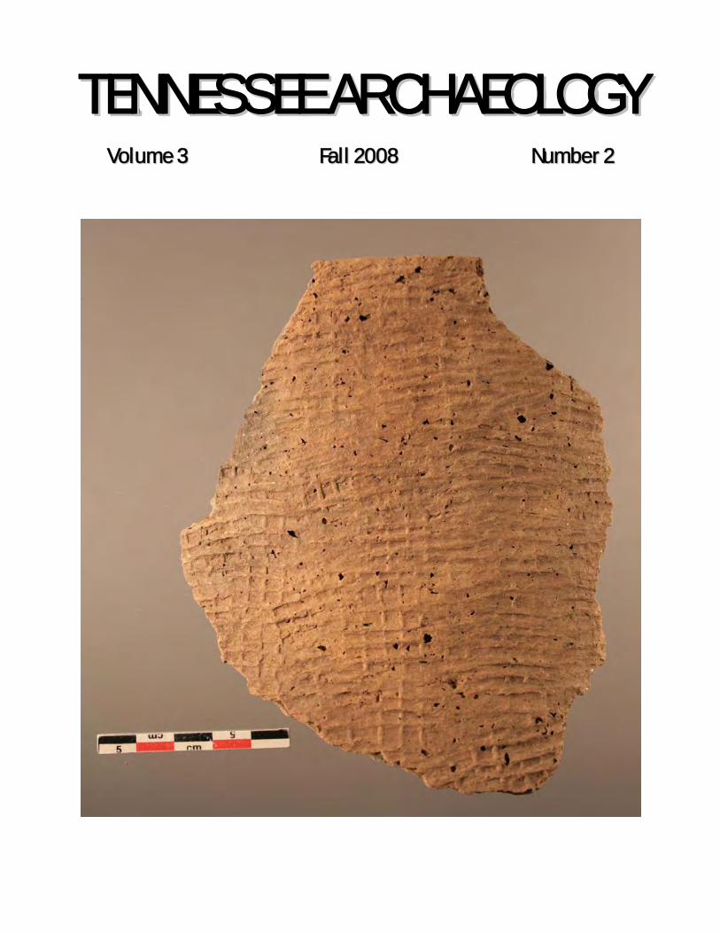
TTEENNNNEESSSSEEEE AARRCCHHAAEEOOLLOOGGYY
VVoolluummee 33 FFaallll 22000088 NNuummbbeerr 22
On the Cover: Wright Check Stamped Rim Sherd from the Nelson Site, Courtesy, Jay D. Franklin
EDITORIAL COORDINATORS
Michael C. Moore Tennessee Division of Archaeology
Kevin E. Smith Middle Tennessee State University
EDITORIAL ADVISORY COMMITTEE
David Anderson University of Tennessee
Patrick Cummins
Alliance for Native American Indian Rights
Aaron Deter-Wolf Division of Archaeology
Jay Franklin
East Tennessee State University
Phillip Hodge Department of Transportation
Zada Law
Ashland City, Tennessee
Larry McKee TRC, Inc.
Katherine Mickelson
Rhodes College
Sarah Sherwood University of Tennessee
Lynne Sullivan
Frank H. McClung Museum
Guy Weaver Weaver and Associates LLC
Tennessee Archaeology is published semi-annually in electronic print format by the Tennessee Council for Professional Archaeology. Correspondence about manuscripts for the journal should be addressed to Michael C. Moore, Tennessee Division of Archaeology, Cole Building #3, 1216 Foster Avenue, Nashville TN 37243. The Tennessee Council for Professional Archaeology disclaims responsibility for statements, whether fact or of opinion, made by contributors.
TTEENNNNEESSSSEEEE AARRCCHHAAEEOOLLOOGGYY
VOLUME 3 Fall 2008 NUMBER 2
101 EDITORS CORNER
ARTICLES
105 Brick Making as a Local Industry in Antebellum Kentucky and Tennessee
TANYA M. PERES AND JESSICA B. CONNATSER
RESEARCH REPORTS 123 Obsidian Research in Tennessee and
Alabama MARK R. NORTON 131 An Analysis of Obsidian and Other
Archaeological Materials from the Southeast Portion of Neelys Bend on the Cumberland River, Davidson County, Tennessee
BOBBY R. BRALY AND JEREMY L. SWEAT 139 Evidence of Prehistoric Violent Trauma from
a Cave in Middle Tennessee SHANNON C. HODGE AND HUGH E. BERRYMAN 157 New Finds of Paleoindian and Early Archaic
Sites along Sulphur Fork in Montgomery County, Tennessee
AARON DETER-WOLF AND JOHN B. BROSTER 163 The Cumberland Stone-Box Burials of Middle
Tennessee. JOHN T. DOWD 181 The Nelson Site: A Late Middle Woodland
Habitation Locale on the Nolichucky River, Washington County, Tennessee
JAY D. FRANKLIN, MICHELLE L. HAMMETT, AND RENEE B. WALKER
201 Recent Research at the Ames Mound
Complex, an Early Mississippian Site in Southwest Tennessee
ANDREW M. MICKELSON
101
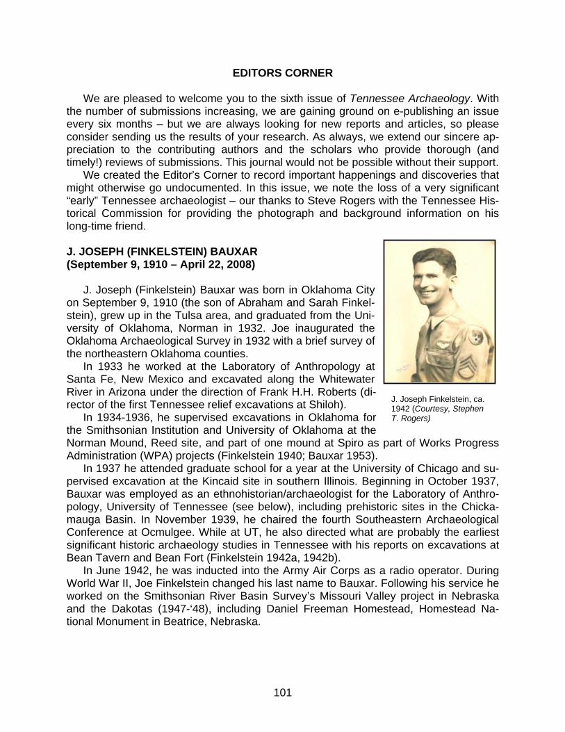
EDITORS CORNER We are pleased to welcome you to the sixth issue of Tennessee Archaeology. With the number of submissions increasing, we are gaining ground on e-publishing an issue every six months – but we are always looking for new reports and articles, so please consider sending us the results of your research. As always, we extend our sincere ap-preciation to the contributing authors and the scholars who provide thorough (and timely!) reviews of submissions. This journal would not be possible without their support. We created the Editor’s Corner to record important happenings and discoveries that might otherwise go undocumented. In this issue, we note the loss of a very significant “early” Tennessee archaeologist – our thanks to Steve Rogers with the Tennessee His-torical Commission for providing the photograph and background information on his long-time friend. J. JOSEPH (FINKELSTEIN) BAUXAR (September 9, 1910 – April 22, 2008) J. Joseph (Finkelstein) Bauxar was born in Oklahoma City on September 9, 1910 (the son of Abraham and Sarah Finkel-stein), grew up in the Tulsa area, and graduated from the Uni-versity of Oklahoma, Norman in 1932. Joe inaugurated the Oklahoma Archaeological Survey in 1932 with a brief survey of the northeastern Oklahoma counties. In 1933 he worked at the Laboratory of Anthropology at Santa Fe, New Mexico and excavated along the Whitewater River in Arizona under the direction of Frank H.H. Roberts (di-rector of the first Tennessee relief excavations at Shiloh). In 1934-1936, he supervised excavations in Oklahoma for the Smithsonian Institution and University of Oklahoma at the Norman Mound, Reed site, and part of one mound at Spiro as part of Works Progress Administration (WPA) projects (Finkelstein 1940; Bauxar 1953). In 1937 he attended graduate school for a year at the University of Chicago and su-pervised excavation at the Kincaid site in southern Illinois. Beginning in October 1937, Bauxar was employed as an ethnohistorian/archaeologist for the Laboratory of Anthro-pology, University of Tennessee (see below), including prehistoric sites in the Chicka-mauga Basin. In November 1939, he chaired the fourth Southeastern Archaeological Conference at Ocmulgee. While at UT, he also directed what are probably the earliest significant historic archaeology studies in Tennessee with his reports on excavations at Bean Tavern and Bean Fort (Finkelstein 1942a, 1942b). In June 1942, he was inducted into the Army Air Corps as a radio operator. During World War II, Joe Finkelstein changed his last name to Bauxar. Following his service he worked on the Smithsonian River Basin Survey’s Missouri Valley project in Nebraska and the Dakotas (1947-‘48), including Daniel Freeman Homestead, Homestead Na-tional Monument in Beatrice, Nebraska.
J. Joseph Finkelstein, ca. 1942 (Courtesy, Stephen T. Rogers)
Tennessee Archaeology 3(2) Fall 2008
102
Joe later continued his education at the University of Chicago where he completed an M.A. in anthropology/history in 1950 and at the University of Wisconsin, Madison where he received a Master of Library Science in 1958. He was a librarian at Rockford College in Rockford, Illinois from 1958 until 1964, when he was appointed University Ar-chivist at Northern Illinois University, DeKalb. He served there until retiring in 1979. While at the University of Tennessee, Joe met his future wife, Alice McIntyre, who was teaching in the Home Economics Department. She graduated from Pembroke Col-lege (Brown University) with a B.A. in History and completed her M.A. in Foods and Nu-trition at Columbia University. They married in 1944, and had three daughters, Esme, Susan, and Debbie (who became an archaeologist). Alice preceded Joe in death in 2002. They are survived by three daughters; a grandson; and one son-in-law (another archaeologist). Joe died April 22, 2008, at his home in Laguna Hills, California and is buried outside of Oklahoma City.
Selected Publications by J. Joseph (Finkelstein) Bauxar Bauxar, J. Joseph 1953 Evidence of a Subsurface Chamber under the Brown Mound at Spiro. American Antiquity 19(2):169-170. 1957 Yuchi Ethnoarchaeology. Parts I-V. Ethnohistory 4(3-4): 279-301, 369-464. 1960 Editorial Notes and Comments. Indian Mounds and Villages in Illinois. Illinois Archaeological Survey, Inc.
Bulletin No. 2. University of Illinois Press. Urbana, Illinois. 101-106. 1978 History of the Illinois Area. Handbook of North American Indians, Volume 15, Northeast, edited by Bruce G.
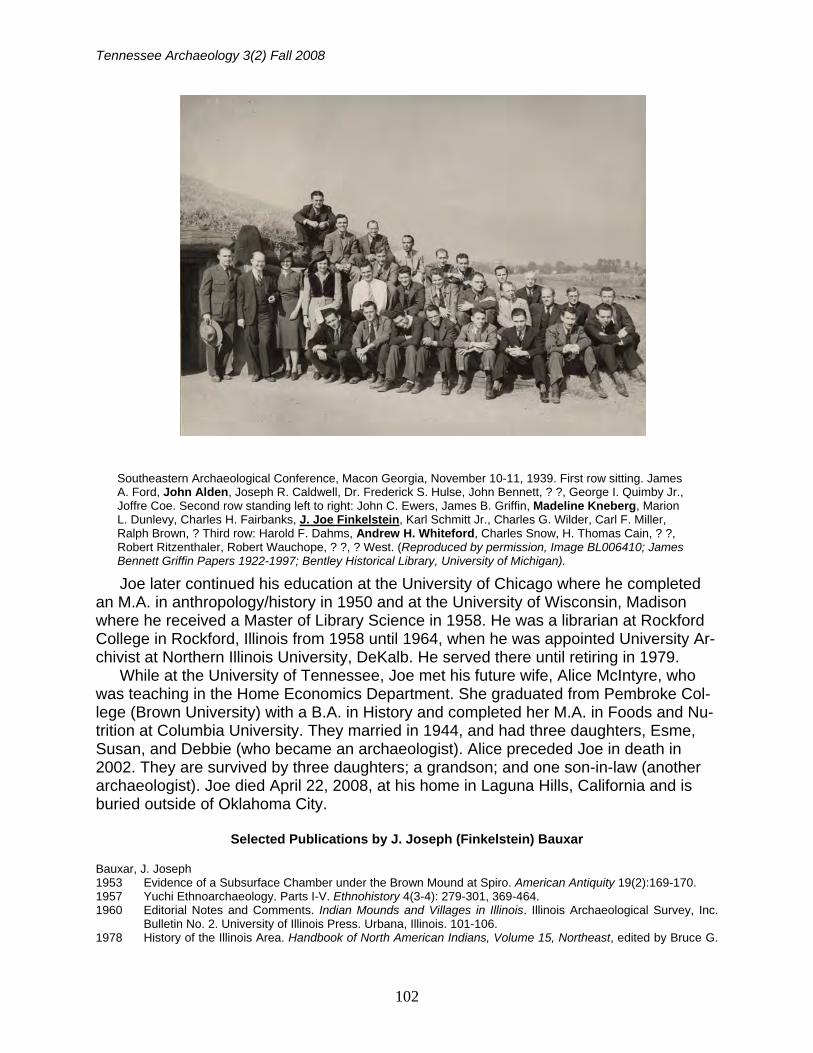
Southeastern Archaeological Conference, Macon Georgia, November 10-11, 1939. First row sitting. James A. Ford, John Alden, Joseph R. Caldwell, Dr. Frederick S. Hulse, John Bennett, ? ?, George I. Quimby Jr., Joffre Coe. Second row standing left to right: John C. Ewers, James B. Griffin, Madeline Kneberg, Marion L. Dunlevy, Charles H. Fairbanks, J. Joe Finkelstein, Karl Schmitt Jr., Charles G. Wilder, Carl F. Miller, Ralph Brown, ? Third row: Harold F. Dahms, Andrew H. Whiteford, Charles Snow, H. Thomas Cain, ? ?, Robert Ritzenthaler, Robert Wauchope, ? ?, ? West. (Reproduced by permission, Image BL006410; James Bennett Griffin Papers 1922-1997; Bentley Historical Library, University of Michigan).
Editors Corner
103
Trigger, pp. 594-601. Smithsonian Institution, Washington D.C. Finkelstein, J. Joe 1937 A Suggested Projectile Point Classification. American Antiquity 2:197-203. 1940 The Norman site excavations near Wagoner, Oklahoma. The Oklahoma Prehistorian 3:2-15. 1942a The Excavation of Bean Tavern, Bean Station, Tennessee. In The Bean Station Tavern Restoration Project,
prepared by Robert M. Howes, pp. 22-28 (plus drawings and photographs). Department of Regional Studies, Tennessee Valley Authority, Knoxville.
1942b The Excavation of Bean Fort – Bean Station, Tennessee. In The Bean State Tavern Restoration Project, prepared by Robert M. Howes, pp. 28-29 (plus drawings and photographs). Department of Regional Studies, Tennessee Valley Authority, Knoxville.
In the mid 1980s, Charles H. Faulkner wrote to J. Joseph Bauxar and asked him to share some of his recollections of early archaeology in the Tennessee Valley. We have reproduced Bauxar’s response from the Tennessee Anthropological Association News-letter (Bauxar 1986).
TVA-WPA ARCHAEOLOGY IN EAST TENNESSEE: A REMINISCENCE
J. Joseph Bauxar
Your invitation to contribute reminiscences of the WPA days at UT set me to recalling details of that period; and I must admit that I could not dredge up any isolated incidents that make for exciting read-ing. The situation at the research center, where I spent most of my time and which was known at the time as the Laboratory of Anthropology, was such that almost every day the analyses of the field and bibliographic data produced exciting insights into our search for a description and history of life in prehistoric Tennessee. I have always felt great pleasure in recalling the fact that this situation was due, in large measure, to the close interpersonal relationship that existed in the laboratory and ex-tended to the field supervisors. I am therefore pleased to submit the following recollections, which you may use as you deem fit for the readers of your Tennessee Anthropological Association News-letter. The Department of Anthropology at UT had its inception in the first archaeological salvage program for the reservoirs of the Tennessee Valley Authority in Tennessee. Such a program had been active in Kentucky for several years when in 1934 the University of Tennessee assumed sponsorship of the archaeological salvage program for Chickamauga Basin, the first of the State of Tennessee projects. Mr. T.M.N. Lewis, senior field supervisor with the Kentucky program, was chosen to be Director of the Tennessee program. With Mr. Lewis came Charles H. Nash as senior field supervisor. A labora-tory was set up on the UT campus in the stately old mansion, West Strong Hall. By 1937 the volume of artifacts and field data had reached the point where Mr. Lewis was faced with the necessity to enlarge his laboratory staff. At that time there were in the University of Chicago Department of Anthropology, among others, three graduate students who were brought closely to-gether by a mutual interest in each other’s anthropological orientation: Miss Madeline D. Kneberg, whose graduate work was in physical anthropology, Andrew H. Whiteford, archaeology major with field experience in the Southwest, and myself, whose interest was ethnohistory. In the spring of 1937 Miss Kneberg was invited to join the Tennessee staff as assistant to Mr. Lewis and to work with the skeletal material. In October I joined the staff as ethnohistorian, to be followed the next month by Mr. Whiteford as artifact analyst. When I arrived at the Laboratory the staff consisted of, in addition to Mr. Lewis and Miss Kneberg, Miss Alice Hendrick, classifier of pottery, Mr. Henry G. Harrison, laboratory technician, and a secre-tary, whose name, regretfully, evades my memory. Miss Kneberg was an artist of considerable talent and imagination. Her artistic reconstruction of physical types based on the excavated skeletal material preceded by many years the discipline now known as forensic anthropology. Among themore exciting days in the laboratory were those when she displayed for our viewing – and criticism – each new drawing of Indian village activity, the as-semblage of which eventually proved to be one of the most interesting sections of the publication Hiwassee Island (Lewis and Kneberg, UT Press, 1946). But the need for illustrations supplementing
Tennessee Archaeology 3(2) Fall 2008
104
photographs of artifacts eventually led to the rounding out of the staff by the addition of Herman K. Strauch as artist. The reservoir basin survey and excavation program lasted until 1942. During that eight year period the program employed a cadre of field supervisors too numerous to mention individually. Red-letter weekends were those when the supervisors came in from the field for consultation, discussion of problems, evaluation of analyses, and R. & R., much of which took place on a Friday or Saturday at the apartment out on the Pike that Whiteford and I shared. No single event in the Laboratory stands out in my mind but there were several of equal importance that were celebrated with jubilation. Those were the occasions when the staff could announce as verifiable cultural entities the typological Foci that came to be named Overhill, Mouse Creeks, Callas, Hiwassee Island, Hamilton and Candy Creek. As ethnohistorian my time was devoted primarily to bibliographic research in the Laboratory and, for some time, at the Knoxville Public Library, where I found a remarkable collection of Tennessee historic research material. The highlight of my labors came on the day when I was able to announce to the staff that, having determined with a high degree of certainty that the identity and protohistoric history of the little known Yuchi tribes of Indians, I would further demonstrate that they could be iden-tified with the people responsible for the Mouse Creeks Focus complex, one of the archaeological complexes found along the Hiwassee River. In 1941 diminishing WPA allocations for field crews gave Whiteford and me an opportunity to get in some field work. I put in a couple of weeks with Nash doing a site location survey by boat along a stretch of the Tennessee River. I was also given the opportunity, on loan to the TVA, to supervise the salvage project at Bean Taven and Bean Fort at Bean Station, destined to be inundated by Lake Cherokee on the Holston River. My services in the laboratory were terminated with my induction into the army in June of 1942. I have no knowledge of subsequent developments that eventually led to the establishment of the De-partment of Anthropology.
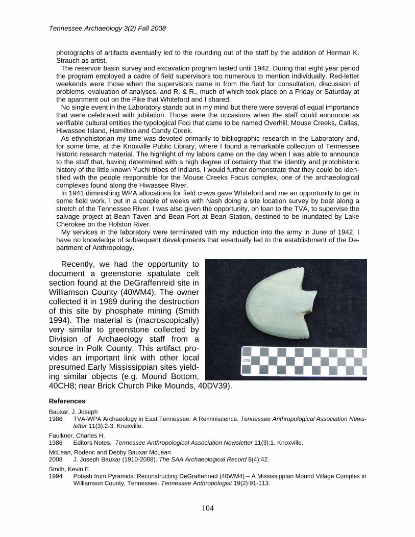
Recently, we had the opportunity to document a greenstone spatulate celt section found at the DeGraffenreid site in Williamson County (40WM4). The owner collected it in 1969 during the destruction of this site by phosphate mining (Smith 1994). The material is (macroscopically) very similar to greenstone collected by Division of Archaeology staff from a source in Polk County. This artifact pro-vides an important link with other local presumed Early Mississippian sites yield-ing similar objects (e.g. Mound Bottom, 40CH8; near Brick Church Pike Mounds, 40DV39).
References
Bauxar, J. Joseph 1986 TVA-WPA Archaeology in East Tennessee: A Reminiscence. Tennessee Anthropological Association News-
letter 11(3):2-3. Knoxville.
Faulkner, Charles H. 1986 Editors Notes. Tennessee Anthropological Association Newsletter 11(3):1. Knoxville.
McLean, Roderic and Debby Bauxar McLean 2008 J. Joseph Bauxar (1910-2008). The SAA Archaeological Record 8(4):42.
Smith, Kevin E. 1994 Potash from Pyramids: Reconstructing DeGraffenreid (40WM4) – A Mississippian Mound Village Complex in
Williamson County, Tennessee. Tennessee Anthropologist 19(2):91-113.
105
BRICK MAKING AS A LOCAL INDUSTRY IN ANTEBELLUM KENTUCKY AND TENNESSEE
Tanya M. Peres and Jessica Bain Connatser
The local manufacture of bricks in the Antebellum Upland South is poorly understood. Few brick kiln sites have been excavated, and the reports of these few are descriptive in nature. While the importance of feature description is recognized, especially for drawing comparisons, the people that participated in brick manufacturing are of equal interest. Previous excavations of six brick kilns in Tennessee and Kentucky are described and compared here. Historical documents and comparative research are used to give an overview of the individuals that would have partici-pated (willingly or not) in the manufacture of bricks at small local kilns. The importance of these individuals to the building of many of American’s national historic landmarks cannot be under-estimated.
As the United States preservation movement has gained in popularity, from the creation of the National Register of Historic Places in 1966 – which currently lists over 80,000 properties on its roles – to the National Trust’s Heritage Tourism Program begun in 1989 – we have seen growing attention given to the research and resurrection of cultural landscapes, long forgotten manufacturing techniques, and traditional food processing and prepa-ration methods, in addition to the time-honored interests in buildings and battle-fields. With this increased interest in tradi-tional technologies and crafts the interpre-tation and preservation of elements of his-toric life are no longer restricted to the purview of the academe. An entire sub-culture of history enthusiasts focuses on reenacting everything from war battles to corn meal grinding to iron smelting; a quick Google search will pull up a host of websites for reenactment associations to attest to this popularity. The archaeology community’s focus on studies of local manufacturing or “cottage industries” has gained in importance in recent years as well (Amos and O’Malley 1991; Gibb et al. 1990; O’Malley 1999). This focus has pro-vided details of forgotten trades that in some cases have aided in the repair, res-
toration, and reconstruction of historic buildings and towns (Weldon 1990).
One cottage industry that has not been thoroughly studied in the Upland South is that of local brick manufacturing. The da-tabase of excavated small, one-time use brick kilns, or clamps, is modest. Brick clamps are not easily located in the ar-chaeological record because in general they were not found near extant buildings or in the vicinity of where buildings once stood. Hence, they generally lay outside of many cultural resource management project areas. Once located, however, they are readily identifiable. Only six have been professionally excavated from Ten-nessee and Kentucky. Conversely, large industrial brick manufacturing sites in Kentucky and eastern Tennessee have been thoroughly studied and results pub-lished (Greene 1992; Guymon 1986; Her-bert 1976; Hockensmith 1996, 1998; Hockensmith and Stottman 1997). This paper will present an overview of small-scale, local brick manufacturing methods, describe and compare the excavated brick kilns from Tennessee and Kentucky, and present an overview about the people that were charged with creating these unique features on the landscape.
Tennessee Archaeology 3(2) Fall 2008
106
Overview of Historic Bricks and Brick Manufacture
In recent years, North American
historical archaeologists have taken an increasing interest in historic brick kilns as well as bricks themselves. For many years bricks were often viewed as part of the matrix of the site (much like shells in shell middens), and while noted on forms and in field notes, little analysis was per-formed. Studies by Gurcke (1987), Hock-ensmith (1996, 1998), and Hockensmith and Stottman (1997), among others (Black 1987; Deiss 1981; Greene 1992; Kelly and Kelly 1977; McKelway et al. 1996; Peres 2002; Wingfield et al. 1997) have focused on brick artifacts and how and where they were manufactured. This section provides an overview of research that has been conducted on bricks and brick manufacture, in areas that are rele-vant to the scope of this paper. Several informative articles (Hockensmith 1996; McKee 1973; McKelway et al. 1996; Weldon 1990) and books (Gurcke 1987) have been published describing the brick-making process. The following is a de-scription of the brick-making process as it applies to the types of bricks recovered from small one-time use kilns, like those excavated in portions of the Upland South.
Material Selection: “Neither Too Sandy nor Too Fat”
While it is accepted that clay is the ba-
sic raw material used in brick manufac-ture, the substance itself is difficult to ac-curately define. A common definition of clay is, “any material of mineral origin which by the absorption of a suitable quantity of water attains a definite degree of plasticity, which it loses temporarily on drying and permanently on burning”
(Searle 1929:213). This does not include all of the different types of materials that the term “clay” encompasses. Searle (1929:213), defines clay as, “a mineral consisting essentially of an ALUMNO-SILICIC ACID in such a physical state that when mixed with a suitable proportion of water it produces a plastic paste.” If this definition holds true, then clays used in brick-making are impure as they contain additional minerals such as quartz (gravel), mica (sand), and feldspar (silt), among others.
Once appropriate clay is located to make brick, there are six basic steps (as outlined by Gurcke 1987:4) in brick mak-ing: (1) mining, or “winning”; (2) prepara-tion; (3) molding, or “forming”; (4) drying; (5) firing, or “burning”; and (6) grading, or sorting of finished products for sale.
Mining or Winning. A number of fac-tors were considered in deciding locality and technique of digging clay for bricks. Some of these factors included thickness of overburden, depth of clay bed, location of deposit in relation to manufacture, mar-ket, and/or construction area (Gurcke 1987:5). Following Gurcke (1987:5) there are four ways to mine clay: (1) surface or open-pit mining; (2) underground mining; (3) hydraulic mining; and (4) dredging. Surface or open-pit mining is the most likely type of clay mining employed at the Zimmerle, Peck Place and Painted Farm brick kilns (see below), thus this method will be discussed further.
Surface mining was used when the clay deposit was located near the surface. Overburden was removed to expose the clay, a process called encallowing, the removal of the callow or topsoil. It was important to remove all the topsoil, and not mix it with the clay, as this would re-sult in defective bricks. Mining or winning was typically performed in late fall and early winter, exposing the clay deposits to
Brick Making
107
snow and frost (Gurcke 1987:5; Weldon 1990). The exposure to numerous freeze/thaw cycles resulted in large chunks of clay breaking apart, making it easier to mix the clay in the spring. Most clay deposits were hand-dug in shallow pits, which varied in horizontal size. Mrs. Fanny Hulette Richardson Lyon, a local informant interviewed by Charles Hock-ensmith (1996:24) during his study of the Howell brick yard in Frankfort, Kentucky, remembered, “a large clay pit several hundred feet across and about 25 feet deep.” This was a large clay pit associ-ated with a commercial brickyard. At site 15SH50, near Shelbyville, a smaller (ap-proximately 10 m x 7.5 m) depression, be-lieved to be the borrow pit, was found 35 m north of the brick kiln (McKelway et al. 1996). This borrow pit was associated with the temporary brick kiln at site 15SH50, thus it is reasonable that it would be much smaller than one located at a commercial manufacturing site. If suitable clay was not located on the property where the kiln was to be constructed, a brickmaker might petition other landown-ers or the court (Weldon 1990: 10) for ac-cess to more desirable “brick earth.”
Preparation. Preparation of the clay is the second step in brick manufacture. The preparation stage could last years, de-pending on the state of the clay. Weather-ing is generally the first part of prepara-tion. It might be left out to dry in the open, then crushed and water added. Rain acted to wash away soluble salts in the clay, which helped to keep the brick from forming a white coating on its surfaces as it aged (Gurcke 1987:7). Typically weath-ering of the clay lasted one winter season.
After weathering was complete, usu-ally in late spring, the clay was tempered. First water and other materials were added to the clay to enhance plasticity, color, and burning. Then these additions
had to be evenly distributed throughout the clay deposit to be used in brick mak-ing. This may have been done in a ring pit, a hole that had been dug for the ex-press purpose of mixing clay, water, and temper. The ring pit may have been lined with boards or bricks, and contained an iron wheel to mix the clay (Gurcke 1987). Pug mills, cylindrical or cone-shaped con-duits with blades on the inside, were also used to mix these ingredients together. Pug mills were powered by horses or mules before, and in the absence of, en-gines (Bell 1935). Research conducted at Colonial Williamsburg suggests that early colonial brickmakers mixed the clay with bare feet, and people of any age and skill level could participate in this process (Weldon 1990:13).
Tempering agents were added to en-hance the clay’s plasticity, to prevent shrinkage or cracking during drying, to change the color of the fired brick, or to lower the temperature of vitrification (Gurcke 1987:11-12). Water was added to make the clay more plastic and pliable. Sand (not the same as that used to lubri-cate the molds) used as a tempering agent helped prevent shrinking and crack-ing during drying of the brick. Grog, “clay that has… been burned to a high enough temperature to destroy its plasticity…then ground to a coarse powder,” (Gurcke 1987:13) was sometimes added to reduce shrinkage. This was an inexpensive tem-pering agent as bricks that had been over-fired, and thus unusable, could be ground up and added to the next batch of clay.
Molding or Forming. The third step in brick manufacture is molding. This is when clay that has been properly pre-pared (weathered and tempered), and is then formed into what is very near its final shape (Gurcke 1987:13). This step re-quired skill, teamwork, and efficiency. Weldon (1990:13) notes that colonial
Tennessee Archaeology 3(2) Fall 2008
108
brickmakers were expected to mold 2,000 bricks in a 14-15 hour day. At the very least the brickmaker required a team of two assistants, one to bring the tempered and mixed clay to the molding station, and one to stack the green bricks for drying. There are three methods of molding bricks: soft-mud, stiff-mud, and dry-pressed (Gurcke 1987:13). These meth-ods are named for the water content of the clay mix and the manufacturing proc-ess. The clay mixture used in the soft-mud method contains 20-30% water; for stiff-mud 12-15% water; and dry-pressed 10 % or less water (Gurcke 1987:13).
The soft-mud method encompasses bricks made by hand and those made by soft-mud brick machines, and is the oldest process by which bricks are made. Most bricks, until the mid- to late nineteenth century, were made by hand in rectangu-lar, wooden or iron clad molds. Wet clay would have been placed in these molds, which were dipped in water before being filled with the clay, and/or lubricated with sand. Bricks made from molds that were water-dipped are called water-struck bricks, and have a smooth dense surface (Allen 1999:251). This method of molding is called “slop-molding” (Gurcke 1987:15). Sand-struck or sand-mold bricks are those that were formed in molds that had been lubricated with sand after being dipped in water. These bricks have a matte-textured surface (Allen 1999:251). Other lubricants, generally used less of-ten, may have included oil, lard, or soapy water (Gurcke 1987:15). The bricks manufactured in the brick kiln at Peck Place would have been made by the soft-mud process.
The stiff-mud method is widely used today to produce large amounts of brick. The clay (made up of 12-15 percent wa-ter) is passed through a vacuum to re-move any air pockets, then extruded
through a rectangular die (Allen 1999:251-252). The clay being extruded is in the form of a rectangular column, and is pushed across a cutting table where the machine slices it into bricks with wires (Al-len 1999:252).
The dry-press method is used for clays that have little water content (less than 10%), and are prone to excessive shrink-age. A high-pressure machine pushes the clay into steel molds that have inter-changeable sides, allowing for the manu-facture of various sizes and shapes of bricks (Gurcke 1987:22).
Drying. Drying is the fourth step in brick manufacture, and is required for bricks made by the soft- and stiff-mud processes. To dry a brick is to remove as much of the water content from the green brick as is necessary before they are fired. Remove too much water and the brick becomes friable and falls apart; re-move too little water and the brick will be destroyed during firing (Gurcke 1987:24). Soft-mud bricks need to have approxi-mately one pound of water per brick re-moved before firing. The amount of water to be removed from stiff-mud bricks is smaller as there is less water in the clay to begin with.
Once the green bricks are removed from the wooden molds they are either placed directly on the ground (if they are sand-struck), or on pallets (if water-struck). They remain in these rows for ap-proximately twenty-four hours, and may be “spattered,” or have the rough edges smoothed (Gurcke 1987:24). Once they are dry enough to handle they are “skintled,” or turned onto their edge. This saves space by placing them closer to-gether as well as facilitates more uniform drying (Gurcke 1987:24). After the green bricks were dry they were “hacked,” meaning they were placed two finger’s width apart in low walls of two bricks wide
Brick Making
109
and eight bricks high (Gurcke 1987:24; Weldon 1990).
Drying could be a precarious process because it depended entirely on the weather. On average, 15% of green bricks were annually damaged and rendered unusable by the weather (Gurcke 1987:26). Weldon (1990:13) notes that the reconstructed brickyard at Colonial Williamsburg lost approximately 10% of the 14,000 molded bricks due to direct sunlight and thunderstorms the first sea-son. Some brickyards built drying sheds, while others left bricks in open fields to dry and only covered them with timber or thatch if there was inclement weather (Gurcke 1987).
Firing. Firing is the fifth step in brick manufacture. This may have been the most important step because the end re-sult of firing is the final product. Moving the dried green bricks from the drying area to the kiln begins the firing process. This could be a laborious process as the hacks had to be broken down, the bricks moved to the kiln, and the hacks rebuilt in the kiln (Gurcke 1987:28). Bricks had to be stacked in the kiln in such a way as to allow the hot air and gases from the fire to pass through and around the bricks in an even manner.
Once the green bricks are stacked in the kiln, the temperature in the kiln is slowly raised to approximately 250° to 350° F, to remove the remaining water from the brick without over-shrinking them (Gurcke 1987:29). This first stage of firing is called “water-smoking,” because of the white steam that comes out of the kiln (Gurcke 1987:29; Weldon 1990).
The temperature of the fire is gradually raised to a red heat once steam has ceased to come from the kiln. This second stage of firing is called “dehydration” or “blue smoking.” Temperatures in the kiln are increased to 1,400° to 1,800° F
(Gurcke 1987:28), causing oxidation. A strong draft must be kept up, since this stage requires large quantities of oxygen to burn off all of the combustible materials present (Gurcke 1987:28). Once oxidation is complete, the drafts are cut down and the kiln is sealed (Gurcke 1987:28). This leads to vitrification, the final step in firing, although in reality dehydration and vitrifi-cation are hard to separate. For vitrifica-tion to be effective the temperature must be around 1,600° to 2,200° F (Gurcke 1987:28). In this stage the brickmaker wants the most amount of shrinkage or “settle” with the least amount of deforma-tion (Gurcke 1987:28). The end result of vitrification is that the clay is transformed into a ceramic material (Allen 1999:253).
Experienced brickmakers know at what point the kiln has settled enough and the fires can be shut off. This begins the cooling process, which requires between 48 and 72 hours for completion (Gurcke 1987:28). The firing stage from beginning to end must be monitored continuously to ensure the final product is of a quality suitable for construction or sale. This en-tire firing process can take anywhere from 40 to 150 hours (Allen 1997:253) and largely depends on the type of kiln.
Types of kilns. There are two types of kilns used for brick manufacture, the peri-odic kiln and the continuous kiln (Allen 1999:252; Gurcke 1987:32). Periodic kilns are semi-permanent or permanent build-ings that are loaded with green bricks, fired, cooled, and unloaded. They are pe-riodic because the fire is put out between firings, allowing the bricks to cool (Plum-ridge and Meulenkamp 1993:167). Con-tinuous kilns are generally made up of a series of chambers, linked together by flues, dampers, and a central chimney (Plumridge and Meulenkamp 1993:167). A continuous sequence of loading, firing, cooling, and unloading each chamber,
Tennessee Archaeology 3(2) Fall 2008
110
with the fire controlled by the dampers, allowed the fire to be taken to the next chamber.
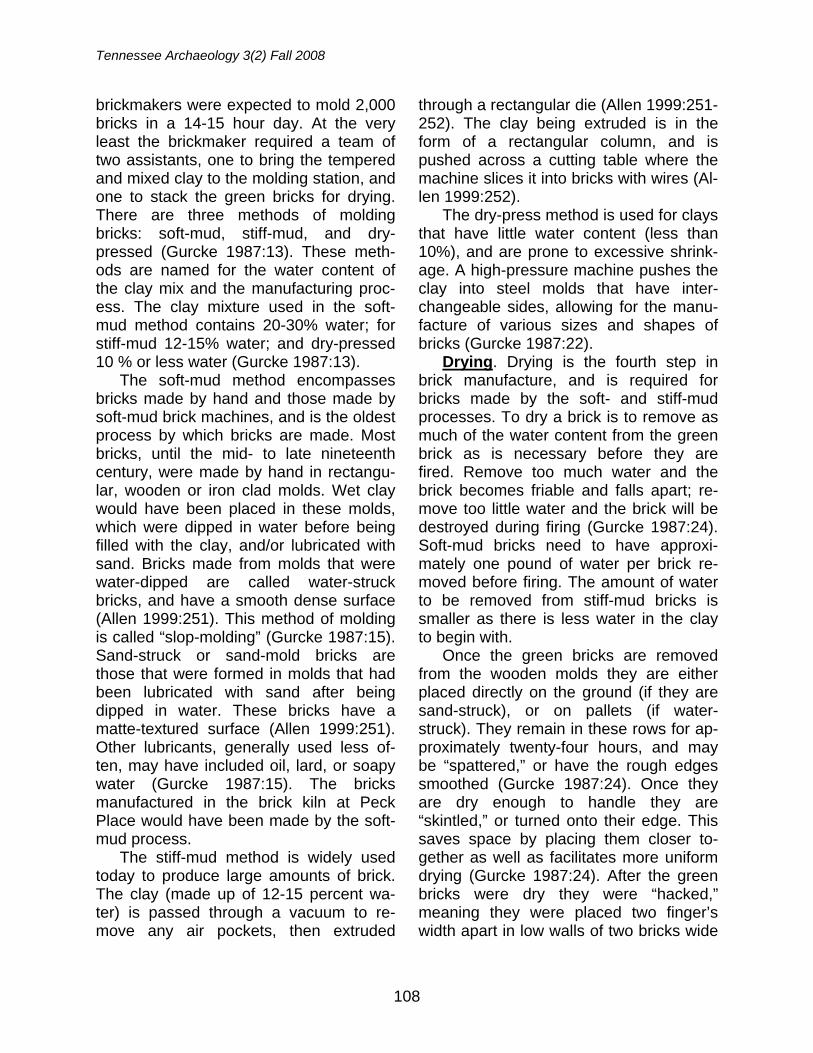
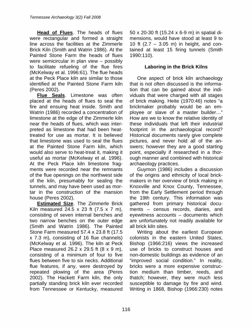
Brick clamps, also called scove kilns, are a type of periodic kiln, and are be-lieved to be the oldest method employed to fire bricks (Plumridge and Meulenkamp 1993). Clamps are temporary structures, made of the bricks themselves (Figure 1). The bricks are stacked in a series of walls or “necks” which are approximately 60 bricks long, 3 bricks thick, and 24 to 30 bricks high (Gurcke 1987:29). In the cen-ter of the necks is an upright. This upright is the same length and height as the
necks, but instead is 6 bricks thick at the bottom and narrows to 3 bricks thick at the top (Gurcke 1987:32). This allows the clamp to slope inward on both sides of the upright. Usually the sides and top are built of burnt bricks. Although this is the gen-eral pattern followed, clamps were built according to the brickmaker’s specifica-tions, thus rarely were two clamps the same.
In between the necks there are “live holes” that run the length of the clamp and are 7 in. wide x 9 in. high (Gurcke 1987:32). Often the green bricks have half-burned ashes mixed in with the clay
FIGURE 1. Two brick kilns, Jefferson County, Tennessee. Kiln in foreground is ready to be fired and the kiln in the background has been fired and opened. (Tennessee State Library and Archives, De-partment of Conservation Photograph Collection, Image ID: 20421)
Brick Making
111
to assist with the firing (Plumridge and Meulenkamp 1993:167). The tunnels or “live holes” would have fuel (wood or coal) stacked inside, and breeze (kindling) would be spread on top of the green bricks to aid in completely firing the bricks (Gurcke 1987:32; Plumridge and Meulenkamp 1993:167).
The downfall to using the clamp method to fire bricks was the lack of con-trol. This lack of control resulted in high variation in the bricks produced; over-fired, under-fired, and variations in color and texture were common. Brick clamps were convenient because they could be used at the site where the building was to be located, thus shortening the transport distance, and little more than a shovel, a wooden mold and manual labor were needed to make them successful.
Grading or Sorting. After the manu-facturing process was completed, bricks were sorted into categories based on the degree of burning each had been ex-posed to. Bricks that were the best for use in building construction were “hard, well-burnt, square, and regular in shape” (Gurcke 1987:35). Bricks that were the closest to the fire, called clinker bricks, were usually overburned and warped, making them unsuitable for building.
Those bricks farthest from the fire would be relatively soft, and orange. While these were not the first choice for building bricks, they may have been used as spares. Bricks from the perimeter of the kiln would not have been fired at all, and may have been discarded. The perfect bricks would have been near the fire, thus fully (well) burned and undistorted.
Archaeology of Brick Clamps in
Tennessee and Kentucky
The database of excavated rural brick clamps from the Upland South is small, however, as Smith (1990:111) notes, the footprints of thousands of eighteenth to early twentieth century brick kilns likely lay undocumented in the Tennessee (and by extension Kentucky) archaeological re-cord. The six kilns discussed here are summarized and compared to gain insight into what would have been a common lo-calized industry in the Upland South, powered by the skilled brickmaker with assistance from both skilled and unskilled laborers. The present discussion includes four kilns from Tennessee and two from Kentucky.
Tennessee Brick Kilns
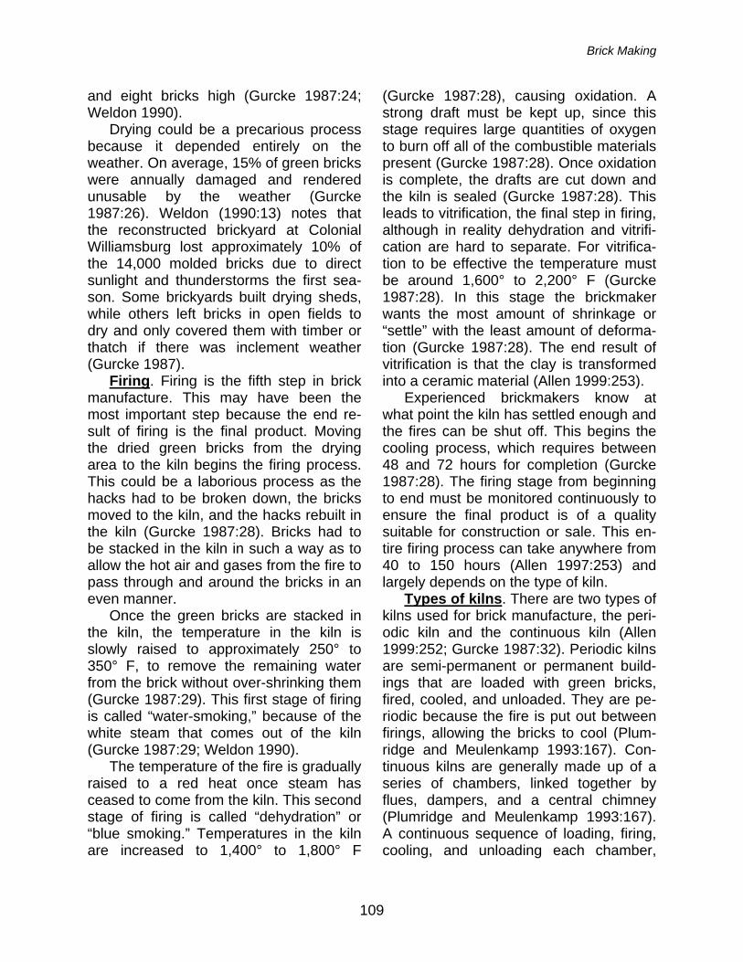
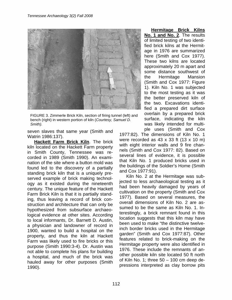
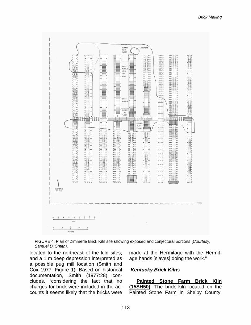
Zimmerle Brick Kiln (40ML187). The Zimmerle Brick Kiln, located in Marshall County, Tennessee was documented in November 1985, after the landowner un-covered a portion of the structure during the investigation of brick rubble in his pas-ture (Smith and Watrin 1986) (Figures 2-4). Historical records suggest that this kiln was used sometime between 1850 and 1864 to build a “mansion house” for Tho-mas J. May and his family (Smith and Watrin 1986:137). A local bricklayer, C. L. Conally, appears in the 1860 U.S. Cen-sus, and May is recorded as owning
FIGURE 2. Exposed portion of Zimmerle Brick Kiln, facing south (Courtesy, Samuel D. Smith)).
Tennessee Archaeology 3(2) Fall 2008
112
seven slaves that same year (Smith and Watrin 1986:137).
Hackett Farm Brick Kiln. The brick kiln located on the Hackett Farm property in Smith County, Tennessee was re-corded in 1989 (Smith 1990). An exami-nation of the site where a button mold was found led to the discovery of a partially standing brick kiln that is a uniquely pre-served example of brick making technol-ogy as it existed during the nineteenth century. The unique feature of the Hackett Farm Brick Kiln is that it is partially stand-ing, thus leaving a record of brick con-struction and architecture that can only be hypothesized from subsurface archaeo-logical evidence at other sites. According to local informants, Dr. Barnett D. Austin, a physician and landowner of record in 1900, wanted to build a hospital on the property, and thus the kiln at Hackett Farm was likely used to fire bricks or this purpose (Smith 1990:3-4). Dr. Austin was not able to complete his plans for building a hospital, and much of the brick was hauled away for other purposes (Smith 1990).
Hermitage Brick Kilns No. 1 and No. 2. The results of limited testing of two identi-fied brick kilns at the Hermit-age in 1976 are summarized here (Smith and Cox 1977). These two kilns are located approximately 20 m apart and some distance southwest of the Hermitage Mansion (Smith and Cox 1977: Figure 1). Kiln No. 1 was subjected to the most testing as it was the better preserved kiln of the two. Excavations identi-fied a prepared dirt surface overlain by a prepared brick surface, indicating the kiln was likely intended for multi-ple uses (Smith and Cox
1977:82). The dimensions of Kiln No. 1 were recorded as 43 x 33 ft (13 x 10 m) with eight interior walls and 9 fire chan-nels (Smith and Cox 1977: 82). Based on several lines of evidence, it is possible that Kiln No. 1 produced bricks used in the buildings of the Soldier’s Home (Smith and Cox 1977:91).
Kiln No. 2 at the Hermitage was sub-jected to less archaeological testing as it had been heavily damaged by years of cultivation on the property (Smith and Cox 1977). Based on several measures, the overall dimensions of Kiln No. 2 are as-sumed to be the same as Kiln No. 1. In-terestingly, a brick remnant found in this location suggests that this kiln may have been used to make “the distinctive twelve-inch border bricks used in the Hermitage garden” (Smith and Cox 1977:87). Other features related to brick-making on the Hermitage property were also identified in 1976. These include the remnants of an-other possible kiln site located 50 ft north of Kiln No. 1; three 50 – 100 cm deep de-pressions interpreted as clay borrow pits
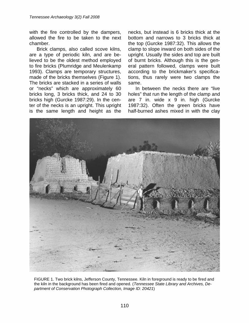
FIGURE 3. Zimmerle Brick Kiln, section of firing tunnel (left) and bench (right) in western portion of kiln (Courtesy, Samuel D. Smith).
Brick Making
113
located to the northeast of the kiln sites; and a 1 m deep depression interpreted as a possible pug mill location (Smith and Cox 1977: Figure 1). Based on historical documentation, Smith (1977:28) con-cludes, “considering the fact that no charges for brick were included in the ac-counts it seems likely that the bricks were
made at the Hermitage with the Hermit-age hands [slaves] doing the work.”
Kentucky Brick Kilns
Painted Stone Farm Brick Kiln
(15SH50). The brick kiln located on the Painted Stone Farm in Shelby County,
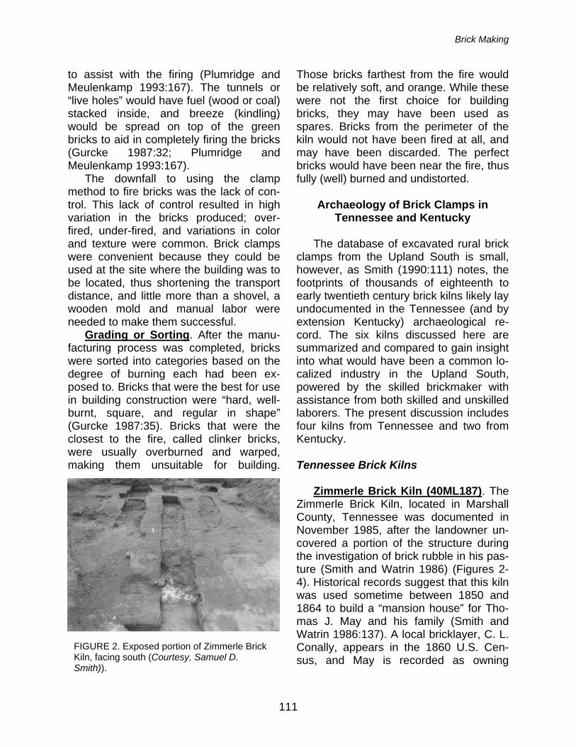
FIGURE 4. Plan of Zimmerle Brick Kiln site showing exposed and conjectural portions (Courtesy, Samuel D. Smith).
Tennessee Archaeology 3(2) Fall 2008
114
Kentucky, was excavated in the mid-1990s as part of a cultural resource man-agement project (McKelway et al. 1996; Wingfield et al. 1997). This site is interest-ing because there are several features, in addition to the kiln itself, that add to our knowledge of rural brick-making. These features include: a borrow pit where clay was mined for the brick-making process was identified 35 m to the north of the kiln feature; a spring pond also located to the north would have provided the water nec-essary to process the clay during the manufacturing process; and 20 m to the south of the kiln, an area of high clay con-tent was identified, thought to be residue from drying and/or processing the clay be-fore it was molded into bricks (McKelway et al. 1996; Wingfield et al. 1997). While the exact use of the bricks produced at the Painted Stone Farm in Kentucky is not given, we can assume they were used for a structure that is no longer extant. This property was part of the original Squire Boone’s Station, a pioneer settlement site dating to the 1780s, thus it has a long his-tory of construction and occupation (McKelway et al. 1996; O’Malley 1996).
Peck Place Brick Kiln (15BH213). The Peck Place Brick Kiln, located in Bath County, Kentucky, has been interpreted as a one-time local-use kiln; the bricks made in it were most likely used in the original construction of the extant house, “Peck Place,” located on the property (Peres 2002). Based on multiple lines of evidence, the site likely dates to the early- to mid-19th century, when the property was owned by Andrew Boyd (Peres 2002). A survey of the cellar of the extant house on the property in 2002 identified exposed bricks in the wall and a brick arch. Measurements made on the bricks recovered from the kiln site and those in the cellar walls are nearly identical. Addi-tionally, the bricks in the cellar walls had
all of the attributes of being handmade (McKelway et al. 1996; Peres 2002). The dimensions and possible individuals re-sponsible for the construction and decon-struction of this kiln are discussed in detail below.
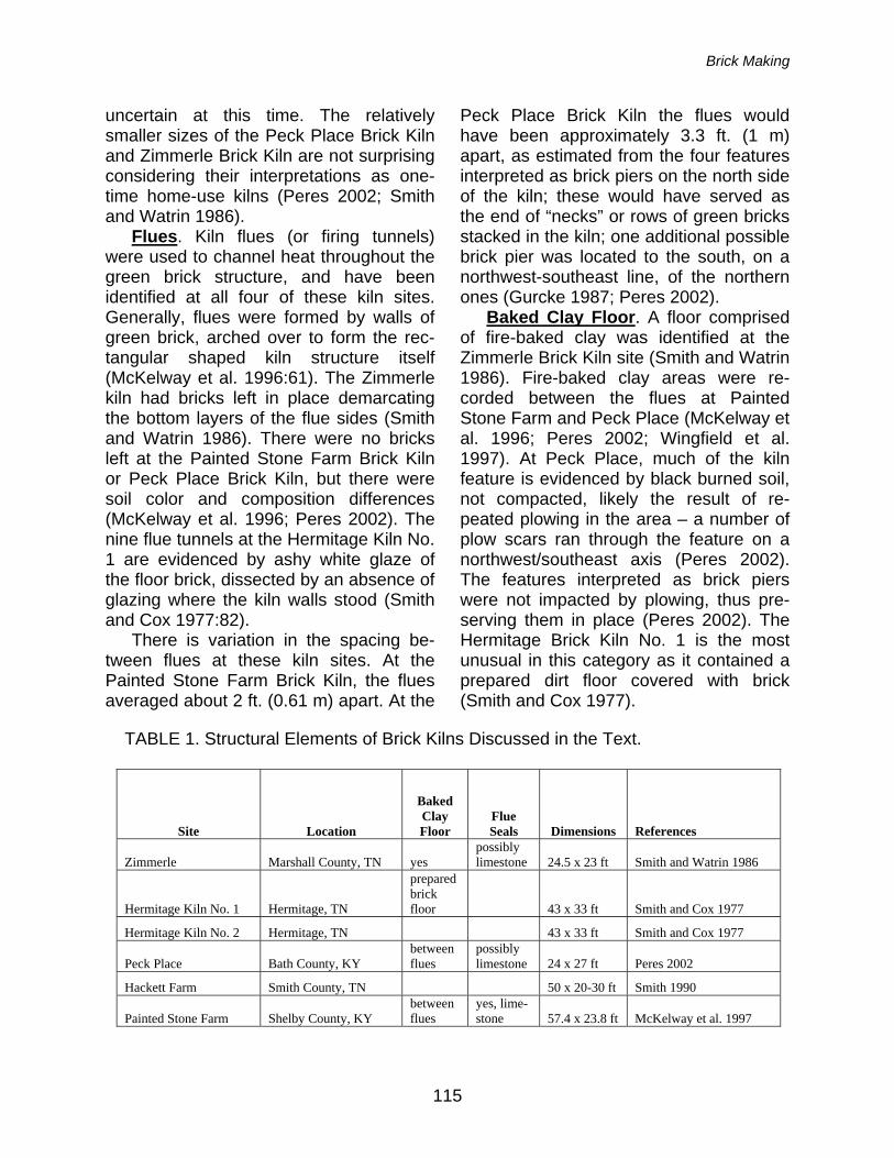
Brick Kiln Structures: A Comparison
A structural comparison of the kilns discussed in the text is provided in Table 1. The four largest kilns included here are the partially standing kiln located on the Hackett Farm property in Smith County, Tennessee (Smith 1990); the Hermitage Kilns No. 1 and No. 2, located at the Her-mitage, Tennessee (Smith and Cox 1977); and the Painted Stone Farm Brick Kiln in Shelby County, Kentucky (McKel-way 1996; Wingfield et al. 1997). The sizes of these four kilns are comparable; the Hackett Farm kiln ranges in size from approximately 1,000-1,500 ft2, the Hermit-age Kilns No. 1 and No. 2 are each ap-proximately 1,419 ft2, and the Painted Stone Farm kiln measures approximately 1,366 ft2. The large sizes of the Hackett Farm and Hermitage kilns are not surpris-ing given the intended uses of the bricks fired in them. According to local infor-mants, Dr. Barnett D. Austin, a physician and landowner of record in 1900, wanted to build a hospital on the property, and thus the kiln at Hackett Farm was likely used to fire bricks for this purpose (Smith 1990:3-4). It is believed that Brick Kilns No. 1 and No. 2 at the Hermitage would have provided the building materials for one or more outbuildings on the property, and possibly the borders for the garden (Smith and Cox 1977). In the absence of a discussion of probable uses of the bricks made in the Painted Stone Farm Brick Kiln, we assume they were used for a structure that is no longer extant, but the exact size and nature of that structure is
Brick Making
115
uncertain at this time. The relatively smaller sizes of the Peck Place Brick Kiln and Zimmerle Brick Kiln are not surprising considering their interpretations as one-time home-use kilns (Peres 2002; Smith and Watrin 1986).
Flues. Kiln flues (or firing tunnels) were used to channel heat throughout the green brick structure, and have been identified at all four of these kiln sites. Generally, flues were formed by walls of green brick, arched over to form the rec-tangular shaped kiln structure itself (McKelway et al. 1996:61). The Zimmerle kiln had bricks left in place demarcating the bottom layers of the flue sides (Smith and Watrin 1986). There were no bricks left at the Painted Stone Farm Brick Kiln or Peck Place Brick Kiln, but there were soil color and composition differences (McKelway et al. 1996; Peres 2002). The nine flue tunnels at the Hermitage Kiln No. 1 are evidenced by ashy white glaze of the floor brick, dissected by an absence of glazing where the kiln walls stood (Smith and Cox 1977:82).
There is variation in the spacing be-tween flues at these kiln sites. At the Painted Stone Farm Brick Kiln, the flues averaged about 2 ft. (0.61 m) apart. At the
Peck Place Brick Kiln the flues would have been approximately 3.3 ft. (1 m) apart, as estimated from the four features interpreted as brick piers on the north side of the kiln; these would have served as the end of “necks” or rows of green bricks stacked in the kiln; one additional possible brick pier was located to the south, on a northwest-southeast line, of the northern ones (Gurcke 1987; Peres 2002).
Baked Clay Floor. A floor comprised of fire-baked clay was identified at the Zimmerle Brick Kiln site (Smith and Watrin 1986). Fire-baked clay areas were re-corded between the flues at Painted Stone Farm and Peck Place (McKelway et al. 1996; Peres 2002; Wingfield et al. 1997). At Peck Place, much of the kiln feature is evidenced by black burned soil, not compacted, likely the result of re-peated plowing in the area – a number of plow scars ran through the feature on a northwest/southeast axis (Peres 2002). The features interpreted as brick piers were not impacted by plowing, thus pre-serving them in place (Peres 2002). The Hermitage Brick Kiln No. 1 is the most unusual in this category as it contained a prepared dirt floor covered with brick (Smith and Cox 1977).
TABLE 1. Structural Elements of Brick Kilns Discussed in the Text.
Site Location
Baked Clay Floor
Flue Seals Dimensions References
Zimmerle Marshall County, TN yes possibly limestone 24.5 x 23 ft Smith and Watrin 1986
Hermitage Kiln No. 1 Hermitage, TN
prepared brick floor 43 x 33 ft Smith and Cox 1977
Hermitage Kiln No. 2 Hermitage, TN 43 x 33 ft Smith and Cox 1977
Peck Place Bath County, KY between flues
possibly limestone 24 x 27 ft Peres 2002
Hackett Farm Smith County, TN 50 x 20-30 ft Smith 1990
Painted Stone Farm Shelby County, KY between flues
yes, lime-stone 57.4 x 23.8 ft McKelway et al. 1997
Tennessee Archaeology 3(2) Fall 2008
116
Head of Flues. The heads of flues were rectangular and formed a straight line across the facilities at the Zimmerle Brick Kiln (Smith and Watrin 1986). At the Painted Stone Farm the heads of flues were semicircular in plan view – possibly to facilitate refueling of the flue fires (McKelway et al. 1996:61). The flue heads at the Peck Place kiln are similar to those identified at the Painted Stone Farm kiln (Peres 2002).
Flue Seals. Limestone was often placed at the heads of flues to seal the fire and ensuing heat inside. Smith and Watrin (1986) recorded a concentration of limestone at the edge of the Zimmerle kiln near the heads of flues, which was inter-preted as limestone that had been heat-treated for use as mortar. It is believed that limestone was used to seal the flues at the Painted Stone Farm kiln, which would also serve to heat-treat it, making it useful as mortar (McKelway et al. 1996). At the Peck Place kiln limestone frag-ments were recorded near the remnants of the flue openings on the northwest side of the kiln, presumably for sealing the tunnels, and may have been used as mor-tar in the construction of the mansion house (Peres 2002).
Estimated Size. The Zimmerle Brick Kiln measured 24.5 x 23 ft (7.5 x 7 m), consisting of seven internal benches and two narrow benches on the outer edge (Smith and Watrin 1986). The Painted Stone Farm measured 57.4 x 23.8 ft (17.5 x 7.3 m), consisting of 16 flue channels) (McKelway et al. 1996). The kiln at Peck Place measured 26.2 x 29.5 ft (8 x 9 m), consisting of a minimum of four to five flues between five to six necks. Additional flue features, if any, were destroyed by repeated plowing of the area (Peres 2002). The Hackett Farm kiln, the only partially standing brick kiln ever recorded from Tennessee or Kentucky, measured
50 x 20-30 ft (15.24 x 6-9 m) in spatial di-mensions, would have stood at least 9 to 10 ft (2.7 – 3.05 m) in height, and con-tained at least 15 firing tunnels (Smith 1990:110).
Laboring in the Brick Kilns
One aspect of brick kiln archaeology
that is not often discussed is the informa-tion that can be gained about the indi-viduals that were charged with all stages of brick making. Heite (1970:46) notes “a brickmaker probably would be an em-ployee or slave of a master builder…” How are we to know the relative identity of these individuals that left their industrial footprint in the archaeological record? Historical documents rarely give complete pictures, and never hold all of the an-swers; however they are a good starting point, especially if researched in a thor-ough manner and combined with historical archaeology practices.
Guymon (1986) includes a discussion of the origins and ethnicity of local brick-makers in her overview of brick making in Knoxville and Knox County, Tennessee, from the Early Settlement period through the 19th century. This information was gathered from primary historical docu-ments – census records, diaries, and eyewitness accounts – documents which are unfortunately not readily available for all brick kiln sites.
Writing about the earliest European colonists in the eastern United States, Bishop (1966:216) views the increased use of bricks to construct houses and non-domestic buildings as evidence of an “improved social condition.” In reality, bricks were a more expensive construc-tion medium than timber, reeds, and thatch; however, they were much less susceptible to damage by fire and wind. Writing in 1868, Bishop (1966:230) notes
Brick Making
117
“after the year 1740, when a great fire laid in ashes a large number of the wooden buildings of [Charleston, South Carolina], brick and stone were more used than be-fore.” During the mid-19th century in Knoxville, Tennessee, population growth resulted in an ever-increasing demand for brick buildings. Guymon (1986:59) cites an article published in 1853 in a local newspaper that describes the inability of the six or eight brickyards in operation at the time to keep up with the demand for brick.
As the demand for brick grew in the United States, so must have the demand for skilled brickmakers. The 1795 Wage Roles kept during the building of the United States White House list five slaves, and numerous more are noted as laborers (Kapsch 1995; Seale 1986). During the construction of the White House, com-mercially produced brick was not locally available. While two free white men are listed as the brick makers of record, they likely employed slaves in the brick making process, as “burning brick in temporary ricks was primarily a black trade” (Kapsch 1995:8). Seale (1986) also notes that slaves were employed to make bricks in temporary kilns on the grounds of the President’s House.
Little mention is made in regional lit-erature about the identity of skilled brick-makers, and how they learned their trade. Guymon’s (1986:49) research in the Knoxville area has found that while skilled slaves and apprentices were likely in competition with one another for work, there were not enough of them to go around. The use of slaves in making brick and the subsequent construction of build-ings from locally made brick is poorly documented and frequently assumed. Of-ten times all we are afforded are small snippets of information regarding their presence during the brick making proc-
ess, if any mention of them as made at all. Documents relating to Thomas Jefferson’s Virginia plantation, Monticello, indicate that his slaves made bricks for buildings located there (Colonial Williamsburg Foundation 2007). They likely worked un-der the direction of John Brewer, a skilled brickmaker hired by Jefferson (Crews 2006). At Carter’s Grove Plantation, also in Virginia, plantation slaves assisted a professional brickmaker hired by owner David Minitree (Colonial Williamsburg Foundation 2007). At Mount Vernon, male slaves served as brickmakers (Carr and Walsh 1988), and plantation owners in Texas and Louisiana paid slaves to make bricks (McDonald 1995:191; Northcott 2001). In Tennessee, enslaved individuals dug the clay used to make the bricks for the construction of the Blount Mansion, home of Territorial Governor William Blount, between 1792 and 1796 (Guymon 1986:54-55). In almost all of these in-stances documentation is available for these sites because the landowners were deemed important wealthy and/or political figures, thus there has been much interest in their lives.
It has been documented that the labor intensive process of making bricks could not always be fulfilled by slaves. In areas where slaves either did not exist or ex-isted in relatively small numbers, groups of men were hired for the cause (Guymon 1986). These men may have been sup-plied by the skilled brickmaker, and often were related to him and/or each other (Guymon 1986:56).
Mentioned in even more ambiguous terms is the labor procured from “un-skilled” workers, whether they were freed or enslaved, men, women, or children. The unskilled jobs included mining, stomping, molding, stacking, and trans-porting. In 18th century Virginia, it has been documented that some folks of the
Tennessee Archaeology 3(2) Fall 2008
118
lower classes (freed and enslaved) were employed by the brickmaking industry (Crews 2006; Colonial Williamsburg Foundation 2007). Interestingly, Tunis (1965:86) offers an illustration of brick-making with “unskilled” work being per-formed by black men, presumably slaves.
Crews (2006) notes that brickmakers often lived on site, as brickmaking was done either close to the source of raw ma-terial and/or close to the construction area. Since the supply of skilled brick-makers could not keep up with the de-mand for brick in the 19th century, they had to move around to where their skills were needed. Often they had their ap-prentices and/or slaves in tow (Guymon 1986:23). John Brewer, brickmaker at Monticello, lived on the plantation with his wife, and was given room and board in addition to pay (Crews 2006). Unfortu-nately, brickmakers are not often men-tioned in census records or other historic documents. More often, brick masons are listed in census records and other docu-ments. While brickmakers and brick ma-sons are two distinct specialties, evidence for brick-related activities (i.e., construc-tion) at a site may be inferred by the men-tion of either or both in historic docu-ments. For instance, Guymon (1986:52-53) notes that an older Virginia “brick ma-son” brought two younger men with him to Tennessee, likely to serve as apprentices; and four younger Tennessee-born brick masons recorded in census data lived with one older Virginia-born brick mason, again, presumably as his apprentices. Un-fortunately, Guymon does not indicate if any of these apprentices were free white or enslaved black men.
Historical records for the Hermitage show that the overseer, Graves W. Steele, managed the manufacture of brick on the property (Smith 1977:27). Samuel Scott, carpenter by trade, was paid for
making brick moulds by Jackson (Smith 1977:27). Other various brick-related charges/tasks were also paid for by Jack-son as recorded in his Farm Journal (Smith 1977:26). As mentioned above, in all probability, the slaves owned by Jack-son (and possibly the Donelsons) were charged with making the thousands of bricks used at the Hermitage and Tulip Grove (Smith and Cox 1977).
Regarding the rural kilns that are the focus of this paper, we do know that the Boyd Family, owners of Peck Place, owned slaves, with at least ten recorded in 1850 (United States Census 1850). Seven of these ten were male, the major-ity of which were in their prime laboring years (ages 14-26) (United States Census 1850). A search of census records for relevant years did not turn up any mention of a brickmaker living in Bath County. Two explanations are possible: (1) a hired brickmaker(s) lived in Bath County during the intervening years of the census, thus was missed; or (2) enslaved individuals were responsible for making bricks, and thus were not listed as brickmakers in the census records. Both hypotheses have equal probability given the paucity of data.
There is mention of slaves participat-ing in other skilled masonry trades on a neighboring farm in Bath County, while not a direct correlate to brick making, it shows that slaves were engaged in trades other than agriculture. During the Bath County Sesquicentennial “House Tour” an article detailing the histories of three prominent farms was published in the Bath County Outlook (1961). Peck Place and Marble Hill Farm are two of these dis-cussed in this article. It is mentioned that the original stone fences still standing at Marble Hill “were built by slaves whose cabins were torn down only a few years ago” (Bath County Outlook 1961). If the slaves were involved in building the
Brick Making
119
fences at Marble Hill, then we can as-sume they either worked under the direc-tion of a skilled free mason, or at least one or several of them were skilled in dry masonry. If slaves in Bath County did have the skills necessary to build dry ma-son stone fences, they certainly could have been skilled brick makers. However, without clear documentation, this claim cannot be substantiated.
Until we have unequivocal evidence of the identities of those that labored in the construction field we will never truly know if they were freed or enslaved, black or white, men or women, adults or children. Sites such as Colonial Williamsburg and the Hermitage give us the most compre-hensive glimpse into the historic local manufacturing industry.
Conclusions
Scholars’ interest in historic period lo-
cal manufacturing techniques or industries in the Upland South has increased over the past decade. Local brick manufactur-ing is one such industry that deserves more attention. The archaeological record of these activities is scant, with few kilns having ever been excavated in Tennes-see and Kentucky. As Smith (1990) has noted, there are likely thousands of uni-dentified early-nineteenth to twentieth century brick kilns across the Upland South (especially Tennessee and Ken-tucky) landscape. The six brick kilns com-pared here are a good start to this data-base.
Further documentation of brick kiln sites are needed to increase the sample size and allow archaeologists to formulate regional comparisons of this manufactur-ing activity (Upland South vs. Virginia vs. the Deep South). More archaeologists should follow Smith’s (1990) lead and conduct thorough research on historical
documents that can give us important in-formation about the people involved in this and other local industries. Information on well-known sites such as Monticello, Co-lonial Williamsburg, the Hermitage, and the United States White House, have shown us that wage laborers and en-slaved individuals had important roles in the building of these great national land-marks. It is the job of historical archae-ology to help give a voice to those that are not easily seen in the history texts. By ob-taining as much information as we can out of the archaeological and documentary records of temporary brick kilns we can give voice to those individuals, both free and enslaved, male and female, that helped build Tennessee and Kentucky.
Acknowledgements: The authors express their appreciation to Samuel Smith, Tennessee Division of Archaeology, for his willingness to share infor-mation and resources from his research on brick kilns in Tennessee. Charles Hockensmith, Ken-tucky Heritage Council, was of great help to the senior author in her original brick kiln research while at the University of Kentucky. Nancy O’Malley, William S. Webb Museum of Anthropol-ogy at the University of Kentucky, gave freely of her time to help track down census records and interpret historic documents, and offered useful advice about both historical archaeology and life. Kevin Smith and Sam Smith assisted with compil-ing historic and personal photographs of brick kilns. Two anonymous reviewers offered sugges-tions that greatly improved the clarity of content. Any omissions or errors are, of course, the re-sponsibility of the authors.
References
Allen, Edward 1999 Fundamental of Building Construction:
Materials and Methods. John W. Ley-ton and Sons, New York.
Amos, Chris and Nancy O'Malley 1991 Milling and Related Industry in the
Boone Creek Drainage. Archaeologi-cal Report No. 262, Department of An-thropology, University of Kentucky,
Tennessee Archaeology 3(2) Fall 2008
120
Lexington, Kentucky. Bath County Outlook 1961 “Charm of Old Homes to be Seen.”
August 10, 1961, 82(45):1. Bell, Edward 1935 Fish on the Steeple. Farrar and
Rinehart, New York. Bishop, J. Leander 1966 A History of American Manufactures:
From 1608 to 1860. Third Edition, Vol-ume 1. Reprints of Economic Classics, Augustus M. Kelley Publishers, New York.
Black, William R., Jr. 1987 Anomalous Marks in Nineteenth Cen-
tury Paducah Bricks. In Proceedings of the Symposium on Ohio Valley Ur-ban and Historic Archaeology 5:96-104, University of Louisville, Kentucky.
Carr, Louis Green, and Lorena S. Walsh 1988 Economic Diversification and Labor
Organization in the Chesapeake, 1650-1820. In Work and Labor in Early America, edited by S. Innes, pp. 144-188. University of North Carolina Press, Chapel Hill, North Carolina.
Colonial Williamsburg Foundation 2007 Brickmaker at Colonial Williamsburg,
Electronic document. http://www history.org/Almanack/life/trades/tradebri.cfm, accessed July 31, 2007.
Crews, Ed 2006 Making, Baking, and Laying Bricks.
Colonial Williamsburg, Winter. Elec-tronic document, http://www.history.org/Foundation/journal/Winter05-06/bricks cfm,
accessed July 31, 2007. Deiss, Ronald Wilson 1981 The Development and Application of a
Chronology for American Glass. Mid-western Archaeological Research Center, Illinois State University, Nor-mal.
Gibb, James G., David J. Berstein, and Daniel
F. Cassedy 1990 Making Cheese: Archaeology of a
19th Century Rural Industry. Historical Archaeology 24(1):18-33.
Greene, L. K. 1992 The Penfield is Mightier Than the
Sword: Machine-Made Bricks in Knox-ville and Knox County, Tennessee. Tennessee Anthropological Associa-tion Miscellaneous Paper 16:74-91.
Gurcke, Karl 1987 Bricks and Brickmaking: A Handbook
for Historical Archaeology. University of Idaho Press, Moscow, Idaho.
Guymon, Gail L. 1986 An Historical and Archaeological
Study of Brickmaking in Knoxville and Knox County, Tennessee. MA Thesis, Department of Anthropology, Univer-sity of Tennessee, Knoxville.
Herbert, John S. 1976 Brick Making in Nashville. In Our An-
cestors Were Engineers, edited by A. W. Crouch and H. D. Claybrook, pp. 33-35. Nashville Section American Society of Civil Engineers, Nashville, Tennessee.
Heite, Edward F. 1970 Colonial Brick Technology. The Con-
ference on Historic Site Archaeology Papers 3:43-49.
Hockensmith, Charles D. 1996 Bricks and Brick Making in Frankfort:
An Archival and Archaeological Study of the Kentucky History Center Site. Kentucky Heritage Council, Occa-sional Reports in Archaeology, Num-ber 1.
1998 A Study of Bricks from the Kentucky River Mills Site, Frankfort, Franklin County, Kentucky. Kentucky Heritage Council, Brick Notes, Number 1.
Brick Making
121
Hockensmith, C. D. and M. Jay Stottman 1997 Investigations at the Maysville Brick
Company: An Example of Industrial Archaeology in Kentucky. Ohio Valley Historical Archaeology 12:89-111.
Kapsch, Joseph J. 1995 Building Liberty’s Capital. American
Visions 10(1):8-10. Kelly, Roger E. and Marsha C. Kelly 1977 Brick Bats for Archaeologists: Values
of Pressed Brick Brands. Historical Ar-chaeology 1:84-89.
McDonald, Roderick A. 1995 Independent Economic Production by
Slaves on Antebellum Louisiana Sugar Plantations. In The Slaves’ Economy: Independent Production by Slaves in the Americas, edited by I. Berlin and P. D. Morgan, pp. 182-208. Frank Cass & Co. Ltd, Portland, Oregon.
McKee, Harley J. 1973 Introduction to Early American Ma-
sonry: Stone, Brick, Mortar, and Plas-ter. Series on the Technology of Early American Building. National Trust for Historic Preservation and Columbia University, Number 1, Washington, D. C.
McKelway, H. S., M. D. Richmond, and R. B.
Hand 1996 An Archaeological Reconnaissance of
Proposed Parcels of Kentucky State Highway 55 Upgrade, and Phase II In-vestigations of Site 15SH50, Shelby County, Kentucky. Cultural Resource Analysts, Inc., Contract Publication Series 96-42, Lexington, Kentucky.
Northcott, Kaye 2001 Slavery Times: The Long Forgotten
Plantation Life in Texas. Texas Co-op Power 5.
O’Malley, Nancy 1996 Squire Boone’s Painted Stone Station:
A Locational Survey. University of
Kentucky Archeological Report 368. University of Kentucky, Lexington.
1999 Peter Evans' Mill: Nineteenth Century Industry in Fayette County, Kentucky. Technical Report 408, Department of Anthropology, University of Kentucky, Lexington, Kentucky.
Peres, Tanya M. 2002 A Phase II Archaeological Evaluation
of Site 15BH213, Associated with the KY 11Project, Bath County, Kentucky (Item No. 9-121.2, 9-121.3, and 9121.4). Technical Report No. 463, Program for Archaeological Research, University of Kentucky, Lexington, Kentucky.
Plumridge, Andrew, and Wim Meulenkamp 1993 Brickwork: Architecture and Design.
Harry N. Abrams, Inc., New York. Seale, William 1986 The President’s House. White House
Historical Association, Washington, D.C.
Searle, Alfred Broadhead 1929 An Encyclopedia of the Ceramic In-
dustries. E. Benn, London. Smith, Samuel D. 1977 Historical Background Study of the
Hermitage “Necessary,” Brick Cabin Sites, Old Barn Site, and the Brick Kilns. In Results of the 1976 Season of the Hermitage Archaeology Project, S. D. Smith, F. W. Brigance, E. Breit-burgh, S. D. Cox, and M. Martin, pp. 4-30. Report Submitted to The Ladies Hermitage Association and The Ten-nessee American Revolution Bicen-tennial Commission by the Tennessee Division of Archaeology, Nashville.
1990 Buttons and Bricks; Some Artifactual Information from Smith County, Ten-nessee. Tennessee Anthropologist, 15(2):96-114.
Tennessee Archaeology 3(2) Fall 2008
122
Smith, Samuel D., and Stephen D. Cox 1977 Archaeological Investigations of the
Hermitage Brick Kilns. In Results of the 1976 Season of the Hermitage Ar-chaeology Project, S. D. Smith, F. W. Brigance, E. Breitburgh, S. D. Cox, and M. Martin, pp. 81-95. Report Submitted to The Ladies Hermitage Association and The Tennessee American Revolution Bicentennial Commission by the Tennessee Divi-sion of Archaeology, Nashville.
Smith, Samuel D. and Charlotte A. Watrin 1986 Zimmerle Brick Kiln. Tennessee An-
thropologist, 11(2):132-144. Tunis, Edwin 1965 Colonial Craftsmen and the Begin-
nings of American Industry. World Publishing Company, Cleveland, Ohio.
United States Census 1850 1850 Census of Bath County, Ken-
tucky. United States Census Bureau, Washington, D.C.
Weldon, Bill 1990 The Arts and Mysteries of the Colonial
Brickmaker. Colonial Williamsburg XII(4):7-15.
Wingfield, D. M., M. D. Richmond, and H. S.
McKelway 1997 Archaeological Remains of a Mid-
Nineteenth Century Brick Clamp: A First Look at Brick Clamps in Ken-tucky. Cultural Resource Analysts, Inc. Reports. Copies available from Cul-tural Resource Analysts, www.crai-ky/reports/brick-clamp.htm
Tanya M. Peres Department of Sociology and Anthropology Middle Tennessee State University Murfreesboro, Tennessee 37132 Jessica Bain Connatser Department of Sociology and Anthropology Middle Tennessee State University Murfreesboro, Tennessee 37132
123
OBSIDIAN RESEARCH IN TENNESSEE AND ALABAMA
Mark R. Norton
Seven obsidian artifacts found in Tennessee and Alabama were sent to the Northwest Research Obsidian Studies Laboratory in Corvallis, Oregon for x-ray fluorescence sourcing and hydration measurement tests. The results indicate obsidian was traded into our region from sources in California, Nevada, Oregon, and Arizona possibly as early as the Late Archaic period (ca. 2000 BC).
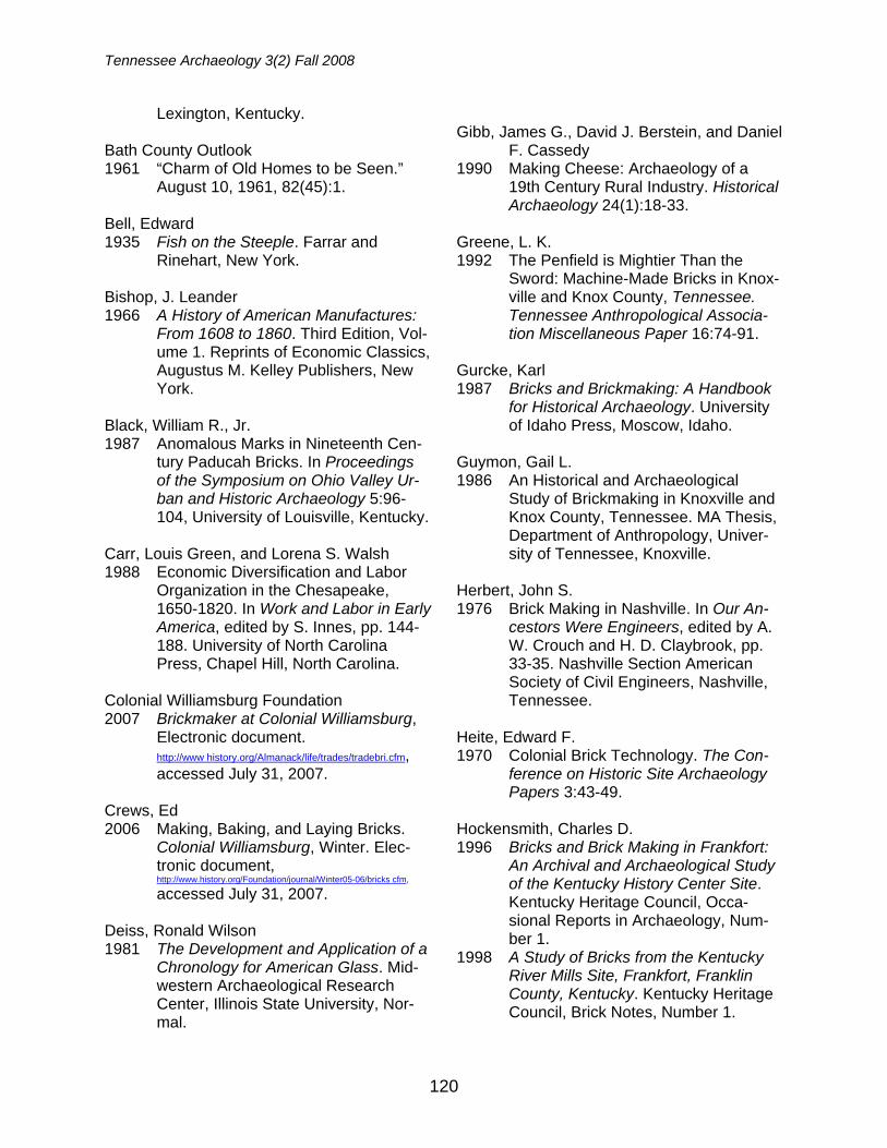
This research began at one of the monthly meetings of the Jackson Ar-chaeological Society (JAS) in Jackson, Tennessee where the question was raised if any obsidian had been found in Ten-nessee. The only specimen known at that time was a core found at the Brick Church Pike Mound site (40DV39) in Nashville, Tennessee by a local resident who lived in an adjacent neighborhood (John Dowd, personal communication, 2003). This arti-fact, given to a local college professor for analysis, was unfortunately misplaced or stolen before any laboratory results were produced. JAS member Mr. Bryan Banks put an exclamation point on the discus-sion by stating that he had found an ob-sidian flake on a site (40BN58) along the Big Sandy River in Benton County, Ten-
nessee (Figure 1). This site had been previously recorded by C.H. Nash in 1940 and designated as Late Archaic ca. 2000-3000 years ago.
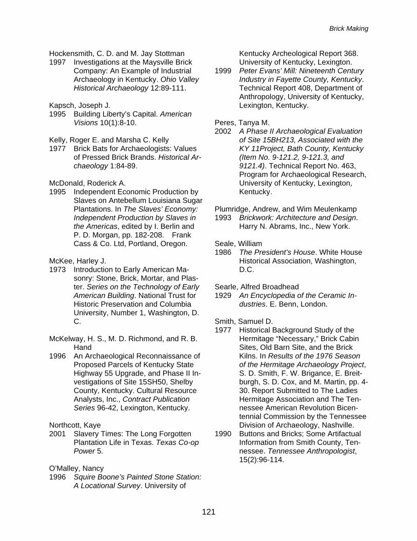
The flake recovered by Mr. Banks was sent to the Northwest Research Obsidian Studies Laboratory in Corvallis, Oregon for x-ray fluorescence (XRF) and hydra-tion analysis. A chemical signature ob-tained from the XRF analysis would allow researchers to define the exact volcano where the obsidian was orginally collected (Skinner 2008a). The XRF result deter-mined this obsidian was collected from Sarcobatus Flat A in southwestern Ne-vada (Figure 2).
The hydration test measured the amount of moisture the flake absorbed since it was manufactured. For the west-
FIGURE 1. Obsidian flake from 40BN58, Benton County, Tennessee.
FIGURE 2. Sarcobatus Flat, Nevada source location for 40BN58 obsidian artifact.
Tennessee Archaeology 3(2) Fall 2008
124
ern United States, researchers measure the thickness of the hydration patina to provide a relative date for the artifact (Skinner 2008b). This method has yet to be perfected in the southeast. The hydra-
tion test yielded a measurement of 6.1 microns (Skinner and Thatcher 2003a). This item is thought to be 2000 years old or older, giving this piece at least a Wood-land period association that approximates the Late Archaic designation suggested by C.H. Nash in 1940.
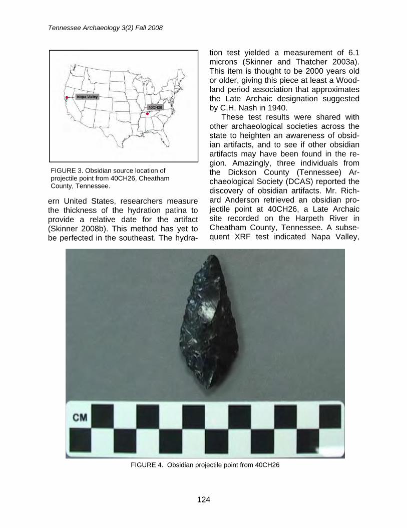
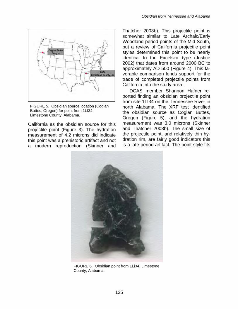
These test results were shared with other archaeological societies across the state to heighten an awareness of obsid-ian artifacts, and to see if other obsidian artifacts may have been found in the re-gion. Amazingly, three individuals from the Dickson County (Tennessee) Ar-chaeological Society (DCAS) reported the discovery of obsidian artifacts. Mr. Rich-ard Anderson retrieved an obsidian pro-jectile point at 40CH26, a Late Archaic site recorded on the Harpeth River in Cheatham County, Tennessee. A subse-quent XRF test indicated Napa Valley,
FIGURE 3. Obsidian source location of projectile point from 40CH26, Cheatham County, Tennessee.
FIGURE 4. Obsidian projectile point from 40CH26
Obsidian from Tennessee and Alabama
125
California as the obsidian source for this projectile point (Figure 3). The hydration measurement of 4.2 microns did indicate this point was a prehistoric artifact and not a modern reproduction (Skinner and
Thatcher 2003b). This projectile point is somewhat similar to Late Archaic/Early Woodland period points of the Mid-South, but a review of California projectile point styles determined this point to be nearly identical to the Excelsior type (Justice 2002) that dates from around 2000 BC to approximately AD 500 (Figure 4). This fa-vorable comparison lends support for the trade of completed projectile points from California into the study area.
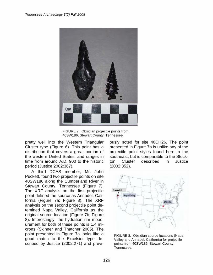
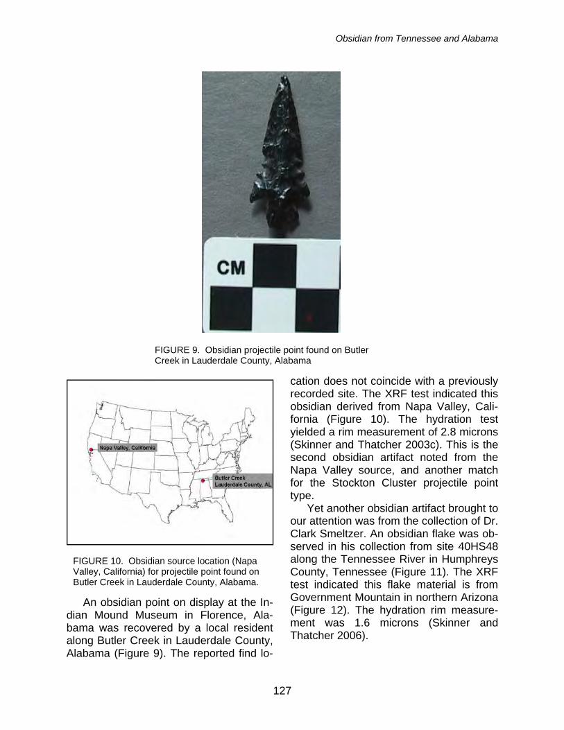
DCAS member Shannon Hafner re-ported finding an obsidian projectile point from site 1LI34 on the Tennessee River in north Alabama. The XRF test identified the obsidian source as Coglan Buttes, Oregon (Figure 5), and the hydration measurement was 3.0 microns (Skinner and Thatcher 2003b). The small size of the projectile point, and relatively thin hy-dration rim, are fairly good indicators this is a late period artifact. The point style fits
FIGURE 5. Obsidian source location (Coglan Buttes, Oregon) for point from 1LI34, Limestone County, Alabama.
FIGURE 6. Obsidian point from 1Li34, Limestone County, Alabama.
Tennessee Archaeology 3(2) Fall 2008
126
pretty well into the Western Triangular Cluster type (Figure 6). This point has a distribution that covers a great portion of the western United States, and ranges in time from around A.D. 900 to the historic period (Justice 2002:367).
A third DCAS member, Mr. John Puckett, found two projectile points on site 40SW186 along the Cumberland River in Stewart County, Tennessee (Figure 7). The XRF analysis on the first projectile point defined the source as Annadel, Cali-fornia (Figure 7a; Figure 8). The XRF analysis on the second projectile point de-temined Napa Valley, California as the original source location (Figure 7b; Figure 8). Interestingly, the hydration rim meas-urement for both of these points is 1.4 mi-crons (Skinner and Thatcher 2005). The point presented in Figure 7a looks like a good match to the Excelsior type de-scribed by Justice (2002:271) and previ-
ously noted for site 40CH26. The point presented in Figure 7b is unlike any of the projectile point styles found here in the southeast, but is comparable to the Stock-ton Cluster described in Justice (2002:352).
FIGURE 7. Obsidian projectile points from 40SW186, Stewart County, Tennessee.
FIGURE 8. Obsidian source locations (Napa Valley and Annadel, California) for projectile points from 40SW186, Stewart County, Tennessee.
Obsidian from Tennessee and Alabama
127
An obsidian point on display at the In-dian Mound Museum in Florence, Ala-bama was recovered by a local resident along Butler Creek in Lauderdale County, Alabama (Figure 9). The reported find lo-
cation does not coincide with a previously recorded site. The XRF test indicated this obsidian derived from Napa Valley, Cali-fornia (Figure 10). The hydration test yielded a rim measurement of 2.8 microns (Skinner and Thatcher 2003c). This is the second obsidian artifact noted from the Napa Valley source, and another match for the Stockton Cluster projectile point type.
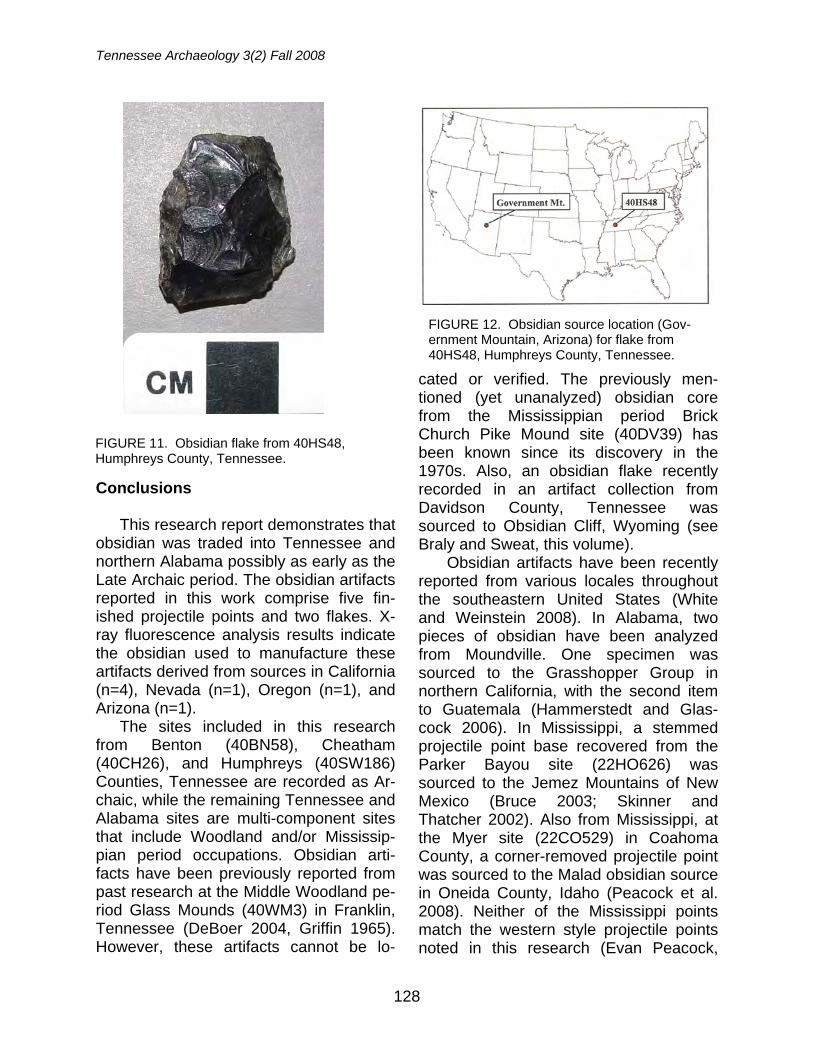
Yet another obsidian artifact brought to our attention was from the collection of Dr. Clark Smeltzer. An obsidian flake was ob-served in his collection from site 40HS48 along the Tennessee River in Humphreys County, Tennessee (Figure 11). The XRF test indicated this flake material is from Government Mountain in northern Arizona (Figure 12). The hydration rim measure-ment was 1.6 microns (Skinner and Thatcher 2006).
FIGURE 9. Obsidian projectile point found on Butler Creek in Lauderdale County, Alabama
FIGURE 10. Obsidian source location (Napa Valley, California) for projectile point found on Butler Creek in Lauderdale County, Alabama.
Tennessee Archaeology 3(2) Fall 2008
128
Conclusions This research report demonstrates that
obsidian was traded into Tennessee and northern Alabama possibly as early as the Late Archaic period. The obsidian artifacts reported in this work comprise five fin-ished projectile points and two flakes. X-ray fluorescence analysis results indicate the obsidian used to manufacture these artifacts derived from sources in California (n=4), Nevada (n=1), Oregon (n=1), and Arizona (n=1).
The sites included in this research from Benton (40BN58), Cheatham (40CH26), and Humphreys (40SW186) Counties, Tennessee are recorded as Ar-chaic, while the remaining Tennessee and Alabama sites are multi-component sites that include Woodland and/or Mississip-pian period occupations. Obsidian arti-facts have been previously reported from past research at the Middle Woodland pe-riod Glass Mounds (40WM3) in Franklin, Tennessee (DeBoer 2004, Griffin 1965). However, these artifacts cannot be lo-
cated or verified. The previously men-tioned (yet unanalyzed) obsidian core from the Mississippian period Brick Church Pike Mound site (40DV39) has been known since its discovery in the 1970s. Also, an obsidian flake recently recorded in an artifact collection from Davidson County, Tennessee was sourced to Obsidian Cliff, Wyoming (see Braly and Sweat, this volume).
Obsidian artifacts have been recently reported from various locales throughout the southeastern United States (White and Weinstein 2008). In Alabama, two pieces of obsidian have been analyzed from Moundville. One specimen was sourced to the Grasshopper Group in northern California, with the second item to Guatemala (Hammerstedt and Glas-cock 2006). In Mississippi, a stemmed projectile point base recovered from the Parker Bayou site (22HO626) was sourced to the Jemez Mountains of New Mexico (Bruce 2003; Skinner and Thatcher 2002). Also from Mississippi, at the Myer site (22CO529) in Coahoma County, a corner-removed projectile point was sourced to the Malad obsidian source in Oneida County, Idaho (Peacock et al. 2008). Neither of the Mississippi points match the western style projectile points noted in this research (Evan Peacock,
FIGURE 12. Obsidian source location (Gov-ernment Mountain, Arizona) for flake from 40HS48, Humphreys County, Tennessee.
FIGURE 11. Obsidian flake from 40HS48, Humphreys County, Tennessee.
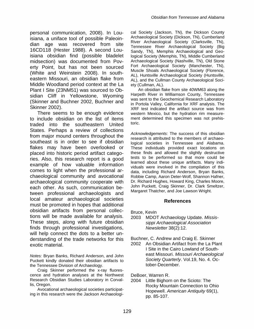
Obsidian from Tennessee and Alabama
129
personal communication, 2008). In Lou-isiana, a uniface tool of possible Paleoin-dian age was recovered from site 16CD118 (Hester 1988). A second Lou-isiana obsidian find (possible bladelet midsection) was documented from Pov-erty Point, but has not been sourced (White and Weinstein 2008). In south-eastern Missouri, an obsidian flake from Middle Woodland period context at the La Plant I Site (23NM51) was sourced to Ob-sidian Cliff in Yellowstone, Wyoming (Skinner and Buchner 2002, Buchner and Skinner 2002).
There seems to be enough evidence to include obsidian on the list of items traded into the southeastern United States. Perhaps a review of collections from major mound centers throughout the southeast is in order to see if obsidian flakes may have been overlooked or placed into historic period artifact catego-ries. Also, this research report is a good example of how valuable information comes to light when the professional ar-chaeological community and avocational archaeological community cooperate with each other. As such, communication be-tween professional archaeologists and local amateur archaeological societies must be promoted in hopes that additional obsidian artifacts from personal collec-tions will be made available for analysis. These steps, along with future obsidian finds through professional investigations, will help connect the dots to a better un-derstanding of the trade networks for this exotic material.
Notes: Bryan Banks, Richard Anderson, and John Puckett kindly donated their obsidian artifacts to the Tennessee Division of Archaeology. Craig Skinner performed the x-ray fluores-cence and hydration analyses at the Northwest Research Obsidian Studies Laboratory in Corval-lis, Oregon. Avocational archaeological societies participat-ing in this research were the Jackson Archaeologi-
cal Society (Jackson, TN), the Dickson County Archaeological Society (Dickson, TN), Cumberland River Archaeological Society (Clarksville, TN), Tennessee River Archaeological Society (Big Sandy, TN), Memphis Archaeological and Geo-logical Society (Memphis, TN), Middle Cumberland Archaeological Society (Nashville, TN), Old Stone Fort Archaeological Society (Manchester, TN), Muscle Shoals Archaeological Society (Florence, AL), Huntsville Archaeological Society (Huntsville, AL), and the Cullman County Archaeological Soci-ety (Cullman, AL). An obsidian flake from site 40WM63 along the Harpeth River in Williamson County, Tennessee was sent to the Geochemical Research Laboratory in Portola Valley, California for XRF analysis. The XRF test indicated the artifact source was from western Mexico, but the hydration rim measure-ment determined this specimen was not prehis-toric. Acknowledgements: The success of this obsidian research is attributed to the members of archaeo-logical societies in Tennessee and Alabama. These individuals provided exact locations on these finds and allowed the slightly destructive tests to be performed so that more could be learned about these unique artifacts. Many indi-viduals were involved in the compilation of this data, including Richard Anderson, Bryan Banks, Robbie Camp, Aaron Deter-Wolf, Shannon Hafner, Dr. Richard Hughes, Howard King, Charles Moore, John Puckett, Craig Skinner, Dr. Clark Smeltzer, Margaret Thatcher, and Joe Lawson Wright.
References
Bruce, Kevin 2003 MDOT Archaeology Update. Missis-
sippi Archaeological Association Newsletter 38(2):12.
Buchner, C. Andrew and Craig E. Skinner 2002 An Obsidian Artifact from the La Plant
I Site in the Cairo Lowland of South-east Missouri. Missouri Archaeological Society Quarterly. Vol.19, No. 4. Oc-tober-December.
DeBoer, Warren R. 2004 Little Bighorn on the Scioto: The
Rocky Mountain Connection to Ohio Hopewell. American Antiquity 69(1), pp. 85-107.
Tennessee Archaeology 3(2) Fall 2008
130
Griffin, James B. 1965 Hopewell and the Dark Black Glass.
The Michigan Archaeologist 11:115-155.
Hammerstedt, Scott W. and Michael D Glas-
cock 2006 Obsidian Artifacts From Moundville.
Poster presented at the 63rd Annual Meeting of the Southeastern Archaeo-logical Conference, Little Rock.
Hester, Thomas R. 1988 Paleoindian Obsidian Artifacts from
Texas: A Review. Current Research in the Pleistocene 5:27-29.
Justice, Noel D. 2002 Stone Age Spear and Arrow Points of
California and the Great Basin. Indi-ana University Press, Bloomington.
Peacock, Evan, Cliff Jenkins, and Grady
White 2008 Obsidian Artifacts from Mississippi.
Mississippi Archaeology. In press. Skinner, Craig E. 2008a Obsidian Characterization Studies.
Northwest Research Obsidian Studies Lab, Corvallis, Oregon.
2008b Obsidian Hydration Studies. Northwest
Obsidian Research Studies Lab, Cor-vallis, Oregon.
Skinner, Craig and C. Andrew Buchner 2002 X-Ray Fluorescence Analysis of Arti-
fact Obsidian from the Laplant Site (23NM51) New Madrid County, Mis-souri. Laboratory Report No. 2002-21. Northwest Research Obsidian Studies, Corvallis.
Skinner, Craig E. and Jennifer J. Thatcher 2002 X-Ray Fluorescence Analysis and Ob-
sidian Hydration Measurement of Arti-fact Obsidian from the Parker Bayou II Site (22HO626), Holmes County, Mis-sissippi. Laboratory Report No. 2002-
18. Northwest Research Obsidian Studies, Corvallis.
2003a X-Ray Fluorescence Analysis and Ob-sidian Hydration Measurement of Arti-fact Obsidian from 40BN58, Benton County, Tennessee. Laboratory Re-port No. 2003-59. Northwest Research Obsidian Studies, Corvallis.
2003b X-Ray Fluorescence Analysis and Ob-sidian Hydration Measurements of Ar-tifacts from Tennessee and Alabama. Report No. 2003-97. Northwest Re-search Obsidian Studies, Corvallis
2003c X-Ray Fluorescence Analysis and Ob-sidian Hydration Measurements of Ar-tifact Obsidian from Butler Creek, Lauderdale County, Alabama. Report No. 2003-113 Northwest Research Obsidian Studies, Corvallis
2005 X-Ray Fluorescence Analysis and Ob-sidian Hydration Measurements of Ar-tifact Obsidian from 40SW186, Stew-art County, Tennessee. Northwest Research Obsidian Studies, Corvallis.
2006 X-Ray Fluorescence Analysis and Ob-sidian Hydration Measurements of Ar-tifact Obsidian from 40HS48, Hum-phreys County, Tennessee. Report No. 2006-142. Northwest Research Obsidian Studies, Corvallis
White, Nancy Marie and Richard A. Weinstein 2008 The Mexican Connection and the Far
West of the U.S. Southeast. American Antiquity 73(2):227-277.
Mark R. Norton Tennessee Division of Archaeology 1216 Foster Avenue, Cole Bldg #3 Nashville, TN 37243
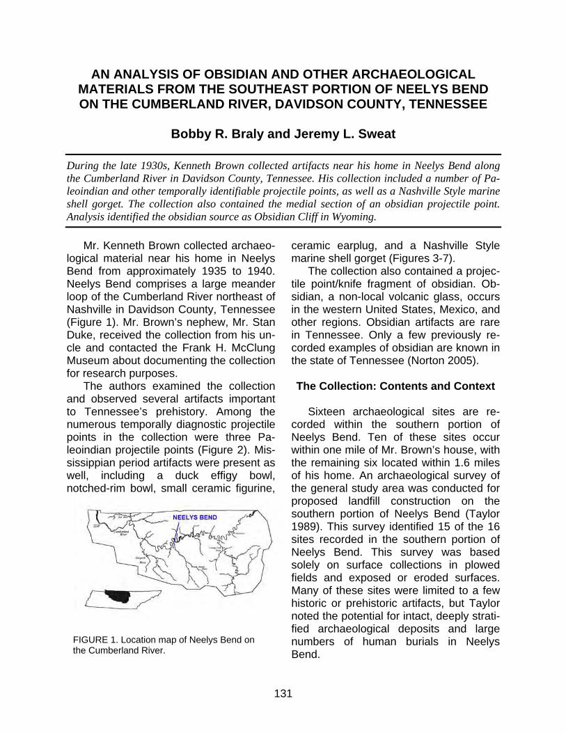
131
AN ANALYSIS OF OBSIDIAN AND OTHER ARCHAEOLOGICAL MATERIALS FROM THE SOUTHEAST PORTION OF NEELYS BEND ON THE CUMBERLAND RIVER, DAVIDSON COUNTY, TENNESSEE
Bobby R. Braly and Jeremy L. Sweat
During the late 1930s, Kenneth Brown collected artifacts near his home in Neelys Bend along the Cumberland River in Davidson County, Tennessee. His collection included a number of Pa-leoindian and other temporally identifiable projectile points, as well as a Nashville Style marine shell gorget. The collection also contained the medial section of an obsidian projectile point. Analysis identified the obsidian source as Obsidian Cliff in Wyoming.
Mr. Kenneth Brown collected archaeo-logical material near his home in Neelys Bend from approximately 1935 to 1940. Neelys Bend comprises a large meander loop of the Cumberland River northeast of Nashville in Davidson County, Tennessee (Figure 1). Mr. Brown’s nephew, Mr. Stan Duke, received the collection from his un-cle and contacted the Frank H. McClung Museum about documenting the collection for research purposes.
The authors examined the collection and observed several artifacts important to Tennessee’s prehistory. Among the numerous temporally diagnostic projectile points in the collection were three Pa-leoindian projectile points (Figure 2). Mis-sissippian period artifacts were present as well, including a duck effigy bowl, notched-rim bowl, small ceramic figurine,
ceramic earplug, and a Nashville Style marine shell gorget (Figures 3-7).
The collection also contained a projec-tile point/knife fragment of obsidian. Ob-sidian, a non-local volcanic glass, occurs in the western United States, Mexico, and other regions. Obsidian artifacts are rare in Tennessee. Only a few previously re-corded examples of obsidian are known in the state of Tennessee (Norton 2005).
The Collection: Contents and Context
Sixteen archaeological sites are re-
corded within the southern portion of Neelys Bend. Ten of these sites occur within one mile of Mr. Brown’s house, with the remaining six located within 1.6 miles of his home. An archaeological survey of the general study area was conducted for proposed landfill construction on the southern portion of Neelys Bend (Taylor 1989). This survey identified 15 of the 16 sites recorded in the southern portion of Neelys Bend. This survey was based solely on surface collections in plowed fields and exposed or eroded surfaces. Many of these sites were limited to a few historic or prehistoric artifacts, but Taylor noted the potential for intact, deeply strati-fied archaeological deposits and large numbers of human burials in Neelys Bend.
FIGURE 1. Location map of Neelys Bend on the Cumberland River.
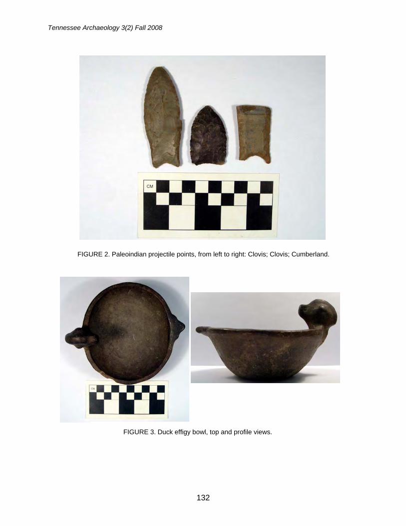
Tennessee Archaeology 3(2) Fall 2008
132
FIGURE 2. Paleoindian projectile points, from left to right: Clovis; Clovis; Cumberland.
FIGURE 3. Duck effigy bowl, top and profile views.
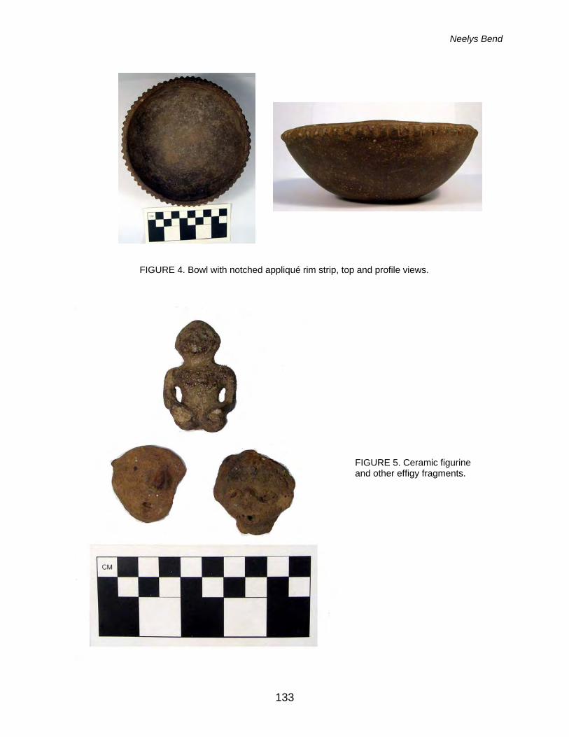
Neelys Bend
133
FIGURE 4. Bowl with notched appliqué rim strip, top and profile views.
FIGURE 5. Ceramic figurine and other effigy fragments.
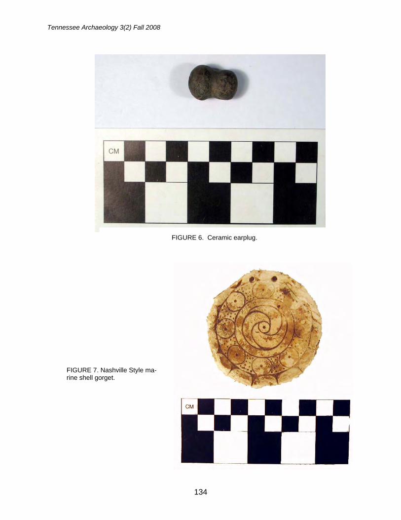
Tennessee Archaeology 3(2) Fall 2008
134
FIGURE 6. Ceramic earplug.
FIGURE 7. Nashville Style ma-rine shell gorget.
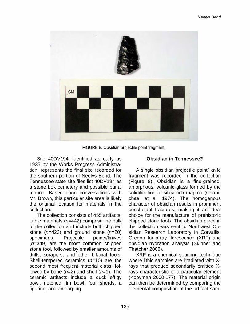
Neelys Bend
135
Site 40DV194, identified as early as 1935 by the Works Progress Administra-tion, represents the final site recorded for the southern portion of Neelys Bend. The Tennessee state site files list 40DV194 as a stone box cemetery and possible burial mound. Based upon conversations with Mr. Brown, this particular site area is likely the original location for materials in the collection.
The collection consists of 455 artifacts. Lithic materials (n=442) comprise the bulk of the collection and include both chipped stone (n=422) and ground stone (n=20) specimens. Projectile points/knives (n=349) are the most common chipped stone tool, followed by smaller amounts of drills, scrapers, and other bifacial tools. Shell-tempered ceramics (n=10) are the second most frequent material class, fol-lowed by bone (n=2) and shell (n=1). The ceramic artifacts include a duck effigy bowl, notched rim bowl, four sherds, a figurine, and an earplug.
Obsidian in Tennessee? A single obsidian projectile point/ knife
fragment was recorded in the collection (Figure 8). Obsidian is a fine-grained, amorphous, volcanic glass formed by the solidification of silica-rich magma (Carmi-chael et al. 1974). The homogenous character of obsidian results in prominent conchoidal fractures, making it an ideal choice for the manufacture of prehistoric chipped stone tools. The obsidian piece in the collection was sent to Northwest Ob-sidian Research Laboratory in Corvallis, Oregon for x-ray florescence (XRF) and obsidian hydration analysis (Skinner and Thatcher 2008).
XRF is a chemical sourcing technique where lithic samples are irradiated with X-rays that produce secondarily emitted X-rays characteristic of a particular element (Kooyman 2000:177). The material origin can then be determined by comparing the elemental composition of the artifact sam-
FIGURE 8. Obsidian projectile point fragment.
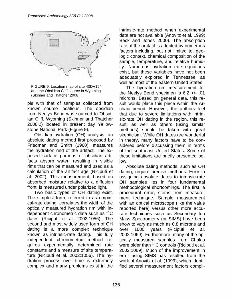
Tennessee Archaeology 3(2) Fall 2008
136
ple with that of samples collected from known source locations. The obsidian from Neelys Bend was sourced to Obsid-ian Cliff, Wyoming (Skinner and Thatcher 2008:2) located in present day Yellow-stone National Park (Figure 9).
Obsidian hydration (OH) analysis, an absolute dating method first proposed by Friedman and Smith (1960), measures the hydration rind of the artifact. The ex-posed surface portions of obsidian arti-facts absorb water, resulting in visible rims that can be measured and used as a calculation of the artifact age (Riciputi et al. 2002). This measurement, based on absorbed moisture relative to a diffusion front, is measured under polarized light.
Two basic types of OH dating exist. The simplest form, referred to as empiri-cal-rate dating, correlates the width of the optically measured hydration rim with in-dependent chronometric data such as 14C dates (Riciputi et al. 2002:1056). The second and most widely used form of OH dating is a more complex technique known as intrinsic-rate dating. This fully independent chronometric method re-quires experimentally determined rate constants and a measure of site tempera-ture (Riciputi et al. 2002:1056). The hy-dration process over time is extremely complex and many problems exist in the
intrinsic-rate method when experimental data are not available (Anovitz et al. 1999; Beck and Jones 2000). The absorption rate of the artifact is affected by numerous factors including, but not limited to, geo-logic context, chemical composition of the sample, temperature, and relative humid-ity. Numerous hydration rate equations exist, but these variables have not been adequately explored in Tennessee, as well as most of the eastern United States.
The hydration rim measurement for the Neelys Bend specimen is 6.2 +/- .01 microns. Based on general data, this re-sult would place this piece within the Ar-chaic period. However, the authors feel that due to severe limitations with intrin-sic-rate OH dating in the region, this re-sult, as well as others (using similar methods) should be taken with great skepticism. While OH dates are wonderful in theory, many factors have to be con-sidered before discussing them in terms of the southeast United States. Some of these limitations are briefly presented be-low.
Absolute dating methods, such as OH dating, require precise methods. Error in assigning absolute dates to intrinsic-rate OH samples lies in four fundamental methodological shortcomings. The first, a procedural error, stems from measure-ment technique. Sample measurement with an optical microscope (like the value reported here) versus other more accu-rate techniques such as Secondary Ion Mass Spectrometry (or SIMS) have been show to vary as much as 0.8 microns and over 1000 years (Riciputi et al. 2002:1069). Furthermore, many of the op-tically measured samples from Chalco were older than 14C controls (Riciputi et al. 2002:1069). Much of the improvement in error using SIMS has resulted from the work of Anovitz et al. (1999), which identi-fied several measurement factors compli-
FIGURE 9. Location map of site 40DV194 and the Obsidian Cliff source in Wyoming (Skinner and Thatcher 2008)
Neelys Bend
137
cating the traditional optical method. Additional factors in intrinsic-rate OH
dating stem from mathematical shortcom-ings of formula variable assumptions. These three values include soil tempera-ture, relative humidity, and diffusion rate of the obsidian. Diffusion is a complex function that can be modeled mathemati-cally by time, temperature, hydration rate, and other variables with fewer effects. If we know the diffusion measurement, other variables can be substituted to solve for time (or age of the artifact). Prehistoric temperature reconstructions for soil tem-perature are unknown at this time, but studying paleoclimatic changes through time and extrapolating these to known current temperatures would be beneficial. This variable, however, becomes circular when solving the equation. To assign a value for soil temperature at time x has invoked a temporal moment in which we are trying to solve for. Inversely, recent research has used OH to calculate paleo-climate when all other variables are con-trolled (Anovitz et al. 2006).
Relative humidity has been shown to affect the hydration rate of obsidian arti-facts. This overall effect has recently been shown to be rather small (Anovitz et al. 2006:5661), but attention must still be given to this value in the equation. The final mathematical error to be discussed is the diffusion rate of obsidian. Many types of obsidian exist, each with its own hydra-tion rate. To accurately estimate the age of an artifact using the intrinsic-rate method, hydration rate data must be de-termined experimentally. Anovitz et al. (2004) determined this rate for Pachuca obsidian from Mexico. No known similar studies have been carried out on obsidian recovered in the southeast United States. The date for the Neelys Bend projectile point/knife fragment in the Brown collec-tion would have to be calculated using a
diffusion rate for this particular source in Wyoming. Other factors exist as well, but these three in conjunction with measure-ment are the primary errors that must be accounted for.
Conclusions
Obsidian, while rare, has previously
been documented in Tennessee and the southeast (Norton 2005). The recovery of a specimen on Neelys Bend in Davidson County, Tennessee and sourced to Wyo-ming suggests extensive trade distance. While undoubtedly of prehistoric origin (based on the sizeable hydration rim), the OH dating of this sample is seen as pre-liminary. As previously discussed, many errors are involved in assigning absolute dates to artifacts using OH dating. The combination of potential procedural and mathematical errors in intrinsic-rate dating may skew the dating of an artifact by thousands of years. Any intrinsic-rate OH dating must proceed carefully when mathematically modeling the diffusion process with respect to the three variables pointed out (soil temperature, relative hu-midity, and hydration rate of specific ob-sidian types). Empirical-rate OH dating, using multiple samples from multiple lev-els coupled with traditional 14C dating, is more applicable. This method, however ideal, is improbable in the region due to the lack of multiple obsidian samples from a single site. Possible future directions for OH dating in the region should focus on modeling, as accurate as possible, the mathematical variables discussed and subjecting archaeological samples to Secondary Ion Mass Spectrometry (SIMS) rather than traditional optical measure-ment.
Acknowledgements: The authors thank Kenneth Brown and Stan Duke for allowing analysis of this collection. The Northwest Obsidian Research
Tennessee Archaeology 3(2) Fall 2008
138
Laboratory performed the XRF and OH analyses. The Frank H. McClung museum graciously al-lowed use of laboratory space. Dr. Lawrence M. Anovitz of the Oak Ridge National Laboratory pro-vided many insightful comments and his direction is greatly appreciated. All errors are those of the authors.
References
Anovitz, L.M., J.M. Elam, L.R. Riciputi, and D.R. Cole
1999 The Failure of Obsidian Hydration Dat-ing: Sources, Implications, and New Directions. Journal of Archaeological Science 26:735-752.
2004 Isothermal Time-Series Determination of the Rate of Diffusion of Water in Pachuca Obsidian. Archaeometry 46(2):301-326.
Anovitz, L.M., L.R. Riciputi, D.R. Cole, M.
Fayek, and J.M. Elam 2006 Obsidian Hydration: A New Paleo-
thermometer. Geology 34(7):517-520. Anovitz, L.M., L.R. Riciputi, D.R. Cole, M.S.
Gruszkiewicz, and J.M. Elam 2006 The Effect of Changes in Relative
Humidity on the Hydration Rate of Pachuca Obsidian. Journal of Non-Crystalline Solids 352:5652-5662.
Beck, Charlotte and George T. Jones 2000 Obsidian Hydration Dating, Past and
Present. In It’s About Time: A History of Archaeological Dating in North America, edited by Stephen E. Nash, pp. 124-151. University of Utah Press, Salt Lake City.
Carmichael, Ian S. E., Francis J. Turner, and
John Verhoogen 1974 Igneous Petrology. International Se-
ries in Earth and Planetary Sciences, McGraw-Hill Book Company, New York.
Friedman, Irving and R. L. Smith 1960 A New Dating Method Using Obsidian:
Part 1, The Development of the
Method. American Antiquity 25:476-522.
Kooyman, Brian P. 2000 Understanding Stone Tools and Ar-
chaeological Sites. University of New Mexico Press, Albuquerque.
Lee R. Riciputi, J. Michael Elam, Lawrence M.
Anovitz, and David R. Cole 2002 Obsidian Diffusion Dating by Secon-
dary Ion Mass Spectrometry: A Test Using Results from Mound 65, Chalco, Mexico. Journal of Archaeological Sci-ence 29:1055-1075.
Norton, Mark R. 2005 Obsidian Artifacts from Tennessee
and Alabama. Paper presented at the 62nd Annual Meeting of the South-eastern Archaeological Conference, Columbia, South Carolina.
Skinner, Craig E. and Jennifer J. Thatcher 2008 X-Ray Fluorescence Analysis and Ob-
sidian Hydration Measurement of Arti-fact Obsidian from 40-DV-194, David-son County, Tennessee. Northwest Research Obsidian Studies Laboratory Report 2008-31, Corvallis, Oregon.
Taylor, Richard D. Jr. 1989 A Cultural Resource Survey of Pro-
posed Landfill Site Locations on White's, Bell's, Hadley and Neely's Bends in Davidson County, Tennes-see. Report prepared for EDGE, Inc, Environmental Division. University of Alabama, State Museum of Natural History, Division of Archaeology
Bobby R. Braly Frank H. McClung Museum The University of Tennessee 1327 Circle Park Drive Knoxville, Tennessee 37996 Jeremy L. Sweat Department of Anthropology The University of Tennessee 250 South Stadium Hall Knoxville, Tennessee 37996
139
EVIDENCE OF PREHISTORIC VIOLENT TRAUMA FROM A CAVE IN MIDDLE TENNESSEE
Shannon Chappell Hodge and Hugh E. Berryman
Some time in the last ten millennia, in what is now Middle Tennessee, a young man in his 20s or early 30s experienced a traumatic encounter with one or more assailants that resulted in his death. This attack left him with a projectile point embedded in his left femur. An isolated frag-ment of this femur (including the embedded projectile) was examined by bioarchaeologists from Middle Tennessee State University. Lacking the rest of this individual’s remains and the context of his burial, we can only speculate that he may have met an untimely end due to various forces ranging from simple interpersonal violence to more wide-ranging conflict resulting from broad trends of culture change within the Archaic societies of the Mid-South.
Caves have always represented curi-osities that attract the attention of the in-quisitive, and exploration often produces evidence of previous human activity. Pro-fessional and avocational archaeologists and cavers have recorded abundant evi-dence of prehistoric and historic human use of the caves of Tennessee. Among their discoveries are evidence of prehis-toric exploration, mining, burial practices, and ritual, and historic era saltpeter min-ing, moonshining and even sightseeing (Boyd and Boyd 1997; Douglas 2001; Douglas et al. 2000; Duncan 1997; Faulk-ner et al. 1984; Faulkner et al. 1989; Ken-nedy and Watson 1997; Willey et al. 2005).
Some time in the 1960s or 1970s, in a cave in middle Tennessee, an amateur archaeologist discovered a segment of bone with an embedded projectile point.1 Thinking it was a deer bone associated with a hearth, he kept it as a curiosity. Ul-timately, this deer bone turned out to be a fragment of human femur. Due to the cir-cumstances of its discovery, the original context of the bone fragment within the cave is unclear, it is unassociated with any particular burial in the cave, and the rest of this individual’s remains were never identified or collected. The collector stated that looted human burials were
nearby in the cave; this fragment might have been displaced by modern pot-hunters, historic or prehistoric human ac-tivity, or even burrowing animals or other taphonomic agents. The collector who brought this specimen to our attention had landowner permission to collect artifacts from the cave. He stated that he did not knowingly disturb any burials in his col-lecting activities, nor was he aware that the bone fragment he collected was hu-man. When he realized the bone might be human, he made a good-faith effort to find out if it was, so the remains could be han-dled appropriately. This is how it came to be on temporary loan to anthropology faculty at Middle Tennessee State Univer-sity.
Description
The bone segment is a proximal hu-
man femur from the left side (i.e., left thigh bone at the hip joint) consisting of the fe-mur head, neck and greater trochanter (Figure 1). The bone fragment measures 100.6 mm in length and exhibits evidence of perimortem trauma and postmortem damage. A portion of a stone projectile point is embedded in the neck of the fe-mur. The bone is stained a medium brown color and, although incomplete, is in fair
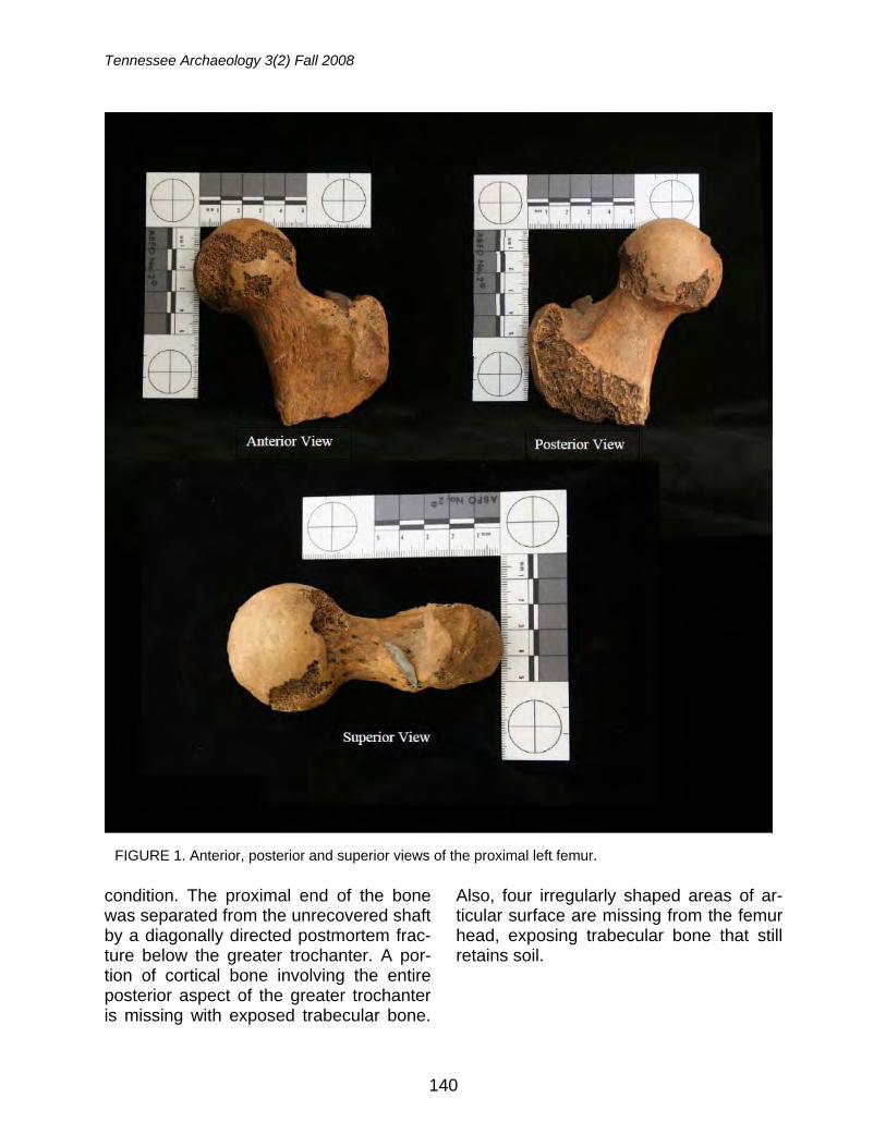
Tennessee Archaeology 3(2) Fall 2008
140
condition. The proximal end of the bone was separated from the unrecovered shaft by a diagonally directed postmortem frac-ture below the greater trochanter. A por-tion of cortical bone involving the entire posterior aspect of the greater trochanter is missing with exposed trabecular bone.
Also, four irregularly shaped areas of ar-ticular surface are missing from the femur head, exposing trabecular bone that still retains soil.
FIGURE 1. Anterior, posterior and superior views of the proximal left femur.
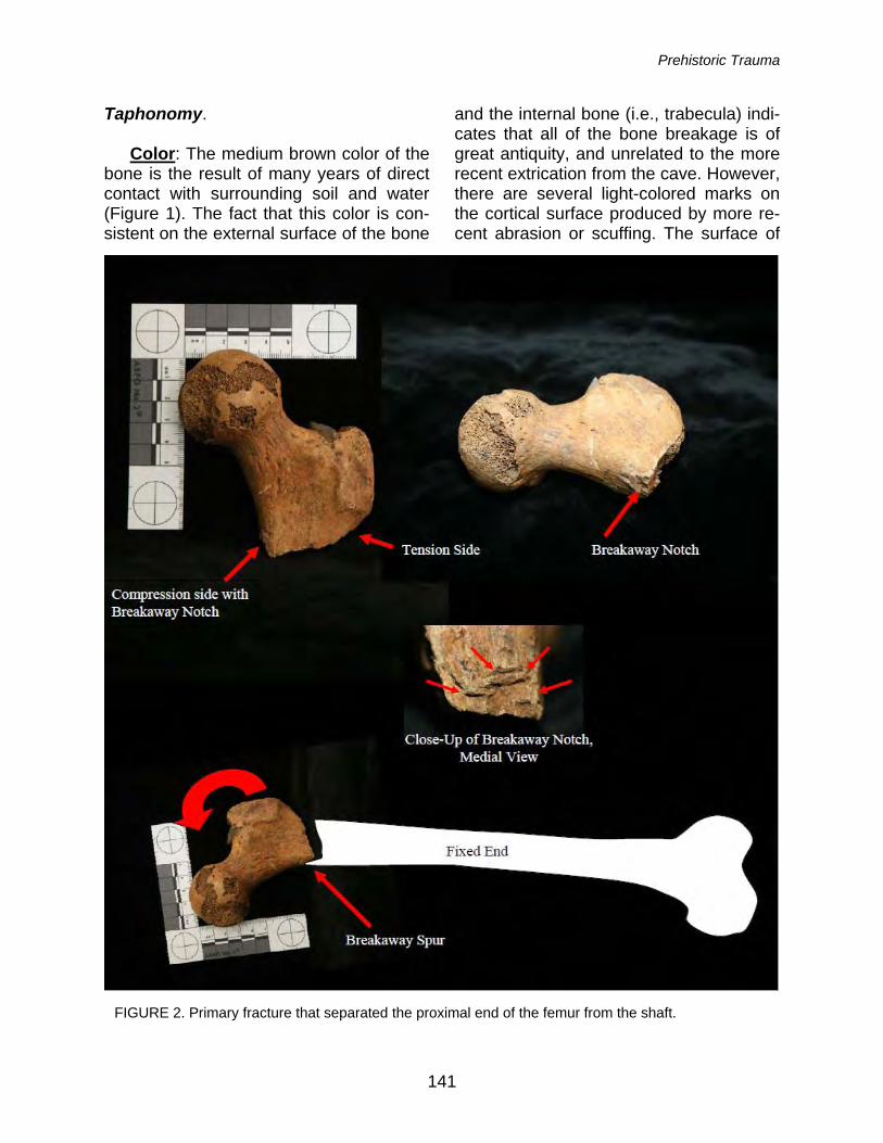
Prehistoric Trauma
141
Taphonomy. Color: The medium brown color of the bone is the result of many years of direct contact with surrounding soil and water (Figure 1). The fact that this color is con-sistent on the external surface of the bone
and the internal bone (i.e., trabecula) indi-cates that all of the bone breakage is of great antiquity, and unrelated to the more recent extrication from the cave. However, there are several light-colored marks on the cortical surface produced by more re-cent abrasion or scuffing. The surface of
FIGURE 2. Primary fracture that separated the proximal end of the femur from the shaft.
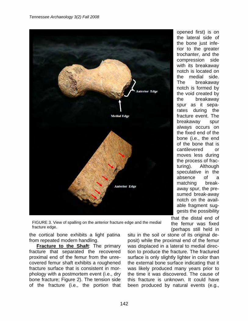
Tennessee Archaeology 3(2) Fall 2008
142
the cortical bone exhibits a light patina from repeated modern handling.
Fracture to the Shaft: The primary fracture that separated the recovered proximal end of the femur from the unre-covered femur shaft exhibits a roughened fracture surface that is consistent in mor-phology with a postmortem event (i.e., dry bone fracture; Figure 2). The tension side of the fracture (i.e., the portion that
opened first) is on the lateral side of the bone just infe-rior to the greater trochanter, and the compression side with its breakaway notch is located on the medial side. The breakaway notch is formed by the void created by the breakaway spur as it sepa-rates during the fracture event. The breakaway spur always occurs on the fixed end of the bone (i.e., the end of the bone that is cantilevered or moves less during the process of frac-turing). Although speculative in the absence of a matching break-away spur, the pre-sumed break-away notch on the avail-able fragment sug-gests the possibility
that the distal end of the femur was fixed (perhaps still held in
situ in the soil or stone of its original de-posit) while the proximal end of the femur was displaced in a lateral to medial direc-tion to produce the fracture. The fractured surface is only slightly lighter in color than the external bone surface indicating that it was likely produced many years prior to the time it was discovered. The cause of this fracture is unknown. It could have been produced by natural events (e.g.,
FIGURE 3. View of spalling on the anterior fracture edge and the medial fracture edge.
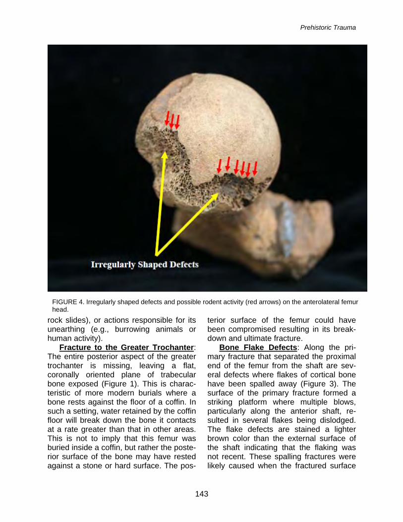
Prehistoric Trauma
143
rock slides), or actions responsible for its unearthing (e.g., burrowing animals or human activity).
Fracture to the Greater Trochanter: The entire posterior aspect of the greater trochanter is missing, leaving a flat, coronally oriented plane of trabecular bone exposed (Figure 1). This is charac-teristic of more modern burials where a bone rests against the floor of a coffin. In such a setting, water retained by the coffin floor will break down the bone it contacts at a rate greater than that in other areas. This is not to imply that this femur was buried inside a coffin, but rather the poste-rior surface of the bone may have rested against a stone or hard surface. The pos-
terior surface of the femur could have been compromised resulting in its break-down and ultimate fracture.
Bone Flake Defects: Along the pri-mary fracture that separated the proximal end of the femur from the shaft are sev-eral defects where flakes of cortical bone have been spalled away (Figure 3). The surface of the primary fracture formed a striking platform where multiple blows, particularly along the anterior shaft, re-sulted in several flakes being dislodged. The flake defects are stained a lighter brown color than the external surface of the shaft indicating that the flaking was not recent. These spalling fractures were likely caused when the fractured surface
FIGURE 4. Irregularly shaped defects and possible rodent activity (red arrows) on the anterolateral femur head.
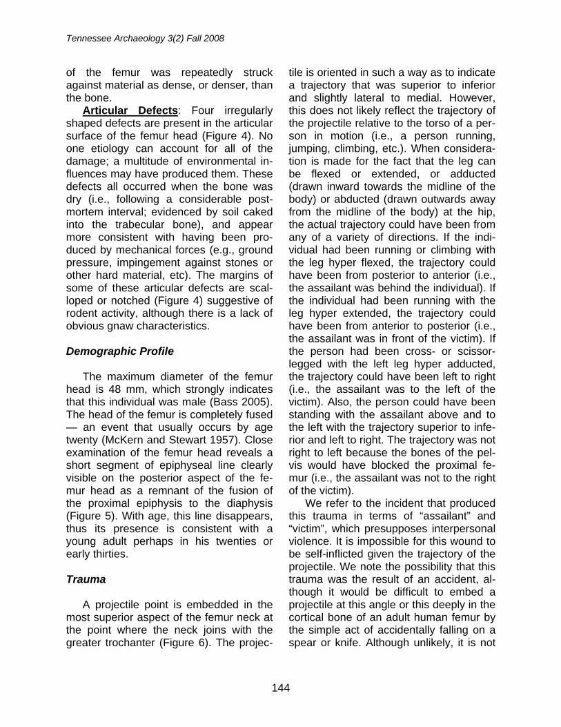
Tennessee Archaeology 3(2) Fall 2008
144
of the femur was repeatedly struck against material as dense, or denser, than the bone.
Articular Defects: Four irregularly shaped defects are present in the articular surface of the femur head (Figure 4). No one etiology can account for all of the damage; a multitude of environmental in-fluences may have produced them. These defects all occurred when the bone was dry (i.e., following a considerable post-mortem interval; evidenced by soil caked into the trabecular bone), and appear more consistent with having been pro-duced by mechanical forces (e.g., ground pressure, impingement against stones or other hard material, etc). The margins of some of these articular defects are scal-loped or notched (Figure 4) suggestive of rodent activity, although there is a lack of obvious gnaw characteristics.
Demographic Profile
The maximum diameter of the femur head is 48 mm, which strongly indicates that this individual was male (Bass 2005). The head of the femur is completely fused — an event that usually occurs by age twenty (McKern and Stewart 1957). Close examination of the femur head reveals a short segment of epiphyseal line clearly visible on the posterior aspect of the fe-mur head as a remnant of the fusion of the proximal epiphysis to the diaphysis (Figure 5). With age, this line disappears, thus its presence is consistent with a young adult perhaps in his twenties or early thirties.
Trauma
A projectile point is embedded in the most superior aspect of the femur neck at the point where the neck joins with the greater trochanter (Figure 6). The projec-
tile is oriented in such a way as to indicate a trajectory that was superior to inferior and slightly lateral to medial. However, this does not likely reflect the trajectory of the projectile relative to the torso of a per-son in motion (i.e., a person running, jumping, climbing, etc.). When considera-tion is made for the fact that the leg can be flexed or extended, or adducted (drawn inward towards the midline of the body) or abducted (drawn outwards away from the midline of the body) at the hip, the actual trajectory could have been from any of a variety of directions. If the indi-vidual had been running or climbing with the leg hyper flexed, the trajectory could have been from posterior to anterior (i.e., the assailant was behind the individual). If the individual had been running with the leg hyper extended, the trajectory could have been from anterior to posterior (i.e., the assailant was in front of the victim). If the person had been cross- or scissor-legged with the left leg hyper adducted, the trajectory could have been left to right (i.e., the assailant was to the left of the victim). Also, the person could have been standing with the assailant above and to the left with the trajectory superior to infe-rior and left to right. The trajectory was not right to left because the bones of the pel-vis would have blocked the proximal fe-mur (i.e., the assailant was not to the right of the victim).
We refer to the incident that produced this trauma in terms of “assailant” and “victim”, which presupposes interpersonal violence. It is impossible for this wound to be self-inflicted given the trajectory of the projectile. We note the possibility that this trauma was the result of an accident, al-though it would be difficult to embed a projectile at this angle or this deeply in the cortical bone of an adult human femur by the simple act of accidentally falling on a spear or knife. Although unlikely, it is not
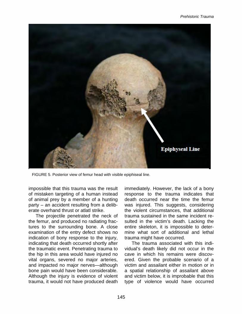
Prehistoric Trauma
145
impossible that this trauma was the result of mistaken targeting of a human instead of animal prey by a member of a hunting party – an accident resulting from a delib-erate overhand thrust or atlatl strike.
The projectile penetrated the neck of the femur, and produced no radiating frac-tures to the surrounding bone. A close examination of the entry defect shows no indication of bony response to the injury, indicating that death occurred shortly after the traumatic event. Penetrating trauma to the hip in this area would have injured no vital organs, severed no major arteries, and impacted no major nerves—although bone pain would have been considerable. Although the injury is evidence of violent trauma, it would not have produced death
immediately. However, the lack of a bony response to the trauma indicates that death occurred near the time the femur was injured. This suggests, considering the violent circumstances, that additional trauma sustained in the same incident re-sulted in the victim’s death. Lacking the entire skeleton, it is impossible to deter-mine what sort of additional and lethal trauma might have occurred.
The trauma associated with this indi-vidual’s death likely did not occur in the cave in which his remains were discov-ered. Given the probable scenario of a victim and assailant either in motion or in a spatial relationship of assailant above and victim below, it is improbable that this type of violence would have occurred
FIGURE 5. Posterior view of femur head with visible epiphiseal line.
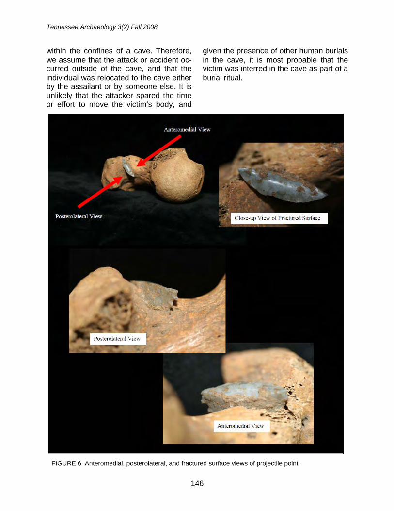
Tennessee Archaeology 3(2) Fall 2008
146
within the confines of a cave. Therefore, we assume that the attack or accident oc-curred outside of the cave, and that the individual was relocated to the cave either by the assailant or by someone else. It is unlikely that the attacker spared the time or effort to move the victim’s body, and
given the presence of other human burials in the cave, it is most probable that the victim was interred in the cave as part of a burial ritual.
FIGURE 6. Anteromedial, posterolateral, and fractured surface views of projectile point.
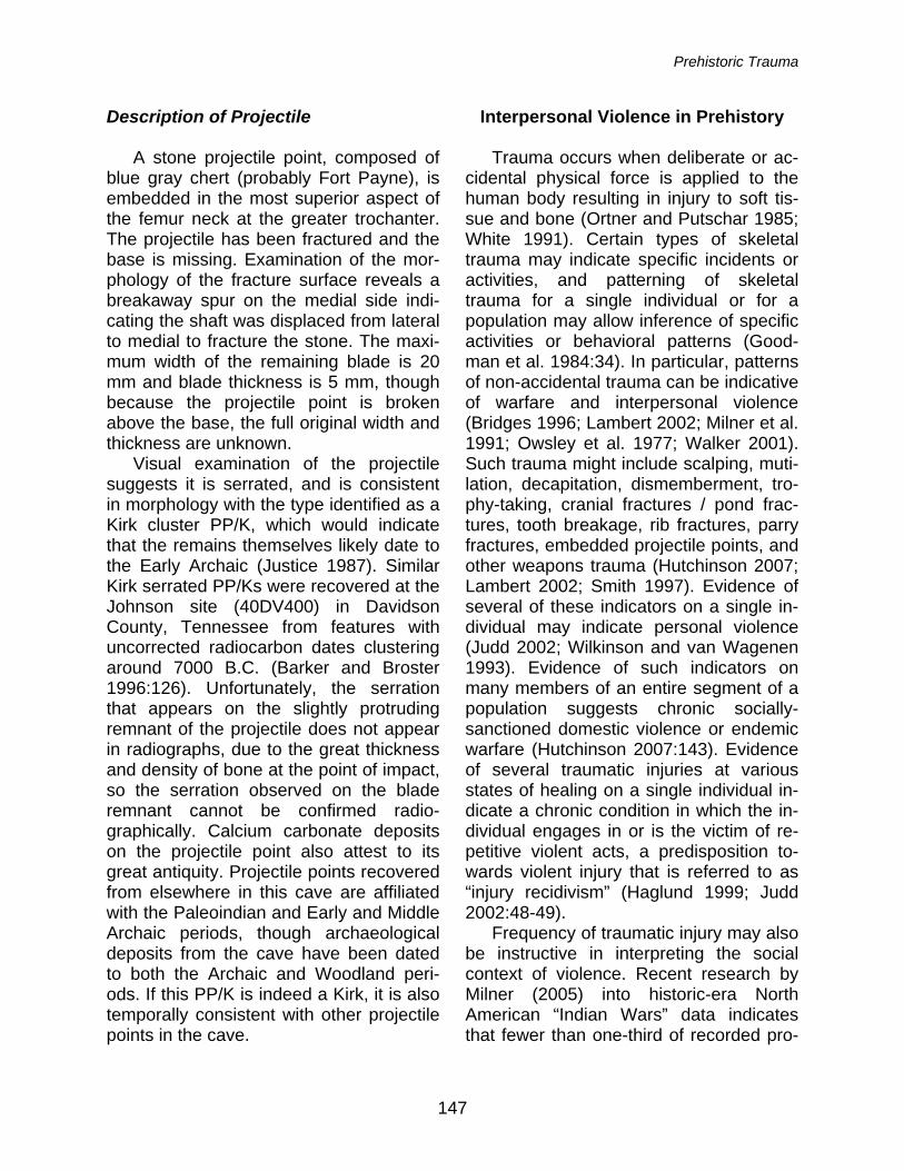
Prehistoric Trauma
147
Description of Projectile
A stone projectile point, composed of blue gray chert (probably Fort Payne), is embedded in the most superior aspect of the femur neck at the greater trochanter. The projectile has been fractured and the base is missing. Examination of the mor-phology of the fracture surface reveals a breakaway spur on the medial side indi-cating the shaft was displaced from lateral to medial to fracture the stone. The maxi-mum width of the remaining blade is 20 mm and blade thickness is 5 mm, though because the projectile point is broken above the base, the full original width and thickness are unknown.
Visual examination of the projectile suggests it is serrated, and is consistent in morphology with the type identified as a Kirk cluster PP/K, which would indicate that the remains themselves likely date to the Early Archaic (Justice 1987). Similar Kirk serrated PP/Ks were recovered at the Johnson site (40DV400) in Davidson County, Tennessee from features with uncorrected radiocarbon dates clustering around 7000 B.C. (Barker and Broster 1996:126). Unfortunately, the serration that appears on the slightly protruding remnant of the projectile does not appear in radiographs, due to the great thickness and density of bone at the point of impact, so the serration observed on the blade remnant cannot be confirmed radio-graphically. Calcium carbonate deposits on the projectile point also attest to its great antiquity. Projectile points recovered from elsewhere in this cave are affiliated with the Paleoindian and Early and Middle Archaic periods, though archaeological deposits from the cave have been dated to both the Archaic and Woodland peri-ods. If this PP/K is indeed a Kirk, it is also temporally consistent with other projectile points in the cave.
Interpersonal Violence in Prehistory
Trauma occurs when deliberate or ac-cidental physical force is applied to the human body resulting in injury to soft tis-sue and bone (Ortner and Putschar 1985; White 1991). Certain types of skeletal trauma may indicate specific incidents or activities, and patterning of skeletal trauma for a single individual or for a population may allow inference of specific activities or behavioral patterns (Good-man et al. 1984:34). In particular, patterns of non-accidental trauma can be indicative of warfare and interpersonal violence (Bridges 1996; Lambert 2002; Milner et al. 1991; Owsley et al. 1977; Walker 2001). Such trauma might include scalping, muti-lation, decapitation, dismemberment, tro-phy-taking, cranial fractures / pond frac-tures, tooth breakage, rib fractures, parry fractures, embedded projectile points, and other weapons trauma (Hutchinson 2007; Lambert 2002; Smith 1997). Evidence of several of these indicators on a single in-dividual may indicate personal violence (Judd 2002; Wilkinson and van Wagenen 1993). Evidence of such indicators on many members of an entire segment of a population suggests chronic socially-sanctioned domestic violence or endemic warfare (Hutchinson 2007:143). Evidence of several traumatic injuries at various states of healing on a single individual in-dicate a chronic condition in which the in-dividual engages in or is the victim of re-petitive violent acts, a predisposition to-wards violent injury that is referred to as “injury recidivism” (Haglund 1999; Judd 2002:48-49).
Frequency of traumatic injury may also be instructive in interpreting the social context of violence. Recent research by Milner (2005) into historic-era North American “Indian Wars” data indicates that fewer than one-third of recorded pro-
Tennessee Archaeology 3(2) Fall 2008
148
jectile point injuries resulted in damage to bone, suggesting that rates of projectile point injury were higher than we can de-termine from skeletal remains, and that violence may have been more prevalent than our skeletal data suggest. Further-more, taphonomic processes that obscure evidence of violent trauma, and skeletal lesions which cannot be definitively attrib-uted to violence, may also lead to the un-dercounting of the incidence of interper-sonal violence.
In the prehistoric Southeast, the record of skeletal trauma indicates low though persistent rates of interpersonal violence and warfare in general. In early North American prehistory, the Archaic period appears to be a time of increased vio-lence (Lambert 2001:227; Smith 1993b). Of course, the Archaic period in the Southeast encompasses a long temporal span and spatial extent, and exhibits con-siderable environmental, social, political, economic, and demographic variation. Overall, evidence of interpersonal vio-lence in the Archaic occurs in isolated in-stances that may represent specific cir-cumstances that led to conflict. However, writ large, the Archaic represents the ear-liest evidence of prehistoric violence in eastern North America, and in those in-stances where violence occurs, it is clear-cut and pervasive.
For example, in Tennessee alone, two Late Archaic incidents of scalping are re-ported from the Eva and Kays Landing sites (Smith 1991, 1997) located in the Lower Tennessee River Valley in Benton and Henry Counties, Tennessee. Simi-larly, at least ten individuals buried at Late Archaic Kentucky Lake Reservoir sites in Western Tennessee were recorded as having died violently, several of whom were scalped or dismembered (Smith 1993a:183, 1997). In addition, there is a probable case of perimortem decapitation
and trophy-related dismemberment of a young adult male at the Late Archaic Rob-inson site on the Cumberland River in Smith County, Tennessee (Smith 1993b, 1997). There is also a possible case of trophy-related dismemberment in the re-moval of an individual’s forearm at the Late Archaic 40DV35 site in Davidson County, Tennessee (Moore et al. 1992; Smith 1993b:133, 1997). These Tennes-see cases are overwhelmingly males - a pattern generally indicative of intergroup conflict, raiding, or warfare (Lambert 2002:227), rather than within-group vio-lence. Interestingly, this pattern is sup-ported by comparatively low frequencies of healed depressed cranial fractures among Tennessee Archaic populations (Mensforth 2005:471). Such fractures are found at higher rates in Kentucky and Ohio Archaic populations, and tend to be healed injuries which Mensforth interprets as evidence of within-group “social con-tests” driven by individual prestige-seeking rather than lethal intent (2001:124-125).
Elsewhere in the Archaic Southeast, there are several notable instances of vio-lence indicated by embedded projectile points, as in the four individuals reported by Webb (1974:226-227) from the Late Archaic Indian Knoll site in Kentucky. A fifth2 and particularly notable victim of vio-lence from Indian Knoll is the individual nicknamed “Flint in the Face” by excava-tors, an adult male who suffered a fatal projectile point wound that appears to have entered the right side of the neck, passing through the arch of the mandible and lodging in the hard palate and left maxillary sinus (Snow 1948:523-524). Also in Kentucky, residents of the Ward site suffered “cranial depression injuries, projectile point injuries, stab wounds, parry fractures, and cut marks indicative of scalping, decapitation, and limb dis-
Prehistoric Trauma
149
memberment” (Baker and Mensforth 1995:2; Mensforth 2007), and residents of the Carlston-Annis site were similarly af-fected by violent death, scalping, dis-memberment, and decapitation (Mens-forth 2007:245). Other instances of Ar-chaic period interpersonal violence from Kentucky include antemortem scalping of two women from the Watt’s Cave site, penetrating wounds and embedded pro-jectile points associated with two adult males and one adult female from the Bar-rett site (Mensforth 2007).
At the Middle Archaic period Mulberry Creek site, a shell mound in the Pickwick Basin of Alabama, there was a triple in-humation of individuals who seem to have met a violent death (Webb and DeJar-nette 1942). This grave contained Burial 84, an adult male with two embedded pro-jectile points, and Burial 85, an adolescent male with one embedded projectile point of nonlocal origin. The nonlocal source of the projectile point associated with Burial 85 is further suggestive of intergroup vio-lence rather than within-group violence. Burial 84 was also missing both radii, both ulnae and both hands, which might have indicated trophy taking in light of other cases of Archaic period arm dismember-ment. However, recent re-analysis of the Mulberry Creek remains found no cut-marks or other indications of dismember-ment on this individual (Shields 2006:25). Also within this grave was Burial 83, an adult male who had three projectile points within his thoracic cavity, though none were embedded in bone (Walthall 1980:64-66; Webb and DeJarnette 1942:245). Shields' (2006:26) reanalysis found no nicks, breaks or other evidence of projectiles having passed through the bones of the thorax of Burial 83, suggest-ing that the non-embedded projectile points were instead placed on top of the body after death, and fell into the thoracic
cavity during decomposition. A third indi-vidual from Mulberry Creek (Burial 88, an adult male), also died violently from a fracture to the nose and forehead (Shields 2006:26).
Walthall (1980:245-246, echoed by Dye 1996:157, 2006:105; and Milner 1995:234) suggests that the intergroup violence characteristic of the Middle to Late Archaic is representative of hunter-gatherer competition over resources. The Mulberry Creek site was optimally located to exploit freshwater shellfish beds of Mulberry Creek and the nearby Tennes-see River, but the site also served as a location for the manufacture of biface blanks (Webb and DeJarnette 1942:247), so there may have been a lithic source nearby as well. Walthall (1980:65-67) ar-gues that the increasing intergroup vio-lence of this period is related to the nar-rowing of the resource base to a seasonal economy in which freshwater shellfish fig-ured prominently. Unfortunately, while this resource is abundant, it is somewhat of a point resource, in that shellfish grow in great numbers only in river shoal areas characterized by fast-moving shallow wa-ter, which tend to be spatially limited lo-cales. Because of their great food bio-mass availability and relative ease of re-source extraction, shellfish shoals might well have been worth fighting over, par-ticularly as populations increased over time. Walthall also points out that in addi-tion to the Mulberry Creek site, several other well-known locations of Archaic pe-riod violence are also located on mussel shoals, including Indian Knoll (Kentucky), Eva (Tennessee), and the Riverton site (Illinois) (Walthall 1980:66).
Alternatively, Smith (1996, 1997; ech-oed by Shields 2006) concludes that al-though raiding over access to territory and resources must certainly have been going on during the Archaic, evidence of scalp-
Tennessee Archaeology 3(2) Fall 2008
150
ing, decapitation, and dismemberment points to individual prestige enhancement on the part of the attacker, in this envi-ronment of increasing social and political complexity. Even as early as the Late Ar-chaic, Dye (2006:105-106, citing Smith 1997:257-258) suggests that interper-sonal violence resulting in trophy-taking may have been a route to increased pres-tige in an environment of increasing social complexity. Mensforth (2001:125) refers to this social-political pattern as “incipient tribalization”. This hypothesis is echoed in analyses of violence among populations in the later prehistoric Southeast, particu-larly during the Mississippian period. For the Archaic period, this explanation may become more compelling as we learn more about Middle and Late Archaic ex-change, information, and social networks, and moundbuilding and other corporate activities. Already it is clear that during the Middle and Late Archaic, populations of the midsouth were becoming more seden-tary and territorial, resulting in greater cul-tural complexity necessitated by man-agement of intra- and inter-group relations (Dye 1996). Alliance-building among in-cipient leaders and the concomitant ex-change of commodities and exotic items are natural opportunities for individual prestige enhancement, but in instances where alliances failed, the resulting con-flict would also have been an opportunity for advancing an individual leader’s social and political influence. Were Archaic pe-riod leaders engaged in warfare for the purpose of manipulating prestige and/or fear in the interest of self-aggrandizement and power politics?
At the late prehistoric Oneota site of Norris Farms in Illinois, fourteen individu-als were scalped, eleven were decapi-tated, eight (including three of the decapi-tated) were otherwise dismembered (Milner 1995), two survived embedded
projectile points, and overall 16% of the population exhibited evidence of antemor-tem or perimortem violence (Milner 1995:225). The Norris Farms evidence suggests intermittent, sneak-attack inter-group warfare rather than internecine con-flict. Many victims of violence were buried in group graves, some in varying states of decomposition and with evidence of car-nivore gnawing and scattering of remains, which Milner (1995) interprets as evi-dence of small-scale raiding of work par-ties or traveling groups who were beyond the protection of the village, and may have lain where they fell for some time before their remains could be safely re-covered and returned home for burial. Groups of victims were often small, and they were commonly attacked with tools (such as celts; Milner 1995) rather than weaponry, suggesting that they might have been opportunistic assaults on the part of their attackers rather than planned raids. Though these were likely sneak at-tacks rather than organized raids, con-stant threat of such attacks could have emotional, social, and economic impacts far beyond the repercussions of individual deaths. Strezewski (2006) has described this type of raiding as “wars of harass-ment, terror, and revenge”. Furthermore, victims were scalped, decapitated, and dismembered, and some were attacked with great violence, sustaining far more wounds than would have been necessary to kill them – a deliberate visual effect re-ferred to as “pincushioning” (Mensforth 2007; Milner 2005). This pattern suggests a motive bent upon revenge or humiliation of foes, and perhaps enhancement of in-dividual prestige for the attacker.
In later prehistory, interpersonal vio-lence seems to increase in frequency af-ter about A.D. 500 (Lambert 2002; Milner 1995; cf. Steinbock 1976:23), and particu-larly among Mississippian cultures (A.D.
Prehistoric Trauma
151
900-1600) of the Southeast, though it is unclear as to whether or not this repre-sents a true increase in frequency, or simple sampling error due to the greater visibility of Mississippian cemeteries on the landscape. It has been suggested that “warfare was important in the formation and maintenance of chiefdom societies” (Lambert 2002:228; echoed by Dye 2006), though Lambert also speculates that later prehistoric violence may have something to do with competition for de-clining resources and increasing popula-tion sizes, exacerbated by climate change associated with the Medieval Warm Pe-riod (A.D. 800-1300) or the Little Ice Age (A.D. 1400-1850; Lambert 2002).
Milner (1995:222) also points out that in many models of the development of so-cial and political complexity, management of conflict is part of an individual or group’s rise to power, as might have been seen among developing Mississippian chiefdoms. Furthermore, the Late Wood-land and Mississippian periods were in general times of increasing population and increasing sedentism in which com-munities were tied more closely to their farmland and to their stored commodities (Milner 1995), which might have been valuable enough to cause populations to stand and fight. Mississippian chiefs may also have felt the need to meet ideological and ritual obligations by engaging in war-fare as did the supernatural heroes they may have emulated (Dye 2006) or whose identity they may even have assumed. Interestingly, rates of interpersonal vio-lence during the Mississippian in both east and west-central Tennessee seem to vary by level of sociopolitical integration (Kuemindrews 2001; Smith 2003), and also by motive, suggesting that smaller scale late prehistoric communities were fighting within the community, and not in combat with other groups, as the larger
scale Mississippian groups appear to have done (Smith 2001, 2002, 2003). As we begin to better understand the eco-nomic, social, and political complexity of Archaic societies, it will be instructive for bioarchaeologists to consult these ex-planatory frameworks that have been de-veloped for later prehistoric societies.
Conclusion
Some time in the last ten millennia, in
what is now Middle Tennessee, a young man in his 20s or early 30s experienced a traumatic encounter with one or more as-sailants that resulted in his death. This lethal attack left him with a projectile point embedded in his left femur. Without the rest of this individual’s remains, and with-out the archaeological context from which to gauge the time period in which this per-son lived and died and what kind of burial, if any, he received, it is difficult to say any-thing more about the circumstances of his death. We can only conclude that he died violently.
The cave from which his remains were recovered is located in a bluff line over-looking the Cumberland River floodplain, but there are no known point resources associated with this locality or the general vicinity which might have been worth fight-ing over. The cave itself appears to have yielded mineral resources during both the prehistoric and historic eras, but many if not most caves in middle Tennessee and southern Kentucky also bear minerals that have been routinely mined over the centu-ries, so it is not likely that the particular resources located in the cave itself were the source of conflict. There is clear evi-dence from throughout Tennessee and the midsouth that prehistoric peoples en-gaged in interpersonal and intergroup vio-lence from at least the Middle Archaic through late prehistory. The violence done
Tennessee Archaeology 3(2) Fall 2008
152
to the remains we examined may have been part of a personal conflict with an individual enemy, or it may have been part of a larger pattern of violence associ-ated with resource restriction, territorial-ism, and the rise of individual power within increasingly complex societies throughout prehistory.
Lacking the rest of this individual’s re-mains and the context of his burial, we can only speculate that he may have met an untimely end due to various forces ranging from simple interpersonal vio-lence to more wide-ranging conflict result-ing from broad trends of culture change within the Archaic societies of Middle Tennessee. Whatever the social context of this individual’s unfortunate death, we believe it is important to report this inci-dent in the professional literature in order to bring it to the attention of fellow re-searchers and to add to the growing body of data on human violent trauma in the Archaic period of Southeastern prehistory. Furthermore, our report of the remains themselves is deliberately clinical, in order to provide as much comparative informa-tion as possible for our bioarchaeology colleagues. Because of the sensationalist nature of human interpersonal violence, most early reports are more salacious and less substantive, and we find ourselves returning to original skeletal collections to examine bone trauma firsthand. More re-cent reports such as those we cite in this overview are of course far superior for comparative purposes, but the literature in general would benefit from a degree of standardization. Given the present reality of repatriation and reburial of human skeletal remains from archaeological con-texts, an additional goal of this research report is to model a format for standardiz-ing future reporting of human skeletal trauma, to make available as much infor-mation as possible in the published litera-
ture for future researchers who may not have the opportunity to revisit skeletal col-lections firsthand.
Notes. 1 The exact location and identification of this cave
site have been deliberately obscured in this re-port, in order to deter additional collecting at this site. Individuals with legitimate need to know more about these remains and their original lo-cation may contact the authors of this paper: Shannon Hodge ([email protected]) and Hugh Berryman ([email protected]).
2 Powell (1996:125) reports six individuals with
embedded projectile points from Indian Knoll, rather than the five noted here.
Acknowledgements: Thanks to the anonymous collector who made this specimen available to us, and to Dr. Kevin Smith, Middle Tennessee State University, who facilitated the exchange. Our grati-tude is also due to Mr. Slade Smith and Mr. Steve Deimel of River Radiology, PLLC who generously provided digital radiographs. Finally, we appreciate the expert opinions of Kevin Smith, Mike Moore, Aaron Deter-Wolf, Gerald Kline, Phillip Hodge and two anonymous reviewers who examined the pro-jectile point firsthand and in photographs, and of-fered expert opinions as to the cultural and tempo-ral affiliation of the remains. We are further grateful to two anonymous reviewers and particularly to the editors of this journal for their thoughtful and gen-erous commentary, which has greatly improved this report. Of course, errors, omissions and other deficiencies are solely our responsibility.
References
Baker, G. and Robert Mensforth 1995 Evidence of Violent Injury, Dismem-
berment, and Trophy-Taking Behav-iors Among Inhabitants of the Late Ar-chaic Ward Site (McL-11) from Ken-tucky (abstract). Presented at the 2nd Annual Meeting of the Midwest Bioar-chaeology and Forensic Anthropology Association, Northern Illinois Univer-sity, Dekalb, Illinois, September 30, 1995.
http://archlab.uindy.edu/documents/barfaa/BARFAA1995.pdf
Accessed May 2007.
Prehistoric Trauma
153
Barker, Gary and John B. Broster 1996 The Johnson Site (40DV400): A Dated
Paleoindian and Early Archaic Occu-pation in Tennessee’s Central Basin. Journal of Alabama Archaeology 42(2):97-153.
Bass, William M. 2005 Human Osteology: A Laboratory and
Field Manual of the Human Skeleton. Fifth Edition, Special Publications No. 2, Missouri Archaeological Society, Columbia.
Boyd, C. Clifford and Donna C. Boyd 1997 Osteological Comparison of Prehis-
toric Native Americans from South-west Virginia and East Tennessee Mortuary Caves. Journal of Cave and Karst Studies 59(3):160-165.
Bridges, Patricia S. 1997 Warfare and Mortality at Koger’s Is-
land, Alabama. International Journal of Osteoarchaeology 6:66-75.
Douglas, Joseph C. 2001 Miners and Moonshiners: Historic In-
dustrial Uses of Tennessee Caves. Midcontinental Journal of Archaeology 26(2):251-267.
Douglas, Joseph C., Marion O. Smith and Jan
F. Simek 2000 Identification and Analysis of a Civil
War Soldier’s Name in South Car-thage Cave, Tennessee. Tennessee Caver 2(1):7-12.
Duncan, M. Susan 1997 Examining Early Nineteenth Century
Saltpeter Caves: an Archaeological Perspective. Journal of Cave and Karst Studies 59(2):91-94.
Dye, David H. 1996 Riverine Adaptation in the Midsouth. In
Of Caves and Shell Mounds, edited by Kenneth C. Carstens and Patty Jo Watson, pp. 140-158. University of Alabama Press, Tuscaloosa.
2006 The Transformation of Mississippian Warfare: Four Case Studies from the Mid-South. In The Archaeology of Warfare: Prehistories of Raiding and Conquest, edited by Elizabeth N. Ar-kush and Mark W. Allen, pp. 101-147. University Press of Florida, Gaines-ville.
Faulkner, Charles H, Bill Deane, and Howard
H. Earnest, Jr. 1984 A Mississippian Period Ritual Cave in
Tennessee. American Antiquity 49(2):350-361.
Faulkner, Charles H. Sharon Patton, and
Sandra Strawbridge Johnson 1989 Prehistoric Parasitism in Tennessee:
Evidence from the Analysis of Desic-cated Fecal Material Collected from Big Bone Cave, Van Buren County, Tennessee. The Journal of Parasitol-ogy 75(3):461-463.
Goodman, Alan H., Debra L. Martin, George
J. Armelagos and George Clark 1984 Indications of Stress from Bone and
Teeth. In Paleopathology at the Ori-gins of Agriculture, edited by Mark Na-than Cohen and George J. Armelagos, pp. 13-49. Academic Press, Orlando.
Haglund, William 1999 Violent Encounters: Multiple Trauma
of Differing Ages. In Broken Bones: Anthropological Analysis of Blunt Force Trauma, edited by Alison Gal-loway, pp. 297-300. Charles C. Tho-mas, Springfield, Illinois.
Hutchinson, Dale L. 2007 Tatham Mound and the Bioarchaeol-
ogy of European Contact: Disease and Depopulation in Central Gulf Coast Florida. University Press of Florida, Gainesville.
Judd, M.A. 2002 One Accident Too Many? British Mu-
seum Studies in Ancient Egypt and Sudan 3:42-54. Online journal:
Tennessee Archaeology 3(2) Fall 2008
154
http://www. hebritishmuseum.ac.uk/research/publications/bm
saes/issue 3/judd.aspx. Accessed January 2007.
Justice, Noel D. 1987 Stone Age Spear and Arrow Points of
the Midcontinental and Eastern United States: A Modern Survey and Refer-ence. Indiana University Press, Bloomington.
Kennedy, Mary C. and Patty Jo Watson 1997 The Chronology of Early Agriculture
and Intensive Mineral Mining in the Salts Cave and Mammoth Cave Re-gion, Mammoth Cave National Park, Kentucky. Journal of Cave and Karst Studies 59(1):5-9.
Kuemindrews, N.J. 2001 Warfare in the Late Prehistoric South-
east: A Multi-Site Osteological Analy-sis from West-Central Tennessee. American Journal of Physical Anthro-pology (Supplement 32) 114(S32):93-94.
Lambert, Patricia M. 2002 The Archaeology of War: A North
American Perspective. Journal of Ar-chaeological Research 10(3):207-241.
McKern, T. W., and T. D. Stewart 1957 Skeletal Age Changes in Young
American Males. U.S. Army Quarter-master Research and Development Command, Technical Report EP-45.
Mensforth, Robert P. 2001 Warfare and Trophy Taking in the Ar-
chaic Period. In Archaic Transitions in Ohio and Kentucky Prehistory, edited by Olaf H. Prufer, Sara E. Pedde, and Richard S. Meindl, pp. 110-138. Kent State University Press, Kent, Ohio.
2005 Paleodemography of the Skeletal Population from Carlston Annis (15Bt5) in Archaeology of the Middle Green River Region, Kentucky, edited by William H. Marquardt and Patty Jo Watson, pp. 453-487. University of
Florida, Gainesville. 2008 Human Trophy Taking in Eastern
North America During the Archaic Pe-riod: The Relationship to Warfare and Social Complexity. In The Taking and Displaying of Human Body Parts as Trophies by Amerindians, edited by Richard J. Chacon and David H. Dye, pp. 277. Springer, New York.
Milner, George R. 1995 An Osteological Perspective on Pre-
historic Warfare. In Regional Ap-proaches to Mortuary Analysis, edited by Lane Anderson Beck, pp. 221-244. Plenum Press, New York.
Milner, George R., Eve Anderson and Virginia
G. Smith 1991 Warfare in Late Prehistoric West-
Central Illinois. American Antiquity 56(4):581-603.
Moore, Michael C., Emanuel Breitburg, John
T. Dowd, C. Parris Stripling, and John B. Broster
1992 Archaeological Investigations at 40DV35: A Multi-Component Site in the Cumberland River Valley, David-son County, Tennessee. Tennessee Anthropologist 17(1):54-78.
Ortner, Donald J. and Walter G. J. Putschar 1985 Identification of Pathological Condi-
tions in Human Skeletal Remains. Smithsonian Institution Press, Wash-ington, D.C.
Owsley, Douglas W., Hugh E. Berryman, and
William M. Bass 1977 Demographic and Osteological Evi-
dence for Warfare at the Larson Site, South Dakota. Plains Anthropologist Memoir 13:119-131.
Powell, Mary Lucas 1996 Health and Disease in the Green River
Archaic. In Of Caves and Shell Mounds, edited by Kenneth C. Car-stens and Patty Jo Watson, pp. 119-131. University of Alabama Press,
Prehistoric Trauma
155
Tuscaloosa. Shields, Ben M. 2006 Materializing Conflict, and the Lack-
thereof, at the Archaic Period Site of Mulberry Creek, Alabama. Fourth Se-mester paper submitted to the faculty of the Department of Anthropology, University of North Carolina, Chapel Hill.
Smith, Maria O. 1991 The Earliest Scalping Victim in Amer-
ica. McClung Museum Research Notes No. 9 (December 1991). http://mcclungmuseum.utk.edu/research/renotes/rn-09txt.htm
Accessed July 2006. 1993a Intergroup Violence Among Prehistoric
Hunter/Gatherers From the Kentucky Lake Reservoir of Western Tennes-see. American Journal of Physical An-thropology (Supplement 16) 36(S16):183-184.
1993b A Probable Case of Decapitation at the Late Archaic Robinson Site (40SM4), Smith County, Tennessee. Tennessee Anthropologist 18(2):131-142.
1996 Biocultural Inquiry into Archaic Period Populations of the Southeast: Trauma and Occupational Stress. In Archae-ology of the Mid-Holocene Southeast, edited by Kenneth E. Sassaman and David G. Anderson, pp. 134-154. Uni-versity Press of Florida, Gainesville.
1997 Osteological Indications of Warfare in the Archaic Period of the Western Tennessee Valley. In Troubled Times: Violence and Warfare in the Past, ed-ited by D.L. Martin and D.W. Frayer, pp. 241-265. Gordon and Breach, New York.
2001 Intergroup Violence: A Comparison Between Dallas Phase and Mouse Creek Phase Frequencies and Pat-terns. American Journal of Physical Anthropology (Supplement 32) 114(S32): 139.
2002 Late Woodland / Early Mississippian Period Evidence of Intergroup Vio-lence: Emerging Temporal and Spatial
Patterning. American Journal of Physical Anthropology (Supplement 34) 17(S34):144.
2003 Beyond Palisades: The Nature and Frequency of Late Prehistoric Deliber-ate Violent Trauma in the Chicka-mauga Reservoir of East Tennessee. American Journal of Physical Anthro-pology 121:303-318.
Snow, Charles E. 1940 Possible Evidence of Scalping at
Moundville. Anthropological Studies at Moundville, Geological Survey of Ala-bama Museum Paper 15, Part 2, pp. 55-59.
1948 Indian Knoll Skeletons of Site Oh2, Ohio County, Kentucky. University of Kentucky Reports in Anthropology Volume IV, No. 3, Part II. Department of Anthropology, University of Ken-tucky, Lexington.
Steinbock, R.T. 1976 Paleopathological Diagnosis and In-
terpretation. C.C. Thomas, Springfield, Illinois.
Strezewski, Michael 2006 Patterns of Interpersonal Violence at
the Fisher Site. Midcontinental Journal of Archaeology 31(2): 249-280.
Walthall, John A. 1980 Prehistoric Indians of the Southeast:
Archaeology of Alabama and the Mid-dle South. University of Alabama Press, Tuscaloosa.
Walker, Phillip L. 2001 A Bioarchaeological Perspective on
the History of Violence. Annual Re-view of Anthropology 30:573-596.
Webb, William S. 1974 (1946) Indian Knoll. University of Ten-
nessee Press, Knoxville. Originally published as “Indian Knoll, Site Oh2, Ohio County, Kentucky”, in University of Kentucky Reports in Anthropology and Archaeology, Volume IV, No. 3,
Tennessee Archaeology 3(2) Fall 2008
156
Part I. Department of Anthropology, University of Kentucky, Lexington.
Webb, William S. and David L. DeJarnette 1942 Archaeological Survey of Pickwick Ba-
sin in the Adjacent Portions of the States of Alabama, Mississippi, and Tennessee. Bureau of American Eth-nology Bulletin 129, Smithsonian Insti-tution, Washington, D.C.
White, Tim D. 1943 Human Osteology, 1st edition. Aca-
demic Press, New York. Wilkinson, Richard G., and Karen M. Van
Wagenen 1993 Violence Against Women: Prehistoric
Skeletal Evidence from Michigan. Mid-continental Journal of Archaeology 18:190-216.
Willey, P., Judy Stolen, George Crothers, and
Patty Jo Watson 2005 Preservation of Prehistoric Footprints
in Jaguar Cave, Tennessee. Journal of Cave and Karst Studies 67(1):61-68.
Shannon Chappell Hodge Department of Sociology and Anthropology Middle Tennessee State University Murfreesboro, Tennessee 37132 Hugh E. Berryman Department of Sociology and Anthropology Middle Tennessee State University Murfreesboro, Tennessee 37132
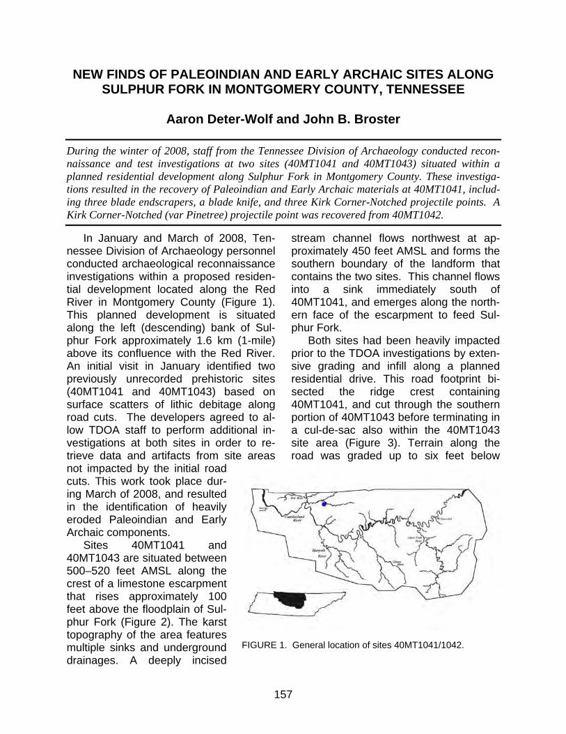
157
NEW FINDS OF PALEOINDIAN AND EARLY ARCHAIC SITES ALONG SULPHUR FORK IN MONTGOMERY COUNTY, TENNESSEE
Aaron Deter-Wolf and John B. Broster
During the winter of 2008, staff from the Tennessee Division of Archaeology conducted recon-naissance and test investigations at two sites (40MT1041 and 40MT1043) situated within a planned residential development along Sulphur Fork in Montgomery County. These investiga-tions resulted in the recovery of Paleoindian and Early Archaic materials at 40MT1041, includ-ing three blade endscrapers, a blade knife, and three Kirk Corner-Notched projectile points. A Kirk Corner-Notched (var Pinetree) projectile point was recovered from 40MT1042.
In January and March of 2008, Ten-nessee Division of Archaeology personnel conducted archaeological reconnaissance investigations within a proposed residen-tial development located along the Red River in Montgomery County (Figure 1). This planned development is situated along the left (descending) bank of Sul-phur Fork approximately 1.6 km (1-mile) above its confluence with the Red River. An initial visit in January identified two previously unrecorded prehistoric sites (40MT1041 and 40MT1043) based on surface scatters of lithic debitage along road cuts. The developers agreed to al-low TDOA staff to perform additional in-vestigations at both sites in order to re-trieve data and artifacts from site areas not impacted by the initial road cuts. This work took place dur-ing March of 2008, and resulted in the identification of heavily eroded Paleoindian and Early Archaic components.
Sites 40MT1041 and 40MT1043 are situated between 500–520 feet AMSL along the crest of a limestone escarpment that rises approximately 100 feet above the floodplain of Sul-phur Fork (Figure 2). The karst topography of the area features multiple sinks and underground drainages. A deeply incised
stream channel flows northwest at ap-proximately 450 feet AMSL and forms the southern boundary of the landform that contains the two sites. This channel flows into a sink immediately south of 40MT1041, and emerges along the north-ern face of the escarpment to feed Sul-phur Fork.
Both sites had been heavily impacted prior to the TDOA investigations by exten-sive grading and infill along a planned residential drive. This road footprint bi-sected the ridge crest containing 40MT1041, and cut through the southern portion of 40MT1043 before terminating in a cul-de-sac also within the 40MT1043 site area (Figure 3). Terrain along the road was graded up to six feet below
FIGURE 1. General location of sites 40MT1041/1042.
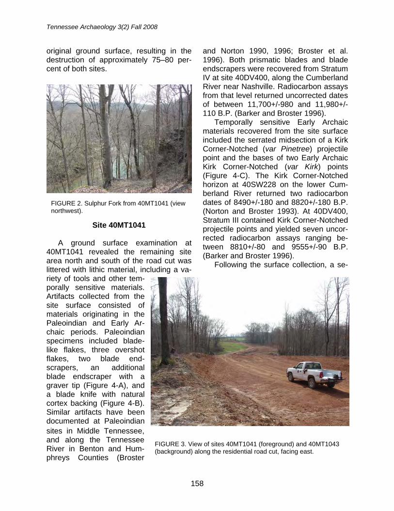
Tennessee Archaeology 3(2) Fall 2008
158
original ground surface, resulting in the destruction of approximately 75–80 per-cent of both sites.
Site 40MT1041
A ground surface examination at 40MT1041 revealed the remaining site area north and south of the road cut was littered with lithic material, including a va-riety of tools and other tem-porally sensitive materials. Artifacts collected from the site surface consisted of materials originating in the Paleoindian and Early Ar-chaic periods. Paleoindian specimens included blade-like flakes, three overshot flakes, two blade end-scrapers, an additional blade endscraper with a graver tip (Figure 4-A), and a blade knife with natural cortex backing (Figure 4-B). Similar artifacts have been documented at Paleoindian sites in Middle Tennessee, and along the Tennessee River in Benton and Hum-phreys Counties (Broster
and Norton 1990, 1996; Broster et al. 1996). Both prismatic blades and blade endscrapers were recovered from Stratum IV at site 40DV400, along the Cumberland River near Nashville. Radiocarbon assays from that level returned uncorrected dates of between 11,700+/-980 and 11,980+/-110 B.P. (Barker and Broster 1996).
Temporally sensitive Early Archaic materials recovered from the site surface included the serrated midsection of a Kirk Corner-Notched (var Pinetree) projectile point and the bases of two Early Archaic Kirk Corner-Notched (var Kirk) points (Figure 4-C). The Kirk Corner-Notched horizon at 40SW228 on the lower Cum-berland River returned two radiocarbon dates of 8490+/-180 and 8820+/-180 B.P. (Norton and Broster 1993). At 40DV400, Stratum III contained Kirk Corner-Notched projectile points and yielded seven uncor-rected radiocarbon assays ranging be-tween 8810+/-80 and 9555+/-90 B.P. (Barker and Broster 1996).
Following the surface collection, a se-
FIGURE 2. Sulphur Fork from 40MT1041 (view northwest).
FIGURE 3. View of sites 40MT1041 (foreground) and 40MT1043 (background) along the residential road cut, facing east.
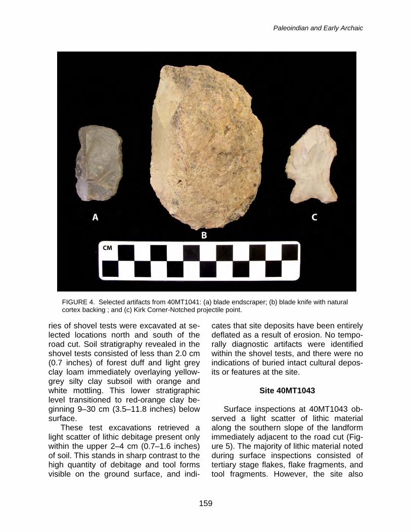
Paleoindian and Early Archaic
159
ries of shovel tests were excavated at se-lected locations north and south of the road cut. Soil stratigraphy revealed in the shovel tests consisted of less than 2.0 cm (0.7 inches) of forest duff and light grey clay loam immediately overlaying yellow-grey silty clay subsoil with orange and white mottling. This lower stratigraphic level transitioned to red-orange clay be-ginning 9–30 cm (3.5–11.8 inches) below surface.
These test excavations retrieved a light scatter of lithic debitage present only within the upper 2–4 cm (0.7–1.6 inches) of soil. This stands in sharp contrast to the high quantity of debitage and tool forms visible on the ground surface, and indi-
cates that site deposits have been entirely deflated as a result of erosion. No tempo-rally diagnostic artifacts were identified within the shovel tests, and there were no indications of buried intact cultural depos-its or features at the site.
Site 40MT1043
Surface inspections at 40MT1043 ob-
served a light scatter of lithic material along the southern slope of the landform immediately adjacent to the road cut (Fig-ure 5). The majority of lithic material noted during surface inspections consisted of tertiary stage flakes, flake fragments, and tool fragments. However, the site also
FIGURE 4. Selected artifacts from 40MT1041: (a) blade endscraper; (b) blade knife with natural cortex backing ; and (c) Kirk Corner-Notched projectile point.
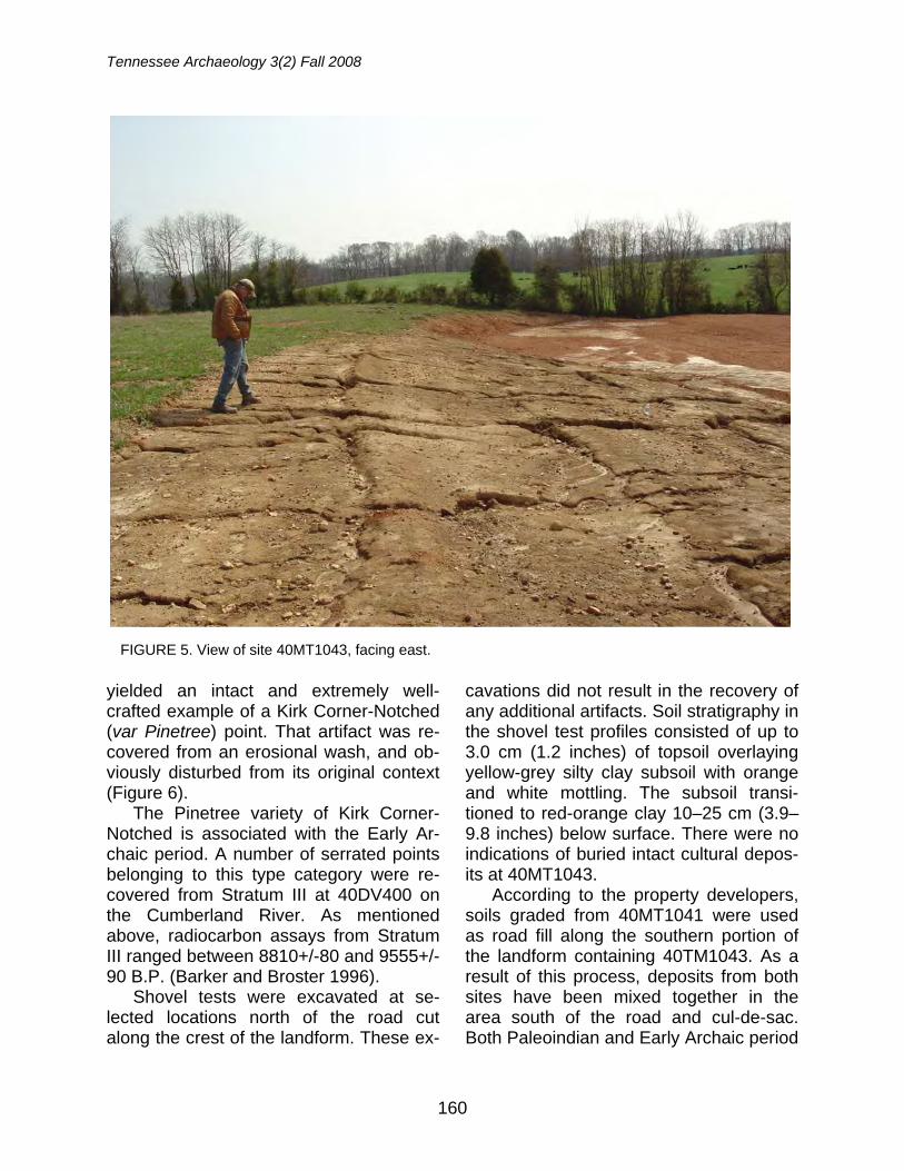
Tennessee Archaeology 3(2) Fall 2008
160
yielded an intact and extremely well-crafted example of a Kirk Corner-Notched (var Pinetree) point. That artifact was re-covered from an erosional wash, and ob-viously disturbed from its original context (Figure 6).
The Pinetree variety of Kirk Corner-Notched is associated with the Early Ar-chaic period. A number of serrated points belonging to this type category were re-covered from Stratum III at 40DV400 on the Cumberland River. As mentioned above, radiocarbon assays from Stratum III ranged between 8810+/-80 and 9555+/-90 B.P. (Barker and Broster 1996).
Shovel tests were excavated at se-lected locations north of the road cut along the crest of the landform. These ex-
cavations did not result in the recovery of any additional artifacts. Soil stratigraphy in the shovel test profiles consisted of up to 3.0 cm (1.2 inches) of topsoil overlaying yellow-grey silty clay subsoil with orange and white mottling. The subsoil transi-tioned to red-orange clay 10–25 cm (3.9–9.8 inches) below surface. There were no indications of buried intact cultural depos-its at 40MT1043.
According to the property developers, soils graded from 40MT1041 were used as road fill along the southern portion of the landform containing 40TM1043. As a result of this process, deposits from both sites have been mixed together in the area south of the road and cul-de-sac. Both Paleoindian and Early Archaic period
FIGURE 5. View of site 40MT1043, facing east.
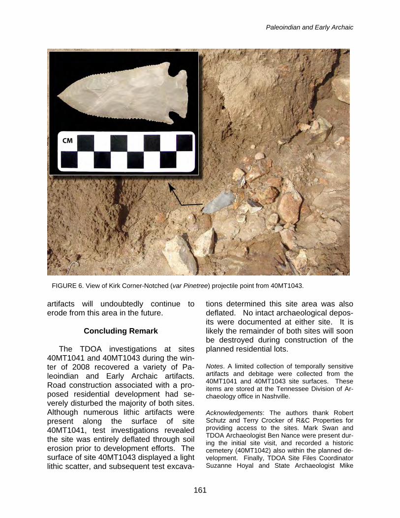
Paleoindian and Early Archaic
161
artifacts will undoubtedly continue to erode from this area in the future.
Concluding Remark
The TDOA investigations at sites
40MT1041 and 40MT1043 during the win-ter of 2008 recovered a variety of Pa-leoindian and Early Archaic artifacts. Road construction associated with a pro-posed residential development had se-verely disturbed the majority of both sites. Although numerous lithic artifacts were present along the surface of site 40MT1041, test investigations revealed the site was entirely deflated through soil erosion prior to development efforts. The surface of site 40MT1043 displayed a light lithic scatter, and subsequent test excava-
tions determined this site area was also deflated. No intact archaeological depos-its were documented at either site. It is likely the remainder of both sites will soon be destroyed during construction of the planned residential lots.
Notes. A limited collection of temporally sensitive artifacts and debitage were collected from the 40MT1041 and 40MT1043 site surfaces. These items are stored at the Tennessee Division of Ar-chaeology office in Nashville.
Acknowledgements: The authors thank Robert Schutz and Terry Crocker of R&C Properties for providing access to the sites. Mark Swan and TDOA Archaeologist Ben Nance were present dur-ing the initial site visit, and recorded a historic cemetery (40MT1042) also within the planned de-velopment. Finally, TDOA Site Files Coordinator Suzanne Hoyal and State Archaeologist Mike
FIGURE 6. View of Kirk Corner-Notched (var Pinetree) projectile point from 40MT1043.
Tennessee Archaeology 3(2) Fall 2008
162
Moore provided direction, encouragement, and their capable editing skills.
References
Barker, Gary and John B. Broster 1996 The Johnson Site (40DV400): A Dated
Paleoindian and Early Archaic Occu-pation in Tennessee’s Central Basin. Journal of Alabama Archaeology 42(2): 97–153.
Broster, John B. and Mark R. Norton 1990 Lithic Analysis and Paleo-Indian Utili-
zation of the Twelkemeier Site (40HS173). Tennessee Anthropologist 15(2):115–131.
1996 Recent Paleoindian Research in Ten-nessee. In The Paleoindian and Early Archaic Southeast, edited by David G. Anderson and Kenneth E. Sassaman, pp. 288-297. University of Alabama Press, Tuscaloosa.
Broster, John B., Mark R. Norton, Dennis J. Stanford, C. Vance Haynes, Jr., and Margaret A. Jodry 1996 Stratified Fluted Point Deposits in the
Western Valley of Tennessee. In Pro-ceedings of the 14th Annual Mid-South Archaeological Conference, ed-ited by Richard Walling, Camille Wharey, and Camille Stanley, pp. 1–11. Panamerican Consultants, Inc. Special Publications 1. Tuscaloosa.
Norton, Mark R. and John B. Broster 1993 Archaeological Investigations at the
Puckett Site (40SW228): A Paleoin-dian/Early Archaic Occupation on the Cumberland River, Stewart County, Tennessee. Tennessee Anthropologist 18(1):45–58.
Aaron Deter-Wolf Tennessee Division of Archaeology 1216 Foster Ave. Cole Building #3, Nashville TN 37243 John B. Broster Tennessee Division of Archaeology 1216 Foster Ave. Cole Building #3, Nashville TN 37243
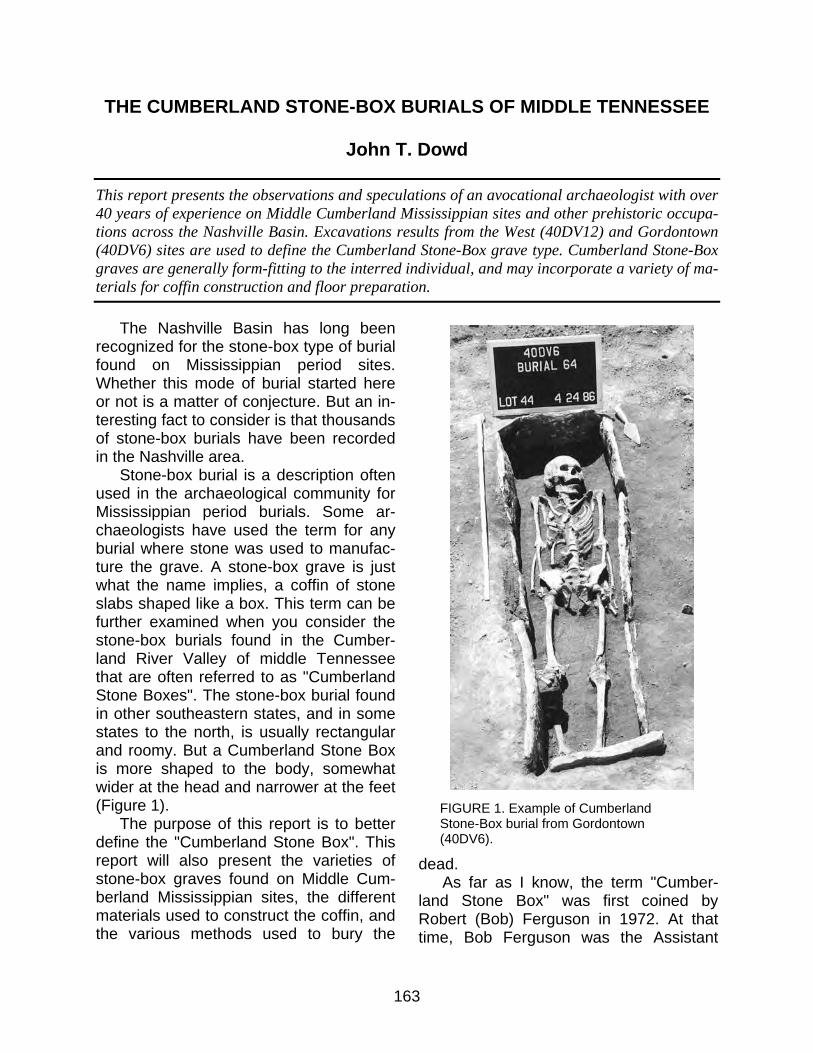
163
THE CUMBERLAND STONE-BOX BURIALS OF MIDDLE TENNESSEE
John T. Dowd
This report presents the observations and speculations of an avocational archaeologist with over 40 years of experience on Middle Cumberland Mississippian sites and other prehistoric occupa-tions across the Nashville Basin. Excavations results from the West (40DV12) and Gordontown (40DV6) sites are used to define the Cumberland Stone-Box grave type. Cumberland Stone-Box graves are generally form-fitting to the interred individual, and may incorporate a variety of ma-terials for coffin construction and floor preparation.
The Nashville Basin has long been recognized for the stone-box type of burial found on Mississippian period sites. Whether this mode of burial started here or not is a matter of conjecture. But an in-teresting fact to consider is that thousands of stone-box burials have been recorded in the Nashville area.
Stone-box burial is a description often used in the archaeological community for Mississippian period burials. Some ar-chaeologists have used the term for any burial where stone was used to manufac-ture the grave. A stone-box grave is just what the name implies, a coffin of stone slabs shaped like a box. This term can be further examined when you consider the stone-box burials found in the Cumber-land River Valley of middle Tennessee that are often referred to as "Cumberland Stone Boxes". The stone-box burial found in other southeastern states, and in some states to the north, is usually rectangular and roomy. But a Cumberland Stone Box is more shaped to the body, somewhat wider at the head and narrower at the feet (Figure 1).
The purpose of this report is to better define the "Cumberland Stone Box". This report will also present the varieties of stone-box graves found on Middle Cum-berland Mississippian sites, the different materials used to construct the coffin, and the various methods used to bury the
dead. As far as I know, the term "Cumber-
land Stone Box" was first coined by Robert (Bob) Ferguson in 1972. At that time, Bob Ferguson was the Assistant
FIGURE 1. Example of Cumberland Stone-Box burial from Gordontown (40DV6).
Tennessee Archaeology 3(2) Fall 2008
164
Manager of Radio Corporation of America (RCA). He, along with Dr. Ronald Spores of Vanderbilt University and others in the Nashville area, started an organization called the Southeastern Indian Archaeo-logical Survey (SIAS) in 1967. This or-ganization exists today as the Middle Cumberland Archaeological Society (MCAS). The SIAS was responsible for much of the archaeological work in Middle Tennessee during the 1960s and early 1970s. The Tennessee Division of Ar-chaeology was created in 1970, but staff was not hired until 1972 (SIAS/MCAS members have assisted the Division of Archaeology as volunteers on many pro-jects). In the SIAS publication The Middle Cumberland Culture, Ferguson noted the differences between a regular stone box and what he called a "Cumberland Stone Box" (Ferguson 1972:15). These differ-ences are what I explore in this report.
Case Studies
The two Mississippian period sites
used for this study are West (40DV12) and Gordontown (40DV6). Gordontown represents an upland fortified town in the Mill Creek headwaters, whereas the West site is a large village/cemetery established along the east bank of the Cumberland River (Dowd 1972; Moore and Breitburg 1998; Moore et al. 2006). These sites were selected for two reasons: (1) they contain all the varieties of the Cumberland Stone-Box graves that I am aware of; and (2) I was intimately involved in the exca-vation of both sites. Also, vandals have looted numerous stone-box graves in Middle Tennessee over the years. The West site was practically undisturbed, and disturbances to the Gordontown cemetery areas were relatively minimal.
West (40DV12) The West site is located in Davidson
County, Tennessee on a bend of the Cumberland River known as Bells Bend. William Morris West owned the site area in the 1960s when the first stone-box graves were excavated there. When Mr. West struck a stone-box grave while plow-ing his field, he would flag the spot and call Mr. Buddy Brehm (a friend of his and a well-known amateur archaeologist). They would excavate the grave together, and over the years 15 graves were dis-covered and removed. Most of these graves were located in the village area of the site. The main cemetery was in a small corner of the site and rarely plowed because of the density of stone in that area. Since the site was located on the river it was easily accessible by boat, and Mr. West often chased off pothunters who were attempting to dig into the graves. Seeing that the graves were in danger of being looted, Mr. West asked Mr. Brehm if he could properly excavate the cemetery area. Buddy Brehm was also a friend of mine and asked if I wished to accompany him in this endeavor. I gladly accepted the invitation. Before we would begin this pro-ject, Mr. West passed away, but when we explained the situation to the new land-owner, Mr. Clarence Siegrist, he gra-ciously allowed us to continue.
By this time much had been written about stone-box graves, but most authors were focused on the ornate grave goods. Little attention was given to the stone box itself. We planned our work with this in mind, and hoped to be different as far as our abilities and equipment allowed. We laid a grid over the cemetery and began our work in March of 1970. Over the next two years we excavated the entire ceme-tery of 50 stone-box graves. Our investi-gation results were published as The
Cumberland Stone-Box
165
West Site: A Stone Box Cemetery in Mid-dle Tennessee (Dowd 1972). The human skeletal remains were sent to the Univer-sity of Tennessee in Knoxville. The recov-ered artifacts, along with the project re-cords, are presently stored at the Frank H. McClung Museum at the University of Tennessee in Knoxville.
Gordontown (40DV6)
Gordontown occurs in extreme south-
ern Davidson County, Tennessee about a mile north of the Williamson County line. The site has access to two springs that feed Brentwood Branch, a small upland tributary that joins Sevenmile Creek which runs into Mill Creek that eventually flows into the Cumberland River. Dr. Joseph Jones first investigated the site in the late 1860s (Jones 1876:37-38). Mr. Edwin Curtiss examined the site a short time later in 1877 for the Peabody Museum (Moore 2004). In 1920, William Edward Myer conducted an examination for the Smithsonian Institution, Bureau of Ethnol-ogy (Myer 1928). Both Curtiss and Myer drew detailed maps of the site area (Moore et al. 2006). Each map showed a large area with several mounds enclosed by a palisade wall.
The site stood virtually untouched for the next 60 years or so until 1984 when Mr. Edsel Charles (President of Homes by Heritage, Inc.) purchased the area for residential development. Prior to this time, Native American graves had no protection under the law and were merely bulldozed away in the face of construction. In 1984, a cemetery vandalism law was passed that included protection for Native Ameri-can graves (Moore 1989, 1998). Gordon-town was the first site to come under that law. Mr. Charles knew the land contained a prehistoric site and was aware of the new burial law. He notified the Division of
Archaeology when the first roads cut into the site hit graves. Archaeologists from the Division were sent to evaluate and ex-cavate the newly discovered graves. I al-ways had an interest in this particular site so I jumped at the opportunity to work as a volunteer. This worked out good for me as I had recently taken early retirement due to the breakup of A.T.& T.
During a meeting held one evening at the site, Mr. Charles acted upon a sug-gestion (by then State Archaeologist Nick Fielder) to hire me to oversee the removal of burials from the site, and act as a liai-son between the builder and the Division of Archaeology. The only legal obligation Mr. Charles had was to remove the buri-als, but he graciously allowed us the op-portunity to explore non-mortuary features such as structures and trash pits. We ex-amined one house lot at a time. As the bulldozer operator carefully scraped the surface, each discovered grave would be flagged. A crew would excavate the flagged burials on one lot, as the bull-dozer operator and monitoring archaeolo-gist would work the next lot. The builder would not start construction on a lot until the burials had been removed. With this system we pretty well stayed out of each other’s way. Over the period of late fall 1985 to June 1986, 85 graves were exca-vated along with three house sites, nine trash pits, five hearths, and a palisade section (Moore and Breitburg 1998).
Cumberland Stone Box Description The Cumberland Stone Box primarily
occurs in the Nashville Basin and Western Highland Rim physiographic provinces. Stone-box construction styles start to change once you get outside these prov-inces. Differences between the Cumber-land Stone Box and other general stone-box graves can be summarized through
Tennessee Archaeology 3(2) Fall 2008
166
the size and fit. I mean that the general stone box is usually rectangular and a bit more “roomy”, whereas the Cumberland Stone Box is more form-fitting (wider at the head and narrower at the foot). I have observed some Cumberland Stone Boxes so tight-fitting that you wonder how the body was inserted into the allotted space.
Construction Materials for Cumberland Stone Boxes
Limestone was by far the most com-
mon material used to construct Cumber-land Stone Boxes. Although far less common, the next most frequent construc-tion material was shale, followed by pot-tery and perishables.
Limestone
Limestone was the most common ma-terial used in stone-box grave construc-
tion in Middle Tennessee due to its’ avail-ability. In East and West Tennessee, lime-stone is not exposed at the surface be-cause of a cover of younger strata. That is not the case in Middle Tennessee, where practically every stream has a limestone outcrop somewhere along its banks (Fig-ure 2). Such outcrops usually display thin, tabular layers that made them ideal for the native occupants to use as burial materi-als.
Limestone is a sedimentary rock com-posed of the mineral calcite (calcium car-bonate). Most limestones are formed from accumulation of the remains of corals, mollusks, starfish, sea urchins, crinoids, and other sea creatures. Calcium carbon-ates found in large amounts (such as an Archaic shell midden heavily laced with mussels and gastropods) have the capac-ity to neutralize the soil acidity, thus allow-ing for near perfect bone preservation. The same holds true, albeit to a lesser
FIGURE 2. Limestone outcrop along stream bed.
Cumberland Stone-Box
167
degree, for the limestone used in stone-box graves. This material aids in the preservation of the enclosed human skeletal remains.
Shale
Shale is occasionally mistaken as slate, which at times leads to some confu-sion whether a Middle Cumberland Mis-sissippian stone-box grave was made with locally available material (shale) or a non-local resource (slate). Shale occurs in an estimated five percent (or less) of the Nashville area stone-box graves, probably due to its scarcity rather than from choice. Shale, also a sedimentary rock, is com-posed of clay, quartz, mica, biotite, chlo-rite, hematite, and other minerals. This material has no neutralizing effect on soil acidity, therefore stone boxes made of shale usually have poorer bone preserva-
tion than those of limestone. Shale has two lines of breakability (cleavage and grain) that makes it more workable for ob-taining thin, smooth slabs. This workability actually allows for a more uniform and tight fitting stone box than can be pro-duced with limestone. Combinations of limestone and slate were sometimes util-ized to construct the same box (Moore and Smith 2001).
Pottery
Pottery, often used as floors in stone
boxes, is rarely utilized in place of stone to construct the box walls and cap. The few box graves constructed of pottery are usually made with thick pan sherds (Fig-ure 3) as noted for Burial 11 at the West site (Dowd 1972:23-23). Such graves are usually those of small infants (Moore and Smith 2001).
FIGURE 3. Pan sherds used to construct Burial 11 coffin at the West site, 40DV12 (scale held by Buddy Brehm’s grand-daughter Cindy ca. 1970).
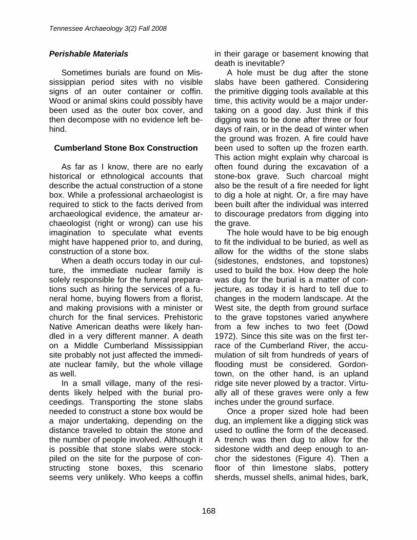
Tennessee Archaeology 3(2) Fall 2008
168
Perishable Materials Sometimes burials are found on Mis-
sissippian period sites with no visible signs of an outer container or coffin. Wood or animal skins could possibly have been used as the outer box cover, and then decompose with no evidence left be-hind.
Cumberland Stone Box Construction
As far as I know, there are no early
historical or ethnological accounts that describe the actual construction of a stone box. While a professional archaeologist is required to stick to the facts derived from archaeological evidence, the amateur ar-chaeologist (right or wrong) can use his imagination to speculate what events might have happened prior to, and during, construction of a stone box.
When a death occurs today in our cul-ture, the immediate nuclear family is solely responsible for the funeral prepara-tions such as hiring the services of a fu-neral home, buying flowers from a florist, and making provisions with a minister or church for the final services. Prehistoric Native American deaths were likely han-dled in a very different manner. A death on a Middle Cumberland Mississippian site probably not just affected the immedi-ate nuclear family, but the whole village as well.
In a small village, many of the resi-dents likely helped with the burial pro-ceedings. Transporting the stone slabs needed to construct a stone box would be a major undertaking, depending on the distance traveled to obtain the stone and the number of people involved. Although it is possible that stone slabs were stock-piled on the site for the purpose of con-structing stone boxes, this scenario seems very unlikely. Who keeps a coffin
in their garage or basement knowing that death is inevitable?
A hole must be dug after the stone slabs have been gathered. Considering the primitive digging tools available at this time, this activity would be a major under-taking on a good day. Just think if this digging was to be done after three or four days of rain, or in the dead of winter when the ground was frozen. A fire could have been used to soften up the frozen earth. This action might explain why charcoal is often found during the excavation of a stone-box grave. Such charcoal might also be the result of a fire needed for light to dig a hole at night. Or, a fire may have been built after the individual was interred to discourage predators from digging into the grave.
The hole would have to be big enough to fit the individual to be buried, as well as allow for the widths of the stone slabs (sidestones, endstones, and topstones) used to build the box. How deep the hole was dug for the burial is a matter of con-jecture, as today it is hard to tell due to changes in the modern landscape. At the West site, the depth from ground surface to the grave topstones varied anywhere from a few inches to two feet (Dowd 1972). Since this site was on the first ter-race of the Cumberland River, the accu-mulation of silt from hundreds of years of flooding must be considered. Gordon-town, on the other hand, is an upland ridge site never plowed by a tractor. Virtu-ally all of these graves were only a few inches under the ground surface.
Once a proper sized hole had been dug, an implement like a digging stick was used to outline the form of the deceased. A trench was then dug to allow for the sidestone width and deep enough to an-chor the sidestones (Figure 4). Then a floor of thin limestone slabs, pottery sherds, mussel shells, animal hides, bark,
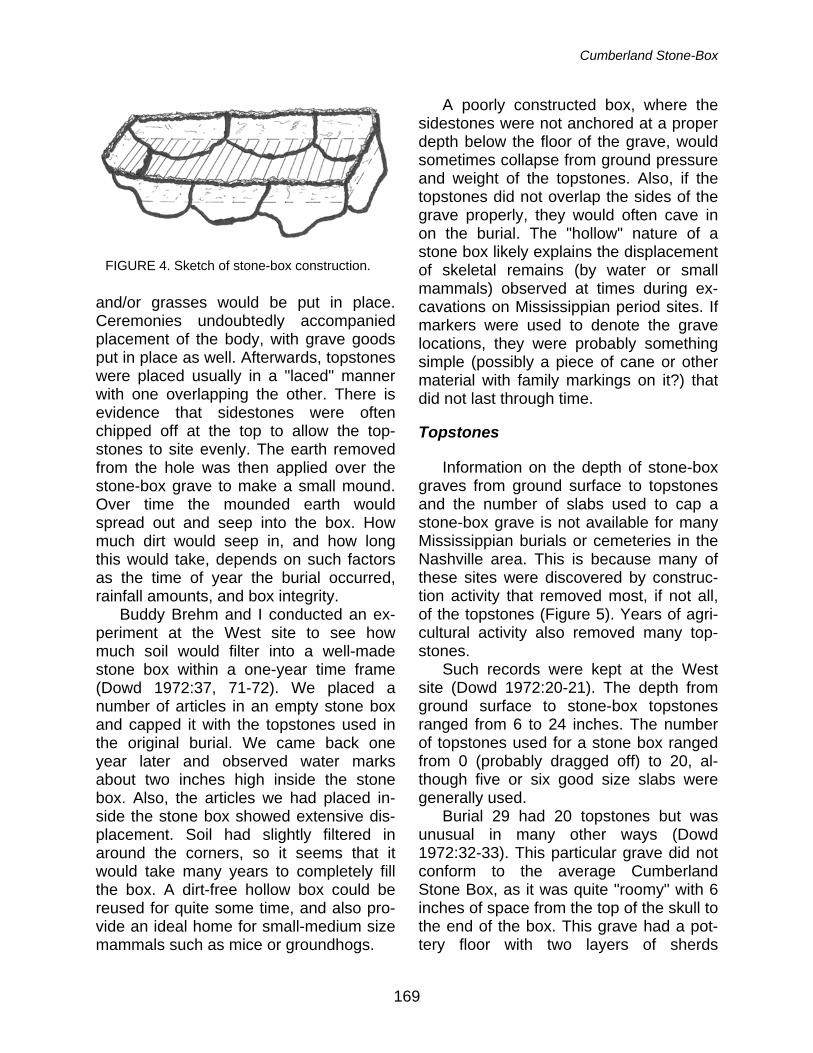
Cumberland Stone-Box
169
and/or grasses would be put in place. Ceremonies undoubtedly accompanied placement of the body, with grave goods put in place as well. Afterwards, topstones were placed usually in a "laced" manner with one overlapping the other. There is evidence that sidestones were often chipped off at the top to allow the top-stones to site evenly. The earth removed from the hole was then applied over the stone-box grave to make a small mound. Over time the mounded earth would spread out and seep into the box. How much dirt would seep in, and how long this would take, depends on such factors as the time of year the burial occurred, rainfall amounts, and box integrity.
Buddy Brehm and I conducted an ex-periment at the West site to see how much soil would filter into a well-made stone box within a one-year time frame (Dowd 1972:37, 71-72). We placed a number of articles in an empty stone box and capped it with the topstones used in the original burial. We came back one year later and observed water marks about two inches high inside the stone box. Also, the articles we had placed in-side the stone box showed extensive dis-placement. Soil had slightly filtered in around the corners, so it seems that it would take many years to completely fill the box. A dirt-free hollow box could be reused for quite some time, and also pro-vide an ideal home for small-medium size mammals such as mice or groundhogs.
A poorly constructed box, where the sidestones were not anchored at a proper depth below the floor of the grave, would sometimes collapse from ground pressure and weight of the topstones. Also, if the topstones did not overlap the sides of the grave properly, they would often cave in on the burial. The "hollow" nature of a stone box likely explains the displacement of skeletal remains (by water or small mammals) observed at times during ex-cavations on Mississippian period sites. If markers were used to denote the grave locations, they were probably something simple (possibly a piece of cane or other material with family markings on it?) that did not last through time.
Topstones
Information on the depth of stone-box
graves from ground surface to topstones and the number of slabs used to cap a stone-box grave is not available for many Mississippian burials or cemeteries in the Nashville area. This is because many of these sites were discovered by construc-tion activity that removed most, if not all, of the topstones (Figure 5). Years of agri-cultural activity also removed many top-stones.
Such records were kept at the West site (Dowd 1972:20-21). The depth from ground surface to stone-box topstones ranged from 6 to 24 inches. The number of topstones used for a stone box ranged from 0 (probably dragged off) to 20, al-though five or six good size slabs were generally used.
Burial 29 had 20 topstones but was unusual in many other ways (Dowd 1972:32-33). This particular grave did not conform to the average Cumberland Stone Box, as it was quite "roomy" with 6 inches of space from the top of the skull to the end of the box. This grave had a pot-tery floor with two layers of sherds
FIGURE 4. Sketch of stone-box construction.
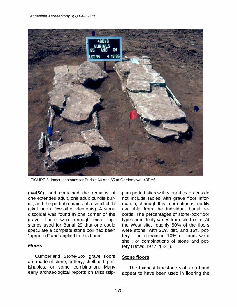
Tennessee Archaeology 3(2) Fall 2008
170
(n=450), and contained the remains of one extended adult, one adult bundle bur-ial, and the partial remains of a small child (skull and a few other elements). A stone discoidal was found in one corner of the grave. There were enough extra top-stones used for Burial 29 that one could speculate a complete stone box had been "uprooted" and applied to this burial.
Floors
Cumberland Stone-Box grave floors
are made of stone, pottery, shell, dirt, per-ishables, or some combination. Many early archaeological reports on Mississip-
pian period sites with stone-box graves do not include tables with grave floor infor-mation, although this information is readily available from the individual burial re-cords. The percentages of stone-box floor types admittedly varies from site to site. At the West site, roughly 50% of the floors were stone, with 25% dirt, and 15% pot-tery. The remaining 10% of floors were shell, or combinations of stone and pot-tery (Dowd 1972:20-21).
Stone floors
The thinnest limestone slabs on hand
appear to have been used in flooring the
FIGURE 5. Intact topstones for Burials 64 and 65 at Gordontown, 40DV6.
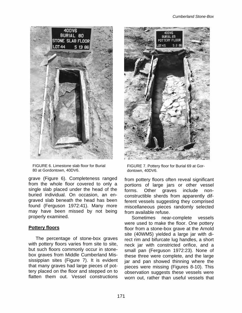
Cumberland Stone-Box
171
grave (Figure 6). Completeness ranged from the whole floor covered to only a single slab placed under the head of the buried individual. On occasion, an en-graved slab beneath the head has been found (Ferguson 1972:41). Many more may have been missed by not being properly examined.
Pottery floors
The percentage of stone-box graves
with pottery floors varies from site to site, but such floors commonly occur in stone-box graves from Middle Cumberland Mis-sissippian sites (Figure 7). It is evident that many graves had large pieces of pot-tery placed on the floor and stepped on to flatten them out. Vessel constructions
from pottery floors often reveal significant portions of large jars or other vessel forms. Other graves include non-constructible sherds from apparently dif-ferent vessels suggesting they comprised miscellaneous pieces randomly selected from available refuse.
Sometimes near-complete vessels were used to make the floor. One pottery floor from a stone-box grave at the Arnold site (40WM5) yielded a large jar with di-rect rim and bifurcate lug handles, a short neck jar with constricted orifice, and a small pan (Ferguson 1972:23). None of these three were complete, and the large jar and pan showed thinning where the pieces were missing (Figures 8-10). This observation suggests these vessels were worn out, rather than useful vessels that
FIGURE 6. Limestone slab floor for Burial 80 at Gordontown, 40DV6.
FIGURE 7. Pottery floor for Burial 69 at Gor-dontown, 40DV6.
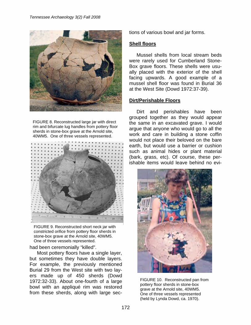
Tennessee Archaeology 3(2) Fall 2008
172
had been ceremonially “killed". Most pottery floors have a single layer,
but sometimes they have double layers. For example, the previously mentioned Burial 29 from the West site with two lay-ers made up of 450 sherds (Dowd 1972:32-33). About one-fourth of a large bowl with an appliqué rim was restored from these sherds, along with large sec-
tions of various bowl and jar forms.
Shell floors Mussel shells from local stream beds
were rarely used for Cumberland Stone-Box grave floors. These shells were usu-ally placed with the exterior of the shell facing upwards. A good example of a mussel shell floor was found in Burial 36 at the West Site (Dowd 1972:37-39).
Dirt/Perishable Floors
Dirt and perishables have been
grouped together as they would appear the same in an excavated grave. I would argue that anyone who would go to all the work and care in building a stone coffin would not place their beloved on the bare earth, but would use a barrier or cushion such as animal hides or plant material (bark, grass, etc). Of course, these per-ishable items would leave behind no evi-
FIGURE 8. Reconstructed large jar with direct rim and bifurcate lug handles from pottery floor sherds in stone-box grave at the Arnold site, 40WM5. One of three vessels represented.
FIGURE 9. Reconstructed short neck jar with constricted orifice from pottery floor sherds in stone-box grave at the Arnold site, 40WM5. One of three vessels represented.
FIGURE 10. Reconstructed pan from pottery floor sherds in stone-box grave at the Arnold site, 40WM5. One of three vessels represented (held by Lynda Dowd, ca. 1970).
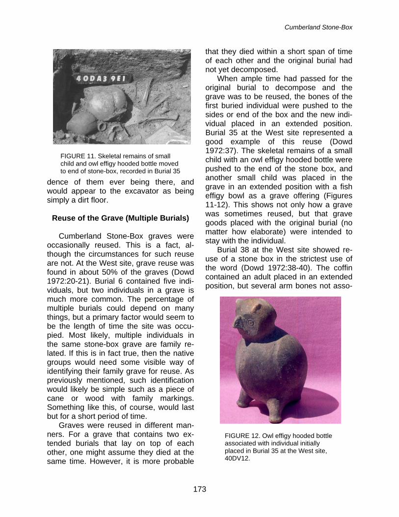
Cumberland Stone-Box
173
dence of them ever being there, and would appear to the excavator as being simply a dirt floor.
Reuse of the Grave (Multiple Burials)
Cumberland Stone-Box graves were
occasionally reused. This is a fact, al-though the circumstances for such reuse are not. At the West site, grave reuse was found in about 50% of the graves (Dowd 1972:20-21). Burial 6 contained five indi-viduals, but two individuals in a grave is much more common. The percentage of multiple burials could depend on many things, but a primary factor would seem to be the length of time the site was occu-pied. Most likely, multiple individuals in the same stone-box grave are family re-lated. If this is in fact true, then the native groups would need some visible way of identifying their family grave for reuse. As previously mentioned, such identification would likely be simple such as a piece of cane or wood with family markings. Something like this, of course, would last but for a short period of time.
Graves were reused in different man-ners. For a grave that contains two ex-tended burials that lay on top of each other, one might assume they died at the same time. However, it is more probable
that they died within a short span of time of each other and the original burial had not yet decomposed.
When ample time had passed for the original burial to decompose and the grave was to be reused, the bones of the first buried individual were pushed to the sides or end of the box and the new indi-vidual placed in an extended position. Burial 35 at the West site represented a good example of this reuse (Dowd 1972:37). The skeletal remains of a small child with an owl effigy hooded bottle were pushed to the end of the stone box, and another small child was placed in the grave in an extended position with a fish effigy bowl as a grave offering (Figures 11-12). This shows not only how a grave was sometimes reused, but that grave goods placed with the original burial (no matter how elaborate) were intended to stay with the individual.
Burial 38 at the West site showed re-use of a stone box in the strictest use of the word (Dowd 1972:38-40). The coffin contained an adult placed in an extended position, but several arm bones not asso-
FIGURE 11. Skeletal remains of small child and owl effigy hooded bottle moved to end of stone-box, recorded in Burial 35
FIGURE 12. Owl effigy hooded bottle associated with individual initially placed in Burial 35 at the West site, 40DV12.
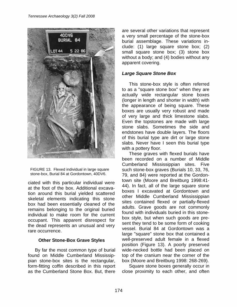
Tennessee Archaeology 3(2) Fall 2008
174
ciated with this particular individual were at the foot of the box. Additional excava-tion around this burial yielded scattered skeletal elements indicating this stone box had been essentially cleaned of the remains belonging to the original buried individual to make room for the current occupant. This apparent disrespect for the dead represents an unusual and very rare occurrence.
Other Stone-Box Grave Styles By far the most common type of burial
found on Middle Cumberland Mississip-pian stone-box sites is the rectangular, form-fitting coffin described in this report as the Cumberland Stone Box. But, there
are several other variations that represent a very small percentage of the stone-box burial assemblage. These variations in-clude: (1) large square stone box; (2) small square stone box; (3) stone box without a body; and (4) bodies without any apparent covering.
Large Square Stone Box
This stone-box style is often referred
to as a "square stone box" when they are actually wide rectangular stone boxes (longer in length and shorter in width) with the appearance of being square. These boxes are usually very robust and made of very large and thick limestone slabs. Even the topstones are made with large stone slabs. Sometimes the side and endstones have double layers. The floors of this burial type are dirt or large stone slabs. Never have I seen this burial type with a pottery floor.
These graves with flexed burials have been recorded on a number of Middle Cumberland Mississippian sites. Five such stone-box graves (Burials 10, 33, 76, 79, and 84) were reported at the Gordon-town site (Moore and Breitburg 1998:41-44). In fact, all of the large square stone boxes I excavated at Gordontown and other Middle Cumberland Mississippian sites contained flexed or partially-flexed adults. Grave goods are not commonly found with individuals buried in this stone-box style, but when such goods are pre-sent they tend to be some form of cooking vessel. Burial 84 at Gordontown was a large "square" stone box that contained a well-preserved adult female in a flexed position (Figure 13). A poorly preserved wide-necked bottle had been placed on top of the cranium near the corner of the box (Moore and Breitburg 1998: 268-269).
Square stone boxes generally occur in close proximity to each other, and often
FIGURE 13. Flexed individual in large square stone-box, Burial 84 at Gordontown, 40DV6.
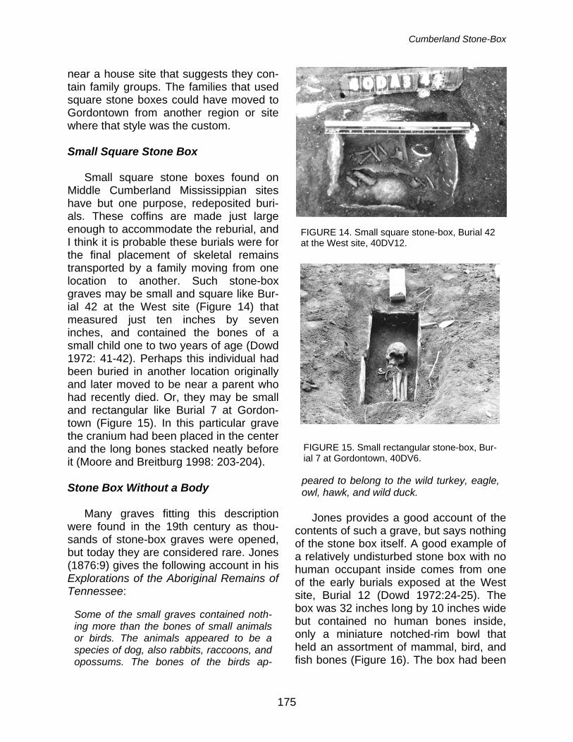
Cumberland Stone-Box
175
near a house site that suggests they con-tain family groups. The families that used square stone boxes could have moved to Gordontown from another region or site where that style was the custom.
Small Square Stone Box
Small square stone boxes found on
Middle Cumberland Mississippian sites have but one purpose, redeposited buri-als. These coffins are made just large enough to accommodate the reburial, and I think it is probable these burials were for the final placement of skeletal remains transported by a family moving from one location to another. Such stone-box graves may be small and square like Bur-ial 42 at the West site (Figure 14) that measured just ten inches by seven inches, and contained the bones of a small child one to two years of age (Dowd 1972: 41-42). Perhaps this individual had been buried in another location originally and later moved to be near a parent who had recently died. Or, they may be small and rectangular like Burial 7 at Gordon-town (Figure 15). In this particular grave the cranium had been placed in the center and the long bones stacked neatly before it (Moore and Breitburg 1998: 203-204).
Stone Box Without a Body
Many graves fitting this description
were found in the 19th century as thou-sands of stone-box graves were opened, but today they are considered rare. Jones (1876:9) gives the following account in his Explorations of the Aboriginal Remains of Tennessee:
Some of the small graves contained noth-ing more than the bones of small animals or birds. The animals appeared to be a species of dog, also rabbits, raccoons, and opossums. The bones of the birds ap-
peared to belong to the wild turkey, eagle, owl, hawk, and wild duck.
Jones provides a good account of the
contents of such a grave, but says nothing of the stone box itself. A good example of a relatively undisturbed stone box with no human occupant inside comes from one of the early burials exposed at the West site, Burial 12 (Dowd 1972:24-25). The box was 32 inches long by 10 inches wide but contained no human bones inside, only a miniature notched-rim bowl that held an assortment of mammal, bird, and fish bones (Figure 16). The box had been
FIGURE 14. Small square stone-box, Burial 42 at the West site, 40DV12.
FIGURE 15. Small rectangular stone-box, Bur-ial 7 at Gordontown, 40DV6.
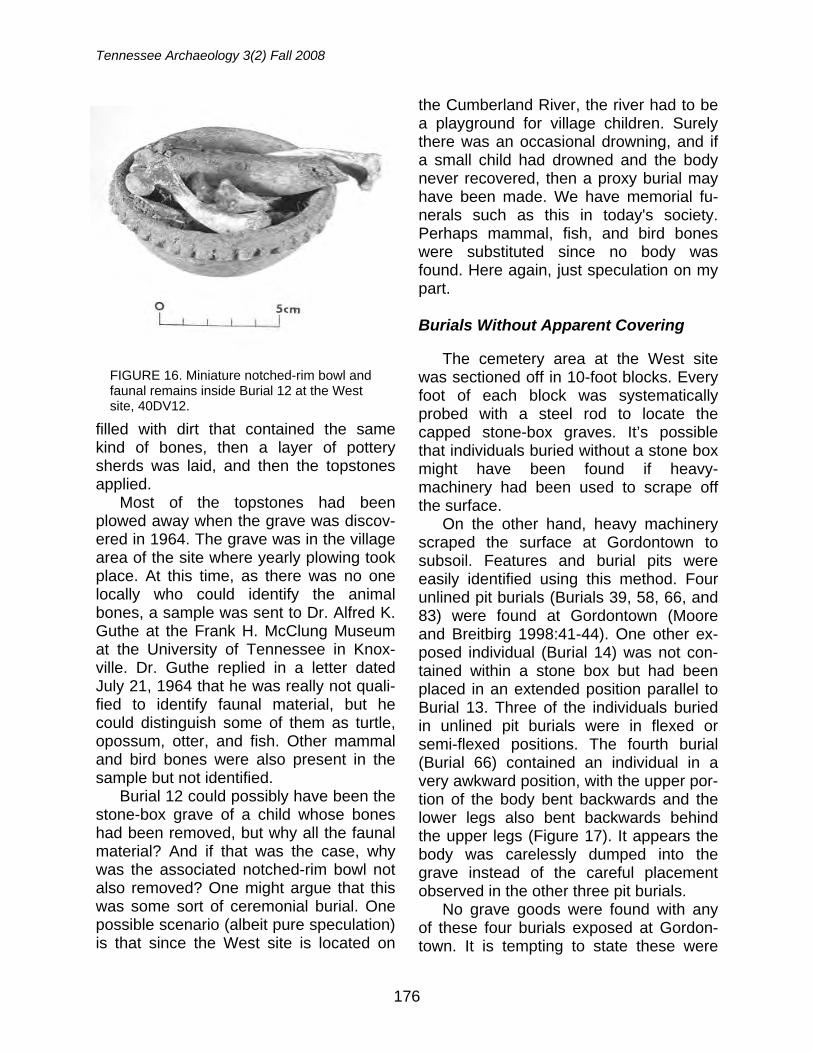
Tennessee Archaeology 3(2) Fall 2008
176
filled with dirt that contained the same kind of bones, then a layer of pottery sherds was laid, and then the topstones applied.
Most of the topstones had been plowed away when the grave was discov-ered in 1964. The grave was in the village area of the site where yearly plowing took place. At this time, as there was no one locally who could identify the animal bones, a sample was sent to Dr. Alfred K. Guthe at the Frank H. McClung Museum at the University of Tennessee in Knox-ville. Dr. Guthe replied in a letter dated July 21, 1964 that he was really not quali-fied to identify faunal material, but he could distinguish some of them as turtle, opossum, otter, and fish. Other mammal and bird bones were also present in the sample but not identified.
Burial 12 could possibly have been the stone-box grave of a child whose bones had been removed, but why all the faunal material? And if that was the case, why was the associated notched-rim bowl not also removed? One might argue that this was some sort of ceremonial burial. One possible scenario (albeit pure speculation) is that since the West site is located on
the Cumberland River, the river had to be a playground for village children. Surely there was an occasional drowning, and if a small child had drowned and the body never recovered, then a proxy burial may have been made. We have memorial fu-nerals such as this in today's society. Perhaps mammal, fish, and bird bones were substituted since no body was found. Here again, just speculation on my part.
Burials Without Apparent Covering
The cemetery area at the West site
was sectioned off in 10-foot blocks. Every foot of each block was systematically probed with a steel rod to locate the capped stone-box graves. It’s possible that individuals buried without a stone box might have been found if heavy-machinery had been used to scrape off the surface.
On the other hand, heavy machinery scraped the surface at Gordontown to subsoil. Features and burial pits were easily identified using this method. Four unlined pit burials (Burials 39, 58, 66, and 83) were found at Gordontown (Moore and Breitbirg 1998:41-44). One other ex-posed individual (Burial 14) was not con-tained within a stone box but had been placed in an extended position parallel to Burial 13. Three of the individuals buried in unlined pit burials were in flexed or semi-flexed positions. The fourth burial (Burial 66) contained an individual in a very awkward position, with the upper por-tion of the body bent backwards and the lower legs also bent backwards behind the upper legs (Figure 17). It appears the body was carelessly dumped into the grave instead of the careful placement observed in the other three pit burials.
No grave goods were found with any of these four burials exposed at Gordon-town. It is tempting to state these were
FIGURE 16. Miniature notched-rim bowl and faunal remains inside Burial 12 at the West site, 40DV12.
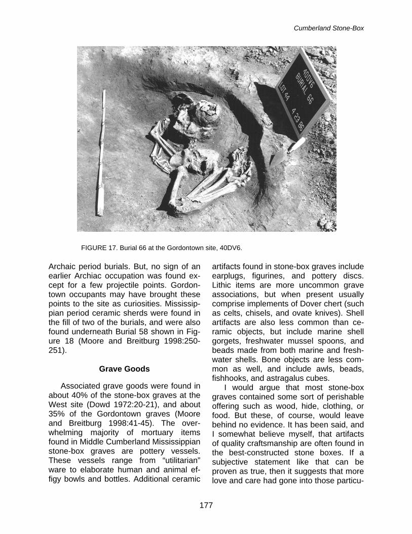
Cumberland Stone-Box
177
Archaic period burials. But, no sign of an earlier Archiac occupation was found ex-cept for a few projectile points. Gordon-town occupants may have brought these points to the site as curiosities. Mississip-pian period ceramic sherds were found in the fill of two of the burials, and were also found underneath Burial 58 shown in Fig-ure 18 (Moore and Breitburg 1998:250-251).
Grave Goods
Associated grave goods were found in
about 40% of the stone-box graves at the West site (Dowd 1972:20-21), and about 35% of the Gordontown graves (Moore and Breitburg 1998:41-45). The over-whelming majority of mortuary items found in Middle Cumberland Mississippian stone-box graves are pottery vessels. These vessels range from “utilitarian” ware to elaborate human and animal ef-figy bowls and bottles. Additional ceramic
artifacts found in stone-box graves include earplugs, figurines, and pottery discs. Lithic items are more uncommon grave associations, but when present usually comprise implements of Dover chert (such as celts, chisels, and ovate knives). Shell artifacts are also less common than ce-ramic objects, but include marine shell gorgets, freshwater mussel spoons, and beads made from both marine and fresh-water shells. Bone objects are less com-mon as well, and include awls, beads, fishhooks, and astragalus cubes.
I would argue that most stone-box graves contained some sort of perishable offering such as wood, hide, clothing, or food. But these, of course, would leave behind no evidence. It has been said, and I somewhat believe myself, that artifacts of quality craftsmanship are often found in the best-constructed stone boxes. If a subjective statement like that can be proven as true, then it suggests that more love and care had gone into those particu-
FIGURE 17. Burial 66 at the Gordontown site, 40DV6.
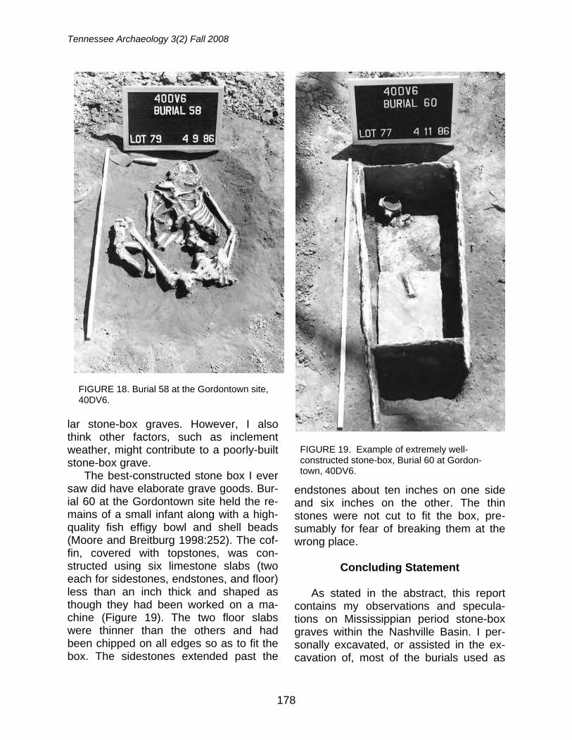
Tennessee Archaeology 3(2) Fall 2008
178
lar stone-box graves. However, I also think other factors, such as inclement weather, might contribute to a poorly-built stone-box grave.
The best-constructed stone box I ever saw did have elaborate grave goods. Bur-ial 60 at the Gordontown site held the re-mains of a small infant along with a high-quality fish effigy bowl and shell beads (Moore and Breitburg 1998:252). The cof-fin, covered with topstones, was con-structed using six limestone slabs (two each for sidestones, endstones, and floor) less than an inch thick and shaped as though they had been worked on a ma-chine (Figure 19). The two floor slabs were thinner than the others and had been chipped on all edges so as to fit the box. The sidestones extended past the
endstones about ten inches on one side and six inches on the other. The thin stones were not cut to fit the box, pre-sumably for fear of breaking them at the wrong place.
Concluding Statement
As stated in the abstract, this report
contains my observations and specula-tions on Mississippian period stone-box graves within the Nashville Basin. I per-sonally excavated, or assisted in the ex-cavation of, most of the burials used as
FIGURE 18. Burial 58 at the Gordontown site, 40DV6.
FIGURE 19. Example of extremely well-constructed stone-box, Burial 60 at Gordon-town, 40DV6.
Cumberland Stone-Box
179
examples in this report. One exception to this statement is the early West site burial (Burial 12) used as an example of a stone box without a body (Dowd 1972:24-25). Although no photographs were taken of this particular burial, I feel very confident in using Mr. Buddy Brehm's description, as anyone who knew Buddy would swear to his honesty and excellent observation skills. I have also used my imagination to speculate on some of the events that pre-ceded the construction of selected stone-box graves, including Burial 12 at the West site.
I have attempted to better define the "Cumberland Stone Box" for the Middle Cumberland River valley, as well as other styles of burials found among them. The information presented in this research re-port should not be considered as new (except the speculation part). This infor-mation is intended, however, to bring at-tention to the different types of burials found on Middle Cumberland Mississip-pian sites. Radiocarbon dates place the West and Gordontown sites within the Thruston regional period that dates from AD 1250 to 1450. I have always consid-ered AD 1350 as a good target date.
Notes: I am not a professional archaeologist or geologist. The descriptions, observations, and speculations given in this report are derived from my personal experiences over the last 40 years and should not necessarily be construed as scien-tific, or technically correct. Tables, graphs, charts, and references from other Middle Cumberland Mississippian sites have been intentionally omitted to make this report easier to read. Acknowledgements: As author of this report credit or blame rests entirely with me, but I want to rec-ognize those who worked with me on the two sites mentioned. My partner at the West site was the late Buddy Brehm who was also my mentor and best friend. I also enjoyed a good working relation-ship with the personnel of the Tennessee Division of Archaeology at the Gordontown site. I also thank Kevin E. Smith and Michael C. Moore for editing this report and allowing an amateur report
to be used in this series.
References
Dowd, John T. 1972 The West Site: A Stone Box Cemetery
in Middle Tennessee. Miscellaneous Paper No. 10. Tennessee Archaeo-logical Society, Knoxville.
Ferguson, Robert B. 1972 Arnold Village Site Excavations of
1965-1966. In The Middle Cumberland Culture, edited by Robert B. Ferguson, pp. 2-49. Vanderbilt University Publi-cations in Anthropology No 3. Nash-ville.
Jones, Joseph 1876 Explorations of the Aboriginal Re-
mains of Tennessee. Smithsonian Contributions to Knowledge No. 259. Washington D.C.
Moore, Michael C. 1989 A Review of the Tennessee State
Cemetery Law and Its Effect upon Ar-chaeological Data Recovery and Site Preservation. Tennessee Anthropolo-gist 14(1):64-76.
1998 An Updated Review of the Tennessee State Cemetery Law and Other Stat-utes Regarding Prehistoric Burial Re-moval. Tennessee Anthropologist 23(1-2):55-64.
2004 Early Investigations at Gordontown (40DV6): Results of an 1877 Explora-tion Sponsored by the Peabody Mu-seum at Harvard University. Tennes-see Archaeology 1(1):58-68.
Moore, Michael C. and Emanuel Breitburg 1998 Gordontown: Salvage Archaeology at
a Mississippian Town in Davidson County, Tennessee. Research Series No. 11. Tennessee Department of En-vironment and Conservation, Division of Archaeology, Nashville.
Tennessee Archaeology 3(2) Fall 2008
180
Moore, Michael C., Emanuel Breitburg, Kevin E. Smith, and Mary Beth Trubitt
2006 One Hundred Years of Archaeology at Gordontown: A Fortified Mississippian Town in Middle Tennessee. South-eastern Archaeology 25(1):89-109.
Moore, Michael C. and Kevin E. Smith 2001 Archaeological Excavations at the
Rutherford-Kizer Site: A Mississippian Mound Center in Sumner County, Tennessee. Research Series No. 13, Tennessee Department of Environ-ment and Conservation, Division of Archaeology, Nashville.
Myer, William Edward 1928 Two Prehistoric Villages in Middle
Tennessee. Forty-first Annual Report of the Bureau of American Ethnology, 1919-1924, pp. 485-614. Reprinted in 1972 by the Southeastern Indian An-tiquities Survey (SIAS), Nashville, TN.
John T. Dowd Nashville Tennessee
181
THE NELSON SITE: LATE MIDDLE WOODLAND HABITATION ON THE NOLICHUCKY RIVER, WASHINGTON COUNTY, TENNESSEE
Jay D. Franklin, Michelle L. Hammett, and Renee B. Walker
The Nelson site (40WG7), a large open habitation locale on the Nolichucky River in Washington County, Tennessee, was excavated in the 1970s by avocational archaeologists from the Kings-port Chapter of the Tennessee Archaeological Society. Although notes are lacking, a large arti-fact assemblage consisting primarily of prehistoric ceramics and faunal material was donated to the Archaeology Laboratory at East Tennessee State University. Here, we address the late Mid-dle Woodland occupation represented in these collections. The ceramic assemblage is generally consistent with other sites in the eastern Tennessee Valley, but indicates regional interactions with the summit region of western North Carolina and perhaps beyond. We discuss Middle Woodland ceramic typology and chronology in upper East Tennessee along with presentation of the first Middle Woodland radiocarbon dates from the Middle Nolichucky River Valley. Based on recovered faunal elements from the collection, the Nelson site assemblage appears typical of a warm weather habitation site.
The evidence increasingly indicates that large Early Woodland habitation sites once dotted the riversides of upper East Tennessee. Of these, the Camp Creek (40GN1), Rankin (40CK6), and (Phipps Bend) 40HW44-40HW45 sites are per-haps the best known (Lafferty 1978, 1981; Lewis and Kneberg 1957; Smith and Hodges 1968). However, there are other occupations on the Holston, Watauga, and Nolichucky Rivers comparable to these sites (Langston and Franklin 2006; Thacker et al. 2008). Unfortunately, little is still known about Middle Woodland period sites in the region. There is virtually noth-ing in the published literature except the late Middle Woodland camp site at Linville Cave, also known as Appalachian Cav-erns (Franklin and Dean 2006). This re-port attempts to address this lack of in-formation by introducing the Nelson site (40WG7), a large and primarily late Mid-dle Woodland open habitation on the No-lichucky River in Washington County, Tennessee. We focus on the Middle Woodland ceramic assemblage and chro-nology, but also discuss subsistence as reflected by the faunal assemblage.
Background The Nelson site, located approximately
600 meters upstream of the confluence of Little Limestone Creek and the Nolichucky River, occurs within a 15-acre alluvial bot-tomland bordered by a wet weather sluice and the river to the west, river cliffs and Little Limestone Creek to the north, foot-hills to the east, and an unnamed tributary to the south (Figure 1). The site was es-tablished on a small ridge in the bottom-land area, and covers an area measuring approximately 107 meters by 76 meters. Historically, the site was used for corn ag-riculture.
The Kingsport Chapter of the original Tennessee Archaeological Society (TAS) conducted excavations at the site in 1978. In typical fashion for the time, a 10-foot by 10-foot grid was established across the site. Units were excavated in six-inch lev-els with all sediments screened through ¼” wire mesh (Figure 2). Several personal collections along with existing field forms and color slides from this excavation were donated to East Tennessee State Univer-sity. Further, the Tennessee Division of
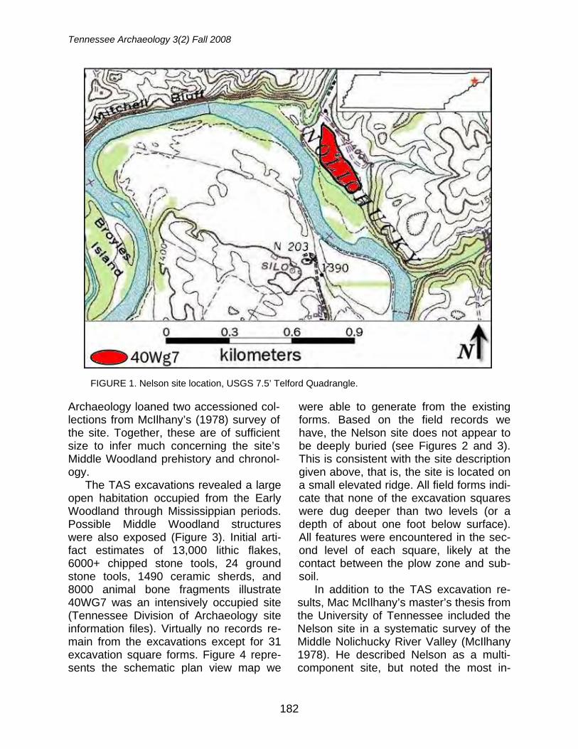
Tennessee Archaeology 3(2) Fall 2008
182
Archaeology loaned two accessioned col-lections from McIlhany’s (1978) survey of the site. Together, these are of sufficient size to infer much concerning the site’s Middle Woodland prehistory and chronol-ogy.
The TAS excavations revealed a large open habitation occupied from the Early Woodland through Mississippian periods. Possible Middle Woodland structures were also exposed (Figure 3). Initial arti-fact estimates of 13,000 lithic flakes, 6000+ chipped stone tools, 24 ground stone tools, 1490 ceramic sherds, and 8000 animal bone fragments illustrate 40WG7 was an intensively occupied site (Tennessee Division of Archaeology site information files). Virtually no records re-main from the excavations except for 31 excavation square forms. Figure 4 repre-sents the schematic plan view map we
were able to generate from the existing forms. Based on the field records we have, the Nelson site does not appear to be deeply buried (see Figures 2 and 3). This is consistent with the site description given above, that is, the site is located on a small elevated ridge. All field forms indi-cate that none of the excavation squares were dug deeper than two levels (or a depth of about one foot below surface). All features were encountered in the sec-ond level of each square, likely at the contact between the plow zone and sub-soil.
In addition to the TAS excavation re-sults, Mac McIlhany’s master’s thesis from the University of Tennessee included the Nelson site in a systematic survey of the Middle Nolichucky River Valley (McIlhany 1978). He described Nelson as a multi-component site, but noted the most in-
FIGURE 1. Nelson site location, USGS 7.5’ Telford Quadrangle.
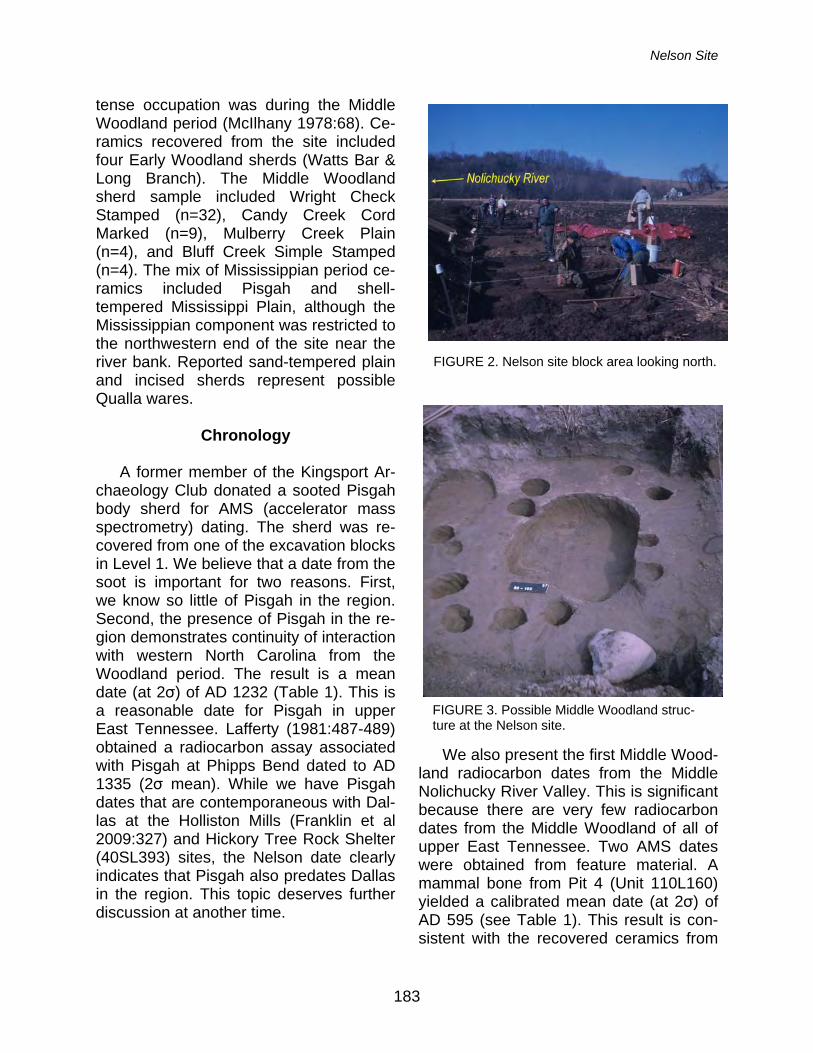
Nelson Site
183
tense occupation was during the Middle Woodland period (McIlhany 1978:68). Ce-ramics recovered from the site included four Early Woodland sherds (Watts Bar & Long Branch). The Middle Woodland sherd sample included Wright Check Stamped (n=32), Candy Creek Cord Marked (n=9), Mulberry Creek Plain (n=4), and Bluff Creek Simple Stamped (n=4). The mix of Mississippian period ce-ramics included Pisgah and shell-tempered Mississippi Plain, although the Mississippian component was restricted to the northwestern end of the site near the river bank. Reported sand-tempered plain and incised sherds represent possible Qualla wares.
Chronology
A former member of the Kingsport Ar-
chaeology Club donated a sooted Pisgah body sherd for AMS (accelerator mass spectrometry) dating. The sherd was re-covered from one of the excavation blocks in Level 1. We believe that a date from the soot is important for two reasons. First, we know so little of Pisgah in the region. Second, the presence of Pisgah in the re-gion demonstrates continuity of interaction with western North Carolina from the Woodland period. The result is a mean date (at 2σ) of AD 1232 (Table 1). This is a reasonable date for Pisgah in upper East Tennessee. Lafferty (1981:487-489) obtained a radiocarbon assay associated with Pisgah at Phipps Bend dated to AD 1335 (2σ mean). While we have Pisgah dates that are contemporaneous with Dal-las at the Holliston Mills (Franklin et al 2009:327) and Hickory Tree Rock Shelter (40SL393) sites, the Nelson date clearly indicates that Pisgah also predates Dallas in the region. This topic deserves further discussion at another time.
We also present the first Middle Wood-land radiocarbon dates from the Middle Nolichucky River Valley. This is significant because there are very few radiocarbon dates from the Middle Woodland of all of upper East Tennessee. Two AMS dates were obtained from feature material. A mammal bone from Pit 4 (Unit 110L160) yielded a calibrated mean date (at 2σ) of AD 595 (see Table 1). This result is con-sistent with the recovered ceramics from
FIGURE 2. Nelson site block area looking north.
FIGURE 3. Possible Middle Woodland struc-ture at the Nelson site.
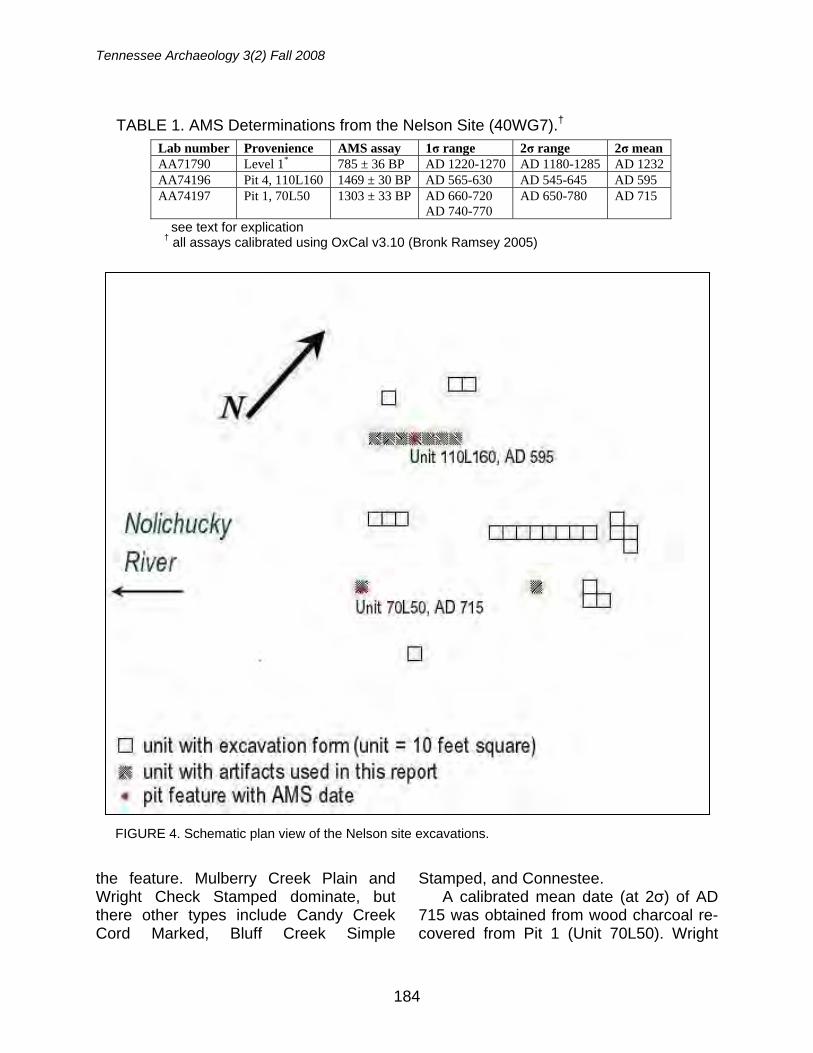
Tennessee Archaeology 3(2) Fall 2008
184
the feature. Mulberry Creek Plain and Wright Check Stamped dominate, but there other types include Candy Creek Cord Marked, Bluff Creek Simple
Stamped, and Connestee. A calibrated mean date (at 2σ) of AD
715 was obtained from wood charcoal re-covered from Pit 1 (Unit 70L50). Wright
TABLE 1. AMS Determinations from the Nelson Site (40WG7).† Lab number Provenience AMS assay 1σ range 2σ range 2σ mean AA71790 Level 1* 785 ± 36 BP AD 1220-1270 AD 1180-1285 AD 1232 AA74196 Pit 4, 110L160 1469 ± 30 BP AD 565-630 AD 545-645 AD 595 AA74197 Pit 1, 70L50 1303 ± 33 BP AD 660-720
AD 740-770 AD 650-780 AD 715
see text for explication † all assays calibrated using OxCal v3.10 (Bronk Ramsey 2005)
FIGURE 4. Schematic plan view of the Nelson site excavations.
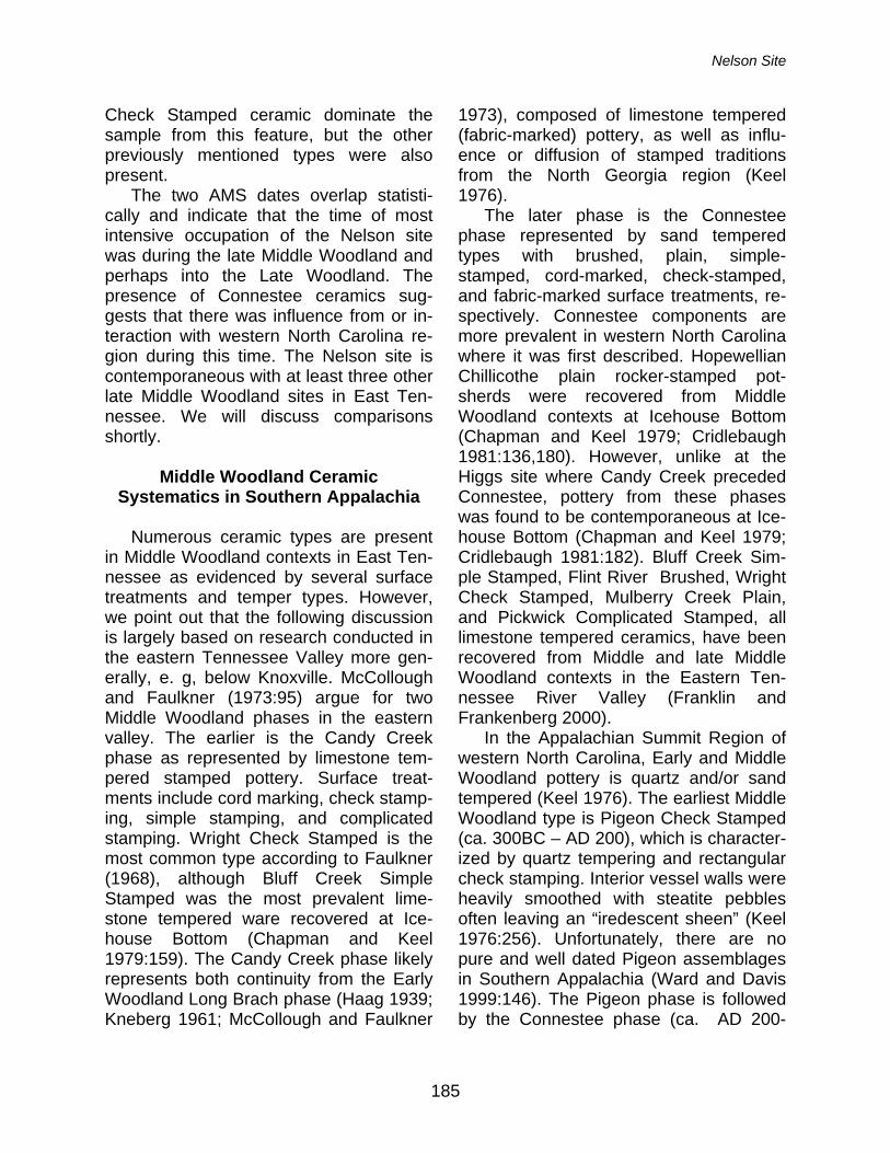
Nelson Site
185
Check Stamped ceramic dominate the sample from this feature, but the other previously mentioned types were also present.
The two AMS dates overlap statisti-cally and indicate that the time of most intensive occupation of the Nelson site was during the late Middle Woodland and perhaps into the Late Woodland. The presence of Connestee ceramics sug-gests that there was influence from or in-teraction with western North Carolina re-gion during this time. The Nelson site is contemporaneous with at least three other late Middle Woodland sites in East Ten-nessee. We will discuss comparisons shortly.
Middle Woodland Ceramic
Systematics in Southern Appalachia Numerous ceramic types are present
in Middle Woodland contexts in East Ten-nessee as evidenced by several surface treatments and temper types. However, we point out that the following discussion is largely based on research conducted in the eastern Tennessee Valley more gen-erally, e. g, below Knoxville. McCollough and Faulkner (1973:95) argue for two Middle Woodland phases in the eastern valley. The earlier is the Candy Creek phase as represented by limestone tem-pered stamped pottery. Surface treat-ments include cord marking, check stamp-ing, simple stamping, and complicated stamping. Wright Check Stamped is the most common type according to Faulkner (1968), although Bluff Creek Simple Stamped was the most prevalent lime-stone tempered ware recovered at Ice-house Bottom (Chapman and Keel 1979:159). The Candy Creek phase likely represents both continuity from the Early Woodland Long Brach phase (Haag 1939; Kneberg 1961; McCollough and Faulkner
1973), composed of limestone tempered (fabric-marked) pottery, as well as influ-ence or diffusion of stamped traditions from the North Georgia region (Keel 1976).
The later phase is the Connestee phase represented by sand tempered types with brushed, plain, simple-stamped, cord-marked, check-stamped, and fabric-marked surface treatments, re-spectively. Connestee components are more prevalent in western North Carolina where it was first described. Hopewellian Chillicothe plain rocker-stamped pot-sherds were recovered from Middle Woodland contexts at Icehouse Bottom (Chapman and Keel 1979; Cridlebaugh 1981:136,180). However, unlike at the Higgs site where Candy Creek preceded Connestee, pottery from these phases was found to be contemporaneous at Ice-house Bottom (Chapman and Keel 1979; Cridlebaugh 1981:182). Bluff Creek Sim-ple Stamped, Flint River Brushed, Wright Check Stamped, Mulberry Creek Plain, and Pickwick Complicated Stamped, all limestone tempered ceramics, have been recovered from Middle and late Middle Woodland contexts in the Eastern Ten-nessee River Valley (Franklin and Frankenberg 2000).
In the Appalachian Summit Region of western North Carolina, Early and Middle Woodland pottery is quartz and/or sand tempered (Keel 1976). The earliest Middle Woodland type is Pigeon Check Stamped (ca. 300BC – AD 200), which is character-ized by quartz tempering and rectangular check stamping. Interior vessel walls were heavily smoothed with steatite pebbles often leaving an “iredescent sheen” (Keel 1976:256). Unfortunately, there are no pure and well dated Pigeon assemblages in Southern Appalachia (Ward and Davis 1999:146). The Pigeon phase is followed by the Connestee phase (ca. AD 200-
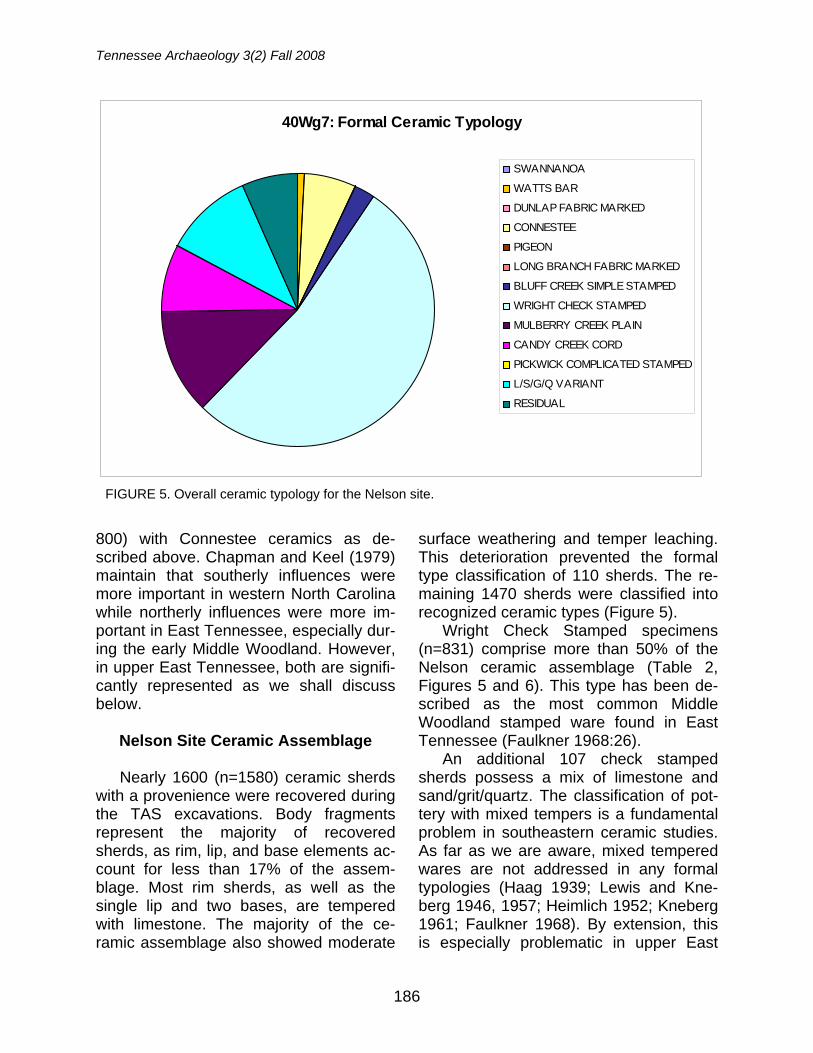
Tennessee Archaeology 3(2) Fall 2008
186
800) with Connestee ceramics as de-scribed above. Chapman and Keel (1979) maintain that southerly influences were more important in western North Carolina while northerly influences were more im-portant in East Tennessee, especially dur-ing the early Middle Woodland. However, in upper East Tennessee, both are signifi-cantly represented as we shall discuss below.
Nelson Site Ceramic Assemblage Nearly 1600 (n=1580) ceramic sherds
with a provenience were recovered during the TAS excavations. Body fragments represent the majority of recovered sherds, as rim, lip, and base elements ac-count for less than 17% of the assem-blage. Most rim sherds, as well as the single lip and two bases, are tempered with limestone. The majority of the ce-ramic assemblage also showed moderate
surface weathering and temper leaching. This deterioration prevented the formal type classification of 110 sherds. The re-maining 1470 sherds were classified into recognized ceramic types (Figure 5).
Wright Check Stamped specimens (n=831) comprise more than 50% of the Nelson ceramic assemblage (Table 2, Figures 5 and 6). This type has been de-scribed as the most common Middle Woodland stamped ware found in East Tennessee (Faulkner 1968:26).
An additional 107 check stamped sherds possess a mix of limestone and sand/grit/quartz. The classification of pot-tery with mixed tempers is a fundamental problem in southeastern ceramic studies. As far as we are aware, mixed tempered wares are not addressed in any formal typologies (Haag 1939; Lewis and Kne-berg 1946, 1957; Heimlich 1952; Kneberg 1961; Faulkner 1968). By extension, this is especially problematic in upper East
40Wg7: Formal Ceramic Typology
SWANNANOA
WATTS BAR
DUNLAP FABRIC MARKED
CONNESTEE
PIGEON
LONG BRANCH FABRIC MARKED
BLUFF CREEK SIMPLE STAMPED
WRIGHT CHECK STAMPED
MULBERRY CREEK PLAIN
CANDY CREEK CORD
PICKWICK COMPLICATED STAMPED
L/S/G/Q VARIANT
RESIDUAL
FIGURE 5. Overall ceramic typology for the Nelson site.
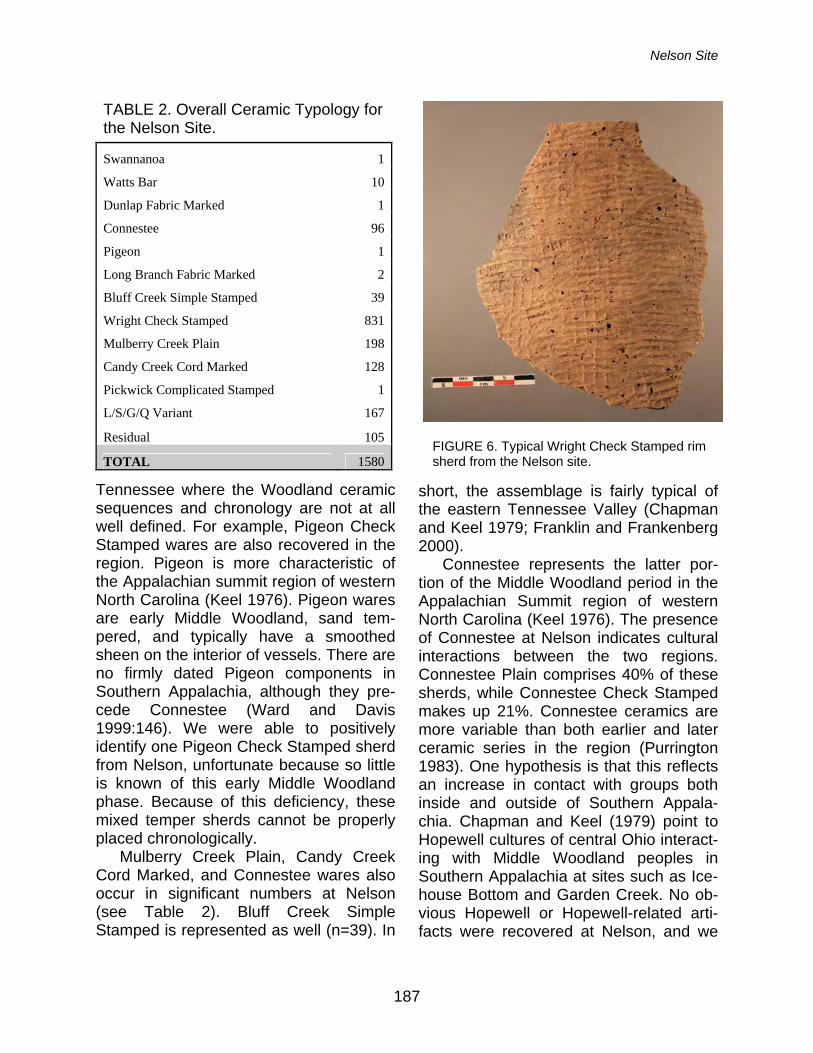
Nelson Site
187
Tennessee where the Woodland ceramic sequences and chronology are not at all well defined. For example, Pigeon Check Stamped wares are also recovered in the region. Pigeon is more characteristic of the Appalachian summit region of western North Carolina (Keel 1976). Pigeon wares are early Middle Woodland, sand tem-pered, and typically have a smoothed sheen on the interior of vessels. There are no firmly dated Pigeon components in Southern Appalachia, although they pre-cede Connestee (Ward and Davis 1999:146). We were able to positively identify one Pigeon Check Stamped sherd from Nelson, unfortunate because so little is known of this early Middle Woodland phase. Because of this deficiency, these mixed temper sherds cannot be properly placed chronologically.
Mulberry Creek Plain, Candy Creek Cord Marked, and Connestee wares also occur in significant numbers at Nelson (see Table 2). Bluff Creek Simple Stamped is represented as well (n=39). In
short, the assemblage is fairly typical of the eastern Tennessee Valley (Chapman and Keel 1979; Franklin and Frankenberg 2000).
Connestee represents the latter por-tion of the Middle Woodland period in the Appalachian Summit region of western North Carolina (Keel 1976). The presence of Connestee at Nelson indicates cultural interactions between the two regions. Connestee Plain comprises 40% of these sherds, while Connestee Check Stamped makes up 21%. Connestee ceramics are more variable than both earlier and later ceramic series in the region (Purrington 1983). One hypothesis is that this reflects an increase in contact with groups both inside and outside of Southern Appala-chia. Chapman and Keel (1979) point to Hopewell cultures of central Ohio interact-ing with Middle Woodland peoples in Southern Appalachia at sites such as Ice-house Bottom and Garden Creek. No ob-vious Hopewell or Hopewell-related arti-facts were recovered at Nelson, and we
TABLE 2. Overall Ceramic Typology for the Nelson Site.
Swannanoa 1
Watts Bar 10
Dunlap Fabric Marked 1
Connestee 96
Pigeon 1
Long Branch Fabric Marked 2
Bluff Creek Simple Stamped 39
Wright Check Stamped 831
Mulberry Creek Plain 198
Candy Creek Cord Marked 128
Pickwick Complicated Stamped 1
L/S/G/Q Variant 167
Residual 105
TOTAL 1580FIGURE 6. Typical Wright Check Stamped rim sherd from the Nelson site.
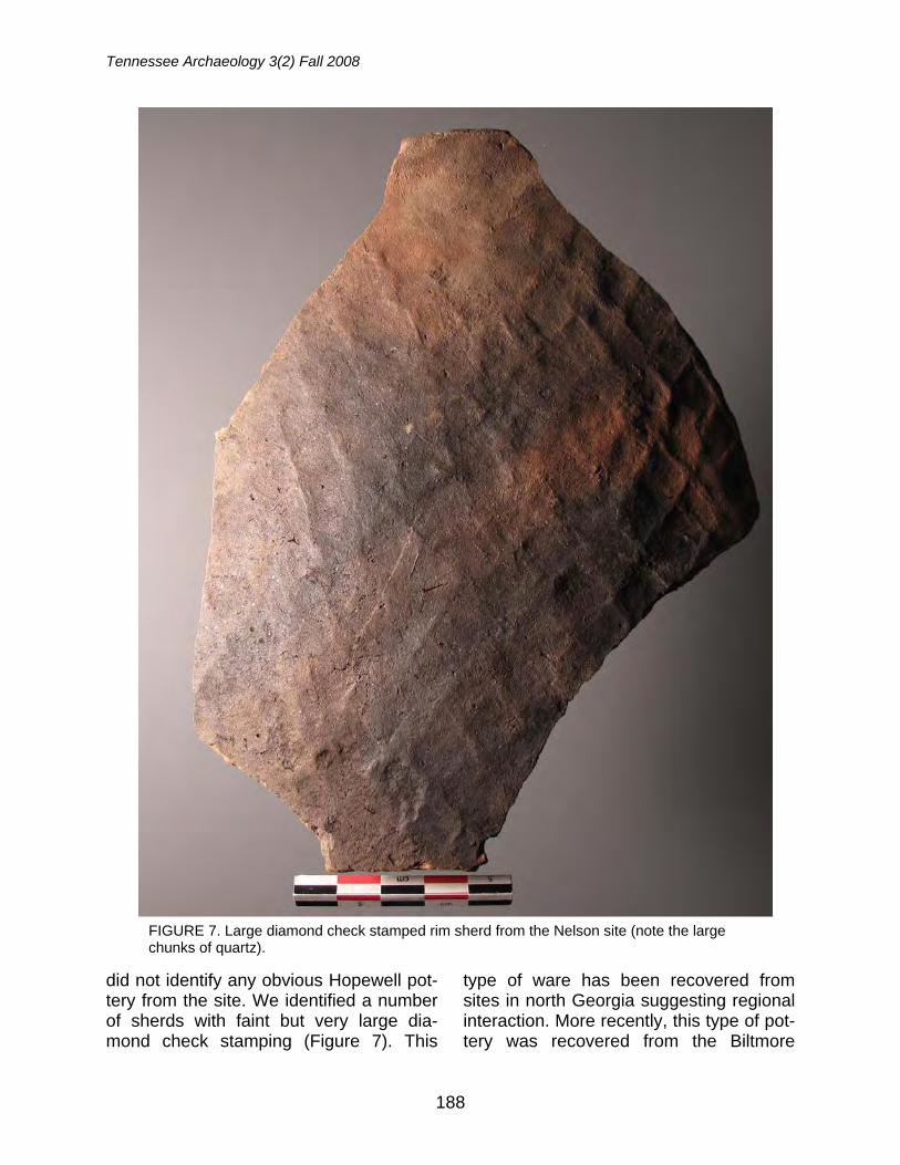
Tennessee Archaeology 3(2) Fall 2008
188
did not identify any obvious Hopewell pot-tery from the site. We identified a number of sherds with faint but very large dia-mond check stamping (Figure 7). This
type of ware has been recovered from sites in north Georgia suggesting regional interaction. More recently, this type of pot-tery was recovered from the Biltmore
FIGURE 7. Large diamond check stamped rim sherd from the Nelson site (note the large chunks of quartz).
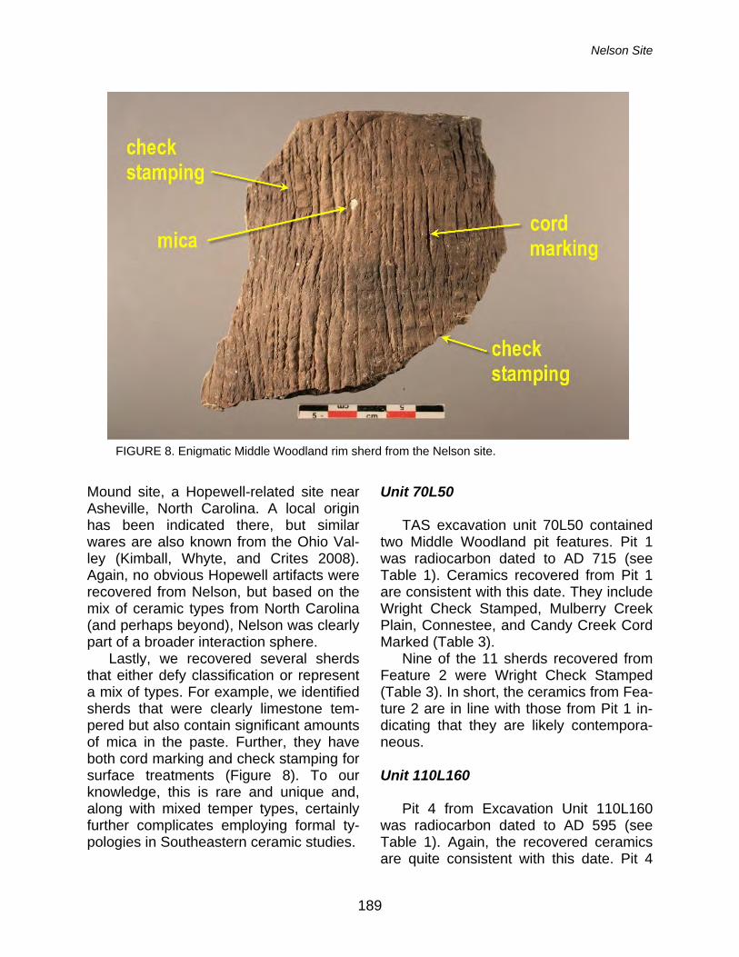
Nelson Site
189
Mound site, a Hopewell-related site near Asheville, North Carolina. A local origin has been indicated there, but similar wares are also known from the Ohio Val-ley (Kimball, Whyte, and Crites 2008). Again, no obvious Hopewell artifacts were recovered from Nelson, but based on the mix of ceramic types from North Carolina (and perhaps beyond), Nelson was clearly part of a broader interaction sphere.
Lastly, we recovered several sherds that either defy classification or represent a mix of types. For example, we identified sherds that were clearly limestone tem-pered but also contain significant amounts of mica in the paste. Further, they have both cord marking and check stamping for surface treatments (Figure 8). To our knowledge, this is rare and unique and, along with mixed temper types, certainly further complicates employing formal ty-pologies in Southeastern ceramic studies.
Unit 70L50 TAS excavation unit 70L50 contained
two Middle Woodland pit features. Pit 1 was radiocarbon dated to AD 715 (see Table 1). Ceramics recovered from Pit 1 are consistent with this date. They include Wright Check Stamped, Mulberry Creek Plain, Connestee, and Candy Creek Cord Marked (Table 3).
Nine of the 11 sherds recovered from Feature 2 were Wright Check Stamped (Table 3). In short, the ceramics from Fea-ture 2 are in line with those from Pit 1 in-dicating that they are likely contempora-neous.
Unit 110L160
Pit 4 from Excavation Unit 110L160
was radiocarbon dated to AD 595 (see Table 1). Again, the recovered ceramics are quite consistent with this date. Pit 4
FIGURE 8. Enigmatic Middle Woodland rim sherd from the Nelson site.
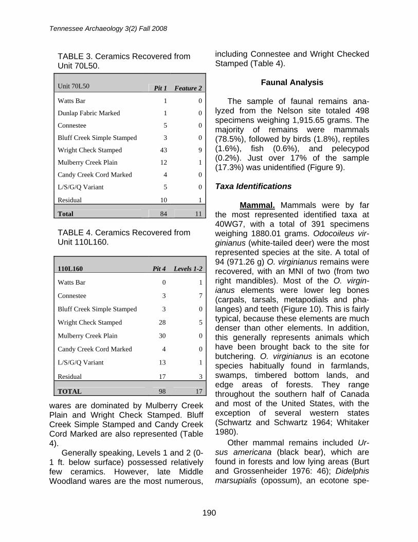
Tennessee Archaeology 3(2) Fall 2008
190
wares are dominated by Mulberry Creek Plain and Wright Check Stamped. Bluff Creek Simple Stamped and Candy Creek Cord Marked are also represented (Table 4).
Generally speaking, Levels 1 and 2 (0-1 ft. below surface) possessed relatively few ceramics. However, late Middle Woodland wares are the most numerous,
including Connestee and Wright Checked Stamped (Table 4).
Faunal Analysis
The sample of faunal remains ana-
lyzed from the Nelson site totaled 498 specimens weighing 1,915.65 grams. The majority of remains were mammals (78.5%), followed by birds (1.8%), reptiles (1.6%), fish (0.6%), and pelecypod (0.2%). Just over 17% of the sample (17.3%) was unidentified (Figure 9).
Taxa Identifications Mammal. Mammals were by far the most represented identified taxa at 40WG7, with a total of 391 specimens weighing 1880.01 grams. Odocoileus vir-ginianus (white-tailed deer) were the most represented species at the site. A total of 94 (971.26 g) O. virginianus remains were recovered, with an MNI of two (from two right mandibles). Most of the O. virgin-ianus elements were lower leg bones (carpals, tarsals, metapodials and pha-langes) and teeth (Figure 10). This is fairly typical, because these elements are much denser than other elements. In addition, this generally represents animals which have been brought back to the site for butchering. O. virginianus is an ecotone species habitually found in farmlands, swamps, timbered bottom lands, and edge areas of forests. They range throughout the southern half of Canada and most of the United States, with the exception of several western states (Schwartz and Schwartz 1964; Whitaker 1980). Other mammal remains included Ur-sus americana (black bear), which are found in forests and low lying areas (Burt and Grossenheider 1976: 46); Didelphis marsupialis (opossum), an ecotone spe-
TABLE 3. Ceramics Recovered from Unit 70L50.
Unit 70L50 Pit 1 Feature 2
Watts Bar 1 0
Dunlap Fabric Marked 1 0
Connestee 5 0
Bluff Creek Simple Stamped 3 0
Wright Check Stamped 43 9
Mulberry Creek Plain 12 1
Candy Creek Cord Marked 4 0
L/S/G/Q Variant 5 0
Residual 10 1
Total 84 11
TABLE 4. Ceramics Recovered from Unit 110L160.
110L160 Pit 4 Levels 1-2
Watts Bar 0 1
Connestee 3 7
Bluff Creek Simple Stamped 3 0
Wright Check Stamped 28 5
Mulberry Creek Plain 30 0
Candy Creek Cord Marked 4 0
L/S/G/Q Variant 13 1
Residual 17 3
TOTAL 98 17
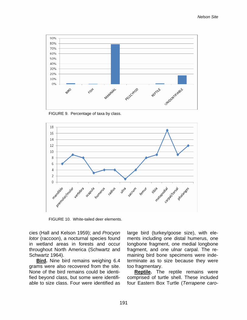
Nelson Site
191
cies (Hall and Kelson 1959); and Procyon lotor (raccoon), a nocturnal species found in wetland areas in forests and occur throughout North America (Schwartz and Schwartz 1964). Bird. Nine bird remains weighing 6.4 grams were also recovered from the site. None of the bird remains could be identi-fied beyond class, but some were identifi-able to size class. Four were identified as
large bird (turkey/goose size), with ele-ments including one distal humerus, one longbone fragment, one medial longbone fragment, and one ulnar carpal. The re-maining bird bone specimens were inde-terminate as to size because they were too fragmentary. Reptile. The reptile remains were comprised of turtle shell. These included four Eastern Box Turtle (Terrapene caro-
FIGURE 9. Percentage of taxa by class.
FIGURE 10. White-tailed deer elements.
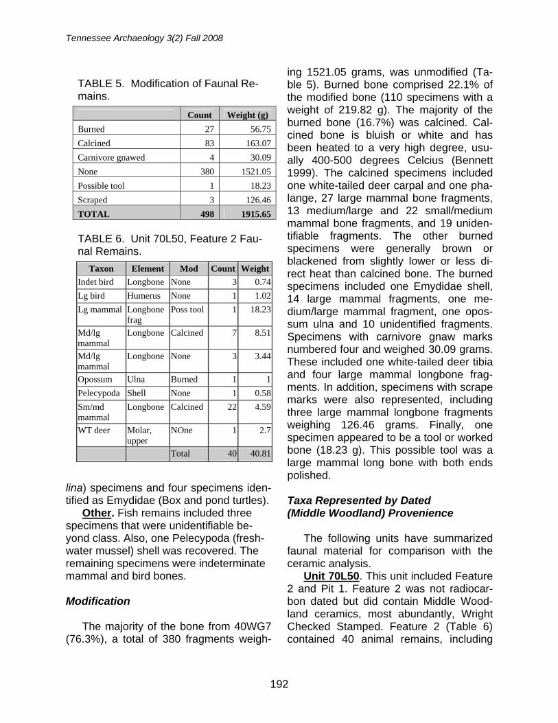
Tennessee Archaeology 3(2) Fall 2008
192
lina) specimens and four specimens iden-tified as Emydidae (Box and pond turtles). Other. Fish remains included three specimens that were unidentifiable be-yond class. Also, one Pelecypoda (fresh-water mussel) shell was recovered. The remaining specimens were indeterminate mammal and bird bones. Modification The majority of the bone from 40WG7 (76.3%), a total of 380 fragments weigh-
ing 1521.05 grams, was unmodified (Ta-ble 5). Burned bone comprised 22.1% of the modified bone (110 specimens with a weight of 219.82 g). The majority of the burned bone (16.7%) was calcined. Cal-cined bone is bluish or white and has been heated to a very high degree, usu-ally 400-500 degrees Celcius (Bennett 1999). The calcined specimens included one white-tailed deer carpal and one pha-lange, 27 large mammal bone fragments, 13 medium/large and 22 small/medium mammal bone fragments, and 19 uniden-tifiable fragments. The other burned specimens were generally brown or blackened from slightly lower or less di-rect heat than calcined bone. The burned specimens included one Emydidae shell, 14 large mammal fragments, one me-dium/large mammal fragment, one opos-sum ulna and 10 unidentified fragments. Specimens with carnivore gnaw marks numbered four and weighed 30.09 grams. These included one white-tailed deer tibia and four large mammal longbone frag-ments. In addition, specimens with scrape marks were also represented, including three large mammal longbone fragments weighing 126.46 grams. Finally, one specimen appeared to be a tool or worked bone (18.23 g). This possible tool was a large mammal long bone with both ends polished.
Taxa Represented by Dated (Middle Woodland) Provenience
The following units have summarized
faunal material for comparison with the ceramic analysis.
Unit 70L50. This unit included Feature 2 and Pit 1. Feature 2 was not radiocar-bon dated but did contain Middle Wood-land ceramics, most abundantly, Wright Checked Stamped. Feature 2 (Table 6) contained 40 animal remains, including
TABLE 5. Modification of Faunal Re-mains.
Count Weight (g)
Burned 27 56.75
Calcined 83 163.07
Carnivore gnawed 4 30.09
None 380 1521.05
Possible tool 1 18.23
Scraped 3 126.46
TOTAL 498 1915.65 TABLE 6. Unit 70L50, Feature 2 Fau-nal Remains.
Taxon Element Mod Count Weight
Indet bird Longbone None 3 0.74
Lg bird Humerus None 1 1.02
Lg mammal Longbone frag
Poss tool 1 18.23
Md/lg mammal
Longbone Calcined 7 8.51
Md/lg mammal
Longbone None 3 3.44
Opossum Ulna Burned 1 1
Pelecypoda Shell None 1 0.58
Sm/md mammal
Longbone Calcined 22 4.59
WT deer Molar, upper
NOne 1 2.7
Total 40 40.81
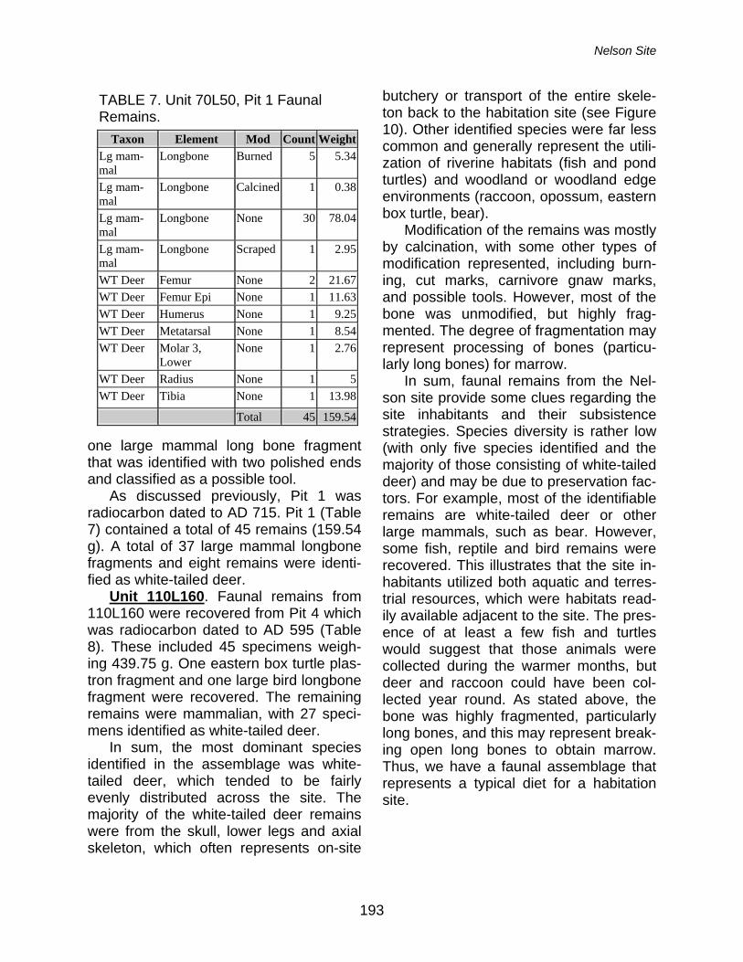
Nelson Site
193
one large mammal long bone fragment that was identified with two polished ends and classified as a possible tool.
As discussed previously, Pit 1 was radiocarbon dated to AD 715. Pit 1 (Table 7) contained a total of 45 remains (159.54 g). A total of 37 large mammal longbone fragments and eight remains were identi-fied as white-tailed deer.
Unit 110L160. Faunal remains from 110L160 were recovered from Pit 4 which was radiocarbon dated to AD 595 (Table 8). These included 45 specimens weigh-ing 439.75 g. One eastern box turtle plas-tron fragment and one large bird longbone fragment were recovered. The remaining remains were mammalian, with 27 speci-mens identified as white-tailed deer.
In sum, the most dominant species identified in the assemblage was white-tailed deer, which tended to be fairly evenly distributed across the site. The majority of the white-tailed deer remains were from the skull, lower legs and axial skeleton, which often represents on-site
butchery or transport of the entire skele-ton back to the habitation site (see Figure 10). Other identified species were far less common and generally represent the utili-zation of riverine habitats (fish and pond turtles) and woodland or woodland edge environments (raccoon, opossum, eastern box turtle, bear).
Modification of the remains was mostly by calcination, with some other types of modification represented, including burn-ing, cut marks, carnivore gnaw marks, and possible tools. However, most of the bone was unmodified, but highly frag-mented. The degree of fragmentation may represent processing of bones (particu-larly long bones) for marrow.
In sum, faunal remains from the Nel-son site provide some clues regarding the site inhabitants and their subsistence strategies. Species diversity is rather low (with only five species identified and the majority of those consisting of white-tailed deer) and may be due to preservation fac-tors. For example, most of the identifiable remains are white-tailed deer or other large mammals, such as bear. However, some fish, reptile and bird remains were recovered. This illustrates that the site in-habitants utilized both aquatic and terres-trial resources, which were habitats read-ily available adjacent to the site. The pres-ence of at least a few fish and turtles would suggest that those animals were collected during the warmer months, but deer and raccoon could have been col-lected year round. As stated above, the bone was highly fragmented, particularly long bones, and this may represent break-ing open long bones to obtain marrow. Thus, we have a faunal assemblage that represents a typical diet for a habitation site.
TABLE 7. Unit 70L50, Pit 1 Faunal Remains.
Taxon Element Mod Count Weight
Lg mam-mal
Longbone Burned 5 5.34
Lg mam-mal
Longbone Calcined 1 0.38
Lg mam-mal
Longbone None 30 78.04
Lg mam-mal
Longbone Scraped 1 2.95
WT Deer Femur None 2 21.67
WT Deer Femur Epi None 1 11.63
WT Deer Humerus None 1 9.25
WT Deer Metatarsal None 1 8.54
WT Deer Molar 3, Lower
None 1 2.76
WT Deer Radius None 1 5
WT Deer Tibia None 1 13.98
Total 45 159.54
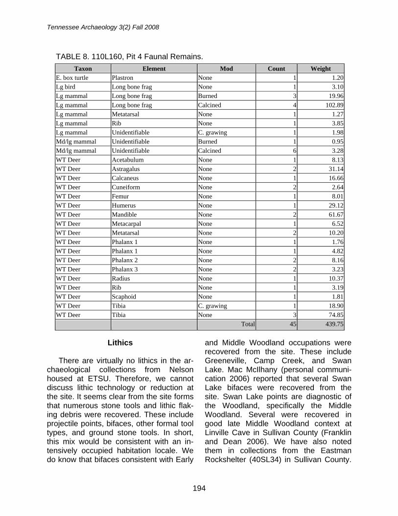
Tennessee Archaeology 3(2) Fall 2008
194
Lithics There are virtually no lithics in the ar-
chaeological collections from Nelson housed at ETSU. Therefore, we cannot discuss lithic technology or reduction at the site. It seems clear from the site forms that numerous stone tools and lithic flak-ing debris were recovered. These include projectile points, bifaces, other formal tool types, and ground stone tools. In short, this mix would be consistent with an in-tensively occupied habitation locale. We do know that bifaces consistent with Early
and Middle Woodland occupations were recovered from the site. These include Greeneville, Camp Creek, and Swan Lake. Mac McIlhany (personal communi-cation 2006) reported that several Swan Lake bifaces were recovered from the site. Swan Lake points are diagnostic of the Woodland, specifically the Middle Woodland. Several were recovered in good late Middle Woodland context at Linville Cave in Sullivan County (Franklin and Dean 2006). We have also noted them in collections from the Eastman Rockshelter (40SL34) in Sullivan County.
TABLE 8. 110L160, Pit 4 Faunal Remains.
Taxon Element Mod Count Weight
E. box turtle Plastron None 1 1.20
Lg bird Long bone frag None 1 3.10
Lg mammal Long bone frag Burned 3 19.96
Lg mammal Long bone frag Calcined 4 102.89
Lg mammal Metatarsal None 1 1.27
Lg mammal Rib None 1 3.85
Lg mammal Unidentifiable C. grawing 1 1.98
Md/lg mammal Unidentifiable Burned 1 0.95
Md/lg mammal Unidentifiable Calcined 6 3.28
WT Deer Acetabulum None 1 8.13
WT Deer Astragalus None 2 31.14
WT Deer Calcaneus None 1 16.66
WT Deer Cuneiform None 2 2.64
WT Deer Femur None 1 8.01
WT Deer Humerus None 1 29.12
WT Deer Mandible None 2 61.67
WT Deer Metacarpal None 1 6.52
WT Deer Metatarsal None 2 10.20
WT Deer Phalanx 1 None 1 1.76
WT Deer Phalanx 1 None 1 4.82
WT Deer Phalanx 2 None 2 8.16
WT Deer Phalanx 3 None 2 3.23
WT Deer Radius None 1 10.37
WT Deer Rib None 1 3.19
WT Deer Scaphoid None 1 1.81
WT Deer Tibia C. grawing 1 18.90
WT Deer Tibia None 3 74.85
Total 45 439.75
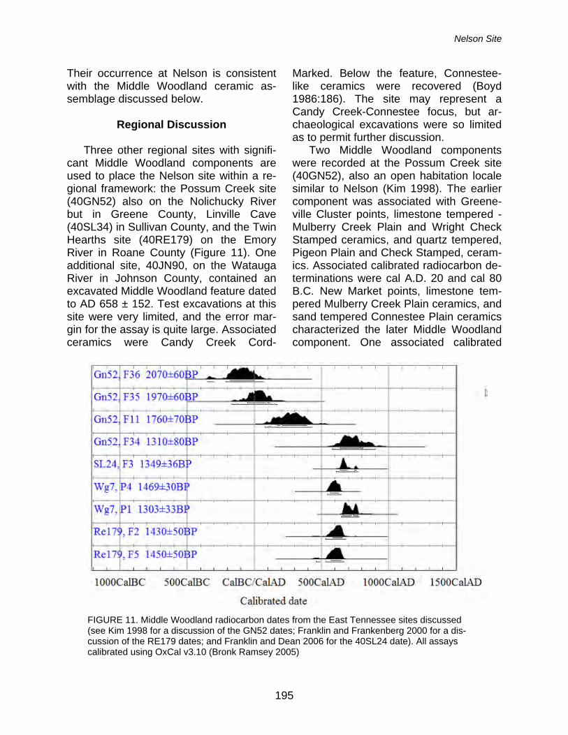
Nelson Site
195
Their occurrence at Nelson is consistent with the Middle Woodland ceramic as-semblage discussed below.
Regional Discussion
Three other regional sites with signifi-
cant Middle Woodland components are used to place the Nelson site within a re-gional framework: the Possum Creek site (40GN52) also on the Nolichucky River but in Greene County, Linville Cave (40SL34) in Sullivan County, and the Twin Hearths site (40RE179) on the Emory River in Roane County (Figure 11). One additional site, 40JN90, on the Watauga River in Johnson County, contained an excavated Middle Woodland feature dated to AD 658 ± 152. Test excavations at this site were very limited, and the error mar-gin for the assay is quite large. Associated ceramics were Candy Creek Cord-
Marked. Below the feature, Connestee-like ceramics were recovered (Boyd 1986:186). The site may represent a Candy Creek-Connestee focus, but ar-chaeological excavations were so limited as to permit further discussion.
Two Middle Woodland components were recorded at the Possum Creek site (40GN52), also an open habitation locale similar to Nelson (Kim 1998). The earlier component was associated with Greene-ville Cluster points, limestone tempered - Mulberry Creek Plain and Wright Check Stamped ceramics, and quartz tempered, Pigeon Plain and Check Stamped, ceram-ics. Associated calibrated radiocarbon de-terminations were cal A.D. 20 and cal 80 B.C. New Market points, limestone tem-pered Mulberry Creek Plain ceramics, and sand tempered Connestee Plain ceramics characterized the later Middle Woodland component. One associated calibrated
FIGURE 11. Middle Woodland radiocarbon dates from the East Tennessee sites discussed (see Kim 1998 for a discussion of the GN52 dates; Franklin and Frankenberg 2000 for a dis-cussion of the RE179 dates; and Franklin and Dean 2006 for the 40SL24 date). All assays calibrated using OxCal v3.10 (Bronk Ramsey 2005)
Tennessee Archaeology 3(2) Fall 2008
196
radiocarbon determination came out to be cal A.D. 725. Thus, Wright Check Stamped wares are dated much earlier in the Middle Woodland at Possum Creek than at Nelson, although Mulberry Creek Plain persists into the later Middle Wood-land at both sites. The mix of Connestee and Mulberry Creek Plain at Possum Creek is consistent with same at Nelson. Unlike Possum Creek, Pigeon ceramics at Nelson are negligible.
Ceramics recovered from Linville Cave indicate a predominantly Middle Wood-land camp site (Franklin and Dean 2006). A single calibrated radiocarbon date of AD 675 indicates that the site was contempo-raneous with Nelson. A total of 415 sherds was recovered in excavations by S. D. Dean. Candy Creek Cord Marked dominates the assemblage (n=166). Curi-ously, there were no Wright Check Stamped wares recovered here. Sand-tempered wares such as Connestee and Pigeon were also absent. It should be pointed out that Linville Cave represents a small special use camp site while Nelson was clearly a long term intensive habita-tion locale. The significance of this differ-ence remains to be tested, but we have also recovered Wright Checked Stamped wares from the Eastman Rockshelter (40SL34). Analysis of those materials is ongoing, so we can have little to say about that site.
Finally, at the Twin Hearths site on the Emory River, a contemporaneous ceramic assemblage was also recovered (Franklin and Frankenberg 2000). Two AMS deter-minations on charred nutshell from hearth features indicate that the site was occu-pied during the mid-seventh century AD. Like Nelson, the site appears to have been an intensive habitation locale, al-though only a small portion was exca-vated. A total of 813 sherds was recov-ered. However, the vast majority were re-
sidual. Of the remaining 114 sherds, Mul-berry Creek Plain (n=89) were the most prevalent. Also present in minority were Candy Creek Cord Marked (n=3), Bluff Creek Simple Stamped (n=3), Wright Checked Stamped (n=1), and Flint River Brushed (n=18). Flint River Brushed per-haps represents a more southerly influ-ence, e. g., Alabama. While sand tem-pered wares also commonly occur during the East Tennessee Middle Woodland in the form of Pigeon or Connestee, these types were absent from at the Twin Hearths site, perhaps not so surprising given that this site is the farthest west of the sites discussed in this report. The relative paucity of Wright Check Stamped is curious given that it represents the most popular form of Middle Woodland stamp-ing in the region (Faulkner 1968).
In sum, the Nelson site seems fairly typical of Middle Woodland sites in East Tennessee in terms of material culture and subsistence, though we caution against lumping upper East Tennessee (e. g., Holston, French Broad, and No-lichucky basins) with the lower East Ten-nessee Valley more generally. Sites along tributary streams such as the Nolichucky, Watauga, and French Broad rivers pos-sess mixes of ceramics that indicate sig-nificant interactions with western North Carolina. Further, there appear to be some significant differences between Nel-son and other sites in terms of ceramic assemblages. Wright Check Stamped wares date earlier in the Middle Woodland at Possum Creek but later at Nelson and Twin Hearths. They are absent at Linville Cave but present at the Eastman Rock-shelter. Currently, we cannot address the significance, if any, regarding this tempo-ral and geographical distribution of Wright Check Stamped in the region. However, we hypothesize that proximity to the Ap-palachian Summit region of western North
Nelson Site
197
Carolina is reflected in the distribution of quartz and sand tempered wares in upper East Tennessee during the early Middle Woodland. The Possum Creek site is closest to western North Carolina and contains significant amounts of both Pi-geon and Connestee wares. At the Nel-son site, farther down the Nolichucky, we recorded only one definite Pigeon sherd. Only three Pigeon sherds were recovered from the entire Watauga Reservoir survey and these were found in plowzone con-texts at a single site, 40JN89 (Boyd 1986:31). We do have significant repre-sentation for Connestee at Nelson, though. Perhaps Pigeon represents a re-stricted ceramic tradition for the early Middle Woodland while Connestee indi-cates a much broader interaction sphere later in the Middle Woodland. This is in-teresting because Early Woodland Swan-nanoa pottery has a broad distribution range from western North Carolina to the Upper Cumberland Plateau of Tennessee (Franklin 2008). So, too, does Connestee (Franklin 2002). Pigeon, situated between Swannanoa and Connestee, is rather re-stricted and poorly understood. It may represent the first interaction of stamped traditions from farther south in Georgia (Keel 1976).
In any case, given the paucity of re-corded Middle Woodland sites in upper East Tennessee, much work remains to be done to address issues like regional cultural interactions. The Nelson site as-semblage and associated new AMS dates have allowed us to frame the hypothesis presented above. Currently, we continue to survey sites in upper East Tennessee, including some that possess Pigeon ce-ramics. Isolating and dating Pigeon com-ponents is a primary goal of these investi-gations. Chronological placement of Wright Check Stamped at Eastman is also a proximate goal along with refining the
temporal distribution of this type in the re-gion more generally. Acknowledgements: Funding for this research was provided by the Honors College at East Tennes-see State University in the form of a Student Fac-ulty Collaborative Grant to Michelle Hammett and Jay Franklin. The NSF-Arizona AMS Facility pro-vided all three radiocarbon dates from the site. The Tennessee Division of Archaeology lent us access to two collections from the site (Accession numbers TDOA 77-249 and 77-389). Chet Bag-eant donated field forms and the Pisgah sherd for AMS dating. We greatly appreciate his interest and support in this project. We wish also to thank one anonymous donor. Without his support, we could not have conducted this research. Finally, we thank two anonymous reviewers for their cogent comments.
References
Bennett, J.L. 1999 Thermal Alteration of Buried Bone
Journal of Archaeological Science 26:1–8.
Boyd, C. C., Jr. 1986 Archaeological Investigations in the
Watauga Reservoir, Carter and John-son Counties, Tennessee. Tennessee Valley Authority, Publications in An-thropology, No. 46, University of Ten-nessee, Department of Anthropology Report of Investigations No. 44, Knox-ville.
Bronk Ramsey, C. 2005 The OxCal radiocarbon calibration
software. Burt, W.H. and R.P. Grossenheider 1976 Mammals: Peterson Field Guide.
Houghton Mifflin Company, Boston. Chapman, J. and B. C. Keel 1979 Candy Creek-Connestee Components
in Eastern Tennessee and Western North Carolina and Their Relationship with Adena-Hopewell. In Hopewell Ar-chaeology: The Chillicothe Confer-ence, edited by D. S. Brose and N.
Tennessee Archaeology 3(2) Fall 2008
198
Greber, pp 157-161. Kent State Uni-versity Press, Kent.
Cridlebaugh, P. A. 1981 The Icehouse Bottom Site (40MR23):
1977 Excavations. University of Ten-nessee Department of Anthropology Report of Investigations No. 35, and The Tennessee Valley Authority Publi-cations in Anthropology No. 34, The University of Tennessee, Knoxville.
Faulkner, C. H. 1968 A Review of Pottery Types in the
Eastern Tennessee Valley. South-eastern Archaeological Conference Bulletin 8:23-35.
Franklin, Jay D. 2002 The Prehistory of Fentress County,
Tennessee: An Archaeological Sur-vey. Doctoral Dissertation, Department of Anthropology, University of Tennes-see, Knoxville, University Microfilms, Ann Arbor, Michigan.
2008 Luminescence Dates and Woodland Ceramics from Rock Shelters on the Upper Cumberland Plateau of Ten-nessee. Tennessee Archaeology 3(1):87-100.
Franklin, J.D. and S.R. Frankenberg 2000 Archaeological Reconnaissance Sur-
vey and Limited Deep Testing Along the Proposed Kingston Fossil Plant Rail Spur. Report Submitted to Ten-nessee Valley Authority (TVA). The University of Tennessee, Knoxville.
Franklin, J. D. and S. D. Dean 2006 The Archaeology of Linville Cave
(40SL24), Sullivan County, Tennes-see. Tennessee Archaeology 2(2):63-82.
Franklin, J. D., E. K. Price, and L. M.
Langston 2009 The Mortuary Assemblage from the
Holliston Mills Site, a Mississippian Town in Upper East Tennessee. In Mississippian Mortuary Practices: Be-
yond Hierarchy and the Representa-tionist Perspective, edited by L. P. Sul-livan and R. C. Mainfort, Jr., pp. 325-350. University Press of Florida, Gainesville (in press).
Haag, W. G. 1939 Description of Pottery Types. Newslet-
ter of the Southeastern Archaeological Conference Volume 1, No. 1, Lexing-ton.
Hall, E.R. and K.R. Kelson 1959 The Mammals of North America. The
Ronald Press Company, New York. Heimlich, M. D. 1952 Guntersville Basin Pottery. Geological
Survey of Alabama, Museum Paper No. 32. University, Alabama.
Keel, B. C. 1976 Cherokee Archaeology. University of
Tennessee Press, Knoxville. Kim, Y. W. 1998 Phase III Data Recovery at the Pos-
sum Creek Site (40GN52) and the Meyers Site (40GN63) in the Pro-posed State Route 350 Right-of-Way, Greene County, Tennessee. Edited and Submitted by Charles Bentz, Transportation Center, University of Tennessee, Knoxville. Submitted to Chester IDE Associates, Inc., Nash-ville, Tennessee.
Kimball, L. R., T. R. Whyte, and G. Crites 2008 The Biltmore Mound and Hopewellian
Mound Use in the Southern Appala-chians. Paper Presented at the 65th Annual Meeting of the Southeastern Archaeological Conference, Charlotte, North Carolina.
Kneberg, M. D. 1961 Four Southeastern Limestone-
tempered Pottery Complexes. South-eastern Archaeological Conference Newsletter 7(2):3-14.
Nelson Site
199
Lafferty, R. H., III 1978 The Early Woodland Chronological
and Cultural Affinities at Phipps Bend on the Holston River, Northeast Ten-nessee. Journal of Alabama Archae-ology 24(2):132-150.
1981 The Phipps Bend Archaeological Pro-ject. Research Series 4, Office of Ar-chaeological Research, University of Alabama, and TVA Publications in An-thropology 26, Knoxville.
Langston, L. M. and J. D. Franklin 2006 Early Woodland Ceramic Typology
and Culture Chronology in Upper East Tennessee. Paper presented at the 63rd Annual Southeastern Archaeo-logical Conference, Little Rock, Arkan-sas.
Lewis, T. M. N. and M. Kneberg 1946 Hiwassee Island. University of Ten-
nessee Press, Knoxville. 1957 The Camp Creek Site. Tennessee Ar-
chaeologist 13(1):1-48. McCollough, M. C. R. and C. H. Faulkner 1973 Excavation of the Higgs and Doughty
Sites, I-75 Salvage Archaeology. Ten-nessee Archaeological Society, Mis-cellaneous Papers No. 12, Knoxville.
McIlhany, C. W. 1978 An Archaeological Survey of the Mid-
dle Nolichucky River Basin. Unpub-lished Masters Thesis, Department of Anthropology, the University of Ten-nessee, Knoxville.
Purrington, B. 1983 Ancient Mountaineers: An Overview of
the Prehistoric Archaeology of North Carolina's Western Mountain Region. In The Prehistory of North Carolina: An Archaeological Symposium, edited by M. A. Mathis and J. C. Crow, pp. 83-160. North Carolina Division of Ar-chives and History, Raleigh.
Schwartz, C.W. and E.R. Schwartz 1964 The Wild Mammals of Missouri. The
University of Missouri Press, Kansas City.
Smith, D. C. and F. M. Hodges, Jr. 1968 The Rankin Site, Cocke County, Ten-
nessee. Tennessee Archaeologist 24(2):36-91.
Thacker, J. P., J. D. Franklin, and S. D. Dean 2008. The WKM Site: A Stratified Early
Woodland Site on the Holston River, Sullivan County, Tennessee. Paper Presented at the 20th Annual Current Research in Tennessee Archaeology Meeting, Nashville, Tennessee.
Ward, H. T. and R. P. S. Davis, Jr. 1999 Time Before History: The Archaeology
of North Carolina. The University of North Carolina Press, Chapel Hill.
Whitaker, J.O. 1980 The Audubon Field Guide to North
American Mammals. Alfred A. Knopf, New York.
Jay D. Franklin East Tennessee State University Johnson City, Tennessee Michelle L. Hammett East Tennessee State University Johnson City, Tennessee Renee B. Walker SUNY-Oneonta Oneonta, New York

Tennessee Archaeology 3(2) Fall 2008
200
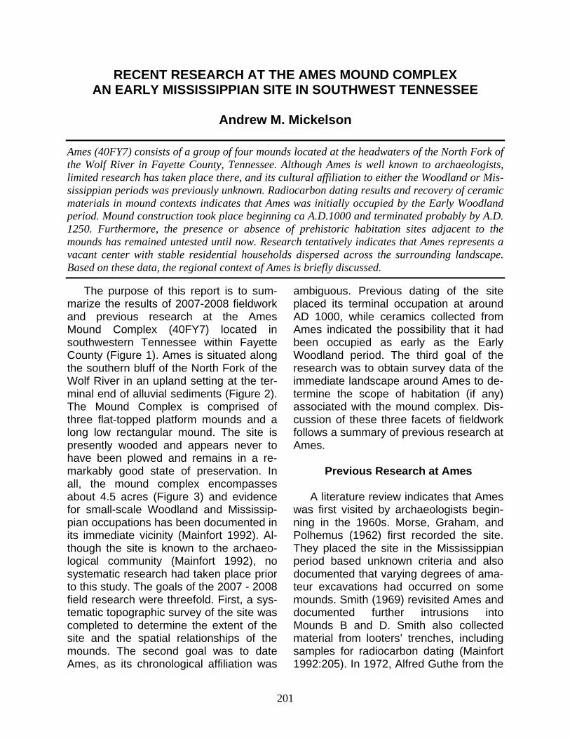
201
RECENT RESEARCH AT THE AMES MOUND COMPLEX AN EARLY MISSISSIPPIAN SITE IN SOUTHWEST TENNESSEE
Andrew M. Mickelson
Ames (40FY7) consists of a group of four mounds located at the headwaters of the North Fork of the Wolf River in Fayette County, Tennessee. Although Ames is well known to archaeologists, limited research has taken place there, and its cultural affiliation to either the Woodland or Mis-sissippian periods was previously unknown. Radiocarbon dating results and recovery of ceramic materials in mound contexts indicates that Ames was initially occupied by the Early Woodland period. Mound construction took place beginning ca A.D.1000 and terminated probably by A.D. 1250. Furthermore, the presence or absence of prehistoric habitation sites adjacent to the mounds has remained untested until now. Research tentatively indicates that Ames represents a vacant center with stable residential households dispersed across the surrounding landscape. Based on these data, the regional context of Ames is briefly discussed.
The purpose of this report is to sum-marize the results of 2007-2008 fieldwork and previous research at the Ames Mound Complex (40FY7) located in southwestern Tennessee within Fayette County (Figure 1). Ames is situated along the southern bluff of the North Fork of the Wolf River in an upland setting at the ter-minal end of alluvial sediments (Figure 2). The Mound Complex is comprised of three flat-topped platform mounds and a long low rectangular mound. The site is presently wooded and appears never to have been plowed and remains in a re-markably good state of preservation. In all, the mound complex encompasses about 4.5 acres (Figure 3) and evidence for small-scale Woodland and Mississip-pian occupations has been documented in its immediate vicinity (Mainfort 1992). Al-though the site is known to the archaeo-logical community (Mainfort 1992), no systematic research had taken place prior to this study. The goals of the 2007 - 2008 field research were threefold. First, a sys-tematic topographic survey of the site was completed to determine the extent of the site and the spatial relationships of the mounds. The second goal was to date Ames, as its chronological affiliation was
ambiguous. Previous dating of the site placed its terminal occupation at around AD 1000, while ceramics collected from Ames indicated the possibility that it had been occupied as early as the Early Woodland period. The third goal of the research was to obtain survey data of the immediate landscape around Ames to de-termine the scope of habitation (if any) associated with the mound complex. Dis-cussion of these three facets of fieldwork follows a summary of previous research at Ames.
Previous Research at Ames
A literature review indicates that Ames
was first visited by archaeologists begin-ning in the 1960s. Morse, Graham, and Polhemus (1962) first recorded the site. They placed the site in the Mississippian period based unknown criteria and also documented that varying degrees of ama-teur excavations had occurred on some mounds. Smith (1969) revisited Ames and documented further intrusions into Mounds B and D. Smith also collected material from looters’ trenches, including samples for radiocarbon dating (Mainfort 1992:205). In 1972, Alfred Guthe from the
Tennessee Archaeology 3(2) Fall 2008
202
University of Tennessee-Knoxville con-ducted test excavations at Ames which according to Peterson (1979:28) “pro-duced virtually nothing.” Unfortunately, none of the materials from Guthe’s study could be relocated.
In 1979 Memphis State (now Univer-sity of Memphis) archaeologists visited the site as a part of a Soil Service Survey contract for archaeological survey of the Wolf River Valley (Peterson 1979:28). Pe-terson’s research consisted of excavating
FIGURE 1. Location of Ames (40FY7) in relation to sites discussed in text.
Ames Mound Complex
203
four test units across the site (Figure 3). He reports finding little archaeological ma-terial, except a few sherds of Woodland period ceramics from Unit 3 near Mound B. Smith (1979:44, 65) reports that the ceramics dated to the Early and Middle Woodland periods, including what were classified as Tchefuncte Plain, var. Tchula (n=3), Thomas ware (n=10), and Baldwin ware (n=7). Curiously, no Mississippian period materials were identified (for fur-ther discussion, see below). The remain-ing three test units produced virtually no artifacts. Memphis State also examined open excavation/looters’ trenches and ob-served evidence for burned clay floors in the exposures of the profiles of at least two of these pits. Unfortunately, the de-scription of the locations of the looters’ pits is rather vague, but it seems likely they were located on Mounds A and B
(Peterson 1979:65). Attempts to relocate field notes and maps from this excavation stored at the C. H. Nash Museum were unsuccessful. Smith (in Peterson 1979:44) concluded that 40FY7 repre-sented a Woodland or Mississippian pe-riod vacant ceremonial center. Similarly, Peterson was unable to resolve the ap-parent chronological incongruity of Wood-land period ceramics in association with a seemingly Mississippian period mound complex.
Mainfort (1986:82; 1992:204) initially thought that Ames was a Middle Wood-land period site possessing characteristics similar to Pinson (40MD1). During this pe-riod of West Tennessee archaeology, Pinson had only recently been identified as a Middle Woodland rather than a Mis-sissippian mound complex. For instance, the ceramics at Ames were interpreted as
FIGURE 2. Relief map of terrain sounding the Ames Mound Complex illustrating its extreme headwaters position on the North Fork of the Wolf River.
Tennessee Archaeology 3(2) Fall 2008
204
Woodland rather than Mississippian. Addi-tionally, the Ames mounds are morpho-logically similar to platform mounds found at Pinson. Both Ames and Pinson also possess a low-density scatter of off-mound artifact concentrations indicative of household level rather than village level occupations. Mainfort (1992:204) revisited four mound complex sites within the western interior of Tennessee, including Ames in the 1980s. Based upon surface collections and mound architectural styles, he concluded that four mound groups, 40HM2 (Bolivar), 40MD85 (Den-mark), 40OB4, and 40FY7 (Ames) dated to the Early Mississippian period based on surface collections of ceramic material. All of the sites, except for 40FY7, contained “sparse” amounts of Mississippian shell tempered ceramics. When Mainfort (1992:206) processed a 1969 radiocarbon
sample collected at Ames by Smith, Ames was first definitively identified as Early Mississippian. The sample was collected from a portion of a burned log or “beam,” recovered from a looter’s trench on top of Mound B and yielded an uncalibrated ra-diocarbon assay of 930 + 70 BP, or cal AD 1020 + 70 (Table 1).
In summary, previous research at Ames has been sporadic and poorly documented. The limited number of at-tempts to rectify the temporal-cultural placement of Ames has been hampered by the discovery that the site contains a mixed ceramics assemblage dating from the Early Woodland to Early Mississippian periods. Ames lacked the then “expected” Mississippian shell-tempered wares. Evi-dence now clearly indicates that Missis-sippian groups within the region produced ceramics without shell tempering. For ex-
FIGURE 3. Topographic map of Ames. Contour interval is one-half meter. Placement of Memphis State University test units are approximate, based on sketch map in Peterson (1979: Figure 24).
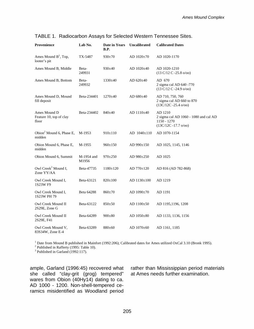
Ames Mound Complex
205
ample, Garland (1996:45) recovered what she called “clay-grit (grog) tempered” wares from Obion (40Hy14) dating to ca. AD 1000 - 1200. Non-shell-tempered ce-ramics misidentified as Woodland period
rather than Mississippian period materials at Ames needs further examination.
TABLE 1. Radiocarbon Assays for Selected Western Tennessee Sites.
Provenience Lab No. Date in Years B.P.
Uncalibrated Calibrated Dates
Ames Mound B1, Top, looter’s pit
TX-5487 930±70 AD 1020±70 AD 1020-1170
Ames Mound B, Middle Beta- 249931
930±40 AD 1020±40 AD 1020-1210 (13 C/12 C -25.8 o/oo)
Ames Mound B, Bottom Beta- 249932
1330±40 AD 620±40 AD 670 2 sigma cal AD 640 -770 (13 C/12 C -24.9 o/oo)
Ames Mound D, Mound fill deposit
Beta-234401 1270±40 AD 680±40
AD 710, 750, 760 2 sigma cal AD 660 to 870 (13C/12C -25.4 o/oo)
Ames Mound D Feature 10, top of clay floor
Beta-234402 840±40 AD 1110±40 AD 1210 2 sigma cal AD 1060 - 1080 and cal AD 1150 - 1270 (13C/12C -17.7 o/oo)
Obion2 Mound 6, Phase E, midden
M-1953 910±110 AD 1040±110 AD 1070-1154
Obion Mound 6, Phase E, midden
M-1955 960±150 AD 990±150 AD 1025, 1145, 1146
Obion Mound 6, Summit M-1954 and M1956
970±250 AD 980±250 AD 1025
Owl Creek3 Mound I, Zone YY/AA
Beta-47735 1180±120 AD 770±120 AD 816 (AD 782-868)
Owl Creek Mound I, 1S23W F9
Beta-63121 820±100 AD 1130±100 AD 1219
Owl Creek Mound I, 1S23W PH 79
Beta 64288 860±70 AD 1090±70 AD 1191
Owl Creek Mound II 2S29E, Zone G
Beta-63122
850±50 AD 1100±50 AD 1195,1196, 1208
Owl Creek Mound II 2S29E, F41
Beta-64289 900±80 AD 1050±80 AD 1133, 1136, 1156
Owl Creek Mound V, 83S34W, Zone E-4
Beta-63289 880±60 AD 1070±60 AD 1161, 1185
1 Date from Mound B published in Mainfort (1992:206); Calibrated dates for Ames utilized OxCal 3.10 (Bronk 1995). 2 Published in Rafferty (1995: Table 10). 3 Published in Garland (1992:117).
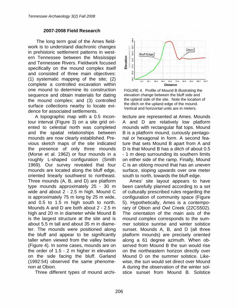
Tennessee Archaeology 3(2) Fall 2008
206
2007-2008 Field Research The long term goal of the Ames field-
work is to understand diachronic changes in prehistoric settlement patterns in west-ern Tennessee between the Mississippi and Tennessee Rivers. Fieldwork focused specifically on the mound complex itself and consisted of three main objectives: (1) systematic mapping of the site; (2) complete a controlled excavation within one mound to determine its construction sequence and obtain materials for dating the mound complex; and (3) controlled surface collections nearby to locate evi-dence for associated settlements.
A topographic map with a 0.5 mcon-tour interval (Figure 3) on a site grid ori-ented to celestial north was completed and the spatial relationships between mounds are now clearly established. Pre-vious sketch maps of the site indicated the presence of only three mounds (Morse et al. 1962) or four mounds in a roughly L-shaped configuration (Smith 1969). Our survey revealed that four mounds are located along the bluff edge, oriented linearly southwest to northeast. Three mounds (A, B, and D) are platform type mounds approximately 25 - 30 m wide and about 2 - 2.5 m high. Mound C is approximately 75 m long by 25 m wide, and 0.5 to 1.5 m high south to north. Mounds A and D are both about 2 - 2.5 m high and 20 m in diameter while Mound B is the largest structure at the site and is about 5.5 m tall and about 35 m in diame-ter. The mounds were positioned along the bluff and appear to be significantly taller when viewed from the valley below (Figure 4). In some cases, mounds are on the order of 1.5 - 2 m higher in elevation on the side facing the bluff. Garland (1992:54) observed the same phenome-non at Obion.
Three different types of mound archi-
tecture are represented at Ames. Mounds A and D are relatively low platform mounds with rectangular flat tops. Mound B is a platform mound, curiously pentago-nal or hexagonal in form. A second fea-ture that sets Mound B apart from A and D is that Mound B has a ditch of about 0.5 - 1 m deep surrounding its southern limits on either side of the ramp. Finally, Mound C is an oblong mound that has an uneven surface, sloping upwards over one meter south to north, towards the bluff edge.
Ames’ site layout appears to have been carefully planned according to a set of culturally prescribed rules regarding the configuration of community space (Figure 5). Hypothetically, Ames is a contempo-rary of Obion and Owl Creek (22CS502). The orientation of the main axis of the mound complex corresponds to the sum-mer solstice sunrise and winter solstice sunset. Mounds A, B, and D (all three platform mounds) are precisely oriented along a 61 degree azimuth. When ob-served from Mound B the sun would rise on the northeastern horizon directly over Mound D on the summer solstice. Like-wise, the sun would set direct over Mound A during the observation of the winter sol-stice sunset from Mound B. Solstice
FIGURE 4. Profile of Mound B illustrating the elevation change between the bluff side and the upland side of the site. Note the location of the ditch on the upland edge of the mound. Vertical and horizontal units are in meters.
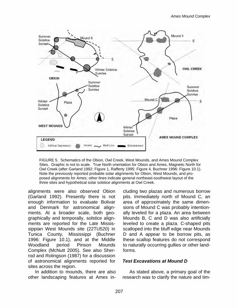
Ames Mound Complex
207
alignments were also observed Obion (Garland 1992). Presently there is not enough information to evaluate Bolivar and Denmark for astronomical align-ments. At a broader scale, both geo-graphically and temporally, solstice align-ments are reported for the Late Missis-sippian West Mounds site (22TU520) in Tunica County, Mississippi (Buchner 1996: Figure 10.1), and at the Middle Woodland period Pinson Mounds Complex (McNutt 2005). See also Sher-rod and Rolingson (1987) for a discussion of astronomical alignments reported for sites across the region.
In addition to mounds, there are also other landscaping features at Ames in-
cluding two plazas and numerous borrow pits. Immediately north of Mound C, an area of approximately the same dimen-sions of Mound C was probably intention-ally leveled for a plaza. An area between Mounds B, C and D was also artificially leveled to create a plaza. C-shaped pits scalloped into the bluff edge near Mounds D and A appear to be borrow pits, as these scallop features do not correspond to naturally occurring gullies or other land-forms.
Test Excavations at Mound D
As stated above, a primary goal of the
research was to clarify the nature and tim-
FIGURE 5. Schematics of the Obion, Owl Creek, West Mounds, and Ames Mound Complex Sites. Graphic is not to scale. True North orientation for Obion and Ames, Magnetic North for Owl Creek (after Garland 1992: Figure 1, Rafferty 1995: Figure 4, Buchner 1996: Figure 10.1). Note the previously reported probable solar alignments for Obion, West Mounds, and pro-posed alignments for Ames; other lines indicate general northeast-southwest layout of the three sites and hypothetical solar solstice alignments at Owl Creek.
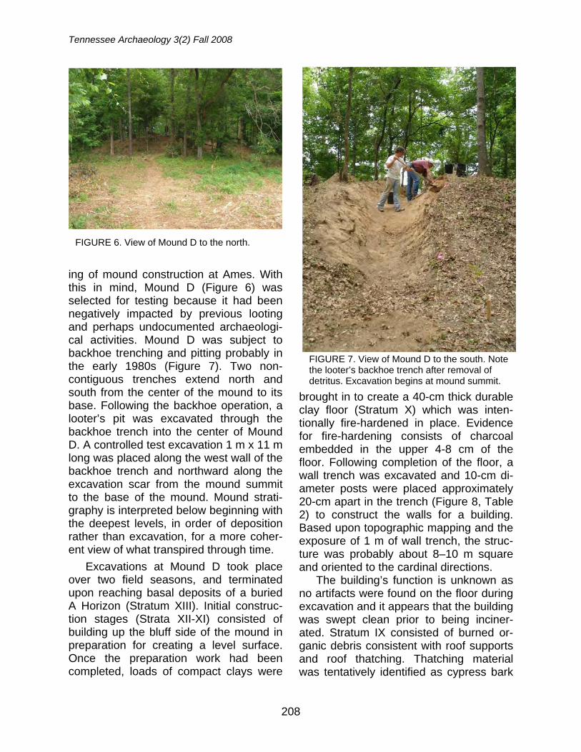
Tennessee Archaeology 3(2) Fall 2008
208
ing of mound construction at Ames. With this in mind, Mound D (Figure 6) was selected for testing because it had been negatively impacted by previous looting and perhaps undocumented archaeologi-cal activities. Mound D was subject to backhoe trenching and pitting probably in the early 1980s (Figure 7). Two non-contiguous trenches extend north and south from the center of the mound to its base. Following the backhoe operation, a looter’s pit was excavated through the backhoe trench into the center of Mound D. A controlled test excavation 1 m x 11 m long was placed along the west wall of the backhoe trench and northward along the excavation scar from the mound summit to the base of the mound. Mound strati-graphy is interpreted below beginning with the deepest levels, in order of deposition rather than excavation, for a more coher-ent view of what transpired through time.
Excavations at Mound D took place over two field seasons, and terminated upon reaching basal deposits of a buried A Horizon (Stratum XIII). Initial construc-tion stages (Strata XII-XI) consisted of building up the bluff side of the mound in preparation for creating a level surface. Once the preparation work had been completed, loads of compact clays were
brought in to create a 40-cm thick durable clay floor (Stratum X) which was inten-tionally fire-hardened in place. Evidence for fire-hardening consists of charcoal embedded in the upper 4-8 cm of the floor. Following completion of the floor, a wall trench was excavated and 10-cm di-ameter posts were placed approximately 20-cm apart in the trench (Figure 8, Table 2) to construct the walls for a building. Based upon topographic mapping and the exposure of 1 m of wall trench, the struc-ture was probably about 8–10 m square and oriented to the cardinal directions.
The building’s function is unknown as no artifacts were found on the floor during excavation and it appears that the building was swept clean prior to being inciner-ated. Stratum IX consisted of burned or-ganic debris consistent with roof supports and roof thatching. Thatching material was tentatively identified as cypress bark
FIGURE 7. View of Mound D to the south. Note the looter’s backhoe trench after removal of detritus. Excavation begins at mound summit.
FIGURE 6. View of Mound D to the north.
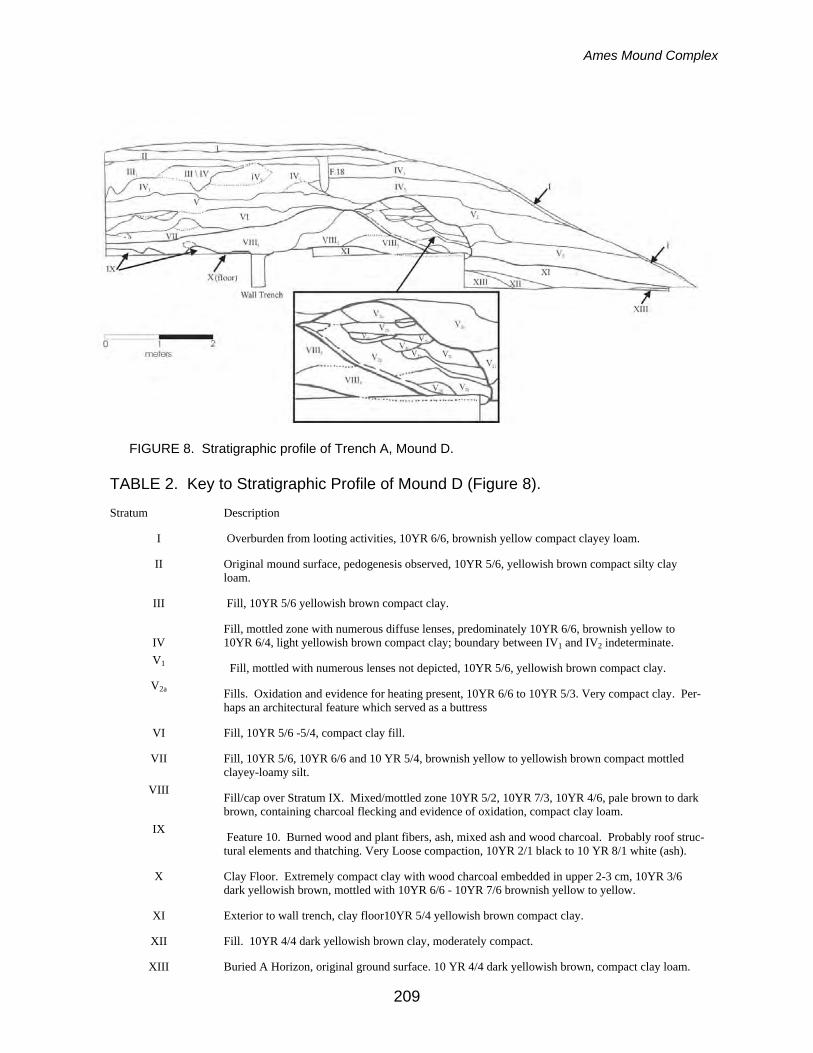
Ames Mound Complex
209
FIGURE 8. Stratigraphic profile of Trench A, Mound D.
TABLE 2. Key to Stratigraphic Profile of Mound D (Figure 8).
Stratum Description
I Overburden from looting activities, 10YR 6/6, brownish yellow compact clayey loam.
II Original mound surface, pedogenesis observed, 10YR 5/6, yellowish brown compact silty clay loam.
III Fill, 10YR 5/6 yellowish brown compact clay.
IV
Fill, mottled zone with numerous diffuse lenses, predominately 10YR 6/6, brownish yellow to 10YR 6/4, light yellowish brown compact clay; boundary between IV1 and IV2 indeterminate.
V1 Fill, mottled with numerous lenses not depicted, 10YR 5/6, yellowish brown compact clay.
V2a Fills. Oxidation and evidence for heating present, 10YR 6/6 to 10YR 5/3. Very compact clay. Per-haps an architectural feature which served as a buttress
VI Fill, 10YR 5/6 -5/4, compact clay fill.
VII Fill, 10YR 5/6, 10YR 6/6 and 10 YR 5/4, brownish yellow to yellowish brown compact mottled clayey-loamy silt.
VIII Fill/cap over Stratum IX. Mixed/mottled zone 10YR 5/2, 10YR 7/3, 10YR 4/6, pale brown to dark brown, containing charcoal flecking and evidence of oxidation, compact clay loam.
IX Feature 10. Burned wood and plant fibers, ash, mixed ash and wood charcoal. Probably roof struc-tural elements and thatching. Very Loose compaction, 10YR 2/1 black to 10 YR 8/1 white (ash).
X Clay Floor. Extremely compact clay with wood charcoal embedded in upper 2-3 cm, 10YR 3/6 dark yellowish brown, mottled with 10YR 6/6 - 10YR 7/6 brownish yellow to yellow.
XI Exterior to wall trench, clay floor10YR 5/4 yellowish brown compact clay.
XII Fill. 10YR 4/4 dark yellowish brown clay, moderately compact.
XIII Buried A Horizon, original ground surface. 10 YR 4/4 dark yellowish brown, compact clay loam.
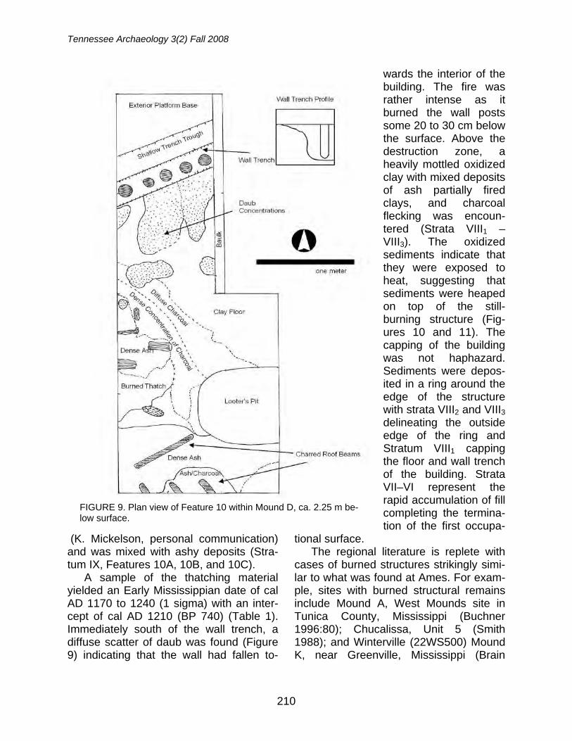
Tennessee Archaeology 3(2) Fall 2008
210
(K. Mickelson, personal communication) and was mixed with ashy deposits (Stra-tum IX, Features 10A, 10B, and 10C).
A sample of the thatching material yielded an Early Mississippian date of cal AD 1170 to 1240 (1 sigma) with an inter-cept of cal AD 1210 (BP 740) (Table 1). Immediately south of the wall trench, a diffuse scatter of daub was found (Figure 9) indicating that the wall had fallen to-
wards the interior of the building. The fire was rather intense as it burned the wall posts some 20 to 30 cm below the surface. Above the destruction zone, a heavily mottled oxidized clay with mixed deposits of ash partially fired clays, and charcoal flecking was encoun-tered (Strata VIII1 – VIII3). The oxidized sediments indicate that they were exposed to heat, suggesting that sediments were heaped on top of the still-burning structure (Fig-ures 10 and 11). The capping of the building was not haphazard. Sediments were depos-ited in a ring around the edge of the structure with strata VIII2 and VIII3 delineating the outside edge of the ring and Stratum VIII1 capping the floor and wall trench of the building. Strata VII–VI represent the rapid accumulation of fill completing the termina-tion of the first occupa-
tional surface. The regional literature is replete with
cases of burned structures strikingly simi-lar to what was found at Ames. For exam-ple, sites with burned structural remains include Mound A, West Mounds site in Tunica County, Mississippi (Buchner 1996:80); Chucalissa, Unit 5 (Smith 1988); and Winterville (22WS500) Mound K, near Greenville, Mississippi (Brain
FIGURE 9. Plan view of Feature 10 within Mound D, ca. 2.25 m be-low surface.
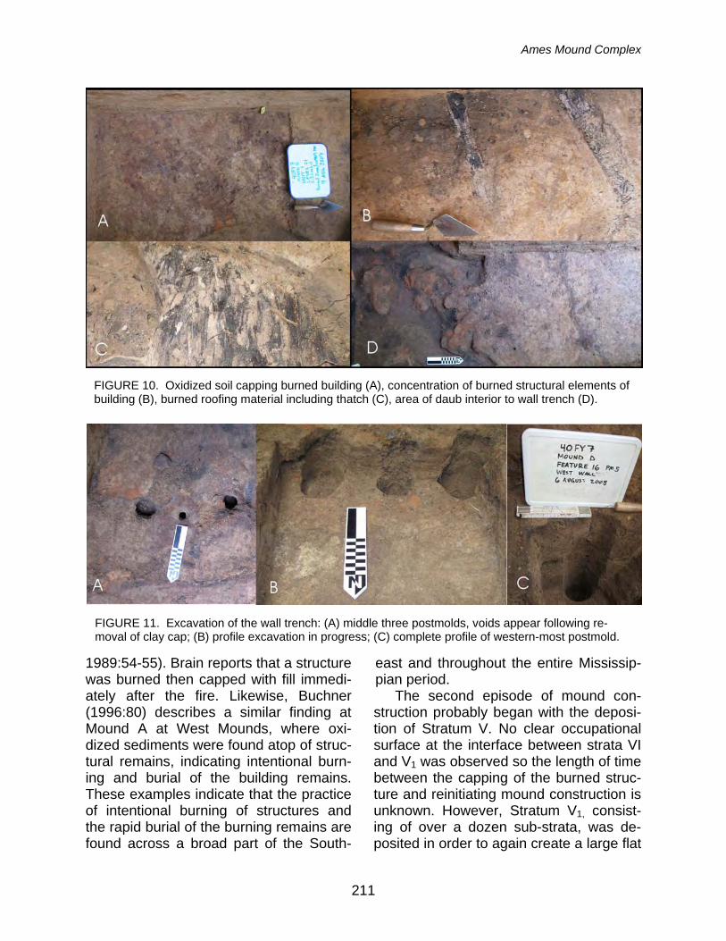
Ames Mound Complex
211
1989:54-55). Brain reports that a structure was burned then capped with fill immedi-ately after the fire. Likewise, Buchner (1996:80) describes a similar finding at Mound A at West Mounds, where oxi-dized sediments were found atop of struc-tural remains, indicating intentional burn-ing and burial of the building remains. These examples indicate that the practice of intentional burning of structures and the rapid burial of the burning remains are found across a broad part of the South-
east and throughout the entire Mississip-pian period.
The second episode of mound con-struction probably began with the deposi-tion of Stratum V. No clear occupational surface at the interface between strata VI and V1 was observed so the length of time between the capping of the burned struc-ture and reinitiating mound construction is unknown. However, Stratum V1, consist-ing of over a dozen sub-strata, was de-posited in order to again create a large flat
FIGURE 10. Oxidized soil capping burned building (A), concentration of burned structural elements of building (B), burned roofing material including thatch (C), area of daub interior to wall trench (D).
FIGURE 11. Excavation of the wall trench: (A) middle three postmolds, voids appear following re-moval of clay cap; (B) profile excavation in progress; (C) complete profile of western-most postmold.
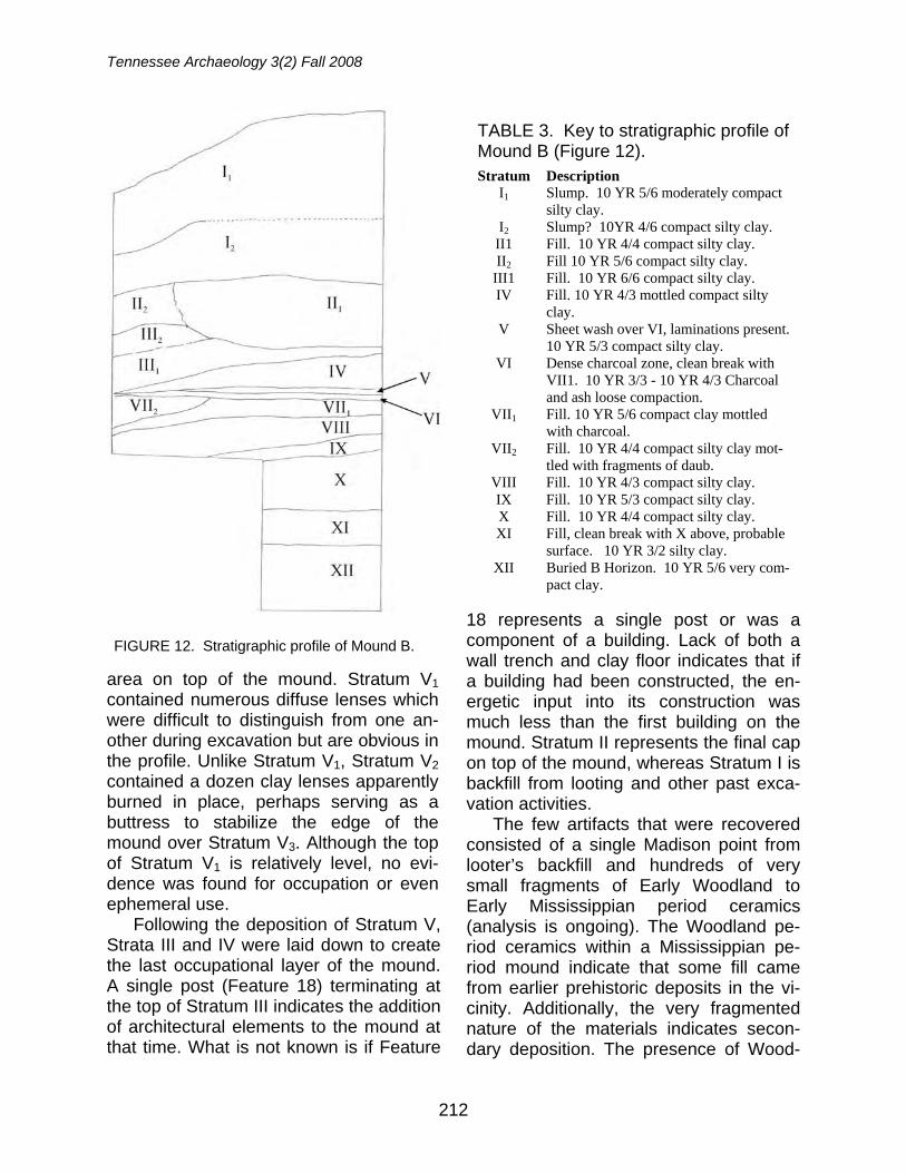
Tennessee Archaeology 3(2) Fall 2008
212
area on top of the mound. Stratum V1 contained numerous diffuse lenses which were difficult to distinguish from one an-other during excavation but are obvious in the profile. Unlike Stratum V1, Stratum V2 contained a dozen clay lenses apparently burned in place, perhaps serving as a buttress to stabilize the edge of the mound over Stratum V3. Although the top of Stratum V1 is relatively level, no evi-dence was found for occupation or even ephemeral use.
Following the deposition of Stratum V, Strata III and IV were laid down to create the last occupational layer of the mound. A single post (Feature 18) terminating at the top of Stratum III indicates the addition of architectural elements to the mound at that time. What is not known is if Feature
18 represents a single post or was a component of a building. Lack of both a wall trench and clay floor indicates that if a building had been constructed, the en-ergetic input into its construction was much less than the first building on the mound. Stratum II represents the final cap on top of the mound, whereas Stratum I is backfill from looting and other past exca-vation activities.
The few artifacts that were recovered consisted of a single Madison point from looter’s backfill and hundreds of very small fragments of Early Woodland to Early Mississippian period ceramics (analysis is ongoing). The Woodland pe-riod ceramics within a Mississippian pe-riod mound indicate that some fill came from earlier prehistoric deposits in the vi-cinity. Additionally, the very fragmented nature of the materials indicates secon-dary deposition. The presence of Wood-
FIGURE 12. Stratigraphic profile of Mound B.
TABLE 3. Key to stratigraphic profile of Mound B (Figure 12). Stratum Description
I1 Slump. 10 YR 5/6 moderately compact silty clay.
I2 Slump? 10YR 4/6 compact silty clay. II1 Fill. 10 YR 4/4 compact silty clay. II2 Fill 10 YR 5/6 compact silty clay.
III1 Fill. 10 YR 6/6 compact silty clay. IV Fill. 10 YR 4/3 mottled compact silty
clay. V Sheet wash over VI, laminations present.
10 YR 5/3 compact silty clay. VI Dense charcoal zone, clean break with
VII1. 10 YR 3/3 - 10 YR 4/3 Charcoal and ash loose compaction.
VII1 Fill. 10 YR 5/6 compact clay mottled with charcoal.
VII2 Fill. 10 YR 4/4 compact silty clay mot-tled with fragments of daub.
VIII Fill. 10 YR 4/3 compact silty clay. IX Fill. 10 YR 5/3 compact silty clay. X Fill. 10 YR 4/4 compact silty clay. XI Fill, clean break with X above, probable
surface. 10 YR 3/2 silty clay. XII Buried B Horizon. 10 YR 5/6 very com-
pact clay.
Ames Mound Complex
213
land materials within a Mississippian pe-riod mound was also reported by Rafferty (1995:17) at Owl Creek. Ceramics are dominated by sand tempered wares. The heavily eroded nature of the sherds makes typological identification nearly im-possible. However, one sherd tempered with quartzite, quartz, quartz sandstone and chert was also identified. It may be of non-local origin as similar material was reported by Peacock (1996) in north Mis-sissippi from a feature dating to ca. AD 400. Alternatively, it may be a variant of the Middle Woodland Knob Creek type described by Smith (in Peterson 1979) at Ames which also contained quartzite.
Test Excavation at Mound B
A 2 x 2 m test pit was located on the
southern side of Mound B, about two thirds of the way above the topographic base of the mound. The goals of the ex-cavation were to date the lower and mid-dle deposits of the mound and to see if anything could be learned regarding early stage mound use. As previously noted, Mainfort obtained an Early Mississippian date for the mound summit from not en-tirely clear contexts, and one purpose was to date material from precisely known lo-cations.
Our excavation exposed a 3.4 m deep profile and additional coring extended the profile another 50 cm (Figure 12, Table 3). Since the excavation is located on the side of the mound, the fact that the upper 1.4 m of deposits consists of slump is not unexpected (Strata I1 and I2). The top of Stratum II represents the end of a major construction phase that was nearly 40 cm thick, beginning at the top of Stratum IV. Stratum VI represents a surface that was perhaps stable for a substantial period of time because Stratum V overlying the sur-face appears to be evidence for sheet
wash, indicating the surface was exposed to rain and deposition of sediments from elsewhere. Strata VII – X are distinct epi-sodes of mound fill resting on what initially appeared to be the base of the mound (top of Stratum XI). Stratum XI is a very compact clay mottled with charcoal and the boundary between Strata XI and X was strong, suggesting that the top of Stratum XI is a former mound surface. Sediments below the X-XI interface were first tested with an Oakfield soil probe and the results indicated that a truncated B-Horizon had been encountered. The test excavation was stepped down to 50 cm x 40 cm and extended an additional 40 cm, exposing a profile containing bits of char-coal and burned clay, before intersecting with a truncated B Horizon. Artifacts from Mound B included 10 unidentified ceramic sherds, two flakes, and two pieces of iron bearing sandstone.
Two accelerator mass spectrometry (AMS) radiocarbon assays were obtained from the Mound B test excavation (Table 1). The first sample was obtained from Stratum VI, the aforementioned stable surface ca. 2.5 m below the mound sum-mit. An uncalibrated date of 940 + 40 BP (cal AD 1020 to 1210) was obtained. The second sample collected for radiocarbon dating was collected from Stratum XI about 3.75 m below the summit of Mound B. This sample yielded a date of 1330 + 40 BP (cal AD 640 to 770). The upper date from Stratum VI matches the date obtained from Mainfort which came from material near the summit of Mound B (un-calibrated 930 + 70 BP). These two dates indicate that the upper 2.5 m of Mound B was constructed within a very short time frame. The date from material collected within Stratum XI suggests two possible scenarios. First, the upper portions of Mound B are Early Mississippian con-struction episodes overlying a Late Wood-
Tennessee Archaeology 3(2) Fall 2008
214
land deposit, possibly a Late Woodland period mound. The second scenario is that Late Woodland deposits were “mined” by Mississippian architects to construct Mound B. Additional testing at Mound B will be required to resolve which scenario is most plausible.
Off-Mound Research The final goal was to obtain distribu-
tional data on non-mound deposits at the site, south of the mound complex in an area currently under cultivation. A con-trolled surface collection of approximately four acres adjacent to the mound complex was completed under nearly ideal visibility conditions. Artifacts were collected along north-south oriented transects at a 5-m interval and were mapped using a sub-meter level accuracy GPS (Figure 13, Ta-ble 4). A low-density scatter of artifacts was revealed. Off-mound artifact densities were on the order of less than 46 artifacts per hectare and this survey failed to en-counter what might be considered a “vil-lage” scale deposit associated with the mound complex. However, additional test-ing (e.g., geophysical prospecting) is re-quired to confirm this observation. Our survey found a single cluster of Mississip-pian period of artifacts (ceramics and two Madison points; Figure 14). Repeated sur-face collection, systematic shovel testing, and geophysical prospecting are planned to further test for occupational deposits around the mound complex. Present data indicate low-level occupational intensity in the vicinity of the mounds. Materials col-lected in the 1970s by Guthe and Peter-son via test pits also found a similar lack of materials in areas off-mounds (Peter-son 1979).
FIGURE 13. Nearest neighbor analysis of sur-face-collected artifacts over a ca. 1. 82 Ha (4.5 acres) south of the mound complex. Artifact density is approximately 46 artifacts per hec-tare. Highest density areas have concentra-tions of Mississippian period artifacts. Con-tours are feet above mean sea level.
TABLE 4. Results of Off-Mound Sur-face Collection. Material Type Count Debitage 64 Prehistoric Ceramics 3 Iron-bearing sandstone 8 Stone pipe fragment (?) 1 Madison Type Triangular Points 2 Total 79
FIGURE 14. Projectile points from surface contexts (A, B) and Mound D, looter’s trench (C).
Ames Mound Complex
215
Ames in Regional Context
Mississippian occupations within the west interior part of Tennessee, between the Tennessee and Mississippi Rivers, remains poorly understood despite years of survey and research. Presently, there are only five known Early Mississippian mound complexes dating from AD 990 to AD 1220 (Table 1). Mainfort (1992:203) observes that archaeological survey data for the interior is “no worse” than for areas along the major drainages within the state, and that sampling error does not explain the paucity of large towns associ-ated with the known Mississippian mound complexes in the region. According to Mainfort (1992), Ames shares traits with other mound groups including Obion, 40OB4, Denmark and Bolivar located in western Tennessee. Expanding the re-search area south of the state line into Mississippi, the Owl Creek complex situ-ated in northern Mississippi deserves in-clusion as well. The shared traits include (1) geographic positioning, (2) similarities in artifact assemblages and mound archi-tecture, and (3) low density artifact scat-ters off-mounds. Each of these character-istics will be considered in order below.
From an ecological/geophysical per-spective, all five sites fall within or on the margins of the Northern Hilly Coastal Plains subunit of the Southeastern Plains and Hills ecological region (Griffith et al. 1998) within upland settings near stream headwaters (refer back to Figure 1). The area lacks large floodplains and smaller river systems comprise the hydrological regime. The four Tennessee sites are lo-cated at the headwaters of tributaries of the Mississippi River while Owl Creek is at the headwaters of a tributary of the Tom-bigbee (only 15 km from the headwaters of the Mississippi drainage system). The Northern Hilly Plains stretches from north-
ern Mississippi to the Tennessee – Ken-tucky border. The natural vegetation of this region consists of an oak–hickory for-est transitioning to an oak-hickory-pine regime to the south and possesses “dis-tinctive faunal characteristics for west Tennessee” (Griffith et al. 1998). The re-gion is unlike the Mississippi Valley Loess Plains to the west or the Western High-land Rim to the east. The area lacks large floodplains as well, due to the smaller riv-ers that comprise the hydrological regime. Therefore, the area presented different challenges to Early Mississippian popula-tions than were encountered in adjacent regions to the east and west.
The Tennessee sites’ topographic po-sitioning along the Mississippi River side of the interfluve between the Mississippi and Tennessee River drainages may indi-cate influence of groups from the Missis-sippi Valley east into the uplands. How-ever, at present the influence may have been less than previously thought. One major Mississippian trait that is lacking at these sites is the predominance of shell tempered ceramics. Ceramics recovered from Ames do not have any attributes suggestive of Mississippi Valley origins and other sites, like Obion, Bolivar, and Denmark tend to have only small quanti-ties of shell-tempered ceramics (Mainfort 1992). Even at Obion the occurrence of shell tempered wares is between 5 and 15 percent across the site (Garland 1992:118). Most of the centers in the re-gion seem to have sparse artifact densi-ties, suggesting lower occupational inten-sity than their neighbors. An explanation is that a process of “Mississippianization” occurred, where local traditions of pottery making and a dispersed settlement strat-egy were retained, something along the lines of what Phillips, Ford, and Griffin (1951) called the X-Factor (Pauketat 2007:107).
Tennessee Archaeology 3(2) Fall 2008
216
All sites discussed have classic traits of Mississippian style mound architecture, similarities in layout, and the presence of plazas. Mound architecture at the above sites consists of rectangular platform mounds and low quasi-rectangular mounds such as Mound C at Ames, Obion Mound 6, and Owl Creek, Mound II. Plowing at Denmark and Bolivar (the two least researched sites) may have obliter-ated similar mounds. Plaza features are clearly present at Obion, Owl Creek, Ames, and Bolivar. Prentice (2000:120) observes that by the early Late Woodland period conical mounds quickly become scarce in the region and are replaced by small mound groups, roughly of three to six mounds oriented along an east-west axis. Ceremonial mound complexes “be-came codified even more with the domi-nant platform mound typically being the ramped variety located on the west side of the plaza opposite of a smaller mound. The ramp was typically placed on the plaza side of the [dominant] mound.” Clearly Ames contains all of the charac-teristics, as Mound B is ramped mound and Mound D is the smaller mound at Ames. Similar configurations are ob-served at Obion and Owl Creek (Figure 10).
Finally, most sites lack evidence for a village scale occupation, such as dense artifact concentrations or middens. The known exception is Obion (Garland 1992). Mainfort observes that there is no lack of agriculturally suitably soils at any of the four sites, thus ruling out ecological vari-ables for the lack of associated villages. This is the case at Ames, where the site is situated at the edge of a large level ex-panse of productive farmland, yet no vil-lage has been identified. The lack of vil-lages indicates regional variability within Early Mississippian settlement patterns. Incomplete data from Ames points to a
dispersed sedentary model of small ham-let or farmstead settlements across the area surrounding the mound group. The lack of a village at Owl Creek was con-firmed by Rafferty (1995) where extensive shovel testing and a review of previous collections from the site yielded a total count of less than 200 artifacts.
If such is the case, the lack of a mid-den or other substantial habitation debris, indicates that Ames supports the argu-ment for retention of a dispersed hamlet or farmstead settlement model from Woodland into Mississippian times within western Tennessee. Although settlement nucleation into villages adjacent to mound groups is seen along the Mississippi and Tennessee River floodplains during this time, such a settlement strategy appears not to have been dominant within the inte-rior. In fact, such a settlement system never seems to take hold in the region, as there are no Middle to Late Mississippian mound groups or even single mounds documented in the area (Prentice 2000). Rather, the present data point to ceremo-nial mound centers produced by small-scale agriculturalists living in dispersed farmsteads across the surrounding coun-tryside. Early Mississippian lifeways, such as at Ames and Obion found in “back-woods” western Tennessee have been described as “anomalies” that do “not fit easily into the Lower Valley or Tennessee [River] sequences” (Williams 1992:197). Our preliminary results do indicate that Ames and other sites varied considerably from its neighbors located in large fluvial valleys to the west and east. When viewed in regional context, they can no longer be thought of as “anomalies.” Rather a different settlement pattern is beginning to emerge.
Ames Mound Complex
217
Acknowledgements: I would like to thank the 2007 and 2008 field school participants from the Univer-sity of Memphis and Rhodes College. Jamie Ev-ans and other staff members at Ames Plantation were especially gracious in assisting our work. Katherine R. Mickelson, beyond being a co-principal investigator on the project also provided invaluable editorial support and commentary on this manuscript. She also conducted initial pa-leoethnobotanical analysis on the thatching mate-rial from Feature 10. I would also like to thank two anonymous reviewers for their helpful comments which greatly improved the original manuscript. This research was supported by a Faculty Re-search Grant funded by the University of Mem-phis..
References
Brain, Jeffrey P. 1989 Winterville: Late Prehistoric Cultural
Contact in the Lower Mississippi Val-ley. Archaeological Report No. 23. Mississippi Department of Archives and History, Jackson.
Bronk, Ramsey C. 1995 Radiocarbon calibration and analysis
of stratigraphy: The OxCal program, Radiocarbon 37:425-430. OxCal Ver-sion 3.10.
Buchner, C. Andrew 1996 Mound A Excavations at the West
Mounds Site, Tunica County, Missis-sippi. In Mounds, Embankments and Ceremonialism in the Midsouth, Robert C. Mainfort and Richard Wall-ing, editors, pp. 78-86. Arkansas Ar-cheological Survey Research Series No. 46. Fayetteville.
Garland, Elizabeth Baldwin 1992 The Obion Site. An Early Mississip-
pian Center in Western Tennessee. Cobb Institute of Archaeology. Report of Investigations 7. Mississippi State University.
1996 Some Observations on Ceremonialism at the Obion Site. In Mounds, Em-bankments and Ceremonialism in the Midsouth, Robert C. Mainfort and
Richard Walling, editors, pp. 44-49. Arkansas Archeological Survey Re-search Series No. 46. Fayetteville.
Griffith, Glenn 2001 Level III and IV Ecoregions of Tennes-
see. United States Environmental Pro-tection Agency. Electronic document,
ftp://ftp.epa.gov/wed/ecoregions/tn/tn eco.e00.Z
accessed October 9, 2008. Griffith, Glenn, James Omernik and Sandra
Azevedo 1998 Ecoregions of Tennessee. United
States Geological Survey. Reston, Vir-ginia. Electronic document,
ftp://ftp.epa.gov/wed/ecoregions/tn/tn eco lg.pdf
accessed October 9, 2008. Mainfort, Robert C., Jr. 1986 Pinson Mounds: a Middle Woodland
Ceremonial Site. Tennessee Depart-ment of Conservation, Division of Ar-chaeology, Research Series, No. 7, Nashville.
1992 The Mississippian Period in the West Tennessee Interior. In The Obion Site. An Early Mississippian Center in Western Tennessee, by Elizabeth Baldwin Garland pp. 203-207. Cobb Institute of Archaeology. Report of In-vestigations 7. Mississippi State Uni-versity.
McNutt, Charles H. 2005 The Pinson Observatory. Southeast-
ern Archaeology 24:142-164. Morse, Dan F., J. Bennett Graham, and Rich-
ard R. Polhemus 1962 Site Survey Sheet: Ames Mound
Complex (40FY7). Copy on file at the Tennessee Division of Archaeology, Nashville.
Pauketat, Timothy R. 2007 Chiefdoms and Other Archaeological
Delusions. Altamira Press, Lanham, Maryland.

Tennessee Archaeology 3(2) Fall 2008
218
Peacock, Evan 1996 Tchula Period Sites on the Holly
Springs National Forest, North-Central Mississippi. Proceedings of the 14th Annual Mid-South Archaeological Conference, pp.13-21, Richard Wall-ing, Camille Wharey, and Camille Stanley, editors. Special Publications 1. Panamerican Consultants, Inc., Memphis.
Peterson, Drexel A. 1979 An Archaeological Assessment of the
Wolf River Watershed. Prepared for the United States Department of Agri-culture, Soil Conservation Service. Contract No. 53-4741-9-28. Copy on file at the C. H. Nash Museum Library, Memphis.
Phillips, Phillip, James A. Ford, and James B.
Griffin 1951 Archaeological Survey in the Lower
Mississippi Alluvial Valley, 1940-1947. Papers of the Peabody Museum of Ar-chaeology and Ethnology, vol. 25. Harvard University, Cambridge, MA.
Prentice, Guy 2000 Ancient Indian Architecture of the
Lower Mississippi Delta: A Study of Earthworks. Southeast Archaeological Center, National Park Service. Talla-hassee, Florida.
Rafferty, Janet 1995 Owl Creek Mounds: Test Excavations
at a Vacant Mississippian Mound Cen-ter. Prepared for United States De-partment of Agriculture, Forest Ser-vice, National Forests of Mississippi. Report of Investigations 7. Cobb Insti-tute of Archaeology, Mississippi State University.
Sherrod, P.C. and M.A. Rolingson 1987 Surveyors of the Ancient Mississippi
Valley. Arkansas Archeological Survey Research Series No. 28
Smith, Gerald P. 1969 Site Survey Sheet: Ames Mound
Complex (40FY7). Copy on file at the Tennessee Division of Archaeology, Nashville.
1979 Ceramics from the Wolf River Drain-age Area. In An Archaeological As-sessment of the Wolf River Water-shed, Drexel A. Peterson, editor, pp.41-44. Prepared for the United States Department of Agriculture, Soil Conservation Service. Contract No. 53-4741-9-28. Copy on file at the C. H. Nash Museum Library, Memphis.
1988 Structural Evidence from Chucalissa Unit 5. Paper presented at the 45th Annual Meeting of the Southeastern Archaeological Conference, Jackson, Mississippi.
Williams, Stephen 1992 Obion Retrospective and Prospective.
In The Obion Site. An Early Mississip-pian Center in Western Tennessee, by Elizabeth Baldwin Garland pp. 193-202. Cobb Institute of Archaeology. Report of Investigations 7. Mississippi State University.
Andrew M. Mickelson Department of Earth Sciences 1 Johnson Hall University of Memphis Memphis, TN 38152
Copyright © 2022 FDOKUMEN