The Natural, Human, and Sacred Geography of Classic Maya ...
344
City University of New York (CUNY) City University of New York (CUNY) CUNY Academic Works CUNY Academic Works Dissertations, Theses, and Capstone Projects CUNY Graduate Center 6-2022 Landscape, Settlement, and Community: The Natural, Human, and Landscape, Settlement, and Community: The Natural, Human, and Sacred Geography of Classic Maya Civilization in West-Central Sacred Geography of Classic Maya Civilization in West-Central Guatemala Guatemala Marc A. Wolf The Graduate Center, City University of New York How does access to this work benefit you? Let us know! More information about this work at: https://academicworks.cuny.edu/gc_etds/4840 Discover additional works at: https://academicworks.cuny.edu This work is made publicly available by the City University of New York (CUNY). Contact: [email protected]
-
Upload
khangminh22 -
Category
Documents
-
view
2 -
download
0
Transcript of The Natural, Human, and Sacred Geography of Classic Maya ...

City University of New York (CUNY) City University of New York (CUNY)
CUNY Academic Works CUNY Academic Works
Dissertations, Theses, and Capstone Projects CUNY Graduate Center
6-2022
Landscape, Settlement, and Community: The Natural, Human, and Landscape, Settlement, and Community: The Natural, Human, and
Sacred Geography of Classic Maya Civilization in West-Central Sacred Geography of Classic Maya Civilization in West-Central
Guatemala Guatemala
Marc A. Wolf The Graduate Center, City University of New York
How does access to this work benefit you? Let us know!
More information about this work at: https://academicworks.cuny.edu/gc_etds/4840
Discover additional works at: https://academicworks.cuny.edu
This work is made publicly available by the City University of New York (CUNY). Contact: [email protected]

LANDSCAPE, SETTLEMENT, AND COMMUNITY: THE NATURAL, HUMAN, AND SACRED GEOGRAPHY OF CLASSIC MAYA CIVILIZATION IN WEST-CENTRAL
GUATEMALA
by
Marc Alexander Wolf
A dissertation submitted to the Graduate Faculty in Anthropology in fulfillment of the requirements for the degree of Doctor of Philosophy. The City University of New York.
2022

ii
© 2022 Marc Alexander Wolf All Rights Reserved
iii
LANDSCAPE, SETTLEMENT, AND COMMUNITY: THE NATURAL, HUMAN, AND SACRED GEOGRAPHY OF CLASSIC MAYA CIVILIZATION IN WEST-CENTRAL
GUATEMALA
by
Marc Alexander Wolf
This manuscript has been read and accepted by the Graduate Faculty in Anthropology in satisfaction of the dissertation requirement for the degree of Doctor of Philosophy.
________________ ________________ Date Cameron McNeil Chair of Examining Committee
_______________ _______________ Date Jeff Mazkovsky Executive Officer
Supervisory Committee:
Cameron McNeil Timothy Pugh William Parry
Arthur Demarest
THE CITY UNIVERSITY OF NEW YORK

iv
ABSTRACT
LANDSCASPE, SETTLEMENT, AND COMMUNITY: THE NATURAL, HUMAN, AND SACRED GEOGRAPHY OF CLASSIC MAYA CIVILIZATION IN WEST-CENTRAL
GUATEMALA
by
Marc Alexander Wolf Advisor: Cameron McNeil
This dissertation explores the fluid and commonly multi-compositional aspects of Maya settlement patterns, which reflect concepts of space within Maya worldviews. Research will be focused on the predominantly Classic (ca. AD 650-810) era archaeological site of Cancuen and its neighbors in the Verapaz department of Guatemala. These settlements provide a complex arena where questions of identity, spirituality, and ethnic affiliations can be addressed within a spatial context. The continuing detailed settlement and environmental survey mapping within the Cancuen region is the primary source of evidence from which a more thorough appreciation of emic Maya spatial considerations will be investigated.
The most enduring and unambiguous statement made by rulers, architects, engineers, and inhabitants is found in the planning of individual buildings (both of commoners and elites), and at a more complex level, entire archaeological sites. From the humblest residential structure to a multi-functioned elite courtyard, an entire city or confederation of states, buildings are physical manifestations of cultural attitudes, environmental adaptations and spiritual aesthetics that are sustained, maintained, and venerated for generations (Houston, 1998; McAnany, 1994, 2000).

v
ACKNOWLEDGMENTS
It is a dual-edged sword with which I write these acknowledgements: one side is filled with joy that the work of this dissertation has come to completion; the other is accompanied by uncertainty about the future. Of certainty is that the people herein are both friends (foremost) and colleagues….as discussed throughout these pages, there is always a duality of relations and I could not have written or considered archaeological themes without a deep closeness to the scientists who have guided and assisted me over the long trajectory of my career. I’ve tried hard, but spelling is not my strength, so please be forgiving!
Like a galaxy whose beginnings and ends can only be guessed, my daughter Annika Elisabeth Wolf is a wonderful infinity whose contributions to the world and to my soul is unseen destiny.
My Grandmother, Lina Eich (RIP), is already honored in this dissertations dedication, and in addition, I recognize her here as a driving force in my identity as both a scholar and as an individual.
My incredibly loving wife, Katie Miller Wolf, who has borne the burden of my writing frustrations, has given me a better life than I deserve, and made my work possible. Her constant advice and editing has made my often garbled and staticco writing accessible to potential readers, and her mathematical and statistical genius helped me visualize the patterning in my data. For her tireless efforts to make me a better academic and person, I am tremendously lucky and forever thankful.
My parents, Eelco and Gisela Wolf, have supported this work emotionally and financially, allowing me the freedom to pursue archaeology and all the hassles and hustles that are associated. Without their unconditional loyalty and devotion I would not have been able to be who I am today.
My European family, brother Jeroen Wolf, sister Leslie Wolf, uncle Friedel Eich, niece Frederique van Rijn, and Aunt Tanja van der Wyck are also consistent unquestionably solid presences in my life and whose support is indelibly part of these pages.
My dissertation committee members, Cameron McNeil, Tim Pugh, and Bill Parry, deserve gracious thanks for their seemingly endless edits, suggestions, and prodding to make this manuscript. They have far exceeded obligations to instill within my persona those attributes that have culminated in generosity, a better dissertation, and a better understanding of how the archaeologist contributes to the pursuit of knowledge. Their sound and familial guidance will endure for the remainder of my archaeological exploits.
More gratitude goes to Arthur Demarest who gave me the opportunity to work in Cancuén and whose close friendship and forceful intelligence has also guided me for the many years of this research.

vi
My New York family, Justin “JB” Bracken, Megan Leight, Cameron “C-Dog” Turley,
Yuko Shiratori, Jennifer Murray and a host of others deserve special credit in both social and intellectual arenas. Justin dovetails, again like the text of this dissertation, into categories of friend, brother, co-worker, classmate, and GIS/Statistical wizard, and has been at my side for most of the research within these pages and whose intellect and heart-felt connection will indubitably help me forevermore. Megan’s ambition and effortless affability and friendship have made me see life and archaeology with holistic perception.
Along the same lines of crucial colleagues and mega-friends, Brent Woodfill, Peter Jackson, Shannon Plank, Allan Maca, David Laubie, Edy Barrios, Andres Cifuentes, Geert “Gerardo Via Via” van Vaeck, David “Hombre Especias” McCormick, and Kristen Landau must be lauded.
A special thanks goes to the formative cast of my life history: Norman “Dr.” Hammond, Gair Tourtellot, Tom Guderjan, Clemency Coggins, Mary Beaudry (RIP), Michael Pappalardo, Ian Graham (RIP), Gordon Willey (RIP), Marshall Becker, Ricardo Agurcia Fasquelle, Eric “E-Rock” Lehrfeld (RIP), Christina Halperin, Francisco Estrada-Belli, Pru Rice, Anne “Annita” Dowd, Matt O’Mansky, Ramona “Blue Eyes” Harrison, Luce and Angie, Nora Lopez, Akin “Iron Man” Ogundiran, Tim Beech, Sheryl Luzadder-Beech, Jon Lhose, Jose Garrido, Patricia McAnany, Fred Bove (RIP), Marco “Traiboss” Hodges , Laura Kosakowsky, Luis “Guicho” Luin, Rudy Larios, Antolin Lopez, Hawley “Hawls” DuLaurence, Fred Valdez, Jane Buikstra, Jeremy Bauer, Ramiero Tox (RIP), Brett Houk, Damien Marken, Efra Ramirez Tox, Barbara Fash, Barbara Arroyo, Sylviane Boucher, Paola Torres, John Heggemon, Julio Lopez, Terry Hunt, Bill Fash, Scott Smith, Robert Sharer (RIP), Julio Cotom, Ron Bishop, Wazir Mohammed, Denise Bullock, Jay Watson, Bill “Sully” and Danielle and little William and Josie Sullivan, Sandi and Charlie and Zander Feldman/Nafman, Henry DuLaurence (RIP), Allan Kaiser, Carolyn White, Jamie Mazzeo, Alexandre Tokovinine, Carolyn Freiwald, Patty Miller, Eric Rochete, Ellen DeRriso, Mike Miller, Matt Miller, Nate “Jack Balls” Miller, Earl Miller, Konrad “K-Man” Smiarowski, Vin DeLuca, Tom McGovern, Bill Prescott, Marc “Master” Gardner, Woody “Richmond”, Phil and Lauri Krause, Gregg Dam, Amanda “Krheezy” Kraha, Vette Loshack, Felix Burgos, Pat “IUE”, T.J. Rivard, Mellisa Bullock, Joe “Richmond”, Justin Combes, Vilmita and Andrew and Matt Demarest, Ellie Harrison-Buck, Michelle Rich, Olivia Navarro-Farr, Rosa Hernandez, Pancho and Aracely Hernandez, Sandra Guerra, Howard and Angela Rosenzweig, Meilin Hernandez, Cate “Cat” Oberg, John “Falcon” Tabbone, Pat and Lloyd “Birdpark”, Chloé Andrieu, Melanie Fornéy, Twisted Tanja and Garnell, Dave “Pirate” and Trish Stefan, Ben “Mr. B” Broyles, Scott Hutson, Stan “Brewster” Praslick, Bob “King Pew” and Framie (RIP) and Noell “Sis” Stone, Nate and Katie Messner, Tomas Barrientos, Cynthia “Tex” Robbin, Laura Levy, Scott Shwarts, Bill “TN” Damon, Keven Barnello, Kristen Gardella, Jim and Mary-Lou Broderick, JT Patton, Ramon Carrasco, Barbara and Refugio Yucatek, David Friedel, Waleska Belches, Claudia Arriaza, Claudia Quintanilla, Casimiro “Lancha”, Vincente “Lancha”, Sheena Howarth, Vic and Sue Leight, Bill Higgins, Mrs. Atkinson, Mr. Goodale, Ms. McGargle, Mr. Levin, Rob Davenport, Mark Tierney, Andrew Burmeister, Doug Williamson, Joaquin Albrecht, Sean Ahearn, Chantal Esquivias, Zena and Sy “Guy” Laubie, Allysha and Mark and Woody Winburn, Meredith and Ben and Henry and Ian
vii
Burgen/Marten, David and Em, Josh “Pensacola”, Amy Zinser, Mrs. DuLaurence, John Flood, Gregg Mastropieto, Ben Thomas, Santi, Tara DuLaurence, Kim Berry, and Mary-Lee Angelini.
My fellow MRP archaeologists who gave me the personal insight to mesh fieldwork, research, and down-time…Sam Krause and Charles, Riana Bowen, Hollie Lincoln, Kevin “Fresa” and Jesse Austin, Gail Hammond, Alex Pastrana, Justin Telepak, Colleen Hanratty, Hannah Plumer-Moodie, Carlos Quiroz, Jose “Mincho”, Sarah “Bird” Eshleman, and Ricky Dominguez, are also noteworthy compatriots.
I also want to thank my team of skillful shamans who have kept my appendages in working order: Brett Kindle, Christopher Naer, Travis Roth, Adam Cohen, Bird-eye.
I am grateful to teams involving Wilbur Dominguez, Normando Witzil, Arcadio Magana, Louis Alofonzo Cuellar, Goyo Martinez, Gilberto Magana, Fidel Magana, Pete Magana, Daniell ‘Rax”, who have helped me gather the data discussed in this dissertation.
My friends at Kinderworld have assisted me immensely with time-management and deserve great thanks: Donna, Brooke, Destiny, Kabrina, Mercedes, Lisa, Shannon, Dessa, and Chef Alex.
Another call of thanks goes to Erin Sears for her checking this document for technical formatting and also offering insightful advice on Verapaz archaeological perspectives.
Some would question my thanks to the many artists who have made me able to reach deadlines and to concentrate on the writing of the dissertation. A hefty acknowledgement of these muses is crucial: Dex and Offspring, Agnostic Front, Minor Threat, Henry Rollins and Black Flagg and SOA, Dag Nasty, Slapshot, 50 Cent, Reel Big Fish, Danzig and Chris and Misfits, Flogging Molly, Billy Bragg, Joe and Clash, Sex Pistols, Dee Light, Beastie Boys, Milo and Descendents, DK, GBH, the Bruisers, Macladds, Saving Ferris, Al and Dropkick Murphys, DRI, John Cougar Concentration C, Big Daddy Kane, Rolling Stones, AC/DC, Ice Cube, Bodycount, Ice T, Madball, Meatmen, Fear, Barrington Levy, Rancid, Bosstones, TN, Goldfinger, Kid Rock, Metallica, They Might Be Giants, Weezer, Red Hot Chili Peppers, Busta Rhymes, Straw Dogs/FUs, Freeze, Youth Brigade, Pantera, Stiff Little Fingers, Proletariat, DOA, Urban Waste, Circle Jerks, Bad Brains, Bad Brians, Lemmy and Motorhead, David Bowie, SOD, Biohazard, Mike Ness and Social Distortion, Gangreen, Distillers, AFI, Teenage Bottle Rocket, Operation Ivy, Mustard Plug, Murphy’s Law, Bad Religion, Less Than Jake, Showcase Showdown, Spring Heeled Jack, Ron Zombie, White Stripes, Buzzcocks, Bouncing Soles, Len, Foster the People, Youth Brigade, Reagan Youth, King Missile, Residentes Calle 13, Daddy Yankee, Eric B and Rakim, Sick of It All, TSOL, X, Billy Idol, Pitbull, Elton John, Voodoo Glow Skulls, Mephaskaphelies, Fabuloso Cadillacs, Blink 182, Match and Daddy, Luke and 2 Live Crew, Block Sabbath, Conflict, Adolescence, Cro-Mags, Necromantics, Exploited, Cocksparer, Sham 69, English Dogs, Varukers, Rage Against the Machine, Suicidal Tendencies, Fugazi, Ramones, Cypress Hill, NOFX, Dead Milkmen, Neighborhoods, Sonic Youth, Chaos UK, Marylyn Manson, Anthrax, Limp Bizkit, Casualties, Ramstein, Crass, 2 Tones, Skatalites, Bad Manners, Interrupters, Desmond Decker, English Beat, Madness, 7-Seconds, Sum 41, Damned, Addicts, UK Subs, New York Dolls, Dead Boys, X, EM, NWA, Run DMC, Old Crow

viii
Medicine Show, Johnny Cash, Sublime, Token Entry, and many, many others—check ‘em out, might do some good!
I’ve been fortunate to be part of the animal kingdom of quadrupeds, reptiles, and the like: Jack E. Kat, Rosie Dog, Blue Girl, Portugal, and Sid Snake, Diablo, Max, and the Eggs with Legs.
And to everyone I forgot to mention in my harried state, thank you too!

ix
CONTENTS
Page LIST OF TABLES.........................................................................................................................xii LIST OF FIGURES......................................................................................................................xiv CHAPTER 1/INTRODUCTION.....................................................................................................1
Survey, Drafting, and Analysis............................................................................................2 Urbanism and Cosmopolitanism..........................................................................................2 Archaeology and Ancient Maya Culture.............................................................................3 Maya Cosmology.................................................................................................................4 Maya Cultural Identity.........................................................................................................5 Exchange Networks.............................................................................................................6 Cancuén/Verapaz.................................................................................................................8 Chapter Summaries..............................................................................................................9
CHAPTER 2/ THEORETICAL PERSPECTIVES OF LANDSCAPE.........................................13 Discussion..........................................................................................................................13 Environmental Opportunism..............................................................................................14
Structuralist View..................................................................................................14 Hybrid Paradigm...................................................................................................15 Patterns...............................................................................................................................16
Shifting Scales...................................................................................................................16 Settlement Studies.............................................................................................................17
Previous Research.................................................................................................19 Dos Hombres, Eastern Lowlands..........................................................................19 Tikal, Petén Lowlands...........................................................................................24 Seibal, Southern Lowlands....................................................................................22 Copan, Western Periphery....................................................................................22 Mexican Gulf Coast...............................................................................................25 Quirigua, Montagua Valley...................................................................................26 Coba, Northern Lowlands......................................................................................27 Chalchuapa, Pacific Slope.....................................................................................29
Identity and Functionality..................................................................................................31 Chapter Conclusion............................................................................................................33
CHAPTER 3/RESEARCH QUESTIONS....................................................................................35 Discussion..........................................................................................................................35 Questions............................................................................................................................35 Presuppositions and Expectations......................................................................................36 Contextualizing Architecture.............................................................................................40
General..................................................................................................................40 Planning.................................................................................................................41 Settlement Legibility and Intelligibility.................................................................42 Cuello.....................................................................................................................44 Yaxchilan................................................................................................................46 Mirador Basin........................................................................................................47

x
Archaeological Mexico..........................................................................................48 Identity...................................................................................................................50
Chapter Conclusion............................................................................................................52 CHAPTER 4/MESOAMERICAN GEOGRAPHY.......................................................................53
Mountain Ranges...............................................................................................................53 Lowlands...........................................................................................................................55 North Lands.......................................................................................................................56 South Lands.......................................................................................................................56 Wetlands............................................................................................................................57 Geographic Regions...........................................................................................................58
Pacific Coast..........................................................................................................61 Maya Highlands....................................................................................................63 Northern Lowlands................................................................................................63 Southern Transitional Midlands............................................................................64 Usumacinta Midlands............................................................................................64 Transitional Lowlands...........................................................................................65 Central Lowlands...................................................................................................66 Western Wetlands...................................................................................................67 Lower East Coast...................................................................................................67 Transitional Zones.................................................................................................68
Chapter Conclusion............................................................................................................69 CHAPTER 5/MAYA SACRED LANDSCAPE AND BUILT ENVIRONMENT.......................70
Discussion..........................................................................................................................70 Sacred Geography..............................................................................................................73
Caves......................................................................................................................73 Mountaintops.........................................................................................................76 Water......................................................................................................................77 Swampland.............................................................................................................82 Lakes......................................................................................................................85 Rivers.....................................................................................................................86
Generalized Maya Time Periods and Architecture............................................................88 Preclassic Period…...............................................................................................89 Classic Period........................................................................................................92 Postclassic Period..................................................................................................94
Chapter Conclusion............................................................................................................95 CHAPTER 6/CANCUÉN..............................................................................................................96
Discussion..........................................................................................................................96 Survey Methodology..............................................................................................98
History of Investigation...................................................................................................100 Early Forays........................................................................................................100 Harvard Project...................................................................................................103 Vanderbilt Project................................................................................................105 Mapping...............................................................................................................106
Ancient Cancuén..............................................................................................................110 Founding of an Urban Center..............................................................................110 Water City............................................................................................................112
xi
Water Sources......................................................................................................117 Waterways............................................................................................................118 Rio Pasión............................................................................................................119 Concordia River...................................................................................................121 Northern Sacred Water System............................................................................122 Plaza Water System..............................................................................................124 Ports.....................................................................................................................128 Royal Pool............................................................................................................130 Possible Features.................................................................................................133 Contemporary Cancuén.......................................................................................135
Regional Picture...............................................................................................................137 Nodes/Networks...................................................................................................147 Secondary and Allied Centers..............................................................................154
Chapter Conclusion..........................................................................................................157 CHAPTER 7/METHODS AND DATA......................................................................................158
Discussion........................................................................................................................158 Using Geographic Information Systems (GIS)....................................................161 Cartography.........................................................................................................164
Data..................................................................................................................................165 Group 1................................................................................................................171 Group 2................................................................................................................172 Group 3................................................................................................................174 Group 4................................................................................................................175 Group 5................................................................................................................175 Group 6................................................................................................................176 Group 7................................................................................................................178 Group 8................................................................................................................179 Group 9................................................................................................................180 Group 10..............................................................................................................181 Group 11..............................................................................................................182 Group 12..............................................................................................................183 Group 13..............................................................................................................183 Group 14..............................................................................................................185 Group 15..............................................................................................................186 Group 16..............................................................................................................186 Group 17..............................................................................................................188 Group 18..............................................................................................................189 Group 19..............................................................................................................190 Group 20..............................................................................................................191 Group 21..............................................................................................................192 Group 22..............................................................................................................193 Group 23..............................................................................................................194 Group 24..............................................................................................................195 Group 25..............................................................................................................196 Group 26..............................................................................................................197 Group 27..............................................................................................................198

xii
Group 28..............................................................................................................199 Group 29..............................................................................................................200 Group 30..............................................................................................................201 Group 31..............................................................................................................202 Group 32..............................................................................................................203
Architectural Statistics.....................................................................................................204 Analysis of Variance and Covariance (ANOVA) ................................................204 Multiple Analysis of Variance and Covariance (MANOVA) ..............................209 Principle Component Analysis (PCA) ................................................................218 Canonical Discriminant Function Analysis (CDFA) ..........................................219
Landscape Statistics.........................................................................................................224 Least Cost Pathways (LCP) ................................................................................224 Wilcoxson Rank Sum Test....................................................................................227 Kruskal-Wallis Rank Sum Test and Pairwise Wilcoxson Matrix.........................228 Chapter Conclusion..............................................................................................232
CHAPTER 8/ANALOGOUS......................................................................................................234 Discussion........................................................................................................................234 Salinas de los Nueve Cerros, Verapaz, Guatemala..........................................................234
General................................................................................................................237 Axis-Mundi...........................................................................................................240 Water....................................................................................................................240 Salinas Swampland..............................................................................................244 Salt Flats..............................................................................................................244 Salt Dome.............................................................................................................247 Mountains............................................................................................................249 SNC Architecture as Cosmogram........................................................................251 Ball Court Group.................................................................................................252 Industrial Zone.....................................................................................................253 Triadic Group......................................................................................................254 Sacred Geography...............................................................................................256
Three Rivers Region, Belize............................................................................................257 General................................................................................................................257 Blue Creek Core/K’in T’an/Rosita/CBN Courtyards..........................................258 Bedrock/Workshops/Aak Witz/Sotohob................................................................263 Xnoha/Mulan/Krahnton.......................................................................................264 Grey Fox..............................................................................................................266 Nojolna/Southern Settlement Zone/Tulix Mul.....................................................267 Sunnyside.............................................................................................................271 Sacred Geography...............................................................................................271
Chapter Conclusion..........................................................................................................272 CHAPTER 9/CONCLUSION.....................................................................................................274
Community, Identity, and the Built Environment...........................................................276 Maya Space.....................................................................................................................278 Statistics...........................................................................................................................280 Fin....................................................................................................................................283
REFERENCES............................................................................................................................285
xiii
TABLES 5.1—Generalities of Maya Architecture and Archaeological Time Periods (Wolf) ....................89 6.1—Cancuén Chronology (Wolf) ..............................................................................................109 6.2—Trade Goods (Wolf) ...........................................................................................................120 7.1—Variables Collected from the Buildings within 32 Cancuén Architectural Groups............166 7.2—Listing of Variables Collected from the 32 Cancuén Architectural Groups.......................167 7.3—Function, Affiliation, and Status from the 32 Cancuén Architectural Groups…...............169 7.4—Data Codes for Function, Affiliation, Status, Landscape, and Viewshed Variables..........170 7.5—ANOVA results of 32 Cancuén Architectural Groups Based on Size................................205 7.6—ANOVA results of Function Based on Size Data…...........................................................206 7.7—ANOVA results of Affiliation Based on Size Data............................................................206 7.8—ANOVA Results of Status (Royal, Elite, Sub-Elite, Population) Based on Size Data.......207 7.9—ANOVA Results of Function Based on Landscape Data...................................................208 7.10—ANOVA Results of Status Based on Landscape..............................................................208 7.11—MANOVA Results for Group-to-Group Comparison from Size and Cultural Data…....209 7.12—Averages for Each Categorization of Group Type by Size Data......................................213 7.13—Averages for Categorization of Group Type by Landscape Data Variables 1-8…….….214 7.14—Averages for Categorization of Group Type by Landscape Data Variables 9-15............215 7.15—Averages for Categorization of Group Type by Landscape Data Variables 16-22……..216 7.16—Principal Components Extracted in PCA………………..................................................219 7.17—CDFA Re-Classification Results......................................................................................220 7.18—LCP Classifications...........................................................................................................226 7.19—Variables Used in Kruskal-Wallis Tests with Travel Class Dependent Variables….......228 7.20—Pairwise Wilcoxon Rank Sum Test/Matrix......................................................................228 7.21—Kruskal-Wallis Test Results with Group Characterization Dependent Variables............229 7.22—Kruskal-Wallis Test Results with Social Spectrum Dependent Variables.......................230 7.23—Kruskal-Wallis Test Results with Water Travel Class Dependent Variables..................230

xiv
FIGURES 1.1—General Map of Central America Depicting Archaeological Sites Discussed (Wolf)...........1 2.1—La Milpa Quadripartite Map (Tourtellot III/Wolf/Estrada-Belli).........................................22 2.2—Kaminaljuyu Map (Shook)...................................................................................................29 4.1—Maya Zonation Map (Sharer)................................................................................................59 4.2—Maya Zonation Map (Wolf)..................................................................................................60 5.1—Olmec Throne Images (Wolf)...............................................................................................73 5.2—Chicomoztoc 5-Lobed Cave with Footprints Image (Brady)...............................................74 5.3—Throned Chac with Rain/Cloud from Cave Image (Miller)..................................................75 5.4—Comparative of Tikal Temple A as Mountain Photos (Demarest).......................................76 5.5—Palenque Map (Barnhart)......................................................................................................79 5.6—Tikal Reservoir Map (Scarborough).....................................................................................80 5.7—Edzna Channels Map (Matheny)..........................................................................................81 5.8—Turtle Shell/Carapace as Delineated Fields Images..............................................................85 5.9—Maya World Tree and Royalty Images from Mesoamerica..................................................87 5.10—Cerros Main Structure Photo/Map (Freidel).......................................................................90 5.11—Nakbe Masks Drawings/Photo (Hansen)............................................................................91 5.12—Cancuén Palace Map (Wolf)...............................................................................................92 5.13—Triadic Groups: Cival, El Mirador, El Tigre, Nakbe, Calakmul.........................................93 6.1—Wide View Map of Verapaz with Guatemala inset and Cancuén location (Wolf)...............96 6.2—Cancuén Map (Maler).........................................................................................................100 6.3—Cancuén Map (Morley).......................................................................................................102 6.4—Cancuén Map (Tourtellot III)..............................................................................................103 6.5—Cancuén Map (Wolf)..........................................................................................................106 6.6—North Transect Maps (Wolf)...............................................................................................108 6.7—Guatemala Rivers Map (Wolf)............................................................................................113 6.8—Great Western Trade Route Map (Wolf)............................................................................114 6.9—Royal Road Map (Luin)......................................................................................................115 6.10—Modern Visitor’s Center Water Level Photo (Demarest).................................................118 6.11—Mesoamerican Networks Map (Demarest/Luin)..............................................................121 6.12—Cancuén Northern Sacred Water System Map (Wolf).....................................................122 6.13—Cancuén Northern Sacred Water System Photo (Demarest)............................................123 6.14—Cancuén ‘Ik’ Stela Photos/Drawings (Harvard Project)..................................................125 6.15—Various ‘Ik’ Sign Representations....................................................................................126 6.16—Cancuén Plaza/Structures L7-28/M8/Taj Chan Ahk Ball Court Maps.............................127 6.17—Cancuén Royal Pool/Palace Map (Wolf)..........................................................................128 6.18—Cancuén Royal Pool/Palace Drawing/Photo (Barrientos/Luin)........................................131 6.19—Cancuén Main Port Drawing/Maps (Wolf/Luin/Alverado)..............................................132 6.20—Cerro Avelos Map (Wolf).................................................................................................137

xv
6.21—Cerro Rivera Map (Wolf)..................................................................................................138 6.22—El Cambio Maps (Wolf)....................................................................................................139 6.23—Finca Alux Maps (Wolf)...................................................................................................140 6.24—Raxruha Viejo Maps/Drawing (Bracken and Wolf/O’Mansky/Luin)..............................141 6.25—Siltzul Map (Wolf)............................................................................................................142 6.26—La Lima Map (Wolf).........................................................................................................143 6.27—El Raudal Maps (Wolf).....................................................................................................144 6.28—Tres Islas Maps (Wolf).....................................................................................................145 6.29—Cebol Maps (Wolf)...........................................................................................................146 6.30—Tierras Rojas Map (Wolf) ................................................................................................147 6.31—Cancuén El Achiote Node Obsidian Exhausted Prismatic Core Cache Photo (Luin)......148 6.32—Taj Chan Ahk Ball Court Map (Wolf)..............................................................................149 6.33—Cancuén Altar 2 Photo/Drawing (Demarest/Luin)...........................................................150 6.34—Cancuén Panel 3 Photo/Drawing (Demarest/Luin)...........................................................152 6.35—Verapaz Figurines Photo (Sears)......................................................................................153 7.1—Tikal Plaza Plan Maps (Becker) ........................................................................................160 7.2—Architectural Analysis Group 1 Map (Wolf)......................................................................171 7.3—Architectural Analysis Group 2 Map (Wolf)......................................................................173 7.4—Architectural Analysis Group 3 Map (Wolf)......................................................................174 7.5—Architectural Analysis Group 4 Map (Wolf)......................................................................175 7.6—Architectural Analysis Group 5 Map (Wolf)......................................................................176 7.7—Architectural Analysis Group 6 Map (Wolf)......................................................................177 7.8—Architectural Analysis Group 7 Map (Wolf)......................................................................178 7.9—Architectural Analysis Group 8 Map (Wolf)......................................................................179 7.10—Architectural Analysis Group 9 Map (Wolf)....................................................................180 7.11—Architectural Analysis Group 10 Map (Wolf)..................................................................181 7.12—Architectural Analysis Group 11 Map (Wolf)..................................................................182 7.13—Architectural Analysis Group 12 Map (Wolf)..................................................................183 7.14—Architectural Analysis Group 13 Map (Wolf)..................................................................184 7.15—Architectural Analysis Group 14 Map (Wolf)..................................................................185 7.16—Architectural Analysis Group 15 Map (Wolf)..................................................................186 7.17—Architectural Analysis Group 16 Map (Wolf)..................................................................187 7.18—Architectural Analysis Group 17 Map (Wolf)..................................................................188 7.19—Architectural Analysis Group 18 Map (Wolf)..................................................................189 7.20—Architectural Analysis Group 19 Map (Wolf)..................................................................190 7.21—Architectural Analysis Group 20 Map (Wolf)..................................................................191 7.22—Architectural Analysis Group 21 Map (Wolf)..................................................................192 7.23—Architectural Analysis Group 22 Map (Wolf)..................................................................193 7.24—Architectural Analysis Group 23 Map (Wolf)..................................................................194 7.25—Architectural Analysis Group 24 Map (Wolf)..................................................................195 7.26—Architectural Analysis Group 25 Map (Wolf)..................................................................196 7.27—Architectural Analysis Group 26 Map (Wolf)..................................................................197 7.28—Architectural Analysis Group 27 Map (Wolf)..................................................................198 7.29—Architectural Analysis Group 28 Map (Wolf)..................................................................199 7.30—Architectural Analysis Group 29 Map (Wolf)..................................................................200

xvi
7.31—Architectural Analysis Group 30 Map (Wolf)..................................................................201 7.32—Architectural Analysis Group 31 Map (Wolf)..................................................................202 7.33—Architectural Analysis Group 32 Map (Wolf)..................................................................203 7.34—CDFA Groupings Based on Architectural Size................................................................221 7.35—CDFA Groupings Based on Architectural Size and Group Function...............................222 7.36—CDFA Groupings Based on Architectural Size and Group Affiliation............................223 7.37—CDFA Groupings Based on Architectural Size and Group Status...................................224 7.38—Cancuén Map Colorizing Architectural Clusters by Function (Wolf/Bracken)...............232 8.1—Salinas de los Nueve Cerros Large-Scale Map (Wolf).......................................................237 8.2—Salt Dome Photo (Woodfill)...............................................................................................238 8.3—Salt Flats Photo (Woodfill).................................................................................................239 8.4—Salt Distillation Ceramic Cauldron Photo (Woodfill)........................................................246 8.5—Purple Cenote Photo (Woodfill).........................................................................................249 8.6—Ball Court Group Map (Wolf)............................................................................................252 8.7—Industrial Zone Map (Wolf and Lopez)..............................................................................253 8.8—Triadic Group Map (Wolf)..................................................................................................255 8.9—Blue Creek Core Map (Wolf).............................................................................................259 8.10—K’in T’an Map (Wolf)......................................................................................................260 8.11—Rosita Map (Wolf)............................................................................................................261 8.12—CBN Map (Wolf)..............................................................................................................262 8.13—Bedrock Map (Wolf).........................................................................................................263 8.14—Xnoha Map (Wolf)............................................................................................................264 8.15—Krohnton Map (Wolf).......................................................................................................265 8.16—Grey Fox Maps (Wolf)......................................................................................................266 8.17—Nojolna Map (Wolf).........................................................................................................268 8.18—Nojolna Settlement Zone Map (Wolf)..............................................................................269 8.19—Tulix Mul Map (Wolf)......................................................................................................270 9.1—Building Trends by Affiliation (Wolf)................................................................................281 9.2—Cancuén Map (Wolf/Bracken)............................................................................................283

xvii
DEDICATED TO MUTTI

1
CHAPTER1/INTRODUCTION
This dissertation explores the relationship between architectural design and cultural
geographic identities within archaeological sites. The objective of the discussion is to create a
better understanding of the fluid aspects of Maya settlement patterns and the use of space within
Maya worldviews by combining human agency with material culture. An architectural analysis
of structural dimensions and key environmental measurements (i.e., slope, distance to water) is
developed to detect descriptive features of the resident’s/builder’s/designer’s self-identification.
Figure 1.1 is a basic locational map of many Central American settlements that are touched upon
throughout this work (Figure 1.1).
Figure 1.1—General Map of Central America Depicting Archaeological Sites Discussed (Wolf)
Various aspects of building and structure compounds are quantified and subject to several
pattern-illuminating statistical analyses. This clustering of architectural groups will clarify
several propositions. The first is that differences in people’s architectural designs are indicative

2
of the diversity of identities expressed within a single settlement. The second is that internal
structural patterns illuminate discussions of neighborhoods or other groupings within an
architectural assemblage (Rapaport 1982; Kostoff 1991; Smith 2011). The third questions the
meaning of that diversity and through its clear definition, using it as a proxy for cosmopolitanism
(Halperin 2017) and the degree to which it marks a population center. Depending on the size or
complexity of many archaeological sites, the discussion morphs into one of the characterizations
of urbanism or other like designations of suburban, regional, urban limits, periphery, barrio,
district, etc. (Smith 2011; Lewicka 2009; Robin 2003; Kintz 1983).
Survey, Drafting, and Analysis
One of the major contributions of this dissertation is the organized presentation of map
data collected, drawn, and interpreted by the author. All maps and drawings are credited to the
original creators, and in most cases represent original plots, measurements, and features that arise
from unknown or “blank” areas. Commonly, the archaeologist works within known and
previously recorded features as in plotted architecture or excavation grids. However, the vast
majority of the maps credited to the author (Wolf) are entirely original products, from contour
lines to architectural drawing to the plotting landforms. In many instances these features of the
map are also re-discovered by the researcher, often ignored or unnoticed by other scientists.
Urbanism and Cosmopolitanism
In this dissertation, urbanism is the structural component of a settlement; its buildings,
avenues and layout that are the means of interaction among the peoples that reside, visit and
work there. Urbanism refers to the physical attributes or infrastructure of architectural extent and
population size which are the foundations of a settlement’s complexity. Cosmopolitanism is the
conceptualization of that complexity and is a direct result of urbanity. It answers the questions of

3
what tasks can be accomplished at or by a population center, the prominence of that place in
local and regional geopolitics and the role played by that settlement in the social worldview.
Examples embrace an enormous range of ideas including a basic availability of materials and
finished products, manufacturing, infrastructure; tourist and pilgrimage sites to intricate social
interactions and institutions, individual and group identities, artistic outlets, intellectual thought,
political sway and other cultural trends. Urbanism and cosmopolitanism are variables within a
singular equation and are importantly the measure of a site’s diversity. Greater diversity
translates to a greater ability to influence the human world in which a site interacts, offering
more varied lifeways to its residents and transients. In the purview of this dissertation, the
interwoven relation between diversity, urbanism and cosmopolitanism can be measured through
an analysis of a settlement’s architectural assemblage.
Archaeology and Ancient Maya Culture
A significant undercurrent that permeates all aspects of this dissertation—from the
Introduction to Conclusion—is the extreme variability in the cultures that have been traditionally
lumped into a single monoculture designated as Maya (Watanabe 1995; Becker 2009). Spatial
views of the world are amalgamations of personal attitude, cultural acceptance, environmental
opportunity, and ideology. Self-identification, community affiliations, and both the natural and
humanistic landscape are emblematic of economic, political and spiritual conceptions. This
dissertation emphasizes the need for a more inclusive appreciation of ancient Maya settlement
through a nuanced evaluation of spatial ideals. Recurring symbolic landscape and architectural
patterns within a general Mesoamerican umbrella are based on a dynamic classificatory scheme
that embraces the vagaries and unique features of different peoples and localities verses a static
view that forces settlement into rigid categories which do not account for individuality.

4
Maya Cosmology
This research addresses three major themes of Maya worldview, discussing them through
an analysis of architectural planning/layout. The three paradigms are usually hybridized in Maya
society and are strong indicators of group identification. Combined in diverse proportions in
Maya society, they form a suite of related notions: 1] a Cave/River ethos indicative of Maya
Lowland cultural tradition (translatable to a Cenote/River ideal in the Northern Maya Lowlands
of the Yucatán and surrounding area) and, 2] a Mountain/River ethic telling of a Highland
cultural styling. A third element, 3], a Swamp-Marsh-Lake/Cave/River tradition (correlating with
a Coastal/River characterization in the appropriate environment that suggesting a Western
Maya/Mexican Gulf Coast convention) that is a hybrid of both 1] and 2], is indicative of a
transitional zone, and an area of strong cultural diversity. Another ideal, implying a strong
relationship with cultural views from further abroad in Central Mexico—places greater emphasis
on human interaction with their architecture as opposed to the natural world—incongruous with
the natural surrounding hills and grasslands. The data presented in this dissertation point to
examples including the columnar stela of Xochicalco that dominate the architectural arrangement
of the principal group, asserting human imposition over the environment or colonnaded buildings
of Chichen Itza and Tula (all within modern Mexico) where each column representing an
individual (or perhaps group) and together masses of people with various cultural styles that mix
iconography into monumental building design. Closer to heartland Maya cultures, much of the
archaeological site of Palenque (particularly the Palace and the Temple of the Inscriptions) is
designed to awe spectators by its demonstration of human dominance over the landscape, where
the inhabitants even altered the courses of the Otulum and Murcielagos waterways that flow
through its center. Calakmul’s numerous block-like quadrangular administrative compounds–

5
seemingly too linear and rectified to be anything other than human creations—are almost alien to
the natural setting, also asserting human control over the landscape. For purposes of comparing
similar features in this dissertation, this thinking can be distilled into a category of an Arid
Upland/River human centric ideal. The Maya cosmos—envisioned differently by differing Maya
peoples in various regions during distinct time periods—is a sub-set of nuanced versions of a
Pan-Mesoamerican (almost a Pan-New World) mythologies, principles, and customs.
This study focuses on the archaeological settlements of the Verapaz region in Guatemala
with important references to sites in the adjoining Highlands and Petén Lowlands. The important
relation between architecture, water, and terrain is rooted in the entirety of Central American
conceptions of space. Maya buildings were imposed upon or blended with natural surroundings
depending on cultural preference. Architecturally, these various social proclivities manifest
themselves not only by association with the more obvious geographic features that aid in the
contextualization of Maya settlement, but most visibly in the integration (or imposition) of the
manipulated landscape and the local environment.
Maya Cultural Identity
What is known traditionally in most scientific circles as the greater Maya region of
Central America is usually mischaracterized as one homogeneous cultural area. Ancient Maya
society was far from a monolithic, unified phenomenon; rather it was a rich patchwork of many
cultures occupying a singular territory. In this perspective, ‘Maya’ refers to a geographic area
rather than a specific cultural identity. It is at this segmented level that factors of scale become
most obvious and useful for scientific analysis; archaeological study of human land-use and
perception of the natural world are necessarily based in artifact patterns and distributions. The
archaeologist must decipher the information available, and in human and architectural relations,

6
this process implies a comprehensive reading of building attributes. Different arrangements and
correlations become visible only at certain scales, and researchers can better debate the
intricacies behind hierarchies of New World, Mesoamerican, Maya Lowland, Guatemalan
Verapaz (in the case of Cancuén)—and other geographic classificatory systems. These ideas are
supported by the structural metrics garnered from the base units of every settlement—the
architectural group and its constituent buildings.
Exchange Networks
While an exhaustive recounting of Maya and Central American economic exchange and
craft specialization lie beyond the scope of this dissertation research, it does directly impact the
strength and spread of contact networks which underlie architectural proclivities of people and
their cultures. Chapter 6 discusses most of the exchange items that flowed through Cancuén, the
focal region of this dissertation research, but it is appropriate to introduce the subject of these
networks here. In base terms, the greater the linkages between regions, the greater likelihood that
different peoples and ideas will be present in areas outside of their place of birth or origin. In
terms of architectural diversity, the more movement of people and exposure to different cultural
traditions the greater the presence of different architectural styles within a settlement or region.
As in all human culture, goods traded within and across the Maya area were only limited
by availability, demand, and transportation logistics; if materials were desired and could be
moved from one location to another, they were. Obviously, heavier items such as ordinary stone
masonry or fills, are less likely to be imported or exported; most of these bulkier items have local
substitutes that populations could exploit more easily as exemplified by the quarry regions
outlying numerous archaeological settlements. This is particularly true of building materials,
usually mined within or near the proposed construction site. However, some necessary resources
7
were simply not locally available. For example, preferred wood types were demanded by Maya
builders and planners. Particularly dense wood, easy to carve and work when fresh while
becoming harder and more durable thereafter, was required for decorative doorway lintels,
jambs, and additional wooden posts. Some woods were more attractive to the beholder as artistic
media, displaying different colors (Ziricote—Cordia angiocarpa—or Purpleheart—Peltogyne
vogel—for instance), gloss or grain. Different types of wood are better suited than others for their
support capacity or were better for withstanding humidity or insect damage (foundation posts
partially buried in humid soils or dock-timbers fully exposed to water environments or sub-
terranean tunnels like those of the interior of the Palenque’s Temple of the Inscriptions). David
Lentz and Brian Hockaday discuss the structural importance of corbelled arch-supporting lintels
and crossbeams from Tikal temples and palaces (2009). They detail preferred wood types like
Manilkari zapota—also called sapodilla, mamee, chicozapote or ya in Mayan Chol—and
Haematoxylum campechianum—a slower growing tree, locally known as logwood, inkwood,
tinta or ek. Like other scientists, they point to the idea of “sacred groves” of trees and other
vegetation that are associated with Mesoamerican gods and spirituality (2009: 17). Specific trees
were optimal in canoe building (Ceiba pentandra, or kapok, and Swietenia macrophylla or
caoba) and trees that grow straighter and longer than others allow for wider construction spans
(J. Estrada et al. 2016, Navarrete and Hernádez Pons 1983). Not all species or good substitutes
were indigenous to all areas within the Maya world. Large-scale trading of general building
materials may have been unlikely, but inevitably, some specialized construction supplies were
imported and exported within Central America. These probably included materials like roof or
wall thatch leaves or palm fronds, sand, and specialty fills, as well as other highly desirable
resources not always locally accessible.

8
The sacred symbolism of materials is also an important aspect in construction. The use of
a particular material is often influenced by cultural values. As alluded to in the prior discussion,
in a pre-industrial society where the technology to transport heavy goods over long distances is
lacking, when those heavier and exponentially more cumbersome goods are exchanged, usually
an extreme need or preference makes the movement of these goods possible. For example, the
Olmec mining and relatively long and difficult river-transport of immense boulders from which
to carve colossal monuments—stone heads—was driven by not only a dearth of sufficiently large
blank stone in the immediate locals of San Lorenzo or La Venta, but also likely by a special
symbolism of rock originating from the vast Tuxla Mountains. This dissertation has pointed to
the sacred significance of ranges like the Tuxlas before. These mountains dominated the vistas of
daily life at the Olmec centers that occupied vast flatlands and low-lying swamplands which
seemed to be the physical world’s direct opposite to the mountain peaks and imparted special
spirituality—and social value and identity—to the boulders.
Cancuén/Verapaz
The archaeological site of Cancuén is the primary locus of investigation. Its ancient
architecture—as read from many survey and mapping sub-projects—provides the numeric
observations from which to discuss self-identification. The environment is also pivotal to any
architectural discussion. Cancuén lies in the Guatemalan Verapaz, a state or administrative
department in the country’s central western region. The region is divided into upper and lower
departments (Alta Verapaz and Bajo Verapaz) detailing the shifting nature of the region’s
topography. Alta Verapaz—geologically speaking—is aligned with the Guatemalan Highlands as
they cascade northward through the modern town of Coban and its Quetzal bird refuge on the
northern end of town. Baja Verapaz—around the modern town of Chisec—is also mountainous

9
and rolling, but less so and is more directly related to the climate shifts and flats of the Petén
region. Both areas are transitional between the extremes of the mountainous highlands proper
and the lower topographic Petén rainforest homogeneity.
The Verapaz department of Guatemala, particularly the portion known as the Transversal
(reflecting the region’s geologic frontier of transition from the highlands to the Maya Lowlands)
provides the setting of this archaeological study. Specifically, the Late Classic (circa AD 772)
Maya site of Cancuén and its neighbors, presents a complex arena in which questions of identity,
spirituality, and ethnic affiliations can be addressed within a spatial context. The continuing
Cancuén settlement and environmental survey create a detailed framework of architectural
concentrations that are to varying degrees identified with a general ‘Cancuén’ style, and those
that represent other cultural proclivities within a broader Maya society.
Chapter Summaries
This Chapter 1/Introduction, conveys to the reader in broader generalizations the research
of this dissertation. It points to several large anthropological/archaeological paradigms and calls
for a robust model of architecture created upon a statistical analysis of physical variables (such
as proximity to another landmark feature or platform to structure ratios). The model discussed
links spatial patterns and cultural identification with the ultimate goal of identifying clusters and
distributions on an inter-site level. Greater aspirations lie with the application of said model to a
larger, regional scale. The chapter notes the integral role of exchange patterns and materials that
effect building decisions ending with a brief on the archaeological site of Cancuén and the
surrounding Verapaz region of Guatemala, and its architecture that provides the data for this PhD
research.

10
Chapter 2/Theoretical Perspectives of Landscape, presents the foundational theoretical
framework of this dissertation. It opens with the nuances and construction of Maya worldviews,
the built and natural environment in which the Maya lived and the major research goals of this
PhD work. The chapter then turns to a brief introduction to the primary site under investigation,
Cancuén, Guatemala.
Chapter 3/Research Questions, features a discussion of the research questions asked of
the Cancuén architectural data. These lines of evidence aim to address the primary research
question: can cultural identification and classification be accurately assessed through
architectural analysis?
Chapter 4/Mesoamerican Geography, discusses regionalization of Mesoamerica inspired
by landforms and settlement. The geological/environmental background influences cultural
attitudes behind Maya architecture; the natural surroundings of various parts of Mesoamerica
that inspire people’s building choices. Buildings are often corollaries of the natural environment
and are designed to emphasize the natural world or civilization’s achievements over those of
nature, harmonizing or inconsistent with its surroundings. In a larger view, culture and society
are also integrated into the regions they inhabit. Landscape formations such as mountain ranges
or waterbodies give an identity to the people and communities who live among them. Culture is
highly adaptive (culture should be a verb, not a noun) and the terrain of any region—like that of
Belize or Verapaz—is also influential because of the cultural traffic and contacts that it affords.
Land where trade is conducted, attractive migration routes, or pilgrimage destinations effect
architecture and design on several different levels. Regional landscapes influence not only by
serving as natural examples for buildings and architectural planning, but also by the way in

11
which they facilitate cultural interaction. Mesoamerican geography and its classification
illuminate many of these factors in Maya settlement.
Chapter 5/Maya Sacred Landscape and Built Environment, discusses the Maya
conceptualization of the constructed and perceived or sacred landscape. The chapter end with a
brief generalization of architectural attributes that often co-vary with Maya time periods and
conclusion tying both the constructed and spiritual landscape together.
The archaeological site of Cancuén lies at the center of Chapter 6/Cancuén. Cancuén
provides the impetus of this research and is the primary example of the co-mingling of
community, identity and the sacred landscape reflected in architectural design, on the small scale
of single structures to larger settlement plans.
Chapter 7/Methods and Data, delves into the basic metrics that are used in this research’s
statistical analysis of Maya architecture at Cancuén. The chapter combines the ideology
presented throughout this dissertation with the numeric specifications of the Cancuén
architectural assemblage. The chapter begins with a detailing of the field-work data collection
process, morphs into a contextualization of the 32 Cancuén architectural compounds
investigated, and ends with a description of the statistical methodology employed.
Chapter 8/Analogous, presents two case examples of the thinking employed in this
dissertation. The first, a discussion of the sacred landscape at the archaeological site of Salinas
de las Nueve Cerros, is mentioned throughout this text, but here is analyzed in a similar light as
is the site of Cancuén from Chapter 6. The second example comes further abroad in the Maya
Research Program sites in northwest Belize. These sites are discussed in an agricultural light that
is also a root of the sacred landscape as alluded to in Chapters 1, 5 and 6; and provides another
route of investigation based in the same principles but inspired by different land-use.

12
Chapter 9/Conclusion is a summary of the several lines of evidence presented in this
research and a discussion of the relation between the results of the data analysis pointed to in
Chapter 7 and the perspectives discussed in previous chapters.

13
CHAPTER 2/THEORETICAL PERSPECTIVES OF LANDSCAPE
Discussion
Many scholars have attempted to explain both the material evidence of ancient
architecture and the humanistic element in their construction and/or conceptualizing, but often
focused on only one of these attributes (cultural features or structural dimensions). The two
ideals considered together—one based in the other and vice versa—are necessary to productively
discuss the constructed and natural landscape. Though discussing, Henry Glassie, in his
discussion of modern and historic architecture in the southern US, posits the idea of human
engagement with architecture as “human control over space (1975: 114).” Cultural logic is the
terminology he uses in tandem with competence to describe architectural norms (1975: 20).
Glassie describes a system where the designer and builder—and occupant—are beholden to the
methods and insights within their cultural experience. Norberg-Schulz (1966) in more
mechanical terms of architect, client and authorities, states that architecture is a product of
cultural perception and knowledge. In Mesoamerica, Ashmore and Sabloff (2002) discuss Maya
site planning in terms of a sacred landscape of directionality as modeled by what is known of
Maya cosmology and myth. Analyzing architectural design at the Maya archaeological site of
Copan, Honduras, Kristen Landau (2015) refers to a principle of spatial logic underlying human
construction—mundanely ‘the way it’s done’. It is both a conscious and unconscious translation
of social norms and culture into building practices and layouts. Reiterating and forwarding her
argument, the act of building is far more than a basic blueprint of space but is also a direct
reflection of social identification.

14
Environmental Opportunism
Other perspectives might take an environmental determinist or economic view of the
settlement spectrum. Resources are a constant concern for builders and architectural planners.
These studies echo the thoughts of many other social scientists—particularly those studying
human geography–where the natural world is not viewed as a constraint on human activity, but
rather as an active setting of cultural choices and growth. Such research employs a vocabulary of
environmental opportunism instead. In simplified terms, two benchmarks lie on the continuum
between the natural and built environment. ‘Benchmarks’ are used as opposed to ‘poles’ as the
spectrum of architectural/natural incorporation is not linear, but cyclical—at no point is there a
zero or measure of non-integration. Likewise, ‘visible’ is employed instead of terminology
implying an absolute and definitive threshold. The natural/built synthesis is constantly moving
and evolving depending on not only the obvious differences of physical dimensions and
technical design but also subtlety in the cultural affinities and choices they represent. The ancient
inhabitant, pilgrim, or merchant and their human appreciation of the moment—their views and
impressions—are as important in the equation as are the material remains.
Structuralist View
A cursory assessment of the research might immediately be under-evaluated as Levi-
Straussian Structuralism—the components of each segment in the architectural scale as isolatable
and self-explanatory. Undoubtedly, there is a framework, a structure, in which all features
operate. However, each supposedly distillable ‘piece-of-the-puzzle’ is itself another question (or
series of questions) and not an answer. This discussion and querying is a productive aspect of
processual archaeology/anthropology. A traditional processual viewpoint of inevitable processes
that are applicable to all cultures however, does not allow for the ambiguity and unpredictability
15
of human/cultural influences on architecture. In strict adherence to processual tenants,
constituents of the structure (the variables) are seen as universal, interchangeable parts—simply
assembled differently to produce various societies and their predictable development. This
dissertation does not advocate for rigid processualist thought, however the idea of structural units
(length, width, volume) that inform the scientist of the meaning behind the whole, is a necessary
aspect of model building. In this case, the X dimensions of a structure (when modelled with
environmental and cultural data) inform the archaeologist of that building’s function/identity.
Hybrid Paradigm
This investigation strives to account for variation in architecture and settlement by not
only analyzing structural dimensions such as length or width or volume and layout (i.e. 3 or 4
buildings, number of amalgamated courtyards, shared foundation platforms, etc.), but also by
appreciating that landscape is an active entity constructed and interpreted differently from one
moment to the next. Structuralist theoretical approaches give little thought to the social
contextualization of their component pieces, becoming an exercise of breaking a framework
down into easily intelligible parts, not a searching for the causality of those parts. There is no
mono-causal explanation and the same image or view can be interpreted differently by various
people at different points in time. Shadows, contrasts, and light can vary with the day and
atmosphere. The stance and position of the audience changes their perspective. Seasonality and
the hues of the surrounding environment, and natural landmarks such as mountains, caves, and
waterbodies each create their own unique impression depending on vantage point. The human
cultural element is an active attribute, playing a crucial role in identity and perception.

16
Patterns
The research presented here will 1] illuminate relationships between structures within
architectural clusters and 2] explore patterning between such groups. On a larger level, the study
will query the impacts of the environment—particularly of slope, water, and aspect—on the
various manifestations of spatial organization represented within archaeological sites of the
Verapaz region. In simpler terms, this dissertation will create a model of architecture that reflects
cultural identity and informs the archaeologist about demographics, regional affinities, and
associations that effect settlement. This study provides additional irrefutable numbers supporting
these comparisons. Straightforward structural dimensions and orientations are the model
variables (i.e. length, width, volume, directionality) that combined in differing proportions, give
insight into the social identities of ancient population. Patterning within the architectural data
revealed statistically will be further enhanced graphically through computer-based GIS
(Geographic Information Systems) data analysis and imagery.
Shifting Scales
This dissertation uses a multi-scaler approach toward scientific reconstruction of past
lifeways. The relationship between the fine-grained and larger scaled is more than a strict
hierarchical set of categories and corresponding definitions. It is also a vibrant and dynamic
metamorphosis from one state to another. To further embrace the diversity of people, their
actions, and their environment, this transition varies to an infinite degree with the mood, actions,
idiosyncrasies, and cultural milieu of the actors involved. An analysis of a house is not complete
without understanding its context as part of a layout that includes other related structures.
Similarly, study of a residential group—an entire house compound or other amalgamated
building clusters—is incomplete without a discussion of other complexes from the same

17
archaeological site. Studies should aspire to include structural groups from settlement outside the
immediate locale. This architectural or settlement scale naturally segues into a regional and ever
broader perspective of comparison and contrast. At the alternate end of the spectrum—single
structures to activity areas or even micro-environments—can be endlessly dissected into smaller
and smaller constituents of the larger scale.
With this spatial realm in mind, researchers must realize that the scale here discussed is
better visualized as a circle or ellipse—a multi-dimensional Mobius strip. As 359 degrees is the
immediate precursor to 1 degree on the compass wheel, so too are the spatial machinations of
ancient peoples and their perceived landscape. Often seeming to occupy opposite extremes on a
spectrum of natural versus human engineering, structural design and layout express vastly
different identities through subtle differences within what appears to the outside observer to be a
singular theme of construction.
Settlement Studies
Differences in building plans are crucial ignition points or micro-processes in a
reactionary scalar environment. It begins with the individual, continues to the structures in which
they live/work, their household, community, and beyond. New York City is a settlement
constantly in flux. City planners who envisioned Central Park or Grand Central Station and its
initial layout of imposing accompanying structures did not picture the future urban development
and planning that has obscured the original design effect of monumentality or the varied
audiences from the 1920s banker to the 2018 tourist. At the finer scale of intra-site or intra-
compound analysis, researchers can generate other crucial metrics, such as population estimates
(Webster et al. 1992), spatial preferences (Ashmore and Sabloff 2002) and social organization
(Johnston and Gonlin 1998). These serve as a portal to larger questions addressing issues of land-

18
use and a myriad of other regional cultural and political maneuverings (Moriarty 2004). Site
ranking hierarchies (Barrientos 2014; W. Fash 1983; Guderjan 2003; N. Hammond 1975; W.
Fash and Andrews 2005), economic relations (Willey et al. 1978), and the cosmopolitan nature
of a diverse city (Guderjan 2007; Henderson 1992; Ingram 2016) are a few examples of avenues
of research. Architectural planning—at a small level of individual constructions as well as entire
archaeological sites and greater regions—is the most enduring and unambiguous statement made
by the builders, engineers, and inhabitants. From the humblest residential structure to a multi-
functional elite courtyard, buildings are physical manifestations of cultural attitudes,
environmental adaptations, and spiritual aesthetics.
Often archaeological studies of architecture and settlement patterns are bereft of the
humanistic side to the data of densities, concentrating on structure typologies, or the physical
size of the buildings (Braswell 2014; Houk 1997; Ingersoll and Kostoff 2013) and not
sufficiently touching upon the cultural awareness of the individuals involved. This work will
emphasize the need for a more inclusive appreciation of ancient Maya settlement; one that
adeptly uses measurements and their associated scientific rigor, but which also includes numbers
considered to represent the self-identification of the ancient peoples through architecture and
their culturally influenced conceptions of space. Architecture is one of the most enduring and
symbolic cultural creations. Buildings are the physical embodiment of the interweaving of
culture and the environment that profoundly impacts their setting. It thrusts the past into modern
times like ancient Rome’s Colosseum incorporation into the modern city or Mexico City’s
remnant serpent heads protruding from the ancient Pre-Columbian platforms assimilated into
contemporary infrastructure. Architecture’s mark on the landscape is inescapable, and even
buildings or land-modifications that have been razed or otherwise ravaged by the erosion of time

19
often continue to leave some vestige of surface features in the form of stone alignments,
depressions, vegetative growth, surface artifact scatters, associated terrain features, etc.
Previous Research
A complete review of all Mesoamerican or related spatial studies is almost a Sisyphean
exercise as new and compelling studies are published all the time. As alluded to in the
Introduction (and illustrated with examples outside the Cancuén arena in Chapter 8), there are
many ways to interpret human-landscape interactions, and settlement is simply the vocabulary
used to discuss an architectural assemblage made up of individual buildings, features, and,
importantly, their human counterparts. As human actors are involved, so too are their
perceptions: of themselves, their relationship to that settlement or structure, and a myriad of
other cultural conceptualizations. A review of all important architectural, settlement,
sociological, cultural, archaeological, and anthropological research related to landscape studies
would require an inter-discipline conversation that would not meet the direct objective of this
dissertation’s dynamic between Maya identity, architecture, the environment, and the sacred
landscape of Verapaz.
Mexican Gulf Coast
David Grove’s 1999 article on Olmec landscapes addresses architecture and monuments
on a finer scale than conventionally associated with settlement pattern studies. Instead of
analyzing the spread and typology behind a site’s architectural assemblage, Grove delves into the
definition of sacred space through the positioning of monuments and construction of area-
delimiting or access-controlling architectural features. Though relatively distant in both an earlier
time (BCE 900) and location, Olmec connections to Maya and other cultural landscapes is
undeniable and a re-occurring theme in this dissertation. Grove’s work focuses on the major
20
Olmec sites of the Mexican Gulf Coast and mentions his work at Chalcatzingo where he
provides a compelling case for the distribution and iconographic content (symbolism of
communal, public, and private, rain, and water) of monuments in that region. The imagery the
site’s architecture depicts, where they are placed, and the areas they define reinforce the mental
ideals of the site’s architects and inhabitants. The division of the sacred or cultural landscape
through physical marker such as monuments or architecture relies not only on the motives of
those responsible for the erection of the sculpture and buildings, but the people who interact with
them as well.
Grove details the construction of the sacred landscape at La Venta, pointing to the
processional ethos of the monumental, colossal heads, where one sculpture is meant to
foreshadow the next—in iconographic context but also in a physical definition of space. Grove’s
supposition is that each new sculpture is viewed with notions generated from the last monument,
and the viewer creates their own personal mental link between the two monuments and the
thoughts they inspire. And this chain continues as one moves through space, viewing more
monuments and shepherded in a particular direction by surrounding architecture. Sculptured
thrones or seats of power, symbolizing the communal birth of Olmec society, were often
represented as a baby or were-jaguar from the sacred natural realm. They embody mountains and
the cave of the carved opening is where power resides. All positions within society: vulnerable
childhood, the intervention of important adults, social hierarchy, and the supernatural are
combined in the architecture of nature.
The Olmec also greatly manipulated the natural terrain in their zeal to stress the
fundamental and crucial importance of the landscape in their world view and conception of
reality. They often augmented the natural surroundings, mirroring natural mountains, filling in

21
the natural plateau of San Lorenzo, extending the area of the site’s sacred core and central
precinct. Interestingly, Grove reads a spatial co-variation between geography and thematic
content, positing that sites peripheral to the core (such as Los Trienta), display less ‘civilized’
and more ‘natural’ themes (such as the dominating themes of aggressive felines from that site’s
main structure). This dichotomy of center versus peripheral, ‘civilized’ versus natural or wild or
instinctual mirrors the interior versus exterior duality of the constructed and perceived landscape.
Dos Hombres, Eastern Lowlands
Brett Houk’s 1996 dissertation on the archaeological site of Dos Hombres, in the
Program for Belize reserve lands in northern Belize, hints that Maya settlement pattern studies
often center on archaeological site-hierarchy schemes. He points to Adams and Jones’s 1981
system of volumetrics, Adams’s earlier and oft used court-yard count methodologies and
modifications to it by Hammond (1975), and later by Lohse (2010), Hegemon (Houk 2013), and
Driver (2007), among others. Regionally, he refers to the schemes of Marcus (1976), Kurjack
(1976), Willy (1981), and Graham (1967). In most cases these studies are embedded in the model
of rank-order with little consideration for the humanistic element of architecture based on
indigenous views of important urban centers, control over trade and other resources, and the fact
that much of Mesoamerican society is based in and heavily influenced by cosmology. To this he
adds his own modification of what he calls the Site Core Area method based on the measured
area of a site’s core monumental architecture. He points to the problems inherent in all ranking
schemes such as the portability and looting of theorized monuments, incomparable maps
(especially in terms of sampled areas, structures, and courtyard or plaza definitions) and different
considerations of site formation and duration in relation to power (i.e. the biggest is not
necessarily the most powerful).
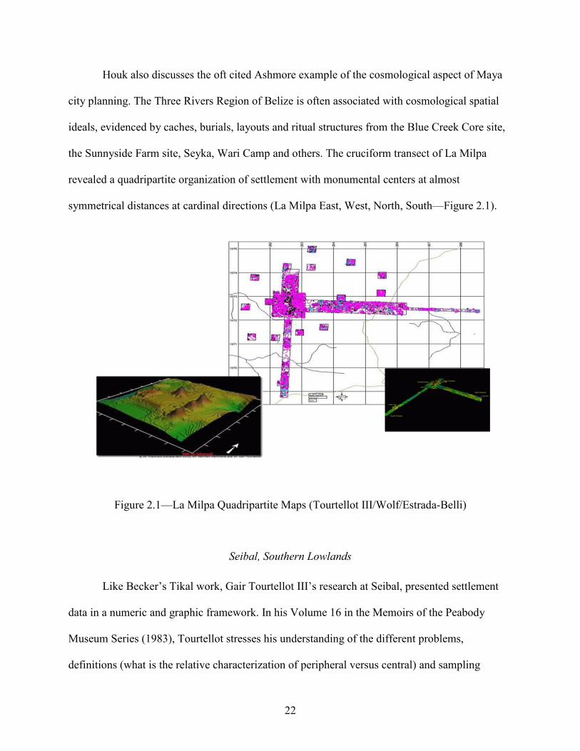
22
Houk also discusses the oft cited Ashmore example of the cosmological aspect of Maya
city planning. The Three Rivers Region of Belize is often associated with cosmological spatial
ideals, evidenced by caches, burials, layouts and ritual structures from the Blue Creek Core site,
the Sunnyside Farm site, Seyka, Wari Camp and others. The cruciform transect of La Milpa
revealed a quadripartite organization of settlement with monumental centers at almost
symmetrical distances at cardinal directions (La Milpa East, West, North, South—Figure 2.1).
Figure 2.1—La Milpa Quadripartite Maps (Tourtellot III/Wolf/Estrada-Belli)
Seibal, Southern Lowlands
Like Becker’s Tikal work, Gair Tourtellot III’s research at Seibal, presented settlement
data in a numeric and graphic framework. In his Volume 16 in the Memoirs of the Peabody
Museum Series (1983), Tourtellot stresses his understanding of the different problems,
definitions (what is the relative characterization of peripheral versus central) and sampling
23
strategies (random, by convenience, or systematic) behind the raw numbers of his settlement
pattern research This is the base from which any thorough discussion of the landscape must
develop. Tourtellot’s work is impressive in its processualist detail revealing the numeric
evidence of social constructs such as architectural identity.
One of Tourtellot’s contributions toward the study of Seibal settlement patterns—indeed
in the entire Maya world—is his classification of differing structure types encountered during his
surveys. He dissects his system into units—where each of his structural types (A-M—with
negative features and a miscellaneous type X) fits into an as site layout. The buildings noted in
Tourtellot’s system are exhaustively analyzed by dimensions, height, roofed space, and activity
areas and then statistically compared by associated artifacts and temporality. Tourtellot aims to
bring mundane length-to-width ratios and spatial patterns into a more humanistic and cultural
pole by developing his points into population estimates and social hierarchies.
Copan, Western Periphery
This research will mention the slightly Marxist or economically-based settlement work of
Julia Hendon in Copan, Honduras, as a brief example of the many forms of the sacred
landscape—here with a tint toward the commercial (discussed later in Chapter 8). Her 1996
dissertation attempts to determine structure use and function. She defines architecture by activity
areas from the archaeological data excavated and surveyed from the Sepulturas settlement zone.
Located only several kilometers East of Copan’s core of archaeological ruins is a group well-
known for its possible separate ethnic identity from the majority of Copan.
The most important aspects of Hendon’s dissertation are her categorizations of the
Sepulturas structures according to her interpretations of their associated artifact assemblage and
thus function. In her study, artifacts define activity areas which in turn define building types. A

24
statistical preponderance towards a certain category of artifact or architectural feature becomes
the criteria of her structure typology. She looks at the structures with and without benches,
ancillary structures (though not precisely defined), and ‘special structures’. Her statements
reference public events—with participation of multiple family or house groups—as a social
factor that drives architectural construction and modification. The main thrust of her argument is
that structures can be defined by the activities of the inhabitants—in her views an almost
commercial outlook. This dissertation would agree with other researchers that whatever the
situation—economically, spiritually motivated or both—it is the interaction between peoples that
make a house or architectural complex or settlement.
W. Andrews and W. Fash's 2005 volume on the kingdom of Copan is a series of
discussion on specific structure types, their monumentality, and by association, general
dimensions. It also embraces the cultural uses and backgrounds (the human and cultural identity)
of the ruins within Honduras's Copan Valley (evincing a regional mixture of Maya and local
traits with influences from central Maya area, the Ulua and Montagua Valleys, and indigenous
Honduran early cultural systems). Construction methods are described in general for the entire
area—within and outside the Copan pocket (dry-laid versus wet-laid fill, earthen platforms and
built cobblestone activity areas, pole-and-thatch superstructures, post-and-beam roofs, vaulted
room plans, masonry-architectural modifications, monumental staircases, and high-relief
sculpture, etc.). Importantly for the research of this dissertation, the book describes the dynastic
history of Copan and environs, often pointing to the architectural elaboration and replication that
marked the waxing and waning of the Copan’s political power in the western reaches of
Mesoamerica.

25
Andrews’ and Casandra Bill’s contribution to the book on aspects of the functionality and
design of the acropolis courtyard groups and how they varied through time is an important
variable in the questions of architecture and identity. Their study is basically similar to Becker’s
work at Tikal or Tourtellot’s at Seibal. The Copan studies are more holistic, applying The
Conjunctive Approach espoused throughout the legendary career of Robert Sharer at Copan and
elsewhere, developed in the 1940s by Walter Tyler (1948), and recently discussed by Allan Maca
(2009). Benches, access, structure size, public versus private space, architectural sculpture,
construction methods, materials, styles, associated monuments and other artifacts are elaborated
in tandem with complementary lines of ceramic, lithic, iconogaphic, epigraphic, bio-
archaeological, botanical, and other data. They have established an excellent sequence of the
development of the Acropolis in terms of not only the architecture but also political phases.
Maya culture dominates Copan and is a presence in much of western Honduras.
However, in pointing out the geographic separation and uniqueness of Copan from other Classic
Maya archaeological sites like Tikal in the Petén Maya Lowlands, the authors also inadvertently
point to a ‘skin’ of Maya elite and ritual culture overlaid onto a Pan-Mesoamerican ideology and
iconography expressed in a myriad of local customs and traditions.
Tikal, Petén Lowlands
In Tikal Report #21 of 1999, Marshall Becker re-introduced and formalized the
architectural complex known as the Plaza Plan II, commonly called the PP2. The plan involved a
roughly square or rectangular grouping of four (on average) or more structures sharing a low
basal platform. On the eastern side of this structural arrangement, usually approximately mid-
way on this plaza edge, lies a smaller, steeper-sided, and usually square structure that is generally

26
considered a temple. The other buildings in the grouping—specifically those directly opposite
the surmised eastern shrine—are more rectangular with less sloping sides.
The PP2 composition crosscuts cultural or economic status. Becker points to the variation
in size, complexity, and the number of burials (and their ‘richness’ or status from fully extended
skeletons with numerous grave goods to accompanying sacrificed retainers, infant burials, crypt
treatments, etc.) to illustrate his point. Becker sees the PP2 as a style, what he relates to as simply
a choice of vocabulary that transcends class and is a hallmark of Tikal identity.
Quirigua, Montagua Valley
This dissertation frequently cites the contributions of Wendy Ashmore in studies of Maya
settlement patterns and considerations of the sacred landscape. Her 2007 work at the site of
Quirigua in the Montagua River Valley of Guatemala is more structural. She discusses various
structure typologies (i.e. Becker’s from Tikal) and creates here own (QP’s, Quirigua plan).
Ashmore’s Quirigua contribution is a detailed description of building materials and construction
techniques that details the styles, functionality, associated features (burials, monuments, etc.),
and general layout of the settlement.
Usefully, Ashmore debates the different classes of features and architecture associated
with her Quirigua research. Structure, platforms, and notably pavements comprise the largest
classes of constructed features and form the skeleton to her analysis. She recognizes the clear
link between overarching settlement patterning and the units of architecture—the individual
buildings themselves. One of her most illuminating discussions centers around the different
materials and techniques used in the different phases of construction at Quirigua. She points to
percentages of facing stones, medium and larger river cobbles, cut-stone masonry, and broken
cobble fill—though she argues the latter could be a form of eroded masonry like weathered lajas
27
from river systems and often used as facing/flooring construction materials elsewhere in the
western Maya world (Cancuen especially).
Ashmore recognizes seven patterns of patio-groups or more isolated structures. She
studies the Quirigua data using architectural elaborations as criteria for her classification system
(e.g. Tourtellot, Becker), touching subjects like architectural room-niches, colonnaded structures,
benches (and associated sub-platforms), doorways, roof and wall materials, etc. With criteria of
size, construction phases, spatial layout, construction, and related artifacts (caches, burials,
middens and monuments), Ashmore sorts the Quirigua peripheral settlement data into her
typology.
Coba, Northern Lowlands
The 1983 “Coba: A Classic Maya Metropolis” (2014 Reprint) is a fantastic, boxed
collection of 25 large fold-out maps that accompanies archaeologist William Folan’s excavation
data and other research at the large Maya site on the northeast coast of Mexico’s Yucatán
Peninsula. Architecturally one of the most impressive features of the site is its complex system of
sacbeob or causeways connecting the urban center with outlying settlements. This infrastructure
necessitated an incredible amount of construction material and labor (one quarry required
tunneling operations that totaled several miles in length). These constructions and changes to
Coba’s environment make it exemplary of the Maya capacity to shape the natural world to their
own ends.
A partial list of his discussion points includes urban versus rural settlement, the many
causeways (sacbeob) linking Coba’s peripheral groups with its core area as well as other Maya
town or cities of the Yucatán, and importantly the linear walls and berms associated with most
house-groups within the Coba area. Topics include soils and geology, hydrology, flora and fauna

28
of the region. Of special interest to the networks discussed throughout this dissertation, he
peppers his discussion with aspects of Maya use of natural products and resources available to
Coba’s population.
The most interesting features of Folan’s general musings deal with the north-south
divisions of the Maya World. He points to the Peten Maya Lowlands (including the Montagua
area of Guatemala, Honduras, the southern half of the modern country of Belize and the lower
portions of present-day Mexico) as the southern sphere of Maya territories. Mexico’s Yucatán
Peninsula represents the northern pole of this scheme, which Folan delineates with such sites as
Oxkintoc, Chichén Itzá, and the Puuc Mountain ridge sites (Uxmal, Sayil, Labna, Kabah,
Xlapak, etc.). Like Houk, Folan notes Joyce Marcus’ 1973 work suggesting the quadripartite
divisioning of Maya Lowlands and respective capitols such as Tikal, Calakmul, Palenque, and
Copan and then proposes his own system of division where Calakmul—the northern capital of
Marcus’ theories—represents the southern capital of a Northern Maya scheme headed by
Chichén Itzá and flanked by Edzna and Coba on its western and eastern margins.
Chalchuapa, Pacific Slope
In 1978 Robert Sharer published most of his research from the site of Chalchuapa.
Resting in the Rio Paz Valley of Salvador, the site lies in the South-eastern Maya Highlands
outside of the traditional lowland centers of Petén or the Northern Highlands (he notes a
similarity to Cancuén, also in an important transitional region) on the Maya periphery of Western
Honduras. Its location alone is intriguing in relation to what has been defined as Maya versus
non-Maya culture (calling attention to a particular Chalchuapan node, the settlement of Las
Victorias, and its purported Olmec signatures). Though specific details of the mapping
mechanisms are not the goal of Sharer’s work, the dialogue of some of his survey methodologies

29
inspired the inclusion of a likewise discussion of this dissertation’s on-the-ground data collection
practices, detailed in Chapter 7.
Where many maps of archaeological sites are ‘Malerized’ or ‘rectangularized’, the
Chalchuapa maps, like the Edwin Shook map of Kaminaljuyu (Kidder et al. 1946—Figure 2.2)
or Ledyard Smith’s Uaxactun map (1950), depict structures and land manipulation through a
liberal use of contour lines (where the isometric topo-lines define nested elevation-polygons to
detail a building).
Figure 2.2—Kaminaljuyu Map (Shook)
This simple mapping convention is incredibly important in highlighting the natural environment
in which the Chalchuapan architecture is constructed. As this dissertation reiterates throughout
its pages, the importance of environmental factors that shape and develop cultural spatial
attitudes is an inextricable feature of the human landscape.

30
Sharer comments on approximately 60 structures, numerous terraces (at least 87) and a
range of land modifications known from the site. He defines Chalchuapa by several loci within
the Chalchuapan Valley, and not as a single epicenter as is often associated ancient Maya
settlements. Aspects of construction phases are discussed; multiple to single events that follow
the site’s entire chronological development. Construction materials are detailed from coarse
yellow sands to earth platforms, laja faced and rubble core walling, yellowish adobe capping and
plastering/adobe of outer surfaces. Analysis and statistics like the prevalence of balustrade
staircases, or the average size by district of platform volume or height also fit into this
dissertation’s landscape approach.
Identity and Functionality
Most structures are usually marked—through façades, layout, building materials,
dimensions, directionality, etc.—as to what they represent. Maya structures were imbued with
sentience, and personality—a life-like-quality—as opposed to a strictly sterile functionality. For
example, a structure may function as a water diversion and channeling system but may also have
a personalized, living identity expressed through aesthetic means. Structure M-8 at the ancient
Maya archaeological site of Cancuén, Guatemala was adorned with water-associated
iconographic elements and false stairs leading to the nearby river that gave the building an
animistic presence as a watery sacred actor in Maya cosmology. Elite and especially ritual or
institutional buildings often display obvious signs of function such as the unique range and
playing alleys of ball courts or impressive palaces and other monumental buildings. However, on
a smaller scale, the central structure and layout of an unimposing architectural compound is
equally as telling of identity. The humblest of houses reflect the origins of their planners and
residents. There are many aspects of Maya culture that combine to form an important

31
relationship between the constructed and natural world. Crucial among these are identity and
cultural attitudes of the physical environment manifest in the dimensions, orientations, and plans
of Maya structure compounds. The unique characteristics of the individual does not by default
embrace the cultural relativism of Franz Boas (Stocking Jr. 1966) or the historical
particularism/cultural materialism of Marvin Harris (1971, 2001), but touches aspects of both
theorists while weaving a complex hybridization that includes elements of sacred geography,
community, and individual human identity.
In 1963 Mircea Eliade published innovative discussions of human spirituality as reflected
by cultural patterns of worldview. In this dissertation, Eliade’s research is used to dissect
meaning behind the architectural group and design. Linda Schele and David Friedel conducted
an analysis of Maya architecture based greatly upon Eliade’s research (Schele et al. 1999), and
several scientists have discussed settlement, landscapes, and particular structures in more detail.
Many have highlighted Maya cave use (Brady 2005; Moyes 2006; Stone 2010), mountain
symbolism (Taube 2004; Stuart 1997; von Schwerin 2011), water associations (B. Fash 2009;
Lucero et al. 2011; Scarborough 2003) and have unequivocally shown the ancient Maya
proclivity of reproducing cultural worldviews through architecture with an emphasis on the
environment (Ashmore 2004; Friedel et al. 1993; Harrison-Buck 2012; Plank 2004;).
In 1990, Warren R. DeBoer published an article about identity that delves into a
discussion of style. Rather than setting out a diametric of the shifting meaning of identity, he
stresses the simultaneous nature of these forces. Previous academic literature is fraught with the
notion that identity can be perfectly classified in a polar or black-and-white world of almost
oppositional relationships. However, He argues for a more nuanced definition, however, where

32
identity and style can vary independently. Only through the unique measure or proportioning of
these differing styles can one determine something’s or someone’s identity.
And style is a complex form of communication. It is well documented that the human
eye/brain combination is adept at sub-consciously recognizing graphic and spatial patterns (more
so than even the calculation power computer against which humans cannot compete) and this
translates directly to DeBoer’s points on style. Not only does he argue for style as a context or an
action, but also something that can be communicated through visual identification. Architectural
style is a communicator of cultural affinity.
In a 1996 article, Dell Upton adds an intriguing twist toward views of ethnicity and the
built environment. He hints at the degree that ‘outside’ populations express themselves. In his
discussion of Caribbean-styled shotgun houses and Rhineland German architecture he develops
the idea of a ‘pure’ cultural to frame questioning of labels of authenticity. He refutes the
traditionally held dictum that later iterations are ‘watered-down’ version of the original—not as
real or pristine. Perhaps very different than the original, every culture displays their own
undeniable reality and purity. He states that often an ‘outside’, foreign or immigrant population
is at first cautious and do not flaunt their traditions blatantly in front of their hosts or the
indigenous populace. After a time, as more intimacy has developed, a better sense of comfort and
acceptance might allow this ‘outside’ population to assert more of its own cultural traditions.
Chapter Conclusion
One of the clearest and simplest examples of the unity of architecture and identity comes
from Timothy Pugh’s research of Kowoj culture in the Petén Lakes region of Guatemala. Pugh
points to the similarities between architectural groupings—likely temple/ceremonial plazas—
from Yucatán and Petén. Specifically, he looks at sacred or ethnically identifying structural

33
layouts from the Northern Lowlands sites (like Mayapan on the Yucatán Peninsula) as compared
to several examples from a variety of Petén sites, such as Topoxte, Tayasal, Nixtun Ch’ich’, and
Zacpeten.
One of Pugh’s premises is that the Kowoj—a Maya group known from at least the
Postclassic era in and around the site of Mayapan—migrated to the Petén area during and the
heyday of their metropolitan Maya city in Yucatán. With these resettlements, the Kowoj
replicated forms of their cultural identity, mythology, and worldview manifested in their
Mayapan architecture by constructing architectural units that mirrored these spatial organizations
in their newer Petén localities. Pugh’s Kowoj evidence invokes the work of Tatiana
Proskouriakoff at Mayapan (1962)—and at her identification of the typical ritual assemblage
from that site (temple, colonnaded hall often called an open hall, oratory and plazas often marked
by a depression, cave, cenote, or other subterranean feature). However, he delves deeper into the
cultural affiliations giving community identity to Kowoj architectural forms.
This architectural complex, what is often referred to as an ‘exemplary center’ (Geertz,
1980) is not attributable to Kowoj, Itza or other people’s invention, but rather a PanMaya or a
cultural universal as seen by Lefebvre (1991). Exemplary centers, Pugh states, are often
replicated through “sympathetic imagery”, where the new construction is modeled after the old,
as exemplified by the Itza from Chichén Itzá rebuilding the Castillo at Mayapan after Chichén’s
collapse. Particularly salient for all Maya societies (and a shared trait of the many geographically
and culturally diverse peoples across the New World) is the fact that architecture is thought of as
a social mirror—one can see themselves, their specific reality, group, identity and position within
their worldview. Creating unity, these mirrors are communal and yet distinct—giving reality to
the social constructs of both the individual and the group.

34
To further the arguments of plazas and mirror visualizations, Pugh recounts Scarboro’s
probably correct theory of plazas acting as water management sites. In this thesis, plazas can act
as temporary shallow catchment basins for rain or floodwaters. These potential pools—reflecting
both personal and communal identities—lie at the core of Kowoj ceremonial architecture.
The work also follows Kowoj transhumance, a critical aspect of the dissemination of
materials, ideology, and peoples that coalesce to promote diversity in any settlement. These
migrations were not a single monumental event, but rather a probable continual flow, ‘migration
streams’, connecting Petén and Yucatán and were repeatedly traveled avenues of movement
between the North and Southern Maya areas.
The Petén Lakes studies are a significant reflection of the research presented in this
dissertation. The dynamic relation between human cultural identity and architectural patterns is
undeniable. Much attention has been given to the general concepts of landscape, structures, and
cultural spatial patterning. Here, these previous investigations are queried at a finer scale of
architectural measurements and social identification.

35
CHAPTER 3/RESEARCH QUESTIONS
Discussion
This study focuses on the archaeological settlements of the Verapaz region in Guatemala
with important references to sites in the adjoining Highlands and Petén Lowlands. The important
relation between architecture, water and terrain is rooted in the entirety of Central American
conceptions of space. Maya buildings were imposed upon or blended with natural surroundings
depending on cultural preference. Architecturally, these differing social proclivities manifest
themselves not only by association with the more obvious geographic features that aid in the
contextualization of Maya settlement, but most visibly in the integration (or imposition) of the
manipulated landscape and the local environment.
Questions
The objective of this research is to simplify and more confidently assign group affiliation
through a basic analysis of structural elements, their proportioning, and positioning regarding the
surrounding landscape. This work quantifies cultural diversity through architecture. Can
archaeologists infer cultural identity through the analysis of emic conceptions of space as
evidenced by a given group’s choice of structural layout? The models used here of architectural
design driven by cultural affinity were intended to recognize patterns and discernable clusters
within the Cancuén structure compounds. Many possible scenarios become evident. The
principal question—the measure of culturally-motivated and environmentally-influenced variety
found within an ancient settlement—leads to more nuanced themes of change over time and how
these changes (or lack thereof) effect or mirror other aspects of the Cancuén settlement.
Cancuén provides an ideal location to study these issues due to its location in a riverine
environment (Brady 2005; Lucero 2006; Woodfill 2007), and because it possessed an economic

36
system focused on trade. Perhaps most importantly, the port (Barrett and Guderjan 2006;
Demarest 2014; McKillop 1996) was in operation during the shifting political order of the Maya
Late Classic period (Culbert 1991; Demarest 2013; Foias 2013). Population diversity is a basic
feature of Classic Maya urban systems (Barnhart 2002, 2007; Bullard 1960; Inomata et al. 2015;
Halperin 2014; Haviland 1972; Hutson et al. 2008; Magnoni 2006; Moriarty 2004; Smith 1993,
2006; Turner 1976) and is clear in Cancuén architecture.
Presuppositions and Expectations
Every scientific analysis should include a discussion of presuppositions and expectations.
Model variables are more completely understood by not only defining their relevance to the
study, but also discussing the constantly shifting cultural and environmental factors that affect
them. Here these suppositions are the intermingling of spirituality and identity—not quite
interchangeable, but one never stands without heavy consideration of the other. Community or
self-identification rests on the forms of spirituality espoused by the society in which they reside.
These different cultural and spiritual attitudes influence all Maya architectural structures.
The anticipated outcome will show obvious and statistically significant clusters within
the Cancuén architectural groups. These clusters are further analyzed in context with the
archaeological evidence excavated and recorded from each individual structure group. Patterns
within the settlement data are corroborated by patterning within the excavated data to further
verify the results of the architectural model. Ideally, the statistical groupings defined by the
architectural analysis mirror the artifact and iconographic distributions from the site, confirming
a cultural identification and the model’s explanatory power.
Quality results rely on the integrity of the archaeological materials recovered and—of
greater import—the accuracy of laboratory assessment of artifact types, classes, origins,

37
production, and exchange. This information can suggest cultural affinity and, when combined
with the groups derived from the architectural study, gives spatial definition to those identities.
Settlement is an arrangement of people and their constructions. Without a more complete
spatial/cultural context as called for in this research, little more than a sterile ‘where’ in the site
can be discerned.
This study not only dissects the ‘where’ but also looks at ‘why’ and ‘how’ people built in
specific locations. Furthermore, once these methods are confirmed and stream-lined, they can be
applied to other archaeological settlements in the immediate region and beyond. As Chapter 7
demonstrates, the results lead to a more holistic understanding not only of the Cancuén
architecture, but also of the intricate patterns of settlement found throughout Mesoamerica.
One outcome of an analysis of cultural behavior modeled through architecture is that
there is no discernable patterning in the data as studied. Aside from oversight within this
dissertation’s model—such as the chosen variables or other miscalculations—a random
distribution of architectural attributes implies cultural uniformity. Within this scenario, additional
questions arise, such as what was the typical Cancuén architectural signature? Did it remain
unchanged from the time of the site’s founding to its fall approximately 75 years later (Fornéy et
al. 2008)? Is this a style specific to Cancuén or applicable to the greater region? A Cancuén
settlement system that differs noticeably from those of earlier periods in the area signals strong
cultural dissimilarities. This evidence would suggest that Cancuén was initially established—or
imposed—on the region’s cultural landscape by a non-local population; potentially displaying
architectural patterns foreign to the area. The possibility also arises that the reason for the lack of
identifiable clusters within the Cancuén architectural assemblage is due to the simple fact of
extreme diversity. Every building group is unique unto itself.

38
As in the previous scenario of a Cancuén ‘monoculture’, a system of exceeding variety
also turns to a question of defining Cancuén architectural norms. Similarly, time becomes a
factor in the questions: do these spatial social attitudes shift throughout Cancuén’s history? Is the
pattern a result of or a mechanism for these changes? Can a comparison of the Cancuén data to
other regional sites offer insight into larger networks of interaction?
Regardless of conclusion, the model will be refined, and its component parts further
scrutinized for efficacy in representing cultural conceptions of space in architectural design.
Cultures—specifically the multitude of unique peoples and cultures subsumed under a singular
Maya moniker—vary significantly by their usages and appreciation of the natural landscape.
Architectural design, conceptions of building and natural interactions, and construction choices
are all heavily influenced by the culture of their human actors. Often the importance of these
humanistic markers is only understood in terms of material culture such as percentages of
ceramics, lithics, or other artifacts. In some instances, textual and iconographic studies also
inform archaeological interpretations (though they are more subject to potential propaganda by
virtue of interpretation by human epigraphers as opposed to the undisputable physical remains of
architecture). Settlement studies occupy numerous points on the continuum of small-scale versus
large, of the individual and the community, of an archaeological site and its relation to the
region.
It is at this larger theoretical or intangible level that factors of scale become most
obvious. Studies of human land-use and perception of the natural world have often become
necessarily highly tailored to individual sites or conversely phrased in general terms that do not
consider the unique circumstances of individual Maya societies and their spatial designs. No
matter the exact subject, different arrangements and correlations become visible only at certain

39
scales. Researchers debate the merits behind hierarchies of New World, Mesoamerican, Maya
Lowland, Guatemalan Verapaz and finer classificatory systems that often culminate in a single
ancient site or activity area. It is self-evident that highly explanatory models at the inter-site level
become less viable at a regional scope and unsatisfactory at a larger scale. Comparisons posited
from communities within a ten-kilometer radius are not necessarily valid in understanding
communities 50 or 100 kilometers apart. The fact remains however, that said model can be
apropos to its local environment. Reformulating the model to be more holistic in incorporating
geographical as well as cultural trends using architecture as a bridge between them will produce
a more robust build with better application in other situations.
Shifting of scales as pointed to in the introduction, translates directly into individuals,
their constructed landscapes, and the natural surrounding environment. This scalar approach
acknowledges the cultural relativism of Franz Boas (1920, 1940; Stocking 1966) or the historical
particularism of Marvin Harris (1968, 1971, 1995) but focuses on movement within as opposed
to a Boasian fixation on unique examples. Questions raised by initial settlement pattern
investigations follow several general themes, though architectural expressions of these vary
according to time, culture, and the environment Many researchers have highlighted Maya cave
use (Brady and Prufer 2002; Brady and Stone 1986; Stone 1995; Woodfill 2011), mountain
symbolism (Brady and Prufer 2000; Prufer 2002, Prufer and Brady 2005)) and water associations
(Lucero 1999, 2006; Scarborough 1993, 2003). The ancient Maya proclivity of architecturally
reproducing cultural world views with an emphasis on the natural environment is a ubiquitous
theme in Mesoamerican archaeological studies (Plank 2004; Schele and Freidel 1990; Schele and
Mathews 1998; Tate 1992).
40
Contextualizing Architecture
The next several entries provide insight into this dissertation’s investigation of the
relationship between architecture and the people it represents. Before this question can be
adequately addressed (if it ever can be), other questions arise like the parameters of the
discussion (city, building, or other) and other specifics, like Central America and Maya culture.
General
From its preface to concluding remarks, Rapoport’s short 1982 work, Meaning of the
Built Environment, provides many insights into the study of urbanism and settlement patterns; he
views these as man-environment studies and describes a ‘framework’ within which to analyze
the questions raised in human-environmental relationships. His discussion centers on modern or
historical instances of human interplay with the natural landscape. He dismisses the idea that
natural context—land features such as rivers, lakes, mountains, etc.—is simply a stage or
inanimate background and insists that it is as active a constituent as any theme played out upon
it. Rapoport does, however, use the vernacular of actors and ‘props’ to decorate or ‘personalize’
the environment—i.e. their office space, back-yard, etc. Structures and building compound
layout are seen as accoutrements to the built/natural setting. To distill his argument, he suggests
that the importance of meaning—the significance of the built environment—is a cultural
phenomenon of appearances and perception.
In Rapoport’s self-evident logic, it is unquestionable that there were planned motives
behind any congregation or settlement of people. His stance is that the arrangement of
architecture and functionality over the landscape induce people into actions regulated by societal
customs. Architecture is meant to channel peoples’ thoughts into cultural norms that are—again
41
to use Rapoport’s example for he purposefully stresses the syntax of supposed cultural
normalcy—within the gamut of accepted behavior as deemed by that society.
Planning
Paul Wheatley’s (1971) work on the significance of ancient Chinese city planning is an
inspiring compendium on village to urban cultural formation processes that serves as an
excellent backdrop for the research presented in this dissertation. He focuses on the sacred aspect
of city planning and emergence, predominantly using examples of the archetypical Chinese city
trajectory. He discusses the character of urbanism across the ancient world, and many of the
insights in which he supports his viewpoints with Chinese or Asian settlement examples, are just
as salient and applicable to Mesoamerica.
For this dissertation, Wheatly’s most important insights come from statements beginning
after the midpoint of the volume—on page 225 entitled “The Nature of the Ceremonial Center”.
He elaborates on the possible formational processes behind urbanism based on this center of
communal identity. Wheatley points out the kinship, sanguine or fictive, is also a prime factor in
incipient urbanism. The Chinese family shrine, often the eastern structure of a quadripartite
house-complex (usually with a shared courtyard) is the home of the ancestors—similar to some
Mesoamerican ideologies. He argues that these ceremonial complexes were the beginnings of
clustered settlement or primordial urbanism, not the archetypical fortress (protection) or
redistributive marketplace (resources/specialization). He points to the “all-pervading religious
context” inherent behind early civilizations.
In his formulation, urbanism began with the sacred, but time changed the communal
nature of this religious feeling to be centered more on divine rulers as in the case of Maya
leaders, Egyptian Pharaohs, or the Khmer kings. The functionality of the centers changed as

42
well, and what began as a religious compound grew into the market or military strong-hold and
possibly a varying grid or organic pattern was added and obfuscates the original intent or layout
of the early urban town.
Settlement Legibility and Intelligibility
Kevin Lynch (1960) discusses several themes about the relation of urbanism, perception,
and settlement. He speaks directly of the individual and perception of architecture or
architectural plans at differing times under different conditions. As Lynch would say,
architecture is not merely a stage, but a vibrant character in its own right that like any powerful
actor, channels the thoughts of their audience toward a certain dynamic or situation of interaction
between it and its co-actors. His thoughts on urbanism center on the legibility of a settlement—
defined as the innate comfort, understanding, and ability to ‘get around’, navigate, or otherwise
find that settlement’s offerings. In his words it is how the human actor is “guided by the
landscape” (p. 94). To Lynch, the city is not a concrete entity, rather it is how the city is
perceived or ‘read’ by its inhabitants, observer and environment that make it what it is:
architecture and settlement as social phenomena. Architectural groupings mimic the spatial
ideals of society, the perceptions and self-identification of the individual within that society. It is
evident in the mechanics of dimensions, volumes, orientations, styles or construction techniques,
and the mathematical relationships within the layout.
The urban scheme is never the same at all moments in time, and Lynch discusses
different smells, visual sensations, shape, sound, touch, kinesthesia, interplay of shadow and
light, night and day, seasonality, light polarization, color, possible electric/magnetic/energy
fields, etc. that all influence the interaction between the human and constructed landscape.
Different appreciation also relies on a person’s state of mind and thus their interpretation of

43
reality at that moment. He alludes to a building or architectural complex’s ability to impart
meaning or intention; Lynch’s apparency is the creation of an image or vision that elicits a
strong mental image—in the purview of this dissertation, the image is of the architectural
drawing, settlement map, or real-time observation of buildings and their environments—and is a
measure of how forceful and integrated with that individual’s conception of the world is that
image.
Survival, flow, and maintenance are crucial aspects of a city and its movement and
communication in roads and efficient planning/engineering. Lynch adds that it is also the “use
and organization of definite sensory clues from the external environment that in unison create the
ethic of the city”. In active wording, he is discussing an individual’s reaction to settlement—
architecture and the natural environment. Shifts in that person’s perceptions are influenced by
mood and other moment to moment personal changes and produce unique aberrations. It is the
infinite variation—according to each individual person’s interpretation of culture and self-
identification—that makes human settlement communal, exclusive, and ever-changing from
moment to moment. The accommodation of both individual and communal average in a single
formula, theme, or feature in a consistently familiar assemblage, pattern, or form is the dominant
symbolic meaning of settlement and architecture.
Identification of the environment is instinctual—animals (humans included) use a variety
of clues to inform themselves of what to ‘expect’—to forecast the conditions to be met in a
particular area. Landscapes are filled with rich information about prevailing conditions. Things
as varied as rainfall, humidity, vegetation, geology, dominant weather patterns, environmental
zones, and focal landscape features are a few influences on perception. Nature gives the animal
world obvious markers of its landscape. The human manipulated landscape of architectural

44
compounds and urban plans should be viewed in similar fashion. Added to the dynamic between
a person’s usual reaction and immediate thought of a given stimulate, is an unpredictable human
component of a mix of psychological mood and circumstances connected with time.
Architecturally, the question is how these ideals are represented in Maya architecture and
settlement. These concepts originate in the natural environment and sacred landscape of Maya
settlements and communities throughout Mesoamerica.
Cuello
Norman Hammond’s archaeological research at the Preclassic archaeological site of
Cuello in Belize was the beginning geographical application of this dissertations landscape
perspective. His methods of large horizontal excavation exposed many of the architectural
nuances behind different iterations of a single structure and new configurations of structure/plaza
arrangements. Stairs, moldings, dedicatory caches, trash middens, artifact concentrations, room
modifications, wall construction, window and door in-filling, flooring, general plastering, and
demolition were some of the architectural details that were brought to light. Was there insight
into Maya cosmological order and landscape in these buildings and compounds that can be
interpreted from them?
Through the late seventies, intermittently through the years, and into the 1990s Hammond
has worked at Cuello in modern Belize’s Orange Walk District (1975, 1980, 2007). With some
of the earliest excavated evidence of architectural style and change, his site reports from
Platform 34—a Middle to Late Formative complex of several structures centered on an adjoining
basal platform—are relevant to the topic of architectural identity and expression (1980). The
over-arching idea is one of renovation—building arrangement, number, and size shift throughout
time. Structure orientations and staircase configurations are frequently altered from one

45
construction phase to subsequent building phases. Re-plastering events and expansion of plaza
areas are frequent—almost all refurbishments are accompanied by dedicatory/termination
deposits detailing ritual that pre-empted or followed reconstruction. Hammond’s archaeological
team exposed examples like the midden found in a storage pit of remains from a remodeling-
feasting event likely culminating in the sacrifice of approximately 15 young individuals
(skeletons also in midden). Post holes are ubiquitous and detail the shifting building patterns of
excavated structures while also illustrating the construction techniques used during the
Formative era. Maps of the successive time periods detail the demographic and volumetric
changes that accompanied Cuello’s growth and changing identity as it grew from a proposed
Archaic/Formative farming hamlet dating to before 2000 BC to a thriving village of over 3000
people into the early phases of the Late Classic period.
The post-holes are extremely interesting because of several that were found meters below
Platform 34’s pyramidal shrine/temple, constructed into the site’s original ground surface. These
post-holes mark the Cuello people’s concern with the space—the physical place—of the
temple/shrine on the platform. This location was special in the minds of the ancient population,
and it was the focus of communal events for generations past and future. The regard for the space
is as important as the ritual itself. This is likely why Platform 34 was the site of various rituals,
many internments, offerings, and mass sacrifice. It is this connection to the land that lies at the
heart of the matter of Maya beginnings in the lowlands of Mesoamerica. Hammond does stress
that new cultural ideas were manifested in local, possibly egalitarian peoples that were already
present in Belize and elsewhere in the lowlands, not a replacement or total reformation acted
upon the ‘simpler’ aboriginal inhabitants by complex foreign cultures (Olmec, Teotihuacán,

46
Chalchuapa, Izapa). The affinity of Maya peoples with the landscape is a pan-Mesoamerican
feature, not easily pinned in origin to a single cultural entity.
Yaxchilán
Carolyn Tate’s (1992) writings on the site of Yaxchilán, rising above the riverbanks of
the Usumacinta between Guatemala and Mexico, were another crucial influence upon the
research presented in this dissertation. Her work spawned questions of what other architectural
features were a staple in the Maya World and could be translated into degrees and orientations at
other sites. Her volume on Yaxchilán concentrates on the reins of the two best documented
rulers—Shield Jaguar and his son Bird Jaguar—from AD 682 to AD 772. The site itself—
displaying strong ties to the Bonampak/Palenque/Tonina/Piedras Negras cultural sphere—has a
much more expansive history, beginning about AD 454 to AD 808. She interprets the urban
settlement, considering the site core as a singular unit for her arguments of Yaxchilán, as
primarily constructed around cosmological principles. She cites Geertz in her preface and points
to the symbolism of the city’s design as an obvious example of Maya architects mirroring their
worldview and culture.
At the onset of the Yaxchilán work, Tate argues for the ritual or mythological planning
behind Maya Urban centers and, in light of this research, architectural compounds like the
structure. For too long, she states, Mayanists have worked with universal mechanisms behind the
construction of Maya cities, arguing that each settlement must be looked at in terms of its
uniqueness among other regional developments. She points to historical documents, settlement
patterns from other known contact period archaeological sites, topographic data, astronomy, and
pan-Mesoamerican iconography (especially sculpture and architectural adornments) as evidence
to support her positions, indicating almost multi-disciplinarian nature of her research.
47
Framing the discussion in architecture, Tate argues for several ideas reiterated by other
researchers on the identity of Mesoamerican places. Like Watanabe (1995) and Blanton (1982),
she links Maya identity with place—and a hierarchy of places or settlements—in one of her
many examples. Tate states that the impetus for city creation in much of Mesoamerica—the
Maya area and Yaxchilán in particular—lies in the religious-political sphere of the builders as
opposed to a functional or economic paradigm. As Inomata has discussed for Aguateca (2009)
and Demarest has argued for Dos Pilas, Cancuén, and elsewhere, Maya cities were
manifestations of a theater state like the Nagara of SE Asia (Demarest and Conrad 1991). In
these formulations, Maya worldview and spiritual cosmology is re-affirmed through the
architectural and material mirrors of status hierarchies and power relations that form the base of
society.
Tate also details spatial relationships of the architecture and monuments at Yaxchilán.
She credits Host Hartung for originating many of the studies that she builds upon. She postulates
that the site core was constructed with the primary purpose of acting as a ritual and functioning
cosmogram. On the day of the summer solstice, the sun’s rays illuminate—slowly, from the
sculpture’s feet upward—this monument of the ruler revealed by the moving rays of the sun,
sitting on Yaxchilán’s throne or seat of power. Bird Jaguar’s physical manifestation is
immortalized through time by detailing his reign in architecture.
Mirador Basin
Richard Hansen’s discussion of early Maya civilization and architecture dissects
Preclassic and Formative Mesoamerican society and places his work conducted over the last
decade at the site of Nakbe (and the site of El Mirador and all settlement within the expansive
Mirador Basin) in geographical and detailed environmental context (1990, 1992, 1998, 2001,

48
2008). Hansen’s research and numerous publications drove the initial broadening of spatial
awareness to a greater Maya universe of all Central America—even extending into Mexico, El
Salvador and beyond. One of his main points is the integrated nature of Preclassic Maya society
with its natural surroundings. The Mirador research was influential in this dissertation’s look at a
broader Maya society that was made up of very different cultures and modes of identity
expression and architectural communication. The great stucco masks from Nacbe and elsewhere
in the Mirador Basin Region are meant to instill awe—fear of a people who can claim close
relation to a power so absolute in Maya cosmology or perhaps goodwill at association with a
benevolent force. The Maya Preclassic period was one of dynamism and continuity with Classic
Period (and future) society—many of the ideals of Maya society were already crystalized in the
Preclassic era. Architectural norms were also well established during these early times and
continued into later Maya epochs. Early eras were far from a time of unorganized and frenetic
groupings of many cultural entities in an ambiguous morass of generalized Mesoamerican
culture. There are recognizable tenants of Preclassic society—often best visualized through
imposing monumental architecture—that are common features of all Maya archaeological sites.
As Hansen stresses, continuity and disjunction, and the contradictions and innovations they bring
to architectural variation, mark the Preclassic and Formative time designations.
Archaeological Mexico
Michael Smith’s prolific work poses numerous questions and provides some excellent
insights into urban planning, deserving of mention in a chapter based in inquiries. Especially
centered on his predominate area of interest—Mexica Mexico (1993, 2006, 2010, 2011), Smith
points repeatedly to the fact that every expression of human urbanism or aggregated settlement is
driven by the cultural ethos of its inhabitants. His discussions of low-density urbanism and

49
neighborhoods are filled with population numbers and socio-economic statistics. They have
spatial significance, but more pointedly social importance. In Smith’s words, identity was built
up from public spaces (2011: 3).
Smith attempts to bridge the chasm from descriptive empirical data of architecture and
settlement to humanistic, larger scale upper-echelon social hypotheses. He states that the
archaeologist’s research design comes from a cataloging of the data (in this case the architecture
itself) which spurs questions of cultural processes or “where many archaeological settlement
pattern studies have taken an opposite tact of creating grand theoretical constructs and then
trying to mesh these preconceived ideas with the material finds (2011: 9).”
Smith’s definition of urbanism is based in a functional paradigm. He reserves the
nomenclature “urban” to larger settlements with greater number of urban functionalities, i.e.,
religious, political, economic, distributive, etc. He argues that every settlement is planned,
subconsciously or consciously, as cities grown by accretion or planned precincts in Egyptian
cities or Imperial Chinese capitals. However, he comes back to point out that in the example of
Maya cities, the archaeologists must deal with inherently unique site plans and layouts though
some spatial similarities are common—agreeing with Sjoberg (1965) in arguing staunchly
against universal theories that characterize urbanization of all times, continents, and cultures.
Incidentally, Smith’s detailed discussion of Aztec twin pyramid groups at Tenochtitlan
and other Mexican Central Plateau sites, are reminiscent of twin pyramid architecture at Tikal,
Yaxha, and elsewhere in the Maya area. This observation’s relevance to this dissertation lies in
both a shared architectural complex, but also in the identity and connections they detail. Though,
not exactly the same in terms of spatial layout, it is believed these twin pyramid complexes share
a common functionality not unlike the various iterations of the ball-court found throughout
50
Mesoamerica. In another work, he describes the hybridization of Maya, Toltec, Teotihuacanoid,
and indigenous Aztec architecture of the construction of Tenochtitlan in the Lake Texcoco Basin.
Identity
Questions of identity, architecture, and the landscape have been grappled with by
archaeologist for several decades, and one of the most prevalent lines of inquiry have revolved
around the themes of memory and time. Many discussions center on a communal wisdom—
learned knowledge or simply acculturated from daily routine—and remembrance. Significantly,
this identity is reflected in the deposition of material remains—often unintentionally left
behind—in seemingly mundane architectural components, such as the omnipresent floor or room
block. This also presents the chronological dynamic into questions of identity in that the
architecture—the landscape and environment—has a time depth beyond the peoples whom it
shelters.
Barbara Mills (2008) reminds archaeologists that remembrances are also partially
embedded in forgetting. Her statements reflect the construction of social memory by acts of
production and consumption of goods rather than just their preservation. Concentrating on
material culture associated with Chaco Canyon, New Mexico, she points to secreting artifacts
away from public viewing and importantly, away from the public landscape, that was a critical
aspect of memory in the prehistoric Southwest. She looks at the architectural decorations and
modification of in-filling niches in ceremonial Puebloan kivas. Elaborate floor and house caches
as mnemonic devices link occupational histories and spatial perspectives. One generation of
ancient Chaconians might not see these objects dedicated by their ancestors, but the importance
that they symbolize are shared by past, present, and theoretical future citizens.

51
Returning focus to Central America, Rosemary Joyce, in her discussion of platform
construction techniques at Puerto Escondido (approx. BCE 1300) in northwestern Honduras
(2004), also looks at the role of depositional processes in accordance with memories. In her
words, this view transforms archaeological thought from over-emphasis on the artifact to a more
active role between an item like architecture and the individual.
Ian Hodder’s and Robert Preucel’s (1996) view of memory work stems from research in
Turkey, at the archaeological site of Ҫatalhӧyük. Like Barbara Bender (2002), they associate
architectural changes and maintenance as one of the crucial lines of evidence for social
construction, culture shifts, and the learned behavior that is memory and identity. They look to
the re-plastering of walls and floors and other mundane general house maintenance as episodes
of memory work. Hodder notes that floors are swept vigorously clean of artifacts when occupied
by their ancient denizens, either as routine chore or in preparation for one of these remodeling
events. However, the floors and surrounds become littered with what he calls microartifacts;
floating in the dust or caught at the edge of the broom embedded or trampled into the soft or wet
plaster floors and walls. He argues that the variations in frequency of the chipped stone artifacts
and bone fragments are indicators of constantly changing functionality—a constantly changing
identity as well. Rebuilding, cleaning, dedicatory caches of initiation and termination, etc., are all
actions that reveal material artifacts in an architectural investigation of memory.
Though many writers refer to Bourdieu’s concept of habitus (1977) in architectural
studies, Hodder emphasizes the idea of the domus. The domus concept is simply the over-
arching mantle of the house. The idea centers on the house as the focus of all cultural
manifestations—social norms and practices or acculturated behaviors learned subconsciously in
the daily affairs focused in the house or similar architecture. Architecture provides humans with

52
the most durable expression of their self-identity—as individuals and as communities. Aside
from their almost sentient nature in effecting culture, houses and other architectural
manipulations are the stages where every aspect—the most utilitarian to the most cosmological,
supernatural, or spiritual—of culture is played.
Chapter Conclusion
This chapter presents the foundational research components explored in this dissertation.
It opens with the nuances and construction of Maya world views, the built and natural
environment in which the Maya lived. The chapter then turns to a short introduction to the
primary site under investigation, Cancuén, Guatemala. The discussion closes with a brief
overview of several settlement pattern perspectives and an underlying creation of identity
through architecture. The combinations of these lines of evidence all aim to address the primary
research question: “Can cultural identification and classification be accurately assessed through
architectural analysis?”

53
CHAPTER 4/MESOAMERICAN GEOGRAPHY
Discussion
The geography of Central America influences, or is greatly responsible, for almost all
accomplishments of Maya civilization. People and collective society cannot help but to express
their spatial and cultural values within their architecture. In a process of landscape and
environmental acculturation, culture is greatly conditioned upon the surrounding terrain and
features. In a finer scale, Maya buildings, component courtyards, and ancillary structures are
designed and constructed under the influence of environmentally predisposed society.
Mountain Ranges
The Central American Volcanic Arc (CAVA) is a well-documented expanse of volcanic
activity stretching from approximately Guatemala to the northern boarders of Panama along the
Pacific Coast (Rose et al. 1999). It is often referenced as the spine or backbone of the New
World, and though the CAVA string of over 100 impressive volcanic caves and flows is
primarily documented from Guatemala to Northern Panama, volatile tectonic activity was a
principal shaper of the physiology of most of Central America and played a significant role in the
mythology of its numerous cultures (J. Barrientos, 2018).
The mountains carry on southward, changing names as they manifest themselves in
different countries, mirroring the slopes of the Pacific Coast, and finally terminating in the Tierra
del Fuego range in Argentina. They dominate the landscape of much of Mesoamerica. North of
Guatemala—near the modern border crossing town of Tapachula—the Sierra Madres Mountain
range extends into Mexico’s Chiapas region and further into the south-central portions of the
United States. Known by various local names, this mountainous trend continues into Canada’s
Yukon and the Bering Sea. Theoretically, this geographic/geologic phenomenon continues under

54
the Arctic Sea or into Siberia and eastern Asia. These mountains are akin to Barthes’ ‘Eiffel
Tower’, framing all activities within their shadows (Barthes 1967). The volatility of the
environment—the potential and power—of volcanic activity, massive flooding, landslides and
earthquakes lie behind the serene surface of peaks, vistas, and microinches. Mountainous
topography is stirring in largesse and charged with a cultural image of the holy mountain (Grove
1999; Freidel 2008;) or cave (Pugh 2005; Brady 2005; Earle 2008; Barton 2010), place or house
of the gods (Houston and Stuart 1996; Vogt and Stuart 2005; Toohey 2013; Bassie-Sweet 2014)
or ancestors (McAnany 1998, 2003). Of particular significance to this study, these ever-present
Highland influences on architectural design and structural engineering were constant—in ways
subconscious and instinctual to local culture. These precipitous regions of volatile seismic
activity, volcanic eruptions, mudslides, and earthquakes are awe-inspiring monumental wonders
of nature that both actively and passively influence building conception, layout, and design. The
rough terrain is mimicked through the differences in structure versus platform heights and
number of courtyard or plaza elevation changes. This continuous chain of mountain topography
from north to south unifies the land—the geology—and the cultures that choose them as the
setting for their structures.
Together these mountain ranges form the Continental Divide of the Americas—one of
many continental divides around the world. That of the Americas is defined by the much taller
peaks of its geology than others, perhaps a factor in their central position in almost every emic
perspective of the Maya universe. Technically a continental divide marks the water-shed
bisection of a landmass with waters draining into the Atlantic Ocean on one side and the Pacific
on the other. These mountains form the most basic and crucial link between higher elevations
and water which forms the backbone of Maya cosmology.

55
The entire chain of mountains—from Canada and North America to the Andes in South
America—falls relatively abruptly to a narrow coastal plain and the rough waters of the Pacific
Coast. The area is a conduit for trade, communication, and other contact within the Maya world
and beyond. The Pacific piedmonts are perfect locations to receive people, ideas and goods from
regions as distant as Veracruz or central Mexico via the Isthmus de Tehuantepec, the adjacent
northern Pacific Coast and into Guatemala, El Salvador, Nicaragua and points further south.
Movement can also originate from the Yucatán, Belize, and Honduras to other areas of the Maya
world or can continue to farther destinations outside—and naturally vice versa—over the
mountain highlands that separate the two oceans. Mountains and water are the basic building
blocks of Mesoamerican natural architecture and provide the archetype for smaller scale human
construction.
Lowlands
The Highlands gradually give way to the Lowlands of Guatemala, Belize, and Mexico.
These ‘Southern Lowlands’ are what have been traditionally called the core Maya area. They
encompass several regions, including parts of southern Campeche and Tabasco, Mexico, most of
upper Belize, the Lacandón region of Chiapas, Mexico, and most of northern Guatemala. The
area is rich in cultural remains and expressions of tradition and the definition of ‘what is Maya’
is reflected in the grandeur and complexity of buildings. Social hierarchy (Low, 2011), political
propaganda (McGovern 2004; J. Christie 2006; McAnany 2008), and spirituality (W. Fash and
B. Fash 1996) are just a few of the factors involved in planning architecture that is more awe-
inspiring than the natural surroundings of karstic towers, immense lakes and swamplands, and
high canopy forest. Architecture provides a certain degree of social control (J. Thomas 1985; Ad.
Chase 2017; and the more prominent the structure—the stronger the contrast between the Maya

56
built environment and the natural setting—the better the message of cultural hierarchy and
superiority is received by its audience of travelers or residents.
North Lands
These lower lying areas merge into Mexico’s Yucatán Peninsula, a limestone shelf
perched over the Gulf of Mexico and the Caribbean. There are many geomorphic anomalies such
as the Puuc Hills in the Yucatán’s northwest corner, the forests of Campeche, Mexico, and the
large systems of swamps in southern Quintana Roo, Mexico, and northern Belize, but the terrain
is generally flat and arid compared to the southern regions. Culturally, attributes of the physical
landscape are often mirrored in architecture with more emphasis on ‘open’ space such as the
plazas and courtyards and lower building height and overall structure compound volume. Maya
structures in these areas have less visual competition with natural surroundings. Already
relatively low and flat, the vegetation and terrain become more so as the Yucatán continues
northward. Here, monumental architecture focused on detail—architectural sculpture like at Ek
Balam or complexity as in the labyrinth at Oxkintok, both in Yucatán—not necessarily height or
volume. The northern region is also characterized by dryer climes where water storage or
catchment systems and simple access to water becomes architecturally more important than at
other cultural and geographic regions within the Maya world.
South Lands
Continuing south from the swamps, lowland rolling topography, lakes and rain forests of
Petén, the Guatemalan Highlands rise from the cross-cut riverine and sharp karstic hills of the
Guatemalan Verapaz. They also merge with highlands of Honduras where they morph into
coastal wetlands of the Gulf of Honduras to the north. These mountains create a sense of cultural
unity, linking the regions of southern Mexico, Guatemala, and Honduras not only by physical
57
proximity but also by a shared familiarity of navigation, resource exploitation and availability,
and customs unique to those locations and that environment.
The geological forces of Central America combine to produce an incredible variety of
regional landscapes and micro-environments. In broad terms, at its southern extent, the Maya
region is always bounded by the Pacific Ocean and its coastal plain rising relatively abruptly to
the highlands. These mountainous regions stretch north into Mexico, cover south central
Guatemala, and reach eastward into Honduras, Salvador, Nicaragua and through Panama. The
abutting lowlands—differentiated by south (wherein lies Cancuén) and north (primarily
Mexico’s state of Tabasco, Quintana Roo and Yucatán). This brief description serves to
contextualize the natural stage of building traditions within Mesoamerica.
Wetlands
The inundated riverine and swamp lowlands of the state of Tabasco, Mexico—spreading
southward from the waters of the Gulf of Mexico—gradually give way to the Lacandón jungles,
lowlands, and eventually south-westward into the Chiapas highlands of Mexico and south into
the Sierra de los Cuchumatanes in Guatemala. Here was also a natural gateway into the dryer
climes, cultures and resources of Central Mexico’s uplands to the east. And although these
regions are not traditionally considered the Maya heartland, this dissertation would argue for a
reconsideration of the definition of ‘Maya’, particularly in the face of the many vastly different
linguistic and cultural traditions in this region alone (Chontal, Ch’ol, Lacandón, Tzeltal,
Tojolab’al, Akatek, Mocho’, Mam, Tektitek, Q’anjob’al, Jakaltek, Chuj, Chicomuceltec, Tzotzil,
etc.). This research aims to unpack the term ‘Maya’ with a shift from a single and unified culture
with a known population/settlement center (often considered Guatemala’s Petén region with
subsidiary branches into Belize, Mexico, Honduras, and Mesoamerican Highlands) to a populous

58
field of different cultures that share similarities but are by no means of the same ethnic identity.
In most anthropological/archaeological contexts, ‘Maya’ has been previously and erroneously
used to categorize many different Mesoamerican societies with some shared traits into a single
cultural entity. There is undoubtedly a Petén-centered culture that strongly exhibits these ‘Maya’
attributes—and through economic and political means heavily influenced other Mesoamerican
peoples with its particular brand of society. However, it is not the sole progenitor of all cultural
activity in the region. This PhD research argues that often what the scientific community
designates as ‘Maya’ is simply a skin of Petén elite culture over many local traditions. Certain
products are strongly embraced—even considered integral to individual identity within a global
marketplace—by numerous unquestionably distinct societies.
Geographic Regions
There are many valid schemes of dividing the Maya area. An understanding of the
topographic, floral and faunal diversity within Mesoamerican landscapes is crucial in the
discussion of the natural environment influencing cultural building processes. A single
researcher or team cannot be expected to know the details and nuances of every archaeological
site and region, and must rely upon the work of many different site investigators. Map
categorizations reflect the multi-scalar compilation of as much relevant data as can be acquired,
often inadvertently leading to generalized comparisons between different regions based upon
inequivalent data resolutions. In modern parlance, these formulations are usually forced to
compare apples with oranges and discuss traits in a system of least-common-denominators. The
following discussion points to some of these categorizations of Mesoamerica and describe
another view that better relates the ideology of this dissertation.

59
The zonation of the Maya area developed by Robert Sharer is an excellent example of the
visualization of both geographic and cultural divisions of Mesoamerica (Sharer and Traxler
2006—Figure 4.1).
Figure 4.1—Maya Zonation Map (Sharer)

60
In 2003 Hodell and associates modified Sharer’s designations, adding additional information,
archaeological sites, and giving more of a geological slant to the categories (Hodell et al. 2003).
Katherine Miller further modified the map in her 2015 doctoral research as a geological
backdrop for migration data (Miller 2015). Using Sharer’s, Hodell’s and Miller’s classifications
as a base, this dissertation collapses or expands certain areas to better represent the different
natural settings of ancient Maya occupation considered in this work (Figure 4.2).
Figure 4.2—Maya Zonation Map (Wolf)
Every classificatory scheme is an approximation and will not satisfy all archaeologists. There
will always be sites that defy the pattern or assignment, and individual researchers will often

61
contextualize their work differently. However, the characterizations presented in this dissertation
are general land-based and architectural cultural distinctions that are useful in discussing
diversity in architecture from the Cancuén area.
Although some regions have less direct contact than others with the primary research area
of focus, Verapaz, all Central America was interconnected. The diversity of Mesoamerican
identities displayed in structures and attitudes of spatial organization lie at the core of this
research. The Cancuén Region is highlighted, however commerce, people and ideas moved
within ancient Central America with regularity. In an extended network, influential actions
monitored by the centers on the Pacific Coast are in turn transmitted throughout the region and
importantly, to the polities of the Highlands. These Highland centers are network hubs that
connect with the Lowlands to the north. In a lengthy (in kilometers from coast to interior and
time from early Central American horizons to later epochs in Maya history) hypothetical chain,
foreign people, landing via water, established a small presence on the Pacific Slope. Transactions
are made that lead to the regional capital and then to the networks of Highland sites with robust
connections to the Lowlands and specifically Verapaz and Cancuén.
Pacific Coast
Sharer’s Pacific Coastal Plain—designated in this research simply as the Pacific Coast
(#1 in Figure 4.2)—represents a dramatic slope change in a relatively narrow landform. Low sea-
level elevations from the ocean’s shores and adjacent piedmont plains rise quickly to steep (often
active) volcanic mountains. The region is a crucial link between the far northern and southern
extents of Central America as well as between North and South America through coastal
navigation and into continental interiors. Water-travel from the north or south likely landed on
these Pacific shores using the coast as an intermediary step for further travel into Mesoamerica—

62
an easier and alternate route into the Maya world as opposed to a more difficult over-land
journey. Archaeological sites such as Pajón lie at the approximate northern extent of
Mesoamerica’s Pacific Coast while sites like Usulután in Salvador occupy the southern extent of
the region that stretches into South America.
On a smaller scale within Mesoamerica, Olmec networks from Veracruz regions in
Mexico extended southward away from the Atlantic/Caribbean side of Mexico through the
relatively unsloping terrain of the Isthmus of Tehantepec toward the Guatemala Pacific Coast. At
the isthmus, the southern portion of the Sierra Madre Mountain range ends abruptly and
reemerges approximately 400 Kilometers further south in the lower portion of the Mexican state
of Chiapas. The Olmec peoples used this corridor as a means of reaching the Guatemala’s Pacific
Coast for trade and further travel northward into the Guatemalan interior, Belize and Honduras.
The archaeological site of Takalik Abaj, founded around 1800 BC, was the trading capital of the
region during these Olmec excursions and is replete with Olmec style sculpture and trade goods.
Important PreClassic and Early Classic sites like La Blanca, El Mesak, Caterrana and Bonete are
also established around this time and display foreign traits and trade goods. Immediately north,
the coast slowly blends into the Maya Highlands through sites like El Baúl, and El Durazno.
Further south, coastal archaeological sites like El Carmen, Los Limones, and La Rama occupy
the transitional region that merges into highland Honduras through sites like Chalchuapa and
Cerén. Kaminaljuyu, the early Highland capital of the Maya during this time, was also a major
cog in this trade network acting as a mediator for items traded from all over Mesoamerica,
including the crucial exchange between the Mexican Gulf Coast and heartland Maya areas of the
Petén and Verapaz via the Pacific Coast.
63
Maya Highlands
For purposes of comparing architectural manifestations of cultural spatial attitudes in the
Verapaz region, this research concentrates on the contrast between steep mountainous terrain and
surrounding lowlands. This leads to a combination of Sharer’s Northern and Southern Highlands
into a single designation of Maya Highlands (#2 in Figure 4.2), arguing that there are only slight
geographic distinctions between north and south, and division is unnecessary for the research of
this dissertation.
At the northwestern end of these Maya Highlands, the mountains transition from
precipitous jagged peaks to a more rolling topography of broader but lower hills and valleys. The
vast mountains have narrowed in expanse and have forked into Mexico’s other ranges. Within
this dynamic system of hills and valleys rests the Central Mexican Plateau and its accompanying
sprawling upland plains. To the south, the mountains grade into a landscape of lower hilly
terrain, extending into Honduras and Salvador—a landmark linking the disparate regions of
Central America.
Northern Lowlands
A different topography and gradual but obvious shift in architectural style begins
approximately at the north-east of the Western Wetlands, encompassing part of Mexican state of
Quintana Roo and Yucatán. The area is generally flat, arid, and has the lowest elevations in
Mesoamerica. The region basically mirrors Sharer’s Northern Lowlands designation and is
referred to by the same name in this research (#9 in Figure 4.2). It is a physical link of northern
Maya culture to this dissertation’s Transitional Lowlands with small frontier adjoining the
northern limits of the Lower East Coast and points further east through the Gulf of Honduras.

64
Importantly for the research presented here, this region was likely a corridor of contact extending
from these lowlands into the northern extreme of the Usumacinta Midlands.
Southern Transitional Midlands
Sharer’s Southern Lowlands have been reincarnated as a slightly less expansive tri-lobed
ragged shape and renamed the Southern Transitional Midlands (#3 in Figure 4.2) to focus on the
role of mediation and environmental transformation from the tallest elevations in Mesoamerica
to the vastly lower regions to its north. These midlands reflect connections within Verapaz (also
named the Franja del Transversal del Norte by early Central American governmental authorities
to highlight the region’s interface between high and lowlands), the Petexbatun archaeological
region, the Rio Pasión, and bordering fringes of the Petén and Usumacinta River Valley.
Cancuén occupies the central position in this ultra-dynamic region in ancient Maya society.
These Transversal Midlands mark the convergence of more cultural diversity than any other area
within the Maya realm, with direct geographic interaction with most of the regions here
described.
Usumacinta Midlands
The northern reaches of the Usumacinta River cut through a rolling mix of topography of
short hills, upland plains, and sporadic mountains remaining from the descent of the nearby
highlands. The region is designated here as the Usumacinta Midlands (#4 in Figure 4.2) named
to convey the pivotal role of this major river that connects much of the Maya world, the
settlements that dot its banks, and its surrounding geology of transitional lands that the massive
river defines.
Well documented archaeological sites in the region’s north, like Palenque and Tonina,
take advantage of vast plains and long-sloping hills. Diverse centers like Bonampak, El Cayo and

65
Lacanha occupy lower-lying jungle areas to the west, and sites like Yaxchilán and Piedras
Negras follow the mighty river. The major transitional sites of Altar de Sacrificios and Seibal
approximate the south-western edge of the region, bleeding into the Petexbatun area as well as
the Central Lowlands as formulated by this dissertation (as opposed to Sharer’s Central
Lowlands).
Transitional Lowlands
The northern remainder of Sharer’s Central Lowlands has been reconfigured and
renamed the Transitional Lowlands (#8 in Figure 4.2) reflecting the region’s gradual change
from the varied topography of this dissertation’s Central Lowlands and the lower, more
homogeneous Northern Lowlands. The area is a frontier between Guatemala and Mexico and
also a small portion of northern Belize. Archaeological sites display a hybrid of structure design
that usually incorporate aspects of what archaeologists have termed a Rio Bec/Chenes tradition.
This style is associated with both a Petén and Northern Lowlands building trends—the false
temples of Xpuhil’s main structure being a prime example. The Rio Bec/Chenes ethic also
highlights an affinity to embody architecture as a portal into and earthly representation of Maya
mythology. As mentioned above, archaeological sites such as El Mirador occupy the southern
extent of the zone that includes Mexican sites like Calakmul and Altar de los Reyes. Defining the
northern reaches of these Transitional Lowlands are other Mexican sites like Chicanná, Becan,
and Xpuhil. Westward, sites like Tzibanche and Ichpaatun form a porous boundary with the
Lower East Coast region. Continuing south from these settlements, Kohunlich and other smaller
centers follow the Mexican side of the Hondo River and the area flows westward again to
Naachtún and back to El Mirador.

66
Central Lowlands
Sharer’s named Central Lowlands are used in this research but are given a much smaller
geographical extent concentrated to the Petén and immediate regions of the Belize Valley,
Belize’s Maya Mountains, and the Hondo/Bravo/Azul Rivers area of north-western Belize (#6 in
Figure 4.2). As in Sharer’s scheme, the Central Lowlands imports the academically traditional
Maya heartland defined by paradigmatic manifestations of Maya culture such as elaborately
carved monuments, fine ceramics and lithics used in ceremony and gift exchange to signify
political affiliation and identity, and specialized architectural forms such as the massive triadic
platforms or celestial-observational E-groups. The region is home to some of the densest
expanses of forest in Central America. Though falling inches short of the rain-fall requirements
of scientifically-defined rainforest (instead referred to as moist-forest), the Central Lowlands
contain the highest-canopy tracts of dense wet-land jungle within the Maya world.
Topographically the region is marked by lakes and swamps surrounded by relatively low hills
and ridges—markedly different than the coastal regions of Belize to the east or the smaller rises
that merge into Mexico’s Calakmul biosphere to the north. Guatemalan archaeological sites like
Ixkun, Itsimte, Motul de San Jose, El Peru, La Corona, Nakbe, Rio Azul, Belizean sites such as
La Milpa, Blue Creek, Lamanai, Xunantunich and Caracol define the approximate limits of the
area. Sites like Nixtun-Ch’ich’, Tayasal, Uaxactún, Tikal, Yaxhá, Tintal, Holmul, and Cival fill
out the region. Other sites such as Lubaantun in Belize (to the south-east), Guatemalan sites like
El Mirador, Naachtún (north) lie on the periphery and occupy a liminal position between
categorical zones (for example El Mirador seems to partially fall into both this dissertation’s
Transitional and Central Lowlands).
67
Western Wetlands
As the river Usumacinta flows into the Gulf of Mexico the hills disappear and morph into
a Western Wetlands region (#5 in Figure 4.2). The terrain becomes generally flat, often
inundated, and dissected by numerous cross-drainages from the mountains of Mexico’s interior,
secondary inner-coastal channels, and tributaries from the several major waterways that traverse
the countryside. Roughly defining this region are archaeological settlements like Comalcalco
near the Gulf Coast, Tortuguero inland to the south, Tecolpan to the south-east, and back toward
the coast below the modern Mexican town and ancient Maya remains of Champotón. The area is
ideally situated to benefit from numerous cultural traditions from the highlands, the Usumacinta
region, the central areas of Guatemala, the uplands of eastern-central Mexico, and various
Yucatán societies. Adding to this dynamism, coastal marine transport and communication
systems links the Western Wetlands to distant regions and peoples north and south.
Lower East Coast
Paralleling the Belize and Honduran Caribbean Coast, the Lower East Coast (#7 in Figure
4.2) creates similar linkages with northern, intermediary and southern regions of Central
America bridging Mexico, Honduras, and Salvador. The region forms a land and coastal-water
corridor connecting the Northern, Central, and Transitional Lowlands to the Maya Midlands and
Highlands through Mexican archaeological sites situated near Chetumal Bay and the Bacalar
Lagoons. The Lower East Coast then extends to neighboring Belizean sites like Santa Rita de
Corozal, Ceros, settlements of the Pulltrowser Swamp area, Cuello, and Altun Ha. It then snakes
below the escarpments of north-west Belize, narrows to a sliver below and to the east of the
rising ground that become the peaks of Belize’s Maya Mountains. It curves slightly with the
marshy and karstic bluffs of coastal southern Belize, gradually widening as it reaches across

68
Guatemala around the Lake Izabal region. Generally, the area mirrors the Gulf and its island and
coral reef/estuary/mangrove/inter-coastal features, skirting the Caribbean shores and extending
into the Honduran Naco Valley and points further south.
Transitional Zones
An example of multiple and shifting of architectural influence is visible at the Classic
period site of Ichpaatun in the transitional zone between the Northern Lowlands and the Lower
East Coast. The site displays many examples of rounded corners, apsidal structures, or circular
forms alongside Peténesque architecture of squared basal platforms and rectangular terraced
pyramids. Later in the Postclassic era, the almost Yucatecan flavor of the rectangular hall-like
and flat-roofed structures of Santa Rita de Corozal detailed a similar combination of ideas.
Immense yet purposefully isolated and thus inspiring single pyramids that dominated the
landscape of modest house platforms at sites like Aventura and Louisville was an architectural
pattern unto itself. Cuello and Nohmul also display traits associated with a Central Lowland
influence, particularly via sites like La Milpa and their larger network affiliations with sites like
Rio Azul, Naranjo, or Tikal.
This reclassification and description of cultural and environmental regions detail the
diversity that is the Maya area of Central America. People consciously or unconsciously are
influenced by their surroundings—both the natural setting of their place of origin and the
dynamics of contacts with others. One’s personal identity is inextricably influenced by the locale
of their upbringing and is usually expressed in the architecture they build and live in. Major
rivers, their tributaries, and seasonal drainages are common and important features—particularly
in the highland regions and the Southern and Central Lowlands. Ranging in dimensions,
navigability and current, these waterways are the settings of local and regional commerce and
69
contact. Often, cave, mountain and water symbolism are intertwined—a related complex in
ideology as caves are usually set amidst mountains (like those of Guatemala’s Petén in the
rolling topography southeast of the modern town of Flores or the Candelaria or Campo Santos
cave systems in the Verapaz) and are associated with water features. Cancuén is located at the
crucial interphase of many regions with differing environmental conditions, architectural styles,
and cultural identifications; this nexus is why Cancuén and its surrounding area is uniquely
situated to embrace all the many resources of Central America. With this diversity comes greater
opportunity to create and express cultural and spiritual identities.
Chapter Conclusion
The natural context behind Maya architecture is as important as the structures themselves
in describing the cultures that erected and lived in them. The environment in which a person
matures or resides influences their architectural choices. Mesoamerica is an incredibly diverse
region of many natural settings that inspire an array of distinct architectural forms and styles.
These different building types, designs and aesthetics are carried with people as they move
around the Maya world. Their ideas are also transmitted via the exchanged goods that originate
in their native lands and with the traders, pilgrims, tourists, and other travelers that visit these
foreign destinations. Witnessing impressive landscape features is also a transformational
experience, likely effecting people’s spatial ideals and inspiring different architectural design
throughout Central America.

70
CHAPTER 5/MAYA SACRED LANDSCAPE AND BUILT ENVIRONMENT
Discussion
In Mesoamerica, identity is expressed through many different media, architecture being
the most visible, obvious, and enduring. Trial and error of structural engineering and
architectural details, materials and forethought is a necessary aspect of the process. Architecture
is an instinctual—a natural—aspect of society; the building of housing, storage, and other
infrastructure lies at the core of human needs, desires, and cultural success. Shelter and the
storage considerations of sedentary lifestyles are basic life requirements. Even nomadic cultures
often have specific trails (repeated land use, modification, and designation) or cultural (and
personal) routine spatial considerations in camp layout (Rapoport 2002). Buildings, architectural
complexes, land modifications and development are products of group effort: planning,
constructing, using, and rebuilding are achieved through the efforts of multiple people. An
important definition of a society is the way in which it leaves its mark on the landscape, perhaps
initiated on an individual level but implemented by a household or a larger community as well.
From grand water works and monumental architecture to settlement organization and sheer
numbers of land-modifications, the constructed world is arguably one of the most durable and
telling cultural descriptors. Construction, settlement, and spatial thinking are dualistic reflecting
both human social ideals of the building and their integration with the natural surroundings. The
generalities detailed in the following sections of this chapter help to illustrate the basic
differences of the natural environment that are evident in Maya architecture. Attributes are
discussed here within chronological headings (Preclassic, Classic, etc.) to contextualize them
within the time periods of Maya and Mesoamerican archaeological science. It is more practical
to discuss earlier versus later construction ideals and cultural influences systematically than in an
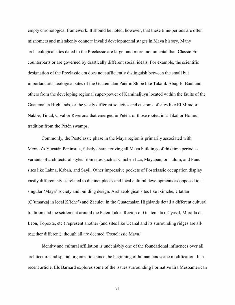
71
empty chronological framework. It should be noted, however, that these time-periods are often
misnomers and mistakenly connote invalid developmental stages in Maya history. Many
archaeological sites dated to the Preclassic are larger and more monumental than Classic Era
counterparts or are governed by drastically different social ideals. For example, the scientific
designation of the Preclassic era does not sufficiently distinguish between the small but
important archaeological sites of the Guatemalan Pacific Slope like Takalik Abaj, El Baúl and
others from the developing regional super-power of Kaminaljuyu located within the faults of the
Guatemalan Highlands, or the vastly different societies and customs of sites like El Mirador,
Nakbe, Tintal, Cival or Riverona that emerged in Petén, or those rooted in a Tikal or Holmul
tradition from the Petén swamps.
Commonly, the Postclassic phase in the Maya region is primarily associated with
Mexico’s Yucatán Peninsula, falsely characterizing all Maya buildings of this time period as
variants of architectural styles from sites such as Chichen Itza, Mayapan, or Tulum, and Puuc
sites like Labna, Kabah, and Sayil. Other impressive pockets of Postclassic occupation display
vastly different styles related to distinct places and local cultural developments as opposed to a
singular ‘Maya’ society and building design. Archaeological sites like Iximche, Utatlán
(Qʼumarkaj in local Kʼicheʼ) and Zaculeu in the Guatemalan Highlands detail a different cultural
tradition and the settlement around the Petén Lakes Region of Guatemala (Tayasal, Muralla de
Leon, Topoxte, etc.) represent another (and sites like Ucanal and its surrounding ridges are all-
together different), though all are deemed ‘Postclassic Maya.’
Identity and cultural affiliation is undeniably one of the foundational influences over all
architecture and spatial organization since the beginning of human landscape modification. In a
recent article, Els Barnard explores some of the issues surrounding Formative Era Mesoamerican

72
domestic structures (Barnard 2016), reinforcing the idea that the earliest Mesoamerican
structures were designed and built within the cultural norms of the builders, architects, and
occupants. Architecture tells the onlooker about the human identity behind the physical aspects
of the building; not only through style but also by the way in which it takes advantage of the
environment to enhance those designs. Naturally, access to resources, economics, and other
factors are fundamental to design and construction, but both majestic and common modifications
operate in the same paradigm of landscape modification, often by the same designers and built
with similar expertise and spatial reasoning. Later architectural groups—like those of Cancuén—
were likewise subconsciously influenced by then current cultural ideals that are revealed in each
structure’s specifications. Barnard’s writing focuses on wattle and daube, and adobe brick
buildings. Though most research into Maya cultural spatial proclivities centers around more
monumental stone structures, it is important to understand that to the building’s residents,
rudimentary straw and mud is as meaningful as their more durable stone counterparts. Buildings
reflect the ideology of their inhabitants using angles, heights and other construction dimensions
while also describing those people’s ideas about their place within the natural world; their way of
interacting with the natural surroundings—where they see themselves within the world.
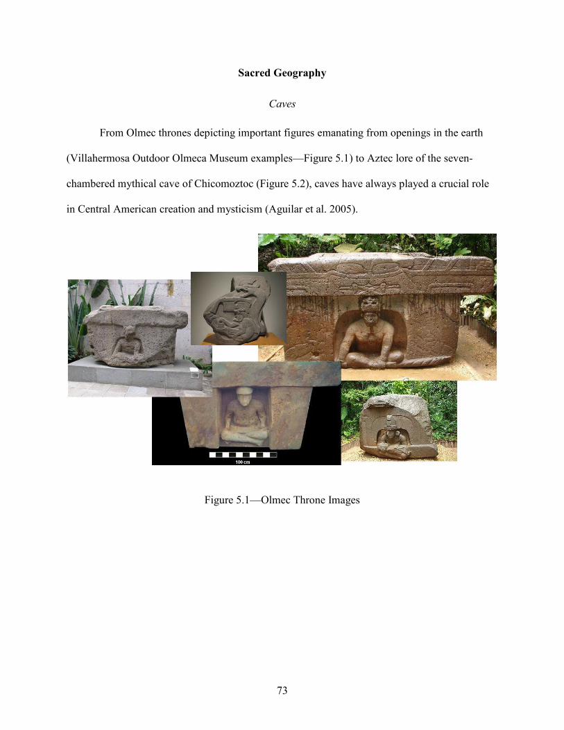
73
Sacred Geography
Caves
From Olmec thrones depicting important figures emanating from openings in the earth
(Villahermosa Outdoor Olmeca Museum examples—Figure 5.1) to Aztec lore of the seven-
chambered mythical cave of Chicomoztoc (Figure 5.2), caves have always played a crucial role
in Central American creation and mysticism (Aguilar et al. 2005).
Figure 5.1—Olmec Throne Images
74
Figure 5.2—Chicomoztoc 5-Lobed Cave with Footprints (Bradey)
It is the portal from which the gifts—the supernatural forces—emanate from the earth to
enrich the lives of humans. At the same time, caves are an opening into the Underworld, below
the realm of the living. The portal is more complex, and by sheer association with the peaks of
the mountainous geology surrounding the cave entrance (typified by Verapaz archaeological
sites like Salinas de los Nueve Cerros, Chisec, La Lima, Siltzul and Raxruha Viejo) also
highlights a connection to the ancestor deities, the cosmos, and the Celestial Realm. Because of
this interplay between life, death, and regeneration, caves are also symbolic of agriculture. The
Popol Vuh, an ancient Maya creation account penned in the mid-16th century (Tedlock 1996) by
Quiche Maya peoples from the Highlands of Guatemala, relates that the stability and flourishing
of Maya civilization came from a game between the Hero Twins and the Lords of the
Underworld. The entire story revolves around the Mesoamerican ball game that the Twins’

75
father, the Twins themselves, and the evil Lords repeatedly play in acts of defiance, punishment,
and regeneration. The ball game court is a constant backdrop. Their father’s decapitated head is
basically a game ball—and impregnates a Lord’s daughter leading to the father’s rebirth as the
Maya Maize God. Maya farmers would make a symbolic cave with every seed-hole they
indented into the earth with their digging stick when planting. Ball courts are figurative caves—
niches in the earth—planting holes. The physical properties of a projectile thrust firmly into an
object usually result in a profile of an outward slope away from the point of impact, much like
the alley and ranges of a Mesoamerican ball court. Agriculture relies on rain or other means of
irrigation. One of the most telling images from the Maya world is (Figure 5.3) the depiction of
the Maya Rain God, Chac, enthroned in the mouth of a cave from which spring life-giving rains.
Figure 5.3—Throned Chac with Rain/Cloud from Cave (Miller)

76
Caves are houses of the gods—one of the earliest forms of Mesoamerican architecture (Prufer
and Brady 2005; Tokovinine and Zender 2012).
Mountaintops
Mountains play crucial parts in Maya cosmology, are the homes of supernatural beings
(Schele et al. 1999) and serve as access-ways to the gods and ancestors (Gillespie 2000). Maya
temples are often described as Ak Wits or sacred mountains, cementing the links between nature
and architecture. Many archaeological studies have demonstrated the Maya custom of imitating
mountains with monumental temples (Brady and Ashmore 1999; Stuart 1997; Taube, 2004, von
Schwerin 2011). Tikal’s Temple A is an iconographic example, a human-made version of nature
(Coe 1988—Figure 5.4).
Figure 5.4—Comparative of Tikal Temple A as Mountain Photos (Demarest)
77
Mountain ranges are equally significant. They act as both a conduit from low-lying areas
to highlands and in their reaching proximity and ability to connect to the Maya Upperworld and
realm of ancestor deities. Mountains are also facilitators of economic exchange and socio-
cultural movement, as many trade routes follow the natural corridors of valleys and traverses
afforded by mountainous terrain (Andrieu 2013; Demarest et al. 2014; N. Hammond 1972); a
traffic in not only material goods, but also of cultural conceptions of space. Ancient Maya
iconography, history and even the anthropology and ethnography of contemporary Maya
societies—point to the importance of ceremonial pilgrimages to mountain regions and sacred
destinations within these precipitous topographies (Brady 2003). Earth and stone are the building
materials of natural architecture—the mountain and its range can represent a single entity or a
host of phenomena in the Maya cosmos. Like caves, mountains are considered houses of the
gods. In essence mountains are an earthly natural dwelling-temple of Maya spirituality, housing
the Underworld gods in their bowls and Upperworld figures amid their peaks. Mountains are the
setting of the same dynamic and contradictory interplay as caves. They are the passageways,
some leading to and transitioning into the deeper realm of the Lords of the Underworld while
others lead to higher grounds, the ancestors and other Upperworld Gods.
Water
Water bodies are also heavily charged with cultural symbolism. Maya iconography is
replete with mystical scenes of creation and the realm of the Underworld marked by aquatic
symbols (Chládek 2011; Stone 2010). Water is responsible for the flourishing of Maya
civilization. Agricultural production—arguably the factor allowing for the increasing populations
that drove the complexity of Maya civilization—is dependent on water. The availability of
drinking waters—another crucial resource for human survival—was also an integral aspect of

78
Maya society and spurred the excavation and construction of reservoirs and canal systems that
could support growing populations in many of their centers. These constructions, their labor
requirements, and end-results instilled an aura of sanctity toward almost all water related entities.
Chac, a dominant figure in the Maya pantheon of gods, is associated with all aspects of water,
also possessing warrior militant attributes, and is a ubiquitous figure in Maya iconography.
Repeatedly, he is impersonated by Maya peoples seeking to identify themselves with life-
sustaining waters (Estrada-Belli 2006; Houston and Stuart 1996). Water management has long
been recognized as a feature of Maya sacred terrain. The division and creation of space within
Palenque (French 2013; French and Marken 2007) by altering a water course is a prime example
and has long been a strategy of Mesoamerican cultures to symbolically highlight their
achievements over nature. Edwin Barnhart’s map of the Palenque site center and surrounding
settlement graphically emphasizes these water courses and he has discussed them in detail
(Barnhart 2001—Figure 5.5).

79
Figure 5.5—Palenque Map (Barnhart)
From the changing of the course of the San Juan River at the site of Teotihuacan in
ancient highland Mexico, the symbolic reservoirs and drainage systems that allude to natural
bodies of waters at the site of Tikal in Guatemala (Scarborough et al. 2012—Figure 5.6), to the
expansive water canal/reservoir system of the site of Edzna in Yucatán (Andrews and Ehrhorn
1969; Matheny 1976—Figure 5.7), or the intensive creation of water capture and distribution
systems that mimic the environments and of terrain of mythic Maya landscapes within the
Mirador Basin in the Guatemala Petén region (Villalgrán and Hansen 2016), the ancient Maya
preoccupation with water is a common theme.
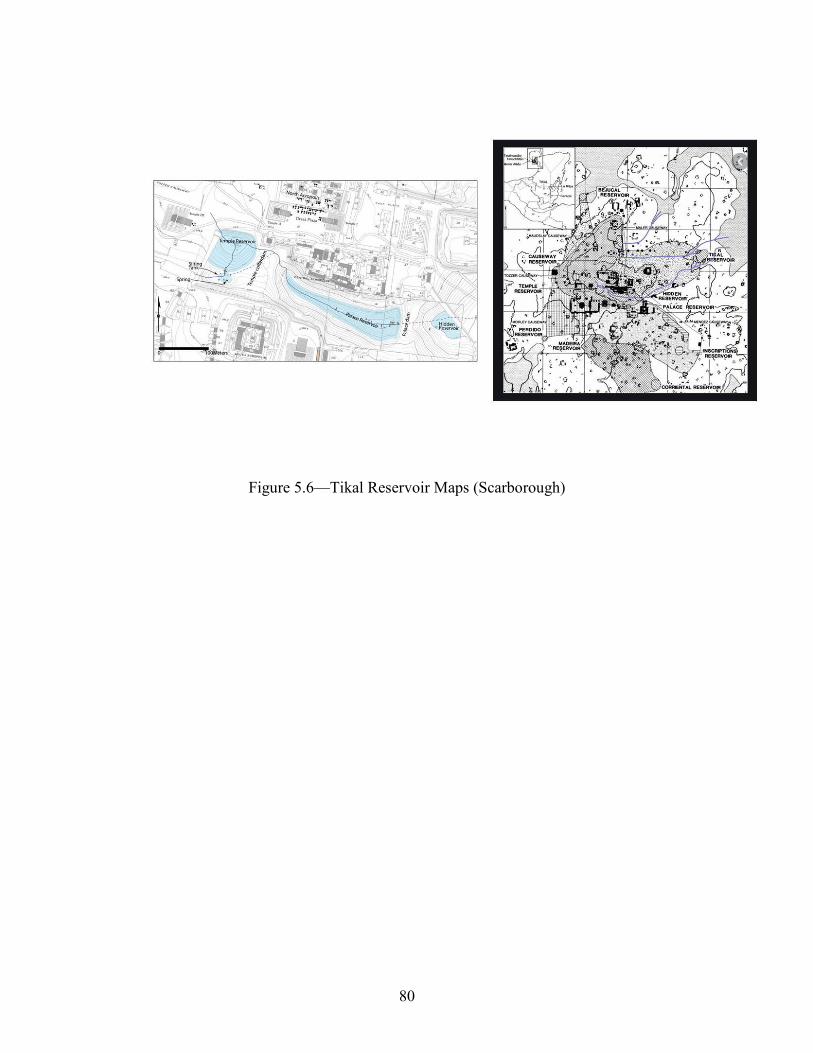
80
Figure 5.6—Tikal Reservoir Maps (Scarborough)

81
Figure 5.7—Edzna Channels Map (Matheny)
Much of Central America receives large volumes of rainfall—up to approximately 203
centimeters per year versus the approximately 89 centimeters in wetter regions of North America
(data from Columbia University and the Earth Institute’s International Research Institute for
Climate and Society’s interactive website, 2018). Recent hurricane flooding, ocean breeches,
river swelling, mudslides, and other water associated destructive actions show that water control
is a necessary aspect of a complex society. Storms have resulted in millions of gallons of
overflow in populous and urban areas. As a pre-industrial society without the mechanical
innovations designed to ameliorate these excess waters, Maya settlements were highly
susceptible to flooding, erosion, and other hydraulic damage. Especially during the rainy season,
Maya peoples were constantly reminded of the physical power that rain symbolized in the drains,
canals, catchment systems, and retention walls that they labored to construct and lived among.

82
Daily travels as well as stately, ceremonial movement of people required an ease of passage
through potentially flooded, slippery, and muddy grounds. Rivers can swell dramatically and
often in the lower regions of Mesoamerica, particularly with voluminous run-off descend from
adjacent highland areas. This is a crucial factor in building location as well—from a hydrological
standpoint of where and an engineering outlook of how to build within that location. Reinforcing
this power and circling back to the impersonation of Chac as an indomitable warrior are those
actions of destruction associated with the tenacious and unrelenting forces of nature and flooding
that can have disastrous effects on architecture and subsistence.
Swampland
Swamps or perennially inundated lands are also important categories within the water
theme. Like more-concentrated water features such as lakes and swamps—while contributing
their own unique set of cultural meanings—all water types (even those human-produced) are
symbolic substitutes for one another. Swampy land however, does recall a suite of attributes that
merit separate discussion. Seemingly unaffected by the ebb and flow of tides or currents, these
more stagnant marsh-like water features provide an enormous array of resources within a single
and relatively easily accessible environment. Water’s reflective properties are common
discussion points in Maya iconographic studies. Swampy grounds add a different depth
dimension to those physical properties and visual perception adding a mystic obscurity through
the still and brackish waters versus the active background of a flowing river or the clarity of a
deeper pooling of water. This impenetrable, yet reflective surface is symbolic of a portal into the
earth, much like caves, and imbues swamps and backwaters with a liminal link between the
Maya worlds of physical reality and the Underworld. Because of their ability to easily navigate
between these planes of existence, crocodilians, other reptiles, amphibians, aquatic mammals

83
like the river otter, and several aquatic birds are imbued with supernatural power. Cormorants—
frequent characters in Maya iconography—are diving birds that can remain submerged for
minutes, swimming comfortably in the marine environment. They soar through the heavens,
glide into the Maya world of the living, and then dive into the Underworld. The swamp is an
architectural doorway into the realm—the houses—of the Lords of the Underworld.
Swampy lands are havens of life (McNeil 2006); almost all animals native to the
region—many with powerful cultural connotations such as big cats and dangerous snakes—are
abundantly represented, as are plethora of smaller mammals and insects. Many species use the
enriching brackish waters to nurture their young, protecting them in a mosaic of fallen trees,
brush, deep pools, swamp vegetation and meandering channels. The paradox of swaps is that
while fostering this environment of development and life, the swampy waters embrace death and
decay. The trees and foliage of the jungle rot in the hydrophilic atmosphere of the swamp and the
same tangle and puzzle of microinches and pockets within the swampy that sheltered life,
camouflages knowing predators. Swamp-like landscape features foster life on a smaller scale but
act to limit it in life and recycle it in death in a larger outlook—offering both danger and safety.
Swamps are architecture that give shelter, but also expose another unknown and potentially
dangerous world lurking beneath its surface.
Fertility is exceedingly good in most swamp-like areas. The Maya were highly aware of
this fact, using the swampy soils as foundations for raised and drained fields. The bajo raised
fields of Quintana Roo in the Yucatán and Tabasco along the Gulf Coast, both in Mexico, are
prime examples of these intensive systems (Denevan 1970). Ditched and raised fields have been
well documented from Belize in the past in the Corozal region (Turner II and Harrison 1983) and
more recently adjoining the Rio Hondo and New River (Guderjan and Krause 2011; Luzzadder-

84
Beach et al. 2012; Pohl 1990). It has been suggested that these systems were also used in a form
of aquaculture in the raising of fish, turtles, and other resources such as snails, frogs, etc.
(Ferrand and Scarborough 2012). Raised or simply managed, the potential of these techniques is
irrefutable, and the combined silt and animal matter would act to further enrich the soils. The
antithetical combinations of anaerobic and aerobic environments lead to the vastly differing
preservation qualities within the same swamp lands. The colloquially named ‘Puleston Axe’,
found in the morasses of Belize, was incredibly well-preserved with even remains of the leather
hafting of the chipped stone head affixed to the wooden handle (Shafer and Hester 1986). The
swamp’s contradictory ability to disintegrate and regenerate—including the revitalizing of
agricultural soils from which sprout humanity and the Maya Maize God—plays a critical role in
Maya world concepts (Taube 1983). This liminal cycle of life, death, and rebirth creates an
atmosphere of renewable resources necessary to help feed and support burgeoning populations
throughout the development of Maya civilization as is evidenced by the numerous settlements
around Central American swamps (Guderjan 1991; Hansen 2001; N. Hammond 1972; Šprajc
2004).
In many major rivers, particularly of note in Guatemala’s Verapaz and the Rio Pasion and
tributaries, cataracts are an important variation on the water theme. They are also liminal
places—at once an important part of an active water system, but at the same time slowing the
currents from the river, diverting a single course into many smaller outlet streams, and forming
barriers to water movement. These cataracts are disruptions of the passage of the water and,
euphemistically, of time.

85
Lakes
Lakes fall along the continuum of water features, perhaps filling a median between rivers
and the many different coastal environments. A placid lake is the epitome of a mirror and is
symbolic of the primordial sea that once covered all land before the present era of Maya creation
(Driver and Wanyerka 2002). Lakes are havens for turtles and other marine life supporting
animals and vegetation requiring deeper waters, slight currents, and a variety of shoreline and
beach-like water levels lacking in most swamps. The Popol Vuh depicts the world arising from a
ruptured turtle shell—the Maize God sprouts from the cleft (the cave or planting hole or ball
court) amidst the square plates of the carapace. These squares are the fields planted and
harvested by the ancient Maya farmers, reinforcing the cosmic worldview of the imperative of
agricultural productivity (Taube 2003—Figure 5.8).
Figure 5.8—Turtle Shell/Carapace as Delineated Fields

86
As in modern times, ancient lake shores (Demarest and Rice 2005; Pendergast 1979, 1985; Rice
et al. 1998) were dotted with settlement—acting like a hub to these spokes, reiterating the
cyclical aspect of Maya symbolic thinking while also providing an easily accessible nexus of
exchange and communication.
Rivers
Within the general cultural importance of waterbodies in Maya worldly conceptions,
rivers (and to a lesser extent drainages and other water-flow configurations) deserve further
description. Ethnographic research has shown that many societies imbue the ideas of up- or
down-river with sacred significance (Ashmore 1991; Milner 1990; Niederland 1956; Rivers
2013). Maya ideology associates up-river with ancestor deities—leading to the Upperworld.
Conversely, down-river leads to the eventual effluence of the river waters from the mountains,
caves, and a path to the Underworld. Larger and stronger flowing rivers are especially symbolic
of the Maya ecliptic—the daily ritualized path of the sun, emerging from the Underworld to the
zenith of the Upperworld, and back into the depths of the Underworld (Freidel et al. 2002). This
cosmological action is mimicked by incipient Maya kings in performances on the various
platforms of the main structure at the site of Cerros in modern Belize. Freidel believes the rulers-
to-be receive much of their power from situating themselves at the center of a Maya universe
The double-headed serpent or ceremonial bars (usually of finely worked chipped stone and
material) that many Maya rulers are shown cradling on sculpted monuments (examples are
numerous from the monuments of archaeological sites like Tikal, Naranjo, Xunantunich,
Calakmul and others) represent this solar passage. In expressions of supernatural power, Maya
rulers often depicted themselves as the cosmic world tree (McDonald 2016; Taube 2003). The
ceremonial bar or double ended staff forms the cross branches of the tree (Freidel and Clancy

87
1986; Schele 1998—Figure 5.9) and are also emblematic of the rivers and other waterways of the
Maya realm.
Figure 5.9—Maya World Tree and Royalty Images from Mesoamerica
Rivers are the veins and arteries of the skeleton of Maya civilization. Demarest reiterates in
much of his work, rivers were the highways of ancient times (Demarest and Rice 2005; Demarest
2006; Demarest et al. 2014). When identifying themselves as the World Tree—the pillar of the
cosmos—Maya kings were holding the rivers and waters of the world. The resources of trade and
interconnection, irrigation and fertility, and interfaces with otherworldly forces that occupied a
central role in Maya world views were literally in the hands of the ruler. The pivotal role of these
water courses in Maya society affects the design and arrangement of their structure compounds.

88
Generalized Maya Time Periods and Architecture
Though there is great regional variation of architecture within the chronology of Maya
civilization, some general observations can be seen from these time periods. Table 5.1 details
some of these. The examples given are the largest and most well-known or iconographic
specimens, however the ideals are the same and the spatial design of the small house mound
mirrors that of a grander design. The ‘Theme/Associations’ column is meant to reflect the
humanistic role the architecture elicits from audiences and builders. A cyclical trend of
architecture inspired by a communal ethos representative of all levels within Maya society (elite
to commoner) changes to the glorification of a single personage and subsequently morphs into a
broader segment (but still exclusive) of shared elite power and governance.

89
Table 5.1—Generalities of Maya Architecture and Archaeological Time Periods (Wolf)
Preclassic Period
Generally, Maya Preclassic architecture is more massive than later Classic Period
counterparts. Emerging and early Maya society had a communal flavor and was more spiritually
focused on the environment as the setting of their spiritual worldview (Aimers and Rice 2006).
Architectural design focused more on inclusive symbolism detailing the supernatural world that
Time Period
Description Examples Comments Theme/Association
Preclassic (~2000 BC-250
AD)
Immense Basal Platforms Supporting Triadic
Structural Arrangements
El Mirador El Tigre Structure Group; Nakbe
Structure 1; Calakmul
Structure 2; Cival
Structure Group 1
Often Adorned With Giant
Anthropomorphic Stucco Masks
Community/Society; Gods/Maya Ideology
Classic (~250-900
AD)
Medium-sized Basal Platforms Supporting
Complex Arrangements of Auxiliary Structures, Elevated Courtyards,
Monumental Stairways and Multi-Roomed Structures
Tikal’s North
Acropolis; Copan’s Central
Acropolis; Tonina’s
Main Group
Often Accessed by Hieroglyphic Stairs and the Setting of
Roya Burials, Stela and Altar Pairs and Other Monuments
Individual divine power/ k’uhul ajaw
Postclassic (~900-
1539 AD)
Rigidly Linear Quadrangle Arrangements of Extended
Rectangular Hall/Range/Administrative
Structures
Chichen Itza Nunnery
Quadrangle; Uxmal Palace
Often Displaying Traits of a
Cosmopolitan/Central Mexican/Broader
Mesoamerican Influence—some
with portrait facades homage to Preclassic
style
Structure Groups reflecting a
decentralized milieu of power –sharing—
still reflecting the authority of elite and
royal persons but several as opposed
to a single individual/multepal
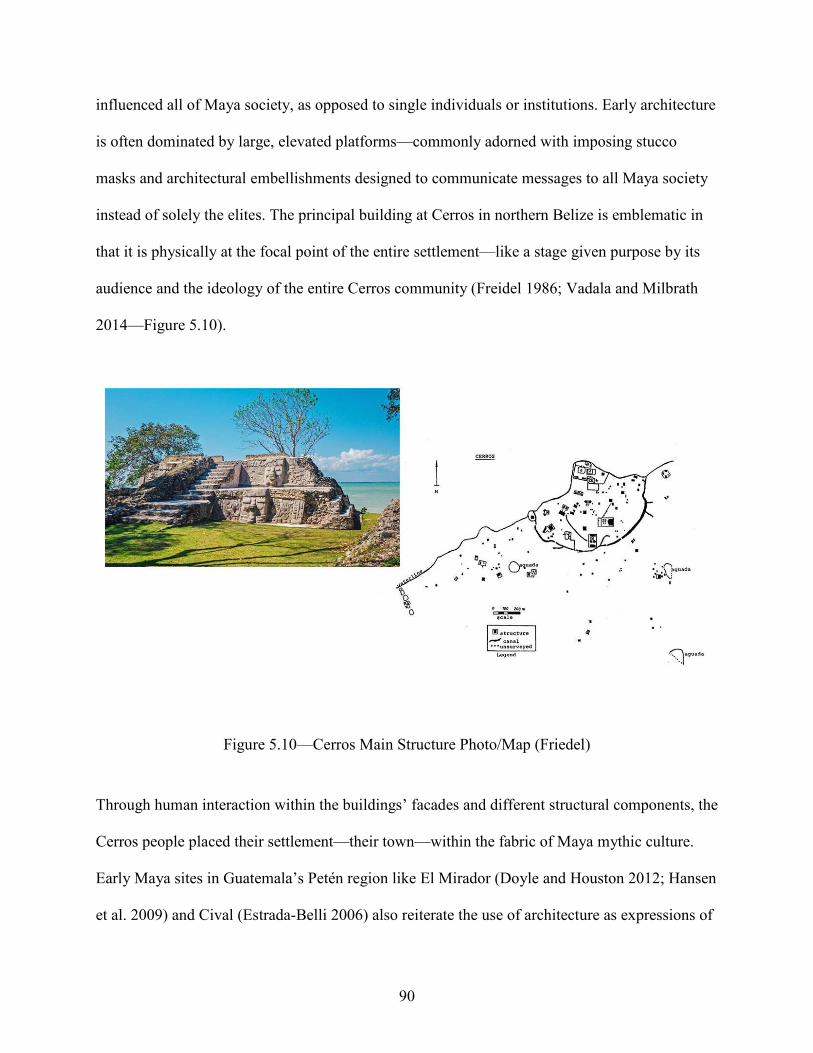
90
influenced all of Maya society, as opposed to single individuals or institutions. Early architecture
is often dominated by large, elevated platforms—commonly adorned with imposing stucco
masks and architectural embellishments designed to communicate messages to all Maya society
instead of solely the elites. The principal building at Cerros in northern Belize is emblematic in
that it is physically at the focal point of the entire settlement—like a stage given purpose by its
audience and the ideology of the entire Cerros community (Freidel 1986; Vadala and Milbrath
2014—Figure 5.10).
Figure 5.10—Cerros Main Structure Photo/Map (Friedel)
Through human interaction within the buildings’ facades and different structural components, the
Cerros people placed their settlement—their town—within the fabric of Maya mythic culture.
Early Maya sites in Guatemala’s Petén region like El Mirador (Doyle and Houston 2012; Hansen
et al. 2009) and Cival (Estrada-Belli 2006) also reiterate the use of architecture as expressions of

91
social identity where the foundations or basal platforms of the most important structures are
enormous canvases for impressive art/propaganda and other communication about the Maya
cosmos at large. Early images like the masks at Riverona—only kilometers from Cival within the
greater Holmul area of Petén (Estrada-Belli et al. 2009) or the impressive and massive masks of
Nakbe (Hansen 2017—Figure 5.11) are other examples of a communal ethic with thematic focus
on gods or mythic symbols of creation and natural power (Stuart 1997; Tokovinine 2006) versus
the aggrandizement of individuals as described in Redfield and Rojas’ early work at Chan Kom
in Yucatán Mexico (1934).
Figure 5.11—Nakbe Masks Drawings/Photo (Hansen)
This communal outlook is reinforced by the work of countless others like Hammond at Cuello in
north-western Belize (Hammond 1980) or Vogt’s Zinacantan work in highland Chiapas, Mexico

92
(Vogt 1965), it is scientifically recognized that most early Maya architectural design was driven
by a communal ethos.
Classic Period
In the later Classic Period, Maya structures decreased in overall size, but the intricacy of
their layouts increased as seen in the Tikal Acropolis (Coe 1962; Haviland 1970; Adams and
Jones 1981) or the palaces of Holmul (Estrada-Belli et al. 2009; Mongelluzzo 2011; Estrada-
Belli and Tokovinin 2016) or Cancuen (Demarest and T. Barrientos 1999; Demarest 2006; T.
Barrientos 2014—Figure 5.12).
Figure 5.12—Cancuén Palace Maps/Drawings (Wolf/Luin)

93
An important caveat is that while the Preclassic structure groups shared imposingly large bases,
the superstructures constructed atop were not always as impressive as El Mirador’s triadic El
Tigre Complex (Graham 1967; Hansen and Balcárcel 2007) or Calakmul’s (Campeche, Mexico)
Structure 2 (Carrasco Vargas 2005—Figure 5.13).
Figure 5.13—Triadic groups: Cival Map, El Mirador El Tigre Complex Drawing, Nakbe Structure 34 Drawing, Calakmul Structure 2 Drawing (Wolf/Hansen/Segovia)
Other exceptions to this generalization include structures such as the early construction phases of
shrines within Xnoha (discussed in Chapter 8) in north-western Belize or the richly painted (and
subsequently buried by more typical Classic period construction) funerary complexes of Motmot
or Rosalila from Copan in western Honduras. These buildings follow the model of a more
encompassing social ambiance—dedicated to known individuals but honoring the society at
large and the entire Maya belief-system, not simply to promote the ideals and life of a single
personage. Most Preclassic structures never approached the level of architectural detail seen in
94
later times as exemplified by the architectural detail of the later iterations of the Copan Acropolis
(B. Fash 1992; Sharer et al. 1999; Webster 1999; Agurcia Fasquelle and B. Fash 2005) or the
Tikal North Acropolis. Notably absent from many later Maya sites are the aforementioned
gigantic masks and facades, but these are instead often replaced in sentiment by complex murals
like those from La Sufricaya (Estrada-Belli 2005) also in the Holmul region, or San Bartolo
(Petén, Guatemala) just 16 kilometers away (Hurst 2005). Individual aspects of rulership,
personal legitimation, and individual feats are more commonly displayed by Classic era
constructions.
Postclassic Period
Postclassic architecture generally is a hybrid of Preclassic, and Classic structures as
discussed above. Building size is often less imposing and moderate—smaller than those of the
Classic era—and there seems to be a return to a more pluralistic social milieu as in the Preclassic
period. Hilltop or otherwise fortifiable landforms with tighter, more restricted open areas. New
building types were common throughout the many time periods of Maya history—architectural
innovation was never stagnant in the development of culture—but during Postclassic times,
constructions expressed a greater variety of forms. Perhaps a result of the intensified cultural
exposure associated with increasingly complex social, political, and economic systems; Maya
structure groups—while adhering to a general north-south/east-west courtyard layout—are more
varied in size, volume, and decoration than in earlier times.
Circular buildings, or structures with rounded corners (as opposed to the angular sides of
earlier architecture), became common, like the later temple/shrines or the elite residences of K’in
T’an and Rosita, both in north-west Belize (Guderjan et al. 2008) and mentioned in more detail
in Chapter 8. Examples include structures placed within earlier plaza layouts at Becan, in

95
Campeche, Mexico (Potter 1977; Thomas 1981), Nohmul (N. Hammond 1983; N. Hammond et
al. 1985) and Santa Rita de Corozal (A. Chase and D. Chase 1988; 2008)—both in Corozal,
Belize, and many other settlements.
Colonnaded galleries, oratories or communal ‘halls’ most notably from Chichen Itza in
Mexico’s Yucatán Peninsula like its Temple of the Warriors and other late Maya/Mesoamerican
sites like Tula (Jones 1993; Healan 2012) in central Mexico, were replicated on much smaller
scale. Examples come from Petén sites like Nixtun-Ch’ich’ (Pugh et al. 2016; Pugh and P. Rice
2017), Tayasal (A. Chase 1983), the Chorcha complex in Copan (W. Fash et al. 1992), most sites
from the Puuc Hills in the north west of Yucatán (Pollock 1980), and are common in the
architecture of the Maya Highlands to the south.
Chapter Conclusion
Mesoamerica is a region of many natural settings that inspire an array of distinct
architectural forms and styles. These different building types, designs and aesthetics are carried
with people as they move around the Maya world. Their ideas are also transmitted via the
exchanged goods that originate in their native lands and with the traders, pilgrims, tourists, and
other travelers that visit these foreign destinations.
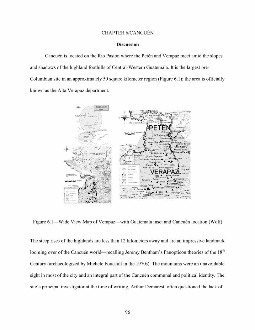
96
CHAPTER 6/CANCUÉN
Discussion
Cancuén is located on the Rio Pasión where the Petén and Verapaz meet amid the slopes
and shadows of the highland foothills of Central-Western Guatemala. It is the largest pre-
Columbian site in an approximately 50 square kilometer region (Figure 6.1); the area is officially
known as the Alta Verapaz department.
Figure 6.1—Wide View Map of Verapaz—with Guatemala inset and Cancuén location (Wolf)
The steep rises of the highlands are less than 12 kilometers away and are an impressive landmark
looming over of the Cancuén world—recalling Jeremy Bentham’s Panopticon theories of the 18th
Century (archaeologized by Michele Foucault in the 1970s). The mountains were an unavoidable
sight in most of the city and an integral part of the Cancuén communal and political identity. The
site’s principal investigator at the time of writing, Arthur Demarest, often questioned the lack of

97
typical Maya temple structures at the site in his early Cancuén works. Shortly thereafter he
realized these roles were filled by the mountains themselves—an obvious use of highland
ideology (Demarest 2000, 2002). Cancuén occupies precipitous banks of the important Pasión
River, and is the first major destination, urbanized settlement, and link to other regions of the
Maya world encountered after descending the Maya Highlands in central Guatemala. Norman
Hammond and others have pointed to this highland-lowland corridor as one of the major trade
routes throughout Maya times (N. Hammond1972; Fowler et al. 1989; Woodfill and Andrieu
2012; Demarest et al. 2013; Canuto and T. Barrientos 2013; Demarest et al. 2014). It is the
physical frontier between the lowlands and highlands, forming a cultural nexus of these two
distinct areas (Adams 1978; T. Barrientos et al. 2000; T. Barrientos et al. 2001; Arnauld 1990,
2001; Demarest et al. 2009; Demarest et al. 2013; Woodfill et al. 2011; van Akkeren 2012;
Ohnstad 2004) making the Cancuén site predisposed to diversity. This variation is mirrored by
the Cancuén architectural concentrations that display hallmarks of a general ‘Cancuén’
architectural theme amidst a gamut of local and foreign traditions. Settlement is influenced by
several cultural and situational factors. This research investigates the nature of their
hybridization. These combinations are temporal and always changing. Three themes dominate:
1) spirituality; 2) the natural environment; and 3) cultural geography. This dissertation uses
architectural groups, their positioning within a single site, and the arrangement of other
archaeological sites in the region to characterize this variety.
Verapaz is composed of intertwined yet vastly different ecological and cultural zones.
This diverse area is unique in that it represents a major internal frontier within the Maya area as
opposed to a peripheral border between Maya and non-Maya cultures. The lower Verapaz is a
region relatively easy to traverse, unlike the mountain ridges to one side and the ubiquitous

98
swampy or riverine impediments to the east, adding to the volume of people and materials
trafficked through the region. It is home to the Guatemalan transversal, the main overland route
of commerce and communication from highland regions into Petén, reaching the coast of Belize
and continuing into the Yucatán, skirting the mountains on one side and lowland inundated
morasses on the other. The rivers also serve as major routes of connection throughout the area.
Mesoamerica—with its vast coastal and riverfront exposure—has a long tradition of
maritime and riverine trading, and Cancuén was an important center along many of these routes
(Rathje and Sabloff 1973; Sabloff and Rathje 1975; Andrews 2002; Masson and Friedel 2002;
Demarest et al. 2014). Cancuén was heavily invested in the trade systems of the Maya world as
evidenced by its commanding position (a sharp-rising promenade overlooking the river), a
strategic location and basically the ’head of navigation’ of the Pasión River (Demarest et al.
2014). An integral part of any port city is an influx and movement of people that have their own
spatial and cultural perceptions (McAnany et al. 2013; Woodfill and Andrieu 2012; T. Barrientos
et al. 2007; Demarest 2014).
Survey Methodology
Upon initial cartographic survey, it became quickly apparent that numerous details and
features had been over-looked by preceding mapping efforts. Terrain contextualization at
Cancuén was non-existent until Graham and Tourtellot’s 1960s work, and even then the contour
interval was too broad and generalized. Additionally, water features, terraces, lower platforms,
causeways, natural drainages, and other important aspects of the landscape were unrecognized. A
combination of an early scientific preoccupation with recording—as in the case of Maler’s
documentation in the early part of the century—to a nascent scientific prioritization of elite
structures, followed by an intellectual recognition of more domestic architecture to studies of the

99
environment and beyond, the reality of logistics, time, and finances, had created several
incomplete Cancuén maps.
The author addressed many of these deficiencies in the maps and drawings referenced
throughout this dissertation. The earlier iterations of the Cancuén map provided a crucial
framework in which to weave more detailed information, newly discovered archaeological
features, and a better appreciation of the surrounding natural and built environment. Contour
intervals were tightened, producing a finer .5 meter surface for the entire Cancuén Peninsula.
Hundreds of individual structures, structure groups, land-modifications, platforms, portage areas,
plazas, springs, natural drainages, activity areas, monuments, trails, and quarry sites are a few of
the many features of the latest map. Examples of undocumented features within the center range
from both the Royal Pool, and the Northern Sacred Water System to the promenade overlooking
the Rio Pasión. The majority of the map outside the Cancuén Central Precinct was blank—the
author’s work has expanded the map in size, complexity, and resolution.
To reiterate a topic alluded to previously, all field point, line, and polygon data was
gathered by the author with a combination of 1 second electronic transits (EDM, TS, etc.) and
sub-meter 12 channel GPS/GNSS receivers. The author assimilated various data sources and
graphics into this backdrop, and then drew prismatic structure walls, rooms, connecting
platforms and other architectural details based in aforementioned spatial data. In basic steps from
an unknown and “void” region of a map, the author geophysically located features with
horizontal and vertical control in locational data. Then a ground surface was interpolated via
computer from these points. Next, graphic map conventions were interpreted and drafted to
represent architectural and landscape features. Finally, these various elements were combined
and refined in a GIS, producing a comprehensive and highly accurate image of the human

100
constructed and natural landscape. Through this work, the map evolves from a blank space to an
area of known topographic trends, and then to a scientifically rigorous architectural image that
details the physical surroundings like drainage patterns, slopes, and viewshed.
History of Investigation
Early Forays
The Austrian explorer scientist Teobert Maler (1908) first re-visited the site in the
summer of 1908 to sketch architectural remains, contextualizing the ruins and a stela badly
damaged by looters. His interest was focused on the site’s monuments and associated grand
buildings (Figure 6.2).
Figure 6.2—Cancuén Map (Maler)
He identified two carved and several plain stela, and a conical-shaped altar. All possessed forms
previously unknown in the Maya area, the altar being asymmetrical from top to bottom, and the

101
stela cut into a stepped form reminiscent of a stylized body-shoulders-head outline. He cursorily
mapped the structures he encountered, particularly those associated with the monuments and
concentrations of lithic materials and ceramics visible on ground surface.
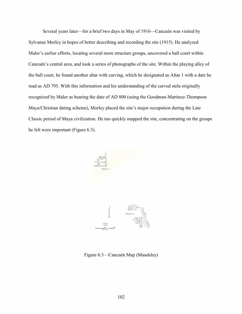
102
Several years later—for a brief two days in May of 1916—Cancuén was visited by
Sylvanus Morley in hopes of better describing and recording the site (1915). He analyzed
Maler’s earlier efforts, locating several more structure groups, uncovered a ball court within
Cancuén’s central area, and took a series of photographs of the site. Within the playing alley of
the ball court, he found another altar with carving, which he designated as Altar 1 with a date he
read as AD 795. With this information and his understanding of the carved stela originally
recognized by Maler as bearing the date of AD 800 (using the Goodman-Martinez-Thompson
Maya/Christian dating scheme), Morley placed the site’s major occupation during the Late
Classic period of Maya civilization. He too quickly mapped the site, concentrating on the groups
he felt were important (Figure 6.3).
Figure 6.3—Cancuén Map (Maudsley)

103
Harvard Project
After many years of scientific neglect, the site was visited by several members of the
Harvard University Peabody Museum’s Seibal project in 1967—located about 115 miles down-
river (Tourtellot III et al. 1978). From the modern Guatemalan town of Sayaxché, they explored
several archaeological sites on the Pasión River, including Cancuén. They re-surveyed and re-
mapped the previously known architectural assemblage, uncovering more buildings than noted
by either Maler or Morley (Figure 6.4).
Figure 6.4—Cancuén Map (Graham)
Additionally, the team—in its brief stay of less than a week—excavated 11 test units with the
goal of refining the ceramic chronology and general context of the Cancuén ruins. Unlike many
investigations at the time, most of the research was directed towards plazas and other non-
structural features. The work “assumed that there would be a better chance of getting some idea

104
of the Cancuén ceramic sequence if pits were dug in plazas or courtyard areas, since, in those
areas, the excavators might be able to dig to sterile soil in the limited amount of time available
(1978: 203).” Several surface samples were also collected, and sketches were made of all
locations studied.
The researchers concluded that the Cancuén ceramics were homogeneous and dated
almost exclusively to the Late Classic period. Although the variety of ceramic types have since
been significantly updated by a far greater sample from many excavations in the Cancuén core as
well as periphery that signal a greater diversity, the Late Classic designation remains,
underscoring the variety of Cancuén building types. Much of the site’s architecture was
constructed during the peak of the site’s prosperity and interaction when variety was the norm.
Due in part to the paucity of excavated artifacts, the early Cancuén research was based
heavily on speculation (numerous intersite comparisons are made throughout the Harvard
report). Additional materials recovered since and updated analysis afford a much more robust
foundation upon which these older estimations are grounded; in ceramic comparisons, the
Harvard team cites Seibal most often, followed by Altar de Sacrificios and Uaxacatun, with some
resemblances to Copan collections. Perhaps one of their more astute observations of the variation
in Cancuén ceramics of the Late Classic period was that it “most likely indicates that there were
local wares which survived the changing times (1978: 219).”
Architecturally, the Harvard team noted several comparisons to constructions throughout
the Pasión area. Their uncertainty in designating a ‘Cancuén’ standard is understandable given
the eclectic mix of many architectural styles at the site. They frequently describe the presence of
hieroglyphic stairways, common in the region with examples from Dos Pilas, La Linterna,

105
Yalpemech, San Isidro (just across the Verapaz boarder into modern Mexico), within the main
Cancuén palace itself, as well as more distant sites such as Naranjo, Copan and Quirigua.
Vanderbilt Project
Arthur Demarest initiated a new period of research at Cancuén in 1999 under the auspices
of Vanderbilt’s Institute of Mesoamerican Archaeology (VIMA) and the Guatemalan
government’s Instituto de Antropología, Etnografía e Historia (IDAEH) (Demarest and
Barrientos, 1999). The Cancuén Archaeological Project has been explicitly inter-disciplinarian,
engaging in studies of iconography (Fahsen et al. 2003); ethnography (Garcia, 2002); large-scale
horizontal excavation strategies (Demarest et al. 2001; T. Barrientos et al. 2006); ecotourism
(Demarest et al. 2004; Del Cid and Garcia, 2006); reforestation; systematic survey and mapping
(Demarest et al. 2003; Woodfill et al. 2001; Spenard, 2006); laser ablation, neutron activation
and ceramic paste analysis (Bishop et al. 2005; Bishop and Sears, 2001); experimental
archaeology and reconsolidation aided by the work of R. Larios (T. Barrientos et al. 2003; 2004);
soil-formation analysis (Cook et al. 2006, 2017); and educational and community
development/outreach programs (Garcia et a., 2002; Demarest, 2004) to mention a few Cancuén-
centric enterprises. Jade production and distribution at Cancuén have been carefully studied
(Andrieu et al. 2010; Andrieu et al. 2011; Andrieu and Forné, 2010; Forné et al. 2010), and
ceramic sequences have been debated and developed for most of the site’s central precinct and
excavated periphery (Bill and Castellanos, 2002; Forné et al. 2010; Bill et al. 2004; Torres et al.
2013). Lithic analysis (Andrieu et al. 2010; Andrieu and Quinonez, 2010) is ongoing as is the
mapping regime (Wolf and McCormick, personal communication, 2015). Architectural
sequences have been thoroughly dissected, particularly for the royal palace and some of the
larger outlying groups (T. Barrientos 2002; Sears, 2016). The site’s water-features have been
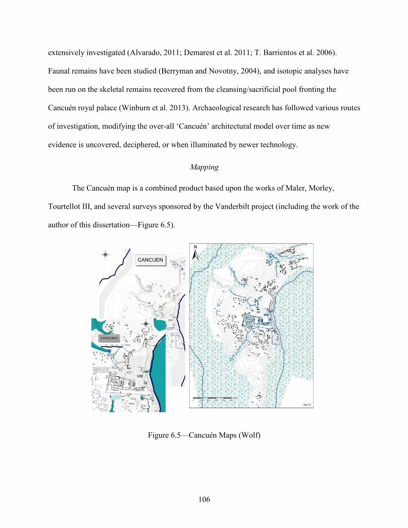
106
extensively investigated (Alvarado, 2011; Demarest et al. 2011; T. Barrientos et al. 2006).
Faunal remains have been studied (Berryman and Novotny, 2004), and isotopic analyses have
been run on the skeletal remains recovered from the cleansing/sacrificial pool fronting the
Cancuén royal palace (Winburn et al. 2013). Archaeological research has followed various routes
of investigation, modifying the over-all ‘Cancuén’ architectural model over time as new
evidence is uncovered, deciphered, or when illuminated by newer technology.
Mapping
The Cancuén map is a combined product based upon the works of Maler, Morley,
Tourtellot III, and several surveys sponsored by the Vanderbilt project (including the work of the
author of this dissertation—Figure 6.5).
Figure 6.5—Cancuén Maps (Wolf)

107
The drawings were outlined by a professional Guatemalan commercial surveyor, Eric Buccaro,
and this defined and monumented polygon was further explored and mapped by teams led by
O’Mansky and Woodfill (O’Mansky 1999). The major Cancuén Palace was comprehensively
surveyed and illustrated by T. Barrientos and Luis Luin during this time, revealing exactly the
proportions of one of the larger palace structures in the Maya world (Demarest 2006). The
Guatemalan government sponsored a survey of areas that overlooked the northern side of
Cancuén’s Main Port. Numerous years were spent by the author refining these efforts and
combining them into a unified GIS model (Wolf 2006). The image of Cancuén’s architecture and
settlement zones has been developed through the perspectives, interpretations, methodologies,
and technologies of many scientists whose work builds upon the stout foundation of previous
study. After assembling prior drawings and re-mapping portions of the Cancuén core area,
exploration began on what was called the North Transect (Figure 6.6) and went from a
technically well-defined sample area upriver and to the north of the Cancuén epicenter to one of
resourceful survey and recording where land-owner permission and environmental obstacles did
not impede progress in adding to the Cancuén knowledge base.

108
Figure 6.6—North Transect Maps (Wolf)
The work here expands upon and is bolstered by approximately 15 years of comparative
investigation. These studies have been focused on large-scale, opportunistic excavation, and
intense multi-disciplinary inquiry by Demarest and his colleagues (T. Barrientos and Demarest
2000; Fahsen et al. 2001; Fahsen and Jackson 2002; Demarest and Fahsen 2002; Fahsen and T.
Barrientos 2004; Wolf 2006; Demarest et al. 2006; Spenard 2006; Wolf et al. 2009; O’Mansky
2003; Woodfill 2007; Demarest et al. 2007; Andrieu and Forné 2009; Forné et al. 2011; Torres,
2011; Andrieu et al. 2012; Woodfill et al. 2012; T. Barrientos 2014; Martinez et al. 2017;
Thornton and Demarest 2019). Table 6.1 sums some of the work conducted by the various
Cancuén project members giving the site a tightly controlled ceramic, epigraphic and settlement
chronology that adds to the overarching ideas presented in this dissertation. As of the year 2019

109
over 200 scholarly articles have been published and myriads of lectures have been presented
about the Cancuén data.
Table 6.1—Modified from the Work/Compilation of Lic. Paola Torres of the Cancuén Data Giving Chronological Context to the Site.
Date (AD)
Ceramic Sequence
Epigraphic Evidence Palace Construction
Authority Over Exchange Network Cancuén
Rulership Regional Power
Structure 650
Concordia
Calakmul Hegemony
Calakmul Presence in Tikal Dominated Pasion/Transversal
Trade Routes
655
K'iib' Ajaw Phase 1
660 665 670 675
Chan Ahk Wi' Taak Kay 680
685
Phase 2
690
? 700
Dos Pilas Hegemony
Dos Pilas Control Over
Pasion/Transversal Trade Routes
705 710 715 720
Lady G1-K'awiil (Dos Pilas Lady of
Cancuén)
725 730 735 740 745 750 ? 755
Phase 3 760
Taj Chan Ahk
? ? Los
Laureles
765
Phase 4 770 775
Cancuén Sovereignty Self-Determined
Control
780 785 Early
Chaman Phase 5 790 795 Late
Chaman 800 Kan Ma'ax Phase 6

110
Ancient Cancuén
Founding of an Urban Center
Cancuén—meaning nest of serpents in the Maya Yucatec language—is a medium-to-
large (the largest in the region) ancient Maya settlement. The site was constructed on one of the
prominent eastern land formations rising from either side of the Rio Pasión that flows through
the large swamplands of the southern limits of Guatemala’s Petén region. It is technically a
peninsula within the folds of the river, but in practice acts like an island with associated control
and defensibility, due to the swampland that covers the isthmus neck of land to Cancuén’s north.
Late Classic population estimates range from less than 1000 to several thousand people for the
surrounding area. Cancuén structures do not approach the scale and elevations of other
monumental architecture as at other pre-Columbian sites such as Chichen Itza or Tikal, however
their elaborate designs, stucco facades, associated monuments, and one of the largest palaces in
Mesoamerica (Demarest and T. Barrientos 2001, 2003; Fahsen and Demarest 2002; T. Barrientos
2014) rival most architecture throughout the Maya world creating an atmosphere of cultural
dynamism and activity. Through the details of its architectural groups, Cancuén provides a
unique opportunity to investigate the varying degrees to which settlement is influenced by a
combination of environmental and social factors.
The locale of the Maya center of Cancuén as it is known today likely began
inauspiciously as a small village or house group. Brent Woodfill’s (2019) recent work chronicles
the settlement history of the region. One of many compounds in the area during the early phases
of the Maya Classic Period, it probably was loosely affiliated with the dominant site of El Raudal
and the tiny (hardly more than a ceremonial platform with several monuments) outpost
peripheral site of Tres Islas, both downriver from Cancuén, as primary actors in local geopolitics.

111
Iconographic and glyphic reading combined with extensive excavation and artifact analysis point
to the founding of Cancuén by the imperial authority of the powerful polity of Calakmul, whose
center lay approximately 250 kilometers away. As Woodfill remarks, the Cancuén polity—
mentioned in the carved texts of Tres Islas—began as more of an idea or dynastic aspiration than
an actual entity or place until the sites’ establishment by Calakmul in later Classic Period times
(Demarest and T. Barrientos 2001; Tomasic and Fahsen 2004; Woodfill 2019). Maya life and
politics were dominated by sites like Tikal from central Petén and Calakmul to the north. The
Rio Pasión and its commerce were Tikal territory during the earlier Classic period, but in the
early 7th Century, peoples identifying with Calakmul founded the city of Cancuén on strategic
banks of the Pasión. The physical location of the site was intentionally chosen for its controlling
position on the heavily trafficked river, specifically to wrest control from Tikal—with the aid of
powerful allied states like Caracol—of the crucial trade link (and all connected activity) of
highland goods to lowland markets.
From its inception, Cancuén became a diverse amalgamation of peoples; some
identifying with the Calakmul area (an immense capitol that attracted migrants from all over
Mesoamerica); some from the original Cancuén/El Raudal area regional center; traders plying
the many routes through the transversal; and a steady influx of highlanders seeking the rich
agricultural potential of the Verapaz. As the years moved into the Late Classic period,
superpowers like Tikal and Calakmul became less influential, in great part due to the years of
conflict between the two centers. Ambitious rulers like Taj Chan Ahk (the Late Classic period
Cancuén king from AD 757 to approximately AD 759) asserted their city’s sovereignty and
independence. Taj Chan Ahk reigned during a fluorescence in Cancuén history, sponsoring
building efforts, remodeling, and the commemoration of many stela/altar pairs (Fernández 2011,

112
Fahsen et al. 2003, Demarest et al. 2006). His rule was greatly responsible for much of the
ambiance of Pre-Columbian Cancuén. Many other sites in the area experienced a renaissance in
building, craft specialization, artistic practice, and population growth with the waning influence
of the traditional superpowers.
Water City
Cancuén is the epitome of a water city, embracing the curves of the Rio Pasión and
flanked on all sides by smaller inlets, springs, and human-created water features. Taj Chan Ahk,
was preoccupied with showing himself as a water king with symbolic water associations
depicted in his headdress on numerous monuments (Demarest et al. 2014). On the close horizon,
to the south—the seeming destination of the river—is the unavoidable and constant view of the
San Francisco Hills. Kilometers north, the domineering presence of the Candelaria Caves merges
into the highlands and symbolizes the river’s origin. Cancuén is bookended by culturally charged
mountains on one side, caves on the other, and is linked into a dynamic whole by the Pasión. The
site core and most of the outer settlement is built within the folds of the sinuous river as it flows
like a serpent toward the Maya heartland and the confluence with the Usumacinta, Lacantun, and
Salinas (Chixoy) Rivers (Figure 6.7).
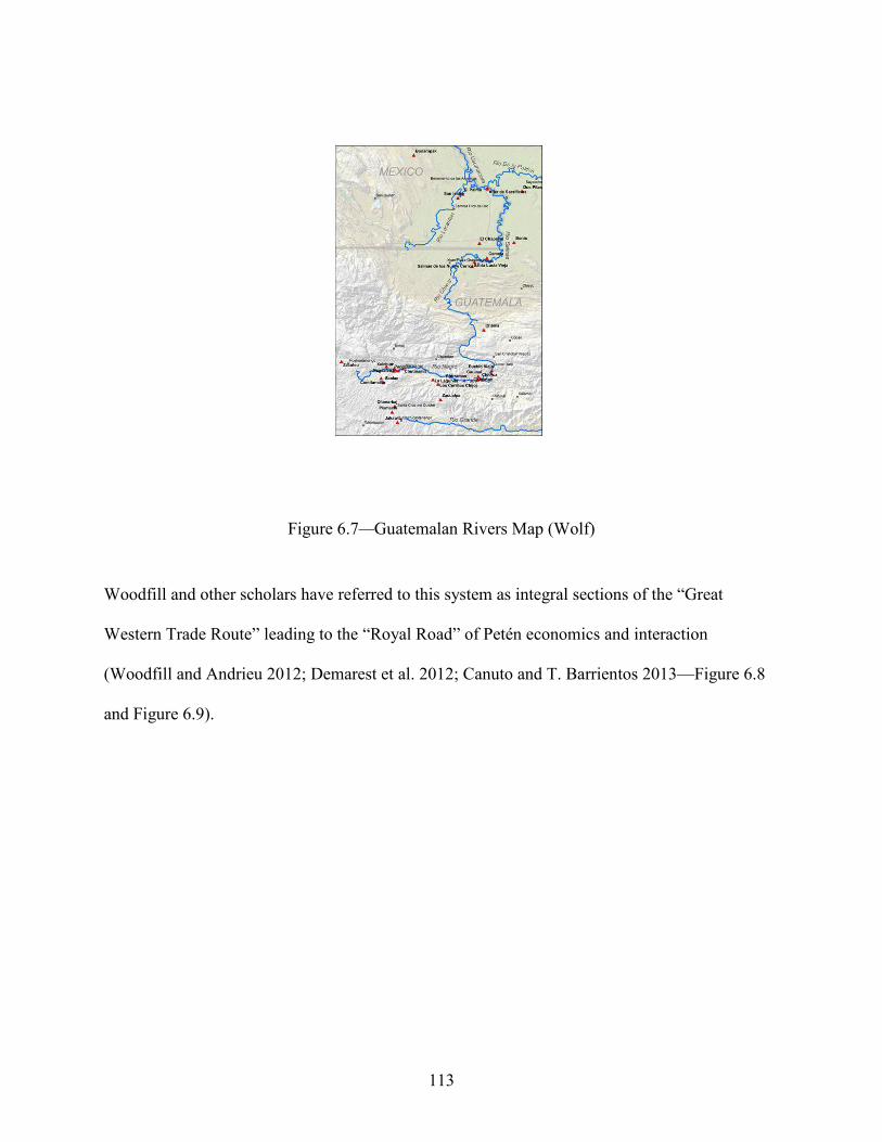
113
Figure 6.7—Guatemalan Rivers Map (Wolf)
Woodfill and other scholars have referred to this system as integral sections of the “Great
Western Trade Route” leading to the “Royal Road” of Petén economics and interaction
(Woodfill and Andrieu 2012; Demarest et al. 2012; Canuto and T. Barrientos 2013—Figure 6.8
and Figure 6.9).

114
Figure 6.8—Great Western Trade Route Maps (Luin)

115
Figure 6.9—Royal Road Map (Luin)
The networks would have connected Mexico’s Gulf Coast and reached the Petexbatun region
both on the Salinas and Rio Pasión sides before stretching into the Petén and continuing into the
areas of the southern Yucatecan Coast, through Belize and into Honduras. The navigable
Lacantun connects to important points in the west of the Maya world like Chiapas and eventually
breaks into both the Mexican Plateau and the Guatemalan Highlands. Kilometers downstream
from Cancuén, the Santa Amelia River breaks away from the Pasión, overlooked by the site of El
Raudal, providing a natural corridor for movement into the southern regions of the Petén and
onward to the southern Yucatecan Coast, the Caribbean swamplands of coastal Belize, and the
Gulf of Honduras. This riverine environment is emblematic of Cancuén’s important
interconnectivity to Maya sacred conceptions of the world.

116
The topography framing the site is a combination of concentric and comparatively drier
bluffs ascending steeply from the Rio Pasión and from numerous seasonal swamps, drainages,
and perennial springs that mark the Cancuén landscape. The land recalls the Mesoamerican
mythical crocodilian or tortoise whose ridged hide or shell protrudes like islands from the
primordial sea. Buildings are bastions of civilization breaking the uniformity of the jungle
canopy. As early as 1893 modern urban planners subscribed to the ideals Garden City posited by
Sir Ebenezer Howard—a settlement model particularly applicable to Mesoamerica (Chase and
Chase 1998) and the discussion of possible garden plots, orchards, and other agricultural
practices conducted within the urban environment (Stark and Ossa 2007; Barthel et al. 2013;
Isendahl 2012; Lentz et al. 2014).
Water themes and features are ubiquitous at Cancuén, most impressively embodied by
the Pasión River itself. Mirroring the sun and moon’s trajectory around the globe, the river marks
a course around most of the Cancuén settlement. The steep riverbanks define the eastern edge of
the Cancuén epicenter. East is culturally a significant direction for many peoples (Rybak et al.
2004) as it is the ‘origin’ of the rising sun as it travels westward. Maya cosmology also attaches a
life-endowing sacred power to this east-west progression—particularly the life-fostering physical
properties of the sun and water (the Pasión as the water role in the case of Cancuén). The western
direction of the movement is likewise associated with life. At Cancuén, this western pole is more
dynamic; a more privileged and epicentric view recognizing the Palace and its associated
prestige and elite status as one side of the directionality or a commoner designation of
architectural groups outside the site core—but both cases focus on the human element of the site.

117
Water Sources
The perennial springs that add to the watery environments of Cancuén are distributed
randomly over the site and are indicative of the shallow water-table of the surrounding
landscape. Much of this water level is dictated by the volumes of rainfall and the corresponding
rise and fall of the river, often changing within a single day. The sky can be clear and full of sun,
but rain downpours in the adjacent highlands drain into the rivers like the Pasión which can swell
significantly in a matter of hours. Notably, this environmental link between highlands and low is
mirrored by the cultural links between these highlands and Cancuén. The pools and streams
produced run fresh with unpolluted water, sustaining fish, amphibians, insects, and a variety of
specialized flora and fauna associated with these wet micro-biomes. Incidentally, these shifts in
water levels and saturation are as active today as in the past. The modern visitor’s center of the
Cancuén archaeological park is constructed upon stilts to accommodate the sudden and rapid
fluctuations (often several meters) of river waters (Figure 6.10).

118
Figure 6.10—Modern Cancuén Visitor’s Center Water Level Photo (Demarest)
The swings in the riverine water level transform the environment as well, filling usually slow
moving or dry drainages with rushing waters, overflowing riverbanks, and flooding vast areas of
the low-lying land that mark the Cancuén topography. The daily backdrop of Cancuén already
heavily imbued with water and river connotations is further drenched in seemingly endless
waters that meander throughout the entire area, adding to the sacred symbolism that Cancuén’s
architectural assemblages are islands of human civilization in a worldly/celestial sea. These
water sources bolster the identification of Cancuén as a city of water—purity given to Cancuén
from the gods and the cosmos itself.
Waterways
Rivers were the highways of the ancient world, and the Pasión provided a major route
within the Maya region. Several ports and numerous potential portage locations linked important

119
areas of the site directly to the river. Rivers are some of the most sacred landscape features
honored in Maya society. Many cultures’ origin myths revolve around a primordial sea, and the
river—even the most ephemeral water feature like a seasonal pond or channel—serves as a
proxy, a stand-in or substitute for this sea of creation in Maya world views. Rivers are also
seemingly tireless, relentless, and reach into the farthest and most exotic/foreign depths of the
world; nowhere can escape the flow of river waters. They eventually penetrate the Underworld to
be recycled as rain descending from the sky and Upperworld. This interaction is mirrored by an
upstream association with the skies and ancestors of the Upperworld versus a downstream
relation with the Underworld. Cancuén was a desirable cultural and social destination. This
vibrant and active environment was made even more attractive as the system grew larger with
more trade and people. Cancuén was not simply a commercial cornucopia but also a cultural
nexus of migrants, religious pilgrims, political players, laborers, specialists, and other people
curious about the bustling port, sacred features of a water city, and the most powerful settlement
in the region.
Rio Pasión
Almost all activity—working, leisure, sacred, communal, civic, etc.—was performed
within sight of the river, its vegetation, or the acoustics of its rushing waters. The comprehensive
reach of the Pasión River directly translates to the variety and exotic nature of the goods and
peoples that ply the river. Table 6.2 lists the principal commodities passing through or produced
in the Transversal. Most of these important items do not originate in Cancuén, however many are
strongly represented in the Cancuén artifacts and are cultivated or extracted from within the
region. These goods are material evidence of the connections reached by the Cancuén network
and demonstrate the regional and long-distance scope of the network (Figure 6.11).

120
Table 6.2—Showing Some of the Traded Resources from the Maya Region that Flowed Through Cancuén
Trade Good Function Origin Note Obsidian Predominantly Utilitarian, some
Sumptuary/Ceremonial Highland Regions
Largely from the El Chayal source, Guatemala—production of prismatic blades
Jade Sumptuary/Ceremonial Montagua River Region
Production of bead and ear spool preforms
Ceramic Figurines
Utilitarian/Sumptuary/Ceremonial Verapaz Region Production of several quality levels
Animal Pelts Predominantly Sumptuary Southern Lowlands, Petén, Belize, Verapaz Regions
Particularly jaguar and other large cats
Feathers Predominantly Sumptuary/Ceremonial
Coban Region Particularly from the Quetzal bird
Cacao Utilitarian/Sumptuary/Ceremonial Cancuén Region
Prized quality
Achiote Utilitarian/Sumptuary/Ceremonial Cancuén Region
Prized quality
Vanilla Utilitarian/Sumptuary/Ceremonial Lower Verapaz Region
Prized quality
Salt Utilitarian/Sumptuary/Ceremonial Salinas de los Nueve Cerros
One of few non-coastal/inland production sites/salt dome
Chili Peppers Utilitarian/Sumptuary/Ceremonial Lower Verapaz Region
Fine Paste Ceramics (fine orange and fine grey)
Utilitarian/Sumptuary/Ceremonial Western Gulf of México, Usumacinta Region
Cotton Utilitarian/Sumptuary Northern Verapaz Region
Prized quality/ tribute mantas

121
Figure 6.11—Mesoamerican Networks (Demarest/https://utaspring2009mesoamerica.blogspot.com)
Concordia River
The Concordia River, a tributary of the Pasión, drains the northern extremes of
Cancuén’s mapped area. It flows into the Pasión approximately a kilometer north of Cancuén’s
central precinct, passing many house compounds while also creating a mosaic of
microenvironments. At points the river rushes downstream to the Pasión and has carved a
distinct channel, while in other locations it becomes a wide and amorphous swamp system, only
to reform into an active river again and vice-versa. Several phases of this system are potential
agricultural activity areas that might have supplied important products into the Maya sacred and
utilitarian economy like cattail reeds (Schele et al. 2001; Zrałka et al. 2007; Milton and Orey
2008) for woven mats, baskets, shades, etc.; cardamom (Wilson, 1999; Thampi, 2003) and
achiote (Marcus 1982; Barrera et al. 2006; Demarest et al. 2014) for food seasoning, and cacao

122
(Hurst et al. 2002; McNeil 2006, 2010). The reeds and cacao in particular hold deep
mythological (also as economic imports/exports) significance within Maya society as discussed
in the research of Cameron McNeil and others (B. Fash et al. 1992; Taube 1993; Schele et al.
1999; Stuart 2006; Vail and Hernandez 2013). In a rolling landscape of small hilltops and
declines, the Concordia serves as a water source and boundary for large expanses of shallow
marshlands punctuated by slight elevations climbing from out of the surrounding wetlands.
Northern Sacred Water System
To the north of the Palace Ball Court leading from the west end of the playing alley, is
the head of a well-defined drainage system that delimits the northern extent of Cancuén’s central
area (Figures 6.12 and 6.13).
Figure 6.12—Cancuén Northern Sacred Water System Map (Wolf)

123
Figure 6.13—Cancuén Northern Sacred Water System Photo (Demarest)
The drainage channel is wide and paved with closely fitted large limestone blocks. It is
commonly known from Maya mythology that the ball court is a figurative entrance to the
subterranean world of the Lords of the Underworld. Allegorically, the water of the system flows
from this Underworld, notably associated with the mythic watery realm of creation in Maya
cosmology. The drain continues for only meters before joining a much longer east-west running
channel that helps define the northern extent of the site core, like a street defining a
neighborhood as does Broadway in modern New York City, Massachusetts Avenue in Boston, or
the Champs Elysees in Paris. Cancuén archaeologists posit that this drain was primarily a
human-created feature, perhaps elaborating on an already present spring (excavations filled
quickly with ground water). Silvia Alvarado and colleagues excavated this drainage detailing the
construction and recovering the remains of a canoe oar (Alvarado 2007) cementing its symbolic

124
water portal symbolism. With a physical link to the known gateway of the Underworld—the ball
court—the northern sacred water system also connects the living world of human civilization as
represented by the expansive and stela-adorned monumental plaza. Though often temporally
associated with Preclassic or Early Classic times, it had been noted in the 2005 Cancuén seasonal
report of the possibility of an E-Group assemblage toward the east. A longer north-south oriented
multi-tiered platform may have been observed from a radial viewing platform constructed
several meters due west and obscured by root and water disturbances due to the drainage. If
substantiated, the water system would enter the Maya cosmos, linking Cancuén to the stars and
planets of the sky and Upperworld. This would be a perfect model of the Maya World Tree with
roots in the Underworld (from the ball court) and reaching into the heavenly realm of the
celestial gods and ancestors with the water channel acting as the tree itself.
Plaza Water System
Plaza B—colloquially the Palace’s backyard plaza—is also the setting of a complex and
multi-layered message of water symbolism. The Plaza’s eastern boundary of the Pasión River is
highly indicative of an aquatic undercurrent. The northern extent of the plaza is the
aforementioned northern sacred water system, and its southern edge bleeds into the main plaza
(Plaza A) and the northeastern sides of the Palace. There is some variation—particularly where
remnant fingers of the northern water system flow toward the Palace and main plaza—but the
ground predominantly slopes slightly upward to the Palace and the Taj Chan Ahk Ball Court.
Thomas Barrientos and associates excavated a series of trenches verifying the presence of
probable water-disturbed limestone paving and concluded that likely the entire plaza acted as a
rainwater catch basin—draining into the northern sacred water system (Alvarado 2013).
Immediately before the downslope to the river, two long, plain stela mark the approximate north
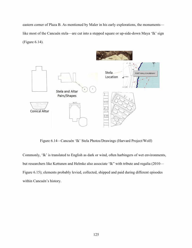
125
eastern corner of Plaza B. As mentioned by Maler in his early explorations, the monuments—
like most of the Cancuén stela—are cut into a stepped square or up-side-down Maya ‘Ik’ sign
(Figure 6.14).
Figure 6.14—Cancuén ‘Ik’ Stela Photos/Drawings (Harvard Project/Wolf)
Commonly, ‘Ik’ is translated to English as dark or wind, often harbingers of wet environments,
but researchers like Kettunen and Helmke also associate ‘Ik” with tribute and regalia (2010—
Figure 6.15); elements probably levied, collected, shipped and paid during different episodes
within Cancuén’s history.

126
Figure 6.15—Various ‘Ik’ Sign Representations
It may also be a reference to dark clouds and winds that cloak rain like regalia. In either case,
water is the stage where these monuments are set. The stela lie on a relatively narrow terrace that
connects the secondary plaza to the main plaza and overlooks the river. This symbolic
promenade is bisected by a relatively steep-sloped cross drainage that empties into the Pasión
below.
At this juncture of these plazas lie two structures that change the natural hydrology and
drainage patterns of Cancuén’s core. Structures L7-28 and M7-8 (Figure 6.16) are built such that
they prevent the escape of water through the natural break in the landscape.
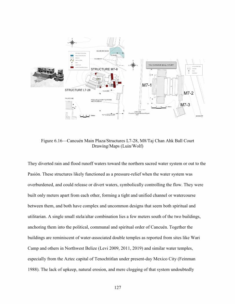
127
Figure 6.16—Cancuén Main Plaza/Structures L7-28, M8/Taj Chan Ahk Ball Court Drawing/Maps (Luin/Wolf)
They diverted rain and flood runoff waters toward the northern sacred water system or out to the
Pasión. These structures likely functioned as a pressure-relief when the water system was
overburdened, and could release or divert waters, symbolically controlling the flow. They were
built only meters apart from each other, forming a tight and unified channel or watercourse
between them, and both have complex and uncommon designs that seem both spiritual and
utilitarian. A single small stela/altar combination lies a few meters south of the two buildings,
anchoring them into the political, communal and spiritual order of Cancuén. Together the
buildings are reminiscent of water-associated double temples as reported from sites like Wari
Camp and others in Northwest Belize (Levi 2009, 2011, 2019) and similar water temples,
especially from the Aztec capital of Tenochtitlan under present-day Mexico City (Feinman
1988). The lack of upkeep, natural erosion, and mere clogging of that system undoubtedly

128
resulted in large flood volumes forcibly pushing through obstacles, deepening the cross drainage
over the time since the site was abandoned. In 2012, excavations were conducted into and around
Structure M7-8 and yielded numerous stucco façade elements displaying aquatic features such as
water lilies and cormorants. In 2014 Structure L7-28 became the target of a large-scale
horizontal excavation detailing an unusual architectural plan that exhibited traits of a hybridized
political, secular, and utilitarian function.
Ports
The largest port at Cancuén—the Main Port of the city—is now (2021) a silt-infilled cove
located at the northeastern corner of the Cancuén core (Figure 6.17).
Figure 6.17—Cancuén Main Port Drawing/Maps (Luin, Alverado/Wolf)
The area would have been able to accommodate numerous watercraft at once, with space for
temporary moorings/slips for vessels not in immediate use, and possibly a dock system (now
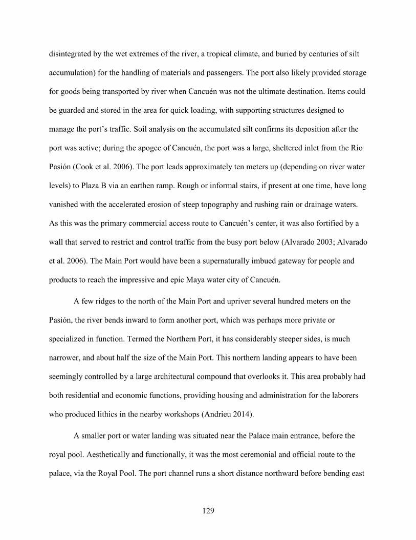
129
disintegrated by the wet extremes of the river, a tropical climate, and buried by centuries of silt
accumulation) for the handling of materials and passengers. The port also likely provided storage
for goods being transported by river when Cancuén was not the ultimate destination. Items could
be guarded and stored in the area for quick loading, with supporting structures designed to
manage the port’s traffic. Soil analysis on the accumulated silt confirms its deposition after the
port was active; during the apogee of Cancuén, the port was a large, sheltered inlet from the Rio
Pasión (Cook et al. 2006). The port leads approximately ten meters up (depending on river water
levels) to Plaza B via an earthen ramp. Rough or informal stairs, if present at one time, have long
vanished with the accelerated erosion of steep topography and rushing rain or drainage waters.
As this was the primary commercial access route to Cancuén’s center, it was also fortified by a
wall that served to restrict and control traffic from the busy port below (Alvarado 2003; Alvarado
et al. 2006). The Main Port would have been a supernaturally imbued gateway for people and
products to reach the impressive and epic Maya water city of Cancuén.
A few ridges to the north of the Main Port and upriver several hundred meters on the
Pasión, the river bends inward to form another port, which was perhaps more private or
specialized in function. Termed the Northern Port, it has considerably steeper sides, is much
narrower, and about half the size of the Main Port. This northern landing appears to have been
seemingly controlled by a large architectural compound that overlooks it. This area probably had
both residential and economic functions, providing housing and administration for the laborers
who produced lithics in the nearby workshops (Andrieu 2014).
A smaller port or water landing was situated near the Palace main entrance, before the
royal pool. Aesthetically and functionally, it was the most ceremonial and official route to the
palace, via the Royal Pool. The port channel runs a short distance northward before bending east

130
to join the Pasión, adding to the sacred symbolism of the landing itself by combining the cultural
importance of the cardinal directions with the physical reality of an east-west passage. The
waterway’s north/south arm points to Cancuén’s supernatural power manifested by the
monumental architecture of the central precinct. The east/west segment highlights the human
element of domestic architecture. It joins the Palace—the ultimate Maya conception of
civilization—to the largest and densest residential settlement within Cancuén. This Palace Port
was the connection—a symbolic umbilical cord—to the Pasión (linking it to the rivers of the
world and tying it to Maya cosmology). The port was probably only active during the height of
the Guatemalan wet season, when Cancuén was most saturated and at its most attractive as a
visitation destination for political and/or other pilgrimage reasons.
Many other river landing areas and portages—both formal and opportunistic in
accordance with shifting water levels and spatial practicalities of where goods were delivered or
extracted—marked the Cancuén peninsula as well (Martinez et al. 2017). Although the Pasión
carves a path northward into the lower regions of the Guatemalan Petén, it frequently and
regularly twists into bows and bends as a sine curve. Each of these curves can represent
considerable effort in transport, impacting success of the pick-up and delivery of cargo and
peoples. An additional variable in effective transport relates to the seasonal strength of the
current and fluctuations in river frontage. Regions of dry land seemingly far from the shore,
flood regularly, providing different river access during specific times of year.
Royal Pool
In 2006, the Cancuén survey team re-examined what previously had been thought to be a
natural sinkhole and modern cattle-trampled depression that flanked the main entrance to the
palace (Figures 6.18 and 6.19).

131
Figure 6.18—Cancuén Royal Pool/Palace Maps (Wolf)
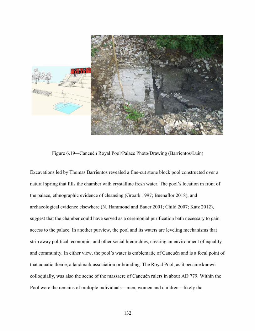
132
Figure 6.19—Cancuén Royal Pool/Palace Photo/Drawing (Barrientos/Luin)
Excavations led by Thomas Barrientos revealed a fine-cut stone block pool constructed over a
natural spring that fills the chamber with crystalline fresh water. The pool’s location in front of
the palace, ethnographic evidence of cleansing (Groark 1997; Buenaflor 2018), and
archaeological evidence elsewhere (N. Hammond and Bauer 2001; Child 2007; Katz 2012),
suggest that the chamber could have served as a ceremonial purification bath necessary to gain
access to the palace. In another purview, the pool and its waters are leveling mechanisms that
strip away political, economic, and other social hierarchies, creating an environment of equality
and community. In either view, the pool’s water is emblematic of Cancuén and is a focal point of
that aquatic theme, a landmark association or branding. The Royal Pool, as it became known
colloquially, was also the scene of the massacre of Cancuén rulers in about AD 779. Within the
Pool were the remains of multiple individuals—men, women and children—likely the

133
inhabitants of the Palace—many marked as nobility by their association with jewelry, inlaid
teeth, well-crafted lithics and other luxury items. Analysis of the skeletal material was conducted
in 2007 by a team of Guatemalan forensic scientists who also analyzed many of the burial
remains from the Guatemalan Civil War (Suasnavar et al. 2007). They hypothesize relatively
merciful deaths of Cancuén nobility that were then thrown into the water, ending the Cancuén
ruling dynasty and again highlighting the role of the Pool and water as symbolic of Cancuén, its
political regime, and the people that make it their home.
I would postulate that the northern sacred water system, the plaza drainage/catchment
system, and the pools are interconnected and form a complex drainage/flow of waters centered
upon the palace, like Johnathan Ruane’s example from the site of Xultun and others from the
Petén (Ruane, 2019). Symbolically the Cancuén Palace is a water mountain from Maya
cosmology (T. Barrientos, 2008). This sacredly charged designation not only adds to the
intangible importance and attraction of the Cancuén settlement in a Maya worldview, but also
becomes a crucial cornerstone of the Cancuén people’s self-identity.
Possible Features
Much of Cancuén’s architecture has been destroyed through a combination of human
action and environmental predation. The developmental history of the area includes mechanical
land modification (i.e., bulldozers), animal grazing (often structures are completely razed to
provide for pasture lands), and sporadic small field, predominantly maize agriculture. Looting
activity has also damaged many Cancuén structures—both for artifacts of perceived value in an
international antiquities trade and for building materials—ancient architecture is an economic
and convenient source of cut stone, fill material and rough boulders. Countless storms and severe
flooding or other natural disasters have washed away and otherwise obscured significant
134
features. The same water ambiance of swampland, rivers, flooding and water-oriented
architecture that defined Cancuén is, unfortunately, one of the strongest factors in its destruction.
The smaller palace-like compound overlooking the Northern Port could have been one of
several similar architectural groups on the high riverbanks north of the site. These structures—
maybe even located at a prescribed distance from one another—likely followed the Pasión
toward Cancuén’s El Achiote settlement node several kilometers upstream from the Cancuén
core. Survey and excavation have revealed continuous occupation from the Cancuén center to at
least as far as the several kilometer limit of the presently known research area. The potential
riverbank architectural compounds would also be secondary and tertiary
community/neighborhood/district nodes. They would include at least a few supporting structures
and retainers, demonstrating the diversity even within Cancuén structure groups. Potentially the
region south of the Palace that holds Cancuén’s densest zone of occupation is only a portion of a
fuller picture.
One of the major routes to the Cancuén area involves a quick perpendicular river crossing
from one side to the other. Depending on the time of year, and thus water conditions, the river
presents about a 10-or-more-meter obstacle to terrestrial travel that must be bridged or ferried
across via small boat. Recalling the work of Oswaldo Chinchilla Mazariegos at Cotzumalguapa
(2018) in southern Guatemala or of Kirk French and associates’ (2007) research at the Mexican
archaeological site of Palenque, bridges were a common feature in Maya structural engineering.
Undoubtedly, Cancuénites spanned the Pasión, most likely with perishable materials (wooden
planks, tree trunks, vines, etc.), and stone or earthen abutments or foundations are possible.
Several locations offer narrow east-west bridging options, the river is notably shallower in these
areas than in others, and the river bottom is seamlessly paved with smooth natural rock.

135
Lost and unrecognized architectural features are especially important in settlement
considerations at an active riverine site like Cancuén. Vibrant commerce and movement often
add to the temporary and more transient nature of both people and goods. Archaeologists easily
identify stone architectural remains or large land modifications and there are probably
innumerable features not documented in the archaeological record. The ephemeral nature of most
construction and structure plans based in low-impact techniques such as pole and thatch
construction leave little to no surface evidence. A quick and easy earthen platform carved out of
the existing terrain can support as much activity as its formal stone counterpart. Cancuén
architecture is replete with examples throughout this spectrum of informal dirt landscape
modification to durable rock construction.
Contemporary Cancuén
The prominence Cancuén enjoyed in the pre-Columbian period continues today. Its
central role to the local and regional fabric of Guatemala and beyond is reflected in the daily
activities of surrounding villages, developmental agencies, governmental organizations,
education institutions, and innumerable international environmental and social scientists. This is
an important issue in Cancuén’s history, detailing the diversity of peoples and projects that the
ancient city inspired and attracted from its inception in pre-Columbian times through today’s era
of modern research, preservation, and into the future of the Guatemalan National Identity.
The Vanderbilt-sponsored Cancuén archaeological work stimulated development in an
ongoing cascade of growth. In the initial years of the Vanderbilt Project, numerous roads were
significantly modified and repaired, and several bridges were constructed. The archaeological
site has become a tourist destination, attracting audiences from around the world. The reworking
of roads and crossings represent a geometric increase in traffic and visitors which beget more

136
peoples in a continuous cycle of growth. Logically this expansion fostered economic prosperity
as well in the form of restaurants, hotels, gas stations, transportation, and numerous other
infrastructure improvements. The Vanderbilt Cancuén Project also initiated development in
several surrounding economically depressed settlements. Church construction, sustainable
agriculture, eco-tourism, potable water systems, the building and stocking of local health clinics,
computer systems in under-funded schools, capacitation of local business and non-profit groups,
as well as the drafting of village development plans are just a few of the ways in which the
Cancuén Archaeological Project has moved beyond archaeology to benefit modern society. The
archaeologists, anthropologists, soil-scientists, biologists, educators, and other researchers give
Cancuén a modern international flair as well. Scientists from the United States, France, Italy,
Australia and elsewhere across the globe collaborate with researchers from throughout Central
America. Several groups of local laborers have been trained and officially incorporated as expert
architectural reconstruction teams, guides, and builders. It is the focus of many local school
curriculums, serving as an important example of environmental curation and the extent and
preservation of cultural patrimony. In recognition of Cancuén’s cultural and national importance,
the governmental agency charged with the protection and maintenance of the Cancuén
Archaeological Park, IDAEH (Instituto de Antropología e Historia), houses several custodians
on site. The Cancuén Palace is also imbued with indigenous spirituality and is often the stage for
modern Maya ritual and pilgrimage—especially from the Coban region (the Verapaz government
seat). From its founding, Cancuén has always been an important symbol for the Maya of the
Verapaz and soon became an important symbol of Guatemalan history inspiring a nationalistic
pride—a powerful self-identification as integral to the fabric and people of modern Guatemala as
well as in Maya times.

137
Regional Picture
Reconnaissance survey and excavation outside of the Cancuén locus is also expanding.
Settlement or other landscape modification within and beyond the Cancuén kingdom is an
important aspect of current research inquiring ‘what was Cancuén’s role within an active
playing-field of sites?’ John Tomasic surveyed and explored many smaller sites within
Cancuén’s immediate southern territory (Demarest et al. 2006)—hamlets and aggregated
architectural compounds like Cerro Bol, Cerro Avelos (Figure 6.20), Cerro Rivera (Figure 6.21),
Cerro Picay, El Cambio (Figure 6.22), El Pato, San Diego, and Finca Alux (Figure 6.23).
Figure 6.20—Cerro Avelos Maps (Wolf)
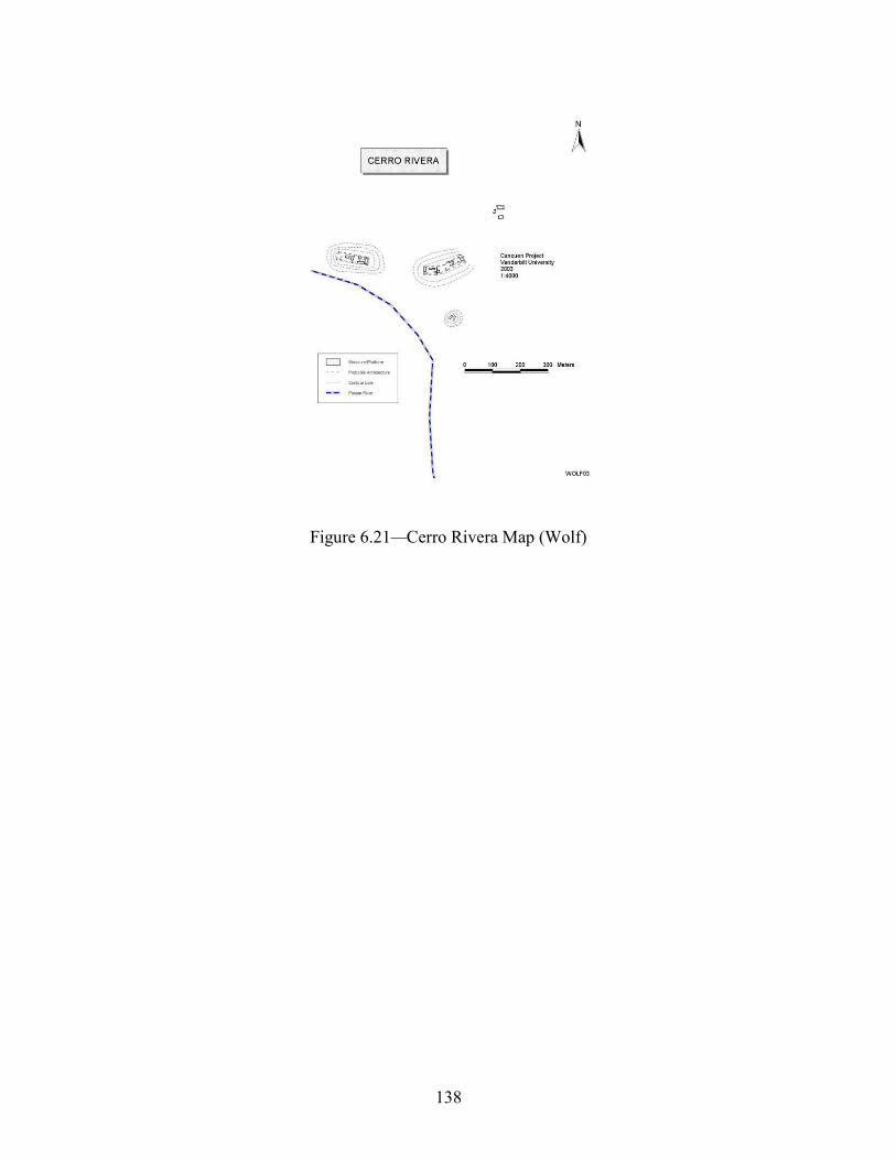
138
Figure 6.21—Cerro Rivera Map (Wolf)

139
Figure 6.22—El Cambio Map (Wolf)

140
Figure 6.23—Finca Alux Map (Wolf)
Some of these smaller structure groups probably were like those that might have occupied the
area prior to Cancuén’s existence. Settlements just outside of the area but still within relatively
close range such as Raxruhá Viejo (O’Mansky 2003—Figure 6.24), Siltzul (Ohnstad 2004—
Figure 6.25), La Lima (Woodfill et al. 2006; Woodfill et al. 2007—Figure 6.26), El Raudal
(Forné et al. 2011; Wolf and Demarest 2009—Figure 6.27), Tres Islas (Barrios and Quintanilla
2007—Figure 6.28), Candelaria Caves (Woodfill 2001), Chisec (Woodfill 2004), Cebol (Wolf
and Cotom 2008—Figure 6.29), Hun Nal Ye (Spenard, 2006; Woodfill et al. 2012), El Guarani
(O’Mansky 2003), Tierras Rojas (Wolf and Demarest 2009—Figure 6.30) and others are
consistently being re-examined and newly relocated sites are registered and added to the
diversity of the region annually (Demarest et al. 2004; Wolf and Bracken 2013a, 2013b).
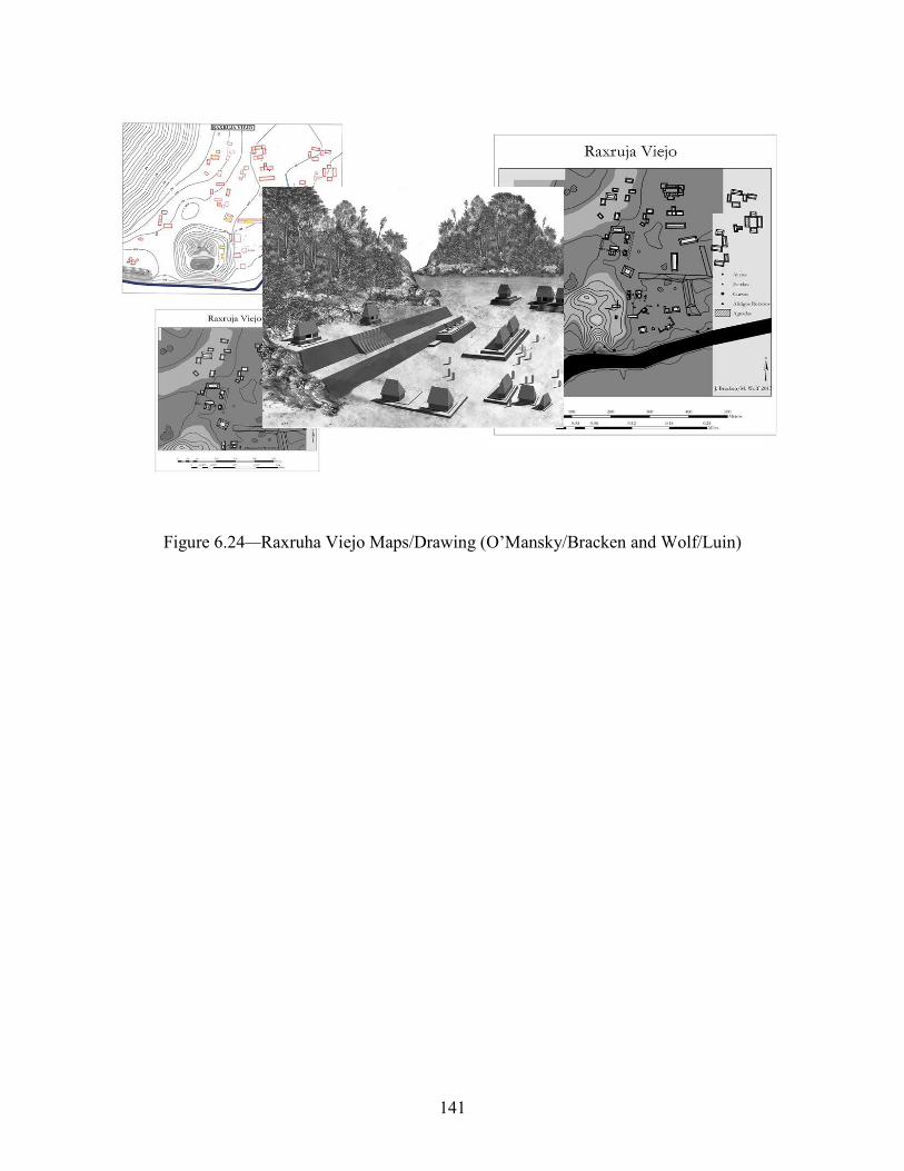
141
Figure 6.24—Raxruha Viejo Maps/Drawing (O’Mansky/Bracken and Wolf/Luin)
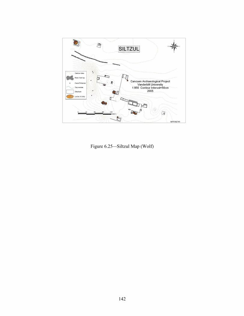
142
Figure 6.25—Siltzul Map (Wolf)

143
Figure 6.26—La Lima Map (Wolf)

144
Figure 6.27—El Raudal Maps (Wolf)
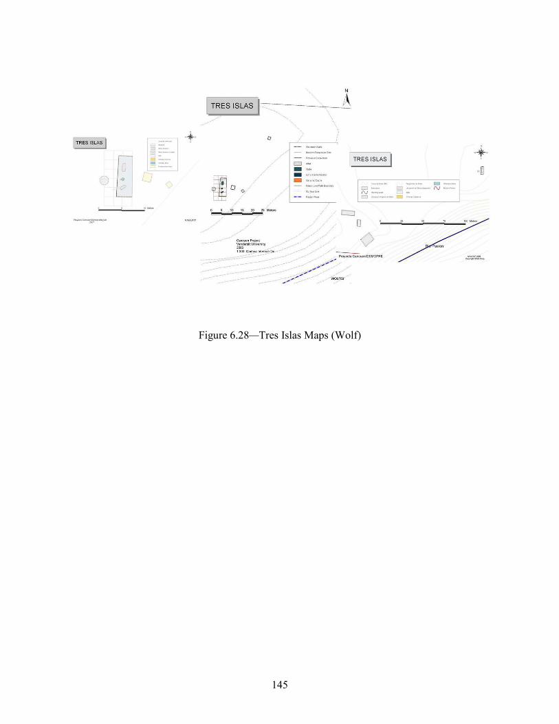
145
Figure 6.28—Tres Islas Maps (Wolf)

146
Figure 6.29—Cebol Maps (Wolf)

147
Figure 6.30—Tierras Rojas Map (Wolf)
Nodes/Networks
In a recent article, Scott Hutson and his team of archaeologists have discussed some of
the ties that bound pre-Columbian Maya sites through the lens of detailed work at the
archaeological site of Chunchucmil in the Mexican Yucatán (Hutson et al. 2016). The site is
distant from Cancuén, yet as Chunchucmil was a primary trader during Cancuén’s dominance
over the Rio Pasión, Hutson and his associates point to a probable connection of the trading
activities between the two sites. The Rio Pasión is the most obvious and dynamic link between
Cancuén and the rest of Central America, touching many trading sites and partners who all exert
influence on their wares. Migration, commerce, visitation, exploration, and chance combined to
make the Pasión River a pipeline of human interaction.
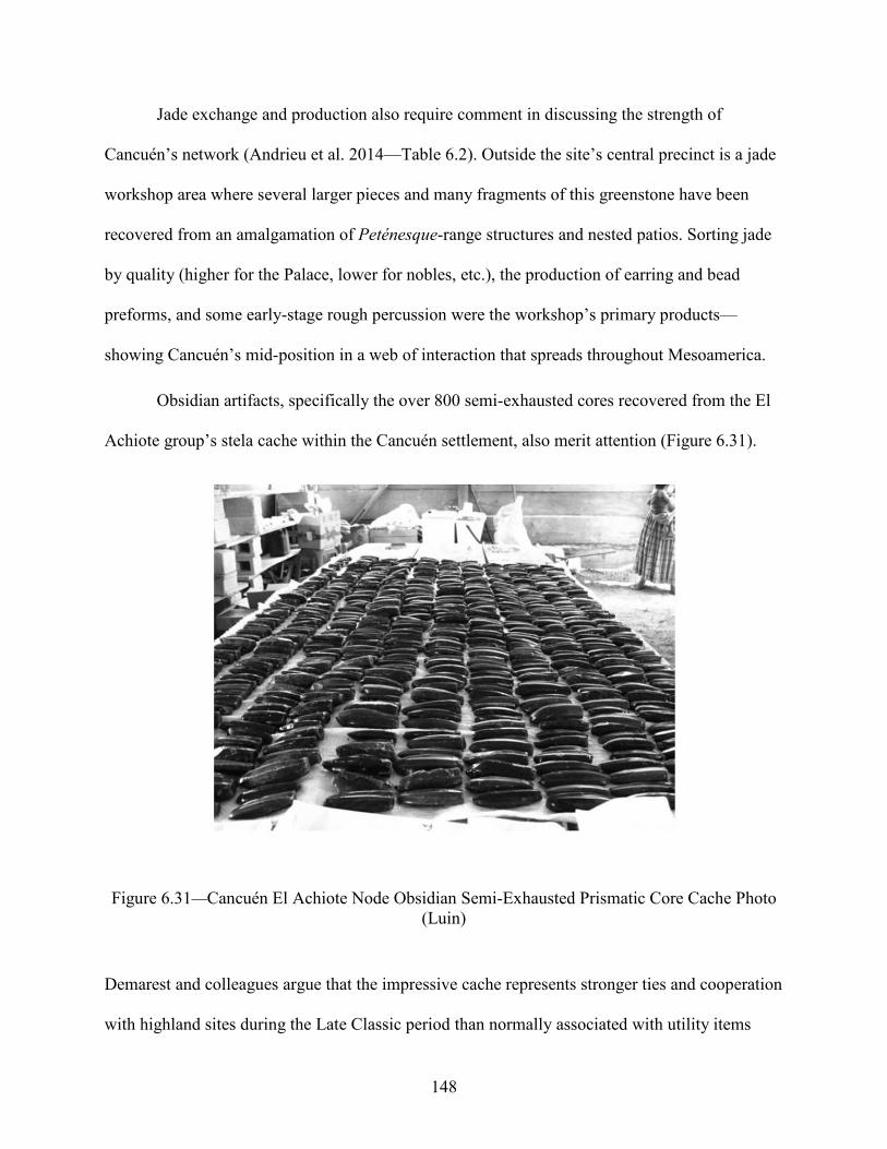
148
Jade exchange and production also require comment in discussing the strength of
Cancuén’s network (Andrieu et al. 2014—Table 6.2). Outside the site’s central precinct is a jade
workshop area where several larger pieces and many fragments of this greenstone have been
recovered from an amalgamation of Peténesque-range structures and nested patios. Sorting jade
by quality (higher for the Palace, lower for nobles, etc.), the production of earring and bead
preforms, and some early-stage rough percussion were the workshop’s primary products—
showing Cancuén’s mid-position in a web of interaction that spreads throughout Mesoamerica.
Obsidian artifacts, specifically the over 800 semi-exhausted cores recovered from the El
Achiote group’s stela cache within the Cancuén settlement, also merit attention (Figure 6.31).
Figure 6.31—Cancuén El Achiote Node Obsidian Semi-Exhausted Prismatic Core Cache Photo (Luin)
Demarest and colleagues argue that the impressive cache represents stronger ties and cooperation
with highland sites during the Late Classic period than normally associated with utility items
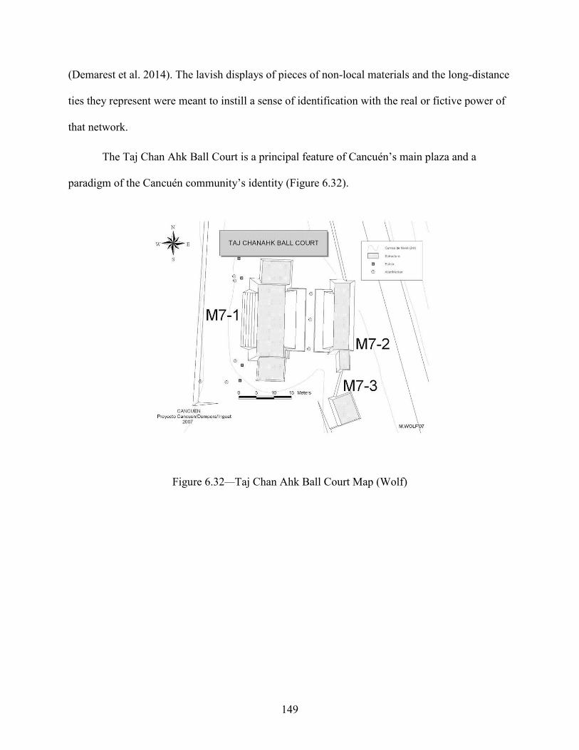
149
(Demarest et al. 2014). The lavish displays of pieces of non-local materials and the long-distance
ties they represent were meant to instill a sense of identification with the real or fictive power of
that network.
The Taj Chan Ahk Ball Court is a principal feature of Cancuén’s main plaza and a
paradigm of the Cancuén community’s identity (Figure 6.32).
Figure 6.32—Taj Chan Ahk Ball Court Map (Wolf)
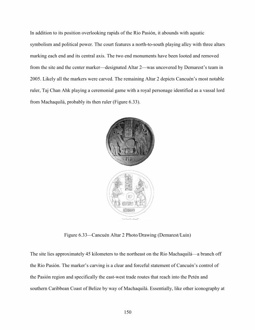
150
In addition to its position overlooking rapids of the Rio Pasión, it abounds with aquatic
symbolism and political power. The court features a north-to-south playing alley with three altars
marking each end and its central axis. The two end monuments have been looted and removed
from the site and the center marker—designated Altar 2—was uncovered by Demarest’s team in
2005. Likely all the markers were carved. The remaining Altar 2 depicts Cancuén’s most notable
ruler, Taj Chan Ahk playing a ceremonial game with a royal personage identified as a vassal lord
from Machaquilá, probably its then ruler (Figure 6.33).
Figure 6.33—Cancuén Altar 2 Photo/Drawing (Demarest/Luin)
The site lies approximately 45 kilometers to the northeast on the Rio Machaquilá—a branch off
the Rio Pasión. The marker’s carving is a clear and forceful statement of Cancuén’s control of
the Pasión region and specifically the east-west trade routes that reach into the Petén and
southern Caribbean Coast of Belize by way of Machaquilá. Essentially, like other iconography at

151
the site, the marker tells all onlookers of Cancuén’s regional political supremacy and wide
networks of contact. The western range of the ball court is integrated into the rear of Structure
M7-5 while the eastern range overlooks the Pasión. The court’s location atop a steep slope would
be impractical for serious athletic competition where the playing ball would inevitably be
repeatedly bumped downslope into the fast flow of the water but ideal to showcase Cancuén’s
royal and communal connection to the sacredly charged river that flows below. Metaphorically,
the eastern range of the ball court was the Pasión River. Additionally, the sacred water context is
heightened by the design of Structure M7-5: the north-south oriented building is faced along its
entire front by several low monumental stairs; steps not of huge stones but joins of thick and flat
lajas or fieldstone-like blocks from the river channel walls. At either end of this stairway lie stela
and altar complexes, further instruments of sacred power. The architecture recalls the long
gallery range structures from Petén and elsewhere in the Maya world, and its interior was the
find spot of Cancuén’s Panel 3. The inscription depicts Taj Chan Ahk as a water lord, carved
larger than his associates and sitting within the typical Maya water-symbolizing quatrefoil
cartouche (Figure 6.34).

152
Figure 6.34—Cancuén Panel 3 Photo/Drawing (Demarest/Luin)
His regalia also identifies him as a water lord and one of the smaller figures is named as a
subordinate noble, reinforcing Taj Chan Ahk’s political dominance in the region and the identity
of Cancuén and its residents as people of water and power.
Cancuén’s highland-style ball court and small palace complex is also worthy of comment
in a discussion of the site’s diverse population. Demarest has noted the ceramic vessels
indicative of a feasting-ball court tradition with Alta Verapaz origins (Demarest et al. 2014). The
ball court was excavated and analyzed by Paola Torres in 2010 and embodies a highland
population within the Cancuén core (Torres 2011).
The production, trade, and use of ceramic figurines were strong traditions in the Verapaz
(Sears and Bishop 2001; Sears et al. 2005; Woodfill and Sears under review—Figure 6.35).

153
Figure 6.35—Verapaz Figurines Photo (Sears)
Cancuén was greatly involved, boasting several workshops of both royal or elite figurines, as
well as those producing figurines of lesser quality (Sears 2016). Cancuén was also
unquestionably one of the three most important mercantile centers in the region, joined by the
archaeological sites of Salinas de las Nueve Cerros on the powerful Chixoy River, and Chama,
which lies north of the modern settlement of San Pedro Carcha and was well-positioned to
control the area’s largest and most active over-land routes from the Highlands to Lowlands
(Woodfill and Andrieu 2012; Demarest 2006; Demarest et al. 2014). The figurines indicate a
connection that Cancuén shared with many of the sites on Guatemala’s Coban Plateau, within a
regional network across the Verapaz, and identification with a localized custom that has parallels
in all of Central America.

154
Originally, fine orange and fine grey ceramics found at Cancuén were thought to reveal
links to archaeological sites like Palenque and Tonina in Mexico, some of the largest producers
and consumers of these wares. Sites along the Usumacinta River and around the drainages of the
Gulf Coast of Mexico—particularly in the Veracruz and Tabasco Regions—also detail fine paste
ceramic influences during the last stages of the Late Classic or Terminal Classic periods (Forné
et al. 2010). However, it is now recognized that fine paste ceramics were often locally made,
highlighting forms and technology that originated in western Mexico. At the same time, the later
neutron activation dating and sourcing studies conducted by Ronald Bishop of the Smithsonian
Institute in Washington show that though this imitation might be common, the Cancuén samples
are indeed from these distant regions of Mexico (Bishop et al. 2009, 2021). In either case, this
mimicked or real association with these foreign agents expands the Cancuén identity.
Secondary and Allied Centers
On the other side of the river from Cancuén, the archaeological site of Raxruha Viejo lies
approximately 12 kilometers to the east. Aside from its spatial proximity, Raxruha Viejo exhibits
several similarities with and undeniable signs of emulation of Cancuén. It is one the largest
settlements immediately outside of the Cancuén nucleus, and Raxruha is also perched astride a
large riverine network surrounding the San Simon waterway. Its ceramic assemblage boasts
many typical Verapaz figurines, identical to those from Cancuén. The most ubiquitous markers
of site connection are the conical altars from each site (O’Mansky et al. 2014). Those from
Raxruha Viejo are smaller than their Cancuén counterparts but share a form distinct in the Maya
world. Work in 2017 was augmented by new GPS survey data and GIS cartography (Andrieu et
al. 2017; Wolf and Bracken 2017b). The major central platform of Raxruha Viejo seems to be
modeled in several aspects after the form of Structure 6 aside Cancuén’s main palace. A

155
relatively simple but elongated, sloping talud frames an important elevated central courtyard at
Cancuén (Sionet et al. 2017), where a similarly unadorned talud rises steeply from the Raxruha
Viejo main plaza towards an elevated courtyard atop the site’s central and largest karst tower.
Both architectural formations likely reflect Central Mexican flair and were perhaps designed
with the aid of foreigners to the Verapaz region.
Tres Islas, another archaeological site mentioned in this text, references the Cancuén
emblem glyph. As mentioned earlier, the site seemed to have functioned primarily as a remote
outpost or marker of trade on that stretch of the Pasión River—akin to a modern billboard
proclaiming the importance of Cancuén (Tomasic et al. 2004).
Approximately 20 kilometers downstream (north) on the Pasión—on the banks of the
east-west running Machaquilá River—the archaeological site of Machaquilá (Garcia-Gallo 2011;
Martinez et al. 2017) is also noteworthy for its many ties to Cancuén. In addition to a ceramic
assemblage that often mirrors that of Cancuén, there were important political connections
between the sites. Machaquilá partially functioned as a median point for Cancuén trade into the
south-eastern regions of the Maya lowlands via the rivers. This trade link was especially
important in what Demarest and associates call Taj Chan Ahk’s “Great Detour” avoiding the
turmoil and violently shifting alliances associated with the lower Pasión routes. While traditional
economic powerhouse sites of Petén and Usumacinta regions fought and maneuvered, Cancuén
traders used routes beyond the fray, maintaining strong ties with cultural groups from western
Mexico through lower eastern Petén and the lower Caribbean. The close relationship between
Cancuén and Machaquilá is best illustrated by the impressive central ball court marker (Altar 2)
discussed before.
156
To the west, with a northern border of Mexico, on the wide Salinas and Chixoy Rivers,
the Guatemalan archaeological site of Salinas de las Nueve Cerros (Woodfill et al. 2010, 2013,
2015) also shared ties to Cancuén. Salinas was one of the three economic hubs of the Verapaz
region (Woodfill, personal communication, 2019) and assuredly had contact with Cancuén
through trade connections. Salt was one of the most precious commodities in Mesoamerica and
Nueve Cerros represented one of only a few inland extraction sites. Salt’s importance touches
upon several cannons of Maya culture: its almost supernatural dualistic corrosive and
preservational power, an incredibly important and heavily traded economic commodity, a highly
demanded flavoring additive to meals, and a necessity for life in a tropical climate that wicks
needed salt minerals from the body. These lines of thought show the crucial position salt held in
Maya society and the inevitability of the linkage between Cancuén and Nueve Cerros.
Associations are also seen in material culture such as the Salinas-specific salt bowls present at
Cancuén or the Cancuén paste ceramic figurines recovered from Nueve Cerros.
The major archaeological site of Dos Pilas was another network partner of the Cancuén
polity. The Late Classic downturn of influence and activity by the then superpower state of
Calakmul not only created a vacuum filled with a resurgence and independence of many
archaeological sites previously thought to be under Calakmul’s control, but more deeply altered
the geopolitical stage throughout Mesoamerica. Because of its location, Dos Pilas was able to
parley itself into differing Petén-regional political positions, but always under the mantle of a
larger state such as Tikal or Calakmul. With Calakmul’s waning sway in the Maya area came a
new set of alliances like that of Cancuén and Dos Pilas. This union’s strength was reinforced by
the marriage of a Cancuén princess—The lady of Cancuén—and Ruler 3 of Dos Pilas. The
Princess became a powerful figure at Dos Pilas, having her own palace constructed in the Dos
157
Pilas site core by a team of masons brought from Cancuén (Demarest, 2006). Dos Pilas was one
of the major gateways from Petén into the eastern parts of the continent via the immense
Usumacinta River. It was in large part the respective control over vast trade networks—the
Pasión River in the case of Cancuén and the Usumacinta for Dos Pilas—that drove the
cooperation.
Chapter Conclusion
Cancuén architecture is an amalgamation of forms and styles with examples of building
construction and design from highland Guatemala and Mexico, Petén, the Petexbatun region, and
western Mexico (Tabasco/Veracruz). Added to these variations are a hybrid local and Mexican
influenced Calakmul settlement system and layout. It was a city whose name was synonymous
with the river, trade, and a cosmopolitanism of contacts outside the Maya region, shaping the
self-identity of Cancuén residents.
Many of the Cancuén’s structures evoke a water ethos, and cascade—pardon the pun—
into a hierophany of aquatic sacred symbolism. Buildings are decorated with water motifs, the
sculptures that they house repeat this message, and they are usually associated with major water
features.
The Cancuén data has been scrutinized by experts in their respective fields, who bring an
interdisciplinary diversity and assurance of high quality and depth to their work. The breadth and
accuracy of Cancuén’s natural and cultural history revealed by the scholars working at the site
has played an enormous role in how it is valued in the modern Guatemalan national identity.

158
CHAPTER 7/METHODS AND DATA
Discussion
Though academic dissertations have traditionally eschewed the more technical, mundane
and list-driven discussion of equipment and basic technique, this work will show-case the means
of data-acquisition. Most of the methodology used in this dissertation revolves around gathering
data, drafting, and analyzing maps. From 2001 to 2016 Cancuén-based or affiliated
archaeological projects provided the scientific background on which the settlement of Cancuén
and surrounding regions was founded. Far from complete, a partial list of scientists and a word
about a few of their contributions follows:
Arthur A. Demarest (Director) Andres Cifuentes (Cultural Anthropology/Ethnography) Brent Woodfill (La Lima, Chisec, Candelaria Caves, Salinas de las Nueve Cerros) Casandra Bill (Ceramics) Chloé Andrieu (Lithics, Raxruhá Viejo) Claudia Arriaza (Lab) Claudia Quintanilla (Co-Director) David Garcia (Cultural Anthropology/Capacitation, Modern Anthropology) David Rafael McCormack (East Transect) Duncan Cook (Geomorphology) Edy Barrios (Western Cancuén) Erin Sears (Figurines) Eric Ohnstad (Siltzul) Frederico Fhasen (Iconography, Epigraphy) Fernando Jose Luis Luin (Co-Director/Illustrator/Reconsolidation/Photographer) Fidel Tuyuk (East Transect) Horacio Martinez (Co-director) Julio Lopez (IDEAH/Archaeological Consultation/Legal) Jeremy Bauer (Cancuén Defenses) John Tomasic (Western Cancuén) Julio Cotom (Sebol, Lab) John Spenard (Hunal Ye Caves) Justin Bracken (East Transect, GIS) Juan F. Saravia (Western Cancuén) Marc Wolf (Cartography, Survey, GIS) Mario Del Cid (Modern Anthropology, Tourism, Capacitation) Melanie Forné (Ceramics) Matt O’Mansky (Raxruhá Viejo, Sebol)

159
Miriam Saravia Co-Director) Nick Dunning (Geomorphology) Paola Torres (Director) Ron Bishop (Ceramics Neutron Activation Analysis) Rudi Larios (Reconsolidation/Reconstruction) Thomas J. Barrientos (Co-Director) Walesqua Belches (Northern Cancuén)
Thus, the architectural designations assigned in this work are based in a deep knowledge
and excellent chronology of Cancuén and its neighbors. In the same light, scientifically vigorous
AND ethical data collection (capturing the best positions is not nearly as simple, comfortable, or
easy as it may seem) is as intricate a task as any supposed ‘higher-level’ analysis. The
archaeologist is not simply a technician operating a machine, but ideally a versed expert
interpreter of what the data they are gathering represents. In this study, much of the data comes
in the form of points—architectural features such as corners or building heights. These points
can also be representative of the natural setting of drainages, rivers, swamplands, and other
geography.
As a side note—mulling personal experience—the archaeological community’s raison
d’etre is to recreate past lifeways. Every scientific line of exploration is designed with the hopes
of furthering this understanding of the past. Many of the concepts and technologies of both older
and more traditional avenues of research as well as modern schemes and equipment are used
here. Whether by horseback, on foot, by raft—with GPS or EDM or Tape-and-Compass—data is
recorded and manipulated within complex models and through exhaustive mathematical
formulas. Such information is presented with a Verapaz or Cancuén perspective. Additionally,
this investigation uses the latest computer applications, and ultimately this numerical and visual
work is translated into meaningful cultural behavior that informs the archaeologist about the
patterns and contrasts within architectural data. The behavioral and cultural aspects behind that

160
settlement data however, is often overlooked by large-scale mapping and survey that have
become the cap stone of many research paradigms (D. and A. Chase 1984; Estrada-Belli 2000;
Canuto and T. Barrientos 2008; Garrison 2019; Canuto et al. 2018; Richards-Rissetto and
Landau 2014). As previously discussed, there are basic conceptions of general Maya building
types such as range or palace, or other monumental forms; for example, triadic platforms of
archaeological sites like Nakbe, El Mirador, or Calakmul on the northern frontier of Mexico and
Guatemala (Folan 2001; Hansen 1990), and twin pyramid complexes from Tikal (Ashmore 1992;
Coe 1988; Coggins 1979). In his seminal study of house patterns at Tikal, Marshal Becker
categorizes several of these building arrangements in his work on plaza plan formations (1973,
1983—Figure 7.1).
Figure 7.1—Tikal Plaza Plan Maps (Becker)
His characterizations are applicable throughout the Maya architectural world and suggest
a broad Central Petén cultural influence. However, there are myriad of variations on his schemes,

161
reflecting local diversities of differing landscapes and cultural priorities within Maya tradition.
Importantly, Becker’s Tikal-focused designations and other scientifically known architectural
complexes are not just representations of grandeur, but also serve as models of construction and
symbolic ideology for all peoples with whom they interact. Orientation, building height,
accessibility, open space, view, and natural setting are just a few architectural features that are
mimicked in the planning and construction of less-than-monumental buildings—the means to
erect Tikal’s giant Twin Pyramid Complexes (Becker 1971, 1973) were not available to all, but
the cardinal directionality or quadripartite organization of space was. Excavation data—
chronologies and artifact assemblages—are optimally available to the surveyor to corroborate
their initial surface inspection, but this is a rarity. Most often archaeological surveyors work
under the subconscious assumption of cultural homogeneity from center to periphery and with an
idealized generality of plaza layouts that are more or less the same from the core area outward.
Using Geographic Information Systems (GIS)
Geographic Information Systems—the computer analysis and modelling software often
known only as the abbreviated ‘GIS’—should ideally form the core of all resource management
projects. It provides the best and most stable digital platform, and in this modern era of daily
advances in technology, data should be gathered with the anticipation of GIS integration.
Interoperability is one of the many strengths of GIS. One can import most data, computerized
database storage files, spreadsheets, and image files, as well as proprietary web features like
Google’s KMZ structure. Importantly, GIS accurately displays the disparate information in
unison. With new file compatibility continually being developed and incorporated into basic GIS
software packages, like LIDAR tiles (light imaging and ranging/side radar), GPR (ground
penetrating radar), and other resonance mapping, GIS becomes more versatile on a daily basis.

162
Questions are relatively simple upon initiation, becoming more complex after each stage
of GIS analysis. The precise compilation of differing data forming the foundation of GIS’s
spatial power is the first step in a process of recognizing trends and patterning. New contexts are
discovered in an ongoing sequence of testing limited only by the time and efforts of the GIS
analyst. For the work presented here, the context is the natural and built landscape supporting the
cultural remains of structures and other modifications. Perhaps the most important aspect of this
contextualization is the hydrology and topography underlying Maya settlement which in turn
describes the social norms and cultural/spatial proclivities of the ancient populations that lived in
those locales.
Aside from informative tools that the GIS features, the system is a visual catalog of an
archeological site’s data. Clusters of points may be taken with a transit/TS (total station), stored
as mere numbers devoid of human meaning. Similarly, GNSS locations (global navigational
satellite systems like the American GPS network) are also an important data source. Aerial
photography can be added to the GIS as are satellite images, road maps, census and
developmental information, hydrological maps, political and administrative boundaries, and a
host of other documented or remotely sensed data. Depending on availability and other logistics,
several instruments are routinely used together (perhaps due to multiple survey crews, instrument
breakage, upgrade, or other maintenance), storing their data in different formats. GIS allows for
seamless and exact integration of these various data gathering methodologies.
This concern for environmental and human interaction underlying architectural
parameters is best displayed and modeled using GIS techniques. The most well-conceived and
efficient data collection scheme does not guarantee meaningful results. It is the human condition
represented by the surviving material culture, landscape modification and construction, that

163
forms the crux of archaeological inquiry. In a continually changing understanding of culture, GIS
is a stable foundation from which to develop deeper questions of social affiliations, identity, and
spirituality. The archaeologist’s job is to interpret the ‘hard’ scientific aspects of GIS data and
other sterile seeming metrics into the ‘soft’ realm of past behavior. The GIS allows ordinary
numbers to be correlated with human activity.
Over several years of data accumulation, field teams worked to produce several drawings
of the architecture within each site. These products were in different CAD (computer aided
design) and bitmap formats—geo-tagged to local or arbitrary coordinates, unfortunately
sometimes without a larger spatial reference. Archaeological resource mapping works under the
guises of many scientific fields—each with their own methodology and forms of record keeping.
GIS data from governmental agencies was and continues to be adapted to a uniform
‘Cancuén/Verapaz’ style. Not only is it important to note the various technologies that record
data, but also that there are dissimilarities in the size and scale of that data—with a macro view
of the globe or focused on the miniscule without orientation. As research progresses at each site,
illustrations by current and future archaeologists are added to the data set. Excavators produce
plan drawings or stylized miniature maps, which provide a level of detail not usually available
without intrusive investigations/excavations. Other scientists record soil and sampling data.
Subsequent studies build on these original blocks in an additive process of research that
continues today. The work discussed here uses the GIS to store data and contextualize new
findings that increase archaeological understanding of the relation between center and
hinterlands.
164
Cartography
The maps in this dissertation were integrated with new data recorded in a universal
coordinate system as opposed to the many relative grids that were often used before. The ‘new’
system was far from novel but represented the need to better locate the sites in terms of regional
and world-wide archaeology and positioning—using a standard grid and set of mapping
conventions for all the settlements. Applying globally accepted standards of geo-positioning and
reference, the maps were adjusted to uniformly adhere to conventional UTM (Universal Trans
Mercator) positions and drawing specifications. The foundation of GIS potency lies in its ability
to simultaneously display data with different native data structures.
Most mapping used in here was conducted using both a high precision GPS and digital
theodolite. Raw data was combined with other available information sources to form the footing
of the architectural GIS model outlined above. This work presents a clear example of the
humanizing steps of GIS analysis, digesting sheer numerical point data into an understanding of
cultural settlement patterns and then into individual self-conceptions. GIS supplies the means to
link mathematically coded attributes while providing insight into the people behind the data.
Architectural compounds are prime examples of feature construction within GIS. Points,
lines, and polygons can be intuitively drafted from point data. These drawings are meshed with
the other relevant images—assuring accuracy through redundancy of the same data presented in
different methods. Again, bare numbers are transformed into representations of previous
lifeways.
A complete discussion of GIS capabilities would be voluminous; however, deserving of
particular mention in recreating landscapes, one of the most useful GIS operations are those
generating detailed land surfaces. Through Kriging or other interpolation programs applied to
165
simple point-data, the GIS models the aspect, directionality, and topographic relief behind
human settlement. This environmental contextualization is a necessary first stage in
understanding cultural differences in building strategies.
Another crucial aspect of GIS is its ability to grow with the development of older
technologies and unforeseen new advances in archeological techniques. Statistical software
packages like R or SPSS, geographically weighted regressions, archaeological site prediction,
LiDAR refinement, and ground penetrating radar plots are some of examples that stock the
actively expanding GIS toolbox. The anticipation of future tools and outputs are logical
opportunities in geographic information systems and their unlimited potential in the
archaeological world.
Data
Before the data can be presented, a brief mention must be made of the many different
survey strategies employed over the years of the project. In 2004, the archaeological information
acquisition process was initiated and laid the foundations for research decades later. A paper map
of Cancuén was given to the project and from this an Autocad file drawing was generated. This
became the starting foundation of intensive archaeological and natural resource mapping and
survey.
The following sections give verbal context, definition and interpretation of the
architectural compounds that are the units of measure for this dissertation’s quantitative analysis.
Structure compounds and related architectural groups or land modifications, provide multiple
sets of specifications for individual features and buildings as well as those of the complex taken
as a whole. As mentioned throughout this dissertation, the remains of ancient Maya
architecture—drafted, recorded, and interpreted—are the units of this study. Point locational

166
data, weather taken manually via GPS or EDM, or remotely by means of remote sensing, are
often interpreted from otherwise vacant farmland, cattle range, or nature conservation areas.
Lines are simply two points and polygons are simply a combination of lines, the basis for all GIS
procedures, from plotting to the generation of Least Cost Pathways (LCP) and other raster-like
digital ground surfaces or simulations. Once the land modifications such as architecture or
drainages have been modeled with the surrounding terrain and landscape, the model can be
refined with the numbers behind the structure groups, specifically at Cancuén.
The measurements or calculation of these values provide the data for 32 groups at
Cancuén, investigated statistically (n=32), an approximately 72% coverage of identified structure
groups (excluding many concentrations of specialty architecture as in The Palace or Taj Chan
Ahk Ball Court). A multitude of dimensions were recorded: orientation, length, width, height,
perimeter, area, and volume were calculated for each individual structure (Table 7.1). These
values were then totaled and averaged, giving numeric framework to the entire group as well as
its constituent buildings.
Table 7.1—Listing of Variables Collected from the Individual Buildings within 32 Cancuén Architectural Groups (DD.DD=decimal degrees, M=meters)
Orientation (DD.DD)
Length (M)
Width (M)
Height (M)
Perimeter (M)
Area (M2)
Volume (M3)
The architectural compounds, or groups were then analyzed as 32 integrated units.
Geostatistical centroids were calculated and compared in every example. Level and platform
changes were tallied, areas were calculated, and distances between landscape and architectural
features measured were among a suite of other metrics generated. Table 7.2 details the variables
collected:
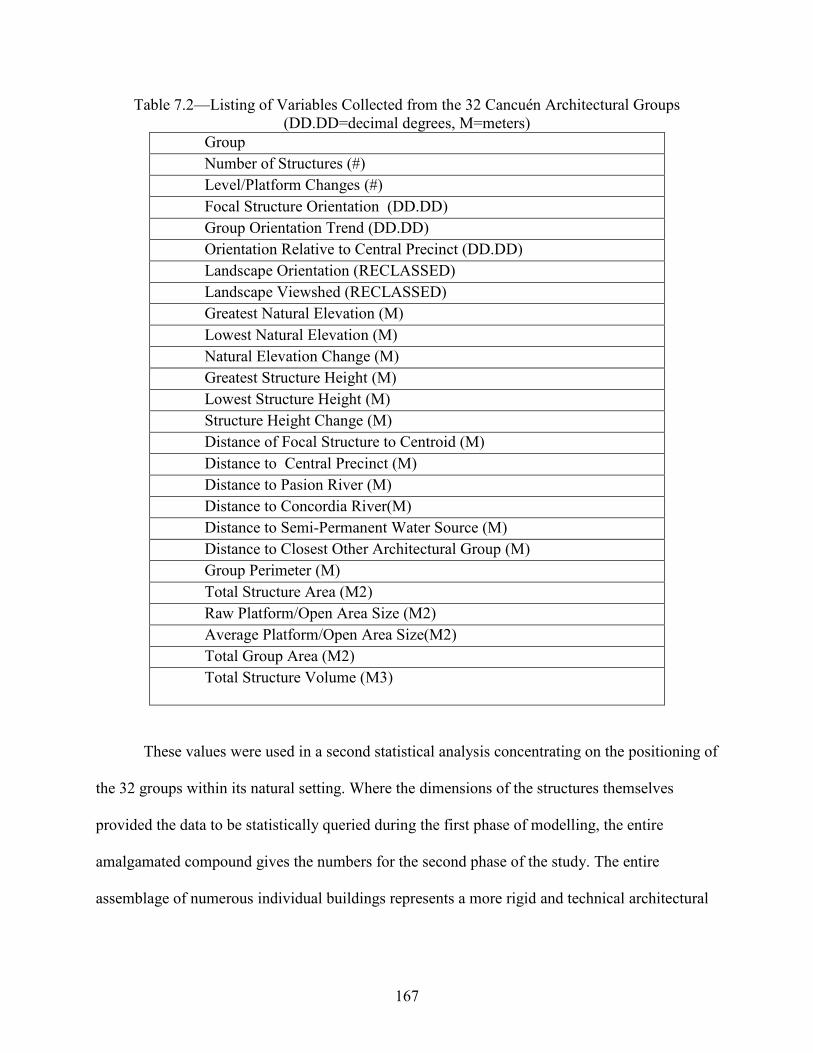
167
Table 7.2—Listing of Variables Collected from the 32 Cancuén Architectural Groups (DD.DD=decimal degrees, M=meters)
Group Number of Structures (#) Level/Platform Changes (#) Focal Structure Orientation (DD.DD) Group Orientation Trend (DD.DD) Orientation Relative to Central Precinct (DD.DD) Landscape Orientation (RECLASSED) Landscape Viewshed (RECLASSED) Greatest Natural Elevation (M) Lowest Natural Elevation (M) Natural Elevation Change (M) Greatest Structure Height (M) Lowest Structure Height (M) Structure Height Change (M) Distance of Focal Structure to Centroid (M) Distance to Central Precinct (M) Distance to Pasion River (M) Distance to Concordia River(M) Distance to Semi-Permanent Water Source (M) Distance to Closest Other Architectural Group (M) Group Perimeter (M) Total Structure Area (M2) Raw Platform/Open Area Size (M2) Average Platform/Open Area Size(M2) Total Group Area (M2) Total Structure Volume (M3)
These values were used in a second statistical analysis concentrating on the positioning of
the 32 groups within its natural setting. Where the dimensions of the structures themselves
provided the data to be statistically queried during the first phase of modelling, the entire
amalgamated compound gives the numbers for the second phase of the study. The entire
assemblage of numerous individual buildings represents a more rigid and technical architectural

168
component of human utility and practicality versus the assembled group specifications which are
more based in the surrounding landscape.
After these preliminary statistics were studied, a third phase of the modelling culminated
in a recoding of several variables (accompanied by a reclassification operation within the GIS).
New attributes were assigned to the data as well. “Group/Site Function” describes an economic
reflection, categorizing the 32 group as simply commercial or not, based mainly in
plaza/courtyard open potential activity space, proximity to the two large rivers in the area,
excavated data, and patterning revealed by modelling the two together. “Group Affiliation” was
based in similar attributes, but focused more on compound layout, architectural features such as
stairways or monuments, and artifact distributions such as the ceramic “Fine” wares or obsidian
caches discussed in Chapter 6. Table 7.3 shows each group with its designation by function,
affiliation, and social spectrum. “Social Spectrum” variables reflect a combination of
monumental architectural features, proximity to Cancuén’s Central Precinct, and the overall
sprawl of each group. “Landscape Orientation” and “Landscape Viewshed” are attributes created
as a means of quantifying or standardizing more aesthetic data, relying upon a vista of natural or
humanly constructed landscape features like grand palatial architecture or powerful rivers. Data
codes for these variables are in Table 7.4. These newer attributes or statistical classes were
displayed visually on a newly created DEM (digital elevation model) within ArcMap GIS. These
outputs of various categories, overlaid upon the standard prismatic architectural and other
cartographic representations of earlier Cancuén maps, are depicted in Figures7.2-7.3.
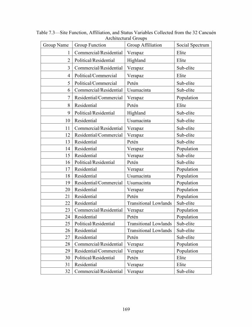
169
Table 7.3—Site Function, Affiliation, and Status Variables Collected from the 32 Cancuén Architectural Groups
Group Name Group Function Group Affiliation Social Spectrum 1 Commercial/Residential Verapaz Elite 2 Political/Residential Highland Elite 3 Commercial/Residential Verapaz Sub-elite 4 Political/Commercial Verapaz Elite 5 Political/Commercial Petén Sub-elite 6 Commercial/Residential Usumacinta Sub-elite 7 Residential/Commercial Verapaz Population 8 Residential Petén Elite 9 Political/Residential Highland Sub-elite
10 Residential Usumacinta Sub-elite 11 Commercial/Residential Verapaz Sub-elite 12 Residential/Commercial Verapaz Sub-elite 13 Residential Petén Sub-elite 14 Residential Verapaz Population 15 Residential Verapaz Sub-elite 16 Political/Residential Petén Sub-elite 17 Residential Verapaz Population 18 Residential Usumacinta Population 19 Residential/Commercial Usumacinta Population 20 Residential Verapaz Population 21 Residential Petén Population 22 Residential Transitional Lowlands Sub-elite 23 Commercial/Residential Verapaz Population 24 Residential Petén Population 25 Political/Residential Transitional Lowlands Sub-elite 26 Residential Transitional Lowlands Sub-elite 27 Residential Petén Sub-elite 28 Commercial/Residential Verapaz Population 29 Residential/Commercial Verapaz Population 30 Political/Residential Petén Elite 31 Residential Verapaz Elite 32 Commercial/Residential Verapaz Sub-elite

170
Table 7.4—Data Codes for Group Function, Affiliation, and Status Characterizations, Landscape Positioning, Viewshed Variables Collected from the 32 Cancuén Architectural Groups
FUNCTION
Political/Residential 1 Political/Commercial 2 Commercial/Residential 3 Residential/Commercial 4 Residential 5 AFFILIATION
Verapaz 1 Highland 2 Petén 3 Usumacinta 4 Transitional Lowlands 5 SOCIAL SPECTRUM
Royal 1 Elite 2 Sub-Elite 3 Population 4 General 5 LANDSCAPE ORIENTATION: COMPASS HEADING North 1 North East 2 East 3 South East 4 South East 5 South West 6 West 7 North West 8 POSTION FOR LANDSCAPE VIEWSHIED Toward Cancuén Central Precinct 1 Toward Rio/Cancuén Central Precinct 2 Toward Rio 3 Toward Rio/Candelaria Caves 4 Toward Candelaria Caves 5 Toward Rio/San Francisco Hills 6 Toward San Francisco Hills 7 Toward Rio/Away from Cancuén Central Precinct 8 Away from Cancuén Central Precinct 9

171
Group 1
Group 1 (Figure 7.2) lies a few terraces below and directly south of the Cancuén Palace
and Central Precinct.
Figure 7.2—Group 1 Map (Wolf)
Excavated in the early 2000s by teams lead by Erin Sears and Lucia Luca, the group was
functionally thought to be a kitchen servicing the royalty and functions of the Palace. Excavation
revealed a rather voluminous architectural complex with numerous structures and several
platform/level changes. Representative of a local Verapaz association and designation in this
dissertation, is the uncovering and analysis (Sears 2015) of several locally produced figurines—
possibly assembled/crafted at Cancuén. Architecturally, Group 1 also has more affinities with
other Verapaz sites like Siltzul, La Lima, Raxruhá Viejo, Salinas de los Neve Cerros and others
172
Verapaz sites mentioned in this text. Open areas—courtyards, activity areas, and plazas—of
Verapaz archaeological sites are usually defined by small structure groupings as opposed to the
spatial integrity of well-defined basal platforms or by the purposeful placement of monuments
that shape architectural configurations elsewhere like in Petén.
Verapaz archaeological settlements discussed here are also more integrated into the
landscape, using elevation changes and terrain features such as structure walls and platform
edges to further delineate architectural compounds; Group 1 utilizes the topography of the ridge
it occupies to create the architectural unity of several smaller groupings into a single grouping.
Group 2
Group 2 (Figure 7.3) is colloquially named the Volcan group as its main structure
suffered intensive looting of its vaulted main room (s), hollowing the structure and littering the
edges of its superstructure with piles of excavated earth.

173
Figure 7.3—Group 2 Map (Wolf)
It sits outside and to the north of the Cancuén Central Precinct on one of the largest rises on the
peninsula (Demarest and Barrientos 2001). Group 2 has been investigated by numerous
Vanderbilt team members at several times throughout the Cancuén archaeological work
culminating in reconsolidation efforts by Rudy Larios of its principal structure. This larger
building was the focus of a formal small plaza group as well as several scattered platforms and
structures that belong together in a unified group occupying one of the highest natural ridges on
the Cancuén peninsula.

174
Group 3
Group 3 (Figure 7.4) sits outside and north of the Cancuén epicenter. It lies downslope—
to the west—of Group 11; both are workshop areas of lithic production.
Figure 7.4—Group 3 Map (Wolf)
Group 3 likely functioned as a subsidiary working area for Group 11, perhaps as a staging area
for goods finalized above in Group 11.

175
Group 4
Group 4 (Figure 7.5) is also colloquially known as the Volcancito group as, like Group 2,
its main structure suffered intensive looting of its vaulted superstructure.
Figure 7.5—Group 4 Map (Wolf)
Like the main structure of Group 2, the Volcancito building was consolidated and somewhat
restored by Rudy Larios in early years of the Vanderbilt work. It lies north-west of the Cancuén
main plazas, on a ridge overlooking one of the larger swampy regions that defines the Cancuén
peninsula. The Group’s extended (but narrow) plazas suggest a workshop complex as one of the
groups functions. Its positioning at the north-western edge of the Cancuén settlement, above a
major inundated landform also promote the notion that it served a security function as well,
limiting western access to the rest of the site.

176
Group 5
Informally known as the Patos complex, Group 5 (Figure 7.6) also lies on the western
edge of the Cancuén settlement.
Figure 7.6—Group 5 Map (Wolf)
Like several of the previously discussed architectural compounds, its focal structure was vaulted
and consolidated by Rudy Larios in the early stages of the Cancuén project. The group occupied
one of the lower natural terraces that sloped into the same swampy landform which Group 4
overlooked, but was more integrated with the landscape, perhaps taking advantage of the
surrounding swampy resources as opposed to the sentry-like affectations of Group 4. Much of
the water runoff from the north-west portion of Cancuén’s core also converged directly off the
southern side of the Patos shared platform (attracting the waterfowl that lend the group its
informal name), giving the group additional aquatic associations.

177
Group 6
Group 6 (Figure 7.7) is made up of several interconnected platforms north and west of the
Cancuén center.
Figure 7.7—Group 6 Map (Wolf)
The platforms cascade downward toward the lowland in front of the ridge leading up to Group 4.
Their open designs hug the natural down-trending terrain and are indicative of workshop or other
commercial enterprises.

178
Group7
Group 7 (Figure 7.8), constructed outside and to the north of the Cancuén Central
Precinct, consists of several plaza areas connected via a shared low ridge.
Figure 7.8—Group 7 Map (Wolf)
It lies just east of Group 5, and likely aided in the control of access to several fresh-water springs
that flow westward. The group sits higher than Group 5 and bookends this water system between
the two architectural compounds.
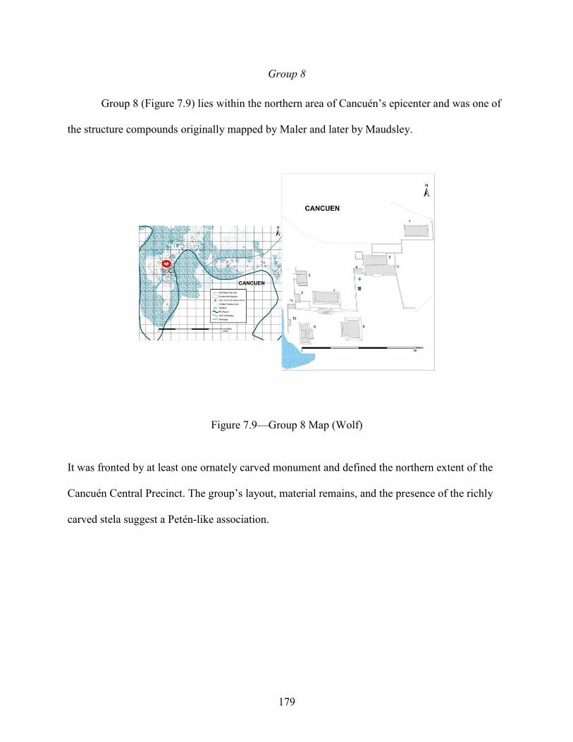
179
Group 8
Group 8 (Figure 7.9) lies within the northern area of Cancuén’s epicenter and was one of
the structure compounds originally mapped by Maler and later by Maudsley.
Figure 7.9—Group 8 Map (Wolf)
It was fronted by at least one ornately carved monument and defined the northern extent of the
Cancuén Central Precinct. The group’s layout, material remains, and the presence of the richly
carved stela suggest a Petén-like association.
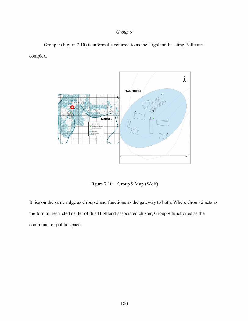
180
Group 9
Group 9 (Figure 7.10) is informally referred to as the Highland Feasting Ballcourt
complex.
Figure 7.10—Group 9 Map (Wolf)
It lies on the same ridge as Group 2 and functions as the gateway to both. Where Group 2 acts as
the formal, restricted center of this Highland-associated cluster, Group 9 functioned as the
communal or public space.

181
Group10
Group 10 (Figure 7.11) lies on one of the larger elevated hilltops on the opposite side of
the Rio Pasión.
Figure 7.11—Group 10 Map (Wolf)
It rises from the often-flooded topography outside and north of the Cancuén epicenter. The
organization of the group suggests a local Verapaz association of structures unified by common
topography without shared formal platforms.

182
Group 11
Group 11 (Figure 7.12) has become known in the Maya archaeological world as the
Cancuén jade workshop.
Figure 7.12—Group 11 Map (Wolf)
Undoubtedly a workshop where jade was worked and from which numerous fragments (and a
single, fist-sized coble of raw jade) of this green-stone material were collected, it is unclear if
this was the main function of the structure complex. It lies on the mid-slope of several downward
cascading terraces north and outside the Cancuén Central Precinct. Due to the uncertainty of the
group’s function and potential economic and sacred importance to the Cancuén polity, it has
undergone several intensive excavation regimes that have destroyed most of the group’s
architecture leaving behind scattered back-fill piles and the outline of only a few of its main
structures.

183
Group 12
Group 12, also dubbed the Northern Port Palace (Figure 7.13), is perched above an
auxiliary port of the Rio Pasión—meters north of Cancuén’s main port.
Figure 7.13—Group 12 Map (Wolf)
It was a multi-function architectural compound (as most Maya complexes are). It was excellently
positioned to oversee the workings of the port below, but also served as a workshop area on its
western side as it mirrors the down-trending landscape with several connected plazas.
Group 13
Group 13 (Figure 7.14) lies on the edge of a curving ridge above the Rio Pasión
straddling both the same auxiliary port of the Rio Pasión as does Group 13 to the north and the
Cancuén main port.
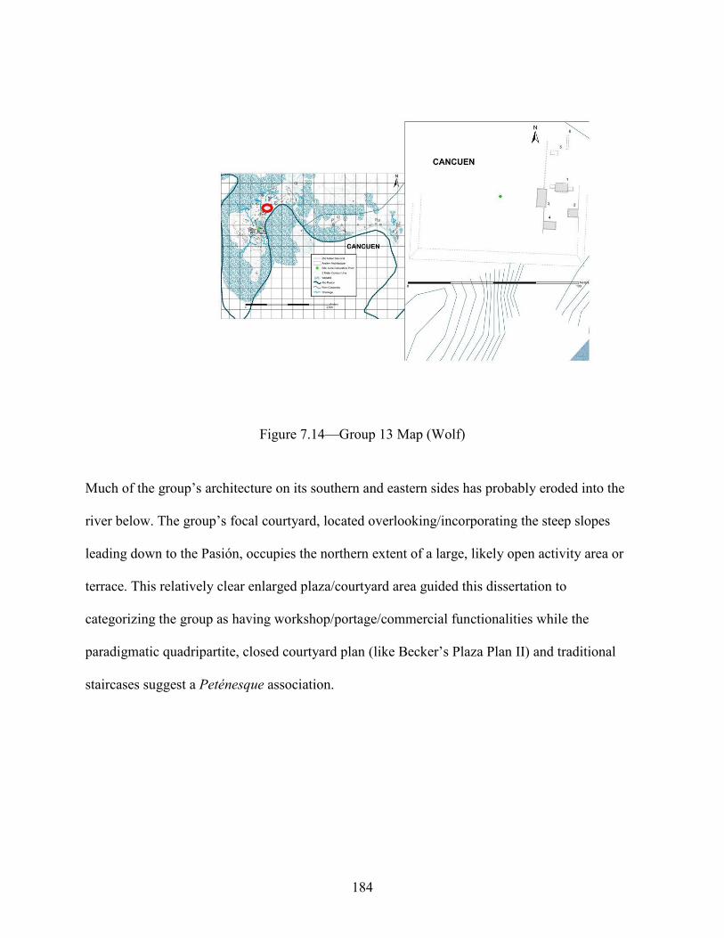
184
Figure 7.14—Group 13 Map (Wolf)
Much of the group’s architecture on its southern and eastern sides has probably eroded into the
river below. The group’s focal courtyard, located overlooking/incorporating the steep slopes
leading down to the Pasión, occupies the northern extent of a large, likely open activity area or
terrace. This relatively clear enlarged plaza/courtyard area guided this dissertation to
categorizing the group as having workshop/portage/commercial functionalities while the
paradigmatic quadripartite, closed courtyard plan (like Becker’s Plaza Plan II) and traditional
staircases suggest a Peténesque association.

185
Group 14
Lying on a low rise to the southern periphery of the Cancuen epicenter, Group 14 uses
the nuances of the surrounding topography to define its multiple terraces (Figure 7.15).
Figure 7.15—Group 14 Map (Wolf)
These open areas and reliance on the elevation shifts of the natural terrain to define the extent of
the group, as opposed to formal masonry terracing, are exemplary of Verapaz association. The
terraces are suggestive of a commercial designation.
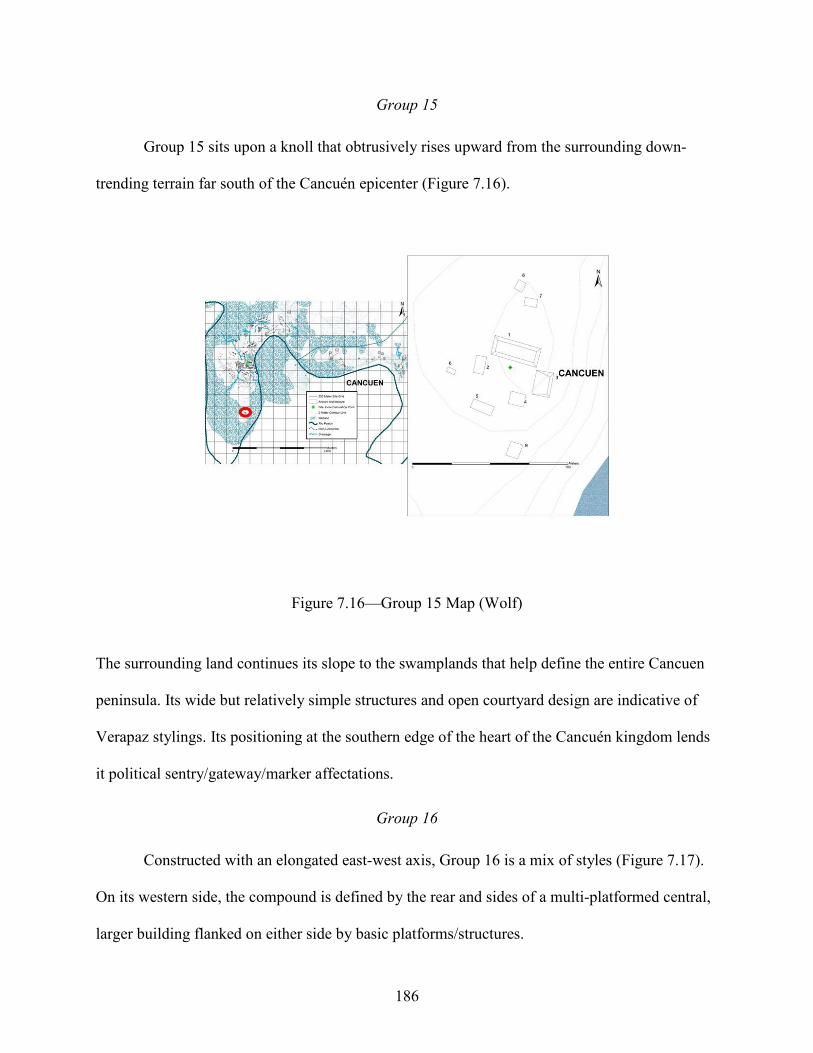
186
Group 15
Group 15 sits upon a knoll that obtrusively rises upward from the surrounding down-
trending terrain far south of the Cancuén epicenter (Figure 7.16).
Figure 7.16—Group 15 Map (Wolf)
The surrounding land continues its slope to the swamplands that help define the entire Cancuen
peninsula. Its wide but relatively simple structures and open courtyard design are indicative of
Verapaz stylings. Its positioning at the southern edge of the heart of the Cancuén kingdom lends
it political sentry/gateway/marker affectations.
Group 16
Constructed with an elongated east-west axis, Group 16 is a mix of styles (Figure 7.17).
On its western side, the compound is defined by the rear and sides of a multi-platformed central,
larger building flanked on either side by basic platforms/structures.

187
Figure 7.17—Group 16 Map (Wolf)
The entire platform likely extended several meters more toward the east, precariously perched
upon the very upper edge of the deep slope toward the river but has been washed down by
gravity and erosion. The western edge of the group suggests a typical Petén-like structure/plaza
plan that becomes increasingly non-Petén-like and open towards its eastern side.

188
Group 17
Like Group 15, Group 17 (Figure 7.18) also occupies a small but the only rise in the
surrounding topography.
Figure 7.18—Group 17 Map (Wolf)
It is similarly relatively far from the Cancuén Central Precinct, lying eastward across the Rio
Pasión. Instead of the “outpost/boundary marker” aesthetic of Group 15, there is more of a local
supervisory feel to Group 17. The terrain is a heavy mix of silt and loam from the muddy banks
of the river and the crosscutting of hundreds of small gullies and channels. Likely this was prime
agricultural land dependent on the flood and ebb of the Rio Pasión. The area is perfectly suited
for agriculture and Group 17 is well positioned to function as a temporary storage area and
central logistics facility. The layout of the group is more miss-aligned (different orientations)

189
than a traditional Petén or Tikal pattern and relies on the hillock’s natural elevation changes
rather than cohesive terraces or platform/plaza lines to create a unified architectural cluster.
Group 18
Group 18 lies at the southern edge of most of the Cancuén settlement outside site center
(Figure 7.19).
Figure 7.19—Group 18 Map (Wolf)
Comprised of several structures and at least two natural terraces, the group occupies the southern
extent of several large platforms and terraces that descend from the Cancuén Central Precinct.
Group 18 appears to be an amalgamation of several lowland styles as evidenced by formal
courtyard group (western side) immediately backed by a relatively sporadic placement of
buildings. A Highland or local ethic is also suggested for Group 18 by the incorporation of the
ridge’s eastern slope into the design of the second courtyard.

190
Group 19
Group 19 occupies the western edge of a vast depression that slopes relatively gently
down to the Rio Pasión (Figure 7.20).
Figure 7.20—Group 19 Map (Wolf)
The group’s focal courtyard is a rectilinear arrangement of several small structures flanking a
central stone staired building sharing a platform that rises with the natural topography toward a
larger structure and its own defined courtyard. Outside this architectural cluster lie several
unaligned buildings that mark the edges of a large, possibly commercial, activity area.
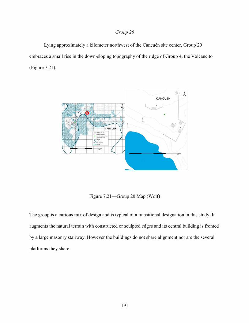
191
Group 20
Lying approximately a kilometer northwest of the Cancuén site center, Group 20
embraces a small rise in the down-sloping topography of the ridge of Group 4, the Volcancito
(Figure 7.21).
Figure 7.21—Group 20 Map (Wolf)
The group is a curious mix of design and is typical of a transitional designation in this study. It
augments the natural terrain with constructed or sculpted edges and its central building is fronted
by a large masonry stairway. However the buildings do not share alignment nor are the several
platforms they share.

192
Group 21
Group 21 is a fragmented arrangement of structures and terrace edges (Figure 7.22).
Figure 7.22—Group 21 Map (Wolf)
It lies at the northeast corner of the same ridge system as Group 20 and the Volcancito Group
and overlooks the Rio Pasión. Group 21’s multiple and relatively large platforms and few
internal clusters of architecture within the group suggest a possible commercial and likely public
oriented functionality—perhaps associated with another port/portage well north (slightly less
than a kilometer) of the main Cancuén settlement.
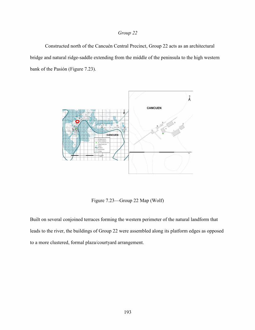
193
Group 22
Constructed north of the Cancuén Central Precinct, Group 22 acts as an architectural
bridge and natural ridge-saddle extending from the middle of the peninsula to the high western
bank of the Pasión (Figure 7.23).
Figure 7.23—Group 22 Map (Wolf)
Built on several conjoined terraces forming the western perimeter of the natural landform that
leads to the river, the buildings of Group 22 were assembled along its platform edges as opposed
to a more clustered, formal plaza/courtyard arrangement.

194
Group 23
Continuing northward, Group 23 (Figure 7.24) is another mixing of architectural design,
combining relatively large platform/activity areas and a smaller, informal cluster of a few
buildings.
Figure 7.24—Group 23 Map (Wolf)
Group 23 is situated atop the same terrace as Group 22 and overlooks the Pasión. The
arrangement of structures, several wide platforms, and preliminary excavation data combine to
suggest a Transitional Lowlands association with economic overtones.

195
Group 24
Group 24 lies north of Group 23, further upstream on the steep banks of the Rio Pasión
(Figure 7.25).
Figure 7.25—Group 24 Map (Wolf)
To its east lies a large morass of swamp vegetation and bajo that demarcates modern property
lines that create a gap in the Cancuén architecture and archaeological record. Its artifact
assemblage and the plan of the group’s courtyards and buildings give it Peténesque
characteristics that are residential and sub-elite in nature.

196
Group 25
Group 25(Figure 7.26) is one of the largest formal courtyard complexes that follows the
archaeological settlement gap after Group 24.
Figure 7.26—Group 25 Map (Wolf)
Five structures are orderly arranged toward approximate cardinal directions, sharing a single
elevated basal platform. It lies between the Pasión and the Concordia River, about 500 meters
equidistant to both. Its monumental architecture, probable grand staircases, orderly and unified
design lend the group Political as well as residential associations and both a Petén and
Transitional Lowlands aesthetic.

197
Group 26
Group 26 (Figure 7.27) is a formal ‘squared’ courtyard positioned just meters northwest
of Group 25.
Figure 7.27—Group 26 Map (Wolf)
Two longer, rectangular structures stand perpendicular to a smaller but higher central building
that faces roughly west, toward the Concordia River (meters away) and the San Francisco
Hills/Caves complex on the horizon. The groups share a well-defined basal platform that is
flanked by the structures but remains open on its fourth side. Group 26’s proximity to both
Group 25 and the Concordia, as well as architectural design, viewshed, and associated material
culture point to a Transitional Lowlands, sub-elite and residential association.
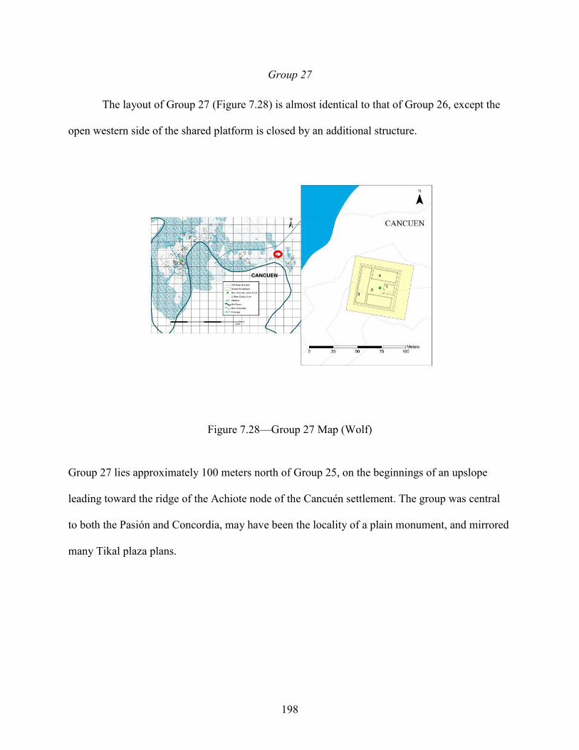
198
Group 27
The layout of Group 27 (Figure 7.28) is almost identical to that of Group 26, except the
open western side of the shared platform is closed by an additional structure.
Figure 7.28—Group 27 Map (Wolf)
Group 27 lies approximately 100 meters north of Group 25, on the beginnings of an upslope
leading toward the ridge of the Achiote node of the Cancuén settlement. The group was central
to both the Pasión and Concordia, may have been the locality of a plain monument, and mirrored
many Tikal plaza plans.

199
Group 28
Occupying the same general landform as Group 25, Group 28 (Figure 7.29) is
constructed on the mid-slope of a lower, eastern terrace that overlooks the Rio Pasión.
Figure 7.29—Group 28 Map (Wolf)
The group’s shared ridge and unifying architectural platforms create a distinction of east and
western sides of the complex, with one side (west) being a more random cluster of structures
verses the more rectilinear design of the east. The large plaza/activity area between the two
building clusters, the proximity of Group 28 to the river, and spatial similarities with Group 1
point to economic and Verapaz affinities.

200
Group 29
Group 29 (Figure 7.30) is a modest assemblage of several platforms and structures
constructed on the edge of solid ground that outlines the marshland surrounding the river.
Figure 7.30—Group 29 Map (Wolf)
The entire area would have been prime river portage with low riverbanks and relatively gentle
relief of several square meters before rising sharply toward Groups 30, 31, and 32 of Cancuén’s
Achiote settlement satellite.

201
Group 30
Group 30 (Figure 7.31) rises on the highest ridge at the center of the Achiote settlement
node of the Cancuén architectural assemblage.
Figure 7.31—Group 30 Map (Wolf)
It is fronted by an immense uncarved stela, consists of at least three nested courtyards and a
grand plaza/activity area perched on high banks of the Rio Pasión. The cache of more than 800
depleted obsidian prismatic blade cores was unearthed beneath the monument that marks the
central elevated courtyard. The group is easily visible from far up- or down- river and probably
served as a sort of beacon for travelers approaching Cancuén from the north.

202
Group 31
Group 31 (Figure 7.32), meters northeast of Group 30, also overlooks the Rio Pasión,
following its contours of the ridge and river as it curves north easterly.
Figure 7.32—Group 31 Map (Wolf)
The group is primarily a cluster of structures arranged around a slightly elevated courtyard
centered on a staired structure oriented to Group 30 and the Cancuén Central Precinct beyond.
Extending eastward toward the river is a long narrow plaza/activity area defined north-south by
architectural terrace edges and a single building on the eastern side. The group’s small structural
cluster centered on the relatively large open platform area, proximity to both Group 30 and the
river, as well as spatial and material similarities to other architecture in the Cancuén settlement
are indicative of local Verapaz associations.

203
Group 32
Reminiscent of the specialty workshop groups outside the northern fringes of Cancuén’s
center, Group 32 (Figure 7.33) is an amalgam of at least seven platform levels and nine or more
structures.
Figure 7.33—Group 32 Map (Wolf)
Structures and platforms are aligned to three different orientations, and the entire group is close
to the Pasión and Concordia Rivers as well as several nearby drainages. Group 32’s rectilinear
but randomly connected courtyards, its spatial relationship with several water sources, and the
group’s layout strong resemblances of other architectural compounds within the Cancuén
assemblage point to a Verapaz association.

204
Architectural Statistics
Analysis of Variance and Covariance (ANOVA)
Analysis of Variance (ANOVA) is a F-test that compares variances among means of n (in
this case 32 groups) samples to pooled variance within the samples (F=s2bg/s2
w). Basically, the F
statistic is a calculation of division of the between-group variation (s2bg) by the within-group
variation (s2w). Any F value that is significantly larger than 1 would suggest that there is a
statistically significant difference between group means or averages. One of the basic
assumptions of a standard one-way Fisher’s ANOVA includes homogeneity of variance in the
sample groups (i.e., that the variance around the mean of one group is like that of other groups).
Within many archaeological datasets—like the Cancuén architectural assemblage—there are
differences in size, quality, and structure of the sample a, such as the 32 Cancuén architectural
groups. Differences in materials, preservation, and recording combine with spatial and cultural
relationships to potentially skew patterns. The Levene’s test (yielding the statistic W) is a check
on the degree of homogeneity necessary for a traditional ANOVA. When this assumption was
shown to be violated with a significant Levene’s test (W), an adjusted Welch’s ANOVA F-test
was conducted. As expected, Levene’s test (W) did identify heterogeneity in the variances
between groups for some variables, supporting the use a more conservative Welch’s ANOVA.
All F statistics are reported, with adjusted results indicated by an asterisk (*) in data tables. Prior
to any test, data were also evaluated for linearity, independence in data, and normality (the three
fundamental ANOVA assumptions) using Bartlett’s test. Results for the size and the landscape
data, as well as with the social factors defined previously, are shown below. A significant F test
(<p=0.05) indicates that a statistically meaningful difference exists between groups based on size
or landscape variables. For example, the first ANOVA reported (Table 7.5) demonstrates that

205
there are significant differences of the size factors across the 32 groups in this study. Such
significance allows for the interpretation of the social and cultural factors marking the
environment.
Table 7.5—ANOVA results of 32 Cancuén Architectural Groups Based on Size Data (values in bold are significant at p<0.05 level/* indicates a Welch’s F test)
Variable Levene’s (W)
p F df p
Perimeter 3.234 <0.001 5.389* 31 <0.001 Area 5.640 <0.001 4.576* 31 <0.001 Length 2.941 <0.001 5.167* 31 <0.001 Volume 5.287 <0.001 5.466* 31 <0.001 Width 4.800 <0.001 12.67* 31 <0.001 Orientation 1.313 0.134 1.565* 31 0.065 Height 4.625 <0.001 19.864* 31 <0.001
Once particular size factors were defined as significant, the social data were evaluated
across the group types based on affiliation, status, and function. Group function was significant
across all size measures apart from orientation (Table 7.6), highlighting the validity of this
designation/variable and Cancuén’s architectural variety as a politically, sacredly, and
commercial important port city.
Group affiliation is only significant with height (Table 7.7) however, group status was
not significant with any size measure (Table 7.8). In sum, 2 dependent variables, area, and
height, proved to be significantly related to their cultural affiliation designation. This
mathematical supports the different Lowland/Midland/Highland associations and identification
of the Cancuén architectural groups, specifically in terms of vertical or horizontal volume.
Affiliation was also examined using the landscape data and there were no strong correlations.
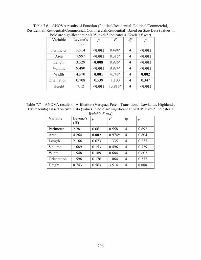
206
Table 7.6—ANOVA results of Function (Political/Residential, Political/Commercial, Residential, Residential/Commercial, Commercial/Residential) Based on Size Data (values in
bold are significant at p<0.05 level/* indicates a Welch’s F test) Variable Levene’s
(W) p F df p
Perimeter 5.514 <0.001 8.494* 4 <0.001 Area 7.997 <0.001 8.315* 4 <0.001
Length 3.529 0.008 8.926* 4 <0.001 Volume 9.480 <0.001 9.924* 4 <0.001 Width 4.570 0.001 4.748* 4 0.002
Orientation 0.708 0.539 1.100 4 0.347 Height 7.12 <0.001 13.818* 4 <0.001
Table 7.7—ANOVA results of Affiliation (Verapaz, Petén, Transitional Lowlands, Highlands, Usumacinta) Based on Size Data (values in bold are significant at p<0.05 level/* indicates a
Welch’s F test) Variable Levene’s
(W) p F df p
Perimeter 2.281 0.061 0.558 4 0.693 Area 4.264 0.002 0.974* 4 0.804 Length 2.166 0.073 1.335 4 0.257 Volume 1.689 0.153 0.496 4 0.739 Width 1.548 0.189 0.684 4 0.603 Orientation 1.596 0.176 1.064 4 0.375 Height 0.743 0.563 3.514 4 0.008
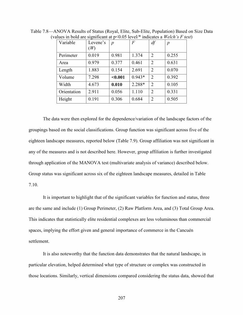
207
Table 7.8—ANOVA Results of Status (Royal, Elite, Sub-Elite, Population) Based on Size Data (values in bold are significant at p<0.05 level/* indicates a Welch’s F test)
Variable Levene’s (W)
p F df p
Perimeter 0.019 0.981 1.374 2 0.255 Area 0.979 0.377 0.461 2 0.631 Length 1.883 0.154 2.691 2 0.070 Volume 7.298 <0.001 0.943* 2 0.392 Width 4.673 0.010 2.288* 2 0.105 Orientation 2.911 0.056 1.110 2 0.331 Height 0.191 0.306 0.684 2 0.505
The data were then explored for the dependence/variation of the landscape factors of the
groupings based on the social classifications. Group function was significant across five of the
eighteen landscape measures, reported below (Table 7.9). Group affiliation was not significant in
any of the measures and is not described here. However, group affiliation is further investigated
through application of the MANOVA test (multivariate analysis of variance) described below.
Group status was significant across six of the eighteen landscape measures, detailed in Table
7.10.
It is important to highlight that of the significant variables for function and status, three
are the same and include (1) Group Perimeter, (2) Raw Platform Area, and (3) Total Group Area.
This indicates that statistically elite residential complexes are less voluminous than commercial
spaces, implying the effort given and general importance of commerce in the Cancuén
settlement.
It is also noteworthy that the function data demonstrates that the natural landscape, in
particular elevation, helped determined what type of structure or complex was constructed in
those locations. Similarly, vertical dimensions compared considering the status data, showed that

208
it was the built environment—structure height and height change—that marks a change in status,
coupled with the amount of average open platform space. This is likely related to the size
variance of public versus elite gathering or potential ‘audience’ space. The findings also suggest
a cultural building affinity towards the height dimension, where peoples from and associations
with regions of greater or lower elevations are reflected in architectural design.
Table 7.9—ANOVA Results of Function Based on Landscape Data (only significant variables reported/values in bold are significant at p<0.05 level/* indicates a Welch’s F test)
Variable Levene’s
(W)
p F df p
Greatest Natural Elevation 1.386 0.265 4.921 4 0.004
Lowest Natural Elevation 1.358 0.275 4.42 4 0.007
Group Perimeter 2.297 0.087 4.046 4 0.011
Raw Platform Open Area 3.216 0.067 5.990* 4 0.001
Total Group Area 2.479 0.068 5.527 4 0.002
Table 7.10—ANOVA Results of Status Based on Landscape Data (only significant variables reported/values in bold are significant at p<0.05 level/* indicates a Welch’s F test) Variable Levene’s
(W) p F df p
Greatest Structure Height 1.636 0.212 3.584 2 0.040 Structure Height Change 1.019 0.374 5.667 2 0.008 Group Perimeter 0.659 0.525 7.699 2 0.002 Raw Platform Open Area 4.284 0.023 11.883* 2 0.072 Average Platform Open Area 3.524 0.043 11.322* 2 0.090 Total Group Area 4.965 0.014 11.742* 2 0.073

209
Multiple Analysis of Variance and Covariance (MANOVA)
MANOVA is like ANOVA in that it is an analysis of variance but can detect differences
between independent groups based on more than one dependent variable. While the ANOVA
was able to evaluate variance between groups on size, status, affiliation, or function one at a
time, the MANOVA shows variance between the groups based on a combination of factors,
discerning the nature of differences between architectural groups.
The results of the MANOVA and multivariate post-hoc tests are reported in Table 7.11.
Pillai’s trace (part of the standard MANOVA regiment, measuring the statistical impact of
explanatory variables on the values of the response variables), is the most robust of the F
statistics. Values range from 0 to 1 and increasing values indicate that effects have contributed to
the observed model. Wilk’s Ʌ is only slightly less statistically robust than Pillai’s and values
range from 0 to 1. Unlike Pillai’s, decreasing values indicate that the effects have contributed
more to the differences between the groups. Size differences between the groups are statistically
significant as they relate to other groups and to the social factors of affiliation, status, and
function.
Table 7.11—MANOVA Results for Group-to-Group Comparison from Size and Cultural Data Multivariate Test Value F Hypothesis df Error df p Pillai’s Trace 0.928 4.412 60 1446 <0.001 Wilk’s Ʌ 0.326 4.934 60 1241.53 <0.001
In addition to the basic MANOVA test, covariance matrices were created (1) to compare
all groups to each other based on each of the eight size variables, (2) to compare the function
types of each group to each other based on each of the eight size variables, (3) to compare the
affiliation types of each group to each other based on each of the eight size variables, and (4) to

210
compare the status types of each group to each other based on each of the eight size variables.
The results of these matrices demonstrate significant differences between the groups, functions,
affiliations, and statuses of the groups. Significant relationships are discussed below (F, p
values<0.05).
To better contextualize the MANOVA results the averages for the size (Table 7.12) and
landscape data variables are presented (Tables 7.13-7.15) below. In sum, statistically significant
numeric details emerged for function, affiliation, and social spectrum.
In regards to structure group Function as related to size variables, political and residential
oriented commercial structure groups (Functions 2 and 4) have similar lengths, heights,
perimeters and areas and are smaller in these dimensions than primarily residential groups
(Functions 1 and 5). Delving further into these metrics, the purely residentially focused structure
groups (Function 5) have the greatest volume (M3) of the entire architectural assemblage in
contrast to the aforementioned politically and residentially focused commercial compounds
which have the smallest volumes. All commercially operating structure groups (Functions 2, 3,
and 4) are always smaller than their residentially centered counterparts, showing the importance
of the numerous people laboring in Cancuén’s robust commerce. It is also probably indicative of
the communal aspect of the settlement’s activity and value within Mesoamerican networks.
In the calculations of size and affiliation variables, Transitional Lowland (Affiliation 5)
designated structure groups have the greatest area (M2) of all the Cancuén architectural groups,
indicating a cultural preference from those areas of lower yet expansive architectural
compounds. As expected, Highland (Affiliation 2) related groups display the greatest height,
probably reflecting the higher elevations associated with uplands. These groups also exhibit the
smallest structure width and length, reinforcing the height to base volume of steep slopes that are

211
often seen in mountainous regions. Verapaz, Usumacinta, and Petén (Affiliations 1, 3, and 4)
related architectural groups display similar areas, lengths, widths, and perimeters, detailing the
geographical and cultural connections of these regions.
In Status categories compared with the size variables, Elite structures (Social Spectrum
Code 2) have the largest length, perimeter, and area values. They share similar length ratios with
Sub-elite classifications (Social Spectrum Code 3), but are significantly smaller than general
Population structures (Social Spectrum Code 4). These Population groups have the greatest
volumes and the largest average of combined structure height; though not as numerous as the
Sub-elite classified architectural groups, they provide housing for larger numbers of individuals.
These computations also detail the role of commerce and movement within the Cancuén area;
showing the large number of sub-elite supervision necessary to organize and control the lower
social strata that perform the myriad of tasks that accompany a busy commercial center.
In quantitative analysis of the landscape variables based in the social factors (Function,
Affiliation, and Social Spectrum), one of the major findings revolved around average structure
height and natural elevations upon which each group is constructed. In Cancuén, desirable land is
statistically more valuable than the materials and construction labor. Location is prestige, and
Elite structures (Social Spectrum Code 2) are located on the highest landforms and the closest to
water versus the other Social Spectrum groupings.
For Function, Commercial/Residential structure groups (Function 3) have more platform
levels than other groups, indicating a desire and necessity to distinguish and spatially separate
differing commercial activities or storage areas. Political and residential commercial compounds
(Functions 1 and 4) were 5 to 20 meters taller than all other functions, showing the need of the
Cancuén peoples to create clear distinctions between living and work structures. They also

212
display the greatest structural height--twice as high as other groups. Structure compounds purely
residential (Function 5) in nature were larger than all other groups. Additionally, commercially
oriented groups (Functions 2, 3, and 4) have 1.5-3 times more structures than all other functional
classifications, again detailing the multitude of differing activities of Cancuén commerce.
In terms of Affiliation, Highland groups (Affiliation 2) have the most structures,
mimicking the multiple slopes of rugged mountain terrain. Petén associated structure compounds
(Affiliation 3) are 2 to 3 times closer to water sources than other groups, perhaps reflective of the
ubiquitous lakes, swamps, and rivers of the Mesoamerican Petén. Verapaz, Highland, and
Transitional Lowlands (Affiliations 1, 2, and 5) related groups Individual buildings, these
showed similar distance of focal structure to their respective centroids and distances to the
Cancuén Central Precinct. Petén compounds (Affiliation 3) have more widely dispersed
structures within their platform areas and are farthest from center than other groups, indicating a
building proclivity for greater privacy and independence. Transitional Lowlands (Affiliation 5)
have the smallest percentage of open areas, echoing the importance of transition from one
structure to another, as their designated name suggests.
Perhaps the most important finding within Social Spectrum comparisons, Elite
compounds have 5-6 meter higher natural elevation measure than other groups and are 1 to 1.5
meters taller in total architecture than other groups, again signaling that elevation is more
important than structure construction volume.

213
Tables 7.12—Averages for Each Categorization of Group Type by Size Data
Orient. (DD.DD)
Length (M)
Width (M)
Height (M)
Perimeter (M)
Area (M2)
Volume (M3)
FUNCTION 1: Political/ Residential (n=5) 200.05 11.09 4.79 1.39 31.76 54.65 93.32 2: Political/ Commercial (n=2) 159.61 7.56 4.14 0.51 23.39 36.79 19.99 3: Commercial/ Residential (n=7) 163.97 10.72 5.03 0.87 31.49 64.67 58.12 4: Residential/ Commercial (n=4) 187.30 6.53 4.09 0.74 21.23 29.90 27.17 5: Residential (n=14) 159.66 11.41 6.28 1.09 35.37 93.22 134.62 AFFILIATION 1: Verapaz (n=15) 160.13 10.05 5.29 0.93 30.69 64.95 78.28 2: Highland (n=2) 213.57 12.52 4.39 1.39 33.84 56.87 94.92 3: Petén (n=8) 172.83 10.30 5.14 0.90 30.89 62.75 66.98 4: Usumacinta (n=4) 172.41 9.03 5.54 0.81 29.14 69.12 101.48 5: Transitional Lowlands (n=3) 170.28 12.18 5.75 1.40 35.87 106.91 121.78 STATUS
2: Elite (n=6) 152.97 11.59 5.38 0.89 33.94 73.04 75.29 3: Sub-Elite (n=15) 177.16 10.26 4.82 0.99 30.15 61.24 69.03 4: Population (n=11) 175.40 9.06 5.79 1.04 29.71 69.74 114.75
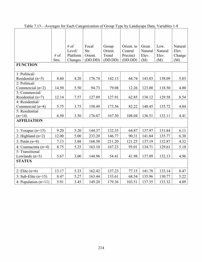
214
Table 7.13—Averages for Each Categorization of Group Type by Landscape Data, Variables 1-8
# of Strs.
# of Level/ Platform Changes
Focal Str. Orient. (DD.DD)
Group Orient. Trend (DD.DD)
Orient. to Central Precinct (DD.DD)
Great. Natural Elev. (M)
Low. Natural Elev. (M)
Natural Elev. Change (M)
FUNCTION 1: Political/ Residential (n=5) 8.60 4.20 176.74 142.13 64.74 143.03 138.09 5.03 2: Political/ Commercial (n=2) 14.50 5.50 94.73 79.08 12.26 123.00 118.50 4.00 3: Commercial/ Residential (n=7) 12.14 7.57 127.89 127.91 62.85 138.12 129.58 8.54 4: Residential/ Commercial (n=4) 5.75 3.75 158.49 173.56 82.22 140.45 135.72 4.84 5: Residential (n=14) 6.50 3.50 176.07 167.30 108.04 136.51 132.11 4.41 AFFILIATION 1: Verapaz (n=15) 9.20 5.20 144.37 132.35 64.87 137.97 131.84 6.11 2: Highland (n=2) 12.00 5.00 233.20 146.77 90.31 141.84 135.77 6.30 3: Petén (n=8) 7.13 3.88 168.50 211.20 121.25 137.19 132.87 4.32 4: Usumacinta (n=4) 8.75 5.25 163.10 167.23 95.01 134.71 129.61 5.10 5: Transitional Lowlands (n=3) 5.67 3.00 144.96 54.41 41.98 137.09 132.13 4.96 STATUS 2: Elite (n=6) 13.17 5.33 162.42 137.23 77.15 141.78 133.14 8.47 3: Sub-Elite (n=15) 8.47 5.27 163.44 133.61 68.54 135.96 130.77 5.22 4: Population (n=11) 5.91 3.45 149.20 179.36 103.51 137.35 133.32 4.09
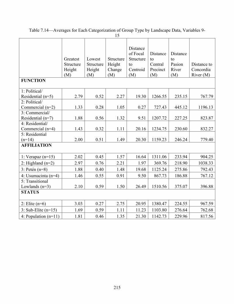
215
Table 7.14—Averages for Each Categorization of Group Type by Landscape Data, Variables 9-15
Greatest Structure Height (M)
Lowest Structure Height (M)
Structure Height Change (M)
Distance of Focal Structure to Centroid (M)
Distance to Central Precinct (M)
Distance to Pasion River (M)
Distance to Concordia River (M)
FUNCTION 1: Political/ Residential (n=5) 2.79 0.52 2.27 19.30 1266.55 235.15 767.79 2: Political/ Commercial (n=2) 1.33 0.28 1.05 0.27 727.43 445.12 1196.13 3: Commercial/ Residential (n=7) 1.88 0.56 1.32 9.51 1207.72 227.25 823.87 4: Residential/ Commercial (n=4) 1.43 0.32 1.11 20.16 1234.75 230.60 832.27 5: Residential (n=14) 2.00 0.51 1.49 20.30 1159.23 246.24 779.40 AFFILIATION 1: Verapaz (n=15) 2.02 0.45 1.57 16.64 1311.06 233.94 904.25 2: Highland (n=2) 2.97 0.76 2.21 1.97 369.76 218.90 1038.33 3: Petén (n=8) 1.88 0.40 1.48 19.68 1125.24 275.86 792.43 4: Usumacinta (n=4) 1.46 0.55 0.91 9.50 867.73 186.88 767.12 5: Transitional Lowlands (n=3) 2.10 0.59 1.50 26.49 1510.56 375.07 396.88 STATUS 2: Elite (n=6) 3.03 0.27 2.75 20.95 1380.47 224.55 967.59 3: Sub-Elite (n=15) 1.69 0.59 1.11 11.23 1103.80 276.64 762.68 4: Population (n=11) 1.81 0.46 1.35 21.30 1142.73 229.96 817.56

216
Table 7.15. Averages for Each Categorization of Group Type by Landscape Data, Variables 16-22
Distance to Semi-Perm. Water Source (M)
Distance to Closest Other Group (M)
Group Perimeter (M)
Total Structure Area (M2)
Total Plat./ Open Area (M2)
Total Group Area (M2)
Total Structure Volume (M3)
FUNCTION 1: Political/ Residential (n=5) 133.54 90.03 335.57 470.00 6082.54 6552.55 802.53 2: Political/ Commercial (n=2) 5.91 136.64 411.56 533.46 12807.28 13340.74 289.84 3: Commercial/ Residential (n=7) 113.15 114.75 470.35 719.28 13332.02 14051.30 705.69 4: Residential/ Commercial (n=4) 69.34 186.72 281.93 169.78 4615.48 4785.26 156.22 5: Residential (n=14) 129.30 186.27 301.33 483.89 5199.02 5682.91 692.69 AFFILIATION 1: Verapaz (n=15) 116.99 182.11 387.86 465.15 9556.83 10021.98 542.45 2: Highland (n=2) 172.24 93.93 399.43 682.39 7757.91 8440.30 1139.02 3: Petén (n=8) 60.35 95.22 302.51 415.86 5703.01 6118.87 477.20 4: Usumacinta (n=4) 152.61 234.51 324.78 604.78 6421.67 7026.45 887.99 5: Transitional Lowlands (n=3) 122.16 87.36 267.97 605.83 3473.52 4079.35 690.10 STATUS 2: Elite (n=6) 77.81 119.90 489.48 916.45 13190.33 14106.78 991.30 3: Sub-Elite (n=15) 103.28 153.71 313.31 457.89 6681.17 7139.07 577.99 4: Population (n=11) 140.27 168.75 318.48 321.67 5567.26 5888.94 476.08
While some patterning is apparent in the averages presented above, some of the more
specific metrics from the statistical regiments are mentioned here. Groups 17, 18, 26, and 27 are
Residential (Function 5) groups of Sub-elite or Population level statuses (Status 3 and 4) and are
different than all other groups in the sample along with Group 1 a Commercial/Residential group

217
(Function 3). Group 1 is further distinguished from this set based on its volume. There is no
pattern between the affiliations of these five groups but rather the groups cluster together based
on the size data. Groups 3, 4, 5, and 6 are distinct from the rest of the groups based on their
overall height. This variety in groupings or clusters emphasizes the environmental
(Highland/Transitional/Lowland) identification and association of individuals and communities,
from single people to neighborhoods and larger organizational units. Political/Commercial or
Commercial/Residential groups (Function 2 and 3) and those of elites and sub-elites (Status 2
and 3) are significant designations, again emphasizing the importance of commerce and its
intertwined relation with Maya geopolitics.
For group Function, Residential groups (Function 5) are distinct from all other groups
based on all size data, Commercial/Residential groups (Function 3) are different from all other
groups based on their length and perimeter, while Political/Residential groups (Function 1) are
distinct in their height.
For group Affiliation, there are no correlations between affiliation and the four size
variables of orientation, width, perimeter, or volume. However, Transitional Lowland groups
(Affiliation 5) have a different height than all other groups. Highland groups (Affiliation 2) have
different length and height compared to all other groups. Verapaz groups (Affiliation 1), Petén
groups (Affiliation 3), and Usumacinta groups (Affiliation 4) are like each other with all size
data but remain distinct from Affiliations 2 and 5. The Highland and Transitional Lowland
groups (Affiliations 2 and 5) are most similar to each other with their only difference being
overall area.
There are no certain correlations between Social Spectrum variables and the four size
variables of orientation, height, perimeter, or area. Those of Population level status (Status 4) are

218
significantly different in the length of the architectural group from elites (Status 2) and in volume
from sub-elites (Status 3). The Elite and Sub-elite (Status 2 and 3) seem to display no statistically
significant differences to each other in the building dimension tested in this research aside from
sheer size.
Principle Component Analysis (PCA)
PCA is a model-free multivariate data analysis method that effectively reduces the
original data into weighted variables known as principal components by transforming variance-
covariance matrices into linear uncorrelated variables. The resulting components variation in the
data set is then ranked by the degree of variation explained in that component (Manly, 1994).
PCA calculations were applied to the Cancuén architectural data in efforts to identify clusters of
structural compounds. These clusters and statistical trends illustrate several concentrations within
the data that lead to neighborhood or barrio classifications and many cultural associations of self-
identification and concepts of the sacred environment.
PCA was performed on the size data derived from the various groups using the statistical
computer package SPSS v. 28, Factor Analysis Function. Only two components could be
extracted for the measurements in this study: Component 1 accounted for 69.49% of the variance
with Component 2 responsible for 84.16% of the variance. Positive factor loading (the
correlation coefficient for said variable and factor) occurred for perimeter, area, length, volume,
width, and orientation on Component 1 with negative loading on height. For Component 2,
positive loading occurred on all factors except for width and orientation, with the highest loading
on height. Component 3 could not be extracted in the component matrix precluding a
multidimensional scaling plot (MDS) to be of group centroids. Component 1 correlates to the
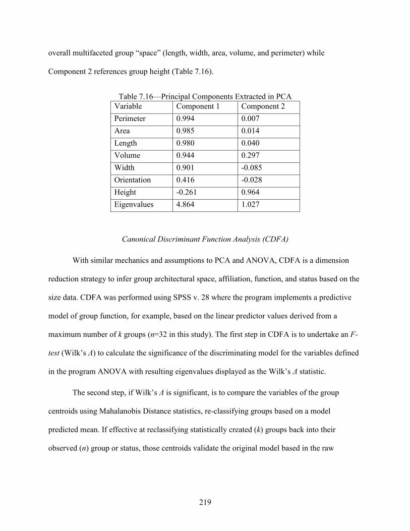
219
overall multifaceted group “space” (length, width, area, volume, and perimeter) while
Component 2 references group height (Table 7.16).
Table 7.16—Principal Components Extracted in PCA Variable Component 1 Component 2 Perimeter 0.994 0.007 Area 0.985 0.014 Length 0.980 0.040 Volume 0.944 0.297 Width 0.901 -0.085 Orientation 0.416 -0.028 Height -0.261 0.964 Eigenvalues 4.864 1.027
Canonical Discriminant Function Analysis (CDFA)
With similar mechanics and assumptions to PCA and ANOVA, CDFA is a dimension
reduction strategy to infer group architectural space, affiliation, function, and status based on the
size data. CDFA was performed using SPSS v. 28 where the program implements a predictive
model of group function, for example, based on the linear predictor values derived from a
maximum number of k groups (n=32 in this study). The first step in CDFA is to undertake an F-
test (Wilk’s Ʌ) to calculate the significance of the discriminating model for the variables defined
in the program ANOVA with resulting eigenvalues displayed as the Wilk’s Ʌ statistic.
The second step, if Wilk’s Ʌ is significant, is to compare the variables of the group
centroids using Mahalanobis Distance statistics, re-classifying groups based on a model
predicted mean. If effective at reclassifying statistically created (k) groups back into their
observed (n) group or status, those centroids validate the original model based in the raw

220
architectural data. For example, the results of the CDFA from the Cancuén architectural groups
report a high percentage of correct assignment of observed groups (n) and predicted groups (k).
For each of the following CDFA results reported (Table 7.17), Wilk’s Ʌ was significant
for group sizes, functions, affiliations, and statuses. The percentage of re-classifications that were
correct varied with the greatest accuracy for groups based on status (72.7%), function (54.0%),
affiliation (51%), and size (39.4 %).
Table 7.17—CDFA Re-Classification Results % of Correct
Re-classifications Wilk’s Ʌ df p
Size Variables (8) 39.4% 0.98 186 <0.001 Function (5) 54.0% 0.788 24 <0.001 Affiliation (5) 51.0% 0.788 24 <0.001 Status (3) 72.7% 0.891 12 0.002
The following CDFA plots reveal classes and relationships observed among the groups,
demonstrating readily identifiable patterns and affiliations representative of clusters of identity
and self-expression.
Figure 7.34 on architectural size had a relatively poor re-classification given the tight
clustering of groups apart from those discussed in the results of the MANOVA. Group 1 is a
consistent outlier in many tests, likely a result of its disproportionate volume relative to others.
However, its importance in the Cancuen identity—both as a potential culinary store/kitchen to
the Palace located meters away, and as a group marked with other strong Verapaz hallmarks such
as the figurines referenced previously—is also disproportionate to the other groups sampled.
Groups 17 and 26 are also often at the outer statistical ranges due to mathematical similarity

221
between each other and great dissimilarity with the other 30 groups in architectural design; their
consistent clustering is indicative of potential further group-to-group patterning.
Figure 7.34—CDFA Groupings Based on Architectural Size
Figure 7.35 on group function reclassified correctly 54% of the time with some clustering
of those function types that are residential (Functions 3 and 5) and those that are commercial
(Functions 2 and 4). The most elite political residences are an outlier from all others—also
geographically the most wide-spread of the Cancuén architectural groups, recalling the role of
outpost or territorial presence/control.

222
Figure 7.35—CDFA Groupings Based on Architectural Size and Group Function
Figure 7.3 on group affiliation re-classified correctly in 51% of cases and verified the
results of the MANOVA matrices discussed above. Groups with affiliations to Verapaz, the
Petén, and Usumacinta cluster together as seen in the MANOVA. Interestingly, the distinction
between the Highlands (Affiliation 2) and Transitional Lowlands (Affiliation 5) is further parsed
out in the CDFA showing that they are very distinct according to the different CDFA Functions
on the X-/Y-axes. Lowland groups have heights that are distinct from all other groups and the
Highland groups represented overall areas that were distinct from others. It may be in this case
that the X-axis is related to height while the Y-axis is related to length.
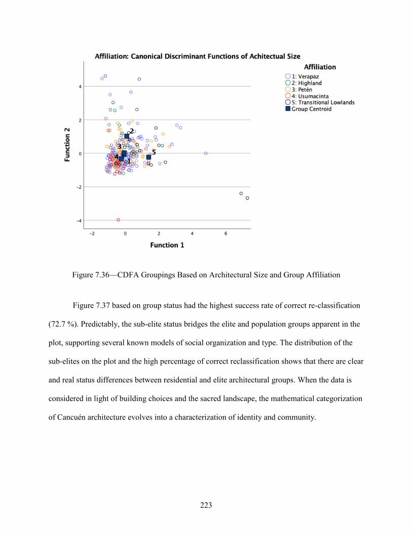
223
Figure 7.36—CDFA Groupings Based on Architectural Size and Group Affiliation
Figure 7.37 based on group status had the highest success rate of correct re-classification
(72.7 %). Predictably, the sub-elite status bridges the elite and population groups apparent in the
plot, supporting several known models of social organization and type. The distribution of the
sub-elites on the plot and the high percentage of correct reclassification shows that there are clear
and real status differences between residential and elite architectural groups. When the data is
considered in light of building choices and the sacred landscape, the mathematical categorization
of Cancuén architecture evolves into a characterization of identity and community.

224
Figure 7.37—CDFA Groupings Based on Architectural Size and Group Affiliation
Landscape Statistics
Least Cost Pathways (LCP)
The next stage in the statistical query involved a deeper understanding and modelling of
the groups’ presence within the Cancuén natural landscape. A new digital surface was calculated
from additional point data, aerial photographs of the region, and SRTM (shuttle radar topography
mission)—1 arc second, from the National Aeronautics and Space Administration (NASA) jet
propulsion laboratory—and other remotely sensed satellite elevation data. An LCP (least cost
pathway) was then developed for the site with five categories based on travel time between
groups and the Cancuén Central Precinct. The five categories (A through E, corresponding to the

225
1-5, Table 7.18) reflected time values from less than four minutes (A) to over 20 minutes (E).
Figures 7.38 and 7.39 graphically explain the results of this work (Figure 7.38 is based in
seconds, re-classed into minutes for Figure 7.39).
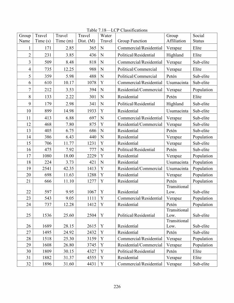
226
Table 7.18—LCP Classifications Group Name
Travel Time (s)
Travel Time (m)
Travel Dist. (M)
Water Travel Group Function
Group Affiliation
Social Status
1 171 2.85 365 N Commercial/Residential Verapaz Elite 2 231 3.85 436 N Political/Residential Highland Elite 3 509 8.48 818 N Commercial/Residential Verapaz Sub-elite 4 735 12.25 988 N Political/Commercial Verapaz Elite 5 359 5.98 488 N Political/Commercial Petén Sub-elite 6 610 10.17 1078 Y Commercial/Residential Usumacinta Sub-elite 7 212 3.53 394 N Residential/Commercial Verapaz Population 8 133 2.22 301 N Residential Petén Elite 9 179 2.98 341 N Political/Residential Highland Sub-elite
10 899 14.98 1933 Y Residential Usumacinta Sub-elite 11 413 6.88 697 N Commercial/Residential Verapaz Sub-elite 12 468 7.80 875 Y Residential/Commercial Verapaz Sub-elite 13 405 6.75 686 N Residential Petén Sub-elite 14 386 6.43 440 N Residential Verapaz Population 15 706 11.77 1231 Y Residential Verapaz Sub-elite 16 475 7.92 777 N Political/Residential Petén Sub-elite 17 1080 18.00 2229 Y Residential Verapaz Population 18 224 3.73 421 N Residential Usumacinta Population 19 2541 42.35 1413 Y Residential/Commercial Usumacinta Population 20 698 11.63 1288 Y Residential Verapaz Population 21 666 11.10 1277 Y Residential Petén Population
22 597 9.95 1067 Y Residential Transitional Low. Sub-elite
23 543 9.05 1111 Y Commercial/Residential Verapaz Population 24 737 12.28 1412 Y Residential Petén Population
25 1536 25.60 2504 Y Political/Residential Transitional Low. Sub-elite
26 1689 28.15 2615 Y Residential Transitional Low. Sub-elite
27 1495 24.92 2432 Y Residential Petén Sub-elite 28 1518 25.30 3159 Y Commercial/Residential Verapaz Population 29 1608 26.80 3745 Y Residential/Commercial Verapaz Population 30 1809 30.15 4327 Y Political/Residential Petén Elite 31 1882 31.37 4555 Y Residential Verapaz Elite 32 1896 31.60 4431 Y Commercial/Residential Verapaz Sub-elite

227
Wilcoxson Rank Sum Test
From the LCP statistics, six variables for each group were selected for group-wise
comparisons using the Wilcoxson Rank Sum Test (best for use with non-parametric data) in
efforts to further find clustering within the Cancuén group data. The variables scrutinized were
(a) the numbers of structures in each group, (b) the maximum natural elevation each group was
constructed upon, (c) the maximum structure height within each group, (d) the distance of each
group to the nearest semi-permanent water source, (e) the distance of each group to the nearest
other architectural group, and (f) the total structure volume of each group.
These variables were then compared in five categories: (1) travel class (five classes
generated in the LCP), (2) group characterization (four categories: political/commercial, political
residential, commercial/residential, and simply residential), (3) group affiliation (based on
architectural and excavation data that suggest a Verapaz, Highland, Petén, Transitional Lowland,
or Usumacinta relation), (4) groups based upon social status (elite, sub-elite or a general
population designation), and (5) a water travel class of whether or not their LCP route to the
Cancuén ceremonial center involved water travel or only overland. This information was then
recoded and imported into R, another robust statistical computer package.
Preliminary computations began with a MANOVA, a standard method of comparison
between variables within grouped data, as noted above. The procedure is parametric, requiring
normally distributed data. After several trials, additional Shapiro-Wilks Normality Tests were
run to address this. Consistently, several of the variables—predominantly elevation, and nearest
group to group distance—were significant, indicating the possibility of a non-normal data
distribution or that the Cancuén architectural groups are clustered around statistically significant
attributes such as topography or neighboring groups.

228
Kruskal-Wallis Rank Sum Test and Pairwise Wilcoxson Matrix
Next, the Kruskal-Wallis Rank Sum Test was applied to the variables as a check on the
above findings. Also referred to colloquially as a ranking one-way ANOVA, relevant results are
reported within for several of the model generated variables. All were exhaustively checked and
cross-checked, but only the significant results are discussed below (Table 7.19).
Table 7.19—Variables Used in Kruskal-Wallis Tests with Travel Class Dependent Variables Variable Kruskal-
Wallis chi-square
df p
Number of Structures 5.115 4 0.275 Max Natural Elevation 8.812 4 0.066 Distance to nearest Architectural Group 14.36 4 <0.0062 Distance to Nearest Water Source 5.06 4 0.281 Max Structure Height 3.259 4 0.515 Total Structure Volume 6.925 4 0.139
As indicated, the relationship between a group’s designated travel class and the distance
between architectural groups is significant, possibly revealing district or community boundaries.
A pairwise Kruskal-Wallis test was run to investigate this relationship further, specifically to
identify where that relationship was significant (Table 7.20):
Table 7.20—Pairwise Wilcoxon Rank Sum Test/Matrix (P value adjustment method: BH) A B C D A 0.000 B 0.639 0.000 C 0.152 0.152 0.000 D 0.070 0.070 0.327 0.000 E 0.070 0.026 1.000 0.152

229
That pairwise test shows that the significant (p<0.05) relationship was between Groups B
and E. Therefore, the distance to the nearest architectural group was significantly different
between Group B, where travel time to the ceremonial center is 4 to 8 minutes, and Group E,
where travel time to the ceremonial center is more than 20 minutes. Group B has an average
distance to nearest architectural group of 66.16m (st. dev. 22.96), while Group E has an average
distance of 174.69m (st. dev. 145.48).
The same Kruskal-Wallis operation was performed with the group characterization
variables interacting with the same dependent variables (number of structures, max elevation,
distance to water, intra-group distance, etc., as above). Table 7.21 displays the results:
Table 7.21—Kruskal-Wallis Test Results with Group Characterization Dependent Variables Variable Kruskal-
Wallis chi-square
df p
Number of Structures 6.7569 3 0.0114 Max Natural Elevation 8.812 3 0.066 Distance to nearest Architectural Group 1.679 3 0.641 Distance to Nearest Water Source 7.084 3 0.069 Max Structure Height 3.1911 3 0.363 Total Structure Volume 1.616 3 0.655
The same Kruskal-Wallis operation was performed with the social spectrum variables
interacting with the same dependent variables (number of structures, max elevation, distance to
water, intra-group distance, etc., as above). Table 7.22 displays the results:

230
Table 7.22—Kruskal-Wallis Test Results with Social Spectrum Dependent Variables Variable Kruskal-
Wallis chi-square
df p
Number of Structures 10.64 2 0.0048 Max Natural Elevation 3.756 2 0.152 Distance to nearest Architectural Group 1.679 2 0.641 Distance to Nearest Water Source 2.917 2 0.232 Max Structure Height 4.499 2 0.105 Total Structure Volume 6.764 2 0.0339
Both Number of Structures in each group and Total Structure Volume for the groups
were significantly related to social or cultural designations, prompting the Wilcox testing. The
pairwise relationship that comes out as most significant is the number of structures per
architectural groups and social parties, another indicator of cultural building design preferences.
The same Kruskal-Wallis operation was performed with the water travel classes variables
interacting with the same dependent variables (number of structures, max elevation, distance to
water, intra-group distance, etc., as above). Table 7.23 displays the results:
Table 7.23—Kruskal-Wallis Test Results with Water Travel Class Dependent Variables Variable Kruskal-
Wallis chi-square
df p
Number of Structures 5.361 1 0.0205 Max Natural Elevation 0.6188 1 0.431 Distance to nearest Architectural Group 5.5693 1 0.0182 Distance to Nearest Water Source 0.813 1 0.367 Max Structure Height 0.0721 1 0.788 Total Structure Volume 6.764 1 0.226

231
As there are only two groupings, pairwise tests are redundant. However, there is a
significant statistical distinction between groups that require water travel to get to the ceremonial
center and those that do not (based on LCP) in numbers of buildings within structure compounds
and the distance between structures. This again alludes to settlement organization and gives
insight into riverine versus terrestrial social habits and subconscious building location choices.

232
Chapter Conclusion
The statistical analyses discussed in the preceding pages give numeric significance and
backbone to the interlaced concepts of identity and the sacred landscape. The results show—
especially for variables such as structure height and platform size or volume—that there are valid
correlations between building dimensions and cultural phenomena such as community and group
affiliation. The clusters identified in the various plots detail possible criteria for neighborhood or
similar classifications. Additionally, these clusters inform the archaeologist of the nature, the
structure and group types that make a unit or neighborhood. Clusters defined via the typologies
used in this dissertation are consistently made up of the same suite of group types, a strong
indication of neighborhood or political district make-up (Figure 7.36).
Figure 7.38—Cancuén Map Colorizing Architectural Clusters by Group Function (Wolf/Bracken)

233
The combined patterning illuminates relationships between cultural choices, origins, and
environmental perception.
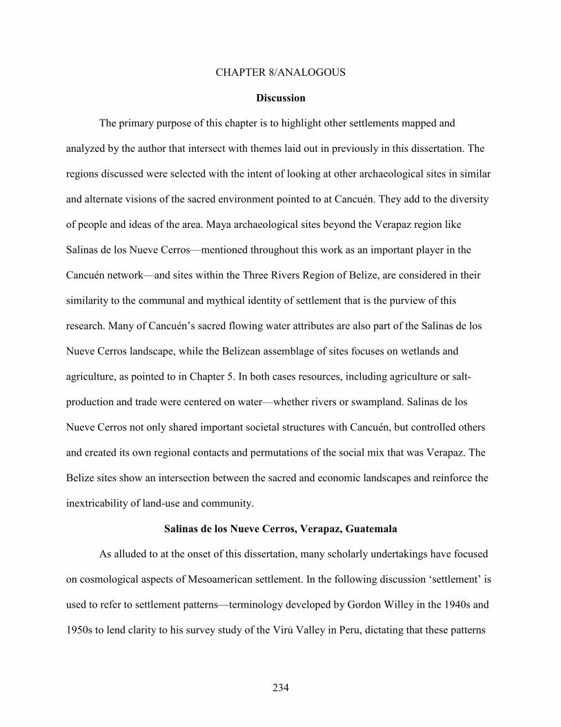
234
CHAPTER 8/ANALOGOUS
Discussion
The primary purpose of this chapter is to highlight other settlements mapped and
analyzed by the author that intersect with themes laid out in previously in this dissertation. The
regions discussed were selected with the intent of looking at other archaeological sites in similar
and alternate visions of the sacred environment pointed to at Cancuén. They add to the diversity
of people and ideas of the area. Maya archaeological sites beyond the Verapaz region like
Salinas de los Nueve Cerros—mentioned throughout this work as an important player in the
Cancuén network—and sites within the Three Rivers Region of Belize, are considered in their
similarity to the communal and mythical identity of settlement that is the purview of this
research. Many of Cancuén’s sacred flowing water attributes are also part of the Salinas de los
Nueve Cerros landscape, while the Belizean assemblage of sites focuses on wetlands and
agriculture, as pointed to in Chapter 5. In both cases resources, including agriculture or salt-
production and trade were centered on water—whether rivers or swampland. Salinas de los
Nueve Cerros not only shared important societal structures with Cancuén, but controlled others
and created its own regional contacts and permutations of the social mix that was Verapaz. The
Belize sites show an intersection between the sacred and economic landscapes and reinforce the
inextricability of land-use and community.
Salinas de los Nueve Cerros, Verapaz, Guatemala
As alluded to at the onset of this dissertation, many scholarly undertakings have focused
on cosmological aspects of Mesoamerican settlement. In the following discussion ‘settlement’ is
used to refer to settlement patterns—terminology developed by Gordon Willey in the 1940s and
1950s to lend clarity to his survey study of the Virủ Valley in Peru, dictating that these patterns

235
are the way humans inhabited or otherwise used and manipulated the natural environment
(Willey 1953). With this foundation of what settlement is, researchers have long sought to
understand the relationships between the human cultural environment and the natural landscapes
where they are situated. There are countless strategies in which this dynamic is based—the
reasons for a chosen locale have been dissected from political to economic reasons and here
special attention is paid to conceptions of an idealized sacred landscape. It is not a novel idea;
instead it is one that has enjoyed the deliberations of many insightful studies within Mesoamerica
and for the Maya area in particular (Andrews 1975; Ashmore 1981; Ashmore and Knapp 1999;
Schele and Friedel 1990; Schele et al. 1999; Sharer 2006; W. Fash 2001). This dialogue will
present another case study within the Maya region that reflects this prior work, yet also moves
the study forward by encompassing both the natural landscape as a single unit mirrored and thus
re-enforced by architectural human-made assemblages. The cosmology or sacred aspect of the
Salinas de los Nueve Cerros archaeological sites provide a literal outline, shadow, highlight or
contrast to the ruins themselves. The natural world represents a cosmology echoed by the site’s
architecture, and vice versa. This duality reflects the unknown (and potentially dangerous as
commonly associated with the uncertain) power that both the natural context and the Maya
structures within this setting inspire.
The ancient Maya displayed in their architecture and iconography their worldview
detailing a cosmogram of their ideology in the layout and forms of buildings as well as the plans
and adornments of the buildings themselves. Though this dissertation research posits ideas of
past Maya traditions, their worldview is constantly evolving into newer forms to adapt to or
confront the ‘outside’ influences of world modernization or globalization. Modern Maya adhere
to many of the basic principles embraced by their fore parents of architectural planning and

236
layout such as the quadripartite alignments and divisions of agricultural fields (Vogt 1969) or
house compounds (Andrews 1975). For the ancient Maya, researchers have postulated cruciform
shapes of urban settlement, reflecting the Maya ideals of a north-south world axis bisected by an
east-west axis (Tourtellot III et al. 2000; Maca 2002). As mentioned earlier, Schele and Friedel
(1990) have discussed the mythic/ceremonial significance of individual structures, like that of
the focal structure at Cerros in coastal northern Belize, and later the iconographic thrust behind
architectural elaborations as the details and adornments of Pacal’s tomb in Palenque, Chiapas,
Mexico, and elsewhere in the Maya area (Schele et al. 1999). The sacred importance within
Maya settlement patterns transcends the buildings and adorning symbols themselves and
crucially echoes the significance of location and context—simply where the Maya chose to erect
their structures is a monumental statement. This discussion asserts that Salinas (though not
unique in Mesoamerica) transcends the usual settlement patterns resultant from obvious political
hierarchies and agendas of a theater state and focuses primarily on ritual environments as the
principal forces behind settlement.
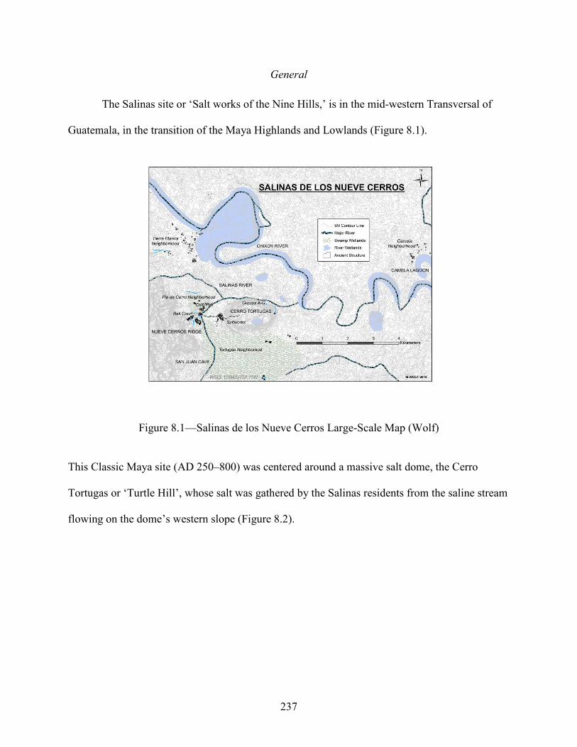
237
General
The Salinas site or ‘Salt works of the Nine Hills,’ is in the mid-western Transversal of
Guatemala, in the transition of the Maya Highlands and Lowlands (Figure 8.1).
Figure 8.1—Salinas de los Nueve Cerros Large-Scale Map (Wolf)
This Classic Maya site (AD 250–800) was centered around a massive salt dome, the Cerro
Tortugas or ‘Turtle Hill’, whose salt was gathered by the Salinas residents from the saline stream
flowing on the dome’s western slope (Figure 8.2).

238
Figure 8.2—Salt Dome Photo (Woodfill)
The Chixoy River borders the northern edge of the city and served as a major trade route
connecting the Maya world. Salinas de los Nueve Cerros is the moniker for several settlements
situated within the omni-presence of the Nueve Cerros Mountains. Salinas pushes—perhaps
establishes—the definition of cosmic space within Maya reality or daily activity. The Salinas
area is arguably the most compelling example from Maya cosmology of the axis-mundi.

239
The traditional model of the axis-mundi is a quadripartite division of the universe,
distinguished by a cruciform shape of cardinal directions with an especially sacred convergence
point in the middle of the two axes (Schele and Friedel 1990; Tourtellot III et al.). At Salinas the
salt dome lies at the east end of the cosmogram, the Nueve Cerros Range at the western position,
and salt flats, the ultimate transition, in the middle (Figure 8.3).
Figure 8.3—Salt Flats Photo (Woodfill)
Bisecting this east-west axis, a north-south axis is defined by several of the drainages in the
Salinas area. The geographically enormous Salinas swamplands, generally trending northward,
define the northern reference for the line, and the energetically flowing Salinas River is the
southern point.

240
Axis-Mundi
The north-south tangent of the Salinas axis-mundi encompasses both the vast Salinas
swamp system and the swift Salinas River. Western culture fixates on north as the main cardinal
direction; however, this was not necessarily the case in ancient Mesoamerica. Mathematically
two perpendicular lines defining two directions are nameless—simply tangents of ninety degrees.
They are assigned to north/south/west/east for the purposes of consistency and convention (the
modern tradition dictates north is usually at the top of the page with other directions referenced
tangentially). Many ancient populations anointed other directions as the most significant (Krupp
1989; McCluskey 2007; Aveni et al. 2004). The Maya maps of the Spanish contact and colonial
periods where east is the focal direction from which the other directions are based is an equally
valid system. At Salinas, water is the conjoining line or physical link between the four directions,
with potable sweet water running from the mountains linking with the salt-stream flowing from
the dome. This confluence defines the western limit of the salt flat and is the starting point for
the river Salinas. The salt stream creates the shifting width of the flats, beginning as a single
channel, breaking into multiple poorly defined smaller systems as it passes through the flats, then
recombining into one flow before emptying into the waters that together become the Salinas
River. The Salinas swamplands lie adjacent to the flats—defining its southern extent. The salt
flats are the tangible and liminal center of the Salinas world linking Maya mythology and the
architecture that surrounds them.
Water
Maya iconography is replete with associations of a watery underworld and stage of world
creation (Scarborough 2003). The Salinas swampland is exemplary. Though future research will
reveal more, these wetlands encompass a variety of different microenvironments. These range

241
from a deeper central area to many horizontally larger shallows and differing degrees of morass
and mud. Much of the entire Salinas area is engulfed to varying degrees within this wet and often
inundated area of Guatemala. The ancient Maya architectural features of the site are islands
within this wetland system. The Salinas wetlands embrace the settlement from all sides, reaching
to the slopes of the Nueve Cerros Mountains and the topography of the salt dome. The salt flat—
a dualistic and contradictory entity belonging to two different states of being at the same time—
is both dry land and an integral part of the surrounding swamp. Water depth influences the
vegetation of the different swamp zones, and these alternate from algae covered waters, thorn
and vine tangles of varying density, and stands of inundated jungle trees and palms.
Important zones within the Salinas swamplands are the deeper water pockets that give the
connotation of a larger, clear waterbody. In Maya sacred world views, little distinction is made
between lakes, oceans and other larger bodies of water (Scarborough 2003; Lucero 2005; Bradey
and Prufer 2005). Maya creation myths commonly associate water as the stage for the
development of humans and the physical world—detailing creation as sprouting from the
carapace of an enormous mythological turtle floating in a primordial sea or from a world-tree
with alligator attributes and other water connotations. Interestingly, the almost grid-like patterns
of most species of turtle and the scales of the mythological reptiles recall the actual form of
Maya agricultural fields or swampland raised field agriculture as known from several Maya sites
and elsewhere in Central America (as example the raised fields of the Aztec chinampa system of
Tenochtitlan).
The more open areas of swamps are surrounded by tightly packed pillar-like stands of
wetland grasses, cattails, and other reeds. Like the columns of the Temple of the Warriors from
Chichen Itza or Tula, the reeds cluster around theses larger pools like sentries guarding a crucial

242
resource or access and from afar look like a military procession marching toward the site. These
swampland reeds are important mythological symbols in a pan-Mesoamerican ideology,
associated with militarism, imperialism, and the underworld (Sugiyama 2005). They represent an
important day name in all Mesoamerican calendars and are tied to concepts of time and in turn
creation. Tollan, an important mythical or unidentified city or locale (especially important in
later Mesoamerican and Mexican cultures) was known as ‘The Place of Reeds’. As McNeil has
noted, these reeds are often indicative of fertility (McNeil 2006).
The Salinas wetlands represent further duality and paradox within Maya world views.
The swamp’s moisture and parasitic organisms readily deteriorate and rot most objects, but the
swamp water is also a primordial ‘soup’ of creation and development, mixing elements and rain
runoff into a concentrated source. It throbs with an abundance of wildlife—birds, fish, reptiles
and a myriad of insects dwell in its rich organic life. Swamp soils are nutrient rich supporting
both aquatic and terrestrial life-forms. They biomes encapsulate the life and death cycles of
many animals. The swamplands provide the necessary drinking water for all life in the area and
the tender grasses are both a food supply and building resource for smaller game and birds. Deer
use the reedy cover to avoid the attention of potential predators, raptors patrol the air for prey,
smaller birds hide in the swamp vegetation while also feeding on the vast array of spiders,
insects, and tiny fish, and larger carnivores can often find their game by the swamp as well. The
environment would naturally be a perfect medium for aquaculture—fish to turtles—and intensive
farming of the wetland soils. It is both a still quagmire of muddy water, yet also flows slowly but
surely from south to north, draining much of the entire region into the great Chixoy River.
Enhancing the contradictory powers of swamplands, the before-mentioned properties of decay
are countered with incredible preservation powers in the anaerobic environs of deeper

243
swampland waters. The famous Puleston Axe mentioned in Chapter 5 was found in a swamp
context in Belize and illustrates these preservation qualities.
The waters are a moving frame of mirrored, self-reflective repetitions of transformational
processes, like the ideas of repetition detailed in other sacred contexts (Mannikka 1996; Schele
and Friedel 1990). As pointed to in the introduction to this dissertation, the greater symbolism of
water itself is supremely sacred to the ancient Maya and Mesoamerica in general (Scarborough
2003; Fedick 1996; Lucero 2006; Culbert 1990). From Aztec and Maya calendrics, Mixtec and
Zapotec codices and Maya iconography, water has been associated with both the underworld and
the heavens above (Lucero et al. 2006; Demarest and Conrad 1992). Control over water
resources have been touted as the factor behind the development of political power and state-
formation (Carneiro 1970). Water availability is one of the principal dictums of agricultural
production and therefore of human populations and cultural systems. In its role as a mainstay of
farming, water supplies are directly responsible for the development of craft specialization and in
turn all the cultural elaborations that mark a hierarchical and developed society—including
religion and worldviews. Terracing and drainage systems combat the erosive powers of rain-
water run-off and other destructive flooding events pervasive in wetter climbs (Scarborough
2003). Water is a dualistic entity, capable of vicious currents and destructive inundation, but also
the foundation of agricultural productivity and life in general. The ideological significance in
Maya cosmology of the hydraulic cycle of groundwater evaporated into the atmosphere and then
re-deposited downward in the form of rain has been detailed in many academic discussions (J.
Sosa 1985). This cycle links the realm of the upper world—the home of the gods and many
ancestors—with the physical middle world (the daily world of the Maya people) and the

244
mysterious underworld into which this rain-water drains. The Salinas area exemplifies a cultural
identity of the dispersion of people and ideas based in a riverine environment and salt resources.
Salinas Swampland
In the large Salinas wetland, water moves south-to-north changing dramatically from a
stagnant swamp to a freely running river aided by the important addition of drainages from the
Salinas Range (the northern extent of the cosmogram) and the salt dome (the southern pole).
Strengthening the symbolism of transformation and creation is the complex relation of the heavy
salinized salt stream and the fresh water from the mountains. Color is important in Maya myth as
well (Tokovinine and McNeil 2012; Tokovinine 2012) and the salt-stream tumbles quickly from
its source in a cloudy grey or black hue, in marked contrast to the crystalline slow-moving blue
or green of the Salinas sweet-water drainages. It is the combination of these waters from the
three very different sources that is the catalyst for transformation into one major waterway. All
come together at the liminal meeting-ground of the salt flats. They are the arena of
metamorphosis and change—transformation of saline water into fresh water, mountains and firm
land into watery swamp and the center point of the Salinas axis-mundi.
Salt Flats
Currently, the salt flats of the Nueve Cerros region include the main flat and a
significantly smaller one slightly to the east. These are probably part of one larger entity itself
dynamic and shifting in time from a contracted mass to several linked individuals and back
again. Together they occupy approximately 500 square meters in area. The flats are sandy,
muddy landforms that appear incongruously in the surrounding jungle and wetlands. Their exact
location moves on the landscape as well (Dillon 1972)—reiterating their indefinable and
ambiguous latent power. In the 1960s they were almost 100 meters from where they are today
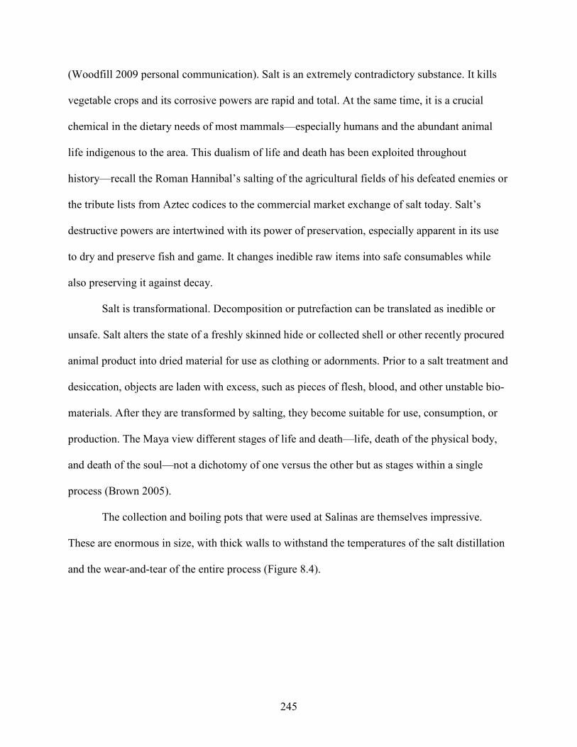
245
(Woodfill 2009 personal communication). Salt is an extremely contradictory substance. It kills
vegetable crops and its corrosive powers are rapid and total. At the same time, it is a crucial
chemical in the dietary needs of most mammals—especially humans and the abundant animal
life indigenous to the area. This dualism of life and death has been exploited throughout
history—recall the Roman Hannibal’s salting of the agricultural fields of his defeated enemies or
the tribute lists from Aztec codices to the commercial market exchange of salt today. Salt’s
destructive powers are intertwined with its power of preservation, especially apparent in its use
to dry and preserve fish and game. It changes inedible raw items into safe consumables while
also preserving it against decay.
Salt is transformational. Decomposition or putrefaction can be translated as inedible or
unsafe. Salt alters the state of a freshly skinned hide or collected shell or other recently procured
animal product into dried material for use as clothing or adornments. Prior to a salt treatment and
desiccation, objects are laden with excess, such as pieces of flesh, blood, and other unstable bio-
materials. After they are transformed by salting, they become suitable for use, consumption, or
production. The Maya view different stages of life and death—life, death of the physical body,
and death of the soul—not a dichotomy of one versus the other but as stages within a single
process (Brown 2005).
The collection and boiling pots that were used at Salinas are themselves impressive.
These are enormous in size, with thick walls to withstand the temperatures of the salt distillation
and the wear-and-tear of the entire process (Figure 8.4).

246
Figure 8.4—Salt Distillation Ceramic Cauldron Photo (Woodfill)
When the salt was properly reduced from the brine water of the salt stream or flats, the entire
ceramic was broken, and the salt ‘cake’ removed. The gargantuan vessels are symbolic
gateways—creating both a physical and hypothetical mirror in the reflections and dynamics of
the surface and the depth of the transformational liquid they are designed to contain.
Salt was also a heavily exchanged commodity (Guderjan 2007; Hewitt et al. 1987; Moga
2009). As control over water supplies helped beget the hierarchical society of the ancient Maya,
access to salt resources was used as a controlling feature that strengthened hierarchical
segregation. Demand for salt was a constant in the development of humankind especially in light
of its dietary importance in the humid tropics.
In addition to human physical requirements, the existence of a redistributed resource (in
this instance, salt) connotes a background of power. Salt economics re-enforce the politics of a
class segregated Maya society. Salt trade—especially salt from the sacred Salinas de los Nueve

247
Cerros—is also a means of combining religion and politics. The intermingling of politics with
sacred ideology is a common theme in religious systems (Kertzer 1989). Salt was both an
ideological symbol and a commercial (and thus political) item. At Salinas, salt was (and still is) a
readily available commodity, but elsewhere in the Maya world its accessibility relied on market
exchange. Although not overtly an exotic item, there is an element of luxury or privilege
associated with Salinas salt, enhancing its value. The salt would not have been traded to distant
regions of Mesoamerica freely for consumption by all, instead it was limited to those with the
means to purchase or otherwise obtain exchanged goods. The salt produced and traded from
Salinas was a legitimization of Maya society, maintaining the divide between those Maya who
had access to salt and those who didn’t. They were not only minimizing the danger in exposure
to the unknown and powerful properties of the salt, but they were asserting their own control
over its ritual strength and were also sharing—proselytizing—its ritual importance with a
broader Maya culture.
Salt Dome
The most visually focusing landscape features of the entire region are the Salinas salt-
dome on one extreme and the Nueve Cerros Mountain Range on the other—about 6 kilometers
away on an approximately east-west axis. As Barthes (1997) mentions in his essay on the
monumentality of France’s Eiffel Tower, the dome serves as a unifying point for all of the
disparate settlement clusters in the region. It is omnipresent in every aspect of daily life, from
washing clothes to preparing food, hunting, or working in the surrounding agricultural fields.
Even today one cannot travel any road or contemplate any activity without the dome looming in
the background. The dome is bifurcated—a twin rise—reminiscent of the Olmec were-jaguar
clefts and a clue to the probable antiquity of settlement and use of the site. The salt from the

248
dome would have always been an attraction for animal and human life. The iconographic
significances of incorporating pre-Maya, Olmec or pan-Mesoamerican symbols raise issues of
time in the conflation of traditions from a distant past with the Maya present. Adding to the
sacred symbolism, from the salt dome flows the heavily salinized arroyo discussed earlier.
The dome is also home to natural gas sources, tapped by energy companies in recent
decades, as well as some other fatal gasses (hydrogen chloride vapor) that have notoriously
killed several people—material proof of the dome’s power. The dome is massive; up to seven
cenotes (small lagoons or sinkholes) grace its peak of approximately 300 meters in elevation.
This highlights its contradictory qualities—its dualism or liminality—by inverting traditional
concepts of space and relations between planes within the Maya cosmos. At Salinas, the
underworld as embodied by the dome is situated above a major settlement zone. One cenote on
its summit routinely turns a deep and unnatural iridescent purple during the rainy season
heightening the reflective qualities and potential power of the water and as an access into the
underworld (Figure 8.5).

249
Figure 8.5—Purple Cenote Photo (Woodfill)
Themselves thresholds or gateways integral to Maya cosmology with their seamless
juxtaposition of water and inner-earth, cenotes are usually confined to lower ground (Brady and
Prufer 2005). Those of the dome exaggerate the dimension of earth and mountain as facets of the
mythological Maya Underworld existing as a plane below the physical world. These cenotes are
not simply envisioned portals of Maya ideology but actual submerged passages into the salt
dome, symbols of the earth and the watery underworld.
Mountains
The Nueve Cerros Mountains—the west point of the cosmogram—rise sharply from the
adjacent, often flooded flatlands and swamp-grounds that mark the Salinas region. The peaks are
not particularly tall; however, their precipitous rise creates the illusion of greater geographic
distance from the ground below. The range is relatively well defined in a region of otherwise

250
rolling hills and light topographic relief, forming a northern fence or boundary point (again a
question of scale) for the area. They sprawl east to west, rising suddenly and sharply. These
mountains represent time in their almost instantaneous vertical shift and thus time-travel to the
pinnacle or sacred Upperworld—distant, inaccessible or completely unreachable. The ability to
combine and transform concepts of time from a single regression into multi-dimensions is
paradigmatic of the axis-mundi. The summits of the Nueve Cerros Range are associated with the
divine celestial world of revered ancestors and supreme gods (McAnany 2000; Watanabe 1990).
The Maya occupation below, the world of daily living, is the plane of the present. The past is
associated with the mortality of the underworld as is the Salinas salt dome.
Temples have been found and caves reported from inside the Nueve Cerros Mountains.
No matter where one is within the region, one cannot avoid feeling the shadow of the dome or
the Nueve Cerros range. They rise impressively from the surrounding landscape of rolling karstic
hills and drainages of the important Rio Chixoy—only kilometers away. As commented
previously, water and rivers have their own power and directionality in Maya cosmology
(Scarborough 2003; Lucero 2006; Lucero and B. Fash 2006), and provide much of the reasoning
behind the declaration of Salinas’ position as the cosmogram of central lowland Maya.
The freshwater drainage from the mountains counteracts the saltwater emitted from the
salt dome. The concentrated mountain run-off is pure, coming from peaks too steep for feasible
subsistence activities. There are neither domesticated nor animal concentrations nor recognized
agricultural enterprises to pollute the drainage. Modern Maya who inhabit the area refer to this
water as chabil-ha (Qu’echi language) literally excellent water and water given by the gods and
ancestors of the Upperworld. Ideology often views mountains as the realm of the wild versus that
of society and culture. The major Salinas living settlements, the culture of the living Maya, lie

251
below the Nueve Cerros heights. The relative inaccessibility of the peaks from whence the
unadulterated water flows also charges this water with sacred power, adding to Salinas
mysticism.
SNC Architecture as Cosmogram
Within this natural context, the Maya added their architecture into the equation.
Mirroring the north-south axis of the cosmogram (the Salinas River and the main Salinas Swamp
respectively) is the Ox Group and the Triadic Group; and the cosmogram’s natural axis of the
Nueve Cerros Range to the west and the salt dome to the east is mirrored by the Industrial Zone
at the eastern pole and the Ball Court Group at the western position. Aside from the structures
associated with the salt dome, all other architectural groups are built upon slight rises out of the
Salinas swampland. They form a mosaic of islands emerging from the primordial waters, like the
rises of crocodilian hide that is the stage of Maya creation discussed earlier. The greater wetlands
of the area reach to the slopes of the Nueve Cerros Range, and much of the occupation has direct
access to fresh water through a series of canals and reservoirs. The ball court area notably
incorporates these into its plan; both embracing the sacred water and socially avoiding them by
turning-its-back to it (the main structure and the entire plaza face away from the water). The
drastic shift from swamp to mountain peak seems more extreme; spatial relationships and time
are altered. The Upperworld is associated with the divine gods and future while the underworld
below yields connotations of viscous water, evil or ambivalence, and past and future creation
(Taube 1992, 1995).

252
Ball Court Group
Architecture associated with the Nueve Cerros range—closer to the divine, celestial, or
upper-world—is more ceremonial in nature. A ball court (Figure 8.6) lies at the heart of this
assemblage having cleft-earth and spiritual connotations (Scarborough and Wilcox 1991).
Figure 8.6—Ball Court Group Map (Wolf)
The mythical story of the Popol Vuh is a clear example of the ties between ball courts and
creation. The story of creation from the Guatemalan Highland Maya Qu’echi peoples (circa AD
1500), the Popol Vuh details the ball court is the context of the trapping, death and re-birth of the
Hero Twins. Their trials and eventual successes set the stage for the creation of the present
world. The twins are tricked and are induced into a heroic journey (and thus a significant
transformation) into the underworld in the settings of the ball court—a cleft or portal into the
earth. Importantly, the ball court lies at the base of the Nueve Cerros Range. It is the down pole
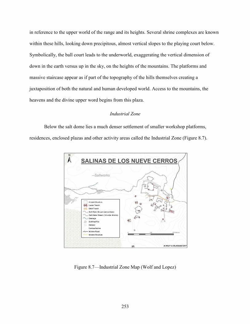
253
in reference to the upper world of the range and its heights. Several shrine complexes are known
within these hills, looking down precipitous, almost vertical slopes to the playing court below.
Symbolically, the ball court leads to the underworld, exaggerating the vertical dimension of
down in the earth versus up in the sky, on the heights of the mountains. The platforms and
massive staircase appear as if part of the topography of the hills themselves creating a
juxtaposition of both the natural and human developed world. Access to the mountains, the
heavens and the divine upper word begins from this plaza.
Industrial Zone
Below the salt dome lies a much denser settlement of smaller workshop platforms,
residences, enclosed plazas and other activity areas called the Industrial Zone (Figure 8.7).
Figure 8.7—Industrial Zone Map (Wolf and Lopez)

254
Most of these architectural compounds appear to be storage, final preparations or redistribution
centers for the salt and other resources within the region. The functionality of this assemblage
recalls a more mundane, earthly, and common aesthetic than the ritualized ball court setting at
the opposite direction of the cosmogram. Central to this area are several expansive and walled
plazas that have a closed, almost militaristic ambiance. The area is a mix of activity locales and
restrictive access; almost hidden inside courtyards are reminiscent of later Central Mexican
defensive and imperial architecture and are defined by the salt stream. The symbolically
powerful salt stream heralds the ideological strength behind these plazas. Similarities to
compounds at Teotihuacan and elsewhere suggest an affinity to warrior dedicated architecture
and the death relation with the Mesoamerican Underworld (Storey 1992; Braswell 2004). Like
the ball court occupying the base of the slope toward the heavens, this industrial and martial
settlement lies at the foot of the salt dome—the Salinas gateway to the underworld.
Triad Group
The north-south axis of the Salinas architectural cosmogram is created by several massive
elite residential complexes. The northern pole is a series of structures atop several greatly
elevated basal platforms. The structures are generally taller (especially with the combined height
of the shared platforms), steeper, and lack the expansive plaza of the Triadic Group that is the
southern pole (Figure 8.8).

255
Figure 8.8—Triadic Group Map (Wolf)
This plaza supporting several large structures is built upon a single large rise from the
surrounding wetlands as opposed to the several islands of construction in the north area. This
opposition is symbolic of the change or a transition from a single unit into a dualistic or multi-
dimensional one.
Many scholars have attributed this axis of the cosmogram as the ecliptic (Schele et al.
1999), the path of the sun and moon. At Salinas, the Salt Dome-Nueve Cerros Range axis is the
principal line of the axis-mundi—east to west, representing the progression of nature and life and
death. The north-south axis is represented by the then-living Maya people, mimicking the life
transformations and developments of the Salinas Maya. As humans change into adults and
history evolves, so the waters change from the deliberate and directionless swamp to the flowing
Salinas River.
256
The Triad Group not only mimics the north-south sprawl of the Nueve Cerros Range in
the grander scheme of a cosmogram, but it is also built to be visually dominated by the
mountains, only thousands of meters away. The structure compound itself and the other
architectural groups on the shared elevated plaza are oriented toward parts of the Nueve Cerros
Range (possibly associated with a specific rise or cave therein). Between the mountains and the
architecture, west below the Triad Group proper, is a low platform connected to the larger plaza
postulated to be adorned by several (at least 3, possibly 5) large, rough stela/monuments. The
crude nature of these suggests that they were simply monumental rough rectangular boulders
from the mountain tumble just meters away. Due to their arrangement on the platform previously
discussed, these monuments of the mountains were likely erected by the ancient Salinas peoples
in reverence.
Sacred Geography
Salinas de los Nueve Cerros is the epitome of Maya sacred space. Its natural landscape
embraces all Maya ideals of an axis-mundi. The individual components of the system are prime
examples of Maya cosmology and together they create an exponentially powerful complex. The
salt dome, the salt flats, the swamp and drainages, and the Nueve Cerros Mountains are deeply
laden with their own sacred power, and the combination of these elements creates a dynamic
system upon which rests Maya expressions of creation, transformation, and afterlife. The Maya
at Salinas inserted their own presence into this natural cosmogram by mirroring the system with
their architecture. Buildings were constructed to reflect the ideals associated with the different
segments of the axis-mundi. The east-west axis of the salt dome and the Nueve Cerros Range
that illustrates the continuum of time and space from the underworld to the Upperworld is
mimicked by the martial and industrial area below the dome and the ceremonial aspects of the

257
ball court group at the base of the mountains. At the center lie the Salinas salt flats with their
own tremendous ritual power as both an economic and sacred resource and as a portal into time.
The amalgamation of these natural formations and their complementary architecture irrefutably
marks the Salinas region as a crucial microcosm of the Maya Universe.
Three Rivers Region, Belize
General
Unlike many areas of Mesoamerica, the Three Rivers Region defies the traditional
models of settlement patterning, displaying a unique combination of Maya landscape use and
occupation. The region provides an outstanding example of the sacred landscape as an
agricultural resource that meets both economic and spiritual needs and identities. From a
technical mapping and survey perspective, this union of ancient Maya settlement techniques is a
dynamic permutation of both political geography and the differing opportunities presented in the
natural landscape. Prehistoric Belize was exploited by many different Maya sub-cultures
resulting in a dynamic display of interaction between Peténesque, the Belize Coast, Yukatekan
and local settlement signatures.
The groupings of sites reflected in this chapter’s headings are not absolute, but rather
reflect research conducted up to now (2020). Many complementary archaeological features that
fill out the picture of these Maya polities have been destroyed through the ravages of time,
natural erosion, and modern development, leaving archaeologists with a severely incomplete
picture of the entire scene from which to create an accurate understanding of the region’s diverse
settlements.
Examples from the scientific field of geography discuss there several ‘schools’ of thought
as to the model of a city. The famous Chicago school of thought viewed settlement in a series of
258
concentric rings, with the ‘downtown’ at its center. A Los Angeles school of thought was
focused on a multi-nuclear model that featured several downtown central activity areas. As many
human geography scientists explain, this too is not a case of one versus the other, but rather a
simple change in perception. For example, modern Houston, Texas can be understood in light of
several different models not in a single explanation.
The dating of Maya epochs like the PreClassic, Classic or PostClassic are likely different
in Northwestern Belize than elsewhere in the Maya world. As Demarest and colleagues point to
about the site of Cancuén (Demarest et al. 2014), the Three Rivers region boasts many artifacts
usually associated with earlier or later dates than their provenance would suggest (like a
purported Archaic period style lithic found much farther inland than current scientific thinking
allows or a PostClassic ceramic technology usually associated with Classic times).
Blue Creek Core/K’in T’an/Rosita/CBN Courtyards
The Blue Creek Project, directed by Dr. Thomas Guderjan, is based in the Mennonite
village of Blue Creek in Belize’s Orange Walk district. The Maya Research Program (MRP) has
conducted a myriad of archaeologically related studies in the Three Rivers region. The MRP
research station is built atop a small limestone hill emerging from the fertile low-lying
depressions that are hallmarks of the topography of the La Lucha escarpment, is defined by the
watersheds of the Azul, Bravo and Hondo Rivers.
A primary goal of MRP and the author’s survey/drafting operations was to standardize
map conventions and provide environmental context to the Blue Creek central precinct
(Guderjan et al. 2009—Figure 8.9).

259
Figure 8.9—Blue Creek Core Map (Wolf)
MRP teams have been studying the site over the past several decades; the Blue Creek core is the
centerpiece of a collection of settlements built upon or around the ridges of the La Lucha
Escarpment. It likely played a dominant role to sites below like Sayapha and was involved in the
production, management, and exploitation of the agricultural abundance of the wetland
agriculture. The La Lucha ridge and settlements like Rosita and the CBN courtyards, encircle
other high-quality agricultural lands, acting as a coral that implies territorial boundaries,
protection, and ease of access to and exploitation of the fields. The Blue Creek ruins are
segregated into two platform groups laid out in almost parallel north-south axis. Plaza A appears
to be somewhat earlier and seems to serve more of a typical central settlement role than Plaza D.
Plaza A includes several seeming administrative structures, numerous examples of
sacred/ceremonial architecture (including a ball court and ceremonial gallery/platform/shrine
where overtly lavish creation cache was dedicated) and a probable astronomically related twin-
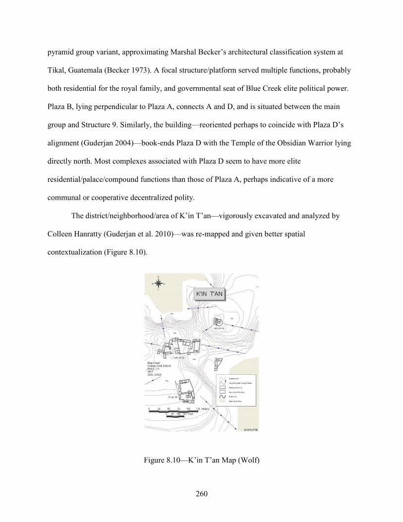
260
pyramid group variant, approximating Marshal Becker’s architectural classification system at
Tikal, Guatemala (Becker 1973). A focal structure/platform served multiple functions, probably
both residential for the royal family, and governmental seat of Blue Creek elite political power.
Plaza B, lying perpendicular to Plaza A, connects A and D, and is situated between the main
group and Structure 9. Similarly, the building—reoriented perhaps to coincide with Plaza D’s
alignment (Guderjan 2004)—book-ends Plaza D with the Temple of the Obsidian Warrior lying
directly north. Most complexes associated with Plaza D seem to have more elite
residential/palace/compound functions than those of Plaza A, perhaps indicative of a more
communal or cooperative decentralized polity.
The district/neighborhood/area of K’in T’an—vigorously excavated and analyzed by
Colleen Hanratty (Guderjan et al. 2010)—was re-mapped and given better spatial
contextualization (Figure 8.10).
Figure 8.10—K’in T’an Map (Wolf)
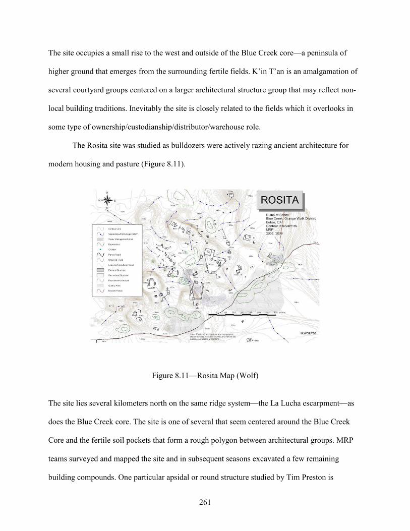
261
The site occupies a small rise to the west and outside of the Blue Creek core—a peninsula of
higher ground that emerges from the surrounding fertile fields. K’in T’an is an amalgamation of
several courtyard groups centered on a larger architectural structure group that may reflect non-
local building traditions. Inevitably the site is closely related to the fields which it overlooks in
some type of ownership/custodianship/distributor/warehouse role.
The Rosita site was studied as bulldozers were actively razing ancient architecture for
modern housing and pasture (Figure 8.11).
Figure 8.11—Rosita Map (Wolf)
The site lies several kilometers north on the same ridge system—the La Lucha escarpment—as
does the Blue Creek core. The site is one of several that seem centered around the Blue Creek
Core and the fertile soil pockets that form a rough polygon between architectural groups. MRP
teams surveyed and mapped the site and in subsequent seasons excavated a few remaining
building compounds. One particular apsidal or round structure studied by Tim Preston is

262
associated with a northwestern Mexican or Yukatekan style. The site was an extensive collection
of human architecture and land modifications of which the full extent is uncertain due to its
modern development.
The CBN courtyard group lies on the same ridge system as Rosita or the Blue Creek
Core, several kilometers south of the Core’s main plazas (Figure 8.12).
Figure 8.12 —CBN Map (Wolf)
The architecture is reminiscent of other elite complexes in the region (Aak Witz, Sotohob, the
Sunnyside Satellite groups, etc.) and its southern and slightly eastern positioning relative to the
Blue Creek central precinct suggests that it is less directly involved in local agriculture,
functioning mainly as an elite residential and ancestral shrine compound. A notable caveat is the
possibility of smaller-scale agricultural terracing that begins from the site’s larger southern and
western platforms and cascades down the escarpment towards the Sayapha fields.
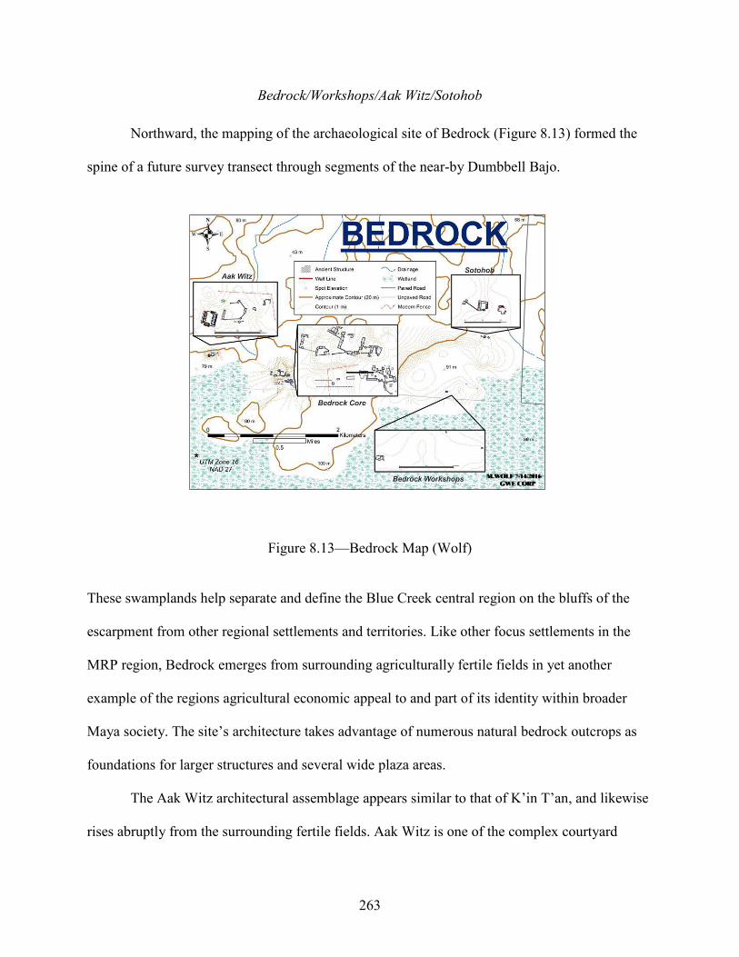
263
Bedrock/Workshops/Aak Witz/Sotohob
Northward, the mapping of the archaeological site of Bedrock (Figure 8.13) formed the
spine of a future survey transect through segments of the near-by Dumbbell Bajo.
Figure 8.13—Bedrock Map (Wolf)
These swamplands help separate and define the Blue Creek central region on the bluffs of the
escarpment from other regional settlements and territories. Like other focus settlements in the
MRP region, Bedrock emerges from surrounding agriculturally fertile fields in yet another
example of the regions agricultural economic appeal to and part of its identity within broader
Maya society. The site’s architecture takes advantage of numerous natural bedrock outcrops as
foundations for larger structures and several wide plaza areas.
The Aak Witz architectural assemblage appears similar to that of K’in T’an, and likewise
rises abruptly from the surrounding fertile fields. Aak Witz is one of the complex courtyard
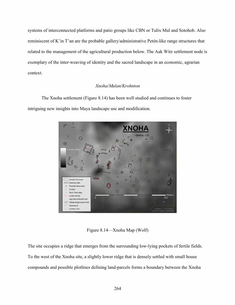
264
systems of interconnected platforms and patio groups like CBN or Tulix Mul and Sotohob. Also
reminiscent of K’in T’an are the probable gallery/administrative Petén-like range structures that
related to the management of the agricultural production below. The Aak Witz settlement node is
exemplary of the inter-weaving of identity and the sacred landscape in an economic, agrarian
context.
Xnoha/Mulan/Krohnton
The Xnoha settlement (Figure 8.14) has been well studied and continues to foster
intriguing new insights into Maya landscape use and modification.
Figure 8.14—Xnoha Map (Wolf)
The site occupies a ridge that emerges from the surrounding low-lying pockets of fertile fields.
To the west of the Xnoha site, a slightly lower ridge that is densely settled with small house
compounds and possible plotlines defining land-parcels forms a boundary between the Xnoha

265
polity and that of Nojolna. Eastward, the ridge undulates several times, especially near the
Xnoha River floodplain, and eventually bleeds into the hills and valleys of the Hondo River.
Moderate-sized courtyard groups are scattered throughout and several show evidence of ancient
agricultural terracing. Krohnton (Figure 8.15) is one of the larger of these (like Aak Witz, CBN
or Tulix Mul), though more compact and seemingly imbued with a more ritualized functionality
in addition to any others as indicated by the red handprint graffiti and possible murals of the
largest building’s vaulted interior).
Figure 8.15—Krohnton Map (Wolf)
The site is likely the eastern extent of the Xnoha polity and is perched above the pocket of fertile
soil embraced by (clockwise) the Xnoha main group, the eastern ridge that buts against it,
Krahnton, Mulan, and the western settlement zone.

266
Grey Fox
The nearby archaeological center of Grey Fox was a logical next step in mapping (Figure
8.16).
Figure 8.16—Grey Fox Maps (Wolf)
The site is one of the closest to the Hondo River in the MRP study region, located on the alluvial
floodplain at a compromise distance between proximity and ease of access while attempting to
avoid incessant inundation. Presently, an illicit Belize/Mexico border crossing involves easily
fording the river at a shallow point slightly northeast of the site’s central precinct.
First impressions point to a position within a more traditional, Guatemalan Lowland site
ranking/hierarchy where Grey Fox plays the part of a very minor outpost of the regional power
of La Milpa. The site exhibits traits that reflect both La Milpa/Petén and local styles. Grey Fox’s
location is reminiscent of the MRP sites, rising from a relatively lower surrounding network of

267
fertile potential agricultural fields (at present, the environs are being prepared for intensive
modern commercial agriculture). Alternately Grey Fox could be the Hondo River port of La
Milpa, an ancient network that leads deep into Mexico as well as Petén, Guatemala, the location
of La Milpa’s apparent founder/patron, the prominent archaeological site of Rio Azul. The
northern and western buildings that outline the Grey Fox main plaza seem to be exact models of
typical Petén-type range structures. The east structure has combined architectural features, with a
height of approximately 11 meters and construction like the larger buildings in the MRP region.
It also includes attached outbuildings like the La Milpa Structure 5 complex, and the easternmost
structures of the Tz’unun archaeological site, possibly part of the La Milpa hegemony.
Nojolna/Southern Settlement Zone/Tulix Mul
The ancient settlement of Nojolna (Figure 8.17) lies several kilometers directly north of
the larger and more centralized Xnoha.

268
Figure 8.17—Nojolna Map (Wolf)
Over several field seasons, MRP teams surveyed, mapped, and tested at Nojolna, its vast
southern settlement zone and adjacent areas (Figure 8.18).

269
Figure 8.18—Nojolna Settlement Zone Map (Wolf)
The large amalgamation of settlement areas lies on the southwestern periphery of the Alacranes
Bajo swampland. Inevitably its size and complexity was strongly connected to the exploitation of
wetland resources. The site was made up of several hill-top groups rising from surrounding
upland swamps as well as the lower Alacranes systems. Almost all these bluffs supported
complex architectural groups, displaying a gamut of functions and stylings. Larger landforms
held impressive central remains—imposing multi-tiered isolated ritual structures like those of
Belize Coastal traditions, administrative Petén-like or Yukatekan palace/range buildings
arranged in quadrangle plazas, and a monumental acropolis.

270
Tulix Mul is an unusually ornate but relatively small pairing of several courtyards and
monumental structures (Figure 8.19).
Figure 8.19—Tulix Mul Map (Wolf)
The central building—perhaps the micro-local seat of family power—is also decorated with
several murals, one painted over the other. There is little doubt that the disproportionate wealth
represented in a peripheral and small site like Tulix Mul is deeply connected to the exploitation
of wetland resources—likely agricultural products similar to K’in T’an in the Blue Creek
Kingdom or Aak Witz as part of the Bedrock polity. The Tulix Mul/K’in T’an comparison is
intentional as the sites are of similar size, elite status, and proximity to agricultural production—
if a swamp had definable banks as rivers, Tulix Mul is constructed on them.
Re-iterating the agricultural theme, Nojolna and associated smaller groups like Tulix Mul
embrace several pockets of fertile lands. The site incorporates in its central planning a large
cenote and surrounding flood grounds that lie meters south of the Nojolna Acropolis. Between

271
several of the more prominent architectural groups are other important water and potential
agricultural/fertility features—many of which play important roles in Maya sacred symbolism.
Sunnyside
The sprawling archaeological site of Sunnyside (located on the grounds of the modern
but now-defunct Sunnyside Farm) is the focus of another group of sites—specifically the three
subsidiary courtyard groups to the east of the main groups that define it from the Bedrock polity
farther east and north. On the next ridge southeast of Sunnyside lies another site, colloquially
designated El Aguila by MRP archaeologists. This impressive and expansive courtyard group
might be part of the La Milpa political network. The site occupies a high ground from which to
see the La Milpa plateau in the southern background, the wetlands of swamps to the east, and the
wetlands pocket between it and Sunnyside. Likely as sprawling as the Rosita site, Sunnyside’s
architecture has been destroyed for the sake of modern development/commercialism.
Sacred Geography
Northwestern Belize is a profoundly sacred ancient Maya landscape embracing a variety
of mythological ideals mirroring the different Maya sub-cultures that settled ancient Belize. The
biodiversity of the region is stunning with an almost unending array of flora and fauna that were
sacredly charged and likely of larger size and more plentiful in ancient times. Rivers, cenotes,
and wetlands are laden with sacred symbolism in all Maya cultures (Knapp and Ashmore 1999)
and Northwestern Belize is a mosaic of symbolic water features (Luzzadder-Beach et al. 2016).
Different types of swampland (upland, plain, etc.) are important aspects of every settlement in
the region—from the local ubiquitous morasses like the Dumbell Bajo or the inter-site
swamplands between Xnoha, Nojolna or Bedrock to the incredible systems of ditched–fields
below the escarpment identified by Krause and Guderjan (Krause and Guderjan 2011) that bleed

272
into those along much of the Hondo River continuing deep into Mexico—the region is literally
soaked in water-related features.
Directionality—east, west, etc.—is also an extremely important aspect of Maya
mysticism (Ashmore 1991; Ashmore and Sabloff 2002). Archaeological sites within the MRP
research concession display architectural and feature alignments that are prime examples—from
the orientation of individual buildings and entire sites, to the placement of architecture in relation
to important landscape features. Mountain-like ridges, chultuns (an example from Nojolna with
toxic subterranean gases requiring the use of aspirators by excavation teams come to mind), and
the imposing swampland network of the Alacranes bajo frame the ancient architecture with
vibrant color. The ridges and peaks of the La Lucha escarpment are continuations of the ranges
following the northern side of the Belize/Mexico border. In a Maya cosmological sense, the
archaeological sites strung along the peaks of the escarpment, are avenues to the heavens, to the
creation Gods and the foundations of Maya society. Caves and other similar geological features
add to the complexity of the sacred landscape (Moyes et al. 2009) complementing the creation of
a Maya mystical world that was home to both Underworld gods and revered ancestor figures
(McAnany 2013).
Chapter Conclusion
There are many ways of envisioning sacred landscape and how it interacts with human
identity. Symbolism is one of these, as described for Salinas de los Nueve Cerros. Agricultural
productivity—as embodied by the settlements of the Three Rivers region of Northwestern Belize
(Dunning et al. 1999) is another. The ideological placement of architecture in relation to the
natural environment lies at the heart of both examples. This foundational pillar of landscape
contextualization of architecture—that spirituality and human identification are inseparable from

273
the physical and natural setting they occupy—should be extended to all conceptions of sacred
landscape.

274
CHAPTER 9/CONCLUSIONS
“As they designed their ceremonial and civic centers, ancient Mesoamerican artists and
architects often made visible their culture’s creation and origin story (Tate 2008: 31).”
Self-identification is an integral component of Maya society, marking important
classifiable distinctions between Maya peoples and cultures (Watanabe 1990)—classic examples
of ‘us’ verses ‘them’. The symbiosis of architecture (temples, palaces, house-mounds, platforms,
etc.), settlement, and human identity is the primary focus of this study. Increasingly, digital
surfaces created through computer imagery such as LiDAR and other means of remote sensing
are employed to generate demographic, spatial, and temporal statistics (Ringel et al. 2021; Von
Schwerin et al. 2016; Chase et al. 2011, 2014) to model Mesoamerican settlement. In contrast, in
this dissertation’s analysis, structures and architectural compounds are manually surveyed on-
the-ground by the author. Within the seemingly mundane dimensions, like height and width, lie
patterns that characterize the organization of human society and identities. Human influences
represent one pole of a continuum, and a sterile architectural scheme lies opposite. To
concentrate solely on one—human variation versus the more material aspects of construction—is
a narrow and short-sided exercise in cultural relativism that does not consider the quantifiable
values resultant from the interplay of both. The latter view is too simple and is mainly just
descriptive—i.e., the number of houses or the number of plazas, etc. This study attempts to do a
more thorough job of representing the human mind behind the buildings, bridging the gap
between structural dimensions and social action (Decertau and Randall 1984).
In the early 1990s Spiro Kostoff published the books “The City Shaped” (1991) and “The
City Assembled” (1992), voluminous compendia of the meaning behind and graphics of
urbanism. He discusses several factors which lie behind the physical aspects of city planning,

275
like height and volume that directly translate to the dataset evaluated in Chapter 7. He analyzes
the architectural specifications in a cultural break-down of platforms, stairs, and ramps. There are
reoccurring shapes or city layouts, and where this research would use more optimistic wording of
opportunity, Kostoff says there is a great degree of environmental determinism at play. In a
discussion of watery environments—highlighted throughout this dissertation and particularly in
Chapter 6—Kostoff states that all humans have been attracted to waters and rivers, lakes and
shores and substitute their idealizations into settlement designs. He describes the process of
development or urbanization as economic maximization—basically land frontage and better land
is associated with a proximity to the economic source of trade, marine foodstuffs,
communication, transhumance, etc.—recalling the multiple functions of the port-city of
Cancuén.
Kostoff frequently points out that all settlements are circumscribed by something
physical—i.e., walls, moats, rivers, lanes, another geographic feature, or even simply the extent
of developed cultural spheres of influence. This dissertation argues that people—through active
construction and/or their ideas, create settlements and their boundaries. By default, there must be
a center and periphery of human population, creating the beginning of a quantifiable spatial
relationship between human culture and architecture. Kostoff repeats that settlement is a window
into cultural worldview of inhabitants as well as a reflection of the character of that community.
There are commonalities that serve as underlying settlement studies guidelines. A
settlement where the raison d’etre is commerce and communication will place more significance
on its routes of internal and external access as opposed to a fabrication town that may give more
consideration to and center itself around industry, or a residential community emphasizing open

276
space or seclusion. However, different cultures will drape their own details onto the framework
of necessity, like a prioritization of inner space versus the outside.
Kostoff shows that empty or open spaces play a large part in his visualization of city
planning. For example, a park is defined by the architecture around it, not necessarily the space
that it contains, like the Cancuén architectural groups. Much of his discussion revolves around
the treatment of streets, parks, alleys, and other open corridors. Networks that are fundamental to
settlement pattern studies (substituted by waterways and paths in this research). These open
spaces are of particular interest to this dissertation as they are representations of the natural
environment, particularly in the ancient world. As pointed to in earlier chapters, pre-historic
settlement and architecture spatially defined trade routes and pedestrian promenades. These were
not only demarcated by buildings or land modifications, like the grid patterns of archaeological
settlements Nixtun Ch’ich’ (Pugh et al. 2017) or Teotihuacán (Millon 1964) for example, but
also by mountains, rivers, rock outcrops, swamps, expanses of different forest types, caves, and
other natural landscape features. These natural features and human constructs reflect the cultural
identities and spirituality of the individuals and communities who lived among them through the
details of architectural dimensions such as width, height, and volume.
Community, Identity, and the Built Environment
In their work on cultural variability in the massive ancient center of Teotihuacán on the
Central Mexican plateau, Feinman and Carballo contextualize variability in the expression of
urban design, indigenous social institutions, and resilience through architectural organization in
precolonial Mesoamerica (Feinman and Carballo 2018). In Carballo’s words, “although
premodern, non-Western cities were different in significant ways from our own, they provide
meaningful points of comparison for considering the broad contours of how infrastructure”—or

277
more specifically in this research, architecture and landscape—“at level of urban epicenters,
neighborhoods, and households contributes to the variability in social relations, size, and
longevity of cities we observe in the archaeological record (Carballo 2021).” With respect to the
urban environment, Feinman and Carballo give several important Central American settlements a
“collectivity score”, giving a caveat of time, space, and scale. In a statistical analysis, they cite
the vastly disparate geography and temporality of Preclassic Gulf Coast peoples, Classic Maya,
and Postclassic Highlands in Mexico, acknowledging these spatio-temporal differences while
still designating each as examples of “less collective formations”. They associate these groups
with a politico-cultural organization of divine kingship (k’uhul ajaw), as echoed here in Chapter
5. They continue by characterizing cultures from the Mexican Preclassic Highlands, many Maya
Preclassic settlements, and several Classic Central Mexican states, like Monte Alban, Tula,
Teotihuacan, and the Postclassic Maya polities with a more decentralized multepal system of
governance as more communal and “collective” in nature. They emphasize that “variability also
was apparent within the Classic Maya world, with northern Yucatecan cities such as
Chunchucmil scoring firmly in the collective category and Caracol in Belize coded only slightly
less so. The more collective societies in the sample tended to emphasize public space and
monuments over palaces (Feinman and Carballo 2018: 11-13).” And this dissertation’s research
amplifies these findings, extending the position into positive statistical relationships with the
social data plotted with the length, height, width, and other building dimension data used in
Chapter 7. Several of those variables correlated positively with platform volume, one of the most
basic and common forms of public space in the Cancuén architectural assemblage.
Socializing metric data such as architectural volume is the crux of this dissertation’s
research, much like aspects of Feinman’s and Carballo’s work. Speaking to the cultural
278
variability of their sample consisting of extremely different American cultures, they state, “the
cyclical pulses of urbanization and state formation observable between the Mirador and
Calakmul regions (Marcus 2012) further demonstrate the fluidity in collectivity that could
operate in a single sphere of cultural interaction (2018: 15).” Their words repeat those of this
dissertation’s introduction and demonstrate the highly distinct cultural patterns of Mesoamerica.
Even areas of what scientists have traditionally categorized as territory occupied by a single
Maya culture is actually made of several cultures that also migrate, flourish, disperse, and
reconstitute over time.
Maya Space
In arguably one of the earliest exhaustive discussion and analysis of Maya spatial
proclivities, in 1974, Gary Gossen published “Chamulas in the World of the Sun: Time and
Space in a Maya Oral Tradition”, an ethnographic exploration of historical Maya conceptions of
space accompanied by indigenous drawings and language translations. Scientists are well aware
that modern or historic cultural patterns do not necessarily translate to Pre-Columbian ones,
however some traditions, particularly conceptions of the world and physical reality—transcend
time. Almost every aspect of Chamulan culture investigated in Gossen’s work occupies part of a
continuum of social ideas regarding the sacred landscape. The map in the publication, drawn by
a Chamulan, illustrates their perception of world and local geography, is indicative of spatial
themes like scale, landmarks and groupings of human culture, and also embracing subjects like
identity and spirituality (1977: 16). Map localities include numerous sacred mountains and
watering holes, mirroring the discussions in this dissertation. Cardinal directions are defined by
Chamulans not with the traditional modern cartographic convention of a north arrow, but by the
sacred dualities of the left and right “sides” of the sky, or of the ocean, or by the movement of
279
the sun. Chamulan geography is a synthesis of the sacred Maya cosmos, physically imposing
landscape features and concentrations of human identities that is applicable on a smaller-scale to
the patterning of architectural groups. Routinely, Chamulans identified themselves through a
simplistic two-dimensional view of themselves verse all others, outsiders. The population centers
drawn on the Gossen map are not noteworthy here because of their inclusion, but rather for what
it tells the viewer about Chamulan cultural priorities of size and proximity. In a microcosm of
that view, structure platform length or group volume as represented in the Cancuén architecture
is subject to the same human influence.
Place Attachment
Maria Lewicka’s 2010 Journal of Environmental Psychology article discussed scale and
place attachment, looking at categories of insiders and outsiders in terms of neighborhoods
(Lewicka 2010). Intangible cultural constructs, such as emotion and human conditioned thought
processes, influence their reaction to people’s daily experience and places of residence. She
points to rooms, houses, communities, cities, countries, continents, etc. in a scaled chain of
attachment that logically also includes the architectural details and raw dimensions of ancient
architecture. She reiterates the spatial importance of landscape features like mountains, bodies of
water, and natural attractions. These features have likewise been deliberated vigorously
throughout this dissertation, and suggests adding human construction and cultural models of
sacred space to Lewicka’s list.
Lewicka writes that “people tend to identify with distinguishable topological units rather
than those with areas whose edges are not clearly defined (2010: 47).” She sees one aspect of the
neighborhood as a unit on the continuum from room to house to neighborhood to urban center—
apropos to Maya settlement hierarchies. Extending Lewicka’s position, each designation marks

280
different levels of emotional investment; intangible and often subconscious human thought that
influence ideas of space and individuality. She touches upon concepts of community and privacy
as well. Though not discussed directly in this research, privacy is one of the most individual,
subjective, and purposely opaque notions that is also strongly influential on ideas of place and
settlement.
Statistics
The tests discussed in Chapter 7 are significant in assessing dependent variation and the
veracity of the Cancuén architectural model based in the length, width, and other variables
analyzed. Generally, all dimensions except orientation classifications, showed statistically
significant groupings within the raw architectural data in ANOVA calculations.
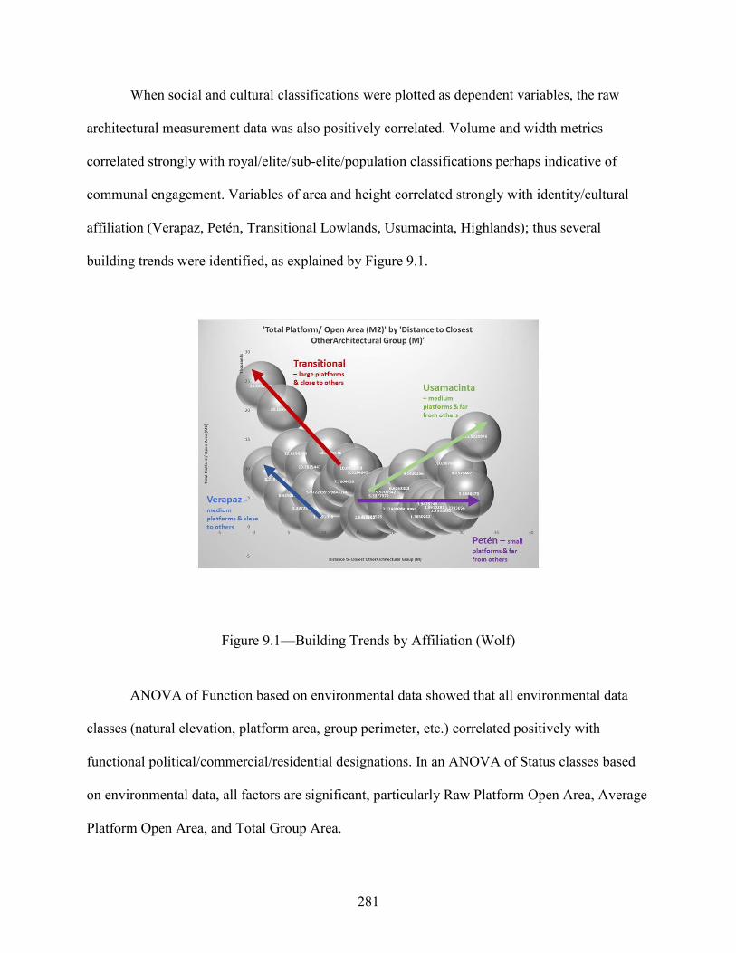
281
When social and cultural classifications were plotted as dependent variables, the raw
architectural measurement data was also positively correlated. Volume and width metrics
correlated strongly with royal/elite/sub-elite/population classifications perhaps indicative of
communal engagement. Variables of area and height correlated strongly with identity/cultural
affiliation (Verapaz, Petén, Transitional Lowlands, Usumacinta, Highlands); thus several
building trends were identified, as explained by Figure 9.1.
Figure 9.1—Building Trends by Affiliation (Wolf)
ANOVA of Function based on environmental data showed that all environmental data
classes (natural elevation, platform area, group perimeter, etc.) correlated positively with
functional political/commercial/residential designations. In an ANOVA of Status classes based
on environmental data, all factors are significant, particularly Raw Platform Open Area, Average
Platform Open Area, and Total Group Area.

282
PCA calculations were a means of model validation and clearly showed the robusticity of
the Cancuén architectural statistical regiment. PCA also details high success rates in
reclassifying variables back into the Cancuén model, pointing to the strength of those as well.
The CDFA results also confirm the soundness of explanatory variables used in the statistical
calculations.
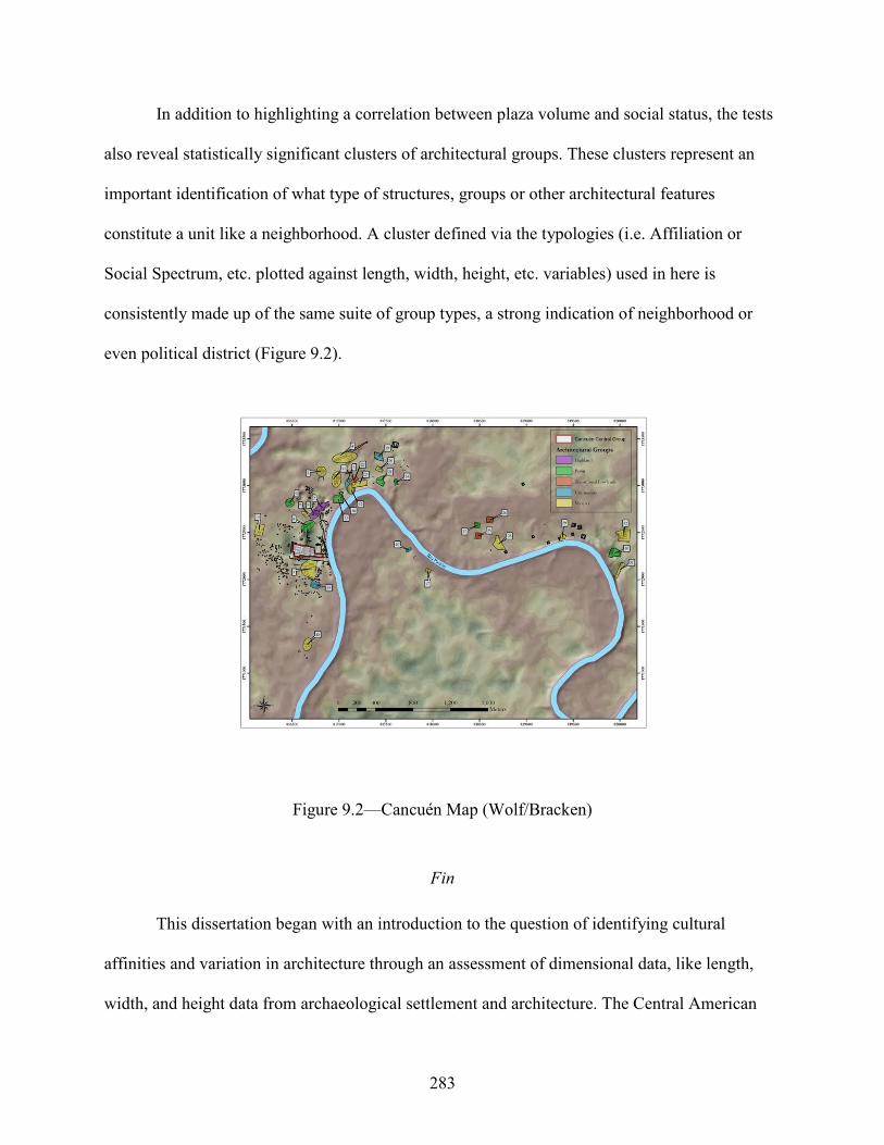
283
In addition to highlighting a correlation between plaza volume and social status, the tests
also reveal statistically significant clusters of architectural groups. These clusters represent an
important identification of what type of structures, groups or other architectural features
constitute a unit like a neighborhood. A cluster defined via the typologies (i.e. Affiliation or
Social Spectrum, etc. plotted against length, width, height, etc. variables) used in here is
consistently made up of the same suite of group types, a strong indication of neighborhood or
even political district (Figure 9.2).
Figure 9.2—Cancuén Map (Wolf/Bracken)
Fin
This dissertation began with an introduction to the question of identifying cultural
affinities and variation in architecture through an assessment of dimensional data, like length,
width, and height data from archaeological settlement and architecture. The Central American

284
landscape was described, followed by a brief generalization of Maya space. Along the way, a
host of relevant settlement pattern analyses and perspectives of a Maya world view were
reviewed and demonstrate the firm footing of this research’s spatial contextualization. Several
perspectives of identity and the sacred landscape were discussed with gradually more emphasis
on Guatemala, Verapaz, and eventually Cancuén. Thirty-two of the architectural groups within
the Cancuén settlement then underwent a series of statistical testing demonstrating the presence
of group clusters within the architecture (based on length, width, height, volume, etc., and
several social variables). Discussion then expanded to regions beyond Cancuén and outside
Guatemala, illustrating examples of variations to the themes reviewed herein. Finally, this
conclusion touches upon additional research from the field and gives a larger perspective to the
discussion of Maya settlement and architecture seen through a lens of self-identification and the
sacred environment.
Living amid notable landscape features usually fosters an impression on inhabitants;
urban sprawl, mountainous or rough terrain, inundated land, karstic ridges and depressions,
stands of vegetation, maritime or riverine environments all impact human identification. They
leave indelible marks on the thoughts and actions of the individual people and community groups
with whom they identify. They are the architects, builders, dwellers and passersby. Architecture
is the embodiment of their designs, and plans. A settlement reflects the dynamic processes of
human construction, visitation, and remodeling integrated with spatial conceptions of the sacred
and built landscape.

285
REFERENCES
Adams, Richard EW., and Richard C. Jones "Spatial patterns and regional growth among Classic Maya cities." American Antiquity 46, no. 2 (1981): 301-322.
Adams, Richard EW
"Routes of Communication in Mesoamerica: the Northern Guatemalan Highlands and the Petén." Mesoamerican Communication routes and Cultural Contacts (1978): 27-36.
Adams, Richard EW., and Jane Jackson Adams
"Volumetric and stylistic reassessment of classic Maya sites in the Peten, Rio Bec, Chenes, and Puuc Hills." Ancient Mesoamerica (2003): 139-150.
Adams, Richard EW., and Richard C. Jones
"Spatial patterns and regional growth among Classic Maya cities." American Antiquity (1981): 301-322.
Aguilar, M., Jaen, M.M., Tucker, T.M. and Brady, J.E.
2005. Constructing mythic space: The significance of a Chicomoztoc Complex at Acatzingo Viejo. In the maw of the earth monster: Mesoamerican ritual cave use, pp.69-87.
Agurcia Fasquelle, Ricardo, and Barbara W. Fash
"The evolution of Structure 10L-16, heart of the Copán Acropolis." Copán. The history of an ancient kingdom, Santa Fe, NM (2005): 201-37.
Aimers, James J., and Prudence M. Rice
"Astronomy, ritual, and the interpretation of Maya “E-Group” architectural assemblages." Ancient Mesoamerica 17, no. 1 (2006): 79-96.
Alvarado, Carlos, Carrie Anne Berryman, Anna Novotny, and Kristen Demarest
"Investigaciones en El Puerto Principal de Cancuén." Proyecto Arqueológico Cancuén; Informe Temporadas 2004u2005, pp. 435-452. Instituto de Antropología e Historia, Guatemala (2006).
Alvarado, Carlos
"Excavaciones en el Puerto Principal de Cancuén: Temporada 2003." Proyecto Arqueológico Cancuén, Informe Temporada 2003, Instituto de Antropología e Historia, Guatemala (2003).
Alvarado, Silvia N.
"Análisis funcional de las reservas de agua en Cancuén." Escuela de Historia, Universidad de San Carlos, Guatemala City (2011).

286
Alvarado, Silvia N. "Manejo Hidráulico Durante el Clásico Tardío en Cancuén, Petén, Guatemala."Archaeology 5 (2013): 125-149.
Alvarado, Silvia N., et al.
"Excavaciones en la Cisterna o Reserva de Agua Norte." Proyecto Arqueológico Cancuén, Informe Final, pp. 79-113. Instituto de Antropología e Historia, Guatemala (2007).
Andrews, George F.
1975. Maya Cities: Placemaking and Urbanization. University of Oklahoma Press, Norman.
Andrews, Anthony P., and Shirley B. Mock
"New Perspectives on the Prehispanic Maya Salt Trade." Ancient Maya Political Economies (2002): 307.
Andrieu, Chloé
2013. Late Classic Maya lithic production and exchange at Rio Bec and Calakmul, Mexico. Journal of Field Archaeology, 38(1), pp.21-37.
Andrieu, Chloé, and Douglas Quiñonez
"Análisis Lítico." Proyecto Arqueológico Cancuén Informe Final, pp. 164-184. Instituto de Antropología e Historia, Guatemala (2010).
Andrieu, Chloé, and Mélanie Forné
"Producción y Distribución del Jade en el Mundo Maya: Talleres, Fuentes y Rutas del Intercambio en su Contexto Interregional: Vista desde Cancuén." XXIV Simposio de Investigaciones Arqueológicas en Guatemala. Museo Nacional de Arqueología, Guatemala (2009).
Andrieu, Chloé, Edna Rodas, and Luis Fernando Luin
"The Values of Classic Maya Jade: a Reanalysis of Cancuén's Jade Workshop."Ancient Mesoamerica 25, no. 1 (2014): 141-164.
Andrieu, Chloé, Mélanie Forné, Arthur A. Demarest, Walburga Wiesheu, and Gabriela Guzzy
"El Jade y Otras Piedras Verdes: Perspectivas Interdisciplinarias e Interculturales." Instituto de Antropología e Historia, Guatemala (2012).
Andrieu, Chloé, O, J. Riveron, M. D. Tenorio, T. Calligaro, J. C. Ocampo, M. Jiménez, and M. Ostroumov
"Últimos Datos Sobre la Producción de Artefactos de Jade en Cancuén." XXIV Simposio de Investigaciones Arqueológicas en Guatemala 2010. Museo Nacional de Arqueología y Etnología, Guatemala (2010).
Ardren, Traci, Scott R. Hutson, David R. Hixson, and Justin Lowry
"Connections Beyond Chunchucmil." (2017): 273.
287
Arnauld, M. Charlotte "El Comercio Clásico de Obsidiana: Rutas Entre Tierras Altas y Tierras Bajas en el Área Maya." Latin American Antiquity 1.4 (1990): 347-367.
Arnauld, M. Charlotte
“La casa grande: Evolución de la arquitectura del poder del clásico al postclasico. Reconstruyendo la Ciudad Maya: El Urbanismo en las Sociedades Antiquas, pp. 363–401. Sociedad Española de Estudios Mayas, Madrid (2001).
Ashmore, Wendy (ed.)
1981. Lowland Maya settlement patterns. University of New Mexico Press. Ashmore, Wendy
"Site-planning principles and concepts of directionality among the ancient Maya." Latin American Antiquity 2, no. 3 (1991): 199-226.
Ashmore, Wendy
1992. Deciphering Maya architectural plans. New theories on the ancient Maya, 77, pp.173-184.
Ashmore, Wendy
"Ancient Maya Landscapes." Continuities and Changes in Maya Archaeology. Routledge, 2004. 96-109.
Ashmore, Wendy
Settlement Archaeology at Quirigua, Guatemala. University of Pennsylvania Press, 2007. Ashmore, Wendy and A. B. Knapp (eds.)
1999. Archaeologies of landscape: contemporary perspectives. Wiley-Blackwell. Ashmore, Wendy and Jeremy A. Sabloff
2002. Spatial orders in Maya civic plans. Latin American Antiquity, 13(2), pp.201-215. Ashmore, Wendy, and Gordon R. Willey
"A historical introduction to the study of Lowland Maya settlement patterns." Lowland Maya settlement patterns (1981): 3-18.
Astor-Aguilera, M.
2009. Mesoamerican Communicating Objects: Maya Worldviews before, During, and After Spanish Contact. Maya Worldviews at Conquest, University of Colorado Press, Boulder.
Aveni, Anthony and Horst Hartung
1986. Maya city planning and the calendar. Transactions of the American Philosophical Society, 76(7), pp.1-87.
288
Aveni, Anthony, S. Milbrath and C. Peraza Lope 2004. Chichen Itza’s Legacy in the Astronomically Oriented Architecture of Mayapan. In RES: Anthropology and Aesthetics, No. 45, pp. 123-143.
Barnard, Els
"Living in Mud Houses: Exploring the Materiality of Formative Mesoamerican Domestic Structures." Mexicon 38 (2016): 38-45.
Barnhart, Edwin L.
"Indicators of urbanism at Palenque." Palenque: Recent Investigations at the Classic Maya Center (2007): 107-121.
Barrera-Bassols, N. and V. M. Toledo
2005. Ethnoecology of the Yucatec Maya: Symbolism, Knowledge and Management of Natural Resources. Journal of Latin American Geography, Vol. 4, No. 1, pp. 9-41.
Barrie, T.
1996. Spiritual Path, Sacred Place: myth, ritual, and meaning in sacred architecture. Shambhala Publications, Massachusetts.
Barrientos, Juan C.
"Volcanos and Mountains in the Mesoamerican Highlands Mythology." (2018). Barrientos, Tomás J, Arthur A. Demarest, Juan Pedro Laporte, Bárbara Arroyo, and Héctor Mejía
"Cancuén: Puerta del Mundo Maya Clásico." XX Simposio de Investigaciones Arqueológicas en Guatemala, pp. 737-755. Museo Nacional de Arqueología y Etnología, Guatemala (2007).
Barrientos, Tomás J, Arthur A. Demarest, Ronald L. Bishop, and Federico Fahsen
"Redescubriendo Cancuén: Nuevos Datos sobre un sitio fronterizo entre las tierras bajas y el altiplano maya." XIV Simposio de Investigaciones Arqueológicas en Guatemala. Museo Nacional de Arqueología y Etnología, Guatemala (2000).
Barrientos, Tomás J, et al.
“Investigaciones en el Área Residencial Sur y Suroeste de Cancuén. Proyecto Arqueológico Cancuén: Informe Temporada 2000, Instituto de Antropología e Historia, Guatemala (2002).
Barrientos, Tomás J, Rudy Larios, Alejando Seijis, and Luis F. Luin
"Investigaciones en la Estructura L7-9, Patio Sur del Palacio de Cancuén." Proyecto Arqueológico Cancuén. Informe de Temporada 2002, pp. 43-68. Instituto de Antropología e Historia, Guatemala (2003).

289
Barrientos, Tomás J. "The Royal Palace of Cancuén: The Structure of Lowland Maya Architecture and Politics at the End of the Late Classic Period." PhD dissertation, Vanderbilt University, Nashville, 2014.
Barrientos, Tomás J. (Quezeda)
The Royal Palace of Cancuen: The Structure of Lowland Maya Architecture and Politics at the end of the Late Classic Period. Vanderbilt University, Nashville, 2014.
Barrientos, Tomás J., Arthur A. Demarest, Silvia Alvarado, Horacio Martínez, Marc Wolf, Luis Fernando Luin, Juan Pedro Laporte, Bárbara Arroyo, and Héctor Mejía
"Hidráulica, ecología, ideología y poder: nueva evidencia y teorías en el sur de Petén." XIX Simposio de Investigaciones Arqueológicas en Guatemala, pp. 319-332. Museo Nacional de Arqueología y Etnología, Guatemala (2006).
Barrientos, Tomás J., Rudy Larios, and Luis F. Luin
"Excavaciones en la Acrópolis de Cancuén: Patio Sur." Proyecto Arqueológico Cancuén, Temporada 2003, pp. 43-84. Instituto de Antropología e Historia, Guatemala (2004).
Barrientos, Tomás
“Hydraulic Systems in Central Cancuén: Ritual, Reservoir, and/or Drainage?” FAMSI © 2008 (http://www.famsi.org/reports/05082/index.html).
Barrios, Edy and Claudia Quintanilla
“Tres Islas: Un pequeño centro de comercio de las Tierras Bajas en el río Pasión, Sayaxché, Petén”. XXI Simposio de Investigaciones Arqueológicas en Guatemala, 2007, Museo Nacional de Arqueología y Etnología, Guatemala (2008).
Barthel, Stephan, and Christian Isendahl
"Urban Gardens, Agriculture, and Water Management: Sources of Resilience for Long-Term Food Security in Cities." Ecological Economics 86 (2013): 224-234.
Barthes, Roland
"Literature According to Minou Drouet. The Eifel Tower and Other Mythologies." Trans. Richard Howard. New York: Hill (1979): 111-18.
Barton, James Gunn
Humanizing divine power: The role of caves in the historical development of Maya culture. California State University, Dominguez Hills, 2010.
Becker, Marshall J.
The identification of a second plaza plan at Tikal, Guatemala and its implications for ancient Maya social complexity. University of Pennsylvania, 1971.

290
Becker, Marshall J. "Archaeological Evidence for Occupational Specialization Among the Classic period Maya at Tikal, Guatemala." American Antiquity 38.4 (1973): 396-406.
Becker, Marshall J.
1982. Ancient Maya houses and their identification: an evaluation of architectural groups at Tikal and inferences regarding their functions. Revista española de antropología americana, 12, p.111.
Becker, Marshall J., Christopher Jones, and John J. McGinn
Excavations in Residential Areas of Tikal--Groups with Shrines: Tikal Report 21. Vol. 104. UPenn Museum of Archaeology, 1999.
Becker, Marshall J., Linda R. Manzanilla, and Claude Chapdelaine
"Tikal: Evidence for Ethnic Diversity in a Prehispanic Lowland Maya State Capital." Domestic Life in Prehispanic Capitals: a Study of Specialization, Hierarchy, and Ethnicity 46 (2009).
Bender, Barbara
"Time and landscape." Current anthropology 43, no. S4 (2002): S103-S112. Berryman, Carrie Anne and Ana Novotny
“Análisis Osteológico”. Proyecto Arqueológico Cancuén, Temporada 2003, pp.515-528. Instituto de Antropología e Historia, Guatemala (2004).
Bill, Cassandra R. and Jeanette Castellanos
"The Ceramics of Cancuén and the Upper Pasión Region." Informe Preliminar #4, Temporada 2002, Instituto de Antropología e Historia, Guatemala (2002).
Bill, Cassandra R. Hill, Jeanette Castellanos and Ronald L. Bishop
“Gris Fino Chablekal: Distribución y Análisis Socioeconómico Preliminar en Cancuén”. XVII Simposio de Investigaciones Arqueológicas en Guatemala, Museo Nacional de Arqueología y Etnología (2004).
Bishop, Ronald L, and Hector Neff
"Laser Ablation-ICP-MS Chemical Characterization of Jade from a Jade Workshop at Cancuén, Guatemala." Laser Ablation-ICP-MS in Archaeological Research (2005): 39-56.
Bishop, Ronald L., Elizabeth H. Paris, Roberto López Bravo, and Timothy D. Sullivan
"Imitation games: The exchange and emulation of fine orange pottery in central Chiapas, Mexico." Journal of Anthropological Archaeology 62 (2021): 101306.

291
Bishop Ronald L., Mélanie Forné, Arthur A. Demarest, M. James Blackman, Erin L. Sears, and Bárbara Arroyo
"Gris Fino, Naranja Fino: presencia temprana y fuentes de producción, el caso de Cancuén." XXIII Simposio de investigaciones arqueológicas en Guatemala, pp. 1163-1182. Museo Nacional de Arqueología y Etnología, Guatemala (2009).
Blanton, Richard
"Urban beginnings: a view from anthropological archaeology." Journal of Urban History 8, no. 4 (1982): 427-446.
Braswell, G. E.
2004. The Maya and Teotihuacan: Reinterpreting Early Classic Interaction. University of Texas Press, Austin, 2004.
Brown, L. A.
2005. Planting the Bones: Hunting Ceremonialism at Contemporary and Nineteenth-Century Shrines in the Guatemalan Highlands. Latin American Antiquity, Vol. 16, No. 2, pp. 131-146.
Boas, Franz
1920. The methods of ethnology. American Anthropologist, 22(4), pp.311-321. Boas, Franz
Race, language, and culture. University of Chicago Press, 1940. Bourdieu, Pierre
Structures and the habitus, 1977. Brady, James E. and Ashmore, Wendy
1999. Mountains, caves, water: ideational landscapes of the ancient Maya. Archaeologies of landscape: contemporary perspectives, pp.124-45.
Brady, James E. and Keith M. Prufer
2005. Maya cave archaeology: a new look at religion and cosmology. Stone Houses and Earth Lords: Maya Religion in the Cave Context, pp.365-380.
Brady, James E. and Andrea Stone
1986. Naj Tunich: entrance to the Maya underworld. Archaeology, 39(6), pp.18-25. Brady, James E.
2003. My Hill, in My Valley: The Importance of Place in Ancient Maya Ritual. Mesas and Cosmologies in Mesoamerica, San Diego Museum Papers, 42, pp.83-91.
Brady, James E.
In the maw of the earth monster: Mesoamerican ritual cave use. University of Texas Press (2005).

292
Brady, James E. 2005. “The Impact of Ritual on Ancient Maya Economy”. Stone Houses and Earth Lords: Maya Religion in the Cave Context, chapter 6.
Braswell, Geoffrey E.
"The technology of ancient Maya civilization." The Technology of Maya Civilization. Routledge, 2014. 13-24.
Buenaflor, Erika
Cleansing Rites of Curanderismo: Limpias Espirituales of Ancient Mesoamerican Shamans. Simon and Schuster, 2018.
Canuto, Marcello A. and Tomás J. Barrientos
"The Importance of La Corona." La Corona Notes 1.1 (2013): 1-5. Canuto, Marcello A., Francisco Estrada-Belli, Thomas G. Garrison, Stephen D. Houston, Mary Jane Acuña, Milan Kováč, Damien Market al.
"Ancient lowland Maya complexity as revealed by airborne laser scanning of northern Guatemala." Science 361, no. 6409 (2018).
Carballo, David
“Urban Infrastructure and Resiliency in Precolonial Mesoamerica.” Lecture given to New York Academy of Sciences, December 6th, 2021.
Carneiro, R.
A Theory on the Origin of the State. Macmillan Publishing, New York 1970. Carrasco Vargas, Ramón
"The Sacred Mountain: Preclassic Architecture in Calakmul." Lords of Creation: The Origins of Sacred Maya Kingship (2005): 62-66.
Chase, Adrian S.
"Residential inequality among the ancient Maya: operationalizing household architectural volume at Caracol, Belize." Research Reports in Belizean Archaeology 14 (2017): 31-39.
Chase, Arlen F.
"A Contextual Consideration of the Tayasal-Paxcaman Zone, El Peten, Guatemala." (1983).
Chase, Arlen F. and Diane Z. Chase
"Details in the archaeology of Caracol, Belize: An introduction." Studies in the Archaeology of Caracol, Belize (1994): 1-11.
Chase, Arlen F. and Diane Z. Chase
"Scale and Intensity in Classic Period Maya Agriculture: Terracing and Settlement at the Garden City of Caracol, Belize." Culture & Agriculture 20, no. 2‐3 (1998): 60-77.

293
Chase, Arlen F., Diane Z. Chase, Jaime J. Awe, John F. Weishampel, Gyles Iannone, Holley Moyes, Jason Yaeger, and M. Kathryn Brown
"The use of LiDAR in understanding the ancient Maya landscape: Caracol and western Belize." Advances in Archaeological Practice 2.3 (2014): 208-221.
Chase, Arlen F., Diane Z. Chase, John F. Weishampel, Jason B. Drake, Ramesh L. Shrestha, K. Clint Slatton, Jaime J. Awe, and William E. Carter
"Airborne LiDAR, archaeology, and the ancient Maya landscape at Caracol, Belize." Journal of Archaeological Science 38.2 (2011): 387-398.
Chase, Diane Z. and Arlen F. Chase
"Late postclassic ritual at Santa Rita Corozal, Belize: Understanding the archaeology of a Maya capital city." Research Reports in Belizean Archaeology 5 (2008): 79-92.
Child, Mark B.
"Ritual Purification and the Ancient Maya Sweat Bath at Palenque." Palenque: Recent Investigations at the Classic Maya Center (2007): 233.
Chinchilla Mazariegos, Oswaldo. "Technologies of Urbanism in Mesoamerica: the Pre-Columbian Bridges of Cotzumalhuapa, Guatemala." Antiquity 92.362 (2018): 456-471. Chládek, S.
2011. Exploring Maya ritual caves: Dark secrets from the Maya underworld. Rowman Altamira.
Christie, Jessica Joyce
"Houses of political power among the ancient Maya and Inka." Palaces and Power in the Americas. From Peru to the Northwest Coast (2006): 353-396.
Clancy, F.S.
1986. Text and Image in the Tablets of the Cross Group at Palenque. RES: Anthropology and Aesthetics 11(1), pp.17-32.
Coe, William R.
"A summary of excavation and research at Tikal, Guatemala: 1956-61." American Antiquity 27, no. 4 (1962): 479-507.
Coe, William R.
1988. Tikal, a handbook of the ancient Maya ruins: with a guide map. University Museum, University of Pennsylvania.
Coggins, C.C.
1979. A new order and the role of the calendar: some characteristics of the Middle Classic period at Tikal. Maya Archaeology and Ethnohistory, pp.38-50.

294
Cohodas, M. 1976. The Iconography of the Panels of the Sun, Cross and Foliated Cross at Palenque: Part III. The Art, Iconography and Dynastic-History of Palenque, pp.155-76.
Cook, Duncan E. et al.
"Deciphering the Inorganic Chemical Record of Ancient Human Activity Using ICP-MS: a Reconnaissance Study of Late Classic Soil Floors at Cancuén, Guatemala." Journal of Archaeological Science 33.5 (2006): 628-640.
Cook, Duncan E., Timothy Beach, and Arthur A. Demarest
"Soil and Slaughter: a Geoarchaeological Record of the Ancient Maya from Cancuén, Guatemala." Journal of Archaeological Science: Reports 15 (2017): 330-343.
Culbert, T. Patrick (ed.)
Classic Maya political history: Hieroglyphic and archaeological evidence. Cambridge University Press, 1991.
Culbert, T. P. and D. S. Rice (eds.)
Precolumbian Population History in the Maya Lowlands. University of New Mexico Press, Albuquerque, 1990.
DeBoer, Warren W.
“Interaction, imitation, and communication as expressed in style: the Ucayali experience.” Cambridge University Press, 1990.
De Certeau, Michel and S. Randall
"Walking in the City." Popular culture: A reader (1984): 449-461. Del Cid, Mari, and David R. García
"The Candelarias Cave, Alta Verapaz: Demythtifyzing Communitarian Participation in Patrimonial Conservation (2006)". Colapso Maya”. Editorial Piedra Santa, Guatemala City (2012).
Demarest, Arthur A.
"Sacred and Profane Mountains of the Pasión." Palaces and Power in the Americas: From Peru to the Northwest Coast (2006): 117.
Demarest, Arthur A.
The Petexbatun Regional Archaeological Project: A Multidisciplinary Study of the Maya collapse. Vol. 1. Vanderbilt University Press, 2006.
Demarest, Arthur A.
"Ideological pathways to economic exchange: religion, economy, and legitimation at the Classic Maya royal capital of Cancuén." Latin American Antiquity 24.4 (2013): 371-402.

295
Demarest, Arthur A. 2014. The royal port of Cancuén and the role of long-distance exchange in the apogee of Maya civilization. The Maya and Their Central American Neighbors: Settlement Patterns, Architecture, Hieroglyphic Texts and Ceramics, p.201.
Demarest, Arthur A. and Tomás J. Barrientos
"Proyecto Cancuén: Introdución a la Temporada 1999." Proyecto Arqueológico Cancuén: Informe Preliminar# 1, Temporada 1999, pp. 5-16, Instituto de Antropología e Historia, Guatemala (1999).
Demarest, Arthur A. and G. W. Conrad (eds.)
1992. Ideology: and pre-Columbian Civilizations. School of American Research, Santa Fe.
Demarest, Arthur A. and Tomás J. Barrientos
“Conclusiones de la temporada de campo de 2000, Proyecto Arqueológico Cancuén. Proyecto Arqueológico Cancuén Informe Preliminar, No.2. Universidad de Vanderbilt, Nashville (2000).
Demarest, Arthur A. and Tomás J. Barrientos
"Proyecto Arqueológico Cancuén, Informe No. 3, Temporada 2001." Instituto de Antropología e Historia, Guatemala (2002).
Demarest, Arthur A, and Tomás J. Barrientos
"Proyecto Arqueológico Cancuén, Temporada 2003: antecedentes y resumen de actividades." Proyecto Arqueológico Cancuén, Informe de Temporada 2003, pp. 1-18, Instituto de Antropología e Historia, Guatemala (2003).
Demarest, Arthur A. and Federico Fahsen
"Nuevos datos e interpretaciones de los reinos occidentales del clásico tardío: hacia una visión sintética de la historia Pasión/Usumacinta." XVI simposio de investigaciones arqueologicas en Guatemala, Museo Nacional de Arqueología y Etnología, Guatemala (2002).
Demarest, Arthur A. and Don S. Rice
2005. The Terminal Classic in the Maya Lowlands: collapse, transition, and transformation. University Press of Colorado.
Demarest, Arthur A., Tomás J. Barrientos, and Federico Fahsen
El apogeo y el colapso del reinado de Cancuén: Resultados e interpretaciones del Proyecto Cancuén, 2004–2005. XIX Simposio de Investigaciones Arqueológicas en Guatemala, pp. 757-768. Museo Nacional de Arqueología y Etnología, Guatemala (2006).
296
Demarest, Arthur A., Matt O'Mansky, Nicholas Dunning, and Timothy Beach "¿Catastrofismo, procesos ecológicos o crisis política? Hacia una mejor metodología para la interpretación del “colapso” de la civilización Maya Clásica." XVII Simposio de investigaciones arqueológicas en Guatemala, pp. 551-563. Museo Nacional de Arqueología y Etnología, Guatemala (2003).
Demarest, Arthur A., Brent KS Woodfill, Marc Wolf, Tomás J. Barrientos, Ronald L. Bishop, Mirza Monterroso, Edy Barrios, Claudia Quintanilla, and Matilde Ivic
"De la Selva a la Sierra: Investigaciones a lo Largo de las Rutas Ribereñas y Terrestres del Occidente." XXI Simposio de Investigaciones Arqueológicas en Guatemala, pp. 179-193. Asociación Tikal/Museo Nacional de Arqueología y Etnología, Guatemala (2007).
Demarest, Arthur A., Horacio Martínez, Marc Wolf, Paola Torres, Waleska Belches, Chloé Andrieu, Luis F. Luin, Matt O’mansky, and Claudia Quintanilla
"Economía interna, relaciones internacionales de Cancuén y de sitios de su reinado." XXII simposio de Investigaciones de Arqueología en Guatemala, pp. 655-74. Museo Nacional de Arqueología y Etnología, Guatemala (2008).
Demarest, Arthur A., Juan Antonio Valdés, Héctor Escobedo, Federico Fahsen, Tomás J. Barrientos y Horacio Martínez.
“25 años de proyectos regionales en el valle del río La Pasión: Una visión general de las investigaciones, resultados y perspectivas sobre los últimos siglos de una gran ruta maya”. XXV Simposio de Investigaciones Arqueológicas en Guatemala, pp. 93-107. Ministerio de Cultura y Deportes, Instituto de Antropología e Historia y Asociación, Guatemala (2012).
Demarest, Arthur A., Andrieu, C., Torres, P., Forné, Mélanie., Barrientos, T. and Marc Wolf
2014. Economy, exchange, and power: new evidence from the late classic Maya port city of Cancuén. Ancient Mesoamerica, 25(1), pp.187-219.
Demarest, Arthur A., Horacio Martínez, Paola Torres, Monica Urquizu, Matt O’Mansky, Marc Wolf, Miryam Saravia, Yasmin Cifuentes, Iyaxel Coji, Chloé Andrieu, Juan Francisco Saravia, Luis F. Luin, Carlos Fidel Tuyuc, and Justin Bracken
Las dinámicas de interacción de tierras bajas con el altiplano: Descubrimientos en Cancuén y la Alta Verapaz. XXVII simposio de Investigaciones Arqueológicas en Guatemala. Museo Nacional de Arqueología y Etnología, Guatemala (2013).
Demarest, Arthur A., Tomás J. Barrientos, Juan Pedro Laporte, Bárbara Arroyo, Héctor Escobedo, and Héctor Mejía
"Los proyectos de arqueología y de desarrollo comunitario en Cancuén: Metas, resultados y desafíos en 2003." XVII Simposio de Investigaciones Arqueológicos en Guatemala, pp. 450-464. Museo Nacional de Arqueología y Etnología, Guatemala (2004).
297
Denevan, W.M. 1970. Aboriginal drained-field cultivation in the Americas: Pre-Columbian reclamation of wetlands was widespread in the savannas and highlands of Latin America. Science, 169 (3946), pp.647-654.
Dillon, Brian
1977. Salinas de los Nueve Cerros, Guatemala. Studies in Mesoamerican Art, Archaeology, and Ethnohistory, No. 2.
Dillon, Brian
1979. The Archaeological Ceramics of Salinas de los Nueve Cerros, Alta Verapaz, Guatemala. Unpublished PhD dissertation, University of California, Berkeley.
Dillon, Brian, K. Pope and M. Love
1988. An Ancient Extractive Industry: Maya Saltmaking at Salinas de los Nueve Cerros, Guatemala. Journal of New World Archaeology, No.7, Vols. 2/3, pp. 37-58.
Dowd, A.S. and Milbrath, S. (eds.)
2015. Cosmology, calendars, and horizon-based astronomy in ancient Mesoamerica. University Press of Colorado.
Doyle, James and Stephen Houston
"Category Archives: El Mirador." (2012) Driver, W. David
"An early classic colonnaded building at the Maya site of Blue Creek, Belize." Latin American Antiquity 13, no. 1 (2002): 63-84.
Driver, W. David
The construction of intrapolity sociopolitical identity through architecture at the ancient Maya site of Blue Creek, Belize. Southern Illinois University at Carbondale, 2007.
Driver, W. David and Wanyerka, P.
2002. Creation symbolism in the architecture and ritual at Structure 3, Blue Creek, Belize. Mexicon, pp.6-8.
Dunning, Nicholas, Vernon Scarborough, Fred Valdez, Sheryl Luzzadder-Beach, Timothy Beach, and John G. Jones
"Temple mountains, sacred lakes, and fertile fields: Ancient Maya landscapes in northwestern Belize." Antiquity 73, no. 281 (1999): 650-660.
Durkheim, Emil
1915. The Elementary Forms of Religious Life. Excerpt from original, and 1963 reprint. Allen and Unwin (original) and Macmillan Publishing (reprint), London.
298
Earle, Duncan "Maya Caves Across Time and Space." Pre-Columbian landscapes of creation and origin, pp. 67-93. Springer, New York, NY, 2008.
Eliade, Mircea
Myth and Reality: Translated from the French by Willard R. Trask. Planned and Edited by Ruth Nanda Anshen. Harper & Row, 1963.
Fahsen, Federico and Arthur A. Demarest
"El papel del reino de Cancuén en la historia de las Tierras Bajas mayas: nuevos datos epigráficos." XIV. Simposio de Investigaciones Arqueológicas en Guatemala, vol. 2000, pp. 858-874. Museo Nacional de Arqueología y Etnología, Guatemala (2001).
Estrada, Javier, Henrry Rodríguez and Gloria Ajú
“Cerro de Oro, Santiago Atitlán: un espacio sagrado a la orilla del lago.” XXX Simposio de Investigaciones Arqueológicas en Guatemala, vol. 2016, pp. 331-345. Museo Nacional de Arqueología y Etnología, Guatemala.
Estrada-Belli, Francisco
1991. The Evolution of Complex Societies in Southeastern Pacific Coastal Guatemala: A Regional GIS Archaeological Approach. PhD dissertation; Boston University.
Estrada-Belli, Francisco
"Archaeological Investigations at Holmul, Guatemala. Report of the First Field Season. May-June 2000." Department of Anthropology, Vanderbilt University, Nashville (2000).
Estrada-Belli, Francisco
"Cival, La Sufricaya and Holmul: The Long History of Maya Political Power and Settlement in the Holmul Region.” Research Reports in Belizean Archaeology Volume 2 (2005): 193.
Estrada-Belli, Francisco
2006. Lightning sky, rain, and the maize god: the ideology of Preclassic Maya rulers at Cival, Peten, Guatemala. Ancient Mesoamerica, 17(1), pp.57-78.
Estrada-Belli, Francisco and Alexandre A. Tokovinine
"A king's apotheosis: iconography, text, and politics from a Classic Maya temple at Holmul." Latin American Antiquity 27, no. 2 (2016): 149-168.
Estrada-Belli, Francisco, Alexandre A. Tokovinine, Jennifer M. Foley, Heather Hurst, Gene A. Ware, David Stuart, and Nikolai Grube
"A Maya Palace at Holmul, Peten, Guatemala and the Teotihuacan “Entrada”: evidence from murals 7 and 9." Latin American Antiquity 20, no. 1 (2009): 228-259.

299
Fahsen, Federico “Proyecto Epigráfico Cancuén, La cronología de las dinastías de Cancuén y Machaquilá. Proyecto Arqueológico Cancuén Informe Preliminar #2. Universidad de Vanderbilt, Nashville (2000).
Fahsen, Federico and Arthur A. Demarest
"El papel del reino de Cancuén en la historia de las Tierras Bajas mayas: nuevos datos epigráficos." XIV. Simposio de Investigaciones Arqueológicas en Guatemala, vol. 2000, pp. 858-874. Museo Nacional de Arqueología y Etnología, Guatemala (2001).
Fahsen, Federico and Sarah Elizabeth Jackson
"Nuevos datos e interpretaciones sobre la dinastía de Cancuén en el periodo Clásico." XV. Simposio de Investigaciones Arqueológicas en Guatemala, vol. 2003, pp. 784-793. Museo Nacional de Arqueología y Etnología, Guatemala (2002).
Fahsen, Federico and Tomás J. Barrientos
"Los monumentos de Taj Chan Ahk y Kan Ma'x." Proyecto Arqueológico Cancuén Informe Final 2004, pp. 35-56. Instituto de Antropología e Historia y Asociación, Guatemala (2004).
Fahsen, Federico, Arthur A. Demarest y Luis F. Luin
“Sesenta años de historia en la escalinata jeroglífica de Cancuén”. XVI Simposio de Investigaciones Arqueológicas en Guatemala, 2002, pp.703-713. Museo Nacional de Arqueología y Etnología, Guatemala (2003).
Fash, Barbara W.
"Late Classic architectural sculpture themes in Copan." Ancient Mesoamerica 3, no. 1 (1992): 89-104.
Fash, Barbara W.
"Watery Places and Urban Foundations Depicted in Maya Art and Architecture." The Art of Urbanism: How Mesoamerican Kingdoms Represented Themselves in Architecture and Imagery (2009): 230-259.
Fash, Barbara W., William L. Fash, Sheree Lane, Rudy Larios, Linda Schele, Jeffrey Stomper, and David Stuart
"Investigations of a Classic Maya council house at Copan, Honduras." Journal of field archaeology (1992): 419-442.
Fash, William L.
"Deducing social organization from Classic Maya settlement patterns: A case study from the Copan Valley." Civilization in the ancient Americas: Essays in honor of Gordon R. Willey (1983): 261-288.

300
Fash, William L. 2001. Scribes, Warriors, and Kings: The City of Copan and the Ancient Maya. Thames and Hudson, London.
Fash, William L. and Barbara W. Fash
"Building a world-view: Visual communication in Classic Maya architecture." RES: Anthropology and Aesthetics 29, no. 1 (1996): 127-147.
Fash, William L. and E. Wyllys Andrews
"Copán: the history of an ancient Maya kingdom." (2005). Fash, William L., Richard V. Williamson, Carlos Rudy Larios, and Joel Palka
"The hieroglyphic stairway and its ancestors: investigations of Copan structure 10L-26." Ancient Mesoamerica 3, no. 1 (1992): 105-115.
Fedick, S. L. (ed.)
1996. The Managed Mosaic: Ancient Maya Agriculture and Resources Use. University Press, Salt Lake City.
Feinman, Gary M.
"Mesoamerican temples," Temple in society (1988): 67-82. Feinman, Gary M. and David M. Carballo
"Collaborative and competitive strategies in the variability and resiliency of large‐scale societies in Mesoamerica."Economic Anthropology 5, no. 1 (2018): 7-19.
Fernández, Carlos E.
"Uniendo Ideas: Los Estucos del Juego de Pelota de Taj Chan Ahk en Cancuén." In XXV Simposio de Investigaciones Arqueológicas en Guatemala, pp. 419-436. 2011.
Ferrand, E.A. and Vernon L. Scarborough
2012. Ancient Maya solutions to water and food insecurity: Low technology lessons for contemporary development. Global Water Forum, Discussion Paper (Vol. 1215).
Foias, Antonia E.
2013. Ancient Maya political dynamics. University Press of Florida. Folan, William J.
Coba: A classic Maya metropolis. Elsevier, 2014. Folan, William J., Gunn, Joel D. and Carrasco, M.D.
2001. Triadic temples, central plazas, and dynastic palaces: A diachronic analysis of the royal court complex, Calakmul, Campeche, Mexico. Royal Courts of the Ancient Maya, 2, pp.223-265.
301
Forné, Mélanie, Silvia Alvarado, and Paola Torres. "Cronología cerámica en Cancuén: historia de una ciudad del Clásico Tardío." Estudios de cultura maya 38 (2011): 11-39.
Forné, Mélanie, Arthur A. Demarest, Horacio Martínez, P. Torres, S. Alvarado and C. Arriaza
2008. Intercambio y afiliación cultural en Cancuén: la complejidad cultural en las vísperas del colapso. XXII Simposio de Investigaciones Arqueológicas en Guatemala, 2008, pp.1017-1036. Forné, Mélanie, Edy Barrios, Claudia Quintanilla y Raquel Macario
Proyecto El Raudal, un sitio mayor de la región del Alto Pasión durante el Clásico Tardío (2012).
Forné, Mélanie, Ronald L. Bishop, Arthur A. Demarest, M. James Blackman, Erin L. Sears, and Bárbara Arroyo
"Gris Fino, Naranja Fino: presencia temprana y fuentes de producción, el caso de Cancuén." XXIII Simposio de investigaciones arqueológicas en Guatemala, vol. 2009, pp. 1163-1182. Guatemala (2010).
Forné, Mélanie, Arthur A. Demarest, Horacio Martínez, Paola Torres, Silvia Alvarado, Claudia Arriaza, Juan Pedro Laporte, Bárbara Arroyo, and Héctor E. Mejía
"Intercambio y afiliación cultural en Cancuén: la complejidad cultural en las vísperas del colapso." XXII Simposio de Investigaciones Arqueológicas en Guatemala, pp. 1017-1036. Guatemala (2008).
Forné, Mélanie, Chloé Andrieu, Arthur A. Demarest, Paola Torres, Claudia Quintanilla, Ronald L. Bishop, and Olaf Jaime Riveron
"Crisis y cambios en el Clásico Tardío: los retos económicos de una ciudad entre tierras altas y tierras bajas mayas." Guatemala (2011).
Fowler, William R. et al.
"Sources of Obsidian from El Mirador, Guatemala: New Evidence on Preclassic Maya Interaction." American Anthropologist 91.1 (1989): 158-168.
Freidel, David A.
"The monumental architecture." Archaeology at Cerros, Belize, Central America: An Interim Report 1 (1986): 1-22.
Freidel, David A.
Maya divine kingship. na, 2008. Freidel, David A. and Linda Schele
1988. Kingship in the Late Preclassic Maya lowlands: the instruments and places of ritual power. American Anthropologist, 90(3), pp.547-567.

302
Freidel, David A., Linda Schele, and Joy Parker "Maya Cosmos Three Thousand Years on the Shaman's Path" (1993).
Freidel, David A., Reese-Taylor, Katherine. and D Mora-Mann
2002. The Origins of Maya Civilization: The Old Shell Game, Commodity, Treasure, and Kingship. Ancient Maya Political Economies, p.41.
Freidel, David A., Arlen F. Chase, Anne S. Dowd, and Jerry Murdock
“Maya E Groups: Calendars, Astronomy, and Urbanism in the Early Lowlands.” University Press of Florida, 2017.
French, Kirk D.
"Creating space through water management at the Classic Maya site of Palenque, Chiapas." Palenque: recent investigations at the Classic Maya center (2007): 123-32.
Garcia, David R.
"Cancuén, Guatemala: Sacred, scientific and sustainable: Practicing anthropology in Latin America." Practicing Anthropology 24.4 (2002): 25-30.
Garcia, David, Arthur A. Demarest, and Tomás J. Barrientos
"El Proyecto Arqueológico Cancuén: Un plan piloto para la interacción entre arqueología y desarrollo social." XV Simposio de Investigaciones Arqueológicas en Guatemala. Guatemala (2002).
García-Gallo, Alfonso Lacadena
"Historia y ritual dinásticos en Machaquilá (Petén, Guatemala)/Dynastic History and Ritual in Machaquilá (Petén, Guatemala)."Revista Española de Antropología Americana 41.1 (2011): 205-240.
Geertz, Clifford.
Negara. Princeton University Press, 1980. Gillespie, Susan D.
2000. Maya “nested houses.” Beyond kinship: Social and material reproduction in house societies, pp.135-60.
Glassie, Henry
Folk housing in middle Virginia: a structural analysis of historic artifacts. Univ. of Tennessee Press, 1975.
Gossen, Gary H.
Chamulas in the World of the Sun: Time and Space in a Maya Oral Tradition. No. CH/306.67275 G67. 1974.

303
Graham, Ian. Archaeological Explorations in El Peten, Guatemala. Middle American Research Institute, Tulane University, 1967.
Groark, Kevin P.
"To warm the blood, to warm the flesh: the role of the steambath in Highland Maya (Tzeltal-Tzotzil) ethnomedicine." Journal of Latin American Lore 20 (1997): 3-96.
Grove, David C.
"Public monuments and sacred mountains: Observations on three Formative period sacred landscapes." Social patterns in Pre-classic Mesoamerica (1999): 255-299.
Guderjan, Thomas H.
1991. Maya settlement in northwestern Belize: the 1988 and 1990 seasons of the Rio Bravo Archaeological Project. Maya Research Program.
Guderjan, Thomas H.
"Public architecture, ritual, and temporal dynamics at the Maya center of Blue Creek, Belize." Ancient Mesoamerica 15.2 (2004): 235-250.
Guderjan, Thomas H.
The nature of an ancient Maya city: Resources, interaction, and power at Blue Creek, Belize. University of Alabama Press, 2007.
Guderjan, Thomas H.
"Power and Authority in an Ancient Maya City.” Reports in Belizean Archaeology 6 (2009): 119.
Guderjan, Thomas H. and Samantha Krause
2011. Identifying the extent of ancient Maya ditched field systems in the Río Hondo Valley of Belize and Mexico: a pilot study and some of its implications. Research Reports in Belizean Archaeology, 8: 1 27.
Guderjan, Thomas H., Jeffrey Baker, and Robert J. Lichtenstein
"Environmental and cultural diversity at Blue Creek." Heterarchy, Political Economy, and the Ancient Maya (2003): 77-91.
Guderjan, Thomas H., Timothy Beach, Colleen Hanratty, Sheryl Luzzadder-Beach, Tim Preston, and Steve Shaw
"Blue Creek Archaeological Project Report of 2007 Fieldwork" (2008). Guderjan, Thomas H., Timothy Beach, Steve Bozarth, Colleen Hanratty, Sheryl Luzzadder-Beach, and Timothy Preston
"New Information About the Demise of a Maya City: Fieldwork at Blue Creek, Belize, 2006 and 2007." Mexicon (2010): 15-22.

304
Halperin, Christina T. 2014. Ruins in Pre-Columbian Maya Urban Landscapes. Cambridge Archaeological Journal, 23.4: 1-24.
Halperin, Christina T.
"Ancient cosmopolitanism: Feminism and the rethinking of Maya inter-regional interactions during the Late Classic to Postclassic periods (ca. 600–1521 CE)." Journal of Social Archaeology 17.3 (2017): 349-375.
Hammond, Gail A.
“Ancient Maya Settlement and the Alacranes Bajo.” BAR International 2956 (2019). Hammond, Norman
“Obsidian Trade Routes in the Mayan Area.” Science 178.4065 (1972): 1092-1093. Hammond, Norman
"Maya settlement hierarchy in northern Belize." Contributions of the University of California Archaeological Research Facility 27 (1975): 40-55.
Hammond, Norman
"Early Maya ceremonial at Cuello, Belize." Antiquity 54.212 (1980): 176-190. Hammond, Norman
"Nohmul, Belize: 1982 Investigations." Journal of Field Archaeology 10.3 (1983): 245-254.
Hammond, Norman and Jeremy R. Bauer
"A Preclassic Maya Sweatbath at Cuello, Belize." Antiquity 75.290 (2001): 683-684. Hammond, Norman, Catherine Clark, Mark Horton, Mark Hodges, Logan McNatt, Laura J. Kosakowsky, and Anne Pyburn
"Excavation and survey at Nohmul, Belize, 1983." Journal of Field Archaeology 2.2 (1985): 177-200.
Hansen, Richard D.
Excavations in the Tigre Complex El Mirador, Petén, Guatemala. XIV Simposio de Investigaciones Arqueológicas en Guatemala, pp. 187-204. 1990.
Hansen, Richard D.
"The archaeology of ideology: A study of Maya Preclassic architectural sculpture at Nakbe, Petén, Guatemala" (1992): 4381-4381.
Hansen, Richard D.
1998. Continuity and disjunction: the Pre-Classic antecedents of Classic Maya architecture. Function and meaning in Classic Maya architecture, pp.49-122.

305
Hansen, Richard D. 2001. The first cities: The beginnings of urbanization and state formation in the Maya Lowlands. Maya: divine kings of the rain forest, pp.50-65.
Hansen, Richard D.
"The feast before famine and fighting: the origins and consequences of social complexity in the Mirador Basin, Guatemala." Feast, Famine or Fighting?, pp. 305-335. Springer, 2017.
Hansen, Richard D. and Beatriz Balcárcel
"El Complejo Tigre y la Acrópolis Central de El Mirador durante el Preclásico Medio y Tardio." Proceedings of the XXI Simposio de Investigaciones Arqueológicas en Guatemala (2007).
Hansen, Richard D., Edgar Suyuc Ley, and Héctor E. Mejía
"Resultados de la temporada de investigaciones 2009: Proyecto Cuenca Mirador." XXIV Simposio de Investigaciones Arqueológicas en Guatemala, pp. 187-204 (2010).
Harris, Marvin
1971. Culture, man, and nature: An introduction to general anthropology. Thomas Y. Crowell.
Harris, Marvin
1995. Anthropology and postmodernism. University of Florida Press. Harris, Marvin
2001. Cultural materialism: The struggle for a science of culture. AltaMira Press. Harris, Marvin, Binford, S.R. and L. R. Binford
1968. New Perspectives in Archaeology. Harrison‐Buck, Eleanor
"Architecture as animate landscape: circular shrines in the ancient Maya lowlands." American Anthropologist 114.1 (2012): 64-80.
Haviland, William A.
"Tikal, Guatemala and Mesoamerican urbanism." World Archaeology 2.2 (1970): 186-198.
Healan, Dan M.
"The Archaeology of Tula, Hidalgo, Mexico." Journal of Archaeological Research 20 (2012): 53-115.
Helms, Mary W.
1988.Ulysses’ Sail: An Ethnographic Odyssey of Power, Knowledge, and Geographical Distance. Princeton University Press, New Jersey.
306
Henderson, John S. "Variations on a theme: a frontier view of Maya civilization." New Themes on the Ancient Maya (1992): 161-71.
Hewitt, W. P.; M. C. Winter and D. A. Patterson
1987. “Salt Production at Hierve El Agua, Oaxaca.” American Antiquity 52.4: 799-816. Hodell, David A., Rhonda L. Quinn, Mark Brenner, and George Kamenov
"Spatial variation of strontium isotopes (87Sr/86Sr) in the Maya region: a tool for tracking ancient human migration." Journal of Archaeological Science 31.5 (2004): 585-601.
Houk, Brett A.
"The archaeology of site planning: An example from the Maya site of Dos Hombres, Belize." (1996): 2542-2542.
Houk, Brett A. and Gregory Zaro
"Architectural History and Ritual Planning at La Milpa: A Reconsideration." Research Reports in Belizean Archaeology 7.1 (2010): 95.
Houk, Brett A., and Jon C. Lohse
"Northwestern Belize and the Central Lowland Classic World." Classic Maya Political Ecology: Resource Management, Class Histories, and Political Change in Northwestern Belize 6 (2013):25.
Houston, Steven and Stuart, David
1996. Of gods, glyphs, and kings: divinity and rulership among the Classic Maya. Antiquity 70(268): 289-312.
Houston, Steven, Robertson, J., Stuart, David, Brody, J., Fought, J.G., Hofling, C.A., McAnany, Patricia A., Pohl, J.M., Stone, A., Storniolo, J. and E Taladoire
“The Language of Classic Maya Inscriptions.” Current Anthropology 41.3(2000): 321-356.
Hurst, Heather
"San Bartolo, Petén: técnicas de pintura mural del Preclásico Tardío." XVIII Simposio de Investigaciones Arqueológicas en Guatemala, pp. 639-646. Museo Nacional de Arqueología y Etnología, Ministerio de Cultura y Deporte, Instituto de Antropología e Historia y Asociación Tikal, Guatemala (2005).
Hurst, W. Jeffrey, Stanley M. Tarka Jr, Terry G. Powis, Fred Valdez Jr, and Thomas R. Hester
"Archaeology: cacao usage by the earliest Maya civilization." Nature 418.6895 (2002): 289.

307
Hutson, S.R., D. R. Hixson, A. Magnoni, D. Mazeau, and Bruce Dahlin 2008. Site and community at Chunchucmil and ancient Maya urban centers. Journal of Field Archaeology 33: 19-40.
Hutson, Scott, John Wayne Janusek, Michael Ernest Smith, and Marilyn A. Masson
The ancient urban Maya: neighborhoods, inequality, and built form. University Press of Florida, 2016.
Ingersoll, Richard, and Spiro Kostoff
World architecture: a cross-cultural history. Oxford University Press, 2013. Ingram, James D.
"Cosmopolitanism from below: Universalism as contestation." Critical Horizons 17.1 (2016): 66-78.
Inomata, Takeshi.
2009. Settlements and Fortifications of Aguateca: Archaeological maps of a Petexbatun Center. Vanderbilt Institute of Mesoamerican Archaeological Series, Vol. 4, Vanderbilt University Press.
Inomata, Takeshi., J. MacLellan, Danielle Triadan, Jessica Munson, M. Burham, K. Aoyama, H. Nasu, F. Pinzón, and H. Yonenobu
2015. Development of sedentary communities in the Maya lowlands: coexisting mobile groups and public ceremonies at Ceibal, Guatemala. Proceedings of the National Academy of Sciences 112.14: 4268-4273.
International Research Institute for Climate and Society
2018. Annual Guatemalan rainfall quantities. Interactive world-wide-web page: (https://iridl.ldeo.columbia.edu/maproom/ACToday/Guatemala/index.html)
Isendahl, Christian
"Agro-urban landscapes: the example of Maya lowland cities." Antiquity 86.334 (2012): 1112-1125.
Johnston, Kevin J. and Nancy Gonlin
"What do houses mean? Approaches to the analysis of Classic Maya commoner residences." Function and Meaning in Classic Maya Architecture. Dumbarton Oaks, Washington, DC (1998): 126-161.
Jordan, P.
2003.Material Culture and Sacred Landscape: The Anthropology of the Siberian Khanty. Altamira Press, California.
Joyce, Rosemary A.
"Unintended Consequences? Monumentality as a Novel Experience in Formative Mesoamerica." Journal of Archaeological Method and Theory 11 (2004): 5-29.

308
Katz, Hayah "He Shall Bathe in Water; then He Shall Be Pure”: Ancient Immersion Practice in the Light of Archaeological Evidence." Vetus Testamentum 62.3 (2012): 369-380.
Kidder, Alfred Vincent, Jesse David Jennings, and Edwin M. Shook.
Excavations at Kaminaljuyu, Guatemala, Vol. 561. Carnegie Institution of Washington, 1946.
Kintz, Ellen R.
"Household composition: an analysis of the composition of residential compounds in Coba." Cobá, a classic maya metropolis (1983): 133-147.
Kertzer, D. L.
1989 Chapter One in Ritual, Politics, and Power. Yale University Press, New Haven. Kettunen, Harri and Christophe Helmke
La escritura jeroglífica maya. Instituto Iberoamericano de Finlandia, 2010. Knapp, A. Bernard and Wendy Ashmore
"Archaeological Landscapes: Constructed, Conceptualized, Ideational." (1999). Kostoff, Spiro
"The city shaped." Bullfinch, New York (1991). Kostof, Spiro
"The city assembled." Bullfinch, New York (1992). Kovad, Brigitte
"The Organization of Jade Production at Cancuén, Guatemala." (2011). Krause, Samantha and Thomas H. Guderjan
"Identifying the Extent of Ancient Maya Ditched Field Systems in the Rio Hondo Valley of Belize and Mexico: A Pilot Study and some of its Implications.” Research Reports in Belizean Archaeology 8 (2011): 127.
Krupp, K. C.
1989.The Cosmic Temples of Old Beijing. World Archaeoastronomy, Cambridge University Press, Cambridge.
Kurjack, Edward B. and E. Wyllys Andrews
"Early boundary maintenance in northwest Yucatán, Mexico." American Antiquity (1976): 318-325.
Kwoka, Joshua J. and Justin Telepak
"Chapter X: Continuing Investigations of Ancient Maya Houselots” (2016).

309
Landau, Kristin "Spatial logic and Maya city planning: the case for cosmology." Cambridge Archaeological Journal 25.1 (2015): 275-292.
Lefebvre, Henri
1997.The Monument. Excerpt in Rethinking Architecture (reprinted from 1974). Edited by Neil Leach, Routledge, London.
Lefebvre, Henri
The production of space (1991). Routledge, 2014. Lentz, David L, and Brian Hockaday
"Tikal timbers and temples: ancient Maya agroforestry and the end of time." Journal of Archaeological Science 36 7 (2009): 1342-1353.
Lentz, David L., B. Lane, and K. Thompson
"Food, Farming, and Forest Management at Aguateca." Life and politics at the royal court of Aguateca: artifacts, analytical data, and synthesis (2014): 201-215.
Levi, Laura
“Plan for Phase 2 Research at Wari Camp (RB 56): Household, Neighborhood, and Ward in the Prehispanic Maya City”. Research Reports from the Programme for Belize Archaeological Project 5 (2010): 132.
Levi, Laura
Phase 2 Research at Wari Camp (RB 56): Summer 2011." Research Reports from the Programme for Belize Archaeological Project 6 (2011): 145.
Levi, Laura
“Dualism at Wari Camp.” Paper presented at 2019 Society for American Archaeology meeting, Albuquerque (2019).
Lewicka, Maria
"What Makes Neighborhood Different from Home and City? Effects of Place Scale on Place Attachment." Journal of Environmental Psychology 30 (2010): 35-51.
Lohse, Jon C.
"Archaic Origins of the Lowland Maya." Latin American Antiquity (2010): 312-352. Low, Setha M.
"Claiming Space for an Engaged Anthropology: Spatial Inequality and Social Exclusion." American anthropologist 113, 3 (2011): 389-407.
Lucero, Lisa J.
1999. Water control and Maya politics in the southern Maya lowlands. Archeological Papers of the American Anthropological Association, 9 (1), pp.35-49.
310
Lucero, Lisa J. 2006. Water and ritual: the rise and fall of Classic Maya rulers. University of Texas Press.
Lucero, L. J. and Barbara W. Fash
2006. Precolumbian Water Management: Ideology, Ritual, and Power. University of Arizona Press, Tucson.
Lucero, Lisa J., Joel D. Gunn, and Vernon L. Scarborough
"Climate change and Classic Maya water management." Water 3.2 (2011): 479-494. Luzzadder-Beach, Sheryl, Timothy Beach, Scott Hutson, and Samantha Krause
"Sky-earth, lake-sea: climate and water in Maya history and landscape." Antiquity 90, 350 (2016): 426-442.
Luzzadder-Beach, Sheryl, Timothy P. Beach, and Nick P. Dunning
2012. Wetland fields as mirrors of drought and the Maya abandonment. Proceedings of the National Academy of Sciences, 109 (10), pp.3646-3651.
Lynch, Kevin R.
The image of the city. Vol. 11. MIT press, 1960. Maca, Allan L.
Spatio-temporal Boundaries in Classic Maya Settlement Systems: Copan’s Urban Foothills and the Excavations at Group 9J-5.” PhD. dissertation, Harvard University, 2002.
Maca, Allan L.
2006. Body, Boundaries, and 'Lived' Urban Space: A Research Model for the Eighth Century-City at Copan, Honduras. Papers of the Space and Spatial Analysis in Archaeology, University of Calgary.
Maca, Allan L.
"Walter Taylor’s conjunctive approach in Maya archaeology." Prophet, pariah, and pioneer. Walter W. Taylor and dissension in American archaeology, Boulder, CO (2009).
MacKinnon, J. J. and S. M. Kepecs.
Prehispanic Saltmaking in Belize: New Evidence. American Antiquity 54.3. (1989). Malinowski, B.
1931. The Role of Magic and Religion. Excerpt from the heading of ‘Culture’. Encyclopedia of the Social Sciences. MacMillan Publishing, London.

311
Maler, Teobert “Explorations of the Upper Usumacinta and Adjoining Regions.” Memoirs of the Peabody Museum of Archaeology and Ethnography, Vol. 4, nos. 1 and 2 (1908).
Manly, Bryan F. J. and Jorge A. Navarro Alberto
Multivariate Statistical Methods: A Primer. Chapman and Hall/CRC, 2016. Mannikka, E.
Angkor Watt: Time, Space, and Kingship. University of Hawaii Press, Hawaii, 1996. Marcus, Joyce
"Territorial organization of the lowland Classic Maya." Science 180.4089 (1973): 911-916.
Martínez Paiz, Horacio, Arthur A. Demarest, Chloé Andrieu, Paola Torres, and Melanie Forné
"Cancuén: una ciudad portuaria en el río de La Pasión." Estudios de cultura Maya 49 (2017): 11-37.
Masson, Marilyn A. and David A. Freidel (eds.)
Ancient Maya political economies. Rowman Altamira, 2002. Marcus, Joyce
Emblem and State in the Classic Maya Lowlands: An epigraphic approach to territorial organization. Dumbarton Oaks, 1976.
Matheny, Ray T.
"Maya lowland hydraulic systems." Science 193.4254 (1976): 639-646. McAnany, Patricia A.
"Ancestors and the Classic Maya built environment." Function and meaning in Classic Maya architecture (1998): 271-298.
McAnany, Patricia A.
Living with the ancestors: Kinship and kingship in ancient Maya society. Cambridge University Press, 2013.
McAnany, Patricia A., Kenneth G. Hirth, and Joanne Pillsbury
"Merchants, Markets, and Exchange in the Pre-Columbian World." (2013). McCluskey. S. C.
2007. Calendrical Cycles: The Eighth Day of the World and the Orientation of English Churches. Skywatching in the Ancient World, University Press of Colorado, Boulder.
McDonald, J. A.
2016. Deciphering the Symbols and Symbolic Meaning of the Maya World Tree. Ancient Mesoamerica 27.2: 333-359.

312
McGovern, James O. "Monumental ceremonial architecture and political autonomy at the ancient Maya City of Actuncan, Belize." PhD dissertation, University of California, Los Angeles, 2004.
McNeil, Cameron L.
"Maya interactions with the natural world: Landscape transformation and ritual plant use at Copan, Honduras." (2006).
Miller, Katherine A.
"Family, ‘Foreigners’, and Fictive Kinship: A Bioarchaeological Approach to Social Organization at Late Classic Copan." PhD dissertation, Arizona State University, 2015.
Millon, René.
"The Teotihuacan mapping project." American Antiquity (1964): 345-352. Mills, Barbara J.
“Remembering While Forgetting: Depositional Practices and Social Memory at Chaco." Memory work: Archaeologies of Material Practices (2008): 81-108.
Milner, George R.
“The late prehistoric Cahokia cultural system of the Mississippi River valley: Foundations, florescence, and fragmentation." Journal of World Prehistory, 4 (1990): 1-43.
Mongelluzzo, Ryan
"Experiencing maya palaces: Royal power, space, and architecture at Holmul, Guatemala." PhD dissertation, University of California, Riverside, 2011.
Moga, I.
“Salt Extraction and Imagery in the Ancient Near East”. Journal for Interdisciplinary Research on Religion and Science, 4 (2009): 175-213.
Moriarty, Matt D.
“Settlement Archaeology at Motul de San José, Petén, Guatemala: preliminary Results from the 1998-2003 Seasons.” Mayab, 17 (2004): 21-44.
Morley, Sylvanus G.
“Cancuén.” Carnegie Institute of Washington Yearbook 1915 (1915): 343-346. Moyes, Holley
The sacred landscape as a political resource: a case study of ancient Maya cave use at Chechem Ha Cave, Belize, Central America. State University of New York at Buffalo, 2006.

313
Moyes, Holley, Jaime J. Awe, George A. Brook, and James W. Webster "The Ancient Maya Drought Cult: Late Classic Cave Use in Belize." Latin American Antiquity 20.1 (2009): 175-206.
Moyes, Holley, Jason Yaeger, and M. Kathryn Brown
"The use of LiDAR in understanding the ancient Maya landscape: Caracol and western Belize." Advances in Archaeological Practice, 2.3 (2014): 208-221.
Navarrete, Carlos C. and Elsa Hernández Pons
“Ensayo Sobre El Systema de Transportee n Atitlan, Guatemala: Un Lago Maya de Tierras Altas.” XVIII Mesa Redonda de la Sociedad Mexicana de Antropología, Taxco (1983).
Niederland, William G.
"River Symbolism Part I." The Psychoanalytic Quarterly 25, no. 4 (1956): 469-504. Norberg-Schulz, Christian
Intentions in architecture, no. 74. MIT press, 1966. Neuman, T. W. et al.
“A Biocultural Approach to Salt Taboos: The Case of the Southeastern United States.” Current Anthropology, 18.2 (1977): 289-308.
O’Mansky, Matt
1999 "Mapeo y Reconocimiento dentro y alrededor de Cancuén." Proyecto Arqueologico Cancuén: Informe Preliminar #1, Temporada 1999, pp. 17-33. Instituto de Antropología e Historia, Guatemala, and Department of Anthropology, Vanderbilt University, Nashville.
O’Mansky, Matt
“Cancuén Regional Archaeological Project: Highland-Lowland Influence and Exchange along a Geographical Boundary.” FAMSI © 2003 (http://www.famsi.org/reports/99089/99089OMansky01.pdf).
Ohnstad, Arik
"El Proyecto Regional Cancuén, Petén: La ruta entre el Altiplano Norte y Cancuén." XVIII Simposio de Investigaciones Arqueológicas en Guatemala. 2004.
Palka, Joel W.
Maya pilgrimage to ritual landscapes: insights from archaeology, history, and ethnography. University of New Mexico Press, 2014.
Pendergast, David M. and Stanley S. Loten
1979. Excavations at Altun Ha, Belize, 1964-1970. Royal Ontario Museum.

314
Pinder, David "Nomadic cities." The New Blackwell Companion to the City (2011): 221.
Plank, Shannon E.
2004. Maya dwellings in hieroglyphs and archaeology: An integrative approach to ancient architecture and spatial cognition (Vol. 1324). British Archaeological Reports.
Pohl, Mary D.
1990. The Rio Hondo project in northern Belize. Ancient Maya Wetland Agriculture: Excavations on Albion Island, Northern Belize, pp.1-19
Pollock, Harry,
1980. The Puuc: An Architectural Survey of the Hill Country of Yucatán and Northern Campeche, Mexico. Peabody Museum of Archaeology and Ethnology.
Potter, David F.
Maya architecture of the central Yucatán Peninsula, Mexico. Vol. 44. Middle American Research Institute, Tulane University, 1977.
Preucel, Robert and Ian Hodder
"Constructing identities." Contemporary Archaeology in Theory (1996): 599-614. Prufer, Keith M.
"Communities, caves, and ritual specialists: a study of sacred space in the Maya Mountains of southern Belize." PhD dissertation, Southern Illinois University Carbondale, 2002.
Prufer, Keith M. and Brady, Jim E. (eds.)
2005. Stone houses and earth lords: Maya religion in the cave context. Mesoamerican Worlds.
Proskouriakoff, Tatiana
"Civic and religious structures of Mayapan." Mayapan, Yucatán, Mexico 619 (1962): 87. Pugh, Timothy W.
"Caves and artificial caves in Late Postclassic Maya ceremonial groups." Stone houses and earth lords: Maya religion in the cave context (2005): 47-69. Pugh, Timothy W. and Prudence M. Rice
"Early urban planning, spatial strategies, and the Maya gridded city of Nixtun-Ch’ich’, Petén, Guatemala." Current Anthropology 8, no. 5 (2017): 576-603.
Pugh, Timothy W., Prudence M. Rice, Evelyn Chan Nieto, and Don S. Rice
"A Chak'an Itza Center at Nixtun-Ch'ich’, Petén, Guatemala." Journal of Field Archaeology 41, no. 1 (2016): 1-16.

315
Puleston, Dennis E. and Donald W. Callender "Defensive Earthworks at Tikal." Expedition 9.3 (1967): 40.
Price, T. D. and G. M. Feinman
2008. Images of the Past. 5th Edition. McGraw Hill, Boston. Quintanilla González, Claudia María
“Perspectiva osteológica y funeraria de los habitantes de Cancuén.” XXVIII Simposio de Investigaciones Arqueológicas en Guatemala, pp. 985-998. Museo Nacional de Arqueología y Etnología, Guatemala (2014).
Rapoport, Amos
"The Meaning of the Built Environment" Sage Publications, Beverly Hills (1982). Rapoport, Amos
"Spatial organization and the built environment." In Companion Encyclopedia of Anthropology, pp. 494-536. Routledge, 2002.
Rathje, William L. and Jeremy A. Sabloff
"Ancient Maya commercial systems: A research design for the island of Cozumel, Mexico." World Archaeology 5, no. 2 (1973): 221-231.
Redfield, Robert and A. Villa Rojas
“Chan Kom: a Maya village." Washington DC: Carnegie Institution of Washington (1934).
Rice, Don S., Rice, Prudence M. and Timothy Pugh
1998. Settlement continuity and change in the central Petén lakes region: The case of Zacpetén. In Anatomía de una civilización: aproximaciones interdisciplinarias a la cultura Maya, pp. 207-252). Sociedad Española de Estudios Mayas.
Richards-Rissetto, Heather and Kristin Landau
"Movement as a means of social (re) production: using GIS to measure social integration across urban landscapes." Journal of Archaeological Science 41 (2014): 365-375.
Ringle, William M., Tomás Gallareta Negrón, Rossana May Ciau, Kenneth E. Seligson, Juan C. Fernandez-Diaz, and David Ortegón Zapata
"Lidar Survey of Ancient Maya Settlement in the Puuc Region of Yucatán, Mexico." Plos one 16, no. 4 (2021): e0249314.
Rivers, Ray, Carl Knappett, and Tim Evans "What makes a site important? Centrality, gateways and gravity." Network analysis in archaeology: New approaches to regional interaction (2013): 125-150.
Robin, Cynthia
"New directions in Classic Maya household archaeology." Journal of archaeological research 11, no. 4 (2003): 307-356.
316
Rose, W. I., Conway, F. M., Pullinger, C. R., Deino, A., McIntosh, W. C. “An improved age framework for late Quaternary silicic eruptions in northern Central America.” Bulletin of Volcanology, 61 (1999): 106–120.
Ruane, Jonathan
Archaeological Recording of Ancient Maya Water Management Features Paper presented at 2019 Society for American Archaeology meeting, Albuquerque (2019).
Rybak, Christopher J., Carol Lakota Eastin, and Irma Robbins
"Native American healing practices and counseling." The Journal of Humanistic Counseling, Education and Development 43, no. 1 (2004): 25-32.
Sabloff, Jeremy A. and William L. Rathje
"The rise of a Maya merchant class." Scientific American 233, no. 4 (1975): 72-83. Scarborough, Vernon L.
1993. Water management in the southern Maya lowlands: an accretive model for the engineered landscape. Research in Economic Anthropology, 7, pp.17-69.
Scarborough, Vernon L.
2003. The flow of power: ancient water systems and landscapes. School for American Research.
Scarborough, Vernon L. and Wilcox, D. R. (eds.)
1993. The Mesoamerican Ballgame. University of Arizona Press. Schele, Linda
1998. The iconography of Maya architectural façades during the Late Classic period. Function and meaning in Classic Maya architecture, pp.479-517.
Schele, Linda and David Freidel
1990. A Forest of Kings: The Untold Story of the Ancient Maya. William and Morrow. Schele, Linda and Julia Guernsey Kappelman
"What the heck’s Coatépec? The formative roots of an enduring mythology." Landscape and power in ancient Mesoamerica (2001): 29-54.
Schele, Linda, Peter Mathews, and M. Everton
1999. The code of kings: The language of seven sacred Maya temples and tombs. Simon and Schuster.
Sears, Erin L.
A reflection of Maya representation, distribution, and interaction: Ceramic figurines from the Late Classic site of Cancuén, Petén Department, Guatemala. University of Kentucky, 2016.
317
Sears, Erin L. and Ronald L. Bishop "Variabilidad en la Composición de las Pastas en el área de Cancuén, Guatemala: figurillas y pastas finas." XV Simposio de Investigaciones Arqueológicas en Guatemala, pp. 495-504. Museo Nacional de Arqueología y Etnología, Guatemala (2001).
Sears, Erin L., Ronald L. Bishop, and M. James Blackman
"Figurines from Cancuén, Petén: the Emergence of a Regional Perspective (2005)." Shafer, Harry and T. Hester
1986. An ancient Maya hafted stone tool from northern Belize. Index of Texas Archaeology: Open Access Gray Literature from the Lone Star State, no. 1 (1986): 24.
Sharer, Robert J.
The Prehistory of Chalchuapa, El Salvador: Pottery and Conclusions. Vol. 36. University of Pennsylvania Press, 1978.
Sharer, Robert J. and Loa P. Traxler
The Ancient Maya. Stanford University Press, 2006. Sharer, Robert J., Loa P. Traxler, David W. Sedat, Ellen E. Bell, Marcello A. Canuto, and Christopher Powell
"Early Classic architecture beneath the Copan acropolis: A research update." Ancient Mesoamerica 10, no. 1 (1999): 3-23.
Sion, Julien, Chloé Andrieu, Paola Torres, y Arthur A. Demarest
Proyecto Arqueológico Regional Cancuén Informe No.16, Temporada de Campo 2016: Tomo 2.
Smith, Michael E.
1993. New World Complex Societies: Recent Economic, Social, and Political Studies, Journal of Archaeological Research, 1 (1), pp.5-41.
Smith, Michael E.
2006. New World States and Empires: Politics, Religion and Urbanism, Journal for Archaeological Research 14 (1).
Smith, Michael E.
"The archaeological study of neighborhoods and districts in ancient cities." Journal of Anthropological Archaeology 29, no. 2 (2010): 137-154.
Smith, Michael E.
"Classic Maya settlement clusters as urban neighborhoods: a comparative perspective on low-density urbanism." Journal de la Société des Américanistes 97-1 (2011): 51-73.

318
Sosa, J. 1985. Maya Sky, Maya World: A Symbolic Analysis of Yucatec Maya Cosmology. PhD dissertation, State University of New York, Albany.
Sjoberg, G.
1965. "Cities in Developing and in Industrialized Societies: A Crosscultural Analysis." pp. 312-63, The Study of Urbanization, New York: Wiley
Smith, Augustus Ledyard
Uaxactun, Guatemala: excavations of 1931-1937. Vol. 588. Carnegie Institution of Washington, 1950.
Spenard, Jon
"Gift in the Cave for the Gift of the World." (2006). Šprajc, I.
2004. Maya sites and monuments in SE Campeche, Mexico. Journal of field archaeology, 29(3-4), pp. 385-407.
Šprajc, I.
2008. Reconocimiento Arqueologico en el Sureste del Estado de Campeche, Mexico: 1996-2005. BAR International Series 1742.
Stark, Barbara L. and Alanna Ossa
"Ancient Settlement, Urban Gardening, and Environment in the Gulf Lowlands of Mexico." Latin American Antiquity 18, no. 4 (2007): 385-406.
Stocking Jr, George W.
"Franz Boas and the Culture Concept in Historical Perspective 1." American Anthropologist 68.4 (1966): 867-882.
Stone, Andrea J.
1992. “From ritual in the landscape to capture in the urban center: The recreation of ritual environments in Mesoamerica”. Journal of Ritual Studies, pp. 109-132.
Stone, Andrea J.
2010. Images from the underworld: Naj Tunich and the tradition of Maya cave painting. University of Texas Press.
Storey, Rebecca
1992. Life and Death in the Ancient City of Teotihuacan: a Modern Paleodemographic Synthesis. University of Alabama Press, Alabama.
Stuart, David
"The hills are alive: sacred mountains in the Maya cosmos." Symbols Spring 1997 (1997): 13-17.

319
Stuart, David “Jade and Chocolate: Bundles of Wealth in Classic Maya Economics and Ritual. Sacred Bundles: Ritual Acts of Wrapping and Binding in Mesoamerica, pp. 127–144. Boundary and Archaeology Research Center, Barnardsville, NC (2006).
Sugiyama, S.
2005. Human Sacrifice, Militarism, and Rulership: Materialization of State Ideology at the Feathered Serpent Pyramid, Teotihuacan. Cambridge University Press, Cambridge.
Sugiyama, S. and L. L. Lujan
2009. Dedicatory Burial/Offering Complexes at the Moon Pyramid, Teotihuacan: a preliminary report of 1998-2004 explorations. Ancient Mesoamerica Vol. 18, pp. 127-146.
Susnávar, José; Alan Robinson, Heidy Quezada, Oscar Ixpatá, Guillermo Vásquez, and Patricia Ixcot
"Investigación antropológico forense de la aguada sur del sitio arqueológico Cancuén, Operación 42."Report on the Proyecto Arqueológico Cancuén, Guatemala. Fundación de Antropología Forense de Guatemala, Guatemala City (2007).
Taylor, Walter W
"Southwestern archeology, its history and theory." American Anthropologist 56, no. 4 (1954): 561-570.
Tate, Carolyn E.
1992.Yaxchilán: The design of a Maya ceremonial city. University of Texas Press. Tate, Carolyn E.
Landscape and a Visual Narrative of Creation at the Olmec Ceremonial Center of La Venta. Pre-Columbian Landscapes of Creation and Origin. Springer Science & Business Media, 2008, pp 31-43.
Taube, Karl .A.
1992. The Major Gods of Ancient Yucatán. Dumbarton Oaks Research Library and Collection, Washington.
Taube, Karl A.
Aztec and Maya Myths. University of Texas Press, 1993. Tedlock, Dennis
1996. Popol Vuh: The Definitive Edition Of The Mayan Book Of The Dawn Of Life And The Glories Of Death. Simon and Schuster.
Terry, Richard E., Fabian G. Fernández, J. Jacob Parnell, and Takeshi Inomata
"The Story in the Floors: Chemical Signatures of Ancient and modern Maya activities at Aguateca, Guatemala." Journal of Archaeological Science, 1.9 (2004): 1237-1250.

320
Thomas, John S. and Michael C. Robbins "Social status and settlement pattern features: A Tojolabal Maya example." Human organization 44, no. 2 (1985): 172-176.
Thomas, Prentice M.
Prehistoric Maya Settlement Patterns at Becan, Campeche, Mexico. Vol. 1. Middle American Research Institute, Tulane University, 1981.
Thornton, Erin Kennedy and Arthur A. Demarest
"At Water's Edge: Ritual Maya Animal Use in Aquatic Contexts at Cancuén, Guatemala." Ancient Mesoamerica (2019): 1-19.
Tokovinine, Alexandre A.
Reporte epigrafico de la temporada de 2005. Investigaciones arqueologicas en La region de Holmul, Peten, Guatemala, lnforme preliminar de Ia temporada 2005. Boston University. Electronic document (2006).
Tokovinine, Alexandre A.
The power of place: political landscape and identity in Classic Maya inscriptions, imagery, and architecture. Cambridge: Harvard University, 2008.
Tokovinine, Alexandre A.
"Writing color: Words and images of colors in Classic Maya inscriptions." RES: Anthropology and Aesthetics 61, no. 1 (2012): 283-299.
Tokovinine, Alexandre A. and Cameron L. McNeil.
"Colored things, chromatic stories: Searching for the pigments of the past." Res: Anthropology and Aesthetics 61, no. 1 (2012): 279-282.
Tokovinine, Alexandre A. and Marc Zender
"Lords of Windy Water. The Royal Court of Motul de San José in Classic Maya Inscriptions." Motul de San José. Politics, History and Economy in a Classic Maya Polity (2012): 30-66.
Tomasic, John and Federico Fahsen
"Exploraciones y Excavaciones Preliminares en Tres Islas, Petén (2004)." Tomasic, John, Claudia M. Quintanilla, and Edy Barrios
"Excavaciones en el Sitio Arqueológico Tres Islas, Río Pasión, Petén." XVIII Simposio de Investigaciones Arqueológicas en Guatemala, pp. 403-412. 2004.
Toohey, Jason L.
"Feeding the Mountains: Sacred Landscapes, Mountain Worship, and Sacrifice in the Maya and Inca Worlds." Reviews in anthropology 42, no. 3 (2013): 161-178.
321
Torres, Paola "Los Juegos de Pelota Como Evidencia de un Sitio Fronterizo: el Caso de Cancuén." Unpublished Licenciatura Thesis, Universidad de San Carlos de Guatemala, Guatemala (2011).
Torres, Paola, Chloé Andrieu, Monica Urquizú, Marc Wolf, Miryam Saravia, Juan F. Saravia, Luis Fernando Luin, and Carlos Fidel Tuyuc
"Proyecto Arqueológico Regional Raxruha Viejo, 2017”, pp. 393-410. Museo Nacional de Arqueología y Etnología, Guatemala (2017).
Torres, Paola, Miriam Saravia, Juan F. Saravia, and Carlos Fidel Tuyuc
"Resultados Cerámicos de Cancuén y Raxruja Viejo: Perspectivas Generales." Proyecto Arqueológico Cancuén, Informe Final, 13 (2013): pp. 187-239 (2013).
Torres, Paola, Monica Urquizú, Marc Wolf, Miryam Saravia, Yasmin Cifuentes, Chloé Andrieu, Luis Fernando Luin, and Carlos Fidel Tuyuc
"Las Dinamicas de la Interaction de Tierras Bajas con El Altiplano: Descubrimentos en Cancuén y La Alta Verapaz.” Proyecto Arqueológico Cancuén, Informe Final, 14, pp. 132-229 (2014).
Tourtellot III, Gair
Ancient Maya settlements at Seibal, Petén, Guatemala: peripheral survey and excavation. Harvard University, 1983.
Tourtellot III, Gair
1988. Excavations at Seibal, Department of Petén, Guatemala: Peripheral Survey and Excavation, Settlement and Community Patterns. Peabody Museum of Archaeology and Ethnology, Harvard University.
Tourtellot III, Gair, Jason Gonzalez, and Francisco Estrada Belli
"Land and People at La Milpa, Belize." 64th Annual Meeting, Society for American Archaeology 27 (1999).
Tourtellot III, Gair; Sabloff, Jeremy, and Robert Sharick
A Reconnaissance of Cancuén. Memoirs of the Peabody Museum of Archaeology and Ethnography, vol. 14, no. 2 (1978).
Tourtellot III, Gair, Gloria Everson, and Norman Hammond
"Suburban Organization: Minor Centers at La Milpa, Belize." Perspectives on Ancient Maya Rural Complexity (2003): 95-107.
Tourtellot III, Gair, Marc Wolf, Francisco Estrada Belli, and Norman Hammond
"Discovery of Two Predicted Ancient Maya Sites in Belize." Antiquity 74.285 (2000): 481-482.

322
Tourtellot III, Gair, Marc Wolf, Scott Smith, Kristen Gardella, and Norman Hammond "Exploring Heaven on Earth: Testing the Cosmological Model at La Milpa, Belize." Antiquity 76, 293 (2002): 633-634.
Trigger, Bruce G.
1990. Monumental architecture: a thermodynamic explanation of symbolic behavior. World Archaeology, 22(2), pp.119-132.
Turner, William L.
1976. Population density in the classic Maya lowlands: New evidence for old approaches. Geographical Review, pp.73-82.
Turner, William L. and Peter D. Harrison (eds.)
1983. Pulltrouser Swamp: Ancient Maya Habitat, Agriculture, and Settlement in Northern Belize. University of Texas Press, Austin.
Turner, Victor W.
1964. Betwixt and Between: The Liminal Period in Rites de Passage. In The Proceedings of the American Ethnological Society, Symposium on New Approaches to the Study of Religion, pp. 4-20.
Upton, Dell
"Ethnicity, authenticity, and invented traditions." Historical Archaeology 30, no. 2 (1996): 1-7.
Vadala, Jeffrey and Susan Milbrath
"Astronomy, Landscape, and Ideological Transmission at the Coastal Maya site of Cerros Belize." Journal of Caribbean Archaeology 14, no. 1 (2014): 1-21.
Valdez Jr, Fred
"Programme for Belize Archaeological Project: Recent Investigations." Research Reports from the Programme for Belize Archaeological Project (2007).
van Akkeren, Ruud
“Xib’balba: El nacimiento del nuevo sol: Una Visión Postclásica. Vogt, Evon Z.
"Structural and Conceptual Replication in Zinacantan Culture 1." American Anthropologist 67, no. 2 (1965): 342-353.
Vogt, Evon Z.
1969. Zinacantan: A Maya Community in the Highlands of Chiapas. The Belknap Press of Harvard University, Cambridge.
323
Vogt, Evon Z. and David Stuart "Some notes on ritual caves among the ancient and modern Maya." The maw of the earth monster: Mesoamerican ritual cave use (2005): 155-185.
von Schwerin, Jennifer
"The sacred mountain in social context. Symbolism and history in maya architecture: temple 22 at Copan, Honduras." Ancient Mesoamerica 22.2 (2011): 271-300.
von Schwerin, Jennifer, Heather Richards-Rissetto, Fabio Remondino, Maria Grazia Spera, Michael Auer, Nicolas Billen, Lukas Loos, Laura Stelson, and Markus Reindel
"Airborne LiDAR acquisition, post-processing and accuracy-checking for a 3D WebGIS of Copan, Honduras." Journal of Archaeological Science: Reports, 5 (2016): 85-104.
Watanabe, John M.
1990. “From Saints to Shibboleths: Image, Structure, and Identity in Maya Religious Syncretism”. American Ethnologist, Vol. 17, No. 1, pp. 131-150.
Watanabe, John M.
1992. Maya Saints and Souls in a Changing World. University of Texas Press, Austin. Watanabe, John M.
"Unimagining the Maya: Anthropologists." Others, and the (1995). Webster, David, William T. Sanders, and Peter Van Rossum
"A Simulation of Copan Population History and its Implications." Ancient Mesoamerica. 1 (1992): 185-197.
Wheatley, Paul
The pivot of the four quarters: a preliminary enquiry into the origins and character of the ancient Chinese city. 1971.
Willey, Gordon R.
1953. Prehistoric Settlement Patterns in the Virủ Valley, Peru. Smithsonian Institution Bureau of American Ethnology, no. 155, Washington.
Willey, Gordon R.
1987 (first published in 1981). Maya Lowland Settlement Patterns: A Summary View. Essays in Maya Archaeology, chapter 5.
Willey, Gordon J., Richard M. Leventhal, and William L. Fash
"Maya settlement in the Copan Valley." Archaeology 31.4 (1978): 32-43. Wilson, Richard
Maya Resurgence in Guatemala: Q'eqchi' Experiences. University of Oklahoma Press, 1999.

324
Winburn, Amanda; Tiffany Tung, Larisa DeSantis, and Claudia Quintanilla "Resultados preliminares: Análisis de isotopos estables de carbono y oxigeno de las muestra humano esquelética de la reserva de agua sur de Cancuén." XXVII Simposio de Investigaciones Arqueológicas en Guatemala. 2013.
Wolf, Marc
“MRP Survey Outside the Blue Creek Core” 69th Annual Meeting, Society for American Archaeology 32 (2004).
Wolf, Marc
“Actividades de mapeo”. Proyecto Arqueológico Cancuén: Informe de Temporada 2004–2005, pp. 19–34. Instituto de Antropología e Historia, Guatemala (2006).
Wolf, Marc and Julio Cotom
“Sebol: Un Sitio Arqueológico al Sur de Cancuén”. Informe Temporada de 2007, Proyecto Arqueologico Cancuén, Vol. 1, No.8, pp. 193-200, Vanderbilt University and Del Valle University of Guatemala. (2008).
Wolf, Marc and Arthur A. Demarest
“Reconocimiento and mapeo en Cancuén, Raudal y Sebol”. Informe Temporada de 2008, Proyecto Arqueologico Cancuén, pp.12-15, Vanderbilt University and Del Valle University (2009)
Wolf, Marc and Justin Bracken
2013a. “Investigaciones en la zona urbana del sitio de Cancuén: Dinámica de patrones de asentamiento y topografía natural afuera del epicentro”. Proyecto Arqueológico Cancuén: Informe No. 13, Temporada 2013, pp. 283–290. Vanderbilt University and Universidad de San Carlos de Guatemala. Dirección General del Patrimonio Cultural y Natura, Guatemala City.
Wolf, Marc and Justin Bracken
2013b. “Patrones de asentamiento en la zona fronteriza de Cancuén: Mapeo de la geografía sagrada del sitio Raxruja Viejo, Alta Verapaz”. Proyecto Arqueológico Cancuén: Informe No. 13, Temporada 2013, pp. 291–294. Vanderbilt University and Universidad de San Carlos de Guatemala. Dirección General del Patrimonio Cultural y Natura, Guatemala City.
Wolf, Marc., Arthur A. Demarest and Tomás J. Barrientos
“Entre ríos y pantanos: reconfigurando Cancuén a través de su geografía sagrada y patrón urbano discontinuo”. XXIV Simposio de Investigaciones Arqueológicas en Guatemala, Instituto Nacional de Arqueología y Etnología, Guatemala. (2009).

325
Woodfill, Brent K. S. "Investigaciones preliminaries en cuevas en el municipio de Chisec, Alta Verapaz." Proyecto Arqueologico Cancuén: Informe Preliminar #4, Temporada 2002, Instituto de Antropología e Historia, Guatemala and Department of Anthropology, Vanderbilt University, Nashville (2002).
Woodfilll, Brent K. S.
2007. Shrines of the Pasión-Verapaz Region, Guatemala: Ritual and Exchange along an Ancient Trade Route, PhD. dissertation, Department of Anthropology, Vanderbilt University.
Woodfill, Brent K. S.
Proyecto Salinas de los Nueve Cerros Informe Preliminar #2, Temporada 2011, pp. 1-10. University of Louisiana at Lafayette, Louisiana (2011).
Woodfill, Brent K. S.
Final Report on the 2011 Investigations and Community Development Initiatives at Salinas de los Nueve Cerros. Submitted to the Alphawood Foundation, Chicago, IL (2011).
Woodfill, Brent K. S.
War in the Land of True Peace: The Fight for Maya Sacred Places. University of Oklahoma Press, 2019.
Woodfill, Brent K. S. and Mirza D. B.
“Arqueología Maya, Tierras Altas, and Tierras Bajas: Investigaciones En El Norte De Alta Verapaz: El Sitio Arqueológico La Lima." Simposio de Investigaciones Arqueológicas en Guatemala, 2006: Museo Nacional de Arqueología y Etnología, vol. 1, p. 265. Ministerio de Cultura y Deportes, Instituto de Antropología e Historia, Guatemala (2007).
Woodfill, Brent K. S. and Chloé Andrieu
"Tikal's Early Classic domination of the great western trade route: ceramic, lithic, and iconographic evidence." Ancient Mesoamerica 23.2 (2012): 189-209.
Woodfill, Brent K. S. and Stanley Guenter
"Changing patterns of ritual activity in an unlooted cave in central Guatemala." Latin American Antiquity 23, no. 1 (2012): 93-119.
Woodfill, Brent K. S., Matt O'Mansky, and Jon Spenard
"Asentamiento y sitios sagrados en la región de Cancuén." XV Simposio de Investigaciones Arqueológicas en Guatemala, pp. 794-805. Museo Nacional de Arqueología y Etnología, Guatemala (2001).

326
Woodfill, Brent K. S., Federico Fahsen and Mirza Monterroso D. B. “Nuevos descubrimientos y evidencia de intercambio a larga distancia en Alta Verapaz, Guatemala”. XIX Simposio de Investigaciones Arqueológicas en Guatemala, 2005, pp.1044-1057. Museo Nacional de Arqueología y Etnología, Guatemala (2006).
Woodfill, Brent K. S., Marc Wolf, and Antolene Velasquez
“Zona Industrial”, Informe Temporada de 2013, Proyecto Salinas de las Nueve Cerros, Guatemala (2013).
Woodfill, Brent K. S., Jon Spenard, Tomás J. Barrientos, and Brigitte Kovad
“Mapeo y studio de patrón de asentamiento en Cancuén: Temporada 2001”. Proyecto Arqueológico Cancuén: Informe No. 3, Temporada 2001, pp. 9–20. Vanderbilt University and Universidad del Valle de Guatemala, Dirección General del Patrimonio Cultural y Natura, Guatemala (2001).
Woodfill, Brent K. S., N. Miller, M. Tarpley and A. Kenward
“Investigaciones subterráneas y de superficie en Chisec, Alta Verapaz, y La Caoba, Sayaxché, Petén”. Proyecto Arqueológico Cancuén, Informe Preliminar no. 4, Temporada 2002, pp. 369-410. Department of Anthropology. Vanderbilt University and Instituto de Antropología e Historia, Guatemala (2004).
Woodfill, Brent K. S., Erin L. Sears, Donaldo Castillo, and José Luis Garrido
“Proyecto Salinas de los Nueve Cerros: Resultados de la primera temporada de campo, 2010”. XXIV Simposio de Investigaciones Arqueológicas en Guatemala, pp. 135–148. Museo Nacional de Arqueología y Etnología, Guatemala (2011).
Woodfill, Brent K. S., Brian Dervin Dillon, Marc Wolf, Carlos Avendaño, and Ronald Canter
"Salinas de los Nueve Cerros, Guatemala: A Major Economic Center in the Southern Maya Lowlands." Latin American Antiquity 26, no. 2 (2015): 162-179.