The metamorphosis of a historical city: From the Byzantine city Argyropolis to the Ottoman...
22
Building and Environment 43 (2008) 928–949 The metamorphosis of a historical city: From the Byzantine city Argyropolis to the Ottoman neighborhood Su¨leymaniye Figen Beyhan Kars, Su¨leyman O ¨ zgen, Ays - e Sag˘so¨z , Altay C - olak, Reyhan Midilli, Derya Elmalı, Nimet Kahya, Sanem L. O ¨ zen, P. Ebru Sinan, Murat Tutkun Faculty of Architecture, Karadeniz Technical University, Turkey Received 7 March 2006; received in revised form 31 October 2006; accepted 14 November 2006 Abstract Anatolia, which has hosted many civilizations since the early ages, is historically very important. While the majority of the settlements of these civilizations are still present where they were founded, there are some historical cities that have disappeared or moved to another place; while some are known with their names only in old sources, the ruins of some of them are found, and some continue to exist in other places because the original places of foundation of the cities were deserted. One of the cities which sought its continuity in another place is Argyropolis. The city which was founded on a sloping area with rich silver mines and which was spread along heights of 1400–1500 m, moved to a valley of a height of 1150 m and some 4 km away from its original place of foundation because of the loss of its socio-economic power. In its original place of foundation, the city was called as Argyropolis and Canca, respectively. After the city was left it was called Eskis -ehir (Old City) and Eski Gu¨mu¨s -hane (Old Gu¨mu¨s -hane), respectively; and when it lost its status as a city and reduced to the status of a neighborhood it was called Su¨ leymaniye (The City of Suleiman). The names given to the old city before it reduced to the status of a neighborhood and to the new city refer to the ‘silver mines’, which were an indication of the economic condition of the city. The closure of these mines was to the desertion of the city what the running of these mines was to its foundation and development. In general, it is aimed to investigate reasons of transformation from a rich city from a small neighborhood of Old Gu¨mu¨s -hane city. With that aim, Byzantine and Ottoman buildings in the scope of this study have been researched and evaluated. The study consists of four sections: (1) Introduction, (2) Fieldwork, stages of the study and the analyses of the examined samples; determining the boundaries of the area of study, determining the actual places of the buildings and ruins on the ground and showing them on the site plan, drawing the plans showing the original states of the buildings, drawing the plans showing the original states of the historical buildings and ruins, analyzing the architectural characteristics of the periods that they belong to based on the relevant literature, determining the historical processes depending both on the interviews made with the people living in the area and on the inscriptions on the buildings on the site. For each sample whose original design was determined, creating identity cards including its plan, cross-section, fac - ade (as the main fac - ade) and history, a section explaining its present condition, and its photos, preparing a model of the site and placing the buildings, building traces and the roads on it. (3) General evaluation. (4) Conclusions. r 2007 Elsevier Ltd. All rights reserved. 1. Introduction Like living organisms, cities are born, grow up, develop and even die. Anatolia [1] has been the scene for city settlements since the early ages. Today, only the ruins of some of these cities exist, and some cities did not leave any traces but their names are found in old sources. Some of the cities have been in their original places and have had the chance to survive and develop up to the present time, but some had to leave their original places of foundation and continue their existence in other places [2]. Natural phenomena such as earthquakes, alluvia, changes in the water levels of lakes as well as wars, desire to live near water sources, easy transportation to surrounding cities, and economic inadequacies may be shown as the reasons ARTICLE IN PRESS www.elsevier.com/locate/buildenv 0360-1323/$ - see front matter r 2007 Elsevier Ltd. All rights reserved. doi:10.1016/j.buildenv.2006.11.014 Corresponding author. E-mail address: [email protected] (A. Sag˘so¨z).
Transcript of The metamorphosis of a historical city: From the Byzantine city Argyropolis to the Ottoman...

ARTICLE IN PRESS
0360-1323/$ - se
doi:10.1016/j.bu
�CorrespondE-mail addr
Building and Environment 43 (2008) 928–949
www.elsevier.com/locate/buildenv
The metamorphosis of a historical city: From the Byzantine cityArgyropolis to the Ottoman neighborhood Suleymaniye
Figen Beyhan Kars, Suleyman Ozgen, Ays-e Sagsoz�, Altay C- olak, Reyhan Midilli,Derya Elmalı, Nimet Kahya, Sanem L. Ozen, P. Ebru Sinan, Murat Tutkun
Faculty of Architecture, Karadeniz Technical University, Turkey
Received 7 March 2006; received in revised form 31 October 2006; accepted 14 November 2006
Abstract
Anatolia, which has hosted many civilizations since the early ages, is historically very important. While the majority of the settlements of
these civilizations are still present where they were founded, there are some historical cities that have disappeared or moved to another place;
while some are known with their names only in old sources, the ruins of some of them are found, and some continue to exist in other places
because the original places of foundation of the cities were deserted. One of the cities which sought its continuity in another place is
Argyropolis. The city which was founded on a sloping area with rich silver mines and which was spread along heights of 1400–1500m, moved
to a valley of a height of 1150m and some 4km away from its original place of foundation because of the loss of its socio-economic power. In
its original place of foundation, the city was called as Argyropolis and Canca, respectively. After the city was left it was called Eskis-ehir
(Old City) and Eski Gumus-hane (Old Gumus-hane), respectively; and when it lost its status as a city and reduced to the status of a
neighborhood it was called Suleymaniye (The City of Suleiman). The names given to the old city before it reduced to the status of a
neighborhood and to the new city refer to the ‘silver mines’, which were an indication of the economic condition of the city. The closure of
these mines was to the desertion of the city what the running of these mines was to its foundation and development.
In general, it is aimed to investigate reasons of transformation from a rich city from a small neighborhood of Old Gumus-hane city.
With that aim, Byzantine and Ottoman buildings in the scope of this study have been researched and evaluated.
The study consists of four sections: (1) Introduction, (2) Fieldwork, stages of the study and the analyses of the examined samples;
determining the boundaries of the area of study, determining the actual places of the buildings and ruins on the ground and showing
them on the site plan, drawing the plans showing the original states of the buildings, drawing the plans showing the original states of the
historical buildings and ruins, analyzing the architectural characteristics of the periods that they belong to based on the relevant
literature, determining the historical processes depending both on the interviews made with the people living in the area and on the
inscriptions on the buildings on the site.
For each sample whose original design was determined, creating identity cards including its plan, cross-section, fac-ade (as the main
fac-ade) and history, a section explaining its present condition, and its photos, preparing a model of the site and placing the buildings,
building traces and the roads on it. (3) General evaluation. (4) Conclusions.
r 2007 Elsevier Ltd. All rights reserved.
1. Introduction
Like living organisms, cities are born, grow up, developand even die. Anatolia [1] has been the scene for citysettlements since the early ages. Today, only the ruins ofsome of these cities exist, and some cities did not leave any
e front matter r 2007 Elsevier Ltd. All rights reserved.
ildenv.2006.11.014
ing author.
ess: [email protected] (A. Sagsoz).
traces but their names are found in old sources. Some ofthe cities have been in their original places and have hadthe chance to survive and develop up to the present time,but some had to leave their original places of foundationand continue their existence in other places [2]. Naturalphenomena such as earthquakes, alluvia, changes in thewater levels of lakes as well as wars, desire to live nearwater sources, easy transportation to surrounding cities,and economic inadequacies may be shown as the reasons
ARTICLE IN PRESSF. Beyhan Kars et al. / Building and Environment 43 (2008) 928–949 929
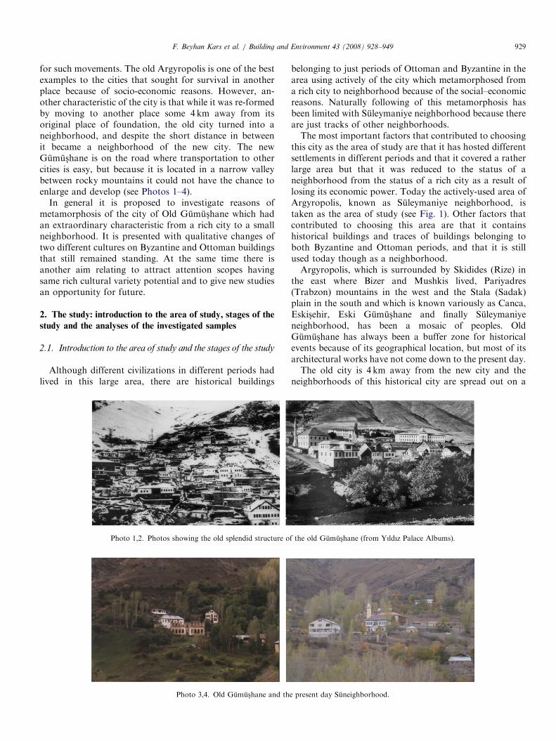
for such movements. The old Argyropolis is one of the bestexamples to the cities that sought for survival in anotherplace because of socio-economic reasons. However, an-other characteristic of the city is that while it was re-formedby moving to another place some 4 km away from itsoriginal place of foundation, the old city turned into aneighborhood, and despite the short distance in betweenit became a neighborhood of the new city. The newGumus-hane is on the road where transportation to othercities is easy, but because it is located in a narrow valleybetween rocky mountains it could not have the chance toenlarge and develop (see Photos 1–4).
In general it is proposed to investigate reasons ofmetamorphosis of the city of Old Gumus-hane which hadan extraordinary characteristic from a rich city to a smallneighborhood. It is presented with qualitative changes oftwo different cultures on Byzantine and Ottoman buildingsthat still remained standing. At the same time there isanother aim relating to attract attention scopes havingsame rich cultural variety potential and to give new studiesan opportunity for future.
2. The study: introduction to the area of study, stages of the
study and the analyses of the investigated samples
2.1. Introduction to the area of study and the stages of the study
Although different civilizations in different periods hadlived in this large area, there are historical buildings
Photo 1,2. Photos showing the old splendid structure o
Photo 3,4. Old Gumus-hane and th
belonging to just periods of Ottoman and Byzantine in thearea using actively of the city which metamorphosed froma rich city to neighborhood because of the social–economicreasons. Naturally following of this metamorphosis hasbeen limited with Suleymaniye neighborhood because thereare just tracks of other neighborhoods.The most important factors that contributed to choosing
this city as the area of study are that it has hosted differentsettlements in different periods and that it covered a ratherlarge area but that it was reduced to the status of aneighborhood from the status of a rich city as a result oflosing its economic power. Today the actively-used area ofArgyropolis, known as Suleymaniye neighborhood, istaken as the area of study (see Fig. 1). Other factors thatcontributed to choosing this area are that it containshistorical buildings and traces of buildings belonging toboth Byzantine and Ottoman periods, and that it is stillused today though as a neighborhood.Argyropolis, which is surrounded by Skidides (Rize) in
the east where Bizer and Mushkis lived, Pariyadres(Trabzon) mountains in the west and the Stala (Sadak)plain in the south and which is known variously as Canca,Eskis-ehir, Eski Gumus-hane and finally Suleymaniyeneighborhood, has been a mosaic of peoples. OldGumus-hane has always been a buffer zone for historicalevents because of its geographical location, but most of itsarchitectural works have not come down to the present day.The old city is 4 km away from the new city and the
neighborhoods of this historical city are spread out on a
f the old Gumus-hane (from Yıldız Palace Albums).
e present day Suneighborhood.

ARTICLE IN PRESS
Fig. 1. The original states of the old and new Gumus-hane.
Fig. 2. The original states of
F. Beyhan Kars et al. / Building and Environment 43 (2008) 928–949930
sloping surface of 1400–1500m altitude [3]. This city wasfounded here because of the presence of ‘silver lead’ minesaround the city [4]. Therefore, the name of the city in theold sources is ‘Argyropolis’ which means ‘silver city’. Thesemines had been known since the early ages and they wererun in the Ottoman period, too. It is also known that silvercoins were minted there [5]. Gumus-hane and its environswere first annexed to the Ottoman Empire during the reignof Sultan Mehmet II in 1461 [6]. Sultan Mehmet IIencouraged the people of the area to run the silver mines byexempting them from paying tax. Special privileges like taxexemption and exemption from military service contrib-uted to the increase in the number of people working inmines [7]. It is said that every new-born baby had a silverspoon, a fork, and a plate in the old rich city ofGumus-hane. Its geographical location, its position on theSilk Road and its silver mines had an important contribu-tion to the increase of its population day by day [8].During his military campaign to Iran in 1553, Sultan
Suleiman, the Magnificent spent some nights in the regionand saw the silver mines. Upon this he ordered to build 1mosque and 50 houses and named the city as Gumus-hane.Before this, the name of the city was Canca [9]. Today, theneighborhood, which was once Old Gumus-hane, takes itsname from the Suleymaniye mosque in the center of thecity. Because of its gold and silver mines, the city wasauthorized by Suleiman, the Magnificent to mint coins onbehalf of itself. The mines and the city reached theirbrightest period during the reign of Sultan Murat IV(1623–1640). Upon the annulment of the special privilegesof the miners by the government in 1894, the mines closed[10]. Upon the closure of the silver mines, the city lost itsfunction and started to move slowly into the Hars-it valleysome 4 km away, and the new Gumus-hane city first becamea trade center and then the government center, whichcompletely reduced the importance of Old Gumus-hane.
the buildings and ruins.
ARTICLE IN PRESSF. Beyhan Kars et al. / Building and Environment 43 (2008) 928–949 931
The migrations caused by the Russian occupation of theregion in 1916 lessened the population of the city, whichaccelerated the demise of Old Gumus-hane. During theRussian occupation, the Muslim population in the regionmigrated to different parts of Anatolia. After the with-drawal of the Russians, the migrated Muslim populationreturned and the Christian population, which cooperatedwith the Russians, was driven to beyond Caucasia [11].Finally, 4 years after the announcement of the Republic ofTurkey, the center of the city government moved to its newplace [12].
Stages of the study contain the following:
1.
Tab
Th
Byz
Bu
Blo
Fac
Th
ma
Th
Bu
Th
orn
Wi
T
sto
T
T
the
Bay
T
V
ope
T
sup
usu
60–
low
Th
win
En
T
the
T
T
abo
in s
Fieldwork:� determining the boundaries of the area of study;
carrying out a pre-investigation in order to choose thecentral area that is actively used today and thatcontains example buildings reflecting different periods,
le
e ch
ant
ildin
ck
-ade
e ea
teri
e fu
ildin
ere
am
ndo
hey
nes
he
her
ba
w
hey
ert
n b
he
por
ally
70 c
ho
e gr
dow
tran
hey
bu
hey
he
ve
om
1
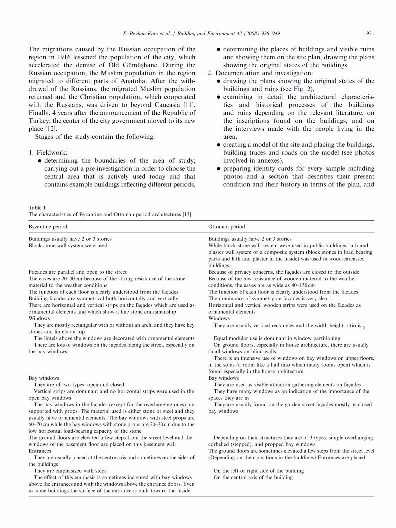
aracteristics of Byzantine and Ottoman period architectures [13]
ine period Ot
gs usually have 2 or 3 stories Bu
stone wall system were used Wh
pla
pa
bu
s are parallel and open to the street Be
ves are 20–30 cm because of the strong resistance of the stone
al to the weather conditions
Be
con
nction of each floor is clearly understood from the fac-ades Th
g fac-ades are symmetrical both horizontally and vertically Th
are horizontal and vertical strips on the fac-ades which are used as
ental elements and which show a fine stone craftsmanship
Ho
orn
ws Wi
are mostly rectangular with or without an arch, and they have key
and lintels on topT
lintels above the windows are decorated with ornamental elements E
e are lots of windows on the fac-ades facing the street, especially on
y windows
O
sm
T
in
fou
indows Ba
are of two types: open and closed T
ical strips are dominant and no horizontal strips were used in the
ay windows
T
spa
bay windows in the fac-ades (except for the overhanging ones) are
ted with props. The material used is either stone or steel and they
have ornamental elements. The bay windows with steel props are
m while the bay windows with stone props are 20–30 cm due to the
rizontal load-bearing capacity of the stone
T
ba
ound floors are elevated a few steps from the street level and the
s of the basement floor are placed on this basement wall
D
cor
ces Th
are usually placed at the centre axis and sometimes on the sides of
ildings
(D
are emphasized with steps O
effect of this emphasis is sometimes increased with bay windows
the entrances and with the windows above the entrance doors. Even
e buildings the surface of the entrance is built toward the inside
O
� determining the places of buildings and visible ruinsand showing them on the site plan, drawing the plansshowing the original states of the buildings.
tom
ildi
ile
ster
rts a
ildin
cau
cau
dit
e fu
e d
rizo
am
ndo
he
qu
n
all
he
the
nd
y w
he
he
ces
he
y w
ep
bel
e gr
epe
n
n
2.
Documentation and investigation:� drawing the plans showing the original states of thebuildings and ruins (see Fig. 2),� examining in detail the architectural characteris-
tics and historical processes of the buildingsand ruins depending on the relevant literature, onthe inscriptions found on the buildings, and onthe interviews made with the people living in thearea,� creating a model of the site and placing the buildings,
building traces and roads on the model (see photosinvolved in annexes),� preparing identity cards for every sample including
photos and a section that describes their presentcondition and their history in terms of the plan, and
an period
ngs usually have 2 or 3 stories
block stone wall system were used in public buildings, lath and
wall system or a composite system (block stones in load bearing
nd lath and plaster in the inside) was used in wood-carcassed
gs
se of privacy concerns, the fac-ades are closed to the outside
se of the low resistance of wooden material to the weather
ions, the eaves are as wide as 40–150 cm
nction of each floor is clearly understood from the fac-ades
ominance of symmetry on fac-ades is very clear
ntal and vertical wooden strips were used on the fac-ades as
ental elements
ws
y are usually vertical rectangles and the width-height ratio is 12
al modular use is dominant in window partitioning
ground floors, especially in house architecture, there are usually
windows on blind walls
re is an intensive use of windows on bay windows on upper floors,
sofas (a room like a hall into which many rooms open) which is
especially in the house architecture
indows
y are used as visible attention gathering elements on fac-ades
y have many windows as an indication of the importance of the
they are in
y are usually found on the garden-street fac-ades mostly as closed
indows
ending on their structures they are of 3 types: simple overhanging,
led (stepped), and propped bay windows
ound floors are sometimes elevated a few steps from the street level
nding on their positions in the buildings) Entrances are placed
the left or right side of the building
the central axis of the building

ARTICLE IN PRESSF. Beyhan Kars et al. / Building and Environment 43 (2008) 928–949932
fac-ade (as the main face) (see tables prepared asidentity cards).
3.
General evaluation. 4. Conclusions.The historical buildings under investigation are: Byzan-tine period: The Greek School, the Metropolitan Building,and the Hagios Georgios Metropolitan Church. Ottomanperiod: Suleymaniye Mosque and Kuc- uk Mosque.Ottoman period traditional houses: Muammer DalogluHouse, Ahmet Kaya House, Rafet C- ubukc-u House andZeki Kadirbeyzade Mansion. Drinking fountains are oneof the street elements and they are known to be verycommon in the area in the past. One such drinkingfountain which has come down to the present day andwhich is known as the fountain of the police chef was alsoinvestigated in this study. Some historical buildings such asthe Suleymaniye Mosque and traditional houses are
Fig. 3. Rubble wall.
Fig. 4. Rough wall.
actively used; other buildings are not used because theylost their functions and because of huge damages of time,which resulted from the migration of the Christian people.
2.2. The characteristics of the Byzantine and Ottoman
period architectures
Although Argyropolis has hosted many civilizations, thearchitectural works that have come down to the presentday in the area of study belong only to Byzantine andOttoman periods. For this reason, the general character-istics of the architectural buildings from Byzantine andOttoman periods were examined and analyzed and datawere provided for the identity cards of the buildings in thearea (Table 1).The main characteristic that distinguishes the house
architecture of one period from the other is the differencein construction and material used in the construction
Fig. 5. Smoothly-cut-stone wall.
Fig. 6. Cut-stone wall.

ARTICLE IN PRESSF. Beyhan Kars et al. / Building and Environment 43 (2008) 928–949 933
systems. The block stone wall system in Byzantine periodarchitecture was replaced by lath and plaster wall system ofwood-carcass system in Ottoman period architecture.
2.2.1. The block stone wall system
Natural stone is a construction material that humanbeings have used since the earlier ages without much effort.Buildings that have come down to the present day owemuch to the characteristics of stone material. Historicalbuildings have been able to come down to the present daywith little deterioration thanks to the simple and functionaluse of stone material.
Wall stones can be used without plastering the inner andouter surfaces. In order for them to be suitable for thesystem used in the wall construction, they should beprismatic with sharp edges and corners, and they shouldhave a rather soft texture to be easily shaped. However, it isnot always necessary to carve them prismatically. It ispossible to obtain different types of walls such as rubblewalls, rough walls, smoothly-cut stone walls, and cut-stonewalls by treating the surfaces of natural stone in differentways (see Figs. 3–6). The public and religious buildings inArgyropolis were built in block rubble wall system wherethe strips on vertical sides are cut-stones. Natural stonematerials that are to be used in constructions should have ahomogenous texture, be non-porous, be resistant to atmo-spheric influences, and have a high resistance to pressureand strong physical characteristics. Volcanic stones andphysical sedimentary stones having these characteristics arevery suitable for constructive use [14].
2.2.2. Lath and plaster wall system
In systems where load bearing parts are wood, there needto be a wall system which is harmonious with the vibrationratio of the wood. The different vibration ratios of brickand stone walls may in time cause slips and cracks in thewalls. In addition, the dampness in the plaster used in suchwalls may cause the wooden material to decay. For this
Fig. 7. Sectional perspectives of
reason, the lath and plaster wall system (lattice fence)which is the most suitable wall system for a building withwooden carcass is preferred (see Fig. 7). Using wood inload-bearing parts instead of stone creates healthier, lighterand spacious inner spaces, and is more economical in termsof cost and time.This technique contains application of laths and
plastering over wooden carcass. The reasons why thistechnique is chosen are that: it is lightweight, it supportsthe large window openings well, it provides a good thermalinsulation, it does not keep humidity and therefore ishealthier, and the lath and plaster mesh provides a morenatural and lovely look.
2.3. Identity cards of the investigated samples
2.3.1. Byzantine period buildings: public buildings
Photos 5–16.
2.3.2. Ottoman period buildings
2.3.2.1. Public buildings. Photos 17–39.
3. General evaluation
In its original place of foundation, the city was calledArgyropolis and Canca, respectively, and after it began tobe deserted it was called Eskis-ehir, which is a combinationof the words ‘eski ¼ old’ and ‘s-ehir ¼ city’, and EskiGumus-hane, which is a combination of the words‘eski ¼ old’ and ‘gumus- yer ¼ silver place’, and finallywhen it lost its city character and became a neighborhood itwas called Suleymanine Mahallesi (literally Suleiman’sNeighborhood). Because of the silver mines in the area, thefirst name it took is Argyropolis, which literally means‘silver city’, and the last name it took is Gumus-hane whichis a combination of ‘silver’ and ‘place’ in Turkish. The newcity was also given the same name. The names given toboth the old historical city and the new city refer to the
lath and plaster wall system.

ARTICLE IN PRESS
Photos 5–8. 5. The main entrance fac-ade of the Greek School and the dominant symmetry on it. 6. The arched passage to the 1st floor from the back
height and the shed. 7. The cracks on the outer wall and the disappeared roof. 8. The ruined inner space and the accumulated soil in the building.
F. Beyhan Kars et al. / Building and Environment 43 (2008) 928–949934

ARTICLE IN PRESS
Photos 9–12. 9. A view of the northeast fac-ade of the church. 10. Part of the outer walls of and the accumulated soil in the church whose roof is completely
collapsed. 11. The remaining abscissas and the erased frescoes. 12. The columns decorated with stones on the sides of the windows.
F. Beyhan Kars et al. / Building and Environment 43 (2008) 928–949 935
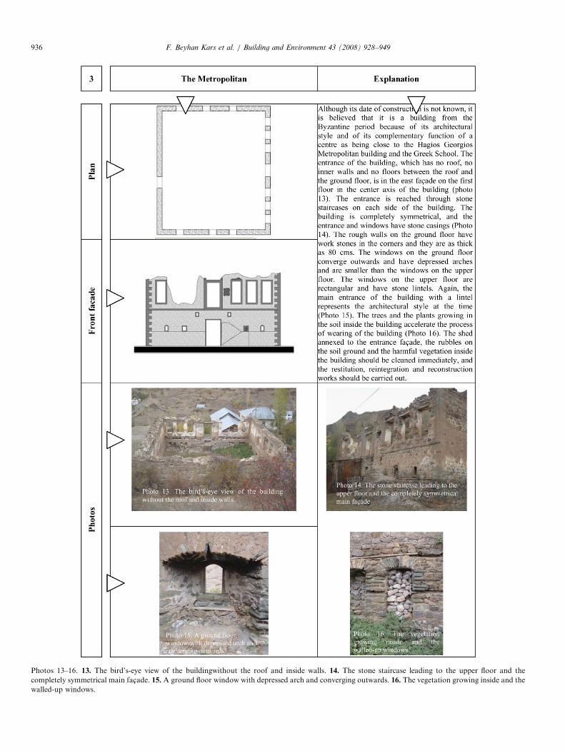
ARTICLE IN PRESS
Photos 13–16. 13. The bird’s-eye view of the buildingwithout the roof and inside walls. 14. The stone staircase leading to the upper floor and the
completely symmetrical main fac-ade. 15. A ground floor window with depressed arch and converging outwards. 16. The vegetation growing inside and the
walled-up windows.
F. Beyhan Kars et al. / Building and Environment 43 (2008) 928–949936

ARTICLE IN PRESS
Photos 17–20. 17. The northeastern view of the mosque. 18. The windows above and on bothsides of the mihrab, which light the inner space. 19. The
entrance with a circular-arch and the cupola. 20. The windows have stone casings and depressed arches.
F. Beyhan Kars et al. / Building and Environment 43 (2008) 928–949 937
‘silver mines’ which were the indicators of the economicstructure of the city. The closure of these mines was to thedesertion of the city by the people what the running of
them was to its foundation and development. The reasonwhy it took the name of ‘Suleymaniye Mahallesi’ after itbecame a neighborhood was that the neighborhood was

ARTICLE IN PRESS
Photos 21–24. 21. The southwest view of the mosque. 22. Mosque. 23. The northwest view and the entrance fac-ade of the building. 24. The south view of
the mosque.
F. Beyhan Kars et al. / Building and Environment 43 (2008) 928–949938
ARTICLE IN PRESS
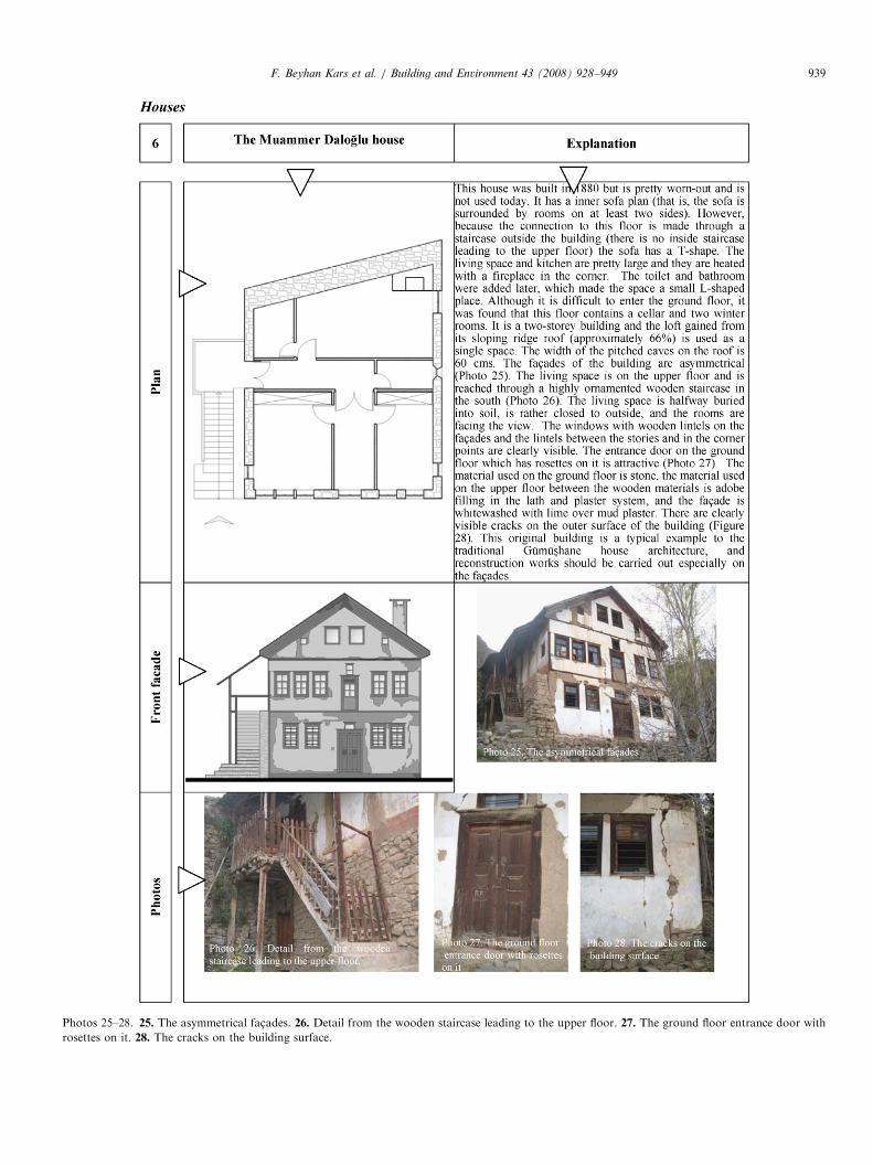
Photos 25–28. 25. The asymmetrical fac-ades. 26. Detail from the wooden staircase leading to the upper floor. 27. The ground floor entrance door with
rosettes on it. 28. The cracks on the building surface.
F. Beyhan Kars et al. / Building and Environment 43 (2008) 928–949 939

ARTICLE IN PRESS
Photos 29–32. 29. The bottom floor entrance and the eastern fac-ade. 30. The main entrance and itsfac-ade on the first floor facing the west. 31.Detail from
the propped bay window. 32. The wet space extension which was annexed to the entrance fac-ade later.
F. Beyhan Kars et al. / Building and Environment 43 (2008) 928–949940

ARTICLE IN PRESS
Photos 33–36. 33. The entrance to the bottom floor and the symmetrical front fac-ade. 34. The south side which is pretty closed to the outside. 35. The
entrance door to the bottom floor and the rosettes on it. 36. The garden gate which is taken from another house.
F. Beyhan Kars et al. / Building and Environment 43 (2008) 928–949 941

ARTICLE IN PRESS
Photos 37–39. 37. The northeastern fac-ade of the mansion. 38. The corner windows and the carvings on the bay window. 39. The Turkish bath in the
garden of the mansion.
F. Beyhan Kars et al. / Building and Environment 43 (2008) 928–949942

ARTICLE IN PRESSF. Beyhan Kars et al. / Building and Environment 43 (2008) 928–949 943
founded around the Suleymaniye Mosque, which asimple public building was made by Suleiman themagnificent having a symbolic importance, and that it isstill used today.
Public buildings from the Byzantine period, the GreekSchool, the Metropolitan Building, the Hagios GeorgiosMetropolitan Church, and religious buildings from theOttoman period, the Kuc- uk Cami, are the most damagedones, and especially the Byzantine period buildings createdanger for the public. By determining their original designs,these buildings should be restituted, be cleaned by removingthe trash and soil accumulated inside, be reconstructed byrebuilding the partitioning elements inside the buildings, andbe reintegrated by completing the outer walls. The Kuc- ukCami (Small Mosque), an Ottoman period building, shouldbe restituted, the loft and the staircase leading to the upperfloor should be reconstructed, and the outer walls and theirplaster work should be reintegrated, and especially the domeshould be strengthened. In its original form, the walls of theSuleymaniye Mosque were stone. During the restoration ofthe mosque in 2003, the walls were painted. The buildingshould be restored to its original form by removing the paintor should be made harmonious with the present texture ofits environment by rebuilding or covering the outer wallswith local stones.
The Byzantine period public buildings were built inapproximately the 14th century, are rectangular and havetwo stories. Symmetry is dominant in these buildings. Theyusually have two opposing entrances in the central axis ofthe buildings. The entrance on the ground floor is ratherhigh and is the main entrance. The second entrance on thefirst floor at the back which is shorter than the frontentrance is reached from the upper level, and is used asthe second entrance. Stone moldings were used betweenthe floors and in the corner points, stone casings wereused in the windows (except for the Hagios GeorgiosMetropolitan church which is a religious building) andin the entrances, smoothly-cut stones of local origin wereused in the walls, and small stones with adobe filling wereused unsystematically in other parts. Ottoman periodbuildings have two stories and do not have symmetry. Thebuildings have one entrance and the entrances are quiteshort. The few windows have stone casings and arches. Inthe corner points on the walls, smoothly-cut stones of localorigin are used, and small stones with adobe filling are usedunsystematically in other parts. Because only religiousbuildings from the Ottoman period have come down tothe present day, the Ottoman period buildings were notcompared with Byzantine period buildings in terms ofarchitectural characteristics. However, the materials used inthe buildings in both periods are the same local material.
Except for the Ottoman period traditional houses, therewere no other buildings belonging to older periods.Therefore, no comparisons were made regarding olderperiods. The general characteristics of the traditionalbuildings that were investigated, important findings andrecommendations can be listed as follows.
The sample houses have inner sofa plans and because ofthe heavy winter conditions and in order to conserve heat,the living spaces are placed opposite the view side andother rooms are placed on the view side. Winter rooms,cellars and the haylofts are on the ground floors, and theliving spaces and bedrooms are on the upper floors. Thiskind of planning which had its origins in the climaticconcerns and which was tested and proved for long yearscan be one of the criteria for new development plans.Because of the sloping grounds, the buildings have two
entrances at two different levels; if the main entrance to thebuilding is at the upper level of the building, the entrance to thelower floor is on the view side and the entrance to the upperfloor is on the opposite side. Both entrances are in the mainaxis of the building and divide the building symmetrically intotwo (see examples 7, 8, 9). Except for the example 9 whichshows the Zeki Kadirbeyzade mansion, the houses have noinner connection between the lower and upper floors, that is,the two stories are independent of each other and passage fromthe lower floor to the upper floor is done through footpathsaround the houses, which is pretty interesting.The houses have two stories. Usually rag-stone walls
with horizontal beams were used on the ground floor, andadobe filling was used between the wooden material in thelath and plaster system on the upper floor. These arethe local materials that can easily be obtained in the area.The outer surfaces are whitewashed with white soil overmud plaster. Example 9 (the Zeki Kadirbeyzade mansion)and example 7 (the Rafet C- ubukc-u house) show differentarchitectural characters from the local style but localbuilding materials were used in both.In the examples of the local architecture, the buildings
usually have pitched roofs, the cover material is sheet metal,and the slope of the roofs is as high as 66%. The slope of theroof of the Zeki Kadirbeyzade mansion, sample 9, is 33%because it is covered with tiles. Because of this aspect, as wellas others mentioned above, it shows a different characterfrom the local style. However, despite the different slopes,the width of the eaves in all samples is as big as 60 cmbecause of the rainy climate of the area. This shows that theclimatic factors, depending on the construction materials,have an effect on the planning of the buildings.Except for the sample 9, the Zeki Kadirbeyzade Mansion,
there are no ornamental elements in any outer parts of thehouses except for the main entrances. In general, thewooden doors with carvings have rosettes and geometricmotifs on them. In the Zeki Kadirbeyzade mansion, thecarvings on the fac-ade above the windows below the eavesare on the baroque arches. The carvings containing someQuranic verses heavily emphasize the difference in thearchitecture of the Zeki Kadirbeyzade mansion. Anothercharacteristic of the mansion is the domed Turkish bath onthe south side of the building. Because of the brickwork andbonding system of its brick dome, it can be said that theTurkish bath is older than the mansion and was probablybuilt in the 16th century. A Turkish bath is a generalbuilding that serves the people’s need for cleaning [15].

ARTICLE IN PRESSF. Beyhan Kars et al. / Building and Environment 43 (2008) 928–949944
The architectural styles of the sample 7 (the Rafet C- ubukc-uHouse) and sample 9 (the Zeki Kadirbeyoglu Mansion) aredifferent from the local architectural style. They each havetwo stoves placed inside the walls on the upper floors for thepurpose of heating the rooms and sofa rooms. The building isinteresting because it was the only example to centrally-heatedbuildings at the time in the region. Its architectural differencebecomes even clearer with its propped jump on the east fac-ade from the sofa room with a triangular fronton. Thewindows on the closed jump have wide wooden casings, andthe other windows and the corners of the building are shell-like with well imitated stone lintels. There are the claims thatit was built by the local master builders during the Russianoccupation of the region or, as an interpretation of theRussian architecture, by the local master builders who hadbeen to Russia to work. Both claims show that the house is aproduct of the intercultural influence. This building can bedescribed as a composite building and is one of the rareexamples of its kind.
The gate of Ahmet Kaya House, sample 8, has a woodenand geometric door which belonged to another house andwhich was installed here later. A second similar examplewas also found in the same place. In addition, it was foundthat because the people living in the area do not know theimportance of the remains belonging to other old buildingsin the area, they usually used such things as separatingelements for their gardens (Photos 40–42). And this showsthat urgent measures should be taken to prevent suchunconscious damage to the historical–traditional buildings.
4. Conclusions
As stated in Section 1 of this study, cities are like livingorganisms; they are born, grow up, develop and even die;and sometimes, as in the case of Argyropolis, they are re-formed by leaving their original place of foundation andslowly moving into another place. Although the originalArgyropolis was not totally deserted, it was reduced to thestatus of a neighborhood and lost its city status. In 1894, thegovernment annulled the special privileges of the minersand, therefore, the mines closed. Upon the closure of thesilver mines, the city lost its function and started to move
Photos 40–42. The use of the gates and stones of the ruin
slowly into the Hars-it valley, some 4km away from the oldcity which provided easier transportation to the surroundingcities. The new Gumus-hane city first became a trade centerand then the government center, which completely reducedthe importance of Argyropolis (Photos A1–A7).Argyropolis is one of the rare cities which did not
manage to live and which were reduced to the status of aneighborhood because of socio-economic reasons. Althoughthe city was founded on a rather steep area where buildingsand streets were built in terrace form and where the land wasnot suitable for the development of the city, it collapsed notbecause of natural reasons but because of socio-economicreasons, which is an important finding (Photos A8–A10).Argyropolis was a Byzantine city but when the Ottoman
domination started, it was given an Ottoman name, whichshows that such cities may no longer be under the influenceof their founding civilizations or cultures but under theinfluence of the dominant civilizations and cultures.Although the public buildings were built in two different
periods by two different cultures, the materials used inthem are the same local materials.The traditional Ottoman houses have two entrances from
two different levels because of the steep land structure; if themain entrance is from the upper level, the entrance to the lowerfloor is on the view side and the entrance to the upper floor ison the opposite side. Both entrances are at the central axis ofthe buildings and symmetrically divide the buildings into two.There are no inner connections between the lower and upperfloors, that is, the two floors are independent of each other.The connection between the two floors is provided throughfootpaths built around the house. The Byzantine period publicbuildings also have two opposing entrances in the central axisand there are no inner staircases connecting the two floorsfrom inside, that is, they are independent of each other. Thisshows that a period may affect the following periods.In order to protect the traditional Ottoman houses in
Argyropolis from the danger of fire, the factors that cancontribute to a fire should be considered first. These are suchfactors as the rewiring the electrical system and providingeasy access to the neighborhood for the fire brigade in case ofa fire. The nearest fire brigade is in the new city 4km away. Inthis case, a possible fire may damage all the traces of the past
ed houses as the separating elements in the gardens.

ARTICLE IN PRESSF. Beyhan Kars et al. / Building and Environment 43 (2008) 928–949 945
all of a sudden. In order to eliminate such a risk, fire plugsshould be installed, and in order to isolate the lath and plasterwalls against a possible fire the walls should be isolated byrestoring them with fire resistant plaster and paint.
The city of Argyropolis where different cultures livedtogether was transformed from the status of a rich andsplendid city into the status of a neighborhood, and exceptfor the examples in the Suleymaniye neighborhood that wereinvestigated in this study, the city has partly come down tothe present day both historically and culturally. However, ithas some other historical riches under the ground or near thesurface whose traces can be seen. The aim of this study is toattract attention to such places and to pave the way for futureinvestigation. The unconscious damage to such a place whichcontains a collection of historical architectural riches should
Photo A1. The Suleymaniye Mosque
Photo A2. The south views of the Greek S
be put to an end, all the archeological surveys should becompleted urgently, the accumulated soil the harmful plantsgrowing inside some of the buildings should be cleanedimmediately, and by using the documentation that we have,restitution, reintegration and reconstruction works should becarried out. Simple restoration works will be enough for someof the buildings. Based on a new protective developmentplan, controlled works for landscape design and adding newfunctions in the area may bring the area to life and make it goon to live, and such a historical area will contribute much tothe cultural riches and tourism of the country.
Appendix
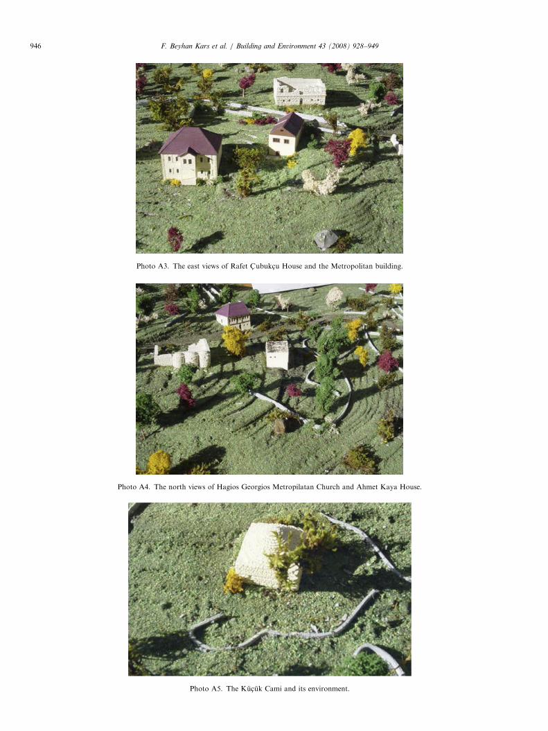
The photos of the model buildings (Photos A1–A10).
and Zeki Kadirbeyzade Mansion.
chool and Muammer Daloglu House.
ARTICLE IN PRESS
Photo A3. The east views of Rafet C- ubukc-u House and the Metropolitan building.
Photo A4. The north views of Hagios Georgios Metropilatan Church and Ahmet Kaya House.
Photo A5. The Kuc- uk Cami and its environment.
F. Beyhan Kars et al. / Building and Environment 43 (2008) 928–949946

ARTICLE IN PRESS
Photo A6. A general look from the north (from the front to the back): the Hagios Georgios Metropolitan Church, the Metropolitan Building, the Rafet
C- ubukc-u House, the Greek School, and the Muammer Daloglu House.
Photo A7. A look from the south (from the front to the back):general look from the north (from the front to the back): the Rafet C- ubukc-u House, the
Greek School, the Hagios Georgios Metropolitan Church, the Metropolitan Building, the Ahmet Kaya House, the Zeki Kadirbeyzade Mansion, and the
Suleymaniye Mosque.
F. Beyhan Kars et al. / Building and Environment 43 (2008) 928–949 947

ARTICLE IN PRESS
Photos A8 and A9. The other photos of the model buildings.
F. Beyhan Kars et al. / Building and Environment 43 (2008) 928–949948

ARTICLE IN PRESS
Photo A10. The other photos of the model buildings.
F. Beyhan Kars et al. / Building and Environment 43 (2008) 928–949 949
References
[1] Tuncel M. Tarih Boyunca Turkiye’de Kent Kurulus-ları, Dogumunun
100.Yılında Ataturk’e Armagan, Istanbul, 1981. p. 309–50.
[2] Tuncel M. Turkiye’de Yer Degis-tiren S-ehirler Hakkında Bir Ilk Not,
I.U. Cografya Enstitusu Dergisi, Sayı: 20–21, Istanbul. p. 119–28.
[3] Kovenko V. Gumus-hane’nin Simli Kurs-un Madenleri, MTA.
Dergisi, Ankara, 1941. p. 283–300.
[4] Winfield D. A note on the south-eastern bordes of the empire of
Trebizond in the thirteenth century. Anatolian Studies, London,
C.12. p. 168.
[5] Darkot B. Islam Ansiklopedisi, Gumus-hane Maddesi.
[6] Akagun G. A.g.e. p. 13–4.
[7] Akagun G. Gumus-hane, Bayburt, Kelkit, Torul, S- iran ve Bazı
Koylerinde Sanat Tarihi Inceleme Gezisi Notları, 1971. p. 13–4.
[8] Cumhuriyet’in 75.Yılında Gumus-hane, a.g.e. p. 50.
[9] Akagun G, A.g.e. s. 13–4.
[10] Cumhuriyet’in 75.Yılında Gumus-hane, Gumus-hane Valiligi, 1999.
p. 44.
[11] Mc Carty J. Muslims and minorities the population of Ottoman
Anatolia and the end of the empire. New York and London, 1983.
p. 119.
[12] Cumhuriyet’in 75.Yılında Gumus-hane, Gumus-hane Valiligi, 1999.
p. 44.
[13] Sagsoz A, Tuluk OI, Ozgen S. Influences of different ages and
cultures on each other from architectural point of view: examination
of historical buildings in Trabzon/Turkiye. Building and Environ-
ment 2006;41(1):45–59.
[14] Turkc- u C- . Yapım-Malzemeler, Ilkeler, Yontemler, C- ozumler, Birsen
Yayınevi, Istanbul, 2000.
[15] Hasol D. Ansiklopedik Mimarlık Sozlugu, Yapı Endustri Merkezi
yayınları, 1995. p. 192.