The mess of problems, patterns, and types
32
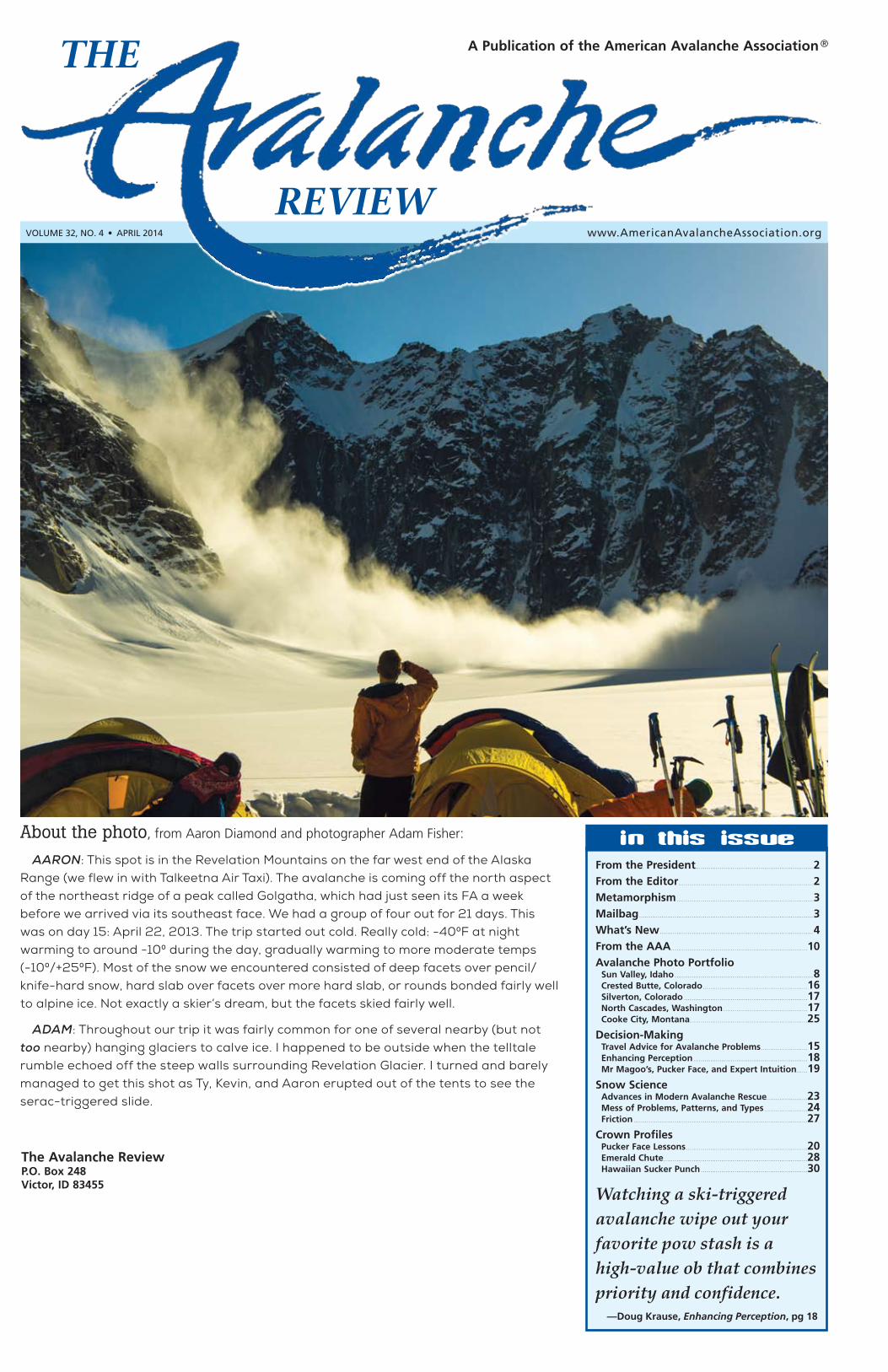
Volume 32, No. 4 • April 2014 The Avalanche Review P.O. Box 248 Victor, ID 83455 In This Issue From the President............................................................... 2 From the Editor ........................................................................ 2 Metamorphism......................................................................... 3 Mailbag ............................................................................................. 3 What’s New. . . . . . . . . . . . . . . . . . . . . . . . . . . . . . . . . . . . . . . . . . . . . . . . . . . . . . . . . . . . . . . . . . . . . . . . . . . . . . . . . . 4 From the AAA......................................................................... 10 Avalanche Photo Portfolio Sun Valley, Idaho .......................................................................... 8 Crested Butte, Colorado ........................................................ 16 Silverton, Colorado .................................................................. 17 North Cascades, Washington ............................................. 17 Cooke City, Montana............................................................... 25 Decision-Making Travel Advice for Avalanche Problems ......................... 15 Enhancing Perception ............................................................. 18 Mr Magoo’s, Pucker Face, and Expert Intuition...... 19 Snow Science Advances in Modern Avalanche Rescue...................... 23 Mess of Problems, Patterns, and Types ....................... 24 Friction ............................................................................................. 27 Crown Profiles Pucker Face Lessons ................................................................. 20 Emerald Chute............................................................................. 28 Hawaiian Sucker Punch ......................................................... 30 Watching a ski-triggered avalanche wipe out your favorite pow stash is a high-value ob that combines priority and confidence. —Doug Krause, Enhancing Perception, pg 18 ® About the photo, from Aaron Diamond and photographer Adam Fisher: AARON: This spot is in the Revelation Mountains on the far west end of the Alaska Range (we flew in with Talkeetna Air Taxi). The avalanche is coming off the north aspect of the northeast ridge of a peak called Golgatha, which had just seen its FA a week before we arrived via its southeast face. We had a group of four out for 21 days. This was on day 15: April 22, 2013. The trip started out cold. Really cold: -400F at night warming to around -100 during the day, gradually warming to more moderate temps (-100/+250F). Most of the snow we encountered consisted of deep facets over pencil/ knife-hard snow, hard slab over facets over more hard slab, or rounds bonded fairly well to alpine ice. Not exactly a skier’s dream, but the facets skied fairly well. ADAM: Throughout our trip it was fairly common for one of several nearby (but not too nearby) hanging glaciers to calve ice. I happened to be outside when the telltale rumble echoed off the steep walls surrounding Revelation Glacier. I turned and barely managed to get this shot as Ty, Kevin, and Aaron erupted out of the tents to see the serac-triggered slide.
Transcript of The mess of problems, patterns, and types
Volume 32, No. 4 • April 2014
The Avalanche ReviewP.O. Box 248Victor, ID 83455
In This Issue
From the President. . . . . . . . . . . . . . . . . . . . . . . . . . . . . . . . . . . . . . . . . . . . . . . . . . . . . . . . . . . . . . . 2
From the Editor. . . . . . . . . . . . . . . . . . . . . . . . . . . . . . . . . . . . . . . . . . . . . . . . . . . . . . . . . . . . . . . . . . . . . . . . 2
Metamorphism . . . . . . . . . . . . . . . . . . . . . . . . . . . . . . . . . . . . . . . . . . . . . . . . . . . . . . . . . . . . . . . . . . . . . . . . . 3
Mailbag . . . . . . . . . . . . . . . . . . . . . . . . . . . . . . . . . . . . . . . . . . . . . . . . . . . . . . . . . . . . . . . . . . . . . . . . . . . . . . . . . . . . . . . . . . . . . 3
What’s New . . . . . . . . . . . . . . . . . . . . . . . . . . . . . . . . . . . . . . . . . . . . . . . . . . . . . . . . . . . . . . . . . . . . . . . . . . . . . . . . . . 4
From the AAA. . . . . . . . . . . . . . . . . . . . . . . . . . . . . . . . . . . . . . . . . . . . . . . . . . . . . . . . . . . . . . . . . . . . . . . . .10
Avalanche Photo Portfolio Sun Valley, Idaho . . . . . . . . . . . . . . . . . . . . . . . . . . . . . . . . . . . . . . . . . . . . . . . . . . . . . . . . . . . . . . . . . . . . . . . . . . 8 Crested Butte, Colorado. . . . . . . . . . . . . . . . . . . . . . . . . . . . . . . . . . . . . . . . . . . . . . . . . . . . . . . .16 Silverton, Colorado . . . . . . . . . . . . . . . . . . . . . . . . . . . . . . . . . . . . . . . . . . . . . . . . . . . . . . . . . . . . . . . . . .17 North Cascades, Washington . . . . . . . . . . . . . . . . . . . . . . . . . . . . . . . . . . . . . . . . . . . . .17 Cooke City, Montana. . . . . . . . . . . . . . . . . . . . . . . . . . . . . . . . . . . . . . . . . . . . . . . . . . . . . . . . . . . . . . .25
Decision-Making Travel Advice for Avalanche Problems. . . . . . . . . . . . . . . . . . . . . . . . .15 Enhancing Perception . . . . . . . . . . . . . . . . . . . . . . . . . . . . . . . . . . . . . . . . . . . . . . . . . . . . . . . . . . . . .18 Mr Magoo’s, Pucker Face, and Expert Intuition. . . . . .19
Snow Science Advances in Modern Avalanche Rescue. . . . . . . . . . . . . . . . . . . . . .23 Mess of Problems, Patterns, and Types . . . . . . . . . . . . . . . . . . . . . . .24 Friction . . . . . . . . . . . . . . . . . . . . . . . . . . . . . . . . . . . . . . . . . . . . . . . . . . . . . . . . . . . . . . . . . . . . . . . . . . . . . . . . . . . . . . . . . . . . .27
Crown Profiles Pucker Face Lessons. . . . . . . . . . . . . . . . . . . . . . . . . . . . . . . . . . . . . . . . . . . . . . . . . . . . . . . . . . . . . . . . .20 Emerald Chute. . . . . . . . . . . . . . . . . . . . . . . . . . . . . . . . . . . . . . . . . . . . . . . . . . . . . . . . . . . . . . . . . . . . . . . . . . . . .28 Hawaiian Sucker Punch . . . . . . . . . . . . . . . . . . . . . . . . . . . . . . . . . . . . . . . . . . . . . . . . . . . . . . . . .30
Watching a ski-triggered avalanche wipe out your favorite pow stash is a high-value ob that combines priority and confidence.
—Doug Krause, Enhancing Perception, pg 18
®
About the photo, from Aaron Diamond and photographer Adam Fisher:
AARON: This spot is in the Revelation Mountains on the far west end of the Alaska Range (we flew in with Talkeetna Air Taxi). The avalanche is coming off the north aspect of the northeast ridge of a peak called Golgatha, which had just seen its FA a week before we arrived via its southeast face. We had a group of four out for 21 days. This was on day 15: April 22, 2013. The trip started out cold. Really cold: -400F at night warming to around -100 during the day, gradually warming to more moderate temps (-100/+250F). Most of the snow we encountered consisted of deep facets over pencil/knife-hard snow, hard slab over facets over more hard slab, or rounds bonded fairly well to alpine ice. Not exactly a skier’s dream, but the facets skied fairly well.
ADAM: Throughout our trip it was fairly common for one of several nearby (but not too nearby) hanging glaciers to calve ice. I happened to be outside when the telltale rumble echoed off the steep walls surrounding Revelation Glacier. I turned and barely managed to get this shot as Ty, Kevin, and Aaron erupted out of the tents to see the serac-triggered slide.
u pAGe 2 the AVAlANche reView Vol. 32, No. 4, April 2014
In putting together this issue, these themes kept surfacing: free will vs determinism, self-control and the power of choice.
Those abstract concepts translate to a practical question: “How do we get beyond our apprentice years in the avalanche world?”
In that period, we are armed with our education plus a strong dose of “get’r.” We’re brash and confident, trying to do the right thing, and struggling to see the big picture. Until the lure of the line intercedes. Most of the time we get away with it. Our education has given us some tools, some structure, even some practice and feedback from someone who knows how to weight the world. But we don’t know how to integrate it all, allow for uncertainty, and then finally come out to the parking lot in one piece afterward.
This issue of TAR outlines some strategies for making it through that stage, as we accumulate our 10,000 hours toward expertise. A couple of case studies, one from this December on Pucker Face near Jackson Hole resort (page 20) and another from a calculated descent of the Emerald Chute in Tahoe (page 28), give us snapshots of how those days look, for better or for worse, and the authors detail the tools they used and lessons they learned. Along this theme, Doug Krause gives us more of his quirky and accurate insight into self-awareness and how it can improve decision-making (page 18). Blase Reardon stitches modern psychology research into the cloth of our day, taking us on a tour of the wickedness of our environment and those pesky human-factor filters. He then leads us to some practical applications to outwit your filters, tips
that translate theory into longevity. Blase’s article is an offshoot of various presentations that he and I have been lending to and stealing from one another for a number of years now. His final paragraph recaps our long-winded discussion succinctly: (see page 19 for Mr Magoo’s, Pucker Face, and Developing Expert Intuition in Avalanche Terrain)
The point is less about the specific habits than about making an effort to maximize the quality of our decisions and the feedback we get for them, so we have the best chances of seeing our Mr Magoo-like close calls and learning from them, without the too-painful learning that comes if and when our luck runs out. Time in the backcountry with that kind of reflection is what leads to the lifetime of accumulation and instant recognition that Kahneman and LaChapelle identify as expertise.
As I work toward expertise, I’ll continue to cover my ass in case I miss something. I’ll try not to break more than one rule at a time (thanks to Alex Lowe and Blase for that one), I’ll double-check decisions with rule-based tools (ALPTRUTh, anyone?) and then execute impeccable travel practices. I’ll dig some pits for structure, for a view into propagation, and to check on how the snowpack is maturing, but rarely ever to give an edict of go/no-go. My choices and my mistakes might show glaring holes in my education, but I designed that progression myself and own the output. I won’t subscribe to the Flip Wilson school of human factor and
determinism: “The devil made me do it.” I’ll try to act like a grownup in the backcountry (but still never turn down chocolate), and realize that exercising free will and choice often means employing self-control and discipline, no matter how beautiful the line might stretch below me.
And back to this issue of TAR: There’s more to this editing job than commas and themes. There’s a strong mentorship and educational aspect, which I employed to the extent of my knowledge and experience in working with Alex Do on his Pucker Face retrospective. He reached out to me and I tried to offer him empathy tempered with an objective look at an unfortunate incident. I applaud Alex: his intelligence and motivation to learn allowed him to take my blunt feedback on his writing and own his decisions and his learning. His human-factor red lights are worth incorporating into your own practice. Thanks are also due to Mike Richardson, who was invaluable as an objective consultant with Alex’s case study.
This is the final issue of volume 32 of TAR; we will see you next September in Banff. A couple of reminders: deadline for submissions for the ISSW TAR is August 1. In addition, the AAA extends a million thank-yous to our graphic designer, Karen Russell of Fall Line Design, here in Driggs, Idaho. TAR has worked with Karen for 10 years now; she’s ready to hand us off to someone else. She has been fabulous, bringing TAR into the new millennium, teaching me a lot, issue after issue, and putting up with my last-minute antics. Check the jobs section of avalanche.org after May 1 for a graphic designer RFQ.
—Lynne Wolfe R
from the editor
Self-Control and the Power of Choice
THE
REVIEW
April 2014 • VOl . 32 • NUMBEr 4The Avalanche Review is published each fall through spring by the American Avalanche Association, Inc., a nonprofit corporation. The Avalanche Review welcomes the submission of articles, photographs and illustrations.
Please send submissions to:Lynne Wolfe –– EditorPO Box 1135Driggs, Idaho 83422tel: (208) [email protected]
Advertising:Paul Nordquist1101 Lenore DriveTacoma, WA 98406tel: (253) [email protected]
Business and Subscription Office:Jaime Musnicki –– AAA Executive DirectorPO Box 248Victor, ID 83455tel: (307) [email protected] [email protected]
Production:Fall Line Design270 N MainDriggs, ID 83422tel/fax: (208) [email protected]
Executive Director ............. Jaime MusnickiAAA Officers *President ........................ John Stimberis *Vice President .................Bill Williamson *Secretary.........................Scott Savage *Treasurer.........................Mike FerrariCommittee Chairs Awards ..............................Halsted Morris Data & IT/Web ..................Ned Bair Education .........................Kirk Bachman Ethics ...............................Aleph Johnston-Bloom, Dave Hendrickson Membership ......................Stuart Thompson Research........................... Jordy Hendrikx Search & Rescue ..............Rich Browne Ski Area ............................Bill Williamson *Publications....................Blase ReardonPublications Committee Editor ................................ Lynne Wolfe Editor Emeritus .................Steve Conger Editor Emeritus .................Sue Ferguson Editor Emeritus .................Blase Reardon Editor Emeritus .................Bruce Tremper
Section Representatives Alaska...............................Andy Dietrick Eastern Section ................Kyle Tyler European Section ..............Krister Kristensen Intermountain North .........Mark Staples Intermountain South .........Damian Jackson Northwest .........................Patty Morrison Rockies .............................Becs Hodgetts Sierra ................................Gene Urie Member Representative .... Jonathan Shefftz Certified Instructor Rep ....Brad Sawtell
Executive Committee denoted by *
The mission of the AAA is:A. To provide information about snow and avalanches;
B. To represent the professional interests of the United States avalanche community;
C. To contribute toward high standards of professional competence and ethics for persons engaged in avalanche activities;
D. To exchange technical information and maintain communications among persons engaged in avalanche activities;
E. To provide direction for, promote, and support avalanche education in the US;
F. To promote research and development in avalanche safety.
Subscription: $30 per year (4 issues). Subscription is included with mem-bership dues to AAA. For subscription and membership information, see www.AmericanAvalancheAssociation.org.
Contributions: Please submit material eight weeks prior to publication date. Include address and telephone number. Please submit typed manu-scripts by e-mail or disk (CD or DVD), using any popular word processing program. Submit any figures as an EPS (preferred), PDF, TIFF or JPG file (300 dpi resolution at 100%). We will return materials if you include a stamped, self-addressed envelope.
Articles, including editorials, appearing in The Avalanche Review reflect the individual views of the authors and not the official points of view adopted by AAA or the organizations with which the authors are affiliated unless otherwise stated.
Layout & Design: Karen Russell, Fall Line Design, (208) 354-6500, [email protected].
©2014 by the American Avalanche Association.
Materials may be reproduced for research or classroom use. Permission is also granted for use of short quotations, figures, and tables in scientific books and journals. For permission for other uses, contact The Avalanche Review.
from the president
Still Waiting……seems like the theme this winter for many of us in the avalanche profession. Waiting for
the snow to arrive and waiting for winter to begin. Isn’t it weird how much we anticipate the start of winter? I figured after decades in this industry I’d get over the anticipation, but every fall the feeling returns. The days grow shorter and colder. This year, the first snow arrived, but then nothing.
Here in the PNW we watched it snow, then rain, then the blocking high arrived. Repeat that process again and again. Finally there was enough snow for most of the resorts to open,
but backcountry skiing was tentative at best. Some parts of the West were doing alright while others were still waiting. Then January arrived with an extended drought. Nobody in our profession really enjoys these prolonged droughts. Skiing usually isn’t that good, our fellow employees get restless, weak interfaces form, and again we’re still waiting.
But then the snow arrives, and all is often forgotten. The rush to get out there takes some by surprise and greets others with grim consequences. In my area we received over three meters of snow in less than three weeks. We get focused on the immediate issues such as storm snow and wind slabs, and on keeping the resorts and highways open. The snow removal starts and doesn’t stop. Work shifts merge into the next and days begin to blend together. A couple weeks into this routine and I’m suddenly lifting my head and looking for the danger signs. What about that late January/early February layer? Managing the details while keeping the big picture in mind is an important part of being a professional.
The weak signals began to emerge. A few large avalanches were reported. Some were triggered by explosives, a few from skis, and there was even a natural involving a few skiers. By now many of you have seen the video from Stevens Pass showing the impressive heli-bombing results. Hopefully when you read this we haven’t had any more tragedies. I think it’s important to pick up on the weak signals. They’re both predictive and responsive. When trends begin to emerge we attempt to see the larger picture and the potential course they will follow. I believe this is analogous to our community of professionals in the American Avalanche Association and the content of The Avalanche Review.
The days are now getting longer. Winter feels like it just arrived, and spring is already ushering it aside. Sunscreen and ball caps replace wool hats and scarves, and many of us will head for new jobs. Soon enough the feeling returns, and we’ll find ourselves waiting for powder once again.
—John Stimberis R
pAGe 3 tthe AVAlANche reViewVol. 32, No. 4, April 2014
The Crested Butte Avalanche Center is excited to announce the addition of two new members to the staff.
Jake Jones began his role as executive director in December. Jake has worked in the adventure-education and guiding industry for nearly 20 years. In addition to his duties directing the CBAC, Jake is the Parks, Recreation, Open Space and Trails Director for the Town of Crested Butte and was a founding board member and former president of the CBAC.
Evan Ross joins the CBAC forecasting team with an obsession for snow science that began while studying at Fort Lewis college in Durango. Evan moved to Crested Butte in the winter of 2011/12. When he’s not out in search of powder stashes in the Elk Mountains he works as a guide for Crested Butte Mountain Guides and Irwin Backcountry Guides. He is preparing to take his AMGA ski exam, and he is AIARE L3 certified, an AIARE L1 avalanche course leader, and an AIARE L2 avalanche course instructor.
The Elk Mountains just got slammed by one of the largest storms we’ve seen in 30 years, with up to 9.5" of SWE falling over a 13-day period. The funny business lower in the snowpack stood little chance, and we observed some impressive and unusual avalanches across our zone. One D4 reportedly crossed a valley and destroyed a concrete outhouse on the opposite hillside. Oh CRAP. Check out the photo gallery at www.cbavalanchecenter.org/page.cfm?pageid=34325. R
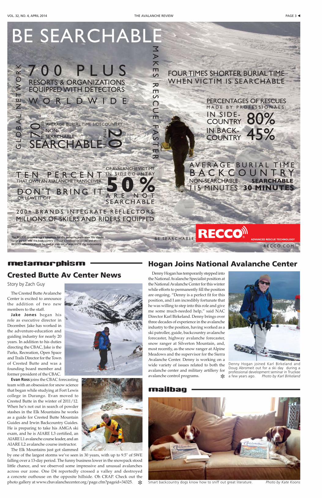
BE SEARCHABLEG
LO
BA
L N
ET
WO
RK
RESORTS & ORGANIZATIONSEQUIPPED WITH DETECTORS
W O R L D W I D E
7 0 0 P L U S
SEARCHABLE
20MIN
UT
ES
MIN
UT
ES
NON-SEARCHABLE70
AVERAGE BURIAL TIME SIDECOUNTRY
D O N ’ T B R I N G I TOR LEAVE IT OFF
T E N P E R C E N TTHAT OWN AN AVALANCHE TRANSCEIVER
OF AVALANCHE VICTIMS I N S I D E C O U N T R Y
A R E N O T S E A R C H A B L E
50 %2 0 0 + B R A N D S I N T E G R AT E R E F L E C TO R SMILLIONS OF SKIERS AND RIDERS EQUIPPED
MA
KE
S R
ES
CU
E F
AS
TE
R
FOUR TIMES SHORTER BURIAL TIME WHEN VICTIM IS SEARCHABLE
80%I N S I D E -COUNTRY
45%IN BACK-COUNTRY
PERCENTAGES OF RESCUESM A D E B Y P R O F E S S I O N A L S :
A V E R A G E B U R I A L T I M EB A C K C O U N T R YNON-SEARCHABLE115 MINUTES
SEARCHABLE30 MINUTES
B E S E A R C H A B L E
R E C C O . C O M
The RECCO system is not a substitute for the avalanche transceiver. You should never go out into the backcountry without a transceiver, probe and shovel. RECCO reflectors should be used in area, out of area, and in the backcountry.
metamorphism
mailbag
Crested Butte Av Center NewsStory by Zach Guy
Denny Hogan has temporarily stepped into the National Avalanche Specialist position at the National Avalanche Center for this winter while efforts to permanently fill the position are ongoing. “Denny is a perfect fit for this position, and I am incredibly fortunate that he was willing to step into this role and give me some much-needed help,” said NAC Director Karl Birkeland. Denny brings over three decades of experience in the avalanche industry to the position, having worked as a ski patroller, guide, backcountry avalanche forecaster, highway avalanche forecaster, snow ranger at Silverton Mountain, and, most recently, as the snow ranger at Alpine Meadows and the supervisor for the Sierra Avalanche Center. Denny is working on a wide variety of issues related to both the avalanche center and military artillery for avalanche control programs. R
Hogan Joins National Avalanche Center
Denny Hogan joined Karl Birkeland and Doug Abromeit out for a ski day during a professional development seminar in Truckee a few years ago. Photo by Karl Birkeland
Smart backcountry dogs know how to sniff out great literature. Photo by Kate Koons
u pAGe 4 the AVAlANche reView Vol. 32, No. 4, April 2014
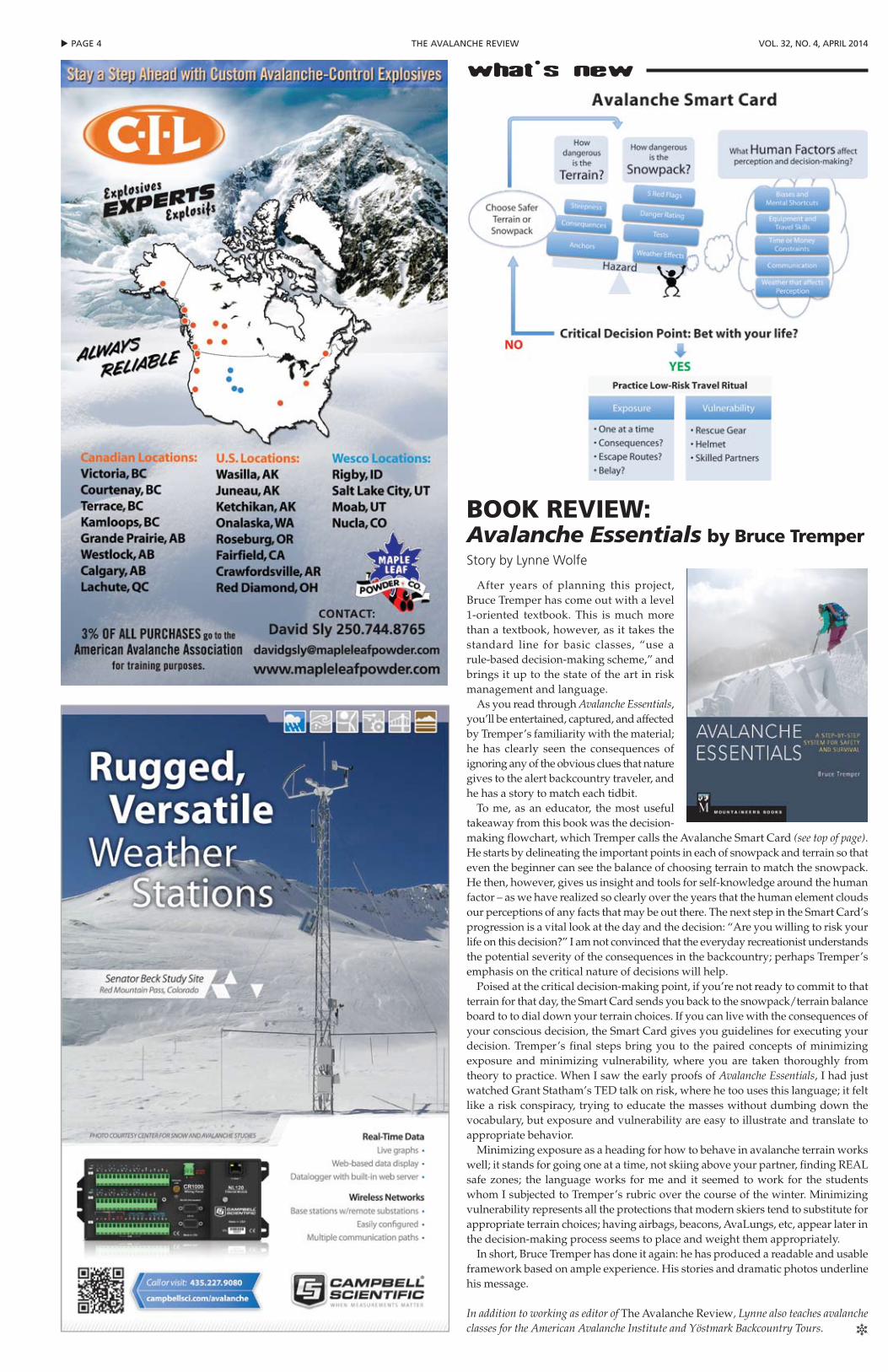
what's new
After years of planning this project, Bruce Tremper has come out with a level 1-oriented textbook. This is much more than a textbook, however, as it takes the standard line for basic classes, “use a rule-based decision-making scheme,” and brings it up to the state of the art in risk management and language.
As you read through Avalanche Essentials, you’ll be entertained, captured, and affected by Tremper’s familiarity with the material; he has clearly seen the consequences of ignoring any of the obvious clues that nature gives to the alert backcountry traveler, and he has a story to match each tidbit.
To me, as an educator, the most useful takeaway from this book was the decision-making flowchart, which Tremper calls the Avalanche Smart Card (see top of page). He starts by delineating the important points in each of snowpack and terrain so that even the beginner can see the balance of choosing terrain to match the snowpack. He then, however, gives us insight and tools for self-knowledge around the human factor – as we have realized so clearly over the years that the human element clouds our perceptions of any facts that may be out there. The next step in the Smart Card’s progression is a vital look at the day and the decision: “Are you willing to risk your life on this decision?” I am not convinced that the everyday recreationist understands the potential severity of the consequences in the backcountry; perhaps Tremper’s emphasis on the critical nature of decisions will help.
Poised at the critical decision-making point, if you’re not ready to commit to that terrain for that day, the Smart Card sends you back to the snowpack/terrain balance board to to dial down your terrain choices. If you can live with the consequences of your conscious decision, the Smart Card gives you guidelines for executing your decision. Tremper’s final steps bring you to the paired concepts of minimizing exposure and minimizing vulnerability, where you are taken thoroughly from theory to practice. When I saw the early proofs of Avalanche Essentials, I had just watched Grant Statham’s TED talk on risk, where he too uses this language; it felt like a risk conspiracy, trying to educate the masses without dumbing down the vocabulary, but exposure and vulnerability are easy to illustrate and translate to appropriate behavior.
Minimizing exposure as a heading for how to behave in avalanche terrain works well; it stands for going one at a time, not skiing above your partner, finding REAL safe zones; the language works for me and it seemed to work for the students whom I subjected to Tremper’s rubric over the course of the winter. Minimizing vulnerability represents all the protections that modern skiers tend to substitute for appropriate terrain choices; having airbags, beacons, AvaLungs, etc, appear later in the decision-making process seems to place and weight them appropriately.
In short, Bruce Tremper has done it again: he has produced a readable and usable framework based on ample experience. His stories and dramatic photos underline his message.
In addition to working as editor of The Avalanche Review, Lynne also teaches avalanche classes for the American Avalanche Institute and Yöstmark Backcountry Tours. R
BOOk rEViEw:Avalanche Essentials by Bruce TremperStory by Lynne Wolfe
pAGe 5 tthe AVAlANche reViewVol. 32, No. 4, April 2014
Early birds Dave Rosenbarger and John Morrison in the Sierra. California. CHRISTIAN PONDELLA © 2014 Patagonia, Inc.
Built for the deepest daysProfessional-level members of the American Avalanche Association may be eligible for a pro account. Visit patagoniapro.com to apply.
u pAGe 6 the AVAlANche reView Vol. 32, No. 4, April 2014
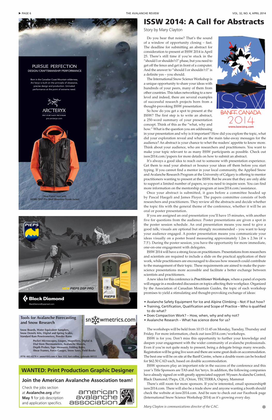
iSSw 2014: A Call for AbstractsStory by Mary Clayton
Do you hear that noise? That’s the sound of a window of opportunity closing – fast. The deadline for submitting an abstract for consideration to present at ISSW 2014 is April 25. There’s still time if you’re stuck in the “should I or shouldn’t I” phase, but you need to get off the fence and get in front of a computer. And the answer to “should I or shouldn’t I” is a definite yes – you should.
The International Snow Science Workshop is a unique opportunity to share your ideas with hundreds of your peers, many of them from other countries. This takes networking to a new level and indeed, there are several examples of successful research projects born from a thought-provoking ISSW presentation.
So how do you get a spot to present at the ISSW? The first step is to write an abstract, a 250-word summary of your presentation concept. Think of this as the “what, why and how.” What is the question you are addressing in your presentation and why is it important? How did you explore the topic, what did your exploration reveal and what are the main take-away messages for the audience? An abstract is your chance to whet the readers' appetite to know more. Think about your audience, who are researchers and practitioners. You want to make your topic relevant to as many ISSW participants as possible. Check out issw2014.com/papers for more details on how to submit an abstract.
It’s always a good idea to reach out to someone with presentation experience. Get them to read your abstract or bounce your ideas off them before you start typing. If you cannot find a mentor in your local community, the Applied Snow and Avalanche Research Program at the University of Calgary is offering to mentor practitioners wanting to present at the ISSW. But be aware that they are only able to support a limited number of papers, so you need to inquire soon. You can find more information on the mentorship program at issw2014.com/assistance.
Once your abstract is submitted, it goes before a committee headed up by Pascal Haegeli and James Floyer. The papers committee consists of both researchers and practitioners. They review all the abstracts and decide whether the topic fits with the general theme of the conference, whether it will be an oral or poster presentation.
If you are assigned an oral presentation you’ll have 15 minutes, with another five for questions from the audience. Poster presentations are given a spot in the poster session schedule. An oral presentation means you need to give a good talk; visuals are optional but strongly recommended – you want to keep your audience engaged. A poster presentation means you communicate your ideas visually on a poster board measuring approximately 1.2m x 2.3m (4' x 7.5'). During the poster session, you have the opportunity for more immediate, one-on-one engagement with delegates.
ISSW 2014 will have a strong focus on practitioners. Presentations from researchers and scientists are required to include a slide on the practical application of their work, while practitioners are encouraged to discuss how research could contribute to the management of their topic. These requirements are aimed to make the pure-science presentations more accessible and facilitate a better exchange between scientists and practitioners.
A new idea for this conference is Practitioner Workshops, where a panel of experts will engage in a moderated discussion on topics affecting their workplace. Organized by the Association of Canadian Mountain Guides, the topic of each workshop promises to yield a stimulating and thought-provoking exchange of ideas:
• Avalanche Safety equipment for ice and Alpine climbing – Not if but how?• training, certification, Qualification and Scope of practice – who is qualified
to do what?• Does compaction work? – how, when, why and why not?• Avalanche research – what has science done for us?
The workshops will be held from 10:15-11:45 on Monday, Tuesday, Thursday and Friday. For more information, check out issw2014.com/workshops.
ISSW is for you. Don’t miss this opportunity to further your knowledge and deepen your engagement with the wider community of avalanche professionals. Even if you’re not quite ready to present, being a delegate brings many rewards. Registration will be going live soon and there are some great deals on accommodation. The best one will be on site at the Banff Centre, where a double room can be booked for $62.50 CAD each, based on double accommodation.
ISSW sponsors play an important role in the success of the conference and this year’s Title Sponsors are TAS and Arc’teryx. In addition, the following companies have already signed on with greatly appreciated support: Wyssen Avalanche Control, Black Diamond/Pieps, CIL/Orion, TECTERRA, Osprey, Mammut
There’s still room for more sponsors. If you’re interested, email [email protected]. There will also be a trade show and anyone wanting a booth should check the website at issw2014.com. And be sure to check out our Facebook page (International Snow Science Workshop 2014) as it’s growing every day.
Mary Clayton is communications director of the CAC. R
WANTED: Print Production Graphic Designer
Join the American Avalanche Association team! Check the jobs section at Avalanche.org after May 1 for job description and application specifics.
BlackDiamondEquipment.com
NEW PIEPS DSP PRO
Pho
togr
aphe
r: J
ay B
eyer
Tools for Avalanche Forecasting and Snow Research
Snow Boards, Water Equivalent Samplers, Snow Density Kits, Digital and Spring Scales, Standard Ram Penetrometers, Powder Rams
Pocket Microscopes, Loupes, Magnifiers, Digital & Dial Stem Thermometers, Avalanche Shovels, Depth Probes, Tape Measures, Folding Rules, Shear Frames, Force Gauges, Snow Saws, Field Books
(970) 482-4279 • [email protected] • box 332, fort collins, colorado 80522
Born in the Canadian Coast Mountain wilderness, Arc’teryx is built on the principle of obsessive,
precise design and production. Unrivaled performance at the point of extreme need.
pro.arcteryx.com
New Patrol Vest with GORE-TEX® Pro Shell Mountain Guide Jacket
CONCEPTION/FABRICATION ARTISANALE/PERFORMANCECONCEPTION/FABRICATION ARTISANALE/PERFORMANCE
pAGe 7 tthe AVAlANche reViewVol. 32, No. 4, April 2014
The third annual Northern Rockies Avalanche Safety Workshop (NRASW) took place this October in Whitefish, Montana. The one-day regional avalanche safety gathering featured guest speakers, vendor displays/demonstrations, a plethora of raffle prizes, and over 300 attendees. The audience included avalanche industry professionals as well as winter backcountry enthusiasts from Montana, Idaho, and Washington.
This year’s NRASW targeted topics related to avalanche-risk assessment, decision-making, and heuristics. To assist us with presenting the workshop’s theme were six top-notch professionals from the realms of avalanche forecasting, education, mountain guiding, and weather forecasting:
•Bruce Tremper, Utah AvalancheCenter director
•EricKnoff,GallatinAvalancheCenteravalanche forecaster
•CollinZacharias,avalancheeducator,mountain guide, and consultant
•LeeAnn Allegretto, avalancheprogram director, Missoula, MT National Weather Service
•Brian Lazar, Colorado AvalancheInformation Center deputy director
•SethCarbonari,FlatheadAvalancheCenter avalanche forecaster
Each presenter spoke 40 minutes with 20 minutes then available for questions. All speakers did an excellent job of
imparting avalanche-safety information that we hope will help attendees manage avalanche risk and reduce vulnerability to avalanche involvement.
Following the presentations a social hour was held at the Great Northern Brewery in Whitefish, where participants socialized while enjoying live music, hand-crafted pizza, and beverages.
Organizing the 2013 NRASW began in early spring and required monthly meetings of the volunteer steering committee through the summer and into the fall. We were fortunate yet again this season to have a solid and dedicated volunteer steering committee.
Our sponsors played a huge role by providing the financial backbone to NRASW 2013. For the third year, the American Avalanche Association was our first sponsor to step in and provide seed money for the event. To the AAA board and membership, thank you so much for your financial assistance.
We would also like to recognize additional financial assistance for the workshop provided by the Flathead Nordic Ski Patrol, Big Mountain Ski Patrol, National Ski Patrol, and the Whitefish Community Foundation.
Local retailers as well as nationally based avalanche safety equipment manufactures also sponsored the event. Over 50 financial and in-kind sponsors contributed funds and/or equipment (for raffle), and they were critical to the event’s great success. A list of NRASW 2013
sponsors can be found at www.avalanchesafetyworkshop.com
NRASW is a “net zero” event with all income exceeding expenses retained for next season’s workshop or donated to the local avalanche safety community. This year, profits were donated to Flathead Nordic Backcountry Patrol, our winter backcountry rescue group, and to Big Mountain Ski Patrol Inc, the nonprofit entity of Big Mountain Ski Patrol. These funds from NRASW are earmarked for professional avalanche continuing education, public avalanche education, and infrastructure to improve avalanche safety in our local community.
Dates are still being determined for next year’s NRASW, but the steering committee is fired up and looking forward to our fourth annual Northern Rockies Avalanche Safety Workshop.
Ted Steiner and Erich Peitzsch serve on the NRASW steering committee in addition to their day jobs as avalanche forecasters for the BNSF Railway and the Going-to-the-Sun Road respectively. R
300 Attend 3rd Annual NrASwStory by Ted Steiner & Erich Peitzsch
S P O N S O R E D B Y
tASArc’teryxwyssentecterrA
cil/orionospreymammut
The recent history of blasting caps, as they are generally called in Canada, or open-ended fuse caps, as they are often called in the US, has been a difficult one. Up to several years ago the Mantespo blasting cap was pretty much the standard for all uses in North America. With a 1.75" length cap and a 0.250" approximate diameter, they were very energetic with a #8-plus brisance strength.
Several years ago these became very difficult to obtain. The reason cited was a packaging regulatory problem in Brazil, however it finally became obvious that Mantespo caps would not return to the market for whatever reason.
In order to continue to supply open-ended caps for use in both Snowlauncher boosters and in Mildets, C- I- L Explosives were able to secure a one-time-only supply of redundant military M- 7 blasting caps that had been produced in the ICI Gomia facility. These blasting caps provided a supply buffer for an 18 to 24 month period of operation. With high-strength brisance energy, they measured longer at 2.35" with 0.250" approximate diameter.
Up until this time, all CIL Snowlaunchers – whether Classic, Stubby, or Slugger – had a cap-well depth of 2.50". This provided
plenty of leeway when using the Mantespo blasting caps. With the advent of the newly introduced M- 7 detonators,
it was felt prudent to produce a 3" cap well to accommodate both the Mantespo caps, which may still be in various stocks, as well as the M- 7 caps.
However, as the reality of not being able to secure any more M- 7 caps was realized, a new guaranteed supply of blasting caps had to be secured and quickly. C- I- L was able to secure and get authorized by both Canadian and US regulatory authorities for a supply of blasting caps from Europe. These blasting caps are of extremely high quality. They measure 1.5" in length and 0.250" diameter and have high-strength brisance energy.
The lesser length will invariably force a return to the 2.5" cap-well depth in Snowlaunchers. The stock overlap between the different detonator types will mean a variety of product and cap-well depths for a period of time. The variability of supply has forced this upon the industry. The positive point is the continuity of supply – otherwise the story would be different and extremely difficult.
Everett Clausen is president of C-I-L Explosives. R
Blasting Cap Changes and Availability UpdateStory by Everett Clausen
Black Diamond/pieps
u pAGe 8 the AVAlANche reView Vol. 32, No. 4, April 2014
DAV Transceiver UpdateGerman Alpine Club finds problems with marking functions on ARVA, PIEPS and other transceiversStory by Dale Atkins
The German Alpine Club (DAV) tests all sorts of mountain-oriented equipment, and while recently testing avalanche transceivers they came across a faulty marking functionality when searching for two or more transmitting units. The DAV also spotted a potential issue concerning ALL avalanche transceivers when using marking functions that can reduce search range in the signal search phase.
Marking Function Blocks Other SignalsThe DAV found a specific issue when searching
with ARVA Evolution and new PIEPS DSP transceivers that occurs when two or more transmitting units are arranged so their signals do not overlap (>60m apart), and the first unit is found and “marked.” If no second signal is automatically detected, the user resumes the signal search phase to seek a second signal. When the searching transceiver comes into range of the second transmitting unit, the searching unit may mistake the new signal for the just marked signal and therefore not display the new signal. In “marking” an internal timer temporarily keeps track or remembers the marked signal. Basically, the issue occurs when searcher moves out of range from the first – marked – signal, but does not travel far so that the searching unit encounters a new signal before the timer clears its memory, the searching unit may mistake the new signal for the just found signal.
Both PIEPS and ARVA have studied the issue, and confirm that the issue described above can
occur. Both companies say that a pure technology fix is not practical, as the fix would cause other performance issues. PIEPS also reports the problem may be exacerbated when the sending units have similar transmitting characteristics.
According to the DAV the following transceivers are affected:
• PIEPS
- DSp Sport- DSp pro
Both PIEPS and ARVA have quickly identified simple solutions. Both companies even share a common solution – a technique that should already be known and practiced by all transceiver users, regardless of brand or model used.
PIEPS has identified three solutions: firmware update, special person method, and iPROBE.
Firmware UpdatesA new firmware upgrade, according to PIEPS,
will drastically limit occurrences but may not eliminate the issue. (The issue is an artifact of how all transceivers work.) Ryan Guess, Black Diamond’s PIEPS North America Specialist, reports the US PIEPS Service Centers are being set up as quickly as possible with the new firmware update (version v1.5), which will be available for free. The upgrade
addresses the timer issue, and PIEPS has shortened the amount of time the searching unit holds on to the “marked” signal. Shorter time means that the searching unit will be able to capture the new signal sooner.
Special Person MethodPIEPS’ second approach, if you can’t get by
one of their service centers, should be easy for practiced transceiver users. If a second signal is not automatically displayed after marking the first signal, reset the mark function (“demark” or “scan”). Then use a generic multiple signal search method to detect a new, stronger signal.
iPROBETheir third solution is to use the electronic iPROBE,
which can temporarily stop the transmission of the just-found transceiver.
Expanding Circle TechniqueARVA has also identified a simple user method as
a solution to this scenario, adding a specific method of use, and emphasizing individual’s practice with the expanding circle technique. Jeremy Jolley, US Market Manager, states, “ARVA has not changed the function of the Evo series of beacons since we introduced its Erasing feature in 2007. The major distinction with the Evolution series of transceivers is we consider this Novice targeted beacon to Mask (or erase) one signal at a time rather than Mark (or keep in memory) multiple signals, as our Neo and ProW models do for more advanced scenarios. We will be addressing this specific technique in our manuals and communications immediately.”
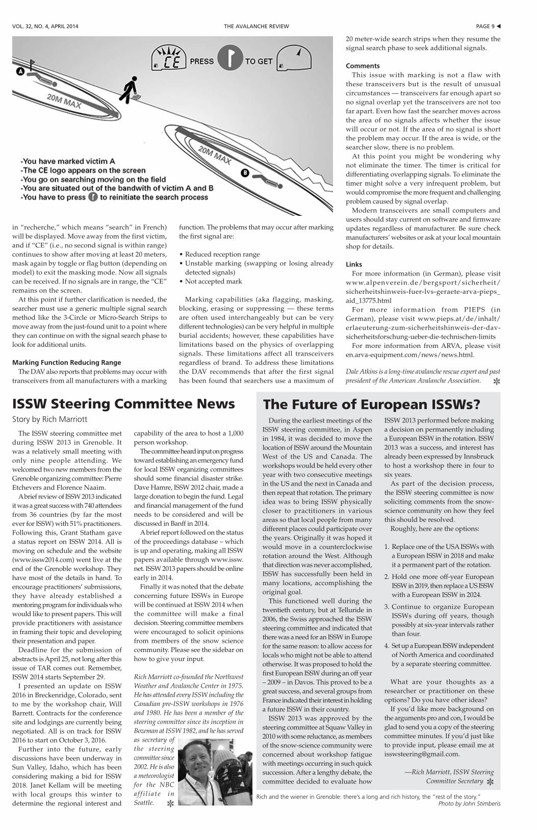
Specific to the use of an Evolution transceiver, after masking the first signal, the letters “CE” (as
• ARVA- evo 3- evo 3+- evolution+ - 3 Axes
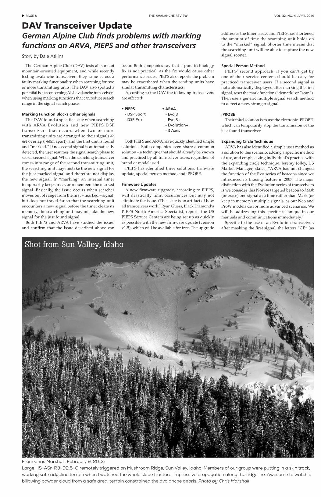
From Chris Marshall, February 9, 2013:Large HS-ASr-R3-D2.5-O remotely triggered on Mushroom Ridge, Sun Valley, Idaho. Members of our group were putting in a skin track, working safe ridgeline terrain when I watched the whole slope fracture. Impressive propagation along the ridgeline. Awesome to watch a billowing powder cloud from a safe area; terrain constrained the avalanche debris. Photo by Chris Marshall
Shot from Sun Valley, Idaho
pAGe 9 tthe AVAlANche reViewVol. 32, No. 4, April 2014
iSSw Steering Committee NewsStory by Rich Marriott
The ISSW steering committee met during ISSW 2013 in Grenoble. It was a relatively small meeting with only nine people attending. We welcomed two new members from the Grenoble organizing committee: Pierre Etchevers and Florence Naaim.
A brief review of ISSW 2013 indicated it was a great success with 740 attendees from 36 countries (by far the most ever for ISSW) with 51% practitioners. Following this, Grant Statham gave a status report on ISSW 2014. All is moving on schedule and the website (www.issw2014.com) went live at the end of the Grenoble workshop. They have most of the details in hand. To encourage practitioners’ submissions, they have already established a mentoring program for individuals who would like to present papers. This will provide practitioners with assistance in framing their topic and developing their presentation and paper.
Deadline for the submission of abstracts is April 25, not long after this issue of TAR comes out. Remember, ISSW 2014 starts September 29.
I presented an update on ISSW 2016 in Breckenridge, Colorado, sent to me by the workshop chair, Will Barrett. Contracts for the conference site and lodgings are currently being negotiated. All is on track for ISSW 2016 to start on October 3, 2016.
Further into the future, early discussions have been underway in Sun Valley, Idaho, which has been considering making a bid for ISSW 2018. Janet Kellam will be meeting with local groups this winter to determine the regional interest and
capability of the area to host a 1,000 person workshop.
The committee heard input on progress toward establishing an emergency fund for local ISSW organizing committees should some financial disaster strike. Dave Hamre, ISSW 2012 chair, made a large donation to begin the fund. Legal and financial management of the fund needs to be considered and will be discussed in Banff in 2014.
A brief report followed on the status of the proceedings database – which is up and operating, making all ISSW papers available through www.issw.net. ISSW 2013 papers should be online early in 2014.
Finally it was noted that the debate concerning future ISSWs in Europe will be continued at ISSW 2014 when the committee will make a final decision. Steering committee members were encouraged to solicit opinions from members of the snow science community. Please see the sidebar on how to give your input.
Rich Marriott co-founded the Northwest Weather and Avalanche Center in 1975. He has attended every ISSW including the Canadian pre-ISSW workshops in 1976 and 1980. He has been a member of the steering committee since its inception in Bozeman at ISSW 1982, and he has served as secretary of the steering committee since 2002. He is also a meteorologist for the NBC a f f i l i a t e in Seattle. R
in “recherche,” which means “search” in French) will be displayed. Move away from the first victim, and if “CE” (i.e., no second signal is within range) continues to show after moving at least 20 meters, mask again by toggle or flag button (depending on model) to exit the masking mode. Now all signals can be received. If no signals are in range, the “CE” remains on the screen.
At this point if further clarification is needed, the searcher must use a generic multiple signal search method like the 3-Circle or Micro-Search Strips to move away from the just-found unit to a point where they can continue on with the signal search phase to look for additional units.
Marking Function Reducing RangeThe DAV also reports that problems may occur with
transceivers from all manufacturers with a marking
function. The problems that may occur after marking the first signal are:
•Reducedreceptionrange•Unstable marking (swapping or losing already
detected signals)•Notacceptedmark
Marking capabilities (aka flagging, masking, blocking, erasing or suppressing — these terms are often used interchangeably but can be very different technologies) can be very helpful in multiple burial accidents; however, these capabilities have limitations based on the physics of overlapping signals. These limitations affect all transceivers regardless of brand. To address these limitations the DAV recommends that after the first signal has been found that searchers use a maximum of
20 meter-wide search strips when they resume the signal search phase to seek additional signals.
CommentsThis issue with marking is not a flaw with
these transceivers but is the result of unusual circumstances — transceivers far enough apart so no signal overlap yet the transceivers are not too far apart. Even how fast the searcher moves across the area of no signals affects whether the issue will occur or not. If the area of no signal is short the problem may occur. If the area is wide, or the searcher slow, there is no problem.
At this point you might be wondering why not eliminate the timer. The timer is critical for differentiating overlapping signals. To eliminate the timer might solve a very infrequent problem, but would compromise the more frequent and challenging problem caused by signal overlap.
Modern transceivers are small computers and users should stay current on software and firmware updates regardless of manufacturer. Be sure check manufacturers’ websites or ask at your local mountain shop for details.
LinksFor more information (in German), please visit
www.alpenverein.de/bergsport/sicherheit/sicherheitshinweis-fuer-lvs-geraete-arva-pieps_aid_13775.html
For more information from PIEPS (in German), please visit www.pieps.at/de/inhalt/erlaeuterung-zum-sicherheitshinweis-der-dav-sicherheitsforschung-ueber-die-technischen-limits
For more information from ARVA, please visit en.arva-equipment.com/news/news.html.
Dale Atkins is a long-time avalanche rescue expert and past president of the American Avalanche Association. R
The Future of European iSSws?During the earliest meetings of the
ISSW steering committee, in Aspen in 1984, it was decided to move the location of ISSW around the Mountain West of the US and Canada. The workshops would be held every other year with two consecutive meetings in the US and the next in Canada and then repeat that rotation. The primary idea was to bring ISSW physically closer to practitioners in various areas so that local people from many different places could participate over the years. Originally it was hoped it would move in a counterclockwise rotation around the West. Although that direction was never accomplished, ISSW has successfully been held in many locations, accomplishing the original goal.
This functioned well during the twentieth century, but at Telluride in 2006, the Swiss approached the ISSW steering committee and indicated that there was a need for an ISSW in Europe for the same reason: to allow access for locals who might not be able to attend otherwise. It was proposed to hold the first European ISSW during an off year – 2009 – in Davos. This proved to be a great success, and several groups from France indicated their interest in holding a future ISSW in their country.
ISSW 2013 was approved by the steering committee at Squaw Valley in 2010 with some reluctance, as members of the snow-science community were concerned about workshop fatigue with meetings occurring in such quick succession. After a lengthy debate, the committee decided to evaluate how
ISSW 2013 performed before making a decision on permanently including a European ISSW in the rotation. ISSW 2013 was a success, and interest has already been expressed by Innsbruck to host a workshop there in four to six years.
As part of the decision process, the ISSW steering committee is now soliciting comments from the snow-science community on how they feel this should be resolved.
Roughly, here are the options:
1. Replace one of the USA ISSWs with a European ISSW in 2018 and make it a permanent part of the rotation.
2. Hold one more off-year European ISSW in 2019, then replace a US ISSW with a European ISSW in 2024.
3. Continue to organize European ISSWs during off years, though possibly at six-year intervals rather than four.
4. Set up a European ISSW independent of North America and coordinated by a separate steering committee.
What are your thoughts as a researcher or practitioner on these options? Do you have other ideas?
If you’d like more background on the arguments pro and con, I would be glad to send you a copy of the steering committee minutes. If you’d just like to provide input, please email me at [email protected].
—Rich Marriott, ISSW Steering Committee Secretary R
Rich and the wiener in Grenoble: there’s a long and rich history, the “rest of the story.” Photo by John Stimberis
u pAGe 10 the AVAlANche reView Vol. 32, No. 4, April 2014
Avalanche Explosive Mitigation Analysis and Implications on the Anti-Crack ModelResearch proposal summary by Ella Darham
This study is comprised of two main questions: 1) Is there a correlation between various avalanche mitigation methods and their effectiveness for triggering a larger percentage of a slide path's area and volume? 2) If the collapse of the slab layer does not initiate the fracture of the weak layer exceeding the critical crack length thus triggering an avalanche, will (A) the force from the air blast be able to re-communicate the same fracture mechanics though the vertical cracks created by the surface blast? Or (B) will the vertical cracks disrupt and limit the triggering affectability of the subsequent air blast? The aim of the research is to provide quantitative evidence of various avalanche explosive delivery methods comparing their effectiveness for triggering larger avalanches in an operational setting, and test practical implications of the anti-crack model with respect to slab “communication” in explosive-induced avalanches. The findings will be useful for all avalanche-control operations utilizing explosives (heli-skiing, ski areas, departments of transportation, mines, etc.), as they will now have in-depth, practical, and comprehensive evidence to support their avalanche mitigation programs. The research will be conducted within the operational boundary of the Bridger Bowl ski area located in southwest Montana.
The Theo Meiners Research Grant will support Ella Darham with materials and data collection for the 2013/14 winter.
Impacts of Ice Crust Thickness and Porosity on Temperature Gradient and Kinetic Snow MetamorphismResearch proposal summary by Kevin Hammonds
Of critical importance to avalanche forecasting is the ability to draw meaningful conclusions from potentially only a small handful of field observations. With this in mind, the research proposed here hopes to develop a new metric that can be easily applied for deciphering the rate at which faceting may occur on or near a buried ice lens or crust. Utilizing several instruments and techniques developed at the Ice Research Laboratory including a micro-CT, peltier cold stage, and a micro-scale thermocouple array, Kevin Hammonds and Xuan Wang hope to find a universal relationship between the driving forces of kinetic snow metamorphism and ice crust thickness. In their working hypothesis, they suspect that even when temperature gradients over the entire snowpack are observed of less than 1 degree C per 10cm, there is a super temperature gradient that exists near the surface of low porosity ice crusts that must account for the faceted grains that are commonly observed. Although these types of weak layers can often be easily identified within a snowpack, it remains a forecasting challenge to assess the future implications of these layers if no immediate signs of instability are present. With the aid of the Theo Meiners Research Grant, Hammonds and Wang hope to provide both scientific evidence in support of their working hypothesis as well as a new tool for field practitioners to aid them in making the most educated decisions possible.
Kevin Hammonds is a PhD candidate in the Ice Research Laboratory, Thayer School of Engineering at Dartmouth College.
Mapping Starting Zone Snow Depth with a Ground-Based Lidar for Avalanche Control Planning and EvaluationResearch proposal summary by Jeffrey S. Deems
In a cooperative effort with the Arapahoe Basin ski patrol, Mammoth Mountain ski patrol, and the US Army Corps of Engineers Cold Regions Research and Engineering Lab, we are using a new terrestrial laser scanning (TLS) system to map snow depth and snow depth change in actively managed avalanche starting zones.
Until recently, TLS surveys have either been limited to very short ranges due to the wavelength of the TLS system, or they have required long-duration nighttime data collection campaigns due to the slow speed of the scanner and limited detection capabilities at longer ranges. A new TLS system allows unprecedented range and resolution for mapping surface elevation of snow-free or snow-covered terrain, and is a potentially revolutionary development for remote measurement of snow depth at high resolutions in complex terrain.
Snow-free data were collected in late September 2013 at A-Basin and Mammoth sites. Snow-on surveys are being conducted during the 2013/14 snow season (until ski area closure). The survey schedule is flexible to accommodate the sequence of weather events and snow conditions as the snow season evolves. Survey scenarios include:
•Latefall,aftersnow-freeperiod–toestimatedepthhoar distribution
•Priortoinitialcontrolefforts–toprovideabaselinesnow-depth map
•Poststorm,precontrol,andpostcontrol–toallowretrospective analysis of shot placement and to estimate hazard reduction and avalanche release volume/mass
•Precontrol,withfastdepthmapgeneration–foruse as a route-planning tool
•Prior,during,andpostwindevent–tostudyloadingpatterns and rates
•Timeseriesduringwinter–tostudyaccumulationpatterns in expansion terrain
This project will continue at least through the 2013/14 ski season. Work to-date has been conducted on a volunteer/in-kind basis, and we are grateful for the enabling support of the Theo Meiners Research Grant program. We will seek additional funding to continue the project into 2015 and hope to expand to other sites/operations. Look for updates on this project in future TAR issues, and at ISSW 2014 in Banff. Thanks are due to Ryan Evanczyk and Dominic Vellone at A-Basin, Mike Collee at Mammoth, and Dave Finnegan, Adam Lewinter, and Pete Gadomski at US Army CRREL.
The Effect of Canopy Shading and Aspect on Surface Hoar Growth in Small Forested MeadowsResearch proposal summary by Matt Wieland
The aim of this study is to further investigate the influences that canopy cover and shading have on the relative size and spatial distribution of surface hoar in small meadow openings. The project focuses on the initial overnight formation of a layer of surface hoar with an attempt of data collection prior to any potential destruction during daytime hours and before the layer is potentially buried. The study will occur in two roughly 50m by 50m below treeline meadow openings on a north and south aspect in the southern Madison range of southwest Montana during two winter seasons. On a collection day, one hundred observations of surface hoar size will be taken at each site along with HS and slope angle. Along with each observation, a digital hemispherical (fisheye) photograph looking skyward will be exposed for use in canopy and radiation estimates. Each site will also have meteorological sensors recording temperature and relative humidity.
This study will attempt to relate relative surface hoar sizes in these two meadows to canopy cover and daytime shading. The goal is a better understanding of initial surface hoar growth patterns in these small meadow openings and differing aspects. Having better understandings of these distributions can aid in future studies that incorporate destructive effects or when storms bury layers rapidly after formation. This project also aims to aid both forecasters and recreationists in their understanding of where these buried layers may be present or where to best place a stability test.
Matt Wieland is a master ’s candidate in the Department of Earth Sciences at Montana State University in Bozeman, MT. He was formally a ski patroller at Moonlight Basin in Big Sky, MT. R
aaa news
First Theo Meiners research Grants AwardedStory by AAA Research Committee Chair Jordy Hendrikx
The AAA has agreed with the recommendations made by the research committee to fund the following
research proposals from the Theo Meiners Research Grant monies. The competition was very strong, and we
only funded a small proportion of the applicants, none to their full requested amount.
On accepting this grant, each participant agreed to 1) provide a brief, one-paragraph summary of their
proposal for TAR within seven days (see descriptions below); 2) provide an article for TAR on completion of their
project; and 3) submit a paper for presentation at the International Snow Science Workshop, 2014.
AAA Fall Governing Board Meeting MinutesExecutive Director’s Report
Financial report Mark Mueller: Avalanche.org account “zero” level is $50,000 and we haven’t collected from the avalanche centers yet for this season – we’re doing well there. Operations account: We are doing well, some bills still to pay but relatively minor. NAC “pass through account” = has some ISSW 2012 money in it, $35-40,000. Most of this is earmarked to future items. Mark recommends that we don’t serve as pass through going forward as it has potential tax implications (red flags for IRS).
Membership report
Pro development grant proposals Mark: Pro development grants: should we use the process as described on the website? In the past, Mark did not and just wrote checks to who applied. He also had to track down individual organizers to see if they were doing events in the current year. We have been able to fill almost all requests in
full. Gallatin NF Avalanche Center event in the spring, Sawtooth Avy Center in the spring, Tahoe in the Sierra in the spring. We have a little extra money from the CIL grant. We need to make sure the program and process reflects what is on the website. Generally speaking, the website has lots of outdated information.
SWAG update
Ordered and received 600. Doing well on margins on SWAG. Most orders are from avalanche schools and universities. Plan on a revision/update in a couple years. Ethan Greene will probably not be the editor – we need to talk to him about future editor options. Jaime: Shipping costs will be larger in the future. Mike: We should consider order fulfillment service for SWAG in the future. Mark: We should see if omnipress (printer) would recommend someone for shipping to Jaime.
Continued on page 18 ➨
pAGe 11 tthe AVAlANche reViewVol. 32, No. 4, April 2014
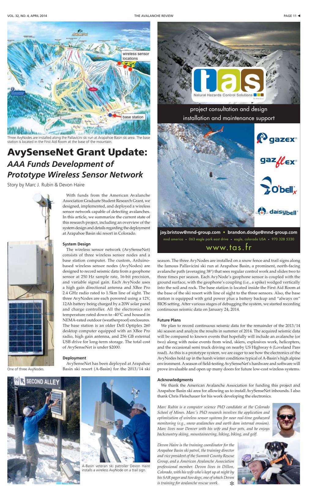
With funds from the American Avalanche Association Graduate Student Research Grant, we designed, implemented, and deployed a wireless sensor network capable of detecting avalanches. In this article, we summarize the current state of this research project, including an overview of the system design and details regarding the deployment at Arapahoe Basin ski resort in Colorado.
System DesignThe wireless sensor network (AvySenseNet)
consists of three wireless sensor nodes and a base station computer. The custom, Arduino-based wireless sensor nodes (AvyNodes) are designed to record seismic data from a geophone sensor at 250 Hz sample rate, 16-bit precision, and variable signal gain. Each AvyNode uses a high gain directional antenna and XBee Pro 2.4 GHz radio rated to 1.5km line of sight. The three AvyNodes are each powered using a 12V, 12Ah battery being charged by a 20W solar panel and charge controller. All the electronics are temperature rated down to -40°C and housed in NEMA-rated outdoor (weatherproof) enclosures. The base station is an older Dell Optiplex 260 desktop computer equipped with an XBee Pro radio, high gain antenna, and 256 GB external USB drive for long-term storage. The total cost of AvySenseNet is under $2000.
DeploymentAvySenseNet has been deployed at Arapahoe
Basin ski resort (A-Basin) for the 2013/14 ski
season. The three AvyNodes are installed on a snow fence and trail signs along the famous Pallavicini ski run at Arapahoe Basin, a prominent, north-facing avalanche path (averaging 38°) that sees regular control work and slides two to three times per season. Each AvyNode’s geophone sensor is coupled with the ground surface, with the geophone’s coupling (i.e., a spike) wedged vertically into the soil and rock. The base station is located inside the First Aid Room at the base of the ski resort with line of sight to the three sensors. Also, the base station is equipped with grid power plus a battery backup and “always on” BIOS setting. After various stages of debugging the system, we started recording continuous seismic data on January 24, 2014.
Future PlansWe plan to record continuous seismic data for the remainder of the 2013/14
ski season and analyze the results in summer of 2014. The acquired seismic data will be compared to known events that hopefully will include an avalanche (or two) along with noise events from wind, skiers, explosives work, helicopters, and the occasional semi truck driving on nearby US Highway 6 (Loveland Pass road). As this is a prototype system, we are eager to see how the electronics of the AvyNodes hold up in the harsh winter conditions typical of A-Basin’s high alpine environment. A season of field-testing AvySenseNet’s hardware and software will prove invaluable and open up many doors for future low-cost wireless systems.
AcknowledgmentsWe thank the American Avalanche Association for funding this project and
Arapahoe Basin ski area for allowing us to install AvySenseNet inbounds. I also thank Chris Fleischauer for his work developing the electronics.
Marc Rubin is a computer science PhD candidate at the Colorado School of Mines. Marc's PhD research involves the application and optimization of wireless sensor systems for near real-time geohazard monitoring (e.g., snow avalanches and earth dam internal erosion). Marc lives near Denver with his wife and four pets, and he enjoys backcountry skiing, mountaineering, hiking, biking, and golf.
Devon Haire is the training coordinator for the Arapahoe Basin ski patrol, the training director and vice president of the Summit County Rescue Group, and a American Avalanche Association professional member. Devon lives in Dillon, Colorado, with his wife who’s kept up at night by his SAR pager and two dogs, one of which Devon is training for avalanche rescue work. R
AvySenseNet Grant Update:AAA Funds Development of Prototype Wireless Sensor NetworkStory by Marc J. Rubin & Devon Haire
Three AvyNodes are installed along the Pallavicini ski run at Arapahoe Basin ski area. The base station is located in the First Aid Room at the base of the mountain.
One of three AvyNodes.
A-Basin veteran ski patroller Devon Haire installs a wireless AvyNode on a trail sign.
u pAGe 12 the AVAlANche reView Vol. 32, No. 4, April 2014
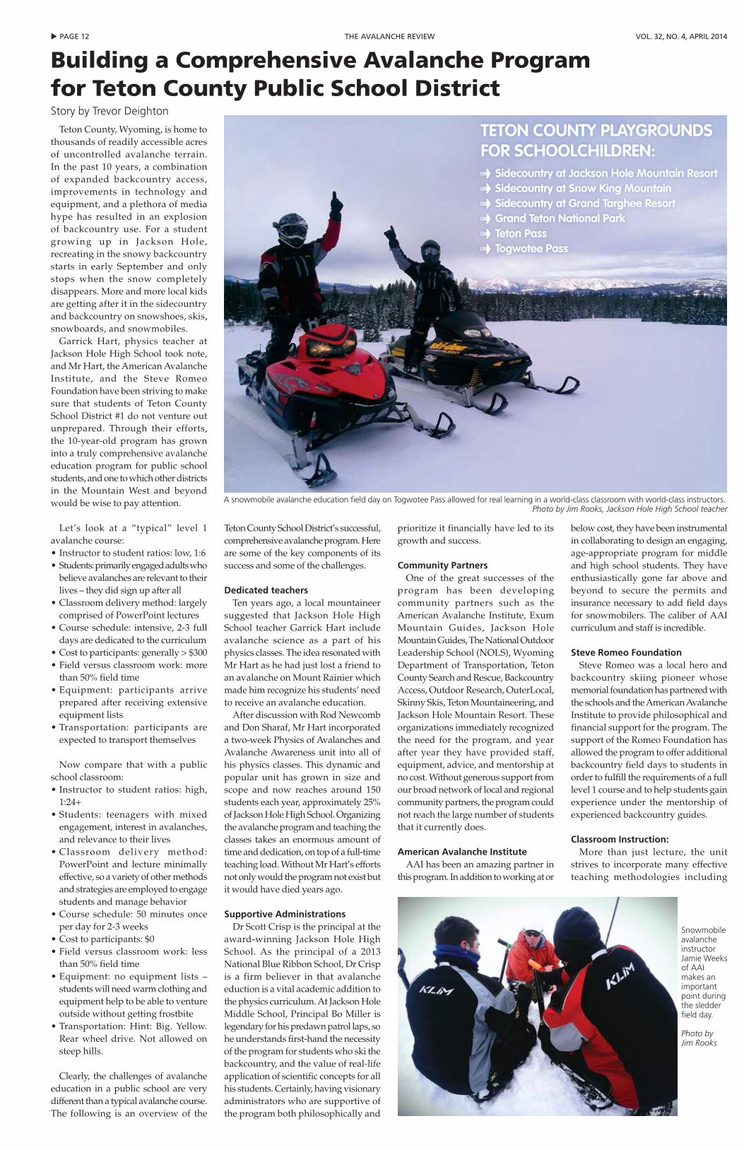
Teton County, Wyoming, is home to thousands of readily accessible acres of uncontrolled avalanche terrain. In the past 10 years, a combination of expanded backcountry access, improvements in technology and equipment, and a plethora of media hype has resulted in an explosion of backcountry use. For a student growing up in Jackson Hole, recreating in the snowy backcountry starts in early September and only stops when the snow completely disappears. More and more local kids are getting after it in the sidecountry and backcountry on snowshoes, skis, snowboards, and snowmobiles.
Garrick Hart, physics teacher at Jackson Hole High School took note, and Mr Hart, the American Avalanche Institute, and the Steve Romeo Foundation have been striving to make sure that students of Teton County School District #1 do not venture out unprepared. Through their efforts, the 10-year-old program has grown into a truly comprehensive avalanche education program for public school students, and one to which other districts in the Mountain West and beyond would be wise to pay attention.
Let’s look at a “typical” level 1 avalanche course:•Instructortostudentratios:low,1:6•Students:primarilyengagedadultswho
believe avalanches are relevant to their lives – they did sign up after all
•Classroomdeliverymethod:largelycomprised of PowerPoint lectures
•Course schedule: intensive,2-3 fulldays are dedicated to the curriculum
•Costtoparticipants:generally>$300•Fieldversusclassroomwork:more
than 50% field time•Equipment: participants arrive
prepared after receiving extensive equipment lists
•Transportation: participants areexpected to transport themselves
Now compare that with a public
school classroom:•Instructor to student ratios: high,
1:24+•Students: teenagers with mixed
engagement, interest in avalanches, and relevance to their lives
•Classroom delivery method:PowerPoint and lecture minimally effective, so a variety of other methods and strategies are employed to engage students and manage behavior
•Course schedule: 50 minutes onceper day for 2-3 weeks
•Costtoparticipants:$0•Field versus classroom work: less
than 50% field time•Equipment: no equipment lists –
students will need warm clothing and equipment help to be able to venture outside without getting frostbite
•Transportation: Hint: Big. Yellow.Rear wheel drive. Not allowed on steep hills.
Clearly, the challenges of avalanche education in a public school are very different than a typical avalanche course. The following is an overview of the
Teton County School District’s successful, comprehensive avalanche program. Here are some of the key components of its success and some of the challenges.
Dedicated teachersTen years ago, a local mountaineer
suggested that Jackson Hole High School teacher Garrick Hart include avalanche science as a part of his physics classes. The idea resonated with Mr Hart as he had just lost a friend to an avalanche on Mount Rainier which made him recognize his students’ need to receive an avalanche education.
After discussion with Rod Newcomb and Don Sharaf, Mr Hart incorporated a two-week Physics of Avalanches and Avalanche Awareness unit into all of his physics classes. This dynamic and popular unit has grown in size and scope and now reaches around 150 students each year, approximately 25% of Jackson Hole High School. Organizing the avalanche program and teaching the classes takes an enormous amount of time and dedication, on top of a full-time teaching load. Without Mr Hart’s efforts not only would the program not exist but it would have died years ago.
Supportive AdministrationsDr Scott Crisp is the principal at the
award-winning Jackson Hole High School. As the principal of a 2013 National Blue Ribbon School, Dr Crisp is a firm believer in that avalanche eduction is a vital academic addition to the physics curriculum. At Jackson Hole Middle School, Principal Bo Miller is legendary for his predawn patrol laps, so he understands first-hand the necessity of the program for students who ski the backcountry, and the value of real-life application of scientific concepts for all his students. Certainly, having visionary administrators who are supportive of the program both philosophically and
prioritize it financially have led to its growth and success.
Community PartnersOne of the great successes of the
program has been developing community partners such as the American Avalanche Institute, Exum Mountain Guides, Jackson Hole Mountain Guides, The National Outdoor Leadership School (NOLS), Wyoming Department of Transportation, Teton County Search and Rescue, Backcountry Access, Outdoor Research, OuterLocal, Skinny Skis, Teton Mountaineering, and Jackson Hole Mountain Resort. These organizations immediately recognized the need for the program, and year after year they have provided staff, equipment, advice, and mentorship at no cost. Without generous support from our broad network of local and regional community partners, the program could not reach the large number of students that it currently does.
American Avalanche InstituteAAI has been an amazing partner in
this program. In addition to working at or
below cost, they have been instrumental in collaborating to design an engaging, age-appropriate program for middle and high school students. They have enthusiastically gone far above and beyond to secure the permits and insurance necessary to add field days for snowmobilers. The caliber of AAI curriculum and staff is incredible.
Steve Romeo FoundationSteve Romeo was a local hero and
backcountry skiing pioneer whose memorial foundation has partnered with the schools and the American Avalanche Institute to provide philosophical and financial support for the program. The support of the Romeo Foundation has allowed the program to offer additional backcountry field days to students in order to fulfill the requirements of a full level 1 course and to help students gain experience under the mentorship of experienced backcountry guides.
Classroom Instruction:More than just lecture, the unit
strives to incorporate many effective teaching methodologies including
Building a Comprehensive Avalanche program for Teton County public School DistrictStory by Trevor Deighton
TeTon CounTy Playgroundsfor sChoolChildren:- sidecountry at Jackson hole Mountain resort- sidecountry at snow King Mountain- sidecountry at grand Targhee resort - grand Teton national Park- Teton Pass- Togwotee Pass
A snowmobile avalanche education field day on Togwotee Pass allowed for real learning in a world-class classroom with world-class instructors.Photo by Jim Rooks, Jackson Hole High School teacher
Snowmobile avalanche instructor Jamie Weeks of AAI makes an important point during the sledder field day.
Photo by Jim Rooks
pAGe 13 tthe AVAlANche reViewVol. 32, No. 4, April 2014
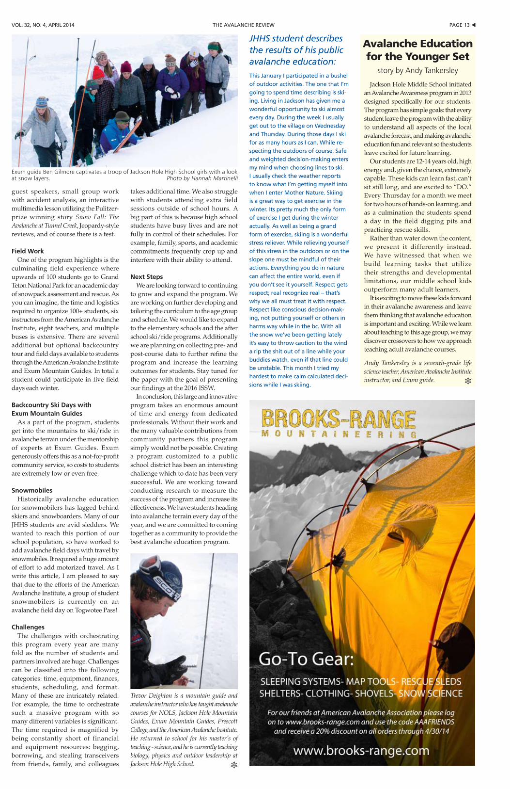
guest speakers, small group work with accident analysis, an interactive multimedia lesson utilizing the Pulitzer-prize winning story Snow Fall: The Avalanche at Tunnel Creek, Jeopardy-style reviews, and of course there is a test.
Field WorkOne of the program highlights is the
culminating field experience where upwards of 100 students go to Grand Teton National Park for an academic day of snowpack assessment and rescue. As you can imagine, the time and logistics required to organize 100+ students, six instructors from the American Avalanche Institute, eight teachers, and multiple buses is extensive. There are several additional but optional backcountry tour and field days available to students through the American Avalanche Institute and Exum Mountain Guides. In total a student could participate in five field days each winter.
Backcountry Ski Days with Exum Mountain Guides
As a part of the program, students get into the mountains to ski/ride in avalanche terrain under the mentorship of experts at Exum Guides. Exum generously offers this as a not-for-profit community service, so costs to students are extremely low or even free.
SnowmobilesHistorically avalanche education
for snowmobilers has lagged behind skiers and snowboarders. Many of our JHHS students are avid sledders. We wanted to reach this portion of our school population, so have worked to add avalanche field days with travel by snowmobiles. It required a huge amount of effort to add motorized travel. As I write this article, I am pleased to say that due to the efforts of the American Avalanche Institute, a group of student snowmobilers is currently on an avalanche field day on Togwotee Pass!
ChallengesThe challenges with orchestrating
this program every year are many fold as the number of students and partners involved are huge. Challenges can be classified into the following categories: time, equipment, finances, students, scheduling, and format. Many of these are intricately related. For example, the time to orchestrate such a massive program with so many different variables is significant. The time required is magnified by being constantly short of financial and equipment resources: begging, borrowing, and stealing transceivers from friends, family, and colleagues
takes additional time. We also struggle with students attending extra field sessions outside of school hours. A big part of this is because high school students have busy lives and are not fully in control of their schedules. For example, family, sports, and academic commitments frequently crop up and interfere with their ability to attend.
Next StepsWe are looking forward to continuing
to grow and expand the program. We are working on further developing and tailoring the curriculum to the age group and schedule. We would like to expand to the elementary schools and the after school ski/ride programs. Additionally we are planning on collecting pre- and post-course data to further refine the program and increase the learning outcomes for students. Stay tuned for the paper with the goal of presenting our findings at the 2016 ISSW.
In conclusion, this large and innovative program takes an enormous amount of time and energy from dedicated professionals. Without their work and the many valuable contributions from community partners this program simply would not be possible. Creating a program customized to a public school district has been an interesting challenge which to date has been very successful. We are working toward conducting research to measure the success of the program and increase its effectiveness. We have students heading into avalanche terrain every day of the year, and we are committed to coming together as a community to provide the best avalanche education program.
Trevor Deighton is a mountain guide and avalanche instructor who has taught avalanche courses for NOLS, Jackson Hole Mountain Guides, Exum Mountain Guides, Prescott College, and the American Avalanche Institute. He returned to school for his master’s of teaching - science, and he is currently teaching biology, physics and outdoor leadership at Jackson Hole High School. R
Jackson Hole Middle School initiated an Avalanche Awareness program in 2013 designed specifically for our students. The program has simple goals: that every student leave the program with the ability to understand all aspects of the local avalanche forecast, and making avalanche education fun and relevant so the students leave excited for future learning.
Our students are 12-14 years old, high energy and, given the chance, extremely capable. These kids can learn fast, can’t sit still long, and are excited to “DO.” Every Thursday for a month we meet for two hours of hands-on learning, and as a culmination the students spend a day in the field digging pits and practicing rescue skills.
Rather than water down the content, we present it differently instead. We have witnessed that when we build learning tasks that utilize their strengths and developmental limitations, our middle school kids outperform many adult learners.
It is exciting to move these kids forward in their avalanche awareness and leave them thinking that avalanche education is important and exciting. While we learn about teaching to this age group, we may discover crossovers to how we approach teaching adult avalanche courses.
Andy Tankersley is a seventh-grade life science teacher, American Avalanche Institute instructor, and Exum guide. R
Exum guide Ben Gilmore captivates a troop of Jackson Hole High School girls with a look at snow layers. Photo by Hannah Martinelli
Avalanche Education for the Younger Set
story by Andy Tankersley
JHHS student describes the results of his public avalanche education:this January i participated in a bushel of outdoor activities. the one that i’m going to spend time describing is ski-ing. living in Jackson has given me a wonderful opportunity to ski almost every day. During the week i usually get out to the village on wednesday and thursday. During those days i ski for as many hours as i can. while re-specting the outdoors of course. Safe and weighted decision-making enters my mind when choosing lines to ski. i usually check the weather reports to know what i’m getting myself into when i enter mother Nature. Skiing is a great way to get exercise in the winter. its pretty much the only form of exercise i get during the winter actually. As well as being a grand form of exercise, skiing is a wonderful stress reliever. while relieving yourself of this stress in the outdoors or on the slope one must be mindful of their actions. everything you do in nature can affect the entire world, even if you don’t see it yourself. respect gets respect; real recognize real – that’s why we all must treat it with respect. respect like conscious decision-mak-ing, not putting yourself or others in harms way while in the bc. with all the snow we’ve been getting lately it’s easy to throw caution to the wind a rip the shit out of a line while your buddies watch, even if that line could be unstable. this month i tried my hardest to make calm calculated deci-sions while i was skiing.
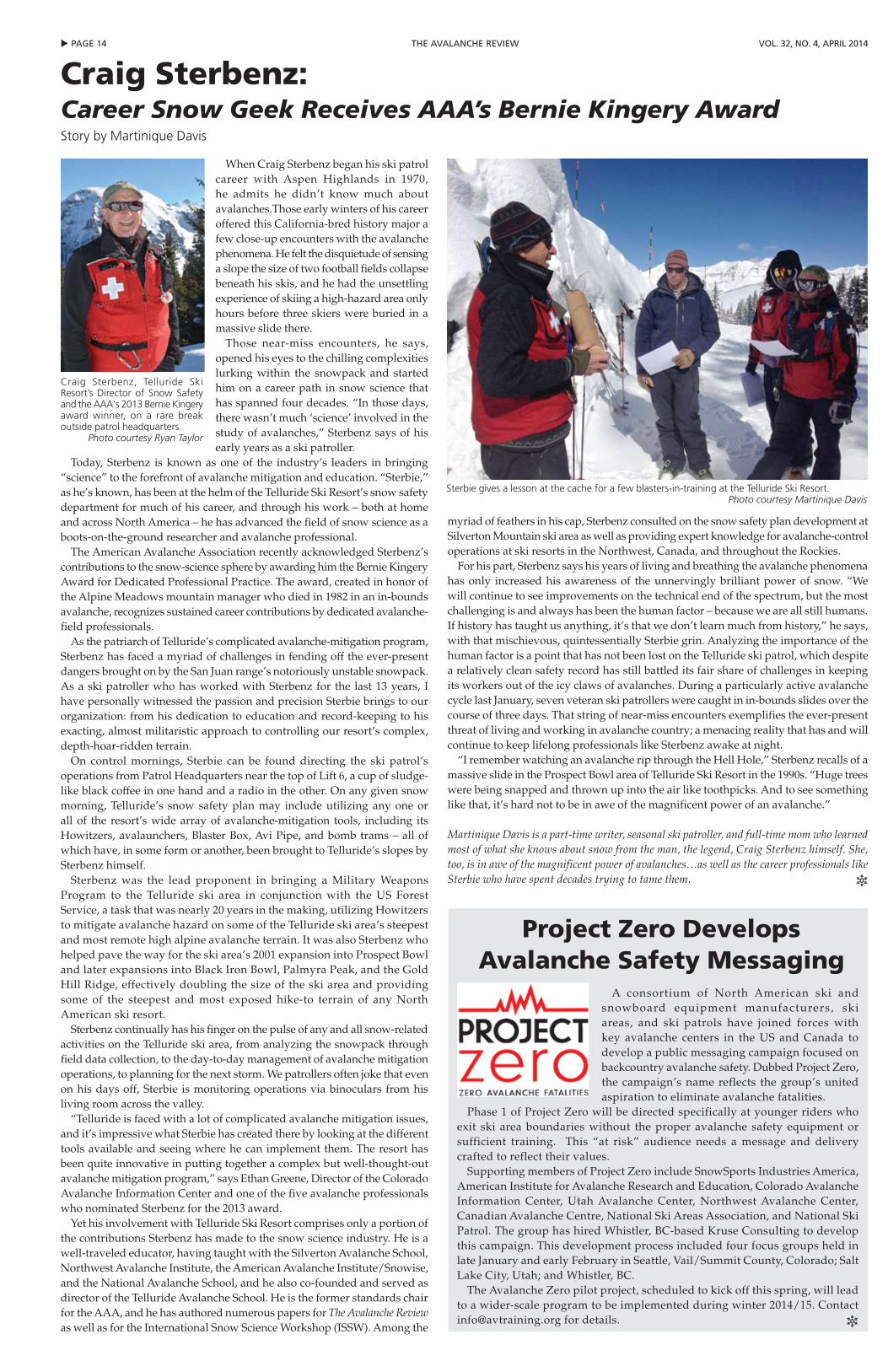
u pAGe 14 the AVAlANche reView Vol. 32, No. 4, April 2014
A consortium of North American ski and snowboard equipment manufacturers, ski areas, and ski patrols have joined forces with key avalanche centers in the US and Canada to develop a public messaging campaign focused on backcountryavalanchesafety.DubbedProjectZero,the campaign’s name reflects the group’s united aspiration to eliminate avalanche fatalities.
Phase1ofProjectZerowillbedirectedspecificallyatyoungerriderswhoexit ski area boundaries without the proper avalanche safety equipment or sufficient training. This “at risk” audience needs a message and delivery crafted to reflect their values.
SupportingmembersofProjectZeroincludeSnowSportsIndustriesAmerica,American Institute for Avalanche Research and Education, Colorado Avalanche Information Center, Utah Avalanche Center, Northwest Avalanche Center, Canadian Avalanche Centre, National Ski Areas Association, and National Ski Patrol. The group has hired Whistler, BC-based Kruse Consulting to develop this campaign. This development process included four focus groups held in late January and early February in Seattle, Vail/Summit County, Colorado; Salt Lake City, Utah; and Whistler, BC.
TheAvalancheZeropilotproject,scheduledtokickoffthisspring,willleadto a wider-scale program to be implemented during winter 2014/15. Contact [email protected] for details. R
project Zero Develops Avalanche Safety Messaging
Craig Sterbenz:Career Snow Geek Receives AAA’s Bernie Kingery Award Story by Martinique Davis
When Craig Sterbenz began his ski patrol career with Aspen Highlands in 1970, he admits he didn’t know much about avalanches.Those early winters of his career offered this California-bred history major a few close-up encounters with the avalanche phenomena. He felt the disquietude of sensing a slope the size of two football fields collapse beneath his skis, and he had the unsettling experience of skiing a high-hazard area only hours before three skiers were buried in a massive slide there.
Those near-miss encounters, he says, opened his eyes to the chilling complexities lurking within the snowpack and started him on a career path in snow science that has spanned four decades. “In those days, there wasn’t much ‘science’ involved in the study of avalanches,” Sterbenz says of his early years as a ski patroller.
Today, Sterbenz is known as one of the industry’s leaders in bringing “science” to the forefront of avalanche mitigation and education. “Sterbie,” as he’s known, has been at the helm of the Telluride Ski Resort’s snow safety department for much of his career, and through his work – both at home and across North America – he has advanced the field of snow science as a boots-on-the-ground researcher and avalanche professional.
The American Avalanche Association recently acknowledged Sterbenz’s contributions to the snow-science sphere by awarding him the Bernie Kingery Award for Dedicated Professional Practice. The award, created in honor of the Alpine Meadows mountain manager who died in 1982 in an in-bounds avalanche, recognizes sustained career contributions by dedicated avalanche-field professionals.
As the patriarch of Telluride’s complicated avalanche-mitigation program, Sterbenz has faced a myriad of challenges in fending off the ever-present dangers brought on by the San Juan range’s notoriously unstable snowpack. As a ski patroller who has worked with Sterbenz for the last 13 years, I have personally witnessed the passion and precision Sterbie brings to our organization: from his dedication to education and record-keeping to his exacting, almost militaristic approach to controlling our resort’s complex, depth-hoar-ridden terrain.
On control mornings, Sterbie can be found directing the ski patrol’s operations from Patrol Headquarters near the top of Lift 6, a cup of sludge-like black coffee in one hand and a radio in the other. On any given snow morning, Telluride’s snow safety plan may include utilizing any one or all of the resort’s wide array of avalanche-mitigation tools, including its Howitzers, avalaunchers, Blaster Box, Avi Pipe, and bomb trams – all of which have, in some form or another, been brought to Telluride’s slopes by Sterbenz himself.
Sterbenz was the lead proponent in bringing a Military Weapons Program to the Telluride ski area in conjunction with the US Forest Service, a task that was nearly 20 years in the making, utilizing Howitzers to mitigate avalanche hazard on some of the Telluride ski area’s steepest and most remote high alpine avalanche terrain. It was also Sterbenz who helped pave the way for the ski area’s 2001 expansion into Prospect Bowl and later expansions into Black Iron Bowl, Palmyra Peak, and the Gold Hill Ridge, effectively doubling the size of the ski area and providing some of the steepest and most exposed hike-to terrain of any North American ski resort.
Sterbenz continually has his finger on the pulse of any and all snow-related activities on the Telluride ski area, from analyzing the snowpack through field data collection, to the day-to-day management of avalanche mitigation operations, to planning for the next storm. We patrollers often joke that even on his days off, Sterbie is monitoring operations via binoculars from his living room across the valley.
“Telluride is faced with a lot of complicated avalanche mitigation issues, and it’s impressive what Sterbie has created there by looking at the different tools available and seeing where he can implement them. The resort has been quite innovative in putting together a complex but well-thought-out avalanche mitigation program,” says Ethan Greene, Director of the Colorado Avalanche Information Center and one of the five avalanche professionals who nominated Sterbenz for the 2013 award.
Yet his involvement with Telluride Ski Resort comprises only a portion of the contributions Sterbenz has made to the snow science industry. He is a well-traveled educator, having taught with the Silverton Avalanche School, Northwest Avalanche Institute, the American Avalanche Institute/Snowise, and the National Avalanche School, and he also co-founded and served as director of the Telluride Avalanche School. He is the former standards chair for the AAA, and he has authored numerous papers for The Avalanche Review as well as for the International Snow Science Workshop (ISSW). Among the
myriad of feathers in his cap, Sterbenz consulted on the snow safety plan development at Silverton Mountain ski area as well as providing expert knowledge for avalanche-control operations at ski resorts in the Northwest, Canada, and throughout the Rockies.
For his part, Sterbenz says his years of living and breathing the avalanche phenomena has only increased his awareness of the unnervingly brilliant power of snow. “We will continue to see improvements on the technical end of the spectrum, but the most challenging is and always has been the human factor – because we are all still humans. If history has taught us anything, it’s that we don’t learn much from history,” he says, with that mischievous, quintessentially Sterbie grin. Analyzing the importance of the human factor is a point that has not been lost on the Telluride ski patrol, which despite a relatively clean safety record has still battled its fair share of challenges in keeping its workers out of the icy claws of avalanches. During a particularly active avalanche cycle last January, seven veteran ski patrollers were caught in in-bounds slides over the course of three days. That string of near-miss encounters exemplifies the ever-present threat of living and working in avalanche country; a menacing reality that has and will continue to keep lifelong professionals like Sterbenz awake at night.
“I remember watching an avalanche rip through the Hell Hole,” Sterbenz recalls of a massive slide in the Prospect Bowl area of Telluride Ski Resort in the 1990s. “Huge trees were being snapped and thrown up into the air like toothpicks. And to see something like that, it’s hard not to be in awe of the magnificent power of an avalanche.”
Martinique Davis is a part-time writer, seasonal ski patroller, and full-time mom who learned most of what she knows about snow from the man, the legend, Craig Sterbenz himself. She, too, is in awe of the magnificent power of avalanches…as well as the career professionals like Sterbie who have spent decades trying to tame them. R
Craig Sterbenz, Telluride Ski Resort’s Director of Snow Safety and the AAA's 2013 Bernie Kingery award winner, on a rare break outside patrol headquarters.
Photo courtesy Ryan Taylor
Sterbie gives a lesson at the cache for a few blasters-in-training at the Telluride Ski Resort.Photo courtesy Martinique Davis
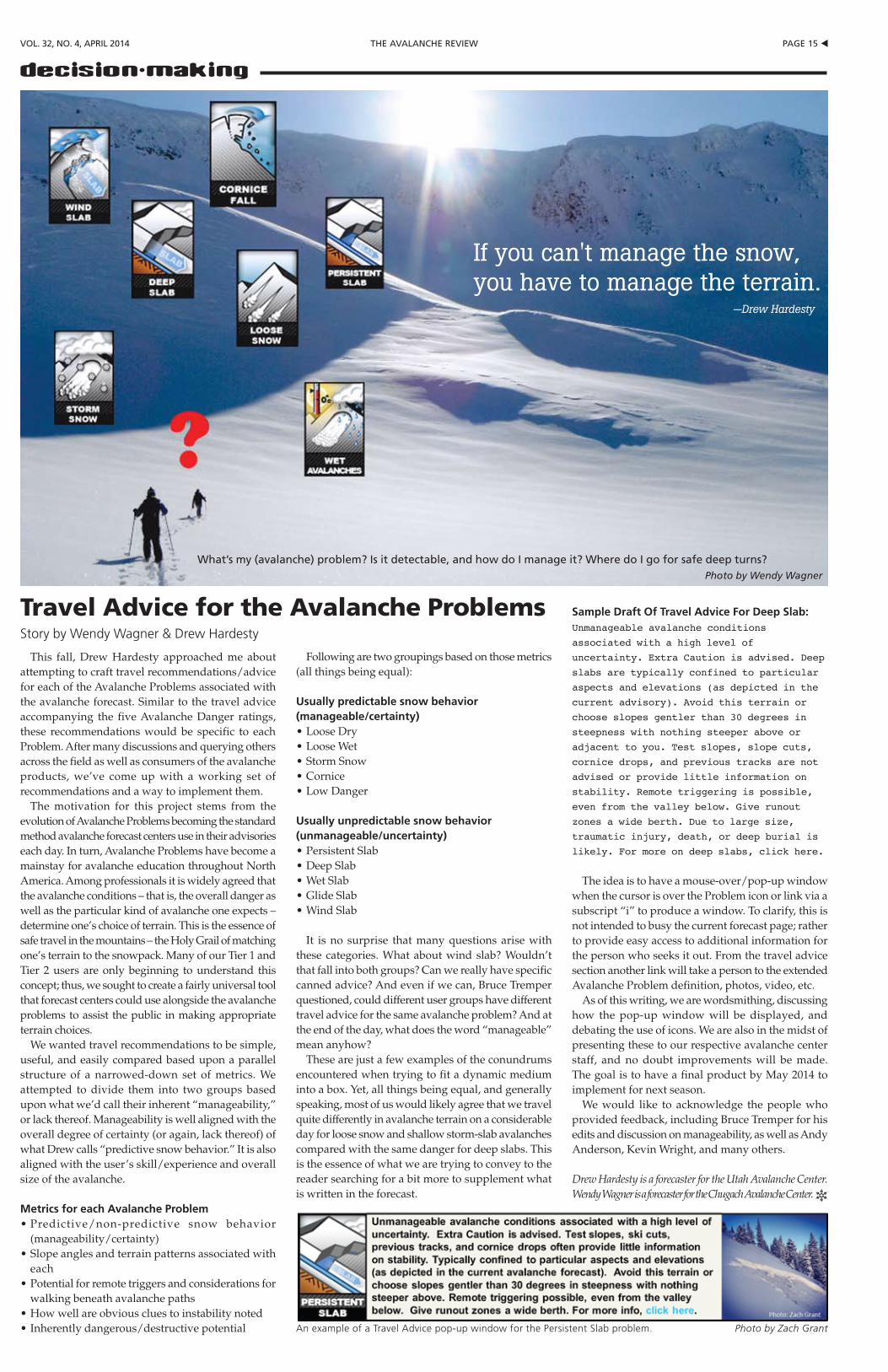
pAGe 15 tthe AVAlANche reViewVol. 32, No. 4, April 2014
decision-making
This fall, Drew Hardesty approached me about attempting to craft travel recommendations/advice for each of the Avalanche Problems associated with the avalanche forecast. Similar to the travel advice accompanying the five Avalanche Danger ratings, these recommendations would be specific to each Problem. After many discussions and querying others across the field as well as consumers of the avalanche products, we’ve come up with a working set of recommendations and a way to implement them.
The motivation for this project stems from the evolution of Avalanche Problems becoming the standard method avalanche forecast centers use in their advisories each day. In turn, Avalanche Problems have become a mainstay for avalanche education throughout North America. Among professionals it is widely agreed that the avalanche conditions – that is, the overall danger as well as the particular kind of avalanche one expects – determine one’s choice of terrain. This is the essence of safe travel in the mountains – the Holy Grail of matching one’s terrain to the snowpack. Many of our Tier 1 and Tier 2 users are only beginning to understand this concept; thus, we sought to create a fairly universal tool that forecast centers could use alongside the avalanche problems to assist the public in making appropriate terrain choices.
We wanted travel recommendations to be simple, useful, and easily compared based upon a parallel structure of a narrowed-down set of metrics. We attempted to divide them into two groups based upon what we’d call their inherent “manageability,” or lack thereof. Manageability is well aligned with the overall degree of certainty (or again, lack thereof) of what Drew calls “predictive snow behavior.” It is also aligned with the user’s skill/experience and overall size of the avalanche.
Metrics for each Avalanche Problem•Predictive/non-predictive snow behavior
(manageability/certainty)•Slopeanglesandterrainpatternsassociatedwith
each•Potentialforremotetriggersandconsiderationsfor
walking beneath avalanche paths•Howwellareobviouscluestoinstabilitynoted•Inherentlydangerous/destructivepotential
Following are two groupings based on those metrics (all things being equal):
Usually predictable snow behavior (manageable/certainty)•LooseDry•LooseWet•StormSnow•Cornice•LowDanger
Usually unpredictable snow behavior (unmanageable/uncertainty)•PersistentSlab•DeepSlab•WetSlab•GlideSlab•WindSlab
It is no surprise that many questions arise with these categories. What about wind slab? Wouldn’t that fall into both groups? Can we really have specific canned advice? And even if we can, Bruce Tremper questioned, could different user groups have different travel advice for the same avalanche problem? And at the end of the day, what does the word “manageable” mean anyhow?
These are just a few examples of the conundrums encountered when trying to fit a dynamic medium into a box. Yet, all things being equal, and generally speaking, most of us would likely agree that we travel quite differently in avalanche terrain on a considerable day for loose snow and shallow storm-slab avalanches compared with the same danger for deep slabs. This is the essence of what we are trying to convey to the reader searching for a bit more to supplement what is written in the forecast.
Sample Draft Of Travel Advice For Deep Slab:Unmanageable avalanche conditions
associated with a high level of
uncertainty. Extra Caution is advised. Deep
slabs are typically confined to particular
aspects and elevations (as depicted in the
current advisory). Avoid this terrain or
choose slopes gentler than 30 degrees in
steepness with nothing steeper above or
adjacent to you. Test slopes, slope cuts,
cornice drops, and previous tracks are not
advised or provide little information on
stability. Remote triggering is possible,
even from the valley below. Give runout
zones a wide berth. Due to large size,
traumatic injury, death, or deep burial is
likely. For more on deep slabs, click here.
The idea is to have a mouse-over/pop-up window when the cursor is over the Problem icon or link via a subscript “i” to produce a window. To clarify, this is not intended to busy the current forecast page; rather to provide easy access to additional information for the person who seeks it out. From the travel advice section another link will take a person to the extended Avalanche Problem definition, photos, video, etc.
As of this writing, we are wordsmithing, discussing how the pop-up window will be displayed, and debating the use of icons. We are also in the midst of presenting these to our respective avalanche center staff, and no doubt improvements will be made. The goal is to have a final product by May 2014 to implement for next season.
We would like to acknowledge the people who provided feedback, including Bruce Tremper for his edits and discussion on manageability, as well as Andy Anderson, Kevin Wright, and many others.
Drew Hardesty is a forecaster for the Utah Avalanche Center. Wendy Wagner is a forecaster for the Chugach Avalanche Center. R
Travel Advice for the Avalanche problemsStory by Wendy Wagner & Drew Hardesty
what’s my (avalanche) problem? is it detectable, and how do i manage it? where do i go for safe deep turns?Photo by Wendy Wagner
An example of a Travel Advice pop-up window for the Persistent Slab problem. Photo by Zach Grant
If you can't manage the snow, you have to manage the terrain.
—Drew Hardesty
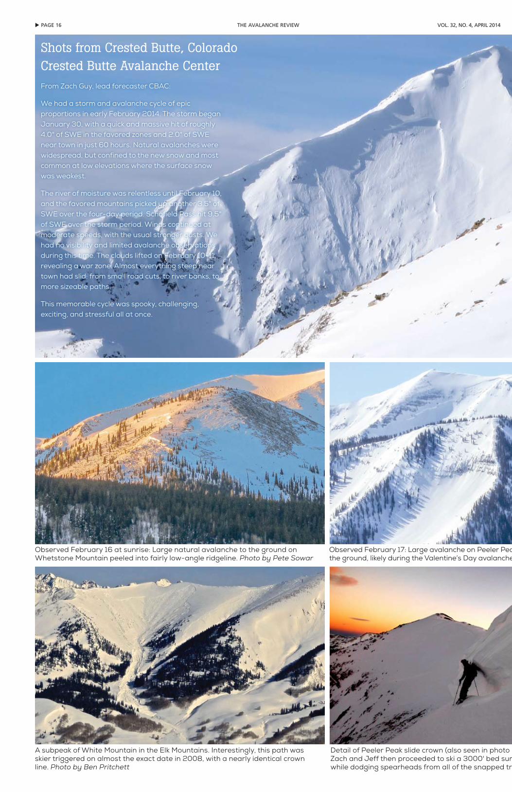
u pAGe 16 the AVAlANche reView Vol. 32, No. 4, April 2014
Observed February 16 at sunrise: Large natural avalanche to the ground on Whetstone Mountain peeled into fairly low-angle ridgeline. Photo by Pete Sowar
Observed February 17: Large avalanche on Peeler Peak failed nearly wall to wall, near the ground, likely during the Valentine’s Day avalanche cycle. Photo by Pete Sowar
A subpeak of White Mountain in the Elk Mountains. Interestingly, this path was skier triggered on almost the exact date in 2008, with a nearly identical crown line. Photo by Ben Pritchett
Detail of Peeler Peak slide crown (also seen in photo above), Jeff Banks pictured. Zach and Jeff then proceeded to ski a 3000' bed surface in near-dark conditions while dodging spearheads from all of the snapped trees. Photo by Zach Guy
Shots from Crested Butte, ColoradoCrested Butte Avalanche CenterFrom Zach Guy, lead forecaster CBAC:
We had a storm and avalanche cycle of epic proportions in early February 2014. The storm began January 30, with a quick and massive hit of roughly 4.0" of SWE in the favored zones and 2.0" of SWE near town in just 60 hours. Natural avalanches were widespread, but confined to the new snow and most common at low elevations where the surface snow was weakest.
The river of moisture was relentless until February 10, and the favored mountains picked up another 3.5" of SWE over the four-day period. Schofield Pass hit 9.5" of SWE over the storm period. Winds continued at moderate speeds, with the usual stronger gusts. We had no visibility and limited avalanche observations during this time. The clouds lifted on February 10-11, revealing a war zone. Almost everything steep near town had slid: from small road cuts, to river banks, to more sizeable paths.
This memorable cycle was spooky, challenging, exciting, and stressful all at once.
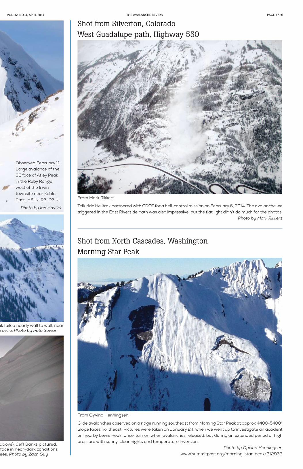
pAGe 17 tthe AVAlANche reViewVol. 32, No. 4, April 2014
From Mark Rikkers:
Telluride Helitrax partnered with CDOT for a heli-control mission on February 6, 2014. The avalanche we triggered in the East Riverside path was also impressive, but the flat light didn't do much for the photos.
Photo by Mark Rikkers
Shot from Silverton, ColoradoWest Guadalupe path, Highway 550
From Oyvind Henningsen:
Glide avalanches observed on a ridge running southeast from Morning Star Peak at approx 4400-5400'. Slope faces northeast. Pictures were taken on January 24, when we went up to investigate an accident on nearby Lewis Peak. Uncertain on when avalanches released, but during an extended period of high pressure with sunny, clear nights and temperature inversion.
Photo by Oyvind Henningsenwww.summitpost.org/morning-star-peak/212932
Shot from North Cascades, WashingtonMorning Star Peak
Observed February 17: Large avalanche on Peeler Peak failed nearly wall to wall, near the ground, likely during the Valentine’s Day avalanche cycle. Photo by Pete Sowar
Detail of Peeler Peak slide crown (also seen in photo above), Jeff Banks pictured. Zach and Jeff then proceeded to ski a 3000' bed surface in near-dark conditions while dodging spearheads from all of the snapped trees. Photo by Zach Guy
Observed February 11: Large avalance of the SE face of Afley Peak in the Ruby Range west of the Irwin townsite near Kebler Pass. HS-N-R3-D3-U
Photo by Ian Havlick

u pAGe 18 the AVAlANche reView Vol. 32, No. 4, April 2014
COMMITTEE BUSINESS/REPORTS Awards
Halsted: Kingery Award to Craig Sterbenz (Sterbie), awarded at National Avalanche School. HM requests whoever is running the website should update all awards since 2010.
Publications/TARAdvertising in TAR. Karen and her
husband had been doing it for years; now it’s Paul Nordquist. This was handled as an internal publications issue. In the future, should be a more widespread topic in the AAA. He’s not doing anything on general advertising now. He gets 15% on long-standing ads and 20% on new ads. Dale: In Europe this month, he proposed an article or two from European members.
Historic/best of TAR book. Halsted: Need to discuss changes based on his investigations into mechanics and cost, will cover later in today’s meeting.
History book. Lynne: Working on outline for book. Blase: Interviews have been conducted and are available to anyone – they will become material for book project. Judson, Perla, Bachman, others. This is an ongoing project and no action items are needed.
MembershipStuart Thompson: 15 professional
applicants to be approved. Encourage quality applications. Nine member affiliates accepted this cycle.
EducationKirk: Two categories to discuss: “stuff
hanging on the vine” and general. At October education committee skype meeting, proposal from AIARE to consider a pro/rec split in the guidelines was presented. This is in the proposal stage. Kirk brought AAI and others into the conversation. AAI created an alternative document. There was a meeting October 31 to look into this topic: group of 16 representing stakeholders and education. (see article in TAR 32-2) A fair number of AAA governing board members were present. General feeling is that creating a separate professional track is worth doing. A working group was formed to look into this and advise the Education Committee.
Hanging on the vine: Brad submitted CI continuing education/professional development documents yesterday, went into TAR 32-3.
Discussion on CI program. Active versus emeritus, continuing education requirements. Will need to refine Brad’s matrix/requirements and reflect active versus inactive/emeritus. Hotlinks for active CIs discussed (we’re asking them to do something, addresses “what do they get?” question). Mark: Can easily create CI database through Wild Apricot. Kirk: Maybe they could choose inactive or active via Wild Apricot? Mark: Maybe, but should an administrator do this? Kirk: Course provider listing application issue – change it on website to read $200 instead of $75. Kirk does these gratis; only asks for second opinion when needed (if not obviously qualifying). What’s the policy on web updates? Do we need a formal directive on how
Situational awareness is the foundation of decision-making. It is not something you have or lack; it is something you do. Situational awareness (SA) is a
cycle that you can prime with a problem and use to make better decisions.
There are three phases to the SA cycle: perception, integration, and projection. The perceptual phase gathers information. Integration reassesses that information and combines it with what you know about the problem. The projection phase supports decision-making and guides the next perceptual phase. Let’s examine the first part of the situational awareness cycle: perception.
The dynamic high-risk environment of operational avalanche mitigation bears similarities to the world of fire fighting. “Flawed situational awareness has been the leading contributing factor for structure fire near-miss events every year since the National Firefighter Near Miss Reporting System has been tracking the data.” (Gasaway, 2013) Challenges in the perceptual phase account for 78% of SA faults. (Near Miss, 2013)
What is this perceptual phase of situational awareness? It sounds complicated. Pshaw. We already have lots of experience. If you are making observations, you are engaged in the perceptual phase. If you are making relevant observations completely and efficiently, you are excelling in the perceptual phase. The priority and confidence of your observations ultimately determine their value.
Sadly, humans are not perfect observers. We are easily distracted by food and shiny things. Perceptual faults fall into several categories.
Perceptual Faults•Information Not Observed: Relevant data is missed or
difficult to detect.•MemoryError:Weforgot.Really?Poorexcuse.•Misperception:“It’swhatweknowthatjustain’tso…”•ConfidenceError:Cocksurecertaintyandmeekmiceare
equal fodder for misperception.•PriorityError:Ididn’tthinkitwouldburnme,butitdid,
and now my hand hurts.
Each perception contains a nugget of beta: a time stamp and an initial value. The initial value is informed by your confidence in an observation and the priority you give it. Watching a ski-triggered avalanche wipe out your favorite pow stash is a high-value ob that combines priority and confidence. If you are meadow skipping the day away, hearsay regarding explosive-triggered avalanches in extreme terrain is lower confidence and lower priority information: less value. There is a gulf of subtlety in establishing the confidence and priority of an observation. That’s why they are reevaluated in the integration phase of situational awareness.
Perceptual Challenges•Physical:Stress,Fatigue•Environmental:Weather,Pestilence•Distractions:RadioChatter,InformationOverload,Shysters
and Fools•Task-Overload:Eachtaskwillsuffer•TimeConstraints:“ChillWinston”•Pu-Pu Platter: When you just gotta have some of each
problem
Those of us not comfortably ensconced in giant bubbles of ignorance or apathy are bedeviled by myriad observational roadblocks. We suffer physical, environmental, and task overload challenges that distract the perceptual phase. Real-time operations suffer from real time constraints. It’s hard to make effective observations when you’re choking on a pu-pu platter of perceptual roadblocks. Have you ever stood atop a mountain cold, sick, and afraid in howling weather wondering how you were gonna get all your work done in time? If so, you are picking up what I am laying down. The world helps
us become better observers slowly and painfully. We need a plan to pick up the pace and avoid getting hurt.
Improving Perception•PhysicalandMentalWell-Being:Om.•Communication:Dude!NoWay!Again?•Validation:“Anyonewhodoesnottaketruthseriouslyin
small matters cannot be trusted in large ones.”•PlanningandOrganization:Doesyourorganizationbelieve
in planning?•Targeting: Identify standard and problem-specific
observations.
We can use simple tools to become better observers, but they won’t carry themselves uphill. We have to make a point of cultivating best practices. Stay healthy and focused; it’s dangerous out there. Communication effectively multiplies your observations. It helps validate low-confidence observations. You can validate perceptions using multiple data points and checking for consistency. Anomalous information should receive an initially high priority. “Whiskey Tango Foxtrot, over.”
Planning and organization mitigate task overload and time pressure. If you lack these things at an organizational level, practice them at a personal level and among your peers. Efficient use of time and labor frees more resources for effective observation. A two-minute meeting can clear up a lot of relevant shit.
Planning what we need to observe is arguably the most important tool for improving perception. Target the observations you need to support a decision. Identify tripwire observations that will trigger a reassessment of decisions. If you plan to check the camel’s teeth, you won’t be surprised by the bad breath.
It’s possible to develop intuitive and targeted scans. When you look at a slope do you subconsciously gauge aspect and slope angle? With practice we intuitively scan for these and other characteristics. Do you purposefully scan ridgelines for transport while assessing storm-slab problems? Targeting scans for specific problem characteristics dramatically improves our observations. Om.
That’s a lot to digest, and there are still two phases to go: integration and projection. In the integration phase, perceptions are reassessed and combined with what is already known about the problem. The projection phase is your inner forecaster and targets observations for the next perceptual phase. The good news is that if you master just the perceptual phase, you will probably never be trapped in a burning building.
Many veterans maintain a high intuitive level of situational awareness. By breaking it down we can help novices learn a similar level of efficacy. Awareness of perceptual faults and roadblocks allows for quick reality checks. Planning our observations improves efficiency and creates a more complete, more accurate picture with lots of happy little skiers.
ReferencesAirbus. (2013). Safety Library. www.airbus.com/company/aircraft-
manufacture/quality-and-safety-first/safety-library/Gasaway, R. (2013). Flawed Situational Awareness at Structure Fires.
www.samatters.com/flawed-situational-awareness-at-structure-fires/#more-4333
Near Miss. (2013). www.firefighternearmiss.comSA Technologies. (2014). www.satechnologies.comUnited States Coast Guard. (2013). Team Coordination Training www.uscg.
mil/auxiliary/training/tct/
Doug Krause has been kicking shins and taking names lo these many years as a skier, guide, patroller, forecaster, and educator in the Andes, the Rockies, and the Chugach. R Continued on page 26 ➨
When you come into new country, listen a lot. —Eskimo saying
You can observe a lot just by watching. —Yogi Berra
Situational Awareness: part iEnhancing PerceptionStory & photo by Doug Krause
Avalanche predators live and breathe high-priority observations because their life and breath depend on it.
AAA BoArdcontinued from page 10
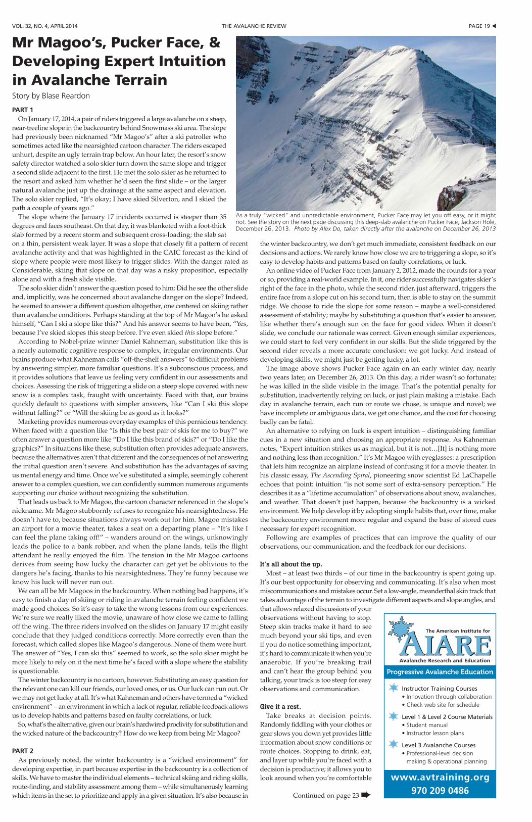
pAGe 19 tthe AVAlANche reViewVol. 32, No. 4, April 2014
PART 1On January 17, 2014, a pair of riders triggered a large avalanche on a steep,
near-treeline slope in the backcountry behind Snowmass ski area. The slope had previously been nicknamed “Mr Magoo’s” after a ski patroller who sometimes acted like the nearsighted cartoon character. The riders escaped unhurt, despite an ugly terrain trap below. An hour later, the resort’s snow safety director watched a solo skier turn down the same slope and trigger a second slide adjacent to the first. He met the solo skier as he returned to the resort and asked him whether he’d seen the first slide – or the larger natural avalanche just up the drainage at the same aspect and elevation. The solo skier replied, “It’s okay; I have skied Silverton, and I skied the path a couple of years ago.”
The slope where the January 17 incidents occurred is steeper than 35 degrees and faces southeast. On that day, it was blanketed with a foot-thick slab formed by a recent storm and subsequent cross-loading; the slab sat on a thin, persistent weak layer. It was a slope that closely fit a pattern of recent avalanche activity and that was highlighted in the CAIC forecast as the kind of slope where people were most likely to trigger slides. With the danger rated as Considerable, skiing that slope on that day was a risky proposition, especially alone and with a fresh slide visible.
The solo skier didn’t answer the question posed to him: Did he see the other slide and, implicitly, was he concerned about avalanche danger on the slope? Indeed, he seemed to answer a different question altogether, one centered on skiing rather than avalanche conditions. Perhaps standing at the top of Mr Magoo’s he asked himself, “Can I ski a slope like this?” And his answer seems to have been, “Yes, because I’ve skied slopes this steep before. I’ve even skied this slope before.”
According to Nobel-prize winner Daniel Kahneman, substitution like this is a nearly automatic cognitive response to complex, irregular environments. Our brains produce what Kahneman calls “off-the-shelf answers” to difficult problems by answering simpler, more familiar questions. It’s a subconscious process, and it provides solutions that leave us feeling very confident in our assessments and choices. Assessing the risk of triggering a slide on a steep slope covered with new snow is a complex task, fraught with uncertainty. Faced with that, our brains quickly default to questions with simpler answers, like “Can I ski this slope without falling?” or “Will the skiing be as good as it looks?”
Marketing provides numerous everyday examples of this pernicious tendency. When faced with a question like “Is this the best pair of skis for me to buy?” we often answer a question more like “Do I like this brand of skis?” or “Do I like the graphics?” In situations like these, substitution often provides adequate answers, because the alternatives aren’t that different and the consequences of not answering the initial question aren’t severe. And substitution has the advantages of saving us mental energy and time. Once we’ve substituted a simple, seemingly coherent answer to a complex question, we can confidently summon numerous arguments supporting our choice without recognizing the substitution.
That leads us back to Mr Magoo, the cartoon character referenced in the slope’s nickname. Mr Magoo stubbornly refuses to recognize his nearsightedness. He doesn’t have to, because situations always work out for him. Magoo mistakes an airport for a movie theater, takes a seat on a departing plane – “It’s like I can feel the plane taking off!” – wanders around on the wings, unknowingly leads the police to a bank robber, and when the plane lands, tells the flight attendant he really enjoyed the film. The tension in the Mr Magoo cartoons derives from seeing how lucky the character can get yet be oblivious to the dangers he’s facing, thanks to his nearsightedness. They’re funny because we know his luck will never run out.
We can all be Mr Magoos in the backcountry. When nothing bad happens, it’s easy to finish a day of skiing or riding in avalanche terrain feeling confident we made good choices. So it’s easy to take the wrong lessons from our experiences. We’re sure we really liked the movie, unaware of how close we came to falling off the wing. The three riders involved on the slides on January 17 might easily conclude that they judged conditions correctly. More correctly even than the forecast, which called slopes like Magoo’s dangerous. None of them were hurt. The answer of “Yes, I can ski this” seemed to work, so the solo skier might be more likely to rely on it the next time he’s faced with a slope where the stability is questionable.
The winter backcountry is no cartoon, however. Substituting an easy question for the relevant one can kill our friends, our loved ones, or us. Our luck can run out. Or we may not get lucky at all. It’s what Kahneman and others have termed a “wicked environment” – an environment in which a lack of regular, reliable feedback allows us to develop habits and patterns based on faulty correlations, or luck.
So, what’s the alternative, given our brain’s hardwired proclivity for substitution and the wicked nature of the backcountry? How do we keep from being Mr Magoo?
PART 2As previously noted, the winter backcountry is a “wicked environment” for
developing expertise, in part because expertise in the backcountry is a collection of skills. We have to master the individual elements – technical skiing and riding skills, route-finding, and stability assessment among them – while simultaneously learning which items in the set to prioritize and apply in a given situation. It’s also because in
the winter backcountry, we don’t get much immediate, consistent feedback on our decisions and actions. We rarely know how close we are to triggering a slope, so it’s easy to develop habits and patterns based on faulty correlations, or luck.
An online video of Pucker Face from January 2, 2012, made the rounds for a year or so, providing a real-world example. In it, one rider successfully navigates skier’s right of the face in the photo, while the second rider, just afterward, triggers the entire face from a slope cut on his second turn, then is able to stay on the summit ridge. We choose to ride the slope for some reason – maybe a well-considered assessment of stability; maybe by substituting a question that’s easier to answer, like whether there’s enough sun on the face for good video. When it doesn’t slide, we conclude our rationale was correct. Given enough similar experiences, we could start to feel very confident in our skills. But the slide triggered by the second rider reveals a more accurate conclusion: we got lucky. And instead of developing skills, we might just be getting lucky, a lot.
The image above shows Pucker Face again on an early winter day, nearly two years later, on December 26, 2013. On this day, a rider wasn’t so fortunate; he was killed in the slide visible in the image. That’s the potential penalty for substitution, inadvertently relying on luck, or just plain making a mistake. Each day in avalanche terrain, each run or route we chose, is unique and novel; we have incomplete or ambiguous data, we get one chance, and the cost for choosing badly can be fatal.
An alternative to relying on luck is expert intuition – distinguishing familiar cues in a new situation and choosing an appropriate response. As Kahneman notes, “Expert intuition strikes us as magical, but it is not…[It] is nothing more and nothing less than recognition.” It’s Mr Magoo with eyeglasses: a prescription that lets him recognize an airplane instead of confusing it for a movie theater. In his classic essay, The Ascending Spiral, pioneering snow scientist Ed LaChapelle echoes that point: intuition “is not some sort of extra-sensory perception.” He describes it as a “lifetime accumulation” of observations about snow, avalanches, and weather. That doesn’t just happen, because the backcountry is a wicked environment. We help develop it by adopting simple habits that, over time, make the backcountry environment more regular and expand the base of stored cues necessary for expert recognition.
Following are examples of practices that can improve the quality of our observations, our communication, and the feedback for our decisions.
It’s all about the up.Most – at least two thirds – of our time in the backcountry is spent going up.
It’s our best opportunity for observing and communicating. It’s also when most miscommunications and mistakes occur. Set a low-angle, meanderthal skin track that takes advantage of the terrain to investigate different aspects and slope angles, and that allows relaxed discussions of your observations without having to stop. Steep skin tracks make it hard to see much beyond your ski tips, and even if you do notice something important, it’s hard to communicate it when you’re anaerobic. If you’re breaking trail and can’t hear the group behind you talking, your track is too steep for easy observations and communication.
Give it a rest.Take breaks at decision points.
Randomly fiddling with your clothes or gear slows you down yet provides little information about snow conditions or route choices. Stopping to drink, eat, and layer up while you’re faced with a decision is productive; it allows you to look around when you’re comfortable
instructor training courses• Innovation through collaboration• Check web site for schedule
level 1 & level 2 course materials• Student manual• Instructor lesson plans
level 3 Avalanche courses• Professional-level decision
making & operational planning
Mr Magoo’s, pucker Face, & Developing Expert intuition in Avalanche TerrainStory by Blase Reardon
Continued on page 23 ➨
As a truly "wicked" and unpredictable environment, Pucker Face may let you off easy, or it might not. See the story on the next page discussing this deep-slab avalanche on Pucker Face, Jackson Hole, December 26, 2013. Photo by Alex Do, taken directly after the avalanche on December 26, 2013
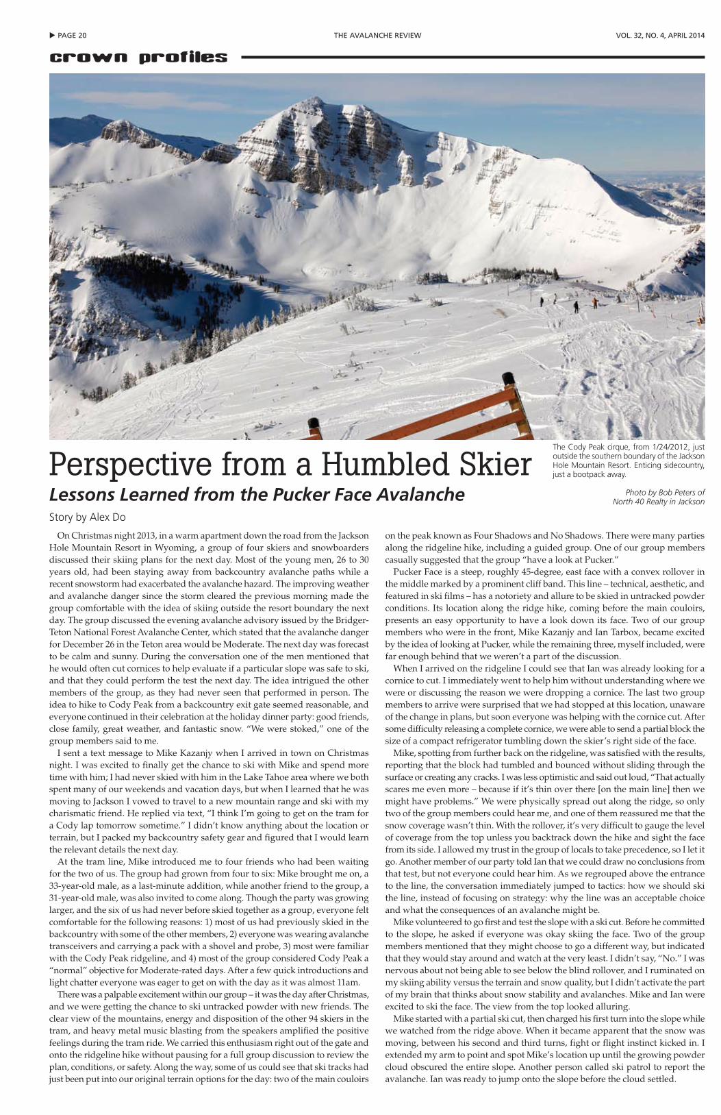
u pAGe 20 the AVAlANche reView Vol. 32, No. 4, April 2014
crown profiles
On Christmas night 2013, in a warm apartment down the road from the Jackson Hole Mountain Resort in Wyoming, a group of four skiers and snowboarders discussed their skiing plans for the next day. Most of the young men, 26 to 30 years old, had been staying away from backcountry avalanche paths while a recent snowstorm had exacerbated the avalanche hazard. The improving weather and avalanche danger since the storm cleared the previous morning made the group comfortable with the idea of skiing outside the resort boundary the next day. The group discussed the evening avalanche advisory issued by the Bridger-Teton National Forest Avalanche Center, which stated that the avalanche danger for December 26 in the Teton area would be Moderate. The next day was forecast to be calm and sunny. During the conversation one of the men mentioned that he would often cut cornices to help evaluate if a particular slope was safe to ski, and that they could perform the test the next day. The idea intrigued the other members of the group, as they had never seen that performed in person. The idea to hike to Cody Peak from a backcountry exit gate seemed reasonable, and everyone continued in their celebration at the holiday dinner party: good friends, close family, great weather, and fantastic snow. “We were stoked,” one of the group members said to me.
I sent a text message to Mike Kazanjy when I arrived in town on Christmas night. I was excited to finally get the chance to ski with Mike and spend more time with him; I had never skied with him in the Lake Tahoe area where we both spent many of our weekends and vacation days, but when I learned that he was moving to Jackson I vowed to travel to a new mountain range and ski with my charismatic friend. He replied via text, “I think I’m going to get on the tram for a Cody lap tomorrow sometime.” I didn’t know anything about the location or terrain, but I packed my backcountry safety gear and figured that I would learn the relevant details the next day.
At the tram line, Mike introduced me to four friends who had been waiting for the two of us. The group had grown from four to six: Mike brought me on, a 33-year-old male, as a last-minute addition, while another friend to the group, a 31-year-old male, was also invited to come along. Though the party was growing larger, and the six of us had never before skied together as a group, everyone felt comfortable for the following reasons: 1) most of us had previously skied in the backcountry with some of the other members, 2) everyone was wearing avalanche transceivers and carrying a pack with a shovel and probe, 3) most were familiar with the Cody Peak ridgeline, and 4) most of the group considered Cody Peak a “normal” objective for Moderate-rated days. After a few quick introductions and light chatter everyone was eager to get on with the day as it was almost 11am.
There was a palpable excitement within our group – it was the day after Christmas, and we were getting the chance to ski untracked powder with new friends. The clear view of the mountains, energy and disposition of the other 94 skiers in the tram, and heavy metal music blasting from the speakers amplified the positive feelings during the tram ride. We carried this enthusiasm right out of the gate and onto the ridgeline hike without pausing for a full group discussion to review the plan, conditions, or safety. Along the way, some of us could see that ski tracks had just been put into our original terrain options for the day: two of the main couloirs
on the peak known as Four Shadows and No Shadows. There were many parties along the ridgeline hike, including a guided group. One of our group members casually suggested that the group “have a look at Pucker.”
Pucker Face is a steep, roughly 45-degree, east face with a convex rollover in the middle marked by a prominent cliff band. This line – technical, aesthetic, and featured in ski films – has a notoriety and allure to be skied in untracked powder conditions. Its location along the ridge hike, coming before the main couloirs, presents an easy opportunity to have a look down its face. Two of our group members who were in the front, Mike Kazanjy and Ian Tarbox, became excited by the idea of looking at Pucker, while the remaining three, myself included, were far enough behind that we weren’t a part of the discussion.
When I arrived on the ridgeline I could see that Ian was already looking for a cornice to cut. I immediately went to help him without understanding where we were or discussing the reason we were dropping a cornice. The last two group members to arrive were surprised that we had stopped at this location, unaware of the change in plans, but soon everyone was helping with the cornice cut. After some difficulty releasing a complete cornice, we were able to send a partial block the size of a compact refrigerator tumbling down the skier’s right side of the face.
Mike, spotting from further back on the ridgeline, was satisfied with the results, reporting that the block had tumbled and bounced without sliding through the surface or creating any cracks. I was less optimistic and said out loud, “That actually scares me even more – because if it’s thin over there [on the main line] then we might have problems.” We were physically spread out along the ridge, so only two of the group members could hear me, and one of them reassured me that the snow coverage wasn’t thin. With the rollover, it’s very difficult to gauge the level of coverage from the top unless you backtrack down the hike and sight the face from its side. I allowed my trust in the group of locals to take precedence, so I let it go. Another member of our party told Ian that we could draw no conclusions from that test, but not everyone could hear him. As we regrouped above the entrance to the line, the conversation immediately jumped to tactics: how we should ski the line, instead of focusing on strategy: why the line was an acceptable choice and what the consequences of an avalanche might be.
Mike volunteered to go first and test the slope with a ski cut. Before he committed to the slope, he asked if everyone was okay skiing the face. Two of the group members mentioned that they might choose to go a different way, but indicated that they would stay around and watch at the very least. I didn’t say, “No.” I was nervous about not being able to see below the blind rollover, and I ruminated on my skiing ability versus the terrain and snow quality, but I didn’t activate the part of my brain that thinks about snow stability and avalanches. Mike and Ian were excited to ski the face. The view from the top looked alluring.
Mike started with a partial ski cut, then charged his first turn into the slope while we watched from the ridge above. When it became apparent that the snow was moving, between his second and third turns, fight or flight instinct kicked in. I extended my arm to point and spot Mike’s location up until the growing powder cloud obscured the entire slope. Another person called ski patrol to report the avalanche. Ian was ready to jump onto the slope before the cloud settled.
Perspective from a Humbled Skier Lessons Learned from the Pucker Face AvalancheStory by Alex Do
The Cody Peak cirque, from 1/24/2012, just outside the southern boundary of the Jackson Hole Mountain Resort. Enticing sidecountry, just a bootpack away.
Photo by Bob Peters of North 40 Realty in Jackson
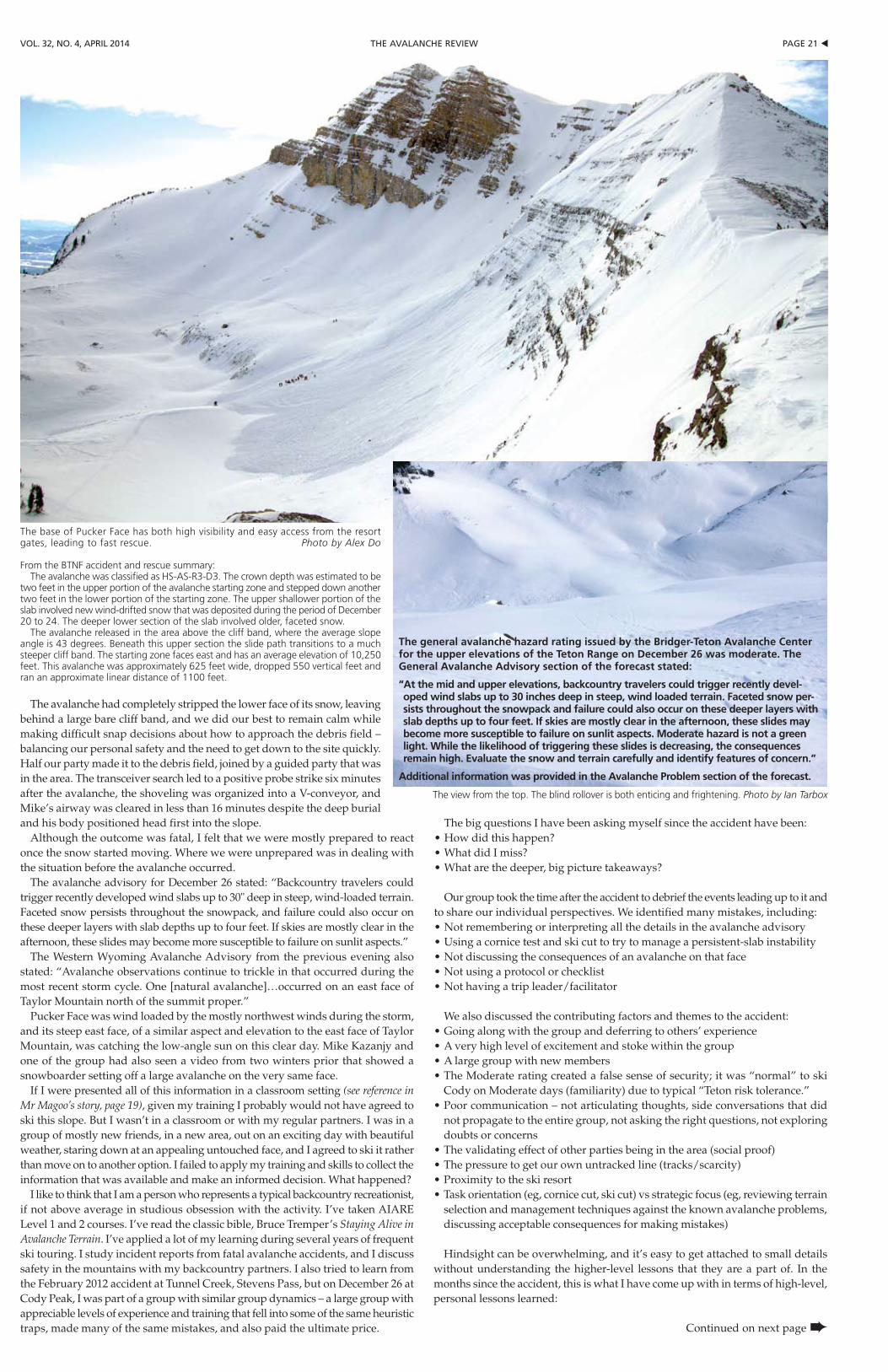
pAGe 21 tthe AVAlANche reViewVol. 32, No. 4, April 2014
The avalanche had completely stripped the lower face of its snow, leaving behind a large bare cliff band, and we did our best to remain calm while making difficult snap decisions about how to approach the debris field – balancing our personal safety and the need to get down to the site quickly. Half our party made it to the debris field, joined by a guided party that was in the area. The transceiver search led to a positive probe strike six minutes after the avalanche, the shoveling was organized into a V-conveyor, and Mike’s airway was cleared in less than 16 minutes despite the deep burial and his body positioned head first into the slope.
Although the outcome was fatal, I felt that we were mostly prepared to react once the snow started moving. Where we were unprepared was in dealing with the situation before the avalanche occurred.
The avalanche advisory for December 26 stated: “Backcountry travelers could trigger recently developed wind slabs up to 30" deep in steep, wind-loaded terrain. Faceted snow persists throughout the snowpack, and failure could also occur on these deeper layers with slab depths up to four feet. If skies are mostly clear in the afternoon, these slides may become more susceptible to failure on sunlit aspects.”
The Western Wyoming Avalanche Advisory from the previous evening also stated: “Avalanche observations continue to trickle in that occurred during the most recent storm cycle. One [natural avalanche]…occurred on an east face of Taylor Mountain north of the summit proper.”
Pucker Face was wind loaded by the mostly northwest winds during the storm, and its steep east face, of a similar aspect and elevation to the east face of Taylor Mountain, was catching the low-angle sun on this clear day. Mike Kazanjy and one of the group had also seen a video from two winters prior that showed a snowboarder setting off a large avalanche on the very same face.
If I were presented all of this information in a classroom setting (see reference in Mr Magoo’s story, page 19), given my training I probably would not have agreed to ski this slope. But I wasn’t in a classroom or with my regular partners. I was in a group of mostly new friends, in a new area, out on an exciting day with beautiful weather, staring down at an appealing untouched face, and I agreed to ski it rather than move on to another option. I failed to apply my training and skills to collect the information that was available and make an informed decision. What happened?
I like to think that I am a person who represents a typical backcountry recreationist, if not above average in studious obsession with the activity. I’ve taken AIARE Level 1 and 2 courses. I’ve read the classic bible, Bruce Tremper’s Staying Alive in Avalanche Terrain. I’ve applied a lot of my learning during several years of frequent ski touring. I study incident reports from fatal avalanche accidents, and I discuss safety in the mountains with my backcountry partners. I also tried to learn from the February 2012 accident at Tunnel Creek, Stevens Pass, but on December 26 at Cody Peak, I was part of a group with similar group dynamics – a large group with appreciable levels of experience and training that fell into some of the same heuristic traps, made many of the same mistakes, and also paid the ultimate price.
The big questions I have been asking myself since the accident have been:•Howdidthishappen?•WhatdidImiss?•Whatarethedeeper,bigpicturetakeaways?
Our group took the time after the accident to debrief the events leading up to it and to share our individual perspectives. We identified many mistakes, including:•Notrememberingorinterpretingallthedetailsintheavalancheadvisory•Usingacornicetestandskicuttotrytomanageapersistent-slabinstability•Notdiscussingtheconsequencesofanavalancheonthatface•Notusingaprotocolorchecklist•Nothavingatripleader/facilitator
We also discussed the contributing factors and themes to the accident:•Goingalongwiththegroupanddeferringtoothers’experience•Averyhighlevelofexcitementandstokewithinthegroup•Alargegroupwithnewmembers•TheModerateratingcreatedafalsesenseofsecurity;itwas“normal”toski
Cody on Moderate days (familiarity) due to typical “Teton risk tolerance.”•Poorcommunication–notarticulatingthoughts,sideconversationsthatdid
not propagate to the entire group, not asking the right questions, not exploring doubts or concerns
•Thevalidatingeffectofotherpartiesbeinginthearea(socialproof)•Thepressuretogetourownuntrackedline(tracks/scarcity)•Proximitytotheskiresort•Taskorientation(eg,cornicecut,skicut)vsstrategicfocus(eg,reviewingterrain
selection and management techniques against the known avalanche problems, discussing acceptable consequences for making mistakes)
Hindsight can be overwhelming, and it’s easy to get attached to small details without understanding the higher-level lessons that they are a part of. In the months since the accident, this is what I have come up with in terms of high-level, personal lessons learned:
Continued on next page ➨
The base of Pucker Face has both high visibility and easy access from the resort gates, leading to fast rescue. Photo by Alex Do
From the BTNF accident and rescue summary: The avalanche was classified as HS-AS-R3-D3. The crown depth was estimated to be
two feet in the upper portion of the avalanche starting zone and stepped down another two feet in the lower portion of the starting zone. The upper shallower portion of the slab involved new wind-drifted snow that was deposited during the period of December 20 to 24. The deeper lower section of the slab involved older, faceted snow.
The avalanche released in the area above the cliff band, where the average slope angle is 43 degrees. Beneath this upper section the slide path transitions to a much steeper cliff band. The starting zone faces east and has an average elevation of 10,250 feet. This avalanche was approximately 625 feet wide, dropped 550 vertical feet and ran an approximate linear distance of 1100 feet.
The view from the top. The blind rollover is both enticing and frightening. Photo by Ian Tarbox
The general avalanche hazard rating issued by the Bridger-Teton Avalanche Center for the upper elevations of the Teton Range on December 26 was moderate. The General Avalanche Advisory section of the forecast stated:
“At the mid and upper elevations, backcountry travelers could trigger recently devel-oped wind slabs up to 30 inches deep in steep, wind loaded terrain. Faceted snow per-sists throughout the snowpack and failure could also occur on these deeper layers with slab depths up to four feet. If skies are mostly clear in the afternoon, these slides may become more susceptible to failure on sunlit aspects. Moderate hazard is not a green light. While the likelihood of triggering these slides is decreasing, the consequences remain high. Evaluate the snow and terrain carefully and identify features of concern.”
Additional information was provided in the Avalanche Problem section of the forecast.
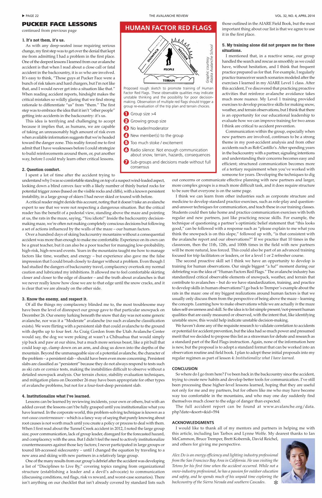
u pAGe 22 the AVAlANche reView Vol. 32, No. 4, April 2014
1. It’s not them, it’s us.As with any deep-seated issue requiring serious
change, my first step was to get over the denial that kept me from admitting I had a problem in the first place. One of the deepest lessons I learned from our avalanche accident is that when I read about a close call or fatal accident in the backcountry, it is us who are involved. It’s easy to think, “Those guys at Pucker Face were a bunch of risk takers and hard chargers, but I’m not like that, and I would never get into a situation like that.” When reading accident reports, hindsight makes the critical mistakes so wildly glaring that we find strong rationale to differentiate “us” from “them.” The first step was to embrace the idea that it isn’t “other people” getting into accidents in the backcountry: it’s us.
This idea is terrifying and challenging to accept because it implies that, as humans, we are capable of taking an unreasonably high amount of risk even when available information suggests that we’re headed toward the danger zone. This reality forced me to first admit that I have weaknesses before I could strategize to build reinforcements around them, or, put another way, before I could truly learn other critical lessons.
2. Question comfort.I spent a lot of time after the accident trying to
understand why I was so comfortable standing on top of a suspect wind-loaded aspect, looking down a blind convex face with a likely number of thinly buried rocks for potential trigger zones (based on the visible rocks and cliffs), with a known persistent instability, in a large group of skiers I had never skied or toured with before.
A critical reader might deride this account, noting that it doesn’t take an avalanche expert to see that we were not respecting a dangerous situation. But the critical reader has the benefit of a pedestal view, standing above the maze and pointing at us, the rats in the maze, saying, “You idiots!” Inside the backcountry decision-making maze, we’re often not making completely conscious decisions but following a set of actions influenced by the walls of the maze – our human factors.
Over a hundred days of skiing backcountry mountains without a consequential accident was more than enough to make me comfortable. Experience on its own can be a great teacher, but it can also be a poor teacher for managing low-probability, high-risk, high-reward events. Years in the mountains taught me how to manage factors like time, weather, and energy – but experience also gave me the false impression that I could brush closely to danger without a problem. Even though I had studied the dangers of backcountry travel, complacency overtook my normal caution and lubricated my inhibitions. It allowed me to feel comfortable skirting closer and closer to the edge of disaster – and the truth about avalanches is that we never really know how close we are to that edge until the snow cracks, and it is clear that we are already on the other side.
3. Know the enemy, and respect it.Of all the things my complacency blinded me to, the most troublesome may
have been the level of disrespect our group gave to that particular snowpack on December 26. Our enemy lurking beneath the snow that day was not some generic avalanche, nor was it a “Moderate” avalanche (no such avalanche classification exists). We were flirting with a persistent slab that could avalanche to the ground with depths up to four feet. As Craig Gordon from the Utah Avalanche Center would say, the dog we were poking at wasn’t a Chihuahua that would simply yip back and paw at our shins, but a much more serious beast, like a pit bull that could leap up, clamp down on an arm, and drag us down into the depths of the mountain. Beyond the unmanageable size of a potential avalanche, the character of the problem – a persistent slab – should have been even more concerning. Persistent slabs are classified as “persistent” because they do not always respond to tests such as ski cuts or cornice tests, making the instabilities difficult to observe without a detailed snowpack analysis. Our terrain choice, stability evaluation techniques, and mitigation plans on December 26 may have been appropriate for other types of avalanche problems, but not for a four-foot-deep persistent slab.
4. Institutionalize what I’ve learned.Lessons can be learned by reviewing incidents, your own or others, but with an
added caveat: the lessons can’t be fully grasped until you institutionalize what you have learned. In the corporate world, this problem-solving technique is known as a root-cause countermeasure – which is a fancy way of saying that purely knowing about root causes is not worth much until you create a policy or process to deal with them. When I first read about the Tunnel Creek accident in 2012, I noted the large group size, poor communication, lack of group leader, disregard for the forecasted hazard, and complacency with the area. But I didn’t feel the need to actively institutionalize countermeasures against those key factors; I never participated in large groups or toured lift-accessed sidecountry – until I changed the equation by traveling to a new area and skiing with new partners in a relatively large group.
One of the many results from our group’s debrief after the accident was developing a list of “Disciplines to Live By,” covering topics ranging from organizational structure (establishing a leader and a devil’s advocate) to communication (discussing conditions, red flags, risk vs reward, and worst-case scenarios). There isn’t anything on our checklist that isn’t already covered by standard lists such
those outlined in the AIARE Field Book, but the most important thing about our list is that we agree to use it in the first place.
5. My training alone did not prepare me for these situations.
I mentioned that, in a reactive sense, our group handled the search and rescue as smoothly as we could have, without hesitation, and I think that frequent practice prepared us for that. For example, I regularly practice transceiver search scenarios modeled after the exercises I learned in my AIARE Level 1 class. After this accident, I’ve discovered that practicing proactive activities that reinforce avalanche avoidance takes much more nuance. My Level 1 training provided exercises to develop proactive skills for making snow, weather, and terrain observations, but I think that there is an opportunity for our educational leadership to evaluate how we can improve training for two areas I think are critical to accident prevention.
Communication within the group, especially when new partners are involved, continues to be a strong theme in my post-accident analysis and from other accidents such as Rob Castillo’s. After spending years in the backcountry with a partner, signaling intentions and understanding their concerns becomes easy and efficient; structured communication becomes more of a tertiary requirement when you’ve worked with someone for years. Developing the techniques to dig
out concerns or communicate effective planning with new partners and larger, more complex groups is a much more difficult task, and it does require structure to be sure that everyone is on the same page.
I think we can learn from other industries such as corporate structure and medicine to develop standard practice exercises, such as role-play and question-and-answer techniques for communication, and teach these in our training classes. Students could then take home and practice communication exercises with both regular and new partners, just like practicing rescue skills. For example, the technique of questioning a partner’s optimistic belief statement that “this looks good,” can be followed with a response such as “please explain to me what you think the snowpack is on this slope,” followed up with, “is that consistent with the avalanche report and our observations?” If we practice that 10 times in the classroom, then the 11th, 12th, and 100th times in the field with new partners will be more natural, less forced. This could also be part of an advanced training focused for trip facilitators or leaders, or for a level 1 or 2 refresher course.
The second proactive skill set I think we have an opportunity to develop is training for human observations. Our single biggest “a ha!” moment during our debriefing was the idea of “Human Factors Red Flags.” The avalanche industry has standardized critical observable elements of snowpack, weather, and terrain that contribute to avalanches – but do we have standardization, training, and practice to develop skills in human observations? I go back to Tremper’s example about the rats in the maze: one of my biggest realizations around human factors is that we usually only discuss them from the perspective of being above the maze – learning the concepts. Learning how to make observations while we are actually in the maze takes self-awareness and skill. So the idea is to list simple present/not-present human qualities that are easily measured or observed, with the intent that, like identifying unstable snow, this would help indicate unstable decision-making.
We haven’t done any of the requisite research to validate correlation to accidents or potential for accident prevention, but the idea had so much power and presumed merit that we decided to propose this list as a strawman for debate and research as a standard part of the Red Flags instruction. Again, none of the information here is new, but the proposal is to adopt a standard format that can be worked into an observation routine and field book. I plan to adopt these initial proposals into my regular regimen as part of lesson 4: Institutionalize what I have learned.
CONCLUSIONSo where do I go from here? I’ve been back in the backcountry since the accident,
trying to create new habits and develop better tools for communication. I’ve still been processing these higher-level lessons learned, hoping that they are useful not only for me and my partners, but for others like me who may have become way too comfortable in the mountains, and who may one day suddenly find themselves much closer to the edge of danger than expected.
The full accident report can be found at www.avalanche.org/data.php?date=&sort=&id=594
ACKNOWLEDGMENTSI would like to thank all of my mentors and partners in helping me with
this article, including Ian Tarbox and Lynne Wolfe. My dearest thanks to Ian McCammon, Bruce Tremper, Brett Kobernik, David Reichel, and others for giving me perspective.
Alex Do is an energy efficiency and lighting industry professional from the San Francisco Bay Area in California. He was visiting the Tetons for his first time when the accident occurred. While not a snow-industry professional, he has a passion for outdoor education and safety, and he spends much of his unpaid time exploring the backcountry of the Sierra Nevada and southern Cascades. R
Pucker FAce Lessonscontinued from previous page HUMAN FACTOR RED FLAGS
Proposed rough sketch to promote training of Human Factor Red Flags. These observable qualities may indicate unstable thinking and the possibility for poor decision-making. Observation of multiple red flags should trigger a group re-evaluation of the trip plan and terrain choices.
1 Group size >4
2 Growing group size
3 No leader/moderator
4 New member(s) to the group
5 Too much stoke / excitement
6 Radio silence: Not enough communication about snow, terrain, hazards, consequences
7 Sub-groups and decisions made without full consensus
Gra
phic
cou
rtes
y A
lask
a A
vala
nche
Sch
ool
pAGe 23 tthe AVAlANche reViewVol. 32, No. 4, April 2014
Looking back at 25 years of backcountry accidents on Mount Washington, I have seen numerous avalanche accident rescues and recoveries resulting in far too many fatalities and injuries. Of the fatalities, none wore beacons, therefore driving us to old school methods of rescue-recovery as the only choice. I think we’ve used every method that Atwater, Chappelle, McInnes, and other forefathers employed – short of trenching, thank God. I have learned lessons along the way and have come to firmly believe we need to teach avalanche rescue systems as an evolutionary process subject to re-evaluation and fine tuning. I say rescue “systems” because complete rescue certainly requires more than the beacon and shovel.
The ProblemIn over-simplified terms, “avalanche rescue”
refers to finding a beacon signal and digging someone out. In our mentoring, teaching, and public speaking we need to start emphasizing an entire rescue system modality to pursue the best patient outcome.
Most of us have paid close attention to the evolution of beacon technology and search techniques, which is obviously critical. The initial period of a rescue is most important as the clock ticks quickly, inescapably toward asphyxia. However, as a profession, we could do better at employing the changes and advances that occur in avalanche-specific triage systems, treating ABCDs, CPR tactics, modern spinal precautions, using modern hypothermia treatments, and effective packaging.
I see us, the first responders and scene managers, as the one hope to set up the patient well for definitive hospital care. When patients are been given the best odds in the field, miraculous outcomes can and do occasionally occur. For the best patient results, knowing, teaching, and treating life threats complicated by asphyxia will increase survival statistics. Improving post-excavation integrated rescue systems will move more individuals from the fatality column into the survived and rescued one.
Whether you are a patroller on a small mountain, an avalanche center technician, a DOT plowman, an avalanche course instructor, or an avid visitor to avalanche terrain, someday you may be an accident responder. How do we monitor all the ongoing changes within each specific avalanche or medical specialty? This is extremely difficult for all of us to do well. It truly can be a moving target with research and improvements happening so rapidly from year to year.
The AdvancesIn some of the bridging topics between
avalanche specialties and medical ones we have seen excellent collaboration. Work by Manuel Genswein et al., on reverse triage systems is a good example of cooperation between fields to produce new advances in triage to consider. This past year Dr Douglas Brown et al., working with ICAR and the Institute of Mountain Emergency Medicine made some significant advances in hypothermia treatment for avalanche burials. ICAR-MEDCOM (Peter Pall et al.) recently produced a comprehensive literature review of 96 studies that addressed the termination of CPR in mountain rescue.
These examples are compelling rationale for new treatment standards in mountain rescue incidents. I foresee scenarios where we may do CPR for hours in cases we may have terminated just two years ago. Patients
subject to long carry outs may see tremendous benefit from newer automatic CPR devices such as the AutoPulse. Prolonged CPR, even in cases of cardiac arrest, is showing some remarkable results in the hypothermic patient if transported to centers with extracorporeal membrane oxygenation (ECMO) and cardiac bypass (CBP) capabilities.
Outside of the avalanche environment, urban-based medicine has pointed out complications for patients due to prolonged backboarding as spinal immobilization. This highlights the motivation to consider alternative methods in prolonged backcountry evacuations such as aggressive spine clearing protocols or using a KED or similar compact spine splints.
A Remedy to ConsiderAs changes and advances continue, we need
an interdisciplinary group that will work to create the best management practices (BMPs) for saving the avalanche victim. It may be seen as difficult for one set of practices to fit every avalanche catastrophe due to the potential chaos of a complex incident. Undoubtedly, flexibility to adapt and overcome unique problems is essential, but a comprehensive guideline can reduce the mayhem. I think of future BMPs as methods of management the avalanche profession believes is the best, of all the current options, to perform the job at the highest level.
Some very sound work has been done recently, and I would advocate that professionals take a look at some of the Canadian Avalanche Association’s recent handbooks including Avalanche Incident Management, which was recently made available. Clearly, good recent work is pointing us in the right direction to develop one web-based source that can serve as a clearing house for today’s best command and scene-management practices. This site would include comprehensive discussions in beacon techniques, companion and organized rescue probing, strategic shoveling, avalanche dog standards, triage tactics, ABCDs including CPR considerations and spinal precautions, hypothermia treatment, ALS in the field, transport considerations, and long-term patient care. It would include state-of-the-art thoughts on each topic with links to journal papers, medical resources, and manufacturer references. In the end, a definitive updated source for any avalanche-terrain user, giving the avalanche victim the best chance.
Making this accessible as a phone application would give it the greatest potential to be most useful. As in many fields, a digital protocol-algorithm handbook can be updated with a tap on the screen. The professional and the recreational user would then have the latest standards to review in the patrol shack or in the backcountry yurt over dinner.
This concept would take real effort but would create a critical resource in our field: a complete and current avalanche rescue system modality of best management practice guidelines. We need this all-inclusive holistic resource to give us the best chance to save the avalanche victim.
Chris Joosen is a snow ranger for the USDA Forest Service White Mountain National Forest. Check out their forecast-er's blog at the bottom of the Mt Washington Avalanche Center home page: www.mountwash-ingtonavalanchecenter.org. R
and talk about what you see. More often than not, you’ll pick up nuances in the terrain that you didn’t see while moving and out of breath – as will your partners. And you’ll make better decisions when your brain isn’t starved for oxygen or nutrition. Pace your group so you’re moving steadily, and don’t feel rushed when you stop at decision points.
You are not the captain nowEncourage feedback within your group. You’re looking for
ideas that can save your ass, not aiming for agreement. It helps to rely on questions rather than declarations. “Does that side of the slope look wind loaded?” instead of “Most of the slope isn’t wind loaded.” Listen for contrarian opinions rather than trying to silence a squeaky wheel. Acknowledge that anyone in the group has veto power.
Write it down.Keep a field notebook or submit observations to your local
avalanche center after each backcountry trip. It’s a sure way to notice and remember details about snow and weather conditions. Summarizing them for a field report forces you to make sense of what you observed, to sort what’s most important from what’s irrelevant. And it gives you something besides dim memories when you’re checking impressions of past events.
Debrief.When we talk about a day in the backcountry immediately
afterward, we often focus on the highlights: the great run, the funny fall, the beautiful light or snow. You provide otherwise unavailable feedback on your decisions by including an opportunity to talk about how you did things and whether those actions put you at risk. Guides often do this formally, in afternoon meetings in which they can identify when they were most at risk during the day. A friend’s more informal approach, is to ask, “Well did we get it done, or did we get away with it?” Find a way to expand your end-of-day conversation to more than high fives. If something nags at you a day or a week later, talk with your partners so everyone understands and learns from the experience.
Find a mentor.Years ago, I spent a day traversing a high peak in the
Wasatch with a mentor when the avalanche danger was high. It was a lesson in micro-route-finding. Near the end of the day, when it seemed we’d mostly passed the hazards, I took a few extra turns on a small slope I now recognize as a terrain trap. I looked up to see my mentor giving me a look that said, “That. Was. Dumb.” That look still floats into my consciousness when I encounter similar slopes. Though the look clearly communicated the stupidity of my move, it was much more forgiving feedback than triggering the slope. Or another like it, because without that mentorship I might have gone much longer without learning to take small slopes seriously. You learn from (and with) a mentor in an iterative process, the goal of which is your becoming equally skilled and knowledgeable, perhaps more so, than your mentor. This relationship is different than that with a guide, who may pass on some useful tips, but who is a leader.
Others with extensive expertise in the backcountry can offer up other practices like these, which may work better for them, or just be better, period. The point is less about the specific habits than about making an effort to maximize the quality of our decisions and the feedback we get for them, so we have the best chances of seeing our Mr Magoo-like close calls and learning from them, without the too-painful learning that comes if and when our luck runs out. Time in the backcountry with that kind of reflection is what leads to the lifetime of accumulation and instant recognition that Kahneman and LaChapelle identify as expertise.
Blase Reardon is an avalanche forecaster for the CAIC, previously working as a forecaster for Glacier National Park in Montana and at the Sawtooth Avalanche Center in Idaho. He edited The Avalanche Review for five years, has an MFA in creative writing from the University of Utah and studied glacier mass balance at the University of Montana. Blase wonders if putting gears on his bike and a camper on his truck are signs of growing up or of aging. R
Mr MAGoo’s & Pucker FAcecontinued from page 19
snow science
Advances in Modern Avalanche rescue Best Management practicesStory by Chris Joosen
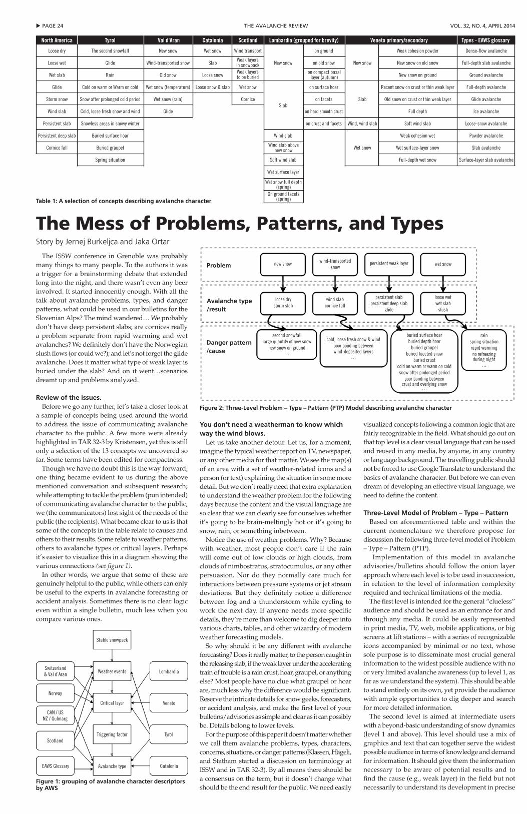
u pAGe 24 the AVAlANche reView Vol. 32, No. 4, April 2014
The ISSW conference in Grenoble was probably many things to many people. To the authors it was a trigger for a brainstorming debate that extended long into the night, and there wasn’t even any beer involved. It started innocently enough. With all the talk about avalanche problems, types, and danger patterns, what could be used in our bulletins for the Slovenian Alps? The mind wandered… We probably don’t have deep persistent slabs; are cornices really a problem separate from rapid warming and wet avalanches? We definitely don’t have the Norwegian slush flows (or could we?); and let’s not forget the glide avalanche. Does it matter what type of weak layer is buried under the slab? And on it went…scenarios dreamt up and problems analyzed.
Review of the issues.Before we go any further, let’s take a closer look at
a sample of concepts being used around the world to address the issue of communicating avalanche character to the public. A few more were already highlighted in TAR 32-3 by Kristensen, yet this is still only a selection of the 13 concepts we uncovered so far. Some terms have been edited for compactness.
Though we have no doubt this is the way forward, one thing became evident to us during the above mentioned conversation and subsequent research; while attempting to tackle the problem (pun intended) of communicating avalanche character to the public, we (the communicators) lost sight of the needs of the public (the recipients). What became clear to us is that some of the concepts in the table relate to causes and others to their results. Some relate to weather patterns, others to avalanche types or critical layers. Perhaps it’s easier to visualize this in a diagram showing the various connections (see figure 1).
In other words, we argue that some of these are genuinely helpful to the public, while others can only be useful to the experts in avalanche forecasting or accident analysis. Sometimes there is no clear logic even within a single bulletin, much less when you compare various ones.
You don’t need a weatherman to know which way the wind blows.
Let us take another detour. Let us, for a moment, imagine the typical weather report on TV, newspaper, or any other media for that matter. We see the map(s) of an area with a set of weather-related icons and a person (or text) explaining the situation in some more detail. But we don’t really need that extra explanation to understand the weather problem for the following days because the content and the visual language are so clear that we can clearly see for ourselves whether it’s going to be brain-meltingly hot or it’s going to snow, rain, or something inbetween.
Notice the use of weather problems. Why? Because with weather, most people don’t care if the rain will come out of low clouds or high clouds, from clouds of nimbostratus, stratocumulus, or any other persuasion. Nor do they normally care much for interactions between pressure systems or jet stream deviations. But they definitely notice a difference between fog and a thunderstorm while cycling to work the next day. If anyone needs more specific details, they’re more than welcome to dig deeper into various charts, tables, and other wizardry of modern weather forecasting models.
So why should it be any different with avalanche forecasting? Does it really matter, to the person caught in the releasing slab, if the weak layer under the accelerating train of trouble is a rain crust, hoar, graupel, or anything else? Most people have no clue what graupel or hoar are, much less why the difference would be significant. Reserve the intricate details for snow geeks, forecasters, or accident analysis, and make the first level of your bulletins/advisories as simple and clear as it can possibly be. Details belong to lower levels.
For the purpose of this paper it doesn’t matter whether we call them avalanche problems, types, characters, concerns, situations, or danger patterns (Klassen, Hägeli, and Statham started a discussion on terminology at ISSW and in TAR 32-3). By all means there should be a consensus on the term, but it doesn’t change what should be the end result for the public. We need easily
visualized concepts following a common logic that are fairly recognizable in the field. What should go out on that top level is a clear visual language that can be used and reused in any media, by anyone, in any country or language background. The travelling public should not be forced to use Google Translate to understand the basics of avalanche character. But before we can even dream of developing an effective visual language, we need to define the content.
Three-Level Model of Problem – Type – PatternBased on aforementioned table and within the
current nomenclature we therefore propose for discussion the following three-level model of Problem – Type – Pattern (PTP).
Implementation of this model in avalanche advisories/bulletins should follow the onion layer approach where each level is to be used in succession, in relation to the level of information complexity required and technical limitations of the media.
The first level is intended for the general “clueless” audience and should be used as an entrance for and through any media. It could be easily represented in print media, TV, web, mobile applications, or big screens at lift stations – with a series of recognizable icons accompanied by minimal or no text, whose sole purpose is to disseminate most crucial general information to the widest possible audience with no or very limited avalanche awareness (up to level 1, as far as we understand the system). This should be able to stand entirely on its own, yet provide the audience with ample opportunities to dig deeper and search for more detailed information.
The second level is aimed at intermediate users with a beyond-basic understanding of snow dynamics (level 1 and above). This level should use a mix of graphics and text that can together serve the widest possible audience in terms of knowledge and demand for information. It should give them the information necessary to be aware of potential results and to find the cause (e.g., weak layer) in the field but not necessarily to understand its development in precise
The Mess of problems, patterns, and TypesStory by Jernej Burkeljca and Jaka Ortar
Table 1: A selection of concepts describing avalanche character
Figure 1: grouping of avalanche character descriptors by AWS
Figure 2: Three-Level Problem – Type – Pattern (PTP) Model describing avalanche character
Problem
Avalanche type/result
Danger pattern/cause
buried surface hoarburied depth hoar
buried graupelburied faceted snow
buried crustcold on warm or warm on coldsnow after prolonged period
poor bonding between crust and overlying snow
…
rainspring situationrapid warmingno refreezingduring night
…
cold, loose fresh snow & windpoor bonding betweenwind-deposited layers
…
second snowfalllarge quantity of new snow
new snow on ground…
new snow wind-transportedsnow
persistent weak layer wet snow
loose wetwet slab
slush
persistent slabpersistent deep slab
glide
wind slabcornice fall
loose drystorm slab
Stable snowpack
Weather events
Critical layer
Triggering factor
Avalanche type
Lombardia
Veneto
Tyrol
Catalonia
Switzerland& Val d’Aran
Norway
CAN / USNZ / Gulmarg
Scotland
EAWS Glossary
Wet snow full depth(spring)
On ground facets(spring)
Weak layersin snowpackWeak layersto be buried
on compact basallayer (autumn)
Wind slab abovenew snow
North America Tyrol Val d'Aran Catalonia Scotland Lombardia (grouped for brevity) Veneto primary/secondary Types - EAWS glossary
Loose dry The second snowfall New snow Wet snow Wind transport on ground Weak cohesion powder Dense-flow avalanche
Loose wet Glide Wind-transported snow Slab New snow on old snow New snow New snow on old snow Full-depth slab avalanche
Wet slab Rain Old snow Loose snow New snow on ground Ground avalanche
Glide Cold on warm or Warm on cold Wet snow (temperature) Loose snow & slab Wet snow on surface hoar Recent snow on crust or thin weak layer Full-depth avalanche
Storm snow Snow after prolonged cold period Wet snow (rain) Cornice on facets Slab Old snow on crust or thin weak layer Glide avalanche
Wind slab Cold, loose fresh snow and wind Glide Slab
on hard smooth crust Full depth Ice avalanche
Persistent slab Snowless areas in snowy winter on crust and facets Wind, wind slab Soft wind slab Loose-snow avalanche
Persistent deep slab Buried surface hoar Wind slab Weak cohesion wet Powder avalanche
Cornice fall Buried graupel Wet snow Wet surface-layer snow Slab avalanche
Spring situation Soft wind slab Full-depth wet snow Surface-layer slab avalanche
Wet surface layer
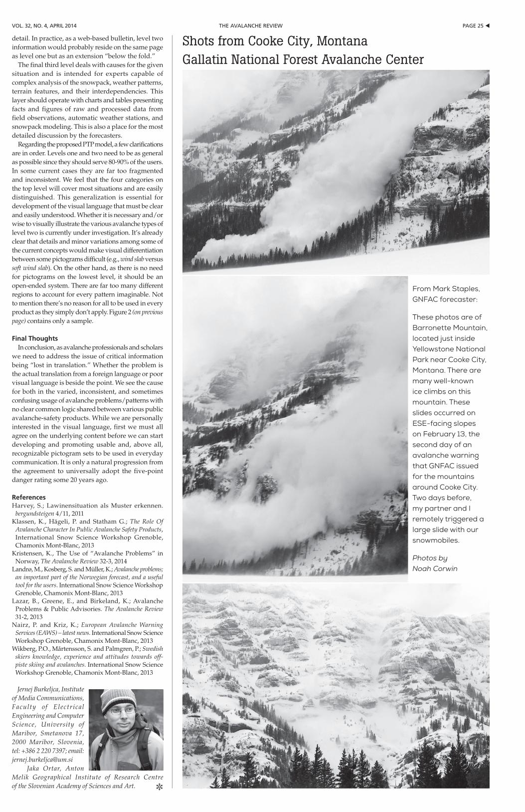
pAGe 25 tthe AVAlANche reViewVol. 32, No. 4, April 2014
detail. In practice, as a web-based bulletin, level two information would probably reside on the same page as level one but as an extension “below the fold.”
The final third level deals with causes for the given situation and is intended for experts capable of complex analysis of the snowpack, weather patterns, terrain features, and their interdependencies. This layer should operate with charts and tables presenting facts and figures of raw and processed data from field observations, automatic weather stations, and snowpack modeling. This is also a place for the most detailed discussion by the forecasters.
Regarding the proposed PTP model, a few clarifications are in order. Levels one and two need to be as general as possible since they should serve 80-90% of the users. In some current cases they are far too fragmented and inconsistent. We feel that the four categories on the top level will cover most situations and are easily distinguished. This generalization is essential for development of the visual language that must be clear and easily understood. Whether it is necessary and/or wise to visually illustrate the various avalanche types of level two is currently under investigation. It’s already clear that details and minor variations among some of the current concepts would make visual differentiation between some pictograms difficult (e.g., wind slab versus soft wind slab). On the other hand, as there is no need for pictograms on the lowest level, it should be an open-ended system. There are far too many different regions to account for every pattern imaginable. Not to mention there’s no reason for all to be used in every product as they simply don’t apply. Figure 2 (on previous page) contains only a sample.
Final ThoughtsIn conclusion, as avalanche professionals and scholars
we need to address the issue of critical information being “lost in translation.” Whether the problem is the actual translation from a foreign language or poor visual language is beside the point. We see the cause for both in the varied, inconsistent, and sometimes confusing usage of avalanche problems/patterns with no clear common logic shared between various public avalanche-safety products. While we are personally interested in the visual language, first we must all agree on the underlying content before we can start developing and promoting usable and, above all, recognizable pictogram sets to be used in everyday communication. It is only a natural progression from the agreement to universally adopt the five-point danger rating some 20 years ago.
ReferencesHarvey, S.; Lawinensituation als Muster erkennen.
bergundsteigen 4/11, 2011Klassen, K., Hägeli, P. and Statham G.; The Role Of
Avalanche Character In Public Avalanche Safety Products, International Snow Science Workshop Grenoble, Chamonix Mont-Blanc, 2013
Kristensen, K., The Use of “Avalanche Problems” in Norway, The Avalanche Review 32-3, 2014
Landrø, M., Kosberg, S. and Müller, K.; Avalanche problems; an important part of the Norwegian forecast, and a useful tool for the users. International Snow Science Workshop Grenoble, Chamonix Mont-Blanc, 2013
Lazar, B., Greene, E., and Birkeland, K.; Avalanche Problems & Public Advisories. The Avalanche Review 31-2, 2013
Nairz, P. and Kriz, K.; European Avalanche Warning Services (EAWS) – latest news. International Snow Science Workshop Grenoble, Chamonix Mont-Blanc, 2013
Wikberg, P.O., Mårtensson, S. and Palmgren, P.; Swedish skiers knowledge, experience and attitudes towards off-piste skiing and avalanches. International Snow Science Workshop Grenoble, Chamonix Mont-Blanc, 2013
Jernej Burkeljca, Institute of Media Communications, Faculty of Electrical Engineering and Computer Science, University of Maribor, Smetanova 17, 2000 Maribor, Slovenia, tel: +386 2 220 7397; email: [email protected] Jaka Ortar, Anton Melik Geographical Institute of Research Centre of the Slovenian Academy of Sciences and Art. R
From Mark Staples, GNFAC forecaster:
These photos are of Barronette Mountain, located just inside Yellowstone National Park near Cooke City, Montana. There are many well-known ice climbs on this mountain. These slides occurred on ESE-facing slopes on February 13, the second day of an avalanche warning that GNFAC issued for the mountains around Cooke City. Two days before, my partner and I remotely triggered a large slide with our snowmobiles.
Photos by Noah Corwin
Shots from Cooke City, MontanaGallatin National Forest Avalanche Center
u pAGe 26 the AVAlANche reView Vol. 32, No. 4, April 2014
to do this? John: Pursuing pro track a good idea. As employer, sees the need.
Continuing Education for CIs: clean number of hours is needed. Kirk: closing communication loops and projects is a big problem in the organization. If something is your job, then it needs to get completed. John: Regarding continuing education hours: would in-house be included? Preparation time for teaching or speaking engagements? Mike: 90 hours for three years? Scott: Likes that: clean and simple, doable for anyone who’s serious about education. Stuart: Should we create a two-tiered system? Mike: We should revisit down the road but should be simple. Mike and John: 30 hours per year should be pretty easy to meet (90 hrs every three years) for people who are actively working – more a matter of them documenting what they are already doing. Halsted: Motion to require 90 hours of continuing education/professional development over a three-year period for CIs to remain active. Inactive/emeritus status will be an option for those who don’t meet the continuing education requirement. Education committee will be responsible for implementation and any auditing of CIs for continuing education.
ResearchJordy: Did not receive any practitioner proposals
last cycle. May put up a list of potential mentors to solicit proposals…or maybe it’s just a blip? Several governing board members in favor of creating mentor list. Jordy standardized the application process to streamline it. Also standardizing grant application evaluation form/process.
Current research: grad research window closed end of October. Howard Conway, Kelly Elder, Andy Gleason, Ian Owens, Ethan Greene are reviewers. (see page 10 for Theo Meiners Grant awards)
Jordy: Making a list of past projects, amount funded, and results. We should also show where CIL/Orion funds go and publicize that we spent a lot of money on professional education and research grants.
EthicsLel: Received two letters of interest for open Ethics
Chair position. Lel resigns, thanks the GB: has been an honor to work with everyone. Welcome to Aleph Johnston-Bloom and Dave Hendrickson as new Ethics co-chairs. Lel would like to remain involved with the AAA going forward.
Other Committees/Section Rep reportsKyle (Eastern): SWAG orders from ESAW? Not yet.
ESAW in third year, going well. Chris Joosen will replace Kyle on ballot as Eastern Rep during next voting cycle.
Becs (CO report): Checking professional applications mostly based on references. CBAC dot listing issue has been resolved.
Damian (Intermountain South): Sawtooth professional development event in the spring. USAW tomorrow. Lots of interest in new applicants. He’d like to contact recently expired/lapsed pro members to make sure they want to leave the organization, try to keep them in the AAA. Can the ED email those names and contact info to the section reps? Jaime: Yes, seems like this could happen. Mark: 176 lapsed pros at this point.
SAR. Dale filling in for Rich Browne: Progress on avalanche rescue course development. Discussion about involving education committee. Also whether we want to be course providers for additional education programs. Dale notes that it puts us front and center with higher level land managers. Bill says it fits with our other classes (AVPro and explosives guidelines) aimed at professionals. Kirk: Next step is to move it to the education committee.
Old/New BusinessResearch. Jordy: He’s had people contact him with
interesting proposals for funding. He usually puts them into the regular deadline procedures. One new proposal is from someone who wants to get their research done this winter. This is a sensitive issue as the new proposal is from someone whose business gives the AAA lots of money. Response from governing
board is to point them to Theo deadlines. Governing board clear in advising no special treatment – we need to be consistent and transparent.
Google Maps/avalanche.org project Scott and Ned Bair skype connect: Website changes mockup on screen during meeting. Avalanche.org daily visits in declining trend. Google analytics say we get 2000 hits a day mid-winter; 200 hits a day off season. Avalanche centers are seeing more visitation. Decline probably due to lack of fresh content. Website revision costs: graphic designer Britt Jonston, $1500-2000; Shirley Studebaker programming, $800-1000. Google analytics: Need to make a mobile-friendly site basic version, but revamp site. Sponsor/advertising value depends on site visitation numbers, so adding fresh content and modern design will help drive revenue.
Insets for Google map project: one is Alaska and the other is the Mt Washington Avalanche Center. Western US will have slide-over view. Move NAC to a text link rather than on map. Leave title sponsor/ accidents/ AAA up top as this is “good real estate” on web sites. Put AAA logo up there next to title sponsor (currently BCA), top right of site. Polygons will display danger ratings but with limited resolution in national map to encourage viewers to “drill down” to individual avalanche centers for specific information. We envision the bulk of the map be mostly the western continental US.
If you click on a delineated polygon, it will take you to either the avalanche center or to a zone forecast – whichever the center wants you to see first. Fully automated to fill in danger ratings and/or warnings. Carol Peck is making it easy for all avalanche centers to participate; no technical obstacles. Remove international centers from current location (in map/graphic product) and move to lists on top tabs and bottom of page. Will need to look into updating liability statement (Janet and Mark have text and contacts). Get rid of slideshow as it is old and stale. Jordy: Pulling data from sites/mapping – gets archived and will have redundancy and searchability.
Corporate partnerships and sponsorships. We are in a holding pattern until we create a sponsorship plan for the future. One vehicle would be a monthly newsletter that can contain special offers from manufacturers, news, featured articles. Insert chart of sponsorship levels as per hazard levels (like americanwhitewater.org). How do we differentiate between TAR advertisers and website advertisers/ sponsors? Discussion about including Paul Nordquist (TAR advertising). We need to inventory what we can offer sponsors. Monthly or bi-monthly newsletters are an option but we won’t give out our email list – sponsors would provide content to us and we would send the email/newsletter. There is a check box on Wild Apricot to opt out of emails from AAA; still receive renewal notices but not newsletters. Governing board feels we should enter into short-term agreements with some of our contacts for one year; give us time to formulate a long-term strategy and determine what our marketing options are worth. Example: Rotating headline sponsor on Sawtooth Avalanche Center is ~$2000 a year, 5-7 different sponsors. Can we get appraisal of our value? Should we hire an ad agency? Short-term solution involves Paul Nordquist, Mike Ferrari, and Jaime dealing with known advertising options and companies that have inquired with us.
Motion: To produce a short-term program for the rest of this fiscal year, approaching potential sponsors for our websites (banners and pages). Can include trial access to membership through emails and/or newsletters. Mike and Jaime will drive this with board support as necessary.
City of Driggs Geotourism Center request. Jaime introduces Dan Powers, Driggs mayor: Building geotourism center to recognize what is authentic about greater Teton area. Connection to snow is central to Tetons, as it is economically important for area. Dan goes through planned center exhibits. Total cost is $4000 – asking for $1000 from AAA. Several questions about our financial situation, funding, permanence, precedent with AAA for exhibits.
Motion: Move that we take funds to fund $1000 for City of Driggs project: motion carries.
Policy on Professional Development Funding Decisions. Scott: Does Jaime feel comfortable making these funding decisions as Mark has done in the past?
Organizers haven’t been following the deadlines/procedure on the website. Mark: When do requests need to come in (April 1 is the deadline on the AAA website, deadline set so board could discuss at the spring governing board meeting)? Maybe we should send out reminders to past organizers and evaluate information/guidelines on the website. Organizers can pay speakers but can’t pay organizers/event labor with grant money. Should we resend guidelines to professional members in spring? We can put it in TAR for February: Scott will review guidelines, maybe move deadline to April 15. Governing board notes generosity of CIL with continued donations. Total grants awarded should be based on donations from CIL from previous year.
Motion: Scotty will edit guidelines and solicit e-vote for edits: carries. Local professional development events are some of the best things we do. Will look at these at spring board meeting.
Online store. Mike: Recommends we have a fire sale at the “SAWS” to eliminate existing inventory. We need to consider sales taxes, especially in Utah where we are incorporated. Mike: Moving forward, consider three options in earlier email to board. 1)Similar system to the past where board members sell stuff at regional events. 2) E-commerce built into the websites. 3) Use order-fulfillmentcompanylikeZazzle,Amazon,orCaféPress.MikethinksZazzleorCaféPressstylesystemmakes the most sense; will pursue this.
Email updates and timely press releases. We should provide timely information and promptly respond to requests.
Strategic plan. Stability and sustainability, influence, and advocacy. John S to talk to Dale about finishing this project.
Employment policies. Paid, appointed, and volunteer. Blase: Should create employment policies and run by legal counsel at some point. John S to spearhead this.
Filling Committee Chairs motion. to condense Data and Web committee chairs to one chair: passes.
Use of AAA logo. Motion passes that exceptions to use of logo terms will be amended to include “exceptions will be considered by the AAA Governing Board on a case by case basis.”
CBAC/dots on the map update. Now, after extensive work by both the CAIC and CBAC, CBAC has a memorandum of understanding (MOI) with the CAIC. MOI is not signed due to political issues, but both parties are in agreement on content. CBAC application is now recommended by CAIC and by Becs H, section rep, and application fulfills all current criteria. With Google maps product on avalanche.org home page, they will be hidden beneath the Gunnison zone on new map and linked on CAIC website.
General discussion on “dot-listing.” Starting to run into issue where some non-agency centers operate at a similar or higher level than some agency centers. The Google map product will make the agency versus non-agency distinction somewhat moot. Some issues have been worked out (eg., Eastern center issuing slope-specific advisories). Some centers will be in a grey area. This issue is linked to season summaries in TAR: which do/can we print? Alaska centers and operations lead to confusion. All centers want inclusion in TAR and avalanche.org, but decisions can’t be arbitrary. We need to encourage professionalism and have some goals for newer centers to meet. Forest Service has four levels of centers. One possible goal: if you are on avalanche.org, you’re included in the TAR season summaries. We need to standardize how centers are represented: Blase recommends that we use data/pub/ethics chairs, plus secretary and president as committee to revise criteria/guidelines. Short-term goal is to refresh, tighten, and clarify criteria and guidelines. Jaime notes Southern California snow and avalanche center.
Motion passes to form committee as proposed and move forward with formulating and refining criteria for avalanche center listing on avalanche.org and for season summary publishing in TAR.
FINAL BUSINESSConsider Mark for life membership with dues
waived: motion carries. Congratulations to Mark Mueller on his new status as AAA life member. R
AAA BoArdcontinued from page 18
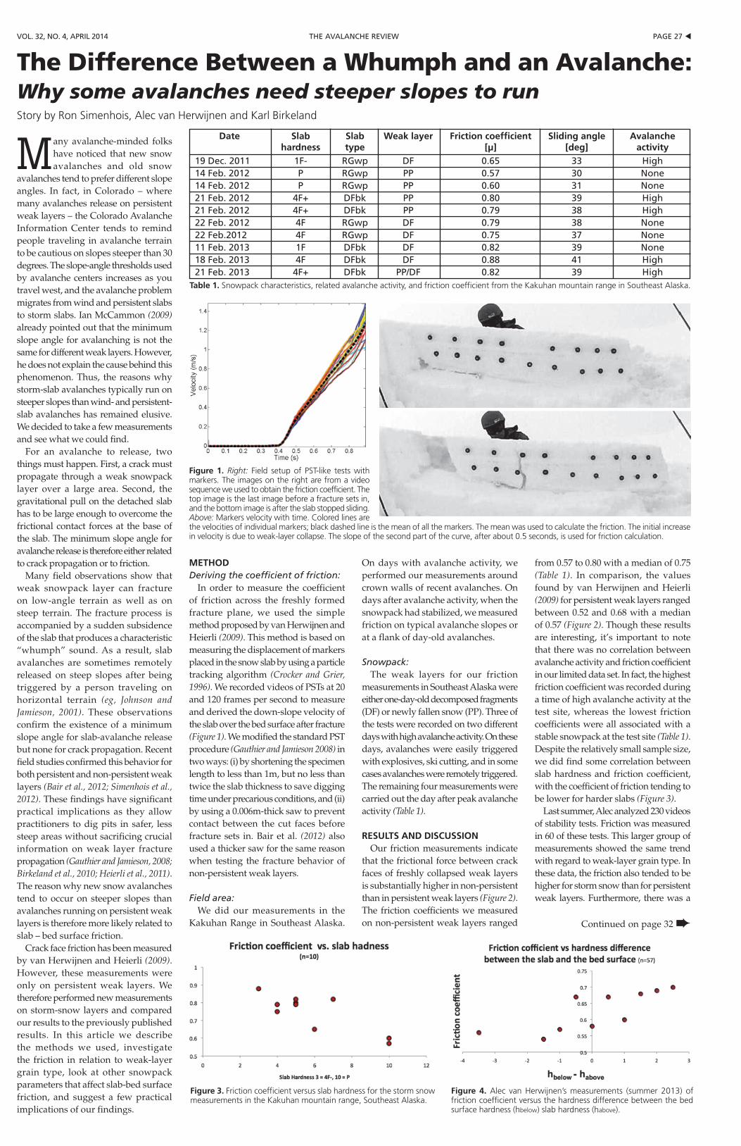
pAGe 27 tthe AVAlANche reViewVol. 32, No. 4, April 2014
Table 1. Snowpack characteristics, related avalanche activity, and friction coefficient from the Kakuhan mountain range in Southeast Alaska.
METHODDeriving the coefficient of friction:
In order to measure the coefficient of friction across the freshly formed fracture plane, we used the simple method proposed by van Herwijnen and Heierli (2009). This method is based on measuring the displacement of markers placed in the snow slab by using a particle tracking algorithm (Crocker and Grier, 1996). We recorded videos of PSTs at 20 and 120 frames per second to measure and derived the down-slope velocity of the slab over the bed surface after fracture (Figure 1). We modified the standard PST procedure (Gauthier and Jamieson 2008) in two ways: (i) by shortening the specimen length to less than 1m, but no less than twice the slab thickness to save digging time under precarious conditions, and (ii) by using a 0.006m-thick saw to prevent contact between the cut faces before fracture sets in. Bair et al. (2012) also used a thicker saw for the same reason when testing the fracture behavior of non-persistent weak layers.
Field area:We did our measurements in the
Kakuhan Range in Southeast Alaska.
On days with avalanche activity, we performed our measurements around crown walls of recent avalanches. On days after avalanche activity, when the snowpack had stabilized, we measured friction on typical avalanche slopes or at a flank of day-old avalanches.
Snowpack:The weak layers for our friction
measurements in Southeast Alaska were either one-day-old decomposed fragments (DF) or newly fallen snow (PP). Three of the tests were recorded on two different days with high avalanche activity. On these days, avalanches were easily triggered with explosives, ski cutting, and in some cases avalanches were remotely triggered. The remaining four measurements were carried out the day after peak avalanche activity (Table 1).
RESULTS AND DISCUSSIONOur friction measurements indicate
that the frictional force between crack faces of freshly collapsed weak layers is substantially higher in non-persistent than in persistent weak layers (Figure 2). The friction coefficients we measured on non-persistent weak layers ranged
from 0.57 to 0.80 with a median of 0.75 (Table 1). In comparison, the values found by van Herwijnen and Heierli (2009) for persistent weak layers ranged between 0.52 and 0.68 with a median of 0.57 (Figure 2). Though these results are interesting, it’s important to note that there was no correlation between avalanche activity and friction coefficient in our limited data set. In fact, the highest friction coefficient was recorded during a time of high avalanche activity at the test site, whereas the lowest friction coefficients were all associated with a stable snowpack at the test site (Table 1). Despite the relatively small sample size, we did find some correlation between slab hardness and friction coefficient, with the coefficient of friction tending to be lower for harder slabs (Figure 3).
Last summer, Alec analyzed 230 videos of stability tests. Friction was measured in 60 of these tests. This larger group of measurements showed the same trend with regard to weak-layer grain type. In these data, the friction also tended to be higher for storm snow than for persistent weak layers. Furthermore, there was a
Many avalanche-minded folks have noticed that new snow avalanches and old snow
avalanches tend to prefer different slope angles. In fact, in Colorado – where many avalanches release on persistent weak layers – the Colorado Avalanche Information Center tends to remind people traveling in avalanche terrain to be cautious on slopes steeper than 30 degrees. The slope-angle thresholds used by avalanche centers increases as you travel west, and the avalanche problem migrates from wind and persistent slabs to storm slabs. Ian McCammon (2009) already pointed out that the minimum slope angle for avalanching is not the same for different weak layers. However, he does not explain the cause behind this phenomenon. Thus, the reasons why storm-slab avalanches typically run on steeper slopes than wind- and persistent-slab avalanches has remained elusive. We decided to take a few measurements and see what we could find.
For an avalanche to release, two things must happen. First, a crack must propagate through a weak snowpack layer over a large area. Second, the gravitational pull on the detached slab has to be large enough to overcome the frictional contact forces at the base of the slab. The minimum slope angle for avalanche release is therefore either related to crack propagation or to friction.
Many field observations show that weak snowpack layer can fracture on low-angle terrain as well as on steep terrain. The fracture process is accompanied by a sudden subsidence of the slab that produces a characteristic “whumph” sound. As a result, slab avalanches are sometimes remotely released on steep slopes after being triggered by a person traveling on horizontal terrain (eg, Johnson and Jamieson, 2001). These observations confirm the existence of a minimum slope angle for slab-avalanche release but none for crack propagation. Recent field studies confirmed this behavior for both persistent and non-persistent weak layers (Bair et al., 2012; Simenhois et al., 2012). These findings have significant practical implications as they allow practitioners to dig pits in safer, less steep areas without sacrificing crucial information on weak layer fracture propagation (Gauthier and Jamieson, 2008; Birkeland et al., 2010; Heierli et al., 2011). The reason why new snow avalanches tend to occur on steeper slopes than avalanches running on persistent weak layers is therefore more likely related to slab – bed surface friction.
Crack face friction has been measured by van Herwijnen and Heierli (2009). However, these measurements were only on persistent weak layers. We therefore performed new measurements on storm-snow layers and compared our results to the previously published results. In this article we describe the methods we used, investigate the friction in relation to weak-layer grain type, look at other snowpack parameters that affect slab-bed surface friction, and suggest a few practical implications of our findings.
Continued on page 32 ➨
The Difference Between a whumph and an Avalanche:Why some avalanches need steeper slopes to runStory by Ron Simenhois, Alec van Herwijnen and Karl Birkeland
Figure 1. Right: Field setup of PST-like tests with markers. The images on the right are from a video sequence we used to obtain the friction coefficient. The top image is the last image before a fracture sets in, and the bottom image is after the slab stopped sliding. Above: Markers velocity with time. Colored lines are the velocities of individual markers; black dashed line is the mean of all the markers. The mean was used to calculate the friction. The initial increase in velocity is due to weak-layer collapse. The slope of the second part of the curve, after about 0.5 seconds, is used for friction calculation.
Figure 3. Friction coefficient versus slab hardness for the storm snow measurements in the Kakuhan mountain range, Southeast Alaska.
Figure 4. Alec van Herwijnen’s measurements (summer 2013) of friction coefficient versus the hardness difference between the bed surface hardness (hbelow) slab hardness (habove).
Date Slab Slab Weak layer Friction coefficient Sliding angle Avalanche hardness type [µ] [deg] activity
19 Dec. 2011 1F- rGwp DF 0.65 33 high14 Feb. 2012 p rGwp pp 0.57 30 None14 Feb. 2012 p rGwp pp 0.60 31 None21 Feb. 2012 4F+ DFbk pp 0.80 39 high21 Feb. 2012 4F+ DFbk pp 0.79 38 high22 Feb. 2012 4F rGwp DF 0.79 38 None22 Feb.2012 4F rGwp DF 0.75 37 None11 Feb. 2013 1F DFbk DF 0.82 39 None18 Feb. 2013 4F DFbk DF 0.88 41 high21 Feb. 2013 4F+ DFbk pp/DF 0.82 39 high
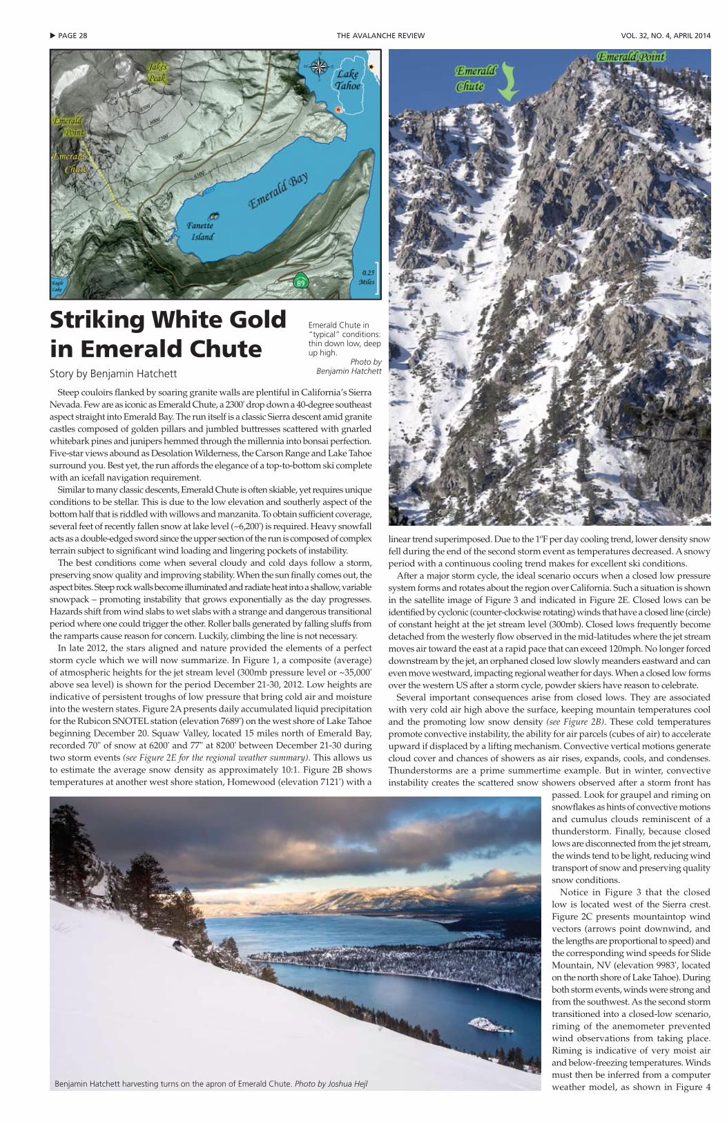
u pAGe 28 the AVAlANche reView Vol. 32, No. 4, April 2014
Steep couloirs flanked by soaring granite walls are plentiful in California’s Sierra Nevada. Few are as iconic as Emerald Chute, a 2300' drop down a 40-degree southeast aspect straight into Emerald Bay. The run itself is a classic Sierra descent amid granite castles composed of golden pillars and jumbled buttresses scattered with gnarled whitebark pines and junipers hemmed through the millennia into bonsai perfection. Five-star views abound as Desolation Wilderness, the Carson Range and Lake Tahoe surround you. Best yet, the run affords the elegance of a top-to-bottom ski complete with an icefall navigation requirement.
Similar to many classic descents, Emerald Chute is often skiable, yet requires unique conditions to be stellar. This is due to the low elevation and southerly aspect of the bottom half that is riddled with willows and manzanita. To obtain sufficient coverage, several feet of recently fallen snow at lake level (~6,200') is required. Heavy snowfall acts as a double-edged sword since the upper section of the run is composed of complex terrain subject to significant wind loading and lingering pockets of instability.
The best conditions come when several cloudy and cold days follow a storm, preserving snow quality and improving stability. When the sun finally comes out, the aspect bites. Steep rock walls become illuminated and radiate heat into a shallow, variable snowpack – promoting instability that grows exponentially as the day progresses. Hazards shift from wind slabs to wet slabs with a strange and dangerous transitional period where one could trigger the other. Roller balls generated by falling sluffs from the ramparts cause reason for concern. Luckily, climbing the line is not necessary.
In late 2012, the stars aligned and nature provided the elements of a perfect storm cycle which we will now summarize. In Figure 1, a composite (average) of atmospheric heights for the jet stream level (300mb pressure level or ~35,000' above sea level) is shown for the period December 21-30, 2012. Low heights are indicative of persistent troughs of low pressure that bring cold air and moisture into the western states. Figure 2A presents daily accumulated liquid precipitation for the Rubicon SNOTEL station (elevation 7689') on the west shore of Lake Tahoe beginning December 20. Squaw Valley, located 15 miles north of Emerald Bay, recorded 70" of snow at 6200' and 77" at 8200' between December 21-30 during two storm events (see Figure 2E for the regional weather summary). This allows us to estimate the average snow density as approximately 10:1. Figure 2B shows temperatures at another west shore station, Homewood (elevation 7121') with a
linear trend superimposed. Due to the 1ºF per day cooling trend, lower density snow fell during the end of the second storm event as temperatures decreased. A snowy period with a continuous cooling trend makes for excellent ski conditions.
After a major storm cycle, the ideal scenario occurs when a closed low pressure system forms and rotates about the region over California. Such a situation is shown in the satellite image of Figure 3 and indicated in Figure 2E. Closed lows can be identified by cyclonic (counter-clockwise rotating) winds that have a closed line (circle) of constant height at the jet stream level (300mb). Closed lows frequently become detached from the westerly flow observed in the mid-latitudes where the jet stream moves air toward the east at a rapid pace that can exceed 120mph. No longer forced downstream by the jet, an orphaned closed low slowly meanders eastward and can even move westward, impacting regional weather for days. When a closed low forms over the western US after a storm cycle, powder skiers have reason to celebrate.
Several important consequences arise from closed lows. They are associated with very cold air high above the surface, keeping mountain temperatures cool and the promoting low snow density (see Figure 2B). These cold temperatures promote convective instability, the ability for air parcels (cubes of air) to accelerate upward if displaced by a lifting mechanism. Convective vertical motions generate cloud cover and chances of showers as air rises, expands, cools, and condenses. Thunderstorms are a prime summertime example. But in winter, convective instability creates the scattered snow showers observed after a storm front has
passed. Look for graupel and riming on snowflakes as hints of convective motions and cumulus clouds reminiscent of a thunderstorm. Finally, because closed lows are disconnected from the jet stream, the winds tend to be light, reducing wind transport of snow and preserving quality snow conditions.
Notice in Figure 3 that the closed low is located west of the Sierra crest. Figure 2C presents mountaintop wind vectors (arrows point downwind, and the lengths are proportional to speed) and the corresponding wind speeds for Slide Mountain, NV (elevation 9983', located on the north shore of Lake Tahoe). During both storm events, winds were strong and from the southwest. As the second storm transitioned into a closed-low scenario, riming of the anemometer prevented wind observations from taking place. Riming is indicative of very moist air and below-freezing temperatures. Winds must then be inferred from a computer weather model, as shown in Figure 4
Striking white Gold in Emerald ChuteStory by Benjamin Hatchett
Emerald Chute in “typical” conditions: thin down low, deep up high.
Photo by Benjamin Hatchett
Benjamin Hatchett harvesting turns on the apron of Emerald Chute. Photo by Joshua Hejl
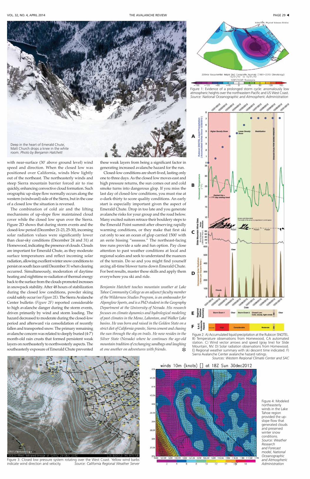
pAGe 29 tthe AVAlANche reViewVol. 32, No. 4, April 2014
with near-surface (30' above ground level) wind speed and direction. When the closed low was positioned over California, winds blew lightly out of the northeast. The northeasterly winds and steep Sierra mountain barrier forced air to rise quickly, enhancing convective cloud formation. Such orographic up-slope flow normally occurs along the western (windward) side of the Sierra, but in the case of a closed low the situation is reversed.
The combination of cold air and the lifting mechanisms of up-slope flow maintained cloud cover while the closed low spun over the Sierra. Figure 2D shows that during storm events and the closed-low period (December 21-23, 25-30), incoming solar radiation values were significantly lower than clear-sky conditions (December 24 and 31) at Homewood, indicating the presence of clouds. Clouds are important for Emerald Chute, as they moderate surface temperatures and reflect incoming solar radiation, allowing excellent winter snow conditions to persist on south faces until December 31 when clearing occurred. Simultaneously, moderation of daytime heating and nighttime re-radiation of thermal energy back to the surface from the clouds promoted increases in snowpack stability. After 48 hours of stabilization during the closed low conditions, powder skiing could safely occur (see Figure 2E). The Sierra Avalanche Center bulletin (Figure 2F) reported considerable to high avalanche danger during the storm events, driven primarily by wind and storm loading. The hazard decreased to moderate during the closed-low period and afterward via consolidation of recently fallen and transported snow. The primary remaining avalanche concern was related to deeply buried (4-7') month-old rain crusts that formed persistent weak layers on northeasterly to northwesterly aspects. The southeasterly exposure of Emerald Chute prevented
these weak layers from being a significant factor in generating increased avalanche hazard for the run.
Closed-low conditions are short-lived, lasting only one to three days. As the closed low moves east and high pressure returns, the sun comes out and cold smoke turns into dangerous glop. If you miss the last day of closed-low conditions, you must rise at o-dark-thirty to score quality conditions. An early start is especially important given the aspect of Emerald Chute. Drop in too late and you generate avalanche risks for your group and the road below. Many excited suitors retrace their bouldery steps to the Emerald Point summit after observing rapidly warming conditions, or they make that first ski cut only to see an ocean of glop carried 1500' with an eerie hissing “ssssssss.” The northeast-facing tree runs provide a safe and fun option. Pay close attention to past weather conditions at local and regional scales and seek to understand the nuances of the terrain. Do so and you might find yourself arcing all-time blower turns down Emerald Chute. For best results, master these skills and apply them everywhere you ski and ride.
Benjamin Hatchett teaches mountain weather at Lake Tahoe Community College as an adjunct faculty member of the Wilderness Studies Program, is an ambassador for Alpenglow Sports, and is a PhD student in the Geography Department at the University of Nevada. His research focuses on climate dynamics and hydrological modeling of past climates in the Mono, Lahontan, and Walker Lake basins. He was born and raised in the Golden State on a strict diet of California granite, Sierra cement and chasing the sun through the sky on trails. He now resides in the Silver State (Nevada) where he continues the age-old mountain tradition of exchanging sandbags and laughing at one another on adventures with friends. R
Figure 1: Evidence of a prolonged storm cycle: anomalously low atmospheric heights over the northeastern Pacific and US West Coast. Source: National Oceanographic and Atmospheric Administration
Figure 2: A) Accumulated liquid precipitation at the Rubicon SNOTEL. B) Temperature observations from Homewood, CA automated station. C) Wind vector arrows and speed (gray line) for Slide Mountain, NV. D) Solar radiation observations from Homewood. E) Regional weather summary with ski descent time indicated. F) Sierra Avalanche Center avalanche hazard ratings.
Sources: Western Regional Climate Center and SAC
Figure 3: Closed low pressure system rotating over the West Coast. Yellow wind barbs indicate wind direction and velocity. Source: California Regional Weather Server
Figure 4: Modeled northeasterly winds in the Lake Tahoe region provided the up-slope flow that generated clouds and preserved winter snow conditions. Source: Weather Research and Forecast model, National Oceanographic and Atmospheric Administration
Deep in the heart of Emerald Chute, Matt Church drops a knee in the white room. Photo by Benjamin Hatchett
A
B
C
D
E
F
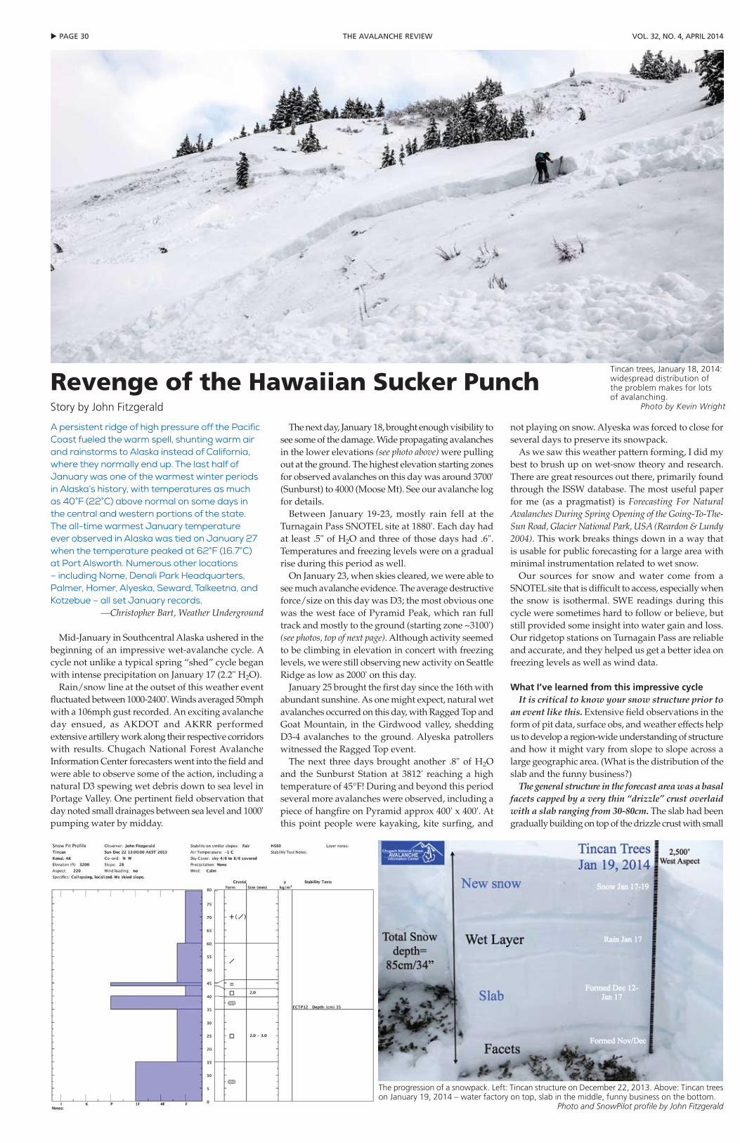
u pAGe 30 the AVAlANche reView Vol. 32, No. 4, April 2014
A persistent ridge of high pressure off the Pacific Coast fueled the warm spell, shunting warm air and rainstorms to Alaska instead of California, where they normally end up. The last half of January was one of the warmest winter periods in Alaska’s history, with temperatures as much as 40°F (22°C) above normal on some days in the central and western portions of the state. The all-time warmest January temperature ever observed in Alaska was tied on January 27 when the temperature peaked at 62°F (16.7°C) at Port Alsworth. Numerous other locations – including Nome, Denali Park Headquarters, Palmer, Homer, Alyeska, Seward, Talkeetna, and Kotzebue – all set January records.
—Christopher Bart, Weather Underground
Mid-January in Southcentral Alaska ushered in the beginning of an impressive wet-avalanche cycle. A cycle not unlike a typical spring “shed” cycle began with intense precipitation on January 17 (2.2" H2O).
Rain/snow line at the outset of this weather event fluctuated between 1000-2400'. Winds averaged 50mph with a 106mph gust recorded. An exciting avalanche day ensued, as AKDOT and AKRR performed extensive artillery work along their respective corridors with results. Chugach National Forest Avalanche Information Center forecasters went into the field and were able to observe some of the action, including a natural D3 spewing wet debris down to sea level in Portage Valley. One pertinent field observation that day noted small drainages between sea level and 1000' pumping water by midday.
The next day, January 18, brought enough visibility to see some of the damage. Wide propagating avalanches in the lower elevations (see photo above) were pulling out at the ground. The highest elevation starting zones for observed avalanches on this day was around 3700' (Sunburst) to 4000 (Moose Mt). See our avalanche log for details.
Between January 19-23, mostly rain fell at the Turnagain Pass SNOTEL site at 1880'. Each day had at least .5" of H2O and three of those days had .6". Temperatures and freezing levels were on a gradual rise during this period as well.
On January 23, when skies cleared, we were able to see much avalanche evidence. The average destructive force/size on this day was D3; the most obvious one was the west face of Pyramid Peak, which ran full track and mostly to the ground (starting zone ~3100') (see photos, top of next page). Although activity seemed to be climbing in elevation in concert with freezing levels, we were still observing new activity on Seattle Ridge as low as 2000' on this day.
January 25 brought the first day since the 16th with abundant sunshine. As one might expect, natural wet avalanches occurred on this day, with Ragged Top and Goat Mountain, in the Girdwood valley, shedding D3-4 avalanches to the ground. Alyeska patrollers witnessed the Ragged Top event.
The next three days brought another .8" of H2O and the Sunburst Station at 3812' reaching a high temperature of 45°F! During and beyond this period several more avalanches were observed, including a piece of hangfire on Pyramid approx 400' x 400'. At this point people were kayaking, kite surfing, and
not playing on snow. Alyeska was forced to close for several days to preserve its snowpack.
As we saw this weather pattern forming, I did my best to brush up on wet-snow theory and research. There are great resources out there, primarily found through the ISSW database. The most useful paper for me (as a pragmatist) is Forecasting For Natural Avalanches During Spring Opening of the Going-To-The-Sun Road, Glacier National Park, USA (Reardon & Lundy 2004). This work breaks things down in a way that is usable for public forecasting for a large area with minimal instrumentation related to wet snow.
Our sources for snow and water come from a SNOTEL site that is difficult to access, especially when the snow is isothermal. SWE readings during this cycle were sometimes hard to follow or believe, but still provided some insight into water gain and loss. Our ridgetop stations on Turnagain Pass are reliable and accurate, and they helped us get a better idea on freezing levels as well as wind data.
What I’ve learned from this impressive cycleIt is critical to know your snow structure prior to
an event like this. Extensive field observations in the form of pit data, surface obs, and weather effects help us to develop a region-wide understanding of structure and how it might vary from slope to slope across a large geographic area. (What is the distribution of the slab and the funny business?)
The general structure in the forecast area was a basal facets capped by a very thin “drizzle” crust overlaid with a slab ranging from 30-80cm. The slab had been gradually building on top of the drizzle crust with small
revenge of the Hawaiian Sucker punchStory by John Fitzgerald
Tincan trees, January 18, 2014: widespread distribution of the problem makes for lots of avalanching.
Photo by Kevin Wright
The progression of a snowpack. Left: Tincan structure on December 22, 2013. Above: Tincan trees on January 19, 2014 – water factory on top, slab in the middle, funny business on the bottom.
Photo and SnowPilot profile by John Fitzgerald
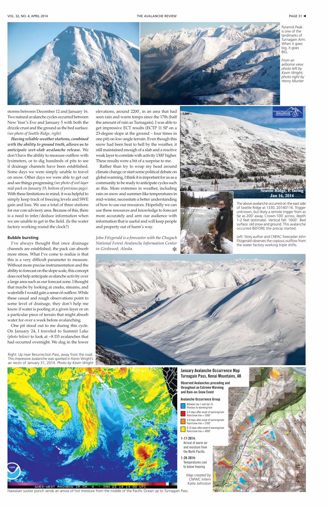
pAGe 31 tthe AVAlANche reViewVol. 32, No. 4, April 2014
storms between December 12 and January 16. Two natural avalanche cycles occurred between New Year’s Eve and January 5 with both the drizzle crust and the ground as the bed surface. (see photo of Seattle Ridge, right)
Having reliable weather stations, combined with the ability to ground truth, allows us to anticipate wet-slab avalanche release. We don’t have the ability to measure outflow with lysimeters, or to dig hundreds of pits to see if drainage channels have been established. Some days we were simply unable to travel on snow. Other days we were able to get out and see things progressing (see photo of wet layer mid-pack on January 19, bottom of previous page). With these limitations in mind, it was helpful to simply keep track of freezing levels and SWE gain and loss. We use a total of three stations for our core advisory area. Because of this, there is a need to infer/deduce information when we are unable to get in the field. (Is the water factory working round the clock?)
Bubble burstingI’ve always thought that once drainage
channels are established, the pack can absorb more stress. What I’ve come to realize is that this is a very difficult parameter to measure. Without more precise instrumentation and the ability to forecast on the slope scale, this concept does not help anticipate avalanche activity over a large area such as our forecast zone. I thought that maybe by looking at creeks, streams, and waterfalls I would gain a sense of outflow. While these casual and rough observations point to some level of drainage, they don’t help me know if water is pooling at a given layer or on a particular piece of terrain that might absorb water for over a week before avalanching.
One pit stood out to me during this cycle. On January 24, I traveled to Summit Lake (photo below) to look at ~8 D3 avalanches that had occurred overnight. We dug in the lower
elevations, around 2200', in an area that had seen rain and warm temps since the 17th (half the amount of rain as Turnagain). I was able to get impressive ECT results (ECTP 11 SP on a 23-degree slope at the ground – four times in one pit) on low-angle terrain. Even though this snow had been beat to hell by the weather, it still maintained enough of a slab and a reactive weak layer to correlate with activity 1300' higher. These results were a bit of a surprise to me.
Rather than try to wrap my head around climate change or start some political debate on global warming, I think it is important for us as a community to be ready to anticipate cycles such as this. More extremes in weather, including rain on snow and summer-like temperatures in mid-winter, necessitate a better understanding of how to use our resources. Hopefully we can use these resources and knowledge to forecast more accurately and arm our audience with information that is useful and will keep people and property out of harm’s way.
John Fitzgerald is a forecaster with the Chugach National Forest Avalanche Information Center in Girdwood, Alaska. R
Right: Up near Resurrection Pass, away from the road. This impressive avalanche was spotted in Kevin Wright’s air recon of January 31, 2014. Photo by Kevin Wright
Pyramid Peak is one of the landmarks of Turnagain Arm. When it goes big, it goes BIG.
From an airborne view: photo left by Kevin Wright; photo right by Henry Munter
The above avalanche occurred on the east side of Seattle Ridge at 1330, 20140116. Trigger unknown, but likely a remote trigger from as far as 200' away. Crown-100’ across, depth 1-2 feet (estimate). Vertical fall: 1600'. Bed surface: old snow and ground. This avalanche occurred BEFORE the precip started.
Left: Story author and CNFAC forecaster John Fitzgerald observes the copious outflow from the water factory working triple shifts.
1-17-2014: Arrival of warm air and moisture from the North Pacific
1-28-2014: Temperatures cool to below freezing
January Avalanche Occurrence Map Turnagain Pass, Kenai Mountains, AKObserved Avalanches preceding and throughout an Extreme Warming and Rain-on-Snow Event
Hawaiian sucker punch sends an arrow of hot moisture from the middle of the Pacific Ocean up to Turnagain Pass.
Map created by CNFAIC intern
Katie Johnston
Avalanche Occurrence GroupBetween Jan 1 and Jan 16Previous to warming/rain
0-4 days after onset of warming/rainRain/snow line = 2000'
4-8 days after onset of warming/rainRain/snow line = 2500'
8-10 days after onset of warming/rainRain/snow line = 4000'

u pAGe 32 the AVAlANche reView Vol. 32, No. 4, April 2014
clear increase in friction with hardness differences across crack faces. Specifically, the softer the slab in relation to the bed surface, the higher the resistance to down-slope motion (Figure 4).
CASE STUDYAlthough our limited measurements
did not necessarily correlate to avalanche activity, on two of our sampling days we did have results that showed a good relationship between avalanche-release slope angles and measured friction coefficients. Both of these days had high avalanche activity. On each day we performed our measurements around an avalanche crown wall that was triggered minutes before the measurements. The differences in the slope angle of the crown walls correlated well with our friction measurements. On December 19, 2011, we measured crack-face friction coefficient of 0.65 (corresponding to a sliding angle of 33 degrees) and slab hardness of 1F-. The crown wall in the area where we performed our measurements was located in a 34-degree steep section of the slope. On that day avalanches were running on slope angles in the low 30 degrees. On February 21, 2012, we measured higher crack-face friction coefficients of 0.79 and 0.80 (corresponding to sliding angles between 38-39 degrees) and slab hardness of 4F+. The crown wall near our measurement location was on a 37-degree section of the slope. On that day, avalanches only released on slopes steeper than 38 degrees. Furthermore, on both days, we placed a five-pound
cast booster in the same location on a flat slope (about 20 degrees) above the crown wall. On both days, the weak layer fractured over a distance of 150m across a flat area and subsequently triggered avalanches on steeper slopes. While on December 19, 2011, these avalanches continued through the low-angle terrain above the crown wall and into slopes that already avalanched, on February 21, 2012, these avalanches stopped shortly after reaching the flat slope (Figure 5). Crack-face friction certainly is not the only factor to determine the release area of slab avalanches, and our measurements were obviously limited. However, our friction and slab-hardness measurements were in line with the steepness of the release areas on these days. These results suggest that crack-face friction (and possibly slab hardness) may play a fundamental role in terms of terrain associated with avalanche release on a given day.
CONCLUSIONSOur results suggest that the high crack-
face friction in storm snow is a likely reason why storm-snow avalanches typically release on steeper slopes than slab avalanches releasing on persistent weak layers. One reason for the higher friction coefficients with storm-snow avalanches is that they typically involve very soft slabs, since we found that friction generally increases when slabs are softer than the bed surface.
From a practical perspective, our results suggest that when ski cutting a slope with newly fallen soft snow, extra caution should be taken to make sure the ski cut is executed on a steep-enough section of the slope. On the other hand, you should
keep in mind that hard-slab avalanches are more likely to also release snow on flatter terrain and sections that otherwise may be considered safe.
Deriving friction angles from observations of whether or not the block slides in small-column tests such as the compression test is problematic. Clearly, when all other things are equal, a sliding block after weak-layer fracture indicates less friction than a block that does not slide. However, we found that obtaining reliable measurements requires a sliding area longer than the typical size of a small-block test.
ACKNOWLEDGMENTSWe would like to thank Alan Gordon
and Collin Wigfield-Gorka for their field work support.
REFERENCESBair, E. H., R. Simenhois, K. W. Birkeland and J.
Dozier. 2012. A field study on failure of storm snow slab avalanches. Cold Regions Science and Technology 79-80 (2012) 20–28
Birkeland, K. W, R. Simenhois and J. Heierli. The Effect Of Changing Slope Angle On Extended Column Test Results: Can We Dig Pits In Safer Locations? 2010 International Snow Science Workshop
Crocker, J., and D. Grier.1996. Methods of digital video microscopy for colloidal studies, J. Colloid Interface Sci., 179, 298– 310.
Gauthier, D., and J. B. Jamieson. 2008. Evaluation of a prototype field test for fracture and failure propagation propensity in weak snowpack layers. Cold Regions Science and Technology 51 (2-3):87-97
Heierli, J., Birkeland, K.W., Simenhois, R., Gumbsch, P., 2011. Anticrack model for skier triggering of slab avalanches. Cold Regions Science and Technology 65 (3), 372–381. doi:10.1016/j.coldregions.2010.10.008
Heierli, J., K. W. Birkeland, R. Simenhois, and P. Gumbsch. New insights into skier-triggering of slab avalanches. 2010 International Snow Science Workshop
Johnson, B., and B. Jamieson. Field data and theory for human-triggered whumpfs and remote avalanches, 2000 International Snow Science Workshop
McCammon I. 38° Revisited: A Closer Look at Avalanche Types & Slope Angle. The Avalanche Review 27-4, April 2009.
McClung, D.M., 1979. Shear fracture precipitated by strain softening as a mechanism of dry slab avalanche release. J. Geophys. Res. 84, 3519–3526
Simenhois, R., K.W. Birkeland, and A. van Herwijnen. Measurements of ECT scores and crack-face friction in non-persistent weak layers: What are the implications for practitioners? 2012 ISSW
van Herwijnen and Heierli. Measurements of Weak Snowpack Layer Friction. 2009 International Snow Science Workshop
Ron Simenhois is avalanche forecaster for the Coeur mine near Juneau, Alaska. He is a founder and supporter of the North Douglas Avalanche Center. R
Frictioncontinued from page 27
Figure 5. Avalanche distributions for 19 December 2011 (left), and 21 February 2012 (right). Outline of the initial avalanche is marked in red. Location of the explosive charge that triggered the secondary avalanches from the flat area is marked with the red X. The outline of the secondary avalanches are marked in green for 19 December 2011, and blue for 21 February 2012.