The Japan Trench and its juncture with the Kuril Trench: cruise results of the Kaiko project, Leg 3
18
Earth and Planetary Science Letters. 83 (1987) 267-284 267 Elsevier Science Publishers B.V., Amsterdam - Printed in The Netherlands [41 The Japan Trench and its juncture with the Kuril Trench" cruise results of the Kaiko project, Leg 3 Jean-Paul Cadet ~, Kazuo Kobayashi 2, Jean Aubouin 3, Jacques Boul+gue 4 Christine Deplus 5, Jacques Dubois 5, Roland von Huene 6 Laurent Jolivet 7, Toshihiko Kanazawa ~, Junzo Kasahara 9, Kinichiro Koizumi 2, Serge Lallemand 7 Yasuo Nakamura ~0, Guy Pautot a~, Kiyoshi Suyehiro ~2, Shin Tani ~3, Hidekazu Tokuyama 2 and Toshitsugu Yamazaki 14 l l~aboratotrede G~ologie Dynamique (UA CNRS 215), D~partement des Sciences de la Terre. Unit)erstt~ d'Orl~ans, 45046 OrlOans C~dex (France) 2 Ocean Research Institute, Universio, of Tokyo, 1-15-1, Minamidai. Nakano-Ku. Tokyo 164 (Japan) D~partement de G~otectonique (UA CNRS 215), Unwersit~ Pierre et Marie Curie. 4 place J~t~sieu, 75252 Paris C~dex 0_5 (France) 4 lxaboratoire de G~ochimie et M~tallog~nie (UA CNRS 196), Universit6 Pierre et Marie Curie, 4 place Jussieu. 75252 Paris C~dex 05 (France) .s Laboratoire de G~ophyslque et de G~odynamique interne (UA CNRS 730), Unit;erstt~ Paris XI. 91405 Orsav (_'~dex (France) Office of Marine Geology, U.S. Geological Surt,ev, Menlo Park, CA 94025 (U.S.A.) 7 Laboratoire de G~ologie (UA CNRS 215). Ecole Normale Sup~rieure. 24 rue Lhomond. 75005 Paris. (France) Geophysical Institute, Unioersity of Tokyo, 2-11-16 Yayoi, Bunkyo-ku, Tokyo 113 (Japan) Earthquake Research Institute, Unie, ersio" of Tol~vo, 1-1-1 Yayoi. Bunkyo-ku. Tokyo 113 (Japan) io Department of Liberal Arts, Unieersi(v of Tokyo, 3-8-1 Komaba, Meguro-ku. Tokyo 153 (Japan) i1 IFREMER, Centre Oc~anologtque de Bretagne. B.P. 337, 29273 Brest Cedex (France) l: Department of Earth Sciences, Faculty of Science, Chiba University. 1-33 Yayoi-cho, Chiha 260 (Japan) m ttydrographic Department, Maritime Safe O' Agenc:v, 5-3-1 Tsukqi, ('huo-Ku. Tokyo 104 (Japan) m Geological Survey of Japan, 1-1-3 Yatabe-Htgashi, T~ukuha, lbaragi 305 (Japan) Revised version accepted October 17, 1986 This paper presents the results of a detailed survey combining Seabeam mapping, gravity and geomagnetic measurements as well as single-channel seismic reflection observations in the Japan Trench and the juncture with the Kuril Trench during the French-Japanese Kaiko project (northern sector of the Leg 3) on the R/V "Jean Charcot". The main data acquired during the cruise, such as the Seabeam maps, magnetic anomalies pattern, and preliminary interpretations are discussed. These new data cover an area of 18,000 km 2 and provide for the first time a detailed three-dimensional image of the Japan Trench. Combined with the previous results, the data indicate new structural interpretations. A comparative study of Seabeam morphology, single-channel and reprocessed multichannel records lead to the conclusion that along the northern Japan Trench there is little evidence of accretion but, instead, a tectonic erosion of the overriding plate. The tectonic pattern on the oceanic side of the trench is controlled by the creation of new normal faults parallel to the Japan Trench axis, which is a direct consequence of the downward flexure of the Pacific plate. In addition to these new faults, ancient normal faults trending parallel to the N65 ° oceanic magnetic anomalies and oblique to the Japan trench axis are reactivated, so that two directions of normal faulting are observed seaward of the Japan Trench. Only one direction of faulting is observed seaward of the Kuril Trench because of the parallelism between the trench axis and the magnetic anomalies. The convergent front of the Kuril Trench is off~t left-laterally by 20 km relative to those of the Japan Trench. This transform fault and the lower slope of the southernmost Kuril Trench are represented by very steep scarps more than 2 km high. Slightly south of the juncture, the Erimo Seamount riding on the Pacific plate, is now entering the subduction zone. It has been preceded by at least another seamount as revealed by magnetic anomalies across the landward slope of the trench. Deeper future studies will be necessary to discriminate between the two following hypothesis about the origin of the curvature between both trenches: Is it due to the collision of an already subducted chain of seamounts? or does it correspond to one of the failure lines of the America/Eurasia plate boundary? 0012-821X/87/$03.50 .~ 1987 Elsevier Science Publishers B.V.
-
Upload
univ-montpellier -
Category
Documents
-
view
1 -
download
0
Transcript of The Japan Trench and its juncture with the Kuril Trench: cruise results of the Kaiko project, Leg 3

Earth and Planetary Science Letters. 83 (1987) 267-284 267 Elsevier Science Publishers B.V., Amsterdam - Printed in The Netherlands
[41
The Japan Trench and its juncture with the Kuril Trench" cruise results of the Kaiko project, Leg 3
Jean-Paul Cadet ~, Kazuo Kobayashi 2, Jean Aubouin 3, Jacques Boul+gue 4 Christine Deplus 5, Jacques Dubois 5, Roland von Huene 6 Laurent Jolivet 7, Toshihiko Kanazawa ~,
Junzo Kasahara 9, Kinichiro Koizumi 2, Serge Lallemand 7 Yasuo Nakamura ~0, Guy Pautot a~, Kiyoshi Suyehiro ~2, Shin Tani ~3, Hidekazu Tokuyama 2 and Toshitsugu Yamazaki 14
l l~aboratotre de G~ologie Dynamique (UA CNRS 215), D~partement des Sciences de la Terre. Unit)erstt~ d'Orl~ans, 45046 OrlOans C~dex (France)
2 Ocean Research Institute, Universio, of Tokyo, 1-15-1, Minamidai. Nakano-Ku. Tokyo 164 (Japan) D~partement de G~otectonique (UA CNRS 215), Unwersit~ Pierre et Marie Curie. 4 place J~t~sieu, 75252 Paris C~dex 0_5 (France)
4 lxaboratoire de G~ochimie et M~tallog~nie (UA CNRS 196), Universit6 Pierre et Marie Curie, 4 place Jussieu. 75252 Paris C~dex 05 (France)
.s Laboratoire de G~ophyslque et de G~odynamique interne (UA CNRS 730), Unit;erstt~ Paris XI. 91405 Orsav (_'~dex (France) Office of Marine Geology, U.S. Geological Surt, ev, Menlo Park, CA 94025 (U.S.A.)
7 Laboratoire de G~ologie (UA CNRS 215). Ecole Normale Sup~rieure. 24 rue Lhomond. 75005 Paris. (France) Geophysical Institute, Unioersity of Tokyo, 2-11-16 Yayoi, Bunkyo-ku, Tokyo 113 (Japan)
Earthquake Research Institute, Unie, ersio" of Tol~vo, 1-1-1 Yayoi. Bunkyo-ku. Tokyo 113 (Japan) io Department of Liberal Arts, Unieersi(v of Tokyo, 3-8-1 Komaba, Meguro-ku. Tokyo 153 (Japan)
i1 IFREMER, Centre Oc~anologtque de Bretagne. B.P. 337, 29273 Brest Cedex (France) l: Department of Earth Sciences, Faculty of Science, Chiba University. 1-33 Yayoi-cho, Chiha 260 (Japan)
m ttydrographic Department, Maritime Safe O' Agenc:v, 5-3-1 Tsukqi, ('huo-Ku. Tokyo 104 (Japan) m Geological Survey of Japan, 1-1-3 Yatabe-Htgashi, T~ukuha, lbaragi 305 (Japan)
Revised version accepted October 17, 1986
This paper presents the results of a detailed survey combining Seabeam mapping, gravity and geomagnetic measurements as well as single-channel seismic reflection observations in the Japan Trench and the juncture with the Kuril Trench during the French-Japanese Kaiko project (northern sector of the Leg 3) on the R / V "Jean Charcot". The main data acquired during the cruise, such as the Seabeam maps, magnetic anomalies pattern, and preliminary interpretations are discussed. These new data cover an area of 18,000 km 2 and provide for the first time a detailed three-dimensional image of the Japan Trench. Combined with the previous results, the data indicate new structural interpretations. A comparative study of Seabeam morphology, single-channel and reprocessed multichannel records lead to the conclusion that along the northern Japan Trench there is little evidence of accretion but, instead, a tectonic erosion of the overriding plate. The tectonic pattern on the oceanic side of the trench is controlled by the creation of new normal faults parallel to the Japan Trench axis, which is a direct consequence of the downward flexure of the Pacific plate. In addition to these new faults, ancient normal faults trending parallel to the N65 ° oceanic magnetic anomalies and oblique to the Japan trench axis are reactivated, so that two directions of normal faulting are observed seaward of the Japan Trench. Only one direction of faulting is observed seaward of the Kuril Trench because of the parallelism between the trench axis and the magnetic anomalies. The convergent front of the Kuril Trench is off~t left-laterally by 20 km relative to those of the Japan Trench. This transform fault and the lower slope of the southernmost Kuril Trench are represented by very steep scarps more than 2 km high. Slightly south of the juncture, the Erimo Seamount riding on the Pacific plate, is now entering the subduction zone. It has been preceded by at least another seamount as revealed by magnetic anomalies across the landward slope of the trench. Deeper future studies will be necessary to discriminate between the two following hypothesis about the origin of the curvature between both trenches: Is it due to the collision of an already subducted chain of seamounts? or does it correspond to one of the failure lines of the America/Eurasia plate boundary?
0012-821X/87/$03.50 .~ 1987 Elsevier Science Publishers B.V.

268
I. Introduction
During Leg 3 of the French-Japanese Kaiko project using R / V "'Jean Charcot", we surveyed the Japan Trench subduction zone [1] which is associated with the modern seismicity of the northern Honshu island. The detailed survey covers about 18,000 square kilometers along the trench with Seabeam bathymetry and simulta- neous observations of the magnetic and gravity fields. Single-channel seismic records were also obtained. All these data were recorded continu- ously along the tracks. Navigation in a Loran-C net provided continuous position information nominally precise to about 100 m, and onboard computer and plotting facilities enabled us to make
real-time interpretations. Here we summarize mainly these on board interpretations and pre- liminary post cruise studies as well.
1.1. The objectives o f the surt, ev The area we surveyed during the later part of
Kaiko Leg 3 (July 19-29, 1984) includes the northern Japan Trench and its juncture with the Kuril Trench at Erimo Seamount (Fig. 1). The front of the landward slope of the Japan Trench, once considered a typical convergent margin with active accretion, was found from study of the cores recovered during the Deep Sea Drilling Proj- ect (DSDP) Legs 56 and 57 to have an unexpected history of massive subsidence and probably land- ward retreat of the slope. Accretion was limited to
141°E 142% 143%
H
i
i
i i
/
Hachin(
NOR' tic
144°E 145°E 146°E 43°N
42°N
41°N
40~
39°N
Fig. 1. Lcx:ation of the Kaiko survey (Leg 3, box 1 ) off northeast Japan in addition to the previous multichannel seismic lines: .INOC 1. J N O ( ' 2 (Japan National Oil Corporation, 1976). ORI 78-3. ORI 78-4 (Ocean Research Institute and Japan Petroleum Exploration Company, 1978) and P-849 (Shell Oil Company, Beck et al. 1976). DSDP sites (I,egs 56-57 and 87) were also plotted on this map. Isobaths are derived from the bathymetric chart of the adJacent seas of Nippon No. 6301 (Hydrographic Department. Maritime Safety Agency, Japan. 1966).
a narrow zone on the lowermost part of the land- ward slope which was not well resolved even by multichannel seismic records. This area of poor resolution was considered accretionary by some authors [2] but other authors argued for an origin from mass movement [3]. A study of this problem was one of our main objectives.
The second objective concerned the seaward slope of the Japan Trench. It was here that the horst and graben structure marking the flexure of ocean crust was first described by Ludwig et al. [4] and lwabuchi [5]. Linear magnetic anomalies trend approximately 50 ° obliquely to the trench axis and Honza [6] further proposed a trend of the horst and graben nearly perpendicular to the mag- netic anomalies (25 ° west of north). These trends were debated especially in view of the tendency for horst and graben along the Middle America Trench to parallel magnetic anomalies [7].
The third major objective was to explore the Japan and Kuril Trench juncture near Erimo Seamount. This already complex juncture is fur- ther complicated by a southward projection of the Central Tectonic Belt on the island of Hokkaido that passes beyond Cape Erimo into the Pacific (Fig. 1). The belt may have been a major plate boundary either between the American and Eura- sian plates or between the Okhotsk and Amurian plates in Neogene time [8-10]. The role of Erimo Seamount at this juncture is debated from several points of view, because neither the bathymetry nor the seismicity indicate a clear structural relation with other major tectonic features. The junction of the two trenches is also located at the mouth of the so-called Hidaka Trough which is the south- ward continuation of the Sapporo-Tomakomai de- pression west of the Central Tectonic Belt in Hok- kaido (Fig. 1). This depression is filled by a thick accumulation of recent sediments [11] supplied by rivers from the Hidaka Mountains. This strong detrital supply should affect the morphology of the trench in the area of the Erimo Seamount.
We focus our report of preliminary results on these three problems and present some of the interesting discoveries from the data acquired in this initial stage of our study.
1.2. Background from the precious studies The geophysical data across the Japan Trench
obtained in preparation for the drilling on Legs 56
269
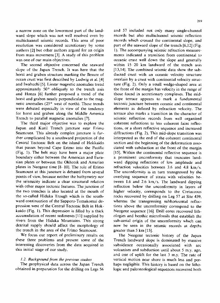
and 57 included not only many single-channel records but also multichannel seismic reflection records which crossed the continental slope, and part of the seaward slope of the trench [6,12] (Fig. 1). The accompanying seismic refraction measure- ments indicated a transition from continental to oceanic crust well down the slope and generally within 15-20 km landward of the trench axis [13,14]. The combined seismic data show the sub- ducted crust with an oceanic velocity structure overlain by a crust with continental velocity struc- ture (Fig. 2). Only a small wedge-shaped area at the front of the margin has velocity in the range of those found in accretionary complexes. The mid- slope terrace appears to mark a fundamental tectonic juncture between oceanic and continental elements as defined by refraction velocity. The terrace also marks a transition in the character of seismic reflection records from well organized coherent reflections to less coherent faint reflec- tions, or a short reflective sequence and increased diffractions (Fig. 2). This mid-slope transition was interpreted as the end of the coherent continental section and the beginning of the deformation asso- ciated with subduction at the front of the margin [15]. Within the continental reflective sequence is a prominent unconformity that truncates land- ward dipping reflections of low amplitude and refraction velocities between 3.6 and 4.8 km/s . The unconformity is in turn transgressed by the overlying sequence of strata with velocities be- tween 1.6 and 2.6 km/s . The landward dipping reflection below the unconformity in layers of higher velocity, corresponds to the Cretaceous rocks recovered by drilling on Leg 57 at Site 439, whereas the transgressing subhorizontai reflec- tions above the unconformity correspond to the Neogene sequence [16]. Drill cores recovered lith- ologies and benthic microfossils that establish the sub-aerial origin of the unconformity which can now be seen in the seismic records at depths greater than 5 km [15].
The Neogene tectonic history of the Japan Trench landward slope is dominated by massive subsidence occasionally associated with arc volcanism and subduction until about 5 m.y. ago, and one of uplift for the last 3 m.y. The rate of vertical motion near shore is much less and per- haps negligible. This history is based on the litho- logic and paleontological sequences recovered both
270
q) £E 10 Ill I-- LU
o _ J
~. 2o
30
,~ tondword slope ~< sectword stope
/ f TYPIEAL v / ~,d-slopo torroco I TOPOGRAPHIC ~ , 1 , zowe~ s~ope I PROFILE ~ ~ + REEORDED \ T ---~ ...._ ~0~p,~,~t DURING KAIKO-ERUISE ~ ~ /
VE=/+X ~ 'SechO S of OR/ zs- ~
~ : , < ~ . ~ . . . . . _ - ' - " - ~ 2 _ " - J ~ ~ - ~ . ~
moho 8.0 f , . ~ 8 . 6 ° V E -- 4 . 2 5 X
I
v
Fig. 2. Composite seismic refraction data (modified by ,,'on Huene et al. [15] after Murauchi and Ludwig [13]) and typical topographic profile corresponding to one survey line along 40 ° 07 'N.
from drill holes near shore and also near the edge of the deep-sea terrace. The temporal boundaries located by mean of the drill holes were followed in seismic records to show the seaward increase in subsidence corresponding to the increase in depth of the subaerial unconformity cutting the Creta- ceous. The subsidence was like a large flap with a quasi-stable hinge point near the present shoreline and an edge that subsided most rapidly near the trench. Subsidence resulted in the progressive sea- ward shift of the Neogene depocenter. Most of the sediments sampled was a monotonous sequence of silt and claystone of hemipelagic origin with rare inter-beds of sand turbidites. Thus it is presumed that despite Neogene subsidence, conditions of sedimentation remained much the same except near the trench where tilting and truncation of the Pliocene and Pleistocene section is shown by seismic and drilling results. A progressive mi- crofracturing of the cored sediments whose origin is thought to result from hydrofracturing as a consequence of overpressured pore fluids in- creased progressively toward the trench [15,17].
The seaward slope of the trench is composed of crust with a Cretaceous magnetic anomaly pattern that crosses the trench obliquely [18]. Honza [6] proposed a trend of the horst and graben per- pendicular to the anomalies on the basis of a series of single-channel seismic reflection records. Off Mexico and Guatemala, however, horst and graben follow the magnetic anomalies, that is to say the original spreading structure of the oceanic crust [7]. The topography conforming uniformly thick (560-650 m) sediments on the ocean crust consists of Cretaceous cherts disconformably over- lain by Eocene to Miocene pelagic clay and then a Neogene sequence of hemipelagic sediment. The 1933 Sanriku earthquake occurred on a normal fault seaward of the axis of the trench [19].
Erimo Seamount, by its position at the Japan and Kuril Trench juncture (Figs. 1 and 3), invokes suggestion of a tectonic relation between the seamount and the juncture [20]. On the other hand, the seamount could also be a passenger of the subducting oceanic plate. The range of specu- lation regarding the role of the seamount is broad

and can only be reasonably evoked after treatment of the data because the juncture area shows a complex topography not resolved by reconnais- sance survey. Nor do the seismological data pre- sent a systematic pattern of dynamic parameters except for a broad curvature in hypocentral depth contours in the upper seismic plane [21]. The sharpness of the change in trend of the subduction zone at this juncture is a feature of large propor- tion and puzzlement.
2. The Japan Trench
2.1. Landward slope morphology, Seabeam data The excellent conventional bathymetric maps
already published by Japanese institutions [22,23] was detailed by our Seabeam survey. Although many details of individual echosounder profiles suggest various tectonic features, the two-dimen- sional Seabeam maps clearly define a morphology produced by the modern Japan Trench subduction zone. The general morphological subdivisions de- veloped from seismic records and single bathymet- ric profiles are characterized in greater detail and on the landward slope of the trench: an upper slope, mid-slope terrace and lower slope are easily distinguished. The lower slope is further char- acterized by an upper part, an escarpment, and a peculiar base of slope area (Figs. 2, 3; Plate IIA, map 4; Plate liB, diagram 4).
Above the mid-slope terrace is the relatively smooth morphology of the upper slope. Its feature- less character and average 3 ° dip is consistent with the morphology in the conventional maps [22,23]. The transverse structure displays a well rounded topography rather than sharp offsets. Transverse features affect the mid-slope terrace causing an apparent constriction or a down-slope step. Other- wise only small straight rills trending directly down-dip cross the part of the slope that was included in the Seabeam survey. A notable aspect of the upper slope is the absence of a morphology that reflects tectonic features. This is in stark contrast with the disrupted morphology that dominates the regime below the mid-slope terrace.
The mid-slope terrace is a nearly continuous fea- ture across the Seabeam map at a general depth of 4400-4500 m. It is of variable width (Fig. 3; Plate
271
IIA, map 4; Plate liB, diagram 4). commonly exhibiting ponded sediments, local ridges and closed uplifts and depressions. Local constrictions by lobate masses are possibly slumps. Slumps were indicated in the core of site 440 in the ponded unit of poorly sorted clayey sand and gravel [24]. The age of the ponded sediments is Holocene to Upper Pleistocene, maximum age being 0.26 Ma. The mid-slope terrace has trapped material transported down-slope and has probably formed a resting place for local slumps. The ter- race marks a fundamental change in the mor- phology of the slope from the smooth landforms of the continental terrace to the first clearly linear elements parallel to the trench.
The adjacent terrane immediate down-slope from the terrace is the least disrupted part of the lower slope. Here the Seabeam contours trend generally north, show a 9 ° dip, and are locally deflected by shallow re-entrants and small highs (Plate IIA. map 4; Plate liB, diagram 4). Several short "canyon-like" features trend down-dip, suggesting down-slope transport of sediment. Notable is the lack of a strong structural grain in comparison with the adjacent areas.
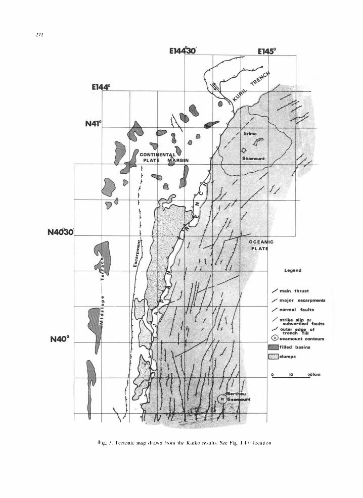
A dominant morphological features of the Seabeam map is a sinuous escarpment at about 6000 m depth that trends subparallel to the trench axis (Fig. 3; Plate IIA; map 4; Plate liB, diagram 4). The strong continuity of the escarpment is broken toward the southern part of the map and although clearly defined in four of the five multi- channel seismic records crossing the slope, the principal record used to locate DSDP site, JNOC 1, is located on one of the gap (Fig. 1). The scarp has a remarkably uniform width of about 2 km, an average slope of 20 ° and a length of about 120 km. Locally it is 1 km high.
Between the scarp and the trench axis is an area of generally disorganized topography (Plate I1A, map 4; Plate liB, diagram 4). Closed depres- sions, hills and lobate bodies suggest slumps. A locally strong but discontinuous linear topography is developed near the trench axis and parallels it; a steep front commonly bounds the axis. This mor- phology is about 10 km wide in the south of the surveyed area and 38 km at its widest part in the north (Fig. 3) as the escarpment and trench axis diverge northward.
272
E I ~ °
E ~
N 4 1 o
'1~ I a p - _ j. CONTINENT L~
_ l PLATE ~ R G N
, /
N 4 0 °
' i ~ i ? & •
f ,U mm
/ /
Legend
J main thrust
7" major escarpments
/ 7 normal faults
J strike slip or subverbcal faults
seamount contours
U f i l l e d basins
~ s l u m p s
0 10 20kin
Fig. 3. Tectonic map dra~n from the Kaiko results. See Fig. 1 for Zocation.

The trench axis trends increasingly east of north toward Erimo Seamount (Fig. 3); its juncture with the slope is sinuous on the scale of about 5 km. Ellipsoidal closed depressions, rarely more than 3 km wide, are commonly separated by 5-20 km narrow stretches along the trench floor. A profile of depth along the axis shows a variability in depth of about 150 m and a general southward deepening of 600 m in about 3.5 ° latitude.
2.2. Landward slope geophysical data Magnetic anomalies (Fig. 4) observed onboard
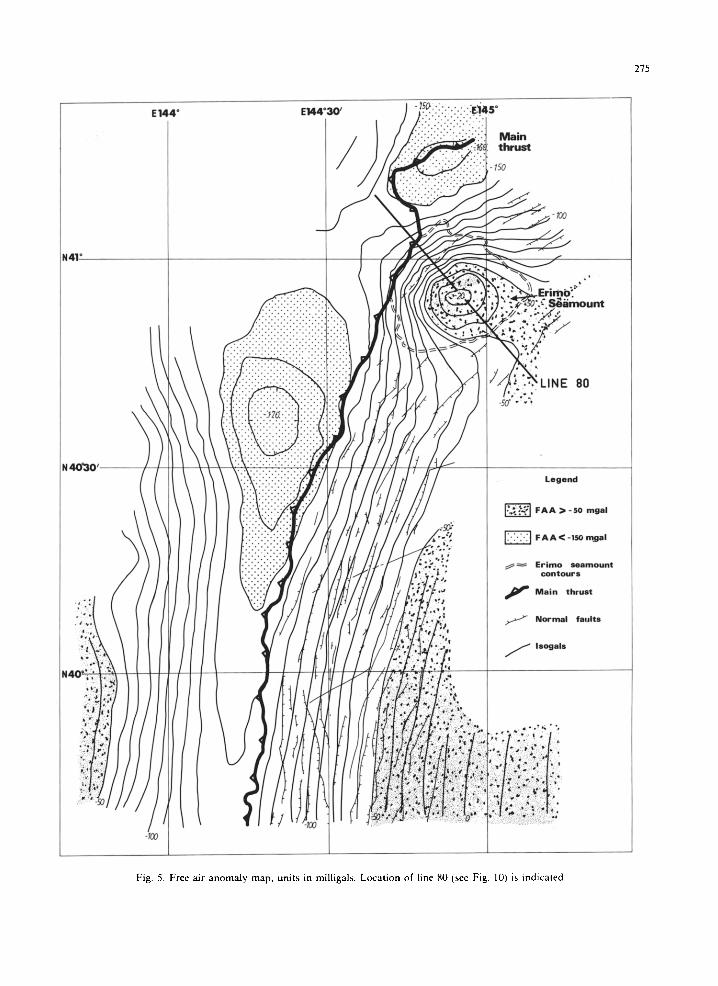
confirm the pattern reported previously [15,25] and show in detail the N70°E trending magnetic anomalies M8, M9 and M10 of Cretaceous age. The age of the anomalies increases southward paralleling the increasing depth of the ocean floor and trench axis. No lateral displacement along the trench, inferred by Hilde et al. [18,26], is observed in the present survey. The anomalies extend land- ward of the trench axis and decrease in amplitude as reported previously [27] (Fig. 4). Gravity free air anomalies show a north-south trending trough just landward of the trench axis (Fig. 5). The deepest negative anomaly at the northern end of the Japan Trench does not correspond to a topo- graphic feature and probably indicates crustal de- pression.
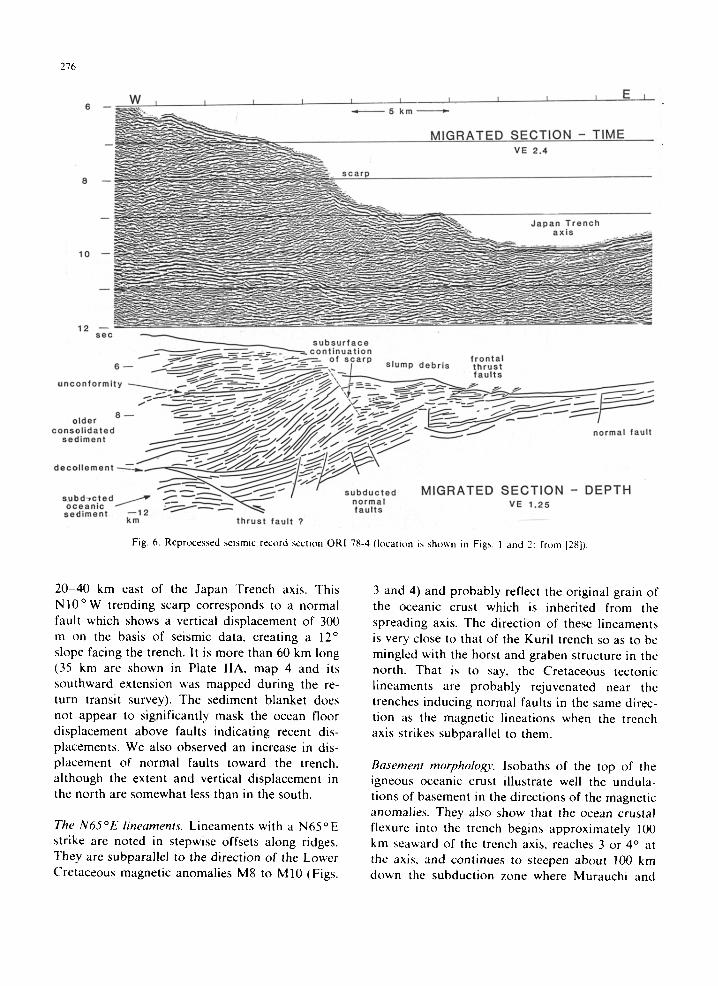
All but one of the 5 multichannel seismic rec- ords previously reported in this area [3,12,28] dis- play the morphological elements detailed by Seabeam. The sequence of eroded Cretaceous rocks covered by Neogene slope sediments is disrupted at the mid-slope terrace by structure not clearly resolved in the best processed seismic records. Generally few coherent reflections are resolved from the mid-slope terrace to the trench axis, but a recently reprocessed diplay of ORI 78-4 [3] shows the structural configuration at the front of the subduction zone [28]. A line drawing of the seismic reflection record section (Fig. 6) shows the escarpment to be a slump scar about 1 km high truncating a nearly horizontal reflective sequence. This reflective sequence is a part of coherent block that comprises the lower landward slope of the trench. In front of the escarpment is a thick pile of sub-horizontal short reflections. The structure of this pile is not that of the landward dipping reflec- tions in an accretionary complex except at the steep slope immediately adjacent to the trench
273
axis. The association of the pile. with the scarp suggests that it consists of reworked slump debris now being deformed at the trench axis. In support of this interpretation is the lack of thick sediment ponded in the trench axis to serve as material for accretion.
At the base of the stratified sequences is a section of subducting sediment which is not dis- rupted from the seaward slope of the trench for about 40 km down the subduction zone. The continuity of the subducted oceanic sequence at the front of the margin indicates relatively low friction along the subduction zone. From the mid-slope terrace to the trench is an aseismic zone based on observations using a local network of ocean bottom seismometers [29,30]. This suggests decoupling of the upper and lower plates in the front of the subductioaa zone consistent with the low compressive stress suggested by the massive failure of the lower slope [31].
2.3. Seaward slope morphology and geophysics The oceanic plate was surveyed from the trench
to 50 km eastward; in addition, four longer lines (two bands, 8 km wide for each, between 39°40 and 39°50 of latitude) were surveyed 110 km seaward of the trench axis in order to precisely define the bending of the oceanic plate prior to subduction beneath the continental plate.
The horst and graben structure. Faults were first defined in single-channel seismic records recorded simultaneously with the Seabeam data. These faults were first plotted on topographic profiles (given by the vertical beam) and subsequently on the Seabeam map where they corresponded to well defined scarps (Fig. 7). Shipboard maps indicated an organized horst and graben structure and an increase in the number of landward facing normal faults toward the trench. Normal faults first occur at the bulge which is well developed off the Japan Trench [32]. No faults with large vertical offset were recognized, during our survey in the ocean basin, more than 50 km seaward of the trench axis. They are subparallel to the Japan and Kuril Trench axes respectively, and trend N 1 0 ° E (plus or minus 20 o ) in the south, to N60 o E ( _+ 10 o ) in the north, with an intermediate zone south of the Erimo Seamount (Fig. 3). The most prominent scarp is located south of 40 ° in latitude and

274
• N 4 1 °
E i 4 4 " E 1 4 4 ° 3 0 ' : : i i
I
~ . E 1 4 5 "
M a i n ,,,-,,-,5~ eh,~u,~
~---- LINE~ r i m o S e a m o u n t I
~777.~.2,j52.52,2, 2 5 ? 5 2 52"552.?52 :::::::::::::::::::::::::::::::::::::::::::::::: I + 2 + . • ' . . - • 2'2 ~';•;.'.
. I 0 0
N ~ 3 0 ' - - - -
M 8 "
i::i::i:iiiiii::ii
. • • . . . . • • • .
• • . • . . . • . • .
.5~'2"
Legemd
~ Negative values
~ Er~mo seamount ~- col3tours
6~lmlP Main thrust
J Normal faults
f Isogammes
N 4 0 ° . . . . .
3 0 0
..?.' ~0
I:ig. 4. Total magnelic field isoanomaly map, u~it.s in nanole~,las. I.ocalion of line B, referred to in section 3..-1. i~, indicalcd.
275
E144" E ~ ' 3 0 ' ;-'.~.:.'~EI45"
N41"
.:.-.: LINE
t
t
B0
I. o,
', J ~ r a ~
\
Legend
~ FAA > - 5 0 mgal
~ F A A < -IS0 n~al
, ;
~+ Erimo seamount contours
f Main thrust
/ Normal faults
f Isogals
• .+, ++ + ~ °
. . . % • ++.
" I ,
Fig. 5. Free air anomaly map, units in milligals. Location of line 80 (see Fig. 10) is indicated.
276
6 - W , 1 , , . . . . . . . ., , ~ , E _ _ _ L
~ • - - ~ . - - . _ _ . . . . M I G R A T E D S E C T I O N - T I M E - - ~ - - VE 2 .4
8 -- scar.p. . . . . . . . . . . . . . . . . . . .
. O a ° , r e n o . . ~ ; " a x i s . -
1 0 " - " - " '-~"~
12 s-e-c
s u b s u r f a c e / ~ ~ -~- . .=- ; - -~ '~- ' - -~ c o n t i n u a t i o n
""-"-"-"-"-'J~;'*" ~ - - ~ - - - ~ " - ~ - _ - - ~ - ' - - - - - of sca rp . f r o n t a l 6 - - ~ , ~ - / ~ ~ - - - ~ - - - - " - / S lump d e b r i s t h r u s t
~ " - - - - - ~ V . - ~ . , * ~ ~ f a u l t s
"Usi~liimUe<lntUU ~ / J ~ / / / ~ / / ~ " ~ ~ / " ~ / - n o r m a l f a u l t
oeco l i emen l ---~_~. - - - " r i - i i ~ / ' S i ~ _ l ~ ,
s u b d , c t e d , . - ~ ~ ~ _ _ ~ " / ' d I G R A T E D S E C T I O N - D E P T H
s e d i m e n t - - 1 2 ~ ~ ~ f a u l t s • km t h r u s t f a u l t ?
Fig. 6. Reprocessed seismic record section ORI 78-4 (location is shown in Figs. 1 and 2: from [28]).
20-40 km east of the Japan "French axis. This N I 0 ° W trending scarp corresponds to a normal fault which shows a vertical displacement of 300 m on the basis of seismic data, creating a 12 ° slope facing the trench. It is more than 60 km long (35 km are shown in Plate IIA, map 4 and its southward extension was mapped during the re- turn transit survey). The sediment blanket does not appear to significantly mask the ocean floor displacement above faults indicating recent dis- placements. We also observed an increase in dis- placement of normal faults toward the trench, although the extent and vertical displacement in the north are somewhat less than in the south.
The N65°E lineaments. Lineaments with a N65°E strike are noted in stepwise offsets along ridges. They are subparallel to the direction of the Lower Cretaceous magnetic anomalies M8 to M10 (Figs.
3 and 4) and probably reflect the original grain of the oceanic crust which is inherited from the spreading axis. The direction of these lineaments is very close to that of the Kuril trench so as to be mingled with the horst and graben structure in the north. That is to say, the Cretaceous tectonic lineaments are probably rejuvenated near the trenches inducing normal faults in the same direc- tion as the magnetic lineations when the trench axis strikes subparallel to them.
Basement morpholoyo,, lsobaths of the top of the igneous oceanic crust illustrate well the undula- tions of basement in the directions of the magnetic anomalies. They also show that the ocean crustal flexure into the trench begins approximately 100 km seaward of the trench axis, reaches 3 or 4 ° at the axis, and continues to steepen about 100 km down the subduction zone where Murauchi and

277
KAIKO_ LEG 3 1984 VERTICAL E X A G E R A T I O N -~ d.
100 k m
KURIL TRENCH ERIMO SEAMOUNT
- - L ~. . . . . . . .- . - .., .... / ~~
3APAN TRENCH
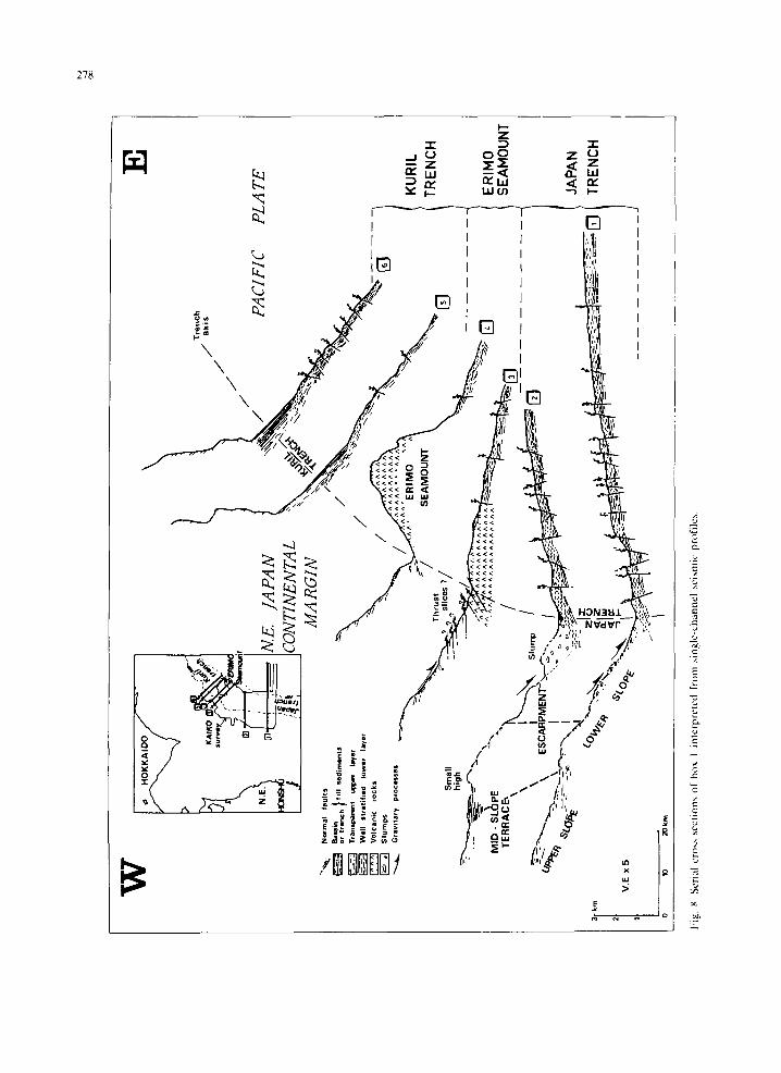
Fig. 7. Perspective diagrams of the surveyed area drawn using the Seabeam map and the seismic profiles.
Ludwig [13] showed a 8 -9 ° angle (Fig. 2). In detail, the average dip of the oceanic crust is 1.5 ° 30 -40 km seaward of the trench axis and varies from 3 ° in the south to 5 ° in the northern Japan Trench axis due to the presence of the Erimo Seamount on the ocean crust. That is to say, the flanks of the seamount, which are steeper than the oceanic crust slope, can be followed under the landward slope.
Sedimentary cooer. The top of the Cretaceous chert layer is well defined on the single channel seismic profiles, but it is quite impossible to distinguish the top of the oceanic igneous crust even in well processed multichannel seismic data. The upper
layer consists of dia tom mud and the lower one is made with biogenic oozes and clay [33]. The aver- age thickness of both layers is about 600 m and the variations are mainly associated with the horst and graben morphology. That is to say, some erosion of the upper layer occurs above the horsts and the eroded material fills grabens. The thick- ness of trench fill sediment is generally less than 300-400 m in the elongated axial basins, but it reaches 600-800 m in the Kuril Trench axis where considerably more sediment is ponded (Fig. 8).
Magnetism and grauity. The map of the magnetic total field isoanomalies (Fig. 4) shows a very clear W S W - E N E trend. The peak to peak ampli tude is
OC
W
> ,~
r-
J]
....
'~
"1
h
"~
/ ~1
..
f /
w~
N.E
. JA
PA
N
PA
CIF
IC
--.~
..
.m.,
,.
o.,.
>%\
I~^^
1 V
oJca
ni¢
,ock
s ~
--
~ "~
--"~
/~
.~--
~.--
---
MID
- S
LOP
E
-"x
."
',
[]
L20
TE
RR
AC
6 ~
/
' i'-
---,\
"
0',~
.."":
"~'
~--,
. \
ES
CA
RP
ME
N'F
'_,x
:--~=
.. O
.~
t/
'~
~-
~
"*t~
e-
-_~
~
I "'
,2 °
"~
~-
"~
'~
'
~-
~
--_~
~ ~
, I
.°
~~
'
Co,
. ~
. \
- -z
lo =
- .,'
~
,' .
..
..
..
..
..
;
.-.~
S
PL
AT
E
KU
RIL
TR
EN
CH
ER
INO
SE
AN
OU
NT
JAPA
N
TREN
CH
l'ig.
g.
Ser
ial
cros
s se
ctio
ns o
f bo
x 1
inte
rpre
ted
fron
l .,,
ingl
e-ch
anne
l ~,
eism
ic p
rofi
les.

279
about 700 nT. Magnetic lineations M8 to M10 (about 130 Ma), caused by normal and reversed polarity successions recorded in the remanent magnetization of the Pacific plate, are recognized. The plate being younger northward. No lateral displacements along transform faults appear in the surveyed area. The general trend of gravity anomalies well conforms to the classical model of free air anomalies over an oceanic subduction zone: values near 0 on the oceanic lithosphere and a minimum of - 139 mgal (in the south) to - 175 mgal (in the north) shifting landward of the trench axis (from 4 km in the south to 19 km in the north). As in the Daiichi Kashima area (see Kobayashi et al. [43]), the absolute values of grav- ity observed are lower than predicted for a 130 Ma old subducting oceanic lithosphere [34]. On the oceanic side the isoanomaly curves follow the same eastward curvature as the isobaths, whereas their orientation is approximately north-south on the landward slope. We interpret this observation in the following way: as the trend of the flow-line of the Pacific plate diverges eastward away from a north-south line of reference, its geometrical junc- tion with the Eurasian plate deepens. This deepen- ing can be observed on free-air anomaly minimum trend (Fig. 5), but not on trench axis depth which follows the oceanic isobaths.
3. Trench juncture, Erimo area
Japan Trench. It is bounded to the southwest by a very steep scarp perpendicular to the direction of the trenches suggesting that the structure of the continental margin is here cut by a steep NW-SE fault (Figs. 3 and 7, plate IIA, map 4).
Landward slope. The morphological pattern of the landward slope changes abruptly at 40°40 'N. South of this latitude the north-south structural trend characteristic of the Japan trench landward slope is still clearly observed; north of this latitude the north-south trend disappears giving way to a complex morphology without any prominent di- rections. Generally, the mid-slope terrace which was so obvious in the south is absent here. Numerous erosional features are observed in the Seabeam map such as canyon running on the slope, or well rounded depressions. The disap- pearance of the Japan Trench character occurs at the mouth of the Hidaka Trough which supplies detrital material from the nearby Hidaka Moun- tains. It is thus likely that the structural trends of the Japan Trench are hidden below detrital material. This complex morphology ends abruptly northeastward against the NW-SE fault scarp. Only a small part of the Kuril Trench landward slope has been mapped and the topography re- veals a very steep scarp parallel to the trench as it was earlier emphasized by Savostin et al. [35] based on single-channel seismic profiling.
3.1. Morphologr', Seabeam data The Seabeam map at the junction of the two
trenches shows drastic morphological differences. We describe successively the trench axis, the land- ward slope and seaward slope.
Trench axis. Southwest of the Erimo Seamount the trench is characterized by a sequence of small elongated basins in a zig-zag pattern, in which the trend of the faults parallel to the Japan Trench and the trend of the faults parallel to the oceanic magnetic anomalies alternate (Fig. 3). Basins nar- row and disappear when approaching the seamount, being squeezed between the seamount and the landward slope. There the trench is re- stricted to a pass only 6250 m deep. Northeast of the seamount the trench suddenly widens into a very large and flat-floored basin (7100 m deep) strongly contrasting with narrow basins of the
Seaward slope. The Erimo Seamount occupies a large area of the seaward slope. Although no large faults were directly observed affecting the seamount as for the Daiichi Kashima Seamount, they may exist but they are less developed than in the Kashima area. Around the seamount the oc- eanic crust is dissected by normal faults which display two main directions. South of the seamount the transition from faults parallel to the Japan Trench to those parallel to the Kuril Trench is observed. In the transition area, fault scarps with zig-zag pattern control the outline of the trench basins.
3. 2. Seismic data Closely spaced single-channel reflection pro-
files records were good on the seaward slope and in the trench (Fig. 8). Normal faults which corre- spond to scarps on the Seabeam map clearly offset

280
the sedimentary sequence. When approaching the seamount, the thickness of the upper sedimentary sequence decreases and finally disappears on the seamount. The Kuril Trench is filled by an ac- cumulation of highly reflective well stratified sedi- ments, probably turbidites, resting unconformably on the oceanic deposits. The thickness of the sediments is 0.5 s (two-way travel time) or 500 m assuming a velocity of 2 k m / s for the sediments.
3.3. Magnetic data Fig. 4 shows the anomalies of the total geomag-
netic field around the Erimo Seamount. As in the southern part, oceanic anomalies
striking N 7 0 ° E pass below the landward slope. The magnetic signature of the Erimo Seamount consists of a pair of anomaly centers superim- posed on the oceanic anomalies. The positive center lies on the positive anomalies M8 (120 Ma) and the negative center lies on the negative anomaly north of M8. This observation suggests that the Erimo Seamount and the oceanic plate have the same magnetization. This is an indication that the Erimo Seamount would have been em- placed close to the spreading center. Another pair of anomaly centers is observed at the corner be- tween both trenches suggesting the presence of an already subducted seamount, as confirmed by seismic records.
The three components of the magnetization of the Erimo Seamount and a planar regional field have been computed by inversion of the measured magnetic anomalies. The tested model which best fits the observed anomalies involves an identical magnetization for the seamount and the support- ing plate and a non-magnetic cap on the top of the Erimo Seamount (Fig. 9). This non-magnetic cap is due to the presence of a coral reef. The depth of its base corresponds to the topographic bench around 4600 m. The declination, inclination and intensity of the magnetization are - 1 6 °, 32 ° and 1.1 × 10 -2 e m u / c m 3, respectively. The calcu- lated position of VGP, 63°N, 50°W agrees with an age of 120 Ma on the Pacific apparent wander path [37,38] (Fig. 10). The northern anomalies can be well explained by another seamount with nearly the same magnetization as Erimo Seamount, which was already subducted at the trench: its summit would now be at the corner of the convergent front north of the Erimo Seamount.
(O) Calculated / /
4 1 ° 0 0 '-
40040 ,. ~ "~o 144°40 ' 5'0' 145~00 ' 1'0'
(cJ Depth(m)
4 0 0 0 "
5 0 0 0 "
6 0 0 0
7 0 0 0 .
Fig. 9. (a) Computed magnetic anomalies created by the model of Erimo Seamount (magnetization: declination is - 1 6 °, in- clination is 32 ° and intensity is 1.1 ×10 -2 emu/cm3) . (b) Residual anomalies. (c) Model.
3.4. Gravity data The free air anomaly (FAA) map is shown in
Fig. 5. The minimum associated with the trench is largely shifted (20 km) landward of the trench axis. This is due to a large sedimentary infilling of the trench in the junction area. As expected, the

A
281
- 7 0
. . . . . . . . . . . . . . .
\'\\ ,\
\ \
~ .30 °~
Fig. 10. Location of VGP of Erimo Seamount (63°N, 50°W) on the Pacific apparent polar wander path. The solid curve is the apparent polar wander path of Cox and Gordon [38]: the dotted line is that Sager (1983) and the dashed line, that of Gordon (1983) (from Sager and Keating [37]). The 95% confidence regions surrounding the mean paleomagnetic poles are shown as ellipses, and the numbers within the ellipses arc the mean ages of the poles in Ma. Map projcction is polar equal area.
gravi ty anomaly of the Er imo Seamount is closely corre la ted with its topography . Isogals give an ind ica t ion of the seamount morpho logy in the area where the seamount is a l ready under the sed iments of the inner slope.
Grav i ty anomal ies have been in te rpre ted in o rde r to de te rmine the emplacemen t age of the seamount [39]. Once it has been formed, a seamount acts as a load on an elast ic plate. The de fo rma t ion of the pla te is cont ro l led by its elast ic thickness Te at the t ime of load ing [40]. It has been shown that the elast ic thickness is related to the age of the l i thosphere [40].
Theore t ica l gravi ty anomal ies created by the t opog raphy of the seamount and the flexure of the l i thosphere have been c o m p u t e d using a three-di- mens ional method. Fig. 11 d isp lays the c o m p u t e d anomal ies a long line 80 for di f ferent values of To. Observed gravi ty from which a regional field (line B in Fig. 4) due to the subduc t ion zone has been removed is also shown in Fig. 11. The best fit is ob ta ined for an elastic thickness of 2 km. This
impl ies that the Er imo Seamount has been em- p laced on a l i thosphere whose age was between 0 and 3 Ma. Therefore it appears that the Er imo Seamoun t has been formed close to the spreading center.
Results of K / A r da t a t ion give an age about 90 Ma [36] which is in appa ren t con t rac t ion with our p roposed age of 120 Ma. But some ambigui t ies in the values of this da t a t ion remain due to the excess argon and pos t -magmat i c ox ida t ion effects. Thus this da t a t ion would be a lower value for this age.
3.5. Discussion on the junction The Seabeam topography shows clearly, first a
N W - S E lef t- la teral offset ( t ransform fault?) by abou t 20 km of the convergent front in the Kuri l Trench relat ive to the Japan Trench. Second, the t rench axis t rends N 2 5 ° E south of the previous tectonic b o u n d a r y and N 5 5 ° E nor th of it. Third , the Er imo Seamount is located immedia te ly south of this tectonic bounda ry , but an a l ready sub-

282
Mgal
100
50
0
FREE-AIR ANOMALY NW SE
Te : 20 km Te : 10 km
Trench axis[ / / / ~ / ~ ----- Te : 3 k i n / - - ......... Te : 5 krn
/ / / / ~ x ' ~ " Y ~ Te: 2krn - - Te : 0 km
effect i ~
L I N E 80 * Observed G r a v i l y Anomaly
Fig. 11. Computed gravity anomalies created bv the topograph?, and the flexure of the lithosphere for different values of the elastic thickness (7[.). compared with the observed anomalies. The location of line 80 is shown in Fig. 5.
ducted seamount (less important than Erimo) is observed (on the basis of magnetic anomalies and seismic profiles) at the upper corner of the trench juncture. Are these results sufficient to say that the sharp curvature of the trench axes is due to the collision of a possible chain of seamounts pre- ceding Erimo Seamount, according to the theory of Vogt et al. [20]?
Keeping in mind that our survey includes only the frontal zone of the continental plate and also only the southernmost part of the Kuril Trench, it seems very difficult to clarify this problem without taking into account the adjacent areas, especially northward and eastward of the present survey.
It seems that the oceanic plate is not concerned by this curvature, because the normal faults are parallel to both trenches with an intermediate zone south of the Erimo Seamount, where we can observe simultaneously both directions: N10°E and N60°E. Furthermore, if the collision is active now, it has to be confirmed by the seismicity in this area.
Anothcr possibility is to relate the "transform fault" to a failure line of a present boundary between the Japanese microplate and the Okhotsk plate [41], but there is no evidence of in- tracontinental seismic activity in the assumed boundary zone (between Erimo Cape and Erimo Seamount). Concerning the curvature of trenches near Erimo Seamount, it may be due to a different tectonic behaviour of plates on either side of the
Ncogene plate boundary between America and Eurasia [8].
4. Summa~ ~ and conclusions
The detailed survey made by the R / V "Jean Charcot" in the Japan Trench and its junction with the Kuril Trench during the French-Japanese Kaiko project (northern part of Leg 3) brings numerous new insights on one of the best known trenches, especially about the interactions between the continental margin and the oceanic crust.
(1) Sediment sliding in the trench: Mass sliding occurs on the landward slope of the trench, fills the axial zone of the trench and reduces it to a succession of short and narrow basins which are offset on the oceanic side by faults trending ob- liquely to the trench axis. Thus the topographic Japan Trench is only the frontal boundary of the sedimentary gravity sliding. These slide deposits are then probably subducted together with oceanic crust and its cover.
The Japan Trench could be a model for tectonic erosion linked with subduction: the continental slope is being destroyed by superficial collapse and the resulting material may ultimately be car- ried down the subduction zone. The continental plate has thus retreated. In addition, it is likely that erosion of the continental margin from below by the subducting oceanic plate occurs [42].
(2) Newly created faults and reactivated faults
on the oceanic side: T h e o c e a n i c c r u s t is cu t i n t o
h o r s t a n d g r a b e n w i t h n o r m a l f au l t s pa r a l l e l to t h e
t r e n c h . S o m e o f t he f a u l t s a re a s s o c i a t e d to l i n e a -
m e n t s c o r r e s p o n d i n g to t he o r i g i n a l s t r u c t u r a l
t r e n d o f t he o c e a n i c p l a t e b e c a u s e they pa ra l l e l t he
m a g n e t i c a n o m a l i e s o b l i q u e to t he t r e n c h . W h e r e
t he o c e a n i c p l a t e s t r u c t u r a l t r e n d is h i g h l y o b l i q u e
to the axis o f f lexure , the n o r m a l f au l t s b r e a k
a c r o s s the s t r u c t u r a l g r a i n of t he o c e a n i c p l a t e a n d
t h e o l d e r f au l t se t r e m a i n s c ryp t i c . S u c h f au l t s
s e e m to h a v e l o n g b e e n t r u n c a t e d a n d b u r i e d
b e n e a t h t he o c e a n i c s e d i m e n t s a n d t h e n we re re-
j u v e n a t e d w h e n t he o c e a n i c c r u s t u n d e r w e n t l a rge
t e c t o n i c s t r e s s d u e to the b e n d i n g of t he p l a t e a t
t he s u b d u c t i o n zone .
(3) Trench junction: A t t he t r a n s i t i o n w i t h Kur i l
T r e n c h , a l e f t - l a t e r a l t r a n s f o r m fau l t o f f se t s the
c o n t i n e n t a l s lope a n d l eads to a w ide f la t p l a i n in
t he axia l z o n e s t r o n g l y c o n t r a s t i n g w i t h t he s m a l l
b a s i n s of t he n o r t h e r n J a p a n T r e n c h . T h e E r i m o
S e a m o u n t , l o c a t e d s l igh t ly s o u t h o f the j u n c t i o n ,
m a y b e l o n g to a c h a i n , a l r e a d y s u b d u c t e d , re-
s p o n s i b l e to the t r e n c h c u r v a t u r e b y co l l i s ion . T h i s
t r e n c h t r a n s i t i o n m a y a l so b e r e l a t e d to the in-
t r a c o n t i n e n t a l b o u n d a r y b e t w e e n A m e r i c a a n d
E u r a s i a p la tes . N e v e r t h e l e s s , n o d e f i n i t i v e c o n c l u -
s i on c a n b e g i v e n a t p r e s e n t w i t h o u t a d e e p e r
s t u d y o f foca l m e c h a n i s m s of e a r t h q u a k e s in th i s
a r e a a n d n o r t h of it.
A c k n o w l e d g e m e n t s
T h a n k s a re d u e to t he C a p t a i n , A l a i n G i r a r d ,
a n d to t he c r ew of the R / V " J e a n C h a r c o t " for
t h e i r s u p p o r t . W e a l so t h a n k the r e v i e w e r s for
t h e i r t h o u g h t f u l c o m m e n t s . T h e f igures we re p re -
p a r e d b y A n n i e B o u r d e a u a n d J a c q u e s Brou i l l e t .
References
1 J.P. Cadet, K. Kobayashi, J. Aubouin, J. Boul~gue, J. Dubois, R. yon Huene, L. Jolivet, T. Kanazawa, J. Kasahara, K. Koizumi, S. Lallemand, Y. Nakamura, G. Pautot, K. Suyehiro, S. Tani, H. Tokuyama and T. Yamazaki, De la fosse du Japon b. la fosse des Kouriles: premiers rrsultats de la campagne oc~anographique franco-japonaise Ka'iko (Leg III), C.R. Acad. Sci. Paris, S~r. II 301,287-296, 1985.
2 E. Honza, Subduction and accretion in the Japan trench, 26th Int. Geol. Congr. 7-17 July, 1980, Paris; Oceanol. Acta, Spec. Issue, 4, 251-258, 1981.
3 N. Nasu, R. von Huene, Y. Ishiwada, M. Langseth, T. Bruns and E. Hortza, Interpretation of multichannel seismic
283
reflection data, Legs 56 and 57, Japan Trench transect, DSDP, in: Initial Reports of the DSDP, 56-57, Part 1, pp. 489-504, U.S. Government Printing Office, Washington, D.C., 1980.
4 W.G. Ludwig, J.l. Ewing, M. Ewing, S. Murauchi, N. Den, S. Asano, H. Hotta, M. Hayakawa, T. Asanuma, K. Ichikawa and I. Noguchi, Sediments and structure of the Japan trench, J. Geophys. Res. 71, 2121-2137, 1966.
5 Y. Iwabuchi, Topography of trenches east of the Japanese islands, J. Geol. Soc. Jpn. 74, 37-46, 1968 (in Japanese with English abstract).
6 E. Honza, Pre-site survey of the Japan trench transect, DSDP, in: Initial Reports of the DSDP, Legs 56-57, Part 1, pp. 449-458, U.S. Government Printing Office, Washing- ton, D.C., 1980.
7 J. Aubouin, R. von Huene et al., A summary of DSDP Leg 67, Shipboard results from the mid-America Trench tran- sect off Guatemala, 26th Int. Geol. Congr., 7-17 July 1980, Paris, Oceanol. Acta, Spec. Issue 4, 225-232, 1981.
8 M.E. Chapman and S.C. Solomon, North American-Eura- sian plate boundary in northeast Asia, J. Geophys. Res. 81, 921-930, 1976.
9 G. KJmura and K. Tamaki, Collision, rotation and back-arc spreading: the case of the Okhotsk and Japan Seas, Tecton- ics 5, 389-401, 1986.
10 L. Jolivet and J.P. Cadet, Mouvements d~crochants, structuration et limite de plaques dans rile d'Hokkaido (Japon septentrional), Ann. Soc. Grol. Nord CIII, 345-352, 1984.
11 Y. Ishiwada, Petroleum geology of the continental terraces surrounding the Japanese islands, J. Jpn. Pet. Inst. 18, 460-465, 1975 (in Japanese).
12 N. Nasu, Y. Tomoda, K. Kobayashi, H. Kagami, S. Uyeda, S. Nagumo, I. Kushiro, M. Ozima, K. Nakamura, H. Okada, S. Murauchi, Y. Ishiwada and Y. Ishii, Multichannel seismic reflection data across the Japan Trench, Ocean Res. Inst., Univ. Tokyo, IPOD Basic Data Ser. 3, 22 pp., 1979.
13 S. Murauchi and W.J. Ludwig, Crustal structure of the Japan trench: the effect of subduction of the ocean crust, in: Initial Reports of the DSDP, Legs 56-57. Part 1, pp. 463-470, U.S. Government Printing Office, Washington, D.C., 1980.
14 S. Nagumo, J. Kasahara and S. Koresawa, OBS airgun seismic refraction survey near sites 441 and 434 (J-IA), 438 and 439 0-12), and proposed site J-2B; Legs 56 and 57, DSDP, in: Initial Reports of the DSDP, Legs 56-57, Part 1, pp. 459-462, U.S. Government Printing Office, Washing- ton, D.C., 1980.
15 R. von Huene, M. l.angseth, N. Nasu and H. Okada, A summary of Cenozoic tectonic history along the IPOD Japan trench transect, Geol. Soc. Am. Bull. 93, 829-846, 1982.
16 Shipboard Scientific Party, Sites 438 and 439, Japan deep sea terrace, Leg 57, in: Initial Reports of the DSDP, Legs 56-57, Part 1, pp. 23-191, U.S. Government Printing Office, Washington, D.C., 1980.
17 B. Carson. R. von Huene and M. Arthur, Small-scale deformation structures and physical properties related to convergence in Japan trench slope sediments, Tectonics 1, 277-302, 1982.

284
18 T. Hilde, N. Isezaki and J.M. Wageman, Mesozoic seafloor spreading in the North Pacific, in: The Geophysics of the Pacific Ocean Basin and Its Margins, Am. Geophys. Union. Geophys. Monogr. 19, 205-226. 1976.
19 H. Kanamori, Seismological evidences for a lithospheric normal faulting, the Sanriku earthquake of 1933, Phys. Earth Planet. Inter. 4, 289-300, 1971.
20 P.R. Vogt, A. l,owrie, D.R. Bracey and R.N. Hey, Subduc- tion of aseismic oceanic ridges: effects on shape, seismicity and other characteristics of consuming plate boundaries, Geol. Soc. Am.. Spec. Pap. 172, 59 pp., 1976.
21 A. Hasegawa, N. Umino, A. Takagi, S. Suzuki, Y. Motoya. S. Kameya, K. Tanaka and Y. Sawada, Spatial distribution of earthquakes beneath Hokkaido and northern Honshu. Japan, Jishin 36. 129-150, 1983 (in Japanese with English abstract).
22 Hydrographic Department, Bathymetric Chart of I'iok- kaido, No. 6311, scale 1/1,()00,000, 1980.
23 Hydrographic Department, Bathymetric Chart of North- east Nippon. No. 6312, scale 1/1,000,000, 198(I.
24 Shipboard Scientific Party, Site 440: Japan Trench mid- slope terrace, I,eg 57, in: Initial Reports of the DSDP, Legs 56-57, Part 1, pp. 225-317, U.S. Government Printing Office, Washington, D.C., 1980.
25 X. Golovchenko, R. I,arson, W.S. Pitman Ill and N. Isezak, Plate-tectonic map of the cireum-Pacific region, Pacific Basin sheet, American Association of Petroleum Geolo- gists, 1982.
26 T.W.C. Hilde, S. Uyeda and L. Kroenke, Evolution of the western Pacific and its margin, Tectonopbysics 38, 145-168, 1977.
27 S. Oshima, T. Kondo. T. Tsukamoto and K. Onodera. Magnetic anomalies at sea around the northern part of Japan. Rep. Hydrogr. Res. 10, 39-44, 1975.
28 R. ','on Huene, To accrete or not accrete, theft is the question, Geol. Rundsch. 75, 1-15. 1986..
29 J. Kasahara, S. Nagumo, S. Koresawa and Y. Nishii, A linear trend of hypocenter distribution in the outer slope region of the Japan trench revealed by OBS array- pre- liminao' report. Bull. Earthq. Res. Inst., Univ. Tokyo 57, 83-104, 1982.
30 N. Hirata, T. Kanazawa, K. Suyehiro and H. Shimamura. A seismic gap beneath the inner wall of the Japan trench as derived by ocean bot tom seismograph measurement, Tectonophysics 112, 193-210, 1985.
31 K. Nakamura, An interpretation of current crustal defor- mations around the Suruga Bay, Japan, Zisin (J. Seismol. Soc. Jpn.) 34. 272..274, 1981 (in Japanese).
32 A.B. Watts and M. Talwani, Gravity anomalies seaward of the deep-sea trenches and their tectonic implications, Get)- phys. J. R. Astron. Soc. 36, 57-90, 1974.
33 Shipboard Scientific Party, Site 436, Japan Trench outer rise, Leg 56, in: Initial Reports of the DSDP. Legs 56-57, Part 1, pp. 399-446, U.S. Government Printing Office. Washington, D.C., 1980.
34 B. Parsons and J.G. Sclater, An analysis of the variation of ocean floor ba thyme t~ and heat-flow with age, J. Geophys. Res. 82, 803-827, 1977.
35 I,. Savostin, L. Zonenshain and B. Baranov, Geology and plate tectonics of the Sea of Okhotsk, in: Geodynamics of the Western Pacific-lndonesian region, T.W.C. Hilde and S. Uyeda, eds., Am. Geophys. Union, Geodvn. Ser. 11, 189-221. 1983.
36 M. Ozima. I. Kaneoka and S. Aramaki, K-At ages of submarine basalts dredged from seamounts in the western Pacific area and discussion of ocean crust, Earth Planet. Sci. Lett. 8, 237-249, 1970.
37 W.W. Sager and B.H. Keating, Paleomagnetism of Line islands seamounts: evidence for late Cretaceous and early TertiaD' volcanism, J. Geophys. Res. 89, 11135-11151, 1984.
38 A. Cox and R.G. Gordon, Paleolatitudes determined from paleomagnetic data from vertical cores, Rev. Geophys. Space Phys. 22. 47-72, 1984.
39 M. Diament and J. Goslin, Emplacement of the Marion Dufresne, Lena and Ob seamounts (South Indian ocean) from a study of isostasy, Tectonophysics 122, in press, 1986.
40 J.H. Bodine. M.S. Steckler and A.W. Watts, Observ~Jtion of the flexure and the theology of the oceanic lithosphere, J. Geophys. Res. 86 (B5), 3695-3707, 1981.
41 T. Seno, Is Northern Honshu a microplate?, Tectonophysics 115, 177-196, 1985.
42 M.G. Langseth, R. yon Huene, N. Nasu and It. Okada, Subsidence of the Japan trench forearc region of northern Honshu, Proc. 26th Int. Geol. Congr., 7-17 July 1980, Paris, Oceanol Acta, Spec. Issue 4. 173-179, 1981.
43 K. Kobayashi, J.P. Cadet, J. Aubouin, J. Boul~gue. J. Dubois. R. yon Huene, L. Jolivet, T. Kana2xtwa, J. Kasahara. K. Koizumi, S. Lallemand, Y. Nakamura, G. Pautot, K. Suyehiro, S. Tani, H. Tokuyama and T. Yamazaki, Normal faulting of the Daiichi-Kashima Seamount in the Japan Trench revealed by the Kaiko I cruise, I,eg 3, Earth Planet. Sei. Left. 83 257-266. 1987 (this issue).