The Evolution of Land Cover Data, in a South African Context, in Line with Ever Increasing User...
36
IGARSS 2009 - 16 July 2009 THE EVOLUTION OF LAND COVER DATA IN A SOUTH AFRICAN CONTEXT IN LINE WITH EVER INCREASING USER DEMANDS Sharon Cundill, Pieter Sevenhuysen, Mark Thompson GeoTerraImage (Pty) Ltd
Transcript of The Evolution of Land Cover Data, in a South African Context, in Line with Ever Increasing User...

IGARSS 2009 - 16 July 2009
THE EVOLUTION OF LAND COVER DATA
IN A SOUTH AFRICAN CONTEXT
IN LINE WITH EVER INCREASING USER DEMANDS
Sharon Cundill, Pieter Sevenhuysen, Mark ThompsonGeoTerraImage (Pty) Ltd

IGARSS 2009 - 16 July 2009
• Introduction
• Specifications
• Drivers
• Enablers
• Conclusion
• Questions
Overview

IGARSS 2009 - 16 July 2009
• SA’s first national land cover in 1990’s
• Used by national government departments
• Environmental applications
• Current land cover datasets
• Used by diverse industries and end-users
• Commercial applications
Introduction

IGARSS 2009 - 16 July 2009
• Scales
• Detail
• Legends
Specifications

IGARSS 2009 - 16 July 2009
• Planning and decision-making requirements
• Demand for higher spatial resolution land cover data
• National land cover 1994 at 1:250 000 scale
• National land cover 2000 at 1:50 000 scale
• Current local land cover at 1:10 000 scale
Specifications - Scales

IGARSS 2009 - 16 July 2009
Specifications - Scales
National Land Cover 1994: use at 1:250 000

IGARSS 2009 - 16 July 2009
Specifications - Scales
National Land Cover 2000 : use at 1:50 000

IGARSS 2009 - 16 July 2009
Specifications - Scales
Port Elizabeth Land Cover 2008 : use at 1:10 000
IGARSS 2009 - 16 July 2009
• Shift from cover mapping
• Soft boundaries
• Indicate presence and extent of broad categories
• To specific feature/object mapping
• Actual boundaries of features
Specifications - Detail

IGARSS 2009 - 16 July 2009
Specifications - Detail
National Land Cover 2000 : cover mapping

IGARSS 2009 - 16 July 2009
Specifications - Detail
Port Elizabeth Land Cover 2008 : feature mapping

IGARSS 2009 - 16 July 2009
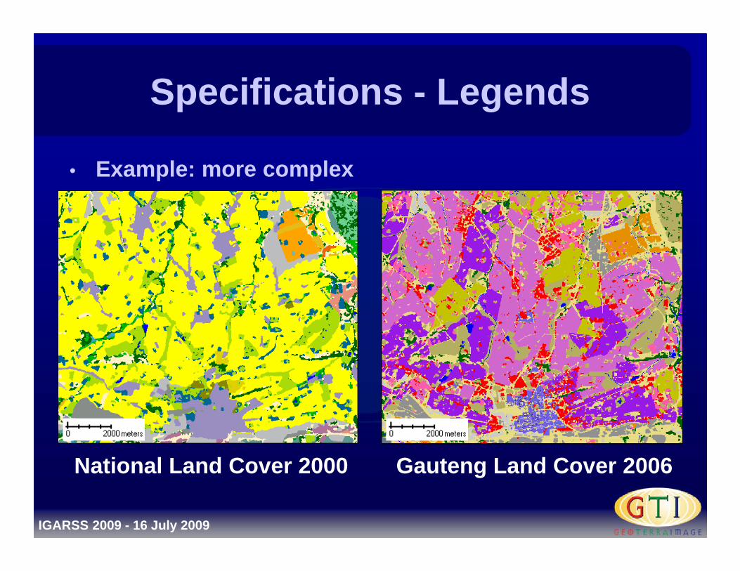
• Shift from generic legends
• To meet needs of wide spectrum of users
• To customised legends
• For specific end-users
• Legends may be more complex or simpler
Specifications - Legends
IGARSS 2009 - 16 July 2009
• Example: more complex
Specifications - Legends
National Land Cover 2000 Gauteng Land Cover 2006

IGARSS 2009 - 16 July 2009
• Example: more simple
Specifications - Legends
Tshwane Land Cover 2006 Tshwane sealed surfaces 2008

IGARSS 2009 - 16 July 2009
• Technology
• Applications
• Legislation
Drivers

IGARSS 2009 - 16 July 2009
Drivers - Technology
• Technologies in various sectors have improved
• Demand for accurate, high resolution data
• Example 1:
• Telecommunications industry: evolved from first to third generation (3G) technology
• Requires greater level of detail for planning and implementation

IGARSS 2009 - 16 July 2009
Drivers - Technology
• Example 2:
• Business sector becoming more spatially aware in terms of decision making
• Internet mapping (Google and Google Earth, Microsoft) and GPS devices and satellite navigation systems (Tom Tom and Garmin)

IGARSS 2009 - 16 July 2009
Drivers - Technology
• Example 2 cont:
• Increased use of complex databases, including spatially-enabled databases (i.e. GIS)
• Requires high level of detail to support applications and queries running on database

IGARSS 2009 - 16 July 2009
Drivers - Applications
• 1990’s
• National government departments
• Environmental applications
• Regional and provincial levels

IGARSS 2009 - 16 July 2009
Drivers - Applications
• Current
• Business sector and local government
• Financial, risk assessment, engineering, urban planning, land management, infrastructure, public safety and security, environmental monitoring
• Local levels

IGARSS 2009 - 16 July 2009
Drivers - Legislation
• 1994: SA’s first democratic election
• Many changes to national, provincial and local legislation
• Numerous changes require a spatial component
• Land cover datasets often fulfill these requirements

IGARSS 2009 - 16 July 2009
Drivers - Legislation
• Example: direct legislation
• National Water Act (Act 36 of 1998)
• Requires historical spatial component in order to assess water usage pre- and post-1998

IGARSS 2009 - 16 July 2009
Drivers - Legislation
• Example: indirect legislation
• The Constitution of the Republic of South Africa (Act 108 of 1996)
• Everyone has the right to adequate housing and sufficient food and water
• Demand forecasting and planning requires spatial component

IGARSS 2009 - 16 July 2009
• Imagery
• Methods
• Equipment
Enablers

IGARSS 2009 - 16 July 2009
• Increasing spatial resolution available from commercial providers
• Higher cost of high resolution imagery more feasible for commercial users
• Cost off-set by benefit
• Reduction in absolute cost of high resolution imagery
• Due to increase in demand, competition and technology
Enablers - Imagery

IGARSS 2009 - 16 July 2009
• 1999: imagery constituted 30% to 50% of total project cost
• 2009: imagery cost is comparatively negligible or free
Enablers - Imagery

IGARSS 2009 - 16 July 2009
Enablers - Imagery
Port Elizabeth Landsat 7 pan merge 15m pixel (RGB: 453)

IGARSS 2009 - 16 July 2009
Enablers - Imagery
Port Elizabeth Spot 5 pan merge 2.5m pixel

IGARSS 2009 - 16 July 2009
Enablers - Imagery
Port Elizabeth digital aerial photography 0.5m pixel

IGARSS 2009 - 16 July 2009
Enablers - Imagery
Port Elizabeth digital aerial photography 0.5m pixel

IGARSS 2009 - 16 July 2009
• Developments in imagery and level of detail necessitates changes in methods
• Shift from manual mapping on acetate prints
• To simple unsupervised classifications
• To complex integration of on-screen digitising, object-orientated segmentation and supervised classifications
• Use of ancillary datasets in modelling process
Enablers - Methods

IGARSS 2009 - 16 July 2009
• 1999: Top of the range image processing hardware system
• 2x 9GB hard drives
• Cost: R45 000 / $6000
• 2009: Standard image processing hardware system
• 2x 1.5TB hard drives
• Cost: R25 000 / $3300
• Can manage a single 18GB image
Enablers - Equipment

IGARSS 2009 - 16 July 2009
• High resolution land cover datasets allow for complex and specific modelling for wide-ranging purposes
• BUT the need for coarse scale and generic land cover datasets is not obsolete
• Still needed at national and regional levels
• Ensure continuity of data
Conclusion

IGARSS 2009 - 16 July 2009
• The new high resolution datasets are invaluable in decision support for the future development of South Africa
Conclusion

IGARSS 2009 - 16 July 2009
Questions and comments
Contact: [email protected]
[email protected]@geoterraimage.com

IGARSS 2009 - 16 July 2009