The Egyptian temple and settlement at Naukratis
19
British Museum Studies in Ancient Egypt and Sudan 17 (2011): 31–49 The Egyptian temple and settlement at Naukratis A. J. Spencer
-
Upload
independent -
Category
Documents
-
view
1 -
download
0
Transcript of The Egyptian temple and settlement at Naukratis
British Museum Studies in Ancient Egypt and Sudan 17 (2011): 31–49
The Egyptian temple and settlement at Naukratis
A. J. Spencer

http://www.britishmuseum.org/research/online_journals/bmsaes/issue_17/spencer.aspx
The Egyptian temple and settlement at Naukratis
A. J. Spencer
The ‘Great Enclosure’ discovered by Flinders Petrie at the south end of the site of Naukratis, and mistakenly identified by him initially as the Hellenion, has been discussed repeatedly in the light of the differing accounts given by Petrie and Hogarth (Petrie 1886, 23–34; Hogarth 1905, 110–111).Neither of them recognised the true function of the enclosure at the time and their views differed, at first over its purpose and later over its very existence. This divergence of opinion has coloured more recent discussion and produced two schools of thought, evident in the literature, between those who accept the presence of the enclosure and now regard it as the surrounding wall of an Egyptian temple, and those who follow Hogarth in doubting its existence.1 Although some of the arguments below, indicating that the Great Enclosure was a wall around an Egyptian temple, have been articulated previously in this discussion, the issue still clouds interpretation of the site so a reconsideration of the evidence would seem to be in order, with additions from Petrie’s unpublished notes. The present article was written as a small contribution to the Leverhulme Trust-funded Naukratis Project, led by Dr Alexandra Villing at the British Museum.
Petrie arrived at the village of Nebireh at sunset on December 1st 1884, but it was almost a month before he began to excavate. The local sheikhs did not accept his letter of permission from Maspero because it had been wrongly addressed to the mudira of Sharqiya and Gharbiya, instead of Beheira.2 During the long delay awaiting the correct papers, Petrie passed the time by combining regular tours over the ruin-mound, collecting sherds and small finds, with excursions to other sites in the region, including Kom Firin, Kom el-Hisn and Sais.
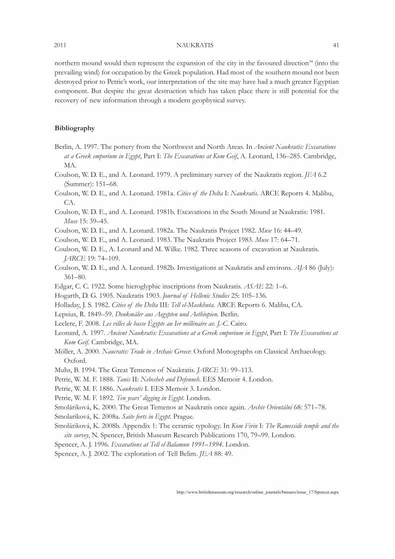
The original location of the main mound at Naukratis is now occupied by a lake (Fig. 1), created by the ingress of subsoil water into an area dug out to considerable depth. Most of this hole was not created by the excavations of Petrie or Hogarth, but by the sebakhin, and it already existed when Petrie arrived at the site, as he records:
‘As you approach from either side there is a long low line of brown mounds, generally only 15 feet; never over 30 ft, above the plain: the line extending for about half a mile in length and dotted with mud brick houses built with tombs and Bedouin tents. On going a little into the side of the mound you look down into a crater, a field of ruins with steep or precipitous sides, some 30 feet below you. This is where the fellahin have cut away the successive layers for spreading on their fields, until they have cleared out Christians, Romans and Ptolemies and left but shattered and mouldering fragments of walls, built 500 or 600 BC, and now heaped over with the shards and scraps belonging to all the later ages.’ 3 Some measure of the ongoing sebakhin activity in 1884 is documented: ‘The sebakh diggers are in full swing now: the road to the mound is almost blocked with strings of donkeys and camels passing and repassing carrying the earth; I counted about 80 people at work yesterday.’ 4
1 See the overview, with references there cited, in Leonard 1997, 1–35. Also Coulson and Leonard 1981a, 12; Muhs 1994, 99–113; Möller 2000, 108–113; Leclère 2008, vol. 1, 128–39. This last source contains a full bibliography for Naukratis up to 2008. A recent article by Patricia Spencer (2011) uses some of the archive material cited in this paper.
2 EES Archive XVIId, 47, p. 24.3 EES Archive XVIId, 47, p. 129.4 EES Archive XVIId, 47, p. 134.
http://www.britishmuseum.org/research/online_journals/bmsaes/issue_17/Spencer.aspx
2011 NAUKRATIS 33
Of the bottom of the crater, Petrie noted ‘all this part is thick with pottery’ and then qualifies this comment by adding, ‘the early Greek pottery is confined to a small part of the whole site, but there is native pottery of the same period over the whole place.’ 5 It is interesting to reflect that had this prodigious sebakh extraction not occurred, and the mound been left intact, the material visible on the surface would have been exclusively Late Roman and the site could well have been passed by, like many of the huge Late Antique mounds of the northern Delta, as being of too late a period to merit exploration. The stripping away of the later levels to reveal the Archaic Greek layer was actually crucial to attracting Petrie’s attention. On 5 December, the block of stone near the pasha’s house (where Petrie was to take rooms) with an inscription mentioning the city of Naukratis was brought to his notice, and he says he ‘almost jumped’ when he saw it, but then tried to appear uninterested in the hope of buying it later ‘for a trifle.’ He did however make a copy at once in his journal.6
The discovery of the Great Enclosure was made on 21 December, when Petrie had gone with Maurice Amos to tour the site: ‘As I was looking about on Sunday with Maurice I spied from the top of the mound that sundry bare parts of earth were in banks around a space; I at once said, “there is the camp.” Going about it I found that it was a square enclosure about 700 ft x 900 ft, with a great mass of brickwork in one part which I thought was a citadel. It is very curiously built with alternate layers of light and dark brick.’ 7
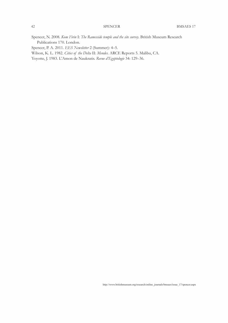
The ‘great mass of brickwork,’ is of course the casemate building in the southern half of the enclosure, later excavated by Petrie and described by him as a fort. His interpretation of the enclosure alters at various stages of the work; at this point he was identifying the enclosure with a camp for mercenaries, but soon after he decided that it was the Hellenion. This is documented in the following extract: ‘Then Professor Sayce came down… I soon walked him over to the camp, as I called it, here we stood on the top of the great mass of brickwork looking around. But where were the temples? he was continually asking; they must have been in a great flat site, without ruins of houses, outside the town. At last someone (I thought it was myself, until the professor said he thought it was himself) said: “But why is not this enclosure, itself, the temenos?” This notion at once seemed to fit. The Greeks had no camp here so far as we know, and I am certain that this is not Roman by the bricks; the citadel (as I thought of it) is too small for a fort (about 40 ft x 50): whereas the special thing at Naukratis was the great altar dedicated to all the gods by the states of Greece in the Panhellenion. Here we were standing on the great altar, looking over the temenos of the Hellenion; the temple ruined and buried and the peribolus carried off for earth. The men seeing us looking about told me without any questioning that there were four great walls all around that, within their memory, walls over twenty feet high by the mound to which they compared them.’ 8 Petrie then decides on a plan of action: ‘Now what we must do is to clear parts of the peribolus, inside and out…and to clear around the base of the altar mound.’ 9 Accompanying these comments is a sketch showing a view of the enclosure from the north, looking towards the casemate building, with the south wall extending left and right (Fig. 2). The modern tombs on the top of the casemate structure are indicated, but also shown is another high mound, covered with tombs, in which the south-west angle of the wall of the Great Enclosure is embedded. Petrie has noted beside the sketch: ‘with a continuation of the cemetery running up
5 EES Archive XVIId, 47, p. 26.6 EES Archive XVIId, 47, p. 30.7 EES Archive XVIId, 47, p. 56.8 EES Archive XVIId, 47, p. 57.9 EES Archive XVIId, 47, p. 58.
http://www.britishmuseum.org/research/online_journals/bmsaes/issue_17/spencer.aspx
34 SPENCER BMSAES 17
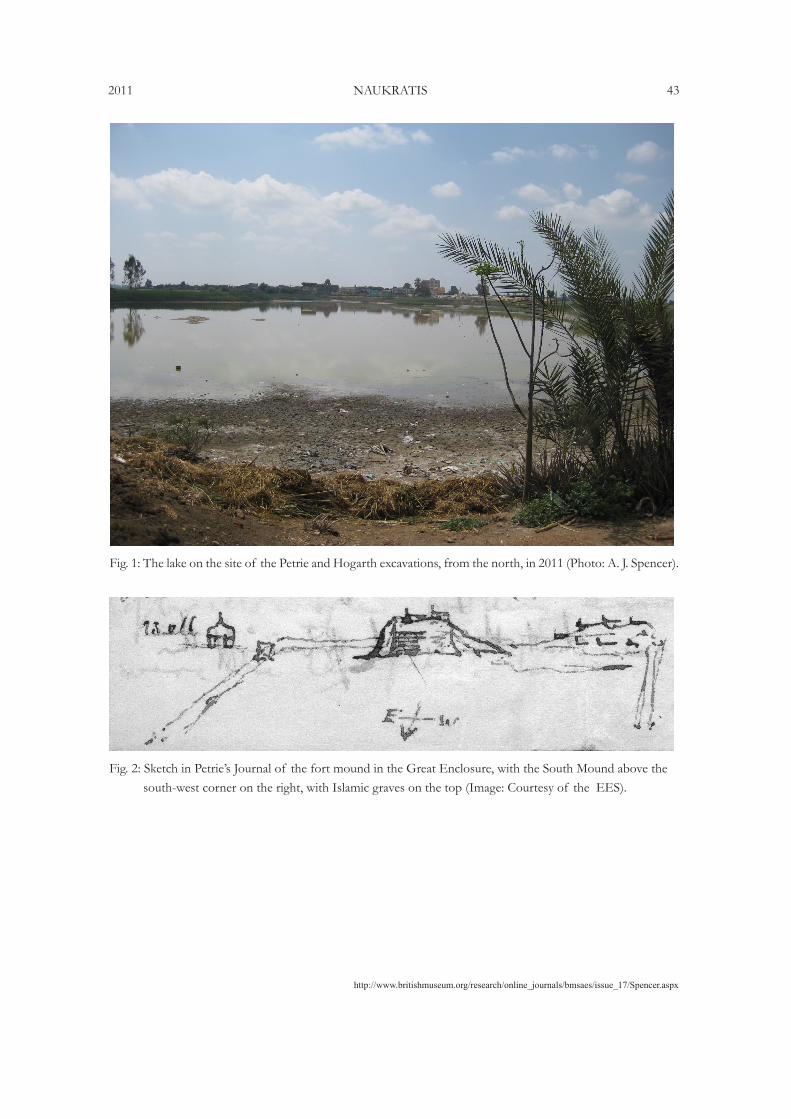
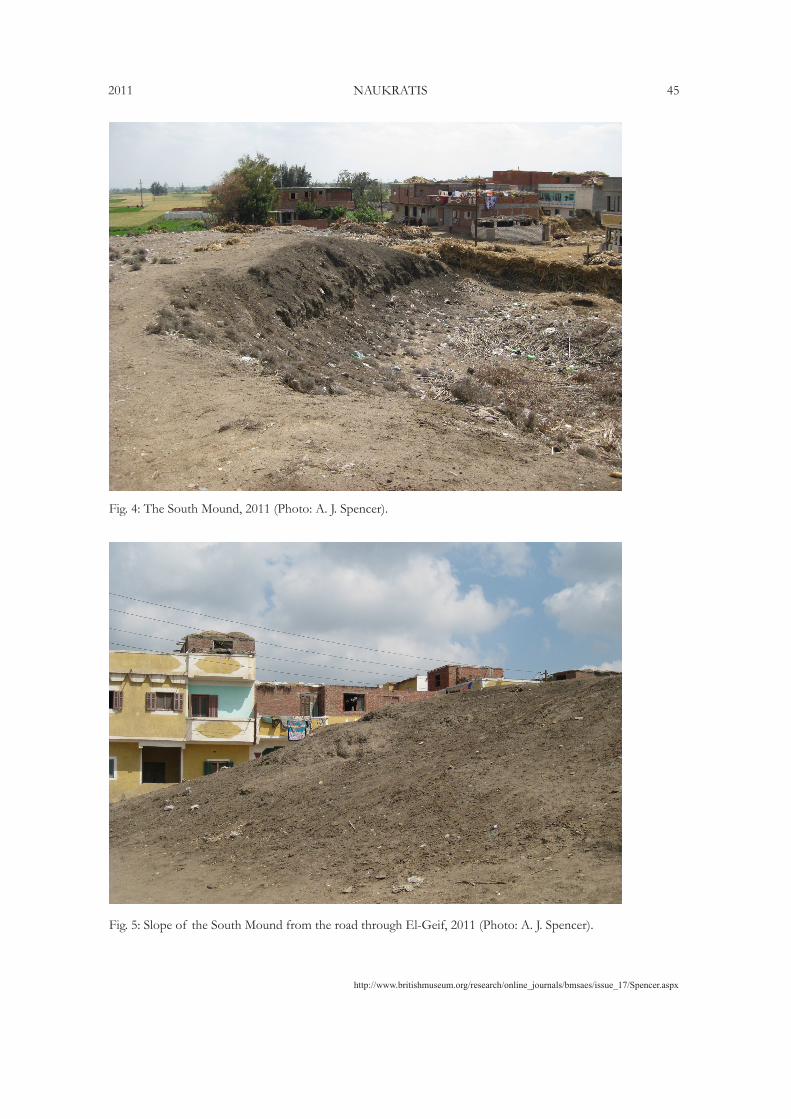
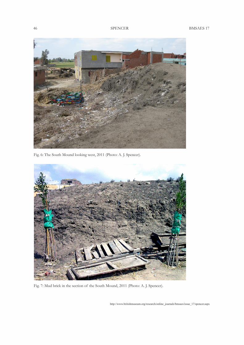
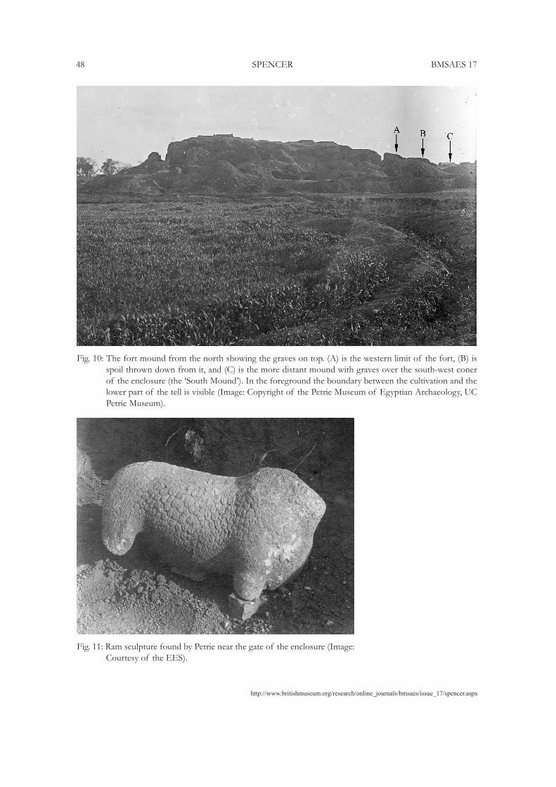
on the line of the wall.’ The elevated ground around the corner of the enclosure is also shown on a sketch-plan in a letter from Petrie (Fig. 3).10 This high area must be the same as the so-called South Mound, which still exists at the site (Fig. 4). The sides of this mound have been cut back as the village houses encroach ever closer (Figs. 5–6), and the lower parts of the sections, examined in 2011, show clearly the presence of much mud brick, very likely the last remnants of the south-west corner of the enclosure (Fig. 7). Overlaying the various plans of Petrie and the Coulson-Leonard expedition of the 1980s on satellite imagery produces a ‘best-fit’ in which the location of the South Mound must lie at the south-west angle of the enclosure, not near the casemate building as shown on the American map (Fig. 8). The latter was influenced by the presence of Islamic graves on the South Mound, the team having come to the erroneous conclusion that these were the ones mentioned by Petrie above the casemate building, which he said he had removed. Having decided that the South Mound marked the location of the casemate building, the Coulson and Leonard team then cast doubt on whether Petrie had really removed the graves and completely excavated the casemate, instead of realising that they were looking at a different cemetery on the South Mound, the one noted by Petrie above the south-west angle of the Great Enclosure. The misidentification of the South Mound and its overlying cemetery with Petrie’s ‘Fort’ mound is an error reiterated in the various publications of the American Naukratis Project and perpetuated in later literature.11 It is demonstrated most clearly by the following passage from the report on the 1980 and 1981 seasons: ‘Although he [Petrie] noted the existence of an Arabic cemetery over a portion of the Great Temenos when he arrived at Naukratis and published a sketch of such a situation, Petrie also claimed to have financed––at the villagers request––the transfer of the contents of these graves to two large communal tombs which subsequently allowed him to clear all the chambers’ (Coulson and Leonard 1982b, 370). Now Petrie did indeed note an Arab cemetery on part of the enclosure––the south-west corner, to be precise (Petrie 1886, 24)––but the sketch cited from his book Ten years’ digging shows not this cemetery, but the one on the Fort Mound (Petrie 1892, 36, fig. 22). The removal of the bones he financed was also from the graves on the Fort Mound, which would, as stated, have allowed him to clear the chambers (of the fort). The American report then goes on to question the veracity of Petrie’s statements about the removal of the Islamic graves over the fort, as mentioned above, because they found graves still present on the South Mound.
A photograph taken by Petrie, kept at the Petrie Museum, shows a view of the casemate building in the enclosure from the north-east (Fig. 10). At the extreme right edge, the view shows part of the South Mound with tombs upon it, beyond the casemate building over the south-west corner of the enclosure. In the foreground, it can be seen on the left that the east part of the enclosed area was already under agriculture, but the western part, on the right, was still wasteland or archaeological mound. The boundary between the two areas is quite evident. This same division is shown on a sketch-plan made at Naukratis by Petrie (Fig. 3). The lack of cultivation over the west side permitted Petrie to dig there extensively, particularly on the line of the west wall, where he found the gate of Ptolemy II. On the prospects for work in this area, Petrie notes, ‘Looking at the ground as compared with the excavations in the town, I should say that there must be over 10 ft of stuff there since early Greek times, so we shall have to go to some depth…’ 12 The fact that Petrie had to dig to such a depth to reach the Ptolemaic gate is confirmation that some of the mound remained in this area.10 EES Archive XVIf, p. 63.11 See for example, Coulson and Leonard 1979, 154; id. 1981b, 42; 1982, 366, 370; Coulson, Leonard and Wilke 1982,
74; Möller 2000, 112. It is a feature of the reports of the American excavations that almost identical articles were submitted to different journals, an unnecessary duplication offering no additional information.
12 EES Archive XVIId, 47, p. 59.
http://www.britishmuseum.org/research/online_journals/bmsaes/issue_17/Spencer.aspx
2011 NAUKRATIS 35
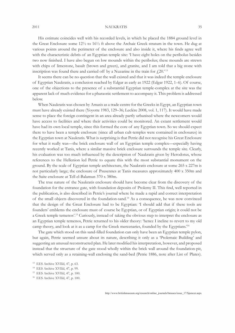
His estimate coincides well with his recorded levels, in which he placed the 1884 ground level in the Great Enclosure some 12½ to 16½ ft above the Archaic Greek stratum in the town. He dug at various points around the perimeter of the enclosure and also inside it, where his finds agree well with the characteristic debris of an Egyptian temple site: ‘I have eight holes on the peribolus besides two now finished. I have also begun on low mounds within the peribolus; these mounds are strewn with chips of limestone, basalt (brown and green), and granite, and I am told that a big stone with inscription was found there and carried off by a Nuzarine in the train for £20.’ 13
It seems there can be no question that the wall existed and that it was indeed the temple enclosure of Egyptian Naukratis, a conclusion reached by Edgar as early as 1922 (Edgar 1922, 1–6). Of course, one of the objections to the presence of a substantial Egyptian temple-complex at the site was the apparent lack of much evidence for a pharaonic settlement to accompany it. This problem is addressed below.
When Naukratis was chosen by Amasis as a trade centre for the Greeks in Egypt, an Egyptian town must have already existed there (Yoyotte 1983, 129–36; Leclère 2008, vol. 1, 117). It would have made sense to place the foreign contingent in an area already partly urbanised where the newcomers would have access to facilities and where their activities could be monitored. An extant settlement would have had its own local temple, since this formed the core of any Egyptian town. So we should expect there to have been a temple enclosure (since all urban cult-temples were contained in enclosures) in the Egyptian town at Naukratis. What is surprising is that Petrie did not recognise his Great Enclosure for what it really was––the brick enclosure wall of an Egyptian temple complex––especially having recently worked at Tanis, where a similar massive brick enclosure surrounds the temple site. Clearly, his evaluation was too much influenced by the description of Naukratis given by Herodotus, whose references to the Hellenion led Petrie to equate this with the most substantial monument on the ground. By the scale of Egyptian temple architecture, the Naukratis enclosure at some 265 x 227m is not particularly large; the enclosure of Psusennes at Tanis measures approximately 400 x 350m and the Saite enclosure at Tell el-Balamun 370 x 380m.
The true nature of the Naukratis enclosure should have become clear from the discovery of the foundation for the entrance gate, with foundation deposits of Ptolemy II. This find, well reported in the publication, is also described in Petrie’s journal where he made a rapid and correct interpretation of the small objects discovered in the foundation-sand.14 As a consequence, he was now convinced that the design of the Great Enclosure had to be Egyptian: ‘I should add that if these tools are founders’ emblems the enclosure must of course be Egyptian, or of Egyptian origin; it could not be a Greek temple temenos’.15 Curiously, instead of taking the obvious step to interpret the enclosure as an Egyptian temple temenos, Petrie returned to his older theory: ‘hence I incline to revert to my old camp theory, and look at it as a camp for the Greek mercenaries, founded by the Egyptians.’16
The gate which stood on this sand-filled foundation can only have been an Egyptian temple pylon, but again, Petrie seemed unsure about its nature, describing it only as a ‘Ptolemaic Building’ and suggesting an unusual reconstructed plan. He later modified his interpretation, however, and proposed instead that the structure of the gate stood wholly within the brick wall around the foundation-pit, which served only as a retaining-wall enclosing the sand-bed (Petrie 1886, note after List of Plates).
13 EES Archive XVIId, 47, p. 63.14 EES Archive XVIId, 47, p. 99.15 EES Archive XVIId, 47, p. 100.16 EES Archive XVIId, 47, p. 100.
http://www.britishmuseum.org/research/online_journals/bmsaes/issue_17/spencer.aspx
36 SPENCER BMSAES 17
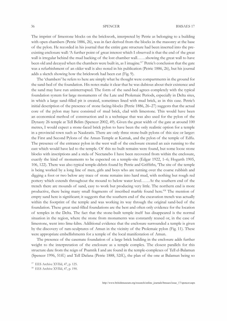
The imprint of limestone blocks on the brickwork, interpreted by Petrie as belonging to a building with open chambers (Petrie 1886, 26), was in fact derived from the blocks in the masonry at the base of the pylon. He recorded in his journal that the entire gate structure had been inserted into the pre-existing enclosure wall: ‘A further point of great interest which I observed is that the end of the great wall is irregular behind the mud backing of the lost chamber wall……showing the great wall to have been old and decayed when the chambers were built in, as I imagine.’17 Petrie’s conclusion that the gate was a refurbishment of an older wall is also noted in his publication (Petrie 1886, 26), but his journal adds a sketch showing how the brickwork had been cut (Fig. 9).
The ‘chambers’ he refers to here are simply what he thought were compartments in the ground for the sand-bed of the foundation. His notes make it clear that he was dubious about their existence and the sand may have run uninterrupted. The form of the sand-bed agrees completely with the typical foundation system for large monuments of the Late and Ptolemaic Periods, especially in Delta sites, in which a large sand-filled pit is created, sometimes lined with mud brick, as in this case. Petrie’s initial description of the presence of stone facing-blocks (Petrie 1886, 26–27) suggests that the actual core of the pylon may have consisted of mud brick, clad with limestone. This would have been an economical method of construction and is a technique that was also used for the pylon of the Dynasty 26 temple at Tell Belim (Spencer 2002, 49). Given the great width of the gate at around 100 metres, I would expect a stone-faced brick pylon to have been the only realistic option for a temple in a provincial town such as Naukratis. There are only three stone-built pylons of this size or larger: the First and Second Pylons of the Amun-Temple at Karnak, and the pylon of the temple of Edfu. The presence of the entrance pylon in the west wall of the enclosure created an axis running to the east which would have led to the temple. Of this no built remains were found, but some loose stone blocks with inscriptions and a stela of Nectanebo I have been recovered from within the enclosure, exactly the kind of monuments to be expected on a temple-site (Edgar 1922, 1–6; Hogarth 1905, 106, 122). There was also typical temple-debris found by Petrie and Griffiths, ‘The site of the temple is being worked by a long line of men, girls and boys who are turning over the coarse rubbish and digging a foot or two below any trace of stone remains into hard mud, with nothing but rough red pottery which extends throughout the mound to below water level……At the southern end of the trench there are mounds of sand, easy to work but producing very little. The northern end is more productive, there being many small fragments of inscribed marble found here.’18 The mention of empty sand here is significant; it suggests that the southern end of the excavation trench was actually within the footprint of the temple and was working its way through the original sand-bed of the foundation. These great sand-filled foundations are the best and often only evidence for the location of temples in the Delta. The fact that the stone-built temple itself has disappeared is the normal situation in the region, where the stone from monuments was constantly reused or, in the case of limestone, went into lime-kilns. Additional evidence that the enclosure surrounded a temple is given by the discovery of ram-sculptures of Amun in the vicinity of the Ptolemaic pylon (Fig. 11). These were appropriate embellishments for a temple of the local manifestation of Amun.
The presence of the casemate foundation of a large brick building in the enclosure adds further weight to the interpretation of the enclosure as a temple complex. The closest parallels for this structure date from the reign of Psamtik I and are found in the temple-complexes of Tell el-Balamun (Spencer 1996, 51ff.) and Tell Dafana (Petrie 1888, 52ff.), the plan of the one at Balamun being so
17 EES Archive XVIId, 47, p. 125.18 EES Archive XVIId, 47, p. 190.
http://www.britishmuseum.org/research/online_journals/bmsaes/issue_17/Spencer.aspx
2011 NAUKRATIS 37
similar to that at Naukratis that they would seem likely to have been contemporary. The buildings on these foundations probably combined several functions, including storage of temple equipment and offerings, and are a regular component of temple complexes. Petrie, no doubt because he had already chosen to identify the enclosure with the Hellenion, concluded that both the ‘Ptolemaic Building’ and the casemate building had been set out in measurements according to the Greek foot (Petrie 1886, 27). But as purely Egyptian monuments they would actually have been planned using the Egyptian cubit. This works well for the lengths recorded by Petrie: the length and width of the gate structure, at 4318 x 1080 inches (109.67 x 27.43m), is fine for an Egyptian pylon of 208 x 52 cubits. These numbers are typical of the measurements favoured by Egyptian architects. The side of the casemate building measured 2158 inches (54.813m), probably intended for 104 cubits.
This Egyptian temple lay, as noted above, at the southern end of the ruin-field of Naukratis, with the monuments of Greek character to the north. This reflects the direction in which cities in Egypt have always grown––from south to north––so it is likely that when the Greeks were settled in the site, the new areas for their use were allocated to the north of the existing Egyptian city. Both Hogarth and Petrie noted the preponderance of Egyptian material in the southern part of the mound (Hogarth 1905, 107; Petrie 1886, 21).
When Hogarth worked at Naukratis some twenty years later, he described the site very differently from Petrie, and in fact denied the existence of the Great Enclosure at the south (Hogarth 1905, 110–111).19 In the southern area he says he searched for remains of the Great Enclosure wall, but found only the remains of houses. He concluded that Petrie had been completely mistaken and what he had interpreted as the Great Enclosure was only the compacted ruins of mud brick houses (Hogarth 1905, 111), a view which has been followed by those later commentators who have adopted Hogarth’s interpretation.20 In dismissing the existence of the enclosure, a comment in the publication of the American excavations of the 1980s goes so far as to express doubt that the deposits of Ptolemy II found by Petrie under the entrance were indeed foundation deposits.21 That this is their correct identification is absolutely certain from the nature of the objects and the manner of their disposition in the foundation-sand. In fact, these groups are classic examples of foundation deposits. The proposal that the enclosure never existed is not sustainable because the archaeology of the site clearly indicates the presence of an Egyptian temple for Amun, which certainly would have possessed an enclosure wall with a monumental entrance just as Petrie describes it. The sympathy of the American Naukratis team for Hogarth’s point of view, and the claim that the outcome of their own excavations ‘casts grave doubts on the very existence of the Great Enclosure and reinforces Hogarth’s scepticism’ (Coulson & Leonard 1982b, 371) is remarkable, given that their excavations of 1981 in Areas 12 and 15 revealed mud brick remains of what was, even by their own admission, probably part of the enclosure wall itself (Leonard 1997, 88). These excavations are considered further below.
Returning to Hogarth, it is perfectly possible for Petrie to have observed the wall while Hogarth did not, but for both to have been correct at the time of their respective observations. In the twenty-year interval between the two excavations, the wall may have been removed by a combination of sebakhin activity (removal of earth, especially decayed mud brick, from ancient sites for fertiliser) and erosion. We know from Petrie that the exploitation of the site for sebakh was particularly intense. Every structure has a foundation level and the steady removal of courses of brick from a great wall will reach
19 This opinion of Hogarth’s is quoted in Leonard 1997, 16, and again in Coulson and Leonard 1982b, 366.20 See Coulson and Leonard 1981a, 12; Leonard 1997, 29.21 Coulson and Leonard 1981b, 41; Coulson, Leonard and Wilke, 1982, 76; see also Leonard 1997, 29.

http://www.britishmuseum.org/research/online_journals/bmsaes/issue_17/spencer.aspx
38 SPENCER BMSAES 17
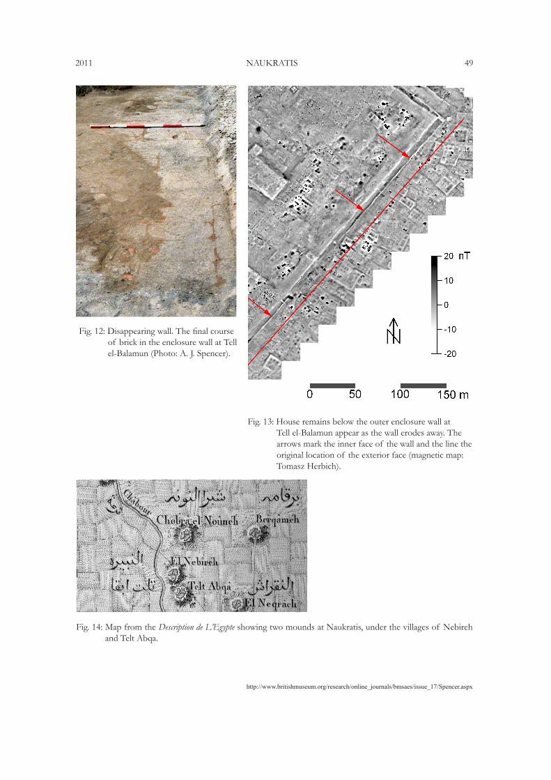
in due course the final layer of brick, and, once this is removed, there is no longer any wall. The level of the ground surface is lowered to below the base of the wall, and the highest archaeological remains become those of structures which preceded the wall’s construction, over which it was built. It is very likely that these older remains would be those of houses, the most common of structures, and this is exactly what Hogarth says he observed in place of the enclosure wall. The same process occurred at other Delta sites. At Sais, a temple enclosure-wall of mud brick was seen and drawn by the Lepsius expedition, still standing to a great height (Lepsius 1849–59, Abth. I, pl. 56, lower). This has since completely disappeared and there do not seem to be any remains of it in the ground, suggesting that the destruction reached the base of the brickwork. At Kom Firin, isolated elements of an enclosure wall remain standing on pillars of earth while the land all around has been dug away to greater depth together with most other parts of the wall (Spencer 2008, 24–25, pls 70–71). Most clearly, at Tell el-Balamun much of the south-east side of the Dynasty 30 temple enclosure wall has been removed by wind erosion, and the steady progress of this removal has been observed over the last fifteen years (Spencer 1996, 34). Cleaned areas on the top of this wall show how the final bricks of the foundation course vanish in the erosion slope of the ground (Fig. 12). On the magnetic map of the site, areas where portions of the wall have been lost can be seen and the underlying older buildings––clusters of houses––show in place of the wall (Fig. 13). This wall at Balamun was not built with a constant foundation level but one that varied as the bricks had been laid directly on the pre-existing undulating contours of the mound. The same feature seems to have applied at Naukratis, as Petrie noted: ‘At the temenos we found the base of the wall at no great depth, in one part, with much broken pot for 5 feet below it, but elsewhere the wall goes much lower. Now this high part is close by the high mounds of the town, and seems as if it had been built over the town mounds when they were much lower than now.’22 The varying depth of the base of the wall is also mentioned in the publication (Petrie 1886, 89). Hogarth was aware of the possibility that the wall might have disappeared but denied he was working below the wall on the basis of the pottery, which he claimed was of too late a date to permit this (Hogarth 1905, 111). This statement cannot be relied upon, however, on account of the pitting of the site by the sebakhin combined with an excavation technique which did not identify and isolate pits from the surrounding fill, leading to serious mixing of the ceramics from different levels. As to the date of the original foundation of the temple enclosure, early Dynasty 26 seems probable,23 although all great temple walls were periodically repaired or renewed as necessary, which, in the climate of the Nile Delta, would have been not infrequently. It is very likely that renewals would have been made in the Dynasty 30, especially as Nectanebo I rebuilt so many of the temple-enclosures of Egypt, and for a Ptolemaic refurbishment we have the evidence of the pylon of Ptolemy II. There is no need to re-date the original foundation of the whole enclosure to the Ptolemaic Period, as has been suggested (Muhs 1994, 104), because the gate is in any case later than the wall.
On the subject of pottery, the paucity of recorded Egyptian Late Dynastic ceramics from the site compared to the preponderance of Archaic Greek and later Hellenistic wares is remarkable but also understandable. Petrie brought back hardly any Egyptian pottery from Naukratis, although he must have encountered large quantities. Indeed, the passage from his journal quoted above refers to ‘native pottery of the same period over the whole place.’ The period referred to is that of the Greek pottery in the base of the deep excavation in the mound, that is around the sixth century BC. It is likely that Petrie was so distracted by the presence of so much decorated Greek ware that the Egyptian material
22 EES Archive XVIId, 47, p. 63.23 Particularly as the design of the casemate building at Naukratis is virtually identical to the Saite one at Tell el-Balamun.
http://www.britishmuseum.org/research/online_journals/bmsaes/issue_17/Spencer.aspx
2011 NAUKRATIS 39
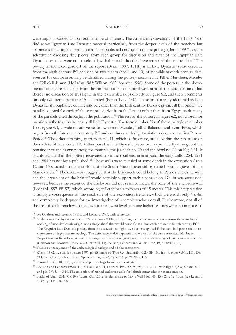
was simply discarded as too routine to be of interest. The American excavations of the 1980s24 did find some Egyptian Late Dynastic material, particularly from the deeper levels of the trenches, but its presence has largely been ignored. The published description of the pottery (Berlin 1997) is quite selective in choosing ‘key pieces’ from each group for discussion and most of the Egyptian Late Dynastic ceramics were not so selected, with the result that they have remained almost invisible.25 The pottery in the text-figure 6.1 of the report (Berlin 1997, 151ff.) is all Late Dynastic, some certainly from the sixth century BC and one or two pieces (nos 1 and 10) of possible seventh century date. Sources for comparison may be identified among the pottery excavated at Tell el-Maskhuta, Mendes and Tell el-Balamun (Holladay 1982; Wilson 1982; Spencer 1996). Some of the pottery in the above-mentioned figure 6.1 came from the earliest phase in the northwest area of the South Mound, but there is no discussion of this figure in the text, which skips directly to figure 6.2, and there comments on only two items from the 15 illustrated (Berlin 1997, 140). These are correctly identified as Late Dynastic, although they could easily be earlier than the fifth century BC date given. All but one of the parallels quoted for each of these vessels derive from the Levant rather than from Egypt, as do many of the parallels cited throughout the publication.26 The rest of the pottery in figure 6.2, not chosen for mention in the text, is also nearly all Late Dynastic. The form number 2 is of the same style as number 1 on figure 6.1, a wide-mouth vessel known from Mendes, Tell el-Balamun and Kom Firin, which begins from the late seventh century BC and continues with slight variations down to the first Persian Period.27 The other ceramics, apart from no. 11, which is Ptolemaic, are all within the repertoire of the sixth to fifth centuries BC. Other possible Late Dynastic pieces occur sporadically throughout the remainder of the drawn pottery, for example, the jar-neck no. 20 and the bowl no. 22 on Fig. 6.61. It is unfortunate that the pottery recovered from the southeast area around the early walls 1254, 1271 and 1565 has not been published .28 These walls were revealed at some depth in the excavation Areas 12 and 15 situated on the east slope of the South Mound, overlaid by ruined Islamic graves of the Mameluk era.29 The excavators suggested that the brickwork could belong to Petrie’s enclosure wall, and the large sizes of the bricks30 would certainly support such a conclusion. Doubt was expressed, however, because the extent of the brickwork did not seem to match the scale of the enclosure wall (Leonard 1997, 88, 92), which according to Petrie had a thickness of 15 metres. This misinterpretation is simply a consequence of the small size of the excavation trenches, which were each only 4 x 4m and completely inadequate for the investigation of a temple enclosure wall. Furthermore, not all of the area of each trench was dug down to the lowest level, as some higher features were left in place, so
24 See Coulson and Leonard 1981a; and Leonard 1997, with references.25 As demonstrated by the comment in Smolariková 2008a, 77: ‘During the four seasons of excavations the team found
nothing of non-Ptolemaic origin, not a single shard that would come from a time earlier than the fourth century BC.’ The Egyptian Late Dynastic pottery from the excavations might have been recognised if the team had possessed more experience of Egyptian archaeology. The deficiency is also apparent in the work of the same American Naukratis Project team at Kom Firin, where no attempt was made to suggest any date for a whole range of late Ramesside bowls (Coulson and Leonard 1982b, 377–80 with Ill. 13; Coulson, Leonard and Wilkie 1982, 19, 81 and fig. 12).
26 This is a consequence of the archaeological background of the excavators.27 Wilson 1982, pl. xvii, 6; Spencer 1996, pl. 65, range of Type C.4; Smoláriková 2008b, 150, fig. 43, types C.051, 131, 139,
214; for other vessel-forms, see Spencer 1996, pl. 66, Type C.6; pl. 70, Type D.328 Leonard 1997, 101, 110, gives lists of pottery bags from these contexts.29 Coulson and Leonard 1981b, 41; id. 1982, 368–71; Leonard 1997, 85–90, 93, 101–2, 110 with figs 3.7, 3.8, 3.9 and 3.10
and pls 3.9, 3.14, 3.16. The utilisation of ruined enclosure walls for Islamic cemeteries is not uncommon.30 Bricks of Wall 1254: 40 x 20 x 12cm; Wall 1271: ‘similar in size to 1254’; Wall 1565: 40–45 x 20 x 12–15cm (see Leonard
1997, pp. 101, 102, 110.

http://www.britishmuseum.org/research/online_journals/bmsaes/issue_17/spencer.aspx
40 SPENCER BMSAES 17
the actual area available to inspect the bricks of the deep walls in question was even further reduced. A report of 1982 on Area 12 states, ‘As in Area 15, neither the northern nor the southern face of Wall 1254/1565 could be excavated because of the superimposition of the later tombs, but enough was uncovered to increase its known north-south dimension to 3.0m.’ (Coulson & Leonard 1982b, 369). In other words, only three metres of brickwork could be seen because that was the size of the trench, but how far the wall extended beyond the excavated area was unknown.31 Above the brickwork was a layer of degraded brick, marking the top of the destroyed wall, into which the tombs were cut (Leonard 1997, 90, with pls 3.3 and 3.4).
The ruined upper surface of a massive wall cannot be understood in such small probes; the brickwork may have been cut by later features (such as the graves), by robbing of the bricks or extraction of sebakh, or even hollowed out to create small chambers for re-use, causing variations in level which may produce false impressions of wall edges. To interpret a 15-metre wide wall requires a 20-metre long trench. It seems very likely that, in spite of the doubts of the excavators, they had indeed encountered part of the brickwork of the Great Enclosure near its south-west corner, which, as demonstrated above, is embedded in the lower levels of the South Mound. Whether the sand-filled foundation of the temple yet survives under the cultivation to the north-east of the South Mound (see Cover picture) is rather doubtful because this sand-bed, unlike those in certain other temples of the Delta, seems to have been of no great depth. Petrie, in a general discussion of temple foundations, remarks, ‘The depth of the sand enclosure varies greatly; it may be only a few inches, a mere film, as at Naukratis’ (Petrie 1888, 8–9). In the light of this comment the chances of detecting the sand-bed by a geophysical survey do not seem very good. Another example of a shallow sand-bed in the foundation of a provincial temple of the Saite period is known from Tell Belim (Spencer 2002, 49–50).
Egyptian urban settlements tended to be clustered around great temple enclosures, one of the prime purposes of the enclosure being to define the sacred space to be kept free from domestic building. It is around this Great Enclosure that the town of Egyptian Naukratis must once have been located and there is some evidence for the former existence of a high settlement mound at the southern end of the site. The Description de L’Égypte map from the beginning of the nineteenth century shows a double-mound at the site of Naukratis: a northern one called El Nebireh (the name derived from the nearby village) and a southern mound overbuilt by a small settlement labelled Talat Abqa (Fig. 14).32 This name is curious; it apparently means ‘three fugitives’ but then the plural form of the noun, Abqat, would be expected. It may have been a misinterpretation of Tell Abqa, which would make more sense. A mound in this position would probably have been contiguous with, and extended southward from, the South Mound and in fact the present-day village of Kom el-Geif at this location still stands on considerably elevated ground. This historic double-mound configuration would have given the site the classic appearance of an Egyptian city-mound, in which the elevated settlements rise above the area occupied by the temple. The presence of the double-mound profile resulting from the existence of a traditional temple-enclosure is a valuable indicator to distinguish Pharaonic sites from later ones in Egypt; post-Pharaonic sites, lacking such temple-enclosures, are generally marked by single mounds.33 The former existence of a southern mound at the site of Naukratis strongly suggests that this was the location of the original Egyptian town, close by the temple enclosure of Amun. The 31 See also Leonard 1997, 88, where the width of the wall is described as ‘at least’ 3m.32 Déscription de l’Egypte, Atlas Géographique, pl. 36. The name Kom el-Geif derives from the much later Ezba of El-Geif.33 As at Kom el-Khanziri or Kom Khawaled. Classic double-mounds exist at Tanis, Buto and Tell el-Balamun.34 Egyptian towns ancient and modern have always shown a pattern of expansion towards the north, where the more
prosperous areas are located.
http://www.britishmuseum.org/research/online_journals/bmsaes/issue_17/Spencer.aspx
2011 NAUKRATIS 41
northern mound would then represent the expansion of the city in the favoured direction34 (into the prevailing wind) for occupation by the Greek population. Had most of the southern mound not been destroyed prior to Petrie’s work, our interpretation of the site may have had a much greater Egyptian component. But despite the great destruction which has taken place there is still potential for the recovery of new information through a modern geophysical survey.
Bibliography
Berlin, A. 1997. The pottery from the Northwest and North Areas. In Ancient Naukratis: Excavations at a Greek emporium in Egypt, Part I: The Excavations at Kom Geif, A. Leonard, 136–285. Cambridge, MA.
Coulson, W. D. E., and A. Leonard. 1979. A preliminary survey of the Naukratis region. JFA 6.2 (Summer): 151–68.
Coulson, W. D. E., and A. Leonard. 1981a. Cities of the Delta I: Naukratis. ARCE Reports 4. Malibu, CA.
Coulson, W. D. E., and A. Leonard. 1981b. Excavations in the South Mound at Naukratis: 1981. Muse 15: 39–45.
Coulson, W. D. E., and A. Leonard. 1982a. The Naukratis Project 1982. Muse 16: 44–49.Coulson, W. D. E., and A. Leonard. 1983. The Naukratis Project 1983. Muse 17: 64–71.Coulson, W. D. E., A. Leonard and M. Wilke. 1982. Three seasons of excavation at Naukratis.
JARCE 19: 74–109.Coulson, W. D. E., and A. Leonard. 1982b. Investigations at Naukratis and environs. AJA 86 (July):
361–80.Edgar, C. C. 1922. Some hieroglyphic inscriptions from Naukratis. ASAE 22: 1–6.Hogarth, D. G. 1905. Naukratis 1903. Journal of Hellenic Studies 25: 105–136.Holladay, J. S. 1982. Cities of the Delta III: Tell el-Maskhuta. ARCE Reports 6. Malibu, CA.Lepsius, R. 1849–59. Denkmäler aus Aegypten und Aethiopien. Berlin.Leclere, F. 2008. Les villes de basse Égypte au Ier millénaire av. J.-C. Cairo.Leonard, A. 1997. Ancient Naukratis: Excavations at a Greek emporium in Egypt, Part I: The Excavations at
Kom Geif. Cambridge, MA.Möller, A. 2000. Naucratis: Trade in Archaic Greece: Oxford Monographs on Classical Archaeology.
Oxford.Muhs, B. 1994. The Great Temenos of Naukratis. JARCE 31: 99–113.Petrie, W. M. F. 1888. Tanis II: Nebesheh and Defenneh. EES Memoir 4. London.Petrie, W. M. F. 1886. Naukratis I. EES Memoir 3. London.Petrie, W. M. F. 1892. Ten years’ digging in Egypt. London.Smoláriková, K. 2000. The Great Temenos at Naukratis once again. Archiv Orientálni 68: 571–78.Smolariková, K. 2008a. Saite forts in Egypt. Prague.Smoláriková, K. 2008b. Appendix 1: The ceramic typology. In Kom Firin I: The Ramesside temple and the
site survey, N. Spencer, British Museum Research Publications 170, 79–99. London.Spencer, A. J. 1996. Excavations at Tell el-Balamun 1991–1994. London.Spencer, A. J. 2002. The exploration of Tell Belim. JEA 88: 49.
http://www.britishmuseum.org/research/online_journals/bmsaes/issue_17/spencer.aspx
42 SPENCER BMSAES 17
Spencer, N. 2008. Kom Firin I: The Ramesside temple and the site survey. British Museum Research Publications 170. London.
Spencer, P. A. 2011. EES Newsletter 2 (Summer): 4–5.Wilson, K. L. 1982. Cities of the Delta II: Mendes. ARCE Reports 5. Malibu, CA.Yoyotte, J. 1983. L’Amon de Naukratis. Revue d’Egyptologie 34: 129–36.
http://www.britishmuseum.org/research/online_journals/bmsaes/issue_17/Spencer.aspx
2011 NAUKRATIS 43
Fig. 1: The lake on the site of the Petrie and Hogarth excavations, from the north, in 2011 (Photo: A. J. Spencer).
Fig. 2: Sketch in Petrie’s Journal of the fort mound in the Great Enclosure, with the South Mound above the south-west corner on the right, with Islamic graves on the top (Image: Courtesy of the EES).

http://www.britishmuseum.org/research/online_journals/bmsaes/issue_17/spencer.aspx
44 SPENCER BMSAES 17
Fig. 3: Petrie’s sketch-map showing the south-west corner of the Great Enclosure embedded in the South Mound, and the extent of the cultivation (Image: Courtesy of the EES).
http://www.britishmuseum.org/research/online_journals/bmsaes/issue_17/Spencer.aspx
2011 NAUKRATIS 45
Fig. 4: The South Mound, 2011 (Photo: A. J. Spencer).
Fig. 5: Slope of the South Mound from the road through El-Geif, 2011 (Photo: A. J. Spencer).
http://www.britishmuseum.org/research/online_journals/bmsaes/issue_17/spencer.aspx
46 SPENCER BMSAES 17
Fig. 6: The South Mound looking west, 2011 (Photo: A. J. Spencer).
Fig. 7: Mud brick in the section of the South Mound, 2011 (Photo: A. J. Spencer).

http://www.britishmuseum.org/research/online_journals/bmsaes/issue_17/Spencer.aspx
2011 NAUKRATIS 47
Fig. 8: Combination of Petrie maps, American map and satellite imagery.
Fig. 9: Petrie’s sketch of the cut end of the enclosure wall at the gate. The space marked ‘chamber’ is the foundation-pit (Image: Courtesy of the EES).
http://www.britishmuseum.org/research/online_journals/bmsaes/issue_17/spencer.aspx
48 SPENCER BMSAES 17
Fig. 10: The fort mound from the north showing the graves on top. (A) is the western limit of the fort, (B) is spoil thrown down from it, and (C) is the more distant mound with graves over the south-west coner of the enclosure (the ‘South Mound’). In the foreground the boundary between the cultivation and the lower part of the tell is visible (Image: Copyright of the Petrie Museum of Egyptian Archaeology, UC Petrie Museum).
Fig. 11: Ram sculpture found by Petrie near the gate of the enclosure (Image: Courtesy of the EES).
http://www.britishmuseum.org/research/online_journals/bmsaes/issue_17/Spencer.aspx
2011 NAUKRATIS 49
Fig. 14: Map from the Description de L’Egypte showing two mounds at Naukratis, under the villages of Nebireh and Telt Abqa.
Fig. 13: House remains below the outer enclosure wall at Tell el-Balamun appear as the wall erodes away. The arrows mark the inner face of the wall and the line the original location of the exterior face (magnetic map: Tomasz Herbich).
Fig. 12: Disappearing wall. The final course of brick in the enclosure wall at Tell el-Balamun (Photo: A. J. Spencer).