~.THE DIGGING STICK - The South African Archaeological ...
16
DIGGING STICK Volume 22, No 1 ISSN 1013-7521 April 2005 THE OCEAN BASKETS: PRE·COLONIAL FISH TRAPS ON THE CAPE SOUTH COAST John Gribble The Cape South Coast is well known for its stone fish traps. Built by the area's pre-colonial inhab- itants, these traps are a special feature of this coastline and have been reported across a wide area from the Cape Peninsula in the west to Mossel Bay in the east. The heritage significance of these sites was acknowledged with the declar- ation of one of the fish trap concentrations near Still Bay as a national monument in the 1980s, but in general very little is known about the extent, precise location, age and archaeological associations of these sites. In 1946 John Goodwin referred to the Cape South Coast fish traps in his paper on prehistoric fishing methods (Goodwin 1946). There followed a 20-year hiatus before Graham Avery published a dis- cussion on a series of fish traps located between Cape Agulhas and Kleinmond (Avery 1975). Since then no formal work has been conducted to survey and record these sites and their distribution, to establish their age or to investigate their archaeo- logical associations. African coast. The project is currently funded by a generous grant from the National Lotteries Dis- tribution Trust Fund. The range of what the NSUH defines as underwater heritage is perhaps best described using the most widely accepted definition of mari- time archaeology, namely the archaeology of human relationship with the sea. Included within the range of sites and materials are the thous- ands of historical shipwrecks that litter our coast, related maritime installations and infrastructure As one of the categories of sites that form part of our national Fig 1: Fynbosstrand fish traps. Note the rock barriers on the seaward side. maritime cultural heritage, fish traps are one of the areas of interest of the National Survey of Underwater Heritage (NSUH). Launched in November 2003, the NSUH is a project of the South African Heritage Resources Agency (SAHRA) and has the aim of locating and identifying maritime heritage along the South John Gribble is Maritime Archaeologist, South African Heritage Resources Agency, Cape Town, and Project Director, National Survey of Underwater Heritage. [email protected] such as harbours, boatyards and lighthouses, and the coastal archaeological sites that record the relationship of South Africa's pre-colonial inhabitants with the sea. South Coast fish traps It is clear from the archaeological remains along South Africa's coast - shell middens, rock art and fish traps - that marine resources have been exploited for a long time. Shell middens are South African Archaeological Society
-
Upload
khangminh22 -
Category
Documents
-
view
1 -
download
0
Transcript of ~.THE DIGGING STICK - The South African Archaeological ...

~.THE DIGGING STICK Volume 22, No 1 ISSN 1013-7521 April 2005
THE OCEAN BASKETS: PRE·COLONIAL FISH TRAPS ON THE CAPE SOUTH COAST
John Gribble
The Cape South Coast is well known for its stone fish traps. Built by the area's pre-colonial inhabitants, these traps are a special feature of this coastline and have been reported across a wide area from the Cape Peninsula in the west to Mossel Bay in the east. The heritage significance of these sites was acknowledged with the declaration of one of the fish trap concentrations near Still Bay as a national monument in the 1980s, but in general very little is known about the extent, precise location, age and archaeological associations of these sites.
In 1946 John Goodwin referred to the Cape South Coast fish traps in his paper on prehistoric fishing methods (Goodwin 1946). There followed a 20-year hiatus before Graham Avery published a discussion on a series of fish traps located between Cape Agulhas and Kleinmond (Avery 1975). Since then no formal work has been conducted to survey and record these sites and their distribution, to establish their age or to investigate their archaeological associations.
African coast. The project is currently funded by a generous grant from the National Lotteries Distribution Trust Fund.
The range of what the NSUH defines as underwater heritage is perhaps best described using the most widely accepted definition of maritime archaeology, namely the archaeology of human relationship with the sea. Included within the range of sites and materials are the thousands of historical shipwrecks that litter our coast, related maritime installations and infrastructure
As one of the categories of sites that form part of our national
Fig 1: Fynbosstrand fish traps. Note the rock barriers on the seaward side.
maritime cultural heritage, fish traps are one of the areas of interest of the National Survey of Underwater Heritage (NSUH). Launched in November 2003, the NSUH is a project of the South African Heritage Resources Agency (SAHRA) and has the aim of locating and identifying maritime heritage along the South
John Gribble is Maritime Archaeologist, South African Heritage Resources Agency, Cape Town, and Project Director, National Survey of Underwater Heritage. [email protected]
such as harbours, boat yards and lighthouses, and the coastal archaeological sites that record the relationship of South Africa's pre-colonial inhabitants with the sea.
South Coast fish traps
It is clear from the archaeological remains along South Africa's coast - shell middens, rock art and fish traps - that marine resources have been exploited for a long time. Shell middens are
South African Archaeological Society

plentiful and in some instances date back more than 100 000 years. Adjacent to many middens on the Cape South Coast are stone fish traps and Goodwin (1946) was the first to propose that there was a relationship between some of the middens and these traps. He suggested that the sudden increase of fish remains in Wilton levels at Oakhurst shelter could point to the inception of the use of fish traps, although he was unable to fix a date for this event. Sea-level data generated since then suggests that the traps presently visible in the inter-tidal zone date to the last 2 000 - 3 000 years (Avery 1975).
A means of dating the fish traps absolutely has yet to be found and the dating of these sites thus remains tenuous and open to question. It is possible that the technology of building fish traps is older than the postulated dates and that earlier evidence of their use was inundated as sea levels rose from their late Pleistocene lows about 15 000 years ago. As part of the survey of these sites the NSUH team plans to dive offshore of some of the fish traps in an attempt to see if any earlier evidence of walling can be found.
Known occurrences of stone fish traps are at De Hoop, Skipskop, Struis Point, Struis Bay Harbour, Cape Agulhas and further west in the area already surveyed by Avery (1975). There are indications that there may be fish traps at Slangkop and Kommetjie on the Cape Peninsula. Sources have also reported an occurrence at Vlaminck Vlei near the mouth of the Berg River on the West Coast and possibly also on the Alexandria Coast north-east of Port Elizabeth.
Still Bay survey
The decision by the NSUH on where to start the fish-trap survey was made easy when John Groenewalt, a member of the Duineveld Coastal Association, approached SAHRA to discuss a project to locate, map and describe the fish traps in the Still Bay area. The approach coincided with the launch of the NSUH in November 2003 and represented an exciting opportunity for the NSUH and a coastal community to work together on a maritime heritage survey.
The first requirement for undertaking a survey of the traps in the Still Bay area was a reconnaissance to locate concentrations of traps along a roughly 100 km long stretch of coastline. The dispersed nature of the concentrations, limited access to the coast and the fact that many of the
The Digging Stick 2
stone walls have collapsed makes finding them on the ground difficult. An exciting alternative was offered by Or Johann Steytler, commercial pilot and chairperson of the Blombos Conservancy, the Duineveld Coastal Association's sister organisation for the coastal area from Jongensfontein to Puntjie. As owner of a share in a small aircraft, he negotiated the availability of the aircraft for a survey of the coast around Still Bay. The NSUH funded the cost of the survey as part of the wider national survey programme.
Early in February 2004 the NSUH survey team travelled to Still Bay to meet Renee Rust, archaeologist and local conservancy owner, and Johann (Fig 2). Taking off from the Still Bay airfield on a partly cloudy Saturday morning, the flight up and down the coast was timed to coincide with spring low tide when the fish traps would be most exposed. Apart from the wellpreserved and previously declared fish traps near Noordkapperpunt, and those adjacent to the Still Bay fishing harbour, the aerial survey identified the remains of at least nine other concentrations of fish traps. The sites were photographed from the air and GPS positions were obtained.
Fig 2: Aerial survey team (from left): Renee Rust, John Gribble, Isaac Montlha, Jonathan Sharfman and Johann Steytler (Feb 2004)
The next stage of the survey was a visit to each of these sites to map and record them. During a week of fieldwork in September 2004, the team managed to map three sets of traps, starting with those adjacent to the Still Bay fishing harbour and working at Fynbosstrand and Geelkrans to the east. Despite initial uncertainties about the relative ease or difficulty of this mapping process, the process turned out to be remarkably
Vol 22(1) April 2005
straightforward, owing largely to the fact that we were able to use a new form of theodolite called a total station to take the hundreds of measurements each set of traps required. The aerial photographs taken earlier also proved invaluable as references for the team when they found themselves on the ground surrounded by a confusing maze of dozens of stone walls and enclosures.
The fish traps are essentially artificial rock pools consisting of low stone walls built from beach cobbles and rocks available on site. They are located in the inter-tidal zone with the walls built to a height that allows them to be inundated twice a month at spring high tide. The theory behind the traps is that fish will swim or be washed over the walls at spring high tide and remain trapped in the pools behind the walls as the tide recedes, where they can be more easily harvested by people.
The positioning of traps, and the form and profile of the walls themselves, indicate that their builders had a sound understanding of shoreline dynamics and the fundamentals of engineering. The traps are generally located on shallow rocky platforms overlain with loose rock, cobbles or boulders. These wide platforms effectively increase the size and extent of the inter-tidal zone and, because they are shallow with a gentle slope, are generally subject to less dynamic wave action. The packed walls are constructed of loose rock cleared from the rocky substrate and usually form a series of linked semicircles. Alternatively, natural gullies in the bedrock were utilised by simply being dammed with rock walls to the height of the surrounding bedrock. The profile of the walls is interesting too. Their inner faces are vertical, making it more difficult for fish to escape once in the pools, while the outer or seaward faces are sloped. This serves the dual purpose of providing less resistance to the force of the surf while at the same time providing an easy entry for the fish.
Each of the three sets of traps surveyed thus far has displayed subtle but interesting differences. Those near the Still Bay harbour are located on a shallow rocky platform protected to a large degree by the headland of Morris Point. They conform most closely to the descriptions of form and position outlined above. By contrast, the traps at Fynbosstrand are located on a somewhat more dynamic and less sheltered stretch of coastline, but their success seems to lie in the
Val 22(1) April 2005 3
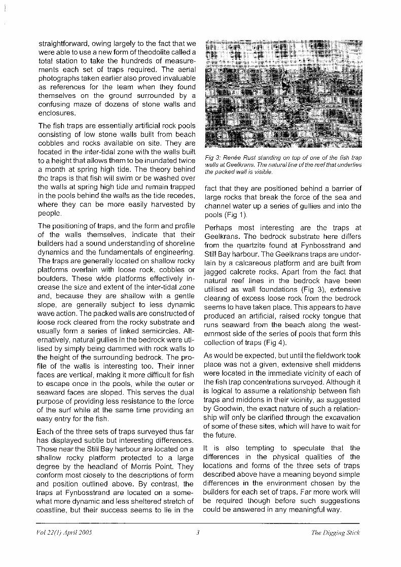
Fig 3: Renee Rust standing on top of one of the fish trap walls at Geelkrans. The natural line of the reef that underlies the packed wall is visible.
fact that they are positioned behind a barrier of large rocks that break the force of the sea and channel water up a series of gullies and into the pools (Fig 1).
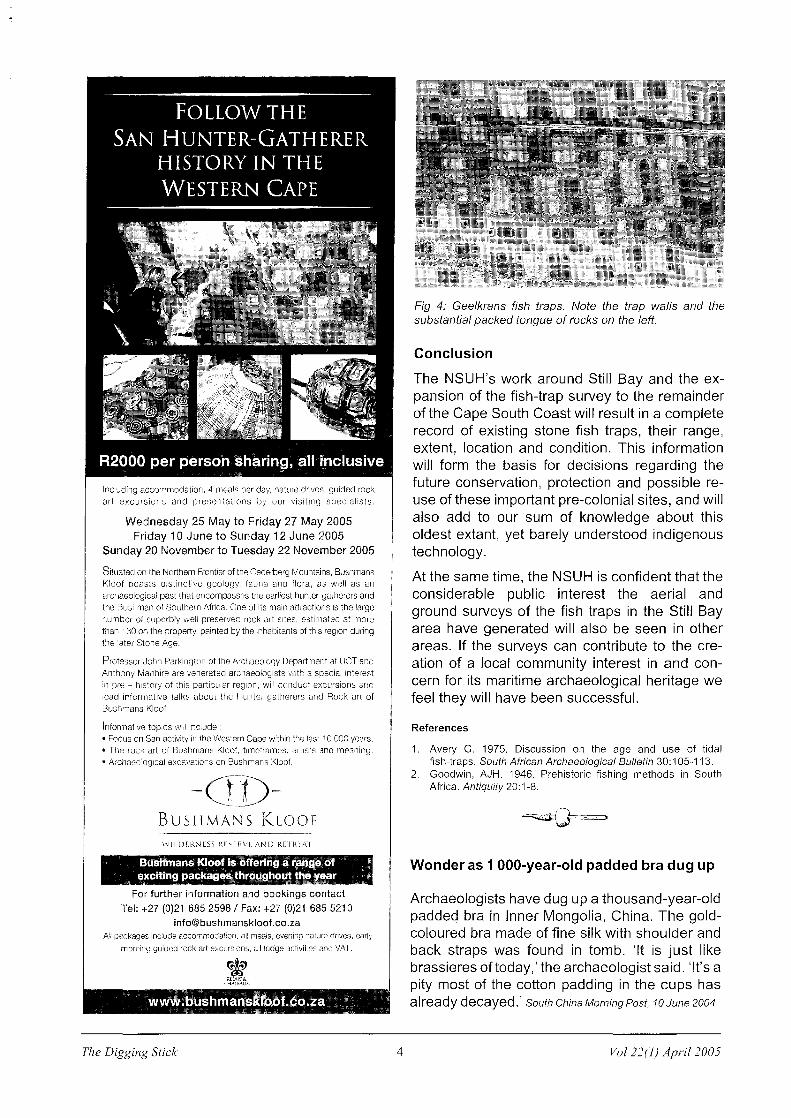
Perhaps most interesting are the traps at Geelkrans. The bedrock substrate here differs from the quartzite found at Fynbosstrand and Still Bay harbour. The Geelkrans traps are underlain by a calcareous platform and are built from jagged calcrete rocks. Apart from the fact that natural reef lines in the bedrock have been utilised as wall foundations (Fig 3), extensive clearing of excess loose rock from the bedrock seems to have taken place. This appears to have produced an artificial, raised rocky tongue that runs seaward from the beach along the western most side of the series of pools that form this collection of traps (Fig 4).
As would be expected, but until the fieldwork took place was not a given, extensive shell middens were located in the immediate vicinity of each of the fish trap concentrations surveyed. Although it is logical to assume a relationship between fish traps and middens in their vicinity, as suggested by Goodwin, the exact nature of such a relationship will only be clarified through the excavation of some of these sites, which will have to wait for the future.
It is also tempting to speculate that the differences in the physical qualities of the locations and forms of the three sets of traps described above have a meaning beyond simple differences in the environment chosen by the builders for each set of traps. Far more work will be required though before such suggestions could be answered in any meaningful way.
The Digging Stick
Including accommodation, 4 meals per day, nature drives, guided rock art excursions and presentations by our visiting specialists.
Wednesday 25 May to Friday 27 May 2005 Friday 10 June to Sunday 12 June 2005
Sunday 20 November to Tuesday 22 November 2005
Situated on the NOl1hern Frontier of the Cederberg Mountains, Bushmans Kloof boasts distinctive geology, fauna and fiora, as well as an archaeological past that encompasses the earliest hunter-gatherel's and the Bushman of Southern Africa. One of its main attractions is the large number of superbly well preserved rock art sites, estimated at more than 130 on the property, painted by the inhabitants of this region during the later Stone Age.
Professor John Parkington of the Archaeology Department at UCT arld Anthony Manhire are venerated archaeologists with a special interest in pre - historj of this particular region, wiii conduct excursions and lead informative talks about the Hunter-gatherers and Rock art of Bushmans Kloof.
Informative topics will include: • Focus on San activity in the Western Cape within the last 10 000 years • The rock art of Bushmans Kloof, timeframes, artists and meaning. • Archaeological excavations on Bushmans Kloof.
-uD-BUSHMANS KLOOF
VV1IDFRNESS RISIRVE /\ND RETREAT
BusHmans KlooI is Dilering a (a~g:e~ Qf " exciting packagesi;flrgggpDl:!t !l'ie ~ea~ _ '
For further information and bookings contact Tel: +27 {O)21 685 2598 I Fax: +27 (0)21 685 5210
i [email protected] All packages include accommodation, all meals, evening nature drives, early
morning guided rock art excursions, all lodge activities and VAT.
~ RElAIS&
GlAITN!X . . ~
, •••• Dtls ... mansl[()D~.I(l.~a .. N N ::; ~ ~ ~
The Digging Stick 4
Fig 4: Geelkrans fish traps. Note the trap walls and the substantial packed tongue of rocks on the left.
Conclusion
The NSUH's work around Still Bay and the expansion of the fish-trap survey to the remainder of the Cape South Coast will result in a complete record of existing stone fish traps, their range, extent, location and condition. This information will form the basis for decisions regarding the future conservation, protection and possible reuse of these important pre-colonial sites, and will also add to our sum of knowledge about this oldest extant, yet barely understood indigenous technology.
At the same time, the NSUH is confident that the considerable public interest the aerial and ground surveys of the fish traps in the Still Bay area have generated will also be seen in other areas. If the surveys can contribute to the creation of a local community interest in and concern for its maritime archaeological heritage we feel they will have been successful.
References
1. Avery G. 1975. Discussion on the age and use of tidal fish-traps. South African Archaeological Bulletin 30:105-113.
2. Goodwin, AJH. 1946. Prehistoric fishing methods in South Africa. Antiquity 20: 1-8.
Wonder as 1 OOO-year-old padded bra dug up
Archaeologists have dug up a thousand-year-old padded bra in Inner Mongolia, China. The goldcoloured bra made of fine silk with shoulder and back straps was found in tomb. 'It is just like brassieres of today,' the archaeologist said. 'It's a pity most of the cotton padding in the cups has al ready decayed.' South China Morning Post, 10 June 2004
Val 22(1) April 2005
FEASTING ON KASTEELBERG
Karim Sadr
Introduction
Currently the majority view is that livestock reached the Cape coast some 2 000 years ago in the company of immigrants from the middle Zambezi basin. However, reliable archaeological evidence for this migration has not yet been found in the Cape provinces. An alternative proposition is that small livestock may initially have spread throughout the western half of the subcontinent by down-the-line trade, or gift exchange from one group of local huntergatherers to another. If so, why should the Cape coastal hunter-gatherers have adopted sheep at that time? In such a rich setting it is difficult to argue that sheep were ever needed to avert famine.
A model from Neolithic Europe may provide the answer. The British archaeologist James Lewthwaite once suggested that sheep were first adopted in the western parts of Mediterranean Europe for prestige and as a means of creating social ranking. This seems a promising idea to pursue on the West Coast of South Africa.
Early sheep in southern Africa
Both Spoegrivier and Blombos on the Cape coast (Fig 1) have produced sheep bones directly dated to the first centuries BC and AD (Mitchell 2002). Directly-dated, early sheep bones are now also known from Toteng in northern Botswana (Larry Robbins, pers. com.). The sites of Geduld and Oruwanje in Namibia, Bambata cave in Zimbabwe, and Boomplaas, Steenbokfontein and Kasteelberg sites G and M in South Africa have also produced very early, but not yet directly dated, sheep bones. All these sheep bones are associated with stone artefacts of the Wilton complex, the archaeological manifestation of the autochthonous hunter-gatherers of southern Africa during the Holocene.
The few livestock remains found at early first millennium Wilton sites may indicate that sheep initially only served as insurance against failure in hunting, or as a small store of wealth that could
Kari.m Sadr is with the School of Geography, Archaeology & Envlronm.ental Studies, University of the Witwatersrand. sadrk@ geoarc.wlts.ac.za
Vol 22(1) April 2005 5
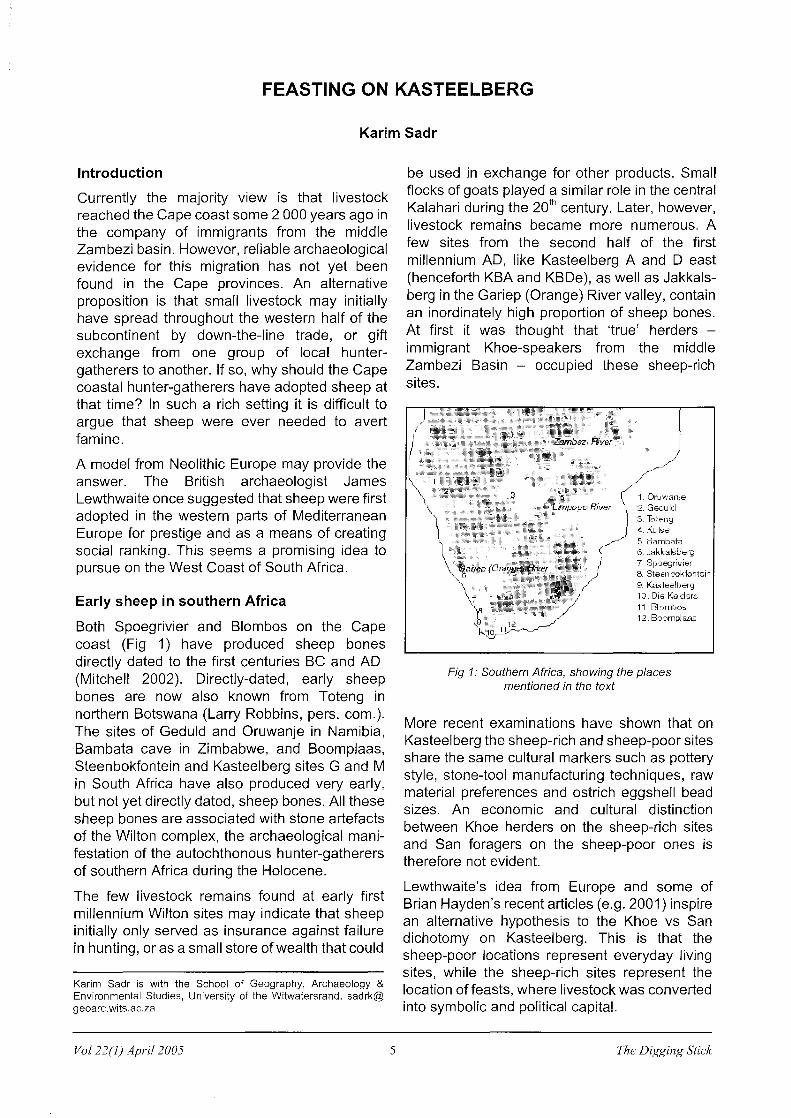
be used in exchange for other products. Small flocks of goats played a similar role in the central Kalahari during the 20th century. Later, however, livestock remains became more numerous. A few sites from the second half of the first millennium AD, like Kasteelberg A and D east (henceforth KBA and KBDe), as well as Jakkalsberg in the Gariep (Orange) River valley, contain an inordinately high proportion of sheep bones. At first it was thought that 'true' herders -immigrant Khoe-speakers from the middle Zambezi Basin - occupied these sheep-rich sites.
5. Bi.llllbata 6, Jakkalsberg 7. 8poegrivier 8. Steenookfontein g, ~'1.Steel berg 10, Die Kelders 11, Blombos 12. Boomplaas
Fig 1: Southern Africa, showing the places mentioned in the text
More recent examinations have shown that on Kasteelberg the sheep-rich and sheep-poor sites share the same cultural markers such as pottery style, stone-tool manufacturing techniques, raw material preferences and ostrich eggshell bead sizes. An economic and cultural distinction between Khoe herders on the sheep-rich sites and San foragers on the sheep-poor ones is therefore not evident.
Lewthwaite's idea from Europe and some of Brian Hayden's recent articles (e.g. 2001) inspire an alternative hypothesis to the Khoe vs San dichotomy on Kasteelberg. This is that the sheep-poor locations represent everyday living sites, while the sheep-rich sites represent the location of feasts, where livestock was converted into symbolic and political capital.
The Digging Stick

On feasting
Feasts are events constituted by the communal consumption of food and drink for a special purpose. Defined negatively, a feast is neither an everyday domestic meal nor is it the simple sharing of food without communal consumption. Beyond this minimal definition, researchers have proposed a bewildering variety of types of feasts. But in general they seem to agree that, beneath the surface, feasts are inherently political acts; feasts provide an arena for manipulating social relations, while commensal hospitality, like gift exchange, creates reciprocal obligations.
A number of recent papers have described the archaeological indications of feasting at different sites and in different periods. The material remains of feasts in minimally hierarchical societies, such as might be relevant to Kasteelberg during the later first millennium, may include large quantities of food debris; evidence of food wastage in the form of articulated joints and unprocessed bones; the remains of special, rare or labour-intensive plant or animal species, including domestic animals; unusual numbers of preparation and serving vessels; special locations for holding the feast; and evidence that the feasting society was 'trans-egalitarian'. In turn, evidence for trans-egalitarian hunter-gatherers might include indications of relatively high population density; differential burial treatments for different individuals depending on their (informal) status; exchange networks; evidence of food storage facilities; and a subsistence economy based on abundant and reliable resources. Most, if not all, of these general indicators of trans-egalitarian hunter-gatherer society can be found in late Holocene sites on the Cape coast (e.g. Mitchell 2002).
The Digging Stick
Fig 2: Kasteelberg, showing the sites discussed in the text - the contours are at 20m intervals
6
Feasting on Kasteelberg
Aside from these background indicators, there is also specific evidence for feasting on Kasteelberg. This includes the special location of the proposed feasting sites, their relative proportions of food debris to artefacts of everyday use and the specific foods consumed at the sites. It is the top of Kasteelberg where most of the sheep-rich sites such as KBA and KBDe are located (Fig 2). The hill is a prominent landmark and the summit provides a magnificent view of the surrounding landscape. Seal pup bones at KBA show that the hilltop was used in winter as well as in other seasons. Low winter clouds, however, make the top of Kasteelberg less than ideal for winter habitation, suggesting the possibility that sites such as KBA and KBDe were not mainly used for daily life in winter, but for special purposes.
A more direct indi- 80
cation of feasting 60
comes from the rel- 40
ative proportions of 20
artefacts found at KBA and KBDe, .30
40
which have an un- 20
usual array of mat- 10
erial remains. Artefacts for mundane 80
0., Sl1&ep (solid! and Bovld II (blank;,
00 Sleenbok (solid)
L:dl<>III<.trfll[).3JHllllln.
L,nh IlIbl nllll<c<rmiunl D
everyday tasks are 60 and Bovld I (blank',
rare on these sites. 40
Stone tools, for ex- 20
ample, occur in very ~-'-'--~---.w.----'-'-
low numbers at 100
KBA, while KBDe is 80
practically devoid of 60
sharp-edged flakes. :: Potsherds, in turn, are abundant relative to the sheeppoor sites. When
Fig 3: Food remains on the Kasteelberg sites
one takes bones and shell into account as well, it becomes clear that the hilltop sites have proportionally more remains related to food consumption than remains related to other everyday activities.
In addition, more food seems to have been wasted on the sheep-rich sites, as might be expected from feasting locales. A comparison shows that, on average, bone fragments are heavier on the Kasteelberg sheep-rich sites than on the sheep-poor sites (Sadr 2004). This could be interpreted to mean more food wastage in the
Val 22(1) April 2005

sense that bones on the sheep-rich sites were not broken up for marrow as intensively as they were on everyday living sites. As a further indication of feasting, the specific food items consumed are also of interest. The hilltop sites contain mostly remains of fat-rich foods such as sheep and seal (Fig 3). As Speth and Spielmann (1983) have shown, fat is greatly valued by hunter-gatherers. Atop Kasteelberg seal fat was served in clay pots. On the other hand, the relatively low numbers of tortoise and small game bones on the hilltop sites may be due to their low fat content, indicating perhaps that these meats were not fit for a feast.
Summary and conclusion
The textbook scenario for the introduction of food-producing economies to southern most Africa has long emphasised the role of immigrants from the north. Specifically, sheep are supposed to have reached the Cape coast of South Africa by the agency of Khoe-speaking herders who came from the middle Zambezi basin. More than three decades after the initial discovery of early sheep at the Cape coast, the archaeological evidence for such a 2 OOO-yearold migration has not yet come to light. Instead,
the archaeological evidence suggests that autochthonous hunter-gatherers were the first shepherds in this landscape. Small livestock may have spread to the Cape coast by a process of 'down-the-line' trade or gift exchange. As to why the West Coast hunter-gatherers of two millennia ago would have wanted to adopt sheep, the answer may have more to do with acquiring prestige than a new mode of subsistence.
Acknowledgments Parts of the research reported on here were generously funded by the Deutsche Forschungsgemeinschaft (DFG) through the auspices of the University of Cologne SFB 389 project, the WennerGren Foundation, the Swan Fund and the Universities of Botswana, Cape Town and the Witwatersrand. Many thanks to the Kotze family and their staff for permitting and facilitating the excavations at Kasteelberg.
References
1. Hayden, B. 2001. Fabulous feasts: A prolegomenon to the importance of feasting. In: Dietler, M & Hayden, B (eds). 2001. Feasts: Archeological and ethnographic perspectives on food, politics and power. Washington and London: Smithsonian Institution Press. Pp 23-64.
2. Mitchell, P. 2002. The archaeology of southern Africa. Cambridge: Cambridge University Press.
3. Sadr, K. 2004. Feasting on Kasteelberg? Early herders on the west coast of South Africa. Before Farming (online edition) 2004/3, article 2.
4. Speth, J and Spielmann, K. 1983. Energy source, protein metabolism and hunter-gatherer subsistence strategies. Journal of Anthropological Archaeology 2: 1-31.
ASAPA GIVES NEW IMPETUS TO PROFESSIONAL ARCHAEOLOGY
The year 2004 saw a significant development in the organisation of professional archaeology in southern Africa. To meet the needs of changing legislation and the growth of professional archaeology in the SADC region, the 33-year-old Southern African Archaeological Association (SA3) was renamed, restructured and given new impetus. The organisation now goes by the name of the Association of Southern African Professional Archaeologists (ASAPA) and carries a new constitution, minimum standards of practice and codes of conduct and ethics. The new professional association is to be registered as a non-profit organisation within the year. Under its new structure ASAPA offers formal representation for the majority of archaeological practitioners in southern Africa. It already has a membership of close to 200 professionals.
Rather than membership of the association being limited to academic archaeologists, as was the case under SA3, it is the intention of ASAPA to recognise standards for a level 3 and 4 National Certificate in Field and Technical Archaeology to be registered within the next 12 months. This will allow field workers and preparators with a technical background to obtain qualifications and to enter the profession, with membership of ASAPA as an added bonus.
Vol 22(1) April 2005 7
The association is committed to opening channels of communication with the public and to encouraging open debate. To this end the new ASAPA website (www.asapa.org.za) provides a forum for debate and offers links to many educational sites. Further, the professional association continues to support and promote the important work carried out by amateur societies in southern Africa. ASAPA is also in the process of developing open lines of communication and active working relationships with the heritage agencies of southern African countries and various governing bodies within South Africa.
In a major development, which will be of particular interest to ArchSoc members, ASAPA recently entered into a five-year agreement with the South African Archaeology Society to edit and co-produce the South African Archaeological Bulletin. The first Bulletin to be produced under ASAPA's editorship will be the December 2005 issue. Amanda Esterhuysen, Chairperson
The Digging Stick

MORE ON BORED STONES USED AS WHEELS
Shaw Badenhorst
In a recent article in The Digging Stick I reported the use of a bored stone as a sledge wheel (Badenhorst 2003). My informant, her father of San and mother of Tswana descent, noticed the use of these stones as wheels in Botswana when she was young. Bored stones had a variety of purposes and uses (e.g. Badenhorst 2003, Lombard 2002, Lombard et al 2003, Ouzman 1997). I recently came across more evidence on the use of bored stones as wheels among Bantu-speakers.
A letter in the South African Archaeological Bulletin by Chas W Bates of the former northern Transvaal (Bates 1949: 107) mentions that while he was interrogating local Bantu-speakers of Mohlaba's Location near Letsilele (former north-eastern Transvaal) on the origin of the bored stones he 'found in the area', he was told that they 'were used by early inhabitants as plough-wheels, revolving on a wooden axle.' Bates admits, however, that many of these bored stones could not have been used as wheels.
In an accompanying letter, Or HC Franz mentions an interview with 'old Mokobane at Makgabeng, a Mokoni about 80 years old' (Franz 1949: 1 07). He reports that Mokobane described 'factory sites on the Makgabeng Plateau where the men used to make these bored stones.' Apparently, a suitable stone was selected and pecked with a harder stone from both sides. Finally an iron rod was used to bore the stone, with sand and water added as an abrasive. Ed Eastwood, who has surveyed the plateau extensively, never found nor heard of such a site (Ed Eastwood, pers. comm.). However, 16 bored stones attached to digging sticks are depicted on a panel at a San rock art site in the Makgabeng (Eastwood & Tlouamma 2002) and bored stones have been found in the vicinity of the plateau (Ed Eastwood, pers. comm.).
In reply to the letters by Bates and Franz, Goodwin (1949:108) points out that neither the plough nor the wheel is known to have crossed the Sahara southwards before the arrival of Europeans. He adds that although bored stones may have been used as wheels, it must have been experimental and secondary, as many bored stones are too small to have accommodated an axle.
Bored stones are generally associated with the San, but the sparse evidence would indicate that Bantuspeaking groups, or some at least, did perhaps produce and manufacture these stones themselves. This, as well as the different roles bored stones played in these societies, needs to be investigated further.
Shaw Badenhorst is with the African Heritage Research Institute in Cape Town. [email protected]
The Digging Stick 8
Acknowledgement
Ed Eastwood provided much needed information, which the author gratefully acknowledges. Isabelle Parsons provided valuable comments to an earlier draft.
References
1. Badenhorst, S. 2003. Notes from an interview: An innovative use of a bored stone as a sledge wheel. The Digging Stick 20(1):8.
2. Bates, CW. 1949. Points from Correspondence: Bored stones from the Transvaal. South African Archaeological Bulletin 4(15):107.
3. Eastwood, EB & Tlouamma, NJ. 2002. The rock art of the Makgabeng Plateau. Volume 4. Millbank and Langbryde. Unpublished report.
4. Franz, HC. 1949. Points from Correspondence: Bored stones from the Transvaal. South African Archaeological Bulletin 4(15):107.
5. Goodwin, AJH. 1949. Points from Correspondence: Bored stones from the Transvaal. South African Archaeological Bulletin 4(15):108.
6. Lombard, M. 2002. Bored stones, lithic rings and the concept of holes in San shamanism. Anthropology Southern Africa 25:17-27.
7. Lombard, M, Parsons, I & Van der Ryst, MM. 2003. 'Lentswe la Badimo': Stone of the ancestors. The Digging Stick 20(1 ):5-7.
8. Ouzman, S. 1997. Between margin and centre. The archaeology of southern African bored stones. In: Wadley, L (ed). Our gendered past. Archaeological studies of gender in southern Africa. Johannesburg: Witwatersrand University Press. Pp 71-106.
Another early human skeleton in Ethiopia
US and Ethiopian scientists believe they have discovered one of the oldest skeletons of an early human ancestor in Ethiopia, dating back four million years. The' bones were found in February just 60 km from the site where the 3,2-million-year-old Lucy, one of the first hominids, was discovered in 1974. The as yet unnamed fossil might be an earlier brother or sister. This is the world's oldest biped,' said Bruce Latimer of the National History Museum in Ohio, who made the discovery with Yohannes Haile-Selassie. A complete tibia from the lower part of the leg, parts of the femur, ribs, vertebrae, a collarbone, pelvis and a complete shoulder blade have been found. The find is significant because the structure of the anklebone indicates that the individual almost certainly walked upright. But it still holds many mysteries, Latimer added. 'It is already clear that the individual was larger than Lucy, has longer legs than Lucy, but it is older, which is strange.'
In January researchers announced the discovery of the remains of at least nine primitive human ancestors between 4,3 and 4,5 million years old belonging to the transitional species Ardipithicus ramidus. BBC, 21312005
Vol 22(1) April 2005

EARLY RECORDS OF SOUTH AFRICAN ROCK ART
Mike Wilson
On 29 February 1752 an expedition under the command of Ensign August Frederik Beutler was despatched from the Castle of Good Hope to explore the region now known as the Eastern Cape. It was to report on the nature of the peoples living there and the possibility of trading with them and on anything else that might be to the interest or advantage of the Dutch East India Company. The expedition journal was kept by Beutler's assistant, Carel Albrecht Haupt.
Theal (1896) published a verbatim copy of the journal (VC 60) in the National Archives, Cape Town. This includes a map of the expedition route (Map 4/2). Another copy in the Colonial Archives in The Hague, Netherlands, was published by Godee Molsbergen (1922). A seminal study by Forbes (1965) concentrated mainly on the geographical aspects, but also provided other information. To date the journal has not been published in any language other than the original Dutch.*
After visiting the Xhosa and Thembu (referred to as Caffers and Tamboegies in the journal) and unsuccessfully attempting to barter cattle from them, the expedition turned north-west on the next stage of its journey, the Copper Mountains of Namaqualand. On 14 August, in the vicinity of Cradock (Forbes 1965:21), Haupt recorded that: 'We noticed that in places here many pictures were found painted on the rocks, these being the work of the d'Gaua, who are called Little Chinese by our travellers. We went to a place about two hours from our camp to see these. Under the ridge of a kloof, in a kind of cave in which one could shelter from wind and rain, we saw pictures of wild horses, baboons and people in various positions, painted on the rocks in red, white and black. Some were rather well drawn, others not, the latter seeming to be the work of pupils. It is astonishing to find such things among such a coarse and ignorant people'.
Although they were unable to make contact with the d'Gaua, who hid themselves in the
Mike Wilson, formerly an archaeologist at the South African Museum, Cape Town. PO Box 862, Sea Point, 8060.
* Wilson and his co-editors of the Codex Witsenii are currently preparing an annotated translation of the journal of Beutler's expedition.
Vol 22(1) April 2005 9
mountains at the approach of the other San sent to look for them, Haupt wrote three days later: 'These d'Gaua, as we understood it, are a kind of Hottentot, though small of stature and of an extremely fearful nature. They are like the Bushmen in their apparel and way of life, but much more adept than these and the other Hottentots in the handling of bow and arrow. They live, like the [Xhosa and Thembu], under a paramount chief, whom they call Goechoe Moua. They are great lovers of the art of painting and everywhere one finds one or other painting on the rocks they find suitable.' (The Dutch plural's' has here been omitted from the people's name.)
Nienaber (1989:314-8) discussed the d'Gaua and considered that the d'-prefix was an attempt by Haupt to reproduce a dental 'click', so that the name would now be spelt /gaua; and that it means 'Red People'. As mentioned by Haupt, the name 'Little Chinese' was given by Europeans. Their being called 'a kind of Hottentot' and said to be different in some respects from the 'Bushmen' is indicative of the confusion existing in the minds of the Europeans over the identities of these peoples. By the time of the expedition the Khoikhoi had been so devastated by recurrent epidemics of smallpox and cattle disease that many of the survivors were forced to go into the service of Europeans, or to adopt a 'Bushman' way of life.
In 1775, Sparrman (Forbes 1975:219) commented that: 'The Chinese or Snese Hottentots, so called from their complexion, which is yellower than that of the other Hottentot nations, and therefore like the Chinese, are likewise in· their dialect very distinct from them. There is, however, so great a resemblance between them all, that they can in some measure understand each other.' In 1776, Sparrman (Forbes 1977:113) observed that: 'If what I have been assured by many be true, the Hottentots, who originally resided at Agter Bruintjes-hoogte, lived peaceably with the Christians who first migrated thither ... but at length they had withdrawn themselves, and now live concealed in holes and corners up and down this part of the country like other Boshies-men. Yet, being fewer in number, they are not altogether so bold and daring. Their complexions being rather of a yellow cast, they
The Digging Stick

are considered as of a different nation, and have consequently been called Chinese- or SneseHottentots. The chief abode of these fugitives is on each side of the two Visch-riviers.' (Italics as in the originals.)
The earliest copies of paintings are probably those made in 1777 by Colonel Robert Jacob Gordon or his artist, Johannes Schumacher, and which were attributed to the Oeswana Hottentot tribe, called 'Sinesen' by the farmers. Commenting on those he had seen, Gordon wrote: 'Some were reasonable, but on the whole they were poor and exaggerated. They had painted various animals, mostly in black, also red and yellow, and some people' (Raper & Boucher 1988:83; pI. 15). The published drawing shows simple black figures of a rhinoceros, an ostrich and four people with upraised arms, possibly dancing. Elphick (1977:28, text & footnote 19) said that the Houswaana were non-Khoikhoi speakers who lived in the Sneeuberg and were known by Khoikhoi as d'Gauas and by whites as 'Chinese Bushmen'.
Although the surveyor and cartographer, Carel David Wentzel, was instructed, if possible, to make drawings of plants and animals (Theal 1896:5), either this was not done or they have not been found. This is regrettable as such drawings would greatly have enhanced the value of the journal, especially if the drawings had been annotated with information on the use of the plants and animals by the indigenous peoples, as was the case with the drawings made on Simon van der Stel's expedition to the Copper Mountains in 1685-6 (De Wet & Pheiffer 1979; Wilson et al 2002).
References
1. De Wet, GC & Pheiffer, RH (eds). 1979. Simon van der Stet's journey to Namaqualand in 1685. Cape Town & Pretoria: Human & Rousseau.
2. Elphick, R. 1977. Kraal and Castle: Khoikhoi and the founding of White South Africa. New Haven & London: Yale University Press.
3. Forbes, VS. 1965. August Frederik Beutler. Pioneer travellers of South Africa: 7-24. Cape Town & Amsterdam: A A Balkema.
4. Forbes, VS (ed). 1975. Anders Sparrman: A voyage to the Cape of Good Hope - Voll. Cape Town: Van Riebeeck Society. 2nd Series No. 6.
5. Forbes, VS (ed). 1977. Anders Sparrman: A voyage to the Cape of Good Hope - Volll. Cape Town: Van Riebeeck Society. 2nd Series No. 7.
6. Godee Molsbergen, EC. 1922. Journaal gehouden door Assistent Carel Albrecht Haupt op de togt door den Vaandrig August Frederik Beutler - in den jaar 1752 ondernoomen. Reizen in Zuid-Afrika Vol. 3:265-336. Amsterdam: Linschoten-Vereeniging.
7. Nienaber, GS. 1989. Khoekhoense stamname: 'n Voorlopige verkenning. Pretoria & Cape Town: Academica (for the Human Sciences Research Council) ..
The Digging Stick 10
8. Raper, PE & Boucher, M (eds). 1988. Robert Jacob Gordon: Cape Travels 1777 to 1786. Johannesburg: The Brenthurst Press.
9. Theal, GM. 1896. Reis van den Vaandrig Beutler in 1752. Belangrijke Historische Dokumenten No. 2:1-78. Cape Town: Van de Sandt De Villiers & Co.
10. Wilson, ML, Toussaint van Hove-Exalto, T & Van Rijssen, WJJ (eds). 2002. Codex Wits en ii. Annotated watercolours of landscapes, flora and fauna observed on the expedition to the Copper Mountains. Cape Town: Iziko Museums. Amsterdam: Davidii BV.
TRANS-VAAL BRANCH CALLS FOR 2006 FUNDING PROPOSALS
The Trans-Vaal Branch of the South African Archaeological Society invites applications for funding by researchers and educators in the field of archaeology in 2006. Archaeological research projects in South Africa and educational programmes that promote knowledge about and an understanding of archaeology, particularly among the youth, will be considered. The deadline for applications is 31 August 2005.
An amount of R 18000 is available for grants. Funding may be split over more than one project. The TransVaal Branch committee's decision on disbursements will be final. The following information must be provided in the application:
1. The proposal, the proposed programme implementation schedule, a budget estimate and the anticipated results or benefits.
2. If the project for which funding is requested forms part of a larger programme, information on how the project relates to the whole.
3. Resources and facilities available for implementing the project or programme.
4. The grant being applied for must be broken down into discrete categories of expenditure to permit the funding of specific aspects of the research.
5. Biographical details of the applicant(s), including previous experience, academic qualifications, professional affiliations and publications.
6. Two references that can attest to the quality of previous archaeological work undertaken by the applicant(s).
7. Proposals for the publication of the research results.
Success applicants will be required to report progress and results to the Trans-Vaal Branch committee sixmonthly.
Applications must be forwarded to the Secretary, Trans-Vaal Branch, South African Archaeological Society, PO Box 41050, Craighall, 2024. E-mail: [email protected]. Enquiries: Mrs Jo Earle, branch chairman, 011 706 6905.
Val 22(1) April 2005

FAMOUS FINDS HONOURED
Elwyn Jenkins
National orders introduced by South Africa in recent years feature two of the country's most important archaeological finds: the best-preserved Mapungubwe rhinoceros and one of the Lydenburg Heads. The rhinoceros is the emblem of the Order of Mapungubwe, which was one of three orders introduced in December 2002 and is awarded to South African citizens for excellence and exceptional achievement. The Lydenburg Head appears on the medal for the Order of Ikhamanga, which was one of the second group of three orders introduced in December 2003 and is awarded for excellence in the arts and sport.
The medal for the Order of Mapungubwe shows the gold-plated rhinoceros against the background of the flat-topped Mapungubwe Hill, as well as a gold-plated sceptre, another artefact found in the royal graves, emerging from a gold melting pot on either side. These 11 th century artefacts are on display in the Mapungubwe Museum at the University of Pretoria. The design was the work of a young industrial designer, happily named Gold Mametja, who also designed the commemorative gold bars for the Comrades Marathon. While the medal for the Order of Ikhamanga gives prominence to two strelitzia flowers, since ikhamanga means 'strelitzia', the central motif is one of the 6th century terracotta heads found at Lydenburg. The heads are housed at the University of Cape Town and the designer of the medal is Gareth Smart.
Giving the background to the selection of the orders and their symbols, government explained in a statement that it had 'investigated symbols and symbolism in an attempt to capture the essence of a new aesthetic that will reflect the spirit of a new country. A panel of academics and specialists versed in indigenous symbols and symbolism was asked to identify key factors and elements that denote the
Elwyn Jenkins is a Professor Emeritus of English at the University of South Africa. E-mail: [email protected]
Vol 22(1) April 2005 11
collective and inclusive history and experience of Africa with South Africa as the main point of reference.' The statement continued that the symbolism of the national orders followed the adoption of the new flag and the coat of arms, which 'embraced the collective historical essence of the people of the country. A new aesthetic that takes consideration of Africa and her symbols became part of the new culture that informs a South African rebirth.'
SENIOR SCOUT ADVENTURE 'FOLLOWS THE SAN'
Andrew Smith
Under the auspices of the South African Scout Association, 600 scouts and scout leaders took over the Cederberg from 10 to 21 December 2004 for the biennial Senior Scout Adventure. This event hosts scouts from all over South Africa, neighbouring countries and, this time, a patrol from Ireland as well. They participate in a number of activities ranging from rock-climbing and para-sailing to Dutch-oven cooking, pizza-making, astronomy and marksmanship, hiking from base to base. The theme of this year's adventure was 'Follow in the Footsteps of the San' and base leaders were encouraged to link what they could with the aboriginal inhabitants of the area. The goldpanning base included Bushman games for the scouts to play and all the watercraft on the base at Clanwilliam Dam had Bushman animal names.
For the second time running, members of the University of Cape Town's Archaeology Department were invited to operate a base in the southern sector. In addition, the Living Landscape Project in Clanwilliam, under the aegis of John Parkington, ran a San rock art trail at Warmhoek in the northern sector. This activity was held at Stadsaal near Sanddrift and consisted of a discussion on the meaning of Bushman paintings with the aim of introducing an alternative view of the world to the scouts. Another aim was to highlight the importance of rock art as a nonrenewable resource that should be treated with respect. The anthropology of hunting was also discussed, especially the relationship of the hunter to his prey and what constitutes a 'real' hunter in Bushman terms. Elephant and eland paintings offered
Andrew B Smith is with the Department of Archaeology, University of Cape Town, Rondebosch. [email protected]
The Digging Stick

a way into the belief of the relationship between animals and people.
As part of the activity, each patrol was invited to break an ostrich egg and to make beads. Examples of Bushman beads were shown, some of which were only 3 mm in outside diameter. After the trial of making (and breaking) beads using metal drills, the scouts were asked to consider how easy it might have been to make the beads without metal. A stone-tipped drill was offered and some scouts were in fact able to make beads with it. At this base guides from the Living Landscape project also led the scouts to various caves in the Warmhoek/Jan Oissels Valley. At each cave the scouts would do an exercise and discuss what was depicted on the rock walls. This exciting activity was initially marred by excessive heat in the valley on the first day when temperatures rose to 40°C, making it difficult for the scouts to follow the trail.
The posit1ve response we got from the scouts made it all worthwhile and we were gratified to see many of our visitors still proudly wearing their bead necklaces at the final campfire.
THE CAPE GALLERY
ARCHAEOLOGY IN BRIEF
France seizes African artefacts. French customs officials have seized 845 African archaeological objects, including rare figurines, destined for possible resale in Belgium. The French Finance Ministry said that the objects were part of a cargo sent from Niger and falsely declared as 'artisan products.' They comprised 668 stone objects dating back to the Neolithic period (6 000-4 000 years BC) and 29 pieces of pottery and rare figurines likely to have been used in funeral ceremonies by inhabitants of the Bura region between Niger and Burkina Faso in the second to 10th centuries. Reuters, 29 January 2005
Ancient rock carvings go online. Newcastle University archaeologists have discovered more than 250 new examples of prehistoric rock carvings in the moorlands of Northumberland. These will feature on a new web site presenting 6 000 images (http://rockart. ncl.ac.uk). The carvings are believed to be the work of Neolithic and Early Bronze Age people between 3 500 and 6 000 years ago. Other rock art to feature on the site will be the country's largest collection of rock art in one place, at Roughting Linn. The project was inspired by Northumberland rock art specialist Or Stan Beckensall, who donated his archive to the university, and is promoted by archaeologist Aron Mazel.
BBC, January 2005
One af five saftground, sugar/ift and
aquatint etchings from 'The Life af
Everyman' series by Judy Waadbarne
60 Church Street Cape Town 8001 TellFax (021) 423-5309
E-mail: [email protected] Web-sites: www.capegallery.co.za
www.capeinfo.comlcapegallery
Gallery Hours: Mon - Fri 9.30 am - 5.00 pm
Sat 9.00 am - 1.00 pm
Mastercard Visa Amex Diners Club
Arrangements can be made to freight your purchases home.
The Digging Stick 12
The Cape Gallery deals in fine art work by SA artists and stocks a selection ofpaintings
depicting South African rock art.
Val 22(1) April 2005

DIGGING STICKS WITH BORED STONES IN ETHIOPIA
Reinoud Boers
Digging sticks topped by bored stones to give weight to them are in daily use in the eastern part of Ethiopia. Members of the Archaeological Society who toured Ethiopia recently did a double take when on their journey from Awash to Harar rows of men were wielding digging sticks to excavate a trench for a new water pipeline. The tool was not seen in the central or north-western parts of the country.
Travelling through the beautiful and fertile Chercher and Arba Gugu mountain ranges, which form the southern escarpment to the Rift Valley, and surrounded by chat (a mild drug chewed in the eastern part of the country in particular) and coffee plantations, there along the road we came upon these, for us, astonishing scenes. Here were hundreds of men industriously digging a trench along long stretches of road with digging sticks. No need to speculate here about the possible ancient meanings and purposes of bored stones. The only other tools in evidence were spades to lift the soil out of the trenches and wheelbarrows. A little later at a roadside guesthouse digging sticks were used in the preparation of the ground for a new retaining wall.
Bored stones and metal spikes at the market
Strolling through the narrow passages and markets of the ancient walled city of Harar, the spiritual heart of Ethiopia's Muslim community, we happened on a square that served as the domestic products market. Here various stalls sold two of the components that make up a typical Ethiopian digging stick, namely the metal spike and the bored stone. The stick, which needs to be about a meter long, one presumably cuts oneselffrom a young eucalyptus tree, the species that grows profusely all over the country (introduced by an Italian early in the 19th century to make up for the rapid loss of the natural forest). The granite bored stones
Reinoud Boers is a committee member of the Trans-Vaal Branch and editor of The Digging Stick.
Val 22(1) April 2005 13
Ethiopian digging sticks at excavation
are clearly handmade, being neither perfectly rounded nor having regularly-formed holes, which taper from the outside surfaces towards the middle.
The immediate difference one notices when comparing the design of the Ethiopian implement to the digging stick that forms part of the logo of our society is that in Ethiopia the bored stone is attached to the extreme end of the stick. In 'our' digging stick the stone is positioned towards the foot of the stick, just above the spike. Is it possibly that the Ethiopian position generates greater force to the downward thrust? The high position appears to allow greater mobility in handling and certainly makes the tool easier to carry: the stick is just slung over the shoulder, with the stone and metal spike balancing out the weight. Another difference is that we depict the digging stick as having a horn as a spike. Presumably a metal spike has never been found in conjunction with a bored stone in southern Africa. Interesting questions arise: was the Ethiopian digging stick converted from horn to metal at some time in the past and did Western colonial influence in southern Africa replace the digging stick with iron tools before the spike could be converted to metal?
Donkeys originated in Africa
Domesticated donkeys came from Africa, according to a study by France's National Centre for Scientific Research. Scientists compared DNA signatures of 427 domestic donkeys from 52 countries with that of wild donkey populations in south-west Asia and east Africa. A genetic family tree indicated that the likely ancestors of donkeys were two populations of African wild asses. Like horses, the asses were tamed about 5 000 years ago, which concurs with sketchy archaeological evidence that Egyptians were the first to use the beasts. Domestication of asses was a watershed in human development, marking the moment when mankind moved away from the nomadic lifestyle to a fixed, agrarian one. A FP, 18 June 2004
The Digging Stick

TRANS-VAAL BRANCH SUPPORT FOR ARCHAEOLOGICAL RESEARCH
Since 2002 the SA Archaeological Society's TransVaal Branch has been supporting archaeological projects, research and education in South Africa by providing annual financial grants. To date, 11 recipients have shared a total of R80 000. The possibility of providing grants was brought about by the branch's rapidly increasing income from sales and the enthusiastic support of the branch's activities by members. Over 80 books and other items are stocked by the branch for sale at its lectures and other events and by mail order.
In addition to these grants, the Trans-Vaal Branch annually also gives awards to the best archaeological students at three Gauteng universities. Van Riet Lowe prizes of R250 each go to the best Wits University undergraduate and postgraduate students of the year (the Van Riet Lowe Trust tops up these awards to R500 each). Hanisch Prizes of R500 each are awarded to Pretoria University's two best students, while UNISA's best archaeology student is awarded R500.
The introduction of annual financial grants had its origin in an appeal in 1999 by the then chairman of the Trans !Gariep Branch, Sven Ouzman, for funding to rehabilitate the Tandjesberg rock art site near Ladybrand, which had been badly damaged by fire. The Trans-Vaal branch's 'seed money' of R1 000 kickod off the project and after expenditure of over R400 000 the rehabilitated site was reopened in March 2001. Two years later, the Trans-Vaal Branch provided a grant of R5 000 to the Archaeological Resource Development Project of Wits University to help defray the costs of producing an educational poster depicting life in the Sterkfontein Valley 2,6 million years ago. The poster, which formed part of an educational information kit for distribution to schools, saw the light of day the following year.
Involvement in these successful projects and growth in sales income convinced the committee to introduce regular annual grants. It was decided that the grants should promote South African archaeological research and educational programmes that foster knowledge about and an understanding of archaeology, especially among the youth, as well as education in the field of archaeology. The grants were first advertised through the Society's publications and at universities in 2002 and they have undoubtedly added considerable value to the branch's activities.
In 2003, Marlize Lombard was awarded a grant of R4 000 to cover some of her costs of conducting residue and use-wear studies for an MA degree at UNISA. In the same year the branch donated an amount of R25 000 to the Society to cover the cost of publishing the December 2003 issue of the South African Archaeological Bulletin. The R20 000 voted by the committee for 2004 was split between four
The Digging Stick 14
recipients, namely:
D Anton Pelser of the National Cultural History Museum: R4 000 for his PhD research project at the Sotho-Tswana settlement at Askoppies to clarify the Late Iron Age sequence on the Vredefort Dome.
D Jonas Tlouamma: R3 500 for first-year archaeological and anthropological studies at UNISA. He aims to contribute to the development of the Makgabeng Plateau in Limpopo as a National Heritage Site. .
D Amanda Esterhuysen, Archaeological Resource Development Project, Wits University: R9 500 for the development phase of an archaeology handbook for educators.
D Vanessa Brueton: R3 000 towards second-year archaeological studies at Wits.
Funding for 2005 was increased to R25 000. Again, there were four beneficiaries, as follows:
D Jonas Tlouamma: R2 400 to cover a further two UNISA modules and field excursion costs.
D Kabelo Matshetshe: R4 600 for research on Late Stone Age lugged ceramics and associated wares in southern Africa for his MA degree at Wits University.
D Genevieve Dewar: R8 000 to fund research on the Namaqualand coast as part of a PhD on shell midden sites at UCT.
D ASAPA - The Association of Southern African Professional Archaeologists: R10 000 to cover the cost of building a web site for the association.
~
LETTER
Clicks in the San language Sir: On a walking trail through the Postberg Nature Reserve near Langebaan, the path led us past a herd of grazing eland. We were intrigued to hear clicking sounds coming from the animals. On further research, I discovered the sound comes from either the hooves, knees or carpal bones. See: The Mammals of the Southern African Subregion, by Reay HN Smithers, page 681. It occurred to me that the clicks in the San languages might in fact have evolved from these antelope, as the San lived in close proximity to them and associated with them in their rituals and spirituality. We all have various sounds to call domesticated animals, so why not make the same sounds as the eland clicks to call/communicate with or mimic them.
I would appreciate any thoughts/correspondence on this observation, or reference to any research done in this field. Dawn Woods, Ken il wo rth , Western Cape
Vol 22( /) April 2005
BOOK REVIEWS
The Broken String Bennun, Neil. 2004. The Broken String: The Last Words of an Extinct People. Viking. [Trans-Vaal Branch Sales Table]
The stories, lore and life histories of the IXam, a San people from the Northern Cape, were recorded by Wilhelm Bleek and Lucy Lloyd in the 1870s. These texts have recently enjoyed a unique revival: as fundamental to contemporary interpretations of rock art, as African literature and as the story of an extraordinary cross-cultural rapport between colonist and colonised. Bennun re-tells these stories of the IXam, their cultural demise and the creation of the IXam archive.
The springing of some IXam men from a Cape Town prison for Bleek's linguistic research is well known. Bennun narrates it afresh, sketching a vivid picture of a late Victorian colonial world that was swallowing the world of the indigenous IXam. Dextrously he sketches IXam ways of life and their perspectives on the world in tandem with the story of Bleek and Lloyd's research, presenting new information and fresh details about the lives of both the narrators and recorders. I found the details on the latter especially engaging: Bleek's encounters with Africa (West Africa, Natal and Cape society); Lloyd's demanding father, her broken engagement and her dedication to her work despite financial difficulties and a cold climate for women scholars. Though I have long worked with the IXam stories, Bennun still surprised me with snippets and context with which I was unfamiliar. The volume also presents a compelling overview of the richness of the IXam world of myth, magic and oral tradition.
This is not a learned tome, but a skilful telling of a unique tale. It compiles others' work rather than pushing the boundaries of knowledge - the author is a little uncritical of his sources and the volume is underreferenced. But it remains a marvellous read - a must for anyone interested in the San and their pasts and the history of our knowledge of indigenous peoples. For a web review, go to: www.spectator.co.uk/ books_ section.php?issue=2004-06-26. Read an interview with the author at www.readysteadybook.com/neil bennun.html. Review by Or Anne Solomon
The Rise of Conservation in SA
Bienart, William. 2003. The Rise of Conservation in South Africa: Settlers, Livestock and the Environment, 1770-1950. Oxford: Oxford University Press. Price R280.
William Bienart, Rhodes Professor of Race Relations at Oxford University, is also the author of an earlier, less specialised historical text on South Africa called Twentieth Century South Africa (1994, OUP). Bienart
Vol 22(1) April 2005 15
is an alumnus of Cape Town University and the London School of Oriental and African Studies.
In the final chapter of his new book, Bienart states that the initial impulse for driving the identification of the topic came from wishing to find out more about the systems of government-run conservation that especially grated on rural communities in apartheid South Africa (and to a lesser extent in Zimbabwe), and which in some instances provided a key rallying point for anti-government action. From this progressive point of viewing a couple of centuries of conservation and land management techniques, however, has sprung a wide-ranging work that covers a great deal more than the point of departure.
The book is organised around nine separate and varied agrarian or conservation-related topics. It opens with a general chapter on the scientific background to land management extant in the post-Enlightenment Cape Colony. The bulk of the book is given over to a serial treatment of a variety of topics, such as 'Fire, vegetation change and pastures, 1860-1880' and 'Prickly pear in the Cape: Useful plants and invaders in the livestock economy, 1890-1950'. Each subject is discussed at some length, making it a highly specific resource for scholars in environmental study. However, some readers could feel short-changed by the fact that there is no discussion - the title does not purport there to be - of pre-colonial methods of stock, agrarian and veld management, all of which would shed much needed light on the societies that were so badly served by history during apartheid.
Owing, however, to Bienart's wide-ranging background and exposure to situations in other parts of the world (e.g. the United States), consistent comparisons are made with these, which counteracts the occasional narrowness of some South African historical texts. One also picks up fascinating nuggets of information, such as the fact that Governor Alfred Milner was so obsessed with imposing 'improving' experiences on post-Boer War South Africa that he funded trips to Australia for Boer POWs so that they could be edu- cated in 'scientific methods' of farming. The Australian methods were presumably deemed superior to the Boers' own centuries-old knowledge of the (African) bush and its ways! The chapter on the career of the talented Afrikaner nationalist agrarian theoretician HS du Toit is an equally fascinating study of the mania for 'scientific improvement', which was a major theme driving apartheid development.
The Rise of Conservation in South Africa provides a useful and thoroughly researched resource on interventionist land and agriculture methodologies in SA between 1770 and 1950, despite the lost opportunity for discussion on pre-colonial communities and indigenous conservation techniques. Review by Sally Raper
The Digging Stick

SOCIETY NEWS
Society AGM. The Annual General Meeting of the South African Archaeological Society is to be held at the TH Barry Lecture Theatre, Iziko: South African Museum, Queen Victoria Street, Cape Town, on 10 May 2005 at 17:30 for 18:00. The agenda may be obtained by telephoning the Society's Assistant Secretary, Carole Goeminne, at 021 481 3886. The AGM will be followed by a lecture by Or Antonia Malan on historical archaeology in Cape Town.
Membership numbers. Assistant Secretary Carole Goeminne appeals to members who deposit their annual membership fees direct into the Society's bank account to ensure that in addition to their names they include their membership numbers with the deposit. This will prevent allocation errors and queries. Membership numbers appear above members' names and addresses on all ArchSoc correspondence.
The Society's Bulletin. The cumulative index to the South African Archaeological Bulletin that was started a few years ago by Duncan Miller and Judy Sealy has been upd,ated thanks to the efforts of the current editor, Margaret Avery. Members can obtain the electronic version bye-mailing a request to the Society's Assistant Secretary, Carole Goeminne, at [email protected]. Hard copies are unfortunately not available.
The Society is very gratefui to Margaret Avery for aii the hard work she has put into editing the Bulletin since the December 2002 issue. We will miss her when she resigns at the end of June 2005, but will always value her quiet efficiency that made an enduring contribution to the Society.
As from 1 July 2005 the Bulletin will be published in association with ASAPA, the Association of Southern African Professional Archaeologists, under a five-year contract. Changes to the cover and layout are being contemplated, but librarians will be relieved to know that name, size and numbering will remain the same. Authors are invited to submit papers for publication to the ASAPA Chairperson, Amanda Esterhuysen, Department of Archaeology, University of the Witwatersrand, Private Bag 3, Wits, 2050.
ARCHAEOLOGY IN SOUTH AFRICA
Schutsekamma moves
Rock engravings at a site at Schutsekamma on the Riet River south of Kimberley are to be rescued. The engravings, situated on a hill overlooking the river, are in a setting where there are also old diamond-bearing river gravels. Mining impacts began in the 1930s and accelerated in the 1990s. In July last year it was found that a slimes dam had leaked over a fenced 1930s
The Digging Stick 16
cemetery and a deep pit had been sunk into one side of the engraving site. The South African Heritage Resources Agency has authorised the rescue of the engravings - at the developer's expense. The plan is that they be accessioned into the collection of the McGregor Museum, but are then transferred to Wildebeest Kuil, the community-based rock art project near Kimberley. Here the engravings will complement existing displays, while highlighting the vulnerability of this heritage. For information on Wildebeest Kuil e-mail [email protected].
Prehistoric site found in underwater cave
Scuba divers from Operation Zembe (Axe) have located an underwater cave in False Bay that reveals 'promising signs' of prehistoric human activity. According to maritime archaeologist Or Bruno Werz, the cave had the correct overhang and orientation for prehistoric cave dwellers. It would have been raised above the landscape, allowing the inhabitants to spot game and command a strategic view and there was evidence around the cave of the type of vegetation that prehistoric man would have eaten. The 12 members of Operation Zembe were selected from hundreds of applicants by the Scientific Exploration Society. Former Royal Marine Monty Hall, one of the divers who discovered an underwater city off India, leads the group. Interest in the False Bay area began in 1995 after Werz discovered the world's oldest underwater artefact, a stone hand-axe believed to be between 300000 and 1,4 million years old. 22 Nov. 2004
The South African Archaeological Society was founded in 1945 to promote archaeology through research, education and publication. It publishes
the South African Arohaeological Bulletin, a scientific publication' of current research in
southern Africa (twice a year), The Digging Stick, the Society's general interest newsletter (three issues per year), and occasional publications in
the Goodwin Series.
The views of the authors are their own and the Society does not take responsibility for them.
Published by the South African Archaeological Society, PO Box 15700, Vlaeberg, 8018,
South Africa. Tel: +27 (0)21 481-3886. Fax: +27 (0)21 481-3993. E-mail: [email protected].
(A non-profit organisation - Registration No: 024-893-NPO)
Editor: Reinoud Boers, PO Box 2196, Rivonia, 2128, South Africa. Home tel/fax: +27 (0)11
803-2681. Cell: +27 (0)82 5666295. E-mail: [email protected]
Layout: Marion Boers. Printing: TVaal Johannesburg (Pty) Ltd.
Val 22(1) April 2005