The DaVinci's of Dirt
19
The DaVincis of dirt: Geoarchaeological perspectives on Native American mound building in the Mississippi River basin Sarah C. Sherwood a,⇑ , Tristram R. Kidder b,1 a Department of Anthropology, Dickinson College, Carlisle, PA 17013, USA b Department of Anthropology, Washington University, St. Louis, MO 63130, USA article info Article history: Received 13 July 2010 Revision received 10 November 2010 Available online 7 January 2011 Keywords: Mound Construction Earthworks Geoarchaeology Micromorphology Mississippi River basin abstract The complexity of mound construction, as revealed through geoarchaeological analyses, indicates the cul- tural significance of mounds may be as well reflected in the earthen construction materials and their arrangement, as it is in the artifacts abandoned on their summits. We use geoarchaeological examples from three sites in the Mississippi River basin, Shiloh Mounds, Cahokia, and Poverty Point, to advocate a geoarchaeological approach that considers multiple scales from the regional soils and geomorphology, field observation of lithostratigraphic units, to the micro-scale identification of the mineralogy and soil development in order to decipher the source and processing of the soils and sediments. We focus on the use of five types of construction referred to here as: sod blocks, soil blocks, loaded fills, zoned fills and veneers. Also we address the selection and transportation of soils and sediments used in mound building and what these types of deposits reveal about the methods used to build mounds. These data can be used to evaluate and understand organization of labor, pace of construction, and mound appear- ance. We hold there is a considerable (although unquantified) difference between earth moving and mound building and that the construction of these important monuments required considerable knowl- edge, skill, planning, hard work, and attention to symbolic and ritual meaning. Ó 2010 Elsevier Inc. All rights reserved. Introduction The Mississippi River basin of eastern North America is home to thousands of earthen mounds erected by American Indians. Archaeological research has documented a 6000 year-long history of mound building (Bense, 1994; Milner, 2004a; Saunders et al., 1997; Steponaitis, 1986). These mounds have long been a focus of research for the artifacts and architectural remains they contain. With the integration of a geoarchaeological perspective it is now possible to view the mounds themselves as artifacts, and to explore their construction using some of the assumptions we apply to other elements of material culture. Traditionally, archaeologists have assumed mounds were erected by a simple process of accu- mulating sediments or soil material into a pile and shaping it to whatever architectural form was desired. New field studies, incor- porating a geoarchaeological perspective, suggest mound building required a planned effort that incorporated site preparation, sophisticated understanding of soil properties, and considerable engineering skills. Each step of the construction process, including planning the mound and preparing the land, acquiring various building materials, allocating labor, and actually constructing the earthwork, required a series of decisions each of which reflect cul- tural choices that encode information about the society, economy, politics, and culture of the builders. We believe this perspective, that extends beyond traditional artifacts to integrate the building material and construction process as ‘‘artifact’’, could be applied to many forms of monumental construction (e.g., ziggurats, Mayan pyramids, and Shang palaces), not just earthen mounds. With the emphasis on the activities occurring on stage surfaces of platform mounds, geoarchaeological characterization of mound stratigraphy is traditionally overlooked or limited (see below for few exceptions), and typically lacks standardized soil/sediment descriptions. In early platform mound excavation reports, the ab- sence of such stratigraphic observations cannot be used as negative data, that there was no internal stratigraphy or that these mounds were composed of homogeneous ‘‘basket loads.’’ Numerous exam- ples of stratigraphic complexity are documented in often unpub- lished Depression-era government-sponsored excavation profiles (e.g., Frank H. McClung Museum Archives) (Fig. 1). These detailed drawings (often rendered in color pencil), as well as photo archives (e.g., Fairbanks, 1956, Ocmulgee National Monument), attest to the presence of this complexity across various temporal and spatial contexts. But variability in mound construction stratigraphy was 0278-4165/$ - see front matter Ó 2010 Elsevier Inc. All rights reserved. doi:10.1016/j.jaa.2010.11.001 ⇑ Corresponding author. Fax: +1 717 245 1479. E-mail addresses: [email protected] (S.C. Sherwood), [email protected] (T.R. Kidder). 1 Fax: +1 314 935 8535. Journal of Anthropological Archaeology 30 (2011) 69–87 Contents lists available at ScienceDirect Journal of Anthropological Archaeology journal homepage: www.elsevier.com/locate/jaa
Transcript of The DaVinci's of Dirt
Journal of Anthropological Archaeology 30 (2011) 69–87
Contents lists available at ScienceDirect
Journal of Anthropological Archaeology
journal homepage: www.elsevier .com/ locate/ jaa
The DaVincis of dirt: Geoarchaeological perspectives on Native Americanmound building in the Mississippi River basin
Sarah C. Sherwood a,⇑, Tristram R. Kidder b,1
a Department of Anthropology, Dickinson College, Carlisle, PA 17013, USAb Department of Anthropology, Washington University, St. Louis, MO 63130, USA
a r t i c l e i n f o a b s t r a c t
Article history:Received 13 July 2010Revision received 10 November 2010Available online 7 January 2011
Keywords:Mound ConstructionEarthworksGeoarchaeologyMicromorphologyMississippi River basin
0278-4165/$ - see front matter � 2010 Elsevier Inc. Adoi:10.1016/j.jaa.2010.11.001
⇑ Corresponding author. Fax: +1 717 245 1479.E-mail addresses: [email protected] (S.C. Sh
(T.R. Kidder).1 Fax: +1 314 935 8535.
The complexity of mound construction, as revealed through geoarchaeological analyses, indicates the cul-tural significance of mounds may be as well reflected in the earthen construction materials and theirarrangement, as it is in the artifacts abandoned on their summits. We use geoarchaeological examplesfrom three sites in the Mississippi River basin, Shiloh Mounds, Cahokia, and Poverty Point, to advocatea geoarchaeological approach that considers multiple scales from the regional soils and geomorphology,field observation of lithostratigraphic units, to the micro-scale identification of the mineralogy and soildevelopment in order to decipher the source and processing of the soils and sediments. We focus onthe use of five types of construction referred to here as: sod blocks, soil blocks, loaded fills, zoned fillsand veneers. Also we address the selection and transportation of soils and sediments used in moundbuilding and what these types of deposits reveal about the methods used to build mounds. These datacan be used to evaluate and understand organization of labor, pace of construction, and mound appear-ance. We hold there is a considerable (although unquantified) difference between earth moving andmound building and that the construction of these important monuments required considerable knowl-edge, skill, planning, hard work, and attention to symbolic and ritual meaning.
� 2010 Elsevier Inc. All rights reserved.
Introduction
The Mississippi River basin of eastern North America is home tothousands of earthen mounds erected by American Indians.Archaeological research has documented a 6000 year-long historyof mound building (Bense, 1994; Milner, 2004a; Saunders et al.,1997; Steponaitis, 1986). These mounds have long been a focusof research for the artifacts and architectural remains they contain.With the integration of a geoarchaeological perspective it is nowpossible to view the mounds themselves as artifacts, and to exploretheir construction using some of the assumptions we apply toother elements of material culture. Traditionally, archaeologistshave assumed mounds were erected by a simple process of accu-mulating sediments or soil material into a pile and shaping it towhatever architectural form was desired. New field studies, incor-porating a geoarchaeological perspective, suggest mound buildingrequired a planned effort that incorporated site preparation,sophisticated understanding of soil properties, and considerableengineering skills. Each step of the construction process, including
ll rights reserved.
erwood), [email protected]
planning the mound and preparing the land, acquiring variousbuilding materials, allocating labor, and actually constructing theearthwork, required a series of decisions each of which reflect cul-tural choices that encode information about the society, economy,politics, and culture of the builders. We believe this perspective,that extends beyond traditional artifacts to integrate the buildingmaterial and construction process as ‘‘artifact’’, could be appliedto many forms of monumental construction (e.g., ziggurats, Mayanpyramids, and Shang palaces), not just earthen mounds.
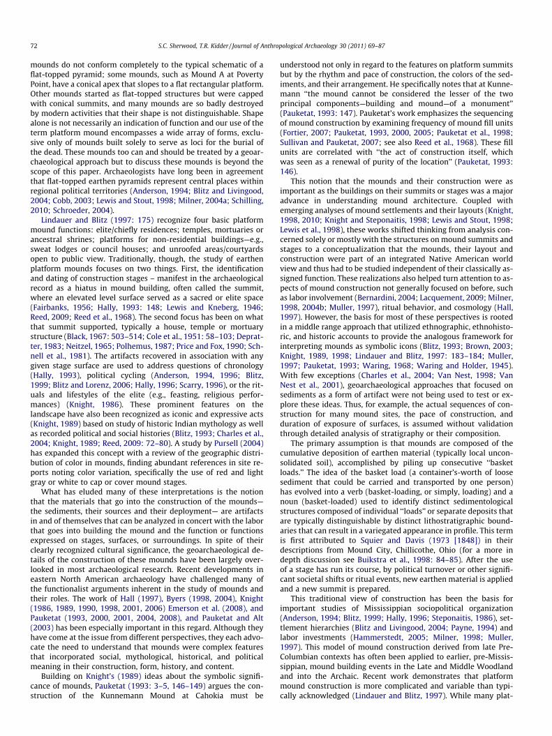
With the emphasis on the activities occurring on stage surfacesof platform mounds, geoarchaeological characterization of moundstratigraphy is traditionally overlooked or limited (see below forfew exceptions), and typically lacks standardized soil/sedimentdescriptions. In early platform mound excavation reports, the ab-sence of such stratigraphic observations cannot be used as negativedata, that there was no internal stratigraphy or that these moundswere composed of homogeneous ‘‘basket loads.’’ Numerous exam-ples of stratigraphic complexity are documented in often unpub-lished Depression-era government-sponsored excavation profiles(e.g., Frank H. McClung Museum Archives) (Fig. 1). These detaileddrawings (often rendered in color pencil), as well as photo archives(e.g., Fairbanks, 1956, Ocmulgee National Monument), attest to thepresence of this complexity across various temporal and spatialcontexts. But variability in mound construction stratigraphy was
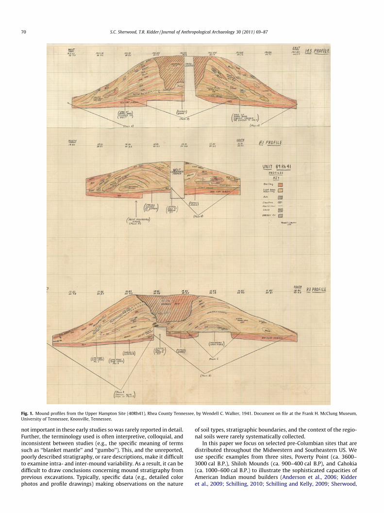
Fig. 1. Mound profiles from the Upper Hampton Site (40Rh41), Rhea County Tennessee, by Wendell C. Walker, 1941. Document on file at the Frank H. McClung Museum,University of Tennessee, Knoxville, Tennessee.
70 S.C. Sherwood, T.R. Kidder / Journal of Anthropological Archaeology 30 (2011) 69–87
not important in these early studies so was rarely reported in detail.Further, the terminology used is often interpretive, colloquial, andinconsistent between studies (e.g., the specific meaning of termssuch as ‘‘blanket mantle’’ and ‘‘gumbo’’). This, and the unreported,poorly described stratigraphy, or rare descriptions, make it difficultto examine intra- and inter-mound variability. As a result, it can bedifficult to draw conclusions concerning mound stratigraphy fromprevious excavations. Typically, specific data (e.g., detailed colorphotos and profile drawings) making observations on the nature
of soil types, stratigraphic boundaries, and the context of the regio-nal soils were rarely systematically collected.
In this paper we focus on selected pre-Columbian sites that aredistributed throughout the Midwestern and Southeastern US. Weuse specific examples from three sites, Poverty Point (ca. 3600–3000 cal B.P.), Shiloh Mounds (ca. 900–400 cal B.P), and Cahokia(ca. 1000–600 cal B.P.) to illustrate the sophisticated capacities ofAmerican Indian mound builders (Anderson et al., 2006; Kidderet al., 2009; Schilling, 2010; Schilling and Kelly, 2009; Sherwood,
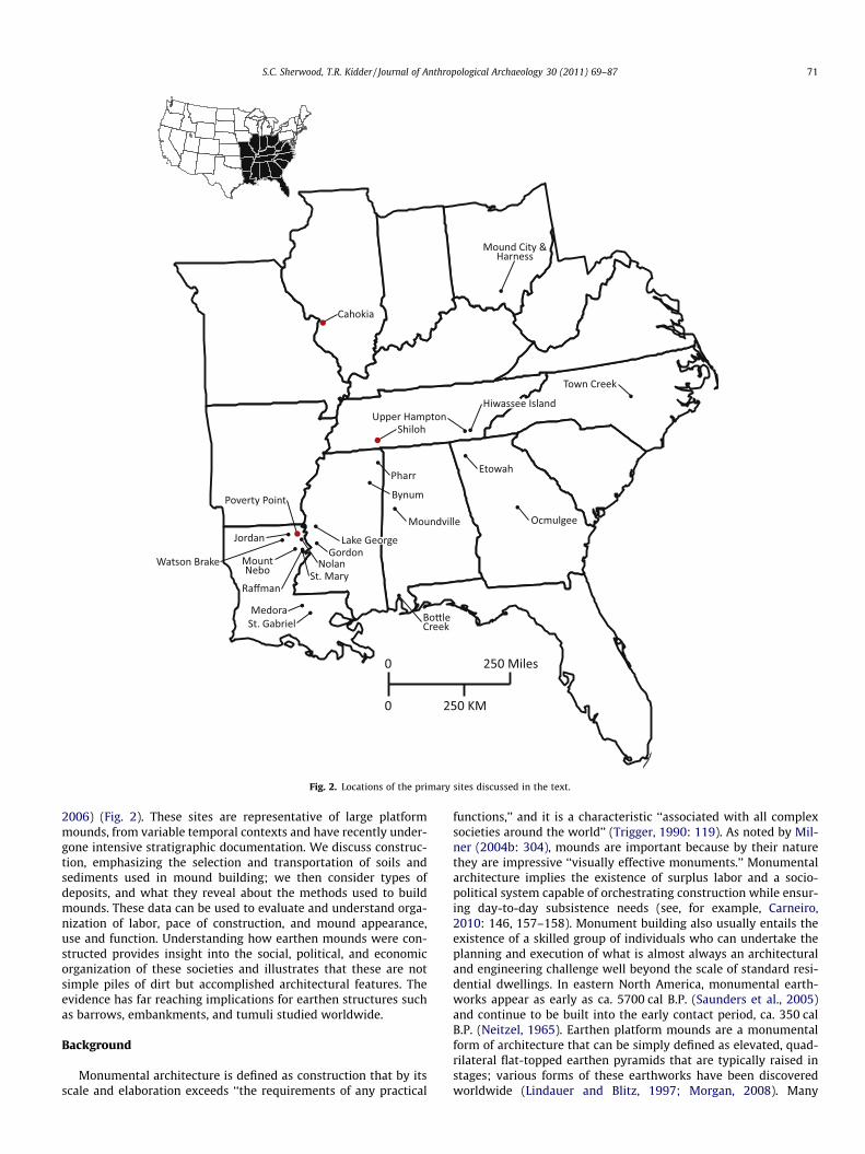
Fig. 2. Locations of the primary sites discussed in the text.
S.C. Sherwood, T.R. Kidder / Journal of Anthropological Archaeology 30 (2011) 69–87 71
2006) (Fig. 2). These sites are representative of large platformmounds, from variable temporal contexts and have recently under-gone intensive stratigraphic documentation. We discuss construc-tion, emphasizing the selection and transportation of soils andsediments used in mound building; we then consider types ofdeposits, and what they reveal about the methods used to buildmounds. These data can be used to evaluate and understand orga-nization of labor, pace of construction, and mound appearance,use and function. Understanding how earthen mounds were con-structed provides insight into the social, political, and economicorganization of these societies and illustrates that these are notsimple piles of dirt but accomplished architectural features. Theevidence has far reaching implications for earthen structures suchas barrows, embankments, and tumuli studied worldwide.
Background
Monumental architecture is defined as construction that by itsscale and elaboration exceeds ‘‘the requirements of any practical
functions,’’ and it is a characteristic ‘‘associated with all complexsocieties around the world’’ (Trigger, 1990: 119). As noted by Mil-ner (2004b: 304), mounds are important because by their naturethey are impressive ‘‘visually effective monuments.’’ Monumentalarchitecture implies the existence of surplus labor and a socio-political system capable of orchestrating construction while ensur-ing day-to-day subsistence needs (see, for example, Carneiro,2010: 146, 157–158). Monument building also usually entails theexistence of a skilled group of individuals who can undertake theplanning and execution of what is almost always an architecturaland engineering challenge well beyond the scale of standard resi-dential dwellings. In eastern North America, monumental earth-works appear as early as ca. 5700 cal B.P. (Saunders et al., 2005)and continue to be built into the early contact period, ca. 350 calB.P. (Neitzel, 1965). Earthen platform mounds are a monumentalform of architecture that can be simply defined as elevated, quad-rilateral flat-topped earthen pyramids that are typically raised instages; various forms of these earthworks have been discoveredworldwide (Lindauer and Blitz, 1997; Morgan, 2008). Many
72 S.C. Sherwood, T.R. Kidder / Journal of Anthropological Archaeology 30 (2011) 69–87
mounds do not conform completely to the typical schematic of aflat-topped pyramid; some mounds, such as Mound A at PovertyPoint, have a conical apex that slopes to a flat rectangular platform.Other mounds started as flat-topped structures but were cappedwith conical summits, and many mounds are so badly destroyedby modern activities that their shape is not distinguishable. Shapealone is not necessarily an indication of function and our use of theterm platform mound encompasses a wide array of forms, exclu-sive only of mounds built solely to serve as loci for the burial ofthe dead. These mounds too can and should be treated by a geoar-chaeological approach but to discuss these mounds is beyond thescope of this paper. Archaeologists have long been in agreementthat flat-topped earthen pyramids represent central places withinregional political territories (Anderson, 1994; Blitz and Livingood,2004; Cobb, 2003; Lewis and Stout, 1998; Milner, 2004a; Schilling,2010; Schroeder, 2004).
Lindauer and Blitz (1997: 175) recognize four basic platformmound functions: elite/chiefly residences; temples, mortuaries orancestral shrines; platforms for non-residential buildings—e.g.,sweat lodges or council houses; and unroofed areas/courtyardsopen to public view. Traditionally, though, the study of earthenplatform mounds focuses on two things. First, the identificationand dating of construction stages – manifest in the archaeologicalrecord as a hiatus in mound building, often called the summit,where an elevated level surface served as a sacred or elite space(Fairbanks, 1956; Hally, 1993: 148; Lewis and Kneberg, 1946;Reed, 2009; Reed et al., 1968). The second focus has been on whatthat summit supported, typically a house, temple or mortuarystructure (Black, 1967: 503–514; Cole et al., 1951: 58–103; Deprat-ter, 1983; Neitzel, 1965; Polhemus, 1987; Price and Fox, 1990; Sch-nell et al., 1981). The artifacts recovered in association with anygiven stage surface are used to address questions of chronology(Hally, 1993), political cycling (Anderson, 1994, 1996; Blitz,1999; Blitz and Lorenz, 2006; Hally, 1996; Scarry, 1996), or the rit-uals and lifestyles of the elite (e.g., feasting, religious perfor-mances) (Knight, 1986). These prominent features on thelandscape have also been recognized as iconic and expressive acts(Knight, 1989) based on study of historic Indian mythology as wellas recorded political and social histories (Blitz, 1993; Charles et al.,2004; Knight, 1989; Reed, 2009: 72–80). A study by Pursell (2004)has expanded this concept with a review of the geographic distri-bution of color in mounds, finding abundant references in site re-ports noting color variation, specifically the use of red and lightgray or white to cap or cover mound stages.
What has eluded many of these interpretations is the notionthat the materials that go into the construction of the mounds—the sediments, their sources and their deployment— are artifactsin and of themselves that can be analyzed in concert with the laborthat goes into building the mound and the function or functionsexpressed on stages, surfaces, or surroundings. In spite of theirclearly recognized cultural significance, the geoarchaeological de-tails of the construction of these mounds have been largely over-looked in most archaeological research. Recent developments ineastern North American archaeology have challenged many ofthe functionalist arguments inherent in the study of mounds andtheir roles. The work of Hall (1997), Byers (1998, 2004), Knight(1986, 1989, 1990, 1998, 2001, 2006) Emerson et al. (2008), andPauketat (1993, 2000, 2001, 2004, 2008), and Pauketat and Alt(2003) has been especially important in this regard. Although theyhave come at the issue from different perspectives, they each advo-cate the need to understand that mounds were complex featuresthat incorporated social, mythological, historical, and politicalmeaning in their construction, form, history, and content.
Building on Knight’s (1989) ideas about the symbolic signifi-cance of mounds, Pauketat (1993: 3–5, 146–149) argues the con-struction of the Kunnemann Mound at Cahokia must be
understood not only in regard to the features on platform summitsbut by the rhythm and pace of construction, the colors of the sed-iments, and their arrangement. He specifically notes that at Kunne-mann ‘‘the mound cannot be considered the lesser of the twoprincipal components—building and mound—of a monument’’(Pauketat, 1993: 147). Pauketat’s work emphasizes the sequencingof mound construction by examining frequency of mound fill units(Fortier, 2007; Pauketat, 1993, 2000, 2005; Pauketat et al., 1998;Sullivan and Pauketat, 2007; see also Reed et al., 1968). These fillunits are correlated with ‘‘the act of construction itself, whichwas seen as a renewal of purity of the location’’ (Pauketat, 1993:146).
This notion that the mounds and their construction were asimportant as the buildings on their summits or stages was a majoradvance in understanding mound architecture. Coupled withemerging analyses of mound settlements and their layouts (Knight,1998, 2010; Knight and Steponaitis, 1998; Lewis and Stout, 1998;Lewis et al., 1998), these works shifted thinking from analysis con-cerned solely or mostly with the structures on mound summits andstages to a conceptualization that the mounds, their layout andconstruction were part of an integrated Native American worldview and thus had to be studied independent of their classically as-signed function. These realizations also helped turn attention to as-pects of mound construction not generally focused on before, suchas labor involvement (Bernardini, 2004; Lacquement, 2009; Milner,1998, 2004b; Muller, 1997), ritual behavior, and cosmology (Hall,1997). However, the basis for most of these perspectives is rootedin a middle range approach that utilized ethnographic, ethnohisto-ric, and historic accounts to provide the analogous framework forinterpreting mounds as symbolic icons (Blitz, 1993; Brown, 2003;Knight, 1989, 1998; Lindauer and Blitz, 1997: 183–184; Muller,1997; Pauketat, 1993; Waring, 1968; Waring and Holder, 1945).With few exceptions (Charles et al., 2004; Van Nest, 1998; VanNest et al., 2001), geoarchaeological approaches that focused onsediments as a form of artifact were not being used to test or ex-plore these ideas. Thus, for example, the actual sequences of con-struction for many mound sites, the pace of construction, andduration of exposure of surfaces, is assumed without validationthrough detailed analysis of stratigraphy or their composition.
The primary assumption is that mounds are composed of thecumulative deposition of earthen material (typically local uncon-solidated soil), accomplished by piling up consecutive ‘‘basketloads.’’ The idea of the basket load (a container’s-worth of loosesediment that could be carried and transported by one person)has evolved into a verb (basket-loading, or simply, loading) and anoun (basket-loaded) used to identify distinct sedimentologicalstructures composed of individual ‘‘loads’’ or separate deposits thatare typically distinguishable by distinct lithostratigraphic bound-aries that can result in a variegated appearance in profile. This termis first attributed to Squier and Davis (1973 [1848]) in theirdescriptions from Mound City, Chillicothe, Ohio (for a more indepth discussion see Buikstra et al., 1998: 84–85). After the useof a stage has run its course, by political turnover or other signifi-cant societal shifts or ritual events, new earthen material is appliedand a new summit is prepared.
This traditional view of construction has been the basis forimportant studies of Mississippian sociopolitical organization(Anderson, 1994; Blitz, 1999; Hally, 1996; Steponaitis, 1986), set-tlement hierarchies (Blitz and Livingood, 2004; Payne, 1994) andlabor investments (Hammerstedt, 2005; Milner, 1998; Muller,1997). This model of mound construction derived from late Pre-Columbian contexts has often been applied to earlier, pre-Missis-sippian, mound building events in the Late and Middle Woodlandand into the Archaic. Recent work demonstrates that platformmound construction is more complicated and variable than typi-cally acknowledged (Lindauer and Blitz, 1997). While many plat-
S.C. Sherwood, T.R. Kidder / Journal of Anthropological Archaeology 30 (2011) 69–87 73
form mounds were built in stages, some were erected rapidly insingle construction efforts. In some instances it is evident elaborateland surface preparation preceded the mound construction, whilein other cases the final earthen deposit placed on the mound ap-pears to have served to ritually bury or seal penultimate platformsurfaces (see for example, Pauketat, 1993: 146–147; Reed, 2009:65; Roe, 2006; Williams and Brain, 1983: 61–62, Fig. 4.1). In short,platform mound construction and use was not a one-size fits allbehavior. Therefore, understanding platform mounds requiresmultiple perspectives. We propose that conceptualizing themounds as complex feats of geotechnical engineering is an impor-tant way to study their significance. This approach requires a com-prehensive knowledge of earthen materials, their composition,structure and their use in construction that have yet to be factoredinto these research questions.
A geoarchaeological approach
In recent years, the interdisciplinary field of geoarchaeology hasstretched beyond its roots in large-scale geomorphic studies thattypically provide a backdrop for the interpretation of artifacts ortheir disturbance, to research behavioral questions. Attention toanthropogenic sediments, at a range of stratigraphic scales andtemporal resolutions, is now actively engaging questions that in-clude: the organization of space in contexts from urban centers(e.g., Albert et al., 2008; Matthews, 1995), caves (e.g., Goldbergand Sherwood, 2006); burning activity, including fuel use (e.g., Al-bert et al., 2000), floor construction and preparations (e.g., Bernaet al., 2007; Macphail et al., 2004), and soil fertility (e.g., Adderleyet al., 2008; Guttmann et al., 2008). Such a geoarchaeological ap-proach to mound stratigraphy provides a framework for the studyof building and engineering techniques and data to draw infer-ences on the labor involved with that construction.
To fully realize and document stratigraphy from an earthenmound, examination must incorporate multiple scales: macro-scopic (field observation focusing on lithostratigraphic characteris-tics and sedimentary structures), microscopic (micromorphologicalanalysis of mound strata and potential source materials), and groupsof deposits that appear as stages (defined as temporally discreet be-cause they exhibit the presence of abrupt or unconformable bound-aries and the presence of building phases expressed in variousbuilding remains at the upper boundary), or substages (defined astemporally discreet based on the presence of abrupt or unconform-able boundaries that lack any evidence of buildings at the upper
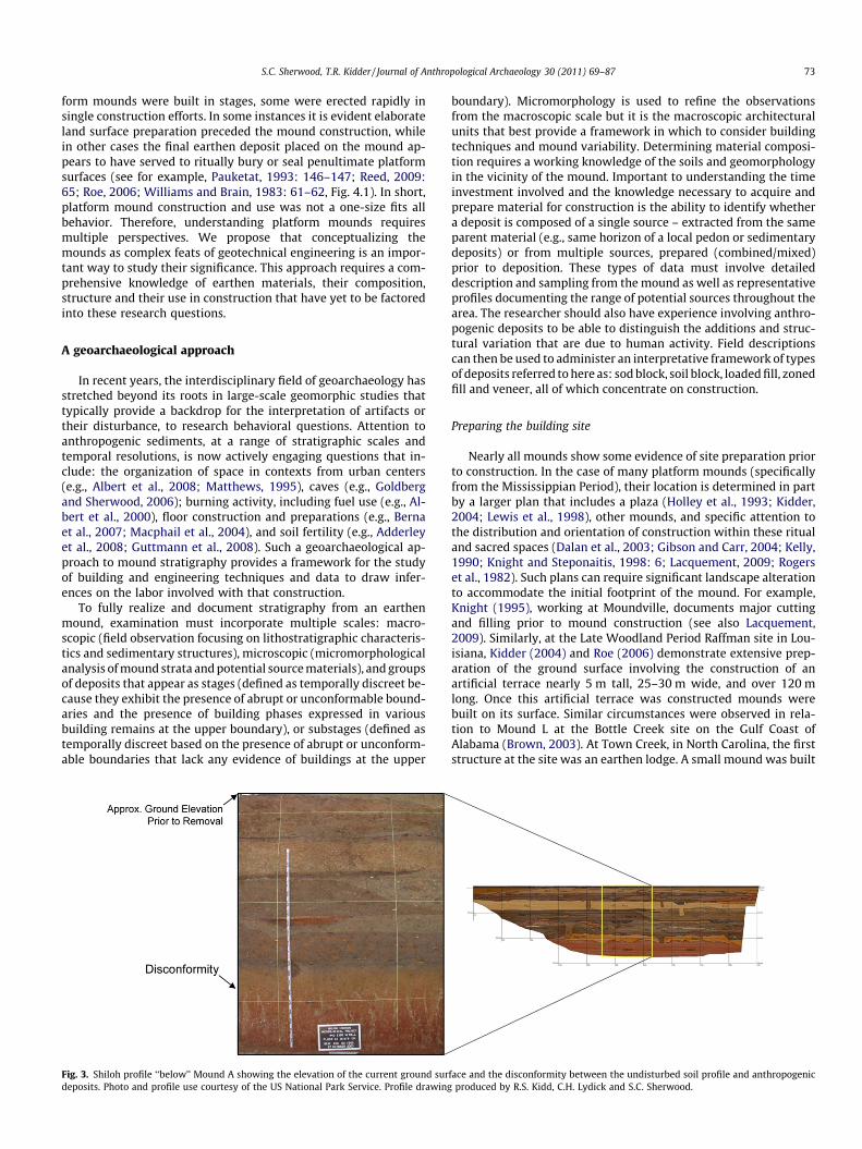
Fig. 3. Shiloh profile ‘‘below’’ Mound A showing the elevation of the current ground surdeposits. Photo and profile use courtesy of the US National Park Service. Profile drawing
boundary). Micromorphology is used to refine the observationsfrom the macroscopic scale but it is the macroscopic architecturalunits that best provide a framework in which to consider buildingtechniques and mound variability. Determining material composi-tion requires a working knowledge of the soils and geomorphologyin the vicinity of the mound. Important to understanding the timeinvestment involved and the knowledge necessary to acquire andprepare material for construction is the ability to identify whethera deposit is composed of a single source – extracted from the sameparent material (e.g., same horizon of a local pedon or sedimentarydeposits) or from multiple sources, prepared (combined/mixed)prior to deposition. These types of data must involve detaileddescription and sampling from the mound as well as representativeprofiles documenting the range of potential sources throughout thearea. The researcher should also have experience involving anthro-pogenic deposits to be able to distinguish the additions and struc-tural variation that are due to human activity. Field descriptionscan then be used to administer an interpretative framework of typesof deposits referred to here as: sod block, soil block, loaded fill, zonedfill and veneer, all of which concentrate on construction.
Preparing the building site
Nearly all mounds show some evidence of site preparation priorto construction. In the case of many platform mounds (specificallyfrom the Mississippian Period), their location is determined in partby a larger plan that includes a plaza (Holley et al., 1993; Kidder,2004; Lewis et al., 1998), other mounds, and specific attention tothe distribution and orientation of construction within these ritualand sacred spaces (Dalan et al., 2003; Gibson and Carr, 2004; Kelly,1990; Knight and Steponaitis, 1998: 6; Lacquement, 2009; Rogerset al., 1982). Such plans can require significant landscape alterationto accommodate the initial footprint of the mound. For example,Knight (1995), working at Moundville, documents major cuttingand filling prior to mound construction (see also Lacquement,2009). Similarly, at the Late Woodland Period Raffman site in Lou-isiana, Kidder (2004) and Roe (2006) demonstrate extensive prep-aration of the ground surface involving the construction of anartificial terrace nearly 5 m tall, 25–30 m wide, and over 120 mlong. Once this artificial terrace was constructed mounds werebuilt on its surface. Similar circumstances were observed in rela-tion to Mound L at the Bottle Creek site on the Gulf Coast ofAlabama (Brown, 2003). At Town Creek, in North Carolina, the firststructure at the site was an earthen lodge. A small mound was built
face and the disconformity between the undisturbed soil profile and anthropogenicproduced by R.S. Kidd, C.H. Lydick and S.C. Sherwood.
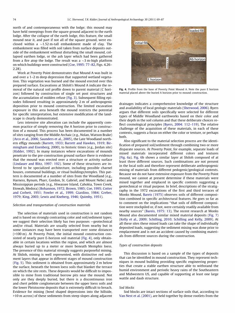
Fig. 4. Profile from the base of Poverty Point Mound A. Note the pure E horizonmaterial placed above the buried A horizon prior to mound construction.
74 S.C. Sherwood, T.R. Kidder / Journal of Anthropological Archaeology 30 (2011) 69–87
north of and contemporaneous with the lodge; this mound mayhave held sweepings from the square ground adjacent to the earthlodge. After the collapse of the earth lodge, this feature, the smallmound near it, and part if not all of the square ground, were en-closed within a �1.52 m-tall embankment made of clay. Theembankment was filled with soil taken from surface deposits out-side of the embankment without disturbing the small mound, col-lapsed earthen lodge, or the ash layer which had been gatheredfrom a fire atop the lodge. The result was a �3 m-high platformon which buildings were constructed (Coe, 1995: 77–82, Figs. 4.26–2.28).
Work at Poverty Point demonstrates that Mound A was built inand over a 1–2 m deep depression that supported wetland vegeta-tion. This vegetation was burned and the mound erected over thisprepared surface. Excavations at Shiloh’s Mound A indicate the re-moval of the natural soil profile down to parent material (C hori-zon) followed by construction of single set post structures andthe accumulation of midden refuse (Fig. 3). Subsequent filling epi-sodes followed resulting in approximately 2 m of anthropogenicdeposition prior to mound construction. The limited excavationexposure in this area beneath the mound restricts the potentialfor specific interpretation, but extensive modification of the land-scape is clearly demonstrated.
Less intensive site alteration can include the apparently com-mon practice of simply removing the A horizon prior to construc-tion of a mound. This process has been documented in a numberof sites ranging from the Middle Archaic (e.g., Nolan, Watson Brake)(Arco et al., 2006; Saunders et al., 2005), the Late Woodland north-ern effigy mounds (Barrett, 1933; Barrett and Hawkes, 1919; Bir-mingham and Eisenberg, 2000), to historic times (e.g., Jordan site)(Kidder, 1992). In many instances where excavations of moundspenetrate to the pre-construction ground surface there is evidencethat the mound was erected over a structure or activity surface(Lindauer and Blitz, 1997: 192). Some of these structures are in-ferred to be specialized architecture, including possible charnelhouses, communal buildings, or ritual buildings/temples. This pat-tern is documented at a number of sites from the Woodland (e.g.,Harness, Bynum, Pharr, Gordon, St. Gabriel, and Mount Nebo) andMississippian periods (e.g., Hiwassee Island, Cahokia, Town Creek,Etowah, Medora) (Bohannon, 1972; Brown, 1985; Coe, 1995; Cotterand Corbett, 1951; Fowler et al., 1999; Giardino, 1984; Greber,1979; King, 2003; Lewis and Kneberg, 1946; Quimby, 1951).
Selection and transportation of construction materials
The selection of materials used in construction is not randomand is based on strongly contrasting color and soil/sediment types;we suggest their selection likely has two purposes —geotechnicaland/or ritual. Materials are usually selected from nearby but insome instances may have been transported over some distances(>100 m). At Poverty Point, the initial mound construction con-sisted of nearly pure E-horizon soil material (Fig. 4), only obtain-able in certain locations within the region, and which are almostalways buried up to a meter or more beneath Memphis loess.The presence of this material strongly suggests purposeful mining.At Shiloh, mining is well represented, with distinctive red sedi-ment layers that appear in different stages of mound construction(Fig. 5). This sediment is obtained from approximately 2 m belowthe surface, beneath the brown loess soils that blanket the terraceon which the site rests. These deposits would be difficult to impos-sible to mine from traditional borrow pits near the mound. Notonly are they deeply buried, but there is a discontinuous ironand chert pebble conglomerate between the upper loess soils andthe lower Pleistocene deposits that is extremely difficult to breach.Evidence for mining (bowl shaped depressions into the hillside,>10 m across) of these sediments from steep slopes along adjacent
drainages indicates a comprehensive knowledge of the structureand availability of local geologic materials (Sherwood, 2006). Byersargues that different soils specifically were selected for differenttypes of Middle Woodland earthworks based on their color andtheir depth in the soil column and that these deliberate choices re-flect cosmological principles (Byers, 2004: 112–119). The relativechallenge of the acquisition of these materials, in each of thesecontexts, suggests a focus on either the color or texture, or perhapsboth.
Also significant to the material selection process are the identi-fication of prepared soil/sediment through combining two or moredisparate sources. At Poverty Point, for example, separate loads ofmixed materials incorporated different colors and textures(Fig. 6a). Fig. 6b shows a similar layer at Shiloh composed of atleast three different sources. Such combinations are not presentin the local soils and therefore represent deliberate anthropogenicmixing of materials from different pedogenic/geological contexts.Because we do not have extensive exposure from the Poverty Pointmound, we cannot at present determine if these materials weremixed together and emplaced in specific contexts suggesting ageotechnical or ritual purpose. In brief, descriptions of the stratig-raphy in the 1972 excavations of the first and third terraces ofMonks Mound, Bareis (1975) observes soils of different composi-tion combined in specific architectural features. He goes so far asto comment on the implications ‘‘that soils of different composi-tion were stockpiled or, if not, were certainly readily available fromnearby sources’’ (Bareis, 1975: 13). The recent research at MonksMound also documented similar mixed material deposits (Fig. 7)(Kelly et al., 2009; Schilling, 2010; Schilling and Kelly, 2009). Atall these sites these mixed loads can take the shape of individuallydeposited loads, suggesting the sediment mixing was done prior toemplacement and is not an accident caused by combining materi-als from different sources during the construction.
Types of construction deposits
This discussion is based on a sample of the types of depositsthat can be identified in mound construction. They represent tech-niques in mound building providing specific engineering proper-ties that create a stable earthen structure able to withstand thehumid environment and periodic heavy rains of the Southeasternand Midwestern US, and capable of supporting at least one largewattle and daub structure.
Sod blocksSod blocks are intact sections of surface soils that, according to
Van Nest et al. (2001), are held together by dense rootlets from the
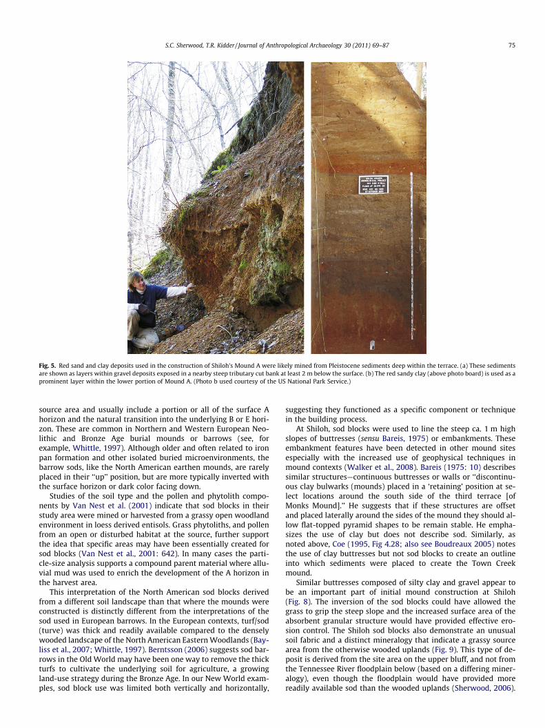
Fig. 5. Red sand and clay deposits used in the construction of Shiloh’s Mound A were likely mined from Pleistocene sediments deep within the terrace. (a) These sedimentsare shown as layers within gravel deposits exposed in a nearby steep tributary cut bank at least 2 m below the surface. (b) The red sandy clay (above photo board) is used as aprominent layer within the lower portion of Mound A. (Photo b used courtesy of the US National Park Service.)
S.C. Sherwood, T.R. Kidder / Journal of Anthropological Archaeology 30 (2011) 69–87 75
source area and usually include a portion or all of the surface Ahorizon and the natural transition into the underlying B or E hori-zon. These are common in Northern and Western European Neo-lithic and Bronze Age burial mounds or barrows (see, forexample, Whittle, 1997). Although older and often related to ironpan formation and other isolated buried microenvironments, thebarrow sods, like the North American earthen mounds, are rarelyplaced in their ‘‘up’’ position, but are more typically inverted withthe surface horizon or dark color facing down.
Studies of the soil type and the pollen and phytolith compo-nents by Van Nest et al. (2001) indicate that sod blocks in theirstudy area were mined or harvested from a grassy open woodlandenvironment in loess derived entisols. Grass phytoliths, and pollenfrom an open or disturbed habitat at the source, further supportthe idea that specific areas may have been essentially created forsod blocks (Van Nest et al., 2001: 642). In many cases the parti-cle-size analysis supports a compound parent material where allu-vial mud was used to enrich the development of the A horizon inthe harvest area.
This interpretation of the North American sod blocks derivedfrom a different soil landscape than that where the mounds wereconstructed is distinctly different from the interpretations of thesod used in European barrows. In the European contexts, turf/sod(turve) was thick and readily available compared to the denselywooded landscape of the North American Eastern Woodlands (Bay-liss et al., 2007; Whittle, 1997). Berntsson (2006) suggests sod bar-rows in the Old World may have been one way to remove the thickturfs to cultivate the underlying soil for agriculture, a growingland-use strategy during the Bronze Age. In our New World exam-ples, sod block use was limited both vertically and horizontally,
suggesting they functioned as a specific component or techniquein the building process.
At Shiloh, sod blocks were used to line the steep ca. 1 m highslopes of buttresses (sensu Bareis, 1975) or embankments. Theseembankment features have been detected in other mound sitesespecially with the increased use of geophysical techniques inmound contexts (Walker et al., 2008). Bareis (1975: 10) describessimilar structures—continuous buttresses or walls or ‘‘discontinu-ous clay bulwarks (mounds) placed in a ‘retaining’ position at se-lect locations around the south side of the third terrace [ofMonks Mound].’’ He suggests that if these structures are offsetand placed laterally around the sides of the mound they should al-low flat-topped pyramid shapes to be remain stable. He empha-sizes the use of clay but does not describe sod. Similarly, asnoted above, Coe (1995, Fig 4.28; also see Boudreaux 2005) notesthe use of clay buttresses but not sod blocks to create an outlineinto which sediments were placed to create the Town Creekmound.
Similar buttresses composed of silty clay and gravel appear tobe an important part of initial mound construction at Shiloh(Fig. 8). The inversion of the sod blocks could have allowed thegrass to grip the steep slope and the increased surface area of theabsorbent granular structure would have provided effective ero-sion control. The Shiloh sod blocks also demonstrate an unusualsoil fabric and a distinct mineralogy that indicate a grassy sourcearea from the otherwise wooded uplands (Fig. 9). This type of de-posit is derived from the site area on the upper bluff, and not fromthe Tennessee River floodplain below (based on a differing miner-alogy), even though the floodplain would have provided morereadily available sod than the wooded uplands (Sherwood, 2006).
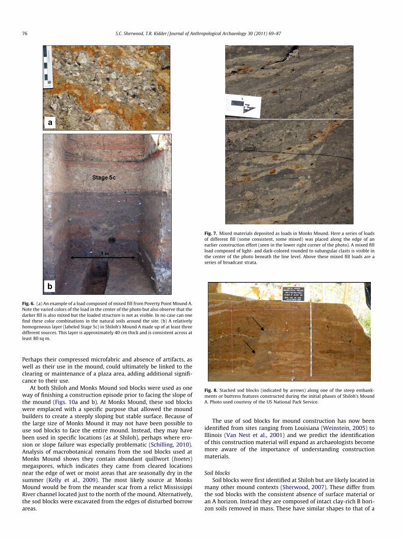
Fig. 6. (a) An example of a load composed of mixed fill from Poverty Point Mound A.Note the varied colors of the load in the center of the photo but also observe that thedarker fill is also mixed but the loaded structure is not as visible. In no case can onefind these color combinations in the natural soils around the site. (b) A relativelyhomogeneous layer (labeled Stage 5c) in Shiloh’s Mound A made up of at least threedifferent sources. This layer is approximately 40 cm thick and is consistent across atleast 80 sq m.
Fig. 7. Mixed materials deposited as loads in Monks Mound. Here a series of loadsof different fill (some consistent, some mixed) was placed along the edge of anearlier construction effort (seen in the lower right corner of the photo). A mixed fillload composed of light- and dark-colored rounded to subangular clasts is visible inthe center of the photo beneath the line level. Above these mixed fill loads are aseries of broadcast strata.
Fig. 8. Stacked sod blocks (indicated by arrows) along one of the steep embank-ments or buttress features constructed during the initial phases of Shiloh’s MoundA. Photo used courtesy of the US National Park Service.
76 S.C. Sherwood, T.R. Kidder / Journal of Anthropological Archaeology 30 (2011) 69–87
Perhaps their compressed microfabric and absence of artifacts, aswell as their use in the mound, could ultimately be linked to theclearing or maintenance of a plaza area, adding additional signifi-cance to their use.
At both Shiloh and Monks Mound sod blocks were used as oneway of finishing a construction episode prior to facing the slope ofthe mound (Figs. 10a and b). At Monks Mound, these sod blockswere emplaced with a specific purpose that allowed the moundbuilders to create a steeply sloping but stable surface. Because ofthe large size of Monks Mound it may not have been possible touse sod blocks to face the entire mound. Instead, they may havebeen used in specific locations (as at Shiloh), perhaps where ero-sion or slope failure was especially problematic (Schilling, 2010).Analysis of macrobotanical remains from the sod blocks used atMonks Mound shows they contain abundant quillwort (Isoetes)megaspores, which indicates they came from cleared locationsnear the edge of wet or moist areas that are seasonally dry in thesummer (Kelly et al., 2009). The most likely source at MonksMound would be from the meander scar from a relict MississippiRiver channel located just to the north of the mound. Alternatively,the sod blocks were excavated from the edges of disturbed borrowareas.
The use of sod blocks for mound construction has now beenidentified from sites ranging from Louisiana (Weinstein, 2005) toIllinois (Van Nest et al., 2001) and we predict the identificationof this construction material will expand as archaeologists becomemore aware of the importance of understanding constructionmaterials.
Soil blocksSoil blocks were first identified at Shiloh but are likely located in
many other mound contexts (Sherwood, 2007). These differ fromthe sod blocks with the consistent absence of surface material oran A horizon. Instead they are composed of intact clay-rich B hori-zon soils removed in mass. These have similar shapes to that of a
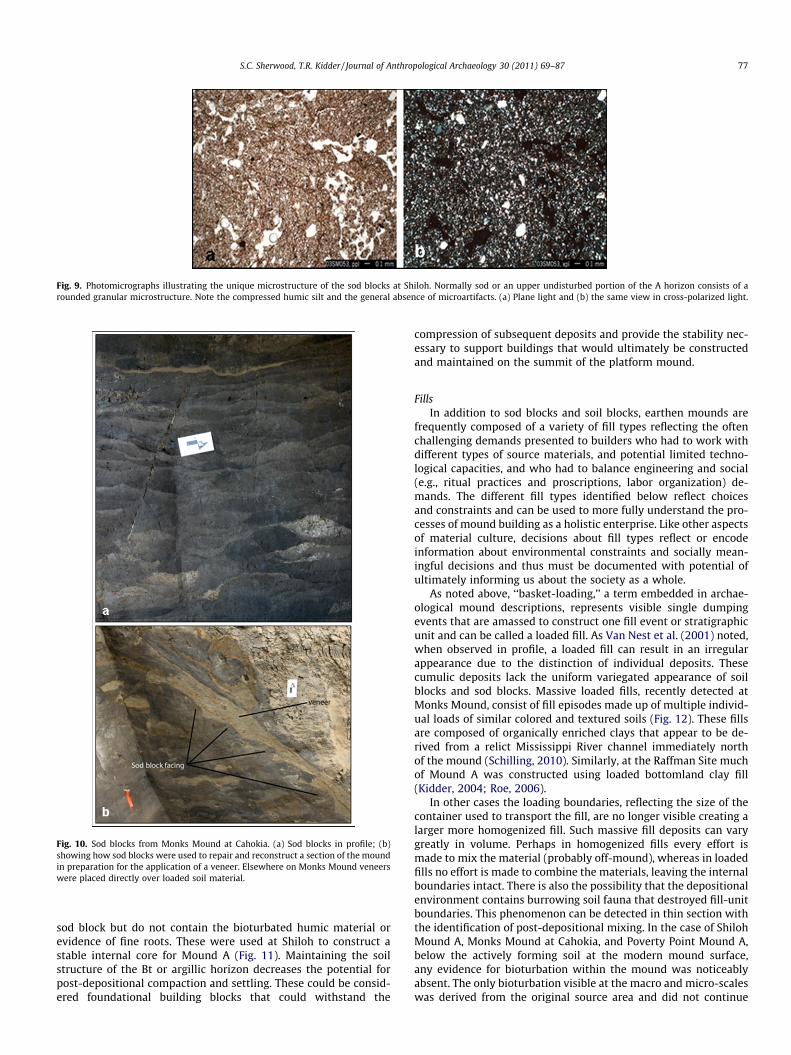
Fig. 9. Photomicrographs illustrating the unique microstructure of the sod blocks at Shiloh. Normally sod or an upper undisturbed portion of the A horizon consists of arounded granular microstructure. Note the compressed humic silt and the general absence of microartifacts. (a) Plane light and (b) the same view in cross-polarized light.
Fig. 10. Sod blocks from Monks Mound at Cahokia. (a) Sod blocks in profile; (b)showing how sod blocks were used to repair and reconstruct a section of the moundin preparation for the application of a veneer. Elsewhere on Monks Mound veneerswere placed directly over loaded soil material.
S.C. Sherwood, T.R. Kidder / Journal of Anthropological Archaeology 30 (2011) 69–87 77
sod block but do not contain the bioturbated humic material orevidence of fine roots. These were used at Shiloh to construct astable internal core for Mound A (Fig. 11). Maintaining the soilstructure of the Bt or argillic horizon decreases the potential forpost-depositional compaction and settling. These could be consid-ered foundational building blocks that could withstand the
compression of subsequent deposits and provide the stability nec-essary to support buildings that would ultimately be constructedand maintained on the summit of the platform mound.
FillsIn addition to sod blocks and soil blocks, earthen mounds are
frequently composed of a variety of fill types reflecting the oftenchallenging demands presented to builders who had to work withdifferent types of source materials, and potential limited techno-logical capacities, and who had to balance engineering and social(e.g., ritual practices and proscriptions, labor organization) de-mands. The different fill types identified below reflect choicesand constraints and can be used to more fully understand the pro-cesses of mound building as a holistic enterprise. Like other aspectsof material culture, decisions about fill types reflect or encodeinformation about environmental constraints and socially mean-ingful decisions and thus must be documented with potential ofultimately informing us about the society as a whole.
As noted above, ‘‘basket-loading,’’ a term embedded in archae-ological mound descriptions, represents visible single dumpingevents that are amassed to construct one fill event or stratigraphicunit and can be called a loaded fill. As Van Nest et al. (2001) noted,when observed in profile, a loaded fill can result in an irregularappearance due to the distinction of individual deposits. Thesecumulic deposits lack the uniform variegated appearance of soilblocks and sod blocks. Massive loaded fills, recently detected atMonks Mound, consist of fill episodes made up of multiple individ-ual loads of similar colored and textured soils (Fig. 12). These fillsare composed of organically enriched clays that appear to be de-rived from a relict Mississippi River channel immediately northof the mound (Schilling, 2010). Similarly, at the Raffman Site muchof Mound A was constructed using loaded bottomland clay fill(Kidder, 2004; Roe, 2006).
In other cases the loading boundaries, reflecting the size of thecontainer used to transport the fill, are no longer visible creating alarger more homogenized fill. Such massive fill deposits can varygreatly in volume. Perhaps in homogenized fills every effort ismade to mix the material (probably off-mound), whereas in loadedfills no effort is made to combine the materials, leaving the internalboundaries intact. There is also the possibility that the depositionalenvironment contains burrowing soil fauna that destroyed fill-unitboundaries. This phenomenon can be detected in thin section withthe identification of post-depositional mixing. In the case of ShilohMound A, Monks Mound at Cahokia, and Poverty Point Mound A,below the actively forming soil at the modern mound surface,any evidence for bioturbation within the mound was noticeablyabsent. The only bioturbation visible at the macro and micro-scaleswas derived from the original source area and did not continue
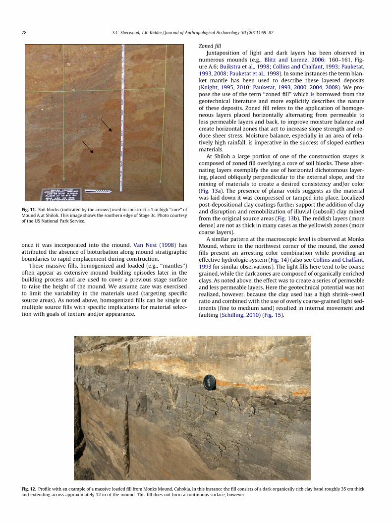
Fig. 11. Soil blocks (indicated by the arrows) used to construct a 1 m high ‘‘core’’ ofMound A at Shiloh. This image shows the southern edge of Stage 3c. Photo courtesyof the US National Park Service.
78 S.C. Sherwood, T.R. Kidder / Journal of Anthropological Archaeology 30 (2011) 69–87
once it was incorporated into the mound. Van Nest (1998) hasattributed the absence of bioturbation along mound stratigraphicboundaries to rapid emplacement during construction.
These massive fills, homogenized and loaded (e.g., ‘‘mantles’’)often appear as extensive mound building episodes later in thebuilding process and are used to cover a previous stage surfaceto raise the height of the mound. We assume care was exercisedto limit the variability in the materials used (targeting specificsource areas). As noted above, homogenized fills can be single ormultiple source fills with specific implications for material selec-tion with goals of texture and/or appearance.
Fig. 12. Profile with an example of a massive loaded fill from Monks Mound, Cahokia. Inand extending across approximately 12 m of the mound. This fill does not form a contin
Zoned fillJuxtaposition of light and dark layers has been observed in
numerous mounds (e.g., Blitz and Lorenz, 2006: 160–161, Fig-ure A.6; Buikstra et al., 1998; Collins and Chalfant, 1993; Pauketat,1993, 2008; Pauketat et al., 1998). In some instances the term blan-ket mantle has been used to describe these layered deposits(Knight, 1995, 2010; Pauketat, 1993, 2000, 2004, 2008). We pro-pose the use of the term ‘‘zoned fill’’ which is borrowed from thegeotechnical literature and more explicitly describes the natureof these deposits. Zoned fill refers to the application of homoge-neous layers placed horizontally alternating from permeable toless permeable layers and back, to improve moisture balance andcreate horizontal zones that act to increase slope strength and re-duce sheer stress. Moisture balance, especially in an area of rela-tively high rainfall, is imperative in the success of sloped earthenmaterials.
At Shiloh a large portion of one of the construction stages iscomposed of zoned fill overlying a core of soil blocks. These alter-nating layers exemplify the use of horizontal dichotomous layer-ing, placed obliquely perpendicular to the external slope, and themixing of materials to create a desired consistency and/or color(Fig. 13a). The presence of planar voids suggests as the materialwas laid down it was compressed or tamped into place. Localizedpost-depositional clay coatings further support the addition of clayand disruption and remobilization of illuvial (subsoil) clay minedfrom the original source areas (Fig. 13b). The reddish layers (moredense) are not as thick in many cases as the yellowish zones (morecoarse layers).
A similar pattern at the macroscopic level is observed at MonksMound, where in the northwest corner of the mound, the zonedfills present an arresting color combination while providing aneffective hydrologic system (Fig. 14) (also see Collins and Chalfant,1993 for similar observations). The light fills here tend to be coarsegrained, while the dark zones are composed of organically enrichedclays. As noted above, the effect was to create a series of permeableand less permeable layers. Here the geotechnical potential was notrealized, however, because the clay used has a high shrink–swellratio and combined with the use of overly coarse-grained light sed-iments (fine to medium sand) resulted in internal movement andfaulting (Schilling, 2010) (Fig. 15).
this instance the fill consists of a dark organically rich clay band roughly 35 cm thickuous surface, however.
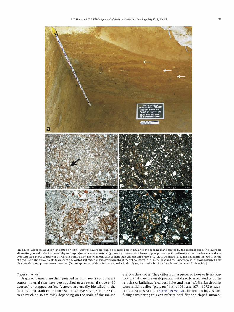
Fig. 13. (a) Zoned fill at Shiloh (indicated by white arrows). Layers are placed obliquely perpendicular to the bedding plane created by the external slope. The layers arealternatively mixed with either more clay (red layers) or more coarse material (yellow layers) to create a balanced pore pressure so the soil material does not become under orover saturated. Photo courtesy of US National Park Service. Photomicrographs (b) plane light and the same view in (c) cross-polarized light, illustrating the tamped structureof a red layer. The arrow points to clasts of clay coated soil material. Photomicrographs of the yellow layers in (d) plane light and the same view in (e) cross-polarized lightillustrate the more porous coarse material. (For interpretation of the references to color in this figure, the reader is referred to the web version of this article.)
S.C. Sherwood, T.R. Kidder / Journal of Anthropological Archaeology 30 (2011) 69–87 79
Prepared veneerPrepared veneers are distinguished as thin layer(s) of different
source material that have been applied to an external slope (�35degrees) or stepped surface. Veneers are usually identified in thefield by their stark color contrast. These layers range from <2 cmto as much as 15 cm thick depending on the scale of the mound
episode they cover. They differ from a prepared floor or living sur-face in that they are on slopes and not directly associated with theremains of buildings (e.g., post holes and hearths). Similar depositswere initially called ‘‘plateaus’’ in the 1964 and 1971–1972 excava-tions at Monks Mound (Bareis, 1975: 12), this terminology is con-fusing considering this can refer to both flat and sloped surfaces.
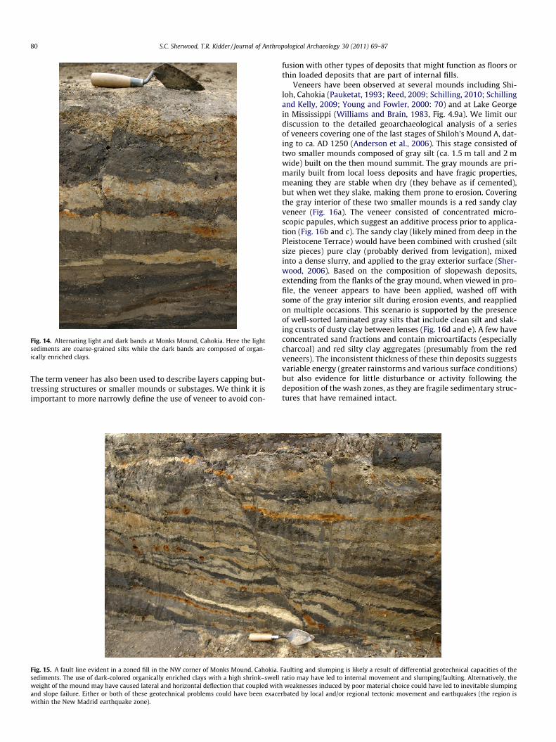
Fig. 14. Alternating light and dark bands at Monks Mound, Cahokia. Here the lightsediments are coarse-grained silts while the dark bands are composed of organ-ically enriched clays.
80 S.C. Sherwood, T.R. Kidder / Journal of Anthropological Archaeology 30 (2011) 69–87
The term veneer has also been used to describe layers capping but-tressing structures or smaller mounds or substages. We think it isimportant to more narrowly define the use of veneer to avoid con-
Fig. 15. A fault line evident in a zoned fill in the NW corner of Monks Mound, Cahokia.sediments. The use of dark-colored organically enriched clays with a high shrink–swellweight of the mound may have caused lateral and horizontal deflection that coupled withand slope failure. Either or both of these geotechnical problems could have been exacewithin the New Madrid earthquake zone).
fusion with other types of deposits that might function as floors orthin loaded deposits that are part of internal fills.
Veneers have been observed at several mounds including Shi-loh, Cahokia (Pauketat, 1993; Reed, 2009; Schilling, 2010; Schillingand Kelly, 2009; Young and Fowler, 2000: 70) and at Lake Georgein Mississippi (Williams and Brain, 1983, Fig. 4.9a). We limit ourdiscussion to the detailed geoarchaeological analysis of a seriesof veneers covering one of the last stages of Shiloh’s Mound A, dat-ing to ca. AD 1250 (Anderson et al., 2006). This stage consisted oftwo smaller mounds composed of gray silt (ca. 1.5 m tall and 2 mwide) built on the then mound summit. The gray mounds are pri-marily built from local loess deposits and have fragic properties,meaning they are stable when dry (they behave as if cemented),but when wet they slake, making them prone to erosion. Coveringthe gray interior of these two smaller mounds is a red sandy clayveneer (Fig. 16a). The veneer consisted of concentrated micro-scopic papules, which suggest an additive process prior to applica-tion (Fig. 16b and c). The sandy clay (likely mined from deep in thePleistocene Terrace) would have been combined with crushed (siltsize pieces) pure clay (probably derived from levigation), mixedinto a dense slurry, and applied to the gray exterior surface (Sher-wood, 2006). Based on the composition of slopewash deposits,extending from the flanks of the gray mound, when viewed in pro-file, the veneer appears to have been applied, washed off withsome of the gray interior silt during erosion events, and reappliedon multiple occasions. This scenario is supported by the presenceof well-sorted laminated gray silts that include clean silt and slak-ing crusts of dusty clay between lenses (Fig. 16d and e). A few haveconcentrated sand fractions and contain microartifacts (especiallycharcoal) and red silty clay aggregates (presumably from the redveneers). The inconsistent thickness of these thin deposits suggestsvariable energy (greater rainstorms and various surface conditions)but also evidence for little disturbance or activity following thedeposition of the wash zones, as they are fragile sedimentary struc-tures that have remained intact.
Faulting and slumping is likely a result of differential geotechnical capacities of theratio may have led to internal movement and slumping/faulting. Alternatively, theweaknesses induced by poor material choice could have led to inevitable slumping
rbated by local and/or regional tectonic movement and earthquakes (the region is
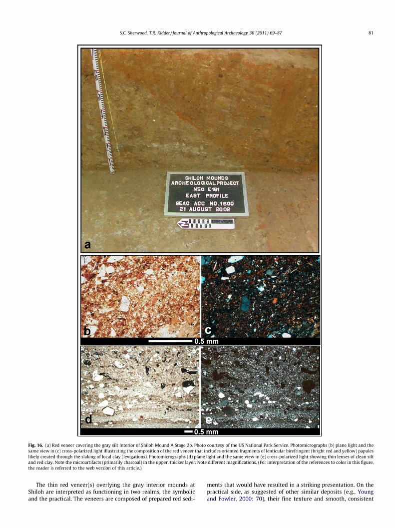
Fig. 16. (a) Red veneer covering the gray silt interior of Shiloh Mound A Stage 2b. Photo courtesy of the US National Park Service. Photomicrographs (b) plane light and thesame view in (c) cross-polarized light illustrating the composition of the red veneer that includes oriented fragments of lenticular birefringent (bright red and yellow) papuleslikely created through the slaking of local clay (levigations). Photomicrographs (d) plane light and the same view in (e) cross-polarized light showing thin lenses of clean siltand red clay. Note the microartifacts (primarily charcoal) in the upper. thicker layer. Note different magnifications. (For interpretation of the references to color in this figure,the reader is referred to the web version of this article.)
S.C. Sherwood, T.R. Kidder / Journal of Anthropological Archaeology 30 (2011) 69–87 81
The thin red veneer(s) overlying the gray interior mounds atShiloh are interpreted as functioning in two realms, the symbolicand the practical. The veneers are composed of prepared red sedi-
ments that would have resulted in a striking presentation. On thepractical side, as suggested of other similar deposits (e.g., Youngand Fowler, 2000: 70), their fine texture and smooth, consistent
82 S.C. Sherwood, T.R. Kidder / Journal of Anthropological Archaeology 30 (2011) 69–87
outer surface may have served to repel rainwater, discouraginginfiltration of the moundfill beneath.
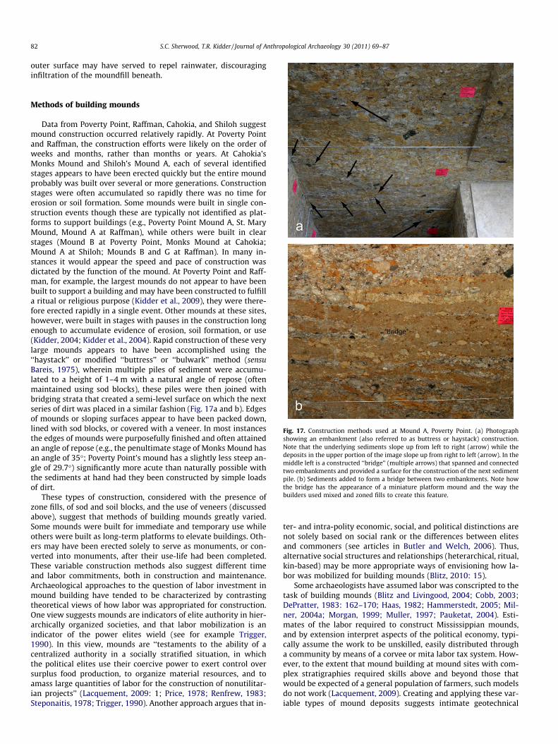
Fig. 17. Construction methods used at Mound A, Poverty Point. (a) Photographshowing an embankment (also referred to as buttress or haystack) construction.Note that the underlying sediments slope up from left to right (arrow) while thedeposits in the upper portion of the image slope up from right to left (arrow). In themiddle left is a constructed ‘‘bridge’’ (multiple arrows) that spanned and connectedtwo embankments and provided a surface for the construction of the next sedimentpile. (b) Sediments added to form a bridge between two embankments. Note howthe bridge has the appearance of a miniature platform mound and the way thebuilders used mixed and zoned fills to create this feature.
Methods of building mounds
Data from Poverty Point, Raffman, Cahokia, and Shiloh suggestmound construction occurred relatively rapidly. At Poverty Pointand Raffman, the construction efforts were likely on the order ofweeks and months, rather than months or years. At Cahokia’sMonks Mound and Shiloh’s Mound A, each of several identifiedstages appears to have been erected quickly but the entire moundprobably was built over several or more generations. Constructionstages were often accumulated so rapidly there was no time forerosion or soil formation. Some mounds were built in single con-struction events though these are typically not identified as plat-forms to support buildings (e.g., Poverty Point Mound A, St. MaryMound, Mound A at Raffman), while others were built in clearstages (Mound B at Poverty Point, Monks Mound at Cahokia;Mound A at Shiloh; Mounds B and G at Raffman). In many in-stances it would appear the speed and pace of construction wasdictated by the function of the mound. At Poverty Point and Raff-man, for example, the largest mounds do not appear to have beenbuilt to support a building and may have been constructed to fulfilla ritual or religious purpose (Kidder et al., 2009), they were there-fore erected rapidly in a single event. Other mounds at these sites,however, were built in stages with pauses in the construction longenough to accumulate evidence of erosion, soil formation, or use(Kidder, 2004; Kidder et al., 2004). Rapid construction of these verylarge mounds appears to have been accomplished using the‘‘haystack’’ or modified ‘‘buttress’’ or ‘‘bulwark’’ method (sensuBareis, 1975), wherein multiple piles of sediment were accumu-lated to a height of 1–4 m with a natural angle of repose (oftenmaintained using sod blocks), these piles were then joined withbridging strata that created a semi-level surface on which the nextseries of dirt was placed in a similar fashion (Fig. 17a and b). Edgesof mounds or sloping surfaces appear to have been packed down,lined with sod blocks, or covered with a veneer. In most instancesthe edges of mounds were purposefully finished and often attainedan angle of repose (e.g., the penultimate stage of Monks Mound hasan angle of 35�; Poverty Point’s mound has a slightly less steep an-gle of 29.7�) significantly more acute than naturally possible withthe sediments at hand had they been constructed by simple loadsof dirt.
These types of construction, considered with the presence ofzone fills, of sod and soil blocks, and the use of veneers (discussedabove), suggest that methods of building mounds greatly varied.Some mounds were built for immediate and temporary use whileothers were built as long-term platforms to elevate buildings. Oth-ers may have been erected solely to serve as monuments, or con-verted into monuments, after their use-life had been completed.These variable construction methods also suggest different timeand labor commitments, both in construction and maintenance.Archaeological approaches to the question of labor investment inmound building have tended to be characterized by contrastingtheoretical views of how labor was appropriated for construction.One view suggests mounds are indicators of elite authority in hier-archically organized societies, and that labor mobilization is anindicator of the power elites wield (see for example Trigger,1990). In this view, mounds are ‘‘testaments to the ability of acentralized authority in a socially stratified situation, in whichthe political elites use their coercive power to exert control oversurplus food production, to organize material resources, and toamass large quantities of labor for the construction of nonutilitar-ian projects’’ (Lacquement, 2009: 1; Price, 1978; Renfrew, 1983;Steponaitis, 1978; Trigger, 1990). Another approach argues that in-
ter- and intra-polity economic, social, and political distinctions arenot solely based on social rank or the differences between elitesand commoners (see articles in Butler and Welch, 2006). Thus,alternative social structures and relationships (heterarchical, ritual,kin-based) may be more appropriate ways of envisioning how la-bor was mobilized for building mounds (Blitz, 2010: 15).
Some archaeologists have assumed labor was conscripted to thetask of building mounds (Blitz and Livingood, 2004; Cobb, 2003;DePratter, 1983: 162–170; Haas, 1982; Hammerstedt, 2005; Mil-ner, 2004a; Morgan, 1999; Muller, 1997; Pauketat, 2004). Esti-mates of the labor required to construct Mississippian mounds,and by extension interpret aspects of the political economy, typi-cally assume the work to be unskilled, easily distributed througha community by means of a corvee or mita labor tax system. How-ever, to the extent that mound building at mound sites with com-plex stratigraphies required skills above and beyond those thatwould be expected of a general population of farmers, such modelsdo not work (Lacquement, 2009). Creating and applying these var-iable types of mound deposits suggests intimate geotechnical
S.C. Sherwood, T.R. Kidder / Journal of Anthropological Archaeology 30 (2011) 69–87 83
knowledge of mound building materials, where to get them in thelocal area and how to alter them to the desired effect. This wouldsuggest that at least some of the labor force or those who closelydirect their work held this knowledge and had the ability to en-force it. While these conclusions are relevant for late Pre-Colum-bian mound building, where chiefly power and authority isclearly expressed, there is less confidence we can uncritically applysuch an authoritarian model to earlier times, such as Watson Brakeor Poverty Point. In the case of early Pre-Columbian mound build-ing we have good reason to believe that some form of directionmust have been employed because it is not reasonable to suggestthat an earthwork the size of Poverty Point’s Mound A (in excessof 230,000 m3) could have been built spontaneously in the lessthan 90 days estimated for its construction duration. Kidder(2011; Kidder et al., 2009) suggests resources for mound buildingmay have been mobilized through the direction of labor by sociallypowerful agents within society, such as age–grade oligarchs orpossibly charismatic persons who claimed ritual authority throughappeal to supernatural forces. The capacity to mobilize laboramong politically acephalous societies is actually not uncommonand we need not always appeal to ranked political systems toexplain large-scale labor efforts (Gibson, 2000; Hoskins, 1986;Johnson, 1994; Tuzin, 2001).
Discussion
The present-day failures of earthen dams, embankments, andother engineered made-earth constructions shows these featuresare not simple structures that are easily made or that effortlesslyremain stable over time. Like these features today, prehistoricearthen mounds of the Midwestern and Southeastern US wereengineered and required considerable planning and knowledge ofsoil properties. This analysis should be an antidote for those whohold to the traditional idea, if not prevailing notion, that moundconstruction is not a challenging task or a job that demands anyspecial skills. The complexity of mound construction, as revealedthrough geoarchaeological analyses, indicates the cultural signifi-cance of these mounds may be as well reflected in the earthen con-struction materials and their arrangement as it is in the artifactsabandoned on their summits.
One reason mounds are seen as simple is because there is con-siderable contention about the labor efforts and requirements forconstructing these features. There is a growing literature on laborrequirements that resolves itself into two camps. On one side arethose who maintain the labor effort is minimal and requires nei-ther any great skill nor significant logistical or organizationalinvestment (the ‘‘minimalists’’) (into this category we put Gibson,1986, 1987, 2000; Milner, 2004b; Muller, 1997; Webster and Kir-ker, 1995). On the other hand there are those who suggest labor ef-forts were far greater than often claimed and argue moundbuilding was not a haphazard practice but one that required notonly planning and labor coordination but also considerable socialinvestment (Abrams and LeRouge, 2008; Arco and Abrams, 2006;Bayliss et al., 2007; Craig et al., 1998; Startin, 1982; Startin andBradley, 1981; Whittle, 1997).
The minimalist camp argues from three positions. First, thatmound building itself is a relatively simple process requiring lar-gely the effort to dig and transport soil and to pile it into the req-uisite shape. The second position grows from a notion that mostmounds were built over the span of many generations in smallincrements. The final consideration is the usually unspoken notionthat platform mounds serve only as elevated surfaces for perish-able building or in some instances, as containers for the deadand their associated artifacts. Mounds in this sense are means toan end and, of and by themselves are of little importance. Combin-
ing these perspectives it is easy to see how one could dismissmound building as an act not requiring any great economic or so-cial investment beyond that of harnessing unskilled labor to createan earthen platform. These positions often do not take into accountthe idea that these mounds have social, symbolic, and ritual value(but see Knight, 1989 for a contrasting position), not to mentionthe probable political/economic values attached to those whoorganize, oversee, and ultimately occupy or direct the activitieson the summits.
It should be clear that we do not particularly agree with theminimalist position. Considerable ink has been spilled over thelabor requirements for mound building based on the minimalistperspective (see for example, Abrams and LeRouge, 2008;Bernardini, 2004; Blitz and Livingood, 2004; Erasmus, 1965;Gibson, 1986, 1987, 2000: 109–110; Hammerstedt, 2005; Jeter,1984; Milner, 2004b; Muller, 1997; Shenkel, 1986; Startin andBradley, 1981). We hold there is a considerable (although unquan-tified) difference between earth moving and mound building.There is no doubt that humans are capable or remarkable physicalefforts, and that it is possible that some labor efforts for earth mov-ing have been overstated (Hammerstedt, 2005). However, wewould argue that building a mound requires more effort and skillthan simply digging and transporting soils and sediments. Moundbuilding is not a random act; instead, it required planning, fromthe selection and design of the work site, the selection of soils/sed-iments for use to their preparation, emplacement, and compaction.In addition to the interior core of the mound, there was the consid-eration and execution that went into the mound’s external appear-ance. The use of veneers and the obvious care that went intomaintaining the steep slopes of the exterior further demonstratethe significance of both the structure itself and those who builtand maintained it.
Evidence suggests that many mounds were constructed in mul-tiple stages (Blitz and Livingood, 2004; Hally, 1996; Knight, 1989)but it is also clear this is not always the case even within sites or atspecific time periods. For example, the mounds at Poverty Pointwere built in different ways and their form evolved. Mound Bstarted as a series of low, flat surfaced platform stages but it wascompleted by the addition of a conical veneer. Mound E looks tobe a double of Mound B but it was never covered with a conical ve-neer (Kidder et al., 2004). Similarly, the mounds at Cahokia havedifferent shapes and different construction histories, and wereerected using a variety of methods (Fowler, 1997; Sullivan andPauketat, 2007). Simply put, not all mounds are alike and to treatthem as if they have known similar histories, or that their shapeis a clue to their functional history, is a disservice to the archaeo-logical record. Some mounds were built very rapidly in single laborefforts and some were not. Each mound required a different laboreffort and labor requirement and skill sets had to be scaled to thesize of the project and the nature of the local building materials.Smaller mounds certainly required less physical effort but thereis no reason to suspect they too did not require a basic knowledgeof earth engineering. Construction histories clearly influence laborrequirements. A massive single construction effort such as at Pov-erty Point’s Mound A cannot be considered in the same way as thelabor needed to build Mound A at Shiloh, or the hundreds of othermultiple stage mounds documented throughout the Southeasternand Midwestern US.
Lastly, mounds are complex architectural edifices and need tobe understood as more than simply platforms for structures orrepositories for the dead. All architecture has symbolic value andembodies more than just the labor and materials required for itsconstruction. As Churchill (1943) famously said, ‘‘We shape ourbuildings; and afterwards our buildings shape us.’’ Examinationof earthen mounds through time suggests these structures alwayshad ritual and symbolic value. Mythology and historic documents
84 S.C. Sherwood, T.R. Kidder / Journal of Anthropological Archaeology 30 (2011) 69–87
show that these features were understood by their builders to beof and by themselves important if not vital features. From thebeginning of mound building many of these monuments havebeen arranged around a plaza and the entire architectural ratio-nale of mound and plaza groups is that they were designed tobe seen from within (Cobb, 2003; Kidder, 1998; Morgan, 1999).The plaza and its surrounding mounds form a ritual theater withinwhich social actions are displayed, contested, and resolved. Thisplan requires the mounds to be an active part of the design ofthese sites. Examination of mounds through time shows thatthrough manipulation of texture, color, and positions these fea-tures conveyed information beyond that present in the architec-ture on the platform or the dead reposing within the earth. AtPoverty Point, for example, Mound A was constructed over alow, wet swale on the landscape. The initial mound depositsplaced over the dark, wet swampy sediment was a thin layer oflight-colored fine silt, and above this a multi-colored massive fill.The use of light silt to bury the dark, watery swale is both poten-tially practical and likely symbolic and ritually charged, suggestingthe actual construction of the mound was part of a broader ritualdramaturgy focused on creating and maintaining corporate groupsolidarity (Kidder, 2011; Kidder et al., 2009). Similarly, the facingof later Mississippian mounds with specifically selected coloredveneers (often red or white), that are symbolically charged colorsin Indian mythology and cosmology (e.g., Cobb and Drake (2008),DeBoer (2005), Hamell (1992), Hudson (1976), Pursell (2004), fornon-North American discussions see Gage, 1999), indicates theconstruction of the mound itself was certainly recognized by thebuilders as a socially embedded action communicating specificmeaning to those who participated in activities at the social andpolitical center.
Conclusions
Despite the ravages or time, and the assaults on earthenmounds by catastrophic weather events, modern developmentand agricultural practices, many of these mounds survive today.Indeed, some mounds resist efforts to destroy them (Phillips,1970: 280, recounts the use and failure of dynamite to reduceMound A at Lake George). The presence of these mounds today isa legacy of the engineering efforts of the mound builders. Butmounds are more than monuments to the engineering skills ofthe anonymous builders. Mounds are also a part of the socialenvironment of many of the late prehistoric cultures of the Mid-western and Southeastern US. Indian mythology, and ethnohistoricaccounts, testify to the vital role mounds played in cosmology andritual. Our careful documentation of mound building constructiontechniques suggests that construction was not solely a means to anend but also part of the symbolic and ritual practices of the moundbuilder’s society.
Mounds in the Mississippi River basin of North America aremore than just piles of dirt and they are also more than just pedes-tals on which activities take place. Our title makes reference to oneof history’s geniuses, who was both an artist as well as an engineer.We are convinced that like DaVinci, the Native American moundbuilders were far more than laboring drudges piling dirt with min-imal effort or intentions. Mound building was an art and a sciencerequiring considerable knowledge, skill and planning, hard work,and impressive aesthetic and symbolic expression. To identifyand decipher these cultural manifestations, a geoarchaeologicalperspective, one emphasizing the stratigraphy at a range of scaleswithin the context of the regional geomorphology, should be anintegral part of the archaeological research. Only with such a per-spective can we truly investigate the variability and meaning ofthese prehistoric earthworks.
Acknowledgments
A number of our colleagues provided assistance and insight to-wards the ideas presented in this article including: David Ander-son, Lee Arco, John Cornelison, David Dye, Mark Esuary, GayleFritz, Paul Goldberg, David Griffing, Nicholas Herrmann, Lara Hom-sey, Meghan Howey, Bill Isminger, John Kelly, James Kocis, DennisLaBatt, Neal Lopinot, Anthony Ortmann, Tim Pauketat, Hector Qir-ko, Tim Schilling, Paul Welch, and the staff at the University of Ten-nessee Archaeological Research Laboratory; Cahokia Mounds StatePark; the Louisiana Division of Archaeology; the Frank H. McClungMuseum; the Louisiana Office of State Parks; the SoutheasternArchaeology Center, and the Shiloh National Military Park. Weare also grateful to the anonymous reviewers whose commentsgreatly improved our manuscript.
References
Abrams, E.M., LeRouge, M.F., 2008. Political complexity and mound constructionamong the Early and Late Adena of the Hocking Valley, Ohio. In: Otto, M.P.,Redmond, B.G. (Eds.), Transitions: Archaic and Early Woodland Research in theOhio Country, Ohio. University Press, Athens, pp. 214–231.
Adderley, W.P., Simpson, I.A., Vésteinsson, O., 2008. Local-scale adaptations: amodeled assessment of soil, landscape, microclimatic, and management factorsin Norse home-field productivities. Geoarchaeology 23, 500–527.
Albert, R.M., Weiner, W., Bar-yosef, O., Meignen, L., 2000. Phytoliths in the MiddlePalaeolithic deposits of Kebara Cave, Mt Carmel, Israel: study of the plantmaterials used for fuel and other purposes. Journal of Archaeological Science 27,931–947.
Albert, R.M., Shahack-Gross, R., Cabanes, D., Gilboa, A., Lev-yadun, L., Portillo, M.,Sharon, I., Boaretto, E., Weiner, S., 2008. Phytolith-rich layers from the LateBronze and Iron Ages at Tel Dor (Israel): mode of formation and archaeologicalsignificance. Journal of Archaeological Science 35, 57–75.
Anderson, D.G., 1994. The Savannah River Chiefdoms: Political Change in the LatePrehistoric Southeast. University of Alabama Press, Tuscaloosa.
Anderson, D.G., 1996. Chiefly cycling and large-scale abandonments as viewed fromthe Savannah River Basin. In: Scarry, J.F. (Ed.), Political Structure and Change inthe Prehistoric Southeastern United States. University Press of Florida,Gainesville, pp. 150–191.
Anderson, D.G., Cornelison Jr., J.E., Sherwood, S.C., 2006. Shiloh Indian MoundsNational Historic Landmark: Research Results of the 1999–2004 Field PaperPresented at the Current Research in Tennessee Archaeology Annual Meeting.Nashville, Tennessee.
Arco, L.J., Abrams, E.M., 2006. An essay on energtics: the construction of the AztecChinampa system. Antiquity 80, 906–918.
Arco, L.J., Adelsberger, K.A., Hung, L., Kidder, T.R., 2006. Alluvial geoarchaeology of aMiddle Archaic Mound complex in the Lower Mississippi Valley, U.S.A.Geoarchaeology 21, 591–614.
Bareis, C.J., 1975. Report of 1972 University of Illinois-Urbana Excavations at theCahokia Site. In: Fowler, M.L. (Ed.), Cahokia Archaeology, Field Reports, ResearchSeries, Papers in Anthropology, vol. 3. Illinois State Museum, Springfield.
Barrett, S., 1933. Ancient Aztalan. Bulletin of the Public Museum of the City ofMilwaukee 13.
Barrett, S.A., Hawkes, E.W., 1919. The Kratz Creek Mound group. Bulletin of thePublic Museum of the City of Milwaukee 3, 1–138.
Bayliss, A., Mcavoy, F., Whittle, A., 2007. The world recreated: Redating Silbury Hillin its monumental landscape. Antiquity 81, 26–53.
Bense, J.A., 1994. Archaeology of the Southeastern United States: Paleoindian toWorld War II. Academic Press, Orlando.
Berna, F., Behar, A., Shahack-Gross, R., Berg, J., Boaretto, E., Gilboa, A., Sharon, I.,Shalev, S., Shilstein, S., Yahalom-Mack, N., Zorn, J.R., Weiner, S., 2007. Sedimentsexposed to high temperatures: reconstructing pyrotechnological processes inLate Bronze and Iron Age Strata at Tel Dor (Israel). Journal of ArchaeologicalScience 34, 358–373.
Bernardini, W., 2004. Hopewell geometric earthworks: a case study in thereferential and experiential meaning of monuments. Journal ofAnthropological Archaeology 23, 331–356.
Berntsson, L., 2006. Me and you and a case of beer. How the Bronze Age barrowswere built. Lund Archaeological Review, 21–24.
Birmingham, R.A., Eisenberg, L.E., 2000. Indian Mounds of Wisconsin. University ofWisconsin Press, Madison.
Black, G.A., 1967. Angel Site: An Archaeological, Historical, and Ethnological Study.Indiana Historical Society, Indianapolis.
Blitz, J.H., 1993. Locust Beads and Archaic Mounds. Mississippi Archaeology 28, 20–43.
Blitz, J.H., 1999. Mississippian chiefdoms and the fission–fusion process. AmericanAntiquity 64, 577–592.
Blitz, J.H., 2010. New perspectives in Mississippian archaeology. Journal ofArchaeological Research 18, 1–39.
S.C. Sherwood, T.R. Kidder / Journal of Anthropological Archaeology 30 (2011) 69–87 85
Blitz, J.H., Livingood, P., 2004. Sociopolitical implications of Mississippian mounds.American Antiquity 69, 291–301.
Blitz, J.H., Lorenz, K.G., 2006. The Chattahoochie Chiefdoms. University of AlabamaPress, Tuscaloosa.
Bohannon, C.F., 1972. Excavations at the Pharr Mounds, Prentiss and ItawambaCounties, Mississippi, and Excavations at the Bear Creek Site, TishomingoCounty, Mississippi. National Park Service, Washington, DC.
Boudreaux, III, E.A., 2005. The Archaeology of Town Creek. Unpublished Ph.D.Dissertation, Department of Anthropology, University of North Carolina, ChapelHill.
Brown, I.W., 1985. Plaquemine architectural patterns in the Natchez Bluffs andsurrounding regions of the Lower Mississippi Valley. Midcontinental Journal ofArchaeology 10, 251–305.
Brown, I.W., 2003. Bottle Creek: A Pensacola Culture Site in South Alabama. TheUniversity of Alabama Press, Tuscaloosa.
Buikstra, J.E., Charles, D.K., Rakita, G.F.M., 1998. Staging ritual: Hopewellceremonialism at the Mound House Site, Greene County, Illinois. Center forAmerican Archeology, Kampsville Studies in Archeology and History, No. 1,Kampsville, Illinois.
Butler, B.M., Welch, P.D., 2006. Leadership and Polity in Mississippian Society,Occasional Papers No. 33. Center for Archaeological Investigations, SouthernIllinois University, Carbondale.
Byers, A.M., 1998. Is the Newark Circle-Octagon the Ohio Hopewell ‘‘RosettaStone’’? A question of archaeological interpretation. In: Mainfort, Robert C., Jr.,Sullivan, Lynne P. (Eds.), Ancient Earthen Enclosures of the Eastern Woodlands.University Press of Florida, Gainesville, pp. 135–153.
Byers, A.M., 2004. The Ohio Hopewell Episode: Paradigm Lost and Paradigm Gained.University of Akron Press.
Carneiro, R.L., 2010. Pauketat’s Chiefdoms and other archaeological delusions: achallenge to social evolution. Social Evolution and History 9, 135–176.
Charles, D.K., Van Nest, J., Buikstra, J.E., 2004. From the earth: minerals and meaningin the Hopewellian world. In: Boivin, N., Owoc, M.A. (Eds.), Soils, Stones, andSymbols: Cultural Perceptions of the Mineral World. UCL Press, London, pp. 43–70.
Churchill, W., 1943. Speech given in the House of Commons, 28 October 1943(meeting in the House of Lords).
Cobb, C., 2003. Mississippian chiefdoms: how complex? Annual Reviews ofAnthropology 32, 63–84.
Cobb, C.R., Drake, E., 2008. The colour of time: head pots and temporalconvergences. Cambridge Archaeological Journal 18, 85–93.
Coe, J.L., 1995. Town Creek Indian Mound: A Native American Legacy. University ofNorth Carolina Press, Chapel Hill.
Cole, F.-C., Bell, R., Caldwell, J., Emerson, N., MacNeish, R., Orr, K., Willis, R., 1951.Kincaid: A Prehistoric Illinois Metropolis. University of Chicago Press, Chicago.
Collins, J.M., Chalfant, M.L., 1993. A second-terrace perspective on Monks Mound.American Antiquity 58, 319–332.
Cotter, J.L., Corbett, J.M., 1951. Archeology of the Bynum Mounds, Mississippi.Archeological Research Series, vol. 1. National Park Service, Washington, DC.
Craig, D.B., Holmlund, J.P., Clark, J.J., 1998. Labor investment and organization inplatform mound construction: a case study from the Tonto Basin of CentralArizona. Journal of Field Archaeology 25, 245–259.
Dalan, R.A., Holley, G.R., Woods, W.I., Watters Jr., H.W., Koepke, J.A., 2003.Envisioning Cahokia: A Landscape Perspective. Northern Illinois Press, DeKalb.
Deboer, W.R., 2005. Colors for a North American past. World Archaeology 37, 66–91.Depratter, C., 1983. Late Prehistoric and Early Historic Chiefdoms in the
Southeastern United States. Dissertation, Department of Anthropology,University of Georgia, Athens.
Emerson, T., Alt, S., Pauketat, T., 2008. Locating American Indian religion at Cahokiaand beyond. In: Fogelin, L. (Ed.), Religion in the Material World. Center forArchaeological Investigations, Southern Illinois University, Carbondale(Occasional Paper No. 36).
Erasmus, C., 1965. Monument building: some field experiments. SouthwesternJournal of Anthropology 21, 277–301.
Fairbanks, C.H., 1956. Archeological Excavations in the Funeral Mound, OcmulgeeNational Monument, GA. Archeological Research Series No. 3. National ParkService, Government Printing Office, Washington, DC.
Fortier, A.C., 2007. The archaeology of the East St. Louis Mound Center, part II: thenorthside excavations. In: Illinois State Archaeology Survey, TransportationArchaeological Research Reports No. 22. University of Illinois.
Fowler, M.L., 1997. The Cahokia Atlas. In: Studies in Archaeology, revised ed.. IllinoisTransportation Archaeological Research Program, vol. 2 University of IllinoisUrbana-Champaign, Urbana.
Fowler, M.L., Rose, J., Vander Leest, B., Ahler, S.R., 1999. The Mound 72 Area:Dedicated and Sacred Space in Early Cahokia. Illinois State Museum, Reports ofInvestigations No. 54. Illinois State Museum Society, Springfield.
Gage, J., 1999. Colour and Meaning: Art, Science and Symbolism. Thames andHudson, London.
Giardino, M.J., 1984. Temporal frameworks: archaeological components and burialstyles: the human osteology of the Mt Nebo Site in North Louisiana. LouisianaArchaeology 9, 99–126.
Gibson, J.L., 1986. Earth sitting: architectural masses at Poverty Point, NortheasternLouisiana. Louisiana Archaeology 13, 201–237.
Gibson, J.L., 1987. The Poverty Point earthworks reconsidered. MississippiArchaeology 22, 14–31.
Gibson, J.L., 2000. The Ancient Mounds of Poverty Point: Place of Rings. UniversityPress of Florida, Gainesville.
Gibson, J., Carr, P., 2004. Signs of Power: The Rise of Cultural Complexity in theSoutheast. University of Alabama Press, Tuscaloosa.
Goldberg, P., Sherwood, S.C., 2006. Deciphering human prehistory through thegeoarchaeological study of cave sediments. Evolutionary Anthropology 15, 20–36.
Greber, N., 1979. A comparative study of site morphology and burial patterns atEdwin Harness Mound and Seip Mounds 1 and 2. In: Brose, D.S., Greber, N.O.(Eds.), Hopewell Archaeology: The Chillicothe Conference. Kent State UniversityPress, Kent, pp. 27–38.
Guttmann, E.B., Simpson, I.A., Nielsen, N., Dockrill, S.J., 2008. Anthrosols in Iron AgeShetland: implications for arable and economic activity. Geoarchaeology 23,799–823.
Haas, J., 1982. The Evolution of the Prehistoric State. Columbia University, NewYork.
Hall, R.L., 1997. An Archaeology of the Soul: North American Indian Belief andRitual. University of Illinois Press, Urbana.
Hally, D.J., 1993. The territorial size of Mississippian chiefdoms. In: Stoltman, J.B.(Ed.), Archaeology of Eastern North America: Papers in Honor of StephenWilliams, Archaeological Report No. 25, Mississippi Department of Archives andHistory, Jackson, pp. 143–168.
Hally, D.J., 1996. Platform mound construction and the instability of MississippianChiefdoms. In: Scarry, J. (Ed.), Political Structure and Change in the PrehistoricSoutheastern United States. University of Florida Press, Gainesville, pp. 92–127.
Hamell, G.R., 1992. The Iroquois and the world’s rim: speculations on color, cultureand contact. American Indian Quarterly 16, 451–469.
Hammerstedt, S.W., 2005. Mississippian Construction, Labor, and SocialOrganization in Western Kentucky. Dissertation, Department of Anthropology,Pennsylvania State University.
Holley, G.R., Dalan, R., Smith, P.A., 1993. Investigations in the Cahokia Site GrandPlaza. American Antiquity 58, 306–319.
Hoskins, J.A., 1986. So My Name Shall Live: Stone Dragging and Grave Building inKodi, West Sumba. Bijdragen tot de Taal-, Land- en Volkenkunde 142, 31–51.
Hudson, C., 1976. The Southeastern Indians. University of Tennessee Press,Knoxville.
Jeter, M.D., 1984. Mound volumes, energy ratios, exotic materials, and contingencytables: comments on some recent analyses of Copena burial practices.Midcontinental Journal of Archaeology 9, 91–104.
Johnson, D.H., 1994. Nuer Prophets: A History of Prophecy from the Upper Nile inthe Nineteenth and Twentieth Centuries. Clarendon Press, Oxford.
Kelly, J.E., 1990. Range site community patterns and the Mississippian emergence.In: Smith, B.D. (Ed.), The Mississippian Emergence. Smithsonian InstitutionPress, Washington, DC, pp. 67–112.
Kelly, J.E., Schilling, T.M., Lopinot, N., Kidder, T.R., 2009. New Perspectives on an OldMonument. Illinois Archaeological Society, Springfield.
Kidder, T.R., 1992. Excavations at the Jordan Site (16MO1), Morehouse Parish,Louisiana. Southeastern Archaeology 11, 109–131.
Kidder, T.R., 1998. Mississippian period mound groups and communities in theLower Mississippi Valley. In: Lewis, R.B., Stout, C. (Eds.), MississippianTowns and Sacred Spaces. University of Alabama Press, Tuscaloosa, pp. 123–150.
Kidder, T.R., 2004. Plazas as architecture: an example from the Raffman Site,Northeast Louisiana. American Antiquity 69, 514–532.
Kidder, T.R., 2011. Transforming Hunter–Gatherer history at Poverty Point. In:Sassaman, K.E., Holley, D.H., Jr. (Eds.), Hunter–Gatherer Archaeology asHistorical Process. Amerind Foundation and University of Arizona Press, Tucson.
Kidder, T.R., Ortmann, A.L., Allen, T., 2004. Mounds B and E at Poverty Point.Southeastern Archaeology 23, 98–113.
Kidder, T.R., Arco, L.J., Ortmann, A.L., Schilling, T.M., Boeke, C., Bielitz, R.,Adelsberger, K.A., 2009. Poverty Point Mound A: Final Report of the 2005 and2006 Field Seasons. Louisiana Division of Archaeology and the LouisianaArchaeological Survey and Antiquities Commission, Baton Rouge.
King, A., 2003. Etowah: The Political History of a Chiefdom Capital. University ofAlabama Press, Tuscaloosa.
Knight Jr., V.J., 1986. The institutional organization of Mississippian religion.American Antiquity 51, 675–687.
Knight Jr., V.J., 1989. Symbolism of Mississippian mounds. In: Hatley, M.T.,Waselkov, G.A., Wood, P.H. (Eds.), Powhatan’s Mantle: Essays in SoutheasternEthnohistory. University of Nebraska Press, Lincoln, pp. 279–291.
Knight Jr., V.J., 1990. Social organization and the evolution of hierarchy inSoutheastern Chiefdoms. Journal of Anthropological Research 46, 1–23.
Knight, Jr., V.J., 1995. Chronology and Use of Public Architecture at the MoundvilleSite: Excavations: Mounds R, F, G and E. Second Interim Report, NationalScience Foundation Award No. 9220568, University of Alabama, Tuscaloosa.
Knight Jr., V.J., 1998. Moundville as a diagrammatic ceremonial center. In: Knight,V.J., Steponaitis, V.P. (Eds.), Archaeology of the Moundville Chiefdom.Smithsonian Institution Press, Washington, DC, pp. 44–62.
Knight Jr., V.J., 2001. Feasting and the emergence of platform mound ceremonialismin Eastern North America. In: Dietler, M., Hayden, B. (Eds.), Feasts:Archaeological and Ethnographic Perspectives on Food, Politics, and Power.Smithsonian Institution Press, Washington, DC, pp. 239–254.
Knight Jr., V.J., 2006. Symbolism of Mississippian mounds. In: Wood, P.H., Waselkov,G.A., Hatley, M.T. (Eds.), Powhatan’s Mantle: Indians in the Colonial SoutheastRevised and Expanded. University of Nebraska Press, Lincoln, pp. 421–434.
86 S.C. Sherwood, T.R. Kidder / Journal of Anthropological Archaeology 30 (2011) 69–87
Knight Jr., V.J., 2010. Mound Excavations at Moundville: Architecture, Elites andSocial Order. University of Alabama Press, Tuscaloosa.
Knight Jr., V.J., Steponaitis, V.P., 1998. A new history of Moundville. In: Knight, V.J.,Steponaitis, V.P. (Eds.), Archaeology of the Moundville Chiefdom. SmithsonianInstitution Press, Washington, DC, pp. 1–25.
Lacquement, C.H., 2009. Landscape Modification at Moundville: An EnergeticsAssessment of a Mississippian Polity. Ph.D. Dissertation, Dept. of Anthropology,University of Alabama, Tuscaloosa.
Lewis, T.M.N., Kneberg, M., 1946. Hiwassee Island. University of Tennessee Press,Knoxville.
Lewis, R.B., Stout, C. (Eds.), 1998. Mississippian Towns and Sacred Spaces. Universityof Alabama Press, Tuscaloosa.
Lewis, R.B., Stout, C., Wesson, C.B., 1998. The design of Mississippian towns. In:Lewis, R.B., Stout, C. (Eds.), Mississippian Towns and Sacred Spaces. Universityof Alabama Press, Tuscaloosa, pp. 1–21.
Lindauer, O., Blitz, J.H., 1997. Higher ground: the archaeology of North Americanplatform mounds. Journal of Archaeological Research 5, 169–207.
Macphail, R.I., Cruise, G.M., Allen, M.J., 2004. Archaeological soil and pollen analysisof experimental floor deposits, with special reference to Butser Ancient Farm,Hampshire, UK. Journal of Archaeological Science 31, 175–191.
Matthews, W., 1995. Micromorphological characterization and interpretation ofoccupation deposits and microstratigraphic sequences at Abu Salabikh, Iraq. In:Barham, T., Bates, M., Macphail, R.I. (Eds.), Archaeological Sediments and Soils,Analysis, Interpretation and Management. Archetype Books, London, pp. 41–76.
Milner, G.R., 1998. The Cahokia Chiefdom: The Archaeology of a MississippianSociety. Smithsonian Institution Press, Washington, DC.
Milner, G.R., 2004a. The Moundbuilders: Ancient Peoples of Eastern North America.Thames and Hudson, New York.
Milner, G.R., 2004b. Old mounds, ancient Hunter–Gatherers, and modernarchaeologists. In: Gibson, J.L., Carr, P.J. (Eds.), Signs of Power: The Rise ofComplexity in the Southeast. University of Alabama Press, Tuscaloosa, Alabama,pp. 300–315.
Morgan, W.N., 1999. Precolumbian Architecture in Eastern North America.University Press of Florida, Gainesville.
Morgan, W.N., 2008. Earth Architecture: From Ancient to Modern. University Pressof Florida, Gainesville.
Muller, J., 1997. Mississippian Political Economy. Plenum Press, New York.Neitzel, R.S., 1965. Archaeology of the Fatherland Site: The Grand Village of the
Natchez. Anthropological Papers of the American Museum of Natural History,vol. 51. Pt. 1, New York.
Pauketat, T.R., 1993. Temples for Cahokia Lords: Preston Holder’s 1955–1956excavations of Kunnemann Mound. Memoirs of the University of MichiganMuseum of Anthropology, vol. 26. University of Michigan, Ann Arbor.
Pauketat, T.R., 2000. The tragedy of the commoners. In: Dobres, M.A., Robb, J.E.(Eds.), Agency of Archaeology. Routledge, London, pp. 113–129.
Pauketat, T.R., 2001. A new tradition in archaeology. In: Pauketat, T.R. (Ed.), TheArchaeology of Traditions. University Press of Florida, Gainesville.
Pauketat, T.R., 2004. The economy of the moment: cultural practices andMississippian Chiefdoms. In: Feinman, G.M., Nicholas, L.M. (Eds.),Archaeological Perspectives on Political Economy. University of Utah Press,Salt Lake City, pp. 25–39.
Pauketat, T.R., 2005. The Archaeology of the East St. Louis Mound Center, Part I: TheSouthside Excavations. Urbana, Transportation Archaeological Research ReportsNo. 21, Illinois Transportation Archaeological Research Program, University ofIllinois.
Pauketat, T.R., 2008. Founders’ Cults and the archaeology of Wa-kan-da. In: Mills, B.,Walker, W.H. (Eds.), Memory Work: Archaeologies of Material Practices. Schoolfor Advanced Research Press, Santa Fe, New Mexico, pp. 61–79.
Pauketat, T.R., Alt, S., 2003. Mounds, Memory, and Contested Mississippian History.In: Van Dyke, R.M., Alcock, S.E. (Eds.), Archaeologies of Memory. Blackwell,Oxford, pp. 151–179.
Pauketat, T.R., Mark, A.R., Paukett, S.L., 1998. An Archaeological Survey of theHorseshoe Lake State Park, Madison County, Illinois. Reports of Investigation,vol. 55. Illinois State Museum, Springfield.
Payne, C., 1994. Mississippian Capitals: An Archaeological Investigation ofPrecolumbian Political Structure. Ph.D. Dissertation, Department ofAnthropology, University of Florida, University Microfilms, Ann Arbor,Gainesville.
Phillips, P., 1970. Archaeological Survey in the Lower Yazoo Basin, Mississippi,1949–1955. Peabody Museum Papers, vol. 60. Harvard University Press,Cambridge.
Polhemus, R., 1987. The Toqua Site: A Late Mississippian Dallas Phase Town. Reportof Investigations No. 41. Department of Anthropology, University of Tennessee,Knoxville, Tennessee.
Price, B.J., 1978. Secondary state formation: an explanatory model. In: Cohen, R.,Service, E.R. (Eds.), Origins of the State: The Anthropology of Political Evolution.Institute for the Study of Human Issues, Philadelphia, pp. 161–186.
Price, J.E., Fox, G.L., 1990. Recent investigations at Towosahgy State Historic Site.The Missouri Archaeologist 51, 1–71.
Pursell, C., 2004. Geographic Distribution and Symbolism of Colored MoundArchitecture in the Mississippian Southeast. Masters Thesis, Department ofAnthropology Southern Illinois University, Carbondale.
Quimby, G.I., 1951. The Medora Site, West Baton Rouge Parish, Louisiana.Anthropological Series, vol. 24. Field Museum of Natural History, Chicago.
Reed, N.A., 2009. Excavations on the third terrace and front ramp of Monks Mound,Cahokia: a personal narrative. Illinois Archaeology 21, 1–89.
Reed, N.A., Bennett, J.W., Porter, J.W., 1968. Solid core drilling of Monks Mound:technique and findings. American Antiquity 33, 137–148.
Renfrew, C. (Ed.), 1983. The Megalithic Monuments of Western Europe. Thames &Hudson, London.
Roe, L., 2006. Coles Creek antecedents of Plaquemine mound construction: evidencefrom the Raffman Site. In: Reese, M., Livingood, P. (Eds.), PlaquemineArchaeology. University of Alabama Press, Tuscaloosa, pp. 20–37.
Rogers, J.D., Moore, M.C., Greaves, R., 1982. Spiro Archaeology: The Plaza. Studies inOklahoma’s Past 10. Oklahoma Archaeological Survey, Norman.
Saunders, J.W., Mandel, R.D., Saucier, R.T., Allen, E.T., Hallmark, C.T., Johnson, J.K.,Jackson, E.H., Allen, C.F., Stringer, G.L., Frink, D.S., Feathers, J.K., Williams, S.,Gremillion, K.J., Vidrine, M.F., Jones, R., 1997. A mound complex in Louisiana at5400–5000 years before the present. Science 277, 1796–1799.
Saunders, J.W., Mandel, R.D., Sampson, C.G., Allen, C.M., Allen, E.T., Bush, D.A.,Feathers, J.K., Gremillion, K.J., Hallmark, C.T., Jackson, H.K., Johnson, J.K., Jones,R., Saucier, R.T., Stringer, G.L., Vidrine, M.F., 2005. Watson Brake, a middleArchaic Mound complex in Northeast Louisiana. American Antiquity 70, 631–668.
Scarry, John F., 1996. Political Structure and Charge in the PrehistoricSoutheastern United States. Ripley P. Bullen Series. University Press ofFlorida, Gainesville.
Schilling, T.M., 2010. An Archaeological Model of the Construction of Monks Moundand Implications for the Development of the Cahokian Society (800–1400 A.D.).Unpublished Ph.D. Dissertation, Department of Anthropology, WashingtonUniversity, St. Louis.
Schilling, T.M., Kelly, J.E., 2009. Report of the 2007 Monks Mound StabilizationProject. Illinois Historic Preservation Agency, Springfield.
Schnell, F.T., Knight, V.J., Schnell, G.S., 1981. Cemochechobee: Archaeology of aMississippian Ceremonial Center on the Chattahoochee River. Ripley P. BullenMonographs in Anthropology and History, vol. 3. University Press of Florida,Gainsville.
Schroeder, S., 2004. Current research on late precontact societies of themidcontinental United States. Journal of Archaeological Research 12, 311–372.
Shenkel, J.R., 1986. An additional comment of volume calculations and acomparison of formulae using several southeastern mounds. MidcontinentalJournal of Archaeology 11, 201–220.
Sherwood, S.C., 2006. Geoarchaeological Study of The Mound A Stratigraphy, ShilohNational Military Park, Hardin County, Tennessee. Technical Report Submittedto the Southeastern Archeological Center, National Park Service, Tallahassee,Florida.
Sherwood, S.C., 2007. The Geoarchaeology of Mississippian Platform Mounds andthe Classification of Mound Stratigraphy. Poster Presented at the 72nd AnnualMeeting for the Society for American Archaeology, Austin, Texas.
Squier, E.G., Davis, E.H., 1973. Ancient Monuments of the Mississippi Valley. AMSPress, New York.
Startin, D.W.A., 1982. Settlement Patterns in the Oxford Region, Excavations at theAbingdon Causewayed Enclosure and Other Sites. Council for BritishArchaeology and Department of Antiquities, Ashmolean Museum ResearchReport 44.
Startin, D.W.A., Bradley, R., 1981. Some notes on work organization and society inprehistoric Wessex. In: Ruggles, C.L.N., Whittle, A.W.R., (Eds.), Astronomy andSociety in Britain During the Period 4000–1500 B.C. BAR British Series, Oxford,England, vol. 88, pp. 289–296.
Steponaitis, V.P., 1978. Locational theory and complex chiefdoms: a Mississippianexample. In: Smith, B.D. (Ed.), Mississippian Settlement Patterns. AcademicPress, New York, pp. 417–453.
Steponaitis, V.P., 1986. Prehistoric archaeology in the Southeastern United States,1970–1985. Annual Review of Anthropology 15, 363–404.
Sullivan, L.P., Pauketat, T.R., 2007. Cahokia’s Mound 31: a short-term construction ata long-term site. Southeastern Archaeology 26, 12–31.
Trigger, B.G., 1990. Monumental architecture: a thermodynamic explanation ofsymbolic behavior. World Archaeology 22, 119–132.
Tuzin, D.F., 2001. Social Complexity in the Making: A Case Study among the Arapeshof New Guinea. Routledge, London.
Van Nest, J., 1998. The 1994 Geological Investigations at the Mound House Site. In:Buikstra, J.E., Charles, D.K., Ratika, G.F.M. (Eds.), Staging Ritual: HopewellCeremonialism at the Mound House Site, Greene County, Illinois, KampsvilleStudies in Archaeology and History, vol. 1. Center for American Archaeology,Kampsville, Illinois, pp. 118–173 (Appendix 3).
Van Nest, J., Charles, D.K., Buikstra, J.E., Asch, D.L., 2001. Sod blocks in IllinoisHopewell Mounds. American Antiquity 66, 633–650.
Walker, C.P., Lawrence, W.L., Dye, D.H., 2008. Archaeo-Geophysical Survey atMound Bottom. Paper Presented at the 65th Annual Meeting of theSoutheastern Archaeological Conference, Charlotte, NC.
Waring, Jr., A.J., 1968. The Southern Cult and Muskhogean Ceremonial: GeneralConsiderations. In: Williams, S. (Ed.), The Waring Papers. Papers of the PeabodyMuseum of Archaeology and Ethnology, vol. 58, Cambridge, Massachusetts, pp.87–93.
Waring Jr., A.J., Holder, P., 1945. A prehistoric ceremonial complex in theSoutheastern United States. American Anthropologist 47, 1–34.
Webster, D.L., Kirker, J., 1995. Too many Maya, too few buildings: investigatingconstruction potential at Copan, Honduras. Journal of Anthropological Research51, 363–387.

S.C. Sherwood, T.R. Kidder / Journal of Anthropological Archaeology 30 (2011) 69–87 87
Weinstein, R.A., 2005. Lake Providence, A Terminal Coles Creek Culture MoundCenter, East Carroll Parish, Louisiana. U.S. Army Corps of Engineers, VicksburgDistrict, Contract No. DACW38-91-D-0014, 2 vols.. Coastal Environments, Inc.,Baton Rouge.
Whittle, A., 1997. Sacred Mound, Holy Rings: Silbury Hill and the West KennetPalisade Enclosures. Monograph, vol. 74. Oxbow Books, Oxford.
Williams, S., Brain, J.P., 1983. Excavations at the Lake George Site, Yazoo Mississippi,1958–1960. Papers of the Peabody Museum of Archaeology and Ethnology, vol.74. Harvard University, Cambridge.
Young, B.W., Fowler, M.L., 2000. Cahokia, The Great Native American Metropolis.University of Illinois Press, Champagne, IL.