The continental margin of western Côte d'Ivoire: Structural framework inherited from...
163
THE CONTINENTAL MARGIN OF WESTERN COTE D'IVOIRE: STRUCTURAL FRAMEWORK INHERITED FROM INTRA-CONTINENTAL SHEARING Guy C de Caprona GEOLOGISKA INSTlTUTlONEN I'uhl. A 69 1992
-
Upload
independent -
Category
Documents
-
view
1 -
download
0
Transcript of The continental margin of western Côte d'Ivoire: Structural framework inherited from...

THE CONTINENTAL MARGIN OF WESTERN COTE D'IVOIRE:
STRUCTURAL FRAMEWORK INHERITED
FROM INTRA-CONTINENTAL SHEARING
Guy C de Caprona
GEOLOGISKA INSTlTUTlONEN
I'uhl. A 69
1992

THE CONTINENTAL MARGIN OF
WESTERN COTE D'IVOIRE:
STRUCTURAL FRAMEWORK INHERITED
FROM INTRA-CONTINENTAL SHEARING
GUY C de CAPRONA
AKADEMISK AVHANDLING
som for avlaggande av filosofie doktorsexamenyid Goteborgs universitet
kommer att forsvaras offentligtfredagen den 22 maj 1992 kl. 13.15
i A3-salen, Chalmers tekniska hogskola,Sven Hultins gata 6, Goteborg.
Fakultetsopponent: Jean-Claude Sibuet, IfremerCentre de Brest, Frankrike
Examinator: Professor Sven Ake Larson, Goteborg

THE CONTINENTAL MARGIN OF WESTERN COTE D'IVOIRE: STRUCTURALFRAMEWORK INHERITED FROM INTRA-CONTINENTAL SHEARING
Guy C de Caprona, Department of Geology,Chalmers University of Technology andUniversity of Goteborg, S-412 96 Goteborg, Sweden
ABSTRACT
The continental margin of western cote d'Ivoire, in thenorthern Gulf of Guinea, extends along the continentaltermination of the Saint Paul Fracture Zone. The objectiveof this thesis is to understand if the faults, horsts andgrabens identified on this former plate boundary wereformed in the Early Cretaceous intra-continental shearingbetween West Africa and northern Brazil. Secondary objectives are to understand the effects on this margin of thesubsequent oceanic-continental shearing and of the presentpassive stage.
For this purpose, the present-day intra-continental shearzones of the San Andreas Fault and of the Dead Sea Transform Fault are reviewed. Active oceanic-continental wrenching and the following passive phase of sheared margins arediscussed, with examples taken from the Gulf of California.
The multi-channel reflection seismic, gravity and magneticdata, from a 2,370 km non-exclusive survey is used for theseismic stratigraphic and structural interpretation of thismargin. These data were recorded by GECO (today GECOPRAKLA) in 1986 on the continental shelf and upper slope ofwestern Cote d'Ivoire (from 5 deg 30 min W to 7 deg 30 minW, i.e. the Liberian border) .
Three stages of evolution of sheared margins are observed.(a) The west Ivorian margin was first structured during anAlbo-Aptian intra-continental shearing of essentiallytranstensional character. (b) foundering of blocks, thermalupheaval of blocks and a regional reduction in subsidencerates are likely expressions of the subsequent Cenomanian Lower Senonian continent-oceanic shearing. (c) From theSenonian to Present, the margin is passive. It is was subject to a reduced thermal upheaval until the Paleocene, andthereafter to post-shearing flexural subsidence.
The structural interpretation and the proposed stratigraphic sequence of the western Cote d'Ivoire margin are inagreement with those of the rest of the African margin controlled by the Saint Paul Fracture Zone; with those of theBrazilian conjugate margin; and, with those of the westernGhanaian margin, controlled by the Romanche Fracture Zone.
Key words: Equatorial Atlantic margins, Cote d'Ivoire,gravimetry, fracture zones, Ivory Coast, magnetometry,marginal ridges, reflection seismic, seismic stratigraphy,shear motion, structural geology, transform margins.
ISSN 0348-2367ISBN 91-7032-685-1
Publ. A 69, 1992

Chalmers tekniska hogskolaoch Giiteborgs universitetGEOLOGISKA INSTITUTIONENS-412 96 G6teborgTe!' 031-722040
Guy C de Caprona
THE CONTINENTAL MARGIN OF WESTERN COTE D'IVOIRE:
STRUCTURAL FRAMEWORK INHERITED
FROM INTRA-CONTINENTAL SHEARING
ISBN 91-7032-685-1ISSN 0348-2367
Pub!. A 69DissertationG6teborg 1992

i
THE CONTINENTAL MARGIN OF WESTERN COTE D'IVOIRE: STRUCTURALFRAMEWORK INHERITED FROM INTRA-CONTINENTAL SHEARING
Guy C de Caprona, Department of Geology,Chalmers University of Technology andUniversity of Goteborg, S-412 96 Goteborg, Sweden
ABSTRACT
The continental margin of western Cote d'Ivoire, in thenorthern Gulf of Guinea, extends along the continentaltermination of the Saint Paul Fracture Zone. The objectiveof this thesis is to understand if the faults, horsts andgrabens identified on this former plate boundary wereformed in the Early Cretaceous intra-continental shearingbetween West Africa and northern Brazil. Secondary objectives are to understand the effects on this margin of thesUbsequent oceanic-continental shearing and of the presentpassive stage.
For this purpose, the present-day intra-continental shearzones of the San Andreas Fault and of the Dead Sea Transform Fault are reviewed. Active oceanic-continental wrenching and the following passive phase of sheared margins arediscussed, with examples taken from the Gulf of California.
The multi-channel reflection seismic, gravity and magneticdata, from a 2,370 km non-exclusive survey is used for theseismic stratigraphic and structural interpretation of thismargin. These data were recorded by GECO (today GECOPRAKLA) in 1986 on the continental shelf and upper slope ofwestern Cote d'Ivoire (from 5 deg 30 min W to 7 deg 30 minw, i.e. the Liberian border) .
Three stages of evolution of sheared margins are observed.(a) The west Ivorian margin was first structured during anAlbo-Aptian intra-continental shearing of essentiallytranstensional character. (b) foundering of blocks, thermalupheaval of blocks and a regional reduction in subsidencerates are likely expressions of the sUbsequent Cenomanian Lower Senonian continent-oceanic shearing. (c) From theSenonian to Present, the margin is passive. It is was subject to a reduced thermal upheaval until the Paleocene, andthereafter to post-shearing flexural subsidence.
The structural interpretation and the proposed stratigraphic sequence of the western Cote d'Ivoire margin are inagreement with those of the rest of the African margin controlled by the Saint Paul Fracture Zone; with those of theBrazilian conjugate margin; and, with those of the westernGhanaian margin, controlled by the Romanche Fracture Zone.
Key words: Equatorial Atlantic margins, Cote d'Ivoire,gravimetry, fracture zones, Ivory Coast, magnetometry,marginal ridges, reflection seismic, seismic stratigraphy,shear motion, structural geology, transform margins.
ISSN 0348-2367ISBN 91-7032-685-1
Publ. A 69, 1992

ii
ACKNOWLEDGEMENTS
I am in great debt to the seismic contractor GECO (todayGECO-PRAKLA) for allowing me to use and pUblish theseismic, gravity and magnetic data in this thesis; and, toGECO, Oslo, for their assistance in gravity and magneticmodeling.
The geophysical data in this thesis are from a 2,370 kmnon-exclusive seismic survey conducted by GECO (today GECOPRAKLA) in 1986 on the continental shelf of western Coted'Ivoire, West Africa. The covered area is 10,000 km 2 •
I was personally in charge of this project, which included:the planning and the carrying-out of the survey; the quality control of the processing of the seismic profiles; andthe quality control of the modeling of the gravimetric andmagnetic information. Before leaving the company in 1987, Iinterpreted the seismic data.
I am also grateful to the Department of Geology of theUNIVERSITY OF GOTHENBURG, Professors K. GOSTA ERIKSSON,SVEN AKE LARSON, Docent GUSTAF LIND and Docent JIMMY STIGH,for having me as a graduate student since 1986, despite thefact that I have continued to be employed in the privatesector. They, and others of the Department, have reviewedand analyzed my work. Not in the least, I wish to thankANITA SVAN for a professional drafting of all my figures.Finally, I wish to thank all my colleagues and ex-colleagues for bearing with my non-economic work.
Doctor JEAN MASCLE, directeur de recherches CNRS, whom Icontacted already in 1987 to have his views on my studyarea, was extremely kind in inviting me for two months in1989 to visit the Laboratoire de Geodynamique sous-marine,universite Paris-VI at Villefranche-sur-mer, France. Thisstay was most valuable, as it gave me the chance of meetingand working together with fellow researchers dedicated tothe adjacent transform margins of Cote d'Ivoire-Ghana andGuinea.
It is not an understatement to say that I would not havebeen able to control the theoretical side of my work without Jean Mascle's guidance. In return, I hope this thesismay provide a few additional clues to current research onthe equatorial margins which is carried out inVillefranche-sur-mer. Finally, Jean's support gave me thecourage to complete my work as I had reached a stand-still.
Last but not least, I am extremely grateful to my wife. Shehas had to bear for many years with my studies at night,while I worked daytime in the industry. My wife, parents(my father proofread the text), mother in-law and latefather in-law have supported me throughout my studies.
Goteborg, March 1992
GUy C de Caprona

iii
TABLE OF CONTENTS Page
ABSTRACT i
ACKNOWLEDGEMENTS ii
TABLE OF CONTENTS iii
LIST OF FIGURES vii
LIST OF TABLES ix
PART I: THE AFRICAN CONTINENTAL MARGIN IN PROLONGATIONOF THE SAINT PAUL FRACTURE ZONE 1
1. THE EQUATORIAL ATLANTIC AND ITS CONTINENTALMARGINS 1
1.1 Western Cote d'Ivoire - southeastern Liberiamargin: its position within the EquatorialAtlantic margins 1
1. 1. 1 Introduction 11.1.2 Origin of the present data and past research and
petroleum exploration work 11.1.3 Major tectonic units along the West African
Equatorial Atlantic margin 41.1.4 The Saint Paul Fracture Zone and associated
marginal ridges on the West African continentalmargin 6
1.21. 2.11. 2.2
1.31. 3.11. 3.2
2.
2.12.1.1
2.1. 22.1. 3
Models of passive continental marginscontinental rift marginscontinental transform margins
Kinematic evolution of the Equatorial Atlanticcontinental fitKinematics of the opening of the EquatorialAtlanticA. Initial rifting in the Neocomian to Late
AptianB. oceanic communication in the Late Albian/
Early CenomanianC. End of transform motion in the Lower SenonianD. Passive phase from the Lower Senonian to
Present
TRANSCURRENT PLATE MOTION
Intra-continental shearing stageFault patterns along transcurrent zonesA. Controls on the development of structural
patterns along strike-slip faultsPatterns at divergent plate boundariesPull-apart basinsA. Evolution of the structural pattern
678
910
12
12
1213
13
14
1515
16182020

iv
B. Basin ridges 21C. Subsidence and sedimentation 21D. Tectonic activity and geothermal gradient 22
2.2
2.3
3 •
3.13.1.13.1. 2
3.1. 3
3.2
3.2.1
3.2.2
3.3
3.3.13.3.23.3.3
3.43.4.13.4.2
continental - oceanic shearing stage
Passive sheared continental margins
STRUCTURE AND STRATIGRAPHIC SEQUENCE OF THEAFRICAN CONTINENTAL MARGIN IN PROLONGATION OFTHE SAINT PAUL FRACTURE ZONE
GeneralitiesPhysiography of the continental marginBasement shieldA. Southwestern C6te d'IvoireB. LineamentsContinental margin controlled by the Saint PaulFracture Zone
western part of the African tranform marginof the Saint Paul Fracture ZoneStructure and stratigraphic sequence of thecontinental margin of southeastern LiberiaA. continental slope and riseB. Continental shelfC. Liberian basins north of the marginal ridgesStructure and stratigraphic sequence of thewestern Ivorian continental margin
Eastern part of the African termination of theSaint Paul Fracture Zone: continental marginof C6te d'Ivoire - western GhanaStructurestratigraphic sequenceSeismic facies
Regional conclusionsTectonic frameworkstratigraphic sequence
22
24
26
2626262828
29
30
31313636
37
39404245
484849
PART II: ANALYSIS OF THE WESTERN IVORIANTRANSFORM MARGIN 51
4 .
4.1
5.
6.
6.16.1.16.1. 2
DATA BASE
Objectives and methods
BATHYMETRY
MAGNETIC AND GRAVITY DATA
Qualitative interpretationMagnetic anomaly mapGravity anomaly map
51
51
52
54
545457

6.26.2.16.2.26.2.3
7.
7.17.1.17.1. 27.27.2.17.2.27.2.3
7.37.3.17.3.2
7.3.37.3.4
7.47.4.17.4.27.4.3
7.57.5.17.5.2
7.67.6.17.6.2
7.77.7.17.7.27.7.3
ModelingEstimation of parametersMagnetic modelingGravity modeling
SEISMIC INTERPRETATION
Seismic dataAcquisition and processing parametersSeismic section qualitySequence and reflector identificationMeso2oic - Ceno2oic eustatic cycle chartsSeismic sequencesInterpretation difficultiesA. Discrimination criteria between the acoustic
basement and the Top Albian unconformityB. Reflector correlation
Seismic mappingAcoustic basementTop Albian unconformityA. continental shelfB. Graben south of SassandraC. continental slopeUpper cretaceous unconformitiesCeno2oic unconformities
Seismic velocities and faciesAlbo-AptianUpper Cretaceous - PaleoceneEocene - Neogene
Timing of faulting and subsidence evolutionTiming of faulting along the marginSubsidence evolution in relation to tectonicactivity
Tectonic interpretationStructural trendsStructural interpretation and comparisonsA. Intra-continental shearing stageB. continental - oceanic shearing stageC. Passive stage
Conclusion on the data interpretationTectonic frameworkStratigraphic sequenceSuggestions for future research
v
61616466
68
68686869697784
8485
8686888891919393
959597
100
100100
101
104104105105107109
109110111111
PART Ill: COMPARISONS OF THE WESTERN IVORIAN MARGIN WITHTHE CONTINENTAL TERMINATIONS OF THE SAINT PAULFRACTURE ZONE AND WITH PART OF THE AFRICANTERMINATION OF THE ROMANCHE FRACTURE ZONE 113
8.
8.1
SOUTHEASTERN LIBERIA AND EASTERN COTE D'IVOIRE
Saint Paul marginal Ridges
113
113

vi
8.2
8.3
9.
9.19.1.19.1. 2
9.29.2.1
9.2.2
9.39.3.19.3.2
10.
10.1
10.2
10.3
10.410.4.110.4.2
11.
Cote d'Ivoire/Ghana Basin
Stratigraphic sequence
NORTH BRAZILIAN CONJUGATE MARGIN OF COTED'IVOIRE: ILHA DE SANTANA PLATFORM
GeneralitiesPhysiography of the continental marginBasement shield
structure and stratigraphyWestern part of the platform and mouth ofthe Amazon RiverEastern part of the platform: Para-MaranhaoBasin
Comparison with western Cote d'Ivoirestructural patternTectonic evolution
CONTINENTAL MARGIN OF WESTERN GHANA
Physiography of the continental margin
structure and stratigraphy
Comparison with western Cote d'Ivoire
Conclusion on the regional comparisonsstructural patterns and evolutionstratigraphic sequences
GENERAL CONCLUSION
114
115
116
116116116
118
118
119
122122122
124
124
124
126
127127127
129
SUMMARY OF: THE CONTINENTAL MARGIN OF WESTERN COTED'IVOIRE - STRUCTURAL FRAMEWORK INHERITED FROMINTRA-CONTINENTAL SHEARING 131
Regional geologySeismic interpretationSeismic sequencesTiming of faulting and subsidence evolutionTectonic interpretation
Regional comparisonsConclusion
LIST OF REFERENCES
131132132134135137139
141

LIST OF FIGURES
vii
Page
1-1:
1-2:
1-3:
1-4:1-5:
2-1:2-2:
2-3:2-4:2-5:
Principal oceanic structures in the EquatorialAtlantic 2Geco non-exclusive seismic survey program map,western Cote d'Ivoire 3structural elements of the continental margin andcraton of West Africa 5Main characteristics of transform margins 8Paleoreconstructions of the opening of theEquatorial Atlantic 11
Evolution of transform margins 14Diagrammatic fault map of the Salton Trough area,California 17Divergent strands along transform faults 19structures associated with divergent wrenching 20Multi-channel seismic, magnetic and gravityprofile across the northern margin of theGuaymas Basin, Gulf of California 23
3-1: Tectonic, bathymetric and location map of Liberiaand Cote d'Ivoire 27
3-2: structural trends of the southeastern continentalmargin of Liberia 31
3-3: Total magnetic anomaly field map of southeasternLiberia 32
3-4: Gravity maps of the southeastern continentalmargin of Liberia 33
3-5: Seismic lines across the southeastern continentalmargin of Liberia 34-35
3-6: Seismic line across the continental margin ofwestern Cote d'Ivoire 38
3-7: Structural map of the Albian - Cenomanian unconformity in the deep offshore Cote d'Ivoire -Ghana Basin 41
3-8: Schematic geological section in the Cote d'IvoireBasin 43
3-9: Tectonic subsidence curves for three wellsoffshore Cote d'Ivoire 45
3-10: Seismic lines in the offshore Cote d'IvoireBasin 46-47
5-1: Water depth and section location map of thewestern Ivorian margin 53
6-1: Magnetic anomaly map of the western Ivorianmargin 55
6-2: Magnetic anomaly map of the margins of westernCote d'Ivoire and of southeastern Liberia 57
6-3: Free-air gravity anomaly map of the westernIvorian margin 58
6-4: Bouguer gravity anomaly map of the westernIvorian margin 59
6-5: Free-air anomaly map of the margins of westernCote d'Ivoire and of southeastern Liberia 61
viii
6-6: Western Cote d'Ivoire, onshore: geologic map.Offshore: qualitative interpretation of themagnetic and gravity profiles 62
6-7: Magnetic models 656-8: Gravity models 67
103
108
7678-79
81
7-1:
7-2:
7-3:
7-4:
7-5:
7-6:
7-7:
7-8:7-9:7-10:
7-11:
7-12:
7-13:
7-14:
7-15:
7-16:7-17:
7-18:
7-19:
7-20:
Seismic dip line across the eastern part of thesurveyed area, south of SassandraSeismic dip line across the central part of thesurveyed area, south of San Pedrocontinental shelf south of Sassandra: progradingUpper Cretaceous - Paleocene sequence on top ofsub-horizontal Albian - Cenomanian beddingSyn-sedimentary faulting and slumping at shelfedge and upper slope, south of SassandraDeep slope south of Sassandra: Upper CretaceousPaleocene sediment in-fillingElongated, faulted and eroded ridge in deep watersoff the central and western parts of the surveyedareaMonotonous monocline under the western continentalshelf: a possible forced monoclineMesozoic - Cenozoic sea level cycle chartsseismic sequence analysis of Figs 7-1 and 7-2Strike line across the continental shelf south ofSassandra: basin floor flexuringSeismic expression of the acoustic basement andof the Top Albian unconformityAcoustic basement map of the eastern part of thesurveyed areaTop Albian unconformity map of the westernIvorian marginRotated fault block at the eastern end of thebasin, located on the shelf south of Sassandra:a releasing fault junction in a pull-apartPaleocene paleo-canyon of the Sassandra River, onthe shelf in the eastern part of the studied areaSeismic interval velocities across the marginGeological section across the western IvorianmarginSeismic expression of the Albian-cenomanianpaleoshelf south of Sassandra, with possiblecarbonate build-ups on top of a basement ridgeDepth conversions across the western IvorianmarginReconstruction of the tectonic evolution of thewestern Ivorian margin
70
71
72
73
74
75
82
85
87
89
90
9496
98
99
8-1: Comparison of the tectonic trends of thewestern Ivorian margin with the trends on themargin of southeastern Liberia 114
9-1: Bathymetry, structural and location map of theBrazilian conjugate margin of Cote d'Ivoire 117
9-2: Basement structure map of the Para-MaranhaoBasin 119

ix
9-3: Geologic section through the transtensionalleg of the Para-Maranhao Basin 120
9-4: Stratigraphic columns along the Brazilian shelfcontrolled by the saint Paul Fracture Zone 121
10-1: Schematic structural map of the margin of westernGhana and of the deep Cote d'Ivoire Basin 124
10-2: Seismic section across the Ghanaian continentalmargin, at the wedge-out of the deep IvorianBasin 125
LIST OF TABLES
1-1: Comparative characteristics of rifted andsheared margins
6-1: Estimation of gravity and magnetic modelingparameters
7
63

x

1
PART I: THE AFRICAN CONTINENTAL MARGIN IN PROLONGATION OFTHE SAINT PAUL FRACTURE ZONE
1. THE EQUATORIAL ATLANTIC AND ITS CONTINENTAL MARGINS
1.1 Western Cote d'Ivoire - southeastern Liberia margin:its position within the Equatorial Atlantic margins
1.1.1 Introduction
The ocean floor of the present-day Equatorial Atlantic isdissected by several major fracture zones that offset theMid-Atlantic Ridge. The fracture zones extend from Africato South America (Saint Paul and Romanche in particular)(Fig 1-1) and are inherited from transform plate motion.The continental margins in their prolongation are consequently a prime area for the study of the tectonic evolution of transform margins.
The studied area is the continental margin of western Coted'Ivoire (*), located on the African termination of theSaint Paul Fracture Zone (Fig 1-1). The objective of thisthesis is to analyze, with multi-channel reflection seismic, gravity and magnetic data, if the interpreted faults,horsts and grabens were created in an intra-continentalshearing stage between northern Brazil and Cote d'Ivoire.A secondary objective is to study the effects on the marginof the subsequent continental-oceanic shearing and of thepresent passive stage.
The present dissertation is more detailed than previouslypUblished studies on the African Equatorial Atlantic margins. The study consequently, provides the opportunity,within the studied area, to analyze the strain regimes thatwere active during the Equatorial Atlantic opening phases.The data interpretation also allows the comparison of theformed structures with modern examples.
1.1.2 Origin of the present data and past research andpetroleum exploration work
The data interpreted in this dissertation are from a nonexclusive survey from 1986 by the geophysical contractorfirm GECO (today GECO-PRAKLA) on the continental shelf andslope of western Cote d'Ivoire. The survey was conductedbetween the latitudes 4 deg 10 min Nand 5 deg 00 min N, orthe coastline, and the longitudes 5 deg 40 min Wand 7 deg30 min W (i.e. the Liberian border) (Fig 1-2).
(*) At the request of the government of the Republic of Cote d'Ivoirein 1986, and following the apparent adherence by the United Nations,World Bank etc., all references to the Ivory Coast are replaced byCote d'Ivoire (Petroconsultants, 1986).

5'N
5'5
10'N
o
")'?
\\
\\
\\ ,
,'-~__-'--"'=_-'- ----'-__-lL .,_-'-'J
o 10'E
RI
0
]:> ]:>]:> ")
:> :>]:> ~ ? 'j,Y' :> '" w I--'
:> " ,.- \
'" \W '"\ \,
\ \,.- , ,\
\ , , \
30' 20'W lO'W40'W
SOUTH AMERICA
50'W
5'N
o
5'5 , /
10'N
10'5
ONSHORE
1'·.··.··.:..·... :1 Poleozoic - Ceno2oic basi ns
o Precambrian shields
OFFSHOREo Oceanic crust or continental margins
U SUbmarine, Qutcropping or buried ridges
, Mid - Atlantic Ridge, separated by fracture zone
An3L. __ Extent of magnetic sea-floor anomalies, dated in Fig 7-8
200m__ Water depth
Figure 1-1: Principal oceanic structures in the Equatorial Atlantic (modified after Gorini, 1981, Emery and Uchupi t1984 and Gouyet, 1988).

•••
IJ
Principal Bathymetry ContoursContoured by: Guy de Caprona
o 10 20 30 40 50 kmL'__J'__---'-, ' '-_-''__-''
6'00'
Scale: 1/1 000 000
CONTINENTAL MARGIN OF WESTERN COTE D'IVOIRE
GECO NON-EXCLUSiVE SEISMIC SURVEY (CI-B6)
SAN PEDRO
Profiles___ Seismic
Seismic, Gravity
Seismic, Gravity and Magnetic
+ Well7000'
COTE D'IVOIRE
7"30'
CAPE IPALMAS I,
«0:WlXJ..J
Figure 1-2: Geea non-exclusive seismic survey program map, western Cote d'Ivoire. KI-IX and Kl-2X are industrywells. See location in Figs 1-1, 1-3, and 3-1. w

4
The data comprise 2,370 km of multi-channel seismic lines,815 km of gravity profiles and 670 km of magnetic profiles.
Academic work was carried out offshore western Coted'Ivoire and southeastern Liberia, in the late sixties andearly seventies, with predominantly single channel reflection seismic data and gravity and magnetic profiles. Thelines concentrate, however, on the abyssal plain and continental rise and very few are recorded along western Coted'Ivoire (Arens et al., 1971, Behrendt et al., 1974,Delteil et al., 1974, Schlee et al., 1974, Emery et al.,1975 and Mascle, 1977). During these surveys, sea-bottomcorings were taken off Liberia but not offshore westernCote d'Ivoire. No Deep Sea Drilling Program (DSDP) norOcean Drilling Program (ODP) wells have been drilled on thenorthern shore of the Gulf of Guinea between Nigeria andSierra Leone.
Petroleum exploration was conducted, offshore western Coted'Ivoire, in the early seventies, by a group of companiesled by Esso who recorded the first industrial seismic survey. Thereafter, the two Ivorian state companies, Petrociand Sodemi, acquired several surveys. No exploration wellshave been drilled. The closest borings to the study areaare K1-1X and Kl-2X and lie to the east, 40 and 52 kmrespectively (Fig 1-2). They were drilled in 1984 to adepth of 3,525 m for K1-1X and 3,512 m for Kl-2X. To thewest in Liberia, the closest well, Cestos-1, is drilled toa depth of 3,170 m, 250 km northwest of the border withCote d'Ivoire (Stewart and Kromah, 1987) (Fig 1-3). Theinformation on these wells is not in the public domain.
Previous interpretations of this continental margin, ofboth academic and industrial seismic data, indicate thatthe shelf consists of a shallow basement (Arens et al.,1971 and Gooma, 1990) with a sedimentary cover of 0 to 150m (Brancart, 1977). However, an unpublished report (Soquip,unpubl.) proposes 2,400 m of sediments on the shelf southof Sassandra.
Previous seismic data is of poor quality, and was thereforeof limited interest in designing the present survey. Instead, an unpublished satellite gravity map was used as itshows the presence of a previously not reported basin.
1.1.3 Major tectonic units along the West AfricanEquatorial Atlantic margin
The major African tectonic units in west Africa, along theGulf of Guinea are, following Affaton et al. (1980) (Fig 13) :
* The West African craton. A Precambrian basement (1,8003,000 Ma) which includes, in Ghana, a Late Precambrianand Paleo2oic cover.

Africa
5°N
0°
/
200 400KI I
-"'\ \
GUINEA ( \,-, r-)
\ \I )
,,. SIERRA 'I
,~'\ LEONE If-. . I, "I,
15°W 100 W 0 5°Er--""'"''"'"'-..-- ----=r-----.----.-----=.--~ ___.-_.._--_,__r__r__,_----_____,-___,;~:;_;__,_,_.,.,10°N
":'~,//:!/:...... ..
" .. '
c:::Jwgj lZ?I/1:r:VJC····z ," ..o . '-' .
CZJ
Precambrian Basement (>1800Ma) [::':.::-"::<:1 Mesozoic - Caenozoic Coastal Basins
Pan-African Fold Belts (650-500 Ma) ~ Fracture Zones with
Late Precambrian and Paleozoic Basins~ Outcropping ridges
Precambrian Lineaments and Ivorian L_l Oceanic Crust and Continental MarginCoastal Fault
ONSHORE
OFFSHORE
-- 200m Water Depth
Figure 1-3: Structural elements of the continental margin and craton of West Africa (modified after Choubert,1968 and Gorini, 1981). The named small circles locate the petroleum industry wells closest to the studied area.

6
* Two Pan-African (650-500 Ma) fold belts bordering thecraton, in Liberia and Sierra Leone in the west and inGhana in the east.
* Narrow, coastal Mesozoic-Cenozoic basins, found in Coted'Ivoire and in eastern Ghana to Nigeria, and also foundalong the Central Atlantic, in sierra Leone into northernLiberia.
Offshore, the structural elements of the eastern EquatorialAtlantic and the bathymetry curves (Fig 1-3) show thenorthern shore of the Gulf of Guinea to be controlled bythe eastern end of major transform faults which split thecontinental margin into the following sectors: Liberia,Cote d'Ivoire and Ghana/Togo/Benin/Nigeria, forming triangular continental wedges in a sawtooth pattern.
1.1.4 The saint Paul Fracture Zone and associated marginalridges on the west African continental margin
The two oceanic transform faults with the largest offsetsof the equatorial Mid-Atlantic Ridge are the Romanche andSaint Paul Fracture Zones. Of a total mid-ocean ridgeoffset of 2,000 km the first is responsible for nearly halfof the offset, or 940 km and the second displaces theridges by 630 km (Gorini, 1981).
The Saint Paul Fracture Zone was named after the smallislets of Saint Peter and Saint Paul's Rocks (Gorini,1981). These islets are located within the stretch of thefracture zone that offsets the spreading ridge (Fig 1-1).Close to the continental margins of both Africa and SouthAmerica, the fracture zone widens to 140-170 km. Towardsthe continental rise of Liberia, the zone breaks into thethree distinct individual ridges (Fig 1-3, enlarged in Fig3 -3) •
The northern ridge, Grand Cess, runs continuously into theupper continental rise of Liberia. South of this, the CapePalmas Ridge runs into the continental rise south of theLiberia-cote d'Ivoire border. The ridge is in line, eastwards, with the continental slope of western Cote d'Ivoire.The Saint Paul Ridge, which is the southernmost transverseridge, can be traced as far east as 7 deg W (Behrendt etal., 1974) (Fig 3-1).
1.2 Models of passive continental margins
Two types of continental margin are caused by divergentplate motion. Both develop into passive margins (Mascle,1977): (I) passive (or more properly, rifted Atlantic-type)margins; and, (2) transform (wrenched, sheared or strikeslip) margins. The two types of divergent margin arecompared in Table 1-1.

FEATURES AT SHEARED MARGINSMorphology Wide shelf, steep
slope! poor rise.
Sedimentary basins Deep basins onlybeneath innershelf or in fractture zone, not oncontinental rise.
Basement features Edge of continental basementheavily faulted toproduce shallowridges beneathslope. Horsts/grabens in fracturezone. Oceanicbasement rarelydownwarpect.
Thinning of con- Limited.tinental crust
Thickening of Absent, except inoceanic crust fracture zones
exploited by vulcanism.
AT RIFTED MARGINSVariable.
Widespread onobese margins.Absent on starvedmargins.
Listric faultsand rotatedblocks common incontinental basement. Ridge inoldest oceanicbasement in places; oceanicbasement commonly downwarped.
Extensive.
Present in someplaces.
7
Width of transition zone
Narrow, generallyless than 100 km.
Variable, 100 to300 km.
Table 1 1: Comparative characteristics of rifted andsheared margins (from Scrutton, 1982a).
1.2.1 continental rift margins
Passive rifted margins are well represented along westAfrica, e.g. the basins of Liberia and eastern Coted'Ivoire/Ghana (Fig 1-3). Scrutton (1982b) summarized thecharacteristics of passive rifted margins. Perpendicular tothe strike of the margins and in the direction of stretching, the continental crust thins gradually and is normallyfaulted. From gravity and seismic refraction data, thisthinning is interpreted over distances from a few tens ofkilometer to as much as a few hundred kilometer.
The sedimentary section is generally dissected by a regional unconformity, separating a lower tectonically deformedsequence from an upper uniformly stratified sequence. Thelower, syn-rift section is tectonised during the fracturingof the continental lithosphere. This involves crustalthinning, local uplift/subsidence and volcanism. The upper,post-rift sequence is contemporaneous with the accretion ofoceanic crust, and is deposited in a regionally subsidinglithosphere.
Sedimentation during the rifting phase is confined to localbasins. The sediments consist of clastics, volcanics, andin some cases evaporites. The overlying, post-rift,sequence is regionally deposited. It is characterized bymarine sedimentation onlapping towards the continent.

8
Fault-controlled, local, subsidence rapidly increases inrate and scale during the initial graben formation untilthe onset of sea-floor spreading. After the cessation oftectonic activity, both the thinned continental crust andthe adjacent aging oceanic crust are subject to a flexuralsubsidence. This subsidence is due to increasing sedimentloading and to thermal contraction which follows from theheating and thinning at the time of rifting (Steckler andwatts, 1982). The thermal subsidence displays exponentialdecaying curves (Sleep, 1971) (Fig 3-9).
In the new depocenter on the continental crust sedimentsaccumulate if source and transportation conditions arefavorable. The combined thermal and isostatic effects canexplain the growth of the important sedimentary columns onpassive rifted margins. On the old margins off NorthAmerica and Africa, more than 7 km of sediments are knownto exist (Steckler and watts, 1982).
1.2.2 continental transform margins
Transform margins are found along the Equatorial Atlanticin the prolongation of fracture zones (chapter 1.1.3).These former plate boundaries are controlled by ridgesoffshore Liberia (Fig 1-4), Cote d'Ivoire and Ghana,related to the Saint Paul and Romanche Fracture Zones.
Fig 1-1 shows that the transform margins confine laterallyand offset rift margins along the Atlantic. They are, in
km
N+ + ... -0
km100
I
+ + + + +
'-:;::;:: I: + : : : ::-" v+++++++
I + -101++++++++++++++++++++++++++++
++++'+++ + + + + + - 20+++++++++++++++++ ++++++++++++++ + + + + + -30++++++++++++++++++-++++++
s
oI
__-'--__-'--__-'--__.L-_---! 3'00'11'00 10'00' 9'00' 8'00' 7'00'
Figure 1-4: Main characteristics of transform margins (Scrutton,1982a, from Behrendt et al., 1974). Section across the Saint PaulAfrican transform margin (gravity model of line 30, Fig 3-Sa). Thestippled area offshore Cote d'Ivoire is the area of study. The continental crust (+) shows very little thinning and is juxtaposed tooceanic crust (v). The two types of crust develop marginal ridgesalong the contact, in the prolongation of the fracture zones. Thegrabens are filled with syn-tectonic deposits and covered by posttectonic deposits (stippled).

9
addition, more or less perpendicular to the axis of oceanicspreading (i.e. parallel with the regional tensions duringrifting time). These margins trend nearly perpendicularlyto the strike of adjacent rifted margins. The characteristics were given by Scrutton (1982a).
A structural cross-section (Fig 1-4) shows little crustalthinning at the transition zone which is generally verynarrow (less than 100 km). The continental and oceanicbasements are broken up into a horst and graben frameworkwith a limited sedimentary cover. Low-angle extensionalfaults, found in rift margins (Wernicke, 1985), arereplaced by subvertical faults that extend through thecrust (Keen et al., 1990), such as the oceanic/continentaldiscontinuity. Sheared continental margins have thus beensUbject to only limited, if any, stretching. The faultedsection is generally topped by a tectonic unconformitywhich Mascle et al. (1988) associate to the rift discordancy of rifted margins.
Several sheared margins seem to be linked to pre-existingsutures, including lineaments: the suture bounding thewestern flank of the Pan-African belt in Ghana and the margin in prolongation of the Romanche Fracture Zone (Fig1-3). In general, however, the strike of the lineaments isoblique to the transform margins, but the detailed relationship has not yet been studied.
The presence of igneous activity during the active shearingalong transform margins is debated. It is generally absentaccording to Garfunkel (1981) and Scrutton (1982a), whileRosendahl (1987) reports a concentration of volcanic activity in the early stages of shearing. According to Keen etal. (1990), volcanism can be of importance, at the crusta1boundary, in the later stages of development of transformmargins
Unlike rifted margins, which are sUbject to a general postbreak-up subsidence, transform margins appear to be coveredregionally with only a limited section of sediments. Sedimentation prior to the break-up is confined to divergingelements along the margins. The rates of sedimentation arehighest during the initial basin opening, which is theintra-continental shearing stage. Regional thermal subsidence is then resumed in the passive phase (Mascle andBlarez, 1987).
1.3 Kinematic evolution of the Equatorial Atlantic
The timing and geometry of the early Equatorial Atlanticopening are not yet fully understood. Opening models haveto comply with the regional constraints of the EquatorialAtlantic being a transition zone which likely broke-up as aresult of the Central and South Atlantic spreadings. The

10
Central Atlantic started to open in the Jurassic, while theSouth started in the Neocomian (Valanginian) (for thechronostratigraphy, see Fig 7-8).
Magnetic seafloor anomalies do not provide any guidancebetween 10 deg Nand 10 deg S. Since the initial opening ofthis part of the Atlantic, the ocean floor has been closeto the magnetic equator. The total field has consequentlyalways been nearly horizontal and parallel with the oceaniccrust. The remanent magnetization vector is then parallelor antiparallel with the present magnetizing force vectorof the Earth's field. Anomalies may consequently only berecorded as variations in amplitude but not in dip of theinduced field. As the initial opening took place during theMiddle Cretaceous - Senonian (Late Aptian to base Campanian) magnetic quiet zone (Fig 7-8), the remanent magnetization of the initial oceanic crust has the same polarity,generating even lower variations of the induced field.
Fracture zones are therefore the prime tool in reconstructing the opening of the Atlantic, as they are fossil trailsof the motion of the continental and oceanic crusts (LePichon and Hayes, 1971).
1.3.1 continental fit
The Central Atlantic started to open in the Early Jurassicand resulted, in Early cretaceous times, in a wide basinbounded south-eastwardly by the margins of western Africaand northern South America (Fig 1-5a) (Pindell, 1985).
In this Neocomian reconstruction, the margins along theequatorial stretch display a remarkable fit. The SouthAmerican counterpart of Cote d'Ivoire is the Ilha deSantana Platform and opposite western Cote d'Ivoire liesthe western edge of the platform dropping down into themouth of the Amazon basin.
The match is, however, not compatible with the SouthAtlantic opening models unless important intra-continentaldeformations are introduced in the early rifting stage in
Figure 1 5: Paleoreconstructions of the opening of the EquatorialAtlantic (modified after Blarez, 1986). A: continental fit in theNeocomian (from Pindell, 1985). B: in the Aptian, small divergentbasins opened up; C: in the Late Albian the continental contact waslost; D: in the Upper Cretaceous (Turonian-Coniacian), the shearingends along the continental margins. FZ: fracture zones; C. Atl:Central Atlantic; S. Atl: South Atlantic; Libe: Liberia; ISP: Ilha deSantana Platform, conjugate margin of the studied area; MAB: mouth ofthe Amazon basin; BT: Benue Trough. Theoretical slip-lines around thesecond major pole of rotation (from latest Aptian to Campanian)(Rabinowitz and LaBrecque, 1979) are dashed in figs b to d. Basins andshelves are white and outcropping shields have a stippled rim. Thechronostratigraphy is found in Fig 7-8.

+ +
o 500 km
""'-=-=:>0"'.k
".
Alblen -Cenomanien
10
s. Ai I.
5o
+
5
CRATON QUeST AfAlCAIN
10
Neocomien
a
C.Atl.
+ + + +
CAATON OUEST AFAICAIN
105
"","
o
+
510
d
"
105
+
o5
CAATON QUEST AFR1CAIN
10
b
Aptlen-A1bleno 500 km )(~=--=~....... Turonien
".\0 0 500 km11o-=_~""...I

12
the Benue Trough (Pindell and Dewey, 1982 and Pindell 1985)or in the South American, Parana Basin of southern Brazil(Curie, 1984 and Unternehr et al., 1988). The proposeddeformations have not yet been confirmed by field observations.
1.3.2 Kinematics of the opening of the Equatorial Atlantic
The plate motion of the South and Equatorial Atlantic(Sibuet and Mascle, 1978 and Rabinowitz and LaBrecque,1979) show from changes in strike of the fracture zones twoprincipal rearrangements of plate motion in the cretaceous,expressed by changes of pole of rotation, in the LateAptian (110-106 Ma) and in the Late santonian (84 Ma,magnetic anomaly C34, Fig 7-8). Oceanic communication isestablished at the Late Albian/Early Cenomanian. Theseevents define the following four opening phases:
A. Initial rifting in the Neocomian to Late Aptian
The Late Aptian reconstruction of the Equatorial Atlantic(Fig 1-5b) corresponding to the end of the first openingphase, shows an initial break-up where the small segmentsrepresent divergent rifting, alternating with rectilinearstretches of strike-slip motion between the two continentalmasses, such as along Cote d'Ivoire and its conjugateBrazilian margin.
In the small segments, restricted divergent basins developed, where the continental crust was thinned and rapidlysubsided (chapter 1.2.1). At the shear contacts on theother hand, stretching is expected to be limited and theevolution is similar to the examples in chapter 2.1.
B. Oceanic communication in the Late Albian/EarlyCenomanian
The continent to continent shearing is followed, in LateAlbian/Early Cenomanian times, on the transform margins(Fig 1-5c), by a contact between continent (or continentalmargin) to thinned continent then by a contact betweencontinent and new oceanic crust (Mascle and Blarez, 1987and Mascle et al., 1988). As the final continental contactbetween South America and Africa was lost, the growinggateway allowed a progressive communication and laterjunction between the newly formed, small oceanic basins inthe rifted stretches of the future ocean.
Fig 1-5c, at the Late Albian/Early Cenomanian, shows thewestern Cote d'Ivoire shelf to be, at this stage, sUbjectto shearing along a thinned continental or new oceaniccrust. The latter case is described in chapter 2.2.

13
C. End of transform motion in the Lower Senonian
During the Upper cretaceous, approximately in TuronianConiacian times, the junction was finally establishedbetween the Central and South Atlantic oceanic platesthrough the Equatorial Atlantic (Fig 1-5d). The rift segments of West Africa and northern Brazil were sUbject to anormal subsidence, while the transform margin of Coted'Ivoire may have been thermally affected, from theCenomanian to the santonian (Lower Senonian), by the passage of the hot spreading ridge (Mascle and Blarez, 1987).
The western part of the Cote d'Ivoire margin is likely tohave been affected at a late stage, possibly in thesantonian (Mascle and Blarez, 1987), prior to the reorganization of the opening geometry of the new ocean around anew pole of rotation.
D. Passive phase from the Lower Senonian to Present
The interpretation of the Cenozoic opening is more detailedas the transform faults are younger and can be traced bysatellite altimetry, as well as with seaborne geophysicaldata (Cande et al., 1988). The evolution of the SouthAtlantic is altered by two significant changes of pole ofrotation in the Lower Paleocene and in the Mid-Eocene(magnetic anomalies C27 and C20, 61 and 43 Ma, Fig 7-8)(Cande et al., 1988) which seem to coincide with majorregressions (chapters 3.1.3 and 3.3.2, and Sibuet andMascle, 1978).
As seen from present-day examples of passive transformmargins (chapter 2.3), after the passage of the accretionary axis in the Lower Senonian, the continental margin ofCote d'Ivoire is in contact with a cooling oceanic crust.The margin is subject to continued thermal upheavalfollowed by regional subsidence (Mascle and Blarez, 1987).
Alternative opening models of the western part of theEquatorial Atlantic introduce compressional phases in theinitial rifting stage. Rabinowitz and LaBrecque (1979)suggest a compression in the Late Aptian (107 Ma). RecentBrazilian authors (Szatmari et al., 1987) propose a compressional phase in the Early Cretaceous (144-119 Ma).Miura and Barbosa (1973) propose that the margins of theEquatorial Atlantic were sUbject to a N-S compressionalphase in the Senonian (santonian). Szatmari et al. (1987)suggest that the compressional phase consists of pulsesfrom the Middle Cretaceous (Coniacian) through the Eocene.This corresponds to the end of the tranform motion and thebeginning of the passive stage.
14
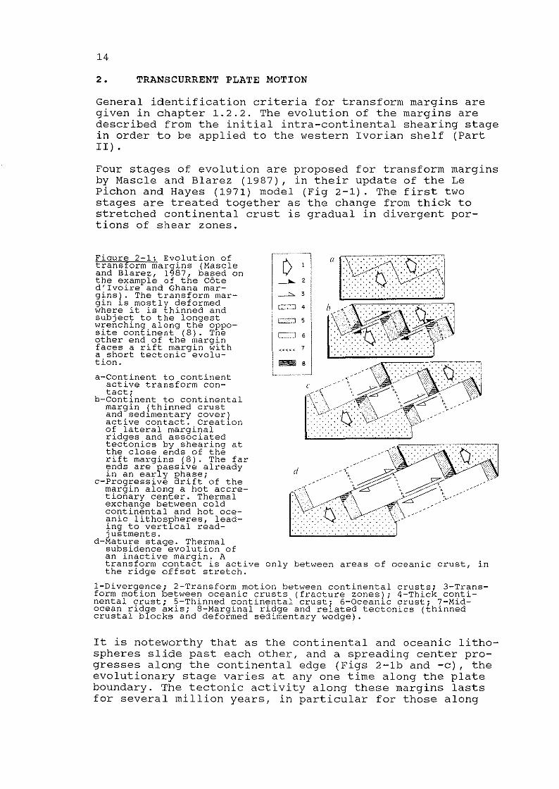
2. TRANSCURRENT PLATE MOTION
General identification criteria for transform margins aregiven in chapter 1.2.2. The evolution of the margins aredescribed from the initial intra-continental shearing stagein order to be applied to the western Ivorian shelf (PartIT) •
Four stages of evolution are proposed for transform marginsby Mascle and Blarez (1987), in their update of the LePichon and Hayes (1971) model (Fig 2-1). The first twostages are treated together as the change from thick tostretched continental crust is gradual in divergent portions of shear zones.
d
C:.::'2~
1
C::::~
<<<< <
1--L_,. _
I~-11 I2 I
II
--L. 3
C::';:::::J 4 I
only between areas of oceanic crust, in
Figure 2-1: Evolution oftransform margins {Mascleand Blarez, 1987, based onthe example of the Coted'Ivoire and Ghana margins}. The transform margin ~s mostly deformedwhere it is thinned andsubject to the longestwrenching along the opposite continent (8). Theother end of the marginfaces a rift margin witha short tectonic evolution.
a-Continent to continentactive transform contacti
b-Contlnent to continentalmargin (thinned crustand sedlmentary cover)active contact. Creatlonof lateral marginalridges and associatedtectonics by shearing atthe close ends of therift margins (8). The farynds are passlve already~n an early phase;
c-Progressive arift of themargin along a hot accretionary center. Thermalexchange between coldcontinental and hot oceanic lithospheres, leading to vertlcal readjustments.
d-Mature stage. Thermalsubsidence evolution ofan inactive margin. Atransform contact is activethe ridge offset stretch.
1-Divergence; 2-Transform motion between continental crusts; 3-Transform motion between oceanic crusts (fracture zones); 4-Thick continental crust; S-Thinned continental crust
i· 6-0cean~c crust; 7-Mid
ocean ridge axis; 8-Marginal ridge and re ated tectonics (thinnedcrustal blocks and deformed sedimentary wedge).
It is noteworthy that as the continental and oceanic lithospheres slide past each other, and a spreading center progresses along the continental edge (Figs 2-1b and -c), theevolutionary stage varies at anyone time along the plateboundary. The tectonic activity along these margins lastsfor several million years, in particular for those along

15
fracture zones with significant offset, whereas in riftmargins the activity is short.
The model implies that the thermodynamic effects of anintra-continental shear vary longitudinally along themargins. They are more intense where the parting continentsare in contact for the longest time (symbol 8, Fig 2-1).The other end of the transform margins face stretched continental crust of a rifted margin. These portions of transform margins rapidly loose their tectonic activity andtheir evolution is linked to the adjacent rift margin. Unlike rift margins, the structural evolution of oppositesides of transform margins is not kinematically symmetric.
The reconstruction of the Albian opening phase (Fig 1-5b)shows the shearing of the continental margins of westernCote d'Ivoire and of the Ilha de Santana Platform. The twoends of the Saint Paul shearing zone (eastern Cote d'Ivoireand the western end of the Brazilian platform) face riftmargins and slide against thinned continental crust. Consequently, along this dextral shearing zone, the margins thatare subject to long continent to continent shearing arewestern Cote d'Ivoire and the eastern part of the Ilha deSantana Platform, as expressed by Fig 2-1b.
2.1 Intra-continental shearing stage
This stage corresponds in the Equatorial Atlantic to thefirst opening phase in the Neocomian to the Late Albian/Early Cenomanian.
2.1.1 Fault patterns along transcurrent zones
In the upper crust the basic structural patterns of wrenching are simple and consistent and can thus be used as identification criteria. Faults and folds, generally arrangeden echelon along the wrench zone, often involve very elongate strips of land (Harding and Lowell, 1979). The principal elements, below, are described in Christie-Blick andBiddle (1985) and examples are seen in Fig 2-2:
1) the main wrench fault with a linear or curvilinearprincipal displacement zone, parallel or sUb-parallelwith the wrench movement; and
2) within and adjacent to the principal fault, conjugatestrike-slip faults, including synthetic faults inclinedat a low angle to the wrench zone but in opposite direction from the folds, and antithetic faults nearly perpendicular to the wrench zone. A well-developed faultpattern appears as sinuous and braided. The faults isolate slivers and blocks of upper crust causing a synsedimentary tectonic style within fault-bounded basins(Scrutton, 1979); and
3) en echelon folds inclined at low angle to the wrenchzone; and

16
4) normal faults or tension joints oriented perpendicularto the fold axes.
In transverse profile prominent strike-slip faults involvebasement rocks as well as sediments. They consist typicallyof a sub-vertical rather narrow displacement zone thatsplays out both upward ("flower structures") and laterally(in "horse-tail splay" pattern) within the sedimentarycover. On seismic data, the easiest identifiable flowerstructures involve a compressive component. Flowers with atensional component can readily be interpreted as sags andnormal faults (Harding et al., 1985).
A. Controls on the development of structural patterns alongstrike-slip faults
From the work by Christie-Blick and Biddle (1985), theprincipal factors that control the development of thestructural pattern of individual continental strike-slipfaults are: (1) the magnitude of displacement; (2) thedegree of parallelism of the block movement and the faulttrace; and, (3) the configuration of pre-existing structures.
1) After initial folding, the strike-slip and normal faultsare observed in a zone with a width that increases rapidlyin the initial stages of deformation but stabilizes as theweakened sheared material concentrates the continuedwrenching (Odonne and Vialon, 1983). As displacement further increases, a continuous principal fault develops parallel with the direction of block movement.
2) Variations from simple parallel shearing are seen bothlocally and on a regional scale.
Convergent movements of crustal blocks tend to enhance compressive wrench-zone structures. Examples are foldsarranged obliquely, en echelon, or parallel to the direction of shearing; conjugate strike-slip faults; and, evenreverse faUlting and thrusting (Wilcox et al., 1973). Dueto compression and isostatic adjustments, convergent bendsin a fault trace generate push-up blocks in the overridingplate, depressing the overridden adjacent block (large bendof the San Andreas Fault Zone delineating the Salton Seadepression; bends along the Elsinore Fault, "EEl" in Fig 22). Such blocks form sources for sediments deposited in theadjacent areas (Crowell, 1974b).
Figure 2 2: Diagrammatic fault map of the Salton Trough area,California (modified after Crowell and Sylvester, 1979). Salton Sea:large stepover basin, between the San Andreas Fault (SAFZ) and theImperial Fault, with coalescing pull-aparts with high geothermal gradient and volcanic activity. Splaying of faults north of the lake, inthe Mecca Hills (MH); San Andreas and San Jacinto fault zones: braidedfault pattern with push-up blocks ("Ell") and pull-apart holes ("8").See location in Fig 2-3a.
\lUlIlll 111111
~IJIJ\\~
=~
jre'19
\ Strike'\ & Dip
NoTdirection of slip
ANAL
0'!c,==~1''i:0...._~20MiLES
Balin fill. dots closer whereinferred to be deeper (exceptbeneath Salton Sea and Imperial Vallev)
Volcanic dome ~ Uplifts
Geothermal area e Down droppedRockslide terranes
Edge of coastal strat~ RegionalK1LOMETERS uplifts
10 20 30 40 50
Major fault andHiohwaVIMountain border
Inferred spreading center
p
o
xE
-"-
,,.-- ..... _------,.- .. ,, " ,,,
Il __ w ... , .. _ ...
,'''-,

18
At a diverging bend in the fault trace, tensional faultsprevail, and ideally rhomboidal tensional basins (pullapart or rhomboidal basins, "8"in Fig 2-2) open to receivesediments (Crowell, 1974b).
Kinematically equivalent features to the described tensional releasing or restraining faults bends are fault junctions and fault stepovers. Wedges at converging faults arecompressed and pushed upwards whereas they are stretchedand drop at diverging faults ("8", Fig 2-2), as describedby Christie-Blick and Biddle (1985). Stepovers along thestrike of wrench faults occur in en echelon arrangements offaults and produce pUll-apart basins (Salton Sea, Fig 2-2)or push-up blocks depending on the sense of stepover.
3) Karig and Jensky (1972) and Crowell (1981) report thatthe San Andreas fault and the transform faults southward inthe Gulf of California approximately parallel the boundaries of older tectonic elements of the Pacific and NorthAmerican plates.
2.1.2 Patterns at divergent plate boundaries
Along major intra-continental wrench zones, divergentopening regimes occur on segments, of the principal displacement zone, which are oblique to the theoretical interplate slip vector. These divergent regimes are expressed byseries of pull-apart basins, as in the southern part of theSan Andreas Fault and along the Dead Sea Transform Fault,south of Lebanon (Fig 2-3). Conversely, directions of purestrike-slip are parallel with the theoretical small circlesdescribing the relative motion of the plates (Mann et al.1983).
An oblique opening similar to Fig 2-3, is seen in theEquatorial Atlantic and in particular along the Saint PaulFracture Zone (Fig 1-5b and -c). It is, therefore, likelythat divergent wrenching has locally played an importantpart in the early opening of this ocean. Structures foundin intra-continental shearings, with a tensional component,are described in this chapter.
The radius of curvature is smaller for the Dead Sea Transform Fault than for the San Andreas Fault (Fig 2-3). Thefollowing differences appear to be related to the distanceto the pole of rotation (Mann et al., 1983): a more curvilinear fault trace seems to generate a larger number ofoblique segments with more frequent pull-aparts; the longest pull-aparts occur farthest from the pole of rotation,which may reflect faster plate motion away from the pole;the widest and most closely spaced basins occur at thegreatest change in strike of the fault with respect to theslip vector; despite the overall oblique trend, the masterfaults of the pUll-aparts strike parallel with the slipvector.
Strike-slip deformations with a component of extension aredescribed by Harding et al. (1985) (Fig 2-4). Extensionenhances brittle deformation with normal faulting deformingthe blocks adjacent to the wrench zone in sequences ofsteep dipping en echelon arrangements. The affected zone

19
is, on the local scale, typically narrow. Most of thelateral movement appears to be taken up by a continuouslinear principal displacement zone or wrench fault describing negative flower patterns. Associated folding appears torun parallel with the wrenching.
o
o,km
300,
I ~~ IN I I<Iill'
IIIII I /1/
If, '"~, ---,./
<)t) ,
( Jr'" os1_-
l"/
~
i-I-_./",1;
// 0 100,
km
Figure 2-3: Divergent strands along transform faults. Divergent andcompressive strands are identified as oblique with respect totheoretical inter-plate slip-lines.
A: San Andreas Fault - Pacific/North American plate boundary zone(modified after Mann et al.! 1983). TR-Transverse Ranges push-upblock (shown in cross-hatching); SS-Salton Sea pull-apart area (Fig2-2); G-Guaymas Basin (Fig 2-5);
B: Dead Sea Transform Fault, separates the Arabian from the Sinai(Levant) plates (modified after Mann et al., 1983 and Manspeizer,1985). LR-Lebanon Ranges push-up block (shown in cross-hatching);OS-Dead Sea Basin; GA-Gulf of Aqaba, the latter two areas withthree en echelon pull-aparts each; RS-Red Sea rift margins.
An increasing component of divergence may lead to normalfaulting parallel with the wrenching, resulting in transverse extension of the plate edges. Along the southern partof the Dead Sea Transform Fault (Fig 2-3b), the plateboundary is a complex fault-bounded zone rather than asingle strike-slip (Garfunkel, 1981).

20
RELEASINGHORSETAIL SPlAY PARALLEL OVERSTEPOF EN ECHELON FORCED ANO PUU·APART
SYNTHETIC FAULTS ~FOLOS BASIN NORMAl FAULT IN·lINE HORST~i * I../' ANO GRABEN SLICES
POZ--_! " / ", I ~
- $\~~ ~~ '\:!~~ ~!ln ~XI:;:: POZ
~!\n ~ \ FORCEO EN ECHELON RESTRAINING NEGATIVE FLOWERMONOClINE NORMAL BENO ANO STRUCTURE
EN ECHELON FAULTS OBlIOUEANTITHETIC FAULTS FOLO
PDZ
e . EXTENSIONAl COMPONENT
MILESo 5±
I
o 8±KILOMETERS
POZ PRINCIPAL DISPlACEMENT ZONE
'"---'l. NORMAL FAULT PROFILE
""'----A. REVERSE FAULT PROFILE
-+- VERTICAL FAULT PROFILE
Figure 2-4: Structures associated with divergent wrenching (Harding etal., 1985). The scale relates to examples taken by Harding et al.(1985) in the Salton Trough Area. Not all divergent wrencn zonescontaln necessarily all features. Insert: strain ellipse in rightlateral divergent wrenching (Harding et al., 1985).
2.1.3 Pull-apart basins
A. Evolution of the structural pattern
The most striking feature found in divergent wrench zonesare the pull-apart openings (Fig 2-4) which lead to theformation of rapidly sUbsiding, very deep troughs. Althoughthey vary in size they tend to be smaller (generally lessthan 50 km wide) than basins produced in tensional (intracontinental grabens) or compressional (foreland and forearcbasins) regimes (Christie-Blick and Biddle, 1985).
The principal characteristic of well-developed pUll-apartbasins is their rhomboedric shape (Fig 2-4). In the preceding generalities (chapter 2.1.1A), depressions were seento nucleate at releasing fault bends, stepovers or junctions. The master faults of the forming grabens stay parallel with the direction of strike-slip and are connected bysynthetic strike-slip or oblique dip-slip faults. Duringtheir evolution, adjacent en echelon depressions maycoalesce as in the Salton Sea Trough (Fig 2-2), between theImperial and the San Andreas Faults and as in the Gulf ofAqaba (Fig 2-3). In these two locations the coalescingbasins are each approximately 10 km wide. In the Gulf ofAqaba they are 40 to 65 km long.
In the latter example, the eastern and western edges of thebasins are sharply defined by very steep normal faults,which take up the component of transverse stretching, asdiscussed above. Such escarpments at the edges of thesliding plates are likely to develop into future continen-

21
tal margins. Their composite throw appears to be approximately 5 km (Ben-Avraham, 1985).
with prolonged offset of tens of millions of years, thepull-apart grabens eventually develop into elongatedtroughs floored with oceanic crust. The crust forms at anorthogonal, short spreading ridge, as seen in the Gulf ofCalifornia (Fig 2-3a) and in the reconstructions of theEquatorial Atlantic in Albo-Aptian time (Figs 1-5b and -c).
B. Basin ridges
Coalescing pull-aparts tend to be linked by drag folds orshort transform ridges. In the Gulf of Aqaba two of thebasins are separated by small and narrow ridges consistingof folded and warped basinal sediments (1 km in wavelength,100 m in amplitude) (Ben Avraham et al., 1979) (Fig 2-3b).These ridges may be caused by compression during differential opening of the juxtaposed basins, as proposed in stage"b" of Fig 2-1. Of larger dimensions, the Mecca Hills,along the San Andreas Fault (Fig 2-2), are high-angle,fault-controlled, en echelon folds. These folds are foundalong the edges of an underlying basement ridge. They arepushed upwards, together with the ridge, by the convergentwrenching of the Salton Sea Trough against the northeastlying block. The folded area and the ridge are 1-3 km wideand form the edge of the 4-6 km deep trough with shallowcrystalline basement to the northeast (Sylvester and Smith,1976) .
Rosendahl et al. (1986) and Rosendahl (1987) identify, inthe East African Rift, ridges linking opposing, non-overlapping, opening basins. The exemplified dimensions arelengths over 70 km, widths as small as 5 km and unspecifiedvertical paleo-reliefs. These inter-basinal ridges, takingup lateral movements, are associated with proto-transformzones. Unlike the Mecca Hills, the ridges appear to beassociated with limited folding, likely due to more limitedwrenching and to a thinner sedimentary cover.
From the study by Rosendahl (1987), it seems that unlikeother basinal features, inter-basinal ridges tend to followpre-existing structural trends.
c. Subsidence and sedimentation
Rates of subsidence during the syn-tectonic phase are morerapid than in divergent basins (Fig 3-9). Consequently,where there is abundant supply of sediments, pull-apartsare characterized by very thick stratigraphic sections incomparisons with lateral basin dimensions (Christie-Blickand Biddle, 1985). In the Salton Sea Trough (Fig 2-2)approximately 6 km of Plio-Quaternary sediments are known(Crowell, 1974b), in basins of only 20 km length. Two pull-

22
aparts in the Gulf of Aqaba are up to 5 km deep (BenAvraham, 1985), with Plio-Pleistocene sediments (Garfunkel,1981). The subsidence rate is, however, faster than thesediment supply as the water depths are 900 to 1500 m.
As seen in Fig 3-9, the post-tectonic phase of strike-slipdepressions is characterized by little sinking of the basinfloor.
D. Tectonic activity and geothermal gradient
As strike-slip basins are generally narrow, they rapidlyloose anomalous heat by lateral rather than vertical conduction. Most of the anomaly would then be lost during thesyn-tectonic phase with an accelerated crustal cooling andcontraction, leading to rapid subsidence rates (Pitman IIIand Andrews, 1985). This evolution is at the expense of thepost-tectonic stage, where only limited vertical movementsare observed (2.1.3.C).
For the same reason, it is likely that the acceleratedlateral heat losses may be unfavorable for the ascent ofmagmas. This may account for their absence in the pullaparts in the Dead Sea Transform Fault and their generalscarcity in divergent wrenching environments (Garfunkel,1981). However, in the East African Rift, Rosendahl (1987)observes that if volcanism occurs in a basin, it seems tobe concentrated along inter-basinal ridges. The ridges mayoffer easier magmatic pathways than border faults.
In the Salton Trough with a very stretched crust, Quaternary basaltic-rhyolitic domes do not directly overliepUll-aparts, but are aligned along a northeast trendinglineament on the southern shore of the sea (Fig 2-2). Therocks may be related to an incipient spreading center(Korsh, 1979), as in more mature pull-aparts in the Gulf ofCalifornia.
In more mature stages when crustal thinning is advanced inpUll-aparts, volcanism focuses along orthogonal directionsas a consequence of incipient spreading axes. It shouldhowever be remembered that there is no clear relationshipbetween the amount of offset and the onset of igneousactivity (Mann et al., 1983).
2.2 continental - oceanic shearing stage
It was seen in chapter 2.1.30 that within maturing pullapart basins, magmatic activity initiates at the continental crustal break, along ridges orthogonal to the mainstrike-slip faults, as seen in the Salton Trough (Fig 2-2).
with continued emplacement of oceanic crust, stretchedcontinental crust is gradually replaced by oceanic crust

23
along the shear zones. A continental to oceanic lithospherestrike-slip motion sUbstitutes, along the shear zones, theformer intra-continental shearing (Figs 2-1c, 1-5c and -d)The slip of newly formed oceanic crust against the continental margin is then followed by the spreading ridgeitself. In its wake, the transform fault looses its strikeslip activity as both crusts become stationary. This lastpassive phase is described in chapter 2.3.
A present-day example is found in the recent pull-apart ofthe Guaymas Basin, in the Gulf of California (Figs 2-3a and2-5) (Lonsdale, 1985). On the active transform margin ofthe pull-apart basin, the major structural element is anarrow oceanic transform ridge (Fig 2-5). It is formed bytightly folded sediments, raised by uplift of shearedoceanic crust at the contact with continental basement. Atthe edge of shearing plates, it is of similar dimensionswith the inter-basinal ridge found at the edge of theSalton Trough (chapter 2.1.3B). The uplift of the transformridge seems to be mechanically and isostatically induced(Lonsdale, 1985).
sw NE
/
MAGNETICANOMALY 50
MARGINAL PLATEAU
2
3
4
--'
TR BfI IL- ./., ,-- ------, '- ----- --- -"_,
-"'/1
+200]o~~~-----'---200
·50
BOUGU ERGRAVITYANOMALY
:J mi
5101I.. ...I
(FREE-AIR" GRAVITY
I ANOMALY
Floure 2 5: Multi-channel seismic, magnetic and gravity profile acrossthe northern margin of the Guayrnas Basin, Gulf of California {modifiedafter Lonsdale, 1985). The section is perpendicular to the ma~n continental boundary fault scarp (BF) with the active transform ridge (TR)at the plate boundary. The sectlon is not migrated.
The negative magnetic anomaly (the polarity depends on the magnetization of the oceanic crust) at the lower slope is attributed to theedge-effect of the juxtaposltion of oceanic and continental crusts.The shallower transform ridge, however, does not have a magneticsignature. The steep Bouguer gradient confirms the abrupt crustaltransition.
The transform ridge (TR) here is a 2-3 km wide zone of diffractions,with a vertical relief of one second TWT (two-way time) (or 750 m)with respect to the ocean side. This feature is 1,250 m higher thanthe spreading center. Trapped sediments on the marginal plateau of thecontinent are approximately 2.5 seconds TWT deep.

24
The section in Fig 2-5 illustrates how the ridge acts as anefficient dam for sedimentation on the marginal plateau.However, the rim of the margin has been uplifted and eroded. The entire section is affected by gentle folds that areoriented (in plan view) en echelon with respect to thefault zone (Lonsdale, 1985). The marginal plateau is boundto the NE, towards land, by steep basement faults ofseveral seconds two-way time (TWT) throw (Lonsdale, 1985).
The continental-oceanic shearing effects have had limitedtime to develop along the Guaymas margin. In the pullapart, the oceanic-continental crustal contact is only 130km long (of which half is active) and with a half-spreadingrate of 2.7 cm/year, the oceanic crust is not older than2.4 Ma (Lonsdale, 1985). Thermal upheaval and erosion ofthe continental margin, with a consequent crustal thinningis proposed in a model by Todd and Keen (1989), during theoceanic-continental shearing. The thermal model includesboth shear heatipg and lateral conduction of heat from thehot oceanic crust into the cold continental crust. Over 2km of crustal uplift is predicted at the fault trace for amodeled transform fault of 500 km in length, with a halfspreading rate between 1.0 and 4.0 cm/year. This upliftdecreases away from the fault over a distance of 60-80 km.
2.3 Passive sheared continental margins
This last phase starts after the passage of the accretionary ridge (stage "d", Fig 2-1). The characteristics ofpassive sheared margins are listed in Table 1-1. The mainprocesses are:
1) The thermal upheaval of the continental margin startedin the active stage. It is caused by the lateral conductionof heat from the oceanic crust to the cooler continentallithosphere, and continues in the passive phase. Uplifts ofa few hundred meters were predicted by Scrutton (1979) inorder to explain the wide occurence of marginal ridgesalong inactive sheared margins (Table 1-1). A modernexample is the passive side of the Guaymas transform fault,in the Gulf of California (chapter 2.2). A marginal ridgeis thermally uplifted several hundred meters after thepassing spreading axis (Lonsdale, 1985).
2) The subsidence of the oceanic crust initiates on bothsides of the spreading ridge, as soon as the new crust isemplaced, at the height of the spreading ridge. The subsidence is likely due to cooling and thermal contraction ofthe new crust (Scrutton, 1979). Scrutton (1979) estimatesthis subsidence to be several thousand meters; eitherdragging down the continent, or generating a fault scarp atthe former plate boundary. When it is not buried undersediment, a fault scarp is indicated by the steepness ofthe continental slope.

25
The loss of heat from the oceanic crust may also lead tocontractions and tensions normal to the fracture zone. Thestresses may generate horst and grabens in the oceaniccrust, within the fracture zone, parallel to the shearedmargin (Collete, 1974; in Scrutton, 1979).
4) As the thermal impact on the continental crust from thecooling oceanic crust decreases with decreasing temperaturedifference, the continental crust will be affected bythermal subsidence. According to Mascle and Blarez (1987),the subsidence behavior should be comparable to that ofrifted margins, i.e. of flexural character.
5) Volcanic activity can be of importance at the crusta Iboundary of sheared margins. In the transform margin southwest of the Grand Banks, off eastern Canada, Keen et al.(1990) report magmatic activity later than the intra-continental stage. It is not specified if this activity is ofoceanic-continental shearing age or if it occurred duringthe passive phase.
During all three stages of sheared margins, marginal ridgesmay develop. In the intra-continental shearing stage theridges are seen to consist of folded sediments or upliftedbasement. In the oceanic-continental shearing stage theyare reported to be formed by folded sediments or by oceaniccrust, or by uplifted continental crust. In the passivestage, the ridges consist of uplifted continental crust.They all act as barriers for sedimentation.

26
3. STRUCTURE AND STRATIGRAPHIC SEQUENCE OF THE AFRICANCONTINENTAL MARGIN IN PROLONGATION OF THE SAINT PAULFRACTURE ZONE
The African continental termination of the saint Paul Fracture Zone includes the continental margins of southeasternLiberia, and of Cote d'Ivoire. It controls the northernpart of the offshore basin of eastern Cote d'Ivoire. Thetransform margin forms the southern end of the Liberia riftmargin.
3.1 Generalities
3.1.1 Physiography of the continental margin
The shoreline along West Africa from Liberia to Ghana isdescribed as a sawtooth pattern with the protruding CapePalmas, in south~astern Liberia, and Cape Three-Points inGhana. The continental shelf runs parallel with the coastand is 25-30 km wide along the Ivorian coast but 50 to 60km wide off Liberia. Offshore Cote d'Ivoire, the shelfbreak occurs in 120 to 130 m of water depth (WO) and isseverely gUllied (Martin, 1971).
Along the western Ivorian continental slope, the bathymetric curves run parallel with the coast and reveal strongdips. The strike continues WSW into Liberian waters. Theregional slope is offset there by three east-west trendswith very high southerly dips (3 - 10 deg).
3.1.2 Basement shield
In Cote d'Ivoire, the basement shield is exposed over97.5% of the country and belongs primarily (Tagini, 1971)to the Eburnean province (Fig 3-1). Its orogenic high iscontemporaneous with the Sveco-Karelian Cycle, occurringbetween 1,800 and 2,000 Ma (Sutton, 1963 in Bessoles,1977). The province extends into the southeastern third ofLiberia whereas the northwestern two-thirds belong to theolder Liberian province. This latter area had its orogenichigh between 2,300 and 3,000 Ma (Sutton, 1963 in Bessoles,1977). Both shield provinces consist of amphibolite-gradegranitic gneisses and metasediments with a northeastwardfoliation trend.
Figure 3-1: Tectonic, bathymetric and location map of Liberia and Coted'Ivoire (compilation of Behrendt et al., 1974; Delteil et al.! 1974;Gorini, 1981; Schlee et al., 1974; stewart and Kromah, 1987 for theoffshore and Bard! 1974; Behrendt et al., 1974; Bessoles, 1977;Choubert, 1968 for the onshore). Lines 26, 30 and 34 are shown in Fig3-5a. Line 30 is extended onshore in Fig 1-4. s: town of Sassandra; B:Seller oil field; E: Espoir oil field; Cestos, Ivco-l, -2, -3, KI-IXand Kl-2X are petroleum industry wells.

Late Precambrian SedimentaryBasin
1---1 Dolerite_ Dykes
. . .
Fig 3-7
Cape ThreePoints",'"
:,{
Mesozoic - CaenozoicCoastal Basins
Precambrian Lineaments
D····. ....
[]][]Pan - African Range
Eburnean and Liberian CrystallineFormations with Foliation Trend
Eburnean Metasediments withFoliation Trend
(SIERRA (LEONE
~
Studied Area
Ocean ic Fracture Zones andAssociated Marginal Ridges
Outcropping Ridges

28
Along the coastal extent of the Liberian province (Fig 31), the Pan-African Rockelides (550 Ma, Behrendt andWotorson, 1970) stretch in a narrow belt consisting mainlyof granulite-facies metamorphic rocks (White and Leo, 1969,in Behrendt and Wotorson, 1970). Dolerite dykes and sills,in the coastal region of Monrovia, have been dated to theJurassic (176-192 Ma (Early Jurassic), White and Leo, 1969,in Bessoles, 1977).
A. Southwestern Cote d'Ivoire
The Eburnean formations in southwestern Cote d'Ivoire (Figs3-1 and 6-6) are described, with geochemical analyses andradiometric datings, by Papon (1973). In the absence ofmeasurements of the physical properties of these formations, the chemical analyses are used in chapter 6.2.1 fora qualitative estimation of densities and magnetic susceptibilities of the basement on the continental margin ofwestern Cote d'Ivoire.
The formations found along the coast of western Coted'Ivoire are (Fig 6-6):
* From the Liberian border to halfway to Sassandra: migmatites with streaks of gneiss of Liberian age, subject toa second metamorphism during the Eburnean orogeny(Tagini, 1971). The formations below date from this laterorogeny.
* Around San Pedro: micaschists.
* Around Sassandra: granodiorites, metamorphic tuffs.
* Amphibolite, quartzites, etc, in limited outcropsthroughout the coastal stretch onshore the studied area.
* East of the present survey (Fig 3-1): slightly metamorphic tuffs and schists bound by the Dimbokro lineament.Along the fault, volcanics are common within a 10 kmstrip (Bessoles, 1977).
* Dolerite dykes, with NW-SE strike as found in Liberia(Fig 3-1). Their K-Ar datings vary between LowerProterozoic (1730 Ma) and Carboniferous (284 Ma) (Tagini,1971), whereas in coastal Liberia, the intrusions seem tobe contemporaneous with the early opening of the Liberianrift margin (Behrendt and Wotorson, 1970). Behrendt etal. (1974) trace a few high frequency magnetic anomalieson the southeastern Liberian shelf, which they interpreteas being caused by similar dykes with the same trend asonshore. Offshore Cote d'Ivoire, the presence of dykes isnot known.
B. Lineaments
Southwestern Cote d'Ivoire and southern Liberia are bothcut by subvertical lineaments parallel to the foliationtrend and which can be followed over tens and even hundredsof kilometers (Fig 3-1) (Bard, 1974). They are mapped asstrike-slip faults (Bard, 1974, with undefined direction of

29
displacement and unknown amount of slip), or as thrustfaults (Lemoine, 1989, in Alric and Vidal, 1990). Thelineament bounding the Liberian and Eburnean Provinces isreported to be of Eburnean age (Caen-vachette, 1988).
The saint Paul marginal Ridges are parallel with two majorlineaments of Sassandra and Soubrei. One of the faults isinferred ("0" in Fig 3-1) from aeromagnetic data on- andoffshore, and is confirmed by geological mapping onshore(Behrendt et al., 1974). It is in trend with the Grand CessRidge. The Oimbokro fault keeps, however, a northeast trendwhen reaching shore, i.e. parallel with the regional foliation trend. Tagini (1971) reports that this fault has apronounced magnetic and gravimetric signature as it separates the eastern metasediments from the magmatics (Fig 31) .
The coastline seems to follow recent faults (Martin, 1971and Tricart, 1957) being formed by WSW trending sections,offset by NS oriented capes.
3.1.3 continental margin controlled by the Saint PaulFracture Zone
Along the continental margin in prolongation of the saintPaul Fracture Zone, the principal depocenters are thebasins offshore Liberia and offshore eastern Cote d'Ivoire- western Ghana (Fig 3-1). Both have a NNW strike. Inbetween, the western shelf of Cote d'Ivoire has been interpreted as consisting of shallow basement, in prolongationof the outcropping onshore shield (Arens et al., 1971,Brancart, 1977 and Gooma, 1990).
Common to the two basins is a very thick Lower Cretaceoussyn-tectonic sequence of clastic sediments starting withthe deposition of an initial continental interval of variable thickness of Late Jurassic or Neocomian age upon adeeply-eroded Precambrian shield. The first marine transgressions date from the Albian, possibly Aptian (for thechronostratigraphy, see Fig 7-8). No evaporites are foundalong this margin, from Guinea to Nigeria.
The syn-tectonic sequence ends on the Equatorial Atlanticmargins with a strong unconformity which is assumed to beLate AlbianjEarly Cenomanian (Mascle et al., 1988). Theunconformity may consequently be contemporaneous of the endof the intra-continental shearing phase (Fig 1-5c). Mascleet al. (1988) propose that most, if not all, tectonicfeatures observed on the margins are formed during thisshearing stage.
Although the Equatorial Atlantic may be expected to beregionallya transtensive environment (chapter 2.1.2), bothtranspressive and transtensive structures should be found,depending on the locally prevailing stress constraints.

30
From the Early Cenomanian to the santonian (chapter 1.3.2),oceanic-continental shearing takes place (chapter 2.2).Mascle and Blarez (1987) propose that the thermal impact ofthe hot newly emplaced oceanic crust should lead to crusta Iadjustments. These could be recorded as a succession ofsedimentary onlaps against marginal ridges and in a slowdown of normal thermal subsidence.
The African transform margin controlled by the saint PaulFracture Zone is approximately 500 km long (Fig 3-1).Mascle and Blarez (1987) assume an initial opening rate of2 cm/year for the Equatorial Atlantic. Applying the modelby Todd and Keen (1989) (chapter 2.2), a significant thermal upheaval over the entire width of the margin, followedby erosion, may be expected during the oceanic-continentalshearing.
The passive evolutionary stage, characterized by continuedthermal uplift ot marginal ridges and general subsidence,starts in the Equatorial Atlantic in the Senonian. Itstarted after the passage of the spreading ridge, probablyin santonian times (Mascle and Blarez, 1987). The normalthermal subsidence continues today (Latil-Brun et al.,1988) .
Two general regressions with very active erosions tookplace during the passive stage, in the Upper Paleocene andin the Oligocene. Fig 7-8 summarizes these events with achart of cycles of relative changes of sea level identifiedworldwide and in the Gulf of Guinea.
3.2 western part of the African transform margin of thesaint Paul Fracture Zone
West of the studied area, the southeastern part of theLiberian continental margin is apparently controlled by themarginal ridges of the saint Paul Transform Fault (Figs 1-4and 3-2). To the east, the sedimentary basin of coted'Ivoire is bordered onshore by a major east-west trending"Faille des Lagunes". Off western Cote d'Ivoire, the basingives place to shallow basement on the shelf (Arens et al.,1971; Brancart, 1977). The shelf-break and the relativelysteep slope were indicated by Le Pichon and Hayes (1971)and Francheteau and Le Pichon (1972) to be in line with thesaint Paul marginal Ridges. The "Faille des Lagunes" istherefore likely to be the eastern end of the sameridges.
The continental margin controlled by the saint Paul Transform Fault has been fragmentally studied on both sides ofthe Liberian/Ivorian border. The description focuses consequently on the western and eastern sides separately.

31
3.2.1 structure and stratigraphic sequence of the continental margin of southeastern Liberia
Published information on the geology of the continentalmargin of Liberia dates back to the early seventies andstarted with onshore geological and geophysical mapping andairborne surveys reported among others by Behrendt andWotorson (1970), and was followed by offshore geophysicalcampaigns interpreted by Behrendt et al. (1974) and Schleeet al. (1974).
The structural interpretation in Fig 3-2 shows the southeastern Liberian margin to be controlled by three ridges:Grand Cess, Cape Palmas and saint Paul. starting from thecontinental slope and rise, available data give the following description.
3"00'6°00'
COTE D'IVOIRELIBERIA
ll~;~:~~ " ',.i·~c,c,'.,.-, ';'-"""'-~~"=-~~)d~£':~~'~' 2000 m
Saint Paul?=? Ridge ~
----/-- --- 1 WD4000m
o •M M
11°00'
LEGEND
Basin with sedimentthickness> 2 km on top ofacoustic basement>4 km on top ofmagnetic basement
~ Edge of block
~.,.~,,- >1/2 km of sediment on shelf
+ Fold
-%- Inferred fault
Figure 3-2: Structural trends of the southeastern continental marginof Liberia (modified after Schlee et al., 1974). Three ridges (GrandCess, Cape Palmas and Saint Paul), of up to 20 km across, are identified. They appear to offset the Liberian slope southeastwardly. Sediments have accumulated below the continental slope against the northern side of the Grand Cess Ridge. Similarly, the two southern ridgeshave acted as dams for sediments carried down the slope forming small"pocket basins" 10-30 km wide, several kilometers deep, within twobroad valleys that cut into the continental slope. Lines 26, 30, 34are found in Fig 3-5a.
A. continental slope and rise
On the slope and rise, the magnetic anomalies (Fig 3-3) arein continuation with the Eburnean trend onshore and on thecontinental shelf and have consequently probably reused

32
this Precambrian strike (Behrendt et al., 1974) (chapter2.1.3B). Northwards, the trend shifts to a coast parallelorientation.
Beneath the slope, the single channel seismic sections showlarge blocks up to 20 km across, with no internal reflectors and with dips as high as 45 deg (Fig 3-5a). The multichannel line reveals probable internal beddings (Fig 3-5b).The associated magnetic curves reveal high amplitude anomalies, at the seismic ridges, due either to intrusions or
km
Sassandra
7'00'
.................................................. 6'00'
~.:o-~C6TE D'IVOIRE
S'OO'
/ Eburnean
;/"Age
V$ \00
i10'00'11°00'
Figure 3-3: Total magnetic anomaly field map of southeastern Liberia(modified after Behrendt et al., 1974). The map has been corrected forthe International Geomagnetic Reference Field (IGRF). The map has notbeen integrated with the available anomaly map of southwestern Coted'Ivoire (Strangway and Vogt, 1970), as the latter is too sketchy.Lines 26, 30 and 34 are found in Fig 3-5a.
to the juxtaposition of crystalline basement rocks withcontrasting susceptibilities. The Bouguer map (Fig 3-4b)confirms the presence of mass excesses at the location ofthe ridges in Fig 3-2. The blocks consist likely of continental basement with locally pre- or syn-tectonic indurated rocks.
In plan view (Fig 3-2) the blocks align into three elongated ridges which trend in a WSW direction. The ridgesextend into the Cape Palmas area and have an expression onthe sea-bottom topography (Fig 3-1). The first and principal zone, Grand Cess, runs continuously into the continental shelf, west of the Ivorian border. The second, CapePalmas Ridge, is a buried feature below the continental
33
km
12°00' WOO'.....................................L .c ..J3'OO'
8°00' 7°00'
A: Free-air map
o
"COTE D'IVOIRE
km
......................~ 3'00'
..................J 6'00'
7°00'12'00'
B: Bouguer map
Figure 3-4: Gravity maps of the southeastern continental margin ofLiberia (modified after Behrendt et al., 1974). The applied Bouguercorrection is 2.67 g/cm3 •

34
rise south of Cape Palmas. The ridge coincides with theshelf-edge at the border. The third transverse ridge, SaintPaul, stays in deep waters and is a topographical high asfar east as 10 deg W, and can be traced, buried under thecontinental rise as far east as 7 deg W (Behrendt et al.,1974) (Fig 3-1).
All three ridges have trapped several kilometers of sediments (Fig 3-2). On the upper slope, Cretaceous and youngersediments pinch out abruptly on the steep northern walls ofthe valleys (Schlee et al., 1974) and accumulate againstthe southern ones, with a more gentle topography (Fig3-5a). Further seawards, the sedimentary section thickensto several kilometers, thinning gradually in the abyssalplain. An indication of an oceanic/continental crustalcontact is given by a gravity model (Fig 1-4) where theSaint Paul Ridge may be of oceanic origin. Multi-channelseismic sections show that it has the shape of a cone(Soquip, unpubl.). The Saint Paul Ridge could be a seamount.
Figure 3-5: Seismic lines across thesoutheastern continental margin ofLiberia. See location in Figs 3-1,3-2 and 3-3.
A: Interpreted single-channel seismicprofiles across the southeasterncontinental margin of Liberia(modified after Schlee et al.,1974). The margin is controlled bythree ridges which can be followedfrom line to line. The sedimentarycover on the shelf ("Xli) is verythin. The total magnetic intensityprofiles are IGRF corrected. A gravity model of line 30, with an onshore extension is in Fig 1-4.
0" '\ifpoI.\/x
hi 1et' 342-' A3 \
..•.,-;~./ Saint Paul--.. ':-' Ridge
o 40kmVERTICAL EXAGGERATION OF TOPOGRAPHYABOuT x9: SU8SURFACE REFLECTORS x5 OR LESS
On the single-channel profiles (Fig 3-5aj the sediments are2 seconds TWT (two-way time) thick in the basins. Thisseems to correspond to the I and II units on the multichannel section (Fig 3-5b). Thereby, the third unit withstrong reflectors would have acted as the acoustic basementon the first lines. Below this unit however, a deeperbasement is not visible. To match the magnetic depth estimate of at least 4 km below sea-bottom (Fig 3-2), it would

o
1
1I
5
]JI
35
come in 0.5 to one second below the 11/111 unconformity.From gravity constraints, Behrendt et al. (1974) interpretthis third unit as a dense, thick non-magnetic sequence,concealing the true basement. It may thus consist of sheetlike volcanic flows within the sediments or thick sequencesof limestone.
Finally, this third unit shows strong faulting and foldingand should thus be a syn-tectonic Lower Cretaceous boundedby a strong unconformity, possibly of Late Albian/EarlyCenomanian age, chapter 3.1.3.
sw
GRAND CESS
RIDGE
BENIN PROFll 11
Figure 3-58: Multi-channel seismic line (modified after Delteil etal., 1974). Basement probably outcrops on the continental shelf and isblock faulted below the slope where it is rapidly overlain by over 3seconds TWT (two-way time) of sediments. The seismic resolution on theslope is much better that on the adjacent single channel lines (Fig 3Sa), as the section reveals a faulted syn-tectonic sequence Ill, inparticular on the sides of the horst that appears to be the Grand CessRidge. An acoustic basement is not visible. By comparison with thelines in the Cote d'Ivoire Basin (Fig 3-10) and off western Coted'Ivoire (chapter 7), unit Ill, with a series of strong reflectors, islikely a Lower cretaceous sequence topped by the Top Albian tectonicunconformity. Unit 11, with low amplitude reflectors, may consist ofUpper Cretaceous and Paleocene sediments and unit I, of the Neogene,starting with a strong erosional surface, possibly of Paleocene age.See location in Figs 3-1 and 3-2. The length of the section is approximately 30 km and the ridge is 2 to 4 km across.
Above this lower unit, the sequence 11, characterized bylow amplitudes, is of a mean thickness of 0.6 seconds TWTand fills the paleolows. It can be compared with the UpperCretaceous - Paleocene in the sections from the Coted'Ivoire offshore Basin (Fig 3-10). The interval is diffi-
NEo
5

36
cult to follow towards the upper slope where it seems to betruncated by a major erosional surface, which forms thebase of the uppermost sequence.
Off the shelf-edge, unit I pinches out against a paleoshelfbreak with a dip of 13-45 deg with no internal reflectors or only mUltiple energy (Fig 3-5b). This youngestinterval has been slumped down, as shown by the irregular,hummocky character of the reflectors. In deeper waters,above the ridge, it seems that the unit is dissected by asecond cenozoic erosional surface at approximately 500 ms(milliseconds) TWT below the sea-bottom.
The continental slope has been dredged on the southernflank of the Grand Cess and Cape Palmas Ridges where thesedimentary cover is thin. On both locations the samplesare marine, possibly Paleogene, sediments (dolomites andclastics derived probably from metamorphic and volcanicmaterial, Schlee et al., 1974). The erosion at the base ofsection I should then be related to a post-Paleogene regression. It may be the trace of the major regressionalphase off West Africa which took place during the Oligocene(chapter 3.1.3) and which is described off eastern Coted'Ivoire (chapter 3.3.2).
B. continental shelf
Onshore southeastern Liberia, the coast is barren of sedimentary formations. On the continental shelf, the singleand multi-channel seismic profiles, interpreted by Schleeet al. (1974) and Delteil et al. (1974) (Figs 3-5a and -b)give evidence to a thin or locally non-existent sedimentarycover (less than 0.5 seconds two-way time) resting on theacoustic basement. The interpretation by Behrendt et al.(1974) of the gravity (Fig 1-4) and magnetic surveys pointto a crystalline nature for this acoustic basement.
There is consequently no geophysical expression of marginalridges on the shelf except for a reported aeromagneticcontinuation of a Precambrian lineament, in trend with theGrand Cess Ridge ("0" in Fig 3-1). The lineament could berelated to the fracture zone (Behrendt et al., 1974).
C. Liberian basins north of the marginal ridges
North of the Grand Cess Ridge, three basins, with a coastparallel strike, are located on the Liberian continentalmargin (Stewart and Kromah, 1987). The basins have between0.5 and 4 km of sediments on the shelf and 2 to 8 km on theslope. Underneath, the acoustic basement is block faulteddown to the ocean (Behrendt et al., 1974).
On the basement horsts offshore, from the latitude ofGreenville northwardly, coast-parallel magnetic lineaments

37
of high spatial frequency are associated with doleriticdykes which have a parallel trend onshore (Behrendt et al.,1974). Similar dykes have been encountered in wells. Theyare of Jurassic and Early cretaceous age (Schlee et al.,1974) .
On top of Lower Paleozoic sediments deposited in the coastal area, the first sediments encountered are in the basinsformed by the initial Jurassic/Early Cretaceous rifting.Most of the sedimentary section found in borings is syntectonic and of Albian and pre-Albian age. The sectionconsists mainly of continental and marine clastics withsmaller amounts of siltstone and limestone. It is up to2,000 m thick (Schlee et al., 1974). The column lacks thecoarse clastics deposited in Cote d'Ivoire (chapter 3.3.2).
The post-rift section consists of thin, non-consistentmarine Upper Cretaceous clastics that have been truncatedby a Tertiary er2sion. The overlying cenozoic (with Eoceneat the base) is thin. Unrestricted marine conditions prevailed throughout the Cenozoic, although subsidence waslimited (Schlee et al., 1974). In addition to the riftingphase, Schlee et al. (1974) report a last faulting andfolding event at the end of the Mesozoic to the beginningof the Tertiary.
Conclusively for the marginal ridges, although the amountof seismic data limits the possibility to identify structural trends within the basins (Fig 3-2), they are nonetheless tensional holes with a rapid syn-tectonic subsidencelocated on a transform margin. The depositional pattern andthe restricted sedimentation within these small basinsindicate a syn-tectonic, of possibly Late Albian/EarlyCenomanian age for the marginal ridges. The present-daypronounced topography of the ridges gives evidence tocontinued post-tectonic vertical movements.
North of the marginal ridges, extensive magmatic activityoccurred in the Jurassic/Early Cretaceous prior to theonset of sedimentation in the opening basins. Tectonicactivity and rates of sedimentation were very high throughout the Lower Cretaceous. The age of the post-rift unconformity is not more detailed than between the Lower andUpper Cretaceous.
3.2.2 structure and stratigraphic sequence of the westernIvorian continental margin
In prolongation of the Liberian southeastern continentalmargin, the western Ivorian shelf and slope show an ENE-WSWorientation, parallel with the coastline and in prolongation of the Cape Palmas and Saint Paul Ridges (Fig 3-2).The margin has been regionally described by Arens et al.(1971), Delteil et al. (1974), Emery et al. (1975) andMascle (1977).

®
38
The coast of western Cote d'Ivoire until Sassandra isbarren of sedimentary formations until Fresco where theIvorian coastal Basin wedges out (Fig 3-1). On the shelf,at the KI-IX and KI-2X petroleum wells (Fig 3-1), Goomainterprets a basin to be of pull-apart origin. From thereto the Liberian border, on the basis of seismic data (Fig3-6) and magnetic anomalies, Arens et al. (1971) interpretthe shelf as consisting of shallow basement. The interpretation is confirmed by Gooma (1990). From unpublishedseismic data, Brancart (1977) puts up to 150 m of sedimentsbetween the Liberian border and Fresco. The upper part ofthe slope, west of 5 deg W, is interpreted by Arens et al.(1971) as directly cut into crystalline basement.
The major NE-SW trending strike-slip lineament of Dimbokrointersects the shoreline a few tens of kilometers east ofthe studied area (chapter 3.1.2B, Fig 3-1). The parallelEburnean foliation strikes at an angle with the continentalmargin and is followed locally by the coastline. There is,at this stage, no indication of a structural heritageduring the Atlantic opening of this Precambrian framework.
®-------0
6 tMAJOR IVORY COAST FAULT
Figure 3-6: Seismic line across the continental margin of western Coted'Ivoire (modified after Arens et al., 1971). In·the Tertiary (T)sequence, the shallow Oligocene erosional surface is clearly visible.The strong reflectors 800 ms (milliseconds) TWT underneath are likelyon top of the Paleocene unconformity. The Upper Cretaceous (CS)interval may correspond to unit 11 in Fig 3-5b. The syn-tectonicAlbo-Aptian (eI) section is masked by peg-leg multiples (deep reflector mapped) between 6 to 8 seconds in the southern part of the section. See location in Fig 3-1.
,6

39
The seismic section (Fig 3-6) shows that the shallow acoustic basement on the shelf is bounded at the shelf-edge byan important steep dipping fault system with a throw exceeding 2 seconds TWT. A comparable faulting is known inthe COte d'Ivoire Basin where the "Faille des Lagunes" hasan aggregate throw of over 4,000 m.
As very few seismic lines are available, the eastern prolongation of the Cape Palmas and saint Paul Ridges cannotbe traced. The westernmost profile in COte d'Ivoire (Fig3-6) runs east of the studied area, i.e. approximately 280km, east of Cape Palmas (Fig 3-1). It shows only a possiblesmall buried horst beneath the slope, at the foot of themajor shelf-edge fault.
The acoustic basement is masked by important peg-leg multiples (deepest marked reflector at the southern end of theline). The one second interval above this mUltiple consistsof low amplitudenreflectors which can be compared with theUpper Cretaceous~Paleocene sequence in Figs 3-10 and 3-Sb.The interval pinches out towards the upper slope where itis truncated by a strong series of reflectors. These wouldbe the base of the Paleocene to Eocene sequence whichdisplays slumping features by the small ridge, as in Fig3-Sb. Near the sea-bottom, the interval is cut by an erosional surface, likely of Oligocene age. As for southeastern Liberia, this is an extrapolation from the IvorianBasin. In this case because the information on the Kl wellshas not been released and nothing has been pUblished on thestratigraphic sequence west of the Ivorian Basin.
3.3 Eastern part of the African termination of the saintPaul Fracture Zone: continental margin of Coted'Ivoire - western Ghana
The Ivorian Basin is emplaced at the eastern end of thesaint Paul transform margin. The predominant feature is themajor coastal "Faille des Lagunes" which trends more orless east-westerly until the Ghanaian border. The faultsystem shifts southeastwardly thereafter and extends, offCape Three Points, towards the COte d'Ivoire-Ghana Ridge,which is the continental extension of the Romanche FractureZone (Figs 1-3 and 3-7).
The basin is thus trapped between three structural units:(1) to the north, the "Faille des Lagunes" , which ties intothe Saint Paul Fracture Zone in western COte d'Ivoire(Arens et al., 1971); (2) to the northeast, the coastalfault which branches towards the COte d'Ivoire-Ghana Ridge;(3) the COte d'Ivoire - Ghana Ridge to the southeast, witha northeasterly trend. The basin is open-ended southwestwardly and oceanwardly between the marginal ridges inprolongation of the two transform faults.

40
3.3.1 structure
The setting of the basin can be compared with Fig 2-1. Thenorthern flank appears to be the far end of a transformmargin with a short wrenching evolution of transtensivecharacter (Blarez, 1986). It faces a northwesterly strikingrift margin which is, in turn, bound by the transformmargin controlled by the parallel Romanche Fracture Zone.These units indicate a large pull-apart opening, as described by Blarez (1986), with shearing regimes along theedges and rifting in the axis of the basin (Mascle andBlarez, 1987).
Tectonic maps have not been published but according toBlarez (1986) the principal faults should overall be eastwesterly with strikes equivalent to the "Faille desLagunes". In the central part of the basin, Grillot et al.(1986) describe, in a detailed structural map over theEspoir oil field (Fig 3-7), frequent faulting with a NNWSSE trend, in what can be interpreted an en echelon arrangement in respect to the principal direction of wrenching.
The age of the faulting is Albian (Figs 3-8 and 3-10a) (forthe chronostratigraphy, see Fig 7-8). The main, east-westtrending faults, affect also the rest of the sedimentarysection (up to the Quaternary) (Brancart, 1977). The cumulate throw of the coastal fault system is 4,000 to 5,000 mon the east-westerly transtensional stretch (Fig 3-8). Fromdrilling information, the throws are again very importanton the divergent part of the basin, in Ghana (Blarez, 1986).
The stratigraphic sequence of the continental slope of western Cote d'Ivoire should therefore be linked to theIvorian divergent Basin starting from the initial oceaniccommunication in Late AlbianjEarly Cenomanian.
Onshore, a thin section of up to 300 m of Upper Cretaceousto Quaternary sediments covers only approximately 8,000km', or 2.5% of the territory (Spengler and Delteil, 1966).The basin is limited to the coastal eastern half of the
Figure 3-7: Structural map of the Albian - Cenomanian unconformity inthe deep offshore Cote d'Ivoire - Ghana Basin (modified after Blarez,1986 and Lati1-Brun et al., 1988). Insert 1: Strain Ellipse from Fig2-4. Insert 2: Structural Interpretaton (Lati1-Brun et al., 1988). Seelocation in Fig 3-1. Isochrons are in seconds TWT. Note the structuraloffsets on the upper slope, corresponding to basement offsets on themap, insert 2. The steep gradient along the shelf-edge is likely to bea water wedge effect and not an expression of the tectonic style. "E"and "B" locate the oil fields Espoir and B~lier. Circles mark petroleum industry wells referred to in the text. Insert 1: See legend inFig 2-4. Insert 2: Continental crust onshore and on the Ghanaian shelf(crosses) is flanked to the SW by the stretched crust of the IvorianBasin, with the Cote d'Ivoire/Ghana Ridge at the rim (both in hatchings). To the south the two areas are in contact with oceanic crust(stippled). Faults are drawn as rectilinear lines, arrows indicate thedirection of motion or extension. Curvilinear arrows show shearsedimentary folds, developed as a consequence of the right lateraltransform motion along the Cote d'Ivoire/Ghana Ridge (chapter 10).

100 kmI
"
"00
+
"00
+ +T i-
+ t'.....:.:
"~
Insert 1
~C \~
----." ----
~
Insert 2
I I',{U zone de fracture1 de Saint Paul
zone de fracture2 de la Romanche

42
country, in a narrow strip that pinches out 35 km or lessnorthward.
The structural map of the deepest horizon published is ofthe Albo-Cenomanian unconformity (Fig 3-7). The isochronscover the divergent part of the basin and have a generalENE-WSW strike. The unconformity is gently dipping oceanwards to the southwest and gives an indication of dammingalong the Cote d'Ivoire-Ghana Ridge.
3.3.2 stratigraphic sequence
The following description of the offshore stratigraphy isin agreement with Brancart (1977), with additional information from sources referred to in the text. The stratigraphic sequence is broken into a syn- and a post-tectonicseries by a Late Albian/Early Cenomanian unconformity (AL)(Mascle et al., 1988) (Fig 3-8). In addition to this unconformity, two major erosions, of Upper Paleocene and ofOligocene age, cut through the post-tectonic sequence.
The syn-tectonic sequence starts in the basin with a seriesof red deposits of continental origin which has been recognized in boreholes overlying the Precambrian shield. Itsthickness exceeds 2,000 m in Ghana, where basement has notbeen reached, and decreases westward. The age of thisseries is believed to be Neocomian with its upper partprobably reaching into the Albo-Aptian. No intrusive norextrusive activity is known to have occurred in the Coted'Ivoire Basin.
Albo-Aptian sequences of conglomerates and fluvial andmarine clastics lie discordantly on top of the precedinginterval. Their thickness is in excess of 2,600 m in thecenter of the basin, where the marine influence is moreimportant, and thins east- and westward. Upper Albiansandstones, fine clastics and dolomites are reported byBrancart (1977) to be deposited along the fringe of thebasin in a shallow water, deltaic environment as indicatedby the reservoir of the Espoir field (Fig 3-8). This interval is separated from the Albo-Aptian strata by a MiddleAlbian unconformity which ends the syn-tectonic sequence(Brancart, 1977). The distinction remains unclear with theoverlying Albian-cenomanian erosion which has generallyworked down to the lower unconformity (Blarez, 1986). Theimportant Lower Cretaceous syn-tectonic subsidence ratesare illustrated by Fig 3-9.
The post-tectonic sedimentation, starting with theCenomanian-Turonian, is marked by a sudden slow down of thesubsidence on the transform end of the basin (Fig 3-9).This burial slow down lasts throughout the Upper Cretaceousto the Paleocene, with low or no sedimentation. TheCenomanian is widely represented in the basin and restsdiscordantly on top of the Albian (Fig 3-8). It is typically regressive and of constant thickness (600 to 700 m)

43
(Brancart, 1977 and Spengler and Delteil, 1966). The presence of the Turonian is still debated as the interval isreported to be partially eroded. The interval is predominantly shaly in its lower part (Lower Cenomanian) andsandy-dolomitic in the Upper Cenomanian. At the edges ofthe basin, the facies are coarser. Limestones, often dolomitic, are generally found in wells.
sESPOIR BElIER• •(PROJECTED)
N
°ii ;;........: '::. :::-:.:-:.:. :':':'::::::::::::::::::::::X::::::::::::::::::::::::::::::::::::::::::::::::::::::::.:.:::::::::::::::::::::::::::::::::::::::::::::::::::::::::::::::::::::::::::::::::::::::':':':':':',' ..:.................... ---............ ---------------------- --------
YE ·31
.................. ... ...........................
KM
................ :::::.:::::::: ....::::-::-:-:-:-:-:-:.::: .R.IF.! .S~Q~.E.~'i
10
[= ] Fi ne CIasties
[· .. 1 Coarse Clasties
a Limestones
Crystall ine Basement
Figure 3-8: Schematic geological section in the Cote d'Ivoire Basin(modified after Clifford, 1986). The unconformities are labelled withthe abreviations used in chapter 7: Top Albian (AL), CenomanianTuronian (CE). The section does not show the Paleocene and Oligoceneunconformities. Espoir and Belier are two oil fields offshore Coted'Ivoire, located in Fig 3-7.
The Lower Senonian (Coniacian-santonian-Campanian, asdefined by Brancart, 1977) is unconformably transgressivewith sediments of bathyal origin (Brancart, 1977 - Gooma

44
(1990) proposes that the transgression starts already inthe Turonian). This is the first interval to locally reachnorth of the large coastal faults. The rate of subsidenceis, however, much lower than during the Albo-Aptian(Spengler and Delteil, 1966). At the center of the basinthe sediments are coarse and detritic; in the west they arepredominantly shaly. The reservoir of the Belier oil fieldare Lower Senonian turbidites (Fig 3-8).
The Upper Senonian is characterized by neritic to lagoonaldeposits of Maastrichtian age, separated, on well logs, byan angular unconformity from the Lower Senonian. The stratigraphy of the Senonian is still disputed due to the lackof paleontological studies and the relative absence ofdatable material (Brancart, 1977).
At the end of the Maastrichtian a widespread emersion takesplace (Spengler and Delteil, 1966 and Brancart, 1977) butis not followed py an erosion. The overlying Paleocene, ofdeeper water facies, transgresses from the central parts ofthe basin, with an angular unconformity offshore, concordantly in the coastal basin. In Fig 3-9, it appears thatfrom the Paleocene, the subsidence progressively increasesfor a short period on the transform end of the basin anddecreases then assymptotically as in the rifted part.Offshore wells show the progradation, from the centralparts of the basin to its fringes, of a bathyal Paleocene.
In Upper Paleocene, an important erosion cuts down to theLower Maastrichtian and transports the sediments to theeastern parts of the basin. The facies in the Eocene gradefrom bathyal-neritic in the lower part to benthic-neriticin the Upper Eocene and are composed of sandy glauconiticclays with limestone streaks in the lower parts (Spenglerand Delteil, 1966 and Brancart, 1977).
The last sedimentary section was deposited on the continental shelf after the last major transgression. This followedan important withdrawal of the sea occurring in UpperEocene and Lower Oligocene. The drop in sea level impliedlocal emersions and an intense erosion (M'Boro et al.,1980), which extends into the Middle Cretaceous (Spenglerand Delteil, 1966). It is followed by a transgression inthe Upper Oligocene (M'Boro et al., 1980) which reaches thecoastal basin in the Lower Miocene (Bacchiana et al.,1982). The regression may be reflected by the halt insubsidence in wells IVCO-1 and -3 (Fig 3-9). The Oligocenecorresponds thus to a slow-down in subsidence.
In the Neogene, the Lower Miocene follows up on the important marine invasion from the Upper Oligocene. It is present in the central part of the basin. Middle and UpperMiocene are much thinner in the west and absent east. Themiddle interval corresponds to a halt in sedimentation,whereas the upper interval is related to a second Neogenetransgression (Brancart, 1977). Overall, the rates of

45
subsidence remain very low in Upper the Tertiary to Present(Fig 3-9).
okm-1--l.__l--,-----+__L-_...L_-l.__l-_....lOMa20
IVCO 1
40
TERTIAIRE
60
!Eocene
superteur
80
Santonlen____ I Paleocene (66.4 Ma I
Cenomanien
CRETACESUP
100120
!Cenomanlen
CRETACEINFERIEUR
140
Fi~ure 3 9: Tectonicsu s~dence curves forthree wells offshoreCote d'Ivoire (LatilBrun et al., 1988).The wells are locatedin Figs 3-1 and 3-7.The tectonic subsidence curves are corrected for sedimentloading. Well IVCO-3is located in thedivergent basin anddisplays exponentially decreasingsubsidence ratescharacteristic ofextensional basins(Sleep, 1971 ). Wells!VCO-l and -2, emplaced closer to thetransform end of thebasin, rev-eal subsi~dence halts typicalof a post-shearing,thermal upheavalphase of ~ transIorm margJ.n.
Latil-Brun et al.(1988) propose tolink the halt insubsidence in theIVCO-1 and -2 wellsto tectonic movements associated with the shearing along the SaintPaul transcurrent zone. The onset of subsidence (66 Ma) at the top ofthe cretaceous, base of the Tertiary may be tied to the end of thecontinental - oceanic shearing along the margin. The thermal evolutionin the Tertiary is similar to rifted margins. The shearing is estimated, however, to have ended in the Santonian (Mascle ana Blarez,1987). Lati1-Brun et al. (1988) suggest that the continued absence ofsubsldence reflects an influence of the post-shearing thermal upliftof more westerly-lying parts of the transform margin.
The logs from wells offshore, show the basin to be veryshale-rich with a frequent recurrence of bathyal sediments(Figs 3-8 and 3-10b). The sea-level lowstands and unconformities are notated next to the eustatic curves in Fig 7-8.According to Brancart (1977), the four major unconformitiesare: (1) Mid Albian (or Late Albian/Early Cenomanian); (2)Lower Senonian; (3) Upper Paleocene; and, (4) Miocene. Fromthe above description, the Oligocene (Simon and Amakou,1984) has to be added as a fifth discordancy. The angularunconformities are: Mid-Campanian, Late Maastrichtian,Lower to Mid-Eocene and Middle to Upper Eocene (Brancart,1977) .
3.3.3 Seismic facies
The seismic lines in Fig 3-10 show five reflectorsequences, starting with (1) an Albo-Aptian unit withstrong, laterally coherent, low frequent reflections. Thissyn-tectonic interval is block-faulted, down to the basinand is unconformably overlain by (2) Lower Senonian down-

46
lapping reflectors of similar amplitude and continuity (Fig3-10a). The Lower Senonian unconformity is of Turonian orCampanian age. The same section shows that the faults diein the Lower Senonian unconformity which truncates theAlbo-Aptian.
sw
o
NE
o
4
oI
KM 2,
-~-,:,,-_---
-.:;.-'""'=~-~ __.'10
4
OUGOCENEUNCONFORMITY
(Ol)
(Pl)
Figure 3-10: Seismic lines in the offshore Cote d'Ivoire Basin.A: 3D Seismic dip line across the Espoir oil field (modified afterGrillot et al., 1986). Rotated fault blocks beneath the Albian unconformity (AL). The overlying sequence, topped by the Lower Senonianunconformity would be of Cenomanian-Turonian age. The Paleocene gliding surface (PL) is not mapped by Grillot et al. (1986) but compareswell with the section in Fig 3-6. The line is comparable with thesouthern part of the geological schematic section (Fig 3-8). Seelocation of the Espoir oil field in Fig 3-7.
(3) The overlying reflectors are of Senonian - Paleoceneage up to the Paleocene (PL) unconformity which is veryclear in both sections in Fig 3-10. The Senonian reflectorsare of comparatively poorer quality than the over- andunderlying sequences. In line 3-10b, the Cenomanian cannotbe differentiated from the Senonian - Paleocene which isdivided into three members by two minor unconformities: (1)the Cenomanian - Campanian, (2) the Maastrichtian and, (3)the Paleocene intervals (Blarez, 1986).

47
(4) The reflectors between the Paleocene and the Oligoceneerosions, constitute a fourth unit and are again of verygood amplitudes and lateral continuity. They display slumping patterns above what may be a hinge line on a regionalscale with slump faults located over older zones of weakness (Fig 3-l0a). From the description of the stratigraphicsequence, the reflectors are likely Upper Paleocene andEocene.
tlEOGEtJE
EOCENE I.~OYEN
(AL)
(PL)
(53)
(51 or 52)
"
AU1IEN SUPERlEUn
I.1AESTAIClmEN
CENQMf\IJIEN A CM.lf'MllEN
P.\LEOCEI1E
EOCEIlE IIIFERIEUR
rllscnnnANCE Ol.lc,nc:r:Ilt:...... (0L)OllGOCEIlE
,..+++++++++
+++ "OI.~·
t·..~~ f ...~o.~
Sonic Log1000ft/sec N
1.I'lc;2~2"""-, :' 1
---~~-
...Figure 3-108: Seismic line crossing well IVCO-2 (modified afterB1arez, 19B6). Inserted is the 1ithologic column (see Fig 3-8 forlegend) and the sonic log. Unlike the previous line, the Albian showsvery little seismic layering below an indurated, high-velocity surface. See location of well Ivco-2 in Fig 3-7.
(5) The Oligocene erosional surface displays deep scars.The surface is, in addition, easily identifiable by thereported very low seismic velocities of the uncompactedpost-erosional Neogene sediments. These are between 1,700and 1,900 m/s in the western part of the basin (Simon andAmakou, 1984). The reflectors do not have any lateralcontinuity. Eocene and Miocene unconformities, reported byBrancart (1977), cannot be identified in Fig 3-10a.
The five major discordancies are labeled, in Part II, bythe dating of the top of the underlying seismic sequence.They are referred to as: (1) AB, the acoustic basement, (2)AL, the Top Albian (a Mid Albian unconformity has not beenidentif ied), (3) CE, the Cenomanian-Turonian (probably

48
Lower Senonian in Brancart, 1977), (4) PL, the UpperPaleocene and, (5) OL, the Oligocene (probably the Miocenein Brancart, 1977). Bounded by the major unconformities,four sequences are described, in the seismic sections inPart 11, and are: (1) the Albo-Aptian; (2) the Uppercretaceous-Paleocene (including where identifiable, theCenomanian-Turonian, the Lower and Upper Senonian and thePaleocene); (3) the Upper Paleocene-Oligocene; and, (4) theOligocene to Present.
3.4 Regional conclusions
3.4.1 Tectonic framework
The African transform margin, in trend with the Saint PaulFracture Zone, is characterized from west to east by thefollowing: Offshore southeastern Liberia, a series of marginal ridges; Offshore western Cote d'Ivoire, importantshelf-edge faults (chapter 3.2.2); Eastwards, the faultsare prolongated by the coastal fault system in eastern Coted'Ivoire and Ghana (chapter 3.3). The marginal ridges, offLiberia (chapter 3.2.1A), have dimensions similar to theinter-basinal ridges in the East African Rift (chapter2.1.3B). The interspacing "pocket basins" have dimensionssimilar to the pull-aparts of the Gulf of Aqaba and of theSalton Sea Trough (chapter 2.1.3A). The southernmost marginal ridge may be of oceanic origin or a seamount (chapter3.2.1A) .
The margin does not show, with the limited amount ofavailable data, any easily identifiable shearing structures(chapter 3). Similarly to the San Andreas Fault and theDead Sea Transform Fault, the fossil Saint Paul TransformFault is oblique with respect to theoretical Cretaceousslip-lines (chapter 2.1.2). A transtensive regime shouldprevail regionally, where negative flower structures may bedifficult to identify and principal displacements andsynthetic strike-slips may only be identified by theirstrike. Normal, oblique, en echelon faulting should be wellrepresented in a detailed interpretation. Compressivefeatures, such as thrusting and folding, are not observedand should only be expected in local transpressive areas.
In the eastern part of the margin, secondary faulting islimited to the Albo-Aptian interval, i.e. the intra-continental shearing and rifting stage (chapter 3.3.1). Majorfaults, parallel with the coastal fault, affect sedimentsup to the Present. These later vertical movements may beeffects of the sUbsequent oceanic-continental shearingphase (crustal upheaval) and of the passive phase (flexuralsUbsidence) (chapters 2.2 and 2.3). At the western end ofthe margin, the dating of the faulting from seismic datacan only be done by analogy, due to the absence of wells(chapter 3.2.1). The marginal ridges are likely of syn-tectonic age, i.e. Albo-Aptian, followed by differential subsidence until present times. The transform margin may

49
consequently be structured by the end of the intra-continental wrenching phase. Later vertical movements haveaccentuated this structural pattern. Due to the absence ofwells, it is not yet possible to see whether there are anydiachronisms of wrenching events along the margin.
The marginal ridges in prolongation of the saint Paul Fracture Zone have followed, at their onset off southeasternLiberia, the Eburnean foliation trend and major Precambrianstrike-slip lineaments (chapters 3.1.2B and 3.2.1A and -B).Eastward, the margin of western Cote d'Ivoire, however,does not display the same heritage of strike (chapter3.2.2). Along the Ivorian Basin, the wrench zone shifts toa more eastward orientation, making a wider angle with thenortheastern Eburnean foliation trend which has probablyhad only a minor influence on the orientation of the mainMesozoic structural directions.
There is no evid~nce of magmatic activity along this transform margin, except at the southeast Liberian end (chapter3.2.1A) .
3.4.2 stratigraphic sequence
The litho logic record at both ends of the shearing zone issimilar (chapters 3.2 and 3.3.2). The first section consists of a very thick Albo-Aptian clastic section withmarine incursions already in the Aptian. Off Liberia, theinterval is preceded by volcanism and a Paleozoic section.On seismic data the Upper Albian has a strong reflectivity,and it has been interpreted as carbonates or volcanics offsoutheastern Liberia.
The Albian section is topped by a tectonic unconformity ofLate Albian/Early Cenomanian age in eastern Cote d'Ivoire,followed by Upper Cretaceous sediments reflecting a slowdown in subsidence. The regressive Cenomanian is contemporaneous of the passage of the accretionary ridge. At thewestern end, the tectonic unconformity is only known to belocated between the Lower and Upper Cretaceous and to beoverlain similarly by a thin Upper Cretaceous. At bothends, the Senonian shows low amplitUdes on seismic records.The Upper Cretaceous is truncated at its top by an erosionwhich could be Paleocene at both ends of the margin. Asecond major erosion occurred in the Oligocene.
On the continental shelf and upper slope of western Coted'Ivoire (chapter 3.2.2), Part 11, below, brings information as to the litho-acoustic section, its possible thickness, and suggestions for the age of the unconformities.

50

51
PART 11: ANALYSIS OF THE WESTERN IVORIAN TRANSFORM MARGIN
In this Part 11, the multi-channel reflection seismic,gravity and magnetic survey, recorded by the seismic contractor firm GECO (today GECO-PRAKLA) in 1986, is presentedand interpreted. The resulting model for this westernmargin of Cote d'Ivoire is compared with present cases ofintra-continental and continental-oceanic shearing modelsintroduced in Part I, chapter 2. The stages in the evolution are dated with the results in chapter 3.
4. DATA BASE
4.1 Objectives and methods
The objective was to acquire seismic profiles over astretch of the West African continental shelf where verylittle oil exploration work had been done. The only background information available consisted of satellitegravimetric maps.
As very little academic work has been done as well, thisinformation of a sub-regional character is of interest forthe study of the African transform margin, in prolongationof the saint Paul Fracture Zone.
Being an industry project, the surveyed area covers onlythe shelf and the upper and lower slope (Fig 1-2). Therefore, no information is available over the continentalrise, so questions related to the oceanic/continentalcrustal contact cannot be answered.
The satellite gravity data over the studied area pointed ata basin on the continental shelf. The basin had not beenpreviously been reported. The dip line density whichgenerally is 6 km, was consequently increased to 2 km (Fig1-2). At the far western end, which was considered of lesspotential for oil exploration, the lines are 10 to 19 kmapart. The dip lines were drawn from the near shore down to2,000 - 2,500 m of water depth (WD) , as the upper slope isvery steep and was expected to be underlain by chaoticreflectors. The more gentle lower slope, with more uniformstructuring, would be better suited to tie the interpretation of the lines.
The spacing of the strike lines is 3 km on the outer shelfand down to 1,000 m of water. One line was drawn near shoreand a last tie-line at 1,500 to 2,000 m water depth.
The acquisition was carried out in two phases with M/V GECOMY, 1,610 km in January 1986 and 760 km in May of the sameyear. The seismic acquisition parameters are reported inchapter 7.1.1. Gravity and magnetics were not recorded inthe first phase. The acquisition parameters in May 1986 arereported in chapter 6.

52
The primary navigation system used was Maxiran. The secondary was by satellite.
Seismic processing was done at the GECO center of Sandvika,Norway and is reported in chapter 7.1.1. Gravity andmagnetic modeling was done concomitantly in Sandvika withthe start of the seismic interpretation which could thenprovide the necessary modeling constraints.
Regional geology has been of significant assistance inunderstanding this environment which differs significantlyfrom standard petroleum geology. Only two wells could beused for geologic control (K1-1X and Kl-2X, Fig 5-1) soavailable lines in Liberia and Cote d'Ivoire were used forcomparison as well as eustatic curves by Haq et al. (1987)and Petters (1983). Finally, seismic interval velocitieswere used for the lithoacoustic interpretation.
5. BATHYMETRY
The water depth recordings on the continental shelf are ofvery poor quality. The majority of the readings were off byup to 50 m, with an average discrepancy of 30 m at intersections. At the slope and continental rise, the valueswere of fair quality, although the instrument used, aSimrad echosounder, is not designed for water depths over1,000 m. The posted values were compared with the onset ofthe sea bottom reflector, using a water velocity of 1,480m/so
On the map (Fig 5-1), echo-sounder values have been usedbeyond the shelf-edge and corrected only when they wereobviously incorrect. The accuracy should be around ± 25 m.On the shelf, very little contouring could be done shallower than 100 m or 135 ms TWT (milliseconds two-way time), asthe water bottom reflector on the sections had been mutedin the processing.
In the studied area, the shelf is 35 km wide at Sassandraand narrows down to 21 km at Cape Palmas (Fig 5-1). Theshelf-edge has a very gUllied appearance and breaks atdepths between 100 and 150 m, with an average at 120 m(Martin, 1973).
The continental slope is very steep down to 2,500 m with agradient in the order of 7-9 deg on the upper slope down to1,000 m depth, and of 5-6 deg in deeper waters. The slopeis very irregular and cut by many small troughs as seen inthe sea-bottom map (Fig 5-1). In addition, the steep slopeshave caused important slumpings, as observed in Fig 7-2, 20km from the origin of the line, where the fault plane atsea-bottom is over 200 m high.

_____ Jkm
• ~mm KI-1 X Id-
~1'\
--- 2000
___ 2500
__ __l ~__ __~
ONTINENTAL ~::O~IN OF WESTERN C6TE D'IVOIRE
LOCATION AND WATER DEPTH MAP
, Contour Interval 500 m Origin of Data Geco, CI-86
IScale: 1/1 000 000 Contoured by: Guy de Caprona
---'---- 4'00'6~30'
SAN PEDRO
COTE D'IVOIRE
\~~::::::~::::=::/ '\'600 I
(::P~ooo 7,00
°1
\'600
___1 -
7°00'
1000'
CAPE1 PALMAS
!
<l:ccWal...J
4'30'~-'i- i---····-····················· ---=~====-=-+---
Figure 5-1: Water depth and section location map of the western Ivorian margin. Location see Fig 3-1. Displays ofFig 7-1: Details (Figs 7-3, -4, -5); Magnetic models of the she1fa1 part of the line (Fig 6-7); Gravity models ofthe she1fal part of the line (Fig 6-8); Interpretations (Figs 7-9A, -16A, -17, -19A, -20). Displays of Fig 7-2:Detail (Fig 7-6); Interpretations (Figs 7-9B, -16B, -19B).
U1W

54
6. MAGNETIC AND GRAVITY DATA
The following gravity and magnetic interpretation is tentative due to the number of geological formations onshore andthe absence of information on their densities and magneticsusceptibilities. This chapter consequently only focuses ontrends and depths to basement, which are used in the seismic interpretation, chapter 7.
Potential fields were only recorded in the GECO 1986 infillsurvey (chapter 4.1) totaling 670 km of magnetic and 815 kmof gravity data, as described in the maps (Figs 1-2, 6-1,6-3 and 6-4). The geographical coordinates bounding thesurveyed area are longitude 5 deg 40 min W to 6 deg 50 minWand latitude 4 deg 25 min N to 4 deg 55 min N. The diplines stretch from near shore to 60 km, at the utmost, to2,500 m water depth (WD).
A Lacoste & Romb7rg instrument was used for the gravity,with a sample rate of 10 seconds (25 m). For magnetics, aGeometrics proton precession instrument was utilized withthe same sampling interval.
The line spacing in the modeled northeastern area south ofSassandra is 3.5 to 4.5 km for the dip lines and 3 kmbetween the strike lines. In the rest of the studied area,from 6 deg 05 min W to 6 de 50 min W, the dip lines are 10to 17 km apart.
Magnetic processing included editing, correction for theInternational Geomagnetic Reference Field (IGRF), low-passfrequency filter and line level corrections after computation of misties at intersections. No magnetic referencedata was available. The gravity data was edited, Eotvoescorrected and tied to the absolute gravity network. Freeair and Bouguer anomaly profiles were computed (applying2.2 gjcm3 ). The data was then corrected for drift andprocessed with the same final sequences as the magnetics.
6.1 Qualitative interpretation
6.1.1 Magnetic anomaly map
At this geographical latitude the magnetic inclination was-14 deg in 1980 increasing by 15 min per year. The inclination was -15 to -16 deg, in 1986.
The data quality is good, with average misties at lineintersections of only 1 nT where the accuracy of marinemagnetics is 5 to 10 nT. The area is clearly undersampledas shown in Fig 6-1.
As found off southeastern Liberia, the continental shelf ofwestern Cote d'Ivoire displays strongly negative values.These have a ENE strike in the western part, and a more

Origin of Data: Geeo, CI-86Contoured by: Guy de Caprona
o 10 20 30 40 50 kmL'__-',__---'-,__--'--,__-"__-"
-50-25
/---- WO 200 m----,,,-
o
Contour Interval: 25 nTReferred to IGRF -85Scale: 1/1 000 000
6 Q OO'
CONTINENT AL MARGIN OF WESTERN C6TE D'IVOIREMAGNETIC TOTAL FIELD ANOMALIES
4"00'
SAN PEDRO
roD'
COTE D'IVOIRE
CAPEPALM AS
7"30'
7"30'
<CCl:Wal...J
4"30'
Figure 6-1: Magnetic anomaly map of the western Ivorian margin. Aliasing is still important on the map, due toundersampling. Location see Fig 3-1. (Jl
(Jl

56
east-westerly in the east. The deep offshore displays anelongated trend with high positive values, possibly incontinuation with the similar trend off Liberia. The anomaly is, however, of lower frequency and does not extend tothe eastern continental slope.
The detailed map identifies the following units (Fig 6-1):a high frequency, strongly negative, 15 km wide area alongthe coast, protruding to the shelf edge in the centralportion. Recorded anomalies range from approximately -100nT (two minima at -250 nT) in the lows to +60 nT in thehighs. They most likely correspond to a shallow basementwith juxtaposed rocks of different susceptibility as foundonshore. Due to the limited number of profiles, NW doleritic high frequency trends cannot be drawn with confidence.An Eburnean strike is visible on the central shelf as abroad northeasterly-oriented low.
On both sides of this central part, magnetic quiet areasstretch over the continental shelf. The western area can beelusive as it is only crossed by three profiles. The linesshow a constant positive gradient from the negative anomalies on the shelf (-85 to -225 nT) to the continental slopewhere the recorded maxima range from +135 to +275 nT.
Despite the few lines recorded, this positive anomaly seemsto trend eastward on the slope, parallel with the coast, atapproximately 2,000 m water depth as it is seen off thecentral basement high. These magnetic high readings shouldcorrespond to a deep seated basement, plunging into agraben past the shelf-edge. As already observed, south ofSassandra, the anomaly disappears or may be offset seawards. There are thus no indications of elongated basementridges, with a magnetic signature, in prolongation of thesaint Paul trend, as observed offshore southeastern Liberia(Fig 3-3).
The eastern magnetic quiet zone on the shelf south ofSassandra, displays a long, low frequency high of lowamplitude (+2 nT), parallel with the coast. At the fareastern end, it is interrupted by a negative trend. Alongthe shelf break, a magnetic low runs parallel to the preceding high, with minima at -20 to -50 nT.
Close to the magnetic equator, the high on the shelf iseither due to a deep-seated intrusion with low susceptibility, or to a graben. Adjacent towards the shelf-edge, amagnetic basement horst or an elongated high susceptibilityintrusion is likely to have generated the anomaly at adepth, from the half-width, between 2 and 4 km.
The anomaly map is merged, in Fig 6-2, with the Liberiantotal field anomaly map (Fig 3-3). The two maps show thesame ENE-WSW trend. The Oimbokro Fault, with a SSW strike(Fig 3-1), reaches the coast approximately 40 km east ofthe survey (Fig 6-2). The fault is reported to have a

57
magnetic signature (Tagini, 1971), but the map only revealsa weak trend. The major coastal faults reach the coast anadditional 30 km to the east and are too far to be linkedto this anomaly map. South of Sassandra, the map shows weakEburnean ENE trends.
11°00'
-, '-~~C6TE D'IVOIRE
,5'00'
6'00'
Figure 6-2: Magnetic anomaly map of the margins of western Coted'Ivolre and of southeastern Liberia. Merge of Fig 6-1 and of thesouthern part of Fig 3-3.
On the eastern slope, high frequency, positive anomaliesare observable, ranging from 0 in the lows and +100 nT inthe highs, and may be due to shallow intrusions.
A qualitative interpretation is shown in Fig 6-6, togetherwith the depths to basement deduced from the modeling. Onshore, the geology used for the determinations of modelingparameters is displayed.
6.1.2 Gravity anomaly map
The quality of the data is good with average misties atline intersections of 0.24 mgal where the accuracy ofmarine gravimetry is 0.5 mgal.
On the free-air and Bouguer anomaly maps (Figs 6-3 and6-4), individual units similar to the magnetic map (Fig 61) can be identified. Near shore, an area with high amplitude anomalies extends out to the shelf edge in the central, western and easternmost areas. This element corresponds to basement buried at shallow depth, in prolonga-
U100
l",~__"""" ---'"""",,, ",--' 4.00'roo' 6°30'
,----'"''''~'---~'''''''''''''''''
6°00' 5 0 30'
CONTINENTAL MARGIN OF WESTERN C6TE D'IVOIREFREE AIR ANOMALIES
40,
5·30'
30,20,
Source of of Data: Geco, Cl -86Contoured by: Guy de Caprona
o 10! !
Contour Interval: 10 mgalGravity Formula: 1967Referred to IGSN -71Scale: 1/1 000 000
5"00'
6·30'
SAN PEORO
roo'
COTE D'IVOIRE
CAPEPALMAS
]030'
<tcc:UJal...I
4.00"'-~" """,,1r30'
Figure 6-3: Free-air gravity anomaly map of the western Ivorian margin. Location see Fig 3-1.

6°00'
4'00 ,'-__-L _
-------------
10 20 30 40 50 km'---_---',__---'-,__..J''---_---',__-',
\. 1°
\\~~D200m50
_ 40
~o
.3'\
-k++\
5'00'1-----
II~N~INENTAL M}~~~~ OF WESTERN COTE D'IVOIRE 5°30'
BOUGUER ANOMALIES
Contour Interval: 10 mgal Scale 1/1 000 000Gravity Formula: 1967 Source of Data: Geco, GI -86
! Referred to: IGSN -71 Contoured by: Guy de Caprona
I Bouguer Density: 2.2 g/cm 3
----!·4"00'6'30 '
8_6~,~Cjl---j,-""" ----=\
30 \
40
SAN PEDRO
roo'
A
COTE D'IVOIRE
:
____ 1 __
7000'
CAPEPALMAS
7"30'
r30'
«a:wCll..J
4°30'
Figure 6-4: Bouguer gravity anomaly map of the western Ivorian margin. Aliasing is still present on the map, dueto undersampling. Location see Fig 3-1.
60
tion of the onshore shield. The other units on the shelfare the gravity low, south of Sassandra, and the constantnegative gradient at the western end of the surveyed area.
In the western part of the surveyed area, the strongnegative gradient on the free-air map corresponds to thecontinental slope. The Bouguer map also shows increasingnegative values towards the ocean, confirming the seawardplunge of the basement. The trend strikes WSW-ENE along theslope, with similar broad free-air anomalies at 10 to 12 kmfrom the 200 m isobath. The Bouguer map displays similarlynegative anomalies that are somewhat closer to the shelfedge. In the central portion of the surveyed area, the lowsare very broad and should reflect a similar graben as onthe magnetic profiles, but closer to shore.
In the eastern part of the studied area, a low frequencygravity low confirms the presence of a deep graben on thshelf. The gravity survey stretches 20 km farther east thanthe magnetic, with 4 additional lines (Figs 6-1 and 6-3),and gives an indication that the anomaly low branchesnortheastwardly, towards the Oimbokro Fault (Fig 6-5). Themap could reflect the gravimetric fault anomaly (chapter3.1.2B). Its influence on the anomaly field is minorcompared with the graben.
Towards the shelf-edge there are indications of an elongated high, more pronounced on the Bouguer map, corresponding to the magnetic horst or intrusion. The continuousseaward gradient on the slope on both maps does not corroborate the assumption of shallow magnetic bodies.
Along the whole length of the survey area, in its deepestwaters, the maps show a very steep positive gradient,similar to southeastern Liberia (Fig 3-4b).
As found in the magnetic map (Fig 6-1), the gravity trendon the slope is parallel with the coast but there are noindications of elongated ridges, in prolongation of theSaint Paul Ridge. However, modeling by Behrendt et al.(1974) shows that the gravity signature would be masked bythe very strong regional trend.
As for the magnetics, the free-air map has been plottedalongside the Liberian anomaly map (Fig 6-5), as theBouguer maps are not comparable (the applied correctionsare not the same). At this scale, the Ivorian side showspositive values on the shelf as in Liberia, and low valueson the eastern part of the shelf and along the entire upperslope. In deep waters, an elongate trough is bound seawardsby a weak positive gradient and may be in trend with asimilar anomaly on the Liberian side. Unlike the magneticmap, the gravity anomalies strike parallel with the coast,except on the low of the eastern shelf, discussed on thedetailed maps. In Fig 6-5, the shelf displays weak northeasterly trends parallel with the Eburnean ENE-WSW orienta-

61
tion. One trend is visible approximately at the magneticanomaly, another at the eastern end, in continuation of theDimbokro Fault onshore.
COTE D'IVOIRE
l _
11"00' 10'00'
20
i8"00' 7"00' 6'00' 4"00'
Figure 6-5: Free-air anomaly map of the margins of western Coted'Ivoire and of southeastern Liberia. Merge of Fig 6-3 and of thesouthern part of Fig 3-4b.
The gravity strikes are put in Fig 6-6, and are in agreement with the magnetic interpretation except for the location on the slope of the possible graben. They are discussed in the structural interpretation in chapter 7.3.2C.Both the gravity and the magnetic lines are too shortoceanwards to locate the oceanic crusta 1 contact as wasdone in southeastern Liberia by Behrendt et al. (1974).
6.2 Modeling
6.2.1 Estimation of parameters
No sampling of representative formations was carried outonshore for this survey. Nor have any density nor susceptibility determinations been made in the area.
In the report by Papon (1973) there is a very large numberof chemical analyses of the formations in southwestern Coted'Ivoire. An estimate of the potential field parameters wascalculated, for the modeling, by taking the CIPW (Cross,Iddings, Pirsson, and Washington) normative magnetitecontent of formations sampled relatively close to shore.

200 m
Scale: 1/1 000 000Origin of Data: Geco, CI-86
10o
CONTINENTAL MARGIN OF WESTERN COTE D'IVOIRE
OUALITATIVE GRAVITY AND MAGNETIC INTERPRETATION OFFSHORE
,./" Gravity and Magnetic Profiles
/" Gravity Profiles
~ Fault from Gravity Anomaly Field
r Fault from Magnetic Anomaly Field
.......------, ....---~ 4~OO' 6(3.5) Depth to Magnetic Basement in km (converted in acoustic TWT)6~30J7~OOJ
r:-·-C
».,_, IM~,'/I/2:;2:~; Upper Cretaceous! '>'/> <;
Paleogene ://Continental "
NeogeneQuaternary
/ Faults cndLineaments
GEOLOGICAL UNITS ONSHORE
7"30'
7"00'
CAPEPALMAS
4"00'
Liberian Megacycle (2300-3000 MY)(Reworked during Eburneon Orogeny)e;'-;-·i Retrometam. Granites
[[-;{J Migmatitest;~2j GneissEburneon Megacycle (1800 - 2000 MY)
GranitesGronodiori\esMicaschistsMetam. luffs. MetarhyolitesVOlcan ic - sedimentary SchistsPrecambrian to PaleazoicDo!eriles
,.-' ,-.J ,'! I b) (J ~ ( ;-I1c;l'l'\
/ I Vc'; I c~ .'cOTE 'IVOIRE,--1 ,J Y r' ~ r' (J r' '/ I " ~+<r-;o;-~.,,-iLr'r'/r' f) \ --- ~; ; ,1 c' / I ~ ,0 ~.:::-~ ,0\\'\ ~,0",0
, . o.>.tI 0 ","1'-- :::...------ \?O uE'()
r' ! it) r' J "",;Zj~=-;;'::==:::: j --\ se\\.l{\~\('I~(\\ ~r_, coos I..eo\lg,4°30'1--+ToPi-""'-········· ,".£ ~ ?'03te~;-----" - I ...~.. -\--_...
- , I/ __J I 'oe(l
~//~ I ?O(O\w\\~~~c§:J (.OOS\ \~oc;l(\e
'); ----",'0 ,.--
Figure 6-6: Western Cote d'Ivoire, onshore: geologic map (simplified after Papon, 1973 and Bagarre and Tagini,1965). Offshore: qualitative interpretation of the magnetic and gravity profiles. Location see Fig 3-1.

FORMATIONS ACIDITY VOL% DENSITY (q/cm3 ) SUSCEPTIBILITY (x10E-3)cgsmagn. Cote Swedish Estim. Used Estim. Used Swedish
d'Iv. Chern. Equiv. Value Value Chern. Equiv.
Carbonates 2.73 2.70 2.60
Paleozoic
Dolerites Basic 0.8 2.1±0.4 0.9-1.0
Eburnean Megacycle
Micaschists Acid 0.7 2.64? 2.70±0.04 "I LOH') 0.31-6.9Metam. Tuffs,Metarhyolites Acid 0.2 2.7Granites Acid 2.53 2.65 2.73 - 0.9-1.5Granodiorites Acid 0.2 2.63 2.67±0.03 2.65 0.34±0.38 0.15-4.65Metasediments 2.53
Liberian Megacycle
Retrograde Granites Acid 0.2 2.53? 2.67±0.03 2.65} 0.32±0.41} 0.15-4.65Gneiss Acid 0.7 2.75 2.73 1.7±1.5 0.9-1.5Migmatites Acid 2.65±0.02 2.65 0.98±0.71
Table 6-1: Estimation of gravity and magnetic modeling parameters. Only relevant formations in Fig 6-6 arechosen. Densities in cote d'Ivoire from Compagnie Generale de Geophysique (unpubl.). Note the very low density ofgranites. Swedish Chern. Equiv. in Sta1hos (1977), Werner et al. (1977), Lundegardh and Nisca (1978), Lundegardh '"w

64
The empirical relationship between susceptibility andvolume percentage magnetite was then applied:
Magnetic susc. = 2.6[Vol%(magn)]E(+1.33) x 10E-3 (cgs)
A density estimate was obtained by using the followingempirical relationships:
Acid rocks:Intermediate rocks:Basic rocks:
densitydensity =density =
2.642.722.87
- 2.72- 2.87- 3.04
gjcm3
gjcm3
gjcm3
plus 0.25 gjcm3 j vol% magnetite.
The results are displayed in Table 6-1. For reference purposes, values obtained in the Swedish Precambrian SvecoKarelian shield are included, in formations with similarCIPW normative composition (Stalhos, 1977, Werner et al.,1977, Lundegardh and Nisca, 1978, Lundegardh, 1983 andStromberg, 1983).
Looking at the geologic information shown in Fig 6-6 andreferring to chapter 3.1.2A, the probable predominantformations on the continental shelf are: granodiorites,schists and tUffs in the east, around Sassandra; micaschists in the central part; and, migmatites, together withgneisses, in the west. The granulitic Rockelides belt, notpresent onshore this far east, is probably absent offshore.
6.2.2 Magnetic modeling
Two and a half dimension (2~D) modeling has been carriedout on the shelf south of Sassandra to establish the configuration of the graben mentioned above. Minimum basementdepths are provided by the seismic lines. Basement rocksare likely to be granodiorites. Only one profile is shown(Figs 6-7a and -b), corresponding to the seismic line inFig 7-1, with the best fit obtained with a high (1.5 x10E-3 cgs) and a low (0.9 x 10E-3 cgs) susceptibility.There is too little information available to choose aregional trend. Choices are therefore made arbitrarily tomatch the curves and the regional constant is thus nil inthe first model and 30 nT in the second.
The modeling confirms the existence of a graben 7 to 9 kmdeep, closed off on the ocean side by a prominent ridgeculminating at a depth of nearly 3 km. The modeling of thisridge is essentially sensitive to the spatial frequency ofits magnetic anomaly. The depth of the hinterlying grabenon the other hand, varies with the susceptibility applied.
In order to match the variations in gradient, faults stepping down to the graben are introduced. To honor the anomalies on the basement high, near shore, intrusions are addedto the model. For the modeling, inverse magnetizations had

SSE25 KMT---
20
Fig 7-10I -(i9 7-18b
IS10
(1)
5
. K~
."""J""'''''J''''I''''J'''''''''J''''''"~'ill'''''I''''''''J''''I''"I'""""J'''''''''I''''~
. .~
o
SO.1l1l "' 26.911E-<C
25.66 ~5.O0
:>. ""+l .60 '''llu"1.4",,LulJilJI -39.66.~
lJlC -25.00 -55.00W+lC -50.01l -811.00H
" ~ 75.1l1l ·lO~.eO
.~
+lW -IOIl.1l1l -130.e8
C0'
-125.0e -155.60
'":.:H -IS0.e6 Fig 7-10 -18ll.0a
'"+l -l1S.0a ni97-18b -20S.0a0E-< I
NNW 0 5 10 IS 20 25 KM SSE NNW0 0
2 2
4Q)
4
6 ---- -------- 6
8CD
8
10 10
12 12
14 ---------- 14
Constant regional subtract: 0Azimut 160 deg N, Dip -15 deg
Constant regional subtract: 0.300 x 10E+02Azimut 160 deg N, Dip -15 deg
(1)(2)(3)
Susc.= 0.90-0.901.0
x 10E-3,x 10E-3,x 10E-3,
1/2 Ext.= 0.30 x0.01 x0.30 x
10E+210E+210E+2
( 1)(2 )(3 )
Susc.= 1.5 x 10E-3,-0.90 x 10E-3,1.0 x 10E-3,
1/2 Ext.= 0.300.010.30
x 10E+2x 10E+2x 10E+2
Figure 6-7: Magnetic models. Location see Figs 5-1, 6-1 and 6-6. The line is the shelf part of Fig 7-1. 0'\Ul

66
to be simulated by assigning negative susceptibilites tosome intrusions.
similar results are obtained on the parallel dip lines andin Fig 6-6, the average depths to basement (from modelswith high and low suceptibility) are posted. The basementhorst, at the shelf-edge, can be followed from the basementhigh in the central part of the survey, to the easternmostbasement nose stretching out to the shelf-edge.
6.2.3 Gravity modeling
Two and a half dimension (2~D) gravity modeling has beendone in the same area as the magnetic modeling, south ofSassandra and where a small graben was inferred in thequalitative gravity interpretation (chapter 6.1.2). Modelsfor only one line, the same as in Figs 6-7a and -b, areincluded here (Figs 6-8a and -b).
Both models show,the necessity of a graben, encased betweenthe near-shore shallow basement and a ridge below theshelf-edge, in order to honor the concave shape of thecurve over the shelf. The interpreted depth to basementvaries with the density contrast applied between sedimentsand bedrock. The bigger the contrast, the shallower theresulting basement depths.
In the first model (Fig 6-8a) the difference is important(0.3 g/cm l : 2.43 for the sediments and 2.73 g/cm l for thebasement) with a resulting relativel~ shallow basement: 3.5km in the graben and 2.5 km on the rldge. A carbonate bankor increasing compaction with depth makes the gravity modelcorrespond to the magnetic, with 7 km in the graben and 3on the ridge (Fig 6-8b: shallow sediments: 2.43 g/cm l ; deepsediments below AL (Top Albian) seismic reflector: 2.60g/cm l ; and, basement: 2.73 g/cm l ). Note that the basementdensity applied is bigger than the estimates, pUlling upthe mode led basement. An arbitrarily chosen regional constant of 10 mgal has been subtracted on the same basis asin the magnetic models.
Behrendt et al. (1974) suggested denser sediments offsoutheastern Liberia (chapter 3.2.1A), on the structure ofthe marginal ridges of Saint Paul. The density applied was2.60 g/cm l , while 2.40 g/cm l was used in the overlyingsediments and 2.87 g/cm l in the basement. It would thuscorrespond to carbonates or lava flows. This denser sequence, not visible on single-channel seismic, would beunit III in Fig 3-5b. The sequence is similar to theAlbo-Aptian in the seismic in chapter 7.
As for the magnetic modeling, similar results are obtainedon the parallel gravity dip lines and in Fig 6-6, the faultlocations are posted. A basement horst, at the shelf-edge,can be followed on all modeled lines.
Conclusively, the qualitative interpretation and the modeling has shown a high relief structuring of the easternshelf of the studied area, which is still tentative due tothe lack of information on the properties of the onshoreformations.

SSE
Fig 7-10
I, Fig 7-18b
i -15 20 25 KM105
KHS,li~llJJJ"J'",!"Ultl"'liul'",j"JjJ""!jj"lj'Jjjll"l""lmJ!""L.",J,,,,1""IJ"'!''''I""L, I, "I,,,,!,,,,],,,,I,,,,!!
o
65.eeGB.eeS5.e0se.eeij5.eB
~8.ee
35. ee30.8825.8820.0015.BBle.Be5.118
.CO-5.ee
¥le.ee-15.08
-?B.IlS
-25.es-38.08-35. Bl!
SSE NNW0
2
4
6
8
10
12
14
Fig7-10
~7-18bI r-c'-
15 20 25 KM
_ 1. _
105
_IIG~1
o
_ __ __L _
NNW
O2 F:::::::::::::::!:::::\:===:::j~==::;;=----,--·.r"::-==='~1===1(2)(3)
4
6
8
10 r---~~~'--"""""'"
12
14KM
50.eesS.easa.ea
.....-l ~S.e8
'"tJI ~e.e8
e 3S.e8311.ee
~ 25. e0";ri 28.\10e 15. e0o le. ee
~ s.ee.CO
.~ -s.eem -le.oeI "15.e0
% ·20.e8~ -25.0B~ -30. ee
-35. ee-~e.ee
Constant regional subtract: 0.100 x 10E+02 Constant regional subtract: 0.100 x 10E+02
(1 ) Dens.= 1.03 gjcm3 , 1/2 Ext.= 0.10 x 10E+2 (1 ) Dens.= 1.03 g/cm', 1/2 Ext.= 0.10 x 10E+2(2 ) 2.43 g/cm' , 0.10 x 10E+2 (2 ) 2.43 gjcm3 , 0.10 x 10E+2(3) = 2.43 g/cm' , = 0.10 x 10E+2 (3 ) 2.60 gjcm3 , = 0.10 x 10E+2(4 ) 2.73 gjcm3 , 0.10 x 10E+2 (4) = 2.73 g/cm' , 0.10 x 10E+2
Figure 6-8: Gravity models. Location see Figs 5-1, 6-1 and 6-6. The line is the shelf part of Fig 7-1. '"-.J

68
7. SEISMIC INTERPRETATION
7.1 Seismic data
7.1.1 Acquisition and processing parameters
The seismic acquisition parameters for both surveys weresimilar. The total airgun volume is 3,640 cu.in. (airgunpressure 2,000 psi), the shotpoint interval is 25 or 50 m,the streamer length is 2,600 m, with 208 groups, and 25 mgroup interval. The recording fold is consequently 5,200%or 2,600%. In the infill survey (chapter 4.1), the shotpoint interval is 25 m, the streamer length 3,000 m, withthe same group interval. The fold is consequently 6,000%.The record length is 7 to 12 seconds and the sample rate 2ms.
All sections dis~layed are migrated. The processing includes deconvolution before and after stack, frequency-wavenumber domain (FK) multiple attenuation, pre-stack partialmigration, migration, FK dip filter and frequency filter.The partial pre-stack migration, together with an FK multiple attenuation, was able to improve the quality of theupper slope where slumping has created a complex pattern offault planes and steep conflicting dips.
7.1.2 Seismic section quality
The seismic sections included in this chapter 7 are locatedon the sea-bottom map (Fig 5-1). The western Ivorian shelfis seismically divided into three areas which correspond tothe units observed with the potential methods. They include:
1) The near-shore basement which is seismically mutebeneath a few hundred ms TWT (milliseconds two-way time) ofreflections (Figs 7-1 and -2). In the central part of thesurvey, off San Pedro, this poor quality area stretches outto the shelf-edge (Fig 7-2);
2) The eastern part of the survey, south of Sassandra (Fig7-1 and detail in Fig 7-3), where the data on the continental shelf is of of variable quality. A prograding sequencedownlaps upon a very strong, laterally continuous marker(AL) at around 1.5 second and its cover of approximately100 ms TWT of weaker conformable horizons (eE). Underneath,the reflectors are of poor quality and subhorizontal downto an acoustic basement (AB) near 2-2.5 seconds TWT.
At the shelf-edge and the upper continental slope thesection displays very complex structural patterns withsyn-sedimentary faulting and slumping above deeper tectonicfaults of often important magnitude; severe erosions (PLand OL) cut into older strata where the syn-sedimentary

69
faults seem to die out (Fig 7-4). The deep water area is ofgenerally very good seismic quality with more gently dipping layering (Fig 7-5).
Faulting is normal and, apart from the major coastal andshelf-edge faults, generally, it stops at the CE reflector.
3) The western part of the survey, between San Pedro andthe Liberian border, where the seismic quality improves onthe shelf. The predominant reflector (AL) is, however, muchweaker and the acoustic basement is indistinct (Fig 7-7).In deep waters, a pronounced, faulted and eroded positivestructure can be followed to the westernmost sections for100 km (Fig 7-6).
7.2 sequence and reflector identification
Figs 7-1 and 7-2(. from the eastern and western parts of thesurveyed area, are used in the dating of the reflector sequences in the deep water area. The figures illustrate howthe shelf has been sUbject to great variations in subsidence (above and below reflector AL) and that the upperslope and shelf-edge have been intensively eroded. On thelower slope, the sedimentary section is expected to be morecomplete due to more continuous sedimentation and lesspronounced erosions.
Despite the absence of coastal onlaps in the cretaceous, atentative sequence identification has been made (Fig 7-9).As a chart of relative changes of coastal onlaps cannot beconstructed, the seismic sequences are only compared to theeustatic cycle charts (Fig 7-8); they are matched withinformation on tectonic events (chapters 1.3 and 3.1.3);and, they are compared with the sequences in publishedseismic lines (chapters 3.2 and 3.3.3). The dating of theboundaries remains, consequently, speculative. Only themajor unconformities, on the seismic lines, could bematched against the KI-IX and Kl-2X wells (Fig 5-1), as thewell informations are not published.
It may be argued whether an Equatorial Atlantic tectonicunconformity, such as the Late Albian/Early Cenomanianshearing unconformity, may be matched to a global eustaticvariation. It can only be observed, according to Hubbard etal. (1985), that many sequence boundaries and unconformities have similar ages in many margins.
7.2.1 Mesozoic - Cenozoic eustatic cycle charts
The global eustatic curve used is by Haq et al. (1987) (Fig7-8). It is the best estimate of short and long term sealevel variations, and is constructed with data from primarily Europe and the united States. It is to be compared withthe adjacent uncalibrated curve computed by Petters (1981

NNW
-~---------~~~~~~~~~-
SSEr--Fig 6-7& 6-8
o
7-10 Fig 7 -18bI
30
t Fig1-4
40I
km
1
2
3
4
5
s TWT
Figure 7-1: Seismic dip line across the eastern part of the surveyed area, south of Sassandra. The line covers avariety of geological environments, going from NNW to SSE: a shallow, near-shore basement; a basin on the shelf;a steep, upper slope dominated by slumpings; and, a lower slope with more gentle dips. The heavy lines are faults(the arrow is the end of a toe-thrust). The unconformities (thin lines) are: AB: Acoustic basement; AL: TopAlbian; CE: Cenomanian-Turonian; PL: Upper Paleocene; OL: Oligocene. Location in Fig 5-1.

~~ - - - - - - - - ~- 1
NNW 0 10 20I
30 40I
km SSE
2
3
4
5
s TWT
Figure 7-2: Seismic dip line across the central part of the surveyed area, south of San Pedro. Deterioration ofthe seismic quality due to a shallow, heavily faulted basement. On the slope, an elongated faulted positivestructure. The heavy lines are faults. The unconformities (thin lines) are: AB: Acoustic basement; AL: TopAlbian; CE: Cenomanian-Turonian; PL: Upper Paleocene; OL: Oligocene. Location in Fig 5-1. ~
.....

NNE10 15
Fig 7-10I
Fig 7-18b
I 20ssw
km
I'M
prograding Upper Cretaceous - Paleocene sequence on top of 5ub-hori7-1, located in Fig 5-1. The heavy lines are faults. The unconformi
ties (thin lines) are: AB: Acoustic basement; AL: Top Albian; CE: Cenomanian-Turonian; PL: Upper Paleocenei OL: 011gocene. Poor quality onlaps ("<")10 the AB-AL section, on top of the basement horst, may indicate a carbonate build-up.

NNWFig 7-3 25
End of Figs 6-7 & ------16-8 30
SSE35km

NNW3.5 40 45
SSEkm
Figure 7-5: Deep slope south of Sassandra: Upper Cretaceous-Paleocene sediment in-filling. Detail of Fig 7-1, locatedFig 5-1. The southern flank of the Albian horst looks like a bank edge. The heavy line is a fault.The unconformities(thin lines) are: AB: Acoustic basement; AL: Top Albiao; CE: Cenomanian-Turoniaoi PL: Upper Paleocene; OL: Oligocene.Angular discordancies (dashed lines) can be: SI or S2: Middle Campanian; S3: Top Maastrichtian. The unlabeled, dashedunconformities below and above the Oligocene may be respectively Eocene and Miocene in age.

NNW30 35
SSEkm

____________~ 0 __ -. __--_ ••
Figure 7-6 (preceding page): Elongated, faulted and eroded ridge in deep waters off the central and western partsof the surveyed area. Detail of Fig 7-2, located in Fig 5-1. The heavy lines are faults. The unconformities (thinlines) are: AB: Acoustic basement; AL: Top Albian; CE: Cenomanian-Turonian; PL: Upper Paleocene; OL: Oligocene.Angular discordancies (dashed lines) are likely: 51 or 82: Middle Campanian; 83: Top Maastrichtian. The unlabeledunconformltles below and above the Oligocene are likely respectively Eocene and Miocene in age.
NNW 0 10 20 km SSE, ,
1
2
3
4
5
TWT
Figure 7-7: Monotonous monocline under the western continental shelf: a possible forced monocline. The heavy linesare faults. The unconformities (thin lines) are: AB: Acoustic basement; AL: Top Albian; CE: Cenomanian-Turonian; PL:Upper Paleocene; OL: Oligocene. Location in Fig 5-1.

77
and 1983) closer to the studied area, in Nigeria, fromplanktonic Foraminifera observations.
Haq et al. (1987) identify major short term sea-level fallsat the start of each supercycle (million years, withinparenthesis): Upper Albian (98), Upper Turonian (90), LowerCampanian (80), Upper Maastrichtian (68), Upper Paleocene(58.5), Lower Eocene (49.5), Mid/Upper Eocene (39.5),Lower/Upper Oligocene (30), Lower Miocene (21) and Mid/Upper Miocene (10.5). An additional major boundary iswithin a supercycle, in Mid-Cenomanian (94). In total, 11important sea withdrawals, from the Upper Albian toPresent, which appear to match to the stratigraphicdescription in chapter 3.3.2.
Disregarding amplitudes and allowing for minor time shifts,the majority of the sea-level lowstands can be found onPetters' (1983) chart. The major difference is a predominant 5antonian-c~mpanian regression, which is thus of localcharacter. It is contemporaneous with a compressive phasein the Benue Trough (Benkhelil, 1982, in Curie, 1984),which occurred at the same time as the end of the transformmotion along the West African sheared margins. It is alsocontemporaneous with the end of the second opening phase ofthe Equatorial Atlantic (chapter 1.3.2C). As compressionsare not reported off eastern Cote d'Ivoire, the amplitudeof the regression may not be recorded on the westernIvorian margin.
7.2.2 Seismic sequences
In Figs 7-1 and 7-2 (and in detail figures), the majorunconformities and reflector sequences described in Figs3-5, 3-6 and 3-10 are looked for and tentatively correlatedwith the charts (Fig 7-8). At the far eastern end of thesurveyed area, the main unconformities are checked againstwell Kl-2X (Fig 7-11). After this first calibration, theminor discordancies are tentatively dated.
The five major unconformities from the basement to presenthave been abreviated: (1) AB, Acoustic Basement; (2) AL,Top Albian; (3) CE, Cenomanian-Turonian; (4) PL, UpperPaleocene; and, (5) OL, Oligocene. Three angular discordancies (51 to 53) have been identified on the lower slope inthe Upper Cretaceous-Paleocene (Fig 7-9). As in Fig 3-10a,the Eocene and Miocene unconformities cannot be traced. Itis only locally that Neogene discordancies are spotted. Thereflector sequences are the following:
1) Albo-Aptian sequence (AB to AL): As in the Cote d'IvoireBasin, this thick sequence consists of poor to good reflectors (Figs 7-1 and 7-10), topped by a laterally continuousmarker of strong amplitude. On the slope, the reflectorcorresponds to an erosional surface. The reflector is calibrated on the shelf to the Top Albian by the well tie-line(Fig 7-11).

s: G :::: G .l: t 0: ~ :>: ;,I ",; <0 nJllEINM.YEARSi i i i j ~
":r~ I~('J)0-len»l-l z~ "'0
~5;"0'"
~ I~
£UTlltlll
PUG· ;l:!I'CENE ~!!z.
UPPER I L U m?.::,MiDDLE
MIOCENE
LOWERUPPER
OllGOCENE
UPPER I LOWERMIDDLE
EOCENE
CENOZOICTERTIARY I~~
PALEOGENE 1 NEOGENE ~~
LOWER
'" tt ~ tl:;::! ~:;;;;;.: "',,:;; ;;;:;; _--".~~~~"I~J~~'--1G'l('J)oS::::D--I::I:l>Plll.o\RITY l>~~~1
~~-;~=£-;~g~g~~g~~~~IIII~g~£~~g~'~'~~'";:::;;B~~9~~~~~~+;;J~~~;j~~~~441111~~Hl~~~~~~~~~~~~~!
UPPER
i
PAlEOCENE
LOWER
~ I 1 1 < 1;;; s 1'; :g c~"I~'I~""1 ;z z 1';
I Ml:C~HCU ~
~ I :l
:l III ~-=lll
TEJAS {T} IIl£CACYCUS !!TEJAS A (TA) TEJAS B (TB) SlIPE~%CU: I~
TAZ I rAJ
IT' ,-I' I'!
1
1' I'
I r I
"I i i , ii'~i!'1 1 I I, I1 I , 11 I ' ,1 1 I 11 I ' , " ~1 I' .1' I I • I! , i, •I ,I i, I ",I" 1<1, I ,W,II'dol~. 1, T'~'<i If. I', ril,]" <0
; ;;1 :-: :::1::1 ~ ~ ;: I ~ ~ ::1:::~;;:"::::i~!~I~1 <S:~Uri.,
TA1
;,; I:
~1 I ,, I 1I , ,I , ,I , ,1 , I1 , I1 , ,1 ~ I ~ ,~ r
'1
111'.'1:ll
IIII
~M-~I.~"
, 'I'
iI
I ~; ••1 ••••iI 1 I1''''11
I I I1I I , 1I 1 ,r lit
TA4
,TB1
" "
TB2 TB3 ISUPUlCYClES !.~ '"mpCmZ
"m":r'"ozo
~!;i5'"».":r<
I I I ~
I.,I , I
: : 1'ir I !§, 1
, 1 'I I I ~, ,1 IJ I
mC
~""C~m
'":;: S !I' S .l: t i:I' !': '" :l ,;: S
'!IM£ IN M, Y£ARS
::u omm CC-I::U UJ-1<-1mm~::u -
...UJ 0I
~
::um 0
::iE ICD X 0>r ~ lO~ -I
-'0 mCD_Yl 0,
l> l> C3:::J :J ~ :JO <
W lO lO 4:- (Jl U1 Cl ~. 0c c ~ 00 -0- 0
:J -, ::u-, -, :-" m
oo::iE\J 0 I<'0> mr r o-lUJ-m-;
::0 •

Angular $3
8'-~,L "-- - "'od"'".. M.",
Angular $1-$2?
L
$EOUHICE BOUNDARY lYPE$ IlOVWc<aaU"OARV
W 2 CE
L 1 AL?
W AL
.... ....,"
Magnetic Polarity_ "0"""' _mA"H'[ ] "'"'""0 '0"'""", "'",O""'V'""O"",-"""y"-,,,,
~
b¥::.:::----------~----------
J)
""
I ~
~ ~ .=~-------~=;;:: I+--"L\_-_-_-_-_-_-_:-I.=== '" _-_~=-=
'- ...
MAA$TAICH'HMI
"<"0ffi~ CAMPAN'IAN
00
"'wa.a.::>
SANTQNIAN ~0 G
00 to!CONIACIAN N• 0 U
TURON'/>N "CC ::>UJ N
CIl Z:::>
CENQMIINIAN «0 J:UJ a.()«t-UJ AlBIA~
CC()
Figure 7-8: Mesozoic - Cenozoic sea level cycle charts. Charts to the left are from Hag et al. (1987), the one tothe right from Petters (1983). The two eustatic curves have the same orientation. The reference to the Cote ~d'!voire Basin: the extension of the regressions is local (L) or widespread (W); the major unconformities are ~
numbered according to chapter 3.3.2; the column to the right lists the labelling of the unconformities, appliedin chapter 7.

80
The section is similar to the ones in Figs 3-5, -6 and-10. Unlike parts of the eastern Ivorian margin (Brancart,1977), it has not been possible to trace a Middle from aLate Albian unconformity. Although the age of the deeperreflectors is not known, the interval has been called AlboAptian by analogy with the eastern Cote d'Ivoire Basin.
2) Upper Cretaceous-Paleocene sequences (AL to PL): Theyconsist on the lower slope of up to one second TWT ofhorizons of variable quality, draping over the paleostructures. The sequences are then cut by an important erosionalor gliding surface (PL) with very strong and continuousreflectors. The Al-PL interval is comparable to the equivalent unit in Fig 3-10 and includes four minor angularunconformities, of which the most important one correlateswith the Cenomanian (CE).
* Cenomanian-Turonian sequence (AL-CE): This second interval consists of ~air amplitude parallel reflectors ofmaximum 400 ms TWT. On the shelf, south of 8assandra, itdownlaps from the near-shore basement on the Albian and isthereafter concordant with it (Fig 7-1). On the slope, asin Fig 3-10a, it down laps as infill on underlying structures. On the lower slope, it on laps from the ocean sideupon an eroded Albian (Figs 7-5 and 7-6).
According to the cycle chart by Haq et al. (1987), the topof this series may correspond to the Mid-Turonian supercycle boundary. The sequence is a likely equivalent to theregressive Cenomanian of eastern Cote d'Ivoire, and issimilarly called in the rest of the dissertation.
* 8enonian sequences (CE-81, 81-82 and 82-83): In deepwater, the first interval consists of 300 to 500 ms TWT ofweak, tangentially oblique reflectors. This regressiveinterval completes the structural infill, initiated duringthe Cenomanian and can only be identified in the deepoffshore. On the upper slope, it is eroded or involved inmajor slumpings and on the shelf it is part of the generalUpper Cretaceous-Paleocene prograding sequence.
The second interval (81-82) is a minor one of up to 200 msTWT, parallel with the underlying sequence. It shows only afew onlaps, in particular draping over the western faultedpositive structure (Fig 7-9b) and some down laps down dip.The 81 surface is not identifiable on all lines. The quality of the reflectors is similar to those in the CE-81sequence.
At their upper boundary, the reflectors are toplapped by aneroding 82 horizon. This surface would thus correspond to asea withdrawal which could then be equivalent to the secondUpper Cretaceous unconformity (Mid-Campanian) detected inthe eastern Cote d'Ivoire Basin (chapter 3.3.2). Its prolongation westwards is less known than the Albian (AL)discordancy. On the charts (Fig 7-8), 82 may thus correspond to the Mid-Campanian supercycle boundary.

NNW 0 10 20 30 40
81km SSE
A
CE ~~\
j~~.. 2
3
4
5
L . ---', TWT
NNW 0
B
10 20 30 40 km SSE
1
3
5
s TWT
Figure 7-9: Seismic sequence analysis of Figs 7-1 and 7-2, located inFig 5-1. The heavy lines are faults. The unconformities (thin lines)are: AB: Acoustic basernenti AL: Top Albiani CE: Cenomanian-TuronianiPL: Upper Paleocenei OL: Oligocene. Angular discordancies may be: SIor 82: Middle Campanian and 83: Top Maastrichtian. The unlabeledunconformities below and above the Oligocene may respectively beEocene and Miocene in age.

----_._~-~._---~
WSW
o
Graben Opening atFlexuring Hinge Point Fig7-1 Fig 7-18a
120'
Paleocanyon of theSassandra River Fi g 7- 14,
40 50
ENE
km
1
3
4
5
sWT
Figure 7-10: Strike line across the continental shelf south of Sassandra: basin floor flexuring. The basin isbound eastward by important faulting leading to a shallow horst, covered by seismic ringing. Westward, basementgrades up to a shallower section. The flexuring has opened a tensional graben. The eastern faulting has beenreused by a Paleocene canyon. The heavy lines are faults. The unconformities (thin lines) are: AB: Acousticbasement; AL: Top Albian; CE: Cenomanian-Turoniani PL: Upper Paleocene; OL: Oligocene. Location in Fig 5-1.

83
The third Senonian sequence (S2-S3) is a 150 to 300 ms TWTdraping interval of reflectors which onlap in the easternpart (Fig 7-9a) , but down lap in the west (Fig 7-9b). Thehorizons do not have the same lateral continuity as in theunderlying sequences. They are concordant with the S3sequence boundary but are truncated updip by the Paleocene(PL) erosion. Bedding on top of S3 shows transgressiveonlaps.
In eastern Cote d'Ivoire, Brancart (1977) reports a localemersion in the Maastrichtian. On the cycle charts (Fig 78), S3 may correspond to the Late Maastrichtian megacycleboundary.
* Paleocene sequence (S3-PL): This last sequence betweenthe AL and PL reflectors onlaps upon the S2-S3 interval atthe far end of the sections. It totals a thickness ofapproximately 300 ms TWT and is truncated by the PL erosion, of Upper Paleocene age as shown in the charts (Fig7-8) and in Fig 3-10b. This is the third major unconformity(chapter 3.3.2).
3) Paleocene-Oligocene sequence (PL to OL): The intervalstarts on the shelf and upper slope with a heavy erosion,referred to above, of Upper Paleocene age. The PL reflectorsplits the seismic sedimentary sections into two halveswith very distinct conditions of sedimentation. The loweris dominated by tectonic faulting and sediment in-filling,the upper by large slumpings. Gravitational faults convergein the Upper Paleocene (PL) decollement surface or in theSenonian interval. On the shelf, the PL reflector correlates to a strong reflector which shows slumping and a fewerosional patterns in dip but important canyons in strike(Fig 7-15). Unlike the Upper Cretaceous prograding section,Eocene and Neogene sediments, overlying the PL reflector,onlap towards shore.
On the slope, the sequence is up to 800 ms TWT thick andconsists on the upper slope of down-slumpings and in deeperwaters of wavy, prograding, tangentially oblique horizonsmade of very strong and continuous reflectors, probably ofolder, reworked sediments. The interval can be comparedeastward with the Eocene intervals (Fig 3-10b). Off theshelf, in deep waters, several unconformities are detectable above the PL reflector. The Oligocene (OL) is themajor detected unconformity, with underneath, a locallyidentifiable unconformity of likely Eocene age (chapter3.3.2) (Fig 7-9).
4) Oligocene to Present sequence (From OL to Sea-Bottom):The interval initiates, on the lower slope, with up to 200ms TWT of chaotic or transparent beds. They fill in thegenerally identifiable scars from the Oligocene erosion(Fig 7-5). The overlying reflectors show good lateralcontinuity with only local discordancies, of likely Mioceneage (chapter 3.3.2). In the upper slope, the erosional

84
event can be linked to important slumpings which havegenerated toe-thrusts (Fig 7-4). The sea-bottom revealsthat the gravitational activity continues today, due to thestill very steep dips (Fig 7-2).
7.2.3 Interpretation difficulties
The major problems in the interpretation of the seismicdata have been:
1) The discrimination between Top Albian (AL) and acousticbasement (AB) reflectors, particularly on the shelf wherethe Albian reflector has previously been interpreted asbasement.
2) The correlation of the reflectors in deep waters and onthe shelf. The transition between the two is not smooth. Ingeneral, the sedJments above the Top Albian (AL) have beeninvolved in important slumpings and erosions (Fig 7-4).
The lateral correlation from east to west, along thestrike-lines, has not posed any major problems as thecharacteristics of the sequences are continuous on theslope along strike.
A. Discrimination criteria between the acoustic basementand the TOp Albian unconformity
The risk of confusion is well illustrated by Fig 7-11. Theacoustic basement subcrops at the pinch-out of an onlappingAlbian section. The Albian is identified in the K1-lX andKl-2X wells. They display the same characters: large amplitude, similar frequency content, wave train and lateralcoherency. Except in the ENE sag, where the Albian truncates underlying reflectors, the Albo-Aptian interval is offairly poor reflectivity.
On the shelf south of Sassandra, the interpretation of thegravity and magnetic data have shown (Figs 6-7 and 6-8)that the strong, subhorizontal AL reflector (Fig 7-1) doesnot correspond to basement. Instead, it drops down below adeep graben.
The Albian unconformity has been mapped throughout thesurveyed area. The quality of the maps is dependant on thequality of the seismic data and on the interpretation ofthe gravity and magnetic data. The potential field datahave been interpreted quantitatively in the east, andqualitatively overall.
Good mapping quality has been achieved on the easternshelf, south of Sassandra, where basement is very deepaccording to the potential field data and the GECO seismicprofiles reveal reflectors underneath the Top Albian (AL).

85
Although the acoustic basement has only been traced andmapped on the shelf and upper slope of this eastern area,the degree of confidence in picking the Albian unconformityis fair for the western end of the shelf and continentalslope, as the seismic quality of the underlying reflectorsis fair to good (Fig 7-7).
WSW 0 10
Well Kl-2XI
20, km ENE
1
2
3
4
5
.5 TWT
Figure 7-11: Seismic expression of the acoustic basement and of theTop Albian unconformity. Note the erosional truncations at the Albianreflector. The unconformities are: AB: Acoustic basement; AL: TopAlbian; CE: Cenomanian-Turonian; PL: Upper Paleocene; OL: Oligocene.The depths of AL, OL and PL are confirmed by the well Kl-2X. Someminor Tertiary unconformities can be observed. From Brancart (1977),they may be of Eocene and Miocene age. Location in Fig 5-1.
In the central shelf area, south of San Pedro (heavilyfaulted part on the Top Albian map, Fig 7-13) where theseismic data has a very low penetration and the gravity andmagnetic basement is shallow, the mapped Albian is likelyto coincide with basement on several locations.
B. Reflector correlation
Across the paleoshelf-edge, the Albian can be traced onseveral sections, by its typical strong amplitude andlaterally coherent character.
Except at major lineaments, most of the faulting is takenup within the Albian, dying out in the Cenomanian. Theunconformable Cenomanian and locally, the senonian, drapeconsequently over the structures. This is in agreement with

86
chapter 3.1.3, where the tectonic discordancy was put atthe Late Albian/ Early Cenomanian. At the upper slope,mapping of the Upper Cretaceous is difficult due to latererosions and slumpings.
Beyond the upper continental slope, the acoustic basementhas been too deeply buried to be mapped with any degree ofconfidence (Fig 7-1).
The shallower Paleocene and Oligocene erosional surfacesare easily identifiable across the shelf-edge, by theircharacteristic gravitational fault planes.
7.3 Seismic mapping
The seismic mapping of the western ivorian margin is concentrated upon the horizons which are related to the intracontinental shearing phase, i.e. the acoustic basement (AB)and the Top Albian unconformity (AL). The latter is thereference reflector in the interpretation and is characterized (chapter 7.2.2) by an erosion on the continentalslope and a very strong reflector on the shelf (the 200 mwater depth (WD) curve is shown as a dashed line). The discussion of the seismic mapping is centered on this horizon.The others horizons are only traced on the sections.
7.3.1 Acoustic basement
The reflector has only been mapped on the sections in theeastern part (Fig 7-12), south of Sassandra. Here, a deepgraben is seen on the shelf in agreement with the interpretation of the potential fields (chapter 6). The map is verysimilar to the Albian unconformity map (Fig 7-13), onlywith larger relief, as at the large coastal fault. Thefault has, at this depth, throws of up to 1,300 ms TWT. Theamount of throw is probable, as basement at the "Faille desLagunes" system drops by 4 to 5 thousand meters (chapter3.3.1). Gravity and magnetic modeling show, in fact, largerthrows than mapped here. Seaward, the map does not stretchbeyond 4.5 to 5 seconds TWT, as the quality rapidly deteriorates.
The structural trends in Fig 6-6 show a very good coherencywith the seismic map. All three interpretaions identify atriangular shaped graben on the shelf.
The seismic reflector is shallower (using interval velocities) than the mode led gravity or magnetic basement, bothin the graben and at the seaward ridge. This is seen bycomparing Fig 7-12 with the qualitative gravity and magnetic interpretation map (Fig 6-6). The maximum seismic depthsare 2.5 to 2.7 seconds TWT or approximately 3,000 to 4,000m in the graben, whereas the magnetic modeling indicatesvalues as large as 7 to 9 km, confirmed by the gravitymodels.

km2010o
6'00'
CONTINENTAL MARGIN OF WESTERN COTE D'IVOIRE
ACOUSTIC BASEMENT
Structure Map in TWT
POOR DATAQUALITY AREA I
WD
5'00'r--~~~-
~~e~!nd
/ Normal Fault
/ Direction of Dip
~ Well
COTE D'IVOIRE
SAN PEDRO
4"00''-'~~~~~~- ------ ------ 4"00'6"30'
Contour Interval: 500 msDatum: MSLScale: 1/1 000 000
Origin of Data: Geco, CI-B6Contoured by: Guy de Caprona
Figure 7-12: Acoustic basement map of the eastern part of the surveyed area. The inserted strain ellipse issimplified from Harding et al. (1985): Syn S-S F: synthetic strike-slip fault; Sec Syn S-S F: secondary strikeslip fault; Ant S-S F: antithetic strike-slip fault; Obl N-S F: oblique normal slip fault; f: fold. See locationin Fig 5-1.
88
since the basement ridge at the shelf-edge, is difficult toobserve on the sections, gravity and magnetics have beenused to trace it. consequently, both maps show at the ridgea general ENE-WSW orientation, offset by NW-SE trends. Itslocation varies by 2 km in dip direction when comparing thethree interpretations (Figs 6-6 and 7-12). Its apex is at2,100 ms TWT, or 3,000 m on the seismic sections (Fig 712). The magnetics shows 2.5 - 3.5 km (maximum 4 km) andgravity approximately 3 km depth (Fig 6-6). The seawardflank of the ridge does not correspond to the mapped Albianfault which cuts, on the seismic sections, the basement afew kilometers south of the ridge.
A minor difference between the modeling by potential fieldmethods and the seismic interpretation is the direction ofthrow of the faults on the shelf. They are facing the basinon the models but face land on seismic, in prolongation ofthe faults seen in the Albian.
7.3.2 TOp Albian unconformity
This reference reflector has been mapped over the entiresurveyed area as this unconformity can be traced withconfidence (Fig 7-13). The structural description of themargin is discussed below.
The only two seismic sections in the western Ivorian marginpreviously published are the single-channel line (line 34)in Fig 3-5a and the multi-trace section in Fig 3-6. Theyare not incorporated in this structural interpretation asthe first is of very poor quality, and the second runs eastof the surveyed area (Fig 3-1).
On the map (Fig 7-13), the reflector is broken up intocompartments by 80 km long ENE-WSW normal faults, with upto 1 second TWT throw. As found off southeastern Liberiaand eastern Cote d'Ivoire, no reverse faulting has beenobserved. The trends are very constant troughout the area.
A. continental shelf
As stated in chapter 7.1.2, little penetration is observedon the sections in the near-shore south of Sassandra and inthe westernmost part of the studied area. South of SanPedro, the entire width of the shelf and upper slope is ofpoor quality. The contours have low values (in general,less than 1,000 ms TWT) on top of a shallow basement (Fig7-12) with high density and susceptibility values (chapter6) •
South of Sassandra, this area is bound by an importantcoast-parallel trending fault, with strong associatedgravity and magnetic gradients, already described in thechapter 7.3.1 above. It then turns ESE, whereby the shallow

6°00'
Origin of Data: GECO, CI-86Contoured by: Guy de Caprona
---~
5'30'
COTE O'IVOIRE
o 10 20 30 40 50 km,'-__-'-,__--'--,__--11__-"---',
~ 6'0(J~----"'~~~
I CONTINENTAL MARGIN OF WESTERN
I TOP ALBIAN UNCONFORMITY
JStructure Map in TWT
Contour Interval: 200 ms TWTDatum: MSL
__ 4000' Scale: 1/1000000
,/'-
6°30'
I~~~_J
SAN PEORO
6°30'------~~~I
I
roo'
7°00'
COTE D'IVOIRE
CAPEPALMAS
7"30'
legend
/ Normal Fault
/ Pinch -out
/ Direction of Dip
-<}- Well
r30'
<tla:'w'CO
.J
4·00'L-- L_- ~-~-- ~-_.~~ .
4°30'
Figure 7-13: Top Albian unconformity map of the western Ivorian margin. The inserted strain ellipse is simplifiedfrom Harding et al. (1985): Syn S-S F: synthetic strike-slip fault; Sec Syn S-S F: secondary strike-slip fault;Ant S-S F: antithetic strike-slip fault; Obl N-S F: oblique normal slip fault; f: fold. See location in Fig 5-1. 00
\f)

NNW
Q 10Fig7-10 Fig 7-15I 201, 30
SSE
km
'"o
1
2
3
4
5
sWT
Figure 7-14: Rotated fault block at the eastern end of the basin, located on the shelf south of Sassandra: areleasing fault junction in a pull-apart. Rotation may occur along a listric border fault, not visible on theseismic. The heavy lines are faults (the toe-thrust is marked by an arrow). The unconformities (thin lines) are:AB: Acoustic basement; AL: Top Albiao; CE: Cenomanian-Turonian; PL: Upper Paleocene; OL: Oligocene. Location inFig 5-1.

91
area extends to the shelf-edge. It has a triangular wedgeshape and is found in the easternmost part of the shelf.The eastern flank of this horst is down-faulted ENE into alarge depression that stretches past the K1 wells on theline that ties to the wells (Fig 7-11).
In the central part, the faults are predominantly orientedNW-SE and downthrown to the west. From San Pedro to theLiberian border, the section on the outer shelf and upperslope dips in an elongated monoclinal basin. Faulting isparallel to the coast and down to the ocean. In the shallowarea, a few NE-SW grabens are identified.
Although only ringing can be seen in the sections in thecoastal area (Figs 7-1, 7-2 and 7-10), the Albian unconformity has been interpreted as onlapping past this majorfault, implying that a wedge of Albo-Aptian sediments maybe expected close to shore.
B. Graben south of Sassandra
South of Sassandra and the coastal fault (Fig 7-13), theAlbian sequences are down-thrown on the shelf, to depthsvarying between 1,000 and 2,000 ms TWT. Eastward, the basinwedges out between the basement promontory and the shelfedge. To the west, it pinches out against the basement highin the central part of the survey (Fig 7-12).
The Albian map shows significant draping on top of theacoustic basement map, characteristic for a syn-tectonicdeposition of the sequence. To the west, the Albian gradesgently up to depths as shallow as 700 ms TWT. At the flexural hinge line, a NNW trending tensional graben is preserved with faults splaying out northwards (Fig 7-10). Nearthe shelf-edge and above the basement elongated horst, theAlbian raises 100 ms TWT at the paleoshelf-edge (Fig 7-13).It is genuine and not a velocity pull-up as its shape doesnot reflect the contours of the present shelf-break, 0 to 3km seaward.
In the eastern prolongation of the shelf-edge horst, thewedge-out of the basin is separated from the basin by adense pattern of NNW and NNE anastomosing faults. Fig 7-14shows the block has been tilted along the border fault,which has not been drawn past the limit of resolution. Itcould easily be "soled out" (term used as in Rosendahl,1987) by rotating the entire down-thrown block. The age ofthe motion is Albo-Aptian, but is essentially senonian, asit fills in the narrow graben.
C. continental slope
The down-faulted graben lying south of Sassandra appears tobe bound, at the shelf-edge, by a major set of faults.

92
These faults often coincide with a paleoshelf-break. Therefore, it is not easy in places, to differentiate betweenfault planes and slopes (Figs 7-1 and 7-4). The fault has athrow of approximately 500 ms TWT and a general ENE-WSWstrike parallel with the coastline, and is offset by WNWESE trends. The third trend, found both on the shelf anddown the slope, is NE-SW but is seldom observed. A fourthfault trend only seen on the shelf, NNW-SSE, is parallelwith the trend found on the eastern flank of the shallowbasement area. It is best represented by two grabens thatcut across the shelf.
Southward, below the slope, the Albian reflectors areblock-faulted again and their depths increase rapidly to5,000 ms TWT. On the upper slope, a horst is visible and isassociated with magnetic anomalies (Fig 6-1). Although thequality is poor, the seaward flank of the horst does notdisplay clear-cut faulting but instead erosional patterns(Fig 7-5). The age of this horst is younger than the structures on the shelf because the Senonian drapes over thesouthward flank of the structure. On the landward side,dating remains difficult due to later erosions and slumpings (PL).
At 6 deg 15 min W on the slope, the regional east-weststrike gives way to a coast parallel, ENE-WSW trend westwards. At the same location, the eroded horst below theslope develops into an extremely elongated, faulted anderoded anticlinal feature. This forms the predominantelement of the western slope (Fig 7-6).
This ridge is a nearly continuous 5 km wide and 100 km longbody of about 800 m in paleo-relief (Fig 7-19). The featureruns at over 1,500 m water depth and disappears at thewesternmost lines. Its strike is ENE-WSW, offset by E-Wtrends. The quality of the seismic data here is better thanto the east and allows the observation, on the northernflank of the ridge, of parallel bedding in the Albian. Itappears that faulting took place later, from the LateAlbian/Early Cenomanian to the Lower Senonian, as thefaults do not penetrate the Upper Senonian intervals (Sl-S2and S2-S3 sequences). The trapped landward sedimentaryinfill confirms the dating of this compression. Thesequences are Cenomanian and Lower Senonian (AL-CE, CE-S1).
The faulting is interpreted as normal, with steep dips, andthe positive structure does not represent a huge, slumpgenerated, toe-thrust. Instead, it appears as basementcontrolled, as shown by the nearly concordant acousticbasement. The seaward flank of the positive structure whichis masked by diffractions, seems to be eroded as well asfaulted, as was the horst on the eastern slope. This ridgeis not detectable on the gravity and magnetic anomaly maps,whereas the shelf-break graben can be identified (Fig 6-6).This may be due to the limited data coverage on the western

10WSWFig 7-18b
TJI'I1IIIIIIIIII!IIIf""""'~miw
15 20 F' 7 4 ENEIg - 1 ----.c'm

95
7.4 Seismic velocities and facies
The seismic interval velocities are at this stage approximate, as seen by the large variations within the majorsequences (Fig 7-16). This is due to the absence of relinquished information on nearby wells. It is also due to thesurveyed area itself, which covers a broad range of geological environments, and to the objective of the seismicprocessing applied, which was of regional character.
The geological section across the Sassandra graben (Fig 717) includes the lithologies inferred from seismic velocities and reflector characters; from the interpretation ofthe potential fields; and from analogies with surroundingbasins.
7.4.1 Albo-Aptian
Like in eastern Cote d'Ivoire and off Liberia, the AlboAptian sedimentary section off western Cote d'Ivoire islikely to consist of continental clastics. These weredumped in the newly formed depocenters, in the eastern andwestern shelf basins and in the deep offshore area. Themarine influence may have increased in the upper part ofthe interval. The section in Fig 7-6 is similar to theAlbo-Aptian in Fig 3-10a.
On the continental shelf south of Sassandra, the top of theAlbian sequence forms a bank together with the overlyingCenomanian strata. From the following characteristics itcan alternatively be interpreted as a carbonate platform:the morphology is of a stable, sub-horizontal platform,bounded at the paleoshelf-edge by a fringe of humps and asteep paleo-slope (Fig 7-13); the interval velocities,slightly lower than in the acoustic basement (3700 to 4300m/s), vary between 3200 and 4200 m/s, and are in the rangeof limestones; finally, the sequence displays high acousticamplitudes and densities but is magnetically transparent.
The humps overlie a basement ridge and a sequence of onlapsthat occur upon a poor quality body without a velocitycontrast with the platform (Fig 7-18a). It may be a shelfedge carbonate build-up, isolated from the important sediment influx from land by the in-between lying basin. Theonlaps are also visible on strike (Fig 7-18b), along theridge, which would rule out the alternative of cones ofdebris or lava flows. Build-up indications of poorer quality are also seen at the western flexuring end of the basin(Fig 7-3).
Figure 7-15: paleocene paleo-canyon of the Sassandra River, on theshelf in the eastern part of the studied area. The trough has followedan Albian fault trend, likely a negative flower structure. The heavylines are faults. The unconformities (thin lines) are: AB: Acousticbasement; AL: Top Albian; CE: Cenomanian-Turonian; PL: UpperPaleocene; OL: Oligocene. Location in Fig 5-1. Start of the horizontalscale is to the west, in Fig 7-18b.

96
NNW 0 10 20 30 40 km SSE
1938--Al?
--- AB 2"Z5319\
A
I
NNW 0 10 20
3305
30
2$/.$
40
1835
\782
km SSE
I
2
3
B
_---.lQ7 _
1,$33
Pl
2273
CE-
1,0\7
4
5
L s TWT
Figure 7 16: Seismic interval velocities across the margin. Thesections are those in Figs 7-1 and 7-2, located in Fig 5-1. On theshelf, velocities are picked 10% higher than on the slope as peg-legmultiples were difficult to filter out. They often have a confusinglysimilar dip with the Upper Cretaceous-Tertiary prograding sequence. Atthe upper slope, the velocities figures are higher due to the strongdips of the reflectors. The heavy lines are faults. The unconformities(thin lines) are: AB: Acoustic basement; AL: Top Albian; CE:Cenomanian-Turoniani PL: Upper Paleocenei OL: 01igocene.

97
On the slope, the Albian is characterized by the samevelocity range as on the shelf (3,000 to 4,500 mjs). It ishowever equivalent, where observable, to those within theacoustic basement.
On the eastern continental slope, the seaward flanks of themain faulted blocks display at the Top Albian steep slopes,when they are not faulted (Fig 7-5). The shape is similarto the edge of the shelf basin (Fig 7-3). At the westerndeep water end, the erosional surface on top of the Albian(Fig 7-6) shows more pronounced truncations than in Fig3-10a. The layered sediments should be more consolidated,they may be carbonates.
Limestone streaks are only known in Cote d'Ivoire in thepost-tectonic Cenomanian. They have not been encountered inthe Albian on this side of the Gulf of Guinea, north ofGabon. However, current interpretation in eastern Ghana,points out Upper Albian build-ups on structural highs(Mellii pers. comm., 1989). Offshore northern Brazil (chapter 9.2.2), carbonates and reefal bodies are encountered inthe post-rifting, syn-shearing Late Albian-Cenomanianinterval.
As mentioned in chapter 3.2.1C, the Albian may be morecarbonaceous in the Liberian sedimentary basins. Behrendtet al. (1974) inferred the presence of dense carbonates orvolcanics for the seismic unit corresponding to the AlboAptian, off southeastern Liberia.
Conclusively, gravity and seismic data indicate thepossible deposition of limestones and reefal build-ups inthe Top Albian, prior to the tectonic unconformity. Thereappears to be, however, a time mismatch with the neighboring basins, where carbonates only appear in the post-tectonic Cenomanian sequence (Fig 3-8).
7.4.2 Upper cretaceous - Paleocene
On the eastern shelf, the Cenomanian consists of progradingclastics, at the foot of the coastal fault, and with probable carbonate streaks as found elsewhere in Cote d'Ivoire.As a stable platform seems to have prevailed from the TopAlbian, it is possible that the interval is as rich incarbonates as in the Brazilian basins. The Cenomanian doesnot, however, display the same high interval velocities(2,500 - 3,500 mjs), nor amplitudes, as the underlyingAlbian. However, the interval has not slumped down thepaleo-slope, and is concordant with the lower sequence (Fig7-18a) which would indicate a fairly good degree ofcompaction.
When it is preserved on the upper slope, the Cenomaniandownlaps at the foot of Albian fault blocks (Figs 7-1 and7-2), as is shown in eastern Cote d'Ivoire (Fig 3-10a). Onthe lower slope, the onlapping Cenomanian displays higher
98
amplitudes than on the shelf, but similar velocities. Theinterval velocities are in the same range as on the shelf(2,600 to 3,800 m/s).
On the eastern shelf, the Senonian and Paleocene (CE-PL)exhibit the same prograding fan systems as in theCenomanian, with velocities (2,600 - 3,000 m/s on the shelfand 2,300 - 2,800 m/s on the slope) reflecting consolidated
4
3
1
2
5
SSEKM4030
Erosional Surface
Fault
[2~.J Toe - Thrust
Fig 7-18b
I20
\\\ Maclnet,c
10
Possi ble Carbonates and Reef
Possible Lime S1reaks
Fine C\astics
Coarse Clasticsl,][3 Acoustic Basement
b::IIJr;-=---,d:: __:±J
NNWo
s'-------------------------------'TWT
Figure 7-17: Geological section across the western Ivorian margin. Theprofile is from Figs 7-1, -9a, -16a. The heavy lines are faults. Someminor Tertiary unconformities can be observed. From Brancart (1977)they may be of Eocene and Miocene age. The magnetic basement depths(TWT) are from Fig 6-6. Location in Fig 5-1.
Figure 7 18: Seismic expression of the Albian Cenomanian paleoshelfsouth of Sassandra, with possible carbonate build-ups on top of abasement ridge. Note the onlaps ("<") at the inferred build-up. Theheavy lines are faults. The unconformities (thin lines) are: AB,Acoustic basement; AL: Top Albian; CE: Cenomanian-Turonian; PL: UpperPaleocene; OL: Oligocene. Location in Fig 5-1.
A: Dip line with a decrease in quality at the paleoshelf- edge. Theunderlying basement ridge can only be inferred from potential fielddata and from faulting at the Top A1bian.
B: Strike line. Albian hump with onlaps ('1<11 and 1'>'1). The pull-downeffect of the overlying Paleocene canyon is negligible using intervalvelocities at respective locations: 1,500 ms TWT corresponds to 2,060m at the crest of the Albian structure, and to 2,010 m at the sagbelow the canyon. The 50 m difference corresponds to a pull-downeffect of 30 ms TWT. The line extends westwards into Fig 7-15.

NNWo
fig7-10I
Fig 7-18bI 5
SSEkm
WSWO---Fig 7-1
Fig 7-180I 5
ENEkm

100
clastics. On the lower slope, the poor internal reflectivity of the downlapping lower sequences indicates a clayeycontent whereas the upper members and the sequences at thewestern end are probably of alternating coarse and fineclastics (Figs 7-5 and 7-6).
7.4.3 Eocene - Neogene
The seismic facies of the rest of the section is interpreted as clastics, similar to what is found in the shalerich Cote d'Ivoire Basin (Fig 3-8). The Paleocene Oligocene interval (PL-OL) shows clastic interval velocities (2,000 - 2,700 mjs on the shelf and 1,700 - 2,000 mjson the slope). The Neogene (post-OL) sequence revealsfigures (1,700 to 2,300 mjs on the shelf and 1,600 to 1,800mjs on the slope) indicative of unconsolidated clastics, asin the Cote d'Ivoire Basin (chapter 3.3.3). On the shelf,the Tertiary for~s an on lapping wedge of possible shallowwater deposits on top of the Paleocene and Oligocene erosional surfaces. Off the slope, the sediments are affectedby gravitational faulting and slumpings. Down slope, theseismic signature is characteristic of olistostromes ofclastic material in the Eocene. On some locations, turbiditic seismic facies can be observed in the Oligocene belowthe lower slope (Fig 7-5). Minor unconformities can betraced locally (Fig 7-9) and may be the reported Mid-Eoceneand Miocene ones (Brancart, 1977).
7.5 Timing of faulting and subsidence evolution
7.5.1 Timing of faulting along the margin
It is mentioned in chapter 7.2 that the dating of theseismic reflectors remains speculative in the absence ofwell information within the studied area. The dating of thereflectors and of the tectonic events is, however, coherentwithin the studied area.
Beneath the shelf south of Sassandra, the structures arebound by faults that stop at the end of the Albian. Thiscorresponds to the end of the intra-continental shearingphase. By then, the lows are filled and the top of theinterval forms a bank (Fig 7-3).
After the Lower and Middle cretaceous, major faults continue to be active in the Senonian as shown by the reflector sequences down lapping upon the CE unconformity. Despitethe seismic ringing, steep lower dips are visible, whichgradually level upwards and give evidence to an initialmore important vertical movement, probably after theCenomanian-Turonian (CE) unconformity. This fault movememtdecreases with time up to the Paleocene. The strike line(Fig 7-10), with draping Upper Cretaceous reflectors,

101
confirms this Lower Senonian fault movement. Similarly, theeastern wedge of the basin is down-faulted during LowerSenonian time, along the border fault (Fig 7-14).
The paleoshelf-edge of the basin south of Sassandra isaffected by Senonian faulting as well (Fig 7-9a). As noUpper Cretaceous sediments are left after the Paleoceneslumpings, a more detailed age for the faulting cannot begiven than between the Cenomanian-Turonian and thePaleocene. The important gravitational movements in theoverlying cenozoic to present sediments and the steepnessof the present slope, indicate a persistent and moreimportant subsidence seaward of the shelf-edge than on thecontinental shelf.
The rest of the shelf, westwardly, is affected by faultsthat die at the end of the Albian or in the early UpperCretaceous (Fig 7-9b). As for the eastern shelf-edge, thesubsidence rates increase markedly across the shelf-edge inthe Cenozoic.
On the continental slope, Upper Albian blocks are offset byfaults that stop at the Top Albian reflector (AL) or in theLower Senonian. The age of the movements is shown by theCenomanian-Turonian and Lower Senonian onlaps on the structures formed (Fig 7-9): the movements may have occurred intwo stages, in the Late Albian/Early Cenomanian and in theLower Senonian. Gooma (1990) puts a pre-Cenomanian age forthe elongated ridge on the western slope (Fig 7-9b). Therest of the Senonian (Sl-PL intervals) drapes over thestructures until the Upper Paleocene (PL) (Fig 7-9). Theunconformity shows only limited curvature, probably due tolimited differential compaction and/or the end of the upheaval or compression of the block. The draping is particularly visible on top of the western deep water sedimentcovered ridge.
7.5.2 Subsidence evolution in relation to tectonic activity
A calibration of subsidence rates is not attempted. Ratesof subsidence may be estimated on the depth converted sections (Fig 7-19).
The first interval between the acoustic basement and theTop Albian is the most important. It has a fairly constant2 km of sediments, except near shore or on the basementhighs. If the Albo-Aptian is not underlain by older layers,subsidence is comparable to the eastern Cote d'Ivoire Basin(Fig 3-9). Most faults die within the interval and the TopAlbian horizon is regarded as the tectonic unconformity onthis margin (chapter 3.1.3).
The Cenomanian-Turonian is relatively thin where it is preserved/deposited and can be associated with the regressivephase observed in the eastern Cote d'Ivoire Basin (chapter
102
3.3.2). In the mapped area, the Cenomanian-Turonian corresponds to the onset of the Upper Cretaceous - Paleocenedecrease in subsidence and to the upheaval or compressionof blocks on the present-day slope (chapter 7.5.1).
The decrease in subsidence is likely interrupted in theLower Senonian by a foundering phase of the blocks definedin the previous chapter 7.5.1, as up to one km of steeplydipping and prograding sediments are interpreted at thefoot of the major faults (Figs 7-19 and 7-20). A blockfoundering phase does not appear in the subsidence curvesin the eastern Cote d'Ivoire Basin (Fig 3-9), but it isreported as variations in sea-level in the text (bathyalLower Senonian sediments unconformibly overlay neriticCenomanian-Turonian deposits, chapter 3.3.2). On the slope,the block upheavals continue in the Lower Senonian (Figs 79 and 7-20).
From the Paleocene onwards, the upheaved blocks seem to besUbject to a regIonal subsidence (Fig 7-9). The firstobservable transgression on the shelf is recorded by theon laps on top of the Upper Paleocene erosion. From the ageof the first gravitational faults, the modern slope datesback to the Upper Paleocene. The subsidence curves in Fig3-9 show an increase of rates in the Paleocene.
Unlike during the two previous stages, subsidence has notacted within fault blocks but has a regional, flexuralcharacter with a break at the shelf-edge. The subsidencehas been more important than the sedimentary influx as theslope is still very steep. The Oligocene erosion may mark asecond halt in sUbsidence, as in Fig 3-9. The cumulatepost-Albian subsidence is illustrated in Fig 7-19, wherethe Top Albian drops, from one end of the seismic sectionsto the other, from a depth of a few hundred meters, nearshore, to over 4 km, at the lower slope.
In summary, the margin acquired its present morphology inthree stages (Fig 7-20): (1) In the Albo-Aptian (MiddleCretaceous), a general horst and graben framework isdeveloped; (2) The Cenomanian to Lower Senonian is characterized by a decrease in subsidence rate and by theupheaval or compression of fault blocks on the present-dayslope. Crustal founderings are interpreted in the LowerSenonian (large blocks bound by major ENE-WSW faults: theshelf-basins and the structures at the present continentalslope); (3) Through the rest of the Upper cretaceous, thestudied portion of the margin is SUbject to a continuedslow subsidence rate. On the slope the block upheaval slowsdown. From the Paleocene to the Present, the margin isSUbject to a regional subsidence that has affected thecontinental slope much more than the shelf.
NNW 0
A
10
AB
20 30
/\
40
~OL
PL
km SSE
2
3
4
5
6km
NNW 0 10
-----------
20 30 40 km SSE
B
I
2
3
4
5
6
7
km
Figure 7 19: Depth conversions across the western Ivorian margin. Theprofiles are those in Fig 7-16 (Figs 7-1 and 7-2, located in Fig 5-1)and the listed interval velocities have been used for the converSlon.The heavy lines are faults. The unconformities (thin lines) are: AB:Acoustic basement; AL: Top Albian; CE: Cenomanian-Turoniani PL: UpperPaleocene; OL: Oligocene.

104
7.6 Tectonic interpretation
As seen in the above structural analysis, the framework ofthe shelf results from basement features which form twodeep and narrow grabens, parallel with the coast and theshelf-edge, and a central basement horst. The slope plungesvery rapidly into deep waters, with faulted blocks in theeast and an elongated ridge running along the westernmargin. This alternation of structures is found alongstrike and not in the dip direction, as in rift margins.
Although data on variations of crusta1 thickness are onlyavailable for the Cape Palmas area (Behrendt et al., 1974and Fig 1-4), the western Cote d'Ivoire shelf and slopepresent regional characteristics of transform margins(chapter 1.2.2), in line with the results of the bibliographical synthesis in chapter 3. The eastern part however,has a pronounced tilted fault block structure which can beassociated with rifted margins. The trends and structures,in this chapter, are interpreted in a wrench context.
7.6.1 structural trends
All faults observed are normal and the structures parallelwith the general trend of the margin. No positive flowerstructure has been observed. The objective is first to testthe transform nature of the margin, then to see whetherthere is a stress component other than shearing.
An ellipse of strains in divergent wrenching is insertednext to the structural maps of the acoustic basement and ofthe Top Albian maps (Figs 7-12 and 7-13).
The major, ENE-WSW faults coincide with the theoreticaldirection, which was first indicated by Le Pichon and Hayes(1971) and Francheteau and Le Pichon (1972) as the prolongation of the saint Paul marginal Ridges. This representsthe principal direction of the right lateral-wrenchingbetween western Cote d'Ivoire and Brazil and is stillexpressed by the coastline orientation.
The second most frequent trend is NW-SE. It corresponds tothe only tensional faults expected on the strain ellipse,with a 35-65 deg angle with the direction of main displacement. These trends are very common in the western part,south of San Pedro. There, the trends are arranged obliquely, en echelon, with respect to the main faults and downthrown to the west. They have opened the narrow elongatedgraben at the flexural hinge line on the eastern shelf (Fig7-10). They offset parts of the main faults on the easternslope and they also control the depression east of thestudied area on the shelf. These trends are frequent in theeastern Sassandra half-graben but are only rarely expressedin the central basement high.

105
Although a potential normal slip direction, this trend isassociated with right-lateral slip at both ends of thegraben south of Sassandra. The faults delineate elongatedtroughs, later used by the Paleocene erosion, such as theSassandra River canyon (Fig 7-15). In plan view, the faultssplay towards land, following, in particular, an antitheticNNE-SSW direction. In section, they look like negativeflowers.
A third fault direction, oriented WNW-ESE or nearly eastwest, shows a small angle with the direction of wrenchingand corresponds likely to synthetic strike-slip movements.This direction is followed by the northern fault closingthe basin south of Sassandra. The synthetic fault is steepbut normal, with an interpreted very large throw. On theacoustic basement map, the ridge closing off the same basinand the coastal fault are seen to be offset by east-westtrends (Fig 7-12).
A fourth direction, NE-SW, is secondary synthetic. It isexpressed as offsets of the coastline, of the major faultsand of the parallel western deep water ridge. It is noticeable that the Dimbokro and the Coastal Fault system havesimilar trends at their onshore terminations (Figs 7-12 and7-13) .
Finally, a NNE-SSW fault direction is observed on bothsides of the master fault, north of the eastern Sassandragraben. If the faults result from lateral movements, thedirection is antithetic. (On the ellipse, Figs 7-12 and 713, the antithetic strike-slip direction is oriented NNWSSE. The direction rotates however in the sense of wrenching with increased displacement magnitUde, Crowell andRamirez, 1979).
The elongate western monocline, with the positive structureat its foot, has a trend parallel with the major faults.The eastern slope structures however show a nearly eastwesterly trend.
The mapped structural trends are compatible with a divergent shearing interpretation. The western deep water ridgemay reflect a local compressional component (chapter7.6.2B) .
7.6.2 structural interpretation and comparisons
A. Intra-continental shearing stage
Fig 2-4, a compilation of features found in divergentwrenching, shows striking similarities with the studiedmargin mapped at the tectonic unconformity (TOp Albian map,Fig 7-13). The reported features are represented off western Cote d'Ivoire but with a difference in scale.

106
The basins mapped on the shelf display typical rhomboidalpull-apart orientations. The half-graben south ofSassandra (up to 15 km wide and 45 km long) is closed tothe east by a junction of large basement faults (chapter2.1.3A). The Albo-Aptian section thickens against theseborder fault (Fig 7-14). This fault movement may resultfrom a release of stresses at the fault junction (Crowell,1974a). From the west, the basin floor drops down from thewestern high, with a thickening overlying Albo-Aptianwedge. This second drop occurs in the direction of extension, against boundary faults (Fig 7-10). A similar exampleis described in the Dead Sea by Arbens (1984, in Reches,1987) with a boundary fault "soling out" at 15 km depth.Such depths are beyond the limit of resolution of theseismic data in this survey.
Pull-apart basins are often very deep despite their limitedlateral size, and are rapidly filled (chapter 2.1.3C). Itis possible that better seismic data will increase thedepth of the present acoustic basement (4 km). The depth tomagnetic basement is 7 to 9 km.
In the Albo-Aptian margin reconstruction (Fig 7-20), the 3km wide basement ridge parallel to the shelf-edge, andclosing off the graben from the ocean side, may correspondto an inter-basinal ridge (chapter 2.1.3B). It occursbetween non-overlapping, opposing, and opening basins asdefined by Rosendahl et al. (1986) and Rosendahl (1987).
The western basin has much larger dimensions and a moredeveloped pull-apart than the one south of Sassandra (Mannet al., 1983). The fault-bound, 100 km long, northern flankdips as a forced monocline towards the ocean. The otherflank may be on the Brazilian margin. The depression isclosed towards the east by a set of en echelon faultsforming releasing step-over faults (Harding et al., 1985).The western end lies outside of the surveyed area, inLiberian waters. Faulting and bUlging at the elongatedpositive structure may have initiated during the intracontinental shearing phase as an inter-basinal ridge. Suchridges can be of limited dimensions (500 m half wavelength,100 m amplitude, chapter 2.1.3B), much smaller than themapped positive structure (5 km across, 800 m amplitude,Fig 7-19b). Inter-basinal ridges may be masked, in thefaulted part of the ridge, by the subsequent developmentduring the Upper Cretaceous continental-oceanic shearing.
A common feature of transform zones is the heritage ofbedrock orientations (chapter 2.1.1A). Figs 3-1 and 6-2show that the Saint Paul Ridges are oriented along with theEburnean foliation trend and prolongate at least onePrecambrian lineament. Off western Cote d'Ivoire, thebreak-up framework does not reflect preceding orientations. However, the eastward-dipping monocline at theeastern end of the studied area lies in the prolongation ofthe Dimbokro lineament (Figs 7-12 and 7-13) (chapter

107
3.1.2B). It may be controlled by the fault, forming part ofits convergence with the zone of principal shearing. Thebreaking-up of the basement nearby into the graben, southof Sassandra, could be a consequence of such convergence.There is however, no available data, from the monoclineeastwards. The coastal fault system, an eastern prolongation of the transform margin, reaches shore 40 km east ofthe studied area. Its onshore termination points towardsthe same convergence area.
B. continental - oceanic shearing stage
The horst and graben framework of the margin, acquiredduring the intra-continental shearing stage, is reused inthe following oceanic-continental shearing, in the UpperCretaceous (Cenomanian to Lower Senonian, chapter 1.3.2).The phase is characterized by a decrease in subsidencerates, by the upheaval or compression of fault blocks andby crustal founderings (chapter 7.5.2).
The crustal founderings, along the major, coast-parallel,faults are likely to occur in the Lower Senonian (chapter7.5.2), with the formation of marginal plateaus (Fig 7-20).This foundering phase may be caused by isostatic adjustments, an indirect evidence of rapid variations in crustalthicknesses, as mode led at Cape Palmas (Fig 1-4). Themarginal plateau of the Guaymas Basin is similarly bound bybasement faults with important throws (chapter 2.2).
Rotations, started in the Albo-Aptian, continue in theLower Senonian in the pull-apart graben south ofSassandra. The Top Albian (AL) and the Cenomanian (CE)reflectors are flexured down into the graben from the western high. At the junction of the border faults of thegraben (Fig 7-14), the Top Albian (AL) and Cenomanian (CE)are dropped and tilted against the border fault.
The continental slopes, and in particular the westernslope, are subject to block upheavals from the Cenomanianto the Lower Senonian, slowing down in the Upper Cretaceousand Paleocene (Figs 7-9, 7-19 and 7-20). These verticalmovements may be mechanically induced, by a local compressional shearing component between opening basins (chapter2.1.3B), and/or by a thermal impact from a hot oceaniccrust (chapter 2.2).
The continental slope south of Sassandra experienced,during this shearing phase, extension along dip, by blockfaulting (Fig 7-20: 4 km of the present total 28 within theline), similarly to what is described in the Gulf of Aqaba(chapter 2.1.3A). This would rule out a compressionalshearing component, in favor for a thermal cause for thecrustal upheaval. In the western part of the studied area,the elongated ridge, or very large drag fold, may indicatethat the continental slope has been sUbject to more parallel shearing than the slope south of Sassandra.

Block Upheaval (')
108
Neocomian to
End Albion
Int ra - ContinentalShearing
Cenomanian toLower Senonian
0E===;==;;10~=~~2o:0'--__-'l30 40 KM
Block faUI;:-~~--:~he ~argin ~'·I5 Senonian
, eo_ bottom::: Al Extension\\\
AB
r---~ -0- ----,--------,---------,----------,
.... Block Foundering............. (Marginal Plateau)
"............ CE
AL
Continental
Oceanic Shearing
Senonian
Beginning ofPassive Phase
(ContinuedBlock Upheaval)
ABCE
c===:..::::---r 1DifferentialI
r------------------,----,Subsidence
IPaleocene
=Onset of
Differential
Subsidence
PL
CEL
Present
Morphology
PL
'- -_--"CE~~AL
AB
Sea-bottom 2
OL3
PL
CE 4
AL5
AB KM
Figure 7-20: Reconstruction of the tectonic evolution of the westernIvorian margin. The reconstruction is focused on the eastern part ofthe studied area, Fig 7-1, located in Fig 5-1. The layers have notbeen decompacted. The heavy lines are faults. The unconformities (thinlines) are: AB: Acoustic basement; AL: Top Albian; CE: CenomanianTuronian; PL: Upper Paleocene; OL: Oligocene.

109
The elongated ridge (5 km half wavelength and 800 m amplitude at the Top Albian) is of similar dimension to theridge on the active rim of the Guaymas Transform Fault(chapter 2.2), but it consists seemingly only of compressed, or upheaved sediments and basement. There is no indication of oceanic crust. The elongated ridge is very similar to the ridge on the passive side of the Guaymas Transform Fault (chapter 2.3). This may be an indication of athermal origin for the Ivorian ridge. Both this ridge andthe upheaved fault blocks south of Sassandra are not located far from oceanic crust (i.e. the saint Paul Ridge,chapter 3.2.1A, Fig 8-1). As the amount of erosion on theupheaved blocks is limited, the amplitude of the thermaleffect seems small in comparison with the model by Todd andKeen (1989) (2 km of upheaval, followed by erosion,chapters 2.2 and 3.1.3).
The Ivorian elongated ridge is of much larger dimensionthan the ridge cJosing the eastern shelf basin. Compared tothis deep water ridge, the absence of folding on top of theeastern ridge may be due to a thin sedimentary cover or tolimited and divergent wrenching (chapter 2.1.3B).
The present interpretation has not revealed any magmaticactivity during the active shearing phases.
C. Passive stage
The low subsidence rates and the block upheavals continuein the passive phase, in the Upper Senonian. The beginningof this last phase may be contemporaneous with a slow-downof block upheavals. The continued vertical motion may becaused by lateral conduction of heat from a hot newlyemplaced, but now stationary oceanic crust, to the coldcontinental crust (chapter 2.3).
It is only from the Upper Paleocene that the margin issubject to a regional subsidence, in accordance with Fig 39. This new development starts with an unconformity whichcoincides with a major worldwide sea level drop. The subsidence is differentail on the shelf and the continentalslope (Fig 7-20) (chapter 7.5.2). This may be a further indirect evidence of important crusta1 variations, a characteristic feature of transform margins (Scrutton, 1982a).
7.7 Conclusion on the data interpretation
The disclosure of the structures on the west Ivorianmargin, required gravity and magnetic data for the determination of a depth to crystalline basement. Reflectionseismic was required for a detailed description of thisportion of the margin and for a proposed lithologic column.Regional geology was necessary for the description of thegeologic characteristics of the margin.

110
In summary, the interpretation of the data from the GECO(today GECO-PRAKLA) geophysical survey fulfills the objectives set in the introduction (chapter 1.1.1). The interpretation confirms and develops the assumptions on thetectonic framework and the stratigraphic sequence set inthe regional conclusions (chapter 3.4).
In the next part (Part Ill), the interpretation of the westIvorian margin, is compared with the regional geology andtectonic environment.
7.7.1 Tectonic framework
As discussed in the regional geology (chapter 3), themiddle part of the saint Paul African transform margin,appears to be structured in the Albo-Aptian by an intracontinental shearing, topped by a Top Albian unconformityof possibly Late Albian/Early Cenomanian age (chapter7.5.1). As predicted from regional data, the shearingregime, which has formed the structures observed, wastranstensional with a coast-parallel dominant faulting. Theexpected fault pattern corresponds to the theoretical model(chapter 2.1), and to modern examples (chapters 2.1 and7.6). No transpressive structures have been observed.
The following oceanic-continental shearing in the UpperCretaceous (Cenomanian to Lower Senonian) is contemporaneous with a drop in subsidence rates and with the upheavalof crustal blocks. In the Lower Senonian, a phase of foundering of large crusta I blocks occurred along the majorfaults. The low subsidence rates and block upheavals may becaused by thermal exchanges with the oceanic crust. Theelongated ridge may also be mechanically induced, by parallel shearing. The thermal exchanges slow down in the passive phase, from the Santonian to the Paleocene. From thePaleocene, the margin has been subject to a differentialsubsidence of a flexural character (see also Fig 3-9). Nocompressional structures have been identified. The blockfounderings and the differential subsidence are indirectindications of rapid crustal thickness variations, a commoncharacter of sheared margins.
The heritage of Precambrian trends is not visible on seismic sections and appears as a weak ENE trend on the shelfon the gravity and magnetic anomaly maps. The possibleconvergence of the Precambrian Dimbokro lineament with thetransform margin may be responsible for the structures inthe eastern part of the studied shelf. Although the saintPaul Ridge is located at the edge of the studied area (Fig3-1), and is probably of oceanic nature or a seamount, nomagmatic activity has been traced in the mapped area.

111
7.7.2 stratigraphic sequence
From the seismic character, the entire section seems toconsist of clastics. They are probably coarse in the syntectonic Albo-Aptian section and shale-rich from the UpperCretaceous to the Present. There is no indication of oldersediments. In the Upper Albian a carbonate bank may bepresent.
7.7.3 suggestions for future research
within the studied area, the interpretation in this Part 11has left, in particular, the following questionsunanswered:
* The evolution of the tectonic subsidence (as in Fig 3-9,offshore eastern Cote d'Ivoire);
* The possible reuse of Precambrian lineaments and structural trends in the intra-continental shearing. Onlyminor effects are mapped at this stage, while offshoresoutheastern Liberia, the lineaments appear to controlthe marginal ridges (Fig 3-1).
* The variations in crustal thickness across the margin (asin Fig 1-4, offshore southeastern Liberia);
* The location of the oceanic crust which is suspected tobe next to the stUdied area (i.e. the Saint Paul Ridge,Fig 3-1).
The interpretation covers only a portion of the Africancontinental margin in prolongation of the Saint Paul Fracture Zone. It would be of interest to expand the work fromsoutheastern Liberia to Ghana, to calibrate the interpretation with existing wells, and to prolongate the seismic,gravity and magnetic profiles into deeper waters.
Questions that could be answered are:
* The location of the transtensive and transpressive partsalong the margin. The Saint Paul marginal Ridges, offshore southeastern Liberia, are schematically mapped. Itis not known if they are formed by transtensive or transpressive shearing;
* The effect of Precambrian structural trends and lineaments on the development of the margin;
* The location and the characteristics of the oceaniccontinental contact along the margin;
* The effects of the oceanic-continental shearing along themargin;
* The thickness of the continental crust across the margin.The crust should be thick as the margin is bounded onshore by a Precambrian shield (Figs 1-4 and 3-1);
* The possible diachronism of unconformities and faultingalong the margin;
* The relative dating and geographical extent of the twomentioned tectonic unconformities (chapter 3.3.2): therift and the shearing unconformities. Only one tectonic
112
unconformity is identified offshore western Cote d'Ivoire(chapter 7.2.2).
These answers would provide the elements for a reconstruction of the shearing phases along the entire saint Paulcontrolled African margin.

113
PART Ill: COMPARISONS OF THE WESTERN IVORIAN MARGIN WITHTHE CONTINENTAL TERMINATIONS OF THE SAINT PAULFRACTURE ZONE AND WITH PART OF THE AFRICANTERMINATION OF THE ROMANCHE FRACTURE ZONE
The first control of the structural and litho logic interpretation of the western margin of Cote d'Ivoire (Part IIabove) is a comparison with the reviewed structural geologyand lithologic sequence along the African transform marginin prolongation of the saint Paul Fracture Zone (chapter3). A second control is to compare with the conjugatemargin, the Ilha de Santana Platform, off northern Brazil,at the western end of the saint Paul Fracture Zone (Figs 11 and 1-5). Thirdly, the tectonic evolution of the westIvorian margin is matched with the evolution observed onthe continental margin controlled by the Romanche FractureZone, off eastern Cote d'Ivoire and Ghana (Fig 1-1).
8. SOUTHEASTERN LIBERIA AND EASTERN COTE D'IVOIRE
8.1 Saint Paul marginal Ridges
Figs 6-2 and 6-5 show that the gravity and magnetic anomalyfields of the margins of southeastern Liberia and westernCote d'Ivoire display similar trends.
The present interpretation and the structural sketches ofSchlee et al. (1974) and Mascle (1977) have a good coherency (Fig 8-1). The faults at the westernmost Ivorian shelfedge are in prolongation of the Liberian faults at theshelf-break. Additionally, the western deep water ridge maybe in continuation of the Cape Palmas Ridge. The southernmost, Saint Paul Ridge, lying off southeastern Liberia,which may be of oceanic origin or is a seamount (chapter3.2.1A), is outside of the studied area.
The two grabens are comparable to the Liberian "pocketbasins". They have similar size, shape and depths to acoustic and magnetic basement. The western deep water ridge issimilar to the sediment covered horst, which is part of theCape Palmas Ridge (Fig 3-5b). Their widths and paleoreliefs are comparable. The ridges in Fig 3-5a still have asea-bottom topography, whereas those offshore western Coted'Ivoire are buried under sediments.
Detailed structural information on the margin of southeastern Liberia is not published. No comparisons can thereforebe made on the intra-continental shearing regimes whichhave been longest offshore southeastern Liberia.
Similar variations in sedimentation rates are reported bothoffshore southeastern Liberia and offshore western Coted'Ivoire, with a very thick sequence of Lower Cretaceousand a thin Upper Cretaceous. The still pronounced sea-

114
bottom topography of the marginal ridges off southeasternLiberia is indicative of a continued differential subsidence in the passive stage. A similar differential subsidence is found across the shelf-edge of western Coted'Ivoire. The inter-basinal basinal ridges have followedthe regional subsidence of the Ivorian margin.
o .........................290km i!
11"00' 10'00' 5"00'j 3"00'
Figure 8-1: Comparison of the tectonic trends of the western Ivorianmargin with the trends on the margin of southeastern Liberia. Theeastern part of the map is from Fig 7-13, the western part from Fig3-2. Normal faults are drawn with notches in the direction of throw.In hatching, small basins with more than 2 km of sediments on top ofacoustic basement, and 4 km on top of magnetic basement (the magneticbasement of the westernmost Ivorlan margin is not known). water depthcurves (WD) are dashed.
Unlike western Cote d'Ivoire, volcanism is reported offshore southeastern Liberia in the Late Jurassic/Neocomian.In the basins north of the marginal ridges, faulting andfolding is reported at the end of the Mesozoic or beginningof the Cenozoic (chapter 3.2.1C). It is not specifiedwhether the movements are gravitational, as in western Coted'Ivoire, or tectonic.
8.2 Cote d'Ivoire/Ghana Basin
Pull-apart basins and inter-basinal highs similar to thoseon the west Ivorian margin (Fig 8-1) are not reported inthe Cote d'Ivoire/Ghana Basin. The east-westerly strikes atthe Top Albian unconformity, in the eastern part of thestudied area (Fig 7-13), may be in trend with the parallelstrikes in the Cote d'Ivoire Basin (Fig 3-7). This orientation disappears westwards, at the foot of the central basement high, and gives place to the predominant ENE-W8Wstrike.

115
The upper slope, south of Sassandra, has probably beensubject to shearing with a predominant tensional component,along the edge of the Ivorian rift margin. To the west, thetrend has likely been parallel with shearing. The marginsouth of Sassandra is thus a hinge area between transtensive and more purely transform motion.
The eastern coastal fault system turns seaward 40 km eastof the studied area and is interpreted to join the shelfedge faults (Schlee et al., 1974). It is probable that themonocline, at the eastern end of the studied area, is partof the fault system, as Gooma (1990) interprets it to be apUll-apart basin (chapter 3.2.2). A shallow basement highis bound there by a NNW trending, ENE dipping monocline,that dips into a deep shelf basin (Fig 7-13). The faultsystem would then merge with the interpreted shelf-edgefaults at the convergence with the Dimbokro lineament(chapter 7.6.2).
As in western Cote d'Ivoire, faulting is Albo-Aptian. Continued movements at major faults is reported through theUpper Cretaceous and the Ceno2oic (Brancart, 1977). It isnot specified whether it is gravitational from thePaleocene onwards. Subsidence slowed in the Senonian atboth locations but block founderings are not reported andcan only be supposed, from lithologic variations, in theeastern Cote d'Ivoire Basin.
8.3 stratigraphic sequence
The stratigraphic sequence proposed, from the seismic dataoffshore western Cote d'Ivoire, is very similar to thoseoffshore Liberia and eastern Cote d'Ivoire. The entiresections consist of clastics which are likely shale-rich.Like in the Ivorian Basin, there is, off western Coted'Ivoire, no indications of a Paleo2oic section, nor ofvolcanics, as offshore Liberia. Possible Upper Albiancarbonates in western Cote d'Ivoire may be represented offsoutheastern Liberia.
Due to the absence of wells, the age of the unconformitiescannot be dated along the entire margin controlled by theSaint Paul Fracture Zone. Diachronisms of wrenching eventscannot yet be studied. The Late Albian/Early Cenomanianshearing unconformity off Liberia is known to be datedbetween the Lower and upper Cretaceous. The erosionalphases during the passive phase (Upper Paleocene andOligocene) may be of the same age along the entire margin.

116
9. NORTH BRAZILIAN CONJUGATE MARGIN OF COTE D'IVOIRE:ILHA DE SANTANA PLATFORM
Fig 1-5a shows the conjugate margin of western Coted'Ivoire along the northern Brazilian shelf in a preopening position. The Gulf of Cote d'Ivoire is occupied bythe Ilha de Santana Platform, also called Para-Maranhao orPara (for commodity reason, called Ilha de Santana).
9.1 Generalities
9.1.1 Physiography of the continental margin
Like on the West African side, the saint Paul Fracture Zoneis expressed off northern Brazil by elongate, discontinuousridges and seamounts (Fig 9-1). They have a ESE-WNW or moreeast-westerly trend. The southernmost one is in trend withthe northern edge of the Ilha de Santana Platform.
From 44 deg W, or from the town of Sao Luis, the continental shelf widens significantly from approximately 60-80 kmalong northeastern Brazil to over 200 km over the platform.Further west, off the Amazon River, the shelf-edge runsover 300 km from the coast line. The continental slope isfairly steep and gUllied except for the Amazon Cone thathas an extremely gentle slope.
9.1.2 Basement shield
The most prominent structural feature onshore is the ENEWSW trending Amazon Trough, with a Paleozoic to Recentinfill. The trough reaches the coast next to the conjugatemargin of the studied area (Fig 9-1). The trough separatesthe north-lying Guiana shield from the Brazilian craton,which is mostly covered by a Paleozoic basin. At outcropsin coastal areas, the two cratons consist of metamorphosedformations and granites from the equivalent of the Eburneanorogeny (2,000 Ma, Gouyet, 1988) (chapter 3.1.2). Overall,foliation and lineaments follow NNW to WNW trends or theWSW to SW orientation of the Amazon Trough (Fig 9-1).
On the continental shelf, the magnetic anomalies in themouth of the Amazon and on the Ilha de Santana Platform areoriented NE-SW. They have the same wavelength and amplitUdepatterns as trends, found onshore Brazil, which are ofEburnean equivalent age (Milliman, 1979). The pattern isthe same as off southeastern Liberia and Cote d'Ivoire. Themargin is thus considered by Milliman (1979) to be under-
Figure 9-1: Bathymetry, structural and location map of the Brazilianconjugate margin of Cote d'Ivoire (compilation of Almeida, 1978;Gouyet, 1988; Schobbenhaus et al., 1981).
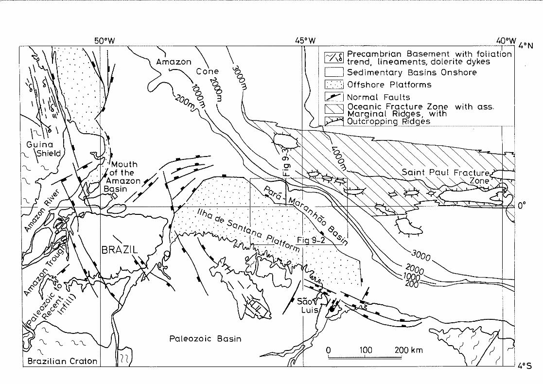
200 km100
,--,-~~~S:::;a;,in;.:t PauI Fra cture >-1'-"--'1" Zone~-...J
o
45°W 400 W 4°N
Ir--/I ~I Precambrian Basement with foliation\ trend, lineaments, dolerite dykes
o Sedimentary Basins Onshore
D Offshore Platforms
1,..,....1 Normal Faultsts:::'3 Oceanic Fracture Zone with ass.~""' Marginal Ridges, with
.OutcroppingmRldg_~!>m
Paleozo ic Basin
50 0 W
nL-__-'-'--'--__-'-------ll-----'L- ---"-L--'-- ---'--'--L-_-'---L-----' 4° S

118
lain by a basement of Eburnean equivalent age. Northwards,the magnetic anomalies on the shelf, north of the mouth ofthe Amazon, are associated with anomalies of Liberian equivalent age (2,700 Ma, Milliman, 1979) (chapter 3.1.2).
9.2 structure and stratigraphy
9.2.1 western part of the platform and mouth of the AmazonRiver
Little is published on the conjugate margin of western Coted'Ivoire, most likely because of the poor seismic dataquality (Gouyet, 1988). A thick Tertiary carbonate bankmasks, on the seismic sections, the underlying basementstructures. Information is available from the adjacentdepocenter of the mouth of the Amazon, broken up intoseveral individual grabens (Fig 9-1).
The northern flank of the platform and the continental riseare oriented parallel with the saint Paul Fracture Zone. Tothe northwest, the platform is defined by faults with a NEsw heading. They bound the mouth of the Amazon depocenterand may take up the Paleozoic weakness trend of the AmazonTrough (Fig 9-1). Regionally, the throws involved aresignificant oceanwards (over 2,000 m, Rezende andFerradaes, 1971) but are small towards the depocenter,towards which the basement plunges gently (Gouyet, 1988).Beyond the platform, the Saint Paul trend is prolongated byseaward-dipping faults and ridges beneath the Amazon Cone(Rezende and Ferradaes, 1971 and Kumar et al., 1976).
On the northern seaward edge of the platform, reversefaulting and folds appear to be absent. Along the westernand northwestern flank of the platform, faults have normalthrows and trend WSW-ENE to SW-NE and E-W (following possibly secondary synthetic or antithetic directions) andoblique NNW-SSE faults, controlling the opening of grabensin the depocenter. This gives evidence to a tensional component in the opening phase of the Equatorial Atlantic(Gouyet, 1988).
The tectonic movements, leading to the opening of theEquatorial Atlantic, are preceded in the Triassic - Jurassic by basaltic magmatism (Rezende and Ferradaes, 1971).The sediments up to Paleocene age are coarse fluvio-deltaicto slope clastics. Their deposition is controlled by tectonism (Fig 9-4). The sequence is a transgressive megacycle, with a lower portion characterized by extensiveterrigenous sedimentation. The Upper cretaceous, startingwith the Cenomanian resting discordantly (rift unconformity) on the underlying sediments, is still continental withminor marine intercalations. The Paleocene is marked by amore extensive marine transgression (Carneiro de Castro etal., 1978).

119
The area is affected through the Upper Cretaceous by latetensional or transtensional movements (Gouyet, 1988). Fromthe Eocene the entire mouth of the Amazon area is subjectto regional subsidence and to the spreading of an extensiveEocene to Middle Miocene carbonate bank on top of a secondmajor Meso-Cenozoic unconformity (Fig 9-4). From the UpperEocene to the Present, the area is sUbject to tectonicmovements which may be linked to the Caribbean tectonicevolution (Campos et al., 1987).
Over the entire area, the Middle Miocene to Recent unitconsists of fluvio-deltaic, submarine fan and slope systemswhich cover the mouth of the Amazon and the platform. Thisunit is separated from the older sequence by a third regional unconformity linked to the uplift of the Andes(Carneiro de Castro et al., 1978).
9.2.2 Eastern paFt of the platform: Para-Maranhao Basin
On the eastern part of the Ilha de Santana Platform, thePara-Maranhao Basin is bound to the south by the platformand westward by the mouth of the Amazon area (Fig 9-1). Thebasin is dog-leg shaped on the continental shelf (Fig 9-2).In the west, the basin is dominated by east-west trendingfaults and on its southeastern leg by a NW-SE striking
PARTE OESTE Fig9-3
o \0 20 ~o <10 !50k"., ' !
t--l SEGAO GEOLOG1CA
CONTOR NO ESTRUTURAL"'3 .. " TEMPO S{SM1CO DUPLO
(SEGUNDOS)
09 PN;OS
PARTE LESTE
+10000
600
100
450
~r--IOOOO
PLATAfORMA DO PARA- MARANHAO
(EMS. RASO)
_._ .._)'•
GRABEN DEI LHADE SANTANA
Figure 9-2: Basement structure map of the Para-Maranhao Basin (modified after Zanotto and Szatmari, 1987). Inserted! strain ellipse fromFig 2-4. Location in Fig 9-1.

120
structural orientation. The oldest sediments are Aptian andall mapped faults have a normal throw and die at the MidAlbian unconformity. Later movements are gravitational, ona decollement surface on top of Upper Cretaceous sediments(Guimaraes et al., 1989) (Fig 9-3). Large slumpings, on thecontinental slope, involve Paleogene to Lower Oligocenesediments.
EMBA$AMENTO
s N..-----------::c"cc"cc"c:-"cc,-----~--~-- -------~---~I
f + +.~ \ \ \ . - ---=-- _\ .~, , , .'~:-;4'~\'.. CRETACEO sUP - ~-'S:::;:....
PLATAFORMA DO + + + +~~__ALTO 00 I-fAAS-9 CRETr.CEO INF ••~
PARA-MARANHAO +,--",,~,r7+ + + \ (ALAGOAS) - -'- ·----iGRABE~ANOT~~~HA' DE +\+_~ +__
+ -i-----'.'
','
','
"
Figure 9-3: Geologic section through the transtensional leg of thePara-Maranhao Basin (Zanotto and Szatmari, 1987). Location in Figs 9-1and 9-2.
In the western half of the basin, a first order east-westor WNW-ESE trending fault system, parallel with the direction of principal displacement, defines the 1-MAS-9 interbasinal high along the shelf-edge (60 by 10 km, and 3 kmpaleorelief, Fig 9-2). Landwards, the Ilha de Santana graben is trapped between the horst and the basement platform.This is a 25 km wide half-graben filled with 3,000 m ofLower Cretaceous sediments (Figs 9-2 and 9-3). Towards theocean, the basement is block faulted, down to the basin.Secondary faults are normal oblique, probably with a synthetic component (NW-SE or 50 deg W), or with an antitheticcomponent (10 deg Wand 30 deg E, depending on the intensity of wrenching). From these elements, Zanotto and Szatmari(1987) interpret this part of the basin as resulting fromthe transtensional motion along Africa.
The southeastern leg of the basin is extensional as thenormal faUlting is parallel with its strike, resulting in adip parallel extension (Fig 9-2).
The stratigraphic sequence (Zanotto and Szatmari, 1987 andGouyet, 1988), preceded by basaltic magmatism of Neocomianage, started with an intense sedimentation of continentaland fluvial clastics of Aptian to Lower Albian age (Fig9-4). Their deposition is controlled by fault block tectonism. At the end of rifting, a severe erosion cut deeplyinto the section in Mid-Albian times. The erosion is followed by the discordant sedimentation in the eastern partof the basin with carbonates of Upper Albian/Cenomanianage. A second erosional phase marks the end of the intracontinental shearing in the Cenomanian.

121
Slope and basin clastics prograded then in the Upper Cretaceous, from the Turonian and up to the Paleocene-LowerEocene. From the Mid-Paleogene, carbonates of importantthickness are deposited. On the continental shelf, thestratigraphic sequence is thin from the Upper Miocene dueto limited subsidence rates. On the slope, the gravita-
WEST SEGMENTS OF MARGIN EAST
TIME AMAZON ILHA DE PARA-TABLE m.v. OFFSHORE SANTANA MARANHAC
- - -I PLIO,-QUAT CONE OF I I I I I I I I I I5 - - I I I I I I Iu AMAZON
I I I I IhiT I
I I- - -0>- MIOCENE 1 'flY I I I I INO::o~
OLIGOCENt [T 1 I I I I I I I I I I I I IZI- I I I I I I I I
hiT11Iwo::
«w EOCENE II I I I I I I I I I IUl- I I I I ",bU?.L 11 I
~ L11
PALEOCENE - - - - -65 - - - I - - ~ -
- - .- - -- - - I - - ~ -
CAMPANIAN('-.
~ -- -- - - - - -- - - I I- - -- ~- - Z - - - -
SANTONIAN - - - I W - -- - I- - - -~ - L: - - - I-- - - I W - - - - ICONIACIAN - - - - --
- - I (/)-_~~_- I- «- - -I CJ) - - -- I
TURONIAN - -VVV - I
----~-_ I(/) - - -- C) -~ S::;) CENOMAN,.I, - .- I Z 1-:100 - -- 1I I I0 R Q..
U W ..... '. Q.. UIU I-u ALBIAN · . I 0 R0« · . ." er: " ' ... '. . , ..NI- . , . U ' . (J)
OW APTIAN CJ).' . c
Wo:: · . (J) ::;) .. ~
L:u c -(/) VVVVV :JLNEOCOMIAN 14f
. .;: 0, .LL:J
r JURAS~~ .. · . 0
TRIASSI VVV LL
PALEOZ.
C j Marine Sediments
D Terrigenous Sediments
a Limestones
Ivvv I Volcan ics(Basaltic)
1+ ++I Basement
a Unconformities
Figure 9-4: Stratigraphic columns along the Brazilian shelf controlledby the Saint Paul Fracture Zone. Columns for the mouth of the Amazonand the Ilha de Santana Platform are from Gouyet (1988), for the ParaMaranhao Basin from Zanotto and Szatmari (1987) and Gouyet (1988).Tectonic unconformities: R: rifting; S: shearing.

122
tional slumps are topped by an unconformity at the base ofthe Upper Oligocene. Turbidites are identified on theseismic sections (Guimaraes et al., 1989).
9.3 comparison with western Cote d'Ivoire
9.3.1 structural pattern
The seismic interpretation of the continental margins ofboth western Cote d'Ivoire and the western part of the Ilhade Santana Platform areas reveals transtensional Cretaceousopening regimes. The two conjugate areas are characterizedby oceanward faults with important throws. Late tectonicmovements affect the Upper Cretaceous.
The major difference is the apparent absence of horsts andgrabens on the Brazilian side beneath the carbonates. It ispossibly due to ?ifficulties in seismic penetration throughthe carbonates, but may also be due to the limited wrenching along of the margin. The margin entered its passivestage already in the Late Albian, when it faced the subsiding rift margin north of the Amazon, and not in LowerSenonian as its conjugate margin, offshore western Coted'Ivoire (Fig 1-5).
As found off West Africa, the saint Paul Fracture Zone runsinto the Precambrian LiberianjEburnean province boundary.The two conjugate margins make a sharp angle with theEburnean foliation and magnetic trends.
The western Ivorian margin (chapters 7.5 and 7.6) and thePara-Maranhao Basin (chapter 9.2.2) have both been structured by an Albo-Aptian transtensional intra-continentalshearing. The two margins display similar structures,parallel with the direction of principal displacement: grabens and inter-basinal ridges. The throws involved areimportant. Unlike the west Ivorian pull-aparts, theBrazilian grabens are not controlled by synthetic oroblique faults, but by antithetic faults. The Brazilianridge is of larger dimensions than the mapped Ivorian one.
9.3.2 Tectonic evolution
Whereas the age of the dolerite dykes onshore western Coted'Ivoire appears to vary between the Lower Proterozoic andthe Carboniferous (chapter 3.1.2A), the age of the doleritedykes in the mouth of the Amazon (Triassic) and of thebasaltic volcanism in the Para-Maranhao Basin (Neocomian)is related to the opening of the Atlantic (Gouyet, 1988).
The intra-continental shearing phase starts, on both flanksof the Ilha de Santana Platform, with a very thick sectionof Albo-Aptian clastics of terrestrial origin, as offshoreCote d'Ivoire.

123
On the western side of the Ilha de Santana Platform, thetectonic (rifting) unconformity is likely to be LateAlbian/Early Cenomanian and is of the same age as the tectonic (shearing) unconformity off western Cote d'Ivoire.Facing a rift margin, the western side of the Ilha deSantana Platform entered then a passive phase (Fig 1-5C).
In the Para-Maranhao Basin, two tectonic unconformities areobserved: a rifting (Mid-Albian) and an intra-continentalshearing (Cenomanian) unconformity. The Mid-Albian discordancy, observed off eastern Cote d'Ivoire, is not traced onthe western Ivorian margin. The Ivorian shearing unconformity is interpreted to be Late Albian/Early Cenomanian andseems somewhat to predate the one in the Para-MaranhaoBasin. The Cenomanian-Turonian unconformity, observed offwestern Cote d'Ivoire, could better correspond to it but itis interpreted as part of the oceanic-continental shearingphase (chapter 7.5.2).
In the oceanic-continental shearing phase and beginning ofthe passive phase, the seismic data interpretation, offwestern Cote d'Ivoire, gave evidence to a phase of reducedsubsidence rates (Cenomanian to Paleocene); of blockupheaval (Cenomanian to Lower Senonian, slowing down in theSenonian); and, of block foundering (Lower Senonian). Asimilar phase is not reported on the Brazilian margincontrolled by the prolongation of the Saint Paul FractureZone.
The Upper Paleocene onset of the regional subsidence in thepassive phase is reported as an unconformity on theBrazilian shelf (western and eastern sides of the Ilha deSantana Platform). On the continental slope (east of theplatform), the onset of the regional subsidence is recordedas the beginning of gravitational movements. A similarrecord is observed on the western Ivorian margin.
The Mesozoic lithologic sections on both sides of theAtlantic consist essentially of clastics. The potentialsyn-wrenching Upper Albian carbonates in western Coted'Ivoire are found on the divergent leg on the ParaMaranhao Basin with an Upper Albian/cenomanian age. Offeastern Cote d'Ivoire, the drilled Cenomanian limestonestreaks are, however, post-wrenching. The Cenozoic tectonicevolution and lithologic section, on the Brazilian shelf(on both sides of the Ilha de Santana Platform), are dissimilar from those proposed for western Cote d'Ivoire.
Conclusively, there are close structural, timing and sedimentological similarities between the two homologous margins of northwestern Brazil and Cote d'Ivoire. TheBrazilian stretch that is comparable with western Coted'Ivoire, by its structure and in its evolution, is however, not the conjugate margin (western Ilha de SantanaPlatform) but the margin that has undergone a long intracontinental shearing, the Para-Maranhao Basin (Fig 2-1).

124
10. CONTINENTAL MARGIN OF WESTERN GHANA
10.1 Physiography of the continental margin
The continental shelf of western Ghana has a similar triangular shape as southeastern Liberia (Fig 3-1). South ofCape Three-Points, the shelf widens to 90 km, similarly tothe area off Greenville (chapter 3.1.1). The shelf is only30 to 35 km wide at the political border of Cote d'Ivoireand of Togo.
Off the shelf, the ENE trending continental slope is thesteepest recorded along this part of Africa (Gorini, 1981),occurring down to water depths of over 4,000 m (Fig 3-1).The sea bottom looses its steepness southwest of CapeThree-Points. West-southwestwardly, in continuation of theGhanaian margin, the bathymetry indicates an elongate high,which is the Cote d'Ivoire/Ghana Ridge. The ridge is inprolongation of the Romanche Fracture Zone (Figs 1-3, 3-1and 10-1).
10.2 Structure and stratigraphy
At the wedge-out of the Ivorian divergent basin (Fig 10-1),the continental slope of western Ghana marks a sharp increase in dip at its lower end (Fig 10-2, part A) whereformations are cut by normal faults. These faults areprobably younger than the original deformations of thethe bedding (Popoff et al., 1989). The southern edge of theIvorian Basin (B) is a narrow intensively faulted belt cut
0'
4' N
l'W
+ +
2'W
+
3'W
::1;" .·h
;.>1 zone de fracture
de Saint Paul
2 zone de fractureo 100km de la Romanche 3'Nk'==d'
1
+ Abidjan
i~
I! ,I,i I;:
.' [' I i !i I I
.'.J.I ! i i If~lJ
Figure 10-1: Schematic structural map of the margin of western Ghanaand of the deep Cote d'Ivoire Basin {Modified after Latil-Brun et al.,198B}. The basin is shown in hatchings. Enlargement of insert 2 in Fig3-7. Legend is found there.

125
by corridors of nearly vertical, normal and reverse faults,including flower structures and transverse faults (Popoffet al., 1989). The deformations rapidly decrease northwardsin the deep Ivorian Basin (C), where reflectors are continuous and sub-horizontal. There is low amplitude folding(NEE-SSW trending) and few normal faults.
C B AN -----=------ ~.o_-_-= • -.----'--'---~.-
5 'I .,ST :.... <, :F~·.
10Km
Figure 10-2: Seismic section across the Ghanaian continental margin,at the wedge-out of the deep Ivorian 8asin (Popoff et al., 1989). A:Lower continental slope; B: Southern edge of the Cote d'Ivoire/GhanaBasin; C: Deep Ivorian Basin, s.s.; 1- Lower Cretaceous, 2- UpperCretaceous-Paleocene, 3- Eocene, 4- Oligocene, 5- Miocene-Present.Location in Fig 10-1.
These transpressive-type deformations are essentiallylimited to the first unit (likely of Lower Cretaceous age)and are topped by the tectonic unconformity (Fig 10-2).This unconformity is tentatively dated to the AlboCenomanian (Popoff et al., 1989). The overlying drapingunit (2) is attributed to the Upper Cretaceous, and theCenozoic units (3 to 5) are reported to display slumpingand erosional features.
Popoff et al. (1989) propose that the Lower Cretaceoussection was deformed during the intra-continental shearing,ending in the Upper Albian-Early Cenomanian. After theAfrican and Brazilian cratons had parted (in the UpperCretaceous), crusta I blocks foundered and form the presentslope morphology. A gravity model has been done across theCote d'Ivoire - Ghana Ridge (Fig 3-7), 100 km to the westby Pontoise et al. (1990). The model indicates an upheavalof the lower sedimentary section (possibly of syn-tectonicage) at the edge of the margin. Pontoise et al. (1990)suggest the upheaval was induced thermally at the contact
126
with hot oceanic crust, as described in chapters 2.2 and2 . 3 •
On the Ghanaian continental shelf, the main unconformitiesare: Base Mesozoic, Mid/Upper Albian (rift unconformity),Late Albian/Early Cenomanian (shearing unconformity),Turonian and Base Miocene (GNPC, not dated).
Southeast of Cape Three-Points, the syn-tectonic LowerCretaceous is characterized by a tensional structuring witha series of small grabens bound by inter-basinal highs. Thesouthernmost high controls the shelf-edge (Fig 10-1), withonly a thin cover of sediments (Blarez, 1986). At thecontinental slope, evidence of synthetic strike-slip movements (Fig 10-1) is given by the bathymetry being offset byNW-SE en echelon trends (Blarez, 1986) (Fig 3-1). Blarez(1986) suggests that magmatics may have used such diaclases. Volcanic material (dated 120-125 Ma, Valanginian)is reported from a well drilled on the shelf-edge (Reyre,1984). From Blarez (1986), it is likely that regionally theshearing has essentially been transtensive, although Blarez(1986) and Clifford (1986) mention from industry data thatthe shelf displays compressive deformations.
10.3 comparison with western Cote d'Ivoire
The continental margin of western Ghana is the Africanstretch of the Romanche wrench zone which was subject to along intra-continental shearing. The position is similar tothe margins of southeastern Liberia and of western Coted'Ivoire along the Saint Paul wrench zone (Fig 1-5). Themargin southeast of Cape Three-Points, as the westernIvorian margin (chapter 7.7.1), has been sUbject regionallyto a transtensive shearing regime. This is unlike thetranspression at the wedge-out of the Ivorian divergentBasin (chapter 10.2).
The volcanics offshore Ghana are of similar age as theintrusions offshore Liberia (chapter 3.2.1C).
Like the eastern Ivorian Basin and the Para-Maranhao Basin,the Ghanaian shelf displays a rift unconformity (Mid/UpperAlbian) that precedes the shearing unconformity (LateAlbian/Early Cenomanian). A rift unconformity is not identifiable offshore western Cote d'Ivoire.
On both the western Ghana and west Ivorian margins, anUpper cretaceous phase of foundering and of block upheavalis interpreted as contemporaneous with the implacement ofnew oceanic crust. This event is not evidenced in the ParaMaranhao Basin (chapter 9.2.2). Later unconformities areidentical in age, apart from the Ivorian Paleocene discordancy. Where present, the Upper Cretaceous and Tertiary areprograding with erosional and slumping features, indicatinglow subsidence rates (Popoff et al., 1989).

10.4 Conclusion on the regional comparisons
127
10.4.1 structural patterns and evolution
structures formed during the Albo-Aptian intra-continentalshearing, similar to those interpreted offshore westernCote d'Ivoire (ridges interspaced by deep and smallbasins), are found in the prolongation of the studied area,offshore southeastern Liberia (chapter 8.1). The Liberianridges have more important reliefs than the west Ivorianones. Similar structures are not reported offshore easternCote d'Ivoire (chapter 8.2).
The structural evolution of western Cote d'Ivoire, with along intra-continental shearing, is more important thanthat of the conjugate Brazilian margin (the northwesternflank of the Ilha de Santana Platform), with a limitedshearing evolution (chapter 9.3.1). Along the Brazilianmargin (in prolongation of the Saint Paul Fracture Zone), astructural evolution similar to the one in the studied areais found on the stretch which has experienced a long intracontinental shearing. The portion of margin is the northeastern part of the Ilha de Santana Platform, the ParaMaranhao Basin (chapter 9.3.1). At both ends of theBrazilian margin in prolongation of the Saint Paul FractureZone, the intra-continental regime is described as transtensional.
The interpreted structures formed during the oceaniccontinental shearing, offshore western Cote d'Ivoire (foundered and upheaved blocks), are not reported on the Brazilian prolongation of the Saint Paul Fracture Zone (chapter9.3.1). Similar structures are reported on the Africanprolongation of the Romanche Fracture Zone, offshore Ghana(chapter 10.3).
The passive phase is only reported on the Brazilian prolongation of the Saint Paul Fracture Zone as a flexural subsidence starting in the Upper Paleocene. A continued thermalimpact on the margin in the Senonian of a hot oceanic crustis not reported offshore Brazil and offshore Ghana.
10.4.2 stratigraphic sequences
Unlike the Cote d'Ivoire margin, the tectonic activitystarts on the Liberian, the Ghanaian and the conjugateBrazilian margin of Cote d'Ivoire with basaltic magmatismof Neocomian age. At the mouth of the Amazon, it is Triassic.
The sedimentary column proposed for western Cote d'Ivoirefrom the seismic data is very similar to those in Liberiaand eastern Cote d'Ivoire, except for a possible UpperAlbian carbonate platform bank south of Sassandra.

128
On the conjugate margin in Brazil, the syn-tectonic lithologic columns consists of clastic sediments of terrestrialorigin. The main unconformities on the Brazilian margin andoff Ghana are of similar ages as found in western Coted'Ivoire. However, in the Para-Maranhao Basin and offshoreGhana, both a rift and a shearing discordancy are observed,with ages similar to those in eastern Cote d'Ivoire. Theabsence in western Cote d'Ivoire of a rift unconformity maybe due to the absence of nearby divergent basins.
Offshore Brazil, the sediments are increasingly marine inthe post-tectonic interval. In the divergent part of thePara-Maranhao Basin, an Upper Albian/Cenomanian carbonatebank may be equivalent to the possible limestones inwestern Cote d'Ivoire. The Cenozoic sedimentation offshoreBrazil is different, with a thick carbonate bank on theIlha de Santana Platform.

129
11. GENERAL CONCLUSION
The interpretation of the seismic data from the GECO (todayGECO-PRAKLA) survey, offshore western Cote d'Ivoire, showsthat the age of the faults and of the structural in-fillingis Albo-Aptian. The formation of the horsts and grabens,along the western Ivorian margin, is consequently of thesame age. From the analysis of the theoretical stressregime and by analogy with modern examples of intra-continental shear-zones (i.e. San Andreas Fault and Dead SeaTransform Fault), this tectonic activity is interpreted tobe of intra-continental shearing nature and essentiallytranstensional. It is concluded that the structures wereformed during an intra-continental shearing which likelyended in the Late Albian/Early Cenomanian. A reuse of preexisting trends in the intra-continental shearing is difficult to trace. No magmatic activity has been found withinthe mapped area.
The subsequent oceanic-continental shearing of the westernIvorian margin in the Upper Cretaceous (Cenomanian to LowerSenonian) is characterized by a reduction in subsidencerates, by block upheavals and by block founderings alongthe principal faults. The block upheavals may be caused bythe thermal impact of a nearby newly emplaced oceaniccrust.
In the beginning of the passive phase, the margin continuesto be thermally influenced by a nearby oceanic crust. Fromthe Upper Paleocene, the margin acquires its present physiography by flexural subsidence of the slope, while theshelf is sUbject to smaller subsidence rates. The differential subsidence rates, together with the foundering ofblocks are indicative of rapid variations in crustal thickness, a characteristic feature of transform margins.
The stratigraphic sequence proposed from the seismic datais very similar to those from Liberia and eastern Coted'Ivoire, except for a possible Upper Albian carbonateplatform bank south of Sassandra. The age of the unconformities, although still unprecise is in agreement withthe regional information.
The structural framework off western Cote d'Ivoire appearsto be less accentuated than the one offshore southeasternLiberia, with a longer intra-continental shearing.
On the conjugate Brazilian margin, the structural evolutionof the western part of the Ilha de Santana Platform with avery short intra-continental shearing, is less importantthan that of western Cote d'Ivoire margin. The Brazilianmargin has only been exposed to limited shearing. A similarevolution and sedimentary column, to western Cote d'Ivoire,is found on the stretch of the Brazilian margin, in prolongation of the Saint Paul Fracture Zone, with a long intracontinental shearing. The setting offshore western Ghana,controlled by the continental extension of the Romanche

130
Fracture Zone, shows a good structural coherency with thestudied area.
The interpretation of the data from the GECO (today GECOPRAKLA) geophysical survey fulfills the objectives set inthe introduction (chapter 1.1.1).
The interpretation confirms the transform origin of thewestern Ivorian margin, located in the theoretical prolongation of the saint Paul Fracture Zone. The interpretationconfirms as well the Lower Cretaceous formation of thestructures on the margin during the intra-continentalshearing along the Brazilian conjugate margin. The shearingis, within the studied area, essentially transtensive andended in the Late AlbianjEarly Cenomanian. The subsequentcontinental-oceanic shearing, in the Cenomanian - LowerSenonian, has accentuated the structures formed, by thermalupheaval of blocks and by crustal founderings. The passivestage from the Senonian to Present is expressed by aninitial continued block upheaval, followed from thePaleocene by a regional subsidence of the margin.
Future work offshore western Cote d'Ivoire should focus oncrustal variations across the margin. Future researchshould model the structural evolution along this Africanmargin controlled by the Saint Paul fracture zone, by extending the interpretation in this thesis to southeasternLiberia and to Ghana, as well as into deeper waters.

131
SUMMARY OF: THE CONTINENTAL MARGIN OF WESTERN COTED'IVOIRE - STRUCTURAL FRAMEWORK INHERITED FROM INTRACONTINENTAL SHEARING
The data interpreted are from a non-exclusive survey (Fig1-2) from 1986 by the geophysical contractor firm GECO(today GECO-PRAKLA) on the continental shelf and slope ofwestern Cote d'Ivoire. They comprise 2,370 km of multichannel seismic data, as well as gravity and magneticprofiles. This portion of margin lies in trend with theoceanic saint Paul Fracture Zone, which is the secondlargest in the Equatorial Atlantic after the Romanche Fracture Zone (Fig 1-1). The objective of this thesis is tounderstand if the faults, horsts and grabens, identified onthis portion of margin, were formed in an intra-continentalshearing between northern Brazil and Cote d'Ivoire. Asecondary objective is to study the effects on the marginof the subsequent continental/oceanic shearing and of thepresent passive stage.
Regional geology
During the initial opening of the Equatorial Atlantic (inthe Neocomian to the Late Aptian) (Fig l-Sb), western Coted'Ivoire is subject to an intra-continental shearing alongits conjugate Brazilian margin. In Late Albian/EarlyCenomanian times (Fig l-Sc), this shearing is progressivelyfollowed by a contact with new oceanic crust. The end ofthe continent to continent contact may result in a riftequivalent unconformity (Mascle and Blarez, 1987; Mascle etal., 1988). The margin of Cote d'Ivoire may then be thermally affected (from the Cenomanian to the Santonian) bythe passing oceanic hot spreading ridge (Mascle and Blarez,1987) (Fig l-Sd). Thereafter, as the transform motion ends,the margin is subject to a continued thermal impact from ahot oceanic crust, followed by subsidence as the margincools, as a passive rifted margin.
The coasts of western Cote d'Ivoire and southeasternLiberia are barren of sediments and the outcroppingPrecambrian basement has a northeastward foliation trend(Papon, 1973). This basement craton is cut by Precambrianstrike-slip lineaments, with a strike parallel to thefoliation trend. One lineament, the Dimbokro fault, reachesthe coast 20 km east of the studied area (Bard, 1974) (Fig3-1). No magmatic activity related to the Atlantic openingis reported in western Cote d'Ivoire.
The continental margin of southeastern Liberia is apparently controlled by three parallel crystalline basement ridgeswith an ENE trend (Behrendt et al., 1974; Schlee et al.,1974; Mascle, 1977) (Fig 3-2). The principal ridge, GrandCess, runs into the continental shelf west of of theIvorian border. The Cape Palmas Ridge runs into the shelfat Cape Palmas and is in line, eastward, with the continental slope of western Cote d'Ivoire. To the south, the
132
Saint Paul Ridge, of possibly oceanic nature (Behrendt etal., 1974) or a seamount (Soquip, unpubl.), stays in deepwaters buried under sediments. The ridges have probablyinherited the Eburnean strike and lineament trend (Behrendtet al., 1974). Small syn-tectonic basins have developed inbetween the ridges (Fig 3-2) and have been sUbject tocontinued post-tectonic vertical movements (Schlee et al.,1974). The continental shelf has only a thin or unexistantsedimentary cover (Schlee et al., 1974; Behrendt et al.,1974; Delteil et al., 1974).
In direct prolongation of the Liberian southeastern continental margin, the western Ivorian shelf and slope show anENE-WSW orientation, parallel with the coastline and intrend with the marginal ridges (Fig 3-1). The shelf is 2530 km wide and the break occurs in 120 to 130 m of water(Martin, 1971). The slope appears very steep and is controlled by a fault system with throws (Arens et al., 1971)comparable to the coastal fault in the Cote d'Ivoire Basin(Spengler et Delteil, 1966). The Eburnean trend forms asharp angle with the margin (Fig 3-1). There is, at thisstage, no indication of a structural heritage during theAtlantic opening of the Precambrian framework.
Along the eastern end of the Saint Paul transform margin,in the Cote d'Ivoire Basin (Fig 3-1), the dominant featuresare coast parallel faults with a cumulate throw of approximately 4,000 to 5,000 m (Spengler and Delteil, 1966).Transtensive tectonic movements are Albo-Aptian (Blarez,1986), with the main faults affecting also the rest of thesedimentary section (Brancart, 1977). The initial, syntectonic sedimentary section is Neocomian and Albo-Aptian.The Mid-Albian rift unconformity (Brancart, 1977) is generally masked by an Albian-Cenomanian erosion (Blarez,1986). The post-tectonic sedimentation is marked by asudden slow down in subsidence until the Paleocene, withthe Senonian cut by minor angular unconformities (Spenglerand Delteil, 1966, Brancart, 1977). Thereafter, in theCenozoic, the margin was sUbject to a passive, flexuralsubsidence (Latil-Brun et al., 1988), interrupted by twomajor erosions in Upper Paleocene and Oligocene (Brancart,1977; Blarez, 1986).
Seismic interpretation
Seismic sequences
Seismic sections (Figs 7-1 and 7-2) illustrate how theshelf has been sUbject to great variations in subsidence(above and below the Top Albian) and that the upper slopeand shelf-edge have been intensively eroded. On the lowerslope, the sedimentary section is expected to be morecomplete due to more continuous sedimentation and lesspronounced erosions. Despite the absence of coastal onlapsin the Cretaceous, a tentative sequence identification has

133
been attempted. The sequences are matched with the regionalgeology and compared to the major sea-level changes according to the global eustatic chart by Haq et al. (1987). Asin Brancart (1977) and Blarez (1986), the five major unconformities are: (1) acoustic basement; (2) Top Albian; (3)Cenomanian - Turonian; (4) Upper Paleocene; and, (5)Oligocene. Three angular discordancies have been identifiedon the lower slope in the Upper Cretaceous-Paleocene, twoof which are tentatively dated Mid-Campanian and LateMaastrichtian (Fig 7-9). At the far eastern end of thesurveyed area, the major unconformities are matched againstthe K1 wells (Fig 7-11).
The acoustic basement identification was the major difficulty in the interpretation of the seismic data. It wasdifficult to discriminate it from the Albian strata, inparticular on the shelf where the Albian reflector haspreviously been interpreted as basement. Gravity and magnetic data have been used in identifying a deep graben onthe shelf in the eastern part of the studied area. Thegraben is bounded by a large coastal fault, that has athrow comparable to those of the eastern Ivorian coastalfaults (Figs 6-7 and 6-8). The depression is at the seawardextrapolation of the Dimbokro Fault. Although the lineamenthas a pronounced magnetic and gravimetric signature onshore(Tagini, 1971), its trend offshore is apparently weak.
As in the Cote d'Ivoire Basin, the overlying Albo-Aptianconsists of a thick sequence of poor to good reflectors butit has not been possible to trace a Middle from a LateAlbian unconformity. The reflector can be mapped over theentire surveyed area with confidence (Fig 7-13). The reflector is broken up into compartments by 80 km long ENEWSW normal faults, with up to 1 second TWT throw. On theshelf in the central part of the studied area and along thecoast (Fig 7-1), the acoustic basement, of likely crystalline nature (Figs 6-7 and 6-8), is shallow. The rest of theshelf is occupied by two grabens bounded oceanwards byimportant faults (Fig 7-13) which often coincide withpaleoshelf-edges. On the continental slope, the Top Albianis block-faulted to the ocean in the eastern part (Fig 71), while westwards the predominant feature is an elongated, faulted and eroded ridge, parallel with the coastline(Fig 7-2). The Albo-Aptian is likely to consist of continental clastics, that are increasingly marine in the upperpart, as is found in the Cote d'Ivoire Basin and offLiberia. As suggested offshore southeastern Liberia(Behrendt et al., 1974), the Top Albian on the continentalshelf in the eastern part of the survey can alternativelybe interpreted as formed of carbonates. Supporting arguments are the morphology, the structural position, the highacoustic amplitude, the interval velocities and densitiesand absence of magnetization. Limestone streaks are onlyknown in Cote d'Ivoire in the post-tectonic Cenomanian(Brancart, 1977).

134
On the shelf, the Upper Cretaceous and Paleocene form ageneral prograding sequence where only the Cenomanianunconformity is identifiable. Below the upper continentalslope, where preserved, the interval is too disturbed byslumpings and gravitational faulting to display any internal structuring. On the lower slope it evens out paleostructures and includes four minor angular unconformitiesof which the most important one is again the Cenomanian(Fig 7-9). The Cenomanian consists of prograding clasticswith probably carbonate streaks as found elsewhere in Coted'Ivoire (Brancart, 1977). The faults detected in theAlbian die out in the Cenomanian and only the major lineaments, such as the coastal fault and the shelf-edge faults,cut through the rest of the Cretaceous.
The Paleocene erosion has worked down to the Upper Cretaceous on the upper continental slope of western Coted'Ivoire and slumped the material down slope (Fig 7-1).Large scale gravitational faults are visible at the shelfedge in particular. They end on the gliding surface or inthe Senonian. Eocene conditions of sedimentation are consequently very different from the Cretaceous, with downslumpings and olistostromes on the slope (Fig 7-5). On theshelf, Eocene and Neogene sediments overlying the Paleocenereflector onlap towards shore, and consist probably ofshallow water deposits. In deep waters, several unconformities are detectable above the Paleocene, of which theOligocene erosion is the major one. This erosion is linkedto slumpings with important toe-thrusts on the upper slope(Fig 7-4). The Oligocene to Present sequence initiates onthe lower slope with turbiditic beds, filling-in the erosional scars. The sea-bottom topography reveals the continued gravitational activity due to the very steep dips (Fig7-2) .
Timing of faulting and subsidence evolution
The west Ivorian margin acquired its present morphology inthree stages: (1) In the Albo-Aptian (Middle Cretaceous), ageneral horst and graben framework developed. Most faultingand sediment in-filling took place, and are sealed by a TopAlbian unconformity in which most faults die (Figs 7-1 and7-2). This is the tectonic unconformity of the west Ivorianmargin. Major faults, such as the coastal ones and theshelf-edge faults, continued to be active in the UpperCretaceous. The Albo-Aptian is the thickest interval (witha fairly constant thickness of 2 km, Fig 7-19), comparablewith the Albo-Aptian interval in the eastern Cote d'IvoireBasin (Spengler and Delteil, 1966).
(2) The Cenomanian to Lower Senonian is characterized by adecrease in subsidence rate (as observed in the IvorianBasin, Brancart, 1977), and by the upheaval of fault blockson the present slope. A foundering of large crustal blocksis interpreted in the Lower Senonian. The blocks are bound

135
by coast parallel faults, with up to one kilometer ofsteeply dipping and prograding sediments at their foot (Fig7-20) .
(3) Through the rest of the Upper cretaceous, the studiedportion of the margin is subject to a continued slow subsidence rate. On the slope, the block upheaval slows down(Fig 7-9). The first observable transgression on the shelfoccurred on top of the Upper Paleocene erosion, whichcoincides with a major worldwide sea level drop. The modernslope dates back as well to the Upper Paleocene, the age ofthe first gravitational faults. It seems that this slopehas been formed by regional subsidence, at more importantrates on the slope than on the shelf. In addition, thissubsidence has been more important than the sedimentaryinflux on the slope, as it is still very steep.
Tectonic interpretation
The framework of the shelf results from basement featureswhich form two deep and narrow grabens, parallel with thecoast and the shelf-edge, and a central basement horst. Theslope plunges very rapidly into deep waters, with faultedblocks in the east and an elongated ridge running along thewestern margin. This alternation of structures is foundalong the strike of the margin and not in the dip direction, as in rift margins. Although data on variations ofcrustal thickness are only available for the Cape Palmasarea (Behrendt et al., 1974), the western Cote d'Ivoireshelf and slope present regional characteristics of transform margins (Scrutton, 1982a). The eastern part, however,shows pronounced, tilted fault blocks which can be associated with rifted margins.
All faults observed are normal and no positive flowerstructure has been observed. The major, ENE-WSW trendingfaults coincide with the theoretical direction of theprolongation of the saint Paul marginal Ridges, as firstproposed by Le Pichon and Hayes (1971) and Francheteau andLe Pichon (1972). This represents the principal directionof the right lateral-wrenching between western Coted'Ivoire and Brazil, that is still expressed by the coastline orientation (Fig 7-13). The second most frequent trendis NW-SE, and corresponds to the only tensional faultsexpected on a strain ellipse (Fig 7-13). Although a potential normal slip direction, this trend is associated withright-lateral slip at both ends of the eastern shelf graben. In plan view, the faults splay towards land, pickingup an antithetic NNE-SSW direction, and in section theylook like negative flowers. A third fault direction, oriented WNW-ESE or nearly east-west, shows a small angle withthe direction of wrenching and corresponds likely to synthetic strike-slip movements. The faults have very largethrows. A fourth direction, NE-SW, is secondary syntheticand is expressed by coastline and major fault offsets.

136
Finally, an antithetic NNE-SSW fault direction is observed,as single faults or tensional grabens on the shelf.
The structures observed are formed by faults that wereactive during the Albo-Aptian intra-continental shearingstage. The structures are characteristic of divergentwrenching (Harding et al., 1985). The basins mapped on theshelf display typical rhomboidal pull-apart orientations.The eastern shelf basin is a half-graben (up to 15 km wideand 45 km long) closed to the east by a junction of borderfaults. At the fault junction, the Albo-Aptian thickensagainst the faults. This Albo-Aptian fault movement mayresult from a release of stresses (Crowell, 1974a). Thebasin floor shows flexuring in the direction of basinextension during the Albo-Aptian as well (Fig 7-10). Asimilar example is proposed in the Dead Sea graben byArbenz (1984, in Reches, 1987). In this example the floorof the graben rotates, in the direction of extension,against a boundary fault which "soles out" at depth.
Pull-apart basins are often very deep despite their limitedlateral size, and are rapidly filled (Christie-Blick andBiddle, 1985). It is possible that better seismic data willincrease the depth of the present acoustic basement (4 km).The depth to magnetic basement is 7 to 9 km. The samegraben is closed oceanwards by a 3 km wide basement ridge,parallel to the shelf-edge. The ridge may have acted as aninter-basinal ridge between opening basins (Fig 7-20). Thisis similar to ridges of comparable size in the East AfricanRift (Rosendahl et al., 1986 and Rosendahl, 1987).
The western basin is of much larger dimensions. The faultbounded, northern flank dips as a forced monocline towardsthe ocean along 100 km. The other flank may be on theBrazilian margin. The depression is closed towards the eastby a set of releasing, en echelon, step-over faults(Harding et al., 1985). The western end lies outside thesurveyed area, in Liberian waters. The elongated positivestructure, on the slope, may have initiated during theintra-continental phase.
A common feature of wrench zones is the heritage of preexisting orientations (Christie-Blick and Biddle, 1985 andRosendahl, 1987). The Saint Paul Ridges are oriented, offshore southeastern Liberia, with the Eburnean foliationtrend and prolongate at least one Precambrian lineament.Off western Cote d'Ivoire, the break-up framework does notreflect, on seismic lines, the preceding orientations. Ongravity and magnetic anomaly maps, a weak trend could beobserved in continuation of the Dimbokro Fault, northeastof the eastern shelf graben. The depression may have developed at the convergence of the Precambrian lineament withthe zone of principal shearing.
The horst and graben framework, acquired in the intra-continental shearing stage, is reused in the following conti-

137
nental-oceanic shearing stage (Cenomanian to LowerSenonian). The phase is characterized by a decrease in subsidence rates, by the upheaval of fault blocks and bycrustal founderings. The block founderings are interpretedin the Lower Senonian. The graben south of Sassandra showscontinued flexuring in the Lower Senonian, both in thedirection of extension of the basin and at the easternjunction of the border faults.
South of Sassandra, the slope has been stretched along dipin the Senonian, similarly to what is described in the Gulfof Aqaba (Ben-Avraham, 1985). In the western part of thestudied area, the continental slope has been subject tomore parallel shearing as shown by the elongated ridge. Thecontinental slopes, and in particular the western slope,are sUbject to block upheavals from the Cenomanian to theLower Senonian, slowing down in the Upper Cretaceous andPaleocene (Fig 7-20). These vertical movements may beinduced from a hot oceanic crust (i.e. the nearby SaintPaul Ridge, Fig 8-1).
The elongated ridge (5 km wide, 100 km long and 800 m ofpaleo-relief) is more similar to ridges generated by thermal impact than by shearing with an oceanic crust(Lonsdale, 1985, Todd and Keen, 1989). Compared to thewestern deep water ridge, the absence of folding in theeastern inter-basinal ridge may be due to a thin sedimentary cover, to limited and divergent wrenching and to theabsence of interaction with an oceanic crust. The presentinterpretation has not revealed, within the mapped area,any magmatic activity during the active shearing phases.
The low subsidence rates and the block upheavals continuedin the passive stage. The beginning of this last phase maycorrespond to a slow-down of block upheaval. The continuedvertical motion may be caused by a continued lateral thermal conduction from a now stationary oceanic crust to thecold continental crust. From the Upper Paleocene, themargin is subject to regional subsidence. The subsidencerates are much higher on the slope than on the shelf. Thisdifference, together with the foundering phase, is anindirect evidence of rapid variations in crustal thickness,typical of transform margins (Scrutton, 1982a).
Conclusively, reflection seismic, gravity and magnetic datahave allowed a detailed interpretation of the westernIvorian margin in agreement with theoretical models andmodern examples. It is therefore of interest to replacethis interpretation in its regional context.
Regional comparisons
The present interpretation shows a good coherency with thestructural sketches of southeastern Liberia (Schlee et al.,1974 or Mascle, 1977) and eastern Cote d'Ivoire (Blarez,

138
1986). Faults at the westernmost Ivorian shelf-edge, with aENE-WSW coast parallel strike, are in prolongation with thefaults at the Liberian shelf-break, while the parallel deepwater ridge may be in trend with the Cape Palmas Ridge (Fig8-1). The southernmost saint Paul Ridge lies outside of thestudied area. The two grabens are comparable in size, shapeand depths to acoustic and magnetic basement to the Liberian "pocket basins" (Schlee et al., 1974). The Liberianridges have more important reliefs than the west Ivorianones.
On the slope, from the foot of the central basement higheastwards, the strike shifts east-westerly as in theIvorian Basin. This part of the margin has probably beensUbject to transtensive shearing, along the edge of theeastern Cote d'Ivoire rift margin, while the trend in thewestern part is more parallel with shearing. The availabledata did not stretch far enough eastwards to clarify thesupposed interaction of the eastern Ivorian coastal faultswith the shelf-edge faults. It does not seem unlikelythough that they merge at a probable convergence with theDimbokro lineament. Lithologies are similar all along themargin, while the age of the unconformities is stilluncertain.
The conjugate margin segment is represented by the northernflank of the Brazilian Ilha de Santana Platform and continental rise that run parallel with the saint Paul FractureZone (Fig 9-1), and are controlled by very important faults(Rezende and Ferradaes, 1971; Kumar, 1976). Faulting,preceded by basaltic magmatism (Rezende and Ferradaes,1971), dates from the Neocomian intra-continental transtensional shearing (Gouyet, 1988). The tectonic unconformity is likely of the same age as in western Cote d'Ivoireand is followed through the Upper Cretaceous by late tensional movements (Gouyet, 1988). Regional subsidence startsin the Eocene. The Brazilian conjugate margin shows anapparent absence of structuring, possibly a seismic qualityproblem (Gouyet, 1988). It may also be due to the muchshorter wrenching of the margin, as it entered its passivestage already in the Late Albian and not in the Senonian asits conjugate margin.
On the eastern part of the Ilha de Santana Platform, thewestern leg of the Para-Maranhao Basin results from thetranstensional motion along Africa (Zanotto and Szatmari,1987). The structural trends are similar to those in western Cote d'Ivoire, with predominant faults and structuresparallel with the direction of principal displacement. Allmapped faults die at the Mid-Albian unconformity. Latermovements occur in the Cenozoic and are gravitational(Guimaraes et al., 1989). Neocomian basaltic magmaticactivity is reported (Gouyet, 1988). As in eastern Coted'Ivoire, a rift and a shearing unconformity of equivalentages are observed (Zanotto and Szatmari, 1987). The absencein western Cote d'Ivoire of a rift unconformity may be due

139
to the absence of nearby divergent basins. In the extensional part of the Para-Maranhao Basin, an Upper AlbianjCenomanian carbonate bank was deposited between the unconformities (Zanotto and Szatmari, 1987), and may be equivalent to the potential limestones in western Cote d'Ivoire.A Lower Senonian block upheaval and block foundering phaseis not reported. As in the mouth of the Amazon and offshoreCote d'Ivoire, the Paleocene discordancy is linked to theonset of a flexural subsidence in the passive phase.
As found in western Cote d'Ivoire, the continental marginof western Ghana is the African stretch of the Romanchewrench zone which has been sUbject to a long intra-continental shearing (Fig 1-5). Both margins display an AlbianjEarly Cenomanian shearing unconformity marking the end ofthe continental shearing. The unconformity is precededoffshore Ghana, as well as in eastern Cote d'Ivoire and inthe Para-Maranhao Basin by an Albian rift unconformity(GNPC, not dated). From Blarez (1986) it is likely thatregionally, the shearing was essentially transtensive as inwestern Cote d'Ivoire. Volcanic material is reported offshore to be dated to the early Equatorial Atlantic opening(Reyre, 1984), and is of similar age as found in Liberiaand in the Para-Maranhao Basin (Gouyet, 1988). South of theCape Three-Points, at the wedge-out of the Ivorian divergent Basin, Popoff et al. (1989) give evidence to a foundering phase of crustal blocks, during the Upper Cretaceous, after the African and Brazilian cratons had parted.This event is similar, in pattern and in time, to what isobserved in western Cote d'Ivoire but is not reportedoffshore northern Brazil.
Conclusion
The interpretation of the seismic data confirms the transtensive nature of the western Ivorian margin. The structures were formed during the intra-continental shearingwhich likely ended in the Late AlbianjEarly Cenomanian. Thesubsequent Cenomanian to Lower Senonian continental-oceanicwrenching was characterized by a reduction in subsidencerates, by block upheavals, and, in the Lower Senonian, bythe foundering of crustal blocks along principal faults. Inthe beginning of the passive phase, the margin continues tobe thermally influenced by an oceanic crust. From the UpperPaleocene, the margin acquires its present physiography byflexuring subsidence of the slope, while the shelf issUbject to lesser rates of subsidence. This differentialsUbsidence, together with the phase of block founderings,is an indirect indicative of rapid variations of crustalthickness.
The stratigraphic sequence proposed from the seismic datais very similar to those from Liberia and eastern Coted'Ivoire, except for a possible Upper Albian carbonateplatform bank south of Sassandra. The age of the uncon-

140
formities, although still unprecise is in agreement withthe regional information.
The structural framework along the African margin in prolongation of the Saint Paul Fracture zone, shows the mostimportant reliefs offshore southeastern Liberia. The basinsoffshore western Cote d'Ivoire are comparable but theinterspacing ridges are less pronounced. The conjugateBrazilian margin of western Cote d'Ivoire, with a shortintra-continental shearing, shows a less important structural evolution. A similar evolution and sedimentary columnis found on the stretch of the Brazilian margin, in prolongation of the Saint Paul Fracture Zone, with a longintra-continental shearing. The setting offshore westernGhana, controlled by the continental extension of theRomanche Fracture Zone, shows a good structural and stratigraphic coherency with the studied area.
Future research offshore western Cote d'Ivoire should focuson crusta I variations across the margin. In order to modelthe structural evolution along this African margin inprolongation of the Saint Paul Fracture Zone, detailedinterpretations could be made offshore southeastern Liberiaand eastern Cote d'Ivoire, as well as in deeper waters.

141
LIST OF REFERENCES
Affaton, P., sougy, J. and Trompette, R. (1980): The Tectono-stratigraphic relationships between the UpperPrecambrian and Lower Paleozoic Volta Basin and thePan-African Dahomeyide orogenic belt (West Africa).American Journal of Sciences, vol. 280. p. 224-248.
Almeida, F.F.M. de (Gen Coord) (1978): Tectonic map ofSouth America. Scale 1:5,000,000. Ministerio das Minase Energia, Departamento Nacional da Produ9ao Mineral(Brasil) - Commission for the Geological Map of theWorld - united Nations Ed., Sci. and Cult. Org., DNPMCGMW-UNESCO.
Alric, G. and Vidal, M. (1991): Donnees nouvelles sur lemagmatisme de la ceinture birimienne de Haute-Comoe(Cote d'Ivoire): un bass in arriere-arc? C.R. Acad.Sci. Paris, t. 313, serie 11. p. 1471-1478.
Arens, G. Delteil, J.R., Valery, P., Dalmotte, B.,Montadert, L. and Patriat, P. (1971): The continentalmargin off the Ivory Coast and Ghana. Inst. Geol. Sci.Report, vol. 70. p. 65-78.
Bacchiana, C., Brancart, R.Y., Klasz, I. de, Legoux, O. andParadis, G. (1982): Presence de Miocene inferieurmarin dans le "Continental terminal" de la basse Coted'Ivoire. Revue de Micropaleontologie, vol. 25, no. 3.p. 145-149.
Bagarre, E. and Tagini, B. (1965): Carte geologique de laCote d'Ivoire. 1/1.000.000. Societe pour le Developement Minier de la Cote d'Ivoire (Sodemi).
Bard, J-P. (1974): Les grands accidents du craton ouestafricain en Cote d'Ivoire: des decrochements posteburneens (?). C.R. Acad. Se. Paris, t. 278, serie D.p. 2609-2611.
Behrendt, J.C., Schlee, J. Robb, J.M. and Silverstein, M.K.(1974): Structure of the continental margin ofLiberia, West Africa. Geol. Soc. Am. Bull., vol. 85.p. 1143-1158.
Behrendt, J.C. and Wotorson, C.S. (1970): Aeromagnetic andgravity investigations of the coastal area and continental shelf of Liberia, West Arica, and their relation to continental drift. Geol. Soc. Am. Bull., vol.81. p. 3563-3574.
Ben-Avraham, Z. (1985): Structural framework of the Gulf ofElat (Aqaba), northern Red Sea. J. Geoph. Res., vol.90, no. B1. p. 703-726.

142
Ben-Avraham, Z., Almagor, G. and Garfunkel, Z. (1979):Sediments and structure of the Gulf of Elat (Aqaba) northern Red Sea. Sedim. Geology, vol. 23. p. 239-267.
Bessoles, B. (1977): Geologie de l'Afrique; le craton ouestafricain. Bureau de Recherches Geologiques etMinieres, memo 88, 402 p.
Blarez, E. (1986): La marge continentale de Cote d'IvoireGhana: structure et evolution d'une marge continentaletransformante. These. universite Pierre et Mariecurie. 188 p.
Brancart, R.Y. (1977): Note sur le bassin sedimentaire deCote d'Ivoire. Republique de Cote d'Ivoire. Ministeredes Mines. Direction des Hydrocarbures. 19 p.
Caen-Vachette, M. (1988): Le craton ouest-africain et lebouclier guyanais: un seul craton au ProterozoYqueinferieur? J. Afr. Earth Sci., vol 7, no. 2. p. 479488.
Campos, J.N.C., Teixeira, L.B. and Filho, J.W. (1987):Movimentos tectonicos rotacionais terciarios na Baciado Baixo Amazonas. In: Szatmari, P., Ribeido, E.M., daBoa Hora, M.P.P. and Arso, L.R.: Tectos-I. l' SeminariD de tectonica da Petrobras. p. 55-76.
Cande, S.C., LaBrecque, J.L. and Haxby, W.F. (1988): Platekinematics of the South Atlantic: Chron C34 toPresent. J. of Geoph. Res., vol. 93, no. B11. p.13479-13492.
Caprona, G.C. de and Mascle, J. (1991a): La marge continentale ouest-ivoirienne: Consequences d'une phase decisaillement intra-continental. C.R. Acad. Sci. Paris,t. 312, serie II. p. 1565-1571.
Caprona, G.C. de and Mascle, J. (1991b): La marge continentale ouest-ivoirienne: Effets d'une phase de cisaillement ocean-continent. C.R. Acad. Sci. Paris, t. 313,serie II. p. 91-97.
Carneiro de Castro, J., Miura, K. and Braga, J.A.E. (1978):Stratigraphic and structural framework of the Foz doAmazonas Basin. Offshore Techn. Conf. 1978. p. 18431847.
Choubert, C. (Coord) (1968): International tectonic map ofAfrica. Scale: 1:5,000,000. Ass. Afr. Geol. Surveysand united Nations Ed. Sci. Cult. Org. ASGA-UNESCO.
Christie-Blick, N. and Biddle, K.T. (1985): Deformation andbasin formation along strike-slip faults. In: Biddle,K.T. and Christie-Blick, N. (Eds). strike-slip deformation, basin formation, and sedimentation. Society of
143
Economic Paleontologists and Mineralogists, SpecialPubl., no. 37. p.1-34.
Clifford, A.C. (1986): African oil - past, present, andfuture. In: Halbouty, M.T. (Ed): Future petroleumprovinces of the world. Am. Ass. Petrol. Geol., memoir40. p. 339-372.
Crowell, J.C. (1974a): Origin of Late Cenozoic basins insouthern California. In: Dickinson, W.R. (Ed): Tectonics and sedimentation. Society of Economic Paleontologists and Mineralogists, Special Publ., no. 22.p. 190-204.
crowell, J.C. (1974b): Sedimentation along the San AndreasFault, California. Spec. Publ. Soc. Econ. Paleontologists and Mineralogists, vol. 19. p. 293-303.
Crowell, J.C. (1981): Juncture of San Andreas transformsystem and Gulf of California rift. Oceanologica Acta.Proceedings, 26th Intern. Geol. Congress, Paris.Geology of continental Margins Symposium. p. 137-141.
crowell, J.C. and Ramirez, V.R. (1979): Late Cenozoicfaults in southeastern California. In: Crowell, J.C.and Sylvester, A.G. (Eds): Tectonics of the juncturebetween the San Andreas Fault system and the SaltonTrough, southeastern California - A guidebook. Department of Geological Sciences, University of California,Santa Barbara. p. 27-39.
Crowell, J.C. and Sylvester, A.G. (1979): Introduction tothe San Andreas-Salton Trough juncture. In: Crowell,J.C. and Sylvester, A.G. (Eds): Tectonics of thejuncture between the San Andreas Fault system and theSalton Trough, southeastern California - A guidebook.Department of Geological Sciences, University ofCalifornia, Santa Barbara. p. 1-14.
Curie, D. (1984): Ouverture de l'Atlantique Sud et discontinuites intra-plaques: une nouvelle analyse.These. universite de Bretagne occidentale. 192 p.
Delteil, J.R., Valery, P., Montadert, L. Fondeur, C.Patriat, P. and Mascle, J. (1974): continental marginin the northern part of the Gulf of Guinea. In: Burk,C.A. and Drake, C.L. (Eds): The geology of continentalmargins. Springer-Verlag. p. 297-311.
Emery, K.O. and Uchupi, E. (1984): The geology of theAtlantic Ocean. Springer-Verlag. 1050 p.
Emery, K.O., Uchupi, E., Phillips, J., Bowin, C. andMascle, J. (1975): continental margin off westernAfrica: Angola to Sierra Leone. Am. Ass. Petrol. Geol.Bull., vol. 59, no. 12. p. 2209 2265.

144
Francheteau, J. and Le Pichon, X. (1972): Marginal fracturezones as structural framework of continental marginsin South Atlantic Ocean. Am. Ass. of Petrol. Geol.Bull., vol. 56, no. 6. p. 991-1007.
Garfunkel, Z. (1981): Internal structure of the Dead Sealeaky transform (rift) in relation to plate kinematics. Tectonophysics, vol. 80. p. 81-108.
GNPC - Ghana National Petroleum Corporation (not dated):The Republic of Ghana. Petroleum exploration opportunities. Brochure available from GNPC.
Gooma, M.K. (1990): Geology of Cote d'Ivoire sedimentaryBasin. Proceedings of the international seminar of theUN; Petroleum geology and geochemistry. Kiev, Ukr, May31 - June 6, 1989. Geologicheskiy Zhurnal, no. 1. p.72-77.
Gorini M.A. (1981): The Tectonic fabric of the EquatorialAtlantic and adjoining continental margins: Gulf ofGuinea to northeastern Brazil. In: Asmus, H.E. (Ed):Estruturas e tectonismo da margem continental brasileira, e suas implicagoes nos processos sedimentares ena avaliagao do potencial de recursos minerais. Projeto Remac - Reconhecimento global da margem continental brasileira. Petrobras. Rio de Janeiro. p. 11-116.
Gouyet,s. (1988): Evolution tectono-sedimentaire des margesguyanaise et nord-bresilienne au cours de l'ouverturede l'Atlantique Sud. These. universite de Pau et despays de l'Adour/S.N.E.A. (P.). 374 p.
Grillot, L.R., Anderton, P.W., Haselton, T.M. andDermargne, J.F. (1986): Three-dimensional seismicinterpretation: Espoir Field area, offshore IvoryCoast. Am. Ass. Petrol. Geol., memoir no. 42. p.164-167.
Guimaraes, P. de T.M., Machado, E.R., silva, S.R.P. da(1989): Interpretagao sismoestratigrafica em aguasprofundas na bacia do Para-Maranhao. I Seminario deInterpretagao explorat6ria. Petrobras. Rio de Janeiro.p. 171-183.
Haq, B.U., Hardenbol, J. and Vail, P.R. (1987): Chronologyof fluctuating sea levels since the Triassic. Am.Assoc. for the Advancement of Science, vol. 235. p.1156-1167.
Harding, T.P. and Lowell, J.D. (1979): Structural styles,their plate-tectonic habitats, and hydrocarbon trapsin petroleum provinces. Am. Ass. Petrol. Geol. Bull.,vol. 63, no. 7. p. 1016-1058.

145
Harding, T.P., Vierbuchen, R.C. and Christie-Blick, N.(1985): structural styles, plate-tectonic settings,and hydrocarbon traps of divergent (transtensional)wrench faults. In: Biddle, K.T. and Christie-Blick, N.(Eds). Strike-slip deformation, basin formation, andsedimentation. Society of Economic Paleontologists andMineralogists, Special Publ., no. 37. p. 51-77.
Hubbard, R.J., Pape, J. and Roberts, D.G. (1985): Depositional sequence mapping to illustrate the evolution ofa passive continental margin. Am. Ass. Petrol. Geol.,memoir 39. p. 93-115.
Karig, D.E. and Jensky, W. (1972): The Proto-Gulf ofCalifornia. Earth and Planet. Sci. Letters, vol. 17.p. 169-174.
Keen, C.E., Kay, W.A. and Roest, W.R. (1990): Crustalanatomy of a transform continental margin.Tectonophysics, vol 173. p. 527-544.
Korsh, R.J. (1979): Cenozoic volcanic activity in theSalton Trough region. In: Crowell, J.C. and Sylvester,A.G. (Eds): Tectonics of the juncture between the SanAndreas Fault system and the Salton Trough, southeastern California - A guidebook. Department of GeologicalSciences, University of California, Santa Barbara. p.87-100.
Kumar, N., Bryan, G., Gorini, M. and Carvalho, J. (1976):Evolution of the continental margin off northernBrazil: sediment distribution and carbon potential.In: Almeida, F.F.M. de (Ed): continental margins ofAtlantic type. An. Acad. Brasileira Ciencias, vol. 48(supl). p. 131-143.
Latil-Brun, M-V., Flicoteaux, R., Blarez, E., Mascle, J.,Bessis, F. and Brunet, M-F. (1988): Variation de lasubsidence le long d'un segment de marge transformantel l'exemple du plateau continental de Coted'Ivoire. C.R. Acad. sci. Paris, t. 306, serie 11. p.83-88.
Le Pichon, X. and Hayes, D.E. (1971): Marginal offsets,fracture zones and the early opening of the SouthAtlantic. Journal of Geoph. Res., vol. 76. no. 26. p.6283-6293.
Lonsdale, P. (1985): A transform continental margin rich inhydrocarbons, Gulf of California. Am. Ass. Petrol.Geol. Bull., vol. 69. no. 7. p. 1160-1180.
Lundegardh, P.H. (1983): Beskrivning till berggrundskartanLindesberg SO. Geological Survey of Sweden, SGU SerieAf. Nr 139.
146
Lundegardh, P.H. and Nisca, D. (1978): Beskrivning tillberggrundskartan Vasteras SV. Geological Survey ofSweden, SGU Serie Af. Nr 122.
Mann, P., Hempton, M.R., Bradley, D.C. and Burke, K.(1983): Development of pUll-apart basins. Journal ofGeology, vol. 91. p. 529-554.
Manspeizer, W. (1985): The Dead Sea rift: impact of climateand tectonism on Pleistocene and Holocene sedimentation. In: Biddle, K.T. and Christie-Blick, N. (Eds).Strike-slip deformation, basin formation, and sedimentation. society of Economic Paleontologists and Mineralogists, Special Publ., no. 37. p. 143-158.
Martin, L. (1971): The continental margin from Cape Palmasto Lagos: bottom sediments and submarine morphology.ICSU/SCOR Working Party, 31 Symposium, Cambridge 1970:The Geology of the East Atlantic continental Margin.Rep., no. 70/16, Inst. Geol. Sci. London, p. 79-95.
Martin, L. (1973): La sedimentation actuelle sur le plateaucontinental de Cote d'Ivoire. Cah. ORSTOM, ser. Geol.,vol. V. no. 2. p. 155-168.
Mascle, J. (1977): Le Golfe de Guinee (Atlantique sud): unexemple d'evolution de marges atlantiques en cisaillement. Mem. Soc. Geol. France. Nouvelle serie, t. 40.no. 128. 102 p.
Mascle, J. and Blarez, E. (1987): Evidence for transformmargin evolution from the Ivory Coast-Ghana continental margin. Nature, vol. 326. p. 378-381.
Mascle, J., Blarez, E. and Marinho, M. (1988): The shallowstructures of the Guinea and Ivory Coast-Ghana transform margins: their bearing on the Equatorial AtlanticMesozoic evolution. Tectonophysics, vol. 155. p.193-209.
M'Boro, R., Anglada, R. and Jouval, J. (1980): Les modalites de la transgression oligo-miocene dans le golfe deGuinee. 8e R. A.S.T., Soc. Geol. Fr., Paris. p. 248.
Milliman, J. (1979): Morphology and structure of Amazonupper continental margin. Am. Ass. Petrol. Geol.Bull., vol. 63. no. 6. p. 934-950.
Miura, K. and Barbosa, J.C. (1973): Geologic evolution ofnorth-northeast continental margin of Brazil. Am. Ass.Petrol. Geol. Bull., vol. 57. no. 4. p. 795.
Odonne, F. and Vialon, P. (1983): Analogue models of foldsabove a wrench fault. Tectonophysics, vol. 99. p. 3146.
147
Papon, A. (1973): Geologie et mineralisations du sud-ouestde la Cote d'Ivoire.i Synthase des travaux de l'operation SASCA, 1962- 1968. Bureau de Recherches Geologiques et Miniares, memo 80. 286 p.
Petroconsultants (1986): Cote d'Ivoire. International oilLetter, June 16. Houston, vol 2. no. 37. p. 4.
Petters, S.W. (1981): Paleoenvironments of the Gulf ofGuinea. Oceanologica Acta., Number SP, Proceedings26th Inter. Geol. Congress. Geology of continenalMargins Symposium. p. 81-85.
Petters, S.W. (1983): Gulf of Guinea planktonic foraminiferal biochronology and geological history of the SouthAtlantic: J. Foraminiferal Research, vol. 13. p.32-59.
Pindell, J.L. (1985): Alleghenian reconstruction and subsequent evolution of the Gulf of Mexico, Bahamas, andProto-caribbean. Tectonics, vol. 4. no. 1. p. 1-39.
Pindell, J.L. and Dewey, J.F. (1982): Permo-Triassic reconstruction of western Pangea and the evolution of theGulf of Mexico/Caribbean region. Tectonics, vol. 1.no. 2. p. 179-211.
Pitman, W.C., III and Andrews, J.A. (1985): Subsidence andthermal history of small pull-apart basins. In:Biddle, K.T. and Christie-Blick, N. (Eds). Strike-slipdeformation, basin formation, and sedimentation.Society of Economic Paleontologists and Mineralogists,Special Publ., no. 37. p. 45-49.
Pontoise, B., Bonvalot, S., Mascle, J. and Basile, C.(1990): Structure crustale de la marge transformantede Cote d'Ivoire - Ghana deduite des observations degravimetrie en mer. C.R. Acad. sci. Paris, t. 310,serie II. p. 527-534.
Popoff, M., Raillard, S., Mascle, J., Auroux, C., Basile,C. and the Equamarge group (1989): Analyse d'un segment de la marge transformante du Ghana: resultats dela campagne Equamarge II (mars 1988). C.R. Acad. sci.Paris, t. 309, serie II. p. 481487.
Rabinowitz, P.D. and LaBrecque, J. (1979): The MesozoicSouth Atlantic Ocean and evolution of its continentalmargins. J. Geoph. Res., vol. 84. no. B11. p. 59736002.
Reches, Z. (1987): Mechanical aspects of pull-apart basinsand push-up swells with applications to the Dead Seatransform. Tectonophysics, vol 141. p. 75-88.

148
Reyre, D. (1984): Remarques sur l'origine et l'evolutiondes bassins sedimentaires africains de la cote atlantique. Bull. Soc. Geol. France, t. XXVI, no. 6.p. 1041-1059.
Rezende, W.M. de and Ferradaes, J.O. (1971): Integra9aogeo16gica regional da bacia sedimentar da Foz doAmazonas. XXV Congr. Bras. Geol., vol. 3. p. 203-214.
Rosendahl, B.R. (1987): Architecture of continental riftswith special reference to East Africa. Ann. Rev. EarthPlanet. Sci., vol. 15. p. 445-503.
Rosendahl, B.R., Reynolds, D.J., Lorber, P.M., Burgess,C.F., McGill, J., Scott, D., Lambiase, J.J. andDerksen, S.J. (1986): Structural expressions of rifting: lessons from Lake Tanganyika, Africa. In:Frostick, L.E. et al. (Eds): Sedimentation in theAfrican rifts. Geol. Soc. Special Publ., no. 25. p.29-43.
Schlee, J., Behrendt, J.C. and Robb, J. M. (1974): ShallowStructure and stratigraphy of Liberian continentalmargin. Am. Ass. Petrol. Geol. BUll., vol. 58. no. 4.p. 708-728.
Schobbenhaus, C., Almeida Campos, D. de, Derze, G.R. andAsmus, H.E. (Coord) (1981): Mapa ge6logico do Brasil eda area oceanica adjacente incluindo dep6sitos minerais. Escala 1:2,500,000. Ministerio das Minas eEnergia, Departamento Nacional da Produ9ao Mineral.
Scrutton, R.A. (1979): On sheared passive continentalmargins. Tectonophysics, vol. 59. p. 293-305.
Scrutton, R.A. (1982a): Crustal structure and developmentof sheared passive continental margins. In: Scrutton,R.A. (Ed). dynamics of passive margins. GeodynamicsSeries vol. 6. Am. Geoph. Union., Wash. D.C., andGeol. Soc. of Am., Boulder, Co. p. 133-140.
Scrutton, R.A. (1982b): Passive continental margins: areview of observations and Mechanisms. In: Scrutton,R.A. (Ed). Dynamics of passive margins. GeodynamicsSeries vol. 6. Am. Geoph. Union, Wash. D.C., and Geol.Soc. of Am., Boulder, Co. p. 5-11.
Sibuet, J.C. and Mascle, J. (1978): Plate kinematic implications of Atlantic Equatorial fracture zone trends.J. Geoph. Res., vol. 83. no. B7. p. 3401-3421.
Simon, P. and Amakou, B. (1984): La discordance oligoceneet les depots posterieurs a la discordance dans lebassin sedimentaire ivoirien. Bull. de la Soc. Geol.de France, t. 26, numero 6 et dernier. p. 1117-1125.
149
Sleep, N.H. (1971): Thermal effetcs of the formation ofAtlantic continental margins by continental break up.Geophys. J. R. Astr. Soc., vol. 24. p.325-350.
Spengler, A. de and Delteil, J.R. (1966): Le bassinsecondaire-tertiaire de Cote d'Ivoire. In: Reyre, D.(Ed). Bassins sedimentaires du littoral africain. Ass.Serv. Geol. Africains. p. 99-113.
Steckler, M.S. and Watts, A.S. (1982): Subsidence historyand tectonic evolution of Atlantic-type continentalmargins. Geodynamics Series, vol. 6. Am. Geoph. Union,Wash. D.C. and Geol. Soc. of Am., Boulder, Co. p.184-196.
Stewart, W.E. and Kromah, F. (1987): Hydrocarbon generationpotential of Monrovia, Roberts/Bassa and Cestos Basinsof Liberia. 1st India oil & Nat. Gas. Comm. Petrol.Geochem. and Explor. in the Afro-Asian Region Int.Conf. (Dehra Dun. India, 85.11.25-27). Proc. p. 133134.
Strangway, D.W. and Vogt, P.R. (1970): Aeromagnetic testsfor continental drift in Africa and South America.Earth and Planet. Sci. Letters, vol. 7. p. 429-435.
Stromberg, A.(1983): Beskrivning till berggrundskartanLudvika so. Geological Survey of Sweden, SGU Serie Af.Nr 128.
stalhos, G. (1977): Beskrivning till berggrundskartanEnkoping SV. Geological Survey of Sweden, SGU SerieAf. Nr 118.
Sylvester, A.G. and Smith, R.R. (1976): Tectonic transpress ion and basement-controlled deformation in SanAndreas Fault zone, Salton Trough, California. Am.Ass. Petrol. Geol., vol. 60. no. 12. p. 2081-2102.
Szatmari, P., Fran90lin, J.B.L., Zanotto, O. and Wolff, S.(1987): Evolu9ao tectonica da margem equatorial brasileira. Rev. Bras. de Geociencias, vol 17, No 2. p.180-188.
Tagini, B. (1971): Esquisse structurale de la Coted'Ivoire; Essai de geotectonique regionale. Sodemi.Abidjan. 302 p.
Todd, B.J. and Keen, C.E. (1989): Temperature effects andtheir geological consequences at transform margins.Can. J. Earth Sci., vol 26. p. 2591-2603.
Tricart, J. (1957): Quelques considerations sur les classifications des cotes. La morphologie cotiere ivoirienne. Bull. I FAN , serie A, t. 19, no. 1. p. 1-20.

150
Unternehr, P., Curie, D., Olivet, J.L., Goslin, J. andBeuzart, P. (1988): South Atlantic fits and intraplateboundaries in Africa and South America.Tectonophysics, vol. 155. p. 169-179.
Werner, S., Aaro, S. and Lagmanson, M. (1977): Gravimeterundersokningar inom Bergslagsgeotraversen. Styrelsenfor Teknisk Utveckling, Slutrapport STU 75-5084.Stockholm.
Wernicke, B. (1985): Uniform-sense normal simple shear ofthe continental lithosphere. Can. J. Earth Sci., vol.22. p. 108-125.
Wilcox, R.E., Harding, T.P. and Seely, D.R. (1973): Basicwrench Tectonics. Am. Ass. Petrol. Geol., vol. 57. no.1. p. 74-96.
Zanotto, O. and Szatmari, P. (1987): Mecanismo de rifteamento da poryao ocidental da margem norte brasileira,bacia do Para-Maranhao. Rev. Bras. de Geociencias,vol. 17. no. 2. p. 189-195.