The Cobar Peneplain Bioregion - Environment NSW
14
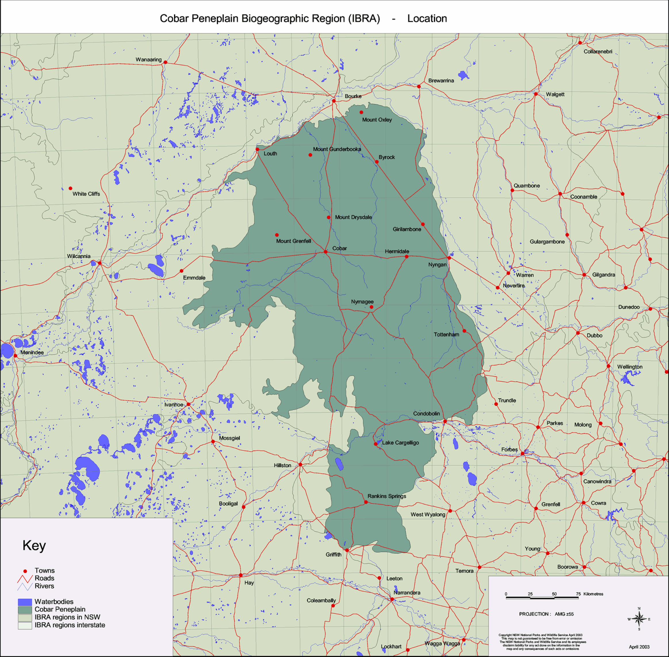
1. Location The Cobar Peneplain Bioregion lies in central NSW west of the Great Dividing Range. It is one of only two of the state’s bioregions to occur entirely within the state, the other being the Sydney Basin Bioregion. The bioregion extends from just south of Bourke to north of Griffith, has a total area of 7,334,664 ha, and occupies 9.2% of the state. The bioregion is bounded to the north and east by the Darling Riverine Plains Bioregion, to the east by the South Western Slopes Bioregion, and by the Riverina and Murray Darling Depression Bioregions to the south and west. The northwestern part of the Cobar Peneplain Bioregion falls in the Western Division. The Cobar Peneplain Bioregion encompasses the townships of Cobar, Nymagee, Byrock, Girilambone, Lake Cargelligo and Rankins Springs with Louth and Tottenham lying at its boundary. In the north of the bioregion,Yanda Creek, a major stream, discharges directly into the Darling River which meanders across the bioregional boundary in the northwest. In the east, several small streams flow occasionally into the Bogan River as it crisscrosses the eastern boundary of the bioregion (Morgan and Terrey 1992). The Lachlan River traverses the bioregion in the south with contributions of minor runoff from smaller streams (Morgan and Terrey 1992). The bioregion lies wholly within the Murray-Darling Basin and includes the Barwon, Macquarie, Yanda, Darling, Lachlan and Murrumbidgee catchments. 2. Climate The Cobar Peneplain is one of 6 bioregions that lie in Australia’s hot, persistently dry semi-arid climatic zone. This climate is complemented by patches of sub-humid climate on the southeastern boundary of the bioregion and, in the south, these areas are characterised by virtually no dry season and a hot summer (Stern et al. 2000). Throughout the year, average evaporation exceeds the average rainfall. Rainfall tends to be summer dominant in the north of the bioregion and winter dominant in the south (Creaser and Knight 1996, Smart et al. 2000a). Temperatures are typically mild in winter and hot in summer and exceed 40°C for short periods during December to February (Creaser and Knight 1996). Frosts are frequent in the winter months (Smart et al. 2000a) and the lowest daily mean temperature in the bioregion is -6.1°C recorded in Lake Cargelligo in July and August. The hottest period in the bioregion occurs between November and March, with the hottest daily mean temperature in the bioregion being 47.8°C, recorded in Cobar in January. 105 CHAPTER 9 The Cobar Peneplain Bioregion Mean Annual Minimum Maximum Mean Annual Minimum Maximum Temperature Average Monthly Average Monthly Rainfall Average Monthly Average Monthly Temperature Temperature Rainfall Rainfall 15 – 19°C 1.6 – 4.2°C 30.8 – 35.3°C 258 – 537mm 14 – 36mm 30 – 60mm Cobar Peneplain
-
Upload
khangminh22 -
Category
Documents
-
view
1 -
download
0
Transcript of The Cobar Peneplain Bioregion - Environment NSW

1. LocationThe Cobar Peneplain Bioregion lies in central NSW west of the Great DividingRange. It is one of only two of the state’s bioregions to occur entirely withinthe state, the other being the Sydney Basin Bioregion. The bioregion extendsfrom just south of Bourke to north of Griffith, has a total area of 7,334,664 ha,and occupies 9.2% of the state. The bioregion is bounded to the north andeast by the Darling Riverine Plains Bioregion, to the east by the South WesternSlopes Bioregion, and by the Riverina and Murray Darling DepressionBioregions to the south and west. The northwestern part of the CobarPeneplain Bioregion falls in the Western Division.
The Cobar Peneplain Bioregion encompasses the townships of Cobar,Nymagee, Byrock, Girilambone, Lake Cargelligo and Rankins Springs withLouth and Tottenham lying at its boundary.
In the north of the bioregion, Yanda Creek, a major stream, discharges directlyinto the Darling River which meanders across the bioregional boundary in thenorthwest. In the east, several small streams flow occasionally into the BoganRiver as it crisscrosses the eastern boundary of the bioregion (Morgan andTerrey 1992). The Lachlan River traverses the bioregion in the south withcontributions of minor runoff from smaller streams (Morgan and Terrey1992).The bioregion lies wholly within the Murray-Darling Basin and includes
the Barwon, Macquarie, Yanda, Darling, Lachlan and Murrumbidgeecatchments.
2. ClimateThe Cobar Peneplain is one of 6 bioregions that lie in Australia’s hot,persistently dry semi-arid climatic zone. This climate is complemented bypatches of sub-humid climate on the southeastern boundary of thebioregion and, in the south, these areas are characterised by virtually no dryseason and a hot summer (Stern et al. 2000).
Throughout the year, average evaporation exceeds the average rainfall.Rainfall tends to be summer dominant in the north of the bioregion andwinter dominant in the south (Creaser and Knight 1996, Smart et al. 2000a).
Temperatures are typically mild in winter and hot in summer and exceed 40°Cfor short periods during December to February (Creaser and Knight 1996).Frosts are frequent in the winter months (Smart et al. 2000a) and the lowestdaily mean temperature in the bioregion is -6.1°C recorded in Lake Cargelligoin July and August. The hottest period in the bioregion occurs betweenNovember and March, with the hottest daily mean temperature in thebioregion being 47.8°C, recorded in Cobar in January.
105
C H A P T E R 9
The Cobar PeneplainBioregion
Mean Annual Minimum Maximum Mean Annual Minimum Maximum Temperature Average Monthly Average Monthly Rainfall Average Monthly Average Monthly
Temperature Temperature Rainfall Rainfall
15 – 19°C 1.6 – 4.2°C 30.8 – 35.3°C 258 – 537mm 14 – 36mm 30 – 60mm
Coba
r Pen
epla
in

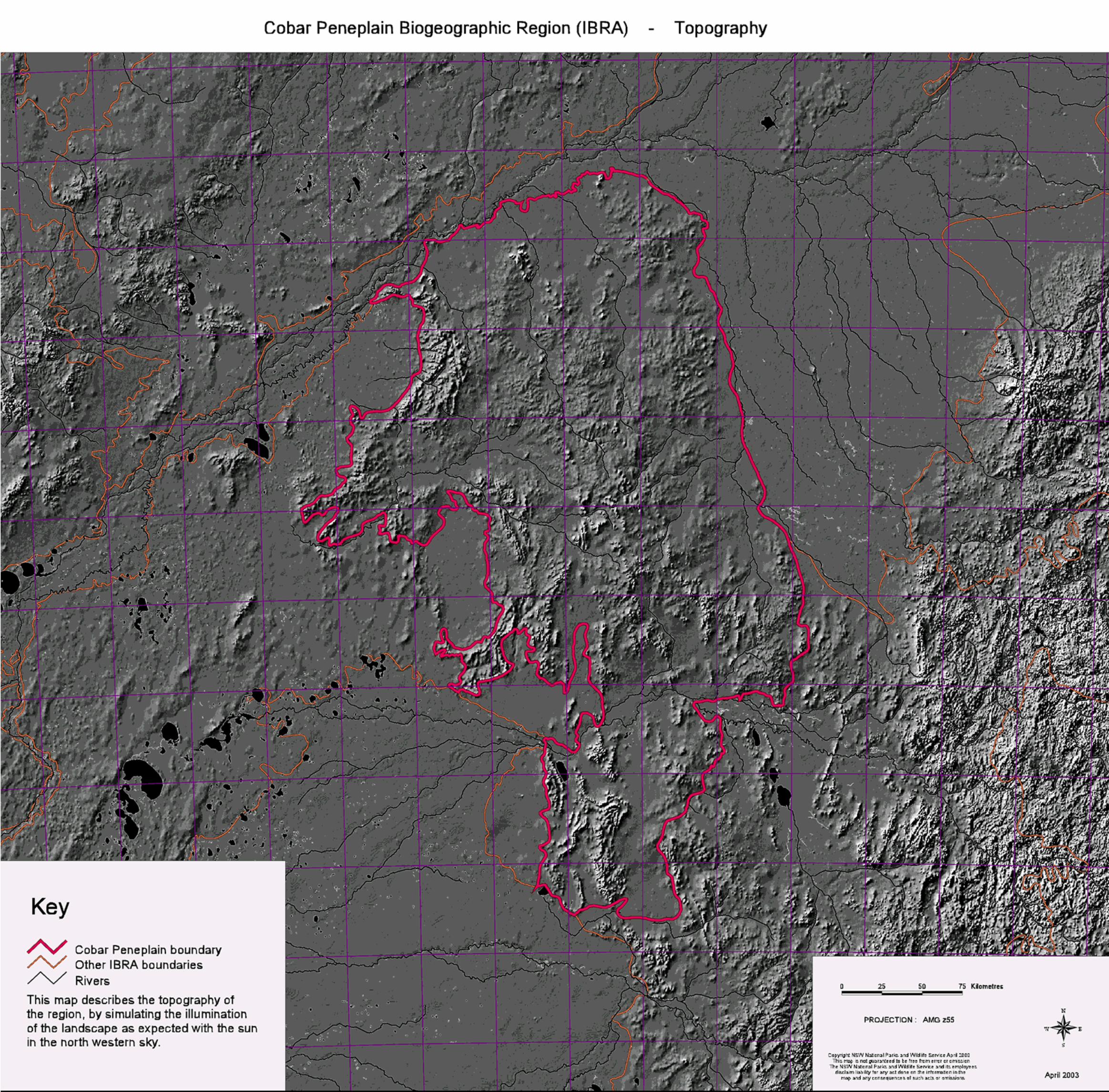
3. TopographyThe Cobar Peneplain Bioregion is a subdued bedrock-controlled landscape inthe centre of semi-arid NSW. Described as a low undulating plain, the CobarPeneplain is easily distinguished from most of the surrounding bioregionswhich are relatively flatter landscapes of floodplains (Riverina and DarlingRiverine Plains bioregions) and sandplains and dunefields (Murray DarlingDepression Bioregion). The Cobar Peneplain is a prominent topographicallandscape of rolling downs and flat plains punctuated by stony ridges andranges and is formed on the northwesterly extension of the Lachlan Fold Belt.The more elevated areas of the Cobar Peneplain are characterised by shallow,red soils and aeolian sands associated with the Darling River and the MurrayBasin mantle in the lower areas in the west and south, while alluvial depositsfrom the Bogan River fringe the Peneplain in the east.
4. Geology and geomorphologyThe Cobar Peneplain bioregion is based on Palaeozoic rocks largely within theLachlan Fold Belt. It is lapped by the Murray Basin and the Great AustralianBasin and although it is described as a peneplain, the implications attachedto this word concerning tectonic stability, landscape and soil genesis shouldnot be uncritically accepted.
The region contains a wide range of bedrock types that exert a stronginfluence on topography. Rock outcrops form low ranges or lines of residualhills controlled by structure (bedding, folds and faults). Rocks in the easternhalf of the bioregion are older (Ordovician), more deformed and more highlymineralised than those in the west (Devonian), although the dominantstructural trends in both are northwest. Quartz sandstones, conglomeratesand siltstones with low angle folds are typical of the younger rocks, and theseform prominent multiple ridges like the ranges at Mt Grenfell up to 300mhigh, or the more complex folds seen in the Cocoparra Ranges near Griffith.Topography on the older rocks around Cobar is more subdued as residual hills,low rounded ridges, and stony slopes formed on softer, more weatheredshales, phyllites and cherts, with only occasional features such as Mt Boppystanding as much as 100 m above the plain.
Igneous rocks are more common in the southern part of the region andgranites north of Nymagee make attractive landscapes of rugged peaks andtors. Very small areas of basalt lava are found from Griffith to north of Cobar,with the most interesting being the rare example of 10-16 million year oldleucitite lava capping the tabletop peak of El’ Capitan.
During the Tertiary and possibly as recently as 5 million years ago, marinesediments were deposited in the Murray Basin with the coastline being thesouthwestern edge of the Cobar Peneplain. In the Quaternary, after theseshallow seas receded, sands were mobilised by wind to form dunes andsandplains that advanced onto the peneplain. A drainage system of wideshallow valleys with a few lakes also developed despite the low rainfall andlow gradients. Today the creeks respond to local rainfall but only occasionallydeliver water to the Bogan or Darling Rivers.
5. GeodiversitySignificant landscape features include the following:
the Gunderbooka Range and the Mt Grenfell Ranges are good examples ofstructural and lithological control of topography. They are also importantas sites of cultural and archaeological significance to Aboriginal people;Gunderbooka and other peaks stand in isolation on the plains and arelikely to have high local endemism in the biota;
the downs and plains are ecologically distinctive with their apparentuniformity, absence of surface water and well-developed biotic patterningof mulga groves caused by interactions between topography, runoff, soiland vegetation; andimportant mining heritage is present at a number of locations, particularlyCobar, which has been the state’s largest copper producer, as well assmaller mines at Nymagee, Mt Hope, Canbelego, Mineral Hill, Tottenham,Ardlethan and elsewhere.
Special geological features include:leucitite lavas of El Capitan;columnar lavas of the Ambone Volcanics;Devonian freshwater fish fossils in the Mt Grenfell area; andarchaeology and palaeo-environmental potential of Barnato Lakes.
6. SoilsSoils across the bioregion are reasonably uniform and relate closely totopographic position and local geology. On ridge crests they are thin, stony,well-drained red loams. Downslope the soil thickens as a colluvial mantle,usually with a large proportion of stones and with an increasing texturecontrast between topsoil and subsoil. On lower slopes the stoninessdecreases, red subsoils give way to yellow subsoils, carbonate levels increaseand soil drainage is more impeded. Brown clays are more common than greyclays in drainage lines, red sands and earthy sands are widespread but thereare only a few areas of sandplain and dunefield.
7. Biodiversity
7.1 Plant communities
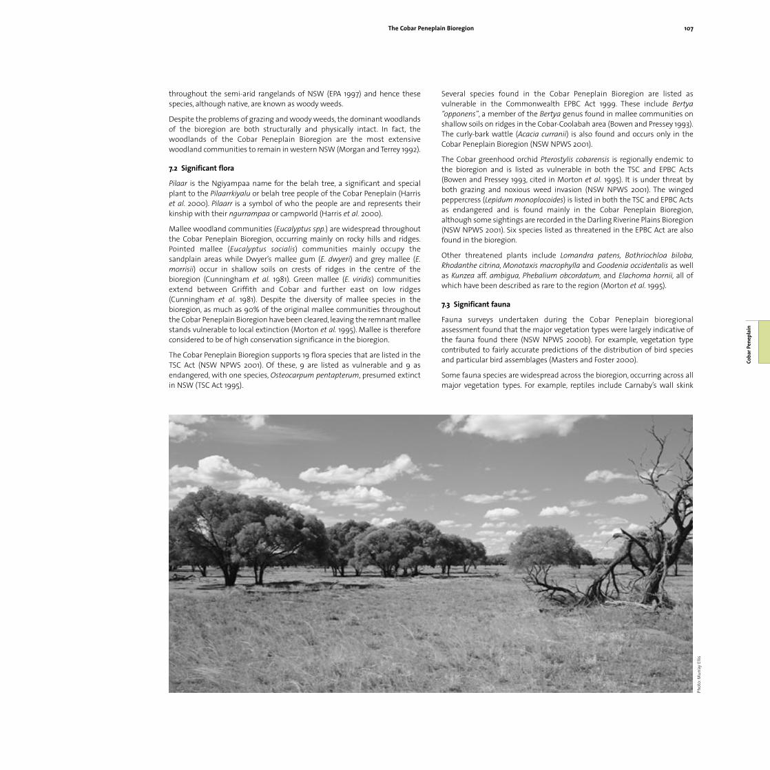
The vegetation of the Cobar Peneplain is regionally distinctive. The bioregionis characterised by an undulating to hilly landscape with shallow, red earthsoils where the vegetation is mainly open woodlands of bimble or poplar box(Eucalyptus populnea), red box (Eucalyptus intertexta) and white cypress(Callitris glaucophylla).
The more arid areas are dominated by mulga (Acacia aneura) (Morgan andTerrey 1992). In the north, mulga and poplar box are dominant. In thesouthwest, poplar box, red box and white cypress pine become morecommon, and in the far south, poplar box and white cypress pine dominate.Red ironbark (Eucalyptus sideroxylon), hill red gum (Eucalyptus dealbata) andgrey box (Eucalyptus microcarpa) woodlands occur on the eastern edges ofthe bioregion, extending into the South West Slopes Bioregion. Westernvegetation communities dominated by belah (Casuarina pauper), wilga(Geijera parviflora) and rosewood (Alectryon oleifolius) are not wellrepresented. Likewise river red gum (Eucalyptus camaldulensis) and black box(Eucalyptus largiflorens) are limited as there are few large streams in theregion. Grasslands are not common in the bioregion.
Mallee is widespread on rocky ridges and sandplains. Typical species includepointed mallee (Eucalyptus socialis), Dwyer’s mallee gum (Eucalyptus dwyeri),grey mallee (Eucalyptus morrisii), green mallee (Eucalyptus viridis), malleebroombush (Melaleuca uncinata), hill tea-tree (Leptospermum trivalve),currawang (Acacia doratoxylon), other Acacia sp. and woody shrubs.
Degradation of the Cobar Peneplain Bioregion by heavy grazing has resultedin vast areas being covered by a dense regrowth of woody shrubs (Morganand Terrey 1992).This shrub layer consists of Eremophila, Dodonaea and Sennaspp. which are unpalatable to stock (Creaser and Knight 1996). Theencroachment and proliferation of such species is a major problem
106 The Bioregions of New South Wales – their biodiversity, conservation and historyCo
bar P
enep
lain
throughout the semi-arid rangelands of NSW (EPA 1997) and hence thesespecies, although native, are known as woody weeds.
Despite the problems of grazing and woody weeds, the dominant woodlandsof the bioregion are both structurally and physically intact. In fact, thewoodlands of the Cobar Peneplain Bioregion are the most extensivewoodland communities to remain in western NSW (Morgan and Terrey 1992).
7.2 Significant flora
Pilaar is the Ngiyampaa name for the belah tree, a significant and specialplant to the Pilaarrkiyalu or belah tree people of the Cobar Peneplain (Harriset al. 2000). Pilaarr is a symbol of who the people are and represents theirkinship with their ngurrampaa or campworld (Harris et al. 2000).
Mallee woodland communities (Eucalyptus spp.) are widespread throughoutthe Cobar Peneplain Bioregion, occurring mainly on rocky hills and ridges.Pointed mallee (Eucalyptus socialis) communities mainly occupy thesandplain areas while Dwyer’s mallee gum (E. dwyeri) and grey mallee (E.morrisii) occur in shallow soils on crests of ridges in the centre of thebioregion (Cunningham et al. 1981). Green mallee (E. viridis) communitiesextend between Griffith and Cobar and further east on low ridges(Cunningham et al. 1981). Despite the diversity of mallee species in thebioregion, as much as 90% of the original mallee communities throughoutthe Cobar Peneplain Bioregion have been cleared, leaving the remnant malleestands vulnerable to local extinction (Morton et al. 1995). Mallee is thereforeconsidered to be of high conservation significance in the bioregion.
The Cobar Peneplain Bioregion supports 19 flora species that are listed in theTSC Act (NSW NPWS 2001). Of these, 9 are listed as vulnerable and 9 asendangered, with one species, Osteocarpum pentapterum, presumed extinctin NSW (TSC Act 1995).
Several species found in the Cobar Peneplain Bioregion are listed asvulnerable in the Commonwealth EPBC Act 1999. These include Bertya“opponens”, a member of the Bertya genus found in mallee communities onshallow soils on ridges in the Cobar-Coolabah area (Bowen and Pressey 1993).The curly-bark wattle (Acacia curranii) is also found and occurs only in theCobar Peneplain Bioregion (NSW NPWS 2001).
The Cobar greenhood orchid Pterostylis cobarensis is regionally endemic tothe bioregion and is listed as vulnerable in both the TSC and EPBC Acts(Bowen and Pressey 1993, cited in Morton et al. 1995). It is under threat byboth grazing and noxious weed invasion (NSW NPWS 2001). The wingedpeppercress (Lepidum monoplocoides) is listed in both the TSC and EPBC Actsas endangered and is found mainly in the Cobar Peneplain Bioregion,although some sightings are recorded in the Darling Riverine Plains Bioregion(NSW NPWS 2001). Six species listed as threatened in the EPBC Act are alsofound in the bioregion.
Other threatened plants include Lomandra patens, Bothriochloa biloba,Rhodanthe citrina, Monotaxis macrophylla and Goodenia occidentalis as wellas Kunzea aff. ambigua, Phebalium obcordatum, and Elachoma hornii, all ofwhich have been described as rare to the region (Morton et al. 1995).
7.3 Significant fauna
Fauna surveys undertaken during the Cobar Peneplain bioregionalassessment found that the major vegetation types were largely indicative ofthe fauna found there (NSW NPWS 2000b). For example, vegetation typecontributed to fairly accurate predictions of the distribution of bird speciesand particular bird assemblages (Masters and Foster 2000).
Some fauna species are widespread across the bioregion, occurring across allmajor vegetation types. For example, reptiles include Carnaby’s wall skink
The Cobar Peneplain Bioregion 107
Coba
r Pen
epla
in
Phot
o:M
urra
y El
lis

(Cryptoblepharus carnabyi) and south-eastern morethia (Morethia sp.) whichare both fairly widespread west of the Great Dividing Range (Cogger 1992).The bioregion also supports a range of mammals that inhabit much of thePeneplain such as the short-beaked echidna (Tachyglossus aculeatus), easterngrey kangaroo (Macropus giganteus) and inland mastiff-bat (Mormopterussp.), as well as many woodland birds such as the blue-faced honeyeater(Entomyzon cyanotis), rainbow bee-eater (Merops ornatus) and mistletoe bird(Diacaeum hirundinaceum).
The kultarr (Antechinomys laniger) is a dasyurid which is known as the“marsupial mouse” due to its large ears, long tail and irregular hopping gait(NSW NPWS 2000b). The distribution of the kultarr has declined in NSW andthe species now occurs in a patchy distribution to the west of the Bogan River,which borders the Cobar Peneplain Bioregion (Dickman et al. 1993, cited inMorton et al. 1995). Although the species is not directly affected by humanactivity, the changes in, or intensification of, land use, is thought to threatenits security (Strahan 1983).The kultarr is now listed as endangered in Schedule1 of the TSC Act 1995.
The now sparse distribution of the greater long-eared bat (Nyctophilustimoriensis) and yellow-bellied sheathtail bat (Saccolaimus flaviventris) can bemainly attributed to loss of habitat. These bats rely on trees for roosting andthe absence of sufficient vegetation has rendered them at risk of predation bycats (Dickman et al. 1993, cited in Morton et al. 1995). Both species are listedas vulnerable in Schedule 2 of the TSC Act 1995.
The bird species of the bioregion are fairly typical of semi-arid climatic zones,although this bioregion is unusual in that it contains a higher than averageproportion of endemic Australian bird species, a reflection of its regionallydistinct dry climate. Declines of these species in the small areas of woodlandin the bioregion are likely to continue unless adequate representative areas ofwoodland are protected from clearing and over-grazing.
Despite the scarcity of remnant mallee stands in the bioregion thisvegetation supports significant populations of the also vulnerable (TSC Act1995) striated grasswren (Amytornis striatus striatus) (Garnett 1992, cited inMorton et al. 1995). The shining bronze-cuckoo (Chrysococcyx lucidus) andspeckled warbler (Sericornis sagittatus or Chthonicola sagittata) also rely onthese small remnants, and are considered to be in decline in the bioregion(Smith et al. 1994, cited in Morton et al. 1995).
There are 43 faunal species listed as threatened under Schedules 1 and 2 ofthe TSC Act 1995 (Smart et al. 2000b). Thirty-six of these are listed asvulnerable and 7 are listed as endangered. Although not formally listed inlegislation, other fauna species (64 birds, 12 mammals, 23 reptiles and 8 frogs)are identified as being of conservation concern because their numbers aredeclining or they are locally extinct within the bioregion (NSW NPWS 2000a).
Of the 88 mammal species found in the Western Division at the time ofEuropean settlement, 27 were thought to be regionally extinct by the 1990s(Main 2000). In the Cobar Peneplain Bioregion these species include the bilby(Macrotis lagotis) and the bridled nail-tail wallaby (Onychogalea fraenata),both formerly found in the bioregion and now listed as species presumedextinct in NSW under Schedule 1 Part 4 of the TSC Act 1995.
In addition to the various native animals that typically inhabit the CobarPeneplain, many feral animals are now commonly seen throughout thebioregion. Of the mammals in the bioregion, domestic livestock, goats, rabbitsand foxes were the most conspicuous during surveys (NSW NPWS 2000b).Such species as the fox (Vulpes vulpes) are becoming more widespreadthrough western NSW and together with cats (Felis catus) prey on the nativespecies of the bioregion (NSW NPWS 2000b).
7.4 Significant wetlands
Lake Brewster is the only wetland of national significance in the bioregion.Considered to be in fair condition, the status of this wetland is declining dueto threats by European carp and other feral animals, exotic weeds and alteredhydrology. Despite these disturbances, the lake remains an important refugehabitat for water birds as it retains water longer than nearby natural lakesduring drought.
Lake Cargelligo is the only bioregionally significant wetland wholly within theCobar Peneplain. It is described as being in fair condition, affected somewhatby feral animals, exotic weeds, increased water flows and grazing pressure.The site is important for several vulnerable species including brolga (Grusrubicundus), freckled duck (Stictonetta naevosa), Major Mitchells cockatoo(Cacatua leadbeateri), blue-billed duck (Oxyura australis), black-breastedbuzzard (Hamirostra melanosternon) and western blue-tongued lizard(Tiliqua occipitalis). The endangered malleefowl (Leipoa ocellata) has alsobeen sighted at the lake.
8. Regional history
8.1 Aboriginal occupation
The Cobar Peneplain Bioregion has been managed and occupied byAboriginal people for at least 40,000-50,000 years (Flannery 1994, Palmer
108 The Bioregions of New South Wales – their biodiversity, conservation and historyCo
bar P
enep
lain
Phot
o:M
urra
y El
lis

1994). The bioregion falls within the traditional homelands of severalAboriginal language groups and within these groups are communities livingin what they term their “home country”. The main language groups areNgiyampaa in the centre, Ngemba in the north east and Wiradjuri in thesouth, with the Paakantkji group occupying the area along the northwesternborder of the bioregion.
The Ngiyampaa people traditionally occupy the area towards the centre ofthe bioregion, southwest of Cobar (Smart et al. 2000b). To distinguishthemselves from other language groups in the area, they refer to themselvesas the people who speak Ngiyampaa the Wangaaypuwan (Wongaibon) way,that is, they use the word wangaay for “no”. Ngiyampaa people also groupthemselves according to their home country so that the Pilaarrkiyalu (BelahTree People), Nhiilyikiyalu (Nelia Tree People) and Karulkiyalu (Stone CountryPeople) all occupy different areas of the Ngiyampaa language group withinand around the bioregion (Smart et al. 2000b). Some Karulkiyalu refer tothemselves as Ngemba because their home country to the north of Cobarborders the two language groups. However, these people still speak theWangaaypuwan way. The Ngemba people in the far north of the bioregionand the Darling Riverine Plains Bioregion use the word wayil for “no” andhence refer to themselves as the people who speak Ngemba the Wayilwanway. To the west of this group, also in the north of the bioregion, is thehomeland of the Paakantkji or Darling River People who are traditionallylinked to the plains of the Darling River from near Bourke south to Wentworth(NSW NPWS 2000c). Paakantji means “belonging to the river” and thesepeople traditionally occupied the Darling River floodplains, spending moretime in the Darling Riverine Plains Bioregion (NSW NPWS 2000c). Thesouthern and eastern parts of the bioregion are traditionally occupied by theLachlan River people known as Kaliyarrkiyalung, who are part of the Wiradjurilanguage group and use the word wirraay for “no” (NPWS 2000c).Wiradjuri isone of the largest language groups in NSW (NSW NPWS 2000c).
The Ngiyampaa (words shown in bold), Paakantji (words are underlined) andNgemba language groups were divided further by a totemic system, wheresections of each group comprised individuals linked to an animal or planttotem (Main 2000). The people were traditionally responsible for protectingtheir totem and would usually refuse to eat the totem that they identifiedwith. Not all totems were food items. Some individuals were responsible forsignificant stands of vegetation such as grey mallee (mali, kaarima,Eucalyptus morrisii) which was important for spear timber (Main 2000).
8.2 European occupation
After the first settlement at Port Jackson, western NSW was not exploredimmediately. This was due to several factors including the need to maintainlaw and order and the colony’s focus being on development in the Sydneyarea (Austral Archaeology 2000). However, between 1817 and 1846 majorexploration of the area west of the Blue Mountains was undertaken by Oxley,Sturt and Mitchell (Whitney 1997) and by 1830 European squatters began tooccupy large areas of land in the west (Denny 1994). By 1850 land settlementhad occurred through the Cobar Peneplain, as far west as Wilcannia in theDarling Riverine Plains bioregion (Denny 1994).
Newspaper reports in the 1850s printed enticing descriptions of the plainsbetween what are now the townships of Louth and Bourke, encouragingsettlers to utilise the productive grazing country of the Cobar Peneplain(Main 2000). Sheep (thumpa, Ovis aries) and cattle (kurrukun, kiyata, Bostaurus) were grazed along the Darling River and by the 1860s about half amillion sheep and 40,000 cattle occupied its banks. Riverboats on the Darlingincreased the accessibility of the pastoral country on the Peneplain and woolproduction in the area was prolific (Main 2000). The first river steamers
reached Bourke and Wilcannia in 1859 (Clelland 1984), providing an importanttransportation link from the wool stations of the Cobar Peneplain.
The settlement of Europeans in the Cobar Peneplain Bioregion and the rest ofNSW brought disease and violence to local Aboriginal communities. By 1860the Aboriginal population of the bioregion had been decimated and this sawan end to many traditional land management practices (Main 2000) thatwere rapidly replaced by high agricultural production, which had an impacton biodiversity. Prior to settlement of the land by Europeans, forests in thebioregion were open eucalypt and cypress pine woodlands with a grassyunderstorey (Anon. 1988). The Aboriginal people of the bioregion preservedthese open woodlands by regularly burning the vegetation (Anon. 1988), atechnique known as “fire-stick farming”. When Europeans arrived theyreduced burning practices and extended the area in which their stock couldgraze by ringbarking and clearing the woodlands (Cunningham et al. 1981,Anon. 1988). Of 88 mammal species recorded at European settlement, almost30 were extinct by 1990 (Main 2000). The end of traditional practices such asfire-stick farming led to devastating bushfires in the 1860s and 1870s. Theextinction of many medium-sized mammals of the area has been partlyattributed to these great fires (Main 2000) as they could not burrowunderground like small mammals to avoid the flames. The loss of thesespecies may have also had an impact on the vegetation of the area.
Louth, in the north-west of the bioregion, was established as a 40-acre (about16 ha) property on the Darling River in 1865 (Clelland 1984). Later it played akey role in the development of mining at Cobar. By 1870 the township ofBourke, just north of the bioregion, was a thriving river port (Clelland 1984).That same year copper was discovered at the Kuburr (Cobar) waterhole andthe area was soon established as the Cobar Copper Mine. This was soonfollowed by the discovery of copper and the establishment in 1871 of twomines – the Cornish, Scottish and Australian (CSA) mine and the United(Occidental) – but these were closed temporarily when they did not achieveimmediate financial success. By 1873 Cobar began to establish itself as apermanent township, growing from its former status as a mining outpost(Clelland 1984). Some travellers did not look upon the landscape favourably,an early poem reporting:
There’s not a mountain, dale, or valley,No babbling brooks make sudden sally;Just sand hills fringed with stunted mallee,That’s Cobar.
In 1877 severe drought conditions took hold of the area, but rainfall improvedin the following years (Clelland 1984). Stock numbers declined during thissevere drought. Drought followed by several wet years after 1878 allowedmany of the cypress pine stands of the area to regenerate unimpeded and alarge proportion of these forest stands remained into the 1980s (Anon. 1988).The 1870s also saw the appearance of rabbits which, along with grazing anddrought, added to the struggle of the vegetation of the bioregion and muchof western NSW (Cunningham et al. 1981).
Copper mining commenced in Nymagee in 1878. The commercial minecommenced operation in 1880 (Clelland 1984) as did the local school atNymagee. Sawmilling in the bioregion began around 1876 when mills werelocated at Cobar, Canbelego and Coolabah to produce timber for the miningindustry and developing towns in the area (Anon. 1988). High demand forfirewood for the smelters meant that forests around Cobar were clearedextensively. The mill at Coolabah operated until it burnt down in 1980 (Anon.1987).
The Cobar Peneplain Bioregion 109
Coba
r Pen
epla
in

The separation of NSW into Western, Central and Eastern Divisions in 1884(Whitney 1997) meant that the western proportion of the Cobar Peneplainwas held under Western Lands Leases which, due to the restrictions placed onthe lands, were used mainly for grazing (Clelland 1984).
The railway reached Bourke in 1885 (Clelland 1984) and was approachingCobar from Nyngan by the 1890s. The Great Cobar Mine was closed in 1889due to low yield and heavy rains which made transport difficult and restrictedthe provision of adequate supplies (Clelland 1984). The mine was later takenover and reopened by the end of the 1890s. Many other mines progressedalongside the Great Cobar, mining copper, gold, silver and lead. In 1889 goldwas discovered near Canbelego (between Cobar and Nyngan) and in 1893there was a rich find at Mt Drysdale (Clelland 1984).
Droughts in the bioregion have occurred in approximate cycles of 20 years’duration over approximately the last 100 years (Anon. 1988). Following thedrought of the 1870s, a great drought gripped the Cobar Peneplain between1895 and 1902 and although rain fell intermittently during this time,overstocking of the land teamed with rabbit and woody weed infestationmeant that pastoralists were hit hard financially (Clelland 1984), and lostthousands of sheep.
By the late 1800s violence towards Aboriginal people had abated somewhatand European pastoralists began to cooperate with survivors, allowing themto remain on their traditional lands in exchange for ecological knowledge andtechnical skills (Main 2000). It has been estimated that by the turn of thecentury Aboriginal workers undertook 30 per cent of pastoral labour innorthwestern NSW (Main 2000).
The main land use in the bioregion is pastoralism (Creaser and Knight 1996),with sheep being the dominant grazing stock while cattle are grazedintermittently according to fluctuations in price and market availability. Landdegradation marked by soil erosion and woody weed infestation has occurredin the Cobar Peneplain and this is due largely to overstocking with sheep,cattle and domestic animals (Creaser and Knight 1996) and to feral animalssuch as rabbits and goats. Subsisting on edible shrubs and trees, goats arefarmed in some areas in an attempt to increase incomes from theseotherwise unproductive lands (Morgan and Terrey 1992). Cropping occursopportunistically in the western parts and annually in the southeast.
The bioregion straddles the Western and Central Divisions (Whitney 1997),separating the bioregion into two distinctive landscapes. Cleared freeholdland lies to the east of the Western Division boundary (63% of the CentralDivision component of the Cobar Peneplain is cleared) and to the west liesthe vegetated pastoral leases of the Western Division (where less than 21% ofthis part of the bioregion has been cleared). Widespread clearing andcropping has occurred on the leasehold lands of the Western Division(Nymagee-Rankin Springs province, Morgan and Terrey 1992).
The bioregion encompasses the townships of Cobar, Nymagee, Byrock,Girilambone, Lake Cargelligo and Rankins Springs with Louth and Tottenhamat its boundary, while Nyngan, Condobolin and Griffith lie just outside thebioregion. As population records are not kept on the basis of bioregionalboundaries, the current population of the Cobar Peneplain Bioregion isdifficult to calculate. However, it is likely that the population is in the order of10,000-15,000 (Dick 2000). Approximately 5,474 people live in the Cobar localgovernment area itself (Australian Bureau of Statistics website –http://www.abs.gov.au) with the majority of the remaining population livingon rural properties throughout the bioregion, mainly in the east and south.This is a reflection of the increase in property size from east to west. Mostsmall towns and villages on the Cobar Peneplain are experiencing a decline inpopulation as people, especially the young, move to larger centres outside theregion to continue their education or seek employment (Australian Bureau of
Statistics 1999, cited in Dick 2000). As the state’s largest copper producer anda significant producer of gold, lead, silver and zinc (Creaser and Knight 1996),the bioregion is a lucrative mining region. Together with Broken Hill, Orangeand New England, the other 3 major areas in NSW for metallic mineralproduction, the area around Cobar contributes significantly to the industryvalue of $1.27 billion (1999-00) (NSW Department of Mineral Resourceswebsite – http://www.minerals.nsw.gov.au). There are 7 mines around Cobar:Peak Gold Mine, McKinnons, Girilambone Copper, CSA, Mineral Hill, Trittonand Elura, which principally mine from 3 major mining belts at Cobar,Canbelego and Girilambone.The Cobar belt holds major mineral deposits andits 60 km length passes through the Cobar town area (Creaser and Knight1996). Together, the 7 mines in the bioregion contain resources of almost 50million tonnes with a maximum yield of about 8% for the metals mined inthe region.
The cessation of operations at the CSA mine in Cobar occurred in early 1998and soon after recommenced operations in March 1999, but only produced alittle over 2,000 tonnes of copper metal in 1998-99 (Department of MineralResources website – http://www.minerals.nsw.gov.au). Girilambone CopperCompany, just inside the Cobar Peneplain Bioregion, produced copper metalfrom mining and processing operations near Girilambone in northern NewSouth Wales until mining ceased in early 2000. Concentrates of lead and zincwith silver by-product are produced from mining operations located atBroken Hill and the Elura mines near Cobar. The Elura zinc-lead-silver depositis the largest mineral deposit yet found in the Cobar Basin (Department ofMineral Resources website – http://www.minerals.nsw.gov.au). The Trittoncopper deposit, located 85 km east of Cobar, is the newest project in thebioregion. It is likely that Cobar suffers from fluctuations in population due tomines closing and reopening. Cobar had experienced a local economic boostfrom mining until the CSA mine closed and over 300 people left thecommunity (NSW NPWS 2000c).
Both the area south of Canbelego and the area around the Lachlan River haveseveral scattered state forests, most of which have been managed for timberproduction (Morgan and Terrey 1992), mainly for white cypress pine (Anon.1988).
9. Bioregional-scale conservationAreas under conservation management in the bioregion occupy 182,623.45 haor 2.49% of the total. Mechanisms provided for under the NPW Act 1974 areresponsible for most of the conserved area.The majority of this is taken up bythe 2 national parks and 9 nature reserves which occupy 116,450.90 ha or1.59% of the bioregion. None of these reserves is also managed as wildernessunder the Wilderness Act 1987.
Of the remaining conservation tenures under the NPW Act 1974, there are noAboriginal areas, no state recreation areas and no regional parks in thebioregion, but there is one historic site of 1,365.09 ha or 0.02% of thebioregion.
No landholders have entered into voluntary conservation agreements underthe NPW Act 1974, although landholders on 11 properties have agreed towildlife refuges and these collectively occupy an area of 60,077.73 ha or 0.82%of the bioregion.
Under the provisions of the Forestry Act 1916 State Forests occupy an area of81,139.24 ha or 1.11% of the bioregion, and there is one flora reserve whichoccupies 1,703.70 ha or 0.02% of the bioregion.
There are six property agreements under the NVC Act 1997 with an area of2,481.55 ha or 0.03% of the bioregion.
110 The Bioregions of New South Wales – their biodiversity, conservation and historyCo
bar P
enep
lain

The Cobar Peneplain Bioregion 111
Boorindal Plains Quaternary alluvialblanket over weatheredOrdovician and Silurianlow grademetamorphosedsedimentary rocks, suchas phyllite.
Undulating plains withwide valleys andoccasional low stonyrises. Gilgai widespreadin depressions andswamps.
Red earths and redtexture contrast soilswith stony lag gravelson slopes. Brown claysand harsh texturecontrast soils indepressions andswamps.
Dense mulga, ironwood, poplar box andred box with dense shrubs on ridges andslopes. Dense poplar box with lignum,budda, emu bush, narrow-leaf hop bushand grasses on lower slopes anddepressions.
Barnato Downs Devonian quartzosesandstones in ridges,finer sedimentary rocksunder the plains oftencovered by a mantle ofQuaternary alluvium.
Steep ridges and rockyslopes controlled bybedding and joints inbedrock. Relief to 150m,length of ranges up to40 km. Undulating lowridges and stony riseson softer rocks with amantle of Quaternarycolluvium and alluvium.Sands and minor claydeposits in stream lines.Lakes at Barnato.
Thin, discontinuousstony profiles on ridges,thickening downslopeto stony, red, texturecontrast soils and redearths on the plains.Valleys generally texturecontrast soils withcalcium carbonate insubsoil, small areas ofcracking brown clays orred sands.
Mulga, red box and grey mallee on crests,white cypress pine and poplar box onslopes. Red box, mulga, white cypress pineand polar box on plains. Areas of belahrosewood and yarran. Pointed mallee inthe south. Woody shrubs widespread.
Canbelego Downs Fine grained Ordovicianand Silurianmetasedimentary andsedimentary rocks, suchas phyllite, slate andchert.
Undulating plateauwith low stony ridgesand stony rises, relief to20m. Long low angleslopes and wide(>500m) valleys. Somecentral sandy channels,a few swamps.
Shallow red loams orstony loams on crestsmerging to red earthson slopes, plains andthrough the valleyfloors.
Minor sand depositsalong streams, yellowtexture contrast soils inswamps.
Mulga with green mallee, red box andnumerous woody shrubs on ridges andslopes. Poplar box, white cypress pine,yarran shrubs and grasses in the valleys.River red gum and polar box with sedges,lignum and nardoo in swamps and largercreeks.
10. Subregions of the Cobar Peneplain Bioregion(Morgan and Terrey 1992)
Subregion Geology Characteristic landforms Typical soils Vegetation
Nymagee Downs Ordovician to Devoniangranites, quartzosesandstones, phyllites,slates and acidvolcanics. Quaternaryaeolian sands andalluvium.
Low hills and ridgeswith steep slopes. Formcontrolled by rock type,rounded hills with torson granite, asymmetricstrike ridges insedimentary rocks.Sandplains fromadjacent bioregions laponto lower slopes.
Gritty red and yellowearthy sands on granite.Stony red earths andtexture contrast soils onsedimentary rocks.Calcareous red earths insandplains, minorearths and grey clays inalluvium.
Dwyer’s mallee gum, white cypress pine,kurrajong, golden wattle on granite crests,poplar box and red box on slopes andcreeks. White cypress pine, red box, belahwith mallee, western wattle grey box androsewood on crests and slopes ofSedimentary rocks. Mallee communitieson sandplains. Dense poplar box andwhite cypress pine in creek lines.
Lachlan Plains Devonian quartzsandstone andconglomerate, smallareas of granite, andQuaternary colluvialslope mantles andalluvium.
Strike ridges of resistantrocks often followingfold patterns. Lowrounded hills of granitewith sparse outcrop.Wide short valleysconnecting to Lachlanfloodplains.
Shallow stony or grittyred earths on crests andslopes, thickeningdownslope as rubblymantles often with atexture contrast. Deepsandy alluvial soils invalleys with small areasof grey clay in swamps.
Dense currawang, Dwyer’s mallee gumand white cypress pine on rocky crests.Same with red ironbark, malleebroombush, hill tea-tree and poplar boxon slopes. Poplar box, white cypress pine,mallee, kurrajong, yarran and wilga invalleys. Poplar box and black box in minorswamps.
Coba
r Pen
epla
in

11. ReferencesAnon. 1987. Management Plan for Dubbo Management Area. ForestryCommission of NSW, Sydney.
Anon. 1988. Management Plan for Cobar Management Area. ForestryCommission of NSW, Sydney.
Austral Archaeology Pty Ltd. 2000. Assessment of Indigenous Cultural HeritageResources: Brigalow Belt South, Final Report. Resource and ConservationAssessment Council, Sydney.
Bowen, P. and Pressey, R. 1993. Localities and habitats of plants with restricteddistributions in the western Division of NSW. NSW National Parks and WildlifeService, Hurstville.
Clelland, W. 1984. Cobar, founding fathers: an illustrated history of thepioneering days in the copper mining district of Cobar, NSW. MacquariePublications, Dubbo.
Cogger, H. 1992. Reptiles and Amphibians of Australia. Reed Publishing,Chatswood NSW.
Creaser, P.M. and Knight, A.T. 1996. Bioregional Conservation Strategy for theCobar Peneplain: Stage 1. Unpublished report. NSW National Parks and WildlifeService, Hurstville.
Cunningham, G.E., Mulham, W.E., Milthorpe, P.L. and Leigh, J.H. 1981. Plants ofWestern NSW. NSW Government Printing Office in conjunction with the SoilConservation Service of NSW, Sydney.
Denny, M.J. 1994 Investigating the past: an approach to determining thechanges in the fauna of the western division of New South Wales since thefirst explorers, in Lunney, D. et al. 1994. Future of the fauna of Western NewSouth Wales. Royal Zoological Society of New South Wales, Mosman.
Dick, R. (ed) 2000. A multi-faceted approach to regional conservationassessment in the Cobar Peneplain biogeographic region – an Overview. NSWNational Parks and Wildlife Service, Hurstville.
Dickman, C.R. Pressey, R.L., Lim, L. and Parnaby, H.E. 1993. Mammals ofparticular conservation concern in the western division of New South Wales.Biological Conservation 65:3.
Environment Protection Authority NSW 1997. New South Wales State ofEnvironment. Environment Protection Authority, Chatswood.
Flannery, T.F. 1994. Is there any hope for ecological stability in the New SouthWales inland? In: Lunney, D., Hand, S., Reed, P. and Butcher, D. (eds) 1994.Future of the Fauna of Western New South Wales. Transactions of the RoyalZoological Society of New South Wales, Mosman.
Garnett, S. 1992. Threatened and extinct birds of Australia, Royal AustralasianOrnithologists Union, Victoria.
Harris, B., James, D., Ohlsen, E., Griffiths, P. and Barker, C. 2000. Pilaarrkiyalu ofthe Cobar Peneplain – Ngiyampaa traditional uses of plants and animals.NSW National Parks and Wildlife Service, Hurstville.
Main, G. 2000. Gunderbooka: A ‘stone country’ story. Resource Policy andManagement, Kingston ACT.
Masters, P. and Foster, E. 2000. Investigating fauna distribution on the CobarPeneplain. NSW National Parks and Wildlife Service, Hurstville.
Morgan, G. and Terrey, J. 1992. Nature conservation in western New SouthWales. National Parks Association, Sydney.
Morton, S.R., Short, J. and Barker, R.D. with an Appendix by Griffin, G.F. andPearce, G. 1995. Refugia for biological diversity in Arid and Semi-arid Australia.A report to the Biodiversity Unit of the Department of Environment, Sportand Territories. CSIRO Australia, Canberra.
NSW NPWS 2000a. Land Systems of the Cargelligo and Narrandera Map Sheetswithin the Cobar Peneplain Biogeographic Region. NSW National Parks andWildlife Service, Hurstville.
NSW NPWS 2000b. The Fauna of Western New South Wales: The CobarPeneplain Biogeographic Region. NSW National Parks and Wildlife Service,Hurstville.
NSW NPWS 2000c. Aboriginal Heritage of the Cobar Peneplain. Informationbrochure. NSW National Parks and Wildlife Service, Hurstville.
NSW NPWS 2001. Atlas of New South Wales wildlife. NSW National Parks andWildlife Service, Hurstville.
Palmer, R.H. 1994. The miracle of recovery. In: Lunney, D., Hand, S., Reed, P. andButcher, D. (eds) 1994. Future of the Fauna of Western New South Wales.Transactions of the Royal Zoological Society of New South Wales, Mosman.
Smart, J. M., Knight, A. T. and Robinson, M. 2000a A Conservation Assessmentfor the Cobar Peneplain Biogeographic Region – Methods and Opportunities.NSW National Parks and Wildlife Service, Hurstville.
Smart, J., Creaser, P. and Monaghan, D. 2000b. Linking Conservation Assessmentand Aboriginal Ecological Knowledge on the Cobar Peneplain. NSW NationalParks and Wildlife Service, Hurstville.
Smith, J.M., Pressey, R.L. and Smith, J.E. 1994. Birds of particular conservationconcern in the western division of New South Wales. Biological Conservation69:3.
Stern, H. et al. 2000. Objective Classification of Australian Climates. Bureau ofMeteorology, Melbourne.
Strahan, R. (ed) 1983. The Australian Museum Complete Book of AustralianMammals. Angus and Robertson, Sydney.
Whitney, A. 1997. Cobar Peneplain Community. In: NSW NPWS 2000. Raisingcommunity awareness of regional conservation assessments on the CobarPeneplain. NSW National Parks and Wildlife Service, Hurstville.
112 The Bioregions of New South Wales – their biodiversity, conservation and historyCo
bar P
enep
lain