The Browns Creek Community Archaeology Project: preliminary results from the survey and excavation...
17
Excavations, Surveys and Heritage Management in Victoria Volume 3 2014
Transcript of The Browns Creek Community Archaeology Project: preliminary results from the survey and excavation...
Excavations, Surveys and Heritage Management in Victoria
Volume 3
2014


1
Excavations, Surveys and Heritage Management in Victoria
Volume 3
2014

2
Excavations, Surveys and Heritage Management in VictoriaVoume 3, 2014
Edited by
Caroline SpryDavid Frankel
Susan LawrenceIlya Berelov
Shaun Canning
Front cover photographSisters Rocks. Courtesy Darren Griffin (photo taken on 17 October 2013)
Excavations, Surveys and Heritage Management in Victoria Volume 3, 2014
Melbourne
© 2014 The authors. All rights reserved.
ISBN 978-0-9924332-3-9

3
Contents
Editorial note 5
Papers
Pleistocene to Holocene in the Upper Maribyrnong River Basin: excavations at Deep Creek, Bulla
7
William Anderson and Racheal Minos
Investigation of a Pleistocene river terrace at Birrarrung Park, Lower Templestowe, Victoria 15
Martin Lawler, Ilya Berelov and Tim Cavanagh
A Pleistocene date at Chelsea Heights, Victoria: evidence for Aboriginal occupation beneath the Carrum Swamp
23
Jim Wheeler, Alan N. Williams, Stacey Kennedy, Phillip S. Toms and Peter Mitchell
Results of recent archaeological investigations along Wallpolla Creek, northwestern Victoria, Australia
33
Ben Watson and Paul Kucera
The Browns Creek Community Archaeology Project: preliminary results from the survey and excavation of a late Holocene shell midden on the Victorian coast
43
Martin Lawler, Ron Arnold, Kasey F. Robb, Andy I.R. Herries, Tya Lovett, Christine Keogh, Matthew Phelan, Steven E. Falconer, Patricia L. Fall, Jacqueline Tumney, Rhiannon Stammers, Tiffany James-Lee and Ilya Berelov
Hiding in plain sight: excavation of a lost pioneer homestead on Kororoit Creek 53
Barry Green
Lonsdale Street, Little Lonsdale Street and Altson Lane, Melbourne: initial testing and first stage of historical excavations in 2013
57
Alison O’Connor
Socio-economics of archaeology in Victoria after the Aboriginal Heritage Act 2006 65
Nicolas Zorzin

4
Abstracts
Identifying Aboriginal hearths in Late Quaternary northwest Victoria: cultural vs natural accumulations of burnt clay and the implications for understanding the archaeological record
75
Alex Blackwood, Emily Dillon, Chris Silvester, David Clark, Jeffrey Clarke, Maurizio Campanelli, Anthony Dall’Oste, Ada Dinckal, Sara Lombardo, Anthony Romano, Adam Valka, and Jillian Garvey
Investigating Late Quaternary human occupation of semi-arid northwest Victoria: preliminary survey and excavation at Neds Corner Station and Murray-Sunset National Park
76
Jillian Garvey
Re-evaluating artefact density as a standalone method of categorising stone artefact occurrences in Victoria: a case study from Beveridge
77
Caroline Spry
Landscape analysis in archaeology: interpretation of Aboriginal campsites at ‘Greenhills’, Pakenham
78
David Rhodes
The Victorian Digital Archaeological Data Archive: an annual update 79
Josara de Lange
Indigenous cultural heritage management at the Mornington Peninsula Shire 80
Adam Magennis
Sisters Rocks: changing connections to a sacred place 81
Darren Griffin and Ben Watson
The formation of cesspit deposits at Little Lon, Melbourne 82
Sarah Hayes and Barbara Minchinton
The buildings of Abbotsford Convent: insights into the practice of confinement 83
Edwina Kay
Two households… in Truganina, where we lay our scene 84
Sylvana Szydzik and Pamela Ricardi
A brief comparison of Indigenous cultural heritage legislation - or - It’s not that bad here in Victoria….no, really….
85
Jamin Moon
La Trobe University’s Young Archaeologists’ Program 86
Thea Kinsela, Maddy Maitri and Susan Lawrence
Fieldwork at Keilor: a short film 87
John Tunn
Contents

5
The papers included here were presented at the third colloquium on Victorian archaeology held at La Trobe University in February 2014. As in previous years, we would like to thank all the participants whose attendance testifies to the importance of what has now become a fixture within the local archaeological calendar as an important opportunity for academics, consultants, managers and Aboriginal community groups to share their common interests in the archaeology and heritage of Victoria.
It is of particular value to include papers in this issue on the earliest periods which are far less well-represented in Victoria than in many other parts of Australia. That these data emerge from consultancies demonstrates the importance of a strong research component in heritage studies. But many other aspects of both research and community engagement are also covered, dealing both with Aboriginal and European heritage.
We are especially grateful to those who later were able to prepare more developed papers for publication. Other presenters allowed slides abstracted from their PowerPoint presentations to be included with their abstracts in this volume. These demonstrate the range
Editorial note
of work being carried out in Victoria, and we hope that many of these will also form the basis for more complete studies in the future. The extended papers were refereed, and we would like to thank those who assisted with this task. Caroline Spry managed this process and much of the sub-editing of this volume. Layout, as in other years, was undertaken by David Frankel.
As with the previous volumes, the illustrations are all in black and white, although many, especially the GIS maps, would be clearer in their original colour. Anyone interested in having copies of these should contact the individual authors.
The 2014 Colloquium was generously supported by our Principal Sponsor, Australian Cultural Heritage Management (ACHM), as well as other sponsors, including Ochre Imprints, AACAI, Biosis Pty Ltd, Archaeological and Heritage Management Solutions (AHMS) and the Department of Archaeology at La Trobe University.
The editors and authors acknowledge the traditional owners of the land and heritage discussed in this book, and pay their respects to their elders, past and present.
43
Abstract
The Browns Creek Community Archaeology Project is a research and training project initiated and driven by traditional owners focusing on an extensive shell midden in Victoria’s southwest. Project partners are the Gadabanud and Gulidjan Traditional Owner Group (GGTOG), Kuuyang Maar Aboriginal Corporation (KMAC), Eastern Maar Aboriginal Corporation (EMAC), Biosis Pty Ltd, La Trobe University (LTU), Otway Coast Care Committee (OCCC) and the Office of Aboriginal Affairs Victoria (OAAV).
Browns Creek 3 (VAHR 7620-0077), located near Apollo Bay on Victoria’s Otway Coast, is an intact, stratified shell midden containing a broad range of faunal and artefactual material, including potential hearth deposits. The traditional owners initiated the project to explore the research potential of this Aboriginal place, and build an understanding of its Aboriginal cultural values in a regional context. The exploratory recording and excavation program, led by Biosis and LTU, commenced in 2013.
Preliminary findings from the 2013 field season indicate an occupational sequence spanning up to 900 years ago, and potentially up to the contact period, with a number of distinct phases of site use separated by sterile dune foramtion. The fieldwork yielded information on subsistence strategies through time, as well as providing opportunities for training in archaeological field methods both for traditional owners and LTU students. This has included opportunities to apply archaeomagnetic methods to coastal Victorian Aboriginal places, and encourage
future collaborative research projects on Victoria’s diminishing coastal archaeology.
This paper presents results from the first phases of this research program.
Background
Browns Creek 3 (VAHR 7620-0077), located approximately 10 km northeast of Apollo Bay on Victoria’s Otway Coast, is an extensive stratified shell midden that is the focus of a joint conservation and investigation project. This paper provides an introduction to the project and summary results of the first fieldwork stages.
The midden lies some 360 m east of Browns Creek, on the eastern side of a small, unnamed freshwater stream and inlet, where coastal dunes, thickly vegetated with Banksia scrub, have accumulated to a height of more than 3 m. The midden is located inshore of a large intertidal rock shelf dissected by gutters, on coastal Crown land, and is currently under the management of the OCCC on behalf of the Department of Environment and Primary Industry (DEPI) (Figure 1).
The construction of the Great Ocean Road in the 1920s, immediately inland of the dune, has had the most severe impact on the area, as have subsequent maintenance and upgrading activities since then. A popular car park has been established for several years off the Great Ocean Road immediately north of the midden, and pedestrian access from the car park to the beach in recent years has exacerbated the progressive shoreward erosion of the dune and midden.
An initial approach was made by Ron Arnold (KMAC/GGTOG) in 2012 to conserve the exposed and eroding midden. A joint funding application for the project by the OCCC to the DEPI’s Coast Care Program was approved in June 2012. The aim of this program has been to formalise access to the beach by constructing walkways, but also to protect and enhance native vegetation through weed control, plant indigenous flora, and erect interpretative signage. The conservation program is being delivered by the KMAC, the OCCC and the Southern Otway Landcare Network, with support from the OAAV.
The Browns Creek Community Archaeology Project: preliminary results from the survey and excavation of a late Holocene shell midden on the Victorian coast
Martin Lawlera, Ron Arnoldb, Kasey F. Robba, Andy I.R. Herriesc, Tya Lovettd, Christine Keoghd, Matthew Phelanc, Steven E. Falconere, Patricia L. Fallf, Jacqueline Tumneye, Rhiannon Stammersc, Tiffany James-Leea and Ilya Berelova
a Biosis Pty Ltd, Melbourne38 Bertie Street, Port Melbourne VIC [email protected]+61 (03) 9646 9499b Gadabanud and Gulidjan Traditional Owner Group, Victoriac The Australian Archaeomagnetism Laboratory, Department of Archaeology, Environment and Community Planning, La Trobe University (Melbourne)d Office of Aboriginal Affairs Victoriae Department of Archaeology, Environment and Community Planning, La Trobe University (Melbourne)f Department of Geography, La Trobe University (Melbourne)

44
Figure 1. Plan of Browns Creek 3 (VAHR 7620-0077)
The second aim of the program includes archaeological investigations of the Browns Creek 3 midden, which commenced in October 2012. These investigations are being undertaken as a voluntary project by a number of bodies in partnership with the traditional owners. Those who have contributed their time and skills to date include the cultural heritage team from Biosis, academic staff and students from LTU, staff from the OAAV, and the traditional owners. The investigations have been supported by ready assistance from the OCCC.
The archaeological investigations of the Browns Creek 3 midden have a broad range of objectives, including to:
• enhance the conservation and interpretation of cultural heritage at this Aboriginal place by understanding how it was occupied, what resources were exploited, and how it relates to a regional context;
• develop and strengthen relationships between academic researchers, cultural heritage consultants and the traditional owners;
• provide training opportunities for LTU students; and
• explore innovative techniques for recording shell middens, such as archaeomagnetic analysis (Herries
2009), Ground Penetrating Radar (GPR) and high-resolution three-dimensional recording.
The investigations have been conducted under the terms of a Cultural Heritage Permit (13/001975), granted under s.40(2)(a) of the Aboriginal Heritage Act 2006.
Three field seasons were undertaken in 2013: a survey stage in March 2013; initial excavations in May 2013; and further excavations in November 2013.
Browns Creek 3 (VAHR 7620-0077)
The Browns Creek 3 shell midden was first recorded as one of a number of midden exposures by LTU staff and Honours students in May 1988, during a survey of the Otway Coast from Apollo Bay to Lorne. While this Aboriginal place is well-known to traditional owners, it had not been recorded or studied in detail. This section of the coastline was not included in Dan Witter’s 1983 survey of the Apollo Bay coastline (Witter 1984).
When first recorded in 1988, Browns Creek 3 was identified as a single lens of shell midden deposit, 5 cm thick and 2 m wide, exposed in the dune cliff to the east of the present extent of the midden exposure. Unlike some of the neighbouring midden exposures in this section of the coast (e.g. VAHR 7620-0075, VAHR 7620-0079), it did not appear to be stratified at the time of recording.
Martin Lawler, et al.

45
It is likely that the midden has eroded since 1988, as the exposure along the dune cliff is now a well-defined layer that is visible in sections over a distance of 200 m, with distinct bands of midden material up to 0.4 m thick.
The dune lies on the eastern side of a narrow stream valley that cuts across the soft sandstone comprising the Eumeralla Formation, creating an inlet through the foreshore platform. To the east of this inlet, the foreshore platform extends as a broad intertidal shelf, some 130 m wide at low tide, and dissected by gullies, pools and extensive gutters. The dune at this location is some 300 m long and 20 wide, rising steeply inland up to the level of the car park and road. The dune is capped by a dense cover of Banksia scrub. A broad track through the scrub (now blocked to vehicles) leads from the car park to the beach along the centre of the dune, running parallel to the shoreline. On its shoreward side, the dune has eroded to form a shallow cliff, ranging between 0.3 m in height at either end, to more than 3 m high in the centre. It is fronted by a bank of loose eroded dune sands with slumped midden material, intercalated with mobile beach sands. Stabilised sections of the collapsed bank along the cliff face have become revegetated. Deflation has created a number of dune blowouts and erosion gullies in the sand cliff, exposing the profile and midden deposits.
The midden is presently exposed across 200 m of the sand cliff section, towards the southwestern (i.e. inlet) side of the dune. Erosion associated with use of pedestrian tracks across the dune has also exposed shell deposits on the western edge of the dune. Towards its northeastern end (i.e. furthest from the inlet), the midden attenuates markedly in shell content and thickness, suggesting that its limit at this end may represent the original extent of the midden. Augering along the inland part of the dune has confirmed the apparent extent of the midden.
In its present form, the eroded sand cliff rises markedly across the central part of the dune, with fresh exposures of midden material, which are adjacent to slumped parts of the dune, visible over several metres. This suggests that this central portion of the midden, which spans approximately 110 m, is being actively eroded by high tides. It is unlikely that the same amount of midden material was exposed at the time of initial recording by LTU in 1988.
The midden exposure along the sand cliff alternates between dense shell concentrations in distinct banded layers to more diffuse lenses with less shell content. Areas of burnt shell, with charcoal and some burnt stone, are also visible. At its densest, the midden forms a distinct multi-banded horizon of shell, charcoal and dark sands, 0.4–0.7 m thick, capped by 0.25–0.4 m of clean dune sands. The base of the midden along the sand cliff is generally masked by slumped dune material, and only the upper portion of the midden deposit is normally visible in section.
Stage 1 survey
An initial survey of the Browns Creek 3 midden was undertaken on 27–28 March 2013, with the participation of Ron Arnold, and in consultation with the KMAC and EMAC. The fieldwork was carried out by staff from the Biosis cultural heritage team and the OAAV, and staff and students from LTU, with the support of the OCCC. The survey was designed to map the extent of the midden and its surrounding landform, to characterise its stratigraphy and provide sufficient information to plan the ensuing stages of excavation.
• A ‘Type Section’ of the exposed midden in the sand cliff was cleaned back and recorded. The slumped dune material was removed from the cliff face to expose the full depth of the dune, overlying the older beach sands. All in situ deposits from the cliff face were sieved, with all shell and stone artefacts being bagged and retrieved for analysis.
• Samples of in situ charcoal were taken for potential radiocarbon dating, and a sample of the dune sands was collected for Optically Stimulated Luminescence (OSL) dating from sterile layers beneath the midden, towards the base of the section. Samples were not taken from the dune sands covering the midden because of large root holes throughout the deposit. Sediment samples were collected for laboratory-based archaeomagnetic analysis, following the procedures described by Herries and Fisher (2010). Displaced potential stone heat retainers were also recovered from the eroded section, to evaluate the presence of hearths at this Aboriginal place and their use for recovering geomagnetic field data (Herries et al. 2007).
• The extent of midden exposure was mapped along the sand cliff and other parts of the dune, using a DPGS. The exposed midden was also photographed in overlapping sections for its full length along the sand cliff.
• To help define the inland extent of the midden, and the nature of the deposits behind the cliff face, a transect of seven auger holes was recorded along the length of the dune on the southwestern side of the access track, 15–20 m inland from the dune cliff face. Sediment samples were recovered for mineral magnetic and general grain size analyses from each 0.15 m section retrieved using the auger.
The location of the cleaned and recorded Type Section of the cliff face was selected in the western half of the midden profile, where the exposed deposits showed distinct multiple bands containing shell and charcoal.
The section face was cut back by 0.15–0.20 m to
The Browns Creek Community Archaeology Project, Apollo Bay

46
Figure 3. Resulting profile of the exposed midden face
provide an undisturbed vertical profile through the dune and midden (Figures 2–4).
Stages 2 and 3 excavations
The first stage of test excavations at Browns Creek was undertaken over a five-day period (6–10 May 2013), 25 years after the midden was first recorded by LTU. The excavation team comprised staff and students from LTU, Biosis and the OAAV, with the participation of Ron Arnold, and in consultation with the KMAC and EMAC. A visit to the area of excavation was arranged for children of the Apollo Bay Primary School.
A further season of excavations (Stage 3) was undertaken by LTU staff and students, with the participation of Ron Arnold, in November 2013.
Test excavations took place in three parts of the stabilised dune, in the western half of the midden area (Figure 1). A 1 x 1 m test pit was excavated in each area (5 m² total excavated area), comprising:
• Area 1 (Test Pits 1A and 1B), located at the western end of the midden, 20 m inland from the cliff ’s edge, where shell-bearing sands are exposed in eroded patches through the vegetated dune surface;
• Area 2 (Test Pits 2A and 2B), situated close to the cliff face, 7–12 m west of the recorded Type Section examined during Stage 1; and
• Area 3 (Test Pit 3A), excavated 8 m to the northeast of the recorded Type Section.
Three further auger holes (Auger Holes 8, 9 and 10) were also excavated adjacent to the three test pit areas.
Two different methodologies were used during the stages 2 and 3 excavations. Test Pits 1A, 1B and 2B were
excavated in shallow horizontal spits and layers, retrieving shell and other midden contents in bulk deposits. In Test Pits 2A and 3A, however, individual shells, lithic artefacts and charcoal samples were recorded using a total station, to provide a high-resolution, three-dimensional record of the midden’s contents (Figure 5). These techniques, currently being used by Dr Andy Herries at Palaeolithic sites in South Africa, are being trialled at Browns Creek for training purposes, and to assess their applicability to archaeological sites in Victoria. A third stage of excavation was carried out in November 2013, to continue the excavation of Test Pit 3A.
The deposits in Test Pits 2A and 3A were excavated in Stratigraphic Units (StratUnits) that were based on changes in geological lithology, colour and inclusions — rather than spits. Both Test Pits were divided into 0.5 x 0.5 m quadrants, to increase spatial control over sieved finds from the StratUnits in each quadrant. If StratUnits were more than 0.05 m deep, spits were established within that particular StratUnit. All shells with measurable attributes (excluding mussels, due to their vast quantity) were recorded individually with the total station, so that each shell had a distinct identification number and related 3D co-ordinates. All rocks, charcoal samples, pieces of ochre, stone artefacts and faunal remains were
Figure 2. Cleaning and sieving of a section through the dune cliff face in March 2013
Martin Lawler, et al.

47
Figure 4. Drawn profile of the exposed midden face
also recorded with the total station, as were the base and outline of each StratUnit and the final stratigraphy. The attributes of each StratUnit (i.e. inclusions, sediment type, photo numbers) were recorded digitally using TapForms© on an iPad. This meant that, aside from student excavation notebooks, all data was recorded digitally in the field. During post-excavation analyses, the StratUnits considered to represent a single temporal unit were then grouped together to make Stratigraphic Aggregates (StratAggs).
Bulk samples of representative sediments were collected from each quadrant within a StratUnit (and spit). These samples were recorded with a total station, and used for archaeomagnetic analysis. The same samples can also be used for any other sediment analyses
Figure 5: Test excavation and recording by La Trobe students in May 2013
The Browns Creek Community Archaeology Project, Apollo Bay

48
in the future. The archaeomagnetic bulk samples were air-dried in a laboratory at LTU to ensure that their water content was homogenous. Large, non-magnetic material — particularly shell — was sieved out, and the remaining sediment was ground up and packed tightly into 8 cm³ plastic palaeomagnetic sample cubes. Samples were then measured at dual frequency on a Bartington MS2 magnetic susceptibility meter, to access their bulk iron and fine-grained ferrimagnetic mineral content. High quantities of both minerals are indicative of fire use, as fire converts weak antiferromagnetic mineral phases often found in sand, such as goethite and haematite, into much stronger, fine-grained ferromagnetic phases, such as magnetite and maghaemite (Herries and Fisher 2010). Wood ash has a particularly high proportion of ultra-fine-grained ferrimagnetic grains. By these means, the identification of these grains can help to identify and track fire use at archaeological sites. Additional mineral magnetic analysis was conducted on a Magnetic Measurements Variable Field Translation Balance (VFTB), to establish the full mineralogy, grain size and concentration of the magnetic minerals in each of the deposits (Herries 2009).
Results
Type Section and augering
The Type Section showed that the dune profile at that location consists of fine, wind-blown sands to a depth of 1.3 m, overlying beach sands. The midden deposits lie within a distinct horizon, 0.7 m thick, consisting of four or five separate horizontal bands of shell, charcoal and discoloured sands, separated by laminae of cleaner wind-blown sands. The midden horizon at that location is overlain by 0.4 m of clean sands, capped by the root zone of the stabilised Banksia scrub (Figures 3–4). Individual bands of midden material showed varying densities and types of shell, particularly mussel and Turbo. Inspection of other sections of the midden face indicated that other parts of the midden have different characteristics, with concentrations of other material such as Haliotis spp. shell.
Augered profiles were undertaken along the southern edge of the track bisecting the midden (Figure 1). Each of the auger holes shows a similar sequence, with varying thicknesses:
1. Dark brown soil cover;
2. Dark grey midden sands containing shell;
3. Fine-grained yellow dune sands; and
4. Basal coarse-grained orange marine (beach) sands.
The augered profiles indicate that the depth of the dune and its contact with marine sands is variable along the midden’s length. The results of the augering indicate that, while quite extensive from east to west, the midden is shallower on its eastern side (Figure 1). The augered profiles also indicate that the midden does not continue inland, to the north of the track that runs along the length of the midden.
Excavations
Excavations at the western end of the shell midden (Test Pits 1A and 1B) indicated that the upper part of the midden in that area has partly eroded away. One of the reasons why excavations were undertaken here was because midden material was exposed on the surface. Excavations revealed a thin basal layer of midden deposit, 0.05 m in thickness, overlain by 0.15 m of clean sands. Above these sands was a second midden horizon, up to 0.4 m thick, whose uppermost 0.2 m had been disturbed. These midden layers on the western edge of the midden are difficult to correlate directly with the various horizons identified in the Type Section, which lies in the central portion of the midden, at a distance of 75 m from Test Pits 1A and 1B.
Test Pits 2A and 2B, which were much closer to the Type Section (i.e. 7–12 m to the west) recorded a single layer of midden, 0.35 m thick, overlain by 0.6 m of clean sands. The difference between these profiles and that of the upper part of the Type Section (with its multiple distinct bands) was notable.
Test Pit 3A, located 8 m to the northeast of the Type Section, revealed three midden layers with an overall thickness of 0.25–0.30 m, separated by fine laminae of dune sands. Shell still occurred sporadically above for about 0.2 m, but the deposits seemed more disturbed. Below the midden layers, sterile dune sands were excavated to a depth of 1 m (Figures 6–7). The results
Figure 6. Test Pit 3A during excavation, showing the layered nature of the midden at this location
Martin Lawler, et al.
49
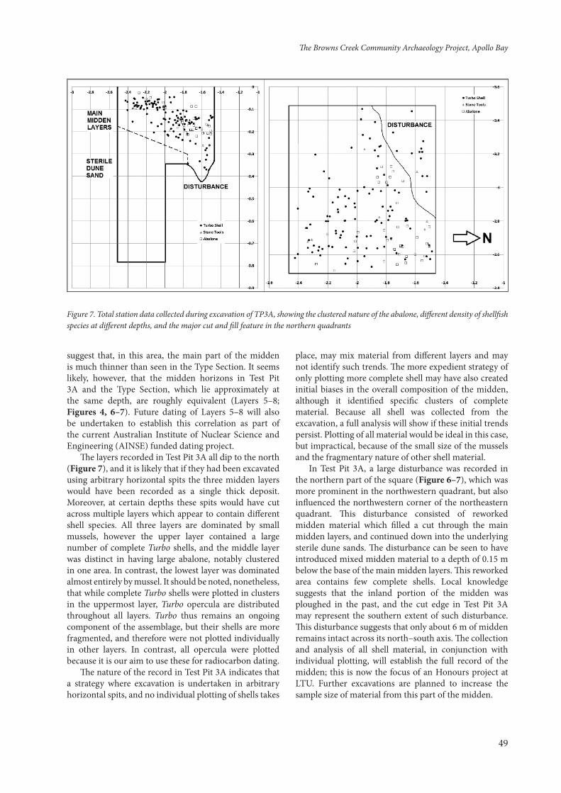
Figure 7. Total station data collected during excavation of TP3A, showing the clustered nature of the abalone, different density of shellfish species at different depths, and the major cut and fill feature in the northern quadrants
suggest that, in this area, the main part of the midden is much thinner than seen in the Type Section. It seems likely, however, that the midden horizons in Test Pit 3A and the Type Section, which lie approximately at the same depth, are roughly equivalent (Layers 5–8; Figures 4, 6–7). Future dating of Layers 5–8 will also be undertaken to establish this correlation as part of the current Australian Institute of Nuclear Science and Engineering (AINSE) funded dating project.
The layers recorded in Test Pit 3A all dip to the north (Figure 7), and it is likely that if they had been excavated using arbitrary horizontal spits the three midden layers would have been recorded as a single thick deposit. Moreover, at certain depths these spits would have cut across multiple layers which appear to contain different shell species. All three layers are dominated by small mussels, however the upper layer contained a large number of complete Turbo shells, and the middle layer was distinct in having large abalone, notably clustered in one area. In contrast, the lowest layer was dominated almost entirely by mussel. It should be noted, nonetheless, that while complete Turbo shells were plotted in clusters in the uppermost layer, Turbo opercula are distributed throughout all layers. Turbo thus remains an ongoing component of the assemblage, but their shells are more fragmented, and therefore were not plotted individually in other layers. In contrast, all opercula were plotted because it is our aim to use these for radiocarbon dating.
The nature of the record in Test Pit 3A indicates that a strategy where excavation is undertaken in arbitrary horizontal spits, and no individual plotting of shells takes
place, may mix material from different layers and may not identify such trends. The more expedient strategy of only plotting more complete shell may have also created initial biases in the overall composition of the midden, although it identified specific clusters of complete material. Because all shell was collected from the excavation, a full analysis will show if these initial trends persist. Plotting of all material would be ideal in this case, but impractical, because of the small size of the mussels and the fragmentary nature of other shell material.
In Test Pit 3A, a large disturbance was recorded in the northern part of the square (Figure 6–7), which was more prominent in the northwestern quadrant, but also influenced the northwestern corner of the northeastern quadrant. This disturbance consisted of reworked midden material which filled a cut through the main midden layers, and continued down into the underlying sterile dune sands. The disturbance can be seen to have introduced mixed midden material to a depth of 0.15 m below the base of the main midden layers. This reworked area contains few complete shells. Local knowledge suggests that the inland portion of the midden was ploughed in the past, and the cut edge in Test Pit 3A may represent the southern extent of such disturbance. This disturbance suggests that only about 6 m of midden remains intact across its north–south axis. The collection and analysis of all shell material, in conjunction with individual plotting, will establish the full record of the midden; this is now the focus of an Honours project at LTU. Further excavations are planned to increase the sample size of material from this part of the midden.
The Browns Creek Community Archaeology Project, Apollo Bay

50
Archaeomagnetism and midden extent
Magnetic susceptibility (MS) analysis of seven auger holes (Augers 2–7 and 9; Figure 8a) shows a very similar trend for auger holes within the extent of the midden (Augers 4–8; Figure 1), although the excavation of Test Pit 3A suggests that the auger holes are positioned mostly in peripheral areas of the midden, or perhaps even in disturbed parts.
Within the midden area, the auger holes show an increase from very low MS values in the basal marine sands to much higher values in the more terrestrial dune sands (i.e. upper 0.5–0.7 m). Augers 4–6 all show an increase in MS from about 0.5 m, although the most easterly auger hole (Auger 4) demonstrates less of an increase until the upper 0.5 m. Augers 4–6 are all located in the eastern part of the midden, where the depth and extent of the midden seem to be more limited based on exposures along the beach section. Augers 7 and 9 both come from the area around Test Pit 2A and Test Pit 3A, showing an increase from a greater depth of 0.6–0.7 m. This is slightly deeper than the predominant depth of midden deposits noted in these areas during excavations (~0.5 m depth in Test Pit 3A). However, disturbed midden deposits in Test Pit 3A have been noted down to about 0.6 m, and the auger holes do not distinguish between undisturbed and disturbed deposits.
Little complete shell was recovered from the augers. While MS values are high in Augers 2–3, throughout the upper 0.5 m, shell was not recovered from this entire depth, and the dark colouration of the upper sands suggests that the high MS values are a result of anthropogenic alteration and enhancement of the deposits by fire use, as well as magnetic enhancement from pedogenic processes
related to the thick vegetation cover over the area of the midden. Further magnetic mineralogical work on both the auger hole and bulk sediment samples recovered during excavations, and from the Type Section, are planned to identify such differences more fully, following the procedures outlined in Herries and Fisher (2010).
Augers 2–3 show extremely different profiles, with much higher overall MS values than any of the midden sections. These auger holes were located in the very eastern part of the midden, which is flat and has likely been reworked. Preliminary high temperature magnetic susceptibility curves (Figure 8b) indicate that the deposits have a complex magnetic mineralogy, with both anti-ferromagnetic material (i.e. haematite; Curie temperature above 620oC) and ferromagnetic material (i.e. magnetite; Curie temperature of ~580oC) present, and a number of distinct phase transitions occurring at temperatures around 250-300oC and ~500oC. As deposits such as these alter a great deal when heated, this indicates that they have not been exposed to heat.
Radiocarbon age estimates
Two samples of in situ charcoal from the Type Section were sent for radiocarbon dating at BETA Analytical. Both samples were subsequently calibrated using the southern hemisphere ShCAL13 curve, through the Oxford Radiocarbon Accelerator Unit (OxCal). The first sample (BETA366407) was taken from Layer 4 (BCMC147 in Figure 4), just above the uppermost layer of midden deposit. The second sample (BETA366406) originated from Layer 10 (BCMC143 in Figure 4), the lowermost well-defined layer of the midden. These determinations indicate that most of the human activity
Figure 8. Magnetic susceptibility data from the auger holes
Martin Lawler, et al.

51
at this Aboriginal place occurred between 1060 ± 30 radiocarbon years BP and 200 ± 30 radiocarbon years BP. These equate to calibrated ages of between 1659–1891 AD (at 93% confidence) for the upper layer, and 982–1145 AD (at 95.4% confidence) for the lower layer.
Discussion
The preliminary results of excavations during the 2013 field seasons at Browns Creek have expanded our understanding of the midden’s development, and hold promise for several areas of research. One of the most interesting features of this Aboriginal place is its varied spatial character, with concentrations of different species in different strata and in different parts of this place, over an area of approximately 5,000 m².
The two radiocarbon age estimates suggest that the Browns Creek 3 midden was deposited, perhaps intermittently, over a period lasting between 514–909 years, until fairly recent times. The Apollo Bay area was first surveyed, and an overland track cut to the area, in 1845, although whalers working in the Bass Strait made several visits to the area before then. The age estimates for the upper layer of the midden therefore raise the possibility that the midden was used as late as the period of first contact and later settlement from 1849. However, there is a greater probability (75.6%) that the midden was last used before 1814, and well before the commencement of European occupation along what is now the Great Ocean Road. The earliest archaeological layers are also more likely (76.5%) to have been laid down after 982–1051 AD, suggesting a maximum potential duration of deposition at this Aboriginal place of some 832 years. While these age estimates are plausible, a more in-depth study of radiocarbon age estimates is needed to confirm the occupation duration of this Aboriginal place, and to provide age estimates for all of the occupation phases. Like other middens along the Otway coast, the Browns Creek 3 midden accumulated from about 1,000 years BP, probably representing the stage when coastal dunes in the region stabilised sufficiently to preserve deposits of this type (Freslov and Frankel 2009).
The midden is densely vegetated, with roots growing deep into the section. Because of this intrusion, the potential for younger charcoal to be incorporated into older deposits is quite high. The radiocarbon study currently underway will provide age estimates for charcoal samples recovered during excavations of the three significant shell midden layers in Test Pit 3A. It will also provide more definitive age estimates for Turbo opercula and cultural material from the same levels. Turbo opercula were chosen because of the greater thickness of this material compared to other parts of the Turbo shell or other shellfish species, but also because this type of material has been successfully dated as part of
other studies (e.g. Leavesley and Chappell 2004; Mahirta 2009).
Like other Aboriginal places along the Otway coast, the Browns Creek 3 deposits contain a range of shellfish species, primarily rocky shore types such as Brachidontes, Subinella, Haliotis and Cellana, with lesser proportions of sandy shore types including Cabestana. The analyses of the faunal remains are still underway.
Artefacts from the test excavations show a reliance on coastal flint, which represents about half of the flaked lithic artefact assemblage, with quartz and small amounts of quartzite making up the remainder. Cortical flakes (flint, quartz and quartzite) form a large proportion of this material, as well as cores and angular fragments. It has been suggested that the preponderance of small waste flakes made on flint and quartz recorded during surveys of exposed middens along the Otway Coast may have been skewed because larger artefacts on these exposed surfaces may have been removed by artefact collectors (du Cros 1990). Interestingly, however, the lithic artefacts from the excavated portions of Browns Creek 3 contain similar amounts of these materials. Quantities of burnt and scorched sandstone were also recovered.
Future directions
Additional fieldwork is being planned for the 2014 season. This fieldwork will concentrate on completing excavations of the test pits which were first excavated in the 2013 season. Further samples will be taken to establish the age and temporal relationship of the stratigraphic layers. Analysis will continue on the faunal assemblages recovered, to determine subsistence patterns associated with this Aboriginal place.
A final focus will be understanding the nature of midden erosion at Browns Creek 3, and investigating potential means of stabilising the dune.
Acknowledgements
We acknowledge the Aboriginal communities who are the traditional owners of this place, and we pay our respects to their elders, past and present.
Warm thanks to the individuals and organisations who have supported the Browns Creek Community Archaeology Project, and to the LTU students and staff who have taken part in the fieldwork: Victoria Davis, Kirsty Gater, Catherine Harvey, Caroline Wright-Neville, Ruby Tolmer, Tom Mallett, Emmy Frost, Tim Masters, James Donlon, Kathleen Carmen, Felicity Coleman, Marilyn Powell, Fiona Shanahan, Rhiannon Ashton, Rhiannon Stammers and Jacqueline Tumney. A number of LTU students, including Chris Silvester and Kenneth Strømsem, helped to prepare and
The Browns Creek Community Archaeology Project, Apollo Bay
52
measure archaeomagnetic samples at The Australian Archaeomagnetism Laboratory (TAAL). TAAL covered all costs for archaeomagnetic analysis. LTU staff members Paul Penzo-Kajewski and Jillian Garvey have supported the project with student training and technical expertise. Funding for the November 2013 excavations and initial radiocarbon age estimates were provided by the Faculty of Humanities and Social Sciences at LTU. Additional funding for radiocarbon studies has been provided by AINSE grant ALNGRA14012. AIRH further acknowledges the support of ARC Future Fellowship FT120100399.
References
du Cros, H. 1990 The Otways Region Archaeological Study Stage 1. Occasional Report No 28. Unpublished reported prepared by the Victoria Archaeological Survey, Department of Conservation and Environment, Melbourne.
Freslov, J. and D. Frankel 1999 Abundant fields? A review of coastal archaeology in Victoria. In J. Hall and I. McNiven (eds), Australian Coastal Archaeology, pp. 239–254. Research papers in Archaeology and Natural History 31. Canberra: Archaeology and Natural History Publications, Research School of Pacific and Asian Studies, Australian National University.
Herries, A.I.R. 2009 New approaches for integrating palaeomagnetic and mineral magnetic methods to answer archaeological and geological questions on
Stone Age sites. In A. Fairbairn, S. O’Conner and B. Marwick (eds), Terra Australis 28: New Directions in Archaeological Science, pp.235–253. Canberra: ANU Press.
Herries, A.I.R and E. Fisher 2010 Multi-dimensional modelling of magnetic mineralogy as a proxy for fire use and spatial patterning: evidence from the Middle Stone Age sea cave site of Pinnacle Point 13B (Western Cape, South Africa), Journal of Human Evolution 59:306–320.
Herries, A.I.R., M. Kovacheva, M. Kostadinova and J. Shaw 2007 Archaeo-directional and intensity data from burnt structures at the Thracian site of Halka Bunar (Bulgaria): the effect of magnetic mineralogy, temperature and atmosphere of heating in antiquity, Physics of the Earth and Planetary Interiors 162:199–216.
Leavesley, M.G. and J. Chappell 2004 Buang Merabak: additional early radiocarbon evidence of the colonisation of the Bismarck Archipelago, Papua New Guinea, Antiquity 78(301): < http://www.antiquity.ac.uk/Projgall/leavesley/ >.
Mahirta 2009 Stone technology and the chronology of human occupation of Rote, Sawu and Timor, Nusa Tenggara Timur, Indonesia. IPPA Bulletin 29:101–108.
Witter, D. 1984 An Archaeological Survey of Apollo Bay and The Otways (Draft). Unpublished report prepared for the Victorian Archaeological Survey, Melbourne.
Martin Lawler, et al.