THE ARAB CITIES
174
THE ARAB CITIES RESILIENCE REPORT
-
Upload
khangminh22 -
Category
Documents
-
view
0 -
download
0
Transcript of THE ARAB CITIES
I
THE ARAB CITIES
RESILIENCE REPORT
Copyright © 2018
By the United Nations Development Programme
Regional Bureau for Arab States (RBAS),
1 UN Plaza, New York, New York, 10017, USA
For the full report, please visit
www.arabstates.undp.org/content/rbas/en/home/publications.html
or http://www.rbas-knowledgeplatform.org/Products
All rights reserved. No part of this publication may be reproduced,
stored in a retrieval system or transmitted in any form or by
any means, electronic, mechanical, photocopying, recording or
otherwise, without prior permission of UNDP/RBAS.
Cover Design, Layout and Production: Fluid SARL, Beirut, Lebanon
www.fluid.com.lb
The analysis and policy recommendations of the report do not
necessarily reflect the views of the United Nations Development
Programme, its Executive Board Members or UN Member States.
The report is the work of an independent team of authors sponsored
by the Regional Bureau for Arab States, UNDP.

III

THE ARAB CITIES RESILIENCE
REPORTIV

THE ARAB CITIES RESILIENCE
REPORT V
CITIES ARE WHERE THE BATTLEFOR SUSTAINABLE DEVELOPMENTWILL BE WON OR LOST
United Nations, The Report of the High-Level Panel of Eminent Persons on the Post-2015 Development Agenda. A New Global Partnership: Eradicate Poverty and Transform Economies Through Sustainable Development. New York:
United Nations publication, 2013, p. 17.

VIIContents
Abbreviations and acronyms
Summary
Introduction
Chapter I: Conceptualizing urban resilience to natural hazards
1.1 Resilience
1.2 Urban resilience
1.3 Urban resilience to natural hazards
1.4 Some background considerations
1.5 Resilience-building indicators and targets
1.6 Final scoping remark: governance
Chapter II: Urban exposure and vulnerability
2.1. Urbanization profile
2.2. Demographic and socioeconomic profile
2.3. Urbanization in progress: challenges and opportunities for urban resilience
Chapter III: Hazards, exposure and risks
3.1. Hazard exposure of the Arab states: general overview
3.2. Hazard profile: hydrometeorological hazards
3.3. Hazard profile: geophysical hazards
Chapter IV: Urban governance and resilience-building in Arab cities
4.1. Urban governance for disaster and climate resilience: framework for analysis
4.2. Governance and praxis of urban resilience-building
Chapter V: Outlook and way forward
Annexes
Annex 1: The Aqaba declaration on disaster risk reduction in cities
Annex 2: SDG - Targets for Goal 11: Make cities inclusive, safe, resilient and
sustainable
Annex 3: Useful resources from the region
Annex 4: Migration, urbanization, and socioeconomic analysis
Annex 5: Arab cities registered in UNiSDR MCR campaign by 31 December 2015
Annex 6: Cultural and natural properties listed in the world heritage list
Select Bibliography
VIII
X
XIV
1
1
2
3
3
7
9
10
10
14
23
29
29
30
44
64
64
68
122
127
127
130
131
132
140
142
143
Contents
THE ARAB CITIES RESILIENCE
REPORTVIII
ACSAD Arab Center for the Studies of Arid zones and Dry lands
AF MPi Alkire-Forster Multidimensional Poverty index
Ai Aridity index
ANDV Aqaba Neighbourhood Disaster Volunteer
ASEZA Aqaba Special Economic Zone Authority
ATO Arab Towns Organization
AUDi Arab Urban Development institute
CCA Climate Change Adaptation
Ci Critical infrastructure
CO Country Office
DiMSUR Technical Centre for Disaster Risk Management, Sustainability and
Urban
Resilience
DM Disaster Management
DRG Disaster Risk Governance
DRM Disaster Risk Management
DRR Disaster Risk Reduction
DST Dead Sea Transform
EARS East African Rift System
EM-DAT The Emergency Events Database
EMR Eastern Mediterranean Region
EMSC European-Mediterranean Seismological Centre
GCC Gulf Cooperation Council
GCiF Global City indicators Facility
GDCD General Directorate of Civil Defence
GDP Gross Domestic Products
GFDRR Global Facility for Disaster Reduction and Recovery
GiS4DS Geographic information System for Decision Support
GNi Gross National income
iCDO international Civil Defence Organization
iDMC internal Displacement Monitoring Centre
iDP internally Displaced Person
iDSC information and Decision Support Centre
iNDC intended Nationally Determined Contribution
iOM international Organization for Migration
iPCC intergovernmental Panel on Climate Change
iRGC international Risk Governance Council
iSiS islamic State of iraq and Syria
iTCZ inter-Tropical Convergence Zone
LDCs Least Developed Countries
LEED Leadership in Energy and Environmental Design
LGSAT Local Governance Self-Assessment Tool
MCR Making Cities Resilient
MENA Middle East and North Africa
MD Multidimensional
Abbreviations& acronyms

IXAbbreviations & acronyms
NAO North Atlantic Oscillation
NCCMDRR National Committee for Crisis Management and Disaster Risk Reduction
NCEMA National Emergency Crisis and Disaster Management Authority
ODi Overseas Development institute
OECD Organisation for Economic Co-operation and Development
OiCC Organization of islamic Capitals and Cities
PDTRA Petra Development and Tourism Regional Authority
PGA Peak Ground Acceleration
PME Presidency of Meteorology and Environment
PPRD Prevention, Preparedness and Response to Natural and Man-made
Disasters
RA Resilience Alliance
RCPs Representative Concentration Pathways
ROAS Regional Office for Arab States
SDC Swiss Development Cooperation
SDGs Sustainable Development Goals
SGS Saudi Geological Survey
SLR Sea Level Rise
SNSN Saudi National Seismic Network
SPEi Standardized Precipitation-Evapotranspiration index
STC Southern Tier Countries
UAE United Arab Emirates
UBC Uniform Building Code
UHi Urban Heat island
UNDESA United Nations Department of Economic and Social Affairs
UNDP United Nations Development Programme
UNHCR United Nations High Commissioner for Refugees
UNFCCC United Nations Framework Convention on Climate Change
UNiSDR United Nations international Strategy for Disaster Reduction
WB World Bank
WCCD World Council on City Data
THE ARAB CITIES RESILIENCE
REPORTX
At a time when the Arab region is going through political turmoil, numerous civil wars and
an economic crisis, a debate about urban resilience may sound inapt or untimely. However
the growing dominance of urban landscapes against rapidly changing, demographic,
political, economic and climatic conditions means that the future of human development
in the region will be determined by how its cities are governed. indeed, an answer to the
ongoing crises of the region might lie in the effective governance of its cities. How can Arab
cities offer better opportunities to urban dwellers irrespective of their class, tribe, creed,
gender, age or nationality of origin? What resources are available to the cities to foster
such opportunities? To what extent are citizens represented in urban governance and can
hold their representatives accountable? What risks, threats and challenges do cities face
in ensuring a sustainable, equitable, safe and fulfilling lifestyle for their residents? How
can those risks, threats and challenges can be minimized? What capacities are required to
address those risks and challenges? Some of these questions relate to the subject of this
Report, especially those concerned with risks, threats and challenges to sustainable and
safer urban development and the capacities needed in this regard.
Broad in concept, resilience is concerned with a society’s ability to anticipate, prevent,
respond to, and recover from potential shocks in the economic, social, political,
technological and environmental domains. The subject matter of this Report is concerned
with the shocks and threats posed by environmental hazards to urban development.
According to the UN Population Division, the total population residing in urban areas of the
Arab region was just over 58 per cent by 2016.1 Population and urbanization levels vary
significantly across the Arab subregions. For instance, urban population in the Mashreq
(Egypt, iraq, Jordan, Lebanon, Palestine and the Syrian Arab Republic) was 88.5 million
in 2015, compared to 64.1 million in the Maghreb (Algeria, Libya, Mauritania, Morocco
and Tunisia), 43.3 million in the countries of the Gulf Cooperation Council (GCC - Bahrain,
iraq, Kuwait, Oman, Qatar, Saudi Arabia and the United Arab Emirates), and 27.5 million in
the Southern Tier Countries (STC - Comoros, Djibouti, Somalia, South Sudan, Sudan and
Yemen). On the other hand, the most urbanized subregion is the GCC (82.2 per cent), and the
least urbanized area is the STC (34.6 per cent).
Numerous unique demographic, sociopolitical and economic trends have a strong
bearing upon urban development, vulnerability and resilience in the Arab region. There
is mushrooming of Medium and small cities have mushroomed across the region. Urban
sprawl is another prominent feature of the settlement patterns in the region, as seen along
the coasts of the Mediterranean, the Red Sea and the Arabian Gulf. The countries that have
largest populations and higher poverty rates are also the ones that are experiencing the
fastest urbanization rates, including Egypt, iraq and Syria from the Mashreq subregion, and
Somalia, Sudan and Yemen from the Southern Tier. Most of the 41.23 million urban poor
who have been identified by the Alkire-Forster Multidimensional poverty index (AF MPi) as
Multidimensional (MD) poor and the 21.5 million city dwellers who are at risk of MD poverty
live in the above countries.2
FOOTNOTES 1 The United Nations Population Division’s World Urbanization Prospects [https://data.worldbank.org/indicator/SP.URB.
TOTL. iN.ZS?locations=1A]. Accessed 30 January 2018.2 Nawar 2014.
Summary

XIExecutive summary
FOOTNOTES 3 Our calculations, based on the internal Displacement Monitoring Centre (iDMC) database [www.internal-
displacement.org/global-figures]. Accessed 11 December 2016.
4 The World Bank, refugee population by country or territory of asylum [https://data.worldbank.org/indicator/SM.POP.
REFG]. 5 international Labour Organization (iLO), Labour Migration [http://www.ilo.org/beirut/areasofwork/labour-migration/
lang--en/index.htm].6 UN-Habitat, 25th Session of the Governing Council [https://unhabitat.org/wp-content/uploads/2015/01/From-
Refugee-Camps-to-Urban-Slums.pdf]. Accessed 25 February 2018..
Although the percentage of slums is decreasing in the Arab States (UN Habitat 2012), some
of the countries are still home to big slum populations. The highest percentage of people
living in slums is in Sudan (91.6 per cent), Mauritania (79.9 per cent), Somalia (78.6 per cent),
Comoros (69.6 per cent), and Yemen (60.8 per cent). Even though the percentage is smaller
in other countries like Syria (19.3 per cent), Morocco (13.1 per cent), Jordan (12.9 per cent),
Egypt (10.6 per cent) or Tunisia (8.0 per cent), the absolute number of people living in slums
or informal settlements in these countries is still in the millions.
The region has the fastest population growth rate in the world. More than half of the 405
million inhabitants of the region is younger than the age of 25. Unemployment rates among
Arab youth are the highest in the world, turning this large social segment into a source
of concern and potential instability. indeed, the events of “the Arab Spring” have been
attributed to the dissatisfaction of the educated urban youth with the existing system, and
rising demands to accommodate their needs and interests.
The region is one of origin, destination and transit of refugees, internally displaced persons
(iDPs) and migrants. The recent conflicts in iraq, Libya, Syria and Yemen together with the
enduring Palestine occupation have resulted in large displacements. The number of iDPs at
17,324,2193 is by far the largest in the world. There are 8,315,6364 refugees, mostly from iraq,
Syria, Yemen, Libya and Palestine. Jordan and Lebanon are the countries hosting the most
refugees, followed by Egypt. The Gulf region is also home to 32 million5 migrant workers,
mainly from Asia and other Arab States. Most of the refugees, migrants and iDPs typically
live in urban slums and informal settlements,6 contributing to their vulnerability. Migrant
workers make up the majority of the population in Bahrain, Oman, Qatar and the United Arab
Emirates, creating a new set of challenges with regards to hazard and climate risks.
Another important consideration while addressing resilience-building is the importance
of cultural and natural heritage and their preservation. The Arab region is home to a
large number of cultural, religious and natural sites included on the World Heritage List.
Protection of these sites is also important from the perspective of sustainable urban
development, which is underlined also in Goal 11 (Sustainable cities and communities) of
the Sustainable Development Goals (SDGs). Many Arab cities are economically dependent
on tourism and, therefore, protection of the heritage sites is vital to the functioning of those
cities. At the moment, there are 80 cultural and natural properties in total in the region
that have been officially added to the World Heritage List, by the United Nations Education,
Scientific and Cultural Organization (UNESCO).
in terms of environmental hazards that pose risks to urban development, the exposure to
hydrometeorological hazards is comparatively very high. Between the 1982-2011 period, a
total of 14,447 (97 per cent) hydrometeorological disasters were recorded together in the
THE ARAB CITIES RESILIENCE
REPORTXII
Emergency Events Database (EM-DAT) and the Disaster information Management System
(Desinventar) in comparison to 422 (3 per cent) geophysical disasters. Floods are the most
commonly occurring events. The most devastating disasters have been caused by droughts
and consequential famines. Sandstorms are also fairly common, as are forest fires in some
countries of the Mashreq and Maghreb region.
Due to its highly arid desert conditions, the region is one of the most vulnerable to climate
change. Climate change is expected to severely reduce the rainfall/runoff (by up to 50 per
cent), and to increase the intensity of droughts and heat waves that can kill hundreds. A lack
of potable water and sanitation facilities will increase waterborne and foodborne diseases.
By 2025, the water supply in the region will be just 15 per cent of what it was in the 1960s.
Sustainable urban development in the region will therefore be very much about water scarcity
management and dealing with the effects of increased temperatures and heat waves.
These climate effects will put dozens of Arab cities at greater risk. The nexus between
water-food scarcity and social unrest is becoming entwined, threatening to destabilize
countries. iDPs, refugees, migrant workers and poor inhabitants of slums and informal
settlements are the most vulnerable social segments. Unprecedented growth in disease is
going to be a primary consequence of the water scarcity, droughts and heat waves. A lack
of potable water and sanitation facilities will increase waterborne and foodborne diseases.
Warmer city temperatures will lead to increases in respiratory disease due to the pollution
effect. Heat cramps, exhaustion and stroke will cause more disease, reducing the number
of workable days especially in summer. A side effect will be the increase in health-related
costs and stresses. Energy demands will also increase for hot season cooling.
Coastal cities are also vulnerable hotspots for climate change. Most cities and towns in
the Gulf, Mashreq, Egyptian Delta and North Africa are located by the Arabian Sea, Red
Sea or on either side of the Mediterranean Sea. Over 70 per cent of the Tunisian and Libyan
population live in cities along the coast. The Egyptian Delta – with almost 40 per cent of the
total Egyptian population – is sandwiched between the Mediterranean and Red Seas. The
coast of Lebanon is an extended sprawl of towns and cities, as is the Saudi Arabian coast
along the Red Sea. On the Arabian Sea, in addition to the archipelago of Bahrain, all the
major urban centres of Kuwait, Oman, Saudi, Qatar and the United Arab Emirates (UAE) are
located on the Gulf shore. The coastal areas of the Maghreb and Mashreq are vulnerable
to earthquakes, flash flooding and tsunamis. Flood and cyclone-related urban disasters
could also lead to economic losses amounting to billions of dollars.
Although geophysical disasters are only a fraction of the total disasters experienced by Arab
cities, they can be extremely devastating when they occur, as demonstrated by the violent
earthquakes that have hit cities in the region. Dozens of cities in Algeria, iraq, Jordan,
Lebanon, Morocco, Palestine, Tunisia and Yemen are at risk of earthquakes. Cities in the
coastal zones of Lebanon and the Maghreb are also vulnerable to tsunamis.
Contrary to the gravity of these risks from natural hazards, urban resilience-building
remains generally an ignored aspect in the political and administrative landscape of the
Arab States. Unlike elsewhere, the city is a weak link in the governance structure of the
region, barring few exceptions in the case of certain megacities and special economic zones,
as well as the cities in Palestine, which have become autonomous by default. For the most
part, Arab cities lack autonomous local governments and therefore the ability to govern their
affairs effectively. Urban planning, management and service delivery is relegated to central

XIIIExecutive summary
ministries, which manage it either directly through local officials or by subcontracting
private sector service providers, in many cases bypassing municipal authorities. The
financial, administrative and technical capacities of most municipal authorities are very
poor. Since most Arab States lack democratic systems, the representation of citizens in
the local government affairs remains minimal, and the accountability and transparency of
government officials almost nonexistent. Disaster risk management still remains primarily
relegated to the Civil Defence department.
Another key impediment to building urban resilience is the cost. Barring the Gulf, most Arab
countries lack the finances required to anticipate, prevent and mitigate risks to build urban
resilience. The city authorities lack taxation powers, and central allocations are usually
only sufficient to meet operating costs. Funds coming from development partners in the
form of aid are too little to finance the interventions. in this context, the role of international
lending institutions is crucial to support Arab cities in identifying resilience-building costs
and financing the implementation process.
However, in spite of the weak urban governance and poor financing, many Arab cities have
been introduced to the idea of urban resilience, and there are already good practices in
place. This positive development is mainly attributed to the role of international protocols
on disaster and climate risk management, and the support of international development
partners, including UNDP, UNiSDR, UN-Habitat, the Swiss Agency for Development
Cooperation (SDC), the World Bank and the 100 Resilient Cities of the Rockefeller
Foundation. More than two dozen cities across the region have benefited from the technical
and financial support of the above partners in improving their capacities and resilience
to natural hazards and climate risks. These include cities in Comoros, Djibouti, Jordan,
Lebanon, Palestine, Saudi Arabia, Sudan and Tunisia. Algeria and the UAE have taken the
lead independently with national resources to build urban resilience.
Tourism, trade and industry and foreign investments appear to be serving as key drivers behind
the growing demands for urban autonomy in many countries in the region. in return, this is
leading to new initiatives for decentralized urban governance and opportunities for financing
of urban resilience. The region possesses significant technical and traditional knowledge for
resilience-building, including academia, and national and regional research entities. There is a
need to develop networking and build synergies between the scientific community and the local
and national entities dealing with urban management. international development partners like
the United Nations can play a critical role in this regard.
Finally, urban resilience is a continuous process that requires ongoing attention, as well
as financial and human resources to account for the constantly changing hazard and
vulnerability profiles of cities. Global best practices demonstrate that the benefits of building
urban resilience far outweigh the costs. in the wake of the political events in iraq, Libya,
Syria and Yemen, and the growing climate-related risks, there is a much greater awareness
among national authorities to adopt better governance practices (including decentralization,
transparency, accountability) and reduce disaster and climate risks. Therefore the pendulum
appears to be moving in the right direction, although the gaps are huge and multifarious.
This Report intends to establish a baseline for urban resilience in Arab cities starting from
2016 and highlight some important considerations that can facilitate meaningful progress
in helping Arab cities to be better prepared to face climate and disaster risks, both today
and in the future.

THE ARAB CITIES RESILIENCE
REPORTXIV
Background
The Arab Cities Resilience Report 2016 explores resilience-building against natural hazards
with a focus on the urban environment. in response to the rapid urbanization challenges in
the region, the Report is an attempt to inform stakeholders about the growing threats from
disaster and climate risks, to commence a debate about urban resilience, and to share best
practices.
The Report was commissioned by the UNDP Arab Regional Hub under the Arab Cities
Disaster Resilience Project. it is intended as a guiding resource for stakeholders in the
region to support the achievement of their commitments towards the Sendai Framework
for Disaster Risk Reduction 2015-20307 and the SDGs,8 particularly Goal 11: Make cities
inclusive, safe, resilient and sustainable.
it has also been drawn up to promote the implementation of the Aqaba Declaration on
Disaster Risk Reduction in Cities adopted at the First Arab Conference on DRR, held in
Aqaba, Jordan, on 19-21 March 2013.9 The Report is further informed by the priorities set
forth in the Arab Strategy for Disaster Risk Reduction 2020.
The Report is geared towards The New Urban Agenda.10 However, while urban resilience
thinking11 in the New Urban Agenda focuses on building urban resilience to multiple stressors
(political, social, economic, technological and natural), this Report focuses on resilience to
natural hazards, which is a transformative commitment in the New Urban Agenda.12
Maintaining the focus on Arab cities, the Report highlights the drivers and challenges to
resilience-building in the region. it covers the period from 2005 to 2030 and beyond, insofar
as available data allows. The Report explores urbanization trends in the region, reveals
exposure and vulnerability to the natural hazards that are prevalent in the region, and
explores risk governance as an enabler of resilience-building at urban and municipal levels.
Acknowledging that resilience-building is inherently context-specific, the Report further
narrows its focus to highlight various cases of resilience-building in certain Arab cities.
The Report has the following key components:
• Urbanization trends reflecting current developments in the region and perspective on
demographic and socioeconomic developments at subregional level: the Mashreq, the
Maghreb, the Gulf, and the Southern Tier Countries;
FOOTNOTES 7 http://www.unisdr.org/we/coordinate/sendai-framework.8 https://sustainabledevelopment.un.org.9 http://www.preventionweb.net/english/hyogo/regional/platform/acdrr/2014/.10 https://www.habitat3.org/the-new-urban-agenda.11 UN-Habitat 2015c.12 UN-Habitat 2016.
Introduction

XVintroduction
• Hazard exposure and vulnerability profile of the region with a particular focus on
hydrometeorological and geophysical hazards at regional, subregional and city levels,
where data allows;
• Governance analysis and praxis of resilience-building against natural hazards at the city
and municipal levels in the context of their specific disaster and climate risk landscapes.
As a first attempt to explore Arab cities’ resilience to natural hazards, the Report sets
the stage for further debate about making cities resilient against emerging risks. The
Report acknowledges the complex interplay between hazard exposure, vulnerability, and resilience capacities of cities and their inherent interdependency in their broader
national and regional contexts, as well as the synergies with the surrounding rural and
suburban areas. Later editions of the Report should offer more refined qualitative as well
as quantitative analysis on issues of urban resilience to disaster risks in the Arab States.
Rationale
This Report is designed to inform and provoke: to inform about concepts, their limitations,
and how they are viewed in the Arab region; and to provoke new ideas and thinking for both
discussion and resilience interventions in Arab cities.
This Report appears at a time when the Arab region is experiencing a very turbulent period
in its history. On one hand, it is seeing extraordinary growth in urbanization which presents
new opportunities for the millions of people living there. On the other hand, civic unrest and
ongoing conflicts in the region are threatening to jeopardize development gains for many
generations to come.
At the moment, the region’s outlook is dominated by social unrest and armed conflicts.
Some countries have experienced devastating war and civil unrest in the recent past and
are still feeling the ramifications (e.g., Bahrain, Egypt, Lebanon and Somalia). Others
are still in active conflict and war situations, like Syria, iraq, Libya, Yemen and Palestine
with its long-drawn-out occupation and conflict. There is, of course, also the situation
surrounding the so-called islamic State of iraq and Syria (iSiS) which, despite international
efforts to combat it, still manages to cling to territories in both iraq and Syria, threatening
further destabilization of the region. in this context it might be argued that the risk of
disasters probably should not be given the highest priority. On contrary, however, it is of
vital importance to examine how resilience-building activities can help reduce long-term
reliance on humanitarian assistance and bring stability and prosperity to the region.
THE ARAB CITIES RESILIENCE
REPORTXVI
Limitations
This Report should be seen in light of the following limitations on its design and
development, as well as its further application to the region.
1. Terminology and concept definitions
There is a certain ambiguity in the definition and interpretation of each of the words in the
phrase: Arab cities’ resilience.
• Arab is a cultural and linguistic term, but it is also a geographic region. in this Report, it refers to the geographic region of the world that consists of the following 22 countries in
the Middle East and North Africa: Algeria, Bahrain, the Comoros islands, Djibouti, Egypt,
iraq, Jordan, Kuwait, Lebanon, Libya, Morocco, Mauritania, Oman, Palestine, Qatar, Saudi
Arabia, Somalia, Sudan, the Syrian Arab Republic, Tunisia, the United Arab Emirates, and
Yemen.
• Criteria for what constitutes a city remain opaque. There is no clear-cut definition of
cities in the literature. The practice across the globe, including the Arab region, shows
that countries define for themselves what is urban, with great variation in the kind and
size of the places deemed as urban.14 Further, there is no harmonization in the region on
data collection in terms of the demographics of urban areas. The data collected does not
differentiate between urban agglomerations, metropolitan or municipal areas either.
• Resilience was voted the “development buzzword” of 2012, according to devex.com,
but many remain confused about what it actually means. Resilience is not just one of the
most contested concepts with no single theoretical framework, but also a new preferred
paradigm among development organizations.
2. Sketch rather than finished drawing
As the very first of its kind, the focus of this Report is on outlining the vulnerabilities of Arab
cities, along with the main drivers and inhibitors of resilience-building. The Report does
not claim to be comprehensive in terms of the various conceptual definitions and empirical
applications of resilience in Arab cities. By no means does it provide a full representation
across the spectrum of disaster and climate resilience-building in the region.
3. Resilience thinking at a crossroads
The main limitation is probably that the resilience thinking in development is still very much
an evolving area of knowledge and practice. There is a wide variety of conceptualizations
but none are shared. Hence, there is widespread confusion concerning its implementation
in actual resilience-building strategies and programmes. This Report therefore provides
an overview of the spectrum of resilience thinking, allowing each of the partners to
experiment and find the most suitable fit-for-purpose approach in any given context.

XVIIintroduction
Report development process
The Report was drawn up by a team of experts in close collaboration with various
development partners in the Arab region. The Report was conceptualized during a
regional brainstorming workshop of urban, innovation, disaster and climate experts which
was held at the Dead Sea in August 2015. Further, a consultation with national and local
stakeholders was organized through the Amman Resilience Forum that took place on 25-26
November 2015, in Jordan. This was attended by stakeholders from Arab cities, civil society
organizations, media, youth and women’s representatives, and UNDP experts.
This Report is primarily based on secondary sources, including existing scientific and grey
literature from a wide range of fields, such as disaster and climate risk management,
governance, resilience, sustainable development, crisis management, sustainable urban
development, risk management, and many more.
The team of experts, in close cooperation with UNDP Country Offices (COs), selected
several cities for a closer analysis of resilience-building. Given the time pressure, primary
and secondary data was balanced in these rapid assessments with cross-referencing and
review. The case studies illustrate the context-specific variability of resilience-building in
the Arab region.
Acknowledgements
This Report has been published under the Arab Cities Disaster Resilience Project, which
was implemented by the UNDP Regional Centre from January 2015 through December
2016. The Report was produced after a year-long process of consultations, research and
analysis. A three-member team of authors led the writing, and their work was supported
by contributions from numerous individuals, consultative forums and organizations. Mr
Zubair Murshed, Regional DRR Specialist conceptualized the Report and led the process of
development of the Report. He also served as editor and prepared written contributions to
the analysis on urban governance for resilience. Mr Kishan Khoday (team leader, climate
disaster, energy Arab States), Ms Jennifer Colville (regional policy advisor, innovation), Mr
Walid Ali (climate change specialist), and Mr Justus Okoko (coordination specialist, the
UNDP Regional Hub) provided inputs into the design of the Report.
Ms Magda Stepanyan served as the lead author, supported by Mr Djillali Benouar and
Mr Wadid Erian. Mr Djillali Benouar wrote a chapter on the analysis of seismic hazards
and risks. He also contributed best practice cases from Algeria. Mr Wadid Erian wrote
the chapter on hydrometeorological hazard risks within the context of climate change. Mr
Adel Al-Assaf, Project Coordinator, provided crucial management and communications
support to the production process, including interaction with partners for organization of
FOOTNOTES 12 http://www.prb.org/Publications/Articles/2009/urbanization.aspx.

THE ARAB CITIES RESILIENCE
REPORTXVIII
consultation events. Mr Jacques Aswad, researcher and English language editor, provided
crucial inputs in finalizing the report and the referencing system. The Programme Support
Unit (PSU) of the Regional Programmes Division of UNDP was instrumental in the logistical
management of consultative events and in the contract management namely Mr Tarek
T. Abdelhadi and Mr Youssef Beyhum. Mr Yakup Baris, the programme manager of the
Regional Programmes of UNDP led the regional consultative forum in Kuwait.
Many experts served as authors of the case studies. They include Mohammed Shaheen,
Chief Resilience Officer, Ramallah Municipality; Mr Husam Tubail, UNDP Palestine; Dr
Jalal Al-Dabeek, Al Najah University Palestine; Ms Karine Zoghby, UNDP Lebanon; Mr
Abdul Qadir, UNDP Somalia; Mr Abdirisak Hussein Aden, UNDP Somalia; and Nuha Eltinay,
Director of Urban Planning and Sustainable Development, Arab Urban Development
institute (AUDi). Mr Hicham Ezzine, Senior Consultant, from the Geographic information
System for Decision Support (GiS4DS), supported the development of Table 7.
Three regional consultative forums were held between June 2015 and October 2015 in the
Dead Sea, Amman and Kuwait respectively; the Dead Sea Consultative Forum on Arab
Cities Resilient Report (June 2015), the Amman Cities Resilience Forum (August 2015) and
the Kuwait Cities Resilience Forum (October 2015). The Forums were attended by DRR
experts, governance experts, city representatives, city networks, UN agencies including
UN-Habitat and UNiSDR, and regional organizations. The discussions at the forums played
a crucial part in defining the purpose and structure for the Report, as well as the process
of its development. Participants of the forums also made written contributions, especially
in terms of case studies.
The Arab Towns Organization (ATO) and its subsidiary, the Arab Urban Development institute
(AUDi) actively participated in the consultation forums and demonstrated keen interest to
use the Report in raising awareness of their member cities about disaster risks and urban
resilience.


CHAPTER 1
Conceptualizing urban resilience to natural hazards 1
Conceptualizing urban resilience to naturalhazards
A fusion of ideas from various fields has been used to underpin certain aspects of resilience.
in order to effectively address resilience-building issues, particularly those related to
urban resilience to disaster and climate risks, it is important to first have an understanding
of the concept of resilience. David E. Alexander (2013) traces the evolution of the concept
from Roman antiquity to modern times. The first scientific definition of the concept, due to
Holing (1973), emphasized on the general persistence of ecological systems functioning
under continuous change. Later it was expanded to address the question of the adaptation
of humans in nature. The most recent refinement of the concept takes it to the more critical
question of social transformation in the face of global change, the latter implying that
environmental problems cannot be addressed in isolation from the social context and that
when exposed to specific shocks a system can undergo transformation from one state to
another, creating thereby a new system pathway.
in simple terms resilience is the long-term capacity of a system to deal with change and shocks
and continue to evolve. UNiSDR defines resilience as “the ability of a system, community or
society exposed to hazards to resist, absorb, accommodate, adapt to, transform and recover
from the effects of a hazard in a timely and efficient manner, including through the preservation
and restoration of its essential basic structures and functions through risk management.”1 This definition emphasizes hazards and the ability to resist and recover quickly.
The intergovernmental Panel on Climate Change (iPCC 2014b) definition of resilience is
similar to that of the UNiSDR, except that it also highlights the ability to anticipate hazards
as a key element in resilience-building, and to maintain “the capacity for adaptation,
learning and transformation.”
With the focus on socioecological systems, scholars from the Resilience Alliance (RA 2010)
drew attention to further characteristics of resilience (i.e., the capacity of a system for
learning, adaptation and self-organization).
in its Strategic Plan 2014-2017: Changing with the World, UNDP defines resilience as “an
inherent as well as acquired condition achieved by managing risks over time at individual,
household, community, and societal levels in ways that minimize costs, build capacity to
manage and sustain development momentum, and maximize transformative potential.”2
importantly, UNDP places risk at the centre of resilience-building, linking it with sustainable
development objectives.
FOOTNOTES 1 United Nations. Report of the open-ended intergovernmental expert working group on indicators and terminology relating
to disaster risk reduction, 1 December 2016 (A/71/644, p. 22). 2 UNDP Strategic Plan 2014-2017: Changing with the World, p. 34, note 8. http://www.undp.org/content/dam/undp/
library/corporate/UNDP_strategic-plan_14-17_v9_web.pdf. Accessed 25 February 2018.
01
Resilience1.1
THE ARAB CITIES RESILIENCE
REPORT2
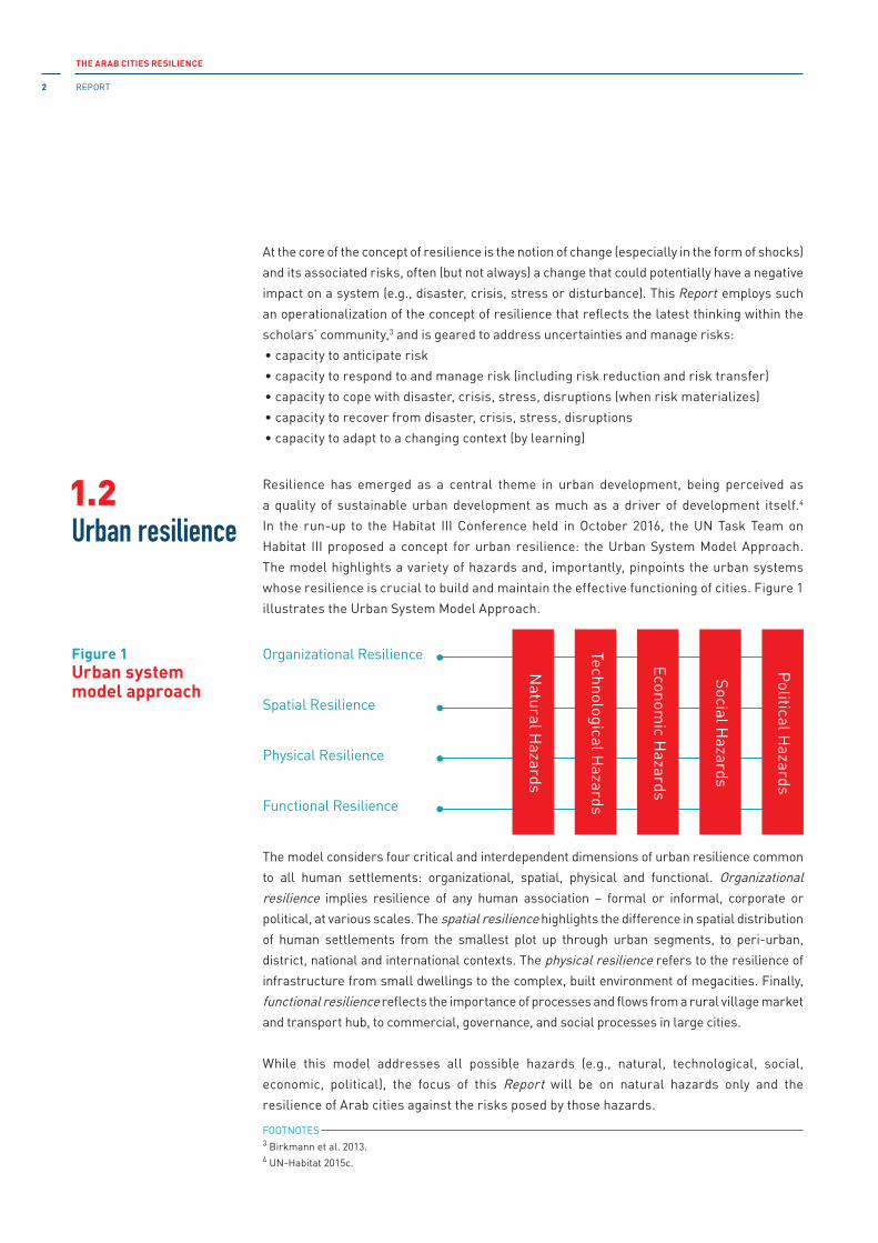
Resilience has emerged as a central theme in urban development, being perceived as
a quality of sustainable urban development as much as a driver of development itself.4
in the run-up to the Habitat iii Conference held in October 2016, the UN Task Team on
Habitat iii proposed a concept for urban resilience: the Urban System Model Approach.
The model highlights a variety of hazards and, importantly, pinpoints the urban systems
whose resilience is crucial to build and maintain the effective functioning of cities. Figure 1
illustrates the Urban System Model Approach.
The model considers four critical and interdependent dimensions of urban resilience common
to all human settlements: organizational, spatial, physical and functional. Organizational resilience implies resilience of any human association – formal or informal, corporate or
political, at various scales. The spatial resilience highlights the difference in spatial distribution
of human settlements from the smallest plot up through urban segments, to peri-urban,
district, national and international contexts. The physical resilience refers to the resilience of
infrastructure from small dwellings to the complex, built environment of megacities. Finally,
functional resilience reflects the importance of processes and flows from a rural village market
and transport hub, to commercial, governance, and social processes in large cities.
While this model addresses all possible hazards (e.g., natural, technological, social,
economic, political), the focus of this Report will be on natural hazards only and the
resilience of Arab cities against the risks posed by those hazards.
Organizational Resilience
Spatial Resilience
Physical Resilience
Functional Resilience
Political H
azards
Social Hazards
Economic H
azards
Technological Hazards
Natural H
azards
Urban resilience1.2
Figure 1Urban system model approach
At the core of the concept of resilience is the notion of change (especially in the form of shocks)
and its associated risks, often (but not always) a change that could potentially have a negative
impact on a system (e.g., disaster, crisis, stress or disturbance). This Report employs such
an operationalization of the concept of resilience that reflects the latest thinking within the
scholars’ community,3 and is geared to address uncertainties and manage risks:
• capacity to anticipate risk
• capacity to respond to and manage risk (including risk reduction and risk transfer)
• capacity to cope with disaster, crisis, stress, disruptions (when risk materializes)
• capacity to recover from disaster, crisis, stress, disruptions
• capacity to adapt to a changing context (by learning)
FOOTNOTES 3 Birkmann et al. 2013. 4 UN-Habitat 2015c.
CHAPTER 1
Conceptualizing urban resilience to natural hazards 3
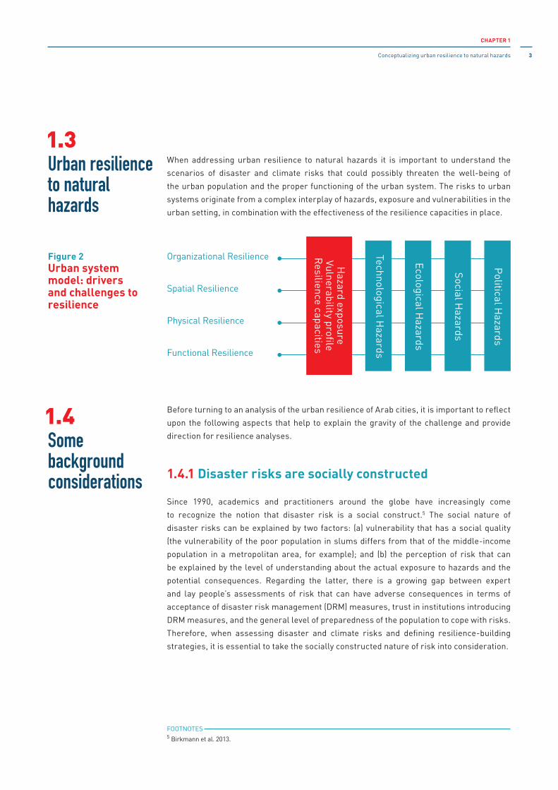
When addressing urban resilience to natural hazards it is important to understand the
scenarios of disaster and climate risks that could possibly threaten the well-being of
the urban population and the proper functioning of the urban system. The risks to urban
systems originate from a complex interplay of hazards, exposure and vulnerabilities in the
urban setting, in combination with the effectiveness of the resilience capacities in place.
Before turning to an analysis of the urban resilience of Arab cities, it is important to reflect
upon the following aspects that help to explain the gravity of the challenge and provide
direction for resilience analyses.
1.4.1 Disaster risks are socially constructed
Since 1990, academics and practitioners around the globe have increasingly come
to recognize the notion that disaster risk is a social construct.5 The social nature of
disaster risks can be explained by two factors: (a) vulnerability that has a social quality
(the vulnerability of the poor population in slums differs from that of the middle-income
population in a metropolitan area, for example); and (b) the perception of risk that can
be explained by the level of understanding about the actual exposure to hazards and the
potential consequences. Regarding the latter, there is a growing gap between expert
and lay people’s assessments of risk that can have adverse consequences in terms of
acceptance of disaster risk management (DRM) measures, trust in institutions introducing
DRM measures, and the general level of preparedness of the population to cope with risks.
Therefore, when assessing disaster and climate risks and defining resilience-building
strategies, it is essential to take the socially constructed nature of risk into consideration.
FOOTNOTES 5 Birkmann et al. 2013.
Organizational Resilience
Spatial Resilience
Physical Resilience
Functional Resilience
Political H
azards
Social Hazards
Ecological Hazards
Technological Hazards
Hazard exposure
Vulnerability profileR
esilience capacities
Urban resilience to natural hazards
Some background considerations
1.3
1.4
Figure 2Urban system model: drivers and challenges to resilience

THE ARAB CITIES RESILIENCE
REPORT4
1.4.2 Understanding emerging disaster and climate risks is increasingly difficult
in its review Future Global Shocks (OECD 2011), the Organisation for Economic Co-operation
and Development emphasized that in the future, the task of assessing risk will be made all the
more difficult by the interaction of known risks with previously unknown or unprepared-for
vulnerabilities. While this argument is made in regard to global shocks and novel hazards, it
equally applies when addressing risks from natural hazards, because it is difficult to ascertain,
due to ever-growing interdependencies, the distributional effects of disaster and climate risks
across geographic regions, sectors, industries and generations. This makes it necessary to
take into account not only the known risks, but also the unknown ones. This challenges the
capacity of the relevant agencies to anticipate, plan and respond to emerging risks and, most
importantly, how their effects could cascade across various systems. Therefore, resilience-
building strategies should be focused not only on adaptation to or reduction of predictable
risks, but also on creating the necessary conditions for pre-adaptation, also called exaptation
(a generic trait gets used for something else, unexpectedly by surprise).6
This requires building certain qualities into a resilient system. in its City Resilience index,
for example, the Rockefeller Foundation explores various indicators of a resilient system,
among which are redundancy, or the spare capacity of a system to be able to accommodate
a disaster, and flexibility – when a system can evolve and adapt in response to a change,
which in turn would imply a degree of decentralization in the system.
1.4.3 Emerging vulnerabilities require regular relevance checks
One of the confident conclusions of the iPCC landmark publication, Managing the Risks of Extreme Events and Disasters to Advance Climate Change Adaptation, is that “vulnerability
and exposure are dynamic, varying across temporal and spatial scales, and depend on economic,
social, geographic, demographic, cultural, institutional, governance, and environmental
factors.”7 The relevance of this statement can be further emphasized from the resilience
perspective. Aggravation of vulnerability will inevitably change (lower) the threshold8 of the
system’s susceptibility to the severity of a natural hazard. That is why many would argue that
reducing vulnerabilities and improving livelihoods could be considered a means to improve
resilience.9 A changing vulnerability context explains the emerging or re-emerging nature
of disaster or climate risks. Therefore, when setting up resilience indicators and standards
for resilience-building, it is also important to carry out regular relevance checks (in light
of the changed hazard and vulnerability profile) of the resilience threshold, and thus the
targets for resilience-building.
FOOTNOTES 6 Dave Snowden, Cognitive Edge, http://cognitive-edge.com. See also his public lecture at the Ohio State Wexner
Medical Center [https://www.youtube.com/watch?v=pHjeFFGug1Y]. Accessed 25 February 2018.7 iPCC 2012, p. 67.8 Climate threshold: “A critical limit within the climate system that induces a non-linear response to a given forcing.”
See also Abrupt climate change (ibid, p. 557).9 iDS 1992.

CHAPTER 1
Conceptualizing urban resilience to natural hazards 5
1.4.4 Resilience-building has to be sufficiently future-oriented
in addressing resilience, it should be recognized that resilience-building requires a time
horizon well beyond today. There is no need to build resilience to today’s risks if they are
likely to change significantly in the future. Defining which time horizon in the future to target
could potentially explain the pace of resilience-building, standards and indicators, and type
of planning required, as well as the outcomes of the resilience-building effort. Therefore,
when designing and implementing resilience programs, the time horizon identified by
different stakeholders for resilience-building across various dimensions of the urban
system needs to be carefully considered.
1.4.5 Resilience-building requires trade-offs
Resilience-building is a political decision. it often has trade-offs that require some amount
of risk to be tolerated in one or more areas, for one or another stakeholder. in a resource-
constrained context, there will always be trade-offs between what is practical, what is fair,
what is affordable, etc. Ultimately, addressing resilience requires careful consideration
about which risks matter and therefore, which risks to prioritize and which to tolerate.
in building resilience there will be winners and losers. Therefore, resilience-building
inevitably is intertwined with issues of equality in society. This is relevant even when
comparing risks across the same time horizon or those that target a different time horizon.
Trade-offs in making decisions about resilience investments has to be driven by ethical and
practical considerations, which closely relates to the following statement.
1.4.6 Resilience is not necessarily good or bad
investment in resilience-building has to be justified. it might very well be the case that
instead of investing in building resilience it may be more prudent to allow the system to cross
the threshold. For example, it may not be justified to invest in building resilient housing in
coastal areas that will be subject to significant inundation over a period of ten years due
to the changing climate. instead, the best option might be to relocate the settlement to
other areas. Therefore, the focus is not on resilience per se but on a tailored response
to the risks that populations, ecosystems and infrastructures are facing in a given time
frame. Again, the question is: Whose risks set the priorities when addressing disasters and
climate change?

THE ARAB CITIES RESILIENCE
REPORT6
1.4.7 Resilience of critical infrastructure with supranational significance raises global risk governance issues
When building urban resilience to natural disasters and climate risks it is also important
to acknowledge that large cities often host critical infrastructure (Ci) with a regional or
even global significance. The disruption of properly functioning Cis by disasters could have
potential ramifications impacting sectors and territorial jurisdictions, extending far beyond
the city itself. Such risks raise numerous questions concerning global risk governance.
1.4.8 Domino effect of risk impact in cities10
The unique dynamics of risk in urban settings rest in the intricate links between cities
and disasters that evolve in two directions: disaster causes the destruction of the built
environment, while at the same time, the inherent organizational, spatial, physical and
institutional nature of the urban fabric in itself increases the risk: intensifying hazards
or creating new ones, exacerbating vulnerabilities, and negatively affecting existing
response and recovery mechanisms. The city-disasters nexus needs to be explored from
this reciprocal perspective, recognizing that risk can travel across sectors, industries,
geographic locations, generations, etc.
1.4.9 Disrupted cause and effect relationships of risk
Such disruption occurs in various dimensions: across generations, geographic borders,
jurisdictions, sectors and institutions – a butterfly effect that often escapes our attention.
For instance, the factors generating and amplifying risk might be contributed to by one
group of actors, whereas the effects of the risk can be significant for another group. Risks
we cause today may have an impact over generations (think of climate change, for instance).
This requires a more holistic approach in understanding and responding to disaster and
climate risks. Resilience-building, therefore, is inevitably linked with the multiplicity and
interconnectedness of various risks across different domains that could potentially be
triggered or exacerbated by a disaster or climate risks.
FOOTNOTES 10 This paragraph is indebted to C. Wamsler and E. Brink, “The Urban Domino Effect: A Conceptualization of Cities’
interconnectedness of Risk.” input paper for the Global Assessment Report on Disaster Risk Reduction (GAR) 2015.
Available at https://www.unisdr.org/we/inform/publications/48146.

CHAPTER 1
Conceptualizing urban resilience to natural hazards 7
The selection of indicators depends on the assumption of what is being measured or
assessed: is resilience a process or is it an outcome? To be able to measure resilience, it is
important to address the following questions: The resilience of what? To what? For whom?
For what purpose?
it is difficult to recognize resilience in action. Some would argue that resilience cannot
be measured, but only illustrated in perspective (e.g., more resilient than before or more
resilient than others). However, there is growing consensus that “measuring resilience
provides a potentially powerful way to evaluate both intentional change, as in the change
that results from programmes or policies, and unintentional change that comes about as a
result of unforeseen system dynamics.”11
Resilience indicators are often designed to address the goal of positive livelihood outcomes
rather than resilience per se.12 Thus, from this perspective, resilience can be measured
with development indicators. The OECD (2014), for instance, defines various levels and
types of indicators including process, output, and proxy impact indicators. in the meantime,
according to ODi (2015) findings, a resilient system has certain qualities that define the key
set of criteria for resilience indicators: learning, options and flexibility. Learning implies a
better understanding of the hazards and vulnerabilities, awareness of risks, and an ability
to incorporate lessons learned into resilience strategies and programmes. The options, or
diversity, criterion implies access to a variety of means to cope with risks and circumvent
the drivers of vulnerability. Flexibility implies that systems can perform and deliver their
services under a wide range of conditions, including disasters.
While there have been many attempts to conceptualize resilience measurement and its
indicators, there is a practical need to measure resilience using consistent mechanisms,
in order to enhance accountability, guide public investment and define the road map
for improvement. With regard to measuring urban resilience, there are six signficant
developments taking place today:
• UN-Habitat is currently developing a set of indicators to support the implementation of
the Urban System Model Approach. This is a work in progress.
• The World Bank Global Facility for Disaster Reduction and Recovery (GFDRR)13 have
developed the CityStrength Diagnostic tool for risk, resilience, and the performance of
urban systems. The tool is structured around sectoral modules, including community and
social protection, DRM, education, energy, environment, health, water, sanitation, etc.
• The Rockefeller Foundation, together with Arup, has developed the City Resilience
Framework14 that explores the qualities of resilient systems, indicators and categories.
importantly, the focus of this work is on city resilience in all categories, including health
and well-being, the economy and society, infrastructure and environment, as well as
leadership and strategy.FOOTNOTES 11 Quinlan et al. 2015, p. 9 (685).12 ODi 2015.13 http://www.worldbank.org/en/topic/urbandevelopment/brief/citystrength.14 http://www.100resilientcities.org/resilience#/-_/.
Resilience-building indicatorsand targets
1.5
THE ARAB CITIES RESILIENCE
REPORT8
• The OECD is also investigating how cities can increase their resilience through governance,
environment, economy and society.15
• The Resilient City Connect (RCC)16 platform has been established as a partnership between
UNiSDR, the Netherlands’ Ministry of infrastructure and Environment, and the Japan Bosai
Platform (JBP), a business association representing 119 small to large corporations based in
Japan. The RCC platform is deemed a learning place for cities to know more, to invest wisely
and to build more safely. it has become the world’s largest association of local governments,
with more than 3,000 cities and municipalities signed up to the partnership.
• UNiSDR’s Making Cities Resilient Campaign17 focuses solely on building the resilience
of cities to natural disasters and climate risks disasters. UNiSDR has developed and
effectively implemented around the globe the ‘Ten Essentials’ for city municipalities to
comply with in order to make them resilient to disasters. About 3,000 cities had joined the
campaign by 2015. From 2017 onward, an updated version of the Ten Essentials is being
piloted. The handbook for mayors, governors, councillors and other local government
leaders on “How to Make Cities More Resilient” was translated into Arabic and has
been widely disseminated in the region. UNiSDR provided a self-monitoring tool to all
participating cities; the Local Government Self-Assessment Tool (LGSAT) assists local
governments to assess DRR progress, and aids them in addressing gaps and challenges.
UNiSDR has also committed to support the implementation of the standardized performance
measurement of sustainable cities. To measure this, 100 indicators have been defined and
included in iSO 37120:2014,18 developed by the Global City indicators Facility (GCiF)19 and
coordinated by the World Council on City Data (WCCD).20
To address some of the divergence in tools and approaches to building urban resilience,
a new alliance among nine of the world’s largest UN and non-UN organizations,21 called
Medellín Collaboration for Urban Resilience,22 was established at the World Urban Forum
in 2014. its purpose is to foster the harmonization of approaches and tools used in different
contexts for assessing strengths and vulnerabilities to natural hazards.
it is important to recognize another aspect of resilience measurement, which is that
measuring resilience numerically is impractical. Resilience cannot be measured as a
single entity due to the different risks facing people and the varying abilities they may rely
on to address those risks.23
FOOTNOTES 15 http://www.100resilientcities.org/resilience#/-_/.16 https://www.unisdr.org/archive/43216.17 https://www.unisdr.org/we/campaign/cities and https://www.unisdr.org/campaign/resilientcities/.18 http://www.iso.org/iso/37120_briefing_note.pdf.19 http://cityindicators.org.20 http://www.dataforcities.org/wccd/.21 The Collaboration includes: UN Office for Disaster Risk Reduction (UNiSDR), UN-Habitat, the Rockefeller
Foundation’s 100 Resilient Cities Acceleration initiative and C40 Cities Climate Leadership Group, the World Bank,
the Global Facility for Disaster Reduction and Recovery (GFDRR), iCLEi – Local Governments for Sustainability, and
the inter-American Development Bank.22 http://unhabitat.org/new-global-collaboration-for-urban-resilience-announced-at-wuf7/.23 ODi 2014.

CHAPTER 1
Conceptualizing urban resilience to natural hazards 9
With or without numerical measurements, it is important to understand how societies
and communities are changing and how their resilience will evolve in the face of such
changes. There is a need to understand why and how resilience fails, and identify resilience
successes at the same time. Yet there is insufficient understanding of how the human
factors drive or impede resilience, compared with the physical defences and how complex
drivers and inhibitors of resilience are interrelated. This will help to determine when to
introduce mitigation measures in advance of an event, and when to deploy recovery assets.
The foregoing demonstrates the gravity of the challenge and explains how the work on
resilience planning, measurement, indicators, standards and targets is evolving along with
resilience thinking. it has yet to be discussed in the Arab region how cities plan to achieve
resilience, which indicators are more relevant to the local context, how many of them
should be used, and how to identify those targets that address the very specific risks each
city faces. This Report highlights some of the important drivers and inhibitors of urban
resilience in the Arab region.
With growing understanding of the complex relationships between the cause and effect of
risk, the attention is shifted from mainly hazard and vulnerability assessment to governance
considerations. An effective risk governance mechanism (be it a multi-stakeholder fund, an
inter-ministerial committee, an open platform, or another form of collaborative effort) can
provide a legitimate basis for risk response across all dimensions, timely risk communication,
and effective management of both threats and opportunities. This is an emerging reality that
development partners are facing and, most importantly, shaping.
it has become almost a textbook example of UN-Habitat that urban governance is the software
that enables the urban hardware to operate.24 From the perspective of resilience to natural
hazards, urban governance may be seen as the software that enables the urban hardware to
function properly by reducing risks to avoid shocks, and to recover when hit by catastrophes.
The importance of risk governance in building resilience to natural hazards was also
underlined in the Sendai Framework for Disaster Risk Reduction 2015-2030 as necessary
and because it “fosters collaboration and partnership across mechanisms and institutions
for the implementation of instruments relevant to disaster risk reduction and sustainable
development.”25
This Report explores the importance of governance as a primary prerequisite in building
resilience to disasters and climate risk.
FOOTNOTES 24 www.unhabitat.org.25 Sendai Framework for Disaster Risk Reduction 2015-2030 (Geneva, Switzerland; UNiSDR, 20150, p. 17.
Final scoping remark: governance
1.6

THE ARAB CITIES RESILIENCE
REPORT10
2.1.1 Urbanization: regional trends
Even though urbanization trends vary widely between countries, there is a global trend
towards rapidly growing urbanization. in the Arab region, the total population residing in
urban areas reached 55.8 per cent in 2015 and will continue to grow to 58 per cent by 2030
(Figure 3). The level of urbanization varies significantly across the different subregions.
The total population in urban environments is growing in each of the subregions: in the
Mashreq – from 88.5 million in 2015 to 121.6 million in 2030, in the Maghreb – from 64.1
million in 2015 to 82.6 million in 2030, in the GCC – from 43.3 million in 2015 to 54.6 million in
2030, and in the STC – from 27.5 million in 2015 to 45.2 million in 2030. The most urbanized
subregion is the GCC (82.2 per cent in 2015 and projected at 84.3 per cent in 2030). The least
urbanized area is the STC (34.6 per cent in 2015 and 40.6 per cent in 2030). The ranking of
the subregion urban population will not change in 2030, but the STC subregion will come
very close to the GCC subregion.
Table 1 provides an overview of the key urbanization indicators in the Arab region. The
details of the dynamic for each indicator for the period 2015-2030 are given in Annex 5.
MashreqMashreqMashreqMashreqMashreqMashreq Egypt
LebanonJordanPalestineIraqSyria
LibyaAlgeriaTunisiaMoroccoMauritania
DjiboutiSomaliaYemenSudanComoros
Mashreq Total
GCCGCCGCCGCCGCCGCC Oman
QatarKuwaitBahrainEmiratesSaudi Arabia
87.883.775.369.557.743.1
78.670.766.860.259.9
77.339.634.633.828.3
99.298.388.885.583.177.6
3.183.792.813.011.371.68
1.132.771.382.263.54
1.604.064.032.542.67
6.023.631.712.872.108.54
0.140.290.300.130.700.05
0.230.930.270.851.09
0.091.191.730.430.27
0.120.020.050.350.250.65
-12.9
-47.219.310.6
8.013.179.9
73.660.891.669.6
-
GCC Total
MaghrebMaghrebMaghrebMaghrebMaghrebMaghreb Total
STC Total
STCSTCSTCSTCSTC
Grand Total
4 4376 4353 423
24 84712 83736 53888 517
4 96228 739
7 51020 439
2 442
6964 3998 837
13 391218
2 3333 5241 2078 192
24 8543 228
43 338
64 093
27 541
223 489
Region Country% of Population in
Urban AreasUrban Population,
1000
Average Annual Rateof Change of the
UrbanPopulation,%
Average Annual Rateof Change of the
PercentageUrban,%
Slum population as apercentage of urbanpopulation, 2014, %
Urban exposureand vulnerability
02Urbanization profile
2.1
Table 1Main urbanization indicatorsfor subregionsand countries in 2015
Source: The UN Department of Economic and Social Affairs (DESA)/ UN Population Division (UNPD), World Population Prospects[https://esa.un.org/unpd/wpp/DataQuery/].

CHAPTER 2
Urban exposure and vulnerability 11
0
50
100
150
200
250
300
350
2005
169.6
196.8
223.5
250.2
277.1
304.0
2010 2015 2020 2025 2030
0
50
100
150
MashreqMaghrebGCCSTC
200569.8%50.8%29.1%19.9%
79.0%57.0%37.4%23.4%
88.5%64.1%43.3%27.5%
98.9%70.9%47.8%32.6%
109.9%77.2%51.5%38.5%
121.6%82.6%54.6%45.2%
2010 2015 2020 2025 2030
0%
25%
50%
75%
100%
GCCMaghrebMashreqSTCTotal
200581.4%61.4%52.5%31.9%54.0%
82.2%64.3%53.2%33.1%55.7%
82.2%67.0%53.8%34.6%57.0%
83.5%69.2%54.1%36.4%57.9%
84.1%71.0%54.3%38.4%58.7%
84.3%72.5%55.0%40.6%59.5%
2010 2015 2020 2025 2030
Figure 3Urban population percentageof total population,in subregions and total
Figure 4Total population (both sexes), in the region (A) and in the subregions (B), 1000
A
B

THE ARAB CITIES RESILIENCE
REPORT12
Each subregion has its own pattern of urbanization. in the Mashreq subregion in 2015, the
countries with large populations (i.e., Egypt, iraq and Syria, were less urbanized, while
the countries with smaller populations were more urbanized). The average annual rate of
change of the urban population was also greater in countries with smaller population size,
and also in iraq. Egypt is expected to continue to exhibit an exceptionally high urbanization
rate. Despite this dynamic, will remain the least urbanized country in its subregion by 2030,
while Lebanon and Jordan will reach almost 90 per cent urbanization, followed by Palestine
with about 78 per cent and iraq, 72 per cent.
in the Maghreb, with an average urbanization level of more than 50 per cent, Libya was the
most urbanized country (78.6 per cent in 2015, reaching 81.8 per cent by 2030). Each of the
countries shows a slightly reducing rate of urbanization during the period 2015-2030, with
Mauritania, Morocco, and Algeria maintaining the highest rates.
The STC was the subregion with the lowest urbanization level in 2015: the urbanization
level in Sudan is 33.8 per cent (population 13.4 million), Yemen – 34.6 per cent (population
8.8 million), Somalia – 39.6 per cent (population 4.4 million). it is, nevertheless, the fastest
urbanizing subregion in the Arab region, with Somalia being the fastest urbanizing country
in the whole region at 4.05 per cent growth rate in 2015.
The GCC is most urbanized subregion. The urbanization rate for Qatar and Kuwait had
reached 99.2 and 98.3 per cent respectively by 2015. Bahrain, the UAE and Saudi Arabia
have reached an urbanization rate of more than 80 per cent, while for Oman it was 77.6 per
cent in 2015.
2.1.2 Urbanization: focus on Arab cities
The region is characterized by: (a) mushrooming of secondary cities and smaller towns,
and (b) growth of large agglomerations with urban population of more than one million.
Such agglomerations are scattered throughout all the subregions (Table 2). The following
are the largest cities in the Arab region showing positive demographic growth over the
period of 2015-2030:
• Cairo (Egypt): from 18.8 million to 24.5 million by 2030
• Baghdad (iraq): from 6.6 million to 9.7 million by 2030
• Riyadh (Saudi Arabia): from 6.4 million to 7.9 million by 2030
• Khartoum (Sudan): from 5.1 million to 8.2 million by 2030
• Alexandria (Egypt): from 4.8 million to 6.3 million by 2030
• Jeddah (Saudi Arabia): from 4.1 million to 5.0 million by 2030
• Aleppo (Syria): from 3.6 million to 5.1 million by 2030
• Casablanca (Morocco): from 3.5 million to 4.4 million by 2030
• Sanaa (Yemen): from 3.0 million to 5.0 million by 2030
• Kuwait City (Kuwait): from 2.8 million to 3.9 million by 2030
• Mogadishu (Somalia): from 2.1 million to 4.2 million by 2030

CHAPTER 2
Urban exposure and vulnerability 13
Table 2 also shows the positive growth trend for each of the cities. These are also the
cities with the highest average annual urbanization growth rate. The frontrunner, however,
is post-conflict Mogadishu: with a population growth rate of 6.9 per cent, it is considered
to be the second fastest growing city in the world.1 The number of agglomerations with a
population of more than one million in the region will grow from 32 to 45 by 2030: with one
in the GCC, three in the Maghreb, four in the STC and five in the Maghreb (Figure 5). The
total population residing in large agglomerations will therefore rise from 93 million (23 per
cent of the total regional population) to 128 million (24 per cent of the total).
Grand Total
GCCGCCGCCGCCGCCGCC Saudi Arabia
Saudi ArabiaSaudi ArabiaKuwaitEmiratesSaudi Arabia
EmiratesSaudi Arabia
14 256
11 926 12 683 13 501 14 614 15 949 17 151
17 915 22 178 25 006 27 126 28 848MoroccoAlgeria
MoroccoMoroccoMoroccoLibya
MashreqMashreqMashreqMashreqMashreqMashreq
STCSTCSTC
SudanYemenSomalia
Al-Khartum (Khartoum)SanaaMuqdisho (Mogadishu)
STC Total
3 9791 7571 4157 151
4 5172 2911 4268 234
5 1292 9622 138
10 229
5 9053 6432 782
12 330
6 9294 3513 441
14 722
8 1585 0714 176
17 405
Lebanon
EgyptIraqEgyptSyriaSyria
Jordan
IraqSyriaSyriaIraq
Mashreq
GCCGCC Emirates
Al-Madinah (Medina)
Ar-Riyadh (Riyadh)JiddahAl Kuwayt (Kuwait City)Dubayy (Dubai)Makkah (Mecca)
Abu Zaby (Abu Dhabi)Ad-Dammam
Sharjah942
4 2272 8831 5511 2681 326
655765
6401 106
5 2273 4522 1021 7781 543
876909
9191 280
6 3704 0762 7792 4151 771
1 1451 064
1 2791 391
7 1334 4753 2022 8621 912
1 3231 166
1 5421 488
7 6174 7703 5713 1892 039
1 4711 251
1 7301 570
7 9404 9883 9153 4712 146
1 6081 321
1 890
GCCGCC TotalMaghrebMaghrebMaghreb Tunisia
Dar-el-Beida (Casablanca)El DjazaÏr (Algiers)
RabatFèsMarrakechTarablus (Tripoli)
Tunis
3 3012 282
1 647960837
1 058
1 841
3 4052 432
1 7991 061
9741 095
1 916
3 5152 594
1 9671 1721 1341 126
1 993
3 7362 835
2 1721 3051 3061 167
2 093
4 0563 149
2 3851 4391 4501 249
2 222
4 3613 405
2 5741 5591 5721 333
2 347MaghrebMaghrebMaghrebMaghrebMaghreb Total
MashreqMashreqMashreqMashreqMashreqMashreq Iraq Sulaimaniya
Iraq
Bayrut (Beirut)
Al-Qahirah (Cairo)BaghdadAl-Iskandariyah (Alexandria)Halab (Aleppo)Dimashq (Damascus)
Amman
Al-Mawsil (Mosul)Hims (Homs)HamahIrbil (Erbil)
Al-Basrah (Basra)696
1 777
15 1745 3273 9192 6052 201
1 062
1 2361 072
676874
837
37 456836
1 990
16 8995 8914 3333 0782 401
1 109
1 4471 341
9251 009
923
42 1811 004
2 226
18 7726 6434 7783 5622 566
1 155
1 6941 6411 2371 166
1 019
47 4621 191
2 252
20 5687 5445 2254 1402 833
1 162
1 9761 9811 5811 348
1 144
52 9441 379
2 347
22 4328 6025 7334 6003 116
1 251
2 2762 2251 8001 552
1 310
58 6221 571
2 437
24 5029 7106 3135 0873 451
1 355
2 5862 4712 0031 766
1 491
64 742
Region Country or Area Urban Agglomeration 2005 2010 2015 2020 2025 2030 Trend
Mashreq Total
70 789 81 013 93 370 104 895 116 419 128 146
Table 2Population estimates and projections (2005-2030) for urban agglomerations with one million or more inhabitants in 2014 (thousands)
FOOTNOTES 1 http://www.hiiraan.com/news4/2015/Nov/102674/mogadishu_ranked_second_fastest_growing_city_in_the_world.aspx.
Source: The UN Department of Economic and Social Affairs (DESA)/ UN Population Division (UNPD), World Population Prospects[https://esa.un.org/unpd/wpp/DataQuery/].
THE ARAB CITIES RESILIENCE
REPORT14
2.2.1 Demographic profile: a regional perspective
Regional demographic change becomes a strategic issue for policy-makers and
development partners when addressing resilience-building to disasters and climate risks.
Table 3 illustrates the combined elements of demographic context as a whole.2 Even though
the data for urban settings is largely missing, the experience suggests that the pattern of
demographic distribution varies little in urban and rural settings.
There is a positive dynamic of the population growth in the Arab region. By 2030, the total
population of the region will increase to 528.8 million (compared with 404.8 million in 2015);
the proportions of population growth in the subregions will remain the same throughout
the period of 2015-2030, whereby the Mashreq will remain the largest subregion, followed
by the GCC countries, the Maghreb, and the STC respectively.
Trending is the proportion of the young males across the whole region, in which the STC
population is the youngest. Median age varies from 16.5 (Somalia) to 30.3 (Bahrain).
FOOTNOTES 2 All data was taken from the United Nations Department of Economic and Social Affairs Population Division World
Population Prospects, the 2015 edition [http://esa.un.org/unpd/wpp/Download/Standard/Population/].
Median age, 2015
■ Total population, ■ 2015 Median age, 2015
Population, 2015 (thousands)
0
10
20
30
40
50
45
35
25
15
5
2005 2010 2015 2020 2025 2030
5
5
3
10
6
6
3
13
9
7
3
14
9
9
4
16
10
10
6
18
10
10
7
9
STC
Maghreb
GCC
Mashreq
28.024.020.016.012.08.04.00
150 000
100 000
50 000
0Somalia
10 787
16.5
Palestine
4 668
19.3
Iraq
36 423
19.3
Yemen
26 832
19.3 19.3
Sudan
40 235
Comoros
788
18 .7
Mauritania
4 068
19.8
Syria
18 502
20.8
Jordan
7 595
22.5
Djibouti
888
23.6
Egypt
91 508
24.7
Figure 5The calculated and projected number, per subregion, of urban agglomerations with one million or more inhabitants from 2005 to 2030
Figure 6Countries withthe youngest median age in 2015
Demographic and socioeconomic profile
2.2

CHAPTER 2
Urban exposure and vulnerability 15
Another important characteristic is the net migration rate, which is negative for all countries
in the STC, and the Maghreb subregions for the period 2015-2030. The Mashreq will remain
the largest migration subregion in 2015-2030. Palestine has negative net migration rate,
whereas Lebanon and Jordan experience influx of migrants. Syria is experiencing extreme
out-migration due to war, which requires significant corrections of the predictions suggested
by the available data. The GCC is the only subregion that exhibits a stable positive net
migration rate, with the exception of Oman.
Region Country
TotalPopulation,1000
Grouthrate %
Sex Ratio,Age 15-25
MedianAge, year
TotalFertility
Male 15-49,1000
NetMigrationRate, %
Number ofMigrants,1000
Mashreq EgyptMashreq IraqMashreq SyriaMashreq JordanMashreq LebanonMashreq PalestineMashreq Total Maghreb AlgeriaMaghreb MoroccoMaghreb TunisiaMaghreb LibyaMaghreb MauritaniaMaghreb TotalSTC SudanSTC YemenSTC SomaliaSTC DjiboutiSTC ComorosSTC Total GCC Saudi ArabiaGCC EmiratesGCC OmanGCC KuwaitGCC QatarGCC BahrainGCC TotalGrandTotal
91 508 2.18 104.5 24.7 3.38 23 734 -0.5 -216 36 423 3.31 105.1 19.3 4.64 9 133 3.3 549 18 502 -2.27 109.3 20.8 3.03 4 671 -41.1 -4030 7 595 3.06 104.2 22.5 3.51 2 081 6.5 230 5 851 5.99 93.3 28.5 1.72 1 593 49.1 1 250 4 668 2.75 104.0 19.3 4.28 1 192 -2.0 -44 164 548 42 403 -2 261 39 667 1.92 103.3 27.6 2.93 10 833 -0.8 -143 34 378 1.37 104.0 28.0 2.56 8 895 -1.9 -311 11 254 1.12 103.6 31.2 2.16 2 991 -0.6 -33 6 278 0.04 100.9 27.5 2.53 1 745 -16.0 -502 4 068 2.49 103.1 19.8 4.69 1 011 -1.0 -20 95 644 25 475 -1009 40 235 2.16 102.2 19.4 4.46 9 877 -4.2 -800 26 832 2.57 103.7 19.3 4.35 6 848 -0.4 -50 10 787 2.37 100.2 16.5 6.61 2 370 -7.9 -400 888 1.33 102.3 23.6 3.30 242 -3.7 -16 788 2.42 103.2 19.7 4.60 197 -2.7 -10 79 531 19 535 -1 276 31 540 2.32 101.0 28.3 2.85 10 789 5.7 850 9 157 1.89 186.4 33.3 1.82 5 294 9.3 405 4 491 8.45 152.7 29.0 2.88 2 218 65.2 1 211 3 892 4.81 102.7 31.0 2.15 1 495 29.8 518 2 235 4.72 311.2 30.7 2.08 1 303 36.3 364 1 377 1.76 153.2 30.2 2.10 597 4.5 30 52 693 21 697 3 377 392 141 109 110 -1 169
Table 3Combined table showing demographic situation in the Arab region per subregion and per country in 2015
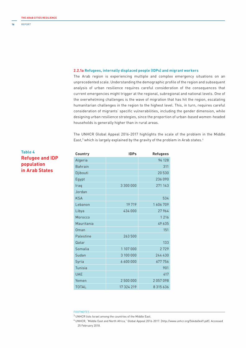
THE ARAB CITIES RESILIENCE
REPORT16
2.2.1a Refugees, internally displaced people (IDPs) and migrant workers
The Arab region is experiencing multiple and complex emergency situations on an
unprecedented scale. Understanding the demographic profile of the region and subsequent
analysis of urban resilience requires careful consideration of the consequences that
current emergencies might trigger at the regional, subregional and national levels. One of
the overwhelming challenges is the wave of migration that has hit the region, escalating
humanitarian challenges in the region to the highest level. This, in turn, requires careful
consideration of migrants’ specific vulnerabilities, including the gender dimension, while
designing urban resilience strategies, since the proportion of urban-based women-headed
households is generally higher than in rural areas.
The UNHCR Global Appeal 2016-2017 highlights the scale of the problem in the Middle
East,3 which is largely explained by the gravity of the problem in Arab states.4
Country IDPs Refugees
Algeria 94 128
Bahrain 311
Djibouti 20 530
Egypt 236 090
iraq 3 300 000 271 143
Jordan
KSA 534
Lebanon 19 719 1 606 709
Libya 434 000 27 964
Morocco 1 216
Mauritania 49 635
Oman 151
Palestine 263 500
Qatar 133
Somalia 1 107 000 2 729
Sudan 3 100 000 244 430
Syria 6 600 000 677 756
Tunisia 901
UAE 417
Yemen 2 500 000 2 057 098
TOTAL 17 324 219 8 315 636
Table 4Refugee and IDP populationin Arab States
FOOTNOTES 3 UNHCR lists israel among the countries of the Middle East.4 UNHCR, “Middle East and North Africa,” Global Appeal 2016-2017. [http://www.unhcr.org/564da0e49.pdf]. Accessed
25 February 2018.

CHAPTER 2
Urban exposure and vulnerability 17
This region is one of origin, destination and transit of refugees and migrants, whereby the
number of iDPs, at 17.3 million, is by far the largest in the world. in the fifth year of the
conflict in Syria, there were more than 6.7 million Syrian refugees and some 6.6 million
internally displaced persons (iDPs) in the region. Over one million Syrians have sought
asylum in more than 90 countries outside the region.5 Since the escalation of the conflict
in Yemen in March 2015, more than 2.3 million people have been internally displaced and
nearly 100,000 more have fled the country. iraq alone hosts 3.2 million iDPs.6 iraq, Libya,
Palestine, Somalia and Sudan are also home to large number of iDPs.
The overwhelming burden of the refugees has been unevenly spread across the Arab states,
whereby Lebanon and Jordan had received the largest portion of refugees by the end of
2014.7 in fact, the UNHCR reports that Jordan is ranked second in the world for the number
of refugees (90) per 1,000 inhabitants. The top country is Lebanon, with a staggering 209.8
Algeria, Egypt, iraq, Sudan, Syria and Yemen are also hosting refugee populations.
Analysing demographic data – total population and median age of population – through the
prism of mobility, and based on these two indicators, Egypt, iraq, Sudan and Yemen remain
the top countries of origin for migration.
The Gulf region is also home to 32 million9 migrant workers mostly from Asia and the Arab
States. Most of the refugees, migrants and iDPs typically live in urban slums and informal
settlements10 which contributes to their vulnerability. Migrant workers make up the majority
of the population in Bahrain, Oman, Qatar and the United Arab Emirates, offering a new set
of challenges with regards to hazard and climate risks. Most of the migrant workers live in
trying conditions (e.g., in isolated camps, informal settlements and crowded houses). Due
to the lack of the knowledge of Arabic their understanding of risk situations remain weak.
Due to their poor social status they remain among the most vulnerable social groups.
FOOTNOTES 5 ibid: http://www.unhcr.org/pages/4a02db416.html.6 ibid: http://www.unhcr.org/564da0e49.html.7 Amnesty international 2014.8 http://foreignpolicy.com/2016/02/02/the-weakest-links-syria-refugees-migrants-crisis-data-visualization/?utm_
content=buffer52983&utm_medium=social&utm_source=facebook.com&utm_campaign=buffer.9 http://www.ilo.org/beirut/areasofwork/labour-migration/lang--en/index.htm.10 iOM 2015.

THE ARAB CITIES RESILIENCE
REPORT18
2.2.1b Demographic profile: subregional perspective
Each subregion has its own demographic dynamic. The Mashreq (with a population of 165
million in 2015 and 221 million in 2030) remains the largest subregion with Egypt the most
populous country in the whole Arab region. The region is characterized by a predominantly
high population growth rate, which at 2030 will be: 2.47 per cent (iraq), 2.28 per cent (Syria),
2.27 per cent (Palestine), 1.27 per cent (Jordan) and 1.45 per cent (Egypt). Lebanon is the
exception, with negative population growth forecast over the period 2020-2030. it maintains
a relatively high sex ratio (males per 100 females) within the 15-25 age group, with Syria
having very high sex ratio (109) and Lebanon an unusually low ratio for the region (93.3
but increasing to 103 by 2030). Lebanon is projected to see significant migration out of the
country, the highest in the whole region, reaching 27.3 per cent in 2020-2025 and 12.5 per
cent in the period 2025-2030. in addition, Lebanon received over one million refugees since
2011.11 And, as of April 2016, about 650,000 refugees were registered in Jordan.12 This is a
massive burden for a country with a population of only 9.5 million. For comparison, should
the same proportion arrive to the United States, it would represent more than 22 million
refugees. About 250,000 refugees from Syria have settled in iraq, the majority of whom
reside in the Kurdistan Region of iraq (KRi).13
The Maghreb (with a population of 96 million in 2015 and 114 million in 2030) shows a
relatively small population growth rate, from 0.59 per cent in Tunisia to 1.2 per cent in
Algeria by 2030, except for Mauritania that has a 2.08 per cent growth rate. The population
has a relatively high median age and it will continue to show slow growth, ranging from 21
in Mauritania to 36 in Tunisia by 2030. Continuous migration out of the Maghreb over the
period 2005-2030 is expected, with Libya experiencing the highest negative net migration
rate in the Maghreb: -16 per cent, which is largely explained by the civil war in 2011. There
are about 434,900 iDPs in the country.14
The STC (with a population of 79 million in 2015 and 111 million in 2030) is the youngest
subregion with a median age of 18 to 19 years in 2015, with the exception of Djibouti, with
a median age of 23.6. it is also the subregion with the highest fertility rate in the Arab
region in 2015: 6.1 per cent (Somalia), 4.2 per cent (Comoros), 4.1 per cent (Sudan), 3.9 per
cent (Yemen) and 2.9 per cent (Djibouti). By 2030 the total population of this subregion (129
million) will exceed the Maghreb’s (114 million). Continuous and stable migration from the
subregion is taking place ranging from -7.9 per cent in Somalia to -4.2 per cent in Sudan,
-3.7 per cent in Djibouti and -2.7 per cent in Comoros.
As estimated by the internal Displacement Monitoring Centre (iDMC), there are over 1.1
million iDPs in Somalia (however difficult it is to clearly distinguish iDPs from economic
migrants, pastoralists who have moved into urban centres following loss of livestock or
FOOTNOTES 11 http://data.unhcr.org/syrianrefugees/country.php?id=122.12 http://data.unhcr.org/syrianrefugees/country.php?id=107.13 http://data.unhcr.org/syrianrefugees/country.php?id=103.14 http://www.unhcr.org/cgi-bin/texis/vtx/page?page=49e485f36&submit=GO.15 http://www.internal-displacement.org/sub-saharan-africa/somalia/figures-analysis.

CHAPTER 2
Urban exposure and vulnerability 19
iDP returns).15 instead, Djibouti has experienced protracted refugee crisis, having hosted
more than 23,000 mainly Somali refugees and more than 5,000 asylum-seekers (December
2015).16 Human and food insecurity are the main causes for mass movements in this
subregion: disasters such as droughts and conflicts shape the iDP landscape in the STC.
The GCC (with a population of 54 million in 2015 and 69 million in 2030) is the only subregion
with positive net migration. During 2010-2015, net migration into the subregion was 3.4
million, with 5.8 per cent to the UAE and 8.5 per cent to Qatar. These numbers do not take into
account the vast number of illegal migrants in the subregion. The median age is the highest in
the region: ranging from 28.3 years (Saudi Arabia) to 33.3 years (United Arab Emirates). The
subregion has the highest sex ratio in the whole region’s 15-25 age group, especially Qatar
(311), UAE (186), Bahrain (153), and Oman (152).
2.2.2 Regional and subregional socioeconomic profile
A look at some of the main socioeconomic indicators reveals some of the underlying drivers
of vulnerability. Table 5a provides an overview of the main indicators from 2014. This shows
the socioeconomic patterns of subregions and countries at a glance.
Region Country GNIGNI PerCapita
GDPgrowthann., %
Access toelect.,
% of pop.
Internetusers,
%
Womenin nat.
parl., %
GCC Saudi Arabia 759.3 51 320 3.5 97.7 63.7 20GCC Emirates 405.2 67 720 4.6 97.7 90.4 18GCC Qatar 200.3 134 420 4.0 97.7 91.5 0GCC Kuwait 185.0 79 850 -1.6 97.7 78.7 2GCC Oman 65.9 33 690 2.9 97.7 70.2 1GCC Bahrain 28.4 37 680 4.5 97.7 91.0 8Maghreb Algeria 213.8 13 880 3.8 100.0 18.1 32Maghreb Morocco 105.8 7 290 2.4 100.0 56.8 17Maghreb Libya 49.0 16 000 -24.0 100.0 17.8 16Maghreb Tunisia 46.5 11 020 2.7 100.0 46.2 31Maghreb Mauritania 5.0 3 710 6.4 21.8 10.7 25Mashreq Egypt 273.1 10 260 2.2 100.0 31.7 2Mashreq Iraq 226.3 15 030 -2.1 100.0 11.3 25Mashreq Syria 72.0 3 890 96.3 28.1 12Mashreq Lebanon 45.6 17 590 2.0 100.0 74.7 3Mashreq Jordan 34.1 11 910 3.1 99.5 44.0 12Mashreq Palestine 13.1 5 000 -1.5 97.7 53.7STC Sudan 67.3 3 920 3.1 32.6 24.6 24STC Yemen 33.3 3 650 4.2 48.4 22.6 0STC Somalia 5.7 226 2.6 32.7 1.6 14STC Djibouti 1.5 1 878 6.0 53.3 10.7 13STC Comoros 0.6 1 430 2.1 69.3 7.0 3
Table 5aSocial and economic indicators, 2014
FOOTNOTES 16 http://www.unhcr.org/pages/49e483836.html.
■ Data for 2013. Data for GNI and GDP per capita for Syria, Somalia, Djibouti.
Source: World Bank Indicators [https://data.worldbank.org/indicator/].

THE ARAB CITIES RESILIENCE
REPORT20
Table 5bUnemployment rate in 2016, by gender and age group
Unemployment rate --
ILO modelled estimates
(%)
Unemployment -- ILO
modelled estimates
(thousands)
Labour force -- ILO
modelled estimates
(thousands)
Region Country Age Time Total Male Female Total Male Female Total Male Female
Maghreb Algeria 15+ 2016 10.2 8.3 18.6 1218 814 403 11937 9769 2168
Maghreb Algeria 15-24 2016 24.3 20.8 41.7 404 290 114 1664 1391 274
Maghreb Algeria 25+ 2016 7.9 6.3 15.3 814 525 289 10273 8379 1894
Maghreb Libya 15+ 2016 18.4 15.7 26.7 435 281 155 2363 1783 580
Maghreb Libya 15-24 2016 45.7 38.6 64.3 164 100 64 358 259 99
Maghreb Libya 25+ 2016 13.6 11.9 18.9 272 181 91 2006 1525 481
Maghreb Mauritania 15+ 2016 9.8 8.6 12.6 125 75 50 1273 875 398
Maghreb Mauritania 15-24 2016 17.8 15.5 22.5 47 27 20 266 176 89
Maghreb Mauritania 25+ 2016 7.7 6.8 9.8 78 48 30 1007 698 309
Maghreb Morocco 15+ 2016 9.4 9.2 9.9 1179 854 325 12542 9270 3272
Maghreb Morocco 15-24 2016 18.6 19.2 16.8 383 298 85 2056 1552 504
Maghreb Morocco 25+ 2016 7.6 7.2 8.7 796 556 240 10486 7718 2768
Maghreb Tunisia 15+ 2016 15.5 12.6 23.5 633 379 254 4083 3001 1082
Maghreb Tunisia 15-24 2016 36.4 34.5 40.3 215 140 75 593 407 186
Maghreb Tunisia 25+ 2016 12.0 9.2 20.0 418 239 179 3491 2594 896
Maghreb Total 15+ 2016 11.2 9.7 15.8 3591 2404 1187 32198 24699 7500
Maghreb Total 15-24 2016 24.6 22.6 31.0 1213 855 358 4936 3784 1152
Maghreb Total 25+ 2016 8.7 7.4 13.1 2378 1548 829 27262 20915 6348
Mashreq Egypt 15+ 2016 12.4 8.6 25.1 3781 2024 1757 30469 23462 7007
Mashreq Egypt 15-24 2016 34.6 30.6 43.4 1772 1075 697 5120 3512 1608
Mashreq Egypt 25+ 2016 7.9 4.8 19.6 2009 949 1060 25349 19949 5400
Mashreq iraq 15+ 2016 7.9 6.9 11.9 810 567 243 10235 8193 2042
Mashreq iraq 15-24 2016 16.2 14.1 24.2 398 278 120 2465 1969 496
Mashreq iraq 25+ 2016 5.3 4.6 7.9 411 289 123 7770 6224 1546
Mashreq Jordan 15+ 2016 15.3 13.1 25.7 363 256 107 2378 1961 417
Mashreq Jordan 15-24 2016 38.5 33.4 60.6 160 113 47 415 338 77
Mashreq Jordan 25+ 2016 10.4 8.8 17.7 203 143 60 1963 1623 339
Mashreq Lebanon 15+ 2016 6.6 5.3 10.5 142 87 55 2164 1638 526
Mashreq Lebanon 15-24 2016 17.2 15.1 22.0 59 36 23 345 239 106
Mashreq Lebanon 25+ 2016 4.6 3.7 7.6 83 51 32 1820 1400 420
Mashreq Palestine 15+ 2016 26.9 22.2 44.7 353 230 123 1313 1039 275
Mashreq Palestine 15-24 2016 41.6 36.1 67.1 140 100 40 336 277 59
Mashreq Palestine 25+ 2016 21.8 17.1 38.6 213 130 83 977 762 216
Mashreq Syria 15+ 2016 14.8 10.8 38.1 708 441 266 4786 4088 698
Mashreq Syria 15-24 2016 35.1 27.8 80.4 378 258 120 1076 927 149
Mashreq Syria 25+ 2016 8.9 5.8 26.6 330 183 146 3710 3161 550
Mashreq Total 15+ 2016 12.0 8.9 23.3 6157 3607 2551 51346 40381 10965
Mashreq Total 15-24 2016 29.8 25.6 41.9 2907 1861 1046 9757 7262 2495
Mashreq Total 25+ 2016 7.8 5.3 17.8 3250 1746 1504 41589 33119 8470
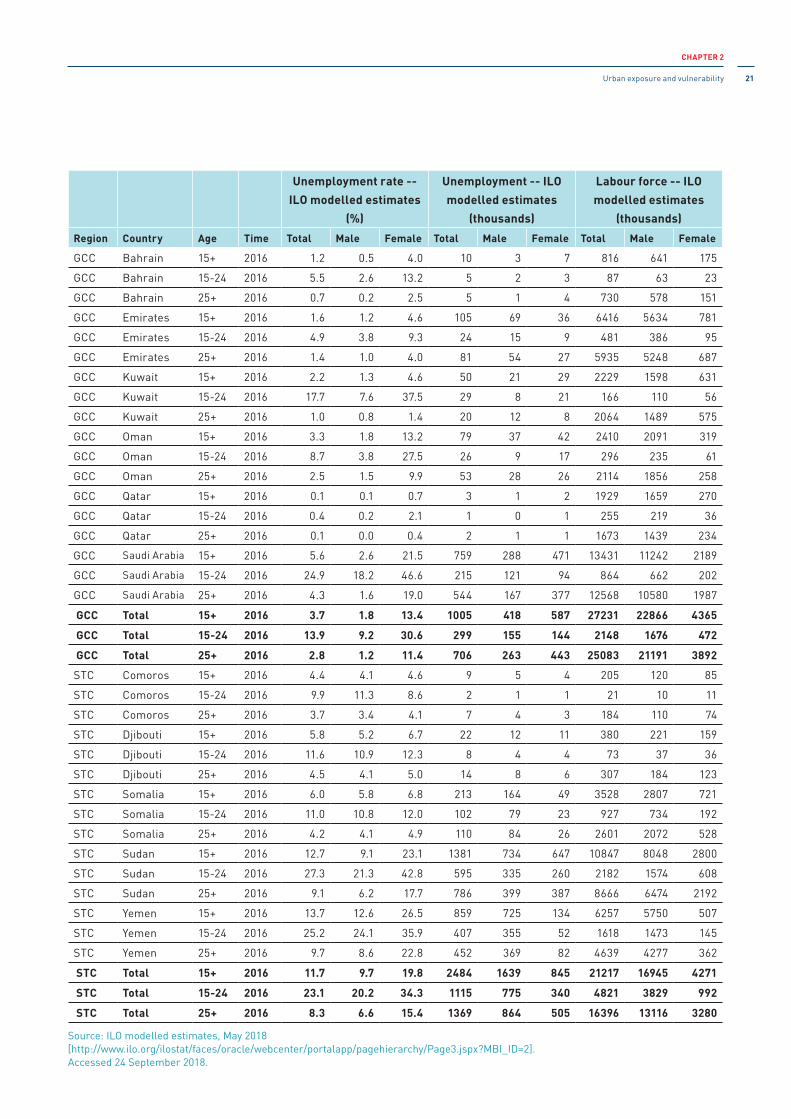
CHAPTER 2
Urban exposure and vulnerability 21
Source: ILO modelled estimates, May 2018[http://www.ilo.org/ilostat/faces/oracle/webcenter/portalapp/pagehierarchy/Page3.jspx?MBI_ID=2].Accessed 24 September 2018.
Unemployment rate --
ILO modelled estimates
(%)
Unemployment -- ILO
modelled estimates
(thousands)
Labour force -- ILO
modelled estimates
(thousands)
Region Country Age Time Total Male Female Total Male Female Total Male Female
GCC Bahrain 15+ 2016 1.2 0.5 4.0 10 3 7 816 641 175
GCC Bahrain 15-24 2016 5.5 2.6 13.2 5 2 3 87 63 23
GCC Bahrain 25+ 2016 0.7 0.2 2.5 5 1 4 730 578 151
GCC Emirates 15+ 2016 1.6 1.2 4.6 105 69 36 6416 5634 781
GCC Emirates 15-24 2016 4.9 3.8 9.3 24 15 9 481 386 95
GCC Emirates 25+ 2016 1.4 1.0 4.0 81 54 27 5935 5248 687
GCC Kuwait 15+ 2016 2.2 1.3 4.6 50 21 29 2229 1598 631
GCC Kuwait 15-24 2016 17.7 7.6 37.5 29 8 21 166 110 56
GCC Kuwait 25+ 2016 1.0 0.8 1.4 20 12 8 2064 1489 575
GCC Oman 15+ 2016 3.3 1.8 13.2 79 37 42 2410 2091 319
GCC Oman 15-24 2016 8.7 3.8 27.5 26 9 17 296 235 61
GCC Oman 25+ 2016 2.5 1.5 9.9 53 28 26 2114 1856 258
GCC Qatar 15+ 2016 0.1 0.1 0.7 3 1 2 1929 1659 270
GCC Qatar 15-24 2016 0.4 0.2 2.1 1 0 1 255 219 36
GCC Qatar 25+ 2016 0.1 0.0 0.4 2 1 1 1673 1439 234
GCC Saudi Arabia 15+ 2016 5.6 2.6 21.5 759 288 471 13431 11242 2189
GCC Saudi Arabia 15-24 2016 24.9 18.2 46.6 215 121 94 864 662 202
GCC Saudi Arabia 25+ 2016 4.3 1.6 19.0 544 167 377 12568 10580 1987
GCC Total 15+ 2016 3.7 1.8 13.4 1005 418 587 27231 22866 4365
GCC Total 15-24 2016 13.9 9.2 30.6 299 155 144 2148 1676 472
GCC Total 25+ 2016 2.8 1.2 11.4 706 263 443 25083 21191 3892
STC Comoros 15+ 2016 4.4 4.1 4.6 9 5 4 205 120 85
STC Comoros 15-24 2016 9.9 11.3 8.6 2 1 1 21 10 11
STC Comoros 25+ 2016 3.7 3.4 4.1 7 4 3 184 110 74
STC Djibouti 15+ 2016 5.8 5.2 6.7 22 12 11 380 221 159
STC Djibouti 15-24 2016 11.6 10.9 12.3 8 4 4 73 37 36
STC Djibouti 25+ 2016 4.5 4.1 5.0 14 8 6 307 184 123
STC Somalia 15+ 2016 6.0 5.8 6.8 213 164 49 3528 2807 721
STC Somalia 15-24 2016 11.0 10.8 12.0 102 79 23 927 734 192
STC Somalia 25+ 2016 4.2 4.1 4.9 110 84 26 2601 2072 528
STC Sudan 15+ 2016 12.7 9.1 23.1 1381 734 647 10847 8048 2800
STC Sudan 15-24 2016 27.3 21.3 42.8 595 335 260 2182 1574 608
STC Sudan 25+ 2016 9.1 6.2 17.7 786 399 387 8666 6474 2192
STC Yemen 15+ 2016 13.7 12.6 26.5 859 725 134 6257 5750 507
STC Yemen 15-24 2016 25.2 24.1 35.9 407 355 52 1618 1473 145
STC Yemen 25+ 2016 9.7 8.6 22.8 452 369 82 4639 4277 362
STC Total 15+ 2016 11.7 9.7 19.8 2484 1639 845 21217 16945 4271
STC Total 15-24 2016 23.1 20.2 34.3 1115 775 340 4821 3829 992
STC Total 25+ 2016 8.3 6.6 15.4 1369 864 505 16396 13116 3280
THE ARAB CITIES RESILIENCE
REPORT22
This table shows two extremes of economic development across the region: Gcc with the
highest Gni per capita, and the STc with the lowest. For comparison, Qatar has 134,420
Gni per capita (the highest in the whole region), whereas Somali has the lowest at 226.
The Maghreb and the Mashreq regions are approximately on the same level of well-being.
The Maghreb countries, except Libya, show positive trends in GDP growth. in the Maghreb,
the highest value of Gni per capita is in Libya (USD 16,000), despite a significant fall in this
indicator (-24 per cent) following the overthrow of Kaddafi, and in Algeria (USD 13,880). The
lowest value is in Mauritania (USD 3710). The STC is the poorest region. All available data
about GDP per capita correspond to low income countries. The World Bank has no data
for Djibouti, but Wikipedia shows GDP 1.6 billion (2004) and GDP per capita USD 1878. Two
countries in this region – Somalia and Yemen – are in civil war.
All the countries in the region exhibit positive annual growth in GDP with exceptions of Libya
(-24 per cent), iraq (-2.1 per cent), Palestine (-1.5 per cent) and Kuwait (-1.6 per cent). This
indicator is absent for Syria, but it is obvious that after seven years of civil war in Syria, it
will be negative and high in absolute value.
The unemployment rate in the GCC countries is relatively low, only high unemployment
rates are scored by the age group 15-24 years in Saudi Arabia (24.9 per cent), Kuwait (17.7
per cent), and Oman (8.7 per cent). in the Mashreq and the Maghreb, the unemployment
rate is moderate, the exceptions being Libya (45.7 per cent) and Tunisia (36.4 per cent) in
the Maghreb, and Palestine (41.6 per cent) in the Mashreq. Similarly, male unemployment
in the age range 15-24 is very high, especially in Libya (38.6 per cent), Palestine (36.1),
Tunisia (34.4) and Jordan (33.4 per cent). This can induce social instability risks. in all the
region, female unemployment is higher than male unemployment, particularly among the
15-24 age groups. in the GCC subregion, this inequality is particularly high in Saudi Arabia
and Kuwait with female unemployment in the 15-24 age range at 46.6 and 37.5 per cent,
respectively, compared to 18.2 and 7.6 per cent of young male unemployment respectively.
The only exception is in Morocco where such inequality tends to disappear and even to
be reversed, with 19.2 per cent of male unemployment against 16.8 per cent of female
unemployment in the 15-24 age range. (See Table 5b)
Another indicator of gender disparity is the percentage of seats held by women in national
parliaments. countries with an extremely low value for this indicator are: Qatar, Kuwait,
Oman (Gcc), Egypt, Lebanon (Mashreq), Yemen, comoros (STc), where there are zero to
three women in the national parliaments. There are eight to eighteen women in parliament
in Bahrain, the UAE (Gcc), Syria, Jordan (Mashreq), Djibouti, Somalia (STc), Libya, and
Morocco (Maghreb). The highest value for this indicator across the whole region is in
Algeria (31) and Tunisia (31).
The level of access to electricity is very high in the GCC, the Mashreq and the Maghreb
countries – almost 100 per cent, except for Mauritania in the Maghreb (21.8 per cent). This
indicator is very low, however, in the STC, especially in Sudan (32.6 per cent), Somalia (32.7
per cent), Yemen (approximately 48 per cent), and Comoros (70 per cent). According to the
international Telecommunication Union (iTC), the internet access indicator is sufficiently
CHAPTER 2
Urban exposure and vulnerability 23
high in the GCC countries (e.g. in UAE, Qatar and Bahrain more than 90 per cent of
population has access to internet). in the Maghreb, the highest values for this indicator are
in Morocco (57.08 per cent) and Tunisia (48.52 per cent). in the Mashreq the highest levels
are in Lebanon (74 per cent), Palestine (57.42 per cent) and Jordan (53.4 per cent). internet
access in the STC is very low. The highest levels are in Sudan (26.61 per cent) and Yemen
(25.6 per cent).
2.2.3 Urban poverty and urban slums
Two important factors to consider while exploring urbanization in the Arab region, are the
percentage of urban slums and the level of urban poverty. Both factors are tightly linked to
inequalities (and deprivation) and the rights-based approach to development.
2.2.3a Urban Poverty
Urban poverty has become a global challenge. Even though the understanding of urban
poverty has advanced significantly during the last 20-25 years, there is still little attention
to urban poverty and a significant conceptual disarray in defining and measuring urban
poverty. Should it entail the level of income or the level of expenditures, or perhaps, access
to basic needs and services, or even the quality of housing? The dollar-a-day poverty line
(and its adjustment to USD 1.90) is one example of the use of overly simplistic income-based
poverty line. it implies that the income needed to avoid poverty is the same everywhere
(whether in large cities, smaller urban centres or rural areas), whereas personal and
household expenditures increase proportionally to urbanization level.17
There is a massive lack of basic data about urban poverty,18 but there are different attempts
to measure urban poverty. Acknowledging that urban poverty has multiple dimensions, for
the purpose of this report, the Alkire-Forster Multidimensional Poverty index (MPi) is used
to explore urban poverty in the Arab states.19 The AF MPi uses micro survey data to reflect
on household deprivation across three areas: education, health and living conditions. Even
though the AF MPi is a global tool for monitoring progress and measuring poverty, no up-to-
date data gathered through nationally representative surveys is available for the Arab region
as a whole. Nevertheless, some indications can be drawn based on already existing data.
Among the 1.7 billion people worldwide defined by the AF MPi as living in multidimensional
(MD) poverty, 2.5 per cent live in Arab States, which means 41.225 million people are MD
poor in this region. There are also 21.5 million people vulnerable to or at risk of MD poverty
in the region, and 18.8 million “severely poor,” representing 9.3 per cent and 7.9 per cent
respectively of the total population of 231.1 million urban people in 2010.20
FOOTNOTES 17 Mitlin 2014.18 Tacoli 2015.19 Nawar 2014.20 ibid.
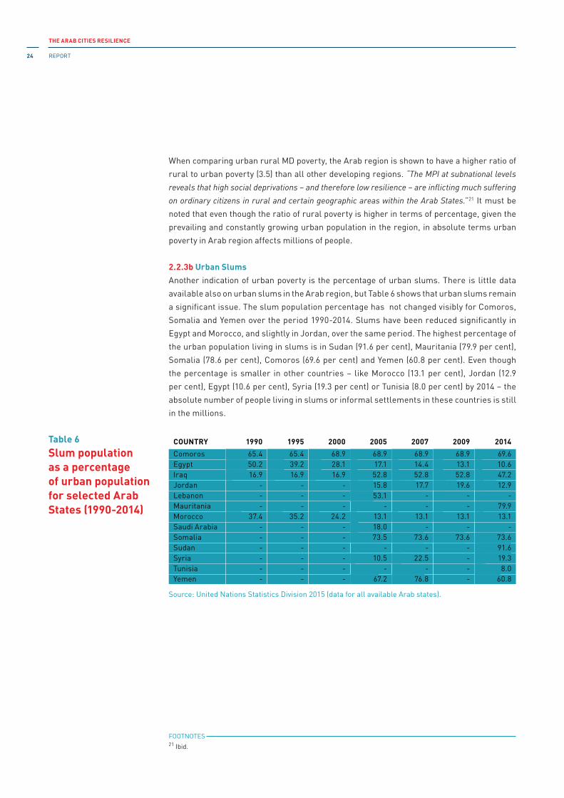
THE ARAB CITIES RESILIENCE
REPORT24
When comparing urban rural MD poverty, the Arab region is shown to have a higher ratio of
rural to urban poverty (3.5) than all other developing regions. “The MPI at subnational levels
reveals that high social deprivations – and therefore low resilience – are inflicting much suffering
on ordinary citizens in rural and certain geographic areas within the Arab States.”21 it must be
noted that even though the ratio of rural poverty is higher in terms of percentage, given the
prevailing and constantly growing urban population in the region, in absolute terms urban
poverty in Arab region affects millions of people.
2.2.3b Urban Slums
Another indication of urban poverty is the percentage of urban slums. There is little data
available also on urban slums in the Arab region, but Table 6 shows that urban slums remain
a significant issue. The slum population percentage has not changed visibly for Comoros,
Somalia and Yemen over the period 1990-2014. Slums have been reduced significantly in
Egypt and Morocco, and slightly in Jordan, over the same period. The highest percentage of
the urban population living in slums is in Sudan (91.6 per cent), Mauritania (79.9 per cent),
Somalia (78.6 per cent), Comoros (69.6 per cent) and Yemen (60.8 per cent). Even though
the percentage is smaller in other countries – like Morocco (13.1 per cent), Jordan (12.9
per cent), Egypt (10.6 per cent), Syria (19.3 per cent) or Tunisia (8.0 per cent) by 2014 – the
absolute number of people living in slums or informal settlements in these countries is still
in the millions.
COUNTRY 1990 1995 2000 2005 2007 2009 2014
Comoros 65.4 65.4 68.9 68.9 68.9 68.9 69.6Egypt 50.2 39.2 28.1 17.1 14.4 13.1 10.6Iraq 16.9 16.9 16.9 52.8 52.8 52.8 47.2Jordan - - - 15.8 17.7 19.6 12.9Lebanon - - - 53.1 - - -Mauritania - - - - - - 79.9Morocco 37.4 35.2 24.2 13.1 13.1 13.1 13.1Saudi Arabia - - - 18.0 - - -Somalia - - - 73.5 73.6 73.6 73.6Sudan - - - - - - 91.6Syria - - - 10.5 22.5 - 19.3Tunisia - - - - - - 8.0Yemen - - - 67.2 76.8 - 60.8
Table 6Slum populationas a percentageof urban population for selected Arab States (1990-2014)
FOOTNOTES 21 ibid.
Source: United Nations Statistics Division 2015 (data for all available Arab states).

CHAPTER 2
Urban exposure and vulnerability 25
Box 1CairoPopulation
Despite many cultural and historical commonalities, countries in the region vary dramatically.
Yet, there are certain dynamics that are quite articulated at the subregional urban level and
provide entry points to ground resilience-building activities in the region.
The Arab region is witnessing an unprecedented rate of urbanization. According to our
calculations based on World Bank indicators, the region already exhibited an average
urbanization growth rate of 3.1 per cent in 2015, which is well above the world average of
2.067 per cent. Most of the population resides in urban areas, with the urban population in
the GCC ranging between 75 and 100 per cent. The STC however remains the least urbanized
subregion (34.5 per cent of urbanization in 2015), yet for the 2015-2030 period it is projected
to show the highest urbanization growth. in 2015 there were already 32 agglomerations in
the region with more than one million inhabitants. This number will grow to 45 by 2030,
with total population exceeding 128 million, with the largest urban populations in Cairo
(Egypt), Baghdad (iraq), and Alexandria (Egypt), with 24.5 million, 9.7 million, and 6.3 million
inhabitants, respectively (UN DESA, 2014).
The population growth dynamic remains positive across the whole region, in which the
higher fertility rate is reflected in the least developed countries in the STC, which also have
the highest percentage of slums: Sudan (91.6 per cent), Comoros (69.6 per cent), Mauritania
(79.9 per cent) and Somalia (73.6 per cent).
The region is characterized by a very young population; more than half the region’s population
is under the age of 25. Median age varies from 16.5 years in Somalia to 30.3 years in Bahrain.
Populations in the STC are both the youngest and the fastest growing. The positive dynamic
created by the growing percentage of the young male population (age 15-24) throughout the
whole region is accompanied by high youth unemployment in all subregions. Finally, the
Maghreb and the Mashreq have the highest average male (respectively 22.6 and 25.6 per
cent) and female (respectively 31.0 and 41.9 per cent) youth unemployment.
Socioeconomic progress is unevenly distributed over the region. Although the average GNi
per capita is more than USD 26,000 in the GCC, it remains at around USD 10,000 in the
Maghreb and the Mashreq, reaching its lowest extreme in the STC at just over USD 2,000.
internet coverage in the region (excluding GCC) remains relatively modest, at around only
26 per cent.
The Greater Cairo province is home to 20 per cent of Egypt’s population, while its area
is no more than two per cent of the total land surface. The Supreme Council for Urban
Planning and Development (under the Council of Ministers) formulated a strategy for
comprehensive development in Egypt until 2050, which indicates that the population
distribution is not proportionate to the surface area of the inhabited regions and outlines
the country’s need for an additional 40,000 feddans* a year in order to accommodate the
population increase.
* A unit of area equivalent to 4200m² / 0.42 hectares / 1.038 acres.
Urbanization in progress: challenges and opportunities for urban resilience
2.3

THE ARAB CITIES RESILIENCE
REPORT26
The gender disparity manifests itself in various aspects of the region’s social fabric. The
predominantly high sex ratio throughout the region, with a disproportionally high ratio
in the GCC (Qatar: 265.5, UAE:274, Oman: 197, Bahrain: 163), will inevitably have a major
impact on the demographic structure, and eventually the urban and socioeconomic profile
of each country in the region. Another indicator of gender disparity is the number of seats in
national parliament held by women, which is very small throughout the whole region, with
the Maghreb countries having on average the highest numbers of women in parliament
(16-32 on average).
Countries in the region are both source, transit and recipient ones of large migrants flows.
in non-oil-producing countries, driven by the high level of unemployment and rising cost
of living, the young male population migrates to cities in search of economic opportunities.
The demographic risk of migration is articulated particularly in Egypt, Sudan, iraq and
Yemen. Oil-producing countries are largely the recipients of migrants. in Kuwait and Qatar,
for example, refugees and migrants make up more than 70 per cent of the population.
Wars and internal conflicts over the past 50 years have caused political instability, damage
to the infrastructure and stunted economic growth. By the end of 2012, rulers had been
forced from power in Tunisia, Egypt, Libya and Yemen. Protests, some major (in Algeria,
iraq, Jordan, Kuwait, Morocco, Sudan and Bahrain), and some minor (in Mauritania,
Oman, Saudi Arabia, Djibouti and Palestine) were seen during the Arab Spring uprising.
Today, the Arab region is immersed in ongoing wars with civil unrest in Syria, Yemen, and
Libya; undergoing the long-drawn-out and periodically escalating tensions in the State of
Palestine, iraq, and Somalia; and still experiencing the ramifications of recent conflicts
in their history (e.g., in Egypt and Sudan). This situation jeopardizes further growth and
prosperity in the region as a whole, and threatens the major cities facing migration influxes
and further escalations of socioeconomic tensions.
Today, the Arab region has the largest number of internally displaced persons (iDPs)
in the world (in iraq, South Sudan and Syria), in which about 40 per cent of the Syrian
population or about 6.6 million people, are currently displaced.22 Since 2011, the Yemeni
crisis has left some 21.1 million people (84 per cent of the total population) fully dependent
on humanitarian aid.23 The spillover effect of this situation is felt throughout the region.
Jordan and Lebanon, for example, host the highest proportion of refugees in the region,
disproportionally high compared to the total population of those countries. Meanwhile, iraq
and Sudan host the world’s third and fourth largest iDP populations (over 3.3 million and
3.1 million, respectively). Palestine is facing the largest and longest refugee crisis in the
history of the world: about 5.1 million refugees according to UNHCR.
FOOTNOTES 22 internal Displacement Monitoring Centre (iDMC). Displacement in Syria as of 21 October 2014 [http://www.internal-
displacement.org/middle-east-and-north-africa/syria/2014/displacement-in-syria-as-of-october-2014]. 23 http://www.unocha.org/yemen.

CHAPTER 2
Urban exposure and vulnerability 27
When looking at urban, demographic, socioeconomic and political drivers, there are key
trends that are contributing to an increased risk exposure throughout the Arab region:
• increased population density;
• high percentage of urban slums predominantly in the STC, as well as some parts of the
Mashreq and the Maghreb;
• high unemployment rates in all subregions, apart from the GCC;
• significant disruption of gender parity;
• uneven socioeconomic progress between countries, subregions and cities. This in turn
implies urban poverty, poor quality housing, infrastructure and services, poor land-use
planning, etc.;
• violent conflict.
These demographic and urbanization changes, triggered by both natural and human-
caused events, inevitably increase the pressure on limited natural resources, stretching
the generative capacity of ecosystems, particularly in urban settings. The high population
density and regular influx of people from rural areas, with large sections of the urban
population living in informal housing and slums, in addition to unplanned urban expansion
often on risky sites with a concomitant concentration of solid and liquid wastes, may
disrupt the normal functioning of the cities’ socioecological systems, rendering a vast
proportion of the population even more vulnerable to disasters and climate risks. The
widening disparities aggravate perceptions of injustice and social exclusion, thereby
multiplying the challenges that municipal authorities face when addressing sustainable
urban development in the region.
in this context, it is critical to find the best ways to balance the ecological and social
constituents of cities, to ensure that they are actually inclusive, safe, resilient and
sustainable, as targeted by Goal 11 of the SDGs.
it is widely recognized that urbanization is a powerful force for economic growth and the
eradication of poverty. Cities also serve as catalysts for collective action, decision-making
and accountability. it has been also proven that “urbanization provides the potential for new
forms of social inclusion, including greater equality, access to services and new opportunities,
and engagement and mobilization that reflects the diversity of cities, countries and the globe.”24
The region is characterized by the rise of large agglomerations with more than one million
inhabitants. One of the aspects of agglomeration essential to economics and productivity
is density:25 population density, economic density and infrastructure density – all of which
allow easy connectivity within and between cities. Meanwhile, population density is the key
source of greater exposure of people, infrastructure and settlements to the risks of natural
hazards. The critical question is how to unlock the greater potential of Arab cities in order
FOOTNOTES 24 UN Habitat 2015.25 World Bank 2009.

THE ARAB CITIES RESILIENCE
REPORT28
to increase resilience and thus ensure sustainable urban development. To this end, it
is important to define the natural hazards facing Arab cities and the range of existing
and emerging risks they will have to confront in order to ensure resilient sustainable
development and prosperity in the future.
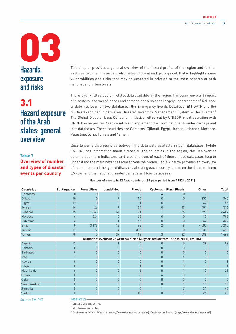
CHAPTER 3
Hazards, exposure and risks 29
This chapter provides a general overview of the hazard profile of the region and further
explores two main hazards: hydrometeorological and geophysical. it also highlights some
vulnerabilities and risks that may be expected in relation to the main hazards at both
national and urban levels.
There is very little disaster-related data available for the region. The occurrence and impact
of disasters in terms of losses and damage has also been largely underreported.1 Reliance
to date has been on two databases: the Emergency Events Database (EM-DAT)2 and the
multi-stakeholder initiative on Disaster inventory Management System – Desinventar.3
The Global Disaster Loss Collection initiative rolled-out by UNiSDR in collaboration with
UNDP has helped ten Arab countries to implement their own national disaster damage and
loss databases. These countries are Comoros, Djibouti, Egypt, Jordan, Lebanon, Morocco,
Palestine, Syria, Tunisia and Yemen.
Despite some discrepancies between the data sets available in both databases, (while
EM-DAT has information about almost all the countries in the region, the Desinventar
data include more indicators) and pros and cons of each of them, these databases help to
understand the main hazards faced across the region. Table 7 below provides an overview
of the number and the type of disasters affecting each country, based on the data sets from
EM-DAT and the national disaster damage and loss databases.
FOOTNOTES 1 Ezzine 2015, pp. 38, 40.2 http://www.emdat.be.3 Desinventar Official Website [https://www.desinventar.org/en/]. Desinventar Sendai [http://www.desinventar.net/].
Countries
Number of events in 22 Arab countries (30 year period from 1982 to 2011)
Earthquakes Forest Fires Landslides Floods Cyclones Flash Floods Other TotalComoros 0 0 0 2 4 0 7 13Djibouti 10 0 7 110 0 0 233 360Egypt 12 0 0 1 0 1 42 56Jordan 16 26 7 94 0 49 401 593Lebanon 35 1 363 64 91 1 156 697 2 407Morocco 6 624 0 66 0 0 10 706Palestine 3 5 1 66 0 0 262 337Syria 0 3 176 13 93 2 8 4 003 7 295Tunisia 17 77 4 336 1 0 1 235 1 670Yemen 70 0 137 112 3 42 1 098 1 462
Number of events in 22 Arab countries (30 year period from 1982 to 2011), EM-DATAlgeria 12 2 1 0 0 5 38 58Bahrain 0 0 0 0 0 0 0 0Emirates 0 0 0 0 0 0 0 0iraq 1 0 0 0 0 4 3 8Kuwait 0 0 0 0 0 1 0 1Libya 0 0 0 1 0 0 0 1Mauritania 0 0 0 6 0 1 15 22Oman 0 0 0 0 4 0 1 5Qatar 0 0 0 0 0 0 0 0Saudi Arabia 0 0 0 0 0 1 11 12Somalia 0 0 0 0 1 7 31 40Sudan 0 0 0 13 0 3 26 42
Hazards,exposureand risks
03Hazard exposure of the Arab states: general overview
3.1
Table 7Overview of number and types of disaster events per country
Source: EM-DAT
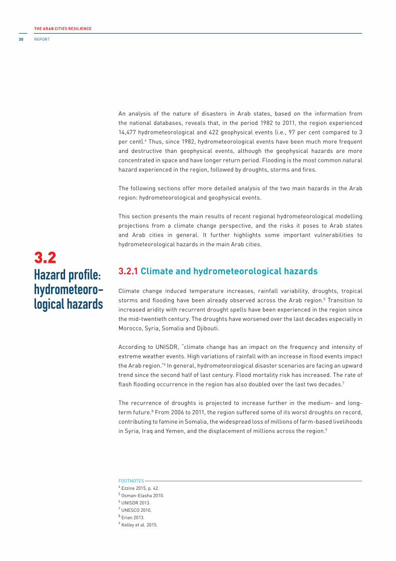
THE ARAB CITIES RESILIENCE
REPORT30
An analysis of the nature of disasters in Arab states, based on the information from
the national databases, reveals that, in the period 1982 to 2011, the region experienced
14,477 hydrometeorological and 422 geophysical events (i.e., 97 per cent compared to 3
per cent).4 Thus, since 1982, hydrometeorological events have been much more frequent
and destructive than geophysical events, although the geophysical hazards are more
concentrated in space and have longer return period. Flooding is the most common natural
hazard experienced in the region, followed by droughts, storms and fires.
The following sections offer more detailed analysis of the two main hazards in the Arab
region: hydrometeorological and geophysical events.
This section presents the main results of recent regional hydrometeorological modelling
projections from a climate change perspective, and the risks it poses to Arab states
and Arab cities in general. it further highlights some important vulnerabilities to
hydrometeorological hazards in the main Arab cities.
3.2.1 Climate and hydrometeorological hazards
Climate change induced temperature increases, rainfall variability, droughts, tropical
storms and flooding have been already observed across the Arab region.5 Transition to
increased aridity with recurrent drought spells have been experienced in the region since
the mid-twentieth century. The droughts have worsened over the last decades especially in
Morocco, Syria, Somalia and Djibouti.
According to UNiSDR, “climate change has an impact on the frequency and intensity of
extreme weather events. High variations of rainfall with an increase in flood events impact
the Arab region.”6 in general, hydrometeorological disaster scenarios are facing an upward
trend since the second half of last century. Flood mortality risk has increased. The rate of
flash flooding occurrence in the region has also doubled over the last two decades.7
The recurrence of droughts is projected to increase further in the medium- and long-
term future.8 From 2006 to 2011, the region suffered some of its worst droughts on record,
contributing to famine in Somalia, the widespread loss of millions of farm-based livelihoods
in Syria, iraq and Yemen, and the displacement of millions across the region.9
Hazard profile: hydrometeoro-logical hazards
3.2
FOOTNOTES 4 Ezzine 2015, p. 42.5 Osman-Elasha 2010.6 UNiSDR 2013.7 UNESCO 2010.8 Erian 2013.9 Kelley et al. 2015.

CHAPTER 3
Hazards, exposure and risks 31
Sea level rise (SLR) has the potential to affect two to four million vulnerable farmers of
the Nile Delta in Egypt. Moreover, SLR is predicted to affect other major cities in the region
including Alexandria, Algiers and Tunis. in addition, the rate of extreme weather events,
including tropical cyclones, coastal erosion, sand storms, strong winds, heat and cold
waves, is increasing across Arab countries. For instance, an estimated 700,000 persons
were internally displaced as a result of climate-induced severe flooding which affected the
low-lying Wadi Hadramout and Al-Mahra in Yemen in 2008.10
The following section highlights more about the impact of climate change on the growth of
disaster risks in the region.
3.2.1a Regional climate
As estimated by the UN after the secession of South Sudan,11 the Arab region covers 13.15
million km2 (more than 2.5 times the size of Western Europe) and stretches from the
Atlantic Ocean to the Zagros Mountains in South-West Asia. The region extends into both
the African and Asian continents, with 72 per cent of the area (9,975,508 km2), and 67 per
cent of the inhabitants (260,718,000) in Africa. The population density, however, is a little
higher in the Asian Arab countries than in the African.12
The climate of Arab countries ranges from Mediterranean, with warm and dry summers and
wet rainy winters, through subtropical zones, with variable amounts of summer monsoon
rains, to deserts with virtually no rain. During the winter, variability in the North Atlantic
Oscillation (NAO) influences storm tracks; annual variations in rainfall in Western and
Central North Africa (the Maghreb), most of the Mashreq and the Arabian Peninsula are
largely governed by this NAO effect. The eastern part of the region (the Mashreq, the Gulf,
and Centre regions) – where it rains mainly during the winter – is almost without rainfall
in summer. The south-eastern area of the region (Yemen and Oman) is influenced by the
indian monsoon system, which is largely controlled by the position of the inter-Tropical
Convergence Zone (iTCZ)13 and therefore has a secondary summer rainfall maximum.
Occasionally, these countries also experience serious consequences due to tropical
cyclones. Environmental challenges in the Arab region include water scarcity, with the
lowest fresh water resource endowment in the world; very low and variable precipitation;
and excessive exposure to extreme events, including drought and desertification.
FOOTNOTES 10 Yemen 2015.11 http://data.un.org/Search.aspx?q=arab+world+surface+area. Accessed 13 December 2016.12 Al-Madhari and Elberier 1996.13 The inter-Tropical Convergence Zone is an equatorial zonal belt of low pressure near the equator where the
northeast trade winds meet the southeast trade winds. As these winds converge, moist air is forced upward,
resulting in a band of heavy rainfall. This band moves seasonally (iPCC Glossary: https://www.ipcc.ch/publications_
and_data/ar4/wg1/en/annexessglossary-e-o.html).

THE ARAB CITIES RESILIENCE
REPORT32
3.2.1b Regional patterns of climate change: expected temperature change and heat
extremes in the Arab region
Warming of 0.2°C per decade has been observed in the region since 1961–1990, and since
then, the warming has been at an even faster rate. Geographically, the strongest warming is
projected to take place close to the Mediterranean coast. Here, as well as in the hinterland
of Algeria, Libya and large parts of Egypt, warming by 3°C (in a 2°C world) is projected
by the end of the century. in a 4°C world, the probability density function of monthly
temperatures (associated with the year-to-year variability of monthly temperatures) shifts
by six standard deviations toward warmer conditions across all regions, from the Sahara to
the Arabian Peninsula to the eastern Mediterranean coast. Such a large shift implies that
summer temperatures here will move to a new climatic regime by the end of the twenty-
first century. Such a dramatic change would be avoided in a 2°C world; (World Bank 2014,
p. 122). Even then, however, a substantial shift is expected to take place: the mean summer
temperatures are expected to be up to 8°C warmer in parts of Algeria, Saudi Arabia and
iraq by the end of the century (Figure 7).
*Temperature anomalies in degrees Celsius (top row) are averaged over the time period 2071–2099 relative to 1951–1980, and normalized by the local standard deviation (bottom row).
Source: World Bank 2014, p.121.
Figure 7Multi-model mean temperature anomaly for Representation Concentration Pathway (RCP) 2.6 (2°C world, left) and RCP 8.5 (4°C world, right) for the months of June-July-August (JJA) in the Middle East and North African region.
MIDDLE EAST AND NORTH AFRICA
121
Figure 4.3: Temperature projections for the Middle East and North African land area compared to the baseline (1951–1980).
Temperature projections for the Middle East and North African land area compared to the baseline (1951–1980) for the multi-model mean (thick line) and individual models (thin lines) under RCP2.6 (2°C world) and RCP8.5 (4°C world) scenarios for the months of JJA. The multi-model mean has been smoothed to give the climatological trend.
Figure 4.4: Multi-model mean temperature anomaly for RCP2.6 (2°C world, left) and RCP8.5 (4°C world, right) for the months of JJA for the Middle East and North African region.
Temperature anomalies in degrees Celsius (top row) are averaged over the time period 2071–2099 relative to 1951–1980, and normalized by the local standard deviation (bottom row).
The multi-model mean warming by 2100 is about 2.5°C in a 2°C world and about 7.5°C in a 4°C world, which is substantially more than the global mean land warming (see Figure 2.5 in World Bank 2013). Under the low-emissions scenario (i.e., a 2°C world), sum-mer temperatures in MENA peak by 2040 at about 2.5°C above the 1951–1980 baseline and remain at this level until the end of the century. In a 4°C world, warming continues almost linearly beyond 2040, reaching about 7.5°C above the 1951–1980 baseline by 2100 (Figure 4.3).
Geographically, the strongest warming is projected to take place close to the Mediterranean coast (see Figure 4.4). Here, and also inland in Algeria, Libya, and large parts of Egypt, regions warm by 3°C in a 2°C world. In a 4°C world, mean summer temperatures in 2071–2099 are expected to be up to 8°C warmer in parts of Algeria. Warming over the Sahel region (i.e., below about 20°N in Figure 4.4) is more moderate (2°C in a 2°C world and 5°C in a 4°C world), which is likely related to an increase in precipitation (see Figure 4.7).
The lower panels of Figure 4.4 show the normalized warm-ing (i.e., the warming expressed in terms of the local year-to-year natural variability—see Section 6.1, Methods for Temperature, Pr ecipitation, Heat Wave, and Aridity Projections) over the Middle
9099_CH04.pdf 121 11/17/14 6:06 PM
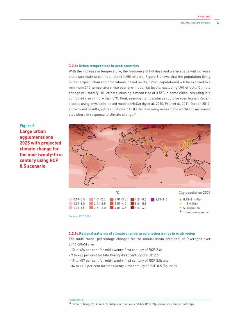
CHAPTER 3
Hazards, exposure and risks 33
3.2.1c Urban temperature in Arab countries
With the increase in temperature, the frequency of hot days and warm spells will increase
and exacerbate urban heat island (UHi) effects. Figure 8 shows that the population living
in the largest urban agglomerations (based on their 2025 populations) will be exposed to a
minimum 2°C temperature rise over pre-industrial levels, excluding UHi effects. Climate
change will modify UHi effects, causing a mean rise of 3.5°C in some cities, resulting in a
combined rise of more than 5°C. Peak seasonal temperatures could be even higher. Recent
studies using physically-based models (McCarthy et al. 2010, Früh et al. 2011, Oleson 2012)
show mixed results, with reductions in UHi effects in many areas of the world and increases
elsewhere in response to climate change.14
3.2.1d Regional patterns of climate change: precipitation trends in Arab region
The multi-model percentage changes for the annual mean precipitation (averaged over
2046–2065) are:
- 10 to +24 per cent for mid-twenty-first century of RCP 2.6;
- 9 to +22 per cent for late twenty-first century of RCP 2.6;
- 19 to +57 per cent for mid-twenty-first century of RCP 8.5; and
- 34 to +112 per cent for late twenty-first century of RCP 8.5 (figure 9).
Figure 8Large urban agglomerations 2025 with projected climate change for the mid-twenty-first century using RCP 8.5 scenario
°C City population 2025
0.19–0.5 0.51–1.0 1.01–1.5
1.51–2.0 2.01–2.5 2.51–3.0
3.01–3.5 3.51–4.0 4.01–4.5
4.51–5.0 5.01–5.5 5.51–6.0
6.01–8.0 0.75–1 million1–5 million5–10 million10 million or more
FOOTNOTES 14 Climate Change 2014: impacts, Adaptation, and Vulnerability, iPCC http://www.ipcc.ch/report/ar5/wg2/
8
Chapter 8 Urban Areas
554
growth rate between 1970 and 2010. Those that had the most rapidpopulation growth rates for these 4 decades are strongly clustered inAsia (especially in China and India) and in Latin America and sub-Saharan Africa (with many on the coast). This map highlights thetemperature rise of greater than 1°C in areas in north and central Asia,western Africa, South America, and parts of North America, indicatingthe potential differential exposure of large cities to climate risk.
Figure 8-3b shows the location of the largest urban agglomerationsaccording to projected populations for 2025 within the world mapshowing projected temperature changes for the mid-21st century, usingRepresentative Concentration Pathway 2.6 (RCP2.6). This is a scenariowith strong mitigation. Projected populations for urban agglomerationswere not made up to 2050 because there is no reliable basis for makingthese. Each urban agglomeration’s future population is much influencedby its economic performance and by social, demographic, economic,and political changes that cannot be predicted so far into the future.Assuming that almost all the large urban agglomerations in 2025 willstill be large urban agglomerations in 2050, Figure 8-3b suggests thata number of large urban agglomerations in almost all continents, will beexposed to a temperature rise of greater than 1.5°C (over preindustriallevels) by mid-century, using the RCP2.6 scenario (IPCC, 2013).
Figure 8-3c shows a similar map showing projected temperaturechanges for the mid-21st century but using the RCP8.5 scenario. This
scenario, based on unchanged current GHG emission trends by mid-century, shows that the bulk of the world’s population living in thelargest urban agglomerations (based on their 2025 populations) will beexposed to a minimum 2°C temperature rise over preindustrial levels,excluding urban heat island effects. By late-century, under the RCP2.6scenario, a number of the urban agglomerations that were among thelargest in 2025 will be exposed to temperature rise of up to 2.5°C overpreindustrial levels (excluding urban heat island effects), especially inthe high latitudes. This implies that mean temperature rise in some citiescould be greater than 4°C. The RCP8.5 scenario by late century (withunchanged current GHG emission trends) shows that the bulk of theworld’s population living in large urban agglomerations will be exposedto a minimum 2.5°C temperature rise. Some cities in high latitudesexperience a mean 3.5°C rise, or greater than 5°C when combined withUHI effects. Peak seasonal temperatures could be even higher.Temperature increases of 6°C to 8°C in the Arctic and temperature risein Antarctica would contribute to sea level rise that would impactcoastal cities across the world.
Increased frequency of hot days and warm spells will exacerbate urbanheat island effects, causing heat-related health problems (Hajat et al.,2010) and, possibly, increased air pollution (Campbell-Lendrum andCorvalan, 2007; Blake et al., 2011), as well as an increase in energydemand for warm season cooling (Lemonsu et al., 2013). Conversely,widespread reduction in periods of very cold weather will mean a
°C0.19–0.5
2.51–3.0
1.51–2.00.51–1.01.01–1.5
3.01–3.5
5.01–5.54.51–5.0
3.51–4.04.01–4.5 5.51–6.0
2.01–2.5
0.75–1 million
10 million or more
1–5 million5–10 million
City population 2025
(c) Large urban agglomerations 2025 with projected climate change for the mid-21st century using RCP8.5
6.01–8.0
Figure 8-3 (continued)
Source: iPCC 2014

THE ARAB CITIES RESILIENCE
REPORT34
Trends in aridity lead to changes in annual water discharge that can be taken as a first-
order approximation of the water resources available to humans. Profound changes in river
run-off are already evident for a 2°C world. Although the Arab region occupies 10 per cent
of the planet, it owns less than one per cent of the world’s fresh water resources, with
available water resources of less than 1,000 m3 per capita per year in all Arab states except
iraq, Syria and Lebanon.
Figure 10 shows the percentage change in the aridity index (Ai).15 Ai is designed to identify
regions with an ongoing precipitation deficit16 and is a standardized measure of water
demand. “Changes in the AI are primarily driven by changes in precipitation causing an increase
in the AI (wetter conditions) south of 25° N (i.e., the Sahel and the most southern part of the
Arabian Peninsula) and a decrease in AI (drier conditions) north of 25° N. The relative increase in
AI values in the southern region is similar to the relative increase in annual mean precipitation
(about 50 per cent wetter conditions), as the change in potential evapotranspiration is small. Note
that this relative increase in AI south of 25° N is superimposed on an already very low AI value,
which results in AI values still classified as arid.”17
Source: World Bank 2014, p. 124
Figure 9Multi-model of the mean percentage change in winter (DJF, top), summer (JJA, middle) and annual (bottom) precipitation for RCP 2.6 (2°C world, left) and RCP 8.5 (4°C world, right) for the Middle East and North Africa by 2071–2099 relative to 1951–1980
FOOTNOTES 15 Ai is calculated as the total annual precipitation divided by the annual potential evapotranspiration (World Bank
2014, p. 126).16 ibid, citing Zomer et al. 2008.17 ibid.

CHAPTER 3
Hazards, exposure and risks 35
Climate change projections show stark differences in the effects across the region.
Although runoff in North Africa and the eastern Mediterranean (including the headwaters
of the Euphrates and the Tigris) is expected to drop by up to 50 per cent, Southern Saudi
Arabia and East Africa (including the headwaters of the Nile) will experience increases
in runoff by up to 50 per cent. Consequently, climate change is projected to reduce water
supplies in the northern and western parts of the Arab region and to increase the supply in
Egypt and the southern part of the region.
Eastern Mediterranean and the Arabian Peninsula are projected to become drier, especially
in the rainy season. Studies on “the projected change in the monthly mean rainfall over the
eastern Mediterranean [...] found a significant decrease in rainfall, on the order of 40 per cent, at
the peak of the rainy season (December and January) over the Mashreq. This change is due to a
reduction in both the frequency and duration of rainy events. Before and after the rainy season,
the situation is less clear, with some areas projected to get wetter and others drier.”18
3.2.2 Risks to urban systems
Due to climate change and the resulting increase in intensity, frequency and duration of
extreme events, stress upon environment “is becoming important in fragile ecosystems and
drylands with limited natural resources as in the Arab region. On the one hand, demographic
growth and high per capita consumption have increased the demand for environmental resources.
On the other hand, environmental depletion and degradation have reduced both the quantity
and the quality of renewable resources. In addition to this supply/demand-induced dynamic, the
unequal distribution of environmental resources must be considered. These combined trends
would create a serious deficit of environmental resources in poor countries and fuel pre-existing
grievances such as ethnic, religious or economic marginalization.”19
Changing climate patterns and the increased risk of hydrometeorological disasters in the
region, strain the ability of Arab States and cities particularly, to provide sufficient water
for people, the economy and ecosystems. “Current projections show that by the year
2025 the water supply in the Arab region will be only 15 per cent of what it was in 1960.”20
Sustainable urban development in the region, therefore, is very much about water scarcity
and the relationship between water and other economic sectors: agriculture, energy,
Figure 10Multi-model mean of the percentage change in the aridity index under RCP 2.6 (2°C world, left) and RCP 8.5 (4°C world, right) for the Middle East and North Africa by 2071–2099 relative to 1951–1980.
Source: World Bank 2014, p. 126
FOOTNOTES 18 World Bank 2012, p. 60, citing Black 2009.19 Erian et al. 2014, p. 32.

THE ARAB CITIES RESILIENCE
REPORT36
health, ecosystem and security. For instance, Yemen has all the chances to become the
first country to run out of water.21
Figure 11 demonstrates the general projected impact of climate change on key sectors in
the Arab region.22 it is also important to highlight the interdependencies and correlations
between various risks across sectors. in the Arab region the nexus between water-food
security and social unrest is becoming more entwined, with potential destabilizing effects
on some countries. The direct and indirect impact of hydrometeorological hazards can
potentially trigger a wide range of different risks for urban systems.
Direct impact
• Changes in precipitation patterns and water cycles will increase the existing problems of
water supply and water quality.
• Cities like Alexandria, located in deltas, are more likely to be affected by coastal flooding
as they may have a lower elevation, suffer natural subsidence to a greater or lesser extent
and, in some cases, receive more water discharge from melting snow-fed rivers (Basra).
• Climate change is expected to increase environment-related diseases. Warmer and/or
wetter breeding seasons will provide ideal conditions for the proliferation of mosquito-
borne diseases, such as puddles where malaria-carrying mosquitoes breed.
• Lack of sanitation and potable water will increase water contamination and food-borne
diseases like cholera, typhoid, diarrhoea, hepatitis and gastroenteritis. Warmer cities
will also lead to an increase in respiratory diseases due to pollution, whose effects are
reinforced by higher temperatures.
• Warming will be felt more in cities because of the urban heat island (UHi) effect that
makes cities warmer than their surroundings by 2°C to 6°C due to the modification of
the land surface and waste heat produced by high energy use. Heat waves that can
kill hundreds of people may become more frequent and intense. The increase of UHi
will cause heat-related health problems23 and, possibly, increased air pollution.24 it is
expected that energy demands will be increased for warm season cooling.25 UHi in the
Arab region and its effect on the population require additional studies.
• Storms, floods and coastal/delta flooding that are expected to be more frequent will
put infrastructure at greater risk. This includes transportation (i.e., roads, railways,
bridges, ports and airports) and communication networks, water supply, sewage, gas
pipelines, drainage, flood and coastal defence systems, power and telecommunication
infrastructure, industrial units and processing plants. in terms of buildings, informal and
traditional housing are the most vulnerable to storms and floods.26
FOOTNOTES 20 UNDP 2013a, p. iV. 21 http://science.time.com/2010/12/14/what-if-yemen-is-first-country-to-run-out-of-water/.22 World Bank 2014, p. xxxiv.23 iPCC 2014a, p. 554, citing Hajat et al 2010.24 ibid, citing Campbell-Lendrum and Corvalán 2007.25 ibid, citing Lemonsu et al. 2013.26 http://base.d-p-h.info/pt/fiches/dph/fiche-dph-8632.html

CHAPTER 3
Hazards, exposure and risks 37
indirect impact
• “Continued urban expansion into hazard-prone areas means that a growing proportion
of urban populations will be at risk of climate-related extreme events and rising food
prices, and thus of increasing poverty levels among urban groups.”27 in this context,
"Mauritania and Yemen stand out as the most food-insecure countries."28
• in combination with non-climatic pressures, a decline in rural livelihood options could
trigger further urban migration, potentially exacerbating urban vulnerability and
intensifying the potential for conflict. Migrants are generally the most vulnerable group
in any city. With no access to the city’s livelihood network and lacking skill sets to enable
them to thrive, these people live in illegal slums with no access to basic amenities. This
group is thus highly vulnerable to a variety of risks arising from living in such hazardous
conditions (e.g., environmental health risks due to poor sanitation and inadequate water
supply, little or no drainage or solid waste disposal services, air and water pollution, as
well as the constant threat of eviction).
• Risk of food insecurity and the breakdown of food systems due to warming, drought and
flooding, as well as precipitation variability and extremes, most particularly affecting
poorer populations in urban and rural settings, as indicated by iPCC (2014a).
• Heat waves could have a major impact on the economy. Episodes of heat cramps, heat
exhaustion and heat stroke would affect the population, primarily the large poorer
section of society. As the immune system weakens due to heat stress, susceptibility to
disease would further increase. The health care expenditure incurred by individuals as
a result would escalate, leading to greater stress. This vicious cycle would therefore
lead to a reduction in human resources. As temperatures increase, the number of days
available for heavy work, like construction, will decrease which may also have a negative
impact on economic growth.
• Climate change may act as a threat multiplier to the security situation in the region
by bringing additional pressures on already scarce resources and by reinforcing pre-
existing threats related to migration following forced displacement.29
FOOTNOTES 27 World Bank 2014, p. xxii, box 2.28 Harrigan 2014, p. 35.29 World Bank 2014, pp. xxvi, 116, 157.
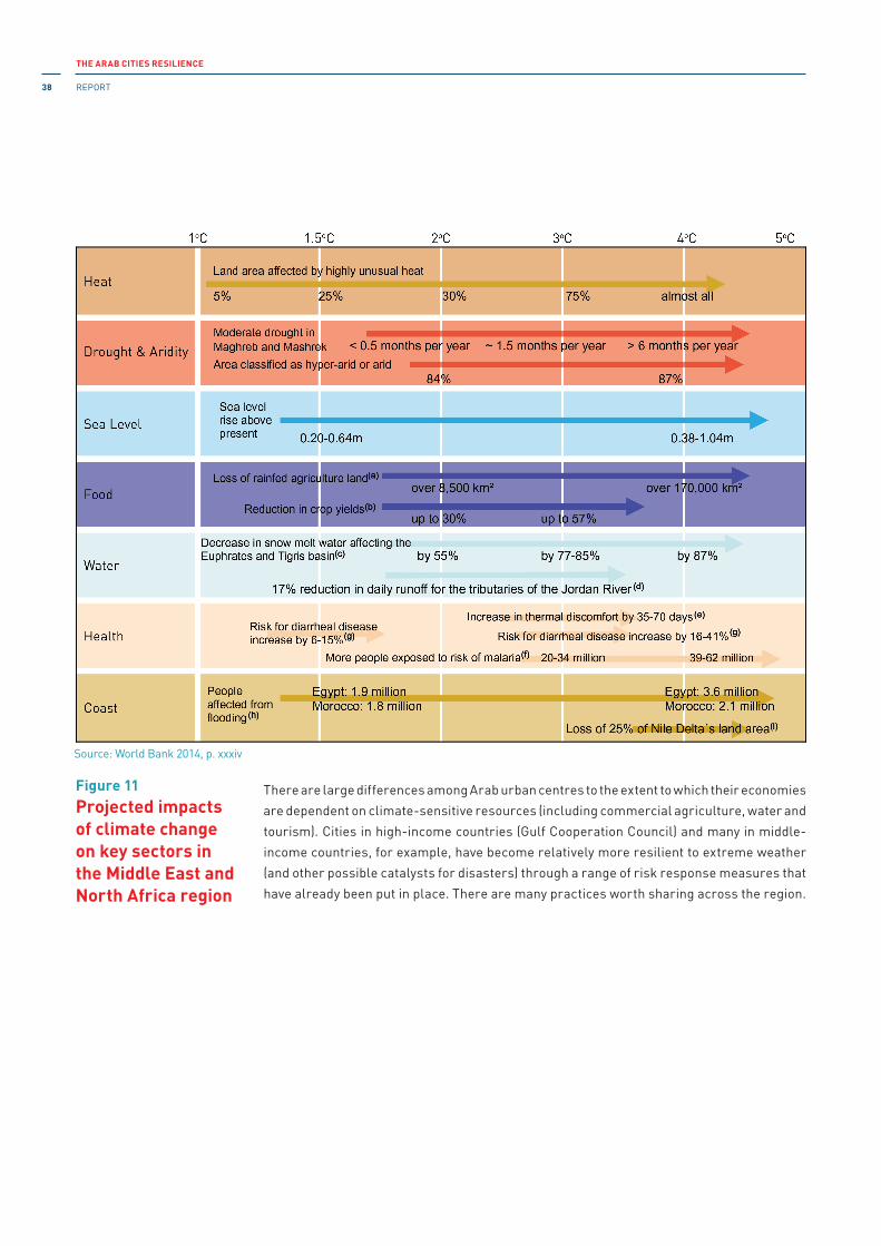
THE ARAB CITIES RESILIENCE
REPORT38
There are large differences among Arab urban centres to the extent to which their economies
are dependent on climate-sensitive resources (including commercial agriculture, water and
tourism). Cities in high-income countries (Gulf Cooperation Council) and many in middle-
income countries, for example, have become relatively more resilient to extreme weather
(and other possible catalysts for disasters) through a range of risk response measures that
have already been put in place. There are many practices worth sharing across the region.
Figure 11Projected impacts of climate change on key sectors in the Middle East and North Africa region
Source: World Bank 2014, p. xxxiv

CHAPTER 3
Hazards, exposure and risks 39
Box 2Flood management measurements at Arsal, al-Fakeha and al-Qaa cities in Beqaa – Lebanon
Northern Beqaa urban areas, such as al-Fakeha and Ras Baalbek, are surrounded by
a mountainous terrain that drains into these areas causing frequent flooding with the
destruction of homes and roads. Major events have occurred in 1987, 1994 1999, 2001,
2004 and 2007.
The vegetation cover in the vicinity of al-Fakeha city was increased in order to mitigate
land degradation from water erosion and reduce the impact of flash floods on the city
and the agricultural land located downstream of the watershed. Two different types of
structures were built to reduce the volume of flood water before it reaches al-Fakeha
city. Surface run-off was diverted into storage structures such as percolation ponds
(hafir). Smaller dispersed structures were built to provide in situ retention of rainfall,
such as stone contour bunds, stone walls, and check dams.
Author: Wadid Erian, Egypt
3.2.3 Special focus area: risk of drought in the main Arab cities
Climate change is likely to increase the frequency of meteorological droughts (aridity and
the duration of dry periods), agricultural droughts (less soil moisture), and hydrological
droughts (shortfalls in water supply) in presently dry regions by the end of the twenty-
first century. Annual maximum wet-bulb temperature (TWmax) increases monotonically in
different locations surrounding the Gulf. Thus, the severest values of annual TWmax occur
in Kuwait and Al Ain, where the 60°C threshold will be frequently exceeded several times
by the end of the century.30 in these locations, 50°C events will become normal during July,
August and September. Rainfall is predicted to decline in parts of the region by 20 to 40 per
cent in a 2°C world and by up to 60 per cent in a 4°C world. Such a combination creates all
the necessary preconditions for drought risk in the region, with widespread consequences
for various systems.
FOOTNOTES 30 Pal and Eltahir 2015, p. 2 (198), considering both dry-bulb temperature (T) and wet-bulb temperature (TW),
specifically their daily maxima averages over 6 hours [which is considered the maximum duration fit humans can
survive at 35°C] denoted by Tmax and TWmax respectively. (ibid. p. 1[197])..
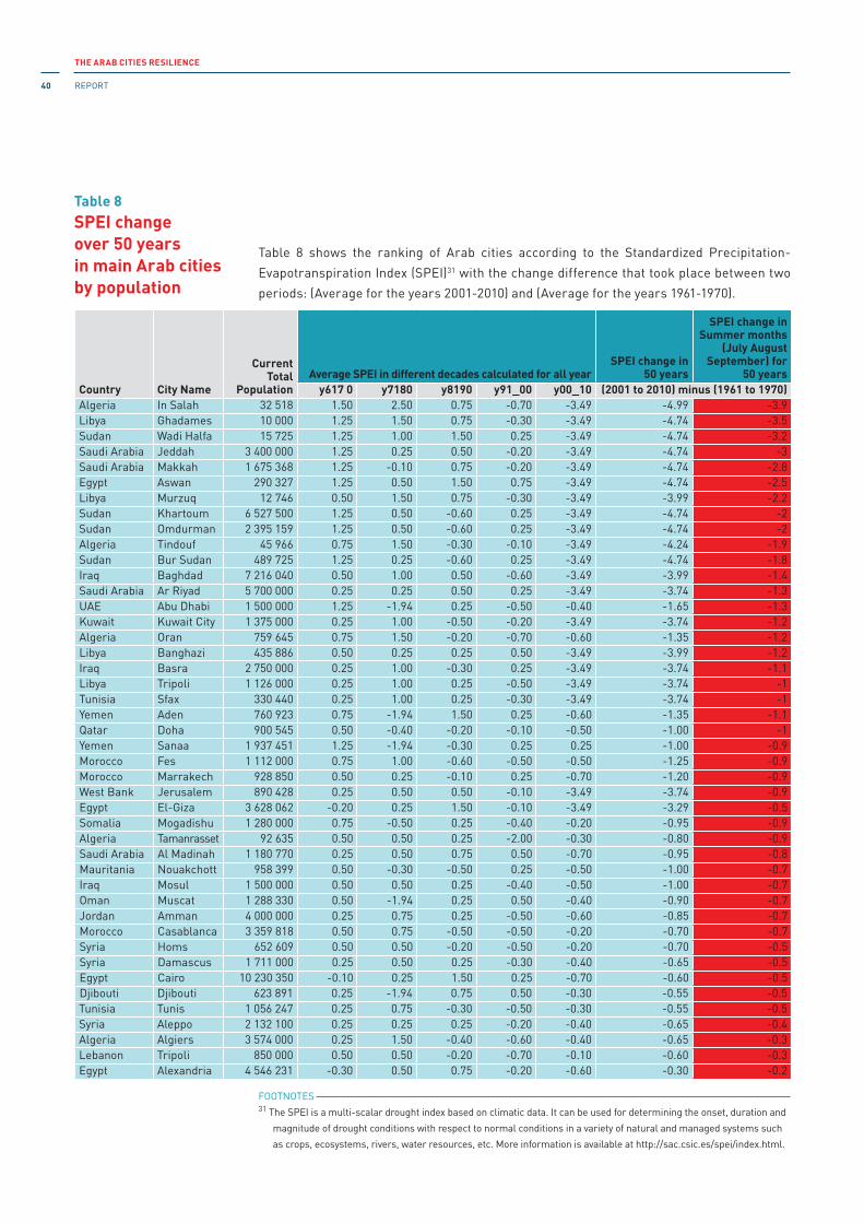
THE ARAB CITIES RESILIENCE
REPORT40
Country City Name
Current Total
PopulationAverage SPEI in different decades calculated for all year
SPEI change in 50 years
SPEI change in Summer months
(July August September) for
50 yearsy617 0 y7180 y8190 y91_00 y00_10 (2001 to 2010) minus (1961 to 1970)
Algeria In Salah 32 518 1.50 2.50 0.75 -0.70 -3.49 -4.99 -3.9Libya Ghadames 10 000 1.25 1.50 0.75 -0.30 -3.49 -4.74 -3.5Sudan Wadi Halfa 15 725 1.25 1.00 1.50 0.25 -3.49 -4.74 -3.2Saudi Arabia Jeddah 3 400 000 1.25 0.25 0.50 -0.20 -3.49 -4.74 -3Saudi Arabia Makkah 1 675 368 1.25 -0.10 0.75 -0.20 -3.49 -4.74 -2.8Egypt Aswan 290 327 1.25 0.50 1.50 0.75 -3.49 -4.74 -2.5Libya Murzuq 12 746 0.50 1.50 0.75 -0.30 -3.49 -3.99 -2.2Sudan Khartoum 6 527 500 1.25 0.50 -0.60 0.25 -3.49 -4.74 -2Sudan Omdurman 2 395 159 1.25 0.50 -0.60 0.25 -3.49 -4.74 -2Algeria Tindouf 45 966 0.75 1.50 -0.30 -0.10 -3.49 -4.24 -1.9Sudan Bur Sudan 489 725 1.25 0.25 -0.60 0.25 -3.49 -4.74 -1.8Iraq Baghdad 7 216 040 0.50 1.00 0.50 -0.60 -3.49 -3.99 -1.4Saudi Arabia Ar Riyad 5 700 000 0.25 0.25 0.50 0.25 -3.49 -3.74 -1.3UAE Abu Dhabi 1 500 000 1.25 -1.94 0.25 -0.50 -0.40 -1.65 -1.3Kuwait Kuwait City 1 375 000 0.25 1.00 -0.50 -0.20 -3.49 -3.74 -1.2Algeria Oran 759 645 0.75 1.50 -0.20 -0.70 -0.60 -1.35 -1.2Libya Banghazi 435 886 0.50 0.25 0.25 0.50 -3.49 -3.99 -1.2Iraq Basra 2 750 000 0.25 1.00 -0.30 0.25 -3.49 -3.74 -1.1Libya Tripoli 1 126 000 0.25 1.00 0.25 -0.50 -3.49 -3.74 -1Tunisia Sfax 330 440 0.25 1.00 0.25 -0.30 -3.49 -3.74 -1Yemen Aden 760 923 0.75 -1.94 1.50 0.25 -0.60 -1.35 -1.1Qatar Doha 900 545 0.50 -0.40 -0.20 -0.10 -0.50 -1.00 -1Yemen Sanaa 1 937 451 1.25 -1.94 -0.30 0.25 0.25 -1.00 -0.9Morocco Fes 1 112 000 0.75 1.00 -0.60 -0.50 -0.50 -1.25 -0.9Morocco Marrakech 928 850 0.50 0.25 -0.10 0.25 -0.70 -1.20 -0.9West Bank Jerusalem 890 428 0.25 0.50 0.50 -0.10 -3.49 -3.74 -0.9Egypt El-Giza 3 628 062 -0.20 0.25 1.50 -0.10 -3.49 -3.29 -0.5Somalia Mogadishu 1 280 000 0.75 -0.50 0.25 -0.40 -0.20 -0.95 -0.9Algeria Tamanrasset 92 635 0.50 0.50 0.25 -2.00 -0.30 -0.80 -0.9Saudi Arabia Al Madinah 1 180 770 0.25 0.50 0.75 0.50 -0.70 -0.95 -0.8Mauritania Nouakchott 958 399 0.50 -0.30 -0.50 0.25 -0.50 -1.00 -0.7Iraq Mosul 1 500 000 0.50 0.50 0.25 -0.40 -0.50 -1.00 -0.7Oman Muscat 1 288 330 0.50 -1.94 0.25 0.50 -0.40 -0.90 -0.7Jordan Amman 4 000 000 0.25 0.75 0.25 -0.50 -0.60 -0.85 -0.7Morocco Casablanca 3 359 818 0.50 0.75 -0.50 -0.50 -0.20 -0.70 -0.7Syria Homs 652 609 0.50 0.50 -0.20 -0.50 -0.20 -0.70 -0.5Syria Damascus 1 711 000 0.25 0.50 0.25 -0.30 -0.40 -0.65 -0.5Egypt Cairo 10 230 350 -0.10 0.25 1.50 0.25 -0.70 -0.60 -0.5Djibouti Djibouti 623 891 0.25 -1.94 0.75 0.50 -0.30 -0.55 -0.5Tunisia Tunis 1 056 247 0.25 0.75 -0.30 -0.50 -0.30 -0.55 -0.5Syria Aleppo 2 132 100 0.25 0.25 0.25 -0.20 -0.40 -0.65 -0.4Algeria Algiers 3 574 000 0.25 1.50 -0.40 -0.60 -0.40 -0.65 -0.3Lebanon Tripoli 850 000 0.50 0.50 -0.20 -0.70 -0.10 -0.60 -0.3Egypt Alexandria 4 546 231 -0.30 0.50 0.75 -0.20 -0.60 -0.30 -0.2
Table 8 SPEI changeover 50 yearsin main Arab cities by population
FOOTNOTES 31 The SPEi is a multi-scalar drought index based on climatic data. it can be used for determining the onset, duration and
magnitude of drought conditions with respect to normal conditions in a variety of natural and managed systems such
as crops, ecosystems, rivers, water resources, etc. More information is available at http://sac.csic.es/spei/index.html.
Table 8 shows the ranking of Arab cities according to the Standardized Precipitation-
Evapotranspiration index (SPEi)31 with the change difference that took place between two
periods: (Average for the years 2001-2010) and (Average for the years 1961-1970).

CHAPTER 3
Hazards, exposure and risks 41
The results confirm that the major Arab cities can be classified into cities with extreme,
moderate and slight drought (as an average for all months).
• Cities with extreme drought: Ain-Salah and Tindouf (Algeria); Ghadames, Murzuq,
Benghazi and Tripoli (Libya); Wadi Halfa, Port Sudan, Khartoum and Omdurman
(Sudan); Jeddah, Makkah and Riyadh (Saudi Arabia); Aswan and Giza (Egypt); Baghdad
and Basra (iraq); Kuwait City (Kuwait); Sfax (Tunisia); and Jerusalem (Palestine).
• Cities with moderate drought: Abu Dhabi (United Arab Emirates); Oran (Algeria);
Marrakech and Fes (Morocco); and Aden (Yemen).
• Cities with slight drought: Doha (Qatar); Sanaa (Yemen); Nouakchott (Mauritania);
Mosul (iraq); Mogadishu (Somalia); Al Madinah (Saudi Arabia); Muscat (Oman); Amman
(Jordan); Tamanrasset (Algeria); Casablanca (Morocco); Homs, Damascus and Aleppo
(Syria); Algiers (Algeria); Alexandria and Cairo (Egypt); Beirut and Tripoli (Lebanon);
Djibouti (Djibouti); Tunis (Tunisia); Rabat (Morocco); and El Obeid (Sudan).
The most affected cities during summer could be ranked as follows: Rabat, Tamanrasset,
Doha, Casablanca, Mogadishu, Djibouti, Tunis, Sanaa, Oran, Asmara, Al Madinah, Cairo,
Addis Ababa, Amman, Aden, Abu Dhabi, Ain-Salah, Muscat, Damascus, Marrakech,
Ghadames, Fes, Homs, Nouakchott, Mosul, Wadi Halfa, Alexandria, Makkah, Aleppo,
Jeddah, Murzuq, Aswan and Tripoli.
3.2.4 Special focus area 2: coastal zones
The coastal zone of the Arab region is 34,000 km long in total, more than half of which is
inhabited. “Most of the Arab cities and towns from Gulf, to Levant, to Egyptian Delta and North
Africa are located along the Arabian Sea, Red Sea and on either side of the Mediterranean Sea. In
North Africa over 70 per cent of Tunisian and Libyan population lives in cities along the coast. The
Egyptian Delta, with almost 40 per cent of the total Egyptian population, is sandwiched between
the Mediterranean and Red Seas. The coast of Lebanon is an extended sprawl of towns and
cities, so is the Saudi Arabian coast on Red Sea. In the Arabian Sea, in addition to archipelago of
Bahrain, all major urban centres of Kuwait, Oman, Saudi, Qatar and UAE lay on the seaside.”32
Coastal cities like Agadir, Alexandria, Algiers, Aqaba, Basra, Bosaso, Beirut, Casablanca,
Djibouti, Jeddah, Tripoli and Tunis are international commercial hubs.
FOOTNOTES 32 UNDP, Arab Cities Disaster Resilience Programme 2014-2017, available at:
http://procurement-notices.undp.org/view_file.cfm?doc_id=54089. Accessed 18 January 2017.

THE ARAB CITIES RESILIENCE
REPORT42
“All coastal cities in the Arab region remain especially vulnerable to multiple hazards
associated with climate change; e.g., sea level rise, coastal inundation, salinization, etc.”33
The coastal areas of the Maghreb and Mashreq are vulnerable to earthquakes, flash
flooding and tsunamis. Flood and cyclone-related urban disasters could lead to economic
losses amounting to billions of dollars. Cyclone Gonu, for example, resulted in losses
amounting to USD 4.2 billion, while flooding in Jeddah led to losses amounting to more
than USD 1 billion. The potential impact could go as far as severe damage to urban housing,
transport networks, motor traffic, ports, office buildings, educational institutions and
drainage systems. “The World Bank estimates that climate change in the Arab region will
expose 80-100 million people to water stress and 6-25 million people to coastal flooding
by 2025.”34 The consequences could reach well beyond the confines of regional geography.
Box 3Coastal zones: the case of Egypt
Ninety per cent of the Egyptian population lives along the Nile Delta. Protection of
coastal zones remains a priority issue for Egypt with about 15 per cent of the population
residing on the country’s Mediterranean and Red Sea coasts. Along the Mediterranean
Sea coast are the governorates of Matrouh, Alexandria, Beheira, Kafr el-Sheikh,
Dakahlia, Damietta, Port Said and North Sinai. The governorates of South Sinai, Suez
and the Red Sea are located along the Red Sea coast.
An increase in sea level as a result of changing climate poses risks to the coastal
population, infrastructure and environment. it is therefore of strategic importance
for Egypt to build resilience against natural hazards while pursuing its developmental
priorities. in order to further improve the understanding of vulnerabilities of major
coastal cities, the Arab Academy of Science, Technology and Maritime Transport, in
partnership with the World Bank (WB), is evaluating climate scenarios for Alexandria
2030.
Magda Stepanyan, Research note for the present report
Box 4Critical infrastructure: the case of the Strait of Hormuz
The narrow Strait of Hormuz* is considered one of the most, if not the most, strategic
straits of water on the planet. Sixty per cent of the world’s total oil exports is transported
from Bahrain, iran, iraq, Kuwait, Qatar, Saudi Arabia and the UAE through the Strait of
Hormuz alone.
The Strait of Hormuz is an exclave of Oman (Musandam governorate), strategically
located on the north coast of iran and the south coast of the UAE. The importance of the
Strait of Hormuz is critical not only to the economy of the City of Hormuz, but also to the
economy of other oil-producing countries in the region (the GCC countries) as well as
FOOTNOTES 33 ibid.34 Serageldin et al. 2016, p. 46.

CHAPTER 3
Hazards, exposure and risks 43
The coastal zones are, to varying extents, exposed to environmental pressures resulting
from irrational development and pollution from several onshore and offshore sources,
including industry, agriculture and urban development. These zones are also exposed
to coastal erosion, Nile Delta inundation, seawater intrusion, soil and groundwater
salinization, and similar environmental problems.
the stability of the global economy at large.
Therefore, building resilience to disaster and climate risks is of the utmost importance
in safeguarding the critical regional and global infrastructure.
Magda Stepanyan
FOOTNOTES
*. http://www.heritageinstitute.com/zoroastrianism/hormozgan/peoplePlaces2.htm. Accessed 25 January 2017.
Box 5Coastal zones: the case of Sudan’s Tokar Delta
The Tokar Delta is located in the north-east of Sudan. The centre of the area is roughly
about 90 km south of Suakin. it resembles an equilateral triangle with sides of about 70
km each. The climate in Tokar is arid; the average annual rainfall is 90 mm. it is hot and
dry during the late spring, summer and early autumn months.
An important feature of the climate of Tokar Delta is the wind. These winds blow for
several months in a southerly or south-westerly direction. They may blow constantly,
often without let-up for several days, and cover the entire delta with a vast blanket
of dust. Many people leave Tokar during such times. These haboob dust storms have
beneficial effects. They bury or submerge in the sea the cotton debris that may harbour
diseases. A less beneficial side effect of these winds is the shifting and reshaping of
the dunes. The resulting erosion and soil blowing onto unprotected land has caused
considerable damage.
The Baraka River and its main tributaries are the major streams in the area. it rises in
the Eritrean highlands south of Keren and has two main branches. Baraka flood waters
usually occur in a number of “flashes” and cover the delta during the months of July to
September. The floods cut off the main road that links Tokar City with Suakin and the
port of Sudan, fill the city streets with water and disrupt everyday activities. From the
end of May until the beginning of October, both the dust storms and flooding bring to a
halt all outdoor activities, except those that are absolutely necessary. The Government
of Sudan is therefore working to relocate the town of Tokar Delta away from here. The
government has started to build the new town of Tokar Delta beyond the confines of the
area to which the population of the old city escapes to avoid the floods.
Wadid Erian

THE ARAB CITIES RESILIENCE
REPORT44
3.2.5 Main findings
(a) Climate change will significantly alter the ecologically important attributes of
hydrologic regimes in rivers and wetlands, and exacerbate the impact of human
water use in developed river basins, thus having a direct impact on water quality and
availability for most cities, exerting pressure on fresh water supplies, sewage, the
built environment and public health.
(b) The Arab region is a global hotspot for worsening extreme heat, drought, aridity and
flash flood conditions.
(b1) Projections indicate that in a 4°C world more than 90 per cent of summers will
have unusually high heat extremes, compared to between 20-40 per cent of
summers in a 2°C world.
(b2) Oasis cities and hinterlands will be increasingly subjected to extreme heat, aridity
and dust storms, which would lead to economic, environmental and public health
problems.
(b3) The eastern Mediterranean and Arabian Peninsula are projected to become drier,
especially during the rainy season.
(c) Extreme heat, drought, aridity and flash floods will increase social vulnerability,
instability, poverty, inequality and migration; all of which are becoming increasingly
complex to manage.
(d) High density cities could bring efficiency gains and technological innovation while
reducing resource and energy consumption.
(e) Many cities will become increasingly dependent on groundwater and desalinated water
as a major source for potable water.
(f) Rapid urbanization and the growth of large cities has been accompanied by the
development of highly vulnerable urban communities living in informal settlements,
many of which in areas exposed to extreme weather.
This section examines the status, issues and challenges in relation to the regional seismic
and geophysical hazard profile of the Arab states and cities. it further highlights some
important vulnerabilities related to the seismic and geophysical hazards facing the main
Arab cities.
3.3.1 Seismic and geophysical risks: regional context
The seismicity of Africa is mainly concentrated in two main subregions: North Africa
and South-East Africa (Figure 12). Seventy-two per cent of the area of the Arab States
(9,975,508 km2), home to 67 per cent of the population (260,718,000), lies in North Africa.
Outside of the East African Rift System (EARS), Africa does not appear to be vulnerable to
potentially dangerous seismic activity, although there are a couple of peaks elsewhere.
The Middle Eastern region is also significantly vulnerable to seismic risks . The 1,000-km
Hazard profile: geophysicalhazards
3.3

CHAPTER 3
Hazards, exposure and risks 45
long western boundary of the Arabian plate is a complex plate boundary, extending from
zones of sea-floor spreading in the Red Sea to zones of plate convergence in Turkey, and
lies along the line of the Gulf of Aqaba, the Dead Sea rift, the Bekaa Valley and the a-Ghab
depression. The Horn of Africa has a significant seismic hazard associated with the EARS.35
The GCC region, due to its location on the Arabian plate, has low exposure to seismic and
geophysical hazards.
PGA ≤ 0.10 g corresponds to low seismic hazard
0.10 g < PGA ≤ 0.30 g corresponds to moderate seismic hazard
PGA > 0.30 g corresponds to high seismic hazard
Tsunami records (prehistoric, historical and instrumental) show a long history of tsunami
occurrences in the whole Mediterranean Basin from east to west.36 in the Maghreb, the
Moroccan Atlantic coast is highly exposed to tsunamis generated by submarine earthquakes.
“The [Atlantic coastal] area of Rabat and Salé is particularly affected by tsunami hazard as
reported by historical documents in which inundation related to the tsunami of 1755 reached
a maximum distance of 2000 m inland.”37 Since about the second century BC until to the
present, there are more or less 22 reliable records of events in the eastern Mediterranean
basin. The entire Lebanese coast is also exposed to tsunami hazard. According to Heidarzadeh
et al. (2006), the Arabian Gulf cannot be classified as a tsunamigenic zone, but it is exposed
to a high-level tsunami hazard due to its proximity to the Makran subduction zone. Figure 13
shows that only western Algeria, eastern Morocco, Syria, Lebanon, Palestine and Egypt may
be affected with an intermediate potential tsunami hazard.
R o b in s o n P ro je c tio n
Dar
es
Salaam
raBujumbuKigali
Kampala
Nairobi
Muqdisho
A d is A b e b a
jDi bouti
S a n a íaaAsmer
Lusaka
Harare
Lilongwe
Antananarivo
Lisboa
Rabat
Algiers Tunis
?a r b u lu sâ
aDoh
Abu
Dhabi
Al
Kuwayt
Ar
Riyad
N'Djamena
Khartoum
ih nt iA a
C a iro
Tel
Aviv-YafoAlexandria AmmanBaghdadDimashq
B a y rtû
Nicosia
Ankara
A
Tehran
pCa e
Town
MaputoaneMbabJohannesburg
Gaborone Pretoria
Maseru
Windhoek
Luanda
KinshasaBrassaville
Libreville
Monrovia
nFreetowConakry
MalabogBan ui
Y a o u n d È
Abidjan Accra Lome
Lagos
Por to
Nov
o
Niamey
Ouagadougou
BamakoBissau
BanjulDakar
Nouakchott
Figure 12Seismic hazard in the Maghreb, the Mashreq, the Gulf countries and the Southern Tier
0.20
0.4
0.8
1.6
2.4
3.2
4.0
4.8
Low Hazard
Moderate Hazard
High Hazard
Very High Hazard
FOOTNOTES 35 PreventionWeb, Horn of Africa: earthquake hazard map. [http://preventionweb.net/go/3870]. Accessed 22 January
2017.36 Tinti et al. 2013.37 Atillah et al. 2011, p. 3397.

THE ARAB CITIES RESILIENCE
REPORT46
3.3.2 Seismic and geophysical hazards in the Maghreb
Earthquake hazard constitutes a constant threat to human life and the environment in the
whole of North Africa including Algeria, Egypt, Libya, Morocco and Tunisia. in particular,
Algeria, Morocco and Tunisia are the most earthquake-prone areas of the Western
Mediterranean basin. Table 9 lists historic events involving magnitudes of more than 6 on
the Richter scale. Several devastating earthquakes have occurred in these countries, some
even triggering a tsunami, causing heavy loss of life and considerable economic damage
in the region.
Figure 13Tsunami prone areas and the tsunami risk in the Mediterranean
Table 9Earthquakes with a magnitude of more than 6 in the Maghreb
The maximum values obtained for the peak ground acceleration (PGA) in these countries
range between 0.15 g and 0.63 g and are located mainly in northern Algeria, eastern Tunisia,
around Tripoli in Libya, around the Gulf of Aqaba, and at the entrance of the Gulf of Suez in
Source: Papadopoulos 2005.
* Magnitudes of earthquakes earlier than 1935, or of those for which there are no instrumental data, are derived from macroseismic observations (using calibration relationships). For more details, see Benouar 1999.
Country Magnitude above 6 earthquakes in the period (1900-2015)*
Algeria1910 June 24 Aumale, (M 6.6); 1954 Sep. 9 El-Asnam (actually Cheliff), (M 6.8); 1980 Oct. 10 El-Asnam (actually Cheliff), (M 7.2); 1994 August 18 Mascara, (M 6.0); 2003, May 21 Boumerdès, (M 6.8)
Morocco 2004, Feb. 24 Al Hoceima, (M 6.2)
Tunisia 1915 July 11 Tunis, (M 6.2); 1941 December 27 Tunis, (M 6.8)
Mauritania NONE
Libya 1935 April 19, Al Qadahia, (M 7.1)

CHAPTER 3
Hazards, exposure and risks 47
Egypt. A detailed analysis38, 39 of the seismicity of Algeria, Morocco and Tunisia (Figure 14)
indicates a value of about 0.4g in Al Hoceima (Morocco), Cheliff, Blida, Setif and Boumerdès
(Algeria) and in Tunis (Tunisia).
Algeria: Earthquake hazard in Algeria poses an incessant threat to human life and the
environment. Rapid urbanization, the development of critical structure, such as dams and
oil facilities, the industrialization of cities, and the concentration of population in hazardous
areas are all matters of growing concern in Algeria. Figure 15 shows that the PGA values
vary from 0.40 g to 0.45 g for a return period of 475 years in El-Asnam (actually Cheliff),
with mean values of 0.35 g in Algiers, Boumerdès, Tipaza and Blida and their surroundings,
and 0.20 g for the city of Setif. Most of the northern area of Algeria has a mean value of 0.12
g with a mean value of 0.06 g for the southern region, including the cities of Saida, Djelfa,
Laghouat and Tebessa. Further south, the Sahara is an earthquake-free region due to its
intraplate location.
Figure 14PGA for a 10 per cent probability of exceedance in a 50-year period (475- year return period)
Figure 15PGA values for the main cities in Algeria
Source: Benouar 1994.
Source: Peláez Montilla et al. 2003.
0.0
0.1
0.2
0.3
0.4
0.5
-1020
28
22
30
24
32
36
26
34
38
-2 8-8 40 10-6 -4 62 12
PGA
0.0
0.2
2.4
0.8
4.0
0.4
3.2
1.6
4.8 m/s2
FOOTNOTES 38 Benouar 1994.39 Benouar et al. 1996.
PGA (worst case)Return period* of 475 years

THE ARAB CITIES RESILIENCE
REPORT48
Algeria is also prone to landslides, with the city of Constantine most affected. The landslides
are caused by both natural and anthropogenic factors: the rugged topography of the area,
water infiltration mainly due to the obsolescence of the water supply network, unplanned
urbanization, the levelling of hill summits by colonial authorities to build residential
neighbourhoods for the settlers, and the creation of vast alluvial surfaces to support the
construction. The most devastating cases40 of landslides occurred in 1910 (a slippage of the
Sidi Rached bridge) and in 1911 when a huge landslide carried about 200,000 m3 of earth to
the bottom of the north side facing Moulin Carbonnel.
Libya: The whole country is characterized by low to moderate levels of seismic activity,
however, a number of earthquakes are reported to have occurred in Libya, including a major
earthquake of M = 7.1 on 19 April 1935. Seismic activity in Libya is concentrated in the northern
part of the country particularly in the Hun Graben and Al Jabal Al Akhdar regions. The number
of earthquakes recorded in Libya is not representative of the actual total number because of
the limitations on instrumental sensitivity before 1950, as well as the lack of seismological
stations in Libya itself. Suleiman et al. (2001) suggest, however, that for the period 1935-2001
most of the activity has been clustered in two areas: the NNW trending Hun Graben and the
Al Jabal Al Akhdar to the north-east of Libya.41 The highest levels of activity are concentrated
in Cyrenaica (north-eastern region) and around the Hun Graben (north-central region). The
southern part of Libya is considered to be seismically stable.42
Table 10PGA values for 475-year return period for 12 selected cities in Algeria
Figure 16Distribution of seismicity in Libya
Source: Peláez Montilla et al. 2003.
Source: Elmelade 2012.
City PGA (g) City PGA (g)
Echeliff 0.45 Guelma 0.19
Algiers 0.35 Oran 0.19
Boumerdès 0.35 Mascara 0.18
Blida 0.35 Batna 0.16
Tipaza 0.35 Bejaia 0.14
Setif 0.25 Aïn Temouchent 0.11
Constantine 0.20 Jijel 0.10
FOOTNOTES 40 Benazzouz 1991.41 Suleiman et al. 2004, p. 553.42 Hassen 1983.
HISTORICAL AND INSTRUMENTAL SEISMICITY DATA OF ISC – PDE – EMSC 1907 – 2005, MAGNITUDE OF 2.6 – 7.1
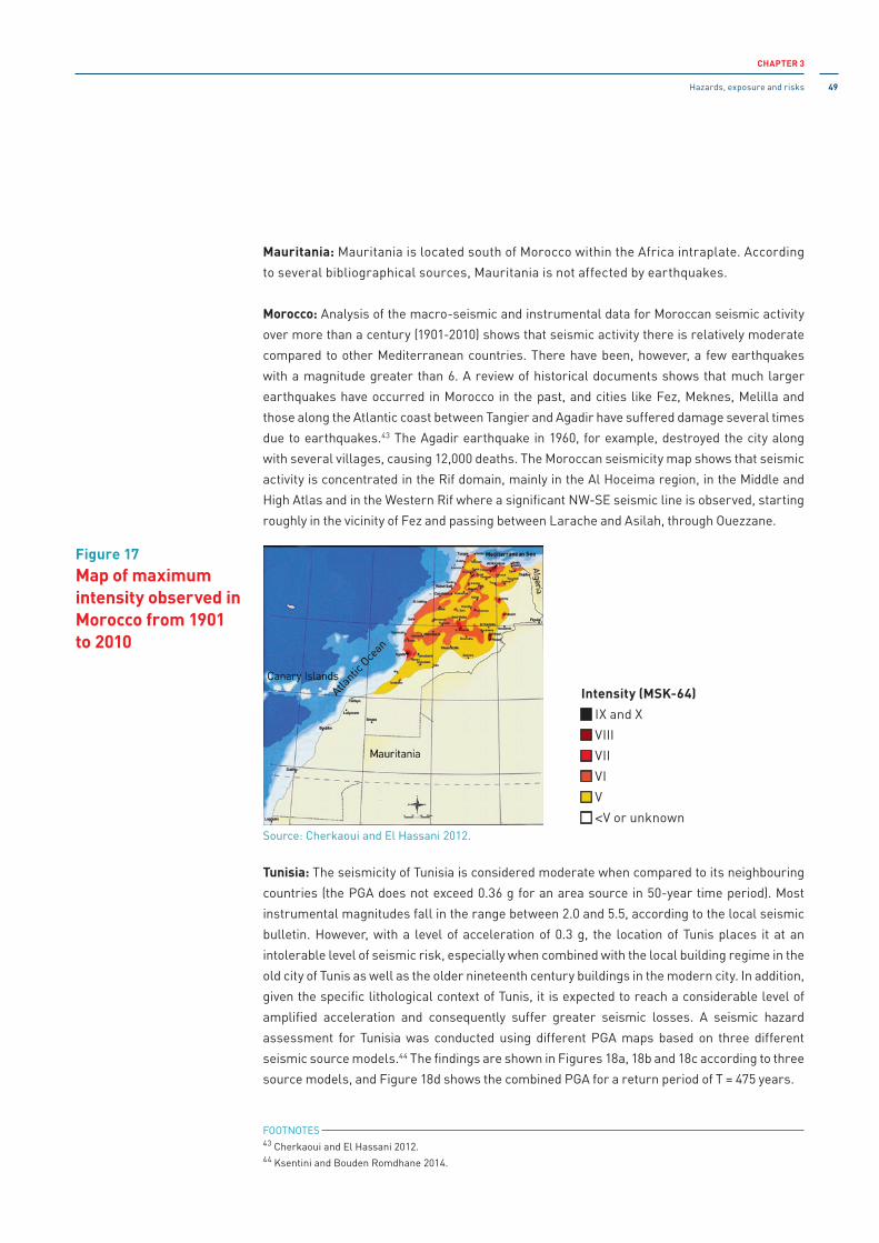
CHAPTER 3
Hazards, exposure and risks 49
Mauritania: Mauritania is located south of Morocco within the Africa intraplate. According
to several bibliographical sources, Mauritania is not affected by earthquakes.
Morocco: Analysis of the macro-seismic and instrumental data for Moroccan seismic activity
over more than a century (1901-2010) shows that seismic activity there is relatively moderate
compared to other Mediterranean countries. There have been, however, a few earthquakes
with a magnitude greater than 6. A review of historical documents shows that much larger
earthquakes have occurred in Morocco in the past, and cities like Fez, Meknes, Melilla and
those along the Atlantic coast between Tangier and Agadir have suffered damage several times
due to earthquakes.43 The Agadir earthquake in 1960, for example, destroyed the city along
with several villages, causing 12,000 deaths. The Moroccan seismicity map shows that seismic
activity is concentrated in the Rif domain, mainly in the Al Hoceima region, in the Middle and
High Atlas and in the Western Rif where a significant NW-SE seismic line is observed, starting
roughly in the vicinity of Fez and passing between Larache and Asilah, through Ouezzane.
Tunisia: The seismicity of Tunisia is considered moderate when compared to its neighbouring
countries (the PGA does not exceed 0.36 g for an area source in 50-year time period). Most
instrumental magnitudes fall in the range between 2.0 and 5.5, according to the local seismic
bulletin. However, with a level of acceleration of 0.3 g, the location of Tunis places it at an
intolerable level of seismic risk, especially when combined with the local building regime in the
old city of Tunis as well as the older nineteenth century buildings in the modern city. in addition,
given the specific lithological context of Tunis, it is expected to reach a considerable level of
amplified acceleration and consequently suffer greater seismic losses. A seismic hazard
assessment for Tunisia was conducted using different PGA maps based on three different
seismic source models.44 The findings are shown in Figures 18a, 18b and 18c according to three
source models, and Figure 18d shows the combined PGA for a return period of T = 475 years.
Figure 17Map of maximum intensity observed in Morocco from 1901 to 2010
Source: Cherkaoui and El Hassani 2012.
FOOTNOTES 43 Cherkaoui and El Hassani 2012.44 Ksentini and Bouden Romdhane 2014.
Intensity (MSK-64)
■ iX and X
■ Viii
■ Vii
■ Vi
■ V
■ <V or unknown

THE ARAB CITIES RESILIENCE
REPORT50
3.3.3 Seismic and geophysical hazards in the Mashreq
The Middle East lies at the intersection of three major tectonic plates (i.e., the African,
Arabian and Eurasian plates), resulting in very high tectonic activity. Seismic activity in the
Eastern Mediterranean region (EMR) is mainly associated with the northward movement
of the Arabian plate.45 Total displacement is estimated at about 107 km since the Oligocene
era, with an annual rate of about 0.5 cm over the past 7-10 million years. Due to this tectonic
setting, seismicity and topography, the EMR has been subjected to earthquake disasters
throughout the past two thousand years. Some of the most significant earthquakes in the
Middle East affected most countries in the region.46
Figure 19 shows the seismogenic zone and epicentres of Gulf of Suez, Gulf of Aqaba, Jordan,
Syria and Lebanon.
Figure 18Major seismotectonic structures of Tunisia and PGA maps according to different seismic source models.
Source: Ksentini and Bouden Romdhane 2014.
(Cornell 1968)classical zonal method.
Structural map of Tunisia, showing major seismotectonic faults
(Lapajne et al. 2003)energy based model.
The logic tree PGA map.
(Woo 1996a) smoothed-gridded seismicity model.A
C
B
D
FOOTNOTES
45 Jreisat and Yazjeen 2013.46 M. Erdik et al., "Assessment of seismic hazard in the Middle East and Caucasus: EMME
(Earthquake Model of Middle East) Project”, Proceedings of fifteenth World Conference on Earthquake Engineering
(Lisbon, Portugal, 2012), Paper No: 2100.
PGA (in g) for a 475-year return period
g: A unit of gravitational force equal to that exerted by the earth’s gravitational field. Near the Earth’s surface, gravitational acceleration is approximately 9.8 m/s2.

CHAPTER 3
Hazards, exposure and risks 51
Figure 19Earthquake distribution in Jordan and the Middle East from 1900 to 2005.
Figure 20Mean PGA (cm/s2) on rock sites with 10 per cent probability of exceedance in 50 years (475-year return period) for Egypt
Source: Abou Elela et al. 2012.
Egypt: There are four major seismic zones in Egypt, known as the Northern Red Sea-Gulf
of Suez-Cairo-Alexandria trending NW-SE; the Gulf of Aqaba-Levant Fault, NNE-SSW; the
Eastern Mediterranean-Cairo-Faiyum, NE-SW; and the Egyptian Mediterranean Coast,
E-W.47 The PGA across Egypt ranges from 0.02 g in middle area of the Western Desert to 0.22
g in the most north-eastern part of Egypt near to the geological origin of the Gulf of Aqaba,
with earthquakes of a magnitude 7.2 for a 475-year return period. The most recent seismic
hazard assessment for Egypt identified the Aqaba region (Jordan–Egypt border) as the area
with relatively highest seismic hazard in the country, which is characterized by moderate
seismic activity. The second active area is the entrance to the Gulf of Suez. in the southern
part of Egypt, high seismic activity is observed around the Aswan area. There are also some
areas with relatively higher seismic activity than their surroundings, such as the Dahshour
area, the Cairo area Suez District, the Beni Seuf area and the Abou-Dabbab area.48
Fig. 17 Mean peak ground acceleration (cm/s2) on rock sites with 2% probability of exceedance in 50 year (2475 year return period) in
Egypt.
Fig. 16 Mean peak ground acceleration (cm/s2) on rock sites with 10% probability of exceedance in 50 year (475 year return period) in
Egypt.
Seismic hazard studies in Egypt 133
FOOTNOTES 47 Amos Salmon et al., “Seismotectonics of Sinai subplate-eastern Mediterranean region”, Geophysical Journal
international, vol 155, No. 1 (September 2003), pp. 149-173, doi:10.1046/j.1365-246X.2003.02017.x.48 Abou Elela 2012.
Jreisat and Yazjeen 2013.
Mediterranean Sea

THE ARAB CITIES RESILIENCE
REPORT52
Figure 21Seismic hazard map for Iraq showing PGA for the 10 per cent probability of exceedance in 50 years
Source: Schwark 2005, p. 55.
Iraq: Tectonically, iraq is located in a relatively active seismic zone on the north-eastern
boundary of the Arabian plate. iraq has a well-documented history of seismic activity, with
annual activity of varying strengths. An earthquake catalogue has been published for iraq
for the period 1900-1988, which contains 1,031 historical events with magnitudes ranging
between 3.7 and 7.4 on the Richter scale.49
Seismic hazard investigations have also been carried out and a seismic zoning map
compiled, in addition to a seismicity index map, a seismic source map, an iso-acceleration
map and a seismic regionalization map. Relatively large and destructive earthquakes
cannot be ruled out in this region.
According to Schwark (2005), north-eastern areas of iraq lie within a region of high seismic
hazard. Since the country does not appear to enforce a system of seismic building codes,
major cities, such as Kirkuk, Mosul, Erbil and even the capital Baghdad, are at significant
risk of severe damage and loss of life in the event of even a moderate magnitude earthquake.
Similar to Mosul, Kirkuk is located in the seismically northern portion of the country and
therefore lies within the region of high seismic hazard that may experience 10 per cent
probability of exceedance for 50 years a PGA of 0.15 g.
City PGA (g) Baghdad 0,02 gMosul 0.09 g Kirkuk 0.09 g Basra 0.01 g
FOOTNOTES 49 The use of the Richter scale for events occurring before its invention is roughly explained in Table 9, note *

CHAPTER 3
Hazards, exposure and risks 53
Figure 22Peak ground acceleration for a 10 per cent probability of exceedance for a 50-year timespan, corresponding to 475-year return
Jordan: “Jordan covers the north-western part of the Arabian plate which is separated
from the African Plate along the most profound tectonic event on the earth’s crust: the
Aqaba-Dead Sea-Jordan Valley rift. This is an active pull-apart with left-lateral motion.
The amount of left-lateral motion along the Transform in the Dead Sea region has been
estimated at 105 km”50 (with an annual rate of about 0.5 cm over the last 7-10 million years).
The Jordan valley, a major part of the Dead Sea Transform (DST), is the most seismically
active region in the Middle East, with a history of four thousand years of documented
destructive earthquakes.51 The occurrence of strong earthquakes along the DST fault
system is a major threat to the public safety and economy of the Middle East.
The Jordanian National Building Code divides the country into four seismic zones: 1, 2A, 2B
and 3 with increasing hazard towards the Dead Sea Transform.
Landslides in Jordan have caused numerous problems over the past 40 years. The most critical
slides occurred during the period 1991-1992 following exceptionally heavy rain and snowfall.52
Palestine: Palestine shares the same tectonics along its border with Jordan. All seismic hazard
studies include both countries. Figure 24 shows the seismic hazard for a 10 per cent probability
of exceedance of the PGA in a 50-year timespan (i.e., a 475- year return period) based on Boore
et al. (1997) in the Levant, including all of Palestine (Quennell 1958; Freund et al. 1970). it should
be noted that the PGA in Gaza is estimated at between 0.05 g and 0.10 g, in Al-Quds between 0.10
g and 0.15 g, in Nablus between 0.15 g and 0.20 g, and about 0.30 g in Ariha.53
FOOTNOTES 50 Jreisat and Yazjeen 2013, citing Quennell 1958; Freund et al., 1970.51 Shapira et al. 2007.52 Abdallah et al., 1996.53 Shapira et al. 2007.
Source: Jreisat and Yazjeen 2013.

THE ARAB CITIES RESILIENCE
REPORT54
Figure 23Seismic hazard for a 10 per cent probability of exceedance of the PGA in a 50-year timespan (475-year return period)
Figure 24Seismic zoning map of central Palestine and Jordan
Source: Shapira et al. 2007, p. 73.
Lebanon: “The country lies along the 1,000-km long left-lateral Levant fault system (LFS)...
This fault system is responsible for a significant number of seismic events in the eastern
Mediterranean.”54 The PGA for a 50 year timespan (a 475-year return period) in the Lebanese
territories varies between 0.2 g in the eastern part of the country to 0.30 g in the western part
near the coastal area between Saida and Tripoli, where most of Lebanon’s population and
capital investments are located. This implies that all civil engineering facilities, including
buildings and bridges, that have still to be constructed in the coastal zone between Saida
and Tripoli should be designed to a “high seismic hazard” standard according to the design
and reinforcement requirements as laid down in international codes of practice.55 Further
FOOTNOTES 54 Huijer, Harajli and Sadek 2011, p. 68.55 ibid.
Source: Shapira et al. 2007, p. 73.

CHAPTER 3
Hazards, exposure and risks 55
to the combined effects of natural and human-caused factors, floods and landslides cost
Lebanon around 10-15 million dollars per year, along with numerous fatalities and injuries.56
Syria: Syria lies on the northern part of the Arabian plate. The seismicity of Syria may be qualified
as moderate if the period of study is restricted to the last two centuries. “The Syrian territory
can be divided into three main tectonic regimes: The first one is the Dead Sea rift system, which
is represented by an N-S left-lateral strike-slip faults system. The second one is the Palmyrides
mega-tectonic shear zone, which is characterized by highly repeated folding and the NE-SW
faults system. The third tectonic zone is the Euphrate system, which is characterized by the
NW-SE normal faults system.”57 Figure 26 demonstrates that “the maximum expected design
value of PGA (0.46 g to 0.5g for R.P.58 475 years) is concentrated at the north-western part of
Syria (i.e., the cities of iskenderun, Latakia and Tartous). According to the Syrian Building Code
(1995), the design PGA value (0.4 g for R.P. 1000 years) applies to all western parts of Syria (idlib,
Aleppo, iskenderun, Latakia, Tartous, Dara, as well as some parts of Hama, Homs, Damascus
and Swaida cities). Also some parts in the centre of Syria (Palmyra).”59
Figure 25Seismic hazard map of Lebanon, distribution of PGA for 50-year period (return period of 475-years).
Figure 26Seismic hazard map of Syria, distribution of PGA for a return period of 475 years
Source: Huijer, Harajli and Sadek 2011. p. 78.
Source: El Ssayed et al. 2012, p. 853.0
0.05
0.25
0.15
0.34
0.1
0.3
0.2
0.38
PGA
FOOTNOTES 56 UNESCO 2010, p. 15, citing Khawlie 2000. 57 El Ssayed et al. 2012, p. 847, citing Cornell University 2001.58 return period.59 ibid, p. 854.
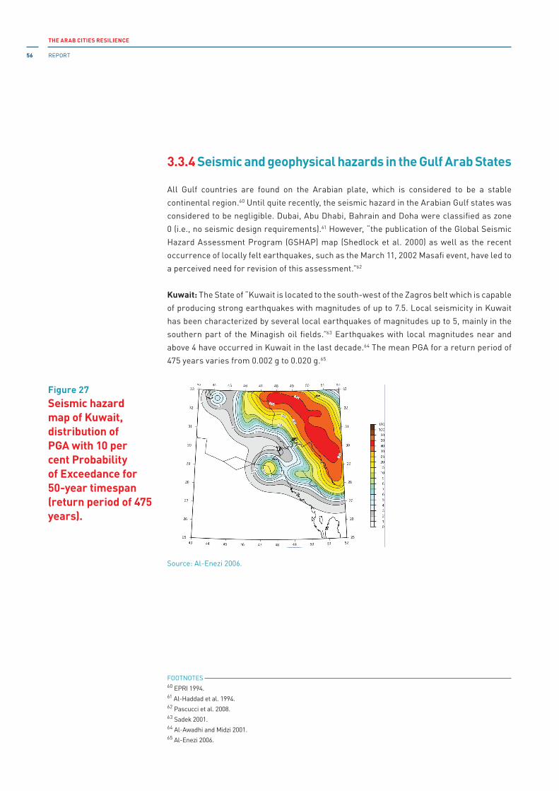
THE ARAB CITIES RESILIENCE
REPORT56
3.3.4 Seismic and geophysical hazards in the Gulf Arab States
All Gulf countries are found on the Arabian plate, which is considered to be a stable
continental region.60 Until quite recently, the seismic hazard in the Arabian Gulf states was
considered to be negligible. Dubai, Abu Dhabi, Bahrain and Doha were classified as zone
0 (i.e., no seismic design requirements).61 However, “the publication of the Global Seismic
Hazard Assessment Program (GSHAP) map (Shedlock et al. 2000) as well as the recent
occurrence of locally felt earthquakes, such as the March 11, 2002 Masafi event, have led to
a perceived need for revision of this assessment.”62
Kuwait: The State of “Kuwait is located to the south-west of the Zagros belt which is capable
of producing strong earthquakes with magnitudes of up to 7.5. Local seismicity in Kuwait
has been characterized by several local earthquakes of magnitudes up to 5, mainly in the
southern part of the Minagish oil fields.”63 Earthquakes with local magnitudes near and
above 4 have occurred in Kuwait in the last decade.64 The mean PGA for a return period of
475 years varies from 0.002 g to 0.020 g.65
Figure 27Seismic hazard map of Kuwait, distribution of PGA with 10 per cent Probability of Exceedance for 50-year timespan (return period of 475 years).
Source: Al-Enezi 2006.
Probabilistic Seismic Hazard Map: Peak Ground Acceleration (PGA) With 10% Probability of Exceedance in 50 years (i.e.,
475 years return period)
FOOTNOTES 60 EPRi 1994.61 Al-Haddad et al. 1994.62 Pascucci et al. 2008.63 Sadek 2001.64 Al-Awadhi and Midzi 2001.65 Al-Enezi 2006.
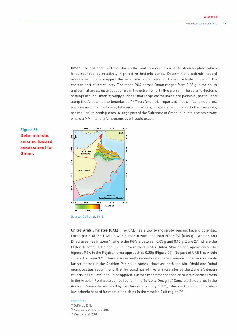
CHAPTER 3
Hazards, exposure and risks 57
Oman: The Sultanate of Oman forms the south-eastern area of the Arabian plate, which
is surrounded by relatively high active tectonic zones. Deterministic seismic hazard
assessment maps suggest the relatively higher seismic hazard activity in the north-
eastern part of the country. The mean PGA across Oman ranges from 0.08 g in the south
and central areas, up to about 0.16 g in the extreme north (Figure 28). “The seismo-tectonic
settings around Oman strongly suggest that large earthquakes are possible, particularly
along the Arabian plate boundaries.”66 Therefore, it is important that critical structures,
such as airports, harbours, telecommunications, hospitals, schools and other services,
are resilient to earthquakes. A large part of the Sultanate of Oman falls into a seismic zone
where a MM intensity Vii seismic event could occur.
United Arab Emirates (UAE): The UAE has a low to moderate seismic hazard potential.
Large parts of the UAE lie within zone 0 with less than 50 cm/s2 (0.05 g). Greater Abu
Dhabi area lies in zone 1, where the PGA is between 0.05 g and 0.10 g. Zone 2A, where the
PGA is between 0.1 g and 0.20 g, covers the Greater Dubai, Sharjah and Ajman area. The
highest PGA in the Fujairah area approaches 0.20g (Figure 29). No part of UAE lies within
zone 2B or zone 3.67 “There are currently no well-established seismic code requirements
for structures in the Arabian Peninsula states. However, both the Abu Dhabi and Dubai
municipalities recommend that for buildings of five or more stories the Zone 2A design
criteria in UBC 1997 should be applied. Further recommendations on seismic hazard levels
in the Arabian Peninsula can be found in the Guide to Design of Concrete Structures in the
Arabian Peninsula prepared by the Concrete Society (2007), which indicates a moderately
low seismic hazard for most of the cities in the Arabian Gulf region.”68
Figure 28Deterministic seismic hazard assessment for Oman.
Source: Deif et al. 2012.
FOOTNOTES 66 Deif et al. 2012.67 Abdalla and Al-Homoud 2004.68 Pascucci et al. 2008.

THE ARAB CITIES RESILIENCE
REPORT58
Bahrain and Qatar: Bahrain and Qatar are located in seismic zone 1 and the probabilistic
seismic hazard assessment for these two Gulf countries, with a 10 per cent exceedance
probability for a timespan of 50 years (475-year return period), varies between 0.04 g and
0.12 g.
Saudi Arabia: Saudi Arabia forms the largest part of the Arabian plate. Harrat Al-Shaqah is
one of the provinces in western Saudi Arabia, (also known as Harrat Lunayyir) to experience
recent volcanic activity in which there was an “intense earthquake swarm due to magmatic
intrusion. Numerous small to moderate size earthquakes occurred in May-July 2009 [...]
recorded by the Saudi National Seismic Network (SNSN) operated by Saudi Geological
Survey (SGS). More than 27,000 earthquakes occurred, 207 of which were felt in and around
Harrat Al-Ahaqah [sic], up to distances of more than 210 km. The most intense activity was
17-19 May when a ML 5.39 earthquake occurred.”69 The seismic hazard potential70 in Saudi
Arabia is fairly low with an expected bedrock horizontal PGA in the range of 0.04 g to 0.06 g
for a return period of 475 years.71
Figure 29Seismic zoning map for UAE, Bahrain, and Qatar showing five zones (0, 1, 2A, 2B and 3) for 475-year return period.
Source: Abdalla and Al-Homoud 2004.
Bahrain
Arabian/Persian Gulf
Gulf of Oman
United Arab Emirates
Qatar
Iran
Sultanate of Oman
Kingdom of Saudi Arabia
50.00 51.00 52.00 53.00 54.00 55.00 56.00 57.00 58.00 59.00 60.00
East Longitude
20.00
21.00
22.00
23.00
24.00
25.00
26.00
27.00
28.00
29.00
30.00
North
Lat
itude
Zone 3
Zone 0
Zone 1
Zone 2A
Zone 2B
FOOTNOTES 69 EPRi 1994.70 H. Zahran and Yousef Salah El-Hadidy, “The 2009 volcanic and seismic activity in Harrat Al- Shaqah (Lunayyir),
western Saudi Arabia,” Reduction of Earthquake Losses in the Extended Mediterranean Region (RELEMR)
Workshop Report Lisbon, Portugal, 26-29 October 2009 (Paris: UNESCO 2010).71 Pascucci et al. 2008.
CHAPTER 3
Hazards, exposure and risks 59
3.3.5 Seismic and geophysical hazards in the southern tier countries
The northern Nubia-Somalia rift zone between Eritrea, Djibouti, Somalia and Ethiopia is a
source of earthquake and volcanic hazards in this region. The great EARS constitutes the
complex boundary between the Nubian and Somalia plates and is also the geological home
to other significant solid-earth geohazards, namely volcanoes and landslides, including
large-scale submarine landslides or continental slope slumping.72
Djibouti: Djibouti is located in a geographic area where the process of stretching and
dislocation of the crust causes earthquakes and volcanic eruptions. The magnitudes
observed by the Geophysical Observatory of Arta are generally between 2.0 and 4.0.
Findings show that Djibouti may experience PGA varying from 0.16 g to 0.24 g, which may
impact seriously on all types of constructions. in Djibouti, the earth crust is very thin
and, because of its high temperature, relatively ductile and therefore less brittle. All
this explains the low magnitude of the earthquakes registered in Djibouti. However the
situation with particular faults (faults transforming) that cut crosswise over the rift (e.g.,
between Arta and Tadjourah) may involve higher energies that could trigger earthquakes
(fortunately much rarer) of magnitudes 5 or even 6. The 1973 earthquake was the most
violent in the last 40 years, although its intensity did not exceed 7.0 on the Mercalli scale.
in recent years, urbanization has accelerated, especially in the capital. The expansion of
the city to the north, backfilled on land reclaimed from the sea, and south towards Ambouli
Wadi, may constitute a real risk in the event of an earthquake. The situation could be further
exacerbated due to the exposure to tsunamis.73
Figure 30PGA (cm/s2) with a 10 per cent probability of exceedance in a 50-year timespan (475-year return period)
Source: Abdalla and Al-Homoud 2004.
FOOTNOTES 72 Chris Hartnady, “Tsunami potential on East African coast, western indian Ocean island states,” Disaster Reduction
in Africa - iSDR informs, No. 5 (Nairobi: UNiSDR 2005), pp. 22-24.73 Stratégie nationale de gestion des risques et des catastrophes de Djibouti (2014).

THE ARAB CITIES RESILIENCE
REPORT60
Somalia: According to GSHAP,74 in Somalia the seismic hazard is very low, varying from
less than 0.01 g to 0.03 g, which is too small to cause any damage to the built structures,
even those which are highly vulnerable.
Sudan: Sudan lies within an intraplate region (Nubian Plate) in the centre of Africa. This
region is bounded by active tectonic features, such as the Red Sea Rift to the north-east
and the EARS to the south and south-east. The seismicity map of Sudan shows that large
parts of Sudan, specifically western and north-western Sudan, lie in zone 0. South-western
Sudan lies in zone 1, where the PGA is between 0.05 g and 0.10 g, and covers most of central
Sudan and north-western Sudan. Although there has been an increase in the magnitude
and frequency of seismic events in many parts of the Sudan, most buildings and structures
have not yet been designed and constructed in accordance with earthquake provisions,
nor has any consideration been given to earthquake effects.75 The seismic vulnerability of
buildings is high in moderate and high seismic zones.
Figure 31Earthquake epicentre map for Djibouti and its surroundings in the period 1960 to 2014 (EMSC)
Source: Earthquake epicenter map of Djibouti and its vicinity from 1960 to 23 January 2014 European-Mediterranean Seismological Centre (EMSC) Manual location.
FOOTNOTES 74 GSHAP 1999.75 Abdel Wahab, Mohamedzein and Abdalla 1999, pp. 36-46.

CHAPTER 3
Hazards, exposure and risks 61
The Comoro Islands: The seismicity of Comoros is governed by the Karthala volcano in Grande
Comore and is generally of low magnitude (M < 2). Despite the vulnerability of buildings and
structures, the impact of earthquakes remains small. Mainly the island of Grande Comore is
subject to volcanic hazard because the Karthala volcano is still active. There is a real threat
to the capital Moroni and most other towns and villages on the island. Figure 33 shows the
volcanic hazard according to the Karthala Volcano Observatory (OVK).76
Figure 32PGA (cm/s2) for a 50-year timespan (475-year return period)
Figure 33Distribution of seismic events on Grande Comore
Source: Abdel Wahab, Mohamedzein and Abdalla 2001.
Source: OVK 2014.
FOOTNOTES 76 OVK 2014.
1: maximum risk2: elevated risk3: average risk4: low risk5: very low to zero risk
Dominant winds
0
1
1 5
2
3
4a
4b
5km

THE ARAB CITIES RESILIENCE
REPORT62
Yemen: The tectonic movement and interaction of the Arabian and the African plates –
constituting the rifts of the Red Sea and the Gulf of Aden – are the principal causes of
earthquakes in Yemen.77,78 Generally, the seismic history of Yemen predicts major
earthquakes recurring with intervals of 20 to 30 years. The Dhamar earthquake of 13
December 1982 (M = 6) was the deadliest earthquake in Yemen, in which more than 15,000
people were killed or injured and about 1,500 settlements were destroyed.79
Figure 34 provides an analysis of the seismic hazard for Yemen with a 10 per cent probability
of being exceeded in 50 years (475-year return period). This map shows that the western
and southern parts of Yemen are subject to the highest level of seismic hazard (up to 0.3 g),
while the hazard is low across central and eastern parts (0.05 g to 0.08 g). The territory of
Yemen can be subdivided into three seismic zones. Sanaa (the capital) and the Dhamar area
are found within the highest hazard level area (zone 1).
City 475-year return period PGA in g City 475-year return period PGA in g
Aden 0.29 AL-Hatwah 0.22
Sanaa 0.24 Zabid 0.21
Al-Hudaydah 0.24 Dhamar 0.19
Bajil 0.24 As-Sihr 0.19
Az-Zaydiyah 0.24 Amran 0.19
Bayt al-Faqih 0.23 Jaar 0.19
Figure 34PGA probabilistic seismic hazard map for 10 per cent probability of exceedance in 50 years (475-year return period).
Table 11Estimated probabilistic seismic hazard for 475-year return periods for major cities in Yemen
Source: Mohindra et al. 2012.
Source: Mohindra et al. 2012.
10 International Journal of Geophysics
Ataq
Jaar
Seismic hazard-475 year return period N
Saudi ArabiaOman
ArabianSea
Yemen
Socotra(Yemen)
Somalia
Ethiopia
Djibouti Gulf of AdenAden
Sana
Sana’a
Bab El mandeb
Taizz
Harad
Sayun
Tarim
As-Sihr
Al-Mukalla
Amran
Bajil
Az-Zaydiyah
Al-HudaydahDhamar
Mabar
Bayt Al-Faqih
EibbRadaYarim
Ad-Dalil
Al-Hatwah
Zabid Al Bayda
AL Qaidah
Iraq
Turkey
LebanonMediterranean
Sea
CaspianSea
Syria
ArabianSea
Gulf of Aden
Saudi Arabia
Yemen
Red Sea
Sudan
Ethiopia
Djibouti
Somalia
Oman
Egypt
JordanIsraelQuwait
Pakistan
Turkmenistan
Afghanistan
Gulf of Oman
Qatar
Persian Gulf
United ArabEmirates
Iran
Red Sea
H Amr
Somalia44◦E 46◦E 48◦E 50◦E 52◦E 54◦E
14◦N
16◦N
12◦N
14◦N
16◦N
12◦N
18◦N
44◦E 46◦E 48◦E 50◦E 52◦E 54◦E
42◦E18◦N
National capital
International boundaryGovernorate boundaryCity boundary
475 year return period
0.22–0.30.18–0.22
0.13–0.180.08–0.130.05–0.080–0.05
0 50 100 150
(kilometers)Peak ground acceleration (g)
Sa’dah
Figure 11: PGA probabilistic seismic hazard maps for 10% probability in 50 years that is, 475-year return period.
Table 4: PGA-MSK intensity conversation table.
PGA (in g) Intensity in MSK scale
0 0
0.03 4
0.05 5
0.092 6
0.18 7
0.32 8
0.52 9
0.82 10
1.2 11
1.6 12
and unburned brick houses. Such houses suffered heavydamage in the form of large and deep cracks in walls and thecollapse of the outer and inner masonry walls that resulted inpartial or complete collapse of the whole construction.
The Al-“Udain and Hazm Al-“Udain (Ibb) Earthquake ofNovember 22, 1991. The November 22, 1991 earthquake (MS
4.5, epicenter 13.9◦N, 44.1◦E) caused widespread damage to
housing and infrastructure in Yemen. The most affected areaswere the Al-“Udain and Hazm Al-“Udain districts in theIbb region. Preliminary surveys indicate that 7,150 buildingswere damaged and 1,578 were destroyed [41]. However, thereinforced concrete structures in the epicentral area sufferedno structural damage indicating the high vulnerability oftraditional buildings, especially those constructed on slopeswithout proper foundation [7].
Obviously, it is not possible to expect a perfect agreementbetween the available intensity observations and the resultsof modeling. However, as can be seen from Figure 10, thegeneral features of the regional earthquake effect (epicentralintensity and intensity attenuation) are reproduced quiteadequately by the applied scheme of ground-motion mod-eling.
9. Results of Probabilistic SeismicHazard Analysis
The following scheme has been applied for the analysis.Ground motion parameter from the stochastic event wascalculated at every particular point of the studied territory(centroid of population agglomeration areas, and 10 km
FOOTNOTES 77 J. P. Poirier and M. A. Taher, “Historical seismicity in the near and Middle East, North Africa and Spain, from Arabic
documents (Viith-XViith century),” Bulletin of the Seismological Society of America, vol. 70, No. 6 (1980), pp.
2185–2201.78 S. A. Alsinawi and A. Al Aydrus, Seismicity of Yemen (Sanaa: Obadi Studies and Publishing Centre, 1999).79 Arya et al. 1985.

CHAPTER 3
Hazards, exposure and risks 63
3.3.6 Main findings:
The main findings of this section show that several cities, particularly coastal cities, in the
Arab region are at significant threat of earthquake risk. The cities (located in the zones with
PGA > 0.30 g) with high risk of earthquake across the Arab States region are as follows:
Echeliff, Algiers, Tipaza, Boumerdès (Algeria), Beirut (Lebanon), Ariha (Palestine), Tartus,
Latakia, Dara (Syria), Aden, Dhamar (Yemen).
it is important to note that the critical infrastructure in these cities and their surroundings
consists of physical networks and assets (such as government and economic institutions,
hydro lines, dams, storage tanks, oil and gas facilities, bridges, hospitals, iT facilities,
etc.), which if disrupted, damaged or destroyed, would seriously affect the health, safety,
security and economic well-being of the population and the functioning of public services.
The critical infrastructure in Arab cities subject to the threat of earthquakes is found in the
following sectors: energy and utilities (electrical power, natural gas and oil transmission
systems), communications (telecommunications and broadcasting systems), services
(financial services, food distribution and health care), transportation (air, rail, marine
and overland), safety (emergency services) and government services (major government
facilities and information networks). Together, these sectors constitute a complex network
of interdependent and interacting services as well as a great many people involved in the
social and economic activities of many Arab countries.

THE ARAB CITIES RESILIENCE
REPORT64
This chapter provides an overview of the proposed analytical framework for urban
governance for resilience-building against natural hazards. it also reflects, as data allows,
on current state and emerging governance dynamics with special focus on the governance
regime for resilience-building in the Arab States. The governance and resilience-building
praxis in Arab cities is further explored through case studies.
if governance is the software that enables the urban hardware to operate, the question is
how to design a software that will enable avoiding the potential devastating consequences
of disaster risk.
UNDP (2012) has defined disaster risk governance (DRG) as “the way in which public authorities, civil servants, media, private sector and civil society coordinate at community, national and regional levels in order to manage and reduce disaster and climate-related risks. This means ensuring that sufficient levels of capacity and resources are made available to prevent, prepare for, manage and recover from disasters. it also entails mechanisms, institutions and processes for citizens to articulate their interests, exercise their legal rights and obligations and mediate their differences.”
A broader definition of risk governance is offered by the international Risk Governance Council
(iRGC 2008): “Risk governance deals with the identification, assessment, management and communication of risks in a broad context. it includes the totality of actors, rules, conventions, processes and mechanisms and is concerned with how relevant risk information is collected, analysed and communicated, and how management decisions are taken. it applies the principles of good governance that include transparency, effectiveness and efficiency, accountability, strategic focus, sustainability, equity and fairness, respect for the rule of law and the need for the chosen solution to be politically and legally feasible as well as ethically and publicly acceptable.” This approach emphasizes the shift from disaster-centred to risk-
centred governance at all levels, highlighting the conditions necessary to effectively address
risks as they evolve. it also leaves room to address risks that have emerged from a complex
interplay of various domains: natural, economic, social, or political.
A resilience approach requires understanding of the complexity of urban settings by
acknowledging risks in their interconnected and networked nature as well as the cascading
effect they may trigger across sectors, generations and jurisdictions. Some indications of
such a shift towards risk-centred development are noticeable in the Sendai Framework.1
Urban governance can be explained in terms of an enabling environment requiring adequate
legal frameworks, efficient political, managerial and administrative processes, as well as
strong local institutions capable of responding to the citizens’ needs.2 it is based on the
principle of decentralization and expressed as:
Urban governance and resilience building in Arab cities
04
Urban governance for disaster and climate resilience: frameworkfor analysis
4.1
FOOTNOTES 1 issue Brief: Disaster Risk Governance, UNDP, 2013. [http://www.undp.org/content/dam/undp/library/crisis%20
prevention/20121112_issue_brief_disasterriskgovernance.pdf]2 UN-Habitat 2015b.

CHAPTER 4
Urban governance and resilience building in Arab cities 65
• political decentralization based on the principle of subsidiarity that guarantees a degree
of independence for a lower authority in relation to a higher body or for a local authority
in relation to central government;
• fiscal decentralization or the availability of sufficient resources through own revenues
(e.g., local taxes), grants, etc.;
• institutional decentralization providing channels that encourage proper accountability
among all stakeholders (state and non-state).
Therefore, from the perspective of resilience-building against natural hazards, urban
risk governance is concerned with the enabling application of autonomy (political, fiscal,
and institutional) of all the relevant local decision makers (the municipal authorities in
the first place) in terms of how they identify, assess, manage and communicate risks of
disasters and climate change while planning and implementing service provision (basic
infrastructure services, social services, quality of life services).3 it is also concerned
with the entire spectrum of measures necessary to implement if risk materializes, which
includes disaster response and recovery. importantly, such enabling autonomy needs to
be compatible with the “risk footprint” (i.e., ensure involvement of those who could directly
contribute to or be impacted by a risk). This should help avoid a fundamental, but less
visible, weakness of decentralization: placing responsibility for risk management on those
who can only address local-level causes of vulnerability,4 leaving thereby deep-rooted
issues unaddressed.
Urban governance is exercised with the aim both to develop capacities and actually implement resilience-building interventions ranging from risk assessment and risk response through
preparedness, disaster response, and post-disaster recovery (covering the whole spectrum
of disaster risk management). Such a perspective provides a room for varying interpretations
of governance: multilevel governance (emphasizing the multiplicity of actors at different
levels contributing or being affected by risk), preventive governance (emphasizing the focus
on prospective or emerging risks through a broad set of governance instruments), adaptive governance (emphasizing governance of common pool natural resources and environmental
assets), etc. – all emphasizing one or more aspects of coping with risk.
The importance of effective decentralization is highlighted in the New Urban Agenda:
“Effective decentralization, based on the principles of subsidiarity and the recognition of local-
self-governance, that strengthen urban governance and management, with co-responsibility
and effective contributions from local authorities as well as civil society, within a transparent
and accountable framework”.5 For the analysis of urban governance of resilience-building
against disaster and climate risk in Arab cities, this report provides an indicative analytical
framework that addresses decentralization of building resilience capacities.
FOOTNOTES 3 UCLG 2013.4 Twigg 2004.5 UN-Habitat 2016, p. 3.

THE ARAB CITIES RESILIENCE
REPORT66
Obviously, the principles of good and democratic governance6 (fostering inclusive
participation, strengthening accountable and responsive governance institutions, and
respecting international principles)7 are applicable across the whole framework. Table 12
illustrates the proposed analytical framework.
The separate components of the framework provide the focus for this analysis.
1. Develop risk anticipation capacities and anticipate risks: This encapsulates the efforts
of municipal government as well as other stakeholders towards building capacities
to identify and assess risks, by setting up processes, mechanisms and structures
to ensure that risks are identified and assessed. This implies the need for legal and
regulatory provisions as well as the allocation of funds and a proper accountability
system to ensure inclusive and accurate risk assessment. This entails both gaining
scientific knowledge and understanding how risks are interpreted by various
stakeholders.
2. Develop risk management capacity and manage risks: This includes collective and
individual efforts of multiple stakeholders to respond to various risks, including risk
reduction strategies, risk transfer (through insurance), risk mitigation, adaptation, etc.
3. Develop coping capacity and cope with disaster: This encapsulates the entire
spectrum of disaster preparedness and response capacities that need to be cultivated
and available to effectively cope with a disaster. Again, this requires legal and financial
provisions by municipal authorities, as well as an adequate accountability mechanism
for implementation.
4. Develop disaster recovery capacity and recover from a disaster: This covers the need
for an enabling environment (i.e., legal, fiscal, institutional) to ensure effective recovery
based on the “build back better” principle.
5. Develop adaptive capacity and adapt/transform (by learning) to a changing context:
This relates to the importance of building capacities, raising awareness and crafting
learning processes across the spectrum of resilience-building. importantly, the learning
should encompass lessons learned from the past, as well as upfront learning from
understanding possible risk scenarios and the capacity gap to respond to those scenarios.
The UNiSDR-promoted 'Ten Essentials' could be seen through the prism of this framework:
1. Organize for disaster resilience (the foundational essential that covers the whole
spectrum of resilience-building processes).
2. identify, understand and use current and future risk scenarios (extends across the
whole spectrum of resilience-building processes).
3. Strengthen financial capacity for resilience (extends across the whole spectrum of
resilience-building processes).
4. Pursue resilient urban development and design (for the case of urban risk governance this
essential covers the whole spectrum of efforts to build capacities and respond to risk).
FOOTNOTES 6 Despite the variability of its definitions provided by UN, OECD, WB, and other stakeholders.7 Decentralized Governance for Development in The Arab States: A background paper on decentralization and local
governance policies, legal frameworks, programs, lessons learned and good practices, UNDP, 2003.

CHAPTER 4
Urban governance and resilience building in Arab cities 67
5. Safeguard natural buffers to enhance the protective functions offered by natural
ecosystems (this is a specific effort that is largely covered by risk response and
learning processes).
6. Strengthen institutional capacities for resilience (goes through the whole vertical of
institutional decentralization across the whole processes of resilience-building).
7. Understand and strengthen societal capacity for resilience (covers all resilience-
building processes).
8. increase infrastructure resilience (zooms in to a specific sector – infrastructure;
however, this requires the whole spectrum of resilience-building processes to be
activated and therefore, this essential could be included in all sections in the urban risk
governance framework).
9. Ensure effective disaster response (requires the whole strength of risk governance for
this particular resilience-building process).
10. Expedite recovery and build back better (requires the whole strength of risk
governance for this particular resilience-building process).
This analytical framework, with the ten essentials designated by their respective numbers,
identifies performance domains where governance is to be exercised to ensure urban
resilience against natural hazards. However, due to data limitations at the city level, instead
of exploring each and every aspect of this analytical framework, the report addresses only
some aspects, leaving a more comprehensive analysis for the next editions.
importantly, future reports should also address the new urban forms – megacities, urban
corridors, metropolises – which requires revisiting the notion of urban and therefore, a
more careful look at the urban governance for resilience-building against disaster and
climate change.
Processes
Political (decision-making) decentralization Fiscal decentralization
Institutional (accountability) decentralization
Develop risk anticipation capacities to AND anticipate risk
1, 2, 3, 4, 7, 8 1, 2, 3, 4, 7, 8 1, 2, 3, 4, 6, 7, 8
Develop risk management capacities to AND manage risks
1, 2, 3, 4, 7, 8 1, 2, 3, 4, 7, 8 1, 2, 3, 4, 6, 7, 8
Develop coping capacity AND cope with disaster, crisis, stress, disruptions
1, 2, 3, 4, 5, 7, 8, 9 1, 2, 3, 4, 5, 7, 8, 9 1, 2, 3, 4, 5, 6, 7, 8, 9
Develop disaster recovery capacity AND recover from a disaster, crisis, stress, disruptions
1, 2, 3, 4, 7, 8, 10 1, 2, 3, 4, 7, 8, 10 1, 2, 3, 4, 6, 7, 8, 10
Develop adaptive capacity AND adapt (by learning) in a changing context
1, 2, 3, 4, 5, 7, 8 1, 2, 3, 4, 5, 7, 8 1, 2, 3, 4, 5, 6, 7, 8
Table 12Analytical framework: urban risk governance for building resilience to natural hazards

THE ARAB CITIES RESILIENCE
REPORT68
4.2.1 National and urban governance in Arab States
There are many similarities and differences between countries in the quality of the governance
regime in general, and governance for resilience in particular. However, the latter should be
seen through the prism of the general governance regime (political, fiscal and institutional) in
each country.
Prior to colonial rule, the Arab region was regulated according to a decentralized power
structure.8 While building post-colonial nation States, some countries (like Morocco, Tunisia,
Lebanon and Jordan) used centralization to consolidate state power, while others (such as
Yemen) preferred to use it as a tool to balance the power of the regions. Today, the Arab region
has several monarchies: Morocco and Jordan, where kings rule as individuals, and the GCC
countries or dynastic monarchies governed by extended families.9 However, all the countries
in the region have enacted decentralization policies and laws, strongly supported by the
international donor community.
Despite years of public administration reforms, most countries in the region are still
“characterized by a top-down, personalized and highly concentrated and noncontestable mode
of governing. Economically, the region exhibits highly skewed income and asset accumulation,
as well as resource allocation.”10 Local municipal budgets are centrally-controlled in all
countries of the region, with the exception of Palestine, where local political and fiscal
autonomy is relatively strong due to the territorial fragmentation caused by israeli occupation.
The general governance indicators as defined and measured by the World Bank across all
countries in the region raise multiple concerns (Table 13). The parameters of all indicators
demonstrated no significant improvement over time and revealed minor difference between
subregions. Thus, the corruption indicator shows the lowest parameter for Somalia (-1.69),
Yemen (-1.55), Sudan (-1.45) and Libya (- 1.61). The indicator on governance effectiveness is
lowest in Somalia (-2.48), Syria (-1.44), Sudan (-1.61), Yemen (-1.41). There are some exceptions
among the GCC countries (UAE, Qatar and Oman) where five out of six governance indicators
have positive parameters: namely, corruption control, government effectiveness, political
stability and absence of violence/terrorism, regulatory quality, and rule of law. The parameters
for “voice and accountability” are negative across all countries of the Arab region.
Governance and praxis of urban resilience-building
4.2
FOOTNOTES 8 Mona Harb and Sami Atallah, “An assessment of decentralization and service delivery in the Arab world,” Local
Governments and Public Goods: Assessing Decentralization in the Arab World, edited by Mona Harb and Sami Atallah
(Beirut: The Lebanese Center for Policy Studies, 2015), p. 228.9 F. Gregory Gause, “Kings for all Seasons: How the Middle East’s monarchies survived the Arab spring,” Brookings
Doha Centre Analysis, paper No. 8, September 2013.10 Daniel Kaufmann, “Governance and the Arab world transition: reflections, empirics and implications for the
international community,” From Aid to Global Development Cooperation, The 2011 Brookings Blum Roundtable
Policy Briefs (Washington, DC: Brookings, 2011), p. 29.

CHAPTER 4
Urban governance and resilience building in Arab cities 69
* Estimates range from approximately -2.5 (weak) to 2.5 (strong)
Source: http://info.worldbank.org/governance/wgi/index.aspx#home.
Region CountryControl of Corruption
Government Effectiveness
Political Stability and Absence of Violence/ Terrorism
Regulatory Quality Rule of Law
Voice and Accountabil-ity
STC DJiBOUTi -0.49 -0.97 -0.72 -0.55 -0.85 -1.41
STC COMOROS -0.53 -1.67 -0.19 -1.14 -0.94 -0.33
STC SUDAN -1.45 -1.61 -2.36 -1.39 -1.15 -1.73
STC YEMEN -1.55 -1.41 -2.53 -0.84 -1.17 -1.34
STC SOMALiA -1.69 -2.48 -2.49 -2.11 -2.39 -2.13
Mashreq JORDAN 0.15 0.13 -0.56 0.08 0.48 -0.77
Mashreq PALESTiNE -0.57 -0.53 -1.99 0.28 -0.44 -0.85
Mashreq EGYPT -0.59 -0.82 -1.58 -0.75 -0.60 -1.19
Mashreq LEBANON -1.06 -0.38 -1.72 -0.22 -0.76 -0.42
Mashreq iRAQ -1.34 -1.13 -2.47 -1.25 -1.36 -1.21
Mashreq SYRiA -1.55 -1.44 -2.76 -1.67 -1.34 -1.80
Maghreb TUNiSiA -0.09 -0.13 -0.93 -0.35 -0.12 0.03
Maghreb MOROCCO -0.26 -0.14 -0.39 -0.01 -0.06 -0.70
Maghreb ALGERiA -0.61 -0.51 -1.17 -1.21 -0.73 -0.93
Maghreb MAURiTANiA -0.92 -1.05 -0.58 -0.70 -0.82 -0.91
Maghreb LiBYA -1.61 -1.64 -2.32 -2.19 -1.52 -1.15
GCC UAE 1.23 1.48 0.81 0.98 0.71 -1.06
GCC QATAR 1.09 0.99 1.00 0.57 0.99 -0.98
GCC BAHRAiN 0.30 0.59 -0.94 0.70 0.45 -1.32
GCC OMAN 0.25 0.29 0.66 0.69 0.58 -1.05
GCC SAUDi ARABiA 0.10 0.23 -0.24 -0.01 0.27 -1.78
GCC KUWAiT -0.26 -0.15 0.14 -0.13 0.05 -0.65
Table 13All governance indicators per country in 2014

THE ARAB CITIES RESILIENCE
REPORT70
An alternative measurement of governance index among African states is offered by The
ibrahim index of African Governance (iiAG)11 and could be a useful tool to compare governance
performance among African states and across various subcategories: safety and rule of law,
participation and human rights, sustainable economic opportunity, and human development.
The governance context and the policy process in Arab region could probably best be described
as “‘opaque’. Rarely do we get a sense of the interplay of public opinion, interest groups,
legislatures, executive authorities and international actors that set agendas, formulate
policies, and apply them.”12
The city configures as a weak entity in the governance framework in the Arab States, barring
exceptions. The administrative tiers revolve around the National, Governorate (Mohafazah,
Wilaya, Department), District and Commune levels.13 The concept of an autonomous city
government does not exist as such, except in the metropolises in North Africa, in special economic
zones and in weak states like Palestine and Lebanon. Nationally the city administration falls
within the mandates of the Ministry of Decentralization, the Ministry of interior, the Ministry of
Local Affairs or the Ministry of Municipalities, which manages the affairs of cities and towns
through its local officials (e.g., governors, mayors, administrators, etc.). The delivery of services
to citizens is directly managed by the respective sectoral line ministries. in the absence of
autonomous city governments, the budget allocations for urban development are received
in the form of the sectoral budget of line ministries to be spent at the local level. Municipal
governments receive limited funds from the government centre for operating costs. The share
of local governments in GDP in the Arab States is about 5 per cent, compared to 20 per cent
in the OECD.14 in some countries, the governments have established funds for the municipal
governments to borrow money to meet their expenses (e.g., the independent Joint Municipal
Fund in Lebanon). Bahrain and Kuwait also allow cities to “get loans” to meet expenses. Such
funds, however, disburse money at high interest rates. Due to weak and financially starved
municipal governments wherever they exist, many municipal services are subcontracted to the
private sector by the sectoral ministries or governorate governments. The role of the private
sector is therefore highly important in urban management in the Arab region, unlike elsewhere.
An additional factor that adds to the complexity is that, due to the lack of a democratic system,
the bureaucratic and technocratic officials responsible for urban management are appointed
as local agents of their mother departments (ministries, governorates), rather than being
elected representative of their constituencies. The development agenda of these officials is
driven by the priorities defined by their mother departments to serve a political system that
relies upon elite patronization rather than public service. Due to the fragmented nature of urban
stakeholders, cities lack a commonly-defined vision and development agenda. This system of
urban governance has led to many pitfalls, including poor urban planning, weak stakeholder
coordination, poor citizen participation, lack of transparency and accountability, and poor
service delivery. Consequently, the majority of Arab cities suffer from chronic challenges of
water supply, waste management, public transport, pollution, protection of natural resources,
FOOTNOTES 11 http://mo.ibrahim.foundation/iiag/downloads/.12 John Waterbury, The Political Economy on Climate Change, AHDR Research Series, 2013, p. 14.13 UCLG 2008.14 ibid.

CHAPTER 4
Urban governance and resilience building in Arab cities 71
informal settlements and urban sprawl. in this context, promoting urban resilience remains a
remote concern in spite of the fact that many cities face recurrent flooding, storms, heatwaves,
and industrial and urban fires.
Civil society and media, two important players in advocating issues of common concern,
remain very weak in the region, primarily due to the autocratic nature of the regimes where
space for dialogue and advocacy is extremely limited. Lobbying is a more common strategy to
seek policy changes. it is however highly personalized due to the culture of wasta - , using one’s
political connections and influence to get things done.
The governance landscape in the Arab cities is changing, however, due to the opportunities
offered by tourism, trade and investment. Many cities have been transformed into autonomous
entities in order to exploit the full potential of growth and development. A few of these include
cities in Jordan (Aqaba, Petra), UAE (Dubai, Abu Dhabi and Sharja) and iraq (Erbil). The growing
complexity of urban management has also encouraged some countries to set up more efficient
urban governance systems. For example Algeria and Saudi Arabia have established a system
of urban observatories to monitor urban development and management indicators, and provide
feedback to authorities to introduce improvements in a timely manner.
4.2.2 Urban resilience-building against disaster and climate risks
With growing urbanization, urban risk governance is emerging as an important concern.
The idea of urban resilience, however, is new to most cities. Disaster risk management, a
key element of urban resilience-building, remains predominantly a Civil Defence issue.
Civil Defence is the focal point agency on disaster risk issues in 14 out of the 22 member
states of the Arab League,15 especially at the local level. There has been notable progress
at the national level to improve coordination mechanisms for multisectoral engagement in
disaster risk management. Various countries have set up specific entities for multisectoral
coordination, including Algeria, Djibouti, Egypt, Lebanon, Morocco, Somalia and the United
Arab Emirates. in other countries however, the National Civil Defence Councils remain the
primary forum for coordination and policy development. The Civil Defence councils do not
meet regularly in times of peace. Their meetings are mostly held in the aftermath of a disaster
with the aim of organizing response. These meetings are attended by political leadership to
the exclusion of managerial and technical experts. The specialized coordination mechanisms
that have been established by different countries (listed above), have certainly helped to shift
the focus of national efforts from response to preparedness and in some cases to disaster
risk reduction. However, such entities lack organizational presence beyond the national level,
and especially at the city level. Therefore, even in these countries at the local level, the Civil
Defence by default remains the primary department concerning disaster risks (e.g., Algeria,
Egypt, Lebanon, Morocco). Like the sectoral ministries, the Civil Defence has a presence
FOOTNOTES 15 National HFA reports and websites of the Civil Defense Department of the Arab States.

THE ARAB CITIES RESILIENCE
REPORT72
at the national, governorate and local levels, where it is typically stationed in the district
headquarters. Due to the competing sectoral priorities and the sporadic nature of disaster
events, the Civil Defence remains a weak link in the national bureaucratic machinery. The
department is starved of financial, technical (personnel) and material resources (equipment
and machinery). The Civil Defence department, also by its mandate, remains concerned
primarily with disaster response and to a lesser extent with preparedness. in terms of its
multidisciplinary coordination role, unlike the National Civil Defence Councils, coordination
councils are either non-existent or non-functional at the governorate and local levels. The
only exception to this rule seems to be the Algerian Civil Protection that has, over the years,
transformed into an effective entity for disaster risk reduction.
in spite of the weaknesses of the Civil Defence system, some countries have achieved significant
success in promoting urban resilience to disaster and climate risks. Among these are Algeria,
UAE and, to a lesser extent, Jordan and Lebanon. in Algeria, the work has been led by the Civil
Protection, mainly as a response to high level of risks faced by the country from earthquakes
and other disasters. in the UAE, the National Emergency Crisis and Disaster Management
Authority (NCEMA) has been engaged in a nationwide disaster preparedness process, including
urban resilience.16 According to Nathalie Zaarour, UNDP’s National Disaster Reduction project
manager in Lebanon, many Arab cities (280 municipalities) have joined the Making Cities
Resilient campaign, although over 80 per cent of those cities are in Lebanon. This is not to say
that a large number of municipalities in Lebanon are on track with building resilience to natural
hazards: far from it. Although the first step of committing to Making Cities Resilient (MCR) is
important, it is even more important to actually start building capacities and integrating risk
consideration in urban planning. To this end, there is only one city in the region that has made a
significant progress and has become a role model for MCR: Aqaba City, where UNDP has been
implementing its Arab Cities Disaster Resilience Programme.
in other countries, the role of international aid organizations has been more important in
promoting urban resilience in the region. Among these are included UNDP, UN-Habitat,
UNiSDR, the World Bank and the Rockefeller Foundation through its 100 Resilient Cities
project.17 Through the Arab Cities Disaster Resilience Project, UNDP has supported cities
in Jordan (Aqaba, Amman and Petra), Lebanon (Sidon, Metn, Byblos and Baalbek), Sudan
(Khartoum) and Tunisia (Ain Draham) to improve city level governance and capacities for DRR.
in Lebanon, UNDP has worked with the Unions of Municipalities to promote joining of Making
Cities Resilient Campaign by Lebanese cities. UNiSDR has reached out to cities in numerous
countries to enrol them in the Making Cities Resilient Campaign and to implement the Local
Government Self-Assessment Tool (LGSAT) including Egypt, Lebanon, Palestine and Tunisia.
The World Bank has conducted risk assessments of Djibouti city (Djibouti), Alexandria (Egypt)
and Tunis (Tunisia) concerning climate change andit is supporting capacity development
there. UN-Habitat is working with the Saudi government to implement the Future Saudi Cities
Programme to promote sustainable development in 17 cities. it has also worked with the
Governments of Madagascar, Malawi, Mozambique and the Union of Comoros to establish the
FOOTNOTES 16 http://www.ncema.gov.ae/en/home.aspx.17 http://www.100resilientcities.org.

CHAPTER 4
Urban governance and resilience building in Arab cities 73
Technical Centre for Disaster Risk Management, Sustainability and Urban Resilience (DiMSUR)
in 2014. The 100 Resilient Cities project of the Rockefeller Foundation is supporting Amman
(Jordan), Byblos (Lebanon), Luxor (Egypt) and Ramallah (Palestine) in developing city resilience
strategies and building capacity.
Climate change is anticipated to have severe impact upon the Arab region, in terms of chronic
challenges in the areas of water, food, health, agriculture, environment and economy, as
well as in terms of greater frequency and intensity of disasters (e.g., droughts, flooding,
sandstorms, cyclones, forest fires and coastal inundation, among others). However, climate
change adaptation, like DRR, remains a lower priority for many governments. The mandate for
climate change adaptation remains sectoral, broadly having been assigned to the Ministries of
Environment or Water Resources. Few countries have established national level committees or
councils for multisectoral coordination on climate change adaptation (CCA). Such coordination
mechanisms are lacking at the governorate and city levels and it remains the job of the concerned
ministry to address CCA issues. National financing for climate change adaptation remains
absent. The least developed countries (LDC) in the region have initiated numerous local level
projects on CCA with financing through global mechanisms; e.g., the GEF, Green Climate Fund
(GCF), Special Climate Change Fund (SCCF) and the Least Developed Countries Fund (LDCF),
especially Djibouti, Egypt, Lebanon, Morocco, Somalia, Sudan, Tunisia and Yemen.18
Another important consideration while addressing urban governance for resilience-building
is the particular importance of cultural and natural heritages and their preservation. The
Arab region is home to a large number of cultural and natural sites listed on the World
Heritage List. Protection of these sites is also important from the perspective of sustainable
urban development, which is underlined also in Goal 11 of the SDGs. Many Arab cities are
economically dependent on tourism and, therefore, protection of these properties is vital to
the functioning of cities. There are 80 cultural and natural properties in total in the region
that have been officially included on the World Heritage List (see Annex 7).
Financing for both disaster risk reduction and climate change adaptation remains a major
challenge, though more so for DRR. Whatever national financing exists for DRR and CCA is
difficult to estimate due to the sectoral nature of allocations aimed at addressing risk reduction
(e.g., early warning systems, risk assessment, flood mitigation infrastructure, water resources
management, drought mitigation, desertification control, natural resource management, health
sector preparedness, etc.). However, a generic impression remains that national financing is
limited. The LDCs and the MiCs are highly dependent upon international funding in terms of
both aid and loans. Comparatively speaking, in terms of global aid, there is significantly more
funding available to countries in the region for climate change adaptation than for DRR.
A critical gap is the lack of coordination and cooperation between the CCA and DRR communities.
Separate policy, institutions and coordination mechanisms for both subjects adversely affect
the ability to address the mutually inclusive challenges posed by climate change and disaster
risks. Especially given the fact that many of the natural hazards in the region are induced by
FOOTNOTES 18 Support for the Arab States region in Adapting to Climate Change (Draft report), UNDP 2016, istanbul.

THE ARAB CITIES RESILIENCE
REPORT74
climate change, it is highly sensible to integrate DRR capacity development within the climate
change adaptation framework.
Robust city governments and multidisciplinary coordination mechanisms at the city level are
crucial to promote urban resilience. Legal and institutional capacities of the relevant focal
point departments also need to be enhanced in the areas of risk mapping, early warning,
risk education and risk reduction. The insurance sector in the Arab States is weak, therefore
the possibility to transfer risk remains limited. Land use planning and building codes are the
weakest areas of urban development.
Decentralization and the empowerment of urban authorities is the most important requirement
in order to enable them to lead urban development. it requires engagement at various levels
with numerous stakeholders. The role of national ministries of interior, Decentralization and
Local Affairs is crucial in terms of undertaking necessary legislative and policy measures to
empower the city authorities and provide them sufficient finances for DRR and CCA. The secto-
ral ministries also need to be more cognizant of the expanding development needs of cities due
to growing population, climate change and related pressures. The provincial governors, with
their role in charge of cities within their jurisdictions, are critical stakeholders. Governors need
to be engaged in an awareness and advocacy process to improve their knowledge about chal-
lenges to urban resilience, and the actions that can be taken to reduce risks.
The regional, subregional and supraregional intergovernmental bodies concerned with
national and urban development have an important role in lobbying and advocacy to
promote urban resilience through their networks of ministers: e.g., the League of Arab
States (and its numerous ministerial committees), the Emergency Management Centre of
the GCC, the intergovernmental Authority for Development (iGAD), United Cities and Local
Governments of Africa (UCLGA), and the African Conference on Decentralization and Local
Development (CADDEL). The networks of Arab cities like the Arab Towns Organization (ATO)
and its subsidiary organizations provide important vehicles to reach out to a vast number
of member cities. The subsidiary organizations of the ATO, which have specific mandates
related to cities, include the Arab Urban Development institute (AUDi), Arab Environment
Development, the Development Fund for Arab Cities and the Arab Forum for information
Systems. The ATO has about 500 member cities. The Organization of islamic Capitals and
Cities (OiCC) is another important stakeholder.
in addition, engagement with private sector service providers is critical due to their strong
involvement in performing some of the municipal functions in service delivery (e.g., water
supply, solid waste management, education, health etc.).
international development assistance organizations and lending agencies will continue to
play an important role as advocates, capacity developers and financiers of urban resilience-
building. Given the fact that the cost of resilience-building runs into millions of dollars per
city, the role of lending institutions becomes crucial, especially since metropolises have the
mandate to borrow directly from international sources and national governments cannot
afford to allocate the required amounts.

CHAPTER 4
Urban governance and resilience building in Arab cities 75
4.2.3 Overview of governance for urban resilience-building in the subregions
4.2.3a The Arab Gulf States
All the GCC member states are monarchies. in the GCC member states, national authorities
play a primary role at all levels in a centralized vertical system. Therefore governance for
urban disaster risk management is also centralized. in most of the GCC countries, the Civil
Defence department, under the Ministry of interior, is the primary focal point for DRM. The
efforts of the civil protection authorities are largely concentrated at the national level and
geared to high-level policy-making and planning. The lower levels within administrations
(specifically, the municipal level) are largely seen as implementers of the national plans/
programmes/policies and have limited authority. in the case of UAE, there is a higher level
of decentralization of civil protection and the disaster risk management system, which is
also largely explained by the federal configuration of the national administration system.
Both disaster and climate risk issues are addressed by different administrative branches
within the national authorities. Each country has a dedicated state authority to address
disaster risk, whereby civil protection systems are usually tightly linked with the security
establishment. Climate change considerations fall instead under the jurisdiction of
environmental authorities.
Urban resilience-building against natural hazards needs to be addressed through the
prism of the critical sustainability risks that GCC countries face. Climate risks have become
a priority to be addressed by national and municipal authorities, in particular, from the
perspective of managing energy and water demand in the built environment.
There is a growing need to explore the multi-hazard risk assessment perspective. Water
scarcity and rising temperatures, for example, pose significant risks in urban settings.
Bahrain, Kuwait, Qatar and Saudi Arabia are among the world’s most water-stressed
countries.19 While many cities in the GCC countries may be classified as cities with extreme
drought; some, like the coastal city of Jeddah, also face flood risks. Adequate resilience-
building requires a more integrated approach to risk consideration, and more authority and
inclusiveness in the areas of risk identification, assessment and response.
The GCC countries are facing existential risks derived from the nexus of energy/oil-
sustainable development. With an already high per capita energy consumption in the GCC
countries, which is expected to double between 2008 and 2020,20 much of the governments’
efforts on resilience-building are geared towards addressing energy efficiency needs and
exploring alternative energy sources. Thus, the UAE is already importing natural gas to
meet its growing energy needs;21 Saudi Arabia, similarly, may need to start importing
FOOTNOTES 19 http://www.fao.org/nr/water/aquastat/main/index.stm.20 Economist 2010.21 Carboun 2011.
THE ARAB CITIES RESILIENCE
REPORT76
oil within the next 20 years if its consumption continues to grow and energy production
remains at current levels.22 Therefore, urban resilience-building is very much linked to
their search for solutions for renewable energy.
All the GCC countries show a high commitment to addressing climate change risks, which is
further reflected in urban planning and urban resilience-building processes. The ruler of Dubai,
Sheikh Mohammed bin Rashid Al Maktoum, for example, was the first to set a policy on green
building standards in his Emirate, in 2007.23 The focus is on improving energy efficiency and water
conservation in new building, a Leadership in Energy and Environmental Design (LEED) standard.
The Bahraini Ministry of Housing has also launched a Green Building initiative and announced
the development of new building code.24 As a result of such policies and initiatives, over 2,000
buildings in the GCC region (with UAE taking the lead) are currently either LEED registered or
certified as such from 2015.25 Another example is Masdar City in Abu Dhabi – the world’s first eco-
city. The non-state actors are largely active in humanitarian and charitable fields.
Bahrain
• The Ministry of Works, Municipalities Affairs and Urban Planning is responsible for
management of municipalities.26
• The General Directorate of Civil Defence, the national focal point for disaster
management is part of the Ministry of interior in Bahrain.27
• Bahrain is divided into 24 subdivisions and municipalities.
The General Directorate of Civil Defence is the national focal point for disaster management
in Bahrain. A National Civil Defence Council has been set up to coordinate all activities
related to resilience-building. Bahrain also has a National Committee for Disaster
Management that reports directly to the Council. Bahrain has initiated a National Multi-
Agency Risk Assessment process. One of the outputs of this initiative is the hazard profile of
the country.28 Local level engagement in resilience-building and disaster risk management
is extremely limited.29
The Ministry of Works, Municipalities Affairs and Urban Planning is a very important
player due to its role in the realization of the objectives of Bahrain’s 2030 Vision. The Vision
emphasizes the importance of sustainable economic growth, and therefore, the Ministry is
seen as a key partner in the development of policies, application of development plans, and
provision of municipal services that are responsive to the local needs, thereby encouraging
citizens to become proactive participants in the initiatives intended to promote their local
FOOTNOTES 22 Bloomberg 2012.23 Arabian Business 2007.24 Arab Sustainability Association, “Bahrain implements green building codes,” September 15, 2012.25 https://www.gbrionline.org/headlines/leed-certified-projects-gulf-cooperation-council-gcc-numbers/26 http://websrv.municipality.gov.bh/mun/index_en.html.27 http://www.moic.gov.bh/En/MoiC%20Centers/BahraininvestorsCenter/Licensing%20Authorities/MinistryOfinterior/
GeneralDirectorateofCivilDefence/Pages/GeneralDirectorateofCivil%20Defence.aspx.28 HFA 2013.29 ibid.

CHAPTER 4
Urban governance and resilience building in Arab cities 77
communities. Also, the focus of the activities of the Ministry and respective local authorities
is largely on providing a safe environment for businesses to flourish.
The largest humanitarian organizations are Bahrain Red Crescent Society30 and the Royal
Charitable Organizations (RCO).31
No city in Bahrain is engaged in the UNiSDR MCR Campaign.
Emirates
• The Emirates is a Constitutional Federation of seven Emirates,32 whereby Abu Dhabi Emirate
makes up 87 per cent of the entire country, 70 per cent of which is an open desert.
• The Emirates has six cities.
The NCEMA is the National Focal Point for DRR in UAE. it works under the Supervision of the
Supreme Council for National Security. The work of NCEMA is focused on the development,
consolidation and maintenance of laws, policies and procedures for emergency and crisis
management at the national level.33 it has the following departments: operations, local
centres, planning and preparedness, support services, information and communication
technology, media and public information, and safety and prevention.
The NCEMA has a relatively high level of decentralization in line with the general
administration system in the country. There are seven NCEMA centres across all Emirates
(Abu Dhabi, Dubai, Sharjah, Ajman, Umm Al Quwain, Ras Al Khuimah, and Fujairah),
which are in-charge of local coordination. Their work is supervised by the Local Centres
Department of the NCEMA. Local centres organize events and take the necessary measures
to implement local response plans, improve readiness and preparedness, prepare the
local risks register, review the local recovery plans, perform coordination to prepare
joint activities in the Emirates, and develop the local resources. The local Centres collect
available data on local resources and share it with the Local Centres department at the
NCEMA to create a national sustainable database. The Centres coordinate the management
of these resources after emergencies, crises and disasters.
The Department of Civil Defence34 under the Ministry of interior35 is also an important
player at the local levels. Acknowledging the boom of housing construction, urbanization,
and industrialization in last years, the civil defence keeps the focus on civil and industrial
safety and on sustainable development. This work is guided by the principles of Total Quality
Management and are geared to obtain Quality Management System certification iSO 9001,
Occupational Health and Safety Management System certification OHSAS 18001 and finally
the Environment Management System iSO 14001 certification.
FOOTNOTES 30 http://www.rcsbahrain.org.31 http://www.orphans.gov.bh. 32 http://government.ae/en/web/guest/home.33 http://www.ncema.gov.ae/en/about-ncema/ncema-in-focus.aspx.34 http://adcd.gov.ae/en/.35 https://www.moi.gov.ae/en/.

THE ARAB CITIES RESILIENCE
REPORT78
Box 6Masdar City: applying traditional knowledge and modern technologyto build resilienceto climate change
in 2006 the Government of Abu Dhabi initiated an unprecedented project: Masdar City. it
is the world’s first full eco-city, with zero carbon emissions and zero waste. Construction
is still in progress, but the city is already functioning and hosts the headquarters of the
international Renewable Energy Agency (iRENA) and multiple cleantech companies.
The design of Masdar City is empowered by the unique mixture of age-old Middle-Eastern
urban planning knowledge and modern technology. The city planners used the ancient
trick of building cool streets: short (no longer than 70 m) and narrow streets that usually
blocked off at the end by a building. These buildings create enough turbulence so that
as the air hits the building it flicks upwards, creating a flushing effect and reducing the
heat in the street. As a result, the temperature in the streets of Masdar City is as low as
20°C, whereas just meters away in the desert sand, the temperature is as high as 35°C.
There are no cars in the city, replaced by driverless electric vehicles that ferry residents
around the city. There are no light switches or taps either. instead, there are sensors
that helped to cut electricity consumption by 51 per cent and water usage by 55 per
cent. The walls of the building are designed to limit heat-radiation and have reduced the
demand for air conditioning by 55 per cent.
The entire community is powered by a 22-hectare field, a 100 MW solar field located
about 150 km south-west of Masdar, called Shams 1. it is one of the largest concentrating
solar power (CSP) plants in the world, and the largest solar plant operating in the
Middle East. Concentrated solar power generates electricity from the heat of the sun
rather than sunlight, as is the case with solar photovoltaic technology. The heat created
at Shams 1 generates electricity that saves 175,000 tons of CO2 a year, equivalent to
planting 1.5 million trees or removing 15,000 cars from Abu Dhabi’s roads.
Source: Official webpage of the Abu Dhabi Future Energy Company, Masdar [www.masdar.ae].
The Emirates is home to the international Humanitarian City (iHC),36 which is located in Dubai.
iHC provides a regional platform for local and international humanitarian organizations,
including several UN agencies and the international Federation of Red Cross and Red
Crescent Societies. Established by the Government of Dubai in 2007, it is an independent free
zone that has become a base for logistics and procurement and partnership and capacity-
building through initiatives such as Sphere training.
One city in the UAE is engaged in the UNiSDR MCR Campaign: Abu Dhabi.
FOOTNOTES 36 https://www.ihc.ae.

CHAPTER 4
Urban governance and resilience building in Arab cities 79
Box 7UAE National Volunteer Program for Emergencies, Crises and Disasters
Acknowledging the importance of forming a distinguished base of volunteers in the
field of emergency, crises and disaster, the NCEMA of UAE has embarked on a National
Volunteer Program for Emergencies, Crises and Disasters.
The objectives of the program comprise:
• Attracting individuals in the community who are interested to volunteer and
encouraging them to effectively assist in social development.
• Establishing, qualifying and training a team of volunteers that will contribute to the
assistance during emergencies, crises and disasters.
• Establishing a database of volunteers to coordinate their work within the efforts of the
national response.
• Supporting programs specialized in the management of the National Career Level to
guarantee the continuity of work during emergencies, crises and disasters.
• instilling and promoting the culture of volunteerism within the society.
• Strengthening the sense of belonging, and social cohesion between community
members and the State authorities, and collaborating during emergencies, crises
and disasters.Source: http://www.ncema.gov.ae/en/home.aspx
Kuwait
• The Directorate General of Civil Defence falls under the jurisdiction of the Ministry
of interior.37
• The activities of municipalities are coordinated through the State Minister for
Municipal Affairs.38
• Kuwait is divided into six governorates, with several areas in each. Areas, sometimes
called towns, do not exceed 5 km2.
The Kuwait Cabinet discussed the possibility of establishing a Civil Defence Authority
only in 2001. Within the DRM discourse, the primary focus of the Ministry of interior is
on prevention and response to industrial accidents (fires, explosions, chemical/biological/
radiological).
UNDP is supporting the Government of Kuwait to establish the Centre of Excellence for
Humanitarian Response and Resilience to institutionalize humanitarian and relief work.
The Centre is deemed to support “...the resilience based approach to development, aimed
at strengthening communities and systems to withstand shock... with the aim of ultimately
limiting damage and reducing costs.”39
No city in Kuwait is engaged in the UNiSDR MCR Campaign.
FOOTNOTES 37 https://www.moi.gov.kw/portal/venglish/.38 http://moc.gov.kw.39 State of Kuwait and UNDP, Country Programme Action Plan 2015 to 2018, Between the Government of Kuwait and
the United Nations Development Programme (UNDP), [http://www.kw.undp.org/content/dam/kuwait/documents/
CPAPandCPA/CPAP%202015-2018.pdf], p. 13.
THE ARAB CITIES RESILIENCE
REPORT80
Oman
• Municipalities in Oman are under the jurisdiction of the Ministry of Regional Municipality
and Water Resources.40
• Oman is divided into five regions and four governorates, which are further divided into
61 provinces.
• Oman has 43 cities, towns and municipalities.
• Total population of Oman estimated at 4,944,875.
The Civil Defence department under the Ministry of interior is the national focal point for
DRR. The civil defence system has been to a large extent shaped by the history of frequent
tropical storms. After the Cyclone Gonu of 2007, the National Committee for Civil Defence
(NCCD) was reformed to take a more proactive role in disaster preparedness. After Cyclone
Phet in 2010, the Sultan ordered the NCCD to establish a national-level crisis management
experts’ panel to actively work on future plans for emergency management.
The National Council for Civil Defence (NCCD) was initially coordinated by the Ministry
of interior since 1999. in 2002, the NCCD became a semi-autonomous entity within the
overall structure of the Royal Oman Police. in 2003, specialized regional-level emergency
management subcommittees were formed and tasked to carry out emergency preparedness
activities in eight regions of Oman. Since 2003, smaller specialized emergency response
teams were also formulated under the Royal Oman Police. These include the first national
emergency medical service, the national Chemical, Biological, Nuclear and Radiological
(CBNR) response team, and other search and rescue teams.
Also, the National Emergency Management Centre in Oman (PACDA) is a part of the
national emergency management system in Oman. it is responsible for management and
coordination of search and rescue operations and hazardous substance incident response.41
The NCCD has developed a number of disaster management plans: relief operation
plan, emergency medical response and public health plan, search and rescue plan,
risk assessment and early warning system, infrastructure recovery plan, CBNR plan,
communication and media plan.
Two laws regulate the emergency management system in the Sultanate of Oman. The first
is the Civil Defence Law that was instituted by the Royal Decree 76 in 1991. The second is the
State of Emergency Law, which was outlined by the Royal Decree 75 in 2008.
The current emergency management system remains largely centralized and resources
are concentrated at the national level. The local level response is under-developed, local
authorities are largely unprepared to handle emergencies and therefore regional and
national support is almost always needed. The local response level is coordinated by the
local governor and representative from various governmental organizations such as local
FOOTNOTES 40 http://mrmwr.gov.om/new/en/Page.aspx?id=143&li=7&Type=&Slide=true#.41 http://www.pacdaoman.gov.om:8080/en/national-committee-en.

CHAPTER 4
Urban governance and resilience building in Arab cities 81
police, local health authorities, and the local municipality. The function of local response
is to assess the emergency, address local needs, and when needed, request the regional
response. it can be activated by the local governor of the affected area after the approval of
the national NCCD representative.
Since its establishment, the Oman Charitable Organization (OCO) runs relief and
humanitarian programmes both in Oman and abroad.
No city in Oman is engaged in the UNiSDR MCR Campaign.
Qatar
• Municipalities in Qatar are under the jurisdiction of the Ministry of Municipality and
Environment.42
• Since 2004, Qatar is divided into eight municipalities,43 which are further subdivided into
87 zones (as of 2004).
The Civil Defence system is responsible for disaster risk management in Qatar at both
national and local levels, the latter through its branches. The General Directorate of Civil
Defence is in charge of disaster management operations. The activities of the General
Directorate of Civil Defence under the Ministry of interior in Qatar are divided between its four
departments (operations, prevention, procurement and administrative affairs) and largely
concentrated at the national level. Starting in 2004, the Civil Defence system in Qatar has
undergone significant reforms.44 The Qatar National Development Strategy 2011-2016 stipulates
to “establish a high-level coordinated approach to national disaster management.”45
A new law approved in December 2015 proposed to set up a Supreme Council for Civil
Defence. The Council is responsible to draw up a general policy, and declare a state of
emergency in case of a disaster. The Council is in charge of preparedness and response
activities with the engagement of all ministries.
Building fire is a major urban risk in Qatar, and the number of fires is growing. in 2013 alone
there were 1,158 fires, or an average of more than three fires a day, most of which occur either
in homes or in vehicles.46 An important preventive function of the Civil Defence is to issue
licenses to commercial, industrial and general stores to ensure building safety.
The Ministry of interior (previously the parent ministry of Civil Defence) has set up the
Ras Laffan Emergency and Safety College (RLESC) at Doha in partnership with Qatar
FOOTNOTES 42 http://www.mme.gov.qa/cui/index.dox?siteiD=2.43 http://www.mme.gov.qa/cui/view.dox?id=585&siteiD=2.44 http://civil-defence-exhibition.com/civil-defence/information-about-civil-defence-qatar.45 General Secretariat for Development Planning (GSDP), The Qatar National Development Strategy 2011-2016,
Towards Qatar National Vision 2030 (Doha, Qatar: Qatar General Secretariat for Development Planning, 2011),
p.19. General Secretariat for Development Planning (GSDP), The Qatar National Development Strategy 2011-2016,
Towards Qatar National Vision 2030 (Doha, Qatar: Qatar General Secretariat for Development Planning, 2011), p.19.46 http://dohanews.co/new-civil-defense-council-formed-to-manage-qatars-emergency-response/.
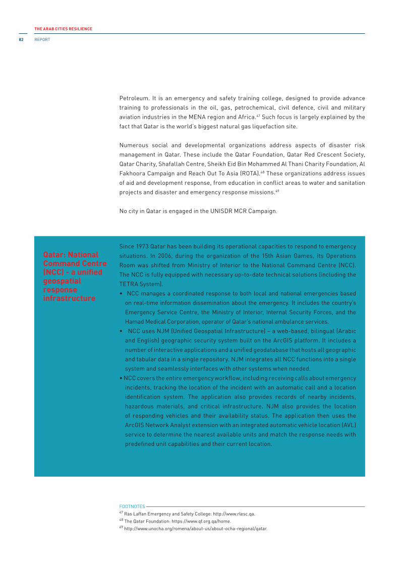
THE ARAB CITIES RESILIENCE
REPORT82
Petroleum. it is an emergency and safety training college, designed to provide advance
training to professionals in the oil, gas, petrochemical, civil defence, civil and military
aviation industries in the MENA region and Africa.47 Such focus is largely explained by the
fact that Qatar is the world’s biggest natural gas liquefaction site.
Numerous social and developmental organizations address aspects of disaster risk
management in Qatar. These include the Qatar Foundation, Qatar Red Crescent Society,
Qatar Charity, Shafallah Centre, Sheikh Eid Bin Mohammed Al Thani Charity Foundation, Al
Fakhoora Campaign and Reach Out To Asia (ROTA).48 These organizations address issues
of aid and development response, from education in conflict areas to water and sanitation
projects and disaster and emergency response missions.49
No city in Qatar is engaged in the UNiSDR MCR Campaign.
Box 8Qatar: National Command Centre (NCC) - a unified geospatial response infrastructure
Since 1973 Qatar has been building its operational capacities to respond to emergency
situations. in 2006, during the organization of the 15th Asian Games, its Operations
Room was shifted from Ministry of interior to the National Command Centre (NCC).
The NCC is fully equipped with necessary up-to-date technical solutions (including the
TETRA System).
• NCC manages a coordinated response to both local and national emergencies based
on real-time information dissemination about the emergency. it includes the country’s
Emergency Service Centre, the Ministry of interior, internal Security Forces, and the
Hamad Medical Corporation, operator of Qatar’s national ambulance services.
• NCC uses NJM (Unified Geospatial infrastructure) – a web-based, bilingual (Arabic
and English) geographic security system built on the ArcGiS platform. it includes a
number of interactive applications and a unified geodatabase that hosts all geographic
and tabular data in a single repository. NJM integrates all NCC functions into a single
system and seamlessly interfaces with other systems when needed.
• NCC covers the entire emergency workflow, including receiving calls about emergency
incidents, tracking the location of the incident with an automatic call and a location
identification system. The application also provides records of nearby incidents,
hazardous materials, and critical infrastructure. NJM also provides the location
of responding vehicles and their availability status. The application then uses the
ArcGiS Network Analyst extension with an integrated automatic vehicle location (AVL)
service to determine the nearest available units and match the response needs with
predefined unit capabilities and their current location.
Source: Ministry of interior, Qatar, Central Operations Department [https://www.moi.gov.qa/site/english/
departments/cod/sections/sec1197/1197.html]. Accessed 20 February 2018.
FOOTNOTES 47 Ras Laffan Emergency and Safety College: http://www.rlesc.qa.48 The Qatar Foundation: https://www.qf.org.qa/home.49 http://www.unocha.org/romena/about-us/about-ocha-regional/qatar.

CHAPTER 4
Urban governance and resilience building in Arab cities 83
Saudi Arabia
• The Ministry of interior is the national focal point for emergency and disaster
management.50 A special focus area is the provision of security during Ramadan and
Hajj seasons in Makkah and Medina.
• The Civil Defence (CD) and Fire Services departments and Public Security Directorate
(PSD) are placed under the jurisdiction of the Ministry of interior.
• Saudi Arabia is divided into 13 provinces with a varying number of governorates in each
province (118 governorates in total).
• Saudi Arabia has 106 cities and towns.
The Ministry of Municipal and Rural Affairs, jointly with the National HABiTAT Consultation
Group in the KSA, has articulated the need to “promote disaster-resilient cities through
integration of disaster risk management measures into spatial planning” among three
priorities for future sustainable development.51 As of September 2014, the Government is
developing a long-term strategy on disaster risk reduction in cooperation with the World
Bank/GFDRR to manage and mitigate the impact of disasters.52
The General Directorate of Civil Defence (GDCD) is chaired by the Minister of interior. The
Civil Defence structure has three layers: Board of the GDCD, Executive Committee, and
volunteers. The Board is responsible for the overall policy development and planning at the
national level. The Executive Committee implements decisions of the Board. its members
are appointed by the Board. CGCD volunteers are the citizens who committed to support the
CGCD task during the times of increased need.53
The Ministry of interior has set up the Emergency Call and Operation Centre (ECO). The
ECO is a network of control rooms across the country tasked with providing multi-agency
event reporting and dispatch operations for civil defence or security events. The centre's
headquarters is located in Makkah.54
Decision-making and resource allocation in the civil protection system is highly centralized.
it is response-oriented with a focus on particular security concerns. Also, the system is
designed to incorporate the charitable giving concepts of zakat (a religious tax) and sadaqa
(optional charity) under the Saudi National Campaign structure. The humanitarian aid is
therefore understood by the community and respected by the government.
Growing attention is paid to urban resilience-building. in 2013, a four-year cooperation
agreement was signed between the Government and UN-Habitat for the development of
the “Future Saudi Cities Programme.” The four-year Programme will be implemented by
UN-Habitat in 17 cities, in collaboration with the Ministry of Municipal and Rural Affairs.
One city in Saudi Arabia – Dammam – is engaged in the UNiSDR MCR Campaign.
FOOTNOTES 50 http://www.saudinf.com/main/c6p.htm.51 UN-Habitat 2016b, p. 47.52 ibid.53 http://www.998.gov.sa/Ar/eServices/Pages/default.aspx.54 Yao et al. 2013.

THE ARAB CITIES RESILIENCE
REPORT84
Box 10Saudi Arabia: smart cities and youth urban innovation
A new initiative has been recently launched by the Arab Urban Development institute
(AUDi) on Youth Urban innovation to utilize youth iCT skills in the implementation of
the KSA 2030 vision and engage youth in transforming cities into SMART CiTiES. The
programme emphasizes the importance of balancing “soft infrastructure” of local
social network, youth civic empowerment, cultural aspects of urban planning and “hard infrastructure” of a smart built environment, while realizing the KSA 2030 vision.
Box 9Jeddah: flood risk and urban planning in an ancient city
Known as the “Bride of the Red Sea,” Jeddah is considered the economic and tourism
capital of the country. it is the second largest city after Riyadh, with a population of
around 3.8 million. The origins of the city date back around 3,000 years, when the
fishing tribe of Quda’ah came to Jeddah and settled there. The founding of the city may
be dated to A.D. 647 when the third Muslim Caliph Othman Bin Affan ordered the city
to be transformed into a port to welcome pilgrims (Hajjis) coming by sea for the Holy
Pilgrimage to Makkah.* Today too, Jeddah continues in its role as the gateway to the holy
cities of Makkah and Madinah.
On 25 November 2015, the worst flood of the past 27 years hit the coastal city of Jeddah
and the surrounding areas of Makkah Province in Saudi Arabia. Heavy rains also lashed
western, northern and central parts of Saudi Arabia, including the cities of Makkah,
Medina, Hail and Arar. More than 90 millimetres of rain fell in just four hours in Jeddah,
which is nearly twice the annual average and the heaviest rainfall in Saudi Arabia in
decades. it resulted in over 100 lives lost and billions of riyals in damage caused to
homes, cars and public infrastructure.
The Governorate of Makkah has confirmed that the flooding of streets and tunnels was
the direct result of “a lack of adequate rainwater drainage systems at these sites.”**
Benefiting from the experience gained from the floods that hit the city in 2009 and 2011,
Jeddah Municipality has prepared an integrated plan to deal with heavy rains or flooding
in the city in 2014. As part of its efforts to deal with the hazards of heavy rains and
floods, the municipality will liaise with the Presidency of Meteorology and Environment
(PME), the Civil Defence, traffic police, the Ministry of Water and Electricity, the National
Water Company and the Ministry of Transport.
The risk of flooding is constant and growing in Jeddah, as it is a coastal city with a
rapidly increasing population. The main focus for the municipality is how to deal with the
housing needs of the middle and low-income families (set to grow by around 2.25 million
people between now and 2029) among Jeddah’s 3.8 million population.***
* http://www.uksacb.org/uk-en1313/page/main-cities
** Arab News, 20 November, 2015 http://www.arabnews.com/saudi-arabia/news/838371
*** Construction Week, February, 2014 http://www.constructionweekonline.com/article-26590- city-report-jeddah/

CHAPTER 4
Urban governance and resilience building in Arab cities 85
The programme's official launch took place in May 2016, adopting the Saudi
transformative 2030 Vision for Sustainable Development and paving the road for
achieving the United Nations 17 Sustainable Development Goals (SDGs) over the
next 15 years. The programme was launched in Riyadh city in collaboration with the
Higher Development Authority of Riyadh, and will be implemented in 17 Saudi Cities
in collaboration with the Ministry of Municipalities and Rural Affairs. The Saudi Arabia
model will be analysed for knowledge dissemination and replication in the Arab region.
The aim of this seven-month programme is to develop smart and responsive
contemporary technology-based services and resilient urban planning development
schemes. The program is designed to inspire and support municipal officials as they
develop the Saudi Smart City policies and implementation framework for their cities,
while engaging youth in leading Smart City development in Saudi Arabia.
The programme is expected inter alia to develop a Youth Urban Visualization learning
toolkit to empower youth civic engagement, as a sustainable approach for community
participation in the space mapping, design and development of Smart Cities.
The Arab Urban Development institute (AUDi) is a non-profit and non-governmental
organization, working as the Arab Towns Organization (ATO) scientific body in 500 cities
and local municipalities across 22 Arab countries. Established in Riyadh 1998, its five
main programmes are: City Development Strategy, Capacity Building, Child and Youth,
Urban Observatories, and Urban Poverty.
Nuha Eltinay
4.2.3b The Maghreb
The Maghreb features very diverse characteristics, a few of which can have significant
impact on urban resilience-building: Morocco as a kingdom with many achievements in
disaster and climate risk management including at the local level, Algeria with an advanced
civil protection and disaster risk management system (particularly risk transfer and DRR
integration into sectoral planning), and Tunisia demonstrating an increasing interest in urban
resilience. Libya, on the other hand, is a failed state with conflict ongoing since 2011, while
Mauritania is one of the poorest countries in the world, and suffering from challenges of food
security due to climate change.
Yet there are similarities among these countries, especially in terms of risk exposure of urban
areas to seismic, coastal and climate hazards. At least three countries (Algeria, Morocco and
Tunisia) have established good practices in disaster risk management. Also, with the exception
of Mauritania, the Maghreb countries are middle and high income. Urbanization is comparatively
high in the region. Decentralization and democratization is stronger in Tunisia and Morocco.
The local authorities, however, struggle to obtain and effectively exercise power over planning,
financing, and implementing resilience-building initiatives. A lack of financial resources, lack of
human capital, and lack of enabling legal framework, all contribute to this situation.
THE ARAB CITIES RESILIENCE
REPORT86
Algeria
• Algeria is divided into 48 provinces,55 553 districts and 1,541 municipalities.56 it has 38
cities with more than 100,000 inhabitants, and 134 towns (Brinkhoff 2017).
• Civil Protection Directorate is part of the Ministry of interior and Local Governments
The civil protection system in Algeria is one of the most advanced in the subregion.57 it has
a long-standing history of disaster reduction in the country, triggered as often is the case,
by disasters. After the El Asnam earthquake in 1980, the Government of Algeria issued the
construction code in 1983. it implemented the first disaster reduction and management
plan already in 1985.
The Boumerdès earthquake of 2003 heightened the importance of preparedness. The
Law on Prevention of Major Risks and Disaster Management and new building regulations
were adopted in 2004. DRR has become an important consideration for sectoral planning,
whereby the National Scheme for Land Use planning was the first to integrate DRR. With
UNDP support, DRR was also integrated into the National Planning Scheme 2030.
After the North Algerian earthquake, a disaster insurance scheme was introduced in 2003.
The insurance scheme is mandatory for all property owners and covers physical damage
to property (e.g., apartments, houses, villas, industrial and commercial buildings and
their contents) affected by one of the following hazard events: earthquakes, floods and
mudslides, violent storms and winds, landslides, or other similar disasters.
in 2006, the Government of Algeria adopted Law No 06-06 about city orientation. The law
provides a common ground for shaping urban coherence scheme. Under this law a study
will be carried out and solutions defined to address the existing and emerging problems in
the urban context (including, but not limited to, the balance of development and economy,
improving the living environment of citizens, etc.). The cities of Algiers, Oran, Constantine
and Annaba will be the first cities to be tackled. in total it is envisaged to include 33 major
cities, 39 cities with population over 10,000, 158 small towns, and 361 urban clusters.
Under this law, a National Observatory for the Cities was also established, followed in
early 2007 by an executive decree establishing the organization and functioning of the
Observatory. The Observatory is in charge of monitoring the implementation of the urban
policy and proposes measures for its realization and the involvement of the citizens. The
new Observatory is also responsible for developing indicators, statistics and information
about the cities as well as new management models able to assist government and
local authorities in improving the life of citizens and consolidating the role of the city in
sustainable development.
FOOTNOTES 55 The regional structure (region) as a local authority granted legal status does not exist. However, the regional
constituency covering a space comprising several wilayas is tangible to the extent that several State services as
well as their public and private businesses have been established regionally.56 http://www.interieur.gov.dz/Dynamics/frmitem.aspx?html=3&s=25.57 UNiSDR-ROAS 2013.

CHAPTER 4
Urban governance and resilience building in Arab cities 87
The resilience agenda in Algeria has been taken to a higher level by the appointment and
institutionalization of the Délégation Nationale aux Risques Majeurs in September 2012.
Also, the response capacities of the civil protection authorities are strong. During the
Nepal earthquake of 2015, Algeria was the only African and Arab country actively present
in the field.58
“The strong centralization of powers and prerogatives, exacerbated by endemic bureaucracy,
has largely reduced the role of community structures, supposed to be the counterpart of
citizens to the extent that, in theory, they embody and express the will of the people.”59 The
decentralization law of 2004 requires municipalities to have specific disaster management
responsibilities. However, resources and capacities at the municipality level remain limited.
As such, additional support is required to empower municipalities to undertake effective
DRM actions, through the provision of adequate budgets and capacities.
Non-governmental organizations are also active in resilience-building in Algeria. in
September 2013, with the support of UN regional offices, the UN Country Team in Algeria
started developing contingency plans to improve emergency preparedness. This included
an earthquake simulation exercise.60
A major component of the Civil Protection’s mandate is to train and sensitize schools,
municipalities and wilayas (provinces) on preparedness and prevention measures. The Civil
Protection Directorate organizes regular public-awareness tours to reach remote sites and
inform the general population about disaster risk preparedness and prevention measures.
Algeria is also part of the Euromed programme for the Prevention, Preparedness and
Response to Natural and Man-made Disasters (PPRD). PPRD is an EU-funded programme
aiming at raising the national resilience of each southern Mediterranean partner country
(countries targeted by the European Neighbourhood Policy – ENP) affected by a natural
or human-caused disaster, mainly through risk reduction (prevention, mitigation, public
awareness) and preparedness (capacity building, contingency planning), including better
cooperation at the international level.61
None of the Algerian cities is engaged in the UNiSDR MCR Campaign.
Box 11Algeria: insurance against natural hazards
The unplanned urbanization and failure to comply with the seismic building codes has
increased vulnerability to natural hazards. To address the growing financial risk from
natural hazards, legislation on hazard risk insurance was enacted in August 2003 after
the 2003 Boumerdès earthquake .
FOOTNOTES 58 http://www.aps.dz/en/algeria/7772-nepal-earthquake-algeria-hailed-for-its-“commitment,”-civil- protection’s
“professionalism”.59 United Cities and Local Governments (UCLG), Country Profile – Algeria.60 http://www.unocha.org/romena/about-us/about-ocha-regional/algeria.61 PPRD South program ii: http://www.euromedpprdsouth2.eu.

THE ARAB CITIES RESILIENCE
REPORT88
it is a mixed insurance system, based on mandatory insurance, combining the principle
of citizen mutuality, a fundamental principle of insurance, and that of national solidarity
with State intervention as a financial guarantor. The compulsory insurance scheme is
designed to limit the financial threat to the national budget, ensure risk-sharing by all
owners, promote seismic building code practices, and build up long-term reserves to
compensate future disasters losses.
The insurance scheme is mandatory for all property owners and covers physical damage
to property (e.g., apartments, houses, villas, industrial and commercial buildings and
their contents) affected by: earthquakes, floods and mudslides, violent storms and winds,
or other similar disasters.
The cost of the insurance (the premium) is based on three parameters: the value of
the property insured, the risk zone where the building is located, and compliance with
the mandatory building standards. For example, an apartment type F3 (three bedroom
apartment) with an area of 70 m2 in Algiers (the capital), can be insured for up to 1,800
DZD (18 USD). The minimum income in Algeria is 20,000 DZD (200 USD). A significant
fraction of the risk is transferred to international reinsurance companies until sufficient
financial funds have been accumulated under the insurance scheme.
To enforce the insurance scheme, two types of sanctions are currently applied:
• Owners are required to take insurance and if they fail to do so, they will not
be eligible for government compensation in the form of housing credits or
reconstruction in the event of damage caused by a natural hazard.
• To sell, purchase or lease any type of housing or property, owners must present their
insurance policy documents to real estate registration offices and the tax authorities
at the time of making their tax declaration. The law also provides sanctions for
non-compliance with this obligation: refusal of compensation and fines equal to the
amount of the premium increased by 20 per cent.
The insurance scheme is designed as a multi-hazard insurer. Private and public insurance
companies undertake policy distribution and marketing, and conduct loss assessments.
Currently, five insurance companies are offering policies for this insurance scheme.
However, it should be noted that the uptake rate is low (5.2 per cent for residential property
and 7.6 per cent for industrial facilities in 2012), due to insufficient public awareness of the
benefits of insurance, the habitual role of the government in compensating for disaster
losses, and the difficult economic conditions experienced in recent years.
Sources
A. Ordonnance No. 03-12 du 27 Joumada Ethania 1424 correspondant au 26 août 2003, relative à l’obligation
d’assurance
des catastrophes naturelles et à l’indemnisation des victimes et textes d’application.
B. Conseil national des assurances (CNA), Bulletin des assurances No. 26 (Alger, Algérie : CNA, 2014). [http://
www.cna.dz/Documentation/Travaux-du-CNA/Publications-du-CNA/Bulletin-des-assurances-n-26]. Accessed
22 February 2018.
C. AssurAl, Le portail de l’Assurance en Algérie, L’assurance contre les effets des catastrophes naturelles
[http://www.cna.dz/En-savoir-plus/Assurances-obligatoires/L-assurance-contre-les-effets-des-
catastrophes- naturelles]. Accessed 22 February 2018.

CHAPTER 4
Urban governance and resilience building in Arab cities 89
Box 12Algeria: flood forecasting and early warning system (UPI) for cities along the Mekerra Wadi
A flood forecasting and early warning system (F-EWS) has been developed and
implemented in Sidi Bel Abbes wilaya (province), through the EU-funded “Support
program for the water resources sector in Algeria” aimed at flood risk prevention. The
F-EWS is expected to be replicated in other provinces of Algeria.
The Oued Mekerra basin forms “a major part of the wilaya of Sidi Bel Abbes” and was
chosen as a pilot area for implementing the methodology and procedures to set up and
manage the forecasting and flood risk early warning system.
The UPI main tasks: The UPi (Unité de Prévision des inondations, or Flood Forecasting
Unit) is a scientific unit, not an operational one. its work is based on real-time
monitoring – necessary for flood forecasting – which consists of collecting data several
times a day on the water level or flow data at key points along the monitored wadis
(valleys). These key points were chosen for Wadi Mekerra in those areas where floods
have occurred in the past. The prediction of rainstorms is the responsibility of the
National Meteorological Organization (ONM). This body is responsible for transmitting
Special Meteorological Bulletins (BMS) to the early warning system (UPi) and to the
National Hydraulic Resource Agency (ANRH). The National Meteorological Organization
regularly distributes these Bulletins. ANRH undertakes the hydrometric observation of
wadis and is also responsible for the management of hydrometric and rainfall stations.
Data transmitted by these stations are received by the UPi and by ANRH. The data
transmission is routinely carried out by telephone landline or by using an ordinary GSM
chip (every 30 minutes). Rainfall stations in the Oued Mekerra basin have been replaced
by automatic units to provide this data (Figure 1). This procedure ensures that rainfall
observation takes place in real time in the basin that is being monitored.
Flood forecasting
UPi compiles an empirical prediction based on its observations of the amount of water
that has fallen in the catchment areas, as well as water levels in the wadi itself. These
observations are mainly made upstream of the basin using the measurement data
collected by the network of “automated data collection and flood warning systems.”
This system provides sufficient time to analyse the data.
The data is then fed into several complex models that can predict water levels. There is
a hydrological model which transforms rainfall into flow. Another model is a hydraulic
simulation model which provides a “model of the distribution of flood water.” The
triggering of the alarm related to the flood risk is based on a disaster risk plan that was
previously established using the hydraulic model.
The UPi is responsible for the dissemination of information. This is carried out for
different levels of risk and by hydraulic subdivision. Alerts have to be forwarded to the
leaders of the Daïras as well as to the local civil protection service.

THE ARAB CITIES RESILIENCE
REPORT90
City Threshold Orange m3/s Threshold Red m3/s Description
Redjem Demouche 200 Water to the limit of the bridge (40 cm below)
Ras El Ma 150 175Risk of flooding city and harbour
El Hacaiba 350Water to the limit of the bridge (60 cm below)
Moulay Slissen 150 175Tadjmout: Risk of flood-ing city and bridge
Moulay Slissen 550 575Mekerra: Risk of flood-ing bridge
Sidi Ali Benyoub 750 775 Risk of flooding bridgeMellinet 675 725 Risk of flooding bridge
Tabia 1500 Water to the limit of the bridge (30 cm below)
Boukhanefis 100 150 Bridges
Sidi Lahcene 100 150Bridges and impact in the city
The flood early warning system serves numerous Algerian cities. A list of the cities with
flood risks is provided in Table 14: Projected threshold flood flows for some cities along the Mekerra Wadi.
Sources
A. Smail Fezazi, L’inondation à Sidi Bel Abbes, Thèse pour Diplôme de Post-Graduation Spécialisée,
Université des Sciences et Technologies Houari Boumédiène (USTHB), 2015.
B. Abbes Merabet, Étude de la protection de la ville de Sidi Bel Abbes contre les inondations, Mémoire de
magister, spécialité: Hydraulique, Université de Sidi Bel Abbes, 2008.
C. Direction de l’hydraulique de la Wilaya de Sidi Bel Abbes, 2010, Système de prévision des inondations
(U.P.i).
Table 14Projected threshold flood flows for some cities along the Mekerra Wadi
Box 13Algeria: development of response and recovery capacities at the wilayas (provinces)
Algeria has built a solid disaster response system across the country. The Civil Protection
General Directorate is the primary actor responsible for coordinating implementation
of comprehensive preparedness, response and recovery measures at the national and
local levels. Every six months wilayas participate in simulation exercises as part of the
national preparedness. Each wilaya is responsible for drafting a disaster management
plan that is tested and updated through simulations according to the 04/20 Law on
Prevention and Disaster Management.
Decisions about the recovery process are taken by the central government and they
are implemented through the line ministries at the wilayas and municipalities. The
example of the 2003 Boumerdès earthquake illustrates the regular process for the
reconstruction and recovery after disasters in Algeria:
Assistance Packages offered to Individuals for Reconstruction: Government allocated
a 100 billion Algerian Dinars (1.4 billion USD) for the reconstruction of 22,000 housing

CHAPTER 4
Urban governance and resilience building in Arab cities 91
units, 160 schools and 6 sanitary establishments and for the repair of damaged
constructions in Algiers and Boumerdès wilayas.
Urban reconstruction measures: Government has decided to incorporate appropriate
preventive measures into policies and programmes of urban zones. Thus, technical
quality control has been made compulsory for public and private buildings alike since
2004. Also, a new law related to the procedures of elaboration and approbation of the
land use, urban planning and construction has been adopted by the government.
Relief Issues:
• Homeless families were sheltered by the government (civil protection, Red Crescent)
and international organizations, in tents built in camp sites.
• Each camp site was provided by a police bureau, a civil protection centre, a
temporary hospital, a bureau of Algerian Red Crescent, an annex of local
administration and a mosque.
• in the first four weeks after the disaster, cooked food was distributed three times a
day.
• Camp administrators organized special tents for children to play, do manual work such
as crafts, watch TV, and play games under the supervision of psychologists and social
workers.
• High school students who had to pass the baccalaureate exam in September were
provided with special sites in the affected zone or outside the zone assisted with
professors to help them review their courses.
• Some nights, musical evenings were organized in the camps.
• The main problems reported in the camps were hygiene and collective toilets. The
families had to stand in a queue to use the toilets.
• The government started building individual prefabricated houses “chalets” in about
150 sites where the victims were removed from the camp sites to these new sites.
• These “chalets” are equipped with water, electrical power, sewage and water
systems and individual toilets.
• The president has promised that all the victims will be sheltered before the
winter season.
Psychological and medical rehabilitation:
• All the sites of temporary sheltering (more than 150 campsites) were provided
consultations, examinations, and a care programme, as well as the programmes of
public health (vaccination, prevention against water-borne diseases, epidemiologic
monitoring).
• The Ministry of Health, in order to avoid the occurrence of epidemics, employed 27
teams of epidemiologists and technicians for cleaning whose mission was the strict
control of drinking water and hygiene in the camps.
Source: Rapport official national sur la gestion de la catastrophe du séisme de Boumerdès du 21 mai 2003 (Algérie, 2003).

THE ARAB CITIES RESILIENCE
REPORT92
Libya
• Libya is divided into 22 districts.
• Libya has 97 cities, towns and municipalities.
After NATO-backed rebels toppled the former ruler Gaddafi, Libya plunged into chaotic
unrest. Diverse warring factions are fighting to seize the power in the country. The conflict
is largely between two groups: the Tobruk government of the General National Congress
(GNC) and the islamic government of the General National Congress (GNC) also called
the National Salvation Government. The situation is complicated with the presence of so-
called iSiS in Libya that has established its largest power centre outside of the caliphate’s
borders, with one city under its brutal brand of islamic law and thousands of fighters across
the country.62
in 2016, the UN-backed Government of National Accord (GNA) was formed. The rival Tripoli-
based National Salvation government rejected the GNA transition. it is assumed that the
GNA is eventually empowered to restore security and launch a comprehensive program
to rebuild the economic and social infrastructures. However, it is uncertain whether the
new unity government will be able to bring together the warring factions and re-establish
stability in Libya.63
in this context, the primary concern is to stabilize the situation in the country and provide
safety and security to the population. UNDP and the Libyan Government of National Accord
initiated the Stabilization Facility to rehabilitate critical infrastructure destroyed by conflict
and restore basic service provision.
The facility can finance rehabilitation and repairs of key public infrastructure including
clinics, hospitals, police stations, water and waste water treatment facilities, power grids
and stations, etc. The facility can also support businesses that were destroyed by the
conflict or degraded, and are vital to communities as a whole, such as bakeries in places
where they were destroyed and people are forced to bring bread from elsewhere.64
it remains important that humanitarian and development partners take due account
of existing and emerging disaster and climate risks while designing and implementing
necessary interventions.
FOOTNOTES 62 http://europe.newsweek.com/watch-rise-isis-libya-445291?rm=eu.63 http://www.cfr.org/global/global-conflict-tracker/p32137#!/conflict/civil-war-in-libya.64 http://www.ly.undp.org/content/libya/en/home/presscenter/articles/2016/04/13/undp-libya-launches- the-
stabilization-facility-plan-for-libya-during-the-senior-officials-meeting-in-tunis/.

CHAPTER 4
Urban governance and resilience building in Arab cities 93
Mauritania
• The national system of regional governors and prefects is modelled on the French
system of local administration. Mauritania is divided into 15 regions, which are further
divided into 44 departments. it has 43 cities, towns and municipalities.
• The Ministry of interior and Decentralization65 oversees the system of local
administration.
• The Directorate of Civil Protection operates under the jurisdiction of the Ministry of
interior and Decentralization.
• Mauritania is one of the poorest countries in the world: it ranks 141 out of 185 countries
based on GDP per capita (WB).66
Mauritania is taking its first steps towards building resilience in the country. The disaster
and climate risk management is inevitably seen through the prism of the food and nutrition
security. Thus, in its Poverty Reduction Strategy Paper, “the integration of risk and natural
disaster management into sectoral policies” is highlighted with regard to climate change
monitoring.67
The Civil Protection system needs support in capacity development in order to further the
resilience-building agenda. Thus, with the support of the Prince’s Government of Monaco
the first three fire-fighting stations have been set up in the capital Nouakchott.68 Also, a
radio communications network was established to support local firemen in dealing with
emergency situations. Some ambulances and protective clothing were also provided.
in January 2015, with the support of NATO and the Canadian Department of Foreign Affairs,
the first Mauritanian Centre for crisis monitoring, alerts and management was set up.69
One of the objectives of this particular partnership is to give more power to the regional
directorates for civil protection, each with an operational coordination centre (Centre de
Coordination Opérationnelle – CCO). As part of West Africa, Mauritania is engaged in and
benefiting from the Regional Committee for Disaster Management in West Africa (GECEAO)
since 2009.70
The administrative system of Mauritania is highly centralized across all sectors including
civil protection. The capacities of the local authorities for resilience-building are extremely
limited in the capital city and largely non-existent outside it. The primary focus is very
much on response.
None of the Mauritanian cities is engaged in the UNiSDR MCR Campaign.
FOOTNOTES 65 http://www.interieur.gov.mr.66 http://data.worldbank.org/indicator/NY .GDP .PCAP .CD?order=wbapi_data_value_2013+wbapi_data_value&sort=asc.67 iMF 2013, p. 71.68 http://en.gouv.mc/Policy-Practice/Monaco-Worldwide/Public-Aid-for-Development-and-international-Cooperation/
News/Civil-Security-in-Mauritania-A-Field-Mission-for-Two-Monegasque-Firemen.69 http://www.nato.int/cps/en/natohq/news_117409.htm.70 http://abdoulkarimsow.org/geceao_VF/.

THE ARAB CITIES RESILIENCE
REPORT94
Morocco
• Directorate of Surveillance and Prevention of Risk falls under the jurisdiction of the
Department of Environment of the Ministry of Energy, Water, Mines and Environment.
• Morocco is divided into multiple levels of local government, all directly under the
Ministry of the interior: 16 regions, 38 provinces and 1,544 municipalities.71
Morocco has taken steps to establish a strong foundation for risk-informed resilience-
building, which is further based on two priority risks and their implications: seismic risk
and climate risk with the focus on the nexus of water, food and agriculture. Understandably,
the resilience-building priorities and tasks are largely divided between various ministries,
including the Ministry of interior, the Ministry of Water and Environment, the Ministry of
Health, the Ministry of Energy and Mines, and the Ministry of Education.
Thus, the Department of Water has developed the Plan National contre les inondations
(PNi, or the National Plan against Floods/NPF). The plan identified 390 priority areas
for which prevention measures are to be realized before 2020. Under this plan, Morocco
has developed a forecasting and flood warning system. The country intends to develop a
geographic information system (GiS) with data on natural and technological hazards across
the country, called GiS risk assessment.
Risks and vulnerabilities in the agricultural sector is a priority for the country too. The
National irrigation Water Saving Programme (or Programme National d’Economie d’Eau
en irrigation/PNEEi), formulated in 2009, is considered the primary tool in implementing
the Plan Maroc Vert (PMV)72 as a response to the challenges of climate change and food
security.
With the support of international partners (WB, GFDD and SDC), Morocco has made a shift
from managing risk in “silos” to integrated risk management.73 in April 2016, USD 200
million in funding was approved by the WB for the integrated Disaster Risk Management
and Resilience Program in Morocco for institutional reforms with disaster risk-reduction
investments and the introduction of a catastrophe risk insurance program.74
Morocco has engaged in a series of reforms on decentralization since 1999. The primary
focus is to ensure that the mission of local authorities is less about maintaining public
order, but rather encouraging development and local initiatives and ensuring human rights
(among others through the Local initiatives for Human Development). There are 1,544
municipalities in Morocco, each of which elects municipal councils and mayors by general
FOOTNOTES 71 Arab Political Systems: Baseline information and Reforms – Morocco, Carnegie Endowment:
www.carnegieendowment.org/arabpoliticalsystems.72 http://www.finances.gov.ma/fr/Pages/Stratégies/Stratégie-de-développement-agricole--le-Plan- Maroc-V ert.aspx?
m=investisseur&m2=investissement.73 World Bank 2013.74 http://www.worldbank.org/projects/P144539?lang=en.

CHAPTER 4
Urban governance and resilience building in Arab cities 95
Box 14Morocco: eradicating urban slums to reduce vulnerability
Like most developing countries, the government of Morocco is faced with the day-to-
day demand on housing and better conditions of living. There are about 1,000 slum
districts in Morocco. in total, about 212,000 families live in urban slums across 70 cities
of Morocco, and about 80,000 families live in informal agglomerations.
in the year 2000, the government launched a strategy to reduce the vulnerability of
informal construction, slums and ancient housing sites.
in order to implement the strategy, under the UN-Habitat program “Cities without slums”
(2004-2005) nearly USD 450 million were invested and an allocation of about USD 140 million
was dedicated to social housing from the State Solidarity Fund of Housing. in parallel, another
programme was launched for urban rehabilitation of illegal districts, with funding from the
State Housing Solidarity Fund (USD 20 million) and the government (USD 25 million).
There is also fair attention paid to creating incentives for rural development. in order
to reduce the rural exodus to large cities, the government strategy is to encourage
development in rural areas and remote villages.
Another important consideration is urban planning for suburban areas located in the
close vicinity of large cities. The government has initiated a new programme to set
up viable new urban agglomerations around the large cities. This programme was
conducted in partnership with local authorities and the private sector. Public land grants
were established in order to promote social housing units and for the prevention of illicit
human establishments. T this end, a micro-zoning planning of Al Hoceima (Morocco)
was initiated as a pilot project for countrywide replication.
The legal framework was revised and improvements were made to the main urban
planning regulations to integrate the risk of natural hazards. Also, technical controls for
constructions in hazard-prone zones were adopted which allow the imposition of fines
and in certain case, demolition of unsanctioned constructions in hazard-prone zones.
in 2004, a financial incentive mechanism was introduced: all the taxes received from
the sales of cement in the entire Kingdom during one year were used to establish two
guaranty funds. Thus, USD 100 million were allocated to support low-income households
and families with irregular income, and two major public banks were reorganized to
support the social housing program in the Kingdom.
Source: A. Guedira and M. El Malti. “Evaluating and reducing the vulnerability of slums, traditional housing, and migrant populations – Experience from Morocco”, Kingdom of Morocco/Ministry of Housing and Urban Planning. World Conference on Disaster Reduction, 18-22 January 2005, Kobe, Hyogo, Japan.
election. As part of its decentralization policy, Morocco's government has sought in recent
years to increase the councils’ autonomy. But the councils remain weak because the central
government continues to control their finances and resources.
Two Moroccan cities are engaged in the UNiSDR MCR Campaign: Agadir and Tata.
THE ARAB CITIES RESILIENCE
REPORT96
Tunisia
• Tunisia is divided into 24 governorates, 264 districts (municipalities).
• Tunisia has 264 cities, towns and municipalities.
• The National Office of Civil Protection (NOCP) operates under the jurisdiction of the
Ministry of interior.75
The roots of Tunisian civil protection can be traced back to November 1894, when the Aid
Association for Volunteer Firemen was founded in Tunis. Since then, it has grown, and in 1993
it became the National Office of Civil Protection (NOCP). it is established within the Ministry
of interior with the goal to organize civil protection on a national and regional scale. This
involves responding to all types of accidents, calamities or disasters that threaten people,
property or the environment. The NOCP also engages in prevention activities, including
contributing to both the national plan and regional plans. in 2015, the NOCP established
the National School of Civil Protection in Jebel Jelloud, Tunis in 2015. it is also involved in
raising citizen awareness on prevention, as well as teaching people about civil protection
and providing instruction in first aid.76 Various international partners (EU, France, etc.)
effectively support the activities of the NOCP and invest in its capacity development.
in addition, Tunisia established its Desinventar database on disaster loss and damage in
2012-2013. Tunisia is a part of the World initiative on Safer Schools launched in istanbul in
2014.77 in 2012 Tunisia announced that it will establish a National DRR Platform, however
during the third UN World Conference on DRR, no National Platform was reported.
Local-level resilience-building in Tunisia is highly restricted by a number of factors,
including limited financial resources and limited human capacities.
Municipal institutions in Tunisia are relatively long-standing. The first modern municipality
dates back to 1858. Article 7 of Tunisia's Constitution recognizes the legal status of
municipalities allowing them to be seen as legally independent from the State, with their own
capital, land and budget, financed by specific revenue. However, municipalities have low level
of autonomous financial resources and limited control over municipal budget.78 Moreover,
municipalities appear detached from many services. Thus, services such as education, water
distribution, drainage, transport, etc. are outsourced to other public organizations leaving
the responsibilities of municipalities largely residual and inconsistent.79 Also, municipalities
have significant lack in human resources and technical capacities to address resilience
issues at the local level. This situation limits the power of the municipalities to exercise the
responsibilities for sustainable urban planning and urban resilience.
FOOTNOTES 75 http://www.ministeres.tn.76 http://www.icdo.org/en/media/press-media/civil-protection-republic-tunisia/.77 https://www.unisdr.org/archive/42152.78 UCLG County Profile: Tunisian Republic.79 ibid.

CHAPTER 4
Urban governance and resilience building in Arab cities 97
Despite the challenges, many Tunisian municipalities are putting forth efforts to champion
urban resilience. Thus, in 2013 the municipality of Ain Draham, with active support of UNDP,
became the first city in Tunisia to join the Making Cities Resilient campaign. it was followed
by 12 other municipalities.
4.2.3c The Mashreq
The Mashreq is the most dynamic subregion when it comes to the legal and institutional
framework for disaster risk management, the progress made on DRR, and the level of
capacities of state and non-state actors.
All six countries of the subregion, including Syria before the 2011 uprising, have undertaken
initiatives to improve national disaster risk management systems through institutional
reform, strategy development, risk assessment, urban disaster resilience, disaster
preparedness, disaster risk education and emergency response. iraq has set up a national
disaster management committee and is currently expanding the work to other levels and
sectors. Of urgent concern and focus is the risk from the Mosul dam. Jordan has achieved
significant progress on urban disaster resilience in numerous cities, but especially in Aqaba
and Petra. Amman is a grant recipient of the 100 Resilient Cities programme of the Rockefeller
Foundation. Egypt has achieved progress on national institutional and strategy development,
governorate-level emergency preparedness, disaster response drills and city-level risk
management. Lebanon is in the lead when it comes to promoting urban resilience. it has
invested significant efforts in reform of the national system and improvement of emergency
preparedness through emergency centres and drills. Palestine has initiated work on national
strategy development, national risk assessment, and urban resilience. All the Mashreq
countries have developed disaster damage and loss databases, namely the Desinventar.
This subregion is also, however, the most unstable of the MENA region. Syria is undergoing
a full scale war with deep engagement of regional and international powers. Egypt and iraq
are trying to balance development with ongoing armed conflict. Palestine is fragmented
and lacks full freedom for actions on resilience-building. Lebanon has a fragile peace and
a weak political system. Jordan is the only “island of stability” in the subregion.
in terms of urban resilience, the municipal authorities in Jordan, Lebanon and Palestine
enjoy relatively higher autonomy - in Palestine and Lebanon due to the weak state and in
Jordan for economic reasons. in iraq, certain governorates and regions also enjoy high
autonomy vis–à-vis the national government. in Egypt, trends of centralization of authority
have become stronger since the arrival of the current government. Another equally
important challenge that the municipalities in the Mashreq face is the lack of financial
resources, with few a exceptions, including Aqaba, Petra and Beirut.
THE ARAB CITIES RESILIENCE
REPORT98
Egypt
• Law 43/1979 defines the legal basis for the local Egyptian administrative system that
is divided into five territorial units: 27 governorates, 25 cities and 217 towns and urban
subdivisions. The Ministry of Local Development80 oversees the local administration
system.
• Egypt is a unitary country with one of the longest traditions of centralization.
Disaster risk management has made some progress at the national level in Egypt. Thus, the
National Strategy for Crisis/Disaster Management and Disaster Risk Reduction and the National
Strategy for Adaptation to Climate Change were adopted in 2010 and 2011, respectively. Other
laws and decrees that provide the legal framework for DRM/DRR in Egypt include Law No.
179/1956 on civil defence, Presidential Decree No. 300 on establishing the Search and Rescue
Centre at the Ministry of Defence (the Centre of “Search and Rescue” was established at the
Ministry of Defence in Cairo), and the Prime Minister's Decree No. 1537/2009 of constituting the
National Committee for Crisis/ Disaster Management and Disaster Risk Reduction.
The same decree established the institutional framework of crisis/disaster management
and DRR in Egypt that comprises six main elements:81 the Higher Ministerial Committee
for Crisis/Disaster Management and DRR; the National Committee for Crisis/Disaster
Management and DRR; the Advisory Committee for Crisis/Disaster Management and DRR;
the Crisis/Disaster Management and DRR Sector at the information and Decision Support
Center (iDSC); and Crisis/Disaster Management Departments at different ministries,
governorates, bodies, civil society organizations and in the private sector.
Also, in partnership with UNiCEF, iDSC developed the Egypt National Communication
Strategy for Raising Societal Awareness in the Area of Risk Reduction and Crisis
Management in 2010.82
Even though each governorate has a designated “crisis/disaster management department,”
the central authorities maintain a high level of control, particularly with regard to financial
issues. For instance, the free transfer of movable and immovable assets or rental fees
carried out by the governorate popular council for amounts of over 50,000 Egyptian pounds
(about 5,000 Euros) must be approved by the Council of Ministers.83
Minor progress on community participation and delegation to the local level has been
noticed so far. Egypt is considered one of the most centralized countries in the world,
ranking 114 out of 158 countries on decentralization and the closeness of government to
the people, a so-called “decentralization index,”84 and this is despite years of the USAiD-
funded Egyptian Decentralization initiative 2008-2012.
FOOTNOTES 80 http://www.mold.gov.eg/arabic/default.htm.81 The National Strategy for Crisis and Disaster Risk Reduction 2010. [http://www.preventionweb.net/files/13353_
nationlstrategyforcrisisdisasterman.pdf]. Accessed 26 February 2018.82 http://www.preventionweb.net/english/professional/policies/v.php?id=21623.83 United Cities and Local Government: Country Profile: Egypt.84 http://www.economics-ejournal.org/economics/journalarticles/2014-3.

CHAPTER 4
Urban governance and resilience building in Arab cities 99
Box 15Egypt: linking national and local levels with legal and institutional frameworks
The institutional arrangements for resilience-building in Egypt are confined to the
National Committee for Crisis/Disaster Management and Disaster Risk Reduction
(Prime Minister’s decree No. 1537/2009), while specific thematic tasks are allocated to
all ministries. The NCCMDRR was established in April 2006. it serves as the National
Platform. The Committee also includes the iDSC and a scientific advisory committee
comprising a panel of experts and professional scientists.
The institutional framework of crisis/disaster management and DRR in Egypt has six
main elements. Crisis management entities were established in all 28 governorates
(the local level), as well as at various ministries, agencies and institutions.
in 2010, Egypt adopted the National Strategy for Crisis/Disaster Management and
Disaster Risk Reduction.* The strategy allocates tasks and responsibilities to national
authorities as well as to governorates and “concerned authorities” (which leaves room
for the municipal authorities). However, the lack of financial and human capacities
means that these tasks go largely unattended. importantly, the National Strategy
emphasizes the significance of raising awareness on disaster risk reduction and
disaster management issues. This is further emphasized in order to promote a Safety
First culture in the National Strategy for Adaptation to Climate Change and Disaster
Risk Reduction.
The system of crisis and disaster management and disaster risk reduction in Egypt
has been designed around the ‘incident’ and not the risk. Although many efforts were
invested to shift the focus of the system from response to prevention and preparedness
issues, and risk considerations have been integrated in the legal and institutional
frameworks, the application of disaster risk governance interventions is still lagging.
A further concern is the capacity of local authorities to reduce disaster risks. For
municipalities this usually takes the form of responsibilities for controlling construction
through the development of land-use regulations, environmental protection measures
and building codes. Since 1956, Egypt has continually developed and updated its building
codes. in 2001, the Egyptian Code for the Calculation of Loads and Forces on Structural
and Masonry Works was completely revised and now follows the Eurocode 8 standards.
The main challenge, however, remains the enforcement of these building codes in cities,
by the municipal authorities as well as by the organizations that are called on to provide
quality control and supervision of construction, such as the Housing and Building
National Research Centre of Egypt.
* http://www.preventionweb.net/files/13353_nationlstrategyforcrisisdisasterman.pdf
Sources
A National Strategy for Crisis/Disaster Management and Disaster Risk Reduction, 2010, Egypt, iDSC;
B HFA Progress Report, 2014, Egypt, iDSC
Four cities in Egypt are committed to the UNiSDR MCR campaign: Alexandria, Cairo,
ismailia and Sharm el-Sheikh.
THE ARAB CITIES RESILIENCE
REPORT100
Iraq
• iraq has a federal parliamentary system of government. iraq is composed of 19
governorates, which are subdivided into 111 districts. iraq has 46 cities.
• The Ministry of Municipality and Public Works supervises the local administration in iraq.
• The Ministry of interior is responsible for dealing with large scale emergency situations.
• The National Committee for Disaster Risk Reduction is under the chairmanship of
the Minister for Science and Technology. it has responsibility for policy, coordination,
capacity development and information management with regards to DRR.
in 2007, the Government of iraq established a National Disaster Risk Reduction (DRR)
Committee, chaired by the Minister of Science and Technology (MoST) with membership
from ten ministries and departments. The committee has drafted a new disaster
risk management policy and proposed the establishment of a National Disaster Risk
Management Centre (NDRMC). However, modern iraq has inherited weak policies and
institutions to deal with disaster risks.85 it has a predominantly response-focused system.
The Province Law enacted in 2008 granted significant autonomy to governorates to
undertake specific measures in case of any disaster. Article 31 prescribes the establishment
of Emergency Response Cell in each Governorate. Currently nine out of 19 governorates
have operational Emergency Response Cells. in case local capacities are not sufficient
to respond to a disaster, the Governor may request the support of the federal Ministry of
interior. However, local capacities and financial resources are extremely limited to address
existing and emerging disaster risks at the municipal level.
No iraqi city is engaged in the UNiSDR MCR campaign.
Box 16Iraq:legislationto support disaster resilience
The administrative framework for governorates, districts and local government
is organised according to the Province Law 2008. The law empowers governors of
respective provinces to undertake specific measures in case of disaster, including
the establishment of Governorate Emergency Cells (GECs) to address humanitarian
emergencies in accordance with a ‘Master Plan’ for response functions.
There are also several specific laws that were enacted before 2003 and remain in
force today. These include the Emergency Use Law 1961; the Civil Defence Law 1978
and the Social Care Law 1980. The Emergency Use Law 1961 was enacted to respond
to disasters, calamities and accidents. The Civil Defence Law, introduced in 1978,
established the Civil Defence in iraq. Other laws that have a bearing on DRR include the
Cities Land Use Law 1965, the Public Health Law 1981, Rangelands and their Protection
Law 1965, Maintenance of Networks of irrigation and Drainage Law 1995, Regulation of
Landfills Law 1986 (updated in 2009 as Law No 29), Protection from ionic Radiation Law
1980, and the Preservation of Water Resources Law 2001.
Source: UNDP 2014b.
FOOTNOTES 85 http://www.iq.undp.org/content/iraq/en/home/operations/projects/environment_and_energy/DRR.html.

CHAPTER 4
Urban governance and resilience building in Arab cities 101
Jordan
• Jordan is divided into Northern, Central, and Southern regions each of which is further
subdivided into governorates (12 in total).
• Jordan has 40 cities and towns.
Jordan has one of the longest-standing and advanced civil protection systems in the region
having established its first Disaster Risk Reduction (DRR) Program in 1991. The primary focus
remains largely on civil defence from the response, reconstruction and recovery perspective.
However, there is a growing recognition of the importance of DRR, especially at the city levels.
The General Directorate of Civil Defence (GDCD) was established in 1959, under the umbrella
of the Ministry of the interior. it provides daily operational duties in the form of ambulance
services, firefighting and rescue operations. Over the last few years, the engagement of Jordan
in the fight against terrorism has placed additional responsibilities on the civil defence services.
The GDCD has around 172 centres across the kingdom’s governorates.86 On 23 February
1991, a Disaster Department was established within the GDCD to serve as focal point for
various cooperative programmes related to disaster risk reduction with other state and
non-state organizations.
The Higher Council of Civil Defence (HCCD)87 in Jordan is authorized by law to undertake
appropriate procedures to deal with disasters. The Minister of the interior is its President,
and the Director General of Civil Defence is Vice President, with membership drawn from
deputies of all ministries and institutions.
in 2006, Jordan embarked on establishing the National Centre for Security and Crisis
Management (NCSCM).88 The vision of the centre is to build national resilience through
coherent cross-sector emergency preparedness capabilities in all sectors of society,
both public and private, and at the national level (strategic, operational and tactical).89
Acknowledging the importance of climate risk considerations, the NCSCM hosts the
permanent office for the National Meteorology Department.
There is a network of voluntary civil defence teams in the country, as stipulated by the main
law governing disaster management system, the Civil Defence Law No. (18) 1999.90 Also, the
Prince Hussein Bin Abdullah ii Academy for Civil Protection91 is considered one of the best
civil defence academies in the Middle East and North Africa.
FOOTNOTES 86 Civil Protection in Jordan: Building the Future. [http://www.icdo.org/en/media/press-media/civil- protection-jordan-
building-future/]. Accessed 26 February 2018.87 http://www.cdd.gov.jo.88 http://ncscm.jo.89 http://www.preventionweb.net/english/professional/policies/v.php?id=7351.90 UNDP and General Directorate of Civil Defence, Analytical Study on Legislations effective in the Hashemite
Kingdom of Jordan related to Disaster and Disaster Management. [http://www.preventionweb.net/files/31204_
legislativerevision28englishedition.pdf]. Accessed 26 February 2018.91 http://www.pha.edu.jo/Default.aspx?tabid=486&language=en-US.

THE ARAB CITIES RESILIENCE
REPORT102
Box 18Jordan: enhancing resilience inthe touristiccity of Petra
in 2013, UNDP, in partnership with the Petra Development and Tourism Regional
Authority (PDTRA), commissioned an integrated Risk Assessment study for Petra.
The study looked at the three main risk factors in Petra-Wadi Musa region, namely,
earthquakes, landslides and flash floods. The study analysed those risks in an integrated
manner and produced numerous maps that quantified the potential loss in property and
lives with different disaster scenarios, and in case of combined disasters as well. The
integrated Risk Assessment was the first of its kind in the country, and is expected to
inform the decision-making in PDTRA.
Based on the outcomes of the risk assessment, competency training was carried out for
the DRM District Committee and DRM Directorate in PDTRA.
The PDTRA City Profile was also developed. While the integrated risk assessment of
the Petra region addressed the physical aspects of vulnerability, the PDTRA City Profile
aimed at defining the current situation of PDTR DRM, and produced a comprehensive
summary of the essential data and statistics of the city. it also provided analysis of the
There is growing attention paid to resilience-building at the municipal level in Jordan. The
most prominent example is Aqaba, which hosted the first Arab Regional Conference on
Disaster Risk Reduction in 2013 with the support of UNDP. it started working on disaster
risk reduction in 2009. Since then, it has become an example for local-level risk reduction
and was recognized as a UNiSDR MCR role model in 2013. Following the example of Aqaba,
the tourist city of Petra has also replicated disaster risk management endeavours, with
support from UNDP.
Also following the path of Aqaba, five other municipalities became engaged in the UNiSDR
MCR campaign, including Salt, Jerash, Ma‘an, Zarqa and irbid. Each of these cities has
set up a disaster risk management unit to oversee activities in close cooperation with the
Higher Council of Civil Defence.
Box 17Jordan: protecting critical infrastructure – getting Amman airport ready for disasters (GARD)
The Getting Airports Ready for Disaster (GARD) program was implemented at Amman
Queen Alia Airport from September 2014 with the aim of improving the efficiency of the
airport at times of abnormal stress, for example during a disaster. in partnership with
Deutsche Post DHL Group (DHL), an in-depth analysis of the airport’s areas of weakness
was conducted in order to ascertain its capacity for response during times of high
activity. The Airport Assessment Reports and Action Plan were prepared and handed
over to the GARD Jordan Owner (the Civil Aviation Regulatory Commission) and UNDP.
The airport was found to be in a good position to respond, with a variety of organisational
and logistical improvements needed to further enhance its response capability. Since
then, numerous simulations on disaster preparedness have been conducted at the
airport involving all agencies concerned with the management of the airport.
Source: Progress Report on GARD Programme, (Jordan: UNDP, 2015).

CHAPTER 4
Urban governance and resilience building in Arab cities 103
disaster management structures of the city within the national institutional framework,
with a special focus on land use planning and management practices. The study also
defined the specific areas pertaining to how the city manages public safety issues
resulting from natural or human-caused hazards. Another important outcome of this
was to investigate for the Disaster Risk Management Vision and to understand what city
decision-makers and/or other sectors want to put into place with respect to DRM.
To further insure proper institutionalization of disaster risk consideration in local planning,
the PDTRA management has set up a DRR Unit and earmarked annual funding for DRR.
Sources
A UNDP Jordan, 2015, Amman
B Hussain Al-Hasnat, DRR Focal Point, Petra Development and Tourism Authority (PDTRA)
Box 19Jordan: making Aqaba the Arab role model city for disaster resilience
The city of Aqaba, with technical assistance from UNDP since 2009, has implemented
a variety of initiatives with regards to earthquake risk reduction, including risk
assessment, public awareness, urban search and rescue capacity, community volunteer
teams, training of officials, establishment of a disaster risk reduction unit and a multi-
stakeholder coordination committee. Based upon the risk assessment report, the city
government also relocated one flash-flood-prone community to a safer area. Aqaba is
using the results of the seismic risk assessment for safer land use planning through
the Aqaba Development Company. Given the strong leadership that Aqaba has shown
in setting up DRR systems, in 2013 it was declared the Arab Role Model City on DRR.
One of the initiatives that the Aqaba Special Economic Zone Authority (ASEZA) has
pioneered with support of UNDP is the Aqaba Neighbourhood Disaster Volunteers
(ANDV). The reasoning behind this initiative is very simple – DRR is more effective
when communities are engaged in the process. Neighbourhood volunteer teams were
selected and trained, and they have been provided with the necessary equipment to
facilitate rescue and aid missions during and/or after a disaster.
Source: UNDP Jordan, 2015, Amman
THE ARAB CITIES RESILIENCE
REPORT104
Box 20Byblos:working with international partners for disaster resilience
Byblos is one of the oldest inhabited cities in the world, largely exposed to natural
hazards, such as landslides, storms and earthquakes. Acknowledging the importance of
resilience-building, the municipality of Byblos, in close cooperation with the Lebanese
Government, embarked upon improving disaster risk reduction in the area.
The municipality of Byblos was among the first municipalities to engage in the “Making
Cities Resilient Campaign” in 2010. Since the campaign was launched, the UNDP DRM
Lebanon
• Lebanon is divided into 8 governorates that are further divided into 26 districts, and
further subdivided into 51 municipal unions and 1,108 municipalities.92
• The Ministry of interior and Municipality 93 oversees the local administration system.
Lebanon is the only country in the region where 57 cities committed to the UNiSDR MCR
campaign. This highlights the importance of the DRM agenda at the city level. Lebanon is
making progress at both the national and municipal level in addressing the DRR agenda.
in 2009, UNDP and the Government of Lebanon initiated the Strengthening Disaster Risk
Management Capacities in Lebanon project. Among the main achievements94 of the project
was the establishment of a fully operational Disaster Risk Reduction Management Unit at
the Office of the Prime Minister, and the development of the National Response Plan and the
Draft Disaster Law. Building city and community resilience is a key priority in Lebanon.95
The project further supported local level DRR efforts to develop city response plans for the
districts of Byblos and Metn, and the municipalities of Byblos and Beirut.
Donors are trying to actively support DRM efforts in Lebanon. in 2014, the JTi Foundation
began supporting the DRM Unit of the Government of Lebanon with (a) the development of
disaster preparedness plans for the key ministries and agencies and (b) strengthening the
resilience of five pilot municipalities against disasters.96 in 2011, UNDP Lebanon, SDC and
UNiSDR ROAS developed the Lebanon disaster guide to help general public prepare for
disasters, such as earthquakes, tsunamis, landslides, storms, floods and fires.97 Another
interesting initiative with respect to seismic risks management has been initiated by
the National Council for Scientific Research (CNRS, for its initials in French). The aim of
this initiative is to develop a risk map for Beirut to develop scenarios and corresponding
response plans, as well as to increase awareness of the local public. The new project is
implemented in partnership with the municipality of Beirut and the Île-de-France region.
FOOTNOTES 92 The Lebanese Center for Policy Studies, About Administrative Decentralisation in Lebanon, 2015. [http://www.lcps-
lebanon.org/publication.php?id=279&category=500&title=8]. Accessed 26 February 2018.93 http://www.moim.gov.lb.94 UNDP 2014a.95 The Lebanese Center for Policy Studies, op. cit.96 http://jtifoundation.org/projects/strenghtening-governmental-disaster-risk-management-capaciti/.97 https://www.unisdr.org/we/inform/publications/27111.

CHAPTER 4
Urban governance and resilience building in Arab cities 105
Unit has been supporting the local authorities in adopting the principles of the campaign,
conducting Local Governance Self-Assessment Tool (LGSAT), drawing up action plans,
establishing partnerships and implementing the action plan. With the support of UNDP,
the municipal authorities drafted a City Risk Assessment Report in 2013 and an Action
Plan for 2015. Through funding obtained from 100 Resilient Cities and direct technical
assistance provided by UNDP, the municipality of Byblos completed its first ever Byblos
Resilience Strategy Report in 2016. The strategy sets out the resilience vision and goals
for the city, the challenges and strategic principles for resilience-building, as well as
the steps to be taken towards achieving this vision.
Effective response and resilient recovery are among the priorities included in the Byblos
Resilience Strategy. A decade's worth of efforts aimed at preparing and responding more
effectively to disasters were highlighted when the seasonal storm Zina struck Lebanon
in January 2015. Zina brought heavy snow and rain, as well as high winds and severe
cold. in the days after the storm, the Byblos municipality mobilized a team to assess the
damage to Byblos-sur-Mer, and evaluate preparedness in the event that another storm
should strike. The assessment was carried out partly to determine reconstruction and
recovery needs, as well as to underscore the importance of greater preparedness for
similar risks. Following Zina, the municipality also deployed a crisis disaster unit for
the first time to support the local population. The unit forms part of the Response Plan
of the Caza (district) of Byblos, in line with the Lebanese National Response Plan for
Disasters. it has been developed through the partnership between the municipality and
UNDP.
Karine Zoghby and Nathalie ZaarourSource: www.medcities.org
However, the capacities to address DRR issues remain largely limited: the system remains
predominantly response-oriented and lacks adequate financial means and technical
capacities to build resilience at the national and local levels.
Article 1 of Legislative Decree No. 118 of 30 June 1977 states that the municipality is a local
government. it enjoys financial autonomy and power of self-management.98 The law stipulates
that any work having a public character or utility within the area of the municipality falls
under the jurisdiction of the Municipal Council. However, municipalities remain constrained
administratively and fiscally: most of the municipalities, of which 70 per cent are small, do not
have the administrative capacity to provide many of the designated services.
Almost 400 municipalities do not have one single employee and another 400 have very weak
municipal administration.99
FOOTNOTES 98 Centre de ressources sur le développement local au Liban. [http://www.localiban.org/rubrique1023.html].99 The Lebanese Center for Policy Studies, Decentralization in Lebanon, March 2012. [http://www.lcps-lebanon.org/
featuredArticle.php?id=6]. Accessed 20 November 2016.

THE ARAB CITIES RESILIENCE
REPORT106
Palestine
• The High Council for Civil Defence is under the jurisdiction of the Ministry of interior.
• Palestine has 36 cities and towns.
Palestine has a non-member observer state status at the UN. Administratively Palestine is
divided into three areas (A, B, and C), whereby area A is controlled by the Palestine National
Authority, Area B by the joint israeli-Palestinian security control, and Area C is fully under
the israeli control. Areas A and B are further subdivided into 165 separate units of land that
have no territorial contiguity and restrictions on access. The latter explains high level of
autonomy of the local municipal authorities in Palestine.
After the winter storm Alexa in December 2014,100 the need to prioritize the adoption of
a DRM strategy for Palestine become more vivid. The current Civil Defence Law No. 3
FOOTNOTES 100 http://www.dailymail.co.uk/news/article-2523259/Historic-snow-fall-turns-Holy-Land-scenes-Christmas-cards.html.
Box 21Saida:integrating resilience into city development strategy
The municipality of Saida (or Sidon) was among the first to join the MCR campaign in 2010
and become a signatory to the 2013 Aqaba Declaration. The municipality was actively
engaged in a vulnerability assessment in preparation for national simulation exercises
that were organized in Saida in 2015. it also took part in an international city-to-city
exchange programme with Dutch cities in 2015. in 2013 the municipality developed
the Saida Urban Sustainable Development Strategy with the support of Medcities.
Furthermore, with technical support from UNDP, the municipality of Saida drafted its
City Resilience Action Plan for 2015.
The city of Saida is the third city of Lebanon with a population of approximately 225,000,
and has one of the oldest and most important harbours in the Levant, as well as a unique
ancient inner city which is considered a living urban heritage site. The population of
the city, their properties, and the critical infrastructure, including cultural heritage
sites inside the old city, are increasingly at risk due to natural hazards. The city faces
growing multidimensional urban problems, putting the operation of the municipality in
a constant state of crisis management.
Acknowledging the importance of resilience-building, part of which is having an
effective disaster response, UNDP has supported the municipality in the procurement
of multipurpose small-scale equipment suitable for specific operations in the context of
Saida's old city architecture. Old cities require more careful consideration of the special
equipment to be used during delicate disaster response and risk mitigation activities.
This equipment is to be used in the old city for preparedness against flooding along the
river banks (e.g., keeping the Awwali and Sayniq riverbanks clean) and to respond to
natural hazards or human-caused disasters (e.g., lifting debris from old houses, etc.).
Karine Zoghby and Nathalie ZaarourSource: www.medcities.org

CHAPTER 4
Urban governance and resilience building in Arab cities 107
adopted in 1998 is the main law addressing disasters in Palestine. Based on this law, the
High Council of Civil Defence (HCCD) is the highest body for disaster risk management. it
was established in 1998. The members of the Council include all ministries and national
bodies. The Ministry of interior serves as chair of the HCCD.101
The National Agency for Disaster Risk Mitigation (NADRM) was founded in 2004 with
the mission to form a national framework that gathers all NGOs working in disaster
management and emergency support. Due to the restrictions put on the Palestinian
Authority’s institutions, the role of Palestinian NGOs has become increasingly important in
providing assistance and services before, during and after disasters.
At the local level, the Governorate Emergency Committees (GEC) are the primary
mechanisms for response; they are composed mainly of security entities. The GECs are
chaired by the Governor, who reports in turn to the President, with a delegated decision-
making authority.
The system of disaster management is very much response-oriented. it provides some
mechanisms for response in case of small-scale disasters and not the large-scale ones.
The system lacks technical capacities and adequate resources at local and national levels.
The situation is further constrained by the complications related to the fragmented land
and the relationship with israel.
in case of Palestine it is also important to mention the strong role of the international donor
community: the UN Working Group on DRR was established in 2012 under the Humanitarian
Country Team (HTC). Organizations such as UNDP, UNiSDR, UNiCEF, WFP, FAO, UNRWA,
UNOPS and many others actively support national and local authorities in building disaster
and emergency response capacities as well as building long-term resilience in Palestine.
Nine cities in Palestine have already committed to the UNiSDR MCR campaign: Al-Khalil/
Hebron, Bethlehem Municipality, Gaza, Jabalia Al Nazlah, Ariha Municipality, Nablus,
Qalailia Municipality, and Ramallah.
FOOTNOTES 101 UNDAC 2014.
Box 22Ramallah: building social and disaster resilience under occupation
The municipality has played an important role in building the capacity of Ramallah city
to face the challenges of rapid population increase and the resulting pressure on limited
resources and space. Ramallah municipality is a member of the emergency council of
Ramallah district and coordinates efforts in the event of threats such as natural hazards
(e.g., severe weather conditions) or human-caused disasters (e.g., israeli incursions).
Ramallah municipality has implemented several projects aimed at enhancing the
security and safety of its citizens toward building a smart city. Many of the initiatives
focus directly on reducing vulnerability as well as building trust and social capital in
Ramallah city. Examples include interventions that are designed to provide access to

THE ARAB CITIES RESILIENCE
REPORT108
Box 23Nablus:a multi-stakeholder approach to resilience-building
Situated around 60 kilometres north of Jerusalem and with a population of more than
150,000, Nablus has experienced more than 20 major earthquakes in the last 1,000 years,
with the last devastating quake occurring in 1927.
in February 2013, the city mayor confirmed his commitment to take the necessary steps
to join the Making Cities Resilient campaign. An advisory board comprising various city
stakeholders and professionals was formed to steer and advocate the incorporation
of DRR into the city’s strategies and polices. There are 20 experts on the board, with
members from Al-Najah University, as well as private and public sector institutions.
internet and rapid information about the latest news on the weather, security, traffic
congestions, available services, etc. The municipality has also built many cultural
centres that have contributed to strengthening local identity, social belonging, and a
sense of pride and commitment among citizens.
The municipality is further actively engaged in disaster risk reduction efforts. it is
currently in the final stages of implementing a large-scale environmental project to
create a sanitary landfill to dump huge amounts of solid waste and reduce public exposure
to toxic hazards. Acknowledging the importance of resilience-building in Ramallah city,
the municipality recently joined the 100 Resilient Cities initiative, which has enabled
Ramallah city to hire a Chief Resilience Officer and to develop its Resilience Strategy.
As part of this international network, Ramallah is engaged in sharing experiences and
expertise with other cities in the network. More than 100 private sector companies offer
support to member cities of the network in the development and implementation of city
resilience strategies worldwide.
Ramallah municipality is aiming to embed resilience into its managerial and technical
capacities, including budget allocation and policy provision for city stakeholders. The
resilience team at the municipality has set up its organizational structure such that
the political leadership at both municipal and national levels are directly involved
in facilitating resilience strategy development and implementation efforts. The
municipality's resilience program is dedicated to raising awareness of the importance
of the initiative among major city stakeholders. Most importantly, the program involves
marginalized groups in strategy formulation and implementation in order to improve
their level of social protection, food security and social cohesion, as well as improve
leadership and decision-making capacities among key players in the city.
Finally, Ramallah city is well positioned to integrate disaster risk reduction into its
Resilience Strategy given that it is also a member of the national DRM committee and
keen to capitalize on both initiatives.
Mohammed Shaheen and Husam Tubail

CHAPTER 4
Urban governance and resilience building in Arab cities 109
Since 2014 the city has implemented various DRR-oriented activities, including the
following:
• in coordination with the Engineers Association – Jerusalem Centre (EAJC), the
Nablus Municipality and other relevant institutions, a plan was prepared to set up a
mechanism to ensure inspection of building construction by engineers.
• A set of rules and regulations was developed for excavation work in projects,
especially where the land has a large incline or weak structure with the potential for
landslides or failure of the land structure itself and the surroundings. This included
the preparation of a safety plan, excavation plan, securing the surrounding areas,
carrying out the necessary tests, as well as insurance policies, etc.
• Studies were conducted to identify areas with the potential for landslides and
seismic amplification for the purpose of land use policy. Unfortunately, the
Municipality does not yet have detailed maps.
• The Municipality completed the construction of a Wastewater Treatment Plant in
2014 with funding from the German Development Bank KFW. This plant is now
operational and handles the waste from the western part of the city, representing
around 70 per cent of the total waste flow. The Municipality is currently working on a
plan to cover the east of Nablus. This plan is in the early design stage.
• in order to reduce population density and thus the exposure factor, the Municipal
Council has approved a plan to expand the city by about 50 per cent. The plans have
been submitted to the Ministry of Local Government for approval.
Jalal Al-Dabeek
Syrian Arab Republic
• The Ministry of Local Affairs was responsible for local authorities.
• The Civil Defence Department under the Ministry of interior was responsible for
disaster management.
• Syria de jure has 64 cities and towns.
Syria de jure is divided into 14 governorates, which are further subdivided into 61 districts. Syria has been in a devastating, multi-sided war for the last seven years, whereby large
parts of the country have been under the control of the rebels and iSiS.
The primary focus in the Syrian conflict has been to cease fire and stabilize the situation.
There are over 13.5 million people in need102 of urgent humanitarian aid, provision of which
is a life-saving activity given the protracted and severe nature of the conflict. Emergency
response has been provided to cultural heritage that are damaged or under a significant
risk of being destroyed by iSiS.103, 104
FOOTNOTES 102 UNOCHA 2015a.103 Prince Claus Fund [http://www.princeclausfund.org/en/programmes/cultural-emergency-response].104 international Centre for the Study of the Preservation and Restoration of Cultural Property
[https://www.iccrom.org/news/first-aid-cultural-heritage-times-crisis].

THE ARAB CITIES RESILIENCE
REPORT110
Not being able to end the violence in Syria is a collective failure of the risk governance
efforts of national authorities and the international community at all levels that is resulting
in human, cultural, environmental and generational disasters of today and tomorrow.
4.2.3d Southern Tier Countries
Resilience-building in the STC can be characterized by a complex interplay of a high degree
of vulnerability, considerable exposure to hazards, and a significant of coping capacities. The
region remains predominantly rural, agrarian and pastoral with the exception of Djibouti.
Recurrent and prolonged drought and floods on one side, and civil war on the other,
define the context of this subregion. As a result, many challenges need to be addressed
including: rural-urban immigration in search of employment opportunities; social
disruption because of displacement; violent conflicts over the resource base; and health
burdens such as malnutrition and epidemics like malaria and cholera. The situation is
further complicated due to the lack of institutional capacity, financial resources, technical
expertise, and centralized legal and administrative frameworks, and the power of tribes
and clans. Resilience-building is primarily exercised in response to an immediate risk
of a humanitarian crisis with some effort towards reducing vulnerability. in this context,
disaster risk governance remains an endeavour that requires plentiful efforts to build
resilient societies.
DRM in all countries of this subregion remains at a rudimentary level. Understandably,
the capacities of the local authorities at city level are hardly evident. Scarcity of resources,
untrained laborers, weak institutional frameworks and a lack of accountability and participation
characterize the urban authorities in the STC subregion. Some efforts, however, have been made
in Djibouti, Sudan and Somalia with support from UNDP and the World Bank. Primary priorities
for the countries are house construction, urban improvements, provision of basic services,
resettlement of returnees and refugees, economic recovery and job creation, neighbourhood
protection, and grassroots reconciliation. Water resourcesmanagement is the topmost priority
for the subregion, remaining a “strategic currency” for all countries in the STC. Effective water
management would make critical contributions to reducing risks in the region.
While the pressure to address the immediate needs of the population is high, the changing
climate and growing urbanization are posing new risks, calling for joint efforts on the part
of the international community to address them.

CHAPTER 4
Urban governance and resilience building in Arab cities 111
Comoros
• Comoros is the third-smallest African state with a total territory of 2,034 km2 and total
population of 798,000. it has the worst income inequality and is ranked in the lowest
quantile of the Human Development index.
• The country consists of three major islands – Grande Comore (with the capital Moroni),
Mohéli and Anjouan –and numerous smaller islands. The presidency rotates among the
three islands.
• The legal system is based on French and Sharia (islamic) Law.
• Comoros has 48 cities, towns and municipalities.
DRM efforts in Comoros consist of rebuilding after extreme events (flood, storm, cyclone
or volcanic eruption) rather than prevention or even response. Comoros has just started to
establish institutional entities with the explicit mandate to manage disaster risks.
in 2010, the National Platform for DRR (PNRRC for its initials in French) was set up. Then in 2012
The Directorate General of Civil Protection (DGSC for its initials in French) was established by
Decree No. 12-054/PR and mandated to protect population, property and the environment. it
also coordinates the development of the national DRM strategy and its implementation. The
DGSC is also charged with the coordination of the National Platform.
However, the DGSC lacks the expertise and resources for effective disaster risk
management. Financial resources are extremely limited at both the Union and island
levels. Public investment needs are generally covered by international partners, including
multilateral (EU, UNDP, WB) and bilateral (China, France, Japan, Qatar, Kuwait, Dubai,
Saudi Arabia, Oman, etc.).
The local level is governed by the island governments that enjoy a high level of fiscal and
political autonomy – even though the Union Government takes precedence over island
law, the island governments may establish their own “basic law” or constitution. island
government is also responsible for the provision of basic services.
DiMSUR was launched in 2014 by the Union of Comoros, Madagascar, Malawi and
Mozambique, which show similar vulnerabilities to disasters. UN-Habitat and DiMSUR have
recently developed the City Resilience Action Planning (CityRAP) Tool with the objective of
enabling local governments of small to intermediate sized cities to understand risks and
plan practical actions to progressively build urban resilience.105
No city is engaged in the UNiSDR MCR campaign.
FOOTNOTES 105 UNiSDR 2015.

THE ARAB CITIES RESILIENCE
REPORT112
Somalia
• Somalia is divided into 18 administration regions, which in turn are subdivided into
90 districts.
• Somalia has 135 cities, towns and municipalities.
Somalia has only recently been lifted out of the category of “failed state” to a “fragile state”
status.106 Disaster management in Somalia should be seen through the prism of complex
political, security and development processes taking place in the country. Somalia topped the
Failed States index (FSi) between 2008 and 2013. Somalia remains a country in conflict over
scarce resources and power, state fragility, environmental degradation, organized armed
groups and proliferation of small arms and light weapons. The parties to the conflict
including clans, Al Shabab militia, the international community, Somalia National Forces,
African Union Mission to Somalia (AMiSOM), The federal government of Somalia, Puntland
and Somaliland governments, and a high density of local and international agencies.
Prolonged droughts and regular floods resulted in famine, which in turn triggered a large
number of refugees and iDPs in and from Somalia.107
There are 4.5 million people in need of life-saving humanitarian aid in Somalia. Therefore,
disaster management in Somalia is inevitably linked to humanitarian aid.108 This is also the
focus of donor community: FAO-managed Food Security and Nutrition Analysis Unit (FSNAU),
Somalia Water and Land information Management (SWALiM), USAiD-created Famine Early
Warning Network (FEWSNET). On 16 September 2013, the Federal Government of Somalia
(FGS) and its international partners launched the New Deal Compact for Somalia, which
provided a comprehensive vision towards peace and stability by clearly identifying the most
vital political, security, social and economic priorities in the country.
Somalia comprises the semi-autonomous and self-proclaimed southern Puntland State of
Somalia, Somaliland, and South Central (Galmudug). The state is governed by one President
and the provisional constitution developed with UNDP support and adopted in 2012.
The National Disaster Council (NDC), under the Office of the President, provides overall
leadership; however, the focal agency for coordination of emergency response is the
National Environmental Research and Disaster Preparedness Agency (NERAD). Capacities
of disaster management authorities in Somalia are at a rudimentary stage to adequately
respond to emergencies and manage disaster risk.
In South Central: The Somalia Disaster Management Agency (DMA) was set up under the
Ministry of interior and Federalism in 2013. it is mandated to formulate and enforce national
disaster policies and regulations at regional and federal levels. Financial capacities are
FOOTNOTES 106 http://www.theguardian.com/world/2015/dec/23/somalia-no-longer-a-failed-state-just-a-fragile-one- says-un.107 Humanitarian crisis analysis: Somalia (including Kenya), SiDA
[http://www.sida.se/globalassets/sida/sve/sa-arbetar-vi/humanitart-bistand/somalia-including-kenya--
-humanitarian-crises-analysis-2015.pdf].108 UNOCHA 2015b.

CHAPTER 4
Urban governance and resilience building in Arab cities 113
very low, dependent on donors for any programme.109 Likewise, human resources are still
at the very early stage and logistical capacities are minimal.
In Somaliland: The National Environment Research and Disaster Preparedness and
Management Authority (NERAD) was created in 2003 and put in place in 2006. The agency
is under the direct supervision of the President of Somaliland and has a fully developed
legal framework defining its mandate, functions and accountability.110 Low capacities and a
lack of financial resources remain persistent.
In Puntland: Puntland operates with a high degree of decentralization. With the support of
UNOCHA and Diakonia Sweden, the Government of Puntland developed in 2011 the Puntland
Disaster Management Framework111 to guide DRM efforts of the Puntland Humanitarian
Affairs and Disaster Management Agency (HADMA). it has an extremely limited annual
budget and some expertise in humanitarian actions, but lacks capacities, logistical and
financial means for effective DRR and DRM.
FOOTNOTES
109 A fresh analysis of the humanitarian system in Somaliland, Puntland and South Central, Oxfam Research Report, 2015
[https://www.oxfam.org/sites/www.oxfam.org/files/file_attachments/rr- humanitarian-system-somaliland-
puntland-south-central-somalia-010515-en.pdf].110 ibid.111 HADMA 2011.
Box 24Mogadishu: resilience in the face of chronic crises and disasters
Somalia displays exceptional resilience in the face of civil war, armed conflict, terror
attacks, climate hazards and economic adversity. Mogadishu, the capital of Somalia,
provides the most extreme example of resolve to carry on with daily life amidst material
deprivation, disasters, poor basic services and extreme physical insecurity. The capital
city has a port and an airport, and it lies on a stretch of coveted East African coastline –
dotted with palm trees and bordered by crystal waters.
However, over the last few decades, natural and human-caused disasters, poor public
service and scarce government resources displaced many in Mogadishu and created
a gap in basic service delivery. The flash flood risks within Mogadishu are high and
environmental vulnerability is intensified with recurrent droughts and flooding due
to changing climatic conditions, combined with growing pressure on land and coastal
resources.
The weakness of the Federal Government of Somali (FGS) makes it unable to prepare
for, prevent and respond to disasters which lead to new displacements on a recurring
basis. The majority of the displaced move to cities, mainly Mogadishu; making it the
second fastest growing city in the world in terms of population, and increasing the
strain on urban services.
in this context of often ineffectual administration in Mogadishu, international aid
organizations and the local private sector are playing an important role in providing

THE ARAB CITIES RESILIENCE
REPORT114
basic services, jobs and livelihoods, infrastructure and institutions. The private sector
has a lot of flexibility (space to operate) in Somalia as result of the absence of restrictive
government policies, state provision, regulation and control. The role of courts have
been replaced in commercial matters by traditional elder-driven dispute resolution
mechanisms, which is a relatively quick procedure and is free. For example, basic
services like water, electricity and transport are delivered to existing and new iDPs
settlements within and at the outskirts of Mogadishu by local private utility companies.
Private companies like Hormud, the biggest telecommunication company in Somalia,
play an important role as part of its corporate social responsibility in supporting the
municipality firefighting emergency unit together with other private companies. Turkish
international Cooperation and Development Agency (TiKA), in partnership with the
Mogadishu Municipality, has rehabilitated main roads and supports waste management
and it has built iDPs settlements in Mogadishu.
Moreover, the local residents also join hands with the municipality and the private
sector in dealing with disasters when they occur. For example, the Shamo area of
Wadajir district, was flood prone, and the drainage system and road were destroyed
during one of the floods. The community, including residents, business people and
the municipality, came together to rehabilitate the drainage system and to reduce the
impact of the flooding.
There is also a growing commitment on the part of the FGS to take a lead role in
providing and coordinating disaster response and assistance to affected people. The
Somali Disaster Management Agency (SoDMA) was established in 2014. The FGS has
also established a ministerial-level Emergency Response Committee tasked with
disaster response and coordination responsibilities. The SoDMA is under the Ministry
of interior and federalism. it is mandated to formulate and enforce national disaster
policies and regulations at regional and federal levels, as well as collaborate closely
with various government ministries, NGOs, and UN agencies to jointly coordinate
efforts in disaster management and emergency operations in the country. SoDMA has
developed a strategic plan to coordinate and establish a common disaster management
approach, but more structural investments are needed to implement this strategy.
Abdul Qadir and Abdirisak Hussein Aden

CHAPTER 4
Urban governance and resilience building in Arab cities 115
Djibouti
• Djibouti is divided into six administrative regions, including Djibouti city itself. The
regions are further divided into 11 districts.
• Djibouti has 11 cities, towns and municipalities.
Djibouti is highly vulnerable to prolonged droughts and flooding. The last major drought
claimed 4 per cent of GDP annually between 2008 and 2011 and impacted more than 50 per
cent of the country’s 860,000 residents. With over 60 per cent of the population dependent
on agriculture-based livelihoods, and an influx of long-term refugees from southern
Somalia and new refugees from Yemen, the primary humanitarian challenge remains
in providing life-saving assistance in food security, as defined in the 2016 Humanitarian
Response Plan (HRP). This situation inevitably affects urban settlements and the capacity
of local authorities to address urban resilience-building challenges.
Acknowledging, however, that disasters are the main source of poverty in the country, the
Government of Djibouti has developed the National Strategy on DRM and Disaster Risk
Management Action Plan in 2006.
The Executive Secretariat for Risk and Disaster Management (SEGRC for its initials in
French) serves as the national focal point. Permanent regional offices of DRM have been
established under the Ministry of interior and Decentralization. Due to the lack of local
sources of revenue, the country is dependent on external funding.112 Djibouti has recently
implemented projects on disaster risk management with support of international donors
(e.g., the World Bank/GFDRR and UNDP). Djibouti is the first among African countries
to establish a vulnerability and risk assessment and communication platform for early
warning of disasters. One of the main purposes of the system is to inform infrastructure
investment and integration of the risk assessment in the urban development efforts for the
capital, Djibouti city.
in November 2012 Djibouti city became the first city in the country to join the UNiSDR MCR
campaign.
Sudan
• Sudan is the third largest Arab country by area after Algeria and Saudi Arabia. it is
divided into 18 states and 133 districts. Sudan has 29 cities.
• The Sudanese legal system is based on islamic Law.
• After a prolonged civil war that resulted in the independence of South Sudan in 2011,
Sudan continues to face immense security challenge.
Flood and drought are the main natural hazards threatening the development of Sudan.
More than 65 per cent out of over 40 million population of Sudan resides in rural areas
that are highly prone to drought. Floods caused by the Nile and rain storms regularly
FOOTNOTES 112 UNiSDR 2014.

THE ARAB CITIES RESILIENCE
REPORT116
Box 25Khartoum: building resilience of a capital city through Aqaba Declaration
Khartoum is the capital of Sudan, as well as the capital of Khartoum State. The State
has a population of 8 million people and an area of 22,000 km2. The major disasters that
affect Khartoum are the seasonal flooding from Nile River and flash flooding due to heavy
rainfall in summer and autumn seasons.
in 2014, UNDP initiated the Arab Cities Resilience Project in Khartoum city. As a result
of the project, the Khartoum municipality has made significant progress in achieving
the objectives of the Aqaba Declaration on DRR. it has especially achieved progress in
following areas:
cause massive losses. in this context, flood and drought risk early warning, and adequate
preparedness, response and mitigation remain the primary concern of DRM institutions.
The Council for Disaster Management under the Ministry of interior is responsible for
disaster management in Sudan. it includes three high-level bodies: the High Council for
Civil Defence, the Humanitarian Aid Commission, and the Higher Council for Environment
and Natural Resources. The primary responsibility for disaster management and civil
protection lies with the National Council for Civil Defence (NCCD) that is headed by the
Minister of interior Affairs. The structure of Civil Defence is replicated at all levels,
including the municipal level. The Civil Defence mainly deals with flood response, including
early warning, awareness, relocation of affected villages and contingency plans.
The UNDP National Disaster Risk Management Programme supported the NCCD to prepare
a National Disaster Risk Management profile and the National Disaster Management
Strategy in 2016. Also, UNDP supported Khartoum State to develop the Khartoum State
Strategy for Disaster Risk Reduction (KSSDRR) 2016-2030.
The Emergency Operation Centres (EOCs) are established at the national and local levels to
respond to critical situations. Many of the efforts are geared towards capacity development
concerning the use of space-based information in natural resource management,
environmental monitoring and DRR, particularly through the support of UN-SPiDER. The
University of Khartoum hosts two institutes – the Desertification and Drought Studies
department and the Remote-sensing Research Centre – which play a crucial role in
promoting disaster risk reduction and an early warning system both for floods and droughts.
Other major international development actors are present in Sudan focusing on eco-system
based DRR (UNEP), dam rehabilitation and de-silting (Practical Action), water resource
management (WB), and more.
A significant lack of technical capacities and extremely limited resources, as well as the
overlap in mandates and lack of cooperation, remain significant problems in the DRM field.
in addition, the country lacks a culture of preparedness and risk reduction. DRR efforts at
the municipal level are hardly evident.

CHAPTER 4
Urban governance and resilience building in Arab cities 117
• Set up a dedicated local unit for planning and management of DRR strategies.
Specifically, in October 2015 a dedicated unit with 12 employees was established under
the High Council for Environment, Urban and Rural Promotion. To date, it has already
implemented a number of capacity development activities in the area of a geographic
information system (GiS), strategic planning, and e-waste management.
• Allocate between 1 and 5 per cent of city’s annual budget for DRR works to be spent on integrating risk reduction measures. Specifically, the Khartoum State allocated
8 per cent of its annual budget (which is about USD 36 million) to disaster risk
reduction in 2013-2014. These funds covered activities such as development of a
rain water drainage canal and water pump-stations for drainage in flood areas; river
embankment; water harvesting structures, and others.
• Prepare the city’s DRR strategy through consultations with stakeholders to define realistic schemes for risk reduction and link it to national strategy for DRR.
Specifically, in partnership with the National Ribat University and in consultation
with all relevant stakeholders, the Unit has developed the Khartoum Disaster Risk
Management Strategy 2016-2030. The Strategy has been approved by the Governor of
Khartoum and the Minister for Environment.
• Develop education and training programs on DRR in schools and universities and integration of DRR in educational curricula. Specifically, the National Ribat University,
the University of Africa and the Ahfad Women University already offer masters,
diploma and certificate programmes on disaster risk management. The Khartoum
State DRR Unit is currently developing a curriculum for integration of DRR concept
into the school syllabus.
• Set up community volunteer groups and train them to support search and rescue, fire- fighting and medical aid. Specifically, in a training course organized in partnership
with the Red Crescent Society of Sudan at least 140 community volunteers have been
trained as first responders. Together with the Arab Organization for Agricultural
Development (AOAD) the DRR Unit of Khartoum State is planning to conduct a city risk
assessment and establish a ‘green belt’ to address desertification challenges.
Jalal Al-Dabbeek
Source: Final Progress Report of the Arab Cities Resilience Programme, Amman: UNDP (2016).
Box 26Khartoum: urban risks from solid waste and e-waste
The municipalities in Sudan face major issues with regards to solid waste (SW)
management in urban areas and its cascading effects on health and environment.
increased rural to urban migration due to drought and desertification, along with
population growth, has caused a sharp population rise in major cities in Sudan. The
quantity of solid waste is increasing rapidly, contributing to health-related hazards.
Studies indicate the value of the per person generation rate of solid waste to be 0.6 kg/
day. Translating this number into total amount of SW for Khartoum through the prism of
the total population in 2015 (5.1 million) and the projected population in 2030 (8.2 million)

THE ARAB CITIES RESILIENCE
REPORT118
Yemen
• Since 2014, Yemen’s administrative division includes six regions creating a federalist
model of governance.
• Yemen has 39 cities.
Yemen today is in civil war. it is not a single conflict, but a mosaic of multifaceted regional,
local and international power struggles, emanating from both recent and long-past
events.113 Currently, North Yemen is under the control of the Houthis – a Zaidi Shia-led
rebel group. South Yemen is split between a portion controlled by Al Qaida in the Arabian
Peninsula (AQAP) and Hadi remnants.
Yemen remains extremely vulnerable to climate risks including droughts, storms and floods.
it faces severe challenges in terms of food security. Sustainable and fair management of
natural resources is one of the critical elements of the reconciliation process. Here is where
disaster risk governance can offer entry points for the creation of the conditions necessary
for resilience. Before the war, the High Council for Civil Defence had the overall responsibility
for DRM, while the civil defence department was concerned with disaster preparedness.
Yemen's Red Crescent Society was also an important player. Many Yemeni cities are at high
risk to climate-induced water scarcity, flash flood and cyclones, including Sanaa.
FOOTNOTES 113 http://www.ecfr.eu/mena/yemen.
means 3.6 million kg SW a day in 2015 and 4.9 million kg SW a day in 2030 respectively.
The local authorities lack the necessary capacity to handle the immense problems of
SW management. Study shows that the poor municipal SW management in Khartoum is
posing high risks to human health and the environment.
The e-waste in Sudan generated per person per year equals to 1.2kg.* This is the result of
large amount of electronic waste disposals in Sudan. in the report on waste crime from
2015,** UNEP indicates that 90 per cent of the world's electronic waste, worth nearly USD
19 billion, is illegally traded or dumped each year largely in Africa and Asia. Khartoum
gets its share of the illegal e-waste.
This situation illustrates interconnectedness of various emerging risks from natural
and human-caused hazards. The solutions therefore will also require a more integrated
perspective acknowledging the “supply chain” of various risks: through natural hazards
or human activities.
* Abubaker B. M. A, Mohammed Alhadi, Aisha Magzoub, Alnail Mohmmed, Gamareldawla Hussein, Nabil M.
Elamin, Bashir H. Osman, Mukhtar Adam, investigating the Solid Waste Management Problems in Urban Area,
Sudan, international Journal of Engineering Research & Technology, June 2014.
** http://www.step-initiative.org/Overview_Sudan.html.

CHAPTER 4
Urban governance and resilience building in Arab cities 119
4.2.4 Urban governance and resilience: concluding remarks
Throughout the whole region, urban management and service delivery are relatively
centralized and led by national public agencies. At the local level, the limited authority and
capacities (human, financial and administrative) of the municipal authorities have created a
huge gap in the provision of public services. Here private sector and civil society organizations
often fill the critical service gaps and, in some cases, are the most efficient service providers
for the urban poor.
The partial autonomy of the municipal authorities also limits the scope for local risk
governance. Public participation and bottom-up approaches to decision-making continue to be
weak throughout the region. This situation largely explains the challenge of urban governance
for resilience-building against natural hazards in Arab cities. it must be acknowledged that
there are differences between countries and cities in how urban governance for resilience-
building is shaped and exercised. This depends largely on the exposure to disasters, the degree
of priority given to disaster risk by various stakeholders, the engagement of civil society, the
role of the donor community, local leadership, and engagement of the private sector and
academia among others.
in general, many of the processes, strategies and programmes (including budgeting) for
resilience-building against natural hazards are happening at regional and national levels.
The UNDP-implemented Arab Cities Resilience Programme 2014-2019 is one of the few
interventions focused on resilience- building at the city level. it is also important to acknowledge
the existing city networks that have a strong potential to become a vehicle for promoting urban
resilience in the region. They include, for instance, the Arab Towns Organization (ATO)114 and
its subsidiaries: the Arab Urban Development institute, the Development Fund for Arab Cities,
the Arab Forum for information Systems, Arab Foundation for Heritage, and Arab Award
Foundation. Another example is the Organization of islamic Capitals and Cities (OiCC).115
Box 27Aden:managing debris to reduce post disaster risks
in June 2016, UNDP and the Government of Japan launched the support to the local
authorities to remove debris and rubble from Aden, which was considered the most
devastated city as a result of the ongoing military conflict in the country. There is a
huge amount of solid waste and debris, estimated at over 350,000 tons, which has
accumulated from the complete destruction of about 163 public and private buildings
and partial destruction of about 327 buildings. The cash-for-work modality has been
used, guaranteeing emergency employment for the local population.*
Source: http://reliefweb.int/report/yemen/undp-and-government-japan-support- removal-debris-and-rubble-aden
FOOTNOTES 114 Arab Town Organization [http://www.araburban.com/index.php?page_id=187].115 http://www.oicc.org.

THE ARAB CITIES RESILIENCE
REPORT120
Throughout the region some progress has been made in improving legal and institutional
frameworks for risk governance. internationally-accepted protocols and targets have
started to be integrated de jure into national legal and institutional frameworks. Some
progress has been made to achieve a cultural shift from the predominant response
approach to prevention and preparedness throughout the region. Most of the countries
have joined international reference frameworks, such as HFA in 2005, and subsequently,
the Sendai Framework for DRR in 2015, MDGs in 2000 and subsequently SDGs in 2015, and
many more.
All countries in the region are members of the international Civil Defence Organization
(iCDO).116 The capacities of the national Civil Defence organizations are being upgraded by
the Euromed PPRD project. The Euromed programme for the Prevention, Preparedness
and Response to Natural and Man-made Disasters (PPRD) is an EU funded programme
aiming at raising the national resilience of each southern Mediterranean partner country
(countries targeted by the European Neighbourhood Policy - ENP).117 There is also growing
engagement of civil society actors in various phases of the disaster risk management
cycle, further combined with a growing awareness among the general public of disaster
and climate risk issues. Multiple EU-funded initiatives are being implemented in the
Mediterranean region by civil society organizations.118
However, there are still significant gaps to be addressed in order to bring about resilience-
building at urban level. These challenges impact more strongly the secondary cities that
are growing at a rapid pace. The hosting of Syrian refugees in Lebanese and Jordanian
cities has exacerbated the exposure and vulnerability of both the refugees and the host
populations to disaster risks. The millions of internally displaced Syrians have also become
highly vulnerable to the impact of droughts and other disasters.
The primary challenges in relation to urban governance for resilience-building against
natural hazards in the region are highlighted below:
• Policy and institutional fragmentation of civil protection, disaster risk management,
and climate risk management in the region: the three interrelated subjects are largely
addressed separately in terms of planning and implementation of resilience-building
interventions. There is a need to overcome such fragmentation by embracing a more
holistic and synergized approach to risk management, acknowledging the cascading effect
of risk that goes beyond narrowly defined institutional borders. An important entry point
could be to organize national risk assessments and use the results for multidisciplinary
interventions including city risk profiling. This is tightly linked with the following point.
• Lack of risk-centred development programming: not only local authorities but also
development partners need to explicitly factor risk in development planning and
implementation. it is not about mainstreaming risk consideration, instead, this requires
FOOTNOTES 116 http://www.icdo.org/en/about-icdo/members/member-states.117 https://eeas.europa.eu/topics/european-neighbourhood-policy-enp.118 http://www.enpi-info.eu/list_projects_med.php?

CHAPTER 4
Urban governance and resilience building in Arab cities 121
building development programming around the risk(s) it aims to address, tackling causes
and consequences of risks. The pathway to resilience is to improve the risk governance
regime of existing and emerging risks. Taking this path requires new thinking,
methodologies and tools from all development partners.
• Urban planning is reactive, insufficiently embracing the medium and long-term horizon.
This can be explained primarily by the lack of local expertise and availability of tools and
mechanisms to take a longer perspective towards understanding risk and its impact on
various sectors and industries at city level. This also requires a certain level of adaptive
regulatory planning, which is not addressed in these cities either.
• Understanding the risk “footprint” and rising awareness of risk justice: increasing
awareness about risk management requires recognizing those contributing to the risk and
those most likely to bear impact of the risk. importantly, understanding the time horizon
attached to risk defines its urgency and should guide risk prioritization efforts. This is
also tightly linked with loss and damage discourse and the importance of disaggregated
data on disaster consequences.
• Little attention to risk perception contributes to risk governance deficit in cities. Risk
perception largely explains the public response to hazards, and provides entry points for
building successful resilience strategies. As defined by iRGC, risk perception is equally
essential to effective risk governance as scientific knowledge about risk.119 it is important
to note the criticality of indigenous knowledge in risk management as demonstrated in
the case study on Masdar City (UAE).
• Urban planning is a “product” not a “process.” Often urban planning is not much of a
process of consultation geared towards better understanding of risk and developing risk-
informed service provision. This requires that urban planning should be a well-balanced
process of deliberation including all relevant stakeholders, together with adequate due
diligence processes. Rather, urban planning is more often a “product,” largely an internal
product of a municipality that reflects the political priorities and immediate tasks that
are feasible within the expected budget. As a result, many municipal governments do
not have adequate provision to be able to deal with increased climate hazards (such as
flood management, for instance), or to invest in those priorities, which do not provide
immediate political dividends.
• The pattern of engagement by international partners could further disable and
disempower local authorities. international donor organizations tend to bypass local
authorities – they work either directly with civil society or through the national authorities.
This is explained by the constraints they face at the city level, yet, through such a strategy,
they further reinforce this vicious cycle. To overcome this challenge, the UNDP Regional
Office for Arab States has embarked on resilience-building activities through local
partners. Thus, it works with the Arab Towns Organization (ATO), its subsidiary bodies,
including the AUDi and other similar entities to address urban risk issues. Working
through these umbrella organizations allows outreach to a large number of cities to
encourage the systematic adoption of a resilience-building agenda by Arab cities. The
Kuwait-based ATO has 402 member cities and ongoing programmes in 35 cities.
FOOTNOTES 119 iRGC 2009.


CHAPTER 5
Outlook and Way Forward 123
Building resilience against disaster risks in Arab cities is of utmost importance. The
question remains how to select the optimum pathway towards building capacities among
multiple stakeholders and thus adequately execute resilience-building interventions. The
cases provided in this report illustrate how different cities are addressing this question.
Practice shows that this work is very much evolving, along with our improving awareness
of what is important and what is feasible.
Across the Arab region, there are multiple initiatives aimed at building resilience in the urban
context. They vary in size, thematic focus, implementation modality, level of engagement
with different state and non-state stakeholders, duration, etc. in all interventions, the most
important prerequisite is the committment by local actors to resilience-building, as well
as the support they receive from the national governments and international development
partners. This commitment comes with enhanced awareness of the importance and benefits
of resilience-building. Therefore, it is strongly recommended that further investment is
made in awareness-raising among all stakeholders and in developing their capacities in
the performance domains referred to the analytical framework outlined in this report
(Table 12).
The report has identified several contextual aspects of resilience-building in Arab cities.
1. The region is exposed to significant hydrometeorological hazards, whereby the nexus
of water-energy-food security is of prime importance for the region. Some cities
in the region are facing up to 5°C temperature increases, which is far above average
projections. Since water stress is a particular challenge throughout the region,
governance and capacities for urban resilience are often seen through the lens of
sustainable development and climate change adaptation, which provide a strong entry
point for increased synergy across thematic sectors. These links need to be further
strengthened through programmatic activities on the part of all donors.
2. The seismic risk is also highly articulated in some cities in the region. Ensuring adoption
and, more importantly, enforcement of the building codes remains a high priority task,
as well as developing appropriate risk transfer mechanisms. The insurance industry in
the Arab States remains underdeveloped due to the weak culture of buying insurance
policies. Therefore the option of risk transfer is not available to most of the vulnerable
segments of society.
3. Many cities in the region are subject to both hydrometeorological and geophysical
hazards. The complex nature of the evolving risk landscape is most articulated in coastal
areas, which are particularly susceptible to both flood, seismic and climate risks.
4. The region is home to a growing number of large agglomerations with populations of more
than one million people. The total number of such agglomerations is expected to increase
to 18 by 2030, accounting for 24 per cent of the total population of the region (128 million
people). Therefore, building resilience in cities with high concentrations of people, assets
and infrastructure is a task of mounting complexity and absolute importance.
Outlookand WayForward
05
THE ARAB CITIES RESILIENCE
REPORT124
5. The growing population of young people in the region need to become more engaged
in resilience-building activities. New ways have to be found to engage young people in
resilience-building in their home cities.
6. Large numbers of people reside in slums and informal settlements in many Arab
cities. More attention should be given to resilience-building activities for and among
the poor. Some countries have provided better quality of housing to the slum dwellers,
however vast numbers of people still continue to stay in the informal settlements. Safer
construction, better access to emergency responders, risk awareness and community
preparedness remain key issues to be addressed in the informal settlements.
7. Reducing vulnerabilities is one of the most important strategies for addressing resilience.
it is most important therefore to identify the risk landscape of each target city and
coordinate donor efforts to the extent feasible, and address these priority risks either by
reducing vulnerabilities or by mitigating the hazard itself.
8. it is of particular relevance for the Arab region to explore the nexus of disaster, climate,
food-security and conflict, and the role of cities as stabilizing factor in potential conflict.
9. The region is home to many world cultural heritage sites and critical infrastructures.
Building resilience to natural hazards requires particular efforts in this context.
The analytical framework on urban governance for building resilience to natural hazards
as proposed in this report, suggests the performance areas where resilience at urban level
can and should be built and measured. From the governance perspective, there are several
important learning points that could be mentioned:
1. The lack of risk governance regime in the region and the cities is immense. Effective
resilience-building depends on how enabling the environment is.
2. The largely hierarchical public administration system in the region leaves little room for
municipal level autonomy in the political, institutional and fiscal domains. This impedes
effective risk identification and assessment, and the deployment of adequate risk response
strategies in the urban environment.
3. A lack of adequate levels of fiscal autonomy and fiscal capacity is another major impediment
to resilience-building.
4. The role of the international donor community could be instrumental if it can harmonize its
activities and align them more closely to the local risk landscape.
5. Resilience-building activities are emerging and being formulated in various Arab cities. it
could potentially be beneficial for local authorities to have a forum where they can engage,
FOOTNOTES 1 UNDP 2013.

CHAPTER 5
Outlook and Way Forward 125
exchange ideas, and learn from each other on the topic of urban resilience-building in
the Arab region. Therefore, following the example of UNDP, closer partnerships with
grass-roots initiatives (such as the AUDi, for instance) should be promoted to create
synergy. The role of regional city networks in resilience-building is crucial. There are
emerging initiatives at a very grassroot level that catalyse resilience-building initiatives,
create fora for city-to-city learning, and stimulate participation and engagement of
various stakeholders.
6. it is also important to pick up the momentum of the MCR campaign and focus commitments
to the Aqaba Declaration, as well as explore further steps towards building urban resilience
to natural hazards. A system of monitoring that addresses “risks to operations” – with the
focus on how to improve performance by maximizing opportunities and avoiding threats1 –
could benefit this process.
7. The most important prerequisite is the need to cultivate a culture of resilience throughout all
areas of the urban fabric. Priority steps for resilience-building at urban level include the need to:
(a) develop the capacities of local actors to enable them understand risk, risk
management, and resilience;
(b) develop methodologies and carry out integrated risk assessments in cities (including
both hazard-based and event-based assessments);
(c) strengthen risk governance throughout legal, institutional and fiscal dimensions
based on the principle of “risk footprint” (i.e., acknowledging creation of a decision-
making space for those contributing to and potentially impacted by the risk).
The foregoing requires comprehensive strategies for resilience-building and the
engagement of all stakeholders, with a primary focus on the evolving risk landscape of
Arab cities. Resilience-building is very much context-specific work, of which the variability
at city level cannot be covered by one report. it is important, however, to keep reviewing the
progress on resilience-building in Arab cities.
All partners are invited to share their knowledge and expertise on building resilience
of Arab Cities and learn from the others at the web portal set up by UNDP: http://
arabcitiesresilience.org/index.php/en/.
it is recommended that future editions of this report address urban resilience performance
in the domains conceptualized under the Analytical Framework: urban governance for
building resilience against natural hazards. in the meantime, the establishment of an Arab
Cities Resilience Network could also be beneficial to further explore urban resilience
against natural hazards, exchange ideas and experiment, as well as learn from one
another’s practices.
it is important to acknowledge that building urban resilience to natural hazards is a
continuous process that requires human and financial investments to accommodate the
constantly changing hazard and vulnerability profiles of Arab cities. This is a lifelong
journey and many Arab cities have already embarked on it!

THE ARAB CITIES RESILIENCE
REPORT126
THE ARAB CITIES RESILIENCE
ANNEXES 127
We, Mayors and Local Government representatives together with National Government
Officials,
Having participated in The First Arab Conference for Disaster Risk Reduction, 19-21 March
in Aqaba, Jordan, and
Welcoming the support by the United Nations Office for Disaster Risk Reduction (UNiSDR),
the United Nations Development Programme (UNDP), the League of Arab States, the Swiss
Agency for Development Cooperation (SDC), and the hospitality of the Hashemite Kingdom
of Jordan and Aqaba Special Economic Zone Authority (ASEZA), which facilitated the
mobilization of Arab mayors, local and national authorities.
We emphasize the importance of reducing disaster risk in Arab cities and declare from
Aqaba the following:
Recognizing that:
• Over 56 per cent of the Arab population at present lives in urban areas (large cities and
small towns), while in some countries the percentage of people living in urban areas is as
high as 87 per cent of the total population;1
• The urban population is growing at an accelerated speed of the overall growth in population,
while the overall population growth rate is also among the highest in the world;
• Arab urban areas are a major source of economic and human development for the
opportunities they provide in the form of employment, education, health, communications
facilities, trade and tourism;
• A well-conserved environment, supported by viable traditional knowledge and skills,
considerably reduces underlying disaster risk factors, strengthens the resilience of
communities and saves lives, assets and livelihoods;
• Many Arab cities and towns are located in high risk areas, including coasts and highly seismic
zones as well as volcanic areas making them exposed to disaster risks from earthquakes,
flooding, flash flooding and storms leading to losses in lives, assets and livelihoods;
• Disaster risk is driven by climate change due to increased frequency and severity of
hydrometeorological incidents including what the Arab region faces from climate change
negative impacts manifested in droughts, desertification, flash flooding, and storms
leading also to food insecurity. Arab cities and villages are expected to be increasingly
exposed to coastal erosion, sea level rise, storms and flash flooding among other climate-
related risks.
• Sustainable development principles must be closely linked to urban development
planning across all sectors (e.g., infrastructure, environment, energy, socioeconomic
development) to increase resilience to disaster through protection and conservation of
natural resources (water, land, green belts, watersheds, swamps) with gender sensitive
approach and prioritization of most vulnerable population.
• Strong disaster risk management policies and functional implementing institutions are a
must to undertake disaster risk reduction measures.
• Sufficient investments in disaster risk reduction activities are necessary to minimize
losses, damages and risks and sustain livelihoods;
• Civil society plays a valuable role in strengthening capacities and enhancing community
awareness, hence it is important to engage civil society organizations in planning,
implementing, monitoring and assessing disaster risk reduction programmes and actions.
The Aqaba declaration on disaster risk reduction in citiesAqaba, Jordan 21 March 2013
01
FOOTNOTES 1 UN-Habitat 2012.
Annex

THE ARAB CITIES RESILIENCE
ANNEXES128
Recalling:
• The World Disaster Reduction Campaign 2010-2015 Making Cities Resilient: “My city is
getting ready!”, which is aimed at achieving resilient, sustainable urban communities
based on the principles of the Hyogo Framework for Action;
• The Mayors’ Statement on Resilient Cities at the Third Session of the Global Platform for
Disaster Risk Reduction, which calls on UNiSDR to work with city networks, UN entities
and civil society organizations to sustain local preparations for disaster risk reduction
and local resilience-building;
Until the end of 2017, we resolve to:
i. Set up a dedicated local unit for planning and management of disaster risk reduction
strategies, including mitigation, preparedness, response and recovery actions at
municipality level;
ii. Recommend issuance of legislations and ensure enforcement of laws and regulations
with respect to: (a) responsibilities of stakeholders for disaster risk reduction,
(b) identification of zones for land-use planning to reduce hazard exposure of city
infrastructure, (c) enforcing penalties for non-compliance and providing incentives for
compliance to safety standards;
iii. Allocate between 1 and 5 per cent of city’s annual budget for disaster risk reduction
works to be spent on integrating risk reduction measures in all development sectors,
strengthening institutional capacities, enhancing resilience of infrastructure and
improving community preparedness;2
iV. Prepare at least one risk assessment report of the city (including public buildings,
schools, health facilities, historic old towns, and cultural heritage areas) to guide
urban development plans and decisions, and ensure that this information and the plans
for city’s resilience are readily available to the public;
V. Prepare City’s Disaster Risk Reduction strategy through consultations with stakeholders
to define realistic schemes for risk reduction and link it to national strategy for disaster
risk reduction;
Vi. implement at least one public awareness campaign to increase the understanding of
local communities in cities, towns and rural areas about disaster risks and actions they
can take to minimize the risks;
Vii. Recommend development of education and training programmes on disaster risk
reduction in schools and universities and integration of disaster risk reduction in
educational curricula;
Viii. Build or restore at least two infrastructure facilities to reduce disaster risks; a dike, a
dam, or a flood drainage system, where needed;
iX. Ensure the implementation of disaster mitigation measures in at least two government
offices, two schools and two hospitals or health facilities in the city;3
FOOTNOTES 2 According to local conditions, such works may include construction and repair of dikes, flood drainage system,
maintenance of green belts/forests, public awareness, early warning, training, purchasing rescue and warning
equipment, setting-up rescue teams, storage of relief materials, provision of microcredits after disasters for
recovery of livelihoods etc.

THE ARAB CITIES RESILIENCE
ANNEXES 129
X. Set up a system to monitor the enforcement of building regulations and land use
planning;
Xi. Set up a municipal early warning committee to prepare and disseminate disaster
warning to high risk communities in urban and rural areas;4
Xii. implement at least two schemes to protect natural resources and mitigate disaster risks
– e.g., natural drainage channels (canals, rivers), swamps/marshlands, mangroves,
forests/green belts, watersheds – where needed;
Xiii. Pay special attention to historical sites and world cultural heritage in the Arab region
and allocate resources to protect and maintain these sites to reduce disaster risk;
XiV. Strengthen joint cooperation among Arab cities and towns to transfer knowledge and
expertise across municipalities and local governments;
XV. Announce the twenty-first of March every year the Arab Day for Disaster Risk Reduction.
Observations
• We are committed to this Declaration up to the end of 2017. A review will be conducted
in 2015 to ensure consistency with the global disaster risk reduction framework to be
adopted in 2015 (post-Hyogo Framework for Action).
• We acknowledge that Arab countries are at different levels of development with regards
to their disaster risk reduction systems and therefore different cities in the Arab states
have differential capacities and resources to implement this Declaration. While all share
equal commitments to this declaration, there will be differentiated levels of progress
among Arab Cities in undertaking targets outlined in the Aqaba Declaration for Disaster
Risk Reduction in Cities.
FOOTNOTES 3 This may include: purchase insurance for critical buildings and infrastructure (city government offices, bridges, hospitals,
schools, airports, train/bus-stations, ports) so as to transfer disaster risks from the public exchequer to the insurance
sector, and partner with the insurance sector to promote risk insurance for private sector industry and housing.4 This may include: set up a multidisciplinary committee to receive disaster warning information from national and
international sources and to disseminate it among general public using variety of channels; e.g. media, mosques,
churches, community organizations, educational institutions.
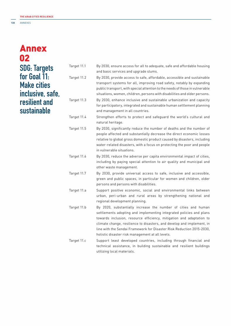
THE ARAB CITIES RESILIENCE
ANNEXES130
Target 11.1 By 2030, ensure access for all to adequate, safe and affordable housing
and basic services and upgrade slums.
Target 11.2 By 2030, provide access to safe, affordable, accessible and sustainable
transport systems for all, improving road safety, notably by expanding
public transport, with special attention to the needs of those in vulnerable
situations, women, children, persons with disabilities and older persons.
Target 11.3 By 2030, enhance inclusive and sustainable urbanization and capacity
for participatory, integrated and sustainable human settlement planning
and management in all countries.
Target 11.4 Strengthen efforts to protect and safeguard the world’s cultural and
natural heritage.
Target 11.5 By 2030, significantly reduce the number of deaths and the number of
people affected and substantially decrease the direct economic losses
relative to global gross domestic product caused by disasters, including
water-related disasters, with a focus on protecting the poor and people
in vulnerable situations.
Target 11.6 By 2030, reduce the adverse per capita environmental impact of cities,
including by paying special attention to air quality and municipal and
other waste management.
Target 11.7 By 2030, provide universal access to safe, inclusive and accessible,
green and public spaces, in particular for women and children, older
persons and persons with disabilities.
Target 11.a Support positive economic, social and environmental links between
urban, peri-urban and rural areas by strengthening national and
regional development planning.
Target 11.b By 2020, substantially increase the number of cities and human
settlements adopting and implementing integrated policies and plans
towards inclusion, resource efficiency, mitigation and adaptation to
climate change, resilience to disasters, and develop and implement, in
line with the Sendai Framework for Disaster Risk Reduction 2015-2030,
holistic disaster risk management at all levels.
Target 11.c Support least developed countries, including through financial and
technical assistance, in building sustainable and resilient buildings
utilizing local materials.
SDG: Targetsfor Goal 11: Make cities inclusive, safe, resilient and sustainable
02Annex

THE ARAB CITIES RESILIENCE
ANNEXES 131
• The Arab Urban Development institute:
http://www.araburban.com/index.php?page_id=187
• Development Fund for Arab Cities:
http://araburban.com/index.php?module=sitemap&page=content_en&id=223
• Arab Forum for information Systems:
http://www.itcat.org
• Arab Foundation for Heritage and Historical Cities:
http://araburban.com/index.php?module=sitemap&page=content_en&id=223#
• The Arab Award Foundation:
http://arabthought.org/en#.VzfaYWNW1Ec
• The Organization of islamic Capitals and Cities (OiCC):
http://www.oicc.org/
• Arab Town Organization:
http://www.araburban.com/index.php?page_id=187
• The Arab Forum for Environment and Development:
http://www.afedonline.org/en/
• Arab Regional Centre for World Heritage (ARC-WH) under the auspices of UNESCO
http://arcwh.org
Useful resources from the region
03Annex
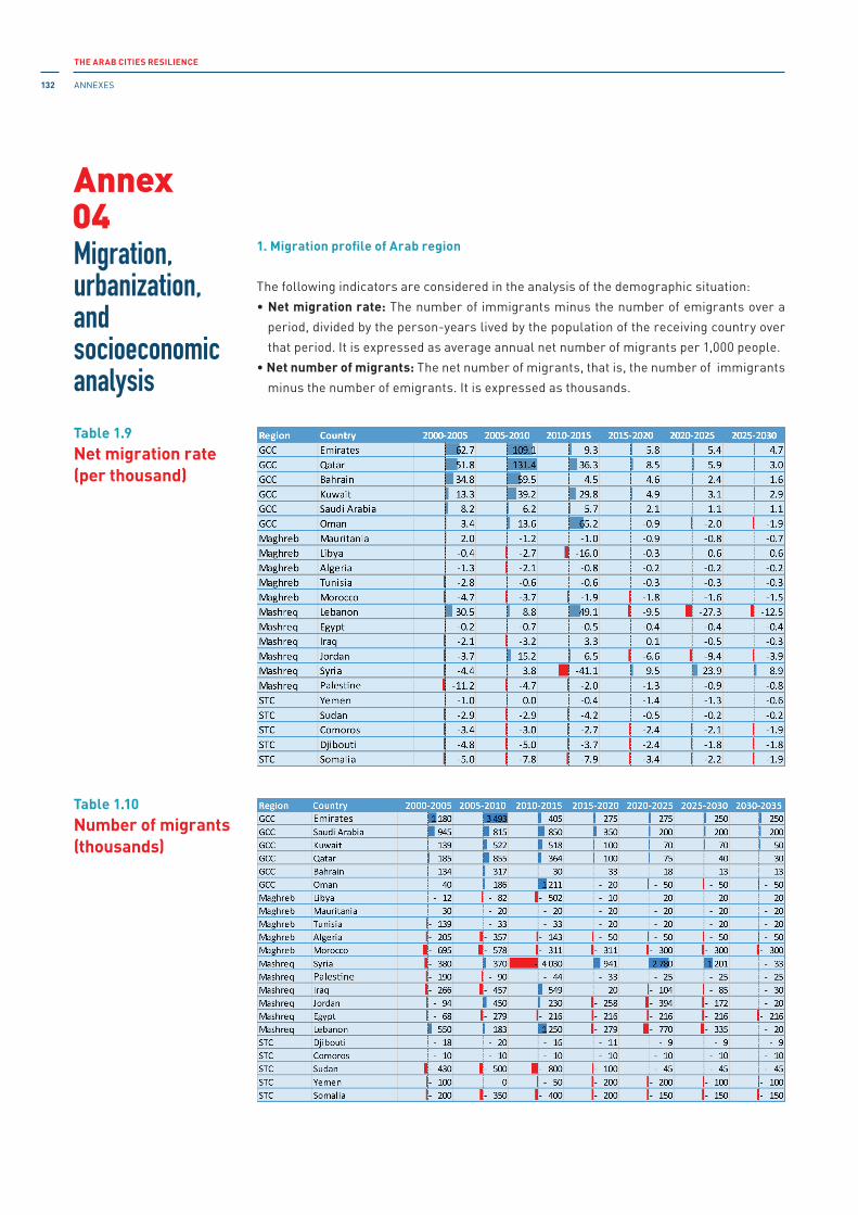
THE ARAB CITIES RESILIENCE
ANNEXES132
1. Migration profile of Arab region
The following indicators are considered in the analysis of the demographic situation:
• Net migration rate: The number of immigrants minus the number of emigrants over a
period, divided by the person-years lived by the population of the receiving country over
that period. it is expressed as average annual net number of migrants per 1,000 people.
• Net number of migrants: The net number of migrants, that is, the number of immigrants
minus the number of emigrants. it is expressed as thousands.
Migration, urbanization, and socioeconomic analysis
04
Table 1.9Net migration rate (per thousand)
Table 1.10Number of migrants (thousands)
Annex

THE ARAB CITIES RESILIENCE
ANNEXES 133
3. Urban profile of Arab region
The following indicators are consideredin the analysis of the urbanization situation:
• Percentage of population at mid-year residing in urban areas by major area, region
and country
• Urban population at mid-year by major area, region and country (thousands)
• Average annual rate of change of the urban population by major area, region and
country (per cent)
• Average annual rate of change of the percentage urban by major area, region and
country (per cent)
• Population of urban agglomerations with one million inhabitants or more in 2014, by
country (thousands)
• Urban population, number of cities and percentage of urban population by size class
of urban settlement, by country
Table 3.1Percentage of population at mid-year residing in urban areas

THE ARAB CITIES RESILIENCE
ANNEXES134
Table 3.2Urban population(in thousands)
Table 3.3Average annualrate of changeof the urban population(per cent)
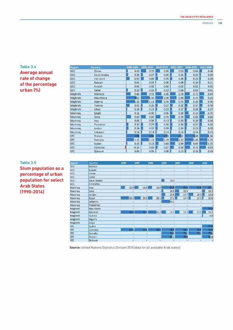
THE ARAB CITIES RESILIENCE
ANNEXES 135
Source: United Nations Statistics Division 2015 (data for all available Arab states)
Table 3.4Average annualrate of changeof the percentage urban (%)
Table 3.5Slum population as a percentage of urban population for select Arab States(1990-2014)
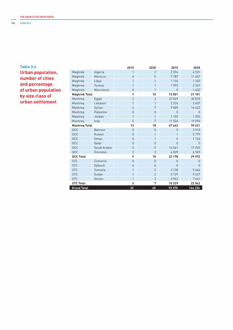
THE ARAB CITIES RESILIENCE
ANNEXES136
2015 2030 2015 2030Maghreb Algeria 1 2 2 594 4 531Maghreb Morocco 4 5 7 787 11 457Maghreb Libya 1 1 1 126 1 333Maghreb Tunisia 1 1 1 993 2 347Maghreb Mauritania 0 1 0 1 432Maghreb Total 7 10 13 501 21 101Mashreq Egypt 2 2 23 549 30 815Mashreq Lebanon 1 1 2 226 2 437Mashreq Syrian 4 7 9 005 16 422Mashreq Palestine 0 0 0 0Mashreq Jordan 1 1 1 155 1 355Mashreq iraq 5 7 11 526 19 592Mashreq Total 13 18 47 462 70 621GCC Bahrain 0 0 0 3 915GCC Kuwait 0 1 1 2 779GCC Oman 0 1 0 1 124GCC Qatar 0 0 0 0GCC Saudi Arabia 5 5 14 561 17 965GCC Emirates 3 3 4 839 6 969GCC Total 9 10 22 178 29 972STC Comoros 0 0 0 0STC Djibouti 0 0 0 0STC Somalia 1 2 2 138 5 464STC Sudan 1 2 5 129 9 437STC Yemen 1 3 2 962 7 641STC Total 3 7 10 229 22 542Grand Total 32 45 93 370 144 236
Table 3.6Urban population, number of citiesand percentageof urban population by size class of urban settlement
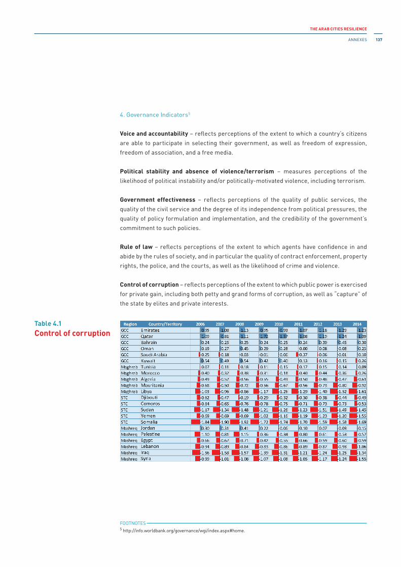
THE ARAB CITIES RESILIENCE
ANNEXES 137
4. Governance indicators5
Voice and accountability – reflects perceptions of the extent to which a country’s citizens
are able to participate in selecting their government, as well as freedom of expression,
freedom of association, and a free media.
Political stability and absence of violence/terrorism – measures perceptions of the
likelihood of political instability and/or politically-motivated violence, including terrorism.
Government effectiveness – reflects perceptions of the quality of public services, the
quality of the civil service and the degree of its independence from political pressures, the
quality of policy formulation and implementation, and the credibility of the government’s
commitment to such policies.
Rule of law – reflects perceptions of the extent to which agents have confidence in and
abide by the rules of society, and in particular the quality of contract enforcement, property
rights, the police, and the courts, as well as the likelihood of crime and violence.
Control of corruption – reflects perceptions of the extent to which public power is exercised
for private gain, including both petty and grand forms of corruption, as well as “capture” of
the state by elites and private interests.
Table 4.1Control of corruption
FOOTNOTES 5 http://info.worldbank.org/governance/wgi/index.aspx#home.

THE ARAB CITIES RESILIENCE
ANNEXES138
Table 4.2Government effectiveness
Table 4.3Political stabilityand absence of violence/terrorism

THE ARAB CITIES RESILIENCE
ANNEXES 139
Table 4.4Rule of law
Table 4.5Voice and accountability

THE ARAB CITIES RESILIENCE
ANNEXES140
Lebanon
Aabbassiyet Tyre, Aalma ech-Chaab, Aaqabet Rachaya, Aaqoura, Aarab Salim, Aarbet
Qozhaiya, Aarjis, Arsal, Aassoun , Aaynata Baalbek, Aaytit, Achach, Afka, Ain Aakrine,
Ain Arab, Ain Baal , Ain El Safsaf-Mar Mikhael Bnabil, Aain el-Ghouaybe, Aïn Et Tineh, Aïn
Kfar Zabad, Ain Qana, Ain Qani, Ain Saade, Ain Zebde, Aintoura, Aintourine, Al Atchaneh,
Al Baddawi, Al Bourghliyeh, Al Dinnieh Union of Municipalities, Al Fidar, Al Ghabeh, Al
Halousieh, Al Hmairy, Al Jebbine, Al Kneyseh, Al Majdal, Al Mourouj, Al Ouyoun, Al-
Tawfiqiyah, Al-Aairoun, Anfeh, Antelias-Naccache, Ardeh, Arzoun, Assia,
Baabda, Baabdat, Baadarane, Baalbek Beeka, Bafliye, Bakaa, Bakhaaoun, Barich,
Baskinta, Batoulay, Bazouriye, Bebnine, Bechmezzine, Bechouat, Bedias, Behouaita,
Beirut, Beit Meri, Beit Shaar-Mazraat el Hadira, Beit Chabab - Chaouiyeh el Qnaytra, Bejje,
Bichtlida, Bikfaya-el Mhaydse, Biyad, Blat Jbeil-Wichita-Qartaboun, Borj Ech-Chemali,
Borj Hammoud, Borj Rahhal, Bouarej, Boustane, Bqarsouna, Broumana, Bsalim-Mezher-
Majzoub, Bteghrin, Btermaz, Bterram, Byaqout, Byblos, Bziza,
Chaaitiye, Chaat, Chehabiye, Chehour, Chihine, Chilfa, Choueifat,
Dahr el Souan, Daraiya Zgharta, Dbayeh-Zouk el Kharab-Aoukar-Haret Ee Ballaneh, Debaal
Tyre, Dedde, Deir Ames, Deir El Qamar, Deir Nbouh, Deir Qanoun el Aain, Deir Qanoun en-
Nahr, Der Kaifa, Derdghaiya, Dhairah, Dik el Mehdi, Douris,
El Dekwaneh Mar Roukoz, El Douar, El Khenshara-El Jouar, El Mtein-Mshikha, El Qaaqour,
El Shwair-Ain El Sendiyene, El-Bire, El-Rafide, En Naqoura, Eymar,
Fanar, Fatre, Federation of Municipalities of the Higher Chouf, Fiaa, Flawi,
Ghabat-Rweiss, Ghabet Bolognia-Wata El Marouj, Ghalboun,
Hadath Baalbek, Halbata, Hanaouay, Haouch el Rafqa, Haret Jandal, Harf el Sayad, Heloueh,
Henniye, Houmine el Faouqa, Hsoun,
iaal, iqlim el Touffah Union of municipalities, Jabbouleh, Jal el Dib-Bkennaya, Jannata,
Jarjou’a, Jbaa Ech-Chouf, Jbaa, Jbal el Botm, Jdaidet El Fekehe, Jdeideh-el Baouchriye- el
Sid, Jdita, Jebaa, Jebjennine, Jej Faouzi Achkouti, Jouaiya,
Kafarzina, Karoun, Kennabet Broumana, Kfar Aabida, Kfar Bnine, Kfar Dines, Kfar Hazir,
Kfar Michki, Kfar Saroun, Kfar Zabad, Kfaraaqab, Kfarfila, Kfarhata Zgharta, Kfartay,
Kherbet Kanafar, Khereibit ech-Chouf, Khirbet Rouha, Kolaylat al Harfouche, Koussaya,
Laqlouk, Lehfed,
Maaraboun, Maarake, Maaroub, Mahrouneh, Majdaloun, Majdel Tarchich, Majdel,
Majdelzoun, Majedil, Makse, Mansoura, Mansouri Tyre, Mansouriyeh-Mkalles-Dishouniyeh,
Mar Moussa el Douar, Mar Moussa el Douar, Mar Shaaya-el Mazkeh, Marjaba, Mayfouq-
Qottara, Mazraaet Meshref, Mazraaet Yashouh, Mdoukha, Merouahine, Mina, Moukhtara,
Mrah es-Srayj, Mrah es-Sfireh, Mristi,
Naba al Qaddam, Nabay, Nahle, Nakhlé - Hara al Khassa, Niha, Niha el Chouf, Nimrine- Bakoura,
Qabb Elias, Qald as-Sabe‘, Qana, Qarsaita, Qlaile Tyre, Qobayyet, Qornet Shahwan-Ain Aar-
Beit el Kiko and El Hbous,
Rabieh, Rach‘ine, Ram-Jabbaniyya, Ras Kifa, Recheknanay, Rmadiye, Rmassa, Roumieh,
Roumine,
Sadiqine, Saghbine, Saida, Sakiet El Mesk-Bhersaf, Sarba, Selaa, Serraain el Tahta,
Shamah, Sin el Fil, Srifa,
Talia, Tarane, Tartij, Tayr Debba, Tayr Falsay, Tayr Harfa, Temnine el Faouqa, Temnine el Tahta,
Terboul, Toura, Tripoli, Tyre Union of municipalities, Tyre,
Arab cities registered in UnISDR MCR campaign by 31 December 2015
05Annex

THE ARAB CITIES RESILIENCE
ANNEXES 141
Wadi Faara, Yahchouch, Yanouh Jbeil-Hdeine, Yanouh Sour (Tyre), Yarine, Youmine,
Zalka-Amarat Chalhou, Zaroun, Zebqine, Zekrit, Zgharta-Ehden.
Jordan
Amman, Aqaba, Salt, irbid, Jarash, Madaba, Petra, Salt, Zarka.
iraq
Maysan.
Palestine
Al-Khalil/Hebron, Bethlehem, Gaza, Jabalia al-Nazlah, Ariha, Nablus, Qalqilia, Ramallah.
Syria
Aleppo and Homs.
Eygpt
Alexandria, Cairo, ismailia, Sharm al-Sheikh.
Tunisia
Ain Draham, Bizerte, Boussalem, Foussana, Hydra, Jidiliène, Menzel Jemil, Mournag,
Sbiba, Tadamen M’nihla, Thala, Tunis.
Morocco
Agadir and Tata.
UAE
Abu Dhabi and Dubai.
KSA
Dammam.
Yemen
Aden and al Mukalla.

THE ARAB CITIES RESILIENCE
ANNEXES142
Algeria:
• six cultural properties: Al Qal‘a of Beni Hammad, Djemala, Kasbah of Algiers, M’Zab
Valley, Timgad, Tipasa
• one mixed cultural and natural property: Tassili n’Ajjer
Bahrain:
• two cultural properties: Pearling, Testimony of an island Economy and Qal‘at al-Bahrain
– Ancient Harbout and Capital of Dilmun
Egypt:
• six cultural properties: Abu Mena, Ancient Thebes with its Necropolis, Historic Cairo,
Memphis and its Necropolis – the Pyramid Fields from Giza to Dahshur, Nubian
Monuments from Abu Simbel to Philae, and Saint Catherine Area
• one natural Property: Wadi Al-Hitan
iraq:
• four cultural properties: Ashur (Qal‘at Sherqat), Erbil Citadel, Hatra, Samarra
Archaeological City
Jordan:
• four cultural properties: Baptism site Bethany Beyond the Jordan (Al-Maghtas), Petra,
Quseir Amra, and Um er-Rasas (Kastrom Mefa’a)
• one mixed property: Wadi Rum Protected Area
Libya:
• five cultural properties: Archaeological Site of Cyrene, Archaeological Site of Leptis
Magna, Archaeological Site of Sabratha, Old Town of Ghadamès, and Rock- Art Sites of
Tadrant Acacus
Lebanon:
• five cultural properties: Anjar, Baalbek, Byblos, Wadi Qadisha (the Holy Valley) and the
Forest of the Cedars of God (horsh Arz el-Rab), Tyre
Mauritania:
• one cultural property: Ancient Ksour of Ouadane, Chinguetti, Tichitt and Oualata
• one natural property: Banc d’Arguin National Park
Morocco:
• nine cultural properties: Archaeological Site of Volubilis, Historic City of Meknes, Ksar
of Ait-Ben-Haddou, Medina of Essaouira (formerly Mogador), Medina of Fez, Medina of
Marrakesh, Medina of Tétouan (formerly known as Titawin), Portuguese City of Mazagan
(El Jadida) and Rabat, Modern Capital and Historic City: a Shared Heritage
Cultural and natural properties listed in the World Heritage List
06Annex

THE ARAB CITIES RESILIENCE
ANNEXES 143
Oman:
• four cultural properties: Aflaj irrigation Systems of Oman, Archaeological Sites of
Bat, Al-Khutm and Al-Ayn, Bahla Fort, Land of Frankincense
Palestine:
• two cultural properties: Birthplace of Jesus: Church of the Nativity and the Pilgrimage
Route, Bethlehem and Palestine: Land of Olives and Vines – Cultural Landscape of
Southern Jerusalem, Battir
Qatar:
• one cultural property: Al Zubarah Archaeological Site
Saudi Arabia:
• four cultural properties: Al-Hijr Archaeological Site, Al-Turaif District in ad- Diriyah,
Historic Jeddah, the Gate of Makkadh, and Rock Art in the Hail Region of Saudi Arabia
Sudan:
• two cultural properties: Archaeological Sites of the island of Meroe and Gebel
Barkal, and the Sites of the Napatan Region
Syria:
• six cultural properties: Ancient City of Aleppo, Ancient City of Bosra, Ancient City of
Damscus, Ancient Villages of Northern Syria, Crac des Chevaliers and Qal‘at Salah Ed-
Din, and Site of Palmyra
Tunisia:
• seven cultural properties: Amphitheatre of El Jem, Archaeological Site of Carthage,
Dougga/Thugga, Kairouan, Medina of Sousse, Medina of Tunis, Public Town of Kerkuane
and its Necropolis
• one natural property: ichkeul National Park
United Arab Emirates:
• one cultural property: Cultural Sites of Al Ain (Hafit, Hili, Bidaa Bint Saud and Oases Areas)
Yemen:
• three cultural properties: Historic Town of Zabid, Old City of Sanaa, and Old Walled City
of Shibam
• one natural property: Socotra Archipelago
NB. Most of the cultural heritages of Syria and Yemen have been brutally destroyed during the current wars, along with other culturally valuable sites in iraq and Libya.

THE ARAB CITIES RESILIENCE
Select BiBliography144
Abdalla, Jamal A. and Azm Shaher Al-Homoud 2004. Seismic hazard assessment of United Arab Emirates and its surroundings. Journal of Earthquake
Engineering, vol.8, No.6, pp. 817-837. London, UK: Imperial College Press. doi:10.1080/13632460409350510.
Abdel Wahab, Abu Bakr, Yahia E-A. Mohamedzein and Jamal A. Abdalla 1999. Suggested provision for earthquake resistant design of structures for the Sudan. Journal
of Building and Road Research, vol. 2, pp. 36-46. Khartoum, Sudan: University of Khartoum, August.
-------- 2001. Probabilistic seismic hazard assessment of Sudan and its vicinity. Earthquake Spectra, Vol. 17, No. 3, pp. 399-415.
Abou Elela, Amin M., Mohamed El-Hadidy, Ahmed Deif and Kamal Mohamed Abou Elenean 2012. Seismic hazard studies in Egypt. NRIAG (National Research Institute of Astronomy and Geophysics) Journal of Astronomy and Geophysics, vol. 1, No. 2, pp. 119-140. doi:10.1016/j.nrjag.2012.12.008.
Al-Awadhi, Jasem M. and Vunganai Midzi 2001. The seismicity of the Kuwaiti subregion. Seismological Research Letters, vol. 72, No. 4, pp. 462-473. doi:10.1785/gssrl.72.4.462.
Al-Enezi, Abdullah 2006. Assessment of seismic hazard for the State of Kuwait. [http://www.meseisforum.net/Docs/Cyber_Journals/Volume_4_2006/GSFII -%20Proceedings/AL%20ENEZI.pdf]. Accessed 04 April 2017.
Alexander, David E. 2013. Resilience and disaster risk reduction: An etymological journey. Natural Hazards and Earth System Sciences, vol. 13, No. 11, pp. 2707-2716. Göttingen, Germany: Copernicus Publications, on behalf of the European Geosciences Union.
Al-Haddad, M., G. H. Siddiqi, R. Al-Zaid, A. Arafa, A. Necioglu and N. Turkelli 1994. A basis for evaluation of seismic hazard and design criteria for Saudi Arabia. Earthquake Spectra, vol. 10, No. 2, pp. 231–257.
Al-Madhari, A. F. and M. O. Elberier 1996. Trends and fatality of natural disasters in the Arab world. Disaster Prevention Management: An International Journal, vol. 5, No. 2, pp. 27-35. doi:10.1108/09653569610112899.
Amnesty International 2014. Left Out in the Cold: Syrian Refugees Abandoned By the
International Community. London, UK: Amnesty International. [http://www.amnesty.eu/content/assets/Reports/Left_Out_in_the_Cold_Syri an_Refugees_Abandoned_by_the_International_Community_final_formatt ed_version.pdf]. Accessed 04 April 2017.
Arya, A. S., L. S. Srivastave and S. P. Gupta 1985. Survey of damages during the Dhamar earthquake of 13 December 1982 in the Yemen Arab Republic. Bulletin of the
Seismological Society of America, vol. 75, No. 2, pp. 597- 610.Arabian Business 2007. Dubai green building rule. [http://www.arabianbusiness.com/
dubai-green-building-rule-123281.html]. Accessed 22 April 2017.Atillah, Abderrahmane, Driss El Hadani, Hisham Moudni, Olivia Lesne, Camille
Renou, Antoine Mangin and Frédéric Rouffi 2011. Tsunami vulnerability and damage assessment in the coastal area of Rabat and Salé, Morocco. Natural
Hazards and Earth System Sciences, vol. 11, No 12, pp. 3397- 3414. doi:10.5194/nhess-11-3397-2011.
Select bibliography
THE ARAB CITIES RESILIENCE
Select BiBliography 145
Benazzouz, Mohamed Tahar 1991. L’évaluation de l’aléa géomorphologique et des coûts des risques à Constantine. Zeitschrift für Geomorphologie, Supplementband 83, pp. 63-70.
Benouar, Djillali 1994. Materials for the investigation of the seismicity of Algeria and adjacent regions during the twentieth century, Annali di geofisica, vol. 37 No. 4, pp. 459-860.
-------- 1999. A methodology for the re-evaluation of the seismicity in the Maghreb countries – Algeria, Morocco and Tunisia. European Earthquake Engineering Journal, vol. 13, No. 3, pp. 62-73.
--------, Gilbert L. Molas and Fumio Yamazaki 1996. Earthquake hazard mapping in the Maghreb countries: Algeria, Morocco, Tunisia. Earthquake Engineering and
Structural Dynamics Journal, vol. 25, No. 10, pp. 1151- 1164. doi:10.1002/(SICI)1096-9845(199610)25:103.0.CO;2-Q.
Birkmann, Joern, O. D. Cardona, M. L. Carreño, A. H. Barbat, M. Pelling, S. Schneiderbauer, S. Kienberger et al. 2013. Framing vulnerability, risk and societal responses: the MOVE framework. Natural Hazards, vol. 67, No. 2, pp. 193-211. doi:10.1007/s11069-013-0558-5.
Black, Emily 2009. The Impact of Climate Change on Daily Rainfall Statistics in Jordan and Israel. Atmospheric Science Letters, vol. 10 No. 3, pp. 192–200. doi:10.1002/asl.233.
Bloomberg 2012. Saudi Arabia May Become Oil Importer by 2030, Citigroup Says. [http://www.bloomberg.com/news/2012-09-04/saudi-arabia-may- become-oil-importer-by-2030-citigroup-says-1-.html]. Archived article.
Boore, David M., William B. Joyner and Thomas E. Fumal 1997. Equations for estimating horizontal response spectra and peak acceleration from western North American earthquakes: a summary of recent work. Seismological Research Letters, vol. 68, No. 1, pp. 128-153.
Brinkhoff, Thomas 2017. Algeria: Provinces & Major Cities - Population Statistics in Maps and Charts. [https://www.citypopulation.de/Algeria-Cities.html]. Accessed 21 February 2018.
Campbell-Lendrum, Diarmid and Carlos Corvalán 2007. Climate change and developing-country cities: Implications for environmental health and equity. Journal of Urban
Health: Bulletin of the New York Academy of Medicine, No. 84 (Supplement 1), pp. 109–117. doi:10.1007/s11524-007- 9170-x.
Carboun 2011. A tale of two energy policies: Carboun’s Visual Guide to Energy and Carbon Emissions in the Arab World. [http://www.carboun.com/energy/a-visual-guide-to-energy-and-carbon- emissions-in-the-arab-world-infographic/#more-2272]. Accessed 10 January 2017.
Cherkaoui, Taj-Eddine and Ahmed El Hassani 2012. Seismicity and seismic hazard in Morocco 1901-2010. Rabat, Morocco: Bulletin de l’Institut scientifique. Section Sciences de la Terre, No. 34, pp. 45-55.
Cornell University 2001. Tectonic Map of Syria. New York, USA: Institute for the Study of the Continents, Cornell University Press.
Deif, Ahmed, Issa El-Hussain, Khalifa S. Al-Jabri et al. 2012. Deterministic seismic hazard assessment for Sultanate of Oman. Arabian Journal of Geoscience, vol. 6, No. 12. doi:10.1007/s12517-012-0790-4.
THE ARAB CITIES RESILIENCE
Select BiBliography146
Economist 2010. The GCC in 2020: Resources for the Future. A report from the Economist Intelligence Unit sponsored by the Qatar Financial Centre Authority. [http://graphics.eiu.com/upload/eb/GCC_in_2020_Resources_WEB.pdf]. Accessed 3 January 2017.
Elmelade, Abdala 2012. General Information about Seismicity and Seismotectonics in Libya. Libyan Centre for Remote Sensing and Space Science (LCRSSS), Libyan National Seismological Network (LNSN), UNESCO–RELEMR Workshop, University of Malta, Sliema, 13-16 February. [http://ds.iris.edu/workshops/2013/assets/pdf/network_reports/elmelade.pdf]. Accessed 22 January 2017.
El Ssayed, Hatem M., Hussam E. Zaineh, Draji Dojcinovski, Vladimir Mihailov 2012. Re-evaluations of seismic hazard of Syria. International Journal of Geosciences, vol.3 No. 4A, pp. 847-855, doi:10.4236/ijg.2012.324085.
EPRI (Electric Power Research Institute) 1994. Johnston, A. C., K. J. Coppersmith, L. R. Kanter, and C. A.Cornell. The Earthquakes of Stable Continental Regions, vol.
1: Assessment of Large Earthquake Potential. Palo Alto, California, USA: Electric Power Research Institute.
Erian, Wadid 2013. Agriculture drought and land degradation risk in Arab Region. The First
Arab Regional Conference for Disaster Risk Reduction. Aqaba, Jordan: ACSAD (Arab Center for the Studies of Arid zones and Dry lands). [http://www.preventionweb.net/files/31093_wadiderianarabcdrr11932013dr oughtpa.pdf]. Accessed 25 January 2017.
Erian, Wadid, Bassem Katlan, Naji Assad and Sanaa Fouad Ibrahim 2014. Effects of drought and land degradation on vegetation losses: in Africa, Arab region, drought and conflict in Syria, drylands in South America and forests of Amazon and Congo rivers basins. Background paper for the 2015 Global Assessment Report on Disaster Risk Reduction. [http://www.preventionweb.net/english/hyogo/gar/2015/en/bgdocs/Erian%2 0et%20al.,%202014.pdf]. Accessed 22 December 2016.
Ezzine, Hicham 2015. Regional Analysis of Disaster Loss Databases in Arab States. Cairo, Egypt: UNISDR Regional Office for Arab States.
Freund, Raphael, Zvi Garfunkel, Israel Zak, Moshe Goldberg, Tuvia Weissbrod and Baruch Derin 1970. The shear along the Dead Sea rift: A discussion on the structure and evolution of the Red Sea and the nature of the Red Sea, Gulf of Aden and Ethiopia rift junction. Philosophical Transactions of the Royal Society of London, Series A, vol. 267, No. 1181, pp. 107-130.
Früh, Barbara et al. 2011. Estimation of climate change impacts on the urban heat load using an urban climate model and regional climate projections. Journal of Applied Meteorology and Climatology, vol. 50, No. 1, pp. 167– 184. doi:10.1175/2010JAMC2377.1.
GSHAP (Global Seismic Hazard Assessment Program) 1999. Assembled by Giardini, Domenico, Kaye M. Shedlock, Gottfried Grünthal, Peizhen Zhang. [http://gmo.gfz- potsdam.de/pub/poster/GSHAP_World_Map_Poster.pdf]. Accessed 22 January 2017.

THE ARAB CITIES RESILIENCE
Select BiBliography 147
Heidarzadeh, Mohammad, Moharram Dolatshahi Pirooz, Nasser Hajizadeh Zaker and Mohammad Mokhtari 2006. Evaluating the tsunami hazard in the Persian Gulf and its possible effects on coastal regions. Paper presented at the seventh International Conference on Coasts, Ports and Marine Structures. Tehran, Iran, 27-29 November. Available at http://www.sid.ir/en/VEWSSID/s_pdf/181E2006H0721.pdf. Accessed 20 January 2017.
HADMA (Humanitarian Affairs and Disaster Management Agency) 2011. Puntland Disaster Management Framework, Government of Puntland Somalia. [http://www.jccp.gr.jp/_src/sc2340/2_PuntlandDRR.Final.pdf]. Accessed 26 April 2017.
Hajat, Shakoor, Madeline O’Connor and Tom Kosatsky 2010. Health effects of hot weather: from awareness of risk factors to effective health protection. The Lancet, vol. 375, No. 9717 (March 2010), pp. 856-863. doi:10.1016/S0140- 6736(09)61711-6.
Harrigan, Jane 2014. The Political Economy of Arab Food Sovereignty. London, UK: Palgrave Macmillan.
Hassen, Hassen A. 1983. Seismicity of Libya and related problems. Master of Science degree thesis, Colorado University, Fort Collins, Colorado, USA.
HFA (Hyogo Framework for Action) 2013. National Progress Report on the Implementation of the Hyogo Framework for Action (2011-2013). [http://www.preventionweb.net/files/29100_bhr_NationalHFAprogress_201 1-13.pdf]. Accessed 9 December 2016.
HLP (High-Level Panel) 2013. The Secretary-General’s High-Level Panel of Eminent Persons on the Post-2015 Development Agenda. A New Global Partnership:
Eradicate Poverty and Transform Economies Through Sustainable Development. New York, USA: United Nations Publications, 2013. [http://www.post2015hlp.org/the-report/]. Accessed 23 March 2017.
Holling, Crawford Stanley 1973. Resilience and stability of ecological systems. Annual
Review of Ecology and Systematics, vol. 4, pp. 1-23. doi:10.2307/2096802,ISSN:0066–4162.
Huijer, Carla, Mohamed Harajli and Salah Sadek 2011. Upgrading the seismic hazard of Lebanon in light of the recent discovery of the offshore thrust fault system. Lebanese Science Journal, vol. 12, No. 2, pp. 67-82.
IDS (Institute for Development Studies) 1992. Chambers, Robert and Gordon R. Conway. Sustainable rural livelihoods: Practical concepts for the 21st century. IDS Discussion Paper 296. Brighton, UK: Institute of Development Studies. [http://publications.iwmi.org/pdf/H_32821.pdf]. Accessed 23 March 2017.
IMF (International Monetary Fund) 2013. Islamic Republic of Mauritania: Poverty Reduction Strategy Paper. IMF Country Report No. 13/189. Washington, D.C., USA: International Monetary Fund, July 2013. [https://www.imf.org/external/pubs/ft/scr/2013/cr13189.pdf]. Accessed 2 December 2016.
IOM (International Organization for Migration) 2015. World Migration Report 2015: Migrants and Cities – New Partnerships to Manage Mobility. Geneva, Switzerland: IOM. [http://publications.iom.int/system/files/wmr2015_en.pdf]. Accessed 26 March 2017.
IPCC (The Intergovernmental Panel on Climate Change) 2012. Managing the Risks of
Extreme Events and Disasters to Advance Climate Change Adaptation. Cambridge, UK and New York, USA: Cambridge University Press.

THE ARAB CITIES RESILIENCE
Select BiBliography148
-------- 2014. Climate Change 2014: Impacts, Adaptation, and Vulnerability. Part A: Global
and Sectoral Aspects. Contribution of Working Group II to the Fifth Assessment Report
of the Intergovernmental Panel on Climate Change. Field, Christopher B., Vicente R. Barros, Vicente R. Dokken et al., eds. Cambridge, UK and New York, USA: Cambridge University Press.
-------- 2014b. Climate Change 2014: Synthesis Report. Contribution of Working Groups I, II and III to the Fifth Assessment Report of the Intergovernmental Panel on Climate Change. Core Writing Team, Rajendra K. Pachauri and Leo Meyer, eds. Geneva, Switzerland: IPCC 2015.
IRGC (International Risk Governance Council) 2008. An Introduction to the IRGC Risk
Governance Framework. Geneva, Switzerland: The International Risk Governance Council. [https://www.irgc.org/IMG/pdf/An_introduction_to_the_IRGC_Risk_Gove rnance_Framework.pdf]. Accessed 29 January 2017.
-------- 2009. Risk Governance Deficit, An analysis and illustration of the most common deficits in risk governance. Geneva, Switzerland: The International Risk Governance Council. [www.irgc.org/IMG/pdf/IRGC_rgd_web_final.pdf]. Accessed 24 April 2017.
Jreisat, Kamal and Tawfiq Yazjeen 2013. A seismic junction. Atlas of Jordan, History,
Territories and Society. Myriam Ababsa (dir.). Beirut, Lebanon: Presses de l’Ifpo.Kelley, Colin P., Shahrzad Mohtadi, Mark A. Cane, Richard Seager and Yochanan Kushnir
2015. Climate change in the Fertile Crescent, and implications of the recent Syrian drought. Proceedings of the National Academy of Sciences, vol. 112, No. 11. [http://www.pnas.org/content/112/11/3241.full.pdf]. Accessed 12 January 2017.
Khawlie, Mohamed al- 2000. Bi’atu Lubnan tharwatun da’i‘ah (Lebanese Environment, a Lost Resource). Beirut, Lebanon: Menrikh publisher.
Ksentini, Ahmed and Najla Bouden Romdhane 2014. Updated seismic hazard assessment of Tunisia. Bulletin of Earthquake Engineering, vol. 12, No. 2, pp. 647–670. doi:10.1007/s10518-013-9548-y.
Lemonsu, Aude, Raphaëlle Kounkou-Arnaud, Julien Desplat, Jean-Luc Salagnac and Valéry Masson 2013. Evolution of the Parisian urban climate under a global changing climate. Climatic Change, vol. 116, No. 3, pp. 679-692.
McCarthy, Mark P., Martin J. Best and Richard A. Betts 2010. Climate change in cities due to global warming and urban effects. Geophysical Research Letters, vol. 37, No. 9. doi:10.1029/2010GL042845.
Mitlin, Diana and David Satterthwaite 2002. How the scale and nature of urban poverty are under-estimated – the limitations of the US$ 1 a day poverty line, International Institute for Environment and Development (IIED) Working Paper. London, UK: IIED. [https://www.ucl.ac.uk/dpu-projects/drivers_urb_change/urb_society/pdf_liveli_vulnera/IIED_Mitlin_David_urban_poverty_under_estimated.pdf]. Accessed 24 September 2018.
Mohindra, Rakesh, Anand K. S. Nair, Sushil Gupta, Ujjwal Sur and Vladimir Sokolov 2012. Probabilistic seismic hazard analysis for Yemen. International Journal of Geophysics, vol. 2012. Article ID 304235. doi:10.1155/2012/304235.

THE ARAB CITIES RESILIENCE
Select BiBliography 149
Nawar, Abdel-Hameed 2014. Multidimensional poverty index and policies for tackling interlocking deprivations in the Arab States. Arab Human Development Report Research Paper. United Nations Development Programme. New York, USA: UNDP Regional Bureau for Arab States. [http://www.arab-hdr.org/publications/other/ahdrps/Final_Abdel-Hameed%20Nawar%20ENG%20low%20res.pdf]. Accessed 23 March 2017.
ODI (Overseas Development Institute) 2014. Simon Levine. Assessing resilience: Why quantification misses the point. HPG Working Paper. London, UK: Humanitarian Policy Group (HPG) at the Overseas Development Institute (ODI). [https://www.odi.org/sites/odi.org.uk/files/odi-assets/publications-opinion-files/9049.pdf]. Accessed 23 March 2017.
-------- 2015. Schipper, E. Lisa F. and Lara Langston. A comparative overview of resilience measurement frameworks: Analyzing indicators and approaches. ODI Working Paper 422. London, UK: Overseas Development Institute. [https://www.odi.org/sites/odi.org.uk/files/odi-assets/publications-opinion- files/9754.pdf]. Accessed 23 March 2017.
OECD (Organisation for Economic Co-operation and Development) 2011. OECD Reviews of Risk Management Policies. Future Global Shocks: Improving Risk Governance. OECD Publishing. [www.oecd.org/governance/48329024.pdf]. Accessed 23 March 2017.
-------- 2015. Guidelines for Resilience Systems Analysis: How to Analyse Risk and
Build a Roadmap to Resilience. OECD Publishing. [https://www.oecd.org/dac/Resilience%20Systems%20Analysis%20FINAL .pdf]. Accessed 23 March 2017.
Oleson, Kirsten 2012. Contrasts between urban and rural climate in CCSM4 CMIP5 climate change scenarios. Journal of Climate, vol. 25, No. 5, pp. 1390-1412.
Osman-Elasha, Balgis 2010. Mapping of climate change threats and human development impacts in the Arab Region. Arab Human Development Report Research Paper. United Nations Development Programme. New York, USA: UNDP Regional Bureau for Arab States.
OVK (L’observatoire volcanologique du Karthala) 2014. Évaluation du risque sismique en Grande Comore. Rapport interne.
Pal, Jeremy S. and Elfatih A. B. Eltahir 2015. Future temperature in southwest Asia projected to exceed a threshold for human adaptability. Nature Climate Change, No. 6, pp. 197-200. doi:10.1038/nclimate2833.
Pascucci, V., Matthew Free and Zygmunt Lubkowski 2008. Seismic hazard and seismic design requirements for the Arabian Peninsula region. The 14th World Conference on Earthquake Engineering. Beijing, China, 12-17 October.
Peláez Montilla, José Antonio, Mohamed Hamdache and Carlos López Casado 2003. Seismic hazard in Northern Algeria using spatially smoothed seismicity. Results for peak ground acceleration. Tectonophysics, vol. 372, No. 1-2, pp. 105-119.
Papadopoulos, Gerassimos 2005. Hazard Assessment. Powerpoint presentation at first Intergovernmental Coordinating Group for the Tsunami Early Warning and Mitigation System in the Northeastern Atlantic, the Mediterranean and Connected Seas (ICG/NEAMTWS), Rome, Italy, November.
Quennell, Albert Mathieson 1958. The structural and geomorphic evolution of the Dead Sea rift. Quarterly Journal of the Geological Society, vol. 114, No. 1-4, pp. 1-24, doi:10.1144/gsjgs.114.1.0001.
THE ARAB CITIES RESILIENCE
Select BiBliography150
Quinlan, Allyson E., Marta Berbés-Blázquez, L. Jamila Haider and Garry D. Peterson 2015. Measuring and assessing resilience: Broadening understanding through multiple disciplinary perspectives. Journal of Applied Ecology, No. 53, pp. 677–687. London, UK: British Ecological Society. doi:10.1111/1365-2664.12550.
RA (Resilience Alliance) 2010. Assessing resilience in social-ecological systems: Workbook for practitioners. Revised Version 2.0. [http://www.resalliance.org/resilience-assessment]. Accessed 23 March 2017.
Sadek, A. W. 2001. Seismic hazard assessment in the State of Kuwait. Barray H. V. Topping (ed.). Proceedings of the Eighth International Conference on Civil and
Structural Engineering Computing. Stirlingshire, UK: Civil- Comp Press. Paper 36. doi:10.4203/ccp.73.36.
Schwark, Jessica M. 2005. Seismic hazard map of Iraq. Master of Science thesis in Geophysics, Colorado School of Mines, Golden, Colorado, USA. [https://dspace.library.colostate.edu/handle/11124/79088]. Accessed 23 April 2017.
Serageldin, Mona, Maren Larsen, François Vigier and Barbara Summers 2016. Habitat III Regional Report for the Arab Region, second draft. Cambridge, Massachusetts USA: Institute for International Urban Development. [http://hlrn.org/img/documents/Habitat%20III%20Regional%20Report%20 Arab%20States%20DRAFT%2012.28.pdf]. Accessed 18 January 2017.
Shapira, Avi, Rami Hofstetter, Abdel-Qader F. Abdallah, Jalal Dabbeek and Walter Hays 2007.Shedlock et al. 2000. The GSHAP Global Seismic Hazard Map. Seismological Research
Letters, vol. 71, No. 6, pp. 679-686. Cf. GSHAP 1999.Suleiman, Abdunnur S., I. Daba and E. Abdurazag 2001. Seismicity of Sirt and
surrounding areas. Detailed investigations and future planning. First Conference on the Natural Resources in the Sirt Area. Sirt, Libya (in Arabic).
--------, Paola Albini and Paola Migliavacca 2004. A short introduction to historical earthquakes in Libya. Annals of Geophysics, vol. 47, No. 2-3, pp. 545-554.
Tacoli, Cecilia, Gordon McGranahan and David Satterthwaite 2015. Urbanisation, rural–urban migration and urban poverty. International Institute for Environment and Development (IIED) Working Paper. London, UK: IIED. [http://pubs.iied.org/pdfs/10725IIED.pdf]. Accessed 23 March 2017.
Tinti, Stefano, Alberto Armigliato, Gianluca Pagnoni and Filippo Zaniboni 2013. Protecting from tsunamis in the Mediterranean area: Tsunami warning systems and mitigation strategies. International Meeting on Earthquakes and Tsunami Hazard in the Mediterranean, Algiers, Algeria 8-9 June 2013.
Twigg, John 2004. Disaster Risk Reduction: Mitigation and Preparedness in Development
and Emergency Programming. London, UK: Overseas Development Institute, Humanitarian Practice Network, Good Practice Review No. 9.
UCLG (United Cities and Local Governments) 2008. Decentralization and Local Democracy
in the World – First Global Report. Avinyó, Barcelona, Spain: United Cities and Local Governments and Washington, DC: The World Bank (2009). [http://www.citiesalliance.org/sites/citiesalliance.org/files/CA_Docs/resour ces/UCLG_DecentralizationandLocalDemocracy.pdf]. Accessed 25 April 2017.

THE ARAB CITIES RESILIENCE
Select BiBliography 151
-------- 2013. Basic Services for All in an Urbanizing World: the Third Global Report on Local
Democracy and Decentralization (GOLD III) – Executive Summary. Barcelona, Spain: United Cities and Local Governments. [http://www.uclg.org/en/issues/access-basic-services-gold-iii-report]. Accessed 9 February 2017.
UNDAC (United Nations Disaster Assessment and Coordination team) 2014. UNDAC
Disaster Response Preparedness Mission to the State of Palestine. [https://www.ochaopt.org/documents/undac_mission_report.pdf]. Accessed 20 November 2016.
UN-DESA (United Nations, Department of Economic and Social Affairs) 2014. World Urbanization Prospects: The 2014 Revision. New York: United Nations, Department of Economic and Social Affairs, Population Division, 2015.
UNDP (United Nations Development Programme) 2012. Issue Brief: Disaster Risk Governance. New York, USA: United Nations Development Programme (December). [http://www.undp.org/content/dam/undp/library/crisis%20prevention/20121 112_Issue_brief_disasterriskgovernance.pdf]
-------- 2013a. Water Governance in the Arab Region: Managing Scarcity and Securing the
Future. New York, USA: United Nations Development Programme, Regional Bureau for Arab States (UNDP-RBAS).
-------- 2013b. Capacity Development in Action: Risk management for capacity development facilities, an output from the Global Review of Capacity Development Facilities. Capacity Development Technical Paper Series. Bratislava, Slovakia: Capacity Development Team, UNDP Bratislava Regional Centre.
-------- 2014a. Strengthening disaster risk management capacities in Lebanon. Project 00071806. [http://www.undp.org/content/dam/lebanon/docs/CrisisPreventionRecovery /Fact%20sheets/DRM_Fact%20Sheet_2014.pdf]. Accessed 13 December 2016.
-------- 2014b. Iraq: Country Case Study – How Law and Regulation Support Disaster Risk
Reduction. [http://www.undp.org/content/undp/en/home/librarypage/crisis-prevention- and-recovery/effective-law---regulation-for-disaster-risk-reduction.html]. Accessed 20 March 2017.
UNESCO (United Nations Educational, Cultural and Scientific Organisation) 2010. Al-Sawah, Mohamed, Rania Bou Kheir, ed. Towards improved public awareness for
climate related disasters in the Arab region (Cairo: UNESCO Cairo Office). [http://www.preventionweb.net/files/12502_NaturalDRRAwarnessStudyFin alp2.pdf].
UN-Habitat (United Nations Human Settlements Programme) 2012. The State of Arab Cities
Report 2012: Challenges of Urban Transition. Nairobi: UN- Habitat.-------- 2015a. Habitat III – Issue Paper 1: Inclusive Cities. New York, USA: UN- Habitat,
31 May 2015. [https://www2.habitat3.org/file/498388/view/542862]. Accessed 23 March 2017.
-------- 2015b. Habitat III – Issue Paper 6: Urban Governance. New York, USA: UN-Habitat, 31 May 2015. [https://www2.habitat3.org/file/498393/view/542867]. Accessed 23 March 2017.
-------- 2015c. Habitat III Issue Paper 15: Urban Resilience. New York, USA: UN-Habitat, 31 May 2015. [https://www2.habitat3.org/file/498402/view/542876]. Accessed 23 March 2017.
THE ARAB CITIES RESILIENCE
Select BiBliography152
-------- 2016. Habitat III Zero draft of New Urban Agenda. New York, USA: UN- Habitat, 06 May 2016. [https://www.habitat3.org/bitcache/3d1efc3b20a4f563ce673671f83ea0f767 b26c10?vid=578792&disposition=inline&op=view]. Accessed 23 March 2017.
-------- 2016b. The National Report for the Third UN Conference on Housing and
Sustainable Urban Development (HABITAT III) for the Kingdom of Saudi Arabia. Riadh, KSA: The Ministry of Municipal and Rural Affairs and the National HABITAT Consultation Group in the Kingdom of Saudi Arabia. [https://www2.habitat3.org/bitcache/6f2874b3507de33323b85bd90b63a045 a62ff62f?vid=561778&disposition=inline&op=view]. Accessed 7 March 2017.
UNICEF (United Nations Children’s Fund) 2016. Immunization, urbanization and slums: A review of evidence. October 2016 Working Paper. UNICEF Health Section, Program Division. [https://www.unicef.org/health/files/Immunization_urbanization_and_slums_working_paper_12122016(1).docx]. Accessed 30 January 2018.
UNISDR (United Nations International Strategy for Disaster Reduction) 2009. UNISDR
Terminology on Disaster Risk Reduction. Geneva, Switzerland: UN, UNISDR. Available, in a continuously updated, interactive, multilingual page: https://www.unisdr.org/we/inform/terminology.
-------- 2013. Factsheet: Overview of disaster risk reduction in the Arab region. Geneva, Switzerland: United Nations Office for Disaster Risk Reduction – UNISDR-ROA. [https://www.unisdr.org/we/inform/publications/31693]. Accessed 23 March 2017.
-------- 2014. Progress and Challenges in Disaster Risk Reduction: A contribution towards the
development of policy indicators for the Post-2015 Framework on Disaster Risk Reduction. Geneva, Switzerland. The United Nations Office for Disaster Risk Reduction (UNISDR). [http://www.unisdr.org/files/40967_40967progressandchallengesindisaste.p df]. Accessed 20 November 2016.
-------- 2015. UNISDR Working Papers on Public Investment Planning and Financing Strategy for Disaster Risk Reduction: Review of Comoros, 2015. Geneva, Switzerland: United Nations International Strategy for Disaster Reduction. [http://www.unisdr.org/files/43527_4.reviewofcomoros1.pdf]. Accessed 20 November 2016.
UNISDR-ROAS 2013. Making Algeria Resilient, Achieving Disaster Risk Reduction in the Arab States: Good Practice Country Brief. Cairo, Egypt: UNISDR-Regional Office for Arab States. [https://www.unisdr.org/we/inform/publications/32443]. Accessed 20 November 2016.
UNOCHA (United Nations Office for the Coordination of Humanitarian Affairs) 2015a. Humanitarian Needs Overview 2016, Syrian Arab Republic. [http://reliefweb.int/sites/reliefweb.int/files/resources/2016_hno_syrian_ara b_republic.pdf]. Accessed 20 November 2016.
-------- 2015b. Somalia Humanitarian Needs Overview 2016. [http://reliefweb.int/sites/reliefweb.int/files/resources/2016_somalia_human itarian_needs_overview.pdf]. Accessed 21 November 2016.
World Bank 2009. System of Cities: Harnessing urbanization for growth and poverty
alleviation. [http://documents.worldbank.org/curated/en/877591468163481401/pdf/518 600WP0Urban10Box342051B01PUBLIC1.pdf]. Accessed 23 March 2017.

THE ARAB CITIES RESILIENCE
Select BiBliography 153
-------- 2012. Verner, Dorte, ed. Adaptation to a changing climate in the Arab countries: a
case for adaptation governance and leadership in building climate resilience. MENA development report. Washington, DC: International Bank for Reconstruction and Development / The World Bank. doi:10.1596/978-0-8213-9458-8.
-------- 2013. Building Morocco’s Resilience: Inputs for an Integrated Risk Management
Strategy. Washington, DC: International Bank for Reconstruction and Development / The World Bank. [http://www- wds.worldbank.org/external/default/WDSContentServer/WDSP/IB/2014/03 /11/000442464_20140311122234/Rendered/PDF/837820WP0REVIS00Box 382112B00PUBLIC0.pdf].
-------- 2014. Turn Down the Heat: Confronting the New Climate Normal. Washington, DC: International Bank for Reconstruction and Development / The World Bank.
Yao, Hao-wei, Fei Liu, Liang Zhang and Dong Liang 2013. Emergency management system of Saudi Arabia. Procedia Engineering, vol. 52, pp. 676-680. doi:10.1016/j.proeng.2013.02.205.
Yemen 2015. Republic of Yemen. Intended Nationally Determined Contribution (INDC) under the UNFCCC. [http://www4.unfccc.int/submissions/INDC/Published%20Documents/Yem en/1/Yemen%20INDC%2021%20Nov.%202015.pdf.]. Accessed 13 December 2016.
Zomer, Robert J., Antonio Trabucco, Deborah A. Bossio and Louis V. Verchot 2008. Climate change mitigation: A spatial analysis of global land suitability for clean development mechanism afforestation and reforestation. Agriculture, Ecosystems
and Environment, vol. 126, No 1–2, pp. 67–80. doi:10.1016/j.agee.2008.01.014.

THE ARAB CITIES RESILIENCE
Select BiBliography154