The Application of Recent Advances in Underwater Detection and Survey Techniques to Underwater...
19
-
Upload
independentresearcher -
Category
Documents
-
view
0 -
download
0
Transcript of The Application of Recent Advances in Underwater Detection and Survey Techniques to Underwater...


1
UNDERWATER ARCHAEOLOGICAL SURVEY ON CILICIAN
COASTS: DISCOVERING AN ANCHORAGE SITE – AYDINCIK-
YILANLI ISLAND
VOLKAN EVRIN1,2
, MERT AYAROĞLU1,2
, KORHAN ÖZKAN1,2
, ÇIĞDEM TOSKAY
EVRIN1,3
, KORHAN BIRCAN2, MURAT BIRCAN
2 AND LEVENT ZOROĞLU
4
1- Middle East Technical University Subaqua Society, ODTÜ Ankara / TÜRKİYE
2- Underwater Research Society, Kazakistan Cad. No: 95/4 Emek, Ankara / TÜRKİYE 3- Vienna University,
Institute for Classical Archaeology, Vienna / AUSTRIA
4- Konya Selçuk University, Department of Classical Archaeology, Konya / TÜRKİYE
E-mail: [email protected] [email protected]
Since 1992, The METU Subaqua Society conducts underwater archaeological surveys on the Eastern
Mediterranean coasts of Turkey, known as the Cilician Coasts in Antiquity. During the 1998 Campaign, a
number of stone anchors and a wreck site were discovered on the north face of an island in Aydıncık
(Kelenderis), named as Yılanlı Island. After the final campaign in the 2003 Season, 36 stone anchors, 1 stone
stock, 11 metal anchors, 1 lead stock with a collar and numerous types of amphorae, most belonging to the
Roman Imperial period, were examined. It was seen that the repertoire of stone anchors spanned a period from
the Late Bronze Age to the Ottoman times. All anchors were measured, drafted and photographed. During our
research campaigns, scientific diving guidelines and regulations, as well as advanced technical diving
procedures were employed. The research area is in proximity of an antique harbour known as Celenderis,
where archaeological land excavations are pursued since 1987. The findings from both sea and land
complement each other. The underwater surveying of the Cilician coasts may expose us to important
archaeological material adding considerable knowledge to our descriptions of the Eastern Mediterranean
Maritime Trade Routes since the Late Bronze Age.
1 Introduction
Anchors are the potsherds of marine archaeology (Frost, 1970). Bronze-Age trade routes in the Eastern
Mediterranean can be determined with the help of anchors. Some wrecks in the western parts of the Anatolian
coast became milestones of underwater archaeology (Bass, 1972, 1996), but only limited discoveries were
made in the eastern part. The main reason for this lack of information can be attributed to limited underwater
research in these areas. The coast of Anatolia is considered to be an important eastern Mediterranean trade
route.
The Middle East Technical University Subaqua Society (METU-SAT) was founded
in 1985 by three students and three members of the academic staff, who channelled their amateur spirit to
the service of science and recreational sports. METU-SAT is a university student society appreciated by the
underwater arena for its scientific activities, studies and research. METU-SAT Wreck Research Group
(BAG) and Underwater Research Society (SAD) - Underwater Archaeology Research Group (SAAG) have
been involved in the following research titled “Archaeological Underwater Survey on the Cilician Coasts”
since 1992. The research areas were Antakya - Samandag - Syria (Antioch - Seleukeia Pieria) border in
1992-1993, Gazipaça - Anamur (Selinus - Anemurium) in 1994 and in the vicinity of Aydıncık (Kelenderis)
between 1996 and 2003 (Fig.1).

2
Figure 1. The investigated regions of the Cilicia Research Project (1992-2003).
The Mediterranean coasts of Anatolia are believed as a part of an important Eastern
Mediterranean Maritime Trade Route. From 1992 onwards, METU-SAT has been
exploring the eastern parts of the Anatolian Coasts belonging to the so-called Roman
Imperial Province of Cilicia designated by emperor Vespasian in AD 72 (Fig.1). During the
Bronze Age the same geographical region was named Kizzuwatna as a Hittite territory.
Although the Cilicia Research campaigns were pursued in a limited number of areas,
results so far obtained revealed that these coasts could have played an important role in
the Eastern Mediterranean Maritime Trade Routes since the Bronze Age. Findings,
especially stone anchors, show that the role of these coasts in the Eastern
Mediterranean Maritime Trade Routes was not insignificant at all and worth for future
research. Therefore, we decided to dive into these waters and aimed at publishing our
scientific results in international and national popular and scientific media (Evrin, et al,
1999, 2000, 2002).
Celenderis was one of the most important gateways to Anatolia and anchorage sites in
the Eastern Mediterrenaen coasts of Anatolia with respect to its geographical position as a
natural harbour belonging to a coastal settlement. The region maintained its importance
partly because of its proximity to the fresh water sources and the cedar forests at its
hinterland that played a major role in the shipbuilding industry. In addition to this,
Celenderis was founded at a very strategic point on the mainland shore, where land is at
its nearest distance to Cyprus. The excavation results at the vicinity of the harbour of
Celenderis and at the necropolis area motivated us in our research objectives. The peak of
activity in Celenderis was mainly at the 5th and 4th centuries B.C. The Ptolemaios from
Egypt governed the city for a short time in the Hellenistic period, and later it went under
Roman rule. As a harbour city, it maintained its importance. The underwater research
area is in proximity to the antique harbour known as Celenderis where archaeological
excavations are pursued since 1987.
2 Research Methods
Our Cilicia Research employed 3 consecutive methods: Gathering Information,
Discovery Trips, and Underwater Survey.
The METU-SAT members
1. collected information from past and present literature concerning the

3
research area (library and internet research, etc.).
2. defined the target research area and the nature of the expeditions.
3. made discovery trips in order to assess the current conditions of the research
area (gathering information on culture, people, logistics, local seamen and
divers, etc.).
4. communicated with the local authorities (obtaining diving expedition
permission, etc.).
5. organized the expeditions at the target research area (accommodation,
travel, logistics, budget, etc).
Research members employed various methods to survey and explore the underwater
environment: snorkelling, shallow scuba diving, deep scuba diving, pulling a diver with an
underwater shuttle and likewise. The techniques that used were chosen with respect to the
coastal conditions and underwater characteristics. At some areas, fishery sonar was also
used. Findings such as wreck sites, a sunken church’s remains, amphorae, stone anchors,
stone and lead stocks were recorded on videotapes, photographed and described by
drawings.
Since 1996, some discovery dives carried on in the Aydıncık region. Especially, around
the antique harbour of Celenderis and neighbouring islands, some important hints to
archaeological remains were detected. Then, the underwater team decided to work in
collaboration with the land excavation team in Celenderis. Our specific research began in
August 2002 under direction of Prof. Dr. Levent Zoroglu with the permission of the
Turkish Ministry of Culture - General Directorate of Monuments and Museums.
In the 2002 season, 14 research divers and 8 support divers made 122 scuba dives in 10
days. The total bottom time was 6744 minutes and maximum depth was 60 meters. 30
dives were to 0-25 meters; 74 dives were 35-45 meters and 18 dives were made deeper
than 45 meters. Later, in the 2003 season, 8 research divers and 10 support divers made
148 scuba dives in 14 days. Between 0-25 meters, 25 dives (total bottom time was 1213
min.); between 25-40 meters, 74 dives (total bottom time was 3526 min.); and to 40
meters and deeper, our divers made 49 dives (total bottom time was 2314 min.). Total
bottom time was 10644 min. (3591 min. in decompression stops) and maximum depth
was 61 meters. All dives were planned with scientific diving software and directed by
diving computers. In order to work under safer conditions, pure oxygen was used in the
decompression stops at 6 and 3 meters at the end of deep dives after completing all air
decompression processes.
A – Divers on the wreck site. Photo by Ali Ethem Keskin B – Divers get an amphora out. Photo by Ali Ethem Keskin

4
C – Divers measured a stone anchor. Photo by Ali Ethem Keskin D – Divers were in decompression stop. Photo by Okan Taktak
Figure 2: Scenes of the research operations
3 Results and Discussions
A. Metal Anchor – Photo by Oytun Tuzcu B. Lead Stock – Photo by Ali Ethem Keskin
C. Lead Collar – Photo by Okan Taktak D. Stone Stock - Photo by Ali Ethem Keskin
Figure 3: Some of the anchors: Metal anchor, lead stock and its collar, another stone stock
5
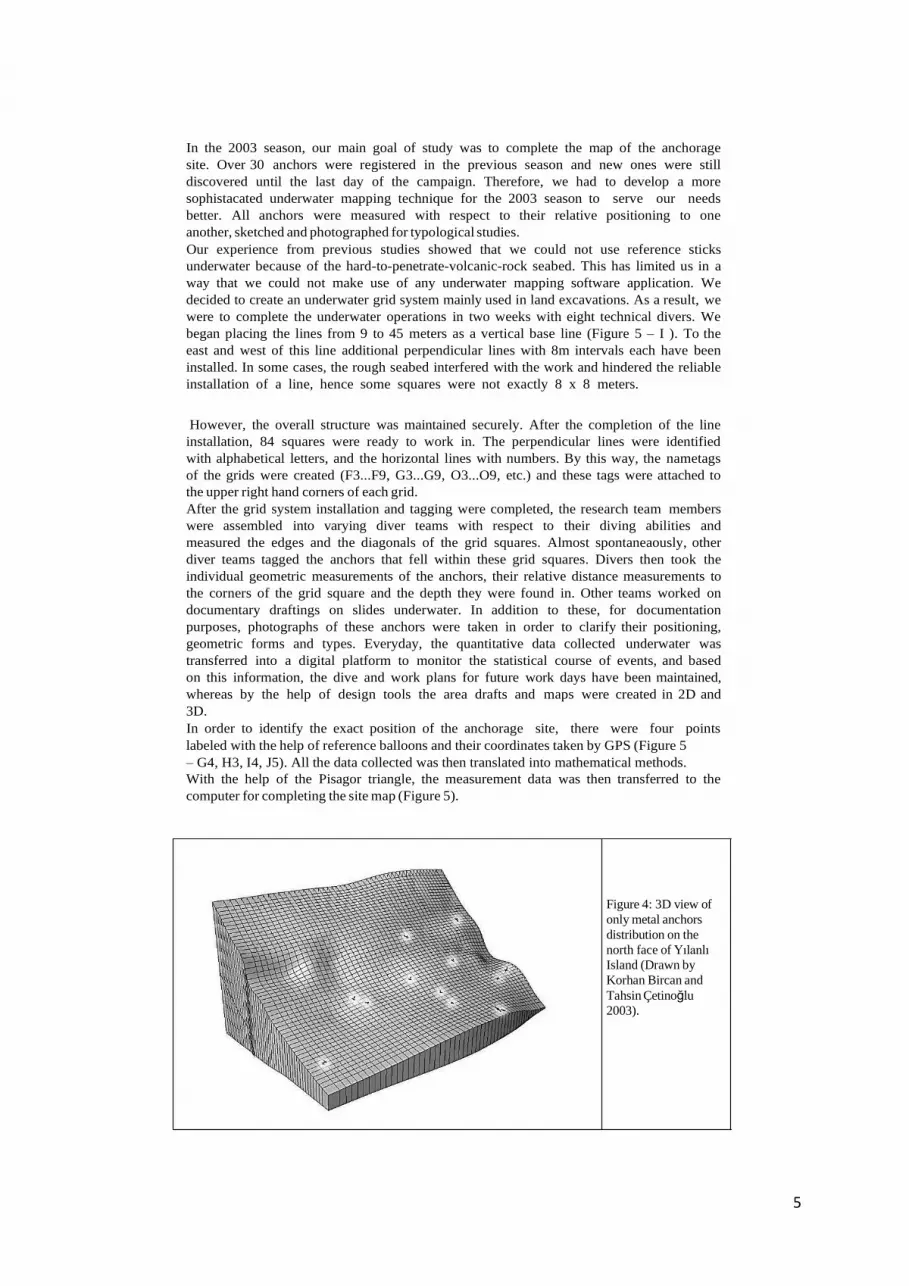
In the 2003 season, our main goal of study was to complete the map of the anchorage
site. Over 30 anchors were registered in the previous season and new ones were still
discovered until the last day of the campaign. Therefore, we had to develop a more
sophistacated underwater mapping technique for the 2003 season to serve our needs
better. All anchors were measured with respect to their relative positioning to one
another, sketched and photographed for typological studies.
Our experience from previous studies showed that we could not use reference sticks
underwater because of the hard-to-penetrate-volcanic-rock seabed. This has limited us in a
way that we could not make use of any underwater mapping software application. We
decided to create an underwater grid system mainly used in land excavations. As a result, we
were to complete the underwater operations in two weeks with eight technical divers. We
began placing the lines from 9 to 45 meters as a vertical base line (Figure 5 – I ). To the
east and west of this line additional perpendicular lines with 8m intervals each have been
installed. In some cases, the rough seabed interfered with the work and hindered the reliable
installation of a line, hence some squares were not exactly 8 x 8 meters.
However, the overall structure was maintained securely. After the completion of the line
installation, 84 squares were ready to work in. The perpendicular lines were identified
with alphabetical letters, and the horizontal lines with numbers. By this way, the nametags
of the grids were created (F3...F9, G3...G9, O3...O9, etc.) and these tags were attached to
the upper right hand corners of each grid.
After the grid system installation and tagging were completed, the research team members
were assembled into varying diver teams with respect to their diving abilities and
measured the edges and the diagonals of the grid squares. Almost spontaneaously, other
diver teams tagged the anchors that fell within these grid squares. Divers then took the
individual geometric measurements of the anchors, their relative distance measurements to
the corners of the grid square and the depth they were found in. Other teams worked on
documentary draftings on slides underwater. In addition to these, for documentation
purposes, photographs of these anchors were taken in order to clarify their positioning,
geometric forms and types. Everyday, the quantitative data collected underwater was
transferred into a digital platform to monitor the statistical course of events, and based
on this information, the dive and work plans for future work days have been maintained,
whereas by the help of design tools the area drafts and maps were created in 2D and
3D.
In order to identify the exact position of the anchorage site, there were four points
labeled with the help of reference balloons and their coordinates taken by GPS (Figure 5
– G4, H3, I4, J5). All the data collected was then translated into mathematical methods.
With the help of the Pisagor triangle, the measurement data was then transferred to the
computer for completing the site map (Figure 5).
Figure 4: 3D view of
only metal anchors
distribution on the
north face of Yılanlı
Island (Drawn by
Korhan Bircan and
Tahsin Çetinoğlu
2003).
6
Figure 5: The Map of AYDINCIK - YILANLI ISLAND Anchorage Site ( Grids planned by Korhan Bircan,
Murat Bircan, Drawn by Mert Ayaroglu, Çigdem Toskay Evrin, Korhan Özkan and Volkan Evrin) 2003.
7
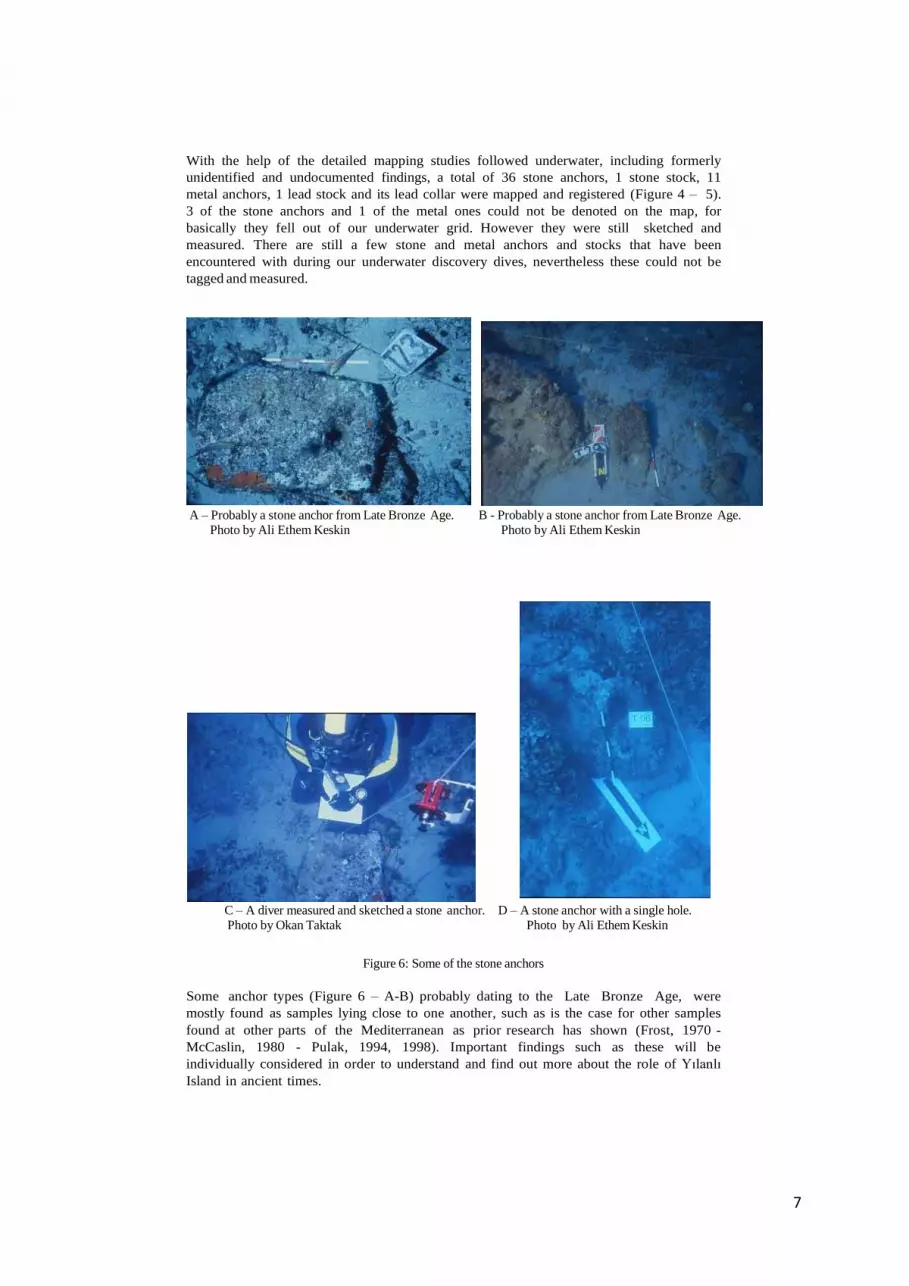
With the help of the detailed mapping studies followed underwater, including formerly
unidentified and undocumented findings, a total of 36 stone anchors, 1 stone stock, 11
metal anchors, 1 lead stock and its lead collar were mapped and registered (Figure 4 – 5).
3 of the stone anchors and 1 of the metal ones could not be denoted on the map, for
basically they fell out of our underwater grid. However they were still sketched and
measured. There are still a few stone and metal anchors and stocks that have been
encountered with during our underwater discovery dives, nevertheless these could not be
tagged and measured.
A – Probably a stone anchor from Late Bronze Age. B - Probably a stone anchor from Late Bronze Age.
Photo by Ali Ethem Keskin Photo by Ali Ethem Keskin
C – A diver measured and sketched a stone anchor. D – A stone anchor with a single hole.
Photo by Okan Taktak Photo by Ali Ethem Keskin
Figure 6: Some of the stone anchors
Some anchor types (Figure 6 – A-B) probably dating to the Late Bronze Age, were
mostly found as samples lying close to one another, such as is the case for other samples
found at other parts of the Mediterranean as prior research has shown (Frost, 1970 -
McCaslin, 1980 - Pulak, 1994, 1998). Important findings such as these will be
individually considered in order to understand and find out more about the role of Yılanlı
Island in ancient times.
The stone anchors with single or multi-holes, the stone stock, lead stock and its connection part,
the T- and Y type metal anchors and the wreck site lie very close to one another within the same
region. In underwater archaeological research, it is a rare incident to discover a high amount of
different types of anchors and a wreck site together, some belonging to different historical
periods. Therefore, we believe, it is worthwhile to continue exploring these coasts to find out more
on the trade routes since the Late Bronze Age and to work out a preliminary typology concerning
the anchors found so far.
4 Conclusion
The Anchorage site, the anchors and the wreck site found at the front of Aydıncık - Yılanlı
Island showed that Celenderis is an important antique harbour-city of the Cilicia region, at the
East Mediterranean coast of Anatolia. Stone anchors are not alien objects to the Anatolian coasts,
as recent research done by METU-SAT and SAD provides positive evidence of their existence
in the much neglected region of Cilicia. These stone anchors are very similar to their
counterparts found in the Mediterranean. The western part of the Anatolian coast is known as a
part of the Maritime Trade Routes in the Late Bronze Age. Comparative results showed and will
show that the Cilician coasts have also been used for trade during the Late Bronze Age and in later
periods as well.
Acknowledgements
We are thankful to the Turkish Naval Forces (Terme Ship and her staff), the Turkish Institute
of Nautical Archaeology (TINA), MIGROS A.Ç., the Turkish Ministry of Culture and DÖSIM
for logistics and financial support. Also we would like to thank to Berrin Çilingir, Içık Adak
Adıbelli and Azize Karabaglı as representatives of the Turkish Ministry of Culture during our field
studies.
References
1. HTTP://www.kilikya.org 2. Bass, G. F., 1972, A History of Seafaring based on Underwater Archaeology. London.
3. Bass, G. F., 1996, Shipwrecks in the Bodrum Museum of Underwater Archaeology. Bodrum Museum
of Underwater Archaeology Publication 3, Ankara.
4. Evrin, V., Öke, G., Özer, A. M. & Yalçıner, A. C., 1999, Tas¸ Çapalar: Dogu Akdeniz Anadolu
Kıyıları Deniz Ticaret Yolları, Genel Bir Bakıs ve Arkeometrik.
Degerlendirmeler. T.C. Kültür Bakanlıgı XXI. Uluslararası Kazı Araçtırma ve Arkeometri
Sempozyumu, Ankara, 109–116.
5. Evrin, V., 2000, Underwater Survey and Archaeometric Analysis on Coastal Archaeology Along the
Mediterranean Coasts of Anatolia. M.Sc. Thesis, Middle East Technical University, Ankara.
6. Evrin, V., Öke, G., Türkmenoglu, A, Demirci, Ç., 2002. The Stone Anchors from the Mediterranean Coasts
of Anatolia, Türkiye: Underwater Surveys and Archaeometrical Investigations, International Journal of
Nautical Archaeology (IJNA), 31.2: 254-267, London.
7. Frost, H., 1970, Bronze Age stone anchors from the Eastern Mediterranean: dating and
identification. Mariner’s Mirror, 56.4: 377–394.
8. McCaslin, D. E., 1980, Stone Anchors in Antiquity: Coastal Settlements and Maritime Trade routes in
the Eastern Mediterranean ca. 1600–1050 B.C. Studies in Mediterranean Archaeology, LXI, Göteborg
9. Pulak, C., 1994, 1994 excavation at Uluburun: the final campaign. INA Quarterly, 21.4.
10. Pulak, C., 1998, The Uluburun shipwreck: an overview. IJNA, 27.3: 188–224.
11. http://www.kilikya.org