Terrestrial Ecology Assessment (Part 9) - Environment
420
GEMINI PROJECT TERRESTRIAL ECOLOGY ASSESSMENT PREPARED FOR MAGNETIC SOUTH PTY LTD SEPTEMBER 2019
-
Upload
khangminh22 -
Category
Documents
-
view
0 -
download
0
Transcript of Terrestrial Ecology Assessment (Part 9) - Environment

GEMINI PROJECT TERRESTRIAL ECOLOGY ASSESSMENT PREPARED FOR MAGNETIC SOUTH PTY LTD SEPTEMBER 2019

Terrestrial Ecology September 2019 AARC Environmental Solutions Pty Ltd E [email protected] AARC.NET.AU
Document History and Status
Issue Rev. Issued To Qty Date Reviewed Approved Draft 0.1 SG 1 09/2019 SG SG Final 0.2 Magnetic South 1 09/2019 PI PI Final 0.3 GB 1 09/2019 GB GB
Author: Lucia Lopez Project Manager: Gareth Bramston Name of Client: Magnetic South Pty Ltd Name of Project: Gemini Project Title of Document: Ecology Terrestrial Assessment Document Version: Final
This controlled document is the property of AARC Environmental Solutions Pty Ltd and all rights are reserved in respect of it. This document may not be reproduced or disclosed in any manner whatsoever, in whole or in part, without the prior written consent of AARC Environmental Solutions Pty Ltd. AARC Environmental Solutions Pty Ltd expressly disclaims any responsibility for or liability arising from the use of this document by any third party.
Opinions and judgments expressed herein, which are based on our understanding and interpretation of current regulatory standards, should not be construed as legal opinions. Information obtained from interviews and contained in the documentation has been assumed to be correct and complete. AARC Environmental Solutions Pty Ltd does not accept any liability for misrepresentation of information or for items not visible, accessible, nor able to be inspected at the sites at the time of the site visits.

Terrestrial Ecology September 2019 AARC Environmental Solutions Pty Ltd E [email protected] AARC.NET.AU
1.0 INTRODUCTION ............................................................................................. 1
1.1 SCOPE OF STUDY ............................................................................................................... 1
1.2 PROJECT OVERVIEW .......................................................................................................... 1
1.3 CURRENT LAND USE .......................................................................................................... 2
1.4 LOCAL WATERWAYS AND TOPOGRAPHY ...................................................................... 3
1.5 GEOLOGY ............................................................................................................................. 6
1.6 REGIONAL CLIMATE ........................................................................................................... 6
2.0 RELEVANT LEGISLATION AND POLICY ..................................................... 8
2.1 ENVIRONMENT PROTECTION AND BIODIVERSITY CONSERVATION ACT 1999 ......... 8
2.2 NATURE CONSERVATION ACT 1992 ................................................................................. 8
2.2.1.1 Nature Conservation (Wildlife) Regulation 2006 .................................................................... 9
2.2.1.2 Nature Conservation (Wildlife Management) Regulation 2006 ............................................... 9
2.3 BIOSECURITY ACT 2014 ..................................................................................................... 9
2.4 VEGETATION MANAGEMENT ACT 1999 ........................................................................... 9
2.5 BIODIVERSITY STATUS .................................................................................................... 10
2.6 QUEENSLAND ENVIRONMENTAL OFFSETS FRAMEWORK ........................................ 11
3.0 DESKTOP ASSESSMENT ............................................................................ 12
3.1 REGULATED VEGETATION .............................................................................................. 13
3.1.1 Threatened Ecological Communities ............................................................................... 13
3.1.2 Regional Ecosystems ...................................................................................................... 13
3.2 SPECIES OF CONSERVATION SIGNIFICANCE .............................................................. 17
3.2.1 Flora ................................................................................................................................. 17
3.2.1.1 State and Commonwealth Listed Flora Species ................................................................... 17
3.2.1.2 Back on Track Flora Species Prioritisation ........................................................................... 18
3.3 FAUNA ................................................................................................................................. 19
3.3.1 State and Commonwealth Listed Fauna Species ............................................................ 19
3.3.1.1 Listed Migratory and Marine Species ................................................................................... 20
3.3.1.2 Back on Track Fauna Species Prioritisation ......................................................................... 21
3.4 ENVIRONMENTALLY SENSITIVE AREAS ........................................................................ 22
3.5 WETLANDS ......................................................................................................................... 23
3.5.1 Groundwater Dependant Ecosystem ............................................................................... 23
GEMINI PROJECT TERRESTRIAL ECOLOGY
ASSESSMENT

Terrestrial Ecology September 2019 AARC Environmental Solutions Pty Ltd E [email protected] AARC.NET.AU
4.0 METHODOLOGY .......................................................................................... 28
4.1 BIOREGION ......................................................................................................................... 28
4.2 FIELD SURVEY GUIDELINES ............................................................................................ 28
4.3 SURVEY SEASONALITY .................................................................................................... 28
4.4 FLORA ................................................................................................................................. 29
4.4.1 Vegetation Mapping and Community Description ........................................................... 30
4.4.2 Targeted Searches for Species of Conservation Significance ........................................ 31
4.5 FAUNA ................................................................................................................................. 33
4.5.1 Fauna Trapping Sites and Survey Locations ................................................................... 33
4.5.2 Fauna Survey Sites ......................................................................................................... 33
4.5.3 Detection Techniques ...................................................................................................... 36
4.5.4 Fauna Survey Effort ......................................................................................................... 39
5.0 FLORA RESULTS AND DISCUSSION ......................................................... 41
5.1 FLORA SURVEY RESULTS ............................................................................................... 41
5.1.1 VC 1: Narrow-leaved ironbark and Clarkson’s bloodwood woodland with a sparse shrub layer on sand plains ...................................................................................................................... 43
5.1.2 VC 2: Lancewood (Acacia shirleyi) and/or Rosewood (Acacia rodoxylon) woodland on lateritic duricrust ............................................................................................................................ 45
5.1.3 VC 3: Blue gum (Eucalyptus tereticornis) with Bauhinia spp. and Casuarina cunninghamiana fringing woodland on drainage features ............................................................ 47
5.1.4 VC 4: Poplar box (Eucalyptus populnea) woodland on alluvial plains ............................ 49
5.1.5 VC 5: Mixed polygon: Ironbark, Bloodwood and Blue gum woodland along ephemeral creeks 51
5.1.6 VC 6: Mixed polygon: Blue gum, Poplar box and Ironbark woodland along ephemeral creeks 52
5.1.7 Non-remnant and Regrowth Vegetation .......................................................................... 53
5.2 WEEDS OF MANAGEMENT CONCERN ........................................................................... 53
5.3 FLORA OF CONSERVATION SIGNIFICANCE .................................................................. 55
5.3.1 Threatened Ecological Communities not identified on the study area ............................ 55
5.3.2 Flora Species of Conservation Significance Identified on the Study Area ...................... 57
5.3.3 Flora Species of Conservation Significance Not Identified on the Study Area ................ 58
5.4 WETLANDS ......................................................................................................................... 59
5.4.1 Groundwater Dependent Ecosystems ............................................................................. 60
6.0 FAUNA RESULTS AND DISCUSSION ......................................................... 64
6.1 FAUNA SURVEY RESULTS ............................................................................................... 64
6.1.1 Amphibians ...................................................................................................................... 64
6.1.2 Reptiles ............................................................................................................................ 65
6.1.3 Birds ................................................................................................................................. 67
6.1.4 Mammals ......................................................................................................................... 70
6.2 PEST SPECIES ................................................................................................................... 74

Terrestrial Ecology September 2019 AARC Environmental Solutions Pty Ltd E [email protected] AARC.NET.AU
6.3 FAUNA SPECIES OF CONSERVATION SIGNIFICANCE ................................................. 75
6.3.1 Fauna Species of Conservation Significance Identified on the Study Area .................... 75
6.3.2 Fauna Species of Conservation Significance Not Identified on the Study Area .............. 76
7.0 POTENTIAL IMPACTS ................................................................................. 81
7.1 TERRESTRIAL FLORA ....................................................................................................... 81
7.1.1 Vegetation Communities .................................................................................................. 81
7.1.2 Flora Species of Conservation Significance and Habitat ................................................ 81
7.1.3 Weed Species .................................................................................................................. 81
7.1.4 Wetlands .......................................................................................................................... 81
7.1.5 Groundwater Dependant Ecosystems ............................................................................. 82
7.2 TERRESTRIAL FAUNA ...................................................................................................... 83
7.2.1 Fauna Species of Conservation Significance and Habitat .............................................. 83
7.2.2 Migratory Fauna Species ................................................................................................. 85
7.2.3 Pest Species .................................................................................................................... 85
8.0 MITIGATION AND MANAGEMENT STRATEGIES ...................................... 87
8.1.1 Terrestrial Flora................................................................................................................ 87
8.1.1.1 Vegetation Communities ...................................................................................................... 87
8.1.1.2 Flora Species of Conservation Significance ......................................................................... 87
8.1.1.3 Weed Species ...................................................................................................................... 87
8.1.1.4 Wetlands / GDEs .................................................................................................................. 88
8.1.2 Terrestrial Fauna ............................................................................................................. 88
8.1.2.1 Fauna Species of Conservation Significance ....................................................................... 88
8.1.2.2 Pest Species ........................................................................................................................ 88
9.0 PROJECT ENVIRONMENTAL OFFSETS .................................................... 90
9.1 ASSESSMENT OF PRESCRIBED MATTERS IDENTIFIED IN THE STUDY AREA ......... 90
9.1.1 Regulated Vegetation ...................................................................................................... 90
9.1.2 Conservation Significant Species, Protected Wildlife Habitat and Essential Habitat ...... 91
9.1.3 HES Wetland ................................................................................................................... 98
9.2 OFFSETS REQUIREMENTS............................................................................................... 98
10.0 REFERENCES ............................................................................................ 101

Terrestrial Ecology September 2019 AARC Environmental Solutions Pty Ltd E [email protected] AARC.NET.AU
LIST OF FIGURES
LIST OF TABLES

Terrestrial Ecology September 2019 AARC Environmental Solutions Pty Ltd E [email protected] AARC.NET.AU
LIST OF PHOTO PLATES

Terrestrial Ecology September 2019 AARC Environmental Solutions Pty Ltd E [email protected] AARC.NET.AU
LIST OF APPENDICES

Terrestrial Ecology September 2019 AARC Environmental Solutions Pty Ltd E [email protected] AARC.NET.AU
°C Degrees Celsius
% Percent
AARC AARC Environmental Solutions Pty Ltd
ALA Atlas of Living Australia
BCA Biodiversity and Conservation Values report
BOM Bureau of Meteorology
BoT Back on Track
BVG Broad Vegetation Group
C Least Concern
CE Critically Endangered
cm Centimetre
DES Department of Environment and Science
E Endangered
EA Environmental Authority
EPBC Act Environment Protection and Biodiversity Conservation Act 1999
EPC Exploration Permit Coal
ESA Environmental Sensitive Area
ERE Endangered Regional Ecosystem
EVNT Endangered, Vulnerable or Near Threatened species
GDE Groundwater Dependent Ecosystem(s)
GDE Atlas National Atlas of Groundwater Dependent Ecosystems
GIS Geographical Information System
GPS Geographical Positioning System
ha hectares
HES High Ecological Significance
LIST OF ABBREVIATIONS

Terrestrial Ecology September 2019 AARC Environmental Solutions Pty Ltd E [email protected] AARC.NET.AU
km kilometres
km2 square kilometres
LC Least Concern
m metre(s)
mbgl metre(s) below ground level
mAHD metre(s) Australian height datum
Ma Marine
Mi Migratory
MLES Matters of Local Environmental Significance
mm millimetres
MNES Matters of National Environmental Significance
MSES Matters of State Environmental Significance
NC Act Nature Conservation Act 1992
NCWR Nature Conservation (Wildlife) Regulation 2006
NP National Park
NRM Natural Resource Management
NT Near Threatened
PMAV Property Maps of Assessible Vegetation
RAD Recovery Actions Database
ROM Run of mine
RE Regional Ecosystem
REDD Regional Ecosystem Description Database
SILO Scientific Information for Land Owners
SL Special Least Concern
SPRAT Species Profile and Threats Database
TEC Threatened Ecological Community
V Vulnerable
VM Act Vegetation Management Act 1999

Terrestrial Ecology September 2019 AARC Environmental Solutions Pty Ltd E [email protected] AARC.NET.AU
VMR Vegetation Management Regulation 2000
WoNS Weeds of National Significance

1
Terrestrial Ecology September 2019 AARC Environmental Solutions Pty Ltd E [email protected] AARC.NET.AU
1.0 INTRODUCTION
AARC Environmental Solutions Pty Ltd (AARC) was commissioned by Magnetic South Pty Ltd (Magnetic South) to prepare a terrestrial ecology assessment for the Gemini Project, located approximately 110 km east of Emerald and 125 km west of Rockhampton in the Bowen Basin of Central Queensland (Figure 1). The Project is a proposed metallurgical open-cut coal mine and associated infrastructure, producing Pulverised Coal Injection (PCI) coal Coking Coal products for export for steel production.
An assessment of the terrestrial ecological values was conducted within Exploration Permit Coal (EPC) 881 (herein referred to as the study area). This assessment forms part of the supporting studies required for the Project’s approval processes.
1.1 SCOPE OF STUDY
To assess the ecological values of terrestrial ecosystems within the study area, the following scope of works was undertaken:
• Database searches to identify species of conservation significance known from the region (provided in Appendix A). These species were targeted during the field survey component of the study;
• Field surveys employing standard methodologies such as the Terrestrial Vertebrate Fauna Survey Guidelines of Queensland (Eyre et al. 2018) and Queensland Herbarium Methodology for Survey and Mapping of Regional Ecosystems and Vegetation Communities in Queensland Version 4.0 (Neldner et al. 2017) to identify terrestrial flora and fauna species inhabiting the study area, particularly species of conservation significance1; and
• Preparation of an assessment report describing the terrestrial ecological values identified on site, potential impacts of the Project, management strategies to minimise the impacts associated with the proposed mining activities and offset requirements.
1.2 PROJECT OVERVIEW
The main activities associated with the Project include:
• Exploration activities continuing in order to support mine planning;
• Development of a Mine Infrastructure Area (MIA) including mine offices, bathhouse, crib rooms, warehouse/stores, workshop, fuel storage, refuelling facilities, explosives magazine and sewage, effluent and liquid waste storage;
• Construction and operation of a Coal Handling Preparation Plant (CHPP) and coal handling facilities adjacent to the MIA (including Run-of-Mine (ROM) coal and, product stockpiles and rejects bin/overflow [coarse and fine rejects]);
1 ‘Species of conservation significance’ or ‘threatened species’ when referred to within this document are references to species listed as Near Threatened, Vulnerable or Endangered under the Queensland Nature Conservation Wildlife Regulation 2006 or Vulnerable, Endangered, Critically Endangered or Migratory under the Environmental Protection and Biodiversity Conservation Act 1999.

2
Terrestrial Ecology September 2019 AARC Environmental Solutions Pty Ltd E [email protected] AARC.NET.AU
• Construction and operation of a surface conveyor from the product stockpiles to a Train Load Out (TLO) facility and rail loop connecting to the Blackwater-Gladstone Branch Rail to transport product coal to coal terminals at Gladstone for export;
• Construction of access roads from the Capricorn Highway to the MIA, and to the TLO facility;
• Installation of a raw water supply pipeline to connect to the Blackwater Pipeline network;
• Construction of a 66 kilovolt (kV) transmission line and switching/substation to connect to the existing regional network;
• Other associated minor infrastructure, plant, equipment and activities;
• Development of mine areas (open cut pits) and out-of-pit waste rock emplacements;
• Drilling and blasting of competent waste material;
• Mine operations using conventional surface mining equipment (excavators, front end loaders, rear dump trucks, dozers);
• Mining up to 1.9 Million tonnes per annum (Mtpa) ROM Coal – average 1.8 Mtpa for a construction/production period of approximately 20 years;
• Progressive placement of waste rock in:
- Emplacements, adjacent to and near the open cut voids;
- Mine voids, behind the advancing open cut mining operations;
• Progressive rehabilitation of waste rock emplacement areas and mined voids;
• Progressive establishment of soil stockpiles, laydown area and borrow pits (for road base and civil works). Material will be sourced from local quarries where required;
• Disposal of CHPP rejects (coarse and fine rejects) in out of pit spoil dumps, and in-pit behind the mining void;
• Progressive development of internal roads and haul roads including a causeway over Charlevue Creek to enable coal haulage and pit access; and
• Development of water storage dams and sediment dams, and the installation of pumps, pipelines, and other water management equipment and structures including temporary levees, diversions and drains.
Existing local and regional infrastructure, facilities and services would be used to support Project activities. These include the SunWater water distribution network, the Aurizon rail network, Ergon’s electricity network, the Capricorn Highway, and Gladstone export coal terminals.
1.3 CURRENT LAND USE
The land within the study area is currently used for low intensity cattle grazing and resource exploration activities. The Capricorn Highway and a number of publicly gazetted roads including Charlevue, Cooinda, Red Hill, Normanby, and Ellesmere roads dissect the study area.
3
Terrestrial Ecology September 2019 AARC Environmental Solutions Pty Ltd E [email protected] AARC.NET.AU
Located directly north of the study area is the Taunton National Park (Scientific), (Taunton Nation Park), a scientific reserve under the Land Act 1994 (Queensland), with the aim of protecting a population of Bridled nail-tail wallabies. A small section of the Taunton National Park of around 2.5 hectares (ha) within the study area.
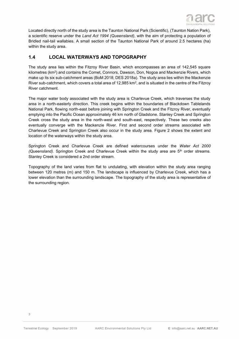
1.4 LOCAL WATERWAYS AND TOPOGRAPHY
The study area lies within the Fitzroy River Basin, which encompasses an area of 142,545 square kilometres (km2) and contains the Comet, Connors, Dawson, Don, Nogoa and Mackenzie Rivers, which make up its six sub-catchment areas (BoM 2018; DES 2018a). The study area lies within the Mackenzie River sub-catchment, which covers a total area of 12,985 km2, and is situated in the centre of the Fitzroy River catchment.
The major water body associated with the study area is Charlevue Creek, which traverses the study area in a north-easterly direction. This creek begins within the boundaries of Blackdown Tablelands National Park, flowing north-east before joining with Springton Creek and the Fitzroy River, eventually emptying into the Pacific Ocean approximately 46 km north of Gladstone. Stanley Creek and Springton Creek cross the study area in the north-west and south-east, respectively. These two creeks also eventually converge with the Mackenzie River. First and second order streams associated with Charlevue Creek and Springton Creek also occur in the study area. Figure 2 shows the extent and location of the waterways within the study area.
Springton Creek and Charlevue Creek are defined watercourses under the Water Act 2000 (Queensland). Springton Creek and Charlevue Creek within the study area are 5th order streams. Stanley Creek is considered a 2nd order stream.
Topography of the land varies from flat to undulating, with elevation within the study area ranging between 120 metres (m) and 150 m. The landscape is influenced by Charlevue Creek, which has a lower elevation than the surrounding landscape. The topography of the study area is representative of the surrounding region.

4
Terrestrial Ecology September 2019 AARC Environmental Solutions Pty Ltd E [email protected] AARC.NET.AU
Project and Study Area Location

5
Terrestrial Ecology September 2019 AARC Environmental Solutions Pty Ltd E [email protected] AARC.NET.AU
Waterways and topography associated with the Study Area

6
Terrestrial Ecology September 2019 AARC Environmental Solutions Pty Ltd E [email protected] AARC.NET.AU
1.5 GEOLOGY
The geology of the region is dominated by its position within the Bowen Basin, one of Queensland’s largest depositional regions, which formed through a period of rifting and subsidence lasting from the Early Permian - Mid-Triassic. The area is dominated by clastic sedimentary rocks of marine and lacustrine origin, including sandstones, conglomerates, mudstones, siltstones and coal (Geoscience Australia 2018).
The coastal and inland depositional environments which created these deposits allowed for the formation of extensive coal seams throughout the Bowen Basin, with the anoxic deposition of organic matter subsequently compacted and de-volatised through compression and increased temperatures (Brooks & Smith 1969).
Generally, coal seams found in the east-central part of the basin contain higher quality coking coal deposits, with rank falling below coking range farther south and west (Hutton 2009). The high-quality coal measures are of Permian age, buried less than 60 m from the surface (Mutton 2003).
1.6 REGIONAL CLIMATE
The regional climate is classified as semi-arid, characterised with warm dry summers and warm winters. Climate data for the study area has been sourced from Scientific Information for Land Owners (SILO) climate database (Queensland Government), which operates by interpolating data from the Commonwealth Bureau of Meteorology (BoM) into a single point data drill.
Figure 3 shows predicted average temperature and rainfall for the area from January 1999 to July 2019. The data indicates the annual mean rainfall for the region is highest between December and March with the maximum average occurring in December (111.5 millimetres (mm)).
The hottest months typically occur between October and March while the coolest months occur between May and September. The highest mean maximum temperature typically occurs in December (34.2 degrees Celsius (°C)) and the lowest mean minimum temperature in July (8.5°C). The mean annual maximum temperature for the region is predicted to be 29.8°C and the mean annual minimum temperature is predicted to be 16°C.

7
Terrestrial Ecology September 2019 AARC Environmental Solutions Pty Ltd E [email protected] AARC.NET.AU
Mean temperature and rainfall data for the region (Source: SILO)
101.1 92.0 90.4 21.8 17.7 40.1 21.2 20.2 28.9 42.7 61.1 111.5
34.233.3
32.4
29.8
26.9
23.8 23.925.8
29.0
31.532.7
33.9
22.0 21.920.5
17.0
12.610.2
8.59.5
13.2
16.7
19.021.0
0.0
20.0
40.0
60.0
80.0
100.0
120.0
0.0
5.0
10.0
15.0
20.0
25.0
30.0
35.0
40.0
Jan Feb Mar Apr May Jun Jul Aug Sep Oct Nov Dec
Rai
nfa
ll (m
m)
Tem
per
atu
re (
°C)
Mean Rainfall Mean monthly temp (max) Mean monthly temp (min)

8
Terrestrial Ecology September 2019 AARC Environmental Solutions Pty Ltd E [email protected] AARC.NET.AU
2.0 RELEVANT LEGISLATION AND POLICY
Commonwealth and State legislation and policies relevant to the assessment of terrestrial ecological values on the study area is discussed below.
2.1 ENVIRONMENT PROTECTION AND BIODIVERSITY CONSERVATION ACT 1999
Under the Commonwealth Environmental Protection and Biodiversity Conservation Act 1999 (EPBC Act), an action requires approval from the Federal Environment Minister if the action has, will have, or is likely to have a significant impact on a Matter of National Environmental Significance (MNES).
An EPBC Referral (2010/5775) was lodged in 2010 for the Gemini Project previously known as the Dingo West Project by Dingo West Pty Ltd, which was declared ‘Not a Controlled Action if undertaken in a Particular Manner’ in July 2011.
The Particular Manner Decision conditions (EPBC 2010/5775) are as follows:
1. To prevent downstream impacts to the Fitzroy River Turtle (Rheodytes leukops) the person taking the action must appropriately bund or locate pits in a manner that prevents surface water from entering the pit during a 1:1000 year flood event (as indicated in flood modelling at Attachment A).
2. To prevent downstream impacts to the Fitzroy River Turtle (Rheodytes leukops) the person taking the action must appropriately bund or locate dams in a manner that prevents surface water from entering or damaging the dams during a during a 1:1000 year flood event (as indicated in flood modelling at Attachment A).
The Gemini Project complies with the Particular Manner Decision (EPBC 2010/5775). Furthermore, the level of impact to MNES have been assessed to be no greater than those described in the EPBC Referral (20105775).
The potential impact of the Project on the Fitzroy River Turtle is addressed in the Aquatic Ecology Assessment (AARC 2019).
2.2 NATURE CONSERVATION ACT 1992
The most relevant components of the Queensland Nature Conservation Act 1992 (NC Act) to the Project, are the sections which pertain to Wildlife and Habitat Conservation. The classes of wildlife to which the NC Act applies includes protected wildlife, which is defined as Extinct wildlife; Endangered wildlife; Vulnerable wildlife; Near Threatened wildlife; and Least Concern wildlife.
‘Threatening processes’ are also relevant to wildlife and habitat conservation. The NC Act defines ‘threatening processes’ as any process that is capable of:
a) threatening the survival of any protected area, area of major interest, protected wildlife, community of native wildlife or native wildlife habitat; or
b) affecting the capacity of any protected area, area of major interest, protected wildlife, community of native wildlife or native wildlife habitat to sustain natural processes.
The NC Act is relevant to the Project for any protected flora or fauna species (as detailed in the NCWR) found in the study area.

9
Terrestrial Ecology September 2019 AARC Environmental Solutions Pty Ltd E [email protected] AARC.NET.AU
2.2.1.1 Nature Conservation (Wildlife) Regulation 2006
Species listed under the above threatened species classes are published in the associated Nature Conservation (Wildlife) Regulation 2006 (NCWR). This report has considered the recent amendments made to listed threatened species in 2019.
2.2.1.2 Nature Conservation (Wildlife Management) Regulation 2006
The Nature Conservation (Wildlife Management) Regulation 2006 provides for the management of wildlife, other than wildlife in a protected area.
This regulation also pertains to the clearing, growing, harvesting and trading of protected plants in Queensland. As per Section 282 of the Regulation, a protected plant clearing permit for protected plants (other than in a protected area) may be required for any vegetation clearing of an area containing EVNT species (DES 2019a).
2.3 BIOSECURITY ACT 2014
The Queensland Biosecurity Act 2014 (Biosecurity Act) provides comprehensive biosecurity measures to safeguard our economy, agricultural and tourism industries, environment and way of life, from pests (e.g. wild dogs and weeds), diseases (e.g. foot-and-mouth disease), and contaminants (e.g. lead on grazing land).
Biosecurity matters are separated into three broad categories:
• A ‘prohibited matter’ is a biosecurity matter that is not found in Queensland but would have a significant adverse impact on our health, way of life, and the economy or the environment if it entered the State. Prohibited matters must be reported to Biosecurity Queensland within 24 hours and all reasonable steps taken to minimise the risks of the prohibited matter and not make the situation worse.
• A ‘restricted matter’ is a biosecurity matter found in Qld and has a significant impact on human health, social amenity, the economy or the environment. Restricted matters are further broken down into seven categories, with each category placing restrictions on the dealings with the biosecurity matter or actions required to be taken to minimise the spread and adverse impact of the biosecurity matter.
• An ‘other matter’ is a biosecurity matter that is not a prohibited or restricted matter. Everyone is obligated to take all reasonable and practical steps to minimise the risks associated with other biosecurity matters under their control.
The Biosecurity Act is relevant to the Project in regard to the control and management of invasive plant and animal species.
2.4 VEGETATION MANAGEMENT ACT 1999
The Vegetation Management Act 1999 (Qld) (VM Act) is a part of a planning framework for the management of native vegetation across Qld. The Vegetation Management Regulation 2012 (VMR) prescribes the status (otherwise known as the Vegetation Management Class (VM Class)) of each of the Regional Ecosystems (RE) identified within Qld.
The specific criteria used to assess the VM Class of RE are defined in Table 1. ‘Remnant Vegetation’ for an area of Queensland for which there is no RE map or remnant vegetation map, is any vegetation where the predominant canopy:

10
Terrestrial Ecology September 2019 AARC Environmental Solutions Pty Ltd E [email protected] AARC.NET.AU
• covers more than 50% of the undisturbed predominant canopy;
• averages more than 70% of the vegetation’s undisturbed height; and
• is composed of species characteristic of the vegetation’s undisturbed dominant canopy.
VM Class Criteria
Endangered • remnant vegetation is less than 10 % of its pre-clearing extent across the
bioregion; or • 10–30% of its pre-clearing extent remains and the remnant vegetation is less
than 10,000 ha.
Of Concern • remnant vegetation is 10–30% of its pre-clearing extent across the
bioregion; or • more than 30% of its pre-clearing extent remains and the remnant extent is
less than 10,000 ha.
Least Concern • remnant vegetation is over 30% of its pre-clearing extent across the bioregion, and the remnant area is greater than 10,000 ha.
2.5 BIODIVERSITY STATUS
The Department of Environment and Science (DES) Biodiversity Status is a classification assigned to REs and is used for a range of planning and management applications. These applications include the Biodiversity Planning Assessments and the determination of environmentally sensitive areas that are used for regulation of the mining industry through provisions in the Environmental Protection Act 1994 (EP Act).
The biodiversity status is based on an assessment of the condition of remnant vegetation in addition to the criteria used to determine the class under the VM Act; including other threatening processes, such as reduction in biodiversity; weed invasion; grazing pressures; inappropriate fire management; fragmentation; and infrastructure development.
Biodiversity Status Criteria in addition to VM Class listing
Endangered
• less than 10% of its pre-clearing extent remains unaffected by severe degradation and/or biodiversity loss; or
• 10–30% of its pre-clearing extent remains unaffected by severe degradation and/or biodiversity loss and the remnant vegetation is less than 10,000ha; or
• it is a rare RE subject to a threatening process.
Of Concern • 10–30% of its pre-clearing extent remains unaffected by moderate degradation and/or biodiversity loss.
No Concern at Present
• the degradation criteria listed above for ‘endangered’ or ‘of concern’ RE are not met.

11
Terrestrial Ecology September 2019 AARC Environmental Solutions Pty Ltd E [email protected] AARC.NET.AU
2.6 QUEENSLAND ENVIRONMENTAL OFFSETS FRAMEWORK
The Queensland environmental offsets framework consists of the Environmental Offsets Act 2014, Environmental Offsets Regulation 2014, and the Queensland Environmental Offsets Policy (Version 1.6) (DES 2018b). The offsets framework requires environmental offsets to be delivered where an activity is likely to result in a significant residual impact on a prescribed environmental matter. The Significant Residual Impact Guideline (DES 2014a) is used to determine whether the residual impacts are significant.
Prescribed Environmental Matters include:
• Matters of National Environmental Significance (MNES);
• Matters of State Environmental Significance (MSES) (outlined below); and
• Matters of Local Environmental Significance (MLES).
MSES are defined in Schedule 2 of the Environmental Offsets Regulation 2014, and comprise:
• Regulated vegetation including:
i. Endangered and Of Concern regional ecosystems;
ii. Regional ecosystems (REs) that intersect areas shown as wetlands on the Vegetation Management Wetlands map;
iii. REs located within a defined distance from the defining banks of a relevant watercourse or relevant drainage feature; or
iv. REs mapped as essential habitat for endangered and vulnerable flora and fauna;
• Areas that provide connectivity and maintain ecosystem functioning;
• Mapped wetlands and watercourses including:
i. Wetland protection areas, or areas of high ecological significance as shown on the Map of referable wetlands; or
ii. High ecological value waters (as defined under the Environmental Protection (Water) Policy 2009);
• Designated precincts in a strategic environmental area under the Regional Planning Interests Regulation 2014;
• Protected wildlife habitat, which includes;
i. High risk areas on the flora survey trigger map;
ii. Areas that contain endangered or vulnerable plants;
iii. Non-juvenile koala habitat trees in certain areas of south-east Queensland; or
iv. Habitat for endangered, vulnerable and special least concern animals;
• Protected areas and highly protected zones of State marine parks;
• Fish habitat areas;
• Waterways providing for fish passage;
• Marine plants; and
• Legally secured offsets.

12
Terrestrial Ecology September 2019 AARC Environmental Solutions Pty Ltd E [email protected] AARC.NET.AU
3.0 DESKTOP ASSESSMENT
Several desktop assessments were conducted to collate information on terrestrial ecological values identified in the region. These searches include previous surveys, community records and other sources. A review of databases facilitates the formulation of specific field survey techniques to target certain flora and fauna species known from the region.
All database searches were based on either the Lot/Plan, study area, or the central coordinate point (-23.6380 149.2514), depending on the database search undertaken. Database search results can be found in Appendix A. The following database searches were undertaken:
1. Environmental Reports Online (search based on EPC boundary);
a. Biodiversity Planning Assessments;
b. Matters of State Environmental Significance, including the regulated vegetation map;
c. Regional Ecosystems;
2. Environmentally Sensitive Area (ESA) Mapping (search based on EPC boundary);
3. Regional Ecosystems Report (search based on EPC boundary);
4. Protected Plants Flora Survey Trigger Map (search based on central coordinate point);
5. EPBC Act Protected Matters Search Tool (PMST) (two searches based on central coordinate point with 10 km and 50 km buffers);
6. Wildlife Online Species List Request (two searches based on central coordinate point with 10 km and 50 km buffers);
a. Rare and Threatened Species (two searches based on central coordinate point with 10 km and 50 km buffers);
b. Introduced Species (search based on central coordinate point with 50 km buffer); and
7. Department of Environment and Science (DES) interactive WetlandMaps database and Map of Referable Wetlands;
8. Bureau of Meteorology (BoM) and Department of Natural Resources Mines and Energy (DNRME) mapping of Groundwater Dependent Ecosystems (GDEs); and
9. ‘Back on Track’ Species Prioritisation Framework Recovery Actions Database (RAD) for Queensland for the Fitzroy Natural Resource Management Region.
Additional resources that provide species records and related information such as the Atlas of Living Australia (ALA) and Queensland Museum were consulted where appropriate, such as to support determinations of the likelihood of individual species occurring (Appendix A).
The following sections address items of nature conservation relevant to the study area, that have been identified within the desktop assessment.

13
Terrestrial Ecology September 2019 AARC Environmental Solutions Pty Ltd E [email protected] AARC.NET.AU
3.1 REGULATED VEGETATION
The Regulated Vegetation Management Map was consulted, and the following regulated vegetation categories have been identified within the Project:
• Category B: Remnant vegetation.
• Category C: High-value regrowth vegetation.
• Category R: Regrowth within 50 m of a watercourse or drainage feature located in Great Barrier Reef catchment areas.
• Category X: Non-remnant vegetation.
Figure 4 outlines the Endangered or Of Concern Regulated Vegetation identified as likely to occur within the study area.
3.1.1 Threatened Ecological Communities
The EPBC Act PMST identified three TECs that could potentially occur within 10 km of the study area (1 to 3), and two additional TECs potentially occurring within 50 km of the study area (4 and 5).
1. Brigalow (Acacia harpophylla dominant and co-dominant);
2. Coolabah – Black Box Woodlands of the Darling Riverine Plains and the Brigalow Belt South Bioregions;
3. Weeping Myall Woodlands;
4. Natural Grasslands of the Qld Central Highlands and the northern Fitzroy Basin; and
5. Semi-evergreen vine thickets of the Brigalow Belt (North and South) and Nandewar Bioregions.
On the 4th July 2019, the Commonwealth government amended the list of threatened species and communities protected by the EPBC Act. Amongst numerous amendments, one was considered relevant to the study area, being the listing of a new TEC:
6. Poplar Box Grassy Woodland on Alluvial Plains.
The Conservation Advice (including listing advice) for the Poplar Box Grassy Woodland on Alluvial Plains (TSSC n.d.) outlines five REs in Queensland that correspond fully or partly with the Poplar box TEC. Of these, RE 11.3.2 (Eucalyptus populnea woodland on alluvial plains) is mapped (desktop) as occurring within the study area. Consequently, the Poplar Box TEC has been added to the list of TECs potentially occurring within 50 km of the study area.
Each TEC, PMST type of presence and desktop assessment of likelihood of occurrence is outlined in Appendix B.
3.1.2 Regional Ecosystems
Current DES mapping identifies six remnant REs occurring within the study area (Table 3, Figure 5).

14
Terrestrial Ecology September 2019 AARC Environmental Solutions Pty Ltd E [email protected] AARC.NET.AU
Regional Ecosystem Description VM Act
Status DES
Biodiversity Status
EPBC Act
11.3.1 Acacia harpophylla and/or Casuarina cristata open forest on alluvial plains Endangered Endangered
Brigalow (Acacia
harpophylla dominant and co-
dominant)
11.3.2 Eucalyptus populnea woodland on alluvial plains Of concern Of concern
Poplar Box grassy
woodland on alluvial
plains Weeping
Myall (Acacia
pendula) Woodland
11.3.25 Eucalyptus tereticornis or E. camaldulensis woodland fringing drainage lines
Least concern Of concern
11.5.2
Eucalyptus crebra, Corymbia spp., with E. moluccana woodland on lower slopes of Cainozoic sand plains and/or remnant surfaces
Least concern
No concern at present
11.5.9b Eucalyptus crebra and other Eucalyptus spp. and Corymbia spp. woodland on Cainozoic sand plains and/or remnant surfaces
Least concern
No concern at present
11.7.2 Acacia spp. woodland on Cainozoic lateritic duricrust. Scarp retreat zone
Least concern
No concern at present

15
Terrestrial Ecology September 2019 AARC Environmental Solutions Pty Ltd E [email protected] AARC.NET.AU
Regulated Vegetation (VM Act) classed as Endangered or Of Concern

16
Terrestrial Ecology September 2019 AARC Environmental Solutions Pty Ltd E [email protected] AARC.NET.AU
Regional Ecosystems Vegetation Management Map for the study area

17
Terrestrial Ecology September 2019 AARC Environmental Solutions Pty Ltd E [email protected] AARC.NET.AU
3.2 SPECIES OF CONSERVATION SIGNIFICANCE
Species of conservation significance identified from the desktop assessment were assigned a likelihood of occurrence based on the criteria identified in Table 4. The assessment was based on the knowledge of ecologists, habitat suitability, previous surveys conducted near the study area and scientific literature.
Desktop assessments to determine the likelihood of each species identified during the database searches, with potential to occur on the study area, were undertaken prior to conducting the field surveys.
Targeted searches were undertaken in the field for species identified as either being likely to occur, or having potential to occur, within the study area, based on the desktop sources. The methodology was applied again after surveys to determine the likelihood of occurrence once additional site-based information became available.
Likelihood of Occurrence Criteria
Unlikely
• Species or species habitat may occur, is likely to occur or is known to occur from the broader search area (based on database searches); but o preferred habitat has not been identified within the study area; and there
are no confirmed species records within 10 km of the study area; or o preferred habitat occurs within the study area, but there are no confirmed
species records within 50 km of the study area.
Potential
• Species or species habitat may occur, is likely to occur or is known to occur from the broader search area (based on database searches); and o preferred habitat occurs within the study area; but there are no confirmed
species records within 10 km of the study area; however, there are confirmed species records within 50 km of the study area; or
• Species indicated as likely during desktop assessment, but field surveys revealed no evidence of occurrence in the study area.
Likely • Preferred habitat occurs within the study area; and confirmed species records
within 10 km of the study area; however, species not yet confirmed as occurring within the study area.
Known • Confirmed species records within the study area (generally as a result of subsequent field survey).
3.2.1 Flora
3.2.1.1 State and Commonwealth Listed Flora Species
The PMST and the Wildlife Online Database identified 33 Endangered, Vulnerable or Near Threatened (EVNT) flora species with potential to occur within the 50 km buffer zone (Appendix A).
Each flora species, its protection status, habitat requirements, and assessment of likelihood of occurrence is provided in Appendix C.
Out of the 33 species identified by the desktop assessment six were considered to have the potential to occur within the study area and were targeted during the field survey. These six species and their conservation status under Commonwealth and State legislation are listed in Table 5.

18
Terrestrial Ecology September 2019 AARC Environmental Solutions Pty Ltd E [email protected] AARC.NET.AU
Scientific Name EPBC status
NC Act status
Potential Presence in Buffer Area
10 km 50 km
Bertya opponens V LC - -
Bertya pedicellata - NT - x
Cerbera dumicola - NT x x
Solanum adenophorum - NT - x
Solanum dissectum E E - x
Solanum elachophyllum - E x x EPBC – Environment Protection and Biodiversity Conservation Act 1999 NC Act – Nature Conservation Act 1992 NT – Near Threatened E – Endangered
3.2.1.2 Back on Track Flora Species Prioritisation
A RAD database search identified 35 Back on Track flora species ranked as either ‘high’ or ‘critical’ from the Fitzroy NRM Region. Of these 35 species, 30 are listed as EVNT under the NC Act and 16 are listed as EVNT under the EPBC Act. A list of these species and their relevant state and Commonwealth listings is presented in Table 6.
Species Name Common Name Fitzroy NRM Region
State BoT Rank
NC Act Status
EPBC Act
Status Apatophyllum olsenii High High E V Atalaya collina High Medium E E Bowenia serrulata Byfield fern Critical Critical LC - Cadellia pentastylis Ooline Critical Critical E - Capparis humistrata High Medium E - Comesperma oblongatum High High V V Commersonia pearnii Critical High E - Cupaniopsis shirleyana Wedge-leaf tuckeroo High High V V Cycas megacarpa Critical Critical E E Cycas ophiolitica Marlborough blue Critical Critical E E Eleocharis blakeana High Medium LC -
Eriocaulon carsonii High High E E Eucalyptus pachycalyx subsp. waajensis High High E -
Eucalyptus raveretiana Black ironbox High High LC - Grevillea venusta Grevillea High High V -
Hakea trineura High High V V Homoranthus decumbens High High V E Lissanthe brevistyla High High V -

19
Terrestrial Ecology September 2019 AARC Environmental Solutions Pty Ltd E [email protected] AARC.NET.AU
Species Name Common Name Fitzroy NRM Region
State BoT Rank
NC Act Status
EPBC Act
Status Logania diffusa High High V V Macrozamia platyrhachis Critical Critical E E Macrozamia serpentina Critical Critical E - Marsdenia brevifolia High High V V Melaleuca groveana High Medium NT - Melaleuca irbyana High Medium E - Myriophyllum artesium High High E - Olde-andia gibsonii Critical Critical E - Olearia macdonnellensis High High - V Phaius australis Critical Critical E E Pisonia grandis High High LC -
Plectranthus graniticola High High V - Rhaponticum australe High High V V Rhodamnia angustifolia High Medium E - Solanum adenophorum High High E - Solanum dissectum High Medium E E Trioncinia retroflexa Critical High E -
EPBC – Environment Protection and Biodiversity Conservation Act 1999 NC Act – Nature Conservation Act 1992 E – Endangered V – Vulnerable NT – Near Threatened LC – Least Concern
3.3 FAUNA
3.3.1 State and Commonwealth Listed Fauna Species
Database searches identified 29 EVNT fauna species with potential to occur within the 50 km of the study area (Appendix A).
A detailed assessment to determine the likelihood of EVNT species to occur on the study area was completed prior to conducting the field survey, for the purpose of determining targeted species and to guide field survey methodology. The detailed assessment was based on the knowledge of ecologists, habitat suitability and scientific literature. This assessment is provided in Appendix D.
The detailed assessment of likelihood of occurrence considered that 16 of the 29 species identified by the desktop assessment had the potential to occur within the study area and were targeted during the field survey. These 16 species and their conservation status under Commonwealth and State legislation are listed in Table 7.
Scientific Name Common Name EPBC status
NC Act status
Amphibians
Adelotus brevis Tusked frog - V
Reptiles

20
Terrestrial Ecology September 2019 AARC Environmental Solutions Pty Ltd E [email protected] AARC.NET.AU
Scientific Name Common Name EPBC status
NC Act status
Delma torquata Collared delma V V
Strophurus taenicauda Golden-tailed gecko - NT
Birds
Calyptorhynchus lathami erebus Glossy black-cockatoo (northern) - V
Erythrotriorchis radiatus Red goshawk V E
Geophaps scripta scripta Squatter pigeon (southern subspecies) V V
Grantiella picta Painted honeyeater V V
Lathamus discolor Swift parrot C E
Ninox strenua Powerful owl - V
Pedionomus torquatus Plains-wanderer C V
Poephila cincta cincta Black-throated finch (white-rumped subspecies) E E
Turnix melanogaster Black-breasted button quail V V
Mammals
Chalinolobus dwyeri Large-eared pied bat V V
Onychogalea fraenata Bridled nailtail wallaby E E
Petauroides volans Greater glider V V
Phascolarctos cinereus Koala V V EPBC – Environment Protection and Biodiversity Conservation Act 1999 NC Act – Nature Conservation Act 1992 NT – Near Threatened V – Vulnerable C – Critically Endangered E – Endangered
3.3.1.1 Listed Migratory and Marine Species
The EBPC PMST indicated 21 marine and/or migratory species known from 50 km of the study area (Appendix A).
The assessment of likelihood of occurrence (Appendix D) considered that nine of the 21 species had the potential to occur within the study area.
Scientific Name Common Name EPBC status
NC Act status
Ardea alba Great egret Ma -
Ardea ibis Cattle egret Ma -
Calidris acuminata Sharp-tailed sandpiper Ma, Mi SL
Chrysococcyx osculans Black-eared cuckoo Ma -
Hirundapus caudacutus White-throated needletail Ma, Mi -
Merops ornatus Rainbow bee-eater Ma -

21
Terrestrial Ecology September 2019 AARC Environmental Solutions Pty Ltd E [email protected] AARC.NET.AU
Scientific Name Common Name EPBC status
NC Act status
Monarcha melanopsis Black-faced Monarch Ma, Mi SL
Motacilla flava Yellow wagtail Ma, Mi SL
Myiagra cyanoleuca Satin flycatcher Ma, Mi SL EPBC – Environment Protection and Biodiversity Conservation Act 1999 NC Act – Nature Conservation Act 1992 Ma – Marine Mi – Migratory SL – Special Least Concern
3.3.1.2 Back on Track Fauna Species Prioritisation
A RAD database search identified 35 Back on Track fauna species ranked as either ‘high’ or ‘critical’ from the Fitzroy NRM Region. A list of these species and their relevant State and Commonwealth listings is presented in Table 8.
Species Name Common Name Fitzroy NRM
Region
State BoT Rank
NC Act
Status
EPBC Act
Status Amphibians Taudactylus pleione Kroombit tinkerfrog High High E CE Reptiles Phyllurus caudiannulatus Ringed thin-tailed gecko High Medium V - Phyllurus championae Critical Critical LC - Elseya albagula Southern snapping turtle High High E CE Rheodytes leukops Fitzroy River turtle High High V V Caretta caretta Loggerhead turtle Critical Critical E E Strophurus taenicauda Golden-tailed gecko High Medium NT - Acanthophis antarcticus Common death adder High Medium V - Denisonia maculata Ornamental snake High Medium V V Hoplocephalus stephensii Stephens' banded snake High High LC - Delma inornata High High LC - Delma torquata Collared delma High High V V Anomalopus brevicollis High High LC -
Egernia rugosa Yakka skink High Medium V V Lerista allanae Allan's lerista High High E E Varanus semiremex Rusty monitor High High LC - Birds Erythrotriorchis radiatus Red goshawk High High E V Esacus magnirostris Beach stone-curlew High High V - Stagonopleura guttata Diamond firetail High High LC - Sternula albifrons Little tern High High SL - Epthianura crocea macgregori Yellow chat (Dawson) High High E CE

22
Terrestrial Ecology September 2019 AARC Environmental Solutions Pty Ltd E [email protected] AARC.NET.AU
Species Name Common Name Fitzroy NRM
Region
State BoT Rank
NC Act
Status
EPBC Act
Status Grantiella picta Painted honeyeater High High V V Turnix melanogaster Black-breasted button quail Critical Critical V V Mammals
Dasyurus maculatus maculatus Spotted-tailed quoll (southern subspecies) High High V E
Dugong dugon Dugong Critical Critical V - Taphozous australis Coastal sheathtail bat High High NT - Onychogalea fraenata Bridled nailtail wallaby Critical Critical E E Petrogale penicillata Brush-tailed rock-wallaby High High V V Macroderma gigas Ghost bat Critical Critical E V Xeromys myoides Water mouse Critical High V V
Petaurus australis australis Yellow-bellied glider (southern subspecies) High High LC -
Bettongia tropica Northern bettong Critical Critical E E Pteropus poliocephalus Grey-headed flying-fox Critical Critical LC V Kerivoula papuensis Golden-tipped bat High Medium LC - Nyctophilus corbeni Eastern long-eared bat High Medium V V Arachnids Selenocosmia crassipes Critical Critical LC - Selenotypus plumipes Critical Critical LC - Gastropods Adclarkia dawsonensis Boggomoss snail Critical Critical E CE
Billordia nicoletteae High High - - Perioinsolita pokryszkoae High High - - Sphaerospira mossmani High High - - Dimidarion slatyeri Critical High - -
EPBC – Environment Protection and Biodiversity Conservation Act 1999 NC Act – Nature Conservation Act 1992 CE – Critically Endangered E – Endangered V – Vulnerable NT – Near Threatened LC – Least Concern
3.4 ENVIRONMENTALLY SENSITIVE AREAS
ESA mapping presents Category A, B, and C areas of conservation significance, including those under international agreements (e.g. Ramsar sites), fish habitat areas, declared catchment areas, Wild River nominated waterways and areas listed under the Directory of Important Wetlands. ESA mapping indicates that several ESAs occur within the study area (Appendix A).
A small section of (around 2.5 ha) of Taunton NP, falls within the study area, on the north west corner of the study area. This NP is identified as Category A ESA. Category B ESA, Endangered Regional Ecosystems is mapped as potentially occupying several parcels of land within the study area. These areas of Category B ESA represent the Endangered RE 11.3.1 (Acacia harpophylla and/or Casuarina cristata open forest on alluvial plains) as a mixed polygon, as mapped by the QLD Government in Figure 5.

23
Terrestrial Ecology September 2019 AARC Environmental Solutions Pty Ltd E [email protected] AARC.NET.AU
3.5 WETLANDS
A review of the DES interactive WetlandMaps database and the Map of Referable Wetlands indicated three types of waterbodies are present within the study area. Riverine wetlands have been identified in association with the Charlevue Creek. Several small riverine, palustrine and lacustrine wetlands also mapped as potentially present within the study area (Figure 6). No wetlands of national or international importance have been recorded within the study area or surrounds. One High Ecological Significance (HES) wetland occurs approximately 4 km east of the study area (Figure 6).
The Aquatic Conservation Assessments defines the study area as having a sub-catchment conservation significance of medium, indicating that these wetlands have varied combinations of high and medium values amongst the assessment criteria.
3.5.1 Groundwater Dependant Ecosystem
Groundwater Dependant Ecosystems (GDEs) are ecosystems that are reliant on groundwater for their survival; they can be solely reliant on groundwater such as ecosystems relying on aquifers or may intermittently depend on groundwater, which would be the case of riparian vegetation, particularly on ephemeral river systems (IESC 2019). GDEs are grouped according to the ‘Groundwater dependant ecosystem typology framework’ which separates GDEs based on their type of groundwater reliance (DSITI 2015). The three GDE types include:
• surface expression GDEs, associated with springs, both permanent and non-permanent;
• terrestrial GDEs, reliant on the sub-surface presence of groundwater and their ability to draw upon this resource; and
• subterranean GDEs, wetland systems that occur below the surface of the ground and can include aquifer ecosystems and cave ecosystems.
The BoM has developed an interactive tool for assistance in the identification of GDEs, the National Atlas of GDEs (GDE Atlas) (BoM 2019). GDE Atlas is a tool used for planning, management and development and incorporates a national dataset of GDEs throughout Australia. The GDE Atlas supplies information to support the identification of GDEs but does not provide a definitive map of GDEs. The BoM mapped both terrestrial and surface expression (aquatic) GDEs as having the potential to occur within the study area (Figure 7 and Figure 8). Within the study area high potential terrestrial GDEs were mapped in association with Charlevue Creek and Springton Creek and moderate with some of the smaller waterways.
The Department of Natural Resources, Mining and Energy (DNRME) also has developed mapping of potential GDEs throughout Queensland. No surface expression GDEs or Subterranean GDEs were mapped by DNRME as occurring or having the potential to occur within the study area. Within the study area there are several ‘low-confidence’ potential terrestrial GDE areas along Charlevue Creek, Springton Creek and Stanley Creek (Figure 9). According to Government RE mapping these are in association with RE 11.3.2, 11.3.25 and 11.3.1.

24
Terrestrial Ecology September 2019 AARC Environmental Solutions Pty Ltd E [email protected] AARC.NET.AU
Wetland Habitats

25
Terrestrial Ecology September 2019 AARC Environmental Solutions Pty Ltd E [email protected] AARC.NET.AU
Potential Terrestrial GDEs (BoM)

26
Terrestrial Ecology September 2019 AARC Environmental Solutions Pty Ltd E [email protected] AARC.NET.AU
Potential Aquatic GDEs (BoM)

27
TERRESTRIAL ECOLOGY September 2019 AARC Environmental Solutions Pty Ltd E [email protected] AARC.NET.AU
Potential Terrestrial GDEs (DNRME)

28
Terrestrial Ecology September 2019 AARC Environmental Solutions Pty Ltd E [email protected] AARC.NET.AU
4.0 METHODOLOGY
4.1 BIOREGION
The study area is located within the Brigalow Belt bioregion. This bioregion occupies over a fifth of Queensland; from Townsville in the north to near the border of New South Wales in the south. The Brigalow Belt bioregion is characterised by Brigalow (Acacia harpophylla) woodland but presents other vegetation such as semi evergreen vine thickets, dry eucalypt woodlands and native Bluegrass (Dichanthium sp) grasslands. Due to the size of Brigalow Belt bioregion, it covers a broad climatic gradient as well as a diversity of soils and topography, the Brigalow Belt hosts a high diversity flora and fauna (Young et al 1999; McFarland et al. 1999 cited in DES 2018c).
As a result of agricultural and development activities, most of the relatively undisturbed areas is confined to the rugged parts of the landscape with less development value (DES 2018c), parks and reserve areas.
4.2 FIELD SURVEY GUIDELINES
Field surveys have been undertaken since 2017 covering a range of seasonal and climatic conditions. Over the study period several updates to existing survey guideline material occurred, as well as the introduction of entirely new material.
At the time of reporting the material that has guided methodology is as follows:
• Site examination for threatened and endangered plant species (Goff, Dawson & Rochow 1982);
• Management of endangered plants (Cropper 1993);
• Survey guidelines for Australia’s threatened bats (DoEE 2010a);
• Survey guidelines for Australia’s threatened birds (DoEE 2010b);
• Survey guidelines for Australia’s threatened mammals (DoEE 2011a);
• Survey guidelines for Australia’s threatened reptiles (DoEE 2011b);
• Survey Standards: Greater Glider, Petauroides volans (MacHunter, Brown, Loyn & Lumsden 2011);
• Terrestrial Vertebrate Fauna Survey Guidelines for Queensland (V3.0) (Eyre et al. 2018);
• Methodology for surveying and mapping regional ecosystems and vegetation communities in Queensland (V5.0) (Neldner et al. 2019); and
4.3 SURVEY SEASONALITY
Survey timing was selected in accordance with the Terrestrial Vertebrate Fauna Survey Guidelines for Queensland V3.0 (Eyre et al. 2018). These guidelines recommend that fauna surveys within the Brigalow Belt bioregion should be conducted during spring to early summer (i.e. September to mid-November) and during autumn (i.e. March to mid-May).

29
Terrestrial Ecology September 2019 AARC Environmental Solutions Pty Ltd E [email protected] AARC.NET.AU
The autumn survey should be undertaken after summer as the temperatures decrease but before the onset of cold winter nights. This coincides with another active period including dispersal and migration of many species (Eyre et al. 2018). The first and third ecological survey for the study area was undertaken during autumn, from the 4th - 12th May 2017 and from the 16th - 23rd February 2018.
The spring season timing provides ideal survey conditions as temperatures begin to rise and a peak in vertebrate activity is observed with the commencement of the breeding period for many species (Eyre et al. 2018). The second survey was undertaken during spring, from the 18th - 30th September 2017.
A fourth survey targeting Microchiroptera bat species and vegetation mapping took place from the 22nd - 29th March 2018, meeting the requirements for the Survey Guidelines for Australia’s Threatened Bats (DoEE 2010a).
The final surveys to finalise the vegetation mapping took place on the 1st, 2nd and 19th August 2019.
Autumn 2017 Survey
Mild conditions were recorded on the study area during the May 2017 ecology survey according to data obtained with SILO and personal observations. Throughout the survey period, a total of 20.2 mm of rainfall was recorded within the region, however, within the study area the rain was only registered on the evening of the 9th and during the day on the 10th. Maximum daily temperatures were slightly lower than average for the study area’s locality reaching only 28.5°C and dropping to 11°C at night.
Spring 2017 Survey
No rainfall was registered during the spring survey period. There was some fluctuation on the temperature throughout the fieldwork, with the highest temperature of 38.5°C recorded and a minimum temperature of 13°C in the region.
Autumn 2018 Surveys
Hot and wet conditions were recorded on the study area (SILO) during the autumn 2018 Ecology survey. Throughout the survey period, 61.5 mm of rainfall was recorded within the region, with most of the rainfall in the study area registered on the 20th February. Maximum daily temperatures reached 35.5°C, dropping to 19.5°C at night.
During the second autumn 2018 survey (consistent on targeted micro-bat and vegetation mapping survey) the conditions were mild, with 6.1 mm of rainfall registered in the region. Maximum temperatures of 34.5°C reached on the 28th of March and minimum temperatures reached 18°C.
Winter Surveys 2019
No rainfall was registered during the spring survey period. The field observations recorded as overcast the 1st of August and sunny and warm the 2nd and the 19th of August. The temperatures registered during the day in the region reached 29°C as maximum and 20°C as the minimum.
4.4 FLORA
The flora survey regime was designed to meet the following objectives:
1. Obtain a detailed floristic summary of the study area through the compilation of a flora species list;

30
Terrestrial Ecology September 2019 AARC Environmental Solutions Pty Ltd E [email protected] AARC.NET.AU
2. Define distinct vegetation communities and compile detailed descriptions of the floristic assemblages in each community;
3. Detect and identify EVNT flora species and threatened ecological communities; and
4. Produce a comprehensive site vegetation map at a 1:10,000 scale.
Plants species were identified using several taxonomic keys, field guides and online reference material. For any plant species that could not be identified in the field, a sample was collected and sent to the Queensland Herbarium.
4.4.1 Vegetation Mapping and Community Description
Methods used to produce a vegetation map and define communities were in accordance with those described in Methodology for surveying and mapping regional ecosystems and vegetation communities in Queensland (V5.0) (Neldner et al. 2019). Version 1.0 of this document was first released by the Qld Herbarium in 1999, with further additions and refinement to the methodology documented in subsequent versions (2004, 2005, 2017, 2019). Field mapping and community description was undertaken in accordance with the version of this guideline that was current at the time of each flora survey.
All RE’s are described in this consolidated report in accordance with the Qld RE Description Database (REDD) (DES 2019c). The use of the terms ‘remnant’ and ‘non-remnant vegetation’ are as per the definitions of the VM Act. Neldner et al. (2019) describes four levels of floristic sampling, two of which were utilised in the study area assessment and defined below.
Secondary Transects: were used for classification and detailed descriptions of regional ecosystems and vegetation communities. Each site consisted of a 50 m long transect specifically marked using a Global Positioning System (GPS) at the start and end points, each accompanied by a photograph taken with a viewpoint of the transect. Foliage projection cover was measured along the transect and calculated as a percentage. Percentage composition of each ground cover species was recorded in five 1 m x 1 m quadrats located at 10 m intervals along the transect line. Within the 50 m x 10 m plot, each species present was recorded including relative abundance within each stratum, height of each stratum, and stem density (for woody stems only). Species representative of the community but located outside of the plot were also recorded. Where a plant could not be positively identified to species level, a voucher specimen was collected for identification by the Qld Herbarium.
Quaternary Sites: are rapid vegetation assessments primarily used to verify regional ecosystem / vegetation community mapping. Each site consisted of a rapid assessment of the vegetation within an approximately 20 m by 20 m plot. Data collected included marking the GPS location, taking photographs, recording the dominant species in the characteristic stratum as well as stratum height. Soil and landform data was recorded to confirm land zone, as many REs can only be differentiated by the land zone they occur on, due to their floristic assemblage descriptions being virtually identical.
Flora was sampled in autumn, spring and winter season to best account for both annual and perennial species assemblages. Sampling was undertaken at a minimum density of 25 observations per 100 ha to complete mapping at the 1:10,000 scale. Subsequently, the flora sites were projected on a Geographical Information System (GIS), and used in conjunction with satellite images, aerial photographs, topographical and geological maps to effectively produce a ground verified vegetation map.
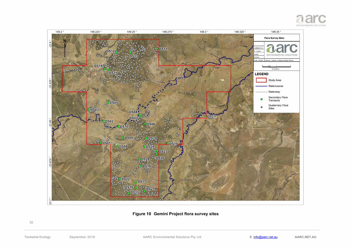
A total of 28 secondary transects and over 1000 quaternary sites were sampled across the study area. The locations of all the flora secondary transects and quaternary sites are shown in Figure 10.

31
Terrestrial Ecology September 2019 AARC Environmental Solutions Pty Ltd E [email protected] AARC.NET.AU
4.4.2 Targeted Searches for Species of Conservation Significance
To gain an understanding of each EVNT species, preferred habitat and ecology, several resources were consulted to pre-determine habitat to be targeted during the field surveys. This included, but was not limited to:
• Commonwealth Listing Advice;
• Commonwealth Approved Conservation Advice;
• Species Profile and Threats Database (SPRAT); and
• WetlandInfo: Plants, Animals, Soils, Water and More Search Tool.
The predominant survey technique utilised for targeted species across the cumulative survey effort was the ‘timed meander’ technique (Cropper 1993; Goff 1982). This technique involved traversing suitable habitat in a random manner so as to maximise the coverage of habitat and the encounter rate of different species. For any EVNT plants observed the location recorded using a GPS. If there was any uncertainty in identification of a species, a representative voucher specimen was collected for identification by the Queensland Herbarium in accordance with the Herbarium procedures (DSITI 2016).
32
Terrestrial Ecology September 2019 AARC Environmental Solutions Pty Ltd E [email protected] AARC.NET.AU
Gemini Project flora survey sites

33
Terrestrial Ecology September 2019 AARC Environmental Solutions Pty Ltd E [email protected] AARC.NET.AU
4.5 FAUNA
4.5.1 Fauna Trapping Sites and Survey Locations
Site scoping was conducted prior to each survey by undertaking a desktop assessment to determine habitat types of the intended study area in accordance with survey objectives. Examination of satellite imagery, topographical features, broad vegetation group (BVG) guided the location of baseline fauna trapping efforts ensuring adequate distribution across, and representation of fauna habitat types. Preferred habitat of targeted species was identified in the same manner to locate targeted trapping and survey effort in suitable locations.
Vehicle-based reconnaissance was carried out, where possible, to assist in locating suitable survey sites, maximising the representative vegetation and fauna habitat survey coverage. This also aided in targeting habitats potentially occupied by species of conservation significance. Vegetation communities optimal for installing fauna sites were then surveyed on foot to allow further ecological familiarisation and comprehensive survey coverage.
The fauna survey methodology employed for the study area was based on the Survey Guidelines for Australia’s Threatened Bats (DoEE 2010a) and the Terrestrial Vertebrate Fauna Survey Guidelines for Queensland V2.0 (Eyre et al. 2014) which was the current version at the time of all surveys. The survey was conducted in compliance with AARC’s scientific purposes permit and animal ethics approval. All fauna trapping efforts were conducted over four consecutive nights (unless otherwise stated).
All fauna survey locations are illustrated in Figure 7 and Figure 8 and described in Table 7. The detection techniques employed at each site is defined in Appendix E, and for descriptions of each technique refer to Section 4.5.2. Total survey effort undertaken during each survey is detailed in Table 9, and total survey effort accumulated across all surveys is summarised in Table 10.
Sampling of vertebrate fauna was conducted primarily along transects established in each of the major fauna habitat types and at changes in vegetation community groups. During all surveys, observations of species outside the specific fauna study locations but within the survey area were noted as incidental observations.
Many fauna species, notably frogs and reptiles, do not have widely accepted common names. Scientific names for species often change with taxonomic revisions. For the purpose of this report, all nomenclature used will follow that used in the ALA database (ALA 2019).
4.5.2 Fauna Survey Sites
Fauna sampling was conducted amongst representative areas of the main habitat types on the study area site to maximise the potential for sampling all wildlife present:
• Habitat type 1: Woodlands dominated Eucalyptus crebra (Narrow-leaved red ironbark) frequently with Corymbia spp. or Callitris spp. on flat to undulating plains.
• Habitat type 2: Low woodlands to tall shrublands dominated by Acacia spp. on residuals. Species include A. shirleyi (Lancewood) and A. rhodoxylon (Rosewood).
• Habitat type 3: Open forests and woodlands dominated by Eucalyptus tereticornis (Blue gum) fringing drainage lines.
• Habitat type 4: Woodlands dominated by Eucalyptus populnea (Poplar box) on alluvium, sand plains and foot slopes of hills and ranges

34
Terrestrial Ecology September 2019 AARC Environmental Solutions Pty Ltd E [email protected] AARC.NET.AU
A total of 15 full fauna survey sites, 8 harp trap sites and 3 mist nets were established across the study area during the ecology survey period.
Descriptions and photos of the survey sites are provided in Appendix E whereas all fauna survey locations indicating the habitat type where they were located and targeted micro-bat trapping sites are shown in Figure 11.

35
Terrestrial Ecology September 2019 AARC Environmental Solutions Pty Ltd E [email protected] AARC.NET.AU
Gemini Project Fauna sites

36
Terrestrial Ecology September 2019 AARC Environmental Solutions Pty Ltd E [email protected] AARC.NET.AU
4.5.3 Detection Techniques
A description of the techniques employed to survey the fauna occurring on the study area site (unless otherwise stated in the site description in Appendix E) is provided below:
Elliott trapping
Elliott traps are aluminium boxes with doors triggered by a floor treadle that are used to target small ground-dwelling mammals inhabiting the study area site. Traps were baited with a mixture of oats, peanut butter, and vanilla essence (referred to here-in as ‘mammal bait’). At each site, two parallel lines each with 10 Elliott traps were placed at 10 m intervals. Alternatively, where fauna sites were established in linear riparian habitats, traps were positioned at 10 m intervals along a single central transect. Traps were strategically positioned under shrubs or beside logs to reduce exposure of trapped animals to the sun, wind and rain and maximise trap success.
Automated Camera Trapping
Automated camera trapping is a less invasive method of surveying medium and large-sized nocturnal terrestrial species. Cameras are usually attached to a tree in a position that offers an unobstructed view over a track or clearing. A bait tube constructed with PVC and filled with bait (on this occasion chicken necks), is pegged to the ground and positioned in clear view of the camera. Motion-sensing technology in the camera detect movement and trigger a photographic response. This is a highly effective survey method and is now widely used instead of cage trapping (Eyre et al. 2018). Automated cameras were deployed for four nights at all fauna survey locations during the survey period.
Pitfall Trapping
To target small ground-dwelling taxa (e.g. reptiles, mammals and amphibians), a pitfall trap line was established at all fauna sites. Each line consisted of a 30 centimetre (cm) tall drift fence running along the ground and crossing the middle of four 20 litre buckets buried flush with the soil surface. Each pitfall trapping line was constructed in a T-shape design with 45 m of drift fence and buckets placed at approximately 7.5 m intervals. The bottom edge of each drift fence was buried to guide target animals towards the buckets. A small amount of soil, vegetation litter, a damp sponge and a small plastic pipe were placed in the bottom of each bucket to provide shelter and moisture for captured wildlife.
Funnel Trapping
Funnel traps are elongated box-shaped traps made of wire and fine mesh. Six funnel traps were positioned at each fauna site in order to catch medium and large-sized terrestrial reptiles, snakes and some species of medium-sized skinks, dragons and geckos. Funnel traps were also set with a damp sponge and covered with hessian bags to provide shelter and moisture for captured wildlife. Where pitfall trapping lines were established at a fauna site, funnel traps were placed at the end of each drift fence. In the absence of a pitfall line, funnel traps were placed in suitable habitat along fallen timber or rocky outcrops throughout the fauna site (100 by 100 m plot).
Microbat Surveying
Micro-bats (Microchiropterans) form an extremely diverse group of wildlife and the identification of individual species requires the use of specialised survey methods due to the superficial similarity of many species, their small size, and largely inaudible calls.
The QLD Government Terrestrial Vertebrate Fauna Survey Guidelines for Queensland v3.0 recommended method for bat survey is the use of a bat recorder (i.e. ANABAT). These are automated

37
Terrestrial Ecology September 2019 AARC Environmental Solutions Pty Ltd E [email protected] AARC.NET.AU
devices that record the echolocation calls of microbat species. The majority of microbat species in Australia can be identified from a species specific ‘call signature’. However, there is a small selection of species that cannot be reliably identified to species level by call signature. The Nyctophilus genus has several species in Australia and cannot be identified further than the genus level. Corben’s long-eared bat (Nyctophilus corbeni) is listed as Vulnerable under both the EPBC Act and the NC Act. The distribution of Nyctophilus corbeni overlies much of central Queensland, including the study area.
A Long-eared bat (Nyctophilus sp.) was detected via echolocation records on the study area during surveys but could not be identified to species level. Ecologists completed a targeted micro-bat survey in order to correctly identify the Nyctophilus species to adequately satisfy the Survey Guidelines for Australia’s Threatened Bats (DoEE 2010a). This targeted micro-bat survey utilised Harp Traps and Mist Nets in addition to ANABAT recorder.
The use of the following methodology was conducted in accordance with the Survey Guidelines for Australia’s Threatened Bats and the Terrestrial Vertebrate Fauna Survey Guidelines for Queensland (Eyre et. al 2018). These fauna survey methods were only adopted for the specialised Micro-bat 2018 autumn survey conducted by AARC ecologists.
ANABAT Recorders
In order to navigate and hunt at night micro-bats use high frequency echolocation calls, most of which are above the frequency range audible to humans (i.e. ultrasound). These echolocation calls provide an opportunity to unobtrusively survey and identify micro-bats through the use of a specialised ultrasonic recorders. During the survey event, bat call detection devices (i.e. Songmeter or ANABAT recorder) were strategically positioned to detect micro-bat calls at all fauna trapping sites. A bat call detector was left at each site for a minimum of 3 nights. This specialised micro-bat survey was utilised during all terrestrial surveys. A bat call detector was left at each site for 3 nights, and bat call analysis performed by Greg Ford of Balance Environmental (Appendix G).
Mist Net
Mist nets are more versatile than harp traps and can be used in a wider variety of habitat types and locations to capture bats, including open areas. The mist net consisted of fine monofilament net approximately 12 m wide by 5 m tall with a mesh size of 19 mm and was held in tension using rope rigging between two trees. The height of the net is divided into ‘benches’ or ‘shelves’, each with a loose pocket of netting that helps entangle the captured bats.
A single Mist Net was deployed at three locations over the second autumn survey. They were generally set several hours after sunset, these nets remained raised for a minimum of 1 hour at each survey site. The position of each Mist Net was marked using a handheld GPS. Photographs of each of these sites were taken with a digital camera and site data (such as vegetation type, weather conditions and habitat condition) was recorded.
Harp Trap
Harp trapping is employed for resolving the presence of species whose calls cannot be separated or identified using bat detectors, such as the Nyctophilus genus, and for collecting abundance and demographic information such as sex, age or breeding condition, which cannot be determined from call echolocation. Harp traps consisted of two or three banks of vertically strung nylon lines held in a rigid aluminium frame above a large calico holding bag and mounted on adjustable legs. Harp traps are most suited to restricted flyways in well vegetated areas, such as along creeks and tracks, preferably placed where fringing vegetation abuts the trap edges on both sides and above. Bats flying along a flyway are

38
Terrestrial Ecology September 2019 AARC Environmental Solutions Pty Ltd E [email protected] AARC.NET.AU
typically unable to detect the lines and get caught between the banks of nylon line and slide down into the large, plastic-lined cloth holding bag, where the bats are unable to climb out.
A single two bank harp trap was deployed at eight sites. Traps were deployed for four nights per site. They were set up shortly before dusk each night and packed up either at dawn or in the early morning. Traps were checked several hours after dusk and again before dawn each night. The position of each trap was marked with a handheld GPS. Photographs of each trap site were taken with a digital camera and site data (such as vegetation type, weather conditions and habitat condition) was recorded.
Bird Surveying
Dedicated searches for birds was conducted visually and aurally during early mornings during peak avian activity. A dedicated search for diurnal birds was conducted visually and aurally at each fauna site. A minimum of one hour of bird surveying per fauna site was conducted in the early morning or late afternoon when bird activity was highest. In addition, opportunistic diurnal searches were also conducted on foot in areas considered likely to have high avian diversity (e.g. vegetated watercourses or dams), or likely to contain cryptic or threatened bird species.
Spotlighting
Spotlighting was carried out in the early evenings (before midnight) during all surveys to maximise encounter rate of nocturnal wildlife such as night birds and arboreal mammals primarily active at night. Two spotlighting techniques were employed:
1. Foot traverses: Dedicated spotlighting events were undertaken on foot at each fauna site. Searches were undertaken over two events where possible, one within the first hour following nightfall, and one after the first hour. Two ecologists randomly traversed the area with spotlights and binoculars, and wherever possible, bark crevices and tree hollows were examined. A slow walking speed (approximately 1 km per hour) was maintained across the length of the survey area to fully facilitate intensive listening and thorough visual searching.
2. Vehicle searches: During any driving on the study area after dark, spotlighting was conducted by the passenger/s from the slow-moving vehicle, to maximise study area coverage that cannot be achieved with foot traverses alone. Spotlights were used to scan trackside vegetation for arboreal and ground-dwelling wildlife.
Call Playback
Several nocturnal bird species are highly cryptic; occurring in naturally low population densities, are wide-ranging, and call infrequently. Detection rates are typically low without solicitation in the form of playback of pre-recorded calls to elicit a response (Kavanagh and Peake 1993; Debus 1995). Detectability of smaller nocturnal bird species such as the Southern Boobook Ninox novaeseelandiae and Australian owlet nightjar (Aegotheles cristatus), and the arboreal marsupial Yellow-bellied glider (Petaurus australis) also increase with playback of large owl calls. Smaller, cryptic arboreal species such as Squirrel glider (P. norfolcensis) and Sugar glider (P. breviceps) can also respond to owl call playback.
Call playback is undertaken prior to spotlighting foot traverses to minimise the chance of spooking species capable of leaving the area undetected. A series of species call would be selected depending on the surrounding habitat suitability, and each would be played for three minutes, followed by a two-minute listening period, with the cycle repeated three times for each species. Calls were played using a megaphone and loud enough so that the softest call could be heard 100-200 m away. Following the completion of all playback cycles, the area would then be spotlighted as described above.

39
Terrestrial Ecology September 2019 AARC Environmental Solutions Pty Ltd E [email protected] AARC.NET.AU
Habitat Searching
To further enhance the likelihood of detecting small cryptic species, dedicated diurnal searches were conducted at each fauna site. This was spread over several events, two per site, during the survey period. Additional habitat searches were carried out during trap checks and while doing the flora surveys. Searches were typically undertaken during the late morning, allowing for reptile activity to increase with rising temperatures, but before the maximum heat of the day. Searching techniques involve the careful rolling of rocks and logs, rustling through leaf litter, and peeling back of exfoliating bark from standing trees. For targeted reptile species, dedicated searches were conducted opportunistically when preferred habitat was encountered (e.g. Gilgai formations or dense ground debris).
Evidence of wildlife was also searched for during these surveys’ identification of tracks, scats and other signs of occupation (e.g. tree trunk scratches). For scats not identifiable in the field, they were collected and sent to a scat analysis expert (Barbara Triggs) for identification of the species responsible for the scat and/or where possible, the identification of prey species material present in predator scats.
Incidental Recordings
Throughout each survey period, ecologists were traversing the study area on foot and by vehicle every day for numerous hours whilst conducting routine survey activities (e.g. driving between sites, checking traps, vegetation surveys etc.). The ecologists remained alert and would record numerous wildlife species as observed or heard during the survey period. As with the habitat searches, this included signs or evidence of wildlife, and included constant vigilance for raptor nests. All areas of the study area have been visited by ecologists throughout the surveys.
4.5.4 Fauna Survey Effort
Survey effort undertaken during each survey event is detailed in Table 9 for each fauna sampling technique.

40
Terrestrial Ecology September 2019 AARC Environmental Solutions Pty Ltd E [email protected] AARC.NET.AU
Sampling Technique
Survey Effort
Autumn Survey 2017
Spring Survey 2017
Autumn Survey 2018
Micro-bat Survey 2018
Total Survey effort
Elliott Trapping
4 sites x 20 traps x 4 nights = 320 trap nights
6 sites x 20 traps x 4 nights = 480 trap nights
5 sites x 20 traps x 4 nights = 400 trap nights
- 1,200 TTN
Automated Camera Trapping
4 sites x 1 camera x 4 nights = 16 trap nights
6 sites x 1 camera x 4 nights = 24 trap nights
5 sites x 1 camera x 4 nights = 20 trap nights
- 60 TTN
Pitfall Trapping
4 sites x 4 pitfalls x 4 nights = 64 trap nights
6 sites x 4 pitfalls x 4 nights = 96 trap nights
5 sites x 4 pitfalls x 4 nights = 80 trap nights
- 240 TTN
Funnel Trapping
4 sites x 6 funnels x 4 nights = 96 trap nights
6 sites x 6 funnels x 4 nights = 144 trap nights
5 sites x 6 funnels x 4 nights = 120 trap nights
- 360 TTN
ANABAT
(3 sites x 1 bat detector x 3 nights) + (1 site x 1 bat detector x 2 nights) = 11 trap nights
(3 sites x 1 bat detector x 3 nights) + (1 site x 1 bat detector x 2 nights) + (1 site x 1 bat detector x 4 nights) = 15 trap nights
4 sites x 1 bat detector x 3 nights = 12 trap nights
- 38 TTN
Harp Trapping - -
2 sites x 1 harp x 4 nights = 8 trap
nights
8 sites x 1 harp x 7
nights = 56 trap nights
64 TTN
Mist Netting - - - 3 sites x 1
mist net = 3 trap nights
3 TTN
Call Playback (CPB)
(30 minutes per session 2 sessions)
4 sites x 5 CPB x 2 nights = 40 CPB
6 sites x 4 CPB x 2 nights = 48 CPB
(4 sites x 4 CPB x 2 nights) + (1 site x 3 CPB x 1 night) + (1 site x 4 CPB x 1
night) = 39 CPB
- 127 CPB
Bird Surveying
(60 minutes per session 2 sessions)
8 person hours at fauna sites
15 person hours of opportunistic bird surveying
12 person hours at fauna sites
20 person hours of opportunistic bird
surveying
10 person hours at fauna sites
15 person hours of opportunistic bird
surveying
- 80 TPH
Spotlighting
(30 minutes per session 2 sessions)
4 person hours at fauna sites
4 person hours of opportunistic spot
lighting
6 person hours at fauna sites
5 person hours of opportunistic spot
lighting
5 person hours at fauna sites
5 person hours of opportunistic spot
lighting
- 29 TPH
Habitat Searching
(60 minutes per session 2 sessions)
8 person hours at fauna sites
12 person hours of opportunistic
habitat searching
12 person hours at fauna sites
15 person hours of opportunistic
habitat searching
10 person hours at fauna sites
10 person hours of opportunistic
habitat searching
- 67 TPH
TTN: Total trap nights TPH: Total person hours

41
Terrestrial Ecology September 2019 AARC Environmental Solutions Pty Ltd E [email protected] AARC.NET.AU
5.0 FLORA RESULTS AND DISCUSSION
5.1 FLORA SURVEY RESULTS
A total of 207 flora species were identified in the study area. One flora species listed as Near Threatened under the NC Act but not listed under the EPBC Act, was observed on the Central East of the study area; Cerbera dumicola. A total of 33 introduced species were recorded on the study area, of which five are listed as weed species under the Queensland Biosecurity Act and/or classified by the Australian Government as a Weed of National Significance (WoNS). All four are listed as Restrictive Invasive plants for Queensland and only three of them are also classified as WoNS; Parthenium weed (Parthenium hysterophorus) and Velvety tree pear (Opuntia tomentosa). A full flora list for the study area is provided in Appendix H. Weed species fact sheets for these species are attached in Appendix J.
Six vegetation communities classed as Remnant Vegetation as defined by the VM Act were identified on the study area during the field surveys. The vegetation communities have been mapped when possible as homogeneous polygons with the exception of some “mixed polygons” which consisted of two or more vegetation communities that were mapped together due to the impracticability in clearly delineating each RE.
Associations within the communities reflect different vegetation structures and compositions, which occur on different geophysical locations. Table 10 outlines the RE characteristic of each vegetation community, where applicable, as well as a short description of the vegetation present. A description is provided in Sections 5.1.1 to 5.1.7 whilst Figure 12 shows the distribution of vegetation communities on the study area.
Analysis of the vegetation communities recorded within the study area confirm that none meet the condition thresholds to constitute a TEC, listed as threatened at the national level (see Section 5.3.1).
Vegetation Community
Regional Ecosystem Community Description
VC 1 11.5.2 Narrow-leaved ironbark and Clarkson’s bloodwood woodland with a sparse shrub layer on sand plains.
VC 2 11.7.2 Lancewood (Acacia shirleyi) and/or Rosewood (Acacia rhodoxylon) woodland on lateritic duricrust.
VC 3 11.3.25 Blue gum (Eucalyptus tereticornis) with Bauhinia spp. and Casuarina cunninghamiana fringing woodland on drainage features.
VC 4 11.3.2 Poplar box (Eucalyptus populnea) woodland on alluvial plains.
VC 5 11.5.2/11.3.25
Mixed polygon where the dominant vegetation community was VC 1 (Eucalyptus crebra and Corymbia clarksoniana woodland) but along ephemeral creeks and with an important presence of Blue gums.
VC 6 11.3.25/11.3.2/11.5.2 Mixed polygon as a result of combination of VC 3 with elements of VC 4 and some elements of VC 1 due to edge effect.
Non-Remnant NA Non-remnant vegetation

42
Terrestrial Ecology September 2019 AARC Environmental Solutions Pty Ltd E [email protected] AARC.NET.AU
Vegetation Communities within the study area

43
Terrestrial Ecology September 2019 AARC Environmental Solutions Pty Ltd E [email protected] AARC.NET.AU
5.1.1 VC 1: Narrow-leaved ironbark and Clarkson’s bloodwood woodland with a sparse shrub layer on sand plains
VC 1 consists of Narrow-leaved ironbark (Eucalyptus crebra) and Clarkson's bloodwood (Corymbia clarksoniana) woodland with a sparse shrub layer on sand plains and is consistent with RE 11.5.2. Allocasuarina luehmannii is dominant in some sandy patches throughout the study area.
VC 1 is the most abundant vegetation community, covering a total of 872.23 ha (12.02%) of the study area. Table 11 provides a summary of community structure and corresponding conservation status.
Associated Regional Ecosystem
11.5.2: Eucalyptus crebra, Corymbia spp., with E. moluccana woodland on lower slopes of Cainozoic sand plains and/or remnant surfaces
Extent within Project 872.23 ha
Remnant Status Remnant and 2.71 ha mapped as High Value Regrowth
EPBC Act Not listed
VM Act Status Least Concern
Biodiversity Status No concern at present
Tree Layer Eucalyptus crebra and Corymbia clarksonia (12 - 14 m) and occasionally Allocasuarina luehmannii dominant on the tree layer. Alphitonia excelsa and Petalostigma pubescens are dominant in a smaller tree layer.
Shrub Layer The 0.5 m to 2 m tall shrub layer is normally dominated by Erythroxylum australe, Petalostigma pubescens, Psydrax johnsonii and Carissa spinarum.
Ground Layer The ground layer is typically dominated by Cleistochloa sp. (Duaringa K.B.Adison 42), Eragrostis lacunaria, Aristida calycina, Aristida caput-medusae, and sometimes exotics such as Melinis repens and Urochloa mosambicensis.
Structure Category Sparse
Biosecurity Act and/or WoNS Weed Species Opuntia tomentosa
Crown Cover (%) Average of 60% canopy cover
Ground Cover (%) On average, bare ground comprised 29% of the total area, whilst organic litter comprised 60%
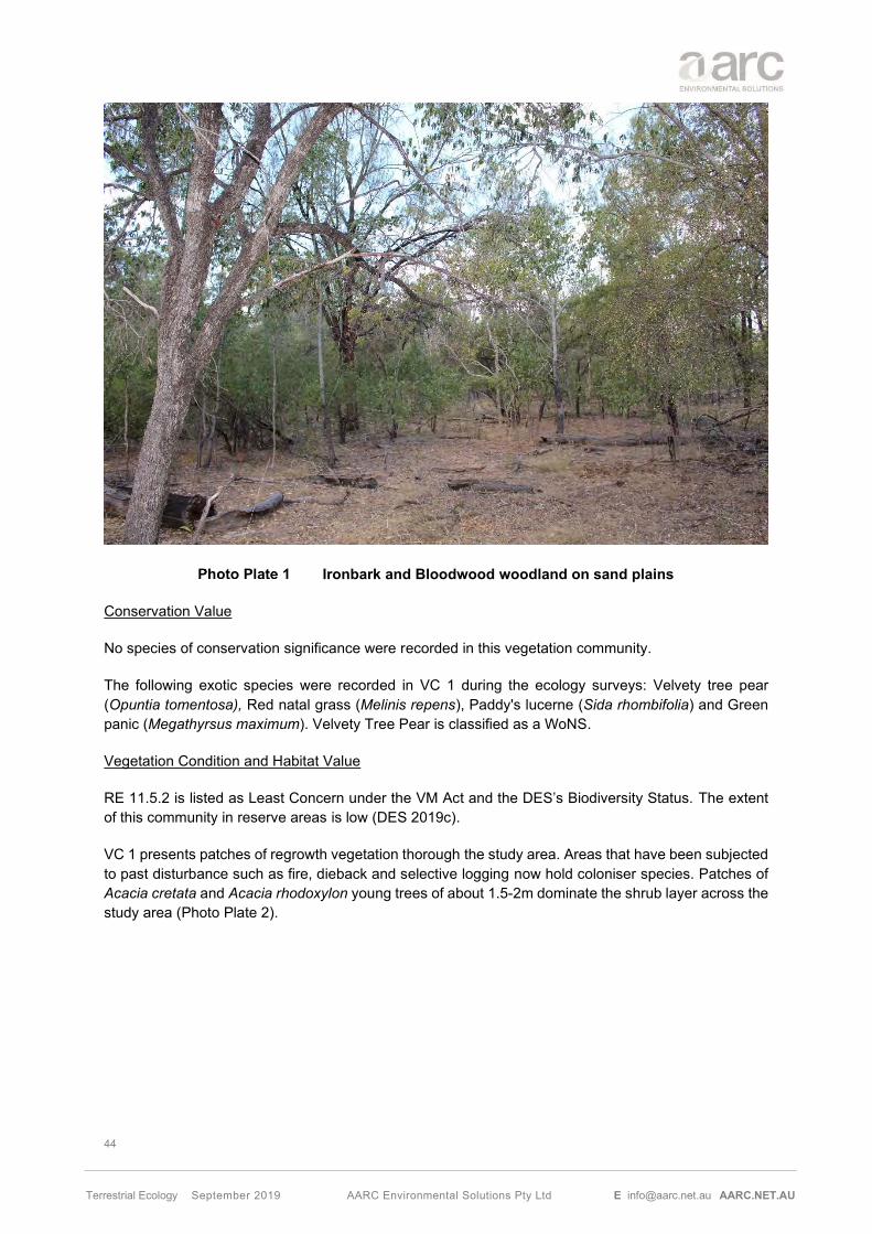
44
Terrestrial Ecology September 2019 AARC Environmental Solutions Pty Ltd E [email protected] AARC.NET.AU
Ironbark and Bloodwood woodland on sand plains
Conservation Value
No species of conservation significance were recorded in this vegetation community.
The following exotic species were recorded in VC 1 during the ecology surveys: Velvety tree pear (Opuntia tomentosa), Red natal grass (Melinis repens), Paddy's lucerne (Sida rhombifolia) and Green panic (Megathyrsus maximum). Velvety Tree Pear is classified as a WoNS.
Vegetation Condition and Habitat Value
RE 11.5.2 is listed as Least Concern under the VM Act and the DES’s Biodiversity Status. The extent of this community in reserve areas is low (DES 2019c).
VC 1 presents patches of regrowth vegetation thorough the study area. Areas that have been subjected to past disturbance such as fire, dieback and selective logging now hold coloniser species. Patches of Acacia cretata and Acacia rhodoxylon young trees of about 1.5-2m dominate the shrub layer across the study area (Photo Plate 2).
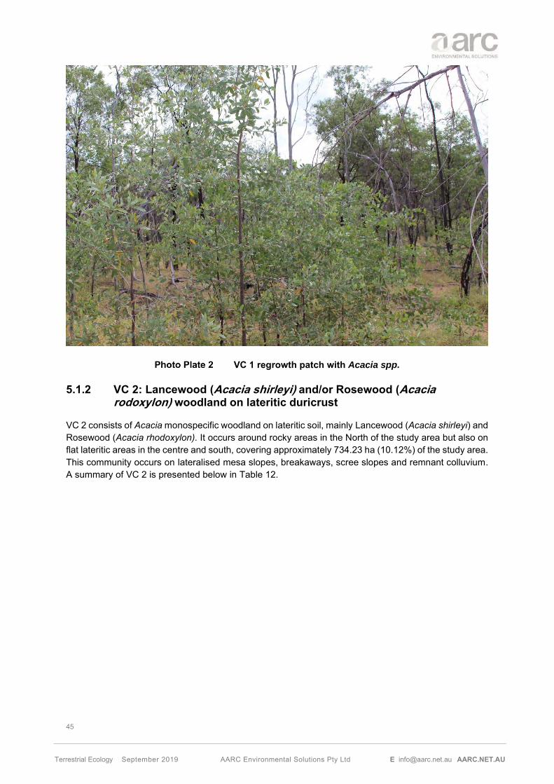
45
Terrestrial Ecology September 2019 AARC Environmental Solutions Pty Ltd E [email protected] AARC.NET.AU
VC 1 regrowth patch with Acacia spp.
5.1.2 VC 2: Lancewood (Acacia shirleyi) and/or Rosewood (Acacia rodoxylon) woodland on lateritic duricrust
VC 2 consists of Acacia monospecific woodland on lateritic soil, mainly Lancewood (Acacia shirleyi) and Rosewood (Acacia rhodoxylon). It occurs around rocky areas in the North of the study area but also on flat lateritic areas in the centre and south, covering approximately 734.23 ha (10.12%) of the study area. This community occurs on lateralised mesa slopes, breakaways, scree slopes and remnant colluvium. A summary of VC 2 is presented below in Table 12.

46
Terrestrial Ecology September 2019 AARC Environmental Solutions Pty Ltd E [email protected] AARC.NET.AU
Associated Regional Ecosystem 11.7.2: Acacia spp. woodland on Cainozoic lateritic duricrust. Scarp retreat zone.
Extent within the study area 734.23 ha
Remnant Status Remnant
EPBC Act Not listed
VM Act Status Least Concern
Biodiversity Status Of Concern
Tree Layer Eucalyptus crebra as occasional emergent tree with Acacia shirleyi or Acacia rhodoxylum monospecific dominant in the tree layer.
Shrub Layer Very sparse shrub layer with dominance of Acacia rhodoxylum, Erythroxylum australe, Alstonia constricta, Psydrax forsteri and Carissa spinarum.
Ground Layer The ground layer is typically dominated by Entolasia stricta (D), Calyptochloa gracilima (D), Aristida caput-medusae (D) and Paspalidium caespitosum (D).
Structure Category Sparse
Biosecurity Act and/or WoNS Weed Species None
Crown Cover (%) Average of 70% canopy cover
Ground Cover (%) On average, bare ground comprised 15.5% of the total area, whilst organic litter comprised 65%
D – Dominant
Lancewood woodland within the study area

47
Terrestrial Ecology September 2019 AARC Environmental Solutions Pty Ltd E [email protected] AARC.NET.AU
Conservation Value
Cerbera dumicola, listed as NT under the NC Act was recorded in two locations within the study area, both of them associated with VC 2. Section 5.3 below discusses this listed species in further detail.
The following exotic species were recorded in VC 2 during the ecology surveys: Sabi grass (Urochloa mosambicensis), Sida cordifolia, Red natal (Melinis repens), Malvastrum americanum and Shrubby stylo (Stylosanthes scabra).
Vegetation Condition and Habitat Value
RE 11.7.2 is listed as Least Concern under the VM Act and the DES’s Biodiversity Status. The extent of this community in reserve areas is low (DES 2019c).
VC 2 presents different degrees of disturbance thorough the study area. As per VC 1, areas that have been subjected to past fire, dieback and selective logging. Rosewood has been targeted for logging due to its high value as fence post. Lancewood, on the other hand, has been left relatively undisturbed due to its value stabilising the soil in an area highly susceptible to erosion. Acacia rhodoxylon young and thin trees of about 1.5-2m can be found in patches across the study area.
5.1.3 VC 3: Blue gum (Eucalyptus tereticornis) with Bauhinia spp. and Casuarina cunninghamiana fringing woodland on drainage features
This community is located along Charlevue Creek and other ephemeral creeks within the study area. It covers approximately 143.74 ha, close to 2% of the study area, and occurs on alluvial plains. Table 13 provides a detailed description of VC 3. Occasional small patches of Corymbia tessellaris or Eucalyptus populnea were present on adjacent alluvial floodplains.
Associated Regional Ecosystem
11.3.25: Eucalyptus tereticornis or E. camaldulensis woodland fringing drainage lines.
Extent within Project 143.74 ha
EPBC Act Not listed
VM Act Status Least Concern
Biodiversity Status Of Concern
Tree Layer
Eucalyptus tereticornis dominant species with occasional Eucalyptus crebra, Eucalyptus populnea, Corymbia tessellaris and Corymbia clarksoniana. In a lower tree layer, the dominant species are Bauhinia carronii and Cassia brewsterii and occasionally Melaleuca nervosa would be the dominant species.
Shrub Layer The 0.5 m to 2 m tall shrub layer is normally dominated by Carissa spinarum, Terminalia oblongata, Melaleuca nervosa and Alphitonia constricta.
Ground Layer The ground layer is typically dominated by Dichantium sericeum (D), Megathyrsus maximus (D), Cenchrus ciliaris (D), Urochloa mosambicensis (D) and Bothriochloa ewartiana (D).
Structure Category Mid-dense
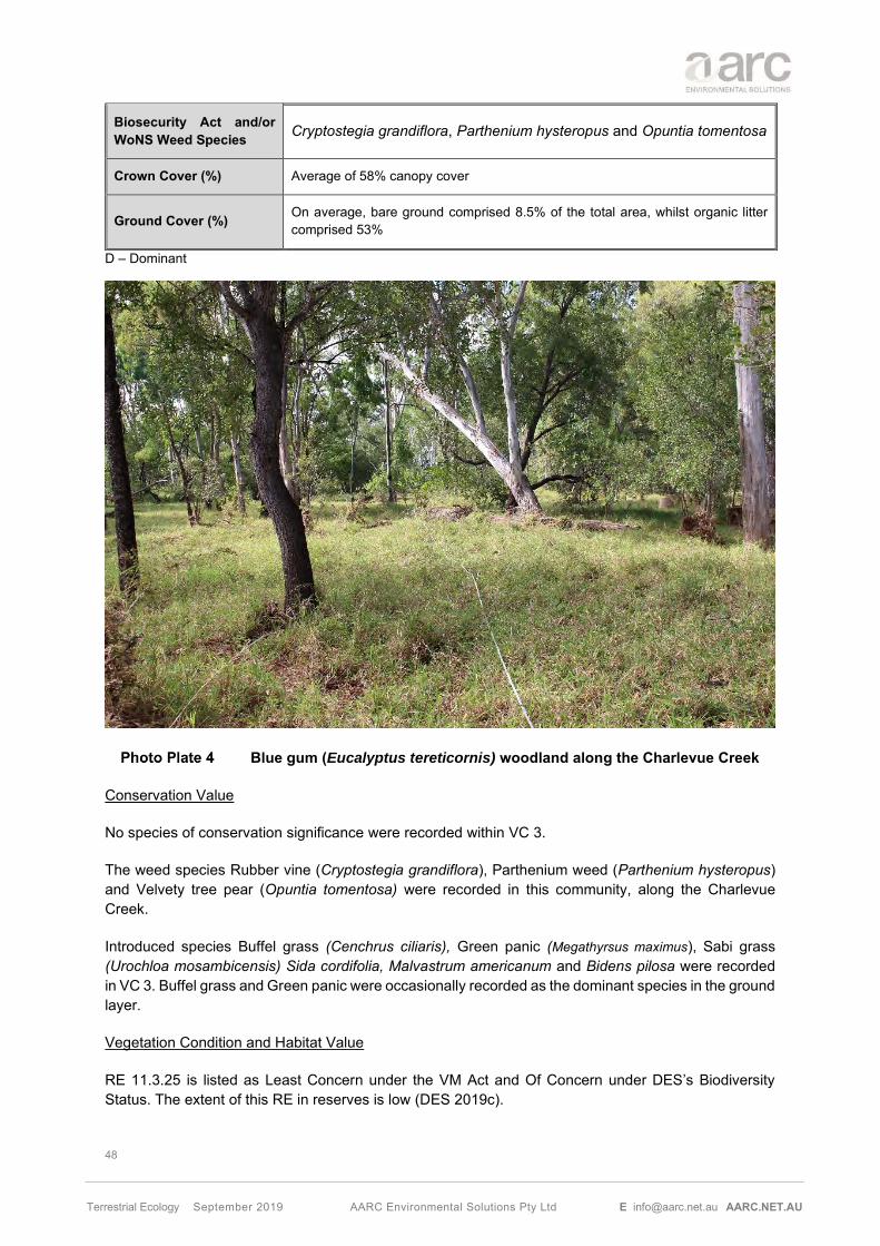
48
Terrestrial Ecology September 2019 AARC Environmental Solutions Pty Ltd E [email protected] AARC.NET.AU
Biosecurity Act and/or WoNS Weed Species Cryptostegia grandiflora, Parthenium hysteropus and Opuntia tomentosa
Crown Cover (%) Average of 58% canopy cover
Ground Cover (%) On average, bare ground comprised 8.5% of the total area, whilst organic litter comprised 53%
D – Dominant
Blue gum (Eucalyptus tereticornis) woodland along the Charlevue Creek
Conservation Value
No species of conservation significance were recorded within VC 3.
The weed species Rubber vine (Cryptostegia grandiflora), Parthenium weed (Parthenium hysteropus) and Velvety tree pear (Opuntia tomentosa) were recorded in this community, along the Charlevue Creek.
Introduced species Buffel grass (Cenchrus ciliaris), Green panic (Megathyrsus maximus), Sabi grass (Urochloa mosambicensis) Sida cordifolia, Malvastrum americanum and Bidens pilosa were recorded in VC 3. Buffel grass and Green panic were occasionally recorded as the dominant species in the ground layer.
Vegetation Condition and Habitat Value
RE 11.3.25 is listed as Least Concern under the VM Act and Of Concern under DES’s Biodiversity Status. The extent of this RE in reserves is low (DES 2019c).

49
Terrestrial Ecology September 2019 AARC Environmental Solutions Pty Ltd E [email protected] AARC.NET.AU
Often associated with regional ecosystems 11.3.2 and 11.3.4, elements of which such as Corymbia tessellaris and Eucalyptus populnea may occur on adjacent alluvial plains. In highly cleared areas, in particular north of the Capricorn Highway, a narrow fringe of riparian vegetation is often the only surviving woody vegetation and it is not mapped as remnant in the Government vegetation map. This RE is impacted by grazing pressure and edge effects, where the dominant ground layer is dominated by the exotic pasture species that grow in the grazing area.
The presence of large, remnant, hollow-bearing trees such as Eucalyptus tereticornis provides important denning and breeding habitat for a variety of arboreal mammals and birds.
5.1.4 VC 4: Poplar box (Eucalyptus populnea) woodland on alluvial plains
This community is located in small patches within the study area. It covers approximately 36.52 ha (0.5%) of the study area on alluvial soils. Table 14 provides a summary of conservation status and vegetative structure for VC 4.
Associated Regional Ecosystem 11.3.2: Eucalyptus populnea woodland on alluvial plains.
Extent within Project 36.52 ha
EPBC Act Analysis of this vegetation (Section 5.3.1) confirms that VC4 does not meet the condition thresholds to constitute a TEC.
VM Act Status Of Concern
Biodiversity Status Of Concern
Tree Layer Tree layer dominated by Eucalyptus populnea (in some occasions E. melanophloia) (12-14m), with occasional Corymbia dallachiana, C. clarksoniana and C. tessellaris.
Shrub Layer Very spare shrub layer dominated by Atalaya hemiglauca, Archidendropsis basaltica, Flindersia dissosperma, Carissa spinarum (dominant in the lower shub layer) and occasionally Alphitonia excelsa.
Ground Layer
The ground layer is typically dominated by Bothriochloa ewartiana, Aristida calycina, Aristida perniciosa (D), Eragrostis sororia, Eragrostis lacunaria, Cynodon dactylon, Urochloa mosambicensis (D), Heteropogon contortus (D) and Themeda triandra,
Structure Category Sparse
Biosecurity Act and/or WoNS Weed Species Harrisia martini and Vachellia farnesiana
Crown Cover (%) Average of 53% canopy cover
Ground Cover (%) On average, bare ground comprised 12.5% of the total area, whilst organic litter comprised 34%
D - Dominant

50
Terrestrial Ecology September 2019 AARC Environmental Solutions Pty Ltd E [email protected] AARC.NET.AU
Poplar box (Eucalyptus populnea) woodland on alluvial plains
Conservation Value
No species of conservation significance were recorded within VC 4.
The exotic species Sabi grass (Urochloa mosambicensis), Sida cordifolia, Shrubby stylo (Stylosanthes scabra), Red natal (Melinis repens), Malvastrum americanum, Bidens pilosa, Mimosa bush (Vachellia farnesiana) and Harrisia cactus (Harrisia martinii) were recorded in VC 4.
VC4 is most consistent with RE 11.3.2, which is an associated RE of the Poplar box grassland on alluvial plains and Weeping myall woodland TEC. None of these TECs were identified within the study area. A summary of the survey effort to determine the presence of both TECs is detailed in Section 5.3.1.
Vegetation Condition and Habitat Value
RE 11.3.2 is classified as Of Concern under the VM Act and Of Concern at present under DES’s Biodiversity Status. The extent of this RE in reserves is low.
VC 4 was only present in small patches within the study area, some of them too small to map. This community presented evidence of edge effect with exotic pasture species such as Urochloa mosambicensis occasionally dominating the ground layer. Regrowth of VC 4 was recorded in the south of the study area and along Cooinda road, in the middle of the study area. Recruitment of Poplar box was observed across the study area, with sections within VC 4 of very young and thin trunks.

51
Terrestrial Ecology September 2019 AARC Environmental Solutions Pty Ltd E [email protected] AARC.NET.AU
5.1.5 VC 5: Mixed polygon: Ironbark, Bloodwood and Blue gum woodland along ephemeral creeks
VC 5 is limited to small patches within the study area and consist on a combination of VC 1 with elements of VC 3 (Blue gums, 20% of the vegetation community) due to the presence of ephemeral drainage features in the vicinity of VC 1. Melaleuca nervosa is occasionally present as dominant species on the tree and shrub layers. It covers approximately 96.71 ha (1.33%) of the study area.
VC 5 is illustrated in Photo Plate 6.
Conservation Value
No species of conservation significance were recorded within VC 5. The same exotic pasture species recorded in VC 1 where observed in the ground layer of this community throughout the study area.
Vegetation Condition and Habitat Value
This community was only present in three patches within the study area, where it was not possible to separate the vegetation into two defined communities. There is evidence of edge effect, where exotic pasture species are present in the groundcover. Regrowth of VC 5 was similar to the regrowth of VC 1, with the same pioneer Acacia spp. as described before. Both RE’s, 11.5.2 and 11.3.25 are classified as Least Concern under the VM Act but while RE 11.5.2 is classified as Least Concern under the DES’s Biodiversity Status, RE 11.3.25 is classified as Of Concern. The extent of these REs in reserves is low (DES 2019c).
VC 5 – RE 11.5.2/11.3.25

52
Terrestrial Ecology September 2019 AARC Environmental Solutions Pty Ltd E [email protected] AARC.NET.AU
5.1.6 VC 6: Mixed polygon: Blue gum, Poplar box and Ironbark woodland along ephemeral creeks
VC 6 is located in small patches within the study area and consist on a combination of VC 3 (Blue gums) along several small ephemeral drainage channels, with elements of VC 4 (Poplar box), present in the alluvial plains between the channels and VC 1 (Ironbark) due to edge effect. VC 6 covers a total of 21.83 ha (0.3%) of the study area.
VC 5 is illustrated in Photo Plate 7.
Conservation Value
No species of conservation significance occurred within VC 6.
Habitat Value
VC 6 was only present in two patches within the study area, where it was not possible to separate the vegetation into three defined communities. As per VC 5, there is evidence of edge effect, with exotic pasture species present in the groundcover and occasionally dominant. The RE classification for the three REs present is as follows: 11.3.25 is listed as Least Concern under the VM Act and Of Concern under DES’s Biodiversity Status; 11.3.2 is listed as Of Concern under the VM Act and the DES’s Biodiversity Status; and 11.5.2 is listed as Least Concern under the VM Act and the DES’s Biodiversity Status. The extent of these RE in reserves is low (DES 2019c).
VC 6 – RE 11.3.25/11.3.2/11.5.2

53
Terrestrial Ecology September 2019 AARC Environmental Solutions Pty Ltd E [email protected] AARC.NET.AU
5.1.7 Non-remnant and Regrowth Vegetation
Non-remnant regrowth vegetation is present in areas that have been disturbed by human activities, such as logging and preparation for grazing through the entire study area. There are numerous patches of regrowth vegetation, including areas that are mapped as remnant in the Vegetation Management Regional Ecosystem Map but have been assessed as non-remnant as a result of the field surveys.
This vegetation is not classed as remnant vegetation, therefore is not defined by an RE.
There is one large patch of vegetation north of the study area mapped as remnant which vegetation consists on Acacia spp regrowth. According to local knowledge (farmers) around six years ago there was a fire that affected the north part of the EPC, the area north of the Capricorn Highway. As a result of that fire, there is regrowth across all the vegetation communities, especially VC 1 and VC 4. A large patch of woodland originally mapped as 11.5.9b is now categorised as non-remnant vegetation. This particular area presents only an extremely sparse tree layer (Eucalyptus crebra and Corymbia clarksoniana) and a dense shrub layer of pioneer Acacia spp. mainly Acacia cretata.
Non-remnant Acacia spp regrowth
The areas of the study area not mapped in Figure 12 are mainly pasture land with more or less evidence of regrowth, or dead vegetation. This regrowth corresponds with early stages of V4, V1 or V2. Regrowth of Acacia cretata is especially abundant within several vegetation communities, such V1, but also in pasture area. Evidence of burning and ring barking has been recorded thorough these pasture areas.
The ground layer of the non-remnant vegetation is dominated by exotic pasture grasses such as Buffel grass (Cenchrus ciliaris), Indian bluegrass (Bothriochloa pertusa), Sabi grass (Urochlora mosambicensis) and Red natal grass (Melinis repens).
5.2 WEEDS OF MANAGEMENT CONCERN
A total of 33 introduced species were identified onsite. The exotic pasture grasses dominate the ground layer of the study area, particularly in cleared areas. A range of other exotic grasses and forbs are also

54
Terrestrial Ecology September 2019 AARC Environmental Solutions Pty Ltd E [email protected] AARC.NET.AU
present across the study area in low to moderate abundance. A complete list of the flora species, indicating their native or introduced status can be found in Appendix H.
Three of these introduced species are classed as WoNS; Parthenium weed (Parthenium hysterophorus), Rubber vine (Cryptostegia grandiflora) and Velvety tree pear (Opuntia tomentosa). Introduced plant species are classified by the Commonwealth Government as WoNS if they present a serious threat to industry, water supply, human health/safety, plant communities and/or cultural values.
The above mentioned three species, together with Harrisia cactus (Harrisia martini) are similarly classed as Restricted Invasive Species under the Biosecurity Act (DAF 2018).
Vachellia farnesiana, also found in the study area, is not a prohibited or restricted invasive plant under the Biosecurity Act. However, by law, everyone has a general biosecurity obligation (GBO) to take reasonable and practical steps to minimise the risks associated with invasive plants and animals under their control (DAF 2016).
Weed species of management concern found in the study area are listed in Table 15. All species present are known to occur commonly throughout the broader region.
Scientific name Common name WoNS Status
Biosecurity Act 2014 Category 3
Harrisia martinii Harrisia cactus - x
Cryptostegia grandiflora Rubber vine Yes x
Opuntia tomentosa Velvety tree pear Yes x
Parthenium hysterophorus Parthenium Yes x
Bryophyllum sp Mother of millions - x
Vachellia farnesiana* Mimosa bush - - Note: * Considered a noxious weed of management concern. Category 3: A person must not distribute the invasive plant either by sale or gift, release it into the environment.

55
Terrestrial Ecology September 2019 AARC Environmental Solutions Pty Ltd E [email protected] AARC.NET.AU
Cryptostegia grandiflora identified on the study area
5.3 FLORA OF CONSERVATION SIGNIFICANCE
5.3.1 Threatened Ecological Communities not identified on the study area
Brigalow (Acacia harpophylla dominant and co-dominant)
The Brigalow (Acacia harpophylla dominant and co-dominant) TEC comprises patches of vegetation in which Acacia harpophylla is one of the most abundant tree species. The tree layer may be dominated by Acacia harpophylla or have a co-dominant presence with other species such as Belah (Casuarina cristata) and other species of Acacia or Eucalyptus. Within Queensland, the Brigalow TEC is consistent with 16 RE described by the Queensland Herbarium, including RE 11.3.1, originally mapped within the study area.
A patch must meet the following condition thresholds to be considered the Brigalow TEC:
• The patch is 0.5 ha or more in size; and
• Exotic perennial plants comprise less than 50% of the total vegetation cover of the patch, as assessed over a minimum sample area of 0.5 ha (100 m by 50 m), that is representative of the patch.
Despite being mapped as present along the Charlevue and Springton Creeks in association with RE 11.3.1, Brigalow (Acacia harpophylla) was only recorded within the study area as a few individual stands. Two trees were recorded along the Charlevue Creek and a small patch with six trees was recorded on the bank of Springton Creek, close to the eastern boundary of the study area.
The sparse Brigalow individuals do not form a clear vegetation community, not reaching dominance in the canopy nor the minimum size of 0.5 ha specified as condition thresholds to qualify as Brigalow TEC.

56
Terrestrial Ecology September 2019 AARC Environmental Solutions Pty Ltd E [email protected] AARC.NET.AU
Weeping myall (Acacia pendula) Woodland
Weeping myall woodlands often occur as monotypic stands generally 4 – 12 m high in which Weeping myall trees are the sole or dominant overstorey species. Other canopy species such as Western rosewood (Alectryon oleifolius subsp. elongatus), Poplar box (Eucalyptus populnea), or Black box (Eucalyptus largiflorens) may occur in association with this community.
Within Queensland, this community is known to occur in association with two REs including RE 11.3.2 (Eucalyptus populnea woodland on alluvial plains) and 11.3.28 (Eucalyptus coolabah +/- Casuarina cristata open woodland on alluvial plains). Of the extent of these REs throughout Queensland, it is estimated that only 5% supports the Weeping myall woodlands community. Most patches of the TEC are less than 1 or 2 ha in area.
This TEC has been previously described as potentially occurring on the study area based on the mapping of Poplar box woodlands on alluvial plains (11.3.2), has been ground-truthed as non-remnant based on the negligible canopy cover. However, due to the cycles of senescence that affect the dominant species Weeping myall, the criteria used to assess a vegetation community includes canopy cover as sparse as 5% and dominated by living, dead or defoliated Weeping myall trees (DEWHA 2009). As a result, additional survey effort was employed in this area, to identify any dead and/or defoliated trees. This area was dominated by Acacia cretata regrowth, confirming the absence of Weeping myall woodland TEC on the study area.
Poplar box Grassy Woodland on Alluvial Plains
Assessments of the RE 11.3.2 present within the study area (VC 4) have concluded that the TEC Poplar box Grassy Woodland is not present within the study area.
To be listed as TEC, the Poplar box in alluvial plains is to meet certain thresholds, such as size and vegetation condition. The following thresholds have been sourced from the Draft Conservation Advice (including listing advice) for the Poplar Box Grassy Woodland on Alluvial Plains (TSSC n. d.):
Class A Highest Quality
• Category A1: Patch equal or larger than 1 ha: The patch has little or no perennial weeds and a diverse native understorey. 90% or more of the perennial vegetation cover is native species and with 30 or more native plant species in the ground layer per ha.
• Category A2: Patch equal or larger than 5 ha. A large patch with low perennial weeds and diverse native understorey. 70% or more of the perennial vegetation cover is ground layer is native and with 30 or more native plant species in the ground layer per ha.
• Category A3: Patch equal or larger than 5 ha. A large patch with high quality habitat features. 10 trees per ha that either are large (30 cm or more in diameter at breast height) and/or have developed hollows and smaller trees, saplings or seedlings suggesting of periodic recruitment and with 20 or more native plant species in the ground layer per ha.
Class B Moderate Quality
• A large patch with moderate quality native understorey. 50% of perennial vegetation cover in ground layer is native and 20 or more native plant species per ha in the ground layer or 10 trees per ha that either are large (30 cm or more in diameter at breast height) and/or have developed hollows

57
Terrestrial Ecology September 2019 AARC Environmental Solutions Pty Ltd E [email protected] AARC.NET.AU
VC 4 does not meet the threshold to constitute a TEC due to the size of the patches and poor condition of the community with a high presence of exotic pastures, occasionally dominant. Some trees recorded from the largest patch of VC 4 within the study area were larger than 30cm in diameter at breast height, however, some sections of the same patch presented younger and smaller specimens, not meeting the average of 10 or more per ha.
5.3.2 Flora Species of Conservation Significance Identified on the Study Area
Targeted searches across the study area detected the presence of one flora species of conservation significance in several of the seasonal surveys, Cerbera dumicola (Photo Plate 10). This species is listed as NT under the NC Act.
Cerbera dumicola is a shrub or small tree growing to 4 m high (DES 2018b). The species occurs across a range of habitats in central and southern Queensland. This species is associated with a range of vegetation communities such as sandstone hills in open Eucalyptus umbra subsp. carnea; woodlands of Acacia shirleyi with Corymbia dolichocarpa; acidic soils in mine rehabilitation area; woodland of A. catenulata and A. shirleyi with E. thozetiana on a slope of sand/clay soil; semi-deciduous notophyll-microphyll vine forest of Brachychiton australis, Gyrocarpus americanus, Flindersia australis, Pleiogynium timorense, Drypetes deplanchei and Sterculia quadrifida on rhyolite hillslopes; open-woodland of E. melanophloia with occasional Acacia shirleyi, E. populnea and E. brownii; semi-evergreen vine thicket with Corymbia citriodora and Corymbia aureola emergents; woodland of A. rhodoxylon on brown, sandy loam; and in Corymbia tessellaris - Acacia aneura open woodland (DES 2018b).
Cerbera dumicola has been severely impacted by land clearing with extensive fragmentation of its original habitat. While it can be very common at some of its known localities, many of the remnant populations comprise few individuals. It is likely to be more widespread than is currently known as these eucalypt dominated woodlands are poorly surveyed in southern Queensland. Threatening processes include:
• Land clearing for agriculture, which has undoubtedly been the main reason in the past for reductions in the area of occupancy, number of populations, number of individuals. Many populations are in areas mapped as 'non-remnant vegetation', hence are still able to be cleared; and
• Land clearing for mining. Several populations have been recorded from mining leases in the central highlands coalfields and are presumed lost (DES 2018b).
Cerbera dumicola has been identified during the vegetation surveys in two very localised rocky areas associated with vegetation community VC 2 and VC 1 (on an ecotone with VC 2) (Figure 14). This species was not identified elsewhere in the study area, within similar habitat types, during targeted searches.
The species is regionally abundant, having been recorded outside of the study area on multiple occasions (AVH 2019).
It is not expected that the proposed Project will impact on the known Cerbera dumicola individuals due to their location. The species has been recorded at the boundary of the study area and adjacent to areas of existing disturbance. Suitable habitat is extensive throughout the local area including immediately east of the study area.

58
Terrestrial Ecology September 2019 AARC Environmental Solutions Pty Ltd E [email protected] AARC.NET.AU
Cerbera dumicola at the study area
5.3.3 Flora Species of Conservation Significance Not Identified on the Study Area
Table 16 below discusses EVNT species that are known from the broader region and have been identified from desktop searches but were not observed on site during surveys.
The assessment of potential for presence and impact on each species is based on the knowledge of ecologists, information obtained from field surveys on the study area, previous surveys conducted on or near the study area and scientific literature. This assessment revealed that of the four species previously assessed with potential to occur within the study area, three were considered unlikely to occur within the study area.

59
Terrestrial Ecology September 2019 AARC Environmental Solutions Pty Ltd E [email protected] AARC.NET.AU
Scientific Name Common Name
Status Likelihood of Occurrence Post Survey EPBC
Act NC Act
Bertya opponens V C
Potential
The study area contained suitable habitat. However, there are no records of the species within 50 km of the study area and the species was not identified during the field survey. It is therefore considered unlikely the Project will impact on this species.
Bertya pedicellata - NT
Potential
The study area contained suitable habitat. However, the species was not identified during the field survey, it is considered unlikely the Project will impact on this species.
Solanum adenophorum - V
Unlikely
The study area did not contain suitable habitat for this species in the form of cracking clay soils and Brigalow woodland. The species was not detected during the field survey, indicating potential for Project impact to be low.
Solanum dissectum E E
Unlikely
The study area did not contain suitable habitat for this species in the form of cracking clay soils and Brigalow woodland. The species was not detected during the field survey, indicating potential for Project impact to be low.
Solanum elachophyllum - E
Unlikely
The study area did not contain suitable habitat for this species in the form of cracking clay soils. Further, the species was not detected during the field survey, indicating potential for Project impact to be low.
EPBC – Environment Protection and Biodiversity Conservation Act 1999 NC Act – Nature Conservation Act 1992 CE – Critically Endangered NT – Near Threatened V – Vulnerable E – Endangered C – Least Concern
5.4 WETLANDS
Field surveys concluded that all the potential lacustrine and palustrine wetlands within the study area (Figure 6) are either not present or have been identified as artificial (farm) dams. The only wetlands confirmed within the study area in accordance to the DES interactive WetlandMaps database are riverine wetlands and have been mapped as VC 3, VC 5 and VC 6.
Outside the study area, there is a large palustrine wetland (approximately 82 ha in area) located about 4 km to the east of the boundary. This wetland, identified as HES, is not connected to the study area through any waterbodies or watercourses and does not occur on the same drainage system that flow through the study area. This wetland has been identified as Category X vegetation under the Regulated Vegetation The pre-clearing Government RE mapping (Appendix A) of this wetland identified it as RE 11.3.27. RE 11.3.27 is described as freshwater wetland; with variable vegetation compositions including; open water with or without aquatic species and fringing sedge lands and eucalypt woodlands (DES 2019c). Current Government mapping and field inspections of the mapped wetlands identify the

60
Terrestrial Ecology September 2019 AARC Environmental Solutions Pty Ltd E [email protected] AARC.NET.AU
vegetation as non-remnant. No water was observed during the site inspection (Photo Plate 11). Assessment of potential impact to this wetland as an MSES have been addressed in Section 9.1.3.
Field surveys concluded that all the potential lacustrine and palustrine wetlands identified within the study area from desktop searches (Figure 6) are either not present or have been identified as artificial (farm) dams. The only natural wetlands within the study area are riverine wetlands associated with riparian and vegetation along Charlevue Creek and have been mapped as VC 3, VC 5 and VC 6 (Figure 12).
Outside the study area, there is a large palustrine wetland (approximately 82 ha in area) located about 4 km to the east of the boundary. This wetland, identified as High Ecological Significance (HES) under the Environmental Protection (Water and Wetland Biodiversity) Policy 2019, is not connected to the study area through any waterbodies or watercourses. Current Government mapping and field inspections of the mapped wetlands identified the vegetation as non-remnant. Field assessment identified the presence of lfora species known to inhabit wetland environements. No water was observed during the site inspection.
Melaleuca spp. dominated HES wetland
5.4.1 Groundwater Dependent Ecosystems
The above-mentioned wetlands have the potential to be partially dependent on groundwater (BoM 2019). Within the study area high potential terrestrial Groundwater Dependent Ecosystems (GDEs) and moderate potential aquatic GDEs were identified by database searches in association with Charlevue Creek and Springton Creek. Moderate potential terrestrial GDEs were also mapped in association with some of the smaller waterways.
The groundwater within the study area has been assessed and the bores located in close proximity of Charlevue Creek show a below surface depth of groundwater of 8.77 meters below ground level (mbgl)

61
Terrestrial Ecology September 2019 AARC Environmental Solutions Pty Ltd E [email protected] AARC.NET.AU
while Springton Creek has a below surface depth of groundwater of 11.19 mbgl. The bores within the study area along the associated tributaries have a groundwater depth of over 16 mbgl. Based on the known rooting depth of dominant tree species, the assessment concluded thatThe potential GDEs within the study area are in only riverine ecosystems located in close proximity to Charlevue Creek and Springton Creek have potential dependency on groundwater.
Wetland habitats identified within the study area are mapped in Figure 13.
The HES wetland located 4 km to the east of the study area is also potentially groundwater dependant; however, it is noted that this wetlands isare ephemeral and does not hold water throughout the year.
Assessment of the GDEs has been addressed in Section 7.1.5 of this report.

62
Terrestrial Ecology September 2019 AARC Environmental Solutions Pty Ltd E [email protected] AARC.NET.AU
Wetland Habitats Identified in the Study Area

63
Terrestrial Ecology September 2019 AARC Environmental Solutions Pty Ltd E [email protected] AARC.NET.AU
Species of Conservation Significance observed within the study area
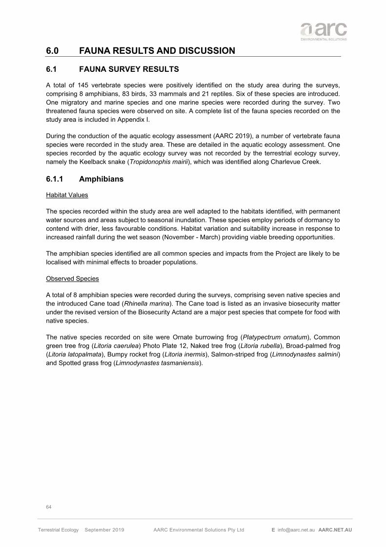
64
Terrestrial Ecology September 2019 AARC Environmental Solutions Pty Ltd E [email protected] AARC.NET.AU
6.0 FAUNA RESULTS AND DISCUSSION
6.1 FAUNA SURVEY RESULTS
A total of 145 vertebrate species were positively identified on the study area during the surveys, comprising 8 amphibians, 83 birds, 33 mammals and 21 reptiles. Six of these species are introduced. One migratory and marine species and one marine species were recorded during the survey. Two threatened fauna species were observed on site. A complete list of the fauna species recorded on the study area is included in Appendix I.
During the conduction of the aquatic ecology assessment (AARC 2019), a number of vertebrate fauna species were recorded in the study area. These are detailed in the aquatic ecology assessment. One species recorded by the aquatic ecology survey was not recorded by the terrestrial ecology survey, namely the Keelback snake (Tropidonophis mairii), which was identified along Charlevue Creek.
6.1.1 Amphibians
Habitat Values
The species recorded within the study area are well adapted to the habitats identified, with permanent water sources and areas subject to seasonal inundation. These species employ periods of dormancy to contend with drier, less favourable conditions. Habitat variation and suitability increase in response to increased rainfall during the wet season (November - March) providing viable breeding opportunities.
The amphibian species identified are all common species and impacts from the Project are likely to be localised with minimal effects to broader populations.
Observed Species
A total of 8 amphibian species were recorded during the surveys, comprising seven native species and the introduced Cane toad (Rhinella marina). The Cane toad is listed as an invasive biosecurity matter under the revised version of the Biosecurity Actand are a major pest species that compete for food with native species.
The native species recorded on site were Ornate burrowing frog (Platypectrum ornatum), Common green tree frog (Litoria caerulea) Photo Plate 12, Naked tree frog (Litoria rubella), Broad-palmed frog (Litoria latopalmata), Bumpy rocket frog (Litoria inermis), Salmon-striped frog (Limnodynastes salmini) and Spotted grass frog (Limnodynastes tasmaniensis).

65
Terrestrial Ecology September 2019 AARC Environmental Solutions Pty Ltd E [email protected] AARC.NET.AU
Common green tree frog (Litoria caerulea) observed at DF02
Amphibians of Conservation Significance
No amphibian species of conservation significance were observed on the study area during field surveys. However, the Tusked frog (Adelotus brevis) has been identified as potentially occurring within the study area due to the proximity of its known range and the presence of suitable habitat (such as dams).
6.1.2 Reptiles
Habitat Values
The study area provided a variety of habitat types such as vegetated drainage features, woodlands to open forests and rocky areas to promote reptile diversity. This included several microhabitats such as tree hollows, fallen timber, dense leaf litter, soil cracks and rock crevices which provide shelter from extreme climates, protection from aerial predators and as habitat for hunting and foraging for food.
Observed Species
A total of 21 reptile species were recorded within the study area during the field surveys, all of which are listed in Appendix I.
The suite of reptiles occurring on the study area included seven species of skink and one species of legless lizard. These species include the Eastern striped skink (Ctenotus robustus), Elegant snake-eyed skink (Cryptoblepharus pulcher), Shaded litter rainbow-skink (Carlia munda), South-eastern morethia skink (Morethia boulengeri), Fire-tailed skink (Morethia taeniopleura), the Orange-flanked Rainbow skink (Carlia rubigo) and Burton’s legless lizard (Lialis burtonis).
Five gecko species were identified on the study area, including the Eastern stone gecko (Diplodactylus vittatus), Dubious dtella (Gehyra dubia), Bynoe’s Gecko (Heteronotia binoei), Box-patterned gecko (Lucasium steindachneri) (Photo Plate 13) and the Prickly knob-tailed gecko (Nephrurus asper).

66
Terrestrial Ecology September 2019 AARC Environmental Solutions Pty Ltd E [email protected] AARC.NET.AU
Box-patterned gecko (Lucasium steindachneri) observed at DF09
Field surveys also detected the presence of three dragon species, Bearded dragon (Pogona barbata), Tommy roundhead (Diporophora australia) and Freckled monitor (Varanus tristis orientalis).
Freckled monitor (Varanus tristis orientalis) observed at DF10
Six snake species namely the Black headed python (Aspidites melanocephalus), Eastern brown snake (Pseudonaja textilis), Pale-headed snake (Hoplocephalus bitorquatus) (Photo Plate 15), Carpentaria snake (Cryptophis boschmai), Yellow-faced whip snake (Demansia psammophis) and Orange-naped snake (Furina ornata) were recorded within the study area.
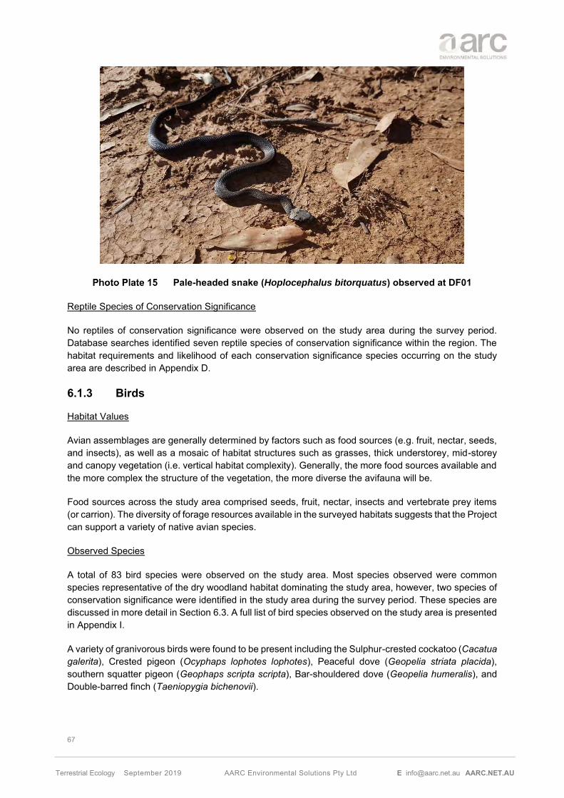
67
Terrestrial Ecology September 2019 AARC Environmental Solutions Pty Ltd E [email protected] AARC.NET.AU
Pale-headed snake (Hoplocephalus bitorquatus) observed at DF01
Reptile Species of Conservation Significance
No reptiles of conservation significance were observed on the study area during the survey period. Database searches identified seven reptile species of conservation significance within the region. The habitat requirements and likelihood of each conservation significance species occurring on the study area are described in Appendix D.
6.1.3 Birds
Habitat Values
Avian assemblages are generally determined by factors such as food sources (e.g. fruit, nectar, seeds, and insects), as well as a mosaic of habitat structures such as grasses, thick understorey, mid-storey and canopy vegetation (i.e. vertical habitat complexity). Generally, the more food sources available and the more complex the structure of the vegetation, the more diverse the avifauna will be.
Food sources across the study area comprised seeds, fruit, nectar, insects and vertebrate prey items (or carrion). The diversity of forage resources available in the surveyed habitats suggests that the Project can support a variety of native avian species.
Observed Species
A total of 83 bird species were observed on the study area. Most species observed were common species representative of the dry woodland habitat dominating the study area, however, two species of conservation significance were identified in the study area during the survey period. These species are discussed in more detail in Section 6.3. A full list of bird species observed on the study area is presented in Appendix I.
A variety of granivorous birds were found to be present including the Sulphur-crested cockatoo (Cacatua galerita), Crested pigeon (Ocyphaps lophotes lophotes), Peaceful dove (Geopelia striata placida), southern squatter pigeon (Geophaps scripta scripta), Bar-shouldered dove (Geopelia humeralis), and Double-barred finch (Taeniopygia bichenovii).

68
Terrestrial Ecology September 2019 AARC Environmental Solutions Pty Ltd E [email protected] AARC.NET.AU
The study area was found to support a number of honeyeaters including the White-throated honeyeater (Melithreptus albogularis), Brown honeyeater (Lichmera indistincta ocularis), Blue-faced honeyeater (Entomyzon cyanotis) and Noisy friarbird (Philemon corniculatus).
The suite of insectivorous birds recorded on site included the Grey fantail (Rhipidura albiscapa), Magpie-lark (Grallina cyanoleuca), Black-faced cuckoo-shrike (Coracina novaehollandiae), Grey-crowned babbler (Pomatostomus temporalis) and Striated pardalote (Pardalotus striatus).
A large diversity of omnivorous and carnivorous species was detected on the study area, including the Apostlebird (Struthidea cinerea), Pheasant coucal (Centropus phasianinus), Grey butcherbird (Cracticus torquatus), Australian magpie (Cracticus tibicen), Australian raven (Corvus coronoides), Laughing kookaburra (Dacelo novaeguineae) and Emu (Dromaius novaehollandiae).
Several nocturnal bird species including the Tawny Frogmouth (Podargus strigoides), Barn owl (Tyto alba) and Southern boobook (Ninox boobook) were observed during field surveys. Five raptor species, including Whistling kite (Haliastur sphenurus) and Brown falcon (Falco berigora) (Photo Plate 16) were also recorded on the study area.
Brown falcon (Falco berigora) observed on the study area
Aquatic bird species such as the Brolga (Grus rubicunda) were also recorded during field surveys.
Birds of Conservation Significance
Threatened Species
The southern subspecies of the Squatter pigeon (Geophaps scripta scripta) was recorded in several locations (Figure 14) on the study area at the time of the surveys (Photo Plate 17).
The southern Squatter pigeon occurs along the inland slopes of the Great Dividing Range with a distribution from the Burdekin-Lynd divide in central Queensland, west to Charleville and Longreach, east to the coastline between Proserpine and Gladstone, and south to scattered sites throughout south-eastern Queensland (Cooper et al. 2004).

69
Terrestrial Ecology September 2019 AARC Environmental Solutions Pty Ltd E [email protected] AARC.NET.AU
Suitable habitat for the southern Squatter Pigeon exists in open grassy woodland throughout the study area. Within this suitable habitat, fifteen birds were observed during the ecological survey period, the majority of them observed during the spring survey in September 2017. The species is regionally abundant, having been observed outside of the study area on multiple occasions, with AARC ecologists observing the species multiple times on local roads and elsewhere while traversing the local area. No breeding activity was observed within the study area.
It is unlikely that the proposed Project will have a significant impact on the local population of the southern Squatter Pigeon; either the local population or the population in its entirety due to:
• the abundance of more suitable habitat outside of the study area in connected woodland; and
• the local abundance of the southern Squatter pigeon.
A Significant Residual Impact Assessment (DEHP 2014a) for the southern Squatter pigeon can be found in Section 9.1.2 of this report.
Squatter Pigeon (Geophaps scripta scripta) observed at the study area
Marine and Migratory Species
The EPBC Act lists bird species that are classified as migratory and/or marine. Two migratory and/or marine birds were identified on the study area (Figure 14), comprising of the Rufous fantail (Rhipidura rufifrons) which is a migratory and marine species and the Rainbow bee-eater (Merops ornatus) which is a marine species.
The Rufous fantail (also listed as Special Least Concern under the NC Act) is found in northern and eastern coastal Australia, being more common in the north. It is also found in New Guinea, the Solomon Islands, Sulawesi and Guam. The Rufous fantail is found in rainforest, dense wet forests, swamp woodlands and mangroves, preferring deep shade, and is often seen close to the ground. During migration, it may be found in more open habitats or urban areas. The Rufous fantail is a common and secure species (Blakers et al. 1984).

70
Terrestrial Ecology September 2019 AARC Environmental Solutions Pty Ltd E [email protected] AARC.NET.AU
The Rainbow bee-eater inhabits all of mainland Queensland, as well as Indonesia, New Guinea and the Solomon Islands. This species is widespread and breeds throughout most of its range, with the exception of southern birds, which move north to breed.
None of the marine species which utilise the study area are at the extent of their known range and the local populations do not constitute an ‘ecologically significant proportion’ of the total population of the species. While these marine species do inhabit the site, the surrounding region provides suitable habitat that can be utilised and impacts from the study area are unlikely to significantly impact the habitat or distribution of this species in the region. Due to the ephemeral nature of the waterways identified onsite it is unlikely that the Project provides year-round habitat for these species.
6.1.4 Mammals
Habitat Values
Mammal morphology varies widely from small rodents to larger kangaroos to bats. The ecology of each of these groups is equally variable and they are assessed separately in the following sections.
Small Mammals
Habitats suitable for small mammals include areas that provide a plentiful food source and suitable shelter sites. The highest density of small mammal species is usually associated with reliable rainfall which is reflected in a reliable source of food and dense ground vegetation, particularly shrubs and grasses.
The diversity of small mammals is often limited by the lack of a predictable food supply and open ground vegetation. Consequently, small mammal populations can fluctuate dramatically in response to rainfall which increases seed production and insect abundance. During less favourable periods, small mammal populations can be very low.
The study area provides a variety of habitat types suitable for small ground-dwelling mammals, including vegetated woodlands, open forests and watercourses, found in vegetation communities VC 1, VC 2 and VC 3. The majority of the study area is comprised of non-remnant vegetation which is mostly utilized as grazing pasture. This community reduces the availability of shelter.
Medium and Large Mammals
Factors affecting the occurrence of medium and large sized mammals are varied. Important factors can include land-clearing, feral animal predation and grazing pressures. Regardless of the clearing that has occurred on the Project, larger macropods have been much less affected than some other mammals. Larger macropods are considered generalists, likely to thrive and flourish in response to areas of grasslands and open vegetation, as they are less vulnerable to small predators such as foxes and cats. They are also highly opportunistic breeders, especially in the presence of permanent water sources such as the dams found onsite.
Most of the study area habitats include pastural land and large areas of low open woodlands. These habitats are likely to support most medium mammals occurring in the region. In particular, the riparian habitats along waterways and watercourses are likely to provide important corridor values for this mammal group.
Larger mammals such as kangaroos have been much less affected by predation than other mammals and by land clearing activities. In fact, many species have flourished in response to increased areas of grassland and open vegetation caused by land clearing activities.

71
Terrestrial Ecology September 2019 AARC Environmental Solutions Pty Ltd E [email protected] AARC.NET.AU
Arboreal Mammals
The majority of arboreal mammals that occur in Australia utilise tree hollows for nesting and shelter (Menkhorst and Knight 2011). A shortage of nest hollows is likely to limit arboreal mammal populations where the density of hollow bearing trees is less than two to eight trees per ha (Smith and Lindenmayer 1988).
Hollow-bearing trees on the study area generally occur along creek-lines or in adjoining vegetation communities. Away from the waterway corridors, hollow-bearing trees are few and are separated by vast open areas that would be difficult for arboreal mammals to cross without venturing onto the ground. Due to the previously cleared and disturbed nature of the study area, arboreal mammal habitat is largely restricted to the waterway corridors of the study area.
Bats
The density and diversity of Australian bat species is determined primarily by the availability of suitable nesting and roosting sites. Roosting sites can include locations such as thick foliage, loose exfoliating bark, rock caves or cavities, tree hollows or even fabricated structures such as old buildings and culverts (Churchill 2008).
Consequently, areas with a large number of hollow-bearing trees that occur within remnant vegetation are of high value to many bat species. As bats have a small body size, these hollows can be much smaller in size than required by some arboreal mammals. Possible roosting sites observed on the study area included tree hollows and exfoliating bark, particularly in VC 1, VC 2 and VC 3.
Potential roosting habitat including rocky areas and drainage areas on the study area were surveyed with an ANABAT echolocation call recorder. Riparian zones with large hollow bearing trees located adjacent to the study area were also surveyed.
Observed Species
In total, 33 mammal species were recorded in the study area, comprising 28 native species and five introduced species, all listed in Appendix I. All introduced species recorded are discussed in Section 6.2.
The suite of native mammal species recorded as having a presence on the study area included the Red-necked wallaby (Macropus rufogriseus), Short-beaked echidna (Tachyglossus aculeatus), Common brushtail possum (Trichosurus vulpecula), Water rat (Hydromys chrysogaster), Swamp wallaby (Wallabia bicolor), Greater glider (Petauroides volans volans), Rufous bettong (Aepyprymnus rufescens) (Photo Plate 18), Wallaroo (Macropus robustus), Eastern grey kangaroo (Macropus giganteus), Black-striped wallaby (Notamacropus dorsalis) and Delicate mouse (Pseudomys delicatulus).

72
Terrestrial Ecology September 2019 AARC Environmental Solutions Pty Ltd E [email protected] AARC.NET.AU
Rufous bettong (Aepyprymnus rufescens) observed in the study area
A total of 17 bat species were positively identified on the study area, none of which are listed under the EPBC Act. Those bat species positively identified on the study area included the Gould’s wattled bat (Chalinolobus gouldii), Little pied bat (Chalinolobus picatus), Hoary wattled bat (Chalinolobus nigrogriseus), Northern free-tailed bat (Chaerephon jobensis), Eastern bentwing bat (Miniopterus schreibersii oceanensis), Inland forest bat (Vespadelus baverstocki), Rides free-tailed bat (Ozimops ridei), Inland free-tailed bat (Ozimops petersi), Northern free-tailed bat (Ozimops lumsdenae), Western broad-nosed bat (Scotorepens balstoni), Little broad-nosed bat (Scotorepens greyii), White-striped Free-tailed bat (Austronomus australis), Troughton’s Sheath-tailed bat (Taphozous troughtoni), Lesser long-eared bat (Nyctophilus geoffroyi) and Yellow-bellied sheathtail bat (Saccolaimus flaviventris).
A Long-eared bat (Nyctophilus sp.) was also detected through the use of ANABAT recorders on the study area; but could not be identified to species level. The Nyctophilus genus has several species in Australia and cannot be identified further then the genus level through ANABATs and a positive identification requires active trapping. The region is known to form part of the distribution of the Vulnerable Nyctophilus corbeni (EPBC Act, NC Act). In response to this, ecologists conducted a targeted micro-bat survey in line with the Survey Guidelines for Australia’s Threatened Bats (DoEE 2010a). The targeted micro-bat survey utilised Harp Traps and Mist Nets. The targeted micro-bat survey did not identify the Vulnerable species Nyctophilus corbeni within the study area but trapped the Lesser long-eared bat (Nyctophilus geoffroyi). It is highly likely that the Nyctophilus sp. call registered in the ANABAT belonged to the Least Concern Nyctophilus geoffroyi.
Several other species of bats not listed as threatened, could not be reliably identified from call analysis due to either poor data quality and/or similarities in call characteristics between species known to occur in the region. Unconfirmed species records include species that could not be distinguished between a group of two to three species. The bat call analysis results are detailed in Appendix G.
Mammals of Conservation Significance
The Short-beaked echidna (Tachyglossus aculeatus) (Photo Plate 19) was recorded in the study area across several sites (Figure 14). This species is not an EVNT species but is listed under the NC Act as Special Least Concern and is not listed under the EPBC Act.

73
Terrestrial Ecology September 2019 AARC Environmental Solutions Pty Ltd E [email protected] AARC.NET.AU
The Short-beaked echidna is found in a variety of habitat types including open forests, grasslands and heavily vegetated woodlands. It’s distribution spans across Australia, including Tasmania and is considered a habitat generalist. This species presence relies on the abundance of ants which are its only food source (Van Dyck et al. 2013). Due to the generality and wide distribution of this species, it is not expected that mining activity will have an impact of this species.
A Significant Residual Impact Assessment (DEHP 2014a) for the Short-beaked echidna can be found in Section 9.1.2 of this report.
Short-beaked Echidna (Tachyglossus aculeatus) observed at the study area
The Greater glider (Petauroides volans) (Photo Plate 20), was detected during the field survey of the study area (Figure 14). The Greater glider is listed under the EPBC Act 1999 as a “Vulnerable” species (DoEE, 2018).
The Greater glider is restricted to eastern Australia, occurring from the Windsor Tableland in north Queensland through to central Victoria, with an elevational range from sea level to 1200 m above sea level. The broad extent of occurrence is unlikely to have changed appreciably since European settlement, however the area of occupancy has decreased substantially, mostly due to land clearing (TSSC 2016a).
The Greater glider is an arboreal nocturnal marsupial, largely restricted to eucalypt forests and woodlands. It is primarily folivorous, with a diet mostly comprising eucalypt leaves, and occasionally flowers. Preferred habitat consists of taller, montane, moist eucalypt forests with relatively old trees and abundant hollows. It also favours forests with a diversity of eucalypt species, due to seasonal variation in its preferred tree species (TSSC 2016a).
Critical microhabitat is an abundance of large hollows of large, old trees for daily denning shelters and breeding purposes. The species is absent from cleared areas and has little ability to disperse between fragments across cleared areas, with habitat connectivity critical to species survival (TSSC 2016a).
Major threats include habitat loss from clearing, high intensity fires, and logging and woodland thinning practices (TSSC 2016a).

74
Terrestrial Ecology September 2019 AARC Environmental Solutions Pty Ltd E [email protected] AARC.NET.AU
Some of the study area has been subject to vegetation clearing to allow cattle grazing. Consequently, only small areas of suitable habitat remain on the site. Generally, habitat of the Great glider is confined to the Eucalypt riparian woodlands such as along the Charlevue Creek. This woodland suits the Greater glider’s preferred habitat of tall open woodland with a sparse shrub layer. Vegetation community mapping identified this suitable habitat as VC 3.
Habitat values of the study area are limited by the large areas of non-remnant vegetation and the impacts of grazing. Considering the extent and connection to surrounding good quality habitat and the minimal disturbance caused by the Project to Charlevue Creek, impacts on a local population of Greater glider is unlikely to be significant.
A Significant Residual Impact Assessment (DEHP 2014a) for the Greater glider can be found in Section 9.1.2 of this report.
Greater glider (Petauroides volans) observed at the study area
6.2 PEST SPECIES
Field surveys positively identified six introduced and/or pest fauna species as having a presence within the study area. Introduced species were recorded through detection of scats, tracks or other traces (e.g. skulls), sensor camera detection and/or direct observation. The suite of introduced species includes the Cane toad (Rhinella marina), Wild dog/Dingo (Canis familiaris/Canis lupus dingo), Feral cat (Felis catus), Rabbit (Oryctolagus cuniculus), House mouse (Mus musculus) and Feral pig (Sus scrofa).
All the non-native fauna species reported from the study area, with the exception of the Cane toad and the House mouse are listed as restricted species under the Biosecurity Act 2014 (DAF 2019) as shown in Table 17.

75
Terrestrial Ecology September 2019 AARC Environmental Solutions Pty Ltd E [email protected] AARC.NET.AU
Scientific name Common name Biosecurity Act 2014
Category 3 Category 4 Category 5 Category 6 Canis familiaris or Canis lupus dingo
Wild dog/Dingo x x x x
Oryctolagus cuniculus Rabbit x x x x
Felis catus Feral cat x x - x
Sus scrofa Feral pig x x - x Category 3: the invasive animal must not be distributed either by sale or gift or released into the environment. Category 4: the invasive animal must not be moved. Category 5: the invasive animal must not be kept. Category 6: the invasive animal must not be fed.
Feral cat (Felis catus) recorded on the camera trap at DF05
The Cane toad and the House mouse are not a prohibited or restricted invasive animal under the Biosecurity Act 2014; however, everyone has a general biosecurity obligation (GBO) to take reasonable and practical steps to minimise the risks associated with invasive plants and animals under their control (DAF 2016b). Cane Toads are recognised as an invasive species, as they present a serious threat to native wildlife. The Cane Toad consumes a wide variety of native animals including frogs, small reptiles, mammals and birds and cause the death of native predators that consume their toxins.
6.3 FAUNA SPECIES OF CONSERVATION SIGNIFICANCE
6.3.1 Fauna Species of Conservation Significance Identified on the Study Area
Field surveys across the study area detected the presence of five fauna species of conservation significance:
• The southern Squatter pigeon (Geophaps scripta scripta) and Greater glider (Petauroides volans), both species are listed as Vulnerable under the EPBC Act and the NC Act;

76
Terrestrial Ecology September 2019 AARC Environmental Solutions Pty Ltd E [email protected] AARC.NET.AU
• The short beaked Short-beaked echidna (Tachyglossus aculeatus) This species is not an EVNT species but is listed under the NC Act as Special Least Concern; and
• The Rufous fantail (Rhipidura rufifrons) listed as migratory and marine species, was identified on the study area.
A description of the four species is included in Sections 6.1.3 and 6.1.4, respectively.
6.3.2 Fauna Species of Conservation Significance Not Identified on the Study Area
Table 18 discusses EVNT and Migratory species that are known from the broader region and have been identified from desktop searches already identified as likely or potential to occur within the study area but were not observed on site during surveys.
The assessment of potential for presence and impact on each species is based on the knowledge of ecologists, information obtained from field surveys on the study area, previous surveys conducted on or near the study area and scientific literature. This assessment indicated that only 11 of the 19 species were considered as possible to occur on the Project.
The distribution of the marine and migratory species identified from desktop searches is widespread in eastern Australia (Simpson and Day, 2010). The study area is not at the limit of these species’ range, nor are these species considered to be declining within the region. Therefore, it is unlikely that the study area will have a significant impact on the regional populations of these species.

77
Terrestrial Ecology September 2019 AARC Environmental Solutions Pty Ltd E [email protected] AARC.NET.AU
Species Name
Common Name
EVNT Listing Likelihood of Occurrence Post Survey
EPBC Act
NC Act
Amphibians
Adelotus brevis
Tusked frog NL V
Potential The study area occurs within the vicinity of the known range of the Tusked frog and suitable habitat is available year-round due to the presence of dams. Despite not being found during targeted field surveys (Aquatic survey, AARC 2019), it is a potential that the study area can support a population of Tusked frogs.
Reptiles
Delma torquata
Adorned delma V V
Potential Suboptimal habitat is present within the study area. However, field surveys revealed no evidence of this species occurring within the study area site.
Strophurus taenicauda
Golden-tailed
gecko
NL NT Potential Suitable habitat is present within the study area. However, field surveys revealed no evidence of this species occurring within the study area site.
Birds
Calidris acuminate
Sharp-tailed Sandpiper
Ma, Mi SL Potential There is the potential for this species to utilise the study area due to the presence of suitable habitat within the study area’s boundary.

78
Terrestrial Ecology September 2019 AARC Environmental Solutions Pty Ltd E [email protected] AARC.NET.AU
Species Name
Common Name
EVNT Listing Likelihood of Occurrence Post Survey
EPBC Act
NC Act
Calyptorhynchus lathami erebus
Glossy black-
cockatoo (northern)
- V
Potential Suitable habitat occurs in the broader region and within the study area. This species is highly reliant on fodder species (Allocasuarina and Casuarina species). Within the study areas the species Allocasuarina luehmannii (Bull oak) was identified as present dominant in small patches. As such it is potential that the study area provides suitable habitat or food sources for this species.
Erythrotriorchis radiatus
Red goshawk
V E Potential There is the potential for this species to utilise the study area due to the presence of suitable habitat within the study area’s boundary. Additional suitable habitat is found throughout the surrounding region.
Hirundapus caudacutus
White-throated
needletail
Ma, Mi SL Potential There is the potential for this species to utilise the study area due to the presence of suitable habitat within the study area’s boundary.
Grantiella picta
Painted honeyeater
E V Unlikely This species is highly reliant on the presence of mistletoes in the canopy strata, no mistletoes were recorded during the terrestrial or aquatic field surveys. The study area is unlikely to provide suitable habitat for this species.
Lathamus discolour
Swift Parrot
CE E Unlikely Limited suitable habitat occurs for this species was recorded along the watercourses within the study area. The study area occurs at the most upper limit of this species distribution.

79
Terrestrial Ecology September 2019 AARC Environmental Solutions Pty Ltd E [email protected] AARC.NET.AU
Species Name
Common Name
EVNT Listing Likelihood of Occurrence Post Survey
EPBC Act
NC Act
Monarcha melanopsis
Black-faced
Monarch
Ma, Mi SL Potential There is the potential for this species to utilise the study area due to the presence of suitable habitat within the study area’s boundary.
Motacilla flava
Yellow wagtail Ma, Mi SL
Potential There is the potential for this species to utilise the study area due to the presence of suitable habitat within the study area’s boundary.
Myiagra cyanoleuca
Satin flycatcher
Ma, Mi SL Potential There is the potential for this species to utilise the study area due to the presence of suitable habitat within the study area’s boundary.
Ninox strenua
Powerful owl - V
Unlikely While there are hollow bearing trees along the watercourses within the study area, these hollows are generally small in nature and are unlikely to be of value to Powerful owls for nesting/shelter. Limited remnant vegetation has been mapped within the study area due to extensive clearing.
Pedionomus torquatus
Plains wanderer
CE V Unlikely No native grasslands occur within the study areas boundary. This species is often absent from areas that are too dense or sparse. All open areas are heavily grazed and dominated by introduced pasture species.

80
Terrestrial Ecology September 2019 AARC Environmental Solutions Pty Ltd E [email protected] AARC.NET.AU
Species Name
Common Name
EVNT Listing Likelihood of Occurrence Post Survey
EPBC Act
NC Act
Poephila cincta cincta
Black-throated finch (white-
rumped subspecies)
E E Unlikely No suitable habitat for this species occurs within the study area. Additionally, this species is not known from the area and was not detected during ecological surveys on site.
Turmix melanogaster
Black-breasted
button-quail
V V Unlikely No suitable habitat for this species was recorded within the study areas boundary.
Mammals
Chalinolobus dwyeri
Large-eared pied
bat
V V Unlikely No sandstone gorges were recorded within the study area, the study area has also undergone extensive clearing limiting the extent of suitable habitat.
Onychogalea fraenata
Bridle nailtail
wallaby
E E
Potential No preferred habitat such as Brigalow woodland and only small disconnected patches of Poplar box woodland have been identified in the study area. However, the only native population of this species is located directly north of the study area. This species could potentially utilise the habitat in the study area for foraging.
Phascolarctos cinereus
Koala
V V
Unlikely Suitable habitat is present within the study area. However, the amount of suitable habitat is limited on the study area and displays limited connectivity to the other known habitat preferences for the species. Field surveys revealed no evidence of this species occurring within the study area.
EPBC – Environment Protection and Biodiversity Conservation Act 1999 NC Act – Nature Conservation Act 1992 CE – Critically Endangered
V – Vulnerable E – Endangered C – Least Concern
SL – Special Least Concern Mi - Migratory

81
Terrestrial Ecology September 2019 AARC Environmental Solutions Pty Ltd E [email protected] AARC.NET.AU
7.0 POTENTIAL IMPACTS
Potential impacts of the Project (Figure 15) on terrestrial ecology values are described below. Mitigation measures and management strategies for the potential impacts are described in Section 8.0.
7.1 TERRESTRIAL FLORA
7.1.1 Vegetation Communities
The Project will include vegetation clearance and land disturbance during the construction and operation of the mine. The extent of land disturbance would be approximately 1961 ha, of which, approximately 720 ha of remnant vegetation clearing is required over the life of the Project.
Other potential impacts to vegetation communities include:
• Removal of habitat for terrestrial flora and fauna.
• Further habitat fragmentation and loss of connectivity. It is noted that existing vegetation clearing due to agricultural land use has already limited connectivity within this community;
• Potential for reduced condition of neighbouring vegetation communities due to the introduction of weeds or the release of contaminants associated with mine operations.
7.1.2 Flora Species of Conservation Significance and Habitat
Cerbera dumicola has been identified during the vegetation surveys in two very localised rocky areas associated with vegetation community VC 2 and VC 1 (Figure 14). This species was not identified elsewhere in the study area, within similar habitat types, during targeted searches.
The proposed mining activity proposes no impacts to populations of Cerbera dumicola. The nearest land disturbance is located 1.3 km to the east.
7.1.3 Weed Species
Project development has the potential to create or enhance conditions for invasive weed species, that may spread and out-compete native and pasture species. Weed species may be introduced via the spread of seed on persons, vehicles and equipment. Weed species may quickly colonise disturbed areas if left untreated.
The introduction of weed species can reduce native species abundance and diversity through competition. Ultimately this can lead to the reduced condition of vegetation and native fauna habitat.
7.1.4 Wetlands
The Project has potential to impact on wetlands via
• Direct clearing;
• Changes in hydrology;
• Erosion and sedimentation; and
• Contaminant release.

82
Terrestrial Ecology September 2019 AARC Environmental Solutions Pty Ltd E [email protected] AARC.NET.AU
7.1.5 Groundwater Dependant Ecosystems
Where wetlands exhibit a degree of dependence on groundwater for survival, drawdown from the mine can result in a reduced ecosystem condition, changes to vegetation composition or die back.
A groundwater assessment was undertaken by JBT Consulting (2019) in the study. Data obtained in this study, such as water quality, groundwater level and groundwater drawdown estimation were used in the assessment of the GDEs and the associated impact of drawdown.
Potential Impacts to GDEs within the study area
The potential GDEs within the study area are riverine type wetlands including riparian vegetation on watercourses and floodplains. The dominant species of this vegetation is Blue gum (Eucalyptus tereticornis), with Bauhinia spp., River oak (Casuarina cunninghamiana), Paperbark tea-tree (Melaleuca spp.) and Poplar box (Eucalyptus populnea) as associated species. Published research has identified the rooting depth of the Blue gum as 10 m (Boland et al 2006).
Groundwater modelling estimated that the Project has the potential to cause a maximum drawdown of 5 m (steady-state post-mining drawdown) at some locations below the Charlevue and Springton Creeks (JBT 2019). The groundwater adjacent to Charlevue Creek has been recorded at a depth of 8.8 mbgl with an Electrical Conductivity (EC) range from 15,200 µS/cm to 16,600 µS/cm, whilst Springton Creek registered a depth of 11.2 mbgl with a recorded EC of 5,948 µS/cm (from a single bore) (JBT 2019).
Considering Blue gum and River oak have moderate salinity tolerance of 4,000 to 8,000 µS/cm (DA 2002), it is concluded that the groundwater within the Charlevue Creek alluvium is too saline to be useable by the vegetation along the Charlevue Creek.
The salinity recorded adjacent to Springton Creek alluvium is within the tolerance level of the dominant species (DA 2002). However, it is also noted that the depth to groundwater in that area (11.19 mbgl) is potentially beyond the depth that is accessible by vegetation.
Charlevue and Springton Creeks are highly ephemeral watercourses subject to occasional flow events that replenish the alluvial aquifers. As a result, fluctuations in the groundwater level throughout the year are likely within these riverine ecosystems. Based on the existing condition of the riverine vegetation communities within the study area, it is highly likely that this vegetation has a very low reliance on groundwater aquifers for survival, if any at all. Rather the riverine communities represent facultative GDEs, capable of surviving on soil moisture present in unsaturated shallow soil layers.
It is therefore concluded that there is a very low risk that groundwater drawdown would result in a significant impact to these riverine communities.
Potential impacts to the HES wetland outside the study area
The groundwater assessment (Appendix E) included an assessment of the potential GDE / wetland located to the south east of study area. The groundwater study predicted a 2m drawdown within the community, post mining.
The potential GDE is located on an elevated ridgeline; the feature is located within a shallow depression on the ridgeline that is surrounded to the south, west and east by elevation contours at 170 m Australian height datum (AHD), with the central of the depression falling below 165 mAHD. The feature is well above the natural ground surface within the MLA, which ranges from 125 to 135 mAHD, with the elevation of the Springton Creek floodplain dropping below 120 mAHD.

83
Terrestrial Ecology September 2019 AARC Environmental Solutions Pty Ltd E [email protected] AARC.NET.AU
The potential GDE is therefore located within a shallow depression on the ridgeline that is likely to be internally draining under average rainfall conditions and that only discharges to the northeast under high rainfall conditions. It is interpreted that, under average rainfall conditions and at the tail end of high rainfall conditions, surface runoff within the relatively small catchment that reports to this area will pond in the area of the shallow depression and provide localised recharge to an underlying groundwater lens that is likely to be disconnected from the regional groundwater system.
Registered bores indicate the depth to water for bores constructed within Tertiary sediments and Permian coal measures ranges from 26.25 to 32.37 mbgl in this area. This equates to a groundwater elevation of 108-110 mAHD for bores in topographically elevated areas. The water level in the site monitoring bores, which were assessed to be representative of the regional groundwater level, are therefore considerably lower than the elevation of the base of the potential GDE, which is at an elevation approximately 165 mAHD.
Based on the observations discussed above, it is concluded that:
• The potential GDE is located on an elevated ridgeline, but within a shallow depression that is likely to drain internally under average rainfall conditions but drains to the northeast under high rainfall conditions;
• The drainage of surface runoff to the shallow depression is likely to result in localised recharge to a perched lens of groundwater that is disconnected from the regional groundwater system;
• It is probable that this perched groundwater lens provides water to vegetation within the depression during the dry season, but that the groundwater lens is an extremely localised system that relies on replenishment by seasonal rainfall rather than being maintained by the regional groundwater system.
It is noted the EC of site groundwater monitoring bores, which are interpreted to be within the regional groundwater system, is high (15,000 µS/cm to 29,000 µS/cm – refer Section 4.3). However, it is also noted that the EC of the registered bores to the north of the potential GDE is very low, with bore 111570 recording an EC of 240 µS/cm and bore 161093 recording an EC of 710 µS/cm. This provide further evidence that the groundwater system in this area is perched above the regional groundwater system, with the flowline from the area of the potential GDE (where recharge is interpreted to occur) to the area where these bores are located being very short.
It is concluded that the potential GDE is maintained by localised runoff and shallow recharge and that a reduction in the regional groundwater level of approximately 2 m, at a vertical distance of approximately 50 to 60 m below the base of the potential GDE, has a very low risk of impacting groundwater levels beneath the potential GDE.
7.2 TERRESTRIAL FAUNA
7.2.1 Fauna Species of Conservation Significance and Habitat
Field surveys across the study area detected the presence of three fauna species of conservation significance; the southern Squatter pigeon (Geophaps scripta scripta), the Greater glider (Petauroides volans) and the Short-beaked echidna (Tachyglossus aculeatus).
Potential impacts of the Project to threatened fauna species include:
• Direct clearing of habitat within the Project defined impact areas;

84
Terrestrial Ecology September 2019 AARC Environmental Solutions Pty Ltd E [email protected] AARC.NET.AU
• Further habitat fragmentation and loss of connectivity, particularly along Charlevue Creek which provides partial connectivity to larger downstream riparian communities. It is noted that existing vegetation clearing due to agricultural land use has already limited connectivity within this community;
• Potential for fauna mortality through interactions with vehicles on roads and/or heavy machinery used for land clearing;
• Potential for habitat degradation through increased risk of release of contaminants or sediments into receiving environments within and downstream of the Project; and
• Potential for increased invasive flora and fauna.
Southern Squatter Pigeon (Geophaps scripta scripta)
Suitable habitat for the southern Squatter Pigeon exists in open grassy woodland throughout the study area. Within this suitable habitat, fifteen birds were observed during the ecological survey period, the majority were observed during the spring survey in September 2017. The species is regionally abundant, having been observed outside of the study area on multiple occasions, with ecologists observing the species multiple times on local roads and elsewhere while traversing the local area. No breeding activity was observed within the study area.
It is unlikely that the proposed Project will have a significant impact on the southern Squatter Pigeon; either the local population or the population in its entirety due to:
• The species being highly mobile;
• The abundance of equivalent and more suitable habitat outside of the study area in adjacent areas;
• The observed high local abundance of the southern Squatter pigeon within and surrounding the study area; and
• The likely suitable habitat to be provided by rehabilitated land, post mining.
Greater glider (Petauroides volans)
The Greater glider preferred habitat consists of taller, montane, moist eucalypt forests with relatively old trees and abundant hollows. It also favours forests with a diversity of eucalypt species, due to seasonal variation in its preferred tree species (TSSC 2016a). Critical microhabitat is an abundance of large hollows of large, old trees for daily denning shelters and breeding purposes. The species is absent from cleared areas and has little ability to disperse between fragments across cleared areas, with habitat connectivity critical to species survival (TSSC 2016a).
Habitat of the Great glider within the study area is confined to the Eucalypt riparian woodlands such as along the Charlevue Creek. This woodland suits the Greater glider’s preferred habitat of tall open woodland containing hollows with a sparse shrub layer.
It is unlikely that the proposed Project will have a significant impact on the Greater glider; either the local population or the population in its entirety due to:
• No significant impact proposed to habitat within the study area, specifically Charlevue Creek. Proposed disturbance within this habitat is limited to the development of a small culvert crossing;

85
Terrestrial Ecology September 2019 AARC Environmental Solutions Pty Ltd E [email protected] AARC.NET.AU
• The observed abundance of Greater Gliders within the study area and within the broader Central Queensland region; and
• The abundance of equivalent and more suitable habitat outside of the study area in adjacent areas.
Short-beaked echidna (Tachyglossus aculeatus)
The Short-beaked echidna is found in a variety of habitat types including open forests, grasslands and heavily vegetated woodlands. Suitable habitat for the species exists across the study area.
It is unlikely that the proposed Project will have a significant impact on the Short-beaked echidna (Tachyglossus aculeatus); either the local population or the population in its entirety due to:
• The known abundance and wide-ranging distribution of the species;
• The presence of ample equivalent or better suited habitat surrounding the Project;
• The relatively small extent of impact proposed by the Project; and
• The likely suitable habitat to be provided by rehabilitated land, post mining.
7.2.2 Migratory Fauna Species
The Rufous fantail (Rhipidura rufifrons), a listed migratory bird species under the EPBC Act, was identified within the study area. The Rufous fantail is generally found in rainforest, dense wet forests, swamp woodlands and mangroves, preferring deep shade, and is often seen close to the ground. During migration, it may be found in more open habitats, such as those within the study area.
It is unlikely that the proposed Project will have a significant impact on the Rufous fantail (Rhipidura rufifrons); either the local population or the population in its entirety due to:
• The Rufous fantail is a common and secure species (Blakers et al. 1984);
• The study area does not contain the preferred habitat type for the species;
• The species is highly mobile and likely only passing through the Project site on its migratory path;
• No known breeding sites or nesting habitat was identified on the study area; and
• Ample equivalent or higher quality habitat exists surrounding the study area.
7.2.3 Pest Species
Pest species compete with and prey on native fauna. Construction and operation of the Project increases the risk of pest species on the study area through:
• Generation of food and other waste that may attract pests; and
• Creation of artificial ponding areas providing habitat for pest species such as cane toads.
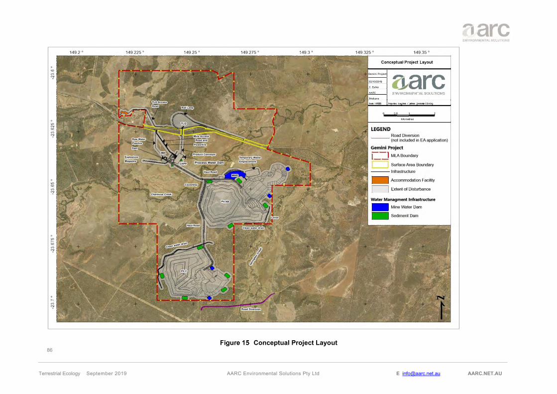
86
Terrestrial Ecology September 2019 AARC Environmental Solutions Pty Ltd E [email protected] AARC.NET.AU
Conceptual Project Layout

87
Terrestrial Ecology September 2019 AARC Environmental Solutions Pty Ltd E [email protected] AARC.NET.AU
8.0 MITIGATION AND MANAGEMENT STRATEGIES
8.1.1 Terrestrial Flora
8.1.1.1 Vegetation Communities
To minimise and mitigate impacts to vegetation communities on the Project area the following management strategies will be implemented:
• Clearing of land and vegetation will be limited to areas defined in the Project approval and required for safe operation.
o An internal Permit to Disturb system will be implemented to minimise the chances of unauthorised clearing;
o Areas to be cleared will be clearly defined and demarked to equipment operators;
• Inductions and training materials provided to employees will identify the environmental values of the site as well as the company procedures for managing impacts within its authority;
• Rehabilitation will be undertaken progressively and will aim to return the land to the pre-mining land use where possible;
• Where impact to Matters of State Environmental Significance cannot be avoided and are authorised by the Project approval, environmental offsets will be provided.
8.1.1.2 Flora Species of Conservation Significance
Suitable habitat for the Cerbera dumicola exists to the west of the Project, within the MLA. The proposed mine construction and development will not impact on the populations.
• An internal Permit to Disturb system will be implemented to minimise the chances of unauthorised clearing and impacts to the populations within the MLA;
• Inductions and training materials provided to employees will identify the environmental values of the site as well as the company procedures for managing impacts within its authority; and
• Existing populations will be monitored for abundance, distribution and health over the mine life.
8.1.1.3 Weed Species
To control the abundance and spread of weed species the following management strategies will be implemented:
• A pest and weed management plan will be prepared and implemented prior to construction;
• As required, weeds within the MLA will be controlled using herbicides and other recommended methods;
• Inductions and training materials provided to employees will assist the identification of common weeds and will include procedures for reporting; and
• Access to vehicle wash down facilities will be provided for vehicles at risk of spreading weeds.

88
Terrestrial Ecology September 2019 AARC Environmental Solutions Pty Ltd E [email protected] AARC.NET.AU
8.1.1.4 Wetlands / GDEs
Wetlands / GDEs include Riverine vegetation on the MLA, particularly riparian vegetation associated with Charlevue and Springton Creeks. In addition, a HES wetland is located to the south east of the Project. To manage potential impacts on wetlands, the following will be undertaken:
• Sediment and erosion control structures will be installed and maintained near all at risk areas to prevent sediment release to wetlands;
• A Receiving Environment Monitoring Program (REMP) will be implemented and will include monitoring of water, sediments, riparian / riverine vegetation health and biological indicators in aquatic environments;
• The release of Mine Affected Water, will be in accordance with the quality controls provided by the model mining conditions; and
• Groundwater bores adjacent to Charlevue Creek (DW7076W) and Springton Creek (DW7292W1), will be fitted with dataloggers. This data will allow the assessment of the range of water levels within the alluvium and the response of groundwater levels within the alluvium to rainfall recharge, stream flow events and mining activities.
8.1.2 Terrestrial Fauna
8.1.2.1 Fauna Species of Conservation Significance
Fauna species of conservation significance associated with the Project site include; the southern Squatter pigeon (Geophaps scripta scripta), the Greater glider (Petauroides volans), the Short-beaked echidna (Tachyglossus aculeatus) and the Rufous fantail (Rhipidura rufifrons) (Migratory). To ensure no significant impact to these species, the following strategies will be implemented:
• An internal Permit to Disturb system will be implemented to minimise the chances of unauthorised clearing and impacts to the threatened fauna within the MLA;
• Inductions and training materials provided to employees will identify the environmental values of the site as well as the company procedures for managing impacts within its authority;
• Vehicles speeds will be limited within the MLA, to minimise the risk of collision;
• Vegetation clearing will be done in a staged manner, allowing time for fauna to escape the area; and
• Pre-clearing inspections will be undertaken by qualified staff to minimise the risk of fauna mortality.
8.1.2.2 Pest Species
To prevent the introduction of pest species and to control their spread, the following management strategies will be implemented for the Project:
• A pest and weed management plan will be prepared and implemented prior to construction;
• Rubbish and food scraps will be managed so as not to encourage pest species;

89
Terrestrial Ecology September 2019 AARC Environmental Solutions Pty Ltd E [email protected] AARC.NET.AU
• Inductions and training materials provided to employees will assist the identification of common pests and will include procedures for reporting; and
• Control of feral cats and other animals will be undertaken within the MLA.

90
Terrestrial Ecology September 2019 AARC Environmental Solutions Pty Ltd E [email protected] AARC.NET.AU
9.0 PROJECT ENVIRONMENTAL OFFSETS
The offsets framework requires environmental offsets to be delivered where an activity is likely to result in a significant residual impact on a prescribed environmental matter. The QEOP Significant Residual Impact Guideline (DES 2014b) is used to determine whether residual impacts are considered to be significant.
Prescribed environmental matters (MSES) are listed in Schedule 2 of the Environmental Offsets Regulation. The following prescribed matters were mapped or identified within the Project area by the terrestrial ecology surveys:
• Regulated vegetation including:
o Regional Ecosystems (REs) that are listed as Endangered or Of Concern (under the Vegetation Management Act 1999 (VM Act));
o REs located within the defined distance from the defining banks of a relevant watercourse or relevant drainage feature identified on the Regulated Vegetation Management Watercourse and Drainage Feature Map (as certified under the VM Act);
o REs mapped as essential habitat on the Essential Habitat Map (as certified under the VM Act) for flora and fauna listed as Endangered and Vulnerable (under the Nature Conservation Act 1992 (NC Act)); or
o With specific application to the prescribed activity of ‘native vegetation clearing’ a RE mapped as essential habitat on the Essential Habitat Map (as certified under the VM Act) for flora and fauna listed as Near Threatened (under the NC Act);
• Remnant REs that contain an area of land required for ecosystem functioning (a connectivity area);
• Protected wildlife habitat, which includes;
o Habitat for Endangered, Vulnerable and Special Least Concern animals (under the NC Act);
9.1 ASSESSMENT OF PRESCRIBED MATTERS IDENTIFIED IN THE STUDY AREA
9.1.1 Regulated Vegetation
The ground verified vegetation map identified the following regulated vegetation categories, under the VM Act:
• REs that are listed as Of Concern (under the VM Act);
• REs that are located within the prescribed distance from the defining banks of a relevant VM Act watercourse; and
The QEOP Significant Residual Impact Guideline (DES 2014a) covers vegetation clearing in excess of thresholds of between 0.5 ha and 5 ha, depending on the structural category of the vegetation. All regulated vegetation proposed to be cleared for the Project is in excess of the larger 5 ha threshold, and no further breakdown is defined (Table 19).

91
Terrestrial Ecology September 2019 AARC Environmental Solutions Pty Ltd E [email protected] AARC.NET.AU
Figure 16 illustrates the distribution of vegetation in relation to proposed disturbance areas, whilst Figure 17 summarises the regulated vegetation present within the proposed disturbance.
RE VM Act Status
Proposed Disturbance (ha)
Significant Residual Impact
RE 11.3.2 OC 7.53 Yes
REs located within the defined distance from the defining banks of a VM Act
watercourse - 59.79 Yes
Notes: * within complete study area
The Project is likely to result in a significant residual impact to MSES, through the clearing of regulated vegetation above the significant residual impact thresholds.
9.1.2 Conservation Significant Species, Protected Wildlife Habitat and Essential Habitat
The Queensland Environmental Offsets Policy Significant Residual Impact Guideline (DEHP 2014a) outlines the criteria for identifying when an impact on prescribed environmental matters (MSES) may be significant. The significant impact criteria provide a trigger for consideration of offsets (DEHP 2014a).
As stated in the Environmental Offsets Regulation 2014 an area of habitat (e.g. foraging, roosting, nesting or breeding habitat) for an animal that is endangered, vulnerable or a special least concern is considered Protected Wildlife Habitat under the Environmental Offsets Regulation 2014 (DEHP 2014a).
As previously discussed, three listed EVNT species under the NC Act were present within the study area, Greater glider, southern Squatter pigeon and the plant species Cerbera dumicola. Essential habitat for all three species has been mapped by the DES in accordance to the VM Act (Figure 18).
An assessment following the Significant residual impact criteria for vulnerable wildlife habitat (including essential habitat) has been conducted for the Greater glider and the southern Squatter pigeon. Similarly, an assessment for the special least concern animal wildlife habitat has been conducted for the Short-beaked echidna, also identified within the study area.
The Queensland Environmental Offsets Policy Significant Residual Impact Guideline (DEHP 2014a) does not include specific criteria for assessing impacts to Near Threatened wildlife. An assessment of the significant residual impact for Cerbera dumicola has been carried out in accordance with the criteria for Vulnerable wildlife, as described in Section 5.1 of the guideline.

92
Terrestrial Ecology September 2019 AARC Environmental Solutions Pty Ltd E [email protected] AARC.NET.AU
Vegetation Communities and Disturbance
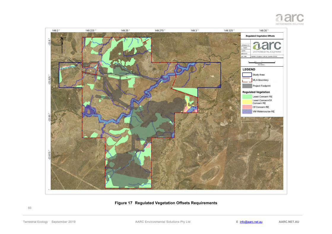
93
Terrestrial Ecology September 2019 AARC Environmental Solutions Pty Ltd E [email protected] AARC.NET.AU
Regulated Vegetation Offsets Requirements

94
Terrestrial Ecology September 2019 AARC Environmental Solutions Pty Ltd E [email protected] AARC.NET.AU
Essential Habitat (VM Act)

95
Terrestrial Ecology September 2019 AARC Environmental Solutions Pty Ltd E [email protected] AARC.NET.AU
Significant Residual Impact Assessment on Vulnerable Species Under the NC Act
When assessed against the significant residual impact criteria, the Project is considered unlikely to result in any significant impact on the southern Squatter pigeon. An assessment of the potential impact of the Project on the southern Squatter pigeon using significant residual impact criteria is presented in Table 20.
When assessed against the significant impact guidelines (Table 21), the Project is considered unlikely to result in a significant impact on the Greater glider. The Project will not fragment available habitat to the extent of fragmenting the Greater glider population. There is considerable alternative habitat available in the surrounding region, and dispersal opportunities will not be impacted as habitat corridors will be retained.
Significant Impact Criteria Impact Assessment
Will the action lead to a long-term decrease in the size of a local population of a species?
No, the Project would not fragment potential habitat for this species to the extent that it would decrease the size of local population of the species.
Will the action reduce the extent of occurrence of the species?
No, the species is highly mobile and individuals in the same area would have access to more suitable habitat through connecting open grasslands. The Project would not fragment potential habitat for this species to the extent that it would reduce the extent of occurrence of the species.
Will the action fragment an existing population? No, this species is highly mobile and individuals in the same area would have access to more suitable habitat through connecting open grasslands. The Project includes measures to prevent significant impacts on this species. This Project will not result in the fragmentation of an existing population into two or more populations.
Will the action result in genetically distinct populations forming as a result of habitat isolation adversely?
No, the Project would not result in habitat isolation for the southern Squatter pigeon to the extent that this species will form genetically distinct populations.
Will the action disrupt ecologically significant locations (breeding, feeding, nesting, migration or resting sites) of a species?
No, this species is mobile, and the surrounding habitat provides suitable sites for breading, feeding, nesting, migration or resting activities. Given the minimal disturbance to suitable habitat for this species and the interconnectedness of habitats, the Project would not disrupt ecologically significant locations for this species.
Will the action result in invasive species that are harmful to the species becoming established in the species habitat?
No, while the southern Squatter pigeon is vulnerable to predation from introduced pest species; pest management strategies will be implemented to minimise the risk of introduced pest species predating on this species.
Will the action introduce disease that may cause the population to decline, or interfere with the recovery of the species?
No diseases are known for the species that could be caused by mining activities and cause the species’ population to decline, nor would actions associated with mining activities interfere substantially with the recovery of the species.

96
Terrestrial Ecology September 2019 AARC Environmental Solutions Pty Ltd E [email protected] AARC.NET.AU
Significant Impact Criteria Impact Assessment
Will the action lead to a long-term decrease in the size of a local population of a species?
No, the Project would not fragment potential habitat for this species to the extent that it would decrease the size of local population of the species.
Will the action reduce the extent of occurrence of the species?
No, the Project would not fragment potential habitat for this species to the extent that it would reduce the extent of occurrence of the species.
Will the action fragment an existing population? No, the clearance of suitable habitat will impact individuals of a local population. This Project will not result in the fragmentation of an existing population into two or more populations.
Will the action result in genetically distinct populations forming as a result of habitat isolation adversely?
No, the Project would not result in habitat isolation for the Greater glider to the extent that this species will form genetically distinct populations.
Will the action disrupt ecologically significant locations (breeding, feeding, nesting, migration or resting sites) of a species?
No, this species is mobile, and the surrounding habitat provides suitable sites for breading, feeding, nesting, migration or resting activities. E. tereticornis (Blue gum) provides hollows and offers optimal habitat for Greater gliders. Given the minimal disturbance to suitable habitat for this species and the interconnectedness of habitats, the Project would not disrupt ecologically significant locations for this species.
Will the action result in invasive species that are harmful to the species becoming established in the species habitat?
No, while the Greater glider is vulnerable to predation from introduced pest species; pest management strategies will be implemented to minimise the risk of introduced pest species predating on this species.
Will the action introduce disease that may cause the population to decline, or interfere with the recovery of the species?
No diseases are known for the species that could be caused by mining activities and cause the species’ population to decline, nor would actions associated with mining activities interfere substantially with the recovery of the species.
Significant Residual Impact Assessment for Near Threatened Species Under the NC Act
When assessed against the significant residual impact criteria, the Project is considered unlikely to result in any significant impact on Cerbera dumicola. An assessment of the potential impact of the Project on Cerbera dumicola using significant residual impact criteria is presented in Table 22.
Significant Impact Criteria Impact Assessment
Will the action lead to a long-term decrease in the size of a local population of a species?
No, Cerbera dumicola was not recorded within the proposed disturbance area following targeted surveys, nor is this area regarded as most suitable habitat for this species.

97
Terrestrial Ecology September 2019 AARC Environmental Solutions Pty Ltd E [email protected] AARC.NET.AU
Significant Impact Criteria Impact Assessment
Will the action reduce the extent of occurrence of the species?
No, the species was not recorded within the proposed disturbance area following targeted surveys, nor is this area regarded as most suitable habitat for this species.
Will the action fragment an existing population? No, the proposed disturbance area is already moderately disturbed due to grazing. Suitable habitat for the species exists within the surrounding woodland.
Will the action result in genetically distinct populations forming as a result of habitat isolation adversely?
No, the proposed disturbance area will cover land where no Cerbera dumicola was not recorded.
Will the action disrupt ecologically significant locations (breeding, feeding, nesting, migration or resting sites) of a species?
No, Cerbera dumicola is capable of producing suckers (plant growth that develops from the rootstock of a plant).
Will the action result in invasive species that are harmful to the species becoming established in the species habitat?
No, invasive species management strategies will be implemented to minimise the risk that introduced species pose for the native wildlife.
Will the action introduce disease that may cause the population to decline, or interfere with the recovery of the species?
No diseases are known for the species that could be caused by mining activities and cause the species’ population to decline, nor would actions associated with mining activities interfere substantially with the recovery of the species.
Significant Residual Impact Assessment for Special Least Concern (non-migratory) Species Under the NC Act
When assessed against the significant residual impact criteria, the Project is considered unlikely to result in any significant impact on the Short-beaked echidna. An assessment of the potential impact of the Project on the Short-beaked echidna using significant residual impact criteria is presented in Table 23.
Significant Impact Criteria Impact Assessment
Will the action lead to a long-term decrease in the size of a local population of a species?
No, the Project would not fragment potential habitat for this species to the extent that it would decrease the size of local population of the species.
Will the action reduce the extent of occurrence of the species?
No, the species can be found in a variety of habitat types including open forests, grasslands and heavily vegetated woodlands. It’s distribution spans across Australia, including Tasmania and is classified as a habitat generalist (Van Dyck et al. 2013). Suitable alternative habitat occurs throughout the broader region and immediately surrounding the study area.
Will the action fragment an existing population? No, this Project will not result in the fragmentation of an existing population into two or more populations.
Will the action result in genetically distinct populations forming as a result of habitat isolation adversely?
No, the Project would not result in habitat isolation for the species to the extent that this species will form genetically distinct populations.

98
Terrestrial Ecology September 2019 AARC Environmental Solutions Pty Ltd E [email protected] AARC.NET.AU
Significant Impact Criteria Impact Assessment
Will the action disrupt ecologically significant locations (breeding, feeding, nesting, migration or resting sites) of a species?
No, the surveys did not identify any unique habitat or significant breeding populations on the study area. This species presence relies on the abundance of ants which are its only food source.
9.1.3 HES Wetland
One HES wetland was identified to occur approximately 4 km east of the study area (Section 5.4). The Queensland Environmental Offsets Policy: Significant Residual Impact Guideline (DEHP 2014) is designed to assist in determining whether or not the impacts of a project will or is likely to have a significant residual impact on a MSES.
When assessed against the MSES significant residual impact guidelines, the Project is considered unlikely to result in a significant residual impact on the HES wetland to the east of the study area.
Significant Residual Impact Criteria Ecological Assessment Will the action result in areas of the wetland being destroyed or artificially modified?
No, the Project will not result in the wetland being destroyed or artificially modified. The HES wetland is located approximately 3.6 km east of the Project.
Will the action result in a measurable change in water quality of the wetland, for example a change in the level of the physical and/or chemical characteristics to a level that exceeds the water quality guidelines for the waters?
No, the Project will not result in a measurable change in water quality of the wetland. The wetland is not connected to the surface waters of the Project and does not have the potential to be affected by controlled water releases from the Project.
Will the action impact on the habitat or lifecycle of native species, including invertebrate fauna and fish species, dependant upon the wetland being seriously affected?
No, the Project will not impact the habitat or lifecycle of native species dependent upon the wetland given there would not be any impacts to the wetland habitat as a result of the Project.
Will the action result in a substantial and measurable change in the hydrological regime or recharge zones of the wetland? For example a substantial change to the volume, timing, duration and frequency of ground and surface water flows to and within the wetland?
No, the Project will not result in a substantial and measurable change in the hydrological regime of this wetland. Potential groundwater drawdown is not likely to affect this site since the wetland groundwater system is very localised and it perched above the regional groundwater system (JBT 2019).
Will the action result in an invasive species that is harmful to the environmental values of the wetland being established (or an existing invasive species being spread) in the wetland?
No, while the wetland is vulnerable to impacts from invasive species; pest and weed management strategies will be implemented to minimise the risk of introduced pest species (such as feral pigs, Sus scrofa) and invasive weed species (such as parthenium (Parthenium hysterophorus) impacting upon the HES wetland.
9.2 OFFSETS REQUIREMENTS
The prescribed matters identified within the Project area and potentially impacted by the proposed disturbance are summarised in Table 25 to determine the Project’s MSES offset requirements.

99
Terrestrial Ecology September 2019 AARC Environmental Solutions Pty Ltd E [email protected] AARC.NET.AU
MSES Total Impact Area (ha) Impact Assessment Offset
Requirement
Of Concern RE11.3.2 7.53 Clearing is non-linear and exceeds the clearing threshold.
Offsetting Required
REs located within the defined distance from the defining banks of a VM Act watercourse
59.79
Clearing of watercourse vegetation is required. The clearing widths and areas exceed significant impact guidelines. REs supporting watercourse vegetation includes RE 11.3.25, 11.5.2, 11.3.2 and 11.7.2
Offsetting Required
Essential habitat
197.23
Greater glider: Significant impact assessment for the greater glider was completed under MSES: Queensland Environmental Offsets Policy Significant Residual Impact Guideline (DEHP 2014a). It was found there would be no significant impact to the species and its habitat (Section 9.1.2).
Not Required
303.88
southern Squatter pigeon: Significant impact assessment for the southern Squatter pigeon was completed under MSES: Queensland Environmental Offsets Policy Significant Residual Impact Guideline (DEHP 2014a). It was found there would be no significant impact to the species and its habitat (Section 9.1.2).
Not Required
106.65 Clearing of the regional ecosystem 11.7.2 mapped in the essential habitat map for the Cerbera dumicola is required.
Not Required
Connectivity area* 720.74
The Landscape Fragmentation and Connectivity Tool* was applied to the proposed extent of disturbance area. The results found that significant impact would occur to connectivity at both local scale and to core remnant areas.
Offsetting Required
Wildlife Habitat for Vulnerable species 13.35
Greater glider: 13.35 ha of suitable habitat is proposed to be cleared, which is 7.9% of the suitable habitat available within the study area. The Project will not fragment the habitat or local population, there is considerable habitat available in the surrounding region, and dispersal opportunity will not be impacted; by retaining corridors. Significant impact assessment for the greater glider was completed under MSES: Queensland Environmental Offsets Policy Significant Residual Impact Guideline (DEHP 2014a). It was found there would be no significant impact to the species and its habitat (Section 9.1.2).
Not Required

100
Terrestrial Ecology September 2019 AARC Environmental Solutions Pty Ltd E [email protected] AARC.NET.AU
MSES Total Impact Area (ha) Impact Assessment Offset
Requirement
720.74
southern Squatter pigeon: Significant impact assessment for the southern Squatter pigeon was completed under MSES: Queensland Environmental Offsets Policy Significant Residual Impact Guideline (DEHP 2014a). It was found there would be no significant impact to the species and its habitat (Section 9.1.2).
Not Required
Wildlife Habitat for Special Least Concern species.
720.74
Short-beaked echidna: Significant impact assessment for the Short-beaked echidna was completed under MSES: Queensland Environmental Offsets Policy Significant Residual Impact Guideline (DEHP 2014a). It was found there would be no significant impact to the species and its habitat (Section 9.1.2).
Not Required
* Landscape Fragmentation and Connectivity Tool is based on current government mapping.
A summary of MSES environmental offset requirements to be delivered under the QEOP is provided in Table 26, including the total extent of impact area to be offset.
MSES Area to be Impacted
(ha) Habitat Description
RE 11.3.2 Eucalyptus populnea (Poplar box) woodland on alluvial plains
7.53
This vegetation community was characterised by Eucalyptus populnea (Poplar box) woodland on alluvial plains. It was represented in several small to moderate patches within the study area and is subject to pressures from grazing, exotic species invasion.
REs located within the defined distance from the defining banks of a VM Act watercourse.
59.79 A number of VM Act watercourses traverse the Project area. Impacts will occur to watercourse vegetation that is associated with RE 11.3.25, 11.5.2, 11.3.2 and 11.7.2
RE mapped as essential habitat on the Essential Habitat Map (as certified under the VM Act) for flora and fauna listed as Near Threatened (under the NC Act)
106.65 Clearing of RE 11.7.2 within the mapped essential habitat map for the Cerbera dumicola will require an offset.
Connectivity area* 720.74 The Landscape Fragmentation and Connectivity Tool determined that there is significant impact to the connectivity of the remnant vegetation within the Project.
* Landscape Fragmentation and Connectivity Tool is based on current government mapping.
Distribution of MSES requiring offsets in association with the footprint of Gemini Project is illustrated in Figure 17.
It is recommended that Magnetic South deliver the offset requirements agreed in the EA prior to disturbance of the area. Offsets may be delivered as a financial settlement, proponent-driven offset (i.e. a land-based offset or Direct Benefit Management Plan) or a combination of proponent-driven offset and financial settlement offset.

101
Terrestrial Ecology September 2019 AARC Environmental Solutions Pty Ltd E [email protected] AARC.NET.AU
10.0 REFERENCES
AARC Environmental Solutions Pty Ltd (AARC) (2019) ‘Gemini Project: Aquatic Ecology Assessment’, prepared for Magnetic South Pty Ltd.
Atlas of Living Australia (ALA) (2018). Atlas of Living Australia website. Available from: <http://www.ala.org.au>
AVH (2019). The Australasian Virtual Herbarium, Council of Heads of Australasian Herbaria, <http://avh.chah.org.au>
Barker, M. (1995). Phaius australis, in Species Management Manual. Department of Natural Resources, Brisbane.
Blakers, M., S.J.J.F. Davies & P.N. Reilly (1984). The Atlas of Australian Birds. Melbourne, Victoria: Melbourne University Press.
Boland D.J., Brooker M.I.H., Chippendale G.M., Hall N., Hyland B.P.M., Johnson R.D., Kleinig D.A., McDonald M.W., Turner J.D. (2006) Forest Trees of Australia. CSIRO Publishing, Collingwood.
Brophy J.J., Craven L.A. and Doran J.C. 2013. Melaleucas: their botany, essential oils and uses. ACIAR Monograph No. 156. Australian Centre for International Agricultural Research: Canberra. 415 pp.
Brooks J.D. & Smith J.W. (1969). The diagenesis of plant lipids during the formation of coal, petroleum and natural gas—II. Coalification and the formation of oil and gas in the Gippsland Basin. Geochimica et Cosmochimica Acta, 33(10), 1183-1194.
Bureau of Meteorology (BOM) (2018). Queensland River Basins. Available from: <http://www.bom.gov.au/qld/flood/brochures/qld/map.pdf>
Bureau of Meteorology (BoM) (2019) Groundwater Dependant Ecosystem Atlas, Commonwealth of Australia, Canberra, available from <http://www.bom.gov.au/water/groundwater/gde/map.shtml>, accessed May 2019.
Churchill, S. (2008). Australian Bats, Reed New Holland, Sydney.
Cooper RM, McAllan IAW and Curtis BR (2014). The Atlas of the Birds of NSW and the ACT. Mini-Publishing, Gordon, New South Wales.
Cropper, S (1993), Management of endangered plants, CSIRO Publications, Melbourne.
Department of Agriculture - Western Australia (DA) (2002), Salinity tolerance of plants for agriculture and revegetation, Department of Agriculture, Western Australia.
Department of Agriculture and Fisheries (DAF) (2016), Mimosa bush, Vachellia farnesiana, Department of Agriculture and Fisheries, Queensland Government.
Department of Agriculture and Fisheries (DAF) (2016b), Cane toad, Buffo marinus, Department of Agriculture and Fisheries, Queensland Government.
Department of Agriculture and Fisheries (DAF) (2018), Restricted invasive plants of Queensland, Department of Agriculture and Fisheries, Queensland Government.

102
Terrestrial Ecology September 2019 AARC Environmental Solutions Pty Ltd E [email protected] AARC.NET.AU
Department of Agriculture and Fisheries (DAF) (2019) Invasive plant and animal fact sheets Available from: <https://www.daf.qld.gov.au/business-priorities/biosecurity/invasive-plants-animals/fact-sheets#pest_animals>
Department of Environment and Heritage Protection (DEHP) (2014a). Queensland Environmental Offsets Policy, Significant Residual Impact Guideline, Department of Environment and Science, Brisbane. Available from: < https://environment.des.qld.gov.au/assets/documents/pollution/management/offsets/significant-residual-impact-guide.pdf>
Department of Environment and Heritage Protection (DEHP) (2014b). Species Profile Search. Department of Environment and Science, Brisbane. Available from: <https://environment.ehp.qld.gov.au/species-search/>
Department of Environment and Science (DES) (2018a). Queensland Environmental Offsets Policy (Version 1.6), Biodiversity Integration and Offsets, Ecosystem Outcomes, Department of Environment and Science, State of Queensland. https://ehp.qld.gov.au/assets/documents/pollution/management/offsets/offsets-policyv1-6
Department of Environment and Science (DES) (2018b). Plants, animals, soils, water and more, WetlandInfo, Department of Environment and Science, State of Queensland., Available from: <https://wetlandinfo.des.qld.gov.au/wetlands/ecology/components/>
Department of Environment and Science (DES) (2018c). A Biodiversity Planning Assessment for the Brigalow Belt Bioregion. Version 2.1, Summary Report. Department of Environment and Science, State of Queensland. Available from: <https://www.qld.gov.au/__data/assets/pdf_file/0029/68186/bb-bpa-summary-report.pdf>
Department of Environment and Science (DES) (2019a), Protected plants flora survey trigger map, Department of Environment and Science, State of Queensland. Available from: <https://apps.des.qld.gov.au/map-request/flora-survey-trigger/>
Department of Environment and Science (DES) (2019b), Wetland maps under the Environmental Protection Act 1994, Department of Environment and Science, State of Queensland. Available from: <https://environment.des.qld.gov.au/ecosystems/wetlands/referable-wetlands-maps.html>
Department of Environment and Science (DES), Queensland Herbarium (2019c), Regional Ecosystem Description Database (REDD) (V 11.1), Department of Environment and Science, Queensland Government, Brisbane.
Department of Environment and Science (DES) (2019d), Flora Survey Guidelines - Protected Plants; Nature Conservation Act 1992, Department of Environment and Science, Queensland Government, Brisbane.
Department of the Environment, Water, Heritage and the Arts (DEWHA) (2009), Weeping Myall Woodlands - EPBC Act policy statement 3.17 - Nationally threatened species and ecological communities. Department of the Environment, Water, Heritage and the Arts, Commonwealth of Australia, Canberra.
Department of Science, Information Technology and Innovation (DSITI) (2015), Queensland Groundwater Dependant Ecosystem Mapping Method, Version 1.1, Department of Science, Information Technology and Innovation, Queensland Government, Brisbane.

103
Terrestrial Ecology September 2019 AARC Environmental Solutions Pty Ltd E [email protected] AARC.NET.AU
Department of Natural Resources, Mines and Energy (DNRME) (2018), General guide to the vegetation clearing codes Accepted development vegetation clearing codes, Queensland Government. Available from: <https://www.dnrme.qld.gov.au/__data/assets/pdf_file/0008/1396988/landholders-guide-to-veg-clearing-codes.pdf>
Department of Environment (DoE) (2013), Significant impact guidelines 1.1: Matters of National Environmental Significance, Department of Environment and Energy, Commonwealth of Australia, Canberra.
Department of the Environment and Energy (DoEE) (2010a), Survey guidelines for Australia’s threatened bats; Guidelines for detecting bats listed as threatened under the Environment Protection and Biodiversity Conservation Act 1999, Department of the Environment and Energy, Commonwealth of Australia, Canberra.
Department of the Environment and Energy (DoEE) (2010b), Survey guidelines for Australia’s threatened birds: Guidelines for detecting birds listed as threatened under the Environment Protection and Biodiversity Conservation Act 1999, Department of the Environment and Energy, Commonwealth of Australia, Canberra.
Department of the Environment and Energy (DoEE) (2011a), Survey guidelines for Australia’s threatened mammals: Guidelines for detecting mammals listed as threatened under the Environment Protection and Biodiversity Conservation Act 1999, Department of the Environment and Energy, Commonwealth of Australia, Canberra.
Department of the Environment and Energy (DoEE) (2011b), Survey guidelines for Australia’s threatened reptiles: Guidelines for detecting reptiles listed as threatened under the Environment Protection and Biodiversity Conservation Act 1999, Department of the Environment and Energy, Commonwealth of Australia, Canberra.
Department of the Environment and Energy (DoEE) (2015). Environment Protection and Biodiversity Conservation Act 1999: Protected Matters Search Tool. Department of the Environment, Canberra. Available from: <http://www.environment.gov.au/topics/about-us/legislation/environment-protection-and-biodiversity-conservation-act-1999/protected>
Department of the Environment and Energy (DoEE) (2018), Species Profile and Threats Database, Department of the Environment, Canberra. Available from:<http://www.environment.gov.au/sprat
Eyre T.J., Ferguson D.J., Hourigan C.L., Smith G.C., Mathieson M.T., Kelly A.L., Venz M.F., Hogan L.D. & Rowland J. (2018). Terrestrial Vertebrate Fauna Survey Guidelines for Queensland Version 3.0. Department of Science, Information Technology, Innovation and the Arts, Queensland Government, Brisbane.
Ford, G. (2017-2018) Microbat Call Identification Report – prepared for AARC Environmental Solutions, Balance Environmental, Toowoomba.
Geoscience Australia (2018) Province and Sedimentary Basin Geology - Bowen Basin. Available from: http://www.ga.gov.au/scientific-topics/energy/province-sedimentary-basin-geology/petroleum/onshore-australia/bowen-basin
Glossy Black Conservancy (2010). Glossy black-cockatoo Conservation Guidelines for South-Eastern Queensland and far North-Eastern New South Wales. Glossy Black Conservancy.
Goff FG, Dawson GA & Rochow JJ (1982), Site examination for threatened and endangered plant species, Environmental Management, vol. 6: 307-316.

104
Terrestrial Ecology September 2019 AARC Environmental Solutions Pty Ltd E [email protected] AARC.NET.AU
Hutton A.C. (2009). Geological Setting of Australasian Coal Deposits. Australasian Coal Mining Practice, pp. 40-84.
Independent Expert Scientific Committee (IESC) (2019) Assessing Groundwater-Dependent Ecosystems: IESC Information Guidelines Explanatory Note, Department of Environment and Energy, Commonwealth of Australia, Canberra.
JBT Consulting Pty Ltd, (2019) ‘Groundwater Impact Assessment Gemini Coal Project’, prepared for Magnetic South Pty Ltd.
JSTOR, Global Plants (2018), Herbarium collections, http://plants.jstor.org/
Lundie-Jenkins, G and Lowry, J 2005. Recovery plan for the bridled nailtail wallaby (Onychogalea fraenata) 2005-2009. Report to the Department of Environment and Heritage (DEH), Canberra.
Mutton A.J. (2003). Queensland Coals - Physical and Chemical Properties, Colliery and Company Information. Department of Natural Resources and Mines, Queensland Government, Brisbane. Available from: <https://www.dnrm.qld.gov.au/?a=267497>
Morcombe, M. 2002. Field Guide to Australian Birds. Steve Parish Publishing, Archerfield, Queensland.
Menkhorst P. & Knight F. (2011). A field guide to the mammals of Australia, Third Edition. Oxford University Press. South Melbourne, Victoria.
Nature Conservation Act 1992, Department of Environment and Science (DES), Queensland Government
Nature Conservation (Wildlife) Regulation 2006. Department of Environment and Science (DES), Queensland Government.
Neldner, V.J., Wilson, B.A., Dillewaard, H.A., Ryan, T.S. and Butler, D.W. (2019) Methodology for Survey and Mapping of Regional Ecosystems and Vegetation Communities in Queensland. Version 5.0. Updated April 2019. Queensland Herbarium, Queensland Department of Science, Information Technology and Innovation, Brisbane. 124 pp.
Pizzey, G. and Knight, F (2007). The Field Guide to the Birds of Australia, HarperCollins Publishers, Pty, Ltd., Pymble, New South Wales.
Rowland, J. 2013. Tusked frog, Adelotus brevis. Targeted species survey guidelines. Queensland Herbarium, Department of Environment and Science, Brisbane. Available from: < https://www.qld.gov.au/__data/assets/pdf_file/0014/67100/tusked-frog.pdf>
Smith A.P. Lindenmayer D (1988) Tree Hollow Requirements of Leadbeater's Possum and Other Possums and Gliders in Timber Production Ash Forests of the Victorian Central Highlands. Wildlife Research 15, 347-362.
Threatened Species Scientific Committee (TSSC) (2008), Commonwealth Conservation Advice Delma torquata. (Collared Delma). Department of the Environment and Energy, Commonwealth of Australia, Canberra.
Threatened Species Scientific Committee (TSSC) (2016a), Commonwealth Conservation Advice Petauroides volans. Department of the Environment and Energy, Commonwealth of Australia, Canberra.

105
Terrestrial Ecology September 2019 AARC Environmental Solutions Pty Ltd E [email protected] AARC.NET.AU
Threatened Species Scientific Committee (TSSC) (2016b), Commonwealth Conservation Advice Macroderma gigas. Department of the Environment and Energy, Commonwealth of Australia, Canberra.
Threatened Species Scientific Committee (TSSC) (2018), Commonwealth Conservation Advice Antechinus argentus silver-headed antechinus. Department of the Environment and Energy, Commonwealth of Australia, Canberra.
Threatened Species Scientific Committee (TSSC) (no date), Draft Conservation Advice (incorporating listing advice) for the Poplar Box Grassy Woodlands on Alluvial Plains, Department of the Environment and Energy, Commonwealth of Australia, Canberra.
Van Dyck, S., Gynther, I. and Baker, A. (eds.) (2013). Field Companion to The Mammals of Australia. New Holland; Sydney.
Vegetation Management Act 1999, Department of Environment and Science (DES), Queensland Government
Wang, J. (1995). Homoranthus decumbens Species Management Profile, Flora and Fauna Information System. 2. Queensland Department of Natural Resources, Brisbane.
Wilson, S. (2005). A Field Guide to the Reptiles of Queensland. Reed New Holland, Sydney.

A
TERRESTRIAL ECOLOGY September 2019 AARC Environmental Solutions Pty Ltd E [email protected] AARC.NET.AU
Appendix A Database Searches

Department of Environment and Heritage Protection
Environmental Reports
Biodiversity and Conservation Values
Biodiversity Planning Assessments and Aquatic Conservation Assessments
Area of Interest: epc: 881

16/04/2017 19:30:48Biodiversity and Conservation Values
Page 2
Environmental Reports - General Information
The Environmental Reports portal provides for the assessment of selected matters of interest relevant to a user specifiedlocation, or Area of Interest (AOI). All area and derivative figures are relevant to the extent of matters of interest containedwithin the AOI unless otherwise stated. Please note, if a user selects an AOI via the "Central co-ordinates" option, theresulting assessment area encompasses an area extending from 2km radius from the point of interest.
All area and area derived figures included in this report have been calculated via reprojecting relevant spatial features toAlbers equal-area conic projection (central meridian = 146, datum Geocentric Datum of Australia 1994). As a result, areafigures may differ slightly if calculated for the same features using a different co-ordinate system.
Figures in tables may be affected by rounding.
The matters of interest reported on in this document are based upon available state mapped datasets. Where the reportindicates that a matter of interest is not present within the AOI (e.g. where area related calculations are equal to zero, or novalues are listed), this may be due either to the fact that state mapping has not been undertaken for the AOI, that statemapping is incomplete for the AOI, or that no values have been identified within the site.
The information presented in this report should be considered as a guide only and field survey may be required to validatevalues on the ground.
Please direct queries about these reports to: [email protected]
Disclaimer
Whilst every care is taken to ensure the accuracy of the information provided in this report, the Queensland Governmentmakes no representations or warranties about its accuracy, reliability, completeness, or suitability, for any particular purposeand disclaims all responsibility and all liability (including without limitation, liability in negligence) for all expenses, losses,damages (including indirect or consequential damage) and costs which the user may incur as a consequence of theinformation being inaccurate or incomplete in any way and for any reason.

16/04/2017 19:30:48Biodiversity and Conservation Values
Page 3
Table of Contents . . . . . . . . . . . . . . . . . . . . . . . . . . . . . . . . . . . . . . . . . . . . . . . . . . . . 4Summary Information
. . . . . . . . . . . . . . . . . . . . . . . . . . . . . . . . . . . . . . . . . . . . 6Biodiversity Planning Assessments
. . . . . . . . . . . . . . . . . . . . . . . . . . . . . . . . . . . . . . . . . . . . . . . . . . 6Introduction
. . . . . . . . . . . . . . . . . . . . . . . . . . . . . . . . . . . . . . . . . . . . . . 6Diagnostic Criteria
. . . . . . . . . . . . . . . . . . . . . . . . . . . . . . . . . . . . . . . . . . . . 8Other Essential Criteria
. . . . . . . . . . . . . . . . . . . . . . . . . . . . . . . . . . . . . . . . . . . 14Aquatic Conservation Assessments
. . . . . . . . . . . . . . . . . . . . . . . . . . . . . . . . . . . . . . . . . . . . . . . . . 14Introduction
. . . . . . . . . . . . . . . . . . . . . . . . . . . . . . . . . . . . . . . . . . . . 14Explanation of Criteria
. . . . . . . . . . . . . . . . . . . . . . . . . . . . . . . . . . . . . . . . . . . . . . 15Riverine Wetlands
. . . . . . . . . . . . . . . . . . . . . . . . . . . . . . . . . . . . . . . . . . . . 16Non-riverine Wetlands
. . . . . . . . . . . . . . . . . . . . . . . . . . . . . . . . . . . . . . . . . . . . . 19Threatened and Priority Species
. . . . . . . . . . . . . . . . . . . . . . . . . . . . . . . . . . . . . . . . . . . . . . . . . 19Introduction
. . . . . . . . . . . . . . . . . . . . . . . . . . . . . . . . . . . . . . . . . . . . . 19Threatened Species
. . . . . . . . . . . . . . . . . . . . . . . . . . . . . . . . . . . . . . . . . . . . 19BPA Priority Species
. . . . . . . . . . . . . . . . . . . . . . . . . . . . . . . . . . . . . . . . . . . . 20ACA Priority Species
. . . . . . . . . . . . . . . . . . . . . . . . . . . . . . . . . . . . . . . . . . . . . . . . . . . . . . . . . . . 21Maps
. . . . . . . . . . . . . . . . . . . . . . . . . . . . . . . . . . . . . . . . . . . . 21Map 1 - Locality Map
. . . . . . . . . . . . . . . . . . . . . . . . . . . . . . 22Map 2 - Biodiversity Planning Assessment (BPA)
. . . . . . . . . . . . . . . . . . . . . . . . . . . . . . . . . . . . . . . . . . . . . . 23Map 3 - Corridors
. . . . . . . . . . . . . . . . . . . . . . . . . . . . . . . . . . . . . . 24Map 4 - Wetlands and waterways
. . . . . . . . . . . . . . . . . . . . . . . . 25Map 5 - Aquatic Conservation Assessment (ACA) - riverine
. . . . . . . . . . . . . . . . . . . . . . 26Map 6 - Aquatic Conservation Assessment (ACA) - non-riverine
. . . . . . . . . . . . . . . . . . . . . . . . . . . . . . . . . . . . . . . . . . . . . . . . . . . . . . . . 27References
. . . . . . . . . . . . . . . . . . . . . . . . . . . . . . . . . . . . . . . . . . . . . . . . . . . . . . . . 28Appendices
. . . . . . . . . . . . . . . . . . . . . . . . . . . . . . . . . . . . . . . . . . 28Appendix 1: Source Data
. . . . . . . . . . . . . . . . . . . . . . . . . . . . . . . . . 29Appendix 2 - Acronyms and Abbreviations

16/04/2017 19:30:48Biodiversity and Conservation Values
Page 4
Summary InformationTables 1 to 8 provide an overview of the AOI with respect to selected topographic and environmental values.
Table 1: Area of interest details
Area of Interest EPC881
Size (ha) 7219.6
LocalGovernment(s)
CENTRAL HIGHLANDS REGIONAL
Bioregion(s) Brigalow Belt
Subregion(s) Woorabinda
Catchment(s) Fitzroy
The following table identifies available Biodiversity Planning Assessments (BPAs) and Aquatic Conservation Assessments(ACAs) with respect to the AOI.
Table 2: Available Biodiversity Planning and Aquatic Conservation Assessments
Assessment Type Assessment Area and Version
Biodiversity Planning Assessment(s) Brigalow Belt v1.3
Aquatic Conservation Assessment(s) (riverine) Great Barrier Reef Catchment v1.1
Aquatic Conservation Assessment(s) (non-riverine) Great Barrier Reef Catchment v1.3
Table 3: Remnant regional ecosystems within the AOI as per the Qld Herbarium's 'biodiversity status'
Biodiversity Status Area (Ha) % of AOI
Endangered 6.4 0.1%
Of Concern 237.3 3.3%
No concern at present 1842.0 25.5%
The following table identifies the extent and proportion of the user specified area of interest (AOI) which is mapped as beingof "State", "Regional" or "Local" significance via application of the Queensland Department of Environment and HeritageProtection's Biodiversity Assessment and Mapping Methodology (BAMM).
Table 4: Summary table, biodiversity significance
Biodiversity significance Area (Ha) % of AOI
State Habitat for EVNT taxa 0.0 0.0%
State 759.7 10.5%
Regional 167.0 2.3%
Local or Other Values 1232.6 17.1%
Table 5: Non-riverine wetlands intersecting the AOI

16/04/2017 19:30:48Biodiversity and Conservation Values
Page 5
Non-riverine wetland types intersecting the area ofinterest
#
Number of Palustrine wetlands 4
Number of Lacustrine wetlands 2
Total number of non-riverine wetlands 6
NB. The figures presented in the table above are derived from the relevant non-riverine Aquatic Conservation Assessment(s).Later releases of wetland mapping produced via the Queensland Wetland Mapping Program may provide more recentinformation in regards to wetland extent.
Table 6: Named waterways intersecting the AOI
Name Permanency
CHARLEVUECREEK
Non-perennial
SPRINGTONCREEK
Non-perennial
STANLEY CREEK Non-perennial
Refer to Map 1 for general locality information.
The following two tables identify the extent and proportion of the user specified AOI which is mapped as being of "Very High","High", "Medium", "Low", or "Very Low" aquatic conservation value for riverine and non-riverine wetlands via application ofthe Queensland Department of Environment and Heritage Protection's Aquatic Biodiversity Assessment and Mapping Method(AquaBAMM).
Table 7: Summary table, aquatic conservation significance (riverine)
Aquatic conservation significance (riverine wetlands) Area (Ha) % of AOI
Very High 0.0 0.0%
High 0.0 0.0%
Medium 7219.6 100.0%
Low 0.0 0.0%
Very Low 0.0 0.0%
Table 8: Summary table, aquatic conservation significance (non-riverine)
Aquatic conservation significance (non-riverine wetlands) Area (Ha) % of AOI
Very High 0.0 0.0%
High 0.0 0.0%
Medium 10.9 0.2%
Low 0.0 0.0%
Very Low 0.0 0.0%

16/04/2017 19:30:48Biodiversity and Conservation Values
Page 6
Biodiversity Planning AssessmentsIntroductionThe department of Environment and Heritage Protection (EHP) attributes biodiversity significance on a bioregional scalethrough a Biodiversity Planning Assessment (BPA). A BPA involves the integration of ecological criteria using the Biodiversityassessment and Mapping Methodology (BAMM) and is developed in two stages: 1) diagnostic criteria, and 2) expert panelcriteria. The diagnostic criteria are based on existing data which is reliable and uniformly available across a bioregion, whilethe expert panel criteria allows for the refinement of the mapped information from the diagnostic output by incorporating localknowledge and expert opinion.
The BAMM methodology has application for identifying areas with various levels of significance solely for biodiversityreasons. These include threatened ecosystems or taxa, large tracts of habitat in good condition, ecosystem diversity,landscape context and connection, and buffers to wetlands or other types of habitat important for the maintenance ofbiodiversity or ecological processes. While natural resource values such as dryland salinity, soil erosion potential or landcapability are not dealt with explicitly, they are included to some extent within the biodiversity status of regional ecosystemsrecognised by the EHP.
Biodiversity Planning Assessments (BPAs) assign three levels of overall biodiversity significance.
• State significance - areas assessed as being significant for biodiversity at the bioregional or state scales. They alsoinclude areas assessed by other studies/processes as being significant at national or international scales. In addition,areas flagged as being of State significance due to the presence of endangered, vulnerable and/or near threatenedtaxa, are identified as "State Habitat for EVNT taxa".
• Regional significance - areas assessed as being significant for biodiversity at the subregional scale. These areashave lower significance for biodiversity than areas assessed as being of State significance.
• Local significance and/or other values - areas assessed as not being significant for biodiversity at state or regionalscales. Local values are of significance at the local government scale.
For further information on released BPAs and a copy of the underlying methodology, go to:
http://www.qld.gov.au/environment/plants-animals/biodiversity/planning/
The GIS results can be downloaded from the Queensland Spatial Catalogue at:
http://qspatial.information.qld.gov.au/geoportal/
The following table identifies the extent and proportion of the user specified AOI which is mapped as being of "State","Regional" or "Local" significance via application of the BAMM.
Table 9: Summary table, biodiversity significance
Biodiversity significance Area (Ha) % of AOI
State Habitat for EVNT taxa 0.0 0.0%
State 759.7 10.5%
Regional 167.0 2.3%
Local or Other Values 1232.6 17.1%
Refer to Map 2 for further information.
Diagnostic CriteriaDiagnostic criteria are based on existing data which is reliable and uniformly available across a bioregion. These criteria arediagnostic in that they are used to filter the available data and provide a "first-cut" or initial determination of biodiversitysignificance. This initial assessment is then combined through a second group of other essential criteria.
A description of the individual diagnostic criteria is provided in the following sections.
Criteria A. Habitat for EVNT taxa: Classifies areas according to their significance based on the presence of endangered, vulnerable and/or rare (EVNT) taxa. EVNT taxa are those scheduled under the Nature Conservation Act 1992 and/or the Environment Protection and Biodiversity Conservation Act 1999. It excludes highly mobile fauna taxa which are instead

16/04/2017 19:30:48Biodiversity and Conservation Values
Page 7
considered in Criterion H and brings together information on EVNT taxa using buffering of recorded sites or habitat suitabilitymodels (HSM) where available.
Criteria B. Ecosystem value: Classifies on the basis of biodiversity status of regional ecosystems, their extent in protectedareas (presence of poorly conserved regional ecosystems), the presence of significant wetlands and intertidal zones; andareas of national importance such as World Heritage areas and Ramsar sites. Ecosystem value is applied at a bioregional(B1) and regional (B2) scale.
Criteria C. Tract size: Measures the relative size of tracts of vegetation in the landscape. The size of any tract is a majorindicator of ecological significance, and is also strongly correlated with the long-term viability of biodiversity values. Largertracts are less susceptible to ecological edge effects and are more likely to sustain viable populations of native flora andfauna than smaller tracts.
Criteria D. Relative size of regional ecosystems: Classifies the relative size of each regional ecosystem unit within itsbioregion (D1) and its subregion (D2). Remnant units are compared with all other occurrences with the same regionalecosystem. Large examples of a regional ecosystem are more significant than smaller examples of the same regionalecosystem because they are more representative of the biodiversity values particular to the regional ecosystem, are moreresilient to the effects of disturbance, and constitute a significant proportion of the total area of the regional ecosystem.
Criteria F. Ecosystem diversity: Is an indicator of the number of regional ecosystems occurring within an area. An area withhigh ecosystem diversity will have many regional ecosystems and ecotones relative to other areas within the bioregion.
Criteria G. Context and connection: Represents the extent to which a remnant unit incorporates, borders or buffers areassuch as significant wetlands, endangered ecosystems; and the degree to which it is connected to other vegetation.
A summary of the biodiversity status based upon the diagnostic criteria is provided in the following table.

16/04/2017 19:30:48Biodiversity and Conservation Values
Page 8
Table 10: Summary of biodiversity significance based upon diagnostic criteria with respect to the AOI
Biodiversity significance Description Area (Ha) % of AOI
Regional Remnant contains at least one Of Concern RE (B1) 274.7 3.8
Local or Other Values Refer to diagnostic data for additional information 1884.7 26.1
Assessment of diagnostic criteria with respect to the AOI
The following table reflects an assessment of the individual diagnostic criteria noted above in regards to the AOI.
Table 11: Assessment of individual diagnostic criteria with respect to the AOI
DiagnosticCriteria
Very HighRating -Area (Ha)
Very HighRating - %of AOI
HighRating -Area (Ha)
HighRating -% of AOI
MediumRating -Area (Ha)
MediumRating - %of AOI
LowRating -Area (Ha)
LowRating -% of AOI
A: Habitatfor EVNTTaxa
427.6 5.9 1731.7 24.0
B1:EcosystemValue(Bioregion)
274.6 3.8 1884.7 26.1
B2:EcosystemValue(Subregion)
2159.3 29.9
C: TractSize
1868.8 25.9 194.1 2.7 96.4 1.3
D1:RelativeRE Size(Bioregion)
2159.3 29.9
D2:RelativeRE Size(Subregion)
2159.3 29.9
F:EcosystemDiversity
32.2 0.4 795.7 11.0 1206.0 16.7 125.4 1.7
G:ContextandConnection
225.3 3.1 576.7 8.0 1294.0 17.9 63.3 0.9
Other Essential CriteriaOther essential criteria (also known as expert panel criteria) are based on non-uniform information sources and which mayrely more upon expert opinion than on quantitative data. These criteria are used to provide a "second-cut" determination ofbiodiversity significance, which is then combined with the diagnostic criteria for an overall assessment of relative biodiversitysignificance. A summary of the biodiversity status based upon the other essential criteria is provided in the following table.
Table 12: Summary of biodiversity significance based upon other essential criteria with respect to the AOI

16/04/2017 19:30:48Biodiversity and Conservation Values
Page 9
Biodiversity significance Description Area (Ha) % of AOI
State Remnant contains Special Biodiversity Values (viewExpert Panel data for further information) (I)
239.1 3.3
State Remnant contains Special Biodiversity Values (viewExpert Panel data for further information) (I)Remnant forms part of a bioregional corridor (J)
369.1 5.1
State Remnant forms part of a bioregional corridor (J) 151.3 2.1
Regional Remnant forms part of a bioregional corridor (J) 1.0 0.0
A description of each of the other essential criteria and associated assessment in regards to the AOI is provided in thefollowing sections.
Criteria H. Essential and general habitat for priority taxa: Priority taxa are those which are at risk or of managementconcern, taxa of scientific interest as relictual (ancient or primitive), endemic taxa or locally significant populations (such as aflying fox camp or heronry), highly specialised taxa whose habitat requirements are complex and distributions are not wellcorrelated with any particular regional ecosystem, taxa important for maintaining genetic diversity (such as complex spatialpatterns of genetic variation, geographic range limits, highly disjunct populations), taxa critical for management or monitoringof biodiversity (functionally important or ecological indicators), or economic and culturally important taxa.
This criterion can be used to identify essential and general habitat for EVNT and other priority taxa additional to that derivedunder Diagnostic Criterion A. Information sources include expert and local knowledge, technical reports and papers, andmodelled maps of essential and general habitat.
Criteria I. Special biodiversity values: areas with special biodiversity values are important because they contain multipletaxa in a unique ecological and often highly biodiverse environment. Areas with special biodiversity values can include thefollowing:
• Ia - centres of endemism - areas where concentrations of taxa are endemic to a bioregion or subregion are found.
• Ib - wildlife refugia (Morton et al. 1995), for example, islands, mound springs, caves, wetlands, gorges, mountainranges and topographic isolates, ecological refuges, refuges from exotic animals, and refuges from clearing. The lattermay include large areas that are not suitable for clearing because of land suitability/capability.
• Ic - areas with concentrations of disjunct populations.
• Id - areas with concentrations of taxa at the limits of their geographic ranges.
• Ie - areas with high species richness.
• If - areas with concentrations of relictual populations (ancient and primitive taxa).
• Ig - areas containing REs with distinct variation in species composition associated with geomorphology and otherenvironmental variables.
• Ih - an artificial waterbody or managed/manipulated wetland considered by the panel/s to be of ecologicalsignificance.
• Ii - areas with a high density of hollow-bearing trees that provide habitat for animals.
• Ij - breeding or roosting sites used by a significant number of individuals.
• Ik - climate change refuge.
The following table identifies the value and extent area of the Other Essential Criteria H and I within the AOI.
Table 13: Relative importance of expert panel criteria (H and I) used to access overall biodiversity significance withrespect to the AOI
ExpertPanel
Very HighRating -Area (Ha)
Very HighRating - %of AOI
HighRating -Area (Ha)
HighRating -% of AOI
MediumRating -Area (Ha)
MediumRating - %of AOI
LowRating -Area(Ha)
LowRating -% ofAOI
H: CoreHabitatPriority Taxa
520.5 7.2

16/04/2017 19:30:48Biodiversity and Conservation Values
Page 10
ExpertPanel
Very HighRating -Area (Ha)
Very HighRating - %of AOI
HighRating -Area (Ha)
HighRating -% of AOI
MediumRating -Area (Ha)
MediumRating - %of AOI
LowRating -Area(Ha)
LowRating -% ofAOI
Ia: Centresof Endemism
Ib: WildlifeRefugia
608.4 8.4
Ic: DisjunctPopulations
Id: Limits ofGeographicRanges
Ie: HighSpeciesRichness
If: RelictualPopulations
Ig: Variationin SpeciesComposition
Ih: ArtificialWetland
Ii: HollowBearingTrees
Ij: Breedingor RoostingSite
Ik: ClimateRefugia
NB. Whilst biodiversity values associated with Criteria I may be present within the site (refer to tables 12 and 15), for the NewEngland Tableland and Central Queensland Coast BPAs, area and % area figures associated with Criteria Ia through to Ijcannot be listed in the table above (due to slight variations in data formats between BPAs).
Criteria J. Corridors: areas identified under this criterion qualify either because they are existing vegetated corridorsimportant for contiguity, or cleared areas that could serve this purpose if revegetated. Some examples of corridors includeriparian habitats, transport corridors and "stepping stones".
Bioregional and subregional conservation corridors have been identified in the more developed bioregions of Queenslandthrough the BPAs, using an intensive process involving expert panels. Map 3 displays the location of corridors as identifiedunder the Statewide Corridor network. The Statewide Corridor network incorporates BPA derived corridors and for bioregionswhere no BPA has been assessed yet, corridors derived under other planning processes. Note: as a result of updating anddeveloping a statewide network, the alignment of corridors may differ slightly in some instances when compared to thoseused in individual BPAs.
The functions of these corridors are:
- Terrestrial Bioregional corridors, in conjunction with large tracts of remnant vegetation, maintain ecological and evolutionaryprocesses at a landscape scale, by:
• Maintaining long term evolutionary/genetic processes that allow the natural change in distributions of species andconnectivity between populations of species over long periods of time;
• Maintaining landscape/ecosystems processes associated with geological, altitudinal and climatic gradients, to allowfor ecological responses to climate change;
• Maintaining large scale seasonal/migratory species processes and movement of fauna;
• Maximising connectivity between large tracts/patches of remnant vegetation;
• Identifying key areas for rehabilitation and offsets; and

16/04/2017 19:30:48Biodiversity and Conservation Values
Page 11
- Riparian Bioregional Corridors also maintain and encourage connectivity of riparian and associated ecosystems.
The location of the corridors is determined by the following principles:
- Terrestrial
• Complement riparian landscape corridors (i.e. minimise overlap and maximise connectivity);
• Follow major watershed/catchment and/or coastal boundaries;
• Incorporate major altitudinal/geological/climatic gradients;
• Include and maximise connectivity between large tracts/patches of remnant vegetation;
• Include and maximise connectivity between remnant vegetation in good condition; and
- Riparian
• Located on the major river or creek systems within the bioregion in question.
The total extent of remnant vegetation triggered as being of "State", "Regional" or "Local" significance due to the presence ofan overlying BPA derived terrestrial or riparian corridor within the AOI, is provided in the following table. For furtherinformation on how remnant vegetation is triggered due to the presence of an overlying BPA derived corridor, refer to therelevant landscape BPA expert panel report(s).
Table 14: Extent of triggered remnant vegetation due to the presence of BPA derived corridors with respect to theAOI
Biodiversity Significance Area (Ha) % of AOI
State 520.5 7.2%
Regional 1.0 0.0%
Local or Other Values 0.0 0.0%
NB: area figures associated with the extent of corridor triggered remnant vegetation are only available for those bioregionswhere a BPA has been undertaken.
Refer to Map 3 for further information.
Threatening process/condition (Criteria K) - areas identified by experts under this criterion may be used to amend(upgrade or downgrade) biodiversity significance arising from the "first-cut" analysis. The condition of remnant vegetation isaffected by threatening processes such as weeds, ferals, grazing and burning regime, selective timber harvesting/removal,salinity, soil erosion, and climate change.
Assessment of Criteria K with respect to the AOI is not currently included in the "Biodiversity and Conservation Values"report, as it has not been applied to the majority of Queensland due to data/information limitations and availability.
Special Area Decisions
Expert panel derived "Special Area Decisions" are used to assign values to Other Essential Criteria. The specific decisionswhich relate to the AOI in question are listed in the table below.
Table 15: Expert panel decisions for assigning levels of biodiversity significance with respect to the AOI
DecisionNumber
Description Panel RecommendedSignificance
Criteria Values
brbn_l_17 Terrestrial corridors StateRegional
J (Terrestrial Corridor): STATEJ (Terrestrial Corridor): REGIONAL
brbn_l_62 Taunton Scientific Reserve andremnants around it, especiallyriparian vegetation
State J (wildlife corridor): STATEH (core habitat for priority taxa):VERY HIGH

16/04/2017 19:30:48Biodiversity and Conservation Values
Page 12
DecisionNumber
Description Panel RecommendedSignificance
Criteria Values
brbn_l_69 Core areas in fragmentedsubregions:Dawson River DownsCallide Creek DownsIsaac - Comet DownsUpper Belyando Floodout
State Ib (wildlife refugia): VERY HIGH
brbs_l_17 Terrestrial Bioregional Corridors State or Regional J (Terrestrial Corridor): STATEorJ (Terrestrial Corridor): REGIONAL
Expert panel decision descriptions:
brbn_l_17
The corridors along the Great Dividing Range Corridor and the eastern ranges, which span large distances, are mapped byincluding remnant vegetation within a 5 kilometre buffer either side of a centre line. Some of the other more significantcorridors that cross bioregions are also mapped in this way. Where corridors are shorter and more numerous the corridorsare mapped by including remnant vegetation within a 2.5 kilometre buffer either side of a centre line.
More information for this decision exists in the BRB BPA North Landscape Report.
brbn_l_62
Taunton National Park (Scientific) is essential habitat for the conservation of the endangered Bridled nail-tail wallaby. Thesurrounding landscape is extensively cleared, however, Bridled nail-tail wallabies have been recorded in remnant vegetationsurrounding the park. Dispersal of wallabies to suitable habitat relies on retaining connectivity from the park, particularly alongthe following creeks: Five Mile, Duckworth, Walton, Iguana, Stanley, Charlevue, Spectacle, Lagoon and Wild Horse.
Regrowth and remnant vegetation along creek lines in the vicinity of Taunton should be considered essential habitat.
brbn_l_69
Tracts are patches of continuous remnant vegetation. The size of any tract is a major indicator of ecological significance, andis also strongly correlated with the long-term viability of biodiversity values. The northern Brigalow Belt has some very largetracts of vegetation. Based on the Tract Size analysis (Criterion C), the following core areas are identified for the northernBrigalow Belt. They are the fragmented subregions:
More information for this decision exists in the BRB BPA North Landscape Report.
brbs_l_17
Maintaining connectivity across a landscape, either through corridors or "stepping-stones" of remnant vegetation, is importantfor the long-term conservation of biodiversity.
The corridors along the Great Dividing Range and the eastern ranges, which span large distances, are mapped by includingremnant vegetation within a 5 kilometre buffer either side of a centre line. Some of the other more significant corridors thatcross bioregions are also mapped in this way. Remnant ecosystem polygons which had 30% or more of its total area withinthe 5km buffered zone were included within the corridor and assigned a J Rating. The significance of this J Rating was basedon the significance given to that corridor by the Expert Panel. Where corridors are shorter and more numerous (i.e. betweenthe ranges and the coastline) the corridors are mapped by including remnant vegetation within a 2.5 kilometre buffer eitherside of a centre line.
More information for this decision exists in the BRB BPA South Landscape Report.

16/04/2017 19:30:48Biodiversity and Conservation Values
Page 13

16/04/2017 19:30:48Biodiversity and Conservation Values
Page 14
Aquatic Conservation AssessmentsIntroductionThe Aquatic Biodiversity Assessment and Mapping Method or AquaBAMM (Clayton et al. 2006), was developed to assessconservation values of wetlands in queensland, and may also have application in broader geographical contexts. It is acomprehensive method that uses available data, including data resulting from expert opinion, to identify relative wetlandconservation/ecological values within a specified study area (usually a catchment). The product of applying this method is anAquatic Conservation Assessment (ACA) for the study area.
An ACA using AquaBAMM is non-social, non-economic and identifies the conservation/ecological values of wetlands at auser-defined scale. It provides a robust and objective conservation assessment using criteria, indicators and measures thatare founded upon a large body of national and international literature. The criteria, each of which may have variable numbersof indicators and measures, are naturalness (aquatic), naturalness (catchment), diversity and richness, threatened speciesand ecosystems, priority species and ecosystems, special features, connectivity and representativeness. An ACA usingAquaBAMM is a powerful decision support tool that is easily updated and simply interrogated through a geographicinformation system (GIS).
Where they have been conducted, ACAs can provide a source of baseline wetland conservation/ecological information tosupport natural resource management and planning processes. They are useful as an independent product or as animportant foundation upon which a variety of additional environmental and socio-economic elements can be added andconsidered (i.e. an early input to broader 'triple-bottom-line' decision-making processes). An ACA can have application in:
• determining priorities for protection, regulation or rehabilitation of wetlands and other aquatic ecosystems
• on-ground investment in wetlands and other aquatic ecosystems
• contributing to impact assessment of large-scale development (e.g. dams)
• water resource and strategic regional planning prcesses
For a detailed explanation of the methodology please refer to the summary and expert panel reports relevant to the ACAutilised in this assessment. These reports can be accessed at WetlandInfo:
http://wetlandinfo.ehp.qld.gov.au/wetlands/assessment/assessment-methods/aca
The GIS results can be downloaded from the Queensland Spatial Catalogue at:
http://qspatial.information.qld.gov.au/geoportal/
Explanation of CriteriaUnder the AquaBAMM, eight criteria are assessed to derive an overall conservation value. Similar to the BiodiversityAssessment and Mapping Methodology, the criteria may be primarily diagnostic (quantitative) or primarily expert opinion(qualitative) in nature. The following sections provide a brief description of each of the 8 criteria.
Criteria 1. Naturalness - Aquatic: This attribute reflects the extent to which a wetland's (riverine, non-riverine, estuarine)aquatic state of naturalness is affected through relevant influencing indicators which include: presence of exotic flora andfauna; presence of aquatic communities; degree of habitat modification and degree of hydrological modification.
Criteria 2. Naturalness - Catchment: The naturalness of the terrestrial systems of a catchment can have an influence onmany wetland characteristics including: natural ecological processes e.g. nutrient cycling, riparian vegetation, waterchemistry, and flow. The indicators utilised to assess this criterion include: presence of exotic flora and/or fauna; riparian,catchment and flow modification.
Criteria 3. Naturalness - Diversity and Richness: This criterion is common to many ecological assessment methods andcan include both physical and biological features. It includes such indicators as species richness, riparian ecosystem richnessand geomorphological diversity.
Criteria 4. Threatened Species and Ecosystems: This criterion evaluates ecological rarity characteristics of a wetland. Thisincludes both species rarity and rarity of communities / assemblages. The communities and assemblages are bestrepresented by regional ecosystems. Species rarity is determined by NCA and EPBC status with Endangered, Vulnerable orNear-threatened species being included in the evaluation. Ecosystem rarity is determined by regional ecosystem biodiversitystatus i.e. Endangered, Of Concern, or Not of Concern.
Criteria 5. Priority Species and Ecosystems: Priority flora and fauna species lists are expert panel derived. These areaquatic, semi-aquatic and riparian species which exhibit at least 1 particular trait in order to be eligible for consideration. Forflora species the traits included:

16/04/2017 19:30:48Biodiversity and Conservation Values
Page 15
• It forms significant macrophyte beds (in shallow or deep water).
• It is an important food source.
• It is important/critical habitat.
• It is implicated in spawning or reproduction for other fauna and/or flora species.
• It is at its distributional limit or is a disjunct population.
• It provides stream bank or bed stabilisation or has soil binding properties.
• It is a small population and subject to threatening processes.
Fauna species are included if they meet at least one of the following traits:
• It is endemic to the study area (>75 per cent of its distribution is in the study area/catchment).
• It has experienced, or is suspected of experiencing, a serious population decline.
• It has experienced a significant reduction in its distribution and has a naturally restricted distribution in the studyarea/catchment.
• It is currently a small population and threatened by loss of habitat.
• It is a significant disjunct population.
• It is a migratory species (other than birds).
• A significant proportion of the breeding population (>one per cent for waterbirds, >75 per cent other species) occursin the waterbody (see Ramsar criterion 6 for waterbirds).
• Limit of species range.
See the individual expert panel reports for the priority species traits specific to an ACA.
Criteria 6. Special Features: Special features are areas identified by flora, fauna and ecology expert panels which exhibitcharacteristics beyond those identified in other criteria and which the expert panels consider to be of the highest ecologicalimportance. Special feature traits can relate to, but are not solely restricted to geomorphic features, unique ecologicalprocesses, presence of unique or distinct habitat, presence of unique or special hydrological regimes e.g. spring-fed streams.Special features are rated on a 1 - 4 scale (4 being the highest).
Criteria 7. Connectivity: This criterion is based on the concept that appropriately connected aquatic ecosystems are healthyand resilient, with maximum potential biodiversity and delivery of ecosystem services.
Criteria 8. Representativeness: This criterion applies primarily to non-riverine assessments, evaluates the rarity anduniqueness of a wetland type in relation to specific geographic areas. Rarity is determined by the degree of wetlandprotection within "protected Areas" estate or within an area subject to the Fisheries Act 1994, Coastal Protection andManagement Act 1995, or Marine Parks Act 2004. Wetland uniqueness evaluates the relative abundance and size of awetland or wetland management group within geographic areas such as catchment and subcatchment.
Riverine WetlandsRiverine wetlands are all wetlands and deepwater habitats within a channel. The channels are naturally or artificially created,periodically or continuously contain moving water, or connecting two bodies of standing water. AquaBAMM, when applied toriverine wetlands uses a discrete spatial unit termed subsections. A subsection can be considered as an area whichencompasses discrete homogeneous stream sections in terms of their natural attributes (i.e. physical, chemical, biologicaland utilitarian values) and natural resources. Thus in an ACA, an aquatic conservation significance score is calculated foreach subsection and applies to all streams within a subsection, rather than individual streams as such.
Please note, the area figures provided in Tables 16 and 17, are derived using the extent of riverine subsections within theAOI. Refer to Map 5 for further information. A summary of the conservation significance of riverine wetlands within the AOI isprovided in the following table.
Table 16: Overall level/s of riverine aquatic conservation significance
Aquatic conservation significance (riverine wetlands) Area (Ha) % of AOI
Very High 0.0 0.0%
High 0.0 0.0%

16/04/2017 19:30:48Biodiversity and Conservation Values
Page 16
Aquatic conservation significance (riverine wetlands) Area (Ha) % of AOI
Medium 7219.6 100.0%
Low 0.0 0.0%
Very Low 0.0 0.0%
The individual aquatic conservation criteria ratings for riverine wetlands within the AOI are listed below.
Table 17: Level/s of riverine aquatic conservation significance based on selected criteria
Criteria Very HighRating -Area (Ha)
Very HighRating - %of AOI
HighRating -Area(Ha)
HighRating -% of AOI
MediumRating -Area (Ha)
MediumRating - %of AOI
LowRating -Area(Ha)
LowRating -% ofAOI
1.Naturalnessaquatic
1273.2 17.6 5946.3 82.4
2.Naturalnesscatchment
2.5 7217.0 100.0
3. Diversityand richness
1273.2 17.6 2074.2 28.7 3872.1 53.6
4. Threatenedspecies andecosystems
7219.5 100.0
5. Priorityspecies andecosystems
7217.0 100.0
6. Specialfeatures
7.Connectivity
5946.3 82.4 1273.2 17.6
The table below lists and describes the relevant expert panel decisions used to assign conservation significance values toriverine wetlands within the AOI.
Table 18: Expert panel decisions for assigning overall levels of riverine aquatic conservation significance
(No Records)
4 is the highest rating/value
Expert panel decision descriptions:
(No Records)
Non-riverine WetlandsNon-riverine wetlands include both lacustrine and palustrine wetlands, however, do not currently incorporate estuarine,marine or subterranean wetland types. A summary of the conservation significance of non-riverine wetlands within the AOI isprovided in the following table. Refer to Map 6 for further information.
Table 19: Overall level/s of non-riverine aquatic conservation significance

16/04/2017 19:30:48Biodiversity and Conservation Values
Page 17
Aquatic conservation significance (non-riverine wetlands) Area (Ha) % of AOI
Very High 0.0 0.0%
High 0.0 0.0%
Medium 10.9 0.2%
Low 0.0 0.0%
Very Low 0.0 0.0%
The following table provides an assessment of non-riverine wetlands within the AOI and associated aquatic conservationcriteria values.
Table 20: Level/s of non-riverine aquatic conservation significance based on selected criteria
Criteria Very HighRating -Area (Ha)
Very HighRating - %of AOI
HighRating -Area(Ha)
HighRating -% of AOI
MediumRating -Area (Ha)
MediumRating - %of AOI
LowRating -Area(Ha)
LowRating -% ofAOI
1.Naturalnessaquatic
4.7 0.1 6.2 0.1
2.Naturalnesscatchment
10.9 0.2
3. Diversityand richness
6.9 0.1 3.7 0.1 0.3
4. Threatenedspecies andecosystems
2.5 4.4 0.1
5. Priorityspecies andecosystems
10.9 0.2
6. Specialfeatures
7.Connectivity
8.Representative-ness
6.9 0.1
The table below lists and describes the relevant expert panel decisions used to assign conservation significance values tonon-riverine wetlands within the AOI.
Table 21: Expert panel decisions for assigning overall levels of non-riverine aquatic conservation significance.
Decisionnumber
Special feature Catchment Criteria/Indicator/Measure Conservation rating(1-4)
ma_nr_fl_02 Regional ecosystems 8.3.411.3.27
Mackenzie 5.2.1 3
4 is the highest rating/value
Expert panel decision descriptions:
ma_nr_fl_02

16/04/2017 19:30:48Biodiversity and Conservation Values
Page 18
These regional ecosystems contain significant habitat values that are under threat from threatening processes such asphysical alteration/ destruction and invasion by hymenachne.
Note: This priority ecosystem decision applies to the following catchments: Calliope, Comet, Dawson, Fitzroy, Isaac,Mackenzie, Misc Other Islands, Nogoa, O'Connell, Pioneer, Plane, Proserpine, Shoalwater, Styx and Waterpark.
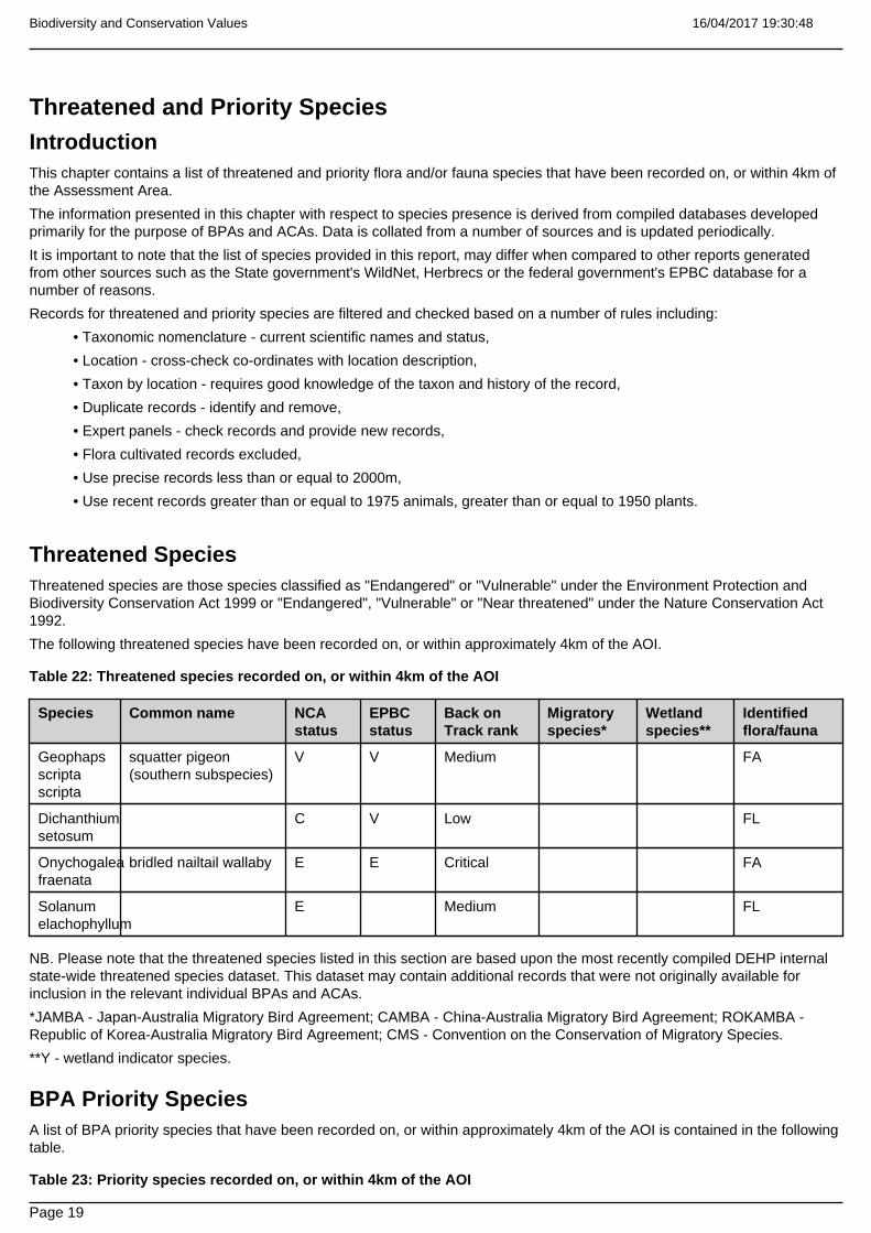
16/04/2017 19:30:48Biodiversity and Conservation Values
Page 19
Threatened and Priority SpeciesIntroductionThis chapter contains a list of threatened and priority flora and/or fauna species that have been recorded on, or within 4km ofthe Assessment Area.
The information presented in this chapter with respect to species presence is derived from compiled databases developedprimarily for the purpose of BPAs and ACAs. Data is collated from a number of sources and is updated periodically.
It is important to note that the list of species provided in this report, may differ when compared to other reports generatedfrom other sources such as the State government's WildNet, Herbrecs or the federal government's EPBC database for anumber of reasons.
Records for threatened and priority species are filtered and checked based on a number of rules including:
• Taxonomic nomenclature - current scientific names and status,
• Location - cross-check co-ordinates with location description,
• Taxon by location - requires good knowledge of the taxon and history of the record,
• Duplicate records - identify and remove,
• Expert panels - check records and provide new records,
• Flora cultivated records excluded,
• Use precise records less than or equal to 2000m,
• Use recent records greater than or equal to 1975 animals, greater than or equal to 1950 plants.
Threatened SpeciesThreatened species are those species classified as "Endangered" or "Vulnerable" under the Environment Protection andBiodiversity Conservation Act 1999 or "Endangered", "Vulnerable" or "Near threatened" under the Nature Conservation Act1992.
The following threatened species have been recorded on, or within approximately 4km of the AOI.
Table 22: Threatened species recorded on, or within 4km of the AOI
Species Common name NCAstatus
EPBCstatus
Back onTrack rank
Migratoryspecies*
Wetlandspecies**
Identifiedflora/fauna
Geophapsscriptascripta
squatter pigeon(southern subspecies)
V V Medium FA
Dichanthiumsetosum
C V Low FL
Onychogaleafraenata
bridled nailtail wallaby E E Critical FA
Solanumelachophyllum
E Medium FL
NB. Please note that the threatened species listed in this section are based upon the most recently compiled DEHP internalstate-wide threatened species dataset. This dataset may contain additional records that were not originally available forinclusion in the relevant individual BPAs and ACAs.
*JAMBA - Japan-Australia Migratory Bird Agreement; CAMBA - China-Australia Migratory Bird Agreement; ROKAMBA -Republic of Korea-Australia Migratory Bird Agreement; CMS - Convention on the Conservation of Migratory Species.
**Y - wetland indicator species.
BPA Priority SpeciesA list of BPA priority species that have been recorded on, or within approximately 4km of the AOI is contained in the followingtable.
Table 23: Priority species recorded on, or within 4km of the AOI

16/04/2017 19:30:48Biodiversity and Conservation Values
Page 20
(no results)
NB. Please note that the list of priority species is based on those species identified in the BPAs, however records for thesespecies may be more recent than the originals used. furthermore, the BPA priority species databases are updated from timeto time. At each update, the taxonomic details for all species are amended as necessary to reflect current taxonomic nameand/or status changes.
ACA Priority SpeciesA list of ACA priority species used in riverine and non-riverine ACAs that have been recorded on, or within approximately 4kmof the AOI are contained in the following tables.
Table 24: Priority species recorded on, or within 4 km of the AOI - riverine
Species Common name Back on Track rank Identified flora/fauna
Eucalyptus tereticornis FL
Lomandra longifolia FL
Eucalyptuscamaldulensis
FL
Table 25: Priority species recorded on, or within 4 km of the AOI - non-riverine
Species Common name Back on Track rank Identified flora/fauna
Eucalyptustereticornis
FL
NB. Please note that the priority species records used in the above two tables are comprised of those adopted for thereleased individual ACAs. The ACA riverine and non-riverine priority species databases are updated from time to time toreflect new release of ACAs. At each update, the taxonomic details for all ACAs records are amended as necessary to reflectcurrent taxonomic name and/or status changes.

16/04/2017 19:30:48Biodiversity and Conservation Values
Page 21
MapsMap 1 - Locality Map

16/04/2017 19:30:48Biodiversity and Conservation Values
Page 22
Map 2 - Biodiversity Planning Assessment (BPA)

16/04/2017 19:30:48Biodiversity and Conservation Values
Page 23
Map 3 - Corridors

16/04/2017 19:30:48Biodiversity and Conservation Values
Page 24
Map 4 - Wetlands and waterways

16/04/2017 19:30:48Biodiversity and Conservation Values
Page 25
Map 5 - Aquatic Conservation Assessment (ACA) - riverine

16/04/2017 19:30:48Biodiversity and Conservation Values
Page 26
Map 6 - Aquatic Conservation Assessment (ACA) - non-riverine

16/04/2017 19:30:48Biodiversity and Conservation Values
Page 27
ReferencesClayton, P.D., Fielder, D.F., Howell, S. and Hill, C.J. (2006) Aquatic biodiversity assessment and mapping method(AquaBAMM): a conservation values assessment tool for wetlands with trial application in the Burnett River catchment.Published by the Environmental Protection Agency, Brisbane. ISBN 1-90928-07-3. Available at
http://wetlandinfo.ehp.qld.gov.au/wetlands/assessment/assessment-methods/aca/
Environmental Protection Agency (2002) Biodiversity Assessment and Mapping Methodology. Version 2.1, July 2002.(Environmental Protection Agency, Brisbane).
Morton, S. R., Short, J. and Barker, R. D. with an Appendix by G.F. Griffin and G. Pearce (1995). Refugia for BiologicalDiversity in Arid and Semi-arid Australia. Biodiversity Series, Paper No. 4, Biodiversity Unit, Environment Australia.
Sattler, P.S. and Williams, R.D. (eds) (1999). The Conservation Status of Queensland's Bioregional Ecosystems.Environmental Protection Agency, Brisbane.

16/04/2017 19:30:48Biodiversity and Conservation Values
Page 28
AppendicesAppendix 1: Source Data
Theme Datasets
Aquatic Conservation Assessments Non-riverine* Combination of the following datasets:Cape York Peninsula Non-riverine v1.1Great Barrier Reef Catchment Non-riverine v1.3QMDB Non-riverine ACA version 1.4WBB Non-riverine ACA version 1.1
Aquatic Conservation Assessments Riverine* Combination of the following datasets:Cape York Peninsula Riverine v1.1Great Barrier Reef Catchment Riverine v1.1QMDB Riverine ACA version 1.4WBB Riverine ACA version 1.1
Biodiversity Planning Assessments* Combination of the following datasets:Brigalow Belt BPA v1.3Cape York Peninsula BPA v1.1Central Queensland Coast BPA v1.3Channel Country BPA v1.1Desert Uplands BPA v1.3Einasleigh Uplands BPA v1.1Mitchell Grass Downs BPA v1.1Mulga Lands BPA v1.4New England Tableland v2.3Southeast Queensland v3.5
Statewide BPA Corridors* Statewide corridors v1.1
Threatened Species An internal DEHP database compiled from Wildnet,Herbrecs, Corveg, the QLD Museum, as well as otherincidental sources.
BPA Priority Species An internal DEHP database compiled from Wildnet,Herbrecs, Corveg, the QLD Museum, as well as otherincidental sources.
ACA Priority Species An internal DEHP database compiled from Wildnet,Herbrecs, Corveg, the QLD Museum, as well as otherincidental sources.
*These datasets are available at:
http://dds.information.qld.gov.au/DDS

16/04/2017 19:30:48Biodiversity and Conservation Values
Page 29
Appendix 2 - Acronyms and Abbreviations
AOI - Area of Interest
ACA - Aquatic Conservation Assessment
AQUABAMM - Aquatic Biodiversity Assessment and Mapping Methodology
BAMM - Biodiversity Assessment and Mapping Methodology
BoT - Back on Track
BPA - Biodiversity Planning Assessment
CAMBA - China-Australia Migratory Bird Agreement
EHP - Department of Environment and Heritage Protection
EPBC - Environment Protection and Biodiversity Conservation Act1999
EVNT - Endangered, Vulnerable, Near Threatened
GDA94 - Geocentric Datum of Australia 1994
GIS - Geographic Information System
JAMBA - Japan-Australia Migratory Bird Agreement
NCA - Nature Conservation Act 1992
RE - Regional Ecosystem
REDD - Regional Ecosystem Description Database
ROKAMBA - Republic of Korea-Australia Migratory Bird Agreement

Department of Environment and Heritage Protection
Environmental Reports
Matters of State Environmental Significance
Area of Interest: epc: 881

16/04/2017 19:29:22Matters of State Environmental Significance
Page 2
Environmental Reports - General Information
The Environmental Reports portal provides for the assessment of selected matters of interest relevant to a user specifiedlocation, or area of interest (AOI). All area and derivative figures are relevant to the extent of matters of interest containedwithin the AOI unless otherwise stated. Please note, if a user selects an AOI via the "Central co-ordinates" option, theresulting assessment area encompasses an area extending for a 2km radius from the point of interest.
All area and area derived figures included in this report have been calculated via reprojecting relevant spatial features toAlbers equal-area conic projection (central meridian = 146, datum Geocentric Datum of Australia 1994). As a result, areafigures may differ slightly if calculated for the same features using a different co-ordinate system.
Figures in tables may be affected by rounding.
The matters of interest reported on in this document are based upon available state mapped datasets. Where the reportindicates that a matter of interest is not present within the AOI (e.g. where area related calculations are equal to zero, or novalues are listed), this may be due either to the fact that state mapping has not been undertaken for the AOI, that statemapping is incomplete for the AOI, or that no values have been identified within the site.
The information presented in this report should be considered as a guide only and field survey may be required to validatevalues on the ground.
Please direct queries about these reports to: [email protected]
Disclaimer
Whilst every care is taken to ensure the accuracy of the information provided in this report, the Queensland Governmentmakes no representations or warranties about its accuracy, reliability, completeness, or suitability, for any particular purposeand disclaims all responsibility and all liability (including without limitation, liability in negligence) for all expenses, losses,damages (including indirect or consequential damage) and costs which the user may incur as a consequence of theinformation being inaccurate or incomplete in any way and for any reason.

16/04/2017 19:29:22Matters of State Environmental Significance
Page 3
Table of Contents . . . . . . . . . . . . . . . . . . . . . . . . . . . . . . . . . . . . . . . . . . . . . . . . . . 4Assessment Area Details
. . . . . . . . . . . . . . . . . . . . . . . . . . . . . . . . . . . 5Matters of State Environmental Significance (MSES)
. . . . . . . . . . . . . . . . . . . . . . . . . . . . . . . . . . . . . . . . . . . . . . . 5MSES Categories
. . . . . . . . . . . . . . . . . . . . . . . . . . . . . . . . . . . . . . . . . . . . 6MSES Values Present
. . . . . . . . . . . . . . . . . . . . . . . . 6Additional Information with Respect to MSES Values Present
. . . . . . . . . . . . . . . . . . . . . . . . . . . . . . . . . . . . . . . . . . . . . . . . . . . . . . . . . . . . 9Maps
. . . . . . . . . . . . . . . . . . . . . . . . . . . . . . . . . . . . . . . . . . . . . . . 9Map 1 - Location
. . . . . . . . . . . . . . . . . . . . . . . . . . . . 10Map 2 - MSES Criteria 1 - State Conservation Areas
. . . . . . . . . . . . . . . . . . . . . . . . . . . . 11Map 3 - MSES Criteria 2 - Wetlands and Waterways
. . . . . . . . . . . . . . . . . . . . . . . . . . . . . . . . . . . . . 12Map 4 - MSES Criteria 3 - Species
. . . . . . . . . . . . . . . . . . . . . . . . . . . . . . 13Map 5 - MSES Criteria 4 - Regulated Vegetation
. . . . . . . . . . . . . . . . . . . . . . . . . . . . . . . . . . . 14Map 6 - MSES Criteria 5 - Offset Areas
. . . . . . . . . . . . . . . . . . . . . . . . . . . . 15Map 7 - Matters of State Environmental Significance
. . . . . . . . . . . . . . . . . . . . . . . . . . . . . . . . . . . . . . . . . . . . . . . . . . . . . . . . 16Appendices
. . . . . . . . . . . . . . . . . 16Appendix 1 - Matters of State Environmental Significance (MSES) Criteria
. . . . . . . . . . . . . . . . . . . . . . . . . . . . . . . . . . . . . . . . . . 17Appendix 2 - Source Data
. . . . . . . . . . . . . . . . . . . . . . . . . . . . . . . . . 18Appendix 3 - Acronyms and Abbreviations

16/04/2017 19:29:22Matters of State Environmental Significance
Page 4
Assessment Area DetailsThe following table provides an overview of the area of interest (AOI) with respect to selected topographic and environmentalvalues.
Table 1: Summary table, AOI details
Area of Interest EPC881
Size (ha) 7219.6
LocalGovernment(s)
CENTRAL HIGHLANDS REGIONAL
Bioregion(s) Brigalow Belt
Subregion(s) Woorabinda
Catchment(s) Fitzroy
Refer to Map 1 for locality information.
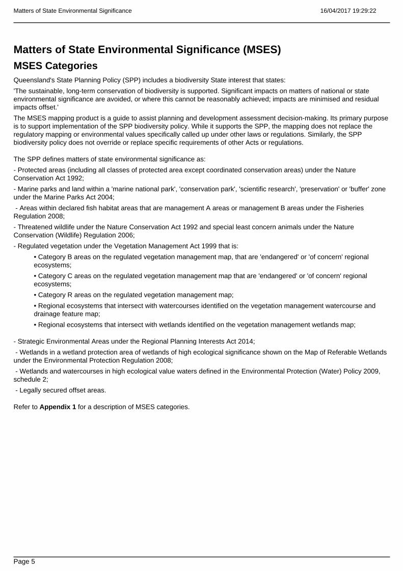
16/04/2017 19:29:22Matters of State Environmental Significance
Page 5
Matters of State Environmental Significance (MSES)MSES CategoriesQueensland's State Planning Policy (SPP) includes a biodiversity State interest that states:
'The sustainable, long-term conservation of biodiversity is supported. Significant impacts on matters of national or stateenvironmental significance are avoided, or where this cannot be reasonably achieved; impacts are minimised and residualimpacts offset.'
The MSES mapping product is a guide to assist planning and development assessment decision-making. Its primary purposeis to support implementation of the SPP biodiversity policy. While it supports the SPP, the mapping does not replace theregulatory mapping or environmental values specifically called up under other laws or regulations. Similarly, the SPPbiodiversity policy does not override or replace specific requirements of other Acts or regulations.
The SPP defines matters of state environmental significance as:
- Protected areas (including all classes of protected area except coordinated conservation areas) under the NatureConservation Act 1992;
- Marine parks and land within a 'marine national park', 'conservation park', 'scientific research', 'preservation' or 'buffer' zoneunder the Marine Parks Act 2004;
- Areas within declared fish habitat areas that are management A areas or management B areas under the FisheriesRegulation 2008;
- Threatened wildlife under the Nature Conservation Act 1992 and special least concern animals under the NatureConservation (Wildlife) Regulation 2006;
- Regulated vegetation under the Vegetation Management Act 1999 that is:
• Category B areas on the regulated vegetation management map, that are 'endangered' or 'of concern' regionalecosystems;
• Category C areas on the regulated vegetation management map that are 'endangered' or 'of concern' regionalecosystems;
• Category R areas on the regulated vegetation management map;
• Regional ecosystems that intersect with watercourses identified on the vegetation management watercourse anddrainage feature map;
• Regional ecosystems that intersect with wetlands identified on the vegetation management wetlands map;
- Strategic Environmental Areas under the Regional Planning Interests Act 2014;
- Wetlands in a wetland protection area of wetlands of high ecological significance shown on the Map of Referable Wetlandsunder the Environmental Protection Regulation 2008;
- Wetlands and watercourses in high ecological value waters defined in the Environmental Protection (Water) Policy 2009,schedule 2;
- Legally secured offset areas.
Refer to Appendix 1 for a description of MSES categories.

16/04/2017 19:29:22Matters of State Environmental Significance
Page 6
MSES Values PresentThe MSES values that are present in the area of interest are summarised in the table below:
Table 2: Summary of MSES present within the AOI
MSES Criteria 1 - STATE CONSERVATION AREAS 3.7 ha 0.1%
1.1 Protected Areas 3.7 ha 0.1%
1.2 Marine Parks 0.0 ha 0.0%
1.3 Fish Habitat Areas 0.0 ha 0.0%
MSES Criteria 2 - WETLANDS AND WATERWAYS - areafeatures
0.0 ha 0.0%
MSES Criteria 2 - WETLANDS AND WATERWAYS - linearfeatures
0.0 km Not applicable
2.1 High Ecological Significance wetlands on the map ofReferable Wetlands
0.0 ha 0.0%
2.2 High Ecological Value (HEV) wetlands 0.0 ha 0.0%
2.2 High Ecological Value (HEV) waterways ** 0.0 km Not applicable
2.3 Strategic Environmental Areas (SEA) 0.0 ha 0.0%
MSES Criteria 3 - SPECIES 0.0 ha 0.0%
3.1 Threatened species and Iconic species 0.0 ha 0.0%
MSES Criteria 4 - REGULATED VEGETATION - areafeatures
252.2 ha 3.5%
MSES Criteria 4 - REGULATED VEGETATION - linearfeatures
81.4 km Not applicable
4.1 Vegetation Management Regional Ecosystems andRemnant Map *
252.2 ha 3.5%
4.2 Vegetation Management Wetland Map * 0.0 ha 0.0%
4.3 Vegetation Management Watercourse Map ** 81.4 km Not applicable
MSES Criteria 5 - OFFSET AREAS 0.0 ha 0.0%
5.1 Legally secured offset areas 0.0 ha 0.0%
Total MSES (criteria 1.1, 1.2, 1.3, 2.1, part of 2.2, 2.3, 3.1,4.1, 4.2 and 5.1) calculated for area features only
255.9 ha 3.5%
Please note that the area and percent area figures in the table above will not necessarily add up to the "Total MSES" figuresdue to overlapping values.
*The total extent area of regulated vegetation (Criteria 4.1) may be overestimated due to the presence of dominant and/orsubdominant non-regulated regional ecosystems in mixed patches of vegetation, i.e. the total area of mixed vegetatedpatches is included irrespective of whether the patch consists only partly of endangered, of concern or wetland regionalecosystems.
**The total linear extent of watercourses may be overestimated in some instances, as both banks (rather than the centreline)of waterbodies and larger watercourses where present are mapped by the State, increasing the extent of linear features.
Additional Information with Respect to MSES Values PresentCriteria 1 - State Conservation Areas
1.1 Protected Areas
Protected Area Names
Taunton National Park

16/04/2017 19:29:22Matters of State Environmental Significance
Page 7
1.2 Marine Parks
(no results)
1.3 Fish Habitat Areas
(no results)
Refer to Map 2 - MSES Criteria 1 - State Conservation Areas for an overview of the relevant MSES.
Criteria 2 - Wetlands and Waterways
2.1 High Ecological Significance wetlands on the Map of Referable Wetlands
(no results)
2.2 High Ecological Value (HEV) wetlands
(no results)
2.2 High Ecological Value (HEV) waterways
(no results)
2.3 Strategic Environmental Areas
(no results)
Refer to Map 3 - MSES Criteria 2 - Wetlands and Waterways for an overview of the relevant MSES.
Criteria 3 - Species
3.1 Threatened species and Iconic species
Threatened and/or iconic species habitat within the AOI (derived from records/essential habitat mapping)
(no results)
*NCA E or V - Endangered or Vulnerable status under the NCA; VMA ehab - VMA essential habitat; Iconic - Iconic species.
To request a species list for an area, or search for a species profile, access Wildlife Online at:
https://www.qld.gov.au/environment/plants-animals/species-list/
Koala bushland habitat
(no results)
Dugong areas
(no results)
Refer to Map 4 - MSES Criteria 3 - Species for an overview of the relevant MSES.
Criteria 4 - Regulated Vegetation

16/04/2017 19:29:22Matters of State Environmental Significance
Page 8
4.1 Endangered and Of Concern regional ecosystems and Category R Regulated Vegetation
Regulated Vegetation Description Regional Ecosystem Patch VMA status
rem_oc 11.3.2/11.3.25 O-dom
hvr_end 11.3.1/11.3.2/11.3.25 E-dom
rem_end 11.3.2/11.3.25/11.3.1 E-subdom
rem_oc 11.3.2 O-dom
rem_end 11.3.25/11.3.1 E-subdom
For further information relating to regional ecosystems in general, go to:
https://www.qld.gov.au/environment/plants-animals/plants/ecosystems/
For a more detailed description of a particular regional ecosystem, access the regional ecosystem search page at:
https://environment.ehp.qld.gov.au/regional-ecosystems/
4.2 Vegetation Management Wetlands
(no results)
Wetlands datasource
Not applicable
4.3 Watercourses shown on the Vegetation Management Watercourse and Drainage Feature Map
A vegetation management watercourse is mapped as present
Watercourses datasource
Vegetation Management Watercourse Map
Refer to Map 5 - MSES Criteria 4 - Regulated Vegetation for an overview of the relevant MSES.
Criteria 5 - Offset Areas
5.1 Legally secured offset areas
(no results)
Refer to Map 6 - MSES Criteria 5 - Offset Areas for an overview of the relevant MSES.

16/04/2017 19:29:22Matters of State Environmental Significance
Page 9
MapsMap 1 - Location

16/04/2017 19:29:22Matters of State Environmental Significance
Page 10
Map 2 - MSES Criteria 1 - State Conservation Areas
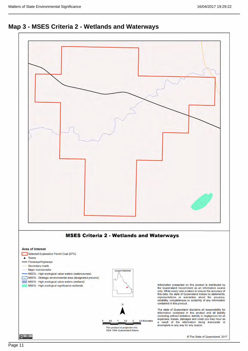
16/04/2017 19:29:22Matters of State Environmental Significance
Page 11
Map 3 - MSES Criteria 2 - Wetlands and Waterways

16/04/2017 19:29:22Matters of State Environmental Significance
Page 12
Map 4 - MSES Criteria 3 - Species

16/04/2017 19:29:22Matters of State Environmental Significance
Page 13
Map 5 - MSES Criteria 4 - Regulated Vegetation

16/04/2017 19:29:22Matters of State Environmental Significance
Page 14
Map 6 - MSES Criteria 5 - Offset Areas

16/04/2017 19:29:22Matters of State Environmental Significance
Page 15
Map 7 - Matters of State Environmental Significance

16/04/2017 19:29:22Matters of State Environmental Significance
Page 16
AppendicesAppendix 1 - Matters of State Environmental Significance (MSES) Criteria
Feature Name Description
1.1 Protected Areas (NCA) Protected areas under the Nature Conservation Act 1992,except coordinated conservation areas.
1.2 Marine Parks (MPA) The following State marine parks zones under the MarineParks Act 2004:- Marine National Park zone;- Marine Conservation Park zone;- Scientific Research zone;- Preservation zone;- Buffer zone.
1.3 Fish Habitat Areas (FA) The following areas under the Fisheries Act 1994 including:All fish habitat areas.
2.1 'High Ecological Significance' wetlands on the Map ofReferable Wetlands
All natural wetlands that are 'High Ecological Significance'(HES) on the Map of Referable Wetlands.Exclude:any amendments to the Map of Referable Wetlands.
2.2 High Ecological Value (HEV) wetlands and waterways(EP Act)
Natural wetlands and waterways that occur in HEV(maintain) freshwater and estuarine areas under theEnvironmental Protection (Water) Policy.
2.3 Strategic Environmental Areas (RPI Act) Designated precinct areas under the Regional PlanningInterests Act 2014.
3.1 Threatened species and Iconic species (NCA) Habitat for:Threatened wildlife under Nature Conservation Act 1992including: 'Endangered' and 'Vulnerable' species.Special least concern animals under the NatureConservation Act 1992 including: Koala (outside SEQ);Echidna and Platypus.
4.1 Vegetation Management Regional Ecosystem andRemnant Map (VMA)
Include VMA 'Endangered' and 'Of Concern' remnant(Category A and B) and high value regrowth (Category C)REs and Category R (GBR regrowth watercourse) areasfrom the Regulated Vegetation Management Map.
4.2 Vegetation Management Wetland Map (VMA) Wetlands that are lakes and swamps shown on theVegetation Management Wetlands Map.
4.3 Vegetation Management Watercourse and DrainageFeature Map (VMA)
Watercourses shown on the Vegetation ManagementWatercourse and Drainage Feature Map.
5.1 Legally secured offset areas (VMA, EP Act, SPA, TIA,EA)
Offset areas legally secured under a covenant,conservation agreement or development approvalcondition.
The Queensland Government's "Method for mapping - matters of state environmental significance for use in land useplanning and development assessment" can be downloaded from:
http://www.ehp.qld.gov.au/land/natural-resource/method-mapping-mses.html.

16/04/2017 19:29:22Matters of State Environmental Significance
Page 17
Appendix 2 - Source DataThe datasets listed below are available on request from:
http://qldspatial.information.qld.gov.au/catalogue/custom/index.page
• Matters of State environmental significance
• Matters of State environmental significance drainage lines
• Boundaries of the Great Barrier Reef Marine Park
Note: MSES mapping is a regional-scale representation of the definition for MSES under the State Planning Policy (SPP).The compiled MSES mapping product is a guide to assist planning and development assessment decision-making. Itsprimary purpose is to support implementation of the SPP biodiversity policy. While it supports the SPP, the mapping does notreplace the regulatory mapping or environmental values specifically called up under other laws or regulations. Similarly, theSPP biodiversity policy does not override or replace specific requirements of other Acts or regulations.
MSES mapping is not based on new or unique data. The primary mapping product draws data from a number of underlyingenvironment databases and geo-referenced information sources. MSES mapping is a versioned product that is updatedgenerally on a twice-yearly basis to incorporate the changes to underlying data sources. Several components of MSESmapping made for the current version may differ from the current underlying data sources. To ensure accuracy, or properrepresentation of MSES values, it is strongly recommended that users refer to the underlying data sources and review thecurrent definition of MSES in the State Planning Policy, before applying the MSES mapping.
Underlying data sources used to develop individual releases of complied MSES mapping include, but are not limited to:
- Regulated vegetation including:
• Regulated Regional Ecosystems and Regrowth
• Regulated Essential habitat
• Regulated Wetlands
• Regulated Watercourses and Drainage
• Former Regrowth
- Queensland Wetland Mapping (v3)
- Essential Habitat Mapping
- Protected Areas
- Marine Parks
- Fish Habitat Areas
- Strategic Environmental Areas
- The Map of Referable Wetlands:
• Wetland Protection Areas (HES wetlands in the GBR)
• Wetland Management Areas (contains other HES wetlands)
Datasets reflective of the above matters can be downloaded via the Queensland Spatial Catalogue:
http://qldspatial.information.qld.gov.au/catalogue/custom/index.page

16/04/2017 19:29:22Matters of State Environmental Significance
Page 18
Appendix 3 - Acronyms and Abbreviations
AOI - Area of Interest
EHP - Department of Environment and Heritage Protection
EP Act - Environmental Protection Act 1994
EPP - Environmental Protection Policy
GDA94 - Geocentric Datum of Australia 1994
GEM - General Environmental Matters
GIS - Geographic Information System
MSES - Matters of State Environmental Significance
NCA - Nature Conservation Act 1992
RE - Regional Ecosystem
SPP - State Planning Policy
VMA - Vegetation Management Act 1999
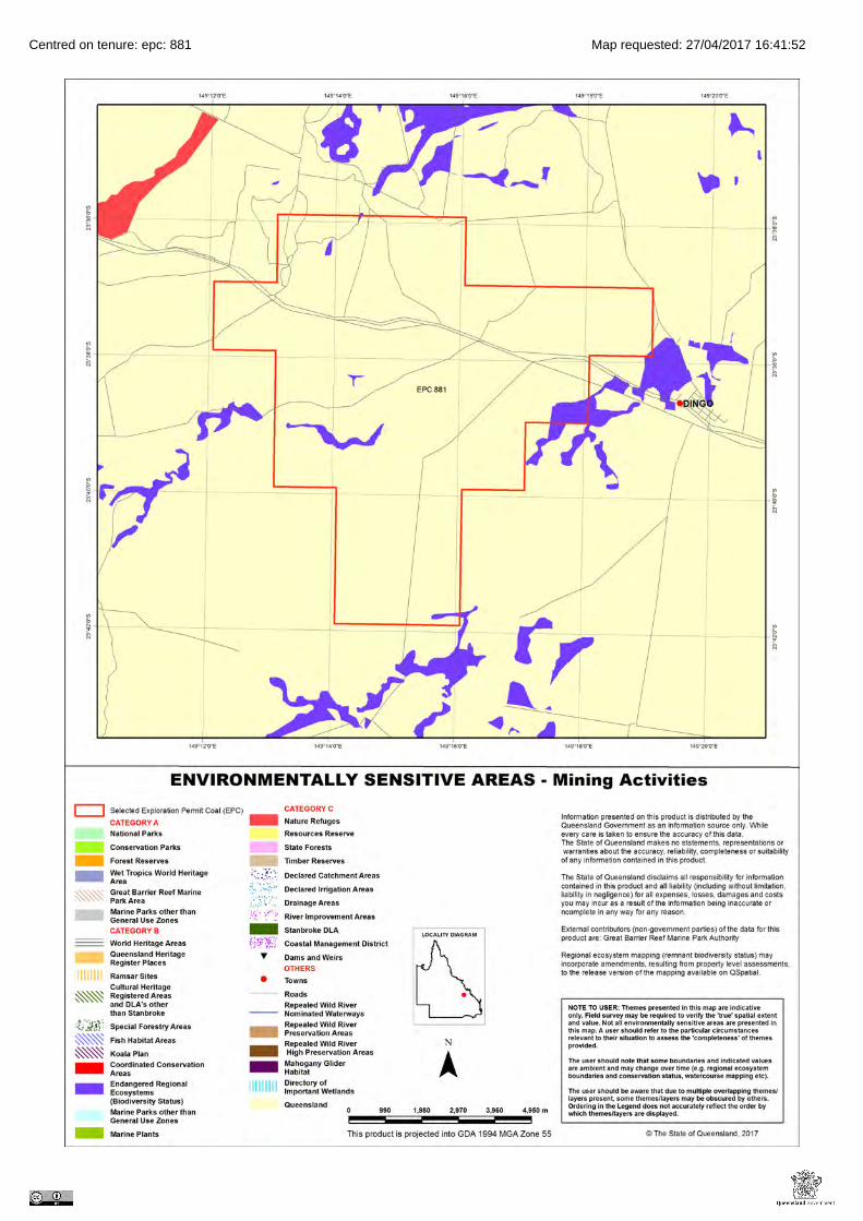
Centred on tenure: epc: 881 Map requested: 27/04/2017 16:41:52

Department of Environment and Heritage Protection
Environmental Reports
Regional Ecosystems
Biodiversity Status
Area of Interest: epc: 881

17/04/2017 10:26:08Regional Ecosystems
Page 2
Environmental Reports - General Information
The Environmental Reports portal provides for the assessment of selected matters of interest relevant to a user specifiedlocation, or area of interest (AOI). All area and derivative figures are relevant to the extent of matters of interest containedwithin the AOI unless otherwise stated. Please note, if a user selects an AOI via the "Central co-ordinates" option, theresulting assessment area encompasses an area extending for a 2km radius from the input coordinates.
All area and area derived figures included in this report have been calculated via reprojecting relevant spatial features toAlbers equal-area conic projection (central meridian = 146, datum Geocentric Datum of Australia 1994). As a result, areafigures may differ slightly if calculated for the same features using a different co-ordinate system.
Figures in tables may be affected by rounding.
The matters of interest reported on in this document are based upon available state mapped datasets. Where the reportindicates that a matter of interest is not present within the AOI (e.g. where area related calculations are equal to zero, or novalues are listed), this may be due either to the fact that state mapping has not been undertaken for the AOI, that statemapping is incomplete for the AOI, or that no matters of interest have been identified within the site.
The information presented in this report should be considered as a guide only and field survey may be required to validatevalues on the ground.
Important Note to User
Information presented in this report is based upon the Queensland Herbarium's Regional Ecosystem framework. TheBiodiversity Status has been used to depict the extent of "Endangered", "Of Concern" and "No Concern at Present" regionalecosystems in all cases, rather than the status used for the purposes of the Vegetation Management Act 1999 (VMA).Mapping and figures presented in this document reflect the Queensland Herbarium's Remnant and Pre-clearing RegionalEcosystem Datasets, and not the certified mapping used for the purpose of the VMA.
For matters relevant to vegetation management under the VMA, please refer to the Department of Natural Resources andMines website
https://www.dnrm.qld.gov.au/
Please direct queries about these reports to: [email protected]
Disclaimer
Whilst every care is taken to ensure the accuracy of the information provided in this report, the Queensland Governmentmakes no representations or warranties about its accuracy, reliability, completeness, or suitability, for any particular purposeand disclaims all responsibility and all liability (including without limitation, liability in negligence) for all expenses, losses,damages (including indirect or consequential damage) and costs which the user may incur as a consequence of theinformation being inaccurate or incomplete in any way and for any reason.

17/04/2017 10:26:08Regional Ecosystems
Page 3
Table of Contents . . . . . . . . . . . . . . . . . . . . . . . . . . . . . . . . . . . . . . . . . . . . . . . . . . . . 4Summary Information
. . . . . . . . . . . . . . . . . . . . . . . . . . . . . . . . . . . . . . . . . . . . . . . . . . . 5Regional Ecosystems
. . . . . . . . . . . . . . . . . . . . . . . . . . . . . . . . . . . . . . . . . . . . . . . . . 51. Introduction
. . . . . . . . . . . . . . . . . . . . . . . . . . . . . . . . . . . . . . 62. Remnant Regional Ecosystems
. . . . . . . . . . . . . . . . . . . . . . . 73. Remnant Regional Ecosystems by Broad Vegetation Group
. . . . . . . . . . . . . . . . . . . . . . . . . . . 84. Technical and BioCondition Benchmark Descriptions
. . . . . . . . . . . . . . . . . . . . . . . . . . . . . . . . . . . . . . . . . . . . . . . . . . . . . . . . . . . 10Maps
. . . . . . . . . . . . . . . . . . . . . . . . . . . . . . . . . . . . . . . . . . . . . . . 10Map 1 - Location
. . . . . . . . . . . . . . . . . . . . . . . . . . . . . . . . . . . 11Map 2 - Remnant regional ecosystems
. . . . . . . . . . . . . . . . . . . . . . . . . . . . . 12Map 3 - Pre-clearing remnant regional ecosystems
. . . . . . . . . . . . . . . . . . . . . . . . . . . . 13Map 4 - Remnant regional ecosystems by BVG (5M)
. . . . . . . . . . . . . . . . . . . . . 14Map 5 - Pre-clearing remnant regional ecosystems by BVG (5M)
. . . . . . . . . . . . . . . . . . . . . . . . . . . . . . . . . . . . . . 15Map 6 - Wetlands and waterways
. . . . . . . . . . . . . . . . . . . . . . . . . . . . . . . . . . . . . . . . . . . 16Links and Other Information Sources
. . . . . . . . . . . . . . . . . . . . . . . . . . . . . . . . . . . . . . . . . . . . . . . . . . . . . . . . 16References
. . . . . . . . . . . . . . . . . . . . . . . . . . . . . . . . . . . . . . . . . . . . . . . . . . . . . . . . 17Appendices
. . . . . . . . . . . . . . . . . . . . . . . . . . . . . . . . . . . . . . . . . . 17Appendix 1: Source Data
. . . . . . . . . . . . . . . . . . . . . . . . . . . . . . . . . 18Appendix 2 - Acronyms and Abbreviations

17/04/2017 10:26:08Regional Ecosystems
Page 4
Summary InformationThe following table provides an overview of the AOI with respect to selected topographic and environmental themes. Refer toMap 1 for locality information.
Table 1: Area of interest details
Area of Interest EPC881
Size (ha) 7219.6
LocalGovernment(s)
CENTRAL HIGHLANDS REGIONAL
Bioregion(s) Brigalow Belt
Subregion(s) Woorabinda
Catchment(s) Fitzroy
The table below summarizes the extent of remnant vegetation classed as "Endangered", "Of concern" and "No concern atpresent" classified by Biodiversity Status within the area of interest (AOI).
Table 2: Summary table, biodiversity status of regional ecosystems within the AOI
Biodiversity Status Area (Ha) % of AOI
Endangered 6.4 0.1
Of concern 237.5 3.3
No concern at present 1842.1 25.5
Total remnant vegetation 2086.0 28.9
Refer to Map 2 for further information.

17/04/2017 10:26:08Regional Ecosystems
Page 5
Regional Ecosystems1. IntroductionRegional ecosystems are vegetation communities in a bioregion that are consistently associated with a particular combinationof geology, landform and soil. Descriptions of Queensland's Regional ecosystems are available online from the RegionalEcosystem Description Database (REDD). Descriptions are compiled from a broad range of information sources includingvegetation, land system and geology survey and mapping and detailed vegetation site data. The regional ecosystem isregularly reviewed as new information becomes available. A number of vegetation communities may form a single regionalecosystem and are usually distinguished by differences in dominant species, frequently in the shrub or ground layers and aredenoted by a letter following the regional ecosystem code (e.g. a, b, c).
The Queensland Herbarium has developed a methodology for mapping regional ecosystems across Queensland. As newinformation is obtained, the descriptions and status of regional ecosystems is updated. Regional ecosystems and broadvegetation groups descriptions in the format of Sattler and Williams (1999) are maintained in the Regional EcosystemDescription Database (REDD). Vegetation communities and regional ecosystems are amalgamated into the higher levelclassification of broad vegetation groups (BVGs).
This report provides information on the type, status, and extent of vegetation communities, regional ecosystems and broadvegetation groups present within a user specified area of interest. Please note, for the purpose of this report, the BiodiversityStatus is used. This report has not been developed for application of matters relevant to the Vegetation Management Act1999 (VMA). Additionally, information generated in this report has been derived from the Queensland Herbarium's RegionalEcosystem Mapping, and not mapping certified for the purposes of the VMA. If your interest/matter relates to regionalecosystems and the VMA, users should refer to the Department of Natural Resources and Mines website.
https://www.dnrm.qld.gov.au/
With respect to the Queensland Biodiversity Status,
"Endangered" regional ecosystems are described as those where:
• remnant vegetation is less than 10 per cent of its pre-clearing extent across the bioregion; or 10-30% of itspre-clearing extent remains and the remnant vegetation is less than 10,000 hectares, or
• less than 10 per cent of its pre-clearing extent remains unaffected by severe degradation and/or biodiversity loss*, or
• 10-30 per cent of its pre-clearing extent remains unaffected by severe degradation and/or biodiversity loss and theremnant vegetation is less than 10,000 hectares; or
• it is a rare** regional ecosystem subject to a threatening process.***
"Of concern" regional ecosystems are described as those where:
• the degradation criteria listed above for 'Endangered' regional ecosystems are not met and,
• remnant vegetation is 10-30 per cent of its pre-clearing extent across the bioregion; or more than 20 per cent of itspre-clearing extent remains and the remnant extent is less than 10,000 hectares, or
• 10-30 percent of its pre-clearing extent remains unaffected by moderate degradation and/or biodiversity loss.****
and "No concern at present" regional ecosystems are described as those where:
• remnant vegetation is over 30 per cent of its pre-clearing extent across the bioregion, and the remnant area is greaterthan 10,000 hectares, and
• the degradation criteria listed above for 'Endangered' or 'Of concern' regional ecosystems are not met.
*Severe degradation and/or biodiversity loss is defined as: floristic and/or faunal diversity is greatly reduced but unlikely torecover within the next 50 years even with the removal of threatening processes; or soil surface is severely degraded, forexample, by loss of A horizon, surface expression of salinity; surface compaction, loss of organic matter or sheet erosion.
**Rare regional ecosystem: pre-clearing extent (1000 ha); or patch size (100 ha and of limited total extent across its range).
***Threatening processes are those that are reducing or will reduce the biodiversity and ecological integrity of a regionalecosystem. For example, clearing, weed invasion, fragmentation, inappropriate fire regime or grazing pressure, orinfrastructure development.

17/04/2017 10:26:08Regional Ecosystems
Page 6
****Moderate degradation and/or biodiversity loss is defined as: floristic and/or faunal diversity is greatly reduced but unlikelyto recover within the next 20 years even with the removal of threatening processes; or soil surface is moderately degraded.
2. Remnant Regional EcosystemsThe following table identifies the remnant regional ecosystems and vegetation communities mapped within the AOI, theassociated short description, Biodiversity Status using the Queensland Herbarium's framework and the extent area presentwithin the selected AOI. Please note, where heterogeneous vegetated patches (mixed patches of remnant vegetationmapped as containing multiple regional ecosystems) occur within the AOI, they have been split and listed as individualregional ecosystems (or vegetation communities where present) for the purposes of the table below. In such instances,associated area figures have been generated based upon the estimated proportion of each regional ecosystem (or vegetationcommunity) predicted to be present within the larger mixed patch.
Table 3: Remnant regional ecosystems, description and status within the AOI
RegionalEcosystem
Short Description BD Status Area (Ha) % of AOI
11.3.1 Acacia harpophylla and/or Casuarina cristataopen forest on alluvial plains
Endangered 6.4 0.1
11.3.2 Eucalyptus populnea woodland on alluvialplains
Of concern 125.3 1.7
11.3.25 Eucalyptus tereticornis or E. camaldulensiswoodland fringing drainage lines
Of concern 112.1 1.6
11.5.2 Eucalyptus crebra, Corymbia spp., with E.moluccana woodland on lower slopes ofCainozoic sand plains and/or remnantsurfaces
No concern atpresent
1004.5 13.9
11.5.9b Eucalyptus crebra and other Eucalyptus spp.and Corymbia spp. woodland on Cainozoicsand plains and/or remnant surfaces
No concern atpresent
142.9 2.0
11.7.2 Acacia spp. woodland on Cainozoic lateriticduricrust. Scarp retreat zone
No concern atpresent
694.7 9.6
non-rem None None 5133.6 71.1
Refer to Map 2 for further information. Map 3 also provides a visual estimate of the distribution of regional ecosystemspresent before European settlement.
Table 4 provides further information in regards to the remnant regional ecosystems present within the site with respect to theextent of remnant vegetation remaining within the bioregion, the 1:1,000,000 broad vegetation group (BVG) classification,whether the regional ecosystem is identified as a wetland, and extent of representation in Queensland's Protected AreaEstate. For a description of the vegetation communities within the AOI and classified according to the 1:1,000,000 BVG, referto Table 6.
Table 4: Remnant regional ecosystems within the AOI, additional information
RegionalEcosystem
Remnant Extent BVG (1Million)
Wetland Representation inprotected estate
11.3.1 In 2013, remnant extent was >10,000 ha and 10-30% of thepre-clearing area remained
25a None Low
11.3.2 In 2013, remnant extent was >10,000 ha and 10-30% of thepre-clearing area remained
17a Contains palustrine wetland(e.g. in swales).
Low

17/04/2017 10:26:08Regional Ecosystems
Page 7
RegionalEcosystem
Remnant Extent BVG (1Million)
Wetland Representation inprotected estate
11.3.25 In 2013, remnant extent was >10,000 ha and >30% of thepre-clearing area remained
16a Riverine wetland or fringingriverine wetland.
Low
11.5.2 In 2013, remnant extent was >10,000 ha and >30% of thepre-clearing area remained
18b None Low
11.5.9b In 2013, remnant extent was >10,000 ha and >30% of thepre-clearing area remained
18b None Low
11.7.2 In 2013, remnant extent was >10,000 ha and >30% of thepre-clearing area remained
24a None Low
non-rem None None None None
Representation in Protected Area Estate: High greater than 10% of pre-clearing extent is represented; Medium 4 - 10% isrepresented; Low less than 4% is represented, No representation.
Map 6 displays the distribution of mapped wetland systems within the area of interest.
The following table lists known special values associated with a regional ecosystem type.
Table 5: Remnant regional ecosystems within the AOI, special values
Regional Ecosystem Special Values
11.3.1 Habitat for threatened fauna species including painted honeyeater,Grantiella picta particularly in subregion 35 (Oliver et al. 2003).
11.3.2 Habitat for threatened flora species Homopholis belsonii.
11.3.25 Habitat for threatened flora species including Eucalyptus raveretiana.Shown to be associated with a high fauna species richness in theTaroom area (Venz et al. 2002). Within parts of the Fitzroycatchment, this RE is known habitat for the threatened freshwaterturtle Rheodytes leukops. Known to be important habitat for otherriparian freshwater turtle species.
11.5.2 None
11.5.9b None
11.7.2 Habitat for threatened flora species including Acacia wardellii.
non-rem None
3. Remnant Regional Ecosystems by Broad Vegetation GroupBVGs are a higher-level grouping of vegetation communities. Queensland encompasses a wide variety of landscapes acrosstemperate, wet and dry tropics and semi-arid climatic zones. BVGs provide an overview of vegetation communities across thestate or a bioregion and allow comparison with other states. There are three levels of BVGs which reflect the approximatescale at which they are designed to be used: the 1:5,000,000 (national), 1:2,000,000 (state) and 1:1,000,000 (regional).
A comprehensive description of BVGs is available at:
https://publications.qld.gov.au/dataset/vegetation-qld/resource/921fa786-e6d5-4a8a-9b0c-e532d2ce3f32
The following table provides a description of the 1:1,000,000 BVGs present and their associated extent within the AOI.
Table 6: Broad vegetation groups (1 million) within the AOI

17/04/2017 10:26:08Regional Ecosystems
Page 8
BVG (1 Million) Description Area (Ha) % of AOI
None None 5133.6 71.1
16a Open forest and woodlands dominated by Eucalyptuscamaldulensis (river red gum) (or E. tereticornis (bluegum)) and/or E. coolabah (coolabah) (or E. microtheca(coolabah)) fringing drainage lines. Associated speciesmay include Melaleuca spp., Corymbia tessellaris(carbeen), Angophora spp., Casuarina cunninghamiana(riveroak). Does not include alluvial areas dominated byherb and grasslands or alluvial plains that are not flooded.(land zone 3) (MGD, BRB, GUP, CHC, MUL, DEU, EIU,NWH, SEQ, [NET, WET]) (All bioregions except CYP andCQC)
112.1 1.6
17a Woodlands dominated by Eucalyptus populnea (poplarbox) (or E. brownii (Reid River box)) on alluvium, sandplains and footslopes of hills and ranges. (land zones 3,5, 10, 9, 4, 11, 12, [8]) (BRB, MUL, DEU, MUL, EIU)
125.3 1.7
18b Woodlands dominated Eucalyptus crebra (sens. lat.)(narrow-leaved red ironbark) frequently with Corymbiaspp. or Callitris spp. on flat to undulating plains. (landzones 5, 3) (BRB, DEU, EIU, GUP, CYP)
1147.4 15.9
24a Low woodlands to tall shrublands dominated by Acaciaspp. on residuals. Species include A. shirleyi(lancewood), A. catenulata (bendee), A. microsperma(bowyakka), A. clivicola, A. sibirica, A. rhodoxylon(rosewood) and A. leptostachya (Townsville wattle). (landzones 7, 10, 5, 12, 11, [9, 3]) (MUL, CHC, BRB, GUP,EIU, MGD, DEU, NWH, [CYP])
694.7 9.6
25a Open forests to woodlands dominated by Acaciaharpophylla (brigalow) sometimes with Casuarina cristata(belah) on heavy clay soils. Includes areas co-dominatedwith A. cambagei (gidgee) and/or emergent eucalypts(land zones 4, 9, 3, 11, 7, 12, [5, 8]) (BRB, MUL, MGD,DEU, [SEQ])
6.4 0.1
Refer to Map 4 for further information. Map 5 also provides a representation of the distribution of vegetation communities asper the 1:5,000,000 BVG believed to be present prior to European settlement.
4. Technical and BioCondition Benchmark DescriptionsTechnical descriptions provide a detailed description of the full range in structure and floristic composition of regionalecosystems (e.g. 11.3.1) and their component vegetation communities (e.g. 11.3.1a, 11.3.1b). See:
http://www.qld.gov.au/environment/plants-animals/plants/ecosystems/technical-descriptions/
The descriptions are compiled using site survey data from the Queensland Herbarium's CORVEG database. Distributionmaps, representative images (if available) and the pre-clearing and remnant area (hectares) of each vegetation communityderived from the regional ecosystem mapping (spatial) data are included. The technical descriptions should be used inconjunction with the fields from the regional ecosystem description database (REDD) for a full description of the regionalecosystem.
Quantitative site data from relatively undisturbed sites are extracted from CORVEG and summarized to provide informationspecific to each vegetation community.
Technical descriptions include the attributes: tree canopy height and cover and native plant species composition of thepredominant layer, which are used to assess the remnant status of vegetation under the Vegetation Management Act 1999.
However, as technical descriptions reflect the full range in structure and floristic composition across the climatic, naturaldisturbance and geographic range of the regional ecosystem, local reference sites should be used where possible (Neldner etal. 2012 (PDF)* section 3.3.1 of:

17/04/2017 10:26:08Regional Ecosystems
Page 9
http://www.qld.gov.au/environment/assets/documents/plants-animals/herbarium/herbarium-mapping-methodology.pdf
The technical descriptions are subject to review and are updated as additional data becomes available.
When conducting a BioCondition assessment, these technical descriptions should be used in conjunction with BioConditionbenchmarks for the specific regional ecosystem, or component vegetation community.
http://www.qld.gov.au/environment/plants-animals/biodiversity/benchmarks/
Benchmarks are subject to review based on additional data and expert opinion. Benchmarks are based on a combination ofquantitative and qualitative information and should be used as a guide only. Benchmarks are specific to one regionalecosystem vegetation community, however, the natural variability in structure and floristic composition under a range ofclimatic and natural disturbance regimes has been considered throughout the geographic extent of the regional ecosystem.Local reference sites should be used for this spatial and temporal (seasonal and annual) variability.
Table 7: List of remnant regional ecosystems within the AOI for which technical and biocondition benchmarkdescriptions are available
Regional ecosystems mapped as within the AOI Technical Descriptions Biocondition Benchmarks
11.3.1 Not currently available Available
11.3.2 Not currently available Available
11.3.25 Not currently available Available
11.5.2 Not currently available Not currently available
11.5.9b Not currently available Not currently available
11.7.2 Not currently available Not currently available
non-rem Not currently available Not currently available

17/04/2017 10:26:08Regional Ecosystems
Page 10
MapsMap 1 - Location

17/04/2017 10:26:08Regional Ecosystems
Page 11
Map 2 - Remnant regional ecosystems

17/04/2017 10:26:08Regional Ecosystems
Page 12
Map 3 - Pre-clearing remnant regional ecosystems

17/04/2017 10:26:08Regional Ecosystems
Page 13
Map 4 - Remnant regional ecosystems by BVG (5M)

17/04/2017 10:26:08Regional Ecosystems
Page 14
Map 5 - Pre-clearing remnant regional ecosystems by BVG (5M)

17/04/2017 10:26:08Regional Ecosystems
Page 15
Map 6 - Wetlands and waterways

17/04/2017 10:26:08Regional Ecosystems
Page 16
Links and Other Information SourcesThe Department of Environment and Heritage's Website -
http://www.qld.gov.au/environment/plants-animals/plants/ecosystems/
provides further information on the regional ecosystem framework, including access to links to the Regional EcosystemDatabase, Broad Vegetation Group Definitions, Regional Ecosystem and Land zone descriptions.
Descriptions of the broad vegetation groups of Queensland can be downloaded from:
https://publications.qld.gov.au/dataset/vegetation-qld/resource/921fa786-e6d5-4a8a-9b0c-e532d2ce3f32
The methodology for mapping regional ecosystems can be downloaded from:
http://www.qld.gov.au/environment/assets/documents/plants-animals/herbarium/herbarium-mapping-methodology.pdf
Technical descriptions for regional ecosystems can be obtained from:
http://www.qld.gov.au/environment/plants-animals/plants/ecosystems/technical-descriptions/
Benchmarks can be obtained from:
http://www.qld.gov.au/environment/plants-animals/biodiversity/benchmarks/
For further information associated with the remnant regional ecosystem dataset used by this report, such as the year at whichthe extent of remnant is reflective of, refer to the metadata associated with the relevant Remnant Regional Ecosystems ofQueensland dataset (version listed in Appendix 1) and which is available through the Queensland Government InformationSystem portal,
http://dds.information.qld.gov.au/dds/
The Queensland Globe is a mapping and data application implemented inside the Google Earth TM application. As aninteractive online tool, Queensland Globe allows you to view and explore Queensland maps, imagery (including up-to-datesatellite images) and other spatial data, including regional ecosystem mapping. To further view and explore regionalecosystems over an area of interest, access the Biota Globe (a component of the Queensland Globe). The QueenslandGlobe can be accessed via the following link:
http://www.dnrm.qld.gov.au/mapping-data/queensland-globe
ReferencesNeldner, V.J., Wilson, B.A., Thompson, E.J., and Dillewaard, H.A. (2012). Methodology for Survey and Mapping of RegionalEcosystems and Vegetation Communities in Queensland. Queensland Herbarium, Department of Science, InformationTechnology, Innovation and the Arts.
(http://www.qld.gov.au/environment/assets/documents/plants-animals/herbarium/herbarium-mapping-methodology.pdf)
Neldner, V.J., Niehus R.E., Wilson, B.A. McDonald, W.J.F. and Ford, A.J. (2014). The Vegetation of Queensland.Descriptions of Broad Vegetation Groups. Queensland Herbarium, Department of Science, Information Technology,Innovation and the Arts.
(https://publications.qld.gov.au/dataset/vegetation-qld/resource/921fa786-e6d5-4a8a-9b0c-e532d2ce3f32)
Sattler, P.S. and Williams, R.D. (eds) (1999). The Conservation Status of Queensland's Bioregional Ecosystems.Environmental Protection Agency, Brisbane.

17/04/2017 10:26:08Regional Ecosystems
Page 17
AppendicesAppendix 1: Source DataThe dataset listed below is available for download from:
http://www.qld.gov.au/environment/plants-animals/plants/ecosystems/download/
• Regional Ecosystem Description Database
The datasets listed below are available for download from:
http://dds.information.qld.gov.au/dds/
• Remnant Regional Ecosystems of Queensland
• Pre-clearing Vegetation Communities and Regional Ecosystems of Queensland
• Queensland Wetland Data Version - Wetland lines
• Queensland Wetland Data Version - Wetland points
• Queensland Wetland Data Version - Wetland areas

17/04/2017 10:26:08Regional Ecosystems
Page 18
Appendix 2 - Acronyms and Abbreviations
AOI - Area of Interest
DNRM - Department of Natural Resources and Mines
EHP - Department of Environment and Heritage Protection
GDA94 - Geocentric Datum of Australia 1994
GIS - Geographic Information System
RE - Regional Ecosystem
REDD - Regional Ecosystem Description Database
VMA - Vegetation Management Act 1999

17/11/2017 10:20:58Longitude: 149.251456 Latitude: -23.638076

EPBC Act Protected Matters Report
This report provides general guidance on matters of national environmental significance and other mattersprotected by the EPBC Act in the area you have selected.
Information on the coverage of this report and qualifications on data supporting this report are contained in thecaveat at the end of the report.
Information is available about Environment Assessments and the EPBC Act including significance guidelines,forms and application process details.
Other Matters Protected by the EPBC Act
Acknowledgements
Buffer: 10.0Km
Matters of NES
Report created: 03/06/19 10:44:27
Coordinates
This map may contain data which are©Commonwealth of Australia(Geoscience Australia), ©PSMA 2010
CaveatExtra Information
DetailsSummary

Summary
This part of the report summarises the matters of national environmental significance that may occur in, or mayrelate to, the area you nominated. Further information is available in the detail part of the report, which can beaccessed by scrolling or following the links below. If you are proposing to undertake an activity that may have asignificant impact on one or more matters of national environmental significance then you should consider theAdministrative Guidelines on Significance.
Matters of National Environmental Significance
Listed Threatened Ecological Communities:
Listed Migratory Species:
3
Great Barrier Reef Marine Park:
Wetlands of International Importance:
Listed Threatened Species:
None
25
None
None
National Heritage Places:
Commonwealth Marine Area:
World Heritage Properties:
None
None
12
The EPBC Act protects the environment on Commonwealth land, the environment from the actions taken onCommonwealth land, and the environment from actions taken by Commonwealth agencies. As heritage values of aplace are part of the 'environment', these aspects of the EPBC Act protect the Commonwealth Heritage values of aCommonwealth Heritage place. Information on the new heritage laws can be found athttp://www.environment.gov.au/heritage
This part of the report summarises other matters protected under the Act that may relate to the area you nominated.Approval may be required for a proposed activity that significantly affects the environment on Commonwealth land,when the action is outside the Commonwealth land, or the environment anywhere when the action is taken onCommonwealth land. Approval may also be required for the Commonwealth or Commonwealth agencies proposing totake an action that is likely to have a significant impact on the environment anywhere.
A permit may be required for activities in or on a Commonwealth area that may affect a member of a listed threatenedspecies or ecological community, a member of a listed migratory species, whales and other cetaceans, or a member ofa listed marine species.
Other Matters Protected by the EPBC Act
None
None
None
Listed Marine Species:
Whales and Other Cetaceans:
18
Commonwealth Heritage Places:
None
None
Critical Habitats:
Commonwealth Land:
Commonwealth Reserves Terrestrial:
NoneAustralian Marine Parks:
Extra Information
This part of the report provides information that may also be relevant to the area you have nominated.
None
2State and Territory Reserves:
Nationally Important Wetlands:
NoneRegional Forest Agreements:
Invasive Species: 21
NoneKey Ecological Features (Marine)

Details
Listed Threatened Species [ Resource Information ]Name Status Type of PresenceBirds
Curlew Sandpiper [856] Critically Endangered Species or species habitatmay occur within area
Calidris ferruginea
Red Goshawk [942] Vulnerable Species or species habitatknown to occur within area
Erythrotriorchis radiatus
Squatter Pigeon (southern) [64440] Vulnerable Species or species habitatknown to occur within area
Geophaps scripta scripta
Painted Honeyeater [470] Vulnerable Species or species habitatmay occur within area
Grantiella picta
Star Finch (eastern), Star Finch (southern) [26027] Endangered Species or species habitatlikely to occur within area
Neochmia ruficauda ruficauda
Southern Black-throated Finch [64447] Endangered Species or species habitatmay occur within area
Poephila cincta cincta
Australian Painted-snipe, Australian Painted Snipe[77037]
Endangered Species or species habitatmay occur within area
Rostratula australis
Black-breasted Button-quail [923] Vulnerable Species or species habitatmay occur within area
Turnix melanogaster
Fish
Murray Cod [66633] Vulnerable Species or species habitatmay occur within area
Maccullochella peelii
Mammals
For threatened ecological communities where the distribution is well known, maps are derived from recoveryplans, State vegetation maps, remote sensing imagery and other sources. Where threatened ecologicalcommunity distributions are less well known, existing vegetation maps and point location data are used toproduce indicative distribution maps.
Listed Threatened Ecological Communities [ Resource Information ]
Name Status Type of PresenceBrigalow (Acacia harpophylla dominant and co-dominant)
Endangered Community known to occurwithin area
Coolibah - Black Box Woodlands of the DarlingRiverine Plains and the Brigalow Belt South Bioregions
Endangered Community may occurwithin area
Weeping Myall Woodlands Endangered Community likely to occurwithin area
Matters of National Environmental Significance

Name Status Type of Presence
Large-eared Pied Bat, Large Pied Bat [183] Vulnerable Species or species habitatmay occur within area
Chalinolobus dwyeri
Northern Quoll, Digul [Gogo-Yimidir], Wijingadda[Dambimangari], Wiminji [Martu] [331]
Endangered Species or species habitatlikely to occur within area
Dasyurus hallucatus
Ghost Bat [174] Vulnerable Species or species habitatlikely to occur within area
Macroderma gigas
Corben's Long-eared Bat, South-eastern Long-earedBat [83395]
Vulnerable Species or species habitatmay occur within area
Nyctophilus corbeni
Bridled Nail-tail Wallaby, Bridled Nailtail Wallaby [239] Endangered Species or species habitatknown to occur within area
Onychogalea fraenata
Greater Glider [254] Vulnerable Species or species habitatlikely to occur within area
Petauroides volans
Koala (combined populations of Queensland, NewSouth Wales and the Australian Capital Territory)[85104]
Vulnerable Species or species habitatlikely to occur within area
Phascolarctos cinereus (combined populations of Qld, NSW and the ACT)
Plants
Ooline [9828] Vulnerable Species or species habitatlikely to occur within area
Cadellia pentastylis
bluegrass [14159] Vulnerable Species or species habitatlikely to occur within area
Dichanthium setosum
[24159] Vulnerable Species or species habitatlikely to occur within area
Logania diffusa
Reptiles
Adorned Delma, Collared Delma [1656] Vulnerable Species or species habitatlikely to occur within area
Delma torquata
Ornamental Snake [1193] Vulnerable Species or species habitatmay occur within area
Denisonia maculata
Yakka Skink [1420] Vulnerable Species or species habitatmay occur within area
Egernia rugosa
Southern Snapping Turtle, White-throated SnappingTurtle [81648]
Critically Endangered Species or species habitatlikely to occur within area
Elseya albagula
Dunmall's Snake [59254] Vulnerable Species or species habitatmay occur within area
Furina dunmalli
Fitzroy River Turtle, Fitzroy Tortoise, Fitzroy Turtle,White-eyed River Diver [1761]
Vulnerable Species or species habitatlikely to occur within area
Rheodytes leukops
Listed Migratory Species [ Resource Information ]* Species is listed under a different scientific name on the EPBC Act - Threatened Species list.Name Threatened Type of PresenceMigratory Marine Birds
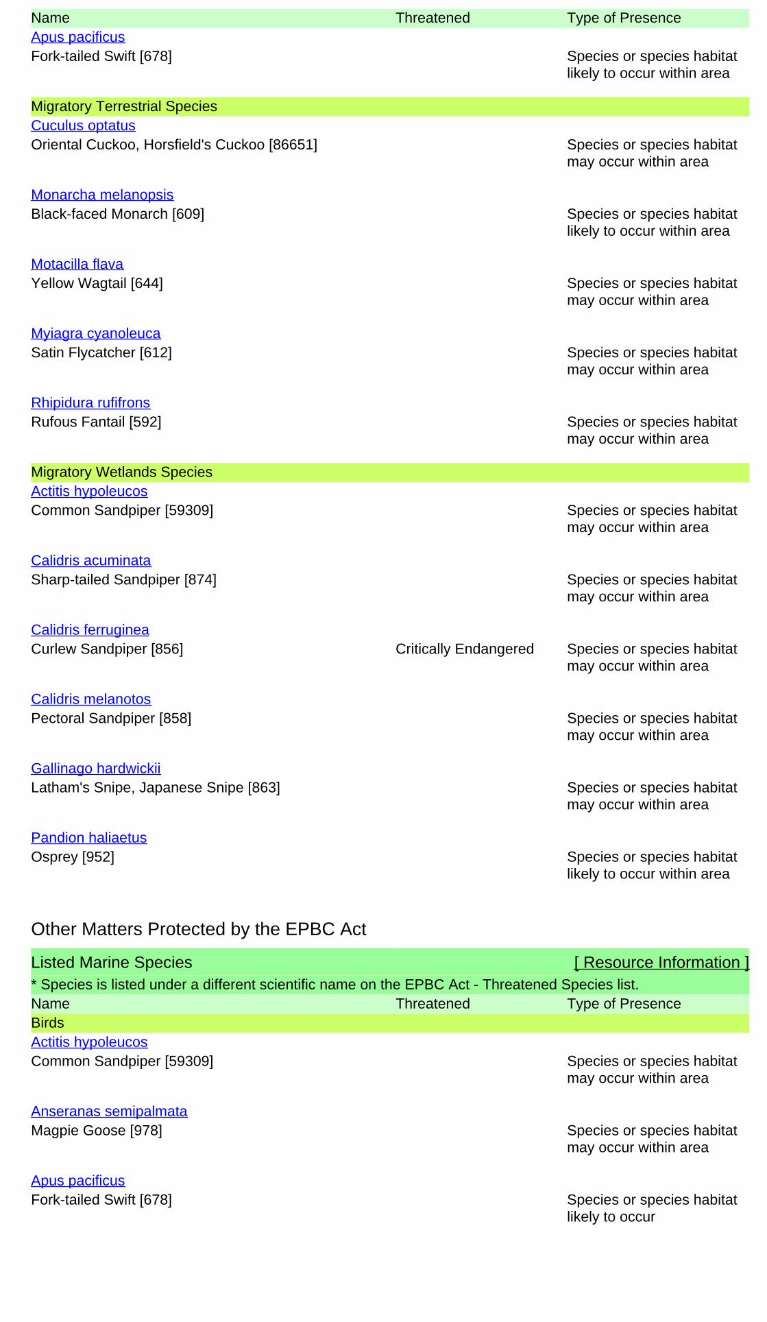
Name Threatened Type of Presence
Fork-tailed Swift [678] Species or species habitatlikely to occur within area
Apus pacificus
Migratory Terrestrial Species
Oriental Cuckoo, Horsfield's Cuckoo [86651] Species or species habitatmay occur within area
Cuculus optatus
Black-faced Monarch [609] Species or species habitatlikely to occur within area
Monarcha melanopsis
Yellow Wagtail [644] Species or species habitatmay occur within area
Motacilla flava
Satin Flycatcher [612] Species or species habitatmay occur within area
Myiagra cyanoleuca
Rufous Fantail [592] Species or species habitatmay occur within area
Rhipidura rufifrons
Migratory Wetlands Species
Common Sandpiper [59309] Species or species habitatmay occur within area
Actitis hypoleucos
Sharp-tailed Sandpiper [874] Species or species habitatmay occur within area
Calidris acuminata
Curlew Sandpiper [856] Critically Endangered Species or species habitatmay occur within area
Calidris ferruginea
Pectoral Sandpiper [858] Species or species habitatmay occur within area
Calidris melanotos
Latham's Snipe, Japanese Snipe [863] Species or species habitatmay occur within area
Gallinago hardwickii
Osprey [952] Species or species habitatlikely to occur within area
Pandion haliaetus
Listed Marine Species [ Resource Information ]* Species is listed under a different scientific name on the EPBC Act - Threatened Species list.Name Threatened Type of PresenceBirds
Common Sandpiper [59309] Species or species habitatmay occur within area
Actitis hypoleucos
Magpie Goose [978] Species or species habitatmay occur within area
Anseranas semipalmata
Fork-tailed Swift [678] Species or species habitatlikely to occur
Apus pacificus
Other Matters Protected by the EPBC Act

Name Threatened Type of Presencewithin area
Great Egret, White Egret [59541] Species or species habitatlikely to occur within area
Ardea alba
Cattle Egret [59542] Species or species habitatmay occur within area
Ardea ibis
Sharp-tailed Sandpiper [874] Species or species habitatmay occur within area
Calidris acuminata
Curlew Sandpiper [856] Critically Endangered Species or species habitatmay occur within area
Calidris ferruginea
Pectoral Sandpiper [858] Species or species habitatmay occur within area
Calidris melanotos
Black-eared Cuckoo [705] Species or species habitatlikely to occur within area
Chrysococcyx osculans
Latham's Snipe, Japanese Snipe [863] Species or species habitatmay occur within area
Gallinago hardwickii
White-bellied Sea-Eagle [943] Species or species habitatlikely to occur within area
Haliaeetus leucogaster
Rainbow Bee-eater [670] Species or species habitatmay occur within area
Merops ornatus
Black-faced Monarch [609] Species or species habitatlikely to occur within area
Monarcha melanopsis
Yellow Wagtail [644] Species or species habitatmay occur within area
Motacilla flava
Satin Flycatcher [612] Species or species habitatmay occur within area
Myiagra cyanoleuca
Osprey [952] Species or species habitatlikely to occur within area
Pandion haliaetus
Rufous Fantail [592] Species or species habitatmay occur within area
Rhipidura rufifrons
Painted Snipe [889] Endangered* Species or species habitatmay occur within area
Rostratula benghalensis (sensu lato)

State and Territory Reserves [ Resource Information ]Name StateTaunton QLDWallaby Lane QLD
Extra Information
Invasive Species [ Resource Information ]Weeds reported here are the 20 species of national significance (WoNS), along with other introduced plantsthat are considered by the States and Territories to pose a particularly significant threat to biodiversity. Thefollowing feral animals are reported: Goat, Red Fox, Cat, Rabbit, Pig, Water Buffalo and Cane Toad. Maps fromLandscape Health Project, National Land and Water Resouces Audit, 2001.
Name Status Type of PresenceBirds
Rock Pigeon, Rock Dove, Domestic Pigeon [803] Species or species habitatlikely to occur within area
Columba livia
House Sparrow [405] Species or species habitatlikely to occur within area
Passer domesticus
Spotted Turtle-Dove [780] Species or species habitatlikely to occur within area
Streptopelia chinensis
Common Starling [389] Species or species habitatlikely to occur within area
Sturnus vulgaris
Frogs
Cane Toad [83218] Species or species habitatknown to occur within area
Rhinella marina
Mammals
Domestic Cattle [16] Species or species habitatlikely to occur within area
Bos taurus
Domestic Dog [82654] Species or species habitatlikely to occur within area
Canis lupus familiaris
Cat, House Cat, Domestic Cat [19] Species or species habitatlikely to occur within area
Felis catus
Brown Hare [127] Species or species habitatlikely to occur within area
Lepus capensis
House Mouse [120] Species or species habitatlikely to occur within area
Mus musculus
Rabbit, European Rabbit [128] Species or species habitatlikely to occur within area
Oryctolagus cuniculus
Black Rat, Ship Rat [84] Species or species habitatlikely to occur within area
Rattus rattus
Pig [6] Species or species habitatlikely to occur within area
Sus scrofa

Name Status Type of Presence
Red Fox, Fox [18] Species or species habitatlikely to occur within area
Vulpes vulpes
Plants
Prickly Acacia [6196] Species or species habitatmay occur within area
Acacia nilotica subsp. indica
Rubber Vine, Rubbervine, India Rubber Vine, IndiaRubbervine, Palay Rubbervine, Purple Allamanda[18913]
Species or species habitatlikely to occur within area
Cryptostegia grandiflora
Cotton-leaved Physic-Nut, Bellyache Bush, Cotton-leafPhysic Nut, Cotton-leaf Jatropha, Black Physic Nut[7507]
Species or species habitatlikely to occur within area
Jatropha gossypifolia
Prickly Pears [82753] Species or species habitatlikely to occur within area
Opuntia spp.
Parkinsonia, Jerusalem Thorn, Jelly Bean Tree, HorseBean [12301]
Species or species habitatlikely to occur within area
Parkinsonia aculeata
Parthenium Weed, Bitter Weed, Carrot Grass, FalseRagweed [19566]
Species or species habitatlikely to occur within area
Parthenium hysterophorus
Prickly Acacia, Blackthorn, Prickly Mimosa, BlackPiquant, Babul [84351]
Species or species habitatlikely to occur within area
Vachellia nilotica

- non-threatened seabirds which have only been mapped for recorded breeding sites
- migratory species that are very widespread, vagrant, or only occur in small numbers
- some species and ecological communities that have only recently been listed
Not all species listed under the EPBC Act have been mapped (see below) and therefore a report is a general guide only. Where available datasupports mapping, the type of presence that can be determined from the data is indicated in general terms. People using this information in makinga referral may need to consider the qualifications below and may need to seek and consider other information sources.
For threatened ecological communities where the distribution is well known, maps are derived from recovery plans, State vegetation maps, remotesensing imagery and other sources. Where threatened ecological community distributions are less well known, existing vegetation maps and pointlocation data are used to produce indicative distribution maps.
- seals which have only been mapped for breeding sites near the Australian continent
Such breeding sites may be important for the protection of the Commonwealth Marine environment.
Threatened, migratory and marine species distributions have been derived through a variety of methods. Where distributions are well known and iftime permits, maps are derived using either thematic spatial data (i.e. vegetation, soils, geology, elevation, aspect, terrain, etc) together with pointlocations and described habitat; or environmental modelling (MAXENT or BIOCLIM habitat modelling) using point locations and environmental datalayers.
The information presented in this report has been provided by a range of data sources as acknowledged at the end of the report.Caveat
- migratory and
The following species and ecological communities have not been mapped and do not appear in reports produced from this database:
- marine
This report is designed to assist in identifying the locations of places which may be relevant in determining obligations under the EnvironmentProtection and Biodiversity Conservation Act 1999. It holds mapped locations of World and National Heritage properties, Wetlands of Internationaland National Importance, Commonwealth and State/Territory reserves, listed threatened, migratory and marine species and listed threatenedecological communities. Mapping of Commonwealth land is not complete at this stage. Maps have been collated from a range of sources at variousresolutions.
- threatened species listed as extinct or considered as vagrants
- some terrestrial species that overfly the Commonwealth marine area
The following groups have been mapped, but may not cover the complete distribution of the species:
Only selected species covered by the following provisions of the EPBC Act have been mapped:
Where very little information is available for species or large number of maps are required in a short time-frame, maps are derived either from 0.04or 0.02 decimal degree cells; by an automated process using polygon capture techniques (static two kilometre grid cells, alpha-hull and convex hull);or captured manually or by using topographic features (national park boundaries, islands, etc). In the early stages of the distribution mappingprocess (1999-early 2000s) distributions were defined by degree blocks, 100K or 250K map sheets to rapidly create distribution maps. More reliabledistribution mapping methods are used to update these distributions as time permits.
-23.66512 149.21782
Coordinates

-Environment and Planning Directorate, ACT-Birdlife Australia-Australian Bird and Bat Banding Scheme
-Department of Parks and Wildlife, Western Australia
Acknowledgements
-Office of Environment and Heritage, New South Wales
-Department of Primary Industries, Parks, Water and Environment, Tasmania
-Department of Land and Resource Management, Northern Territory-Department of Environmental and Heritage Protection, Queensland
-Department of Environment and Primary Industries, Victoria
-Australian National Wildlife Collection
-Department of Environment, Water and Natural Resources, South Australia
This database has been compiled from a range of data sources. The department acknowledges the followingcustodians who have contributed valuable data and advice:
-Australian Museum
-National Herbarium of NSW
Forestry Corporation, NSW-Australian Government, Department of Defence
-State Herbarium of South Australia
The Department is extremely grateful to the many organisations and individuals who provided expert adviceand information on numerous draft distributions.
-Natural history museums of Australia
-Queensland Museum
-Australian National Herbarium, Canberra
-Royal Botanic Gardens and National Herbarium of Victoria
-Geoscience Australia
-Ocean Biogeographic Information System
-Online Zoological Collections of Australian Museums-Queensland Herbarium
-Western Australian Herbarium
-Tasmanian Herbarium
-Northern Territory Herbarium
-South Australian Museum
-Museum Victoria
-University of New England
-CSIRO
-Other groups and individuals-Tasmanian Museum and Art Gallery, Hobart, Tasmania
-Museum and Art Gallery of the Northern Territory
-Reef Life Survey Australia-Australian Institute of Marine Science-Australian Government National Environmental Science Program
-Australian Tropical Herbarium, Cairns
-Australian Government – Australian Antarctic Data Centre
-Queen Victoria Museum and Art Gallery, Inveresk, Tasmania
-eBird Australia
-American Museum of Natural History
© Commonwealth of Australia
+61 2 6274 1111
Canberra ACT 2601 Australia
GPO Box 787
Department of the Environment
Please feel free to provide feedback via the Contact Us page.

EPBC Act Protected Matters Report
This report provides general guidance on matters of national environmental significance and other mattersprotected by the EPBC Act in the area you have selected.
Information on the coverage of this report and qualifications on data supporting this report are contained in thecaveat at the end of the report.
Information is available about Environment Assessments and the EPBC Act including significance guidelines,forms and application process details.
Other Matters Protected by the EPBC Act
Acknowledgements
Buffer: 50.0Km
Matters of NES
Report created: 03/06/19 09:45:56
Coordinates
This map may contain data which are©Commonwealth of Australia(Geoscience Australia), ©PSMA 2010
CaveatExtra Information
DetailsSummary
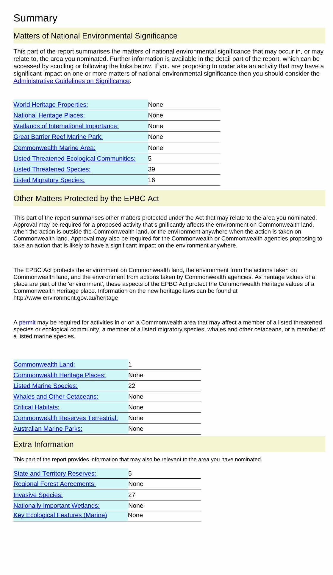
Summary
This part of the report summarises the matters of national environmental significance that may occur in, or mayrelate to, the area you nominated. Further information is available in the detail part of the report, which can beaccessed by scrolling or following the links below. If you are proposing to undertake an activity that may have asignificant impact on one or more matters of national environmental significance then you should consider theAdministrative Guidelines on Significance.
Matters of National Environmental Significance
Listed Threatened Ecological Communities:
Listed Migratory Species:
5
Great Barrier Reef Marine Park:
Wetlands of International Importance:
Listed Threatened Species:
None
39
None
None
National Heritage Places:
Commonwealth Marine Area:
World Heritage Properties:
None
None
16
The EPBC Act protects the environment on Commonwealth land, the environment from the actions taken onCommonwealth land, and the environment from actions taken by Commonwealth agencies. As heritage values of aplace are part of the 'environment', these aspects of the EPBC Act protect the Commonwealth Heritage values of aCommonwealth Heritage place. Information on the new heritage laws can be found athttp://www.environment.gov.au/heritage
This part of the report summarises other matters protected under the Act that may relate to the area you nominated.Approval may be required for a proposed activity that significantly affects the environment on Commonwealth land,when the action is outside the Commonwealth land, or the environment anywhere when the action is taken onCommonwealth land. Approval may also be required for the Commonwealth or Commonwealth agencies proposing totake an action that is likely to have a significant impact on the environment anywhere.
A permit may be required for activities in or on a Commonwealth area that may affect a member of a listed threatenedspecies or ecological community, a member of a listed migratory species, whales and other cetaceans, or a member ofa listed marine species.
Other Matters Protected by the EPBC Act
None
None
None
Listed Marine Species:
Whales and Other Cetaceans:
22
Commonwealth Heritage Places:
1
None
Critical Habitats:
Commonwealth Land:
Commonwealth Reserves Terrestrial:
NoneAustralian Marine Parks:
Extra Information
This part of the report provides information that may also be relevant to the area you have nominated.
None
5State and Territory Reserves:
Nationally Important Wetlands:
NoneRegional Forest Agreements:
Invasive Species: 27
NoneKey Ecological Features (Marine)

Details
Listed Threatened Species [ Resource Information ]Name Status Type of PresenceBirds
Curlew Sandpiper [856] Critically Endangered Species or species habitatmay occur within area
Calidris ferruginea
Red Goshawk [942] Vulnerable Species or species habitatknown to occur within area
Erythrotriorchis radiatus
Squatter Pigeon (southern) [64440] Vulnerable Species or species habitatknown to occur within area
Geophaps scripta scripta
Painted Honeyeater [470] Vulnerable Species or species habitatmay occur within area
Grantiella picta
Star Finch (eastern), Star Finch (southern) [26027] Endangered Species or species habitatlikely to occur within area
Neochmia ruficauda ruficauda
Eastern Curlew, Far Eastern Curlew [847] Critically Endangered Species or species habitatmay occur within area
Numenius madagascariensis
Southern Black-throated Finch [64447] Endangered Species or species habitatmay occur within area
Poephila cincta cincta
Australian Painted-snipe, Australian Painted Snipe[77037]
Endangered Species or species habitatlikely to occur within area
Rostratula australis
Black-breasted Button-quail [923] Vulnerable Species or speciesTurnix melanogaster
For threatened ecological communities where the distribution is well known, maps are derived from recoveryplans, State vegetation maps, remote sensing imagery and other sources. Where threatened ecologicalcommunity distributions are less well known, existing vegetation maps and point location data are used toproduce indicative distribution maps.
Listed Threatened Ecological Communities [ Resource Information ]
Name Status Type of PresenceBrigalow (Acacia harpophylla dominant and co-dominant)
Endangered Community known to occurwithin area
Coolibah - Black Box Woodlands of the DarlingRiverine Plains and the Brigalow Belt South Bioregions
Endangered Community may occurwithin area
Natural Grasslands of the Queensland CentralHighlands and northern Fitzroy Basin
Endangered Community likely to occurwithin area
Semi-evergreen vine thickets of the Brigalow Belt(North and South) and Nandewar Bioregions
Endangered Community likely to occurwithin area
Weeping Myall Woodlands Endangered Community likely to occurwithin area
Matters of National Environmental Significance

Name Status Type of Presencehabitat likely to occur withinarea
Fish
Murray Cod [66633] Vulnerable Species or species habitatmay occur within area
Maccullochella peelii
Mammals
Large-eared Pied Bat, Large Pied Bat [183] Vulnerable Species or species habitatlikely to occur within area
Chalinolobus dwyeri
Northern Quoll, Digul [Gogo-Yimidir], Wijingadda[Dambimangari], Wiminji [Martu] [331]
Endangered Species or species habitatlikely to occur within area
Dasyurus hallucatus
Ghost Bat [174] Vulnerable Species or species habitatlikely to occur within area
Macroderma gigas
Corben's Long-eared Bat, South-eastern Long-earedBat [83395]
Vulnerable Species or species habitatmay occur within area
Nyctophilus corbeni
Bridled Nail-tail Wallaby, Bridled Nailtail Wallaby [239] Endangered Species or species habitatknown to occur within area
Onychogalea fraenata
Greater Glider [254] Vulnerable Species or species habitatknown to occur within area
Petauroides volans
Koala (combined populations of Queensland, NewSouth Wales and the Australian Capital Territory)[85104]
Vulnerable Species or species habitatknown to occur within area
Phascolarctos cinereus (combined populations of Qld, NSW and the ACT)
Grey-headed Flying-fox [186] Vulnerable Foraging, feeding or relatedbehaviour may occur withinarea
Pteropus poliocephalus
Plants
[3566] Vulnerable Species or species habitatknown to occur within area
Acacia grandifolia
[17906] Vulnerable Species or species habitatlikely to occur within area
Aristida annua
[13792] Vulnerable Species or species habitatlikely to occur within area
Bertya opponens
Ooline [9828] Vulnerable Species or species habitatlikely to occur within area
Cadellia pentastylis
[55797] Endangered Species or species habitatlikely to occur within area
Cycas ophiolitica
[3567] Vulnerable Species or species habitatlikely to occur within area
Daviesia discolor
King Blue-grass [5481] Endangered Species or species habitatmay occur within area
Dichanthium queenslandicum
bluegrass [14159] Vulnerable Species or species habitatlikely to occur within area
Dichanthium setosum

Name Status Type of Presence
Black Ironbox [16344] Vulnerable Species or species habitatlikely to occur within area
Eucalyptus raveretiana
a shrub [55186] Endangered Species or species habitatknown to occur within area
Homoranthus decumbens
[24159] Vulnerable Species or species habitatlikely to occur within area
Logania diffusa
cycad [3412] Endangered Species or species habitatlikely to occur within area
Macrozamia platyrhachis
Lesser Swamp-orchid [5872] Endangered Species or species habitatknown to occur within area
Phaius australis
[75720] Endangered Species or species habitatknown to occur within area
Solanum dissectum
[84820] Endangered Species or species habitatmay occur within area
Solanum johnsonianum
Reptiles
Adorned Delma, Collared Delma [1656] Vulnerable Species or species habitatknown to occur within area
Delma torquata
Ornamental Snake [1193] Vulnerable Species or species habitatknown to occur within area
Denisonia maculata
Yakka Skink [1420] Vulnerable Species or species habitatknown to occur within area
Egernia rugosa
Southern Snapping Turtle, White-throated SnappingTurtle [81648]
Critically Endangered Species or species habitatknown to occur within area
Elseya albagula
Dunmall's Snake [59254] Vulnerable Species or species habitatmay occur within area
Furina dunmalli
Fitzroy River Turtle, Fitzroy Tortoise, Fitzroy Turtle,White-eyed River Diver [1761]
Vulnerable Species or species habitatlikely to occur within area
Rheodytes leukops
Listed Migratory Species [ Resource Information ]* Species is listed under a different scientific name on the EPBC Act - Threatened Species list.Name Threatened Type of PresenceMigratory Marine Birds
Fork-tailed Swift [678] Species or species habitatlikely to occur within area
Apus pacificus
Migratory Marine Species
Salt-water Crocodile, Estuarine Crocodile [1774] Species or species habitatlikely to occur within area
Crocodylus porosus
Migratory Terrestrial Species
Oriental Cuckoo, Horsfield's Cuckoo [86651] Species or species habitatmay occur within area
Cuculus optatus
Name Threatened Type of Presence
White-throated Needletail [682] Species or species habitatknown to occur within area
Hirundapus caudacutus
Black-faced Monarch [609] Species or species habitatlikely to occur within area
Monarcha melanopsis
Spectacled Monarch [610] Species or species habitatmay occur within area
Monarcha trivirgatus
Yellow Wagtail [644] Species or species habitatmay occur within area
Motacilla flava
Satin Flycatcher [612] Species or species habitatmay occur within area
Myiagra cyanoleuca
Rufous Fantail [592] Species or species habitatmay occur within area
Rhipidura rufifrons
Migratory Wetlands Species
Common Sandpiper [59309] Species or species habitatmay occur within area
Actitis hypoleucos
Sharp-tailed Sandpiper [874] Species or species habitatlikely to occur within area
Calidris acuminata
Curlew Sandpiper [856] Critically Endangered Species or species habitatmay occur within area
Calidris ferruginea
Pectoral Sandpiper [858] Species or species habitatmay occur within area
Calidris melanotos
Latham's Snipe, Japanese Snipe [863] Species or species habitatmay occur within area
Gallinago hardwickii
Eastern Curlew, Far Eastern Curlew [847] Critically Endangered Species or species habitatmay occur within area
Numenius madagascariensis
Osprey [952] Species or species habitatlikely to occur within area
Pandion haliaetus
Listed Marine Species [ Resource Information ]* Species is listed under a different scientific name on the EPBC Act - Threatened Species list.Name Threatened Type of PresenceBirds
Commonwealth Land [ Resource Information ]The Commonwealth area listed below may indicate the presence of Commonwealth land in this vicinity. Due tothe unreliability of the data source, all proposals should be checked as to whether it impacts on aCommonwealth area, before making a definitive decision. Contact the State or Territory government landdepartment for further information.
NameDefence - BLACKWATER TRAINING DEPOT
Other Matters Protected by the EPBC Act

Name Threatened Type of Presence
Common Sandpiper [59309] Species or species habitatmay occur within area
Actitis hypoleucos
Magpie Goose [978] Species or species habitatmay occur within area
Anseranas semipalmata
Fork-tailed Swift [678] Species or species habitatlikely to occur within area
Apus pacificus
Great Egret, White Egret [59541] Breeding known to occurwithin area
Ardea alba
Cattle Egret [59542] Species or species habitatmay occur within area
Ardea ibis
Sharp-tailed Sandpiper [874] Species or species habitatlikely to occur within area
Calidris acuminata
Curlew Sandpiper [856] Critically Endangered Species or species habitatmay occur within area
Calidris ferruginea
Pectoral Sandpiper [858] Species or species habitatmay occur within area
Calidris melanotos
Black-eared Cuckoo [705] Species or species habitatlikely to occur within area
Chrysococcyx osculans
Latham's Snipe, Japanese Snipe [863] Species or species habitatmay occur within area
Gallinago hardwickii
White-bellied Sea-Eagle [943] Species or species habitatlikely to occur within area
Haliaeetus leucogaster
White-throated Needletail [682] Species or species habitatknown to occur within area
Hirundapus caudacutus
Rainbow Bee-eater [670] Species or species habitatmay occur within area
Merops ornatus
Black-faced Monarch [609] Species or species habitatlikely to occur within area
Monarcha melanopsis
Spectacled Monarch [610] Species or species habitatmay occur within area
Monarcha trivirgatus
Yellow Wagtail [644] Species or species habitatmay occur within area
Motacilla flava
Satin Flycatcher [612] Species or species habitatmay occur within area
Myiagra cyanoleuca
Eastern Curlew, Far Eastern Curlew [847] Critically Endangered Species or species habitatmay occur within area
Numenius madagascariensis
Osprey [952] Species or speciesPandion haliaetus

Name Threatened Type of Presencehabitat likely to occur withinarea
Rufous Fantail [592] Species or species habitatmay occur within area
Rhipidura rufifrons
Painted Snipe [889] Endangered* Species or species habitatlikely to occur within area
Rostratula benghalensis (sensu lato)
Reptiles
Salt-water Crocodile, Estuarine Crocodile [1774] Species or species habitatlikely to occur within area
Crocodylus porosus
State and Territory Reserves [ Resource Information ]Name StateBlackdown Tableland QLDBlackwater QLDGhungalu QLDTaunton QLDWallaby Lane QLD
Extra Information
Invasive Species [ Resource Information ]Weeds reported here are the 20 species of national significance (WoNS), along with other introduced plantsthat are considered by the States and Territories to pose a particularly significant threat to biodiversity. Thefollowing feral animals are reported: Goat, Red Fox, Cat, Rabbit, Pig, Water Buffalo and Cane Toad. Maps fromLandscape Health Project, National Land and Water Resouces Audit, 2001.
Name Status Type of PresenceBirds
Mallard [974] Species or species habitatlikely to occur within area
Anas platyrhynchos
Rock Pigeon, Rock Dove, Domestic Pigeon [803] Species or species habitatlikely to occur within area
Columba livia
House Sparrow [405] Species or species habitatlikely to occur within area
Passer domesticus
Spotted Turtle-Dove [780] Species or species habitatlikely to occur within area
Streptopelia chinensis
Common Starling [389] Species or species habitatlikely to occur within area
Sturnus vulgaris
Frogs
Cane Toad [83218] Species or species habitatknown to occur within area
Rhinella marina
Mammals
Domestic Cattle [16] Species or species habitatlikely to occur within area
Bos taurus
Domestic Dog [82654] Species or species habitatlikely to occur within area
Canis lupus familiaris

Name Status Type of Presence
Cat, House Cat, Domestic Cat [19] Species or species habitatlikely to occur within area
Felis catus
Brown Hare [127] Species or species habitatlikely to occur within area
Lepus capensis
House Mouse [120] Species or species habitatlikely to occur within area
Mus musculus
Rabbit, European Rabbit [128] Species or species habitatlikely to occur within area
Oryctolagus cuniculus
Black Rat, Ship Rat [84] Species or species habitatlikely to occur within area
Rattus rattus
Pig [6] Species or species habitatlikely to occur within area
Sus scrofa
Red Fox, Fox [18] Species or species habitatlikely to occur within area
Vulpes vulpes
Plants
Prickly Acacia [6196] Species or species habitatmay occur within area
Acacia nilotica subsp. indica
Rubber Vine, Rubbervine, India Rubber Vine, IndiaRubbervine, Palay Rubbervine, Purple Allamanda[18913]
Species or species habitatlikely to occur within area
Cryptostegia grandiflora
Hymenachne, Olive Hymenachne, Water Stargrass,West Indian Grass, West Indian Marsh Grass [31754]
Species or species habitatlikely to occur within area
Hymenachne amplexicaulis
Cotton-leaved Physic-Nut, Bellyache Bush, Cotton-leafPhysic Nut, Cotton-leaf Jatropha, Black Physic Nut[7507]
Species or species habitatlikely to occur within area
Jatropha gossypifolia
Lantana, Common Lantana, Kamara Lantana, Large-leaf Lantana, Pink Flowered Lantana, Red FloweredLantana, Red-Flowered Sage, White Sage, Wild Sage[10892]
Species or species habitatlikely to occur within area
Lantana camara
Prickly Pears [82753] Species or species habitatlikely to occur within area
Opuntia spp.
Parkinsonia, Jerusalem Thorn, Jelly Bean Tree, HorseBean [12301]
Species or species habitatlikely to occur within area
Parkinsonia aculeata
Parthenium Weed, Bitter Weed, Carrot Grass, FalseRagweed [19566]
Species or species habitatlikely to occur within area
Parthenium hysterophorus
Mesquite, Algaroba [68407] Species or species habitatlikely to occur within area
Prosopis spp.
Salvinia, Giant Salvinia, Aquarium Watermoss, KaribaWeed [13665]
Species or species habitatlikely to occur within area
Salvinia molesta
Athel Pine, Athel Tree, Tamarisk, Athel Tamarisk,Athel Tamarix, Desert Tamarisk, Flowering
Species or species habitatlikely to occur
Tamarix aphylla

Name Status Type of PresenceCypress, Salt Cedar [16018] within area
Prickly Acacia, Blackthorn, Prickly Mimosa, BlackPiquant, Babul [84351]
Species or species habitatlikely to occur within area
Vachellia nilotica

- non-threatened seabirds which have only been mapped for recorded breeding sites
- migratory species that are very widespread, vagrant, or only occur in small numbers
- some species and ecological communities that have only recently been listed
Not all species listed under the EPBC Act have been mapped (see below) and therefore a report is a general guide only. Where available datasupports mapping, the type of presence that can be determined from the data is indicated in general terms. People using this information in makinga referral may need to consider the qualifications below and may need to seek and consider other information sources.
For threatened ecological communities where the distribution is well known, maps are derived from recovery plans, State vegetation maps, remotesensing imagery and other sources. Where threatened ecological community distributions are less well known, existing vegetation maps and pointlocation data are used to produce indicative distribution maps.
- seals which have only been mapped for breeding sites near the Australian continent
Such breeding sites may be important for the protection of the Commonwealth Marine environment.
Threatened, migratory and marine species distributions have been derived through a variety of methods. Where distributions are well known and iftime permits, maps are derived using either thematic spatial data (i.e. vegetation, soils, geology, elevation, aspect, terrain, etc) together with pointlocations and described habitat; or environmental modelling (MAXENT or BIOCLIM habitat modelling) using point locations and environmental datalayers.
The information presented in this report has been provided by a range of data sources as acknowledged at the end of the report.Caveat
- migratory and
The following species and ecological communities have not been mapped and do not appear in reports produced from this database:
- marine
This report is designed to assist in identifying the locations of places which may be relevant in determining obligations under the EnvironmentProtection and Biodiversity Conservation Act 1999. It holds mapped locations of World and National Heritage properties, Wetlands of Internationaland National Importance, Commonwealth and State/Territory reserves, listed threatened, migratory and marine species and listed threatenedecological communities. Mapping of Commonwealth land is not complete at this stage. Maps have been collated from a range of sources at variousresolutions.
- threatened species listed as extinct or considered as vagrants
- some terrestrial species that overfly the Commonwealth marine area
The following groups have been mapped, but may not cover the complete distribution of the species:
Only selected species covered by the following provisions of the EPBC Act have been mapped:
Where very little information is available for species or large number of maps are required in a short time-frame, maps are derived either from 0.04or 0.02 decimal degree cells; by an automated process using polygon capture techniques (static two kilometre grid cells, alpha-hull and convex hull);or captured manually or by using topographic features (national park boundaries, islands, etc). In the early stages of the distribution mappingprocess (1999-early 2000s) distributions were defined by degree blocks, 100K or 250K map sheets to rapidly create distribution maps. More reliabledistribution mapping methods are used to update these distributions as time permits.
-23.66512 149.21782
Coordinates

-Environment and Planning Directorate, ACT-Birdlife Australia-Australian Bird and Bat Banding Scheme
-Department of Parks and Wildlife, Western Australia
Acknowledgements
-Office of Environment and Heritage, New South Wales
-Department of Primary Industries, Parks, Water and Environment, Tasmania
-Department of Land and Resource Management, Northern Territory-Department of Environmental and Heritage Protection, Queensland
-Department of Environment and Primary Industries, Victoria
-Australian National Wildlife Collection
-Department of Environment, Water and Natural Resources, South Australia
This database has been compiled from a range of data sources. The department acknowledges the followingcustodians who have contributed valuable data and advice:
-Australian Museum
-National Herbarium of NSW
Forestry Corporation, NSW-Australian Government, Department of Defence
-State Herbarium of South Australia
The Department is extremely grateful to the many organisations and individuals who provided expert adviceand information on numerous draft distributions.
-Natural history museums of Australia
-Queensland Museum
-Australian National Herbarium, Canberra
-Royal Botanic Gardens and National Herbarium of Victoria
-Geoscience Australia
-Ocean Biogeographic Information System
-Online Zoological Collections of Australian Museums-Queensland Herbarium
-Western Australian Herbarium
-Tasmanian Herbarium
-Northern Territory Herbarium
-South Australian Museum
-Museum Victoria
-University of New England
-CSIRO
-Other groups and individuals-Tasmanian Museum and Art Gallery, Hobart, Tasmania
-Museum and Art Gallery of the Northern Territory
-Reef Life Survey Australia-Australian Institute of Marine Science-Australian Government National Environmental Science Program
-Australian Tropical Herbarium, Cairns
-Australian Government – Australian Antarctic Data Centre
-Queen Victoria Museum and Art Gallery, Inveresk, Tasmania
-eBird Australia
-American Museum of Natural History
© Commonwealth of Australia
+61 2 6274 1111
Canberra ACT 2601 Australia
GPO Box 787
Department of the Environment
Please feel free to provide feedback via the Contact Us page.

Wildlife Online Extract
Search Criteria: Species List for a Specified Point
Species: All
Type: All
Status: Rare and threatened species
Records: All
Date: All
Latitude: -23.6381
Longitude: 149.2514
Distance: 10
Email: [email protected]
Date submitted: Thursday 13 Jun 2019 10:03:40
Date extracted: Thursday 13 Jun 2019 10:10:12
The number of records retrieved = 7
Disclaimer
As the DSITIA is still in a process of collating and vetting data, it is possible the information given is not complete. The information provided should only be usedfor the project for which it was requested and it should be appropriately acknowledged as being derived from Wildlife Online when it is used.
The State of Queensland does not invite reliance upon, nor accept responsibility for this information. Persons should satisfy themselves through independentmeans as to the accuracy and completeness of this information.
No statements, representations or warranties are made about the accuracy or completeness of this information. The State of Queensland disclaims allresponsibility for this information and all liability (including without limitation, liability in negligence) for all expenses, losses, damagesand costs you may incur as a result of the information being inaccurate or incomplete in any way for any reason.
Feedback about Wildlife Online should be emailed to [email protected]

Kingdom Class Family Scientific Name Common Name I Q A Records
animals birds Columbidae Geophaps scripta scripta squatter pigeon (southern subspecies) V V 17 animals mammals Macropodidae Onychogalea fraenata bridled nailtail wallaby E E 15 animals mammals Phascolarctidae Phascolarctos cinereus koala V V 1 animals mammals Pseudocheiridae Petauroides volans volans southern greater glider V V 2 plants Equisetopsida Apocynaceae Cerbera dumicola NT 2/2plants Equisetopsida Solanaceae Solanum elachophyllum E 1 plants Equisetopsida Solanaceae Solanum adenophorum E 1/1
CODES
I - Y indicates that the taxon is introduced to Queensland and has naturalised.
Q - Indicates the Queensland conservation status of each taxon under the Nature Conservation Act 1992. The codes are Extinct in the Wild (PE), Endangered (E),Vulnerable (V), Near Threatened (NT), Least Concern (C) or Not Protected ( ).
A - Indicates the Australian conservation status of each taxon under the Environment Protection and Biodiversity Conservation Act 1999. The values of EPBC areConservation Dependent (CD), Critically Endangered (CE), Endangered (E), Extinct (EX), Extinct in the Wild (XW) and Vulnerable (V).
Records – The first number indicates the total number of records of the taxon for the record option selected (i.e. All, Confirmed or Specimens).This number is output as 99999 if it equals or exceeds this value. The second number located after the / indicates the number of specimen records for the taxon.This number is output as 999 if it equals or exceeds this value.
Page 1 of 1Queensland Government Wildlife Online - Extract Date 13/06/2019 at 10:10:12

Wildlife Online Extract
Search Criteria: Species List for a Specified Point
Species: All
Type: All
Status: All
Records: All
Date: All
Latitude: -23.6381
Longitude: 149.1514
Distance: 10
Email: [email protected]
Date submitted: Thursday 13 Jun 2019 10:54:38
Date extracted: Thursday 13 Jun 2019 11:00:02
The number of records retrieved = 397
Disclaimer
As the DSITIA is still in a process of collating and vetting data, it is possible the information given is not complete. The information provided should only be usedfor the project for which it was requested and it should be appropriately acknowledged as being derived from Wildlife Online when it is used.
The State of Queensland does not invite reliance upon, nor accept responsibility for this information. Persons should satisfy themselves through independentmeans as to the accuracy and completeness of this information.
No statements, representations or warranties are made about the accuracy or completeness of this information. The State of Queensland disclaims allresponsibility for this information and all liability (including without limitation, liability in negligence) for all expenses, losses, damagesand costs you may incur as a result of the information being inaccurate or incomplete in any way for any reason.
Feedback about Wildlife Online should be emailed to [email protected]

Kingdom Class Family Scientific Name Common Name I Q A Records
animals amphibians Bufonidae Rhinella marina cane toad Y 4 animals amphibians Hylidae Litoria latopalmata broad palmed rocketfrog C 1 animals amphibians Hylidae Cyclorana alboguttata greenstripe frog C 1 animals amphibians Hylidae Litoria caerulea common green treefrog C 1 animals amphibians Limnodynastidae Limnodynastes tasmaniensis spotted grassfrog C 1 animals amphibians Limnodynastidae Limnodynastes salmini salmon striped frog C 1 animals amphibians Limnodynastidae Platyplectrum ornatum ornate burrowing frog C 5 animals birds Acanthizidae Acanthiza nana yellow thornbill C 1 animals birds Acanthizidae Smicrornis brevirostris weebill C 3 animals birds Acanthizidae Gerygone olivacea white-throated gerygone C 7 animals birds Accipitridae Milvus migrans black kite C 1 animals birds Accipitridae Haliastur sphenurus whistling kite C 3 animals birds Accipitridae Aquila audax wedge-tailed eagle C 6 animals birds Aegothelidae Aegotheles cristatus Australian owlet-nightjar C 2 animals birds Alaudidae Mirafra javanica Horsfield's bushlark C 1 animals birds Anatidae Anas gracilis grey teal C 1 animals birds Anatidae Cygnus atratus black swan C 1 animals birds Anatidae Anas rhynchotis Australasian shoveler C 1 animals birds Anatidae Aythya australis hardhead C 2 animals birds Anatidae Dendrocygna arcuata wandering whistling-duck C 1 animals birds Anatidae Anas superciliosa Pacific black duck C 3 animals birds Anatidae Chenonetta jubata Australian wood duck C 1 animals birds Anhingidae Anhinga novaehollandiae Australasian darter C 1 animals birds Anseranatidae Anseranas semipalmata magpie goose C 1 animals birds Ardeidae Egretta novaehollandiae white-faced heron C 1 animals birds Ardeidae Nycticorax caledonicus nankeen night-heron C 1 animals birds Ardeidae Ardea alba modesta eastern great egret C 1 animals birds Ardeidae Ardea intermedia intermediate egret C 1 animals birds Ardeidae Bubulcus ibis cattle egret C 1 animals birds Ardeidae Ardea pacifica white-necked heron C 2 animals birds Artamidae Cracticus tibicen Australian magpie C 10 animals birds Artamidae Cracticus torquatus grey butcherbird C 6 animals birds Artamidae Artamus leucorynchus white-breasted woodswallow C 1 animals birds Artamidae Cracticus nigrogularis pied butcherbird C 8 animals birds Artamidae Artamus cinereus black-faced woodswallow C 3 animals birds Cacatuidae Cacatua galerita sulphur-crested cockatoo C 3 animals birds Cacatuidae Eolophus roseicapilla galah C 2 animals birds Cacatuidae Calyptorhynchus banksii red-tailed black-cockatoo C 1 animals birds Campephagidae Lalage tricolor white-winged triller C 1 animals birds Campephagidae Coracina novaehollandiae black-faced cuckoo-shrike C 6 animals birds Campephagidae Coracina papuensis white-bellied cuckoo-shrike C 1 animals birds Casuariidae Dromaius novaehollandiae emu C 1 animals birds Charadriidae Vanellus miles masked lapwing C 1 animals birds Charadriidae Elseyornis melanops black-fronted dotterel C 2 animals birds Columbidae Ocyphaps lophotes crested pigeon C 4 animals birds Columbidae Geophaps scripta scripta squatter pigeon (southern subspecies) V V 8
Page 1 of 9Queensland Government Wildlife Online - Extract Date 13/06/2019 at 11:00:02

Kingdom Class Family Scientific Name Common Name I Q A Records
animals birds Columbidae Geopelia humeralis bar-shouldered dove C 4 animals birds Columbidae Phaps chalcoptera common bronzewing C 2 animals birds Columbidae Geopelia striata peaceful dove C 5 animals birds Columbidae Geopelia cuneata diamond dove C 1 animals birds Coraciidae Eurystomus orientalis dollarbird C 3 animals birds Corcoracidae Struthidea cinerea apostlebird C 5 animals birds Corcoracidae Corcorax melanorhamphos white-winged chough C 2 animals birds Corvidae Corvus coronoides Australian raven C 3 animals birds Corvidae Corvus orru Torresian crow C 9 animals birds Cuculidae Chalcites basalis Horsfield's bronze-cuckoo C 1 animals birds Cuculidae Chalcites lucidus shining bronze-cuckoo C 1 animals birds Cuculidae Scythrops novaehollandiae channel-billed cuckoo C 1 animals birds Cuculidae Cacomantis pallidus pallid cuckoo C 1 animals birds Cuculidae Centropus phasianinus pheasant coucal C 3 animals birds Cuculidae Eudynamys orientalis eastern koel C 1 animals birds Dicruridae Dicrurus bracteatus spangled drongo C 1 animals birds Estrildidae Taeniopygia guttata zebra finch C 1 animals birds Estrildidae Taeniopygia bichenovii double-barred finch C 9 animals birds Eurostopodidae Eurostopodus mystacalis white-throated nightjar C 1 animals birds Falconidae Falco cenchroides nankeen kestrel C 2 animals birds Falconidae Falco berigora brown falcon C 4 animals birds Gruidae Grus rubicunda brolga C 3 animals birds Halcyonidae Dacelo novaeguineae laughing kookaburra C 7 animals birds Halcyonidae Todiramphus macleayii forest kingfisher C 2 animals birds Halcyonidae Dacelo leachii blue-winged kookaburra C 2 animals birds Halcyonidae Todiramphus pyrrhopygius red-backed kingfisher C 1 animals birds Halcyonidae Todiramphus sanctus sacred kingfisher C 1 animals birds Hirundinidae Petrochelidon nigricans tree martin C 2 animals birds Hirundinidae Hirundo neoxena welcome swallow C 1 animals birds Jacanidae Irediparra gallinacea comb-crested jacana C 1 animals birds Maluridae Malurus cyaneus superb fairy-wren C 1 animals birds Maluridae Malurus melanocephalus red-backed fairy-wren C 7 animals birds Maluridae Malurus lamberti variegated fairy-wren C 2 animals birds Megaluridae Cincloramphus mathewsi rufous songlark C 1 animals birds Meliphagidae Manorina flavigula yellow-throated miner C 3 animals birds Meliphagidae Gavicalis virescens singing honeyeater C 3 animals birds Meliphagidae Lichmera indistincta brown honeyeater C 3 animals birds Meliphagidae Philemon corniculatus noisy friarbird C 7 animals birds Meliphagidae Ptilotula penicillata white-plumed honeyeater C 1 animals birds Meliphagidae Manorina melanocephala noisy miner C 5 animals birds Meliphagidae Myzomela sanguinolenta scarlet honeyeater C 1 animals birds Meliphagidae Philemon citreogularis little friarbird C 7 animals birds Meliphagidae Melithreptus albogularis white-throated honeyeater C 11 animals birds Meliphagidae Plectorhyncha lanceolata striped honeyeater C 2 animals birds Meliphagidae Entomyzon cyanotis blue-faced honeyeater C 7 animals birds Meropidae Merops ornatus rainbow bee-eater C 11
Page 2 of 9Queensland Government Wildlife Online - Extract Date 13/06/2019 at 11:00:02
Kingdom Class Family Scientific Name Common Name I Q A Records
animals birds Monarchidae Grallina cyanoleuca magpie-lark C 11 animals birds Monarchidae Myiagra inquieta restless flycatcher C 3 animals birds Monarchidae Myiagra rubecula leaden flycatcher C 3 animals birds Motacillidae Anthus novaeseelandiae Australasian pipit C 2 animals birds Nectariniidae Dicaeum hirundinaceum mistletoebird C 2 animals birds Neosittidae Daphoenositta chrysoptera varied sittella C 1 animals birds Oriolidae Oriolus sagittatus olive-backed oriole C 7 animals birds Oriolidae Sphecotheres vieilloti Australasian figbird C 2 animals birds Otididae Ardeotis australis Australian bustard C 5 animals birds Pachycephalidae Pachycephala rufiventris rufous whistler C 5 animals birds Pachycephalidae Colluricincla megarhyncha little shrike-thrush C 1 animals birds Pachycephalidae Colluricincla harmonica grey shrike-thrush C 6 animals birds Pardalotidae Pardalotus striatus striated pardalote C 11/1animals birds Pelecanidae Pelecanus conspicillatus Australian pelican C 1 animals birds Petroicidae Eopsaltria australis eastern yellow robin C 1 animals birds Petroicidae Microeca fascinans jacky winter C 4 animals birds Phalacrocoracidae Phalacrocorax varius pied cormorant C 1 animals birds Phalacrocoracidae Microcarbo melanoleucos little pied cormorant C 1 animals birds Phalacrocoracidae Phalacrocorax sulcirostris little black cormorant C 1 animals birds Phasianidae Coturnix ypsilophora brown quail C 1 animals birds Podicipedidae Tachybaptus novaehollandiae Australasian grebe C 3 animals birds Podicipedidae Podiceps cristatus great crested grebe C 1 animals birds Pomatostomidae Pomatostomus temporalis grey-crowned babbler C 4 animals birds Psittacidae Trichoglossus chlorolepidotus scaly-breasted lorikeet C 2 animals birds Psittacidae Trichoglossus haematodus moluccanus rainbow lorikeet C 8 animals birds Psittacidae Aprosmictus erythropterus red-winged parrot C 2 animals birds Psittacidae Melopsittacus undulatus budgerigar C 1 animals birds Psittacidae Platycercus adscitus pale-headed rosella C 7 animals birds Ptilonorhynchidae Ptilonorhynchus maculatus spotted bowerbird C 5 animals birds Rallidae Porphyrio melanotus purple swamphen C 1 animals birds Rallidae Fulica atra Eurasian coot C 1 animals birds Rallidae Gallinula tenebrosa dusky moorhen C 1 animals birds Recurvirostridae Himantopus himantopus black-winged stilt C 1 animals birds Rhipiduridae Rhipidura leucophrys willie wagtail C 10 animals birds Rhipiduridae Rhipidura albiscapa grey fantail C 6 animals birds Strigidae Ninox boobook southern boobook C 1 animals birds Threskiornithidae Threskiornis spinicollis straw-necked ibis C 4 animals birds Threskiornithidae Threskiornis molucca Australian white ibis C 1 animals birds Threskiornithidae Platalea regia royal spoonbill C 1 animals birds Threskiornithidae Platalea flavipes yellow-billed spoonbill C 1 animals birds Timaliidae Zosterops lateralis silvereye C 1 animals birds Tytonidae Tyto delicatula eastern barn owl C 3 animals mammals Bovidae Bos taurus European cattle Y 1 animals mammals Canidae Vulpes vulpes red fox Y 1 animals mammals Canidae Canis lupus dingo dingo 6 animals mammals Equidae Equus caballus horse Y 1
Page 3 of 9Queensland Government Wildlife Online - Extract Date 13/06/2019 at 11:00:02

Kingdom Class Family Scientific Name Common Name I Q A Records
animals mammals Felidae Felis catus cat Y 3 animals mammals Hipposideridae Hipposideros ater aruensis eastern dusky leaf-nosed bat C 1 animals mammals Leporidae Oryctolagus cuniculus rabbit Y 2 animals mammals Leporidae Lepus europaeus European brown hare Y 2 animals mammals Macropodidae Macropus dorsalis black-striped wallaby C 5 animals mammals Macropodidae Onychogalea fraenata bridled nailtail wallaby E E 13 animals mammals Macropodidae Macropus giganteus eastern grey kangaroo C 2 animals mammals Macropodidae Macropus robustus common wallaroo C 1 animals mammals Macropodidae Wallabia bicolor swamp wallaby C 1 animals mammals Miniopteridae Miniopterus schreibersii oceanensis eastern bent-wing bat C 1 animals mammals Muridae Mus musculus house mouse Y 5 animals mammals Muridae Pseudomys delicatulus delicate mouse C 1 animals mammals Peramelidae Perameles nasuta long-nosed bandicoot C 1 animals mammals Phalangeridae Trichosurus vulpecula common brushtail possum C 4 animals mammals Phascolarctidae Phascolarctos cinereus koala V V 1 animals mammals Potoroidae Aepyprymnus rufescens rufous bettong C 2 animals mammals Pseudocheiridae Petauroides volans volans southern greater glider V V 2 animals mammals Suidae Sus scrofa pig Y 1 animals mammals Tachyglossidae Tachyglossus aculeatus short-beaked echidna SL 4 animals mammals Vespertilionidae Nyctophilus gouldi Gould's long-eared bat C 1 animals mammals Vespertilionidae Myotis macropus large-footed myotis C 2 animals ray-finned fishes Terapontidae Leiopotherapon unicolor spangled perch 1 animals reptiles Agamidae Pogona barbata bearded dragon C 2/1animals reptiles Agamidae Diporiphora australis tommy roundhead C 1/1animals reptiles Boidae Aspidites melanocephalus black-headed python C 1 animals reptiles Carphodactylidae Nephrurus asper spiny knob-tailed gecko C 2/1animals reptiles Diplodactylidae Lucasium steindachneri Steindachner's gecko C 1 animals reptiles Diplodactylidae Oedura monilis ocellated velvet gecko C 1/1animals reptiles Diplodactylidae Strophurus taenicauda golden-tailed gecko NT 3 animals reptiles Elapidae Demansia vestigiata lesser black whipsnake C 2 animals reptiles Elapidae Demansia psammophis yellow-faced whipsnake C 1 animals reptiles Elapidae Hoplocephalus bitorquatus pale-headed snake C 1/1animals reptiles Gekkonidae Gehyra catenata chain-backed dtella C 1/1animals reptiles Gekkonidae Gehyra dubia dubious dtella C 32 animals reptiles Gekkonidae Heteronotia binoei Bynoe's gecko C 6 animals reptiles Pygopodidae Lialis burtonis Burton's legless lizard C 2 animals reptiles Scincidae Cryptoblepharus pulcher pulcher elegant snake-eyed skink C 1 animals reptiles Scincidae Cryptoblepharus virgatus sensu lato C 1 animals reptiles Scincidae Carlia pectoralis sensu lato C 2/1animals reptiles Scincidae Cryptoblepharus australis inland snake-eyed skink C 1 animals reptiles Scincidae Cyclodomorphus gerrardii pink-tongued lizard C 1 animals reptiles Scincidae Morethia taeniopleura fire-tailed skink C 2 animals reptiles Scincidae Ctenotus taeniolatus copper-tailed skink C 1 animals reptiles Scincidae Concinnia brachysoma northern bar-sided skink C 1/1animals reptiles Scincidae Morethia boulengeri south-eastern morethia skink C 1 animals reptiles Scincidae Lygisaurus foliorum tree-base litter-skink C 1
Page 4 of 9Queensland Government Wildlife Online - Extract Date 13/06/2019 at 11:00:02

Kingdom Class Family Scientific Name Common Name I Q A Records
animals reptiles Scincidae Lerista fragilis eastern mulch slider C 2 animals reptiles Scincidae Carlia rubigo orange-flanked rainbow skink C 6 animals reptiles Scincidae Carlia vivax tussock rainbow-skink C 1 plants Equisetopsida Acanthaceae Pseuderanthemum variabile pastel flower C 1 plants Equisetopsida Amaranthaceae Alternanthera pungens khaki weed Y 1/1plants Equisetopsida Amaranthaceae Ptilotus polystachyus C 1/1plants Equisetopsida Amaryllidaceae Crinum flaccidum Murray lily C 1 plants Equisetopsida Apocynaceae Carissa ovata currantbush C 20 plants Equisetopsida Apocynaceae Cerbera dumicola NT 2/2plants Equisetopsida Apocynaceae Alstonia constricta bitterbark C 10/1plants Equisetopsida Apocynaceae Parsonsia straminea monkey rope C 6 plants Equisetopsida Apocynaceae Cryptostegia grandiflora rubber vine Y 1 plants Equisetopsida Apocynaceae Parsonsia eucalyptophylla gargaloo C 1 plants Equisetopsida Asteraceae Blumea saxatilis C 1/1plants Equisetopsida Asteraceae Parthenium hysterophorus parthenium weed Y 1 plants Equisetopsida Asteraceae Cyanthillium cinereum C 5 plants Equisetopsida Asteraceae Coronidium glutinosum C 2/2plants Equisetopsida Boraginaceae Ehretia membranifolia weeping koda C 2 plants Equisetopsida Cactaceae Harrisia martinii Y 1 plants Equisetopsida Cactaceae Opuntia tomentosa velvety tree pear Y 2 plants Equisetopsida Caesalpiniaceae Lysiphyllum hookeri Queensland ebony C 1 plants Equisetopsida Caesalpiniaceae Lysiphyllum carronii ebony tree C 1 plants Equisetopsida Caesalpiniaceae Cassia brewsteri C 21/1plants Equisetopsida Capparaceae Capparis C 1 plants Equisetopsida Capparaceae Capparis mitchellii C 1 plants Equisetopsida Capparaceae Capparis loranthifolia C 1 plants Equisetopsida Capparaceae Capparis lasiantha nipan C 5/1plants Equisetopsida Capparaceae Capparis canescens C 5 plants Equisetopsida Casuarinaceae Allocasuarina luehmannii bull oak C 1 plants Equisetopsida Casuarinaceae Casuarina cunninghamiana subsp. cunninghamiana C 1/1plants Equisetopsida Celastraceae Elaeodendron australe var. integrifolium C 1 plants Equisetopsida Chenopodiaceae Maireana C 2 plants Equisetopsida Chenopodiaceae Sclerolaena C 1/1plants Equisetopsida Chenopodiaceae Salsola australis C 1 plants Equisetopsida Chenopodiaceae Enchylaena tomentosa C 1 plants Equisetopsida Chenopodiaceae Maireana microphylla C 2/2plants Equisetopsida Clusiaceae Hypericum gramineum C 1 plants Equisetopsida Colchicaceae Iphigenia indica C 2/2plants Equisetopsida Combretaceae Terminalia oblongata C 7 plants Equisetopsida Commelinaceae Commelina diffusa wandering jew C 1 plants Equisetopsida Convolvulaceae Evolvulus alsinoides C 2 plants Equisetopsida Convolvulaceae Evolvulus alsinoides var. decumbens C 2 plants Equisetopsida Crassulaceae Bryophyllum x houghtonii Y 1/1plants Equisetopsida Crassulaceae Bryophyllum delagoense Y 9 plants Equisetopsida Cupressaceae Callitris glaucophylla white cypress pine C 1 plants Equisetopsida Cyperaceae Cyperaceae C 1
Page 5 of 9Queensland Government Wildlife Online - Extract Date 13/06/2019 at 11:00:02

Kingdom Class Family Scientific Name Common Name I Q A Records
plants Equisetopsida Cyperaceae Cyperus fulvus C 1/1plants Equisetopsida Cyperaceae Fimbristylis aestivalis C 1/1plants Equisetopsida Cyperaceae Cyperus conicus C 1/1plants Equisetopsida Cyperaceae Cyperus alterniflorus C 2/1plants Equisetopsida Dipterocarpaceae Shorea C 1/1plants Equisetopsida Erythroxylaceae Erythroxylum australe cocaine tree C 18/2plants Equisetopsida Euphorbiaceae Mallotus philippensis red kamala C 1/1plants Equisetopsida Euphorbiaceae Euphorbia tannensis subsp. eremophila C 2 plants Equisetopsida Fabaceae Daviesia filipes C 1/1plants Equisetopsida Fabaceae Jacksonia scoparia C 1 plants Equisetopsida Fabaceae Medicago polymorpha burr medic Y 1/1plants Equisetopsida Fabaceae Stylosanthes scabra Y 4 plants Equisetopsida Fabaceae Hovea linearis x Hovea planifolia C 1/1plants Equisetopsida Fabaceae Desmodium macrocarpum C 1 plants Equisetopsida Fabaceae Jacksonia rhadinoclona Miles dogwood C 1 plants Equisetopsida Fabaceae Macroptilium atropurpureum siratro Y 1 plants Equisetopsida Fabaceae Daviesia filipes subsp. filipes C 1/1plants Equisetopsida Fabaceae Crotalaria verrucosa C 1/1plants Equisetopsida Goodeniaceae Goodenia rotundifolia C 2 plants Equisetopsida Goodeniaceae Scaevola spinescens prickly fan flower C 1/1plants Equisetopsida Lamiaceae Plectranthus parviflorus C 1/1plants Equisetopsida Loganiaceae Mitrasacme oasena C 1/1plants Equisetopsida Malvaceae Hibiscus divaricatus C 1 plants Equisetopsida Malvaceae Sida sp. (Aramac E.J.Thompson+ JER192) C 5/4plants Equisetopsida Malvaceae Abutilon C 1 plants Equisetopsida Malvaceae Sida cordifolia Y 5/1plants Equisetopsida Malvaceae Sida atherophora C 3 plants Equisetopsida Malvaceae Sida hackettiana C 3 plants Equisetopsida Malvaceae Hibiscus splendens pink hibiscus C 1/1plants Equisetopsida Malvaceae Malvastrum americanum Y 2 plants Equisetopsida Malvaceae Sida aprica var. aprica C 1/1plants Equisetopsida Malvaceae Hibiscus sturtii var. sturtii C 1 plants Equisetopsida Malvaceae Sida rohlenae subsp. rohlenae C 1/1plants Equisetopsida Malvaceae Malvastrum americanum var. americanum Y 1 plants Equisetopsida Meliaceae Owenia acidula emu apple C 2/1plants Equisetopsida Meliaceae Melia azedarach white cedar C 1/1plants Equisetopsida Mimosaceae Acacia leiocalyx subsp. leiocalyx C 2/2plants Equisetopsida Mimosaceae Leucaena leucocephala subsp. leucocephala Y 1/1plants Equisetopsida Mimosaceae Acacia blakei subsp. blakei C 2/1plants Equisetopsida Mimosaceae Vachellia farnesiana Y 1/1plants Equisetopsida Mimosaceae Acacia bancroftiorum C 3/3plants Equisetopsida Mimosaceae Acacia harpophylla brigalow C 10 plants Equisetopsida Mimosaceae Acacia rhodoxylon ringy rosewood C 26 plants Equisetopsida Mimosaceae Albizia lebbeck Indian siris C 1/1plants Equisetopsida Mimosaceae Acacia shirleyi lancewood C 10/4plants Equisetopsida Mimosaceae Acacia salicina doolan C 10
Page 6 of 9Queensland Government Wildlife Online - Extract Date 13/06/2019 at 11:00:02

Kingdom Class Family Scientific Name Common Name I Q A Records
plants Equisetopsida Mimosaceae Acacia caroleae C 1 plants Equisetopsida Mimosaceae Acacia excelsa C 4 plants Equisetopsida Mimosaceae Acacia cretata C 8/6plants Equisetopsida Moraceae Ficus opposita C 2/1plants Equisetopsida Myrtaceae Eucalyptus thozetiana C 2/1plants Equisetopsida Myrtaceae Eucalyptus chloroclada Baradine red gum C 1 plants Equisetopsida Myrtaceae Eucalyptus tereticornis C 5 plants Equisetopsida Myrtaceae Corymbia citriodora subsp. citriodora C 1/1plants Equisetopsida Myrtaceae Eucalyptus camaldulensis subsp. acuta C 2 plants Equisetopsida Myrtaceae Lophostemon grandiflorus subsp. riparius C 1/1plants Equisetopsida Myrtaceae Eucalyptus crebra x Eucalyptus thozetiana C 1/1plants Equisetopsida Myrtaceae Corymbia clarksoniana C 8/1plants Equisetopsida Myrtaceae Corymbia tessellaris Moreton Bay ash C 7/1plants Equisetopsida Myrtaceae Corymbia dallachiana C 3 plants Equisetopsida Myrtaceae Eucalyptus populnea poplar box C 30 plants Equisetopsida Myrtaceae Corymbia intermedia pink bloodwood C 1 plants Equisetopsida Myrtaceae Angophora leiocarpa rusty gum C 1 plants Equisetopsida Myrtaceae Melaleuca groveana NT 2/2plants Equisetopsida Myrtaceae Eucalyptus exserta Queensland peppermint C 3 plants Equisetopsida Myrtaceae Melaleuca nervosa C 1/1plants Equisetopsida Myrtaceae Eucalyptus crebra narrow-leaved red ironbark C 21/2plants Equisetopsida Myrtaceae Eucalyptus C 1 plants Equisetopsida Myrtaceae Melaleuca C 1 plants Equisetopsida Myrtaceae Eucalyptus cambageana Dawson gum C 14 plants Equisetopsida Myrtaceae Eucalyptus suffulgens C 1/1plants Equisetopsida Oleaceae Jasminum didymum subsp. lineare C 2 plants Equisetopsida Orchidaceae Dendrobium speciosum C 1/1plants Equisetopsida Oxalidaceae Oxalis corniculata Y 1 plants Equisetopsida Passifloraceae Passiflora foetida Y 1/1plants Equisetopsida Phyllanthaceae Phyllanthus C 1/1plants Equisetopsida Phyllanthaceae Phyllanthus virgatus C 6 plants Equisetopsida Picrodendraceae Petalostigma pubescens quinine tree C 6 plants Equisetopsida Pittosporaceae Pittosporum angustifolium C 1/1plants Equisetopsida Poaceae Aristida C 9 plants Equisetopsida Poaceae Cymbopogon C 1 plants Equisetopsida Poaceae Enneapogon C 1 plants Equisetopsida Poaceae Eragrostis C 2 plants Equisetopsida Poaceae Oplismenus 1 plants Equisetopsida Poaceae Paspalidium C 3 plants Equisetopsida Poaceae Perotis rara comet grass C 1 plants Equisetopsida Poaceae Eulalia aurea silky browntop C 1 plants Equisetopsida Poaceae Chloris gayana rhodes grass Y 2/2plants Equisetopsida Poaceae Melinis repens red natal grass Y 1 plants Equisetopsida Poaceae Aristida ingrata C 1/1plants Equisetopsida Poaceae Dinebra ligulata C 2 plants Equisetopsida Poaceae Themeda triandra kangaroo grass C 2
Page 7 of 9Queensland Government Wildlife Online - Extract Date 13/06/2019 at 11:00:02

Kingdom Class Family Scientific Name Common Name I Q A Records
plants Equisetopsida Poaceae Aristida calycina C 2 plants Equisetopsida Poaceae Cenchrus ciliaris Y 5 plants Equisetopsida Poaceae Chloris pectinata comb chloris C 1/1plants Equisetopsida Poaceae Entolasia stricta wiry panic C 2 plants Equisetopsida Poaceae Eragrostis pilosa soft lovegrass Y 1/1plants Equisetopsida Poaceae Sporobolus caroli fairy grass C 5 plants Equisetopsida Poaceae Aristida latifolia feathertop wiregrass C 1 plants Equisetopsida Poaceae Chrysopogon fallax C 3/1plants Equisetopsida Poaceae Digitaria diminuta C 2 plants Equisetopsida Poaceae Eragrostis sororia C 3/2plants Equisetopsida Poaceae Eriachne mucronata C 2 plants Equisetopsida Poaceae Paspalum dilatatum paspalum Y 1/1plants Equisetopsida Poaceae Eragrostis elongata C 1/1plants Equisetopsida Poaceae Megathyrsus maximus Y 1 plants Equisetopsida Poaceae Bothriochloa pertusa Y 1 plants Equisetopsida Poaceae Eragrostis lacunaria purple lovegrass C 7/1plants Equisetopsida Poaceae Tripogon loliiformis five minute grass C 1/1plants Equisetopsida Poaceae Alloteropsis cimicina C 2/1plants Equisetopsida Poaceae Aristida jerichoensis C 2 plants Equisetopsida Poaceae Heteropogon contortus black speargrass C 4 plants Equisetopsida Poaceae Aristida caput-medusae C 6/1plants Equisetopsida Poaceae Bothriochloa decipiens C 2 plants Equisetopsida Poaceae Enneapogon lindleyanus C 2 plants Equisetopsida Poaceae Paspalidium spartellum C 1 plants Equisetopsida Poaceae Thyridolepis xerophila C 1/1plants Equisetopsida Poaceae Urochloa mosambicensis sabi grass Y 6 plants Equisetopsida Poaceae Eragrostis leptostachya C 1/1plants Equisetopsida Poaceae Paspalidium caespitosum brigalow grass C 3 plants Equisetopsida Poaceae Digitaria divaricatissima spreading umbrella grass C 1/1plants Equisetopsida Poaceae Aristida calycina var. calycina C 1/1plants Equisetopsida Poaceae Aristida holathera var. holathera C 1/1plants Equisetopsida Poaceae Chloris divaricata var. divaricata slender chloris C 1/1plants Equisetopsida Poaceae Megathyrsus maximus var. pubiglumis Y 1 plants Equisetopsida Poaceae Panicum decompositum var. decompositum C 1/1plants Equisetopsida Poaceae Calyptochloa gracillima subsp. gracillima C 7/1plants Equisetopsida Poaceae Cleistochloa sp. (Duaringa K.B.Addison 42) C 3/1plants Equisetopsida Poaceae Digitaria divaricatissima var. divaricatissima C 1 plants Equisetopsida Poaceae Eriachne mucronata forma (Alpha C.E.Hubbard 7882) C 1/1plants Equisetopsida Portulacaceae Portulaca filifolia C 1 plants Equisetopsida Potamogetonaceae Potamogeton octandrus C 1/1plants Equisetopsida Proteaceae Persoonia falcata C 1 plants Equisetopsida Proteaceae Grevillea longistyla C 1 plants Equisetopsida Proteaceae Grevillea striata beefwood C 4 plants Equisetopsida Proteaceae Hakea lorea C 2 plants Equisetopsida Proteaceae Grevillea parallela C 1/1plants Equisetopsida Pteridaceae Cheilanthes sieberi subsp. sieberi C 1
Page 8 of 9Queensland Government Wildlife Online - Extract Date 13/06/2019 at 11:00:02

Kingdom Class Family Scientific Name Common Name I Q A Records
plants Equisetopsida Pteridaceae Cheilanthes C 1 plants Equisetopsida Rhamnaceae Alphitonia excelsa soap tree C 15 plants Equisetopsida Rhamnaceae Ventilago viminalis supplejack C 4 plants Equisetopsida Rubiaceae Oldenlandia galioides C 1/1plants Equisetopsida Rubiaceae Oldenlandia mitrasacmoides subsp. trachymenoides C 1/1plants Equisetopsida Rubiaceae Everistia vacciniifolia C 1 plants Equisetopsida Rubiaceae Psydrax oleifolia C 2 plants Equisetopsida Rubiaceae Spermacoce brachystema C 2 plants Equisetopsida Rutaceae Geijera parviflora wilga C 8 plants Equisetopsida Rutaceae Citrus x limon Y 1/1plants Equisetopsida Rutaceae Philotheca difformis subsp. difformis C 1/1plants Equisetopsida Sapindaceae Dodonaea viscosa subsp. spatulata C 1/1plants Equisetopsida Sapindaceae Alectryon diversifolius scrub boonaree C 3 plants Equisetopsida Sapindaceae Alectryon oleifolius C 2 plants Equisetopsida Sapindaceae Atalaya hemiglauca C 3/1plants Equisetopsida Sapindaceae Dodonaea C 3 plants Equisetopsida Scrophulariaceae Myoporum acuminatum coastal boobialla C 1 plants Equisetopsida Scrophulariaceae Eremophila mitchellii C 9 plants Equisetopsida Solanaceae Solanum parvifolium C 1 plants Equisetopsida Solanaceae Solanum adenophorum E 1/1plants Equisetopsida Solanaceae Solanum ellipticum potato bush C 1 plants Equisetopsida Solanaceae Solanum ferocissimum C 2 plants Equisetopsida Solanaceae Solanum elachophyllum E 1 plants Equisetopsida Sparrmanniaceae Grewia latifolia dysentery plant C 4 plants Equisetopsida Sparrmanniaceae Grewia retusifolia C 3/1plants Equisetopsida Stylidiaceae Stylidium eriorhizum C 2/1plants Equisetopsida Verbenaceae Phyla canescens Y 1/1plants Equisetopsida Verbenaceae Stachytarpheta jamaicensis Jamaica snakeweed Y 1 plants Equisetopsida Violaceae Afrohybanthus stellarioides C 2
CODES
I - Y indicates that the taxon is introduced to Queensland and has naturalised.
Q - Indicates the Queensland conservation status of each taxon under the Nature Conservation Act 1992. The codes are Extinct in the Wild (PE), Endangered (E),Vulnerable (V), Near Threatened (NT), Least Concern (C) or Not Protected ( ).
A - Indicates the Australian conservation status of each taxon under the Environment Protection and Biodiversity Conservation Act 1999. The values of EPBC areConservation Dependent (CD), Critically Endangered (CE), Endangered (E), Extinct (EX), Extinct in the Wild (XW) and Vulnerable (V).
Records – The first number indicates the total number of records of the taxon for the record option selected (i.e. All, Confirmed or Specimens).This number is output as 99999 if it equals or exceeds this value. The second number located after the / indicates the number of specimen records for the taxon.This number is output as 999 if it equals or exceeds this value.
Page 9 of 9Queensland Government Wildlife Online - Extract Date 13/06/2019 at 11:00:02

Wildlife Online Extract
Search Criteria: Species List for a Specified Point
Species: All
Type: All
Status: Rare and threatened species
Records: All
Date: All
Latitude: -23.6380
Longitude: 149.2514
Distance: 50
Email: [email protected]
Date submitted: Thursday 13 Jun 2019 10:03:05
Date extracted: Thursday 13 Jun 2019 10:10:15
The number of records retrieved = 50
Disclaimer
As the DSITIA is still in a process of collating and vetting data, it is possible the information given is not complete. The information provided should only be usedfor the project for which it was requested and it should be appropriately acknowledged as being derived from Wildlife Online when it is used.
The State of Queensland does not invite reliance upon, nor accept responsibility for this information. Persons should satisfy themselves through independentmeans as to the accuracy and completeness of this information.
No statements, representations or warranties are made about the accuracy or completeness of this information. The State of Queensland disclaims allresponsibility for this information and all liability (including without limitation, liability in negligence) for all expenses, losses, damagesand costs you may incur as a result of the information being inaccurate or incomplete in any way for any reason.
Feedback about Wildlife Online should be emailed to [email protected]

Kingdom Class Family Scientific Name Common Name I Q A Records
animals amphibians Limnodynastidae Adelotus brevis tusked frog V 10 animals birds Accipitridae Erythrotriorchis radiatus red goshawk E V 15 animals birds Cacatuidae Calyptorhynchus lathami glossy black-cockatoo V 4 animals birds Cacatuidae Calyptorhynchus lathami erebus glossy black-cockatoo (northern) V 19/2animals birds Columbidae Geophaps scripta scripta squatter pigeon (southern subspecies) V V 47 animals birds Estrildidae Poephila cincta cincta black-throated finch (white-rumped E E 4/1
subspecies)animals birds Meliphagidae Grantiella picta painted honeyeater V V 3 animals birds Pedionomidae Pedionomus torquatus plains-wanderer V CE 1 animals birds Psittacidae Psephotus pulcherrimus paradise parrot PE EX 9/2animals birds Psittacidae Lathamus discolor swift parrot E CE 1 animals birds Strigidae Ninox strenua powerful owl V 3 animals birds Turnicidae Turnix melanogaster black-breasted button-quail V V 7 animals insects Lycaenidae Jalmenus eubulus pale imperial hairstreak V 5 animals mammals Dasyuridae Antechinus argentus silver-headed antechinus V E 23 animals mammals Macropodidae Onychogalea fraenata bridled nailtail wallaby E E 41 animals mammals Phascolarctidae Phascolarctos cinereus koala V V 13 animals mammals Potoroidae Bettongia gaimardi gaimardi eastern bettong PE EX 4 animals mammals Pseudocheiridae Petauroides volans volans southern greater glider V V 69 animals mammals Pseudocheiridae Petauroides volans greater glider V V 3 animals mammals Vespertilionidae Chalinolobus dwyeri large-eared pied bat V V 2 animals reptiles Chelidae Elseya albagula southern snapping turtle E CE 3 animals reptiles Chelidae Rheodytes leukops Fitzroy River turtle V V 1 animals reptiles Diplodactylidae Strophurus taenicauda golden-tailed gecko NT 10/1animals reptiles Elapidae Denisonia maculata ornamental snake V V 2 animals reptiles Pygopodidae Delma torquata collared delma V V 1 plants Equisetopsida Apocynaceae Cerbera dumicola NT 6/6plants Equisetopsida Arecaceae Livistona fulva V 16/12plants Equisetopsida Asteraceae Rutidosis glandulosa NT 7/7plants Equisetopsida Byttneriaceae Commersonia pearnii E 2/2plants Equisetopsida Combretaceae Macropteranthes leiocaulis NT 1/1plants Equisetopsida Euphorbiaceae Bertya pedicellata NT 3 plants Equisetopsida Fabaceae Daviesia discolor V V 8/6plants Equisetopsida Fabaceae Daviesia quoquoversus V 7/2plants Equisetopsida Lamiaceae Plectranthus blakei NT 10/10plants Equisetopsida Loganiaceae Logania diffusa V V 4/2plants Equisetopsida Mimosaceae Acacia storyi NT 21/17plants Equisetopsida Myrtaceae Sannantha brachypoda V 1/1plants Equisetopsida Myrtaceae Melaleuca pearsonii NT 13/12plants Equisetopsida Myrtaceae Baeckea trapeza V 7/7plants Equisetopsida Myrtaceae Melaleuca groveana NT 6/4plants Equisetopsida Orchidaceae Phaius australis E E 5/3plants Equisetopsida Orchidaceae Corunastylis valida V 1/1plants Equisetopsida Orchidaceae Gastrodia crebriflora V 1/1plants Equisetopsida Orchidaceae Corunastylis pedersonii V 1/1plants Equisetopsida Picrodendraceae Pseudanthus pauciflorus subsp. arenicola NT 2/1
Page 1 of 2Queensland Government Wildlife Online - Extract Date 13/06/2019 at 10:10:15

Kingdom Class Family Scientific Name Common Name I Q A Records
plants Equisetopsida Solanaceae Solanum dissectum E E 3/3plants Equisetopsida Solanaceae Solanum adenophorum E 12/10plants Equisetopsida Solanaceae Solanum elachophyllum E 17/14plants Equisetopsida Surianaceae Cadellia pentastylis ooline V V 4/4plants Equisetopsida Zamiaceae Macrozamia platyrhachis E E 55/30
CODES
I - Y indicates that the taxon is introduced to Queensland and has naturalised.
Q - Indicates the Queensland conservation status of each taxon under the Nature Conservation Act 1992. The codes are Extinct in the Wild (PE), Endangered (E),Vulnerable (V), Near Threatened (NT), Least Concern (C) or Not Protected ( ).
A - Indicates the Australian conservation status of each taxon under the Environment Protection and Biodiversity Conservation Act 1999. The values of EPBC areConservation Dependent (CD), Critically Endangered (CE), Endangered (E), Extinct (EX), Extinct in the Wild (XW) and Vulnerable (V).
Records – The first number indicates the total number of records of the taxon for the record option selected (i.e. All, Confirmed or Specimens).This number is output as 99999 if it equals or exceeds this value. The second number located after the / indicates the number of specimen records for the taxon.This number is output as 999 if it equals or exceeds this value.
Page 2 of 2Queensland Government Wildlife Online - Extract Date 13/06/2019 at 10:10:15

Wildlife Online Extract
Search Criteria: Species List for a Specified Point
Species: All
Type: All
Status: All
Records: All
Date: All
Latitude: -23.6381
Longitude: 149.1514
Distance: 50
Email: [email protected]
Date submitted: Thursday 13 Jun 2019 10:01:50
Date extracted: Thursday 13 Jun 2019 10:10:02
The number of records retrieved = 2173
Disclaimer
As the DSITIA is still in a process of collating and vetting data, it is possible the information given is not complete. The information provided should only be usedfor the project for which it was requested and it should be appropriately acknowledged as being derived from Wildlife Online when it is used.
The State of Queensland does not invite reliance upon, nor accept responsibility for this information. Persons should satisfy themselves through independentmeans as to the accuracy and completeness of this information.
No statements, representations or warranties are made about the accuracy or completeness of this information. The State of Queensland disclaims allresponsibility for this information and all liability (including without limitation, liability in negligence) for all expenses, losses, damagesand costs you may incur as a result of the information being inaccurate or incomplete in any way for any reason.
Feedback about Wildlife Online should be emailed to [email protected]
Kingdom Class Family Scientific Name Common Name I Q A Records
animals amphibians Bufonidae Rhinella marina cane toad Y 75/1animals amphibians Hylidae Cyclorana cultripes grassland collared frog C 3/3animals amphibians Hylidae Cyclorana alboguttata greenstripe frog C 16/1animals amphibians Hylidae Cyclorana novaehollandiae eastern snapping frog C 12/1animals amphibians Hylidae Cyclorana verrucosa rough collared frog C 3/2animals amphibians Hylidae Litoria latopalmata broad palmed rocketfrog C 48/1animals amphibians Hylidae Cyclorana brevipes superb collared frog C 5/2animals amphibians Hylidae Litoria wilcoxii eastern stony creek frog C 15/1animals amphibians Hylidae Litoria caerulea common green treefrog C 41/1animals amphibians Hylidae Litoria rubella ruddy treefrog C 20/1animals amphibians Hylidae Litoria peronii emerald spotted treefrog C 5/1animals amphibians Hylidae Litoria inermis bumpy rocketfrog C 22/1animals amphibians Hylidae Litoria rothii northern laughing treefrog C 6 animals amphibians Hylidae Litoria fallax eastern sedgefrog C 17/1animals amphibians Limnodynastidae Adelotus brevis tusked frog V 10 animals amphibians Limnodynastidae Limnodynastes peronii striped marshfrog C 11 animals amphibians Limnodynastidae Limnodynastes terraereginae scarlet sided pobblebonk C 28/2animals amphibians Limnodynastidae Limnodynastes tasmaniensis spotted grassfrog C 14/1animals amphibians Limnodynastidae Platyplectrum ornatum ornate burrowing frog C 35/1animals amphibians Limnodynastidae Limnodynastes salmini salmon striped frog C 13 animals amphibians Myobatrachidae Crinia signifera clicking froglet C 5 animals amphibians Myobatrachidae Pseudophryne sp. 1 animals amphibians Myobatrachidae Uperoleia rugosa chubby gungan C 2/1animals amphibians Myobatrachidae Pseudophryne major great brown broodfrog C 20/1animals amphibians Myobatrachidae Uperoleia laevigata eastern gungan C 10 animals amphibians Myobatrachidae Uperoleia sp. 3 animals amphibians Myobatrachidae Crinia parinsignifera beeping froglet C 17 animals birds Acanthizidae Acanthiza nana yellow thornbill C 27 animals birds Acanthizidae Gerygone fusca western gerygone C 3 animals birds Acanthizidae Acanthiza lineata striated thornbill C 28/9animals birds Acanthizidae Acanthiza pusilla brown thornbill C 6 animals birds Acanthizidae Gerygone olivacea white-throated gerygone C 90 animals birds Acanthizidae Acanthiza apicalis inland thornbill C 8 animals birds Acanthizidae Sericornis citreogularis yellow-throated scrubwren C 1 animals birds Acanthizidae Sericornis frontalis white-browed scrubwren C 25 animals birds Acanthizidae Acanthiza chrysorrhoa yellow-rumped thornbill C 10 animals birds Acanthizidae Acanthiza uropygialis chestnut-rumped thornbill C 1 animals birds Acanthizidae Chthonicola sagittata speckled warbler C 8 animals birds Acanthizidae Smicrornis brevirostris weebill C 129 animals birds Acanthizidae Acanthiza reguloides buff-rumped thornbill C 80/8animals birds Accipitridae Accipiter fasciatus brown goshawk C 10 animals birds Accipitridae Aviceda subcristata Pacific baza C 14 animals birds Accipitridae Haliastur sphenurus whistling kite C 52 animals birds Accipitridae Haliaeetus leucogaster white-bellied sea-eagle C 3 animals birds Accipitridae Hieraaetus morphnoides little eagle C 3 animals birds Accipitridae Accipiter cirrocephalus collared sparrowhawk C 6
Page 1 of 49Queensland Government Wildlife Online - Extract Date 13/06/2019 at 10:10:02

Kingdom Class Family Scientific Name Common Name I Q A Records
animals birds Accipitridae Erythrotriorchis radiatus red goshawk E V 13 animals birds Accipitridae Aquila audax wedge-tailed eagle C 46 animals birds Accipitridae Milvus migrans black kite C 14 animals birds Accipitridae Circus assimilis spotted harrier C 1 animals birds Accipitridae Elanus axillaris black-shouldered kite C 5 animals birds Accipitridae Pandion cristatus eastern osprey SL 1 animals birds Accipitridae Circus approximans swamp harrier C 1 animals birds Accipitridae Lophoictinia isura square-tailed kite C 2 animals birds Acrocephalidae Acrocephalus australis Australian reed-warbler C 8 animals birds Aegothelidae Aegotheles cristatus Australian owlet-nightjar C 61 animals birds Alaudidae Mirafra javanica Horsfield's bushlark C 11 animals birds Alcedinidae Ceyx azureus azure kingfisher C 4 animals birds Anatidae Aythya australis hardhead C 17 animals birds Anatidae Anas superciliosa Pacific black duck C 60 animals birds Anatidae Chenonetta jubata Australian wood duck C 31 animals birds Anatidae Dendrocygna eytoni plumed whistling-duck C 6 animals birds Anatidae Dendrocygna arcuata wandering whistling-duck C 7 animals birds Anatidae Nettapus coromandelianus cotton pygmy-goose C 5 animals birds Anatidae Malacorhynchus membranaceus pink-eared duck C 3 animals birds Anatidae Anas rhynchotis Australasian shoveler C 3 animals birds Anatidae Tadorna radjah radjah shelduck C 1 animals birds Anatidae Cygnus atratus black swan C 14 animals birds Anatidae Anas gracilis grey teal C 27 animals birds Anatidae Anas castanea chestnut teal C 1 animals birds Anhingidae Anhinga novaehollandiae Australasian darter C 27 animals birds Anseranatidae Anseranas semipalmata magpie goose C 4 animals birds Apodidae Hirundapus caudacutus white-throated needletail SL 6 animals birds Apodidae Apus pacificus fork-tailed swift SL 2 animals birds Ardeidae Ardea alba modesta eastern great egret C 17 animals birds Ardeidae Ixobrychus flavicollis black bittern C 2 animals birds Ardeidae Nycticorax caledonicus nankeen night-heron C 13 animals birds Ardeidae Egretta novaehollandiae white-faced heron C 33 animals birds Ardeidae Ardea pacifica white-necked heron C 26 animals birds Ardeidae Egretta picata pied heron C 1 animals birds Ardeidae Ardea intermedia intermediate egret C 13 animals birds Ardeidae Egretta garzetta little egret C 4 animals birds Ardeidae Bubulcus ibis cattle egret C 3 animals birds Artamidae Strepera graculina pied currawong C 141/3animals birds Artamidae Artamus cyanopterus dusky woodswallow C 4 animals birds Artamidae Cracticus torquatus grey butcherbird C 174 animals birds Artamidae Artamus leucorynchus white-breasted woodswallow C 15 animals birds Artamidae Artamus superciliosus white-browed woodswallow C 16 animals birds Artamidae Cracticus tibicen Australian magpie C 206 animals birds Artamidae Artamus cinereus dealbatus black-faced woodswallow (east-central C 4
Queensland)animals birds Artamidae Artamus minor little woodswallow C 7
Page 2 of 49Queensland Government Wildlife Online - Extract Date 13/06/2019 at 10:10:02
Kingdom Class Family Scientific Name Common Name I Q A Records
animals birds Artamidae Artamus cinereus black-faced woodswallow C 15 animals birds Artamidae Artamus personatus masked woodswallow C 12 animals birds Artamidae Cracticus nigrogularis pied butcherbird C 128 animals birds Burhinidae Burhinus grallarius bush stone-curlew C 10 animals birds Cacatuidae Cacatua galerita sulphur-crested cockatoo C 108 animals birds Cacatuidae Cacatua sanguinea little corella C 2 animals birds Cacatuidae Calyptorhynchus banksii banksii red-tailed black-cockatoo C 1
(Cape York & Eastern Aust)animals birds Cacatuidae Calyptorhynchus lathami erebus glossy black-cockatoo (northern) V 19/2animals birds Cacatuidae Calyptorhynchus funereus yellow-tailed black-cockatoo C 3 animals birds Cacatuidae Calyptorhynchus lathami glossy black-cockatoo V 4 animals birds Cacatuidae Calyptorhynchus banksii red-tailed black-cockatoo C 6 animals birds Cacatuidae Nymphicus hollandicus cockatiel C 8 animals birds Cacatuidae Eolophus roseicapilla galah C 29 animals birds Campephagidae Lalage tricolor white-winged triller C 34 animals birds Campephagidae Lalage leucomela varied triller C 1 animals birds Campephagidae Coracina papuensis white-bellied cuckoo-shrike C 27 animals birds Campephagidae Coracina tenuirostris cicadabird C 42 animals birds Campephagidae Coracina novaehollandiae black-faced cuckoo-shrike C 93 animals birds Campephagidae Coracina maxima ground cuckoo-shrike C 5 animals birds Casuariidae Dromaius novaehollandiae emu C 10 animals birds Charadriidae Elseyornis melanops black-fronted dotterel C 15 animals birds Charadriidae Vanellus miles novaehollandiae masked lapwing (southern subspecies) C 23 animals birds Charadriidae Charadrius ruficapillus red-capped plover C 1 animals birds Charadriidae Erythrogonys cinctus red-kneed dotterel C 1 animals birds Charadriidae Vanellus tricolor banded lapwing C 2 animals birds Charadriidae Vanellus miles masked lapwing C 7 animals birds Ciconiidae Ephippiorhynchus asiaticus black-necked stork C 1 animals birds Cisticolidae Cisticola exilis golden-headed cisticola C 12 animals birds Climacteridae Climacteris picumnus brown treecreeper C 7 animals birds Climacteridae Cormobates leucophaea metastasis white-throated treecreeper (southern) C 84/8animals birds Climacteridae Cormobates leucophaea white-throated treecreeper C 19 animals birds Columbidae Geophaps scripta scripta squatter pigeon (southern subspecies) V V 44 animals birds Columbidae Leucosarcia melanoleuca wonga pigeon C 1 animals birds Columbidae Geopelia humeralis bar-shouldered dove C 25 animals birds Columbidae Geopelia cuneata diamond dove C 9 animals birds Columbidae Geopelia striata peaceful dove C 67 animals birds Columbidae Ocyphaps lophotes crested pigeon C 43 animals birds Columbidae Phaps chalcoptera common bronzewing C 13 animals birds Coraciidae Eurystomus orientalis dollarbird C 47 animals birds Corcoracidae Struthidea cinerea apostlebird C 82 animals birds Corcoracidae Corcorax melanorhamphos white-winged chough C 31 animals birds Corvidae Corvus coronoides Australian raven C 31 animals birds Corvidae Corvus sp. 7 animals birds Corvidae Corvus bennetti little crow C 1 animals birds Corvidae Corvus orru Torresian crow C 209
Page 3 of 49Queensland Government Wildlife Online - Extract Date 13/06/2019 at 10:10:02

Kingdom Class Family Scientific Name Common Name I Q A Records
animals birds Cuculidae Chalcites lucidus shining bronze-cuckoo C 12 animals birds Cuculidae Chalcites osculans black-eared cuckoo C 2 animals birds Cuculidae Cacomantis pallidus pallid cuckoo C 25 animals birds Cuculidae Chalcites minutillus little bronze-cuckoo C 2 animals birds Cuculidae Eudynamys orientalis eastern koel C 12 animals birds Cuculidae Cacomantis variolosus brush cuckoo C 2 animals birds Cuculidae Centropus phasianinus pheasant coucal C 53 animals birds Cuculidae Cacomantis flabelliformis fan-tailed cuckoo C 35 animals birds Cuculidae Scythrops novaehollandiae channel-billed cuckoo C 33 animals birds Cuculidae Chalcites minutillus barnardi Eastern little bronze-cuckoo C 5 animals birds Cuculidae Chalcites basalis Horsfield's bronze-cuckoo C 16 animals birds Dicruridae Dicrurus bracteatus bracteatus spangled drongo (eastern Australia) C 4 animals birds Dicruridae Dicrurus bracteatus spangled drongo C 18 animals birds Estrildidae Neochmia modesta plum-headed finch C 8 animals birds Estrildidae Neochmia temporalis red-browed finch C 17 animals birds Estrildidae Taeniopygia guttata zebra finch C 11 animals birds Estrildidae Taeniopygia bichenovii double-barred finch C 73 animals birds Estrildidae Lonchura castaneothorax chestnut-breasted mannikin C 5 animals birds Eurostopodidae Eurostopodus argus spotted nightjar C 3 animals birds Eurostopodidae Eurostopodus mystacalis white-throated nightjar C 11 animals birds Falconidae Falco sp. 1 animals birds Falconidae Falco berigora brown falcon C 36 animals birds Falconidae Falco longipennis Australian hobby C 6 animals birds Falconidae Falco peregrinus peregrine falcon C 12 animals birds Falconidae Falco cenchroides nankeen kestrel C 28 animals birds Falconidae Falco subniger black falcon C 4 animals birds Gruidae Grus rubicunda brolga C 19 animals birds Haematopodidae Haematopus longirostris Australian pied oystercatcher C 1 animals birds Halcyonidae Dacelo novaeguineae laughing kookaburra C 189 animals birds Halcyonidae Todiramphus sanctus sacred kingfisher C 28 animals birds Halcyonidae Todiramphus macleayii forest kingfisher C 35 animals birds Halcyonidae Dacelo leachii blue-winged kookaburra C 25 animals birds Halcyonidae Todiramphus pyrrhopygius red-backed kingfisher C 8 animals birds Hirundinidae Petrochelidon ariel fairy martin C 18 animals birds Hirundinidae Cheramoeca leucosterna white-backed swallow C 1 animals birds Hirundinidae Petrochelidon nigricans tree martin C 27 animals birds Hirundinidae Hirundo neoxena welcome swallow C 25 animals birds Jacanidae Irediparra gallinacea comb-crested jacana C 11 animals birds Laridae Hydroprogne caspia Caspian tern SL 4 animals birds Laridae Chlidonias hybrida whiskered tern C 1 animals birds Maluridae Malurus cyaneus superb fairy-wren C 34 animals birds Maluridae Malurus lamberti variegated fairy-wren C 118/1animals birds Maluridae Malurus melanocephalus red-backed fairy-wren C 199 animals birds Megaluridae Megalurus timoriensis tawny grassbird C 2 animals birds Megaluridae Cincloramphus cruralis brown songlark C 5 animals birds Megaluridae Cincloramphus mathewsi rufous songlark C 24
Page 4 of 49Queensland Government Wildlife Online - Extract Date 13/06/2019 at 10:10:02

Kingdom Class Family Scientific Name Common Name I Q A Records
animals birds Megapodiidae Alectura lathami Australian brush-turkey C 2 animals birds Meliphagidae Manorina flavigula yellow-throated miner C 42 animals birds Meliphagidae Melithreptus gularis gularis black-chinned honeyeater (eastern) C 2 animals birds Meliphagidae Acanthorhynchus tenuirostris eastern spinebill C 14/1animals birds Meliphagidae Melithreptus brevirostris brown-headed honeyeater C 4 animals birds Meliphagidae Plectorhyncha lanceolata striped honeyeater C 41/1animals birds Meliphagidae Melithreptus albogularis white-throated honeyeater C 113 animals birds Meliphagidae Acanthagenys rufogularis spiny-cheeked honeyeater C 6 animals birds Meliphagidae Philemon citreogularis little friarbird C 70 animals birds Meliphagidae Ptilotula fusca fuscous honeyeater C 12 animals birds Meliphagidae Grantiella picta painted honeyeater V V 3 animals birds Meliphagidae Meliphaga lewinii Lewin's honeyeater C 7 animals birds Meliphagidae Caligavis chrysops yellow-faced honeyeater C 79/4animals birds Meliphagidae Entomyzon cyanotis blue-faced honeyeater C 123 animals birds Meliphagidae Phylidonyris niger white-cheeked honeyeater C 18 animals birds Meliphagidae Epthianura tricolor crimson chat C 1 animals birds Meliphagidae Gavicalis virescens singing honeyeater C 43 animals birds Meliphagidae Lichmera indistincta brown honeyeater C 90 animals birds Meliphagidae Melithreptus gularis black-chinned honeyeater C 1 animals birds Meliphagidae Melithreptus lunatus white-naped honeyeater C 48/4animals birds Meliphagidae Nesoptilotis leucotis white-eared honeyeater C 50 animals birds Meliphagidae Philemon corniculatus noisy friarbird C 223/4animals birds Meliphagidae Ptilotula penicillata white-plumed honeyeater C 4 animals birds Meliphagidae Lichenostomus melanops yellow-tufted honeyeater C 17 animals birds Meliphagidae Manorina melanocephala noisy miner C 225 animals birds Meliphagidae Myzomela sanguinolenta scarlet honeyeater C 23 animals birds Meropidae Merops ornatus rainbow bee-eater C 65 animals birds Monarchidae Monarcha melanopsis black-faced monarch SL 3 animals birds Monarchidae Grallina cyanoleuca magpie-lark C 101 animals birds Monarchidae Myiagra cyanoleuca satin flycatcher SL 1 animals birds Monarchidae Myiagra rubecula leaden flycatcher C 62 animals birds Monarchidae Myiagra inquieta restless flycatcher C 22 animals birds Monarchidae Myiagra alecto shining flycatcher C 1 animals birds Motacillidae Anthus novaeseelandiae Australasian pipit C 17 animals birds Nectariniidae Dicaeum hirundinaceum mistletoebird C 74 animals birds Neosittidae Daphoenositta chrysoptera varied sittella C 25/1animals birds Oriolidae Oriolus sagittatus olive-backed oriole C 45/1animals birds Oriolidae Sphecotheres vieilloti Australasian figbird C 8 animals birds Otididae Ardeotis australis Australian bustard C 22/1animals birds Pachycephalidae Pachycephala rufiventris rufous whistler C 170 animals birds Pachycephalidae Colluricincla harmonica grey shrike-thrush C 124 animals birds Pachycephalidae Pachycephala pectoralis golden whistler C 9/1animals birds Pachycephalidae Colluricincla megarhyncha little shrike-thrush C 2 animals birds Pardalotidae Pardalotus striatus striated pardalote C 271/1animals birds Pardalotidae Pardalotus punctatus spotted pardalote C 56/2animals birds Pardalotidae Pardalotus rubricatus red-browed pardalote C 2
Page 5 of 49Queensland Government Wildlife Online - Extract Date 13/06/2019 at 10:10:02

Kingdom Class Family Scientific Name Common Name I Q A Records
animals birds Passeridae Passer domesticus house sparrow Y 7 animals birds Pedionomidae Pedionomus torquatus plains-wanderer V CE 1 animals birds Pelecanidae Pelecanus conspicillatus Australian pelican C 15 animals birds Petroicidae Petroica rosea rose robin C 3 animals birds Petroicidae Petroica goodenovii red-capped robin C 3 animals birds Petroicidae Microeca fascinans jacky winter C 32/2animals birds Petroicidae Eopsaltria australis eastern yellow robin C 44/4animals birds Phalacrocoracidae Phalacrocorax sulcirostris little black cormorant C 15 animals birds Phalacrocoracidae Microcarbo melanoleucos little pied cormorant C 33 animals birds Phalacrocoracidae Phalacrocorax varius pied cormorant C 9 animals birds Phalacrocoracidae Phalacrocorax carbo great cormorant C 3 animals birds Phasianidae Coturnix pectoralis stubble quail C 1 animals birds Phasianidae Coturnix ypsilophora brown quail C 15 animals birds Podargidae Podargus strigoides tawny frogmouth C 40 animals birds Podicipedidae Tachybaptus novaehollandiae Australasian grebe C 32 animals birds Podicipedidae Poliocephalus poliocephalus hoary-headed grebe C 1 animals birds Podicipedidae Podiceps cristatus great crested grebe C 4 animals birds Pomatostomidae Pomatostomus temporalis temporalis grey-crowned babbler (eastern) C 10 animals birds Pomatostomidae Pomatostomus temporalis grey-crowned babbler C 78 animals birds Psittacidae Lathamus discolor swift parrot E CE 1 animals birds Psittacidae Parvipsitta pusilla little lorikeet C 49 animals birds Psittacidae Platycercus elegans crimson rosella C 2 animals birds Psittacidae Alisterus scapularis Australian king-parrot C 17 animals birds Psittacidae Platycercus adscitus pale-headed rosella C 143/1animals birds Psittacidae Psephotus pulcherrimus paradise parrot PE EX 6/1animals birds Psittacidae Melopsittacus undulatus budgerigar C 9 animals birds Psittacidae Trichoglossus haematodus moluccanus rainbow lorikeet C 270/4animals birds Psittacidae Platycercus adscitus adscitus pale-headed rosella (northern form) C 1 animals birds Psittacidae Aprosmictus erythropterus red-winged parrot C 61 animals birds Psittacidae Trichoglossus chlorolepidotus scaly-breasted lorikeet C 86 animals birds Psittacidae Platycercus adscitus palliceps pale-headed rosella (southern form) C 10 animals birds Psophodidae Psophodes olivaceus eastern whipbird C 6 animals birds Psophodidae Cinclosoma punctatum spotted quail-thrush C 15 animals birds Ptilonorhynchidae Ptilonorhynchus maculatus spotted bowerbird C 149 animals birds Rallidae Gallinula tenebrosa dusky moorhen C 17 animals birds Rallidae Tribonyx ventralis black-tailed native-hen C 4 animals birds Rallidae Fulica atra Eurasian coot C 9 animals birds Rallidae Porphyrio melanotus purple swamphen C 8 animals birds Recurvirostridae Himantopus himantopus black-winged stilt C 12 animals birds Rhipiduridae Rhipidura leucophrys leucophrys willie wagtail (southern) C 12 animals birds Rhipiduridae Rhipidura leucophrys willie wagtail C 95 animals birds Rhipiduridae Rhipidura rufifrons rufous fantail SL 6 animals birds Rhipiduridae Rhipidura albiscapa grey fantail C 166/1animals birds Scolopacidae Gallinago hardwickii Latham's snipe SL 1 animals birds Scolopacidae Calidris acuminata sharp-tailed sandpiper SL 2 animals birds Scolopacidae Tringa stagnatilis marsh sandpiper SL 1
Page 6 of 49Queensland Government Wildlife Online - Extract Date 13/06/2019 at 10:10:02
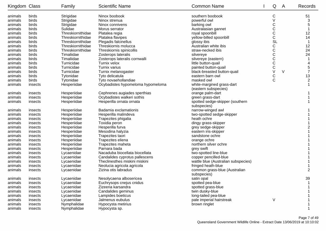
Kingdom Class Family Scientific Name Common Name I Q A Records
animals birds Strigidae Ninox boobook southern boobook C 51 animals birds Strigidae Ninox strenua powerful owl V 3 animals birds Strigidae Ninox connivens barking owl C 5 animals birds Sulidae Morus serrator Australasian gannet C 1 animals birds Threskiornithidae Platalea regia royal spoonbill C 12 animals birds Threskiornithidae Platalea flavipes yellow-billed spoonbill C 14 animals birds Threskiornithidae Plegadis falcinellus glossy ibis SL 1 animals birds Threskiornithidae Threskiornis molucca Australian white ibis C 12 animals birds Threskiornithidae Threskiornis spinicollis straw-necked ibis C 24 animals birds Timaliidae Zosterops lateralis silvereye C 24 animals birds Timaliidae Zosterops lateralis cornwalli silvereye (eastern) C 1 animals birds Turnicidae Turnix velox little button-quail C 4 animals birds Turnicidae Turnix varius painted button-quail C 5 animals birds Turnicidae Turnix melanogaster black-breasted button-quail V V 7 animals birds Tytonidae Tyto delicatula eastern barn owl C 13 animals birds Tytonidae Tyto novaehollandiae masked owl C 2 animals insects Hesperiidae Ocybadistes hypomeloma hypomeloma white-margined grass-dart 1
(eastern subspecies)animals insects Hesperiidae Cephrenes augiades sperthias orange palm-dart 1 animals insects Hesperiidae Ocybadistes walkeri sothis green grass-dart 1 animals insects Hesperiidae Hesperilla ornata ornata spotted sedge-skipper (southern 1
subspecies)animals insects Hesperiidae Badamia exclamationis narrow-winged awl 1 animals insects Hesperiidae Hesperilla malindeva two-spotted sedge-skipper 1 animals insects Hesperiidae Trapezites phigalia heath ochre 1 animals insects Hesperiidae Toxidia peron dingy grass-skipper 1 animals insects Hesperiidae Hesperilla furva grey sedge-skipper 2 animals insects Hesperiidae Mesodina halyzia eastern iris-skipper 1 animals insects Hesperiidae Trapezites taori sandstone ochre 1 animals insects Hesperiidae Trapezites eliena orange ochre 1 animals insects Hesperiidae Trapezites maheta northern silver ochre 1 animals insects Hesperiidae Parnara bada grey swift 1 animals insects Lycaenidae Nacaduba biocellata biocellata two-spotted line-blue 1 animals insects Lycaenidae Candalides cyprotus pallescens copper pencilled-blue 1 animals insects Lycaenidae Theclinesthes miskini miskini wattle blue (Australian subspecies) 1 animals insects Lycaenidae Neolucia agricola agricola fringed heath-blue 1 animals insects Lycaenidae Zizina otis labradus common grass-blue (Australian 2
subspecies)animals insects Lycaenidae Nesolycaena albosericea satin opal 39 animals insects Lycaenidae Euchrysops cnejus cnidus spotted pea-blue 1 animals insects Lycaenidae Zizeeria karsandra spotted grass-blue 1 animals insects Lycaenidae Candalides geminus twin dusky-blue 1 animals insects Lycaenidae Lampides boeticus long-tailed pea-blue 1 animals insects Lycaenidae Jalmenus eubulus pale imperial hairstreak V 1 animals insects Nymphalidae Hypocysta metirius brown ringlet 1 animals insects Nymphalidae Hypocysta sp. 1
Page 7 of 49Queensland Government Wildlife Online - Extract Date 13/06/2019 at 10:10:02

Kingdom Class Family Scientific Name Common Name I Q A Records
animals insects Nymphalidae Melanitis leda bankia evening brown 4 animals insects Nymphalidae Tirumala hamata hamata blue tiger 3 animals insects Nymphalidae Junonia villida villida meadow argus 4 animals insects Nymphalidae Ypthima arctous arctous dusky knight 1 animals insects Nymphalidae Hypolimnas bolina nerina varied eggfly 3 animals insects Nymphalidae Hypocysta adiante adiante orange ringlet 2 animals insects Nymphalidae Junonia orithya albicincta blue argus 5 animals insects Nymphalidae Acraea andromacha andromacha glasswing 2 animals insects Nymphalidae Charaxes sempronius sempronius tailed emperor 2 animals insects Nymphalidae Hypocysta pseudirius grey ringlet 1 animals insects Nymphalidae Danaus petilia lesser wanderer 3 animals insects Nymphalidae Euploea corinna common crow 5 animals insects Nymphalidae Hypocysta irius orange-streaked ringlet 1 animals insects Nymphalidae Vanessa kershawi Australian painted lady 1 animals insects Papilionidae Graphium eurypylus lycaon pale triangle 1 animals insects Papilionidae Cressida cressida cressida clearwing swallowtail 2 animals insects Papilionidae Papilio aegeus aegeus orchard swallowtail (Australian 4
subspecies)animals insects Pieridae Appias paulina ega yellow albatross 1 animals insects Pieridae Elodina angulipennis southern pearl-white 1 animals insects Pieridae Belenois java teutonia caper white 3 animals insects Pieridae Delias argenthona argenthona scarlet jezebel 1 animals insects Pieridae Catopsilia gorgophone gorgophone yellow migrant 2 animals insects Pieridae Eurema hecabe large grass-yellow 1 animals insects Pieridae Eurema herla pink grass-yellow 1 animals insects Pieridae Catopsilia pomona lemon migrant 3 animals insects Pieridae Elodina parthia striated pearl-white 1 animals insects Pieridae Eurema smilax small grass-yellow 2 animals insects Pieridae Cepora perimale scyllara caper gull (Australian subspecies) 3 animals mammals Acrobatidae Acrobates pygmaeus feathertail glider C 11 animals mammals Bovidae Bos sp. cattle Y 4 animals mammals Bovidae Bos taurus European cattle Y 18 animals mammals Canidae Vulpes vulpes red fox Y 1 animals mammals Canidae Canis lupus dingo dingo 22 animals mammals Canidae Canis lupus familiaris dog Y 11 animals mammals Dasyuridae Dasyurus sp. 1 animals mammals Dasyuridae Antechinus flavipes flavipes yellow-footed antechinus C 8
(south-east Queensland)animals mammals Dasyuridae Sminthopsis macroura stripe-faced dunnart C 2 animals mammals Dasyuridae Antechinus argentus silver-headed antechinus V E 23 animals mammals Dasyuridae Sminthopsis murina common dunnart C 3 animals mammals Dasyuridae Planigale maculata common planigale C 4 animals mammals Dasyuridae Planigale ingrami long-tailed planigale C 1 animals mammals Emballonuridae Saccolaimus flaviventris yellow-bellied sheathtail bat C 16 animals mammals Emballonuridae Taphozous troughtoni Troughton's sheathtail bat C 5 animals mammals Equidae Equus caballus horse Y 2
Page 8 of 49Queensland Government Wildlife Online - Extract Date 13/06/2019 at 10:10:02

Kingdom Class Family Scientific Name Common Name I Q A Records
animals mammals Felidae Felis catus cat Y 26 animals mammals Hipposideridae Hipposideros ater aruensis eastern dusky leaf-nosed bat C 3 animals mammals Leporidae Oryctolagus cuniculus rabbit Y 20 animals mammals Leporidae Lepus europaeus European brown hare Y 9 animals mammals Macropodidae Onychogalea fraenata bridled nailtail wallaby E E 42 animals mammals Macropodidae Lagorchestes conspicillatus spectacled hare-wallaby C 2 animals mammals Macropodidae Macropus parryi whiptail wallaby C 3 animals mammals Macropodidae Wallabia bicolor swamp wallaby C 9 animals mammals Macropodidae Macropus dorsalis black-striped wallaby C 19 animals mammals Macropodidae Macropus robustus common wallaroo C 9/1animals mammals Macropodidae Macropus giganteus eastern grey kangaroo C 30 animals mammals Macropodidae Petrogale herberti Herbert's rock-wallaby C 6/3animals mammals Macropodidae Petrogale inornata unadorned rock-wallaby C 3 animals mammals Macropodidae Macropus rufogriseus red-necked wallaby C 2 animals mammals Miniopteridae Miniopterus schreibersii oceanensis eastern bent-wing bat C 2 animals mammals Molossidae Mormopterus petersi inland free-tailed bat C 1 animals mammals Molossidae Tadarida australis white-striped freetail bat C 4 animals mammals Molossidae Mormopterus lumsdenae northern free-tailed bat C 2 animals mammals Molossidae Mormopterus sp. 7 animals mammals Muridae Mus musculus house mouse Y 69 animals mammals Muridae Rattus sp. 1 animals mammals Muridae Rattus tunneyi pale field-rat C 16/1animals mammals Muridae Melomys burtoni grassland melomys C 1/1animals mammals Muridae Rattus fuscipes bush rat C 2 animals mammals Muridae Rattus sordidus canefield rat C 2 animals mammals Muridae Zyzomys argurus common rock-rat C 1 animals mammals Muridae Rattus lutreolus swamp rat C 1 animals mammals Muridae Pseudomys patrius eastern pebble-mound mouse C 2 animals mammals Muridae Leggadina forresti Forrest's mouse C 2 animals mammals Muridae Melomys cervinipes fawn-footed melomys C 27 animals mammals Muridae Hydromys chrysogaster water rat C 5 animals mammals Muridae Pseudomys delicatulus delicate mouse C 11 animals mammals Muridae Pseudomys gracilicaudatus eastern chestnut mouse C 7 animals mammals Muridae Melomys sp. 3 animals mammals Muridae Pseudomys sp. 1/1animals mammals Ornithorhynchidae Ornithorhynchus anatinus platypus SL 2 animals mammals Peramelidae Isoodon macrourus northern brown bandicoot C 7 animals mammals Peramelidae Perameles nasuta long-nosed bandicoot C 3 animals mammals Petauridae Petaurus breviceps sugar glider C 22 animals mammals Petauridae Petaurus norfolcensis squirrel glider C 12 animals mammals Petauridae Petaurus australis australis yellow-bellied glider (southern C 42
subspecies)animals mammals Phalangeridae Trichosurus vulpecula common brushtail possum C 23 animals mammals Phascolarctidae Phascolarctos cinereus koala V V 12 animals mammals Potoroidae Aepyprymnus rufescens rufous bettong C 15 animals mammals Potoroidae Bettongia gaimardi gaimardi eastern bettong PE EX 4
Page 9 of 49Queensland Government Wildlife Online - Extract Date 13/06/2019 at 10:10:02

Kingdom Class Family Scientific Name Common Name I Q A Records
animals mammals Pseudocheiridae Petauroides volans greater glider V V 3 animals mammals Pseudocheiridae Petauroides volans volans southern greater glider V V 69 animals mammals Pteropodidae Pteropus sp. 1 animals mammals Pteropodidae Pteropus scapulatus little red flying-fox C 4 animals mammals Rhinolophidae Rhinolophus megaphyllus eastern horseshoe-bat C 5 animals mammals Suidae Sus scrofa pig Y 9 animals mammals Tachyglossidae Tachyglossus aculeatus short-beaked echidna SL 24 animals mammals Vespertilionidae Scotorepens sp. 8 animals mammals Vespertilionidae Chalinolobus morio chocolate wattled bat C 9 animals mammals Vespertilionidae Nyctophilus gouldi Gould's long-eared bat C 16 animals mammals Vespertilionidae Scotorepens greyii little broad-nosed bat C 4 animals mammals Vespertilionidae Chalinolobus dwyeri large-eared pied bat V V 2 animals mammals Vespertilionidae Chalinolobus gouldii Gould's wattled bat C 17 animals mammals Vespertilionidae Chalinolobus picatus little pied bat C 7 animals mammals Vespertilionidae Scotorepens balstoni inland broad-nosed bat C 4 animals mammals Vespertilionidae Nyctophilus geoffroyi lesser long-eared bat C 5 animals mammals Vespertilionidae Vespadelus troughtoni eastern cave bat C 5 animals mammals Vespertilionidae Vespadelus baverstocki inland forest bat C 2 animals mammals Vespertilionidae Chalinolobus nigrogriseus hoary wattled bat C 7 animals mammals Vespertilionidae Nyctophilus sp. 1 animals mammals Vespertilionidae Myotis macropus large-footed myotis C 2 animals mammals Vespertilionidae Vespadelus sp. 2 animals mammals Vespertilionidae Vespadelus pumilus eastern forest bat C 1 animals ray-finned fishes Ambassidae Ambassis agassizii Agassiz's glassfish 3 animals ray-finned fishes Anguillidae Anguilla reinhardtii longfin eel 4 animals ray-finned fishes Apogonidae Glossamia aprion mouth almighty 5 animals ray-finned fishes Ariidae Neoarius graeffei blue catfish 135 animals ray-finned fishes Atherinidae Craterocephalus stercusmuscarum flyspecked hardyhead 6 animals ray-finned fishes Belonidae Strongylura krefftii freshwater longtom 18 animals ray-finned fishes Clupeidae Nematalosa erebi bony bream 136 animals ray-finned fishes Eleotridae Hypseleotris klunzingeri western carp gudgeon 3 animals ray-finned fishes Eleotridae Philypnodon grandiceps flathead gudgeon 1 animals ray-finned fishes Eleotridae Hypseleotris species 1 Midgley's carp gudgeon 4 animals ray-finned fishes Eleotridae Hypseleotris compressa empire gudgeon 3 animals ray-finned fishes Eleotridae Oxyeleotris lineolata sleepy cod 8 animals ray-finned fishes Eleotridae Mogurnda adspersa southern purplespotted gudgeon 1 animals ray-finned fishes Megalopidae Megalops cyprinoides oxeye herring 3 animals ray-finned fishes Melanotaeniidae Melanotaenia splendida splendida eastern rainbowfish 5 animals ray-finned fishes Osteoglossidae Scleropages leichardti southern saratoga 22 animals ray-finned fishes Percichthyidae Macquaria ambigua golden perch 10 animals ray-finned fishes Plotosidae Tandanus tandanus freshwater catfish 5 animals ray-finned fishes Plotosidae Neosilurus hyrtlii Hyrtl's catfish 6 animals ray-finned fishes Pseudomugilidae Pseudomugil signifer Pacific blue eye 1 animals ray-finned fishes Terapontidae Leiopotherapon unicolor spangled perch 5 animals ray-finned fishes Terapontidae Scortum hillii leathery grunter 9 animals ray-finned fishes Terapontidae Amniataba percoides barred grunter 17
Page 10 of 49Queensland Government Wildlife Online - Extract Date 13/06/2019 at 10:10:02

Kingdom Class Family Scientific Name Common Name I Q A Records
animals reptiles Agamidae Amphibolurus muricatus jacky lizard C 1 animals reptiles Agamidae Pogona barbata bearded dragon C 7/1animals reptiles Agamidae Diporiphora sp. 1 animals reptiles Agamidae Diporiphora australis tommy roundhead C 6/1animals reptiles Agamidae Chlamydosaurus kingii frilled lizard C 1 animals reptiles Agamidae Lophognathus gilberti sensu lato Gilbert's dragon C 1 animals reptiles Agamidae Diporiphora lalliae Lally's two-line dragon C 1 animals reptiles Agamidae Diporiphora nobbi nobbi C 19 animals reptiles Agamidae Intellagama lesueurii eastern water dragon C 9 animals reptiles Boidae Aspidites melanocephalus black-headed python C 6 animals reptiles Boidae Morelia spilota carpet python C 6 animals reptiles Boidae Antaresia maculosa spotted python C 8/1animals reptiles Carphodactylidae Underwoodisaurus milii thick-tailed gecko C 4 animals reptiles Carphodactylidae Nephrurus asper spiny knob-tailed gecko C 17/2animals reptiles Carphodactylidae Saltuarius salebrosus rough-throated leaf-tailed gecko C 17 animals reptiles Chelidae Chelodina expansa broad-shelled river turtle C 1 animals reptiles Chelidae Wollumbinia latisternum saw-shelled turtle C 3 animals reptiles Chelidae Chelodina longicollis eastern snake-necked turtle C 1 animals reptiles Chelidae Elseya albagula southern snapping turtle E CE 2 animals reptiles Chelidae Emydura macquarii krefftii Krefft's river turtle C 8 animals reptiles Chelidae Rheodytes leukops Fitzroy River turtle V V 1 animals reptiles Colubridae Dendrelaphis punctulatus green tree snake C 6 animals reptiles Colubridae Tropidonophis mairii freshwater snake C 7 animals reptiles Colubridae Boiga irregularis brown tree snake C 7 animals reptiles Diplodactylidae Oedura sp. 1 animals reptiles Diplodactylidae Oedura tryoni southern spotted velvet gecko C 27/1animals reptiles Diplodactylidae Oedura monilis ocellated velvet gecko C 16/3animals reptiles Diplodactylidae Amalosia rhombifer zig-zag gecko C 3/1animals reptiles Diplodactylidae Diplodactylus platyurus eastern fat-tailed gecko C 6/1animals reptiles Diplodactylidae Strophurus williamsi soft-spined gecko C 3 animals reptiles Diplodactylidae Strophurus taenicauda golden-tailed gecko NT 10/1animals reptiles Diplodactylidae Diplodactylus vittatus wood gecko C 14 animals reptiles Diplodactylidae Lucasium steindachneri Steindachner's gecko C 7/1animals reptiles Diplodactylidae Nebulifera robusta robust velvet gecko C 15 animals reptiles Elapidae Suta suta myall snake C 8/1animals reptiles Elapidae Furina ornata orange-naped snake C 1 animals reptiles Elapidae Furina diadema red-naped snake C 4/1animals reptiles Elapidae Denisonia maculata ornamental snake V V 1 animals reptiles Elapidae Cryptophis boschmai Carpentaria whip snake C 1 animals reptiles Elapidae Demansia psammophis yellow-faced whipsnake C 5 animals reptiles Elapidae Hoplocephalus bitorquatus pale-headed snake C 5/2animals reptiles Elapidae Pseudonaja textilis eastern brown snake C 4 animals reptiles Elapidae Vermicella annulata bandy-bandy C 5 animals reptiles Elapidae Pseudechis australis king brown snake C 1 animals reptiles Elapidae Cryptophis nigrescens eastern small-eyed snake C 7 animals reptiles Elapidae Brachyurophis australis coral snake C 1
Page 11 of 49Queensland Government Wildlife Online - Extract Date 13/06/2019 at 10:10:02

Kingdom Class Family Scientific Name Common Name I Q A Records
animals reptiles Elapidae Demansia vestigiata lesser black whipsnake C 2 animals reptiles Gekkonidae Gehyra sp. 1 animals reptiles Gekkonidae Gehyra dubia dubious dtella C 115/1animals reptiles Gekkonidae Hemidactylus frenatus house gecko Y 2 animals reptiles Gekkonidae Gehyra versicolor C 2 animals reptiles Gekkonidae Heteronotia binoei Bynoe's gecko C 113/2animals reptiles Gekkonidae Gehyra catenata chain-backed dtella C 25/1animals reptiles Pygopodidae Delma torquata collared delma V V 1 animals reptiles Pygopodidae Paradelma orientalis brigalow scaly-foot C 9 animals reptiles Pygopodidae Pygopus lepidopodus common scaly-foot C 1 animals reptiles Pygopodidae Lialis burtonis Burton's legless lizard C 6 animals reptiles Scincidae Ctenotus strauchii eastern barred wedgesnout ctenotus C 1 animals reptiles Scincidae Ctenotus spaldingi straight-browed ctenotus C 6 animals reptiles Scincidae Cryptoblepharus sp. 2 animals reptiles Scincidae Ctenotus leonhardii Leonhardi's ctenotus C 1/1animals reptiles Scincidae Lygisaurus foliorum tree-base litter-skink C 25/1animals reptiles Scincidae Morethia boulengeri south-eastern morethia skink C 17 animals reptiles Scincidae Concinnia brachysoma northern bar-sided skink C 4/1animals reptiles Scincidae Ctenotus taeniolatus copper-tailed skink C 59/3animals reptiles Scincidae Lampropholis amicula friendly sunskink C 9 animals reptiles Scincidae Lampropholis delicata dark-flecked garden sunskink C 22/1animals reptiles Scincidae Morethia taeniopleura fire-tailed skink C 29/3animals reptiles Scincidae Anomalopus brevicollis short-necked worm-skink C 2 animals reptiles Scincidae Lerista punctatovittata eastern robust slider C 3 animals reptiles Scincidae Cryptoblepharus pannosus ragged snake-eyed skink C 15 animals reptiles Scincidae Cyclodomorphus gerrardii pink-tongued lizard C 1 animals reptiles Scincidae Cryptoblepharus australis inland snake-eyed skink C 1 animals reptiles Scincidae Cryptoblepharus metallicus metallic snake-eyed skink C 1 animals reptiles Scincidae Glaphyromorphus punctulatus fine-spotted mulch-skink C 5 animals reptiles Scincidae Carlia pectoralis sensu lato C 64/2animals reptiles Scincidae Cryptoblepharus pulcher pulcher elegant snake-eyed skink C 17 animals reptiles Scincidae Cryptoblepharus virgatus sensu lato C 45 animals reptiles Scincidae Carlia sp. 5 animals reptiles Scincidae Lerista sp. 1 animals reptiles Scincidae Menetia sp. 1 animals reptiles Scincidae Carlia munda shaded-litter rainbow-skink C 4 animals reptiles Scincidae Carlia vivax tussock rainbow-skink C 2 animals reptiles Scincidae Ctenotus sp. 4 animals reptiles Scincidae Carlia rubigo orange-flanked rainbow skink C 8 animals reptiles Scincidae Eulamprus sp. 3/1animals reptiles Scincidae Egernia rugosa yakka skink V V 1/1animals reptiles Scincidae Menetia greyii common dwarf skink C 4 animals reptiles Scincidae Concinnia tenuis bar-sided skink C 6/2animals reptiles Scincidae Ctenotus ingrami unspotted yellow-sided ctenotus C 2 animals reptiles Scincidae Eulamprus quoyii eastern water skink C 11 animals reptiles Scincidae Lampropholis sp. C 5
Page 12 of 49Queensland Government Wildlife Online - Extract Date 13/06/2019 at 10:10:02

Kingdom Class Family Scientific Name Common Name I Q A Records
animals reptiles Scincidae Lerista fragilis eastern mulch slider C 30 animals reptiles Scincidae Carlia pectoralis open-litter rainbow skink C 11 animals reptiles Scincidae Carlia schmeltzii robust rainbow-skink C 18/2animals reptiles Scincidae Concinnia martini dark bar-sided skink C 1 animals reptiles Scincidae Egernia striolata tree skink C 1 animals reptiles Scincidae Concinnia sokosoma stout bar-sided skink C 3/1animals reptiles Scincidae Tiliqua scincoides eastern blue-tongued lizard C 1/1animals reptiles Typhlopidae Anilios sp. 1 animals reptiles Typhlopidae Anilios affinis small-headed blind snake C 1 animals reptiles Typhlopidae Anilios bituberculatus prong-snouted blind snake C 1 animals reptiles Typhlopidae Anilios nigrescens blackish blind snake C 1/1animals reptiles Typhlopidae Anilios proximus proximus blind snake C 1/1animals reptiles Varanidae Varanus tristis black-tailed monitor C 10/1animals reptiles Varanidae Varanus varius lace monitor C 7 animals uncertain Indeterminate Indeterminate Unknown or Code Pending C 15 bacteria blue-green algae Aphanothecaceae Aphanothece stagnina C 1/1bacteria blue-green algae Scytonemataceae Scytonema hofman-bangii C 2/2bacteria blue-green algae Stigonemataceae Stigonema hormoides C 1/1bacteria blue-green algae Stigonemataceae Stigonema multipartitum C 1/1fungi Agaricomycetes Polyporaceae Polyporus C 1/1fungi Agaricomycetes Stereaceae Stereum C 1/1fungi lecanoromycetes Cladoniaceae Cladonia rigida var. rigida C 1/1fungi lecanoromycetes Cladoniaceae Cladonia C 2/2fungi lecanoromycetes Cladoniaceae Cladonia ochrochlora C 1/1fungi lecanoromycetes Collemataceae Collema C 1/1fungi lecanoromycetes Graphidaceae Diploschistes euganeus C 1/1fungi lecanoromycetes Lecanoraceae Lecanora elatinoides C 1/1fungi lecanoromycetes Leprocaulaceae Leprocaulon microscopicum C 1/1fungi lecanoromycetes Parmeliaceae Parmotrema tinctorum C 2/2fungi lecanoromycetes Parmeliaceae Usnea scabrida subsp. elegans C 5/5fungi lecanoromycetes Parmeliaceae Xanthoparmelia antleriformis C 1/1fungi lecanoromycetes Parmeliaceae Xanthoparmelia stuartioides C 1/1fungi lecanoromycetes Parmeliaceae Xanthoparmelia neoquintaria C 3/3fungi lecanoromycetes Parmeliaceae Usnea C 1/1fungi lecanoromycetes Parmeliaceae Usnea baileyi C 6/6fungi lecanoromycetes Parmeliaceae Usnea rubicunda C 3/3fungi lecanoromycetes Parmeliaceae Relicina limbata C 3/3fungi lecanoromycetes Parmeliaceae Parmelia erumpens C 2/2fungi lecanoromycetes Parmeliaceae Parmelia signifera C 1/1fungi lecanoromycetes Parmeliaceae Parmotrema cooperi C 1/1fungi lecanoromycetes Parmeliaceae Punctelia subflava C 1/1fungi lecanoromycetes Parmeliaceae Usnea trichodeoides C 1/1fungi lecanoromycetes Parmeliaceae Parmotrema eurysacum C 1/1fungi lecanoromycetes Parmeliaceae Relicina sydneyensis C 1/1fungi lecanoromycetes Parmeliaceae Flavoparmelia rutidota C 1/1fungi lecanoromycetes Parmeliaceae Pannoparmelia wilsonii C 1/1
Page 13 of 49Queensland Government Wildlife Online - Extract Date 13/06/2019 at 10:10:02

Kingdom Class Family Scientific Name Common Name I Q A Records
fungi lecanoromycetes Parmeliaceae Parmotrema lobulascens C 4/4fungi lecanoromycetes Parmeliaceae Hypotrachyna immaculata C 2/2fungi lecanoromycetes Parmeliaceae Parmotrema subcaperatum C 1/1fungi lecanoromycetes Parmeliaceae Xanthoparmelia amplexula C 1/1fungi lecanoromycetes Parmeliaceae Xanthoparmelia tasmanica C 1/1fungi lecanoromycetes Parmeliaceae Xanthoparmelia isidiigera C 2/2fungi lecanoromycetes Parmeliaceae Austroparmelina conlabrosa C 1/1fungi lecanoromycetes Parmeliaceae Punctelia pseudocoralloidea C 1/1fungi lecanoromycetes Parmeliaceae Xanthoparmelia australasica C 1/1fungi lecanoromycetes Pertusariaceae Pertusaria C 1/1fungi lecanoromycetes Physciaceae Rinodina williamsii C 1/1fungi lecanoromycetes Physciaceae Heterodermia obscurata C 1/1fungi lecanoromycetes Psoraceae Protoblastenia C 2/2fungi lecanoromycetes Stereocaulaceae Lepraria jackii C 1/1plants ConjugatophyceaeZygnemataceae Zygogonium ericetorum C 1/1plants Equisetopsida Acanthaceae Pseuderanthemum C 1 plants Equisetopsida Acanthaceae Ruellia simplex Y 1/1plants Equisetopsida Acanthaceae Brunoniella australis blue trumpet C 8 plants Equisetopsida Acanthaceae Pseuderanthemum tenellum C 1 plants Equisetopsida Acanthaceae Rostellularia adscendens C 12/2plants Equisetopsida Acanthaceae Acanthaceae C 1/1plants Equisetopsida Acanthaceae Dipteracanthus australasicus C 1 plants Equisetopsida Acanthaceae Asystasia gangetica subsp. gangetica Y 1/1plants Equisetopsida Acanthaceae Rostellularia adscendens var. adscendens C 2 plants Equisetopsida Acanthaceae Dipteracanthus australasicus subsp. corynothecus C 4/2plants Equisetopsida Acanthaceae Pseuderanthemum variabile pastel flower C 9/2plants Equisetopsida Agavaceae Agave vivipara var. vivipara Y 1/1plants Equisetopsida Aizoaceae Trianthema triquetra red spinach C 13/1plants Equisetopsida Aizoaceae Zaleya galericulata subsp. galericulata C 3/2plants Equisetopsida Aizoaceae Trianthema portulacastrum black pigweed Y 8 plants Equisetopsida Alismataceae Caldesia oligococca C 1 plants Equisetopsida Alismataceae Damasonium minus starfruit C 1/1plants Equisetopsida Amaranthaceae Ptilotus nobilis C 1 plants Equisetopsida Amaranthaceae Alternanthera denticulata lesser joyweed C 7 plants Equisetopsida Amaranthaceae Achyranthes aspera C 8/2plants Equisetopsida Amaranthaceae Nyssanthes erecta C 4/2plants Equisetopsida Amaranthaceae Alternanthera nana hairy joyweed C 6 plants Equisetopsida Amaranthaceae Amaranthus viridis green amaranth Y 1 plants Equisetopsida Amaranthaceae Nyssanthes diffusa barbed-wire weed C 1 plants Equisetopsida Amaranthaceae Ptilotus semilanatus C 1/1plants Equisetopsida Amaranthaceae Alternanthera pungens khaki weed Y 1/1plants Equisetopsida Amaranthaceae Gomphrena celosioides gomphrena weed Y 4 plants Equisetopsida Amaranthaceae Ptilotus polystachyus C 1/1plants Equisetopsida Amaranthaceae Amaranthus macrocarpus dwarf amaranth C 1 plants Equisetopsida Amaranthaceae Ptilotus macrocephalus green pussytails C 2/1plants Equisetopsida Amaranthaceae Alternanthera nodiflora joyweed C 4/1
Page 14 of 49Queensland Government Wildlife Online - Extract Date 13/06/2019 at 10:10:02

Kingdom Class Family Scientific Name Common Name I Q A Records
plants Equisetopsida Amaranthaceae Deeringia amaranthoides redberry C 2/1plants Equisetopsida Amaryllidaceae Crinum flaccidum Murray lily C 4 plants Equisetopsida Anacardiaceae Euroschinus falcatus C 1 plants Equisetopsida Anacardiaceae Pleiogynium timorense Burdekin plum C 1 plants Equisetopsida Anacardiaceae Schinus terebinthifolius Y 1/1plants Equisetopsida Annonaceae Melodorum leichhardtii C 1 plants Equisetopsida Apiaceae Platysace ericoides heath platysace C 6/3plants Equisetopsida Apiaceae Actinotus helianthi flannel flower C 1 plants Equisetopsida Apiaceae Actinotus gibbonsii dwarf flannel flower C 1 plants Equisetopsida Apiaceae Centella asiatica C 2/1plants Equisetopsida Apocynaceae Alyxia magnifolia C 1 plants Equisetopsida Apocynaceae Alyxia ruscifolia C 1 plants Equisetopsida Apocynaceae Cascabela thevetia yellow oleander Y 1/1plants Equisetopsida Apocynaceae Cynanchum viminale C 3 plants Equisetopsida Apocynaceae Parsonsia lilacina crisped silkpod C 1 plants Equisetopsida Apocynaceae Secamone elliptica C 2 plants Equisetopsida Apocynaceae Alstonia constricta bitterbark C 30/1plants Equisetopsida Apocynaceae Marsdenia australis doubah C 1 plants Equisetopsida Apocynaceae Parsonsia straminea monkey rope C 9/1plants Equisetopsida Apocynaceae Vincetoxicum ovatum C 1 plants Equisetopsida Apocynaceae Marsdenia micradenia gymnema C 1 plants Equisetopsida Apocynaceae Marsdenia microlepis C 3/1plants Equisetopsida Apocynaceae Marsdenia pleiadenia C 1 plants Equisetopsida Apocynaceae Parsonsia lanceolata northern silkpod C 12/2plants Equisetopsida Apocynaceae Asclepias curassavica red-head cottonbush Y 1/1plants Equisetopsida Apocynaceae Parsonsia plaesiophylla C 1 plants Equisetopsida Apocynaceae Cryptostegia grandiflora rubber vine Y 8/2plants Equisetopsida Apocynaceae Gomphocarpus physocarpus balloon cottonbush Y 1 plants Equisetopsida Apocynaceae Parsonsia eucalyptophylla gargaloo C 3 plants Equisetopsida Apocynaceae Hoya australis subsp. australis C 5/5plants Equisetopsida Apocynaceae Cynanchum viminale subsp. australe C 2 plants Equisetopsida Apocynaceae Cynanchum viminale subsp. brunonianum C 7/2plants Equisetopsida Apocynaceae Marsdenia viridiflora subsp. viridiflora C 7/3plants Equisetopsida Apocynaceae Cerbera dumicola NT 6/6plants Equisetopsida Apocynaceae Hoya australis C 1 plants Equisetopsida Apocynaceae Carissa ovata currantbush C 87 plants Equisetopsida Apocynaceae Marsdenia C 3 plants Equisetopsida Apocynaceae Parsonsia C 8 plants Equisetopsida Araliaceae Polyscias elegans celery wood C 2/1plants Equisetopsida Araliaceae Astrotricha cordata C 7/1plants Equisetopsida Araliaceae Hydrocotyle acutiloba C 1 plants Equisetopsida Araliaceae Trachymene procumbens creeping wild parsnip C 2/1plants Equisetopsida Araliaceae Astrotricha intermedia C 1 plants Equisetopsida Araliaceae Astrotricha longifolia star hair bush C 1 plants Equisetopsida Arecaceae Livistona C 6 plants Equisetopsida Arecaceae Livistona fulva V 16/12
Page 15 of 49Queensland Government Wildlife Online - Extract Date 13/06/2019 at 10:10:02

Kingdom Class Family Scientific Name Common Name I Q A Records
plants Equisetopsida Arecaceae Livistona australis cabbage tree palm C 2 plants Equisetopsida Asteraceae Acmella grandiflora var. brachyglossa C 1 plants Equisetopsida Asteraceae Ageratum conyzoides subsp. conyzoides Y 1/1plants Equisetopsida Asteraceae Pterocaulon serrulatum var. serrulatum C 4/4plants Equisetopsida Asteraceae Verbesina encelioides var. encelioides Y 3/3plants Equisetopsida Asteraceae Crassocephalum crepidioides thickhead Y 1 plants Equisetopsida Asteraceae Pseudognaphalium luteoalbum Jersey cudweed C 1 plants Equisetopsida Asteraceae Vittadinia dissecta var. hirta C 5/3plants Equisetopsida Asteraceae Lactuca serriola forma serriola Y 1/1plants Equisetopsida Asteraceae Peripleura hispidula var. setosa C 3/3plants Equisetopsida Asteraceae Gynura drymophila var. drymophila C 1/1plants Equisetopsida Asteraceae Conyza 1 plants Equisetopsida Asteraceae Calotis C 1 plants Equisetopsida Asteraceae Olearia C 1 plants Equisetopsida Asteraceae Senecio C 1 plants Equisetopsida Asteraceae Vittadinia C 1 plants Equisetopsida Asteraceae Brachyscome C 1 plants Equisetopsida Asteraceae Bidens pilosa Y 2/1plants Equisetopsida Asteraceae Blumea lacera C 1/1plants Equisetopsida Asteraceae Centipeda minima subsp. minima C 2/2plants Equisetopsida Asteraceae Peripleura hispidula var. hispidula C 1 plants Equisetopsida Asteraceae Sonchus asper rough sowthistle Y 1 plants Equisetopsida Asteraceae Calotis dentex white burr daisy C 8/7plants Equisetopsida Asteraceae Tagetes minuta stinking roger Y 1/1plants Equisetopsida Asteraceae Calotis cuneata C 1 plants Equisetopsida Asteraceae Cassinia laevis C 1 plants Equisetopsida Asteraceae Bidens bipinnata bipinnate beggar's ticks Y 2/1plants Equisetopsida Asteraceae Blumea saxatilis C 1/1plants Equisetopsida Asteraceae Centipeda minima C 2 plants Equisetopsida Asteraceae Olearia nernstii Ipswich daisy C 1 plants Equisetopsida Asteraceae Pluchea dunlopii C 1/1plants Equisetopsida Asteraceae Pluchea xanthina C 1/1plants Equisetopsida Asteraceae Camptacra barbata C 1 plants Equisetopsida Asteraceae Eclipta prostrata white eclipta Y 3/2plants Equisetopsida Asteraceae Gynura drymophila C 2 plants Equisetopsida Asteraceae Olearia canescens C 1 plants Equisetopsida Asteraceae Olearia xerophila C 1/1plants Equisetopsida Asteraceae Sonchus oleraceus common sowthistle Y 4/2plants Equisetopsida Asteraceae Tridax procumbens tridax daisy Y 1/1plants Equisetopsida Asteraceae Calotis cuneifolia burr daisy C 1 plants Equisetopsida Asteraceae Coronidium cymosum C 5/5plants Equisetopsida Asteraceae Emilia sonchifolia Y 1 plants Equisetopsida Asteraceae Flaveria trinervia Y 1/1plants Equisetopsida Asteraceae Vittadinia sulcata native daisy C 3/2plants Equisetopsida Asteraceae Coronidium rupicola C 1 plants Equisetopsida Asteraceae Euchiton sphaericus C 3/2
Page 16 of 49Queensland Government Wildlife Online - Extract Date 13/06/2019 at 10:10:02

Kingdom Class Family Scientific Name Common Name I Q A Records
plants Equisetopsida Asteraceae Glossocardia bidens native cobbler's pegs C 2/1plants Equisetopsida Asteraceae Minuria integerrima smooth minuria C 5/3plants Equisetopsida Asteraceae Olearia microphylla C 2/1plants Equisetopsida Asteraceae Rutidosis leucantha C 1/1plants Equisetopsida Asteraceae Calyptocarpus vialis creeping cinderella weed Y 1 plants Equisetopsida Asteraceae Erigeron bonariensis Y 2/1plants Equisetopsida Asteraceae Lagenophora gracilis C 1 plants Equisetopsida Asteraceae Peripleura hispidula C 1 plants Equisetopsida Asteraceae Pterocaulon redolens C 2 plants Equisetopsida Asteraceae Rhodanthe polyphylla C 3/2plants Equisetopsida Asteraceae Rutidosis glandulosa NT 7/7plants Equisetopsida Asteraceae Senecio depressicola C 1/1plants Equisetopsida Asteraceae Vittadinia pustulata C 1 plants Equisetopsida Asteraceae Xanthium occidentale Y 7/2plants Equisetopsida Asteraceae Coronidium glutinosum C 7/5plants Equisetopsida Asteraceae Cyanthillium cinereum C 16/4plants Equisetopsida Asteraceae Lagenophora stipitata C 1 plants Equisetopsida Asteraceae Podolepis longipedata tall copper-wire daisy C 2/1plants Equisetopsida Asteraceae Rutidosis murchisonii C 1 plants Equisetopsida Asteraceae Senecio bathurstianus C 1 plants Equisetopsida Asteraceae Senecio brigalowensis C 4/4plants Equisetopsida Asteraceae Senecio prenanthoides C 1/1plants Equisetopsida Asteraceae Verbesina encelioides crownbeard Y 1 plants Equisetopsida Asteraceae Brachyscome dalbyensis C 1 plants Equisetopsida Asteraceae Pterocaulon serrulatum C 1 plants Equisetopsida Asteraceae Senecio quadridentatus cotton fireweed C 1 plants Equisetopsida Asteraceae Sigesbeckia orientalis Indian weed C 1 plants Equisetopsida Asteraceae Gamochaeta pensylvanica Y 1 plants Equisetopsida Asteraceae Isoetopsis graminifolia grass cushion C 1 plants Equisetopsida Asteraceae Ozothamnus cassinioides C 2/1plants Equisetopsida Asteraceae Pterocaulon sphacelatum applebush C 1/1plants Equisetopsida Asteraceae Parthenium hysterophorus parthenium weed Y 14/6plants Equisetopsida Asteraceae Symphyotrichum subulatum Y 1/1plants Equisetopsida Asteraceae Chrysocephalum apiculatum yellow buttons C 7/2plants Equisetopsida Asteraceae Sphaeromorphaea australis C 4/1plants Equisetopsida Asteraceae Sphaeromorphaea subintegra C 1 plants Equisetopsida Asteraceae Synedrellopsis grisebachii Y 1/1plants Equisetopsida Bignoniaceae Pandorea pandorana wonga vine C 4/1plants Equisetopsida Blechnaceae Blechnum indicum swamp water fern C 2 plants Equisetopsida Blechnaceae Doodia media C 1 plants Equisetopsida Blechnaceae Blechnum nudum fishbone water fern C 5 plants Equisetopsida Blechnaceae Blechnum cartilagineum gristle fern C 2/1plants Equisetopsida Blechnaceae Blechnum ambiguum C 4/3plants Equisetopsida Blechnaceae Doodia caudata C 2 plants Equisetopsida Boraginaceae Heliotropium moorei C 1/1plants Equisetopsida Boraginaceae Heliotropium indicum Y 2/1
Page 17 of 49Queensland Government Wildlife Online - Extract Date 13/06/2019 at 10:10:02

Kingdom Class Family Scientific Name Common Name I Q A Records
plants Equisetopsida Boraginaceae Ehretia membranifolia weeping koda C 9 plants Equisetopsida Boraginaceae Heliotropium ovalifolium C 1/1plants Equisetopsida Burmanniaceae Burmannia disticha C 3/1plants Equisetopsida Byttneriaceae Commersonia pearnii E 2/2plants Equisetopsida Byttneriaceae Seringia corollata C 7/2plants Equisetopsida Byttneriaceae Waltheria indica C 3/2plants Equisetopsida Byttneriaceae Seringia collina C 1/1plants Equisetopsida Byttneriaceae Melochia pyramidata Y 1 plants Equisetopsida Byttneriaceae Commersonia dasyphylla C 1 plants Equisetopsida Byttneriaceae Hannafordia shanesii C 1/1plants Equisetopsida Byttneriaceae Seringia lanceolata C 4/2plants Equisetopsida Byttneriaceae Seringia hookeriana C 4/4plants Equisetopsida Byttneriaceae Commersonia leichhardtii C 2 plants Equisetopsida Cactaceae Harrisia C 1 plants Equisetopsida Cactaceae Opuntia stricta Y 14 plants Equisetopsida Cactaceae Harrisia martinii Y 18/2plants Equisetopsida Cactaceae Opuntia tomentosa velvety tree pear Y 23/1plants Equisetopsida Cactaceae Opuntia C 8 plants Equisetopsida Cactaceae Harrisia pomanensis Y 2/2plants Equisetopsida Cactaceae Opuntia leucotricha Y 1/1plants Equisetopsida Cactaceae Opuntia streptacantha cardona pear Y 12 plants Equisetopsida Cactaceae Acanthocereus tetragonus sword pear Y 1 plants Equisetopsida Cactaceae Opuntia aurantiaca tiger pear Y 1 plants Equisetopsida Caesalpiniaceae Senna aciphylla Australian senna C 2/2plants Equisetopsida Caesalpiniaceae Cassia brewsteri C 54/8plants Equisetopsida Caesalpiniaceae Senna barclayana C 2/1plants Equisetopsida Caesalpiniaceae Senna circinnata C 1 plants Equisetopsida Caesalpiniaceae Cassia tomentella C 1 plants Equisetopsida Caesalpiniaceae Labichea rupestris C 2/2plants Equisetopsida Caesalpiniaceae Senna coronilloides C 3 plants Equisetopsida Caesalpiniaceae Lysiphyllum carronii ebony tree C 31/1plants Equisetopsida Caesalpiniaceae Parkinsonia aculeata parkinsonia Y 14/9plants Equisetopsida Caesalpiniaceae Petalostylis labicheoides C 4/3plants Equisetopsida Caesalpiniaceae Chamaecrista nomame var. nomame C 1/1plants Equisetopsida Caesalpiniaceae Senna artemisioides subsp. coriacea C 2 plants Equisetopsida Caesalpiniaceae Chamaecrista rotundifolia var. rotundifolia Y 1 plants Equisetopsida Caesalpiniaceae Senna C 4 plants Equisetopsida Caesalpiniaceae Cassia C 2 plants Equisetopsida Caesalpiniaceae Lysiphyllum C 2 plants Equisetopsida Caesalpiniaceae Petalostylis C 1 plants Equisetopsida Caesalpiniaceae Delonix regia poinciana Y 1/1plants Equisetopsida Caesalpiniaceae Senna gaudichaudii C 1 plants Equisetopsida Caesalpiniaceae Senna occidentalis coffee senna Y 4/2plants Equisetopsida Caesalpiniaceae Chamaecrista nomame C 1/1plants Equisetopsida Caesalpiniaceae Lysiphyllum hookeri Queensland ebony C 19/3plants Equisetopsida Campanulaceae Lobelia quadrangularis C 1
Page 18 of 49Queensland Government Wildlife Online - Extract Date 13/06/2019 at 10:10:02

Kingdom Class Family Scientific Name Common Name I Q A Records
plants Equisetopsida Campanulaceae Lobelia trigonocaulis forest lobelia C 2/1plants Equisetopsida Campanulaceae Wahlenbergia gracilis sprawling bluebell C 1 plants Equisetopsida Campanulaceae Lobelia purpurascens white root C 1 plants Equisetopsida Campanulaceae Isotoma gulliveri C 1 plants Equisetopsida Campanulaceae Isotoma axillaris australian harebell C 1 plants Equisetopsida Campanulaceae Lobelia concolor C 1 plants Equisetopsida Campanulaceae Lobelia gibbosa native lobelia C 1 plants Equisetopsida Campanulaceae Wahlenbergia C 3 plants Equisetopsida Capparaceae Capparis mitchellii C 7 plants Equisetopsida Capparaceae Capparis loranthifolia C 12 plants Equisetopsida Capparaceae Capparis loranthifolia var. bancroftii C 2/2plants Equisetopsida Capparaceae Capparis loranthifolia var. loranthifolia C 3/3plants Equisetopsida Capparaceae Apophyllum anomalum broom bush C 24 plants Equisetopsida Capparaceae Capparis lasiantha nipan C 22/3plants Equisetopsida Capparaceae Capparis canescens C 14/1plants Equisetopsida Capparaceae Capparis arborea brush caper berry C 1 plants Equisetopsida Capparaceae Capparis ornans C 1 plants Equisetopsida Capparaceae Capparis C 10 plants Equisetopsida Carpodetaceae Cuttsia viburnea silver-leaf cuttsia C 3/2plants Equisetopsida Caryophyllaceae Polycarpaea spirostylis subsp. compacta C 2 plants Equisetopsida Caryophyllaceae Cerastium glomeratum mouse ear chickweed Y 1 plants Equisetopsida Caryophyllaceae Polycarpaea corymbosa var. minor C 2/2plants Equisetopsida Casuarinaceae Casuarina cristata belah C 4/2plants Equisetopsida Casuarinaceae Allocasuarina torulosa C 151/1plants Equisetopsida Casuarinaceae Allocasuarina inophloia C 1 plants Equisetopsida Casuarinaceae Allocasuarina littoralis C 6 plants Equisetopsida Casuarinaceae Allocasuarina luehmannii bull oak C 22/2plants Equisetopsida Casuarinaceae Casuarina cunninghamiana C 2 plants Equisetopsida Casuarinaceae Casuarina cunninghamiana subsp. cunninghamiana C 1/1plants Equisetopsida Celastraceae Denhamia disperma C 3 plants Equisetopsida Celastraceae Denhamia oleaster C 11/1plants Equisetopsida Celastraceae Denhamia bilocularis C 1 plants Equisetopsida Celastraceae Elaeodendron australe var. integrifolium C 2/1plants Equisetopsida Celastraceae Denhamia cunninghamii C 6/1plants Equisetopsida Celastraceae Elaeodendron australe C 5 plants Equisetopsida Celastraceae Siphonodon australis ivorywood C 2 plants Equisetopsida Chenopodiaceae Maireana C 4 plants Equisetopsida Chenopodiaceae Salsola australis C 39/1plants Equisetopsida Chenopodiaceae Sclerolaena C 1/1plants Equisetopsida Chenopodiaceae Einadia nutans C 7 plants Equisetopsida Chenopodiaceae Einadia hastata C 5/1plants Equisetopsida Chenopodiaceae Atriplex muelleri lagoon saltbush C 8 plants Equisetopsida Chenopodiaceae Dysphania carinata C 4/2plants Equisetopsida Chenopodiaceae Rhagodia spinescens thorny saltbush C 2 plants Equisetopsida Chenopodiaceae Atriplex semibaccata creeping saltbush C 3/1plants Equisetopsida Chenopodiaceae Einadia polygonoides knotweed goosefoot C 4
Page 19 of 49Queensland Government Wildlife Online - Extract Date 13/06/2019 at 10:10:02

Kingdom Class Family Scientific Name Common Name I Q A Records
plants Equisetopsida Chenopodiaceae Enchylaena tomentosa C 30 plants Equisetopsida Chenopodiaceae Maireana microphylla C 5/3plants Equisetopsida Chenopodiaceae Sclerolaena muricata C 4 plants Equisetopsida Chenopodiaceae Sclerolaena ramulosa C 2/1plants Equisetopsida Chenopodiaceae Atriplex elachophylla C 1 plants Equisetopsida Chenopodiaceae Sclerolaena calcarata red burr C 3 plants Equisetopsida Chenopodiaceae Dysphania ambrosioides Y 1 plants Equisetopsida Chenopodiaceae Sclerolaena tetracuspis brigalow burr C 4/1plants Equisetopsida Chenopodiaceae Sclerolaena anisacanthoides yellow burr C 4 plants Equisetopsida Chenopodiaceae Einadia nutans subsp. nutans C 1/1plants Equisetopsida Chenopodiaceae Einadia nutans subsp. linifolia C 2/2plants Equisetopsida Chenopodiaceae Sclerolaena bicornis var. horrida C 2 plants Equisetopsida Chenopodiaceae Enchylaena tomentosa var. tomentosa C 1 plants Equisetopsida Chenopodiaceae Sclerolaena muricata var. semiglabra C 1/1plants Equisetopsida Chenopodiaceae Dysphania melanocarpa forma melanocarpa C 1/1plants Equisetopsida Chenopodiaceae Dysphania glomulifera subsp. glomulifera C 3/3plants Equisetopsida Chenopodiaceae Chenopodium desertorum subsp. anidiophyllum C 1 plants Equisetopsida Chenopodiaceae Chenopodium C 1 plants Equisetopsida Cleomaceae Cleome viscosa tick-weed C 3/1plants Equisetopsida Clusiaceae Hypericum gramineum C 8/4plants Equisetopsida Colchicaceae Iphigenia indica C 2/2plants Equisetopsida Combretaceae Terminalia oblongata C 62 plants Equisetopsida Combretaceae Terminalia porphyrocarpa C 1 plants Equisetopsida Combretaceae Macropteranthes fitzalanii C 1 plants Equisetopsida Combretaceae Terminalia oblongata subsp. oblongata C 10 plants Equisetopsida Commelinaceae Commelina C 1 plants Equisetopsida Commelinaceae Commelina diffusa wandering jew C 9 plants Equisetopsida Commelinaceae Murdannia graminea murdannia C 3/1plants Equisetopsida Commelinaceae Commelina ensifolia scurvy grass C 2 plants Equisetopsida Convolvulaceae Evolvulus alsinoides var. decumbens C 3/1plants Equisetopsida Convolvulaceae Ipomoea polpha subsp. weirana C 1 plants Equisetopsida Convolvulaceae Convolvulus graminetinus C 1/1plants Equisetopsida Convolvulaceae Jacquemontia paniculata C 1 plants Equisetopsida Convolvulaceae Evolvulus alsinoides C 12 plants Equisetopsida Convolvulaceae Convolvulus arvensis Y 2 plants Equisetopsida Convolvulaceae Polymeria calycina pink bindweed C 2/1plants Equisetopsida Convolvulaceae Ipomoea polymorpha C 3/2plants Equisetopsida Convolvulaceae Polymeria pusilla C 2 plants Equisetopsida Convolvulaceae Ipomoea calobra C 1/1plants Equisetopsida Convolvulaceae Ipomoea plebeia bellvine C 5 plants Equisetopsida Crassulaceae Crassula colorata C 1 plants Equisetopsida Crassulaceae Bryophyllum x houghtonii Y 2/2plants Equisetopsida Crassulaceae Bryophyllum delagoense Y 28/5plants Equisetopsida Crassulaceae Crassula sieberiana C 1 plants Equisetopsida Cucurbitaceae Cucumis melo C 1 plants Equisetopsida Cucurbitaceae Diplocyclos palmatus C 1
Page 20 of 49Queensland Government Wildlife Online - Extract Date 13/06/2019 at 10:10:02

Kingdom Class Family Scientific Name Common Name I Q A Records
plants Equisetopsida Cucurbitaceae Zehneria cunninghamii slender cucumber C 1 plants Equisetopsida Cucurbitaceae Neoalsomitra capricornica C 1 plants Equisetopsida Cucurbitaceae Cucumis anguria var. anguria West Indian gherkin Y 3/2plants Equisetopsida Cucurbitaceae Cucumis myriocarpus subsp. myriocarpus prickly pademelon Y 1 plants Equisetopsida Cucurbitaceae Diplocyclos palmatus subsp. palmatus C 1/1plants Equisetopsida Cupressaceae Callitris endlicheri black cypress pine C 6/2plants Equisetopsida Cupressaceae Callitris glaucophylla white cypress pine C 1 plants Equisetopsida Cyatheaceae Cyathea australis C 2/1plants Equisetopsida Cyatheaceae Cyathea cooperi C 2 plants Equisetopsida Cyperaceae Schoenus apogon var. apogon C 1/1plants Equisetopsida Cyperaceae Cyperus betchei subsp. betchei C 1/1plants Equisetopsida Cyperaceae Lepidosperma laterale var. laterale C 2 plants Equisetopsida Cyperaceae Cyperus gunnii subsp. novae-hollandiae C 4/1plants Equisetopsida Cyperaceae Caustis sp. (Robinson Gorge P.I.Forster+ PIF11256) C 6/3plants Equisetopsida Cyperaceae Gahnia C 1/1plants Equisetopsida Cyperaceae Caustis C 4 plants Equisetopsida Cyperaceae Cyperus C 3 plants Equisetopsida Cyperaceae Scleria C 1 plants Equisetopsida Cyperaceae Schoenus C 4/3plants Equisetopsida Cyperaceae Cyperaceae C 1 plants Equisetopsida Cyperaceae Cyperus iria C 5/1plants Equisetopsida Cyperaceae Cyperus bifax western nutgrass C 1/1plants Equisetopsida Cyperaceae Gahnia aspera C 3/1plants Equisetopsida Cyperaceae Scleria levis C 2/1plants Equisetopsida Cyperaceae Cyperus fulvus C 6/4plants Equisetopsida Cyperaceae Cyperus haspan C 7/2plants Equisetopsida Cyperaceae Cyperus laevis C 1 plants Equisetopsida Cyperaceae Cyperus betchei C 6 plants Equisetopsida Cyperaceae Cyperus conicus C 1/1plants Equisetopsida Cyperaceae Cyperus lucidus C 3/2plants Equisetopsida Cyperaceae Schoenus apogon C 1 plants Equisetopsida Cyperaceae Schoenus kennyi C 3/3plants Equisetopsida Cyperaceae Caustis flexuosa C 3/1plants Equisetopsida Cyperaceae Cyperus gracilis C 9 plants Equisetopsida Cyperaceae Eleocharis plana ribbed spikerush C 1 plants Equisetopsida Cyperaceae Fuirena ciliaris C 2 plants Equisetopsida Cyperaceae Baumea planifolia C 5/3plants Equisetopsida Cyperaceae Baumea rubiginosa soft twigrush C 6/3plants Equisetopsida Cyperaceae Caustis pentandra thick twistrush C 5/3plants Equisetopsida Cyperaceae Caustis recurvata C 1 plants Equisetopsida Cyperaceae Cyperus concinnus C 3/1plants Equisetopsida Cyperaceae Cyperus difformis rice sedge C 3 plants Equisetopsida Cyperaceae Cyperus exaltatus tall flatsedge C 2 plants Equisetopsida Cyperaceae Cyperus javanicus C 1 plants Equisetopsida Cyperaceae Gahnia sieberiana sword grass C 3/1plants Equisetopsida Cyperaceae Isolepis inundata swamp club rush C 1
Page 21 of 49Queensland Government Wildlife Online - Extract Date 13/06/2019 at 10:10:02

Kingdom Class Family Scientific Name Common Name I Q A Records
plants Equisetopsida Cyperaceae Schoenus sparteus C 3/2plants Equisetopsida Cyperaceae Schoenus villosus C 1 plants Equisetopsida Cyperaceae Cyperus rigidellus C 3/1plants Equisetopsida Cyperaceae Eleocharis atricha tuber spikerush C 3/1plants Equisetopsida Cyperaceae Scleria sphacelata C 6/2plants Equisetopsida Cyperaceae Cyperus brevifolius Mullumbimby couch Y 2/2plants Equisetopsida Cyperaceae Cyperus curvistylis C 2/2plants Equisetopsida Cyperaceae Cyperus gymnocaulos spiny flatsedge C 1 plants Equisetopsida Cyperaceae Tetraria capillaris C 2/1plants Equisetopsida Cyperaceae Cyperus involucratus Y 1/1plants Equisetopsida Cyperaceae Cyperus polystachyos C 5 plants Equisetopsida Cyperaceae Rhynchospora brownii beak rush C 2/2plants Equisetopsida Cyperaceae Scleria mackaviensis C 1/1plants Equisetopsida Cyperaceae Cyperus alterniflorus C 2/1plants Equisetopsida Cyperaceae Eleocharis sphacelata tall spikerush C 3/1plants Equisetopsida Cyperaceae Isolepis subtilissima C 1/1plants Equisetopsida Cyperaceae Lepidosperma laterale C 4/1plants Equisetopsida Cyperaceae Cyperus sanguinolentus C 2/1plants Equisetopsida Cyperaceae Fimbristylis dichotoma common fringe-rush C 11/3plants Equisetopsida Cyperaceae Schoenus melanostachys C 4/2plants Equisetopsida Cyperaceae Fimbristylis aestivalis C 1/1plants Equisetopsida Cyperaceae Lipocarpha microcephala C 1 plants Equisetopsida Cyperaceae Schoenoplectiella erecta Y 2/1plants Equisetopsida Cyperaceae Schoenoplectiella laevis C 1/1plants Equisetopsida Cyperaceae Eleocharis cylindrostachys C 1/1plants Equisetopsida Cyperaceae Schoenoplectiella mucronata C 4/2plants Equisetopsida Davalliaceae Davallia pyxidata C 2 plants Equisetopsida Dennstaedtiaceae Histiopteris incisa bats-wing fern C 4/1plants Equisetopsida Dennstaedtiaceae Pteridium esculentum common bracken C 10 plants Equisetopsida Dicksoniaceae Calochlaena dubia C 7 plants Equisetopsida Dilleniaceae Hibbertia C 4/2plants Equisetopsida Dilleniaceae Hibbertia linearis var. obtusifolia C 7/2plants Equisetopsida Dilleniaceae Hibbertia stricta var. stricta C 1/1plants Equisetopsida Dilleniaceae Hibbertia hendersonii C 4/4plants Equisetopsida Dilleniaceae Hibbertia oligodonta C 11/5plants Equisetopsida Dilleniaceae Hibbertia acicularis C 1 plants Equisetopsida Dilleniaceae Hibbertia cistoidea C 3/1plants Equisetopsida Dilleniaceae Hibbertia linearis C 3/1plants Equisetopsida Dilleniaceae Hibbertia stricta C 5 plants Equisetopsida Dilleniaceae Hibbertia sp. (Isla Gorge P.Sharpe 598) C 1/1plants Equisetopsida Dilleniaceae Hibbertia ferox C 1/1plants Equisetopsida Dilleniaceae Hibbertia aspera C 4 plants Equisetopsida Dilleniaceae Hibbertia diffusa C 1 plants Equisetopsida Dilleniaceae Hibbertia riparia C 4 plants Equisetopsida Dioscoreaceae Dioscorea transversa native yam C 2 plants Equisetopsida Dipterocarpaceae Shorea C 1/1
Page 22 of 49Queensland Government Wildlife Online - Extract Date 13/06/2019 at 10:10:02

Kingdom Class Family Scientific Name Common Name I Q A Records
plants Equisetopsida Droseraceae Drosera burmanni C 2/2plants Equisetopsida Droseraceae Drosera binata forked sundew C 4/2plants Equisetopsida Droseraceae Drosera C 3 plants Equisetopsida Droseraceae Drosera spatulata C 2 plants Equisetopsida Droseraceae Drosera spatulata var. spatulata C 3/3plants Equisetopsida Droseraceae Drosera lunata C 1/1plants Equisetopsida Dryopteridaceae Arachniodes aristata prickly shield fern C 1 plants Equisetopsida Ebenaceae Diospyros humilis small-leaved ebony C 17/1plants Equisetopsida Ebenaceae Diospyros geminata scaly ebony C 3 plants Equisetopsida Elaeocarpaceae Elaeocarpus reticulatus ash quandong C 3/2plants Equisetopsida Elatinaceae Elatine gratioloides waterwort C 2 plants Equisetopsida Ericaceae Leucopogon C 1 plants Equisetopsida Ericaceae Melichrus C 4/3plants Equisetopsida Ericaceae Monotoca scoparia prickly broom heath C 5/2plants Equisetopsida Ericaceae Leucopogon muticus C 5/4plants Equisetopsida Ericaceae Acrotriche aggregata red cluster heath C 6/4plants Equisetopsida Ericaceae Leucopogon biflorus C 10/8plants Equisetopsida Ericaceae Epacris obtusifolia common heath C 2/1plants Equisetopsida Ericaceae Agiortia pleiosperma C 1 plants Equisetopsida Ericaceae Melichrus procumbens jam tarts C 1 plants Equisetopsida Ericaceae Melichrus urceolatus honey gorse C 3/2plants Equisetopsida Ericaceae Melichrus sp. (Isla Gorge P.Sharpe+ 601) C 6/4plants Equisetopsida Ericaceae Brachyloma daphnoides subsp. daphnoides C 1/1plants Equisetopsida Ericaceae Leucopogon mitchellii C 3/1plants Equisetopsida Ericaceae Leucopogon cuspidatus C 1/1plants Equisetopsida Ericaceae Brachyloma daphnoides C 4 plants Equisetopsida Eriocaulaceae Eriocaulon nanum C 1/1plants Equisetopsida Eriocaulaceae Eriocaulon scariosum C 5/2plants Equisetopsida Erythroxylaceae Erythroxylum australe cocaine tree C 43/3plants Equisetopsida Erythroxylaceae Erythroxylum C 1 plants Equisetopsida Euphorbiaceae Euphorbia hirta Y 1/1plants Equisetopsida Euphorbiaceae Croton insularis Queensland cascarilla C 5/3plants Equisetopsida Euphorbiaceae Ricinus communis castor oil bush Y 2/2plants Equisetopsida Euphorbiaceae Acalypha eremorum soft acalypha C 12/2plants Equisetopsida Euphorbiaceae Bertya pedicellata NT 3 plants Equisetopsida Euphorbiaceae Acalypha capillipes small-leaved acalypha C 6 plants Equisetopsida Euphorbiaceae Beyeria viscosa C 2/1plants Equisetopsida Euphorbiaceae Bertya opponens C V 4/3plants Equisetopsida Euphorbiaceae Ricinocarpos C 2 plants Equisetopsida Euphorbiaceae Euphorbia C 6 plants Equisetopsida Euphorbiaceae Acalypha C 1 plants Equisetopsida Euphorbiaceae Ricinocarpos ledifolius scrub wedding bush C 1 plants Equisetopsida Euphorbiaceae Ricinocarpos ruminatus C 4 plants Equisetopsida Euphorbiaceae Excoecaria dallachyana scrub poison tree C 1 plants Equisetopsida Euphorbiaceae Euphorbia hyssopifolia Y 1/1plants Equisetopsida Euphorbiaceae Claoxylon tenerifolium Queensland brittlewood C 2
Page 23 of 49Queensland Government Wildlife Online - Extract Date 13/06/2019 at 10:10:02

Kingdom Class Family Scientific Name Common Name I Q A Records
plants Equisetopsida Euphorbiaceae Mallotus philippensis red kamala C 3/1plants Equisetopsida Euphorbiaceae Mallotus claoxyloides green kamala C 1 plants Equisetopsida Euphorbiaceae Euphorbia dallachyana C 2/1plants Equisetopsida Euphorbiaceae Croton acronychioides thick-leaved croton C 1 plants Equisetopsida Euphorbiaceae Euphorbia drummondii C 2 plants Equisetopsida Euphorbiaceae Alchornea ilicifolia native holly C 2 plants Equisetopsida Euphorbiaceae Euphorbia tannensis C 1 plants Equisetopsida Euphorbiaceae Euphorbia tannensis subsp. eremophila C 4/1plants Equisetopsida Euphorbiaceae Euphorbia tannensis subsp. tannensis C 2 plants Equisetopsida Euphorbiaceae Homalanthus stillingiifolius C 1/1plants Equisetopsida Euphorbiaceae Ricinocarpos linearifolius C 14/10plants Equisetopsida Euphorbiaceae Homalanthus populifolius C 1 plants Equisetopsida Euphorbiaceae Tragia novae-hollandiae stinging-vine C 1 plants Equisetopsida Euphorbiaceae Croton phebalioides narrow-leaved croton C 16/4plants Equisetopsida Fabaceae Mirbelia rubiifolia heathy mirbelia C 3/1plants Equisetopsida Fabaceae Stylosanthes scabra Y 16/3plants Equisetopsida Fabaceae Crotalaria verrucosa C 1/1plants Equisetopsida Fabaceae Indigofera australis C 5 plants Equisetopsida Fabaceae Indigofera brevidens C 4/3plants Equisetopsida Fabaceae Indigofera linifolia C 1 plants Equisetopsida Fabaceae Indigofera pratensis C 3/1plants Equisetopsida Fabaceae Phyllota phylicoides yellow peabush C 5/3plants Equisetopsida Fabaceae Pultenaea petiolaris C 14/9plants Equisetopsida Fabaceae Tephrosia brachyodon C 1 plants Equisetopsida Fabaceae Daviesia quoquoversus V 7/2plants Equisetopsida Fabaceae Desmodium brachypodum large ticktrefoil C 4/1plants Equisetopsida Fabaceae Desmodium macrocarpum C 8/4plants Equisetopsida Fabaceae Dillwynia phylicoides C 5/4plants Equisetopsida Fabaceae Erythrina vespertilio C 4 plants Equisetopsida Fabaceae Gompholobium pinnatum poor mans gold C 3/1plants Equisetopsida Fabaceae Hardenbergia violacea C 5/1plants Equisetopsida Fabaceae Crotalaria medicaginea trefoil rattlepod C 2 plants Equisetopsida Fabaceae Jacksonia rhadinoclona Miles dogwood C 3/1plants Equisetopsida Fabaceae Pultenaea cunninghamii prickly pea C 7/7plants Equisetopsida Fabaceae Hovea C 6/1plants Equisetopsida Fabaceae Glycine C 1/1plants Equisetopsida Fabaceae Galactia C 1 plants Equisetopsida Fabaceae Kennedia C 1 plants Equisetopsida Fabaceae Mirbelia C 1/1plants Equisetopsida Fabaceae Pultenaea C 1 plants Equisetopsida Fabaceae Swainsona C 1 plants Equisetopsida Fabaceae Tephrosia C 3/1plants Equisetopsida Fabaceae Indigofera C 2 plants Equisetopsida Fabaceae Cullen tenax emu-foot C 4/1plants Equisetopsida Fabaceae Stylosanthes C 1 plants Equisetopsida Fabaceae Hovea linearis erect hovea C 3/2
Page 24 of 49Queensland Government Wildlife Online - Extract Date 13/06/2019 at 10:10:02

Kingdom Class Family Scientific Name Common Name I Q A Records
plants Equisetopsida Fabaceae Hovea longipes brush hovea C 4/1plants Equisetopsida Fabaceae Aotus subglauca C 1 plants Equisetopsida Fabaceae Cullen cinereum C 1/1plants Equisetopsida Fabaceae Glycine falcata C 1 plants Equisetopsida Fabaceae Lotus australis Australian trefoil C 1 plants Equisetopsida Fabaceae Medicago sativa lucerne Y 1 plants Equisetopsida Fabaceae Pultenaea borea C 1/1plants Equisetopsida Fabaceae Vigna vexillata C 1 plants Equisetopsida Fabaceae Zornia areolata C 1/1plants Equisetopsida Fabaceae Bossiaea brownii C 6 plants Equisetopsida Fabaceae Daviesia filipes C 4/1plants Equisetopsida Fabaceae Glycine tabacina glycine pea C 1 plants Equisetopsida Fabaceae Hovea lanceolata C 1 plants Equisetopsida Fabaceae Hovea planifolia C 11/3plants Equisetopsida Fabaceae Mirbelia pungens C 2/1plants Equisetopsida Fabaceae Tephrosia rufula C 1 plants Equisetopsida Fabaceae Vigna lanceolata C 1 plants Equisetopsida Fabaceae Bossiaea concolor C 5/2plants Equisetopsida Fabaceae Canavalia papuana wild jack bean C 1/1plants Equisetopsida Fabaceae Clitoria ternatea butterfly pea Y 1 plants Equisetopsida Fabaceae Crotalaria brevis C 1/1plants Equisetopsida Fabaceae Daviesia discolor V V 8/6plants Equisetopsida Fabaceae Desmodium varians slender tick trefoil C 6 plants Equisetopsida Fabaceae Hovea tholiformis C 5/3plants Equisetopsida Fabaceae Mirbelia aotoides C 2/2plants Equisetopsida Fabaceae Aeschynomene brevifolia C 1/1plants Equisetopsida Fabaceae Pultenaea spinosa C 15/1plants Equisetopsida Fabaceae Rhynchosia minima C 3 plants Equisetopsida Fabaceae Austrosteenisia blackii bloodvine C 1 plants Equisetopsida Fabaceae Desmodium campylocaulon C 1 plants Equisetopsida Fabaceae Gompholobium foliolosum fern-leaved burtonia C 2 plants Equisetopsida Fabaceae Desmodium rhytidophyllum C 5/2plants Equisetopsida Fabaceae Macroptilium lathyroides Y 4/4plants Equisetopsida Fabaceae Hardenbergia perbrevidens C 4/4plants Equisetopsida Fabaceae Macroptilium atropurpureum siratro Y 4/2plants Equisetopsida Fabaceae Rhynchosia minima var. minima C 1 plants Equisetopsida Fabaceae Aotus subglauca var. filiformis C 1 plants Equisetopsida Fabaceae Crotalaria incana subsp. incana Y 1/1plants Equisetopsida Fabaceae Daviesia filipes subsp. filipes C 4/4plants Equisetopsida Fabaceae Glycine clandestina var. sericea C 1 plants Equisetopsida Fabaceae Pultenaea millarii var. millarii C 9/7plants Equisetopsida Fabaceae Tephrosia filipes subsp. filipes C 3/1plants Equisetopsida Fabaceae Hovea linearis x Hovea planifolia C 3/3plants Equisetopsida Fabaceae Sesbania cannabina var. cannabina C 3 plants Equisetopsida Fabaceae Mirbelia speciosa subsp. ringrosei C 2/1plants Equisetopsida Fabaceae Zornia muriculata subsp. angustata C 3/3
Page 25 of 49Queensland Government Wildlife Online - Extract Date 13/06/2019 at 10:10:02

Kingdom Class Family Scientific Name Common Name I Q A Records
plants Equisetopsida Fabaceae Crotalaria medicaginea var. neglecta C 1/1plants Equisetopsida Fabaceae Glycine clandestina var. clandestina C 1 plants Equisetopsida Fabaceae Hovea planifolia x Hovea tholiformis C 1/1plants Equisetopsida Fabaceae Erythrina vespertilio subsp. vespertilio C 1 plants Equisetopsida Fabaceae Macroptilium lathyroides var. semierectum Y 1 plants Equisetopsida Fabaceae Crotalaria dissitiflora subsp. dissitiflora C 1 plants Equisetopsida Fabaceae Kennedia sp. (Blackdown Tableland R.J.Henderson+ C 1/1
H747)plants Equisetopsida Fabaceae Templetonia egena desert broombush C 1/1plants Equisetopsida Fabaceae Zornia muriculata C 2 plants Equisetopsida Fabaceae Bossiaea carinalis C 12/7plants Equisetopsida Fabaceae Crotalaria montana C 3 plants Equisetopsida Fabaceae Daviesia villifera prickly daviesia C 1 plants Equisetopsida Fabaceae Daviesia wyattiana long-leaved bitter pea C 8/5plants Equisetopsida Fabaceae Glycine tomentella woolly glycine C 5/1plants Equisetopsida Fabaceae Indigofera hirsuta hairy indigo C 2/2plants Equisetopsida Fabaceae Indigofera linnaei Birdsville indigo C 1 plants Equisetopsida Fabaceae Jacksonia scoparia C 17/2plants Equisetopsida Fabaceae Pultenaea millarii C 2/1plants Equisetopsida Fabaceae Pultenaea paleacea C 1 plants Equisetopsida Fabaceae Sesbania cannabina C 2 plants Equisetopsida Fabaceae Zornia dyctiocarpa C 1 plants Equisetopsida Fabaceae Aeschynomene indica budda pea C 2 plants Equisetopsida Fabaceae Daviesia acicularis C 1 plants Equisetopsida Fabaceae Daviesia ulicifolia native gorse C 3 plants Equisetopsida Fabaceae Glycine clandestina C 3 plants Equisetopsida Fabaceae Medicago polymorpha burr medic Y 1/1plants Equisetopsida Fissidentaceae Fissidens asplenioides C 1/1plants Equisetopsida Fissidentaceae Fissidens C 1/1plants Equisetopsida Gentianaceae Schenkia australis C 1/1plants Equisetopsida Gentianaceae Centaurium erythraea common centaury Y 1 plants Equisetopsida Gleicheniaceae Gleichenia dicarpa pouched coral fern C 6/2plants Equisetopsida Gleicheniaceae Sticherus flabellatus var. flabellatus C 7/1plants Equisetopsida Gleicheniaceae Dicranopteris linearis var. linearis C 1 plants Equisetopsida Gleicheniaceae Dicranopteris linearis C 3 plants Equisetopsida Gleicheniaceae Sticherus flabellatus C 1/1plants Equisetopsida Gleicheniaceae Gleichenia rupestris C 2/1plants Equisetopsida Goodeniaceae Scaevola spinescens prickly fan flower C 3/2plants Equisetopsida Goodeniaceae Goodenia grandiflora C 7/6plants Equisetopsida Goodeniaceae Scaevola ramosissima purple fan flower C 2/1plants Equisetopsida Goodeniaceae Goodenia fascicularis C 1 plants Equisetopsida Goodeniaceae Goodenia rotundifolia C 9/3plants Equisetopsida Goodeniaceae Goodenia racemosa var. racemosa C 1 plants Equisetopsida Goodeniaceae Goodenia racemosa var. latifolia C 1 plants Equisetopsida Goodeniaceae Goodenia bellidifolia subsp. argentea C 3/2plants Equisetopsida Goodeniaceae Goodenia sp. (Mt Castletower M.D.Crisp 2753) C 1/1
Page 26 of 49Queensland Government Wildlife Online - Extract Date 13/06/2019 at 10:10:02

Kingdom Class Family Scientific Name Common Name I Q A Records
plants Equisetopsida Goodeniaceae Goodenia hederacea C 1 plants Equisetopsida Goodeniaceae Goodenia C 3 plants Equisetopsida Goodeniaceae Goodenia rosulata C 1/1plants Equisetopsida Goodeniaceae Goodenia racemosa C 2 plants Equisetopsida Goodeniaceae Dampiera discolor C 6/2plants Equisetopsida Goodeniaceae Dampiera adpressa C 4/3plants Equisetopsida Goodeniaceae Dampiera stricta C 1 plants Equisetopsida Goodeniaceae Goodenia glabra C 3/2plants Equisetopsida Goodeniaceae Brunonia australis blue pincushion C 3 plants Equisetopsida Goodeniaceae Dampiera C 1 plants Equisetopsida Gyrostemonaceae Codonocarpus attenuatus C 1 plants Equisetopsida Gyrostemonaceae Codonocarpus cotinifolius C 1 plants Equisetopsida Haemodoraceae Haemodorum austroqueenslandicum C 4/2plants Equisetopsida Haloragaceae Gonocarpus C 2/1plants Equisetopsida Haloragaceae Haloragis stricta C 1 plants Equisetopsida Haloragaceae Gonocarpus micranthus subsp. ramosissimus C 2/1plants Equisetopsida Haloragaceae Myriophyllum simulans C 3/2plants Equisetopsida Haloragaceae Haloragis heterophylla rough raspweed C 1 plants Equisetopsida Haloragaceae Myriophyllum verrucosum water milfoil C 1/1plants Equisetopsida Haloragaceae Gonocarpus chinensis subsp. verrucosus C 2/1plants Equisetopsida Haloragaceae Haloragis aspera raspweed C 1/1plants Equisetopsida Haloragaceae Gonocarpus humilis C 1/1plants Equisetopsida Hemerocallidaceae Dianella longifolia var. stenophylla C 1/1plants Equisetopsida Hemerocallidaceae Dianella caerulea var. petasmatodes C 1/1plants Equisetopsida Hemerocallidaceae Dianella caerulea var. protensa C 1/1plants Equisetopsida Hemerocallidaceae Dianella revoluta var. tenuis C 2/2plants Equisetopsida Hemerocallidaceae Geitonoplesium cymosum scrambling lily C 2 plants Equisetopsida Hemerocallidaceae Dianella longifolia C 3/1plants Equisetopsida Hemerocallidaceae Dianella revoluta C 8 plants Equisetopsida Hemerocallidaceae Dianella caerulea C 3 plants Equisetopsida Hemerocallidaceae Dianella C 4 plants Equisetopsida Hemerocallidaceae Dianella rara C 2/2plants Equisetopsida Hernandiaceae Gyrocarpus americanus C 1 plants Equisetopsida Hydrocharitaceae Ottelia ovalifolia subsp. ovalifolia C 2/2plants Equisetopsida Hydrocharitaceae Ottelia ovalifolia swamp lily C 3 plants Equisetopsida Hydrocharitaceae Vallisneria nana C 1/1plants Equisetopsida Hymenophyllaceae Abrodictyum caudatum C 1 plants Equisetopsida Hymenophyllaceae Abrodictyum brassii C 1 plants Equisetopsida Hypoxidaceae Hypoxis hygrometrica var. villosisepala C 1 plants Equisetopsida Iridaceae Patersonia sericea C 1 plants Equisetopsida Iridaceae Patersonia sericea var. sericea C 2/1plants Equisetopsida Iridaceae Patersonia glabrata C 3/2plants Equisetopsida Johnsoniaceae Tricoryne anceps C 1 plants Equisetopsida Johnsoniaceae Caesia parviflora var. parviflora C 3/1plants Equisetopsida Johnsoniaceae Tricoryne muricata C 4/1plants Equisetopsida Johnsoniaceae Tricoryne elatior yellow autumn lily C 6
Page 27 of 49Queensland Government Wildlife Online - Extract Date 13/06/2019 at 10:10:02

Kingdom Class Family Scientific Name Common Name I Q A Records
plants Equisetopsida Johnsoniaceae Caesia parviflora C 1 plants Equisetopsida Johnsoniaceae Caesia chlorantha C 1 plants Equisetopsida Juncaceae Juncus prismatocarpus branching rush C 3/1plants Equisetopsida Juncaceae Juncus planifolius C 1 plants Equisetopsida Juncaceae Juncus continuus C 7/2plants Equisetopsida Juncaceae Juncus aridicola tussock rush C 2 plants Equisetopsida Juncaceae Juncus usitatus C 3 plants Equisetopsida Juncaceae Juncus C 1 plants Equisetopsida Juncaginaceae Cycnogeton procerus C 1 plants Equisetopsida Lamiaceae Plectranthus C 1 plants Equisetopsida Lamiaceae Prostanthera cryptandroides subsp. euphrasioides C 5/1plants Equisetopsida Lamiaceae Prostanthera C 3/2plants Equisetopsida Lamiaceae Ajuga australis Australian bugle C 3/1plants Equisetopsida Lamiaceae Teucrium argutum C 1 plants Equisetopsida Lamiaceae Teucrium junceum C 3/1plants Equisetopsida Lamiaceae Mentha grandiflora C 1 plants Equisetopsida Lamiaceae Ocimum tenuiflorum C 4 plants Equisetopsida Lamiaceae Teucrium daucoides C 1/1plants Equisetopsida Lamiaceae Teucrium puberulum C 1/1plants Equisetopsida Lamiaceae Plectranthus blakei NT 10/10plants Equisetopsida Lamiaceae Prostanthera collina C 2/2plants Equisetopsida Lamiaceae Chloanthes parviflora C 6/2plants Equisetopsida Lamiaceae Glossocarya hemiderma C 2 plants Equisetopsida Lamiaceae Ocimum caryophyllinum C 1/1plants Equisetopsida Lamiaceae Pityrodia salviifolia pityrodia C 3/1plants Equisetopsida Lamiaceae Plectranthus diversus C 1/1plants Equisetopsida Lamiaceae Prostanthera oleoides C 2/2plants Equisetopsida Lamiaceae Basilicum polystachyon C 2/1plants Equisetopsida Lamiaceae Prostanthera parvifolia C 3/3plants Equisetopsida Lamiaceae Clerodendrum floribundum C 6/2plants Equisetopsida Lamiaceae Plectranthus parviflorus C 4/2plants Equisetopsida Lamiaceae Prostanthera suborbicularis C 2/2plants Equisetopsida Lamiaceae Ocimum 1 plants Equisetopsida Lauraceae Cassytha filiformis dodder laurel C 2 plants Equisetopsida Lauraceae Cassytha pubescens downy devil's twine C 1 plants Equisetopsida Lauraceae Cassytha glabella forma glabella C 2/1plants Equisetopsida Laxmanniaceae Lomandra multiflora subsp. multiflora C 4 plants Equisetopsida Laxmanniaceae Lomandra leucocephala C 2 plants Equisetopsida Laxmanniaceae Lomandra confertifolia subsp. pallida C 7/3plants Equisetopsida Laxmanniaceae Lomandra confertifolia C 1 plants Equisetopsida Laxmanniaceae Thysanotus tuberosus subsp. tuberosus C 1/1plants Equisetopsida Laxmanniaceae Lomandra C 5 plants Equisetopsida Laxmanniaceae Laxmannia C 1/1plants Equisetopsida Laxmanniaceae Lomandra laxa broad-leaved matrush C 1 plants Equisetopsida Laxmanniaceae Lomandra obliqua C 9/4plants Equisetopsida Laxmanniaceae Laxmannia compacta C 3/3
Page 28 of 49Queensland Government Wildlife Online - Extract Date 13/06/2019 at 10:10:02

Kingdom Class Family Scientific Name Common Name I Q A Records
plants Equisetopsida Laxmanniaceae Laxmannia gracilis slender wire lily C 3 plants Equisetopsida Laxmanniaceae Lomandra filiformis C 3 plants Equisetopsida Laxmanniaceae Lomandra longifolia C 12 plants Equisetopsida Laxmanniaceae Lomandra ramosissima C 1/1plants Equisetopsida Laxmanniaceae Thysanotus tuberosus C 1 plants Equisetopsida Laxmanniaceae Eustrephus latifolius wombat berry C 9 plants Equisetopsida Laxmanniaceae Lomandra filiformis subsp. filiformis C 8/1plants Equisetopsida Lentibulariaceae Utricularia lateriflora small bladderwort C 1 plants Equisetopsida Lentibulariaceae Utricularia blackmanii C 1/1plants Equisetopsida Lentibulariaceae Utricularia dichotoma fairy aprons C 2/1plants Equisetopsida Lentibulariaceae Utricularia aurea golden bladderwort C 1/1plants Equisetopsida Lentibulariaceae Utricularia bifida C 3 plants Equisetopsida Leucobryaceae Leucobryum aduncum C 2/2plants Equisetopsida Leucobryaceae Leucobryum chlorophyllosum C 1/1plants Equisetopsida Lindsaeaceae Lindsaea ensifolia C 1/1plants Equisetopsida Lindsaeaceae Lindsaea microphylla lacy wedge fern C 3/1plants Equisetopsida Loganiaceae Logania C 1 plants Equisetopsida Loganiaceae Logania diffusa V V 4/2plants Equisetopsida Loganiaceae Logania albiflora C 8/5plants Equisetopsida Loganiaceae Mitrasacme oasena C 1/1plants Equisetopsida Loganiaceae Orianthera pusilla C 1 plants Equisetopsida Loganiaceae Mitrasacme paludosa C 6/5plants Equisetopsida Loganiaceae Mitrasacme prolifera C 1 plants Equisetopsida Loganiaceae Mitrasacme alsinoides C 3/2plants Equisetopsida Loganiaceae Strychnos psilosperma strychnine tree C 1 plants Equisetopsida Loranthaceae Amyema cambagei C 1 plants Equisetopsida Loranthaceae Amyema quandang var. quandang C 2/1plants Equisetopsida Loranthaceae Dendrophthoe glabrescens C 1/1plants Equisetopsida Loranthaceae Dendrophthoe vitellina long-flowered mistletoe C 2/1plants Equisetopsida Loranthaceae Muellerina bidwillii C 1 plants Equisetopsida Loranthaceae Lysiana subfalcata C 6 plants Equisetopsida Loranthaceae Lysiana filifolia C 4/3plants Equisetopsida Loranthaceae Amyema C 1 plants Equisetopsida Loranthaceae Amyema quandang var. bancroftii broad-leaved grey mistletoe C 2 plants Equisetopsida Loranthaceae Amyema quandang C 1 plants Equisetopsida Lycopodiaceae Lycopodiella cernua C 2/1plants Equisetopsida Lygodiaceae Lygodium microphyllum snake fern C 7/4plants Equisetopsida Lygodiaceae Lygodium flexuosum C 1 plants Equisetopsida Lythraceae Ammannia multiflora jerry-jerry C 2/2plants Equisetopsida Lythraceae Lythrum paradoxum C 1 plants Equisetopsida Lythraceae Rotala mexicana C 1/1plants Equisetopsida Lythraceae Rotala C 1 plants Equisetopsida Macarthuriaceae Macarthuria ephedroides C 11/8plants Equisetopsida Malvaceae Urena lobata urena weed Y 1 plants Equisetopsida Malvaceae Sida rohlenae C 4 plants Equisetopsida Malvaceae Sida corrugata C 3/1
Page 29 of 49Queensland Government Wildlife Online - Extract Date 13/06/2019 at 10:10:02

Kingdom Class Family Scientific Name Common Name I Q A Records
plants Equisetopsida Malvaceae Abutilon nobile C 1/1plants Equisetopsida Malvaceae Sida cordifolia Y 10/3plants Equisetopsida Malvaceae Sida fibulifera C 2 plants Equisetopsida Malvaceae Sida trichopoda C 9/2plants Equisetopsida Malvaceae Abutilon auritum Chinese lantern C 1 plants Equisetopsida Malvaceae Abutilon fraseri dwarf lantern flower C 1 plants Equisetopsida Malvaceae Hibiscus sturtii C 4/2plants Equisetopsida Malvaceae Hibiscus trionum 3 plants Equisetopsida Malvaceae Sida atherophora C 7/2plants Equisetopsida Malvaceae Sida hackettiana C 11/1plants Equisetopsida Malvaceae Sida rhombifolia Y 8/3plants Equisetopsida Malvaceae Sida cunninghamii C 2 plants Equisetopsida Malvaceae Abutilon guineense Y 3/3plants Equisetopsida Malvaceae Abutilon otocarpum C 4/1plants Equisetopsida Malvaceae Abutilon oxycarpum C 1 plants Equisetopsida Malvaceae Gossypium australe C 1/1plants Equisetopsida Malvaceae Gossypium hirsutum Y 2/2plants Equisetopsida Malvaceae Hibiscus splendens pink hibiscus C 2/1plants Equisetopsida Malvaceae Abutilon malvifolium bastard marshmallow C 2 plants Equisetopsida Malvaceae Hibiscus divaricatus C 5/4plants Equisetopsida Malvaceae Hibiscus meraukensis Merauke hibiscus C 2/1plants Equisetopsida Malvaceae Abelmoschus ficulneus native rosella C 1/1plants Equisetopsida Malvaceae Abutilon leucopetalum C 2/1plants Equisetopsida Malvaceae Malvastrum americanum Y 9 plants Equisetopsida Malvaceae Hibiscus heterophyllus C 2 plants Equisetopsida Malvaceae Hibiscus krichauffianus C 3/3plants Equisetopsida Malvaceae Sida aprica var. aprica C 3/3plants Equisetopsida Malvaceae Hibiscus brachysiphonius C 3 plants Equisetopsida Malvaceae Hibiscus sturtii var. sturtii C 5/2plants Equisetopsida Malvaceae Sida rohlenae subsp. rohlenae C 5/3plants Equisetopsida Malvaceae Abutilon fraseri subsp. fraseri C 2/1plants Equisetopsida Malvaceae Abutilon oxycarpum var. incanum C 1/1plants Equisetopsida Malvaceae Sida corrugata var. angustifolia C 1/1plants Equisetopsida Malvaceae Abutilon oxycarpum var. oxycarpum C 1 plants Equisetopsida Malvaceae Malvastrum americanum var. stellatum C 2/2plants Equisetopsida Malvaceae Abutilon oxycarpum var. subsagittatum C 2 plants Equisetopsida Malvaceae Malvastrum americanum var. americanum Y 19/1plants Equisetopsida Malvaceae Sida sp. (Aramac E.J.Thompson+ JER192) C 7/5plants Equisetopsida Malvaceae Hibiscus sp. (Emerald S.L.Everist 2124) C 1/1plants Equisetopsida Malvaceae Sida sp. (Musselbrook M.B.Thomas+ MRS437) C 5/3plants Equisetopsida Malvaceae Sida C 21/1plants Equisetopsida Malvaceae Abutilon C 18 plants Equisetopsida Malvaceae Malvaceae C 2/1plants Equisetopsida Malvaceae Sida spinosa spiny sida Y 2 plants Equisetopsida Marsileaceae Marsilea mutica shiny nardoo C 2/1plants Equisetopsida Marsileaceae Marsilea hirsuta hairy nardoo C 2
Page 30 of 49Queensland Government Wildlife Online - Extract Date 13/06/2019 at 10:10:02

Kingdom Class Family Scientific Name Common Name I Q A Records
plants Equisetopsida Marsileaceae Marsilea drummondii common nardoo C 1 plants Equisetopsida Marsileaceae Marsilea costulifera narrow-leaved nardoo C 2 plants Equisetopsida Melastomataceae Melastoma malabathricum subsp. malabathricum C 8/2plants Equisetopsida Meliaceae Owenia venosa crow's apple C 2/1plants Equisetopsida Meliaceae Owenia acidula emu apple C 15/2plants Equisetopsida Meliaceae Melia azedarach white cedar C 4/1plants Equisetopsida Meliaceae Turraea pubescens native honeysuckle C 2 plants Equisetopsida Menispermaceae Tinospora smilacina snakevine C 2/1plants Equisetopsida Menyanthaceae Nymphoides crenata wavy marshwort C 2/1plants Equisetopsida Menyanthaceae Nymphoides geminata C 3/1plants Equisetopsida Menyanthaceae Nymphoides indica water snowflake C 5/4plants Equisetopsida Mimosaceae Neptunia gracilis forma gracilis C 3/1plants Equisetopsida Mimosaceae Acacia cretata - Acacia leiocalyx C 1/1plants Equisetopsida Mimosaceae Acacia cretata x Acacia fodinalis C 2/2plants Equisetopsida Mimosaceae Acacia leiocalyx subsp. leiocalyx C 15/5plants Equisetopsida Mimosaceae Acacia victoriae subsp. victoriae C 3/3plants Equisetopsida Mimosaceae Acacia julifera subsp. curvinervia C 1 plants Equisetopsida Mimosaceae Acacia disparrima subsp. disparrima C 1/1plants Equisetopsida Mimosaceae Acacia penninervis var. penninervis C 2/2plants Equisetopsida Mimosaceae Leucaena leucocephala subsp. glabrata Y 1/1plants Equisetopsida Mimosaceae Acacia bancroftiorum x Acacia falciformis C 3/3plants Equisetopsida Mimosaceae Leucaena leucocephala subsp. leucocephala Y 3/3plants Equisetopsida Mimosaceae Acacia C 19 plants Equisetopsida Mimosaceae Acacia blakei C 1 plants Equisetopsida Mimosaceae Acacia decora pretty wattle C 2 plants Equisetopsida Mimosaceae Acacia storyi NT 21/17plants Equisetopsida Mimosaceae Acacia cretata C 23/15plants Equisetopsida Mimosaceae Acacia excelsa C 17 plants Equisetopsida Mimosaceae Acacia implexa lightwood C 3/1plants Equisetopsida Mimosaceae Acacia burrowii C 5/2plants Equisetopsida Mimosaceae Acacia caroleae C 6 plants Equisetopsida Mimosaceae Acacia conferta C 2/1plants Equisetopsida Mimosaceae Acacia coriacea C 1 plants Equisetopsida Mimosaceae Acacia oswaldii miljee C 8/2plants Equisetopsida Mimosaceae Acacia salicina doolan C 25 plants Equisetopsida Mimosaceae Acacia shirleyi lancewood C 16/5plants Equisetopsida Mimosaceae Acacia venulosa veined wattle C 8/7plants Equisetopsida Mimosaceae Albizia lebbeck Indian siris C 1/1plants Equisetopsida Mimosaceae Acacia amblygona fan-leaf wattle C 1 plants Equisetopsida Mimosaceae Acacia buxifolia C 1 plants Equisetopsida Mimosaceae Acacia decurrens Y 1 plants Equisetopsida Mimosaceae Acacia everistii C 9/8plants Equisetopsida Mimosaceae Acacia gittinsii C 27/22plants Equisetopsida Mimosaceae Acacia leiocalyx C 7/1plants Equisetopsida Mimosaceae Acacia polifolia C 5/4plants Equisetopsida Mimosaceae Acacia pubicosta C 1
Page 31 of 49Queensland Government Wildlife Online - Extract Date 13/06/2019 at 10:10:02

Kingdom Class Family Scientific Name Common Name I Q A Records
plants Equisetopsida Mimosaceae Acacia catenulata bendee C 13 plants Equisetopsida Mimosaceae Acacia complanata flatstem wattle C 10/1plants Equisetopsida Mimosaceae Acacia concurrens C 1 plants Equisetopsida Mimosaceae Acacia flavescens toothed wattle C 16 plants Equisetopsida Mimosaceae Acacia holotricha C 5/5plants Equisetopsida Mimosaceae Acacia juncifolia C 9/6plants Equisetopsida Mimosaceae Acacia leptocarpa north coast wattle C 1 plants Equisetopsida Mimosaceae Acacia macradenia zig-zag wattle C 15/6plants Equisetopsida Mimosaceae Acacia neriifolia pechey wattle C 9/7plants Equisetopsida Mimosaceae Acacia rhodoxylon ringy rosewood C 43 plants Equisetopsida Mimosaceae Acacia semirigida C 3/2plants Equisetopsida Mimosaceae Acacia ulicifolia C 3/2plants Equisetopsida Mimosaceae Albizia canescens C 1 plants Equisetopsida Mimosaceae Acacia aulacocarpa C 3 plants Equisetopsida Mimosaceae Acacia falciformis broad-leaved hickory C 2/2plants Equisetopsida Mimosaceae Acacia glaucocarpa hickory wattle C 15 plants Equisetopsida Mimosaceae Acacia grandifolia C V 1/1plants Equisetopsida Mimosaceae Acacia harpophylla brigalow C 88 plants Equisetopsida Mimosaceae Acacia hendersonii C 5/5plants Equisetopsida Mimosaceae Acacia holosericea C 1/1plants Equisetopsida Mimosaceae Acacia melanoxylon blackwood C 2 plants Equisetopsida Mimosaceae Acacia penninervis C 3 plants Equisetopsida Mimosaceae Acacia dietrichiana C 5/3plants Equisetopsida Mimosaceae Acacia leichhardtii C 8/5plants Equisetopsida Mimosaceae Acacia leptostachya Townsville wattle C 8/4plants Equisetopsida Mimosaceae Acacia longispicata C 4/4plants Equisetopsida Mimosaceae Vachellia bidwillii C 1 plants Equisetopsida Mimosaceae Acacia bancroftiorum C 8/7plants Equisetopsida Mimosaceae Acacia fasciculifera scaly bark C 1 plants Equisetopsida Mimosaceae Acacia resinicostata C 4 plants Equisetopsida Mimosaceae Vachellia farnesiana Y 6/1plants Equisetopsida Mimosaceae Acacia neobrachycarpa C 9/5plants Equisetopsida Mimosaceae Acacia podalyriifolia Queensland silver wattle C 7/4plants Equisetopsida Mimosaceae Desmanthus pernambucanus Y 1/1plants Equisetopsida Mimosaceae Archidendropsis basaltica red lancewood C 7 plants Equisetopsida Mimosaceae Archidendropsis thozetiana C 2 plants Equisetopsida Mimosaceae Acacia blakei subsp. blakei C 7/6plants Equisetopsida Mimosaceae Acacia crassa subsp. crassa C 3/2plants Equisetopsida Mimosaceae Acacia excelsa subsp. angusta C 1/1plants Equisetopsida Mimosaceae Acacia excelsa subsp. excelsa C 1/1plants Equisetopsida Mimosaceae Acacia crassa subsp. longicoma C 2/1plants Equisetopsida Mimosaceae Acacia julifera subsp. julifera C 2/2plants Equisetopsida Mimosaceae Acacia sp. (Comet L.Pedley 4091) C 7/7plants Equisetopsida Molluginaceae Glinus lotoides hairy carpet weed C 3/3plants Equisetopsida Moraceae Ficus obliqua C 2 plants Equisetopsida Moraceae Ficus opposita C 7/1
Page 32 of 49Queensland Government Wildlife Online - Extract Date 13/06/2019 at 10:10:02

Kingdom Class Family Scientific Name Common Name I Q A Records
plants Equisetopsida Moraceae Ficus rubiginosa forma rubiginosa C 1/1plants Equisetopsida Moraceae Ficus virens C 1 plants Equisetopsida Moraceae Ficus coronata creek sandpaper fig C 5/1plants Equisetopsida Myrsinaceae Myrsine variabilis C 2 plants Equisetopsida Myrtaceae Eucalyptus coolabah coolabah C 11/1plants Equisetopsida Myrtaceae Eucalyptus mensalis C 22/15plants Equisetopsida Myrtaceae Eucalyptus populnea poplar box C 61 plants Equisetopsida Myrtaceae Eucalyptus tenuipes narrow-leaved white mahogany C 6/6plants Equisetopsida Myrtaceae Harmogia densifolia C 3/2plants Equisetopsida Myrtaceae Melaleuca bracteata C 4 plants Equisetopsida Myrtaceae Melaleuca lazaridis C 6/6plants Equisetopsida Myrtaceae Melaleuca pearsonii NT 13/12plants Equisetopsida Myrtaceae Melaleuca viminalis C 3/2plants Equisetopsida Myrtaceae Triplarina paludosa C 18/14plants Equisetopsida Myrtaceae Angophora floribunda rough-barked apple C 48/2plants Equisetopsida Myrtaceae Corymbia dallachiana C 9/1plants Equisetopsida Myrtaceae Corymbia hendersonii C 31/9plants Equisetopsida Myrtaceae Corymbia tessellaris Moreton Bay ash C 21/1plants Equisetopsida Myrtaceae Eucalyptus baileyana Bailey's stringybark C 66/13plants Equisetopsida Myrtaceae Eucalyptus cloeziana Gympie messmate C 46/7plants Equisetopsida Myrtaceae Eucalyptus mediocris C 8/8plants Equisetopsida Myrtaceae Eucalyptus moluccana gum-topped box C 74/1plants Equisetopsida Myrtaceae Eucalyptus propinqua small-fruited grey gum C 13/8plants Equisetopsida Myrtaceae Melaleuca hemisticta C 1/1plants Equisetopsida Myrtaceae Sannantha brachypoda V 1/1plants Equisetopsida Myrtaceae Corymbia clarksoniana C 32/8plants Equisetopsida Myrtaceae Corymbia leichhardtii rustyjacket C 2 plants Equisetopsida Myrtaceae Corymbia trachyphloia C 1 plants Equisetopsida Myrtaceae Eucalyptus acmenoides C 70/12plants Equisetopsida Myrtaceae Eucalyptus caliginosa broad-leaved stringybark C 18 plants Equisetopsida Myrtaceae Eucalyptus cambageana Dawson gum C 48/1plants Equisetopsida Myrtaceae Eucalyptus interstans C 11/11plants Equisetopsida Myrtaceae Eucalyptus suffulgens C 36/21plants Equisetopsida Myrtaceae Eucalyptus thozetiana C 14/4plants Equisetopsida Myrtaceae Homoranthus decasetus C 1 plants Equisetopsida Myrtaceae Lophostemon confertus brush box C 6/1plants Equisetopsida Myrtaceae Melaleuca leucadendra broad-leaved tea-tree C 6/1plants Equisetopsida Myrtaceae Melaleuca tamariscina C 3/3plants Equisetopsida Myrtaceae Ochrosperma adpressum C 1/1plants Equisetopsida Myrtaceae Corymbia erythrophloia variable-barked bloodwood C 1 plants Equisetopsida Myrtaceae Eucalyptus chloroclada Baradine red gum C 1 plants Equisetopsida Myrtaceae Eucalyptus decorticans C 1/1plants Equisetopsida Myrtaceae Eucalyptus eugenioides C 3 plants Equisetopsida Myrtaceae Eucalyptus melanoleuca Nanango ironbark C 48/8plants Equisetopsida Myrtaceae Eucalyptus raveretiana black ironbox C V 2/1plants Equisetopsida Myrtaceae Eucalyptus tholiformis C 1/1
Page 33 of 49Queensland Government Wildlife Online - Extract Date 13/06/2019 at 10:10:02

Kingdom Class Family Scientific Name Common Name I Q A Records
plants Equisetopsida Myrtaceae Leptospermum neglectum C 1 plants Equisetopsida Myrtaceae Leptospermum sericatum C 3/2plants Equisetopsida Myrtaceae Lophostemon suaveolens swamp box C 40/3plants Equisetopsida Myrtaceae Melaleuca linariifolia snow-in summer C 4/2plants Equisetopsida Myrtaceae Backhousia angustifolia narrow-leaved backhousia C 1 plants Equisetopsida Myrtaceae Eucalyptus melanophloia C 16 plants Equisetopsida Myrtaceae Eucalyptus sphaerocarpa Blackdown stringybark C 210/29plants Equisetopsida Myrtaceae Eucalyptus tereticornis C 21 plants Equisetopsida Myrtaceae Homoranthus brevistylis C 2/2plants Equisetopsida Myrtaceae Leptospermum lamellatum C 19/3plants Equisetopsida Myrtaceae Melaleuca montis-zamiae C 1/1plants Equisetopsida Myrtaceae Melaleuca quinquenervia swamp paperbark C 1 plants Equisetopsida Myrtaceae Melaleuca trichostachya C 4/2plants Equisetopsida Myrtaceae Micromyrtus capricornia C 9/9plants Equisetopsida Myrtaceae Eucalyptus camaldulensis C 1 plants Equisetopsida Myrtaceae Eucalyptus longirostrata C 46/6plants Equisetopsida Myrtaceae Lophostemon grandiflorus C 2 plants Equisetopsida Myrtaceae Lysicarpus angustifolius budgeroo C 34/4plants Equisetopsida Myrtaceae Leptospermum brachyandrum weeping tea-tree C 4/2plants Equisetopsida Myrtaceae Leptospermum polygalifolium tantoon C 11/4plants Equisetopsida Myrtaceae Eucalyptus saligna subsp. saligna C 4/4plants Equisetopsida Myrtaceae Corymbia citriodora subsp. variegata C 40 plants Equisetopsida Myrtaceae Corymbia watsoniana subsp. capillata C 2/1plants Equisetopsida Myrtaceae Corymbia citriodora subsp. citriodora C 135/2plants Equisetopsida Myrtaceae Corymbia watsoniana subsp. watsoniana C 3/1plants Equisetopsida Myrtaceae Eucalyptus camaldulensis subsp. acuta C 3 plants Equisetopsida Myrtaceae Lophostemon grandiflorus subsp. riparius C 1/1plants Equisetopsida Myrtaceae Syncarpia glomulifera subsp. glomulifera C 10/4plants Equisetopsida Myrtaceae Corymbia trachyphloia subsp. carnarvonica C 1/1plants Equisetopsida Myrtaceae Corymbia trachyphloia subsp. trachyphloia C 17 plants Equisetopsida Myrtaceae Eucalyptus crebra x Eucalyptus thozetiana C 1/1plants Equisetopsida Myrtaceae Eucalyptus crebra x Eucalyptus melanophloia C 1/1plants Equisetopsida Myrtaceae Eucalyptus melanophloia subsp. melanophloia C 1/1plants Equisetopsida Myrtaceae Eucalyptus tereticornis subsp. tereticornis C 49/1plants Equisetopsida Myrtaceae Corymbia C 2 plants Equisetopsida Myrtaceae Melaleuca C 6/3plants Equisetopsida Myrtaceae Eucalyptus C 10/6plants Equisetopsida Myrtaceae Leptospermum C 3/1plants Equisetopsida Myrtaceae Baeckea trapeza V 7/7plants Equisetopsida Myrtaceae Kunzea opposita C 1 plants Equisetopsida Myrtaceae Corymbia aureola C 2/2plants Equisetopsida Myrtaceae Corymbia bunites C 95/22plants Equisetopsida Myrtaceae Gossia bidwillii C 2 plants Equisetopsida Myrtaceae Melaleuca nodosa C 3/2plants Equisetopsida Myrtaceae Angophora costata C 1 plants Equisetopsida Myrtaceae Backhousia kingii C 1
Page 34 of 49Queensland Government Wildlife Online - Extract Date 13/06/2019 at 10:10:02

Kingdom Class Family Scientific Name Common Name I Q A Records
plants Equisetopsida Myrtaceae Eucalyptus carnea C 1 plants Equisetopsida Myrtaceae Eucalyptus crebra narrow-leaved red ironbark C 140/6plants Equisetopsida Myrtaceae Melaleuca nervosa C 11/2plants Equisetopsida Myrtaceae Syzygium australe scrub cherry C 1 plants Equisetopsida Myrtaceae Corymbia bloxsomei C 1 plants Equisetopsida Myrtaceae Eucalyptus exserta Queensland peppermint C 11/3plants Equisetopsida Myrtaceae Eucalyptus saligna C 2/1plants Equisetopsida Myrtaceae Melaleuca groveana NT 6/4plants Equisetopsida Myrtaceae Angophora leiocarpa rusty gum C 59/3plants Equisetopsida Myrtaceae Corymbia citriodora spotted gum C 12 plants Equisetopsida Myrtaceae Corymbia intermedia pink bloodwood C 67/6plants Equisetopsida Myrtaceae Corymbia watsoniana C 1 plants Equisetopsida Nyctaginaceae Boerhavia C 1 plants Equisetopsida Nyctaginaceae Boerhavia sp. (St George A.Hill AQ399299) C 2/2plants Equisetopsida Nyctaginaceae Boerhavia pubescens C 1 plants Equisetopsida Nyctaginaceae Boerhavia dominii C 10/2plants Equisetopsida Olacaceae Ximenia americana C 1/1plants Equisetopsida Olacaceae Olax stricta C 3/1plants Equisetopsida Oleaceae Jasminum didymum C 9 plants Equisetopsida Oleaceae Jasminum didymum subsp. racemosum C 5 plants Equisetopsida Oleaceae Notelaea microcarpa C 4 plants Equisetopsida Oleaceae Jasminum simplicifolium C 1 plants Equisetopsida Oleaceae Jasminum didymum subsp. didymum C 2 plants Equisetopsida Oleaceae Jasminum didymum subsp. lineare C 12/1plants Equisetopsida Oleaceae Jasminum simplicifolium subsp. australiense C 2/1plants Equisetopsida Oleaceae Notelaea sp. (Barakula A.R.Bean 7553) C 2/2plants Equisetopsida Oleaceae Notelaea punctata C 4 plants Equisetopsida Onagraceae Ludwigia octovalvis willow primrose C 6 plants Equisetopsida Onagraceae Ludwigia peploides subsp. montevidensis C 1 plants Equisetopsida Ophioglossaceae Ophioglossum pendulum ribbon fern C 1 plants Equisetopsida Ophioglossaceae Ophioglossum reticulatum C 2/1plants Equisetopsida Orchidaceae Erythrorchis cassythoides climbing orchid C 1 plants Equisetopsida Orchidaceae Bulbophyllum schillerianum red rope orchid C 1 plants Equisetopsida Orchidaceae Caladenia carnea var. carnea C 1/1plants Equisetopsida Orchidaceae Thelymitra ixioides var. ixioides C 1 plants Equisetopsida Orchidaceae Cymbidium C 4 plants Equisetopsida Orchidaceae Calochilus C 2/1plants Equisetopsida Orchidaceae Thelymitra C 1/1plants Equisetopsida Orchidaceae Prasophyllum C 1 plants Equisetopsida Orchidaceae Caleana major flying duck orchid C 1 plants Equisetopsida Orchidaceae Diuris luteola northern yellow donkeys tails C 2/2plants Equisetopsida Orchidaceae Caladenia carnea C 1 plants Equisetopsida Orchidaceae Corybas barbarae helmet orchid C 1 plants Equisetopsida Orchidaceae Diuris sulphurea tiger orchid C 1 plants Equisetopsida Orchidaceae Phaius australis E E 5/3plants Equisetopsida Orchidaceae Acianthus exsertus C 1
Page 35 of 49Queensland Government Wildlife Online - Extract Date 13/06/2019 at 10:10:02

Kingdom Class Family Scientific Name Common Name I Q A Records
plants Equisetopsida Orchidaceae Caladenia catenata C 3/1plants Equisetopsida Orchidaceae Dipodium punctatum C 1 plants Equisetopsida Orchidaceae Pterostylis nutans C 1 plants Equisetopsida Orchidaceae Sarcochilus hillii C 1 plants Equisetopsida Orchidaceae Corunastylis valida V 1/1plants Equisetopsida Orchidaceae Cryptostylis erecta bonnet orchid C 1 plants Equisetopsida Orchidaceae Dockrillia bowmanii scrub pencil orchid C 1 plants Equisetopsida Orchidaceae Microtis parviflora slender onion orchid C 2 plants Equisetopsida Orchidaceae Acianthus fornicatus pixie caps C 1 plants Equisetopsida Orchidaceae Chiloglottis reflexa autumn bird orchid 1 plants Equisetopsida Orchidaceae Corunastylis archeri C 1 plants Equisetopsida Orchidaceae Dendrobium speciosum C 3/2plants Equisetopsida Orchidaceae Gastrodia sesamoides cinnamon bells C 1 plants Equisetopsida Orchidaceae Sarcochilus ceciliae fairy bells C 1 plants Equisetopsida Orchidaceae Spiranthes australis C 1 plants Equisetopsida Orchidaceae Calochilus campestris copper beard orchid C 3/2plants Equisetopsida Orchidaceae Chiloglottis trullata C 2/2plants Equisetopsida Orchidaceae Corybas aconitiflorus C 1 plants Equisetopsida Orchidaceae Dendrobium tetragonum tree spider orchid C 2/1plants Equisetopsida Orchidaceae Dockrillia cucumerina C 1 plants Equisetopsida Orchidaceae Gastrodia crebriflora V 1/1plants Equisetopsida Orchidaceae Calochilus robertsonii purplish beard orchid C 1 plants Equisetopsida Orchidaceae Dipodium hamiltonianum yellow hyacinth orchid C 1 plants Equisetopsida Orchidaceae Lyperanthus suaveolens brown beaks C 2/1plants Equisetopsida Orchidaceae Pterostylis longicurva C 1 plants Equisetopsida Orchidaceae Pterostylis parviflora tiny greenhood C 1 plants Equisetopsida Orchidaceae Corunastylis pedersonii V 1/1plants Equisetopsida Orchidaceae Cymbidium canaliculatum C 11/1plants Equisetopsida Orchidaceae Pterostylis ophioglossa C 1/1plants Equisetopsida Orchidaceae Thelymitra angustifolia C 2/2plants Equisetopsida Orchidaceae Bulbophyllum minutissimum grain-of-wheat orchid C 1 plants Equisetopsida Orobanchaceae Buchnera urticifolia C 1 plants Equisetopsida Orobanchaceae Striga parviflora C 2 plants Equisetopsida Orobanchaceae Buchnera linearis C 1 plants Equisetopsida Orobanchaceae Buchnera gracilis C 1 plants Equisetopsida Orthotrichaceae Macromitrium hemitrichodes C 1/1plants Equisetopsida Osmundaceae Todea barbara king fern C 3/1plants Equisetopsida Oxalidaceae Oxalis corniculata Y 6 plants Equisetopsida Oxalidaceae Oxalis perennans C 1/1plants Equisetopsida Oxalidaceae Oxalis C 3 plants Equisetopsida Papaveraceae Argemone ochroleuca subsp. ochroleuca Mexican poppy Y 2/1plants Equisetopsida Passifloraceae Passiflora aurantia C 1 plants Equisetopsida Passifloraceae Passiflora aurantia var. aurantia C 3/3plants Equisetopsida Passifloraceae Passiflora foetida Y 2/2plants Equisetopsida Pentapetaceae Melhania oblongifolia C 7/6plants Equisetopsida Pentapetaceae Melhania ovata C 1
Page 36 of 49Queensland Government Wildlife Online - Extract Date 13/06/2019 at 10:10:02

Kingdom Class Family Scientific Name Common Name I Q A Records
plants Equisetopsida Philydraceae Philydrum lanuginosum frogsmouth C 8/1plants Equisetopsida Phrymaceae Mimulus gracilis slender monkey flower C 1 plants Equisetopsida Phrymaceae Glossostigma diandrum C 2/1plants Equisetopsida Phyllanthaceae Glochidion sumatranum umbrella cheese tree C 1 plants Equisetopsida Phyllanthaceae Phyllanthus mitchellii C 18/10plants Equisetopsida Phyllanthaceae Poranthera microphylla small poranthera C 3/1plants Equisetopsida Phyllanthaceae Phyllanthus fuernrohrii C 2 plants Equisetopsida Phyllanthaceae Phyllanthus carpentariae C 1/1plants Equisetopsida Phyllanthaceae Synostemon rhytidospermus C 1/1plants Equisetopsida Phyllanthaceae Phyllanthus maderaspatensis C 5/1plants Equisetopsida Phyllanthaceae Phyllanthus maderaspatensis var. maderaspatensis C 4/1plants Equisetopsida Phyllanthaceae Flueggea 1 plants Equisetopsida Phyllanthaceae Phyllanthus C 4/2plants Equisetopsida Phyllanthaceae Phyllanthus gunnii C 2 plants Equisetopsida Phyllanthaceae Poranthera obovata C 3/3plants Equisetopsida Phyllanthaceae Sauropus hirtellus C 1 plants Equisetopsida Phyllanthaceae Flueggea leucopyrus C 3 plants Equisetopsida Phyllanthaceae Synostemon spinosus C 1/1plants Equisetopsida Phyllanthaceae Breynia oblongifolia C 10 plants Equisetopsida Phyllanthaceae Phyllanthus collinus C 1/1plants Equisetopsida Phyllanthaceae Phyllanthus tenellus Y 1 plants Equisetopsida Phyllanthaceae Phyllanthus virgatus C 18/3plants Equisetopsida Phyllanthaceae Bridelia leichhardtii C 1 plants Equisetopsida Phyllanthaceae Glochidion ferdinandi C 1 plants Equisetopsida Picrodendraceae Pseudanthus pauciflorus subsp. arenicola NT 2/1plants Equisetopsida Picrodendraceae Petalostigma pachyphyllum C 15/5plants Equisetopsida Picrodendraceae Pseudanthus orientalis C 2/1plants Equisetopsida Picrodendraceae Petalostigma pubescens quinine tree C 29/4plants Equisetopsida Piperaceae Peperomia blanda var. floribunda C 1 plants Equisetopsida Pittosporaceae Rhytidosporum diosmoides C 2/2plants Equisetopsida Pittosporaceae Pittosporum angustifolium C 7/1plants Equisetopsida Pittosporaceae Bursaria incana C 5 plants Equisetopsida Pittosporaceae Billardiera scandens C 2/1plants Equisetopsida Pittosporaceae Auranticarpa rhombifolia C 1 plants Equisetopsida Pittosporaceae Pittosporum spinescens C 12/1plants Equisetopsida Pittosporaceae Bursaria spinosa subsp. spinosa C 4 plants Equisetopsida Plantaginaceae Gratiola pedunculata C 2 plants Equisetopsida Plantaginaceae Scoparia dulcis scoparia Y 3/2plants Equisetopsida Plantaginaceae Veronica plebeia trailing speedwell C 3/1plants Equisetopsida Plantaginaceae Stemodia pubescens C 1/1plants Equisetopsida Plantaginaceae Plantago cunninghamii sago weed C 1 plants Equisetopsida Plumbaginaceae Plumbago zeylanica native plumbago C 4/1plants Equisetopsida Poaceae Entolasia whiteana C 1 plants Equisetopsida Poaceae Eragrostis brownii Brown's lovegrass C 1 plants Equisetopsida Poaceae Eragrostis curvula Y 1 plants Equisetopsida Poaceae Eragrostis sororia C 9/4
Page 37 of 49Queensland Government Wildlife Online - Extract Date 13/06/2019 at 10:10:02

Kingdom Class Family Scientific Name Common Name I Q A Records
plants Equisetopsida Poaceae Eriachne aristidea C 1/1plants Equisetopsida Poaceae Eriachne mucronata C 3 plants Equisetopsida Poaceae Ischaemum australe C 4 plants Equisetopsida Poaceae Chloris C 10 plants Equisetopsida Poaceae Panicum C 4 plants Equisetopsida Poaceae Poaceae C 7 plants Equisetopsida Poaceae Aristida C 35 plants Equisetopsida Poaceae Cenchrus C 1 plants Equisetopsida Poaceae Eriachne C 2 plants Equisetopsida Poaceae Paspalum C 2 plants Equisetopsida Poaceae Digitaria C 6 plants Equisetopsida Poaceae Cymbopogon C 1 plants Equisetopsida Poaceae Enneapogon C 5 plants Equisetopsida Poaceae Eragrostis C 18 plants Equisetopsida Poaceae Oplismenus 1 plants Equisetopsida Poaceae Sporobolus C 5 plants Equisetopsida Poaceae Dichanthium C 1 plants Equisetopsida Poaceae Echinochloa C 1 plants Equisetopsida Poaceae Paspalidium C 19 plants Equisetopsida Poaceae Perotis rara comet grass C 3/1plants Equisetopsida Poaceae Eulalia aurea silky browntop C 3/1plants Equisetopsida Poaceae Chloris gayana rhodes grass Y 3/2plants Equisetopsida Poaceae Melinis repens red natal grass Y 11/1plants Equisetopsida Poaceae Panicum buncei C 2/2plants Equisetopsida Poaceae Panicum simile C 2/1plants Equisetopsida Poaceae Aristida ramosa purple wiregrass C 4/2plants Equisetopsida Poaceae Aristida vagans C 2 plants Equisetopsida Poaceae Chloris inflata purpletop chloris Y 12/2plants Equisetopsida Poaceae Chloris virgata feathertop rhodes grass Y 4 plants Equisetopsida Poaceae Eriachne obtusa C 8/7plants Equisetopsida Poaceae Isachne globosa swamp millet C 1 plants Equisetopsida Poaceae Panicum effusum C 6 plants Equisetopsida Poaceae Setaria surgens C 2/2plants Equisetopsida Poaceae Sorghum x almum Y 1/1plants Equisetopsida Poaceae Triodia pungens C 2/1plants Equisetopsida Poaceae Aristida ingrata C 2/2plants Equisetopsida Poaceae Aristida lignosa C 2/1plants Equisetopsida Poaceae Cynodon dactylon Y 4 plants Equisetopsida Poaceae Dinebra ligulata C 3/1plants Equisetopsida Poaceae Eragrostis minor smaller stinkgrass Y 3/1plants Equisetopsida Poaceae Eriochloa crebra spring grass C 7 plants Equisetopsida Poaceae Leersia hexandra swamp rice grass C 4/1plants Equisetopsida Poaceae Sporobolus laxus C 1 plants Equisetopsida Poaceae Themeda triandra kangaroo grass C 21/2plants Equisetopsida Poaceae Urochloa foliosa C 1/1plants Equisetopsida Poaceae Aristida calycina C 7
Page 38 of 49Queensland Government Wildlife Online - Extract Date 13/06/2019 at 10:10:02

Kingdom Class Family Scientific Name Common Name I Q A Records
plants Equisetopsida Poaceae Dichanthium sericeum C 4/1plants Equisetopsida Poaceae Digitaria longiflora C 2/2plants Equisetopsida Poaceae Digitaria parviflora C 1 plants Equisetopsida Poaceae Digitaria violascens bastard summergrass Y 1/1plants Equisetopsida Poaceae Dimorphochloa rigida C 2/2plants Equisetopsida Poaceae Enneapogon nigricans niggerheads C 2 plants Equisetopsida Poaceae Enneapogon truncatus C 1/1plants Equisetopsida Poaceae Eragrostis lacunaria purple lovegrass C 13/3plants Equisetopsida Poaceae Eragrostis tenellula delicate lovegrass C 1 plants Equisetopsida Poaceae Panicum decompositum C 6 plants Equisetopsida Poaceae Paspalum longifolium C 3/1plants Equisetopsida Poaceae Sporobolus elongatus C 4 plants Equisetopsida Poaceae Sporobolus scabridus C 3/2plants Equisetopsida Poaceae Tripogon loliiformis five minute grass C 3/2plants Equisetopsida Poaceae Alloteropsis cimicina C 8/6plants Equisetopsida Poaceae Aristida jerichoensis C 5 plants Equisetopsida Poaceae Chionachne cyathopoda river grass C 1/1plants Equisetopsida Poaceae Cymbopogon bombycinus silky oilgrass C 1 plants Equisetopsida Poaceae Dichanthium aristatum angleton grass Y 1/1plants Equisetopsida Poaceae Dichelachne micrantha shorthair plumegrass C 3/2plants Equisetopsida Poaceae Astrebla lappacea curly mitchell grass C 1 plants Equisetopsida Poaceae Cenchrus ciliaris Y 49/2plants Equisetopsida Poaceae Chloris pectinata comb chloris C 2/1plants Equisetopsida Poaceae Digitaria brownii C 4/2plants Equisetopsida Poaceae Digitaria diffusa C 6/2plants Equisetopsida Poaceae Entolasia stricta wiry panic C 10/1plants Equisetopsida Poaceae Eragrostis pilosa soft lovegrass Y 2/2plants Equisetopsida Poaceae Eriachne glabrata C 1 plants Equisetopsida Poaceae Holcolemma dispar C 1/1plants Equisetopsida Poaceae Hyparrhenia hirta coolati grass Y 1 plants Equisetopsida Poaceae Panicum coloratum Y 1 plants Equisetopsida Poaceae Panicum paludosum swamp panic C 1/1plants Equisetopsida Poaceae Setaria apiculata C 1/1plants Equisetopsida Poaceae Sporobolus caroli fairy grass C 23 plants Equisetopsida Poaceae Sporobolus creber C 6/1plants Equisetopsida Poaceae Urochloa piligera C 3/3plants Equisetopsida Poaceae Urochloa pubigera C 2/1plants Equisetopsida Poaceae Aristida benthamii C 1 plants Equisetopsida Poaceae Aristida holathera C 1 plants Equisetopsida Poaceae Aristida latifolia feathertop wiregrass C 4/2plants Equisetopsida Poaceae Aristida leptopoda white speargrass C 1 plants Equisetopsida Poaceae Aristida personata C 1/1plants Equisetopsida Poaceae Astrebla squarrosa bull mitchell grass C 5 plants Equisetopsida Poaceae Cenchrus echinatus Mossman River grass Y 1 plants Equisetopsida Poaceae Chloris divaricata C 1 plants Equisetopsida Poaceae Chloris ventricosa tall chloris C 5/1
Page 39 of 49Queensland Government Wildlife Online - Extract Date 13/06/2019 at 10:10:02
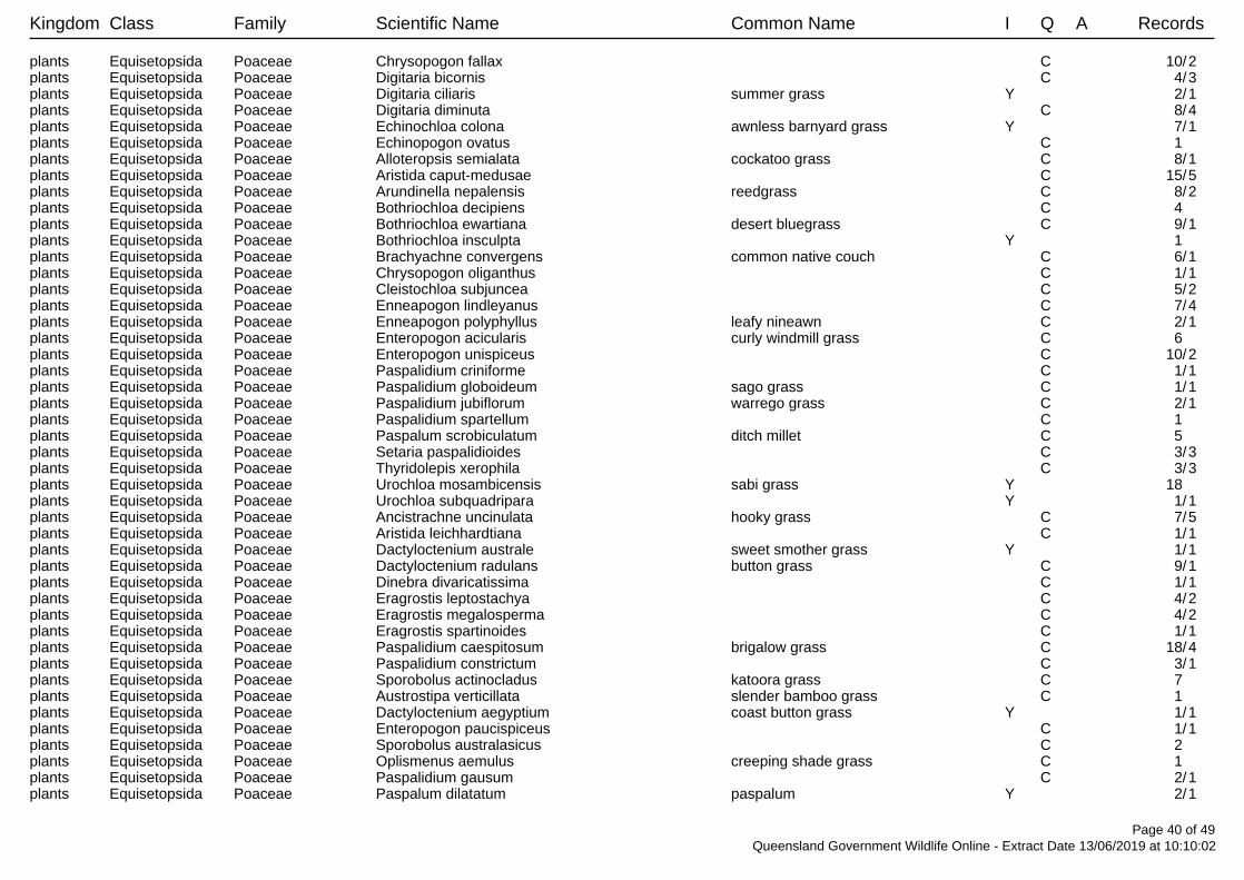
Kingdom Class Family Scientific Name Common Name I Q A Records
plants Equisetopsida Poaceae Chrysopogon fallax C 10/2plants Equisetopsida Poaceae Digitaria bicornis C 4/3plants Equisetopsida Poaceae Digitaria ciliaris summer grass Y 2/1plants Equisetopsida Poaceae Digitaria diminuta C 8/4plants Equisetopsida Poaceae Echinochloa colona awnless barnyard grass Y 7/1plants Equisetopsida Poaceae Echinopogon ovatus C 1 plants Equisetopsida Poaceae Alloteropsis semialata cockatoo grass C 8/1plants Equisetopsida Poaceae Aristida caput-medusae C 15/5plants Equisetopsida Poaceae Arundinella nepalensis reedgrass C 8/2plants Equisetopsida Poaceae Bothriochloa decipiens C 4 plants Equisetopsida Poaceae Bothriochloa ewartiana desert bluegrass C 9/1plants Equisetopsida Poaceae Bothriochloa insculpta Y 1 plants Equisetopsida Poaceae Brachyachne convergens common native couch C 6/1plants Equisetopsida Poaceae Chrysopogon oliganthus C 1/1plants Equisetopsida Poaceae Cleistochloa subjuncea C 5/2plants Equisetopsida Poaceae Enneapogon lindleyanus C 7/4plants Equisetopsida Poaceae Enneapogon polyphyllus leafy nineawn C 2/1plants Equisetopsida Poaceae Enteropogon acicularis curly windmill grass C 6 plants Equisetopsida Poaceae Enteropogon unispiceus C 10/2plants Equisetopsida Poaceae Paspalidium criniforme C 1/1plants Equisetopsida Poaceae Paspalidium globoideum sago grass C 1/1plants Equisetopsida Poaceae Paspalidium jubiflorum warrego grass C 2/1plants Equisetopsida Poaceae Paspalidium spartellum C 1 plants Equisetopsida Poaceae Paspalum scrobiculatum ditch millet C 5 plants Equisetopsida Poaceae Setaria paspalidioides C 3/3plants Equisetopsida Poaceae Thyridolepis xerophila C 3/3plants Equisetopsida Poaceae Urochloa mosambicensis sabi grass Y 18 plants Equisetopsida Poaceae Urochloa subquadripara Y 1/1plants Equisetopsida Poaceae Ancistrachne uncinulata hooky grass C 7/5plants Equisetopsida Poaceae Aristida leichhardtiana C 1/1plants Equisetopsida Poaceae Dactyloctenium australe sweet smother grass Y 1/1plants Equisetopsida Poaceae Dactyloctenium radulans button grass C 9/1plants Equisetopsida Poaceae Dinebra divaricatissima C 1/1plants Equisetopsida Poaceae Eragrostis leptostachya C 4/2plants Equisetopsida Poaceae Eragrostis megalosperma C 4/2plants Equisetopsida Poaceae Eragrostis spartinoides C 1/1plants Equisetopsida Poaceae Paspalidium caespitosum brigalow grass C 18/4plants Equisetopsida Poaceae Paspalidium constrictum C 3/1plants Equisetopsida Poaceae Sporobolus actinocladus katoora grass C 7 plants Equisetopsida Poaceae Austrostipa verticillata slender bamboo grass C 1 plants Equisetopsida Poaceae Dactyloctenium aegyptium coast button grass Y 1/1plants Equisetopsida Poaceae Enteropogon paucispiceus C 1/1plants Equisetopsida Poaceae Sporobolus australasicus C 2 plants Equisetopsida Poaceae Oplismenus aemulus creeping shade grass C 1 plants Equisetopsida Poaceae Paspalidium gausum C 2/1plants Equisetopsida Poaceae Paspalum dilatatum paspalum Y 2/1
Page 40 of 49Queensland Government Wildlife Online - Extract Date 13/06/2019 at 10:10:02

Kingdom Class Family Scientific Name Common Name I Q A Records
plants Equisetopsida Poaceae Paspalum distichum water couch C 2 plants Equisetopsida Poaceae Sacciolepis indica Indian cupscale grass C 4/2plants Equisetopsida Poaceae Triodia mitchellii buck spinifex C 14/10plants Equisetopsida Poaceae Aristida gracilipes C 1/1plants Equisetopsida Poaceae Aristida polyclados C 3 plants Equisetopsida Poaceae Chrysopogon filipes C 2/1plants Equisetopsida Poaceae Dichelachne montana C 1/1plants Equisetopsida Poaceae Digitaria ammophila silky umbrella grass C 1 plants Equisetopsida Poaceae Digitaria ramularis C 1 plants Equisetopsida Poaceae Enneapogon gracilis slender nineawn C 7/2plants Equisetopsida Poaceae Enteropogon ramosus C 4/1plants Equisetopsida Poaceae Entolasia marginata bordered panic C 3/2plants Equisetopsida Poaceae Eragrostis elongata C 8/4plants Equisetopsida Poaceae Eragrostis speciosa C 1/1plants Equisetopsida Poaceae Eriachne pallescens C 2/1plants Equisetopsida Poaceae Imperata cylindrica blady grass C 8 plants Equisetopsida Poaceae Leptochloa digitata C 8 plants Equisetopsida Poaceae Megathyrsus maximus Y 4 plants Equisetopsida Poaceae Panicum larcomianum C 1/1plants Equisetopsida Poaceae Paspalidium distans shotgrass C 2 plants Equisetopsida Poaceae Paspalidium gracile slender panic C 4/1plants Equisetopsida Poaceae Tragus australianus small burr grass C 8/1plants Equisetopsida Poaceae Bothriochloa pertusa Y 5/1plants Equisetopsida Poaceae Cymbopogon refractus barbed-wire grass C 13/1plants Equisetopsida Poaceae Walwhalleya subxerophila C 1/1plants Equisetopsida Poaceae Cymbopogon queenslandicus C 1 plants Equisetopsida Poaceae Digitaria divaricatissima spreading umbrella grass C 2/2plants Equisetopsida Poaceae Diplachne fusca var. fusca C 2/1plants Equisetopsida Poaceae Eriochloa pseudoacrotricha C 2/2plants Equisetopsida Poaceae Eragrostis longipedicellata C 2/2plants Equisetopsida Poaceae Hyparrhenia rufa subsp. rufa Y 2/2plants Equisetopsida Poaceae Cynodon dactylon var. dactylon Y 2 plants Equisetopsida Poaceae Aristida calycina var. calycina C 4/3plants Equisetopsida Poaceae Aristida calycina var. praealta C 1/1plants Equisetopsida Poaceae Dinebra decipiens var. asthenes C 3/2plants Equisetopsida Poaceae Dinebra decipiens var. decipiens C 4/1plants Equisetopsida Poaceae Dinebra decipiens var. peacockii C 2/2plants Equisetopsida Poaceae Ischaemum australe var. australe C 1/1plants Equisetopsida Poaceae Megathyrsus maximus var. maximus Y 1 plants Equisetopsida Poaceae Aristida benthamii var. benthamii C 3/3plants Equisetopsida Poaceae Aristida holathera var. holathera C 3/2plants Equisetopsida Poaceae Panicum decompositum var. tenuius C 2 plants Equisetopsida Poaceae Chloris divaricata var. divaricata slender chloris C 5/2plants Equisetopsida Poaceae Bothriochloa bladhii subsp. bladhii C 2 plants Equisetopsida Poaceae Eriachne pallescens var. pallescens C 3/2plants Equisetopsida Poaceae Megathyrsus maximus var. pubiglumis Y 14/3
Page 41 of 49Queensland Government Wildlife Online - Extract Date 13/06/2019 at 10:10:02

Kingdom Class Family Scientific Name Common Name I Q A Records
plants Equisetopsida Poaceae Microlaena stipoides var. stipoides C 1 plants Equisetopsida Poaceae Dichanthium sericeum subsp. humilius C 1/1plants Equisetopsida Poaceae Dichanthium sericeum subsp. sericeum C 4/3plants Equisetopsida Poaceae Bothriochloa decipiens var. decipiens C 6/2plants Equisetopsida Poaceae Aristida queenslandica var. dissimilis C 7/4plants Equisetopsida Poaceae Panicum decompositum var. decompositum C 1/1plants Equisetopsida Poaceae Aristida jerichoensis var. jerichoensis C 5/1plants Equisetopsida Poaceae Aristida jerichoensis var. subspinulifera C 6/1plants Equisetopsida Poaceae Aristida queenslandica var. queenslandica C 2/2plants Equisetopsida Poaceae Calyptochloa gracillima subsp. gracillima C 13/4plants Equisetopsida Poaceae Cleistochloa sp. (Duaringa K.B.Addison 42) C 11/9plants Equisetopsida Poaceae Digitaria divaricatissima var. divaricatissima C 1 plants Equisetopsida Poaceae Eriachne mucronata forma (Alpha C.E.Hubbard 7882) C 3/3plants Equisetopsida Poaceae Echinochloa esculenta Japanese millet Y 1 plants Equisetopsida Poaceae Eragrostis microcarpa C 1 plants Equisetopsida Poaceae Eremochloa bimaculata poverty grass C 7 plants Equisetopsida Poaceae Heteropogon contortus black speargrass C 15 plants Equisetopsida Poaceae Iseilema vaginiflorum red flinders grass C 2 plants Equisetopsida Poaceae Schizachyrium fragile firegrass C 1/1plants Equisetopsida Poaceae Sporobolus disjunctus C 4/4plants Equisetopsida Podocarpaceae Podocarpus spinulosus dwarf plum-pine C 2/1plants Equisetopsida Polygalaceae Comesperma retusum C 1 plants Equisetopsida Polygalaceae Polygala triflora C 3/3plants Equisetopsida Polygalaceae Comesperma C 1 plants Equisetopsida Polygalaceae Comesperma sphaerocarpum C 6/2plants Equisetopsida Polygalaceae Comesperma patentifolium C 12/7plants Equisetopsida Polygalaceae Comesperma ericinum C 1 plants Equisetopsida Polygonaceae Muehlenbeckia rhyticarya C 1 plants Equisetopsida Polygonaceae Persicaria lapathifolia pale knotweed C 1/1plants Equisetopsida Polygonaceae Persicaria orientalis princes feathers C 3/1plants Equisetopsida Polygonaceae Polygonum plebeium small knotweed C 2/2plants Equisetopsida Polygonaceae Duma florulenta C 2 plants Equisetopsida Polygonaceae Emex C 1 plants Equisetopsida Polygonaceae Persicaria attenuata C 2/1plants Equisetopsida Polypodiaceae Drynaria rigidula C 2/1plants Equisetopsida Polypodiaceae Platycerium veitchii silver elkhorn C 4/2plants Equisetopsida Polypodiaceae Pyrrosia rupestris rock felt fern C 1 plants Equisetopsida Polypodiaceae Pyrrosia confluens C 1 plants Equisetopsida Pontederiaceae Monochoria cyanea C 3 plants Equisetopsida Portulacaceae Portulaca pilosa Y 3 plants Equisetopsida Portulacaceae Portulaca bicolor C 3/1plants Equisetopsida Portulacaceae Portulaca oleracea pigweed Y 12 plants Equisetopsida Portulacaceae Portulaca filifolia C 7 plants Equisetopsida Portulacaceae Calandrinia pleiopetala C 1 plants Equisetopsida Portulacaceae Portulaca C 1 plants Equisetopsida Portulacaceae Calandrinia pickeringii C 4/2
Page 42 of 49Queensland Government Wildlife Online - Extract Date 13/06/2019 at 10:10:02

Kingdom Class Family Scientific Name Common Name I Q A Records
plants Equisetopsida Potamogetonaceae Potamogeton octandrus C 1/1plants Equisetopsida Potamogetonaceae Potamogeton C 1/1plants Equisetopsida Potamogetonaceae Potamogeton tricarinatus floating pondweed C 2 plants Equisetopsida Proteaceae Hakea C 2/2plants Equisetopsida Proteaceae Banksia integrifolia subsp. integrifolia C 1 plants Equisetopsida Proteaceae Hakea lorea C 5 plants Equisetopsida Proteaceae Hakea benthamii C 4/1plants Equisetopsida Proteaceae Banksia spinulosa C 5 plants Equisetopsida Proteaceae Grevillea striata beefwood C 8 plants Equisetopsida Proteaceae Persoonia falcata C 19/2plants Equisetopsida Proteaceae Grevillea helmsiae C 2 plants Equisetopsida Proteaceae Grevillea sessilis C 12/6plants Equisetopsida Proteaceae Lomatia silaifolia crinkle bush C 8/1plants Equisetopsida Proteaceae Persoonia subtilis C 8/6plants Equisetopsida Proteaceae Grevillea parallela C 2/1plants Equisetopsida Proteaceae Xylomelum benthamii C 1 plants Equisetopsida Proteaceae Banksia oblongifolia dwarf banksia C 5 plants Equisetopsida Proteaceae Grevillea floribunda C 2 plants Equisetopsida Proteaceae Grevillea longistyla C 14/8plants Equisetopsida Proteaceae Petrophile canescens C 6/2plants Equisetopsida Proteaceae Stenocarpus salignus scrub beefwood C 5/4plants Equisetopsida Proteaceae Conospermum taxifolium devil's rice C 1 plants Equisetopsida Proteaceae Grevillea singuliflora C 2 plants Equisetopsida Proteaceae Hakea lorea subsp. lorea C 3/2plants Equisetopsida Proteaceae Xylomelum cunninghamianum C 10/1plants Equisetopsida Proteaceae Grevillea decora subsp. decora C 4/4plants Equisetopsida Proteaceae Banksia spinulosa var. spinulosa C 3/3plants Equisetopsida Proteaceae Grevillea floribunda subsp. floribunda C 1/1plants Equisetopsida Proteaceae Xylomelum C 1 plants Equisetopsida Psilotaceae Psilotum nudum skeleton fork fern C 3/2plants Equisetopsida Pteridaceae Cheilanthes C 3 plants Equisetopsida Pteridaceae Vittaria elongata C 1 plants Equisetopsida Pteridaceae Cheilanthes distans bristly cloak fern C 3/1plants Equisetopsida Pteridaceae Cheilanthes sieberi C 26 plants Equisetopsida Pteridaceae Pityrogramma calomelanos var. calomelanos Y 1/1plants Equisetopsida Pteridaceae Cheilanthes nudiuscula C 2 plants Equisetopsida Pteridaceae Cheilanthes tenuifolia rock fern C 1 plants Equisetopsida Pteridaceae Cheilanthes sieberi subsp. sieberi C 9/1plants Equisetopsida Pteridaceae Adiantum hispidulum var. hispidulum C 2/1plants Equisetopsida Pteridaceae Adiantum aethiopicum C 1 plants Equisetopsida Putranjivaceae Drypetes deplanchei grey boxwood C 1 plants Equisetopsida Ranunculaceae Clematis glycinoides C 6/1plants Equisetopsida Ranunculaceae Ranunculus sceleratus Y 1 plants Equisetopsida Restionaceae Baloskion pallens C 7/5plants Equisetopsida Rhamnaceae Pomaderris C 1 plants Equisetopsida Rhamnaceae Alphitonia excelsa soap tree C 56
Page 43 of 49Queensland Government Wildlife Online - Extract Date 13/06/2019 at 10:10:02

Kingdom Class Family Scientific Name Common Name I Q A Records
plants Equisetopsida Rhamnaceae Pomaderris lanigera C 4/2plants Equisetopsida Rhamnaceae Ventilago viminalis supplejack C 22/1plants Equisetopsida Rhamnaceae Polianthion minutiflorum V V 2/2plants Equisetopsida Rhamnaceae Pomaderris queenslandica C 4/3plants Equisetopsida Rosaceae Rubus probus C 1 plants Equisetopsida Rubiaceae Gynochthodes jasminoides C 3/2plants Equisetopsida Rubiaceae Coelospermum reticulatum C 13/3plants Equisetopsida Rubiaceae Everistia vacciniifolia C 6 plants Equisetopsida Rubiaceae Triflorensia ixoroides C 2/2plants Equisetopsida Rubiaceae Spermacoce multicaulis C 2/1plants Equisetopsida Rubiaceae Spermacoce brachystema C 6/3plants Equisetopsida Rubiaceae Richardia brasiliensis white eye Y 1 plants Equisetopsida Rubiaceae Psychotria daphnoides C 3 plants Equisetopsida Rubiaceae Pavetta australiensis C 1 plants Equisetopsida Rubiaceae Oldenlandia galioides C 1/1plants Equisetopsida Rubiaceae Opercularia diphylla C 2/1plants Equisetopsida Rubiaceae Larsenaikia ochreata C 3/3plants Equisetopsida Rubiaceae Antirhea putaminosa C 2/1plants Equisetopsida Rubiaceae Psydrax oleifolia C 6 plants Equisetopsida Rubiaceae Psydrax johnsonii C 2/2plants Equisetopsida Rubiaceae Psydrax attenuata C 1 plants Equisetopsida Rubiaceae Psydrax forsteri C 3/2plants Equisetopsida Rubiaceae Psydrax odorata C 3 plants Equisetopsida Rubiaceae Pomax umbellata C 6 plants Equisetopsida Rubiaceae Dentella repens dentella C 1/1plants Equisetopsida Rubiaceae Psychotria C 1 plants Equisetopsida Rubiaceae Oldenlandia mitrasacmoides subsp. trachymenoides C 1/1plants Equisetopsida Rubiaceae Everistia vacciniifolia forma vacciniifolia C 3/3plants Equisetopsida Rubiaceae Psydrax odorata subsp. australiana C 1/1plants Equisetopsida Rubiaceae Psydrax attenuata forma megalantha C 1 plants Equisetopsida Rubiaceae Psydrax odorata forma buxifolia C 3 plants Equisetopsida Rubiaceae Psydrax saligna forma saligna C 1/1plants Equisetopsida Rubiaceae Cyclophyllum coprosmoides C 1 plants Equisetopsida Rubiaceae Oldenlandia coerulescens C 1/1plants Equisetopsida Rutaceae Phebalium glandulosum subsp. glandulosum C 1/1plants Equisetopsida Rutaceae Zieria minutiflora subsp. trichocarpa C 1/1plants Equisetopsida Rutaceae Philotheca difformis subsp. smithiana C 1 plants Equisetopsida Rutaceae Philotheca difformis subsp. difformis C 7/7plants Equisetopsida Rutaceae Zieria fraseri subsp. robusta C 5/5plants Equisetopsida Rutaceae Murraya paniculata 'Exotica' Y 2 plants Equisetopsida Rutaceae Dinosperma erythrococcum C 2/1plants Equisetopsida Rutaceae Flindersia dissosperma C 21/8plants Equisetopsida Rutaceae Acronychia pauciflora soft acronychia C 1 plants Equisetopsida Rutaceae Philotheca difformis C 1 plants Equisetopsida Rutaceae Boronia occidentalis C 3/3plants Equisetopsida Rutaceae Melicope micrococca white evodia C 1/1
Page 44 of 49Queensland Government Wildlife Online - Extract Date 13/06/2019 at 10:10:02

Kingdom Class Family Scientific Name Common Name I Q A Records
plants Equisetopsida Rutaceae Geijera salicifolia brush wilga C 3 plants Equisetopsida Rutaceae Coatesia paniculata C 1 plants Equisetopsida Rutaceae Zieria minutiflora C 1 plants Equisetopsida Rutaceae Philotheca ciliata C 1 plants Equisetopsida Rutaceae Geijera parviflora wilga C 39/2plants Equisetopsida Rutaceae Phebalium woombye wallum phebalium C 1/1plants Equisetopsida Rutaceae Boronia splendida C 1/1plants Equisetopsida Rutaceae Boronia duiganiae C 1/1plants Equisetopsida Rutaceae Boronia bipinnata rock boronia C 6/2plants Equisetopsida Rutaceae Acronychia laevis glossy acronychia C 1 plants Equisetopsida Rutaceae Phebalium nottii pink phebalium C 5/3plants Equisetopsida Rutaceae Boronia odorata C 1/1plants Equisetopsida Rutaceae Boronia obovata C 33/22plants Equisetopsida Rutaceae Zieria smithii C 3/2plants Equisetopsida Rutaceae Zieria fraseri C 1 plants Equisetopsida Rutaceae Citrus x limon Y 1/1plants Equisetopsida Rutaceae Citrus glauca C 18 plants Equisetopsida Rutaceae Zieria aspalathoides subsp. aspalathoides C 5/4plants Equisetopsida Rutaceae Boronia C 1 plants Equisetopsida Santalaceae Exocarpos cupressiformis native cherry C 4 plants Equisetopsida Santalaceae Santalum lanceolatum C 13/2plants Equisetopsida Santalaceae Exocarpos latifolius C 2 plants Equisetopsida Sapindaceae Dodonaea vestita C 9/4plants Equisetopsida Sapindaceae Cardiospermum halicacabum var. halicacabum Y 1/1plants Equisetopsida Sapindaceae Dodonaea lanceolata var. subsessilifolia C 1/1plants Equisetopsida Sapindaceae Alectryon oleifolius subsp. elongatus C 5/1plants Equisetopsida Sapindaceae Dodonaea viscosa subsp. burmanniana C 1/1plants Equisetopsida Sapindaceae Dodonaea viscosa subsp. spatulata C 3/1plants Equisetopsida Sapindaceae Dodonaea viscosa subsp. viscosa C 1 plants Equisetopsida Sapindaceae Cupaniopsis anacardioides tuckeroo C 2/1plants Equisetopsida Sapindaceae Elattostachys xylocarpa white tamarind C 1 plants Equisetopsida Sapindaceae Alectryon diversifolius scrub boonaree C 45/2plants Equisetopsida Sapindaceae Dodonaea triangularis C 3/1plants Equisetopsida Sapindaceae Dodonaea peduncularis C 4/2plants Equisetopsida Sapindaceae Alectryon subdentatus C 1 plants Equisetopsida Sapindaceae Dodonaea stenophylla C 3 plants Equisetopsida Sapindaceae Dodonaea macrossanii C 1 plants Equisetopsida Sapindaceae Alectryon oleifolius C 5 plants Equisetopsida Sapindaceae Dodonaea lanceolata C 1 plants Equisetopsida Sapindaceae Dodonaea filifolia C 7/2plants Equisetopsida Sapindaceae Dodonaea C 11/3plants Equisetopsida Sapindaceae Dodonaea viscosa C 2 plants Equisetopsida Sapindaceae Alectryon connatus grey birds-eye C 4/1plants Equisetopsida Sapindaceae Atalaya hemiglauca C 32/2plants Equisetopsida Sapotaceae Planchonella cotinifolia C 1 plants Equisetopsida Sapotaceae Planchonella cotinifolia var. pubescens C 1
Page 45 of 49Queensland Government Wildlife Online - Extract Date 13/06/2019 at 10:10:02

Kingdom Class Family Scientific Name Common Name I Q A Records
plants Equisetopsida Schizaeaceae Schizaea bifida forked comb fern C 1 plants Equisetopsida Scrophulariaceae Eremophila longifolia berrigan C 3/1plants Equisetopsida Scrophulariaceae Eremophila maculata C 4 plants Equisetopsida Scrophulariaceae Eremophila latrobei subsp. glabra C 2/2plants Equisetopsida Scrophulariaceae Eremophila latrobei subsp. latrobei C 3/3plants Equisetopsida Scrophulariaceae Myoporum acuminatum coastal boobialla C 12 plants Equisetopsida Scrophulariaceae Eremophila mitchellii C 56/1plants Equisetopsida Scrophulariaceae Eremophila latrobei C 2/1plants Equisetopsida Scrophulariaceae Eremophila deserti C 18/1plants Equisetopsida Scrophulariaceae Eremophila debilis winter apple C 3/2plants Equisetopsida Scrophulariaceae Eremophila C 1 plants Equisetopsida Scrophulariaceae Myoporum C 1 plants Equisetopsida Scrophulariaceae Eremophila maculata subsp. maculata C 3/3plants Equisetopsida Selaginellaceae Selaginella C 1/1plants Equisetopsida Simaroubaceae Ailanthus triphysa white siris C 1 plants Equisetopsida Smilacaceae Smilax australis barbed-wire vine C 4/1plants Equisetopsida Solanaceae Solanum furfuraceum C 2/2plants Equisetopsida Solanaceae Solanum parvifolium C 2 plants Equisetopsida Solanaceae Solanum semiarmatum prickly nightshade C 2 plants Equisetopsida Solanaceae Solanum stelligerum devil's needles C 1 plants Equisetopsida Solanaceae Physalis lanceifolia Y 1 plants Equisetopsida Solanaceae Solanum ferocissimum C 9/3plants Equisetopsida Solanaceae Solanum densevestitum C 1 plants Equisetopsida Solanaceae Solanum elachophyllum E 17/14plants Equisetopsida Solanaceae Solanum mitchellianum C 2/2plants Equisetopsida Solanaceae Nicotiana megalosiphon C 1 plants Equisetopsida Solanaceae Solanum parvifolium subsp. parvifolium C 1/1plants Equisetopsida Solanaceae Solanum C 27 plants Equisetopsida Solanaceae Physalis Y 1 plants Equisetopsida Solanaceae Solanum opacum green berry nightshade C 1 plants Equisetopsida Solanaceae Solanum esuriale quena C 5/2plants Equisetopsida Solanaceae Solanum pusillum C 2/2plants Equisetopsida Solanaceae Physalis angulata Y 2/2plants Equisetopsida Solanaceae Solanum dissectum E E 3/3plants Equisetopsida Solanaceae Solanum gympiense C 1 plants Equisetopsida Solanaceae Solanum americanum C 3/3plants Equisetopsida Solanaceae Solanum cocosoides C 5/5plants Equisetopsida Solanaceae Solanum ellipticum potato bush C 9/4plants Equisetopsida Solanaceae Solanum nemophilum C 6/1plants Equisetopsida Solanaceae Datura leichhardtii native thornapple Y 1/1plants Equisetopsida Solanaceae Solanum adenophorum E 12/10plants Equisetopsida Sparrmanniaceae Corchorus tomentellus C 3/3plants Equisetopsida Sparrmanniaceae Corchorus trilocularis C 3/1plants Equisetopsida Sparrmanniaceae Grewia retusifolia C 4/1plants Equisetopsida Sparrmanniaceae Grewia scabrella C 8/3plants Equisetopsida Sparrmanniaceae Grewia C 1
Page 46 of 49Queensland Government Wildlife Online - Extract Date 13/06/2019 at 10:10:02

Kingdom Class Family Scientific Name Common Name I Q A Records
plants Equisetopsida Sparrmanniaceae Grewia latifolia dysentery plant C 19/2plants Equisetopsida Sphagnaceae Sphagnum C 2/2plants Equisetopsida Stackhousiaceae Stackhousia viminea slender stackhousia C 2 plants Equisetopsida Stackhousiaceae Stackhousia monogyna creamy candles C 1/1plants Equisetopsida Sterculiaceae Brachychiton bidwillii little kurrajong C 3/1plants Equisetopsida Sterculiaceae Brachychiton australis broad-leaved bottle tree C 2 plants Equisetopsida Sterculiaceae Sterculia quadrifida peanut tree C 1 plants Equisetopsida Sterculiaceae Brachychiton rupestris C 15/1plants Equisetopsida Sterculiaceae Brachychiton populneus subsp. trilobus C 1/1plants Equisetopsida Stylidiaceae Stylidium graminifolium grassy-leaved trigger-flower C 3/2plants Equisetopsida Stylidiaceae Stylidium eglandulosum C 2/1plants Equisetopsida Stylidiaceae Stylidium eriorhizum C 3/2plants Equisetopsida Stylidiaceae Stylidium tenerum C 1 plants Equisetopsida Stylidiaceae Stylidium debile frail trigger plant C 8/3plants Equisetopsida Surianaceae Cadellia pentastylis ooline V V 3/2plants Equisetopsida Tamaricaceae Tamarix aphylla athel pine Y 1/1plants Equisetopsida Thelypteridaceae Christella dentata creek fern C 3 plants Equisetopsida Thelypteridaceae Cyclosorus interruptus C 2/2plants Equisetopsida Thelypteridaceae Sphaerostephanos unitus C 1/1plants Equisetopsida Thymelaeaceae Pimelea mollis C 1/1plants Equisetopsida Thymelaeaceae Pimelea linifolia C 2 plants Equisetopsida Thymelaeaceae Pimelea haematostachya C 2/1plants Equisetopsida Thymelaeaceae Pimelea linifolia subsp. linifolia C 4/4plants Equisetopsida Typhaceae Typha orientalis broad-leaved cumbungi C 1 plants Equisetopsida Ulmaceae Trema tomentosa var. aspera C 1/1plants Equisetopsida Urticaceae Dendrocnide photiniphylla shiny-leaved stinging tree C 1 plants Equisetopsida Urticaceae Pipturus argenteus white nettle C 1 plants Equisetopsida Verbenaceae Lantana camara lantana Y 1/1plants Equisetopsida Verbenaceae Phyla canescens Y 1/1plants Equisetopsida Verbenaceae Verbena bonariensis purpletop Y 1 plants Equisetopsida Verbenaceae Lippia alba var. alba Y 5/5plants Equisetopsida Verbenaceae Glandularia aristigera Y 1 plants Equisetopsida Verbenaceae Stachytarpheta jamaicensis Jamaica snakeweed Y 3/1plants Equisetopsida Violaceae Viola betonicifolia subsp. betonicifolia C 1/1plants Equisetopsida Violaceae Afrohybanthus stellarioides C 5 plants Equisetopsida Violaceae Afrohybanthus enneaspermus C 4/2plants Equisetopsida Violaceae Hybanthus monopetalus C 2/1plants Equisetopsida Violaceae Viola perreniformis C 1/1plants Equisetopsida Violaceae Viola betonicifolia C 1 plants Equisetopsida Violaceae Viola C 1 plants Equisetopsida Violaceae Viola hederacea C 1 plants Equisetopsida Viscaceae Viscum articulatum flat mistletoe C 2/1plants Equisetopsida Viscaceae Notothixos cornifolius kurrajong mistletoe C 1 plants Equisetopsida Vitaceae Cissus oblonga C 2/1plants Equisetopsida Vitaceae Cayratia clematidea slender grape C 2 plants Equisetopsida Vitaceae Clematicissus opaca C 28
Page 47 of 49Queensland Government Wildlife Online - Extract Date 13/06/2019 at 10:10:02

Kingdom Class Family Scientific Name Common Name I Q A Records
plants Equisetopsida Vitaceae Cissus hypoglauca C 2 plants Equisetopsida Vitaceae Cayratia acris hairy grape C 1 plants Equisetopsida Vitaceae Cissus repens C 1 plants Equisetopsida Vitaceae Cissus reniformis C 1 plants Equisetopsida Xanthorrhoeaceae Xanthorrhoea C 2 plants Equisetopsida Xanthorrhoeaceae Xanthorrhoea johnsonii C 13/1plants Equisetopsida Xyridaceae Xyris complanata yellow-eye C 6/4plants Equisetopsida Zamiaceae Macrozamia moorei C 1 plants Equisetopsida Zamiaceae Macrozamia platyrhachis E E 55/30plants Equisetopsida Zygophyllaceae Tribulus eichlerianus bull head C 3 plants Equisetopsida Zygophyllaceae Tribulus micrococcus yellow vine C 2/2plants Equisetopsida Zygophyllaceae Zygophyllum apiculatum gall weed C 1/1plants Equisetopsida Zygophyllaceae Tribulus terrestris caltrop C 2 plants Florideophyceae Cystocloniaceae Hypnea pannosa C 1/1plants Ulvophyceae Trentepohliaceae Trentepohlia bosseae var. samoensis C 1/1plants Ulvophyceae Ulotrichaceae Ulothrix cylindricum C 1/1plants green algae Uronemataceae Uronema confervicola C 1/1plants uncertain Incertae sedis PlantaeSchizothrix friesii C 1/1plants uncertain Incertae sedis PlantaeSchizothrix calcicola C 1/1plants uncertain Indet. Indet. C 5
CODES
I - Y indicates that the taxon is introduced to Queensland and has naturalised.
Q - Indicates the Queensland conservation status of each taxon under the Nature Conservation Act 1992. The codes are Extinct in the Wild (PE), Endangered (E),Vulnerable (V), Near Threatened (NT), Least Concern (C) or Not Protected ( ).
A - Indicates the Australian conservation status of each taxon under the Environment Protection and Biodiversity Conservation Act 1999. The values of EPBC areConservation Dependent (CD), Critically Endangered (CE), Endangered (E), Extinct (EX), Extinct in the Wild (XW) and Vulnerable (V).
Records – The first number indicates the total number of records of the taxon for the record option selected (i.e. All, Confirmed or Specimens).This number is output as 99999 if it equals or exceeds this value. The second number located after the / indicates the number of specimen records for the taxon.This number is output as 999 if it equals or exceeds this value.
Page 48 of 49Queensland Government Wildlife Online - Extract Date 13/06/2019 at 10:10:02

Centred on: Lot: 1 Plan: HT424Map requested: 25/10/2018 16:58:21
Page 1

Centred on: Lot: 1 Plan: HT424Map requested: 25/10/2018 16:58:21
Page 2

B
TERRESTRIAL ECOLOGY September 2019 AARC Environmental Solutions Pty Ltd E [email protected] AARC.NET.AU
Appendix B Likelihood of Occurrence for Threatened Ecological Communities (TEC)

B
TERRESTRIAL ECOLOGY September 2019 AARC Environmental Solutions Pty Ltd E [email protected] AARC.NET.AU
Likelihood of Occurrence for Threatened Ecological Communities
Community Name Database searches
Desktop likelihood determination PMST
Corresponding REs mapped within EPC
Brigalow (Acacia harpophylla dominant and co-dominant)
Known to occur
(0-10 km) 11.3.1
Likely
Brigalow TEC is common throughout central QLD in small patches. It is known to occur within a 10 km buffer of the study area. One RE that corresponds to the TEC has been mapped by DES as occurring on the study area. It is likely that this TEC will be identified within the study area during RE mapping validation.
Natural grasslands of the Queensland Central Highlands and northern Fitzroy Basin
May occur
(0-10 km) None
Unlikely
This TEC may occur within a 10 km buffer of the study area according to the PMST. There are no REs corresponding to this TEC mapped by DES within the study area.
Coolabah – Black Box Woodlands of the Darling Riverine Plains and the Brigalow Belt South Bioregions
May occur
(0-10 km) None
Unlikely
Search with PMST has identified that this TEC may occur within a 10 km buffer of the study area. None of the REs identified within the study area correspond with this TEC and therefore it is unlikely that this TEC will be found within the study area.
Weeping Myall Woodlands
Likely to occur
(0-10 km) 11.3.2
Unlikely
Weeping Myall TEC is uncommon and is only known to form minor components of two possible REs. It is considered likely to occur within a 0 – 10 km buffer of the study area. One RE that has the potential to contain minor components corresponding to this TEC has been mapped by DES as occurring on the study area. No records of Acacia pendula (Weeping Myall) were returned in a 50 km search of the Project using Wildlife Online. It is considered unlikely that this TEC will occur on the study area.
Semi-evergreen vine thickets of the Brigalow Belt (North and South) and Nandewar Bioregions
Likely to occur
(10-50 km) None
Unlikely
Vine thicket TEC is not known to occur within 10 km of the study area and is only considered likely to occur within a 10 – 50 km buffer of the Project. No REs that correspond to the TEC have been mapped by DES as occurring on the study area.

B
TERRESTRIAL ECOLOGY September 2019 AARC Environmental Solutions Pty Ltd E [email protected] AARC.NET.AU
Community Name Database searches
Desktop likelihood determination PMST
Corresponding REs mapped within EPC
Poplar Box Grassy Woodlands on Alluvial Plains
Not identified at time of search 11.3.2
Likely
Poplar Box TEC was added to the list of TECs protected by the EPBC Act effective from 4 July 2019.
One RE that corresponds to the TEC has been mapped by DES as occurring on the study area, Eucalyptus populnea woodland on alluvial plains (RE 11.3.2).

C
TERRESTRIAL ECOLOGY September 2019 AARC Environmental Solutions Pty Ltd E [email protected] AARC.NET.AU
Appendix C Likelihood of Occurrence for Flora Species of Conservation Significance

C
TERRESTRIAL ECOLOGY September 2019 AARC Environmental Solutions Pty Ltd E [email protected] AARC.NET.AU
Likelihood of Occurrence for Fauna Species of Conservation Significance
Species Name
Common Name
EVNT Listing Database Searches Preferred Habitat Desktop Likelihood of Occurrence EPBC
Act NC Act PMST Wildlife Online Records
Acacia grandiflora V LC
Species or species habitat known to occur
within area (10 – 50 km)
6 10 - 50 km
Acacia grandifolia grows in hilly terrain on hillslopes of varying aspects and slope. The species also occurs on hillcrests, gullies and plains. Soil is usually shallow and well drained and is described as sandy loam to clay loam in texture derived from sandstones and acidic volcanics. Altitudes are predominantly between 200 and 370 metres. The vegetation is tall woodland or open forest with a range of floristic associations. The most frequently recorded tree species are Eucalyptus crebra, Corymbia citriodora, C. trachyphloia, E. maculata and E. exserta (QCRA/FRA, 1998; Queensland Herbarium 2011, cited in DES 2018b).
Unlikely This species has been recorded 6 times within 50 km of the Project. Potential suitable habitat is not likely to occur within the Project due to the elevation requirements of the species. The Project is located outside of the species distribution range.
Acacia storyi - NT - 17 10 - 50 km
Acacia storyi typically grows on sandy and shallow skeletal soils over sandstone and grows in open forests. This species is associated with Eucalyptus teriticornis and Aristida spp. The species was considered occasional in two populations from Blackdown Tableland National Park, west of Rockhampton in central Queensland (DES 2018b).
Unlikely This species has been recorded 17 times within 50 km of the Project and potential habitat is likely to occur within the Project. However, the species range is very restricted, and the majority of the known populations protected within the Blackdown Tablelands NP, to the southwest of the Project.
Aristida annua V V
Species or species habitat likely to occur
within area (10 – 50 km)
No Records This species is restricted to Eucalypt woodland on black clay and basalt soils (DoEE 2018).
Unlikely This species was returned in the 50 km PMST search as likely to occur, however has no records within 50 km of the Project on Wildlife Online or Atlas of Living Australia database (ALA). Potential habitat is unlikely to occur within the Project due to the absence of suitable soil types.

C
TERRESTRIAL ECOLOGY September 2019 AARC Environmental Solutions Pty Ltd E [email protected] AARC.NET.AU
Species Name
Common Name
EVNT Listing Database Searches Preferred Habitat Desktop Likelihood of Occurrence EPBC
Act NC Act PMST Wildlife Online Records
Baeckea trapeza - NT - 7 10 - 50 km
Baeckea trapeza grows at altitudes around 700 – 800m and on sandy soil in open Eucalyptus forest. This species is confined to the Blackdown Tableland (DES 2018b).
Unlikely This species has been recorded 7 times within 50 km of the Project and potential habitat is likely to occur within the Project. However, the species range is very restricted, and the majority of the known populations area protected within the Blackdown Tablelands NP, to the southwest of the Project.
Bertya opponens V V
Species or species habitat likely to occur
within area (10 – 50 km)
No Records
Recorded growing in a variety of community types including mixed shrubland, Lancewood woodland, Mallee woodland, Eucalyptus / Acacia open forest with shrubby understorey, Eucalyptus / Callitris open woodland and semi-evergreen vine-thicket. Soils are recorded as generally shallow sandy loams or red earths associated mostly with sandstone, but also with rhyolite, shale and metasediments (DoEE 2018).
Potential This species was returned in the 50 km PMST search as likely to occur, however has no records within 50 km of the Project on Wildlife Online, ALA or Australian Virtual Herbarium (AVH). Due to the presence of Lancewood woodland within the study area and the proximity to the edge of the species distribution, the species potentially could be found within the study area.
Bertya pedicellata - NT - 3
10 - 50 km
Bertya pedicellata grows on rocky hillsides in range of community types including eucalypt forest or woodland, Acacia woodland or shrubland and open heathland or vine thicket communities. The soils on which this species grow on are mainly skeletal to shallow sandy, sandy clay or clay loams overlaying rhyolite, trachyte or sandstone substrates (DES 2018b).
Potential This species has been recorded 3 times within 50 km of the Project. Even though there are no records of the species in the vicinity of the Project, this is located within the species distribution range. Potential suitable habitat may occur within the Project.

C
TERRESTRIAL ECOLOGY September 2019 AARC Environmental Solutions Pty Ltd E [email protected] AARC.NET.AU
Species Name
Common Name
EVNT Listing Database Searches Preferred Habitat Desktop Likelihood of Occurrence EPBC
Act NC Act PMST Wildlife Online Records
Cadellia pentastylis
Ooline
V V
Species or species habitat likely to occur
within area (0-10 km)
4 10 - 50 km
Ooline occurs in a range of vegetation types including dry rainforest, semi-evergreen vine thickets and sclerophyll communities including, Brigalow-Belah, Poplar Box and Bendee communities (Pollock 1999; DEWHA 2008; cited in DES 2014b). Ooline often occurs on the edges of sandstone and basalt escarpments, 200 - 500m above sea level. Ooline grows on the moderately fertile soils preferred for agriculture and pasture development (Pollock 1999; DEWHA 2008; cited in DES 2014b).
Unlikely This species has been recorded four times within 50 km of the Project. Potential suitable habitat is not likely to occur within the Project due to the elevation requirements of the species. The Project is located outside of the species distribution range.
Cerbera dumicola - NT -
2 0 - 10 km
6
10 - 50 km
Cerbera dumicola occurs across a range of habitats in central and southern Queensland. Associated vegetation and species include: sandstone hills in open E. umbra subsp. carnea; on plateaus, in woodland of Acacia shirleyi with Corymbia dolichocarpa; acidic soils in mine rehabilitation area; woodland of A. catenulata and A. shirleyi with E. thozetiana on a slope of sand/clay soil; semi-deciduous notophyll-microphyll vine forest of Brachychiton australis, Gyrocarpus americanus, Flindersia australis, Pleiogynium timorense, Drypetes deplanchei and Sterculia quadrifida on rhyolite hillslopes; open-woodland of E. melanophloia with occasional Acacia shirleyi, E. populnea and E. brownii; semi-evergreen vine thicket with Corymbia citriodora and Corymbia aureola emergents; woodland of A. rhodoxylon on brown, sandy loam; and in Corymbia tessellaris - Acacia aneura open woodland (Queensland Herbarium, 2011; cited in DES 2018).
Likely This species has been been recorded twice within 10 km of the Project, and six times within 50 km. Potential suitable habitat is likely to occur within the Project.

C
TERRESTRIAL ECOLOGY September 2019 AARC Environmental Solutions Pty Ltd E [email protected] AARC.NET.AU
Species Name
Common Name
EVNT Listing Database Searches Preferred Habitat Desktop Likelihood of Occurrence EPBC
Act NC Act PMST Wildlife Online Records
Commersonia pearnii - E -
2 10 - 50 km
Commersonia pearnii occurs in open forests and woodlands with a range of canopy species. This species grows on sandstone escarpments and tablelands with shallow, medium to coarse-grained soils. This species is restricted to Blackdown Tableland in central Queensland (DES 2014b).
Unlikely This species is restricted to the Blackdown Tablelands NP. Potential suitable habitat is not likely to occur within the Project.
Corunastylis pedersonii - V -
1 0 - 50 km
This species has been recorded in Queensland from a single location in the Blackdown Tableland NP, on coarse decomposed sandstone. Seepage area on rock ledge with sedges, moss and Drosera sp. (AVH 2019). Specimens from New South Wales were recorded from Undulating country. Reddish/brown sandy clay loam soil over sandstone. Shrubby Eucalyptus crebra woodland with Melaleuca uncinata.
Unlikely This species has been recorded once within 50 km of the Project, in the Blackdown Tableland NP. Potential suitable habitat is not likely to occur within the Project due to the absence of suitable soil types.
Corunastylis valida - V -
1 10 - 50 km
This species has been recorded in Queensland from a single location in the Blackdown Tableland NP, on coarse decomposed sandstone. Sparse woodland dominated by Banksia sp. (AVH 2019).
Unlikely This species has been recorded once within 50 km of the Project, in the Blackdown Tableland NP. Potential suitable habitat is not likely to occur within the Project due to the absence of suitable soil types.

C
TERRESTRIAL ECOLOGY September 2019 AARC Environmental Solutions Pty Ltd E [email protected] AARC.NET.AU
Species Name
Common Name
EVNT Listing Database Searches Preferred Habitat Desktop Likelihood of Occurrence EPBC
Act NC Act PMST Wildlife Online Records
Cycas ophiolitica
Marlborough blue E E
Species or species habitat likely to occur
within area (10 – 50 km)
No Records
Cycas ophiolitica inhabits eucalypt open forest and woodland communities with a grassy understorey. They occur on hill tops or steep slopes, at altitudes of 80-620m above sea level. It grows on shallow, stony, red clay loams or sandy soils (DES 2018b).
Unlikely This species was returned in the 50 km PMST search as likely to occur, however has no records within 50 km of the Project on Wildlife Online or ALA. Potential suitable habitat is unlikely to occur within the Project.
Daviesia discolor V V
Species or species habitat likely to occur
within area (10 – 50 km)
6 10 - 50 km
This species is distributed in three localities in Queensland; Blackdown Tableland NP, Mount Walsh area near Biggeden, and in Carnarvon National Park (north of Mount Playfair) (DoEE 2018; Queensland Herbarium 2012). Daviesia discolor typically occurs from coastal hills to mountain slopes and ridges and grows between 50 – 1100m in altitude, mostly on fine-textured soils, which may be derived from acid volcanic or metamorphic rocks. Specifically, on the Blackdown Tableland NP, this species occurs on sandy soil derived from sandstone and on lateritic clay at altitudes of 600 – 900m, in open eucalypt forest dominated by species such as Eucalyptus sphaerocarpa and E. nigra (Queensland Herbarium 2012, cited in DES 2018b).).
Unlikely This species has been recorded within 50 km of the Project in the Blackdown Tableland NP. Potential suitable habitat is not likely to occur within the Project due to the absence of suitable soil types and elevation.

C
TERRESTRIAL ECOLOGY September 2019 AARC Environmental Solutions Pty Ltd E [email protected] AARC.NET.AU
Species Name
Common Name
EVNT Listing Database Searches Preferred Habitat Desktop Likelihood of Occurrence EPBC
Act NC Act PMST Wildlife Online Records
Daviesia quoquoversus - V -
2 10 - 50 km
Daviesia quoquoversus occurs in open forests on sandy soil derived from sandstone. This species is restricted to south-east Queensland and only found in Blackdown Tableland NP (Queensland Herbarium 2012, cited in DES 2018b).
Unlikely This species has been described as restricted to the Blackdown Tableland NP. Potential suitable habitat is not likely to occur within the study area due to the absence of suitable soil types.
Dichanthium queenslandicum
King bluegrass
E V
Species or species habitat
may occur within area
(10 – 50 km)
No Records
This species occurs on black cracking clay in tussock grasslands mainly in association with other species of Bluegrasses. It is mostly confined to the natural Bluegrass grasslands of central and southern Queensland (DoEE 2018).
Unlikely The species has not been recorded within 50 km of the Project. The species is mostly confined to natural Bluegrass grasslands and not in grazed land. The study area lacks on suitable habitat.
Dichanthium setosum
Bluegrass
V -
Species or species habitat likely to occur
within area (0 – 10 km)
Species or
species habitat likely to occur
within area (10 – 50 km)
No Records
Occurs in grassy woodland and open forests in inland Australia. Associated with heavy basaltic black soils and stony red-brown hard-setting loam with clay subsoil and is found in moderately disturbed areas such as cleared woodland, grassy roadside remnants, grazed land and highly disturbed pasture (DoEE 2018).
Unlikely The species has not been recorded within 50 km of the Project. The species is mostly confined to natural Bluegrass grasslands and not in grazed land. The study area lacks on suitable habitat.
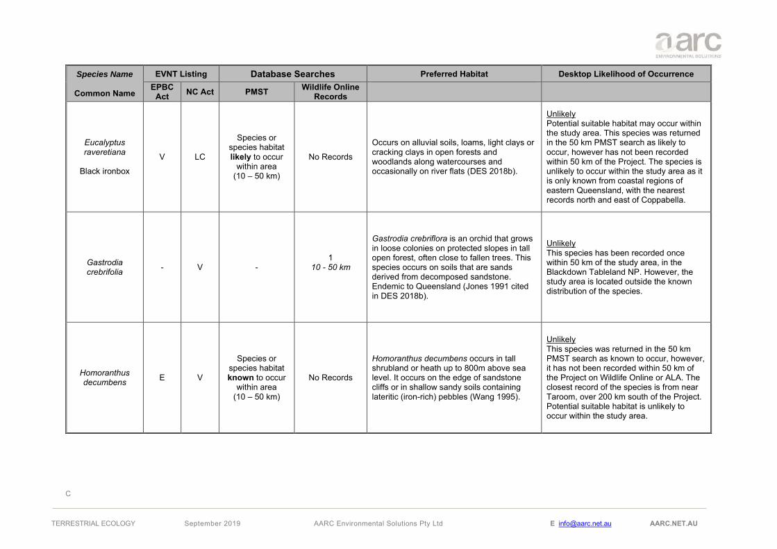
C
TERRESTRIAL ECOLOGY September 2019 AARC Environmental Solutions Pty Ltd E [email protected] AARC.NET.AU
Species Name
Common Name
EVNT Listing Database Searches Preferred Habitat Desktop Likelihood of Occurrence EPBC
Act NC Act PMST Wildlife Online Records
Eucalyptus raveretiana
Black ironbox
V LC
Species or species habitat likely to occur
within area (10 – 50 km)
No Records
Occurs on alluvial soils, loams, light clays or cracking clays in open forests and woodlands along watercourses and occasionally on river flats (DES 2018b).
Unlikely Potential suitable habitat may occur within the study area. This species was returned in the 50 km PMST search as likely to occur, however has not been recorded within 50 km of the Project. The species is unlikely to occur within the study area as it is only known from coastal regions of eastern Queensland, with the nearest records north and east of Coppabella.
Gastrodia crebrifolia - V -
1 10 - 50 km
Gastrodia crebriflora is an orchid that grows in loose colonies on protected slopes in tall open forest, often close to fallen trees. This species occurs on soils that are sands derived from decomposed sandstone. Endemic to Queensland (Jones 1991 cited in DES 2018b).
Unlikely This species has been recorded once within 50 km of the study area, in the Blackdown Tableland NP. However, the study area is located outside the known distribution of the species.
Homoranthus decumbens E V
Species or species habitat known to occur
within area (10 – 50 km)
No Records
Homoranthus decumbens occurs in tall shrubland or heath up to 800m above sea level. It occurs on the edge of sandstone cliffs or in shallow sandy soils containing lateritic (iron-rich) pebbles (Wang 1995).
Unlikely This species was returned in the 50 km PMST search as known to occur, however, it has not been recorded within 50 km of the Project on Wildlife Online or ALA. The closest record of the species is from near Taroom, over 200 km south of the Project. Potential suitable habitat is unlikely to occur within the study area.

C
TERRESTRIAL ECOLOGY September 2019 AARC Environmental Solutions Pty Ltd E [email protected] AARC.NET.AU
Species Name
Common Name
EVNT Listing Database Searches Preferred Habitat Desktop Likelihood of Occurrence EPBC
Act NC Act PMST Wildlife Online Records
Livistona fulva - V - 12
10 - 50 km
Livistona fulva occurs mainly along sandstone cliff-lines, on rocky foot-slopes below cliffs, in shallow rocky gullies of the Blackdown Tableland NP, and in deep sandstone gorges below major waterfalls around the edge of the plateau. Grows in moderately tall eucalypt forest, typically dominated by Eucalyptus sphaerocarpa. Most occurrences are recorded at altitudes 300 – 600m above sea level (DES 2018b). This species is found in the Blackdown Tablelands NP.
Unlikely This species has been described as occur mainly in the Blackdown Tableland NP. Potential suitable habitat is not likely to occur within the study area due to the absence of suitable soil types and low elevation.
Logania diffusa V V
Species or species habitat likely to occur
within area (0-10 km)
2 10 - 50 km
Logania diffusa occurs in heathland and eucalypt open forest. It grows in sandy or sandy clay soil with sandstone outcropping and loose surface stones on escarpments. This species grows at altitudes of 600 – 780m above sea level. This species is restricted to the Blackdown Tableland NP (DES 2014b).
Unlikely This species has been described as restricted to the Blackdown Tableland NP. Potential suitable habitat is not likely to occur within the Project due to the absence of suitable soil types and low elevation.
Macrozamia platyrhachis E E
Species or species habitat likely to occur
within area (0-10 km)
30 10 - 50 km
Macrozamia platyrhachis is scattered locally and abundantly in eucalypt woodland or open forest at altitudes between 300 – 780m above sea level. Mid- and under-stories of the vegetation may be relatively dense but is variably dependent on fire history. This species grows on deep sandy soils, derived from sandstone and is mainly found on Blackdown Tableland NP and has occurrence recorded in areas slightly south of township of Dingo (DES 2018b).
Unlikely This species has been recorded mainly within 50 km of the Project, in the Blackdown Tableland NP. The study area with its highest elevation at 200m above sea level, lacks the suitable habitat for this species.

C
TERRESTRIAL ECOLOGY September 2019 AARC Environmental Solutions Pty Ltd E [email protected] AARC.NET.AU
Species Name
Common Name
EVNT Listing Database Searches Preferred Habitat Desktop Likelihood of Occurrence EPBC
Act NC Act PMST Wildlife Online Records
Melaleuca groveana - NT -
4 10 - 50 km
Melaleuca groveana grows on exposed rocky ridges, high mountain slopes and the summit of mountains at altitudes 340 – 600m above sea level. This species typically occurs on in heaths and eucalypt woodlands and forests with heath understoreys. It is also found in tall open forest with a grassy understorey and in microphyll vine forests. It has been previously recorded growing on red sandy loams, brown loams, skeletal rocky soils and sandy soils over sandstone rock. This species is found in fragments from Port Stephens (NSW) to the Blackdown Tableland NP (DES 2014b).
Unlikely This species has been recorded within 50 km of the Project, in the Blackdown Tableland NP. The study area with its highest elevation at 200m above sea level, lacks the suitable habitat for this species.
Melaleuca pearsonii - NT -
12 10 - 50 km
Melaleuca pearsonii occurs in Blackdown Tableland NP. Grows near rivers, in rocky gullies and in wallum vegetation in creek beds (Brophy et al. 2013).
Unlikely This species has been described as occurring in the Blackdown Tableland NP. Potential suitable habitat is not likely to occur within the study area.

C
TERRESTRIAL ECOLOGY September 2019 AARC Environmental Solutions Pty Ltd E [email protected] AARC.NET.AU
Species Name
Common Name
EVNT Listing Database Searches Preferred Habitat Desktop Likelihood of Occurrence EPBC
Act NC Act PMST Wildlife Online Records
Phaius australis E E
Species or species habitat known to occur
within area (0-10 km)
3 10 - 50 km
Phaius australis grows in areas where soils are almost always damp, but not flooded for lengthy periods. Sands are generally the underlying soil type. P. australis are usually found in coastal habitats between swamps and forests or in suitable areas further inland. This includes swampy sclerophyll forest dominated by melaleucas, swampy forest that often have scleorphyll emergents, or fringing open forest and melaleuca swamp forest associated with rainforest species. P. australis has also been recorded in wallum, sedgeland, rainforest and closed forest. They often grow in deep shade but can also occur in full sun. This species occurs at higher altitudes in northern Queensland (Barker 1995).
Unlikely Despite being described from coastal habitats, this species has been recorded 3 times within 50 km of the study area in the Blackdown Tableland NP. Potential suitable habitat is not likely to occur within the Project.
Plectranthus blakei - NT -
10 10 - 50 km
Plectranthus blakei has been only recorded from sandstone rock outcrops and ledges in association with Hoya australis and Clandrina in the Blackdown Tableland NP (JSTOR 2018).
Unlikely This species has only been recorded in the Blackdown Tableland NP. However, the study area is located outside the known distribution of the species.

C
TERRESTRIAL ECOLOGY September 2019 AARC Environmental Solutions Pty Ltd E [email protected] AARC.NET.AU
Species Name
Common Name
EVNT Listing Database Searches Preferred Habitat Desktop Likelihood of Occurrence EPBC
Act NC Act PMST Wildlife Online Records
Pseudanthus pauciflorus subsp.
arenicola - NT -
1 10 - 50 km
This species occurs in crevices on vertical or near vertical rock faces and sandstone cliffs within dry sclerophyll woodland (DSITI 2015) and is endemic to the Blackdown Tableland NP (DES 2018b).
Unlikely This species has been described as being endemic to the Blackdown Tableland NP. Potential suitable habitat does not occur within the study area.
Rutidosis glandulosa - NT -
7 10 - 50 km
Rutidosis glandulosa is known from approximately 15 populations across six distinct localities, which includes Blackdown Tableland NP. This species mainly occurs on sandy or gravelly well drained soil in grassy open eucalypt woodland. Around Blackdown Tableland NP, this species appears to be growing in open forest dominated by Eucalyptus interstans, E. sphaerocarpa and Angophora leiocarpa. (DES 2018b).
Unlikely The study area is located outside of the species distribution, which extends from Stanthorpe to the Blackdown Tableland NP, to the west of the study area. Potential suitable habitat is not likely to occur within the Project.
Sannantha brachypoda - V -
1 10 - 50 km
Sannantha brachypoda has been described from loamy, sandy or rocky soils and from gorges and creek lines (AVH 2019).
Unlikely This species has been recorded once within 50 km of the study area, in the Blackdown Tableland NP. Potential suitable habitat does not occur within the study area.

C
TERRESTRIAL ECOLOGY September 2019 AARC Environmental Solutions Pty Ltd E [email protected] AARC.NET.AU
Species Name
Common Name
EVNT Listing Database Searches Preferred Habitat Desktop Likelihood of Occurrence EPBC
Act NC Act PMST Wildlife Online Records
Solanum adenophorum - NT -
10 10 - 50 km
Solanum adenophorum occurs mostly in brigalow woodland and on very gently inclined slopes. It also occurs in gidgee (Acacia cambagei) scrub on deep cracking clay soils (DES 2018e). Occurrence records show that this species is from south and south-west of Marlborough to Rockhampton and also found in small populations north and north-east of Wagga Wagga, NSW (ALA 2018).
Potential The Project is located south of the distribution range of the species. All records near the Project are located within Taunton NP. Potential suitable habitat may occur within the study area in small patches.
Solanum dissectum E E
Species or species habitat known to occur
within area (0-10 km)
3 10 - 50 km
Solanum dissectum occurs in open forest and woodland of brigalow (Acacia harpophylla) or Eucalyptus thozetiana on solodic clay soils (Queensland Herbarium 2012, cited in DES 2018b).
Potential This species was returned in the 50 km PMST search as known to occur, however, the closest record of the species is from west of Blackdown Tableland NP. Potential suitable habitat may occur within the study area in small patches.
Solanum elachophyllum - E -
1 0 - 10 km
14
10 - 50 km
Solanum elachophyllum grows on fertile cracking-clay soils in open forest of Eucalyptus thozetiana, Acacia harpophylla, with understorey of Geijera parviflora, Casuarina cristata, Macropteranthes leichhardtii, Eucalyptus cambageana, or woodland of E. creba and E. tenuipes (DES 2018b). Occurrence of this species has been recorded in areas from south-west of Mackay to south-west of Gladstone.
Likely The Project is located within the species distribution. Potential suitable habitat may occur within the study area in small patches.

C
TERRESTRIAL ECOLOGY September 2019 AARC Environmental Solutions Pty Ltd E [email protected] AARC.NET.AU
Species Name
Common Name
EVNT Listing Database Searches Preferred Habitat Desktop Likelihood of Occurrence EPBC
Act NC Act PMST Wildlife Online Records
Solanum johnsonianum E E
Species or species habitat
may occur within area
(10 – 50 km)
No Records
Solanum johnsonianum is distributed within communities dominated or co-dominated by Acacia harpophylla (Brigalow), on heavy cracking soils. Other associated species include Eucalyptus thozetiana with understorey of Geijera parviflora (Bean, 2004; Queensland Herbarium, 2012, cited in DES 2018b).
Unlikely The Project is located south of the distribution of the species. Potential suitable habitat may occur within the study area in small patches. There are no records of the species within 50 km of the Project.

D
TERRESTRIAL ECOLOGY September 2019 AARC Environmental Solutions Pty Ltd E [email protected] AARC.NET.AU
Appendix D Likelihood of Occurrence for Fauna Species of Conservation Significance

D
TERRESTRIAL ECOLOGY September 2019 AARC Environmental Solutions Pty Ltd E [email protected] AARC.NET.AU
Likelihood of Occurrence for Fauna Species of Conservation Significance
Scientific Name Common Name
Status Database Searches Habitat and Distribution Desktop Likelihood of Occurrence EPBC
Act NC Act PMST
Wildlife Online
Records Amphibians
Adelotus brevis Tusked frog
- V - 10 (10-50 km)
The Tusked frog Inhabits wet eucalypt forest, rainforest, and sometimes dry eucalypt forest, where it can be found in close proximity to suitable breeding habitat such as ponds and slow-moving sections of streams. Also recorded from dams and garden ponds in urban and peri-urban areas (Rowland 2013).
Potential
The study area occurs within the vicinity of the known range of the Tusked frog and there is a possibly the study area provides areas of suitable habitat. However, the closest records of the species in the area are from Blackdown Tableland NP, located over 20km southwest of the study area.
Reptiles
Delma torquate Adorned delma
V V
Species or species habitat likely to occur within area (0-10 km)
1 (10-50 km)
The Collared Delma normally inhabits eucalypt dominated woodland and open forest where it is associated with suitable micro-habitats (exposed rocky outcrops). The ground cover is
predominantly native grasses, such as Kangaroo Grass (Themeda triandra), Barbed-wire Grass (Cymbopogon refractus), Wiregrass (Aristida sp.) and Lomandra (Lomandra sp.) (Peck & Hobson, 2007, cited in TSSC 2008).
Potential
This species was returned in the 10 km PMST search as may occur. This species is known to occur between 10 and 50 km, at the Blackdown Tablelands NP. However, desktop searches identified marginal suitable habitat for this species in the study area.
Denisonia maculate Ornamental snake
V V
Species or species habitat may to occur within area (0-10 km)
2 (10-50 km)
The Ornamental Snake's preferred habitat is within, or close to, habitat that is favoured by its prey - frogs. The species is known to prefer woodlands and open forests associated with moist areas, particularly gilgai (melon-hole) mounds and depressions in Queensland Regional Ecosystem Land Zone 4, but also lake margins and wetlands (Agnew 2010 pers. comm.; Brigalow Belt Reptiles Workshop 2010; Wilson & Knowles 1988
Unlikely
This species was returned in the 10 km PMST search as may occur, and as known to occur between 10 and 50 km. Desktop searches did not identify suitable habitat for this species.

D
TERRESTRIAL ECOLOGY September 2019 AARC Environmental Solutions Pty Ltd E [email protected] AARC.NET.AU
Scientific Name Common Name
Status Database Searches Habitat and Distribution Desktop Likelihood of Occurrence EPBC
Act NC Act PMST
Wildlife Online
Records cited in DEE 2018). Gilgai formations are found where deep-cracking alluvial soils with high clay contents occur (Brigalow Belt Reptiles Workshop 2010, cited in DoEE 2018).
Egernia rugosa Yakka skink V V
Species or species habitat known to occur within area (0-10 km)
No records
Dry open forests, woodlands and rocky areas in the Brigalow Belt, where it occurs in fallen timber, wood piles, uprooted trees, deep rock crevices, deeply eroded gullies or disused rabbit warrens (DoEE 2018).
Unlikely This species or species habitat was returned in the 10 km PMST search as known to occur, however no records were returned in the database and online searches. There nearest ALA records are from over 50km west of the study area. Some marginally suitable habitat may be found on the study area.
Furina dunmalli Dunmall's snake V V
Species or species habitat may occur within area (0-10 km)
No records
Dunmall's Snake inhabits a broad range of habitats including; Forests/woodlands on black alluvial cracking clay/clay loams. Dominant vegetation includes Brigalow (Acacia harpophylla), Wattles (A. burowii, A. deanii, A. leioclyx), native Cypress (Callitris spp.) or Bull-oak (Allocasuarina luehmannii), Corymbia citriodora, Eucalyptus crebra and E. melanophloia, and Callitris glaucophylla (DoEE 2018).
Unlikely This species was returned in the 10 km PMST search as may occur, however no records were returned in the database and online searches. There nearest ALA records are from over 50km west of the study area. Desktop searches identified potentially suitable habitat for this species on the study area.
Strophurus taenicauda Golden-tailed gecko
- NT - 10 (10-50 km)
The Golden-tailed Gecko inhabits dry sclerophyll forests featuring ironbarks, cypress pine and brigalow. It is described as an arboreal species sheltering behind loose dead bark, in hollows, or clinging to exposed slender branches in dapple sunlight (Wilson 2005).
Potential
This species has been recorded within 50 km of the study area. The study area contains suitable habitat for this species.
Birds
Actitis hypoleucos Ma SL Species or
species habitat No records Varied coastal and interior wetlands – narrow muddy edges of billabongs, river pools,
Unlikely
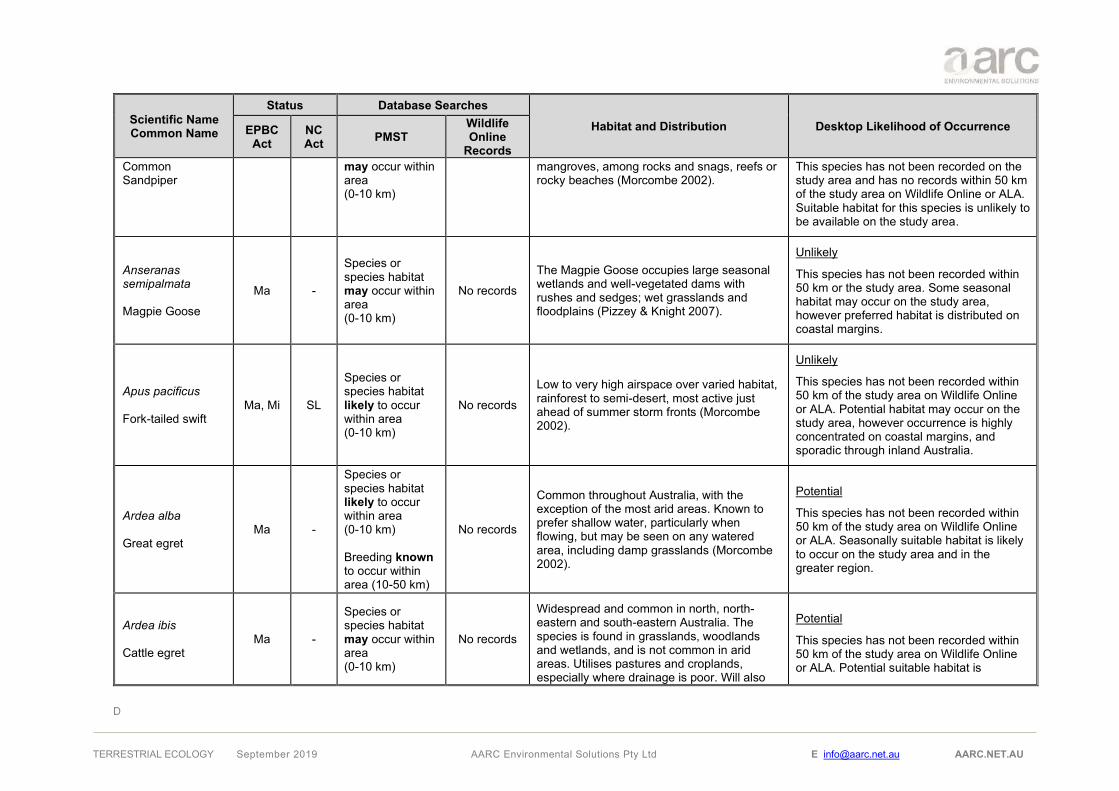
D
TERRESTRIAL ECOLOGY September 2019 AARC Environmental Solutions Pty Ltd E [email protected] AARC.NET.AU
Scientific Name Common Name
Status Database Searches Habitat and Distribution Desktop Likelihood of Occurrence EPBC
Act NC Act PMST
Wildlife Online
Records Common Sandpiper
may occur within area (0-10 km)
mangroves, among rocks and snags, reefs or rocky beaches (Morcombe 2002).
This species has not been recorded on the study area and has no records within 50 km of the study area on Wildlife Online or ALA. Suitable habitat for this species is unlikely to be available on the study area.
Anseranas semipalmata Magpie Goose
Ma -
Species or species habitat may occur within area (0-10 km)
No records
The Magpie Goose occupies large seasonal wetlands and well-vegetated dams with rushes and sedges; wet grasslands and floodplains (Pizzey & Knight 2007).
Unlikely
This species has not been recorded within 50 km or the study area. Some seasonal habitat may occur on the study area, however preferred habitat is distributed on coastal margins.
Apus pacificus Fork-tailed swift
Ma, Mi SL
Species or species habitat likely to occur within area (0-10 km)
No records
Low to very high airspace over varied habitat, rainforest to semi-desert, most active just ahead of summer storm fronts (Morcombe 2002).
Unlikely
This species has not been recorded within 50 km of the study area on Wildlife Online or ALA. Potential habitat may occur on the study area, however occurrence is highly concentrated on coastal margins, and sporadic through inland Australia.
Ardea alba Great egret
Ma -
Species or species habitat likely to occur within area (0-10 km) Breeding known to occur within area (10-50 km)
No records
Common throughout Australia, with the exception of the most arid areas. Known to prefer shallow water, particularly when flowing, but may be seen on any watered area, including damp grasslands (Morcombe 2002).
Potential
This species has not been recorded within 50 km of the study area on Wildlife Online or ALA. Seasonally suitable habitat is likely to occur on the study area and in the greater region.
Ardea ibis Cattle egret
Ma -
Species or species habitat may occur within area (0-10 km)
No records
Widespread and common in north, north-eastern and south-eastern Australia. The species is found in grasslands, woodlands and wetlands, and is not common in arid areas. Utilises pastures and croplands, especially where drainage is poor. Will also
Potential
This species has not been recorded within 50 km of the study area on Wildlife Online or ALA. Potential suitable habitat is

D
TERRESTRIAL ECOLOGY September 2019 AARC Environmental Solutions Pty Ltd E [email protected] AARC.NET.AU
Scientific Name Common Name
Status Database Searches Habitat and Distribution Desktop Likelihood of Occurrence EPBC
Act NC Act PMST
Wildlife Online
Records forage in garbage dumps, and often associates with livestock (Morcombe 2002).
available on the study area and in the greater region.
Calidris acuminate Sharp-tailed sandpiper
Ma, Mi SL
Species or species habitat may occur within area (0-10 km) Species or species habitat likely to occur within area (10-50 km)
No records
Fresh or salt wetlands – the muddy edges of wetlands and dams (Morcombe 2002). In Queensland, they are recorded in most regions, being widespread along much of the coast and are very sparsely scattered inland, particularly in central and south-western regions (DoEE 2018).
Potential
This species was returned in the 10 km PMST search as may occur, and as likely to occur between 10 and 50 km. No records of presence were recorded within 50km of the study area. Species occurrence is concentrated on coastal margins, but still common throughout inland Australia where suitable habitat is available. Limited seasonal habitat may occur in the study area.
Calidris ferruginea Curlew sandpiper
CE, Mi, Ma E
Species or species habitat may occur within area (0-10 km)
No records
Inhabiting wetland environments, the Curlew sandpiper is commonly found on sandy shores, lagoons, tidal mudflats, saltmarshes, swamps, lakes, and sewage farms (Pizzey and Knight 2007). They forage at the edge of shallow pools and can wade through water 15-60 mm deep (DoEE 2018). Whilst small numbers have been recorded living inland around ephemeral and permanent lakes, dams and bores, the majority reside along the coast roosting on dry shingle, sand, or shell beaches. This species is distributed around most of the coastline of Australia.
Unlikely
Habitat within the study area is not suited for this species as the study area is not coastal and will not provide the resources required to sustain this species. Although this species has been recorded in association with inland waterbodies, it is very rare.
Calidris melanotos Pectoral sandpiper
Ma, Mi SL
Species or species habitat may occur within area (0-10 km)
No records
Usually coast wetlands, both fresh and saline, but also inland on permanent and temporary wetlands; utilises sites with mudflats, fringing vegetation, swamps with heavy overgrowth of vegetation (Morcombe 2002).
Unlikely
This species was returned in the 10 km PMST search as may occur, however as no records were returned in the database and online searches. The nearest ALA records are near Mackay and Yeppoon. Potentially

D
TERRESTRIAL ECOLOGY September 2019 AARC Environmental Solutions Pty Ltd E [email protected] AARC.NET.AU
Scientific Name Common Name
Status Database Searches Habitat and Distribution Desktop Likelihood of Occurrence EPBC
Act NC Act PMST
Wildlife Online
Records marginal suitable habitat is likely to occur within the study area.
Calyptorhynchus lathami erebus Glossy black-cockatoo (northern)
- V - 19 (10-50 km)
The Glossy black-cockatoo (northern) prefers woodland areas dominated by she-oak Allocasuarina or open sclerophyll forests and woodlands with a stratum of Allocasuarina beneath Eucalyptus, Corymbia or Angophora. This species occurs in the north and central east coast of Queensland, including Blackdown Tableland (Glossy Black Conservancy 2010).
Potential
Wildlife online records indicate 19 occurrences of this species within 10 to 50 km of the study area. The PMST did not identify this species as it is not listed under the EPBC Act. Suitable habitat occurs in the broader region but has not been mapped as present within the study area.
Cuculus optatus Oriental Cuckoo Mi SL
Species or species habitat may occur within area (0-10 km)
No records
Rainforest margins, monsoon forest, vine scrubs, riverine thickets, wetter, densely canopied eucalypt forests, paperbark swamps and mangroves (Morcombe 2002).
Unlikely
This species was returned in the 10 km PMST search as may occur, however no records were returned in the database and online searches. Suitable habitat is unlikely to occur within the study area.
Chrysococcyx osculans Black-eared cuckoo
Ma -
Species or species habitat likely to occur within area (0-10 km)
No records
This species inhabits areas of dry open forests, scrublands, mallee, mulga, lignum, and riverside thickets. This species is widespread across the mainland of Australia.
Potential
This species was returned in the 10 km PMST search as likely to occur, however no records were returned in the database and online searches. Potential habitat for this species may occur within the study area.
Erythrotriorchis radiatus Red goshawk
V E
Species or species habitat known to occur within area (0-10 km)
15 (10-50km)
The red goshawk prefers a mix of vegetation types with its habitat including tall open forest, woodland, lightly treed savannah and the edge of rainforest. In partly cleared parts of eastern Queensland, it is associated with gorge and escarpment country (DES 2018b).
Potential
Wildlife Online records identify 15 occurrences of this species within 10 to 50 km. PMST identified species/species habitat as known to occur within 10 km of the study area.

D
TERRESTRIAL ECOLOGY September 2019 AARC Environmental Solutions Pty Ltd E [email protected] AARC.NET.AU
Scientific Name Common Name
Status Database Searches Habitat and Distribution Desktop Likelihood of Occurrence EPBC
Act NC Act PMST
Wildlife Online
Records
Gallinago hardwickii Lathams snipe
Ma, Mi SL
Species or species habitat may occur within area (0-10 km)
-
This species prefers open freshwarer wetlands, typically with low dense vegetation. Can be found in a variety of vegetation communities including but not limited to tussock grasslands, coastal and alpine heathlands, tea-tree scrub and open forests.
Unlikely
This species was returned in the 10 km PMST search as may occur, no records were returned in the database and online searches. Limited suitable habitat is likely to occur within the study area.
Geophaps scripta scripta Squatter pigeon (southern)
V V
Species or species habitat known to occur within area (0-10 km)
14 (0-10 km)
44 (10-50 km)
Open grassy woodlands on sandy soils interspersed with low gravelly ridges, never far from water (Morcombe 2002).
Likely
This species has been recorded several times within 10 km of the study area. Suitable habitat exists within the study area. The species is typically locally abundant in areas where it is known from and not cryptic in nature.
Grantiella picta Painted honeyeater
V V
Species or species habitat may occur within area (0-10 km)
3 (10-50 km)
The Painted honeyeater typically occupies habitats on deep, productive soils and is reliant on abundant mistletoes as a food source. It favours Acacia dominant woodlands (particularly Brigalow dominant) and often uses Belah and Bulloak woodlands and riparian woodlands of Black Box and River Red Gum. The species’ breeding range is largely restricted to inland NSW and south of Roma.
Potential
Thre records identified this species as occurring between 10 and 50 km from the study area. Desktop searches identified potential suitable habitat for this species along creek lines/watercourses within the study area.
Haliaeetus leucogaster White-bellied Sea-Eagle
Ma -
Species or species habitat likely to occur within area (0-10 km)
No records
Coastal habitats (especially those close to the sea-shore) and around terrestrial wetlands. Habitat characterised by the presence of large areas of open water (larger rivers, swamps, lakes, the sea). Birds have been recorded in (or flying over) a variety of terrestrial habitats (DoEE 2018).
Unlikely
This species was returned in the 10 km PMST search as likely to occur, but no records within 50 km of the study area. Seasonally suitable habitat may occur within the study area.

D
TERRESTRIAL ECOLOGY September 2019 AARC Environmental Solutions Pty Ltd E [email protected] AARC.NET.AU
Scientific Name Common Name
Status Database Searches Habitat and Distribution Desktop Likelihood of Occurrence EPBC
Act NC Act PMST
Wildlife Online
Records
Hirundapus caudacutus White-throated needletail
Ma, Mi SL
Species or species habitat known to occur within area (10-50 km)
No records
This species in Australia is primarily aerial but does show preferences for certain habitats. This species is found in associated with wooded areas, including open forests and rainforests.
Potential
This species was returned in the 50 km PMST search as known to occur. Database searches did not identify any records of this species occurring within 50 km of the study area.
Lathamus discolor Swift parrot CE E - 1 (10-50 km)
This species distribution covers eastern NSW, South-east Queensland, Victoria and Tasmania. This species migrates to south-eastern Queensland during Autumn and Winter. This species forages within eucalypt forests and woodlands.
Potential
This species was not identified by the PMST. One record of this species exists within 10 to 50 km from the study area. Limited suitable habitat occurs for this species along the creek lines and watercourses within the study area. The study area occurs at the most upper limit of this species distribution.
Merops ornatus Rainbow bee-eater
Ma -
Species or species habitat may occur within area (0-10 km)
No records
Open forests and woodlands, shrublands, various cleared or semi-cleared habitats, including farmland and areas of human habitation. Open, cleared or lightly timbered areas that are often located in close proximity to permanent water (DoEE 2018).
Potential
This species was listed as may occur within 10 km on the PMST search. Database searches did not identify any records of this species occurring within 50 km of the study area. The study area is likely to contain suitable habitat for this species.
Monarcha melanopsis Black-faced monarch
Ma, Mi SL
Species or species habitat likely to occur within area (0-10 km)
No records Rainforests, mangroves, eucalypt forests and woodlands (Morcombe 2002).
Potential
This species was returned in the 10 km PMST search as likely to occur, however has not been recorded in the 50 km Wildlife Online search. Suitable habitat potentially occurs within the study area.
Monarcha trivirgatus Ma, Mi SL Species or
species habitat No records Distribution is focused along the eastern coastline of Queensland and NSW. This
Unlikely

D
TERRESTRIAL ECOLOGY September 2019 AARC Environmental Solutions Pty Ltd E [email protected] AARC.NET.AU
Scientific Name Common Name
Status Database Searches Habitat and Distribution Desktop Likelihood of Occurrence EPBC
Act NC Act PMST
Wildlife Online
Records Spectacled monarch
may occur within area (10-50 km)
species inhabits areas of wet forests and mangroves.
This species was returned in the 10 km PMST search as may occur, however has not been recorded in the 50 km Wildlife Online search. The study area occurs at the limit of this species range and its preferred habitat is unlikely to occur within the study area.
Motacilla flava Yellow wagtail
Ma, Mi SL
Species or species habitat may occur within area (0-10 km)
No records Open habitats, often near water; in Queensland it is usually coastal (Morcombe 2002).
Potential
This species was returned in the 10 km PMST search as may occur, however no records were returned in the database and online searches. Suitable habitat has the potential to occur within the Project, though likely only seasonally.
Myiagra cyanoleuca Satin flycatcher
Ma, Mi SL
Species or species habitat may occur within area (0-10 km)
No records
Forests and woodlands, mangroves, coastal heath scrubs; in breeding season favours dense, wet gullies of heavy eucalypt forests (Morcombe 2002).
Potential
This species was returned in the 10 km PMST search as may occur, but no database records within 50 km. Limited suitable habitat may occur within the study area.
Neochmia ruficauda ruficauda Star finch
E E
Species or species habitat likely to occur within area (0-10 km)
No records
The Star finch occurs in grasslands and grassy woodlands, near permanent water, and often in or near suburban areas (Curtis et al. 2012). The Star Finch is endemic to central Queensland (DoEE 2018).
Unlikely
This species was returned in the 10 km PMST search as likely to occur, but no database records within 50 km. Limited to no suitable habitat for this species is likely to occur within in the study area.
Ninox strenua Powerful owl - V - 3 (10-50 km)
This species prefers tall open woodlands and forests. Powerful owls require large hollows to nest. This species inhabits areas along watercourses.
Potential
Three records of this species have been recorded between 10 and 50 km from the study area. This species is not listed under the EPBC Act as such did not come up in

D
TERRESTRIAL ECOLOGY September 2019 AARC Environmental Solutions Pty Ltd E [email protected] AARC.NET.AU
Scientific Name Common Name
Status Database Searches Habitat and Distribution Desktop Likelihood of Occurrence EPBC
Act NC Act PMST
Wildlife Online
Records the PMST. This species is likely to use only marginal habitat features along major watercourses within the study area.
Numenius madagascariensis Eastern curlew
CE, Mi E
Species or species habitat may occur within area (10-50 km)
No records Tidal mudflats, sand spits of estuaries, mangroves, lake shores and ocean beaches (Morcombe 2002).
Unlikely
This species has not been recorded within 50 km of the study area on Wildlife Online. Suitable habitat is unlikely to be present on the study area due to the study area lying outside suitable coastline environs, with only scattered records inland.
Pedionomus torquatus Plains wanderer
CE V - 1 (10-50 km)
The Plains wanderer is a ground-dwelling bird species that inhabits native grasslands. This species is often absent from areas that are too dense or sparse.
Potential
This species was not identified in the PMST, and only one record of this species was identified within 10 to 50 km from the study area. Desktop searches identified no native grasslands within the study area boundary.
Psephotus pulcherrimus Paradise parrot
PE EX - 9 (10-50 km)
Historically this species occurred in central and southern Queensland. This species inhabited undulating river valleys in sparse open eucalypt woodlands and forests.
Unlikely
This species is now extinct. Historic records are from over 50 years ago.
Poephila cincta cincta Black-throated finch (white-rumped subspecies)
E E
Species or species habitat may occur within area (0-10 km)
4 (10-50 km)
This species inhabits open grassy woodlands and forests (Curtis et al. 2012), scrubby plains and Pandanus flats with deep cover of grasses. Its habitat is never far from water. It is known to occur south of Townsville, particularly around Townsville and Charters Towers (DoEE 2018).
Potential
This species was returned in the 10 km PMST search as may occur. Wildlife Online records identify four occurrences of this species within 10 to 50 km.
Rhipidura rufifrons Rufous fantail
Ma SL Species or species habitat No records
In east and southeast Australia, the Rufous Fantail mainly inhabits wet sclerophyll forests. They are also recorded from parks and
Unlikely
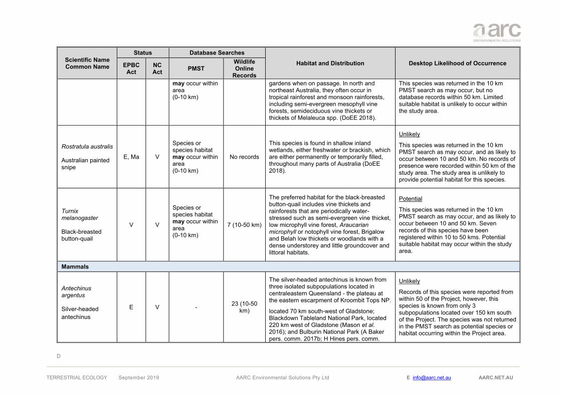
D
TERRESTRIAL ECOLOGY September 2019 AARC Environmental Solutions Pty Ltd E [email protected] AARC.NET.AU
Scientific Name Common Name
Status Database Searches Habitat and Distribution Desktop Likelihood of Occurrence EPBC
Act NC Act PMST
Wildlife Online
Records may occur within area (0-10 km)
gardens when on passage. In north and northeast Australia, they often occur in tropical rainforest and monsoon rainforests, including semi-evergreen mesophyll vine forests, semideciduous vine thickets or thickets of Melaleuca spp. (DoEE 2018).
This species was returned in the 10 km PMST search as may occur, but no database records within 50 km. Limited suitable habitat is unlikely to occur within the study area.
Rostratula australis Australian painted snipe
E, Ma V
Species or species habitat may occur within area (0-10 km)
No records
This species is found in shallow inland wetlands, either freshwater or brackish, which are either permanently or temporarily filled, throughout many parts of Australia (DoEE 2018).
Unlikely
This species was returned in the 10 km PMST search as may occur, and as likely to occur between 10 and 50 km. No records of presence were recorded within 50 km of the study area. The study area is unlikely to provide potential habitat for this species.
Turnix melanogaster Black-breasted button-quail
V V
Species or species habitat may occur within area (0-10 km)
7 (10-50 km)
The preferred habitat for the black-breasted button-quail includes vine thickets and rainforests that are periodically water-stressed such as semi-evergreen vine thicket, low microphyll vine forest, Araucarian microphyll or notophyll vine forest, Brigalow and Belah low thickets or woodlands with a dense understorey and little groundcover and littoral habitats.
Potential
This species was returned in the 10 km PMST search as may occur, and as likely to occur between 10 and 50 km. Seven records of this species have been registered within 10 to 50 kms. Potential suitable habitat may occur within the study area.
Mammals
Antechinus argentus Silver-headed antechinus
E V - 23 (10-50 km)
The silver-headed antechinus is known from three isolated subpopulations located in centraleastern Queensland - the plateau at the eastern escarpment of Kroombit Tops NP.
located 70 km south-west of Gladstone; Blackdown Tableland National Park, located 220 km west of Gladstone (Mason et al. 2016); and Bulburin National Park (A Baker pers. comm. 2017b; H Hines pers. comm.
Unlikely
Records of this species were reported from within 50 of the Project, however, this species is known from only 3 subpopulations located over 150 km south of the Project. The species was not returned in the PMST search as potential species or habitat occurring within the Project area.

D
TERRESTRIAL ECOLOGY September 2019 AARC Environmental Solutions Pty Ltd E [email protected] AARC.NET.AU
Scientific Name Common Name
Status Database Searches Habitat and Distribution Desktop Likelihood of Occurrence EPBC
Act NC Act PMST
Wildlife Online
Records 2017), located 80 km south-east of Gladstone (TSSC 2018).
Chalinolobus dwyeri Large-eared pied bat
V V
Species or species habitat may occur within area (0-10 km)
2 (10-50 km)
This species occurs in areas with extensive cliffs and caves, primarily in the Central Queensland sandstone belt. Suitable habitat consists of sandstone gorges in tall open eucalypt forest, dry sclerophyll forests and woodlands, rainforest edges, wet sclerophyll forest and Callitris dominant forest.
Potential
This species was returned in the 10 km PMST search as may occur, and as likely to occur between 10 and 50 km. The study area potentially contains suitable habitat for this species.
Dasyurus hallucatus Northern quoll
E -
Species or species habitat likely to occur within area (0-10 km)
No records
The northern quoll lives in a range of open woodland and open forest types preferring rocky areas. Northern quolls have also been recorded in vine forest, mangroves, sugarcane farms and urban areas. Their greatest breeding success is known to occur at sites near water (DES 2018b).
Unlikely
This species was returned in the 10 km PMST search as likely to occur. The study area may contain small areas of suitable habitat for this species. No confirmed records of this species have been found to occur within 50 km of the study area.
Macroderma gigas Ghost bat
V E
Species or species habitat likely to occur within area (0-10 km)
No records
Ghost bats currently occupy habitats ranging
from the arid Pilbara to tropical savanna woodlands and rainforests. During the daytime they roost in caves, rock crevices and old mines. (TSSC 2016b). They occupy the northern tropical areas of Queensland, Northern Territory and Western Australia.
Unlikely
This species was returned in the 10 km PMST search as likely to occur. The study is unlikely to contain suitable habitat for this species and is located outside of the species distribution. No confirmed records of this species have been found to occur within 50 km of the study area.
Nycophilus corbeni Corben’s long-eared bat
V V
Species or species habitat may occur within area (0-10 km)
No records
This species is found across semi-arid southern Australia to southern Queensland and inhabits a range of dry woodland and shrubland communities in arid and semi-arid regions. This bat species roosts mostly in tree hollows (Menkhorst & Knight 2011).
Unlikely
This species was returned in the 10 km PMST search as may occur, however, the study area is located outside of the species distribution. No records of presence were recorded within 50 km of the study area. Based on desktop mapping investigations areas containing hollow bearing trees are

D
TERRESTRIAL ECOLOGY September 2019 AARC Environmental Solutions Pty Ltd E [email protected] AARC.NET.AU
Scientific Name Common Name
Status Database Searches Habitat and Distribution Desktop Likelihood of Occurrence EPBC
Act NC Act PMST
Wildlife Online
Records likely limited to along watercourses within the study area.
Onychogalea fraenata Bridled nail-tail wallaby
E E
Species or species habitat known to occur within area (0-10 km)
15 (0-10 km)
41 (10-50 km)
Within Taunton National Park, bridled nailtail wallabies are found in open grassy eucalypt woodland dominated by poplar box (Eucalyptus populnea), dense acacia forest dominated by brigalow (Acacia harpophylla), transitional vegetation intermediate between the woodland and forest
areas of very dense brigalow regrowth (Lundie-Jenkins, G., & J. Lowry 2005)
Likely
Despite not being reported on the Wildlife online search for 10km, this species is known to occur in the Taunton NP. Desktop searches identified potential suitable habitat for this species in small isolated patches throughout the study area.
Petauroides Volans Greater glider
V V
Species or species habitat likely to occur within area (0-10 km)
1 (0-10 km)
71 (10-50 km)
Eucalypt dominated habitats, ranging from low, open forests on the coast to tall forests in the ranges and low woodland westwards of the Dividing Range (DES 2018b).
Likely
Based on desktop mapping investigations areas containing hollow bearing trees are likely limited to along watercourses within the study area. One Wildlife online records of presence was recorded within 10 km of the study area, and 71 records exist within 10 to 50 kms.
Phascolarctos cinereus Koala
V V
Species or species habitat likely to occur within area (0-10 km)
1 (0-10 km)
14 (10-50 km)
The Koala inhabits Eucalypt forests and woodlands on the east coast of Australia (Curtis et al. 2012). Koalas require areas of eucalypt species that are highly connected, to ensure shelter from predators.
Potential
The study area occurs within the known range of the Koala and provides possible areas of suitable habitat along a narrow strip of Eucalyptus spp following the watercourses in the study area. One Wildlife online record of presence was recorded within 10 km of the study area, and 14 records exist within 10 to 50 kms.

D
TERRESTRIAL ECOLOGY September 2019 AARC Environmental Solutions Pty Ltd E [email protected] AARC.NET.AU
Scientific Name Common Name
Status Database Searches Habitat and Distribution Desktop Likelihood of Occurrence EPBC
Act NC Act PMST
Wildlife Online
Records
Pteropus poliocephalus Grey-headed flying-fox
V -
Foraging, feeding or related behaviour may occur within area (10-50 km)
No records
Roost in native vegetation near water, including mangrove, rainforest, melaleuca or casuarina (Churchill 2008). Typically commute within 15 km to feed on flowering and fruiting plants, including blossoms of various species of eucalypt, angophora, tea-tree and banksia (DES 2018b).
Unlikely
No records within 50 km of the study area on Wildlife Online or ALA. Seasonally suitable foraging habitat may exist within the study area, however, no known records or roosts occur within 50 km.

E
TERRESTRIAL ECOLOGY September 2019 AARC Environmental Solutions Pty Ltd E [email protected] AARC.NET.AU
Appendix E Fauna Survey Sites

E
TERRESTRIAL ECOLOGY September 2019 AARC Environmental Solutions Pty Ltd E [email protected] AARC.NET.AU
Site Name DF01
Associated Project Site Dingo West
Site Location (Zone, Easting, Northing) 55 727223 7381160
Habitat type Habitat type 2
Associated RE 11.7.2
Habitat Description Acacia spp. woodland with Eucalyptus crebra as emergent on lateritic duricrust.
Disturbance Present Moderate to light grazing and evidence of old fire.
Dominant Vegetation Species
Dominant Trees: Acacia sherleyi (Lancewood), Acacia rhodoxylon (Rosewood) and Eucalyptus crebra as emergent. Dominant Shrubs: Erythroxylum australe, and saplings of the canopy species. Dominant Ground Cover: Calyptochloa gracilima and Aristida caput-medusae

E
TERRESTRIAL ECOLOGY September 2019 AARC Environmental Solutions Pty Ltd E [email protected] AARC.NET.AU
Site Name DF02
Associated Project Site Dingo West
Site Location (Zone, Easting, Northing) 55 K 727380 7382738
Habitat type Habitat type 3
Associated RE 11.3.25
Habitat Description Eucalyptus tereticornis open woodland in floodplain between main creek and drainage line.
Disturbance Present Adjacent land cleared, moderate grazing, erosion nearby and invasive species (Parthenium weed, Rubber vine and Velvet tree pear).
Dominant Vegetation Species
Dominant Trees: Eucalyptus tereticornis and Cassia brewsterii Dominant Shrub: Cassia brewsterii Dominant Ground Cover: Megathyrsus maximus

E
TERRESTRIAL ECOLOGY September 2019 AARC Environmental Solutions Pty Ltd E [email protected] AARC.NET.AU
Site Name DF03
Associated Project Site Dingo West
Site Location (Zone, Easting, Northing) 55 K 726387 7383525
Habitat type Habitat type 1
Associated RE 11.5.2
Habitat Description Eucalyptus crebra and Acacia rhodoxylon on sandy plains.
Disturbance Present Moderate grazing, evidence of old fire and invasive species (Harrisia cactus and Velvet tree pear).
Dominant Vegetation Species
Dominant Trees: Eucalyptus crebra and Acacia rhodoxylon Dominant Shrubs: Erythroxylum australe Dominant Ground Cover: Cleistochloa sp. (Duaringa K.B.Adison 42) and Aristida caput-medusae

E
TERRESTRIAL ECOLOGY September 2019 AARC Environmental Solutions Pty Ltd E [email protected] AARC.NET.AU
Site Name DF04
Associated Project Site Dingo West
Site Location (Zone, Easting, Northing) 55 K 729993 7383135
Habitat type Habitat type 3
Associated RE 11.5.2/11.3.25
Habitat Description Floodplain next to creek line with Eucalyptus crebra on the floodplain and E. tereticornis woodland by the creek line.
Disturbance Present Tracks, erosion, moderate grazing and invasive species (Rubber vine)
Dominant Vegetation Species
Dominant Trees: Eucalyptus tereticornis, Eucalyptus crebra and Bauhinia carronii Dominant Shrubs: Bauhinia carronii and Terminalia oblongata Dominant Ground Cover: Dichantium sericeum and Megathyrsus maximus

E
TERRESTRIAL ECOLOGY September 2019 AARC Environmental Solutions Pty Ltd E [email protected] AARC.NET.AU
Site Name DF05
Associated Project Site Dingo West
Site Location (Zone, Easting, Northing) 55 K 728432 7382299
Habitat type Habitat type 3
Associated RE 11.3.25
Habitat Description Eucalyptus tereticornis and Bauhinia carronii woodland on floodplain between creek lines.
Disturbance Present Moderate grazing and invasive species (Velvet tree pear).
Dominant Vegetation Species
Dominant Trees: Eucalyptus tereticornis and Bauhinia carronii Dominant Shrubs: Bauhinia carronii and Carissa spinarum Dominant Ground Cover: Cenchrus ciliaris

E
TERRESTRIAL ECOLOGY September 2019 AARC Environmental Solutions Pty Ltd E [email protected] AARC.NET.AU
Site Name DF06
Associated Project Site Dingo West
Site Location (Zone, Easting, Northing) 55 K 729350 7388339
Habitat type Habitat type 2
Associated RE 11.7.2
Habitat Description Acacia rhodoxylon woodland on undulating soil with ephemeral drainage lines.
Disturbance Present Road nearby, dieback, invasive species (Velvet tree pear).
Dominant Vegetation Species
Dominant Trees: Acacia rhodoxylon Dominant Shrubs: Owenia acidula, Erythroxylum australe and Carissa spinarum Dominant Ground Cover: Aristida caput medusae

E
TERRESTRIAL ECOLOGY September 2019 AARC Environmental Solutions Pty Ltd E [email protected] AARC.NET.AU
Site Name DF07
Associated Project Site Dingo West
Site Location (Zone, Easting, Northing) 55 K 729388 7387547
Habitat type Habitat type 1
Associated RE 11.5.2
Habitat Description Eucalyptus crebra and Corymbia clarksoniana on undulating terrain on top of hill besides an ephemeral drainage feature.
Disturbance Present Agriculture (clearing prior 1986 pers. comm.), road nearby, evidence of fire (big fire around 2014 less than 100m away, across the road) and invasive species (Velvet tree pear).
Dominant Vegetation Species
Dominant Trees: Eucalyptus crebra, Corymbia clarksoniana, Alphitonia excelsa, Acacia leiocalyx subsp. leiocalyx and Acacia rhodoxylon Dominant Shrubs: Petalostigma pubescens, Erythroxylum australe and Carissa spinarum Dominant Ground Cover: Cenchrus ciliaris and native grasses

E
TERRESTRIAL ECOLOGY September 2019 AARC Environmental Solutions Pty Ltd E [email protected] AARC.NET.AU
Site Name DF08
Associated Project Site Dingo West
Site Location (Zone, Easting, Northing) 55 K 728436 7387550
Habitat type Habitat type 2
Associated RE 11.7.2
Habitat Description Acacia lanceolata and Acacia rhodoxylon woodland with Eucalyptus crebra as emergent at foothill of a rocky scarpment.
Disturbance Present Moderate disturbance due to a nearby track (not in use any longer because of erosion), some evidence of selective logging, moderate grazing and invasive species (Velvet tree pear)
Dominant Vegetation Species
Dominant Trees: Eucalyptus crebra, Acacia shirleyi, Acacia rhodoxylon Dominant Shrubs: Psydrax forsteri Dominant Ground Cover: Calyptochloa gracilima

E
TERRESTRIAL ECOLOGY September 2019 AARC Environmental Solutions Pty Ltd E [email protected] AARC.NET.AU
Site Name DF09
Associated Project Site Dingo West
Site Location (Zone, Easting, Northing) 55 K 731322 7387731
Habitat type Habitat type 1
Associated RE 11.5.2
Habitat Description Allocasuarina luehmannii with Eucalyptus crebra and Corymbia clarksoniana on sand plains with ephemeral drainage features.
Disturbance Present Tracks nearby, moderate grazing, clearing land nearby, evidence of fire and invasive species (Velvet tree pear).
Dominant Vegetation Species
Dominant Trees: Eucalyptus crebra, Allocasuarina luehmannii and Corymbia clarksoniana Dominant Shrubs: Melaleuca nervosa and Petalostigma pubescens Dominant Ground Cover: Aristida calycina and Eragrostis lacunaria
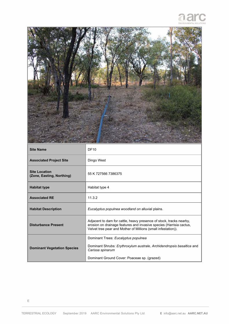
E
TERRESTRIAL ECOLOGY September 2019 AARC Environmental Solutions Pty Ltd E [email protected] AARC.NET.AU
Site Name DF10
Associated Project Site Dingo West
Site Location (Zone, Easting, Northing) 55 K 727566 7386375
Habitat type Habitat type 4
Associated RE 11.3.2
Habitat Description Eucalyptus populnea woodland on alluvial plains.
Disturbance Present Adjacent to dam for cattle, heavy presence of stock, tracks nearby, erosion on drainage features and invasive species (Harrisia cactus, Velvet tree pear and Mother of Millions (small infestation)).
Dominant Vegetation Species
Dominant Trees: Eucalyptus populnea Dominant Shrubs: Erythroxylum australe, Archidendropsis basaltica and Carissa spinarum Dominant Ground Cover: Poaceae sp. (grazed)

E
TERRESTRIAL ECOLOGY September 2019 AARC Environmental Solutions Pty Ltd E [email protected] AARC.NET.AU
Site Name DF11
Associated Project Site Dingo West
Site Location (Zone, Easting, Northing) 55 K 730436 7381462
Habitat type Habitat type 2
Associated RE 11.7.2
Habitat Description Acacia rhodoxylon woodland on sandy plains with emergent Eucalyptus crebra.
Disturbance Present Agriculture (clearing) and roads and tracks nearby.
Dominant Vegetation Species
Dominant Trees: Acacia rhodoxylon Dominant Shrubs: Carissa spinarum Dominant Ground Cover: Aristida calycina

E
TERRESTRIAL ECOLOGY September 2019 AARC Environmental Solutions Pty Ltd E [email protected] AARC.NET.AU
Site Name DF12
Associated Project Site Dingo West
Site Location (Zone, Easting, Northing) 55 K 731898 7381098
Habitat type Habitat type 3
Associated RE 11.3.25
Habitat Description Eucalyptus tereticornis woodland fringing drainage lines.
Disturbance Present Agriculture (clearing) and roads and tracks nearby and evidence of fire.
Dominant Vegetation Species
Dominant Trees: Eucalyptus tereticornis Dominant Shrubs: Acacia cretata Dominant Ground Cover: Bothriochloa ewartiana

E
TERRESTRIAL ECOLOGY September 2019 AARC Environmental Solutions Pty Ltd E [email protected] AARC.NET.AU
Site Name DF13
Associated Project Site Dingo West
Site Location (Zone, Easting, Northing) 55 K 729657 7377985
Habitat type Habitat type 1
Associated RE 11.5.2
Habitat Description Eucalyptus.crebra woodland with Allocasuarina luehmannii in the understorey.
Disturbance Present Agriculture (clearing) and roads and tracks nearby and evidence of fire.
Dominant Vegetation Species
Dominant Trees: Eucalyptus crebra and Allocasuarina luehmannii Dominant Shrubs: Acacia cretata and Corymbia clarksoniana sapplings Dominant Ground Cover: Themeda triandra
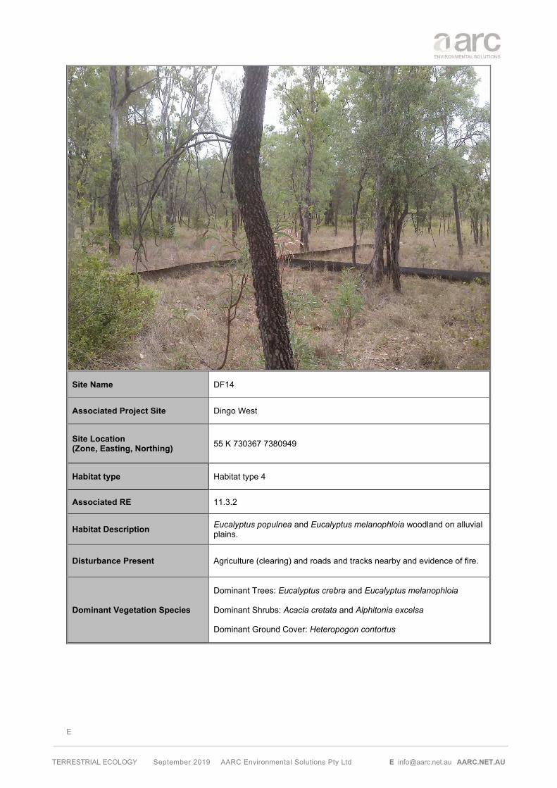
E
TERRESTRIAL ECOLOGY September 2019 AARC Environmental Solutions Pty Ltd E [email protected] AARC.NET.AU
Site Name DF14
Associated Project Site Dingo West
Site Location (Zone, Easting, Northing) 55 K 730367 7380949
Habitat type Habitat type 4
Associated RE 11.3.2
Habitat Description Eucalyptus populnea and Eucalyptus melanophloia woodland on alluvial plains.
Disturbance Present Agriculture (clearing) and roads and tracks nearby and evidence of fire.
Dominant Vegetation Species
Dominant Trees: Eucalyptus crebra and Eucalyptus melanophloia Dominant Shrubs: Acacia cretata and Alphitonia excelsa Dominant Ground Cover: Heteropogon contortus

E
TERRESTRIAL ECOLOGY September 2019 AARC Environmental Solutions Pty Ltd E [email protected] AARC.NET.AU
Site Name DF15
Associated Project Site Dingo West
Site Location (Zone, Easting, Northing) 55 K 729597 7378351
Habitat type Habitat type 4
Associated RE 11.3.2
Habitat Description Eucalyptus populnea open woodland on alluvial plains.
Disturbance Present Agriculture (clearing) and roads and tracks nearby, heavy grazing (farmer’s dam in the vicinity) and evidence of fire.
Dominant Vegetation Species
Dominant Trees: Eucalyptus populnea and Atalaya hemiglauca Dominant Shrubs: Atalaya hemiglauca and Owenia acidula Dominant Ground Cover: Aristida perniciosa

F
TERRESTRIAL ECOLOGY September 2019 AARC Environmental Solutions Pty Ltd E [email protected] AARC.NET.AU
Appendix F Herbarium Identifications


Download a full version of Census of the Queensland Flora 2016
https://data.qld.gov.au/dataset/census-of-the-queensland-flora-2016
Queensland Herbarium Brisbane Botanic Gardens Mt Coot-tha•Toowong 4066 Queensland•Australia
Telephone +61 7 3896 9326 • Facsimile +61 7 3896 9624
e-mail [email protected]
www.qld.gov.au/herbarium
Enquiries Dan Kelman
Telephone 07 3896 9318
Your reference
Our reference DTK:ss 802/17
6 November 2017
Ms Lucia Lopez Poveda
AARC Environmental Solutions Pty Ltd
Suite 5
1 Swann Road
TARINGA QLD 4068
Dear Lucia
The botanical specimens received by the Queensland Herbarium on 23 October 2017, have
been identified as:
D 10-10 Ehretia membranifolia
D 10-11 *Sonchus oleraceus
D 10-3 Glycine tabacina
DS 13-01 Goodenia sp.
DS 13-02 Acacia leiocalyx subsp. leiocalyx
DS 14-8 Archidendropsis basaltica, the fruit like structures on this specimen are insect
galls
SD 14-4 Sphaeromorphaea subintegra
*Naturalised, non-native species
There is a charge of $165.82 (1.5 hrs @ $110.55 per hr incl GST) for these identifications. A
tax invoice and receipt are enclosed.
Yours sincerely
G.P. Guymer
Director

Download a full version of Census of the Queensland Flora 2017
https://data.qld.gov.au/dataset/census-of-the-queensland-flora-2017
Centre for botanical research and information on the Queensland flora
Queensland Herbarium Brisbane Botanic Gardens Mt Coot-tha•Toowong 4066 Queensland•Australia
Telephone +61 7 3896 9326 • Facsimile +61 7 3896 9624
e-mail [email protected]
http://www.qld.gov.au/herbarium
Enquiries Tony Bean
Telephone 07 3896 9318
Your reference
Our reference ARB:ABP:RB:mh 341/18
10 May 2018
Lucia Lopez Poveda
AARC Environmental Solutions
Suite 5, 1 Swann Road
TARINGA Qld 4068
Dear Lucia
The botanical specimens received by the Queensland Herbarium on 26 April 2018 have been
identified as:
Dingo Project
PCUS/1 *Sporobolus pyramidalis. This species is a Restricted Invasive Plant
(Category 3) under the Queensland Biosecurity Act 2014.
PS17-15 Aristida gracilipes
DS21-2 Panicum effusum
DS17-22 Ehretia membranifolia
DB-3 Goodenia disperma
DS17-5 Eriochloa procera
DB-1 Laxmannia gracilis
DS18-5 Cyperus concinnus
RCDS/1 Cyperus trinervis
DS17-1 Enneapogon sp. probably Enneapogon lindleyanus
DB-2 Cyanthillium cinereum
DB-4 Murdannia graminea
DS19-2 *Emilia sonchifolia var. sonchifolia
DS16-6 Poaceae sp. indeterminate. Fertile material is required for complete
identification.
*Naturalised, non-native species
There is a charge of $1216.05 (11 hrs @ $110.55 per hr incl GST) for these identifications.
Yours sincerely
G.P.Guymer
Director
Department of Environment and Science

G
TERRESTRIAL ECOLOGY September 2019 AARC Environmental Solutions Pty Ltd E [email protected] AARC.NET.AU
Appendix G Bat Call Analysis

Microbat Call Identification Report
Prepared for (“Client”): AustralAsian Resource Consultants Survey location/project name: Dingo area Survey dates: 5-11 May 2017 Client project reference: Job no.: AARC-1703 Report date: 12 June 2017
DISCLAIMER:
© Copyright – Balance! Environmental, ABN 75 795 804 356. This document and its content are copyright and may not be copied, reproduced or distributed (in whole or part) without the prior written permission of Balance! Environmental other than by the Client for the purposes authorised by Balance! Environmental (“Intended Purpose”). To the extent that the Intended Purpose requires the disclosure of this document and/or its content to a third party, the Client must procure such agreements, acknowledgements and undertakings as may be necessary to ensure that the third party does not copy, reproduce, or distribute this document and its content other than for the Intended Purpose. This disclaimer does not limit any rights Balance! Environmental may have under the Copyright Act 1968 (Cth).
The Client acknowledges that the Final Report is intended for the sole use of the Client, and only to be used for the Intended Purpose. Any representation or recommendation contained in the Final Report is made only to the Client. Balance! Environmental will not be liable for any loss or damage whatsoever arising from the use and/or reliance on the Final Report by any third party.

AARC1703_Dingo_May2017_batcall analysis.docx 12/06/2017 Page 2 of 7
Methods
Data received and post-processing
This survey was conducted at four sites over six consecutive nights, using two Anabat Express detectors (Titley Scientific, Brisbane) provided by Balance! Environmental. Table 1 provides a summary of detector log data, matched to site information provided by the client.
AnalookW (Corben 2015) was used to download the raw ZCA data and log files and to generate Anabat zero-crossing (ZC) call sequence files. This process yielded more than 68,000 sequence files.
Due the large size of the data set, and high noise-to-signal ratio evident in an initial manual scan of the data, a generic noise filter (after Corben 2009) was used to extract only those files that contained recognisable bat call sequences. This reduced the analysable data set to just under 1000 files containing potentially-identifiable bat calls.
Call identification
All sequence files that passed the noise filter were viewed in AnalookW, with species identification achieved manually by comparing the call spectrograms with those of reference calls from central and northern Queensland and with reference to published call descriptions (e.g. Reinhold et al. 2001; Pennay et al. 2004). Calls with fewer than four clearly-defined, non-fragmented pulses were excluded from the analysis.
Species' identification was also guided by considering probability of occurrence based on general distribution information (Churchill 2008; van Dyck et al. 2013) and/or Atlas of Living Australia on-line database records (http://www.ala.org.au).
Reporting standard
The format and content of this report follows Australasian Bat Society standards for the interpretation and reporting of bat call data (Reardon 2003), available on-line at http://www.ausbats.org.au/. Species nomenclature follows Reardon et al. (2015).
Table 1 Summary of echolocation survey effort at Dingo, 5-11 May 2017.
Detector Date Site GPS coordinate Time Battery Volts
Latitude Lonitude Start Finish Start Finish
Anabat-1 5/05/2017 FS02 Incorrectly recorded offsite 17:16 06:54 5.25 4.94
6/05/2017 FS02 -23.6500 149.2288 17:01 06:54 5.00 4.89 7/05/2017 FS02 -23.6503 149.2289 17:01 06:55 4.95 4.86 8/05/2017 FS04 -23.6463 149.2544 17:02 06:57 4.91 4.79 9/05/2017 FS04 -23.6463 149.2546 17:02 06:57 4.86 4.70 10/05/2017 FS04 -23.6463 149.2545 17:01 06:58 4.76 4.56
Anabat-2 5/05/2017 FS01 -23.6649 149.2280 17:04 06:55 6.18 5.64 6/05/2017 FS01 -23.6649 149.2281 17:03 06:56 5.76 5.46 7/05/2017 FS01 -23.6649 149.2281 17:02 6:11 5.65 5.34 8/05/2017 FS03 -23.6433 149.2192 17:02 06:57 5.52 5.27 9/05/2017 FS03 -23.6433 149.2192 17:02 06:57 5.41 5.19 10/05/2017 FS03 -23.6433 149.2193 17:01 06:58 5.30 5.09

AARC1703_Dingo_May2017_batcall analysis.docx 12/06/2017 Page 3 of 7
Results & Discussion Detector log files indicate that both detectors recorded continuously from sunset to sunrise on each night of survey; however, no sequence files were retrieved from the raw data file recorded on Anabat-2 on the night of 9th May (second night at site FS03). The cause of this failure is not apparent from log data recorded by the detector.
At least thirteen and probably fourteen species were recorded during the Dingo survey of May 2017 (see Table 2).
The only species not positively identified was Chalinolobus nigrogriseus, which shares many call characteristics with Scotorepens greyii. The latter species was reliably identified for sites FS01, FS02 and FS03, but a number of calls from sites FS02 and FS03 had characteristics intermediate between these two species. All other species were positively identified from at least one call recorded during the survey; although all species were not recorded at every site.
Many calls could not be resolved to species level, due to similarities between the calls of several species that are likely to occur in the study area. These calls were allocated to species groups and each member of the group listed as “possible” unless other calls were unequivocally identified.
The species groups used in this analysis included:
• Chalinolobus gouldii / Mormopterus ridei / Scotorepens balstoni; • Chalinolobus nigrogriseus / Scotorepens greyii; • Chalinolobus picatus / Scotorepens greyii; and • Saccolaimus flaviventris / Chaerephon jobensis.
None of the species recorded in this survey are listed as threatened under State or Commonwealth legislation; however, it was interesting to note the presence of three species that generally rely on subterranean roosts (Rhinolophus megaphyllus, Vespadelus troughtoni and Miniopterus orianae oceanensis). These three species were all recorded at FS03, with M. o. oceanensis also recorded at sites FS01 and FS02. A cursory survey of Google Earth imagery suggests that natural subterranean roosts are probably not present in the immediate vicinity of the study area, so it is assumed these bats are roosting in man-made structures (e.g. culverts and bridges along the nearby Capricorn Highway) and then commuting to the study area to forage. All three species are also present in Blackdown Tableland National Park, south of the study area, although it is unlikely that R. megaphyllus or V. troughtoni would commute 15-20km from there to forage in the study area.
References Churchill, S. (2008). Australian Bats. Jacana Books, Allen & Unwin; Sydney. Corben, C. (2009). Basic Use of Filters in AnalookW. Unpublished technical guide provided with AnalookW software. Corben, C. (2015). AnalookW for bat call analysis using ZCA. Version 4.1z, 20 September 2015. Pennay, M., Law, B. and Reinhold, L. (2004). Bat Calls of New South Wales. Department of Environment and Conservation, Hurstville. Reardon, T. (2003). Standards in bat detector based surveys. Australasian Bat Society Newsletter20, 41-43. Reardon, T.B., Armstrong, K.N. and Jackson, S.M. (2015). A current taxonomic list of Australian Chiroptera. Version 2015-05-10. URL: http://ausbats.org.au/Reinhold, L., Law, B., Ford, G. and Pennay, M. (2001). Key to the bat calls of south-east Queensland and north-east New South Wales. Department of Natural Resources and Mines, Brisbane. van Dyck, S., Gynther, I. and Baker, A. (ed.) (2013). Field Companion to the Mammals of Australia. New Holland; Sydney.

AARC1703_Dingo_May2017_batcall analysis.docx 12/06/2017 Page 4 of 7
Table 2 Microbat species recorded during the Dingo survey, 5-11 May 2017.
♦ = ‘definite’ - at least one call from the site was attributed unequivocally to the species □ = ‘probable’ - calls similar to those of the species were recorded, but could not be reliably identified
Site FS01 FS02 FS03 FS04 Date 5-May 6-May 7-May 5-May 6-May 7-May 8-May 9-May 10-May 8-May 9-May 10-May
Total sequence files 13047 8249 14330 7062 2907 7948 520 0 83 13685 121 81 Calls identified 28 44 28 273 223 174 51 0 57 21 16 40
Rhinolophus megaphyllus ♦ Chalinolobus gouldii ♦ ♦ ♦ ♦ ♦ ♦ ♦ ♦ ♦ ♦ ♦ Chalinolobus morio ♦ Chalinolobus nigrogriseus □ □ □ □ □ Chalinolobus picatus □ ♦ □ □ □ □ ♦ ♦ ♦ Scotorepens balstoni □ ♦ ♦ □ ♦ Scotorepens greyii ♦ ♦ □ ♦ ♦ ♦ ♦ ♦ Vespadelus troughtoni ♦ Miniopterus orianae oceanensis ♦ ♦ ♦ ♦ ♦ Austronomus australis ♦ ♦ ♦ ♦ ♦ ♦ ♦ ♦ Chaerephon jobensis □ ♦ □ ♦ ♦ ♦ ♦ ♦ ♦ ♦ ♦ Mormopterus lumsdenae ♦ ♦ ♦ ♦ ♦ ♦ ♦ Mormopterus ridei ♦ ♦ □ □ □ □ ♦ ♦ □ □ ♦ Saccolaimus flaviventris □ □ □ ♦ ♦ □ □ ♦ ♦ ♦ ♦

AARC1703_Dingo_May2017_batcall analysis.docx 12/06/2017 Page 5 of 7
Glossary Technical terms used in this report are described in the following table.
Approach phase The part of a bat call emitted as the bat starts to home in on a detected prey item; a transitional series of pulses between the search phase and feeding buzz, that become progressively steeper and shorter in duration.
Call Refers to a single bat call, made up of a series of individual sound pulses in one or more phases (search, approach, feeding buzz).
CF (=Constant Frequency) A type of pulse in which the dominant component consists of a more-or-less ‘pure tone’ of sound at a Constant Frequency; with shapeappearing flat on the sonogram. Often also contains a brief FMcomponent at the beginning and/or end of the CF component (viz. FM-CF-FM).
Characteristic frequency (Fc) The frequency of the flattest part of a pulse; usually the lowest frequency reached in the qCF component of a pulse. This is often the primary diagnostic feature for species identification.
Duration The time period from the beginning of a pulse to the end of the pulse. Feeding buzz The terminal part of a call, following the approach phase, emitted as
the bat catches a prey item; a distinctive, rapid series of very steep, very short-duration pulses.
FM (=Frequency Modulated) A type of pulse in which there is substantial change in frequency from beginning to end; shape ranges from almost vertical and linear through varying degrees of curvature.
FC range Refers to the range of frequencies occupied by the characteristic frequency section of pulses within a call or set of calls.
Frequency sweep or “band-width” The range of frequencies through which a pulse sweeps from beginning to end; Maximum frequency (Fmax) – minimum frequency (Fmin).
Knee The transitional part of a pulse between the initial (usually steeper) frequency sweep and the characteristic frequency section (usually flatter); time to knee (Tk) and frequency of knee (Fk) can be diagnostic for some species.
Pulse An individual pulse of sound within a bat call; the shape, duration and characteristic frequency of a pulse are the key diagnostic features used to differentiate species.
Pulse body The part of the pulse between the knee and tail and containing the characteristic frequency section.
Pulse shape The general appearance of a pulse on the sonogram, described using relative terms related to features such as slope and degree of curvature. See also CF, qCF and FM.
qCF (=quasi Constant Frequency) A type of pulse in which there is very little change in frequency from beginning to end; shape appears to be almost flat. Some pulses also contain an FM component at the beginning and/or end of the qCF component (viz. FM-qCF).
Search phase The part of a bat call generally required for reliable species diagnosis. A consistent series of pulses emitted by a bat that is searching for prey or and/or navigating through its habitat. Search phase pulses generally have longer duration, flatter slope and more consistent shape than approach phase and feeding buzz pulses.
Sequence Literally, a sequence of pulses that may be from one or more bats; but generally refers to a call or part (e.g. phase) of a call.
Tail The final component of a pulse, following the characteristic frequencysection; may consist of a short or long sweep of frequencies either upward or downward from the Fc; or may be absent.
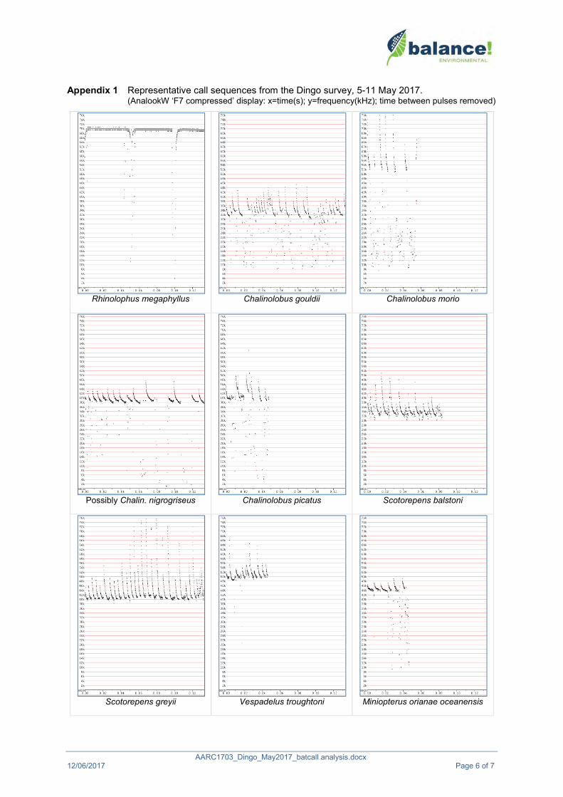
AARC1703_Dingo_May2017_batcall analysis.docx 12/06/2017 Page 6 of 7
Appendix 1 Representative call sequences from the Dingo survey, 5-11 May 2017. (AnalookW ‘F7 compressed’ display: x=time(s); y=frequency(kHz); time between pulses removed)
Rhinolophus megaphyllus Chalinolobus gouldii Chalinolobus morio
Possibly Chalin. nigrogriseus Chalinolobus picatus Scotorepens balstoni
Scotorepens greyii Vespadelus troughtoni Miniopterus orianae oceanensis

AARC1703_Dingo_May2017_batcall analysis.docx 12/06/2017 Page 7 of 7
Austronomus australis Chaerephon jobensis Mormopterus lumsdenae
Mormopterus ridei Saccolaimus flaviventris

Microbat Call Identification Report
Prepared for (“Client”): AustralAsian Resource Consultants Survey location/project name: West of Dingo Survey dates: 19-29 September 2017 Client project reference: Job no.: AARC-1706 Report date: 12 October 2017
DISCLAIMER:
© Copyright – Balance! Environmental, ABN 75 795 804 356. This document and its content are copyright and may not be copied, reproduced or distributed (in whole or part) without the prior written permission of Balance! Environmental other than by the Client for the purposes authorised by Balance! Environmental (“Intended Purpose”). To the extent that the Intended Purpose requires the disclosure of this document and/or its content to a third party, the Client must procure such agreements, acknowledgements and undertakings as may be necessary to ensure that the third party does not copy, reproduce, or distribute this document and its content other than for the Intended Purpose. This disclaimer does not limit any rights Balance! Environmental may have under the Copyright Act 1968 (Cth).
The Client acknowledges that the Final Report is intended for the sole use of the Client, and only to be used for the Intended Purpose. Any representation or recommendation contained in the Final Report is made only to the Client. Balance! Environmental will not be liable for any loss or damage whatsoever arising from the use and/or reliance on the Final Report by any third party.

AARC1706_Dingo_Sep2017_batcall analysis.docx 12/10/2017 Page 2 of 8
Methods
Survey summary
The survey was conducted at six sites (see Figure 1) over 11 consecutive nights, using Anabat Express detectors (Titley Scientific, Brisbane). Deployment details are summarised in Table 1.
Table 1 Deployment schedule for the Dingo bat-detector survey September 2017.
Derived from detector LOG files and survey summary information provided by the client.
Detector name & Serial No. Site Latitude &
Longitude Date Time Battery VoltsStart Stop Start Stop
Anabat 1 SN434354
FS05 -23.6537 149.2393
19/09/2017 17:28:05 6:25:04 6.29 5.79 20/09/2017 17:28:24 6:24:01 5.87 5.62 21/09/2017 17:28:44 6:22:59 5.77 5.52
FS08 -23.6068 149.2386
23/09/2017 17:29:23 6:20:56 5.72 5.42 24/09/2017 17:29:43 6:19:54 5.61 5.33 25/09/2017 17:30:03 6:18:52 5.52 5.25 26/09/2017 17:30:24 6:17:51 5.43 5.20
FS10 -23.6174 149.2305
27/09/2017 17:30:46 6:16:52 5.36 5.11 28/09/2017 17:31:07 6:15:50 5.34 5.05 29/09/2017 17:31:28 6:14:50 5.28 4.96
Anabat 2 SN434344
FS06 -23.5994 149.2475
19/09/2017 17:28:03 6:25:01 6.31 5.76 20/09/2017 17:28:23 6:23:59 5.83 5.60 21/09/2017 17:28:42 6:22:57 5.74 5.49
FS07 -23.6066 149.2481
22/09/2017 17:29:01 6:21:55 6.25 5.71 23/09/2017 17:29:21 6:20:53 5.84 5.55 24/09/2017 17:29:41 6:19:52 5.76 5.42
FS09 -23.6046 149.2692
25/09/2017 17:29:57 6:18:46 5.54 5.33 26/09/2017 17:30:17 6:17:44 5.57 5.25
Figure 1 Bat detection sites in the Dingo survey area, 19-29 September 2017

AARC1706_Dingo_Sep2017_batcall analysis.docx 12/10/2017 Page 3 of 8
Data post-processing
Balance! Environmental received eighteen raw Anabat ZCA files and associated LOG files for post-processing and analysis. AnalookW (Corben 2015) was used to convert the ZCA files to 4365 Anabat call sequence files for use in species identification.
Call identification
All Anabat sequence files were viewed in AnalookW, with a subset of all call types recorded each night at each site selected for further analysis. Species identification was achieved manually by comparing the call spectrograms of the selected files with those of reference calls from central and southern Queensland and to published call descriptions (e.g. Reinhold et al. 2001; Pennay et al. 2004).
Calls with fewer than four clearly-defined, non-fragmented pulses were excluded from the analysis.
Species' identification was also guided by considering probability of occurrence based on general distribution information (Churchill 2008; van Dyck et al. 2013) and/or Atlas of Living Australia on-line database records (http://www.ala.org.au).
Reporting standard
The format and content of this report follows Australasian Bat Society standards for the interpretation and reporting of bat call data (Reardon 2003), available on-line at http://www.ausbats.org.au/.
Species nomenclature follows Jackson & Groves (2015). Note that this treatment of Australian mammal taxonomy elevates the sub-genus names proposed by Reardon et al. (2014) for the Mormopterus free-tailed bats to genus level, hence Ozimops (O. lumsdenae, O. petersi, O. ridei) and Setirostris (S. eleryi) are used herein.
Results & Discussion
Detection success
More than 75% of the sequence files (3374/4365) were recorded by Anabat 1 (SN434354), with sites FS08 and FS10 producing over half of the total recorded bat calls. The detector sensitivity setting was the same (115) on both detectors for all nights, so, assuming microphone equivalence and similar deployment set-up, this marked difference in call detection probably reflects a real difference in bat activity levels related to habitat suitability and, possibly, bat abundance.
Location data show sites sampled by Anabat 1 were near water (FS05 and FS10) or on lateritic escarpment with potential subterranean roosting habitat (FS08); whereas sites FS06, FS07 and FS09 (Anabat 2) were distant from water and in more open vegetation sites (see Figure 1). Proximity to water has been shown to be a key determinant in roost-selection and foraging activity of bats (e.g. see Kalcounis-Rüppell et al. 2005; Rainho & Palmeirim 2011; Blakey et al. 2017). Furthermore, a significant proportion of the calls recorded at site FS08 were from the Eastern Cave Bat, Vespadelus troughtoni, which roosts in shallow caves and overhangs (Parnaby et al. 2008), such as those observed by the client in the vicinity of FS08.
Species identified
Species identification was attempted on 227 call sequence files.
At least 14 and up to 19 species were recorded during these surveys (see Table 2). Thirteen call types were positively identified to individual species, while one type was reliably identified to the genus Nyctophilus but could not be further differentiated. Two Nyctophilus species potentially occur in the study area: N. geoffroyi and N. gouldi.

AARC1706_Dingo_Sep2017_batcall analysis.docx 12/10/2017 Page 4 of 8
Some calls could not be reliably identified due to similarities in the call characteristics of several species that may occur in the study area. Where such unresolved calls were encountered, they were allocated to species groups. All group members are listed as “probable” in Table 1, unless additional calls of one or more group members were positively identified for the same site. The groups used in this analysis included:
• Chalinolobus gouldii / Ozimops petersi / O. ridei; • C. gouldii / Scotorepens balstoni; • Chalinolobus picatus / Scotorepens greyii / Vespadelus baverstocki;• Scotorepens greyii / Setirostris eleryi;• Vespadelus troughtoni / Chalinolobus morio; and • Taphozous troughtoni / Mormopterus lumsdenae.
Table 2 Microbat species recorded during the surveys near Dingo, 19-29 September 2017.
♦ = ‘definite’ - at least one call from the site was attributed unequivocally to the species □ = ‘probable’ - calls similar to those of the species were recorded, but could not be reliably identified
Detector: Anabat 1 (SN434354) Anabat 2 (SN434344) Site: FS05 FS08 FS10 FS06 FS07 FS09
Total sequence files: 690 1356 1328 240 411 340 Number of calls identified: 42 41 51 27 40 26
Rhinolophus megaphyllus ♦ ♦ ♦Chalinolobus gouldii ♦ □ ♦ ♦ ♦ ♦Chalinolobus morio ♦ Chalinolobus picatus ♦ ♦ ♦ □ ♦ ♦Nyctophilus sp. ♦ ♦ ♦ ♦ ♦Scotorepens balstoni □ □ □ □ □ Scotorepens greyii ♦ ♦ ♦ □ ♦ ♦ Vespadelus baverstocki □ □ □ □Vespadelus troughtoni ♦ ♦ ♦Miniopterus orianae oceanensis ♦ ♦ ♦ ♦ ♦ Austronomus australis ♦ Chaerephon jobensis ♦ ♦ ♦ ♦ ♦ ♦Ozimops lumsdenae ♦ ♦ ♦ ♦ ♦ ♦Ozimops petersi ♦ □ ♦ ♦ □ ♦ Ozimops ridei ♦ □ ♦ ♦ ♦ ♦ Setirostris eleryi □ □ □Saccolaimus flaviventris ♦ ♦ ♦ ♦ ♦ ♦Taphozous troughtoni □ □

AARC1706_Dingo_Sep2017_batcall analysis.docx 12/10/2017 Page 5 of 8
References Blakey, R.V., Kingsford, R.T., Law, B.S. & Stoklosa, J. (2017). Floodplain habitat is disproportionately
important for bats in a large river basin. Biol. Conserv. 215: 1–10.
Churchill, S. (2008). Australian Bats. Jacana Books, Allen & Unwin; Sydney.
Corben, C. (2015). AnalookW for bat call analysis using ZCA. Version 4.1z, 20 September 2015.
Jackson, S. and Groves, C. (2015). Taxonomy of Australian Mammals. CSIRO Publishing, Melbourne.
Kalcounis-Rüppell, M.C., Psyllakis, J.M. & Brigham, R.M. (2005). Tree roost selection by bats: an empirical synthesis using meta-analysis. Wildl. Soc. Bull. 33(3): 1123-1132.
Milne, D.J., Fisher, A., Pavey, C.R. (2006). Models of the habitat associations and distributions of insectivorous bats of the Top End of the Northern Territory, Australia. Biol. Conserv. 130: 370–385.
Parnaby, H., Law, B.S., Pennay, M. & Kutt, A.S. (2008). Eastern Cave Bat Vespadelus troughtoni. Pp. 571-572 in The Mammals of Australia 3rd Edition (van Dyck, S. & Strahan, R., ed.); Reed New Holland; Sydney.
Pennay, M., Law, B. and Reinhold, L. (2004). Bat Calls of New South Wales. Department of Environment and Conservation, Hurstville.
Rainho, A. & Palmeirim, J.M. (2011). The Importance of Distance to Resources in the Spatial Modelling of Bat Foraging Habitat. PLoS ONE, 6(4): e19227. doi:10.1371/journal.pone.0019227
Reardon, T. (2003). Standards in bat detector based surveys. Australasian Bat Society Newsletter20: 41-43.
Reardon, T. B., McKenzie, N. L., Cooper, S. J. B., Appleton, B., Carthew, S. and Adams, M. (2014). A molecular and morphological investigation of species boundaries and phylogenetic relationships in Australian free-tailed bats Mormopterus (Chiroptera : Molossidae). Aust. J. Zool. 62, 109–136.
Reinhold, L., Law, B., Ford, G. and Pennay, M. (2001). Key to the bat calls of south-east Queensland and north-east New South Wales. Department of Natural Resources and Mines, Brisbane.
van Dyck, S., Gynther, I. and Baker, A. (ed.) (2013). Field Companion to the Mammals of Australia. New Holland; Sydney.

AARC1706_Dingo_Sep2017_batcall analysis.docx 12/10/2017 Page 6 of 8
Glossary Technical terms used in this report are described in the following table.
Approach phase The part of a bat call emitted as the bat starts to home in on a detected prey item; a transitional series of pulses between the search phase and feeding buzz, that become progressively steeper and shorter in duration.
Call Refers to a single bat call, made up of a series of individual sound pulses in one or more phases (search, approach, feeding buzz).
CF (=Constant Frequency) A type of pulse in which the dominant component consists of a more-or-less ‘pure tone’ of sound at a Constant Frequency; with shapeappearing flat on the sonogram. Often also contains a brief FMcomponent at the beginning and/or end of the CF component (viz. FM-CF-FM).
Characteristic frequency (Fc) The frequency of the flattest part of a pulse; usually the lowest frequency reached in the qCF component of a pulse. This is often the primary diagnostic feature for species identification.
Duration The time period from the beginning of a pulse to the end of the pulse. Feeding buzz The terminal part of a call, following the approach phase, emitted as
the bat catches a prey item; a distinctive, rapid series of very steep, very short-duration pulses.
FM (=Frequency Modulated) A type of pulse in which there is substantial change in frequency from beginning to end; shape ranges from almost vertical and linear through varying degrees of curvature.
FC range Refers to the range of frequencies occupied by the characteristic frequency section of pulses within a call or set of calls.
Frequency sweep or “band-width” The range of frequencies through which a pulse sweeps from beginning to end; Maximum frequency (Fmax) – minimum frequency (Fmin).
Knee The transitional part of a pulse between the initial (usually steeper) frequency sweep and the characteristic frequency section (usually flatter); time to knee (Tk) and frequency of knee (Fk) can be diagnostic for some species.
Pulse An individual pulse of sound within a bat call; the shape, duration and characteristic frequency of a pulse are the key diagnostic features used to differentiate species.
Pulse body The part of the pulse between the knee and tail and containing the characteristic frequency section.
Pulse shape The general appearance of a pulse on the sonogram, described using relative terms related to features such as slope and degree of curvature. See also CF, qCF and FM.
qCF (=quasi Constant Frequency) A type of pulse in which there is very little change in frequency from beginning to end; shape appears to be almost flat. Some pulses also contain an FM component at the beginning and/or end of the qCF component (viz. FM-qCF).
Search phase The part of a bat call generally required for reliable species diagnosis. A consistent series of pulses emitted by a bat that is searching for prey or and/or navigating through its habitat. Search phase pulses generally have longer duration, flatter slope and more consistent shape than approach phase and feeding buzz pulses.
Sequence Literally, a sequence of pulses that may be from one or more bats; but generally refers to a call or part (e.g. phase) of a call.
Tail The final component of a pulse, following the characteristic frequencysection; may consist of a short or long sweep of frequencies either upward or downward from the Fc; or may be absent.

AARC1706_Dingo_Sep2017_batcall analysis.docx 12/10/2017 Page 7 of 8
Appendix 1 Representative call sequences from the Dingo area survey, September 2017. (AnalookW ‘F7 compressed’ display: x=time(s); y=frequency(kHz); time between pulses removed)
Rhinolophus megaphyllus Chalinolobus gouldii Chalinolobus morio
Chalinolobus picatus Nyctophilus species Possibly Scotorepens balstoni
Scotorepens greyii Probably Vespadelus baverstocki Vespadelus troughtoni

AARC1706_Dingo_Sep2017_batcall analysis.docx 12/10/2017 Page 8 of 8
Miniopterus orianae oceanensis Austronomus australis Chaerephon jobensis
Ozimops lumsdenae Ozimops petersi Ozimops ridei
Possibly Setirostris eleryi Saccolaimus flaviventris Possibly Taphozous troughtoni

Microbat Call Identification Report
Prepared for (“Client”): AustralAsian Resource Consultants Survey location/project name: Dingo West Stage 3 Survey dates: 17-22 April 2018 Client project reference: Job no.: AARC-1805 Report date: 30 May 2018
DISCLAIMER:
© Copyright – Balance! Environmental, ABN 75 795 804 356. This document and its content are copyright and may not be copied, reproduced or distributed (in whole or part) without the prior written permission of Balance! Environmental other than by the Client for the purposes authorised by Balance! Environmental (“Intended Purpose”). To the extent that the Intended Purpose requires the disclosure of this document and/or its content to a third party, the Client must procure such agreements, acknowledgements and undertakings as may be necessary to ensure that the third party does not copy, reproduce, or distribute this document and its content other than for the Intended Purpose. This disclaimer does not limit any rights Balance! Environmental may have under the Copyright Act 1968 (Cth).
The Client acknowledges that the Final Report is intended for the sole use of the Client, and only to be used for the Intended Purpose. Any representation or recommendation contained in the Final Report is made only to the Client. Balance! Environmental will not be liable for any loss or damage whatsoever arising from the use and/or reliance on the Final Report by any third party.

AARC1805_Dingo West_Apr2018_batcall analysis.docx 30/05/2018 Page 2 of 8
Methods
Survey summary
The survey was conducted at four sites (see Figure 1) over six consecutive nights, using Anabat Express detectors (Titley Scientific, Brisbane). Deployment details are summarised in Table 1.
Table 1 Deployment schedule for the Dingo West Stage 3 bat-detector survey, 17-22 April 2018.
Derived from detector LOG files and survey summary information provided by the client.
Site name
Coordinates Detector Serial No.
Deployment date
Operating time Latitude Longitude Start Finish
FS11 -23.661 149.2592 SN434344 17-Apr 18:11:59 6:22:13 18-Apr 18:11:16 6:22:47 19-Apr 18:10:32 6:23:21
FS12 -23.664 149.2731 SN434354 17-Apr 18:11:56 6:22:10 18-Apr 18:11:12 6:22:44 19-Apr 18:10:29 6:23:17
FS13 -23.6924 149.2521 SN434354 20-Apr 18:09:49 6:23:54 21-Apr 18:09:02 6:24:27 22-Apr 18:08:15 6:24:59
FS14 -23.6659 149.2584 SN434344 20-Apr 18:09:46 6:23:54 21-Apr 18:08:59 6:24:27 22-Apr 18:08:12 6:24:59
Figure 1 Bat detection sites in the Dingo West survey area, 17-22 April 2018.

AARC1805_Dingo West_Apr2018_batcall analysis.docx 30/05/2018 Page 3 of 8
Data post-processing
Balance! Environmental received 12 raw Anabat ZCA files and associated LOG files for post-processing and analysis. AnalookW (Corben 2017) was used to convert the ZCA files to Anabat call sequence files (ZC files). This process yielded 25,023 ZC files, which were passed through a generic noise filter in AnalookW to extract only those files that contained potentially-identifiable bat calls. This filtration process extracted 3588 ZC files for analysis.
Call identification
All Anabat sequence files that passed the noise filter were viewed in AnalookW, with a subset of all call types recorded at each site selected for further analysis. Species identification was achieved manually by comparing the call spectrograms of the selected files with those of reference calls from central and southern Queensland and to published call descriptions (e.g. Reinhold et al. 2001; Pennay et al. 2004).
Calls with fewer than four clearly-defined, non-fragmented pulses were excluded from the analysis.
Species' identification was also guided by considering probability of occurrence based on general distribution information (Churchill 2008; van Dyck et al. 2013) and/or Atlas of Living Australia on-line database records (http://www.ala.org.au).
Reporting standard
The format and content of this report follows Australasian Bat Society standards for the interpretation and reporting of bat call data (Reardon 2003), available on-line at http://www.ausbats.org.au/.
Species nomenclature follows Jackson & Groves (2015), which elevates the sub-genus names proposed by Reardon et al. (2014) for the Mormopterus free-tailed bats to genus level, hence Ozimops (O. lumsdenae and O. ridei) is used herein.
Results & Discussion Species identification was attempted on 658 call sequence files.
Table 2 provides a summary of species recorded at each site. Twelve species were positively identified, with one further call type allocated reliably to the Nyctophilus genus, within which species’ calls cannot be differentiated. Two Nyctophilus species probably occur in the study area: N. geoffroyi; and N. gouldi.
Nine call types could not be reliably identified due to similarities in the call characteristics of several species that may occur in the study area. These unresolved calls were allocated to species groups (see lower half of Table 2), most of which contained species that were also identified positively (see upper part of Table 2); however, two groups included species that were not otherwise identified in this analysis:
Taphozous troughtoni / Ozimops lumsdenae
o Calls similar in frequency and pulse-shape to those allocated to O. lumsdenae, but more uniform pulse-shape throughout sequence and often much flatter pulse-shape
Vespadelus troughtoni / Chalinolobus morio
o Just one call allocated to this group, with no other evidence of either species from the entire data set
o Call was brief and somewhat fragmented, with indeterminate pulse shape

AARC1805_Dingo West_Apr2018_batcall analysis.docx 30/05/2018 Page 4 of 8
Table 2 Microbat species recorded during the Dingo West Stage 3 survey, 17-22 April 2018.
Number of calls allocated to each species or group
Site name: FS11 FS12 FS13 FS14 Total calls for species
Species positively identified Rhinolophus megaphyllus 1 1
Chalinolobus gouldii 25 64 17 13 119
Chalinolobus nigrogriseus 10 1 11
Chalinolobus picatus 17 25 3 2 47
Nyctophilus species 1 4 3 8
Scotorepens balstoni 5 6 11
Scotorepens greyii 3 25 6 9 43
Vespadelus baverstocki 6 8 5 19
Miniopterus orianae oceanensis 1 6 1 8
Chaerephon jobensis 9 11 22 14 56
Ozimops lumsdenae 19 28 16 19 82
Ozimops ridei 13 3 7 7 30
Saccolaimus flaviventris 24 31 15 8 78
Unresolved calls C. gouldii / O. ridei 6 11 1 1 19
C. gouldii / S. balstoni 7 11 1 2 21
C. nigrogriseus / S. greyii 2 16 2 2 22
C. picatus / S. greyii 12 10 4 15 41
C. picatus / V. baverstocki 5 2 7
S. flaviventris / C. jobensis 3 1 4
S. flaviventris / O. lumsdenae 2 1 2 1 6
T. troughtoni / O. lumsdenae 7 8 7 2 24
Vespadelus troughtoni / Chalinolobus morio 1 1
Total calls identified for site 152 280 122 104 658

AARC1805_Dingo West_Apr2018_batcall analysis.docx 30/05/2018 Page 5 of 8
References Churchill, S. (2008). Australian Bats. Jacana Books, Allen & Unwin; Sydney.
Corben, C. (2017). AnalookW for bat call analysis using ZCA. Version 4.2n, 16 March 2017.
Jackson, S. and Groves, C. (2015). Taxonomy of Australian Mammals. CSIRO Publishing, Melbourne.
Pennay, M., Law, B. and Reinhold, L. (2004). Bat Calls of New South Wales. Department of Environment and Conservation, Hurstville.
Reardon, T. (2003). Standards in bat detector based surveys. Australasian Bat Society Newsletter20: 41-43.
Reardon, T. B., McKenzie, N. L., Cooper, S. J. B., Appleton, B., Carthew, S. and Adams, M. (2014). A molecular and morphological investigation of species boundaries and phylogenetic relationships in Australian free-tailed bats Mormopterus (Chiroptera : Molossidae). Aust. J. Zool. 62, 109–136.
Reinhold, L., Law, B., Ford, G. and Pennay, M. (2001). Key to the bat calls of south-east Queensland and north-east New South Wales. Department of Natural Resources and Mines, Brisbane.
van Dyck, S., Gynther, I. and Baker, A. (ed.) (2013). Field Companion to the Mammals of Australia. New Holland; Sydney.

AARC1805_Dingo West_Apr2018_batcall analysis.docx 30/05/2018 Page 6 of 8
Glossary Technical terms used in this report are described in the following table.
Approach phase The part of a bat call emitted as the bat starts to home in on a detected prey item; a transitional series of pulses between the search phase and feeding buzz, that become progressively steeper and shorter in duration.
Call Refers to a single bat call, made up of a series of individual sound pulses in one or more phases (search, approach, feeding buzz).
CF (=Constant Frequency) A type of pulse in which the dominant component consists of a more-or-less ‘pure tone’ of sound at a Constant Frequency; with shapeappearing flat on the sonogram. Often also contains a brief FMcomponent at the beginning and/or end of the CF component (viz. FM-CF-FM).
Characteristic frequency (Fc) The frequency of the flattest part of a pulse; usually the lowest frequency reached in the qCF component of a pulse. This is often the primary diagnostic feature for species identification.
Duration The time period from the beginning of a pulse to the end of the pulse. Feeding buzz The terminal part of a call, following the approach phase, emitted as
the bat catches a prey item; a distinctive, rapid series of very steep, very short-duration pulses.
FM (=Frequency Modulated) A type of pulse in which there is substantial change in frequency from beginning to end; shape ranges from almost vertical and linear through varying degrees of curvature.
FC range Refers to the range of frequencies occupied by the characteristic frequency section of pulses within a call or set of calls.
Frequency sweep or “band-width” The range of frequencies through which a pulse sweeps from beginning to end; Maximum frequency (Fmax) – minimum frequency (Fmin).
Knee The transitional part of a pulse between the initial (usually steeper) frequency sweep and the characteristic frequency section (usually flatter); time to knee (Tk) and frequency of knee (Fk) can be diagnostic for some species.
Pulse An individual pulse of sound within a bat call; the shape, duration and characteristic frequency of a pulse are the key diagnostic features used to differentiate species.
Pulse body The part of the pulse between the knee and tail and containing the characteristic frequency section.
Pulse shape The general appearance of a pulse on the sonogram, described using relative terms related to features such as slope and degree of curvature. See also CF, qCF and FM.
qCF (=quasi Constant Frequency) A type of pulse in which there is very little change in frequency from beginning to end; shape appears to be almost flat. Some pulses also contain an FM component at the beginning and/or end of the qCF component (viz. FM-qCF).
Search phase The part of a bat call generally required for reliable species diagnosis. A consistent series of pulses emitted by a bat that is searching for prey or and/or navigating through its habitat. Search phase pulses generally have longer duration, flatter slope and more consistent shape than approach phase and feeding buzz pulses.
Sequence Literally, a sequence of pulses that may be from one or more bats; but generally refers to a call or part (e.g. phase) of a call.
Tail The final component of a pulse, following the characteristic frequencysection; may consist of a short or long sweep of frequencies either upward or downward from the Fc; or may be absent.

AARC1805_Dingo West_Apr2018_batcall analysis.docx 30/05/2018 Page 7 of 8
Appendix 1 Representative call sequences from the Dingo West Stage 3 survey, April 2018. (AnalookW ‘F7 compressed’ display: x=time(s); y=frequency(kHz); time between pulses removed)
Rhinolophus megaphyllus Chalinolobus gouldii Chalinolobus nigrogriseus
Chalinolobus picatus Nyctophilus species Scotorepens balstoni
Scotorepens greyii Vespadelus baverstocki V. troughtoni or C. morio

AARC1805_Dingo West_Apr2018_batcall analysis.docx 30/05/2018 Page 8 of 8
Miniopterus orianae oceanensis Chaerephon jobensis Ozimops lumsdenae
Ozimops ridei Saccolaimus flaviventris T. troughtoni / O. lumsdenae

H
TERRESTRIAL ECOLOGY September 2019 AARC Environmental Solutions Pty Ltd E [email protected] AARC.NET.AU
Appendix H Flora Species List

H
TERRESTRIAL ECOLOGY September 2019 AARC Environmental Solutions Pty Ltd E [email protected] AARC.NET.AU
Family Scientific Name Common Name NC Act Status
EPBC Act
Status VC1 VC2 VC3 VC4
Acanthaceae Brunoniella australis LC - x x
Acanthaceae Pseuderanhenum variable Pastel flower LC - x x
Acanthaceae Rostellularia adscendens Pink tongues LC - x x x
Amaranthaceae Alternanthera nana Hairy joyweed LC - x
Amaranthaceae Gomphrena celosioides Gomphrena weed I - x x
Amaranthaceae Sclerolaena birchii Galvanised burr LC - x
Amaranthaceae Maireana microphylla LC - x
Amaryllidae Crinum flaccidum Murray lily LC - x
Apocynaceae Alstonia constricta Bitterbark LC - x x
Apocynaceae Carissa spinarum Currant bush LC - x x x x
Apocynaceae Cerbera dumicola NT - x
Apocynaceae Cryptostegia grandiflora Rubber vine RI - x
Apocynaceae Parsonsia eucalyptophylla Gargaloo LC - x
Apocynaceae Parsonsia straminea Monkey rope LC - x x x
Asparagaceae Eustrephus latifolius Wombat berry LC - x
Asparagaceae Laxmannia gracilis Slender wire lily LC - x
Asparagaceae Lomandra longifolia LC - x x x
Asteraceae Asteraceae sp. x
Asteraceae Bidens pilosa I - x
Asteraceae Chrysocephalum apiculatum Yellow buttons LC - x
Asteraceae Cyanthillium cinereum LC - x x x x
Asteraceae Emilia sonchifolia I -
Asteraceae Emilia sonchifolia var. sonchifolia
I - x
Asteraceae Parthenium hysterophorus Parthenium weed RI WoNS x
Asteraceae Pterocaulon redolens LC - x
Asteraceae Pterocaulon sphacelatum Applebush LC - x
Asteraceae Senecio brigalowensis LC - x
Asteraceae Sonchus oleraceus Common sowthistle I - x
Asteraceae Sphaeromorphaea subintegra
LC - x
Boraginaceae Ehretia membranifolia Weeping koda LC - x x
Cactaceae Harrisia martinii RI - x
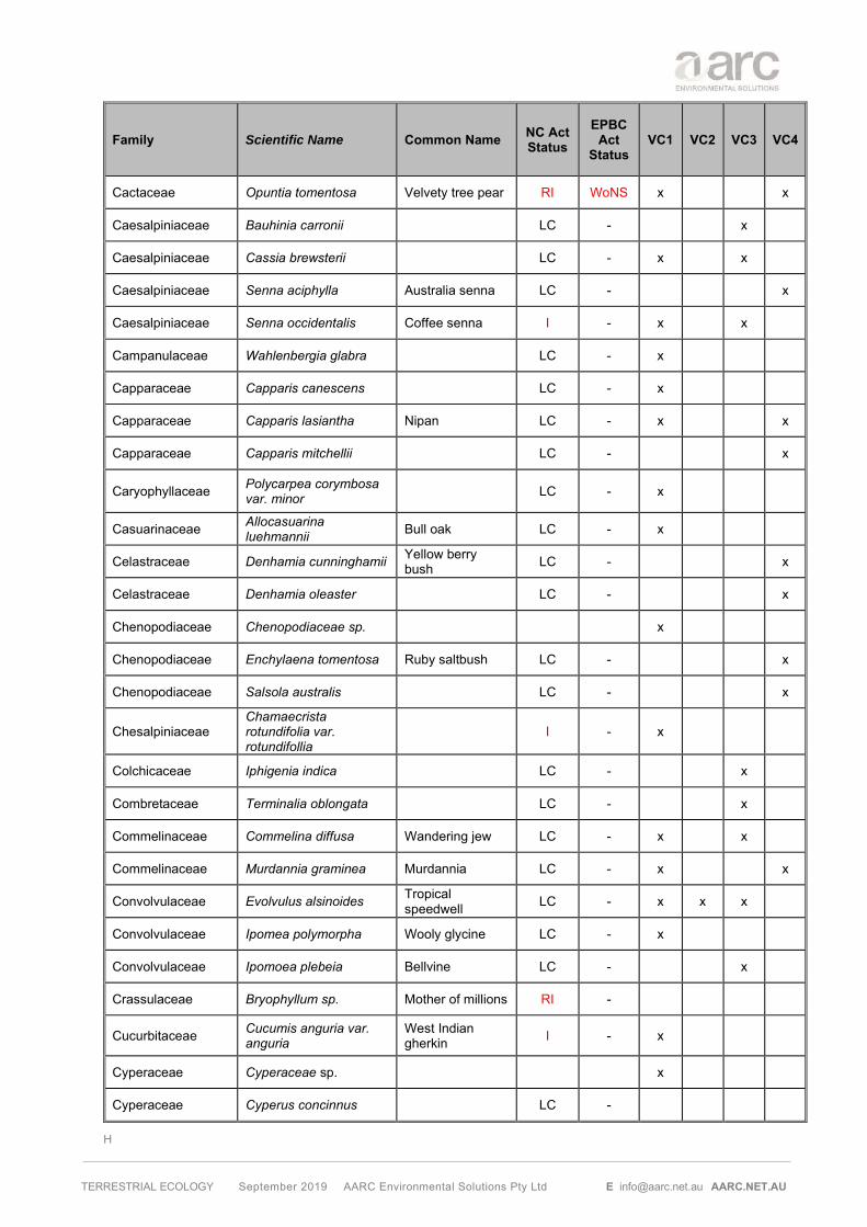
H
TERRESTRIAL ECOLOGY September 2019 AARC Environmental Solutions Pty Ltd E [email protected] AARC.NET.AU
Family Scientific Name Common Name NC Act Status
EPBC Act
Status VC1 VC2 VC3 VC4
Cactaceae Opuntia tomentosa Velvety tree pear RI WoNS x x
Caesalpiniaceae Bauhinia carronii LC - x
Caesalpiniaceae Cassia brewsterii LC - x x
Caesalpiniaceae Senna aciphylla Australia senna LC - x
Caesalpiniaceae Senna occidentalis Coffee senna I - x x
Campanulaceae Wahlenbergia glabra LC - x
Capparaceae Capparis canescens LC - x
Capparaceae Capparis lasiantha Nipan LC - x x
Capparaceae Capparis mitchellii LC - x
Caryophyllaceae Polycarpea corymbosa var. minor
LC - x
Casuarinaceae Allocasuarina luehmannii Bull oak LC - x
Celastraceae Denhamia cunninghamii Yellow berry bush LC - x
Celastraceae Denhamia oleaster LC - x
Chenopodiaceae Chenopodiaceae sp. x
Chenopodiaceae Enchylaena tomentosa Ruby saltbush LC - x
Chenopodiaceae Salsola australis LC - x
Chesalpiniaceae Chamaecrista rotundifolia var. rotundifollia
I - x
Colchicaceae Iphigenia indica LC - x
Combretaceae Terminalia oblongata LC - x
Commelinaceae Commelina diffusa Wandering jew LC - x x
Commelinaceae Murdannia graminea Murdannia LC - x x
Convolvulaceae Evolvulus alsinoides Tropical speedwell LC - x x x
Convolvulaceae Ipomea polymorpha Wooly glycine LC - x
Convolvulaceae Ipomoea plebeia Bellvine LC - x
Crassulaceae Bryophyllum sp. Mother of millions RI -
Cucurbitaceae Cucumis anguria var. anguria
West Indian gherkin I - x
Cyperaceae Cyperaceae sp. x
Cyperaceae Cyperus concinnus LC -

H
TERRESTRIAL ECOLOGY September 2019 AARC Environmental Solutions Pty Ltd E [email protected] AARC.NET.AU
Family Scientific Name Common Name NC Act Status
EPBC Act
Status VC1 VC2 VC3 VC4
Cyperaceae Cyperus fulvus LC - x
Cyperaceae Cyperus gracilis LC - x x
Cyperaceae Fimbristylis sp. LC - x
Cyperaceae Fimbristylis dichotoma Common fringe-rush LC - x
Erythroxylaceae Erythroxylum australe Cocaine bush LC - x x x
Euphorbiaceae Euphorbia tannensis subsp eremophila
LC - x x
Euphorbiaceae Ricinus communis Castor oil bush I -
Fabaceae Crotalaria medicaginea Trefoil rattlepod LC - x
Fabaceae Crotalaria pallida* I - x
Fabaceae Desmodium macrocarpum
LC - x
Fabaceae Erythrina vespertilio Bat wing coral tree LC - x
Fabaceae Glycine sp. (Marburg K.A.Williams 83006)*
LC - x
Fabaceae Glycine tabacina Glycine pea LC -
Fabaceae Glycine tomentella Woolly glycine LC - x
Fabaceae Indigofera colutea Sticky indigo LC - x
Fabaceae Indigofera linnaei Birdsville indigo LC - x
Fabaceae Jacksonia rhadinochloa Miles dogwood LC - x
Fabaceae Macroptilium atropurpureum Siratro I - x
Fabaceae Medicago sp. I - x
Fabaceae Neptunia gracilis LC - x
Fabaceae Rhynchosia minima LC - x x
Fabaceae Stylosanthes aspera I - x
Fabaceae Stylosanthes glabra I - x
Fabaceae Stylosanthes scrabra I - x x x
Fabaceae Vigna lanceolata LC - x x
Fabaceae Zornia sp. LC - x
Goodeniaceae Goodenia disperma LC - x
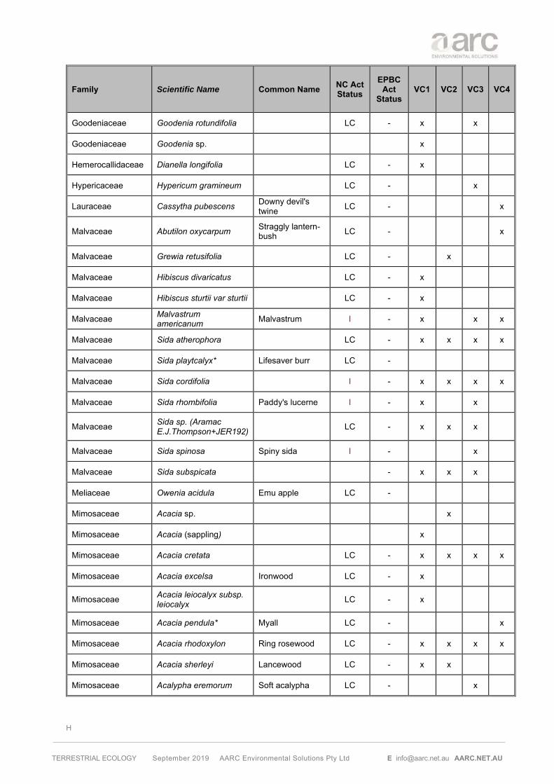
H
TERRESTRIAL ECOLOGY September 2019 AARC Environmental Solutions Pty Ltd E [email protected] AARC.NET.AU
Family Scientific Name Common Name NC Act Status
EPBC Act
Status VC1 VC2 VC3 VC4
Goodeniaceae Goodenia rotundifolia LC - x x
Goodeniaceae Goodenia sp. x
Hemerocallidaceae Dianella longifolia LC - x
Hypericaceae Hypericum gramineum LC - x
Lauraceae Cassytha pubescens Downy devil's twine LC - x
Malvaceae Abutilon oxycarpum Straggly lantern-bush LC - x
Malvaceae Grewia retusifolia LC - x
Malvaceae Hibiscus divaricatus LC - x
Malvaceae Hibiscus sturtii var sturtii LC - x
Malvaceae Malvastrum americanum Malvastrum I - x x x
Malvaceae Sida atherophora LC - x x x x
Malvaceae Sida playtcalyx* Lifesaver burr LC -
Malvaceae Sida cordifolia I - x x x x
Malvaceae Sida rhombifolia Paddy's lucerne I - x x
Malvaceae Sida sp. (Aramac E.J.Thompson+JER192)
LC - x x x
Malvaceae Sida spinosa Spiny sida I - x
Malvaceae Sida subspicata - x x x
Meliaceae Owenia acidula Emu apple LC -
Mimosaceae Acacia sp. x
Mimosaceae Acacia (sappling) x
Mimosaceae Acacia cretata LC - x x x x
Mimosaceae Acacia excelsa Ironwood LC - x
Mimosaceae Acacia leiocalyx subsp. leiocalyx
LC - x
Mimosaceae Acacia pendula* Myall LC - x
Mimosaceae Acacia rhodoxylon Ring rosewood LC - x x x x
Mimosaceae Acacia sherleyi Lancewood LC - x x
Mimosaceae Acalypha eremorum Soft acalypha LC - x

H
TERRESTRIAL ECOLOGY September 2019 AARC Environmental Solutions Pty Ltd E [email protected] AARC.NET.AU
Family Scientific Name Common Name NC Act Status
EPBC Act
Status VC1 VC2 VC3 VC4
Mimosaceae Archidendropsis basaltica Red lancewood LC - x
Mimosaceae Vachellia farnesiana Mimosa bush I -
Moraceae Ficus opposita Sandpaper fig LC - x
Myrtaceae Corymbia clarksoniana LC - x x x x
Myrtaceae Corymbia dallachiana LC - x
Myrtaceae Corymbia tesselaris Moreton bay ash LC - x x x
Myrtaceae Eucalyptus (sappling) LC - x
Myrtaceae E. crebra/E. populnea (hybrid)
LC - x
Myrtaceae Eucalyptus crebra Narrow-leaved red ironbark LC - x x x
Myrtaceae Eucalyptus exserta Queensland peppermint LC - x
Myrtaceae Eucalyptus melanophloia
LC - x
Myrtaceae Eucalyptus populnea Poplar box LC - x x x
Myrtaceae Eucalyptus tereticornis River blue gum LC - x x
Myrtaceae Melaleuca sp. - x
Myrtaceae Melaleuca nervosa LC - x
Nyctaginaceae Boerhavia dominii Tarvine LC - x
Oleaceae Jasminum didymum LC - x
Oxalidaceae Oxalis corniculata Yellow wood sorrel I - x x x
Pentapetaceae Melhania oblongifolia LC - x
Phyllanthaceae Phyllanthaceae sp.
Phyllanthaceae Phyllanthus virgatus LC - x x x x
Picrodendraceae Petalostigma pubescens Quinine tree LC - x x x x
Poaceae Alloteropsis cimicina LC - x x
Poaceae Aristida sp. - x
Poaceae Aristida calycina LC - x x x
Poaceae Aristida caput-medusae LC - x x x
Poaceae Aristida gracilipes LC - x

H
TERRESTRIAL ECOLOGY September 2019 AARC Environmental Solutions Pty Ltd E [email protected] AARC.NET.AU
Family Scientific Name Common Name NC Act Status
EPBC Act
Status VC1 VC2 VC3 VC4
Poaceae Aristida jerichoensis LC - x x
Poaceae Aristida perniciosa LC - x
Poaceae Aristida pruinosa LC -
Poaceae Bothriochloa decipiens LC - x x
Poaceae Bothriochloa ewartiana Desert bluegrass LC - x x
Poaceae Bothriochloa pertusa I - x
Poaceae Calyptochloa gracilima LC - x x x
Poaceae Cenchrus ciliaris Buffel grass I - x x x x
Poaceae Chrysopogon fallax LC - x x x
Poaceae Cleistochloa sp. (Duaringa K.B.Adison 42)
LC - x x
Poaceae Cymbopogon refractus Barbed-wire grass LC - x
Poaceae Cynodon dactylon Native couch I - x x
Poaceae Dichanthium sericeum Queensland bluegrass LC - x
Poaceae Digitaria brownii (dead)* LC - x
Poaceae Digitaria diminuta LC - x x
Poaceae Digitaria divaricatissima Spreading umbrella grass LC - x
Poaceae Digitaria sp (not enough material for a positive ID)
x
Poaceae Dinebra ligulata LC - x
Poaceae Enneapogon lindleyanus
LC - x x x
Poaceae Enteropogon acicularis Curly windmill grass LC - x
Poaceae Entolasia stricta Wiry panic LC - x x
Poaceae Eragrostis sp. (not enough material to ID) x
Poaceae Eragrostis elongata LC - x
Poaceae Eragrostis lacunaria Purple lovegrass LC - x x x x
Poaceae Eragrostis sororia Woodland lovegrass LC - x x x
Poaceae Eriachne mucronata LC - x

H
TERRESTRIAL ECOLOGY September 2019 AARC Environmental Solutions Pty Ltd E [email protected] AARC.NET.AU
Family Scientific Name Common Name NC Act Status
EPBC Act
Status VC1 VC2 VC3 VC4
Poaceae Eriochloa procera Slender cupgrass LC - x
Poaceae Eulalia aurea Silky browntop LC - x
Poaceae Heteropogon contortus Black spear grass LC - x x x
Poaceae Megathyrsus maximus I - x x
Poaceae Melinis repens Red natal grass I - x x x
Poaceae Panicum decompositum LC - x
Poaceae Panicum effusum LC - x x
Poaceae Paspalidium caespitosum Brigalow grass LC - x x x
Poaceae Paspalidium constrictum*
LC - x
Poaceae Paspalidium sp. x
Poaceae Perotis rara Comet grass LC - x x
Poaceae Sporobolus caroli Fairy grass LC - x x x x
Poaceae Sporobolus creber Western rat's tail Grass LC - x
Poaceae Themeda triandra Kangaroo grass LC - x x
Poaceae Urochloa mosambicensis Sabi grass LC - x x x x
Poaceae Urochloa sp. x x
Poaceae Poaceae sp. (grazed) x x
Polygonaceae Duma florulenta LC - x
Portulacaceae Portulaca bicolor LC -
Portulacaceae Portulaca filifolia LC - x
Portulacaceae Portulaca pilosa I -
Proteaceae Grevillea striata Beefwood LC - x x
Pteridaceae Cheilanthes sieberi subsp sieberi Poison rock fern LC - x
Pteridaceae Cheilanthes sp.
Rhamnaceae Alphitonia excelsa Soap tree LC - x x x x
Rhamnaceae Ventilago viminalis Supplejack LC -
Rubiaceae Coelospermum reticulatum
LC - x x x
Rubiaceae Everistia vacciniifolia LC - x x

H
TERRESTRIAL ECOLOGY September 2019 AARC Environmental Solutions Pty Ltd E [email protected] AARC.NET.AU
Family Scientific Name Common Name NC Act Status
EPBC Act
Status VC1 VC2 VC3 VC4
Rubiaceae Psydrax forsteri LC - x x
Rubiaceae Psydrax johnsonii LC - x x
Rubiaceae Psydrax oleifolia LC - x
Rubiaceae Spermacoce brachystema
LC - x x
Rubiaceae Coelospermum reticulatum
LC - x
Rutaceae Flindersia dissosperma LC -
Rutaceae Rutaceae sp. x
Sapindaceae Atalaya hemiglauca Whitewood LC - x x
Scrophulariaceae Myoporum acuminatum Coastal boobialla LC -
Stylidiaceae Stylidium eriorhizum LC -
Verbenaceae Glandularia aristigera Mayne's pest I -
Violaceae Afrohybanthus stellarioides
LC - x x x
Violaceae Afrohybanthus enneaspermus
LC - x
* Possibly this species LC Least Concern NT Near Threatened I Introduced WoNS Weed of National Significance RI Restricted invasive plant

I
TERRESTRIAL ECOLOGY September 2019 AARC Environmental Solutions Pty Ltd E [email protected] AARC.NET.AU
Appendix I Fauna Species List

I
TERRESTRIAL ECOLOGY September 2019 AARC Environmental Solutions Pty Ltd E [email protected] AARC.NET.AU
EPBC
Act OPPS DF01 DF02 DF03 DF04 Total OPPS DF05 DF06 DF07 DF08 DF09 DF10 Total OPPS DF11 DF12 DF13 DF14 DF15 Total
Amphibians
Bufonidae Rhinella marina Cane toad I - 5 8 13 13 4 8 25 5 1 10 16
Hylidae Litoria rubella Naked tree frog LC - 0 1 1 1 1
Hylidae Litoria caerulea Common green tree frog LC - 7 2 9 0 1 1 2
Hylidae Litoria latopalmata Broad-palmed frog LC - 1 1 0 0
Hylidae Litoria inermis Bumpy rocket frog LC - 1 1 1 1 1 2 6 9
Limnodynastidae Limnodynastes salmini Salmon-striped frog LC - 0 1 1 0
Limnodynastidae Limnodynastes tasmaniensis Spotted grass frog LC - 0 2 2 2 3 5
Limnodynastidae Platyplectrum ornatum Ornate burrowing frog LC - 249 2 25 276 1 1 3 5 8
TOTAL AMPHIBIANS 1 0 262 2 35 300 1 18 4 0 0 0 8 31 0 0 13 1 10 17 41
Reptiles
Elapidae Cryptophis boschmai Carpentaria snake LC - 0 2 2 1 1
Elapidae Demansia psammophis Yellow-faced whip snake LC - 0 1 1 0
Elapidae Furina ornata Orange-naped snake LC - 0 1 1 0
Elapidae Hoplocephalus bitorquatus Pale-headed snake LC - 1 1 0 0
Elapidae Pseudonaja textilis Eastern Brown snake LC - 1 1 1 1 2 0
Pythonidae Aspidites melanocephalus Black headed python LC -
Agamidae Pogona barbata Bearded dragon LC - 1 1 1 1 1 1 2
Agamidae Diporiphora australis Tommy roundhead LC - 0 2 4 6 3 3
Varanidae Varanus tristis orientalis Freckled monitor LC - 0 1 1 0
Carphodactylidae Nephrurus asper Prickly knob-tailed gecko LC - 0 1 1 0
DIiplodactylidae Diplodactylus vittatus Eastern stone gecko LC - 0 1 1 0
DIiplodactylidae Lucasium steindachneri Box-patterned gecko LC - 0 2 2 0
Gekkonidae Heteronotia binoei Bynoe's gecko LC - 1 4 2 7 1 2 2 1 2 8 1 1
Gekkonidae Gehyra dubia Dubious dtella LC - 1 1 2 1 1 2 1 1
Pygopodidae Lialis burtonis Burton's legless lizard LC - 1 1 0 0
Scincidae Carlia munda Shade-litter rainbow skink LC - 0 0 1 1
Scincidae Carlia rubigo Orange-flanked rainbow-skink LC - 4 1 4 3 12 3 3 3 9 2 2
Scincidae Cryptoblepharus pulcher Elegant snake-eyed skink LC - 1 1 1 1 0
Scincidae Morethia boulengeri South-eastern morethia LC - 0 1 1 0
Scincidae Ctenotus robustus Eastern striped skink LC - 0 0 1 2 2 5
Scincidae Morethia taeniopleura Fire-tailed skink LC - 2 2 0 0
Scincidae Pygmaescincus timlowi Dwarf litter-skink LC - 0 1 1 2 2
LIZARDS 0 7 1 12 6 26 1 4 2 9 7 7 4 34 0 3 3 6 2 3 17
SNAKES 1 0 0 0 1 2 1 2 0 2 0 0 1 6 0 0 0 0 1 0 1
TOTAL REPTILES 1 7 1 12 7 28 2 6 2 11 7 7 5 40 0 3 3 6 3 3 18
Common NameScientific NameFamily
2017 - Autumn 2017 - Spring 2018 - AutumnNC
Act/LP
Act

I
TERRESTRIAL ECOLOGY September 2019 AARC Environmental Solutions Pty Ltd E [email protected] AARC.NET.AU
EPBC
Act
status
OPPS DF01 DF02 DF03 DF04 Total OPPS DF05 DF06 DF07 DF08 DF09 DF10 Total OPPS DF11 DF12 DF13 DF14 DF15 Total
Birds
Acanthizidae Gerygone olivaceae White-throated gerygone LC - 2 2 1 2 7 1 1 1 1 2 6 1 1
Acanthizidae Smicrornis brevirostris Weebill LC - 0 1 1 2 1 1 1 3
Accipitridae Aquila audax Wedge-tailed eagle LC - 1 1 2 2 13 1 14
Accipitridae Haliastur sphenurus Whistling kite LC - 1 1 1 1 1 1
Accipitridae Milvus migrans Black kite LC - 1 1 1 1 10 1 11
Aegothelidae Aegotheles cristatus Australian owlet nightjar LC - 0 1 1 2 4 1 1 2
Alcedinidae Todiramphus macleayii Forest kingfisher LC - 0 2 2 2 2 8 1 1
Anatidae Anas superciliosa Pacific black duck LC - 0 1 1 0
Ardeidae Ardea modesta Eastern great egret LC - 1 1 1 1 0
Ardeidae Ardea pacifica White-necked heron LC - 0 1 1 0
Ardeidae Egretta novaehollandiae White-faced heron LC - 1 1 1 1 0
Artamidae Cracticus nigrogularis Pied butcherbird LC - 2 2 4 1 2 2 5 2 2 4
Artamidae Cracticus tibicen Australian magpie LC - 2 2 1 2 7 1 1 1 3 2 1 1 1 5
Artamidae Cracticus torquatus Grey butcherbird LC - 1 1 2 4 1 2 2 2 2 9 3 1 4
Burninidae Burhinus grallarius Bush stone-curlew LC - 0 1 2 3 0
Cacatuidae Cacatua galerita Sulphur-crested cockatoo LC - 1 1 2 1 1 1 1
Cacatuidae Calyptorhynchus banksii Red-tailed black-cockatoo LC - 1 1 0 0
Cacatuidae Eolophus roseicapilla Galah LC - 0 1 1 0
Cacatuidae Nymphicus hollandicus Cockatiel LC - 1 1 1 1 1 1
Campephagidae Coracina novaehollandiae Black-faced cuckoo-shrike LC - 1 1 1 1 2 1 1 2
Campephagidae Coracina papuensis White-bellied cuckoo-shrike LC - 0 1 1 0
Campephagidae Lalage tricolor White-winged triller LC - 0 1 1 0
Caprimulgidae Eurostopodus argus Spotted nightjar LC - 1 1 1 1 0
Charadriidae Vanellus miles Masked lapwing LC - 0 1 1 0
Contropodidae Centropus phasianinus Pheasant coucal LC - 0 1 1 0
Columbidae Geopelia humeralis Bar-shouldered dove LC - 1 1 2 1 1 1 3 0
Columbidae Geopelia striata placida Peaceful dove LC - 1 2 2 5 1 1 2 2 2 2 10 1 1
Columbidae Geophaps scripta scripta southern Squatter pigeon V V 2 1 3 9 2 11 1 1
Columbidae Ocyphaps lophotes Crested pigeon LC - 1 1 2 2 2 1 1 6 0
Columbidae Phaps chalcoptera Common bronzewing LC - 0 1 1 0
Corcoracidae Corcorax melanorhamphos White-winged chough LC - 0 1 1 0
Corcoracidae Struthidea cinerea Apostlebird LC - 1 1 1 1 2 4 1 1 2
Corvidae Corvus coronoides Australian raven LC - 2 1 2 2 7 2 1 2 1 6 1 1
Cuculidae Scythrops novaehollandiae Channel-billed cuckoo LC - 0 1 1 0
NC
Act/LP
Act
Status
2017 - Autumn 2017 - Spring 2018 - Autumn
Family Scientific Name Common Name

I
TERRESTRIAL ECOLOGY September 2019 AARC Environmental Solutions Pty Ltd E [email protected] AARC.NET.AU
EPBC
Act
status
OPPS DF01 DF02 DF03 DF04 Total OPPS DF05 DF06 DF07 DF08 DF09 DF10 Total OPPS DF11 DF12 DF13 DF14 DF15 Total
Dromaiidae Dromaius novaehollandiae Emu LC - 1 1 1 1 20 20
Estrildidae Taeniopygia bichenovii Double-barred finch LC - 1 1 2 4 2 1 3 1 1
Estrildidae Taeniopygia guttata Zebra finch LC - 0 0 0
Falconidae Falco berigora Brown falcon LC - 1 1 1 1 0
Falconidae Falco cenchroides Nankeen kestrel LC - 1 1 0 0
Halcyonidae Dacelo novaeguineae Laughing kookaburra LC - 1 1 8 10 1 2 1 1 5 1 1
Maluridae Malurus lamberti Variegated fairy-wren LC - 1 1 1 1 0
Maluridae Malurus melanocephalus Red-backed fairywren LC - 0 2 2 1 1 2
Meliphagidae Entomyzon cyanotis Blue-faced honeyeater LC - 1 1 1 1 0
Meliphagidae Lichenostomus virescens Singing honeyeater LC - 1 1 0 0
Meliphagidae Lichmera indistincta Brown honeyeater LC - 0 1 1 0
Meliphagidae Manorina flavigula Yellow-throated miner LC - 1 1 1 1 0
Meliphagidae Manorina melanocephala Noisy miner LC - 1 2 3 1 2 3 1 1 1 3
Meliphagidae Melithreptus albogularis White-throated honeyeater LC - 1 2 1 4 1 1 0
Meliphagidae Philemon citreogularis Little friarbird LC - 0 0 1 1 2
Meliphagidae Philemon corniculatus Noisy friarbird LC - 2 2 1 2 3 1 1 2
Meropidae Merops ornatus Rainbow bee-eater LC Ma 1 1 2 1 2 1 6 0
Monarchidae Grallina cyanoleuca Magpie-lark LC - 1 1 2 1 1 2 4 2 2
Monarchidae Myiagra inquieta Restless flycatcher LC - 1 1 1 1 0
Monarchidae Myiagra rubecula Leaden flycatcher LC - 0 2 1 2 1 2 8 1 1 2
Neosittidae Daphoenositta chrysoptera Varied sittella LC - 0 1 1 2 0
Oriolidae Oriolus sagittatus Olive-backed oriole LC - 1 1 1 1 2 0
Oriolidae Sphecotheres vieilloti Australasian figbird LC - 0 1 1 0
Otididae Ardeotis australis Australian bustard LC - 0 1 1 0
Pachycephalidae Colluricincla harmonica Grey shrike-thrush LC - 1 1 2 1 1 2 1 1
Pachycephalidae Pachycephala rufiventris Rufous whistler LC - 1 1 2 2 4 2 2
Pardalotidae Pardalotus striatus Striated pardalote LC - 2 1 2 2 7 2 2 1 2 7 2 2 2 1 7
Phasianidae Coturnix ypsilophora Brown quail LC - 1 1 1 1 0
Pelecanidae Pelecanus conspicillatus Australian pelican LC - 0 1 1 0
Petroicidae Microeca fascinans Jacky winter LC - 1 1 1 1 0
Podargidae Podargus strigoides Tawny frogmouth LC - 0 5 1 1 7 0
Pomatostomidae Pomatostomus temporalis Grey-crowned babbler LC - 1 1 1 1 1 1 4 1 1 2
Psittacidae Aprosmictus erythropterus Red-winged parrot LC - 1 1 2 2 1 1 2
Psittacidae Platycercus adscitus Pale-headed rosella LC - 1 1 1 1 1 1 4 1 1 2
Psittaculidae Trichoglossus moluccanus Rainbow lorikeet LC - 2 1 1 4 1 1 1 1 4 2 2
Rhipiduridae Rhipidura albiscapa Grey fantail LC - 2 1 2 2 7 1 1 2 0
Rhipiduridae Rhipidura rufifrons Rufous fantail SL Mi, Ma 0 1 1 0
Strigidae Ninox boobook Southern boobook LC - 1 1 1 1 1 1 4 2 2
Alcedinidae Dacelo leachii Blue-winged kookaburra LC - 0 0 1 1
Artamidae Artamus leucorynchus White-breasted woodswallow LC - 0 0 1 1
2017 - Spring 2018 - Autumn
Family Scientific Name Common Name
NC
Act/LP
Act
Status
2017 - Autumn
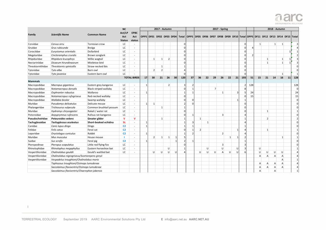
I
TERRESTRIAL ECOLOGY September 2019 AARC Environmental Solutions Pty Ltd E [email protected] AARC.NET.AU
EPBC
Act
status
OPPS DF01 DF02 DF03 DF04 Total OPPS DF05 DF06 DF07 DF08 DF09 DF10 Total OPPS DF11 DF12 DF13 DF14 DF15 Total
Corvidae Corvus orru Torresian crow LC - 0 0 1 1 1 3
Gruidae Grus rubicunda Brolga LC - 0 0 4 4
Coraciidae Eurystomus orientalis Dollarbird LC - 0 0 1 1
Megaluridae Cincloramphus cruralis Brown songlark LC - 0 0 2 2
Rhipiduridae Rhipidura leucophrys Willie wagtail LC - 1 1 2 0 0 1 1 1 3
Nectariniidae Dicaeum hirundinaceum Mistletoe bird LC - 0 0 1 1 1 3
Threskiornithidae Threskiornis spinicollis Straw-necked ibis LC - 1 1 0 0
Tytonidae Tyto alba Barn owl LC - 2 2 4 0 0
Tytonidae Tyto javanica Eastern barn owl LC - 0 0 1 1
TOTAL BIRDS 17 30 21 26 30 120 37 36 22 29 26 22 21 193 51 15 21 14 16 11 128
Mammals
Macropodidae Macropus giganteus Eastern grey kangaroo LC - 1 2 3 2 2 128 128
Macropodidae Notamacropus dorsalis Black-striped wallaby LC - 0 1 7 8 0
Macropodidae Osphranter robustus Wallaroo LC - 1 1 1 1 3 5 24 24
Macropodidae Notamacropus rufogriseus Red-necked wallaby LC - 0 0 15 15
Macropodidae Wallabia bicolor Swamp wallaby LC - 0 0 1 1 0
Muridae Pseudomys delicatulus Delicate mouse LC - 1 1 2 0 0 0
Phalangeridae Trichosurus vulpecula Common brushtail possum LC - 1 1 0 0
Muridae Hydromys chrysogaster Rakali / water rat LC - 0 0 1 1
Potoroidae Aepyprymnus rufescens Rufous rat-kangaroo LC - 0 1 3 4 0
Pseudocheiridae Petauroides volans Greater glider V V 1 1 1 1 2 2
Tachyglossidae Tachyglossus aculeatus Short-beaked echidna SL - 1 1 3 1 4 0
Canidae Canis lupus dingo Dingo C2 - 1 1 1 1 0
Felidae Felis catus Feral cat C2 - 0 1 2 1 4 1 1
Leporidae Oryctolagus cuniculus Rabbit C2 - 1 1 2 2 4 0
Muridae Mus musculus House mouse I - 2 1 1 1 5 1 1 2 1 1
Suidae Sus scrofa Feral pig C2 - 1 1 2 1 1 0
Pteropodinae Pteropus scapulatus Little red flying fox LC - 0 3 3 0
Rhinolophidae Rhinolophus megaphyllus Eastern horseshoe bat LC - U 1 U U U 3 U 1
Vespertilionidae Chalinolobus gouldii Gould's wattled bat LC - U U U U 4 U U U A U U 6 U U U U 4
Vespertilionidae Chalinolobus nigrogriseus/Scortorepens greyii A A A A 4
Vespertilionidae Vespadelus troughtoni/Chalinolobus morio A 1
Taphozous troughtoni/Ozimops lumsdenae A A A A 4
Saccolaimus flaviventris/Ozimops lumsdenae A A A A 4
Saccolaimus flaviventris/Chaerephon jobensis A A 1
Family Scientific Name Common Name
NC
Act/LP
Act
Status
2017 - Autumn 2017 - Spring 2018 - Autumn

I
TERRESTRIAL ECOLOGY September 2019 AARC Environmental Solutions Pty Ltd E [email protected] AARC.NET.AU
LC - Least Concern SL - Special Least Concern V - Vulnerable I - Introduced
Blue - Pests A - Ambiguous identification U - Unambiguous identification # - probable identification of species from hair samples
* species identified from tracks, scats or other traces ^ Probable species ID from bat calls
EPBC
Act
status
OPPS DF01 DF02 DF03 DF04 Total OPPS DF05 DF06 DF07 DF08 DF09 DF10 Total OPPS DF11 DF12 DF13 DF14 DF15 Total
Vespertilionidae Chalinolobus picatus/Vespadelus baverstocki A A 2
Vespertilionidae Chalinolobus picatus/Scotorepens greyii A A A A 4
Vespertilionidae Chalinolobus gouldii/Scotorepens balstoni A A A A 4
Chalinolobus gouldii/Ozimops ridei A A A A 4
Vespertilionidae Chalinolobus morio Chocolate wattled bat LC - U 1 U 1 0
Vespertilionidae Chalinolobus nigrogriseus Hoary wattled bat LC - A A 2 0 U U 2
Vespertilionidae Chalinolobus picatus Little pied bat LC - U A U U 4 U A U U U U 6 U U U U 4
Vespertilionidae Nyctophilus geoffroyi LC -
Vespertilionidae Nyctophilus sp. (N. geoffroyi or N. gouldi) LC - 0 U U U U U 5 U U U 3
Vespertilionidae Scotorepens balstoni Western broad-nosed bat LC - U A U 3 A A A A A 5 U U 2
Vespertilionidae Scotorepens greyii Little broad-nosed bat LC - U U U 3 U A U U U U 6 U U U U 4
Vespertilionidae Vespadelus baverstocki Inland forest bat LC - 0 A A A A 4 U U U 3
Vespertilionidae Vespadelus troughtoni Eastern cave bat LC - U 1 U U U 3 0
Miniopteridae Miniopterus orianae oceanensis LC - 0 0 U U U 3
Miniopteridae Miniopterus schreibersii oceanensisEastern bent-wing bat LC - U U U 3 U U U U U 5 0
MolossidaeAustronomus australis
White-striped free-tailed
BatLC - U U U U 4 U 1 0
Molossidae Chaerephon jobensis Northern free-tailed bat LC - U U U U 4 U U U U U U 6 U U U U 4
Molossidae Mormopterus (Setirostris) eleryi Hairy-nosed free-tailed bat LC - 0 A A A 3 0
Molossidae Ozimops lumsdenae Northern free-tailed bat LC - U U U 3 U U U U U U 6 U U U U 4
Molossidae Ozimops petersi Inland free-tailed bat LC - 0 U U A A U U 6 0
Molossidae Ozimops ridei Ride's free-tailed bat LC - U A U U 4 U U U A U U 6 U U U U 4
Emballonuridae Saccolaimus flaviventris Yellow-bellied sheathtail-bat LC - A U A U 4 U U U U U U 6 U U U U 4
Emballonuridae Taphozous troughtoni Troughton's sheathtail-bat LC - 0 A A 2 0
FERAL/DOMESTICATED/INTRODUCEDFERAL / DOMESTICATED / INTRODUCED SPECIES 3 2 1 1 2 9 2 0 0 2 1 2 12 5 0 1 0 1 0 2
NATIVE MAMMALS (NON-BATS) 4 1 2 2 0 9 1 1 7 4 0 3 24 172 0 3 0 0 0 175
BATS 0 9 12 13 7 41 15 12 12 15 12 17 83 0 17 19 18 17 0 71
TOTAL MAMMALS 7 12 15 16 9 59 18 13 19 21 13 22 119 167 17 23 18 18 0 243
2017 - Spring 2018 - Autumn
Family Scientific Name Common Name
NC
Act/LP
Act
Status
2017 - Autumn

I
TERRESTRIAL ECOLOGY September 2019 AARC Environmental Solutions Pty Ltd E [email protected] AARC.NET.AU
LC - Least Concern
EPBC
Act
status
HP 1 HP 2 HP 3 HP 4 HP 5 HP 6 HP 7 HP 8 MN 1 MN 2 MN 3 Total
Pteropodinae Pteropus scapulatus Little red flying fox LC -
Rhinolophidae Rhinolophus megaphyllus Eastern horseshoe bat LC -
Vespertilionidae Chalinolobus gouldii Gould's wattled bat LC - 1 1
Vespertilionidae Chalinolobus nigrogriseus/Scortorepens greyii
Vespertilionidae Vespadelus troughtoni/Chalinolobus morio
Taphozous troughtoni/Ozimops lumsdenae
Saccolaimus flaviventris/Ozimops lumsdenae
Saccolaimus flaviventris/Chaerephon jobensis
Vespertilionidae Chalinolobus picatus/Vespadelus baverstocki
Vespertilionidae Chalinolobus picatus/Scotorepens greyii
Vespertilionidae Chalinolobus gouldii/Scotorepens balstoni
Chalinolobus gouldii/Ozimops ridei
Vespertilionidae Chalinolobus morio Chocolate wattled bat LC - 1 1
Vespertilionidae Chalinolobus nigrogriseus Hoary wattled bat LC -
Vespertilionidae Chalinolobus picatus Little pied bat LC - 1 1
Vespertilionidae Nyctophilus geoffroyi LC - 1 1
Vespertilionidae Nyctophilus sp. (N. geoffroyi or N. gouldi) LC -
Vespertilionidae Scotorepens balstoni Western broad-nosed bat LC -
Vespertilionidae Scotorepens greyii Little broad-nosed bat LC - 5 2 1 1 2 11
Vespertilionidae Vespadelus baverstocki Inland forest bat LC -
Vespertilionidae Vespadelus troughtoni Eastern cave bat LC -
Miniopteridae Miniopterus orianae oceanensis LC -
Miniopteridae Miniopterus schreibersii oceanensis Eastern bent-wing bat LC -
MolossidaeAustronomus australis
White-striped free-tailed
BatLC -
Molossidae Chaerephon jobensis Northern free-tailed bat LC -
Molossidae Mormopterus (Setirostris) eleryi Hairy-nosed free-tailed bat LC -
Molossidae Ozimops lumsdenae Northern free-tailed bat LC -
Molossidae Ozimops petersi Inland free-tailed bat LC -
Molossidae Ozimops ridei Ride's free-tailed bat LC -
Emballonuridae Saccolaimus flaviventris Yellow-bellied sheathtail-bat LC -
Emballonuridae Taphozous troughtoni Troughton's sheathtail-bat LC -
BATS 5 4 3 1 2 15
TOTAL MAMMALS
Bat Survey Autumn 2018
Family Scientific Name Common Name
NC
Act/LP
Act
Status

J
TERRESTRIAL ECOLOGY September 2019 AARC Environmental Solutions Pty Ltd E [email protected] AARC.NET.AU
Appendix J Weed Species and Management Plans
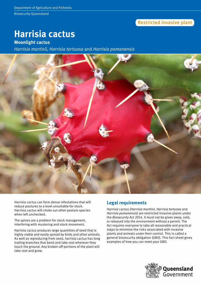
Harrisia cactus Moonlight cactus Harrisia martinii, Harrisia tortuosa and Harrisia pomanensis
Department of Agriculture and Fisheries
Biosecurity Queensland
Restricted invasive plant
Harrisia cactus can form dense infestations that will reduce pastures to a level unsuitable for stock. Harrisia cactus will choke out other pasture species when left unchecked.
The spines are a problem for stock management, interfering with mustering and stock movement.
Harrisia cactus produces large quantities of seed that is highly viable and easily spread by birds and other animals. As well as reproducing from seed, harrisia cactus has long trailing branches that bend and take root wherever they touch the ground. Any broken-off portions of the plant will take root and grow.
Legal requirements Harrisia cactus (Harrisia martinii, Harrisia tortuosa and Harrisia pomanensis) are restricted invasive plants under the Biosecurity Act 2014. It must not be given away, sold, or released into the environment without a permit. The Act requires everyone to take all reasonable and practical steps to minimise the risks associated with invasive plants and animals under their control. This is called a general biosecurity obligation (GBO). This fact sheet gives examples of how you can meet your GBO.

2 Harrisia cactus Harrisia martinii, Harrisia tortuosa and Harrisia pomanensis
At a local level, each local government must have a biosecurity plan that covers invasive plants and animals in its area. This plan may include actions to be taken on certain species. Some of these actions may be required under local laws. Contact your local government for more information.
Description Harrisia cactus is a perennial. The spiny fleshy stems are jointed and form tangled mats about half a metre high. Many branches often lie flat and take root where they touch the ground. Each section is ribbed lengthwise with six ribs; each rib has low, thick, triangular humps at regular intervals. These humps have cushions of grey felty hairs, three to five short spines lying flat, and one to three erect, stiff, very sharp spines 2.5−3 cm long.
The large flowers open at night. Flowers are pink and funnel-shaped with a tinge of white. These grow singly near the ends of the stems on a scaly but spineless slender grey-green tube 12−15 cm long.
Round, red fruits 4−5 cm across have scattered bumps with hairs and spines. Numerous small black seeds are embedded in the white, juicy pulp of the fruit, which splits open when ripe.
Harrisia cactus roots are of two types. Shallow feeding roots up to 3 cm thick and 30 cm to 2 m long grow mostly horizontally off a crown, up to 15 cm below ground level. Swollen tuberous storage roots descend to a depth of 15−60 cm.
Life cycle Harrisia cactus bears a bright red fruit containing 400−1000 small black seeds. Plants are easily established from seed and germinate soon after rain.
Seedlings quickly produce a swollen tuberous food storage root that develops as the plant grows. Branches take root where they touch the ground and new plants will grow from broken branches and sections of underground tubers.
Counts of tubers in dense cactus infestations have shown over 125 000 per hectare. Each plant houses many dormant underground buds that are all capable of reshooting when the tip growth dies; any small portion of the tuberous root left in the soil will grow.
Methods of spread Fruit and seed are readily eaten by birds, mammals and to a lesser extent by feral pigs.
Habitat and distribution Harrisia cactus is a native of Argentina and Paraguay, South America. It was introduced to Australia as a pot plant in the 1890s. In 1935 it was first recognised as a serious pest in the Collinsville district and by the 1950s was rapidly spreading south.
Harrisia cactus is mainly a pest of brigalow and associated softwood country. However, infestations are now appearing in box and ironbark stands and also in pine forests.
Map 1. Distribution of harrisia cactus in Queensland
The cactus is shade tolerant and reaches its maximum development in the shade and shelter of brigalow scrub, though established infestations can persist once scrub is pulled.
Harrisia cactus is found in the Collinsville, Nebo, Moranbah, Dingo, Blackwater and Goondiwindi districts, with minor infestations occurring at Millmerran, Greenmount, Gatton, Ipswich, Rockhampton, Rannes, Mount Morgan, Alpha and Mitchell.
Control Managing harrisia cactus The GBO requires a person to take reasonable and practical steps to minimise the risks posed by harrisia cactus. This fact sheet provides information and some options for controlling harrisia cactus.
Control of this plant is difficult as it has a deep underground tuberous root system and use of a combination of physical, biologic and herbicide controls is recommended.
Physical control Dig out plants completely and burn. Ensure that all tubers that can grow are removed and destroyed.
Ploughing is not considered an effective means of control unless followed by annual cropping.

Harrisia cactus Harrisia martinii, Harrisia tortuosa and Harrisia pomanensis 3
Biological control Two introduced insects have become established in the field:
• a stem-boring longicorn beetle (Alcidion cereicola) • a mealy bug (Hypogeococcus festerianus). The stem-boring beetle only attacks older woody stems. In the Collinsville area, large beetle colonies developed and contributed to the collapse of dense areas of cactus. Populations of Alcidion cereicola have declined with the reduction in the cactus in recent years.
The most successful biological control agent is the mealy bug Hypogeococcus festerianus which is now present in harrisia cactus in Collinsville, Dingo, Moranbah, Blackwater, Nebo, Charters Towers and Goondiwindi districts, with small colonies established at Alpha, Capella, Rannes, Gatton, Greenmount, Millmerran and Rockhampton.
How mealy bug works
The mealy bug aggregates and feeds in the tips of stems and buds, where it limits growth and causes distortion. This results in the knotting of the stem. The plant’s response is to utilise energy reserves within the tuber system to produce new growth. Eventually the plant dies, as it is unable to support the continuous high energy demands.
Dry weather reduces the effectiveness of the mealy bug. When dry, the plant’s tuber system becomes dormant. Consequently, mealy bug damage does not result in new growth and the energy reserves within the plant are not affected. Instead the bug may damage all vegetative parts and eventually die out. The tuber will remain dormant until adequate moisture returns, when it will reshoot.
How to spread the bug
Mealy bug disperses naturally via wind, although landholder assistance is necessary for its continuous spread, particularly between patches. The bug is manually spread by cutting infected stems and placing them into healthy plants. The best pieces for starting new colonies are large knobs of twisted and distorted cactus that contain many mealy bugs well protected inside knots. Stem tips covered by white, woolly masses of bug are also good. To collect the bug, cut infected stems approximately 15 cm from the distorted knob and place segments in green, plump sections of the healthy plant. Avoid placing mealy bug in stressed or dried out stems. Small cactus plants require at least one large knot, with larger plants requiring three knots per plant. Where possible, landholders should infest every cactus clump as this ensures a rapid reduction in growth and fruiting potential. When cactus infestations are light, chemical control may be a preferable option.
Cut pieces can be transported in boxes or open vehicles. They are not delicate, but are best kept in the shade. Avoid keeping them in large heaps, in direct sunlight, under tarpaulins or in closed containers for long periods. Such conditions will promote rotting of the stems, leading to poor results or failures. Ideally, stems should be put out within three days and a maximum of five days.
When to infest
Best results come by infesting new areas during spring and early summer, from September to December. Maximum growth and spreading occurs in the summer months of December to February. During the drier and colder months of April to August the mealy bug does not die, but little growth and multiplication occurs. Introduction of mealy bug during autumn and winter will not be lost, but little effect is seen until the following summer.
How soon to expect results
Mealy bugs are generally more active and effective on harrisia cactus growing underneath shrubs and trees, so results will be seen more quickly in these areas than in cactus growing in the open. Best results are obtained when infesting plants that have actively growing new shoots.
During wet summers in northern and central Queensland, the growing points of stems will begin to curl after about six weeks.
By the end of the first summer, damage (severe twisting) will be widespread in infested plants. If the initial infestation was sufficiently heavy, no fruit or growth will occur during the second year, and the cactus will begin to die during the third year. Seedlings and regrowth shoots will continue to be present but by the end of the fourth year there should be very little cactus left.
In the southern portion of the state, where temperatures are lower, the mealy bug still provides control but the process takes longer. However, the mealy bug will do better on cactus in the open, rather than in the shade, as temperatures are higher in the open.
Herbicide control Foliar application of registered herbicides provides effective control, but can be costly over large areas. Before using any herbicide always read the label carefully. All herbicides must be applied strictly in accordance with the directions on the label (see to Table 1).
Further information Further information is available from your local government office, or by contacting Biosecurity Queensland on 13 25 23 or visit www.biosecurity.qld.gov.au.

Table 1. Herbicides for the control of harrisia cactus
Situation Herbicide Rate Comments
Non-crop land and rights-of-way
Dichlorprop as K salt (600 g/L) 1 L/60 L water Good soil moisture essential Spray plant when actively growing to run-off point A follow-up treatment may be necessary
Native pastures, rights-of-way, commercial and industrial areas
Metsulfuron-methyl (600 g/kg) (e.g. Brush-Off®)
20 g/100 L water + surfactant
Spray plant when actively growing to run-off point A follow-up treatment may be necessary
Agricultural non-crop areas, commercial and industrial areas, fence lines, forestry, pastures and rights-of-way
Triclopyr as butotyl (240 g/L) + Picloram as ioe (120 g/L) (e.g. Access®)
1 L/60 L diesel Spray plant when actively growing Apply as overall spray, wetting all areas of the plant to ground level
Non-agricultural areas (native pastures), commercial and industrial areas and rights-of-ways
Aminopyralid as K salt 375 g/kg + Metsulfuron methyl 3 g/kg (e.g Stinger)
40 g/100 L water Spray to thoroughly wet using 1000 to 1400 L/ha Follow-up treatment may be necessary
Commercial and industrial areas, around buildings and rights-of-way
Triclopyr as butotyl 75 g/L + Metsulfuron-methyl 28 g/L (e.g. Zelam Brush Weed®)
500 mL/100 L Spray to thoroughly wet using 1000 to 1500 L/ha Follow-up treatment may be necessary
Agricultural non-crop areas, commercial and industrial areas, forests, pastures and rights-of-way
Triclopyr as tea 200 g/L + Picloram as tipa 100 g/L (e.g. Slasher) or Triclopyr as tea 200 g/L + Picloram as tipa 100 g/L + Aminopyralid 25 g/L (e.g. Tordon RegrowthMaster) (e.g. Tordon DSH®)
2.5 L/100 L water Spray plant when actively growing (September–March) Treat all stems thoroughly
Read the label carefully before use. Always use the herbicide in accordance with the directions on the label.
This fact sheet is developed with funding support from the Land Protection Fund.
Fact sheets are available from Department of Agriculture and Fisheries (DAF) service centres and our Customer Service Centre (telephone 13 25 23). Check our website at www.biosecurity.qld.gov.au to ensure you have the latest version of this fact sheet. The control methods referred to in this fact sheet should be used in accordance with the restrictions (federal and state legislation, and local government laws) directly or indirectly related to each control method. These restrictions may prevent the use of one or more of the methods referred to, depending on individual circumstances. While every care is taken to ensure the accuracy of this information, DAF does not invite reliance upon it, nor accept responsibility for any loss or damage caused by actions based on it.
© The State of Queensland, Department of Agriculture and Fisheries, 2017. 03/17

Mimosa bush can spread readily and grow quickly. As it often forms thorny thickets, it can be a considerable nuisance during mustering and can also hinder stock access to water.
Mimosa does offer shade in open downs country and can be useful as a supplement to grass during the dry season. It may therefore be a useful plant in some areas if its spread can be controlled to prevent thicket formation. The maintenance of healthy pasture competition is the best mechanism to achieve this.
Legal requirementsMimosa bush is not a prohibited or restricted invasive plant under the Biosecurity Act 2014. However, by law, everyone has a general biosecurity obligation (GBO) to take reasonable and practical steps to minimise the risks associated with invasive plants and animals under their control.
Local governments must have a biosecurity plan that covers invasive plants and animals in their area. This plan may include actions to be taken on certain species. Some of these actions may be required under local laws. Contact your local government for more information.
Mimosa bushAcacia farnesiana
Department of Agriculture and Fisheries
Biosecurity Queensland
Invasive plant

2 Mimosa bush Acacia farnesiana
DescriptionMimosa bush is a rounded shrub or small tree generally growing 2 to 3 m high, occasionally to 5 m. It often forms thorny thickets, and is nearly always multi-stemmed. The branches grow in a zigzag shape and are usually a grey-brown colour with prominent white spots.
Leaves are a ferny type, with 1−6 pairs of leaf ‘branches’ each with 5−20 pairs of narrow, rounded leaflets 4−8 mm long. Leaves are sometimes more of a yellowish green than a pure green. Thorns are found in pairs at the base of each leaf and can grow up to 10 cm long.
Golden yellow to orangeish flowers are ball-shaped, about 1 cm across, and grow on stalks, usually two stalks at the base of each leaf. Flowers develop into clusters of cigar-shaped pods, slightly curved and up to 6 cm long. The pods are dark brown or black and woody at maturity, with seeds embedded in the pith. Pods do no split open and tend to stay on the plant for a length of time.
Mimosa bush can be confused with the declared weeds mesquite (Prosopis spp.) and prickly acacia (Vachellia nilotica), particularly when young (see the ‘identification of prickle bushes’ fact sheet from www.biosecurity.qld.gov.au).
DistributionMimosa bush, a native of central and south America, is naturalised in Australia. Mimosa bush is widespread in Queensland, and found in all but the wettest and driest parts of the State. Seeds sprout readily and plants grow rapidly. Mimosa bush does well in dry localities and on loamy or sandy soils, forming thickets along watercourses. Mimosa bush withstands drought well, is readily eaten by stock, and has good regrowth after grazing.
Mimosa bush is not a long-lived plant. It is readily attacked by many native insects and is prone to dieback on an irregular basis. In some parts of the world mimosa bush is cultivated for perfume production.
Control
Basal bark sprayFor stems up to 15 cm diameter, carefully spray completely around base of plant to a height of 30 cm above ground level. Thoroughly spray into all crevices. Larger trees may be controlled by spraying to a greater height, up to 100 cm above ground level.
The best time for treatment is during autumn when plants are actively growing and soil moisture is good.
Cut stump treatmentAt any time of year, cut stems off horizontally as close to the ground as possible. Immediately (within 15 seconds) swab cut surface with herbicide mixture.
Bore drainsChannels and drains must be empty of water. Spray a one metre strip into the mud in channel or drain. Wait at least three days for diuron to bond to mud before slowly allowing water in again. Water must not be used in domestic water supply or supplied to desirable shade trees for 7−14 days after re-opening the drain.
Further informationFurther information is available from your local government office, or by contacting Biosecurity Queensland on 13 25 23 or visit www.biosecurity.qld.gov.au.

Table 1. Herbicides for the control of mimosa bush
Situation Herbicide Rate Optimum time CommentsBasal bark/cut stump
Fluroxypyr eg. Starane Advanced®, etc Triclpyr + picloram e.g. Access®
Refer to product label
Basal bark: for plants up to 5 cm basal diameter
Triclpyr + picloram e.g. Access®
1 L/60 L diesel Basal bark: for plants up to 5 cm basal diameter
Ensure all stems on multi-stemmed plants are treated.
Soil application
Tebuthiuron (PERMIT 13891)e.g. Tebulan 200GR herbicide®, Graslan herbicide®, etc
2.0 g/m2 or 20 kg/ha
For use in pastures, roadside and rights of way.Application just prior to rainfall gives best results.Avoid damage to off target species – refer to herbicide label for product restraints and critical comments.
High volume spray
500 g/L clopyralid present as the triisopropanol amine (PERMIT 11638)e.g. Lontrel herbicide®, Nufarm Archer®, Farmoz Victory herbicide®, etc
500 mL of product per 100 L of water (plus non-ionic surfactant at 0.1%)
Spray when plants are actively growing and in full leaf
For use in pastures, rights of way, powerline areas.Full covering of foliage with spray is essential.Withholding period: do not graze treated areas, or cut for stock feed, for seven days after application.
Bore drains Diuron e.g. Diuron 500SC®, etc
Refer to product label
Do not apply between 1 December and 30 March each year.
Do not apply more than once per calendar year.Do not open drains for 72 hours following treatment.Do not apply if heavy rains are predicted within three days of application. Application should be limited to 1 m strips along the sides of bore drains.Withholding period – do not allow animals to drink water from treated bore drains for three days, before slaughter for human consumption
Read the label carefully before use. Always use the herbicide in accordance with the directions on the label.
This fact sheet is developed with funding support from the Land Protection Fund.
Fact sheets are available from Department of Agriculture and Fisheries (DAF) service centres and our Customer Service Centre (telephone 13 25 23). Check our website at www.biosecurity.qld.gov.au to ensure you have the latest version of this fact sheet. The control methods referred to in this fact sheet should be used in accordance with the restrictions (federal and state legislation, and local government laws) directly or indirectly related to each control method. These restrictions may prevent the use of one or more of the methods referred to, depending on individual circumstances. While every care is taken to ensure the accuracy of this information, DAF does not invite reliance upon it, nor accept responsibility for any loss or damage caused by actions based on it.
© The State of Queensland, Department of Agriculture and Fisheries, 2016. 07/16

Mother-of-millions Bryophyllum delagoense (syn. B. tubiflorum, Kalanchoe delagoensis), Bryophyllum × houghtonii (syn. B. daigremontianum × B. delagoense, Kalanchoe × houghtonii)
Fact sheet DECLARED CLASS 2 PEST PLANTGroundsel bush
accharis halimifolia Mother-of-millions BBryophyllum delagoense (syn. B. tubiflorum, Kalanchoe delagoensis) and Bryophyllum × houghtonii
Department of Agriculture and Fisheries
Biosecurity Queensland
Restricted invasive plant
Mother-of-millions are native to Madagascar and are escaped ornamental plants. Five species are commonly naturalised in Queensland. It is well adapted to dry areas because of its succulent features.
As the name suggests, one plant can reproduce a new generation from masses of embryoids (plantlets) that are formed on the leaf edges. This makes these plants hard to eradicate and follow up controls are essential.
These plants, especially their flowers, are poisonous to stock and occasionally cause a significant number of cattle deaths. The plant flowers from May to October (during the drier months of the year) and the scarcity of feed at this time may cause cattle to consume lethal amounts of mother-of-millions.
Legal requirements Mother-of-millions is a restricted invasive plant under the Biosecurity Act 2014. It must not be given away, sold, or released into the environment without a permit.
Bryophyllum pinnatum (resurrection plant, live-leaf) is not a restricted invasive plant. However the Act requires everyone to take all reasonable and practical steps to minimise the risks associated with invasive plants and animals under their control. This is called a general biosecurity obligation (GBO). This fact sheet gives examples of how you can meet your GBO.

At a local level, each local government must have a biosecurity plan that covers invasive plants and animals in its area. This plan may include actions to be taken on certain species. Some of these actions may be required under local laws. Contact your local government for more information.
Description Mother-of-millions are erect, smooth, fleshy succulent plants growing to 1 m or more in height.
All species form tall flower spikes in winter with clusters of bell-shaped flowers. Each species has a distinctive leaf shape, but all produce small plantlets along the edges of the leaves. These plantlets drop readily, develop roots and establish quickly to form a new colony.
Bryophyllum delagoense syn. B. tubiflorum and Kalanchoe delagoensis (common mother-of-millions, mission bells, Christmas bells) has grey-brown, fleshy, tubular-like leaves with up to seven projections at the tip of each leaf. The flowers are orange-red and occur in a cluster at the top of a single stem. Seeds can germinate for some years.
Bryophyllum × houghtonii syn. B. daigremontianum × B. delagoense, Kalanchoe × houghtonii (hybrid or crossbred mother-of-millions) has similar flowers arranged in a branched cluster at the top of the stem. Its leaves are boat shaped with thick stalks and notches along the edges of the leaves.
A third species, Bryophyllum pinnatum (resurrection plant, live-leaf) has yellow-green, oval, fleshy leaflets with wavy edges and up to five leaflets per leaf. Its flowers are yellowish-green, often tinged with pink, and occur in loose clusters on stalks growing at intervals along the upper portion of the stem.
Life cycle Mother-of-millions flowers in Winter and reproduces by seed and by tiny plantlets that are produced at the tips of its fleshy (succulent) leaves. Dislodged leaves and broken leaf parts can also take root and give rise to new plants.
Methods of spread Mother-of-millions is commonly spread by garners and in garden waste. The tiny seeds are probably wind and water dispersed and its leaves and plantlets may also be dislodged and spread by animals, vehicles, machinery, soil and slashers.
Habitat and distribution Native to Madagascar, these popular succulent garden plants have escaped culitvation and spread in various areas of Queensland. They have become a problem in pasture lands in the central highlands around Clermont, Emerald and Dingo, and the Burnett, Moreton and Darling Downs scrub regions. The plants establish well in leaf litter or other debris on shallow soils in shady woodlands, and often grow on roadsides, along fence lines and around old rubbish dumps. They can spread from these areas, especially in flood, and establish if pastures are run down.
Map 1. Distribution of mother-of-millions in Queensland
They are adapted to dry conditions and can survive long periods of drought.
Toxicity These plants are toxic, especially their flowers, and occasionally cause a significant number of cattle deaths. When cattle are under stress or in unusual conditions they are more likely to eat plants that they would not normally eat. Shifting cattle to new paddocks, moving stock through infested rubbish dumps and wastelands, and reduction of availability of feed due to flood or drought can all contribute to cattle eating mother-of-millions and being poisoned.
Poisoned cattle show signs of dullness, loss of appetite, diarrhoea and heart failure. Some cattle may drool saliva or dribble urine. There are two responses to poisoning:
• acute—where cattle die within a day • chronic—where cattle may take up to five days to die.
Some cattle may make a slow recovery if insufficient plant material was eaten.
Poisoned cattle must be treated within 24 hours of consuming the plant. The treatment is intense and needs to be given by a veterinarian, or under their direction, because of the drugs and materials used.
2 Mother-of-millions Bryophyllum spp.

Control
Managing mother-of-millions The GBO requires a person to take reasonable and practical steps to minimise the risks posed by mother-of-millions. This fact sheet provides information and some options for controlling mother-of-millions.
Prevention and early detection The best form of weed control is prevention. Always treat weed new infestations when small—do not allow weeds to establish. Weed control is not cheap, but it is cheaper to do it now rather than next year, or the year after. Proper planning ensures better value for each dollar spent.
Permanent control of mother-of-millions infested areas is best ensured by establishing more desirable plants in that location to compete successfully with future mother-of-millions seedlings and plantlets. This is best achieved through soil preparation, replanting, fertilising and using the area more productively.
Ensure scattered infestations and small dumping areas on properties are regularly checked and cleaned up. Day-today hygiene management will help prevent establishment of these weeds.
Co-operative control upstream and downstream of problem areas will help prevent re-infestation from other areas.
To prevent poisoning, keep stock (especially hungry stock) away from infested areas until the plants are controlled.
Mechanical control For small areas, pull up plants by hand and burn on a wood heap. Alternatively, bag the plants and dump them in a bin, the contents of which are buried at council refuse tips rather than being recycled into mulch.
Fire When suitable (e.g. after grading firebreaks), burn infestations and the accompanying debris on which mother-of-millions plants thrive. This is the most economical form of control, encourages grass competition and lessens the problem for following years, requiring only spot spraying with selective herbicides.
Biological control
The South African citrus thrip is present in Queensland and is quite widespread through the south of the state. The thrip damages the outer tissue of the mother-ofmillions plant and also lays its eggs under the outer tissue. Where high populations of thrips exist, the number of viable plantlets and flowers forming on mother-of-millions is reduced.
The thrips populations vary from year to year, according to mother-of-millions populations and climate. The South African citrus thrips should not be seen as a long term control strategy—only a control option to complement other techniques such as herbicide treatment and burning.
The department is undertaking further research to identify potential biological control agents to support with management.
Herbicide control
Before using any herbicide always read the label carefully. All herbicides must be applied strictly in accordance with the directions on the label. Where the addition of a wetting agent is recommended, always use a commercial wetting agent or surfactant.
Mother-of-millions may be controlled with herbicides at ny time of the year, but infestations are easiest to see in winter when the plants are in flower. Treating infestations at this time of year also has the benefit of preventing new seeds from developing on common mother-of-millions.
Table 1 details the herbicides registered for mother-of-millions control.
Further information Further information is available from your local government office, or by contacting Biosecurity Queensland on 13 25 23 or visit www.biosecurity.qld.gov.au.
Bryophyllum x houghtonii (left) and Bryophyllum delagoense (right)
South African citrus thrips damage to mother-of-millions
Mother-of-millions Bryophyllum spp. 3

Table 1. Herbicides for the control of mother-of-millions
Situation Herbicide Rate Comments Pastures and non-crop land 2,4-D acid (e.g. Affray 300) 7 L/1000 L water per ha
70 mL/10 L water High volume foliar spray (handgun) High volume foliar spray (knapsack)
Pastures, rights-of-way and industrial
2,4-D amine 700 g/L (e.g. Amicide Advance 700)
360 mL/100L water Hand gun and knapsack only. Thorough coverage is essential. Use a surfactant (e.g. Nufarm Activator) (consult label).
Pastures, rights-of-way, non-crop land, forests, non-agricultural land and commercial and industrial areas
Triclopyr 300 g/L + Picloram 100 g/L (e.g. Conqueror) or Triclopyr 300 g/L + Picloram 100 g/L + Aminopyralid 8 g/L (e.g. Grazon Extra)
500 mL/100 L water 50 mL/10 L water
High volume foliar spray (hand gun, knapsack). Always add a wetting agent (e.g. BS-1000 or Chemwet 1000) at 100 mL/100 L water. Apply at flowering.
Fluroxypyr 200 g/L (e.g. Flagship 200)
600 mL/100 L water + sufactant (consult label)
Apply to seedlings and young plants before flowering.
Fluroxypyr 333 g/L (e.g. Starane Advanced)
360 mL/100 L water + sufactant (consult label)
Fluroxypyr 400 g/L (e.g. Comet 400)
300 mL/100 L water + sufactant (consult label)
Notes Thorough, even coverage of leaves and plantlets is necessary. Note that many 2,4-D products are not registered for control of mother-of-millions in Queensland. Only use products registered for the purpose.
Read the label carefully before use. Always use the herbicide in accordance with the directions on the label.
This fact sheet is developed with funding support from the Land Protection Fund.
Fact sheets are available from Department of Agriculture and Fisheries (DAF) service centres and our Customer Service Centre (telephone 13 25 23). Check our website at www.biosecurity.qld.gov.au to ensure you have the latest version of this fact sheet. The control methods referred to in this fact sheet should be used in accordance with the restrictions (federal and state legislation, and local government laws) directly or indirectly related to each control method. These restrictions may prevent the use of one or more of the methods referred to, depending on individual circumstances. While every care is taken to ensure the accuracy of this information, DAF does not invite reliance upon it, nor accept responsibility for any loss or damage caused by actions based on it.
© The State of Queensland, Department of Agriculture and Fisheries, 2016. 07/16

Parthenium is a vigorous species that colonises weak pastures with sparse ground cover. It will readily colonise disturbed, bare areas along roadsides and heavily stocked areas around yards and watering points. Parthenium can also colonise brigalow, gidgee and softwood scrub soils. Its presence reduces the reliability of improved pasture establishment and reduces pasture production potential.
Parthenium is also a health problem as contact with the plant or the pollen can cause serious allergic reactions such as dermatitis and hay fever.
Parthenium is listed as a Weed of National Significance.
Legal requirementsParthenium is a restricted invasive plant under the Biosecurity Act 2014. It must not be given away, sold, or released into the environment without a permit. The Act requires everyone to take all reasonable and practical steps to minimise the risks associated with invasive plants and animals under their control. This is called a general biosecurity obligation (GBO). This fact sheet gives examples of how you can meet your GBO.
At a local level, each local government must have a biosecurity plan that covers invasive plants and animals in its area. This plan may include actions to be taken on certain species. Some of these actions may be required under local laws. Contact your local government for more information.
PartheniumParthenium hysterophorus
Department of Agriculture and Fisheries
Biosecurity Queensland
Restricted invasive plant

2 Parthenium weed Parthenium hysterophorus
Description Parthenium is an annual herb with a deep tap root and an erect stem that becomes woody with age. As it matures, the plant develops many branches in its top half and may eventually reach a height of 2 m.
Its leaves are pale green, deeply lobed and covered with fine soft hairs.
Small creamy white flowers occur on the tips of the numerous stems. Each flower contains four to five black seeds that are wedge-shaped, two millimetres long with two thin, white scales.
Life cycleParthenium normally germinates in spring and early summer, produces flowers and seed throughout its life and dies around late autumn. However, with suitable conditions (rain, available moisture, mild temperatures), parthenium can grow and produce flowers at any time of the year. In summer, plants can flower and set seed within four weeks of germination, particularly if stressed.
Methods of spreadParthenium seeds can spread via water, vehicles, machinery, stock, feral and native animals and in feed and seed. Drought conditions aid the spread of seed with increased movements of stock fodder and transports.
Habitat and distributionParthenium is capable of growing in most soil types but becomes most dominant in alkaline, clay loam soils.
The plant is well established in Central Queensland and present in isolated infestations west to Longreach and in northern and southern Queensland.
Infestations have also been found in northern and central parts of New South Wales and it is capable of growing in most states of Australia.
ControlManaging partheniumThe GBO requires a person to take reasonable and practical steps to minimise the risks posed by parthenium. This fact sheet provides information and some options for controlling parthenium.
Prevention and weed seed spreadPastures maintained in good condition, with high levels of grass crown cover, will limit parthenium colonisation. Drought, and the subsequent reduced pasture cover, creates the ideal window of opportunity for parthenium colonisation when good conditions return.
Vehicles and implements passing through parthenium infested areas should be washed down with water. Particular care should be taken with earthmoving machinery and harvesting equipment. The wash down procedure should be confined to one area, so that plants that establish from dislodged seed can be destroyed before they set seed.
Map 1. Distribution of parthenium in Queensland
Extreme caution should be taken when moving cattle from infested to clean areas. Avoid movement during wet periods as cattle readily transport seed in muddy soil. On arrival, cattle should be held in yards or small paddocks until seed has dropped from their coats and tails prior to their release into large paddocks. Infestations around yards can be easily spotted and controlled whereas infestations can develop unnoticed in large paddocks.
Particular care should be taken when purchasing seed, hay and other fodder materials. Always keep a close watch for the emergence of parthenium or other weeds on areas where hay has been fed out.
Property hygiene is important. Owners of clean properties should ensure that visitors from infested areas do not drive through their properties. If your property has parthenium on it, ensure that it is not spread beyond the boundary or further within the property.
Manual control Hand pulling of small areas is not recommended. There is a health hazard from allergic reactions and a danger that mature seeds will drop off and increase the area of infestation.
Pasture managementGrazing management is the most useful method of controlling large-scale parthenium infestations. Maintain pastures in good condition with high levels of ground and grass crown cover. This may require rehabilitation of poor pastures, followed by a sound grazing maintenance program.

Parthenium weed Parthenium hysterophorus 3
Sown pasture establishment—Poor establishment of sown pastures can allow parthenium colonisation.
Pasture agronomy—Aerial seeding prior to scrub pulling is normally beneficial.
Overgrazing—High grazing pressure caused by drought or high stock numbers decreases the vigour and competitiveness of pastures and allows the entry and spread of parthenium. Maintenance of correct stock numbers is most important in controlling parthenium.
Pastures spelling—In situations of serious infestation, pasture spelling is essential for rehabilitation. Total spelling is much more effective than simply reducing the stocking rate. However, overgrazing of the remainder of the property must be avoided.
The most appropriate time for pasture spelling is the spring−summer growing period, with the first 6−8 weeks being particularly important. If the condition of perennial grasses (native or sown) is low, spelling for the entire growing season may be required or introduced grasses may need to be re-sown. Herbicide treatment can hasten the rehabilitation process by removing a generation of parthenium seedlings and allowing grass seedlings to establish without competition. In the presence of parthenium, grass establishment is poor.
Grazing during winter should not increase the parthenium risk. Most tropical grasses are dormant and can tolerate moderate grazing during this period. However, parthenium may germinate and grow at this time.
Fencing—One of the main problems in controlling parthenium is the large paddock size and the variability of country within paddocks. The resulting uneven grazing pressures encourage parthenium to colonise the heavily grazed country. Ideally, similar land types should be fenced as single units. Fencing can be used to great effect to break up large paddocks, allowing more flexible management such as pasture spelling or herbicide application, options not available previously.
Burning—Burning is not promoted as a control strategy for parthenium. However, research suggests that burning for pasture management (e.g. woody weed control) should not result in an increased infestation if the pasture is allowed to recover prior to the resumption of grazing. Stocking of recently burnt areas known or suspected to contain parthenium decreases pasture competition and favours parthenium, ultimately creating a more serious infestation.
Biological control The combined effects of biological control agents reduced the density and vigour of parthenium and increased grass production.
There are currently a number of insect species and two rust pathogens that have been introduced to control parthenium—a selection of these are outlined below. Epiblema strenuana is a moth introduced from Mexico established in all parthenium areas. The moth’s larvae feed inside the stem, forming galls that stunt the plant’s growth, reduce competitiveness and seed production.
Listronotus setosipennis is a stem-boring weevil from Argentina but is of limited success in reducing parthenium infestations.
Zygogramma bicolorata is a defoliating beetle from Mexico which is highly effective where present. It emerges in late spring and is active until autumn.
Smicronyx lutulentus (Mexico) lays eggs in the flower buds where the larvae feed on the seed heads. Conotrachelus albocinereus (stem-galling weevil from Argentina) produces small galls and is still becoming established in Queensland.
Bucculatrix parthenica (leaf mining moth from Mexico) larvae feed on leaves, leaving clear windows in the leaf. Carmentia ithacae is a stem boring moth from Mexico which is becoming established at favourable sites in the northern Central Highlands.
Puccinia abrupta is a winter rust from Mexico that infects and damages leaves and stems. It is currently established over a wide area from Clermont south. It requires a night temperature of less than 16 degrees and 5−6 hours of leaf wetness (dew). Sporadic outbreaks occur where weather conditions are suitable.
Puccinia melampodii is a summer rust from Mexico that weakens the plant by damaging the leaves over the summer growing season. It is currently established and spreading at a number of sites from north of Charters Towers to Injune in the south.
Herbicide controlNon-crop areas Parthenium should be sprayed early before it can set seed. A close watch should be kept on treated areas for at least two years.
Small and/or isolated infestations should be treated immediately. Herbicide control will involve a knockdown herbicide to kill plants that are present and a residual herbicide to control future germinations. Repeated spraying may be required even within the one growing season to prevent further seed production.

Table 1. Herbicides for the control of parthenium
Situation Herbicide Rate CommentsPastures, rights-of-way and industrial land
2,4-D as amine 625 g/L (e.g. Ken-Amine 625)
320 mL/100 L water Spot spray Apply to young actively growing plants, ensuring thorough coverage2,4-D as amine 700 g/L
(e.g. Amicide Advance 700)285 mL/100L water
Non agricultural areas (native pastures), commercial and industrial areas, rights-of-way
Aminopyralid 375 g/kg plus metsulfuron-methyl 300 g/kg (Stinger)
10 g/100 L water plus wetting agent Consult label
Spray to thoroughly wet all foliage but not to cause run-off
Fields and fallow, various crops (see label)
Atrazine 500 g/L (e.g. Kenso Atrazine 500)
3.6−6 L/ha Rate varies with situation Consult label
Boom spray. Pre and post emergent application Restrictions apply. Consult label for details of specific conditions. Max 3 kg a.i./ha/yr
Roadside and rights-of-way 6 L/ha Boom spray. Pre and post emergent application Restrictions apply. Consult label for details of specific conditions. Max 3 kg a.i./ha/yr
Fields and fallow, various crops (see label)
Atrazine 900 g/kg (e.g. Atradex WG)
2−3.3 kg/ha Rate varies with situation Consult label
Boom spray. Pre and post emergent application Restrictions apply. Consult label for details of specific conditions. Max 3 kg a.i./ha/yr
Roadside and rights-of way 3.3 kg/ha Boom spray. Pre and post emergent application.Restrictions apply. Consult label for details of specific conditions. Max 3 kg a.i./ha/yr
Non-crop areas, commercial and industrial areas, pastures and rights-of-way
2,4-D 300 g/L + picloram 75 g/L (e.g. Tordon 75-D)
125 mL/100 L Spot spray during rosette stage Use at least 3000 L/ha in dense infestations Consult label
3 L/ha Boom spray during rosette stage Consult label
Native pastures, rights-of-way, commercial and industrial land
metsulfuron methyl 600g/L (e.g. Associate)
5 g/100 L water + wetter
Hand gun. Spray to thoroughly wet all foliage but not to cause runoff
7 g/ha + wetter Boom spray. For pastures only. Treat in rosette stage. Consult label for details
Wheat, barley, triticale and cereal rye
5–7 g/h Boom spray. Lower rate up to 4-leaf stage, higher rate 4-leaf stage to rosette
Native pastures, rights-of-way, commercial and industrial land
Triclopyr 75 g/L + metsulfuron-methyl 28 g/L (e.g. Zelam Brush Weed)
125 mL/100 L water Spot spray plants from rosette to flowering Consult label for critical comments
Commercial and industrial areas, rights-of-way, around agricultural buildings
Hexazinone 750 g/kg (e.g. Velpar DF)
1 kg/ha 2 g/10 L/20 m2
Boom spray or spot spray
Around agricultural buildings Hexazinone 250 g/L (e.g. Velpar L)
3.5 L/ha or 7 L/10 L/20 m2
Grass pastures, fallows, various crop and non-crop situations (consult label for details
Dicamba 500 g/L (e.g. Kamba 500) Dicamba 700 g/kg
Rates vary with situation Consult label
Boom spray or spot spray Consult label for details and critical comments
A number of the listed herbicides are available as different formulations, but some may not be registered for parthenium. Check the label for registration, rate and critical comments. Only use products that list parthenium on the label. The registered rates are for non-crop uses. Consult label for in-crop recommendations. For power hand spray or knapsack use, spray plants to the point of runoff.
Read the label carefully before use. Always use the herbicide in accordance with the directions on the label.
This fact sheet is developed with funding support from the Land Protection Fund.
Fact sheets are available from Department of Agriculture and Fisheries (DAF) service centres and our Customer Service Centre (telephone 13 25 23). Check our website at www.biosecurity.qld.gov.au to ensure you have the latest version of this fact sheet. The control methods referred to in this fact sheet should be used in accordance with the restrictions (federal and state legislation, and local government laws) directly or indirectly related to each control method. These restrictions may prevent the use of one or more of the methods referred to, depending on individual circumstances. While every care is taken to ensure the accuracy of this information, DAF does not invite reliance upon it, nor accept responsibility for any loss or damage caused by actions based on it.
© The State of Queensland, Department of Agriculture and Fisheries, 2016. 07/16
Extensive infestations will require herbicide treatment in conjunction with pasture management. Timing of spraying is critical so that parthenium is removed when plants are small and before seeding has occurred. Grasses should be actively growing and seeding so that they can recolonise the infested area.
Table 1. shows the herbicides registered for parthenium control and application rates. All herbicides must be applied strictly in accordance with the directions on the label.
Cropping areas Controlling parthenium in cropland requires selective herbicide use and/or crop rotations. For further information on parthenium control in crops consult your local biosecurity officer.
Further informationFurther information is available from your local government office, or by contacting Biosecurity Queensland on 13 25 23 or visit www.biosecurity.qld.gov.au.

Three types (genera) of opuntioid cacti have naturalised in Australia and are now considered Weeds of National Significance: Austrocylindropuntia, Cylindropuntia and Opuntia. They are drought resistant because of their succulent nature, their lack of leaves and their thick, tough skins. These features result in plants that use the majority of their internal tissues for water storage and their outer parts to reduce water loss and damage by grazing and browsing animals. They can remain vigorous in hot, dry conditions that cause most other plants to lose vigour or even die. Some species develop underground bulbs that enable the plant to resist fire and mechanical damage.
Dense infestations compete with native vegetation, limiting the growth of small shrubs and groundcover species. The plant’s sharp spines or barbs can cause injury to stock and native animals and contaminate wool and hides, reducing or preventing grazing activities and productivity.
Large stands of cacti provide harbour for pest animals, such as foxes and rabbits and, due to their spiny nature, can limit access for stock mustering and recreational activities. The spines are capable of causing serious injury to animals and humans.
Opuntioid cactiAustrocylindropuntia, Cylindropuntia and Opuntia species
Department of Agriculture and Fisheries
Biosecurity Queensland
Restricted invasive plant

2 Opuntioid cacti Austrocylindropuntia, Cylindropuntia and Opuntia species
Legal requirementsAll Cholla cacti (Cylindropuntia spp.) and prickly pear (Opuntia spp.) not listed below are prohibited invasive plants and the Biosecurity Act 2014 requires that all sightings to be reported to Biosecurity Queensland within 24 hours. By law, everyone has a general biosecurity obligation (GBO) to take all reasonable and practical steps to minimise the risk of these cacti spreading until they receive advice from an authorised officer.
The following species are restricted invasive plants under the Act. The Act requires that all sightings of these cacti must be reported to Biosecurity Queensland within 24 hours of the sighting. By law, everyone has a GBO to take all reasonable and practical steps to minimise the risk of spread of these cacti until they receive advice from an authorised officer.
• Hudson pear (Cylindropuntia rosea and C. trunicata)
• Jumping cholla (Cylindropuntia prolifera)
• Bunny ears (Opuntia microdasys)
• Riverina pear (Opuntia elata)
The following species are restricted invasive plants under the Biosecurity Act 2014. They must not be given away, sold, or released into the environment without a permit. The Act requires everyone to take all reasonable and practical steps to minimise the risks associated with invasive plants and animals under their control. This is called a general biosecurity obligation (GBO). This fact sheet gives examples of how you can meet your GBO.
• Cane cactus (Austrocylindropuntia cylindrical)
• Eve’s pin cactus (Austrocylindropuntia subulata)
• Coral cactus (Cylindropuntia fulgida)
• Devil’s rope pear (Cylindropuntia imbricata)
• Snake cactus (Cylindropuntia spinosior)
• Common pest pear, spiny pest pear (Opuntia stricta Syn. O. inermis)
• Drooping tree pear (Opuntia monacantha Syn. O. vulgaris)
• Tiger pear (Opuntia aurantiaca)
• Velvety tree pear (Opuntia tomentosa)
• Westwood pear (Opuntia streptacantha)
Indian fig (Opunia ficus-indica) is not prohibited or restricted invasive plant.
At a local level, each local government must have a biosecurity plan that covers invasive plants and animals in its area. This plan may include actions to be taken on certain species. Some of these actions may be required under local laws. Contact your local government for more information.
DescriptionOpuntioid cacti vary significantly in their form and habit, ranging from low-growing shrubs under 50 cm to erect trees up to 8 m tall.
Plants are normally leafless succulent shrubs. Stems are divided into segments (pads or joints) that are flat and often incorrectly called leaves.
Young shoots have true leaves resembling small fleshy scales that fall off as the shoot matures.
Flowers are large, normally seen during spring and can be yellow, orange, red, pink, purple or white depending on the species. Fruits vary between species and can be red, purple, orange, yellow or green.
Areoles (spots with clusters of spines) are found on both the pads (joints, segments) and fruit. In addition to spines, areoles often have clusters of sharp bristles (glochids) and tufts of fibre (‘wool’). Each areole contains a growing point that can produce roots or shoots.
Hudson pear (Cylindropuntia rosea and C. tunicata)
Densely branched cactus up to 1.5 m tall and 3 m wide. Spines are extremely sharp, 4.5 cm long, enclosed in whitish papery sheaths. Spines on C. rosea are white and C. tunicata are brown. Flowers on C. rosea are pink-purple, and on C. tunicata they are pink-yellow, 5 cm wide. Stem segments are green to grey-green, cylindrical, 90 cm long, 4 cm wide. Fruit is oval-shaped, up to 4.5 cm long, yellow when ripe.
Jumping cholla (Cylindropuntia prolifera)
Low shrub 0.4 to 1 m tall. Spines 7–11, 1–2 cm long, light to dark brown, interlacing, white to light tan sheath firmly attached. Flowers are rose to magenta, 25–30 mm wide. Stem segments are dull green to greenish grey, whorled or subwhorled, cylindrical, 4–15 cm long, 4–5 cm wide, waxy flaky surface when dry. Prominent tubercles and segments easily detached. Fruit obovoid to globose, solitary or forming chains, up to 20–50 mm long, green. Seed not seen in Australia.
Bunny ears (Opuntia microdasys)
Dense shrub 40–60 cm tall, occasionally more. Stems are pad-like, 6–15 cm long, 4–12 cm wide. No central stem, pads always grow in pairs, giving appearance of bunny ears. Has no spines, but instead has numerous white or yellow glochids (hair-like prickles), 2–3 mm long, in dense clusters. Flowers are yellow, 3 cm wide. Fruits are fleshy, globular, 3 cm long, red-purple.
Riverina pear (Opuntia elata)
Branched shrub with erect branches to 2 m tall. Spines absent or 1–3 short spines, whitish yellow present at some areoles. Flowers are orange, 3–4 cm wide. Stem segments are glossy green, sometimes with a purple tinge (especially around the areoles and margins). Often more than 2 cm thick, 5–25 cm long. Fruit club shaped, up to 6 cm long, purplish red.

Opuntioid cacti Austrocylindropuntia, Cylindropuntia and Opuntia species 3
Cane cactus (Austrocylindropuntia cylindrica)
Dark green shrub, 0.5–1.5 m tall. Branches 35–40 mm diameter. Leaves on new growth, deciduous, 3–5 mm long, but up to 10 mm on regrowth. Spines without papery sheath, 3–6 major ones per areole, 9–25mm long, and 3–4 minor ones, to 5.5 mm long. Flowers are red to red-orange. Fruit solitary or in small chains of 2–4. 30–60 mm long, dark green to yellow-green.
Eve’s pin cactus (Austrocylindropuntia subulata)
Robust shrub to 3 m tall. Branches 40–50 mm diameter. Spines without papery sheath, 1 per areole on new growth, additional smaller ones (up to five) developing in successive years, mostly 35–70 mm long. Flowers are pink. Stem segments are glossy green, sometimes with a purple tinge (especially around the areoles and margins). Often more than 2 cm thick, 5–25 cm long. Fruit large, solitary or in small chains of 2–4, green, 50–135 mm long.
Coral cactus (Cylindropuntia fulgida)
Coral cactus grows as a branching shrub 1–1.5 m high. The stems of coral cactus are divided into green cylinder-like pads that are fist-like and obtuse at their apex. Mature coral cactus pads widen, become distorted and wavy, and resemble a piece of coral. Areoles along the pads have a number of short white spines.
Coral cactus produces small (1−2 mm wide) scarlet flowers. The fruit is yellow-green and 2−5 cm wide.
Devil’s rope pear (Cylindropuntia imbricata)
This open-branching shrub grows 1.5–3 m high. The stems are divided into hairless, dull green, cylindrical pads that vary up to 37 cm in length and are 3.5–5 cm thick. The pads have a series of short raised ridges that give them a twined, rope-like appearance. The areoles are found on these ridges and produce 3–11 pale yellow or white spines, with the longest being 2.5 cm long. Papery sheaths cover these spines.
The flowers are a dull, red-purple colour and found at the ends of pads. The yellow fruit resembles a small, 5 cm wide custard apple and has a spineless areole at the top.
Snake cactus (Cylindropuntia spinosior)
This open-branching shrub grows 1–2 m high. The stems are divided into hairless, dull green, cylindrical pads that vary up to 20 cm in length and are 3.5–5 cm thick. The pads have a series of short raised ridges that give them a twined rope-like appearance. The areoles are found on the bottom of these ridges and produce 5–10 pale yellow to brown spines, with the longest being 3 cm long.
The flowers are light red to dark rose and commonly 5−7 cm wide. Snake cactus produces fruit that is yellow and 2–5 cm wide.
Common pest pear, Spiny pest pear (Opuntia stricta)
This bushy, spreading plant grows up to 1.5 m high and forms large clumps. The stems are divided into oval, blue-green spineless pads 20 cm long and 10 cm wide. Areoles are in diagonal lines along the pads 2.5 cm to 5 cm apart and have a cushion of brown wool containing bristles but usually no spines. When spines occur they are stout, yellow and up to 4 cm long.
Flowers that are 7.5 cm wide, bright lemon yellow and green at the base. The fruit is oval-shaped, has a deep cavity on one end and tapers at the other. It is purple, 6 cm long and 3 cm wide, with carmine-coloured (dark red) seeds and a fleshy pulp.
Drooping tree pear (Opuntia monacanta)
This erect succulent shrub with fibrous roots grows up to 5 m high but is usually 2–3 m high. The branches are divided into glossy light green pads up to 45 cm long, 15 cm wide and 1.5 cm thick. The dark grey trunk grows up to 25 cm in diameter. Drooping tree pear gets its name because the upper segments tend to droop. The areoles on the older pads have 1–5 sharp spines about 5 cm long.
Small, scale-like leaves are found on areoles of very young pads and are quickly shed as the pad grows. Drooping tree pear produces yellow flowers that are 6 cm wide and have red markings on the back. The fruit is pear-shaped and 4–7 cm long with a green skin. The flesh of the fruit is red and pulpy and contains round seeds that are yellow or pale brown. The fruits have areoles with tufts of fine, barbed bristles.
Tiger pear (Opuntia aurantiaca)
This succulent low shrub with underground tubers usually grows 30–60 cm high. The stems are divided into very spiny, slightly flattened pads that are 1–30 cm long and 1–5 cm wide. The stems are dark green to purple and red in colour. The areoles have 3–7 brown barbed spines up to 4 cm long surrounded by tufts of short, fine bristles. The pads detach easily and are transported on the skins of animals. Small and scale-like leaves are found on areoles of immature pads.
Tiger pear produces 6 cm wide yellow flowers. The rarely formed fruits are pear-shaped and about 2.5 cm long. When ripe, they are red with purple markings.
Velvety tree pear (Opuntia tomentosa)
This tree-like plant forms a central woody trunk over 40 cm wide and grows up to 5 m high. The stems are divided into oblong pads that are dull green and velvety to touch due to the dense covering of short fine hairs. The pads are 15–35 cm long, 8–12 cm wide and 1.5–2 cm thick.
Young plants have 2–4 white or pale yellow spines located in the areoles with one spine reaching a length of 2.5 cm. The areoles usually become spineless as the plant matures. A more spiny variety does exist and has more than 50 spines in each areole on the trunk.
The flowers are a deep orange. The fruit is egg-shaped, about 5 cm long and 3 cm wide, and dull red. The top of the fruit is saucer-shaped with circular lines that meet in the centre and give the fruit a shrivelled appearance. The fruit produces many seeds within a reddish pulp.
Westwood pear or Cardona pear (Opuntia streptacantha)
Westwood pear is a shrub-like or tree-like plant that forms clumps by branching from the base and is usually 2–4 m high. The stems are divided into almost circular dull green pads, 25–30 cm long and 15–20 cm wide. The areoles have white spines that vary in number and size when the plant matures.

4 Opuntioid cacti Austrocylindropuntia, Cylindropuntia and Opuntia species
Young pads have 2−5 white spines 1−2 cm long, accompanied by two hair-like spines 0.5 cm long in the lower part of the areole. Spines increase in number
(up to 20) and size (5 cm long) in areoles along the
trunk of the plant.
The flowers are yellow and fruits are barrel-shaped, 6 cm long and 5 cm wide with a flat top. The fruit has a purple skin and a rind that is 1 cm thick. Fruits contain red seeds buried in a dark red (carmine) pulp.
Habitat and distributionNative to the Americas, Opuntioid species are found throughout most Australian states and territories and there is potential for further spread.
In Queensland Opuntioid species are mainly found in low rainfall areas but can be are found in gardens,along beaches and on off shore island.
Life cycleOpuntioids reproduce both sexually and asexually. Birds and other animals readily eat the many seeded fruits and deposit seeds in their droppings. The seeds have hard seed coats that allow them to survive heat and lack of water. Asexual reproduction (cloning) of cacti occurs when pads (joints, segments) or fruits located on the ground take root and produce shoots.
Methods of spreadAnimals and floods move broken pads long distances. These pads can survive long periods of drought before weather conditions allow them to set roots. People can spread cacti for ornamental plantings.
Control
Managing opuntioid cactiThe GBO requires a person to take reasonable and practical steps to minimise the risks posed by opuntioid cacti. This fact sheet provides information and some options for controlling opuntioid cacti.
Mechanical and fire controlMechanical control using machinery is difficult because prickly pear pads can easily re-establish. A hot fire is an effective control method for dense prickly pear infestations. Before burning, consult Biosecurity Queensland to see if this practice is suitable for your pasture and land management practices.
Biological controlInvestigations into biological control agents against prickly pear began in 1912. Over 150 insect species were studied throughout the world, with 52 species selected for transport to Queensland. Following intensive host specificity testing, 18 insects and one mite were released in Queensland. Nine insects and the mite remain established in Queensland. These species are:
Cactoblastis cactorum, a stem-boring moth
• Dactylopius ceylonicus, a cochineal mealy bug• Dactylopius opuntiae, a cochineal mealy bug • Dactylopius confusus, a cochineal mealy bug • Dactylopius tomentosus, a cochineal mealy bug• Dactylopius austrinus, a cochineal mealy bug • Chelinidea tabulata, a cell-sucking bug• Tucumania tapiacola, a stem-boring moth • Archlagocheirus funestus, a stem-boring beetle• Tetranychus opuntiae, prickly pear red
spider mite.
These biological control agents continue to keep several prickly pear species under control. It is important to remember not all the agents attack all species.
The most successful of these agents were the moth Cactoblastis cactorum and five cochineal mealy bugs—Dactylopius ceylonicus, D. opuntiae, D. confusus, D. tomentosus and D. austrinus. The other agents are still around but not in sufficient numbers to provide control.
Cactoblastis cactorum (cactoblastis moth)
Larvae of this moth were introduced from Argentina in 1925. Cactoblastis proved to be the most effective agent against the common and spiny pest pears, destroying massive infestations in Australia. Larvae keeps these two pest pears controlled to an acceptable level most of the time, although it is less effective in some coastal and far western areas.
The larvae collectively eat out the contents of the pads, leaving empty pad skins and piles of mushy droppings. The orange and black larvae are occasionally observed on the outsides of pads. Cactoblastis also attacks most types of prickly pear but is not effective against them.
Dactylopius spp. (cochineal insects)
All female cochineal insects are small, sessile mealy bugs that spend their adult lives permanently attached to their host plants sucking plant juices. They are covered by a fine, white, waxy secretion and when crushed yield a carmine colouring. The adult males are small, free-flying insects that do not feed.
Dactylopius ceylonicus (monacantha cochineal, Argentine cochineal)
This South American mealy bug was released in 1914 and 1915 to control drooping tree pear. It destroyed the dense infestations existing at that time. It is specific to drooping tree pear and today remains the only effective biological control agent for drooping tree pear. This insect needs to be distributed manually.
Dactylopius opuntiae (prickly pear cochineal)
This mealy bug was introduced from Mexico and southern United States between 1920 and 1922. It is effective against common pest pear, spiny pest pear, velvety tree pear and Westwood pear and remains the main biological control agent against velvety tree pear and Westwood pear. This insect spreads slowly in nature and can be assisted manually.

Opuntioid cacti Austrocylindropuntia, Cylindropuntia and Opuntia species 5
Dactylopius confusus (prickly pear cochineal)
This mealy bug was introduced from Florida and released in 1933 against spiny pest pear. It remains effective against spiny pest pear in central Queensland but spreads slowly. This insect can be spread manually.
Dactylopius tomentosus (devil’s rope pear cochineal)
This mealy bug was introduced from southern United States in 1925 and 1926. It is effective against devil’s rope pear but works slowly.
Dactylopius austrinus (tiger pear cochineal)
This mealy bug was introduced from Argentina in 1932. It is specific to and effective against tiger pear. It rapidly reduces tiger pear populations but dies out in a paddock after the destruction of tiger pear. It needs to be reintroduced after tiger pear regrows.
Chelinidea tabulata (prickly pear bug)
This plant-sucking bug was introduced from Texas in 1921. It was effective against dense common pest pear before Cactoblastis cactorum was but is now relatively ineffective. This insect also attacks most other prickly pears. The adult is a pale brown bug up to 20 mm long that leaves characteristic round bleached spots on the surface of the cactus.
Tucumania tapiacola (prickly pear moth-borer)
This moth was introduced from Argentina in 1934 against tiger pear. Its solitary larvae feed internally and eat out tiger pear pads with limited effect. It has been observed attacking common pest pear and harrisia cactus.
Archlagocheirus funestus (tree pear beetle)
This stem-boring beetle was introduced from Mexico in 1935. It was effective against velvety tree pear and Westwood pear but has become rare since the dense stands of these prickly pears have gone.
Tetranychus opuntiae (prickly pear spider mite)
This mite was introduced from southern United States and Mexico in 1922. It was effective against common pest pear but is now rare and difficult to find. It causes distinctive scar tissue formation around areoles.
Distributing biological control agents
Cactoblastis
Cactoblastis can be spread manually by distributing eggs or larvae. Cactoblastis moths lay chains of eggs (eggsticks) on prickly pear pads from January to February and from September to November. The eggsticks are distinguished from spines by their curved appearance.
1. Collect the fragile eggsticks carefully. 2. Glue single eggsticks to small pieces of paper using a
starch-based adhesive. 3. Pin the egg papers to prickly pear pads. (Eggs take up
to one month to hatch.)4. Collect pads or plants in which larvae are obviously
still active.
5. At a release site place all the collected plant material in a small part of the infestation.
6. Subsequent generations of moths will disperse through the infestation.
7. Follow up the biological control with either herbicide or mechanical treatment.
Cochineals
Because several cochineal insects affect some prickly pears and not others, it is essential to know what prickly pear you wish to control.
1. Identify your prickly pear type.2. Find the same prickly pear type which is being
attacked by a cochineal.3. Collect pads of the prickly pear with the insects.4. Place affected pads against unaffected prickly pears
at the release site.5. Follow up the biological control with either herbicide
or mechanical treatment.
Tiger pear cochineal
Tiger pear cochineal is easy to multiply quickly after collection.
1. Carefully collect a reasonable quantity of unaffected tiger pear in a container (box or bucket).
2. Place a few pieces of cochineal-affected tiger pear into the same container.
3. Cover the container with a cloth and store under cover for a few weeks.
4. Check the cactus occasionally. 5. When most of the tiger pear in the container has
cochineal, it is ready to distribute.6. At the release site place affected pads against
unaffected prickly pears.7. Follow up the biological control with either herbicide
or mechanical treatment.Note: It is best to multiply tiger pear cochineal before release.
Herbicide controlHerbicide options available for the control of optuntioid cacti in Queensland are shown in Table 1.
Landholders and contractors should check if the property is in a hazardous area as defined in the Agricultural Chemicals Distribution Control Act 1966 prior to spraying.
Further informationFurther information is available from your local government office, or by contacting Biosecurity Queensland on 13 25 23 or visit www.biosecurity.qld.gov.au.

6 Opuntioid cacti Austrocylindropuntia, Cylindropuntia and Opuntia species
Table 1. Herbicides for the control of opuntioid cacti
Pest name Situation Herbicide Rate Method
Common prickly pear Agricultural non-crop areas, commercial and industrial areas, fence lines, forestry, pastures and rights-of-way
Triclopyr 240 g/L + picloram 120 g/L (e.g. Access)
1 L/60 L diesel Basal bark/cut stump Apply as an overall spray, wetting all areas of plant to ground level
Agricultural non-crop areas, commercial and industrial areas, forests, pastures and rights-of-way
Triclopyr 300 g/L + picloram 100 g/L (e.g. Conqueror) or Triclopyr 300 g/L + picloram 100 g/L + aminopyralid 8g/L (Grazon Extra)
500 mL/100 L Apply as a thorough foliage spray
Triclopyr 600 g/L )e.g. Garlon 600)
3 L/100 L or 0.8 L/60 L diesel
Coral cactus Agricultural non-crop areas, commercial and industrial areas, fence lines, forestry, pastures and rights-of-way
Triclopyr 240 g/L + picloram 120 g/L (e.g. Access)
1 L/60 L diesel Basal bark/cut stump Apply as an overall spray, wetting all areas of the plant to ground level
Pastures, rights-of-way, commercial/industrial areas
Triclopyr 240 g/L + picloram 120 g/L (e/g/ Access)
1 L/60 L diesel See permit PER13812 (expires 30/11/2017)
Paint stump immediately after cutting or spray basal bark
Tiger pear Agricultural non-crop areas, commercial and industrial areas, fence lines, forestry, pastures and rights-of-way
Triclopyr 240 g/L + picloram 120 g/L (e.g. Access)
1 L/60 L diesel Basal bark/cut stump Apply as an overall spray, wetting all areas of plant to ground level
Agricultural non-crop areas, commercial and industrial areas, forests, pastures and rights-of-way
Triclopyr 600 g/L (e.g. Garlon 600)
3 L/100 L water or 0.8 L/60 L diesel
Apply as a thorough foliage spray
Drooping tree pear Agricultural non-crop areas, commercial and industrial areas, fence lines, forestry, pastures and rights-of-way
Triclopyr 300 g/L + picloram 100 g/L (e.g. Conqueror) or Triclopyr 300 g/L + picloram 100 g/L + aminopyralid 8g/L (Grazon Extra)
500 mL/100L water
Non-crop areas around buildings, commercial and industrial areas, domestic and public service areas, rights-of-way
Amitrole 250 g/L + ammonium thiocyanate 220 g/L (e.g. Amitrole T)
1 mL/3 cm (inject) or 1 L/25 L (small plants/regrowth)
Tree pears may take up to 12 months to die Resparying may be needed in some cases Consult label
Velvety tree pear Agricultural non-crop areas, commercial and industrial areas, fence lines, forestry, pastures and rights-of-way
Triclopyr 240 g/L + picloram 120 g/L (e.g Access)
1 L/60 L diesel Basal bark/cut stump Apply as an overall spray, wetting all areas of plant to ground level
Non-crop areas around buildings, commercial and industrial areas, domestic and public service areas, rights-of-way
Amitrole 250 g/L + ammonium thiocyanate 220 g/L (e.g. Amitrole T)
1 mL/3 cm (inject) or 1 L/25 L (small plants/regrowth)
Tree pears may take up to 12 months to die Resparying may be needed in some cases Consult label
Spiny pest pearWestwood pearDevil’s rope pearSnake cactus
Agricultural non-crop areas, commercial and industrial areas, fence lines, forestry, pastures and rights-of-way
Triclopyr 240 g/L + picloram 120 g/L (e.g. Access)
1 L/60 L diesel Basal bark/cut stumpApply as an overall spray, wetting all areas of plant to ground level

Opuntioid cacti Austrocylindropuntia, Cylindropuntia and Opuntia species 7
Snake cactus (Cylindropuntia spinosior)
Coral cactus (Cylindropuntia fulgida)
Jumping cholla (Cylindropuntia prolifera)
Hudson pear (Cylindropuntia rosea)
Prickly pear (Opuntia stricta)

This fact sheet is developed with funding support from the Land Protection Fund.
Fact sheets are available from Department of Agriculture and Fisheries (DAF) service centres and our Customer Service Centre (telephone 13 25 23). Check our website at www.biosecurity.qld.gov.au to ensure you have the latest version of this fact sheet. The control methods referred to in this fact sheet should be used in accordance with the restrictions (federal and state legislation, and local government laws) directly or indirectly related to each control method. These restrictions may prevent the use of one or more of the methods referred to, depending on individual circumstances. While every care is taken to ensure the accuracy of this information, DAF does not invite reliance upon it, nor accept responsibility for any loss or damage caused by actions based on it.
© The State of Queensland, Department of Agriculture and Fisheries, 2016. 07/16
Bunny ears (Opuntia microdasys)
Riveria pear (Optunia elata)
Tiger pear (Opuntia aurantiaca)
Devil’s rope pear (Cylindropuntia imbricata) Drooping tree pear (Opuntia monacanta)

Rubber vine’s ability to quickly spread and colonise areas makes it a threat to many areas of northern Australia. Due to this ability, rubber vine is listed as a Weed of National Significance.
Rubber vine generally invades waterways first, where the seeds germinate in moist silt layers after rain. The plant smothers riparian vegetation and forms dense, sometimes impenetrable, thickets.
This decreases biodiversity and prevents access to both stock and native animals. It also creates habitat for feral animals. Infestations expand outward from waterways, hillsides and pastures, resulting in loss of grazing land and increased difficulty in mustering stock.
Rubber vine is poisonous to stock, though seldom eaten. Most deaths due to rubber vine occur after stock have been stressed, or when other feed is scarce.
Rubber vineCryptostegia grandiflora and Cryptostegia madagascarensis
Department of Agriculture and Fisheries
Biosecurity Queensland
Restricted invasive plant

2 Rubber vine Cryptostegia grandiflora and Cryptostegia madagascarensis
Legal requirementsRubber vine (Cryptostegia grandiflora) and ornamental rubber vine (Cryptostegia madagascarensis) are restricted invasive plants under the Biosecurity Act 2014. They must not be given away, sold, or released into the environment without a permit. The Act requires everyone to take all reasonable and practical steps to minimise the risks associated with invasive plants and animals under their control. This is called a general biosecurity obligation (GBO). This fact sheet gives examples of how you can meet your GBO.
At a local level, each local government must have a biosecurity plan that covers invasive plants and animals in its area. This plan may include actions to be taken on certain species. Some of these actions may be required under local laws. Contact your local government for more information.
DescriptionRubber vine is a vigorous climber with twining, whip-like shoots that can grow unsupported as an untidy, multi-stemmed shrub 1–2 m high, or it can scramble up to 30 m high in trees. The stems, leaves and unripe pods exude a white, milky sap when broken or cut.
Leaves are dark green and somewhat glossy, 6−10 cm long, 3−5 cm wide, and in opposite pairs.
Flowers are large and showy, with five white to light purple petals arranged in a funnel shape.
The seed pods are rigid and grow in pairs at the end of a short stalk. The pods are 10–12 cm long, 3–4 cm wide and each can contain up to 450 brown seeds. Each seed has a tuft of long, white, silky hairs, which enable easy dispersal by wind and water.
Ornamental rubber vine (Cryptostegia spilanthoides) is a shrub up to 3 m tall, if unsupported and stems can climb to 10 m if supported. Bark is sparsely dotted with corky patches. Leaves are dark green, glossy, with pale underside, 2–11 cm long, 1.5–5.5 cm wide, arranged in opposite pairs. Plant produces milky latex sap when leaves, fruit or branches are cut.
Flowers are pink-purple, 4–6 cm long, found near branchlet ends. Pods are 7–9 cm long, contain seeds 5–5.9 mm long, 1.8–3.5 mm wide, topped with silky tuft of white hairs.
Life cycle Rubber vine flowers at any time of year if sufficient moisture is available. Usually, June and July are the only non-flowering months. Plant stem diameter must be approximately 20 mm before flowering can occur.
Seed pod formation occurs from spring to late autumn, with peak seed production corresponding to maximum flowering. Eventually, pods dry out and split open, with pod-splitting occurring approximately 200 days after formation.
Map 1. Distribution of rubber vine in Queensland
Seeds are scattered by wind, but also carried downstream by water. Approximately 95% of seed is viable, although germination requires favourable temperature and soil moisture conditions.
Methods of spreadRubber vine seeds spread by wind and water.
Habitat and distributionRubber vine is native to Madagascar, but is now widely distributed throughout tropical and subtropical regions of the world.
The plant was introduced to Australia as an ornamental shrub in 1875 or earlier, and was popular in north Queensland mining settlements due to its luxuriant growth even under harsh conditions. Weedy infestations were recorded around Charters Towers early this century.
Rubber vine prefers areas where annual rainfall is 400–1400 mm, and is well adapted to a monsoonal climate.
Infestations of rubber vine are now found throughout river systems of southern Cape York and the Gulf of Carpentaria, south along the coast to the Burnett River, and isolated infestations occur as far south as Gatton and as far west as the Northern Territory border.

Rubber vine Cryptostegia grandiflora and Cryptostegia madagascarensis 3
Infestations are common throughout central Queensland, while in western Queensland there are infestations in the Mount Isa, Longreach and Aramac areas. Isolated infestations have been reported in Western Australia.
ControlManaging rubber vineThe GBO requires a person to take reasonable and practical steps to minimise the risks posed by rubber vine. This fact sheet provides information and some options for controlling rubber vine.
Effective control of rubber vine can be achieved by a number of methods, alone or in combination depending on the situation and the severity of infestation. All areas treated must be periodically checked and any regrowth treated or the initial treatment efforts will be wasted.
Rubber vine seed is most commonly spread by wind and running water.
It is thus difficult to prevent seed coming onto uninfested land if there is rubber vine anywhere in the area. Your goal should be to prevent rubber vine from establishing and forming dense infestations. It is essential to regularly inspect all areas of your property, paying particular attention to creeks and gullies.
This is most important where prevailing winds are known to blow from infested areas, or where infestations occur upstream.
Any isolated plants located should be treated promptly.
All control of rubber vine will require follow-up treatments to keep your property clean. As rubber vine spreads quickly, small infestations should be controlled first to prevent them from becoming major problem areas. Dense infestations are difficult and costly to treat.
Follow-up treatment must be budgeted for within the overall control program. Techniques need to be integrated for successful rubber vine management. Consideration should be given to coordinating control over a catchment area.
Five suggested strategies for controlling rubber vine in scattered, medium, and dense infestations are outlined in Table 2.
Fire
Rubber vine infestations can be very effectively controlled by burning. Preparing and managing fuel load prior to burning, and following up in a timely manner after the fires, are critical to the overall success of the program.
It is recommended that you perform two successive annual burns. The first fire will open up the infestation to increase grass growth (fuel load) while killing rubber vine plants. The second fire will clean up the regrowth that occurs after the first fire.
An appropriate fire regime is an effective tool for managing rubber vine over the long term, as well as being an effective follow-up to other control methods.
Mechanical controlSeveral mechanical techniques are effective in controlling rubber vine. The type of infestation will determine the technique required.
• Scattered or medium-density infestations: Where possible, repeated slashing close to ground level is recommended.
• Dense infestations: During winter, stick-raking or blade-ploughing reduces the bulk of the infestation. Pasture should be sown and windrows burned to kill residual seed. Follow-up treatment is essential. It is important to comply with the relevant state and/or local government native vegetation legislation, and it should be noted that causing even accidental death of vegetation can be a breach of this legislation.
Biological controlTwo biological control agents are successfully established, and their impact depends on abundance. Both agents cause abnormal defoliation, creating an ‘energy sink’, which appears to reduce seed production. These agents usually do not kill established rubber vine plants.
Diseases
Rubber vine rust (Maravalia cryptostegiae) is established over a wide area. Yellow spores form under the leaves and are spread mainly by the wind.
It is most active over summer, abundance being directly related to leaf wetness, which is dependent on rainfall and dew. Over summer, a generation is completed every seven days. Rust activity is reduced over the dry season.
Continued heavy infection causes defoliation, appears to reduce seed production, can kill small seedlings and causes dieback of the whip-like stems. Established plants are not killed.
Insects
Also established is the moth Euclasta whalleyi, whose larvae are leaf feeders. Observation indicates the moth prefers stressed plants, either from limited soil moisture or high levels of rust infection.
The moth’s period of activity is the dry season. A native fly parasite and a disease can reduce the localised abundance of the Euclasta larvae.
The larvae are tapered at both ends, grow up to 30 mm long, and are grey-brown with orange dots along their sides. Fine silken threads and black, bead-like droppings are often found near the larval feeding damage.
The creamy-brown moths are active at night and rest at a 450 angle from a surface, with their wings folded. The life cycle from egg to adult takes 21–28 days.
Defoliation reduces the smothering effect on other vegetation and causes an increase in leaf litter and promotes increased grass growth amongst rubber vine, increasing fuel loads required for fire management. Decreased flower and pod production should reduce the ability of rubber vine to spread.

4 Rubber vine Cryptostegia grandiflora and Cryptostegia madagascarensis
Herbicide controlBasal bark spray
This method gives a high level of control although it is not as effective on multi-stemmed plants as it is difficult to spray each stem completely around the base.
Thoroughly spray around the base of the plant to a height of 20−100 cm above ground level, spraying higher on larger plants.
Optimum results are attained when the plant is actively growing.
Cut stump treatment
This is the most successful method of herbicide control, but also the most labour intensive. The following points should be followed carefully:
• cut the stem off as close to the ground (within 15 cm) as possible; for smaller plants use a machete or similar; larger plants may require a chainsaw
• make sure the cut is horizontal• immediately spray or swab the cut surface• a cost-effective method for scattered to medium-
density infestations is the use of a brush-cutter.
Soil application
Because of the high risk of killing non-target vegetation, including trees and pasture plants, soil-applied herbicides play a role in controlling rubber vine only in specific situations.
It is important to comply with the relevant state and/or local government native vegetation legislation, and it should be noted that causing even accidental death of vegetation can be a breach of this legislation.
The following points should be followed carefully:
• do not use residual herbicides within a distance of two or three times the height of desirable trees
• do not use Graslan along waterways or land with greater than a 200 slope
• a minimum of 50−80 mm of rainfall is required before residual herbicides are taken up by the plant.
Further informationFurther information is available from your local government office, or by contacting Biosecurity Queensland on 13 25 23 or visit www.biosecurity.qld.gov.au.

Rubber vine Cryptostegia grandiflora and Cryptostegia madagascarensis 5
Table 1. Herbicides for the control of rubber vine
Situation Herbicide Rate Comments
Agricultural non-crop areas, commercial and industrial areas, forests, pastures and rights-of-way
Triclopyr 300 g/L + Picloram 100 g/L + Aminopyralid 8 g/L (Grazon Extra) or Triclopyr 300 g/L + Picloram 100 g/L (e.g. Conqueror)
350–500 mL/ 100 L water
High volume spray Actively growing plants not infected with rust Use the higher rate for dense stands higher than 1.5 m tall at flowering (consult label)
Native pastures, rights-of-way, commercial and industrial areas
Metsulfuron-methyl 600 g/kg (e.g. Associate, Ken-Met 600)
15 g/100 L water
High volume spray on actively growing plants Apply to actively growing bushes up to 3 m tall, October through April Wetting agent is critical Complete coverage is essential May damage pasture legumes (consult label)
Agricultural non-crop areas, commercial and industrial areas, forests, pastures and rights-of-way
2,4 D 300 g/L + Picloram 75 g/L (e.g. Tordon 75-D, Commander 75-D)
1.3 L/100 L water
Treat actively growing plants Thoroughly wet leaves and soil around base of plant Less effective than other treatments
Around agricultural buildings and other farm non-crop situations, commercial, industrial, and public service areas, rights-of-way and waster land, away from desirable vegetation
Imazapyr 250 g/L (e.g. Unimaz 250 SL)
4 mL/L water High volume application to actively growing plants (consult label)
Non agricultural areas (native pastures) commercial and industrial areas and rights-of-way
Aminopyralid 375 g/kg plus Metsulfuron-methyl 300 g/kg (e.g. Stinger)
30 g/100L water plus wetting agent (consult label)
Apply to bushes up to 3 m in height Apply from October to April when bushes are actively growing. Ensure thorough spray coverage of all foliage and leaders Incomplete coverage will result in regrowth
Native pastures, rights-of-way, commercial and industrial areas
Triclopyr 75 g/L + Metsulfuron-methyl 28 g/L (e.g. Zelam Brush Weed)
375 mL/100L Spray actively growing plants up to 3 m tall, from October to April. Thoroughly spray all foliage and leaders. Incomplete coverage will result in regrowth
Agricultural non-crop areas, commercial and industrial areas, fencelines, forestry, pastures and rights-of-way
Triclopyr 240 g/L + Picloram 120 g/L (e.g. Access)
1 L/60 L diesel Basal bark plants up to 5 cm basal diameter Treat at any time Thoroughly spray around base of plant
Agricultural non-crop areas, commercial and industrial areas, forests, pastures and rights-of-way
Triclopyr 600 g/L (e.g. Garlon 600, Triclopyr 600)
1 L/60 L diesel Basal bark Treat at any time Thoroughly spray around base of plant
Agricultural non-crop areas, commercial and industrial areas, fencelines, forestry, pastures and rights-of-way
Triclopyr 240 g/L + Picloram 120 g/L (e.g. Access)
1 L/60 L diesel Cut stump Apply immediately cut is made
Agricultural non-crop areas, commercial and industrial areas, forests, pastures and rights-of-way
Triclopyr 600 g/L (e.g. Garlon 600, Triclopyr 600)
1 L/60 L diesel Basal bark size and larger plants
Non-crop areas, including: native vegetation, conservation areas, gullies, reserves and parks
Picloram 44.7 g/L + aminopyralid 4.47 g/L (Vigilant II)
Undiluted Cut stump as close to the ground as possible. Apply immediately according to label instructions
Pastures, rights-of-way and industrial 2,4-D as amine 700 g/L (e.g. Amicide Advance 700)
145 mL/10L water
Cut stump Apply immediately
Other formulations of 2,4-D are also registered for cut-stump treatment of rubber vine. Consult labels for registration details, rates and critical comments.
Hexazinone# 250g /L (e.g. Bobcat®SL, Velpar®L)
2 mL/spot, 3 spots for each bush (tree)
Soil application# prior to rain See warning below. #Must place spots around bush. Less effective on sandy soils
Tebuthiuron# 200 g/kg (e.g. Graslan, Tebuthiuron 200)
1.5 g/m2 Soil application# prior to rain Application prior to rain by hand or backpack spreader
Triclopyr 300 g/L + Picloram 100 g/L+ Aminopyralid 8 g/L (Grazon Extra) or Triclopyr 300 g/L + Picloram 100 g/L (e.g. Conqueror, Grass-up)
3−5 L/ha Aerial application (helicopter only) to actively growing plants Triclopyr 300 g/L + Picloram 100 g/L
Tebuthiuron# 200 g/kg registered for aerial application (e.g. Graslan)
7.5−15 kg/ha Aerial application prior to rain Triclopyr 300 g/L + Picloram 100 g/L
# Warning: Soil testing is highly recommended prior to application of these herbicides, as rate and efficacy are dependant on soil type. DO NOT USE SOIL APPLIED HERBICIDES (HEXAZINONE AND GRASLAN) WITHIN A DISTANCE OF TWO TO THREE TIMES THE HEIGHT OF DESIRABLE TREES. DO NOT USE GRASLAN NEAR WATERWAYS OR LAND WITH GREATER THAN A 20° SLOPE.
Read the label carefully before use. Always use the herbicide in accordance with the directions on the label.

Table 2. Suggested strategies for the control of rubber vine
Situation Initial treatment
Follow-up Comments
Scattered infestations
Basal bark/cut stump
Follow-up with basal bark/cut stump as necessary
Cut stump method preferred where possible
Foliar spray Follow-up basal bark/cut stump/foliar spray as necessary
Only foliar spray when there is nil to little rust on the leaves of the plants
Fire Follow-up basal bark/cut stump/foliar spray as necessary
For scattered infestations usually recommended only if herbicides not desired, or if have other weeds can be controlled by fire or if fire is utilised to improve pastures
Repeated slashing
Medium infestations
Foliar spray Treat regrowth, seedlings with basal bark/cut stump/foliar spray
Fire and follow-up with basal bark/cut stump/foliar spray as necessary
Fire Fire 1 year later and follow-up basal bark/cut stump/foliar spray as necessary
If fuel load is sufficient CAUTION: There are some native tree species which are susceptible to fire Check before burning
Repeated slashing
Dense infestations previously cleared areas
Stick rake or blade plough
Sow pasture – basal bark/foliar spray – fire and basal bark/cut stump/foliar spray as necessary
First treatment clears bulk of rubber vine and kills roots; any regrowth or seedlings can then be treated; when grass growth allows fuel build up, fire used as control and individual plants later treated
Fire Fire one year later and follow-up basal bark/cut stump/foliar spray as necessary
If fuel load is sufficient CAUTION: There are some native tree species which are susceptible to fire Check before burning
Aerial spray Fire 1−2 years later or follow-up with basal bark spray
Bulk of rubber vine killed with aerial spray; allow build up of fuel for fire or treat remaining plants with basal bark spray Contact 13 25 23 before use of this method
Graslan Where situation and soil type are suitable
Dense infestations along creeks and rivers
Basal bark/cut stump
Fire or basal bark/cut stump/foliar spray
When bulk of rubber vine killed, allow fuel build up for fire or treat remaining plants individually
Fire and sow pasture
Fire one year later and follow-up basal bark/cut stump/foliar spray as necessary
If there is a sufficient fuel load to carry a fire, it can open up dense infestations CAUTION: There are some native tree species which are susceptible to fire Check before burning
This fact sheet is developed with funding support from the Land Protection Fund.
Fact sheets are available from Department of Agriculture and Fisheries (DAF) service centres and our Customer Service Centre (telephone 13 25 23). Check our website at www.biosecurity.qld.gov.au to ensure you have the latest version of this fact sheet. The control methods referred to in this fact sheet should be used in accordance with the restrictions (federal and state legislation, and local government laws) directly or indirectly related to each control method. These restrictions may prevent the use of one or more of the methods referred to, depending on individual circumstances. While every care is taken to ensure the accuracy of this information, DAF does not invite reliance upon it, nor accept responsibility for any loss or damage caused by actions based on it.
© The State of Queensland, Department of Agriculture and Fisheries, 2017. 11/17

K
TERRESTRIAL ECOLOGY September 2019 AARC Environmental Solutions Pty Ltd E [email protected] AARC.NET.AU
Appendix K Pest Species and Management Plans

The cane toad is not a declared pest in Queensland, so there is no legal requirement to control them.
Their original introduction in 1935 was to control agricultural pests, but they proved ineffective.
For the past 60 years, cane toads have been expanding their territory in Australia, and are capable of colonising at least four of the mainland Australian states.
As the toad’s geographical range continues to expand, concern has increased about their detrimental environmental effects, particularly on the wetlands of the Northern Territory.
Studies into the feasibility of biological control have commenced.
Legal requirementsThe cane toad is not a prohibited or restricted invasive animal under the Biosecurity Act 2014, however everyone has a general biosecurity obligation (GBO) to take reasonable and practical steps to minimise the risks associated with invasive plants and animals under their control.
Local governments have a biosecurity plan that covers invasive plants and animals in their area and may require additional actions to be taken on certain species; some of these may be applied under local laws. Refer to your local government for more information.
The rabbit and its controlOryctolagus cuniculus
Wild dog controlCanis familiaris
Department of Agriculture, Fisheries and ForestryBiosecurity Queensland
Department of Agriculture and Fisheries
Biosecurity Queensland
Cane toadBufo marinus
Invasive animal

2 Cane toad Bufo marinus
History of introduction and spreadThe cane toad or giant toad is an amphibian, native to Central and South America. Cane toads have been introduced throughout the world as a biological control for insect pests of agriculture, most notably sugarcane.
A consignment of cane toads from Hawaii was released into Queensland cane fields in 1935. The introduction was surrounded by controversy as to the potential costs and benefits to Australia.
It was hoped that the toad would control Frenchi and greyback beetles—pests of economic importance to the sugarcane industry.
By 1941, however, it had become evident that the cane toad was exerting only limited control over its intended prey. There were two main reasons for this:• Greyback beetles are only rarely in contact with the
ground and Frenchi beetles invade cane fields at a time when the toads are absent due to a lack of protective cover.
• The cane toad has a wide-ranging and indiscriminate diet, and it was not solely dependant upon its intended prey.
The unlimited food source, suitable environment and low rates of predation allowed dynamic reproduction and spread. Toads were recorded in Brisbane only 10 years after release. The toad continues to thrive and has now invaded the Northern Territory and New South Wales (see Map 1).
Map 1. Distribution of the cane toad in Australia
The cane toad’s advance is only limited by environmental factors, such as the availability of water for breeding, tolerable temperatures, suitable shelter and availability of food.
Toads at the frontier of their range of expansion may be larger than those in established populations. This is most probably due to greater food supply, combined with a lower incidence of disease.
DescriptionIn comparison with native frog and toad species, adult cane toads have a distinctive head and face, and are large and heavily built creatures (adults may grow to 20 cm).
Following their aquatic larval stages (eggs and tadpoles), cane toads are generally encountered at night near any
Map 2. Distribution of the cane toad in Queensland
source of light. Cane toads are ground-dwelling—they are poor climbers and unable to jump very high.
A definite visor or awning extends over each eye and a high angular bony ridge extends from the eyes to the nose.
The parotid glands (see Figure 1) are perhaps the most characteristic feature of the adult cane toad. These glands are large, protuberant, and are situated on the head behind each ear. These glands carry a toxin.
Figure 1. Distinguishing features of the cane toad
The cane toad’s hands and feet are relatively small and lack discs at the tips of the digits. Webbing is absent between the fingers but is distinct and leathery between the toes.
Colouring on the dorsal (upper) surface may be brown, olive-brown or reddish-brown. The ventral (under) surface varies from white to yellow and is usually mottled with brown.
Ridge extending over eyes to the nose
Parotid glands
Awning over eyes

Cane toad Bufo marinus 3
Warts are present on all cane toads; however, males possess more than females. Warts are dark brown at the caps.
MatingMating can occur at any time of the year and depends only on available food and permanent water. The mating call is a continuous purring trill that sounds like a running motor.
In situations where females are scarce or absent, male cane toads may have the ability to undergo a sex change to become fertile females; however, this has not been proved.
EggsBoth cane toads and native frogs spawn in slow-moving or still water, but their eggs can be easily distinguished.
Cane toad eggs are laid in long, gelatinous ‘strings’ with the developing tadpoles appearing as a row of small black dots along the length. The strings are unique to cane toads, generally appearing as blobs of jelly attached to water plants or debris. Native frogs generally produce egg clusters as mounds of foam floating on the water surface.
Compared with native species, cane toad egg production is dynamic and a single clutch can contain up to 35 000 eggs. Remove any cane toad eggs found in the water and allow to dry out.
Figure 2. Drawing of toad spawn from Wildlife of greater Brisbane
TadpolesThe cane toad is the only species in Australia that has a pure black tadpole. Native frogs have lighter-coloured undersides with a great range of colours and markings—cane toad tadpoles may turn paler colours to almost transparent at night.
Cane toad tadpoles are small and usually congregate in vast, slow-moving shoals. This ‘shoaling’ behaviour is uncharacteristic of most native species.
Unlike cane toad tadpoles, native species develop lungs at an early stage and periodically rise to the surface in order to exchange their lung gasses. Large groupings of tadpoles that do not break the water surface for air indicate cane toads.
Young toadsFollowing emergence from the water, the young toadlets usually congregate around the moist perimeter of the water body for about a week before they eventually disperse.
Young toads are very difficult to distinguish from the native Uperoleiea species, which also have parotid glands, but all Uperolelea species have bright red patches in the groin area.
Under ideal conditions toadlets may reach adult size within a year.
ToxicityBufo marinus produce venom in glands occurring in most of the skin on their upper surface. The venom is concentrated in the parotid glands as a creamy-white solution, which is released when the animal experiences extreme provocation or direct localised pressure (e.g. grasped by the mouth of a predator).
The parotid solution is highly toxic and when ingested it produces drastic acceleration of the heartbeat, shortness of breath, salivation and prostration. It is extremely painful if accidentally rubbed into the eye.
Ingestion of toads by domestic and most native animals can result in death. In some recorded cases, death has occurred within 15 minutes.
Field observations suggest that some predatory Australian species have learned how to feed safely on cane toads.
Birds have been observed flipping toads over to avoid the parotid glands. Predatory reptiles may have more trouble adapting, being unable to remove a toad from the mouth once they start feeding.
Impacts on wildlifeThe cane toad is poisonous at all stages of its life cycle and most native frog larvae and many aquatic invertebrates are dramatically affected by their presence.
Cane toads are voracious feeders that consume a wide variety of insects, frogs, small reptiles, mammals and even birds. Perhaps the only limiting factor to the prey taken is the width of the cane toad’s mouth.
It has been suggested that cane toad competition for food and breeding grounds has been responsible for reducing the populations of some native frogs. However, many native frogs are arboreal (tree-dwelling) and occupy different niches. Cane toads don’t have the native frogs’ ability to ‘shut down’ during dry seasons when resources are limited.
Pressure from cane toads may displace native animals (frogs and other species) where they are already suffering due to manipulation of their habitat by humans and grazing animals. Animals that use waterholes as retreat sites during the dry season are especially vulnerable—toads will congregate here in large numbers.
Public healthCane toads readily eat animal and human faecal material and, in areas of poor hygiene, they have been known to transmit disease such as salmonella.

ControlControl of cane toads is not enforced as there is currently no available effective broad scale control. Individuals and community groups have carried out removal campaigns to decrease numbers and slow the invasion front.
Fencing is recommended to keep toads out of ponds intended for native fish and frogs; a height of 50 cm is sufficient. Bird wire with 1 cm holes may keep toads out of an area.
Research indicates that spread can be delayed in semi-arid areas by blocking access to water holes.
Individual toads may be killed relatively humanely using a commercial spray available from hardware stores or may be stunned and decapitated (only by experienced operators). The removal of eggs from small water bodies such as frog ponds can be effective.
Researchers have successfully mitigated impacts in recently colonised areas by ‘training’ predators however, large scale application of this technique is difficult.
Further informationFurther information is available from your local government office, or by contacting Biosecurity Queensland on 13 25 23 or visit www.biosecurity.qld.gov.au.
This fact sheet is developed with funding support from the Land Protection Fund.
Fact sheets are available from Department of Agriculture and Fisheries (DAF) service centres and our Customer Service Centre (telephone 13 25 23). Check our website at www.biosecurity.qld.gov.au to ensure you have the latest version of this fact sheet. The control methods referred to in this fact sheet should be used in accordance with the restrictions (federal and state legislation, and local government laws) directly or indirectly related to each control method. These restrictions may prevent the use of one or more of the methods referred to, depending on individual circumstances. While every care is taken to ensure the accuracy of this information, DAF does not invite reliance upon it, nor accept responsibility for any loss or damage caused by actions based on it.
© The State of Queensland, Department of Agriculture and Fisheries, 2016. 07/16

The dingo is a primitive canid related to wolves and coyote. The dingo was not a part of the ancestral fauna of Australia. Though its origins are not clear, it is thought to have arrived in Australia 3500–4000 years ago.
It is the largest mammalian carnivore remaining in mainland Australia, and as such fills an important ecological niche. Females weigh about 12 kg and males 15 kg.
The dingo has been regarded as a serious predator of domestic stock since early European settlement in Australia.
Since European settlement domestic dogs have been released or escaped into the environment to cross with dingoes. These hybrids or crosses are colloquially call wild dogs (Canis lupus familiaris). Often the term wild dog covers both dingoes and dingo hybrids.
Wild dogs predate on livestock, native fauna and domestic pets.
Wild dog controlCanis familiaris
Department of Agriculture, Fisheries and ForestryBiosecurity Queensland
Department of Agriculture and Fisheries
Biosecurity Queensland
DingoCanis familiaris dingo
Restricted invasive animal

Legal requirements The dingo is a restricted invasive animal under the Biosecurity Act 2014. It must not be moved, kept, fed, given away, sold, or released into the environment without a permit. The wild dog must not be moved, fed, given away, sold, or released into the environment without a permit.
The Act requires everyone to take all reasonable and practical steps to minimise the risks associated with invasive plants and animals under their control. This is called a general biosecurity obligation (GBO).
At a local level, each local government must have a biosecurity plan that covers invasive plants and animals in its area. This plan may include actions to be taken on certain species. Some of these actions may be required under local laws. Contact your local government for more information.
DescriptionRed, ginger and sandy-yellow are the dominant coat colours, though dingoes can also be pure white, black and tan or solid black.
It is not difficult to distinguish between most dingoes and hybrids. The presence of domestic genes is suggested by broken colours—brindling and patchiness in the normally pure white feet and chest patch and sable colouration (black hairs along the back and sides).
Dingoes have a more heavily boned skull and larger teeth (especially the canine) than domestic dogs of similar size.
Life cycleDingoes have only one breeding season per year (usually April to June), whereas domestic bitches have two or more oestrus cycles per year. However, unless seasons are particularly favourable, or human sources of food are intentionally or inadvertently provided, feral domestic dogs are unlikely to successfully rear two litters per year.
After a nine-week gestation, dingo pups (usually four to six) are born in a hollow log or cave den. Bitches tend to use the same den each year. Pups are suckled at four to six weeks and generally weaned at four months. When large enough to travel, pups are taken from the den to kills, and other dens many be used. The range of pups is increased as they are moved from den to den. In this way the pups are gradually moved around the bitch’s home range.
Independence may occur as early as six months of age when parents abandon them, but this results in high juvenile mortality. Pups that become independent around 12 months appear to disperse voluntarily. Being larger and more experienced, mortality is then usually low.
Where dingoes live alone or in small groups (most pastoral and semi-settled areas), mature females will breed successfully each year.
By contrast, dominant female infanticide results in only one litter being successfully raised each year within groups containing several adult females (e.g. undisturbed areas such as the Simpson Desert). The dominant (alpha)
female will kill all pups of the other females, and then use subordinate females to suckle and rear her litter.
Methods of spreadDingoes in an undisturbed area generally belong to discrete packs (3–12 members), which occupy long-term, non-overlapping territories. The group rarely moves as a pack—rather, members meet and separate again throughout the day. Dingoes are most gregarious during the breeding season.
There is overlap of home ranges within a group. In contrast, boundaries between groups are more rigid, actively defended and infrequently crossed.
Olfactory communication (smell) is important in dingo social organisation. Dingo droppings are deposited along pads in specific areas where other dingoes will encounter them (creek crossings, intersections of roads and fences).
These ‘scent posts’ appear to delineate the home range boundary and act as a warning to neighbouring groups and individuals.
This strong site attachment of dingoes is contrary to the notion commonly held by property owners that dingoes will travel large distances to kill stock.
Habitat and distributionDingo numbers are believed to be higher today than in pre-European times. This is thought to be due to increased food availability via the introduced rabbit and cattle carcasses, and the development of permanent waters in arid areas of the state.
Dingoes/wild dogs are present in all parts of the state.
The distribution of the wild dog in relation to purebred dingoes varies throughout the state. In far western areas, most dingoes sighted appear to be ‘pure’, with characteristic white points and broad heads. Closer to settled areas a greater number of feral domestic dogs produce a generally hybrid population. It has been estimated that dingoes are 50% pure in south-eastern Queensland and 90–95% pure in south-western and central Queensland.
Radio tracking studies show dingoes occupy a discrete area known as a ‘home range’. The dingo visits the edge of this area frequently.
The home range can vary in size according to the productivity of the country—from 9 km² in rainforest areas to 300 km² on the Nullarbor Plain.
The edge of the home range is commonly associated with a major topographic feature (e.g. an escarpment, a major ridge or stream).
The home range is not used uniformly. Activity is centred on areas with highest food density.
Hunting movement is slow and exploratory, in contrast to frequent rapid movement around the home range boundary.
2 Dingoes Canis lupus dingo
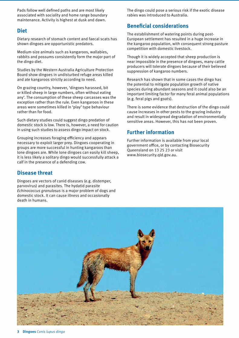
Pads follow well defined paths and are most likely associated with sociality and home range boundary maintenance. Activity is highest at dusk and dawn.
DietDietary research of stomach content and faecal scats has shown dingoes are opportunistic predators.
Medium-size animals such as kangaroos, wallabies, rabbits and possums consistently form the major part of the dingo diet.
Studies by the Western Australia Agriculture Protection Board show dingoes in undisturbed refuge areas killed and ate kangaroos strictly according to need.
On grazing country, however, ‘dingoes harassed, bit or killed sheep in large numbers, often without eating any’. The consumption of these sheep carcasses was the exception rather than the rule. Even kangaroos in these areas were sometimes killed in ‘play’ type behaviour rather than for food.
Such dietary studies could suggest dingo predation of domestic stock is low. There is, however, a need for caution in using such studies to assess dingo impact on stock.
Grouping increases foraging efficiency and appears necessary to exploit larger prey. Dingoes cooperating in groups are more successful in hunting kangaroos than lone dingoes are. While lone dingoes can easily kill sheep, it is less likely a solitary dingo would successfully attack a calf in the presence of a defending cow.
Disease threatDingoes are vectors of canid diseases (e.g. distemper, parvovirus) and parasites. The hydatid parasite Echinococcus granulosus is a major problem of dogs and domestic stock. It can cause illness and occasionally death in humans.
The dingo could pose a serious risk if the exotic disease rabies was introduced to Australia.
Beneficial considerationsThe establishment of watering points during post-European settlement has resulted in a huge increase in the kangaroo population, with consequent strong pasture competition with domestic livestock.
Though it is widely accepted that sheep production is near impossible in the presence of dingoes, many cattle producers will tolerate dingoes because of their believed suppression of kangaroo numbers.
Research has shown that in some cases the dingo has the potential to mitigate population growth of native species during abundant seasons and it could also be an important limiting factor for many feral animal populations (e.g. feral pigs and goats).
There is some evidence that destruction of the dingo could cause increases in other pests to the grazing industry and result in widespread degradation of environmentally sensitive areas. However, this has not been proven.
Further informationFurther information is available from your local government office, or by contacting Biosecurity Queensland on 13 25 23 or visit www.biosecurity.qld.gov.au.
3 Dingoes Canis lupus dingo

This fact sheet is developed with funding support from the Land Protection Fund.
Fact sheets are available from Department of Agriculture and Fisheries (DAF) service centres and our Customer Service Centre (telephone 13 25 23). Check our website at www.biosecurity.qld.gov.au to ensure you have the latest version of this fact sheet. The control methods referred to in this fact sheet should be used in accordance with the restrictions (federal and state legislation, and local government laws) directly or indirectly related to each control method. These restrictions may prevent the use of one or more of the methods referred to, depending on individual circumstances. While every care is taken to ensure the accuracy of this information, DAF does not invite reliance upon it, nor accept responsibility for any loss or damage caused by actions based on it.
© The State of Queensland, Department of Agriculture and Fisheries, 2016. 07/16

Feral cat ecology and control
A descendant of the African wild cat (Felis silvestris lybica), the common ‘house’ cat (Felis catus) has now been domesticated for about 4000 years. Although the domestic cat has a long history of association with humans, it retains a strong hunting instinct and can easily revert to a wild (feral) state when abandoned or having strayed from a domestic situation.
Semi-feral cats live around dump sites, alleys or abandoned buildings, relying on humans by scavenging rubbish scraps and sheltering in abandoned structures. The true feral cat does not rely on humans at all, obtaining its food and shelter from the natural environment.
Legal requirementsThe feral cat is a restricted invasive animal under the Biosecurity Act 2014. This is a cat that is not domesticated. The feral cat must not be moved, fed, given away, sold, or released into the environment without a permit. The Act requires everyone to take all reasonable and practical steps to minimise the risks associated with invasive plants and animals under their control. This is called a general biosecurity obligation (GBO). This fact sheet gives examples of how you can meet your GBO.
Department of Agriculture and Fisheries
Biosecurity Queensland
Feral catFelis catus
Restricted invasive animal

At a local level, each local government must have a biosecurity plan that covers invasive plants and animals in its area. This plan may include actions to be taken on certain species. Some of these actions may be required under local laws. Contact your local government for more information.
DescriptionThe feral cat differs little in appearance from its domestic counterpart; however, when in good condition, the feral cat displays increased overall muscle development, especially noticeable around the head, neck and shoulders, which gives the animal a more robust appearance. The average body weight of male feral cats is 3–6 kg, while females weigh 2–4 kg. Body weights vary with condition, with some extremely large specimens documented.
Australian feral cats are predominantly short-haired, with coat colours that range between ginger, tabby, tortoiseshell, grey and black. White markings may be present on the feet, belly, chest and throat; completely white feral cats are extremely rare. In established populations, coat colours are the result of a natural, genetically selective process. Terrain, predators and the ability to capture prey limit coat colours to those that provide the most suitable camouflage and cause a predominance of these colours in subsequent offspring. Ginger cats are more likely to be found in the semi-arid and desert areas, while grey and black specimens generally predominate in scrub and more heavily timbered habitats.
The feral cat is most active at night, with peak hunting activity occurring soon after sunset and in the early hours before sunrise. At night the cat displays a distinctive green eyeshine under spotlight, making it easily distinguishable from other animals. During the day it will rest in any number of den sites, which may include hollow logs, dense clumps of grass, piles of debris, rabbit burrows, and even the hollow limbs of standing trees.
The most obvious and characteristic field signs of feral cats are their scats (droppings). Unlike the domestic cat, the feral cat does not bury its scats, but leaves them exposed at prominent sites to warn other cats of its territorial boundary.
Life cycle Male cats attain sexual maturity at about 12 months, whereas females are capable of reproduction at approximately seven months. Annually, and under ideal conditions, an adult female can produce up to three litters—each of usually four kittens, but varying from two to seven.
As the breeding instinct is triggered by the increasing length of daylight, litters are less frequent in winter. Most reproduction occurs during the spring and summer months, and is generally limited to two litters per year. Birth follows a gestation period of 65 days, and kittens may be reared in a single den site or may be frequently shifted to other sites within the female’s home range. Family and litter bonding begin to break down when the
Map 1. Distribution of feral cats in Queensland
kittens are approximately seven months old. The female’s ability to bear litters does not decrease with age, so reproduction continues for the course of her life.
Habitat and distributionThere is some evidence to suggest that the cat was present in Australia long before European settlement. This may have occurred as a result of Dutch shipwrecks and regular visits to northern Australia by early South-East Asian vessels as long as 500 years ago.
Post-settlement dispersal resulted from cats straying from areas of early colonisation. In the late 19th and early 20th centuries, large numbers of cats were purposely released in many rural areas to combat plague numbers of rabbits. Unwanted cats continue to be released into urban and rural areas by irresponsible pet owners.
The feral cat is now present Australia-wide, thriving under all climatic extremes and in vastly different types of terrain.
Feral cats maintain stable home ranges, the sizes of which depend upon the relative abundance of food and the availability of suitable den sites. Dominant male cats may have territories of up to 8 km2, while the territories of females are smaller and may even be halved while kittens are being reared.
Scent glands are present on the chin, at the corners of the mouth, and in the anal region. Territorial boundaries are maintained by scent marking with the cheek glands,
2 Feral cat Felis catus

pole-clawing, urinating and leaving exposed faecal deposits.Although feral cats are often thought of as being solitary animals, studies show this behaviour is generally limited to hunting activities. At other times feral cats display a degree of social interaction that peaks during the breeding season. Group behaviour has been observed in semi-feral populations, and it has been suggested that such behaviour is exhibited also in feral populations.
Groups usually comprise several related adult females, their young of both sexes, and an adult male—whose range may include other groups of females. Young females usually remain in a group, while young males either leave or are driven from the group as they reach sexual maturity.
Impacts
Effects on wildlifeThe energy expended by an adult male cat requires it to consume 5–8% of its body weight in prey per day, while females raising kittens require 20%. Based on these figures, one study concluded that 375 feral cats on Macquarie Island would consume 56 000 rabbits and 58 000 sea birds per year. Where present on the mainland, rabbits may comprise up to 40% of a feral cat’s diet. Cats are successful as a control mechanism only when rabbit densities are low. At other times cat predation does little to halt the build-up or spread of rabbit populations; rabbits merely help to support a larger number of cats. When seasonal shortages of rabbits occur there is a corresponding rise in the number of native animals taken by cats.
The feral cat is an opportunistic predator, and dietary studies have shown that small mammals, birds, reptiles, amphibians, insects and even fish can be taken as prey. Cat predation is particularly harmful in island situations, and a number of species have become extinct due to the introduction of cats by early sealers and lighthouse keepers. On the mainland, native animals—which already suffer due to the destruction of their habitats by man and other introduced animals—may be endangered further by cat predation. Actual competition for prey can cause a decline in the numbers of native predatory species such as quolls, eagles, hawks and reptiles. Not only do native animals bear the brunt of predation, but they also suffer the effects of a parasite that reproduces only in the intestine of the cat. This disease (toxoplasmosis) is particularly harmful to marsupials, which may develop blindness, respiratory disorders, paralysis, and suffer the loss of offspring through abortion and stillbirths.
Exotic disease—rabiesDue to their widespread distribution, feral cats may prove to be a major vector for this fatal viral disease if it ever enters Australia. Overseas studies have revealed that wounds inflicted by rabid cats are more dangerous than those caused by rabid dogs. While the bites of rabid dog are generally inflicted on the arms and legs, the cat attacks the head of its victim, biting and clawing viciously. These head and facial bites reduce the time taken for the virus to enter the central nervous system, lessening the chance of success from subsequent remedial treatment.
ControlManaging feral catsThe GBO requires a person to take reasonable and practical steps to minimise the risks posed by feral cats. This fact sheet provides information and some options for controlling cats.
Exclusion fencingFencing is the only feasible method of control when special areas need protection from cats. Feral cats have been successfully prevented from climbing over netted fences that use an electrified wire mounted 15 cm from the top and 10 cm outward from the fence. Non-electrified fencing should incorporate a netted ceiling, or a curved overhang, which prevents the cat from climbing straight up and over the fence.
TrappingRubber-jawed, leg-hold traps (see below) can be laid in the same manner as they are laid for dingoes and foxes. Leg-hold traps can work well with true feral cats, which would normally avoid the live-capture box traps.
Ideal sites are those where territorial markers, such as faecal deposits and pole-clawing, are noticed. Tuna fish oil has shown some success as an attractant; however, feral cats seem more readily attracted to a site by some visual stimulus such as a bunch of bird feathers hung from a bush or stick.
Semi-feral urban cats are easily trapped in wire ‘treadle-type’ box traps (see diagram at right). Attractants/lures may be of meat or fish and should be placed so that they cannot be reached through the wire and be retrieved by clawing.
A number of local governments hire cat traps for the purpose of removing stray and feral cats in urban situations.
Rubber-jawed leg-hold trap
Treadle box trap
3 Feral cat

Lures
Audible recorded lures for feral cats and other predators are available through a number of sources. These recordings mimic the distress call of a small animal and can be used to draw a predator to a bait or trap site.
ShootingNight shooting is assisted by the cat’s distinctive, green eyeshine. Cats have been successfully attracted by the use of a fox whistle.
PoisoningFresh meat baits containing 1080 may be used for controlling feral cats under APVMA PERMIT14015. To obtain a copy of this permit visit www.apvma.gov.au.
Only authorised persons can supply 1080 baits to landholders.
Further informationFurther information is available from your local government office, or by contacting Biosecurity Queensland on 13 25 23 or visit www.biosecurity.qld.gov.au.
This fact sheet is developed with funding support from the Land Protection Fund.
Fact sheets are available from Department of Agriculture and Fisheries (DAF) service centres and our Customer Service Centre (telephone 13 25 23). Check our website at www.biosecurity.qld.gov.au to ensure you have the latest version of this fact sheet. The control methods referred to in this fact sheet should be used in accordance with the restrictions (federal and state legislation, and local government laws) directly or indirectly related to each control method. These restrictions may prevent the use of one or more of the methods referred to, depending on individual circumstances. While every care is taken to ensure the accuracy of this information, DAF does not invite reliance upon it, nor accept responsibility for any loss or damage caused by actions based on it.
© The State of Queensland, Department of Agriculture and Fisheries, 2016. 07/16
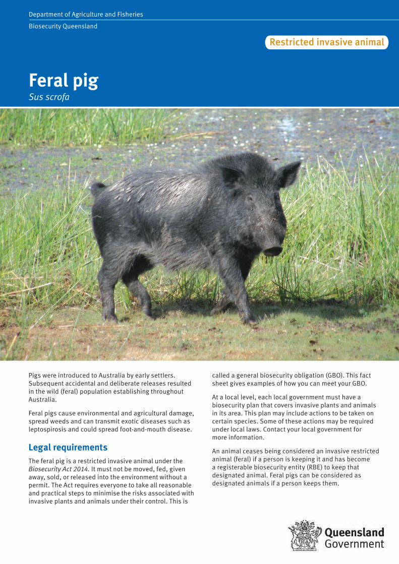
Wild dog controlCanis familiaris
Department of Agriculture, Fisheries and ForestryBiosecurity Queensland
Department of Agriculture and Fisheries
Biosecurity Queensland
Feral pigSus scrofa
Restricted invasive animal
Pigs were introduced to Australia by early settlers. Subsequent accidental and deliberate releases resulted in the wild (feral) population establishing throughout Australia.
Feral pigs cause environmental and agricultural damage, spread weeds and can transmit exotic diseases such as leptospirosis and could spread foot-and-mouth disease.
Legal requirementsThe feral pig is a restricted invasive animal under the Biosecurity Act 2014. It must not be moved, fed, given away, sold, or released into the environment without a permit. The Act requires everyone to take all reasonable and practical steps to minimise the risks associated with invasive plants and animals under their control. This is
called a general biosecurity obligation (GBO). This fact sheet gives examples of how you can meet your GBO.
At a local level, each local government must have a biosecurity plan that covers invasive plants and animals in its area. This plan may include actions to be taken on certain species. Some of these actions may be required under local laws. Contact your local government for more information.
An animal ceases being considered an invasive restricted animal (feral) if a person is keeping it and has become a registerable biosecurity entity (RBE) to keep that designated animal. Feral pigs can be considered as designated animals if a person keeps them.
DescriptionFeral pigs are typically smaller, leaner and more muscular than domestic pigs with well developed shoulders and necks, and smaller, shorter hindquarters.
The body is usually covered in sparse, coarse hair and they have a longer, larger snout, longer tusks, a straighter tail and narrower back than domestic pigs. Feral pigs are mostly black, buff-coloured or spotted black and white.
Growth potential is similar to domestic pigs, although harsh environmental conditions tend to stunt development. Adult female feral pigs usually weigh 60–75 kg, while males usually weigh 90–110 kg. Older boars (razorbacks) can have massive heads and shoulders and a raised and prominent back bone that slopes steeply down to small hams and short hind legs. Some boars develop a crest or mane of stiff bristles extending from their neck down the middle of their back.
Life cycleUnder good seasonal conditions, breeding occurs all year and sows can produce two litters per year. Adult females have a 21−day oestrus cycle, with a gestation period of about 113 days, producing a litter of 4–10 piglets. Sows can make nests of available vegetation just before farrowing. Nests sometimes have a domed roof and are usually less than 2 km from available water. Piglets normally spend the first 1–5 days of life inside the nest, with the sow nearby. Weaning occurs after 2–3 months. Sexual maturity is reached when sows weigh about 25 kg, usually around six months of age.
Mortality of juveniles is high if the mother’s dietary protein intake is low (up to 100% mortality in dry seasons). Adult mortality does not vary as much with seasonal conditions, but few animals live more than five years.
Social behaviourFeral pigs are generally nocturnal, spending daylight hours sheltering in dense cover. Pigs are omnivorous, eating plants and animals and are extremely opportunistic feeders, exploiting any temporarily abundant food.
They prefer green feed and will eat grains, sugarcane and other crops, fruit and vegetables. They root extensively for tubers, worms and soil invertebrates.
Feral pigs have relatively high energy and protein requirements, particularly during pregnancy and lactation and often move to other parts of their home range during pregnancy.
Habitat and distributionFeral pigs are found in all habitat types in Queensland. The greatest concentrations of feral pigs are on the larger drainage basins and swamp areas of the coast and inland. In hot weather, pigs need to remain near water.
Population estimates can be achieved by spotlighting, aerial survey or the use of motion cameras.
Map 1. Distribution of feral pigs in Queensland
Evidence of feral pigs includes fresh digging or rooting of the ground, tracks and faeces on and off pads, mud or hair at holes in fences where pigs have pushed through, wallows, tusk marking and mud rubs on trees and fence posts and nests in vegetation made by sows before farrowing.
Female and juvenile pigs usually live in small family groups with a home range of 2–20 km2. Adult males are typically solitary, with a home range of 8–50 km2. Range size varies with season, habitat, food availability and disturbance. Herds of 400 pigs have been recorded in Cape York.
ImpactsPigs can damage almost all crops from sowing to harvest, starting with uprooting seed and seedlings to feeding on or trampling mature crop.
They feed on seed, sugar cane and grain crops (except safflower), fruit (especially banana, mango, papaw, macadamia and lychee) and vegetable crops. Research has shown feral pigs can take up to 40% of lambs.
Pastures are damaged by grazing and rooting and pigs can also transport weeds. Wallowing pigs damage and foul the water in tanks and bore drains and silt up troughs. They can also damage fences and dam walls.
Pig activity degrades water quality and the habitat for small terrestrial and aquatic animals. It also creates erosion and allows exotic weeds to establish. Predation of native fauna does occur and examination of faeces has shown remains of marsupials, reptiles, insects, and ground-nesting birds and their eggs.
2 Feral pig Sus scrofa

Diseases and parasitesFeral pigs can carry many infectious diseases and internal and external parasites. Some are endemic (already present), while others are exotic to Australia.
Many of the diseases can spread to domestic pigs, other livestock and humans. Feral pigs can transmit sparganosis, melioidosis, leptospirosis, Q fever and brucellosis to humans.
To prevent contracting these diseases it is advisable to either avoid handling feral pigs or use suitable protective clothing (mask, goggles, strong rubber gloves and plastic apron and boots) to minimise contamination with blood, urine and faeces. Rare or undercooked meat should not be eaten; thoroughly cook meat to avoid contracting pathogens. Raw feral pig meat and offal should not be fed to dogs as dogs can be infected with swine brucellosis. Dogs infected with swine brucellosis can also transmit the disease to humans.
ControlManaging feral pigsThe GBO requires a person to take reasonable and practical steps to minimise the risks posed by feral pigs. This fact sheet provides information and some options for controlling feral pigs.
Feral pigs are difficult to control because they are primarily nocturnal, breed rapidly, are generalist omnivores and
have large home ranges and thus control programs need to be conducted over a wide area (often including several properties) to be effective.
Effective control requires an integrated, collaborative approach where all stakeholders participate in planning, implementation and evaluation of the actions taken.
Fencing Though an expensive option, fencing can offer successful pig control especially for high value crops grown on small areas. Research has indicated that the most successful pig-proof fences are also the most expensive.
The most effective pig-proof fences use fabricated sheep mesh held close to the ground by plain or barbed wire and supported on steel posts.
Electrifying a conventional fence greatly improves its effectiveness if used before pigs have established a path through the fence.
Pigs will often charge an electric fence and unless the fence incorporates fabricated netting they often successfully breach the fence.
For crop protection or to avoid lamb predation, pig-proof fences need to be constructed before the pigs become a problem. Once pigs have adjusted to feeding on grain or lambs in a particular paddock fencing may be ineffective.
Feral pig wallow Feral pig rooting
Feral pig damage to river banks Feral pig damage to sugar cane
Feral pig Sus scrofa 3

Trapping
Trapping is an important technique that is most useful in populated areas, on smaller properties (<5000 ha), and where there are low pig numbers. Trapping can be particularly useful in ‘mopping up’ survivors from baiting programs. It is most successful when food resources are limited.
Trigger mechanisms for pig traps can be made pig-specific and therefore pose little danger to wildlife or domestic animals.
Advantages
• This is the safest form of control and can be safely undertaken on closely populated areas.
• It’s flexible and can be incorporated into routine property activities, making economical use of labour and materials.
• Carcasses can be safely disposed. • Traps can be moved and re-used; good trapping makes
use of opportunities as they arise. • Normal pig behaviour is not altered, which allows a
greater number of the total population in an area to be targeted.
• More humane to pigs and non-target species. • The number of animals removed can be easily
monitored.
Disadvantages
• Can be time consuming and expensive to construct and maintain.
• Must be checked regularly. • Not practical for large-scale control. • Some pigs are trap shy.
Tips • Stop all activities that will disturb normal feeding
(i.e. do not undertake any shooting or dogging). • Pre-feeding (i.e. ensure that pigs are visiting trap
and consuming bait) prior to activating traps is an essential part of successful trapping.
• Feeding sites should be placed where feral pigs are active (i.e. water points, holes in fences, areas containing old carcasses on which pigs have been feeding).
• Bait for traps must be food that pigs usually eat in that area. Pigs feeding on one crop (e.g. sugarcane) will often not take to alternative foods. However, new, novel baits are sometimes attractive (e.g. fermented grains).
• The trap can be built around the feeding site, with feeding within the trap undertaken for several nights before it is set.
• Set the trap every night and check each day. If the trap cannot be checked daily then shade and water must be provided.
• Continue to trap until no more pigs are caught. A change of bait can be tried. Again, feed for one or two nights before re-setting the trap.
• Traps may be left permanently in locations used by pigs and can be utilised when fresh signs of pigs appear.
• If the trap is to be moved, start feeding at the new site before re-locating the trap.
Design There are several trap designs but all are principally an enclosed area with one-way gates (see Figure 1).
The main area of the trap can be any shape and be made from materials on the property. The best material is steel mesh with a grid 100 × 100 mm, with a minimum height of at least 1.5 m. Star pickets need to be placed no more than 1.5 m apart and imbedded far enough to ensure that adult pigs cannot push them over or lift them up out of the ground.
Alternative trap entrances Funnel entrance
Formed by the two ends of the mesh forming a funnel, the ends are tied together at the top with wire or rope. The pig moves through the funnel forcing the bottom of the mesh ends apart and once it is in the trap the ends spring back together (see Figures 1 and 2).
Tripped gate entrance
A side-hinged gate is pulled shut by springs and is held open by many systems that can be triggered to allow the gate to swing shut. Often trip wires or other systems are used; most of these systems are not selective for feral pigs and can be triggered by any animal attracted to the bait. Once triggered the trap is no longer effective in trapping pigs.
Pig-specific trigger
By far the simplest and most effective trigger system has the gate held open by a bar (often a branch or piece of wood) which is hooked over the wire on the gate and on the side panel (see Figure 3). For a close up of the pig specific trigger (see Figure 4).
Pigs rooting for feed in the trap lift the bar allowing the gate to swing shut. The specific feeding habit of pigs insures they are the only animals that lift the trigger bar.
The gate may be latched to prevent pigs from opening the door once triggered. However, this will prevent more pigs pushing their way in to join those inside.
Shooting Shooting pigs by helicopter is effective in areas where pigs exist in reasonable numbers and are observable from the air.
Ground shooting is not effective in reducing the pig population unless intense shooting is undertaken on a small, isolated and accessible population of pigs.
Feral pig Sus scrofa 4

Figure 1. Alternative trap entrances – funnel entrance
Figure 2. Silo trap with funnel entrance (14 m of silo mesh diameter about 4.5 m
Figure 3. Pig-specific trigger
Figure 4. Close up of pig-specific trigger
Feral pig trap
Trapped feral pigs
Hog hopper – pig specific bait station
Feral pig Sus scrofa 5

Poisoning Poisoning is the most effective control method available that can quickly reduce a pig population.
Sodium fluoroacetate (1080) can only be supplied by people approved under the Health (Drugs & Poisons) Regulation 1996 for the purpose of controlling declared pest animals. Your local government office should be able to assist you.
Pre-feeding is the most important step in ground-based poisoning operations. Free feeding with non-poisoned bait should be performed for several days prior to laying poisoned baits.
By selecting bait wisely, landholders can be species-selective in their poisoning program and avoid many of the unintentional effects of secondary poisoning.
Bait material such as fermented grains are very attractive to pigs. It is a good idea to establish a free feeding routine so that pigs are the only animals feeding, which helps to keep other non-targets away from the feeding site.
Other options (like pig-specific feeders) are now commercially available, and can assist in reducing non-target species access to bait. Other options include burying baits; feral pigs are one of the few animals that will dig up bait.
Aerial poisoning is also available and typically used for broadscale control in western and northern regional areas. Bait is distributed from an aircraft. This is particularly useful for covering large, remote, areas or restricted ground access. Aerial poisoning is a proven and cost-effective method for reducing pig populations.
A phosphorous-based poison is also available for use in Queensland.
Further informationFurther information is available from your local government office, or by contacting Biosecurity Queensland on 13 25 23 or visit www.biosecurity.qld.gov.au.
Biosecurity Queensland gratefully acknowledges the contribution from Choquenot, D., McIlroy, J. and Korn T. (1996) Managing Vertebrate Pests: Feral Pigs, Bureau of Resource Sciences, AGPS, Canberra. Commonwealth of Australia copyright reproduced by permission.
Feral pig exclusion fencing
This fact sheet is developed with funding support from the Land Protection Fund.
Fact sheets are available from Department of Agriculture and Fisheries (DAF) service centres and our Customer Service Centre (telephone 13 25 23). Check our website at www.biosecurity.qld.gov.au to ensure you have the latest version of this fact sheet. The control methods referred to in this fact sheet should be used in accordance with the restrictions (federal and state legislation, and local government laws) directly or indirectly related to each control method. These restrictions may prevent the use of one or more of the methods referred to, depending on individual circumstances. While every care is taken to ensure the accuracy of this information, DAF does not invite reliance upon it, nor accept responsibility for any loss or damage caused by actions based on it.
© The State of Queensland, Department of Agriculture and Fisheries, 2016. 10/16

The rabbit and its controlOryctolagus cuniculus
Rabbits are one of Australia’s major agricultural and environmental animal pests, costing the country between $600 million and $1 billion annually. They compete with native animals, destroy the landscape and are a primary cause of soil erosion by preventing regeneration of native vegetation.
Legal requirements The rabbit is a restricted invasive animal under the Biosecurity Act 2014. It must not be moved, kept, fed, given away, sold, or released into the environment without
a permit. The Act requires everyone to take all reasonable and practical steps to minimise the risks associated with invasive plants and animals under their control. This is called a general biosecurity obligation (GBO). This fact sheet gives examples of how you can meet your GBO.
At a local level, each local government must have a biosecurity plan that covers invasive plants and animals in its area. This plan may include actions to be taken on certain species. Some of these actions may be required under local laws. Contact your local government for more information.
Wild dog controlCanis familiaris
Department of Agriculture, Fisheries and ForestryBiosecurity Queensland
Rabbit Oryctolagus cuniculus
Restricted invasive animal

Pet rabbitsIntroducing and selling rabbits in Queensland is not permitted (penalties apply). Limited numbers of permits for domestic rabbits are only available from Biosecurity Queensland for research purposes, public display, magic acts or circuses. Before a permit is granted, a number of guidelines need to be fulfilled.
DescriptionRabbits are small mammals around 34–45 cm in length usually grey brown with pale belly fur, other colours include piebald, black and ginger. They have long ears
10 cm long and big eyes. They have long hind legs with hind feet measuring 9–11 cm and shor t front legs. The tail is fluffy brown with white underneath, 4–8 cm. Adult rabbits usually weigh around 1–2.1 kg. The male is called a buck, the female a doe and her young are called kittens.
Life cycleDoes (females) are pregnant for 28−30 days, but are able to mate within hours of giving birth. The average litter is 3−4 kittens but varies from two in a young doe, up to eight or more in a mature doe, and depends on the amount and quality of food available.
Five to six litters are possible in a good season. Young does can breed at four months of age if conditions are suitable.
Habitat and distributionRabbits prefer to live in warrens as protection against predators and extremes in temperature. However, they will sur vive in above-ground harbours such as logs, windrows and dense thickets of scrub (e.g. blackberr y and lantana) or under built harbour, old sheds and machiner y etc.
In newly colonised areas without warrens, rabbits tend to live in ‘scrapes’ (or ‘squats’)
Rabbits are adaptable and sometimes live in close association with people. They live in built environments such as:
• in and under buildings• old machinery and storage containers • in old dumps.
In rural environments rabbits frequently live in:
• felled timber and associated windrows• tussock grasses and rocky areas• warrens (if soils are easy to dig).
Control Managing rabbits The GBO requires a person to take reasonable and practical steps to minimise the risks posed by rabbits. This factsheet information and some options for controlling rabbits.
Map 1. Distribution of rabbits in Queensland
Effective rabbit control cycle
Rabbit control is best done as a joint exercise involving all land managers in the district. Integrated control methods, such as fumigating, ripping warrens and harbour destruction, are essential for the continued long-term reduction of rabbit numbers. Cost-effective, long-term results can be achieved in rabbit control by following a combination of the methods outlined below.
2 Rabbit Oryctolagus cuniculus

Prevention and early detectionRabbits will generally eat around 15% of their body weight per day—approximately 250 g. This compares dramatically with the averages for stock—sheep and cattle eat around 3% of their body weight per day. So even a low number of rabbits can be removing large amounts of livestock feed.
For effective long-term rabbit control, concentrate on destroying source areas. Source areas will all have well-established warrens or ready-made structures that are cool and provide protection from predators. A source area must also have a good supply of green feed during the cooler seasons.
Direction of first rip lines
Cross rip
Burrowentrance
Warren
Underground tunnel
Apparent edgeof warren
Burrow entrance
Areas which needto be ripped
Manual controlHarbour destructionWhere there is abundant surface harbour, a high proportion of rabbits may live above ground rather than in underground warrens. Rabbits can make their homes in windrows, dense thickets of shrubs (such as blackberries and lantana) and even in old machinery.
To eliminate these above-ground breeding areas, it may be necessary to:
• burn windrows and log piles• remove noxious weeds through chemical and physical
control• remove movable objects (such as old machinery) from
paddocks.
Sometimes removing harbour can expose warrens underneath. If this happens, the warrens need to be ripped.
Mechanical controlWarren rippingIn areas where rabbits live in warrens, ripping is the most effective method of long-term control. Ripping is so successful because warrens can rarely be reopened and rabbits are unable to recolonise these areas.
Direction to rip warrens (illustration courtesy Will Dobbie)
Tyne for ripping warrens (photo courtesy Mark Ridge)
To get the best results it is important to chase as many of the rabbits inside the warren as possible. Dogs can be used to drive rabbits into the warren before ripping starts.
The aim of ripping is to completely destroy the warren. It involves using a tractor with a tyned (sharp-pronged) implement—one tyne or many—that rips through the warren and collapses it. Larger tractors and dozers are more appropriate for properties with many warrens as they are able to move faster and rip wider.
Extent to rip warrens (illustration courtesy Will Dobbie)
Obviously, ripping is not suitable for warrens located underneath buildings or on steep rocky country. In such cases, other methods (poison baiting, releasing virus or fumigating burrows) should instead be used to reduce rabbit numbers. Warrens should then be either filled in or covered to stop rabbits from re-establishing. Burrows can be blocked with small boulders or rocks.
Rock blocking rabbit hole
3 Rabbit Oryctolagus cuniculus

Exclusion fencingRabbit exclusion fences are built with the aim of keeping rabbits out of a particular area. It is appropriate for small, high-value areas that require protection. A fully fenced area will only remain rabbit-free in the long term if all rabbits are removed from the enclosed area after fencing and the fence is regularly maintained and checked for holes.
4 Rabbit Oryctolagus cuniculus
Electric fencing is a cheaper alternative, but it is not a complete physical barrier and is also prone to damage from other pest animals and stock.
Exclusion fence for rabbits (illustration courtesy DEWHA)
A rabbit-proof fence should be made of wire mesh netting (40 mm or smaller) and needs to be at least 900 mm high. The netting should also be buried to depth of at least 150 mm. Gates into the fenced area need to be rabbit-proof as well.
TrappingTrapping is an extremely labour-intensive control method and requires a skilled operator to set the traps to successfully capture rabbits.
If you do plan to trap rabbits on your property, common sense and respect for animal welfare are essential. While there are currently no strict guidelines for the use of traps in Queensland, it is an area of growing concern for animal welfare advocates.
Cage trap A cage trap has a lever that closes the cage when a rabbit steps on it. The rabbits are lured into the cage with bait—usually diced carrot. Traps need to be disabled and left open for two or three nights with bait leading into the cage. This entices rabbits to enter. A trap can be set once a rabbit has consumed a trail of bait all the way into that trap. Traps should be checked and emptied regularly—usually a couple of times a night.
This effective and humane technique is most useful for removing any remaining rabbits from places like hay sheds and after the shed has been fenced to prevent additional rabbits from entering and leaving. Free-feed then trap, and keep the shed rabbit-proof to prevent rabbits recolonising.
Barrel trap A barrel trap is designed specifically for rabbits. It is cylindrical, made of light mesh, and is about 1 m long and 15 cm in diameter. The trap has one open end with two
hinged trap doors along its side. The open end is placed in the burrow, and the hinged gates close and trap the rabbit after it enters from the burrow.
The trap can be left in the burrow entrance for a number of days. However, it must be checked at least daily so that if a rabbit has been caught it does not suffer and animal welfare responsibilities are met.
Barrel rabbit trap in hole
Biological controls Rabbit hemorrhagic disease virus (also known as rabbit calicivirus disease)RHDV is a virus specific to rabbits which works by infecting the lining of the throat, lungs, gut and liver.
RHDV relies primarily on direct rabbit-to-rabbit contact in order to spread. High rabbit numbers are therefore needed before this control method will be effective.
After RHDV has infected an area, it is important to use another method for follow-up control to increase the likelihood that the population is eradicated before it is able to develop resistance and increase its numbers again.
Resistance to RHDV depends primarily on the age of the rabbit. Therefore, it is better for RHDV to go through a rabbit population after rabbits have bred and the young are old enough to be affected by the virus. Rabbits that survive RHDV develop antibodies against the virus. Breeding females can also pass these antibodies on to the young (through antibodies in their milk), conferring temporary protection on rabbits up to 12 weeks old.
MyxomatosisMyxomatosis is no longer produced as a laboratory strain but field strains are still known to recur and affect rabbit populations.
RHDV1-K5Recent research by state and federal agencies has identified a new strain of RHDV (called RHDV-K5) that will aid in controlling rabbits that have immunity to current strains.
ShootingShooting is most useful when used to ‘mop up’ after other control methods (such as ripping). To get the best results, shoot at the time of day when rabbits are active. This is usually in the early morning, late afternoon or at night. The best and most economical firearm to use is a .22 calibre rifle.

If your property is within an urban area, you will need to comply with local government regulations and the Police Powers and Responsibilities Act 2000, which restrict the use of firearms.
Poison baitingBaiting is not effective as a sole control method and will not eradicate an entire rabbit population. Numbers will quickly increase again, and you will have to continue baiting year after year with no permanent overall change
in the rabbit population.
Rabbits can also become ‘bait shy’ and this method becomes less and less effective over time. Ideally, baiting is best used either before ripping/fumigation to reduce a population, or after ripping/fumigation as a ‘mop-up’.
Baiting works best when rabbits are not breeding. During breeding season the majority of the population feeds over a larger-than-normal area, and it is the young rabbits that are most likely to take baits. While numbers will be reduced, animals of breeding age are not likely to be affected.
Free-feed and poison feedtrail located throughoutfeeding area
Bait trail
Burrows20–30 m
Rabbit feeding area
1080—sodium fluouroacetatePre-feeding is required when using 1080 because rabbits will not readily take new feed. The poison-free bait should be laid at least three times over a one-week period before the poisoned bait is laid. (1080-impregnated carrot baits are the most common form of bait used.) The practice helps to ensure that, when the poisoned bait is laid, it will be eaten by most of the rabbit population.
1080 can only be supplied through persons authorised under the Health Act. Your local Biosecurity officer or your local government office should be able to assist you.
PindonePindone is an anticoagulant registered for rabbit control. This poison works by preventing blood from clotting. In Queensland, it is not recommended for broadacre use and is mainly used in urban areas and near farm buildings.
Pindone works best when given as a series of small doses/feeds over a period of three days. Although pre-feeding is not essential, it does enhance the bait uptake by shy rabbits as they get used to the feed prior to any poison bait being laid. To be effective, pindone requires multiple feeds so that the poison can build up to fatal levels in the rabbit’s body. Feeding over a number of nights provides plenty of opportunity for most of the rabbit population to consume the required lethal dose. Rabbits poisoned with pindone will usually die within 10–20 days.
Pindone baiting does not work well when there is a lot of green pick around for rabbits.
Poison bait trailsIt is important that bait trails are laid properly to ensure the best results. ‘Baitlayers’ make it easier to put out bait trails at the correct rate, and they can be towed behind most 4WD vehicles, quad bikes and tractors.
When scratching and laying a trail, consider the following:
• Rabbits like freshly scratched/disturbed soil—this may be because rabbits are territorial and inspect newly disturbed soil, and/or the disturbed vegetation smell attracts them.
• Lay trails around warrens and in the areas where rabbits most often feed.
• Laying trails on slopes and hills requires care—it can cause erosion in some soils types (e.g. granite and traprock). Trails are best laid in a zigzag pattern in steep terrain to minimise erosion.
• A trail that has been scratched for the first feed is easy to follow for the rest of the baiting program.
• The soil should be turned only enough to scratch the surface—don’t plough the ground.
• A trail that has been scratched too deep will spook the rabbits because they will not have full sight of their predators.
• Where vegetation is thick, or it is difficult to find the main feeding areas, lay bait trails in a grid pattern across the site.
As a general rule, avoid crossing the bait trail—it can cause confusion when you try to follow the same trail on subsequent occasions.
Method for laying a bait trail (illustration courtesy Animal Control Technologies)
Bait trials will be most effective if you follow these guidelines:
• Use good quality, non-contaminated bait material. (Simple rule: if you wouldn’t eat it, the rabbit won’t either.)
• Use enough feed to bait all the rabbits in the area. (The pre-feed will give an indication of the potential bait take.)
• Expect a greater uptake of pre-feed and bait material when vegetation is scarce, dried off or soured.
• Ensure that all the preparation equipment is clean and free of any chemical residues or smells—rabbits can be very shy of unusual odours.
• When there are kittens in a warren, lay the bait trail close to the warrens.
FumigationFumigation is labour intensive and time consuming, and is not usually an effective method if used alone. However, as a ‘mop-up’ technique or control method for use in areas
5 Rabbit Oryctolagus cuniculus

where ripping is not practical (e.g. steep and rocky terrain), it may be a good alternative.
Because this technique relies on directly affecting the rabbits, and does not affect the structure of the warren, it is crucial that as many rabbits as possible are underground when fumigation is carried out. Rabbits usually take refuge in their burrows from mid-morning to
mid-afternoon and during hot weather so these are the best times to fumigate. Dogs can also be used to drive rabbits into their warrens.
For best results, fumigation should be carried out in two stages—initially, before the breeding season starts (as this reduces the breeding stock), and then again during the breeding season.
There are two types of warren fumigation—static and pressure. In Queensland, static fumigants are a more popular and safer option for controlling rabbits and will be explained below.
Static fumigationThis method is easy to use, and time- and cost-effective. Static fumigation comes in the form of aluminium phosphide (phosphine) tablets, which can be purchased from most agricultural suppliers. These tablets are small and round (about the size of a marble), and weigh 3 g. Trade names for phosphine include Pestex®, Quickphos® and Gastion®. General directions for the use of phosphine tablets appear below, but always refer to the manufacturer’s specific recommendations for use.
To fumigate warrens using phosphine tablets:
1. Find all warren entrances—both active and inactive.2. Cut back the warren entrance at right angles using a
shovel.3. Separately wrap two tablets in moistened absorbent
paper (toilet paper/paper towels). 4. Insert the tablets as far down into the entrance as
possible (polypipe and a push rod can be used to help push the tablets down).
5. Push some scrunched-up newspaper down the hole to block the entrance and then cover it up with soil and, if possible, a rock.
6. Treat all entrances to the warren (active and inactive) the same way.
7. Check warrens about a week after fumigation and re-fumigate any reopened entrances.
Once in the warren, the moistened tablets react with air to release a toxic gas, which spreads quickly throughout the warren. The phosphine gas itself is invisible and odourless but leakages from the warren can be detected by the smell of ammonia. (This is a safety mechanism that is built into the tablet.) Any leakages need to be blocked immediately.
Shooting
Shooting is most useful when used to ‘mop up’ after other control methods (such as ripping). To get the best results, shoot at the time of day when rabbits are active. This is usually in the early morning, late afternoon or at night. The best and most economical firearm to use is a .22 calibre rifle.
If your property is within an urban area, you will need to comply with local government regulations and the Police Powers and Responsibilities Act 2000, which restrict the use of firearms.
Further informationFor further detailed reading information on specific rabbit control techniques or costing your rabbit control please refer to Rabbit control in Queensland; a guide for land managers. Download from the Biosecurity Queensland website at www.biosecurity.qld.gov.au
Further information is available from your local government office, or by contacting Biosecurity Queensland on 13 25 23 or visit www.biosecurity.qld.gov.au.
This fact sheet is developed with funding support from the Land Protection Fund.
Fact sheets are available from Department of Agriculture and Fisheries (DAF) service centres and our Customer Service Centre (telephone 13 25 23). Check our website at www.biosecurity.qld.gov.au to ensure you have the latest version of this fact sheet. The control methods referred to in this fact sheet should be used in accordance with the restrictions (federal and state legislation, and local government laws) directly or indirectly related to each control method. These restrictions may prevent the use of one or more of the methods referred to, depending on individual circumstances. While every care is taken to ensure the accuracy of this information, DAF does not invite reliance upon it, nor accept responsibility for any loss or damage caused by actions based on it.
© The State of Queensland, Department of Agriculture and Fisheries, 2016. 07/16
Wild rabbit Escaped or dumped pet rabbits