Hybrid Satellite-Terrestrial Communication Networks ... - arXiv
27
arXiv:1903.11814v2 [cs.NI] 21 Jan 2021 1 Hybrid Satellite-Terrestrial Communication Networks for the Maritime Internet of Things: Key Technologies, Opportunities, and Challenges Te Wei, Wei Feng, Senior Member, IEEE, Yunfei Chen, Senior Member, IEEE, Cheng-Xiang Wang, Fellow, IEEE, Ning Ge, Member, IEEE, and Jianhua Lu, Fellow, IEEE Abstract—With the rapid development of marine activities, there has been an increasing number of Internet of Things (IoT) devices on the ocean. This leads to a growing demand for high- speed and ultra-reliable maritime communications. It has been reported that a large performance loss is often inevitable if the existing fourth-generation (4G), fifth-generation (5G) or satellite communication technologies are used directly on the ocean. Hence, conventional theories and methods need to be tailored to this maritime scenario to match its unique characteristics, such as dynamic electromagnetic propagation environments, geometri- cally limited available base station (BS) sites and rigorous service demands from mission-critical applications. Towards this end, we provide a survey on the demand for maritime communications enabled by state-of-the-art hybrid satellite-terrestrial maritime communication networks (MCNs). We categorize the enabling technologies into three types based on their aims: enhancing transmission efficiency, extending network coverage, and pro- visioning maritime-specific services. Future developments and open issues are also discussed. Based on this discussion, we envision the use of external auxiliary information, such as sea state and atmosphere conditions, to build up an environment- aware, service-driven, and integrated satellite-air-ground MCN. Index Terms—Maritime communication network, maritime channel, maritime service, satellite-air-ground integration, knowl- edge library. This work was supported in part by the National Natural Science Foun- dation of China (Grant No. 61922049, 61771286, 61941104, 61960206006, 61701457, 91638205), the National Key R&D Program of China under Grant 2018YFA0701601, the Frontiers Science Center for Mobile Information Communication and Security, the High Level Innovation and Entrepreneurial Research Team Program in Jiangsu, the High Level Innovation and En- trepreneurial Talent Introduction Program in Jiangsu, the Research Fund of National Mobile Communications Research Laboratory, Southeast University, under Grant 2020B01, the Fundamental Research Funds for the Central Universities under Grant 2242020R30001, the Huawei Cooperation Project, the EU H2020 RISE TESTBED2 project under Grant 872172, the Nantong Technology Program under Grant JC2019115, and the Beijing Innovation Center for Future Chip. T. Wei, W. Feng (corresponding author), N. Ge, and J. Lu are with the Beijing National Research Center for Information Science and Technology, Department of Electronic Engineering, Tsinghua Uni- versity, Beijing 100084, China. T. Wei is also with the Department of WLAN Development, Huawei Beijing Research Center, Beijing 100085, China (e-mail: [email protected]; [email protected]; gen- [email protected]; [email protected]). Y. Chen is with the School of Engineering, University of Warwick, Coventry CV4 7AL, U.K. (e-mail: [email protected]). C.-X. Wang is with the National Mobile Communications Research Labo- ratory, School of Information Science and Engineering, Southeast University, Nanjing, 210096, China, and also with the Purple Mountain Laboratories, Nanjing 211111, China (e-mail: [email protected]). I. I NTRODUCTION Maritime activities, such as marine tourism, offshore aqua- culture, and oceanic mineral exploration, have seen rapid development in recent years. With the increasing number of vessels, offshore platforms, buoys, etc., there has been a growing demand for high-speed and ultra-reliable maritime communications to connect them [1]–[3]. For example, navi- gational information and operational data are required for the safe navigation of all vessels, and multi-media communica- tion services are needed for passengers, crew, and fishermen onboard. Similarly, offshore drilling platforms require real- time operational data communications, and buoys also have a large amount of meteorological and hydrological data to upload [4]–[6]. For maritime rescue, in addition to information exchange using texts and voices, real-time videos are often required for better ship-to-ship and ship-to-shore coordination [7]. Therefore, building a broadband maritime communication network (MCN) for the maritime Internet of Things (IoT) is of great significance for marine transportation [8][9], production safety [10] and emergency rescue [11]. Currently, mobile terminals on the ocean mainly rely on maritime satellites or base stations (BSs) on the coast/island to acquire services. Narrow-band satellites, represented by International Maritime Satellites (Inmarsat), mainly provide services such as telephone, telegraph, and fax, at a low communication rate. For example, the annual throughput of Inmarsat was only 66 Gbps in 2016, while the number of ships has exceeded 2 million. Thus, the average commu- nication rate per ship is less than 33 kbps [12]. To meet the demand for broadband satellite communication services, several companies have launched high-throughput satellites, such as EchoStar-19 (also known as Jupiter-2) by EchoStar and the Starlink project by SpaceX. In addition to maritime satellites, shore & island-based BSs are also used to extend the coverage of terrestrial fourth-generation (4G)/fifth-generation (5G) networks for maritime activities [13]. The existing shore- based communication systems, such as the Navigation Telex (NAVTEX) system and the Automatic Identification System (AIS), mainly provide services for information broadcasting, voice, and ship identification, but they cannot provide high- speed data services [14]. To improve the communication rate, several companies, such as Huawei and Ericsson, have carried out long-distance shore-to-ship transmission tests based on Worldwide Interoperability for Microwave Access (WiMAX)
-
Upload
khangminh22 -
Category
Documents
-
view
0 -
download
0
Transcript of Hybrid Satellite-Terrestrial Communication Networks ... - arXiv
arX
iv:1
903.
1181
4v2
[cs
.NI]
21
Jan
2021
1
Hybrid Satellite-Terrestrial CommunicationNetworks for the Maritime Internet of Things:
Key Technologies, Opportunities, and ChallengesTe Wei, Wei Feng, Senior Member, IEEE, Yunfei Chen, Senior Member, IEEE,
Cheng-Xiang Wang, Fellow, IEEE, Ning Ge, Member, IEEE, and Jianhua Lu, Fellow, IEEE
Abstract—With the rapid development of marine activities,there has been an increasing number of Internet of Things (IoT)devices on the ocean. This leads to a growing demand for high-speed and ultra-reliable maritime communications. It has beenreported that a large performance loss is often inevitable if theexisting fourth-generation (4G), fifth-generation (5G) or satellitecommunication technologies are used directly on the ocean.Hence, conventional theories and methods need to be tailored tothis maritime scenario to match its unique characteristics, suchas dynamic electromagnetic propagation environments, geometri-cally limited available base station (BS) sites and rigorous servicedemands from mission-critical applications. Towards this end, weprovide a survey on the demand for maritime communicationsenabled by state-of-the-art hybrid satellite-terrestrial maritimecommunication networks (MCNs). We categorize the enablingtechnologies into three types based on their aims: enhancingtransmission efficiency, extending network coverage, and pro-visioning maritime-specific services. Future developments andopen issues are also discussed. Based on this discussion, weenvision the use of external auxiliary information, such as seastate and atmosphere conditions, to build up an environment-aware, service-driven, and integrated satellite-air-ground MCN.
Index Terms—Maritime communication network, maritimechannel, maritime service, satellite-air-ground integration, knowl-edge library.
This work was supported in part by the National Natural Science Foun-dation of China (Grant No. 61922049, 61771286, 61941104, 61960206006,61701457, 91638205), the National Key R&D Program of China underGrant 2018YFA0701601, the Frontiers Science Center for Mobile InformationCommunication and Security, the High Level Innovation and EntrepreneurialResearch Team Program in Jiangsu, the High Level Innovation and En-trepreneurial Talent Introduction Program in Jiangsu, the Research Fund ofNational Mobile Communications Research Laboratory, Southeast University,under Grant 2020B01, the Fundamental Research Funds for the CentralUniversities under Grant 2242020R30001, the Huawei Cooperation Project,the EU H2020 RISE TESTBED2 project under Grant 872172, the NantongTechnology Program under Grant JC2019115, and the Beijing InnovationCenter for Future Chip.
T. Wei, W. Feng (corresponding author), N. Ge, and J. Lu arewith the Beijing National Research Center for Information Scienceand Technology, Department of Electronic Engineering, Tsinghua Uni-versity, Beijing 100084, China. T. Wei is also with the Department ofWLAN Development, Huawei Beijing Research Center, Beijing 100085,China (e-mail: [email protected]; [email protected]; [email protected]; [email protected]).
Y. Chen is with the School of Engineering, University of Warwick, CoventryCV4 7AL, U.K. (e-mail: [email protected]).
C.-X. Wang is with the National Mobile Communications Research Labo-ratory, School of Information Science and Engineering, Southeast University,Nanjing, 210096, China, and also with the Purple Mountain Laboratories,Nanjing 211111, China (e-mail: [email protected]).
I. INTRODUCTION
Maritime activities, such as marine tourism, offshore aqua-
culture, and oceanic mineral exploration, have seen rapid
development in recent years. With the increasing number
of vessels, offshore platforms, buoys, etc., there has been a
growing demand for high-speed and ultra-reliable maritime
communications to connect them [1]–[3]. For example, navi-
gational information and operational data are required for the
safe navigation of all vessels, and multi-media communica-
tion services are needed for passengers, crew, and fishermen
onboard. Similarly, offshore drilling platforms require real-
time operational data communications, and buoys also have
a large amount of meteorological and hydrological data to
upload [4]–[6]. For maritime rescue, in addition to information
exchange using texts and voices, real-time videos are often
required for better ship-to-ship and ship-to-shore coordination
[7]. Therefore, building a broadband maritime communication
network (MCN) for the maritime Internet of Things (IoT) is of
great significance for marine transportation [8][9], production
safety [10] and emergency rescue [11].
Currently, mobile terminals on the ocean mainly rely on
maritime satellites or base stations (BSs) on the coast/island
to acquire services. Narrow-band satellites, represented by
International Maritime Satellites (Inmarsat), mainly provide
services such as telephone, telegraph, and fax, at a low
communication rate. For example, the annual throughput of
Inmarsat was only 66 Gbps in 2016, while the number of
ships has exceeded 2 million. Thus, the average commu-
nication rate per ship is less than 33 kbps [12]. To meet
the demand for broadband satellite communication services,
several companies have launched high-throughput satellites,
such as EchoStar-19 (also known as Jupiter-2) by EchoStar
and the Starlink project by SpaceX. In addition to maritime
satellites, shore & island-based BSs are also used to extend the
coverage of terrestrial fourth-generation (4G)/fifth-generation
(5G) networks for maritime activities [13]. The existing shore-
based communication systems, such as the Navigation Telex
(NAVTEX) system and the Automatic Identification System
(AIS), mainly provide services for information broadcasting,
voice, and ship identification, but they cannot provide high-
speed data services [14]. To improve the communication rate,
several companies, such as Huawei and Ericsson, have carried
out long-distance shore-to-ship transmission tests based on
Worldwide Interoperability for Microwave Access (WiMAX)
2
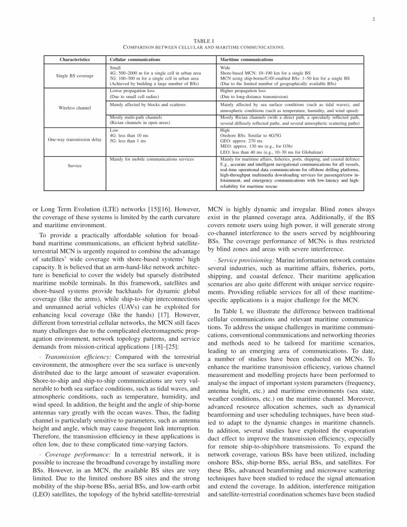
TABLE ICOMPARISON BETWEEN CELLULAR AND MARITIME COMMUNICATIONS.
Characteristics Cellular communications Maritime communications
Single BS coverage
Small Wide4G: 500–2000 m for a single cell in urban area Shore-based MCN: 10–100 km for a single BS5G: 100–300 m for a single cell in urban area MCN using ship-borne/UAV-enabled BSs: 1–50 km for a single BS(Achieved by building a large number of BSs) (Due to the limited number of geographically available BSs)
Wireless channel
Lower propagation loss
(Due to small cell radius)
Higher propagation loss
(Due to long-distance transmission)
Mainly affected by blocks and scatteres Mainly affected by sea surface conditions (such as tidal waves), and
atmospheric conditions (such as temperature, humidity, and wind speed)
Mostly multi-path channels(Rician channels in open areas)
Mostly Rician channels (with a direct path, a specularly reflected path,
several diffusely reflected paths, and several atmospheric scattering paths)
One-way transmission delay
Low4G: less than 10 ms5G: less than 1 ms
HighOnshore BSs: Similar to 4G/5GGEO: approx. 270 msMEO: approx. 130 ms (e.g., for O3b)
LEO: less than 40 ms (e.g., 10–30 ms for Globalstar)
Service
Mainly for mobile communications services Mainly for maritime affairs, fisheries, ports, shipping, and coastal defenceE.g., accurate and intelligent navigational communications for all vessels,real-time operational data communications for offshore drilling platforms,high-throughput multimedia downloading services for passenger/crew in-fotainment, and emergency communications with low-latency and high-
reliability for maritime rescue
or Long Term Evolution (LTE) networks [15][16]. However,
the coverage of these systems is limited by the earth curvature
and maritime environment.
To provide a practically affordable solution for broad-
band maritime communications, an efficient hybrid satellite-
terrestrial MCN is urgently required to combine the advantage
of satellites’ wide coverage with shore-based systems’ high
capacity. It is believed that an arm-hand-like network architec-
ture is beneficial to cover the widely but sparsely distributed
maritime mobile terminals. In this framework, satellites and
shore-based systems provide backhauls for dynamic global
coverage (like the arms), while ship-to-ship interconnections
and unmanned aerial vehicles (UAVs) can be exploited for
enhancing local coverage (like the hands) [17]. However,
different from terrestrial cellular networks, the MCN still faces
many challenges due to the complicated electromagnetic prop-
agation environment, network topology patterns, and service
demands from mission-critical applications [18]–[25]:
· Transmission efficiency: Compared with the terrestrial
environment, the atmosphere over the sea surface is unevenly
distributed due to the large amount of seawater evaporation.
Shore-to-ship and ship-to-ship communications are very vul-
nerable to both sea surface conditions, such as tidal waves, and
atmospheric conditions, such as temperature, humidity, and
wind speed. In addition, the height and the angle of ship-borne
antennas vary greatly with the ocean waves. Thus, the fading
channel is particularly sensitive to parameters, such as antenna
height and angle, which may cause frequent link interruption.
Therefore, the transmission efficiency in these applications is
often low, due to these complicated time-varying factors.
· Coverage performance: In a terrestrial network, it is
possible to increase the broadband coverage by installing more
BSs. However, in an MCN, the available BS sites are very
limited. Due to the limited onshore BS sites and the strong
mobility of the ship-borne BSs, aerial BSs, and low-earth orbit
(LEO) satellites, the topology of the hybrid satellite-terrestrial
MCN is highly dynamic and irregular. Blind zones always
exist in the planned coverage area. Additionally, if the BS
covers remote users using high power, it will generate strong
co-channel interference to the users served by neighbouring
BSs. The coverage performance of MCNs is thus restricted
by blind zones and areas with severe interference.
· Service provisioning: Marine information network contains
several industries, such as maritime affairs, fisheries, ports,
shipping, and coastal defence. Their maritime application
scenarios are also quite different with unique service require-
ments. Providing reliable services for all of these maritime-
specific applications is a major challenge for the MCN.
In Table I, we illustrate the difference between traditional
cellular communications and relevant maritime communica-
tions. To address the unique challenges in maritime communi-
cations, conventional communications and networking theories
and methods need to be tailored for maritime scenarios,
leading to an emerging area of communications. To date,
a number of studies have been conducted on MCNs. To
enhance the maritime transmission efficiency, various channel
measurement and modelling projects have been performed to
analyse the impact of important system parameters (frequency,
antenna height, etc.) and maritime environments (sea state,
weather conditions, etc.) on the maritime channel. Moreover,
advanced resource allocation schemes, such as dynamical
beamforming and user scheduling techniques, have been stud-
ied to adapt to the dynamic changes in maritime channels.
In addition, several studies have exploited the evaporation
duct effect to improve the transmission efficiency, especially
for remote ship-to-ship/shore transmissions. To expand the
network coverage, various BSs have been utilized, including
onshore BSs, ship-borne BSs, aerial BSs, and satellites. For
these BSs, advanced beamforming and microwave scattering
techniques have been studied to reduce the signal attenuation
and extend the coverage. In addition, interference mitigation
and satellite-terrestrial coordination schemes have been studied

3
Fig. 1. The structure of this paper.
to overcome the interference due to the irregular network
topology. To satisfy the unique maritime service require-
ments, different systems and their transmission and resource
allocation techniques have been studied for different service
requirements, such as bandwidth, latency, and criticality.
Although there have been a large number of works on the
above topics, there are very few survey papers on MCNs.
Additionally, most of them are focused on a specific issue,
such as channel models [18]–[20], network management [21],
or existing systems [22]–[25]. These issues are closely related
to the characteristics of MCNs, but they were addressed sep-
arately without considering their interplays. For example, the
surveys on maritime channel models have pointed out the chal-
lenges faced by environment-sensitive maritime channels but
have not discussed any technologies to enhance transmission
efficiency in such maritime scenarios. Moreover, many other
important issues for MCNs, such as resource allocation, ser-
vice provisioning and network integration, are not completely
discussed by any of these surveys. Although the survey papers
on some relevant topics, such as 5G channel measurements
and models [26], space-air-ground integrated networks [27],
and cognitive-radio-based IoT [28], could shed light on the
development of an efficient hybrid satellite-terrestrial MCN,
in general they have not specialized in maritime scenarios. To
the best of the authors’ knowledge, a survey paper dedicated
to hybrid satellite-terrestrial MCNs with a complete picture of
maritime communications is not available in the literature but
is crucial to pave the way for the understanding of the unique
features of MCNs. To fill in the gap, this paper provides a
survey on maritime communications, which not only includes
the topics that have not been previously covered, such as
maritime service provisioning, but also extends the existing
surveys by addressing the unique features of MCNs and the
inner connections among the topics.
This paper provides a survey on the demand, state of
the art, major challenges and key technical approaches in
maritime communications. In particular, it focuses on the
unique characteristics of maritime communications that are
not seen in terrestrial or satellite communications. It discusses
the major challenges of MCNs due to unique meteorological
conditions and geographical environments, as well as het-
erogeneous service requirements. Consequently, it illustrates
the corresponding solutions from link-level, network-level,
and service-level perspectives. Finally, it makes recommenda-
tions on developing an environment-aware, service-driven and
satellite-air-ground integrated MCN, which is smart enough
to utilize the external auxiliary information, e.g., the sea state
conditions. The relevant open issues are also pointed out.
The remainder of this paper is organized as follows. Sec-
tion II briefly reviews the state-of-the-art MCNs, including
satellite-based, shore-based, island-based, vessel-based, air-
based, and underwater MCNs. In Section III, we introduce the
key technologies to enhance maritime transmission efficiency.
Section IV introduces the key technologies to extend the cov-
erage of MCNs. The demand for maritime communications,
and key technologies for providing maritime-specific services
such as low-power communications and cross-layer design,
are discussed in Section V. In Section VI, we suggest the
architecture and features of future smart MCNs, as well as
suggesting future research topics. Section VII concludes this
paper. Figure 1 shows the outline of the paper.

4
II. STATE-OF-THE-ART MARITIME COMMUNICATIONS
Maritime communications began at the turn of the 20th
century, pioneered by Marconi’s work on long-distance radio
transmissions. In 1897, Marconi established a 6-km commu-
nication link across the Bristol Channel, which is the first
wireless communication over open sea. In 1899, he initiated
the transmission across the English channel, from Wimereux,
France to Dover, England, approximately 50 km away. In
the same year, Marconi and his assistants installed wireless
equipment on the Saint Paul, a trans-Atlantic passenger liner,
and successfully received telegrams from the coast station
122 km away. In 1901, Marconi achieved trans-Atlantic com-
munications with a transmission distance of over 3000 km,
using a 20 kW high-power transmitter and a receiving antenna
with a height of 150 metres [29]–[31]. Marconi’s experiments
aroused great interest from the shipping industry in Europe
and North America. From then on, many countries began to
install coast stations and ship-borne radio stations. Narrow-
band communication services such as telegraph, telephone and
fax were provided using data transmissions via intermediate
frequency (MF, 0.3–3 MHz), high frequency (HF, 3–30 MHz),
very high frequency (VHF, 30–300 MHz), and ultra high
frequency (UHF, 0.3–3 GHz) bands. Among them, VHF is
mostly used for radio and television broadcast. It is also a
licensed band for aviation and navigation, which is important
for the safe navigation of ships within 25 nautical miles along
the coast. VHF terminals have been widely used on merchant
ships, fishing boats, official ships, yachts, and lifeboats. It is
the most popular communication equipment for marine vessels
[32]–[34].
At present, several works have been conducted on broad-
band MCNs. Norway and Portugal launched the MARCOM
project and the BLUECOM+ project, respectively, to provide
broadband communications for remote areas by using Wi-
Fi, General Packet Radio Service (GPRS), Universal Mobile
Telecommunications System (UMTS), LTE technologies or
their combination [35][36]. Singapore launched the TRITON
project, where a wireless multi-hop network is formed between
adjacent vessels, maritime beacons, and buoys, to ensure
wide-area coverage [37]. In addition, the authors in [38]–
[40] discussed methods to achieve maritime communications
through collaborative heterogeneous wireless networks using
terrestrial networks, satellite networks, and other types of
wireless networks.
The history of the development of MCNs is depicted in
Figure 2. Based on the network architecture, MCNs can
be categorized into satellite-based, shore-based, island-based,
vessel-based, and air-based networks. They will be discussed
in the following sections.
A. Satellite-based Maritime Communications
Inmarsat is an international geostationary Earth orbit (GEO)
satellite communications system. It aims to provide worldwide
voice and data services for various applications, such as ocean
transport, air traffic control, and emergency rescue [41]. The
first generation of Inmarsat systems (Inmarsat-1) was put into
use in 1982. The system is composed of several satellites and
transponders rented from other companies and organizations,
mainly providing analogue voice, fax, and low-speed data
services [42]. The second-generation system (Inmarsat-2) was
put into use in 1990. It has a total of four satellites, each of
which is equipped with a single global beam, providing digital
voice, fax, and low/medium-speed data services [43][44]. The
third-generation system (Inmarsat-3) was put into use in 1996.
There are 5 satellites, and each satellite has 4–6 regional spot
beams in addition to the global beam. Inmarsat-3 can support
mobile packet data service (MPDS), with a capacity 8 times
that of Inmarsat-2 [45]–[47]. The state-of-the-art Inmarsat-4
system consists of 3 satellites. Each satellite has a global beam,
19 regional beams, and approximately 200 narrow spot beams.
Inmarsat-4 can provide Internet services with a peak rate of
492 kbps [48][49]. The future Inmarsat-5 system, also known
as Global Xpress, aims to provide worldwide customers with
downlink services at 50 Mbps and uplink services at 5 Mbps
[50].
O3b is the first medium Earth orbit (MEO) satellite com-
munications system that has been commercially used. It con-
sists of 16 active satellites, providing standard and limited
services for areas within latitudes of 45 degrees and 62
degrees, respectively. At present, the O3b company is actively
promoting maritime satellite communication services and has
installed O3b satellite communication terminals on several
Royal Caribbean cruise ships. The maximum data rate of a
single ship is 700 Mbps, while the delay is approximately
140 ms [51].
Iridium is an LEO satellite communications system provid-
ing voice and low-speed data services for users with satellite
phones and pagers. The second generation of Iridium satellite
constellations, Iridium Next, started in 2017. It consists of
66 active satellites, 9 in-orbit spare satellites, and 6 on-ground
spare satellites. At present, Iridium Next provides data services
of up to 128 kbps to mobile terminals and up to 1.5 Mbps to
Iridium Pilot marine terminals. In the future, it will support
more bandwidth and higher rate, reaching a transmission rate
of 1.4 Mbps for mobile terminals and up to 30 Mbps for high-
speed data services when large user terminals are available
[52].
Tiantong-1 is China’s first mobile satellite communications
system, which is also known as the Chinese “Inmarsat”.
The system was launched into orbit in 2016 and put into
commercial use in 2018. It mainly covers the Asia-Pacific
region, including most of the Pacific Ocean and the Indian
Ocean. It provides voice, short message, and low-speed data
services, with a peak rate of 9.6 kbps [53].
The Shijian-13 communications satellite is China’s first
high-throughput communication satellite. It is a multi-beam
broadband communication system using the Ka-band, and its
total communication capacity is more than 20 Gbps, approxi-
mately 10 times higher than before. The satellite is designed
with 26 user spot beams, covering nearly 200 km of China’s
offshore areas [54].
Another high-throughput satellite EchoStar-19 has a capac-
ity of more than 200 Gbps and is equipped with 138 customer
communications beams and 22 gateway beams. The satellite
provides users in North America with high-speed Internet

5
Fig. 2. The developing route of MCNs.
services and emergency response. In addition, Ka-band-based
airborne broadband services will be available on the EchoStar-
19 satellite [55].The satellite-based communication systems have wide cov-
erage and can provide low-speed or high-speed data services
depending the bandwidth. However, satellite-based communi-
cations are easily affected by climate and the marine environ-
ment, resulting in low reliability [56]–[59]. In addition, the
cost of ship-borne equipment and the communication charges
are also very high. For example, the cost of installing ship-
borne equipment for Inmarsat (Fleet 77) is approximately
$28000, including the antenna, terminal, handset, manuals,
SIM card and power supply, and the data service costs $2.8
per minute [60]. Data from the AIS show that there are nearly
80,000 ships sailing simultaneously around the world, less than
25,000 of which are high-end ships (with a load of more than
10,000 tons) that may afford the ship-borne equipment for
high-throughput satellite communications.
B. Shore-based Maritime Communications
The NAVTEX system is a narrow-band system with data
rates of 300 bps, providing direct-printing services for ships
within 200 nautical miles offshore. It operates at the MF band,
using the 518 kHz band to broadcast international information
and the 490 kHz band for local messages [61]. The NAV-
TEX system delivers navigational messages, meteorological
warnings and forecasts and emergency information to enhance
marine safety, but it cannot provide broadband communication
services or obtain real-time information from users [23].
The PACTOR system is also a narrow-band system, which
operates at the HF band, using frequencies between 1 MHz
and 30 MHz [62]. The first generation of PACTOR (PACTOR-
I) was built to provide a combination of direct-printing and
packet radio services. Adaptive modulation methods and or-
thogonal frequency division multiplexing (OFDM) technolo-
gies were applied to PACTOR-II and PACTOR-III, respec-
tively, in order to improve the spectral efficiency [63]. The
state-of-the-art PACTOR-IV system uses adaptive channel
equalization, channel coding, and source compression tech-
niques, and has proven to be suitable for channels with severe
multi-path. PACTOR-IV can provide text-only e-mail services
for ships thousands of kilometres away from the land with a
data rate of up to 10.5 kbps, using a bandwidth of 2.4 kHz
[64]. Similar to NAVTEX, the PACTOR system cannot provide
real-time communication services due to a large transmission
delay.
As wireless communications technologies advance, several
broadband MCNs have been constructed. The world’s first
offshore LTE network was jointly developed by Tampnet
in Norway and Huawei in China. It covers the platforms,
tankers, and floating production storage and offloading (FPSO)
facilities from 20 km to 50 km offshore on the North Sea,
providing voice and data services of 1 Mbps uplink and
2 Mbps downlink. It also supports video surveillance data
uploading and wireless trunking services [65].
Ericsson has also been working on connecting vessels at
sea with shore-based BSs. It aims to enable maritime ser-
vices that facilitate crew infotainment, cargo monitoring, and
shipping route optimization. Ericsson and China Mobile have
constructed a TD-LTE trial network for maritime coverage
in Qingdao, China. The network operates at the 2.6 GHz
band, covering areas up to 30 km offshore with a peak rate
of 7 Mbps. It can provide broadband services for offshore
applications, such as maritime transportation and offshore
fisheries [66].
The shore-based MCNs, as extensions of terrestrial net-
works, can provide broadband communications services for
offshore applications, such as multimedia file downloading
and video surveillance data uploading. However, the shore-
based MCNs have limited coverage compared with satellite
networks, and the coverage performance depends largely on
the geometrically available BS sites. Shore-based communi-

6
cations are suitable for maritime applications that are densely
clustered in a small area.
C. Island-based Maritime Communications
For the remote islands on the sea, high-quality commu-
nications can not only provide service for the islanders but
also provide strong support for the timely communications
and interconnection of border information. In 2015, the U.S.
wireless provider Verizon Communications enhanced 4G LTE
network coverage on Rhode Island. It can provide the islanders
and nearby vessels with web browsing and file downloading
services [67]. In 2016, China Mobile set up a 4G BS on the
Yongshu Reef, which is more than 1,400 km from mainland
China. By building satellite ground stations on the island, the
signals from the island can be transmitted to the satellites, then
to the backbone gateway on the mainland. The transmission
rate often reaches 10 Mbps on the island and 15 Mbps using
nearby ship-borne communication equipment. In 2017, China
Telecom set up four 4G BSs on the Nansha Islands, which
were connected to the mainland using underwater cables.
The BSs provide coverage for the islands and reefs such as
Yongshu Reef, Qibi Reef, Meiji Reef and nearby sea areas,
enhancing broadband communication services [68].The construction of island-based BSs further expands the
coverage of terrestrial mobile signals. Island-based MCNs
can support clear voice and video calls from the coast to
the island and provide high-quality communication services
for the surrounding ships and fishermen. On the other hand,
island-based BSs are more vulnerable to extreme climate
events, such as typhoons and rainstorms. Their coverage is
also limited.
D. Vessel-based Maritime Communications
The Japanese Ministry of Internal Affairs and Commu-
nications has developed a maritime mobile ad hoc network
(Maritime-MANET) to expand the coverage of shore/island-
based MCNs via ship-to-ship communications. The network
uses 27 MHz and 40 MHz frequency bands, covering areas of
up to 70 km offshore. However, the supported rate is only 1.2
kbps, supporting mainly narrowband communication services,
such as the short message service (SMS) [69].Singapore has launched the TRITON project to develop a
wireless mesh network to expand the coverage area. In this
network, each vessel, maritime beacon, or buoy serves as a
mesh node, which can route traffic for other nearby nodes.
The network operates at the 5.8 GHz band, covering areas up
to 27 km away from the shore, with a coverage of 98.91%.
It can provide broadband communication services of 6 Mbps
for offshore applications but cannot cover the high seas [37].The vessel-based mesh or ad hoc networks can provide
broadband communication services for most vessels and plat-
forms along the coast. However, the link stability of vessel-
based MCNs is restricted by the frequent change of the sea
surface and marine weather conditions. In addition, the mesh
architecture requires a high density of vessels, and each vessel
needs to install expensive equipment. Therefore, more reliable
network protocols and more cost-effective ship-borne termi-
nals are required for vessel-based maritime communications.
E. Air-based Maritime Communications
The Internet.org project was launched by Facebook in 2013,
aiming to provide free Internet access for users in remote areas,
including marine users. The project utilizes UAVs at altitudes
of 55–82 km to serve as aerial BSs and form a network via
laser communications. Until now, Facebook has teamed up
with a set of mobile operators and handset manufactures and
has found a number of sites for deploying UAVs to cover
impoverished areas in Latin America, Asia and Africa [70].
The Loon project was initiated by Google in 2013, aiming
to provide Internet access for users in the countryside and
remote areas. The project uses super-pressure balloons at an
altitude of 20 km to build a communication network. The
network operates at the 2.4/5.8 GHz band and can provide
communication services of 10 Mbps. Although the project is
not commercial yet, it has provided emergency communication
services for several areas suffering from natural disasters [71].
The BLUECOM+ project also uses tethered balloons as
routers to extend land-based communications to remote ocean
areas. It exploits the TV white spaces for long-range wireless
communications and uses multi-hop relaying techniques to
extend the coverage. Simulation results have shown that the
BLUECOM+ solution can cover the ocean areas up to 150 km
from shore, providing broadband communication services at 3
Mbps [35][36].
In general, the air-based MCNs can cover a wider area than
the vessel-based MCNs, as the BSs are high above the ocean
surface. They can provide remote users with high-rate and low-
reliability communication services. On the other hand, aerial
BSs, such as UAVs and balloons, are easily damaged by severe
weather.
F. Sensing-Oriented Maritime IoT
DARPA launched the Maritime IoT project in 2017, which
plans to deploy tens of thousands of small, low-cost smart
floating objects to form a distributed sensor network to achieve
continuous situational awareness of large areas of the sea. Each
smart float will use a set of commercial sensors to collect
environmental data such as sea temperature, sea conditions and
location in the area, as well as activity data for commercial
vessels, aircraft and even marine animals. These floats can
periodically transmit data via satellite to the cloud for storage
and real-time analysis. The first phase of the Maritime IoT
mainly involves the initial designs and trials to verify concepts
[72].
The key performance indicators of existing MCNs are
compared in Table II. For satellite communications, narrow-
band satellites mainly provide services, such as telephone,
telegraph and fax, and the communication rate is low. The
newly launched high-throughput satellites enable broadband
maritime coverage. However, the cost of ship-borne equipment
is very high. In addition to satellites, shore & island-based
BSs can be built to extend the maritime coverage of terrestrial
networks. UAVs, high-end ships and offshore lighthouses
can be exploited as well to extend the coverage further. The
coverage performance of the MCN depends largely on the
abovementioned geometrically available BS sites, and the

7
TABLE IIEXISTING MARITIME COMMUNICATION NETWORKS.
Project/System Sponsor Frequency Maximum rate Coverage Feature
WISEPORT Singapore 5.8 GHz 5 Mbps 15 km WiMAX
TRITON Singapore 5.8 GHz 6 Mbps 27 km mesh
Maritime-MANET Japan 27/40 MHz 1.2 kbps 70 km Ad Hoc
BLUECOM+ Portugal 500/800 MHz 3 Mbps 100 km balloons, 2-hop
Digital VHF TMR Norway 87.5-108/174-240 MHz 21/133 kbps 130 km broadcasting
Qingdao TD-LTE Trial Network China Mobile & Ericsson 2.6 GHz 7 Mbps 30 km LTE
Norwagian Offshore LTE Network Tampnet & Huawei 1785-1805 MHz 2 Mbps 50 km LTE
Internet.org Facebook laser unknown wide UAVs & laser
Loon Google 2.4 GHz 10 Mbps wide balloons
Inmarsat-4 Inmarsat L/S band 492 kbps wide GEO
Iridium NEXT Iridium & Motorola L band 30 Mbps wide LEO
Tiantong-1 China S band 9.6 kbps wide GEO
transmission efficiency of a single BS is affected by maritime
weather conditions, e.g., wave fluctuations. The link stability
is generally poorer than terrestrial networks. From the above,
it is necessary to enhance the transmission efficiency in the
complex and dynamical maritime environment, to extend
the coverage by taking advantage of different methods,
and to develop service-oriented transmission and coverage
techniques to meet the unique service requirements from
maritime applications. We begin with the key technologies for
transmission efficiency enhancement in the following section.
III. ENHANCING MARITIME TRANSMISSION EFFICIENCY
Compared with the terrestrial environment, the atmosphere
over the sea surface is unevenly distributed due to seawater
evaporation. Thus, the electromagnetic propagation over sea
is susceptible to sea surface conditions (tidal waves, etc.) and
atmospheric conditions (temperature, humidity, wind speed,
etc.), as depicted in Figure 3. In addition, the height and
angle of ship-borne antennas can change rapidly with the
fluctuation of the sea surface. A representative insight on this
issue can be found in [73], where the impact of sea waves
to radio propagation and the communications link quality
has been comprehensively discussed. Hence, maritime channel
fading is particularly sensitive to parameters such as antenna
height and angle, which may cause frequent link interruption.
These complex time-varying factors reduce the transmission
efficiency in maritime scenarios.
To enhance the transmission efficiency, it is necessary to
understand and take advantage of the characteristics of the
wireless propagation environments over sea. Compared with
terrestrial scenarios, electromagnetic propagation over sea is
affected by various weather conditions, such as sea surface
conditions and atmospheric conditions. These are unique for
maritime channels. Therefore, the measurement and modelling
of the maritime channel is very important for the design of
MCNs [18]. On the other hand, advanced resource allocation
schemes, such as dynamic beamforming and user scheduling
techniques, need to be studied to utilize the dynamic changes
of maritime channels. In addition, evaporation ducts may
exist due to uneven atmospheric humidity above the sea
surface, which can trap the signal inside and greatly reduce
the transmission loss. It is possible to exploit the evaporation
duct effect to improve the transmission efficiency, especially
for remote transmissions. We start with the characteristics and
Fig. 3. Illustration of typical shore-to-ship propagation rays, which areaffected by sea state and atmosphere conditions.
models for maritime channels.
A. Characteristics and Models of Maritime Channels
Various channel measurements and modelling works have
been conducted to analyse the impact of system parameters
(frequency, antenna height, etc.) and maritime environments
(sea state, weather conditions, etc.) on maritime channel fading
[74]-[104]. According to the rate of change of these parameters
over time, maritime channel fading can be classified as large-
scale fading and small-scale fading. The large-scale fading
varies slowly on the same order as the user location change.
The small-scale fading is much faster due to the rapid fluctu-
ations in signal amplitude, phase, or multi-path delay over a
signal wavelength.
For the large-scale fading, Y. Bai et al. studied the influence
of ground curvature on the signal propagation characteristics
of the maritime environment and calculated the link budget for
Wideband Code Division Multiple Access (WCDMA) systems
[74]. K. Yang et al. studied the possibility of adapting several
terrestrial channel models to the maritime environment in the
2 GHz band and found that the model from the International
Telecommunication Union Radiocommunication Group (ITU-
R) agrees well with the measurement results [75]. However,
the ITU-R model uses simple corrections for different terrains
and therefore does not truly reflect the complex maritime
variations such as sea reflections and evaporation ducts.
Considering the impact of sea surface reflections, some
recent works [76]–[79] studied the two-ray channel model and
proposed several modified models. Among them, Y. Zhao et al.
considered factors, such as sea surface reflection and antenna
height, and proposed a two-ray model suitable for maritime
channels [76]. The model assumes that the maritime channel

8
mainly consists of a direct path and a reflection path, and its
path loss can be expressed as
L2−ray = −10log10
{
(
λ
4πd
)2[
2 sin
(
2πH1H2
λd
)]2}
(1)
where λ is the carrier wavelength, d is the distance between
the transmitting antenna and the receiving antenna, H1 and
H2 represent the heights of the transmitter antenna and the
receiver antenna, respectively.
Additionally, J. C. Reyes-Guerrero et al. measured the
maritime channel in non-line-of-sight (NLOS) scenarios and
proposed a simplified two-path model by using a geometrical
approximation method. Compared with the free-space model
and the two-ray model, this model is only appropriate for
transmission over a short distance [77]. N. Mehrnia et al.
introduced the index correction coefficient in the two-ray
model formula and obtained better channel prediction in the 5
GHz band [78]. Jae-Hyun Lee et al. studied large-scale fading
characteristics and small-scale fading characteristics in the 2.4
GHz band and found that the two-ray model considering the
wave height is more consistent with the experimental data
in general [79]. This modified two-ray model can achieve
good accuracy under certain scenarios but is only applicable
to offshore areas within a short distance.
In the marine atmosphere, special atmospheric refractive
index structures easily form evaporation ducts, so that the elec-
tromagnetic wave has an extra scattering energy gain, enabling
it to propagate to more distant areas. The evaporation duct
effect is necessary for communications at a longer distance.
Y. H. Lee et al. measured the near-shore channel in the line-
of-sight (LOS) scenario. The analysis shows that, when the
distance between the transmitter and receiver exceeds a certain
threshold (relative to the antenna heights), the presence of the
evaporation duct will affect the path loss. In addition, Y. H. Lee
et al. proposed a three-ray path loss model, which is closely
related to the heights of the evaporation duct and the transmit-
ting and receiving antennas [80]. The height of the evaporation
duct can be estimated using the Paulus-Jeske empirical model
(P-J model). A. Coker et al. simulated and analysed the effect
of evaporation duct height on signal attenuation and diversity
[81]. More recently, in [82], the authors proposed a way to
estimate the evaporation duct height using a novel refractivity
profile model. Under proper sea conditions, the 3-ray model
considering the evaporation duct has considerable advantages
over the 2-ray model, and its path loss can be expressed as
L3−ray=
−10log10
{
(
λ
4πd
)2[2 sin
(
2πH1H2
λd
)]2}
, d<dbreak
−10log10
{
(
λ
4πd
)2[2 (1 + ∆)]2
}
, d>dbreak(2)
where ∆ = 2 sin(
2πH1H2
λd
)
sin(
2π(He−H1)(He−H2)λd
)
,
dbreak=4H1H2
λ, and He denotes the height of evaporation
duct layer.
In addition to path loss, the maritime channel model needs
to consider small-scale fading caused by sea-level fluctuation
and atmospheric scattering. X. Hu et al. pointed out that multi-
path reflection on the sea surface can be divided into coherent
specular reflection and non-coherent diffuse reflection, and the
concept of effective reflection area was proposed [83]. M.
Dong et al. used the Rayleigh roughness decision criterion
to prove that the diffuse reflection from the sea surface is
negligible when the wave height is less than 4 metres and the
grazing angle is less than 5 degrees [84]. K. Haspert et al.
proposed a theoretical approximation modelling method that
can be applied to multi-path channels containing specular and
diffuse reflection components [85]. K. Yang et al. measured
the channel between the transmitting antenna on the far
sea and the receiving antenna on the shore, and analysed
the important influence of the antenna position on signal
propagation based on the received signal level (RSL) and the
power delay profile (PDP) [86]. J. Lee et al. analysed the
probability density function (PDF) of the small-scale fading
and pointed out that the PDF is more approximate to the
Rice distribution than the Nakagami-m distribution and the
Rayleigh distribution [87]. K. Yang et al. analysed the Doppler
shift [88]. F. Huang et al. considered the smooth sea surface
and the rough sea surface. The impulse response of a multi-
path channel, composed of the direct path, reflected paths,
and scattering paths, was obtained. The model is suitable
for different carrier frequencies, transmission distances, and
sea states [89]. More recently, in [90], the authors performed
ship-to-shore propagation measurements at the 1.39 GHz band
and the 4.5 GHz band, and proposed a model to capture the
behaviour of small-scale fading at different frequency bands.
Focusing on the influence of various factors such as waves,
tides, and evaporating ducts on the maritime channel, we
conducted a maritime channel measurement experiment at the
5.8 GHz band on the East Sea of China. The bandwidth of the
measured signal is 20 MHz and the maximum distance is 33
km. The transmitter is set at the top of the teachers’ apartment
of the Qidong Campus of Nantong University, and the height
is approximately 22 m. The receiver is arranged on the top of
the fishing boat cabin and the height is approximately 4 m.
The vessel travels in a straight line in the East China Sea to
the east at a constant speed of 10 knots. Parameters that affect
the large-scale channel fading include the carrier frequency,
the antenna heights, and the distance between the transmit-
ting antenna and the receiving antenna. In particular, in the
maritime environment, the height of the wave changes slowly
due to the tide phenomenon, which changes the height of the
ship-borne antennas consequently [91]. It affects the received
signal strength in duplicate measurements according to the
two-ray model, as shown in Figure 4. The small-scale fading
characteristics of the channel can be observed by deriving the
probability density distribution from the measurement data of
the path loss, which can be described by the Rician distribution
in LOS due to the existence of direct path and multiple sea
surface reflection paths. However, the measurement results
deviate greatly from the Rician distribution, and the small-
scale fading model of the maritime channel needs further
exploration.
For satellite channels, the channel fading consists of free
space loss, ionospheric scintillation effect, atmospheric absorp-
tion loss, multi-path fading and shadowing effects. When the
weather is good, the signal is not blocked by clouds when it
is transmitted over the channel. The signal received by the

9
1000 3000 5000 7000 9000 11000 13000 15000Distance (m)
-65
-60
-55
-50
-45
-40
-35
-30
-25
-20R
ecei
ved
sign
al s
tren
gth
(dB
m)
Measurements-AMeasurements-B2-ray propagation model
Fig. 4. Received signal strength results of channel measurements conductedon East China Sea and a two-ray channel model.
terminal includes scattering and direct components. In this
case, the received signal envelope follows the Rice distribution.
When the weather conditions are poor, the signal is affected
by both shadowing effect and multipath without direct signal.
It can be described using the Suzuki model as
p (a)=
∫
∞
0
a
σ2exp
(
−a2
2σ2
)
1√
2πσσl
exp
(
−(lnσ−µ)
2
2σ2l
)
dσ (3)
where σ is the standard deviation of each Gaussian component,
µ and σl are the mean and standard deviations of signals that
follow the Log-normal distribution, respectively. For maritime
satellite channels, the authors in [92] measured the channel
fading with different antenna types and elevation angles and
compared the performance of several modulation schemes.
The authors in [93] and [94] analysed the characteristics of
rain fading on the Ka-band using the statistics extracted from
the satellite-to-beacon propagation measurements.
The channel parameters from representative maritime chan-
nel measurements and modelling works are listed in Table
III. The maritime channel model is determined not only by
parameters such as signal frequency, transmission distance,
antenna height and moving speed, but also by oceanic weather
and sea surface fluctuations [100]–[104]. The above studies
have considered several specific factors and measured the
relevant received signal strengths under specific experimental
setups and marine environments. However, their combined
effect is still unknown. For the design of a practical MCN, link
budget is necessary based on channel measurement results,
which changes greatly from spring to winter, from day to
night, and from sunny days to windy days. Therefore, net-
work design ignoring the environmental factors will largely
reduce the transmission efficiency and degrade the coverage
performance of MCNs. On the other hand, the transmission
efficiency in MCNs is envisioned to be enhanced by using
some promising 5G technologies, such as massive multiple-
input multiple-output (MIMO) technologies, millimetre wave
Fig. 5. Illustration of the four possible propagation paths due to atmosphericrefraction and the evaporation duct.
(mmWave) communications, and vehicle-to-vehicle (V2V)
communications [105]. Until now, many massive MIMO chan-
nel models [106]–[109], mmWave channel models [110][111],
V2V channel models [112][113], and high-mobility channel
models [114]–[117] have been proposed, and a general 5G
channel model can be used to simulate the channels [118].
However, these models are mostly based on the channel mea-
surements in terrestrial scenarios and may not be suitable for
the environment-sensitive maritime channels [26]. Therefore, it
is necessary to carry out further measurements and modelling
studies on maritime channels.
B. Reducing Transmission Loss: Exploiting Evaporation Duct
for Remote Transmissions
The atmospheric refractive index over the sea surface varies
with the maritime environment. Electromagnetic waves have
different propagation paths depending on the rate at which
the refractive index changes with height. When the rate meets
certain conditions, atmospheric ducts will be formed, and
signals will be trapped therein, as depicted in Figure 5 [119].
Atmospheric ducts can be utilized to improve transmission
efficiency, as the propagation loss in the duct layer is much
smaller than that in free space [120].
Three types of atmospheric ducts often appear over the sea
surface, namely, surface duct, elevated duct, and evaporation
duct. The evaporation duct, formed by a large amount of
seawater evaporated approximately 0–40 m above sea level, is
the most common type of atmospheric duct and only occurs
in the oceanic atmosphere [119]. Using the evaporation duct,
several radio links have been set up for beyond-LOS maritime
communications, such as the 78-km link from the Australian
mainland to the Great Barrier Reef [120], and the 100-km link
between Malaysian shores [121][122].
It should be noted that the height of the evaporation duct
layer depends on various environmental factors, such as air-sea
temperature difference, humidity, air pressure, wind speed, and
wave height [123]. Although the P-J formulation can be used
to calculate the duct height, it may lose the prediction accuracy
due to its sensitivity to the weather information. The utilization
of evaporation duct for maritime communications is still in
the early stage. To promote the development of MCNs, more
meteorological instruments are needed to collect the vertical
weather information, and more accurate models are required
to predict the channel state information (CSI).

10
TABLE IIIMARITIME CHANNEL MEASUREMENTS AND MODELS.
Ref. ScenarioFrequency
(GHz)
Tx-Rx
Distance (km)
Tx/Rx Antenna
Heights (m)Channel Statistics
Environmental
Factors ConsideredChannel Model
[74] ship to shore 2.1 13-41 10,25,50,100/10 PL earth curvature FSPL model
[75] ship to shore 2.075 45 9.5/11.2 RSL, PDP, SC not mentioned ITU-R model
[77] buoy to ship 5.8 10 1.7/9.8 PL not mentioned modified 2-ray model
[78] ship to ship 35/94 20 5/9.7 PDP, PL, RMS-DS not mentioned FSPL model, modified 2-ray model
[79] shore to ship 2.4 2 3/4.5 RSL, PL not mentioned FSPL, ITU-R, and 2-ray models
[80] ship to shore 5.15 10 3-4/7.6,10,20 PL evaporation duct FSPL, 2-ray, and 3-ray models
[86] ship to shore 2.075 45 9.5/11.2 RSL, PDP, SC not mentioned ITU-R model
[87] air to ground 5.7 10 370,1830/2.1,7.65 PL evaporation duct FSPL model, 2-ray model
[88] ship to shore 2.075 15.5 6.5/23 RSL, PDP, DFO, SRC sea state 2-ray model
[95] shore to ship 1.95 16 22/2.5 RSL, PL not mentioned FSPL model
[96] flight to ship 5.7 27.7 1000/5.5 PL evaporation duct ducting-induced enhancement model
[97] island to island 0.248/0.341 33.3,48 18.5/16,14 RSL, PL sea state FSPL model, ITU-R model
[98] buoy to ship 5800 0.2 1.9/3.3 PDP, RMS-DS not mentioned not mentioned
[99] ship to ship 1900 5-30 8/8 PDP, PL not mentioned log-distance PL model
Tx: transmitter; Rx: receiver; PL: path loss; RSL: received signal level; PDP: power delay profile; SC: spatial correlation; RMS-DS: root-mean-square delay spread;DFO: Doppler frequency offset; SRC: sea reflection coefficient; FSPL: free-space path loss
C. Improving Resource Utilization: Resource Management
and Allocation Schemes
The transmission efficiency of MCNs depends on the
channel environment. Therefore, advanced resource allocation
schemes, such as dynamic beamforming and user scheduling
techniques, can be used to take advantage of the dynamic
changes of maritime channels. For random and rapidly chang-
ing wireless channels, traditional resource allocation and uti-
lization methods based on service statistics and characteristics
are inefficient, as they lead to a significant decrease in the
overall performance of the network. To deal with the dynamic
changes in maritime channels from sea surface and weather
conditions, it is necessary to fully exploit the characteristics
of the MCN.
The authors in [124] used vertically spaced multiple anten-
nas at the receiver side and proposed a frequency and time syn-
chronization and scheduling scheme to overcome deep fading,
assuming the two-path characteristic of maritime channels.
The authors in [125] proposed a service-oriented framework
for the management of MCNs and developed three policy-
based routing schemes using the framework. In addition to the
above works, WiMAX and delay-tolerant networking (DTN)
technologies have been widely discussed for maritime commu-
nications [126]. The authors in [127] used the WiMAX-based
mesh technology for ship-to-ship communications with DTN
features and compared the performances of different routing
schemes. The authors in [128] studied the scheduling of data
traffic tasks to optimize the network throughput and energy
sustainability. In [129], the authors proposed a joint backhaul
and access link resource management scheme for the maritime
mesh network to maximize the network capacity.
In contrast to terrestrial networks, user behaviour charac-
teristics are useful in MCNs to improve its transmission effi-
ciency, since most marine users, such as passenger ships and
cargo vessels, follow specific shipping lanes [130]–[132]. The
authors in [133] derived a model of ship encounter probability
and used the model to analyse the data delivery ratio. The au-
thors in [134] proposed an architecture of delay-tolerant MCNs
where the AIS is integrated to obtain the trip-related data of
ships, and they optimized the routing performance utilizing
ship contact opportunities. In [135] and [136], the authors
proposed energy-and-content-aware scheduling algorithms for
video uploading in MCNs based on the deterministic network
topology and the ship route traces, respectively.
The studies in Section III.A have suggested that maritime
channels consist of only a few strong propagation paths
due to the limited number of scatterers, making the large-
scale channel fading more dominant. Thus, it is promising to
allocate resources using the large-scale CSI only, which can
be conveniently acquired from the location information in the
MCN [137]. Previous studies have explored the performance
gain achieved by power allocation [138] and user scheduling
[139] techniques using only large-scale CSI and suggested that
coordinated transmission with large-scale CSI is effective in
practical MIMO or distributed MIMO systems to improve the
spectral efficiency and energy efficiency [140].
In Table IV, we summarize the technologies to enhance
transmission efficiency for MCNs, as well as the unique
characteristics of maritime communications that have been
utilized. From the table, we can see that it is promising to
utilize the unique features of MCNs in terms of electromag-
netic propagation environment, service requirement and vessel
movement for more efficient transmission. Specifically, since
maritime channels are susceptible to sea surface conditions
and atmospheric conditions, future MCNs need to be able
to perceive environmental information, such as the sea level,
temperature, humidity, and wind speed, to make more accurate
prediction of the CSI and then intelligently utilize the dynamic
changes of maritime channels for more efficient transmission.
IV. INCREASING BROADBAND COVERAGE
The previous section has focused on enhancing the transmis-
sion efficiency for the MCN from the link-level perspective.
However, due to the quite limited BS sites in an MCN, only
link-level enhancement is not enough to ensure seamless wide-
area coverage. For this reason, we focus on the utilization and
coordination of all available wireless coverage approaches, and
introduce the key technologies for increasing broadband cov-
erage from a system/network-level perspective in this section.
In addition to maritime satellites, shore & island-based BSs
can be built to extend the coverage of terrestrial networks
to the ocean. UAVs, high-end ships and offshore lighthouses

11
TABLE IVTECHNOLOGIES TO ENHANCE TRANSMISSION EFFICIENCY FOR MCNS.
Goal Scheme Characteristics of MCNs Used Contributions
reducing transmission lossmicrowave scattering evaporation duct over sea setting up beyond-LOS maritime communications: 78-km
[120], 100-km [121][122]
frequency-timescheduling
two-path maritime channels exploiting vertically spaced multiple antennas at the Rx. to
overcome deep fading [124]
reducing transmission delay routing delay-tolerant maritime services a service-oriented framework and three policy-based routing
schemes [125], DTN technologies [126][127]
improving network throughputtraffic scheduling content-aware maritime applications data traffic task scheduling [128]
resource allocation heterogeneous networking joint backhaul and access link resource management [129]
improving data delivery ratio routinguser behaviours (such as shipping lanes)
a model of ship encounter probability [133], an architecture
integrating the AIS [134]
improving energy efficiency traffic scheduling energy-and-content-aware scheduling algorithms for videouploading based on the deterministic network topology [135]
and the ship route traces [136]
Fig. 6. Exploiting onshore BSs, ship-borne BSs, aerial BSs and satellites toextend the maritime coverage.
can be exploited as well to serve as maritime BSs. The
coverage performance of the MCN depends largely on the
abovementioned geometrically available BS sites. Due to the
limited onshore BS sites and the high mobility of the ship-
borne BSs, aerial BSs and users, the topology of the MCN
is highly irregular. There always exist blind zones within the
coverage area. When the BS increases its transmission power,
it will also generate strong co-channel interference to users
served by the neighbouring BSs.Considering these problems, the MCN has to make full use
of the available BSs, including onshore BSs, ship-borne BSs,
aerial BSs and satellites, as depicted in Figure 6. By using
multi-hop wireless networking and satellite-terrestrial integra-
tion technologies, the BSs can work cooperatively to increase
broadband coverage. Advanced transmission techniques, such
as dynamic beamforming and microwave scattering, can also
be used to reduce the signal attenuation and extend the
coverage of a single BS.
A. Building and Exploiting Offshore BSs: Multi-hop Network-
ing of Ship-borne and UAV-enabled BSs
To achieve wider coverage for MCNs, the authors in [141]
and [142] proposed the ad hoc networks Maritime-MANET
and Nautical Ad hoc Network (NANET), respectively. Sim-
ilarly, the authors in [127] proposed a WiMAX-based mesh
network to provide delay-tolerant maritime communication
services. To improve the efficiency of ship-to-ship commu-
nications in these MCNs, [141] used multiple directional
antennas, [143] used virtual MIMO technologies, and [144]
and [145] used two relaying schemes. Additionally, in [146],
a novel handover protocol was proposed. In [147], a distributed
adaptive time slot allocation scheme was proposed, while
in [148], a cognition-enhanced mesh medium access control
(MAC) protocol was proposed. Further, the authors in [149]
proposed an integrated MCN consisting of NANETs, terrestrial
cellular networks, and satellite networks, in order to meet the
requirements of various services.
Various routing methods and protocols have been pro-
posed for terrestrial delay-tolerant ad hoc networks [150][151],
such as epidemic routing [152], probabilistic routing [153],
spray and wait [154], network coding schemes [155][156],
Optimized Link State Routing (OLSR) [157], Ad Hoc On
Demand Distance Vector (AODV) Routing [158]–[160], and
Ad Hoc On Demand Multipath Distance Vector (AOMDV)
[161]. However, these schemes have poor performances in
maritime communications, due to the large delivery delay and
low delivery ratio from the lower user density [162]. Therefore,
routing protocols custom-made for maritime mesh networks
are required [163]–[165].
In [166], the authors proposed an opportunistic routing
scheme for delay-tolerant MCNs based on lane intersecting
opportunities. In [135], the authors proposed three offline
scheduling algorithms for video uploading in MCNs based
on the deterministic network topology. In [167], the authors
proposed a route maintenance method for maritime sensor
networks based on ring broadcast mechanism. In addition, the
authors of [168] and [169] proposed two secure and efficient
routing protocols for the Internet of Mobile Things based on
movement prediction. These studies utilized the predictability
and stability of user movement but did not take full advantage
of the physical characteristics of maritime channels. Different
features and applicable scenarios of representative routing
protocols for maritime communications are listed in Table V.
Note that the height and angle of the ship-borne antenna are
rapidly changing due to the fluctuation of the sea surface.
In addition, maritime channel fading is sensitive to antenna
height and angle [91]. To solve this problem, we need to

12
establish a sensitivity model for the received signal strength,
the height of the ship-borne antennas, and the sea surface
fluctuation intensity, based on which we can optimize the
routing algorithm in MCNs to reduce the packet loss rate and
network delay.
Moreover, marine traffic also fluctuates over time, resulting
in changes in BS loading. Using BS switching, the MCN
can shut down some low-loaded BSs when the traffic is low
to not only support current users but also save energy and
reduce interference to neighbouring users. At present, the
switch selection methods applicable to terrestrial fixed BSs
are based on BS performance indicators such as coverage,
cell load, and neighbouring cell interference, to provide a BS
deployment scheme and a switching method. Unlike terrestrial
BSs, a ship-borne BS has the following two characteristics:
First, the power resources are limited, so it is more important
to save energy. Second, the on-board BS has high mobility. If
the switch selection method for terrestrial fixed BS is applied
to maritime communications, either the BS switch operation
will be too frequent or the BS switch configuration for a
period of time will not meet the user needs. Therefore, existing
BS switch selection methods do not apply to the onboard
BS. Switch selection methods for ship-borne BSs in maritime
communications need to be investigated. For example, the
authors in [172] proposed a ship-borne BS sleeping control
and power allocation scheme for the MCN based on the sailing
route to enhance the robustness of dynamic coverage.
UAVs are believed to be useful and efficient for promoting
connectivity in vehicular ad hoc networks [173]. In addition
to ship-borne BSs, UAVs can be exploited to serve as aerial
maritime BSs, or relay nodes to extend the coverage of the
MCN. Specifically, the coordination among UAVs can provide
a multi-hop network, such as a mesh network, where the
flight trajectory, routing strategy and transmission method are
optimized. In [174], the authors focused on the reliability, and
optimized the altitude of the UAV as a relaying station. In
[175], the authors considered UAV-aided data collection for the
maritime IoT and optimized the transmit power and duration
of all devices to maximize the data collection efficiency. Due
to their agile manoeuvrability, UAVs are considered effective
tools to achieve dynamic and flexible coverage for MCN.
Despite that, utilizing UAVs for maritime IoT applications
(such as data gathering) still faces challenges. For example, it
is difficult to recharge battery-equipped maritime IoT devices,
so the energy constraint must be considered to optimize the
communication strategy. In addition, it is difficult to acquire
perfect CSI (including the random small-scale CSI) due to the
sea wave movement.
B. Utilizing High-throughput Satellites: Multi-spot Beams and
Satellite-terrestrial Cooperation
In addition to building a mesh network using ship-borne BSs
and UAVs, satellites can also be exploited to extend the cover-
age of MCNs. The utilization of satellite communications for
maritime coverage has been widely reported in the literature
[176]–[187]. Although satellite communications have a wide
coverage, they are limited by their high latency and low data
Fig. 7. Using intelligent middleware for satellite-terrestrial cooperation [185].
rate. To enhance broadband coverage of maritime satellites,
spot beam and frequency reuse technologies have been studied.
Since a narrower beam width leads to a higher antenna gain,
the use of spot beam technologies can increase the spectral
efficiency, and allow maritime users to use smaller satellite
terminals [176]–[178]. Further, the use of multi-spot beams
allows beams that are far apart to reuse frequency. Frequency
reuse is an effective way to improve spectral efficiency, but
it may generate strong inter-beam interference due to the
non-zero side lobes [179]. Therefore, side lobe suppression
technologies are required for the use of multi-spot beams, and
there is a trade-off between the number of spot beams and the
distance between frequency-reuse beams [180][181]. It should
be noted that, in maritime communications, the density of
vessels/platforms/islands is low, while the users are clustered
thereon. Therefore, using multi-spot beams is an effective way
to enhance broadband coverage for MCNs [182][183].
Since terrestrial networks in general have high capacity but
limited coverage, while satellites have wide coverage but a low
data rate, an integrated satellite-terrestrial network (ISTN) is a
promising way to enable seamless broadband coverage, taking
advantage of both networks [184]. Specifically, for maritime
communications, the authors in [185] proposed intelligent
middleware and link-specific protocols for the coordination
of maritime mesh networks and satellite communication net-
works, as depicted in Figure 7. The authors in [186] considered
a hybrid Satellite-MANET consisting of GEO, MEO, and LEO
satellites and terrestrial MANET. They analysed the distribu-
tion of coverage radius for full connection and proposed a
multi-hop routing protocol to minimize the end-to-end delay.
The authors in [187] proposed an OceanNet Backhaul Link
Selection (OBLS) algorithm to select the optimal backhaul
links with the best signal to noise ratio (SNR). Further, the
authors implemented the proposed algorithm in a hardware
test-bed.
It should be noted that the round-trip time in satellite
communications is much longer than cellular communications.
This will greatly degrade the quality of service (QoS) and
quality of experience (QoE), especially for real-time video
needed in marine rescue. To tackle this problem, the authors in
[188] proposed a backhaul activation scheme to minimize the
traffic delivery time for a multi-hop ISTN. In addition, caching

13
TABLE VROUTING PROTOCOLS FOR MARITIME COMMUNICATIONS.
Reference Protocol Feature Applicable Scenario
[150] Routing Application for Parallel Computation of Discharge (RAPID) Replica-based (flooding) Ships in low density
[152] Epidemic Routing (ER) Replica-based (flooding) Ships in low density
[153] Probabilistic Routing (PR) Replica-based (flooding) Ships in low density
[154] Spray and Wait (SaW) Replica-based (flooding) Ships in low density
[155] Estimation Based Erasure Coding (EBEC) Coding based Ships in low density
[156] Hybrid Erasure coding (HEC) Coding based Ships in low density
[157] Optimized Link State Routing (OLSR) Regular Ships in good density
[158] Ad Hoc On Demand Distance Vector (AODV) Regular Ships in good density
[161] Ad Hoc On Demand Multi-path Distance Vector (AOMDV) Regular Ships in good density
[166] Lane-Based Opportunistic Routing (LanePost) Knowledge based Ships in low density
[170] Geographical Routing (GR) Knowledge based Ships in low density
[171] Gradient Routing Based on Link Metrics (GR-LM) Knowledge based Ships in low density
strategies have been adopted to reduce the accumulative delay.
In [189], the authors proposed a back-tracing partition based
on-path caching algorithm for ISTNs to reduce the overheads
and access delay. In [190], the authors proposed a QoE-driven
caching placement scheme for video streaming in the ISTN,
considering the social relationship among users. In [191], the
authors presented a secure hybrid in-network caching scheme
for multimedia content streaming in the ISTN.
It is also possible to increase the broadband coverage for
MCNs by building large-scale LEO satellite constellations.
SpaceX plans to launch approximately 12,000 Starlink LEO
satellites. There will be two Starlink satellite constellations:
one containing 4,409 satellites and the other containing 7,518
satellites. SpaceX plans to provide affordable Internet services
with delays between 25 ms and 35 ms, which will make
its services comparable to cable and fiber optics. In addition
to SpaceX, many companies such as OneWeb, TeleSat, and
Amazon hope to provide Internet access services to more
people by deploying small LEO satellite networks [192]–
[195]. There are many challenges for large-scale LEO satellite
constellations, such as mobility management, resource alloca-
tion, and security. For example, conventional Internet protocols
have large signalling overhead and handover delay due to the
frequent changes of LEO satellites’ point of attachment (PoA)
in the ISTN, and methods of installing mobility logic in the
software defined network (SDN) controller to address the PoA
variation need to be studied.
C. Reducing Signal Attenuation: Phased-array Antennas and
Beam Scheduling Techniques
Directional beams are commonly used to widen the cov-
erage area. The concept of beamforming was introduced in
5G, where the beamforming vectors are calculated based on
the MIMO CSI [196]. In the scenario of maritime commu-
nications, the density of vessels is low and the users are
clustered in a small area (ship/platform), which makes it
easy to determine the beam directions according to the users’
geographical location. Thus, it is convenient for MCNs to use
phased array antennas with analogue beamforming to reduce
the cost. The use of phased array antennas can effectively
increase the coverage of MCNs with a lower cost based on
the existing LTE networks [197], as the directions of antennas
can be determined according to the location of users.
The user location information can be obtained from the
AIS. The BS receives the location information and steers the
antennas to point to the selected directions [198]. Note that
directional beams can point to a narrower range of directions
than omni-directional beams to decrease the signal attenuation,
and the beams need to be dynamically scheduled, for higher
throughput or wider coverage [199]–[201].
D. Exploiting Microwave Scattering for Over-the-horizon
Coverage of Islands/Platforms
The earth’s atmosphere can be divided into the ionosphere,
the stratosphere, and the troposphere. The troposphere is the
atmosphere from earth surface to an average altitude of 10–
12 km. The turbulence and the inhomogeneous medium in the
troposphere can scatter incident microwaves to allow over-the-
horizon communications. Microwave scattering communica-
tions have the advantages of long distance, large capacity, high
security, and high flexibility. Therefore, microwave scattering
is very suitable for providing communication services for users
in environmentally harsh areas, such as mountains, deserts, and
oceans [202]–[204].
The number of scatterers in the troposphere over the oceans
is much larger than that in the troposphere over the ground,
due to more frequent atmospheric flows. Thus, the transmis-
sion distance using microwave scattering in maritime com-
munications is larger than that in terrestrial communications
[205][206]. Until now, many experimental links have been
set up for over-the-horizon maritime communications using
microwave frequency band, such as the 5.8 GHz band [202],
and the 2.2 GHz band [204].
High-power microwave antennas or large-scale antenna ar-
rays often require compensation for the transmission loss.
Therefore, microwave scattering communications may not be
cost-effective and are mainly used for the coverage of islands,
warships, and drilling platforms [207].
E. Interference Alleviation for Irregular Network Topology
Due to the limited spectrum resources, some systems and
beams of the MCN have to be frequency-multiplexed, and
the interference model is complicated. Traditional methods
often deal with the inter-system interference and intra-system
interference independently. However, the MCN often has an
irregular topology, and its coupling between the systems and

14
TABLE VITECHNOLOGIES TO INCREASE BROADBAND COVERAGE FOR MCNS.
Approach Goal Scheme Technology
exploiting ship-borne BSs
providing delay-tolerant maritime
communication services
network architecture
WiMAX-based mesh network [127]
Maritime MANET [141]
Nautical ad hoc network [142]
resource allocation
dynamic subnet relay [144]
energy-efficient handover [146]
routing (shown in Table V)
improving the efficiency of
ship-to-ship communications
multiple antennasmultiple directional antennas [141]
virtual MIMO technologies [143]
resource allocation
distributed adaptive time slot allocation [147],
cognition-enhanced mesh MAC protocol [148]
ship-borne BS sleeping control and power allocation [172]
utilizing high-throughput satellites
improving the throughput of
satellite-to-ship communicationssmart antennas
smart satellite terminals [177][178]
phased array antennas [181]–[183]
satellite-MANET coordination network protocol
intelligent middleware and link-specific protocol [185]
multi-hop routing protocol [186]
backhaul link selection algorithm [187]
extending the coverage of a single BS
reducing propagation loss directional beamsMIMO transmit diversity and multiplexing [200]
location-aware dynamic beam scheduling [201]
achieving over-the-horizon
communicationsmicrowave scattering
experimental microwave links [203]
novel lightweight antennas [204]
interference alleviation
interference analysis
interferencemodelling
modelling of interferences on other satellites in maritime
satellite communications [179]
interference simulationanalysis and simulation of interference produced to the fixed
service receivers by the mobile satellite service [180]
analysing the co-channel interference from maritime mobile
earth station to 5G mobile service [212][213]
interference coordination resource allocationpilot scheduling and power allocation [216]
radio resource block allocation [218]
the intra-system interference is very strong [208]–[210]. To
solve this problem, one can either schedule the beam resources
between the satellite and the terrestrial network, study the opti-
mal beam design method, or suppress inter-beam interference.
In [211], an antenna selection algorithm was proposed for
hierarchical maritime radio networks towards better coverage
and cost-effectiveness. In [179], the authors investigated the
impact of diffracted waves from the structures of a ship on
the received signal levels and found a relationship between the
clearance angles and interference. In [180], the authors focused
on the interference between the mobile satellite service and the
fixed service in a maritime environment in the Ku band, and
analysed the mobile earth station’s transmit power, antenna
gain, speed, and the propagation environment. More recently,
the authors in [212] and [213] analysed the co-channel in-
terference from maritime mobile earth station to 5G mobile
service and suggested that a separation distance should be set
to guarantee the QoS for 5G outdoor environments.
Due to the long distance required to cover the sea surface,
the propagation path needs to take into account the influence
of the curvature of the earth. For sea surface coverage, the
wireless signal travels very far due to the small loss of radio
wave transmission. At this point, the influence of the curvature
of the earth on the sea surface must be considered, and the sea
surface cannot be regarded as a plane. Therefore, the height
of the antenna is directly related to the coverage distance
[214][215]. If the antenna height is too low, it will reduce
the coverage of the BS. If the antenna height is too high,
it will cause pilot contamination between neighbouring cells.
Therefore, the antenna height must be carefully adjusted for
maritime communications.
On the other hand, when the BS covers the remote users
with high power, it will generate strong interference to users
served by the neighbouring BSs, causing the near-far effect.
The removal of interference requires the CSI, but the pilot
transmitted by the nearby users also generates strong inter-
ference to the pilot transmitted by the remote user, resulting
in inaccurate channel estimation. Thus, the pilots need to be
carefully designed [216].
Up to now, the key technologies to extend the coverage
of MCNs, such as multi-hop wireless networking of ship-
borne BSs and UAVs, satellite-terrestrial cooperation, dynamic
beam scheduling, microwave scattering, and interference man-
agement, have been studied. We summarize the technologies
in Table VI. To give full play to the advantages of the
abovementioned methods, a heterogeneous network can be
formed by coordinating maritime satellites, shore & island-
based BSs, ship-borne BSs and UAVs. In particular, narrow-
band systems that provide position information or transmit
control signals, such as the VHF Data Exchange System

15
(VDES), may also be integrated for intelligent configuration
of the heterogeneous MCN. Additionally, it is essential to
effectively allocate spectrum and power resources based on
the characteristics of different service requirements [217]–
[219]. Typical maritime communication services, such as
geographic information services for safe navigation and video
downloading services for passenger infotainment, have various
requirements for bandwidth, latency and reliability. We will
discuss the key technologies for service provisioning in detail
in the following section.
V. SERVICE PROVISIONING FOR MARITIME APPLICATIONS
A. Demand for Maritime Communications
The demand for maritime communications emerged in the
early 20th century. Due to several maritime accidents, such as
the sinking of the Titanic in 1912, the maritime community
was awakened to the need for maritime communications in the
event of search and rescue and to ensure the safety of ships and
lives on the sea. In 1914, the International Convention on the
Safety of Life at Sea (SOLAS) was developed. It mandates that
ships sailing at sea must have battery-powered transceivers for
transmitting and receiving radio alarm signals [220]. After that,
maritime communications played an important role in distress
communication and rescue. In this case, low-speed maritime
communication services were enough to meet the demand for
emergency rescue.
The number of maritime activities has increased dramati-
cally since the beginning of the 21st century, owing to the
development of the world’s economies and the prosperity
of the modern shipping industry. Maritime activities, such
as marine tourism, offshore aquaculture and oceanic mineral
exploration, have generated huge demand for high-speed and
ultra-reliable maritime communication services. For example,
the annual throughput of communication services provided by
maritime satellites was less than 5 Gbps in 2005, while this
number increased to approximately 66 Gbps in 2016 [12].
If one takes a bird’s-eye view over the ocean, one will
find various types of marine users requiring communication
services. For sailing vessels, navigational and operational
communication services are required for safe navigation. For
passengers, crew, fishermen and offshore workers, web brows-
ing and multi-media downloading services are needed for their
entertainment. The beacons are deployed to collect and upload
meteorological and hydrological information, and platforms
for oil exploitation require real-time operational data services.
In particular, when a marine accident happens, real-time video
communications will be of great help for rescue.
In industrial applications, marine informatization manage-
ment requires wireless data services, such as video surveil-
lance, video conferencing, and navigational data services.
Other marine industries, such as marine fisheries and offshore
oil exploration, also have a large amount of data for upload-
ing. For marine tourism applications, multimedia services are
needed to satisfy the passengers and the crew, and internet
services are required to keep them connected at any time. For
all of the applications described above, low-cost high-speed
maritime communications are beneficial [4]–[6].
On the other hand, for maritime rescue, real-time and high-
reliability maritime communication services are required to
enable coordination between ships and between ship and shore.
In addition to text and voice, real-time video communications
will be very helpful for conducting rescue operations in a
more accurate manner. Real-time and high-reliability services
are also required for maritime military applications, e.g.,
for communication and coordination between warships and
between fleets and land. A higher level of security is also
required in these applications to prevent the data transmission
from being intercepted by eavesdroppers [221].
Based on the nature of the communication network or-
ganization and service demands, maritime communication
services can be classified as secure communications, dedicated
communications and public communications [14]. Secure
communications include voyage reports and severe weather
warnings to ensure safe navigation, as well as communications
for help, search and rescue in the event of a shipwreck.
Dedicated communications allow the navigation department
or the maritime enterprise to establish internal communication
protocols, and set up communication links between a self-
designed or leased coast station and its own ships according to
the application requirements. Public communications refer to
the communications between ship personnel, passengers, and
any users of the land-based public communication network
[60].
Typical maritime communication services are depicted in
Figure 8, according to their requirements for rate and latency
[222]. Navigational and operational communication services,
such as ship reporting, voyage reporting, electronic navi-
gational chart (ENC) updates, coast state notification, and
environment notification, are required by all vessels. These
services do not require large bandwidth and can be provided
by coast stations or maritime satellites [223][224]. Secure
communications services, such as those for emergency rescue
and military missions, have a critical demand for latency.
There have been increasing demands for real-time video
communications in addition to voice services in such mission-
critical maritime activities [225]–[227]. Dedicated communi-
cations usually require a large bandwidth but tolerate high
latency. Public communications, such as web browsing and
video downloading services, are mainly for passenger and
crew infotainment. For public communications, a great deal
of bandwidth is required, while the demand for latency varies
from real-time to minutes.
B. Service Provisioning for Typical Maritime Applications
Different services have different requirements for band-
width, latency and reliability, as depicted in Figure 9. For
example, the data services for maritime rescue and opera-
tion of oil platforms have a critical demand for real-time
video and high reliability. The multimedia downloading and
data gathering services usually require a large bandwidth
but tolerate high latency. One unique property of maritime
services is that the density of vessels is low, while the users
(passengers/crew/fishermen/offshore workers) are clustered in
a small area (ship/platform). Therefore, the passenger/crew

16
Fig. 8. Three types of maritime communication services and their required rate and latency.
infotainment services are sparsely distributed on the sea, but
densely clustered in each vessel.
In view of this, next we will introduce the existing and
potential schemes to provide maritime-specific services. In
addition to the intelligent navigational communication services
required by all vessels, the clustered distribution services,
delay/reliability-sensitive maritime services, as well as delay-
tolerant maritime services will be discussed.
1) Intelligent Navigational Communication Services: To
achieve safe navigation and improve shipping efficiency, sail-
ing ships need to be provided with real-time and accurate
maritime traffic information in the fastest and most efficient
way. In [228], the authors considered the feasibility of utilizing
illuminators sent by Inmarsat for maritime surveillance and
navigation, especially for marine obstacle avoidance. In [229],
the authors introduced the utilization of satellite-based AIS
receivers to extend traffic monitoring zones to open seas, as
well as collision avoidance in high traffic zones. More recently,
the authors of [230] proposed a parallel signal processing
architecture and algorithms for satellite-based AIS to cope
with the message collision in dense maritime zones and
reduce the downlink power, bandwidth, and latency. Similar
to satellite-based AIS, the Long-Range Identification and
Tracking (LRIT) system is a real-time reporting system that
allows for ship detection and identification from space [231].
In addition to using the above-mentioned satellite-based
systems, navigational communication services can also be
provided by shore-based systems, such as terrestrial AIS
and coastal radars [232]. Shore-based radar systems can pro-
mote safe navigation by collision monitoring and grounding
prevention. Particularly, the authors of [233] reported the
experimental performance assessment of high frequency sur-
face wave (HFSW) radars, which have wider coverage than
conventional microwave radars. The detection capabilities of
HFSW radars were evaluated and enhanced using spectrum
analysis techniques in [234]. In short, an intelligent maritime
transportation network is currently formed by making full
use of the Geographic Information System (GIS), the Global
Positioning System (GPS), remote sensing (RS), and other
technologies [235]–[240].
2) Passenger/Crew Infotainment–Clustered Distribution
Services: Different from the terrestrial scenario, where users
are scattered on the land, in the MCN, the density of vessels
is low, while the users (passengers/crew/fishermen/offshore
workers) are clustered in a small area (ship/platform) [241].
Therefore, the passenger/crew infotainment services are
sparsely distributed on the sea, but densely clustered in
each vessel. To provide such services, phased array antennas
and beamforming techniques can be used. The direction of
beams can be controlled according to the location of vessels,
which can be obtained from the AIS [242]. In [219], the
authors proposed a user-centric communication structure and
an antenna selection scheme based on distributed antennas.
In [201], the authors proposed a location-aware dynamic
beam scheduling scheme to provide users in each ship with
guaranteed QoS to strike a balance between the throughput
and fairness among different ships.
3) Mission-critical Services with Low Latency and High Re-
liability: When a marine accident happens, real-time and high-
reliability communication services are important for maritime
search and rescue. The emergency communication systems
based on UAVs and low-orbit satellites can provide real-time
transmissions of voice, image, video, etc., and help improve
the communication security in the remote area. In addition,
underwater emergency communications can also provide com-
munication and location services for underwater rescue, wreck
positioning, as well as search and salvage [243].
For ship-to-ship communications between the rescue team
and the ship with accident, it is worth mentioning that the
height and angle of the ship-borne antenna are rapidly chang-
ing with the fluctuation of the sea surface. Thus, the maritime
channel fading is particularly sensitive to antenna height and
angle, which may cause frequent link interruption. To cope
with this challenge, antenna switching techniques have been
proposed in [244]. In this paper, when the rocking angle of
a ship is more than a threshold, antenna switching will be

17
TABLE VIITECHNOLOGIES FOR GUARANTEEING TYPICAL MARITIME COMMUNICATION SERVICES.
Service Characteristics Solutions Technologies
intelligent navigation
and emergency rescue
real-time,
high reliability,
high accuracy
using satellite-based
positioning and geographic
information systems
utilizing illuminating signals sent by Inmarsat for maritime surveillance and navigation [228]
utilizing satellite-based AIS receivers to extend traffic monitoring zones [229]
parallel signal processing for satellite-based AIS to cope with message collision [230]
collecting and disseminating vessel position information via the self-reporting-based LRIT system [231]
using shore-based
positioning and geographic
information systems
collision monitoring and grounding prevention using terrestrial AIS and coastal radar systems [232]
experimental performance assessment of HFSW radars [233]
enhancing detection capabilities of HFSW radars using spectrum analysis techniques [234]
passenger and crew
infotainment
low density of vessels,
users clusteredin a small area
generating directional
beams according to
the location of vessels
fairness-oriented beam scheduling using phased-array antennas [201]
antenna selection based on distributed antennas [219]
antenna tracking [242]
multimediadownloading and
data gathering
large data volume,
high latency tolerance
service scheduling based
on the mobility of vessels
offline scheduling based on the deterministic network topology [135]
opportunistic routing based on lane intersecting opportunities [166]
store-carry-and-forward scheduling [246]
triggered to improve link stability and packet delivery ratio.
4) Multimedia Downloading and Data Gathering–Delay-
tolerant Services: The downloading of multi-media and the
uploading of hydro-meteorological information require broad-
band communications and high latency tolerance [245]. To
provide this kind of delay-tolerant services, several resource
scheduling methods for maritime communications have been
proposed. In [166], an opportunistic routing scheme for delay-
tolerant MCNs based on lane intersecting opportunities was
proposed. In [135], three offline scheduling algorithms for
video uploading in MCNs based on the deterministic network
topology were proposed. These studies utilized the predictabil-
ity and stability of marine user movement [246].
In Table VII, we summarize the technologies used to
provide typical maritime communication services. The above
work has designed different networks for different maritime
service requirements. However, for maritime communications,
due to the limited number of BSs, the best solution is to
establish a network that supports all types of services at sea.
To this end, network resources should be flexibly coordinated
to present different performance gains according to different
service requirements. Therefore, cross-layer design and joint
optimization of the physical layer, MAC layer, and network
layer are required for multiple service types and QoS require-
ments, such as different rates, delays, and reliability, with
comprehensive consideration of channel status and service
requirements.
C. Low Power Communications for Maritime IoT
The Low-Power Wide-Area Network (LPWAN) is designed
for low-bandwidth, low-power, long-range, and massively
connected IoT applications, which can support data collection
from sensors up to several tens of kilometres from shore
[247]. LPWAN has wider coverage than other wireless
connection technologies (such as Bluetooth and Wi-Fi) and
lower power consumption than cellular technologies (such
as 4G/5G). LPWAN can be divided into two categories: one
using unlicensed spectrum, such as LoRa and SigFox, and
the other using licensed spectrum, such as NB-IoT. NB-IoT
has higher-reliability due to less interference in the licensed
band, while its power consumption is higher than the other
two technologies with a coverage of approximately 10 km
[248]. The role of LPWAN in cellular IoT to support massive
machine-type communications (mMTC) is being discussed
for beyond 5G networks, while it remains to be seen whether
its coverage can be further expanded for maritime IoT [249].
D. Cross-Layer Design for QoS-guaranteed Maritime Com-
munications
It should be noted that the maritime application scenarios
are quite different and that the marine service requirements are
unique. To adapt to the different types of services and different
requirements for QoS, it may be necessary to jointly consider
the CSI and service requirements by designing cross-layer op-
timization schemes [250]. For example, potential synergies of
exchanging information between different layers for real-time
video streaming in ad hoc networks was explored in [251].
The joint design of physical, MAC, and network layers was
considered for interference-limited wireless sensor networks in
[252]. Reference [253] analysed the cross-layer design of QoS-
forward geographic wireless sensor network routing strategies
in green IoT. In particular, service-driven methods can be used
in MCNs to allocate resources, and user-centric transmissions
can be used to implement rapid link-building services [254].
Resource conditions and service requirements can be exploited
for flexible resource allocation for different services [255].
In addition, a programmable architecture based on SDN is
believed to be useful for the maritime IoT [256].
Using these service-driven schemes, it is possible to com-
prehensively address the dynamic changes in the location and
demand of marine users, as well as the wide range of maritime
network coverage with severely limited resources. Moreover,
a new framework for joint optimization of service scheduling
and BS transmission can be built. For example, a proxy can
be set up for each user, and the agent collects and combines
information such as the user location, shipping route, service
demand, and link resource status of the BS, along with the
sea status. The resource scheduling is performed by estimating

18
Fig. 9. Future MCNs: satellite-air-ground integrated, environment-aware and service-driven.
user location and CSI, and then these data are sent to the BSs
and to the users.
VI. ARCHITECTURE AND FEATURES OF FUTURE MCNS
In the last three sections, we have discussed the key
technologies for enhancing transmission efficiency, increasing
broadband coverage, and providing domain-specific services
for the MCN. As discussed in Section IV, a heterogeneous
network is useful which requires the coordination of terrestrial
and non-terrestrial BSs [257]. In this network, the terrestrial
BSs mainly cover the offshore waters, and the satellites mainly
cover the ocean areas. At the same time, the ship-borne BSs
on the sea can be used as relay nodes to serve nearby vessels.
To facilitate the use of the abovementioned BSs, advanced
hardware needs to be developed, such as new antennas with
higher directivity and lower complexity, radio frequency (RF)
amplifiers with higher linearity and lower noise, as well as
airborne and shipborne equipment with lighter weight and
lower power consumption [258][259]. Future MCNs should
enhance the transmission efficiency in the complex and varied
maritime environment, extend the coverage by taking advan-
tage of and overcoming the shortcomings of different coverage
methods, and develop service-specific transmission and cov-
erage techniques to meet the unique service requirements of
marine users.
A. Requirements and Characteristics of Future MCNs
To improve transmission efficiency, future MCNs need to be
aware of the environment, such as the sea level, temperature,
humidity, and wind speed, and use this awareness to obtain
more accurate prediction of the CSI and adopt more efficient
transmission techniques that counteract the dynamic changes
in maritime channels [260]. In addition, future MCNs need
to be able to provide flexible services based on resource
conditions and service requirements. This can address the
dynamic changes in the location and demand of marine users
and thus allow the provision of dynamic and on-demand
coverage using limited resources.
As depicted in Figure 10, future MCNs can adopt more
flexible coverage modes and service patterns by utilizing the
unique maritime channels and service characteristics. Specif-
ically, the environmental information, positional information
and service information can be collected by narrowband sys-
tems and exploited by the central processor (and BSs serving
as edge processors [261][262]) to design integrated satellite-
air-ground systems. For example, a long-distance commu-
nication link can be dynamically established, depending on
whether the user is in an environment that satisfies the con-
ditions under which the evaporating duct exists. When high-
speed and high-reliability communication services are required
for rescuing a vessel on fire, the nearby vessels and UAVs can
gather together to provide ship-borne and air-borne services.
B. Exploiting the Knowledge Library for Intelligent MCNs
Following the discussion in Section VII.A, it is recom-
mended to establish a knowledge library that contains all
environmental information for future MCNs. The knowledge
library is used to portray the complex signal propagation
environment, network topology, and service characteristics,
based on which the transmission efficiency and coverage
performance can be improved through optimization. The
knowledge library comes from both internal information on
the communication process, such as the CSI, and external
information, such as the maritime environment, network node
position, and user behaviour characteristics, as depicted in
Figure 11. The external information can be gathered by buoys,
ship-borne sensors, etc., and then uploaded to the central
processor via narrowband systems. In the machine learning
and optimization platform with the central processor, machine
learning techniques can be adopted to jointly process the
internal and external information and establish the knowledge
library, including the hierarchical maritime channel model, the
network topology evolution model, and the service model.
The available BSs with extra storage capacity and computing
power can be exploited to serve as edge processors. Neural
network structures [263] and federated learning technologies
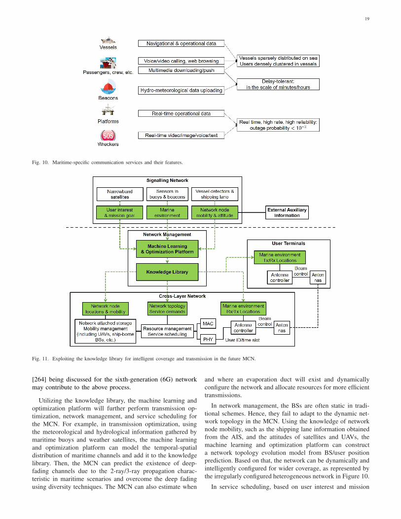
19
Fig. 10. Maritime-specific communication services and their features.
Fig. 11. Exploiting the knowledge library for intelligent coverage and transmission in the future MCN.
[264] being discussed for the sixth-generation (6G) network
may contribute to the above process.
Utilizing the knowledge library, the machine learning and
optimization platform will further perform transmission op-
timization, network management, and service scheduling for
the MCN. For example, in transmission optimization, using
the meteorological and hydrological information gathered by
maritime buoys and weather satellites, the machine learning
and optimization platform can model the temporal-spatial
distribution of maritime channels and add it to the knowledge
library. Then, the MCN can predict the existence of deep-
fading channels due to the 2-ray/3-ray propagation charac-
teristic in maritime scenarios and overcome the deep fading
using diversity techniques. The MCN can also estimate when
and where an evaporation duct will exist and dynamically
configure the network and allocate resources for more efficient
transmissions.
In network management, the BSs are often static in tradi-
tional schemes. Hence, they fail to adapt to the dynamic net-
work topology in the MCN. Using the knowledge of network
node mobility, such as the shipping lane information obtained
from the AIS, and the attitudes of satellites and UAVs, the
machine learning and optimization platform can construct
a network topology evolution model from BS/user position
prediction. Based on that, the network can be dynamically and
intelligently configured for wider coverage, as represented by
the irregularly configured heterogeneous network in Figure 10.
In service scheduling, based on user interest and mission
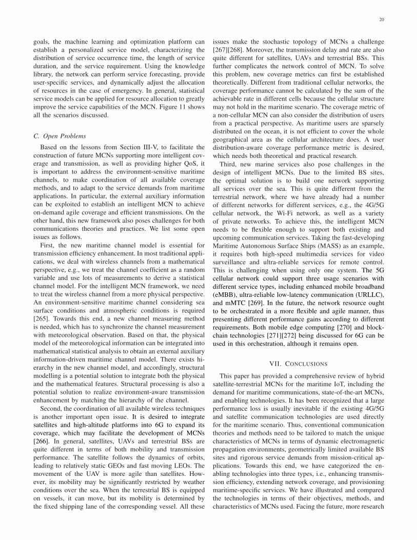
20
goals, the machine learning and optimization platform can
establish a personalized service model, characterizing the
distribution of service occurrence time, the length of service
duration, and the service requirement. Using the knowledge
library, the network can perform service forecasting, provide
user-specific services, and dynamically adjust the allocation
of resources in the case of emergency. In general, statistical
service models can be applied for resource allocation to greatly
improve the service capabilities of the MCN. Figure 11 shows
all the scenarios discussed.
C. Open Problems
Based on the lessons from Section III-V, to facilitate the
construction of future MCNs supporting more intelligent cov-
erage and transmission, as well as providing higher QoS, it
is important to address the environment-sensitive maritime
channels, to make coordination of all available coverage
methods, and to adapt to the service demands from maritime
applications. In particular, the external auxiliary information
can be exploited to establish an intelligent MCN to achieve
on-demand agile coverage and efficient transmissions. On the
other hand, this new framework also poses challenges for both
communications theories and practices. We list some open
issues as follows.
First, the new maritime channel model is essential for
transmission efficiency enhancement. In most traditional appli-
cations, we deal with wireless channels from a mathematical
perspective, e.g., we treat the channel coefficient as a random
variable and use lots of measurements to derive a statistical
channel model. For the intelligent MCN framework, we need
to treat the wireless channel from a more physical perspective.
An environment-sensitive maritime channel considering sea
surface conditions and atmospheric conditions is required
[265]. Towards this end, a new channel measuring method
is needed, which has to synchronize the channel measurement
with meteorological observation. Based on that, the physical
model of the meteorological information can be integrated into
mathematical statistical analysis to obtain an external auxiliary
information-driven maritime channel model. There exists hi-
erarchy in the new channel model, and accordingly, structural
modelling is a potential solution to integrate both the physical
and the mathematical features. Structural processing is also a
potential solution to realize environment-aware transmission
enhancement by matching the hierarchy of the channel.
Second, the coordination of all available wireless techniques
is another important open issue. It is desired to integrate
satellites and high-altitude platforms into 6G to expand its
coverage, which may facilitate the development of MCNs
[266]. In general, satellites, UAVs and terrestrial BSs are
quite different in terms of both mobility and transmission
performance. The satellite follows the dynamics of orbits,
leading to relatively static GEOs and fast moving LEOs. The
movement of the UAV is more agile than satellites. How-
ever, its mobility may be significantly restricted by weather
conditions over the sea. When the terrestrial BS is equipped
on vessels, it can move, but its mobility is determined by
the fixed shipping lane of the corresponding vessel. All these
issues make the stochastic topology of MCNs a challenge
[267][268]. Moreover, the transmission delay and rate are also
quite different for satellites, UAVs and terrestrial BSs. This
further complicates the network control of MCN. To solve
this problem, new coverage metrics can first be established
theoretically. Different from traditional cellular networks, the
coverage performance cannot be calculated by the sum of the
achievable rate in different cells because the cellular structure
may not hold in the maritime scenario. The coverage metric of
a non-cellular MCN can also consider the distribution of users
from a practical perspective. As maritime users are sparsely
distributed on the ocean, it is not efficient to cover the whole
geographical area as the cellular architecture does. A user
distribution-aware coverage performance metric is desired,
which needs both theoretical and practical research.
Third, new marine services also pose challenges in the
design of intelligent MCNs. Due to the limited BS sites,
the optimal solution is to build one network supporting
all services over the sea. This is quite different from the
terrestrial network, where we have already had a number
of different networks for different services, e.g., the 4G/5G
cellular network, the Wi-Fi network, as well as a variety
of private networks. To achieve this, the intelligent MCN
needs to be flexible enough to support both existing and
upcoming communication services. Taking the fast-developing
Maritime Autonomous Surface Ships (MASS) as an example,
it requires both high-speed multimedia services for video
surveillance and ultra-reliable services for remote control.
This is challenging when using only one system. The 5G
cellular network could support three usage scenarios with
different service types, including enhanced mobile broadband
(eMBB), ultra-reliable low-latency communication (URLLC),
and mMTC [269]. In the future, the network resource ought
to be orchestrated in a more flexible and agile manner, thus
presenting different performance gains according to different
requirements. Both mobile edge computing [270] and block-
chain technologies [271][272] being discussed for 6G can be
used in this orchestration, although it remains open.
VII. CONCLUSIONS
This paper has provided a comprehensive review of hybrid
satellite-terrestrial MCNs for the maritime IoT, including the
demand for maritime communications, state-of-the-art MCNs,
and enabling technologies. It has been recognized that a large
performance loss is usually inevitable if the existing 4G/5G
and satellite communication technologies are used directly
for the maritime scenario. Thus, conventional communication
theories and methods need to be tailored to match the unique
characteristics of MCNs in terms of dynamic electromagnetic
propagation environments, geometrically limited available BS
sites and rigorous service demands from mission-critical ap-
plications. Towards this end, we have categorized the en-
abling technologies into three types, i.e., enhancing transmis-
sion efficiency, extending network coverage, and provisioning
maritime-specific services. We have illustrated and compared
the technologies in terms of their objectives, methods, and
characteristics of MCNs used. Facing the future, more research

21
on communication and networking theories is still needed to
avoid simple integration of existing networks. We have accord-
ingly envisioned the use of external auxiliary information to
build up an environment-aware, service-driven, and integrated
satellite-air-ground MCN. The corresponding open issues have
also been discussed.
REFERENCES
[1] H. Wang, O. L. Osen, G. Li, W. Li, H. Dai, and W. Zeng, “Big data andindustrial Internet of Things for the maritime industry in NorthwesternNorway”, in Proc. IEEE Region 10 Conf., Macao, China, Nov. 2015,pp. 1–5.
[2] T. Xia, M. M. Wang, J. Zhang, and L. Wang, “Maritime Internet ofThings: Challenges and solutions”, IEEE Wireless Commun., vol. 27,no. 2, pp. 188–196, Apr. 2020.
[3] J. Zhang, M. M. Wang, T. Xia, and L. Wang, “Maritime IoT: AnArchitectural and radio spectrum perspective,” IEEE Access, vol. 8,pp. 93109–93122, 2020.
[4] W. Ejaz, K. Manzoor, H. J. Kim, B. T. Jang, G. Jin, and H. S. Kim,“Two-state routing protocol for maritime multi-hop wireless networks,”Computers & Electrical Engineering, vol.39, no.6, pp. 1854–1866,Aug. 2013.
[5] T. Roste, K. Yang, and F. Bekkadal, “Coastal coverage for maritimebroadband communications,” in Proc. Oceans, Bergen, Norway, Jun.2013, pp. 1–8.
[6] L. Lambrinos and C. Djouvas, “Creating a maritime wireless meshinfrastructure for real-time applications,” in Proc. IEEE GLOBECOM
Workshops, Houston, TX, USA, Dec. 2011, pp. 529–532.[7] T. D. Ta, T. D. Tran, D. D. Do, H. V. Nguyen, Y. V. Vu, and N. X. Tran,
“GPS-based wireless ad hoc network for marine monitoring, search andrescue (MSnR),” in Proc. Intern. Conf. Intelligent Systems, Modelling
& Simulation, Kuala Lumpur, Malaysia, Mar. 2011, pp. 350–354.[8] J. Wozniak, K. Gierlowski, and M. Hoeft, “Broadband communication
solutions for maritime ITSs: Wider and faster deployment of new e-navigation services,” in Proc. Intern. Conf. ITS Telecommun, Warsaw,Poland, May 2017, pp. 1–11.
[9] J. S. Jeong, G. Park, and J. Kim, “Prediction table to improve maritimesituation awareness by VTS operator,” in Proc. Intern. Conf. Fuzzy
Theory & Applications, Taipei, Taiwan, Dec. 2013, pp. 479–481.[10] Y. M. Dai and K. S. Liu, “TACSA: A web-service based system
for coastal surveillance and situational awareness,” in Proc. Intern.Carnahan Conf. Security Tech., Taipei, Taiwan, Sep. 2015, pp. 409–413.
[11] T. Tares, H. Greidanus, G. Jurquet, and P. Helie, “Wide Maritime AreaAirborne Surveillance SoS,” in Proc. Intern. Systems Conf., Vancouver,BC, Canada, Mar. 2009, pp. 123–126.
[12] Q. Zhuang and C. Zheng, “Research on INMARSAT based on Ka bandand applications,” in Proc. Intern. Conf. Information, Cybernetics &Computational Social Systems, Dalian, China, Jul. 2017, pp. 127–129.
[13] J. Mashino, K. Tateishi, K. Muraoka, D. Kurita, S. Suyama, and Y.Kishiyama, “Maritime 5G experiment in windsurfing World Cup byusing 28 GHz band massive MIMO,” in Proc. IEEE Intern. Symp.
Personal, Indoor & Mobile Radio Commun., Bologna, Italy, Sep. 2018,pp. 1134–1135.
[14] F. Bekkadal, “Innovative maritime communications technologies,” inProc. Intern. Conf. Micromaves, Rader, & Wireless Commun., Vilnius,Lithuania, Jun. 2010, pp. 1–6.
[15] H. Seo, J. Shim, S. Ha, Y. S. Kim, and J. Jeong, “Ultra long rangeLTE ocean coverage solution,” in Proc. Intern. Conf. Telecommun.,Limassol, Cyprus, May 2017, pp. 1–5.
[16] Huawei Technologies Co., Ltd.: Huawei eWBBLTE Solution, 2013. [Online]. Available:http://www.huawei.com/ilink/enenterprise/download/HW203747.[Accessed: Dec. 15, 2018].
[17] R. Huang, “Maritime intelligent real-time control system based onUAV,” in Proc. Intern. Conf. Robots & Intell. System, Changsha, China,May 2018, pp. 10–12.
[18] S. Balkees, K. Sasidhar, and S. Rao, “A survey based analysis ofpropagation models over the sea,” in Proc. Intern. Conf. Advances in
Computing, Commun. & Informatics, Kochi, India, Aug. 2015, pp. 69–75.
[19] J. Wang et al., “Wireless channel models for maritime communica-tions,” IEEE Access, vol. 6, pp. 68070–68088, Nov. 2018.
[20] A. Habib and S. Moh, “A survey on channel models for radiopropagation over the sea surface,” in Proc. Intern. Conf. Internet,Phnom Penh, Cambodia, Dec. 2018, pp. 1–3.
[21] D. Kidston and T. Kunz, “Challenges and opportunities in managingmaritime networks,” IEEE Commun. Mag., vol. 46, no. 10, pp. 162–168, Oct. 2008.
[22] F. Bekkadal and K. Yang, “Novel maritime communications technolo-gies,” in Proc. Mediterranean Microwave Symp., Guzelyurt, Cyprus,Aug. 2010, pp. 338–341.
[23] F. Bekkadal, “Emerging maritime communications technologies,” inProc. Intern. Conf. Intell. Transport Systems Telecommun., Lille,France, Oct. 2009, pp. 358–363.
[24] L. Robinson, T. Newe, J. Burke, G. Dooly, J. Coleman, and D.Toal, “High bandwidth maritime communication systems: Review ofexisting solutions and new proposals,” in Proc. URSI Atlantic RadioSci. Meeting, Meloneras, Spain, Jun. 2018, pp. 1–3.
[25] F. Bekkadal, “Future maritime communications technologies,” in Proc.
Oceans, Bremen, Germany, May 2009, pp. 1–6.[26] C.-X. Wang, J. Bian, J. Sun, W. Zhang, and M. Zhang, “A survey of 5G
channel measurements and models,” IEEE Commun. Surveys & Tuts.,vol. 20, no. 4, pp. 3142–3168, 4th Quart., 2018.
[27] J. Liu, Y. Shi, Z. M. Fadlullah, and N. Kato, “Space-air-groundintegrated network: A survey,” IEEE Commun. Surveys & Tuts., vol.20, no. 4, pp. 2714–2741, May 2018.
[28] A. A. Khan, M. H Rehmani, and A. Rachedi, “Cognitive-radio-basedInternet of Things: applications, architectures, spectrum related func-tionalities, and future research directions,” IEEE Wireless Commun.,vol. 24, no. 3, pp. 17–25, 2017.
[29] G. Falciasecca and B. Valotti, “Guglielmo Marconi: The pioneer ofwireless communications,” in Proc. European Microwave Conf., Rome,Italy, Sep. 2009, pp. 544–546.
[30] J. S. Belrose, “Fessenden and Marconi: their differing technologies andtransatlantic experiments during the first decade of this century,” inProc. Intern. Conf. 100 Years Radio, London, UK, Sep. 1995, pp. 32–43.
[31] A. Sinha, S. A. Saoudy, and B. P. Sinha, “An investigation of Marconi’stransmitter during the 1901 transatlantic experiment,” in Proc. Symp.
Antenna Tech. & Applied Electromagnetics, Ottawa, Canada, Aug.1998, pp. 29–32.
[32] S. J. Lee, H. K. Kwon, G. Y. Park, H. Hwang, D. Kim, and B. Park,“Development of an ASM2.0 RF system for maritime communicationsof high-data-rate in the VHF band,” in Proc. Asia-Pacific Microwave
Conf., Nanjing, China, Dec. 2015, pp. 1–3.[33] D. Palma, “Enabling the maritime Internet of Things: CoAP and
6LoWPAN performance over VHF links,” IEEE Internet Things J.,vol. 5, no. 6, pp. 5205–5212, Sep. 2018.
[34] Q. Hu, X. Jing, L. Xu, J. Huang, and Z. Sun, “Performance speci-fications of filtered multitone modulation for the roll-off factor andfilter order in the maritime VHF data exchange system,” in Proc. IEEE
Intern. Conf. Smart IoT, Xi’an, China, Aug. 2018, pp. 87–92.[35] R. Campos, T. Oliveira, N. Cruz, A. Matos, and J. M. Almeida,
“BLUECOM+: Cost-effective broadband communications at remoteocean areas,” in Proc. Oceans, Shanghai, China, Apr. 2016, pp. 1–6.
[36] BLUECOM+: Innovative communications solution for broadband,cost-effective Internet access at remote ocean areas, 2019. [Online].Available: http://bluecomplus.inesctec.pt . [Accessed: July. 4, 2019].
[37] M. Zhou, V. D. Hoang, H. Harada, J. S. Pathmasuntharam, H. Wang,P. Kong, C. Ang, Y. Ge, and S. Wen, “TRITON: high-speed maritimewireless mesh network,” IEEE Wireless Commun., vol. 20, no. 5,pp. 134–142, Nov. 2013.
[38] S. Jiang and H. Chen, “A possible development of marine Internet:A large scale cooperative heterogeneous wireless network,” in Proc.
Conf. Smart Spaces, Petersburg, Russia, Aug. 2015, pp. 481–495.[39] K. Adarsh, K. M. P. Akshay, J. P. Dhivvya, K. J. Harikrishna, S.
Simi, and S. N. Rao, “Analysis of long range wi-fi backhaul linkin maritime environment,” in Proc. Intern. Conf. Commun. & Signal
Process., Chennai, India, Apr. 2018, pp. 569–573.[40] M. Cankar and S. Stanovnik, “Maritime IoT solutions in fog and
cloud,” in Proc. IEEE/ACM Intern. Conf. Utility & Cloud Computing
Companion, Dec. 2018, Zurich, Switzerland, pp. 284–289.[41] J. Wang and C. Liu, “Development and application of INMARSAT
satellite communication system,” in Proc. Intern. Conf. Instrumenta-
tion, Measurement, Computer, Commun. & Control, Beijing, China,Oct. 2011, pp. 619–621.
[42] V. V. Spiridonov, “Inmarsat systems and services,” in Proc. Intern.
Conf. Satellite Commun., Moscow, Russia, Oct. 1994, pp. 45–52.

22
[43] E. Gambaruto, “Inmarsat Second Generation Satellites for MaritimeCommunications,” in Proc. Oceans, Seattle, WA, USA, Sep. 1989,pp. 920–925.
[44] D. K. Banks, E. Gambaruto, and B. Krinsky, “The Inmarsat secondgeneration communications payload,” in Proc. European Microwave
Conf., London, UK, Sep. 1989, pp. 781–788.[45] S. W. Wong, “An evaluation of 6.4 kbit/s speech codecs for Inmarsat-M
system,” in Proc. Intern. Conf. Acoustics, Speech & Signal Process.,Toronto, Ontario, Canada, Apr. 1991, pp. 629–632.
[46] G. V. Kinal, J. Nagle, and D. W. Lipke, “INMARSAT integrity channelsfor global navigation satellite systems,” IEEE Aerospace & Electronic
Systems Mag., vol. 7, no. 8, pp. 22–25, Aug. 1992.[47] G. V. Kinal, J. Nagle, and D. W. Lipke, “Inmarsat integrity channels
for global navigation satellite systems,” in Proc. National Telesystems
Conf., Washington, DC, USA, May 1992, pp. 1–4.[48] A. Franchi, E. Trachtman, L. Christodoulides, and J. Sengupta, “Mul-
timedia via Inmarsat,” IEEE MultiMedia, vol. 6, no. 4, pp. 15–19, Dec.1999.
[49] A. Franchi, A. Howell, and J. Sengupta, “Broadband mobile viasatellite: Inmarsat BGAN,” in Proc. IEE Seminar Broadband Satellite,Oct. 2000, pp. 1–7.
[50] P. J. Hadinger, “Inmarsat Global Xpress: The design, implementation,and activation of a global Ka-band network,” in Proc. AIAA Intern.Commun. Satellite Systems Conf. & Exhibition., Queensland, Australia,Sep. 2015, pp. 1–8.
[51] M. Breiling et al., “LTE backhauling over MEO-satellites,” in Proc.
Advanced Satellite Multimedia Systems Conf. & Signal Process. SpaceCommun. Workshop, Livorno, Italy, Sep. 2014, pp. 1–8.
[52] K. Sekiguchi, “Iridium contributes to maritime safety,” in Proc. Techno-
Ocean, Kobe, Japan, Oct. 2016, pp. 90–92.[53] F. Wei, B. Chen, R. Jia, T. Wang, and L. Wang, “Research on maritime
leapfrog emergency communication coverage technology based onsatellite relay,” J. Phys.: Conf. Ser., vol. 1087, no. 4, p. 042064, Sep.2018.
[54] Xinhua News Agency: China launches 1st high-throughputcommunications satellite, 2017. [Online]. Available:http://silkroad.news.cn/2017/0413/16398.shtml. [Accessed: Feb.3, 2019].
[55] Spaceflight101: EchoStar 19 Satellite Overview, 2019. [Online]. Avail-able: http://spaceflight101.com/atlas-v-echostar-19/echostar-19. [Ac-cessed: Feb. 11, 2019].
[56] O. Lundberg, “The way ahead for maritime satellite communications,”Radio & Electronic Engineer, vol. 53, no. 7, pp. 254–256, Jul. 1983.
[57] T. Aoyagi, K. Suzaki, Y. Suzuki, T. Hirose, and T. Sugiyama, “Wavepropagation simulations for considering the installation of the mar-itime mobile satellite communication antennas,” in Proc. Asia-Pacific
Microwave Conf., Kaohsiung, Taiwan, Dec. 2012, pp. 346–348.[58] M. Kuwabara, K. Nishino, and H. Sugihara, “Satellite repeater arrange-
ment in a new maritime mobile telephone system,” IEEE Trans. Veh.
Tech., vol. 18, no. 3, pp. 116–123, Nov. 1969.[59] D. Wright, “International maritime satellite communication,” Electron-
ics and Power, vol. 29, no. 9, pp. 623–626, Sep. 1983.[60] O. J. Roseth, B. Kvamstad, A. Tjora, and F. Drezet, “Ship-shore
communication requirements,” FLAGSHIP, Brussels, Belgium, Tech.Rep. TIP5-CT-2006-031406, 2009.
[61] S. Lee and J. Lee, “An implementation of NAVTEX applicationon android mobile device,” in Proc. Intern. Conf. Info. Science &Applications, Suwon, South Korea, Jun. 2013, pp. 1–3.
[62] M. Y. A. Razak, N. Zainal, and A. R. M. Sidek, “Performance of 8FSKbase on PACTOR I protocol over AWGN channels,” in Proc. Intern.
Conf. Info. Tech., Computer & Electrical Engineering, Semarang,Indonesia, Sep. 2018, pp. 1–5.
[63] S. Valcic, Z. Mrak, and D. Kezic, “Comparison of new technologies fordata exchange in the maritime HF frequency band,” in Proc. Intern.
Convention Info. & Commun. Tech., Electronics & Microelectronics,Opatija, Croatia, May 2013, pp. 498–502.
[64] Special Communications Systems (SCS): PACTOR-4, 2018. [On-line]. Available: https://www.scs-ptc.com/en/PACTOR-4.html. [Ac-cessed: July. 4, 2019].
[65] Huawei Technologies Co., Ltd.: North Sea: World’s First OffshoreLTE Network, 2013. [Online]. Available: https://e.huawei.com/hk/case-studies/global/older/hw 258225. [Accessed: Feb. 11, 2019].
[66] Ericsson: Maritime ICT Cloud enables ships to join the NetworkedSociety, 2015. [Online]. Available: https://www.ericsson.com/en/press-releases/2015/1/maritime-ict-cloud-enables-ships-to-join-the-networked-society. [Accessed: Feb. 11, 2019].
[67] Verizon Communications : Wireless : Announces 4G LTECoverage Enhancements in Rhode Island, 2015. [Online]. Available:https://www.marketscreener.com/VERIZON-COMMUNICATIONS-IN-4830/news/Verizon-Communications-Wireless-Announces-4G-LTE-Coverage-Enhancements-in-Rhode-Island-20135125. [Accessed:Feb. 11, 2019].
[68] Chinadaily: Telecoms extend 4G service toNansha Islands, 2016. [Online]. Available:http://www.newsgd.com/news/2016-07/20/content 151841840.htm.[Accessed: Feb. 11, 2019].
[69] T. Yoshikawa, S. Kawasaki, M. Takase, Y. Hiraoka, Y. Takaki, C.Ohta, and T. Inoue, “Development of 27MHz/40MHz bands maritimewireless ad-hoc networks,” in Proc. Intern. Conf. Ubiquitous & FutureNetworks, Jeju, South Korea, Jun. 2010, pp. 177–182.
[70] M. L. Best, “The Internet that Facebook built,” ACM Commun., vol.57,no.12, pp. 21–23, Dec. 2014.
[71] M. Engel, “Google’s Project Loon hovers over the satellite industry,”Via Satellite, vol. 28, no. 8, p. 13, Aug. 2013.
[72] Ryan Maass, United Press International: DARPA’s Sea NetworkProject Completes First Phase, 2017. [Online]. Available:https://www.ecnmag.com/news/2017/01/darpas-sea-network-project-completes-first-phase?cmpid=horizontalcontent. [Accessed: July. 4,2019].
[73] Y. Huo, X. Dong, and S. Beatty, “Cellular communications in oceanwaves for maritime Internet of Things,” IEEE IoT. J., to appear, 2020.DOI: 10.1109/JIOT.2020.2988634.
[74] Y. Bai, W. Du, and C. Shen, “Over-the-sea radio propagation andintegrated wireless networking for ocean fishery vessels,” in Proc.
Intern. Conf. Wireless Commun. & Applications, Sanya, China, Aug.2011, pp. 180–190.
[75] K. Yang, T. Roste, F. Bekkadal, K. Husby, and O. Trandem, “Long-distance propagation measurements of mobile radio channel over seaat 2 GHz,” in Proc. Veh. Tech. Conf., San Francisco, CA, USA, Sep.2011, pp. 1–5.
[76] Y. Zhao, J. Ren, and X. Chi, “Maritime mobile channel transmissionmodel based on ITM,” in Proc. Intern. Symp. Computer, Commun.,
Control & Automation, Singapore, Dec. 2013, pp. 378–383.[77] J. C. Reyes-Guerrero, M. Bruno, L. A. Mariscal, and A. Medouri,
“Buoy-to-ship experimental measurements over sea at 5.8 GHz nearurban environments,” in Proc. Mediterranean Microwave Symp., Ham-mamet, Tunisia, Sep. 2011, pp. 320–324.
[78] N. Mehrnia and M. K. Ozdemir, “Novel maritime channel models formillimeter radiowaves,” in Proc. Intern. Conf. Software, Telecommun.
& Computer Networks, Split, Croatia, Sep. 2016, pp. 405–410.[79] J. Lee, J. Choi, W. Lee, J. Choi, and S. Kim, “Measurement and
analysis on land-to-ship offshore wireless channel in 2.4 GHz,” IEEE
Wireless Commun. Lett., vol.6, no.2, pp. 222–225, Feb. 2017.[80] Y. H. Lee, F. Dong, and Y. S. Meng, “Near sea-surface mobile
radiowave propagation at 5 GHz: measurements and modeling,” Ra-dioengineering, vol. 23, no. 3, pp. 824–830, Sep. 2014.
[81] A. Coker, L. Straatemeier, T. Rogers, P. Valdez, D. Cooksey, and K.Griendling, “Maritime channel modeling and simulation for efficientwideband communications between autonomous unmanned surfacevehicles,” in Proc. Oceans, San Diego, CA, USA, Sep. 2013, pp. 1–9.
[82] Q. Wang et al., “Estimation of evaporation duct and surface-based ductparameters from a combined refractivity model,” in Proc. IEEE Intern.Symp. Antennas & Propagation, Boston, USA, Jul. 2018, pp. 879–880.
[83] X. Hu, J. Chen, and Y. Wang, “Research on metre-wave radar height-finding multipath model,” Chinese J. Radio Science, vol. 23, no. 4,pp. 651–657, Apr. 2008.
[84] M. Dong, Y. Zhao, and S. Zhang, “The analysis of the multipath modelunder the VHF band and at sea,” Acta Electronica Sinica, vol. 36, no.6, pp. 1373–1377, Jun. 2009.
[85] K. Haspert and M. Tuley, “Comparison of predicted and measuredmultipath impulse responses,” IEEE Trans. Aerospace & Electronic
Systems, vol. 47, no. 3, pp. 1696–1709, Jul. 2011.[86] K. Yang, T. Roste, F. Bekkadal, and T. Ekman, “Channel characteri-
zation of mobile radio channel over sea at 2 GHz,” in Proc. Mediter-
ranean Microwave Symp., Guzelyurt, Cyprus, Aug. 2010, pp. 389–392.[87] Y. H. Lee and Y. S. Meng, “Analysis of ducting effects on air-to-ground
propagation channel over sea surface at C-band,” in Proc. Asia-Pacific
Microwave Conf., Melbourne, VIC, USA, Dec. 2011, pp. 1678–1681.[88] K. Yang, T. Roste, F. Bekkadal, and T. Ekman, “Channel characteri-
zation including path loss and Doppler effects with sea reflections formobile radio propagation over sea at 2 GHz,” in Proc. Intern. Conf.
Wireless Commun. & Signal Process., Suzhou, China, Oct. 2010, pp. 1–6.

23
[89] F. Huang, X. Liao, and Y. Bai, “Multipath channel model for radiopropagation over sea surface,” Wireless Personal Commun., vol. 90,no. 1, pp. 245–257, Sep. 2016.
[90] G. Dahman, D. Couillard, M.-E. Grandmaison, G. Poitau, and F.Gagnon, “Improved 2-Ray model for overwater propagation channels:modeling the instantaneous variations in the received signal strength,”IEEE Wireless Commun. Lett., vol. 8, no, 3, pp. 865–868, Jun. 2019.
[91] C. Ang and S. Wen, “Signal strength sensitivity and its effects onrouting in maritime wireless networks,” in Proc. IEEE Conf. LocalComputer Networks, Montreal, Canada, Oct. 2008, pp. 192–199.
[92] J. Hagenauer, F. Dolainsky, E. Lutz, W. Papke, and R. Schweikert, “Themaritime satellite communication channel–channel model, performanceof modulation and coding,” IEEE J. Sel. Areas Commun., vol. 5, no.4, pp. 701–713, May 1987.
[93] C. Amaya and D. V. Rogers, “Characteristics of rain fading on Ka-band satellite-earth links in a Pacific maritime climate,” IEEE Trans.
Microwave Theory & Tech., vol. 50, no. 1, pp. 41–45, Aug. 2002.[94] C. Amaya and D. V. Rogers, “Characteristics of rain fading on Ka-
band satellite-Earth links in a Pacific maritime climate,” in Proc. Intern.
Microwave & Optoelectronics Conf., Rio de Janeiro, Brazil, Aug. 1999,pp. 308–311.
[95] D. Y. Choi, “Measurement of radio propagation path loss over the seafor wireless multimedia,” in Proc. Intern. Ifip-tc6 Conf. Networking,Coimbra, Portugal, May 2006, pp. 525–532.
[96] Y. H. Lee and Y. S. Meng, “Empirical modeling of ducting effects ona mobile microwave link over a sea surface,” Radioengineering, vol.21, no. 4, pp. 1054-1059, Dec. 2012.
[97] C. Y. D. Sim, “The propagation of vhf and uhf radio waves over seapaths,” Ph.D. dissertation, University of Leicester, 2002.
[98] J. C. Reyes-Guerrero and L. A. Mariscal, “Experimental time disper-sion parameters of wireless channels over sea at 5.8 GHz,” in Proc.ELMAR, Zadar, Croatia, Sep. 2012, pp. 89–92.
[99] K. Maliatsos, P. Loulis, M. Chronopoulos, P. Constantinou, P. Dallas,and M. Ikonomou, “Measurements and wideband channel characteri-zation for over-the-sea propagation,” in Proc. Intern. Conf. Wireless &
Mobile Computing, Networking & Commun., Montreal, Canada, Jun.2006, pp. 237–244.
[100] P. Sobieski, A. Guissard, C. Baufays, and P. Siraut, “Sea surfacescattering calculations in maritime satellite communications,” IEEE
Trans. Commun., vol. 41, no. 10, pp. 1525–1533, Oct. 1993.[101] S. Song, S. Lee, H. Kim, and C. Kim, “Digital communication channel
model analysis for AUV in maritime environment,” in Proc. Oceans,Yeosu, South Korea, May 2012, pp. 1–4.
[102] M. J. Lopes, F. Teixeira, J. B. Mamede, and R. Campos, “Wi-Fibroadband maritime communications using 5.8 GHz band,” in Proc.Underwater Commun. & Networking, Sestri Levante, Italy, Sep. 2014,pp. 1–5.
[103] M. Cvijetic and M. Li, “Characterization of free space optical channelsfor terrestrial and maritime air conditions,” in Proc. Intern. Conf.Transparent Optical Networks, Girona, Spain, Jul. 2017, pp. 1–5.
[104] H. Wang, W. Jia, and G. Min, “Effective channel exploitation inIEEE 802.16j networks for maritime communications,” in Proc. Intern.Conf. Distributed Computing Systems, Minneapolis, USA, Jun. 2011,pp. 162–171.
[105] C.-X. Wang, F. Haider, X. Gao, X.-H. You, Y. Yang, D. Yuan, H.Aggoune, H. Haas, S. Fletcher, and E. Hepsaydir, “Cellular architectureand key technologies for 5G wireless communication networks,” IEEE
Commun. Mag., vol. 52, no. 2, pp. 122–130, Feb. 2014.[106] S. Wu, C.-X. Wang, H. Aggoune, M. M. Alwakeel, and Y. He, “A
non-stationary 3D wideband twin-cluster model for 5G massive MIMOchannels,” IEEE J. Sel. Areas Commun., vol. 32, no. 6, pp. 1207–1218,June 2014.
[107] S. Wu, C.-X. Wang, H. Haas, H. Aggoune, M. M. Alwakeel, and B.Ai, “A non-stationary wideband channel model for massive MIMOcommunication systems,” IEEE Trans. Wireless Commun., vol. 14, no.3, pp. 1434–1446, Mar. 2015.
[108] C.-X. Wang, S. Wu, L. Bai, X. You, J. Wang, and C.-L. I, “Recentadvances and future challenges for massive MIMO channel measure-ments and models,” Sci. China Inf. Sci., vol. 59, no. 2, pp. 1–16, Feb.2016.
[109] C. F. Lopez and C.-X. Wang, “Novel 3D non-stationary widebandmodels for massive MIMO channels,” IEEE Trans. Wireless Commun.,vol. 17, no. 5, pp. 2893–2905, May 2018.
[110] J. Huang, C.-X. Wang, R. Feng, J. Sun, W. Zhang, and Y. Yang,“Multi-frequency MmWave massive MIMO channel measurements andcharacterization for 5G wireless communication systems,” IEEE J. Sel.
Areas Commun., vol. 35, no. 7, pp. 1591–1605, July 2017.
[111] J. Huang, C.-X. Wang, Y. Liu, J. Sun, and W. Zhang, “A novel 3DGBSM for mmWave MIMO channels,” Sci. China Inf. Sci., vol. 61,no. 10, Oct. 2018.
[112] Y. Yuan, C.-X. Wang, Y. He, M. M. Alwakeel, and H. Aggoune, “3Dwideband non-stationary geometry-based stochastic models for non-isotropic MIMO vehicle-to-vehicle channels,” IEEE Trans. Wireless
Commun., vol. 14, no. 12, pp. 6883–6895, Dec. 2015.[113] X. Cheng, C.-X. Wang, B. Ai, and H. Aggoune, “Envelope level
crossing rate and average fade duration of non-isotropic vehicle-to-vehicle Ricean fading channels,” IEEE Trans. Intell. Transp. Syst., vol.15, no. 1, pp. 62–72, Feb. 2014.
[114] C.-X. Wang, A. Ghazal, B. Ai, P. Fan, and Y. Liu, “Channel mea-surements and models for high-speed train communication systems: asurvey,” IEEE Commun. Surveys & Tuts., vol. 18, no. 2, pp. 974–987,2nd Quart., 2016.
[115] A. Ghazal, C.-X. Wang, B. Ai, D. Yuan, and H. Haas, “A non-stationary wideband MIMO channel model for high-mobility intelligenttransportation systems,” IEEE Trans. Intell. Transp. Syst., vol. 16, no.2, pp. 885–897, Apr. 2015.
[116] Y. Liu, C.-X. Wang, J. Huang, J. Sun, and W. Zhang, “Novel 3-Dnonstationary mmWave massive MIMO channel models for 5G high-speed train wireless communications,” IEEE Trans. Veh. Tech., vol. 68,no. 3, pp. 2077–2086, Mar. 2019.
[117] J. Bian, J. Sun, C.-X. Wang, R. Feng, J. Huang, Y. Yang, and M. Zhang,“A WINNER+ based 3D non-stationary wideband MIMO channelmodel,” IEEE Trans. Wireless Commun., vol. 17, no. 3, pp. 1755–1767,Mar. 2018.
[118] S. Wu, C.-X. Wang, H. Aggoune, M. M. Alwakeel, and X. You, “Ageneral 3D non-stationary 5G wireless channel model,” IEEE Trans.
Commun., vol. 66, no. 7, pp. 3065–3078, July 2018.[119] Z. Yao, B. Zhao, W. Li, Y. Zhu, J. Du, and F. Dai, “Analysis on
characteristics of atmospheric duct and its effects on the propagation ofelectromagnetic wave,” Acta. Meteor. Sin., vol. 15, no. 2, pp. 605–616,Feb. 2001.
[120] G. S. Woods, A. Ruxton, C. H. Holmes, and G. Gigan, “High-capacity,long-range, over ocean microwave link using the evaporation duct,”IEEE J. Ocean Eng., vol. 34, no. 3, pp. 323–330, Jul. 2009.
[121] A. Iqbal and V. Jeoti, “Feasibility study of radio links using evaporationduct over sea off Malaysian shores,” in Proc. Intern. Conf. Intell.
Advanced Systems, Manila, Philippines, Jun. 2010, pp. 1–5.[122] W. L. Patterson, “Advanced refractive effects prediction system
(AREPS),” in Proc. IEEE Radar Conf., Boston, USA, Apr. 2007,pp. 891–895.
[123] R. A. Paulus, “Practical application of an evaporation duct model,”Radio Science, vol. 20, no. 4, pp. 887–896, Jul. 1985.
[124] R. Raulefs, M. Wirsing, and W. Wang, “Increasing long range coverageby multiple antennas for maritime broadband communications,” inProc. Oceans, Charleston, SC, USA, Oct. 2018, pp. 1–6.
[125] D. Kidston and I. Labbe, “A service oriented framework for policy-based management of maritime mobile networks,” in Proc. IEEE
Military Commun. Conf., Washington, USA, Oct. 2006, pp. 1–7.[126] S. Burleig, A. Hooke, L. Torgerson, et al., “Delay-tolerant networking:
an approach to interplanetary Internet,” IEEE Commun. Mag., vol. 41,no. 6, pp. 128–136, Jun. 2003.
[127] H. Lin, Y. Ge, A. Pang, and J. S. Pathmasuntharam, “Performance studyon delay tolerant networks in maritime communication environments,”in Proc. OCEANS, Sydney, Australia, May 2010, pp. 1–6.
[128] T. Yang, Z. Zheng, H. Liang, et al., “Green energy and content awaredata transmission in maritime wireless communication network,” IEEE
Trans. Intell. Transport. Syst., vol. 16, no. 2, pp. 751–762, Apr. 2015.[129] C. Jiang, C. Jiang, L. Yin, and Y. Qian, “Joint backhaul and access link
resource management in maritime communication network,” in Proc.
IEEE Global Commun. Conf., Abu Dhabi, United Arab Emirates, Dec.2018, pp. 1–6.
[130] A. Alessandrini, M. Alvarez, H. Greidanus, V. Gammieri, V. F. Ar-guedas, F. Mazzarella, C. Santamaria, M. Stasolla, D. Tarchi, and M.Vespe, “Mining vessel tracking data for maritime domain applications,”in Proc. Intern. Conf. Data Mining Workshops, Barcelona, Spain, Dec.2016, pp. 361–367.
[131] Y. T. Wen, C. H. Lai, P. R. Lei, and W. C. Peng, “RouteMiner: Miningship routes from a massive maritime trajectories,” in Proc. Intern. Conf.Mobile Data Management, Brisbane, Australia, Jul. 2014, pp. 353–356.
[132] V. F. Arguedas, G. Pallotta, and M. Vespe, “Maritime traffic networks:From historical positioning data to unsupervised maritime traffic mon-itoring,” IEEE Trans. Intell. Transportation Systems, vol. 19, no. 3,pp. 722–732, Mar. 2018.

24
[133] S. Qin, G. Feng, W. Qin, et al., “Performance modeling of data trans-mission in maritime delay-tolerant-networks,” in Proc. IEEE WirelessCommun. & Networking Conf., Shanghai, China, Apr. 2013, pp. 1109–1114.
[134] P. Kolios and L. Lambrinos, “Optimising file delivery in a maritimeenvironment through inter-vessel connectivity predictions,” in Proc.IEEE Intern. Conf. Wireless & Mobile Computing, Networking &
Commun., Barcelona, Spain, Oct. 2012, pp. 777–783.[135] T. Yang, H. Liang, N. Cheng, R. Deng, and X. Shen, “Efficient
scheduling for video transmissions in maritime wireless communicationnetworks,” IEEE Trans. Veh. Tech., vol. 64, no. 9, pp. 4215–4229, Sep.2015.
[136] T. Yang and X. Shen, Maritime wideband communication networks:Video transmission scheduling, Berlin: Springer, 2014, pp. 15–31.
[137] S. M. Mun, J. Y. Son, W. R. Jo, and W. B. Lee, “An implementationof AIS-based Ad hoc routing (AAR) protocol for maritime datacommunication networks,” in Proc. Intern. Conf. Natural Computation,Chongqing, China, May 2012, pp. 1007–1010.
[138] W. Feng, Y. Wang, N. Ge, J. Lu, and J. Zhang, “Virtual MIMO in multi-cell distributed antenna systems: coordinated transmissions with large-scale CSIT,” IEEE J. Sel. Areas Commun., vol. 31, no. 10, pp. 2067–2081, Oct. 2013.
[139] W. Feng, Y. Wang, D. Lin, N. Ge, J. Lu, and S. Li, “When mmWavecommunications meet network densification: a scalable interferencecoordination perspective,” IEEE J. Sel. Areas Commun., vol. 35, no. 7,pp. 1459–1471, Jul. 2017.
[140] W. Feng, Y. Chen, N. Ge, and J. Lu, “Optimal energy-efficient powerallocation for distributed antenna systems with imperfect CSI,” IEEE
Trans. Veh. Tech., vol. 65, no. 9, pp. 7759–7763, Sep. 2016.[141] J. H. Laarhuis, “MaritimeManet: mobile ad-hoc networking at sea,” in
Waterside Security Conf., Carrara, Italy, Nov. 2010, pp. 1–6.[142] Y. Kim, J. Kim, Y. Wang, K. Chang, J. W. Park, and Y. Lim,
“Application scenarios of nautical ad-hoc network for maritime com-munications,” in Proc. Oceans, Biloxi, MS, USA, Oct. 2009, pp. 1–4.
[143] K. S. Zaidi, V. Jeoti, A. Awang, and M. Drieberg, “High reliabilityusing virtual MIMO based mesh network for maritime wireless com-munication,” in Proc. Intern. Conf. Intell. & Advanced Systems, KualaLumpur, Malaysia, Aug. 2016, pp. 1–5.
[144] M. Jorgenson, C. Reichelt, and T. Johnson, “Operation of the dynamicTDMA subnet relay system with HF bearers,” in Proc. IEEE Military
Commun. Conf., Atlantic City, USA, Oct. 2005, pp. 338–343.[145] R. Duan, J. Wang, H. Zhang, C. Jiang, Y. Ren, and T. Q. S. Quek,
“Touch the sea: energy efficient relay design for maritime multi-hopmulticast systems,” in Proc. IEEE Global Commun. Conf., Abu Dhabi,United Arab Emirates, Dec. 2018, pp. 1–6.
[146] V. D. Hoang, M. Ma, R. Miura, and M. Fujise, “A novel way forhandover in maritime WiMAX mesh network,” in Proc. IEEE Conf.
ITS Telecommun., Sophia Antipolis, France, Jun. 2007, pp. 1–4.[147] P. Kong, H. Wang, Y. Ge, C. Ang, J. S. Pathmasuntharam, W. Su,
M. Zhou, and H. Harada, “Distributed adaptive time slot allocationfor WiMAX based maritime wireless mesh networks,” in Proc. IEEE
Wireless Commun. & Networking Conf., Budapest, Hungary, Apr. 2009,pp. 1–6.
[148] M. Zhou and H. Harada, “Cognitive maritime wireless mesh/ad hoc net-works,” J. Network & Computer Applications, vol. 35, no.2, pp. 518–526, Mar. 2012.
[149] W. Du, Z. Ma, Y. Bai, C. Shen, B. Chen, and Y. Zhou, “Integrated wire-less networking architecture for maritime communications,” in Proc.
ACIS Intern. Conf. Software Engineering, Artificial Intell., Networking& Parallel/Distributed Computing, London, UK , Jun. 2010, pp. 134–138.
[150] A. Balasubramanian, B. Levine, and A. Venkataramani, “DTN routingas a resource allocation problem,” in Proc. Conf. Applications, Tech.,Architectures & Protocols Computer Commun., New York, USA, 2007,pp. 373–384.
[151] G. Pei, M. Gerla, and T. Chen, “Fisheye state routing: A routing schemefor ad hoc wireless networks,” in Proc. IEEE Intern. Conf. Commun.,New Orleans, USA, Jun. 2000, pp. 70–74.
[152] R. Ramanathan, R. Hansen, P. Basu, R. Rosales-Hain, and R. Krishnan,“Prioritized epidemic routing for opportunistic networks,” in Proc.Intern. MobiSys Workshop Mobile Opportunistic Networking, NewYork, USA, Jun. 2007, pp. 62–66.
[153] A. Lindgren, A. Doria, and O. Schelen, “Probabilistic routing in inter-mittently connected networks,” SIGMOBILE Mob. Comput. Commun.Rev., vol. 7, no. 3, pp. 19–20, Jul. 2003.
[154] T. Spyropoulos, K. Psounis, and C. S. Raghavendra, “Spray and focus:Efficient mobility-assisted routing for heterogeneous and correlated
mobility,” in Proc. IEEE Intern. Conf. Pervasive Computing & Com-
mun. Workshops, White Plains, NY, USA, Mar. 2007, pp. 79–85.[155] Y. Liao, K. Tan, Z. Zhang, and L. Gao, “Estimation based erasure-
coding routing in delay tolerant networks,” in Proc. IWCMC, NewYork, USA, Jan. 2006, pp. 557–562.
[156] L. Chen, C. Yu, T. Sun, Y. Chen, and H. Chu, “A hybrid routingapproach for opportunistic networks,” in Proc. SIGCOMM Workshop
Challenged Networks, Pisa, Italy, Sep. 2006, pp. 213–220.[157] P. Jacquet, P. Muhlethaler, T. Clausen, A. Laouiti, A. Qayyum, and L.
Viennot, “Optimized link state routing protocol for ad hoc networks,”in Proc. IEEE INMIC, Lahore, Pakistan, Dec. 2001, pp. 62–68.
[158] C. E. Perkins and E. M. Royer, “Ad-hoc on-demand distance vectorrouting,” in Proc. IEEE Workshop Mobile Computing Systems &Applications, New Orleans, LA, USA, Feb. 1999, pp. 90–100.
[159] K. Devarajan and V. Padmathilagam, “An enhanced cluster gatewayswitch routing protocol (ECGSR) for congestion control using AODValgorithm in MANET,” Intern. J. Computer Applications, vol. 123, no.3, pp. 37–42, Aug. 2015.
[160] Y. Choi and Y. Lim, “Geographical AODV protocol for multi-hopmaritime communications,” in Proc. Oceans, Bergen, Norway, Jun.2013, pp. 1–3.
[161] M. K. Marina and S. R. Das, “On-demand multipath distance vectorrouting in ad hoc networks,” Proc. Intern. Conf. Network Protocols,Riverside, CA, USA, Nov. 2001, pp. 14–23.
[162] L. Lambrinos, C. Djouvas, and C. Chrysostomou, “Applying delay tol-erant networking routing algorithms in maritime communications,” inProc. IEEE Intern. Symp. & Workshops Wireless, Mobile & MultimediaNetworks, Madrid, Spain, Jun. 2013, pp. 1–6.
[163] P. Kong, H. Wang, Y. Ge, C. Ang, S. Wen, J. S. Pathmasuntharam, M.Zhou, and H. V. Dien, “A performance comparison of routing protocolsfor maritime wireless mesh networks,” Proc. IEEE Wireless Commun.& Networking Conf., Las Vegas, NV, USA, Mar. 2008, pp. 2170–2175.
[164] M. Manoufali, H. Alshaer, P. Kong, and S. Jimaa, “Technologies andnetworks supporting maritime wireless mesh communications,” in Proc.Joint IFIP Wireless & Mobile Networking Conf., Dubai, United ArabEmirates, Apr. 2013, pp. 1–8.
[165] S. Ali, J. Qadir, and A. Baig, “Routing protocols in delay tolerantnetworks–a survey,” in Proc. Intern. Conf. Emerging Tech., Islamabad,Pakistan, Oct. 2010, pp. 70–75.
[166] X. Geng, Y. Wang, H. Feng, and L. Zhang, “Lanepost: lane-basedoptimal routing protocol for delay-tolerant maritime networks,” ChinaCommun., vol. 14, no. 2, pp. 65–78, Feb. 2017.
[167] Y. Hu, Y. Zheng, H. Liu, Y. Hu, “A route maintenance method formarine mobile sensor network based on ring broadcast mechanism,”in IEEE Intern. Conf. Commun. Tech., Chongqing, China, Oct. 2018,pp. 533–537.
[168] G. Glissa, A. Rachedi, and A. Meddeb, “A secure routing protocolbased on RPL for Internet of Things,” in Proc. IEEE Global Commun.
Conf. (GLOBECOM), pp. 1–7, 2016.[169] M. Bouaziz, A. Rachedi, and A. Belghith, EKF-MRPL: Advanced
mobility support routing protocol for Internet of Mobile Things:movement prediction approach,” Future Generation Computer Systems,vol. 93, pp. 822–832, 2019.
[170] P. Cheng, K. C. Lee, M. Gerla, and J. Hrri, “GeoDTN+Nav: GeographicDTN routing with navigator prediction for urban vehicular environ-ments,” Mobile Networks & Applications, vol. 15, no. 1, pp. 61–82,Jun. 2009.
[171] E. P. C. Jones, L. Li, J. K. Schmidtke, and P. A. S. Ward, “Practicalrouting in delay-tolerant networks,” IEEE Trans. Mobile Computing,vol. 6, no. 8, pp. 943–959, Aug. 2007.
[172] A. Xiao, N. Ge, L. Yin, C. Jiang, and S. Zhao, “Adaptive shipbornebase station sleeping control for dynamic broadband maritime commu-nications,” in Proc. Asia-Pacific Network Operations & ManagementSymp., Seoul, South Korea, Sep. 2017, pp. 7–12.
[173] O. S. Oubbati, N. Chaib, A. Lakas, P. Lorenz, and A. Rachedi, “UAV-assisted supporting services connectivity in urban VANETs,” IEEETrans. Veh. Tech., vol. 68, no. 4, pp. 3944–3951, 2019.
[174] Y. Chen, W. Feng, and G. Zheng, “Optimum placement of UAV asrelays,” IEEE Commun. Lett., vol. 22, no. 2, pp. 248–251, Feb. 2018.
[175] W. Feng, J. Wang, Y. Chen, X. Wang, N. Ge, and J. Lu, “UAV-aidedMIMO communications for 5G Internet of Things,” IEEE Internet
Things J., vol. 6, no. 2, pp. 1731–1740, Apr. 2019.[176] M. Stasolla, J. J. Mallorqui, G. Margarit, C. Santamaria, and N. Walker,
“A comparative study of operational vessel detectors for maritimesurveillance using satellite-borne synthetic aperture radar,” IEEE J. Sel.
Topics Applied Earth Observations & Remote Sensing, vol. 9, no. 6,pp. 2687–2701, Jun. 2016.

25
[177] A. Baroni, A. Michel, M. Pannozzo, D. Zamberlan, M. Andrenacci, andF. Silvestri, “Performance assessment of the Smart mAritime saTelliteterminal for mUltimedia seRvices and conteNts (SATURN) system,” inProc. Advanced Satellite Multimedia Systems Conf. & Signal Process.
Space Commun. Workshop, Livorno, Italy, Sep. 2014, pp. 136–143.[178] M. Pannozzo, A. F. Cominotto, M. Andrenacci, S. Titomanlio, S.
Granelli, and D. Zamberlan, “SATURN: Smart mAritime saTelliteterminal for mUltimedia seRvices and conteNts,” in Proc. IEEE AESS
European Conf. Satellite Telecommun., Rome, Italy, Oct. 2012, pp. 1–5.[179] T. Aoyagi, K. Suzaki, Y. Suzuki, T. Hirose, and T. Sugiyama, “Model-
ing of interferences on other satellites in maritime satellite communica-tions,” in Proc. IEEE Intern. RF & Microwave Conf., Penang, Malaysia,Dec. 2013, pp. 247–252.
[180] M. Koletta, V. Milas, and P. Constantinou, “Analysis and simulation ofthe interference produced to the fixed service receivers by the mobilesatellite service in a maritime environment in the Ku band,” in Proc.
Asia-Pacific Conf. on Commun., Beijing, China, Sep. 2004, pp. 209–213.
[181] M. Geissler, F. Woetzel, M. Bottcher, S. Korthoff, A. Lauer, M. Eube,and R. Gieron, “Innovative phased array antenna for maritime satellitecommunications,” in Proc. European Conf. Antennas & Propagation,Berlin, Germany, Mar. 2009, pp. 735–739.
[182] M. Geissler, F. Woetzel, M. Buttcher, S. Korthoff, A. Lauer, M. Eube,and M. Wleklinski, “L-band phased array for maritime satcom,” inProc. IEEE Intern. Symp. Phased Array Systems & Tech., Waltham,MA, USA, Oct. 2010, pp. 518–523.
[183] K. Feng, J. Xu, and N. Li, “A phased array antenna system forINMARSAT mobile ground terminal,” in Proc. IEEE Intern. Symp.
Microwave, Antenna, Propagation & EMC Tech. Wireless Commun.,Beijing, China, Oct. 2009, pp. 415–418.
[184] W. Feng, N. Ge, and J. Lu, “Coordinated satellite-terrestrial networks:a robust spectrum sharing perspective,” in Proc. Wireless & Optical
Commun. Conf., Newark, USA, Apr. 2017, pp. 1–5.[185] R. Boreli, Y. Ge, T. Iyer, C. Dwertmann, and J. S. Pathmasuntharam,
“Intelligent middleware for high speed maritime mesh networks withsatellite communications,” in Proc. Intern. Conf. Intell. Transport
Systems Telecommun., Lille, France, Oct. 2009, pp. 370–375.[186] A. Kessab, L. Mroueh, P. Martins, and I. Bucaille, “Optimizing end-
to-end propagation delays in hybrid satellite-maritime mobile ad hocnetworks,” in Proc. Intern. Conf. Software, Telecommun. & Computer
Networks, Split, Croatia, Sep. 2016, pp. 1–5.[187] J. P. Dhivvya, S. N. Rao, and S. Simi, “Analysis of optimal back-
haul link selection in a novel maritime communication network,” inProc. Intern. Conf. Wireless Commun., Signal Process. & Networking,Chennai, India, Mar. 2017, pp. 101–106.
[188] M. Shaat and A. I. Perez-Neira, “Joint flow control and link schedulingin hybrid terrestrial-satellite wireless backhauling network,” in Proc.
IEEE Intern. Conf. Commun. Workshops, Paris, France, May 2017, pp.870–875.
[189] Y. Li, Q. Zhang, P. Yuan, and Z. Yang, “A back-tracing partition basedon-path caching distribution strategy over integrated LEO satellite andterrestrial networks,” in Proc. IEEE Intern. Conf. Wireless Commun. &Signal Process., Hangzhou, China, Oct. 2018, pp. 1–6.
[190] G. Zhong, J. Yan, and L. Kuang, “QoE-driven social aware cachingplacement for terrestrial-satellite networks,” China Commun., vol. 15,no. 10, pp. 60–72, Oct. 2018.
[191] S. P. Romano and C. Roseti, “Secure hybrid in-network caching in ahybrid satellite-terrestrial environment: the SHINE project,” in Proc.
IEEE Intern. Symp. Broadband Multimedia Systems & Broadcasting,Valencia, Spain, Jun. 2018, pp. 1–6.
[192] SpaceX: SpaceX designs, manufactures and launches advanced rocketsand spacecraft, 2019. [Online]. Available: https://www.spacex.com/.[Accessed: July. 4, 2019].
[193] OneWeb: Revolutionizing the economics of space, 2019. [Online].Available: https://onewebsatellites.com/. [Accessed: July. 4, 2019].
[194] TeleSat: World’s First 5G Backhaul Demo over LEO Satellite, 2019.[Online]. Available: https://www.telesat.com/news-events/worlds-first-5g-backhaul-demo-over-leo-satellite. [Accessed: July. 4, 2019].
[195] GeekWire: Amazon to offer broadband access from orbit with3,236-satellite Project Kuiper constellation, 2019. [Online]. Available:https://www.geekwire.com/2019/amazon-project-kuiper-broadband-satellite/. [Accessed: July. 4, 2019].
[196] F. Capozzi, G. Piro, L. A. Grieco, et al., “Downlink packet schedulingin LTE cellular networks: Key design issues and a survey,” IEEECommun. Surveys & Tuts., vol. 15, no. 2, pp. 678–700, 2013.
[197] C. Wengerter, J. Ohlhorst, and A. E. Elbwart, “Fairness and throughputanalysis for generalized proportional fair frequency scheduling in
OFDMA,” in Proc. Veh. Tech. Conf., Stockholm, Sweden, May 2005,pp. 1903–1907.
[198] R. Kwan, C. Leung, and J. Zhang, “Proportional fair multiuser schedul-ing in LTE,” IEEE Signal Process. Lett., vol. 16, no. 6, pp. 461–464,Jun. 2009.
[199] R. Kwan, C. Leung, and J. Zhang, “Multiuser scheduling on thedownlink of an LTE cellular system,” Research Lett. Commun., vol.2008, no. 3, Jan. 2008.
[200] I. Ahmad and K. Chang, “Analysis on MIMO transmit diversity andmultiplexing techniques for ship ad-hoc networks under a maritimechannel model in coastline areas,” in Proc. Intern. Conf. Info. Commun.Tech. Convergence, Jeju, South Korea, Oct. 2017, pp. 945–947.
[201] Y. Li, L. Su, T. Wei, Z. Zhou, and N. Ge, “Location-aware dynamicbeam scheduling for maritime communication systems,” in Proc. In-
tern. Conf. Commun., Circuits & Systems, Chengdu, China, Dec. 2018,pp. 1–5.
[202] I. B. Mabrouk, J. C. Reyes-Guerrero, and M. Nedil, “Radio-channelcharacterization of an over-sea communication,” in Proc. EuropeanConf. Antennas & Propagation, Lisbon, Portugal, Apr. 2015, pp. 1–4.
[203] A. Tingsuwatit and P. Janpugdee, “An analysis of maritime commu-nications between a ship at sea and a shore station by a ray-basedMonte Carlo method,” in Proc. Progress Electromagnetics ResearchSymposium, St. Petersburg, Russia, May 2017, pp. 3462–3466.
[204] P. Kabacik, A. Byndas, W. Fraczek, D. Sysak, M. Hofman, andF. Bekkadal, “Over-the-horizon broadband maritime communicationsutilizing novel lightweight antennas,” in Proc. Oceans, Aberdeen, UK,Jun. 2017, pp. 1–5.
[205] R. M. Schmalenberger and M. G. Edrich, “Channel modelling forwideband data communication in a maritime mobile environment,”in Proc. IEEE/AFCEA Eurocomm., Munich, Germany, May 2000,pp. 150–154.
[206] S. Jiang, “Fostering marine Internet with advanced maritime radiosystem using spectrums of cellular networks,” in Proc. IEEE Intern.
Conf. Commun. Systems, Shenzhen, China, Dec. 2016, pp. 1–6.
[207] K. S. Zaidi, V. Jeoti, and A. Awang, “Wireless backhaul for broadbandcommunication over Sea,” in Proc. IEEE Malaysia Intern. Conf.Commun., Kuala Lumpur, Malaysia, Nov. 2013, pp. 298–303.
[208] A. Adejo, J. Hussein, and S. Boussakta, “Optimal transmit powerconfiguration for soft frequency reuse in irregular cellular networks,”in Proc. Intern. Conf. Ubiquitous & Future Networks, Milan, Italy, Jul.2017, pp. 711–713.
[209] J. Park, N. Lee, and R. W. Heath, “Base station cluster patternsfor semi-static multi-cell cooperation in irregular network topologies,”in Proc. European Signal Process. Conf., Nice, France, Aug. 2015,pp. 2441–2445.
[210] L. Kayili and E. Sousa, “Cell outage compensation for irregular cellularnetworks,” in Proc. IEEE Wireless Commun. & Networking Conf.,Istanbul, Turkey, Apr. 2014, pp. 1850–1855.
[211] Y. Kim, Y. Song, and S. H. Lim, “Hierarchical maritime radio networksfor Internet of maritime things,” IEEE Access, vol. 7, pp. 54218–54227,2019.
[212] H. K. Son and Y. J. Chong, “Analysis of the interference effects frommaritime earth station in motion to 5G mobile service,” in Proc. Intern.
Conf. Info. & Commun. Tech. Convergence, Jeju, South Korea, Oct.2017, pp. 1225–1228.
[213] H. Kim, Y. Cho, E. Edwin, H.-S. Jo, “Adjacent channel interferencefrom maritime earth station in motion to 5G mobile service,” in Proc.Intern. Conf. Info. & Commun. Tech. Convergence, Jeju, South Korea,Oct. 2018, pp. 1164–1169.
[214] L. Xu, S. Wu, J. Xu, Y. Wang, and Q. Zhang, “Fairness-aware inter-ference coordination by combined SFR and CoMP for heterogeneousnetworks,” in Proc. IEEE Veh. Tech. Conf., Toronto, Canada, Sep. 2017,pp. 1–6.
[215] C. Liu, W. Feng, T. Wei, and N. Ge, “Fairness-oriented hybridprecoding for massive MIMO maritime downlink systems with large-scale CSIT,” China Communications, vol. 15, no. 1, pp. 52–61, Jan.2018.
[216] T. Wei, W. Feng, N. Ge, and J. Lu, “Optimized time-shifted pilots formaritime massive MIMO communication systems,” in Proc. Wireless& Optical Commun. Conf., Newark, USA, Apr. 2017, pp. 1–5.
[217] M. Zhou, H. Harada, P. Kong, and J. S. Pathmasuntharama, “Interfer-ence range analysis and scheduling among three-hop neighborhood inmaritime WiMAX mesh networks,” in Proc. IEEE Wireless Commun.
& Networking Conf., Sydney, Australia, Apr. 2010, pp. 1–6.

26
[218] A. Kachroo, M. K. Ozdemir, and H. T. Mogulkoc, “Optimization ofLTE radio resource block allocation for maritime channels,” in Proc.IEEE Sarnoff Symp., Newark, USA, Sep. 2016, pp. 88–93.
[219] Y. Xu, “Quality of service provisions for maritime communicationsbased on cellular networks,” IEEE Access, vol. 5, pp. 23881–23890,Oct. 2017.
[220] N. Takatsu, T. Kimoto, H. Mikasa, K. Harada, S. Watanabe, M.Uematsu, and S. Tsunogai, “Development of offshore monitoringplatform ‘SOLAReS’ for SOLAS,” in Proc. Oceans, San Diego, USA,Sep. 2003, pp. 850–856.
[221] ITU-R M.2202, “Maritime broadband wireless mesh networks,”Geneva, Switzerland, Rep. ITU-R M.2202, Dec. 2011.
[222] A. A. Allal, K. Mansouri, M. Youssfi, and M. Qbadou, “Toward anew maritime communication system in Detroit of Gibraltar whereconventional and autonomous ships will co-exist,” in Proc. Intern. Conf.
Wireless Networks & Mobile Commun., Rabat, Morocco, Nov. 2017,pp. 1–8.
[223] G. Giorgi, P. J. G. Teunissen, and T. P. Gourlay, “Instantaneous globalnavigation satellite system (GNSS)-based attitude determination formaritime applications,” IEEE J. Oceanic Engineering, vol. 37, no. 3,pp. 348–362, Jul. 2012.
[224] St. D. Ilcev, “Satellite CNS for maritime transportation augmenta-tion system (MTAS),” in Proc. Intern. Crimean Conf. Microwave &
Telecommun. Tech., Sep. 2009, pp. 3–8.[225] L. Bracciale, P. Loreti, M. Luglio, C. Roseti, and F. Zampognaro,
“SMARTSOS: Systems for maritime advanced rescue through satelliteand optimized sensor networks,” in Proc. Intern. Conf. Info. & Com-mun. Tech. Disaster Management, Vienna, Austria, Dec. 2016, pp. 1–5.
[226] A. Weinberg, Y. Kaminsky, and F. Keblawi, “A novel concept for asatellite-based maritime search and rescue system,” IEEE Trans. Veh.
Tech., vol. 26, no. 3, pp. 258–269, Aug. 1977.[227] R. M. LaRosa, “Maritime satellite requirements and utilization,” IEEE
Trans. Veh. Tech., vol. 26, no. 3, pp. 251–257, Jul. 1977.[228] A. G. Stove, M. S. Gashinova, S. Hristov, and M. Cherniakov, “Passive
maritime surveillance using satellite communication signals,” IEEE
Trans. Aerospace & Electronic Systems, vol. 53, no. 6, pp. 2987–2997,Dec. 2017.
[229] S. Holsten, “Global maritime surveillance with satellite-based AIS,” inProc. Oceans, Bremen, Germany, May 2009, pp. 1–4.
[230] S. Jayasimha, J. Paladugula, A. V. Gadiraju, and M. K. Medam,“Satellite-based AIS receiver for dense maritime zones,” in Proc.
Intern. Conf. Commun. Systems & Networks, Bangalore, India, Jan.2017, pp. 15–22.
[231] U.S. Coast Guard Navigation Center. Long Range Identification and
Tracking (LRIT) Overview. Accessed: Nov. 30, 2020. [Online]. Avail-able: https://www.navcen.uscg.gov/?pageName=lritMain
[232] Z. Xiao, X. Fu, L. Zhang, and R. S. M. Goh, “Traffic pattern miningand forecasting technologies in maritime traffic service networks: Acomprehensive survey,” IEEE Trans. Intell. Transp. Syst., vol. 21, no.5, pp. 1796–1825, May 2020.
[233] P. Braca, S. Maresca, R. Grasso, K. Bryan, and J. Horstmann, “Mar-itime surveillance with multiple over-the-horizon HFSW radars: Anoverview of recent experimentation,” IEEE Aerosp. Electron. Syst.
Mag., vol. 30, no. 12, pp. 4–18, Dec. 2015.[234] S. Grosdidier, A. Baussard, and A. Khenchaf, “HFSW radar model:
Simulation and measurement,” IEEE Trans. Geosci. Remote Sens., vol.48, no. 9, pp. 3539–3549, Sep. 2010.
[235] J. Urbanski, W. Morgas, and C. Specht, “Perfecting the maritimenavigation information services of the European Union,” in Proc.
Intern. Conf. Info. Tech., Gdansk, Poland, May 2008, pp. 1–4.[236] J. Zhao, T. Yang, H. Feng, and J. Li, “Study on wide-band commu-
nication at sea under E-navigation framework,” in Proc. Intern. Conf.
Info., Cybernetics & Computational Social Systems, Dalian, China, Jul.2017, pp. 48–52.
[237] M. S. Choi, M. A. Jeong, S. M. Jeon, J. H. Kim, C. H. Kim, H. J.Lee, H. M. Park, J. Y. Choo, and S. R. Lee, in “Ship to shore maritimecommunication for e-Navigation using IEEE 802.16e,” in Proc. Intern.
Conf. Info. Commun. Tech. Convergence, Jeju, South Korea, Oct. 2013,pp. 759–762.
[238] O. J. Rodseth, “A maritime ITS architecture for e-Navigation and e-Maritime: Supporting environment friendly ship transport,” in Proc.Intern. Conf. Intell. Transportation Systems, Washington, USA, Oct.2011, pp. 1156–1161.
[239] L. Ye and Y. Wang, “Marine navigation services based on COMPASS(Beidou) and GPS,” in Proc. Ubiquitous Positioning, Indoor Navigation
& Location Based Service, Helsinki, Finland, Oct. 2012, pp. 1–7.
[240] J. Tagg and B. Stafford, “Future maritime radar: Requirements andsolutions,” in Proc. Intern. Conf. Radar Systems, Belfast, UK, Oct.2017, pp. 1–4.
[241] M. Zhou, H. Harada, and J. S. Pathmasuntharam, “An analysis modelof DoA in maritime environment for ship-to-ship/shore wireless com-munications,” in Proc. Intern. Conf. Intell. Transport Systems Telecom-
mun., Lille, France, Oct. 2009, pp. 376–380.[242] D. Yoo, H. Kim, J. Choi, B. Jang, and S. Ro, “A novel antenna tracking
technique for maritime broadband communication (MariComm) sys-tem,” in Proc. Intern. Conf. Advanced Commun. Tech., Seoul, SouthKorea, Jul. 2015, pp. 225–229.
[243] J. Tiemann, O. Feldmeier, and C. Wietfeld, “Supporting maritimesearch and rescue missions through UAS-based wireless localization,”in Proc. IEEE Globecom Workshops, Abu Dhabi, United Arab Emi-rates, Dec. 2018, pp. 1–6.
[244] G. G. Cruz, L. M. Guzman, M. F. D. Guzman, and S. M. Cheng,“Compensation of antenna misalignment using selection diversity formaritime communications,” Proc. IEEE Region 10 Conf., Jeju, SouthKorea, Oct. 2018, pp. 350–355.
[245] B. Sun, “Marine environmental information service system based onvisualization technology,” in Proc. Intern. Symp. Knowledge Acquisi-
tion & Modeling, Wuhan, China, Dec. 2009, pp. 315–318.[246] T. Yang, H. Liang, N. Cheng, and X. Shen, “Towards video packets
store-carry-and-forward scheduling in maritime wideband communica-tion,” in Proc. IEEE Global Commun. Conf., Atlanta, GA, USA, Dec.2013, pp. 4032–4037.
[247] M. Bouaziz and A. Rachedi, “A survey on mobility management pro-tocols in Wireless Sensor Networks based on 6LoWPAN technology,”Computer Commun., vol. 74, pp. 3–15, 2016.
[248] Mekki, Kais, et al., “A comparative study of LPWAN technologies forlarge-scale IoT deployment,” ICT Express, vol. 5, no. 1, pp. 1–7, 2019.
[249] A. Hoeller, J. Sant’Ana, J. Markkula, K. Mikhaylov, R. Souza and H.Alves, “Beyond 5G low-power wide-area networks: A LoRaWAN suit-ability study,” 2020 2nd 6G Wireless Summit (6G SUMMIT), Levi, Fin-land, 2020, pp. 1–5, doi: 10.1109/6GSUMMIT49458.2020.9083800.
[250] Shakkottai, Sanjay, Theodore S. Rappaport, and Peter C. Karlsson,“Cross-layer design for wireless networks,” IEEE Commun. Magazine,vol. 41, no. 10, pp. 74–80, 2003.
[251] Setton, Eric, et al., “Cross-layer design of Ad-hoc networks for real-time video streaming,” IEEE Wireless Commun., vol. 12, no. 4, pp. 59–65, 2005.
[252] Madan, Ritesh, et al., “Cross-layer design for lifetime maximization ininterference-limited wireless sensor networks,” in Proc. Annual JointConference IEEE Computer & Commun. Societies, vol. 3, 2005.
[253] Hasan, Mohammed Zaki, Fadi Al-Turjman, and Hussain Al-Rizzo,“Analysis of cross-layer design of quality-of-service forward geo-graphic wireless sensor network routing strategies in green internetof things,” IEEE Access, vol. 6, pp. 20371–20389, 2018.
[254] D. Parlanti, F. Paganelli, and D. Giuli, “A service-oriented approachfor network-centric data integration and its application to maritimesurveillance,” IEEE Systems J., vol. 5, no. 2, pp. 164–175, Jun. 2011.
[255] B. Yang, Y. Hao, J. Wang, and Z. Hu, “Flexible service architecturefor maritime business promotion based on mobile technology,” inProc. Intern. Conf. Networks Security, Wireless Commun. & Trusted
Computing, Wuhan, China, Apr. 2010, pp. 490–493.[256] D. Bendouda, A. Rachedi, and H. Haffaf, “Programmable architecture
based on software defined network for Internet of Things: Connecteddominated sets approach,” Future Generation Computer Systems, vol.80, pp. 188–197, 2018.
[257] T. Yang, R. Wang, Z. Cui, J. Dong, and M. Xia, “Multi-attributeselection of maritime heterogenous networks based on SDN and fogcomputing architecture,” in Proc. Intern. Symp. Modeling & Optimiza-
tion Mobile, Ad Hoc & Wireless Networks, Shanghai, China, May 2018,pp. 1–6.
[258] H. Chu, P. Li, X. Zhu, H. Hong, and Y. Guo, “Bandwidth improvementof center-fed series antenna array targeting for base stations in offshore5G communications,” IEEE Access, vol. 7, pp. 33537–33543, Mar.2019.
[259] M. Gheisarnejad, M.-H. Khooban, and T. Dragicevic, “The future5G network aased secondary load frequency control in maritimemicrogrids,” IEEE J. Emerging & Sel. Topics Power Electronics, toappear, 2019. DOI: 10.1109/JESTPE.2019.2898854.
[260] P. Kokkinakos, A. Michalitsi-Psarrou, S. Mouzakitis, I. Alvertis, D.Askounis, and S. Koussouris, “Big data exploitation for maritimeapplications a multi-segment platform to enable maritime big data

27
scenarios,” in Proc. Intern. Conf. Engineering, Tech. & Innovation,Funchal, Portugal, Jun. 2017, pp. 1131–1136.
[261] T. Yang, H. Feng, C. Yang, Y. Wang, J. Dong, and M. Xia, “Multi-vessel computation offloading in maritime mobile edge computingnetwork,” IEEE Internet Things J., vol. 6, no. 3, pp. 4063–4073, Jun.2019.
[262] T. Yang, Y. Zhang, and J. Dong, “Collaborative optimization schedulingof maritime communication for mobile edge architecture,” in Proc.
IEEE Intern. Conf. RFID Tech. & Application, Macau, China, Sep.2018, pp. 1–5.
[263] K. Wang, P. Xu, C.-M. Chen, S. Kumari, M. Shojafar and M. Alazab,“Neural architecture search for robust networks in 6G-enabled massiveIoT domain,” IEEE IoT. J., doi: 10.1109/JIOT.2020.3040281.
[264] Y. Liu, X. Yuan, Z. Xiong, J. Kang, X. Wang, and D. Niyato,“Federated learning for 6G communications: Challenges, methods, andfuture directions,” China Communications, vol. 17, no. 9, pp. 105–118,Sep. 2020.
[265] T. Wei, W. Feng, J. Wang, N. Ge, and J. Lu, “Exploiting the shippinglane information for energy-efficient maritime communications”, IEEE
Trans. Veh. Tech., vol. 68, no. 7, pp. 7204–7208, Jul. 2019.[266] G. Wikstrom et al., “Challenges and technologies for 6G,” 2020 2nd
6G Wireless Summit (6G SUMMIT), Levi, Finland, 2020, pp. 1–5, doi:10.1109/6GSUMMIT49458.2020.9083880.
[267] X. Li, W. Feng, Y. Chen, C. Wang, and N. Ge, “Maritime coverageenhancement using UAVs coordinated with hybrid satellite-terrestrialnetworks,” IEEE Trans. Commun., vol. 68, no. 4, pp. 2355–2369, Apr.2020.
[268] X. Li, W. Feng, J. Wang, Y. Chen, N. Ge, and C.-X. Wang, “Enabling5G on the ocean: a hybrid satellite-UAV-terrestrial network solution,”IEEE Wireless Commun., 2020.
[269] N. H. Mahmood, H. Alves, O. A. Lopez, M. Shehab, D. P. M. Osorio,and M. Latva-Aho, “Six key features of machine type communicationin 6G,” 2020 2nd 6G Wireless Summit (6G SUMMIT), Levi, Finland,2020, pp. 1–5, doi: 10.1109/6GSUMMIT49458.2020.9083794.
[270] T. Yang et al., “Two-stage offloading optimization for energy-latencytradeoff with mobile edge computing in maritime Internet of Things,”IEEE IoT. J., vol. 7, no. 7, pp. 5954–5963, Jul. 2020.
[271] H. Wei, W. Feng, C. Zhang, Y. Chen, Y. Fang, and N. Ge, “Creatingefficient blockchains for the Internet of Things by coordinated satellite-terrestrial networks,” IEEE Wireless Commun., vol. 27, no. 3, pp. 104–110, Jun. 2020.
[272] T. Nguyen, N. Tran, L. Loven, J. Partala, M. Kechadi, and S. Pirt-tikangas, “Privacy-aware blockchain innovation for 6G: Challenges andopportunities,” 2020 2nd 6G Wireless Summit (6G SUMMIT), Levi, Fin-land, 2020, pp. 1–5, doi: 10.1109/6GSUMMIT49458.2020.9083832.