Tectonic control of Tertiary deposition in the Streatham Deep-Lead System in western Victoria
16
Tectonic control of Tertiary deposition in the Streatham Deep-Lead System in western Victoria M. RAIBER* AND J. A. WEBB Environmental Geosciences, La Trobe University, Bundoora, Vic. 3086, Australia. The mainly sub-basaltic paleodrainage of the Streatham Deep-Lead System covers 42500 km 2 between the West Victorian Uplands and the Otway Basin, from which it is separated by a subsurface granite ridge. Five main tributaries flowed southwards into a series of grabens that host up to 140 m of fluvial coal-bearing sediments (Yaloak/Calivil Formation). The grabens were probably initially connected to the ocean (Otway Basin) through a western outlet; in the Eocene, the outlet shifted eastwards. Accumulation of the deep-lead sediments in the central grabens was controlled by synsedimentary subsidence along reactivated north-northwest Paleozoic and east-northeast Cretaceous faults. Fault movement occurred in the mid-Late Paleocene in the western depocentre, and Eocene in the central and eastern depocentres, and correlates well with tectonic activity in the eastern part of the Otway Basin. Following an Early Oligocene hiatus, fluvial sedimentation and syndepositional faulting recommenced from the Late Oligocene to Late Miocene/Pliocene, concomitant with sediment deposition and faulting in deep leads to the north of the divide. A final period of compressional faulting in the latest Miocene – Early Pliocene uplifted some sections of the Streatham Deep-Lead System, before it was almost entirely covered by basalt lavas. KEY WORDS: deep lead, landscape evolution, Otway Basin, palynology, Streatham Deep-Lead System, tectonic activity, Tertiary, West Victorian Uplands. INTRODUCTION During the Early – mid-Tertiary, over large areas of southeastern Australia a series of river systems, flowing both north and south of the drainage divide, deposited fluvial sediments in valleys eroded into the Paleozoic basement. In western Victoria, these sediments were sealed by the Newer Volcanic basalts erupted during the Plio-Pleistocene, and are often referred to as (sub-basaltic) deep leads or sub-basaltic gravels (Canavan 1988). With the first discovery of gold in deep-lead sedi- ments in western Victoria in 1854 (Krause 1874), the deep leads gained economic significance, and some yielded large quantities of gold. Although more than 150 years have elapsed since the onset of gold mining in western Victoria, exploration for gold in the deep leads continues. More recently, deep-lead groundwater has been utilised as a resource, and the potential for the deep-lead sediments to help define the landscape evolu- tion of the region has been realised. Taken together, these factors have contributed to a growing scientific interest in the deep leads. Since the first landmark study on the deep leads of Victoria, in which Hunter (1909) presented maps and cross-sections for numerous deep leads, many authors have investigated the north- and south-flowing systems (Canavan 1988; Macumber 1991; Cayley & McDonald 1995; Hughes & Carey 2002; Taylor et al. 2000; Cayley & Taylor 2001). A key concern of recent studies (Bishop & Li 1997; Carey & Hughes 1997; Hill 1999; Hughes et al. 1998; Taylor & Gentle 2002; Holdgate et al. 2004, 2006) is the timing of the entrenchment and deposition in the context of the landscape evolution of the West Victorian Uplands. In the current study, we focus on one of the most widespread and complex deep leads of western Victoria (Figure 1), herein named the Streatham Deep-Lead System, and previously known as the Kornong Graben (Bradley et al. 1994) and Streatham Sub-basin (Holdgate et al. 2004, 2006). This paleodrainage system has been extensively drilled as part of groundwater investiga- tions conducted by the Rural Water Commission (Nolan et al. 1990) and mineral exploration surveys. The resultant knowledge of the stratigraphic record, in conjunction with airborne geophysical images, allows a detailed examination of the relationship between sediment accumulation in the deep lead, Tertiary tectonic activity and the landscape evolution of western Victoria. GEOLOGICAL SETTING The Streatham Deep-Lead System (Figure 2a, b) overlies Cambrian basement of the St Arnaud Group turbidites in the east and, in the west the Moornambool Metamorphic Complex, a 15 km wide high-strain zone *Corresponding author: [email protected]. Australian Journal of Earth Sciences (2008) 55, (493 – 508) ISSN 0812-0099 print/ISSN 1440-0952 online Ó 2008 Geological Society of Australia DOI: 10.1080/08120090801888610 Downloaded By: [La Trobe University Library] At: 03:59 21 October 2008
-
Upload
independent -
Category
Documents
-
view
4 -
download
0
Transcript of Tectonic control of Tertiary deposition in the Streatham Deep-Lead System in western Victoria
Tectonic control of Tertiary deposition in the StreathamDeep-Lead System in western Victoria
M. RAIBER* AND J. A. WEBB
Environmental Geosciences, La Trobe University, Bundoora, Vic. 3086, Australia.
The mainly sub-basaltic paleodrainage of the Streatham Deep-Lead System covers 42500 km2
between the West Victorian Uplands and the Otway Basin, from which it is separated by a subsurfacegranite ridge. Five main tributaries flowed southwards into a series of grabens that host up to 140 m offluvial coal-bearing sediments (Yaloak/Calivil Formation). The grabens were probably initiallyconnected to the ocean (Otway Basin) through a western outlet; in the Eocene, the outlet shiftedeastwards. Accumulation of the deep-lead sediments in the central grabens was controlled bysynsedimentary subsidence along reactivated north-northwest Paleozoic and east-northeastCretaceous faults. Fault movement occurred in the mid-Late Paleocene in the western depocentre,and Eocene in the central and eastern depocentres, and correlates well with tectonic activity in theeastern part of the Otway Basin. Following an Early Oligocene hiatus, fluvial sedimentation andsyndepositional faulting recommenced from the Late Oligocene to Late Miocene/Pliocene,concomitant with sediment deposition and faulting in deep leads to the north of the divide. A finalperiod of compressional faulting in the latest Miocene– Early Pliocene uplifted some sections of theStreatham Deep-Lead System, before it was almost entirely covered by basalt lavas.
KEY WORDS: deep lead, landscape evolution, Otway Basin, palynology, Streatham Deep-Lead System,tectonic activity, Tertiary, West Victorian Uplands.
INTRODUCTION
During the Early – mid-Tertiary, over large areas of
southeastern Australia a series of river systems, flowing
both north and south of the drainage divide, deposited
fluvial sediments in valleys eroded into the Paleozoic
basement. In western Victoria, these sediments were
sealed by the Newer Volcanic basalts erupted during
the Plio-Pleistocene, and are often referred to as
(sub-basaltic) deep leads or sub-basaltic gravels
(Canavan 1988).
With the first discovery of gold in deep-lead sedi-
ments in western Victoria in 1854 (Krause 1874), the
deep leads gained economic significance, and some
yielded large quantities of gold. Although more than
150 years have elapsed since the onset of gold mining in
western Victoria, exploration for gold in the deep leads
continues. More recently, deep-lead groundwater has
been utilised as a resource, and the potential for the
deep-lead sediments to help define the landscape evolu-
tion of the region has been realised. Taken together,
these factors have contributed to a growing scientific
interest in the deep leads.
Since the first landmark study on the deep leads
of Victoria, in which Hunter (1909) presented maps
and cross-sections for numerous deep leads, many
authors have investigated the north- and south-flowing
systems (Canavan 1988; Macumber 1991; Cayley &
McDonald 1995; Hughes & Carey 2002; Taylor et al.
2000; Cayley & Taylor 2001). A key concern of recent
studies (Bishop & Li 1997; Carey & Hughes 1997; Hill
1999; Hughes et al. 1998; Taylor & Gentle 2002; Holdgate
et al. 2004, 2006) is the timing of the entrenchment and
deposition in the context of the landscape evolution of
the West Victorian Uplands.
In the current study, we focus on one of the most
widespread and complex deep leads of western Victoria
(Figure 1), herein named the Streatham Deep-Lead
System, and previously known as the Kornong Graben
(Bradley et al. 1994) and Streatham Sub-basin (Holdgate
et al. 2004, 2006). This paleodrainage system has been
extensively drilled as part of groundwater investiga-
tions conducted by the Rural Water Commission (Nolan
et al. 1990) and mineral exploration surveys. The
resultant knowledge of the stratigraphic record, in
conjunction with airborne geophysical images, allows
a detailed examination of the relationship between
sediment accumulation in the deep lead, Tertiary
tectonic activity and the landscape evolution of western
Victoria.
GEOLOGICAL SETTING
The Streatham Deep-Lead System (Figure 2a, b) overlies
Cambrian basement of the St Arnaud Group turbidites
in the east and, in the west the Moornambool
Metamorphic Complex, a 15 km wide high-strain zone
*Corresponding author: [email protected].
Australian Journal of Earth Sciences (2008) 55, (493 – 508)
ISSN 0812-0099 print/ISSN 1440-0952 online � 2008 Geological Society of Australia
DOI: 10.1080/08120090801888610
Downloaded By: [La Trobe University Library] At: 03:59 21 October 2008
characterised by schist, quartzite and amphibolite
(VandenBerg et al. 2000). The Moyston Fault
(Figure 2a) was long thought to be the boundary
between the Lachlan and Delamerian Fold Belts, but
recent research indicates that this orogenic boundary is
located further east (Miller et al. 2005). The Delamerian
Fold Belt was cratonised in the Cambrian, while the
Lachlan Fold Belt was cratonised later, between the Late
Ordovician and the Middle Devonian (Cayley & Taylor
2001; Moore 2002).
During the Late Silurian to Early Carboniferous,
I-type plutons of granitic or granodioritic composition
(VandenBerg et al. 2000) were intruded, including the
Dundonnell Granite and the Illoura Granodiorite
(Figure 2a, b).
Following the Early to mid-Paleozoic tectonic and
intrusive activity, a long period of stability followed
during the Late Paleozoic and Mesozoic (Cayley &
Taylor 2001), and an extensive paleoplain formed, which
dates back to at least the Triassic (Hughes et al. 1998).
Despite considerable modification, landscape remnants
of the paleoplain may still exist (Ollier & Pain 1994;
Cayley & McDonald 1995), such as the summits of
Langi Ghiran, Mt Cole, Mt Buangor and Mt Ararat
(Figure 2a, b).
During tectonism in the Late Jurassic to Early
Cretaceous, the basement was segmented along north-
northwest faults (Foster & Gleadow 1992; Moore 2002)
and the West Victorian Uplands were upwarped in the
Cretaceous. The current landscape configuration is a
result of the stripping of the uplifted paleoplain during
two major cycles of erosion and deposition dating
back to the Late Cretaceous and continuing through
the Cenozoic (Cayley & Taylor 2001; Hughes & Carey
2002).
The older of these depositional sequences, the White
Hills Gravel, occurs in elevated landscape positions on
hill tops and valley flanks, as ferruginised conglomer-
ates mainly composed of reef quartz interbedded with
sand lenses. These mature sediments were deposited in
a high-energy fluvial environment and are remnants of
once-broader valley-floor deposits (Cayley & McDonald
1995; Hughes et al. 1998; Cayley & Taylor 2001; Hughes &
Carey 2002). Using U – Pb SHRIMP dating of zircons, a
maximum Late Cretaceous age has been inferred for the
White Hills Gravel (Birch et al. 2007).
The second cycle of erosion and deposition began
with uplift and valley incision in the Paleocene (Hughes
et al. 1998). Sediments deposited in these valleys are mid-
Paleocene to Late Miocene in age, and form the sub-
basaltic deep leads, including the Streatham system,
which have been incised into and lie topographically
50 – 100 m below the White Hills Gravel.
During the Oligocene and Miocene, numerous mar-
ine transgressions occurred in the Otway Basin, but
most of them reached only the southern margin of the
Streatham Deep-Lead System, where a thin section of
marine strata accumulated (Nolan et al. 1990). In the
latest Miocene, a major transgression covered much of
southern Victoria; as the sea retreated, a series of
strandlines, the latest Miocene – Early Pliocene Doro-
dong Sands, were deposited (Paine et al. 2004; Wallace
et al. 2005).
The Newer Volcanic basalts erupted across western
Victoria in several phases during the Late Miocene to
Quaternary (Bennetts et al. 2003; Joyce 2003). The
earliest flow covering the sediments of the Streatham
Deep-Lead System southeast of Ararat has been dated at
6.07 + 0.11 Ma (Webb et al. 1998). Most eruptions
occurred at 3 – 1 Ma (Price et al. 1997), but the youngest
lava flows in the study area are younger than 1 Ma, as
suggested by their well-preserved flow features with
little or no soil cover (Joyce 2003). The lava flows created
a flat to gently undulating plain with a disrupted
Figure 1 Location of Streatham
Deep-Lead System and adjacent
sedimentary basins and uplands.
494 M. Raiber and J. A. Webb
Downloaded By: [La Trobe University Library] At: 03:59 21 October 2008
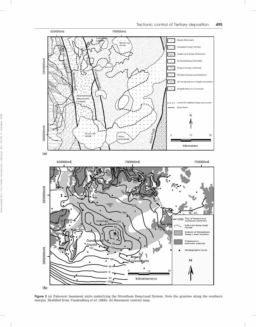
Figure 2 (a) Paleozoic basement units underlying the Streatham Deep-Lead System. Note the granites along the southern
margin. Modified from VandenBerg et al. (2000). (b) Basement contour map.
Tectonic control of Tertiary deposition 495
Downloaded By: [La Trobe University Library] At: 03:59 21 October 2008
drainage that bears no relationship to the underlying
deep-lead system.
METHODS
To investigate the Streatham Deep-Lead System, bore
log records of more than 300 exploration, groundwater
and stratigraphic bores were compiled and analysed
from well-completion reports, mining records and
electronic databases. Where the deep-lead sediments
are covered by valley-filling basalts, their extent can
often be mapped using the first derivative of the
aeromagnetic intensity, because the increased thickness
of the basalts in the paleovalleys and/or the existence of
a maghemite/ferricrete layer on top of the deep-lead
sediments gives an enhanced magnetic response
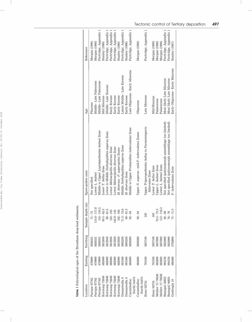
(Holdgate et al. 2006). Palynological ages for the deep-
lead strata (Table 1) were compiled from previous
studies and supplemented by nine additional determina-
tions by A. D. Partridge (Appendix 1) conducted on chip
samples sourced from the Department of Primary
Industries Core Library.
A Digital Elevation Model (DEM) from the NASA
shuttle radar topography mission was combined with
high-resolution airborne geophysical images (radio-
metrics, aeromagnetics and gravity) using Global Map-
per and MapInfo to map the basement geology,
particularly the orientation of lineaments and locations
of granites, as well as the extent of the Newer Volcanics.
All data were incorporated into a set of geological maps
and cross-sections, using the AGD 66 datum, and from
this information, a conceptual model for the evolution
and the structural controls of the Streatham Deep-Lead
System has been developed.
STREATHAM DEEP-LEAD SYSTEM
The Streatham Deep-Lead System extends over an area
of more than 2500 km2 south of the West Victorian
Uplands and southeast of the Grampians, and comprises
three parts: a branched headwater system, a central
deep with three depocentres, and two southern outlets.
Headwater system
The widely branched headwater tributary system con-
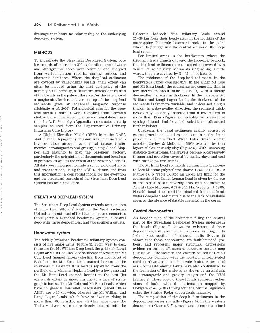
sists of five major arms (Figure 3). From west to east,
these are the Mt William Deep Lead, the gold-rich Langi
Logan or Main Hopkins Lead southeast of Ararat, the Mt
Cole Lead (named herein) starting from northwest of
Beaufort, the Mt. Emu Lead (named herein) to the
southeast of Beaufort (this lead is separated from the
north-flowing Madame Hopkins Lead by a low pass) and
the Mt Bute Lead (named herein) to the east (its
eastwards extent is uncertain due to a lack of strati-
graphic bores). The Mt Cole and Mt Emu Leads, which
have in general low-relief headwaters (about 300 m
AHD), are 410 km wide, whereas the Mt William and
Langi Logan Leads, which have headwaters rising to
more than 500 m AHD, are 52.5 km wide; here the
Tertiary rivers were more deeply incised into the
Paleozoic bedrock. The tributary leads extend
25 – 30 km from their headwaters in the foothills of the
outcropping Paleozoic basement rocks to the point
where they merge into the central section of the deep-
lead system.
For limited areas in the headwaters, where the
tributary leads branch out onto the Paleozoic bedrock,
the deep-lead sediments are uncapped or covered by a
veneer of Quaternary sediments (Figure 4a). South-
wards, they are covered by 30 – 110 m of basalts.
The thickness of the deep-lead sediments in the
headwaters varies considerably. In the wider Mt Cole
and Mt Emu Leads, the sediments are generally thin (a
few metres to about 30 m: Figure 3) with a steady
downvalley increase in thickness. In the narrower Mt
William and Langi Logan Leads, the thickness of the
sediments is far more variable, and it does not always
thicken in a downvalley direction; the sediment thick-
nesses may suddenly increase from a few metres to
more than 45 m (Figure 3), probably as a result of
syndepositional fault-bounded subsidence (discussed
further below).
Upstream, the basal sediments mainly consist of
coarse gravel and boulders and contain a significant
proportion of reworked White Hills Gravel quartz
cobbles (Cayley & McDonald 1995) overlain by thin
layers of clay or sandy clay (Figure 5). With increasing
distance downstream, the gravels become progressively
thinner and are often covered by sands, clays and coal
with fining-upwards trends.
The Mt Emu Lead sediments contain Late Oligocene
to Late Miocene palynofloras (bores 46853, 54474, 62734:
Figure 4a, b; Table 1), and an upper age limit for the
sediments of the Langi Longan Lead is given by the age
of the oldest basalt covering this lead southeast of
Ararat (Late Miocene, 6.07+ 0.11 Ma: Webb et al. 1998).
No additional dates could be obtained from the head-
waters deep-lead sediments due to the lack of available
cores or the absence of datable material in the cores.
Central depocentres
An isopach map of the sediments filling the central
part of the Streatham Deep-Lead System underneath
the basalt (Figure 3) shows the existence of three
depocentres, with sediment thicknesses reaching up to
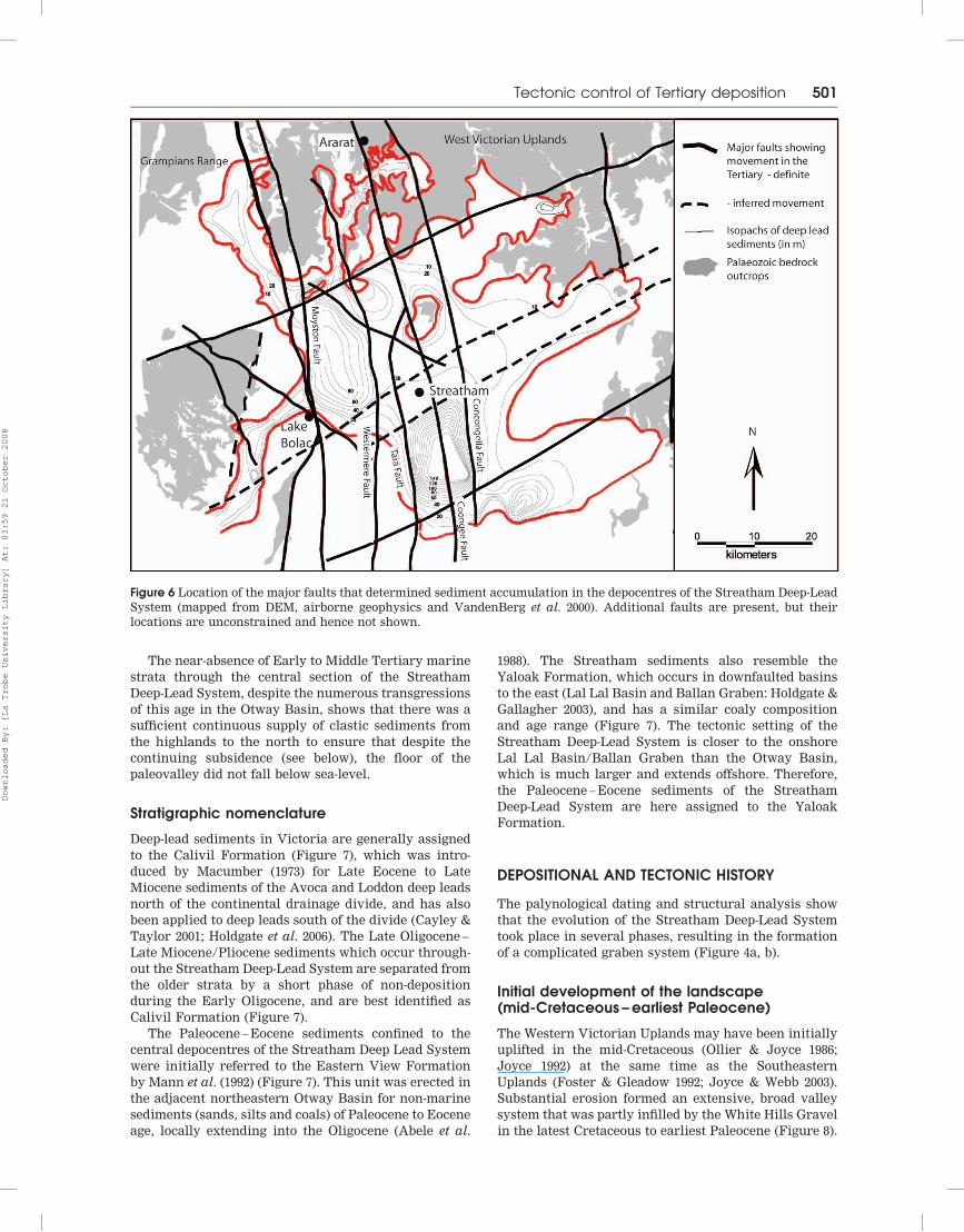
140 m. Superposition of mapped faults (Figure 6)
shows that these depocentres are fault-bounded gra-
bens, and represent major structural depressions
evident on the top-of-basement structure contour map
(Figure 2b). The western and eastern boundaries of all
depocentres coincide with the location of reactivated
north-northwest-oriented Paleozoic faults. A series of
east-northeast-trending faults have also contributed to
the formation of the grabens, as shown by an analysis
of aeromagnetic and gravity images and the DEM
(Figure 6). These east-northeast faults represent exten-
sions of faults with this orientation mapped by
Holdgate et al. (2006) throughout the central highlands
using the Shuttle Radar topographic imagery.
The composition of the deep-lead sediments in the
depocentres varies spatially (Figure 5). In the western
depocentre (Figures 3, 5), gravels are absent or confined
496 M. Raiber and J. A. Webb
Downloaded By: [La Trobe University Library] At: 03:59 21 October 2008
Table
1P
aly
no
log
ica
la
ge
so
fth
eS
tre
ath
am
de
ep
-le
ad
sed
ime
nts
.
Lo
ca
tio
nE
ast
ing
No
rth
ing
Sa
mp
led
ep
th(m
)S
po
re
-po
lle
nzo
ne
Ag
eR
efe
re
nc
e
Pa
ru
pa
/87762
670800
5826551
71
–73
No
tsp
ec
ifie
dP
lio
ce
ne
Mo
rg
an
(1990)
Pa
ru
pa
/87762
670800
5826551
114.8
–117.8
Lo
we
rL
.b
alm
eiM
idd
le–
La
teP
ale
oc
en
eM
org
an
(1990)
Pa
ru
pa
/87762
670800
5826551
144
–144.5
Mid
dle
toU
pp
er
Ly
gis
tep
oll
enit
esb
alm
eiZ
on
eM
idd
le–
La
teP
ale
oc
en
eP
artr
idg
e,
Ap
pe
nd
ix1
Ko
rn
on
g/
72649
682000
5812950
59.5
–62.5
Lo
wer
T.
bel
lus
Zo
ne
Mid
Mio
ce
ne
Sta
nle
y(1
990)
Ko
rn
on
g/
72649
682000
5812950
80
–81.5
Lo
we
rto
Mid
dle
No
tho
fag
idit
esa
sper
us
Zo
ne
Mid
dle
–L
ate
Eo
ce
ne
Pa
rtr
idg
e,
Ap
pe
nd
ix1
Ko
rn
on
g/
72649
682000
5812950
122
–123
Lo
we
rM
alv
aci
po
llis
div
ersu
sZ
on
eE
arly
Eo
ce
ne
Pa
rtr
idg
e,
Ap
pe
nd
ix1
Ko
rn
on
g/
72649
682000
5812950
142.8
–145
Lo
we
rM
alv
aci
po
llis
div
ersu
sZ
on
eE
arly
Eo
ce
ne
Pa
rtr
idg
e,
Ap
pe
nd
ix1
Ko
rn
on
g/
72649
682000
5812950
162
–166
M.
div
ersu
s–
P.
asp
ero
po
lus
Zo
ne
sE
arly
Eo
ce
ne
Sta
nle
y(1
990)
Du
nn
aw
all
a9
691500
5805250
71.5
–72.8
Mid
dle
No
tho
fag
idit
esa
sper
us
Zo
ne
La
test
Mid
dle
–L
ate
Eo
ce
ne
Pa
rtr
idg
e,
Ap
pe
nd
ix1
Du
nn
aw
all
a9
691500
5805250
90
–91.5
M.
div
ersu
sZ
on
eE
arly
Eo
ce
ne
Sta
nle
y(1
988)
Ca
ra
mb
all
uc
No
rth
/54474
684000
5830200
92
–94
Mid
dle
toU
pp
er
Pro
tea
cid
ites
tub
ercu
latu
sZ
on
eL
ate
Oli
go
ce
ne
–E
arly
Mio
ce
ne
Pa
rtr
idg
e,
Ap
pe
nd
ix1
Ca
ra
mb
all
uc
No
rth
/54474
684000
5830200
92
–94
Up
pe
rN
.a
sper
us
–m
id-P
.tu
ber
cula
tus
Zo
ne
sO
lig
oc
en
eM
org
an
(1990)
En
uc
/62734
701550
5837100
105
Up
pe
rT
rip
oro
po
llen
ites
bel
lus
toF
ora
min
isp
ori
s
bif
urc
atu
sZ
on
e
La
teM
ioc
en
eP
artr
idg
e,
Ap
pe
nd
ix1
En
uc
/62734
701550
5837100
105
Lo
we
rT
.b
ellu
sZ
on
eM
id-M
ioc
en
eM
org
an
(1990)
Me
llie
r17/
78528
663600
5837800
72.5
–75.5
Up
pe
rL
.b
alm
eiZ
on
eP
ala
eo
ce
ne
Mo
rg
an
(1990)
Me
llie
r17/
78528
663600
5837800
113
–116.3
Lo
we
rL
.b
alm
eiZ
on
eP
ala
eo
ce
ne
Mo
rg
an
(1990)
Ba
an
ga
l/46853
694150
5824900
66
–68
No
tsp
ec
ifie
d(p
aly
no
mo
rp
ha
sse
mb
lag
eto
oli
mit
ed
)M
ost
lik
ely
La
teM
ioc
en
eP
artr
idg
e,
Ap
pe
nd
ix1
Ba
an
ga
l/46853
694150
5824900
76
–78
No
tsp
ec
ifie
d(p
aly
no
mo
rp
ha
sse
mb
lag
eto
oli
mit
ed
)M
ost
lik
ely
La
teM
ioc
en
eP
artr
idg
e,
Ap
pe
nd
ix1
Ge
ele
ng
la10
686400
5792800
71
–71.5
P.
tub
ercu
latu
sZ
on
eE
arly
Oli
go
ce
ne
–E
arly
Mio
ce
ne
Sta
nle
y(1
987)
Tectonic control of Tertiary deposition 497
Downloaded By: [La Trobe University Library] At: 03:59 21 October 2008
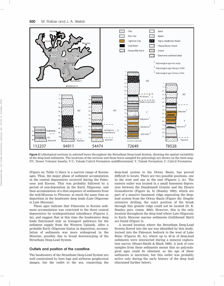
to thin layers while sands, ligneous clays and coal
dominate. In the central depocentre, up to 15 fining-
upwards cycles can be identified (Figure 5). These
fining-upwards cycles and the coaly lithology indicate
that the deposition of these sediments occurred in a
floodplain environment with repeated periods of flood-
ing and drying.
The overall transformation from very coarse-
grained fluvial sediments in the headwaters of the
deep leads to finer-grained sediments deposited in a
swampy environment downstream marks a change
from high-energy transport in a dominantly braided
river system in the steeper upper reaches to low-energy
transport across a floodplain in the central section of
the deep-lead system.
Palynological age determinations show that deposi-
tion in the central depocentres took place over a time
interval of more than 50 million years, from mid – Late
Paleocene to Middle – Late Miocene (Morgan 1990;
Stanley 1987, 1988, 1990; this study; Table 1; Appendix
1). The oldest sediments (mid – Late Paleocene) are
*80 m thick and located in the western depocentre
(Figures 4a, 5; Table 1). Ages from the 140 m of
sediments in the central depocentre range from Early
Eocene to Late Miocene, with most of the sediments
deposited during the Eocene. In the eastern depocentre
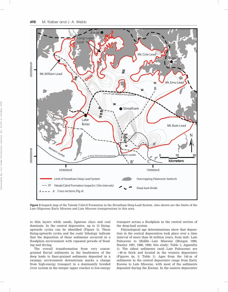
Figure 3 Isopach map of the Yaloak/Calivil Formation in the Streatham Deep-Lead System. Also shown are the limits of the
Late Oligocene/Early Miocene and Late Miocene transgressions in this area.
498 M. Raiber and J. A. Webb
Downloaded By: [La Trobe University Library] At: 03:59 21 October 2008
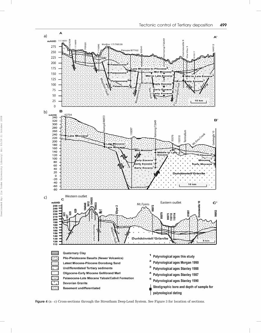
Figure 4 (a – c) Cross-sections through the Streatham Deep-Lead System. See Figure 3 for location of sections.
Tectonic control of Tertiary deposition 499
Downloaded By: [La Trobe University Library] At: 03:59 21 October 2008
(Figure 4a; Table 1) there is a narrow range of Eocene
ages. Thus, the major phase of sediment accumulation
in the central depocentres occurred during the Paleo-
cene and Eocene. This was probably followed by a
period of non-deposition in the Early Oligocene, and
then accumulation of a thin sequence of sediments from
the mid-Miocene to Pliocene, at much the same time as
deposition in the headwater deep leads (Late Oligocene
to Late Miocene).
These ages indicate that Paleocene to Eocene sedi-
ment accumulation was restricted to the three central
depocentres by syndepositional subsidence (Figures 3,
4a), and suggest that at this time the headwaters deep
leads functioned only as transport pathways for the
sediment supply from the Western Uplands. After a
probable Early Oligocene hiatus in deposition, accumu-
lation of sediments was more widespread in the
Miocene, possibly due to broad downwarping of the
Streatham Deep-Lead System.
Outlets and position of the coastline
The headwaters of the Streatham Deep-Lead System are
well constrained by bore logs and airborne geophysical
images, but the outlet to the sea, connecting the
deep-lead system to the Otway Basin, has proved
difficult to locate. There are two possible positions, one
in the west and one in the east (Figures 3, 4c). The
eastern outlet was located in a small basement depres-
sion between the Dundonnell Granite and the Illoura
Granodiorite (Figure 2a, b) (Stanley 1992), which are
part of a massive basement ridge separating the deep-
lead system from the Otway Basin (Figure 4b). Despite
extensive drilling, the exact position of the break
through this granite ridge could not be located (D. R.
Stanley pers. comm. 2005). However, this is the only
location throughout the deep lead where Late Oligocene
to Early Miocene marine sediments (Gellibrand Marl)
are found (Figure 3).
A second location where the Streatham Deep-Lead
System flowed into the sea was identified by this study,
incised into the Paleozoic bedrock to the west of Lake
Bolac (Figures 2b, 4c), where up to 40 m of deep-lead
sediments were intersected during a mineral explora-
tion survey (Stuart-Smith & Black 1999). A lack of core
samples from these sediments meant that no palynolo-
gical ages could be obtained, so the age of these
sediments is uncertain, but this outlet was probably
active only during the early history of the deep lead
(discussed further below).
Figure 5 Lithological sections in selected bores throughout the Streatham Deep-Lead System, showing the spatial variability
of the deep-lead sediments. The locations of the sections and those bores sampled for palynology are shown on the inset map.
NV, Newer Volcanic basalts; Y/C, Yaloak/Calivil Formation undifferentiated; Y, Yaloak Formation; C, Calivil Formation.
500 M. Raiber and J. A. Webb
Downloaded By: [La Trobe University Library] At: 03:59 21 October 2008
The near-absence of Early to Middle Tertiary marine
strata through the central section of the Streatham
Deep-Lead System, despite the numerous transgressions
of this age in the Otway Basin, shows that there was a
sufficient continuous supply of clastic sediments from
the highlands to the north to ensure that despite the
continuing subsidence (see below), the floor of the
paleovalley did not fall below sea-level.
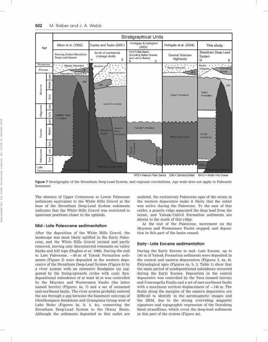
Stratigraphic nomenclature
Deep-lead sediments in Victoria are generally assigned
to the Calivil Formation (Figure 7), which was intro-
duced by Macumber (1973) for Late Eocene to Late
Miocene sediments of the Avoca and Loddon deep leads
north of the continental drainage divide, and has also
been applied to deep leads south of the divide (Cayley &
Taylor 2001; Holdgate et al. 2006). The Late Oligocene –
Late Miocene/Pliocene sediments which occur through-
out the Streatham Deep-Lead System are separated from
the older strata by a short phase of non-deposition
during the Early Oligocene, and are best identified as
Calivil Formation (Figure 7).
The Paleocene – Eocene sediments confined to the
central depocentres of the Streatham Deep Lead System
were initially referred to the Eastern View Formation
by Mann et al. (1992) (Figure 7). This unit was erected in
the adjacent northeastern Otway Basin for non-marine
sediments (sands, silts and coals) of Paleocene to Eocene
age, locally extending into the Oligocene (Abele et al.
1988). The Streatham sediments also resemble the
Yaloak Formation, which occurs in downfaulted basins
to the east (Lal Lal Basin and Ballan Graben: Holdgate &
Gallagher 2003), and has a similar coaly composition
and age range (Figure 7). The tectonic setting of the
Streatham Deep-Lead System is closer to the onshore
Lal Lal Basin/Ballan Graben than the Otway Basin,
which is much larger and extends offshore. Therefore,
the Paleocene – Eocene sediments of the Streatham
Deep-Lead System are here assigned to the Yaloak
Formation.
DEPOSITIONAL AND TECTONIC HISTORY
The palynological dating and structural analysis show
that the evolution of the Streatham Deep-Lead System
took place in several phases, resulting in the formation
of a complicated graben system (Figure 4a, b).
Initial development of the landscape(mid-Cretaceous –earliest Paleocene)
The Western Victorian Uplands may have been initially
uplifted in the mid-Cretaceous (Ollier & Joyce 1986;
Joyce 1992) at the same time as the Southeastern
Uplands (Foster & Gleadow 1992; Joyce & Webb 2003).
Substantial erosion formed an extensive, broad valley
system that was partly infilled by the White Hills Gravel
in the latest Cretaceous to earliest Paleocene (Figure 8).
Figure 6 Location of the major faults that determined sediment accumulation in the depocentres of the Streatham Deep-Lead
System (mapped from DEM, airborne geophysics and VandenBerg et al. 2000). Additional faults are present, but their
locations are unconstrained and hence not shown.
Tectonic control of Tertiary deposition 501
Downloaded By: [La Trobe University Library] At: 03:59 21 October 2008
The absence of Upper Cretaceous to Lower Paleocene
sediments equivalent to the White Hills Gravel at the
base of the Streatham Deep-Lead System sediments
indicates that the White Hills Gravel was restricted to
upstream positions closer to the uplands.
Mid – Late Paleocene sedimentation
After the deposition of the White Hills Gravel, the
landscape was most likely uplifted in the Early Paleo-
cene, and the White Hills Gravel incised and partly
removed, leaving only disconnected remnants on valley
flanks and hill tops (Hughes et al. 1998). During the mid
to Late Paleocene, *80 m of Yaloak Formation sedi-
ments (Figure 3) were deposited in the western depo-
centre of the Streatham Deep-Lead System (Figure 8) by
a river system with an extensive floodplain (as sug-
gested by the fining-upwards cycles with coal). Syn-
depositional subsidence of at least 40 m was controlled
by the Moyston and Westermere Faults (the latter
named herein) (Figures 4a, 7) and a set of unnamed
east-northeast faults. The river system probably entered
the sea through a gap between the basement outcrops of
Glenthompson Sandstone and Grampians Group west of
Lake Bolac (Figures 2a, b, 3, 4c), connecting the
Streatham Deep-Lead System to the Otway Basin.
Although the sediments deposited in this outlet are
undated, the exclusively Paleocene ages of the strata in
the western depocentre make it likely that the outlet
was active during the Paleocene. To the east of this
outlet, a granite ridge separated the deep lead from the
ocean, and Yaloak/Calivil Formation sediments are
absent to the south of this ridge.
At the end of the Paleocene, movement on the
Moyston and Westermere Faults stopped, and deposi-
tion in this part of the basin ceased.
Early – Late Eocene sedimentation
During the Early Eocene to mid – Late Eocene, up to
140 m of Yaloak Formation sediments were deposited in
the central and eastern depocentres (Figures 3, 4a, 8).
Palynological ages (Figures 4a, b, 5; Table 1) show that
the main period of syndepositional subsidence occurred
during the Early Eocene. Deposition in the central
depocentre was controlled by the Tara (named herein)
and Concongella Faults and a set of east-northeast faults
with a maximum vertical displacement of *140 m. The
faults along the margins of the eastern depocentre are
difficult to identify in the aeromagnetic images and
the DEM, due to the strong overriding magnetic
signature and topographic expression of the Dorodong
Sand strandlines, which cover the deep-lead sediments
in this part of the system (Figure 4a).
Figure 7 Stratigraphy of the Streatham Deep-Lead System, and regional correlations. Age scale does not apply to Paleozoic
basement.
502 M. Raiber and J. A. Webb
Downloaded By: [La Trobe University Library] At: 03:59 21 October 2008
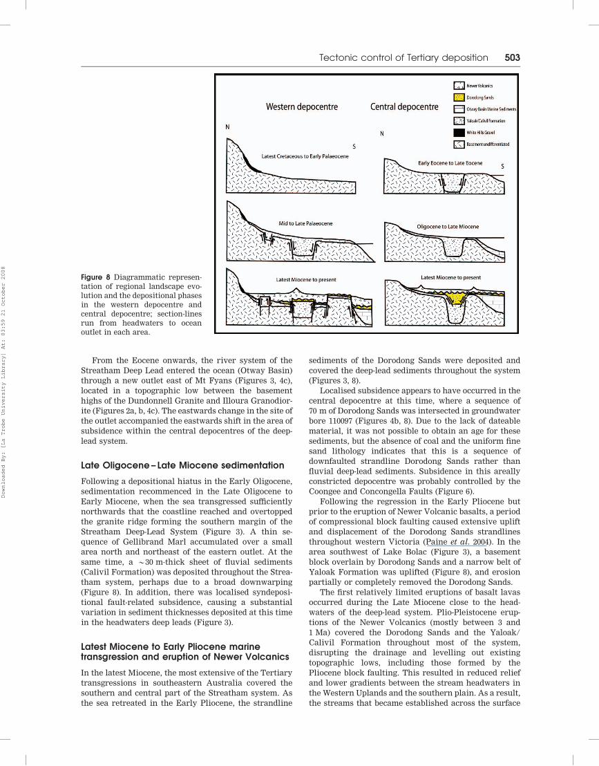
From the Eocene onwards, the river system of the
Streatham Deep Lead entered the ocean (Otway Basin)
through a new outlet east of Mt Fyans (Figures 3, 4c),
located in a topographic low between the basement
highs of the Dundonnell Granite and Illoura Granodior-
ite (Figures 2a, b, 4c). The eastwards change in the site of
the outlet accompanied the eastwards shift in the area of
subsidence within the central depocentres of the deep-
lead system.
Late Oligocene– Late Miocene sedimentation
Following a depositional hiatus in the Early Oligocene,
sedimentation recommenced in the Late Oligocene to
Early Miocene, when the sea transgressed sufficiently
northwards that the coastline reached and overtopped
the granite ridge forming the southern margin of the
Streatham Deep-Lead System (Figure 3). A thin se-
quence of Gellibrand Marl accumulated over a small
area north and northeast of the eastern outlet. At the
same time, a *30 m-thick sheet of fluvial sediments
(Calivil Formation) was deposited throughout the Strea-
tham system, perhaps due to a broad downwarping
(Figure 8). In addition, there was localised syndeposi-
tional fault-related subsidence, causing a substantial
variation in sediment thicknesses deposited at this time
in the headwaters deep leads (Figure 3).
Latest Miocene to Early Pliocene marinetransgression and eruption of Newer Volcanics
In the latest Miocene, the most extensive of the Tertiary
transgressions in southeastern Australia covered the
southern and central part of the Streatham system. As
the sea retreated in the Early Pliocene, the strandline
sediments of the Dorodong Sands were deposited and
covered the deep-lead sediments throughout the system
(Figures 3, 8).
Localised subsidence appears to have occurred in the
central depocentre at this time, where a sequence of
70 m of Dorodong Sands was intersected in groundwater
bore 110097 (Figures 4b, 8). Due to the lack of dateable
material, it was not possible to obtain an age for these
sediments, but the absence of coal and the uniform fine
sand lithology indicates that this is a sequence of
downfaulted strandline Dorodong Sands rather than
fluvial deep-lead sediments. Subsidence in this areally
constricted depocentre was probably controlled by the
Coongee and Concongella Faults (Figure 6).
Following the regression in the Early Pliocene but
prior to the eruption of Newer Volcanic basalts, a period
of compressional block faulting caused extensive uplift
and displacement of the Dorodong Sands strandlines
throughout western Victoria (Paine et al. 2004). In the
area southwest of Lake Bolac (Figure 3), a basement
block overlain by Dorodong Sands and a narrow belt of
Yaloak Formation was uplifted (Figure 8), and erosion
partially or completely removed the Dorodong Sands.
The first relatively limited eruptions of basalt lavas
occurred during the Late Miocene close to the head-
waters of the deep-lead system. Plio-Pleistocene erup-
tions of the Newer Volcanics (mostly between 3 and
1 Ma) covered the Dorodong Sands and the Yaloak/
Calivil Formation throughout most of the system,
disrupting the drainage and levelling out existing
topographic lows, including those formed by the
Pliocene block faulting. This resulted in reduced relief
and lower gradients between the stream headwaters in
the Western Uplands and the southern plain. As a result,
the streams that became established across the surface
Figure 8 Diagrammatic represen-
tation of regional landscape evo-
lution and the depositional phases
in the western depocentre and
central depocentre; section-lines
run from headwaters to ocean
outlet in each area.
Tectonic control of Tertiary deposition 503
Downloaded By: [La Trobe University Library] At: 03:59 21 October 2008
of the basalt have only shallow valleys and thin fluvial
sediments.
DISCUSSION
Structural trends and Tertiary tectonism acrosswestern Victoria
Early Tertiary fault movement, probably related to the
Australia – Antarctica breakup, was widespread across
western Victoria; minor overall north – south extension
reactivated pre-existing faults to form localised grabens
that received Paleocene – Eocene sediments. Fault activ-
ity in the Streatham Deep-Lead System has similar
timing and structural trends to that in the eastern
Otway Basin.
In the Port Campbell Embayment and Colac Trough,
located to the south and southeast of the Streatham
Deep-Lead System (Figure 1), thick sequences of Wan-
gerrip Group were deposited unconformably on the Late
Cretaceous Sherbrook Group during the Paleocene to
Early Eocene, due to subsidence controlled by faulting
(Cooper 1995; Edwards et al. 1996). Syndepositional
graben formation also occurred in the Tyrendarra
Embayment during the Paleocene to Early Eocene
(Perincek & Cockshell 1995).
The major north-northwest-trending lineaments
across the Streatham Deep-Lead System (e.g. Moyston,
Coongee and Concongella Faults) can be traced south on
aeromagnetic and gravity images from the Western
Volcanic Plain into the eastern part of the Otway
Basin, where these reactivated Paleozoic structures also
control sediment accumulation (Moore 2002). East-
northeast-trending lineaments, such as the Colac
Monocline and the Bambra Fault, can be identified on
gravity images across the northern margin of the Port
Campbell Embayment and the Colac Trough. These
lineaments run parallel to the main rift axis between
Antarctica and Australia (Edwards et al. 1996), which
developed during the mid-Cretaceous (Moore 2002), and
also correspond to the east-northeast structural trends
observed throughout the Streatham Deep-Lead System
and the Western Uplands.
The Tertiary deep-lead systems north of the drainage
divide (e.g. Loddon – Ballarat system) are cross-cut by
east-northeast-trending faults (Holdgate et al. 2006) that
can be traced southwestwards using the airborne
geophysical images and the DEM into the Streatham
Deep-Lead System, where they represent the northern
and southern edges of the major depocentres and also
cross-cut the headwaters deep leads. The east-northeast
faulting north of the divide was coeval with the Late
Eocene to Miocene sedimentation in both these deep
leads (Canavan 1988; Holdgate et al. 2006) and the
headwaters deep leads south of the divide, but was later
than the Paleocene – Eocene activity in the central
depocentres of the Streatham Deep-Lead System.
Early Pliocene syndepositional downfaulting of
Dorodong Sands occurred contemporaneously in the
Hamilton Graben west of the study area (Paine et al.
2004), and in the central depocentre of the Streatham
Deep-Lead System (Figure 8).
CONCLUSIONS
The mainly sub-basaltic Streatham Deep-Lead System
covers *2500 km2 and consists of five major tributaries,
which fuse into a central section with three major
depocentres. Fluvial coal-bearing sediments of the
Yaloak Formation were deposited in the depocentres as
a series of fining-upwards cycles. The western depocen-
tre received *80 m of sediments from the mid to Late
Paleocene, whereas the central and eastern depocentres
accumulated up to 140 m of Eocene to Late Miocene
strata. Sediment accumulation was controlled by sub-
sidence along north-northwest- and east-northeast-
trending, reactivated Paleozoic and Cretaceous faults.
Syndepositional faulting with a similar orientation and
timing also occurred in the Otway Basin to the south.
In the Paleocene, the river system of the Streatham
Deep Lead flowed into the ocean (Otway Basin) through
a western outlet; in the Eocene, the outlet shifted
eastwards along with the locus of sedimentation, to a
location between two basement highs east of Mt Fyans.
Following a short hiatus in the Early Oligocene,
fluvial sedimentation and syndepositional faulting re-
commenced from the Late Oligocene to Late Miocene/
Pliocene, depositing the *30 m thick Calivil Formation
throughout the deep-lead system, perhaps due to a broad
downwarping. Sediment deposition and faulting oc-
curred at the same time in the north-flowing deep leads
in central and northern Victoria.
A period of latest Miocene to Early Pliocene fault
subsidence affected the central depocentre, followed by
widespread compressional block faulting across western
Victoria in the Early Pliocene. The deep-lead sediments
were then covered by basalts, mostly erupted in the Plio-
Pleistocene.
ACKNOWLEDGEMENTS
We would like to acknowledge the financial assistance of
the Glenelg Hopkins Catchment Management Authority
and the Australian Institute of Nuclear Science and
Engineering. We also wish to thank the Department of
Primary Industries Victoria for providing bore log re-
cords and airborne geophysical images and granting
access to the core library, as well as Sinclair Knight Mertz
for supplying bore log records. The authors wish to thank
Darren Bennetts and Matthew Edwards for their com-
ments on the draft manuscript and journal reviewers
David Taylor and Guy Holdgate for their suggestions,
which helped to improve the quality of the manuscript.
REFERENCES
ABELE C., GLOE C. S., HOCKING J. B., HOLDGATE G., KENLEY P. R.,
LAWRENCE C. R., RIPPER D., THRELFALL W. F. & BOLGER P. F. 1988.
Tertiary. In: Douglas J. G. & Ferguson J. A. eds. Geology of
Victoria, pp. 251 – 350. Geological Society of Australia, Victorian
Division, Melbourne.
BENNETTS D. A., WEBB J. A. & GRAY C. M. 2003. Distribution of Plio-
Pleistocene basalts and regolith around Hamilton, western
Victoria, and their relationship to groundwater recharge and
discharge. In: Roach I. C. ed. Advances in Regolith, pp. 11 – 15.
Cooperative Research Centre for Landscape Environments and
Mineral Exploration, Bentley.
504 M. Raiber and J. A. Webb
Downloaded By: [La Trobe University Library] At: 03:59 21 October 2008
BIRCH W. D., BARRON L. M., MAGEE C. & SUTHERLAND F. L. 2007. Gold-
and diamond-bearing White Hills Gravel, St Arnaud district,
Victoria: age and provenance based on U – Pb dating of zircon
and rutile. Australian Journal of Earth Sciences 54, 609 – 628.
BISHOP P. & LI S. 1997. Sub-basaltic deep-lead systems and gold
exploration at Ballarat, Australia. Australian Journal of Earth
Sciences 44, 253 – 264.
BRADLEY J., STANLEY D., MANN B., CHAPLIN H. & FOLEY G. 1994.
Ballarat Hydrogeological Map (1:250 000 scale) Murray Basin
Hydrogeological Map Series. Australian Geological Survey
Organisation, Canberra.
CANAVAN F. 1988. Deep lead gold deposits of Victoria. Geological
Survey of Victoria Bulletin 62.
CAREY S. P. & HUGHES M. J. 1997. Three generations of gold-bearing
fluvial systems at Ararat, Victoria. Geological Society of Aus-
tralia Abstracts 47, 4.
CAYLEY R. A. & MCDONALD P. A. 1995. Beaufort 1:100 000 map
geological report. Geological Survey of Victoria Report 104.
CAYLEY R. A. & TAYLOR D. H. 2001. Ararat 1:100 000 map geological
report. Geological Survey of Victoria Report 115.
COOPER G. T. 1995. Seismic structure and extensional development of
the eastern Otway Basin – Torquay Embayment. APEA Journal
35, 436 – 450.
EDWARDS J., LEONARD J. G., PETTIFER G. R. & MCDONALD P. A. 1996.
Colac 1:250 000 map geological report. Geological Survey of
Victoria Report 98.
FOSTER D. A. & GLEADOW A. J. W. 1992. Reactivated tectonic
boundaries and implications for the reconstruction of south-
eastern Australia and northern Victoria Land, Antarctica.
Geology 20, 267 – 270.
HILL S. M. 1999. Mesozoic regolith and palaeolandscape features in
southeastern Australia: significance for interpretations of denu-
dation and highland evolution. Australian Journal of Earth
Sciences 46, 217 – 232.
HOLDGATE G. R., CUNNINGHAM K. A., WALLACE M. W.,
GALLAGHER S. J. & MOORE D. H. 2004. Tertiary ‘deep lead’
palaeoriver systems and their relationship to basin evolution,
Victoria. In: Boult P. J., Johns D. R. & Lang S. C. eds. Eastern
Australasian Basin Symposium 2, pp. 707 – 724. Petroleum
Exploration Society of Australia Special Publication.
HOLDGATE G. R. & GALLAGHER S. J. 2003. Chapter 10: Tertiary. In:
Birch W. D. ed. Geology of Victoria, pp. 289 – 335. Geological
Society of Australia Special Publication 23.
HOLDGATE G. R., WALLACE M. W., GALLAGHER S. J., WITTEN R. B.,
STATS B. & WAGSTAFF B. E. 2006. Cenozoic fault control on ‘deep
lead’ palaeoriver systems, Central Highlands, Victoria. Austra-
lian Journal of Earth Sciences 53, 445 – 468.
HUGHES M. J. & CAREY S. P. 2002. Palaeodrainage development of the
West Victorian Uplands, Victoria, Australia. In: Victoria Under-
cover: Benalla 2002. Conference Proceedings and Field Guide:
Collaborative Geoscience in Northern Victoria, pp. 155 – 159.
CSIRO Publishing, Collingwood.
HUGHES M. J., KOTSONIS A. & CAREY S. P. 1998. Cainozoic weathering
and its economic significance in Victoria. Australian Institute of
Geoscientists Bulletin 24, 135 – 148.
HUNTER S. B. 1909. The deep leads of Victoria. Geological Survey of
Victoria Memoir 7.
JOYCE E. B. 1992. The West Victorian Uplands of southeastern
Australia: origin and history. Earth Surface Processes and
Landforms 17, 407 – 418.
JOYCE E. B. 2003. Western Volcanic Plains, Victoria. In: Roach I. C.
ed. Advances in Regolith, p. 5. Cooperative Research Centre for
Landscape Environments and Mineral Exploration, Bentley.
JOYCE E. B. & WEBB J. A. 2003. Chapter 18: Geomorphology. In:
Birch W. D. ed. Geology of Victoria, pp. 553 – 562. Geological
Society of Australia Special Publication 23.
KRAUSE F. M. 1874. Geological Survey of Ararat. Geological Survey of
Victoria Progress Report 2, 93 – 98.
MACUMBER P. G. 1973. Progress report on the groundwater survey of
the Avoca and Loddon valleys. In: Groundwater Investigation
Program Report 1972, p. 7. Department of Mines Victoria.
MACUMBER P. G. 1991. Interaction between groundwater and surface
systems in northern Victoria. Department of Conservation and
Environment, Melbourne.
MANN B. S., STANLEY D. A., BOLGER P. F. & NOLAN J. 1992.
Groundwater processes in the basalt plains of
southwestern Victoria. Geological Survey of Australia Abstracts
32, 259 – 260.
MILLER J. McL., PHILLIPS D., WILSON C. J. L. & DUGDALE L. J. 2005.
Evolution of a reworked orogenic zone: the boundary
between the Delamerian and Lachlan Fold Belts,
southeastern Australia. Australian Journal of Earth Sciences
52, 921 – 940.
MOORE D. H. 2002. Basement basin relationships in the Otway Basin,
Victoria, Australia. Victorian Initiative for Minerals and Petro-
leum Report 78.
MORGAN R. 1990. Palynology of nineteen samples from the Basalt
Plains and Riverine Plains Victoria, Australia. Geological Survey
of Victoria Report 1990/24 (unpubl.).
NOLAN J., STANLEY D., WIJESEKERA N. & MANN B. 1990. Basalt plains
hydrogeological investigation progress report no. 1. Rural
Water Commission, Victoria, Investigation Branch Report 1990/
1 (unpubl.).
OLLIER C. D. & JOYCE E. B. 1986. Regolith terrain units of the
Hamilton 1:100 000 sheet, western Victoria. Bureau of Mineral
Resources Record 1986/33.
OLLIER C. D. & PAIN C. F. 1994. Landscape evolution and tectonics in
southeastern Australia. AGSO Journal of Australian Geology &
Geophysics 15, 335 – 345.
PAINE M. D., BENNETTS D. A., WEBB J. A. & MORAND V. J. 2004.
Nature and extent of Pliocene strandlines in southwestern
Victoria and their application to late Neogene tectonics.
Australian Journal of Earth Sciences 51, 407 – 422.
PERINCEK D. & COCKSHELL C. D. 1995. The Otway Basin: Early
Cretaceous rifting to Neogene inversion. APEA Journal 35,
451 – 466.
PRICE R. C., GRAY C. M. & FREY F. A. 1997. Strontium isotopic and
trace element heterogeneity in the plains basalts of the Newer
Volcanic Province, Victoria, Australia. Geochimica et Cosmochi-
mica Acta 61, 171 – 192.
STANLEY D.R. 1987. Well completion report: Geelengla 10. Rural
Water Commission, Victoria, Investigation Branch Report 1987/
48 (unpubl.).
STANLEY D. R. 1988. Well completion report; Dunnawalla 9, GC 13:
lignite potential of the northern margin of the Otway Basin.
Rural Water Commission, Victoria, Investigation Branch Report
1988/9 (unpubl.).
STANLEY D. R. 1990. Well Completion report Kornong 1 and 2. Rural
Water Commission, Victoria, Investigation Branch Report 1990/
26 (unpubl.).
STANLEY D. R. 1992. Groundwater usage and resource potential along
the northern margin of the Basalt Plains, western Victoria.
Rural Water Commission, Victoria, Investigation Branch Report
1992/6 (unpubl.).
STUART-SMITH P. & BLACK L. P. 1999. Willaura, Sheet 7422, Victoria,
1:100 000 Map Geological Report. Australian Geological Survey
Organisation Record 1999/38.
TAYLOR D. H. & GENTLE L. V. 2002. Evolution of deep-lead
palaeodrainages and gold exploration at Ballarat, Australia.
Australian Journal of Earth Sciences 49, 869 – 878.
TAYLOR D. H., WOHLT K. E., SIMONS B. A., MAHER S., MORAND V. J. &
SAPURMAS P. 2000. Creswick 1:100 000 map area geological report.
Geological Survey of Victoria Report 117.
VANDENBERG A. H. M., WILLMAN C. E., MAHER S., SIMONS B. A.,
CAYLEY R. A., TAYLOR D. H., MORAND V. J., MOORE D. H. &
RADOJKOVIC A. 2000. The Tasman Fold Belt System in Victoria.
Geological Survey of Victoria Special Publication.
WALLACE M. W., DICKINSON J. A., MOORE D. H. & SANDIFORD M. 2005.
Late Neogene strandlines of southern Victoria: a unique record
of eustasy and tectonics in southeast Australia. Australian
Journal of Earth Sciences 52, 279 – 297.
WEBB A. W., OSBORNE C. R., TAYLOR D. H. & CAYLEY R. A. 1998.
K – Ar geochronology of Newer Volcanics on the Ballarat 1:250
000 map sheet. Geological Survey of Victoria Report 1998/10
(unpubl.).
Received 9 February 2007; accepted 16 November 2007
Tectonic control of Tertiary deposition 505
Downloaded By: [La Trobe University Library] At: 03:59 21 October 2008
Bore-ID
Sample depth (m)
Parupa/
87762
144 – 145
Kornong/72649 Dunnawalla
9
71.5 – 72.8
Caramballuc
North 54474
92 – 94
Enuc/
62734
105
Baangal/
46853a
66 – 68 &
76 – 78
80 – 81.5 122 – 123 142.8 – 145
Spores
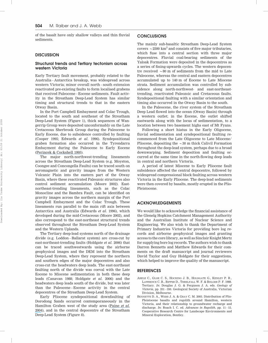
Baculatisporites disconformis – – – – – – X –
Baculatisporites sp. nov. – – – – – – 1.0% –
Baculatisporites spp. 1.0% 1.9% 0.6% 0.6% 1.0% – – –
Clavifera triplex 0.3% – – 1.3% – – – –
Cyathidites paleospora – – – – – – 28.0% X
Cyathidites porospora – – – – – – X –
Cyathidites splendens – – X X – – – –
Cyathidites spp. 7.7% – – – – – – –
Cyathidites spp. (large) – – 2.5% – – – – –
Cyathidites spp. (small) – 3.1% 3.1% 8.4% 1.5% – – –
Foveotriletes balteus 0.3% – – – – – – –
Foraminisporis bifurcatus – – – – – – ? –
Gleicheniidites circinidites 1.0% – 0.6% 0.6% – – 4.0% –
Ischyosporites gremius 1.3% X – X – – X –
Ischyosporites irregularis sp. nov. – – – – 1.5% – – –
Laevigatosporites major – 2.5% 0.6% X 1.0% – 3.5% –
Laevigatosporites ovatus 1.0% 0.6% 4.9% 2.6% 3.0% X 0.5% –
Matonisporites ornamentalis – X – – 0.5% – 0.5% –
Peromonolites densus – – – – X – – –
Peromonolites vellosus 0.3% – – – – – – –
Polypodiaceoisporites tumulatus – – – – – – X –
Polypodiisporites spp. 0.3% 4.3% – – 1.0% – 1.0% –
Ricciaesporites sp. – – – – – – X –
Rugulatisporites cowrensis – – – – – – 0.5% –
Trilete spores indet. – 0.6% – – 0.5% – – –
Tripunctisporis maastrichtiensis – – – X X – – –
Stereisporites australis – – – – – – 1.0% –
Rugulatisporites mallatus X – – – – – – –
Trilete spores indet. – – – – – – 0.5% –
Verrucosisporites kopukuensis 0.3% 1.2% X 0.6% 1.0% –
Total spores: 13.5% 14.3% 12.3% 14.2% 10.9% 51% 40.5% –
Gymnosperm pollen
Araucariacites australis 1.0% – 1.2% 1.9% – – 1.0% –
Dilwynites granulatus 11.3% – 1.9% 3.9% – – – –
Darcycarpites australiensis – 3.1% – – 5.4% – 2.0% –
Dilwynites tuberculatus 1.6% – 5.6% 0.6% – – – –
Lygistepollenites balmei 0.3% – – – – – – –
Lygistepollenites florinii 6.1% 7.5% 9.9% 3.9% 1.0% 0.5% 1.5% –
Microcachryidites antarcticus 0.6% – 1.2% 0.6% 1.0% – – –
Parvisaccites catastus – 0.6% – – – – – –
Phyllocladidites mawsonii 0.6% 9.9% – – X 1.4% – –
Phyllocladidites verrucosus X – – – – – – –
Podocarpidites spp. 40.0% 9.9% 29.6% 23.2% 12.4% – 3.5% –
Trichotomosulcites subgranulatus 6.1% 2.5% 0.6% 1.3% X – – –
Total gymnosperm pollen: 67.7% 33.5% 50.0% 35.5% 19.8% 1.9% 8.5% –
Angiosperm pollen
Banksieaeidites arcuatus – – – – – 0.5% – –
Banksieaeidites elongatus – – – – – 0.5% 0.5% –
Banksieaeidites minimus – – – – – – 5.5% –
Beaureaidites elanansiformis – – – – – 0.5% – –
Bysmapollis emaciatus – 0.6% – – – – – –
Bysmapollis minimus – – – – X – – –
Chenopodipollis chenopodiaceoides – – – – – – X –
(continued)
APPENDIX 1: SPECIES LIST OF STREATHAM DEEP-LEAD SEDIMENTS
A. D. Partridge (Biostrata Pty Ltd: [email protected])
506 M. Raiber and J. A. Webb
Downloaded By: [La Trobe University Library] At: 03:59 21 October 2008
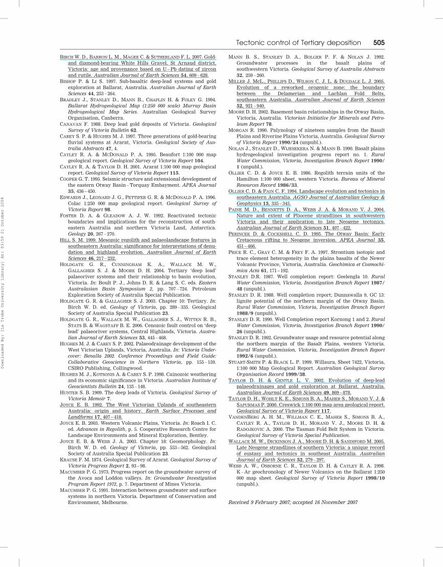
APPENDIX 1 (Continued)
Bore-ID
Sample depth (m)
Parupa/
87762
144 – 145
Kornong/72649 Dunnawalla
9
71.5 – 72.8
Caramballuc
North 54474
92 – 94
Enuc/
62734
105
Baangal/
46853a
66 – 68 &
76 – 78
80 – 81.5 122 – 123 142.8 – 145
Cupanieidites orthoteichus – – – – 0.5% – – –
Dicotetradites clavatus 0.3% 0.6% 4.3% 0.6% – – – –
Ericipites crassiexinus – 0.6% – – – – – –
Ericipites scabratus 0.6% – 3.1% 12.9% 0.5% 0.9% 0.5% X
Gambierina edwardsii 0.3% – – – – – – –
Gambierina rudata 0.3% – – – – – – –
Gyropollis psilatus – – – – – – 0.5% –
Haloragacidites amolosus – – – – – – 0.5% –
Haloragacidites haloragoides – – – – – – 5.5% X
Haloragacidites harrisii X 3.7% 1.2% 2.6% 2.5% 55.9% 10.0% X
Ilexpollenites anguloclavatus – – – – – 0.9% – –
Ilexpollenites spp. 0.6% – 1.2% X – – – –
Liliacidites sp. – – – – – – X –
Lymingtonia sp. – X – – – – – –
Malvacipollis robustus sp. nov. – X – – – – – –
Malvacipollis subtilis X 3.1% – X – 0.9% – –
Micrantheum spinysporis – – – – – X – –
Milfordia homeopunctata – – – – – – X –
Milfordia incertus – – – – – – 13.5% X
Myrtaceidites eucalyptoides – – – – – – 0.5% –
Myrtaceidites parvus/mesonesus – – – – – – 0.5% –
Nothofagidites asperus – – – – X – – –
Nothofagidites brachyspinulous – 0.6% – – 0.5% – – –
Nothofagidites deminutus – 0.6% – – 11.4% 2.3% – –
Nothofagidites emarcidus/heterus 1.0% 28.6% X 1.9% 44.1% 18.3% X –
Nothofagidites endurus 0.6% – – – – – – –
Nothofagidites falcatus – 3.1% – – 1.5% 0.5% 0.5% –
Nothofagidites flemingii X 1.2% X 0.6% – X – –
Nothofagidites goniatus – 0.6% – – – – – –
Nothofagidites vansteenisii – X – – 1.0% 0.5% – –
Periporopollenites demarcatus – 2.5% 1.2% – 2.5% 1.9% – –
Periporopollenites plyoratus 2.9% – – 1.3% X – – –
Periporopollenites vesicus – 1.2% – – – – – –
Polyporina reticulata – – – – – – – X
Polycolpites langstonii X – – – – – – –
Proteacidites spp. 9.0% 1.9% 13.6% 24.5% 2.0% 3.3% X –
Proteacidites annularis ? – – – – 1.4% – –
Proteacidites differentipolus – – – X – – – –
Proteacidites grandis – – 1.9% 1.9% – – – –
Proteacidites obscurus – – – – – 0.5% – –
Proteacidites pseudomoides – – 1.9% X – – – –
Proteacidites rectomarginis – – – – – 6.1% – –
Proteacidites stipplatus – – – – – X – –
Proteacidites sp. cf. P.rectus – – – X – – – –
Proteacidites tenuiexinus – – X X – – – –
Proteacidites truncatus – – – – – – X –
Proteacidites (Hakeidites) sp. – – – – – – 9.5% –
Pseudowinterapollis couperi – – – – – – X –
Santalumidites cainozoicus – X – – 0.5% – – –
Stephanocolpites oblatus – – – – – – X –
Striasyncolpites laxus – – – – – – X –
Tetracolporites multistrixus sp.nov. X – – – – – – –
Tetracolporites verrucosus ? – – – – – – –
Tricolpate and Tricolpate pollen undiff. 0.6% 2.5% 8.0% 2.6% – 1.9% 2.0% –
Tricolpites phillipsii 0.6% – – 1.3% – – – –
Tricolpites simatus – – – – X – – –
Tricolpites thomasii – – – – X – – –
Tricolporate pollen undiff. – – – – 1.0% – – –
Tricolporites adelaidensis 0.3% – 0.6% X – 0.5% – –
Tricolorites leuros – X – – 0.5% 0.9% – –
(continued)
Tectonic control of Tertiary deposition 507
Downloaded By: [La Trobe University Library] At: 03:59 21 October 2008
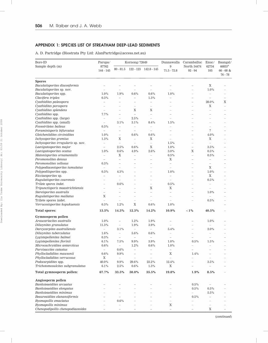
APPENDIX 1 (Continued)
Bore-ID
Sample depth (m)
Parupa/
87762
144 – 145
Kornong/72649 Dunnawalla
9
71.5 – 72.8
Caramballuc
North 54474
92 – 94
Enuc/
62734
105
Baangal/
46853a
66 – 68 &
76 – 78
80 – 81.5 122 – 123 142.8 – 145
Tricolporites marginatus sp. nov. X – X – – – – –
Tricolporites microreticulatus – – – X – – – –
Tricolporites sphaerica 1.0% 0.60% 0.60% – – – – –
Triporopollenites ambiguus – – – X 0.5% – – –
Triporopollenites spp. 0.3% – – – – – – –
Tubulifloridites antipodica – – – – – – 0.5% –
Total angiosperm pollen: 18.7% 52.2% 37.7% 50.3% 69.3% 98.1% 51.0% –
Total spore – pollen count: 310 161 162 155 202 213 200 –
Other palynomorphs
Fungal germlins – – – – – 0.7% – –
Fungal fruiting bodies – – 1.2% – – – – –
Fungal spores & hyphae 1.9% – 5.2% 1.9% 4.2% 27.2% 1.0% –
Botryococcus braunii – – – – – – 3.3% –
Brazilea sp. – – – – – – X –
Gelasinicysta vangellii – – – – – – 0.5% X
Gelasinicysta sp. 4 – – – – – – X –
Lecaniella sp. 8 – – – – – – X –
Tertaporina sp. – – – – – – – X
Indeterminate palynomorphs – – – – 3.7% 1.0% – –
Total other palynomorphs 1.9% 0% 6.4% 1.9% 7.9% 28.9% 4.8% –
Total other palynomorphs count: 6 0 11 3 17 85 10 –
Grand total count: 316 161 173 158 219 298 210 –
aLimited palynomorph assemblage in bore Baangal/46853 does not allow accurate determinations, but similarity of the assemblage to
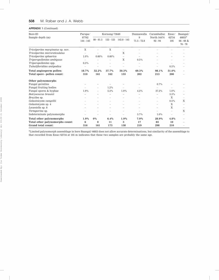
that recorded from Enuc/62734 at 105 m indicates that these two samples are probably the same age.
508 M. Raiber and J. A. Webb
Downloaded By: [La Trobe University Library] At: 03:59 21 October 2008