Technical Report on La Libertad Complex, Nicaragua Report ...
421
Technical Report on La Libertad Complex, Nicaragua Report for NI 43-101 Calibre Mining Corp. SLR Project No: 233.03320.R0000 March 30, 2021
-
Upload
khangminh22 -
Category
Documents
-
view
1 -
download
0
Transcript of Technical Report on La Libertad Complex, Nicaragua Report ...

Technical Report on La Libertad Complex, Nicaragua
Report for NI 43-101 Calibre Mining Corp.
SLR Project No: 233.03320.R0000 March 30, 2021

Technical Report on La Libertad Complex, Nicaragua
SLR Project No: 233.03320.R0000
Prepared by
SLR Consulting (Canada) Ltd. 55 University Ave., Suite 501
Toronto, ON M5J 2H7 for
Calibre Mining Corp.
Suite 413 – 595 Burrard Street P.O. Box 49167 Vancouver, BC
V7X 1J1
Effective Date – December 31, 2020 Signature Date - March 30, 2021
Prepared by: Grant A. Malensek, M.Eng., P.Eng. José M. Texidor Carlsson, M.Sc., P.Geo. Hugo M. Miranda, MBA, SME (RM) Stephan R. Blaho, P.Eng. Andrew P. Hampton, P.Eng. Luis Vasquez, M.Sc., P.Eng. Todd McCracken, P.Geo. Shane Ghouralal, MBA, P.Eng. Isabelle Larouche, P.Eng. Peer Reviewed by:
Approved by: Project Manager Grant A. Malensek, M.Eng., P.Eng. Project Director Richard J. Lambert, MBA, P.Eng.
FINAL Distribution: 1 copy – Calibre Mining Corp. 1 copy – SLR Consulting (Canada) Ltd. 1 copy – BBA E&C Inc. 1 copy – WSP Canada Inc.

Calibre Mining Corp. | La Libertad Complex, SLR Project No: 233.03320.R0000 NI 43-101 Technical Report - March 30, 2021 i
CONTENTS 1.0 SUMMARY .......................................................................................................................... 1-1
1.1 Executive Summary ....................................................................................................................... 1-1 1.2 Economic Analysis ....................................................................................................................... 1-12 1.3 Technical Summary ..................................................................................................................... 1-12
2.0 INTRODUCTION .................................................................................................................. 2-1
2.1 Sources of Information ................................................................................................................. 2-1 2.2 List of Abbreviations ..................................................................................................................... 2-3
3.0 RELIANCE ON OTHER EXPERTS ............................................................................................. 3-1
4.0 PROPERTY DESCRIPTION AND LOCATION ............................................................................. 4-1
4.1 La Libertad..................................................................................................................................... 4-1 4.2 Pavón ............................................................................................................................................ 4-7
5.0 ACCESSIBILITY, CLIMATE, LOCAL RESOURCES, INFRASTRUCTURE AND PHYSIOGRAPHY ......... 5-1
5.1 La Libertad..................................................................................................................................... 5-1 5.2 Pavón ............................................................................................................................................ 5-2
6.0 HISTORY ............................................................................................................................. 6-1
6.1 La Libertad..................................................................................................................................... 6-1 6.2 Pavón .......................................................................................................................................... 6-12
7.0 GEOLOGICAL SETTING AND MINERALIZATION ...................................................................... 7-1
7.1 La Libertad..................................................................................................................................... 7-1 7.2 Pavón .......................................................................................................................................... 7-11
8.0 DEPOSIT TYPES ................................................................................................................... 8-1
9.0 EXPLORATION ..................................................................................................................... 9-1
9.1 La Libertad..................................................................................................................................... 9-1 9.2 Pavón ............................................................................................................................................ 9-5
10.0 DRILLING .......................................................................................................................... 10-1
10.1 La Libertad................................................................................................................................... 10-1 10.2 Pavón .......................................................................................................................................... 10-8
11.0 SAMPLE PREPARATION, ANALYSES, AND SECURITY ............................................................ 11-1
11.1 La Libertad................................................................................................................................... 11-1 11.2 Pavón ........................................................................................................................................ 11-10
12.0 DATA VERIFICATION .......................................................................................................... 12-1

Calibre Mining Corp. | La Libertad Complex, SLR Project No: 233.03320.R0000 NI 43-101 Technical Report - March 30, 2021 ii
12.1 La Libertad................................................................................................................................... 12-1 12.2 Pavón .......................................................................................................................................... 12-1
13.0 MINERAL PROCESSING AND METALLURGICAL TESTING ...................................................... 13-1
13.1 Introduction ................................................................................................................................ 13-1 13.2 Metallurgical Testing................................................................................................................... 13-1
14.0 MINERAL RESOURCE ESTIMATE ......................................................................................... 14-1
14.1 Summary ..................................................................................................................................... 14-1 14.2 La Libertad................................................................................................................................... 14-4 14.3 Pavón ........................................................................................................................................ 14-47
15.0 MINERAL RESERVE ESTIMATE ............................................................................................ 15-1
15.1 Mineral Reserves Summary ........................................................................................................ 15-1 15.2 La Libertad................................................................................................................................... 15-2 15.3 Pavón Open Pit............................................................................................................................ 15-6 15.4 Factors that May Affect Mineral Reserve Estimates .................................................................. 15-7
16.0 MINING METHODS ............................................................................................................ 16-1
16.1 Open Pit Operations ................................................................................................................... 16-1 16.2 Underground Operations .......................................................................................................... 16-23
17.0 RECOVERY METHODS ........................................................................................................ 17-1
17.1 Process Description ..................................................................................................................... 17-2 17.2 Current Operations ..................................................................................................................... 17-4
18.0 PROJECT INFRASTRUCTURE ............................................................................................... 18-1
18.1 La Libertad................................................................................................................................... 18-1 18.2 Pavón .......................................................................................................................................... 18-6
19.0 MARKET STUDIES AND CONTRACTS ................................................................................... 19-1
19.1 Markets ....................................................................................................................................... 19-1 19.2 Contracts ..................................................................................................................................... 19-1
20.0 ENVIRONMENTAL STUDIES, PERMITTING, AND SOCIAL OR COMMUNITY IMPACT ............... 20-1
20.1 La Libertad................................................................................................................................... 20-1 20.2 Pavón ........................................................................................................................................ 20-21
21.0 CAPITAL AND OPERATING COSTS ....................................................................................... 21-1
21.1 Capital Costs ................................................................................................................................ 21-1 21.2 Operating Costs ........................................................................................................................... 21-2
22.0 ECONOMIC ANALYSIS ........................................................................................................ 22-1

Calibre Mining Corp. | La Libertad Complex, SLR Project No: 233.03320.R0000 NI 43-101 Technical Report - March 30, 2021 iii
23.0 ADJACENT PROPERTIES ..................................................................................................... 23-1
24.0 OTHER RELEVANT DATA AND INFORMATION ..................................................................... 24-1
25.0 INTERPRETATION AND CONCLUSIONS ............................................................................... 25-1
25.1 Geology and Mineral Resources ................................................................................................. 25-1 25.2 Mining and Mineral Reserves ..................................................................................................... 25-2 25.3 Mineral Processing ...................................................................................................................... 25-3 25.4 Infrastructure .............................................................................................................................. 25-4 25.5 Environmental, Social and Governance Considerations ............................................................. 25-4 25.6 Risks ............................................................................................................................................ 25-5
26.0 RECOMMENDATIONS ........................................................................................................ 26-1
26.1 Geology and Mineral Resources ................................................................................................. 26-1 26.2 Mining and Mineral Reserves ..................................................................................................... 26-3 26.3 Mineral Processing ...................................................................................................................... 26-4 26.4 Infrastructure .............................................................................................................................. 26-4 26.5 Environmental, Social and Governance Considerations ............................................................. 26-5
27.0 REFERENCES ..................................................................................................................... 27-1
28.0 DATE AND SIGNATURE PAGE ............................................................................................. 28-1
29.0 CERTIFICATE OF QUALIFIED PERSON .................................................................................. 29-1
29.1 Grant A. Malensek ...................................................................................................................... 29-1 29.2 José M. Texidor Carlsson ............................................................................................................. 29-3 29.3 Hugo M. Miranda ........................................................................................................................ 29-4 29.4 Stephan R. Blaho ......................................................................................................................... 29-6 29.5 Andrew P. Hampton .................................................................................................................... 29-7 29.6 Luis Vasquez ................................................................................................................................ 29-8 29.7 Todd McCracken ......................................................................................................................... 29-9 29.8 Shane Ghouralal ........................................................................................................................ 29-10 29.9 Isabelle Larouche ...................................................................................................................... 29-11
30.0 APPENDIX A ...................................................................................................................... 30-1
30.1 Significant Drill Hole Intersections - Pavón ................................................................................. 30-1

Calibre Mining Corp. | La Libertad Complex, SLR Project No: 233.03320.R0000 NI 43-101 Technical Report - March 30, 2021 iv
TABLES Table 1-1: La Libertad Exploration Budget ............................................................................................. 1-7
Table 1-2: Pavón Phase 1 Exploration .................................................................................................... 1-8
Table 1-3: Pavón Phase 2 Exploration .................................................................................................... 1-8
Table 1-4: Summary of Mineral Resources for La Libertad and Pavón ................................................ 1-18
Table 1-5: Mineral Reserves Summary for La Libertad and Pavón as of December 31, 2020 ............. 1-20
Table 1-6: Life of Mine Capital Costs .................................................................................................... 1-24
Table 1-7: Life of Mine Operating Costs............................................................................................... 1-24
Table 4-1: La Libertad Tenure Data ........................................................................................................ 4-1
Table 4-2: Nicaragua Exploration/Mining Concession Canon Payment Schedule ................................. 4-5
Table 4-3: Pavón Tenure Data ................................................................................................................ 4-8
Table 4-4: Summary of Pavón Surface Land Holdings ......................................................................... 4-10
Table 4-5: Summary of Pavón Exploration and Exploitation Permits .................................................. 4-12
Table 6-1: La Libertad Mine Historical Production............................................................................... 6-12
Table 6-2: Pavón Historical Exploration ............................................................................................... 6-13
Table 9-1: 2003 Trench Locations .......................................................................................................... 9-5
Table 9-2: 2004 Trench Locations .......................................................................................................... 9-7
Table 9-3: 2009 Pavón Trench Locations ............................................................................................. 9-10
Table 9-4: 2010 Pavón Trench Locations ............................................................................................. 9-12
Table 9-5: 2014 Pavón Trench Locations ............................................................................................. 9-15
Table 9-6: 2015 Pavón Trench Locations ............................................................................................. 9-17
Table 10-1: La Libertad Drilling Summary .............................................................................................. 10-1
Table 10-2: 2004 Diamond Drill Collars.................................................................................................. 10-8
Table 10-3: 2005 Diamond Drill Collars................................................................................................ 10-10
Table 10-4: 2006 Diamond Drill Collars................................................................................................ 10-13
Table 10-5: 2014 Pavón Diamond Drill Collars ..................................................................................... 10-15
Table 10-6: 2015 Pavón Diamond Drill Collars ..................................................................................... 10-17
Table 10-7: Calibre Diamond Drill Collars ............................................................................................ 10-19
Table 11-1: Summary of QA/QC Submittals – La Libertad 2010 to 2020 ............................................... 11-2
Table 11-2: Summary of Standard Reference Materials and Performances – Jabalí 2010 to 2020 ...... 11-2
Table 11-3: Pavón Certified Reference Material Summary ................................................................. 11-14
Table 11-4: Calibre Standard Reference Material Summary ............................................................... 11-16

Calibre Mining Corp. | La Libertad Complex, SLR Project No: 233.03320.R0000 NI 43-101 Technical Report - March 30, 2021 v
Table 12-1: Validation of Pavón Drill Holes ............................................................................................ 12-2
Table 12-2: Pavón Check Assay .............................................................................................................. 12-3
Table 13-1: Future Mill Feed Blend ........................................................................................................ 13-2
Table 13-2: Jabalí Antena Sample Head Assays ..................................................................................... 13-3
Table 13-3: Summary of Cyanidation Test Work on Samples from the San Antonio Deposit – 2018 ... 13-4
Table 13-4: Results of 2020 San Antonio Bottle Roll Leach Tests .......................................................... 13-5
Table 13-5: 2014 Pavón Metallurgical Samples ..................................................................................... 13-6
Table 13-6: La Libertad Plant versus Limón Plant Leach Conditions ...................................................... 13-6
Table 13-7: Head Analyses of Pavón Master Composite and Variability Sample .................................. 13-7
Table 13-8: Results of Cyanide Leach Testing of Pavón Master Composite – Gold ............................... 13-8
Table 13-9: Results of Cyanide Leach Testing of Pavón Master Composite – Silver .............................. 13-8
Table 13-10: Results of Cyanide Leaching of Pavón Variability Samples ............................................... 13-10
Table 14-1: Summary of Mineral Resources for La Libertad and Pavón ................................................ 14-1
Table 14-2: Comparison with the Previous Mineral Resources ............................................................. 14-3
Table 14-3: Summary of La Libertad Block Models ................................................................................ 14-6
Table 14-4: Summary of La Libertad Densities ...................................................................................... 14-7
Table 14-5: La Libertad Mineral Resource Cut Off Grade Summary ...................................................... 14-8
Table 14-6: Summary of Drill Holes and Channels for Block Model Estimation by Deposit .................. 14-8
Table 14-7: La Libertad Capping Levels ................................................................................................ 14-16
Table 14-8: La Libertad Uncapped Assay Statistics – Gold ................................................................... 14-18
Table 14-9: La Libertad Capped Assay Statistics – Gold ....................................................................... 14-18
Table 14-10: La Libertad Uncapped Assay Statistics – Silver ................................................................. 14-19
Table 14-11: La Libertad Capped Assay Statistics – Silver...................................................................... 14-19
Table 14-12: La Libertad Capped Composite Statistics – Gold .............................................................. 14-20
Table 14-13: La Libertad Capped Composite Statistics – Silver ............................................................. 14-20
Table 14-14: Variogram Parameters ...................................................................................................... 14-22
Table 14-15: Search Strategy and Grade Interpolation Parameters ...................................................... 14-24
Table 14-16: Composites Selection ........................................................................................................ 14-25
Table 14-17: Number of Density Values - La Libertad ........................................................................... 14-26
Table 14-18: Density Values – La Libertad ............................................................................................. 14-27
Table 14-19: La Libertad Block Sizes ...................................................................................................... 14-28
Table 14-20: La Libertad Mineral Resource Estimate ............................................................................ 14-46
Table 14-21: Pavón Mineral Resource Summary ................................................................................... 14-47

Calibre Mining Corp. | La Libertad Complex, SLR Project No: 233.03320.R0000 NI 43-101 Technical Report - March 30, 2021 vi
Table 14-22: Statistics of the Pavón Norte Dataset ............................................................................... 14-48
Table 14-23: Pavón Norte Solids Summary ............................................................................................ 14-49
Table 14-24: Pavón Norte Assay Summary ............................................................................................ 14-51
Table 14-25: Pavón Norte Composite Data Summary ........................................................................... 14-53
Table 14-26: Pavón Norte Capped Composite Summary....................................................................... 14-56
Table 14-27: Pavón Norte Variogram Parameters ................................................................................. 14-59
Table 14-28: Pavón Norte Search Ellipse Summary ............................................................................... 14-60
Table 14-29: Pavón Norte Parent Model Summary ............................................................................... 14-60
Table 14-30: Pavón Norte Estimation Strategy ...................................................................................... 14-61
Table 14-31: Pavón Norte Pit Shell Parameters ..................................................................................... 14-61
Table 14-32: Pavón Norte Global Comparison ....................................................................................... 14-66
Table 14-33: Pavón Central Dataset ....................................................................................................... 14-68
Table 14-34: Pavón Central Solids Summary ......................................................................................... 14-68
Table 14-35: Pavón Central Assay Summary .......................................................................................... 14-69
Table 14-36: Pavón Central Composite Data Summary ......................................................................... 14-71
Table 14-37: Pavón Central Capped Composite Summary .................................................................... 14-74
Table 14-38: Pavón Central Variogram Parameters .............................................................................. 14-77
Table 14-39: Pavón Central Search Ellipse Summary ............................................................................. 14-78
Table 14-40: Pavón Central Parent Model Summary ............................................................................. 14-78
Table 14-41: Pavón Central Estimation Strategy ................................................................................... 14-79
Table 14-42: Pavón Central Pit Shell Parameters .................................................................................. 14-79
Table 14-43: Pavón Central Global Comparison .................................................................................... 14-80
Table 14-44: Pavón Sur Dataset ............................................................................................................. 14-82
Table 14-45: Pavón Sur Solids Summary ................................................................................................ 14-83
Table 14-46: Pavón Sur Assay Summary ................................................................................................ 14-83
Table 14-47: Pavón Sur Composite Data Summary ............................................................................... 14-84
Table 14-48: Capped Composite Data for Pavón Sur ............................................................................. 14-86
Table 14-49: Pavón Sur Variogram Parameters ..................................................................................... 14-87
Table 14-50: Pavón Sur Search Ellipse Summary ................................................................................... 14-87
Table 14-51: Pavón Sur Parent Model Summary ................................................................................... 14-87
Table 14-52: Pavón Sur Estimation Strategy .......................................................................................... 14-88
Table 14-53: Pavón Sur Pit Shell Parameters ......................................................................................... 14-88
Table 14-54: Comparison of Pavón Model Parameters ......................................................................... 14-90

Calibre Mining Corp. | La Libertad Complex, SLR Project No: 233.03320.R0000 NI 43-101 Technical Report - March 30, 2021 vii
Table 14-55: Comparison of Pavón Mineral Resource Estimates .......................................................... 14-90
Table 15-1: Mineral Reserves Summary for La Libertad as of December 31, 2020 ............................... 15-1
Table 15-2: Mineral Reserves for La Libertad - Jabalí Antena Open Pit as of December 31, 2020........ 15-2
Table 15-3: 2020 Jabalí Antena Cut-Off Grade Parameters ................................................................... 15-2
Table 15-4: Mineral Reserves for Jabalí West UG .................................................................................. 15-3
Table 15-5: Cut-Off Grades for Jabalí West UG...................................................................................... 15-5
Table 15-6: Pavón Mineral Reserves at December 31, 2020 ................................................................. 15-6
Table 16-1: 2020 Jabalí Antena Pit Optimization Parameters ............................................................... 16-3
Table 16-2: Jabalí Antena Design Parameters ........................................................................................ 16-4
Table 16-3: Jabalí Antena Summary ....................................................................................................... 16-6
Table 16-4: Jabalí Antena Equipment List .............................................................................................. 16-7
Table 16-5: Jabalí Antena Waste Dump Parameters ............................................................................. 16-7
Table 16-6: 2020 Pavón Norte and Pavón Central Pit Optimization Parameters .................................. 16-9
Table 16-7: 2020 Pavón Norte and Pavón Central Bench Design Parameters .................................... 16-13
Table 16-8: Pavón Mine Production Schedule Summary ..................................................................... 16-18
Table 16-9: Life of Mine Production Schedule Summary ..................................................................... 16-23
Table 16-10: Historical Production at Jabalí West UG ........................................................................... 16-24
Table 16-11: Geotechnical Characteristics ............................................................................................. 16-29
Table 16-12: Ground Support at Jabalí West UG ................................................................................... 16-31
Table 16-13: Mining Methods at Jabalí West UG .................................................................................. 16-32
Table 16-14: Jabalí West UG Infrastructure and Mine Services............................................................. 16-38
Table 16-15: Jabalí West UG Mobile Equipment ................................................................................... 16-42
Table 16-16: Personnel at Jabalí West UG ............................................................................................. 16-43
Table 16-17: Jabalí West UG Design Parameters ................................................................................... 16-47
Table 16-18: Life of Mine Plan – Jabalí West UG Development ............................................................ 16-48
Table 16-19: Life of Mine Plan – Jabalí West UG Production................................................................. 16-48
Table 20-1: Summary of Environmental Permits and Authorizations ................................................. 20-10
Table 20-2: Summary of Key Environmental Effects and Management Strategies ............................. 20-23
Table 20-3: Summary of Environmental Permits and Authorizations ................................................. 20-26
Table 21-1: Life of Mine Capital Costs .................................................................................................... 21-1
Table 21-2: Development Capital Costs ................................................................................................. 21-1
Table 21-3: Sustaining Capital Costs ...................................................................................................... 21-2
Table 21-4: Life of Mine Operating Costs............................................................................................... 21-3

Calibre Mining Corp. | La Libertad Complex, SLR Project No: 233.03320.R0000 NI 43-101 Technical Report - March 30, 2021 viii
Table 21-5: Jabalí Antena OP Mine Operating Costs ............................................................................. 21-3
Table 21-6: Pavón OP Mine Operating Costs ......................................................................................... 21-4
Table 21-7: Underground Mine Operating Cost Summary .................................................................... 21-4
Table 21-8: Process Operating Costs Summary ..................................................................................... 21-6
Table 21-9: G&A Operating Costs Summary .......................................................................................... 21-8
Table 26-1: La Libertad Exploration Budget ........................................................................................... 26-1
Table 26-2: Pavón Phase 1 Exploration .................................................................................................. 26-2
Table 26-3: Pavón Phase 2 Exploration .................................................................................................. 26-3
FIGURES Figure 1-1: General Location Map ......................................................................................................... 1-14
Figure 4-1: Project Location .................................................................................................................... 4-2
Figure 4-2: La Libertad Mine and Adjacent Exploration Properties ........................................................ 4-3
Figure 4-3: La Libertad Northern Exploration Concessions ..................................................................... 4-4
Figure 4-4: Pavón Property Map ............................................................................................................. 4-9
Figure 5-1: Pavón Access Map ................................................................................................................. 5-3
Figure 5-2: Walking / Horse Trail to Pavón Norte ................................................................................... 5-4
Figure 5-3: Pavón Norte Mine Access Road ........................................................................................... 5-5
Figure 5-4: Project Topography ............................................................................................................... 5-6
Figure 6-1: La Libertad Magnetic Surveys ............................................................................................... 6-5
Figure 6-2: La Libertad Soil Sampling ..................................................................................................... 6-7
Figure 6-3: La Libertad Rock Sampling .................................................................................................... 6-9
Figure 6-4: La Libertad Trench Sample Locations ................................................................................. 6-11
Figure 7-1: Regional Geology .................................................................................................................. 7-2
Figure 7-2: Regional Stratigraphic Column .............................................................................................. 7-3
Figure 7-3: La Libertad Property Geology ............................................................................................... 7-6
Figure 7-4: Location of Mineralized Zones at La Libertad ..................................................................... 7-10
Figure 7-5: Pavón Regional Geology ...................................................................................................... 7-12
Figure 7-6: Pavón Property Geology ..................................................................................................... 7-14
Figure 8-1: Schematic of a Low Sulphidation Deposit ............................................................................. 8-2
Figure 9-1: Targets with Exploration Potential ....................................................................................... 9-3
Figure 9-2:Additional Targets within La Libertad District .......................................................................... 9-4

Calibre Mining Corp. | La Libertad Complex, SLR Project No: 233.03320.R0000 NI 43-101 Technical Report - March 30, 2021 ix
Figure 9-3: 2003 Trench Locations .......................................................................................................... 9-6
Figure 9-4: 2004 Trench Locations .......................................................................................................... 9-9
Figure 9-5: 2009 Trench Locations ........................................................................................................ 9-11
Figure 9-6: 2010 Trench Locations ........................................................................................................ 9-14
Figure 9-7: 2014 Trench Locations ........................................................................................................ 9-16
Figure 9-8: 2015 Trench Locations ........................................................................................................ 9-18
Figure 9-9: 2015 Soil Sample Location and Results ............................................................................... 9-19
Figure 10-1: Jabalí West UG Drilling by Year ........................................................................................... 10-3
Figure 10-2: Rosario OP Drilling by Year.................................................................................................. 10-4
Figure 10-3: Socorro OP Drilling by Year ................................................................................................. 10-5
Figure 10-4: San Antonio OP Drilling by Year .......................................................................................... 10-6
Figure 10-5: San Juan UG Drilling by Year ............................................................................................... 10-7
Figure 10-6: 2004 Drill Collar Locations .................................................................................................. 10-9
Figure 10-7: 2005 Drill Collar Locations ................................................................................................ 10-12
Figure 10-8: 2006 Drill Collar Locations ................................................................................................ 10-14
Figure 10-9: 2014 Drill Collar Locations ................................................................................................ 10-16
Figure 10-10: Pavón Core Logging Facility ...................................................................................... 10-18
Figure 10-11: 2020 Diamond Drill Collars ....................................................................................... 10-21
Figure 10-12: Pavón Core Logging Facility ...................................................................................... 10-23
Figure 10-13: Pavón Core Storage in Managua .............................................................................. 10-23
Figure 11-1: La Libertad Control Chart of SRM GSP7B (Gold) ................................................................. 11-4
Figure 11-2: La Libertad Control Chart of SRM GSB22 (Gold) ................................................................. 11-4
Figure 11-3: La Libertad Z-Score Chart of all SRMs (Gold) ...................................................................... 11-5
Figure 11-4: La Libertad Blank Assays (2010 to 2020) ............................................................................. 11-6
Figure 11-5: La Libertad Field Duplicate Performance ............................................................................ 11-7
Figure 11-6: La Libertad Coarse Reject Duplicate Performance.............................................................. 11-7
Figure 11-7: La Libertad Pulp Duplicate Performance ............................................................................ 11-8
Figure 11-8: La Libertad Check Assays .................................................................................................... 11-9
Figure 11-9: Gold ppm in Pavón Blank Material ................................................................................... 11-12
Figure 11-10: Calibre Gold in Blank Material .................................................................................. 11-13
Figure 14-1: Locations of the Mineral Resource Areas at La Libertad .................................................... 14-5
Figure 14-2: Domains in Jabalí West UG ............................................................................................... 14-10
Figure 14-3: Domains in Rosario OP ...................................................................................................... 14-11

Calibre Mining Corp. | La Libertad Complex, SLR Project No: 233.03320.R0000 NI 43-101 Technical Report - March 30, 2021 x
Figure 14-4: Domains in Socorro OP ..................................................................................................... 14-12
Figure 14-5: Domains in San Antonio OP .............................................................................................. 14-13
Figure 14-6: Domains in Jabalí Antena OP and East UG ........................................................................ 14-14
Figure 14-7: Domains in San Juan UG ................................................................................................... 14-15
Figure 14-8: 3D View Showing Composites and Block Classification for Jabalí Antena OP and East UG ....... .................................................................................................................................. 14-29
Figure 14-9: 3D View Showing Composites and Block Classification for Jabalí West UG ..................... 14-30
Figure 14-10: 3D View Showing Composites and Block Classification for Rosario OP ................... 14-31
Figure 14-11: 3D View Showing Composites and Block Classification for Socorro OP ................... 14-32
Figure 14-12: 3D View Showing Composites and Block Classification for San Antonio OP ............ 14-33
Figure 14-13: 3D View Showing Composites and Block Classification for San Juan UG ................. 14-34
Figure 14-14: 3D View Showing Composite and Block Grade for Jabalí Antena OP and Jabalí East UG . .................................................................................................................................. 14-36
Figure 14-15: 3D View Showing Composite and Block Grade for Jabalí West UG .......................... 14-37
Figure 14-16: 3D View Showing Composite and Block Grade for Rosario OP ................................ 14-38
Figure 14-17: 3D View Showing Composite and Block Grade for Socorro OP ................................ 14-39
Figure 14-18: 3D View Showing Composite and Block Grade for San Antonio OP ......................... 14-40
Figure 14-19: 3D View Showing Composite and Block Grade for San Juan UG .............................. 14-41
Figure 14-20: Swath Plots for Jabalí West UG ................................................................................ 14-42
Figure 14-21: Swath Plots for Rosario OP ....................................................................................... 14-43
Figure 14-22: Swath Plots for Socorro OP ...................................................................................... 14-44
Figure 14-23: Swath Plots for San Antonio OP ............................................................................... 14-45
Figure 14-24: Pavón Norte Mineralization Solids ........................................................................... 14-50
Figure 14-25: Pavón Norte Gold Log Cumulative Probability Plot .................................................. 14-55
Figure 14-26: Pavón Norte Silver Log Cumulative Probability Plot ................................................. 14-56
Figure 14-27: Pavón Norte Pit Constrained Mineral Resource ....................................................... 14-63
Figure 14-28: Pavón Norte Visual Validation .................................................................................. 14-65
Figure 14-29: Pavón Central Gold Log Cumulative Probability Plot ............................................... 14-73
Figure 14-30: Pavón Central Silver Log Cumulative Probability Plot .............................................. 14-73
Figure 14-31: Pavón Sur Gold Log Cumulative Probability Plot ...................................................... 14-85
Figure 14-32: Pavón Sur Silver Log Cumulative Probability Plot ..................................................... 14-85
Figure 16-1: Jabalí Antena Topography, End of December 2020 ............................................................ 16-2
Figure 16-2: Jabalí Antena Pit Design ...................................................................................................... 16-5

Calibre Mining Corp. | La Libertad Complex, SLR Project No: 233.03320.R0000 NI 43-101 Technical Report - March 30, 2021 xi
Figure 16-3: Pavón Norte Pit Optimization – Pit by Pit Graph .............................................................. 16-11
Figure 16-4: Pavón Central Pit Optimization – Pit by Pit Graph ............................................................ 16-12
Figure 16-5: Pavón Final Pit Design and Surface Layout ....................................................................... 16-15
Figure 16-6: Pavón Norte and Pavón Central Phase Designs ................................................................ 16-17
Figure 16-7: Pavón Norte Waste Rock Storage Facility and Saprolite Dump Design ........................... 16-21
Figure 16-8: Pavón Central Waste Rock Storage Facility and Saprolite Dump Design .......................... 16-22
Figure 16-9: Jabalí West UG – 3D View ................................................................................................. 16-26
Figure 16-10: Jabalí West UG – Longitudinal Section ..................................................................... 16-27
Figure 16-11: Jabalí West UG – Plan View ...................................................................................... 16-28
Figure 16-12: Avoca Drilling Layout - Section ................................................................................. 16-34
Figure 16-13: Avoca Typical Drilling layout - Plan ........................................................................... 16-35
Figure 16-14: Avoca Method – Mucking Ore .................................................................................. 16-36
Figure 16-15: Avoca Method – Backfilling ...................................................................................... 16-36
Figure 16-16: Avoca Method – Next Lift ......................................................................................... 16-37
Figure 16-17: Avoca Method – Gap Left between Rock Pile and Bench ........................................ 16-37
Figure 16-18: Jabalí West UG Ventilation System – Plan View ....................................................... 16-40
Figure 16-19: Jabalí West UG Ventilation System – Longitudinal Section ...................................... 16-41
Figure 16-20: Portable Mine-Rescue Refuge Station at Jabalí West UG ........................................ 16-44
Figure 16-21: Refuge Stations and Emergency Egresses at Jabalí West UG ................................... 16-45
Figure 16-22: Dräger PSS® BG 4 Plus Closed-Circuit Breathing Apparatus ..................................... 16-46
Figure 17-1: Processing Plant Throughput and Recovery ....................................................................... 17-1
Figure 17-2: La Libertad Process Flow Sheet ........................................................................................... 17-3
Figure 17-3: Monthly La Libertad Mill Production for 2020 .................................................................... 17-4
Figure 17-4: Monthly La Libertad Process Operating Costs for 2020 ..................................................... 17-5
Figure 18-1: La Libertad Site Plan ............................................................................................................ 18-3
Figure 18-2: La Libertad Site Layout ........................................................................................................ 18-4
Figure 18-3: La Esperanza TSF Stage 7 Arrangement .............................................................................. 18-5
Figure 18-4: Pavón Norte and Central Sites ............................................................................................ 18-7
Figure 18-5: Pavón Norte Site Layout...................................................................................................... 18-8
Figure 18-6: Pavón Central Site Layout ................................................................................................... 18-9
Figure 21-1: Pavón to La Libertad Trucking Route .................................................................................. 21-7

Calibre Mining Corp. | La Libertad Complex, SLR Project No: 233.03320.R0000 NI 43-101 Technical Report - March 30, 2021 1-1
1.0 SUMMARY
1.1 Executive Summary SLR Consulting Ltd (SLR) was retained by Calibre Mining Corp. (Calibre) to prepare an independent Technical Report on La Libertad Complex (the Project), located in Chontales Department, Nicaragua, which includes La Libertad Mine, the Pavón Project, and La Libertad processing plant. SLR acquired Roscoe Postle Associates Inc. (RPA) in September 2019. The purpose of this report is to update the Mineral Resources and Mineral Reserves for the Project as of December 31, 2020. This Technical Report conforms to NI 43-101 Standards of Disclosure for Mineral Projects. SLR visited La Libertad Mine in April 2019 and February 2020. WSP Canada Inc. (WSP), which provided information for Pavón in this report as part of a Pre-Feasibility Study (PFS) undertaken in 2020 and early 2021, visited the Pavón Project in November 2019.
Calibre is a Vancouver-based company formed in January 1969. It is a reporting issuer in British Columbia and Alberta and is under the jurisdiction of the British Columbia Securities Commission. Its shares trade on the Toronto Stock Exchange under the symbol CXB.V.
Calibre is focussed on the exploration, development, and operation of gold-silver-copper deposits in Nicaragua. Calibre has extensive land holdings at various stages of exploration in the Borosi area and a number of other exploration projects in Nicaragua.
On July 2, 2019, Calibre entered into a transaction with B2Gold Corp. (B2Gold) whereby it would acquire the producing El Limόn and La Libertad gold mines as well as the Pavón gold project and other mineral concessions in Nicaragua held by B2Gold for an aggregate consideration of $100 million, to be paid with a combination of cash, common shares, and a convertible debenture. On October 15, 2020, Calibre made the final acquisition-related payments of US$15.5 million to B2Gold. B2Gold now owns an approximate 33% direct equity interest in Calibre.
La Libertad Complex is composed of a series of current and former mine operations and projects centred around the La Libertad conventional Carbon in Pulp (CIP) processing plant. The CIP plant has been in production since 2009 with a nominal capacity of approximately 2.25 million tonnes per annum (Mtpa). At the time of acquisition by Calibre in Q3 2019, the plant was scheduled to undergo final closure and reclamation starting in 2020 after the final mining of selected Mineral Resources around La Libertad Complex.
This Technical Report contemplates extending the operating life of La Libertad plant by four years (2021 to 2024) with expanded Mineral Reserve base and a two-fold operating strategy:
1. Continue to exploit and develop existing and new open pit (OP) and underground (UG) Mineral Reserves inside La Libertad Complex, and
2. Process additional Mineral Reserves trucked 300 km from the newly developed open pit operations at the Pavón deposit (Pavón).
1.1.1 Conclusions
SLR and WSP have the following conclusions:

Calibre Mining Corp. | La Libertad Complex, SLR Project No: 233.03320.R0000 NI 43-101 Technical Report - March 30, 2021 1-2
1.1.1.1 Geology and Mineral Resources
The Mineral Resource estimates have been prepared utilizing acceptable estimation methodologies, and the classifications of Indicated and Inferred Mineral Resources conform to Canadian Institute of Mining, Metallurgy and Petroleum (CIM) Definition Standards for Mineral Resources and Mineral Reserves dated May 10, 2014 (CIM (2014) definitions).
1.1.1.1.1 La Libertad
• The La Libertad deposits are low-sulphidation epithermal deposits hosted by volcanic lithologies. • The sampling, sample preparation, analyses, security, and data verification meet industry
standards and are appropriate for Mineral Resource estimation. • The composite lengths are reasonable. • The interpretation of the mineralization, wireframes, and block sizes are appropriate. • Capping restrictions are reasonable. • The grade interpolation strategies are appropriate for the style of mineralization. • The parameters, assumptions, and methodology used for Mineral Resource estimation are
appropriate for the style of mineralization. • Total Mineral Resources at La Libertad Complex are:
o Indicated – 1.1 Mt grading 4.20 g/t Au, 24.09 g/t Ag, containing 148 koz Au and 849 koz Ag
o Inferred – 2.2 Mt grading 4.46 g/t Au, 11.16 g/t Ag, containing 323 koz Au and 809 koz Ag
• The overall Mineral Resource classification is reasonable and conforms to CIM (2014) definitions. There is potential to outline additional Mineral Resources with an exploration program.
1.1.1.1.2 Pavón
Based on the review of the available information and observations made during the site visit, WSP concludes the following:
• The property is currently held 100% by Calibre, through its Desarrollo Minero de Nicaragua, S. A. (DESMINIC) subsidiary.
• The Natividad and Las Brisas concessions, within which Pavón is located, are not subject to any current option agreements with any other company.
• Pavón is analogous to an epithermal gold deposit and likely associated with the epithermal systems typical for the region. The system has a current strike length of approximately 5,000 m and a current depth of 150 m to 200 m.
• There has been no historical production at Pavón. • Drilling and sampling procedures, sample preparation, and assay protocols are generally
conducted in agreement with best practices. • Verification of the drill hole collars, surveys, assays, core, and drill hole logs indicate the Calibre
data is reliable. • Based on the quality assurance and quality control (QA/QC) program, the data is sufficiently
reliable to support the Mineral Resource estimate generated for the Pavón deposit. • The mineral models have been constructed in conformance to industry standard practices.

Calibre Mining Corp. | La Libertad Complex, SLR Project No: 233.03320.R0000 NI 43-101 Technical Report - March 30, 2021 1-3
• The geological understanding supports the resource estimation and the resource classification assigned.
• The specific gravity values used to determine the tonnages at Pavón were derived from samples collected at Pavón Norte during the drilling program and used at Pavón Central and Pavón Sur.
• Total Mineral Resources at Pavón are:
o Indicated – 1.4 Mt grading 5.16 g/t Au, 7.72 g/t Ag, containing 231 koz Au and 346 koz Ag
o Inferred – 0.6 Mt grading 3.39 g/t Au, 4.90 g/t Ag, containing 63 koz Au and 91 koz Ag
• There are several trenches with elevated gold results that were not included in the resource model. These trenches are not part of the main vein system yet may be related in a structural system and require additional exploration to understand the potential contribution to the Project.
• The Pavón deposit remains open at depth and along strike in certain areas.
1.1.1.2 Mining and Mineral Reserves
Calibre has one underground and two open pit open operations that are either in operation or will be commencing operations starting in 2021. The Jabalí West Underground (UG) and Jabalí Antena Open Pit (OP) operations are situated at La Libertad, and Pavón Norte and Pavón Central are located at Pavón with material being trucked 300 km to the La Libertad plant.
The Mineral Reserve estimates have been prepared utilizing acceptable estimation methodologies and the classification of Probable Mineral Reserves conforms to CIM (2014) definitions.
1.1.1.2.1 La Libertad
• Jabalí Antena operation will not include drilling and blasting of the ore and ripping of the laterite rich upper portions will be used to mine the ore.
• The Jabalí Antena open pit operation will be performed by a mining contractor; loading, hauling, and dumping to a transfer stockpile at the mine, followed by a mill feed haulage contractor to cover the distance from the mine to La Libertad plant.
• Total Probable Mineral Reserves at Jabalí Antena are 139,000 t grading 4.25 g/t Au and 50.37 g/t Ag, containing 19 koz Au and 225 koz Ag.
• Jabalí West UG is a trackless mechanized operation accessed from the surface by a single main ramp. A mining contractor carries out all development and production activities. The mine produced 111,232 t grading 3.93 g/t in 2019, but only 27,900 t grading 3.75 g/t Au in 2020. The low output in 2020 was due to a suspension in mining activities for most of the year. The suspension resulted from ground subsidence caused by illegal artisanal mining that affected local households.
• Jabalí West UG consists of four zones named Zone 1 to Zone 4, going from east to west. Zone 1 is the largest and will be the mine’s main source of production during the life of mine (LOM). Zones 2 and 3 lie beneath the Antena open pit. Zone 4 is the smallest and requires the most development for initiating production. The deposit has sufficient Mineral Reserves to support production until Q1 2023.
• Jabalí West UG consists of steeply dipping veins with widths ranging up to 20 m. The configuration of the deposit is suitable for longitudinal sublevel-stoping type mining methods. The specific

Calibre Mining Corp. | La Libertad Complex, SLR Project No: 233.03320.R0000 NI 43-101 Technical Report - March 30, 2021 1-4
methods used at the mine are Avoca (also called Longitudinal Retreat Sublevel Stoping) and Longitudinal Longhole Sublevel Open Stoping.
• The LOM plan represents a continuation of mining activities that are already underway; consequently, adjustments to infrastructure, equipment, and workforce levels will be consistent with maintaining normal operations.
• Total Probable Mineral Reserves at Jabalí West UG are 477,000 t grading 3.92 g/t Au and 20.00 g/t Ag, containing 60 koz Au and 307 koz Ag.
1.1.1.2.2 Pavón
• Calibre has two open pit mines that are either in operation or will be within the next year. Pavón Norte and Pavón Central are located at Pavón with material being trucked to La Libertad processing plant.
• Open pit operations at Pavón are performed by a mining contractor; blasting, loading, hauling, and dumping to a transfer stockpile at the mine, followed by a mill feed haulage contractor to cover the distance from the mine to La Libertad plant.
• The LOM plans represent a continuation of mining activities that are already underway; consequently, adjustments to infrastructure, equipment, and workforce levels will be consistent with maintaining normal operations.
• Total Probable Mineral Reserves at Pavón are 1.281 Mt grading 4.86 g/t Au and 7.02 g/t Ag, containing 200 koz Au and 290 koz Ag.
1.1.1.3 Mineral Processing
• Metallurgical testing from 2009 to date has indicated that the mill feed of La Libertad mines can be successfully processed through the plant maintaining historical recoveries of 92% to 95%.
• Metallurgical testing from 2014 has indicated that mill feed from the Pavón deposit can be successfully processed through La Libertad plant and achieve similar recoveries to historic La Libertad mill feed. The master composite cyanidation tests results indicated that higher gold extractions could be achieved at finer grinds. A gold extraction of 93.6% was observed at 80% passing (P80) 99 µm while it reached 96.5% at P80 51 µm. Testing of the variability samples revealed that the samples responded well to the leach conditions and the average gold and silver extractions were 95.4% and 76.3%, respectively.
• El Limón mill grinds to P80 65 µm and all of the Libertad test work has been performed under the standard El Limón conditions, including the P80 65 µm grind size. Lower recovery may be experienced for mineralization from the El Limón Complex when processed in the La Libertad mill. The 2021 SGS testing program is investigating the effect of grind size on gold recovery for each of the Limón area deposits and a comparison is being made between the El Limón grind size and the La Libertad grind size to determine the expected Au recoveries when processing the deposits in either mill.
• La Libertad plant processed an average 126,000 tonnes per month and gold recovery averaged 92.3% during the last seven months of 2020 following the two-month plant shutdown due to COVID-19. The decrease in tonnage and recovery from historical averages is due to changes in mill feed materials.
• Deposits to be processed at the La Libertad mill starting in 2021 as envisaged in this Technical Report include:

Calibre Mining Corp. | La Libertad Complex, SLR Project No: 233.03320.R0000 NI 43-101 Technical Report - March 30, 2021 1-5
o La Libertad: Jabalí West UG and Jabalí Antena OP
o Pavón: Pavón Norte and Pavón Central OP
1.1.1.4 Infrastructure
1.1.1.4.1 La Libertad
• The infrastructure in place at La Libertad Complex is adequate for current operations and for the four-year (2021-2024) mine plan described in this Technical Report including mine and mill infrastructure, power, water supply, road access, and sufficient tailings storage facilities (TSF) capacity.
• Relocation of the National Road and the Tension Poles are to be completed by October 2022 to commence Pavón Central mine site preparation for production mining in February 2023.
1.1.1.4.2 Pavón
• The Pavón Project will utilize the same supporting infrastructure for both the Pavón Norte and Pavón Central areas and includes:
o Camp and Offices;
o Explosive Magazine;
o Fuel Station;
o Truck Shop/Maintenance Shop;
o Warehouse; and
o Cap Magazines are located at the mine sites.
1.1.1.5 Environmental, Social and Governance Considerations
• No environmental issues were identified by SLR from the documentation available for review that could materially impact the ability to extract the Mineral Resources and Mineral Reserves.
• Calibre has the permits required to continue the mining operations at La Libertad. • An exploitation permit for Pavón Norte deposit was granted by the Nicaraguan government in
2020. Permitting for remaining areas at Pavón are well advanced and it is expected that operating permits will be obtained before September 2022 when start-up of construction at Pavón Central is scheduled.
• Mined mill feed from the Pavón site will be trucked to La Libertad plant for processing when the Pavón Norte operation begins in 2021.
• There are no specific permits required for truck transportation in hauling mill feed from one site to another through national roads. Environmental monitoring is not required by the authorities for the transportation corridor between Pavón and La Libertad. The transportation corridor is used by a large number of transport trucks, including trucks of a higher weight capacity than those to be used for mill feed transportation by Calibre, and with a higher frequency.
• The Esperanza TSF at La Libertad dam was raised in 2019 to expand the storage capacity and is expected to continue operating until 2022. For future tailings management, Calibre will use the mined-out Crimea Pit.

Calibre Mining Corp. | La Libertad Complex, SLR Project No: 233.03320.R0000 NI 43-101 Technical Report - March 30, 2021 1-6
• The La Esperanza TSF does not have an emergency spillway. Operation of the La Esperanza TSF without an emergency spillway represents a risk since a potential dam failure can be triggered in the event of dam overtopping during an extreme rainfall event. SLR understands that there is a plan to construct a spillway at closure with capacity to convey the Probable Maximum Flood. Calibre informed SLR that the pond water volume in the La Esperanza TSF is actively managed to maintain an adequate freeboard.
• Surface water quality, air quality, and noise monitoring results are submitted to the Ministry of Natural Resources and Environment (MARENA) annually (also biannually for surface water quality). No environmental compliance issues associated with water quality, air quality, and noise have been raised by the authorities for La Libertad in the past two year (the period reviewed by SLR).
• As part of Calibre’s Health, Safety, Environmental, and Social (HSES) Management System, protocols and procedures have been established for heavy equipment and vehicle operation, including speed limits, preventive driving instructions and, in the case of the use of public roads and highways, strict compliance with all traffic and driving regulations in effect in Nicaragua. All Calibre contractors are obligated to comply with these procedures, and their driving along the routes is monitored through global positioning system (GPS) technology.
• Social risks are identified and generally managed through the social management system which forms part of the HSES Management System, and through stakeholder engagement. The social management system includes a Social Responsibility Policy (December 2020) with a set of performance standards.
• No heritage or archaeological resources have been found in the Project areas. • Calibre continues to implement social initiatives and projects aimed at improving the quality of
life in the various operations areas of influence. • Calibre actively manages relations with artisanal miners and implements a compensation
framework when the operations need to move into areas where artisanal miners are active. Calibre is confident that the risks associated with artisanal miners are satisfactorily managed.
• There was significant social unrest in Nicaragua in 2018, which temporarily restricted the supply of key consumables (fuel and lime) and affected gold production at the mine. Additional unrest was reported by the press in 2019, and demonstrations were also reported in 2020 related to the COVID-19 pandemic. While regular operations at La Libertad have not been affected since 2018, there is the risk that operations could be impacted by further work stoppages due to illegal road blockades or social conflict in the future.
1.1.1.6 Risks
La Libertad Complex, and its CIP plant facility, has been in production for over 10 years and is a mature operation. In SLR’s opinion, there are not any significant risks and uncertainties that could reasonably be expected to affect the reliability or confidence in the exploration information, Mineral Resource and Mineral Reserve estimates, or projected economic outcomes.
1.1.2 Recommendations
SLR and WSP have the following recommendations.

Calibre Mining Corp. | La Libertad Complex, SLR Project No: 233.03320.R0000 NI 43-101 Technical Report - March 30, 2021 1-7
1.1.2.1 Geology and Mineral Resources
1.1.2.1.1 La Libertad
1. Complete additional drilling of mined out areas in open pit resources that were not surveyed and are classified as Inferred Mineral Resources, in order to determine the true extent of the openings and grade of the material contained therein.
2. Complete further review of the methodology for estimation of tonnage and grade in backfill material classified as Inferred Mineral Resources.
3. Conduct a study on reconciliation of backfill material grade. 4. Complete the Phase 2 exploration program, which commenced in January 2021 and is expected
to cost approximately US$5.0 million. It will require twelve months to complete. Exploration plans for 2022 and beyond will be contingent on the 2021 Phase 2 results. Diamond drilling, assays and exploration target generation (surface geochemical sampling, trenching, geophysics, etc.) accounts for approximately 55% of the total cost while the remainder is for salaries and support, and technical studies. RPA concurs with the recommended program and budget.
Table 1-1: La Libertad Exploration Budget Calibre Mining Corp. – La Libertad Complex
Phase 2 (12 months: 2021)
Item Work Program Cost (US$)
Diamond Drilling 17,500 m @ $100/m 1,750,000
Assays 7,500 samples @ $50/sample 375,000
Exploration Targeting: Geochem. sampling, geophysics 625,000
Salaries / Technical Support 1,500,000
Permitting 50,000
Metallurgical Testing 25,000
Technical Studies Geotechnical, hydrogeological, etc 100,000
Surveying 25,000
Economic Study / Technical Report 100,000
Consumable Supplies and Camp Costs 450,000
Total 5,000,000
1.1.2.1.2 Pavón
1. The QP is of the opinion that additional exploration is warranted.
Two separate exploration programs for Pavón, Phase 1 and Phase 2, are proposed. Phase 2 is dependent on the results of Phase 1 and should be completed or adjusted upon the completion of Phase 1.
Phase 1 – Pavón Expansion
Phase 1 is designed primarily to expand the current resource at the Pavón deposit by testing the strike and dip extension of the deposit as well as other geochemical and geophysics targets. This will entail

Calibre Mining Corp. | La Libertad Complex, SLR Project No: 233.03320.R0000 NI 43-101 Technical Report - March 30, 2021 1-8
diamond and reverse circulation (RC) drilling with additional work on metallurgical testing, rock mechanics, and surveying.
The drilling campaign should be designed to target the potential strike extensions of the Project, particularity the northeast. Drill hole spacing should continue at approximately 30 m to 50 m along section, and 50 m to 75 m vertically on section to support an Indicated Mineral Resource. Rock mechanics logging should be completed on all holes in order to support the parameters for pit wall angles.
The proposed budget for Phase 1 is estimated at US$2.5 million. Table 1-2 summarizes the exploration program proposed.
Table 1-2: Pavón Phase 1 Exploration Calibre Mining Corp. – La Libertad Complex
Item Unit Unit Rate Amount (US$)
Diamond Drilling 9,000 m $100.00/m 900,000
Assays 15,000 samples $50.00/sample 750,000
Salaries / Technical Support 1 unit $290,000/unit 290,000
Metallurgical Testing 1 program $200,000/program 200,000
Surveying 1 survey $40,000/survey 40,000
Geotechnical Study 1 study $60,000/study 60,000
Resource Update & Engineering Study 1 study $160,000/study 160,000
Consumable Supplies & Camp Costs 1 unit $100,000/unit 100,000
Total 2,500,000
Note: Includes all drilling related charges.
Phase 2 - Pavón Delineation
Phase 2 is designed to delineate the resource at the Project by infilling of the deposit and providing the level of detail for future studies. This will entail a diamond and RC drilling programs, additional metallurgical testing, other technical studies, and environmental baseline studies.
The drilling campaign should be designed to target the core areas of the Pavón deposit, particularly in the areas where widths are wider and/or grades are higher. Drill hole spacing should be at approximately 25 m to 30 m along section, and 30 m to 50 m vertically on section to improve the resource classification. The proposed budget for Phase 2 is estimated at approximately US$3.7 million.
Table 1-3 summarizes the proposed exploration program.
Table 1-3: Pavón Phase 2 Exploration Calibre Mining Corp. – La Libertad Complex
Item Unit Unit Rate Amount (US$)
Diamond Drilling 8,500 m $100/m 850,000
Assays 22,500 samples $50/sample 1,125,000
Salaries / Technical Support 1 unit $325,000/unit 325,000

Calibre Mining Corp. | La Libertad Complex, SLR Project No: 233.03320.R0000 NI 43-101 Technical Report - March 30, 2021 1-9
Item Unit Unit Rate Amount (US$)
Environmental baseline 1 survey $175,000/survey 175,000
Hydrogeology 1 study $150,000/study 150,000
Geotechnical 1 study $200,000/study 200,000
Resource Update & Engineering Study 1 study $650,000/study 650,000
Consumable Supplies & Camp Costs 1 unit $250,000/unit 250,000
Total $3,725,000
Note: Includes all drilling related charges.
1.1.2.2 Mining and Mineral Reserves
1.1.2.2.1 La Libertad
1. Currently, the Jabalí Antena OP design is constrained by community location and permitting limitations. SLR recommends that Calibre continue exploring options to increase the open pit Mineral Reserves at Jabalí Antena under community and permit modification approvals.
2. Open pit and underground mining trade-off analysis should be continuously reviewed depending on the current gold price to maximize Net Present Value (NPV).
3. Jabalí West UG would benefit from a thorough understanding of the geotechnical conditions and their effects on the underground excavations and surface subsidence. The geotechnical reports reviewed by SLR focus mainly on ground support requirements.
4. As shotcrete is one of the methods included in its ground support standards, Calibre should consider acquiring mechanized equipment for its use, including mobile shotcrete sprayers and transmixers.
5. Calibre should consider sending its personnel on site visits to mines that have used longitudinal sublevel stoping methods for many years.
6. Place priority on establishing an underground communications system at Jabalí West UG. An option to consider is installing a private 4G-LTE cellular network at La Libertad Complex to provide mobile communications and data transfer for the entire site, including Jabalí West UG and future underground operations. This type of system has proven to be effective and economical at other underground mines. It is efficient for underground installations as the signal is not limited to line-of-site transmission, as is the case with WiFi access points and leaky-feeder coaxial cables.
7. Implement the following measures when mining near historical workings and old stopes: • Determine their positions and dimensions through probe drilling. • Leave adequate pillars as recommended by the geotechnical department. • Drain them to eliminate the risk of a sudden inflow of water or a mudrush. • Otherwise, leave them undisturbed. It is not worth attempting to backfill them.
1.1.2.2.2 Pavón
1. Further geotechnical campaigns to supplement discontinuity orientation datasets are recommended. The mine design can be optimized further as more information including geotechnical will be available to optimize the planned design.

Calibre Mining Corp. | La Libertad Complex, SLR Project No: 233.03320.R0000 NI 43-101 Technical Report - March 30, 2021 1-10
2. Inferred Mineral Resources are considered as waste, however, production infill drilling could recategorize the resources and could be placed in the plan during production.
3. The rock produced for Pavón Norte and Pavón Central can be sold for construction material for local municipal and private contractors.
4. Continue to schedule according to seasonal conditions, and supplement material for the stockpiles as required.
5. Continue cut-off grade calculations during production and adjusting the Low-Grade Stockpile accordingly.
6. Reconcile Pavón Central Mine Plan with artisanal mining.
1.1.2.3 Mineral Processing
1.1.2.3.1 La Libertad
1. Perform metallurgical testing on each of the new materials being processed. The focus should be on grind particle size versus cyanidation recovery, comminution testing including semi-autogenous mill comminution (SMC) testing and Bond crushing, ball milling, and abrasion index testing. Chemical characterization is recommended, including base metal analysis as some of the materials contain soluble copper which affects recovery and cyanide consumptions.
2. Evaluate the capacity of La Libertad processing plant to produce finer grind particle sizes. The mill will be operating at lower rates due to availability of feed sources and should have excess grinding capacity and may only require a change in cyclone classification components to implement finer grinding.
1.1.2.3.2 Pavón
1. Test Pavón Central and Pavón Norte representative samples using the La Libertad processing conditions.
2. Perform confirmatory grindability and leaching test work on samples from Pavón Central and Pavón Norte at external laboratory.
3. Initiate sample collection and bulk testing on at least one master composite sample for Pavón Sur. 4. Confirm mill feed composition (% from each source) and associated capacity at La Libertad
(grinding, leaching and recovery circuits).
1.1.2.4 Infrastructure
1.1.2.4.1 La Libertad
1. No recommendations.
1.1.2.4.2 Pavón
1. Pavón Norte has a south access road to the settling pond, which will also be utilized for construction purposes to build the first two lifts of the Saprolite Dump. This opportunity results in a reduction of road construction cost.
2. Pavón Norte waste rock can be used for building material for Pavón Central infrastructure such as roads, orepads, dump foundation, underdrainage materials, etc.

Calibre Mining Corp. | La Libertad Complex, SLR Project No: 233.03320.R0000 NI 43-101 Technical Report - March 30, 2021 1-11
3. Future considerations to include detailed water management study considering operational inputs and pond sizing and ditch design.
4. A more detailed design for under drainage for the next stage.
1.1.2.5 Environmental, Social and Governance Considerations
1.1.2.5.1 La Libertad
1. Continue to implement, review and revise, as needed, the site Environmental Management Plan which monitors and manages potential environmental impacts resulting from the Project to inform future permit applications and updates to the closure plan. Consider incorporation of International Best Practices when conducting revisions or updates.
2. Expand the monitoring program to include groundwater quality upstream and downstream of the mine site at La Libertad and Santo Domingo to confirm that no changes to groundwater quality result from mining activities.
3. Review existing flora and fauna studies within the Project footprint and the area of influence, with the aim of informing the closure plan and siting studies for future operations and site infrastructure development.
4. Geochemistry sampling, testing, and characterization of waste rock and tailings should be conducted ahead of mine closure to better understand the potential for acid rock drainage and metal leaching in the long-term, and inform the implementation of appropriate closure measures to achieve geochemical stability.
5. Continue to ensure all necessary permits are obtained for operating the site in the medium and long term allowing for early start of permitting applications to reduce risks associated with permit approvals required from the authorities.
6. The Esperanza TSF closure costs require additional consideration and review. The existing tailings deposition plan up to closure may have significant fill volume requirements for regrading and potential construction challenges associated with placing fill over soft wet tailings.
7. To improve dam safety and to simplify closure cover requirements, deposition planning in La Esperanza TSF should be revised to displace the water away from the dam using coarser tailings and to promote drainage towards the spillway. Additional capacity at Esperanza TSF should be considered if beneficial for reducing the facility closure costs and risk.
8. Opportunities for in-pit tailings deposition should continue to be investigated for future tailings management strategies.
9. Formalize actions to be taken in the event of a heritage or cultural resource find in a Chance Find procedure.
10. Continue to implement, review, and revise the social management system, identify risks and appropriate mitigation thereof.
11. Continue to implement the social projects and initiatives within the Project areas of influence.
12. Continue to manage relations and company risks associated with artisanal miners.
13. Develop and implement a stakeholder engagement plan going forward and update this plan regularly.

Calibre Mining Corp. | La Libertad Complex, SLR Project No: 233.03320.R0000 NI 43-101 Technical Report - March 30, 2021 1-12
1.1.2.5.2 Pavón
1. Geochemistry sampling, testing, and characterization of waste rock (including kinetic testing) should be conducted to understand the potential for acid rock drainage and metal leaching in the long-term, and inform the Environmental Management Plan for operations and closure planning.
2. Expand the monitoring program to include groundwater quality upstream and downstream of the mine site at Pavón Norte and Pavón Central to confirm that no changes to groundwater quality result from mining activities.
3. Conduct a heritage and cultural resource survey in the planned areas of disturbance and formalise actions to be taken in the event such resource finds in a Chance Find procedure.
4. Continue to implement the social management system, identify risks, and appropriate mitigation thereof.
5. Continue to implement the social projects and initiatives within the operations areas of influence.
6. Continue to manage relations and company risks associated with artisanal miners. 7. Ore will be trucked between La Libertad and Pavón using community roads and the mine
implements a set of safety protocols to limit the vehicle speeds which are tracked using GPS, driver training and incident reporting and management. Incidents should be closely tracked by Calibre to determine if additional management measures are needed or if the use of the community roads present a risk to the reliable delivery of ore to the mineral processing plant.
8. Should land acquisition and resettlement be required in the future, planning should be initiated as early as possible in mine planning and the company must implement the Calibre resettlement policy and the resettlement and compensation framework.
9. Develop and implement a stakeholder engagement plan going forward as the various projects move forward and update this plan regularly.
1.2 Economic Analysis Under NI 43-101 rules, producing issuers may exclude the information required in Section 22 - Economic Analysis on properties currently in production, unless the Technical Report includes a material expansion of current production. SLR notes that Calibre is a producing issuer, La Libertad Complex is currently in production, and a material expansion is not being planned.
SLR reviewed the LOM cash flow for La Libertad Complex, which verifies the economic viability of the Mineral Reserves at a gold price of $1,400 per troy ounce and the assumptions stated in this Technical Report.
1.3 Technical Summary
1.3.1 Property Description and Location
The Project is composed of two operating areas (La Libertad and Pavón) delivering mill feed to the 2.25 Mtpa La Libertad processing plant which forms the core of La Libertad Complex as shown in Figure 1-1.
1.3.1.1 La Libertad
The La Libertad property is located in the municipal area of La Libertad, Chontales Department, Republic of Nicaragua, approximately 110 km due east of Managua, the capital of Nicaragua.

Calibre Mining Corp. | La Libertad Complex, SLR Project No: 233.03320.R0000 NI 43-101 Technical Report - March 30, 2021 1-13
1.3.1.2 Pavón
The Pavón property is located approximately 240 km to the northeast of Managua within the department of Matagalpa and municipality of Rancho Grande. Roads are paved outside of Managua until the village of Rancho Grande where roads change to a mixed surface made of dirt, gravel, and mud. The site is approximately 300 km by road from the La Libertad processing plant.

Nicaragua
Bluefields
Puerto Cabezas
PAV PROJECTÓN
LIBERTADMILL (2.2 Mtpa)
LIMÓN MILL0.5 Mtpa
BOROSI DISTRICT2.4 Moz Inf. Res
Granada
0 50 250
Kilometres
100 150 200
N
1-14
March 2021 Source: Calibre, 2019.
Calibre Mining Corp.
La Libertad ComplexChontales Department, Nicaragua
General Location Map
Figure 1-1

Calibre Mining Corp. | La Libertad Complex, SLR Project No: 233.03320.R0000 NI 43-101 Technical Report - March 30, 2021 1-15
1.3.2 Land Tenure
1.3.2.1 La Libertad
La Libertad property consists of a contiguous, irregularly shaped block of concessions extending for approximately 25 km in an east-west direction and approximately 12 km in a north-south direction, and three properties 6 km to the north of the block of concessions. It consists of one exploitation concession and five exploration concessions totalling 65,589 ha. The exploitation concession covers an area of 10,937 ha and was granted by Ministerial Decree for a 40-year term in 1994. The Buenaventura, Cerro Quiroz, Kinuma. and San Marcos exploration concessions, which are contiguous with the exploitation concession, cover a total area of 7,489 ha. The Amalia, El Níspero, and El Rosario exploration concessions cover a total area of 44,127 ha.
1.3.2.2 Pavón
The Pavón area is currently comprised of two mineral concessions with a total of 3,158 ha. The Pavón Norte, Pavón Central, and Pavón Sur targets are located within the southernmost Natividad concession.
1.3.3 History
1.3.3.1 La Libertad
The district has been explored by prospectors, small scale miners, and mining companies for the last 150 years. Mining operations at La Libertad were sporadic until the mine was privatized in 1994. Effective August 26, 1994, Greenstone Resources Canada Ltd. (GRENICA) purchased an interest in the mine, and formed a new company called Minera Nicaragüense S.A. (MINISA). The new company was formed with the purpose of developing a large-scale gold mining operation out of the small La Libertad operation.
GRENICA completed a feasibility study in 1995, acquired the remaining interest in the mine in 1996, and resumed operation in 1997, using heap leach processing to recover gold. GRENICA operated the mine from 1997 to mid-1999, mining 3.1 Mt at a grade of 1.9 g/t Au and producing 103 koz of gold.
By 1999, GRENICA was suffering financial difficulties, and Leslie Coe, an individual investor, acquired the mine by repaying GRENICA’s debt to vendors. The name of the new company was Desarollo Minero de Nicaragua S.A. (DESMINIC). In early 2001, DESMINIC rehabilitated the heap leach operation at La Libertad, and resumed operations. Mine production has been largely from a series of pits along the main Mojón-Crimea structure. Significant production was also achieved from the Esmeralda structure located parallel to and immediately south of the Mojón pits. Mine production from 2001 to March 2007 totalled 6.7 Mt at a grade of 1.66 g/t Au, producing 207 koz of gold.
In July 2006, Glencairn Gold Corporation (Glencairn) purchased a 100% interest in La Libertad and, in 2007, studied the potential for conversion of the heap leach process to conventional milling. Results were positive, and open pit mining was halted in March 2007 in order to proceed with the process upgrade. Glencairn underwent a name change to Central Sun Mining Inc. (Central Sun) on November 29, 2007. Along with the corporate name change, the La Libertad operation was renamed Orosi.
B2Gold Corporation (B2Gold) acquired Central Sun on March 26, 2009 and completed the construction of the mill in the fourth quarter of 2009 and commenced processing at La Libertad on December 15, 2009.

Calibre Mining Corp. | La Libertad Complex, SLR Project No: 233.03320.R0000 NI 43-101 Technical Report - March 30, 2021 1-16
1.3.3.2 Pavón
Radius Gold Inc. (Radius) was granted the Pavón deposit concessions in 2003 after the discovery of gold-silver bearing low sulphidation veins on the property. The property was optioned by Meridian Gold Inc. (Meridian) in 2004, which completed soil sampling, trenching, and diamond drilling over the period of 2004 to 2006. Meridian withdrew from the option agreement in early 2007 with 100% interest in the Pavón property returning to Radius.
In 2009, B2Gold optioned Pavón from Radius with an initial 60% interest earned in Radius’ country-wide projects by expending a total of $4 million on exploration within four years of the signed agreement, and proceeded to achieve the earn-in. In 2012, B2Gold acquired a 100% interest in Pavón and carried out further exploration and drilling.
Calibre acquired the Pavón property in October 2019 after completion of the purchase of B2Gold’s Nicaraguan mines and country-wide mining assets.
1.3.4 Geology and Mineralization
1.3.4.1 La Libertad
La Libertad gold district covers an area of approximately 150 km2 and lies within a broad belt of Tertiary volcanic rocks that have been differentiated into two major units called the Matagalpa and the Coyol Groups. The Oligocene to Miocene age Matagalpa Group consists of intermediate to felsic pyroclastic rocks. Unconformably overlying the Matagalpa Group are Miocene-aged mafic to intermediate lavas of the Lower Coyol unit.
The rocks of the Lower Coyol unit host the gold-bearing low-sulphidation epithermal quartz veins in the La Libertad gold district. Gold mineralization at La Libertad is contained within vein sets along two parallel trends separated by approximately 500 m. The Mojón-Crimea Trend is nearly four kilometres long, strikes 065°, and dips on average 80° to the southeast. The down-dip dimension is commonly in the order of 200 m to 250 m. The massive quartz veins and adjacent stockwork/stringer zones range in width from 2.0 m to 70 m for an average of 15 m, often narrowing at depth. The Santa María-Esmeralda Trend is discontinuous, with the Santa María and Esmeralda veins separated by approximately 1,000 m. The Santa María vein averages 10 m wide and is approximately 450 m long. The Esmeralda Vein has been mined out. Additional mineralization is contained within previously mined material that has been crushed and partly processed by heap leach methods.
1.3.4.2 Pavón
The Pavón area is underlain primarily by volcanic rocks, with inferred coeval intrusives and re-worked volcanic derived sedimentary units belonging to two volcanic supergroups. The Matagalpa Group (Oligocene-Miocene age), is composed of andesite to rhyodacite tuffs with interbedded agglomerates and lahars. The Coyol Group (Miocene-Pliocene age) unconformably overlies the Matagalpa Group and is made up of interbedded volcanics including andesitic to basaltic flows, andesitic to rhyolitic tuffs, ignimbrites, and andesitic to basaltic agglomerates. The greater volcanic package has been intruded by numerous hypabyssal stocks, plugs, and domes, with variable composition including diorite, basalt, latite, and rhyolite.
The Pavón low sulphidation epithermal veins are hosted within an interbedded, bimodal basaltic andesite-rhyodacite sequence. Andesitic to basaltic lavas and pyroclastic rocks were deposited during wrench

Calibre Mining Corp. | La Libertad Complex, SLR Project No: 233.03320.R0000 NI 43-101 Technical Report - March 30, 2021 1-17
faulting and related graben development. The lithic tuffs and flows, and lesser ignimbrites, belong to the lower Matagalpa Group.
The Pavón Mineral Resource occurs as individual veins, vein swarms, breccia bodies, quartz stockwork, and disseminated orebodies. Primary quartz has a range of textures including colloform, crustiform, cockade, and cockscomb. Veins are commonly brecciated with multiple hydrothermal events and quartz textures visible within a silica rich matrix. The presence of bladed calcite and/or pseudomorph quartz after calcite are indicators of fluid boiling and are favourable indicators of a “preserved” epithermal system.
1.3.5 Exploration Status
1.3.5.1.1 La Libertad
Exploration at La Libertad mostly comprises drilling. Other exploration methods include prospecting, geological mapping, geophysical and geochemical surveys, and trenching. Exploration work conducted by Calibre on the La Libertad project has demonstrated significant potential in several areas for near-surface resources and has advanced some targets to the step-out and infill drilling stage. Targets are hosted in Miocene-aged mafic to intermediate lavas of the Lower Coyol unit and include Rosario, Tranca, Nancite, Socorro, and Escandalo
Brownfields opportunities in areas of current production include Panteón Sur, Panteón Central, and Veta Nueva. In addition, the Atravesada, Las Ramadas, and Portal areas, not currently in production, represent advanced targets. Conceptual targets at Cuatro Cruces – San Pancho Northwest Corridor and along the eastern edge of Santa Rosa basin (possible graben) represent targets in the conceptual stage.
In RPA’s opinion, there is potential to outline additional resources in the following areas:
• Existing Resource areas not currently producing;
o Rosario
o Tranca
o Nancite
o Socorro
o Escandalo
• Advanced Targets:
o Volcan
o Santa Julia
o Cosmatillo
1.3.5.2 Conceptual Targets
The possibility of “blind veins” covered by recent deposits or post-mineral volcanic flows should be evaluated as well within La Libertad district and nearby Calibre-owned concessions.
Calibre has in progress a two-phase exploration program to explore for and outline additional Mineral Resources at La Libertad. The company completed the first phase of the program in December 2020. The Phase 2 portion of the program which commenced in January 2021 is expected to cost US$5.0 million and

Calibre Mining Corp. | La Libertad Complex, SLR Project No: 233.03320.R0000 NI 43-101 Technical Report - March 30, 2021 1-18
will require twelve months to complete. Exploration plans for 2022 and beyond will be contingent on 2021 Phase 2 results. Diamond drilling, assays and exploration target generation (surface geochemical sampling, trenching, geophysics, etc.) accounts for approximately 55% of the total cost while the remainder is for salaries and support, and technical studies. SLR concurs with the recommended program and budget.
1.3.5.2.1 Pavón
Six years of trenching, totalling 3,022 m, was completed on the Pavón Project. The trenches were dug by hand to test the three vein systems, Pavón Norte, Pavón Central, and Pavón Sur.
Six years of diamond drilling, totalling approximately15,046 m in 136 holes, was completed on the Pavón Project. Drilling programs tested the three vein systems, Pavón North, Pavón Central, and Pavón Sur.
1.3.6 Mineral Resources
The La Libertad and Pavón Mineral Resources are summarized in Table 1-4. CIM (2014) definitions were used for Mineral Resource classification.
Table 1-4: Summary of Mineral Resources for La Libertad and Pavón Calibre Mining Corp. – La Libertad Complex
Tonnage Grade Contained Metal
(000 t) (g/t Au) (g/t Ag) (koz Au) (koz Au)
La Libertad
Indicated
Jabalí Antena OP 153 5.15 66.20 25 327
Rosario OP 43 1.86 7.05 3 10
Socorro OP 424 2.01 9.59 27 131
Jabalí West UG 421 5.72 28.15 77 381
Stockpile 55 9.3 16
Total Indicated 1,096 4.20 24.09 148 849
Inferred
Jabalí Antena OP 32 2.12 48.28 2 51
Jabalí East UG 351 4.91 55
Rosario OP 202 2.11 7.66 14 50
Socorro OP 76 1.57 9.55 4 23
San Antonio OP 359 2.42 28
Jabalí West UG 466 7.12 45.74 107 685
San Juan UG 146 4.32 20
Tope UG 141 4.19 19
Mojon UG 481 4.79 74

Calibre Mining Corp. | La Libertad Complex, SLR Project No: 233.03320.R0000 NI 43-101 Technical Report - March 30, 2021 1-19
Tonnage Grade Contained Metal
(000 t) (g/t Au) (g/t Ag) (koz Au) (koz Au)
Total Inferred 2,254 4.46 11.16 323 809
Pavón
Indicated
Pavón Norte 863 3.58 4.77 99 132
Pavón Central 529 7.73 12.55 131 213
Total Indicated 1,392 5.15 7.72 230 345
Inferred
Pavón Norte 98 3.53 6.16 11 19
Pavón Central 153 4.46 7.68 22 38
Pavón Sur 326 2.85 3.22 30 34
Total Inferred 577 3.40 4.91 63 91
Notes: 1. Effective dates are December 31, 2020 for all La Libertad deposits and November 12, 2019 for Pavón. 2. CIM (2014) definitions were followed for Mineral Resources. 3. A cut-off grade of 0.85 g/t Au is used for Jabalí Antena OP, 0.81 g/t for Rosario OP, 0.80 g/t Au for Socorro OP and San
Antonio OP, 2.90 g/t Au for San Juan UG, San Diego UG and Mojon UG, and 2.84 g/t Au for Jabalí West UG and Jabalí East UG, and 1.17 g/t Au for Pavón
4. Reporting shapes were used for reporting Jabalí West UG. 5. Mineral Resources are estimated using a long-term gold price of US$1,500/oz. 6. Bulk density varies between 1.70 t/m3 and 2.57 t/m3 at La Libertad. A specific gravity value of 2.49 was applied to all
blocks in rock and 2.30 was applied to all blocks in saprolite at Pavón. 7. Mineral Resources that are not Mineral Reserves do not have demonstrated economic viability. 8. Mineral Resources are inclusive of Mineral Reserves. 9. Numbers may not add up due to rounding.
The SLR and WSP QPs are not aware of any environmental, permitting, legal, title, taxation, socio-economic, marketing, political, or other relevant factors that could materially affect the Mineral Resource estimate.
1.3.6.1.1 La Libertad
The Mineral Resources at La Libertad Mine were estimated initially by B2Gold and reviewed and accepted by SLR. SLR created new wireframes and block models for all deposits in this report except for Jabalí Antena OP, Jabalí East UG, San Juan UG, Tope UG and Mojon UG. The Mineral Resources are contained in one operating open pit, three potentially operating pits, and five operating and potentially operating underground mining areas.
To fulfill the CIM requirement of “reasonable prospects for eventual economic extraction” of open pit scenarios, SLR prepared a preliminary open pit shell for the Jabalí Antena OP mineralized zone to constrain the block model for resource reporting purposes. The Antena open pit Mineral Resource estimate used a cut-off grade of 0.85 g/t Au. The preliminary pit shell was generated using Whittle software. For deposits being, or proposed to be, mined by underground methods, a cut-off grade of between 2.85 g/t Au and

Calibre Mining Corp. | La Libertad Complex, SLR Project No: 233.03320.R0000 NI 43-101 Technical Report - March 30, 2021 1-20
$2.90 g/t Au, depending on deposit, was used to reflect the mining costs based on the mining method, processing costs, and gold price.
La Libertad Mineral Resources are based on approximately 65,000 assays from approximately 250,000 m of drilling in 1,674 diamond drill holes and approximately 124,000 m of RC drilling from 704 drill holes, as well as 3,800 trenches amounting to approximately 77,000 m.
1.3.6.1.2 Pavón
The Mineral Resources at Pavón were generated using industry standard guidelines, geological and technical experience in epithermal deposit of central America. The Mineral Resources are pit constrained.
1.3.7 Mineral Reserves
La Libertad OP consists of the existing Jabalí Antena and the new operating pits at Pavón, Pavón Norte and Pavón Central. Mineral Reserves at La Libertad OP total approximately 1.4 Mt of ore at a grade of 4.80 g/t Au. Open pit Mineral Reserves from Pavón account for approximately 1.3 Mt of ore at a grade of 4.86 g/t Au of the total open pit Mineral Reserves.
La Libertad underground Mineral Reserves consist of Jabalí West UG and total 477,000 t at a grade of 3.2 g/t Au.
Total Project Mineral Reserves as of December 31, 2020 are summarized in Table 1-5.
Table 1-5: Mineral Reserves Summary for La Libertad and Pavón as of December 31, 2020 Calibre Mining Corp. – La Libertad Complex
Deposit Tonnage (000 t)
Grade Contained Metal
(g/t Au) (g/t Ag) (koz Au) (koz Ag)
Underground
Jabalí West - Probable 477 3.92 20.00 60 307
Open Pit
Jabalí Antena - Probable 139 4.25 50.37 19 225
Pavón - Probable 1,281 4.86 7.02 200 290
Sub-total Open Pit 1,420 4.80 11.27 219 515
Stockpile 55 9.30 0 16 0
Total - Probable 1,952 4.71 13.08 296 822
Notes: 1. CIM (2014) definitions were followed for Mineral Reserves. 2. Underground Mineral Reserves are estimated at fully costed and incremental cut-off grades of 3.05 g/t Au and 1.92
g/t Au, respectively, and incorporate 0.6 m dilution in both hanging wall and footwall. 3. Open pit Mineral Reserves are estimated at a cut-off grade of 0.92 g/t Au for Jabalí Antena, and incorporate estimates
of dilution and mining losses. 4. Open pit Mineral Reserves are estimated at a cut-off grade of 1.50 g/t Au for Pavón Norte and Pavón Central, and
incorporate estimates of dilution and mining losses. 5. Mineral Reserves are estimated using an average long-term gold price of US$1,400 per ounce. 6. A minimum mining width of 1.5 m was used for underground Mineral Reserves. 7. Open pit and underground bulk density varies from 1.70 t/m3 to 2.61 t/m3; underground backfill density is 1.00 t/m3.

Calibre Mining Corp. | La Libertad Complex, SLR Project No: 233.03320.R0000 NI 43-101 Technical Report - March 30, 2021 1-21
8. Numbers may not add due to rounding. Mineral Reserves are reported in dry tonnes. 9. A mining extraction factor of 95% was applied to the underground stopes. Where required a pillar factor was also
applied for sill or crown pillar. A 100% extraction factor was assumed for development.
The QPs are not aware of any mining, metallurgical, infrastructure, permitting, or other relevant factors that could materially affect the Mineral Reserve estimate.
1.3.8 Mining Method
Open pit mining will be a conventional truck/loader open-pit operation incorporating loading, hauling, support, and administrative functions. Pavón open pit mining requires drilling and blasting, while Jabalí Antena will mine weathered material without drilling and blasting.
Pavón mine production will mine up to 3.6 Mtpa and 6.6 Mtpa (mineral reserves and waste) for Pavón Norte and Pavón Central respectively over a 3.5 year mine life. The Mineral Reserves sent to the mill will be 1,024 tpd and 1,057 tpd for Pavón Norte and Pavón Central respectively complementing a mill annual capacity of 2.25 Mtpa.
Contractor mining is used at the mine, with Calibre’s management and technical staff overseeing the operations.
The Jabalí West UG mine consists of four zones, two of which lie directly beneath the Antena open pit and the other two are situated to the east and west of the pit.
The mine is mechanized and is accessed via a ramp from the surface. A mining contractor carries out all development and production activities. The mine uses two mining methods, Avoca and Longitudinal Longhole Sublevel Open Stoping (LLSOS). Avoca is a sublevel stoping method based on longitudinal retreat and continuous backfilling. LLSOS is a sublevel stoping method that divides the vein into a series of stopes, which are mined one after the other. While Avoca currently accounts for approximately 65% of the production, Calibre intends to make LLSOS the predominant method.
The mine began producing ore in 2018 and produced 111,232 t grading 3.93 g/t in 2019. Production declined to 27,900 t, grading 3.75 g/t Au in 2020 due to a suspension in mining activities. This suspension occurred because of ground subsidence caused by illegal artisanal mining, which affected some households in the community.
1.3.9 Mineral Processing
La Libertad processing plant is a conventional processing plant consisting of agitated cyanide leaching and carbon adsorption, followed by carbon elution, electrowinning, and doré production. It has been in operation since 2009 and has undergone some upgrades to allow for increased throughput. Prior to 2009, La Libertad operated as an on-off heap leach and adsorption, desorption, and regeneration (ADR) operation from 1994 to 1996, and again from 2001 until 2007. Historical gold recovery from the heap leach operation reportedly averaged approximately 45%. La Libertad processing plant can treat approximately 2.25 Mtpa and current gold recoveries are approximately 92% to 95%.
Metallurgical testing programs focussed mainly on the amenability of potential future feed material for La Libertad processing plant to cyanidation. Deposits in the LOM plan that have been tested include the Jabalí Antena, San Antonio, Pavón, and Santa Pancha deposits. A plant trial was run on the Santa Pancha material by operating La Libertad mill with 100% Santa Pancha material for a period of three days and the recoveries were consistent with metallurgical testing. Comminution testing on Pavón and Santa Pancha

Calibre Mining Corp. | La Libertad Complex, SLR Project No: 233.03320.R0000 NI 43-101 Technical Report - March 30, 2021 1-22
samples indicated that the materials were very hard, with Bond work indexes of 19.6 kWh/t for Pavón and 21.3 kWh/t for Santa Pancha.
In general, the test work to date has indicated that the mineralization of the El Limon mines could be successfully processed through the La Libertad plant with slightly reduced recoveries. Mineralization from El Limón and adjacent areas is harder and has finer gold than the La Libertad materials requiring a finer grind in the P80 55 µm to P80 65 µm range to liberate the gold versus the P75 74 µm grind that the Libertad mill currently targets. El Limón mill grinds to P80 65 µm and all of the test work has been performed under the standard El Limón conditions, including the P80 65 µm grind.
1.3.10 Project Infrastructure
The infrastructure in place at La Libertad site is adequate for current operations and contains:
• A conventional processing plant with a current nominal capacity of 2.25 Mt of mill feed per year. • Stockpile areas and haulage roads from the La Libertad mines to the plant. • Electrical power from the national grid system via a dedicated 138 kVA line. The existing
transformer has a capacity of 20 MW, and current mine consumption is 7.5 MW. • Process water supply totalling 1,450 gallons per minute (gpm) from a variety of sources on the
site. • Warehouses, administration buildings, dry facilities, and maintenance shops. • Access road network connecting the mine infrastructure to the town site and to public roads. • National highways for trucked mill feed from El Limón and Pavón mine operations. • A conventional TSF (La Esperanza) is located near and just below the plant and office area. In
addition, the deposition of tailings in the mined-out Crimea Pit is planned once permits are received. As of the effective date of the report, there is remaining operating capacity sufficient to complete the current LOM plan.
The Pavón project will utilize the same supporting infrastructure for both the Pavón Norte and Pavón Central areas.
The main supporting infrastructure for the Pavón Project includes:
• Camp and Offices; • Explosive Magazine; • Fuel Station; • Truck Shop/Maintenance Shop; • Warehouse; and
• Cap Magazines are located at the mine sites
1.3.11 Market Studies
The principal commodities at La Libertad are freely traded at prices that are widely known so that prospects for sale of any production are virtually assured. SLR used a gold price of US$1,500/oz Au and US$16/oz Ag for Mineral Resources and US$1,400/oz Au and US$16/oz Ag for Mineral Reserves.

Calibre Mining Corp. | La Libertad Complex, SLR Project No: 233.03320.R0000 NI 43-101 Technical Report - March 30, 2021 1-23
1.3.12 Environmental, Social and Governance Considerations
Various Environmental Impact Assessments (EIAs) have been submitted and approved in previous years for La Libertad in compliance with permitting application requirements for mining of ore deposits (open pit and underground mines) and for construction and operation of tailings storage facilities. The most recent EIA was submitted in 2020 to permit the disposal of tailings in the mined-out Crimea Pit. The Environmental Management Plan is developed as part of EIA preparation.
Calibre tracks commitments established in the approved EIAs using a register of environmental compliance conditions that lists the environmental commitments, the department responsible within the structural organization of the mining company, the frequency (e.g. monthly, bi annual, permanent, specific period, milestone date) and comments on compliance status.
An annual report of environmental activities is submitted to MARENA during operations, which includes the surface water quality monitoring results, the air quality and noise monitoring results, and activities conducted on biodiversity. Water quality monitoring results are submitted to MARENA biannually.
Permits to continue operating La Libertad Complex in the near future are in place. Mined mill feed from the Pavón site will be trucked to the La Libertad mill for processing when the Pavón Norte operation begins in 2021. There are no specific permits required for truck transportation in hauling mill feed from one site to another through national roads. The exploitation permit for the Pavón Norte site was granted by the Nicaraguan government in 2020 and Calibre expects to obtain the exploitation permit for Pavón Central site in the next one to two years.
Tailings produced at La Libertad site are being deposited in La Esperanza TSF since 2008. A dam raise was recently completed for the La Esperanza TSF in the fourth quarter of 2019 (stage 7) expanding its storage capacity to continue the tailings disposal in this facility until 2022. The dam raise for La Esperanza was mostly downstream with centerline raise used in certain areas of the embankment. The TSF does not have an emergency spillway except for the outlet spillway channel, which was already built for this facility. Calibre informed SLR that the pond water volume in the La Esperanza TSF is actively managed to ensure there is enough make-up process water available during the dry season, while excess water is treated and discharged to maintain an adequate freeboard. The final tailings deposition snapshots indicate that the plan places the pond against the dam, which does not mitigate dam safety risks during operations. The annual monitoring report for 2020 by Tierra Group International (2021) indicates satisfactory performance of the TSF in line with the design intent.
For future tailings management, Calibre is looking into in-pit tailings deposition. In-pit tailings deposition is a good opportunity due to the numerous completed pits on the Project and the typically low risk that in-pit tailings deposition presents (because there is no risk of loss of containment). The plan is to continue the tailings disposal in the mined-out Crimea Pit once La Esperanza TSF reaches its design capacity some time in 2022.
The mine waste rock is considered non-acid generating and has been stored in a number of waste rock dumps around the open pits in La Libertad Complex. Based on laboratory analysis of waste rock samples taken from mine benches and water quality sampling and analysis from waste rock dump subdrains, no issues associated with acid generation have been identified by Calibre.
Water from the La Esperanza TSF is reclaimed to the mill for mill feed processing via the contact water management ponds. Seepage from the TSF is collected and either pumped back to the tailings pond or released to the environment if it meets water quality standards. Excess water collected in the contact water management ponds and water from the heap leach are discharged to the detoxification ponds for

Calibre Mining Corp. | La Libertad Complex, SLR Project No: 233.03320.R0000 NI 43-101 Technical Report - March 30, 2021 1-24
treatment prior to final discharge to the environment. La Esperanza TSF is lined to minimize infiltration from the facility into the ground.
Water management for the Pavón site involves collection of contact water in settling ponds prior to its release to the environment. No other form of water quality treatment has been identified as required by Calibre and the water management system designer based on historical assessments and studies. Waste rock and saprolite will be deposited in separate waste rock dumps at the Pavón site. No ore processing nor tailings disposal will take place at the Pavón site.
Social risks are identified and generally managed through the social management system which forms part of the HSES Management System, and through stakeholder engagement. The social management system includes a Social Responsibility Policy (December 2020) with a set of performance standards. There is a grievance mechanism in place.
A closure plan has been developed for La Libertad Complex and a conceptual level closure plan has been prepared for Pavón Norte (part of the EIA). The Pavón mine sites closure have been estimated and allocated based on current operating sites closure costs and schedules. The asset retirement obligations (ARO) for 2020 present a total estimated cost of $29.8 million to complete La Libertad and Santo Domingo Mines Closure and Transition Plan by 2029, which is inclusive of a five-year post-closure monitoring (2025-2029), and factors indirect costs. Closure costs have been estimated for the Pavón mine sites at $2.6 million.
1.3.13 Capital and Operating Cost Estimates
A summary of the LOM capital costs for the projected life of the production schedule from 2021 to 2024 plus post closure reclamation costs is provided in Table 1-6.
Table 1-6: Life of Mine Capital Costs Calibre Mining Corp. – La Libertad Complex
Description ($000)
Total Development Capital 19,539
Total Sustaining Capital 17,921
Total Closure/Reclamation Capital 30,863
Total Capital 68,323
The LOM unit operating costs for the projected life of the production schedule from 2021 to 2024 are listed in Table 1-7.
Table 1-7: Life of Mine Operating Costs Calibre Mining Corp. – La Libertad Complex
Item Units Total
Surface Mining $/t mined 2.43
Underground Mining $/t milled 86.00

Calibre Mining Corp. | La Libertad Complex, SLR Project No: 233.03320.R0000 NI 43-101 Technical Report - March 30, 2021 1-25
Item Units Total
Total Mining $/t milled 41.80
Processing $/t milled 22.62
Hauling/Trucking $/t milled 23.11
Total G&A $/t milled 26.15
Tailings Storage Facility $/t milled 2.56
CSR Projects $/t milled 2.85
Total Unit Operating Cost $/t milled 119.13
The operating cost estimates are prepared based on recent operating performance and current operating budgets. SLR considers these operating cost estimates to be reasonable.

Calibre Mining Corp. | La Libertad Complex, SLR Project No: 233.03320.R0000 NI 43-101 Technical Report - March 30, 2021 2-1
2.0 INTRODUCTION SLR Consulting Ltd (SLR) was retained by Calibre Mining Corp. (Calibre) to prepare an independent Technical Report on La Libertad Complex (the Project), located in Chontales Department, Nicaragua, which includes La Libertad Mine, the Pavón Project, and La Libertad processing plant. SLR acquired Roscoe Postle Associates Inc. (RPA) in September 2019. The purpose of this report is to update the Mineral Resources and Mineral Reserves for the Project as of December 31, 2020. This Technical Report conforms to NI 43-101 Standards of Disclosure for Mineral Projects. SLR visited La Libertad Mine in April 2019 and February 2020. WSP Canada Inc. (WSP), which provided information for Pavón in this report as part of a Pre-Feasibility Study (PFS) undertaken in 2020 and early 2021, visited the Pavón Project in November 2019.
Calibre is a Vancouver-based company formed in January 1969. It is a reporting issuer in British Columbia and Alberta and is under the jurisdiction of the British Columbia Securities Commission. Its shares trade on the Toronto Stock Exchange under the symbol CXB.V.
Calibre is focussed on the exploration, development, and operation of gold-silver-copper deposits in Nicaragua. Calibre has extensive land holdings at various stages of exploration in the Borosi area and a number of other exploration projects in Nicaragua.
On July 2, 2019, Calibre entered into a transaction with B2Gold Corp. (B2Gold) whereby it would acquire the producing El Limόn and La Libertad gold mines as well as the Pavón gold project and other mineral concessions in Nicaragua held by B2Gold for an aggregate consideration of $100 million, to be paid with a combination of cash, common shares, and a convertible debenture. On October 15, 2020, Calibre made the final acquisition-related payments of US$15.5 million to B2Gold. B2Gold now owns an approximate 33% direct equity interest in Calibre.
La Libertad Complex is composed of a series of current and former mine operations and projects centred around the La Libertad conventional Carbon in Pulp (CIP) processing plant. The CIP plant has been in production since 2009 with a nominal capacity of approximately 2.25 million tonnes per annum (Mtpa). At the time of acquisition by Calibre in Q3 2019, the plant was scheduled to undergo final closure and reclamation starting in 2020 after the final mining of selected Mineral Resources around La Libertad Complex.
This Technical Report contemplates extending the operating life of La Libertad plant by four years (2021 to 2024) with expanded Mineral Reserve base and a two-fold operating strategy:
3. Continue to exploit and develop existing and new open pit (OP) and underground (UG) Mineral Reserves inside La Libertad Complex, and
4. Process additional Mineral Reserves trucked 300 km from the newly developed open pit operations at the Pavón deposit (Pavón).
2.1 Sources of Information A site visit to La Libertad was carried out on April 30, 2019 by Scott Ladd, P.Eng., formerly RPA Principal Mining Engineer, Lance Engelbrecht, RPA Principal Metallurgist, and Stephan Theben, Dipl-Ing., SLR Mining Sector Lead and Managing Principal. A second site visit was carried out on February 12-13, 2020 by Jose Texidor Carlsson, M.Sc., P.Geo., SLR Senior Geologist, and Hugo M. Miranda, M.Eng., MBA, SME (RM), SLR Principal Mining Engineer.

Calibre Mining Corp. | La Libertad Complex, SLR Project No: 233.03320.R0000 NI 43-101 Technical Report - March 30, 2021 2-2
A site visit to Pavón was carried out by Todd McCracken, P.Geo. (ex Manager – Mining for WSP), now Director – Mining & Geology – Central Canada for BBA E&C Inc. (BBA) from November 13 to 15, 2019 inclusive.
Discussions were held with personnel from Calibre:
• Bill Patterson, Vice President Technical Services • Dustin Van Doorselaere, Vice President Operations • Roberto Soto, Operations Superintendent – La Libertad • Franklin Padilla, Engineering Chief – La Libertad • Filemon Romero, Superintendent Laboratories, ADR and Refinery – La Libertad • Carlos Puga, Manager of Technical Services – La Libertad • Thomas Lee, Senior Manager, Corporate Affairs • Alejandra Madriz Corrales, Manager, Environmental Permitting
This Technical Report was prepared by SLR personnel including Grant A. Malensek, M.Eng., P.Eng., Managing Principal Mining Engineer, José M. Texidor Carlsson, M.Sc., P.Geo., Senior Geologist, Hugo M. Miranda, M.Eng., MBA, SME (RM), Principal Mining Engineer, Stephan R. Blaho, MBA, P.Eng., Principal Mining Engineer, Andrew P. Hampton, M.Sc., P.Eng., Principal Metallurgist, and Luis Vasquez, M.Sc., P.Eng, Senior Environmental Consultant and Hydrotechnical Engineer. Carl Fietze, SLR Principal Geological Engineer, assisted the mining QPs with a review of the OP and UG geomechanical assumptions.
All sections for Pavón have been prepared by WSP personnel including Shane Ghouralal, MBA, P.Eng., Project Manager – Mining Team Lead, Isabelle Larouche, P.Eng., Senior Metallurgist, Mining, and Todd McCracken, P.Geo., formerly of WSP but now Director – Mining & Geology – Central Canada for BBA.
Qualified Person Responsible For Section(s)
Grant A. Malensek, M.Eng., P.Eng. 18 (La Libertad), 19, 21 (La Libertad), 22, and 24
José M. Texidor Carlsson, M.Sc., P.Geo. 4 to 12, 14 (La Libertad), and 23
Hugo M. Miranda, M.Eng., MBA, SME(RM) 15 and 16 (La Libertad OP mining)
Stephan R. Blaho, MBA, P.Eng. 15 and 16 (La Libertad UG mining)
Andrew P. Hampton, M.Sc., P.Eng. 13 (La Libertad) and 17
Luis Vasquez, M.Sc., P.Eng. 20 (La Libertad and Pavón)
Todd McCracken, P.Geo. 4 to 12, and 14 (Pavón)
Shane Ghouralal, MBA, P.Eng. 15, 16, 18, and 21 (Pavón)
Isabelle Larouche, P.Eng. 13 (Pavón)
All Qualified Persons (QP) 1, 2, 3, 25, 26, and 27
The documentation reviewed, and other sources of information, are listed at the end of this report in Section 27 References.

Calibre Mining Corp. | La Libertad Complex, SLR Project No: 233.03320.R0000 NI 43-101 Technical Report - March 30, 2021 2-3
2.2 List of Abbreviations Units of measurement used in this report conform to the metric system. All currency in this report is US dollars (US$) unless otherwise noted.
µ micron kVA kilovolt-amperes
µg microgram kW kilowatt
a annum kWh kilowatt-hour
A ampere L litre
bbl barrels lb pound
Btu British thermal units L/s litres per second
°C degree Celsius m metre
C$ Canadian dollars M mega (million); molar
cal calorie m2 square metre
cfm cubic feet per minute m3 cubic metre
cm centimetre MASL metres above sea level
cm2 square centimetre m3/h cubic metres per hour
d day mi mile
dia diameter min minute
dmt dry metric tonne µm micrometre
dwt dead-weight ton mm millimetre
°F degree Fahrenheit mph miles per hour
ft foot MVA megavolt-amperes
ft2 square foot MW megawatt
ft3 cubic foot MWh megawatt-hour
ft/s foot per second oz Troy ounce (31.1035g)
g gram oz/st, opt ounce per short ton
G giga (billion) ppb part per billion
Gal Imperial gallon ppm part per million
g/L gram per litre psia pound per square inch absolute
Gpm Imperial gallons per minute psig pound per square inch gauge
g/t gram per tonne RL relative elevation
gr/ft3 grain per cubic foot s second
gr/m3 grain per cubic metre st short ton
ha hectare stpa short ton per year
hp horsepower stpd short ton per day

Calibre Mining Corp. | La Libertad Complex, SLR Project No: 233.03320.R0000 NI 43-101 Technical Report - March 30, 2021 2-4
hr hour t metric tonne
Hz hertz tpa metric tonne per year
in. inch tpd metric tonne per day
in2 square inch US$ United States dollar
J joule USg United States gallon
k kilo (thousand) USgpm US gallon per minute
kcal kilocalorie V volt
kg kilogram W watt
km kilometre wmt wet metric tonne
km2 square kilometre wt% weight percent
km/h kilometre per hour yd3 cubic yard
kPa kilopascal yr year

Calibre Mining Corp. | La Libertad Complex, SLR Project No: 233.03320.R0000 NI 43-101 Technical Report - March 30, 2021 3-1
3.0 RELIANCE ON OTHER EXPERTS This report has been prepared by SLR for Calibre. The information, conclusions, opinions, and estimates contained herein are based on:
• Information available to SLR at the time of preparation of this report. • Assumptions, conditions, and qualifications as set forth in this report.
For the purpose of this report, the QPs from SLR and WSP have relied on information provided by Calibre for the following:
• Ownership information for La Libertad and Pavón properties as described in Section 4, Property Description and Location and the relevant sections of the Summary. La Libertad ownership information was confirmed by Carlos David Castillo, General Counsel for Nicaragua of Calibre Mining Corp. in an email dated September 9, 2020. Updated Pavón mineral claims and mining lease information was confirmed by Carlos David Castillo, General Counsel for Nicaragua of Calibre Mining Corp. in an email dated February 23, 2021. SLR and WSP have not researched property title or mineral rights for the Project and express no opinion as to the ownership status of the property.
• Royalties and other encumbrances for La Libertad and Pavón, as described in Section 4 Property Description and Location and the relevant sections of the Summary, was confirmed by Carlos David Castillo, General Counsel for Nicaragua of Calibre Mining Corp. in an email dated March 28, 2021.
• Environmental and permitting information for La Libertad and Pavón, as described in Section 4, Property Description and Location, Section 20, Environmental Studies, Permitting, and Social or Community Impact and the relevant sections of the Summary. The permit register was provided by Alejandra Madriz Corrales, Manager, Environmental Permitting of Calibre Mining Corp. uploaded to the virtual data room on March 25, 2021.
• Major third party contract information as described in Section 19 Market Studies and Contracts and the relevant sections of the Summary was provided by Juan Becerra, Vice President, Supply Chain of Calibre Mining Corp. in an email dated March 25, 2021.
• SLR has relied on Calibre for guidance on applicable taxes and other government levies or interests, applicable to revenue or income, to evaluate the viability of the Mineral Reserves stated in Section 22, Economic Analysis, and the relevant sections of the Summary of this Technical Report. This information was confirmed by Paulo Santos, Controller of Calibre Mining Corp. in an email dated September 8, 2020. SLR is unaware of any changes to the Nicaraguan tax code since the date of confirmation.
Except for the purposes legislated under provincial securities laws, any use of this report by any third party is at that party’s sole risk.

Calibre Mining Corp. | La Libertad Complex, SLR Project No: 233.03320.R0000 NI 43-101 Technical Report - March 30, 2021 4-1
4.0 PROPERTY DESCRIPTION AND LOCATION The Project includes mining mill feed from sources at the La Libertad operations and the Pavón deposit, with material from both to be processed at La Libertad processing plant (Figure 4-1).
4.1 La Libertad
4.1.1 Location
La Libertad operations are located in the municipal area of La Libertad, Chontales Department, Republic of Nicaragua, approximately 110 km due east of Managua, the capital city of Nicaragua. The geographic coordinates of La Libertad operations are approximately 12°13’ N latitude, 85°10’ W longitude. The datum survey point for the property group is 135,277.57 mN and 704,476.63 mE (UTM NAD 27, Zone 16). A map showing the property location is presented in Figure 4-1.
4.1.2 Land Tenure
La Libertad property consists of a contiguous, irregularly shaped block of concessions extending for approximately 25 km in an east-west direction and approximately 12 km in a north-south direction, and three properties six kilometres to the north of the block of concessions (Figures 4-2 and 4-3). It consists of one exploitation concession and five exploration concessions totalling 65,589 ha. The exploitation concession covers an area of 10,937 ha and was granted by Ministerial Decree for a 40-year term in 1994. The Buenaventura, Cerro Quiroz, Kinuma. and San Marcos exploration concessions, which are contiguous with the exploitation concession, cover a total area of 7,489 ha. The Amalia, El Níspero, and El Rosario exploration concessions cover a total area of 44,127 ha. In addition, Calibre has a joint venture with Eniminas in the El Santo II concession.
Table 4-1 lists the La Libertad concessions and their relevant tenure information.
Table 4-1: La Libertad Tenure Data Calibre Mining Corp. – La Libertad Complex
Ministerial Agreement Tax Date (DD-MM-YY)
Expiry Date (DD-MM-YY)
Hectares (ha) Tax Year
La Libertad 032-RN-MC/1994 DESMINIC 26-Sep-94 25-Sep-34 10,937 27
Buenaventura 200-RN-MC/2002 DESMINIC 03-Jul-02 02-Jul-27 2,350 19
Cerro Quiroz 07-DM-268-2011 QUIROZ 18-Feb-11 17-Feb-36 2,250 10
Kinuma 059-DGM-012-2020 DESMINIC 12-Dec-17 12-Dec-42 2,889 4
San Marcos 062-DGM-647-2015 DESMINIC 30-Sep-15 29-Sep-40 3,037 6
Amalia 056-DGM-009-2020 DESMINIC 18-Apr-2013 18-Apr-2038 8,357 8
El Níspero 057-DGM-010-2020 DESMINIC 18-Aug-2015 18-Aug-2040 17,169 6
El Rosario 058-DGM-011-2020 DESMINIC 12-Dec-2017 12-Dec-2042 18,600 4
Total 65,589
Notes: 1. DESMINIC: Desarrollo Minero de Nicaragua, S. A.2. Quiroz: Cerro Quiroz Gold, S. A.

(Corn Islands)
Punta Perlas
Punta Mono
I. del Venado
(Monkey Point)
Coco
Cañas
El Bluff
Makantaca
Prinzapolka
La Rosita
San Juandel Norte
Pun
tarenas
Casares
Camoapa
Sébaco
Larreynaga
El Sauce
El CarmenMasachapa
Wiwilí
Alta Gracia
San Ubaldo
Punta Gorda
Bonanza
Juticalpa
Muy Muy
Río Grande
PeñasBlancas
Puerto Lempira
Condega
Potosí
Danlí
Talanga
Chichigalpa
Auasbila
de Culmí
Comayagua
TusiTrujillo
Puerto Viejo
Somoto
Jinotega
Boaco
Ocotal
Granada
Juigalpa
San Carlos
L neóBOACO
ATLÁNTICO NORTE
A
MA AGALT PA
JINOTEGA
MADRIZ
RÍOSAN JUAN
LEÓN
ESTELÍ
MANAGUA
REGION I
REGION IX
REGION V
REGION I
EGION VIIEL SAL ORVAD
Lago deNicaragua
Lago deManagua
Kurinwás
Tuma
RíoGra
ndede Matagalpa
Golfo deFonseca
Patuc
a
San Juan
deNicoya
La
guna
deP
erla
s
Kukalaya
Coco
LagunaK áarat
Laguna de
Wounta
San Carlos
LagunaBismuna
Bahía
Punta Gorda
C
oco
Sico
Laguna deCaratasca
.
Siquia
Dulce Nombre
87° 86°
Tegucigalpa
Yuscarán
Santa Maria
Teotecacinte
JalapaNUEVA
SEGOVIA
Choluteca
CH NANDEGI A
Somotillo
Chinandega
Estero Real
PoneloyaLa Paz Centro
Corinto
NagarotePuerto Sandino
OCÉANO PACIFICO
San SebastiánREGION VI
REGION I R
de YalíCholuteca
Quilalí
San Benito
Tipitapa
Masaya
Estelí
Managua
V
R
REGION III
EGION II
NandaimeJinotepe
CARAZO
RIVAS
Rivas
Matagalpa
Cabo Santa
Nacaome
San Juandel Sur
Golfo dePapagayo
Golfo
Elena
Península
BilwaskarmaLeimus
Wasparn
Wawa
RamaEscondido
Bluefields
VIIColoniaNueva Guïnea
Punta Gorda
San José
MAR CARIBE
Puerto Cabezas
Cabo Graciasa Dios
The boundaries and names shown and the designationsused on this map do not imply official endorsement oracceptance by the United Nations
La Constancia
Siuna
NICARAGUA
Santo Domingo
Santo Tomás
AcoyapaPuerto Díaz CHONTALES
Morrito
Solentiname
Liberia
de Nicoya
I. Zapatera
Cayos Miskitos
I. de Ometepe
Islas del Maíz
Archipiélago de
Prinzapolka
Limbaica
La Cruz deRío Grande
TLÁNTICO SUR
Rama
84° 83°16°
13°
14°
15°
12°
11°
10°
85°16°
13°
14°
12°
11°
COSTA RICA
HONDURAS
NICARAGUA
REGIONREGIONREGIONREGIONREGIONREGIONREGION
REGION
REGION
IIIIIIIVVVIVII
VIII
IX
LAS SEGOVIASOCCIDENTALMANAGUASURCENTRALNORTEAUT NOMA ATLÁNTICOÓNORTEAUT NOMA ATLÁNTICOÓSURRÍO SAN JUAN
National capital
Regional capital
Departmental capital
City, town
Major airport
International boundary
Regional boundary
Departmental boundary
Pan American Highway
Main road
Secondary road
Railroad
N
50
0 50 100 150 km
100 mi
4-2
March 2021 Source: Map No. 3932 Rev. 5, United Nations, 2011.
Location MapChontales Department, Nicaragua
La Libertad Complex
Calibre Mining Corp.
LA LIBERTAD MINE
PAV PROJECTÓN
Figure 4-1

March 2021 Source: Calibre, 2020.
4-3
0 4 20
Kilometres
8 12 16
N
Calibre Mining Corp.
La Libertad Complex
La Libertad Mine andAdjacent Exploration Properties
Chontales Department, Nicaragua
Figure 4-2

4-4
March 2021 Source: Calibre, 2021.
0 2 10
Kilometres
4 6 8
N
Calibre Mining Corp.
La Libertad Complex
La Libertad Complex andNorthern Exploration Concessions
Chontales Department, Nicaragua
Figure 4-3
Rosario El Nispero
Amalia
La Libertad Mine andAdjacent Concessions
Legend:

Calibre Mining Corp. | La Libertad Complex, SLR Project No: 233.03320.R0000 NI 43-101 Technical Report - March 30, 2021 4-5
On July 2, 2019, Calibre entered into a transaction with B2Gold Corp. (B2Gold) whereby it would acquire the producing El Limόn and La Libertad gold mines as well as the Pavón gold project and other mineral concessions in Nicaragua held by B2Gold for an aggregate consideration of $100 million, to be paid with a combination of cash, common shares and a convertible debenture. On October 15, 2020, Calibre made the final acquisition-related payments of US$15.5 million to B2Gold. B2Gold now owns an approximate 33% direct equity interest in Calibre.
4.1.3 Mining Rights
Exploration and exploitation of mineral deposits in Nicaragua are defined and regulated in the 2001 Mining Code (the Mining Code) and overseen by the Ministry of Development, Industry, and Trade (Ministerio de Fomento, Industria y Comercio, or MIFIC) of the government of Nicaragua.
Under the Mining Code and regulations, the new mineral concessions have a term of 25 years. Each concession is subject to an agreement (Acuerdo Ministerial) issued by the government of Nicaragua. The Mining Code allows for amalgamation, division, and reduction of the concessions. Concessions are demarcated by east-west and north-south lines as defined by Universal Transverse Mercator (UTM) coordinates using 1927 North American Datum (NAD-27). Mineral concessions are subject to surface taxes cánon payments due as two advanced instalments in January and July of each year, and adjusted for any reductions in concession area, according to the rates shown on Table 4-2.
Table 4-2: Nicaragua Exploration/Mining Concession Canon Payment Schedule Calibre Mining Corp. – La Libertad Complex
Tax Year Fee
($/ha)
1 0.25
2 0.75
3 & 4 1.50
5 & 6 3.00
7 & 8 4.00
9 & 10 8.00
11 to 25 12.00
The La Libertad concessions have a term of 40 years. The total payment required to renew all of the La Libertad concessions upon their respective anniversary dates for 2020 is $57,686.
Under the Mining Code all mineral concessions include the rights to explore, develop, mine, extract, export, and sell the mineral commodities found and produced from the concession. Concession holders are required to submit annual reports of its activities and production statistics to the government, as well as quarterly reports on its exploration activities. Artisanal miners are permitted to conduct hand mining on concessions held by others, however, artisanal miners not already active by 2001 are limited to a maximum of 1% of the concession area and their activities are regulated by MIFIC.

Calibre Mining Corp. | La Libertad Complex, SLR Project No: 233.03320.R0000 NI 43-101 Technical Report - March 30, 2021 4-6
4.1.4 Surface Rights
In the Jabalí area, surface land rights are presently owned by private parties and the mayoralty of the town of Santo Domingo. Negotiations with the landowners to obtain surface access to conduct exploration were carried out in the area in 2009 and 2010.
There is a person with no title currently occupying the remaining Jabalí property although DESMINIC has obtained two court orders concerning the property. The first confirms the location with the office of the cadastre, and the second grants the right of forced sale of the property to DESMINIC. This grants adequate surface rights for operations of the entire life of mine (LOM) plan.
4.1.5 Royalties and Other Encumbrances
La Libertad is subject to a royalty interest granted to Inversiones Mineras S.A. (IMISA), a holding company formed to represent unionized mine workers in Nicaragua, equal to 2.0% of the value of total production of gold and silver from the La Libertad exploitation concession. In Nicaragua, the government is entitled to an ad valorem tax (a net proceeds tax) over the substances extracted from a mineral concession. The amount of ad valorem tax is 3% for minerals. Under Nicaraguan law, the ad valorem tax paid is considered a deductible expense for purposes of computing corporate income tax, however, when this law was enacted, it included a grandfathering rule which allowed concessions granted prior to this law to continue operating under its existing regime. Under the mining law applicable at the time, the amount paid as ad valorem tax is applied as a direct credit against corporate income tax. The total royalty payable on La Libertad production is 5.0%. In addition, under Nicaraguan law, small scale or artisanal miners have the right to exploit secondary veins up to a total surface area that may not exceed 1% of the total area granted under a concession. Artisanal mining activities continue on the concession.
4.1.6 Environmental Liabilities
Due to historic mining and processing, there is the possibility of historic mercury contamination. From 1900 to 1935, British companies processed mineralized rock using stamp mills and mercury amalgamation.
Prior to 1988, tailings from the later flotation/cyanidation processing were dumped directly into the Rio El Tigre. Construction of a tailings dam was completed in 1988, and the tailings were stored there on site.
4.1.7 Required Permits and Status
4.1.7.1 Permit Application Process
To carry out exploration activities such as geophysics, geochemistry, trenching, and drilling, permits are required in Nicaragua from Ministry of Natural Resources and Environment (MARENA).
4.1.7.1.1 Exploration Permit Application Process
The following is excerpted from WSP (2020). The process applies to both La Libertad and Pavón.
The exploration permit process involves the completion of an Environmental Impact Assessment report (Evaluaciones de Impactos Ambientales - EIA), which is submitted to MARENA for review and approval.

Calibre Mining Corp. | La Libertad Complex, SLR Project No: 233.03320.R0000 NI 43-101 Technical Report - March 30, 2021 4-7
The first step consists of the company submitting a project profile (Perfil de Proyecto), summarizing the proposed exploration work to MARENA to obtain the Terms of Reference (Términos de Referencia - TDR) for the project. The TDR includes a list of items/documents to be included in the EIA.
The second step consists in hiring an external contractor to compile the required EIA information which typically includes the completion of an impact assessment for equipment and materials used during exploration activities, a biological study of local flora and fauna, and the collection of baseline water, noise, and air quality data.
After the EIA report has been prepared, it undergoes a review stage with MARENA before being included as a reference document for the public consultation meetings which are held in the closest municipalities. If no major concerns are raised at the public consultation stage, the EIA is approved, and the exploration permit is granted. If the EIA is not accepted, the company has three months to re-submit as an addendum for approval.
The exploration permit process typically takes six to eight months to complete, and the permit duration is determined based on the project timeline outlined by the company (commonly three to five years).
4.1.7.1.2 Exploitation Permit Application Process
The following is excerpted from WSP (2020). The process applies to both La Libertad and Pavón.
The exploitation permit process is similar to the exploration permit in that it first requires that the company submit a project profile to obtain the TDR from MARENA. The EIA portion of the permit is more substantial in that it requires a review of the mine plan, completion of relevant geotechnical studies, and the collection of additional baseline data such as groundwater monitoring.
The EIA also includes the presentation of legal documents on behalf of the company including operating licences, concession titles, surface ownership titles, and a summary of the exploration history of the project including current mineral inventory.
The MARENA review stage of the EIA document and the public consultation stage are the same for both the exploration and exploitation permits. If no major concerns are raised at the public consultation stage, the permit is granted. The exploitation permit process typically takes six to eight months to complete, and the permit duration is based on the LOM plan.
4.1.7.2 La Libertad Permits
Following the submission of a plan of work report and an EIA for La Libertad to MARENA, exploration work including diamond drilling, trenching, soil sampling, and geological mapping was permitted under Administrative Resolution No. 08-2008, dated May 12, 2008, and issued to DESMINIC by MARENA. Calibre is operating under that permit issued on May 12, 2008 with new exploration programs added to the existing permit as addendums.
4.2 Pavón
4.2.1 Location
The Pavón deposit is located approximately 240 km to the northeast of Managua within the department of Matagalpa and municipality of Rancho Grande (Figure 4-1). Roads are paved outside of Managua until the village of Rancho Grande where roads change to a mixed surface made of dirt, gravel, and mud. Numerous single lane bridges need to be crossed between the city of Matagalpa and the Pavón site.

Calibre Mining Corp. | La Libertad Complex, SLR Project No: 233.03320.R0000 NI 43-101 Technical Report - March 30, 2021 4-8
4.2.2 Land Tenure
The Pavón area is currently comprised of two mineral concessions with a total of 3,158 ha (Table 4-3). The Pavón Norte, Pavón Central, and Pavón Sur targets are located within the southernmost Natividad concession (Figure 4-4).
Table 4-3: Pavón Tenure Data Calibre Mining Corp. – La Libertad Complex
Concession Name
Concession Type
Tax Date (DD-MM-YY)
Expiry Date (DD-MM-YY)
Holding Company
Hectares (ha)
Natividad Concession 11-02-2004 10-02-2029 Minerales Nueva Esperanza S.A. 1,301.10
Las Brisas Concession 18-08-2015 17-08-2040 Mineral Glencairn S.A. 1,856.63
Total 3,157.7

March 2021 Source: Calibre, 2020.
4-9
N
Pavón Property MapChontales Department, Nicaragua
La Libertad Complex
Calibre Mining Corp.
Figure 4-4
0 2 10
Kilometres
4 6 8
Pav n Property Concessionsó
Pavono Regional Geology Groups
Upper Coyol Group
Lower Coyol Group
Matagalpa Group
Mioscene Intrusives
Early Cretaceous Basement
Roads
Las Brisas
Natividad

Calibre Mining Corp. | La Libertad Complex, SLR Project No: 233.03320.R0000 NI 43-101 Technical Report - March 30, 2021 4-10
4.2.3 Mining Rights
See the Mineral Rights section under La Libertad for the description of mining legislation in Nicaragua.
Concession payments for Pavón in 2020 total US$15,537.46.
4.2.4 Surface Rights
Calibre holds certain surface titles at Pavón consisting of an area of 431.23 ha. Table 4-4 summarizes the surface land holdings.
Table 4-4: Summary of Pavón Surface Land Holdings Calibre Mining Corp. – La Libertad Complex
Count Landowner Municipality Concession Hectares
1 Desarrollo Minero de Nicaragua S.A. Rancho Grande Natividad 0.88
2 Desarrollo Minero de Nicaragua S.A. Rancho Grande Natividad 15.88
3 Desarrollo Minero de Nicaragua S.A. Rancho Grande Natividad 13.45
4 Desarrollo Minero de Nicaragua S.A. Rancho Grande Natividad 8.16
5 Desarrollo Minero de Nicaragua S.A. Rancho Grande Natividad 2.45
6 Desarrollo Minero de Nicaragua S.A. Rancho Grande Natividad 11.75
7 Desarrollo Minero de Nicaragua S.A. Rancho Grande Natividad 10.55
8 Desarrollo Minero de Nicaragua S.A. Rancho Grande Natividad 0.76
9 Desarrollo Minero de Nicaragua S.A. Rancho Grande Natividad 21.53
10 Desarrollo Minero de Nicaragua S.A. Rancho Grande Natividad 15.97
11 Desarrollo Minero de Nicaragua S.A. Rancho Grande Natividad 15.92
12 Desarrollo Minero de Nicaragua S.A. Rancho Grande Natividad 2.55
13 Desarrollo Minero de Nicaragua S.A. Rancho Grande Natividad 81.37
14 Desarrollo Minero de Nicaragua S.A. Rancho Grande Natividad 5.74
15 Desarrollo Minero de Nicaragua S.A. Rancho Grande Natividad 4.13
16 Desarrollo Minero de Nicaragua S.A. Rancho Grande Natividad 35.81
17 Desarrollo Minero de Nicaragua S.A. Rancho Grande Natividad 18.89
18 Desarrollo Minero de Nicaragua S.A. Rancho Grande Natividad 12.82
19 Desarrollo Minero de Nicaragua S.A. Rancho Grande Natividad 31.19
20 Desarrollo Minero de Nicaragua S.A. Rancho Grande Natividad 18.16
21 Desarrollo Minero de Nicaragua S.A. Rancho Grande Natividad 6.37
22 Desarrollo Minero de Nicaragua S.A. Rancho Grande Natividad 40.41
23 Desarrollo Minero de Nicaragua S.A. Rancho Grande Natividad 10.78
24 Desarrollo Minero de Nicaragua S.A. Rancho Grande Natividad 45.38

Calibre Mining Corp. | La Libertad Complex, SLR Project No: 233.03320.R0000 NI 43-101 Technical Report - March 30, 2021 4-11
Count Landowner Municipality Concession Hectares
25 Desarrollo Minero de Nicaragua S.A. Rancho Grande Natividad 0.16
26 Desarrollo Minero de Nicaragua S.A. Rancho Grande Natividad 0.17
Total 431.23
4.2.5 Royalties and Other Encumbrances
In 2009, B2Gold Corporation (B2Gold) signed an option agreement with Radius Gold Inc. (Radius) in respect of the Pavón property. The option agreement granted B2Gold an option to acquire a 60% interest in these properties by spending a total of US$4 million within four years, which resulted in a 60% B2Gold – 40% Radius joint venture. In 2012, B2Gold signed an agreement with Radius transferring full ownership of Pavón to B2Gold. The terms of this agreement included C$20 million, payable in common shares of B2Gold to Radius, as well as contingent payments to Radius of US$10 per ounce of gold on 40% of any proven or probable mineral reserves in excess of 500,000 ounces.
There is a 3% royalty, payable to the Nicaraguan government on all extracted substances.
4.2.6 Environmental Liabilities
There has been surface disturbance by past mining activities in parts of Pavón. It is believed that Calibre, as the current concession owner, is not liable for the effects of mining and exploration prior to the privatization of the concessions in 1994. This liability has been accepted by the government of Nicaragua. Calibre is responsible only for any environmental disturbances generated through the exploration and exploitation activities conducted by Calibre.
4.2.7 Required Permits and Status
The description of the permit application process in Nicaragua is described in the Required Permits and Status section under La Libertad in this Technical Report.
Environmental permits were issued for exploitation of the Pavón Norte pit (on July 21, 2020) and for exploration within the Natividad concession (on July 14, 2020). Requests have been submitted for final permitting requirements: tree-clearing licence and water-use licence, and issuance of both is expected in September 2020.
Exploration and exploitation permits currently issued for Pavón are summarized in Table 4-5. Modification to the exploitation permits was granted after detailed designs were completed for the PFS deviated from the original permit description.

Calibre Mining Corp. | La Libertad Complex, SLR Project No: 233.03320.R0000 NI 43-101 Technical Report - March 30, 2021 4-12
Table 4-5: Summary of Pavón Exploration and Exploitation Permits Calibre Mining Corp. – La Libertad Complex
Environmental Permits for the Natividad Concession
type Code Name Obtained Issued by Description
Exploration project DGCA P009/080120/019/2020 Exploración geológica Natividad 14-Jul-20 MARENA Exploration projects for the rest of the concession excepting Pavón Norte area
Exploitation project DGCA P0009/300919/018/2020 Pavón Norte 21-Jul-20 MARENA Includes Pit, WRD, fuel tanks and explosives warehouse
Clearing trees permit Pavón Norte 2-Sep-20 INAFOR clearing trees permit for Pavón Norte project
Modification DGCA P0009/300919/018/2020/001M/2021 Pavón Norte 18-Feb-21 MARENA
modification to WRD, stockpile, fuel tanks, explosives warehouse and mechanical
workshop

Calibre Mining Corp. | La Libertad Complex, SLR Project No: 233.03320.R0000 NI 43-101 Technical Report - March 30, 2021 4-13
SLR is not aware of any environmental liabilities on the property. Calibre has all required permits to conduct the proposed work on the property. SLR is not aware of any other significant factors and risks that may affect access, title, or the right or ability to perform the proposed work program on the property.

Calibre Mining Corp. | La Libertad Complex, SLR Project No: 233.03320.R0000 NI 43-101 Technical Report - March 30, 2021 5-1
5.0 ACCESSIBILITY, CLIMATE, LOCAL RESOURCES, INFRASTRUCTURE AND PHYSIOGRAPHY
5.1 La Libertad
5.1.1 Accessibility
Managua is the capital of Nicaragua and daily flights to international destinations are available. Access to the La Libertad property is via paved roads from Managua to Juigalpa, the capital city of the Department of Chontales, a distance of approximately 201 km. From Juigalpa, a cobble road heads northeastwards for approximately 30 km to the town of La Libertad. Access to the mine site from the community of La Libertad is along a five kilometre unpaved secondary road. Total driving distance from Managua is approximately 236 km and takes approximately three hours.
A private haul road has been constructed between the Jabalí mining area and the plant site. Upgrades were also completed to the public road between the town of La Libertad and Santo Domingo. The mine improved the public road including the installation of bridges and the government surfaced the road with paving stones.
5.1.2 Climate
The most salient climatic characteristic of the region is a pronounced wet and dry season. The wet season occurs in May through to November, with the highest precipitation occurring usually in September and October. Average monthly rainfall during these months is approximately 270 mm. The driest months are generally in February and March, with average monthly rainfalls of approximately 23 mm. According to government statistical records, the Department of Chontales has an average annual rainfall of 1,695 mm. At the La Libertad weather station, the average annual precipitation recorded over a 16-year period (1972 to 1987) was 1,687 mm.
Temperature variation in Nicaragua is mainly a function of altitude. Nationally, temperature varies between 21°C in the upper parts of the central mountain ranges to 29°C in the Pacific coastal regions. Average temperatures recorded in Chontales region range from 24°C in December to 27°C in May. The average daily temperature is fairly constant at 25°C during the rest of the year.
Statistical records indicate an annual average rate of evaporation of approximately 2,050 mm, higher than the average annual precipitation of approximately 1,695 mm. The highest monthly evaporation rates of approximately 235 mm coincide with the driest and hottest months (March and April). The La Libertad mines can operate year-round and is not normally affected by the typical seasonal climatic variations.
5.1.3 Local Resources
Most of the non-professional staff at La Libertad come from the surrounding towns in the area. The town of La Libertad, approximately 6 km by an unsurfaced secondary road, has a local population just over 11,000. Several other small towns are located within close proximity of the mine. The area has a long history of mining and ranching, and a local labour force skilled in small-scale mining is available. Many of the higher-skilled jobs, such as supervisory and professional designations, are filled by expatriates. Most machinery and equipment required at the mine is imported. The transportation network is well established.

Calibre Mining Corp. | La Libertad Complex, SLR Project No: 233.03320.R0000 NI 43-101 Technical Report - March 30, 2021 5-2
5.1.4 Infrastructure
Nicaragua in general has a moderately developed infrastructure of telecommunications, roads, airports, and seaports and there is a fairly high literacy rate among the population with an ample supply of skilled and unskilled labour.
Project infrastructure is described in Section 18 of this Technical Report.
5.1.5 Physiography
The area is characterized by hilly terrain ranging in elevation from 400 MASL to 835 MASL. Many of the old workings in the region are located on hills and ridges. Gold mineralization is associated with quartz veins that support these topographic highs. Cerro El Chamarro, located 5 km northeast of the town of La Libertad, is the highest point on the concession at 835.2 MASL.
The La Libertad property is situated in the western end of the exploitation concession, approximately four kilometres northwest of the town of La Libertad. Prior to open pit mining, a mineralized vein outcropped along the Cerro Mojón ridge. It was the highest point in the immediate area at approximately 630 MASL but has since been removed by mining. The surrounding topography is characterized by gently sloping terrain, reaching a low of approximately 500 MASL. Vegetative cover is primarily second growth shrubs and small trees.
5.2 Pavón
5.2.1 Accessibility
Roads are paved outside of Managua until the village of Rancho Grande where roads change to a mixed surface made of dirt, gravel, and mud (Figure 5-1). Numerous single lane bridges need to be crossed between the city of Matagalpa and the Pavón site.
Within the concession area, exploration targets are accessed from the field camp either by foot, or on horseback along narrow dirt trails which criss-cross the property. Travel time on foot between the camp and the Pavón Norte target is approximately one hour each way (Figure 5-2).
A mine access road was constructed from National Road 5 near Pavón Central north for approximately 3.95 km to Pavón Norte. The road averages eight metre wide with two four metre wide lanes plus safety berms and gutters (Figure 5-3).

N
Pav n Access Mapó
Chontales Department, Nicaragua
La Libertad Complex
Calibre Mining Corp.
Figure 5-1
0 4 20
Kilometres
8 12 16
Pav n Property Concessionsó
Cities
Roads
Departments
March 2021 Source: Calibre, 2020.
5-3

Calibre Mining Corp. | La Libertad Complex, SLR Project No: 233.03320.R0000 NI 43-101 Technical Report - March 30, 2021 5-4
Figure 5-2: Walking / Horse Trail to Pavón Norte

Calibre Mining Corp. | La Libertad Complex, SLR Project No: 233.03320.R0000 NI 43-101 Technical Report - March 30, 2021 5-5
Figure 5-3: Pavón Norte Mine Access Road
5.2.2 Climate
The local climate is mountain tropical with average daytime temperatures in the high 20°C’s. The rainy season lasts from mid-June until mid-December; however, afternoon showers are common throughout the year. Water for exploration activities such as diamond drilling is available year-round from local creeks. Fieldwork is possible throughout the year, with access generally being easier during the dry season.
5.2.3 Infrastructure
A permanent field camp was established in 2004 on a ridge west of Pavón Central which is accessible by vehicle from the main road and serves as a base for exploration activities. The camp is tied-into the national power grid but utilizes a back-up generator during regional power outages. Cellular telephone and internet coverage for the Pavón property area has increased significantly the past few years and is available at camp, at higher elevations, and near the main road. A back-up satellite phone is used for emergency purposes.

Calibre Mining Corp. | La Libertad Complex, SLR Project No: 233.03320.R0000 NI 43-101 Technical Report - March 30, 2021 5-6
5.2.4 Physiography
The local topography consists of a series of north, northwest, and northeast oriented ridgelines separated by incised creek drainages with elevations ranging from 230 m to approximately 1,000 m. Much of the primary jungle vegetation has been cleared over the past 40 years to make room for farming and cattle raising.
Figure 5-4: Project Topography

Calibre Mining Corp. | La Libertad Complex, SLR Project No: 233.03320.R0000 NI 43-101 Technical Report - March 30, 2021 6-1
6.0 HISTORY
6.1 La Libertad
6.1.1 Prior Ownership
Underground mining operations in the Santo Domingo area first began in 1862 at the El Jabalí Mine and continued until the mid-1970s. Important mines developed during this period include: El Jabalí, which belonged to Companía Anónima de El Jabalí; Monte Carmelo, owned by Victoria Salinas; and La Tranca, owned by the Pellas and Company. No larger-scale mining operations have been in production in the Santo Domingo area for the last 20 years; however, small miner activity and “arrastra” (local artisanal milling) operations have continued.
Larger scale mining operations at La Libertad started in the middle of the last century at the San Juan and Babilonia areas. From 1900 to 1935, British companies extracted mineralized rock from the Santa Elena, Crimea, Santa María, San Juan, Tres Amigos, Zopilote, and Azul areas. Approximately 200,000 tonnes of ore, with an average grade of 15 g/t Au, was mined during this time. The ore was processed at a rate of 20 to 40 tpd using a stamp mill. Gold was recovered by mercury amalgamation techniques.
From 1943 to 1945, the Neptune Mining Company conducted geological exploration in the Santa Elena and Santa María areas, however, no mining took place. From 1956 to 1979, an American company, Lemans Resource, mined the Santa Elena-Crimea deposit. The ore was processed in a mill at a rate of 40 tpd. Gold was recovered through flotation and cyanidation of the concentrate.
Prior to the Sandinista period, Nicaragua was an important contributor in the Central American gold market. In November 1979, the Sandinista government nullified all mining concessions issued by the previous administration and nationalized all mining companies operating in the country. As a result, average annual gold production for the period 1975 through 1979 dropped to an estimated 69,400 troy ounces.
Throughout the 1980s, the Sandinista government sought assistance for the mining sector in both Western and Eastern Europe. The United Kingdom, the Soviet Union, Sweden, and Bulgaria all provided institutional support to the Nicaraguan mining industry, however, due to low availability of capital most facilities had to make do with old and substandard equipment.
Large-scale mining operations at La Libertad were suspended in November 1979. In 1982, mining of the Santa Elena deposit resumed under the Instituto Nicaragüense de la Minería (INMINE). From 1984 to 1989, a crushing and grinding facility was installed and the capacity of the mill increased from 40 to 120 tpd, using the same flotation/cyanidation technology for gold recovery. Tailings were being dumped directly into the Río El Tigre until a tailings dam was constructed northeast of the mill in 1988.
Mining operations at Santa Elena were suspended in 1991 and the San Juan vein became the main source of ore.
In 1991, the Chamorro Administration began its efforts to privatize Nicaraguan mining enterprises as part of an overall plan for economic stabilization and structural reform. It was hoped that foreign investment would boost mining production and provide employment and stability in regions dependent on mining. The Chamorro Administration agreed to privatize 25% of the national mineral resources to the Nicaraguan mine workers. This resulted in the formation of IMISA, a profit-oriented company privately held by the

Calibre Mining Corp. | La Libertad Complex, SLR Project No: 233.03320.R0000 NI 43-101 Technical Report - March 30, 2021 6-2
Nicaraguan mine workers. Technical and administrative assistance for IMISA was contracted from former INMINE officials. The remaining interest in select facilities was put out to international tender.
La Libertad went out to tender in 1992. On April 11, 1994, a Presidential Decree was issued authorizing the privatization of La Libertad mining assets. Effective August 26, 1994, an agreement between GRENICA, a wholly owned subsidiary of Greenstone Resources Canada Ltd. (together GRENICA), and IMISA resulted in the formation of a new company called Minera Nicaragüense S.A. (MINISA). The new company was formed with the purpose of developing a large-scale gold mining operation out of the La Libertad operation. At this time, small miners were active on site, processing their gold using stamp mills, grinding, and mercury amalgamation.
MINISA was originally owned 75% (51,450 shares) by GRENICA and 25% (17,150 shares) by IMISA (68,600 total shares). IMISA vested in its 25% of MINISA by virtue of contributing the existing assets at La Libertad, including the exploitation and exploration concessions (which included a 3% royalty payable to the Nicaraguan government). These assets were conveyed to IMISA by the Nicaraguan government and the IMISA shares were pledged to the Nicaraguan government, until such time as IMISA paid $1,715,000 to the government. GRENICA became vested once it had contributed a total of $5.325 million to the project and issued 468,100 Greenstone Common Shares.
As a requirement of privatization, MINISA had to complete a feasibility study for an operation producing greater than 50,000 ounces of gold per year. Compliance was met with the submittal of a feasibility study in October 1995. GRENICA was required to fund the feasibility as well as any cash losses from the existing operation. It was also required to fund a limited rehabilitation program of the existing operation. At December 31, 1995, GRENICA had met all vesting conditions for the 75% interest in MINISA. In September 1996, GRENICA acquired the remaining 25% minority interest from IMISA through the acquisition of all the shares of MINISA held by IMISA. The purchase price consisted of:
• a cash payment of $13,125,000, directed by IMISA to be paid to shareholders; • a cash payment of approximately $350,000 in satisfaction of existing obligations to IMISA in
connection with GRENICA’s and IMISA’s shareholdings in MINISA; and • a 2% net smelter return (NSR) in favour of IMISA on future production from areas within the La
Libertad mining area.
Under MINISA, the La Libertad mine site was rehabilitated, and operations continued from mid-1994 until October 1996, when MINISA shut down the operation to prepare for the heap leach operation.
GRENICA, through MINISA, operated the mine from 1997 to mid-1999, as a heap leach operation, mining 3.1 Mt at a grade of 1.9 g/t Au and producing 103 thousand ounces (koz) of gold.
By 1999, GRENICA was suffering financial difficulties, and all mining and exploration activities at La Libertad ceased in August of that year. Leslie Coe, an individual investor, acquired MINISA by repaying GRENICA’s debt to vendors. The name of the new company was Desarollo Minero de Nicaragua S.A.(DESMINIC). In February 2001, Coe sold 50% of DESMINIC to RNC Resources Limited (RNC), a private international business incorporated in Belize in March 2001, and 40% to Auric Resources Corp. (Auric). Coe retained a 10% interest in DESMINIC.
In early 2001, DESMINIC rehabilitated the heap leach operation at La Libertad, and resumed operations.
In July 2003, RNC acquired Auric’s interest in DESMINIC and, in September 2003, Coe’s remaining 10% interest, thereby obtaining 100% ownership. RNC Gold Inc. (RNC Gold), a publicly traded Canadian company, became the owner of all the assets of RNC, including DESMINIC, in December 2003 as a result

Calibre Mining Corp. | La Libertad Complex, SLR Project No: 233.03320.R0000 NI 43-101 Technical Report - March 30, 2021 6-3
of a reverse take-over of Tango Mineral Resources Inc. (Tango) by RNC and a name change of Tango to RNC Gold. In February 2006, Yamana Gold Inc. (Yamana) acquired DESMINIC along with all the other assets of RNC Gold as a result of a merger between the two companies.
Operations from 2001 to 2007 were continuous, with some temporary shutdowns reported as being for maintenance purposes. Mine production has been largely from a series of pits along the main Mojón-Crimea structure. Significant production was also achieved from the Esmeralda structure located parallel to and immediately south of the Mojón pits. Mine production for 2001 to March 2007 totalled 6.7 Mt at a grade of 1.66 g/t Au, producing 207 koz of gold. During this time, the size of crushed material on the heap leach pad varied and resulted in low gold recoveries; as a result, the spent leach material is being reprocessed through the current mill facility.
On July 6, 2006, Glencairn Gold Corporation (Glencairn) purchased a 100% interest in La Libertad from Yamana, along with a 60% interest in the Cerro Quema Gold Project in Panama. The total consideration for these two acquisitions was 32 million Glencairn common shares.
AMEC conducted test work and studied the potential for conversion of the heap leach process to conventional milling for Glencairn, completing a scoping study in May 2007. Results were positive, and open pit mining was halted in March 2007 in order to proceed with the process upgrade. Glencairn commissioned a feasibility study and investigated sources of mill equipment.
Glencairn underwent a name change to Central Sun Mining Inc. (Central Sun) on November 29, 2007. Along with the corporate name change, the La Libertad operation was renamed Orosi.
Ownership of DESMINIC, B2Gold’s subsidiary that holds the mineral title, passed through several companies because of mergers and acquisitions, until July 6, 2006, when Central Sun purchased a 100% interest in La Libertad. B2Gold acquired Central Sun on March 26, 2009 and completed the construction of the mill in the fourth quarter of 2009 and commenced processing at La Libertad on December 15, 2009.
Extensive exploration has been completed at La Libertad including work completed by previous owners and successive exploration programs by B2Gold every year since acquisition in 2009. Exploration mostly comprises drilling as described in Section 10, Drilling. Other exploration methods include prospecting, geological mapping, geophysical and geochemical surveys, and trenching.
6.1.2 Historical Exploration
6.1.2.1 Geological Mapping
B2Gold completed extensive geological mapping covering much of La Libertad Project. Surface mapping is severely constrained by the limited natural outcrop in the area. Topography is gentle to moderate and oxidation has resulted in the formation of saprolite and thin to moderate but extensive soil coverage. While natural outcrops are rare, exposures can be found in drainages as well as in workings associated with artisanal miner activity. Rock float including quartz blocks and lag associated with veins and silicified structures is typical and provides a useful tool for mapping. Additional exposures were created by trenching.
6.1.2.2 Geophysical Surveys
Magnetic surveys have been competed over the entire main concession block. Veins and silicified structures are often associated with magnetic low interpreted to be related to destruction of magnetic

Calibre Mining Corp. | La Libertad Complex, SLR Project No: 233.03320.R0000 NI 43-101 Technical Report - March 30, 2021 6-4
minerals in the host rocks surrounding the mineralized structures. Figure 6-1 illustrates the results of the compilation of the magnetic surveys.

1995 - 2011
Drilling by Year:
2013
2012
2014
2015
2016
March 2021 Source: B2 Gold, 2019.
6-5
0 1 5
Kilometres
2 3 4
N
La Libertad Magnetic Surveys
Chontales Department, Nicaragua
La Libertad Complex
Calibre Mining Corp.
Figure 6-1

Calibre Mining Corp. | La Libertad Complex, SLR Project No: 233.03320.R0000 NI 43-101 Technical Report - March 30, 2021 6-6
6.1.2.3 Soil Sampling
Soil sampling and geochemical analyses is one of the best exploration methods for the identification of gold-bearing veins and structures in the La Libertad area. Moderate topography and moderate oxidation with a well-developed but shallow soil horizon results in conditions where most near surface gold bearing veins and structures are identifiable using moderately spaced soil sampling programs and gold analyses. Dispersion away from the veins and structures is moderate but sufficient to generate anomalies with appropriately spaced surveys. The current database contains 12,950 soil samples and results greater than 100 ppb gold have outlined all the known deposits as well as numerous additional targets. Figure 6-2 illustrates the results of the soil sampling surveys.

March 2021 Source: B2 Gold, 2019.
6-7
La Libertad Soil Samples
Chontales Department, Nicaragua
La Libertad Complex
Calibre Mining Corp.
Figure 6-2
N
0 2 10
Kilometres
4 6 8

Calibre Mining Corp. | La Libertad Complex, SLR Project No: 233.03320.R0000 NI 43-101 Technical Report - March 30, 2021 6-8
6.1.2.4 Rock Sampling
Outcrop is rare, however, quartz veins and breccias are often demonstrated by float and lag on surface. Individual pieces of an eluvial deposit that have eroded from a lode are popularly known as “float” while coarser gravels tend to “lag”. These can be picked up in soil samples away from the vein. Extensive sampling programs have been completed often following up on geochemical anomalies generated by soil sampling.
Additionally, augers have been used to penetrate the near surface cover, extending two to eight metres with the collection of a sample at the bottom of the hole. This type of sample provides accurate geochemical results for the exact position of the auger drill hole with limited to no effect of dispersion. The current database contains 13,330 rock samples and results greater than 250 ppb gold have outlined all the known deposits as well as numerous additional targets. Figure 6-3 illustrates the results of the rock sampling.

0 2 10
Kilometres
4 6 8
March 2021 Source: B2 Gold, 2019.
6-9
La Libertad Rock Samples
Chontales Department, Nicaragua
La Libertad Complex
Calibre Mining Corp.
Figure 6-3
N

Calibre Mining Corp. | La Libertad Complex, SLR Project No: 233.03320.R0000 NI 43-101 Technical Report - March 30, 2021 6-10
6.1.2.5 Trenching
Geochemical anomalies generated by soil and rock sampling are often followed up by trenching. Trenching is completed by hand to a depth of two to three metres below surface depending on the local soil and weather provide. Material sampled is often oxidized except in the cases of veins and silicified vein breccias which often extend to surface or close to surface. Continuous chip samples of vein and wall rock material are collected with the aid of a rock saw where required. Figure 6-4 illustrates the location of the trenches.

0 2 10
Kilometres
4 6 8
March 2021 Source: Calibre, 2020.
6-11
N
Calibre Mining Corp.
La Libertad Complex
La Libertad TrenchSample Locations
Chontales Department, Nicaragua
Figure 6-4

Calibre Mining Corp. | La Libertad Complex, SLR Project No: 233.03320.R0000 NI 43-101 Technical Report - March 30, 2021 6-12
6.1.3 Historical Resource Estimates
There have been several historical Mineral Resource and Mineral Reserve estimates prepared by previous operators. These estimates are historical in nature and should not be relied upon.
6.1.4 Past Production
Historical production from La Libertad is summarized in Table 6-1.
Table 6-1: La Libertad Mine Historical Production Calibre Mining Corp. – La Libertad Complex
Period Ore Processed (000 t)
Mill Head Grade (g/t Au)
Production (000 oz Au)
1900 to 1935 200 15.00 96.5 (est.)
1975 to 1979 N/A N/A 347 (est.)
1997 to 1999 3,100 1.90 103
2001 to 2007 6,700 1.66 207
2010 to 2014 9,737 1.96 559.1
2015 to 2018 8,998 1.52 415.8
2019 2,012 1.36 84.9
2020 1,301 1.88 71.5
6.2 Pavón
6.2.1 Prior Ownership
Any work completed before Radius is not well documented in the public domain. Prior to the discovery by Radius of gold-bearing low sulphidation veins on the Property in 2003 there was no history of organized exploration or formal mining in the Pavón property area. Intermittent artisanal mining has been observed and documented on the Property since 2003.
Radius applied for and was granted the Pavón concessions in 2003 after the discovery of gold-silver bearing low sulphidation veins on the Property. The Project was optioned by Meridian in 2004 with an initial 60% interest earned by spending no less than US$3.5 million over the first two years of the agreement, completing a feasibility study within four years, and paying to Radius a set amount per ounce of resource defined by a feasibility study for 60% of the ounces Meridian would acquire. Meridian withdrew from the option agreement in early 2007 with 100% interest in the Pavón property returning to Radius.
In 2009, B2Gold Corp. optioned the Project from Radius with an initial 60% interest earned in Radius’ country-wide projects by expending a total of US$4 million on exploration within four years of the signed agreement, and proceeded to achieve the earn-in. In 2012, B2Gold Corp. acquired a 100% interest in Pavón as part of a C$20 million deal for Radius’ Pavón and Trebol Nicaraguan properties payable in common shares an agreed upon contingency payment based on proven and probable resources in excess of 500,000 ounces gold.

Calibre Mining Corp. | La Libertad Complex, SLR Project No: 233.03320.R0000 NI 43-101 Technical Report - March 30, 2021 6-13
Calibre acquired the Pavón property in October 2019 after completion of the purchase of B2Gold’s Nicaraguan mines and country-wide mining assets for an aggregate amount of US$100 million made up of cash, common shares, and a convertible debenture.
6.2.2 Historical Exploration
Table 6-2 presents a summary of work completed at Pavón.
Table 6-2: Pavón Historical Exploration Calibre Mining Corp. – La Libertad Complex
Company Year(s) Work Completed
Radius Gold Inc. 2003 - 2004 Pavón concession applied for and granted. 21 trenches totalling 325 m 7 diamond drill holes 749 m
Meridian Gold Inc. 2004 - 2006
Optioned Project from Radius Soil sampling 37 trenches totalling 697 m 53 diamond drill holes totalling 7,358 m
Radius Gold Inc. 2007 – 2008 Minimal exploration work completed
B2Gold Corp. 2009 - 2011 Project optioned from Radius Soil sampling 55 trenching 1,612 m
B2Gold Corp. 2012 - 2019
100% project acquired Soil sampling 25 trenches totalling 389 m 47 diamond drill holes totalling 3,393 m
Calibre Mining Corp. 2019 Acquired 100% of the Pavón Project from B2Gold.
Calibre Mining Corp. 2020 Maiden Mineral Resource Estimate for the Pavón Project. Incorporation of the Pavón Project into La Libertad Complex Preliminary Economic Assessment
6.2.2.1 Trenching
Radius completed a re-sampling of trenches using a rock saw to cut continuous channel samples across the exposed veins. The trenches were hand dug to reach solid undisturbed material within the weathered saprolite layer above unweathered bedrock. This method was chosen because it generally yields a more consistent and representative sample across a vein than chip sampling done by hammer and chisel. A total of fifteen trenches were completed totalling 324.6 m.
In 2004, Meridian completed a re-sampling of trenches using a rock saw to cut continuous channel samples across the veins. The trenches were hand dug to reach solid undisturbed material within the saprolite layer. Samples were collected by this method because it yields a more consistent and

Calibre Mining Corp. | La Libertad Complex, SLR Project No: 233.03320.R0000 NI 43-101 Technical Report - March 30, 2021 6-14
representative sample across a mineralized vein structure than conventional hammer and chisel chip sampling. A total of 37 trenches were completed totalling 696.64 m.
Between January and July 2015, B2Gold conducted a systematic rock soil sampling survey along the entire strike of the Pavón Central vein. The rock soil program over the central and south sectors of the Pavón Central vein consisted of 18 east‐west lines covering an area of approximately 850 m x 250 m with samples collected every 15 m along lines separated 50 m apart. There is no information available on the sampling procedures for the soil survey.
6.2.2.2 Drilling
In 2004, Radius completed a seven-hole diamond drill program totalling 749.11 m. Drilling was completed by Kluane Guatemala S.A. Coring size was NTW (56 mm). No other description was available on the logistics of the drilling program.
In 2005, Meridian completed a 32-hole diamond drill program totalling 4,392.62 m. No other description was available on the logistics of the drilling program completed by Meridian.
In 2006, Meridian completed an additional 21 diamond drill holes totalling 2,965.65 m. No other description was available on the logistics of the drilling program completed by Meridian.
6.2.3 Historical Resource Estimates
An earlier estimate for Pavón Norte was completed by B2Gold in 2014, for a total Indicated Mineral Resource of 290 Mt at 5.82 g/t Au and 55 koz Au and Inferred Mineral Resource of 130 Mt at 5.50 g/t Au and 23 koz Au. This estimate is historical in nature, is relevant as it indicates the mineralization on the property, however, it should not be relied upon as it has been superseded by the current Mineral Resource estimate in Section 14.
6.2.4 Past Production
There has been no production from Pavón.

Calibre Mining Corp. | La Libertad Complex, SLR Project No: 233.03320.R0000 NI 43-101 Technical Report - March 30, 2021 7-1
7.0 GEOLOGICAL SETTING AND MINERALIZATION Nicaragua is located in the southern part of the Chortis Block, one of the several major structural units forming the Caribbean Plate.
McBirney and Williams (1965) divided Nicaragua into four physiographical provinces that closely correspond to geological provinces. From west to east these are the Pacific Coastal Plain, the Nicaraguan Depression, the Interior Highlands, and the Atlantic Coastal Plain.
7.1 La Libertad
7.1.1 Regional Geology
The La Libertad gold district covers an area of approximately 150 km2 within the Interior Highlands.
The Interior Highlands consist of the Oligocene Matagalpa and Miocene-Pliocene Coyol Groups. The Matagalpa Group comprises an approximately 2,500 m thick sequence of pyroclastic flows, mainly ignimbrites whereas the Coyol Group consists mainly of basaltic through rhyolitic lavas, breccias, lahars, and pyroclastic flows (Ehrenborg and Alvarez, 1988). These two groups are separated by an angular discordance a tribute to faulting and doming above Coyol related intrusions.
The property lies within a broad belt of Tertiary volcanic rocks that have been differentiated into two major units called the Matagalpa and the Coyol Groups (McBirney and Williams, 1965; Parsons Corporation, 1972). The Oligocene to Miocene age Matagalpa Group consists of intermediate to felsic pyroclastic rocks. Unconformably overlying the Matagalpa Group are Miocene-aged mafic to intermediate lavas of the Lower Coyol unit. The rocks of the Lower Coyol unit host the gold-bearing quartz veins in the Libertad gold district. Pliocene-age mafic lavas and ignimbrites, belonging to the 400 m to 600 m thick Upper Coyol unit, form mesa-like erosional remnants in the region (Darce, 1990). Several small felsic to mafic intrusive bodies of similar Tertiary age are distributed along northeast-southwest structural trends.
The rocks of the Lower Coyol unit host the gold-bearing quartz veins in La Libertad gold district.
Figure 7-1 illustrates the Regional Geology of the La Libertad area. Figure 7-2 illustrates the Regional Stratigraphic Column.

March 2021 Source: Calibre, 2020.
7-2
LA LIBERTAD MINE
PAV N PROJECTÓ
EL LIMÓN MINE
0 50 250
Kilometres
100 150 200
N
Regional GeologyChontales Department, Nicaragua
La Libertad Complex
Calibre Mining Corp.
Figure 7-1

Thickness(m)
LithologyUnit
Pyroclastic andVolcaniclastic
Rocks
Age
. Cherts andShales
Pal
cene
eoRhyolitic Ignimbrites
and Tuffs
Low
er Basaltic andAndesitic Flows
Basaltic Flows
Upp
erU
pper
>20
300
100
300
110
120
TE
RT
IAR
Y Mio
cene
Olig
ocen
eE
ocen
eP
lioce
ne
Mat
agal
pa G
roup
Pre
-Mat
agal
paG
roup
El C
arac
olF
mC
oyol
Gro
up
7-3
March 2021 Source: Chlumsky, Armbrust and Meyer, 2003.
Regional Stratigraphic ColumnChontales Department, Nicaragua
La Libertad Complex
Calibre Mining Corp.
Figure 7-2
Calibre Mining Corp. | La Libertad Complex, SLR Project No: 233.03320.R0000 NI 43-101 Technical Report - March 30, 2021 7-4
7.1.2 Local and Property Geology
The following is taken largely from Pearson and Speirs (2009).
7.1.2.1 Lithology
The epithermal gold-silver system at La Libertad is hosted in a thick sequence of andesitic lava flows believed to be part of the Lower Coyol Group. The group consists of individual flows ranging in thickness from two metres to five metres to much larger flows 22 m to 50 m in thickness. Flow breccias and conglomerate debris flows, ranging from 3.0 m to 40 m thick, commonly separate the coherent flows.
The andesitic rocks are locally intruded by fine-grained variably altered andesitic dikes. Crosscutting relationships suggest the dikes predate the epithermal gold mineralization. The dikes probably intruded along pre-existing fault structures similar in manner to the mineralized quartz veins.
A younger sequence of basaltic-andesite rocks locally intrude and overlie the older mineralized andesitic package. These rocks are commonly fresh, dense rocks that are locally weathered but not hydrothermally altered. The basaltic-andesite flow rocks were apparently deposited on an erosional surface having a paleo-topography similar to that of the present-day relief.
7.1.2.2 Structure
The overall strike length of the quartz veins in La Libertad gold district suggests emplacement along a regionally extensive fault system, however, it is difficult to recognize individual pre-mineral structures that have not been filled by quartz veins. The only clearly demonstrable fault planes in the district have been observed in the Mojón, Crimea, and Esmeralda pits. These faults appear to be pre-mineral structures occupied by quartz veins that have since experienced post-mineral movement.
In La Libertad gold district, individual northeast trending fracture-controlled ridges can be traced for more than five kilometres and host a number of targets including: Mojón SW, Mojón, Zopilote, Babilonia, Crimea, Santa Elena, Esmeralda, Santa María, and Soccoro (formerly Chamarro). Five parallel and similar structures occur within La Libertad district. These structures from northwest to southeast are: Mojón SW to Chamarro; Esmeralda to Santa María to Santa Evangelina; San Francisco to Los Angeles; San Juan to Calvario; and El Pulpito.
The analyses of the lineaments evident on RADARSAT-1 imagery and aerial photographs show a dominance of northeast and northwest trending fractures. Northwest trending faults may be related to the subduction zone along the Pacific Coast of Nicaragua. The northeast trending vein structures form ridges throughout La Libertad district and are thought to represent extensional fractures parallel to the principal northeast stress direction. These fractures have acted as the major fluid conduits for both magmatic and hydrothermal activity.
East-northeast and north-northeast trending conjugate fractures are thought to be related to strike-slip movement. Some of these conjugate fractures were dilatant and acted as fluid pathways during mineralization while others remained closed. It is thought that during the mineralizing event, these conjugate fractures were open to gold-bearing fluids and formed an en-echelon series of dilatational zones within the main northeast trending fracture/vein zones.
The andesite flows host the epithermal quartz veins, quartz stockworks, sheeted veining, and massive banded quartz veins along the northeast trending fracture zones. Minor stockwork zones and quartz veins one metre to two metres in width are found within the hanging wall of the main vein structures. Hanging wall veins appear to occupy fractures that are conjugate to the main vein.

Calibre Mining Corp. | La Libertad Complex, SLR Project No: 233.03320.R0000 NI 43-101 Technical Report - March 30, 2021 7-5
7.1.2.3 Alteration and Gangue Mineralogy
Alteration associated with the deposits is typical of a low sulphidation epithermal gold-silver deposit. Fracture-controlled quartz veining and silicification is haloed by argillic and propylitic alteration zones within the andesite host rock.
Alteration aureoles around the individual veins extend for two to ten times the width of the respective veins (Darce, 1990). Alteration mineralogy gradually changes with distance from the veins as follows:
Quartz vein->adularia/quartz/illite->kaolinite/illite/qtz->kaolinite/quartz->chlorite/carbonate
Quartz veins consist of milky white, sugary textured quartz, with varying amounts of chalcedonic, banded, cockscomb, and vuggy quartz. Vuggy quartz appears to be pseudo-morphing platy calcite in places, which may be indicative of boiling of the hydrothermal fluid (Corbett and Leach, 1998).
Manganiferous oxides are ubiquitous and observed to be very strong throughout the vuggy textured quartz, as linings and coatings on open spaces. Goethite, limonite, and jarosite are invariably present as coatings and linings to open spaces and fractures. Minor “massive” goethite-limonite occurs within the massive vein zone, usually as thin (one centimetre to five centimetres thick) veinlets. These presumably represent the oxidation product of sulphide-rich veinlets.
Silicification is often intense within the vein zones. Partial silica replacement/rimming of breccia clasts is widespread throughout the veins and can extend into both the hanging wall and footwall. A zone of intense silica replacement and brecciation up to several metres in width is often observed within the zone immediately footwall to the main vein structure.
Darce (1990) describes an illite-kaolinite cap in the near surface levels of quartz veins and proposes that this alteration zone was formed during the waning stages of the geothermal field. The illite-kaolinite “cap” is observed by Darce to progress to chlorite-adularia-illite at depth, reflecting paleo-temperature and chemical gradients in the hydrothermal system. This kaolinite/illite cap can be observed in the Mojón open pit and has been noted from deep drilling to become very narrow or absent with depth.
Meteoric weathering and alteration formed a clay rich “blanket” throughout La Libertad district. Weathering profiles tend to mimic topography and have been observed to extend from surface to depths of 50 m. The distinction between hypogene and supergene clay alteration at or near surface can be difficult to distinguish. The presence of finely disseminated, cubic pyrite is generally accepted as indicative of hypogene alteration.
The boundary between oxidized and unoxidized rock is very sharp along the footwall contact of the Mojón mineralized zone. Goethite and jarosite, which were derived from the oxidization of pyrite, are present in various ratios throughout the mineralized structural zone and are seen as brown, brownish yellow, yellowish brown to yellow colours in clay-altered hanging wall rock and fracture coatings within the quartz veins.
The property geology is illustrated in Figure 7-3.

March 2021 Source: Chlumsky, Armbrust and Meyer, 2003.
7-6
705,
000
E
1,355,000 N La Libertad
Concession
La Buena Ventura I
Concession
La Libertad Mine Santo DomingoConcession
0 2 0. 10.0
Kilometres
4.0 6.0 8.0
N
Mineralized Structure
Legend:
Acid asic Intrusives/B
Andesitic Dacite Flows
Basaltic Flows
Alluvium
Volcanic Sediments
Rhyolitic Ignimbrites and Tuffs
La Libertad Property GeologyChontales Department, Nicaragua
La Libertad Complex
Calibre Mining Corp.
Figure 7-3

Calibre Mining Corp. | La Libertad Complex, SLR Project No: 233.03320.R0000 NI 43-101 Technical Report - March 30, 2021 7-7
7.1.3 Mineralization
Gold mineralization at La Libertad is contained within vein sets along the parallel Mojón-Crimea and Santa Mariá-Esmeralda trends, which are separated by approximately 500 m. The Mojón-Crimea Trend is nearly 4 km long, strikes 65°, and dips on average 80° to the southeast. The down-dip dimension is commonly in the order of 200 m to 250 m. The massive quartz veins and adjacent stockwork/stringer zones range in width from 2.0 m to 70 m for an average of 15 m, often narrowing at depth. The Santa Mariá-Esmeralda Trend is discontinuous, with the Santa Mariá and Esmeralda veins separated by approximately 1,000 m. The Santa Mariá vein averages 10 m wide and is approximately 450 m long. The Esmeralda Vein has been mined out. Additional mineralization is contained within previously mined material that has been crushed and partly processed by heap leach methods.
The following descriptions of mineralization at La Libertad is taken from Hulse, Crowl, and Malhotra (2015). Figure 7-4 illustrates the locations of the various mineralized zones mentioned below.
7.1.3.1 Mojón
The Mojón trend forms a braided stockwork system trending 63° and dipping sub-vertically 75° to 90° to the south-southeast. Stockwork/vein zones average 22 m in width, with a range from five metres to 40 m. Numerous hanging wall splays are present that are generally narrower and less continuous than the main zone. They are oriented at 75° and have vertical to slightly north-northwest dips. Gold grades in the stockwork zones are generally 0.1 g/t Au to 0.5 g/t Au with occasional spikey values.
Massive veins/vein breccias within the stockwork envelopes have an average true width of about nine metres with a range of one metre to 20 m. Higher gold grades are associated with vuggy, drusy, and banded quartz veins. Pyrite (and its oxidized products) is closely related to gold mineralization but is present in small volumes, generally less than one percent.
Host rocks are moderately altered immediately adjacent to the stockwork and veining zones. Alteration types are typically silica and argillic with minor amounts of propylitic. Surface saprolite alteration is developed to a depth of approximately 15 m to 20 m.
7.1.3.2 Jabalí Area
The Jabalí low sulphidation epithermal quartz adularia vein system is hosted in a thick sequence of andesitic flows believed to be part of the Lower Coyol Group. The group consists of individual, feldspar porphyritic andesitic flows ranging in thickness from two metres to five metres to much larger flows 22 m to 50 m in thickness. Lapilli-tuff and occasionally ash tuff beds of variable thickness separate the flows.
The east-west trending Jabalí vein system has been traced on surface over a distance of more than six kilometres. To date, ongoing diamond drilling has tested more than 3,950 m of the Jabalí vein system. The vein system dips to the north, varying from 60° to 80° north.
The andesite flows host the epithermal quartz veins, quartz stockworks, quartz breccia, and massive to banded quartz veins along the east-west trending mineralized structure.
Alteration associated with the deposits is typical of a low sulphidation epithermal quartz adularia vein system. Fracture-controlled quartz veining and silicification is surrounded by argillic and propylitic alteration zones within the andesite host rock.

Calibre Mining Corp. | La Libertad Complex, SLR Project No: 233.03320.R0000 NI 43-101 Technical Report - March 30, 2021 7-8
Quartz veins consist of milky white to light grey quartz with minor amounts of adularia. Epithermal textures comprise crustiform and colloform banding, vuggy and drusy quartz, cockscomb, and bladed silica pseudomorphs after low temperature calcite.
Manganese oxides are ubiquitous and observed to be very strong throughout the vuggy textured quartz, as linings and coatings on open spaces. Goethite, limonite, and jarosite are invariably present as coatings and linings to open spaces and fractures.
Silicification is often intense within the vein zones. Partial silica replacement and rimming of breccia clasts is widespread throughout the veins and can extend into both the hanging wall and footwall.
7.1.3.3 San Juan
The San Juan zone is a low sulphidation epithermal vein and stockwork system hosted by sub-horizontal andesitic volcanic and volcaniclastic rocks.
The San Juan trend forms a vein and stockwork system trending at 140° and dipping sub-vertically 80° to 90° to the north-northwest. Stockwork zones average 12 m wide, with a range from 10 m to 20 m. Gold grades in the stockwork zones are generally from 0.1 g/t Au to 0.5 g/t Au with occasional spikey values.
Massive veins/vein breccias within the stockwork envelopes have an average true width of approximately three metres with a range of one metre to 11 m. Higher gold grades are associated with vuggy, drusy, and banded quartz veins.
Host rocks are moderately altered immediately adjacent to the stockwork and veining zones. Alteration types are typically silica and argillic with minor amounts of propylitic.
Surface saprolite alteration is developed to a depth of approximately 15 m to 20 m.
7.1.3.4 Los Angeles
The Los Angeles vein is a low-sulphidation epithermal breccia and stockwork system.
The mineralized structure strikes at 240° and dips steeply to the north at approximately 75° to 85°. The mineralized portion is confirmed over at least 400 m and is open along strike. The zones are also open down dip. The deepest current intersection is well mineralized at 120 m vertical from surface. The stockwork zone varies from three metres to 12 m thick, while the higher-grade breccias are 1.5 m to 3.5 m thick.
The best gold grades are associated with hydrothermal breccia, quartz breccia, and wall rock breccia with >25% veins and veinlets and banded texture with fine black sulphides.
The volcanic host rocks are moderately altered immediately adjacent to the stockwork and veining zones. In these areas, silicic and argillic alteration is present.
Surface saprolite alteration is developed to a depth of approximately 25 m from surface.
The Los Angeles vein was previously mined and, although the highest-grade portions of the vein are likely mined out, significant remnants in the hanging wall and footwall still contain mineralization. Drilling and long sections of historic mining confirm that there is no previous mining greater than 40 m to 50 m from surface.

Calibre Mining Corp. | La Libertad Complex, SLR Project No: 233.03320.R0000 NI 43-101 Technical Report - March 30, 2021 7-9
7.1.3.5 Jabalí Central and Jabalí Antena
The Jabalí vein system is geologically similar to other known veins within the La Libertad concession. Gold mineralization at Jabalí is hosted in the east-west striking, northerly dipping quartz vein, quartz breccia, and quartz stockwork system. The 6.2 km long vein system has been divided into two zones: Jabalí Antena to the west of the Rio Sucio and Jabalí Central to the east. Preliminary multi-element geochemical data in conjunction with drill core logging suggests gold values are associated with the presence of gold-silver sulphosalt mineralization and locally with zinc and possibly lead sulphides. The vein structure is commonly oxidized up to 60 m below surface. Gold values within this oxidized portion of the vein are commonly associated with increased limonite, jarosite, and manganese oxides within vuggy textured quartz breccia veins.
Sulphides are rare near surface due to moderate to strong oxidation within the structure. Jabalí Antena has been drill tested over a strike length of 1,300 m. The vein system ranges in width from five metres to 29 m, dips 60° to 70° to the north, and has vertical extent that ranges from 150 m to 250 m.
Jabalí Central has been drill tested over a strike length of 2,650 m. The vein system ranges in width from five metres to 13 m, dips 80° to the north, and has a vertical extent of 50 m to 150 m as presently drilled.

March 2021 Source: Chlumsky, Armbrust and Meyer, 2003.
7-10
La LibertadConcession
Santo DomingoConcession
La Buena Ventura IConcession
El Gallo
El Tope
EsmeraldaSan Juan
Peru
El Pulpito
El CarmenJabalí
Santo Domingo
Escond doi
La Estrella
Crimea
Chamarro
Santa ElenaSantaMaria
Los AngelesMojón SW
Mojón
San Jeronimo
El Sacorro
La Libertad
La LibertadMill & Plant
Santo Domingo
Hamarro Road
695,
000
E
700,
000
E
705,
000
E
710,
000
E
1,355,000 N
1,350,000 N
1,345,000 N
N
0 1.0 5.0
Kilometres
2.0 3.0 4.0
Mineralized Structure
Legend:
Concession Boundary
Location of Mineralizedat La LibertadZones
Chontales Department, Nicaragua
La Libertad Complex
Calibre Mining Corp.
Figure 7-4

Calibre Mining Corp. | La Libertad Complex, SLR Project No: 233.03320.R0000 NI 43-101 Technical Report - March 30, 2021 7-11
7.2 Pavón
7.2.1 Regional Geology
The Pavón property is located within the Interior Highlands of Nicaragua (Figure 7-5). The Pavón area is underlain primarily by volcanic rocks, with inferred coeval intrusives and re-worked volcanic derived sedimentary units belonging to two volcanic supergroups. The Matagalpa Group (Oligocene-Miocene age) is composed of andesite to rhyodacite lithic tuffs with interbedded agglomerates and lahars. The Coyol Group (Miocene-Pliocene age) unconformably overlies the Matagalpa Group and is made up of interbedded volcanics including andesitic to basaltic flows, andesitic to rhyolitic tuffs, ignimbrites, and andesitic to basaltic agglomerates. The greater volcanic package has been intruded by numerous hypabyssal stocks, plugs and domes, with variable compositions including diorite, basalt, latite, and rhyolite.
The El Pavón low sulphidation epithermal veins are hosted within an interbedded, bimodal basaltic andesite-rhyodacite sequence (Reardon, 2005). Andesitic to basaltic lavas and pyroclastic rocks were deposited during wrench faulting and related graben development. The lithic tuffs and flows, and lesser ignimbrites belong to the lower Matagalpa Group. Heterolithic breccias and rhyodacite clasts in andesitic pyroclastic rocks, in combination with felsic rocks at the top of the sequence, suggest contemporaneous intermediate and felsic volcanism (Hawksworth, 2005).

March 2021 Source: Calibre, 2020.
7-12
N
Pavón Regional GeologyChontales Department, Nicaragua
La Libertad Complex
Calibre Mining Corp.
Figure 7-5
0 2 10
Kilometres
4 6 8
Pav n Property Concessionsó
Pavono Regional Geology Groups
Upper Coyol Group
Lower Coyol Group
Matagalpa Group
Mioscene Intrusives
Early Cretaceous Basement
Roads
Las Brisas
Natividad

Calibre Mining Corp. | La Libertad Complex, SLR Project No: 233.03320.R0000 NI 43-101 Technical Report - March 30, 2021 7-13
7.2.2 Local and Property Geology and Mineralization
All the major veins identified on the Pavón concessions are hosted by intermediate to felsic rocks within the Matagalpa Group sequence (Figure 7-6). Rhyolite tuffs and flows overlying the sequence appear to be syn- to post-mineral and have been mapped regionally as part of the Lower Coyol Group.
Potentially economic gold-silver mineralization at Pavón is hosted within quartz veins, and stockwork veinlets, and quartz vein breccia with textures and alteration assemblages typical of formation in a low sulphidation epithermal environment. Many of the veins display multiple stages of quartz deposition and both tectonic to hydrothermal brecciation. Brecciated veins are more common than massive fissure veins in the Pavón area.
Quartz vein textures vary both within individual veins, and between veins across the concession. Common quartz textures include granular (locally gray with fine-grained disseminated pyrite), massive, and banded clear, gray, and blue chalcedonic. Coarsely crystalline or massive quartz, cockscomb, and cockade textures are less common suggesting most of the multi-phase quartz was deposited at lower epithermal temperatures (Hawksworth, 2005).
Adularia is an important vein component of the Pavón Norte, Pavón Central, and Pavón Sur deposits. It occurs as millimetre-wide growth rims with banded massive, granular, or chalcedonic quartz, and locally as radiating crystals extending up to 1.0 cm into the quartz bands. Examination of drill logs shows a general correlation of gold with total quartz volume percent and adularia percent.
Sulphides within the quartz veins are rare. Pyrite occurs within grey silica/quartz that forms the late stage hydrothermal breccia matrix which is generally the last vein event within the major structures. Trace amounts of base metal sulphide have been observed within select holes.

7-14
March 2021 Source: Calibre, 2020.
0 200 1000
Metres
400 600 800
N
Pav n Property GeologyóChontales Department, Nicaragua
La Libertad Complex
Calibre Mining Corp.
Figure 7-6
665, 000 mE 666, 000 mE 667, 000 mE
666, 000 mE 667, 000 mE
1,466,000 mN
1,467,000 mN
1,468,000 mN
1,469,000 mN
1,470,000 mN
1,46
7,00
0 m
N1,
468,
000
mN
1,46
9,00
0 m
N1,
470,
000
mN
Legend:
La Pia Rhyolite
Quarry Flows
Pavon Ignimbrite and Tuffs
Red Ash Tuff
Pavon Diorite
Pavon Flows
Red Volcanoclastic
La Pia Tuffs and Flows
Quarry Ignimbrite
Rhyodacite
Plagioclase Andesite
Basalt
Astrid Andesitic Crystal - Lithic Tuff
Pavon Andesite - Dacite Tuffs and Flows
Quartz Eye Tuffs
Red Shale

Calibre Mining Corp. | La Libertad Complex, SLR Project No: 233.03320.R0000 NI 43-101 Technical Report - March 30, 2021 8-1
8.0 DEPOSIT TYPES According to Pearson and Speirs (2009), the La Libertad vein system is classified as a low sulphidation epithermal system. WSP has also classified the Pavón vein system as a low sulphidation epithermal system. The following is a description of this type of mineralization.
Low sulphidation epithermal Au-Ag + Cu deposits develop from near neutral dilute fluids, which are dominated by meteoric waters within cells of circulating hydrothermal fluids, commonly driven by the intrusive source rocks for metals, at considerable depth. Low sulphidation deposits therefore tend to dominate in reactivated dilational structural settings, and so are commonly characterized by banded veins comprising many individual events of hydrothermal mineral deposition. Some events of mineral deposition will be dominated by Au-bearing fluids derived from the magmatic source, deep circulating meteoric waters will entrain a magmatic component and so may exhibit lower grade Au mineralization, while shallow circulating meteoric waters are sometimes barren. Ground waters may collapse into the hydrothermal system or otherwise interact with the hydrothermal cells as an important feature of the deposition process.
Varying mechanisms of mineral deposition are apparent within multi-generational veins. While boiling or phase separation by rapid pressure drop has long been proposed as a possible mechanism of mineral deposition, detailed character sampling has often failed to identify the bulk of Au-Ag mineralization in the minerals deposited at this stage – adularia, bladed calcite, quartz pseudo-morphing calcite, and to a certain extent chalcedony. Rather, these minerals constitute much of the gangue mineralogy. Some workers (Corbett and Leach, 1998) have proposed that Au deposition may be promoted by rapid cooling of the fluid, enhanced by wall rock reaction, or mixing with varying ground waters. Rapid cooling of a fluid, which promotes high-grade Au deposition, is often evidenced by the presence of Au within chalcedony, while fluid mixing is apparent from the presence of kaolin for low pH acid sulphate waters, manganese oxide for bicarbonate waters, and hypogene hematite and jarosite for oxygenated ground waters.
Varying styles of low sulphidation epithermal Au deposits, which commonly form in different geological environments, are distinguished based on vein mineralogy. The group of low sulphidation Au-Ag deposits with higher sulphide contents, although in many instances only in the order of one to two per cent, display a closer association with intrusive source rocks. These display transitional relationships and vary spatially and temporally from early to later in a vein paragenetic sequence, and generally from deeper to shallower levels from: quartz-sulphide Au + Cu, to carbonate-base metal Au, and epithermal quartz Au-Ag deposits.
Corbett (2004) further sub-divides the low sulphidation epithermal gold deposits into the following sub-types:
• Quartz-sulphide Au + Cu deposits, • Carbonate – base metal Au, • Epithermal quartz Au – Ag, • Sediment-hosted replacement Au, and, • Adularia-sericite banded epithermal Au-Ag quartz vein deposits
The reader is referred to Corbett (2004) for a description of these sub-types.
Examples of low sulphidation gold deposits include Hishikari (Japan), Sleeper (Nevada), and Round Mountain (Nevada). Figure 8-1 is a schematic illustration of a low sulphidation deposit.

Silicification (Chalcedony, Opal, Kaolinite, Alunite)
Legend:
Advanced Argillic Alteration (Koalinite, Alunite)
Propylitic Alteration (Chlorite, Calcite, Pyrite)
Adularia - Illite
Argillic Alteration (Smectite, Illite - Smectite)
Economic Mineralization
Present Surface Elevation
Paleo Surface
Steam
SteamMASL
2,700?
2,350?
1,750
Massive Sulfides?
Ore Shoot
Ag, Au, +/- Pb, Zn
Argillic
Alteration
Steam Heated
Blanket
Ero
de
d a
t La
Gu
ita
rra
March 2021 Source: Calibre, 2020.
8-2
Schematic of a LowSulphidation Deposit
Chontales Department, Nicaragua
La Libertad Complex
Calibre Mining Corp.
Figure 8-1

Calibre Mining Corp. | La Libertad Complex, SLR Project No: 233.03320.R0000 NI 43-101 Technical Report - March 30, 2021 9-1
9.0 EXPLORATION
9.1 La Libertad
9.1.1 Historical Exploration
All exploration work prior to Calibre’s acquisition of La Libertad in 2019 is described in Section 6, History.
9.1.2 Exploration Potential
Exploration work conducted by Calibre on the La Libertad project has demonstrated significant potential in several areas for near-surface resources and has advanced some targets to the step-out and infill drilling stage. Targets are hosted in Miocene-aged mafic to intermediate lavas of the Lower Coyol unit and include Rosario, Tranca, Nancite, Socorro, and Escandalo (Figure 9-1).
Calibre has in progress a two-phase exploration program to explore for and outline additional Mineral Resources at La Libertad. The company completed the first phase of the program in December 2020. The Phase 2 portion of the program which commenced in January 2021 is expected to cost US$5.0 million and will require twelve months to complete (Table 9-1). Exploration plans for 2022 and beyond will be contingent on 2021 Phase 2 results. Rosario
Rosario mainly consists of a northeast-trending quartz-adularia vein and associated quartz stockwork, and corresponds to the southwestern extension of San Diego's vein which was open-pit mined and produced approximately 36,400 oz of gold. During 2020, Rosario was drill-tested within and outside of the current Inferred Mineral Resource shell, totalling 5,662 m of diamond drilling in 21 holes. Highlights of drilling include 2.34 g/t Au over 14.3 m in hole RS-20-052 and 7.96 g/t Au over 5.1 m in hole RS-20-060, demonstrating high potential to extend the economic mineralization. The previous operator’s drilling plus the last Calibre drilling campaign has delineated a resource of 16,231 oz of gold grading 2.07 g/t Au over approximately 450 m of strike length, which remains open towards the southwest where more step-out drilling is needed. Farther west, evidence of Rosario's vein extension has been identified at surface level and additional exploration work is recommended for advancement to drill-ready status.
9.1.2.1 Tranca
The Tranca target comprises an east-west trending quartz vein-breccia and associated quartz stockwork, located approximately 2.5 km to the southwest of the historically productive and east-west trending Jabalí vein. Tranca extends over a strike length of approximately four kilometres and during 2020 its western portion was drill-tested up to 300 m below surface and 1.4 km along strike, totalling 7,090 m of diamond drilling in 28 holes. Highlights of drilling include 3.92 g/t Au over 4.5 m in hole TR-20-009, 1.62 g/t Au over 4.6 m in hole TR-20-002, and 2.09 g/t Au over 4.7 m in hole TR-20-003. Results to date suggest that the higher grade mineralization at Tranca is concentrated in the near-surface portion of the target, making it a good candidate for open pit mining. Further shallow depth drilling is recommended to upgrade mineral inventory into Inferred and Indicated Mineral Resources.
9.1.2.2 Nancite
Nancite is a subparallel structure to Tranca located 250 m further south that primarily consists of a quartz matrix breccia and associated quartz stockwork, which extends over a strike length of approximately 800 m. During 2020, the target was drill-tested up to 150 m below surface and 750 m along strike totalling

Calibre Mining Corp. | La Libertad Complex, SLR Project No: 233.03320.R0000 NI 43-101 Technical Report - March 30, 2021 9-2
2,400 m of diamond drilling in 11 holes, returning with encouraging intercepts including 1.83 g/t Au over 5.33 m in hole NA-20-001, 5.02 g/t Au over 2.8 m in hole NA-20-010, and 1.78 g/t Au over 4.0 m in hole NA-20-011. Tranca results to date suggest that the higher grade mineralization at Nancite is concentrated at the near-surface portion of the target and remains open both at depth and along strike.
9.1.2.3 Soccoro
Socorro target is a northeast trending quartz vein and associated quartz stockwork located approximately three kilometres to the northeast of the prolific Mojón vein. Twelve holes were drilled in 2020 totalling 4,170 m of diamond drilling, returning some significant intercepts including 3.13 g/t Au over 3.7 m in hole CH-20-034, 4.43 g/t Au over 3.1 m in hole CH-20-041, and 21.90 g/t Au over 1.1 m in hole CH-20-043. To date, the Socorro target has been drill-tested over a strike length of 1.2 km and up to 150 m below surface remaining open towards the northeast. To date, the Socorro target has been drill-tested over a strike length of 1.2 km and up to 150 m below surface remaining open towards the northeast.
9.1.2.4 Escandalo
Escandalo target is an east-west trending, steeply north dipping, quartz vein located 1.8 km to the north of the Jabalí West area. Calibre and the previous operator have drill-tested the target up to 300 m below the surface and 600 m along strike. Results to date suggest a good potential for a near-surface resource that requires further shallow infill drilling to take it into Inferred and Indicated Mineral Resource categories. Highlights of historic drilling include 11.68 g/t Au over 4.0 m in hole ES-12-002, 25.44 g/t Au over 2.6 m in hole ES-12-007, and 14.32 g/t Au over 2.5 m in hole ES-12-015.
9.1.2.5 Other Targets
Additional low sulphidation epithermal vein targets within La Libertad district include the Volcan, Santa Julia, and Cosmatillo areas where surface exploration work and historic drilling suggest a significant potential to find further economic resources (Figure 9-2). Furthermore, first pass of diamond drilling carried out by Calibre at the Espinoza target in the Amalia concession returned with encouraging intercepts including 19.99 g/t Au over 1.9 m in hole EZ-20-007, 5.24 g/t Au over 6.7 m in hole EZ-20-011, and 3.86 g/t Au over 3.1 m in hole EZ-20-015. Espinoza is located approximately 35 km to the northeast of La Libertad mill and was drill-tested during 2020 over a strike length of 900 m and up to 130 m below the surface.
The possibility of “blind veins” covered by recent deposits or post-mineral volcanic flows should be evaluated as well within La Libertad district and nearby Calibre-owned concessions.

Libertad Proerty DepositsLegend:
N
March 2021 Source: Calibre, 2021.
9-3
Calibre Mining Corp.
La Libertad ComplexChontales Department, Nicaragua
Targets with Exploration Potential
Figure 9-1
0 2 10
Kilometres
4 6 8

9-4
March 2021 Source: Calibre, 2021.
0 2 10
Kilometres
4 6 8
N
Calibre Mining Corp.
La Libertad Complex
Additional Targets withinLa Libertad District
Chontales Department, Nicaragua
Figure 9-2
Legend:

Calibre Mining Corp. | La Libertad Complex, SLR Project No: 233.03320.R0000 NI 43-101 Technical Report - March 30, 2021 9-5
9.2 Pavón
9.2.1 Radius 2003 Trenching
Radius completed a re-sampling of trenches using a rock saw to cut continuous channel samples across the exposed veins. The trenches were hand dug to reach solid undisturbed material within the weathered saprolite layer above unweathered bedrock. This method was chosen because it generally yields a more consistent and representative sample across a vein than chip sampling done by hammer and chisel. A total of fifteen trenches were completed totalling 324.6 m.
Trench locations are listed in Table 9-1 and shown on Figure 9-3.
Table 9-1: 2003 Trench Locations Calibre Mining Corp. – La Libertad Complex
Trench ID Y X Z Length (m) Dip Azimuth Prospect
TRN-01 1469699.34 666124.06 619.94 16.00 0 90 Pavón Norte
TRN-02 1469611.94 666157.06 606.00 18.60 0 58 Pavón Norte
TRN-03 1469236.33 666756.06 492.00 15.60 0 27 Pavón Norte
TRN-04 1469765.33 666091.06 615.49 17.80 0 73 Pavón Norte
TRN-05 1469856.34 666062.06 601.81 15.00 0 52 Pavón Norte
TRN-06 1469560.34 666169.06 593.00 15.00 0 70 Pavón Norte
TRP-01 1466390.33 665876.07 395.67 8.70 0 270 Pavón Central
TRP-02 1466498.07 665936.37 387.96 8.35 0 270 Pavón Central
TRP-03 1466647.56 665869.94 384.00 21.83 0 228 Pavón Central
TRP-04 1466883.30 665805.5 418.00 15.50 0 249 Pavón Central
TRP-05 1466286.11 665903.67 330.05 36.93 0 239 Pavón Central
TRP-06 1466460.96 665935.27 387.00 9.20 0 272 Pavón Central
TRP-07 1466533.30 665929.53 389.83 8.54 0 260 Pavón Central
TRP-08 1467166.33 665758.06 408.58 23.53 0 180 Pavón Central
TRP-09 1467251.08 665766.06 461.22 36.67 0 244 Pavón Central
TRP-10 1466191.33 666022.46 346.35 7.31 0 185 Pavón Sur
TRP-11 1465895.32 666030.06 375.16 6.90 0 261 Pavón Sur
TRP-12 1465742.82 666064.56 399.18 7.40 0 216 Pavón Sur
TRP-13 1467289.17 665758.36 490.68 20.71 0 241 Pavón Central
TRP-14 1466124.32 665844.11 458.12 8.00 0 270 Pavón Sur
TRP-15 1466655.66 665859.25 392.72 7.03 0 265 Pavón Central

Calibre Mining Corp. | La Libertad Complex, SLR Project No: 233.03320.R0000 NI 43-101 Technical Report - March 30, 2021 9-6
Figure 9-3: 2003 Trench Locations

Calibre Mining Corp. | La Libertad Complex, SLR Project No: 233.03320.R0000 NI 43-101 Technical Report - March 30, 2021 9-7
9.2.2 Meridian 2004 Trenching
Meridian completed a re-sampling of trenches using a rock saw to cut continuous channel samples across the veins. The trenches were hand dug to reach solid undisturbed material within the saprolite layer. Samples were collected by this method because it yields a more consistent and representative sample across a mineralized vein structure than conventional hammer and chisel chip sampling. A total of 37 trenches were completed totalling 696.64 m.
Trench locations are listed in Table 9-2 and shown in Figure 9-4.
Table 9-2: 2004 Trench Locations Calibre Mining Corp. – La Libertad Complex
Trench ID Y X Z Length (m) Dip Azimuth Prospect
TRN-07 1469983.34 666016.06 576.74 27.10 0 63 Pavón Norte
TRN-08 1470061.33 665972.06 504.38 41.70 0 69 Pavón Norte
TRN-09 1468997.33 666448.06 497.54 6.60 0 68 Pavón Norte
TRN-10 1468212.73 666280.06 427.87 8.51 0 195 Pavón Norte
TRN-12 1469044.67 666431.94 506.02 13.50 0 64 Pavón Norte
TRN-13 1469198.33 666780.07 474.09 21.10 0 51 Pavón Norte
TRN-14 1468909.25 666479.93 485.5 14.20 0 59 Pavón Norte
TRN-15 1469425.34 666192.06 551.49 24.50 0 90 Pavón Norte
TRN-16 1469149.33 666844.06 442.63 14.00 0 39 Pavón Norte
TRN-17 1469234.34 666760.06 491.14 17.60 0 34 Pavón Norte
TRN-22 1470052.03 666157.81 511.58 12.00 0 150 Pavón Norte
TRN-27 1469113.33 666893.06 417.33 4.50 0 63 Pavón Norte
TRN-28 1469335.33 666420.06 550.01 13.20 0 52 Pavón Norte
TRN-35 1469445.33 666495.06 567.64 9.70 0 37 Pavón Norte
TRN-36 1469349.33 666603.06 527.74 12.00 0 59 Pavón Norte
TRN-37 1469318.34 666636.06 529.96 9.30 0 46 Pavón Norte
TRN-38 1469524.33 666426.06 567.03 10.70 0 44 Pavón Norte
TRN-39 1469259.34 666699.06 509.24 19.50 0 44 Pavón Norte
TRN-40 1469602.34 666284.06 573.55 13.00 0 37 Pavón Norte
TRN-41 1469336.33 666395.06 552.11 19.80 0 24 Pavón Norte
TRN-42 1469584.33 666378.06 545.00 24.00 0 53 Pavón Norte
TRP004 1466884.32 665805.06 418.71 24.50 0 243 Pavón Central
TRP007 1466519.33 665913.06 391.63 8.54 0 270 Pavón Central
TRP013 1467291.33 665760.06 491.27 20.71 0 270 Pavón Central
TRP-03A 1466636.99 665859.63 390.16 8.40 3 77 Pavón Central

Calibre Mining Corp. | La Libertad Complex, SLR Project No: 233.03320.R0000 NI 43-101 Technical Report - March 30, 2021 9-8
Trench ID Y X Z Length (m) Dip Azimuth Prospect
TRP-16 1465629.33 665944.06 456.38 7.40 0 45 Pavón Sur
TRP-17 1466862.19 665796.84 407.50 6.40 0 76 Pavón Central
TRP-18 1467457.32 665676.06 474.00 5.68 0 90 Pavón Central
TRP-19 1466875.33 665677.06 437.00 11.20 0 256 Pavón Central
TRP-20 1465713.33 665931.06 430.82 22.50 0 270 Pavón Sur
TRP-21 1466695.00 665854.88 397.16 45.60 0 287 Pavón Central
TRP-22 1467007.42 665785.84 444.75 50.40 0 276 Pavón Central
TRP-23 1467077.20 665796.83 428.76 49.10 0 260 Pavón Central
TRP-24 1466442.18 665926.43 384.00 27.30 0 260 Pavón Central
TRP-25 1467407.33 665737.06 483.01 25.60 0 109 Pavón Central
TRP-26 1466432.33 665947.06 378.04 26.00 0 270 Pavón Central
TRP-27 1465223.32 666012.06 421.99 20.80 0 225 Pavón Sur

Calibre Mining Corp. | La Libertad Complex, SLR Project No: 233.03320.R0000 NI 43-101 Technical Report - March 30, 2021 9-9
Figure 9-4: 2004 Trench Locations
9.2.3 B2Gold 2009 Trenching
B2Gold began to operate the Project in 2009, focusing at the Pavón Sur veins, where a trenching campaign comprising 15 trenches in 18 segments totalling 490.58 m was completed.
The trenches were hand dug to reach solid undisturbed material within the saprolite layer. Samples were likewise collected from rock saw channels.

Calibre Mining Corp. | La Libertad Complex, SLR Project No: 233.03320.R0000 NI 43-101 Technical Report - March 30, 2021 9-10
Trench locations are listed in Table 9-3 and shown in Figure 9-5.
Table 9-3: 2009 Pavón Trench Locations Calibre Mining Corp. – La Libertad Complex
Trench ID Y X Z Length (m)
Dip (°)
Azimuth (°) Prospect
TRP-09-001 1465944.95 665856.96 464.00 36.09 0 62 Pavón South
TRP-09-002 1465926.00 665872.00 460.23 38.23 0 62 Pavón South
TRP-09-003 1465904.00 665872.00 461.35 31.00 0 53 Pavón South
TRP-09-004E 1465889.00 665880.00. 460.00 35.56 0 63 Pavón South
TRP-09-004W 1465887.28 665868.80 460.39 10.60 0 63 Pavón South
TRP-09-005 1465873.00 665898.00 458.00 27.50 -53 67 Pavón South
TRP-09-006 1465852.00 665896.00 460.00 28.80 0 65 Pavón South
TRP-09-007 1465831.00 665900.00 461.02 28.23 -51 66 Pavón South
TRP-09-008 1465815.05 665906.96 459.00 30.80 0 63 Pavón South
TRP-09-009 1465795.00 665906.00 453.43 36.70 0 55 Pavón South
TRP-09-010 1465775.98 665902.97 448.83 26.92 0 71 Pavón South
TRP-09-011 1465754.96 665903.96 441.74 30.10 0 76 Pavón South
TRP-09-012E 1465739.87 665915.43 434.00 17.10 -65 75 Pavón South
TRP-09-012W 1465733.96 665907.02 437.03 9.40 0 77 Pavón South
TRP-09-013E 1465705.00 665928.44 434.58 29.00 -45 77 Pavón South
TRP-09-013W 1465699.95 665917.96 439.28 11.30 0 77 Pavón South
TRP-09-014 1465687.00 665916.00 441.26 30.05 0 73 Pavón South
TRP-09-015 1465665.00 665921.00 446.02 33.20 -66 74 Pavón South

Calibre Mining Corp. | La Libertad Complex, SLR Project No: 233.03320.R0000 NI 43-101 Technical Report - March 30, 2021 9-11
Figure 9-5: 2009 Trench Locations

Calibre Mining Corp. | La Libertad Complex, SLR Project No: 233.03320.R0000 NI 43-101 Technical Report - March 30, 2021 9-12
9.2.4 B2Gold 2010 Trenching
B2Gold continued to operate the Project shifting focus to the Pavón Norte veins. The trenching campaign comprised 33 trenches in 37 segments totalling 1,121.45 m.
The trenches were hand dug to reach solid undisturbed material within the saprolite layer. Samples were collected using a rock saw channel.
Trench locations are listed in Table 9-4 and shown in Figure 9-6.
Table 9-4: 2010 Pavón Trench Locations Calibre Mining Corp. – La Libertad Complex
Trench ID Y X Z Length (m)
Dip (°)
Azimuth (°) Prospect
TRP-10-016 1465646.00 665938.00 453.00 33.70 -79 55 Pavón South
TRP-10-017 1465627.00 665933.00 458.07 40.75 0 34 Pavón South
TRP-10-018 1465603.00 665936.00 465.00 40.35 0 71 Pavón South
TRP-10-019 1465592.00 665947.00 463.10 41.2 -80 69 Pavón South
TRP-10-020 1469525.00 666154.00 575.44 42.35 64 62 Pavón North
TRP-10-021 1469549.00 666167.00 589.01 20.80 0 67 Pavón North
TRP-10-022 1469565.00 666153.00 591.48 26.75 0 63 Pavón North
TRP-10-023 1469588.00 666147.00 597.63 29.60 0 62 Pavón North
TRP-10-024 1469606.00 666143.00 601.66 28.35 0 62 Pavón North
TRP-10-025 1469628.00 666145.00 608.00 28.05 66 0 Pavón North
TRP-10-026 1469644.00 666135.00 608.57 33.30 0 62 Pavón North
TRP-10-027 1469664.00 666125.00 609.69 32.15 0 62 Pavón North
TRP-10-028 1469678.00 666115.00 610.48 43.25 -64 62 Pavón North
TRP-10-029 1469693.00 666116.00 615.22 40.75 0 62 Pavón North
TRP-10-030E 1469725.69 666129.13 615.38 10.20 -41 67 Pavón North
TRP-10-030W 1469717.00 666107.00 616.61 23.45 0 63 Pavón North
TRP-10-031E 1469743.40 666112.88 616.57 16.60 0 62 Pavón North
TRP-10-031W 1469738.00 666099.00 616.00 15.15 55 51 Pavón North
TRP-10-032E 1469764.12 666118.39 606.55 7.25 0 71 Pavón North
TRP-10-032W 1469753.00 666094.00 615.53 26.80 -64 62 Pavón North
TRP-10-033 1469770.00 666085.00 615.00 36.05 0 62 Pavón North
TRP-10-034 1469785.00 666072.00 614.77 37.80 0 55 Pavón North
TRP-10-035 1469470.00 666186.00 563.00 32.65 0 63 Pavón North
TRP-10-036 1469485.00 666169.00 563.99 38.60 0 62 Pavón North
TRP-10-037 1469506.00 666167.00 571.81 36.30 0 62 Pavón North

Calibre Mining Corp. | La Libertad Complex, SLR Project No: 233.03320.R0000 NI 43-101 Technical Report - March 30, 2021 9-13
Trench ID Y X Z Length (m)
Dip (°)
Azimuth (°) Prospect
TRP-10-038 1469804.00 666062.00 613.06 44.80 30 26 Pavón North
TRP-10-039 1469822.00 666061.00 614.00 36.25 0 62 Pavón North
TRP-10-040 1469845.00 666055.00 606.99 41.35 -28 17 Pavón North
TRP-10-041E 1469865.00 666064.00 597.47 32.35 -41 65 Pavón North
TRP-10-041W 1469856.57 666039.09 602.33 17.25 0 70 Pavón North
TRP-10-042 1469884.00 666054.00 591.94 28.05 -33 12 Pavón North
TRP-10-043 1469904.00 666054.00 584.74 22.50 0 68 Pavón North
TRP-10-044 1469924.00 666048.00 588.08 17.05 0 70 Pavón North
TRP-10-045 1469943.00 666032.00 597.58 30.10 0 65 Pavón North
TRP-10-046 1469955.00 666020.00 597.14 38.55 0 70 Pavón North
TRP-10-047 1469979.00 666025.00 584.02 26.10 0 65 Pavón North
TRP-10-048 1470009.00 666024.00 563.81 24.90 0 65 Pavón North

Calibre Mining Corp. | La Libertad Complex, SLR Project No: 233.03320.R0000 NI 43-101 Technical Report - March 30, 2021 9-14
Figure 9-6: 2010 Trench Locations
9.2.5 B2Gold 2014 Trenching
B2Gold’s 2014 trenching campaign was carried out at the north sector of the Pavón Central vein. The trenching campaign comprised 4 trenches totalling 89.6 m. TRP‐14‐002 consisted in the cleaning of the North wall of the road cut where the main road between Matagalpa and Waslala intersects the Pavón Central vein.

Calibre Mining Corp. | La Libertad Complex, SLR Project No: 233.03320.R0000 NI 43-101 Technical Report - March 30, 2021 9-15
The trenches were hand dug to reach solid undisturbed material within the saprolite layer. Samples were collected using a rock saw channel.
Trench locations are listed in Table 9-5 and shown in Figure 9-7.
Table 9-5: 2014 Pavón Trench Locations Calibre Mining Corp. – La Libertad Complex
Trench ID Y X Z Length (m)
Dip (°)
Azimuth (°) Prospect
TRC-14-001 1469303.00 666646.00 527.00 18.50 0 55 Pavón North
TRP-14-001 1467441.59 665678.00 479.00 15.00 0 80 Pavón Central
TRP-14-002 1467244.99 665727.61 461.73 35.10 0 100 Pavón Central
TRP-14-003 1467402.01 665712.07 492.66 21.00 0 265 Pavón Central

Calibre Mining Corp. | La Libertad Complex, SLR Project No: 233.03320.R0000 NI 43-101 Technical Report - March 30, 2021 9-16
Figure 9-7: 2014 Trench Locations
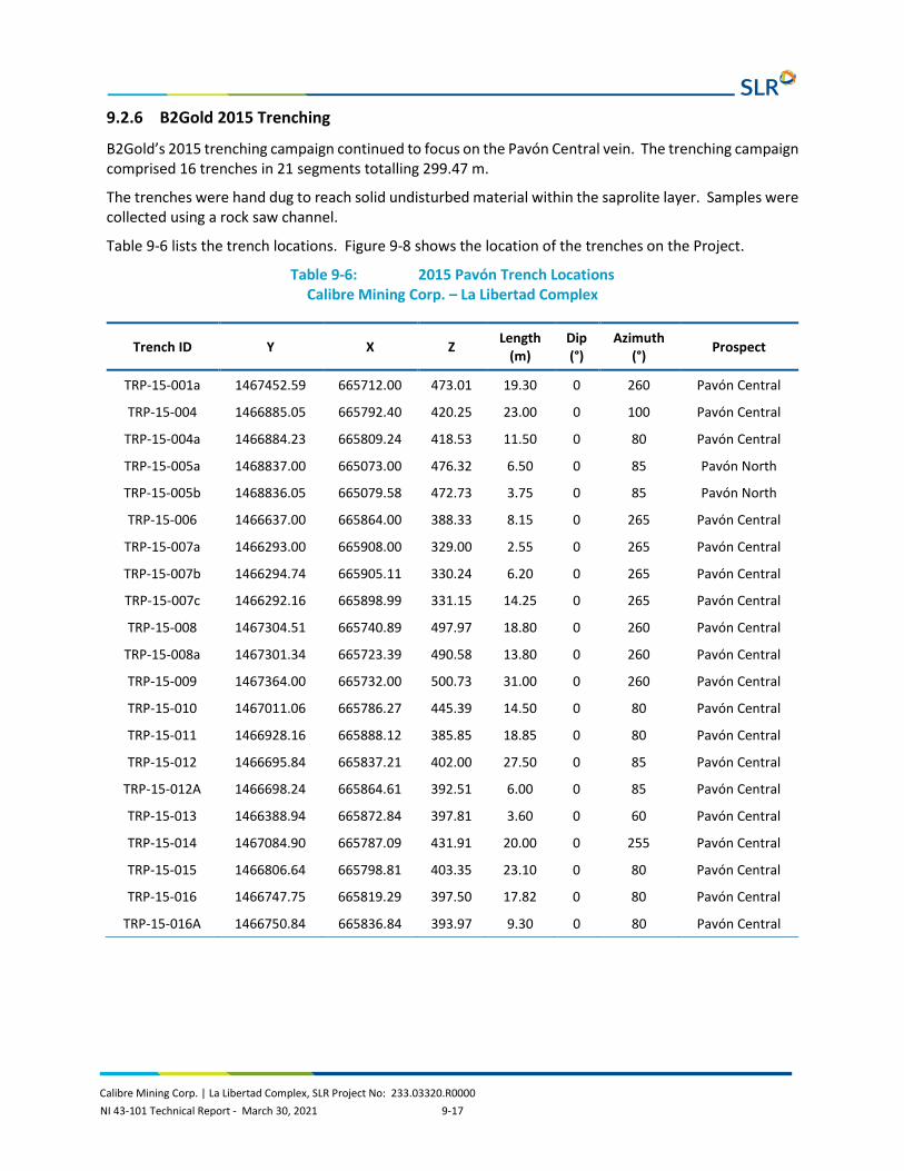
Calibre Mining Corp. | La Libertad Complex, SLR Project No: 233.03320.R0000 NI 43-101 Technical Report - March 30, 2021 9-17
9.2.6 B2Gold 2015 Trenching
B2Gold’s 2015 trenching campaign continued to focus on the Pavón Central vein. The trenching campaign comprised 16 trenches in 21 segments totalling 299.47 m.
The trenches were hand dug to reach solid undisturbed material within the saprolite layer. Samples were collected using a rock saw channel.
Table 9-6 lists the trench locations. Figure 9-8 shows the location of the trenches on the Project.
Table 9-6: 2015 Pavón Trench Locations Calibre Mining Corp. – La Libertad Complex
Trench ID Y X Z Length (m)
Dip (°)
Azimuth (°) Prospect
TRP-15-001a 1467452.59 665712.00 473.01 19.30 0 260 Pavón Central
TRP-15-004 1466885.05 665792.40 420.25 23.00 0 100 Pavón Central
TRP-15-004a 1466884.23 665809.24 418.53 11.50 0 80 Pavón Central
TRP-15-005a 1468837.00 665073.00 476.32 6.50 0 85 Pavón North
TRP-15-005b 1468836.05 665079.58 472.73 3.75 0 85 Pavón North
TRP-15-006 1466637.00 665864.00 388.33 8.15 0 265 Pavón Central
TRP-15-007a 1466293.00 665908.00 329.00 2.55 0 265 Pavón Central
TRP-15-007b 1466294.74 665905.11 330.24 6.20 0 265 Pavón Central
TRP-15-007c 1466292.16 665898.99 331.15 14.25 0 265 Pavón Central
TRP-15-008 1467304.51 665740.89 497.97 18.80 0 260 Pavón Central
TRP-15-008a 1467301.34 665723.39 490.58 13.80 0 260 Pavón Central
TRP-15-009 1467364.00 665732.00 500.73 31.00 0 260 Pavón Central
TRP-15-010 1467011.06 665786.27 445.39 14.50 0 80 Pavón Central
TRP-15-011 1466928.16 665888.12 385.85 18.85 0 80 Pavón Central
TRP-15-012 1466695.84 665837.21 402.00 27.50 0 85 Pavón Central
TRP-15-012A 1466698.24 665864.61 392.51 6.00 0 85 Pavón Central
TRP-15-013 1466388.94 665872.84 397.81 3.60 0 60 Pavón Central
TRP-15-014 1467084.90 665787.09 431.91 20.00 0 255 Pavón Central
TRP-15-015 1466806.64 665798.81 403.35 23.10 0 80 Pavón Central
TRP-15-016 1466747.75 665819.29 397.50 17.82 0 80 Pavón Central
TRP-15-016A 1466750.84 665836.84 393.97 9.30 0 80 Pavón Central

Calibre Mining Corp. | La Libertad Complex, SLR Project No: 233.03320.R0000 NI 43-101 Technical Report - March 30, 2021 9-18
Figure 9-8: 2015 Trench Locations

Calibre Mining Corp. | La Libertad Complex, SLR Project No: 233.03320.R0000 NI 43-101 Technical Report - March 30, 2021 9-19
9.2.7 B2Gold 2015 Soil Survey
Between January and July 2015, a systematic rock soil sampling survey was carried out along the entire strike of the Pavón Central vein. The rock-soil program over the central and south sectors of the Pavón Central vein consisted of 18 east-west lines covering an area of ~850 m x 250 m with samples collected every 15 m along lines separated 50 m apart (Figure 9-9). There is no information available on the sampling procedures for the soil survey.
Figure 9-9: 2015 Soil Sample Location and Results

Calibre Mining Corp. | La Libertad Complex, SLR Project No: 233.03320.R0000 NI 43-101 Technical Report - March 30, 2021 10-1
10.0 DRILLING
10.1 La Libertad Drilling has tested numerous priority targets defined by the exploration and has resulted in a series of discoveries including several deposits which are being mined or have been mined over the last number of years and others which host existing Inferred Mineral Resources.
La Libertad Mineral Resources are based on approximately 65,536 assays from 250,645 m of diamond drilling; 124,208 m of RC drilling and 77,300 m of channel samples in 1,674 diamond drill holes; 704 RC holes and 3,784 channels. The drilling was conducted almost exclusively from surface, with the exception of a small number of diamond drill holes completed from underground.
RC drilling and diamond drilling was conducted on 30 m to 40 m spacing for the Jabalí deposit and on 40 m to 60 m spacing for the other deposits.
The drilling for 1984 through 2020 is summarized in Table 10-1. Figure 10-1 to Figure 10-5 shows historical and new drilling in the Jabalí West UG since the last Mineral Resources update in August 30, 2019.
Table 10-1: La Libertad Drilling Summary Calibre Mining Corp. – La Libertad Complex
Year Drill Holes RC Trench/Channels
Holes Metres (m) Holes Metres
(m) Trenches Metres (m)
1984 18 2,353 - - - -
1986 4 448 - - - -
1987 2 231 - - - -
1995 - - 57 5,822 - -
1996 - - 100 16,639 - -
1997 13 2,627 253 47,014 - -
1998 15 2,433 294 54,734 2,483 64,267
2006 30 3,246 - - - -
2007 97 10,205 - - - -
2008 83 13,800 - - - -
2009 - - - - 2 47
2010 130 20,095 - - - -
2011 331 47,289 - - - -
2012 150 19,667 - - - -
2013 33 7,977 - - 5 71
2014 54 7,845 - - 9 65
2015 100 12,690 - - 5 121

Calibre Mining Corp. | La Libertad Complex, SLR Project No: 233.03320.R0000 NI 43-101 Technical Report - March 30, 2021 10-2
Year Drill Holes RC Trench/Channels
Holes Metres (m) Holes Metres
(m) Trenches Metres (m)
2016 87 11,553 - - 72 1,888
2017 160 21,771 - - 11 137
2018 109 14,991 - - 43 721
2019 77 9,200 - - 6 73
2020 181 42,222 - - 4 35
Unspecified - - - - 1,144 9,875
Total 1,674 250,645 704 124,208 3,784 77,300

Previous Drilling
Drilling by Year:
2019
2018
2020
Channels
0 100 500
Metres
200 300 400
Calibre Mining Corp.
La Libertad Complex
Jabal West UG, Drilling by Yearí
Chontales Department, Nicaragua
Figure 10-1
Looking North
1 -0 3
March 2021 Source: SLR, 2021.

2015
Drilling by Year:
2019
2018
2020
0 100 500
Metres
200 300 400
Calibre Mining Corp.
La Libertad Complex
Rosario OP, Drilling by Year
Chontales Department, Nicaragua
Figure 10-2
Looking Northeast
1 -0 4
March 2021 Source: SLR, 2021.

0 50 250
Metres
100 150 200
Domains:
CH_SPL2
CH0
CH2
CH1
CH3
CH4
CH5
CH_SPL1
CH_SPL3
CH_SPL4
CH_SPL6
CH_SPL5
CH_SPL7
1995 - 1997
Drilling by Year:
2017
2016
2018
2020
HALO
Calibre Mining Corp.
La Libertad Complex
Socorro OP, Drilling by Year
Chontales Department, Nicaragua
Figure 10-3
Looking North
1 -0 5
March 2021 Source: SLR, 2021.

1996
Drilling by Year:
1998
1997
2012
2017 Calibre Mining Corp.
La Libertad Complex
San Antonio OP, Drilling by Year
Chontales Department, Nicaragua
Figure 10-4
Looking North
1 -0 6
March 2021 Source: SLR, 2021.
2018
West
East
Central
Not to Scale

0 50 250
Metres
100 150 200
1984
Drilling by Year:
2008
1995
2010
2011
N
2012
Calibre Mining Corp.
La Libertad Complex
San Juan UG, Drilling by Year
Chontales Department, Nicaragua
Figure 10-5
1 -0 7
March 2021 Source: SLR, 2021.

Calibre Mining Corp. | La Libertad Complex, SLR Project No: 233.03320.R0000 NI 43-101 Technical Report - March 30, 2021 10-8
Drill hole collars are surveyed using Sokia Total Station and Trimble Pro XRT-2 GPS instruments. Downhole surveys are completed at 50 m downhole intervals using a multi- or single-shot Reflex EZ-Shot or Reflex EZ-Trac instrument.
Drill core is logged by a geologist noting lithology, alteration, weathering/oxidation, mineralization, structure, core recovery, and rock quality designation (RQD). Logging is completed on paper, dual entered into Microsoft (MS) Excel, then imported to an MS Access database and verified with a 100% check by the logging geologist. Drill core is photographed, both wet and dry, and the electronic photos are stored on site and on the Vancouver server.
Sample lengths range from 0.25 m to 2.00 m and respect lithological and mineralization contacts. Core is sawn in half with a diamond saw; half is sent to the laboratory for sample preparation and analysis and the remaining core is stored on site under cover.
There is a written protocol for logging and sampling to ensure consistency in the database.
Density measurements are collected on core samples every 20 m down hole. Samples are weighed, coated with wax, weighed in air, then suspended in water and weighed again. Average densities by domain code and oxidation are used for tonnage calculations. Densities range from 1.70 t/m3 to 2.24 t/m3 in saprolite and saprock and 2.40 t/m3 to 2.65 t/m3 in fresh rock. In SLR’s opinion, these are reasonable densities for this type of mineralization.
The exploration drilling database is maintained in MS Access, underground sampling data is stored in MS Excel, and underground mapping lines are maintained in AutoCAD.
10.2 Pavón
10.2.1 Radius 2004 Drilling
In 2004, Radius completed a 7-hole diamond drill program totalling 749.11 m. Drilling was completed by Kluane Guatemala S.A. Coring size was NTW. No other description was available on the logistics of the drilling program.
Drill hole collar coordinates are listed in Table 10-2 and hole locations are shown on Figure 10-6. Appendix A provides a summary of the significant intersections of the Radius 2004 drilling program.
Table 10-2: 2004 Diamond Drill Collars Calibre Mining Corp. – La Libertad Complex
Borehole ID Y X Z Depth (m) Dip Azimuth Prospect
PADH-001 1465714.34 665891.06 450.00 48.78 -50 90 Pavón Sur
PADH-002 1465714.34 665891.06 450.00 147.56 -90 0 Pavón Sur
PADH-003 1466889.87 665832.67 410.99 103.20 -50 270 Pavón Central
PADH-004 1467156.02 665726.16 416.08 108.20 -60 84 Pavón Central
PADH-005 1469664.34 666131.06 617.00 80.77 -45 20 Pavón Norte
PADH-005B 1469664.34 666131.56 617.00 24.38 -45 20 Pavón Norte
PADH-006 1469664.24 666130.26 617.00 135.64 -85 100 Pavón Norte
PADH-007 1469248.34 666786.06 482.14 100.58 -45 230 Pavón Norte

Calibre Mining Corp. | La Libertad Complex, SLR Project No: 233.03320.R0000 NI 43-101 Technical Report - March 30, 2021 10-9
Figure 10-6: 2004 Drill Collar Locations

Calibre Mining Corp. | La Libertad Complex, SLR Project No: 233.03320.R0000 NI 43-101 Technical Report - March 30, 2021 10-10
10.2.2 Meridian 2005 Drilling
In 2005, Meridian completed a 32-hole diamond drill program totalling 4,392.62 m. No other description was available on the logistics of the drilling program completed by Meridian.
Drill hole collar coordinates are listed in Table 10-3 and hole locations are shown in Figure 10-7. Appendix A provides a summary of the significant intersections of the Meridian 2005 drilling program.
Table 10-3: 2005 Diamond Drill Collars Calibre Mining Corp. – La Libertad Complex
Borehole ID Y X Z Depth (m) Dip Azimuth Prospect
NAT05-001 1466333.92 665907.22 357.77 7.16 -45 250 Pavón Central
NAT05-003 1465987.33 665948.06 432.00 143.25 -55 60 Pavón Sur
NAT05-004 1465987.33 665948.06 432.00 134.72 -70 60 Pavón Sur
NAT05-005 1465891.33 665977.06 430.00 128.01 -65 80 Pavón Sur
NAT05-006 1465819.34 665986.07 425.00 114.30 -50 90 Pavón Sur
NAT05-007 1465819.34 665986.07 425.00 146.30 -70 90 Pavón Sur
NAT05-008 1466956.76 665711.86 467.10 68.83 -45 90 Pavón Central
NAT05-008A 1466956.76 665711.86 467.10 154.87 -45 90 Pavón Central
NAT05-009 1466586.48 665825.79 409.37 107.59 -50 90 Pavón Central
NAT05-010 1466390.20 665816.75 421.94 94.79 -50 90 Pavón Central
NAT05-013 1465778.34 665863.06 464.00 160.02 -45 90 Pavón Sur
NAT05-014 1465778.34 665863.06 464.00 103.63 -75 90 Pavón Sur
NAT05-015 1466107.34 665802.06 458.00 228.60 -52 90 Pavón Sur
NAT05-016 1465991.33 665812.06 457.00 234.69 -45 90 Pavón Sur
NAT05-017 1465895.33 665848.06 476.00 83.82 -45 90 Pavón Sur
NAT05-018 1465656.33 665898.06 452.00 85.34 -45 90 Pavón Sur
NAT05-019 1465656.33 665898.06 452.00 91.44 -75 90 Pavón Sur
NAT05-020 1465593.33 665881.06 461.00 108.20 -45 90 Pavón Sur
NAT05-021 1465304.33 665937.06 451.00 120.39 -45 90 Pavón Sur
NAT05-025 1469951.10 665954.51 582.10 185.93 -45 70 Pavón Norte
NAT05-026 1469871.03 666010.97 594.45 91.44 -45 70 Pavón Norte
NAT05-027 1469590.63 666129.98 589.66 230.18 -45 70 Pavón Norte
NAT05-028 1469775.15 666050.48 601.67 97.54 -45 70 Pavón Norte
NAT05-029 1469775.15 666050.48 601.67 144.78 -70 70 Pavón Norte
NAT05-030 1469026.66 666389.88 530.68 121.03 -55 70 Pavón Norte
NAT05-031 1469393.70 666453.32 567.85 132.59 -45 40 Pavón Norte

Calibre Mining Corp. | La Libertad Complex, SLR Project No: 233.03320.R0000 NI 43-101 Technical Report - March 30, 2021 10-11
Borehole ID Y X Z Depth (m) Dip Azimuth Prospect
NAT05-032 1469393.70 666453.32 567.85 170.69 -45 220 Pavón Norte
NAT05-033 1468869.34 666286.06 564.00 152.4 -45 70 Pavón Norte
NAT05-034 1469093.39 666236.04 562.07 166.76 -45 70 Pavón Norte
NAT05-035 1469387.34 666153.06 542.00 181.35 -50 70 Pavón Norte
NAT05-038 1467395.34 665658.06 486.62 175.26 -45 70 Pavón Central
NAT05-039 1467339.11 665811.63 479.98 226.72 -45 225 Pavón Central

Calibre Mining Corp. | La Libertad Complex, SLR Project No: 233.03320.R0000 NI 43-101 Technical Report - March 30, 2021 10-12
Figure 10-7: 2005 Drill Collar Locations

Calibre Mining Corp. | La Libertad Complex, SLR Project No: 233.03320.R0000 NI 43-101 Technical Report - March 30, 2021 10-13
10.2.3 Meridian 2006 Drilling
In 2006, Meridian completed an additional 21 diamond drill holes totalling 2,965.65 m. No other description was available on the logistics of the drilling program completed by Meridian.
Drill hole collar coordinates are listed in Table 10-4 and hole locations are shown on Figure 10-8. Appendix A provides a summary of the significant intersections of the Meridian 2006 drilling program.
Table 10-4: 2006 Diamond Drill Collars Calibre Mining Corp. – La Libertad Complex
Borehole ID Y X Z Depth (m) Dip Azimuth Prospect
NAT06-049 1465898.33 665787.06 451.00 140.20 -45 90 Pavón Sur
NAT06-050 1465837.33 665853.06 474.00 73.15 -45 90 Pavón Sur
NAT06-051 1465595.33 665817.06 463.00 172.21 -50 90 Pavón Sur
NAT06-052 1465595.33 665922.05 485.00 81.69 -50 90 Pavón Sur
NAT06-053 1465534.33 665913.06 488.00 128.01 -55 90 Pavón Sur
NAT06-054 1465536.33 665853.06 476.00 181.35 -55 90 Pavón Sur
NAT06-055 1465388.33 665907.06 472.00 147.82 -55 80 Pavón Sur
NAT06-056 1465202.33 665878.05 452.00 205.74 -60 90 Pavón Sur
NAT06-057 1465382.34 665817.06 479.00 242.32 -55 90 Pavón Sur
NAT06-058 1465452.33 665923.06 479.00 118.87 -70 90 Pavón Sur
NAT06-060 1467348.71 665756.99 497.71 121.92 -55 250 Pavón Central
NAT06-060A 1467348.71 665756.99 497.71 30.48 -45 250 Pavón Central
NAT06-061 1467393.12 665754.62 482.47 202.69 -63 270 Pavón Central
NAT06-062 1467492.50 665617.28 487.19 145.69 -53 85 Pavón Central
NAT06-063 1467550.30 665591.38 488.86 167.64 -53 85 Pavón Central
NAT06-064 1469926.88 666013.76 602.91 74.67 -45 70 Pavón Norte
NAT06-065 1469892.85 665922.92 566.31 194.46 -50 70 Pavón Norte
NAT06-066 1469677.32 666001.13 565.46 195.07 -45 70 Pavón Norte
NAT06-067 1469715.58 666088.55 607.67 76.20 -45 70 Pavón Norte
NAT06-068 1469571.32 666072.52 561.78 156.97 -45 70 Pavón Norte
NAT06-069 1469492.08 666105.39 549.52 108.50 -45 70 Pavón Norte

Calibre Mining Corp. | La Libertad Complex, SLR Project No: 233.03320.R0000 NI 43-101 Technical Report - March 30, 2021 10-14
Figure 10-8: 2006 Drill Collar Locations
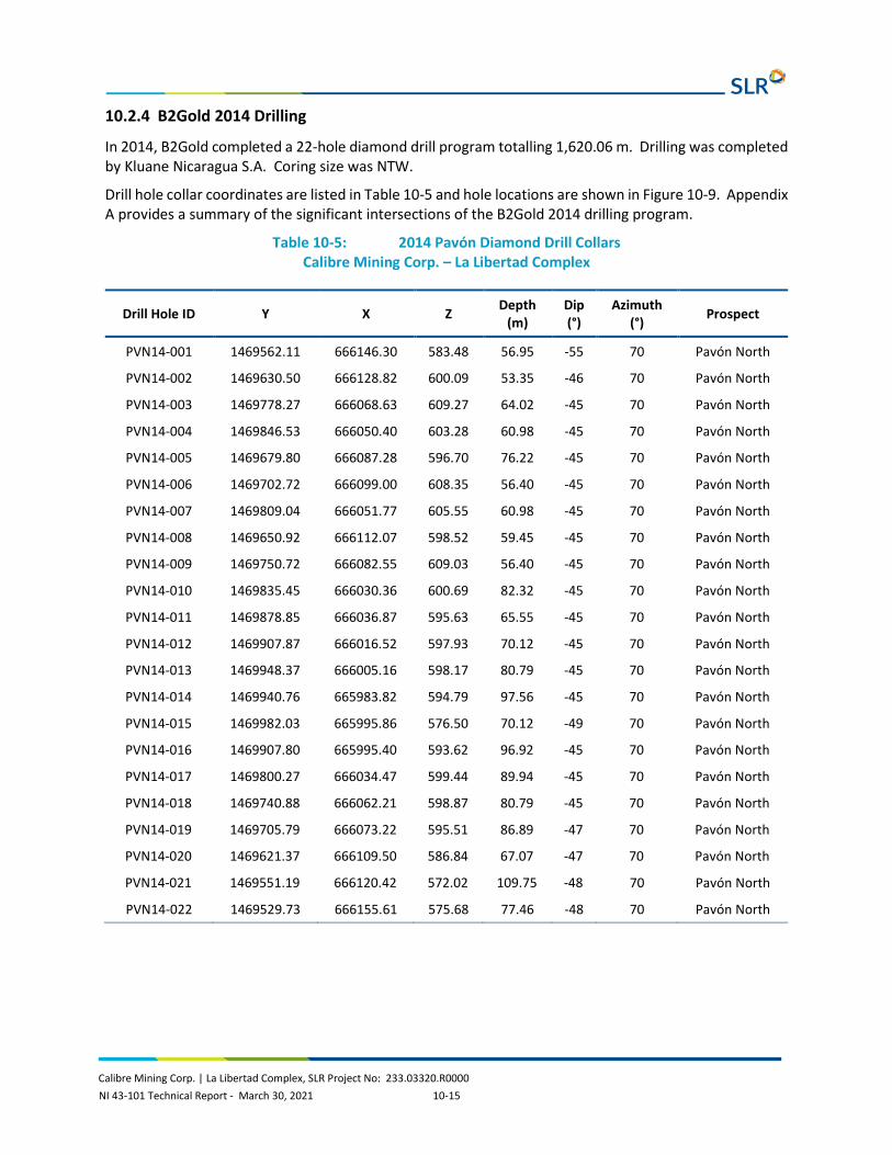
Calibre Mining Corp. | La Libertad Complex, SLR Project No: 233.03320.R0000 NI 43-101 Technical Report - March 30, 2021 10-15
10.2.4 B2Gold 2014 Drilling
In 2014, B2Gold completed a 22-hole diamond drill program totalling 1,620.06 m. Drilling was completed by Kluane Nicaragua S.A. Coring size was NTW.
Drill hole collar coordinates are listed in Table 10-5 and hole locations are shown in Figure 10-9. Appendix A provides a summary of the significant intersections of the B2Gold 2014 drilling program.
Table 10-5: 2014 Pavón Diamond Drill Collars Calibre Mining Corp. – La Libertad Complex
Drill Hole ID Y X Z Depth (m)
Dip (°)
Azimuth (°) Prospect
PVN14-001 1469562.11 666146.30 583.48 56.95 -55 70 Pavón North
PVN14-002 1469630.50 666128.82 600.09 53.35 -46 70 Pavón North
PVN14-003 1469778.27 666068.63 609.27 64.02 -45 70 Pavón North
PVN14-004 1469846.53 666050.40 603.28 60.98 -45 70 Pavón North
PVN14-005 1469679.80 666087.28 596.70 76.22 -45 70 Pavón North
PVN14-006 1469702.72 666099.00 608.35 56.40 -45 70 Pavón North
PVN14-007 1469809.04 666051.77 605.55 60.98 -45 70 Pavón North
PVN14-008 1469650.92 666112.07 598.52 59.45 -45 70 Pavón North
PVN14-009 1469750.72 666082.55 609.03 56.40 -45 70 Pavón North
PVN14-010 1469835.45 666030.36 600.69 82.32 -45 70 Pavón North
PVN14-011 1469878.85 666036.87 595.63 65.55 -45 70 Pavón North
PVN14-012 1469907.87 666016.52 597.93 70.12 -45 70 Pavón North
PVN14-013 1469948.37 666005.16 598.17 80.79 -45 70 Pavón North
PVN14-014 1469940.76 665983.82 594.79 97.56 -45 70 Pavón North
PVN14-015 1469982.03 665995.86 576.50 70.12 -49 70 Pavón North
PVN14-016 1469907.80 665995.40 593.62 96.92 -45 70 Pavón North
PVN14-017 1469800.27 666034.47 599.44 89.94 -45 70 Pavón North
PVN14-018 1469740.88 666062.21 598.87 80.79 -45 70 Pavón North
PVN14-019 1469705.79 666073.22 595.51 86.89 -47 70 Pavón North
PVN14-020 1469621.37 666109.50 586.84 67.07 -47 70 Pavón North
PVN14-021 1469551.19 666120.42 572.02 109.75 -48 70 Pavón North
PVN14-022 1469529.73 666155.61 575.68 77.46 -48 70 Pavón North

Calibre Mining Corp. | La Libertad Complex, SLR Project No: 233.03320.R0000 NI 43-101 Technical Report - March 30, 2021 10-16
Figure 10-9: 2014 Drill Collar Locations

Calibre Mining Corp. | La Libertad Complex, SLR Project No: 233.03320.R0000 NI 43-101 Technical Report - March 30, 2021 10-17
10.2.5 B2Gold 2015 Drilling
In 2015, B2Gold completed a 25-hole diamond drill program totalling 1,773.73 m. Drilling was completed by Kluane Nicaragua S.A. Coring size was NTW.
Drill hole collar coordinates are listed in Table 10-6 and hole locations are shown on Figure 10-10. Appendix A provides a summary of the significant intersections of the B2Gold 2014 drilling program.
Table 10-6: 2015 Pavón Diamond Drill Collars Calibre Mining Corp. – La Libertad Complex
Drill Hole ID Y X Z Depth (m)
Dip (°)
Azimuth (°) Prospect
PVC15-001 1467298.00 665696.00 477.00 70.73 -45 80 Pavón Central
PVC15-002 1467298.00 665696.00 477.00 101.06 -69 80 Pavón Central
PVC15-003 1467240.00 665701.00 459.00 77.74 -50 80 Pavón Central
PVC15-004 1467372.00 665674.00 488.00 70.12 -45 80 Pavón Central
PVC15-005 1467372.00 665674.00 488.00 82.32 -66 80 Pavón Central
PVC15-006 1467446.00 665640.00 486.00 82.32 -50 80 Pavón Central
PVC15-007 1467519.00 665610.00 487.00 91.46 -45 80 Pavón Central
PVC15-008 1467209.00 665766.00 434.00 64.02 -50 260 Pavón Central
PVC15-009 1466493.00 665902.00 389.00 53.99 -50 80 Victoria Vein
PVC15-010 1466447.00 665893.00 388.00 65.55 -50 90 Victoria Vein
PVC15-011 1466447.00 665893.00 388.00 65.55 -70 90 Victoria Vein
PVC15-012 1466923.00 665771.00 445.00 67.07 -53 80 Pavón Central
PVC15-013 1467018.00 665808.00 429.00 50.30 -45 260 Pavón Central
PVC15-014 1467337.00 665701.00 492.00 51.83 -45 80 Pavón Central
PVC15-015 1467330.00 665660.00 479.00 111.98 -50 80 Pavón Central
PVC15-016 1467430.00 665678.00 482.00 53.35 -50 80 Pavón Central
PVC15-017 1467424.00 665648.00 488.00 96.04 -55 80 Pavón Central
PVC15-018 1467273.00 665700.00 472.00 71.65 -45 93 Pavón Central
PVC15-019 1467271.00 665683.00 466.00 97.56 -53 91 Pavón Central
PVC15-020 1467220.00 665716.00 449.00 62.50 -50 80 Pavón Central
PVC15-021 1466535.00 665880.00 394.00 79.27 -50 80 Victoria Vein
PVC15-022 1466409.00 665899.00 386.00 53.35 -75 100 Victoria Vein
PVN15-023 1469637.00 666137.00 604.00 38.11 -45 70 Pavón Norte
PVN15-024 1469578.00 666114.00 578.00 74.70 -50 70 Pavón Norte
PVN15-025 1469548.00 666155.00 581.00 41.16 -45 70 Pavón Norte

Calibre Mining Corp. | La Libertad Complex, SLR Project No: 233.03320.R0000 NI 43-101 Technical Report - March 30, 2021 10-18
Figure 10-10: Pavón Core Logging Facility

Calibre Mining Corp. | La Libertad Complex, SLR Project No: 233.03320.R0000 NI 43-101 Technical Report - March 30, 2021 10-19
10.2.6 Calibre 2020 Drilling
In 2020, Calibre completed an additional 29 diamond drill holes totalling approximately 3,547 m as of the effective date of this report. Drilling was completed by Kluane Nicaragua S.A. Coring size was NTW. Twelve of the holes, totalling approximately 1,424 m were condemnation holes.
Drill hole collar coordinates are listed in Table 10-7 and hole locations are shown in Figure 10-11. Appendix A provides a summary of the significant intersections of the Calibre drilling program.
Table 10-7: Calibre Diamond Drill Collars Calibre Mining Corp. – La Libertad Complex
Borehole Id Y X Z Depth (m) Dip Azimuth Prospect
PVC-20-023 1467399.10 665741.26 486.05 120.60 -51.3 264 Pavón Central
PVC-20-024 1467473.97 665707.06 472.17 100.65 -48.1 271.8 Pavón Central
PVC-20-025 1467501.69 665676.28 477.89 77.77 -49.5 242 Pavón Central
PVC-20-026 1467121.06 665735.50 422.02 106.75 -45 80 Pavón Central
PVC-20-027 1466983.14 665747.79 467.78 132.67 -62.3 80 Pavón Central
PVC-20-028 1467022.99 665734.85 473.60 131.15 -57.9 80 Pavón Central
PVC-20-029 1467069.96 665736.26 444.08 88.45 -45 80 Pavón Central
PVC-20-030 1467753.70 665469.30 472.32 138.77 -45 55 Pavón Central
PVC-20-031 1467630.00 665541.00 500.00 120.47 -45 55 Pavón Central
PVC-20-032 1467352.20 665389.90 500.00 128.10 -45 55 Pavón Central
PVC-20-033 1467449.46 666043.76 501.89 103.70 -45 266 Pavón Central
PVC-21-034 1467601.00 665245.00 500.00 102.17 -45 55 Pavón Central
PVC-21-035 1467586.50 665789.53 461.86 112.85 -45 266 Pavón Central
PVN-20-026 1469900.83 665966.46 583.33 137.25 -45 70 Pavón Norte
PVN-20-027 1469847.81 665996.38 590.25 132.67 -45 70 Pavón Norte
PVN-20-028 1469726.80 666044.27 589.80 118.95 -45 70 Pavón Norte
PVN-20-029 1469665.84 666052.30 582.56 137.25 -45 70 Pavón Norte
PVN-20-030 1469601.73 666080.19 575.16 129.62 -45 70 Pavón Norte
PVN-20-031 1469499.76 666150.17 564.92 96.07 -45 70 Pavón Norte
PVN-20-032 1469573.77 666204.51 586.14 131.15 -45 250 Pavón Norte
PVN-20-033 1470036.54 666048.16 543.18 158.60 -45 250 Pavón Norte
PVN-20-034 1469988.75 665932.70 556.56 160.17 -46 50 Pavón Norte
PVN-20-035 1470036.44 665924.51 521.00 163.17 -45 67 Pavón Norte
PVN-20-036 1470011.74 665764.80 550.88 114.60 -45 60 Pavón Norte
PVN-20-037 1469890.29 665540.78 522.88 120.47 -45 60 Pavón Norte
PVN-20-038 1469655.45 665432.12 548.37 102.17 -45 60 Pavón Norte
PVN-20-039 1469710.85 665723.40 516.04 120.47 -45 60 Pavón Norte

Calibre Mining Corp. | La Libertad Complex, SLR Project No: 233.03320.R0000 NI 43-101 Technical Report - March 30, 2021 10-20
Borehole Id Y X Z Depth (m) Dip Azimuth Prospect
PVN-20-040 1469647.53 665927.12 534.98 131.85 -45 60 Pavón Norte
PVN-20-041 1469520.7 665828.1 490.96 128.10 -45 60 Pavón Norte

Calibre Mining Corp. | La Libertad Complex, SLR Project No: 233.03320.R0000 NI 43-101 Technical Report - March 30, 2021 10-21
Figure 10-11: 2020 Diamond Drill Collars

Calibre Mining Corp. | La Libertad Complex, SLR Project No: 233.03320.R0000 NI 43-101 Technical Report - March 30, 2021 10-22
10.2.7 Logging Procedures
10.2.7.1 B2Gold Logging Procedures
Once at the logging facility (Figure 10-12), the boxes containing drill cores are placed on tables, and their wooden lids are removed for washing, checking, labeling, and preliminary geological logging.
Geotechnical logging is carried out by a trained technician who fills out a paper log that includes core recovery, RQD, fracture count, and rock strength. During the geotechnical logging, a technician under the supervision of a geologist selects samples for volumetric mass density measurements using an industry standard weight-in-air and weight-in-water technique.
Detailed geological logging completed by a B2Gold project geologist included rock type, mineralization type, alteration type, structural data, sample intervals and semi-quantitative estimates of alteration intensity and mineral content. Drill holes were sampled using variable core lengths (0.25 m to 2.00 m) considering breaks in alteration, mineralization intensities, and lithology differences. During the logging process, drill core intervals were rotated to appropriate core axis configuration, and a cut line scribed on the core segments by the logging geologist to minimize any sample bias during core cutting. The logging geologist was responsible for marking and labeling each sample interval and for designating the position of the quality control samples to be inserted into the sampling sets. According to the B2Gold protocols applied, each set of 70 samples submitted for geochemical analysis contained four quality control samples including standard, blank, core duplicate, and preparation duplicate.
Prior to collection of core samples, all core boxes were photographed by the technicians. The drill core splitting was performed using an electric core cutting saw by well-trained and experienced personnel. One-half of the core was sent to the onsite B2Gold's laboratory for preparation while the remaining half was retained for future reference.
The collected data was entered into Excel sheets by office assistants, then checked by the responsible geologist prior to being entered into an Access database by B2Gold’s database manager. All sampling, logging and data entry procedures were supervised by a senior B2Gold geologist for quality assurance and control.
Once detailed logging and sampling were completed, boxed drill core was placed in storage at a B2Gold facility in Managua (Figure 10-13).

Calibre Mining Corp. | La Libertad Complex, SLR Project No: 233.03320.R0000 NI 43-101 Technical Report - March 30, 2021 10-23
Figure 10-12: Pavón Core Logging Facility
Figure 10-13: Pavón Core Storage in Managua

Calibre Mining Corp. | La Libertad Complex, SLR Project No: 233.03320.R0000 NI 43-101 Technical Report - March 30, 2021 10-24
10.2.7.2 Calibre Logging Procedure
Once at the logging facility (Figure 10-12), the boxes containing drill cores are placed on tables, and their wooden lids are removed for washing, checking, labeling, and preliminary geological logging.
Geotechnical logging is carried out by a trained technician who fills out a paper log that includes core recovery, RQD, fracture count, and rock strength. During the geotechnical logging, a technician under the supervision of a geologist selects samples for volumetric mass density measurements using an industry standard weight-in-air and weight-in-water technique.
Detailed geological logging completed by a Calibre project geologist included lithology, alteration, mineralization, oxidation, veins, structures, sample intervals. Drillholes were sampled using variable core lengths (1.0 m or 1.50 m) considering breaks in alteration, mineralization intensities, and lithology differences. During the logging process, drill core intervals were rotated to appropriate core axis configuration, and a cut line scribed on the core segments by the logging geologist to minimize any sample bias during core cutting. The logging geologist was responsible for marking and labeling each sample interval and for designating the position of the quality control samples to be inserted into the sampling sets. According to the Calibre protocols applied, each set of 70 samples submitted for geochemical analysis contained four quality control samples including standard, blank, preparation and pulp duplicate.
Prior to collection of core samples, all core boxes were photographed by the technicians. The drill core splitting was performed using an electric core cutting saw by well-trained and experienced personnel. One-half of the core was sent to the external laboratory for preparation while the remaining half was retained for future reference.
The collected data was entered directly into a digital logging platform (LogChief by MaxGeo). Upon completion of the hole, the data is transferred into a SQL database managed by DataShed.
10.2.8 QP Opinion
It is the QP’s opinion that the drilling and logging procedures in place prior to Calibre’s involvement met acceptable industry standards of the time and that the information can be used for geological and resource modelling.
It is also the QP’s opinion that the drilling and logging procedures in place by Calibre meet acceptable industry standards and the information is suitable for disclosure in this Technical Report and for use in future Mineral Resource estimates.

Calibre Mining Corp. | La Libertad Complex, SLR Project No: 233.03320.R0000 NI 43-101 Technical Report - March 30, 2021 11-1
11.0 SAMPLE PREPARATION, ANALYSES, AND SECURITY
11.1 La Libertad
11.1.1 Sample Preparation and Analysis
Sample preparation is carried out at the site assay laboratory and comprises the following steps:
• Dry at 100°C • Crush to 85% minus 2 mm • Riffle split 800 g • Pulverize to 85% minus 74 microns
Prior to January 2013, the primary independent laboratory for analyses of La Libertad sample pulps used for Mineral Resource estimation was ALS Chemex in North Vancouver, British Columbia, Canada. Since January 2013, sample pulps used for Mineral Resource estimation are shipped to independent laboratory, Bureau Veritas Minerals (BVM), previously Acme Analytical Labs Ltd. (Acme Labs), in Vancouver, British Columbia, Canada for analysis. Core samples are analyzed for gold using protocol FA430. Samples returning values greater than 10 g/t Au are re-assayed using protocol FA530. BVM holds global certifications for quality ISO9001:2008, Environmental Management: ISO14001 and Safety Management OH SAS 18001 and AS4801.
11.1.1.1 QP Opinion
In the QP’s opinion, the sample preparation, analysis, and security procedures at La Libertad are adequate for use in the estimation of Mineral Resources.
11.1.2 Quality Assurance and Quality Control
Quality assurance (QA) is necessary to demonstrate that the assay data has precision and accuracy within generally accepted limits for the sampling and analytical methods used in order to have confidence in the resource estimation. Quality control (QC) consists of procedures used to ensure that an adequate level of quality is maintained in the process of sampling, preparing, and assaying the drill core samples. In general, quality assurance and quality control (QA/QC) programs are designed to prevent or detect contamination and allow analytical precision and accuracy to be quantified. In addition, a QA/QC program can disclose the overall sampling – assaying variability of the sampling method itself.
Exploration geological staff use an industry standard system for QA/QC including the insertion of standard reference materials (SRM), blanks, and duplicates. La Libertad employs a database manager whose responsibilities include the monitoring of the QA/QC programs. The results are forwarded to a corporate database manager for review and corporate reporting.
11.1.2.1 QA/QC Protocols
Each batch of 39 samples included a standard sample, a blank sample, a field duplicate (split core), a reject duplicate, and a pulp duplicate. In the event of a failed QA/QC sample, the entire batch was re-assayed.
Table 11-1 presents the data provided to SLR for La Libertad.

Calibre Mining Corp. | La Libertad Complex, SLR Project No: 233.03320.R0000 NI 43-101 Technical Report - March 30, 2021 11-2
Table 11-1: Summary of QA/QC Submittals – La Libertad 2010 to 2020 Calibre Mining Corp. – La Libertad Complex
Year 2010 2011 2012 2013 2014 2015 2016 2017 2018 2019 2020 Total
SRM Submission 356 664 332 145 164 315 319 758 347 244 825 4,481
Blank Submission 356 687 338 149 172 341 332 780 350 230 875 4,622
Field Duplicate Submission 206 581 267 98 137 295 290 608 270 98 4 2,854
Coarse Duplicate
Submission 267 617 266 82 122 274 312 567 252 155 635 3,549
Pulp Duplicate Submission 120 418 61 550 1,149
External Checks 420 1106 673 332 333 708 764 1043 561 169 341 6,450
Total 1,725 4,073 1,876 806 928 1,933 2,017 3,756 1,780 957 3,230 23,105
11.1.2.2 Standard Reference Material
Results of the regular submission of SRMs or standards are used to identify any issues with a specific batch of samples and long term biases associated with the primary assay laboratory. SLR analyzed the results of the SRMs and plotted them in control charts, with failure rates, defined as assay values reporting more than three standard deviations (SD) from the expected value, and warning rates, defined as assay values reporting more than two SD, but less than three SD from the expected values.
A total of 30 different SRMs were used resulting in 4,481 individual assays at the La Libertad project. SLR reviewed the results for gold assays provided. Table 11-2 describes the different standards used, years active and statistics regarding the SRMs.
Figure 11-1 charts 618 samples of standard GSP7B used from 2011 through 2018. The mean value for the sample set is 0.713 ppm and had only 10 failures.
Figure 11-2 charts 794 samples of standard GSB22 used from 2011 through 2020. The mean value for the sample set is 2.053 ppm and had only 19 failures. A 2.6% high bias is observed for SRM GSB22.
Figure 11-3 is a Z-Score chart for all 4,481 SRMs used at La Libertad. Z-Score charts plot the performances of all the SRMs with respect to standard deviation.
Table 11-2: Summary of Standard Reference Materials and Performances – Jabalí 2010 to 2020 Calibre Mining Corp. – La Libertad Complex
SRM Year Element Certified Value (g/t Au)
Std Dev (g/t Au)
Mean (g/t Au) Assay Count Bias
GS11A 2010 Au 11.21 0.435 10.450 2 -6.78%
GS1G 2011 Au 1.140 0.045 1.145 120 0.47%
GS1P5C 2011-2020 Au 1.560 0.065 1.618 523 3.75%

Calibre Mining Corp. | La Libertad Complex, SLR Project No: 233.03320.R0000 NI 43-101 Technical Report - March 30, 2021 11-3
SRM Year Element Certified Value (g/t Au)
Std Dev (g/t Au)
Mean (g/t Au) Assay Count Bias
GS1P5D 2011-2013 Au 1.470 0.075 1.461 39 -0.59%
GS1P5L 2016 Au 1.530 0.070 1.607 2 5.03%
GS1P5R 2019-2020 Au 1.81 0.07 1.807 250 -0.15%
GS2C 2010 Au 2.060 0.075 2.033 3 -1.29%
GS2E 2010-2011 Au 1.520 0.070 1.504 143 -1.07%
GS3F 2010-2011 Au 3.100 0.120 3.107 129 0.22%
GS3G 2011 Au 2.590 0.090 2.596 130 0.25%
GS3H 2011-2012 Au 3.040 0.115 3.048 20 0.25%
GS4E 2016 Au 4.190 0.095 4.223 4 0.78%
GS5A 2010 Au 5.100 0.135 4.823 4 -5.44%
GS5G 2011-2017 Au 4.770 0.200 4.846 379 1.59%
GS5Q 2016 Au 5.590 0.175 5.621 6 0.55%
GS5W 2019-2020 Au 5.270 0.165 5.245 162 -0.47%
GS6A 2017-2020 Au 5.690 0.240 5.944 157 4.46%
GSB22 2011-2020 Au 2.000 0.085 2.053 794 2.63%
GSB23 2011-2020 Au 7.930 0.365 8.131 485 2.53%
GSP1G 2011 Au 1.140 0.045 1.150 1 0.88%
GSP5E 2019-2020 Au 0.665 0.031 0.672 253 1.07%
GSP7B 2011-2018 Au 0.710 0.035 0.713 621 0.44%
GSP7E 2017-2019 Au 0.766 0.043 0.802 98 4.74%
GSP7L 2016 Au 0.709 0.036 0.724 2 2.05%
GSP8 2010 Au 0.780 0.030 0.743 44 -4.73%
Oreas15Pa 2010 Au 1.020 0.034 0.955 17 -6.34%
Oreas17Pb 2010 Au 2.560 0.085 2.538 20 -0.88%
Oreas61D 2010 Au 4.760 0.159 4.735 8 -0.53%
OXi67 2010 Au 1.820 0.061 1.808 35 -0.66%
OXN77 2010-2011 Au 7.730 0.258 7.640 30 -1.16%

Calibre Mining Corp. | La Libertad Complex, SLR Project No: 233.03320.R0000 NI 43-101 Technical Report - March 30, 2021 11-4
Figure 11-1: La Libertad Control Chart of SRM GSP7B (Gold)
Figure 11-2: La Libertad Control Chart of SRM GSB22 (Gold)

Calibre Mining Corp. | La Libertad Complex, SLR Project No: 233.03320.R0000 NI 43-101 Technical Report - March 30, 2021 11-5
Figure 11-3: La Libertad Z-Score Chart of all SRMs (Gold)
Z-Score charts help view the performance of many standards at once. The Z-Score chart above shows that overall, the SRMs are performing as expected and have a passing rate of 99%.
SRMs can return high or low biases regarding the certified value. The biases calculated for the SRMs used are relatively low. The exceptions occur in SRMs that have low sample counts and are not yet reliable for long term analysis.
The variations observed in the precision of the SRMs do not adversely affect the overall confidence in the assays.
11.1.2.3 Blanks
The regular submission of blank material is used to assess contamination during sample preparation and to identify sample numbering errors. SLR analyzed and prepared a chart depicting the performance of the blank submissions. The QA/QC protocol accepts results returning up to 10 times the detection limit as a pass. Detection limits for the gold blanks are at 0.05 ppm.
A total of 4,622 blank samples were sent for analysis with the La Libertad samples. Figure 11-4 shows the performance of all the blank material. Results indicate a negligible amount of sample contamination associated with samples from La Libertad.

Calibre Mining Corp. | La Libertad Complex, SLR Project No: 233.03320.R0000 NI 43-101 Technical Report - March 30, 2021 11-6
Figure 11-4: La Libertad Blank Assays (2010 to 2020)
11.1.2.4 Field, Coarse and Pulp Duplicates
Duplicate samples help to monitor preparation and assay precision and grade variability as a function of sample homogeneity and laboratory error. Field duplicates include the natural variability of the original core sample, as well all levels of error including core splitting, sample size reduction in the preparation laboratory, sub-sampling of the pulverized sample, and the analytical error. Coarse reject and pulp duplicates provide a measure of the sample homogeneity at different stages of the preparation process (crushing and pulverizing).
A total of 7,552 duplicate samples were analyzed between field, coarse, and pulp duplicates from the La Libertad samples. Field, coarse and pulp duplicates for La Libertad are shown in Figure 11-5 through Figure 11-7. Industry standards suggest that duplicate failures limits are as follows:
• Acceptable difference value for field duplicates is < 30% • Acceptable difference value for coarse duplicate is < 20% • Acceptable difference value for pulp is < 10 %

Calibre Mining Corp. | La Libertad Complex, SLR Project No: 233.03320.R0000 NI 43-101 Technical Report - March 30, 2021 11-7
Figure 11-5: La Libertad Field Duplicate Performance
Figure 11-6: La Libertad Coarse Reject Duplicate Performance

Calibre Mining Corp. | La Libertad Complex, SLR Project No: 233.03320.R0000 NI 43-101 Technical Report - March 30, 2021 11-8
Figure 11-7: La Libertad Pulp Duplicate Performance
SLR notes that the performances of the duplicate samples show good QA/QC protocols along the laboratory preparation process and no major issues are observed.
11.1.2.5 External Checks
As part of the QA/QC program, sample pulps were submitted to a secondary laboratory. Check assays consist of submitting pulps that were assayed at the primary laboratory to a secondary laboratory and re-analyzing them by using the same analytical procedures. This is done primarily to improve the assessment of bias in addition to the submission of SRMs submitted to the original laboratory.
A total of 6,450 check assays for La Libertad were sent for analysis covering SRMs, blanks, field duplicates, coarse duplicates, and pulp duplicates. Figure 11-8 shows the performances of the check assays.

Calibre Mining Corp. | La Libertad Complex, SLR Project No: 233.03320.R0000 NI 43-101 Technical Report - March 30, 2021 11-9
Figure 11-8: La Libertad Check Assays
Overall, the check assays have good correlation. The check assays show that the secondary laboratory correlate well with the original primary laboratory’s assay results, with no apparent bias.
11.1.2.6 QA/QC Conclusions and Recommendations
The results of the SRM performances at La Libertad indicate good precision of samples assayed and a low bias of the results.
The results of the blank samples confirm that there is a low likelihood of grade smearing and contamination at the preparation laboratory.
Moderate to high precision is observed in the results of the coarse reject and pulp duplicate programs.
High precision is observed in the results of the external laboratory checks.
SLR recommends continued adherence to the QAQC protocols and monitoring of the results.
SLR recommends investigating the consistent high bias in CRM GSB22 and determine whether it should be recalibrated or removed from circulation.
In the QP’s opinion, the results of the QAQC programs installed at the La Libertad Projects support the use of the data results for Mineral Resource Estimation.

Calibre Mining Corp. | La Libertad Complex, SLR Project No: 233.03320.R0000 NI 43-101 Technical Report - March 30, 2021 11-10
11.2 Pavón
11.2.1 Sample Preparation, Analyses, and Security
11.2.1.1 Sample Preparation
11.2.1.1.1 Radius Gold
There is no public documentation available describing the sample preparation used by Radius.
11.2.1.1.2 Meridian Gold
There is no public documentation available describing the sample preparation used by Meridian.
11.2.1.1.3 B2Gold
During the 2009 to 2010 trenching program, the preparation of samples was completed at B2Gold's El Limón laboratory by well-trained and experienced employees. Once samples were received, laboratory personnel verified that bags were complete and seals were intact. B2Gold also checked for any possible discrepancies between sample numbering tags and the submission form.
Each sample was dried in ovens at 100°C, crushed to 85% less than 2 mm, approximately 800 g split off from that sample by riffle splitter, and this final sample pulverized to 85% passing 74 µm.
Three subsamples 150 g in weight each were placed in sealed packets, one of them sent to the independent Acme Analytical Laboratories (Acme Labs) in Canada, and the two remaining samples were stored for future reference and quality control purposes. At three month intervals, B2Gold sent eight percent of the pulps to a second independent laboratory for check analysis using the same analytical method as the primary laboratory, Acme Labs.
Prepared samples were packed into cardboard boxes and sent to the B2Gold exploration office in Managua along with a submission form signed by the project manager. Samples are transported by a B2Gold driver, and once in Managua, each sample batch was delivered to the Acme Lab staff for shipment to Canada.
From 2012 to 2019, trench and drill core samples were prepared at Acme Labs in Vancouver, British Columbia. The following preparation steps were completed:
• Crush, split and pulverize 1.0 kg to 200 mesh; • Split samples by riffle splitter; • Pulverize to 85% passing 200 mesh; • Extra wash with glass between each sample.
11.2.1.1.4 Calibre Mining
Drill core is halved and shipped in sealed bags to Bureau Veritas in Managua, Nicaragua, an independent analytical services provider with global certifications for Quality Management Systems ISO 9001:2008, Environmental Management: ISO14001 and Safety Management OH SAS 18001 and AS4801.
The following preparation steps were completed:
• Crush, 2 kg to 70% passing 10 mesh (2 mm);

Calibre Mining Corp. | La Libertad Complex, SLR Project No: 233.03320.R0000 NI 43-101 Technical Report - March 30, 2021 11-11
• Split samples by riffle splitter; • Pulverize 250 g to 85% passing 200 mesh (75 µm); • Extra wash with glass between each sample.
11.2.1.2 Sample Analyses
11.2.1.2.1 Radius
There is no public documentation available describing the sample analyses used by Radius. The Acme Labs assay certificates reviewed indicate the analytical methodology by lead collection fire assay fusion, followed by digesting an Ag doré bead, then analyzing by atomic absorption spectroscopy (AAS). Samples returning results over 3,000 ppm were re-run with a gravimetric finish.
11.2.1.2.2 Meridian
There is no public documentation available describing the sample analyses used by Meridian. The Acme Labs assay certificates reviewed indicate the analytical methodology by lead collection fire assay fusion, followed by digesting an Ag doré bead, then analyzing by AAS. Samples returning results over 3,000 ppm were re-run with a gravimetric finish.
11.2.1.2.3 B2Gold
During the 2009 to 2010 trenching program, sample pulps were shipped to ALS Laboratory in Vancouver, British Columbia. The analysis methodology was 50-gram aliquot lead collection fire assay fusion, followed by digesting an Ag doré bead, then analyzing by AAS. Silver was analyzed by aqua regia digestion and AA finish.
From 2012 to 2019, gold analysis was completed by lead collection fire assay fusion with AA finish. Silver analysis was completed using an aqua regia digestion and inductively coupled plasma emission spectrometry (ICP-ES) finish. Additional analysis for multiple elements was completed with a four-acid digestion and ICP mass spectrometry (ICP-MS) finish.
11.2.1.2.4 Calibre Mining
Bureau Veritas ships the pulps to its analytical facility in Vancouver, British Columbia. Gold analyses are routinely performed via a 50 g aliquot fire assay/AA finish methods (Assay Code FA450). Analyses for silver and 32 other elements of interest are performed by Induction Coupled Plasmaspectrometry (Assay Code AQ300).
11.2.2 Quality Assurance and Quality Control Programs
QC samples in the form of blanks and standard reference material were inserted into the trench and core drilling sample streams.
11.2.2.1 Pre Calibre Blanks
The material sourced as blank was not disclosed in any documentation.
Of the 198 blank samples submitted, seventeen (9%) were deemed as failures or four times the detection limit. Nine of the failures (5%) occurred during the Radius and Meridian drill programs. After series 182, there was a procedural shift that matched with the start of the B2Gold drilling programs and the switch

Calibre Mining Corp. | La Libertad Complex, SLR Project No: 233.03320.R0000 NI 43-101 Technical Report - March 30, 2021 11-12
to using the B2Gold preparation facility. Figure 11-9 shows the performance of gold in blank material for the duration of the sampling programs.
Figure 11-9: Gold ppm in Pavón Blank Material
11.2.2.2 2020 Calibre Blanks
The material sourced as blank was not disclosed in any documentation.
Of the 46 blank samples submitted, no samples were deemed as failures or four times the detection limit. Figure 11-10 shows the performance of gold in blank material for the duration of the sampling programs.

Calibre Mining Corp. | La Libertad Complex, SLR Project No: 233.03320.R0000 NI 43-101 Technical Report - March 30, 2021 11-13
Figure 11-10: Calibre Gold in Blank Material
11.2.2.3 Pre-Calibre Standard Reference Material
Several standards were used over the sampling programs. Table 11-3 lists the standards used, the expected value and two standard deviation, the analytical methodology, the year the standards were used, and the number of standards inserted. The standards used were commercial standard reference materials obtained from CDN Resource Laboratories (CDN) in Langley, British Columbia, Canada.
All but one SRM (OREAS 61d) was prepared by CDN using the same procedure; reject ore material was dried, crushed, pulverized, then passed through a 270 mesh screen. The +270 mech material was discarded. The -270 mesh material was mixed for five days in a double-cone mixer. Splits were taken and sent to 15 commercial laboratories for round-robin assaying.
The certified material specifications are also summarized in Table 11-3. The accuracy is measured by the difference between the average of all laboratory results (after the out-of-control results have been excluded) and the assigned value, as provided in the Certificate of Analysis that accompanies the Certified Reference Material (CRM). The difference is expressed as a percentage of the assigned value. Precision is a measure of how variable the laboratory analytical procedure is. This is expressed as a relative standard deviation (RSD) using the median moving range standard deviation.

Calibre Mining Corp. | La Libertad Complex, SLR Project No: 233.03320.R0000 NI 43-101 Technical Report - March 30, 2021 11-14
Table 11-3: Pavón Certified Reference Material Summary Calibre Mining Corp. – La Libertad Complex
Standard Element Ref Value ± 2SD Methodology Year
Inserted Standards Inserted
Accuracy (%)
Precision (%)
CDN-GS-1A Gold 0.78 g/t ±0.08 g/t 30 g fire assay (FA), ICP Finish
2005-2007 51 -1.65 2.32
CDN-GS-2E Gold 1.52 g/t ±0.14 g/t 30 g FA, ICP or AA Finish 2010 9 -0.22 6.87
CDN-GS-2K Gold 1.97 g/t ±0.18 g/t N/A 2014-2016 29 -0.98 4.07
CDN-GS-3A Gold No certificate found N/A 2005-
2006 48 N/A 4.46
CDN-GS-3C Gold 3.58 g/t ±0.31 g/t 30 g FA, ICP or AA Finish 2010 5 0.00 1.92
CDN-GS-3F Gold 3.10 g/t ±0.24 g/t 30 g FA, ICP or AA Finish 2010 7 0.28 4.75
CDN-GS-3J Gold 2.71 g/t ±0.26 g/t 30 g FA, ICP or AA Finish 2014-2016 20 0.07 3.45
CDN-GS-5D Gold 5.06 g/t ±0.25 g/t 30 g FA, ICP or AA Finish 2010 5 0.16 3.19
CDN-GS-6A Gold 5.69 g/t ±0.48 g/t 30 g FA, ICP Finish 2014-2016 28 1.63 3.85
CDN-GS-P7E Gold 0.766 g/t ±0.0.86 g/t 30 g FA, ICP Finish 2014-
2016 25 4.69 5.44
CDN-GS-P8 Gold 0.78 g/t ±0.06 g/t 30 g FA, Gravimetric Finish 2010 8 0.64 5.32
CDN-GS-10 Gold 0.82 g/t ±0.09 g/t 30 g FA, ICP or AA Finish 2004 3 3.62 2.87
CDN-GS-11 Gold 3.40 g/t ±0.27 g/t 30 g FA, ICP or AA Finish 2004 3 5.59 2.96
CDN-GS-11A Gold 11.21 g/t ±0.87 g/t 30 g FA, Gravimetric Finish 2010 11 -0.13 3.96
CDN-GS-12 Gold 9.98 g/t ±0.37 g/t 30 g FA, Gravimetric Finish 2005-2006 19 2.22 3.24
CDN-GS-14 Gold 7.47 g/t ±0.31 g/t 30 g FA, Gravimetric Finish 2004-2007 46 1.18 3.97
CDN-GS-15 Gold 15.31 g/t ±0.58 g/t 30 g FA, Gravimetric Finish 2005-2007 22 -0.38 5.28
OREAS 61d Gold 4.76 g/t ±0.07 g/t 50 g FA, AA Finish 2010 7 -0.81 1.78
11.2.2.3.1 Summary of CRM Results
• CDN-GS-1A
o There are a number of trend shifts that should have been addressed at the time of the sample program. The samples in general are acceptable.
• CDN GS-2E
o The sample set (9) is not large enough to determine a statistical trend.

Calibre Mining Corp. | La Libertad Complex, SLR Project No: 233.03320.R0000 NI 43-101 Technical Report - March 30, 2021 11-15
• CDN-GS-2K
o The samples in general are acceptable.
• CDN-GS-3A
o No certificate was located for GS-3A, therefore can not calculate the accuracy of the standard. There are at least two occurrences of trend shifts. The samples in general are acceptable.
• CDN-GS-3C
o The sample set (5) is not large enough to determine a statistical trend.
• CDN-GS-3F
o The sample set (7) is not large enough to determine a statistical trend.
• CDN-GS-3J
o The samples in general are acceptable.
• CDN-GS-5D
o The sample set (5) is not large enough to determine a statistical trend.
• CDN-GS-6A
o The samples in general are acceptable.
• CDN-GS-P7E
o The samples in general are acceptable
• CDN-GS-P8
o The sample set (8) is not large enough to determine a statistical trend.
• CDN-GS-10
o The sample set (3) is not large enough to determine a statistical trend.
• CDN-GS-11
o The sample set (3) is not large enough to determine a statistical trend.
• CDN-GS-11A
o The sample set (11) is not large enough to determine a statistical trend.
• CDN-GS-12
o The samples in general are acceptable.
• CDN-GS-14
o There is at least on trend shift at sample, yet the samples are acceptable.
• CDN-GS-15
o The samples in general are acceptable.
• OREAS 61D
o The sample set (7) is not large enough to determine a statistical trend.

Calibre Mining Corp. | La Libertad Complex, SLR Project No: 233.03320.R0000 NI 43-101 Technical Report - March 30, 2021 11-16
11.2.2.4 Calibre Standard Reference Material
Three standards were used over the sampling programs. Table 11-4 lists the standards used, the expected value and two standard deviations, the analytical methodology, the year the standards were used, and the number of standards inserted. The standards used were commercial standard reference materials obtained from CDN Resource Laboratories (CDN) in Langley, British Columbia, Canada.
All standard reference material were prepared by CDN using the same procedure; reject ore material was dried, crushed, pulverized, then passed through a 270-mesh screen. The +270 material was discarded. The -270 material was mixed for five days in a double-cone mixer. Splits were taken and sent to 15 commercial laboratories for round-robin assaying.
A description of the certified material specifications is also summarized in Table 11-4. The accuracy is measured by the difference between the average of all laboratory results and the assigned value, as provided in the Certificate of Analysis that accompanies the Reference Material. The difference is expressed as a percentage of the assigned value. Precision is a measure of how variable the laboratory analytical procedure is. This is expressed as a relative standard deviation (RSD) using the median moving range standard deviation.
For all three standards used in the 2020 program, the sample sets are not large enough to determine a statistical trend. Regardless of the sample set size, no failures were identified.
Table 11-4: Calibre Standard Reference Material Summary Calibre Mining Corp. – La Libertad Complex
Standard Element Ref Value ± 2 Std Dev Methodology Year
Inserted # Standards
Inserted Accuracy
(%) Precision
(%)
CDN-GS-2K Gold 1.97 g/t ±0.18 g/t N/A 2020 17 -1.92 4.46
CDN-GS-3J Gold 2.71 g/t ±0.26 g/t
30 g FA, ICP or AA Finish 2020 18 -0.31 3.14
CDN-GS-P7E Gold 0.766 g/t ±0.086 g/t
30 g FA, ICP Finish 2020 12 1.29 4.46
11.2.3 QP Opinion
It is the QP’s opinion that the sample preparation and analytical procedures used prior to Calibre’s involvement met the acceptable industry standards of the time and the information can be used for geological and resource modeling.
It is also the QP’s opinion the sample preparation, analysis and QA/QC procedures in place by Calibre meet acceptable industry standards and the information is suitable for disclosure in this technical report and for use in future mineral resource estimates.

Calibre Mining Corp. | La Libertad Complex, SLR Project No: 233.03320.R0000 NI 43-101 Technical Report - March 30, 2021 12-1
12.0 DATA VERIFICATION
12.1 La Libertad
12.1.1 Software Validation and Audit of Drill Hole Database
SLR conducted a number of digital and visual queries on the resource database. SLR inspected the drill hole traces, reviewed the drill hole traces in 3D, level plan, and vertical sections and found no unreasonable geometries. SLR also confirmed that there are no duplicate sample numbers and that sample numbers are available for every assayed interval.
SLR compared approximately 4,500 (8%) of the gold and silver assays in the databases for La Libertad to the assay certificates from ALS, that were provided. No discrepancies was found.
In addition, a number of standard data integrity checks were performed within the software programs on the La Libertad drill hole database such as:
• Property boundary limits for each deposit. • Intervals exceeding the total hole length (from-to issue). • Negative length intervals (from-to issue). • Out-of-sequence and overlapping intervals (from-to issue; additional sampling/QA/QC/check
sampling included in the table). • No interval defined within analyzed sequences (not sampled or missing samples/results). • Inconsistent drill hole labelling between tables and duplicate drill hole numbers. • Invalid data formats and out-of-range values. • Unusual assay results, including excessively long high grade assay intervals.
SLR reviewed the error reports generated by Aranz’ Leapfrog Geo and imported the drill hole database into Leapfrog Geo version 6.0.4. SLR identified a limited number of holes missing lithological information. No discrepancies were found.
12.1.2 QP Opinion on Database
In the QP’s opinion, the La Libertad database is adequate for Mineral Resource estimation.
12.2 Pavón
12.2.1 Data
WSP carried out an internal validation of the diamond drill hole file against the original drill hole logs and assay certificates under the supervision of the QP. The validation of the data files was completed on all drill holes in the database or 100% of the dataset. Data verification was completed on collar coordinates, end-of-hole depth, down-the-hole survey measurements, and “From” and “To” intervals. No errors were encountered. A total of 10% of the assay data was validated against the original assay certificates. No errors were encountered. All assay intervals below detection limit were converted to half the detection limit in the dataset.

Calibre Mining Corp. | La Libertad Complex, SLR Project No: 233.03320.R0000 NI 43-101 Technical Report - March 30, 2021 12-2
The drill hole data was imported into the Surpac program, which has a routine that checks for duplicate intervals, overlapping intervals, and intervals beyond the end-of-hole. The errors identified in the routine were checked against the original logs and corrected.
12.2.2 Borehole Validation
The QP confirmed the locations of 15 drill hole collars during the site. The QP collected the collar locations using a Garmin GPSMAP 64st handheld GPS unit using the NAD83/WGS84 datum. Table 12-1 displays the results of the collar validation. The elevation readings recorded by QP’s GPS are not as accurate and are not being used as reliable data.
Table 12-1: Validation of Pavón Drill Holes Calibre Mining Corp. – La Libertad Complex
Coordinates from Calibre Database Field Coordinates (GPSMAP 64st)
Hole UTM North UTM East UTM North UTM East
PVN14-001 1,469,562 666,146 1,469,565 666,144
PVN14-004 1,469,847 666,050 1,469,843 666,052
PVN14-011 1,469,879 666,037 1,469,883 666,039
PVN14-012 1,469,908 666,017 1,469,910 666,024
PVN14-014 1,469,941 665,984 1,469,941 665,987
PVN14-016 1,469,908 665,995 1,469,908 665,996
PVN15-025 1,469,548 666,155 1,469,546 666,155
PVC15-001 1,467,298 665,696 1,467,296 665,697
PVC15-002 1,467,298 665,696 1,467,296 665,697
PVC15-004 1,467,372 665,674 1,467,370 665,677
PVC15-005 1,467,372 665,674 1,467,370 665,677
PVC15-006 1,467,446 665,640 1,467,431 665,643
PVC15-015 1,467,330 665,660 1,467,333 665,659
PVC15-017 1,467,424 665,648 1,467,421 665,657
PVC15-018 1,467,273 665,700 1,467,269 665,699
12.2.3 Check Assays
Twenty-nine independent samples of mineralized pulps were collected for check assaying representing different mineralization grade ranges. The pulps were collected by the QP in Nicaragua and transported to Sudbury, Ontario, Canada.
The samples were bagged, sealed on site, and delivered to ALS Minerals in Sudbury, Ontario. ALS Minerals is accredited to international quality standards through the ISO/IEC 17025 (ISO/IEC 17025 includes ISO 9001 and ISO 9002 specifications) with CAN-P-1579 (Mineral Analysis).
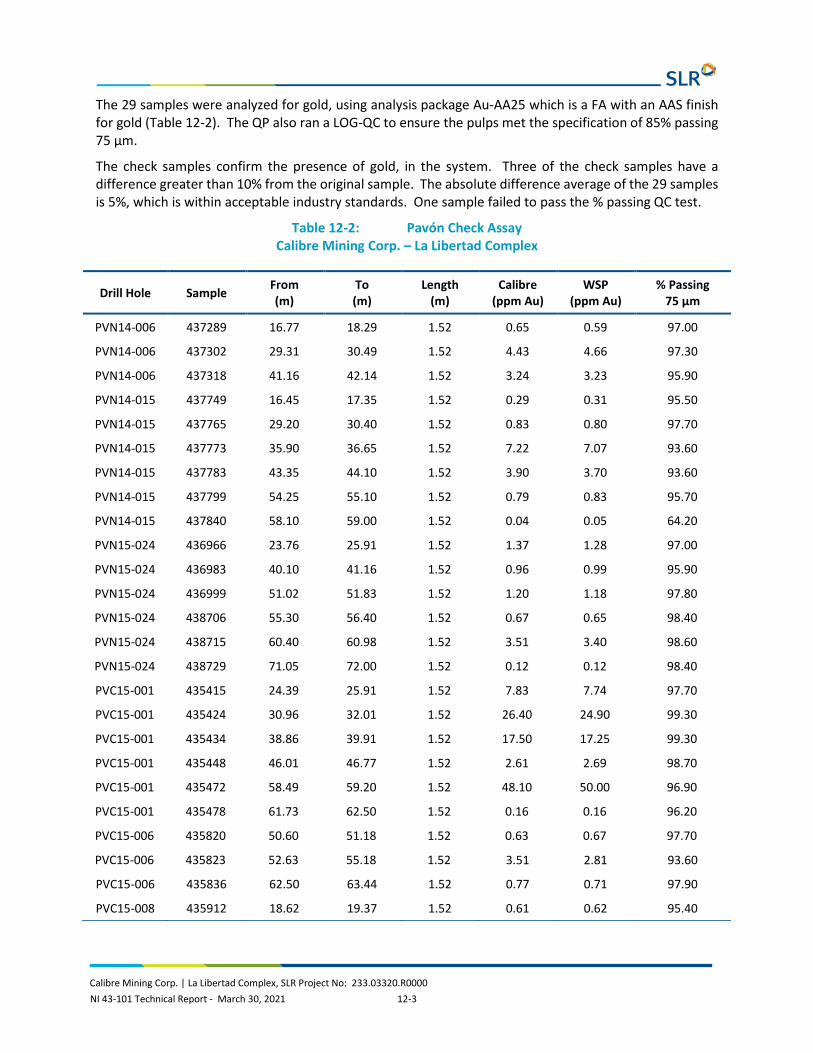
Calibre Mining Corp. | La Libertad Complex, SLR Project No: 233.03320.R0000 NI 43-101 Technical Report - March 30, 2021 12-3
The 29 samples were analyzed for gold, using analysis package Au-AA25 which is a FA with an AAS finish for gold (Table 12-2). The QP also ran a LOG-QC to ensure the pulps met the specification of 85% passing 75 µm.
The check samples confirm the presence of gold, in the system. Three of the check samples have a difference greater than 10% from the original sample. The absolute difference average of the 29 samples is 5%, which is within acceptable industry standards. One sample failed to pass the % passing QC test.
Table 12-2: Pavón Check Assay Calibre Mining Corp. – La Libertad Complex
Drill Hole Sample From (m)
To (m)
Length (m)
Calibre (ppm Au)
WSP (ppm Au)
% Passing 75 µm
PVN14-006 437289 16.77 18.29 1.52 0.65 0.59 97.00
PVN14-006 437302 29.31 30.49 1.52 4.43 4.66 97.30
PVN14-006 437318 41.16 42.14 1.52 3.24 3.23 95.90
PVN14-015 437749 16.45 17.35 1.52 0.29 0.31 95.50
PVN14-015 437765 29.20 30.40 1.52 0.83 0.80 97.70
PVN14-015 437773 35.90 36.65 1.52 7.22 7.07 93.60
PVN14-015 437783 43.35 44.10 1.52 3.90 3.70 93.60
PVN14-015 437799 54.25 55.10 1.52 0.79 0.83 95.70
PVN14-015 437840 58.10 59.00 1.52 0.04 0.05 64.20
PVN15-024 436966 23.76 25.91 1.52 1.37 1.28 97.00
PVN15-024 436983 40.10 41.16 1.52 0.96 0.99 95.90
PVN15-024 436999 51.02 51.83 1.52 1.20 1.18 97.80
PVN15-024 438706 55.30 56.40 1.52 0.67 0.65 98.40
PVN15-024 438715 60.40 60.98 1.52 3.51 3.40 98.60
PVN15-024 438729 71.05 72.00 1.52 0.12 0.12 98.40
PVC15-001 435415 24.39 25.91 1.52 7.83 7.74 97.70
PVC15-001 435424 30.96 32.01 1.52 26.40 24.90 99.30
PVC15-001 435434 38.86 39.91 1.52 17.50 17.25 99.30
PVC15-001 435448 46.01 46.77 1.52 2.61 2.69 98.70
PVC15-001 435472 58.49 59.20 1.52 48.10 50.00 96.90
PVC15-001 435478 61.73 62.50 1.52 0.16 0.16 96.20
PVC15-006 435820 50.60 51.18 1.52 0.63 0.67 97.70
PVC15-006 435823 52.63 55.18 1.52 3.51 2.81 93.60
PVC15-006 435836 62.50 63.44 1.52 0.77 0.71 97.90
PVC15-008 435912 18.62 19.37 1.52 0.61 0.62 95.40

Calibre Mining Corp. | La Libertad Complex, SLR Project No: 233.03320.R0000 NI 43-101 Technical Report - March 30, 2021 12-4
Drill Hole Sample From (m)
To (m)
Length (m)
Calibre (ppm Au)
WSP (ppm Au)
% Passing 75 µm
PVC15-008 435926 24.96 25.91 1.52 2.13 2.16 98.70
PVC15-008 435936 32.51 33.54 1.52 0.48 0.54 97.90
PVC15-008 435947 39.03 39.95 1.52 1.81 1.80 98.70
PVC15-008 435951 42.68 43.60 1.52 0.18 0.18 98.80
12.2.4 QP Opinion on the Database
The QP is of the opinion that the sample database provided by Calibre and validated by WSP is suitable to support the Mineral Resource estimation.

Calibre Mining Corp. | La Libertad Complex, SLR Project No: 233.03320.R0000 NI 43-101 Technical Report - March 30, 2021 13-1
13.0 MINERAL PROCESSING AND METALLURGICAL TESTING
13.1 Introduction The La Libertad processing plant is a conventional processing plant consisting of agitated cyanide leaching and carbon adsorption, followed by carbon elution, electrowinning, and doré production. La Libertad processing plant has been in operation since 2009, with upgrades completed to allow for increased throughput. Prior to 2009, La Libertad operated as an on-off heap leach and adsorption, desorption, and regeneration (ADR) operation from 1994 to 1996, and again from 2001 until 2007. Historical gold recovery from the heap leach operation averaged approximately 45%, as reported in the 2008 Scott Wilson RPA Technical Report (Scott Wilson RPA, 2008). La Libertad processing plant can treat approximately 2.25 Mtpa and current gold recoveries are approximately 92% to 95% with mill feed sourced from mines within La Libertad Complex.
13.2 Metallurgical Testing Metallurgical testing programs focussed predominantly on the amenability of potential future feed material for La Libertad processing plant to cyanidation. In general, the test work to date has indicated that mill feed material from La Libertad Complex could be successfully processed through La Libertad processing plant at recoveries similar to historical recoveries.
Mineralization from El Limón and adjacent areas is harder and has finer gold than La Libertad mineralization, requiring a finer grind in the 80% passing (P80) 55 µm to P80 65 µm range to liberate the gold versus the P75 74 µm grind that La Libertad mill currently targets. El Limón mill grinds to P80 65 µm and all of the test work has been performed under the standard El Limón conditions, including the P80 65 µm grind. The result may be lower recovery for those particular materials when processed in La Libertad mill.
13.2.1 La Libertad
13.2.1.1 SGS Program - 2015
CIP modelling was conducted by SGS Canada Inc. (SGS) in 2015 using two samples, one of current plant cyclone overflow, and one composite sample consisting of a blend of future La Libertad mill feed including Jabalí Central OP, spent heap material, Mojón OP and UG, Jabalí Antena OP, and Jabalí West UG material. SGS also evaluated one composite sample and four variability samples from the Jabalí Antena deposit for amenability to whole ore cyanidation in 2015. Jabalí Antena OP and Jabalí West UG material are the only material in the production schedule from this testing program. Mining at the other deposits in this program had been virtually completed by the end of 2019.
Sample representativity for the samples used in the various test campaigns was not available, however, the small degree of variability between the results for the samples (with the exception of the High-Ox Jabalí Antena sample) indicate that, in general, recoveries similar to historical recoveries are possible when treating mineralization from these deposits. No deleterious elements were detected in significant amounts.

Calibre Mining Corp. | La Libertad Complex, SLR Project No: 233.03320.R0000 NI 43-101 Technical Report - March 30, 2021 13-2
13.2.1.2 CIP Modelling – SGS, 2015
Two samples, one of current processing plant cyclone overflow and one of a future mill feed blend were submitted for test work. The first phase of the test work focussed on the amenability of the samples to whole ore cyanidation, while the second phase focussed on carbon circuit modelling. A sample of La Libertad regenerated plant carbon was also used for the test work. The make-up of the future feed blend sample is provided in Table 13-1.
Table 13-1: Future Mill Feed Blend Calibre Mining Corp. – La Libertad Complex
Source SGS Sample Distribution (%)
Amount of Sample (kg)
Jabalí Central La Libertad Jabalí Central 11.9 2.4
Spent Heap Material Spent Heap Material 48.1 9.6
Mojón Surface La Libertad Mojón OP 6.9 1.4
Jabalí Antena1 Avg. Grade Mix 8.6 1.7
Mojón Underground Mojón Master Comp 10.1 2.0
Jabalí West UG1 50% Low-mix Sulphide 50% High-mix Sulphide 14.4
1.4 1.4
Total 100.0 20.0
Note: 1. In the production schedule
While the cyclone overflow sample assayed 1.41 g/t Au and 9.7 g/t Ag, the future blend sample assayed 2.70 g/t Au and 22.4 g/t Ag. The CIP modelling program included leach kinetics, adsorption kinetics, and equilibrium isotherm test work. Results from the tests were used to develop a mathematical leach and adsorption model that reproduced key plant operating parameters. The future blend modelling results illustrated that a carbon transfer rate of 12 tpd (current plant condition) would need to be used for the higher grade sample in order to maximize both gold and silver recovery.
13.2.1.3 Jabalí Antena Cyanidation Amenability – SGS, 2015
One average grade mixed sample and four variability samples were used for a metallurgical program to evaluate amenability of the samples to whole-ore cyanidation using optimized leach conditions established by a third party (BBA Engineering), with adjustments to the dissolved oxygen profile and leach temperature to simulate the current La Libertad plant operating conditions. The tests were completed using the La Libertad target grind size of P80 100 µm. The leach tests were conducted using stirred reactors, as opposed to standard bottle roll tests, at the request of the client. The head grades for the average grade mix sample were 4.17 g/t Au and 35.6 g/t Ag. The head grades of the variability samples ranged from 2.38 g/t Au to 11.1 g/t Au and from 12.8 g/t Ag to 85.2 g/t Ag. Head assays for the samples are presented in Table 13-2.

Calibre Mining Corp. | La Libertad Complex, SLR Project No: 233.03320.R0000 NI 43-101 Technical Report - March 30, 2021 13-3
Table 13-2: Jabalí Antena Sample Head Assays Calibre Mining Corp. – La Libertad Complex
Element Unit Samples
Average Grade Mix
Low Mix (Sulphide)
High Mix (Sulphide) Low Ox High Ox
Au Cut A g/t 3.66 2.43 9.60 2.44 11.2
Au Cut B g/t 4.67 2.32 7.40 2.53 11.0
Au Avg. g/t 4.17 2.38 8.50 2.49 11.1
Ag Cut A g/t 35.5 14.5 62.2 13.2 85.7
Ag Cut B g/t 35.7 15.5 65.2 12.4 84.7
Ag Avg. g/t 35.6 15.0 63.7 12.8 85.2
Cu % 0.079 - - - -
Pb % 0.69 - - - -
Zn % 0.59 - - - -
ST % 0.52 0.36 0.70 0.16 0.71
S= % 0.46 0.29 0.59 0.15 0.62
SO4 % <0.1 <0.1 <0.1 <0.1 <0.1
S° % <0.05 <0.05 <0.05 <0.05 <0.05
Hg g/t <0.3 <0.3 <0.3 <0.3 <0.3
The average grade mix sample, low mix sulphide, and low ox samples all responded well to the optimized test conditions and gold extractions were approximately 96% or higher after 32 hours of leaching. Silver extractions were approximately 73% to 74%.
The high mix sulphide and high ox variability samples did not respond well to the optimized leach conditions, and gold extractions were 44.1% and 47.7%, respectively. Silver extractions were 47.1% (high mix sulphide) and 7.9% (high ox). Repeat tests were completed and the cyanide (NaCN) concentration was increased to 0.5 g/L from 0.3 g/L. The increased cyanide concentration had a positive impact on both samples. The high mix sulphide sample gold and silver extractions increased to 93.8% and 80.2%, respectively. The high ox sample gold and silver extractions increased to 61.8% and 64.3%, respectively, but were still lower than all the other samples tested.
The cyanide and lime consumptions for the optimized leach tests ranged from 0.48 kg/t to 1.57 kg/t and 1.48 kg/t to 2.06 kg/t, respectively. The cyanide consumption was directly related to the sulphide, copper, and zinc head grades.
A three stage diagnostic leach test was completed using the repeat high ox cyanidation residue sample. The results indicated that the majority of the gold in the sample (approximately 99%) was readily available and could be extracted with additional leach time and more cyanide. The silver extraction was approximately 81% after the additional leach stages and the remaining silver was mostly associated with sulphide minerals.

Calibre Mining Corp. | La Libertad Complex, SLR Project No: 233.03320.R0000 NI 43-101 Technical Report - March 30, 2021 13-4
13.2.1.4 San Antonio Cyanidation Amenability – La Libertad, 2018
Samples from the San Antonio deposit were tested in La Libertad metallurgical laboratory. Results are presented in Table 13-3.
Table 13-3: Summary of Cyanidation Test Work on Samples from the San Antonio Deposit – 2018
Calibre Mining Corp. – La Libertad Complex
Sample No. % - 200M
Target NaCN (ppm)
Calc Head
(g/t Au)
Au Extra (g/t Au)
Ave Au Tails, (g/t Au)
Au Extra (%)
Time (hr)
NaCN Cons,
(kg NaCN/t)
CaO Add,
(kg CaO/t)
Lead Nitrate Add,
(g Pb(NO3)2/t)
SA18-011 72 350 1.844 1.772 0.072 96.1 31 0.192 1.9 100
SA18-015 72 350 1.75 1.678 0.071 95.9 31 0.22 1.94 100
SA18-016 70 350 1.247 1.169 0.078 93.8 31 0.192 1.54 100
SA18-017 70 350 4.432 4.26 0.172 96.1 31 0.148 2.3 100
SA18-020 71.5 350 1.754 1.66 0.094 94.6 31 0.167 1.453 100
SA18-021 70.7 350 1.386 1.186 0.102 92.1 31 0.178 2.56 100
SA18-023 69 350 1.714 1.625 0.089 94.8 31 0.25 2.12 100
SA18-024 70 350 1.318 1.236 0.078 94.1 31 0.178 1.7 100
SA18-025 73 350 0.888 0.834 0.054 93.9 31 0.206 1.32 100
SA18-012/013 70.5 350 1.158 1.079 0.079 93.2 31 0.188 1.728 100
Comp 021 and 024 72 350 1.289 1.2 0.089 93.11 31 0.22 1.42 100
Comp 021 and 025 72 500 1.335 1.268 0.066 95.04 31 0.343 1.46 100
Comp All Samples 71 350 1.732 1.654 0.078 95.5 31 0.24 1.6 100
Comp All Samples 71 500 1.668 1.604 0.054 96.74 31 0.37 1.6 100
Source: B2Gold, 2019
13.2.1.5 San Antonio Cyanide Leach Testing – 2020
In July 2020, La Libertad collected four samples from the San Antonio deposit for cyanidation testing. Duplicate bottle roll cyanidation tests were performed on each of the individual samples and a fifth duplicate test was performed on a composite of all four samples. Results are presented in Table 13-4. The conditions for the tests were:
• Grind size: 75% passing 200 M (74 µm) • Pulp Density: 42% solids • Pulp pH: 10.5 to 11.0 maintained with lime • Cyanide concentration: 380 mg NaCN/L (maintained) • Retention Time: 42 hr • Leach Temperature: 36°C to 38°C

Calibre Mining Corp. | La Libertad Complex, SLR Project No: 233.03320.R0000 NI 43-101 Technical Report - March 30, 2021 13-5
• Dissolved Oxygen Concentration: 18 ppm O2 to 22 ppm O2 from 0 hr to 28 hr and 8 ppm O2 to 12 ppm O2 from 29 hr to 48.5 hr.
Table 13-4: Results of 2020 San Antonio Bottle Roll Leach Tests Calibre Mining Corp. – La Libertad Complex
Test Code
NaCN Cons
Head Grade
(g/t Au)
Head Calc
(g/t Au)
Tails (g/t Au)
Extra Au (%)
Head Calc
(g/t Ag)
Tail (g/t Ag)
Extra Ag (%)
Head Calc
(g/t Cu)
Tails (g/t Cu)
Extra Cu (%)
Test 1
PB-1768 0.82 0.57 0.82 0.07 91.2% 1.05 0.65 38.0% 89.1 81.4 8.7%
PB-1773 0.82 0.57 0.94 0.09 90.7% 1.34 0.68 37.8% 92.8 84.2 9.3%
Average 0.82 0.57 0.88 0.08 90.9% 1.20 0.66 37.9% 90.9 82.8 9.0%
Test 2
PB-1769 0.74 9.13 8.89 0.27 97.0% 3.86 0.88 77.3% 162.5 117.8 27.5%
PB-1774 0.74 9.13 8.74 0.26 97.1% 3.64 1.12 69.3% 155.2 113.6 26.8%
Average 0.74 9.13 8.82 0.26 97.0% 3.75 1.00 73.3% 158.8 115.7 27.1%
Test 3
PB-1770 1.33 7.13 6.64 0.26 96.1% 4.82 0.98 79.6% 143.3 103.6 27.7%
PB-1775 1.33 7.13 6.81 0.21 96.9% 5.07 1.22 76.0% 151.7 108.3 28.7%
Average 1.33 7.13 6.73 0.24 96.5% 4.95 1.10 77.8% 147.5 105.9 28.2%
Test 4
PB-1771 0.71 0.73 0.42 0.04 90.0% 0.42 0.98 32.5% 54.4 40.6 25.3%
PB-1776 0.71 0.73 0.55 0.06 89.9% 0.55 0.95 32.3% 59.0 45.6 22.7%
Average 0.71 0.73 0.48 0.05 89.9% 0.48 0.97 32.4% 56.7 43.1 24.0%
Test 5
PB-1772 0.68 4.58 4.31 0.16 96.2% 2.97 1.03 65.3% 114.9 90.3 21.4%
PB-1777 0.68 4.58 4.30 0.18 95.8% 3.05 1.18 61.4% 107.5 82.8 23.0%
Average 0.68 4.58 4.30 0.17 96.0% 3.01 1.11 63.3% 111.2 86.5 22.2%
Gold grades ranged from 0.88 g/t Au to 8.82 g/t Au and the gold recoveries ranged from 89.9% Au extraction to 97.0% Au extraction. SLR notes that there is a direct correlation between gold head grade and gold recovery. The lowest recovery was associated with the lowest grade and highest recovery with the highest grade. SLR notes that the low grade samples had very low residue grades, while the high grade samples had higher residues indicating that more leaching would occur with longer retention times for the high grade samples.
Silver grades ranged from 0.48 g/t Ag to 4.95 g/t Ag and extractions ranged from 32.4% Ag to 77.8% Ag extraction. There is a direct grade recovery relationship with silver as with gold. The lowest recovery was associated with the lowest grade and highest recovery with the highest head grade. SLR notes that two other factors that may play a role are cyanide concentration and soluble copper concentration. The copper extraction tends to mirror the silver extraction and, as expected, the soluble copper must be extracted before the silver and can consume all of the available cyanide.

Calibre Mining Corp. | La Libertad Complex, SLR Project No: 233.03320.R0000 NI 43-101 Technical Report - March 30, 2021 13-6
13.2.2 Pavón
13.2.2.1 SGS Program - 2014
In 2014 and 2015, SGS conducted test work on samples from the Pavón deposit. One master composite sample and six variability samples were used for a metallurgical program to evaluate amenability of the samples to whole ore cyanidation. An additional sample was subjected to a Bond ball mill grindability test. Based on information provided by Calibre, the samples tested by SGS were taken from the Pavón Norte deposit.
Table 13-5 presents the 2014 metallurgical samples tested.
Table 13-5: 2014 Pavón Metallurgical Samples Calibre Mining Corp. – La Libertad Complex
Sample Receipt Sample ID Sample Name Material Type Weight (kg)
0001-Nov14
6284 Master Comp Course Reject 32
6285 Var. Sample #1 Course Reject 10
6286 Var. Sample #2 Course Reject 10
6287 Var. Sample #3 Course Reject 10
6288 Var. Sample #4 Course Reject 10
6289 Var. Sample #5 Course Reject 10
6290 Var. Sample #6 Course Reject 10
6291 Comminution 1/4 NQ Core 40
The effect of grind and cyanide concentration on gold and silver extraction were evaluated for the master composite sample. The grind size evaluation tests were completed on target grind sizes varying between P80 100 µm and P80 53 µm. Cyanide concentrations ranging from 0.32 g/L NaCN to 0.5 g/L NaCN were tested. The remaining leach conditions were as per the Limón plant operation (data provided by client). The main differences between La Libertad and El Limón leach conditions are presented in Table 13-6.
Table 13-6: La Libertad Plant versus Limón Plant Leach Conditions Calibre Mining Corp. – La Libertad Complex
Element Unit La Libertad Plant
Limón Plant
Target Grind Size µm 75 (P70) 65 (P80)
Slurry Density % solids w/w 45 42
Slurry pH - N/A 10.5-11
Target Cyanide Concentration g/L NaCN 0.35 0.32
Retention Time h 32 48.5
Leach Temperature °C N/A 36-38

Calibre Mining Corp. | La Libertad Complex, SLR Project No: 233.03320.R0000 NI 43-101 Technical Report - March 30, 2021 13-7
Element Unit La Libertad Plant
Limón Plant
Dissolved Oxygen Concentration ppm N/A 18-22 (0-28h)
8-12 (29-48.5h)
Based on the available data, the leaching operating conditions at La Libertad and El Limón differ in grind size and leach residence time. Head grades for the master composite sample were 7.88 g/t Au and 8.7 g/t Ag.
The head grades of the variability samples ranged from 3.22 g/t Au to 15.5 g/t Au and from 3.7 g/t Ag to 13.3 g/t Ag. Sulphur head grades were low. Variability samples 1, 2, 3, and 6 are considered to be most representative of the expected Pavón ore head grade to the mill.
The results are presented in Table 13-7.
Table 13-7: Head Analyses of Pavón Master Composite and Variability Sample Calibre Mining Corp. – La Libertad Complex
Element Unit Master Composite
Variability Samples
1 2 3 4 5 6
Au Cut A g/t 7.93 3.22 3.67 3.86 10.6 15.7 3.72
Au Cut B g/t 7.82 3.21 3.62 7.18 11.5 15.3 3.57
Au Avg. g/t 7.88 3.22 3.65 7.02 11.1 15.5 3.65
Ag g/t 8.7 3.7 7.3 8.1 13.3 10.8 7.2
Cu g/t 0.001% 24.5 21.9 19.5 40.3 19.6 67.1
Pb g/t <20 <20 <20 <20 <20 <20 <20
Zn g/t <0.01% 6 9 4 16 5 39
ST % 0.05 0.06 0.23 0.03 0.03 0.12 0.10
S= % 0.05 0.06 0.19 <0.05 <0.05 0.12 0.10
13.2.2.1.1 Comminution Testing
The single Bond ball mill grindability test performed at a closing size of 56 µm resulted in a work index value of 19.6 kWh/t. This value is categorized as very hard in the SGS database.
13.2.2.1.2 Cyanide Leach Testing
The metallurgical program consisted of whole ore cyanidation test work. The master composite sample was used to evaluate the effect of grind size and cyanide concentration on gold and silver extraction. Three grind sizes were tested between P80 100 µm and P80 53 µm and cyanide concentrations between 0.32 g/L NaCN and 0.50 g/L NaCN were tested. The remainder of the tests were performed using the standard leach conditions of El Limón processing plant.
The results of cyanidation of gold and silver performed on the master composite sample at grind sizes ranging from P80 100 µm to P80 53 µm are shown in Table 13-8 for gold and Table 13-9 for silver.

Calibre Mining Corp. | La Libertad Complex, SLR Project No: 233.03320.R0000 NI 43-101 Technical Report - March 30, 2021 13-8
Table 13-8: Results of Cyanide Leach Testing of Pavón Master Composite – Gold Calibre Mining Corp. – La Libertad Complex
Leach Test No.
Feed Size (P80 μm) Conc
(g/t NaCN)
Reagent Consumption (kg/t Feed)
Extraction (% Au)
Residue (g/t Au)
Head Grade (g/t Au)
Target Actual NaCN CaO 2h 8h 24h 48.5 h Ave of 3 Calc Ave Direct
1 100 99 0.32 0.41 1.15 14 87 95 93.6 0.53 8.17
8.17 7.88
2 65 65 0.32 0.46 1.20 15 96 97 95.6 0.36 8.07
3 53 51 0.32 0.46 1.20 11 95 97 96.5 0.29 8.14
4 65 64 0.40 0.54 1.12 16 94 94 95.6 0.36 8.14
5 65 65 0.50 0.66 1.05 21 94 95 96.0 0.34 8.35
Table 13-9: Results of Cyanide Leach Testing of Pavón Master Composite – Silver Calibre Mining Corp. – La Libertad Complex
Leach Test No.
Feed Size (P80 μm) Conc
(g/t NaCN)
Reagent Consumption (kg/t Feed)
Extraction (% Ag)
Residue (g/t Ag)
Head Grade (g/t Ag)
Target Actual NaCN CaO 2h 8h 24h 48.5 h Ave of 3 Calc Average Direct
1 100 99 0.32 0.41 1.15 15 55 72 76.1 2.2 9.2
9.1 8.7
2 65 65 0.32 0.46 1.20 14 71 82 81.8 1.6 9.0
3 53 51 0.32 0.46 1.20 12 69 80 82.5 1.5 8.8
4 65 64 0.40 0.54 1.12 16 72 82 83.5 1.5 9.1
5 65 65 0.50 0.66 1.05 21 73 82 84.8 1.4 9.2

Calibre Mining Corp. | La Libertad Complex, SLR Project No: 233.03320.R0000 NI 43-101 Technical Report - March 30, 2021 13-9
The master composite cyanidation test results indicated that higher gold extractions could be achieved at finer grinds. A gold extraction of 93.6% was observed at P80 99 µm while 96.5% was achieved at P80 51 µm. The finest grind sample leached quickly as the leach was complete after 8 hours. The coarsest feed size sample required 24 hours for the leach to be complete (shorter than the available leach time at La Libertad). Higher cyanide concentrations had no effect on gold extraction but slightly increased silver extraction.
The variability samples were submitted for single leach tests using the El Limón mine leach conditions and target grind size P80 65 µm. The results of the tests are given in Table 13-10.
Testing of the variability samples revealed that the samples responded well to the leach conditions and the average gold and silver extractions were 95.4% and 76.3%, respectively.
Cyanide and lime (CaO) consumptions (kg/t of leach feed) were similar for all the variability samples with an average of 0.49 kg/t for NaCN and 1.14 kg/t for CaO.

Calibre Mining Corp. | La Libertad Complex, SLR Project No: 233.03320.R0000 NI 43-101 Technical Report - March 30, 2021 13-10
Table 13-10: Results of Cyanide Leaching of Pavón Variability Samples Calibre Mining Corp. – La Libertad Complex
Var Test No.
CN Test No.
Feed Size (P80, μm)
Reagent Cons (kg/t Feed)
Extraction (%)
Residue (g/t Au)
Residue (g/t Ag)
Head Grade (g/t Au)
Head Grade (g/t Ag)
NaCN CaO Au Ag Ave of 3 Ave of 3 Calc Direct Calc Direct
1 6 59 0.45 1.00 96.0 77.3 0.16 0.80 3.75 3.22 3.40 3.70
2 7 59 0.48 1.19 93.2 86.3 0.27 1.00 3.98 3.65 7.30 7.30
3 8 66 0.57 1.13 96.2 70.6 0.28 2.20 7.28 7.02 7.60 8.10
4 9 53 0.39 1.22 96.9 68.5 0.36 4.50 11.60 11.10 14.20 13.30
5 10 67 0.50 1.00 97.1 84.7 0.46 1.60 15.80 15.50 10.40 10.80
6 11 65 0.57 1.32 92.7 70.4 0.27 2.10 3.66 3.65 7.00 7.20

Calibre Mining Corp. | La Libertad Complex, SLR Project No: 233.03320.R0000 NI 43-101 Technical Report - March 30, 2021 13-11
13.2.2.2 Testing of Pavón Central by Calibre
In 2020 and early 2021, bottle roll tests were performed at La Libertad by Calibre on samples from the Pavón Central deposit.
Thirty-seven tests have been carried out on composite samples with an average head grade of approximately 23 g/t Au, at P7075 μm. The tests were performed with initial NaCN concentrations of 350 ppm or 380 ppm and an oxygen concentration of 25 ppm. Lead nitrate dosage was 100 g of Pb(NO3)2 per ton of ore for all the tests.
Gold recovery ranged between 86.1% and 97.3% with an average of 93.8%.
Although the recovery results for these high grade Pavón Central samples appear consistent with the metallurgical performances of the Pavón Norte samples tested by SGS in 2014, these values are yet to be confirmed by an independent laboratory.

Calibre Mining Corp. | La Libertad Complex, SLR Project No: 233.03320.R0000 NI 43-101 Technical Report - March 30, 2021 14-1
14.0 MINERAL RESOURCE ESTIMATE
14.1 Summary Canadian Institute of Mining, Metallurgy and Petroleum (CIM) Definition Standards for Mineral Resources and Mineral Reserves dated May 10, 2014 (CIM (2014) definitions) were used for Mineral Resource classification.
The Mineral Resources at San Juan UG, Mojón UG, Tope UG, Jabalí Antena OP, and Jabalí East UG in La Libertad Mine were estimated by B2Gold and reviewed and accepted by SLR. The Mineral Resources at Rosario OP, Socorro OP, San Antonio OP, and Jabalí West UG were estimated by SLR. Pavón Mineral Resources have been estimated by WSP. The Mineral Resources are contained in one active open pit and three proposed open pit mining scenarios, in addition to in one active underground mine and three proposed underground mining scenarios, as well as spent ore from a previous heap leach operation and surface stockpiles.
A summary of the La Libertad and Pavón Mineral Resources is provided in Table 14-1. The La Libertad deposits have an effective date of December 31, 2020. Pavón Mineral Resources are effective November 12, 2019. A comparison with the previous resource estimate is provided in Table 14-2.
The QPs are not aware of any environmental, permitting, legal, title, taxation, socio-economic, marketing, political, or other relevant factors that could materially affect the Mineral Resource estimate.
Table 14-1: Summary of Mineral Resources for La Libertad and Pavón Calibre Mining Corp. – La Libertad Complex
Tonnage Grade Contained Metal
(000 t) (g/t Au) (g/t Ag) (koz Au) (koz Ag)
La Libertad
Indicated
Jabalí Antena OP 153 5.15 66.20 25 327
Rosario OP 43 1.86 7.05 3 10
Socorro OP 424 2.01 9.59 27 131
Jabalí West UG 421 5.72 28.15 77 381
Stockpile 55 9.3 16
Total Indicated 1,096 4.20 24.09 148 849
Inferred
Jabalí Antena OP 32 2.12 48.28 2 51
Jabalí East UG 351 4.91 55
Rosario OP 202 2.11 7.66 14 50
Socorro OP 76 1.57 9.55 4 23

Calibre Mining Corp. | La Libertad Complex, SLR Project No: 233.03320.R0000 NI 43-101 Technical Report - March 30, 2021 14-2
Tonnage Grade Contained Metal
(000 t) (g/t Au) (g/t Ag) (koz Au) (koz Ag)
San Antonio OP 359 2.42 28
Jabalí West UG 466 7.12 45.74 107 685
San Juan UG 146 4.32 20
Tope UG 141 4.19 19
Mojon UG 481 4.79 74
Total Inferred 2,254 4.46 11.16 323 809
Pavón
Indicated
Pavón Norte 863 3.58 4.77 99 132
Pavón Central 529 7.73 12.55 131 213
Total Indicated 1,392 5.15 7.72 230 345
Inferred
Pavón Norte 98 3.53 6.16 11 19
Pavón Central 153 4.46 7.68 22 38
Pavón Sur 326 2.85 3.22 30 34
Total Inferred 577 3.40 4.91 63 91
Notes: 1. Effective dates are December 31, 2020 for all La Libertad deposits and November 12, 2019 for Pavón. 2. CIM (2014) definitions were followed for Mineral Resources. 3. A cut-off grade of 0.85 g/t Au is used for Jabalí Antena OP, 0.81 g/t for Rosario OP, 0.80 g/t Au for Socorro OP and San
Antonio OP, 2.90 g/t Au for San Juan UG, San Diego UG and Mojon UG, and 2.84 g/t Au for Jabalí West UG and Jabalí East UG, and 1.17 g/t Au for Pavón
4. Reporting shapes were used for reporting Jabalí West UG. 5. Mineral Resources are estimated using a long-term gold price of US$1,500/oz. 6. Bulk density varies between 1.70 t/m3 and 2.57 t/m3 at La Libertad. A specific gravity value of 2.49 was applied to all
blocks in rock and 2.30 was applied to all blocks in saprolite. 7. Mineral Resources that are not Mineral Reserves do not have demonstrated economic viability. 8. Mineral Resources are inclusive of Mineral Reserves. 9. Numbers may not add up due to rounding.

Calibre Mining Corp. | La Libertad Complex, SLR Project No: 233.03320.R0000 NI 43-101 Technical Report - March 30, 2021 14-3
Table 14-2: Comparison with the Previous Mineral Resources Calibre Mining Corp. – La Libertad Complex
Tonnage Grade Contained Au Grade Contained AgMineral Resources - December 31, 2020
Tonnage Grade Contained Au Grade Contained Ag Δ Tonnes Δ Au Grade Δ Contained Au Δ Ag Grade Δ Contained Ag Δ Tonnes Δ Au Grade Δ Contained Au Δ Ag Grade Δ Contained Ag(kt) (g/t Au) (koz) (g/t Ag) (koz) (kt) (g/t Au) (koz) (g/t Ag) (koz) (000 t) (g/t) (000 oz) (g/t) (000 oz) (%) (%) (%) (%) (%)
La LibertadIndicatedJabali Antena OP 273 5.57 49 0.00 0 153 5.15 25 66.20 327 66.20 327 N/A N/ARosario OP 0 0 0 0 0 43 1.86 3 7.05 10 7.05 10 N/A N/ASocorro OP 0 0 0 0 0 424 2.01 27 9.59 131
-12043
424
-0.421.862.01
-243
27 9.59 131
-44%N/AN/A
-8%N/AN/A
-49%N/AN/A N/A N/A
Jabali West UG 436 6.06 85 0 0 421 5.72 77 28.15 381 28.15 381 -3% -9% N/A N/AStockpile 8 0.75 0.2 0 0 55 9.3 16 0 0
-1547
-0.348.55
-816 0.00 0
-3%588% 1140% 7900% N/A N/A
Total Indicated 717 5.82 134 0.00 0 1,096 4.20 148 24.09 849 379 -1.62 14 24.09 849 53% -28% 10% N/A N/A
InferredJabali Antena OP 52 2.93 5 0.00 0 32 2.12 2 48.28 51 48.28 51 N/A N/AJabali East UG 0 0.00 0 0.00 0 351 4.91 55
-20351
-0.814.91
-355 0.00 0
-38%N/A
-28%N/A
-60%N/A N/A N/A
Rosario OP 228 2.14 16 0.00 0 202 2.11 14 7.66 50 -26 -0.03 -2 7.66 50 -11% -1% -13% N/A N/ASocorro OP 154 1.77 8 0.00 0 76 1.57 4 9.55 23 -4 9.55 23 -51% -50% N/A N/ASan Antonio OP 380 2.42 29 0.00 0 359 2.42 28
-0.200.00 -1 0.00 0
-11%0% -3% N/A N/A
Jabali West UG 405 8.45 110 0.00 0 466 7.12 107 45.74 685 45.74 685 N/A N/ASan Juan UG 146 4.32 20 0.00 0 146 4.32 20 0.00 0 N/A N/ATope UG 141 4.19 19 0.00 0 141 4.19 19 0.00 0 N/A N/AMojon UG 481 4.79 74 0.00 0 481 4.79 74
-78-2161
000
-1.330.000.000.00
-3000 0.00 0
-6%15%
0%0%0%
-16%0%0%0%
-3%0%0%0% N/A N/A
Total Inferred 1,987 4.40 281 0.00 0 2,254 4.46 323 11.16 809 267 0.06 42 11.16 809 13% 1% 15% N/A N/A
PavonIndicatedPavon Norte 863 3.58 99 4.77 132 863 3.58 99 4.77 132 0 0.00 0 0.00 0 0% 0% 0% 100% 100%Pavon Central 529 7.73 131 12.55 213 529 7.73 131 12.55 213 0 0.00 0 0.00 0 0% 0% 0% 100% 100%Total Indicated 1,392 5.15 230 7.72 345 1,392 5.15 230 7.72 345 0 0.00 0 0.00 0 0% 0% 0% 100% 100%
Pavon Norte 98 3.53 11 6.16 19 98 3.53 11 6.16 19 0 0.00 0 0.00 0 0% 0% 0% 100% 100%Pavon Central 153 4.46 22 7.68 38 153 4.46 22 7.68 38 0 0.00 0 0.00 0 0% 0% 0% 100% 100%Pavon Sur 326 2.85 30 3.22 34 326 2.85 30 3.22 34 0 0.00 0 0.00 0 0% 0% 0% 100% 100%Total Inferred 577 3.40 63 4.91 91 577 3.40 63 4.91 91 0 0.00 0 0.00 0 0% 0% 0% 100% 100%
Total Indicated 2,109 5.38 365 5.09 345 2,488 4.73 378 14.93 1,194 379 14 9.84 849 18% 4% 293% 346%Total Inferred 2,564 4.17 344 1.10 91 2,831 4.24 386 9.89 900 267
-0.650.07 42 8.78 809 10%
-12%2% 12% 896% 989%
Mineral Resources - December 31, 2019 Variance

Calibre Mining Corp. | La Libertad Complex, SLR Project No: 233.03320.R0000 NI 43-101 Technical Report - March 30, 2021 14-4
14.2 La Libertad
14.2.1 Project Summary
The 2020 year end (YE) La Libertad Mineral Resource estimate consists of a mixture of wireframes prepared by B2Gold and updated wireframes prepared by SLR. The La Libertad Mineral Resource estimate represents an update of previous Mineral Resource estimates for the Project.
Vein area divisions and spatial locations of the Mineral Resource areas are shown in Figure 14-1. Table 14-3 lists each block model and includes selected supporting information, while Table 14-4 provides a summary of densities used in each block model.

Jabalí Open Pit and Underground
San Juan UG
Rosario OP
Socorro OP
San Antonio OP
Tope UG
Mojon UG
La Libertad Mill
N
0 1 5
Kilometres
2 3 4
14-5
March 2021 Source: SLR, 2021.
Calibre Mining Corp.
La Libertad Complex
Locations of the Mineral ResourceAreas at La Libertad
Chontales Department, Nicaragua
Figure 14-1

Calibre Mining Corp. | La Libertad Complex, SLR Project No: 233.03320.R0000 NI 43-101 Technical Report - March 30, 2021 14-6
Table 14-3: Summary of La Libertad Block Models Calibre Mining Corp. – La Libertad Complex
Area Domain Zone Codes Model Name Wireframes Completed
By
Block Models Completed
By
Last Updated
Database Cut-Off
Jabalí Antena OP 2000,3000,4000,7000,8000 feb28_mod B2Gold B2Gold 2016-Jan-15 2015-Dec-31
Jabalí West UG 101-103,201,991 BM_JABWUG_16Mar2021 SLR SLR 2021-Mar-16 2020-Dec-31
Jabalí East UG 2000,3000,4000,7000,8000 feb28_mod B2Gold B2Gold 2016-Jan-15 2015-Dec-31
Rosario OP ALL Main_Vein Rosario_2020_Sub_Blk SLR SLR 2021-Mar- 07 2020-12-31
Socorro (Chamarro) OP ALL
ch0, ch1,ch2,ch3,ch4,ch5, ch_spl1,ch_spl 2,ch_spl 3,ch_spl 4,ch_spl
5,ch_spl6,ch_spl7,halo Socorro_2020_Sub_Blk SLR SLR 2021-Mar- 07 2020-12-31
San Antonio OP ALL West, Central, East RPA San Antonio Jul 29 2020 SLR SLR 2020-Aug-30 2018-Dec-07
San Juan UG ALL 2000,3000,4000,7000,8000 20160919_sj_allmodxp_nogt5 B2Gold B2Gold 2016-Feb-01 2015-Dec-31
Tope (San Diego) UG ALL 1000,2000,3000,4000,8000 171115_combomod2_4xp B2Gold B2Gold 2017-Oct-10 2017-Jul-17
Mojón UG ALL 1000-2060 mojon_ug_mar_2016_5_2_5_regmod_v6 B2Gold B2Gold 2016-Mar-11 2015-Dec-31
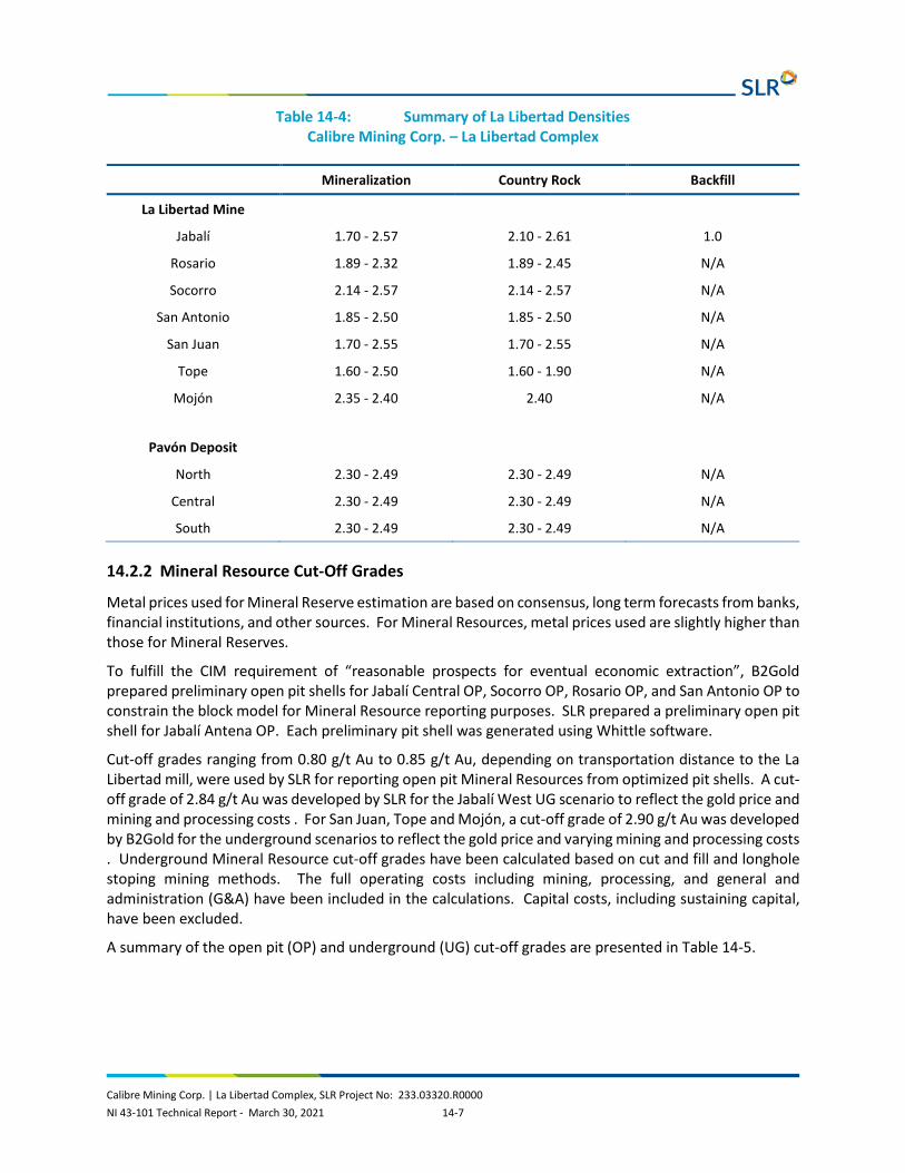
Calibre Mining Corp. | La Libertad Complex, SLR Project No: 233.03320.R0000 NI 43-101 Technical Report - March 30, 2021 14-7
Table 14-4: Summary of La Libertad Densities Calibre Mining Corp. – La Libertad Complex
Mineralization Country Rock Backfill
La Libertad Mine
Jabalí 1.70 - 2.57 2.10 - 2.61 1.0
Rosario 1.89 - 2.32 1.89 - 2.45 N/A
Socorro 2.14 - 2.57 2.14 - 2.57 N/A
San Antonio 1.85 - 2.50 1.85 - 2.50 N/A
San Juan 1.70 - 2.55 1.70 - 2.55 N/A
Tope 1.60 - 2.50 1.60 - 1.90 N/A
Mojón 2.35 - 2.40 2.40 N/A
Pavón Deposit
North 2.30 - 2.49 2.30 - 2.49 N/A
Central 2.30 - 2.49 2.30 - 2.49 N/A
South 2.30 - 2.49 2.30 - 2.49 N/A
14.2.2 Mineral Resource Cut-Off Grades
Metal prices used for Mineral Reserve estimation are based on consensus, long term forecasts from banks, financial institutions, and other sources. For Mineral Resources, metal prices used are slightly higher than those for Mineral Reserves.
To fulfill the CIM requirement of “reasonable prospects for eventual economic extraction”, B2Gold prepared preliminary open pit shells for Jabalí Central OP, Socorro OP, Rosario OP, and San Antonio OP to constrain the block model for Mineral Resource reporting purposes. SLR prepared a preliminary open pit shell for Jabalí Antena OP. Each preliminary pit shell was generated using Whittle software.
Cut-off grades ranging from 0.80 g/t Au to 0.85 g/t Au, depending on transportation distance to the La Libertad mill, were used by SLR for reporting open pit Mineral Resources from optimized pit shells. A cut-off grade of 2.84 g/t Au was developed by SLR for the Jabalí West UG scenario to reflect the gold price and mining and processing costs . For San Juan, Tope and Mojón, a cut-off grade of 2.90 g/t Au was developed by B2Gold for the underground scenarios to reflect the gold price and varying mining and processing costs . Underground Mineral Resource cut-off grades have been calculated based on cut and fill and longhole stoping mining methods. The full operating costs including mining, processing, and general and administration (G&A) have been included in the calculations. Capital costs, including sustaining capital, have been excluded.
A summary of the open pit (OP) and underground (UG) cut-off grades are presented in Table 14-5.

Calibre Mining Corp. | La Libertad Complex, SLR Project No: 233.03320.R0000 NI 43-101 Technical Report - March 30, 2021 14-8
Table 14-5: La Libertad Mineral Resource Cut Off Grade Summary Calibre Mining Corp. – La Libertad Complex
Item Jabalí Antena OP
Rosario OP
Socorro OP
Jabalí West UG
Gold Price $1,500/oz Au $1,500/oz Au $1,500/oz Au $1,500/oz Au
Selling Cost $34.38/oz Au $34.38/oz Au $34.38/oz Au $34.38/oz Au
Recovery 92.5% 92.5% 92.5% 92.5%
Underground Mining Cost - - - $81.22/t
Processing Cost $22.62/t $22.62/t $22.62/t $22.62/t
Haulage to Mill $4.63/t $2.80/t $2.20/t $4.96
G&A $10.00/t $10.00/t $10.00/t $10.00/t
Cut-off Grade 0.85 0.81 0.80 2.85
14.2.3 Resource Database
The exploration drilling database is maintained in MS Access, underground sampling data is stored in MS Excel, and underground mapping lines are maintained in AutoCAD.
La Libertad Mineral Resources are based on 1,152 diamond drill holes and 9 RC drill holes, amounting to approximately 225,791 m and 997 m, respectively, as well as 1,179 trenches amounting to approximately 10,449 m. Drilling was conducted almost exclusively from surface, with the exception of a small number of diamond drill holes completed from underground.
The Mineral Resource database consists of diamond drilling on 30 m to 40 m spacing for the Jabalí deposit and 40 m to 60 m spacing for the other deposits. Trench samples are occasionally used, however, their influence is restricted.
Table 14-6 provides a summary of drill holes used for block model estimation by deposit.
Table 14-6: Summary of Drill Holes and Channels for Block Model Estimation by Deposit Calibre Mining Corp. – La Libertad Complex
Deposit DDH Holes
Metres (m) RC Holes Metres
(m) Trenches Metres (m)
Jabalí Antena OP and East UG 450 67,533 - - - -
Jabalí West UG 270 43,134 - - 1,145 9,890
Socorro 47 9,873 9 997 - -
Rosario 64 9,551 - - 34 559
San Antonio 27 3,181 - - - -
San Juan 103 14,431 - - - -
Tope 69 8,353 - - - -

Calibre Mining Corp. | La Libertad Complex, SLR Project No: 233.03320.R0000 NI 43-101 Technical Report - March 30, 2021 14-9
Deposit DDH Holes
Metres (m) RC Holes Metres
(m) Trenches Metres (m)
Mojón 392 69,735 - - - -
Total 1,152 225,791 9 997 1,179 10,449
14.2.4 Geological Interpretation
All La Libertad Mineral Resource estimates are based on interpretations of vein/quartz breccia, stockwork, and mined out openings. Solid models for Jabalí West UG, Socorro OP, Rosario OP, and San Antonio OP were constructed by SLR with Leapfrog (Figure 14-2 to Figure 14-5). Solid models for Jabalí Antena OP (Figure 14-6), San Juan UG (Figure 14-7), Tope UG, and Mojón UG were built by B2Gold using a combination of Leapfrog and Datamine software. For the purposes of this Technical Report, SLR updated the solid model for Jabalí West UG, Socorro OP, Rosario OP, and San Antonio OP. Block model grade estimates are controlled by the geological/grade zone interpretations. SLR notes that in the B2Gold models there is good correspondence between diamond drill data, wireframes, and blocks. A minimum mining width of two metres was used by SLR to model Jabalí West UG, San Antonio OP, Rosario OP, and Socorro OP.
SLR reviewed the blocks related to the high grade veins in the B2Gold Jabalí Antena OP and East UG and notes that some areas close to the openings (galleries) have been extended more than half of the distance between holes. In general, the areas are very narrow from 0.5 m to two metres and in some cases their thickness is four to six metres. SLR notes that there is a risk that more openings could exist (as they were built based only on drill hole intercepts) in areas where there is no hole available to confirm what has been left. Overall, SLR is of the opinion that the mineralization and lithology wireframes are adequate for the style of mineralization and are suitable to constrain the block model.

101 Vein
Legend:
103 MHW
102 MHH
201 Skin
999
0 50 250
Metres
100 150 200
Calibre Mining Corp.
La Libertad Complex
Domains in Jabal West UGí
Chontales Department, Nicaragua
Figure 14-2
Looking North
14-10
March 2021 Source: SLR, 2021.

0 100 500
Metres
200 300 400
Main Vein
Calibre Mining Corp.
La Libertad Complex
Domains in Rosario OP
Chontales Department, Nicaragua
Figure 14-3
Looking North
14-11
March 2021 Source: SLR, 2021.

Legend:
0 50 250
Metres
100 150 200
CH_SPL2CH0
CH2
CH1
CH3
CH4
CH5
CH_SPL1
CH_SPL3
CH_SPL4
CH_SPL6
CH_SPL5
CH_SPL7
HALO
Calibre Mining Corp.
La Libertad Complex
Domains in Socorro OP
Chontales Department, Nicaragua
Figure 14-4
Looking North
14-12
March 2021 Source: SLR, 2021.

Central
Legend:
West
East
Not to Scale
Calibre Mining Corp.
La Libertad Complex
Domains in San Antonio OP
Chontales Department, Nicaragua
Figure 14-5
Looking Northeast
Isometric View
14-13
March 2021 Source: SLR, 2021.

Jabalí
Jabalí Antena Pitshell
Antena OP and
Jabalí East UG Domains
Jabalí Central Pitshell
Jabalí West UG Domains
0 100 500
Metres
200 300 400
14-14
March 2021 Source: SLR, 2021.
Calibre Mining Corp.
La Libertad Complex
Domains in JabalíAntena OP and East UG
Chontales Department, Nicaragua
Figure 14-6
Looking North

Topo Surface
Main
Footwall
Hanging WallArea of Artisanal Workings
0 50 250
Metres
100 150 200
Calibre Mining Corp.
La Libertad Complex
Domains in San Juan UG
Chontales Department, Nicaragua
Figure 14-7
Looking Northwest
14-15
March 2021 Source: SLR, 2021.

Calibre Mining Corp. | La Libertad Complex, SLR Project No: 233.03320.R0000 NI 43-101 Technical Report - March 30, 2021 14-16
14.2.5 Capping of High Grade Assays in Former B2Gold Block Models
Capping of high grade gold assays was applied by resource area and domain (vein, quartz breccia, stockwork, high grade shoot, etc.). If high grade shoots were apparent, assays within the shoot were treated as a separate capping domain. Capping levels for each domain were determined using decile analysis and lognormal probability plots. For the primary domains at Mojón, secondary capping using a distance restriction was used. Raw assays were capped prior to compositing. Gold and silver capping values are summarized in Table 14-7.
SLR performed an independent capping analysis on gold for the high grade vein, vein, stockwork, and gallery domains (1,000, 2,000, 3,000, and 8,000), where possible, in the Jabalí (Antena OP and East UG), San Juan UG, Tope UG, and Mojón UG models. Additionally, visual validation of the block model in section and plan view was completed. SLR notes that while high grade areas with more than 20 g/t Au are overpowering low grade areas, this occurs mostly in Inferred blocks. SLR plans to incorporate a distance restriction to control the smearing of high grade zones in future resource model updates.
14.2.6 Capping of High Grade Assays in SLR Block Models
Gold and silver capping values are compiled in Table 14-7. Assays for Jabalí West UG, Rosario OP, Socorro OP, and San Antonio OP were reviewed using histograms, log probability plots, and decile analysis to determine a cap. An outlier grade search radii restriction of 25% for composites above 3.0 g/t Au was used in San Antonio OP.
Table 14-7: La Libertad Capping Levels Calibre Mining Corp. – La Libertad Complex
Deposit Capping Level (g/t Au)
Capping Level (g/t Ag)
Jabalí Antena OP and East UG
HG Vein-1 30.0 N/A
HG Vein-0 20.0 N/A
Breccia 9.0 N/A
Stockwork 8.0 N/A
Gallery (Fill) 11.0 N/A
Jabalí West UG
All Mineralization 40.0 350
Rosario OP
Vein, Stockwork 15.0 40
Socorro OP
Veins 11.0 65

Calibre Mining Corp. | La Libertad Complex, SLR Project No: 233.03320.R0000 NI 43-101 Technical Report - March 30, 2021 14-17
Deposit Capping Level (g/t Au)
Capping Level (g/t Ag)
Stockwork 4.0 65
San Antonio OP
All Mineralization 16 N/A
San Juan UG
HG Vein-1 20.0 N/A
HG Vein-2 50.0 N/A
Stockwork 2.5 N/A
Gallery (Fill) 3.5 N/A
Tope UG
Vein (various) 2.0 – 25.0 N/A
Stockwork (various) 1.5 – 5.0 N/A
Gallery (Fill) 0.2 N/A
Mojón UG
Vein (various) 5.0 – 25.0 100
Stockwork (various) 6.0 N/A
Gallery (Fill) 0.2 N/A
Table 14-8 and Table 14-9 summarize uncapped and capped assay statistics for gold. Table 14-10 and Table 14-11 summarize uncapped and capped assay statistics for silver.

Calibre Mining Corp. | La Libertad Complex, SLR Project No: 233.03320.R0000 NI 43-101 Technical Report - March 30, 2021 14-18
Table 14-8: La Libertad Uncapped Assay Statistics – Gold Calibre Mining Corp. – La Libertad Complex
Jabalí Antena OP
Jabalí West UG Rosario OP Socorro OP San Antonio
OP San Juan
UG Tope UG
Mojón UG
Count 14,675 6,040 1,173 6,391 215 4,262 1,929 12,024
Mean (g/t) 1.31 3.35 1.19 0.35 2.82 0.89 0.92 0.99
Standard Deviation 1.31 3.35 1.19 0.35 2.82 0.89 0.92 0.99
CV 0.24 6.51 2.55 8.51 1.37 6.15 3.16 3.87
Variance 414.69 474.67 9.12 8.83 14.88 30.06 8.36 14.61
Minimum (g/t) 0.00 0.00 0.00 0.00 0.01 0.00 0.00 0.00
Maximum (g/t) 2010 2010 40 134 31 185 58 292
Table 14-9: La Libertad Capped Assay Statistics – Gold Calibre Mining Corp. – La Libertad Complex
Jabalí Antena OP
Jabalí West UG Rosario OP Socorro OP San Antonio
OP San Juan
UG Tope UG
Mojón UG
Count 14,675 6,040 1,173 6,391 215 4,262 1,929 12,024
Mean (g/t) 1.00 2.87 1.09 0.35 2.70 0.77 0.80 0.93
Standard Deviation 5.77 5.66 2.24 2.97 3.38 3.80 2.06 2.58
CV 5.78 1.97 2.05 8.51 1.25 4.91 2.57 2.77
Variance 33.27 31.99 5.01 8.83 11.41 14.44 4.26 6.65
Minimum (g/t) 0.00 0.00 0.00 0.00 0.00 0.00 0.00 0.00
Maximum (g/t) 30 40 15 11 16 50 25 25

Calibre Mining Corp. | La Libertad Complex, SLR Project No: 233.03320.R0000 NI 43-101 Technical Report - March 30, 2021 14-19
Table 14-10: La Libertad Uncapped Assay Statistics – Silver Calibre Mining Corp. – La Libertad Complex
Jabalí Antena OP
Jabalí West UG Rosario OP Socorro OP San Antonio
OP San Juan
UG Tope UG
Mojón UG
Count - 6,040 1,173 6,391 - - 1,929 11,610
Mean (g/t) - 16.20 10.97 3.36 - - 2.60 4.31
Standard Deviation - 57.51 60.08 10.82 - - 9.58 24.87
CV - 3.55 5.48 3.22 - - 3.68 5.76
Variance - 3307.32 3609.77 117.07 - - 91.70 618.65
Minimum (g/t) - 0.00 0.00 0.02 - - 0.01 0.00
Maximum (g/t) - 1765 1224 299 - - 326 3550
Table 14-11: La Libertad Capped Assay Statistics – Silver Calibre Mining Corp. – La Libertad Complex
Jabalí Antena OP
Jabalí West UG Rosario OP Socorro OP San Antonio
OP San Juan
UG Tope UG
Mojón UG
Count - 6,040 1,173 6,391 - - 1,929 11,610
Mean (g/t) - 14.74 6.16 3.10 - - 2.28 3.91
Standard Deviation - 36.27 9.81 7.23 - - 5.29 7.09
CV - 2.46 1.59 2.33 - - 2.32 1.81
Variance - 1315.51 96.29 52.23 - - 28.04 50.21
Minimum (g/t) - 0.00 0.00 0.02 - - 0.01 0.00
Maximum (g/t) - 350 40 65 - - 50 100

Calibre Mining Corp. | La Libertad Complex, SLR Project No: 233.03320.R0000 NI 43-101 Technical Report - March 30, 2021 14-20
14.2.7 Compositing
For Jabalí Antena OP, Jabalí East UG, San Juan UG, Tope UG, Rosario OP, and San Antonio OP samples were composited to two metres beginning at each domain. In Mojón, samples were composited to 1.5 m. In Jabalí West UG and Socorro OP, the composites were created at one metre.
Composite statistics for gold and silver are summarized in Tables 14-12 and 14-13, respectively.
Table 14-12: La Libertad Capped Composite Statistics – Gold Calibre Mining Corp. – La Libertad Complex
Jabalí Antena OP
Jabalí West UG
Rosario OP
Socorro OP
San Antonio OP
San Juan UG
Tope UG
Mojón UG
Count 9,281 5,189 365 824 90 1,765 1,929 8,465
Mean (g/t) 0.77 2.87 1.02 0.68 2.70 0.74 0.49 0.86
Standard Deviation 2.31 5.11 1.68 1.18 2.40 2.61 1.33 1.88
CV 3.00 1.78 1.65 1.74 0.89 3.52 2.73 2.19
Variance 5.34 26.12 2.83 1.40 5.77 6.81 1.76 3.52
Minimum (g/t) 0.00 0.00 0.00 0.00 0.05 0.00 0.00 0.00
Maximum (g/t) 60.00 40.00 15.00 13.29 11.15 41.40 23.56 25.00
Table 14-13: La Libertad Capped Composite Statistics – Silver Calibre Mining Corp. – La Libertad Complex
Jabalí Antena OP
Jabalí West UG
Rosario OP
Socorro OP
San Antonio OP
San Juan UG
Tope UG
Mojón UG
Count - 5,189 365 824 - - 1,929 8,267
Mean (g/t) - 14.74 6.11 4.99 - - 1.18 3.86
Standard Deviation - 33.28 8.14 7.12 - - 2.82 6.69
CV - 2.26 1.33 1.43 - - 2.39 1.73
Variance - 1,107.56 66.28 50.66 - - 7.97 44.74
Minimum (g/t) - 0.00 0.00 0.01 - - 0.00 0.00
Maximum (g/t) - 350.00 40.00 62.34 - - 44.40 100.00
14.2.8 Variography
Variogram parameters (Table 14-14) and experimental semi variograms were calculated from the composites for each domain in Jabalí Antena OP, Jabalí West UG, Rosario UG, Socorro UG, San Antonio OP, San Juan UG, Tope UG and Mojón UG. The major and semi-major directions were fit in the plane of the mineralization which was defined by inspecting the histogram of dip and dip direction of wireframe triangles for each domain. Experimental semi variograms were fit with nugget effect structures as required. Downhole variograms were used to model the nugget effect and fit the across-strike variogram

Calibre Mining Corp. | La Libertad Complex, SLR Project No: 233.03320.R0000 NI 43-101 Technical Report - March 30, 2021 14-21
models. For Tope UG, variography was performed on composites, however, most domains lacked sufficient samples to obtain robust variograms. For this reason, kriging was not used for interpolation.
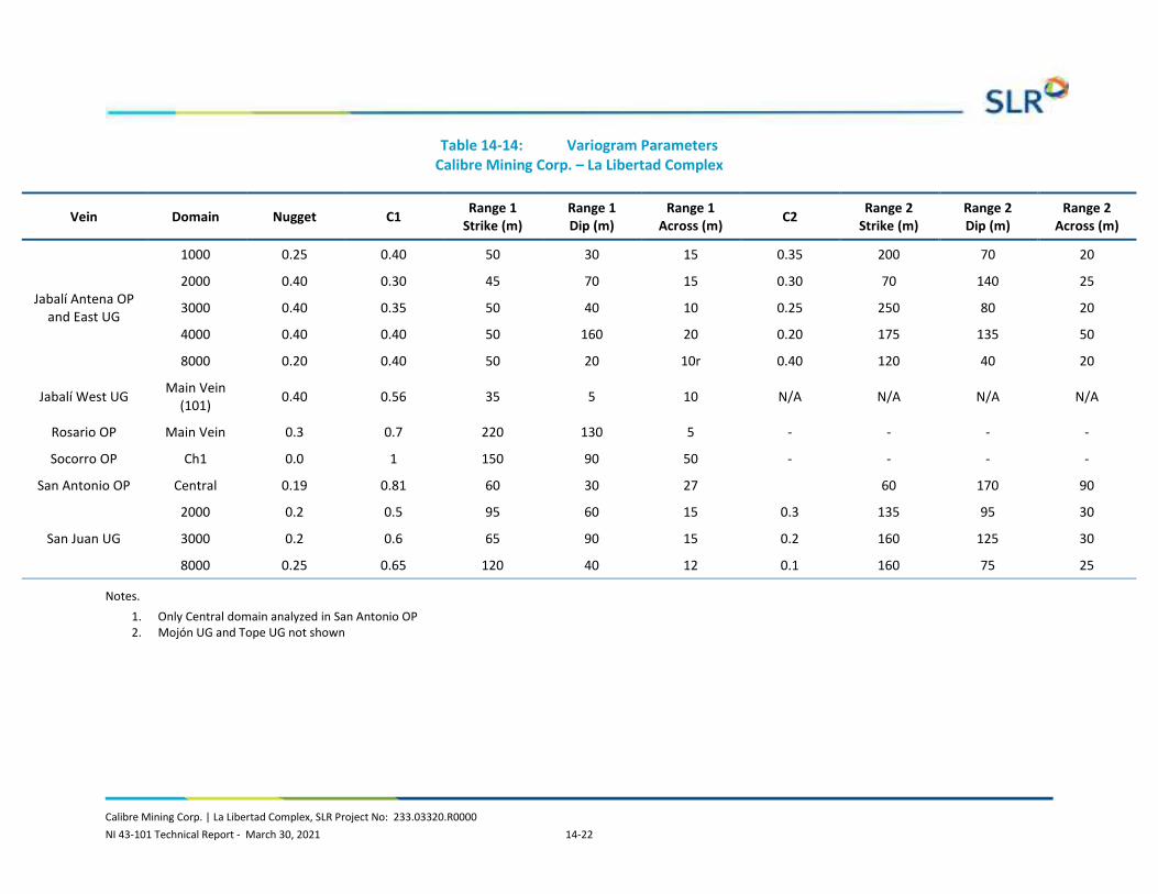
Calibre Mining Corp. | La Libertad Complex, SLR Project No: 233.03320.R0000 NI 43-101 Technical Report - March 30, 2021 14-22
Table 14-14: Variogram Parameters Calibre Mining Corp. – La Libertad Complex
Vein Domain Nugget C1 Range 1 Strike (m)
Range 1 Dip (m)
Range 1 Across (m) C2 Range 2
Strike (m) Range 2 Dip (m)
Range 2 Across (m)
Jabalí Antena OP and East UG
1000 0.25 0.40 50 30 15 0.35 200 70 20
2000 0.40 0.30 45 70 15 0.30 70 140 25
3000 0.40 0.35 50 40 10 0.25 250 80 20
4000 0.40 0.40 50 160 20 0.20 175 135 50
8000 0.20 0.40 50 20 10r 0.40 120 40 20
Jabalí West UG Main Vein (101) 0.40 0.56 35 5 10 N/A N/A N/A N/A
Rosario OP Main Vein 0.3 0.7 220 130 5 - - - -
Socorro OP Ch1 0.0 1 150 90 50 - - - -
San Antonio OP Central 0.19 0.81 60 30 27 60 170 90
San Juan UG
2000 0.2 0.5 95 60 15 0.3 135 95 30
3000 0.2 0.6 65 90 15 0.2 160 125 30
8000 0.25 0.65 120 40 12 0.1 160 75 25
Notes. 1. Only Central domain analyzed in San Antonio OP 2. Mojón UG and Tope UG not shown

Calibre Mining Corp. | La Libertad Complex, SLR Project No: 233.03320.R0000 NI 43-101 Technical Report - March 30, 2021 14-23
14.2.9 Search Strategy and Grade Interpolation Parameters
Grade interpolation into parent blocks used ordinary kriging (OK), inverse distance cubed (ID3) or inverse distance squared (ID2) and between two and four passes (Table 14-15). In SLR’s opinion, the estimation strategies are appropriate for this type of deposit.
Search ellipses for grade interpolation were oriented using dynamic anisotropy, with the longest axis parallel to strike and the second longest axis down-dip. Search distances ranged from 35 m to 200 m in three estimation passes depending on the deposit (Table 14-15), with the number of composites varying from one to 20 (Table 14-16), depending on the deposit and pass number.
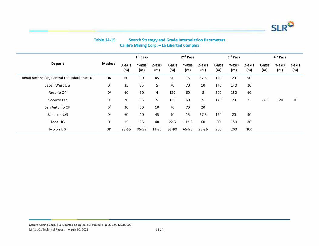
Calibre Mining Corp. | La Libertad Complex, SLR Project No: 233.03320.R0000 NI 43-101 Technical Report - March 30, 2021 14-24
Table 14-15: Search Strategy and Grade Interpolation Parameters Calibre Mining Corp. – La Libertad Complex
Deposit Method
1st Pass 2nd Pass 3rd Pass 4th Pass
X-axis (m)
Y-axis (m)
Z-axis (m)
X-axis (m)
Y-axis (m)
Z-axis (m)
X-axis (m)
Y-axis (m)
Z-axis (m)
X-axis (m)
Y-axis (m)
Z-axis (m)
Jabalí Antena OP, Central OP, Jabalí East UG OK 60 10 45 90 15 67.5 120 20 90
Jabalí West UG ID3 35 35 5 70 70 10 140 140 20
Rosario OP ID3 60 30 4 120 60 8 300 150 60
Socorro OP ID3 70 35 5 120 60 5 140 70 5 240 120 10
San Antonio OP ID2 30 30 10 70 70 20
San Juan UG ID2 60 10 45 90 15 67.5 120 20 90
Tope UG ID3 15 75 40 22.5 112.5 60 30 150 80
Mojón UG OK 35-55 35-55 14-22 65-90 65-90 26-36 200 200 100

Calibre Mining Corp. | La Libertad Complex, SLR Project No: 233.03320.R0000 NI 43-101 Technical Report - March 30, 2021 14-25
Table 14-16: Composites Selection Calibre Mining Corp. – La Libertad Complex
Deposit Domain 1st Pass 2nd pass 3rd pass 4th pass
Max per DDH Min No. Max No. Min No. Max No. Min No. Max No. Min No. Max No.
Jabalí Antena OP, Jabalí East UG ALL 4 12 4 12 2 12 3
Jabalí West UG
FWMID 3 8 4 10 2
FWSX, HW, HWN, IW2, IW3, XM3 4 8 3 10 3 10 2
All Other Domains 4 8 3 10 2
Rosario OP Main Vein 4 12 4 12 1 12 - - 3
Socorro OP All Domains 3 8 3 8 1 8 1 8 2
San Antonio OP All 3 10 3 20 2
San Juan UG All 3 10 3 10 1 10 2
Tope UG All 3 10 3 10 1 10 2
Mojón UG STK: MAIN, HW5, HW, CROSS 1-3 6 10 4 8 1 6 4/3/4
All Other Domains 5 8 3 8 1 6 4/2/4

Calibre Mining Corp. | La Libertad Complex, SLR Project No: 233.03320.R0000 NI 43-101 Technical Report - March 30, 2021 14-26
14.2.10 Bulk Density
A total of 9,511 density measurements were collected at La Libertad. Density measurements were, in general, collected on core samples every 20 m. Samples were weighed, coated with wax, weighed in air, then suspended in water and weighed again. Average densities by domain code and oxidation were then used for tonnage calculations. Densities range from 1.40 t/m3 to 2.24 t/m3 in saprolite and saprock and 2.40 t/m3 to 2.65 t/m3 in fresh rock. In SLR’s opinion, these are reasonable densities for this type of mineralization.
The modelled mined out areas have poor or no recovery and varying portions of fill and voids. For this material, the fill density was applied then factored by the estimated percent recovery. Therefore, an interval with 50% recovery in galleries would be assigned a bulk density of 1.9 t/m3*50%=0.95 t/m3.
Bulk density values were applied to the block models based on a combination of modelled rock type and weathering intensity. Examples of Jabalí (All), San Juan UG, Tope UG, and Mojón UG are presented in Table 14-17 and Table 14-18. SLR notes that obvious erroneous data was removed from the dataset prior to calculating averages. Domains without representation were based on regression from other domains or assumptions by material type.
Table 14-17: Number of Density Values - La Libertad Calibre Mining Corp. – La Libertad Complex
Weathering Material
Vein
Jabalí (Antena OP
and East UG)
Jabalí West UG
Rosario OP
Socorro OP
San Antonio
OP
San Juan UG
Tope UG
Mojón UG
Saprolite
High Grade Vein 0 0 N/A N/A 0 N/A N/A N/A
Vein/Breccia 0 0 N/A 18 0 0 0 N/A
Stockwork 0 0 N/A N/A 0 0 0 N/A
Bedrock/Waste 1 1 8 17 0 10 1 N/A
Saprock
High Grade Vein 0 0 N/A N/A 3 N/A N/A N/A
Vein/Breccia 0 0 N/A N/A 0 0 0 N/A
Stockwork 0 0 N/A N/A 0 35 0 N/A
Bedrock/Waste 19 19 52 18 0 74 21 N/A
Rocksap
High Grade Vein N/A N/A N/A N/A 13 N/A N/A N/A
Vein/Breccia N/A N/A N/A N/A 0 N/A 9 N/A
Stockwork N/A N/A N/A N/A 0 N/A 11 N/A
Bedrock/Waste N/A N/A N/A N/A 0 N/A 42 N/A
Fresh
High Grade Vein 31 28 N/A N/A 35 244 N/A N/A
Vein/Breccia 104 N/A 84 87 0 0 28 178
Stockwork 136 N/A N/A N/A 0 0 47 203
Bedrock/Waste 710 2,342 437 315 135 0 170 882

Calibre Mining Corp. | La Libertad Complex, SLR Project No: 233.03320.R0000 NI 43-101 Technical Report - March 30, 2021 14-27
Weathering Material
Vein
Jabalí (Antena OP
and East UG)
Jabalí West UG
Rosario OP
Socorro OP
San Antonio
OP
San Juan UG
Tope UG
Mojón UG
Colluvium 0 0 N/A N/A N/A 0 0 N/A
Fill 0 0 N/A N/A N/A 0 0 N/A
Table 14-18: Density Values – La Libertad Calibre Mining Corp. – La Libertad Complex
Weathering Material
Jabalí (Antena OP
and East UG) (t/m3)
Jabalí West UG
(t/m3)
Rosario OP
(t/m3)
Socorro OP
(t/m3)
San Antonio
OP (t/m3)
San Juan UG
(t/m3)
Tope UG
(t/m3)
Mojón UG
(t/m3)
Saprolite
High Grade Vein 2.02 2.05 N/A N/A 1.85 N/A N/A N/A
Vein/Breccia 2.05 2.05 2.32 2.14 1.85 1.70 2.10 N/A
Stockwork 2.05 2.05 1.89 2.16 1.85 1.70 2.10 N/A
Bedrock 2.10 2.10 N/A 2.16 1.85 1.70 2.03 N/A
Saprock
High Grade Vein 2.28 2.30 N/A N/A 2.10 N/A N/A N/A
Vein/Breccia 2.30 2.30 2.32 2.23 2.10 2.20 2.27 N/A
Stockwork 2.30 2.30 2.12 N/A 2.10 2.20 2.24 N/A
Bedrock/Waste 2.36 2.36 N/A 2.23 2.10 2.20 2.01 N/A
Rocksap
High Grade Vein N/A 2.30 N/A N/A 2.28 N/A N/A N/A
Vein/Breccia N/A 2.30 N/A N/A 2.28 N/A 2.49 N/A
Stockwork N/A 2.30 N/A N/A 2.28 N/A 2.36 N/A
Bedrock N/A 2.36 N/A N/A 2.28 N/A 2.19 N/A
Fresh
High Grade Vein 2.53 2.57 N/A N/A 2.50 N/A N/A N/A
Vein/Breccia 2.56 2.57 2.32 2.429 2.50 2.54 2.50 2.40
Stockwork 2.56 2.57 N/A N/A 2.50 2.50 2.46 2.35
Bedrock 1.65 2.61 2.45 2.57 2.50 2.55 2.46 2.40
Colluvium 1.70 1.70 N/A N/A N/A 1.70 1.60 N/A
Fill 1.90 1.00 N/A N/A N/A 1.90 N/A N/A
14.2.11 Block Models
Block sizes for Indicated and Inferred Mineral Resource estimations are between two metres and 12.0 m (Table 14-19). SLR notes that some of the mineralized wireframes are very narrow in some places. SLR recommends a minimum thickness constraint be applied to the remaining B2Gold La Libertad deposit wireframes, where required. SLR considers the block model sizes appropriate for the mining methods and dip of the veins.

Calibre Mining Corp. | La Libertad Complex, SLR Project No: 233.03320.R0000 NI 43-101 Technical Report - March 30, 2021 14-28
Table 14-19: La Libertad Block Sizes Calibre Mining Corp. – La Libertad Complex
Deposit BM Type Parent Block Size Sub-block Size Rotation
Z-axis (°)
X-axis (m)
Y-axis (m)
Z-axis (m)
X-axis (m)
Y-axis (m)
Z-axis (m)
Jabalí: Antena OP, East UG Sub-blocked 12 2 6 2 0.05 0.10 0
Jabalí West UG Sub-blocked 3 2 3 1.5 0.5 0.75 0
Rosario OP Sub-blocked 5 2 5 2.5 1 2.5 335
Socorro OP Sub-blocked 2.5 2 2.5 1.25 1 1.25 330
San Antonio OP Sub-blocked 6 2 6 1.5 1.0 1.5 0
San Juan UG Sub-blocked 12 2 6 2 0.05 0.10 40
Tope UG Sub-blocked 12 3 6 1 0.1 0.1 340
Mojón UG Regular 2 5 5 N/A N/A N/A 60
14.2.12 Classification
Definitions for Mineral Resource categories used in this Technical Report are consistent with those defined by CIM (2014) and adopted by NI 43-101. In the CIM classification, a Mineral Resource is defined as “a concentration or occurrence of solid material of economic interest in or on the Earth’s crust in such form, grade, or quality and quantity that there are reasonable prospects for eventual economic extraction”. Mineral Resources are classified into Measured, Indicated, and Inferred categories. A Mineral Reserve is defined as the “economically mineable part of a Measured and/or Indicated Mineral Resource” demonstrated by studies at Pre-Feasibility or Feasibility level as appropriate. Mineral Reserves are classified into Proven and Probable categories.
Mineral Resources were classified based on the distance to the nearest data points. Generally, Indicated Mineral Resources to be potentially mined by open pit methods required two drill holes within 30 m to 35 m. Underground Indicated Mineral Resources required two drill holes within 22 m to 35 m. Inferred Mineral Resources required two drill holes within 60 m.
In places, it is assumed that a rim of material remains adjacent to mined out underground workings. This rim material was classified as Indicated or Inferred according to the criteria described above.
Classification of the block models is shown in Figure 14-8 to Figure 14-13.
In Jabalí and San Juan, the backfill in underground workings is considered to be part of the Inferred Mineral Resources. SLR recommends a study regarding the reconciliation of backfill material be completed.
In SLR’s opinion, the overall classification is reasonable.

Jabalí Antena PitshellJabalí Central Pitshell
Jabalí West UGJabalí East UG
Historical UG Mining
Historical UG Mining
0 200 1000
Metres
400 600 800
Calibre Mining Corp.
La Libertad Complex
3D View Showing Compositesand Block Classification for
Jabal Antena OP and Jabal East UGí í
Chontales Department, Nicaragua
Figure 14-8
Looking North
14-29
March 2021 Source: SLR, 2021.
Legend:
Classification
Inferred
Indicated
Composites

Antena OP
Historical UG
Mining
Au (g/t)
Legend:
0.5 - 1.0
> 0.5
1.0 - 2.0
2.0 - 3.00 50 250
Metres
100 150 200
Classification
Inferred
Indicated
3.0 - 5.0
5.0 - 10
< 10
Calibre Mining Corp.
La Libertad Complex
3D View Showing andCompositesBlock Classification for Jabal West UGí
Chontales Department, Nicaragua
Figure 14-9
Looking North
14-30
March 2021 Source: SLR, 2021.
Skin Domain 101

0 50 125
Metres
25 75 100
Au (g/t)
Legend:
0.2 - 0.5
< 0.2
0.5 - 1.0
1.0 - 5.0
Classification
Inferred
Indicated
5.0 - 10
> 10
Calibre Mining Corp.
La Libertad Complex
3D View Showing Composites andBlock Classification for Rosario OP
Chontales Department, Nicaragua
Figure 14-10
Looking South East
14-31
March 2021 Source: SLR, 2021.
Skin Domain 101

0 50 250
Metres
100 150 200
Au (g/t)
Legend:
0.2 - 0.5
< 0.2
0.5 - 1.0
1.0 - 5.0
Classification
Inferred
Indicated
5.0 - 10
> 10
Calibre Mining Corp.
La Libertad Complex
3D View Showing s andCompositeBlock Classification for Socorro OP
Chontales Department, Nicaragua
Figure 14-11
Looking Northwest
14-32
March 2021 Source: SLR, 2021.

Inferred Classification
Calibre Mining Corp.
La Libertad Complex
3D View Showing andCompositesBlock Classification for San Antonio OP
Chontales Department, Nicaragua
Figure 14-12
Looking North
Isometric View
14-33
March 2021 Source: SLR, 2021.
Au (g/t)
Legend:
Classification
Inferred
Indicated
Skin Domain 101
0.01 - 0.5
> 0.01
0.5 - 0.64
0.64 - 1.0
1.0 - 2.0
2.0 - 3.0
3.0 - 5.0
< 5.0
0 60 150
Metres
30 90 120

Au (g/t)
Legend:
0.5 - 1.0
> 0.5
1.0 - 2.0
2.0 - 3.0
0 50 250
Metres
100 150 200
3.0 - 5.0
5.0 - 10
< 10
Note: All blocks classified are inferred.
Calibre Mining Corp.
La Libertad Complex
3D View Showing andCompositesBlock Classification for San Juan UG
Chontales Department, Nicaragua
Figure 14-13
Looking North
14-34
March 2021 Source: SLR, 2021.

Calibre Mining Corp. | La Libertad Complex, SLR Project No: 233.03320.R0000 NI 43-101 Technical Report - March 30, 2021 14-35
In Jabalí and San Juan, the backfill in underground workings is considered to be part of the Inferred Mineral Resources. A study regarding the reconciliation of backfill material is recommended.
In SLR’s opinion, the overall classification is reasonable.
14.2.13 Block Model Validation
Blocks were validated using industry standard techniques including:
• Visual inspection of composite versus block grades (Figure 14-14 to Figure 14-19) • Comparison between ID, nearest neighbour (NN), and composite means • Swath plots (Figure 14-20 to Figure 14-23)
SLR imported the B2Gold block models into Leapfrog and Surpac software and viewed gold grades and proportions relative to the blocks, drilled grades, composites, and modelled solids. SLR observed that the block grades exhibited general accord with drilling and sampling, and did not appear to smear significantly across sampled grades
B2Gold verified their models using a combination of visual comparison of block grades to drill hole composites, swath plots, global bias checks, and model to true thickness comparisons. SLR produced comparative statistics and swath plots for Jabalí Antena OP, Jabalí West UG, Rosario OP, Socorro OP, San Antonio OP and San Juan UG. Swath plots generally demonstrated good correlation, with block grades being somewhat smoothed relative to composite grades, as expected. There were some areas where composite grades varied more than 10% from block grades. SLR notes that these areas may indicate isolated high grades, which could be controlled by a combination of distance restriction and separate domains, if applicable.
SLR visually examined the mined solids in the context of the block model and the result is reasonable in the context of the work described by B2Gold.
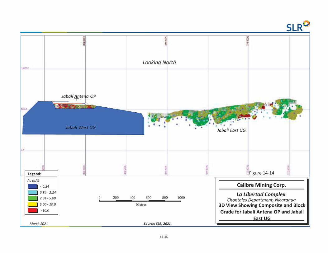
Jabalí West UG
Jabalí Antena OP
Jabalí East UG
Au (g/t)
Legend:
0.84 - 2.84
< 0.84
2.84 - 5.00
5.00 - 10.0
> 10.0
0 200 1000
Metres
400 600 800
Looking North
Calibre Mining Corp.
La Libertad Complex
3D View Showing Composite and BlockGrade for Jabalí Antena OP and Jabalí
East UG
Chontales Department, Nicaragua
Figure 14-14
14-36
March 2021 Source: SLR, 2021.

Au (g/t)
Legend:
0.5 - 1.0
> 0.5
1.0 - 2.0
2.0 - 3.0
0 50 250
Metres
100 150 2003.0 - 5.0
5.0 - 10
< 10
Calibre Mining Corp.
La Libertad Complex
3D View Showing Composite andBlock Grade for West UGJabalí
Chontales Department, Nicaragua
Figure 14-15
Looking North
14-37
March 2021 Source: SLR, 2021.
Skin Domain 101

0 20 100
Metres
40 60 80
Au (g/t)
Legend:
0.2 - 0.5
< 0.2
0.5 - 1.0
1.0 - 5.0
5.0 - 10
> 10
Calibre Mining Corp.
La Libertad Complex
3D View Showing Composite andBlock Grade for Rosario OP
Chontales Department, Nicaragua
Figure 14-16
Looking Southeast
14-38
March 2021 Source: SLR, 2021.
Skin Domain 101

Surveyed Artisanal Workings
Au (g/t)
Legend:
0.2 - 0.5
< 0.2
0.5 - 1.0
1.0 - 5.0
5.0 - 10
> 10
0 50 250
Metres
100 150 200 Calibre Mining Corp.
La Libertad Complex
3D View Showing Composite andBlock Grade for Socorro OP
Chontales Department, Nicaragua
Figure 14-17
Looking North
14-39
March 2021 Source: SLR, 2021.

Au (g/t)
Legend:
0.01 - 0.5
> 0.01
0.5 - 0.64
0.64 - 1.0
1.0 - 2.0
2.0 - 3.0
3.0 - 5.0
< 5.0
Calibre Mining Corp.
La Libertad Complex
3D View Showing Composite andBlock Grade for San Antonio OP
Chontales Department, Nicaragua
Figure 14-18
Looking North
Isometric View
14-40
March 2021 Source: SLR, 2021.
Skin Domain 101
0 60 150
Metres
30 90 120

Au (g/t)
Legend:
0.5 - 1.0
> 0.5
1.0 - 2.0
2.0 - 3.0 0 50 250
Metres
100 150 200
3.0 - 5.0
5.0 - 10
< 10
Calibre Mining Corp.
La Libertad Complex
3D View Showing Compositeand Block Grade for San Juan UG
Chontales Department, Nicaragua
Figure 14-19
Looking Northwest
14-41
March 2021 Source: SLR, 2021.

Calibre Mining Corp. | La Libertad Complex, SLR Project No: 233.03320.R0000 NI 43-101 Technical Report - March 30, 2021 14-42
Figure 14-20: Swath Plots for Jabalí West UG

Calibre Mining Corp. | La Libertad Complex, SLR Project No: 233.03320.R0000 NI 43-101 Technical Report - March 30, 2021 14-43
Figure 14-21: Swath Plots for Rosario OP

Calibre Mining Corp. | La Libertad Complex, SLR Project No: 233.03320.R0000 NI 43-101 Technical Report - March 30, 2021 14-44
Figure 14-22: Swath Plots for Socorro OP

Calibre Mining Corp. | La Libertad Complex, SLR Project No: 233.03320.R0000 NI 43-101 Technical Report - March 30, 2021 14-45
Figure 14-23: Swath Plots for San Antonio OP

Calibre Mining Corp. | La Libertad Complex, SLR Project No: 233.03320.R0000 NI 43-101 Technical Report - March 30, 2021 14-46
14.2.14 La Libertad Mineral Resource Reporting
Mineral Resources for La Libertad are reported as per the Mineral Resource estimation methodologies and classification criteria detailed in this Technical Report. Table 14-20 summarizes the Mineral Resources.
The estimation methodology is consistent with standard industry practice and the Project Indicated and Inferred Mineral Resource estimate is considered to be reasonable and acceptable.
Table 14-20: La Libertad Mineral Resource Estimate Calibre Mining Corp. – La Libertad Complex
Tonnage Grade Contained Metal
(000 t) (g/t Au) (g/t Ag) (koz Au) (koz Ag)
La Libertad
Indicated
Jabalí Antena OP 153 5.15 66.20 25 327
Rosario OP 43 1.86 7.05 3 10
Socorro OP 424 2.01 9.59 27 131
Jabalí West UG 421 5.72 28.15 77 381
Stockpile 55 9.3 16
Total Indicated 1,096 4.20 24.09 148 849
Inferred
Jabalí Antena OP 32 2.12 48.28 2 51
Jabalí East UG 351 4.91 55
Rosario OP 202 2.11 7.66 14 50
Socorro OP 76 1.57 9.55 4 23
San Antonio OP 359 2.42 28
Jabalí West UG 466 7.12 45.74 107 685
San Juan UG 146 4.32 20
Tope UG 141 4.19 19
Mojon UG 481 4.79 74
Total Inferred 2,254 4.46 11.16 323 809
Notes: 1. Effective dates are December 31, 2020 for all La Libertad deposits and November 12, 2019 for Pavón. 2. CIM (2014) definitions were followed for Mineral Resources. 3. A cut-off grade of 0.85 g/t Au is used for Jabalí Antena OP, 0.81 g/t Au for Rosario OP, 0.80 g/t Au for Socorro OP and
San Antonio OP, 2.90 g/t Au for San Juan UG, San Diego UG and Mojon UG, and 2.84 g/t Au for Jabalí West UG and Jabalí East UG, and 1.17 g/t Au for Pavón

Calibre Mining Corp. | La Libertad Complex, SLR Project No: 233.03320.R0000 NI 43-101 Technical Report - March 30, 2021 14-47
4. Reporting shapes were used for reporting Jabalí West UG. 5. Mineral Resources are estimated using a long-term gold price of US$1,500/oz in all deposits except Pavón Sur,
estimated using a long-term gold price of US$1,400/oz. 6. Bulk density varies between 1.70 t/m3 and 2.57 t/m3. 7. Mineral Resources that are not Mineral Reserves do not have demonstrated economic viability. 8. Mineral Resources are inclusive of Mineral Reserves. 9. Numbers may not add up due to rounding.
14.3 Pavón Table 14-21 summarizes the pit constrained Mineral Resource estimate at a 1.17 g/t Au cut-off grade for Pavón Norte, Pavón Central, and Pavón Sur. Mineral Resources are estimated using a long term gold price of US$1,500/oz Au for Pavón Norte, Central and Pavón Sur.
Table 14-21: Pavón Mineral Resource Summary Calibre Mining Corp. – La Libertad Complex
Deposit Tonnage (000 t)
Grade Contained Metal
(g/t Au) (g/t Ag) (oz Au) (oz Ag)
Indicated
Pavón Norte 863 3.58 4.77 99,370 132,220
Pavón Central 529 7.73 12.55 131,440 213,460
Total Indicated 1,392 5.16 7.72 230,810 345,680
Inferred
Pavón Norte 98 3.53 6.16 11,130 19,410
Pavón Central 153 4.46 7.68 21,920 37,780
Pavón Sur 326 2.85 3.22 29,870 33,750
Total Inferred 577 3.39 4.90 62,920 90,940
Notes: 1. Mineral Resources were prepared in accordance CIM (2014) definitions. Mineral Resources that are not Mineral
Reserves do not have demonstrated economic viability. 2. Open pit Mineral Resources are reported at a gold cut-off grade of 1.17 g/t. Mineral Resources are estimated using a
long term gold price of US$1,500/oz. 3. Appropriate mining costs, processing costs, metal recoveries, and inter-ramp pit slope angles were used by WSP to
generate the pit shell. 4. Rounding may result in apparent summation differences between tonnes, grade, and contained metal content.
Tonnage and grade measurements are in metric units. Contained gold ounces are in troy ounces. 5. Composites were completed at 2 m down the hole. 6. Contributing assay composites were capped at 29.03 g/t Au at Pavón Norte, 75 g/t Au at Pavón Central, and
17.18 g/t Au at Pavón Sur. 7. A SG value of 2.49 was applied to all blocks in rock and 2.30 was applied to all blocks in saprolite. 8. Modelling was performed using GEOVIA Surpac 2019 software with grades estimated using the OK interpolation
methodology.
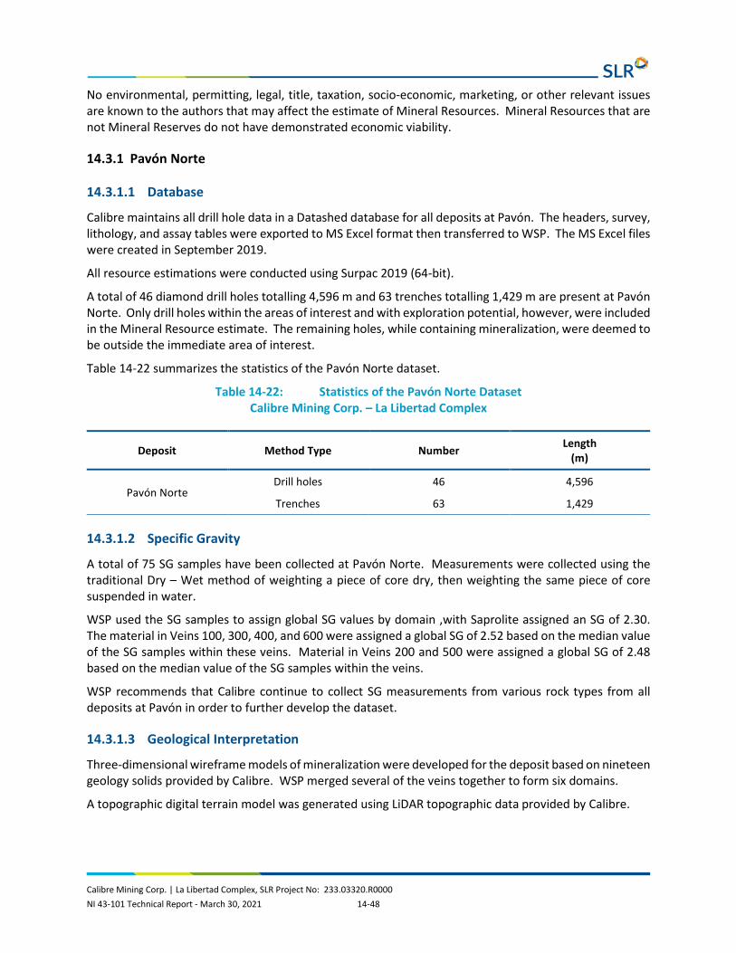
Calibre Mining Corp. | La Libertad Complex, SLR Project No: 233.03320.R0000 NI 43-101 Technical Report - March 30, 2021 14-48
No environmental, permitting, legal, title, taxation, socio-economic, marketing, or other relevant issues are known to the authors that may affect the estimate of Mineral Resources. Mineral Resources that are not Mineral Reserves do not have demonstrated economic viability.
14.3.1 Pavón Norte
14.3.1.1 Database
Calibre maintains all drill hole data in a Datashed database for all deposits at Pavón. The headers, survey, lithology, and assay tables were exported to MS Excel format then transferred to WSP. The MS Excel files were created in September 2019.
All resource estimations were conducted using Surpac 2019 (64-bit).
A total of 46 diamond drill holes totalling 4,596 m and 63 trenches totalling 1,429 m are present at Pavón Norte. Only drill holes within the areas of interest and with exploration potential, however, were included in the Mineral Resource estimate. The remaining holes, while containing mineralization, were deemed to be outside the immediate area of interest.
Table 14-22 summarizes the statistics of the Pavón Norte dataset.
Table 14-22: Statistics of the Pavón Norte Dataset Calibre Mining Corp. – La Libertad Complex
Deposit Method Type Number Length (m)
Pavón Norte Drill holes 46 4,596
Trenches 63 1,429
14.3.1.2 Specific Gravity
A total of 75 SG samples have been collected at Pavón Norte. Measurements were collected using the traditional Dry – Wet method of weighting a piece of core dry, then weighting the same piece of core suspended in water.
WSP used the SG samples to assign global SG values by domain ,with Saprolite assigned an SG of 2.30. The material in Veins 100, 300, 400, and 600 were assigned a global SG of 2.52 based on the median value of the SG samples within these veins. Material in Veins 200 and 500 were assigned a global SG of 2.48 based on the median value of the SG samples within the veins.
WSP recommends that Calibre continue to collect SG measurements from various rock types from all deposits at Pavón in order to further develop the dataset.
14.3.1.3 Geological Interpretation
Three-dimensional wireframe models of mineralization were developed for the deposit based on nineteen geology solids provided by Calibre. WSP merged several of the veins together to form six domains.
A topographic digital terrain model was generated using LiDAR topographic data provided by Calibre.

Calibre Mining Corp. | La Libertad Complex, SLR Project No: 233.03320.R0000 NI 43-101 Technical Report - March 30, 2021 14-49
Sectional interpretations were digitized in Surpac software, and subsequently linked with tag strings and triangulated to build three-dimensional solids. Table 14-23 summarizes the solids and associated volumes. The solids were validated in Surpac and no errors were found.
WSP notes that the zones of mineralization interpreted for each area were generally contiguous, however, due to the nature of the mineralization, there are portions of the wireframe that contain zones of poor mineralization yet are still within the mineralizing trend (Figure 14-24).
A saprolite unit defined by the trenches and diamond drill holes was modelled as a distinct unit at the top of each vein.
Table 14-23: Pavón Norte Solids Summary Calibre Mining Corp. – La Libertad Complex
Domain Minimum X
Maximum X
Minimum Y
Maximum Y
Minimum Z
Maximum Z
Volume (m3)
Vein 100 666,026 666,213 1,469,413 1,469,891 415 638 437,189
Vein 200 665,971 666,131 1,469,747 1,470,084 415 638 418,308
Vein 300 666,121 666,194 1,469,386 1,469,613 450 614 105,449
Vein 400 666,065 666,144 1,469,547 1,469,717 422 635 103,398
Vein 500 666,143 666,225 1,469,537 1,469,582 462 615 19,584
Vein 600 666,076 666,138 1,469,630 1,469,715 424 633 57,514

N
Not to Scale
Looking Northeast
March 2021 Source: 2019.WSP,
14-50
Calibre Mining Corp.
La Libertad Complex
Pavón NorthMineralization Solids
Chontales Department, Nicaragua
Figure 14-24

Calibre Mining Corp. | La Libertad Complex, SLR Project No: 233.03320.R0000 NI 43-101 Technical Report - March 30, 2021 14-51
14.3.1.4 Exploratory Data Analysis
14.3.1.4.1 Assays
The portion of the Pavón Norte deposit included in the Mineral Resource was sampled by a total of 1,429 gold assays (Table 14-24). Assay information was also provided for silver, copper, and arsenic.
Table 14-24: Pavón Norte Assay Summary Calibre Mining Corp. – La Libertad Complex
Domain Field Records Minimum Maximum Mean Standard Deviation
Vein 100 - Rock Au (g/t) 588 0.004 60.40 3.64 5.99
Vein 100 - Saprolite Au (g/t) 191 0.130 38.37 3.56 5.37
Vein 200 - Rock Au (g/t) 271 0.016 27.20 2.94 3.73
Vein 200 - Saprolite Au (g/t) 179 0.050 64.50 3.36 7.13
Vein 300 - Rock Au (g/t) 47 0.045 18.90 2.03 3.55
Vein 300 - Saprolite Au (g/t) 54 0.009 33.80 4.14 7.52
Vein 400 - Rock Au (g/t) 17 0.029 3.93 0.89 1.01
Vein 400 - Saprolite Au (g/t) 28 0.049 37.00 4.00 8.03
Vein 500 - Rock Au (g/t) 14 0.030 11.50 2.95 3.09
Vein 500 - Saprolite Au (g/t) - - - - -
Vein 600 - Rock Au (g/t) 32 0.039 10.25 1.26 2.18
Vein 600 - Saprolite Au (g/t) 8 0.078 12.30 3.17 4.45
Vein 100 - Rock Ag (g/t) 512. 0.100 81.20 4.79 6.70
Vein 100 - Saprolite Ag (g/t) 191 0.100 29.80 1.93 3.41
Vein 200 - Rock Ag (g/t) 260 0.100 42.70 4.34 4.75
Vein 200 - Saprolite Ag (g/t) 179 0.100 100.00 3.03 8.08
Vein 300 - Rock Ag (g/t) 40 0.700 33.90 5.89 7.65
Vein 300 - Saprolite Ag (g/t) 52 0.200 18.40 2.73 3.64
Vein 400 - Rock Ag (g/t) 10 1.00 22.77 3.75 6.72
Vein 400 - Saprolite Ag (g/t) 27 0.500 19.20 6.26 4.68
Vein 500 - Rock Ag (g/t) 14 0.800 58.00 9.66 16.10
Vein 500 - Saprolite Ag (g/t) - - - - -
Vein 600 - Rock Ag (g/t) 32 0.200 15.30 1.82 2.96
Vein 600 - Saprolite Ag (g/t) 8 0.900 13.80 6.79 5.29
Vein 100 - Rock Cu (ppm) 277 3.400 321.10 42.25 41.91
Vein 100 - Saprolite Cu (ppm) 30 5.000 52.00 22.73 15.50

Calibre Mining Corp. | La Libertad Complex, SLR Project No: 233.03320.R0000 NI 43-101 Technical Report - March 30, 2021 14-52
Domain Field Records Minimum Maximum Mean Standard Deviation
Vein 200 - Rock Cu (ppm) 172 6.000 276.20 42.55 36.05
Vein 200 - Saprolite Cu (ppm) 30 3.000 48.00 14.37 9.68
Vein 300 - Rock Cu (ppm) 35 5.700 145.00 53.24 35.45
Vein 300 - Saprolite Cu (ppm) 16 23.500 142.30 87.79 26.63
Vein 400 - Rock Cu (ppm) 7 18.500 94.00 70.43 26.63
Vein 400 - Saprolite Cu (ppm) 27 13.800 123.10 71.24 30.02
Vein 500 - Rock Cu (ppm) 14 3.300 25.80 11.89 6.29
Vein 500 - Saprolite Cu (ppm) - - - - -
Vein 600 - Rock Cu (ppm) 10 54.100 212.30 126.18 52.80
Vein 600 - Saprolite Cu (ppm) 8 17.000 166.90 72.26 48.68
Vein 100 - Rock As (ppm) 277 2.000 376.00 58.41 65.84
Vein 100 - Saprolite As (ppm) 30 11.000 187.00 56.53 44.21
Vein 200 - Rock As (ppm) 172 6.000 508.00 57.85 59.95
Vein 200 - Saprolite As (ppm) 30 6.000 177.00 62.50 43.73
Vein 300 - Rock As (ppm) 35 1.000 104.00 29.49 24.68
Vein 300 - Saprolite As (ppm) 16 31.000 128.00 73.19 28.16
Vein 400 - Rock As (ppm) 7 36.000 57.00 43.43 7.59
Vein 400 - Saprolite As (ppm) 27 17.000 289.00 79.11 80.12
Vein 500 - Rock As (ppm) 14 4.000 45.00 29.14 11.41
Vein 500 - Saprolite As (ppm) - - - - -
Vein 600 - Rock As (ppm) 10 35.000 91.00 57.50 17.30
Vein 600 - Saprolite As (ppm) 8 7.000 94.00 50.75 29.73
Vein 100 - Rock Length (m) 588 0.250 3.05 0.75 0.40
Vein 100 - Saprolite Length (m) 191 0.300 2.00 0.76 0.38
Vein 200 - Rock Length (m) 271 0.300 2.00 0.74 0.28
Vein 200 - Saprolite Length (m) 179 0.300 2.30 0.77 0.37
Vein 300 - Rock Length (m) 47 0.340 1.94 0.89 0.42
Vein 300 - Saprolite Length (m) 54 0.350 2.01 0.92 0.43
Vein 400 - Rock Length (m) 17 0.400 2.12 0.87 0.50
Vein 400 - Saprolite Length (m) 28 0.300 2.05 0.84 0.48
Vein 500 - Rock Length (m) 14 0.370 1.00 0.64 0.22
Vein 500 - Saprolite Length (m) - - - - -
Vein 600 - Rock Length (m) 32 0.350 1.55 0.84 0.38

Calibre Mining Corp. | La Libertad Complex, SLR Project No: 233.03320.R0000 NI 43-101 Technical Report - March 30, 2021 14-53
Domain Field Records Minimum Maximum Mean Standard Deviation
Vein 600 - Saprolite Length (m) 8 0.350 1.53 0.94 0.50
14.3.1.4.2 Composites
Sample intervals were composited to two metre downhole intervals honouring the interpreted geological solids. A two metre composite length was selected as 99% of the samples are less than two metres and 80% of the samples are less than one metre in length. The two metre composite corresponds to approximately one half to one third the cell size in the shortest dimension to be used in the modelling process. The backstitching process was used in the compositing routine to ensure all captured sample material was included. Composites were completed separately for each zone. Table 14-25 summarizes the composite statistics.
Table 14-25: Pavón Norte Composite Data Summary Calibre Mining Corp. – La Libertad Complex
Domain Field Records Minimum Maximum Mean Standard Deviation
Vein 100 - Rock Au (g/t) 227 0.012 29.026 3.350 4.149
Vein 100 - Saprolite Au (g/t) 71 0.257 20.569 2.912 3.671
Vein 200 - Rock Au (g/t) 104 0.185 11.568 2.679 2.409
Vein 200 - Saprolite Au (g/t) 73 0.281 17.832 2.524 3.342
Vein 300 - Rock Au (g/t) 23 0.163 8.495 1.805 2.180
Vein 300 - Saprolite Au (g/t) 22 0.013 15.091 3.790 4.476
Vein 400 - Rock Au (g/t) 9 0.044 3.929 1.063 1.168
Vein 400 - Saprolite Au (g/t) 13 0.116 17.757 2.563 4.726
Vein 500 - Rock Au (g/t) 6 0.905 5.250 2.848 1.528
Vein 500 - Saprolite Au (g/t) - - - - -
Vein 600 - Rock Au (g/t) 5 0.646 10.227 2.652 4.236
Vein 600 - Saprolite Au (g/t) 15 0.142 5.216 0.937 1.274
Vein 100 - Rock Ag (g/t) 192 0.146 33.945 4.783 4.920
Vein 100 - Saprolite Ag (g/t) 71 0.150 14.658 1.535 2.177
Vein 200 - Rock Ag (g/t) 102 0.150 24.441 4.100 3.627
Vein 200 - Saprolite Ag (g/t) 73 0.100 16.356 2.167 2.886
Vein 300 - Rock Ag (g/t) 19 1.371 20.438 5.779 5.809
Vein 300 - Saprolite Ag (g/t) 21 0.274 17.337 3.345 3.916
Vein 400 - Rock Ag (g/t) 7 1.200 22.770 4.718 7.982
Vein 400 - Saprolite Ag (g/t) 12 0.500 18.774 6.182 4.726

Calibre Mining Corp. | La Libertad Complex, SLR Project No: 233.03320.R0000 NI 43-101 Technical Report - March 30, 2021 14-54
Domain Field Records Minimum Maximum Mean Standard Deviation
Vein 500 - Rock Ag (g/t) 6 1.639 32.080 8.548 11.630
Vein 500 - Saprolite Ag (g/t) - - - - -
Vein 600 - Rock Ag (g/t) 5 1.200 11.643 7.142 4.015
Vein 600 - Saprolite Ag (g/t) 15 0.239 10.676 1.849 2.782
Vein 100 - Rock Cu (ppm) 101 5.999 198.200 41.738 30.828
Vein 100 - Saprolite Cu (ppm) 16 5.594 49.767 27.104 15.830
Vein 200 - Rock Cu (ppm) 62 14.352 105.830 42.607 21.985
Vein 200 - Saprolite Cu (ppm) 18 3.857 29.000 15.019 7.368
Vein 300 - Rock Cu (ppm) 14 15.225 105.950 57.923 29.343
Vein 300 - Saprolite Cu (ppm) 8 67.400 124.254 92.489 16.167
Vein 400 - Rock Cu (ppm) 5 18.500 89.813 64.892 29.008
Vein 400 - Saprolite Cu (ppm) 12 43.300 116.318 75.317 21.824
Vein 500 - Rock Cu (ppm) 6 7.229 16.059 12.018 3.639
Vein 500 - Saprolite Cu (ppm) - - - - -
Vein 600 - Rock Cu (ppm) 5 34.544 124.574 82.904 36.223
Vein 600 - Saprolite Cu (ppm) 5 63.953 192.386 123.827 49.559
Vein 100 - Rock As (ppm) 101 3.895 359.000 69.988 68.053
Vein 100 - Saprolite As (ppm) 16 13.284 158.000 65.101 45.239
Vein 200 - Rock As (ppm) 62 14.545 265.794 60.086 45.921
Vein 200 - Saprolite As (ppm) 18 5.571 157.275 64.051 42.588
Vein 300 - Rock As (ppm) 14 3.269 71.940 29.186 18.891
Vein 300 - Saprolite As (ppm) 8 40.169 113.783 71.083 24.548
Vein 400 - Rock As (ppm) 5 35.000 44.000 40.577 3.691
Vein 400 - Saprolite As (ppm) 12 22.787 199.022 61.813 52.961
Vein 500 - Rock As (ppm) 6 19.952 36.865 30.059 6.388
Vein 500 - Saprolite As (ppm) - - - - -
Vein 600 - Rock As (ppm) 5 33.522 94.000 60.732 21.988
Vein 600 - Saprolite As (ppm) 5 46.864 82.108 61.295 14.517
Vein 100 - Rock Length (m) 227 0.650 2.360 1.919 0.263
Vein 100 - Saprolite Length (m) 71 1.000 2.250 1.985 0.200
Vein 200 - Rock Length (m) 104 0.250 2.390 1.881 0.331
Vein 200 - Saprolite Length (m) 73 0.700 2.390 1.875 0.283
Vein 300 - Rock Length (m) 23 0.730 2.315 1.809 0.346

Calibre Mining Corp. | La Libertad Complex, SLR Project No: 233.03320.R0000 NI 43-101 Technical Report - March 30, 2021 14-55
Domain Field Records Minimum Maximum Mean Standard Deviation
Vein 300 - Saprolite Length (m) 22 1.700 2.375 2.104 0.190
Vein 400 - Rock Length (m) 9 0.050 2.270 1.553 0.673
Vein 400 - Saprolite Length (m) 13 1.180 2.100 1.813 0.262
Vein 500 - Rock Length (m) 6 0.870 2.100 1.500 0.405
Vein 500 - Saprolite Length (m) - - - - -
Vein 600 - Rock Length (m) 5 0.790 2.340 1.466 0.576
Vein 600 - Saprolite Length (m) 15 0.160 2.088 1.627 0.532
14.3.1.5 Grade Capping
Grade capping was completed on the composited data for all Pavón deposits. Grade capping was reviewed to assess the amount of metal at risk from high grade assays. WSP used a combination of the Parrish analysis, cumulative histograms, and spatial distribution to assist in determining if and where to apply a top cut to the grades. Parrish analysis (Parrish, 1997) indicates that if the metal content in the 90th decile exceeds 40%, capping may be required.
Based on the analysis, grade caps for gold and silver were applied globally to the veins within the Pavón Norte dataset. Capping was not applied to copper or arsenic due to the lack of samples. Figure 14-25 shows a Pavón Norte gold log cumulative probability plot used to assist in selecting grade capping values and Figure 14-26 shows a Pavón Norte silver log cumulative probability plot used to assist in selecting grade capping values. Pavón Norte gold composites were capped at 37.977 g/t Au and silver composites were capped at 33.945 g/t Ag. Table 14-26 summarizes the capped composite data.
Figure 14-25: Pavón Norte Gold Log Cumulative Probability Plot

Calibre Mining Corp. | La Libertad Complex, SLR Project No: 233.03320.R0000 NI 43-101 Technical Report - March 30, 2021 14-56
Figure 14-26: Pavón Norte Silver Log Cumulative Probability Plot
Table 14-26: Pavón Norte Capped Composite Summary Calibre Mining Corp. – La Libertad Complex
Domain Field Records Minimum Maximum Mean Standard Deviation
Samples Capped
Assay Vein 100 - Rock Au (g/t) 588 0.004 60.400 3.643 5.989 -
Capping Vein 100 - Rock Au (g/t) 588 - 29.030 3.530 5.230 8
Assay Vein 100 - Saprolite Au (g/t) 191 0.130 38.370 3.559 5.370 -
Capping Vein 100 - Saprolite Au (g/t) 191 0.130 29.030 3.480 4.890 2
Assay Vein 200 - Rock Au (g/t) 271 0.016 27.200 2.939 3.726 -
Capping Vein 200 - Rock Au (g/t) 271 0.020 27.200 2.940 3.730 -
Assay Vein 200 - Saprolite Au (g/t) 179 0.050 64.500 3.363 7.130 -
Capping Vein 200 - Saprolite Au (g/t) 179 0.050 29.030 3.040 4.920 2
Assay Vein 300 - Rock Au (g/t) 47 0.045 18.900 2.031 3.554 -
Capping Vein 300 - Rock Au (g/t) 47 0.050 18.900 2.030 3.550 -
Assay Vein 300 - Saprolite Au (g/t) 54 0.009 33.800 4.144 7.520 -
Capping Vein 300 - Saprolite Au (g/t) 54 0.010 29.030 4.020 7.050 2
Assay Vein 400 - Rock Au (g/t) 17 0.029 3.929 0.893 1.011 -
Capping Vein 400 - Rock Au (g/t) 17 0.030 3.930 0.890 1.010 -
Assay Vein 400 - Saprolite Au (g/t) 28 0.049 37.000 3.998 8.032 -

Calibre Mining Corp. | La Libertad Complex, SLR Project No: 233.03320.R0000 NI 43-101 Technical Report - March 30, 2021 14-57
Domain Field Records Minimum Maximum Mean Standard Deviation
Samples Capped
Capping Vein 400 - Saprolite Au (g/t) 28 0.050 29.030 3.710 6.880 1
Assay Vein 500 - Rock Au (g/t) 14 0.030 11.500 2.953 3.087 -
Capping Vein 500 - Rock Au (g/t) 14 0.030 11.500 2.950 3.090 -
Assay Vein 500 - Saprolite Au (g/t) - - - - - -
Capping Vein 500 - Saprolite Au (g/t) - - - - - -
Assay Vein 600 - Rock Au (g/t) 32 0.039 10.250 1.263 2.184 -
Capping Vein 600 - Rock Au (g/t) 32 0.040 10.250 1.260 2.180 -
Assay Vein 600 - Saprolite Au (g/t) 8 0.078 12.300 3.166 4.450 -
Capping Vein 600 - Saprolite Au (g/t) 8 0.080 12.300 3.170 4.450 -
Assay Vein 100 - Rock Ag (g/t) 512 0.100 81.200 4.790 6.700 -
Capping Vein 100 - Rock Ag (g/t) 512 0.100 33.950 4.660 5.730 5
Assay Vein 100 - Saprolite Ag (g/t) 191 0.100 29.800 1.930 3.410 -
Capping Vein 100 - Saprolite Ag (g/t) 191 0.100 29.800 1.930 3.410 -
Assay Vein 200 - Rock Ag (g/t) 260 0.100 42.700 4.340 4.750 -
Capping Vein 200 - Rock Ag (g/t) 260 0.100 33.950 4.310 4.500 1
Assay Vein 200 - Saprolite Ag (g/t) 179 0.100 100.000 3.030 8.080 -
Capping Vein 200 - Saprolite Ag (g/t) 179 0.100 33.950 2.660 4.210 1
Assay Vein 300 - Rock Ag (g/t) 40 0.700 33.900 5.890 7.650 -
Capping Vein 300 - Rock Ag (g/t) 40 0.700 33.900 5.890 7.650 -
Assay Vein 300 - Saprolite Ag (g/t) 52 0.200 18.400 2.730 3.640 -
Capping Vein 300 - Saprolite Ag (g/t) 52 0.200 18.400 2.730 3.640 -
Assay Vein 400 - Rock Ag (g/t) 10 1.000 22.770 3.750 6.720 -
Capping Vein 400 - Rock Ag (g/t) 10 1.000 22.770 3.750 6.720 -
Assay Vein 400 - Saprolite Ag (g/t) 27 0.500 19.200 6.260 4.680 -
Capping Vein 400 - Saprolite Ag (g/t) 27 0.500 19.200 6.260 4.670 -
Assay Vein 500 - Rock Ag (g/t) 14 0.800 58.000 9.660 16.100 -
Capping Vein 500 - Rock Ag (g/t) 14 0.800 33.950 7.940 11.030 1
Assay Vein 500 - Saprolite Ag (g/t) - - - - - -
Capping Vein 500 - Saprolite Ag (g/t) - - - - - -
Assay Vein 600 - Rock Ag (g/t) 32 0.200 15.300 1.820 2.960 -
Capping Vein 600 - Rock Ag (g/t) 32 0.200 15.300 1.820 2.960 -
Assay Vein 600 - Saprolite Ag (g/t) 8 0.900 13.800 6.790 5.290 -
Capping Vein 600 - Saprolite Ag (g/t) 8 0.900 13.800 6.790 5.290 -

Calibre Mining Corp. | La Libertad Complex, SLR Project No: 233.03320.R0000 NI 43-101 Technical Report - March 30, 2021 14-58
Domain Field Records Minimum Maximum Mean Standard Deviation
Samples Capped
Assay Vein 100 - Rock Cu (ppm) 277 3.400 321.100 42.250 41.910 -
Capping Vein 100 - Rock Cu (ppm) 277 3.400 213.110 41.670 38.830 3
Assay Vein 100 - Saprolite Cu (ppm) 30 5.000 52.000 22.730 15.500 -
Capping Vein 100 - Saprolite Cu (ppm) 30 5.000 52.000 22.730 15.500 -
Assay Vein 200 - Rock Cu (ppm) 172 6.000 276.200 42.550 36.050 -
Capping Vein 200 - Rock Cu (ppm) 172 6.000 213.110 42.180 33.920 1
Assay Vein 200 - Saprolite Cu (ppm) 30 3.000 48.000 14-370 9.680 -
Capping Vein 200 - Saprolite Cu (ppm) 30 3.000 48.000 14-370 9.680 -
Assay Vein 300 - Rock Cu (ppm) 35 5.700 145.000 53.240 35.450 -
Capping Vein 300 - Rock Cu (ppm) 35 5.700 145.000 53.240 35.450 -
Assay Vein 300 - Saprolite Cu (ppm) 16 23.500 142.300 87.790 26.630 -
Capping Vein 300 - Saprolite Cu (ppm) 16 23.500 142.300 87.790 26.630 -
Assay Vein 400 - Rock Cu (ppm) 7 18.500 94.000 70.430 26.630 -
Capping Vein 400 - Rock Cu (ppm) 7 18.500 94.000 70.430 26.630 -
Assay Vein 400 - Saprolite Cu (ppm) 27 13.800 123.100 71.240 30.020 -
Capping Vein 400 - Saprolite Cu (ppm) 27 13.800 123.100 71.240 30.020 -
Assay Vein 500 - Rock Cu (ppm) 14 3.300 25.800 11.890 6.290 -
Capping Vein 500 - Rock Cu (ppm) 14 3.300 25.800 11.890 6.290 -
Assay Vein 500 - Saprolite Cu (ppm) - - - - - -
Capping Vein 500 - Saprolite Cu (ppm) - - - - - -
Assay Vein 600 - Rock Cu (ppm) 10 54.100 212.300 126.180 52.800 -
Capping Vein 600 - Rock Cu (ppm) 10 54.100 212.300 126.180 52.800 -
Assay Vein 600 - Saprolite Cu (ppm) 8 17.000 166.900 72.260 48.680 -
Capping Vein 600 - Saprolite Cu (ppm) 8 17.000 166.900 72.260 48.680 -
Assay Vein 100 - Rock As (ppm) 277 2.000 376.000 58.410 65.840 -
Capping Vein 100 - Rock As (ppm) 277 1.000 373.370 57.690 66.140 1
Assay Vein 100 - Saprolite As (ppm) 30 11.000 187.000 56.530 44.210 -
Capping Vein 100 - Saprolite As (ppm) 30 10.000 187.000 55.900 44.610 -
Assay Vein 200 - Rock As (ppm) 172 6.000 508.000 57.850 59.950 -
Capping Vein 200 - Rock As (ppm) 172 5.000 373.370 56.380 55.010 3
Assay Vein 200 - Saprolite As (ppm) 30 6.000 177.000 62.500 43.730 -
Capping Vein 200 - Saprolite As (ppm) 30 5.000 177.000 61.930 44.150 -
Assay Vein 300 - Rock As (ppm) 35 1.000 104.000 29.490 24.680 -

Calibre Mining Corp. | La Libertad Complex, SLR Project No: 233.03320.R0000 NI 43-101 Technical Report - March 30, 2021 14-59
Domain Field Records Minimum Maximum Mean Standard Deviation
Samples Capped
Capping Vein 300 - Rock As (ppm) 35 1.000 104.000 28.600 24.860 -
Assay Vein 300 - Saprolite As (ppm) 16 31.000 128.000 73.190 28.160 -
Capping Vein 300 - Saprolite As (ppm) 16 30.000 128.000 72.750 28.570 -
Assay Vein 400 - Rock As (ppm) 7 36.000 57.000 43.430 7.590 -
Capping Vein 400 - Rock As (ppm) 7 35.000 57.000 42.430 7.590 -
Assay Vein 400 - Saprolite As (ppm) 27 17.000 289.000 79.110 80.120 -
Capping Vein 400 - Saprolite As (ppm) 27 16.000 289.000 78.410 80.530 -
Assay Vein 500 - Rock As (ppm) 14 4.000 45.000 29.140 11.410 -
Capping Vein 500 - Rock As (ppm) 14 3.000 44.000 28.140 11.410 -
Assay Vein 500 - Saprolite As (ppm) - - - - - -
Capping Vein 500 - Saprolite As (ppm) - - - - - -
Assay Vein 600 - Rock As (ppm) 10 35.000 91.000 57.500 17.300 -
Capping Vein 600 - Rock As (ppm) 10 34.000 91.000 57.000 17.750 -
Assay Vein 600 - Saprolite As (ppm) 8 7.000 94.000 50.750 29.730 -
Capping Vein 600 - Saprolite As (ppm) 8 6.000 94.000 50.000 30.120 -
14.3.1.6 Spatial Analysis
Variography using Surpac software was completed for gold, silver, copper, and arsenic. Downhole variograms were used to determine nugget effect, then semi-variograms were modelled with two structures to determine spatial continuity in each element.
Table 14-27 summarizes results of the variography. Appendix D in WSP’s January 9, 2020 NI 43-101 Technical Report contains the details of the variogram models for each element at Pavón Norte.
Table 14-27: Pavón Norte Variogram Parameters Calibre Mining Corp. – La Libertad Complex
Field Nugget Sill 1st Structure
Range 1st Structure
Sill 2nd Structure
Range 2nd Structure
Au (g/t) - Rock 0.012 0.828 33.7 0.159 60.848
Au (g/t) - Saprolite 0.074 0.435 63.011 0.49 118.079
Ag (g/t) - Rock 0.142 0.457 34.815 0.4 62.718
Ag (g/t) - Saprolite 0.280 0.249 127.882 0.472 224.646
Cu (ppm) - Rock 0.419 0.58 83.53 - -
As (ppm) - Rock 0.148 0.643 20.743 0.21 67.832
Table 14-28 demonstrates the size and rotations of the search ellipses created from the semi-variograms for each element in each zone.

Calibre Mining Corp. | La Libertad Complex, SLR Project No: 233.03320.R0000 NI 43-101 Technical Report - March 30, 2021 14-60
Table 14-28: Pavón Norte Search Ellipse Summary Calibre Mining Corp. – La Libertad Complex
Field Bearing (°)
Plunge (°)
Dip (°)
Major Axis (m)
Semi-Major Axis (m)
Minor Axis (m)
Major/ Semi-Major
Ratio
Major/Minor Ratio
Au (g/t) - Rock 48 79 30 60.85 31.53 16.53 1.93 3.68
Au (g/t) - Saprolite 145 0 5 118.08 27.30 19.72 4.33 5.99
Ag (g/t) - Rock 255 -80 0 62.72 35.14 11.67 1.79 5.37
Ag (g/t) - Saprolite 160 0 0 224.65 52.86 28.21 4.25 7.96
Cu (ppm) - Rock 255 -80 0 83.53 50.02 20.83 1.67 4.01
As (ppm) - Rock 255 -80 0 67.83 24.40 19.98 2.78 3.40
14.3.1.7 Resource Model
A single block model was established in Surpac for the Pavón Norte veins using one parent model as the origin. The model was not rotated.
Drill hole spacing varies throughout the model area. A block size of 5 m x 5 m x 5 m in the X/Y/Z directions was selected to accommodate the nature of the mineralization. Sub-celling of the block model was used to improve the block volume relative to the solid volume.
Table 14-29 summarizes details of the parent block model.
Table 14-29: Pavón Norte Parent Model Summary Calibre Mining Corp. – La Libertad Complex
Parameters Bearing
Minimum X Coordinate 1,469,300
Minimum Y Coordinate 665,900
Minimum Z Coordinate 400
Maximum X Coordinate 1,470,200
Maximum Y Coordinate 666,300
Maximum Z Coordinate 650
Block Size (m) 5 x 5 x 5
Rotation 0
Sub-block 1.25 x 1.25 x 1.25
Total No. Blocks 46,080,000
The interpolation of the model was completed using three estimation methods: OK, NN, and ID2. The estimations were designed for three passes. In each pass a minimum and maximum number of samples were required as well as a maximum number of samples from a drill hole to satisfy the estimation criteria. Table 14-30 summarizes the interpolation criteria for the Pavón Norte resource model.

Calibre Mining Corp. | La Libertad Complex, SLR Project No: 233.03320.R0000 NI 43-101 Technical Report - March 30, 2021 14-61
Table 14-30: Pavón Norte Estimation Strategy Calibre Mining Corp. – La Libertad Complex
Estimation Pass No.
Search Ellipse Factor
Minimum No. of Composites
Maximum No. of Composites
Maximum No. of Composites per Hole
1 0.6 3 15 2
2 0.8 3 15 2
3 1 2 15 2
14.3.1.8 Resource Classification
WSP considered several factors when establishing definitions for resource classification:
• NI 43-101 requirements. • CIM guidelines. • The QP’s experience with epithermal gold deposits. • Spatial continuity of the assays within the drill holes. • Drill hole and trench spacing and estimate runs required to estimate the grades in a block. • The confidence with the dataset base on the results of the validation. • The number of samples and drill hole used in each of the block estimations. • The number of samples and drill hole used in each of the block estimations.
14.3.1.9 Mineral Resource Tabulation
The Pavón Norte Mineral Resource estimate with an effective date of November 12, 2019 has been tabulated in terms of a pit constrained gold cut-off grade.
Based on similar parameters at Calibre’s El Limón and La Libertad gold operations located in Nicaragua, a 1.17 g/t Au cut-off grade was used to tabulate the total for the Pavón Norte deposit. Table 14-31 contains the parameters used to generate a pit shell to constrain the Pavón Norte resource.
Table 14-31: Pavón Norte Pit Shell Parameters Calibre Mining Corp. – La Libertad Complex
Parameter Units Base Case
Mining Dilution % 5
Mining Recovery % 95
Overall Slope Angle - overburden Degrees 38
Overall Slope Angle - rock Degrees 45
Mining Cost $/tonne mined 2.43
Processing Cost (including additional costs for G&A, trucking, etc.) $/tonne processed 48.25
Metallurgical Recovery % 94
Payable Factor % 94

Calibre Mining Corp. | La Libertad Complex, SLR Project No: 233.03320.R0000 NI 43-101 Technical Report - March 30, 2021 14-62
Parameter Units Base Case
Metal Prices - Gold $/oz. 1,500
Selling Cost $/oz. 8
Mineral Resource Classifications Used in Optimization Indicated Inferred
Table 14-21 summarizes the pit constrained resource estimate at the 1.17 g/t Au cut-off grade for Pavón Norte. Figure 14-27 is an oblique view of the Pavón Norte pit constrained resource.

N
> 1.15
Au (g/t):
3.00 - 6.00
1.15 - 3.00
< 6.00
Not to Scale
March 2021 Source: 2019.WSP,
14-63
Calibre Mining Corp.
La Libertad Complex
Pav n Nort Pit Constrainedó eMineral Resource
Chontales Department, Nicaragua
Figure 14-27
Looking Northeast

Calibre Mining Corp. | La Libertad Complex, SLR Project No: 233.03320.R0000 NI 43-101 Technical Report - March 30, 2021 14-64
14.3.1.10 Validation
The Pavón Norte, Central, and Sur models were validated by three methods:
• Visual comparison of colour coded block model grades with composite drill hole grades on section.
• Comparison of the global mean block grades for ID2, NN, and composites. • Swath plots.
14.3.1.11 Visual Validation
The visual comparisons of block model grades with composite grades for the Pavón Norte deposit indicate a reasonable correlation between the values (Figure 14-28). No significant discrepancies were apparent from the sections, yet grade smoothing is apparent in places. Collars above or below topography are located off-section.

Looking North
0.5 - 1.15
Au (g/t):
3.00 - 6.00
1.15 - 3.00
< 6.00
> 0.5
March 2021 Source: 2019.WSP,
14-65
0 5 25
Metres
10 15 20
Calibre Mining Corp.
La Libertad Complex
Pavón Norte Visual Validation
Chontales Department, Nicaragua
Figure 14-28
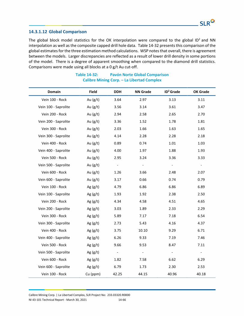
Calibre Mining Corp. | La Libertad Complex, SLR Project No: 233.03320.R0000 NI 43-101 Technical Report - March 30, 2021 14-66
14.3.1.12 Global Comparison
The global block model statistics for the OK interpolation were compared to the global ID2 and NN interpolation as well as the composite capped drill hole data. Table 14-32 presents this comparison of the global estimates for the three estimation method calculations. WSP notes that overall, there is agreement between the models. Larger discrepancies are reflected as a result of lower drill density in some portions of the model. There is a degree of apparent smoothing when compared to the diamond drill statistics. Comparisons were made using all blocks at a 0 g/t Au cut-off.
Table 14-32: Pavón Norte Global Comparison Calibre Mining Corp. – La Libertad Complex
Domain Field DDH NN Grade ID2 Grade OK Grade
Vein 100 - Rock Au (g/t) 3.64 2.97 3.13 3.11
Vein 100 - Saprolite Au (g/t) 3.56 3.14 3.61 3.47
Vein 200 - Rock Au (g/t) 2.94 2.58 2.65 2.70
Vein 200 - Saprolite Au (g/t) 3.36 1.52 1.78 1.81
Vein 300 - Rock Au (g/t) 2.03 1.66 1.63 1.65
Vein 300 - Saprolite Au (g/t) 4.14 2.28 2.28 2.18
Vein 400 - Rock Au (g/t) 0.89 0.74 1.01 1.03
Vein 400 - Saprolite Au (g/t) 4.00 1.97 1.88 1.93
Vein 500 - Rock Au (g/t) 2.95 3.24 3.36 3.33
Vein 500 - Saprolite Au (g/t) - - - -
Vein 600 - Rock Au (g/t) 1.26 3.66 2.48 2.07
Vein 600 - Saprolite Au (g/t) 3.17 0.66 0.74 0.79
Vein 100 - Rock Ag (g/t) 4.79 6.86 6.86 6.89
Vein 100 - Saprolite Ag (g/t) 1.93 1.92 2.38 2.50
Vein 200 - Rock Ag (g/t) 4.34 4.58 4.51 4.65
Vein 200 - Saprolite Ag (g/t) 3.03 1.89 2.33 2.29
Vein 300 - Rock Ag (g/t) 5.89 7.17 7.18 6.54
Vein 300 - Saprolite Ag (g/t) 2.73 5.43 4.16 4.37
Vein 400 - Rock Ag (g/t) 3.75 10.10 9.29 6.71
Vein 400 - Saprolite Ag (g/t) 6.26 9.33 7.19 7.46
Vein 500 - Rock Ag (g/t) 9.66 9.53 8.47 7.11
Vein 500 - Saprolite Ag (g/t) - - - -
Vein 600 - Rock Ag (g/t) 1.82 7.58 6.62 6.29
Vein 600 - Saprolite Ag (g/t) 6.79 1.73 2.30 2.53
Vein 100 - Rock Cu (ppm) 42.25 44.15 40.96 40.18

Calibre Mining Corp. | La Libertad Complex, SLR Project No: 233.03320.R0000 NI 43-101 Technical Report - March 30, 2021 14-67
Domain Field DDH NN Grade ID2 Grade OK Grade
Vein 100 - Saprolite Cu (ppm) - - - -
Vein 200 - Rock Cu (ppm) 42.55 43.38 41.70 40.76
Vein 200 - Saprolite Cu (ppm) - - - -
Vein 300 - Rock Cu (ppm) 53.24 48.69 53.91 55.36
Vein 300 - Saprolite Cu (ppm) - - - -
Vein 400 - Rock Cu (ppm) 70.43 61.80 63.99 64.79
Vein 400 - Saprolite Cu (ppm) - - - -
Vein 500 - Rock Cu (ppm) 11.89 12.00 12.43 12.19
Vein 500 - Saprolite Cu (ppm) - - - -
Vein 600 - Rock Cu (ppm) 126.18 76.21 94.72 103.13
Vein 600 - Saprolite Cu (ppm) - - - -
Vein 100 - Rock As (ppm) 58.41 50.69 46.74 46.77
Vein 100 - Saprolite As (ppm) - - - -
Vein 200 - Rock As (ppm) 57.85 53.01 50.06 49.68
Vein 200 - Saprolite As (ppm) - - - -
Vein 300 - Rock As (ppm) 29.49 24.63 27.63 29.60
Vein 300 - Saprolite As (ppm) - - - -
Vein 400 - Rock As (ppm) 43.43 29.41 32.57 32.29
Vein 400 - Saprolite As (ppm) - - - -
Vein 500 - Rock As (ppm) 29.14 29.60 29.55 29.03
Vein 500 - Saprolite As (ppm) - - - -
Vein 600 - Rock As (ppm) 57.50 59.63 62.54 65.20
Vein 600 - Saprolite As (ppm) - - - -
14.3.1.13 Swath Plots
A series of swath plots were generated to compare the distribution of the grades in the OK method compared to the ID2 and NN methods. The swath plots were generated in elevation and easting orientations. As expected with a small data set, there is grade smoothing in the model compared to the drill hole composites. WSP notes that the Pavón Norte swath plots exhibit good correlations between the models and the composites.
14.3.2 Pavón Central
14.3.2.1 Database
A total of 31 diamond drill hole totalling 3,017 m and 46 trenches totalling 867 m are present at Pavón Central. Only drill holes within the areas of interest and with exploration potential, however, were

Calibre Mining Corp. | La Libertad Complex, SLR Project No: 233.03320.R0000 NI 43-101 Technical Report - March 30, 2021 14-68
included in the Mineral Resource estimate. The remaining holes, while containing mineralization, were deemed to be outside the immediate area of interest.
Table 14-33 summarizes the statistics of the Pavón Central dataset.
Table 14-33: Pavón Central Dataset Calibre Mining Corp. – La Libertad Complex
Deposit Method Type Number Length (m)
Pavón Central Drill Holes 31 3,017
Trenches 46 867
14.3.2.2 Specific Gravity
No SG samples have been collected at Pavón Central.
WSP used the Pavón Norte SG samples to assign global SG values by domain at Pavón Central. The saprolite was assigned an SG of 2.30. The material in Veins 700, 800, 900, 1000 and 1100, was assigned a global SG of 2.52 based on the median value of the SG samples within the veins.
14.3.2.3 Geological Interpretation
Three-dimensional wireframe models of mineralization were developed for the deposit based on six geology solids provided by Calibre. WSP merged several of the veins together to form five domains.
Topographic digital terrain model was generated using LiDAR topographic data provided by Calibre.
Sectional interpretations were digitized in Surpac software, and subsequently linked with tag strings and triangulated to build three-dimensional solids. Table 14-34 summarizes the solids and associated volumes. The solids were validated in Surpac and no errors were found.
WSP notes that the zones of mineralization interpreted for each area were generally contiguous, however, due to the nature of the mineralization, there are portions of the wireframe that contain zones of poor mineralization yet are still within the mineralizing trend.
A saprolite unit defined by the trenches and diamond drill holes was modelled as a distinct unit at the top of each vein.
Table 14-34: Pavón Central Solids Summary Calibre Mining Corp. – La Libertad Complex
Domain Minimum X
Maximum X
Minimum Y
Maximum Y
Minimum Z
Maximum Z
Volume (m3)
Vein 700 665,662 665,756 1,467,237 1,467,497 318.463 525.204 58,520
Vein 800 665,871 665,956 1,466,279 1,466,570 290.543 397.969 64,152
Vein 900 665,877 665,940 1,466,271 1,466,554 306.515 408.115 45,445
Vein 1000 665,865 665,920 1,466,263 1,466,526 296.698 408.619 23,304
Vein 1100 665,654 665,885 1,466,384 1,467,502 323.779 535.576 565,930

Calibre Mining Corp. | La Libertad Complex, SLR Project No: 233.03320.R0000 NI 43-101 Technical Report - March 30, 2021 14-69
14.3.2.4 Exploratory Data Analysis
14.3.2.4.1 Assays
The portion of the Pavón Central deposit included in the Mineral Resource was sampled by a total of 600 gold assays (Table 14-35). Assay information was also provided for silver, copper, and arsenic.
Table 14-35: Pavón Central Assay Summary Calibre Mining Corp. – La Libertad Complex
Domain Field Records Minimum Maximum Mean Standard Deviation
Vein 700 - Rock Au (g/t) 44 0.16 48.10 5.23 9.09
Vein 700 - Saprolite Au (g/t) 29 0.07 29.10 4.43 7.18
Vein 800 - Rock Au (g/t) 22 0.11 33.60 6.84 7.69
Vein 800 - Saprolite Au (g/t) 8 0.77 1.46 1.20 0.22
Vein 900 - Rock Au (g/t) 21 0.15 21.90 3.17 5.13
Vein 900 - Saprolite Au (g/t) 26 0.22 79.18 9.04 17.17
Vein 1000 - Rock Au (g/t) 11 0.14 5.18 1.37 1.58
Vein 1000 - Saprolite Au (g/t) 9 0.25 11.33 2.08 3.54
Vein 1100 - Rock Au (g/t) 252 0.02 99.10 9.02 15.41
Vein 1100 - Saprolite Au (g/t) 178 0.02 75.30 4.61 8.23
Vein 700 - Rock Ag (g/t) 41 0.60 78.70 10.27 15.10
Vein 700 - Saprolite Ag (g/t) 29 0.05 11.70 2.27 2.87
Vein 800 - Rock Ag (g/t) 22 1.00 83.90 17.52 19.85
Vein 800 - Saprolite Ag (g/t) 8 1.30 25.70 9.26 9.63
Vein 900 - Rock Ag (g/t) 21 0.50 48.80 7.85 10.71
Vein 900 - Saprolite Ag (g/t) 26 1.00 78.70 9.91 15.13
Vein 1000 - Rock Ag (g/t) 11 0.70 158.40 16.74 47.06
Vein 1000 - Saprolite Ag (g/t) 9 0.15 8.90 2.36 2.59
Vein 1100 - Rock Ag (g/t) 178 0.05 41.50 4.27 6.85
Vein 1100 - Saprolite Ag (g/t) 9 26.00 281.00 98.11 88.29
Vein 700 - Rock Cu (ppm) 9 17.00 64.00 44.33 15.58
Vein 700 - Saprolite Cu (ppm) 9 0.40 2.40 1.05 0.55
Vein 800 - Rock Cu (ppm) 218 0.30 201.00 17.27 26.10
Vein 800 - Saprolite Cu (ppm) 37 8.20 123.10 51.39 33.65
Vein 900 - Rock Cu (ppm) 190 3.70 177.00 35.81 33.13
Vein 900 - Saprolite Cu (ppm) 190 2.00 629.00 66.39 92.61

Calibre Mining Corp. | La Libertad Complex, SLR Project No: 233.03320.R0000 NI 43-101 Technical Report - March 30, 2021 14-70
Domain Field Records Minimum Maximum Mean Standard Deviation
Vein 1000 - Rock Cu (ppm) 252 0.25 3.00 0.91 0.46
Vein 1000 - Saprolite Cu (ppm) 29 7.00 67.20 28.95 17.14
Vein 1100 - Rock Cu (ppm) 22 7.40 63.70 26.21 15.66
Vein 1100 - Saprolite Cu (ppm) 8 13.00 66.00 40.09 20.52
Vein 700 - Rock As (ppm) 21 4.90 177.00 46.18 40.10
Vein 700 - Saprolite As (ppm) 26 11.00 63.00 24.82 12.28
Vein 800 - Rock As (ppm) 11 11.00 167.20 44.20 47.08
Vein 800 - Saprolite As (ppm) 178 3.80 181.00 31.50 26.42
Vein 900 - Rock As (ppm) 37 18.00 502.00 122.54 105.50
Vein 900 - Saprolite As (ppm) 29 21.00 113.00 57.62 21.98
Vein 1000 - Rock As (ppm) 22 2.00 363.00 77.18 108.06
Vein 1000 - Saprolite As (ppm) 8 12.00 55.00 30.13 16.02
Vein 1100 - Rock As (ppm) 21 3.00 269.00 67.05 66.16
Vein 1100 - Saprolite As (ppm) 26 3.00 79.00 27.50 20.39
Vein 700 - Rock Length 11 15.00 303.00 92.27 90.47
Vein 700 - Saprolite Length 178 3.00 465.00 67.76 73.42
Vein 800 - Rock Length 44 0.34 2.05 0.74 0.36
Vein 800 - Saprolite Length 29 0.30 2.31 1.04 0.57
Vein 900 - Rock Length 22 0.39 1.29 0.82 0.27
Vein 900 - Saprolite Length 8 0.40 2.10 1.28 0.73
Vein 1000 - Rock Length 21 0.30 2.59 1.10 0.55
Vein 1000 - Saprolite Length 26 0.49 2.40 1.07 0.49
Vein 1100 - Rock Length 11 0.49 3.47 1.32 0.82
Vein 1100 - Saprolite Length 178 0.30 3.90 0.94 0.54
14.3.2.4.2 Composites
Sample intervals were composited to two metre downhole intervals honouring the interpreted geological solids. A two metre composite length was selected as 95% of the samples are less than two metres and 70% of the samples are less than one metre in length. The two metre composite corresponds to approximately one half to one third the cell size in the shortest dimension to be used in the modelling process. The backstitching process was used in the compositing routine to ensure all captured sample material was included. Composites were completed separately for each zone. Table 14-36 summarizes the composite statistics.

Calibre Mining Corp. | La Libertad Complex, SLR Project No: 233.03320.R0000 NI 43-101 Technical Report - March 30, 2021 14-71
Table 14-36: Pavón Central Composite Data Summary Calibre Mining Corp. – La Libertad Complex
Domain Field Records Minimum Maximum Mean Standard Deviation
Vein 700 - Rock Au (g/t) 21 0.39 41.35 4.75 8.83
Vein 700 - Saprolite Au (g/t) 15 0.07 23.70 3.92 6.46
Vein 800 - Rock Au (g/t) 10 0.47 21.79 6.58 5.78
Vein 800 - Saprolite Au (g/t) 6 1.09 1.39 1.21 0.11
Vein 900 - Rock Au (g/t) 13 0.38 14-36 3.32 3.73
Vein 900 - Saprolite Au (g/t) 16 0.37 38.15 8.56 10.38
Vein 1000 - Rock Au (g/t) 8 0.14 5.18 1.98 2.09
Vein 1000 - Saprolite Au (g/t) 5 0.70 4.85 1.90 1.78
Vein 1100 - Rock Au (g/t) 118 0.02 61.43 7.92 10.57
Vein 1100 - Saprolite Au (g/t) 90 0.03 30.47 4.11 4.59
Vein 700 - Rock Ag (g/t) 19 1.47 67.56 9.49 14-91
Vein 700 - Saprolite Ag (g/t) 15 0.09 9.30 2.34 2.59
Vein 800 - Rock Ag (g/t) 10 4.88 49.26 17.75 14-55
Vein 800 - Saprolite Ag (g/t) 6 1.31 20.99 5.97 7.50
Vein 900 - Rock Ag (g/t) 13 0.74 48.80 11.56 14-61
Vein 900 - Saprolite Ag (g/t) 16 1.10 37.33 9.64 8.53
Vein 1000 - Rock Ag (g/t) 8 0.70 64.90 11.40 21.89
Vein 1000 - Saprolite Ag (g/t) 5 0.15 5.01 1.97 1.95
Vein 1100 - Rock Ag (g/t) 104 0.30 72.30 15.11 14-15
Vein 1100 - Saprolite Ag (g/t) 90 0.10 29.26 3.89 4.65
Vein 700 - Rock Cu (ppm) 16 8.50 99.89 48.45 27.76
Vein 700 - Saprolite Cu (ppm) 15 9.86 65.13 26.89 13.99
Vein 800 - Rock Cu (ppm) 10 10.70 47.50 27.23 11.32
Vein 800 - Saprolite Cu (ppm) 6 23.17 66.00 46.17 17.14
Vein 900 - Rock Cu (ppm) 13 8.48 85.11 41.00 26.46
Vein 900 - Saprolite Cu (ppm) 16 12.78 63.00 27.03 12.62
Vein 1000 - Rock Cu (ppm) 8 12.28 144.19 49.43 45.69
Vein 1000 - Saprolite Cu (ppm) 5 33.93 241.65 93.00 84.91
Vein 1100 - Rock Cu (ppm) 83 4.86 146.50 37.47 29.06
Vein 1100 - Saprolite Cu (ppm) 90 3.93 160.93 30.12 24.20

Calibre Mining Corp. | La Libertad Complex, SLR Project No: 233.03320.R0000 NI 43-101 Technical Report - March 30, 2021 14-72
Domain Field Records Minimum Maximum Mean Standard Deviation
Vein 700 - Rock As (ppm) 16 17.00 171.02 94.07 54.70
Vein 700 - Saprolite As (ppm) 15 20.00 85.01 53.32 17.94
Vein 800 - Rock As (ppm) 10 3.92 150.93 58.69 56.98
Vein 800 - Saprolite As (ppm) 6 16.64 53.65 34.08 14-95
Vein 900 - Rock As (ppm) 13 7.96 172.20 61.00 47.91
Vein 900 - Saprolite As (ppm) 16 4.83 59.65 25.89 15.31
Vein 1000 - Rock As (ppm) 8 15.72 160.00 82.93 55.65
Vein 1000 - Saprolite As (ppm) 5 22.40 52.00 43.05 12.38
Vein 1100 - Rock As (ppm) 83 2.49 176.77 51.39 50.36
Vein 1100 - Saprolite As (ppm) 90 2.68 176.77 57.03 42.20
Vein 700 - Rock Length 21 0.45 2.24 1.56 0.49
Vein 700 - Saprolite Length 15 0.49 2.17 1.82 0.65
Vein 800 - Rock Length 10 1.10 2.25 1.81 0.40
Vein 800 - Saprolite Length 6 1.23 2.07 1.70 0.42
Vein 900 - Rock Length 13 1.46 2.07 1.74 0.24
Vein 900 - Saprolite Length 16 0.51 2.40 1.71 0.44
Vein 1000 - Rock Length 8 1.53 2.21 1.78 0.24
Vein 1000 - Saprolite Length 5 1.66 1.70 1.67 0.02
Vein 1100 - Rock Length 118 0.29 2.30 1.89 0.33
Vein 1100 - Saprolite Length 90 0.19 2.35 1.78 0.38
14.3.2.5 Grade Capping
Grade capping was completed on the composited data in a similar manner as at Pavón Norte.
Based on the analysis, the grade cap for gold and silver were applied globally to the veins within the Pavón Central dataset. Capping was not applied to copper or arsenic due to the lack of samples. Figure 14-29 presents the Pavón Central gold log cumulative probability plot used to assist in selecting grade capping values, and Figure 14-30 presents the Pavón Central silver log cumulative probability plot used to assist in selecting grade capping values. Pavón Central gold composites were capped at 75 g/t Au, and silver composites were capped at 78.7 g/t Ag. Table 14-37 summarizes the capped composite data.

Calibre Mining Corp. | La Libertad Complex, SLR Project No: 233.03320.R0000 NI 43-101 Technical Report - March 30, 2021 14-73
Figure 14-29: Pavón Central Gold Log Cumulative Probability Plot
Figure 14-30: Pavón Central Silver Log Cumulative Probability Plot

Calibre Mining Corp. | La Libertad Complex, SLR Project No: 233.03320.R0000 NI 43-101 Technical Report - March 30, 2021 14-74
Table 14-37: Pavón Central Capped Composite Summary Calibre Mining Corp. – La Libertad Complex
Domain Field Records Minimum Maximum Mean Standard Deviation
Samples Capped
Vein 700 - Rock Au (g/t) 44 0.16 48.10 5.23 9.09 -
Assay Vein Capping 700 - Rock Au (g/t) 44 0.16 48.10 5.23 9.09 -
Vein 700 - Saprolite Au (g/t) 29 0.07 29.10 4.43 7.18 -
Assay Vein Capping 700 - Saprolite Au (g/t) 29 0.07 29.10 4.43 7.18 -
Vein 800 - Rock Au (g/t) 22 0.11 33.60 6.84 7.69 -
Assay Vein Capping 800 - Rock Au (g/t) 22 0.11 33.60 6.84 7.69 -
Vein 800 - Saprolite Au (g/t) 8 0.77 1.46 1.20 0.22 -
Assay Vein Capping 800 - Saprolite Au (g/t) 8 0.77 1.46 1.20 0.22 -
Vein 900 - Rock Au (g/t) 21 0.15 21.90 3.17 5.13 -
Assay Vein Capping 900 - Rock Au (g/t) 21 0.15 21.90 3.17 5.13 -
Vein 900 - Saprolite Au (g/t) 26 0.22 79.18 9.04 17.17 -
Assay Vein Capping 900 - Saprolite Au (g/t) 26 0.22 75.00 8.88 16.49 1
Vein 1000 - Rock Au (g/t) 11 0.14 5.18 1.37 1.58 -
Assay Vein Capping 1000 - Rock Au (g/t) 11 0.14 5.18 1.37 1.58 -
Vein 1000 - Saprolite Au (g/t) 9 0.25 11.33 2.08 3.53 -
Assay Vein Capping 1000 - Saprolite Au (g/t) 9 0.25 11.33 2.08 3.53 -
Vein 1100 - Rock Au (g/t) 252 0.02 99.10 9.02 15.41 -
Assay Vein Capping 1100 - Rock Au (g/t) 252 0.02 75.00 8.73 13.92 4
Vein 1100 - Saprolite Au (g/t) 178 0.02 75.30 4.61 8.23 -
Assay Vein Capping 1100 - Saprolite Au (g/t) 178 0.02 75.00 4.60 8.22 1
Vein 700 - Rock Ag (g/t) 41 0.60 78.70 10.27 15.10 -
Assay Vein Capping 700 - Rock Ag (g/t) 41 0.60 78.70 10.27 15.10 -
Calibre Mining Corp. | La Libertad Complex, SLR Project No: 233.03320.R0000 NI 43-101 Technical Report - March 30, 2021 14-75
Domain Field Records Minimum Maximum Mean Standard Deviation
Samples Capped
Vein 700 - Saprolite Ag (g/t) 29 0.05 11.70 2.27 2.86 -
Assay Vein Capping 700 - Saprolite Ag (g/t) 29 0.05 11.70 2.27 2.86 -
Vein 800 - Rock Ag (g/t) 22 1.00 83.90 17.52 19.85 -
Assay Vein Capping 800 - Rock Ag (g/t) 22 1.00 78.70 17.29 19.03 1
Vein 800 - Saprolite Ag (g/t) 8 1.30 25.70 9.26 9.63 -
Assay Vein Capping 800 - Saprolite Ag (g/t) 8 1.30 25.70 9.26 9.63 -
Vein 900 - Rock Ag (g/t) 21 0.50 48.80 7.85 10.70 -
Assay Vein Capping 900 - Rock Ag (g/t) 21 0.50 48.80 7.85 10.70 -
Vein 900 - Saprolite Ag (g/t) 26 1.00 78.70 9.91 15.12 -
Assay Vein Capping 900 - Saprolite Ag (g/t) 26 1.00 78.70 9.91 15.12 -
Vein 1000 - Rock Ag (g/t) 11 0.70 158.40 16.74 47.05 -
Assay Vein Capping 1000 - Rock Ag (g/t) 11 0.70 78.70 9.49 23.10 1
Vein 1000 - Saprolite Ag (g/t) 9 0.15 8.90 2.36 2.59 -
Assay Vein Capping 1000 - Saprolite Ag (g/t) 9 0.15 8.90 2.36 2.59 -
Vein 1100 - Rock Ag (g/t) 218 0.30 201.00 17.27 26.10 -
Assay Vein Capping 1100 - Rock Ag (g/t) 218 0.30 78.70 15.64 17.28 4
Vein 1100 - Saprolite Ag (g/t) 178 0.05 41.50 4.27 6.85 -
Assay Vein Capping 1100 - Saprolite Ag (g/t) 178 0.05 41.50 4.27 6.85 -
Vein 700 - Rock Cu (ppm) 37 8.20 123.10 51.39 33.65 -
Assay Vein Capping 700 - Rock Cu (ppm) 37 8.20 123.10 51.39 33.65 -
Vein 700 - Saprolite Cu (ppm) 29 7.00 67.20 28.95 17.14 -
Assay Vein Capping 700 - Saprolite Cu (ppm) 29 7.00 67.20 28.95 17.14 -
Vein 800 - Rock Cu (ppm) 22 7.40 63.70 26.20 15.66 -

Calibre Mining Corp. | La Libertad Complex, SLR Project No: 233.03320.R0000 NI 43-101 Technical Report - March 30, 2021 14-76
Domain Field Records Minimum Maximum Mean Standard Deviation
Samples Capped
Assay Vein Capping 800 - Rock Cu (ppm) 22 7.40 63.70 26.20 15.66 -
Vein 800 - Saprolite Cu (ppm) 8 13.00 66.00 40.09 20.52 -
Assay Vein Capping 800 - Saprolite Cu (ppm) 8 13.00 66.00 40.09 20.52 -
Vein 900 - Rock Cu (ppm) 21 4.90 177.00 46.18 40.10 -
Assay Vein Capping 900 - Rock Cu (ppm) 21 4.90 177.00 46.18 40.10 -
Vein 900 - Saprolite Cu (ppm) 26 11.00 63.00 24.82 12.28 -
Assay Vein Capping 900 - Saprolite Cu (ppm) 26 11.00 63.00 24.82 12.28 -
Vein 1000 - Rock Cu (ppm) 11 11.00 167.20 44.20 47.08 -
Assay Vein Capping 1000 - Rock Cu (ppm) 11 11.00 167.20 44.20 47.08 -
Vein 1000 - Saprolite Cu (ppm) 9 26.00 281.00 98.11 88.29 -
Assay Vein Capping 1000 - Saprolite Cu (ppm) 9 26.00 281.00 98.11 88.29 -
Vein 1100 - Rock Cu (ppm) 190 3.70 177.00 35.81 33.13 -
Assay Vein Capping 1100 - Rock Cu (ppm) 190 3.70 177.00 35.81 33.13 -
Vein 1100 - Saprolite Cu (ppm) 178 3.80 181.00 31.50 26.42 -
Assay Vein Capping 1100 - Saprolite Cu (ppm) 178 3.80 181.00 31.50 26.42 -
Vein 700 - Rock As (ppm) 37 18.00 502.00 122.54 105.50 -
Assay Vein Capping 700 - Rock As (ppm) 37 17.00 176.77 100.49 60.94 8
Vein 700 - Saprolite As (ppm) 29 21.00 113.00 57.62 21.98 -
Assay Vein Capping 700 - Saprolite As (ppm) 29 20.00 113.00 57.00 22.38 -
Vein 800 - Rock As (ppm) 22 2.00 363.00 77.18 108.06 -
Assay Vein Capping 800 - Rock As (ppm) 22 1.00 176.77 56.92 63.41 3
Vein 800 - Saprolite As (ppm) 8 12.00 55.00 30.13 16.02 -
Assay Vein Capping 800 - Saprolite As (ppm) 8 12.00 55.00 30.13 16.02 -

Calibre Mining Corp. | La Libertad Complex, SLR Project No: 233.03320.R0000 NI 43-101 Technical Report - March 30, 2021 14-77
Domain Field Records Minimum Maximum Mean Standard Deviation
Samples Capped
Vein 900 - Rock As (ppm) 21 3.00 269.00 67.05 66.16 -
Assay Vein Capping 900 - Rock As (ppm) 21 2.00 176.77 62.04 54.46 1
Vein 900 - Saprolite As (ppm) 26 3.00 79.00 27.50 20.39 -
Assay Vein Capping 900 - Saprolite As (ppm) 26 3.00 79.00 27.50 20.39 -
Vein 1000 - Rock As (ppm) 11 15.00 303.00 92.27 90.47 -
Assay Vein Capping 1000 - Rock As (ppm) 11 15.00 176.77 80.32 66.08 2
Vein 1000 - Saprolite As (ppm) 9 16.00 64.00 44.33 15.58 -
Assay Vein Capping 1000 - Saprolite As (ppm) 9 16.00 64.00 44.33 15.58 -
Vein 1100 - Rock As (ppm) 190 2.00 629.00 66.39 92.61 -
Assay Vein Capping 1100 - Rock As (ppm) 190 1.00 176.77 53.85 56.77 20
Vein 1100 - Saprolite As (ppm) 178 3.00 465.00 67.76 73.42 -
Assay Vein Capping 1100 - Saprolite As (ppm) 178 2.00 176.77 60.05 51.89 12
14.3.2.6 Spatial Analysis
Variography using Surpac software was completed for gold, silver, copper, and arsenic. Downhole variograms were used to determine nugget effect, then semi-variograms were modelled with two structures to determine spatial continuity in each element.
Table 14-38 summarizes results of the variography. Appendix D in WSP’s January 9, 2020 NI 43-101 Technical Report contains the details of the variogram models for each element at Pavón Central.
Table 14-38: Pavón Central Variogram Parameters Calibre Mining Corp. – La Libertad Complex
Field Nugget Sill 1st Structure
Range 1st Structure
Sill 2nd Structure
Range 2nd Structure
Au (g/t) - Rock 53.23 135.82 65.51 21.53 102.44
Au (g/t) - Saprolite 5.04 8.31 35.05 16.2 65.63
Ag (g/t) - Rock 53.23 141.91 63.09 21.99 119.9
Ag (g/t) - Saprolite 4.57 11.47 41.14 14-25 59.04
Cu (ppm) - Rock 2,349.3 1,229.94 109.49 1,879.46 120.58

Calibre Mining Corp. | La Libertad Complex, SLR Project No: 233.03320.R0000 NI 43-101 Technical Report - March 30, 2021 14-78
Field Nugget Sill 1st Structure
Range 1st Structure
Sill 2nd Structure
Range 2nd Structure
Cu (ppm) - Saprolite 334.05 373.02 38.54 1,770.47 199.53
As (ppm) - Rock 300.61 206.67 17.59 336.3 115.53
As (ppm) - Saprolite 184.84 258.33 89.82 191.52 125.1
Table 14-39 demonstrates the size and rotations of the search ellipses created from the semi variograms for each element in each zone.
Table 14-39: Pavón Central Search Ellipse Summary Calibre Mining Corp. – La Libertad Complex
Field Bearing (°)
Plunge (°)
Dip (°)
Major Axis (m)
Semi-Major Axis (m)
Minor Axis (m)
Major/Semi- Major Ratio
Major/Minor Ratio
Au (g/t) - Rock 29.01 68.91 54.99 102.44 56.60 12.81 1.81 8.00
Au (g/t) - Saprolite 325.00 0.00 15.00 65.63 22.55 15.93 2.91 4.12
Ag (g/t) - Rock 29.01 68.91 54.99 119.90 53.29 15.18 2.25 7.90
Ag (g/t) - Saprolite 325.00 0.00 15.00 59.04 17.01 10.49 3.47 5.63
Cu (ppm) - Rock 255.00 80.00 -10.00 120.58 64.83 40.60 1.86 2.97
Cu (ppm) - Saprolite 135.00 0.00 -10.00 199.53 53.21 19.41 3.75 10.28
As (ppm) - Rock 260.00 80.00 0.00 115.53 31.31 24.95 3.69 4.63
As (ppm) - Saprolite 14-70 4.21 5.00 125.10 119.14 26.50 1.05 4.72
14.3.2.7 Resource Model
A single block model was established in Surpac for the Pavón Central veins using one parent model as the origin. WSP notes that the model was not rotated.
Drill hole spacing varies throughout the model area. A block size of 5 m x 5 m x 5 m in the X/Y/Z directions was selected to accommodate the nature of the mineralization. Sub-celling of the block model was used to improve the block volume relative to the solid volume.
Table 14-40 summarizes details of the parent block model.
Table 14-40: Pavón Central Parent Model Summary Calibre Mining Corp. – La Libertad Complex
Parameters Bearing
Minimum X Coordinate 1,466,000
Minimum Y Coordinate 665,400
Minimum Z Coordinate 280
Maximum X Coordinate 1,467,700

Calibre Mining Corp. | La Libertad Complex, SLR Project No: 233.03320.R0000 NI 43-101 Technical Report - March 30, 2021 14-79
Parameters Bearing
Maximum Y Coordinate 666,200
Maximum Z Coordinate 580
Block Size (m) 5 x 5 x 5
Rotation 0
Sub-block 1.25 x 1.25 x 1.25
Total No. Blocks 208,896,000
The interpolation of the model was completed using three estimation methods: OK, NN, and ID2. The estimations were designed for three passes. In each pass a minimum and maximum number of samples were required as well as a maximum number of samples from a drill hole to satisfy the estimation criteria. Table 14-41 summarizes the interpolation criteria for the Pavón Central resource model.
Table 14-41: Pavón Central Estimation Strategy Calibre Mining Corp. – La Libertad Complex
Estimation Pass No.
Search Ellipse Factor
Minimum No. of Composites
Maximum No. of Composites
Maximum No. of Composites per
Drill Hole
1 0.6 3 15 2
2 0.8 3 15 2
3 1 2 15 2
14.3.2.8 Resource Classification
The same factors considered for resource classification at Pavón Norte were used for Pavón Central.
14.3.2.9 Mineral Resource Tabulation
The Pavón Central Mineral Resource estimate, with an effective date of November 12, 2019, has been tabulated in terms of a pit constrained gold cut-off grade.
Based on similar parameters at Calibre’s El Limón and La Libertad gold operations located in Nicaragua, a 1.17 g/t Au cut-off grade was used to tabulate the total for the Pavón Central deposit. Table 14-42 contains the parameters used to generate a pit shell to constrain the resource.
Table 14-42: Pavón Central Pit Shell Parameters Calibre Mining Corp. – La Libertad Complex
Parameter Units Base Case
Mining Dilution % 5
Mining Recovery % 95
Overall Slope Angle - overburden Degrees 38
Overall Slope Angle - rock Degrees 45

Calibre Mining Corp. | La Libertad Complex, SLR Project No: 233.03320.R0000 NI 43-101 Technical Report - March 30, 2021 14-80
Parameter Units Base Case
Mining Cost $/tonne mined 2.43
Processing Cost (including additional costs for G&A, trucking, etc.) $/tonne processed 48.25
Metallurgical Recovery % 94
Payable Factor % 94
Metal Prices - Gold $/oz 1,500
Selling Cost $/oz 8
Mineral Resource Classifications Used in Optimization Indicated
Inferred
Table 14-21 summarizes the pit constrained resource estimate at the 1.17 g/t Au cut-off grade for Pavón Central.
14.3.2.10 Validation
Validation was carried out in the same manner as at Pavón Norte.
14.3.2.11 Visual Validation
The visual comparisons of block model grades with composite grades for the deposit indicate a reasonable correlation between the values. No significant discrepancies were apparent from the sections, yet grade smoothing is apparent in places. Collars above or below topography are located off-section.
14.3.2.12 Global Comparison
The global block model statistics for the OK interpolation were compared to the global ID2 and NN interpolation as well as the composite capped drill hole data. Table 14-43 presents this comparison of the global estimates for the three estimation method calculations. WSP notes that overall, there is agreement between the models. Larger discrepancies are reflected as a result of lower drill density in some portions of the model. There is a degree of apparent smoothing when compared to the diamond drill statistics. Comparisons were made using all blocks at a 0 g/t Au cut-off.
Table 14-43: Pavón Central Global Comparison Calibre Mining Corp. – La Libertad Complex
Domain Element DDH NN Grade ID2 Grade OK Grade
Vein 700 - Rock Au (g/t) 5.23 5.42 6.17 6.07
Vein 700 - Saprolite Au (g/t) 4.43 5.66 4.93 4.26
Vein 800 - Rock Au (g/t) 6.84 5.69 6.23 6.16
Vein 800 - Saprolite Au (g/t) 1.20 1.19 1.25 1.26
Vein 900 - Rock Au (g/t) 3.17 3.10 4.24 4.34
Vein 900 - Saprolite Au (g/t) 9.04 7.64 9.40 9.13
Vein 1000 - Rock Au (g/t) 1.37 2.04 2.35 2.21

Calibre Mining Corp. | La Libertad Complex, SLR Project No: 233.03320.R0000 NI 43-101 Technical Report - March 30, 2021 14-81
Domain Element DDH NN Grade ID2 Grade OK Grade
Vein 1000 - Saprolite Au (g/t) 2.08 2.14 2.49 2.32
Vein 1100 - Rock Au (g/t) 9.02 5.02 5.71 5.55
Vein 1100 - Saprolite Au (g/t) 4.61 3.36 3.74 3.78
Vein 700 - Rock Ag (g/t) 10.27 8.64 10.24 10.38
Vein 700 - Saprolite Ag (g/t) 2.27 2.51 1.68 1.61
Vein 800 - Rock Ag (g/t) 17.52 18.42 18.45 17.89
Vein 800 - Saprolite Ag (g/t) 9.26 5.17 3.38 3.63
Vein 900 - Rock Ag (g/t) 7.85 8.15 8.01 8.76
Vein 900 - Saprolite Ag (g/t) 9.91 7.45 9.72 9.60
Vein 1000 - Rock Ag (g/t) 16.74 10.42 10.59 11.55
Vein 1000 - Saprolite Ag (g/t) 2.36 2.43 2.50 2.46
Vein 1100 - Rock Ag (g/t) 17.27 9.81 10.36 10.32
Vein 1100 - Saprolite Ag (g/t) 4.27 3.54 4.28 4.39
Vein 700 - Rock Cu (ppm) 51.39 51.58 48.43 50.15
Vein 700 - Saprolite Cu (ppm) 28.95 17.79 15.63 15.63
Vein 800 - Rock Cu (ppm) 26.20 25.72 26.62 26.64
Vein 800 - Saprolite Cu (ppm) 40.09 34.89 34.18 34.05
Vein 900 - Rock Cu (ppm) 46.18 47.56 38.55 38.64
Vein 900 - Saprolite Cu (ppm) 24.82 19.59 18.18 18.03
Vein 1000 - Rock Cu (ppm) 44.20 54.81 52.08 53.65
Vein 1000 - Saprolite Cu (ppm) 98.11 59.63 42.09 42.19
Vein 1100 - Rock Cu (ppm) 35.81 32.71 30.28 29.50
Vein 1100 - Saprolite Cu (ppm) 31.50 20.06 16.88 17.06
Vein 700 - Rock As (ppm) 122.54 89.78 77.87 78.48
Vein 700 - Saprolite As (ppm) 57.62 50.70 53.32 53.53
Vein 800 - Rock As (ppm) 77.18 43.15 49.83 50.23
Vein 800 - Saprolite As (ppm) 30.13 37.77 38.78 38.67
Vein 900 - Rock As (ppm) 67.05 65.33 47.56 46.24
Vein 900 - Saprolite As (ppm) 27.50 29.77 23.87 24.53
Vein 1000 - Rock As (ppm) 92.27 89.09 64.97 65.09
Vein 1000 - Saprolite As (ppm) 44.33 49.58 54.12 59.38
Vein 1100 - Rock As (ppm) 66.39 36.69 36.57 35.89
Vein 1100 - Saprolite As (ppm) 67.76 66.92 57.27 57.96

Calibre Mining Corp. | La Libertad Complex, SLR Project No: 233.03320.R0000 NI 43-101 Technical Report - March 30, 2021 14-82
14.3.2.13 Swath Plots
A series of swath plots were generated to compere the distribution of the grades in the OK method compared to the ID2 and NN methods. The swath plots were generated in elevation and easting orientations. As expected with a small dataset, there is grade smoothing in the model compared to the drill hole composites. WSP notes that the Pavón Central swath plots exhibit good correlations between the models and the composites.
14.3.3 Pavón Sur
14.3.3.1 Database
A total of 26 diamond drill holes totalling 3,570 m, and 29 trenches totalling 727 m are present at Pavón Sur. Only drill holes within the areas of interest and with exploration potential, however, were included in the Mineral Resource estimate. The remaining holes, while containing mineralization, were deemed to be outside the immediate area of interest.
Table 14-44 summarizes the statistics of the Pavón Sur dataset.
Table 14-44: Pavón Sur Dataset Calibre Mining Corp. – La Libertad Complex
Targets Method Type Number Length (m)
Pavón Sur Drill holes 26 3,570
Trenches 29 727
14.3.3.2 Specific Gravity
No SG samples have been collected at Pavón Sur.
WSP used the Pavón Norte SG samples to assign global SG values by domain at Pavón Sur. The saprolite was assigned an SG of 2.30. The material in high grade veins (1200) and low grade stockwork (1300) was assigned a global SG of 2.52.
14.3.3.3 Geological Interpretation
Three-dimensional wireframe models of mineralization were developed for the deposit based on two geology solids generated by WSP.
Topographic digital terrain model was generated using LiDAR topographic data provided by Calibre.
Sectional interpretations were digitized in Surpac software, and subsequently linked with tag strings and triangulated to build three-dimensional solids. Table 14-45 summarizes the solids and associated volumes. The solids were validated in Surpac and no errors were found.
WSP notes that the zones of mineralization interpreted for each area were generally contiguous, however, due to the nature of the mineralization, there are portions of the wireframe that contain zones of poor mineralization yet are still within the mineralizing trend.

Calibre Mining Corp. | La Libertad Complex, SLR Project No: 233.03320.R0000 NI 43-101 Technical Report - March 30, 2021 14-83
Table 14-45: Pavón Sur Solids Summary Calibre Mining Corp. – La Libertad Complex
Domain Minimum X
Maximum X
Minimum Y
Maximum Y
Minimum Z
Maximum Z
Volume (m3)
Vein 1200 - HG Vein 665,820 665,990 1,465,566 1,465,970 338 508 1,211,508
Vein 1300 - LG Halo 665,822 665,975 1,465,572 1,465,967 340 481 318,246
14.3.3.4 Exploratory Data Analysis
14.3.3.4.1 Assays
The portion of the Pavón Sur deposit included in the Mineral Resource was sampled by a total of 396 gold assays (Table 14-46). Assay information was also provided for silver, copper, and arsenic.
Table 14-46: Pavón Sur Assay Summary Calibre Mining Corp. – La Libertad Complex
Domain Field No of Records Minimum Maximum Mean Standard
Deviation
Low Grade Stockwork - Rock Au (g/t) 108 0.01 1.11 0.26 0.22
Low Grade Stockwork - Saprolite Au (g/t) 288 0.01 6.76 0.30 0.48
High Grade Vein - Rock Au (g/t) 94 0.02 118.90 4.49 13.06
High Grade Vein - Saprolite Au (g/t) 242 0.05 27.90 2.10 3.38
Low Grade Stockwork - Rock Ag (g/t) 2 2.00 3.13 2.57 0.80
Low Grade Stockwork - Saprolite Ag (g/t) 287 0.10 19.80 0.73 2.12
High Grade Vein - Rock Ag (g/t) 27 1.03 95.65 8.93 18.50
High Grade Vein - Saprolite Ag (g/t) 240 0.10 15.50 1.31 2.12
Low Grade Stockwork - Rock Cu (ppm) - - - - -
Low Grade Stockwork - Saprolite Cu (ppm) 6 5.00 17.00 11.50 4.42
High Grade Vein - Rock Cu (ppm) - - - - -
High Grade Vein - Saprolite Cu (ppm) 6 4.00 53.00 13.17 19.53
Low Grade Stockwork - Rock As (ppm) - - - - -
Low Grade Stockwork - Saprolite As (ppm) 6 12.00 44.00 30.00 12.31
High Grade Vein - Rock As (ppm) - - - - -
High Grade Vein - Saprolite As (ppm) 6 3.00 107.00 30.50 38.09
Low Grade Stockwork - Rock Length 108 0.30 3.00 1.30 0.50
Low Grade Stockwork - Saprolite Length 288 0.10 4.50 0.90 0.60

Calibre Mining Corp. | La Libertad Complex, SLR Project No: 233.03320.R0000 NI 43-101 Technical Report - March 30, 2021 14-84
Domain Field No of Records Minimum Maximum Mean Standard
Deviation
High Grade Vein - Rock Length 94 0.30 2.50 1.00 0.50
High Grade Vein - Saprolite Length 242 0.30 4.50 0.90 0.40
14.3.3.4.2 Composites
Sample intervals were composited to two metre downhole intervals honouring the interpreted geological solids. A two metre composite length was selected as 98% of the samples are less than two metres and 65% of the samples are less than one metre in length. The two metre composite corresponds to approximately one half to one third the cell size in the shortest dimension to be used in the modelling process. The backstitching process was used in the compositing routine to ensure all captured sample material was included. Composites were completed separately for each of the zones. Table 14-47 summarizes the composite statistics.
Table 14-47: Pavón Sur Composite Data Summary Calibre Mining Corp. – La Libertad Complex
Domain Field No of Records Minimum Maximum Mean Standard
Deviation
Low Grade Stockwork - Rock/Saprolite Au (g/t) 219 0.02 2.17 0.27 0.26
High Grade Vein - Rock/Saprolite Au (g/t) 166 0.13 14-53 2.27 2.88
Low Grade Stockwork - Rock/Saprolite Ag (g/t) 149 0.10 14-42 0.75 1.97
High Grade Vein - Rock/Saprolite Ag (g/t) 137 0.10 15.23 2.04 3.09
14.3.3.5 Grade Capping
Grade capping was completed on the composited data in a similar manner as at Pavón Norte.
Based on the analysis, the grade cap for gold and silver were applied globally to the veins within the Pavón Sur dataset. Capping was not applied to copper or arsenic due to the lack of samples. Figure 14-31 presents the Pavón Central gold log cumulative probability plot used to assist in selecting grade capping values, and Figure 14-32 presents the Pavón Central silver log cumulative probability plot used to assist in selecting grade capping values. Pavón Sur gold composites were capped at 17.18 g/t Au and silver composites were capped at 15.23 g/t Ag. Table 14-48 summarizes the capped composite data.

Calibre Mining Corp. | La Libertad Complex, SLR Project No: 233.03320.R0000 NI 43-101 Technical Report - March 30, 2021 14-85
Figure 14-31: Pavón Sur Gold Log Cumulative Probability Plot
Figure 14-32: Pavón Sur Silver Log Cumulative Probability Plot

Calibre Mining Corp. | La Libertad Complex, SLR Project No: 233.03320.R0000 NI 43-101 Technical Report - March 30, 2021 14-86
Table 14-48: Capped Composite Data for Pavón Sur Calibre Mining Corp. – La Libertad Complex
Domain Field Records Minimum Maximum Mean Standard Deviation
Samples Capped
Assay Low Grade Stockwork - Rock Au (g/t) 108 0.01 1.11 0.26 0.22 -
Assay Capping Low Grade Stockwork - Rock Au (g/t) 108 0.01 1.11 0.26 0.22 -
Assay Low Grade Stockwork - Saprolite Au (g/t) 288 0.01 6.76 0.30 0.48 -
Assay Capping Low Grade Stockwork - Saprolite Au (g/t) 288 0.01 6.76 0.30 0.48 -
Assay High Grade Vein - Rock Au (g/t) 94 0.02 118.90 4.49 13.06 -
Assay Capping High Grade Vein - Rock Au (g/t) 94 0.02 17.18 3.13 4.49 6
Assay High Grade Vein - Saprolite Au (g/t) 242 0.05 27.90 2.10 3.38 -
Assay Capping High Grade Vein - Saprolite Au (g/t) 242 0.05 17.18 2.04 2.98 1
Assay Low Grade Stockwork - Rock Ag (g/t) 2 2.00 3.13 2.57 0.80 -
Assay Capping Low Grade Stockwork - Rock Ag (g/t) 2 2.00 3.13 2.57 0.80 -
Assay Low Grade Stockwork - Saprolite Ag (g/t) 287 0.10 19.80 0.73 2.12 -
Assay Capping Low Grade Stockwork - Saprolite Ag (g/t) 287 0.10 15.23 0.71 1.99 1
Assay High Grade Vein - Rock Ag (g/t) 27 1.03 95.65 8.93 18.50 -
Assay Capping High Grade Vein - Rock Ag (g/t) 27 1.03 15.23 5.26 4.22 2
Assay High Grade Vein - Saprolite Ag (g/t) 240 0.10 15.50 1.31 2.12 -
Assay Capping High Grade Vein - Saprolite Ag (g/t) 240 0.10 15.23 1.31 2.12 1
14.3.3.6 Spatial Analysis
Variography using Surpac software was completed for gold, and silver. Downhole variograms were used to determine nugget effect, then semi-variograms were modelled with two structures to determine spatial continuity in each element.
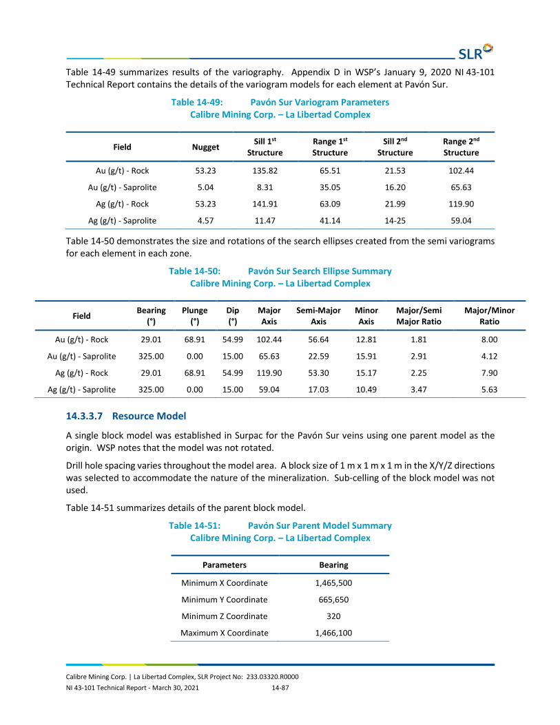
Calibre Mining Corp. | La Libertad Complex, SLR Project No: 233.03320.R0000 NI 43-101 Technical Report - March 30, 2021 14-87
Table 14-49 summarizes results of the variography. Appendix D in WSP’s January 9, 2020 NI 43-101 Technical Report contains the details of the variogram models for each element at Pavón Sur.
Table 14-49: Pavón Sur Variogram Parameters Calibre Mining Corp. – La Libertad Complex
Field Nugget Sill 1st Structure
Range 1st Structure
Sill 2nd Structure
Range 2nd Structure
Au (g/t) - Rock 53.23 135.82 65.51 21.53 102.44
Au (g/t) - Saprolite 5.04 8.31 35.05 16.20 65.63
Ag (g/t) - Rock 53.23 141.91 63.09 21.99 119.90
Ag (g/t) - Saprolite 4.57 11.47 41.14 14-25 59.04
Table 14-50 demonstrates the size and rotations of the search ellipses created from the semi variograms for each element in each zone.
Table 14-50: Pavón Sur Search Ellipse Summary Calibre Mining Corp. – La Libertad Complex
Field Bearing (°)
Plunge (°)
Dip (°)
Major Axis
Semi-Major Axis
Minor Axis
Major/Semi Major Ratio
Major/Minor Ratio
Au (g/t) - Rock 29.01 68.91 54.99 102.44 56.64 12.81 1.81 8.00
Au (g/t) - Saprolite 325.00 0.00 15.00 65.63 22.59 15.91 2.91 4.12
Ag (g/t) - Rock 29.01 68.91 54.99 119.90 53.30 15.17 2.25 7.90
Ag (g/t) - Saprolite 325.00 0.00 15.00 59.04 17.03 10.49 3.47 5.63
14.3.3.7 Resource Model
A single block model was established in Surpac for the Pavón Sur veins using one parent model as the origin. WSP notes that the model was not rotated.
Drill hole spacing varies throughout the model area. A block size of 1 m x 1 m x 1 m in the X/Y/Z directions was selected to accommodate the nature of the mineralization. Sub-celling of the block model was not used.
Table 14-51 summarizes details of the parent block model.
Table 14-51: Pavón Sur Parent Model Summary Calibre Mining Corp. – La Libertad Complex
Parameters Bearing
Minimum X Coordinate 1,465,500
Minimum Y Coordinate 665,650
Minimum Z Coordinate 320
Maximum X Coordinate 1,466,100

Calibre Mining Corp. | La Libertad Complex, SLR Project No: 233.03320.R0000 NI 43-101 Technical Report - March 30, 2021 14-88
Parameters Bearing
Maximum Y Coordinate 666,100
Maximum Z Coordinate 460
Block Size (m) 1 x 1 x 1
Rotation 0
Sub-block none
Total No. Blocks 37,800,000
The interpolation of the model was completed using two estimation methods: NN and ID2. The estimations were designed for three passes. In each pass a minimum and maximum number of samples were required as well as a maximum number of samples from a drill hole to satisfy the estimation criteria. Table 14-52 summarizes the interpolation criteria for the Pavón Sur resource model.
Table 14-52: Pavón Sur Estimation Strategy Calibre Mining Corp. – La Libertad Complex
Estimation Pass No.
Search Ellipse Factor
Minimum No. of Composites
Maximum No. of Composites
Maximum No. of Composites per Drill Hole
1 0.6 3 15 2
2 0.8 3 15 2
3 1 2 15 2
14.3.3.8 Resource Classification
The same factors for resource classification at Pavón Norte and Central were used for Pavón Sur.
14.3.3.9 Mineral Resource Tabulation
The Pavón Sur Mineral Resource estimate, with an effective date of November 12, 2019, has been tabulated in terms of a pit constrained gold cut-off grade.
Based on similar parameters at Calibre’s El Limón and La Libertad gold operations located in Nicaragua, a 1.17 g/t Au cut-off grade was used to tabulate the total for the Pavón Sur deposit. Table 14-53 contains the parameters used to generate a pit shell to constrain the resource.
Table 14-53: Pavón Sur Pit Shell Parameters Calibre Mining Corp. – La Libertad Complex
Parameter Units Base Case
Mining Dilution % 5
Mining Recovery % 95
Overall Slope Angle - overburden Degrees 38
Overall Slope Angle - rock Degrees 45
Mining Cost $/tonne mined 2.43
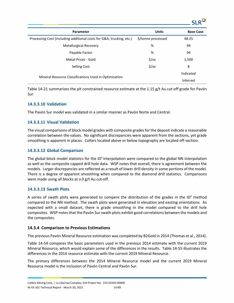
Calibre Mining Corp. | La Libertad Complex, SLR Project No: 233.03320.R0000 NI 43-101 Technical Report - March 30, 2021 14-89
Parameter Units Base Case
Processing Cost (including additional costs for G&A, trucking, etc.) $/tonne processed 48.25
Metallurgical Recovery % 94
Payable Factor % 94
Metal Prices - Gold $/oz 1,500
Selling Cost $/oz 8
Mineral Resource Classifications Used in Optimization Indicated Inferred
Table 14-21 summarizes the pit constrained resource estimate at the 1.15 g/t Au cut-off grade for Pavón Sur.
14.3.3.10 Validation
The Pavón Sur model was validated in a similar manner as Pavón Norte and Central.
14.3.3.11 Visual Validation
The visual comparisons of block model grades with composite grades for the deposit indicate a reasonable correlation between the values. No significant discrepancies were apparent from the sections, yet grade smoothing is apparent in places. Collars located above or below topography are located off-section.
14.3.3.12 Global Comparison
The global block model statistics for the ID2 interpolation were compared to the global NN interpolation as well as the composite capped drill hole data. WSP notes that overall, there is agreement between the models. Larger discrepancies are reflected as a result of lower drill density in some portions of the model. There is a degree of apparent smoothing when compared to the diamond drill statistics. Comparisons were made using all blocks at a 0 g/t Au cut-off.
14.3.3.13 Swath Plots
A series of swath plots were generated to compere the distribution of the grades in the ID2 method compared to the NN method. The swath plots were generated in elevation and easting orientations. As expected with a small dataset, there is grade smoothing in the model compared to the drill hole composites. WSP notes that the Pavón Sur swath plots exhibit good correlations between the models and the composites.
14.3.4 Comparison to Previous Estimations
The previous Pavón Mineral Resource estimation was completed by B2Gold in 2014 (Thomas et al., 2014).
Table 14-54 compares the basic parameters used in the previous 2014 estimate with the current 2019 Mineral Resource, which would explain some of the differences in the results. Table 14-55 illustrates the differences in the 2014 resource estimate with the current 2019 Mineral Resource.
The primary differences between the 2014 Mineral Resource model and the current 2019 Mineral Resource model is the inclusion of Pavón Central and Pavón Sur.

Calibre Mining Corp. | La Libertad Complex, SLR Project No: 233.03320.R0000 NI 43-101 Technical Report - March 30, 2021 14-90
Table 14-54: Comparison of Pavón Model Parameters Calibre Mining Corp. – La Libertad Complex
Description 2014 B2Gold Model 2019 WSP Model
Number of drill holes 28 trenches/35 drill holes 57 trenches/107 drill holes
Gold grade capping 30 g/t 29.03 g/t, Pavón Norte
75 g/t Pavón Central 17.18 g/t Pavón Sur
Composite lengths 2 m 2 m
Cut-off grade 2.25 g/t pit constrained 1.17 g/t pit constrained
Gold price US$1,500/oz Au US$1,500/oz Au
Number of mineral zones 1 domain: Pavón Norte
3 domains: Pavón Norte
Pavón Central Pavón Sur
Block size 2 x 5 x 5 (50 m3) 5 x 5 x 5 (625 m3)
Sub-block - 1.25 x 1.25 x 1.25
Estimation passes 3 3
Minimum composites 4 3
Maximum Composites 12 15
Max Composites/drill hole 3 2
Estimation method ID2 with NN validation OK with ID2 and NN validation
Table 14-55: Comparison of Pavón Mineral Resource Estimates Calibre Mining Corp. – La Libertad Complex
Classification Tonnes (000 t)
Grade (g/t Au)
Contained Metal (000 oz Au)
2014 2019 Change % 2014 2019 Change % 2014 2019 Change %
Indicated 290 1,392 380% 5.82 5.16 -11% 55 230 318%
Inferred 130 577 344% 5.5 3.39 -38% 23 63 174%

Calibre Mining Corp. | La Libertad Complex, SLR Project No: 233.03320.R0000 NI 43-101 Technical Report - March 30, 2021 15-1
15.0 MINERAL RESERVE ESTIMATE
15.1 Mineral Reserves Summary The Total Mineral Reserves as of December 31, 2020 that will be processed by the La Libertad processing plant include reserves from Jabalí Antena OP, Jabalí West Underground (UG), Pavón OP, and the existing stockpile.
Total Probable Reserves are 1.95 Mt of ore at a grade of 4.71 g/t Au as presented in Table 15-1.
Table 15-1: Mineral Reserves Summary for La Libertad as of December 31, 2020 Calibre Mining Corp. – La Libertad Complex
Deposit Tonnage (000 t)
Grade Contained Metal
(g/t Au) (g/t Ag) (koz Au) (koz Ag)
Underground
Jabalí West - Probable 477 3.92 20.00 60 307
Open Pit
Jabalí Antena - Probable 139 4.25 50.37 19 225
Pavón - Probable 1,281 4.86 7.02 200 290
Sub-total Open Pit 1,420 4.80 11.27 219 515
Stockpile 55 9.30 0 16 0
Total - Probable 1,952 4.71 13.08 296 822
Notes: 1. CIM (2014) definitions were followed for Mineral Reserves. 2. Underground Mineral Reserves are estimated at fully costed and incremental cut-off grades of 3.05 g/t Au and 1.92
g/t Au, respectively, and incorporate 0.6 m dilution in both hanging wall and footwall. 3. Open pit Mineral Reserves are estimated at a cut-off grade of 0.92 g/t Au for Jabalí Antena, and incorporate estimates
of dilution and mining losses. 4. Open pit Mineral Reserves are estimated at a cut-off grade of 1.50 g/t Au for Pavón Norte and Pavón Central, and
incorporate estimates of dilution and mining losses. 5. Mineral Reserves are estimated using an average long-term gold price of US$1,400 per ounce. 6. A minimum mining width of 1.5 m was used for underground Mineral Reserves. 7. Open pit and underground bulk density varies from 1.70 t/m3 to 2.61 t/m3; underground backfill density is 1.00 t/m3. 8. Numbers may not add due to rounding. Mineral Reserves are reported in dry tonnes. 9. A mining extraction factor of 95% was applied to the underground stopes. Where required a pillar factor was also
applied for sill or crown pillar. A 100% extraction factor was assumed for development.
The QPs are not aware of any mining, metallurgical, infrastructure, permitting, or other relevant factors that could materially affect the Mineral Reserve estimate.

Calibre Mining Corp. | La Libertad Complex, SLR Project No: 233.03320.R0000 NI 43-101 Technical Report - March 30, 2021 15-2
15.2 La Libertad
15.2.1 Open Pit Mineral Reserves
15.2.1.1 Summary
The Probable Mineral Reserves for the Jabalí Antena OP at La Libertad total 139,000 tonnes of ore at a grade of 4.25 g/t Au as presented in Table 15-2.
Table 15-2: Mineral Reserves for La Libertad - Jabalí Antena Open Pit as of December 31, 2020 Calibre Mining Corp. – La Libertad Complex
Deposit Tonnage (000 t)
Grade Contained Metal
(g/t Au) (g/t Ag) (koz Au) (koz Ag)
La Libertad- Jabalí Antena OP
Probable 139.1 4.25 50.37 19 225
Notes: 1. CIM (2014) definitions were followed for Mineral Reserves. 2. Open pit Mineral Reserves are estimated at a cut-off grade of 0.92 g/t Au, and incorporate estimates of dilution and
mining losses. 3. Mineral Reserves are estimated using an average long-term gold price of US$1,400 per ounce. 4. Open pit bulk density varies from 1.70 t/m3 to 2.61 t/m3. 5. Numbers may not add due to rounding. Mineral Reserves are reported in dry tonnes. 6. A 100% extraction factor was assumed for development.
15.2.1.2 Dilution and Extraction
The Jabalí Antena block model was re-blocked to 3.0 m by 3.0 m by 3.0 m from a sub-block model with a minimum block size of 2.0 m by 0.05 m by 0.1 m. The re-blocked model was used to report Mineral Reserves. This re-blocked model includes dilution built in during the re-blocking process. No additional dilution than re-blocking process and a 100% mining recovery was applied.
15.2.1.3 Cut-Off Grade
The marginal mill cut-off grade of 0.92 g/t Au is based on a US$1,400/oz Au price for Mineral Reserves. The marginal cut-off grade excludes mining costs, and by-product credits for silver sales. Table 15-3 summarizes parameters used in the calculation of the cut-off grade used for the Mineral Reserve estimation.
Table 15-3: 2020 Jabalí Antena Cut-Off Grade Parameters Calibre Mining Corp. – La Libertad Complex
Parameter Units Mineral Reserves
Gold Price US$/oz 1,400
Resource Category Ind
Dore Freight, Security & Insurance $/oz produced 1.56

Calibre Mining Corp. | La Libertad Complex, SLR Project No: 233.03320.R0000 NI 43-101 Technical Report - March 30, 2021 15-3
Parameter Units Mineral Reserves
Refining Cost $/oz produced 2.82
Royalties $/oz produced 28.0
Total Selling Cost $/oz produced 32.38
Processing Gold Recovery % 92.5
Mill Feed Material Haulage to Plant $/t milled 4.63
Process Cost $/t milled 22.62
Site General Cost $/t milled 10.0
Total Operating Cost $/t milled 37.25
Marginal Plant Cut-Off Grade (Excluding Mining Cost) g/t Au 0.92
15.2.2 Underground Mineral Reserves
15.2.2.1 Summary
Table 15-4 presents the Mineral Reserve estimate for Jabalí West UG as of December 31, 2020. To convert Mineral Resources to Mineral Reserves, modifying factors of dilution and mineral extraction were applied to the Measured and Indicated Mineral Resources. Inferred Mineral Resources are not included in the Mineral Reserves.
Table 15-4: Mineral Reserves for Jabalí West UG Calibre Mining Corp. – La Libertad Complex
Deposit Category Tonnage (000 t)
Grade Contained Metal
(g/t Au) (g/t Ag) (koz Au) (koz Ag)
Jabalí West UG Probable 477 3.92 20.00 60 307
Sub-total Underground Probable 477 3.92 20.00 60 307
Notes: 1. CIM (2014) definitions were followed for Mineral Reserves. 2. Underground Mineral Reserves are estimated at fully costed and incremental cut-off grades of 3.05 g/t Au and 1.92
g/t Au, respectively, and incorporate 0.6 m dilution in both hanging wall and footwall. 3. Mineral Reserves are estimated using an average long-term gold price of US$1,400 per ounce. 4. A minimum mining width of 1.5 m was used for underground Mineral Reserves. 5. Underground bulk density varies from 1.70 t/m3 to 2.61 t/m3; underground backfill density is 1.00 t/m3. 6. Numbers may not add due to rounding. Mineral Reserves are reported in dry tonnes. 7. A mining extraction factor of 95% was applied to the underground stopes. Where required a pillar factor was also
applied for sill or crown pillar.

Calibre Mining Corp. | La Libertad Complex, SLR Project No: 233.03320.R0000 NI 43-101 Technical Report - March 30, 2021 15-4
15.2.2.2 Dilution and Extraction
Dilution is addressed in two ways, internal to mine designs and external factoring. Internal, or planned, dilution is included in the mining shapes where they extend beyond the resource wireframe. Mining shapes are designed to be operationally achievable and respect the minimum mining width of 1.5 m.
The dilution for the stopes is 0.6 m for the hanging wall and footwall. The minimum mining width is 1.5 m. For veins narrower than 1.5 m, the difference between the actual and minimum widths is considered waste.
A mining extraction of 95% is used based on historical values from site.
15.2.2.3 Cut-Off Grade
Metal prices used for Mineral Reserves are based on consensus, long term forecasts from banks, financial institutions, and other sources. Costs applied to gold metal produced are either actual or, in the case of royalties, based on the contractual formula. Processing recoveries were determined through metallurgical testing as discussed in Section 13 of this Technical Report. Operating costs and other costs are based on La Libertad Complex's 2021 budget. Incremental cut-off grades are used to evaluate mineralization for which some mining costs are sunk-costs, and the allocation of certain fixed costs is not applicable.
In addition, SLR considered incremental cut-off grades of 1.92 g/t Au for Jabalí West UG based on higher gold prices (US$1,600/oz), as more representative of current operating practices. Stope shapes were generated using the incremental COGs, and stopes in between the incremental and break-even COGs were reviewed and considered for inclusion in Mineral Reserves. Criteria for incremental material included mineability, proximity to better-grade material, and development/infrastructure needs. A total of 140,841 tonnes of incremental material, representing 30% of Mineral Reserves, was selected for inclusion.
Table 15-5 presents the calculations of the break-even cut-off grades for Jabalí West UG.

Calibre Mining Corp. | La Libertad Complex, SLR Project No: 233.03320.R0000 NI 43-101 Technical Report - March 30, 2021 15-5
Table 15-5: Cut-Off Grades for Jabalí West UG Calibre Mining Corp. – La Libertad Complex
Parameter Units Full Cost Incremental
Net Unit Revenues
Gold Price $/oz 1,400.00 1,600.00
Doré Transport, Security, Ins $/oz (1.56) (1.56)
Refining Costs & Sales Costs $/oz (2.82) (2.82)
Royalties $/oz (28.00) (32.00)
Subtotal $/oz 1,367.62 1,563.62
Processing Recovery 92.50% 92.50%
Gold Recovered $/oz 1,265.05 1,446.35
Net Unit Revenues $/g 40.67 46.50
Operating Costs
Ore Production $/t 49.12 49.12
Stope Preparation $/t 32.10 -
Haulage (Mine To Mill) $/t 4.96 4.96
Processing $/t 22.62 22.62
Site General Cost $/t 10.00 10.00
Tailings Facility $/t 2.56 2.56
Subtotal Operating Costs $/t 121.36 89.26 Other Costs
Mining Concession Tax $/t 0.07 -
Sustaining Capital - General $/t 0.25 -
Sustaining Capital - Mine $/t 2.48 -
Subtotal Other Costs $/t 2.80 -
Total Unit Costs $/t 124.16 89.26
Cut-Off Grade g/t 3.05 1.92

Calibre Mining Corp. | La Libertad Complex, SLR Project No: 233.03320.R0000 NI 43-101 Technical Report - March 30, 2021 15-6
15.3 Pavón Open Pit
15.3.1 Summary
The Mineral Reserves for Pavón OP are a subset of the Measured and Indicated Mineral Resources, described in Section 14 of this Technical Report, as supported by the 2021 Open Pit Mine Plan described in Section 16.
All blocks classified as Inferred Mineral Resources and blocks with diluted grades of less than 1.50 g/t Au are considered to be waste. Mineral Reserves have been estimated using the CIM 2019 Best Practices Guidelines and are classified using CIM (2014) definitions. Mining recovery is assumed to be 100% as the veins are in the middle of the design and can be completely recovered. Open pit shells are based on the results of NPV Scheduler (NPVS) which uses the Lerchs-Grossmann (LG) algorithm to define the blocks that can be mined at a profit, and then designed into detailed pit phases to estimate the pit Mineral Reserves used in production scheduling. Mill feed tonnes and gold grades are based on pit constrained diluted grades calculated in the original resource model blocks above the cut-off grade of 1.50 g/t Au.
Probable Mineral Reserves are summarized in Table 15-6.
Table 15-6: Pavón Mineral Reserves at December 31, 2020 Calibre Mining Corp. – La Libertad Complex
Category Phase Tonnage (000 t)
Grade Contained Metal
(g/t Au) (g/t Ag) (koz Au) (koz Ag)
Pavón Norte
Probable PH1 572.8 3.50 4.47 64.5 60.6
Probable PH2 186.6 3.17 3.88 19.0 17.9
Sub-total 756.4 3.42 4.33 83.5 78.5
Pavón Central
Probable PH1 521.5 6.96 10.95 116.7 109.7
Pavón Norte & Pavón Central
Total 1,280.9 4.86 7.02 200.2 188.2
Notes: 1. The Mineral Reserve estimates were prepared by Shane Ghouralal, P.Eng. MBA (Qualified Person for the Pavón
Mineral Reserve estimates), reported using the CIM (2014) definitions. 2. Mineral Reserves are mined tonnes and diluted grade; the reference point is the mill feed at the primary crusher. 3. Mineral Reserves are reported at a cut-off grade of 1.50 g/t Au. 4. Cut-off grade assumes Au of US$1,400/oz and Ag US$17/oz; 100% payable gold with a royalty of US$28/oz; selling
costs are US$4.38/oz including offsite costs (refining and transport); and uses an 94% metallurgical recovery for Au and 35% for Ag. The cut off-grade covers processing costs of US$22.62/t, hauling costs of US$31.91/t, G&A costs of US$4.91/t, tailings facility costs of US$2.56/t.
15.3.2 Dilution and Mining Recovery
WSP supplied the resource block model for the Pavón Norte and Central deposits. The resource models provide the necessary information to progress the mine planning tasks. The planning models, built from

Calibre Mining Corp. | La Libertad Complex, SLR Project No: 233.03320.R0000 NI 43-101 Technical Report - March 30, 2021 15-7
the resource block models, were developed using HxGN MinePlan (MineSight) software. A 13% dilution and 0% loss have been applied during the planning and economic analysis phases.
15.3.3 Cut-Off Grade
The cut-off grade was determined by:
Cut-off grade = Treatment plant costs
(Gold price x (1-royalty) - selling cost) x recovery
Where:
• Processing, haulage, Site G&A and Tailings Facility (Treatment Plant Cost) US$62.00/t • Gold price US$1,400/oz • Royalty US$28/oz • Dore Transportation, Security, Insurance, Refining and Sales (Selling Cost) US$4.38/oz • Metallurgical recovery 94%
Treatment plant costs include the unit rate costs (US$/t) for ore processing and all other ore related costs and an allocation for G&A costs. Ore-related costs are the incremental costs applied to ore mining and haulage that are not applied to waste material. These costs include grade control in the pit, drill and blast, and load and haul costs. The cut-off grade applied to Pavón Norte and Pavón Central was 1.50 g/t Au.
15.4 Factors that May Affect Mineral Reserve Estimates Mineral Reserves are based on the engineering and economic analysis described in Sections 16 to 22 of this Technical Report. Changes in the following factors and assumptions may affect the Mineral Reserve estimate:
• Metal prices. • Interpretations of mineralization geometry and continuity of mineralization zones. • Geotechnical and hydrogeological assumptions. • Previously mined material from artisanal miners. • Ability of the mining operation to meet the annual production rate. • Operating cost assumptions. • Mining and processing plant recoveries. • Land ownership for the disturbance area. • Ability to meet and maintain permitting and environmental license conditions. • The ability to maintain the social license to operate.

Calibre Mining Corp. | La Libertad Complex, SLR Project No: 233.03320.R0000 NI 43-101 Technical Report - March 30, 2021 16-1
16.0 MINING METHODS
16.1 Open Pit Operations Calibre has two open pit mines currently in operation or that are planned to be within the next two years. Jabalí Antena is situated at La Libertad and Pavón Norte and Pavón Central are located at Pavón with material being trucked to the La Libertad plant.
16.1.1 Jabalí Antena
16.1.1.1 Mine Design and Mining Method
Jabalí Antena is an existing open pit gold mine with approximately 139,000 tonnes of Mineral Reserves remaining as of December 31, 2020, and approximately 0.96 Mt of waste to be mined. The mill feed material haul route is approximately 15 km to the existing processing plant at La Libertad, located southwest of Jabalí Antena.
The Jabalí Antena open pit was designed to be executed in two phases, with Phase 1 completed in 2020 and Phase 2 (East Extension) to begin in 2023. The East Extension design was limited based on a local community permitting requirement and only weathered material is scheduled to be mined, excluding drilling and blasting hard rock material on the west side of the pit.
Mining at Jabalí Antena will be carried out using a conventional open pit mining contractor with a total mining production schedule of 139,000 tonnes in 2023 for Phase 2 (East Extension).
Figure 16-1 shows the Jabalí Antena topography at the end of December 2020.

0 100 500
Metres
200 300 400
March 2021 Source: SLR, 2021.
1 -26
N
Calibre Mining Corp.
La Libertad Complex
Jabalí Antena Topography,End of December 2020
Chontales Department, Nicaragua
Figure 16-1

Calibre Mining Corp. | La Libertad Complex, SLR Project No: 233.03320.R0000 NI 43-101 Technical Report - March 30, 2021 16-3
16.1.1.2 Geomechanics
Knight Piésold Ltd. (KP) completed a geomechanical assessment for Jabalí Antena in 2012. Spatial variability in the performance of saprolite and saprock, as a result of the infiltration of surface water was expected. It was concluded that shallow single or multi-bench failures may occur near surface. KP recommended a step-out at the base of the saprock. Single 6.0 m high benches with a bench face angle of 60°, width of 6.0 m, and corresponding interramp angle of 32° were recommended.
The 2012 KP report also recommended 48° for hanging wall and footwall designs with a 70° bench face angle, 9.5 m bench width, and 18.0 m bench height. The current Jabalí Antena pit design assumes saprolite and saprock wall material only.
16.1.1.3 Pit Optimization
A pit optimization analysis was completed on the Indicated Mineral Resources to determine the economic potential of extraction by open pit methods. Pit shells were generated using Whittle software. Table 16-1 lists the parameters used to generate the optimum pit shell.
Pit optimization was limited to the east side of the deposit due to the location of a community near the pit. The end of June 2020 topography was used as a starting point for the pit optimization.
Table 16-1: 2020 Jabalí Antena Pit Optimization Parameters Calibre Mining Corp. – La Libertad Complex
Parameter Units Reserves
Gold Price US$/oz 1,400
Resource Category Ind
Doré Transportation, Security, Insurance $/oz produced 1.56
Refining and Selling Cost Total $/oz produced 2.82
Royalties $/oz produced 28.0
Processing Gold Recovery % 92.5%
Costs
Mining Cost $/t waste 2.50
Mill Feed haulage to Plant $/t milled 4.63
Process Cost $/t milled 22.62
Site General Cost $/t milled 10.00
Processing, G&A and others $/t milled 37.25
Pit Slope degrees 30.0
Underground Mining Alternative Cost $/t UG mined 92.45

Calibre Mining Corp. | La Libertad Complex, SLR Project No: 233.03320.R0000 NI 43-101 Technical Report - March 30, 2021 16-4
16.1.1.4 Pit Design
The Jabalí Antena pit design criteria were based on a conventional surface mine operation 5.0 m3 backhoe excavators, and haulage by a fleet of 40 t capacity trucks. Jabalí Antena is operated by a mining contractor.
Pit design parameters are listed in Table 16-2. A ramp width of 10.0 m has been selected for the operation of 40 t trucks. The open pit phase design is shown in Figure 16-2.
Table 16-2: Jabalí Antena Design Parameters Calibre Mining Corp. – La Libertad Complex
Design Parameters Units Value
Bench Height m 6.0
Catch Bench m 6.0
Bench Face Angle ° 60.0
Ramp Width m 10.0
Ramp Grade % 10.0
Interramp Slope Angle ° 32.0
Elevation Mining Limit masl 512

0 50 250
Metres
100 150 200
March 2021 Source: SLR, 2021.
1 -6 5
N
Calibre Mining Corp.
La Libertad Complex
Jabalí Antena Pit Design
Chontales Department, Nicaragua
Figure 16-2

Calibre Mining Corp. | La Libertad Complex, SLR Project No: 233.03320.R0000 NI 43-101 Technical Report - March 30, 2021 16-6
The Mineral Reserves from the Jabalí Antena open pit will not require drilling and blasting while mining soft material. Open Pit Mineral Reserves and waste material by phase are summarized in Table 16-3. Pit optimization at a revenue factor of 1 results in significantly more in-pit material than the pit design; this difference is due to the mining elevation limitation applied to the pit design and restricting use of drilling and blasting in Phase 2 (East Extension).
Table 16-3: Jabalí Antena Summary Calibre Mining Corp. – La Libertad Complex
Description Units Phase 2
(East Extension)
Mining Year 2023
In-Pit Resource (000) t 139
Gold Grade g/t 4.25
Silver Grade g/t 50.37
Waste (000) t 956
Total Mined (000) t 1,095
16.1.1.5 Life of Mine Plan
Jabalí Antena Phase 2 (East Extension) Mineral Reserves will provide a mill feed of 139,000 t at a grade of 4.25 g/t Au in 2023. It is expected that a total of approximately 1.1 Mt of material will be mined, including 0.96 Mt of waste rock, for an overall stripping ratio (W:O) of 6.9:1.0.
16.1.1.6 Infrastructure
The existing infrastructure used in 2020 for Phase 1 will be used to mine Phase 2 including roadways, contractor maintenance shops, and the contractor mobile equipment fleet. The mill feed haulage road to La Libertad processing plant is approximately 15 km long. An existing mill feed transfer station at Jabalí Antena allows mill feed material dumped by the Santa Fe open pit mining contractor, to be loaded and transported to the processing plant by Espinoza Ingenieros S.A (ESINSA).
16.1.1.7 Mine Equipment
The mining contractor will provide all equipment required for loading and hauling, including support equipment similar to the 2020 operation. Drilling and blasting will not be required for Jabalí Antena Phase 2 (East Extension). Table 16-4 summarizes the contractor and owner equipment.

Calibre Mining Corp. | La Libertad Complex, SLR Project No: 233.03320.R0000 NI 43-101 Technical Report - March 30, 2021 16-7
Table 16-4: Jabalí Antena Equipment List Calibre Mining Corp. – La Libertad Complex
Equipment Type Model Owner Capacity
Haulage Cat 740 Contractor 40 t
Load Backhoe Excavator Contractor 5 m3
Ancillary Equipment
Dozer Cat D9 Contractor
Dozer Cat D8 Contractor
Dozer Cat D6 Contractor
Grader Cat 14M Contractor
Water Truck Mack Contractor
16.1.1.8 Waste Rock Storage Facility
The waste rock storage facility (WRSF) is located west of Jabalí Antena, approximately 400 m from the west exit of the pit. Current WRSF design parameters are presented in Table 16-5.
Table 16-5: Jabalí Antena Waste Dump Parameters Calibre Mining Corp. – La Libertad Complex
Parameters Unit Value
Loose Waste Rock Density t/m3 1.90
Face Angle º 32.0
Berm m 6
Lift Height m 6
16.1.2 Pavón
16.1.2.1 Mine Design and Mining Method
WSP prepared and summarized the mine design and planning work completed to support the Mineral Reserves.
The proposed mine development includes two open pits (Norte and Central), separated by approximately three kilometres. Mine production will consist of up to 3.6 Mtpa and 6.6 Mtpa (ore and waste) for Pavón Norte and Central respectively over a 3.5 year mine life. Pavón Norte and Pavón Central will provide mill feed to La Libertad mill at 1,024 tpd and 1,057 tpd respectively, complementing a mill annual capacity of 2.25 Mtpa.
Calibre Mining Corp. | La Libertad Complex, SLR Project No: 233.03320.R0000 NI 43-101 Technical Report - March 30, 2021 16-8
16.1.2.2 Geomechanics
Two site investigation campaigns were carried out by RocSoil in 2020 and 2021 to characterize the subsurface geotechnical and hydrogeological conditions including lithology, alteration, mineralization, rock quality, and structural characterization at Pavón (RocSoil, 2020a, 2020b, 2021).
RocSoil carried out the geotechnical logging of 25 boreholes for the Pavón Norte and seven holes for the Pavón Central. The holes were geotechnically logged by RocSoil to determine the lithological units, alteration profiles, assess the physical characteristics of the discontinuities and intact rock, and determine the geomechanical quality indices for the rock mass. In situ soil parameters were collected during drilling campaigns and laboratory testing was completed on samples to determine soil characteristics. Selected rock samples were assigned for laboratory testing to determine rock and defect strength parameters. Hole locations were geographically spread throughout the site at various azimuth and dip angles to ensure a comprehensive dataset.
A thin layer of surficial soils is indicated. Weathering of surface rock occurs to a moderate depth and is gradational. Weathered and moderately weathered bedrock units (saprolite) is observed on site for depths ranging between 3 m to 18 m dependent upon topography and location, followed by unweathered bedrock.
The orientation of discontinuities and associated properties are required for pit design and kinematic assessment. Although regional and local structural data is available, a detailed campaign to collect orientation and population data of local discontinuities has not been completed by oriented core logging or televiewer surveys.
Areas of similar geotechnical characteristics, called domains, were assessed for the site considering lithology, alteration profiles, and location. For Pavón Norte and Central, domains are assigned based on lithological units. Rock mass characterization parameters were used to define detailed descriptions of the lithological units.
Hydrogeological inputs were considered in open pit and waste dump and stockpile pile assessments based on studies and observations completed by RocSoil and Investigaciones Geológicas y Geofísicas S.A.(IGEOS, 2020).
Laboratory testing for unconfined compressive strength, point load, indirect tensile strength, and direct shear testing has been completed on various lithologies (RocSoil, 2020, 2021). Based on the direct shear testing on natural and manufactured discontinuities, a friction angle of 30° was selected as an input to stability assessments.
For geotechnical design purposes of the open pit slopes, several design sectors have been defined considering pit wall orientation, orientation of structural features, alteration profiles, lithological domains and rock mass characteristics. Selected limit equilibrium stability assessments and kinematic assessments for each design sector was competed based on the proposed Prefeasibility Pit Design to determine geotechnical pit design criteria including bench face angle, bench width and bench height to ensure minimum required factors of safety. Based on these analyses, the Inter-ramp slope angles range from 42° to 52°.
16.1.2.3 Hydrogeology
IGEOS carried out the hydrological and hydrogeological study for the Pavón Norte area to characterize the subsurface conditions for the purposes of hydrologic design.

Calibre Mining Corp. | La Libertad Complex, SLR Project No: 233.03320.R0000 NI 43-101 Technical Report - March 30, 2021 16-9
The hydrogeological units of the Pavón Norte site, located in the Pavón Micro-basin, were defined from the geophysical and well drilling studies, lithological documentation, and Lugeon tests. According to information from wells drilled around the vein, the static levels vary between 42 m north of the area and 18 m to 30 m in the central part of Pavón Norte.
16.1.2.4 Pit Optimization
The economic pit limit for Pavón Norte and Central was created using NPVS software. NPVS uses the Lerchs Grossmann (LG) algorithm to define the blocks that can be mined at a profit and creates an economic shell (LG shell) based on the following information:
• Initial topography; • Overall slope angles by geotechnical zone; • Metallurgical recoveries by mineralization and rock type; • Geologic grade model with gold and silver grades, density, lithology, and mineral types; • Process and mining costs; • Incremental vertical bench mining costs; • Downstream costs, such as gold refining, royalties, freight, and marketing. • Sustaining capital for future equipment replacement or refurbishment; • Mining dilution and recovery.
The primary objective of the pit optimization process is to identify the Net Present Value (NPV) from the Mineral Reserves by defining the limits of mining and the extraction sequence. An iterative methodology of pit design and pit optimization incorporates and applies critical economic measures and physical constraints that affect the ultimate economics of the project.
Overall slope angles are determined by the geotechnical slope parameters. The theoretical slope angles are then reduced as required to accommodate haulage ramps and berms. These adjusted slope parameters are incorporated within the optimization package to reflect the final wall slope configuration and minimize the variance between the optimized shapes and actual design.
Cost studies provide basic cost information, including decision-making on future spending and future capital expenditures (sustaining capital). Results of the cost studies and actual (historical) site costs from Calibre were used and applied to the diluted mine model. The net value for each block was calculated and included in the economic model, based on the costs, recoveries, and long term price assumptions.
The costs were split into mining costs, processing costs, and selling costs and applied to the economic model in NPVS. These costs included G&A costs and sustaining capital.
Table 16-6 provides a summary of the input parameters for generation of LG shells.
Table 16-6: 2020 Pavón Norte and Pavón Central Pit Optimization Parameters Calibre Mining Corp. – La Libertad Complex
Parameter Units Pavón Norte Pavón Central
Gold Price US$/oz Au 1,400 1,400
Silver Price US$/oz Ag 17 17
Base Mining Cost $/t 2.68 2.68

Calibre Mining Corp. | La Libertad Complex, SLR Project No: 233.03320.R0000 NI 43-101 Technical Report - March 30, 2021 16-10
Parameter Units Pavón Norte Pavón Central
Bench Reference Elevation MASL 605m 465m
Incremental Mining Cost (over/below) $/t/10m bench 0.02 0.02
Process Cost
Process Cost $/t milled 22.62 22.62
Haulage to Plant $/t milled 31.91 31.91
Site General Cost $/t milled 4.91 4.91
Sustaining Capital Cost $/t milled 2.56 2.56
Recoveries
Gold Recovery % 94 94
Silver Recovery % 35 35
Other Costs
Dore Transportation, Security, Insurance $/oz Au 1.56 1.56
Refining costs & sales costs $/oz Au 2.82 2.82
Royalty $/oz Au 28 28
Discount Rate per Bench % 1.25 1.25
Sinking rate target Benches per year 8 8
Mineralized material from Pavón Norte and Central is proposed to be processed in the La Libertad processing plant. The recovery applied in the optimization has considered the recovery achieved in the mill processing plant.
The optimization was run using incremental gold and silver prices to generate a set of LG shells with a gold price of US$1,400/oz Au. These incremental price shells guide the selection of the pushbacks leading to the final pit shown in the pit-by-pit graphs for Pavón Norte (Figure 16-3) and Pavón Central (Figure 16-4).

Calibre Mining Corp. | La Libertad Complex, SLR Project No: 233.03320.R0000 NI 43-101 Technical Report - March 30, 2021 16-11
Figure 16-3: Pavón Norte Pit Optimization – Pit by Pit Graph

Calibre Mining Corp. | La Libertad Complex, SLR Project No: 233.03320.R0000 NI 43-101 Technical Report - March 30, 2021 16-12
Figure 16-4: Pavón Central Pit Optimization – Pit by Pit Graph
16.1.2.5 Pit Design
The final pit limits were established from the base case LG pit optimization. Design pits are complete with haul roads and adhere to the recommended geotechnical parameters. There is an adequate buffer zone around the pits for inclusion of surface haul roads, slope stability structures, rehabilitation, and future pit expansion. The buffer zone surrounding the pit limits was determined using an “upside economic scenario” derived from a US$2,000/oz Au pit shell. The Pavón Norte and Central pit limit does not significantly increase assuming a gold price of US$2,000/oz Au, as the size of the pit is limited by the modelled recovery and waste stripping requirements.
For the Norte pit, a bench geometry of 4.5 m wide and 5 m high was selected based on equipment sizing. Double benching was assumed (i.e. an overall bench height of 10 m in 2 x 5 m benches). For the Central Pit, a bench geometry of 5 m wide and 6 m high was selected. Double-benching was considered (i.e. an overall bench height of 12 m in 2 x 6 m benches).
Inter-ramp angle (IRA) was calculated using the bench width (w), bench height (H), and bench face angle (BFA) (Table 16-7).

Calibre Mining Corp. | La Libertad Complex, SLR Project No: 233.03320.R0000 NI 43-101 Technical Report - March 30, 2021 16-13
Table 16-7: 2020 Pavón Norte and Pavón Central Bench Design Parameters Calibre Mining Corp. – La Libertad Complex
Domain Face Angle
(°)
Berm Width
(m)
Berm Interval
(m)
Inter-ramp Angle
(°)
Norte Pit 68 4.5 10 49.5
West – Hanging Wall 68 4.5 10 49.5
North Abutment 68 4.5 10 49.5
East – Foot Wall 68 4.5 10 49.5
South Abutment 68 4.5 10 49.5
Central Pit
West – Hanging Wall 68 5.0 12 50.6
North Abutment 68 5.0 12 50.6
East – Foot Wall 68 5.0 12 50.6
South Abutment 68 5.0 12 50.6
The basis for the ultimate pit design is the economic shell generated using the LG algorithm in the NPVS software package. The optimization was completed using the following:
• Gold price of US$1,400/oz Au and silver price of US$17/oz Ag. • Measured and Indicated Mineral Resources. • Current operating costs, • RocSoil assessment geotechnical criteria and estimation of overall slope angles.
The resulting optimized economic shell does not include access ramps and is not restricted by equipment mining limitations. The ultimate design pit includes these considerations while maintaining as much of the LG guidance as is feasible.
The mine design is based on key considerations that include:
• Compliance with the geotechnical recommendations for slope angles set out by geotechnical studies, haul road widths, and maximum effective grades for operation with the pre-existing fleet.
• Bench heights that are safely manageable with the pre-existing fleet of CAT 374 excavators. • Minimum allowable mining widths for practical mining with the pre-existing loader fleet. • Pit exits that are located to minimize haulage to the stockpiles, WRSFs, and primary crusher. • Options to provide for two operational ramps that increase the flexibility and viability of the mine
layout.
Slopes vary according to the slope sector involved. Interramp slope angles range from 42° to 52°. Catch benches for the design vary based on bench face angles and ultimate bench height. The overall design slopes include access ramps and follow the same criteria used in the LG cone calculation.

Calibre Mining Corp. | La Libertad Complex, SLR Project No: 233.03320.R0000 NI 43-101 Technical Report - March 30, 2021 16-14
Once the LG runs were finalized, detailed pit design work was undertaken. This design work involved incorporating realistic bench face angles, catchment berms, and haul ramps. The final product was the final (or ultimate) pit design (Figure 16-5).

1 -6 15
March 2021 Source: Modified from WSP, 2021.
Stockpile
Pavón Norte
Final Pit
SaproliteDump
Pavón Central
Final Pit
Stockpile
WasteDump
Access Road
WasteDump
SaproliteDump
0 100 500
Metres
200 300 400
N
Calibre Mining Corp.
La Libertad Complex
Pavón Final Pit Designand Surface Layout
Chontales Department, Nicaragua
Figure 16-5

Calibre Mining Corp. | La Libertad Complex, SLR Project No: 233.03320.R0000 NI 43-101 Technical Report - March 30, 2021 16-16
16.1.2.6 Life of Mine Plan
Phased pushbacks were developed to optimize the mining sequence. Two pushbacks were developed for Pavón Norte and one for Pavón Central.
Pushback sequencing was established using the NPVS mine planning package.
Figure 16-6 illustrates a plan view of the pushback sequences in Pavón Norte and Central. The pushback sequence in Pavón Norte is dictated by two pushbacks that will allow mining with all the operational conditions for a maximum of 27 months. The average mining rate during this period is 10,000 tpd total material. The average mining rate is calculated based on the total production of pushback 1 and pushback 2 from January 1 to December 31, divided by 365 days.
For the Pavón mine operations, an initial mining rate of 10,500 tpd is necessary to fill the mill throughput requirement. A monthly schedule was completed in the MSSO (MineSight Schedule Optimizer) tool of the MineSight software package and incorporated the haulage cycle time estimation. The haulage and loading hours were further optimized in MSSO.
The mines were planned to feed the mill by establishing mineralized material extraction as soon as possible. To create the schedule, the veins were set as a priority. Sectors were established to mine the mineralized material with an internal pit to access the veins by splitting the benches, and other sectors were being stripped in parallel, creating multiple benches to expose the mineralized material in time to feed to the mill. The schedule is designed to ensure sufficient stripping has been completed in time to allow access to the ore needed to feed the mill.
The life of mine production schedule includes reduced production during the Nicaragua rainy season from late May/early June to November with a reduced throughput of 750 tpd ore during this period. The remaining dry months have a throughout of 1,200 tpd ore.
The mine plan by year is presented on Table 16-8.

Pav nó Central
Phase 1
Phase 2
N N
100 m
Pavón CentralPav nó Norte
200 m
March 2021 Source: Modified from WSP, 2021
1 -6 17
Calibre Mining Corp.
La Libertad ComplexChontales Department, Nicaragua
Pavón Norte and PavónCentral Phase Design
Figure 16-6

Calibre Mining Corp. | La Libertad Complex, SLR Project No: 233.03320.R0000 NI 43-101 Technical Report - March 30, 2021 16-18
Table 16-8: Pavón Mine Production Schedule Summary Calibre Mining Corp. – La Libertad Complex
Date
Ore Tonnes to
Crusher
Au Diluted
(g/t)
Ag Diluted
(g/t)
Total Waste
Total Ore Moved
(t)
Total Mined
(t)
Pavón Norte
Jan-21 37,200 3.80 2.36 247,700 79,900 327,600
Feb-21 33,600 3.53 2.11 253,800 70,200 324,000
Mar-21 37,200 2.44 2.44 255,100 72,500 327,600
Apr-21 37,200 4.41 3.34 271,100 61,500 332,600
May-21 37,200 3.64 4.46 235,000 52,500 287,500
Jun-21 37,200 3.72 3.74 235,500 52,000 287,500
Jul-21 23,200 3.33 4.11 235,700 37,000 272,700
Aug-21 17,300 3.34 4.58 250,300 17,300 267,700
Sep-21 20,800 3.42 5.39 250,300 20,800 271,200
Oct-21 23,200 3.56 3.67 289,800 30,600 320,400
Nov-21 30,500 2.98 4.04 297,200 30,500 327,700
Dec-21 30,900 3.83 4.29 297,200 30,900 328,100
Jan-22 22,800 3.09 4.75 290,400 22,800 313,200
Feb-22 28,000 3.90 4.63 290,400 28,000 318,300
Mar-22 21,800 3.53 5.76 290,400 21,800 312,200
Apr-22 21,000 3.70 5.10 295,400 21,000 316,400
May-22 25,300 3.64 6.39 250,300 25,300 275,700
Jun-22 26,700 3.67 5.63 250,300 26,700 277,000
Jul-22 23,200 3.35 5.85 247,400 25,200 272,700
Aug-22 23,200 2.97 6.10 237,600 35,900 273,600
Sep-22 22,500 3.07 5.37 230,000 42,900 272,800
Oct-22 23,300 2.99 6.80 297,100 23,300 320,400
Nov-22 31,500 3.70 3.76 297,200 31,500 328,700
Dec-22 25,600 3.51 3.85 297,200 25,600 322,800
Jan-23 37,200 3.28 4.18 273,300 54,200 327,600
Feb-23 17,000 3.02 4.15 162,600 61,500 224,100
Mar-23 37,200 2.69 4.40 0 37,200 37,200
Apr-23 7,300 2.69 4.40 0 7,300 7,300

Calibre Mining Corp. | La Libertad Complex, SLR Project No: 233.03320.R0000 NI 43-101 Technical Report - March 30, 2021 16-19
Date
Ore Tonnes to
Crusher
Au Diluted
(g/t)
Ag Diluted
(g/t)
Total Waste
Total Ore Moved
(t)
Total Mined
(t)
Subtotal Pavón Norte 759,400 3.42 4.33 6,828,300 1,046,000 7,867,100
Pavón Central
Mar-23 37,200 7.32 11.06 519,600 72,600 592,200
Apr-23 37,200 7.26 10.37 498,600 93,600 592,200
May-23 37,200 8.56 12.34 541,600 50,600 592,200
Jun-23 37,200 8.47 11.73 509,400 82,800 592,200
Jul-23 37,200 9.06 13.51 536,700 55,500 592,200
Aug-23 36,000 7.01 11.59 555,000 36,000 591,000
Sep-23 23,300 9.72 14.30 409,700 57,600 467,300
Oct-23 23,300 6.41 9.38 435,800 31,500 467,300
Nov-23 22,500 6.54 10.17 434,800 31,700 466,500
Dec-23 23,300 6.70 11.35 418,300 48,900 467,300
Jan-24 36,000 6.38 11.62 536,600 54,400 591,000
Feb-24 37,200 5.70 10.40 538,700 53,500 592,200
Mar-24 37,200 6.51 9.53 534,800 57,400 592,200
Apr-24 33,600 5.06 9.36 510,600 78,000 588,600
May-24 37,200 5.09 9.45 145,900 56,000 201,900
Jun-24 26,000 5.53 8.85 0 26,000 26,000
Subtotal Pavón Central 521,500 6.96 10.95 7,126,000 886,200 8,012,200
TOTAL PAVÓN 1,280,900 4.86 7.02 13,954,400 1,932,200 15,879,300
16.1.2.7 Infrastructure
Most of the existing facilities are suitable and will support the proposed start of mining at Pavón. Minor changes to laydown areas as the pits expand and mining progresses are expected and will be accommodated within the area available. The offices, warehouse, powder magazines, truck wash, water standpipe, and maintenance facilities were considered as part of the plan as this is a new operation. An increase in mining fleet will not require an expansion of the fleet maintenance infrastructure.
16.1.2.8 Mine Equipment
Due to the short mine life, a trade-off study between owner-operated and contract mining has been conducted. The trade-off study indicates that contractor mining is more economical than owner mining.

Calibre Mining Corp. | La Libertad Complex, SLR Project No: 233.03320.R0000 NI 43-101 Technical Report - March 30, 2021 16-20
Selection of the mining equipment at Pavón is based on the current mining fleet used at the La Libertad site. The loading fleet includes a CAT 374 excavator paired with CAT 740 haul trucks. The CAT 740 haul truck nominal payload of 40 t. The estimated payload does not vary by rock type or time and represents the average payload.
Drilling equipment requirements are estimated using a technique similar to the one described above for loading equipment. Fragmentation requirements are used to determine the drill hole pattern size (i.e., burden and spacing). This information is used to estimate the metres of drilling required to achieve planned production. Operating hours are based on drill penetration rates, which are estimated based on benchmarking data from the other Calibre operation in Nicaragua.
A contractor will execute blasting and provide blasting consumables, with the exception of fuel oil that will be provided by Calibre.
It is expected that all mobile mining equipment will be provided by the mining contractor, which includes the operation and maintenance required for the equipment. The unit cost from the contractor is a fixed rate based on volume mined (m3) and re-handle cost. The variability of the mining cost depends on the tonnage and the fixed cost of Pavón’s proportion.
16.1.2.9 Waste Rock Storage Facility
The mine plan requires a significant amount of waste stripping. Due to the distance between Pavón Norte and Pavón Central, separate waste rock and saprolite storage facilities are proposed. For both projects, the storage areas are planned directly to the west of the pits to minimize haulage requirements.
The high stripping ratio at Pavón means that large quantities of overburden, saprolite and waste rock will be removed to expose the mineral to be mined. The overburden will be segregated and stored for mine closure purposes. Waste rock and saprolite will be segregated and stored in separate piles to increase stability. Management of these dumps during the mine life cycle is important to protect human health, safety, and the environment.
Geotechnical drilling has been completed in the footprint area of the waste and saprolite dumps and supplemented by the open pit geotechnical drilling database. Hydrogeological assessments have been completed as well and suggest that, on average, the piezometric surface is 18 m below the surface.
Limited equilibrium stability assessments were completed on all dumps and stockpiles considering subsurface soil and bedrock layers, hydrogeological conditions and storage material properties.
In this design, the Pavón Norte WRSF will have a storage capacity of 2.2 Mm3, achieve a height of 101 m above existing ground, and will occupy an area of approximately 7.5 ha. The Pavón Norte saprolite storage facility will have a storage capacity of approximately 0.4 Mm3, achieve a height of 120 m above existing ground, and will occupy an area of approximately 4.3 ha. The Pavón Central WRSF will have a storage capacity of 1.9 Mm3, achieve a height of 82 m above existing ground, and will occupy 9.7 ha. The Pavón Central saprolite storage facility will have a storage capacity of approximately 1.1 Mm3, achieve a height of 78 m above existing ground, and occupy an area of approximately 8.1 ha.
Figures 16-7 presents the Pavón Norte and Pavón Central waste rock and saprolite storage facility designs.

1 -26 1
March 2021 Source: Modified from WSP, 2021.
Saprolite Dump
Ore Stockpile
Waste Dump
0 50 250
Metres
100 150 200
N
Calibre Mining Corp.
La Libertad Complex
Pavón Norte Waste Rock StorageFacility and Saprolite Dump Design
Chontales Department, Nicaragua
Figure 16-7

1 - 26 2
March 2021 Source: Modified from WSP, 2021.
Ore Stockpile
Waste Dump
Saprolite Dump
0 50 250
Metres
100 150 200
N
Calibre Mining Corp.
La Libertad Complex
Pavón Central Waste Rock StorageFacility and Saprolite Dump Design
Chontales Department, Nicaragua
Figure 16-8

Calibre Mining Corp. | La Libertad Complex, SLR Project No: 233.03320.R0000 NI 43-101 Technical Report - March 30, 2021 16-23
16.1.3 Open Pit Life of Mine Plan
The open pit production schedule for this Technical Report is based upon a subset of total Indicated Mineral Resources currently identified at Jabalí Antena and Pavón. A summary of the Mineral Reserve production schedule is provided in Table 16-9.
Table 16-9: Life of Mine Production Schedule Summary Calibre Mining Corp. – La Libertad Complex
Description LOM 2021 2022 2023 2024
Mill Feed Mine
La Libertad
Jabalí Antena OP 000 t 139 139
Au(g/t) 4.25 4.25
Contained Au (koz) 19 19
Pavón Norte OP 000 t 759 366 295 99
Au(g/t) 3.42 3.52 3.45 2.97
Contained Au (koz) 83 41 33 9
Pavón Central OP 000 t 522 314 207
Au(g/t) 6.96 7.77 5.72
Contained Au (koz) 117 79 38
Subtotal – Pavón 000 t 1,281 366 295 413 207
Au(g/t) 4.86 3.52 3.45 6.62 5.72
Contained Au (koz) 200 41 33 88 38
Grand Total 000 t 1,420 366 295 552 207
Au(g/t) 5.32 3.52 3.45 6.03 5.72
Contained Au (koz) 219 41 33 107 38
16.2 Underground Operations The Jabalí West UG mine consists of four deposits, two of which lie beneath the Jabalí Antena open pit. The mine is mechanized and uses two mining methods, Avoca and Longitudinal Longhole Sublevel Open Stoping. A mining contractor carries out all development and production activities.
Table 16-10 presents the historical production at Jabalí West UG. It began producing ore in 2018, and in 2019, it produced 111,232 t with an average grade of 3.93 g/t Au. Production declined to 27,900 t in 2020, reflecting an eight-month suspension of blasting beginning in November of 2019. The suspension occurred because of ground subsidence caused by illegal artisanal mining, which required relocating of some local households.

Calibre Mining Corp. | La Libertad Complex, SLR Project No: 233.03320.R0000 NI 43-101 Technical Report - March 30, 2021 16-24
Table 16-10: Historical Production at Jabalí West UG Calibre Mining Corp. – La Libertad Complex
Unit 2016 2017 2018 2019 2020 2021
Actual Budget Actual Budget Actual Budget Actual Budget Actual Budget YTD-Mar Budget
Ore Mined t - - - 6,348 14,283 104,438 111,232 119,094 27,900 243,138 26,820 66,857
Gold Grade g/t 0.00 0.00 0.00 4.82 1.95 3.55 3.93 3.19 3.75 3.89 3.07 4.41
Gold Ounces oz 793 2,101 17,303 25,690 16,661 19,782 14,053 12,205 3,367 30,397 2,643 9,472

Calibre Mining Corp. | La Libertad Complex, SLR Project No: 233.03320.R0000 NI 43-101 Technical Report - March 30, 2021 16-25
16.2.1 Jabalí West UG
16.2.1.1 Deposit Characteristics
The Jabalí West UG deposit is the site of an operating underground mine that produced 111,232 t at a grade of 3.93 g/t Au in 2019 and 27,900 t at a grade of 3.75 g/t Au in 2020. The blasting and mining activities were suspended in late 2019 due to surface instability caused by illegal artisanal mining, however, operations resumed in August 2020.
Figures 16-9, 16-10, and 16-11 present, respectively, 3D, longitudinal, and plan views of the Jabalí deposit, which consists of four zones named Zones 1, 2, 3, and 4 sequentially from east to west. Zones 2 and 3 are situated directly below the Jabalí Antena open pit and are extensions of the same mineralized structure mined in the pit.
The deposit’s strike is east-west, and its total length is 1,334 m from the start of Zone 1 to the end of Zone 4. The Jabalí deposit has a vertical extent of 400 m, widths of up to 20 m, and dips ranging from 70°N to 75°N. The configuration of the deposit is suitable for sublevel-stoping-type mining methods. The density of fresh mineralization ranges from 2.53 t/m3 to 2.56 t/m3.
Jabalí West UG is accessed by a ramp with a portal at the surface. The mine has been developed with internal ramps that provide access to sublevels. Each sublevel usually has a footwall drive extending parallel to the vein. The vein is accessed from the footwall drive via one or more crosscuts.

N
Footwall Drift
Legend:
Ore Drift
Level Access
Ore Pass
Not to Scale
Ramp
Vent Drift
Remuck
Vent Raise
Waste Drift
Stope - Remnant
Stope - New Areas
1 -26 6
March 2021 Source: SLR, 2020.
Calibre Mining Corp.
La Libertad Complex
Jabalí West UG– 3D View
Chontales Department, Nicaragua
Zone 2 Zone 1Zone 3
Zone 4
Figure 16-9
Looking SouthSurface Topography
Antenna Pit
Existing Development

0 50 250
Metres
100 150 200
Calibre Mining Corp.
La Libertad Complex
Jabalí West U – Longitudinal SectionG
Chontales Department, Nicaragua
Figure 16-10
Looking North
1 -26 7
March 2021 Source: Calibre, 2021.
Stopes
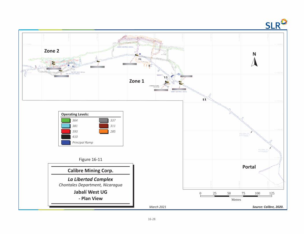
364
Operating Levels:
393
381
410
Principal Ramp
337
285
311
Zone 2
Zone 1
Portal
1 -26 8
March 2021 Source: Calibre, 2020.
0 25 125
Metres
50 75 100
N
Calibre Mining Corp.
La Libertad Complex
Jabalí West UG- Plan View
Chontales Department, Nicaragua
Figure 16-11

Calibre Mining Corp. | La Libertad Complex, SLR Project No: 233.03320.R0000 NI 43-101 Technical Report - March 30, 2021 16-29
16.2.1.2 Geomechanics and Ground Support
Typical Veins
As indicated in Table 16-11, ground conditions at Jabalí West UG are generally at least fair and often fair to good. A geomechanical assessment conducted by DCR Ingenieros S.R. Ltda. (DCR) estimated that 74% of the rock mass would have an RMR76 of between 40 and 70, while 26% would be less than 40 (DCR, 2009). The presence of a two to three metre thick silicification zone adjacent to the contacts may contribute to the hanging wall's strength. A 15 m to 20 m thick zone of argillation with lower rock quality occurs beyond the silica alteration.
In SLR’s opinion, the Avoca mining method is a reasonable approach for mining the typical veins at the Jabalí West UG. Drilling and blasting procedures should take the silicification zone into account and avoid overbreaking into or otherwise disturbing the hanging wall.
Table 16-11: Geotechnical Characteristics Calibre Mining Corp. – La Libertad Complex
Unit RMR76 Rock Class UCS (MPa)
Hanging Wall 45-65 Fair or Fair to good 80
Hanging Wall Intermediate 45 Fair 40
Ore Zone 45-68 Fair or Fair to good 50
Footwall 65-75 Good 80
Footwall Intermediate 44 - 52 Fair 50
Source: DCR
The advantages of Avoca compared to other mining methods such as sublevel open stoping are as follows:
• Backfilling is part of the mining cycle, minimizing the extent of the unfilled stope opening, which is advantageous from a geotechnical perspective.
• No infrastructure is required for backfilling, as is the case with hydraulic backfill and paste-fill. • Rockfill is readily available from mine development and open pit waste dumps.
Wide Veins
In its geomechanical assessment, DCR recommended avoiding 13 m widths. Avoca is a longitudinal mining method suitable for narrow veins, generally less than 10 m wide. Another method, such as transverse sublevel open stoping, should be used for mining wider veins. With this method, the vein can be mined with 10 m to 15 m wide stopes extending between footwall and hanging wall.
Mining Under Historical Workings
Parts of Jabalí West UG were mined decades ago, so the mine design must take historical workings and stopes into account. The veins were likely mined by shrinkage or stull stoping and consequently were left empty (i.e., no backfill) and so the old stopes now likely contain caved material, mud, and water.
In SLR’s opinion, it is not worth attempting to backfill these historical workings. The best approach is to leave them undisturbed. The main risk they pose to present mining operations is not from geotechnical concerns but rather the mud and water they contain. Any breakthrough to these voids could produce a

Calibre Mining Corp. | La Libertad Complex, SLR Project No: 233.03320.R0000 NI 43-101 Technical Report - March 30, 2021 16-30
sudden inflow of water or a mudrush. Probe drilling will be required to determine their positions and dimensions. Measures should be implemented to drain out the mud and water they likely contain.
The topmost interval of a vein extending beneath an old stope should be mined as a longhole stope drilled with upholes from the final Avoca overcut. These holes can be up to 25 m long if the vein's profile is reasonably regular. A slot raise must be driven at one end of the stope to initiate longhole blasting. Following each blast, the broken ore is mucked out with a load haul dump (LHD) operated by remote control. The stope is left unfilled and, beyond the brow, is strictly non-entry to personnel. Unlike Avoca, there is no waste pile to contain the broken ore, so the blasts should be designed to minimize how far the muck is thrown.
A sill pillar must be left separating the longhole stope from the bottom of the historical workings. It serves as a safety barrier to prevent the debris, mud, and water from entering the longhole stope. It also provides geotechnical support, which is needed because neither the longhole stope nor the old one is backfilled. The geotechnical department will determine the thickness of the sill pillar, however, as a rule of thumb, it should be at least double the vein width.
Mining Adjacent to Old Stopes
Mining adjacent to old stopes poses similar risks to mining underneath them. Probe drilling will be required to determine the locations of historical workings. The mud and water they contain should be drained out of them. A pillar must be left to prevent material in the old stope from entering the new one and provide geotechnical support considering that the old one will remain unfilled. The geotechnical department will determine the pillar width, however, it would likely range from 10 m to 15 m.
Crown Pillar
SLR’s geotechnical assessment recommends leaving a 25 m thick crown pillar between the bottom of the open pit and the top of the underground stope excavations. This pillar can be considered a temporary feature if it can be recovered towards the end of the LOM. It may be feasible to mine it as a longhole stope either by drilling downholes from the pit floor or upholes from the final overcut of Avoca mining. The excavation remaining after mining the crown pillar should be backfilled with rockfill.
Backfilling the First Lift
The first lift of a zone mined with Avoca should be backfilled with cemented rockfill if the vein extends to greater depths. This procedure allows mining of ore in the next-lower block without leaving a substantial sill pillar, as would be the case if the lift were filled with unconsolidated material. The interval of ore beneath the first lift can be recovered with a longhole stope with upholes drilled from the final Avoca overcut. To avoid disturbing the cemented rockfill, a skin of ore, e.g., one metre thick, can be left in the back. The mined-out longhole stope is not backfilled.
Ground Support
Table 16-12 summarizes the types of ground support used at Jabalí West UG. The factors determining the type and intensity of support are the excavation’s intended usage time (i.e., permanent or temporary), rock quality, and cross-section. Hydrabolts are used in long term excavations such as ramps, while split sets are installed in temporary ones such as overcuts and undercuts. Requirements range from light bolting and screening in good ground to more intense degrees of support in poor ground, calling for tighter bolting patterns and shotcrete with fibre. In SLR’s opinion, the ground-support standards used at Jabalí West UG are appropriate for the conditions and in accordance with industry standards.

Calibre Mining Corp. | La Libertad Complex, SLR Project No: 233.03320.R0000 NI 43-101 Technical Report - March 30, 2021 16-31
Table 16-12: Ground Support at Jabalí West UG Calibre Mining Corp. – La Libertad Complex
Type Application
Split Sets Used in short term excavations, 2.10 m long, Spacing 1.5 x 1.5 to 1.0 x 1.0 m
Hydrabolts Used in long term excavations, 2.10 m long. Spacing 1.5 x 1.5 to 1.0 x 1.0 m
Wire mesh Installed in about 75% of headings
Shotcrete Applied in areas with poor ground conditions, sometimes with fibre
16.2.1.3 Mining Method
As indicated in Table 16-13, Jabalí West UG uses two mining methods:
• Avoca • Longitudinal Longhole Sublevel Open Stoping (LLSOS)
Approximately 65% of the mine’s production comes from Avoca and the remainder from LLSOS, however, Calibre plans on increasing the use of LLSOS such that it will become the predominant mining method.
Avoca, also known as Longitudinal Retreat Sublevel Stoping, is a bottom-up method meaning that the vein is mined from bottom to top in lifts. It is a retreating method because mining initiates at both ends of the stope and then advances along strike from both sides towards the middle. At the same time that benches retreat, the stope's mined-out part is backfilled with unconsolidated or cemented rockfill.
The benches are drilled with rows of downholes from the overcut drift in the vein. Figures 16-12 and 16-13 show a typical drilling layout for Avoca at Jabalí West UG. Benching is initiated at opposite ends of the stope by blasting into slot raises extending between the undercut and overcut. With successive cycles of drilling, blasting, and mucking, the benches retreat along strike toward the middle of the stope until, with the final blast, the stope is mined out. As the ore is extracted, the stope is progressively backfilled will rockfill such that the waste muck pile advances just behind the retreating bench face. Rockfill used in the Avoca stopes at Jabalí West UG may be either unconsolidated or cemented.
Following a bench blast, an LHD mucks the broken ore in the stope using the undercut as an access route (Figure 16-14). As the LHD operates part of the time in the open stope, some of the mucking requires radio remote control, with the operator positioned safely in the undercut drift behind the brow. When unconsolidated rockfill is used, the operator has to minimize mucking the backfill on the undercut floor and from the rock pile along with the ore. The LHD transports the ore out of the stope via the central crosscut. It either dumps the ore in a muck bay or loads it onto a mine truck.
With the Avoca method, backfilling is an integral part of the mining cycle and frequently can be carried out in parallel with other activities such as longhole drilling. Once the blasted ore is mucked out, the stope is backfilled by advancing the pile of rockfill toward the bench, filling the void created by mining it (Figure 16-15). An LHD delivers the rockfill to the stope by entering via one of the upper-sublevel crosscuts at the stope’s ends. It travels over the previously deposited rockfill and dumps its load over the edge of the advancing rock pile.
The pile is advanced enough to leave a gap between it and the bench, providing a void for the next blast. When blasted, the broken ore impacts against rock pile, rather than scattering about an open stope. After

Calibre Mining Corp. | La Libertad Complex, SLR Project No: 233.03320.R0000 NI 43-101 Technical Report - March 30, 2021 16-32
it is completely backfilled, the stope’s upper sublevel serves as the undercut for the next higher-up stope in the bottom-up sequence (Figures 16-16 and 16-17).
The mine may occasionally use a version of Avoca referred to as Modified Avoca. With this approach, the LHD or mine truck delivers the rockfill to the stope via its upper-sublevel crosscut in the middle of the stope rather than the crosscuts at the stope's opposite ends. The LHD or mine truck travels through the overcut and dumps the rockfill starting at the edge of the bench. With this version, the stope opening in front of the bench ends up completely filled without leaving a gap. Before blasting, an LHD must muck out a portion of the recently dumped rockfill from the undercut to open up a void. The main advantage of Modified Avoca compared with the standard approach is that it saves on developing a footwall drive. Its drawbacks are that production drilling cannot be carried out in parallel with backfilling on the same side of the stope, and extra rockfill handling is required to create the void.
In the LLSOS method the vein is dividing into sublevels and the lifts between sublevels into stopes. The vein is mined in lifts with a bottom-up sequence. The stopes at Jabalí West UG are mined in series, one next to the other. The principal means of access to the stopes are the overcut and undercut drifts, although they generally have independent access via crosscuts extending from the footwall drive.
The longholes are drilled as downholes from the overcut drift. Longhole blasting is initiated by blasting into a slot raise, which extends between the undercut and overcut. An LHD mucks the broken ore, using the undercut for access. It operates most of the time inside the open stope. During that time, mucking is done by radio remote control, with the operator positioned at a safe location in the undercut drift behind the brow. The LHD transports the broken ore out of the stope and either dumps it in a muck bay or loads it into a mine truck.
Once mined out, the stope is backfilled with cemented rockfill. The cemented rockfill is prepared underground with an LHD and deliver by LHD or truck to the stope, entering via the overcut drift or an upper sublevel crosscut. The cemented rockfill must be allowed sufficient time to cure before the adjacent stope can be mined. Once backfilled, the stope’s overcut serves as the undercut for the next higher-up stope. The method allows flexibility for multilevel mining of the same vein.
Table 16-13: Mining Methods at Jabalí West UG Calibre Mining Corp. – La Libertad Complex
Production
Mining method Avoca: Longitudinal Retreat Sublevel Stoping with continuous
backfilling
Longitudinal Longhole Sublevel Open Stoping
Direction of stope sequencing Bottom-up Bottom-up Longhole drilling direction Downholes drilled from overcut Downholes drilled from overcut Sublevel interval 14-28 m 14-28 m Stope Height 18-32 m 18-32 m Stope length along strike No specific limit to stope length 20 m Minimum mining width 3 m 3 m

Calibre Mining Corp. | La Libertad Complex, SLR Project No: 233.03320.R0000 NI 43-101 Technical Report - March 30, 2021 16-33
Timing of backfilling Backfilling is integral part of the
mining cycle Backfilling is integral part of the
mining cycle
Backfill type Both cemented and unconsolidated
rockfill used Cemented rockfill containing 3 to
5% cement
Maximum backfill gap 15 m n/a Minimum backfill gap 3 to 5 m n/a Stope access for backfill delivery Via crosscuts at opposite ends of
the stope Via overcut drift
Backfill source Mainly development waste,
occasionally open-pit waste dump Mainly development waste,
occasionally open-pit waste dump
Development
Ramp 4.0 x 4.5 m, 12% grade 4.0 x 4.5 m, 12% grade Footwall drive 4.0 x 4.0 m 4.0 x 4.0 m Crosscuts 4.0 x 4.0 m 4.0 x 4.0 m
Crosscut spacing Minimum 3 One for each stope Ore drives 4.0 x 4.0 m 4.0 x 4.0 m Raises 2.0 x 2.0 m 2.0 x 2.0 m

Calibre Mining Corp. | La Libertad Complex, SLR Project No: 233.03320.R0000 NI 43-101 Technical Report - March 30, 2021 16-34
Figure 16-12: Avoca Drilling Layout - Section

Calibre Mining Corp. | La Libertad Complex, SLR Project No: 233.03320.R0000 NI 43-101 Technical Report - March 30, 2021 16-35
Figure 16-13: Avoca Typical Drilling layout - Plan

Calibre Mining Corp. | La Libertad Complex, SLR Project No: 233.03320.R0000 NI 43-101 Technical Report - March 30, 2021 16-36
Figure 16-14: Avoca Method – Mucking Ore
Figure 16-15: Avoca Method – Backfilling
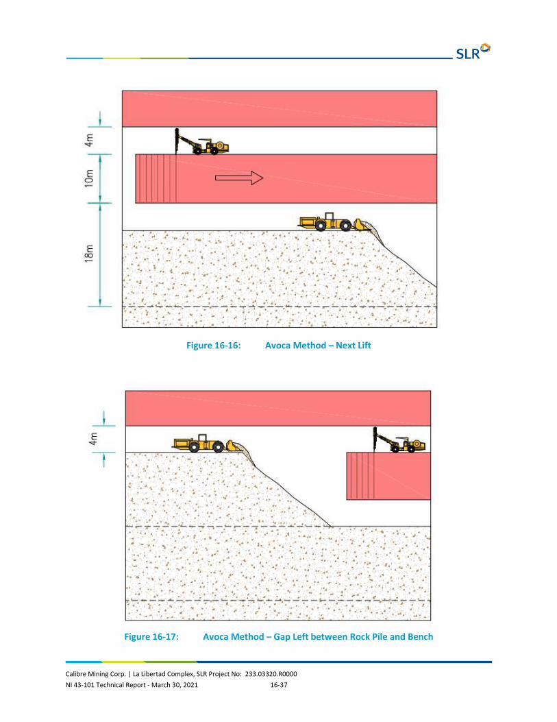
Calibre Mining Corp. | La Libertad Complex, SLR Project No: 233.03320.R0000 NI 43-101 Technical Report - March 30, 2021 16-37
Figure 16-16: Avoca Method – Next Lift
Figure 16-17: Avoca Method – Gap Left between Rock Pile and Bench

Calibre Mining Corp. | La Libertad Complex, SLR Project No: 233.03320.R0000 NI 43-101 Technical Report - March 30, 2021 16-38
16.2.1.4 Infrastructure and Mine Services
Table 16-14 provides a summary of Jabalí West UG’s infrastructure and mine services.
Table 16-14: Jabalí West UG Infrastructure and Mine Services Calibre Mining Corp. – La Libertad Complex
Refuge Station • 1 ea. Refuge station equipped for mine rescue
Dewatering System • 1 ea. x pumping stations with 2 ea. Stationary pumps (350 hp ea.) • 1 ea. x sump with submersible pumps, one 58 hp and the other 140 hp • 3 ea. sump with 3 ea. x 58-hp submersible pumps.
Ventilation System • 1 ea. x 250-hp ABC ventilation fan installed at the base of a ventilation raise extending to surface. • 1 ea. x 100-hp high-pressure ventilation fan • 2 ea. X 115-hp high-pressure Airtec ventilation fan • 1 ea. X high-pressure Airtec ventilation fan • 1 ea. x ABC 100-hp low-pressure ventilation fan • 1 ea. x 88-hp high-pressure Zitron ventilation fan • 1 ea. 100-hp high-pressure Zitron ventilation fan • 30" Ø to 42" Ø ventilation tubing • 36" Ø oval ventilation tubing
Electric Power System
• 2 ea. x 500 KVA electric substations
• 2 ea. 1,000 KVA substation
Compressed Air
• 1 ea. Compressor station located underground
with 2 ea. x Kaiser compressors (c/u 120 PSI, 350 CFM, 85 hp)
Pipe
• Water line 2" Ø HDPE

Calibre Mining Corp. | La Libertad Complex, SLR Project No: 233.03320.R0000 NI 43-101 Technical Report - March 30, 2021 16-39
• Dewatering line 6" Ø HDPE
• Compressed air 4" Ø HDPE
Explosives Storage
• Powder magazine
• Cap magazine
Both located in the main ramp a short distance inside the portal
The main ventilation system draws fresh air down the main ramp and expels spent air via an Alimak Raise that extends to surface. The power of the main ventilation fan situated at the base of this raise is 250 hp and has a capacity of 210,000 cfm of air. Other ventilation fans in Jabalí West UG either move air to different levels or are connected to ventilation ducting to distribute air in developments and stopes. Figures 16-18 and 16-19 illustrate the Jabalí West UG ventilation system with plan and longitudinal views, respectively.
Jabalí West UG has one main pump station, which is equipped with two 350 hp stationary pumps. The dewatering system also has three sumps equipped with submersible pumps. The mine has a compressor station underground equipped with two 350 cfm compressors. Jabalí West UG’s electric-power system includes four electrical substations, two of which are 1,000 KVA, and the others 500 KVA. Powder and cap magazines are located in the main ramp near the portal.
Jabalí West UG uses high density polyethylene (HDPE) pipe. The pipe sizes are 3” diameter for water, 6” and 8” diameter for dewatering, and 4” diameter for compressed air.

1 -6 40
March 2021 Source: Calibre, 2020.
Not to Scale
0 40 200
Metres
80 120 160
N
Fresh Air
Legend:
Stale Air
1 Oval Drift 18x36’
and 2 Circular Dirfts
High Pressure
Ventilator
at 30,000 cfm /
High Pressure
Ventilator
at 50,00 cfm
High Pressure
Ventilator
at 30,000 cfm /
High Pressure
Ventilator
at 50,00 cfm
250 HP Extractor
at 21,00 cfm
Capacity
Calibre Mining Corp.
La Libertad Complex
Jabalí G VentilationWest USystem – Plan View
Chontales Department, Nicaragua
Figure 16-18

Not to Scale
Fresh Air
Legend:
Stale Air
Looking North
1 -6 41
March 2021 Source: K&M, 2018.
Calibre Mining Corp.
La Libertad Complex
Jabalí West UG VentilationLongitudinalSystem – Section
Chontales Department, Nicaragua
Ventilator
at 30 kcfm
Extractor Fan
at 210 kcfm
Ventilation Raise
2.0 m x 2.0m
Figure 16-19

Calibre Mining Corp. | La Libertad Complex, SLR Project No: 233.03320.R0000 NI 43-101 Technical Report - March 30, 2021 16-42
16.2.1.5 Mine Equipment
Table 16-15 lists the mobile mining equipment currently operating at Jabalí West UG. The production drill rigs belong to the mining contractor Canchanya Ingenieros SR Ltda. LHD #2 is equipped for remote control operation, while LHD #1 and mine truck #02 are used for backfilling. The Carmix concrete mixer is a self-loading unit that can prepare concrete from cement, aggregate, and water at any location.
Table 16-15: Jabalí West UG Mobile Equipment Calibre Mining Corp. – La Libertad Complex
Equipment Type Make Model Year Calibre Contractor
Rockbolting Jumbo #1 Resemin Bolter 88 2016 1
Rockbolting Jumbo #2 Resemin Bolter 99 2019 1
Jumbo #1 Sandvik DD311 2015 1
Jumbo #2 Sandvik DD311 2015 1
LHD #3 Caterpillar R1600H 2014 1
LHD #2 Caterpillar R1600G 2013 1
LHD #1 Caterpillar R1300G 2010 1
Mine Truck #2 Atlas Copco MT2010 2008 1
Mine Truck #1 Atlas Copco MT420B 2008 1
Mobile Concrete Mixer Carmix 3.5 TT 2017 1
Robot Shotcrete Putzmeister
2016 1
Backhoe Case 580N 2017 1
Telehandler # 1 Dieci ICARUS 40.17 2018 1
Telehandler # 2 Dieci ICARUS 40.17 2018 1
Dump Truck #1 Volvo 310 2019 1
Dump Truck #2 Volvo 440 2018 1
Dump Truck #3 Volvo 440 2018 1
Long. Hole Drilling Recefer Nautilius DSB-16 2018 1
Production Drill Rig Sandvik DU 311-TK 2018 1
ITH Track Drill Cubex 1
16.2.1.6 Personnel
Table 16-16 lists the personnel that work at Jabalí West UG.

Calibre Mining Corp. | La Libertad Complex, SLR Project No: 233.03320.R0000 NI 43-101 Technical Report - March 30, 2021 16-43
Table 16-16: Personnel at Jabalí West UG Calibre Mining Corp. – La Libertad Complex
Area Calibre Contractors Shifts
Administration Mine
}
• Management 2 2 Calibre rotation 5 days on / 2 days off
• Technical Services 8 6 Contractor rotation 45/15 and 20/10
• Other 1 12
Subtotal 11 20
Jabalí W UG
• Supervision 4 14
}
• Mine 69 Calibre rotation 5 days on / 2 days off
• Maintenance 10 24 Contractor rotation 45/15 and 20/10
• Other 1
Subtotal 15 107
Total 26 127
16.2.1.7 Mine Safety and Communications
Jabalí West UG has a fixed mine rescue refuge station on the 378 level and two portable ones. Each of these is designed to accommodate 20 occupants for 48 hours. Figure 16-20 shows one of the portable refuge stations that are set up underground. Calibre plans on establishing a second fixed refuge station in the mine during 2021.
The mine has two ladderway equipped raises that extend to the surface. These raises provide two means of emergency egress from the mine besides the main ramp. Figure 16-21 shows the locations of refuge stations and emergency egresses.
La Libertad Complex has an emergency rescue squad with 23 members. During an emergency, the squad forms teams of five or six participants each. The mine rescue equipment available at the site includes six autonomous open-circuit respirators rated for 45 minutes of use and six Dräger BG-4 Plus self-contained breathing apparatus rated for four hours (Figure 16-22). La Libertad Complex has three ambulances and a fire truck.
Jabalí West UG does not presently have a communications system, however, Calibre plans to install telephones or a radio system in the underground mine in the second quarter of 2021. The mine has stench-gas and an audible alarm system to warn personnel of emergency situations.
SLR recommends that Calibre consider installing a private 4G-LTE cellular network at La Libertad Complex to provide mobile communications and data transfer for the entire site, including Jabalí West UG and future underground operations. This type of system has proven to be effective and economical at other underground mines. It is efficient for underground installations as the signal is not limited to line-of-site transmission as is the case with WiFi access points and leaky-feeder coaxial cables.

Calibre Mining Corp. | La Libertad Complex, SLR Project No: 233.03320.R0000 NI 43-101 Technical Report - March 30, 2021 16-44
Figure 16-20: Portable Mine-Rescue Refuge Station at Jabalí West UG

0 100 500
Metres
200 300 400
1 -6 45
March 2021 Source: Calibre, 2020.
Calibre Mining Corp.
La Libertad Complex
Refuge Stations and EmergencyEgresses at Jabalí West UG
Chontales Department, Nicaragua
Figure 16-21
N
Evacuation Route
Legend:
Refuge Station

Calibre Mining Corp. | La Libertad Complex, SLR Project No: 233.03320.R0000 NI 43-101 Technical Report - March 30, 2021 16-46
Figure 16-22: Dräger PSS® BG 4 Plus Closed-Circuit Breathing Apparatus
16.2.1.8 Life of Mine Plan
Tables 16-18 and 16-19 present the development and production LOM schedules for Jabalí West UG. The LOM plan calls for mining its four zones, which are numbered from 1 to 4, going from east to west.
The largest of these is Zone 1, which is situated at the east end of the deposit. It will be the principal source of ore during the mine life. Production at the zone will commence following the development of a spiral ramp from the existing main ramp. Mining the zone will require extending the development to the 240 level.
Zones 2 and 3 are considerably smaller than Zone 1. They lie directly beneath the Jabalí Antena open pit and are extensions of the same mineralization being mined in it. Zone 3 will be the first to produce ore as it requires only minimal development. Accessing Zone 2 requires developing a short ramp, however, production will start during 2021.
Zone 4, at the deposit's far west side, is the smallest of the four zones. Accessing it will require developing a 250 m long ramp, which will begin production in Q2 2021. From there, spiral ramps will be developed both upwards and downwards to access the sublevels. Zone 4 will begin producing ore in Q1 2022.
The LOM plan is based on the design parameters listed in Table 16-17. The plan is based on the use of the Avoca method in all zones. Jabalí West UG has sufficient Mineral Reserves to support production through to Q1 2023.

Calibre Mining Corp. | La Libertad Complex, SLR Project No: 233.03320.R0000 NI 43-101 Technical Report - March 30, 2021 16-47
Table 16-17: Jabalí West UG Design Parameters Calibre Mining Corp. – La Libertad Complex
Parameter LOM Plan
Ore Production
• Mining method Avoca
• Sublevel interval 16 - 20 m
• Stope height 20 - 24 m
• Minimum mining width 1.5 m
• Maximum stope width 10 m
• Stope length 10 m
• Stope cut-off grade 3.05 g/t Au
• Incremental cut-off grade 1.92 g/t Au
• Dilution 0.6 FW / 0.6 m HW
• Extraction 95%
• Pilar dimensions 5 m
• Backfill Rockfill
Development
• Ramps 4.0 x 4.5 m, 12% grade
• Ramp radius 12 m
• Ramps - advance rate 3.5 m/day/face
• Footwall drifts 4.0 x 4.0 m
• Footwall drifts - advance rate 3.5 m/day/face
• Ore drifts 4.0 x 4.0 m
• Ore drifts - advance rate 3.5 m/day/face
• Crosscuts 4.0 x 4.0 m
• Crosscuts - advance rate 3.5 m/day/face
• Raises 2.0 m diameter
• Raises - advance rate 3.5 m/day

Calibre Mining Corp. | La Libertad Complex, SLR Project No: 233.03320.R0000 NI 43-101 Technical Report - March 30, 2021 16-48
Table 16-18: Life of Mine Plan – Jabalí West UG Development Calibre Mining Corp. – La Libertad Complex
Units Total 2021 2022 2023
Operating lateral development m 2,546 2,544 3 -
Capital ramp and lateral development m 3,941 3,941 - -
Vertical development m 273 273 - -
Table 16-19: Life of Mine Plan – Jabalí West UG Production Calibre Mining Corp. – La Libertad Complex
Units Total 2021 2022 2023
Tonnage 000 t 477 210 241 26
Au grade g/t 3.92 4.47 3.56 2.84

Calibre Mining Corp. | La Libertad Complex, SLR Project No: 233.03320.R0000 NI 43-101 Technical Report - March 30, 2021 17-1
17.0 RECOVERY METHODS The La Libertad processing plant is a conventional processing plant consisting of comminution, agitated cyanide leaching, and carbon adsorption, followed by carbon elution, electrowinning, and doré production. La Libertad processing plant can treat approximately 2.25 Mtpa and current gold recoveries are approximately 92% to 95%. Figure 17-1 summarizes the annual throughput and gold recovery from 2010 to the first quarter of 2020.
Figure 17-1: Processing Plant Throughput and Recovery
La Libertad processing plant processes a combination of ore from open pit and underground mines in addition to reclaimed material from the historical heap leach operations. Historical operations at La Libertad consisted of heap leaching (on-off heap leach pads) from 1994 to 1996 and from 2001 to 2007. During the heap leach operations, material from the heap leach pads was deposited between the location of the current La Libertad processing plant and the current tailings storage facility (La Esperanza tailings storage facilities (TSF)). SLR notes that this disposal site is not lined. Reclamation and re-treatment of material currently makes up approximately two thirds of the feed to the La Libertad processing plant. There are reportedly approximately 3.0 Mt of material remaining. Reclamation of the material allows for both the recovery of residual gold and the disposal of the subsequent waste material in a lined TSF.
Ore from the Pavón deposit will be blended with other feed sources at the La Libertad processing plant. Metallurgical test work has been performed on samples for the Pavón Norte deposit. Pavón Norte and Pavón Central are hosted by the same geological structures and are expected to have similar metallurgical performances.
2010 2011 2012 2013 2014 2015 2016 2017 2018 2019 2020 2021Jan-Feb
Ore Processed 1,566,122 1,992,264 2,041,415 2,014,838 2,190,937 2,307,921 2,277,795 2,161,917 2,250,688 2,139,104 1,301,076 192,929
Gold Recovery 87.1 91.0 92.5 93.8 94.3 94.2 95.0 93.8 94.4 95.5 92.9 92.2
40.0
50.0
60.0
70.0
80.0
90.0
100.0
0
500,000
1,000,000
1,500,000
2,000,000
2,500,000
3,000,000
Rec
over
y (%
)
Ann
ual T
hrou
ghpu
t (t)

Calibre Mining Corp. | La Libertad Complex, SLR Project No: 233.03320.R0000 NI 43-101 Technical Report - March 30, 2021 17-2
17.1 Process Description La Libertad processing plant consists of the following unit operations:
• Single-stage crushing with two jaw crushers capable of processing approximately 400 tonnes per hour (tph) and 200 tph, one utilized for ROM ore and the other for reclaimed material from the leach pads, followed by a crushed ore stockpile.
• Two-stage grinding to P70 75 µm utilizing a conventional semi-autogenous grinding (SAG) circuit followed by ball milling and pebble crushing (SABC). The grinding circuit consists of one SAG mill followed by two ball mills operating in parallel and an integrated pebble crushing circuit. The SAG and ball mills are 20 ft x 9 ft and 13 ft x 20 ft, respectively, each with a 1,680 kW motor.
• Pre-leach thickening to 45% solids, is followed by leaching in 11 leach tanks (4 x 1,500 m3 and 7 x 570 m3) with oxygen addition for a total of 32 hours residence time. Carbon adsorption is carried out in six 550 m3 CIP tanks.
• Tailings disposal occurs by pumping tailings to the lined La Esperanza TSF. SLR notes that the L Esperanza TSF reportedly has remaining capacity for the disposal of current processing plant tailings until August 2021. Studies have been conducted for disposal of tailings to one of the spent open pits (approximately 3.5 years capacity). The new La Libertad TSF is permitted with construction starting in March 2021. The new facility will be operational by August 2021.
• Stripping of loaded carbon occurs using a pressure Zadra stripping process, in either of two carbon stripping columns with a combined capacity for two stripping campaigns, or 12 tpd of carbon, with stripped carbon returned to the adsorption circuit after regeneration in a gas-fired kiln.
• Gold recovery from the pregnant elution solution by electrowinning, with the precipitate being smelted in a liquefied petroleum gas (LPG) fired furnace to produce doré bars typically containing up to 55% silver, depending on the source of ore. Doré is sent to the US for refining.
• Tailings return water for use as process water. Cyanide destruction is deemed not necessary due to the low levels of cyanide in the water.
• Energy, water, and process material specific consumptions are not anticipated to change materially over the remainder of the LOM.
The La Libertad process flow sheet is presented in Figure 17-2.

17-3
March 2021 Source: B2Gold, 2019.
La Libertad Process Flow heetS
Chontales Department, Nicaragua
La Libertad Complex
Calibre Mining Corp.
Figure 17-2

Calibre Mining Corp. | La Libertad Complex, SLR Project No: 233.03320.R0000 NI 43-101 Technical Report - March 30, 2021 17-4
17.2 Current Operations La Libertad processing plant processes a combination of mill feed from open pit and underground mines and reclaimed spent heap leach material (spent heap material) from the historical heap leach operations.
Figure 17-3 presents the monthly La Libertad plant production and gold and silver recoveries for 2020. Figure 17-3 presents the downtime incurred in April and May due to COVID-19 and the recovery to full production in June and July. La Libertad plant processed an average 126,000 tonnes per month and gold recovery averaged 92.3% during the last seven months of 2020 following the two-month plant shutdown. The decrease in tonnage and recovery from historical averages is due to changes in mill feed materials. Gold recovery was steady with an average of 92.3% during the last seven months of 2020.
Figure 17-3: Monthly La Libertad Mill Production for 2020
Figure 17-4 presents the monthly processing operating costs for 2020. Unit operating costs have varied between US$12/t and US$20/t over the period, with the average operating cost for 2020 being US$16.26/t. The most significant processing costs are grinding media, crusher and grinding mill liners, wear materials, and power. The ore is very hard and abrasive.
Jan Feb Mar Apr May Jun Jul Aug Sep Oct Nov Dec
Mill Production, t 133,573 129,557 130,484 0 21,583 124,695 133,149 123,989 122,927 130,436 122,417 128,266
Gold Recovery, % 95.60% 93.00% 94.26% 0.00% 94.40% 91.47% 92.59% 93.69% 92.53% 92.45% 91.16% 92.10%
Silver Recovery, % 44.00% 48.00% 51.00% 0.00% 0.00% 38.00% 45.00% 52.00% 59.00% 52.00% 52.00% 52.00%
0.00%
20.00%
40.00%
60.00%
80.00%
100.00%
120.00%
0
20,000
40,000
60,000
80,000
100,000
120,000
140,000
160,000
2020 Mill Prodution, Au Recovery and Ag Recovery

Calibre Mining Corp. | La Libertad Complex, SLR Project No: 233.03320.R0000 NI 43-101 Technical Report - March 30, 2021 17-5
Figure 17-4: Monthly La Libertad Process Operating Costs for 2020
Jan Feb Mar Apr May Jun Jul Aug Sep Oct Nov DecProcess Operating Cost $11.87 $11.29 $13.68 $0.00 $12.05 $11.34 $11.34 $14.05 $16.25 $12.65 $11.94 $11.77
Process Maintenance Cost $3.34 $3.58 $4.48 $0.00 $0.00 $2.91 $3.08 $4.34 $3.85 $4.26 $3.53 $3.72
Total Process Cost 15.20 14.87 18.17 0.00 12.05 14.26 14.42 18.39 20.10 16.91 15.47 15.49
$0.00
$5.00
$10.00
$15.00
$20.00
$25.00
Proc
ess C
ost,
US$
/t2020 Mill Feed Grades and Process Operating Cost

Calibre Mining Corp. | La Libertad Complex, SLR Project No: 233.03320.R0000 NI 43-101 Technical Report - March 30, 2021 18-1
18.0 PROJECT INFRASTRUCTURE
18.1 La Libertad La Libertad operation has all required infrastructure necessary for a mining complex including:
• One surface mine: Jabalí Antena and one underground mine: Jabalí West UG.
• A conventional processing plant with comminution, agitated cyanide leaching, and carbon adsorption, followed by carbon elution, electrowinning, and doré production, with a current nominal capacity of 2.25 Mtpa.
• Mine and mill infrastructure including warehouses, administration buildings, dry facilities, and maintenance shops.
• Electrical power from the national grid system. There are high voltage power lines that provide power to Santo Domingo, however, the power supply can be limited. Service to the mine is via a dedicated 138 kVA line which is fed from a substation near Juigalpa. The existing transformer has a capacity of 20 MW, and current mine consumption is 7.5 MW.
• An adequate water supply exists at the Project for year-round operation. Process water for the ADR plant comes predominantly from the tailings sub-drain (250 gpm) and from the sub-drain of the backfilled Crimea Pit (waste dump #7), which is potable (300 gpm). Supplemental process water is available from the Paslama River (up to 900 gpm).
• Mine ventilation fans and ventilation systems. • Haulage roads from the mines to the plant. • Stockpile areas. • Maintenance facilities. • Administrative office facilities. • Core storage and exploration offices. • Security gates and manned security posts at mine entries. • Access road network connecting the mine infrastructure to the town site and to public roads.
A site plan for La Libertad Complex is shown in Figure 18-1. A site plan for La Libertad site is shown in Figure 18-2.
18.1.1 La Esperanza Tailings Storage Facility
A conventional TSF (La Esperanza) is located near and just below the plant and office area. The TSF was constructed when the project shifted from a heap leach to a CIP plant in 2008. The TSF design includes a basal liner and uses primarily the downstream construction method for raising the dam. A portion of the Stage 6 TSF embankment was constructed with a reinforced vertical upstream face. The original permit has been modified twice to raise the impoundment in 2014 and 2015 (Stage 6). SLR understands that Stage 7 with crest elevation 510 m was designed by Tierra Group International (Tierra Group) and it was recently constructed (Figure 18-3). The Tierra Group are the current Engineer of Record (EOR) for the facility. The 2020 annual TSF monitoring report by Tierra Group (2021) indicates satisfactory performance of the TSF in line with the design intent, including negligible deformation noted as a result of a January 2020 Magnitude 5.5 earthquake with epicenter 130 km from the site. La Esperanza TSF had remaining capacity for 2 Mt of additional tailings as of October 2020 (Tierra Group, 2021). In addition, the deposition

Calibre Mining Corp. | La Libertad Complex, SLR Project No: 233.03320.R0000 NI 43-101 Technical Report - March 30, 2021 18-2
of tailings in the mined-out Crimea Pit was permitted for the remaining LOM or approximately 5.5 Mt. Tierra Group (2017b) identified several options including a partial liner or recovery wells to inhibit seepage from the potentially acid generating tailings. As of the effective date of the report, there is remaining operating capacity planned for 4.7 Mt, sufficient to complete the current LOM plan. SLR relies on the designs of Tierra Group (2018) for La Esperanza Tailings Storage Facility – Stage 7 Design and provides no conclusions or opinions regarding the stability of the listed dams and impoundments. No inspection reports, audits, or dam safety reviews were available to SLR for the La Esperanza TSF.

La Libertad City
0 1 5
Kilometres
2 3 4
18-3
March 2021 Source: Calibre, 2019.
N
La Libertad Site PlanChontales Department, Nicaragua
La Libertad Complex
Calibre Mining Corp.
Figure 18-1

LA ESPERANZA TSF
SPENTORE
STOCKPILE
WASTEROCK
DUMP 11
WASTEROCK
DUMP 7
WASTEROCK
DUMP 6
WASTE ROCK DUMP 5
MOJON PIT LOS ANGELES PIT
N 1,350,000
N 1,351,500
N 1,353,000
N 1,354,500
E 6
91,5
00
E 6
93,0
00
E 6
94,5
00
E 6
96,0
00
E 6
97,5
00
E 6
99,0
00
E 7
00,5
00
WASTE ROCKDUMP 14
WASTE ROCK DUMP 13
EL TOPE PIT
SANJUANPIT
SANTAMARIA
PIT
CRIMEAPIT
Legend:
0 200 1000
Metres
400 600 800
PIT LIMITS
WASTE ROCK DUMP LIMITS
SPENT ORE LIMITS
STREAMS
DIVERSION CHANNELS
PROPERTY BOUNDARY
N
Calibre Mining Corp.
La Libertad Complex
La Libertad Site Layout
Chontales Department, Nicaragua
Figure 18-2
18-4
March 2021 Source: Knight Piésold and Co., 2018.

N
0 25 125
Metres
50 75 100
Calibre Mining Corp.
La Libertad Complex
La Esperanza TSF Stage 7 Arrangement
Chontales Department, Nicaragua
Figure 18-3
18-5
March 2021 Source: Tierra Group International , 2018.

Calibre Mining Corp. | La Libertad Complex, SLR Project No: 233.03320.R0000 NI 43-101 Technical Report - March 30, 2021 18-6
18.2 Pavón Pavón Norte will commence production in 2021 as a Calibre in-house mining operation, with Pavón Central production following in 2023. The school near the Pavón Norte site was relocated due to proximity with the proposed mining activities. Pavón Norte has a mine access road with the mine support infrastructure (i.e.., explosive magazine, fuel station, etc.) at strategic locations placed alongside the road.
Pavón Central’s main capital expense is the relocation of National Highway 5 and the ENATREL High Voltage lines. Pavón Central will utilize the existing and developed infrastructure of the Pavón Norte Project.
18.2.1 Site Infrastructure Overview
The Pavón project will utilize the same supporting infrastructure for both the Pavón Norte and Pavón Central areas. Figure 18-4 shows the supporting infrastructure for the Pavón site illustrated in the blue highlighted areas. This figure illustrates the site infrastructure upon completion of the Pavón Norte Mine Access Road and relocation of the local school.
The main supporting infrastructure for the Pavón Project includes:
• Camp and Offices; • Explosive Magazine; • Fuel Station; • Truck Shop/Maintenance Shop; • Warehouse; and
• Cap Magazines are located on site at the mine sites
Pavón Central requires relocation/realignment of National Road 5 and the ENATREL High Voltage lines. The completion for the construction of these items is December 2022. Pavón Central ore production is scheduled for March 2023. Figures 18-5 and 18-6 show the proposed site layout for Pavón Norte and Pavón Central, respectively.

18-7
March 2021 Source: S. , 2021.Ghouralal
0 100 500
Metres
200 300 400
N
Calibre Mining Corp.
La Libertad Complex
Pavón Norte and Central Sites
Chontales Department, Nicaragua
Figure 18-4

18-8
March 2021 Source: S. , 2021.Ghouralal
Legend:
0 50 250
Metres
100 150 200
N
Calibre Mining Corp.
La Libertad Complex
Pavón Norte Site Layout
Chontales Department, Nicaragua
Figure 18-5

NLegend:
0 50 250
Metres
100 150 200
Calibre Mining Corp.
La Libertad Complex
Pavón Central Site Layout
Chontales Department, Nicaragua
Figure 18-6
18-9
March 2021 Source: S. , 2021.Ghouralal

Calibre Mining Corp. | La Libertad Complex, SLR Project No: 233.03320.R0000 NI 43-101 Technical Report - March 30, 2021 18-10
18.2.1.1 Camp and Offices
The Pavón camp and offices serves for both Pavón Norte and Pavón Central mining operations and is located between the both the mining operations locations. The camp comprises a security gate, parking, on-site warehouse, offices, core shack, dining room and living area and four houses with eight bedroom each. The total area is 1,790 m2. The site’s utilities are a water treatment system sized for 50 people, the water treatment provides potable water on site, 10,000-liter water tank, metal tower, drilled well and pumping system, 60 kVA generator and mesh perimeter fence.
18.2.1.2 Explosives Magazine
The Explosive magazine is a secure building constructed to mix and store explosives. The explosive magazine is between both sites. The explosive magazine will service Pavón Norte and Pavón Central mining operations providing explosives and accessories to the sites.
18.2.1.3 Fuel Station
The fuel station will service the mine fleet and contractor fleet. The fuel station is located between Pavón Norte and Pavón Central. The fuel station will have electronic fuel tracking, dispensing pumps, fuel tanks, and associated piping.
18.2.1.4 Truck Shop/Maintenance Shop
The truck shop/maintenance shop building is located south of the fuel station. The truck shop also has a truck wash. The facilities have a drinking water system, wastewater treatment system. The building has a 3,000 psi reinforced concrete foundation. The building will be used to maintain the 40 tonnes haul trucks, the highway lorry trucks and for storage and maintenance services for site equipment.
18.2.2 Pavón Sites Overview
The Pavón Site is to be developed in two phases. The first phase is the construction of the roads, drainage and diversion structures, dumps, temporary topsoil storage and orepad/stockpile areas. The second phase for Pavón Norte and Central Projects comprises rehabilitating the Saprolite Storage and the Waste Rock Dump by covering with the stored topsoil material. Additionally, Phase 2 also includes the development of the extended north pit, designated as Pavón Norte Phase 2.
18.2.2.1 Roads
Pavón Norte and Pavón Central have the same design concept; the main roads infrastructure is installed and developed in tandem with site drainage. The main roads are:
1. Pit Access Road
2. WRSF/Saprolite Dump Access Road
Pavón Norte also has a south access road to the settling pond, which will also be utilized for construction purposes to build the first two lifts of the Saprolite Dump. This opportunity results in a reduction of road construction costs. Pavón Norte waste rock can be used for building material for Pavón Central roads

Calibre Mining Corp. | La Libertad Complex, SLR Project No: 233.03320.R0000 NI 43-101 Technical Report - March 30, 2021 18-11
18.2.2.2 Power
The Pavón project infrastructure will be powered from a new ENATREL 24.9kV line connected at S/S Waslala located 10 km to the east of the Pavón Project. Pavón mine infrastructure will have back-up generators at each facility. Pavón Central requires the ENATREL 138 kV line to be relocated. ENATREL supplies a 24.9kV line to Pavón Norte that powers the facilities, described in Section 18.2, from the poles along the road. The power is supplied directly from the pole for the project, there are no substations. There are generator backups for the facilities.
18.2.2.3 Water Management
The Pavón sites are planned to have contact and non-contact (i.e., diversion) water management. Based on historical assessments and studies, water contact with rock has been assessed to be non-acid generating Based on historical assessments and studies, water contact with rock has been assessed to be non-acid generating based on the presence of low-sulphidation epithermal veins. It is also recognized, based on background data and studies, that the receiving environment has a high buffering capacity. Considering water management best practices, contact water is required to be contained and passively treated for suspended solids content only.
For both the Norte and Central sites, the contact water is collected in concrete lined collection ditches and the non-contact water realigns existing watercourses with concrete lined diversion ditches.
For the Norte site, the Waste Dump Access Road provides access to construction of the diversion ditch and the collection ditch. There is an existing watercourse to the west of the proposed Waste Rock and Saprolite Dumps. This water course requires realignment and development of a parallel contact water collection ditch with separation. The water from the water course realignment is input into the creek further downstream and the contact water is diverted to a settling pond developed at the toe of the saprolite dump for retention and settlement of suspended solids until water quality objectives are met and then released to the environment.
Pavón Central has four settling ponds, two for the Waste Rock Dump, one for the Saprolite Dump and one for orepad/stockpile, all considering topography and hydrologic divides. There is a diversion ditch to the south of Pavón Central pit as the road needs to be constructed from the waste rock to get to the eastern section of the pit.
The Pavón Norte and Central waste rock dumps, saprolite rock dumps and orepads/stockpiles have an underdrainage system to collect the contact water to report to the collection ditch system.
The ditches and ponds are sized for a five-year 24-hour design storm event, selected by the designer according to the anticipated Pavón Project life of three years.
18.2.2.4 Temporary Topsoil Dump
Pavón Norte and Pavón Central have temporary topsoil dumps. These temporary topsoil dumps are placed in proximity to the WRSF and are used to progressively rehabilitate by layering the topsoil on the saprolite dump and the WRSF slopes as the lifts are completed.
18.2.2.5 WRSFs and Saprolite Dumps
Pavón Norte and Pavón Central are designed to segregate the saprolite material and waste rock material. The variability in geotechnical properties (grain size, permeability and in situ strength) for the saprolite

Calibre Mining Corp. | La Libertad Complex, SLR Project No: 233.03320.R0000 NI 43-101 Technical Report - March 30, 2021 18-12
and the waste rock showed that the material is incompatible for layering/mixing and this may contribute to instability issues.
The saprolite is mined before the waste rock and it is placed furthest away from the pit and adjacent to the WRSF. The overall design is for the waste rock to be below the saprolite to increase the stability of the dump’s design.
The saprolite waste dumps and WRSFs are planned to have foundation drainage channels that feeds into the contact water collection ditch and then travels to the settling ponds.
18.2.2.6 Orepad/Stockpile
The Pavón Norte and Pavón Central orepad/stockpile area is designed to have a firm base that can accommodate the size and weight of the stockpiles that are required throughout the mine life. The stockpiles at both mines each have a storage capacity of 300,000 m3. The orepads are designed for easy loading access for the lorry highway trucks and for ease of dumping for the 40 tonne pit trucks. The Pavón Norte high-grade stockpile production capacity from the schedule is 45,000 tonnes and the Pavón Central high-grade stockpile production capacity is 57,000 tonnes.
There is a collection ditch around the orepad/stockpile for collecting the contact water that reports to a settling pond. Pavón Norte waste rock can be used for building material for Pavón Central orepad.
The low-grade material stores mineralized material graded from 1.26 g/t to 1.49g/t. The Pavón Norte low-grade is designed for 92,000 tonnes, and the Pavón Central was designed for 25,000 tonnes.
18.2.2.7 Pit Dewatering
Convention dewatering equipment which are submersible pumps from pit bottom and feeds into the collection ditch system is proposed. The two diesel Flygt or Grindex submersible pumps are sized for 150 m3 /hr. The pumps are sized based on the estimate of the direct precipitation over the pit area and the groundwater inflow rates based on the host rock hydraulic conductivity. An inflow of 5,000 m3 /day was estimated from a pit hydrogeology analysis considering direct precipitation and groundwater. The current design considers 300 mm HDPE pipes is to be installed from the pit bottom and pumped upwards to the collection ditch system.

Calibre Mining Corp. | La Libertad Complex, SLR Project No: 233.03320.R0000 NI 43-101 Technical Report - March 30, 2021 19-1
19.0 MARKET STUDIES AND CONTRACTS
19.1 Markets The principal commodities at La Libertad are freely traded at prices that are widely known so that prospects for sale of any production are virtually assured. SLR used a gold price of US$1,500/oz Au and US$16/oz Ag for Mineral Resources and US$1,400/oz Au and US$16/oz Ag for Mineral Reserves.
19.2 Contracts Major contract services related to the Project are as follows:
• Drilling Contracts: Kluane Drilling and RodioSwissBoring - $/meter contracts with expiration date not to exceed December 2022
• Open Pit Mining: Santa Fe Constructors - three year contract with expiration date of December 2022
• Explosives: Explotec - Down the hole service with expiration date not to exceed December 2022 • Grid Power: DISNORTE-DISSUR (DN-DS) – yearly agreement for both La Libertad and El Limón
operations • Doré Handling and Refining:
o Handling: Brinks - month to month agreement
o Refining: Asahi Refining, Salt Lake City, Utah, USA
• Ore Hauling – Pavón to La Libertad: ESINA – three year contract with expiration date of December 2023
• DESMINIC presently has a collective agreement with the workers union that is valid until January 2022.

Calibre Mining Corp. | La Libertad Complex, SLR Project No: 233.03320.R0000 NI 43-101 Technical Report - March 30, 2021 20-1
20.0 ENVIRONMENTAL STUDIES, PERMITTING, AND SOCIAL OR COMMUNITY IMPACT
20.1 La Libertad
20.1.1 Environmental Aspects
20.1.1.1 Environmental Setting and Baseline
Baseline characterization is required for the preparation of an Environmental Impact Assessment (EIA) in Nicaragua and, in general, as mining industry best practice. SLR understands that baseline characterization at La Libertad is conducted in the initial EIA for a given development area. If subsequent modifications or expansions such as mining of new ore deposits, changes in ore processing methods, and TSF expansion take place within the study area previously addressed in the initial EIA, no further baseline characterization is completed in subsequent EIAs. Updated baseline studies and characterization are included in the EIA when the modification or expansion involves a new study area determined by the revised boundaries of the mine site.
The environmental baseline characterization from the 2007 EIA was made available to SLR for review by Calibre. The description of the existing environment in the study area from 2008 included local geology, climate, geomorphology, soils, water resources, flora, and fauna. No socio-economic characterization was included in the baseline section of the 2007 EIA.
Baseline studies for EIAs including field data collection and characterization typically last 45 days as part of the environmental permitting process with MARENA.
20.1.1.1.1 Topography
The Project lies within the Chontaleña mountain range, which comprises 33% of the total surface of the country and is located at the centre of Nicaragua. This province is topographically the highest region in Nicaragua and composed of high mountain ranges with deep valleys. The province consists of numerous volcanic plateaus that have been eroded by rivers. Elevations range between 500 MASL and 2,000 MASL in the northern portion (the Upper Basin of Rio Coco), and an average elevation of 200 MASL in the San Juan River basin in the south.
20.1.1.1.2 Climate
The La Libertad Complex study area is located in the Subtropical Transition Life Zone, according to the Holdrige classification. The annual precipitation of this area is between 1,000 mm and 2,000 mm, and the average temperature is 25°C.
Using the W. Koppen classification, the area lies withing the Sabana Tropical climate region. This is the climate that predominates in the Pacific region of Nicaragua and in the western areas of the Central Mountain Range, from sea level to 1,000 m altitude.
20.1.1.1.3 Hydrology and Hydrogeology
The La Libertad Complex area is underlain by sedimentary rocks from the Cretaceous and Tertiary era, and within a fault system which gives rise to springs in the highlands. The fault and fracture system cross the

Calibre Mining Corp. | La Libertad Complex, SLR Project No: 233.03320.R0000 NI 43-101 Technical Report - March 30, 2021 20-2
concession area with a predominant orientation of northeast-southwest, the mineralization and large dislocations of the rocks of the area are related with these faults.
20.1.1.1.4 Hydrology
On a regional scale, the area lies in the basin of the Escondido River (Basin No. 61). The Siquia, Mico, and Rama rivers, converge to form the Escondido River, which runs to the Caribbean coast near Bluefields.
On a local scale, the study area rests on a part of the Mico and Rio Sucio rivers. The Mico River flows through the western part of the study area and passes through the town of La Libertad. The northern and eastern ends of the exploitation concession are located within the Siquia River basin. Rio Sucio, the main tributary of the Siquia River, passes through the concession and through the town of Santo Domingo. The Mico River and Rio Sucio are important hydraulic resources for the populations of La Libertad and Santo Domingo, respectively.
20.1.1.1.5 Biological Environment
La Libertad has been in operation for several decades, therefore the flora and fauna within the direct footprint of La Libertad Complex is highly disturbed. Flora and fauna baseline studies were conducted in 1996 and 2002. The vegetation observed in the La Libertad area is mostly shrubby, with the presence of some trees that have reached a remarkable level of growth. While thirteen plant species were identified, none were noted as threatened or sensitive species.
The presence of mining activities and use of equipment and machinery has driven away most of the terrestrial and avian fauna of the area. Animals have moved out of the La Libertad Complex site and into the reforested area that La Libertad has developed, which serves as refuge and habitat for various species. Staff involved in the management of the reforested areas have reported the presence of regionally endangered vertebrates such as deer, armadillos, reptiles, and native birds (such as quetzal). Flora and fauna studies have also been carried out for the TSF to determine displacements.
20.1.1.2 Environmental Studies and Key Environmental Issues
Various EIAs have been submitted and approved in previous years for La Libertad in compliance with permitting application requirements for mining of ore deposits (open pit and underground mines) and for the construction and operation of TSFs. The most recent EIA was submitted in 2020 (the 2020 EIA) to permit the disposal of tailings in the mined-out Crimea Pit. The following EIAs have been approved by MARENA:
• EIA from November 2007 for permit approval through government resolution 05-2008 for conversion of the heap leach process to conventional milling.
• EIA from June 2012 for permit approval through government resolution DGCA-P0018-0611-034-2012 for the Jabalí Central Project.
• EIA from January 2015 for permit approval through government resolution DGCA-P0026-0814-028-2015 for the conversion of the mining system for the Mojón open pits.
• EIA from May 2015 for permit approval through government resolution DGCA-P0034-1014-008-2019 for the Jabalí Antena Project.
• EIA from September 2015 for permit approval through government resolution DGCA-P0014-0614-001-2016 for the La Esperanza TSF dam raising.

Calibre Mining Corp. | La Libertad Complex, SLR Project No: 233.03320.R0000 NI 43-101 Technical Report - March 30, 2021 20-3
• EIA from September 2017 for permit approval through government resolution DGCA-P0009-0417-002-2018/003M/2019 for the Jabalí West U/G Project.
• EIA from March 2020 for permitting renewal of the San Antonio Project currently expired. • EIA from September 2020 for permit approval through government resolution
DGCA/P0009/300919/018/2020 for the Crimea Pit TSF.
SLR has been provided with the following documents and reports by Calibre to support the review of environmental aspects of La Libertad operations:
• EIA for the conversion of the heap leach process to conventional milling prepared in 2007. • EIA for the Jabalí Antena mine prepared in 2015. • EIA for dam raising of the La Esperanza TSF prepared in 2015. • EIA for the Crimea Pit TSF prepared in 2020. • Environmental management program from the 2007 EIA. • Matrix of environmental compliance conditions included in permit 05-2008 for the conversion of
the heap leach process to conventional milling (last updated on May 5, 2015). • Tailings geochemical characterization report for La Esperanza TSF prepared by Cores Consultoría
Ambiental in 2015. • Hydrogeological study report prepared by Global Resource Engineering Ltd. in 2013. • Report on evaluation of air quality prepared by Marlon Antonio Vendaña Reyes in 2020. • Biodiversity study report prepared by Fundación Amigos del Río San Juan (FUNDAR) in 2016. • Various biodiversity study reports completed in 2020. • Annual report on environmental activities for year 2019. • Annual report on environmental activities for year 2020.
The main Project environmental effects resulting from operation activities at la Libertad, as identified in the 2007 EIA, are as follows:
• Increase in vehicular traffic on the access roads to the site. • Contamination of water due to the generation of wastewater with cyanide content. • Contamination of soil and ambient air due to generation of solid and liquid waste. • Noise emissions caused by use of machinery and equipment. • Modification of the landscape and natural topography. • Social impact related to the generation of permanent jobs.
The mitigation measures presented in the 2007 EIA are as follows:
• Recirculation of water from the TSF to the processing plant. • Treatment of excess water prior to its discharge to the receiving environment (the treatment
involves determination of cyanide concentration in the water and neutralization using sodium hypochlorite).
• Water diversion upstream of the TSF to reduce the volume of water collected in the TSF pond. • Erosion protection on the downstream face of the TSF dam. • Dam instrumentation and monitoring. • Regular inspection of the TSF and tailings pipelines.

Calibre Mining Corp. | La Libertad Complex, SLR Project No: 233.03320.R0000 NI 43-101 Technical Report - March 30, 2021 20-4
• Measures associated with planning and design aspects of the power transmission line. • Signaling for access road, pipelines and processing plant area. • Industrial health and safety involving activities such as management of hazardous substances,
training of staff on cyanide handling and use, and inspection of the TSF after extreme storm events.
The Environmental Management Plans (EMPs) are prepared as part of the EIAs development. The EMP from the 2007 EIA includes environmental policies, the administrative structure of the mining company for environmental management and occupational health and safety, environmental monitoring, environmental supervision, and a contingency plan for emergency situations. The monitoring program includes industrial and domestic effluent discharges, surface water quality, groundwater quality, air quality, ambient noise, and biodiversity.
SLR notes that the environmental baseline characterization, effects assessment, and EMP included in the EIAs do not follow International Finance Corporation (IFC) Performance Standards nor international best practices for the development of EIAs, which are more stringent relative to the requirements of the national legislation and government regulatory agencies.
Calibre tracks commitments established in the approved EIAs using a register of environmental compliance conditions that lists the environmental commitments, the department responsible within the structural organization of the company, the frequency (e.g. monthly, bi-annual, permanent, specific period, milestone date), and comments on compliance status. Example of environmental commitments presented in the register include replacement of equipment, staff qualifications, mitigation measures for construction activities, reclamation of inactive waste rock dumps, water management, dust control, reforestation, environmental monitoring and documentation, and obligations of the company related to national legislation requirements.
An annual report on environmental activities is submitted to MARENA, which includes the surface water quality monitoring results, the air quality and noise monitoring results, activities conducted on biodiversity, management of hydrocarbons, management of non-mineralized waste, sediment control and sediment removal, revegetation of waste dumps, and environmental training for site staff.
Contamination of water in natural water courses, signs of acid rock drainage (ARD) and metal leaching (ML) have not been observed from long term water quality monitoring records. Calibre reports the results of the environmental monitoring program to the authorities according to the frequency stated in the approved resolutions and no compliance issues have been raised by the authorities. SLR notes that the Nicaraguan mining legislation has not developed specific environmental guidelines for sustainable management of tailings, waste rock, and ARD.
No environmental issues were identified by SLR from the documentation available for review that could materially impact the ability to extract the Mineral Resources and Mineral Reserves.
20.1.1.3 Environmental Management System
La Libertad adopted an Environmental Policy and a Biodiversity Policy developed by B2Gold, the previous owner, designed to ensure that environmental risks continue to be identified and are adequately addressed while committing to environmental protection for all its activities. The most recent version of those policies is dated 2018. Similarly, La Libertad established an Occupational, Health and Safety Policy (updated in 2018) under B2Gold aimed at minimizing risks to its workers and a Corporate Social Responsibility (CSR) policy to openly and respectfully engage with community stakeholders. These policies

Calibre Mining Corp. | La Libertad Complex, SLR Project No: 233.03320.R0000 NI 43-101 Technical Report - March 30, 2021 20-5
are, in part, implemented through the site HSES Management System. This system provides La Libertad staff with a clear understanding of Calibre’s expectations regarding how to effectively manage the key risks associated with operation at La Libertad, to lead to positive environmental and social outcomes. SLR understands that the operation of the La Libertad Complex has maintained the management system that was in place prior to Calibre’s acquisition of the property in 2019 although details of its implementation were not scrutinized by SLR for this review. SLR also understands that Calibre is planning to develop its own corporate policies, although timelines have not been determined.
The B2Gold management system implemented prior to 2019 is based on international standards including compliance with in-country regulations, relevant ISO references and Occupational Health, Safety and Security standards, and reliance on the IFC Performance Standards and international best practices in cases where national regulatory systems are not sufficiently stringent.
The following standards related to waste and water management were developed prior to 2019:
• Cyanide Management. The standard defines the requirements to ensure that the on-site storage, handling, and use of cyanide are protective of human health and the environment. The standard applies to the purchase, transportation, handling, mixing, storage, and operation of on-site cyanide mixing and storage facilities. It is largely derived from the July 2012 version of the International Cyanide Management Code and includes controls to manage cyanide at sites.
• Tailings Management. The standard defines the requirements for the characterization of tailings, protection of groundwater and surface water, prevention of uncontrolled releases to the environment, the management of process water, and monitoring requirements.
• Water Management. The standard defines the requirements for effectively managing water at sites, including site water balances, processing water, stormwater, discharges, and mine dewatering activities and monitoring to ensure that no loss of beneficial use occurs, and that human health and the environment are protected. Additional water management requirements related to mining infrastructure are included in the Environmental and Biodiversity Performance Standard.
20.1.2 Waste and Water Management
20.1.2.1 Environmental Geochemistry
No ARD potential nor ML concerns have been identified in the documentation available for review at this time, however, SLR notes that no specific reports on geochemistry test work and/or characterization for waste rock have been conducted.
The geochemical assessment of tailings deposited in the La Esperanza TSF was carried out in 2015 (Cores, 2015) included analysis of 13 samples collected from the outskirts of the tailings facility. Analysis of metals content was completed by X-Ray Fluorescence (XRF) analyzer. Rinse pH and Conductivity were also measured on sub-samples.
Although the XRF method is practical and effective for screening and identification of metals within samples, the detection limits are relatively high in comparison to laboratory methods of Aqua Regia digest with Inductively Coupled Plasma (ICP) analysis. It is noted that results for many of the metals analyzed were below detection including arsenic (Detection Limit of 7 mg/kg), silver (10 mg/kg), chromium (150 mg/kg), copper (50 mg/kg), cadmium (12 mg/kg), nickel (114 mg/kg), antimony (18 mg/kg), and selenium(15 mg/kg).

Calibre Mining Corp. | La Libertad Complex, SLR Project No: 233.03320.R0000 NI 43-101 Technical Report - March 30, 2021 20-6
No evaluation of the potential for metal leaching from the tailings was provided.
No analyses were completed for acid base accounting (ABA) to evaluate the potential for the acid generation. The report indicates that sulphide minerals, including pyrite, have been observed in different alteration zones of the deposit at the Site. Therefore, the potential for acid generation exists if insufficient neutralization capacity is present within the tailings. However, it is noted that the pH of the tailings samples were generally neutral to alkaline.
The chemical and mineralogical composition of the waste rock depends on the geological characteristics and type of ore deposit being mined. According to Cores (2015), the ore deposits located within the La Libertad Complex have been classified as low sulphidation epithermal deposits, which have low concentrations of metallic sulphur, and presence of hillite, adularia and sericite.
Waste rock samples are taken from mine benches and sent to a local laboratory (Laquisa) for analysis. The results of numerous rock samples collected from the benches of the pit were provided for review, and included carbonate, pH, total sulphur, sulphate sulphur and sulphide sulphur. Although a detailed correlation of results for individual samples was not completed for this review, a preliminary review of average carbonate values suggests available Neutralization potentials of about 70 kg/t CaCO3. Similarly, average total sulphur contents of about 0.3 wt% indicate acid generation potentials of about 9 kg/t CaCO3. These results would suggest that overall, the rock at the La Libertad Complex is non-acid generating. No evaluation of metals content or metal leaching was completed on the rock samples.
Water quality downstream of the La Esperanza TSF and water quality from waste rock dump subdrains is monitored on a regular basis. Although no evaluation of metal leaching has been completed, SLR understands that Calibre has not detected issues associated with ARD/ML from results of water quality monitoring to date. However, for closure purposes and to guide the design and management of the mine wastes post-closure, it is recommended that some additional testing of the waste rock and tailings materials be completed to confirm that acid generation and metal leaching will not be of concern in the future. The testing should include ABA, metals content through aqua regia digestion, and leachability through shake flask extraction. Should acid generation be identified as a potential issue in the future, additional testing of metal leaching under acidic conditions should also be considered.
20.1.2.2 Tailings Management
Tailings have been deposited in the La Esperanza TSF since 2008. A dam raise was recently completed for the La Esperanza TSF in the fourth quarter of 2019 (stage 7) expanding its storage capacity until 2022. SLR notes the dam raise was mostly downstream. In some places with topographic constraints, the centerline raise method was used with a mechanically stabilized earth (MSE) wall. Tierra Group is the engineer of record for this TSF.
Documents pertaining to the design and construction of the La Esperanza TSF dams and supporting drainage and infrastructure were not reviewed by SLR. Calibre informed SLR that the pond water volume in the La Esperanza TSF is actively managed to ensure there is sufficient make-up process water available during the dry season, while excess water is treated and discharged to maintain an adequate freeboard. La Libertad’s operational requirements include maintaining a water level that leaves sufficient storage capacity to contain the Probable Maximum Flood and prevent dam overtopping.
The final tailings deposition snapshots indicate that the plan places the pond against the dam, which does not mitigate dam safety risks during operations. The proposed closure plan calls for a soil cover over the interior of the TSF, including through the current pond area. The proposed cover, however, as outlined by Tierra Group (2018), involves substantial regrading that has schedule and cost risks due to material

Calibre Mining Corp. | La Libertad Complex, SLR Project No: 233.03320.R0000 NI 43-101 Technical Report - March 30, 2021 20-7
sourcing and construction on the wet deposited tailings. The cover thickness required for regrading and the ponded area within the TSF basin could potentially be reduced by altering the deposition planning during operation, which would help to mitigate cost risks associated with the closure cover plan.
SLR notes that the annual monitoring report for 2020 prepared by Tierra Group (2021) indicates satisfactory performance of the La Esperanza TSF in line with the design intent, including negligible deformation noted as a result of a January 2020 Magnitude 5.5 earthquake with an epicenter 130 km from the site.
For future tailings management, Calibre is investigating the possibility of in-pit tailings deposition. In-pit tailings deposition is a good opportunity due to the numerous completed pits at the Project and the typically low risk that in-pit tailings deposition presents (as there is no risk of loss of containment). Calibre’s proposed plan is to continue tailings disposal in the mined-out Crimea Pit once the La Esperanza TSF reaches its design capacity some time in 2022. The La Esperanza TSF will then be used for operational water storage/management in conjunction with the Crimea Pit TSF in order to reduce water storage at Crimea. Therefore, closure and decommissioning of the La Esperanza TSF will be delayed for a period of time to accommodate water management activities and to allow the tailings to consolidate prior to closure cover construction.
Some construction at the Crimea Pit is planned to begin in 2021 to prepare the pit for tailings disposal targeted to commence in July 2022. Construction will mostly involve diversion channels and pit dewatering.
The mine waste rock has been stored in a number of waste rock dumps around the open pits. The closure plan indicates that all dumps on the Project site will be revegetated and that channels will be constructed as needed to manage surface water and ensure erosional stability. No technical documentation of waste rock facilities on the site was reviewed by SLR.
20.1.2.3 Water Management System
Water supply for mine operations comes from mine dewatering and the collection of contact water within the mine site. The water management system is comprised of the following main facilities:
• La Esperanza TSF pond • Contact water management ponds • Detoxification ponds • Diversion channels
Water from La Esperanza TSF is reclaimed to the mill for mill feed processing via the contact water management ponds. The barge pump of La Esperanza TSF controls the volume of supernatant water stored in the tailings pond. Seepage from La Esperanza TSF is collected and either pumped back to the tailings pond or released to the environment if it meets water quality standards. Excess water collected in the contact water management ponds and water from the heap leach are discharged to detoxification ponds for treatment prior to final discharge to the environment. The discharge of excess water follows treatment through carbon columns and a series of water treatment ponds (i.e., detoxification ponds). Discharge takes place on an as-needed basis in consultation with Tierra Group, an external consultant (i.e., the discharge frequency is not fixed).
La Esperanza TSF is lined with low permeability compacted soil underlying a linear low density polyethylene (LLDPE) geomembrane to minimize infiltration from the TSF into the ground. La Esperanza TSF has an underdrain system to intercept infiltrations from the facility and groundwater, which drains by

Calibre Mining Corp. | La Libertad Complex, SLR Project No: 233.03320.R0000 NI 43-101 Technical Report - March 30, 2021 20-8
gravity to a collection sump located downstream of La Esperanza TSF dam near the toe. Daily water quality sampling takes place in the sump to assess if it meets water quality standards for direct discharge to the environment. Depending on the results, the water is pumped back to La Esperanza TSF or released to the environment.
Four diversion channels reduce the catchment area of La Esperanza TSF to minimize the amount of contact water to be collected and either reused at the mine site or treated prior to being discharged to the environment.
The stormwater management design criteria are as follows:
• La Esperanza TSF was designed to store the flood with an annual exceedance probability of one third between the 1:1,000 year runoff event and the Probable Maximum Flood following dam safety guidelines from the Canadian Dam Association.
• The minimum freeboard to be maintained in the TSF at all times is one metre. • The stormwater runoff conveyance structures (e.g., diversion channels) were sized for the
100 year 24 hour rainfall storm event.
SLR notes that La Esperanza TSF is not equipped with an overflow emergency spillway during the operation phase, only a portion of the outlet spillway channel has been constructed to date (i.e. the North Diversion Outlet), however, there is no gravity structure currently in place to safely convey flows out of the TSF. Hence, prevention of dam overtopping relies on maintaining adequate storage capacity available through operation procedures (i.e., pumping to and from the La Esperanza TSF) to be able to store the runoff resulting from storm events. TSF operation without an emergency spillway represents a risk. A potential dam failure can be triggered in the event of dam overtopping during an extreme rainfall event. SLR understands that there is a plan to construct a spillway at closure with capacity to convey the Probable Maximum Flood. Discharge from the closure phase spillway will be conveyed to the North Diversion Outfall, which has been sized for the Probable Maximum Flood in anticipation of the construction of the spillway when tailings disposal ceases at La Esperanza TSF. A dam breach inundation study was completed in 2018 for the La Esperanza TSF Stage 7 to evaluate the effects of a potential dam failure.
During the site visit conducted in 2019, SLR observed a very high water level in the La Esperanza TSF. Appropriate implementation of the water management operating practices should be confirmed.
La Esperanza TSF is located in an environment with a net positive balance (i.e., total water inflow exceeds total outflow resulting in excess water on an annual basis).
According to the Operation, Maintenance, and Surveillance (OMS) manual for the TSF, water balance modelling conducted for stages 6 and 7 of the TSF expansion shows the following:
• The La Esperanza TSF is located in an environment with a net positive balance (i.e., total water inflow exceeds total outflow resulting in excess water on an annual basis).
• As La Esperanza TSF is expanded, the facility has sufficient capacity to continue managing the volume of water collected in the tailings pond from tailings discharge and runoff contribution.
A water balance has been developed in linked spreadsheets to account for inflows and outflows with a daily time step, and track water volumes managed at the mine site. According to teleconference meetings held with Calibre on March 18 and 19, 2021, the water balance is used during operations to support decision making associated with water management in a collaborative manner involving the processing plant superintendent and the environmental superintendent.

Calibre Mining Corp. | La Libertad Complex, SLR Project No: 233.03320.R0000 NI 43-101 Technical Report - March 30, 2021 20-9
20.1.2.4 Water Environmental Monitoring
Direct and indirect effluent discharges to receiving water bodies from the mining industry in Nicaragua must be compliant with National Decree 21-2017 (superseding Decree 33-95), which dictates maximum permissible limits for water quality concentrations. Compliance with the legislation is regulated by government agencies involved with the mining sector (MARENA in this case), responsible for carrying out supervision and participating in environmental monitoring campaigns in areas with exploration and/or exploitation activities.
Frequency of surface water quality monitoring is as follows:
• Daily at the detoxification system and La Esperanza TSF. • Weekly at subdrains from waste rock dumps. • Monthly at the open pits.
Excess water collected in La Esperanza TSF that is not used for ore processing in the processing plant is treated in the detoxification ponds using sodium hypochlorite to eliminate free cyanide and reach concentrations below 1 mg/L of total cyanide, as required by National Decree 21-2017.
Daily water quality monitoring of Cyanide (CN) Total is conducted at the processing plant areas and La Esperanza TSF. Maximum permissible limits established in Decree 21-2017 are not applicable to these samples because the water is not discharged directly to the environment. Water quality monitoring of the detoxification system effluent discharge is also carried out when discharge takes place, sometimes in the presence of MARENA and the Municipal Government’s Environmental Unit.
Water monitoring results are documented in monthly environmental reports and also in the monthly operations report, which include a section on environmental performance and monitoring.
Biannual surface water quality monitoring activities are conducted to determine physical and chemical properties of the Mico and Sucio rivers and other adjacent tributaries. In 2019 and 2020 samples were analyzed by the Laquisa laboratory from Nicaragua (a third-party laboratory) for the following parameters: As, Hg, Cd, Fe, Pb, Zn, Mg, Ni, Cr, Mn, Cu, Ba, Ag, Cr, Cr6+, Al, total suspended solids (TSS), total sediment solids, nitrates, , total cyanide, free cyanide, nitrates, oil and grease, and pH. Biannual samples of water impounded within the pits are also taken for analysis. Pursuant to the new Decree 21-2017, published by the Nicaraguan government in December 2017, the required monitoring frequency is biannual, with the most recent sampling for La Libertad taking place in January 29, 2021.
Biannual surface water quality monitoring is conducted at 21 locations for the La Libertad site, the effluent discharge location, five locations outside of the La Libertad site direct area of influence, and two locations for the Santo Domingo site. The field values for pH and temperature, and the results from the laboratory analysis are compared against the maximum permissive limits from Decree 21-2017. The biannual water quality monitoring campaigns are always conducted with participation of representatives from MARENA, Laquisa laboratory, the Ministry of Energy and Mines (MEM), and municipal environmental units.
SLR recommends expansion of the monitoring program to include groundwater quality upstream and downstream of the mine site at La Libertad and Santo Domingo to confirm that no changes to groundwater quality result from mining activities.
Water quality monitoring results are submitted to MARENA biannually. According to teleconference meetings held with Calibre on March 18 and 19, 2021 and previous email communication from Calibre in July 2020, no compliance issues have been raised by MARENA.

Calibre Mining Corp. | La Libertad Complex, SLR Project No: 233.03320.R0000 NI 43-101 Technical Report - March 30, 2021 20-10
20.1.3 Environmental Permitting
20.1.3.1 Current Permits, Approvals & Authorizations
According to teleconference meetings held with Calibre on March 18 and 19, 2021, permits to continue operating the La Libertad Complex in the near future are in place. The environmental authorizations issued as permitting resolutions are listed in Table 20-1, extracted from the permitter register provided by Calibre to SLR in March 2021.
Calibre submitted the project description for the Crimea in-pit TSF to MARENA and received the terms of references from the project. The 2020 EIA for the new Crimea in-pit TSF was prepared by a local consultant with support from Tierra Group on technical aspects. The 2020 EIA was submitted to MARENA in 2020 and public consultation was carried out afterwards. Following approval of the 2020 EIA, the permit for the Crimea in-pit TSF was issued (government resolution DGCA/P0009/300919/018/2020).
Calibre maintains and up to date record of the legal permits obtained to date, documenting the name of the project, a brief description of the project, the permit identification code, the date when the permitting process was initiated and the date when the permit was issued. The majority of the permits do not have expiration dates. SLR recommends the inclusion of the expiration date to the record for those permits with a limited validity period and a note indicating if renewal is required.
Table 20-1: Summary of Environmental Permits and Authorizations Calibre Mining Corp. – La Libertad Complex
Permit Issued Date Project Name Description Status
Exploitation Permits
05-2008 April 2008 Conversion of the heap
leach process to conventional milling
Construction of Process Plant and La Esperanza
TSF. Reprocessing of spent ore.
Current
DGCA-P0014-0614-001-2016 March 2016 La Esperanza TSF Dam raising to elevation
506 MASL Current
DGCA/P0009/0417/002/2018/003M/2019 March 2018 Jabalí Oeste
Exploitation permit for Jabalí West mineral
reserves Current
DGCA/P0014/0614/001/2016/006M/2018 October 2018 La Esperanza TSF Dam raising to elevation
510 MASL Current
DGCA-P0034-1014-008-2019 June 2019 Jabalí Antena
Exploitation permit for mineral reserves west of
the Jabalí vein Current
DGCA/P0010/280220/003/2021 February 2021 Crimea Pit TSF Tailings deposition in the
mined-out Crimea Pit Current
Water Use Authorizations

Calibre Mining Corp. | La Libertad Complex, SLR Project No: 233.03320.R0000 NI 43-101 Technical Report - March 30, 2021 20-11
Permit Issued Date Project Name Description Status
Resolución Administrativa 179-2014 December 2014
Quebrada Alegre and Subdrain Waste Dump
No. 8 Road irrigation Current
Resolución Administrativa 180-2014 December 2014 La Tranca (Finca
Barquero) Exploration drilling Current
Resolución Administrativa 095-2015 July 2015 Dam filter and Waste
Dump No. 7 filter Process Plant water
consumption
Resolución Administrativa 104-2016 December 2016 San Antonio El Gallo
(Cosmatillo) Exploration drilling Current
Resolución Administrativa 120-2016 December 2016 Túnel Azul Underground
exploration drilling Current
Resolución Administrativa 25-2017 June 2017 La Libertad Exploration drilling Current
Environmental and Social Authorizations
DGCA-HEU-137-03-2012 March 2012 Detoxification system
Compliance with environmental condition
No. 19 for technology conversion
Current
CHO-003-0515 May 2015 Nuevo Jabalí housing Resettlement of people located within 100 m of the Antena Pit footprint
Current
DT-CHON-040715 July 2015 Sanitary landfill Disposal and treatment of waste Current
28-2016R November 2016 Handling and use of chemical substances
Licence issued by the Commission for
Regulation and Control of Toxic and/or
Hazardous Substances
Expired
DGCA-UMA-C828 January 2020 Ore hauling route
Letter of Non-Objection for ore transportation from El Limón Triton-
DESMINIC
Expired
DTMMAT-JRMP-125-03-20 April 2020 Pavón access road Access to open pit for
ore mining Current
DGCA 130121 P1005-0 January 2021 Ore hauling route
Letter of Non-Objection for ore transportation from El Limón Triton-
DESMINIC
Current

Calibre Mining Corp. | La Libertad Complex, SLR Project No: 233.03320.R0000 NI 43-101 Technical Report - March 30, 2021 20-12
20.1.3.2 Environmental Approval
The introduction of EIAs in Nicaraguan legislation began with the approval of the Regulations for Permits and Environmental Impact Assessment (RPEIA) in 1994. These regulations came prior to the General Law of Environment and Natural Resources in 1996 (Law 217). When Law 217 was created, it respected and incorporated the RPEIA of 1994, and considered it to be one of the instruments of environmental management. In addition, Law 217 determined the decentralization for EIA to the Autonomous Regions on the Atlantic Coast dividing it into the North Atlantic and the South Atlantic Regions.
The first regulation was superseded in 2006 following the creation of a new regulation that introduced procedures for the development of EIAs. Later in 2017, a new regulation came into force, known as the System of Environmental Assessment for permits and authorization for the sustainable use of natural resources defined in Decree 20-2017 published in November 2017. MARENA is the national authority responsible for the system and the environmental permits. The structure of the environmental assessment system presented in Article 6 is comprised of:
• Strategic environmental evaluation • Project environmental evaluation, involving the following categories:
o I. Projects that are considered special, because of their National or transboundary nature. Require a full EIA.
o II. Projects that are considered as potentially causing High Potential Environmental Impact. Require a full EIA.
o III. Projects that are considered as potentially leading to Moderate Environmental Impact. Require an environmental management program.
o IV. Projects, potentially causing Low Environmental Impact. Require an environmental management program.
o V. Experimental or innovative projects that are subject to investigation because the potential impacts are unknown to the environment. Require a provisional environmental assessment.
Mining projects typically belong to Category II. The environmental approval steps are as follows:
• Screening. Project categorization according to Article 6. • Scoping. Submission of application form for environmental permitting to MARENA. Upon review
and approval of the application, an inter-institutional commission responsible for issuing the Terms of Reference (ToR) for the preparation of the EIA study is convened. The inter-institutional commission conducts a site visit inspection before developing the ToR, which include the Project Presentation Document (prepared by the project developer), site information, summary of potential significant environmental impacts of each component of the project, and identification of the main issues to be taken into account. The ToR are included in the Register of MARENA.
• Assessment. The EIA must be submitted to MARENA for review and approval. For Category II it is specified that the EIA study needs to be ready within six months, and that this period can be extended for an additional three months with proper justification. There are no specified contents of the EIA although annexes 1 to 3 to Decree 20-2017 provide some guidance. The EIA must meet the ToR.
• Review. The review of EIA studies for Category II projects is done by the inter-institutional commission, whereby they check whether the EIA study is carried out according to the ToR. The

Calibre Mining Corp. | La Libertad Complex, SLR Project No: 233.03320.R0000 NI 43-101 Technical Report - March 30, 2021 20-13
results of the review are documented in a technical document. The review timeline for Category II projects is 20 days. When the review concludes that there are shortcomings, the proponent is allowed to re-submit the EIA study. Re-submission can only be done twice. If still not satisfactory, the procedure has to start over.
• Public Consultation. For Category II projects, once the EIA is approved, the Directorate General of Environmental Quality of MARENA communicates to the proponent that the project goes to public consultation according to its applicable regulations. If the EIA is accepted, public consultation is fourteen working days with two additional weeks for comments to be provided to regulators. If the EIA is not accepted, the proponent has three months to re-submit as an addendum for approval, then ten working days for MARENA to review and then proceed to public consultation.
• Decision Making. For Category II, the environmental permit is issued based on the technical document prepared by the inter-institutional commission during the review step, and the results of public consultation. The Environmental Permit is issued by an administrative resolution, which can include conditional rules. The timeline for Category II projects is 45 business days.
• Compliance Monitoring. Compliance monitoring is required during operations to control commitments established by the environmental permit and environmental authorization. Compliance monitoring is regulated by the Territorial Delegations of MARENA in coordination with the corresponding Municipal and Sector Environmental Management Units. The breach by the proponent of the conditions of the Environmental Permit, are sanctioned according to Law 217, General Law of Environment and Natural Resources.
According to teleconference meetings held with Calibre on March 18 and 19, 2021, based on the EIA process followed multiple times in previous years for various projects associated with La Libertad Complex, approval of the EIA and obtention of the environmental permit typically takes one year and in some cases it can be expedited for completion in nine months.
20.1.3.3 Permits and Authorizations
Other than EIAs, the operation of La Libertad Complex is subject to authorizations for water use (listed in Table 20-1) for industrial consumption at the processing plant (i.e. fresh water requirements that cannot be met with water recirculated from the La Esperanza TSF), road irrigation for dust suppression, and drilling for exploration activities.
Other environmental and social permits listed in Table 20-1 involve the water management detoxification system, the sanitary landfill, the handling and use of hazardous substances, and the resettlement of populations for mining of the Jabalí Antena OP.
20.1.3.4 Permitting Schedule
Permits for mining of the Jabalí Antena OP and Jabalí West UG mines as well as for the current disposal of tailings in the La Esperanza TSF and future disposal in the mined-out Crimea Pit (beginning in 2022) are in place.

Calibre Mining Corp. | La Libertad Complex, SLR Project No: 233.03320.R0000 NI 43-101 Technical Report - March 30, 2021 20-14
20.1.4 Social or Community Requirements
20.1.4.1 Corporate Policies
Calibre states on its website that it recognizes that in order to operate in different jurisdictions around the world, the company needs to develop their social license to operate. The social license is developed through the adoption of best practices and operating procedures that reflect health, safety and environmental concerns of local governments and communities. Calibre further states that it is committed to understanding and implementing these best practices wherever they may work.
Calibre also states on the company website that it believes that all workplace accidents are preventable and that every employee, contractor and member of the public has the right to work in a safe and healthy environment and to return home healthy every day. Calibre further state that the company is committed to working in a safe and healthy manner and ensuring that all risk of work-related illness or injury is identified, controlled or eliminated from the workplace. Calibre believes that everyone is responsible for their own safety and the safety of those around them.
Calibre has developed Corporate Governance Policies and Procedures Manual which was approved by the Board of Directors on August 7, 2020. Relevant social policies include (Calibre, 2020a):
• Code of business conduct and ethics • Whistleblower policy • Disclosure policy • Diversity policy
Calibre has developed a Social Responsibility Policy (December 2020) with a set of performance standards covering:
• Human Rights • Social risk management • Stakeholder engagement • Community grievance management • Community investment • Local content • Resettlement • Artisanal and small-scale mining • Indigenous Peoples • Social closure
20.1.4.2 Social Management System
According to a teleconference meeting held with Calibre on March 18, 2021, Calibre continues to implement the B2Gold HSES Management System. This system is based on internal B2Gold standards (see Section 20.1.1.3). This system provides La Libertad staff with a clear understanding of the company’s expectations regarding how to effectively manage the key risks associated with Health, Safety, and Environment (HSE). The main social standards are:
• Consultation and Participation

Calibre Mining Corp. | La Libertad Complex, SLR Project No: 233.03320.R0000 NI 43-101 Technical Report - March 30, 2021 20-15
• Hazard Identification and Assessment of HSE Risks • HSE Documentation, Document Control and Records Management, Monitoring, Measurement
and Reporting • Outsourcing, Procurement and Contractor Management • Incident Reporting and Investigation
The management system, including its processes, practices, and tools, is intended to be dynamic in nature and subject to periodic reviews by the management team. The procedures included in the 2018 manual are to be reviewed regularly, at least once every three years.
20.1.4.3 Social Setting
As previously mentioned, La Libertad Complex is located in the municipality of La Libertad, Department of Chontales, in the north of Nicaragua in the Chontaleña mountain range and a distance from the capital city of 186 km. The population in the municipality was reported as 14,372 in a 2019 census, with 54% of the population living in rural areas. The main economic activity is raising livestock and mining. The nearest communities are La Libertad, Santa Elena and Los Angeles which lie within 50 m to 300 m of surface mining infrastructure. Santo Domingo lies further afield to the east and La Libertad Mine operated an open pit in this area previously. The open pits in these areas are Jabalí Antena and San Antonio. Calibre also has an underground mine called Jabalí West UG at La Libertad. Detailed social baseline information was not available at the time of writing this report.
20.1.4.4 Key Social Issues and Management
Key social issues are identified through stakeholder engagement and through the implementation of the social management system. Calibre has identified the following social risks:
• Increased anti-mining activism – this is rated as having a medium significance • Lawsuits for subsidence in Barrio Jabalí, Sector La Gasolinera – this is rated as having a high
significance • Moving artisanal miners out of the Crimean sector – this is rated as having a medium significance • Demand by Miners' Cooperatives in La Libertad for work areas within the company’s properties
after closure (San Juan and San Diego)
Some mitigation measures are mentioned in the risk matrix developed by Calibre.
SLR notes that ore will be trucked between La Libertad and Santo Domingo using community roads and enquired with Calibre how these risks will be managed specifically. According to a teleconference meeting held with Calibre on March 18, 2021, the mine implements a set of safety protocols to limit the vehicle speeds which are tracked using GPS, driver training and incident reporting and management. SLR has had sight of the incident procedure.
The Calibre Community Investment Standard (Calibre, 2020a) defines the minimum requirements to meet Calibre’s commitments to make meaningful, positive, and sustainable contributions to the socio-economic advancement of communities where the company operates. Sites are required to produce annual Community Investment Plans that include activities, projects, budgets, responsibilities, social impact indicators, and outcomes. This standard indicates that community investments activities will:
• Prioritize opportunities for improving community health, education, livelihoods, and social infrastructure.

Calibre Mining Corp. | La Libertad Complex, SLR Project No: 233.03320.R0000 NI 43-101 Technical Report - March 30, 2021 20-16
• Support the objective and conform to Calibre’s Social Responsibility Policy. • Contribute to wider long-term development in the host community. • Be valued by their impact and outcomes rather than the amount of money invested.
Calibre provided information on previous social initiatives. These included:
• A bamboo workshop was developed as part of the closing plan responsible for the Jabalí Central mining project which benefited 30 women from the town of Santo Domingo. In addition, capacity building was conducted with more than 20 local producers in the planting of pitahayas, beekeeping, technical assistance, and accompaniment.
• In coordination with the territorial delegation of the MEM, 90 artisanal miners, partners of Santo Domingo cooperatives were trained on security, environment, and relevant legal requirements.
• Since 2015, the mine has supported education in the municipalities of Santo Domingo and La Libertad. A scholarship program implemented in coordination with the Catholic Church is benefiting 30 young people with limited resources.
Calibre lists the following ongoing and planned social initiatives and projects:
• Support for children and young people with disabilities to access to medical care, physiotherapies, early stimulation, and academic support.
• Support for religious and cultural activities. • Funding of 60 scholarships for the development of education and capacities of young
municipalities. • Support for fumigation and anti-epidemic efforts • Delivery of wood and firewood • Improving selected community streets • Miguel Angel Cienfuegos school improvement
The Local Content policy (Standard 6, Calibre, 2020a) aims to support economic development in the communities where the company operates through the implementation of local content strategies to generate employment and procurement opportunities in a local region, building the capacity of local people, employees, businesses, and organizations.
20.1.4.5 Community Engagement and Agreements
The Calibre Stakeholder Engagement Standard (Calibre, 2020a) applies to all stages of company activities (from prospecting through to closure) and to all interactions between Stakeholders and Calibre staff or contractors. The responsibility for management and implementation of these requirements can be assigned to the project, operations or country level, as appropriate. All sites are required to identify impacted and potentially impacted stakeholders within the site sphere of influence, identify and comply with all legal requirements on engagement, such as requirements for consultation during impact assessment and permitting processes, ensure all affected communities have access to relevant information and opportunities for consultation and participation. The standard requires maintenance of a stakeholder register, engagement planning, maintenance of records, monitoring and reporting, including external communication and reporting.
The Calibre Community Grievance Management Standard (Calibre, 2020a) requires all Calibre sites to operate and resource a Grievance Management Mechanism that complies with local laws and regulations.

Calibre Mining Corp. | La Libertad Complex, SLR Project No: 233.03320.R0000 NI 43-101 Technical Report - March 30, 2021 20-17
Additionally, the mechanism is required to meet the principles for good practice as supported by the IFC, the World Gold Council, and be compatible with the United Nations Guiding Principles for Business. The mechanism must address dealing with grievances as well as record keeping and reporting. Calibre provided SLR with a procedure for community complaints dates December 2018.
La Libertad Mine maintains a list of stakeholders along with their interests and needs. The mine has indicated that it has an open-door policy which facilitates positive relationships and transparency with its stakeholders. A graph was provided which shows that 15 stakeholder engagement events were held in 2019 and 12 in 2020, and three workshops in 2019 and 2020, although no accompanying meeting minutes or descriptions of workshops and events were provided.
La Libertad implements a complaints system and this system is used as a basis to develop appropriate mitigation measures. The mine reported that 18 complaints were received in 2019 and five in 2020. The main concerns were reported to be related to blasting, while a lack of water supply was also noted although not related to the mining activities.
The mine reports agreements with community members as including construction of offices, purchase of trucks, delivering scriptures, delivery of title deeds to the families, and window payment to a family.
20.1.4.6 Land Acquisition and Involuntary Resettlement
The Calibre Resettlement Standard (Calibre, 2020a) requires that all resettlement and land access activities be carried out in accordance with relevant national legislation and embody the principles of the IFC Performance Standard 5 – Land Acquisition and Involuntary Resettlement. The Standard provides the following principles (Calibre, 2020a):
• Clear justification is required when involuntary resettlement is considered unavoidable. • Sites will aim to achieve resettlement through prior community consent and good faith
negotiations, rather than reliance on legal permissions. • Resettlement activities will apply the mitigation hierarchy and implement actions or remedies
that address residual adverse effects to restore or improve living standards and livelihoods of displaced people.
• All resettlement will follow an “Assess, Plan, Implement, Monitor and Evaluate” process underpinned by Stakeholder Engagement throughout the process.
Sites must produce a management plan that ensures displaced people will be compensated and/or resettled fairly and promptly. In case of economic displacement, sites must use a Compensation Framework covering affected people and assets, compensation assessment methods and rates, transitional support and timelines. In case of physical and economic displacement, a Resettlement Action Plan (RAP) will be developed, incorporating: a broader Compensation Framework; legal context; land tenure and rights; census and asset survey; impacts and entitlements; approaches to vulnerable persons; cultural heritage and indigenous peoples; community engagement; compensation and resettlement packages and timelines; livelihood restoration and community development activities; plus, monitoring and evaluation actions. SLR has not had sight of the resettlement and compensation framework at the time of writing this report.
According to a teleconference meeting held with Calibre on March 18, 2021, an open pit (Jabalí Antena project) in the Santo Domingo area was temporarily closed because the mine could not reach agreement with all of the households that needed to be relocated in order to realize the full extent of the planned pit footprint. Approximately 44 households were resettled, with approximately 191 people remaining.

Calibre Mining Corp. | La Libertad Complex, SLR Project No: 233.03320.R0000 NI 43-101 Technical Report - March 30, 2021 20-18
A resettlement effort was communicated by Calibre to SLR during a teleconference held on July 13, 2020. The resettlement requirement resulted from a land movement that took place in October 2019 in the town of Santo Domingo affecting the Jabalí neighbourhood. The land movement was believed to occur due to heavy rainfall affecting the hill side where residential houses were built on loose soil. The stability of this area was already compromised due to intensive artisanal mine work by locals. The land movement affected approximately 22 houses that displayed significant cracking. Given that the Jabalí West UG mine operated by Calibre is located near the town of Santo Domingo, the authorities requested a stop to blasting, which resulted in temporary interruption of the mine operation since then. A resettlement process was initiated by the government carrying negotiations to reach agreements with the affected residents. Although the government is responsible for the resettlement including the negotiations, due to the lack of public funding, Calibre built the new resettlement neighbourhood and basic service infrastructure. Work in the Jabalí West UG mine resumed in the third quarter of 2020 with additional monitoring of mining activities.
Additional agreements with affected households may be required in the Santo Domingo area to allow further mine surface development in the future, although it is noted that this is not currently planned. The land is not owned by the mine, therefore there is some risk that agreements with affected households may not be achievable. This will need to be actively managed by Calibre should the need arise.
20.1.4.7 Artisanal Miners
In Nicaragua, there is a long history of small-scale miner activity throughout the country. Nicaraguan law provides that 1% of a mining concession be available for artisanal (non-mechanized) activity. Areas of La Libertad Complex are subject to significant small scale and artisanal mining activity. According to a teleconference meeting held with Calibre on March 18, 2021, a cooperative and respectful relationship with artisanal miners is maintained by Calibre as follows:
• MEM has the responsibility of co-ordinate artisanal miners. The mine assists MEM by identifying and keeping a register of miners in the mining concession areas.
• Artisanal miner relationships are managed by a specific specialized group at the mine with the aim of maintaining co-existence within the concession.
• The mine offers artisanal miners environmental and safety training. • In instances where the mine needs to move into an area being mined by artisanal miners, the
mine implements a compensation framework. • The mine contributed to the establishment of a small-scale mineral processing mill for artisanal
miners. This helps prevent mercury pollution and health risk to these miners.
20.1.4.8 Social Unrest
From April to July 2018, Nicaragua saw significant social unrest. This development resulted in protests by citizens and ultimately led to roadblocks being established near La Libertad, which temporarily restricted the supply of key consumables (fuel and lime) and affected gold production at the mine. Additional unrest was reported by the press in 2019, and demonstrations were also reported in 2020 related to the COVID-19 pandemic. While regular operations at La Libertad have resumed since the onset of social unrest, there is the risk that operations could be materially impacted by further work stoppages due to illegal road blockades or social conflict in the future.
It is noted that the United States of America, Canada, and some European Union countries have instituted sanctions against Nicaragua due to human rights abuses and government official corruption.

Calibre Mining Corp. | La Libertad Complex, SLR Project No: 233.03320.R0000 NI 43-101 Technical Report - March 30, 2021 20-19
20.1.4.9 Indigenous Peoples
No Indigenous populations have been identified in the area, this was confirmed in a teleconference meeting held with Calibre on March 18, 2021.
20.1.4.10 Labour and Working Conditions
Calibre reports that there is a worker’s union, namely Sindicato Minero Rigoberto Cruz Arguello. A bargaining agreement called “Convenio Colectivo Desminic, S.A.” is in effect for the period of 2020 to 2022.
Calibre has provided a list of employee benefits which include bonuses, overtime pay, retirement compensation, food subsidies, death and disability compensation, education scholarships, incentives to women, housing repair program, Christmas gifts, assistance in the event of a family death, in kind gifts such as health care for family members, housing incentives, purified water, etc. Employees work up to 43 to 48 hours per week, depending on their role. The mine staff perform pre-employment, annual employment, and post-employment medical examinations, which allow them to identify potential occupational health risk factors, detect the onset of potential occupational diseases, mitigate occupational exposures, and provide care as necessary to the workforce.
Calibre has provided information on how many people are employed locally and from outside areas as follows:
• Total employee contingent: 479 people • Local employment: 85% (231 qualified; 176 unqualified) • Employment from other communities: 12% (50 qualified; 10 unqualified) • Foreigners: 3 % (qualified only)
La Libertad has fully developed and implemented an HSE management system based on corporate performance standards. The HSE management system and performance includes annual internal auditing by independent experts. HSE committees are in place at La Libertad to provide a forum for employees and contractors to address HSE related issues. DESMINIC reported nine list time injuries for and 17 for contractors for 2020.
20.1.4.11 Archaeology and Cultural Heritage
According to a teleconference meeting held with Calibre on March 18, 2021, a heritage survey was conducted, although SLR has not had sight of the report, and no archaeological or other heritage sites were found within the La Libertad Mine properties. Additional surveys will be required for any additional areas of surface disturbance. There is no formal chance find procedure and such incidents will be handled by management on a case by case basis.
20.1.5 Mine Closure
20.1.5.1 Regulatory Requirements
The current national legislation has no legal instrument to regulate the closures and post-closures of mines. No specific requirements have been set for preparation and filing of mine closure plans by the mining companies and there is no requirement for mine closure financial assurance.

Calibre Mining Corp. | La Libertad Complex, SLR Project No: 233.03320.R0000 NI 43-101 Technical Report - March 30, 2021 20-20
20.1.5.2 Mine Closure Plan
The La Libertad and Santo Domingo Mines Phase 2 Closure and Transition Plan (the Phase 2 Plan) prepared by Knight Piésold Ltd. and dated August 20, 2018 was provided to RPA for review.
A phased approach has been selected to help organize the process and to build consensus among internal stakeholders for the decisions that are required to support closure planning and implementation. Phase 1 was completed in September 2017 and resulted in the development of a strategic closure and transition plan that included:
• Outlining the planning process • Summarizing closure activities completed through August 2017 • Recommendations for closure and transition actions • Updated cost estimates
The Phase 2 Plan included varying levels of engineering design by each mine component, completed between September 2017 and June 2018. Phase 3 of the process is the implementation of the final closure designs and social transition planning. The expected timing for Phase 3 is dependent on the approval of the concepts for Phase 2 by DESMINIC and the government of Nicaragua. Uncertainties in the Phase 2 closure actions will need to be further evaluated in Phase 3. External stakeholders have been engaged in Phase 2, which will continue into Phase 3.
The overall objectives of the Phase 2 Plan include:
• Comply with all legal requirements in Nicaragua. • Protect human health and the environment now and for the foreseeable future. • Minimize long-term environmental impacts. • Complete social transition in an information and orderly process that includes stakeholder
engagement. • Minimize social impacts and recognize potential opportunities for the employees and local
communities. • Manage costs to effectively complete closure transition.
With the exception of structures deemed desirable for transfer/annexation to the local community(ies) or those to be retained for historic preservation purposes, general best management practices will be utilized to decommission and remove buildings and ancillary facilities.
Safety berms and fences will be placed around pit perimeters to secure them from the public. Most mine roads will remain in place to facilitate post-closure monitoring and to provide access to public housing and other public areas. If any roads are to be reclaimed, they will be ripped to loosen the compacted soil. Once ripped, roads will be regraded to shed water, blend with the surrounding topography, limit erosion, and promote revegetation.
Closure of La Esperanza TSF currently in operation involves the construction of a closure spillway, along with placement of a vegetation cover (thickness modelling is on-going) on the impoundment basin, upstream slope dam face, and upstream crest. The cover’s primary function is for surface water runoff management, directing runoff to the closure spillway, as well as solidifying the final reclaimed surface. A closure cover optimization study for La Esperanza TSF was completed in August 2018. Surface water management controls, i.e., swales on the cover and diversion channels will be constructed as appropriate. Tailings deposition and reclaim water pipelines will be removed and the underdrain system will be

Calibre Mining Corp. | La Libertad Complex, SLR Project No: 233.03320.R0000 NI 43-101 Technical Report - March 30, 2021 20-21
maintained and monitored until approved by MARENA to cease, at which point the underdrain pond can be breached, allowing flow to discharge freely. Embankment toe drains will be maintained.
Several WRSFs around the site have already been closed and revegetated. At closure, the remaining WRSFs will be revegetated and have surface water and erosional controls established where necessary.
A Closure Monitoring Plan (CMP) has been prepared which considers the existing operational monitoring program and establishes a monitoring plan effective through termination of operations and into closure. The CMP describes the pre-, active-, and post-closure monitoring needs for the mine. The pre-closure and active-closure monitoring objectives are to gather additional data for the various mine components to support detailed closure design and transition into post-closure monitoring. The main objective of the post-closure monitoring is to verify successful stabilization of the site facilities.
Of note, Calibre is working towards continuing the operation at La Libertad for at least four more years. SLR recommends updating the closure plan to reflect all the facilities and components to be closed, the most recent strategies planned for closure and revisions to the closure schedule.
20.1.5.3 Closure Cost Estimate
The asset retirement obligations (ARO) for 2020 present a total estimated cost of $29.8 million to complete La Libertad and Santo Domingo Mines Closure and Transition Plan by 2029, which is inclusive of a five-year post-closure monitoring (2025-2029), and factors indirect costs. It accounts for social closure costs, severance, closure monitoring and additional studies. The closure cost estimate presented in the ARO was not reviewed at by SLR for this Technical Report, however, according to Calibre, the ARO are reviewed as specified by the Statement of Financial Accounting Standards (FAS) 143 every year.
20.2 Pavón
20.2.1 Environmental Aspects
20.2.1.1 Environmental Setting and Baseline
The environmental baseline characterization from the EIA completed in 2019 was made available to SLR by Calibre. The description of the existing environment in the study area included geology, climate, hydrology, air quality, landscape, flora, fauna, and socio-economic factors. A hydrogeology study completed in 2020 included assessments on geology, geophysics, hydrology, hydrogeology, and water quality.
Baseline studies for EIAs including field data collection and characterization typically last 45 days as part of the environmental permitting process with MARENA.
20.2.1.1.1 Topography
The Pavón area is dominated by average elevations of 500 MASL and maximum elevations in the El Venado Mountain and La Luz are more than 600 MASL.
20.2.1.1.2 Climate
Pavón lies within the Monsoon Climate Region (Am), according to the Koeppen climate classification. Average annual temperatures range from 25°C to 26°C. It rains for nine or ten months per year, with average annual rainfall of 2,000 mm to 4,000 mm.

Calibre Mining Corp. | La Libertad Complex, SLR Project No: 233.03320.R0000 NI 43-101 Technical Report - March 30, 2021 20-22
20.2.1.1.3 Air Quality
Air quality monitoring was conducted over January 21 and 22, 2020, with eight hours of sampling periods at two monitoring points, 2,000 m northwest of the camp and 2,500 m northeast of the camp. Monoxide, sulphur dioxide, nitrogen dioxide, ozone, and lead concentrations were below the regulatory maximum permissible limit. Dust and inhalable particulates were also found to be below the regulatory maximum permissible limit.
20.2.1.1.4 Ambient Noise
Noise monitoring was conducted over January 21 and 22, 2020, with eight hours of sampling periods at two monitoring points, 2,000 m northwest of the camp and 2,500 m northeast of the camp. Noise levels were reported to be below the World Health Organization (WHO) limits.
20.2.1.1.5 Surface Water
Pavón lies within the Yaoska River basin, which originates northeast of the concession. The La Pila River flows parallel to the Yaoska River within the concession area. Surface and groundwater are characterized as calcium-magnesium bicarbonate water and calcium-sodium bicarbonate water. Surface water monitoring showed contamination with faecal coliforms which are believed to be caused by livestock grazing near the rivers. Other parameters sampled were reported to be within WHO guidelines.
20.2.1.1.6 Groundwater
The Pavón area is underlain by andesitic and basaltic volcanic rocks and has a system of northwest-southeast trending faults which serve as areas of recharge for shallow and deeper aquifers. The Yaoska Fault is the most significant feature and controls the flow of the Yaoska River. The northern part of Pavón Project area lies on the El Venado mountain, which serves as a recharge zone of the San Martín and La Pila catchments, where superficial flows drain down the slopes and infiltrate the fault and fracture zones. Groundwater depth varies between 42 m (north of the site) and 18 m to 30 m in the central part of the Pavón area. Groundwater baseline sampling showed the water quality to be good and in compliance with WHO drinking water quality guidelines.
20.2.1.1.7 Biodiversity
A floral baseline survey was conducted within a one-kilometer radius (date not reported). The area is used for agriculture including crops of corn, beans, cocoa and coffee, and livestock grazing. In addition, 99 species of trees were identified, with the Laurel dominating. No threatened or sensitive species were noted.
For fauna, transects covering an area of 10,579 m2 were set up and fog nets, trap cameras and small mammal traps were used along with other tools (date not reported). A total of 57 species of birds were identified, including 13 migratory species. 14 species are notes as protected by the Nicaraguan state, and 16 species are protected at regional level, while 16 species are listed in Appendix II of the Convention on International Trade in Endangered Species of Wild Fauna and Flora (CITES), which are not necessarily threatened with extinction, but could become so unless their trade is strictly controlled. Nine amphibian species and 21 reptile species were found. Fourteen of the reptile species are protected in Nicaragua and two of these are listed in Appendix I of CITES which are endangered. Seventeen mammal species were found, with one listed as endangered by CITES and another as conservation worthy. Five of the mammal species are protected within Nicaragua

Calibre Mining Corp. | La Libertad Complex, SLR Project No: 233.03320.R0000 NI 43-101 Technical Report - March 30, 2021 20-23
20.2.1.1.8 Landscape
Landscape quality is regarded as high, although artisanal mining and other anthropogenic activities have altered the landscape. The landscape in and around the site was determined to be able to absorb some visual impacts with mitigation in place.
20.2.1.2 Environmental Studies and Key Environmental Issues
The EIA for Pavón Norte was prepared in 2019. The EIA for Pavón Central has not been developed but, according to Calibre’s schedule, submission of the EIA application for the Pavón Central pit to MARENA is planned for September 2021 (see Section 20.2.3.4). SLR has been provided with the following documents and reports by Calibre to support the review of environmental aspects of the proposed Pavón Norte operation:
• Environmental baseline characterization (Section 11) and effects assessment (Section 12) from the EIA;
• Environmental management program (Section 14) from the EIA; • Matrix of environmental compliance conditions included in permit
DGCA/P0009/300919/018/2020 for the exploitation project (last updated on September 30, 2020);
• Hydrogeological and geophysical study for the Pavón Norte deposit prepared by IGEOS in 2020; • Report on evaluation of air quality at the Natividad concession area in the municipality of Rancho
Grande prepared by Marlon Antonio Vendaña Reyes in 2020; • Biodiversity baseline study report on wild flora and fauna rescue prepared by Luis Martín Arauz
in 2020; and • Forestry inventory table for Las Brisas region.
The main environmental effects and associated management strategies resulting from construction and operation activities at Pavón Norte, as identified in the EIA, are shown in Table 20-2.
Table 20-2: Summary of Key Environmental Effects and Management Strategies Calibre Mining Corp. – Pavón Norte
Environmental Component Potential Impact Management Strategies
Soils Changes to soil uses Changes to soil quality
Removal and stockpiling of topsoil in specific areas. Repurposing removed vegetation for mulching to prevent erosion and increase soil fertility. Adequate handling and management of waste. Adequate management of hydrocarbons, oil and grease. Preventive maintenance of equipment. Management of sanitary wastewater. Implementation of erosion control measures.
Air Quality Changes from particulate and gas emissions
Road irrigation for dust suppression. Leveling and compacting of access roads. Covered hoppers for trucks.
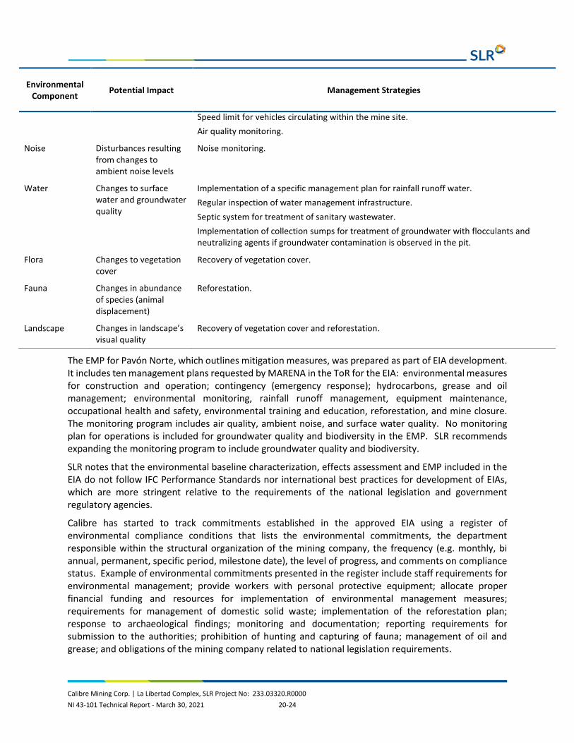
Calibre Mining Corp. | La Libertad Complex, SLR Project No: 233.03320.R0000 NI 43-101 Technical Report - March 30, 2021 20-24
Environmental Component Potential Impact Management Strategies
Speed limit for vehicles circulating within the mine site. Air quality monitoring.
Noise Disturbances resulting from changes to ambient noise levels
Noise monitoring.
Water Changes to surface water and groundwater quality
Implementation of a specific management plan for rainfall runoff water. Regular inspection of water management infrastructure. Septic system for treatment of sanitary wastewater. Implementation of collection sumps for treatment of groundwater with flocculants and neutralizing agents if groundwater contamination is observed in the pit.
Flora Changes to vegetation cover
Recovery of vegetation cover.
Fauna Changes in abundance of species (animal displacement)
Reforestation.
Landscape Changes in landscape’s visual quality
Recovery of vegetation cover and reforestation.
The EMP for Pavón Norte, which outlines mitigation measures, was prepared as part of EIA development. It includes ten management plans requested by MARENA in the ToR for the EIA: environmental measures for construction and operation; contingency (emergency response); hydrocarbons, grease and oil management; environmental monitoring, rainfall runoff management, equipment maintenance, occupational health and safety, environmental training and education, reforestation, and mine closure. The monitoring program includes air quality, ambient noise, and surface water quality. No monitoring plan for operations is included for groundwater quality and biodiversity in the EMP. SLR recommends expanding the monitoring program to include groundwater quality and biodiversity.
SLR notes that the environmental baseline characterization, effects assessment and EMP included in the EIA do not follow IFC Performance Standards nor international best practices for development of EIAs, which are more stringent relative to the requirements of the national legislation and government regulatory agencies.
Calibre has started to track commitments established in the approved EIA using a register of environmental compliance conditions that lists the environmental commitments, the department responsible within the structural organization of the mining company, the frequency (e.g. monthly, bi annual, permanent, specific period, milestone date), the level of progress, and comments on compliance status. Example of environmental commitments presented in the register include staff requirements for environmental management; provide workers with personal protective equipment; allocate proper financial funding and resources for implementation of environmental management measures; requirements for management of domestic solid waste; implementation of the reforestation plan; response to archaeological findings; monitoring and documentation; reporting requirements for submission to the authorities; prohibition of hunting and capturing of fauna; management of oil and grease; and obligations of the mining company related to national legislation requirements.

Calibre Mining Corp. | La Libertad Complex, SLR Project No: 233.03320.R0000 NI 43-101 Technical Report - March 30, 2021 20-25
No environmental issues were identified by SLR from the documentation available for review that could materially impact the ability to extract the mineral resources and mineral reserves.
20.2.1.3 Environmental Management System
The Environmental Management System is discussed in Section 20.1.1.3.
20.2.2 Water Management
20.2.2.1 Environmental Geochemistry
WSP indicated that, from historical assessments and studies, water contact with rock has been assessed to be non-acid generating based on the presence of low-sulphidation epithermal veins. It is also recognized, based on background data and studies, that the receiving environment has a high buffering capacity. Considering water management best practices, contact water is required to be contained and passively treated for suspended solids content only (WSP, 2021).
SLR understands from communication with Calibre that no geochemistry sampling, test work, and characterization for waste rock has been conducted to date for the Pavón Norte and Central deposits. SLR recommends the development and implementation of a geochemistry program to characterize the ARD/ML potential of the waste rock to be extracted and deposited in the waste rock dumps.
20.2.2.2 Water Management System
The description of the water management plan is presented in Section 18.2 as provided by WSP (2021), the consultant responsible for the design of the water management system. The Pavón Norte and Central sites are planned to have contact and non-contact (i.e., diversion) water management. The contact water will be collected in lined collection ditches and the non-contact water will realigns existing watercourses with lined diversion ditches.
Contact water will be collected in settling ponds to be developed at the toe of the saprolite and waste rock dumps until water quality objectives are met and is passively released to the environment. Settlement pond design is informed from site practices and informed by experience from other Calibre properties in Nicaragua and allows for retention and settlement of suspended solids. The embankment design typically consists of gabion walls covered on the upstream side with a double layer of geotextile to limit water seepage. The downstream outlet and passive overflow apron area is lined with a gabion mattress for scour protection.
The waste rock dumps, saprolite rock dumps and orepad/stockpiles will have underdrainage to collect the contact water to report to the collection ditch system via a rock drain system.
The ditches and ponds are sized for a five-year 24-hour design storm event selected by the designer according to the anticipated Pavón Project life of three years (see Section 18.2). Larger storm events could result in peak flows that exceed the flow conveyance capacity of the ditches and promote discharge of contact water to the environment before reaching the settling ponds. Larger storm events could also trigger exceedances of TSS in the receiving environment due to insufficient retention time in the ponds for settling of suspended solids. The risk of discharges of contact water without the proper level of treatment is increased when considering the effects climate change is having on rainfall frequency and intensity.

Calibre Mining Corp. | La Libertad Complex, SLR Project No: 233.03320.R0000 NI 43-101 Technical Report - March 30, 2021 20-26
20.2.2.3 Water Environmental Monitoring
Calibre informed SLR that a monitoring program for Pavón has been developed, however, it was not included within the documentation provided to SLR for review.
20.2.3 Environmental Permitting
20.2.3.1 Current Permits, Approvals & Authorizations
The environmental authorizations issued as permitting resolutions for Pavón Norte are listed in Table 20-3, extracted from the permitter register provided by Calibre to SLR in March 2021. Calibre maintains and up to date record of the legal permits obtained to date, documenting the subject of the permit, the permit identification code, the date when the permit was issued and the government agency that issued the permit. Calibre informed SLR that the permits issued to date have no expiration dates.
The EIA for the Pavón Norte pit stipulates that Pavón mill feed will be processed at the La Libertad site and this is captured in the Pavón Norte exploitation permit.
Table 20-3: Summary of Environmental Permits and Authorizations Calibre Mining Corp. – Pavón Norte
Permit Issued Date Type Issued by Status
DGCA P0009/300919/018/2020 July 2020 Exploitation permit MARENA Current
0000013913 September 2020 Tree clearing INAFOR Current
DGCA P0009/300919/018/2020/001M/2021 February 2021
Modification (expansion of topsoil stockpile area, and relocation of shop, magazine and camp)
MARENA Current
RAE-ANA-DGRH-0023-2021 March 2021 Use of water for road irrigation ANA Current
20.2.3.2 Environmental Approval
The environmental approval process in Nicaragua is described in Section 20.1.3.2.
20.2.3.3 Permits and Authorizations
Other than the EIA, the operation of Pavón Norte is subject to authorizations for water use (listed in Table 20-3) for road irrigation for dust suppression, and drilling for exploration activities. This requirement also applies to Pavón Central.
An existing exploration camp already permitted will be used at the beginning of the Pavón Norte operation. When a new camp is developed, authorization for discharge of treated sanitary wastewaster to the environment will be required. The proposed new Pavón camp and offices will serve for both Pavón Norte and Pavón Central mining operations and will be located between the mining operations locations.
20.2.3.4 Permitting Schedule
Permits for mining of the Pavón Norte pit are in place. Calibre is planning to submit the EIA application for the Pavón Central pit to MARENA in September 2021, expecting to receive approval and the exploitation permit within a year. Commencement of construction activities at Pavón Central are

Calibre Mining Corp. | La Libertad Complex, SLR Project No: 233.03320.R0000 NI 43-101 Technical Report - March 30, 2021 20-27
currently scheduled by Calibre for September 2022. Since Calibre has received several ToR in the past issued by MARENA for preparation of EIAs, they have familiarity with the typical requirements and therefore is planning to advance the baseline studies between May and August 2021 before the application process is officially started.
20.2.4 Social or Community Requirements
20.2.4.1 Corporate Policies and Social Management System
The corporate commitments and social management system described in Section 20.1.4.1 and 20.1.4.2 apply to the Pavón Project.
20.2.4.2 Social Setting
Pavón lies within the department of Matagalpa and municipality of Rancho Grande. Its main economic activity is agriculture, focusing on the production of basic grains and coffee and cocoa. The population was reported as 39,583 in this municipality according to a 2019 census, with approximately 82% of the people living in rural areas. The nearest communities which lie within approximately 500 m or less of the planned operations include, Yaosca and Las Brisas, as well as, Las Vallas Abajo within the municipality of Waslala. Pajaro Central lies slightly further away, within 1 km of the planned operations, separated from the municipality of Rancho Grande by the channel of the Yaosca River; it lies within the municipality of Waslala. From Google Earth imagery, these appear to be small villages or hamlets. The total population of these communities is estimated at 3,263, with most of these people living in Las Brisas (1,292 people). The Pavón Norte and Pavón Central open pits will be located at Pavón with material being trucked to La Libertad processing plant.
Calibre has identified 17 houses within 500 m of the planned operations but at a distance greater than 100 m, which is the legal buffer zone required for open pits. There are 16 homes and a small school within one kilometre of the planned operations.
Along the transport route between Pavón and La Libertad, there are 74 populated centres with different characteristics, from concentrated hamlets to densely populated urban areas. There are approximately 129,221 people in the urban areas, 59% of these people live in five urban centres, namely La Dalia, San Ramón, Muy Muy, Camoapa, and Juigalpa. Social infrastructure around the proposed access route (but not within the road right of way) include 55 schools, 13 health units, a slaughterhouse, and municipal dump.
20.2.4.3 Key Social Issues
Key social issues are identified through stakeholder engagement and through the implementation of the social management system. Calibre has identified the following risks:
• Traffic risks • Surface water impacts • Impacts on local flora and fauna. • Land use impacts
No further information was provided regarding these risks or the mitigation thereof.
Calibre Mining Corp. | La Libertad Complex, SLR Project No: 233.03320.R0000 NI 43-101 Technical Report - March 30, 2021 20-28
SLR notes that ore will be trucked between La Libertad and Pavón using community roads and enquired with Calibre how these risks will be managed specifically. According to a teleconference meeting held with Calibre on March 18, 2021, the mine implements a set of safety protocols to limit the vehicle speeds which are tracked using GPS, driver training and incident reporting and management. SLR has had sight of the incident procedure.
Section 20.1.4.4 describes the Calibre Community Investment Standard (Calibre, 2020a).
Calibre has identified a number of needs in the community. Previous projects reported by Calibre in the Pavón area with a total budget of $ 209,634 include:
• Donation of musical instruments; • Donation of sporting uniforms and equipment; • Donation of boots and equipment to the municipality of Rancho Grande; • Construction of a school for 33 students in the community of Yahosca. The school has electric
power, drinking water, kitchen and bedroom for the teacher and a dining room for children, green areas, separate bathrooms, perimeter mesh and a septic system.
The Community Relations Plan also includes compensation for landowners where exploration work is carried out, as well as the subsequent rehabilitation of the site. The plan also aims to raise awareness among the workers of the company and its contractors of the characteristics of the local population and the natural environment, occupational safety, biodiversity management, community-focused waste management, etc.
Calibre has provided SLR with an updated Community Relations Plan which comprises a set of MS Excel spreadsheets detailing planned community initiatives and projects for 2021. Each project is described along with objectives, targets and planned completion dates. These include:
• A three-year program with a budget of $363,384 to manage actual and potential social and environmental impacts of the Pavón Mining Project within its direct area of influence. Project objectives include:
o Improve the supply of drinking water and the conditions of the education and health system for the communities of Yaosca and Las Brisas.
o Improve the water, forest and biodiversity conservation indices in Rancho Grande.
o Increase the annual income of the population benefited by the project's livelihood initiatives.
o Establish a territorial center for CEN to manage permanent multi-stakeholder coordination in the area and successfully develop sustainable productive alternatives.
o Improved drinking water supply and educational and health system conditions for the communities of Yaosca and Las Brisas.
• Donation of medical supplies, instruments and equipment to resource constrained healthcare facilities (budget $33,000).
• Financing loans and technical assistance to local suppliers and local businesses to improve competitiveness (budget $20,000).

Calibre Mining Corp. | La Libertad Complex, SLR Project No: 233.03320.R0000 NI 43-101 Technical Report - March 30, 2021 20-29
20.2.4.4 Community Engagement and Agreements
Section 20.1.4.6 describes the Calibre Stakeholder Engagement Standard and Community Grievance Management Standard (Calibre, 2020a) as well as the Calibre community complaints procedure (Calibre, 2018).
The relevant communities were informed of the Project through the EA process which included some stakeholder engagement.
Calibre maintains a list of stakeholders along with their stated interests, concerns and an analysis of risks associated with concerns raised. Calibre publicizes information on the project and reports that in-house visits are conducted which has allowed the company to improve relationships with the community and explain in detail the objectives of the project and the environmental and social management plans. Calibre provided attendance list for two meetings held in 2020 and one in March 2021, however, there were no accompanying minutes.
Calibre reports the following main community concerns:
• Management of artisanal mining by the company • Water supply • The environment in general • Artisanal mining and related politics • Transport of ore • Projects that benefit the community
Calibre has reported an agreement with the community of Yahosca regarding the construction of a school.
20.2.4.5 Land Acquisition and Involuntary Resettlement
Calibre has not identified the need for relocation or resettlement of any households for the development of the Pavón Project at this stage. Should resettlement be required in the future, Calibre will implement its resettlement and compensation framework which aims to adhere to IFC requirements.
20.2.4.6 Artisanal Miners
Section 20.1.4.7 describes how relations with artisanal and small-scale miners is managed.
20.2.4.7 Social Unrest
Section 20.1.4.8 describes the risk that operations could be materially impacted by social conflict in the future.
20.2.4.8 Indigenous Peoples
As discussed in Section 20.1.4.8, no Indigenous populations have been identified in the area.
20.2.4.9 Labour and Working Conditions
Pavón forms part of the La Libertad operating entity DESMINIC, therefore the same labour and working conditions will apply.

Calibre Mining Corp. | La Libertad Complex, SLR Project No: 233.03320.R0000 NI 43-101 Technical Report - March 30, 2021 20-30
20.2.4.10 Archaeology and Cultural Heritage
No information is available on archaeological or other heritage sites. Surveys will be required for planned areas of surface disturbance. There is no formal chance find procedure and such incidents will be handled by management on a case by case basis.
20.2.5 Mine Closure
20.2.5.1 Regulatory Requirements
The current national legislation has no legal instrument to regulate the closures and post-closures of mines. No specific requirements have been set for preparation and filing of mine closure plans by the mining companies with the authorities and there is no requirement for mine closure financial assurance.
20.2.5.2 Mine Closure Plan
A conceptual closure plan is presented in the EMP developed as part of the EIA for Pavón Norte. A Mine Closure Plan will be developed later presenting a closure strategy in agreement with the authorities of MARENA, MEM, and the Municipal Environmental Unit. The conceptual closure plan considers the physical and biological environments, aiming to restore pre-development conditions when possible, proposing mitigation and/or compensation works for zones where restoration to pre-development conditions is not feasible. The plan highlights the importance of implementing progressive closure with emphasis on three processes: environmental closure, physical safety, and post-closure responsibility.
The objective stated in the conceptual closure plan is the protection of the ecosystem of the Pavón Norte area against long term impacts following cessation of operations, and restoration of the environment surrounding the site.
Final closure is anticipated to take one year followed by a period of active maintenance anticipated to last 1.5 years to achieve physical and chemical stability.
The closure activities will be undertaken based on environmental responsibility policies, the environmental management programs defined for Pavón Norte, and the environmental and social management system implemented by Calibre.
The infrastructure subjected to closure activities includes:
• Ancillary buildings (administration, dining room, warehouse, storage, vehicle maintenance shop, magazine, etc.)
• Open pit and access roads • Waste rock and saprolite dumps • Orepad and stockpile • Topsoil deposit • Areas for management of hydrocarbon waste, industrial waste, grease traps, etc.
The main closure activities identified in the conceptual closure plan are:
• Dismantling, demolition, salvaging, and disposal of structures • Repurposing of wooden structures • Filling of infrastructure that was used for management of liquid waste during operations
Calibre Mining Corp. | La Libertad Complex, SLR Project No: 233.03320.R0000 NI 43-101 Technical Report - March 30, 2021 20-31
• Recontouring and scarification of terrain, and revegetation with native species • Slope contouring for physical stability for the open pit and waste dumps (if required)
Specific closure measures for the pit and the waste sumps have not been identified in the conceptual closure plan (for example, pit flooding and installation of closure covers for the dumps). A monitoring program for closure and post-closure was not included in the conceptual closure plan.
20.2.5.3 Closure Cost Estimate
Closure costs have been estimated for the Pavón mine sites at $2.6 million (see Section 21.1.3). Calibre informed SLR that approximately $1 million was booked at the end of year 2020 liability estimate. It covered the Pavón Norte access road, the waste dump and the open pit. Calibre also informed its intention to continue booking up to the $2.6 million cost estimate as Pavón Central is developed.

Calibre Mining Corp. | La Libertad Complex, SLR Project No: 233.03320.R0000 NI 43-101 Technical Report - March 30, 2021 21-1
21.0 CAPITAL AND OPERATING COSTS
21.1 Capital Costs A summary of the LOM capital costs for the projected life of the production schedule from 2021 to 2024 plus post closure reclamation costs is provided in Table 21-1.
Table 21-1: Life of Mine Capital Costs Calibre Mining Corp. – La Libertad Complex
Description Cost ($000)
Total Development Capital 19,539
Total Sustaining Capital 17,921
Total Closure/Reclamation Capital 30,863
Total Capital Costs 68,323
21.1.1 Development Capital Costs
Development capital costs for each of the mine operation areas are outlined below with the annual expenditures shown in Table 21-2.
Table 21-2: Development Capital Costs Calibre Mining Corp. – La Libertad Complex
Description LOM ($000)
2021 ($000)
2022 ($000)
La Libertad
Jabalí Antena OP 500 500
Crimea In-Pit Phase 1 TSF 7,050 7,050
Pavón
Pavón Norte and Central 11,989 9,447 2,542
Grand Total 19,539 16,497 3,042
21.1.2 Sustaining Capital Costs
The proposed sustaining capital costs for the Project are predominately for the Jabalí West UG mine development and continued Pavón OP operations. An additional $1.5 million annual Staying in Business (SIB) capital allowance has been budgeted for mill and infrastructure upgrades and maintenance (Table 21-3).

Calibre Mining Corp. | La Libertad Complex, SLR Project No: 233.03320.R0000 NI 43-101 Technical Report - March 30, 2021 21-2
Table 21-3: Sustaining Capital Costs Calibre Mining Corp. – La Libertad Complex
Description Cost ($000)
La Libertad
Mill/Infrastructure SIB 6,000
Jabalí West UG Development 3,162
Pavón
Pavón Operations 8,759
Grand Total 17,921
21.1.3 Mine Closure/Reclamation Costs
Total mine closure costs are estimated at $30.9 million to be incurred starting in 2025, a year after operations cease in the current Mineral Reserves production schedule:
• La Libertad Complex: $28.3 million to be incurred over three years. • Pavón: $2.6 million to be incurred in 2025.
SLR notes that no salvage estimates were included in the evaluation.
21.1.4 Working Capital
Since the Project is currently in operation and not requiring large amounts of upfront working capital adjustments normally found with greenfield start up projects, SLR used simplified proforma assumptions to calculate annual working capital adjustments in the cash flow model. These assumptions include:
• Accounts Receivable: Five days sales outstanding • Accounts Payable: 14 days payable outstanding for labour and 30 days payable outstanding for
supplies • Consumable Inventories: Three percent of cumulative annual balance of property, plant, and
equipment (PP&E) for consumable inventories.
All working capital adjustments are recaptured at the end of mine life and post closure/reclamation activities thus net to zero over the LOM.
21.2 Operating Costs The LOM unit operating costs for the projected life of the production schedule from 2021 to 2024 are listed in Table 21-4.

Calibre Mining Corp. | La Libertad Complex, SLR Project No: 233.03320.R0000 NI 43-101 Technical Report - March 30, 2021 21-3
Table 21-4: Life of Mine Operating Costs Calibre Mining Corp. – La Libertad Complex
Item Units Total
Surface Mining $/t mined 2.43
Underground Mining $/t milled 86.00
Total Mining $/t milled 41.80
Processing $/t milled 22.62
Hauling/Trucking $/t milled 23.11
Total G&A $/t milled 26.15
Tailings Storage Facility $/t milled 2.56
CSR Projects $/t milled 2.85
Total Unit Operating Cost $/t milled 119.13
The operating cost estimates are prepared based on recent operating performance and current operating budgets. SLR considers these operating cost estimates to be reasonable.
21.2.1 Mining
21.2.1.1 Open Pit Operations
The total mine operating cost has been estimated to be $2.10/t mined for Jabalí Antena OP based on 2020 pit operation.
Table 21-5 displays actual mine operating costs for the open pit based on Jabalí Antena OP, 2020 costs except drilling and blasting. Jabalí Antena OP did not have drilling and blasting activities during 2020.
Table 21-5: Jabalí Antena OP Mine Operating Costs Calibre Mining Corp. – La Libertad Complex
Item Units Total
Contractor
Loading and Hauling Mill feed $/t mined Mill feed 2.74
Loading and Hauling Waste $/t mined Waste 1.73
Sub-Total Loading and Hauling Rock $/t mined Rock 1.93
Dewatering $/t mined 0.01
Other Costs (Distributed Eng. Geo Adm.) $/t mined 0.36
Total Unit Mine Operating Cost $/t mined 2.10
Table 21-6 presents the estimated mine operating costs for the Pavón OP including drilling and blasting.

Calibre Mining Corp. | La Libertad Complex, SLR Project No: 233.03320.R0000 NI 43-101 Technical Report - March 30, 2021 21-4
Table 21-6: Pavón OP Mine Operating Costs Calibre Mining Corp. – La Libertad Complex
Item Units Total
Trucks $/t mined 0.45
Shovel $/t mined 0.22
Graders $/t mined 0.17
Dozers $/t mined 0.32
Ancillary Equipment $/t mined 0.21
Dewatering $/t mined 0.01
Drilling $/t mined 0.02
Blasting $/t mined 0.20
Software and IT Support $/t mined 0.05
G&A $/t mined 0.32
Aggregates $/t mined 0.06
Catering and Transportation $/t mined 0.14
Total Unit Mine Operating Cost $/t mined 2.17
21.2.1.2 Underground Operations
Table 21-7 provides a breakdown of the unit underground-mining operating costs for Jabalí West UG, both for 2020 actual costs and the 2021 budget. The mine's direct costs are mining activities related to stope preparation and production. The indirect costs, which support both operating and capital-development underground-mining activities, were allocated to operating costs in proportion to ore tonnes mined versus total tonnes of ore and waste mined.
In the QP's opinion, the 2021 budget value of $86.68/t is a reasonable basis for estimating the LOM underground mining operating cost. It is based on Calibre's detailed analysis of its plans for the mine, and the period coincides with a significant part of the LOM schedule. Furthermore, the actual 2020 costs are not representative of normal operations as La Libertad’s mining activities were suspended for more than half of the year. The suspension was due to ground subsidence caused by artisanal mining that affected local households. The unit underground-mining operating cost from the 2021 budget was used to calculate the mine's cut-off grades.
Table 21-7: Underground Mine Operating Cost Summary Calibre Mining Corp. – La Libertad Complex
Units 2020 Actual 2021 Budget
Exploration Drilling
Contractor $/t-mined 13.69
Drilling steel $/t-mined
Total $/t-mined 13.69 0.00

Calibre Mining Corp. | La Libertad Complex, SLR Project No: 233.03320.R0000 NI 43-101 Technical Report - March 30, 2021 21-5
Units 2020 Actual 2021 Budget
Blasting Block
Explosive Supplies $/t-mined 5.65 0.48
Equipment O&M Cost $/t-mined
Total $/t-mined 5.65 0.48
Contractor-Slopes Production
Slopes $/t-mined 13.64 15.84
Others $/t-mined
Total $/t-mined 13.64 15.84
Loading & Hauling - Ore
Operating Labor $/t-mined
Contractor Costs (Transport to Planta) $/t-mined 5.81 4.96
Fuel Diesel and Gasoline $/t-mined 0.00 0.95
Contractor Costs to Waste Dump $/t-mined 0.49 0.49
Contractor Costs $/t-mined 0.00 1.15
Equipment O&M Cost $/t-mined
Total $/t-mined 6.30 7.55
Operating
Contractor Development
Ramp (4x4) $/t-mined 31.22 14.14
Gallery and Cross Cut $/t-mined 86.57 17.88
Drift $/t-mined 14.18
Ground Support $/t-mined 5.14 2.88
Supplies DESMINIC
Ground Support Supplies $/t-mined 7.47 1.50
Explosives Supplies $/t-mined 7.75 2.69
Water & Air Services $/t-mined 0.92
Ventilation $/t-mined 0.50 0.37
Electrical Supplies $/t-mined 1.03 0.73
Pumping $/t-mined 3.37 0.59
Total $/t-mined 143.97 54.97
Contractor Cost, Operational Development $/linear metre
Total Operational Development $/linear metre
Engineering $/t-mined 0.93 0.24
Geology $/t-mined 1.37 0.20
Mine General $/t-mined 2.54 0.51
Chemical Laboratory $/t-mined 0.00 0.32

Calibre Mining Corp. | La Libertad Complex, SLR Project No: 233.03320.R0000 NI 43-101 Technical Report - March 30, 2021 21-6
Units 2020 Actual 2021 Budget
Maintenance - Chemical Laboratory $/t-mined 0.00 0.01
Maintenance General $/t-mined 0.00 0.57
Electrical Power - Generation $/t-mined 13.69 5.99
Total $/t-mined 18.54 7.83
Total $/t-mined 201.79 86.68
21.2.2 Processing
The total process operating costs are summarized in Table 21-8 with the $22.62/t milled unit rate used in the economic analysis. An additional cost of $2.56/t milled unit rate for tailings storage was also used in the economic analysis.
Table 21-8: Process Operating Costs Summary Calibre Mining Corp. – La Libertad Complex
Description Units 2020 Process Cost 2021 Budget Cost
Crushing $/t 1.09 1.35
Grinding $/t 6.77 8.64
Thickening $/t 0.29 0.39
Leaching $/t 3.23 3.26
Carbon in Pulp $/t 0.27 0.50
Carbon Elution and Regeneration $/t 0.84 1.71
Electrowinning and Refinery $/t 0.37 0.44
Tailings Storage Facility $/t 0.15 0.18
Detoxification $/t 0.14 0.22
Water System, Fresh and Process Reclaim $/t 0.00 0.00
Metallurgical Laboratory $/t 0.11 0.22
General $/t 2.57 5.00
Distributable $/t 0.44 0.71
Total $/t $16.26 $22.62
21.2.3 Trucking
Based on current contract with ESINSA Ingenieros, a $31.91/t unit rate is estimated for Pavón mill feed trucked on a 300 km one way haul (Figure 21-1).
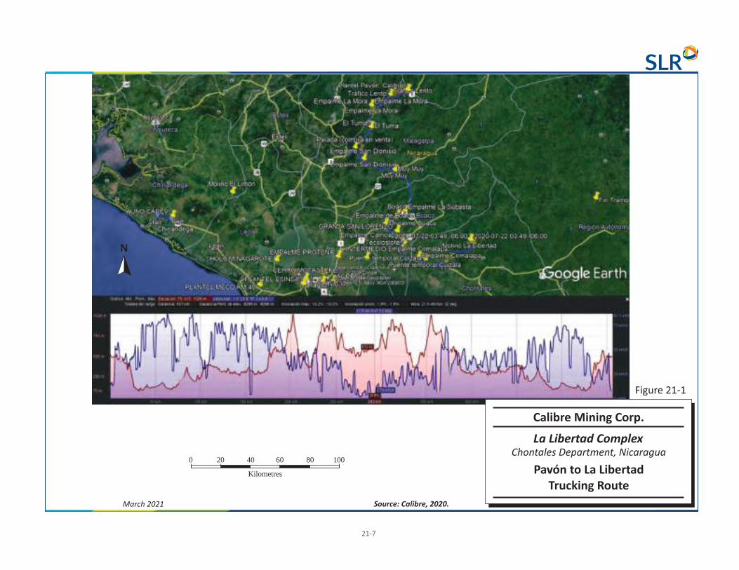
21-7
March 2021 Source: Calibre, 2020.
0 20 100
Kilometres
40 60 80
N
Calibre Mining Corp.
La Libertad Complex
Pavón to La LibertadTrucking Route
Chontales Department, Nicaragua
Figure 21-1

Calibre Mining Corp. | La Libertad Complex, SLR Project No: 233.03320.R0000 NI 43-101 Technical Report - March 30, 2021 21-8
21.2.4 General and Administration
Based on current Calibre operating budgets, a $12.4 million per year estimate for total G&A costs as presented in Table 21-9. The estimate does not include any Vancouver, BC Canada head office costs.
Table 21-9: G&A Operating Costs Summary Calibre Mining Corp. – La Libertad Complex
Description Annual Cost ($000)
Unit Cost ($/t milled)
La Libertad Site G&A 8,400 16.09
Pavón Site G&A 1,600 5.00
Managua Regional Office 2,300 4.85
Mining License 100 0.21
Total G&A 12,400 26.15
21.2.5 CSR Projects
Based on current Calibre operating budgets, the study assumes $1.35 million per year for community projects through LOM.

Calibre Mining Corp. | La Libertad Complex, SLR Project No: 233.03320.R0000 NI 43-101 Technical Report - March 30, 2021 22-1
22.0 ECONOMIC ANALYSIS Under NI 43-101 rules, producing issuers may exclude the information required in Section 22 - Economic Analysis on properties currently in production, unless the Technical Report includes a material expansion of current production. SLR notes that Calibre is a producing issuer, La Libertad Complex is currently in production, and a material expansion is not being planned.
SLR reviewed the LOM Cash Flow for La Libertad Complex, which verifies the economic viability of the Mineral Reserves at a gold price of $1,400 per troy ounce and the assumptions stated in this Technical Report.

Calibre Mining Corp. | La Libertad Complex, SLR Project No: 233.03320.R0000 NI 43-101 Technical Report - March 30, 2021 23-1
23.0 ADJACENT PROPERTIES There are no adjacent properties to report in this section.

Calibre Mining Corp. | La Libertad Complex, SLR Project No: 233.03320.R0000 NI 43-101 Technical Report - March 30, 2021 24-1
24.0 OTHER RELEVANT DATA AND INFORMATION No additional information or explanation is necessary to make this Technical Report understandable and not misleading.

Calibre Mining Corp. | La Libertad Complex, SLR Project No: 233.03320.R0000 NI 43-101 Technical Report - March 30, 2021 25-1
25.0 INTERPRETATION AND CONCLUSIONS SLR and WSP have the following conclusions:
25.1 Geology and Mineral Resources The Mineral Resource estimates have been prepared utilizing acceptable estimation methodologies, and the classifications of Indicated and Inferred Mineral Resources conform to CIM (2014) definitions.
25.1.1 La Libertad
• The La Libertad deposits are low-sulphidation epithermal deposits hosted by volcanic lithologies. • The sampling, sample preparation, analyses, security, and data verification meet industry
standards and are appropriate for Mineral Resource estimation. • The composite lengths are reasonable. • The interpretation of the mineralization, wireframes, and block sizes are appropriate. • Capping restrictions are reasonable. • The grade interpolation strategies are appropriate for the style of mineralization. • The parameters, assumptions, and methodology used for Mineral Resource estimation are
appropriate for the style of mineralization. • Total Mineral Resources at La Libertad Complex are:
o Indicated – 1.1 Mt grading 4.20 g/t Au, 24.09 g/t Ag, containing 148 koz Au and 849 koz Ag
o Inferred – 2.2 Mt grading 4.46 g/t Au, 11.16 g/t Ag, containing 323 koz Au and 809 koz Ag
• The overall Mineral Resource classification is reasonable and conforms to CIM (2014) definitions. There is potential to outline additional Mineral Resources with an exploration program.
25.1.2 Pavón
Based on the review of the available information and observations made during the site visit, WSP concludes the following:
• The property is currently held 100% by Calibre, through its DESMINIC subsidiary. • The Natividad and Las Brisas concessions, within which Pavón is located, are not subject to any
current option agreements with any other company. • Pavón is analogous to an epithermal gold deposit and likely associated with the epithermal
systems typical for the region. The system has a current strike length of approximately 5,000 m and a current depth of 150 m to 200 m.
• There has been no historical production at Pavón. • Drilling and sampling procedures, sample preparation, and assay protocols are generally
conducted in agreement with best practices. • Verification of the drill hole collars, surveys, assays, core, and drill hole logs indicate the Calibre
data is reliable. • Based on the QA/QC program, the data is sufficiently reliable to support the Mineral Resource
estimate generated for the Pavón deposit.

Calibre Mining Corp. | La Libertad Complex, SLR Project No: 233.03320.R0000 NI 43-101 Technical Report - March 30, 2021 25-2
• The mineral models have been constructed in conformance to industry standard practices. • The geological understanding supports the resource estimation and the resource classification
assigned. • The specific gravity values used to determine the tonnages at Pavón were derived from samples
collected at Pavón Norte during the drilling program and used at Pavón Central and Pavón Sur. • Total Mineral Resources at Pavón are:
o Indicated – 1.4 Mt grading 5.16 g/t Au, 7.72 g/t Ag, containing 231 koz Au and 346 koz Ag
o Inferred – 0.6 Mt grading 3.39 g/t Au, 4.90 g/t Ag, containing 63 koz Au and 91 koz Ag
• There are several trenches with elevated gold results that were not included in the resource model. These trenches are not part of the main vein system yet may be related in a structural system and require additional exploration to understand the potential contribution to the Project.
• The Pavón deposit remains open at depth and along strike in certain areas.
25.2 Mining and Mineral Reserves Calibre has one underground and two open pit open operations that are either in operation or will be commencing operations starting in 2021. The Jabalí West UG and Jabalí Antena OP operations are situated at La Libertad, and Pavón Norte and Pavón Central are located at Pavón with material being trucked 300 km to the La Libertad plant.
The Mineral Reserve estimates have been prepared utilizing acceptable estimation methodologies and the classification of Probable Mineral Reserves conforms to CIM (2014) definitions.
25.2.1 La Libertad
• Jabalí Antena operation will not include drilling and blasting of the ore and ripping of the laterite rich upper portions will be used to mine the ore.
• The Jabalí Antena open pit operation will be performed by a mining contractor; loading, hauling, and dumping to a transfer stockpile at the mine, followed by a mill feed haulage contractor to cover the distance from the mine to La Libertad plant.
• Total Probable Mineral Reserves at Jabalí Antena are 139,000 t grading 4.25 g/t Au and 50.37 g/t Ag, containing 19 koz Au and 225 koz Ag.
• Jabalí West UG is a trackless mechanized operation accessed from the surface by a single main ramp. A mining contractor carries out all development and production activities. The mine produced 111,232 t grading 3.93 g/t in 2019, but only 27,900 t grading 3.75 g/t Au in 2020. The low output in 2020 was due to a suspension in mining activities for most of the year. The suspension resulted from ground subsidence caused by illegal artisanal mining that affected local households.
• Jabalí West UG consists of four zones named Zone 1 to Zone 4, going from east to west. Zone 1 is the largest and will be the mine’s main source of production during the life of mine (LOM). Zones 2 and 3 lie beneath the Antena open pit. Zone 4 is the smallest and requires the most development for initiating production. The deposit has sufficient Mineral Reserves to support production until Q1 2023.
• Jabalí West UG consists of steeply dipping veins with widths ranging up to 20 m. The configuration of the deposit is suitable for longitudinal sublevel-stoping type mining methods. The specific

Calibre Mining Corp. | La Libertad Complex, SLR Project No: 233.03320.R0000 NI 43-101 Technical Report - March 30, 2021 25-3
methods used at the mine are Avoca (also called Longitudinal Retreat Sublevel Stoping) and Longitudinal Longhole Sublevel Open Stoping.
• The LOM plan represents a continuation of mining activities that are already underway; consequently, adjustments to infrastructure, equipment, and workforce levels will be consistent with maintaining normal operations.
• Total Probable Mineral Reserves at Jabalí West UG are 477,000 t grading 3.92 g/t Au and 20.00 g/t Ag, containing 60 koz Au and 307 koz Ag.
25.2.2 Pavón
• Calibre has two open pit mines that are either in operation or will be within the next year. Pavón Norte and Pavón Central are located at Pavón with material being trucked to La Libertad processing plant.
• Open pit operations at Pavón are performed by a mining contractor; blasting, loading, hauling, and dumping to a transfer stockpile at the mine, followed by a mill feed haulage contractor to cover the distance from the mine to La Libertad plant.
• The LOM plans represent a continuation of mining activities that are already underway; consequently, adjustments to infrastructure, equipment, and workforce levels will be consistent with maintaining normal operations.
• Total Probable Mineral Reserves at Pavón are 1.281 Mt grading 4.86 g/t Au and 7.02 g/t Ag, containing 200 koz Au and 290 koz Ag.
25.3 Mineral Processing • Metallurgical testing from 2009 to date has indicated that the mill feed of La Libertad mines can
be successfully processed through the plant maintaining historical recoveries of 92% to 95%. • Metallurgical testing from 2014 has indicated that mill feed from the Pavón deposit can be
successfully processed through La Libertad plant and achieve similar recoveries to historic La Libertad mill feed. The master composite cyanidation tests results indicated that higher gold extractions could be achieved at finer grinds. A gold extraction of 93.6% was observed at P80 99 µm while it reached 96.5% at P80 51 µm. Testing of the variability samples revealed that the samples responded well to the leach conditions and the average gold and silver extractions were 95.4% and 76.3%, respectively.
• El Limón mill grinds to P80 65 µm and all of the Libertad test work has been performed under the standard El Limón conditions, including the P80 65 µm grind size. Lower recovery may be experienced for mineralization from the El Limón Complex when processed in the La Libertad mill. The 2021 SGS testing program is investigating the effect of grind size on gold recovery for each of the Limón area deposits and a comparison is being made between the El Limón grind size and the La Libertad grind size to determine the expected Au recoveries when processing the deposits in either mill.
• La Libertad plant processed an average 126,000 tonnes per month and gold recovery averaged 92.3% during the last seven months of 2020 following the two-month plant shutdown due to COVID-19. The decrease in tonnage and recovery from historical averages is due to changes in mill feed materials.
• Deposits to be processed at the La Libertad mill starting in 2021 as envisaged in this Technical Report include:

Calibre Mining Corp. | La Libertad Complex, SLR Project No: 233.03320.R0000 NI 43-101 Technical Report - March 30, 2021 25-4
o La Libertad: Jabalí West UG and Jabalí Antena OP
o Pavón: Pavón Norte and Pavón Central OP
25.4 Infrastructure
25.4.1 La Libertad
• The infrastructure in place at La Libertad Complex is adequate for current operations and for the four-year (2021-2024) mine plan described in this Technical Report including mine and mill infrastructure, power, water supply, road access, and sufficient tailings storage facilities (TSF) capacity.
• Relocation of the National Road and the Tension Poles are to be completed by October 2022 to commence Pavón Central mine site preparation for production mining in February 2023.
25.4.2 Pavón
• The Pavón Project will utilize the same supporting infrastructure for both the Pavón Norte and Pavón Central areas and includes:
o Camp and Offices;
o Explosive Magazine;
o Fuel Station;
o Truck Shop/Maintenance Shop;
o Warehouse; and
o Cap Magazines are located at the mine sites.
25.5 Environmental, Social and Governance Considerations • No environmental issues were identified by SLR from the documentation available for review that
could materially impact the ability to extract the Mineral Resources and Mineral Reserves. • Calibre has the permits required to continue the mining operations at La Libertad. • An exploitation permit for Pavón Norte deposit was granted by the Nicaraguan government in
2020. Permitting for remaining areas at Pavón are well advanced and it is expected that operating permits will be obtained before September 2022 when start-up of construction at Pavón Central is scheduled.
• Mined mill feed from the Pavón site will be trucked to La Libertad plant for processing when the Pavón Norte operation begins in 2021.
• There are no specific permits required for truck transportation in hauling mill feed from one site to another through national roads. Environmental monitoring is not required by the authorities for the transportation corridor between Pavón and La Libertad. The transportation corridor is used by a large number of transport trucks, including trucks of a higher weight capacity than those to be used for mill feed transportation by Calibre, and with a higher frequency.
• The Esperanza TSF at La Libertad dam was raised in 2019 to expand the storage capacity and is expected to continue operating until 2022. For future tailings management, Calibre will use the mined-out Crimea Pit.

Calibre Mining Corp. | La Libertad Complex, SLR Project No: 233.03320.R0000 NI 43-101 Technical Report - March 30, 2021 25-5
• The La Esperanza TSF does not have an emergency spillway. Operation of the La Esperanza TSF without an emergency spillway represents a risk since a potential dam failure can be triggered in the event of dam overtopping during an extreme rainfall event. SLR understands that there is a plan to construct a spillway at closure with capacity to convey the Probable Maximum Flood. Calibre informed SLR that the pond water volume in the La Esperanza TSF is actively managed to maintain an adequate freeboard.
• Surface water quality, air quality, and noise monitoring results are submitted to the Ministry of Natural Resources and Environment (MARENA) annually (also biannually for surface water quality). No environmental compliance issues associated with water quality, air quality, and noise have been raised by the authorities for La Libertad in the past two year (the period reviewed by SLR).
• As part of Calibre’s HSES Management System, protocols and procedures have been established for heavy equipment and vehicle operation, including speed limits, preventive driving instructions and, in the case of the use of public roads and highways, strict compliance with all traffic and driving regulations in effect in Nicaragua. All Calibre contractors are obligated to comply with these procedures, and their driving along the routes is monitored through GPS technology.
• Social risks are identified and generally managed through the social management system which forms part of the HSES Management System, and through stakeholder engagement. The social management system includes a Social Responsibility Policy (December 2020) with a set of performance standards.
• No heritage or archaeological resources have been found in the Project areas.
• Calibre continues to implement social initiatives and projects aimed at improving the quality of life in the various operations areas of influence.
• Calibre actively manages relations with artisanal miners and implements a compensation framework when the operations need to move into areas where artisanal miners are active. Calibre is confident that the risks associated with artisanal miners are satisfactorily managed.
• There was significant social unrest in Nicaragua in 2018, which temporarily restricted the supply of key consumables (fuel and lime) and affected gold production at the mine. Additional unrest was reported by the press in 2019, and demonstrations were also reported in 2020 related to the COVID-19 pandemic. While regular operations at La Libertad have not been affected since 2018, there is the risk that operations could be impacted by further work stoppages due to illegal road blockades or social conflict in the future.
25.6 Risks La Libertad Complex, and its CIP plant facility, has been in production for over 10 years and is a mature operation. In SLR’s opinion, there are not any significant risks and uncertainties that could reasonably be expected to affect the reliability or confidence in the exploration information, Mineral Resource and Mineral Reserve estimates, or projected economic outcomes.

Calibre Mining Corp. | La Libertad Complex, SLR Project No: 233.03320.R0000 NI 43-101 Technical Report - March 30, 2021 26-1
26.0 RECOMMENDATIONS SLR and WSP have the following recommendations.
26.1 Geology and Mineral Resources
26.1.1 La Libertad
1. Complete additional drilling of mined out areas in open pit resources that were not surveyed and are classified as Inferred Mineral Resources, in order to determine the true extent of the openings and grade of the material contained therein.
2. Complete further review of the methodology for estimation of tonnage and grade in backfill material classified as Inferred Mineral Resources.
3. Conduct a study on reconciliation of backfill material grade. 4. Complete the Phase 2 exploration program, which commenced in January 2021 and is expected
to cost approximately US$5.0 million. It will require twelve months to complete. Exploration plans for 2022 and beyond will be contingent on the 2021 Phase 2 results. Diamond drilling, assays and exploration target generation (surface geochemical sampling, trenching, geophysics, etc.) accounts for approximately 55% of the total cost while the remainder is for salaries and support, and technical studies. RPA concurs with the recommended program and budget (Table 26-1).
Table 26-1: La Libertad Exploration Budget Calibre Mining Corp. – La Libertad Complex
Phase 2 (12 months: 2021)
Item Work Program Cost (US$)
Diamond Drilling 17,500 m @ $100/m 1,750,000
Assays 7,500 samples @ $50/sample 375,000
Exploration Targeting: Geochem. sampling, geophysics 625,000
Salaries / Technical Support 1,500,000
Permitting 50,000
Metallurgical Testing 25,000
Technical Studies Geotechnical, hydrogeological, etc 100,000
Surveying 25,000
Economic Study / Technical Report 100,000
Consumable Supplies and Camp Costs 450,000
Total 5,000,000
26.1.2 Pavón
1. The QP is of the opinion that additional exploration is warranted.

Calibre Mining Corp. | La Libertad Complex, SLR Project No: 233.03320.R0000 NI 43-101 Technical Report - March 30, 2021 26-2
Two separate exploration programs for Pavón, Phase 1 and Phase 2, are proposed. Phase 2 is dependent on the results of Phase 1 and should be completed or adjusted upon the completion of Phase 1.
Phase 1 – Pavón Expansion
Phase 1 is designed primarily to expand the current resource at the Pavón deposit by testing the strike and dip extension of the deposit as well as other geochemical and geophysics targets. This will entail diamond and RC drilling with additional work on metallurgical testing, rock mechanics, and surveying.
The drilling campaign should be designed to target the potential strike extensions of the Project, particularity the northeast. Drill hole spacing should continue at approximately 30 m to 50 m along section, and 50 m to 75 m vertically on section to support an Indicated Mineral Resource. Rock mechanics logging should be completed on all holes in order to support the parameters for pit wall angles.
The proposed budget for Phase 1 is estimated at US$2.5 million. Table 26-2 summarizes the exploration program proposed.
Table 26-2: Pavón Phase 1 Exploration Calibre Mining Corp. – La Libertad Complex
Item Unit Unit Rate Amount (US$)
Diamond Drilling 9,000 m $100.00/m 900,000
Assays 15,000 samples $50.00/sample 750,000
Salaries / Technical Support 1 unit $290,000/unit 290,000
Metallurgical Testing 1 program $200,000/program 200,000
Surveying 1 survey $40,000/survey 40,000
Geotechnical Study 1 study $60,000/study 60,000
Resource Update & Engineering Study 1 study $160,000/study 160,000
Consumable Supplies & Camp Costs 1 unit $100,000/unit 100,000
Total 2,500,000
Note: Includes all drilling related charges.
Phase 2 - Pavón Delineation
Phase 2 is designed to delineate the resource at the Project by infilling of the deposit and providing the level of detail for future studies. This will entail a diamond and RC drilling programs, additional metallurgical testing, other technical studies, and environmental baseline studies.
The drilling campaign should be designed to target the core areas of the Pavón deposit, particularly in the areas where widths are wider and/or grades are higher. Drill hole spacing should be at approximately 25 m to 30 m along section, and 30 m to 50 m vertically on section to improve the resource classification. The proposed budget for Phase 2 is estimated at approximately US$3.7 million.
Table 26-3 summarizes the proposed exploration program.

Calibre Mining Corp. | La Libertad Complex, SLR Project No: 233.03320.R0000 NI 43-101 Technical Report - March 30, 2021 26-3
Table 26-3: Pavón Phase 2 Exploration Calibre Mining Corp. – La Libertad Complex
Item Unit Unit Rate Amount (US$)
Diamond Drilling 8,500 m $100/m 850,000
Assays 22,500 samples $50/sample 1,125,000
Salaries / Technical Support 1 unit $325,000/unit 325,000
Environmental baseline 1 survey $175,000/survey 175,000
Hydrogeology 1 study $150,000/study 150,000
Geotechnical 1 study $200,000/study 200,000
Resource Update & Engineering Study 1 study $650,000/study 650,000
Consumable Supplies & Camp Costs 1 unit $250,000/unit 250,000
Total $3,725,000
Note: Includes all drilling related charges.
26.2 Mining and Mineral Reserves
26.2.1 La Libertad
1. Currently, the Jabalí Antena OP design is constrained by community location and permitting limitations. SLR recommends that Calibre continue exploring options to increase the open pit Mineral Reserves at Jabalí Antena under community and permit modification approvals.
2. Open pit and underground mining trade-off analysis should be continuously reviewed depending on the current gold price to maximize NPV.
3. Jabalí West UG would benefit from a thorough understanding of the geotechnical conditions and their effects on the underground excavations and surface subsidence. The geotechnical reports reviewed by SLR focus mainly on ground support requirements.
4. As shotcrete is one of the methods included in its ground support standards, Calibre should consider acquiring mechanized equipment for its use, including mobile shotcrete sprayers and transmixers.
5. Calibre should consider sending its personnel on site visits to mines that have used longitudinal sublevel stoping methods for many years.
6. Place priority on establishing an underground communications system at Jabalí West UG. An option to consider is installing a private 4G-LTE cellular network at La Libertad Complex to provide mobile communications and data transfer for the entire site, including Jabalí West UG and future underground operations. This type of system has proven to be effective and economical at other underground mines. It is efficient for underground installations as the signal is not limited to line-of-site transmission, as is the case with WiFi access points and leaky-feeder coaxial cables.
7. Implement the following measures when mining near historical workings and old stopes: • Determine their positions and dimensions through probe drilling. • Leave adequate pillars as recommended by the geotechnical department. • Drain them to eliminate the risk of a sudden inflow of water or a mudrush.

Calibre Mining Corp. | La Libertad Complex, SLR Project No: 233.03320.R0000 NI 43-101 Technical Report - March 30, 2021 26-4
• Otherwise, leave them undisturbed. It is not worth attempting to backfill them.
26.2.2 Pavón
1. Further geotechnical campaigns to supplement discontinuity orientation datasets are recommended. The mine design can be optimized further as more information including geotechnical will be available to optimize the planned design.
2. Inferred Mineral Resources are considered as waste, however, production infill drilling could recategorize the resources and could be placed in the plan during production.
3. The rock produced for Pavón Norte and Pavón Central can be sold for construction material for local municipal and private contractors.
4. Continue to schedule according to seasonal conditions, and supplement material for the stockpiles as required.
5. Continue cut-off grade calculations during production and adjusting the Low-Grade Stockpile accordingly.
6. Reconcile Pavón Central Mine Plan with artisanal mining.
26.3 Mineral Processing
26.3.1 La Libertad
1. Perform metallurgical testing on each of the new materials being processed. The focus should be on grind particle size versus cyanidation recovery, comminution testing including SMC testing and Bond crushing, ball milling, and abrasion index testing. Chemical characterization is recommended, including base metal analysis as some of the materials contain soluble copper which affects recovery and cyanide consumptions.
2. Evaluate the capacity of La Libertad processing plant to produce finer grind particle sizes. The mill will be operating at lower rates due to availability of feed sources and should have excess grinding capacity and may only require a change in cyclone classification components to implement finer grinding.
26.3.2 Pavón
1. Test Pavón Central and Pavón Norte representative samples using the La Libertad processing conditions.
2. Perform confirmatory grindability and leaching test work on samples from Pavón Central and Pavón Norte at external laboratory.
3. Initiate sample collection and bulk testing on at least one master composite sample for Pavón Sur. 4. Confirm mill feed composition (% from each source) and associated capacity at La Libertad
(grinding, leaching and recovery circuits).
26.4 Infrastructure
26.4.1 La Libertad
1. No recommendations.

Calibre Mining Corp. | La Libertad Complex, SLR Project No: 233.03320.R0000 NI 43-101 Technical Report - March 30, 2021 26-5
26.4.2 Pavón
1. Pavón Norte has a south access road to the settling pond, which will also be utilized for construction purposes to build the first two lifts of the Saprolite Dump. This opportunity results in a reduction of road construction cost.
2. Pavón Norte waste rock can be used for building material for Pavón Central infrastructure such as roads, orepads, dump foundation, underdrainage materials, etc.
3. Future considerations to include detailed water management study considering operational inputs and pond sizing and ditch design.
4. A more detailed design for under drainage for the next stage.
26.5 Environmental, Social and Governance Considerations
26.5.1 La Libertad
1. Continue to implement, review and revise, as needed, the site Environmental Management Plan which monitors and manages potential environmental impacts resulting from the Project to inform future permit applications and updates to the closure plan. Consider incorporation of International Best Practices when conducting revisions or updates.
2. Expand the monitoring program to include groundwater quality upstream and downstream of the mine site at La Libertad and Santo Domingo to confirm that no changes to groundwater quality result from mining activities.
3. Review existing flora and fauna studies within the Project footprint and the area of influence, with the aim of informing the closure plan and siting studies for future operations and site infrastructure development.
4. Geochemistry sampling, testing, and characterization of waste rock and tailings should be conducted ahead of mine closure to better understand the potential for acid rock drainage and metal leaching in the long-term, and inform the implementation of appropriate closure measures to achieve geochemical stability.
5. Continue to ensure all necessary permits are obtained for operating the site in the medium and long term allowing for early start of permitting applications to reduce risks associated with permit approvals required from the authorities.
6. The Esperanza TSF closure costs require additional consideration and review. The existing tailings deposition plan up to closure may have significant fill volume requirements for regrading and potential construction challenges associated with placing fill over soft wet tailings.
7. To improve dam safety and to simplify closure cover requirements, deposition planning in La Esperanza TSF should be revised to displace the water away from the dam using coarser tailings and to promote drainage towards the spillway. Additional capacity at Esperanza TSF should be considered if beneficial for reducing the facility closure costs and risk.
8. Opportunities for in-pit tailings deposition should continue to be investigated for future tailings management strategies.
9. Formalize actions to be taken in the event of a heritage or cultural resource find in a Chance Find procedure.

Calibre Mining Corp. | La Libertad Complex, SLR Project No: 233.03320.R0000 NI 43-101 Technical Report - March 30, 2021 26-6
10. Continue to implement, review, and revise the social management system, identify risks and appropriate mitigation thereof.
11. Continue to implement the social projects and initiatives within the Project areas of influence.
12. Continue to manage relations and company risks associated with artisanal miners.
13. Develop and implement a stakeholder engagement plan going forward and update this plan regularly.
26.5.2 Pavón
1. Geochemistry sampling, testing, and characterization of waste rock (including kinetic testing) should be conducted to understand the potential for acid rock drainage and metal leaching in the long-term, and inform the Environmental Management Plan for operations and closure planning.
2. Expand the monitoring program to include groundwater quality upstream and downstream of the mine site at Pavón Norte and Pavón Central to confirm that no changes to groundwater quality result from mining activities.
3. Conduct a heritage and cultural resource survey in the planned areas of disturbance and formalise actions to be taken in the event such resource finds in a Chance Find procedure.
4. Continue to implement the social management system, identify risks, and appropriate mitigation thereof.
5. Continue to implement the social projects and initiatives within the operations areas of influence.
6. Continue to manage relations and company risks associated with artisanal miners. 7. Ore will be trucked between La Libertad and Pavón using community roads and the mine
implements a set of safety protocols to limit the vehicle speeds which are tracked using GPS, driver training and incident reporting and management. Incidents should be closely tracked by Calibre to determine if additional management measures are needed or if the use of the community roads present a risk to the reliable delivery of ore to the mineral processing plant.
8. Should land acquisition and resettlement be required in the future, planning should be initiated as early as possible in mine planning and the company must implement the Calibre resettlement policy and the resettlement and compensation framework.
9. Develop and implement a stakeholder engagement plan going forward as the various projects move forward and update this plan regularly.

Calibre Mining Corp. | La Libertad Complex, SLR Project No: 233.03320.R0000 NI 43-101 Technical Report - March 30, 2021 27-1
27.0 REFERENCES Barton, N., Lien, R. and Lunde, J., (1974). Engineering classification of rock masses for the design of tunnel
support, Rock Mech. pp 189 - 239
Bieniawski, Z. T., (1989). Engineering rock mass classifications, New York: Wiley.
Calibre, 2021a: Community Relations – Documentation for Updating Technical Reports
Calibre, 2021b: Summary of Safety, Health, Data and Statistics for Accidents/Incidents (excel spreadsheet)
Calibre, 2021c: Employee benefits (excel spreadsheet)
Calibre, 2021d: Employee breakdown (excel spreadsheet)
Calibre, 2021e: Employee shifts (excel spreadsheet)
Calibre, 2021f: Unions and agreements (excel spreadsheet)
Calibre, 2020a: Social Performance Standards
Calibre, 2020b: Corporate Governance Policies and Procedures Manual
Calibre, 2018: Community Complaints Procedure
Calibre (undated): Nicaragua’s Mining Development Pavón Project, Rancho Grande - Matagalpa
Calibre Mining Corp. Calibre Announces Positive Pavón Gold Mine Pre-Feasibility Study; Pavón Norte Currently in Production; Strong Exploration Potential; After-tax NPV5% at US$1,700 gold of $106 Million, news release, March 16, 2021.
Canadian Institute of Mining, Metallurgy and Petroleum (CIM), 2014, CIM Definition Standards for Mineral Resources and Mineral Reserves, adopted by the CIM Council on May 10, 2014.
CIM Estimation of Mineral Resources and Mineral Reserves Best Practice Guidelines, 2019, Prepared by the CIM Mineral Resource and Mineral Reserve Committee.
Carter T.G., Miller R.I. (1995). Crown pillar risk assessment – planning aid for cost effective mine closure remediation.
City Population, 22 March 2021: https://www.citypopulation.de/en/nicaragua/admin/chontales/6515__la_libertad/
City Population, 22 March 2021: https://www.citypopulation.de/en/matagalpa/admin/matagalpa/4005__rancho_grande/

Calibre Mining Corp. | La Libertad Complex, SLR Project No: 233.03320.R0000 NI 43-101 Technical Report - March 30, 2021 27-2
Corbett, G.J., 2004: Epithermal and Porphyry Gold – Geological Models in Pacrim Congress 2004, Adelaide. The Australasian Institute of Mining and Metallurgy, pp. 15-23.
Corbett, G.J. and Leach, T.M., 1998: Southwest Pacific Rim, Gold-Copper Systems: Structure, Alteration and Mineralization. Society of Economic Geologists Special Publication 6, 234 p.
Cores Consultoría Ambiental, 2015, Caracterización de Residuos Depositados en la Presa de Colas La Esperanza, prepared for DESMINIC in February 2015.
DCR Ingenieros S.R. Ltda., 2009: Seguimiento Geomecanico del Minado de Mina Santa Pancha – Informe, July.
Fietze, C. (2021), Geotechnical Assessment: Jabalí West Underground Mine, SLR Consulting, February 2021.
Hawksworth, M.A., 2005: Summary of Phase I Exploration Work (October 2004 to September 2005), Natividad Joint Venture, Nicaragua.
IGEOS, 2020: Estudio Hidrogeologico-Geofisico De Veta Pavón Norte Rancho Grande-Matagalpa, March 2020.
K&M Mining, 2018: Deseño del Sistema de Ventilación Principal para el Mediano Plaza de la Mina Jalabí, A technical report making recommendations for immediate improvement of the ventilation system at the Jalabi Underground Mine.
Knight Piésold, 2018, La Libertad and Santo Domingo Mines Phase 2 Closure and Transition Plan, prepared for DESMINIC, dated August 20, 2018.
NGI Handbook (2015). Using the Q-system (Rock mass classification and support design), recent update to the 2013 handbook
Parrish, I.S., 1997: Geologist’s Gordian Knot: To Cut or Not to Cut. Mining Engineering, vol. 49, pp. 967-982.
Pearson, W.N., and Speirs, G., 2009: Technical Report on Mineral Resources and Mineral Reserves, Limόn Mine and Mestiza – La India Areas, Nicaragua. A technical report prepared by Central Sun Mining Inc
Potvin, Y., (1988). Empirical Open Stope Design in Canada, Ph.D thesis, University of British Columbia, Vancouver
Reardon, N., 2005: 1:10,000 Mapping Project Final Report.
RocSoil, 2019: “Estudio de Diseño Geotecnico del Botadero de Desmonte de Tajo Abierto San Antonio, Nicaragua prepared by Roberto Cabrera for DESMINIC S.A.

Calibre Mining Corp. | La Libertad Complex, SLR Project No: 233.03320.R0000 NI 43-101 Technical Report - March 30, 2021 27-3
RocSoil Consulting S.A.C., 2020a, Informe Estuio Geomec De Talude Tajo Pavón Norte (Preliminar).
RocSoil Consulting S.A.C., 2020b: Resumen de parametros geotécnicos del tajo abierto Pavón Centro
RocSoil Consulting S.A.C, 2021: Estudio Geotéchnico de Diseňo y Estabilidad de Tauluds del Tajo Abierto Pavόn Central.
Roscoe Postle Associates Inc., 2020a: Technical Report on the La Libertad Mine, Chontales Department, Nicaragua prepared by Malensek, G.A., Valliant, W.W., Scholey, B.Y.J., Texidor Carlsson, J.M., and Vasquez, L., on behalf of Calibre Mining Corp. (August 30, 2019 as amended January 31, 2020)
Roscoe Postle Associates Inc., 2020b: Technical Report on the Preliminary Economic Assessment of La Libertad Complex, Chontales Department, Nicaragua prepared by Grant A. Malensek, José M. Texidor Carlsson, Todd McCracken, Hugo M. Miranda, Stephan R. Blaho, Edwin Gutierrez, Andrew P. Hampton, and Luis Vasquez on behalf of Calibre Mining Corp. (September 4, 2020)
Roscoe Postle Associates Inc., 2020c: La Libertad Mineral Resource Estimate Update. Letter report prepared for Calibre Mining Corp., March 2, 2020.
Scott Wilson Roscoe Postle Associates Inc., 2008: Technical Report on the Orosi Mine, Nicaragua. A technical report prepared by Cox, J.J., Lacroix, P.A., Ross, D.A., and Rust, J.C. for Central Sun Mining Inc. (June 26, 2008).
SGS Mineral Services, 2015: An investigation into gold and silver recovery from Pavón deposit samples (Report 13975-003 – Final Report).
SGS, 2015: An investigation into Gold and Silver Recovery from Pavón Deposit Samples, Project 13975-003 – Final Report, Report prepared by SGS to B2Gold Corporation, February 6th, 2015.
Thomas, D., Meister, S., Harder, M., 2014: Pavón Resource Estimation Summary Report – Preliminary Model dated 14-Nov-2014, B2Gold Memorandum.
Tierra Group International Ltd., 2017a, Presa de Colas La Esperanza, Mina La Libertad, Manual de Operacion, Mantenimiento y Vigilancia (OMV), prepared for B2Gold in November 2017.
Tierra Group International Ltd., 2017b: Tajo Crimea In-Pit, Tailings Containment Concept Study, Field Investigations and Preliminary Engineering Evaluation, prepared for DESMINIC in January 2017.
Tierra Group International Ltd., 2018: La Esperanza Tailings Storage Facility Stage 7 Design, prepared for DESMINIC in July 2018.
Tierra Group International Ltd., 2021: Mina La Libertad, La Esperanza Tailings Storage Facility Monitoring Report (November 2019 to October 2020), prepared for DESMINIC in January 2021.
Travel Guide Nicaragua, March 22, 2021: http://info-nicaragua.com/matagalpa/rancho-grande/

Calibre Mining Corp. | La Libertad Complex, SLR Project No: 233.03320.R0000 NI 43-101 Technical Report - March 30, 2021 27-4
WSP, 2020: Pavón Gold Project Resource Estimation, Nicaragua prepared by McCracken, T., on behalf of Calibre Mining Corp. (January 9, 2020).
WSP, 2021, Project Infrastructure Description for Pavón, prepared for Calibre, dated March 29, 2021.
Calibre Mining Corp. | La Libertad Complex, SLR Project No: 233.03320.R0000 NI 43-101 Technical Report - March 30, 2021 28-1
28.0 DATE AND SIGNATURE PAGE This report titled “Technical Report on La Libertad Complex, Nicaragua” with an effective date of December 31, 2020 was prepared and signed by the following authors:
(Signed and Sealed) Grant A. Malensek
Dated at Lakewood, CO Grant A. Malensek, M.Eng., P.Eng. March 30, 2021 Managing Principal Mining Engineer
(Signed and Sealed) José M. Texidor Carlsson
Dated at Toronto, ON José M. Texidor Carlsson, M.Sc., P.Geo. March 30, 2021 Consulting Geologist
(Signed and Sealed) Hugo M. Miranda
Dated at Lakewood, CO Hugo M. Miranda, MBA, SME (RM) March 30, 2021 Principal Mining Engineer
(Signed and Sealed) Stephan R. Blaho
Dated at Toronto, ON Stephan R. Blaho, MBA, P.Eng. March 30, 2021 Principal Mining Engineer
(Signed and Sealed) Andrew P. Hampton
Dated at Lakewood, CO Andrew P. Hampton, M.Sc., P.Eng. March 30, 2021 Principal Metallurgist
(Signed and Sealed) Luis Vasquez
Dated at Toronto, ON Luis Vasquez, M.Sc., P.Eng. March 30, 2021 Senior Environmental Consultant and Hydrotechnical Engineer
Calibre Mining Corp. | La Libertad Complex, SLR Project No: 233.03320.R0000 NI 43-101 Technical Report - March 30, 2021 28-2
(Signed and Sealed) Todd McCracken
Dated at Sudbury, ON Todd McCracken, P.Geo. March 30, 2021 Director – Mining and Geology, BBA E&C Inc.
(Signed and Sealed) Shane Ghouralal
Dated at Sudbury, ON Shane Ghouralal, MBA, P.Eng. March 30, 2021 Mining Team Lead – Project Manager, WSP Canada Inc.
(Signed and Sealed) Isabelle Larouche
Dated at Lévis, QC Isabelle Larouche, P.Eng. March 30, 2021 Senior Metallurgist, Mining , WSP Canada Inc.

Calibre Mining Corp. | La Libertad Complex, SLR Project No: 233.03320.R0000 NI 43-101 Technical Report - March 30, 2021 29-1
29.0 CERTIFICATE OF QUALIFIED PERSON
29.1 Grant A. Malensek I, Grant A. Malensek, M.Eng., P.Eng., as an author of this report entitled “Technical Report on La Libertad Complex, Nicaragua” prepared for Calibre Mining Corp. with an effective date of December 31, 2020, do hereby certify that:
1. I am Managing Principal Mining Engineer with SLR International Corporation, of Suite 100, 1658 Cole Blvd, Lakewood, CO, USA 80401.
2. I am a graduate of the University of British Columbia, Canada, in 1987 with a B.Sc. degree in Geological Sciences and Colorado School of Mines, USA in 1997 with a M.Eng. degree in Geological Engineering.
3. I am registered as a Professional Engineer/Geoscientist in the Province of British Columbia (Reg.# 23905). I have worked as a mining engineer/geologist for a total of 25 years since my graduation. My relevant experience for the purpose of the Technical Report is:
• Feasibility, Prefeasibility, and scoping studies • Fatal flaw, due diligence, and Independent Engineer reviews for equity and project financings • Financial and technical-economic modelling, analysis, budgeting, and forecasting • Property and project valuations • Capital cost estimates and reviews • Mine strategy reviews • Options analysis and project evaluations in connection with mergers and acquisitions
4. I have read the definition of "qualified person" set out in National Instrument 43-101 (NI 43-101) and certify that by reason of my education, affiliation with a professional association (as defined in NI 43-101) and past relevant work experience, I fulfill the requirements to be a "qualified person" for the purposes of NI 43-101.
5. I have not visited the Project.
6. I am responsible for overall preparation of the Technical Report, specifically for Sections 18 (La Libertad), 19, and 21 (La Libertad), Sections 22 and 24, and related disclosure in Sections 1, 2, 3, 25, 26, and 27 of the Technical Report.
7. I am independent of the Issuer applying the test set out in Section 1.5 of NI 43-101.
8. I have prepared previous Technical Reports dated August 30, 2019 as amended January 31, 2020 and September 4, 2020, and have been involved with the audit of the year end 2019 Mineral Resource and Mineral Reserve estimates for La Libertad Complex that is the subject of the Technical Report.
9. I have read NI 43-101, and the Technical Report has been prepared in compliance with NI 43-101 and Form 43-101F1.

Calibre Mining Corp. | La Libertad Complex, SLR Project No: 233.03320.R0000 NI 43-101 Technical Report - March 30, 2021 29-2
10. At the effective date of the Technical Report, to the best of my knowledge, information, and belief, the Technical Report contains all scientific and technical information that is required to be disclosed to make the Technical Report not misleading.
Dated this 30th day of March, 2021
(Signed and Sealed) Grant A. Malensek
Grant A. Malensek, M.Eng., P.Eng.

Calibre Mining Corp. | La Libertad Complex, SLR Project No: 233.03320.R0000 NI 43-101 Technical Report - March 30, 2021 29-3
29.2 José M. Texidor Carlsson I, José M. Texidor Carlsson, M.Sc., P.Geo., as an author of this report entitled “Technical Report on La Libertad Complex, Nicaragua” prepared for Calibre Mining Corp. with an effective date of December 31, 2020, do hereby certify that:
1. I am a Consulting Geologist with SLR Consulting (Canada) Ltd., of Suite 501, 55 University Ave., Toronto, ON M5J 2H7.
2. I am a graduate of University of Surrey, United Kingdom, in 1998 with a Master of Engineering, Electronic and Electrical degree and Acadia University, Nova Scotia, in 2007 with an M.Sc. degree in Geology.
3. I am registered as a Professional Geologist in the Province of Ontario (Reg. #2143). I have worked as a geologist for a total of 14 years since my graduation. My relevant experience for the purpose of the Technical Report is:
• Eight years of experience estimating Mineral Resources for precious and base metals. This experience includes deposits ranging from greenfield projects to operating mines.
• Mineral Resource estimation and NI 43-101 reporting. • Supervision of exploration properties and active mines in Canada, Mexico, and South America. • Experienced user of geological and resource modelling software.
4. I have read the definition of "qualified person" set out in National Instrument 43-101 (NI 43-101) and certify that by reason of my education, affiliation with a professional association (as defined in NI 43-101) and past relevant work experience, I fulfill the requirements to be a "qualified person" for the purposes of NI 43-101.
5. I visited the Project on February 12-13, 2020.
6. I am responsible for portions of Sections 4 to 12 and 14 (La Libertad), Section 23, and related disclosure in Sections 1, 2, 3, 25, 26, and 27 of the Technical Report.
7. I am independent of the Issuer applying the test set out in Section 1.5 of NI 43-101.
8. I have been involved with the audit of the year end 2019 Mineral Resource and Mineral Reserve estimates and previous Technical Reports dated August 30, 2019 as amended January 31, 2020 and September 4, 2020 on La Libertad Complex that is the subject of the Technical Report.
9. I have read NI 43-101, and the Technical Report has been prepared in compliance with NI 43-101 and Form 43-101F1.
10. At the effective date of the Technical Report, to the best of my knowledge, information, and belief, the Technical Report contains all scientific and technical information that is required to be disclosed to make the Technical Report not misleading.
Dated this 30th day of March, 2021
(Signed and Sealed) José M. Texidor Carlsson
José M. Texidor Carlsson, M.Sc., P.Geo.

Calibre Mining Corp. | La Libertad Complex, SLR Project No: 233.03320.R0000 NI 43-101 Technical Report - March 30, 2021 29-4
29.3 Hugo M. Miranda
I, Hugo M. Miranda, M.Eng., MBA, SME(RM), as an author of this report entitled “Technical Report on La Libertad Complex, Nicaragua” prepared for Calibre Mining Corp. with an effective date of December 31, 2020, do hereby certify that:
1. I am a Principal Mining Engineer with SLR International Corporation, of Suite 100, 1658 Cole Blvd, Lakewood, CO, USA 80401.
2. I am a graduate of the Santiago University of Chile, with a B.Sc. degree in Mining Engineering in 1993, and Santiago University, with a Masters of Business Administration degree in 2004, and Colorado School of Mines , with a Masters of Engineering (Engineer of Mines) degree in 2015.
3. I am a Registered Member with the Society of Mining Engineers (RM #41499165). I have worked as a mining engineer for a total of 24 years since my graduation. My relevant experience for the purpose of the Technical Report is:
• Principal Mining Engineer – RPA/SLR in Colorado. Review and report as a consultant on mining operations and mining projects. Mine engineering including mine plan and pit optimization, pit design and economic evaluation.
• Principal Mining Consultant – Pincock, Allen and Holt in Colorado, USA. Review and report as a consultant on numerous development and production mining projects.
• Open Pit Project Manager, El Teniente Mine, CODELCO – Chile. • Mine Planning Chief, El Tesoro Open Pit Mine - Antofagasta Minerals in Chile. • Open Pit Planning Engineer, Radomiro Tomic Mine, CODELCO – Chile. • Open Pit Planning Engineer, Andina Mine, CODELCO - Chile.
4. I have read the definition of "qualified person" set out in National Instrument 43-101 (NI 43-101) and certify that by reason of my education, affiliation with a professional association (as defined in NI 43-101) and past relevant work experience, I fulfill the requirements to be a "qualified person" for the purposes of NI 43-101.
5. I visited the Project on February 12-13, 2020.
6. I am responsible for portions of Sections 15 and 16 (La Libertad open pit mining) and related disclosure in Sections 1, 2, 3, 25, 26, and 27 of the Technical Report.
7. I am independent of the Issuer applying the test set out in Section 1.5 of NI 43-101.
8. I have been involved with the audit of the year end 2019 Mineral Resource and Mineral Reserve estimates and a previous Technical Report dated September 4, 2020 for La Libertad Complex that is the subject of the Technical Report.
9. I have read NI 43-101, and the Technical Report has been prepared in compliance with NI 43-101 and Form 43-101F1.

Calibre Mining Corp. | La Libertad Complex, SLR Project No: 233.03320.R0000 NI 43-101 Technical Report - March 30, 2021 29-5
10. At the effective date of the Technical Report, to the best of my knowledge, information, and belief, the Technical Report contains all scientific and technical information that is required to be disclosed to make the technical report not misleading.
Dated this 30th day of March, 2021
(Signed and Sealed) Hugo M. Miranda
Hugo M. Miranda, MBA, SME(RM)

Calibre Mining Corp. | La Libertad Complex, SLR Project No: 233.03320.R0000 NI 43-101 Technical Report - March 30, 2021 29-6
29.4 Stephan R. Blaho I, Stephan R. Blaho, MBA, P.Eng., as an author of this report entitled “Technical Report on La Libertad Complex, Nicaragua” prepared for Calibre Mining Corp. with an effective date of December 31, 2020, do hereby certify that:
1. I am Principal Mining Engineer with SLR Consulting (Canada) Ltd., of Suite 501, 55 University Ave., Toronto, ON M5J 2H7.
2. I am a graduate of the Queen’s University, Kingston, Ontario, Canada, in 1980 with a Bachelor of Science degree in Mining Engineering, and Western University, London, Ontario, Canada in 1984 with a Master of Business Administration degree.
3. I am registered as a Professional Engineer in the Province of Ontario (Licence Number: 90252719). I have worked as a mining engineer for more than 35 years since my graduation. My relevant experience for the purpose of the Technical Report is:
• Managing underground mining operations with a variety of mining methods in Canada and internationally.
• Planning and managing underground mining projects around the world. • Managing technical studies for underground mines and mining projects, including scoping, PFS,
and FS studies.
4. I have read the definition of "qualified person" set out in National Instrument 43-101 (NI 43-101) and certify that by reason of my education, affiliation with a professional association (as defined in NI 43-101) and past relevant work experience, I fulfill the requirements to be a "qualified person" for the purposes of NI 43-101.
5. I did not visit La Libertad Complex.
6. I am responsible for portions of Sections 15 and 16 (La Libertad underground mining) and related disclosure in Sections 1, 2, 3, 25, 26, and 27 of the Technical Report.
7. I am independent of the Issuer applying the test set out in Section 1.5 of NI 43-101.
8. I have prepared a previous NI 43-101 Technical Report dated September 4, 2020 on La Libertad Complex that is the subject of this Technical Report.
9. I have read NI 43-101, and the Technical Report has been prepared in compliance with NI 43-101 and Form 43-101F1.
10. At the effective date of the Technical Report, to the best of my knowledge, information, and belief, the Technical Report contains all scientific and technical information that is required to be disclosed to make the Technical Report not misleading.
Dated this 30th day of March, 2021
(Signed and Sealed) Stephan R. Blaho
Stephan R. Blaho, MBA, P.Eng.

Calibre Mining Corp. | La Libertad Complex, SLR Project No: 233.03320.R0000 NI 43-101 Technical Report - March 30, 2021 29-7
29.5 Andrew P. Hampton
I, Andrew P. Hampton, M.Sc., P.Eng., as an author of this report entitled “Technical Report on La Libertad Complex, Nicaragua” prepared for Calibre Mining Corp. with an effective date of December 31, 2020, do hereby certify that:
1. I am Principal Metallurgist with SLR International Corporation, of Suite 100, 1658 Cole Blvd, Lakewood, CO, USA 80401.
2. I am a graduate of Southern Illinois University in 1979 with a B.S. Degree in Geology, and a graduate of the University of Idaho in 1985, with an M.S. Degree in Metallurgical Engineering.
3. I am registered as a Professional Engineer in the Province of British Columbia, Licence No. 22046. I have worked as an extractive metallurgical engineer for a total of 35 years since my graduation. My relevant experience for the purpose of the Technical Report is:
• Process plant engineering, operating and maintenance experience at mining and chemical operations, including the Sunshine Mine, Kellogg, Idaho, Beker Industries Corp, phosphate and DAP plants in Florida and Louisiana respectively, and the Delamar Mine in Jordan Valley Oregon.
• Engineering and construction company experience on a wide range of related, precious metal projects and studies, requiring metallurgical testing, preliminary and detailed design, project management, and commissioning and start-up of process facilities and infrastructure. EPCM companies included Kilborn Engineering Pacific Ltd., SNC Lavalin Engineers and Constructors, Washington Group International Inc. and Outotec USA, Inc.
4. I have read the definition of "qualified person" set out in National Instrument 43-101 (NI 43-101) and certify that by reason of my education, affiliation with a professional association (as defined in NI 43-101) and past relevant work experience, I fulfill the requirements to be a "qualified person" for the purposes of NI 43-101.
5. I did not visit the Project.
6. I am responsible for preparation of Sections 13 (La Libertad) and 17, and related disclosure in Sections 1, 2, 3, 25, 26, and 27 of the Technical Report.
7. I am independent of the Issuer applying the test set out in Section 1.5 of NI 43-101.
8. I have prepared a previous NI 43-101 Technical Report dated September 4, 2020 on the Project that is the subject of this Technical Report.
9. I have read NI 43-101, and the Technical Report has been prepared in compliance with NI 43-101 and Form 43-101F1.
10. At the effective date of the Technical Report, to the best of my knowledge, information, and belief, the Technical Report contains all scientific and technical information that is required to be disclosed to make the technical report not misleading.
Dated this 30th day of March, 2021
(Signed and Sealed) Andrew P. Hampton
Andrew P. Hampton, M.Sc., P.Eng.

Calibre Mining Corp. | La Libertad Complex, SLR Project No: 233.03320.R0000 NI 43-101 Technical Report - March 30, 2021 29-8
29.6 Luis Vasquez I, Luis Vasquez, M.Sc., P.Eng., as an author of this report entitled “Technical Report on La Libertad Complex, Nicaragua” prepared for Calibre Mining Corp. with an effective date of December 31, 2020, do hereby certify that:
1. I am a Senior Environmental Consultant and Hydrotechnical Engineer with SLR Consulting (Canada) Ltd., of Suite 501, 55 University Ave., Toronto, ON M5J 2H7.
2. I am a graduate of Universidad de Los Andes, Bogotá, Colombia, in 1998 with a B.Sc. degree in Civil Engineering.
3. I am registered as a Professional Engineer in the Province of Ontario (Reg. #100210789). I have worked as a as a civil engineer on mining related projects for a total of 17 years since my graduation. My relevant experience for the purpose of the Technical Report is:
• Reviews and reports as an environmental consultant on numerous mining operations and projects for due diligence and regulatory requirements.
• Preparation of numerous environmental impact assessments for mining projects located in Canada, and Perú for regulatory approval.
• Preparation of multiple mine closure plans for mining projects in Canada and Perú. • Preparation of several scoping, prefeasibility, feasibility and detailed design level studies for
projects located in North America, South America, the Caribbean and Asia with a focus on planning, design and safe operation of water management systems and waste disposal facilities.
4. I have read the definition of "qualified person" set out in National Instrument 43-101 (NI 43-101) and certify that by reason of my education, affiliation with a professional association (as defined in NI 43-101) and past relevant work experience, I fulfill the requirements to be a "qualified person" for the purposes of NI 43-101.
5. I did not visit La Libertad Complex.
6. I am responsible for Section 20 and related disclosure in Sections 1, 2, 3, 25, 26, and 27 of the Technical Report.
7. I am independent of the Issuer applying the test set out in Section 1.5 of NI 43-101.
8. I have prepared previous Technical Reports dated August 30, 2019 as amended January 31, 2020 and September 4, 2020, on La Libertad Complex that is the subject of the Technical Report.
9. I have read NI 43-101, and the Technical Report has been prepared in compliance with NI 43-101 and Form 43-101F1.
10. At the effective date of the Technical Report, to the best of my knowledge, information, and belief, the Technical Report contains all scientific and technical information that is required to be disclosed to make the Technical Report not misleading.
Dated this 30th day of March, 2021
(Signed and Sealed) Luis Vasquez
Luis Vasquez, M.Sc., P.Eng.

G:\7126\002\40_ING_ENG\4M_MINE\01_QP CERTIFICATE\7126002-000000-37-ALT-0001-EN.DOCX Page 1
BBA E&C Inc. Ref.: 7026002
29.7 Todd McCracken
I, Todd McCracken, P. Geo., of Sudbury, Ontario do hereby certify:
— I am Director -Mining & Geology – Central Canada with BBA E&C Inc. with a business address at 1010 Lorne Street, Suite 101, Sudbury, Ontario P3C 4R9.
— This certificate applies to the technical report titled “Technical Report on La Libertad Complex, Nicaragua”, with an effective date of December 31, 2020 (the “Technical Report”).
— I am a graduate of the University of Waterloo, with a Bachelor of Science (Honours) in Applied Earth Science in 1992.
— I am a member of the Association of Professional Geoscientists of Ontario and License 0631. My relevant experience includes 30 years of experience in exploration and operations, including resource estimations on epithermal hosted gold deposits.
— I have read the definition of “Qualified Person” as set out in National Instrument 43-101 Standards of Disclosure for Mineral Properties (“the Instrument”) and certify that by reason of my education,
affiliation with a professional association (as defined in the Instrument), and past relevant work experience, I fulfill the requirements to be a “Qualified Person” for the purposes of the Instrument.
— My most recent personal inspection of the Pavon Project was between November 13 and November 15, 2019.
— I am responsible for portions of Sections 4 to 12 (Pavon) and 14 (Pavon) and related disclosure in Sections 1, 2, 3, 25, 26, and 27 of the Technical Report.
— I am independent of Calibre Mining Corp. as defined by Section 1.5 of the Instrument.
— I have prior involvement with the Pavon Project that is the subject of the Technical Report, having authored previous technical reports.
— I have read the Instrument, and the Technical Report has been prepared in compliance with the Instrument.
— As of the date of this certificate, to the best of my knowledge, information, and belief, the Technical Report contains all scientific and technical information that is required to be disclosed to make the Technical Report not misleading.
Signed and stamped this 30th day of March 2021 at Sudbury, Ontario.
Original signed and stamped by Todd McCracken, P.Geo. Todd McCracken, P.Geo. Director – Mining and Geology – Central Canada BBA E&C Inc.

WSP
CERTIFICATE OF QUALIFIED PERSON
Shane Ghouralal, P.Eng., MBA
I, Shane Ghouralal of Sudbury, Ontario do hereby certify:
— I am a Mining Team Lead – Project Manager with WSP Canada Inc. with a business address at 93 Cedar Street, Suite 300, Sudbury, Ontario P3E 1A7.
— This certificate applies to the technical report titled Technical Report on La Libertad Complex, Nicaragua, with an effective date of December 31, 2020 (the “Technical Report”).
— I am a graduate of University of Waterloo and Norwich University. I am a member in good standing with the Professional Engineers Ontario (PEO Registration No. 100523537) and Professional Engineers and Geoscientist of Newfoundland and Labrador (PEGNL Registration No. 10197). My relevant experience includes 10 years of mining engineering and financial assessments. I am a “Qualified Person” for the purposes of National Instrument 43-101 (the Instrument).
— I have read the definition of “Qualified Person” as set out in National Instrument 43-101 Standards of Disclosure for Mineral Properties (“the Instrument”) and certify that by reason of my education, affiliation with a professional association (as defined in the Instrument), and past relevant work experience, I fulfill the requirements to be a “Qualified Person” for the purposes of the Instrument.
— I have not visited the Pavón Project.
— I am responsible for Sections 15, 16, 18, and 21 (Pavón) and related disclosure in Sections 1, 2, 3, 25, 26, and 27 of the Technical Report.
— I am independent of Calibre Mining Corp. as defined in Section 1.5 of the Instrument.
— I have had no prior involvement with the Property that is the subject of the Technical Report.
— I have read the Instrument and the sections of the Technical Report that I am responsible for have been prepared in compliance with the “Instrument.
— As of the date of this certificate, to the best of my knowledge, information, and belief, the section of the Technical Report that I am responsible for contains all the scientific and technical information that is required to be disclosed to make the Technical Report accurate and not misleading.
Signed and dated this 30th day of March, 2021 at Sudbury, Ontario.
Original signed and stamped by Shane Ghouralal P.Eng., MBA Shane Ghouralal, P.Eng., MBA Mining Team Lead – Project Manager WSP Canada Inc.

WSP
CERTIFICATE OF QUALIFIED PERSON
Isabelle Larouche, P.Eng.
I, Isabelle Larouche, P.Eng., of Lévis, Québec do hereby certify that:
— I am a senior metallurgical engineer with WSP Canada Inc. with a business address at 1300, Guillaume-Couture boulevard, Lévis (Québec), Canada.
— This certificate applies to the technical report entitled Technical Report on La Libertad Complex, Nicaragua, with an effective date of December 31, 2020 (the “Technical Report”).
— I am a graduate of the Laval University, with a Bachelor of Science in Materials and Metallurgical Engineering in 2006.
— I am a member in good standing of the Ordre des ingénieurs du Québec (OIQ License #142262). My relevant experience includes 14 years in mineral processing flowsheet development and plant design, metallurgical testwork supervision, plant personnel training and equipment cost estimation. I have been involved in numerous gold projects from scoping studies to detailed engineering.
— I have read the definition of “Qualified Person” as set out in National Instrument 43-101 Standards of Disclosure for Mineral Properties (“the Instrument”) and certify that by reason of my education, affiliation with a professional association (as defined in the Instrument), and past relevant work experience, I fulfill the requirements to be a “Qualified Person” for the purposes of the Instrument.
— I have not visited the Pavón Project site.
— I am responsible for portions of Section 13 (Pavón) and related disclosure in Sections 1, 2, 3, 25, 26, and 27 of the Technical Report.
— I am independent of Calibre Mining Corp. as defined by Section 1.5 of the Instrument.
— I have had no prior involvement with the Pavón Project that is the subject of the Technical Report.
— I have read the Instrument, and the Technical Report has been prepared in compliance with the Instrument.
— As of the date of this certificate, to the best of my knowledge, information, and belief, the Technical Report contains all scientific and technical information that is required to be disclosed to make the Technical Report not misleading.
Signed and stamped this 30th day of March, 2021 at Lévis, Québec.
Original signed and stamped by Name, Designation Isabelle Larouche, P.Eng. Senior metallurgist WSP Canada Inc.

Calibre Mining Corp. | La Libertad Complex, SLR Project No: 233.03320.R0000 NI 43-101 Technical Report - March 30, 2021 30-1
30.0 APPENDIX A
30.1 Significant Drill Hole Intersections - Pavón

Calibre Mining Corp. Pavon Gold Project Resource Estimation 191-12314-00_RPT-01_R0
Appendix A DDH SAMPLES
Page 1 of 20
BH ID Sample ID From (m) To (m) Length (m) Au_ppm Ag_ppm PADH-001 427001 28.95 29.25 0.30 1.17 - PADH-001 427002 29.25 30.10 0.85 3.40 - PADH-001 427003 30.10 30.72 0.62 1.89 - PADH-001 427004 30.72 31.02 0.30 2.80 - PADH-001 427005 31.02 31.40 0.38 3.97 - PADH-001 427008 32.52 33.40 0.88 1.14 - PADH-001 427009 33.40 34.20 0.80 0.91 - PADH-001 427010 34.20 34.60 0.40 3.27 - PADH-001 427012 34.60 35.15 0.55 6.33 - PADH-001 427013 35.15 35.58 0.43 5.97 - PADH-001 427014 35.58 36.45 0.87 10.03 - PADH-001 427015 36.45 37.05 0.60 21.17 - PADH-001 427016 37.05 38.00 0.95 2.15 - PADH-001 427017 38.00 38.65 0.65 7.00 - PADH-001 427018 38.65 39.62 0.97 20.23 - PADH-001 427019 39.62 39.95 0.33 30.03 - PADH-001 427022 41.75 43.28 1.53 1.33 - PADH-002 427043 69.22 70.00 0.78 5.83 - PADH-003 427100 43.05 44.08 1.03 1.84 - PADH-003 427101 44.08 44.58 0.50 0.78 - PADH-003 427102 44.58 45.18 0.60 1.80 - PADH-003 427107 47.54 48.46 0.92 1.71 - PADH-003 427108 48.46 49.22 0.76 1.79 - PADH-003 427110 49.22 50.62 1.40 1.52 - PADH-004 427154 50.00 50.38 0.38 0.97 - PADH-004 427155 50.38 51.40 1.02 1.22 - PADH-004 427156 51.40 52.30 0.90 1.00 - PADH-005 427183 9.14 10.05 0.91 1.78 - PADH-005 427184 10.05 12.20 2.15 1.70 - PADH-005 427185 12.20 13.45 1.25 0.34 - PADH-005 427186 13.45 14.50 1.05 2.00 - PADH-005 427187 14.50 15.24 0.74 2.23 - PADH-005 427188 15.24 18.29 3.05 1.31 - PADH-005 427189 18.29 18.86 0.57 1.12 - PADH-005 427191 18.86 19.81 0.95 4.57 - PADH-005 427192 19.81 20.85 1.04 1.41 - PADH-005 427193 20.85 21.64 0.79 2.25 - PADH-005 427194 21.64 22.95 1.31 23.23 - PADH-005 427195 22.95 24.09 1.14 29.20 - PADH-005 427196 24.09 25.18 1.09 6.50 - PADH-005 427197 25.18 25.98 0.80 3.83 - PADH-005 427198 25.98 26.86 0.88 1.53 - PADH-005 427199 26.86 27.65 0.79 9.30 - PADH-005 427201 27.65 29.26 1.61 7.83 - PADH-005 427202 29.26 29.93 0.67 3.83 - PADH-005 427206 34.72 35.88 1.16 1.41 - PADH-005B 427276 7.62 9.07 1.45 1.11 - PADH-005B 427277 9.07 10.67 1.60 1.45 - PADH-005B 427278 10.67 12.34 1.67 0.06 - PADH-005B 427279 12.34 13.60 1.26 4.43 - PADH-005B 427281 13.60 15.24 1.64 2.00 - PADH-005B 427282 15.24 16.76 1.52 1.82 - PADH-005B 427283 16.76 18.55 1.79 1.74 -

Calibre Mining Corp. Pavon Gold Project Resource Estimation 191-12314-00_RPT-01_R0
Appendix A DDH SAMPLES
Page 2 of 20
BH ID Sample ID From (m) To (m) Length (m) Au_ppm Ag_ppm PADH-005B 427284 18.55 19.63 1.08 5.97 - PADH-005B 427285 19.63 21.34 1.71 1.89 - PADH-005B 427286 21.34 21.91 0.57 3.47 - PADH-005B 427287 21.91 23.12 1.21 54.00 - PADH-005B 427288 23.12 24.38 1.26 60.40 - PADH-006 427253 52.70 53.60 0.90 2.78 - PADH-006 427254 53.60 54.60 1.00 2.23 - PADH-006 427255 54.60 55.32 0.72 1.79 - PADH-006 427256 55.32 55.80 0.48 1.40 - PADH-006 427257 55.80 57.25 1.45 0.19 - PADH-006 427258 57.25 58.25 1.00 7.27 - PADH-006 427259 58.25 59.31 1.06 1.23 - PADH-006 427261 59.31 60.10 0.79 1.61 - PADH-006 427262 60.10 61.05 0.95 1.70 - PADH-006 427263 61.05 61.50 0.45 0.25 - PADH-006 427264 61.50 62.30 0.80 0.25 - PADH-006 427265 62.30 63.30 1.00 3.03 - PADH-006 427266 63.30 64.31 1.01 3.83 - PADH-007 427307 59.44 60.30 0.86 4.73 - PADH-007 427308 60.30 60.96 0.66 1.23 - NAT05-002 N100100 31.08 32.00 0.92 1.06 - NAT05-002 N100151 32.00 32.91 0.91 1.73 - NAT05-002 N100168 49.83 51.24 1.41 1.27 - NAT05-003 N100234 71.97 73.15 1.18 1.50 - NAT05-004 N100285 88.44 89.75 1.31 4.80 - NAT05-005 N100331 73.15 74.67 1.52 1.37 - NAT05-006 N100383 92.96 93.68 0.72 1.73 - NAT05-007 NS - - - - - NAT05-008 NS - - - - - NAT05-008A N101333 103.10 105.16 2.06 2.23 2.03 NAT05-008A N101343 115.83 117.35 1.52 1.57 2.03 NAT05-008A N101344 117.35 118.60 1.25 1.90 2.17 NAT05-009 N100022 48.76 50.29 1.53 1.20 - NAT05-009 N100023 50.29 50.90 0.61 1.07 - NAT05-010 N100068 69.95 70.86 0.91 1.37 - NAT05-010 N100082 80.16 80.92 0.76 1.67 - NAT05-010 N100083 80.92 81.53 0.61 0.45 - NAT05-010 N100084 81.53 81.83 0.30 0.66 - NAT05-010 N100085 81.83 82.45 0.62 1.67 - NAT05-011 NS - - - - - NAT05-012 NS - - - - - NAT05-013 N100507 48.02 48.76 0.74 8.20 - NAT05-013 N100509 48.76 50.29 1.53 118.90 95.65 NAT05-013 N100511 50.29 50.79 0.50 23.63 - NAT05-013 N100512 50.79 52.11 1.32 3.90 - NAT05-013 N100513 52.11 53.34 1.23 2.10 - NAT05-013 N100514 53.34 54.20 0.86 1.37 - NAT05-013 N100515 54.20 55.58 1.38 0.72 - NAT05-013 N100516 55.58 56.80 1.22 0.56 - NAT05-013 N100517 56.80 57.91 1.11 7.83 - NAT05-013 N100522 64.00 66.50 2.50 1.03 - NAT05-015 N100544 3.55 4.11 0.56 1.60 - NAT05-016 NS - - - - -

Calibre Mining Corp. Pavon Gold Project Resource Estimation 191-12314-00_RPT-01_R0
Appendix A DDH SAMPLES
Page 3 of 20
BH ID Sample ID From (m) To (m) Length (m) Au_ppm Ag_ppm NAT05-017 N100635 23.50 24.38 0.88 1.70 1.02 NAT05-017 N100645 40.35 40.85 0.50 1.97 4.11 NAT05-017 N100646 40.85 41.65 0.80 1.17 5.03 NAT05-017 N100647 41.65 42.43 0.78 0.76 - NAT05-017 N100648 42.43 43.22 0.79 0.64 - NAT05-017 N100650 43.22 44.20 0.98 1.13 - NAT05-017 N100652 44.20 45.72 1.52 2.27 - NAT05-017 N100653 45.72 46.35 0.63 4.47 1.21 NAT05-017 N100654 46.35 47.55 1.20 1.98 1.30 NAT05-017 N100655 47.55 49.07 1.52 14.53 1.15 NAT05-018 N100667 31.70 32.90 1.20 3.10 3.18 NAT05-018 N100668 32.90 34.50 1.60 2.17 7.05 NAT05-018 N100669 34.50 36.00 1.50 0.74 - NAT05-018 N100670 36.00 37.50 1.50 1.40 2.01 NAT05-018 N100671 37.50 39.10 1.60 0.67 - NAT05-018 N100672 39.10 40.60 1.50 1.30 1.15 NAT05-018 N100679 46.50 47.50 1.00 3.07 2.09 NAT05-018 N100680 47.50 49.00 1.50 0.61 - NAT05-018 N100681 49.00 50.29 1.29 6.87 3.25 NAT05-018 N100682 50.29 51.58 1.29 2.90 5.11 NAT05-018 N100683 51.58 53.15 1.57 1.03 4.01 NAT05-019 NS - - - - - NAT05-020 N100695 72.89 73.77 0.88 5.73 6.03 NAT05-020 N100696 73.77 74.67 0.90 0.40 NAT05-020 N100697 74.67 75.48 0.81 1.33 3.01 NAT05-020 N100700 75.48 76.45 0.97 5.27 4.11 NAT05-020 N100701 76.45 77.48 1.03 17.20 9.09 NAT05-021 NS - - - - - NAT05-022 N100858 190.07 190.92 0.85 1.47 5.30 NAT05-022 N100859 190.92 191.95 1.03 13.37 6.73 NAT05-022 N100888 220.31 221.25 0.94 2.77 8.01 NAT05-022 N100889 221.25 222.03 0.78 1.33 4.01 NAT05-022 N100890 222.03 223.18 1.15 3.73 7.20 NAT05-022 N100891 223.18 224.02 0.84 1.04 5.10 NAT05-022 N100892 224.02 225.55 1.53 11.70 13.29 NAT05-022 N100888 220.31 221.25 0.94 2.77 8.01 NAT05-022 N100889 221.25 222.03 0.78 1.33 4.01 NAT05-022 N100890 222.03 223.18 1.15 3.73 7.20 NAT05-022 N100891 223.18 224.02 0.84 1.04 5.10 NAT05-022 N100892 224.02 225.55 1.53 11.70 13.29 NAT05-022 N100898 244.87 246.42 1.55 1.20 10.20 NAT05-023 N100934 54.86 55.93 1.07 1.06 - NAT05-024 NS - - - - - NAT05-025 N101039 98.68 99.37 0.69 2.73 1.73 NAT05-025 N101040 99.37 100.38 1.01 1.27 2.36 NAT05-025 N101041 100.38 101.60 1.22 3.37 1.86 NAT05-025 N101042 101.60 102.10 0.50 0.40 - NAT05-025 N101043 102.10 102.70 0.60 0.54 - NAT05-025 N101044 102.70 104.11 1.41 1.23 0.96 NAT05-025 N101047 104.11 105.35 1.24 5.20 14.47 NAT05-025 N101048 105.35 105.96 0.61 0.20 - NAT05-025 N101049 105.96 106.73 0.77 0.92 - NAT05-025 N101050 106.73 107.25 0.52 1.26 1.36

Calibre Mining Corp. Pavon Gold Project Resource Estimation 191-12314-00_RPT-01_R0
Appendix A DDH SAMPLES
Page 4 of 20
BH ID Sample ID From (m) To (m) Length (m) Au_ppm Ag_ppm NAT05-025 N101051 107.25 108.68 1.43 0.15 - NAT05-025 N101052 108.68 109.42 0.74 0.32 - NAT05-025 N101053 109.42 110.40 0.98 4.50 1.66 NAT05-026 N101063 44.60 46.00 1.40 1.00 1.00 NAT05-026 N101067 50.50 52.00 1.50 1.03 6.97 NAT05-026 N101068 52.00 53.45 1.45 1.13 2.03 NAT05-026 N101069 53.45 55.00 1.55 1.00 0.77 NAT05-026 N101080 66.00 67.64 1.64 2.53 3.77 NAT05-026 N101081 67.64 69.00 1.36 0.02 - NAT05-026 N101082 69.00 70.10 1.10 0.21 - NAT05-026 N101083 70.10 71.50 1.40 1.11 1.00 NAT05-026 N101084 71.50 73.00 1.50 1.67 2.03 NAT05-026 N101085 73.00 74.50 1.50 6.07 3.33 NAT05-026 N101086 74.50 75.90 1.40 2.90 5.03 NAT05-027 N101092 16.76 18.29 1.53 2.43 2.97 NAT05-027 N101093 18.29 19.81 1.52 1.13 2.12 NAT05-027 N101094 19.81 21.62 1.81 4.50 3.33 NAT05-027 N101103 32.76 34.37 1.61 6.80 4.70 NAT05-027 N101106 34.37 35.50 1.13 6.57 4.33 NAT05-027 N101107 35.50 36.80 1.30 0.21 - NAT05-027 N101108 36.80 37.60 0.80 2.00 4.17 NAT05-027 N101109 37.60 38.10 0.50 5.50 8.07 NAT05-028 N101130 52.96 54.63 1.67 2.13 7.23 NAT05-028 N101131 54.63 55.70 1.07 2.97 10.33 NAT05-028 N101136 59.08 60.48 1.40 8.67 18.93 NAT05-028 N101137 60.48 61.88 1.40 2.27 6.07 NAT05-029 N101183 104.29 105.48 1.19 1.63 6.90 NAT05-029 N101184 105.48 106.68 1.20 6.13 16.03 NAT05-029 N101186 106.68 108.20 1.52 2.47 8.87 NAT05-029 N101187 108.20 109.18 0.98 1.97 5.00 NAT05-029 N101188 109.18 109.80 0.62 1.93 14.77 NAT05-029 N101189 109.80 111.25 1.45 1.23 6.33 NAT05-029 N101196 119.23 119.89 0.66 1.93 10.87 NAT05-030 N101163 54.86 55.80 0.94 1.07 1.03 NAT05-031 438570 45.97 46.31 0.34 1.38 1.20 NAT05-032 NS - - - - - NAT05-035 N101303 38.20 39.92 1.72 1.93 - NAT05-035 N101304 39.92 41.80 1.88 2.73 - NAT05-035 N101330 176.48 177.70 1.22 2.93 0.13 NAT05-037 N101390 72.05 72.50 0.45 1.47 17.83 NAT05-037 N101391 72.50 72.90 0.40 4.30 38.93 NAT05-038 N101403 55.16 56.85 1.69 1.33 7.77 NAT05-038 N101404 56.85 57.91 1.06 17.60 16.93 NAT05-038 N101405 57.91 59.31 1.40 0.25 - NAT05-038 N101406 59.31 59.99 0.68 1.53 6.03 NAT05-038 N101414 66.14 67.34 1.20 1.37 2.07 NAT05-039 NS - - - - - NAT05-040 N101422 89.13 89.82 0.69 1.07 1.93 NAT05-041 NS - - - - - NAT05-042 NS - - - - - NAT05-043 N101583 17.61 18.11 0.50 1.77 0.57 NAT05-044 NS - - - - - NAT05-045 NS - - - - -

Calibre Mining Corp. Pavon Gold Project Resource Estimation 191-12314-00_RPT-01_R0
Appendix A DDH SAMPLES
Page 5 of 20
BH ID Sample ID From (m) To (m) Length (m) Au_ppm Ag_ppm NAT06-046 N101733 170.80 172.30 1.50 7.38 27.00 NAT06-047 N101805 169.16 170.68 1.52 2.01 9.13 NAT06-047 N101806 170.68 172.11 1.43 1.89 6.03 NAT06-047 N101812 175.26 176.47 1.21 2.03 11.87 NAT06-047 N101822 215.58 216.46 0.88 2.73 6.07 NAT06-048 N101911 229.83 230.54 0.71 6.53 5.00 NAT06-049 N101928 88.73 89.28 0.55 9.17 5.03 NAT06-049 N101929 89.28 91.26 1.98 2.43 3.07 NAT06-049 N101946 107.90 109.72 1.82 1.11 2.00 NAT06-050 N101959 50.29 51.41 1.12 1.29 8.13 NAT06-050 N101960 51.41 52.01 0.60 1.68 2.03 NAT06-050 N101962 52.01 53.34 1.33 6.07 10.10 NAT06-050 N101968 59.43 60.96 1.53 3.47 33.97 NAT06-050 N101969 60.96 61.32 0.36 0.15 NAT06-050 N101970 61.32 62.01 0.69 1.62 14.07 NAT06-051 NS - - - - - NAT06-052 N102000 53.44 54.86 1.42 1.39 1.03 NAT06-052 N102013 68.02 69.30 1.28 1.09 3.13 NAT06-053 NS - - - - - NAT06-054 NS - - - - - NAT06-055 N102097 120.40 121.25 0.85 1.13 4.23 NAT06-056 NS - - - - - NAT06-057 NS - - - - - NAT06-058 NS - - - - - NAT06-059 N102288 158.35 158.80 0.45 1.97 0.97 NAT06-060 N102330 54.86 55.60 0.74 1.50 6.53 NAT06-060 N102332 55.60 57.00 1.40 4.20 4.00 NAT06-060 N102334 57.00 57.91 0.91 2.87 4.93 NAT06-060 N102335 57.91 59.18 1.27 0.89 - NAT06-060 N102336 59.18 60.68 1.50 6.40 6.97 NAT06-060 N102337 60.68 61.62 0.94 2.07 5.83 NAT06-060 N102338 61.62 63.12 1.50 8.97 18.87 NAT06-060 N102339 63.12 64.92 1.80 5.13 18.93 NAT06-060 N102341 64.92 66.52 1.60 1.27 3.97 NAT06-060 N102342 66.52 67.10 0.58 0.60 - NAT06-060 N102344 67.10 68.30 1.20 3.27 24.03 NAT06-060 N103051 68.30 69.95 1.65 16.20 19.33 NAT06-060 N103052 69.95 70.75 0.80 1.47 19.00 NAT06-060 N103053 70.75 71.75 1.00 0.47 - NAT06-060 N103054 71.75 72.70 0.95 1.07 14.17 NAT06-060 N103055 72.70 74.20 1.50 7.67 10.27 NAT06-060 N103056 74.20 75.70 1.50 10.80 13.00 NAT06-060 N103057 75.70 77.20 1.50 11.73 12.47 NAT06-060 N103058 77.20 78.20 1.00 10.60 11.07 NAT06-060 N103059 78.20 79.70 1.50 15.27 69.77 NAT06-060 N103060 79.70 80.77 1.07 3.40 8.97 NAT06-060 N102359 80.77 82.30 1.53 4.27 25.10 NAT06-060 N102360 82.30 83.40 1.10 5.43 20.00 NAT06-060 N102361 83.40 85.40 2.00 1.30 25.33 NAT06-061 N102376 42.67 43.53 0.86 4.70 6.83 NAT06-062 N102423 63.70 64.21 0.51 1.83 1.97 NAT06-062 N102424 64.21 65.72 1.51 2.77 1.93 NAT06-062 N102425 65.72 66.55 0.83 0.93 -

Calibre Mining Corp. Pavon Gold Project Resource Estimation 191-12314-00_RPT-01_R0
Appendix A DDH SAMPLES
Page 6 of 20
BH ID Sample ID From (m) To (m) Length (m) Au_ppm Ag_ppm NAT06-062 N102426 66.55 67.05 0.50 6.80 6.40 NAT06-062 N102427 67.05 67.83 0.78 1.37 3.00 NAT06-063 NS - - - - - NAT06-064 N102501 41.60 42.67 1.07 1.17 1.93 NAT06-064 N102502 42.67 43.60 0.93 0.42 NAT06-064 N102504 43.60 44.25 0.65 7.40 5.13 NAT06-064 N102506 44.25 45.72 1.47 1.80 6.07 NAT06-064 N102507 45.72 46.75 1.03 1.23 2.00 NAT06-064 N102508 46.75 48.26 1.51 2.20 6.43 NAT06-064 N102509 48.26 49.57 1.31 0.09 NAT06-064 N102511 49.57 50.29 0.72 1.20 3.07 NAT06-064 N102513 50.29 51.32 1.03 13.27 9.13 NAT06-064 N102514 51.32 52.05 0.73 4.23 2.03 NAT06-064 N102515 52.05 52.65 0.60 11.60 14.53 NAT06-064 N102516 52.65 53.60 0.95 6.97 4.03 NAT06-064 N102517 53.60 54.25 0.65 1.50 3.00 NAT06-065 NS - - - - - NAT06-066 N102590 71.00 71.50 0.50 3.23 1.33 NAT06-067 N102628 29.60 30.98 1.38 3.60 4.00 NAT06-067 N102630 30.98 33.17 2.19 10.10 6.03 NAT06-067 N102632 33.17 34.12 0.95 6.00 4.23 NAT06-067 N102633 34.12 34.82 0.70 2.00 1.13 NAT06-067 N102634 34.82 35.48 0.66 0.87 - NAT06-067 N102635 35.48 35.88 0.40 1.27 2.03 NAT06-067 N102636 35.88 36.23 0.35 2.03 2.53 NAT06-067 N102637 36.23 37.21 0.98 3.50 5.83 NAT06-067 N102639 37.21 39.02 1.81 0.85 - NAT06-067 N102641 39.02 39.75 0.73 2.37 4.10 NAT06-067 N102642 39.75 40.97 1.22 2.77 11.47 NAT06-067 N102643 40.97 41.29 0.32 3.23 2.27 NAT06-067 N102644 41.29 41.72 0.43 2.27 4.90 NAT06-067 N102645 41.72 42.00 0.28 2.97 1.03 NAT06-067 N102646 42.00 42.67 0.67 0.90 - NAT06-067 N102647 42.67 42.97 0.30 3.13 5.80 NAT06-067 N102648 42.97 43.52 0.55 1.65 4.03 NAT06-067 N102649 43.52 44.44 0.92 0.78 - NAT06-067 N102650 44.44 45.57 1.13 1.63 1.27 NAT06-067 N102652 45.57 46.82 1.25 1.90 5.43 NAT06-067 N102654 46.82 48.16 1.34 1.13 1.33 NAT06-067 N102655 48.16 48.81 0.65 1.93 3.10 NAT06-067 N102656 48.81 49.81 1.00 6.03 6.93 NAT06-068 N102670 57.67 58.32 0.65 1.17 3.03 NAT06-068 N102674 59.49 59.94 0.45 1.03 1.27 NAT06-068 N102678 64.08 64.48 0.40 1.60 22.77 NAT06-068 N102693 89.79 90.52 0.73 2.57 3.93 NAT06-068 N102703 99.06 100.00 0.94 1.17 4.33 NAT06-068 N102705 100.00 100.52 0.52 1.17 1.07 NAT06-068 N102707 100.52 101.48 0.96 4.23 17.33 NAT06-068 N102708 101.48 102.75 1.27 0.15 - NAT06-068 N102709 102.75 103.69 0.94 1.43 1.03 NAT06-069 N102735 67.23 68.48 1.25 1.23 11.97 NAT06-069 N102736 68.48 68.82 0.34 2.10 19.33 NAT06-069 N102743 73.12 73.77 0.65 1.37 19.57

Calibre Mining Corp. Pavon Gold Project Resource Estimation 191-12314-00_RPT-01_R0
Appendix A DDH SAMPLES
Page 7 of 20
BH ID Sample ID From (m) To (m) Length (m) Au_ppm Ag_ppm NAT06-069 N102746 75.89 76.39 0.50 2.00 46.27 NAT06-069 N102752 79.30 80.37 1.07 1.37 16.43 NAT06-069 N102760 85.48 86.37 0.89 1.77 15.27 NAT06-069 N102762 86.37 87.11 0.74 1.23 7.60 NAT06-069 N102763 87.11 88.06 0.95 1.40 5.60 NAT06-069 N102765 88.06 89.00 0.94 1.30 3.60 NAT06-070 N103087 117.93 119.11 1.18 1.68 - PVC15-001 435420 28.24 28.96 0.72 12.40 16.10 PVC15-001 435421 28.96 29.70 0.74 39.50 41.70 PVC15-001 435422 29.70 30.49 0.79 34.80 46.70 PVC15-001 435423 30.49 30.96 0.47 24.10 34.40 PVC15-001 435424 30.96 32.01 1.05 26.40 39.20 PVC15-001 435425 32.01 32.71 0.70 50.60 44.70 PVC15-001 435426 32.71 33.54 0.83 97.00 94.70 PVC15-001 435428 33.54 34.32 0.78 0.97 4.10 PVC15-001 435429 34.32 35.06 0.74 5.04 8.50 PVC15-001 435430 35.06 36.59 1.53 16.20 21.30 PVC15-001 435431 36.59 37.36 0.77 1.64 5.50 PVC15-001 435432 37.36 38.11 0.75 2.05 5.00 PVC15-001 435433 38.11 38.86 0.75 83.70 201.00 PVC15-001 435434 38.86 39.91 1.05 17.50 17.30 PVC15-001 435435 39.91 40.86 0.95 19.70 12.50 PVC15-001 435436 40.86 41.48 0.62 18.10 16.70 PVC15-001 435437 41.48 42.03 0.55 28.20 42.20 PVC15-001 435438 42.03 42.43 0.40 99.10 201.00 PVC15-001 435439 42.43 42.73 0.30 6.42 10.10 PVC15-001 435440 42.73 43.31 0.58 14.10 29.80 PVC15-001 435442 43.31 43.70 0.39 7.30 14.00 PVC15-001 435443 43.70 44.21 0.51 11.20 8.50 PVC15-001 435444 44.21 44.91 0.70 5.70 5.70 PVC15-001 435445 44.91 45.35 0.44 1.13 3.40 PVC15-001 435446 45.35 45.68 0.33 0.88 3.30 PVC15-001 435447 45.68 46.01 0.33 0.18 4.80 PVC15-001 435448 46.01 46.77 0.76 2.61 8.70 PVC15-001 435449 46.77 47.43 0.66 2.00 4.00 PVC15-001 435450 47.43 47.75 0.32 10.80 5.80 PVC15-001 435451 47.75 48.30 0.55 13.60 24.00 PVC15-001 435459 51.92 52.44 0.52 0.23 4.80 PVC15-001 435460 52.44 53.15 0.71 2.58 9.40 PVC15-001 435468 56.40 56.75 0.35 3.96 8.10 PVC15-001 435469 56.75 57.28 0.53 0.88 7.30 PVC15-001 435470 57.28 57.73 0.45 4.81 28.30 PVC15-001 435471 57.73 58.49 0.76 34.40 56.10 PVC15-001 435472 58.49 59.20 0.71 48.10 78.70 PVC15-001 435484 66.67 67.47 0.80 1.53 0.50 PVC15-001 435414 23.77 24.39 0.62 11.80 14.80 PVC15-001 435415 24.39 25.91 1.52 7.83 9.40 PVC15-001 435417 25.91 26.86 0.95 15.00 13.10 PVC15-001 435418 26.86 27.44 0.58 15.50 10.90 PVC15-001 435419 27.44 28.24 0.80 19.30 34.50 PVC15-001 435453 48.30 49.18 0.88 0.78 5.70 PVC15-001 435454 49.18 49.66 0.48 10.80 17.30 PVC15-001 435455 49.66 50.30 0.64 4.03 9.10
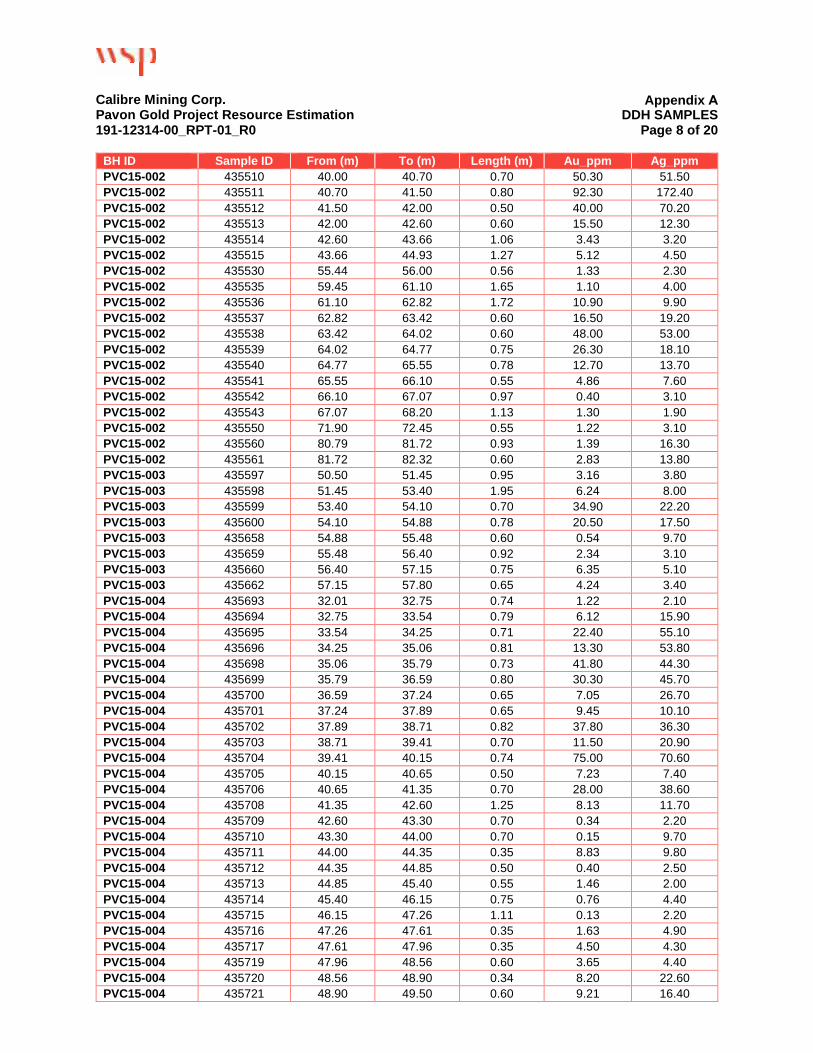
Calibre Mining Corp. Pavon Gold Project Resource Estimation 191-12314-00_RPT-01_R0
Appendix A DDH SAMPLES
Page 8 of 20
BH ID Sample ID From (m) To (m) Length (m) Au_ppm Ag_ppm PVC15-002 435510 40.00 40.70 0.70 50.30 51.50 PVC15-002 435511 40.70 41.50 0.80 92.30 172.40 PVC15-002 435512 41.50 42.00 0.50 40.00 70.20 PVC15-002 435513 42.00 42.60 0.60 15.50 12.30 PVC15-002 435514 42.60 43.66 1.06 3.43 3.20 PVC15-002 435515 43.66 44.93 1.27 5.12 4.50 PVC15-002 435530 55.44 56.00 0.56 1.33 2.30 PVC15-002 435535 59.45 61.10 1.65 1.10 4.00 PVC15-002 435536 61.10 62.82 1.72 10.90 9.90 PVC15-002 435537 62.82 63.42 0.60 16.50 19.20 PVC15-002 435538 63.42 64.02 0.60 48.00 53.00 PVC15-002 435539 64.02 64.77 0.75 26.30 18.10 PVC15-002 435540 64.77 65.55 0.78 12.70 13.70 PVC15-002 435541 65.55 66.10 0.55 4.86 7.60 PVC15-002 435542 66.10 67.07 0.97 0.40 3.10 PVC15-002 435543 67.07 68.20 1.13 1.30 1.90 PVC15-002 435550 71.90 72.45 0.55 1.22 3.10 PVC15-002 435560 80.79 81.72 0.93 1.39 16.30 PVC15-002 435561 81.72 82.32 0.60 2.83 13.80 PVC15-003 435597 50.50 51.45 0.95 3.16 3.80 PVC15-003 435598 51.45 53.40 1.95 6.24 8.00 PVC15-003 435599 53.40 54.10 0.70 34.90 22.20 PVC15-003 435600 54.10 54.88 0.78 20.50 17.50 PVC15-003 435658 54.88 55.48 0.60 0.54 9.70 PVC15-003 435659 55.48 56.40 0.92 2.34 3.10 PVC15-003 435660 56.40 57.15 0.75 6.35 5.10 PVC15-003 435662 57.15 57.80 0.65 4.24 3.40 PVC15-004 435693 32.01 32.75 0.74 1.22 2.10 PVC15-004 435694 32.75 33.54 0.79 6.12 15.90 PVC15-004 435695 33.54 34.25 0.71 22.40 55.10 PVC15-004 435696 34.25 35.06 0.81 13.30 53.80 PVC15-004 435698 35.06 35.79 0.73 41.80 44.30 PVC15-004 435699 35.79 36.59 0.80 30.30 45.70 PVC15-004 435700 36.59 37.24 0.65 7.05 26.70 PVC15-004 435701 37.24 37.89 0.65 9.45 10.10 PVC15-004 435702 37.89 38.71 0.82 37.80 36.30 PVC15-004 435703 38.71 39.41 0.70 11.50 20.90 PVC15-004 435704 39.41 40.15 0.74 75.00 70.60 PVC15-004 435705 40.15 40.65 0.50 7.23 7.40 PVC15-004 435706 40.65 41.35 0.70 28.00 38.60 PVC15-004 435708 41.35 42.60 1.25 8.13 11.70 PVC15-004 435709 42.60 43.30 0.70 0.34 2.20 PVC15-004 435710 43.30 44.00 0.70 0.15 9.70 PVC15-004 435711 44.00 44.35 0.35 8.83 9.80 PVC15-004 435712 44.35 44.85 0.50 0.40 2.50 PVC15-004 435713 44.85 45.40 0.55 1.46 2.00 PVC15-004 435714 45.40 46.15 0.75 0.76 4.40 PVC15-004 435715 46.15 47.26 1.11 0.13 2.20 PVC15-004 435716 47.26 47.61 0.35 1.63 4.90 PVC15-004 435717 47.61 47.96 0.35 4.50 4.30 PVC15-004 435719 47.96 48.56 0.60 3.65 4.40 PVC15-004 435720 48.56 48.90 0.34 8.20 22.60 PVC15-004 435721 48.90 49.50 0.60 9.21 16.40

Calibre Mining Corp. Pavon Gold Project Resource Estimation 191-12314-00_RPT-01_R0
Appendix A DDH SAMPLES
Page 9 of 20
BH ID Sample ID From (m) To (m) Length (m) Au_ppm Ag_ppm PVC15-004 435726 53.20 54.70 1.50 1.65 4.40 PVC15-004 435727 54.70 56.20 1.50 0.16 1.30 PVC15-004 435728 56.20 57.70 1.50 1.01 1.40 PVC15-005 435765 51.68 51.93 0.25 2.26 9.70 PVC15-005 435766 51.93 52.43 0.50 4.17 18.10 PVC15-005 435767 52.43 53.11 0.68 8.22 23.70 PVC15-005 435768 53.11 53.75 0.64 6.69 13.70 PVC15-005 435769 53.75 54.43 0.68 15.30 17.10 PVC15-005 435770 54.43 55.13 0.70 6.79 13.50 PVC15-005 435771 55.13 56.09 0.96 2.65 12.50 PVC15-005 435772 56.09 56.64 0.55 0.85 12.90 PVC15-005 435773 56.64 57.93 1.29 0.83 18.50 PVC15-005 435774 57.93 59.05 1.12 1.85 16.80 PVC15-005 435775 59.05 60.15 1.10 1.85 37.80 PVC15-005 435777 60.15 60.98 0.83 1.82 32.10 PVC15-005 435778 60.98 62.50 1.52 1.99 31.70 PVC15-005 435779 62.50 64.02 1.52 5.08 15.90 PVC15-006 435823 52.63 55.18 2.55 3.51 72.30 PVC15-006 435824 55.18 56.00 0.82 2.79 8.10 PVC15-006 435825 56.00 56.80 0.80 2.96 7.70 PVC15-006 435826 56.80 57.35 0.55 2.28 4.50 PVC15-006 435828 57.35 57.93 0.58 3.03 3.60 PVC15-006 435829 57.93 58.68 0.75 4.44 7.70 PVC15-006 435830 58.68 59.45 0.77 4.71 9.00 PVC15-006 435831 59.45 60.07 0.62 3.73 7.00 PVC15-006 435832 60.07 60.75 0.68 1.02 2.30 PVC15-007 NS - - - - - PVC15-008 435924 24.04 24.39 0.35 1.38 1.80 PVC15-008 435925 24.39 24.96 0.57 0.83 2.30 PVC15-008 435926 24.96 25.91 0.95 2.13 2.80 PVC15-008 435927 25.91 26.72 0.81 11.10 14.30 PVC15-008 435928 26.72 27.44 0.72 6.84 8.10 PVC15-008 435929 27.44 28.15 0.71 6.20 18.70 PVC15-008 435930 28.15 28.96 0.81 10.80 45.70 PVC15-008 435931 28.96 29.58 0.62 5.43 14.90 PVC15-008 435932 29.58 30.00 0.42 3.42 31.20 PVC15-008 435933 30.00 30.49 0.49 1.23 4.40 PVC15-008 435934 30.49 32.01 1.52 32.50 30.70 PVC15-008 435935 32.01 32.51 0.50 4.42 4.70 PVC15-008 435936 32.51 33.54 1.03 0.48 2.50 PVC15-008 435938 33.54 33.92 0.38 15.40 14.20 PVC15-008 435939 33.92 34.60 0.68 14.90 33.20 PVC15-008 435940 34.60 34.95 0.35 0.96 13.00 PVC15-008 435941 34.95 35.32 0.37 3.33 9.50 PVC15-008 435942 35.32 36.04 0.72 3.89 9.80 PVC15-008 435943 36.04 37.06 1.02 7.56 18.90 PVC15-008 435945 37.06 38.11 1.05 15.10 11.00 PVC15-008 435946 38.11 39.03 0.92 1.38 8.10 PVC15-008 435947 39.03 39.95 0.92 1.81 3.30 PVC15-009 436002 38.34 39.63 1.29 4.97 35.10 PVC15-009 436004 39.63 40.63 1.00 2.71 14.00 PVC15-009 436005 40.63 41.51 0.88 33.60 40.90 PVC15-009 436006 41.51 42.58 1.07 15.20 12.90

Calibre Mining Corp. Pavon Gold Project Resource Estimation 191-12314-00_RPT-01_R0
Appendix A DDH SAMPLES
Page 10 of 20
BH ID Sample ID From (m) To (m) Length (m) Au_ppm Ag_ppm PVC15-009 436011 45.55 46.76 1.21 5.82 9.80 PVC15-010 436048 36.35 37.20 0.85 2.00 3.20 PVC15-010 436049 37.20 38.11 0.91 21.90 18.90 PVC15-010 436051 38.11 38.41 0.30 1.60 3.20 PVC15-010 436058 41.80 42.80 1.00 3.80 4.10 PVC15-010 436059 42.80 44.05 1.25 6.79 8.10 PVC15-011 436113 22.87 23.37 0.50 1.12 1.60 PVC15-011 436125 34.46 35.06 0.60 1.08 1.30 PVC15-011 436128 36.75 38.35 1.60 2.02 158.40 PVC15-011 436133 42.68 44.21 1.53 1.98 3.10 PVC15-011 436134 44.21 45.73 1.52 0.32 2.60 PVC15-011 436135 45.73 46.73 1.00 13.60 9.40 PVC15-011 436136 46.73 47.70 0.97 2.26 5.60 PVC15-011 436137 47.70 48.78 1.08 0.53 3.70 PVC15-011 436138 48.78 49.51 0.73 0.45 2.10 PVC15-011 436139 49.51 50.30 0.79 6.49 7.10 PVC15-011 436140 50.30 51.23 0.93 4.05 5.10 PVC15-011 436141 51.23 51.83 0.60 8.77 7.80 PVC15-011 436143 51.83 52.23 0.40 18.90 16.20 PVC15-011 436144 52.23 53.05 0.82 2.44 7.80 PVC15-012 436091 48.78 49.70 0.92 1.24 2.60 PVC15-012 436092 49.70 50.74 1.04 1.08 3.30 PVC15-012 436093 50.74 51.70 0.96 0.16 5.00 PVC15-012 436094 51.70 52.75 1.05 1.79 3.50 PVC15-012 436096 52.75 53.35 0.60 1.05 2.20 PVC15-012 436097 53.35 54.57 1.22 1.13 2.70 PVC15-013 436160 27.05 27.44 0.39 1.35 4.00 PVC15-013 436176 36.40 36.95 0.55 1.93 2.70 PVC15-014 436187 8.70 9.70 1.00 2.73 3.70 PVC15-014 436189 9.70 10.30 0.60 16.30 24.30 PVC15-014 436190 10.30 11.25 0.95 28.10 35.30 PVC15-014 436191 11.25 12.20 0.95 20.50 27.70 PVC15-014 436192 12.20 12.95 0.75 56.70 72.70 PVC15-014 436193 12.95 13.82 0.87 23.10 40.90 PVC15-014 436194 13.82 14.69 0.87 1.36 11.20 PVC15-014 436195 14.69 15.42 0.73 2.04 21.40 PVC15-014 436196 15.42 16.07 0.65 1.58 9.50 PVC15-014 436197 16.07 16.77 0.70 1.41 4.20 PVC15-014 436198 16.77 18.29 1.52 1.02 4.20 PVC15-014 436199 18.29 19.15 0.86 0.36 2.90 PVC15-014 436401 19.15 20.15 1.00 1.06 2.00 PVC15-014 436402 20.15 21.05 0.90 0.94 1.00 PVC15-014 436403 21.05 22.34 1.29 0.80 1.20 PVC15-014 436404 22.34 23.00 0.66 1.69 0.80 PVC15-014 436405 23.00 23.80 0.80 0.64 1.10 PVC15-014 436406 23.80 24.39 0.59 1.87 1.40 PVC15-014 436407 24.39 25.16 0.77 2.85 2.70 PVC15-014 436408 25.16 25.91 0.75 1.86 3.80 PVC15-014 436409 25.91 26.71 0.80 0.49 0.90 PVC15-014 436410 26.71 27.70 0.99 0.20 2.50 PVC15-014 436411 27.70 28.30 0.60 6.49 8.40 PVC15-014 436412 28.30 28.90 0.60 0.16 0.70 PVC15-014 436413 28.90 30.55 1.65 1.54 8.00

Calibre Mining Corp. Pavon Gold Project Resource Estimation 191-12314-00_RPT-01_R0
Appendix A DDH SAMPLES
Page 11 of 20
BH ID Sample ID From (m) To (m) Length (m) Au_ppm Ag_ppm PVC15-014 436414 30.55 31.45 0.90 3.17 2.90 PVC15-014 436416 31.45 32.10 0.65 0.88 1.20 PVC15-014 436417 32.10 32.60 0.50 1.40 3.10 PVC15-014 436418 32.60 33.54 0.94 0.47 4.60 PVC15-014 436419 33.54 34.54 1.00 1.70 1.50 PVC15-014 436420 34.54 35.55 1.01 1.54 3.40 PVC15-014 436421 35.55 36.00 0.45 17.60 21.10 PVC15-014 436432 42.70 43.45 0.75 4.43 8.10 PVC15-015 436458 51.83 52.67 0.84 1.25 2.40 PVC15-015 436459 52.67 53.59 0.92 4.43 2.80 PVC15-015 436487 77.74 78.64 0.90 2.41 13.10 PVC15-015 436488 78.64 80.79 2.15 7.29 13.10 PVC15-015 436489 80.79 81.28 0.49 7.04 26.40 PVC15-015 436512 99.86 100.61 0.75 2.03 0.80 PVC15-015 436513 100.61 101.63 1.02 18.80 8.40 PVC15-016 NS - - - - - PVC15-017 436558 49.04 49.72 0.68 1.58 1.20 PVC15-017 436572 62.50 64.02 1.52 3.41 7.10 PVC15-017 436573 64.02 64.70 0.68 1.21 7.50 PVC15-017 436574 64.70 65.55 0.85 2.02 7.40 PVC15-017 436581 67.78 68.25 0.47 1.23 1.30 PVC15-017 436582 68.25 68.60 0.35 0.29 1.20 PVC15-017 436583 68.60 69.07 0.47 0.69 2.40 PVC15-017 436584 69.07 69.69 0.62 0.28 1.50 PVC15-017 436585 69.69 70.12 0.43 9.44 19.00 PVC15-017 436586 70.12 71.02 0.90 9.30 24.00 PVC15-017 436587 71.02 71.65 0.63 1.89 6.20 PVC15-017 436597 77.84 78.40 0.56 1.94 2.40 PVC15-018 436638 39.95 41.16 1.21 1.69 2.90 PVC15-018 436639 42.68 44.21 1.53 0.47 1.60 PVC15-018 436640 44.21 45.73 1.52 1.45 3.40 PVC15-018 436641 45.73 47.26 1.53 1.11 5.50 PVC15-018 436642 47.26 48.78 1.52 19.50 17.40 PVC15-018 436643 48.78 50.30 1.52 6.65 10.00 PVC15-018 436644 50.30 50.96 0.66 17.50 25.80 PVC15-018 436645 50.96 51.41 0.45 1.57 4.30 PVC15-018 436646 51.41 51.93 0.52 1.38 4.10 PVC15-018 436648 51.93 54.10 2.17 1.03 2.70 PVC15-018 436649 54.10 55.08 0.98 0.89 3.10 PVC15-018 436650 55.08 56.61 1.53 3.83 5.60 PVC15-018 436651 56.61 57.09 0.48 0.74 4.80 PVC15-018 436652 57.09 57.56 0.47 3.77 6.00 PVC15-018 436653 57.56 58.03 0.47 1.03 6.40 PVC15-018 436654 58.03 59.00 0.97 0.37 4.70 PVC15-018 436655 59.00 59.72 0.72 0.48 1.10 PVC15-018 436656 59.72 60.09 0.37 6.11 5.00 PVC15-018 436657 60.09 60.58 0.49 0.66 2.10 PVC15-018 436658 60.58 61.08 0.50 6.16 3.70 PVC15-018 436666 64.19 64.55 0.36 4.66 3.50 PVC15-018 436671 67.07 67.60 0.53 1.99 2.30 PVC15-019 436694 37.71 38.11 0.40 2.54 1.10 PVC15-019 436695 38.11 38.51 0.40 0.14 0.70 PVC15-019 436696 38.51 39.01 0.50 18.00 7.50

Calibre Mining Corp. Pavon Gold Project Resource Estimation 191-12314-00_RPT-01_R0
Appendix A DDH SAMPLES
Page 12 of 20
BH ID Sample ID From (m) To (m) Length (m) Au_ppm Ag_ppm PVC15-019 436697 39.01 39.63 0.62 1.05 0.40 PVC15-019 436721 71.65 72.02 0.37 1.03 3.00 PVC15-019 436722 72.02 73.17 1.15 0.68 1.80 PVC15-019 436723 73.17 73.67 0.50 11.10 7.20 PVC15-019 436724 73.67 74.30 0.63 13.00 8.60 PVC15-019 436725 74.30 74.70 0.40 18.90 22.00 PVC15-019 436727 74.70 76.87 2.17 5.49 18.90 PVC15-020 436774 29.71 30.49 0.78 1.77 0.90 PVC15-020 436775 30.49 31.85 1.36 5.28 6.80 PVC15-020 436776 31.85 32.35 0.50 9.77 17.50 PVC15-020 436777 32.35 32.85 0.50 3.87 7.80 PVC15-020 436778 32.85 33.35 0.50 1.30 1.80 PVC15-020 436779 33.35 35.06 1.71 1.53 4.80 PVC15-020 436780 35.06 36.64 1.58 0.60 9.10 PVC15-020 436781 36.64 38.31 1.67 39.70 35.60 PVC15-020 436782 38.31 39.35 1.04 11.60 25.30 PVC15-020 436783 39.35 39.85 0.50 1.00 4.80 PVC15-020 436784 39.85 40.35 0.50 2.26 3.60 PVC15-020 436786 40.35 41.42 1.07 0.39 1.80 PVC15-020 436787 41.42 42.01 0.59 1.64 2.30 PVC15-020 436788 42.01 42.90 0.89 2.43 5.40 PVC15-020 436800 49.65 50.30 0.65 1.65 22.30 PVC15-020 436801 50.30 51.00 0.70 1.07 11.40 PVC15-021 436817 56.00 56.70 0.70 3.34 8.70 PVC15-021 436818 56.70 57.35 0.65 8.62 50.60 PVC15-021 436819 57.35 57.93 0.58 11.60 83.90 PVC15-021 436820 57.93 58.74 0.81 4.72 28.90 PVC15-021 436829 65.55 67.07 1.52 1.56 6.00 PVC15-022 436845 13.60 17.07 3.47 5.18 8.90 PVC15-022 436853 22.97 24.09 1.12 3.30 4.10 PVC15-022 436854 24.09 25.41 1.32 2.73 3.40 PVC15-022 436855 25.41 27.44 2.03 3.89 8.40 PVC15-022 436857 27.44 28.04 0.60 1.70 4.90 PVC15-022 436858 28.04 29.64 1.60 0.78 17.10 PVC15-022 436859 29.64 30.79 1.15 1.94 9.60 PVC15-022 436860 30.79 31.24 0.45 1.90 4.30 PVC15-022 436861 31.24 32.43 1.19 0.91 4.10 PVC15-022 436862 32.43 33.54 1.11 0.76 3.50 PVC15-022 436863 33.54 35.06 1.52 0.55 2.20 PVC15-022 436864 35.06 36.59 1.53 0.50 4.00 PVC15-022 436865 36.59 38.11 1.52 0.91 9.40 PVC15-022 436866 38.11 38.63 0.52 6.52 20.90 PVC15-022 436868 38.63 39.21 0.58 1.09 6.80 PVN14-001 437004 2.20 2.56 0.36 31.00 11.40 PVN14-001 437006 2.56 4.57 2.01 0.87 18.40 PVN14-001 437007 4.57 6.10 1.53 0.18 2.10 PVN14-001 437008 6.10 9.14 3.04 0.22 5.10 PVN14-001 437009 9.14 10.67 1.53 17.60 8.40 PVN14-001 437010 10.67 12.19 1.52 2.44 7.40 PVN14-001 437011 12.19 13.72 1.53 0.12 4.00 PVN14-001 437012 13.72 15.24 1.52 1.33 5.10 PVN14-001 437013 15.24 16.76 1.52 0.10 3.80 PVN14-001 437014 16.76 18.29 1.53 1.03 2.90

Calibre Mining Corp. Pavon Gold Project Resource Estimation 191-12314-00_RPT-01_R0
Appendix A DDH SAMPLES
Page 13 of 20
BH ID Sample ID From (m) To (m) Length (m) Au_ppm Ag_ppm PVN14-001 437016 18.29 18.69 0.40 4.60 28.70 PVN14-001 437017 18.69 19.29 0.60 0.16 1.60 PVN14-001 437018 19.29 19.81 0.52 0.77 2.10 PVN14-001 437019 19.81 20.47 0.66 18.90 8.60 PVN14-001 437020 20.47 21.34 0.87 0.37 0.30 PVN14-001 437021 21.34 22.08 0.74 0.52 13.50 PVN14-001 437022 22.08 22.86 0.78 1.91 34.90 PVN14-001 437023 22.86 23.62 0.76 2.03 4.50 PVN14-001 437024 23.62 24.38 0.76 18.60 9.10 PVN14-001 437025 24.38 25.15 0.77 7.03 5.20 PVN14-001 437026 25.15 25.91 0.76 18.40 11.40 PVN14-001 437027 25.91 26.95 1.04 15.90 14.20 PVN14-001 437028 26.95 27.95 1.00 21.20 12.00 PVN14-001 437030 27.95 28.96 1.01 1.05 2.30 PVN14-001 437031 28.96 29.72 0.76 1.70 4.00 PVN14-001 437032 29.72 30.48 0.76 11.80 4.70 PVN14-001 437033 30.48 31.28 0.80 16.90 11.80 PVN14-001 437034 31.28 32.00 0.72 2.05 7.00 PVN14-001 437035 32.00 32.73 0.73 1.36 1.60 PVN14-001 437045 40.15 41.15 1.00 2.13 4.00 PVN14-001 437046 41.15 41.70 0.55 1.63 0.80 PVN14-001 437047 41.70 42.25 0.55 4.34 1.70 PVN14-001 437058 49.48 50.30 0.82 1.98 3.30 PVN14-001 437059 50.30 50.90 0.60 11.50 9.10 PVN14-001 437060 50.90 51.83 0.93 0.03 1.20 PVN14-001 437061 51.83 52.73 0.90 7.05 6.50 PVN14-002 437093 28.96 29.92 0.96 1.78 1.80 PVN14-002 437094 29.92 30.60 0.68 0.37 8.60 PVN14-002 437095 30.60 31.55 0.95 0.29 1.30 PVN14-002 437096 31.55 32.17 0.62 3.38 6.90 PVN14-002 437097 32.17 32.75 0.58 2.05 25.30 PVN14-002 437098 32.75 33.54 0.79 1.10 15.60 PVN14-002 437100 33.54 34.10 0.56 3.61 2.90 PVN14-003 437150 34.39 35.06 0.67 10.00 12.20 PVN14-003 437151 35.06 35.51 0.45 2.50 6.40 PVN14-003 437152 35.51 36.02 0.51 6.50 15.00 PVN14-003 437153 36.02 36.59 0.57 2.62 9.90 PVN14-003 437154 36.59 37.10 0.51 8.62 13.60 PVN14-003 437155 37.10 37.56 0.46 4.90 23.70 PVN14-003 437156 37.56 38.11 0.55 3.36 14.10 PVN14-003 437157 38.11 38.86 0.75 5.68 6.40 PVN14-003 437159 38.86 39.63 0.77 2.48 2.60 PVN14-003 437160 39.63 40.46 0.83 0.68 1.30 PVN14-003 437161 40.46 41.16 0.70 0.55 1.30 PVN14-003 437162 41.16 41.93 0.77 2.88 1.90 PVN14-003 437163 41.93 42.56 0.63 2.13 2.00 PVN14-003 437164 42.56 42.98 0.42 1.38 1.00 PVN14-003 437165 42.98 43.33 0.35 1.04 1.60 PVN14-003 437174 48.78 49.48 0.70 1.26 1.20 PVN14-003 437175 49.48 50.30 0.82 1.73 2.40 PVN14-003 437176 50.30 50.95 0.65 1.15 2.60 PVN14-004 437192 34.54 35.06 0.52 1.66 1.10 PVN14-004 437193 35.06 35.96 0.90 9.93 8.00

Calibre Mining Corp. Pavon Gold Project Resource Estimation 191-12314-00_RPT-01_R0
Appendix A DDH SAMPLES
Page 14 of 20
BH ID Sample ID From (m) To (m) Length (m) Au_ppm Ag_ppm PVN14-004 437195 35.96 36.59 0.63 1.10 2.30 PVN14-004 437196 36.59 38.11 1.52 1.90 2.80 PVN14-004 437197 38.11 38.81 0.70 5.45 6.70 PVN14-004 437198 38.81 39.63 0.82 4.52 4.80 PVN14-004 437199 39.63 40.30 0.67 8.37 5.80 PVN14-005 437240 40.53 41.16 0.63 12.30 11.10 PVN14-005 437241 41.16 41.87 0.71 7.72 12.30 PVN14-005 437248 46.54 47.31 0.77 2.15 8.90 PVN14-005 437255 50.88 51.55 0.67 30.70 34.80 PVN14-005 437256 51.55 52.30 0.75 24.80 17.80 PVN14-005 437257 52.30 52.83 0.53 0.58 2.50 PVN14-005 437258 52.83 53.75 0.92 2.07 4.00 PVN14-005 437259 53.75 54.88 1.13 0.83 8.20 PVN14-005 437260 54.88 55.63 0.75 0.94 1.40 PVN14-005 437261 55.63 56.40 0.77 1.05 3.40 PVN14-005 437262 56.40 57.00 0.60 0.90 3.40 PVN14-005 437263 57.00 57.50 0.50 5.46 7.40 PVN14-005 437264 57.50 58.25 0.75 11.30 15.90 PVN14-005 437266 58.25 59.02 0.77 4.98 6.80 PVN14-005 437267 59.02 59.45 0.43 3.13 3.00 PVN14-006 437293 22.05 22.40 0.35 2.43 1.50 PVN14-006 437300 27.44 28.46 1.02 10.00 15.00 PVN14-006 437301 28.46 29.31 0.85 18.30 13.00 PVN14-006 437302 29.31 30.49 1.18 4.43 6.30 PVN14-006 437303 30.49 30.99 0.50 6.69 15.90 PVN14-006 437304 30.99 32.01 1.02 6.28 17.20 PVN14-006 437305 32.01 33.20 1.19 0.21 9.40 PVN14-006 437306 33.20 33.84 0.64 2.88 2.90 PVN14-006 437307 33.84 34.71 0.87 0.49 7.40 PVN14-006 437308 34.71 35.16 0.45 2.24 4.70 PVN14-006 437310 35.16 35.55 0.39 0.88 5.40 PVN14-006 437311 35.55 36.10 0.55 0.15 3.00 PVN14-006 437312 36.10 37.18 1.08 2.23 1.90 PVN14-006 437313 37.18 37.65 0.47 0.27 1.80 PVN14-006 437314 37.65 38.30 0.65 3.44 3.20 PVN14-006 437315 38.30 39.38 1.08 0.64 2.20 PVN14-006 437316 39.38 40.30 0.92 0.73 1.00 PVN14-006 437317 40.30 41.16 0.86 3.18 3.00 PVN14-006 437318 41.16 42.14 0.98 3.24 4.00 PVN14-006 437319 42.14 42.88 0.74 1.69 2.60 PVN14-007 437346 46.86 47.90 1.04 2.58 4.10 PVN14-008 437359 4.69 5.60 0.91 1.62 5.50 PVN14-008 437372 18.29 19.27 0.98 1.01 2.00 PVN14-008 437402 38.31 39.02 0.71 6.56 5.50 PVN14-008 437404 39.02 39.47 0.45 10.30 14.30 PVN14-008 437405 39.47 39.88 0.41 7.06 9.50 PVN14-008 437406 39.88 40.76 0.88 0.71 11.00 PVN14-008 437407 40.76 41.16 0.40 5.43 5.90 PVN14-008 437408 41.16 41.56 0.40 5.05 6.20 PVN14-008 437417 45.36 45.93 0.57 1.58 5.90 PVN14-009 437431 20.34 21.34 1.00 12.50 9.70 PVN14-009 437432 21.34 21.84 0.50 4.03 12.10 PVN14-009 437443 26.91 27.44 0.53 2.81 2.70

Calibre Mining Corp. Pavon Gold Project Resource Estimation 191-12314-00_RPT-01_R0
Appendix A DDH SAMPLES
Page 15 of 20
BH ID Sample ID From (m) To (m) Length (m) Au_ppm Ag_ppm PVN14-009 437444 27.44 27.90 0.46 9.96 15.70 PVN14-009 437445 27.90 28.42 0.52 11.70 20.90 PVN14-009 437446 28.42 28.96 0.54 10.90 14.70 PVN14-009 437447 28.96 29.39 0.43 4.13 10.20 PVN14-009 437448 29.39 29.84 0.45 2.42 5.90 PVN14-009 437449 29.84 30.32 0.48 2.79 2.70 PVN14-009 437450 30.32 30.93 0.61 0.82 7.40 PVN14-009 437451 30.93 31.43 0.50 1.61 5.70 PVN14-009 437453 31.43 32.01 0.58 1.94 2.00 PVN14-009 437454 32.01 32.61 0.60 1.93 1.70 PVN14-009 437455 32.61 33.27 0.66 1.07 1.50 PVN14-009 437456 33.27 33.84 0.57 3.19 25.70 PVN14-009 437457 33.84 34.24 0.40 3.48 2.40 PVN14-009 437458 34.24 34.79 0.55 3.08 3.30 PVN14-009 437459 34.79 35.34 0.55 1.26 4.40 PVN14-009 437460 35.34 35.88 0.54 0.53 7.90 PVN14-009 437461 35.88 36.74 0.86 0.39 0.90 PVN14-009 437462 36.74 37.27 0.53 0.40 17.50 PVN14-009 437463 37.27 38.11 0.84 1.50 1.90 PVN14-009 437465 38.11 38.72 0.61 2.53 1.90 PVN14-009 437466 38.72 39.22 0.50 0.94 21.00 PVN14-009 437467 39.22 40.13 0.91 0.82 3.10 PVN14-009 437468 40.13 40.70 0.57 0.41 1.70 PVN14-009 437469 40.70 41.27 0.57 0.49 3.00 PVN14-009 437470 41.27 41.83 0.56 1.31 2.00 PVN14-010 437497 66.15 66.65 0.50 1.10 2.30 PVN14-010 437498 66.65 67.07 0.42 4.17 6.50 PVN14-010 437500 67.07 67.90 0.83 1.13 2.00 PVN14-010 437501 67.90 68.60 0.70 0.93 2.50 PVN14-010 437502 68.60 69.30 0.70 7.05 7.70 PVN14-011 437526 20.35 21.34 0.99 1.13 4.60 PVN14-011 437549 41.82 42.32 0.50 1.01 0.50 PVN14-011 437550 42.32 42.96 0.64 0.16 5.40 PVN14-011 437551 42.96 43.63 0.67 4.95 6.90 PVN14-011 437552 43.63 44.21 0.58 3.07 4.00 PVN14-011 437553 44.21 44.78 0.57 2.94 4.30 PVN14-011 437554 44.78 45.38 0.60 1.81 0.80 PVN14-011 437556 45.38 46.00 0.62 15.80 5.10 PVN14-011 437557 46.00 46.60 0.60 13.80 8.90 PVN14-012 437597 45.73 46.30 0.57 2.16 2.00 PVN14-012 437598 46.30 46.91 0.61 4.74 2.00 PVN14-012 437599 46.91 47.62 0.71 1.03 1.50 PVN14-012 437607 51.10 51.70 0.60 5.84 10.00 PVN14-012 437608 51.70 52.18 0.48 4.55 5.60 PVN14-012 437609 52.18 52.70 0.52 4.94 5.80 PVN14-012 437610 52.70 53.35 0.65 8.79 8.50 PVN14-012 437611 53.35 53.86 0.51 5.82 3.60 PVN14-012 437612 53.86 54.40 0.54 1.77 0.80 PVN14-012 437613 54.40 54.93 0.53 3.34 1.90 PVN14-012 437614 54.93 55.45 0.52 5.40 2.90 PVN14-012 437616 55.45 56.05 0.60 3.85 2.30 PVN14-012 437617 56.05 56.58 0.53 1.94 10.80 PVN14-013 437633 25.83 26.45 0.62 1.49 0.80

Calibre Mining Corp. Pavon Gold Project Resource Estimation 191-12314-00_RPT-01_R0
Appendix A DDH SAMPLES
Page 16 of 20
BH ID Sample ID From (m) To (m) Length (m) Au_ppm Ag_ppm PVN14-013 437651 43.15 43.95 0.80 1.06 8.20 PVN14-013 437653 43.95 44.85 0.90 15.20 17.60 PVN14-013 437654 44.85 45.73 0.88 11.60 8.30 PVN14-013 437655 45.73 46.75 1.02 2.17 2.00 PVN14-013 437664 52.57 53.35 0.78 1.01 9.30 PVN14-013 437666 53.35 53.90 0.55 3.35 7.10 PVN14-013 437667 53.90 54.50 0.60 3.91 8.30 PVN14-013 437668 54.50 55.05 0.55 9.99 12.30 PVN14-013 437669 55.05 55.54 0.49 11.80 22.20 PVN14-013 437670 55.54 56.30 0.76 10.20 13.20 PVN14-013 437671 56.30 56.80 0.50 20.20 16.40 PVN14-013 437672 56.80 57.40 0.60 15.40 11.50 PVN14-013 437673 57.40 58.09 0.69 4.46 5.10 PVN14-013 437674 58.09 58.90 0.81 1.55 2.20 PVN14-013 437676 58.90 59.45 0.55 6.11 3.50 PVN14-013 437677 59.45 60.22 0.77 7.59 4.20 PVN14-013 437678 60.22 60.98 0.76 2.13 1.80 PVN14-013 437679 60.98 61.80 0.82 9.07 4.70 PVN14-013 437680 61.80 62.50 0.70 5.51 10.10 PVN14-014 437702 66.80 67.50 0.70 1.06 1.40 PVN14-014 437703 67.50 68.20 0.70 1.25 4.30 PVN14-014 437704 68.20 68.80 0.60 2.10 3.10 PVN14-014 437705 68.80 69.55 0.75 1.82 1.30 PVN14-014 437706 69.55 70.30 0.75 2.39 4.30 PVN14-014 437707 70.30 70.95 0.65 0.26 3.10 PVN14-014 437708 70.95 71.82 0.87 1.47 7.80 PVN14-014 437709 71.82 72.52 0.70 0.95 6.80 PVN14-014 437710 72.52 73.17 0.65 0.99 4.50 PVN14-014 437712 73.17 73.77 0.60 1.79 3.30 PVN14-014 437713 73.77 74.47 0.70 0.96 5.30 PVN14-014 437714 74.47 75.07 0.60 8.72 7.00 PVN14-014 437715 75.07 75.87 0.80 6.80 8.10 PVN14-014 437716 75.87 76.65 0.78 1.16 2.00 PVN14-014 437717 76.65 77.25 0.60 2.19 2.70 PVN14-014 437723 81.00 82.00 1.00 2.77 4.70 PVN14-014 437725 82.00 83.00 1.00 1.71 5.50 PVN14-014 437726 83.00 83.70 0.70 1.36 1.60 PVN14-014 437727 83.70 84.30 0.60 1.86 1.70 PVN14-014 437728 84.30 85.37 1.07 0.87 2.00 PVN14-014 437729 85.37 86.15 0.78 1.49 3.00 PVN14-014 437730 86.15 86.89 0.74 3.13 6.80 PVN14-015 437770 33.90 34.75 0.85 4.49 1.20 PVN14-015 437772 34.75 35.90 1.15 0.38 0.60 PVN14-015 437773 35.90 36.65 0.75 7.22 1.20 PVN14-015 437774 36.65 37.65 1.00 1.55 0.80 PVN14-015 437815 37.65 38.20 0.55 9.59 2.40 PVN14-015 437775 38.20 38.65 0.45 9.31 0.80 PVN14-015 437776 38.65 39.65 1.00 2.57 0.80 PVN14-015 437777 39.65 40.35 0.70 2.00 1.50 PVN14-015 437778 40.35 41.35 1.00 0.33 0.70 PVN14-015 437779 41.35 42.25 0.90 1.22 0.90 PVN14-015 437780 42.25 42.85 0.60 4.14 2.40 PVN14-015 437782 42.85 43.35 0.50 0.44 1.30

Calibre Mining Corp. Pavon Gold Project Resource Estimation 191-12314-00_RPT-01_R0
Appendix A DDH SAMPLES
Page 17 of 20
BH ID Sample ID From (m) To (m) Length (m) Au_ppm Ag_ppm PVN14-015 437783 43.35 44.10 0.75 3.90 1.20 PVN14-015 437784 44.10 44.90 0.80 7.93 3.40 PVN14-015 437785 44.90 45.70 0.80 0.69 2.40 PVN14-015 437786 45.70 46.30 0.60 4.57 2.00 PVN14-015 437787 46.30 47.00 0.70 2.09 12.40 PVN14-015 437788 47.00 47.70 0.70 4.69 5.90 PVN14-015 437789 47.70 48.50 0.80 5.70 2.90 PVN14-015 437790 48.50 49.40 0.90 2.26 3.80 PVN14-015 437791 49.40 50.30 0.90 0.65 10.40 PVN14-015 437792 50.30 50.70 0.40 0.75 0.60 PVN14-015 437793 50.70 51.20 0.50 1.29 7.70 PVN14-015 437795 51.20 51.85 0.65 1.30 9.10 PVN14-015 437817 51.85 52.35 0.50 2.36 2.40 PVN14-015 437801 55.80 56.60 0.80 1.14 10.10 PVN14-015 437802 56.60 57.40 0.80 2.84 5.50 PVN14-015 437803 57.40 58.10 0.70 0.50 7.10 PVN14-015 437804 58.10 59.00 0.90 2.71 3.80 PVN14-015 437806 59.00 59.70 0.70 3.04 12.50 PVN14-015 437807 59.70 60.20 0.50 3.08 3.90 PVN14-015 437808 60.20 60.60 0.40 0.58 5.30 PVN14-015 437809 60.60 61.00 0.40 0.96 3.10 PVN14-015 437810 61.00 61.80 0.80 3.26 3.70 PVN14-016 437892 68.28 68.87 0.59 2.17 1.20 PVN14-016 437893 68.87 69.35 0.48 3.15 1.70 PVN14-016 437901 72.62 73.17 0.55 1.05 4.20 PVN14-016 437902 73.17 73.75 0.58 1.37 7.80 PVN14-016 437903 73.75 74.30 0.55 3.96 7.40 PVN14-016 437904 74.30 74.70 0.40 9.28 4.80 PVN14-016 437905 74.70 75.26 0.56 4.68 3.30 PVN14-016 437906 75.26 75.71 0.45 3.22 4.80 PVN14-016 437907 75.71 76.47 0.76 2.12 5.00 PVN14-016 437908 76.47 76.91 0.44 1.90 3.40 PVN14-016 437910 76.91 77.30 0.39 0.89 5.20 PVN14-016 437911 77.30 77.74 0.44 8.22 9.00 PVN14-017 437957 69.65 70.00 0.35 1.10 8.90 PVN14-017 437958 70.00 70.45 0.45 0.50 3.10 PVN14-017 437959 70.45 71.10 0.65 0.18 0.60 PVN14-017 437960 71.10 71.80 0.70 2.88 9.00 PVN14-017 437961 71.80 72.55 0.75 2.89 3.00 PVN14-018 438008 46.76 47.41 0.65 2.09 5.00 PVN14-018 438013 49.32 49.78 0.46 1.83 3.80 PVN14-018 438014 49.78 50.30 0.52 0.33 1.30 PVN14-018 438016 50.30 50.98 0.68 0.57 2.50 PVN14-018 438017 50.98 51.28 0.30 1.19 5.10 PVN14-018 438018 51.28 51.83 0.55 2.25 3.30 PVN14-018 438019 51.83 52.30 0.47 1.14 3.00 PVN14-018 438020 52.30 52.89 0.59 0.44 1.50 PVN14-018 438021 52.89 53.27 0.38 4.07 7.40 PVN14-018 438022 53.27 53.68 0.41 1.66 3.20 PVN14-018 438023 53.68 54.04 0.36 1.87 2.10 PVN14-018 438024 54.04 54.40 0.36 4.57 6.30 PVN14-018 438025 54.40 54.71 0.31 11.40 21.60 PVN14-018 438026 54.71 55.34 0.63 4.60 3.60

Calibre Mining Corp. Pavon Gold Project Resource Estimation 191-12314-00_RPT-01_R0
Appendix A DDH SAMPLES
Page 18 of 20
BH ID Sample ID From (m) To (m) Length (m) Au_ppm Ag_ppm PVN14-018 438027 55.34 55.81 0.47 26.80 12.20 PVN14-018 438028 55.81 56.54 0.73 5.75 4.20 PVN14-018 438030 56.54 56.92 0.38 0.29 2.30 PVN14-018 438031 56.92 57.34 0.42 0.28 2.40 PVN14-018 438032 57.34 57.74 0.40 0.45 0.70 PVN14-018 438033 57.74 58.12 0.38 0.29 1.70 PVN14-018 438034 58.12 58.65 0.53 1.11 1.60 PVN14-018 438035 58.65 59.31 0.66 2.30 8.70 PVN14-018 438036 59.31 59.66 0.35 0.09 9.10 PVN14-018 438037 59.66 60.28 0.62 0.97 1.40 PVN14-018 438038 60.28 60.78 0.50 0.38 2.10 PVN14-018 438039 60.78 61.18 0.40 1.79 2.00 PVN14-018 438040 61.18 61.58 0.40 0.42 0.60 PVN14-018 438041 61.58 61.90 0.32 1.52 1.80 PVN14-018 438043 61.90 62.50 0.60 7.56 3.50 PVN14-018 438044 62.50 63.27 0.77 3.82 3.30 PVN14-018 438045 63.27 63.80 0.53 1.61 2.00 PVN14-019 438069 8.75 9.29 0.54 37.00 15.30 PVN14-019 438070 9.29 9.59 0.30 18.50 8.50 PVN14-019 438071 9.59 10.29 0.70 15.50 7.20 PVN14-019 438072 10.29 10.67 0.38 0.25 7.00 PVN14-019 438073 10.67 11.12 0.45 1.81 7.70 PVN14-019 438074 11.12 11.57 0.45 0.42 0.90 PVN14-019 438076 11.57 11.95 0.38 1.81 7.30 PVN14-019 438077 11.95 12.42 0.47 3.93 2.70 PVN14-019 438089 31.49 31.91 0.42 1.21 3.60 PVN14-019 438114 48.06 48.85 0.79 2.59 3.70 PVN14-019 438119 50.56 51.14 0.58 8.09 8.90 PVN14-019 438120 51.14 51.75 0.61 2.84 4.90 PVN14-019 438121 51.75 52.43 0.68 0.63 2.90 PVN14-019 438122 52.43 52.87 0.44 2.06 6.40 PVN14-019 438123 52.87 53.17 0.30 2.10 2.10 PVN14-019 438125 53.17 53.83 0.66 31.30 9.90 PVN14-019 438130 56.10 56.40 0.30 4.85 8.30 PVN14-019 438131 56.40 56.90 0.50 17.50 13.30 PVN14-019 438137 59.02 59.70 0.68 3.88 4.10 PVN14-019 438138 59.70 60.20 0.50 7.65 4.80 PVN14-019 438139 60.20 60.52 0.32 12.00 7.60 PVN14-019 438141 60.98 61.50 0.52 1.13 2.50 PVN14-019 438149 64.14 64.95 0.81 1.31 2.80 PVN14-020 438162 4.92 5.62 0.70 3.68 5.30 PVN14-020 438163 5.62 6.10 0.48 1.49 5.30 PVN14-020 438166 7.42 8.07 0.65 2.60 5.60 PVN14-020 438206 41.55 42.15 0.60 3.50 6.80 PVN14-020 438207 42.15 42.48 0.33 0.49 0.50 PVN14-020 438208 42.48 42.90 0.42 1.85 15.40 PVN14-020 438212 44.08 44.53 0.45 11.60 9.20 PVN14-020 438213 44.53 44.93 0.40 2.71 2.40 PVN14-020 438215 44.93 45.28 0.35 4.36 3.60 PVN14-020 438216 45.28 45.59 0.31 5.98 4.10 PVN14-020 438217 45.59 45.93 0.34 3.07 5.10 PVN14-020 438218 45.93 46.38 0.45 0.37 3.30 PVN14-020 438219 46.38 47.00 0.62 0.70 3.80

Calibre Mining Corp. Pavon Gold Project Resource Estimation 191-12314-00_RPT-01_R0
Appendix A DDH SAMPLES
Page 19 of 20
BH ID Sample ID From (m) To (m) Length (m) Au_ppm Ag_ppm PVN14-020 438220 47.00 47.31 0.31 2.80 2.50 PVN14-020 438221 47.31 47.98 0.67 12.00 11.20 PVN14-021 438246 4.30 5.00 0.70 13.20 14.00 PVN14-021 438250 9.15 10.65 1.50 1.90 4.10 PVN14-021 438251 10.65 11.10 0.45 3.30 7.00 PVN14-021 438253 11.10 12.20 1.10 0.14 2.50 PVN14-021 438254 12.20 13.70 1.50 1.02 2.70 PVN14-021 438283 35.80 36.55 0.75 3.21 1.90 PVN14-021 438293 42.55 43.25 0.70 7.73 15.10 PVN14-021 438294 43.25 43.75 0.50 7.69 9.50 PVN14-021 438295 43.75 44.20 0.45 12.50 18.30 PVN14-021 438296 44.20 44.80 0.60 6.56 33.90 PVN14-021 438310 51.70 52.65 0.95 1.01 1.10 PVN14-021 438313 53.45 53.95 0.50 1.70 4.40 PVN14-021 438314 53.95 54.55 0.60 1.09 21.70 PVN14-021 438315 54.55 55.25 0.70 1.51 37.30 PVN14-021 438316 55.25 56.15 0.90 0.71 18.30 PVN14-021 438317 56.15 56.90 0.75 1.04 17.90 PVN14-021 438318 56.90 57.60 0.70 0.78 9.10 PVN14-021 438319 57.60 58.50 0.90 1.10 14.20 PVN14-021 438325 61.50 61.98 0.48 1.07 14.20 PVN14-021 438329 63.90 64.27 0.37 3.40 58.00 PVN14-022 438404 5.75 6.10 0.35 1.53 6.10 PVN14-022 438431 22.61 23.50 0.89 3.85 4.20 PVN14-022 438434 24.52 25.34 0.82 3.08 4.40 PVN14-022 438446 31.45 31.76 0.31 2.45 0.80 PVN14-022 438446 31.45 31.76 0.31 2.45 0.80 PVN14-022 438489 53.88 54.25 0.37 1.12 0.90 PVN14-022 438490 54.25 54.88 0.63 4.13 1.60 PVN14-022 438491 54.88 55.33 0.45 1.22 2.30 PVN15-023 436885 19.48 20.08 0.60 14.00 16.60 PVN15-023 436886 20.08 20.85 0.77 16.10 10.20 PVN15-023 436887 20.85 21.50 0.65 3.75 6.50 PVN15-023 436888 21.50 22.87 1.37 2.33 4.80 PVN15-023 436889 22.87 24.99 2.12 0.70 3.00 PVN15-023 436890 24.99 26.19 1.20 3.31 2.20 PVN15-023 436891 26.19 27.10 0.91 1.59 1.80 PVN15-024 436966 23.79 25.91 2.12 1.37 1.20 PVN15-024 436967 25.91 26.89 0.98 1.65 1.40 PVN15-024 436968 26.89 27.44 0.55 0.26 1.00 PVN15-024 436969 27.44 28.31 0.87 1.56 1.00 PVN15-024 436970 28.31 29.83 1.52 0.23 1.50 PVN15-024 436971 29.83 30.88 1.05 1.44 1.60 PVN15-024 436982 39.53 40.10 0.57 1.84 2.60 PVN15-024 436989 44.85 45.53 0.68 3.46 11.00 PVN15-024 436999 51.02 51.83 0.81 1.20 3.10 PVN15-024 437000 51.83 52.29 0.46 0.49 0.60 PVN15-024 438701 52.29 53.00 0.71 0.93 2.40 PVN15-024 438702 53.00 53.63 0.63 2.33 1.40 PVN15-024 438703 53.63 54.42 0.79 1.46 1.70 PVN15-024 438704 54.42 54.88 0.46 5.16 9.00 PVN15-024 438705 54.88 55.30 0.42 2.71 11.60 PVN15-024 438706 55.30 56.40 1.10 0.67 8.20

Calibre Mining Corp. Pavon Gold Project Resource Estimation 191-12314-00_RPT-01_R0
Appendix ADDH SAMPLES
Page 20 of 20
BH ID Sample ID From (m) To (m) Length (m) Au_ppm Ag_ppm PVN15-024 438707 56.40 57.07 0.67 1.34 26.90 PVN15-024 438715 60.40 60.98 0.58 3.51 81.20 PVN15-025 436939 19.02 19.38 0.36 2.93 1.10 PVN15-025 436944 23.42 24.39 0.97 8.69 3.70 PVN15-025 436945 24.39 25.91 1.52 8.20 3.60 PVN15-025 436946 25.91 27.44 1.53 3.58 1.40 PVN15-025 436947 27.44 28.14 0.70 7.85 3.50


![Consumo Energético, Rivas-Nicaragua [Subcuenca Gil Gonzalez]](https://static.fdokumen.com/doc/165x107/632535c285efe380f30695c2/consumo-energetico-rivas-nicaragua-subcuenca-gil-gonzalez.jpg)