Talc, pyrophyllite and magnesite in Western Australia - NET
129
MINERAL RESOURCES BllLLETII 16 OOVERNMENT OF WESTERN AUSTRALIA TALC, tl m m .OrAYLLlTE by I? B. Abeysinghe 1
-
Upload
khangminh22 -
Category
Documents
-
view
1 -
download
0
Transcript of Talc, pyrophyllite and magnesite in Western Australia - NET

MINERAL RESOURCES
BllLLETII 16
OOVERNMENT OF WESTERN AUSTRALIA
TALC, tl m m .OrAYLLlTE
by I? B. Abeysinghe
1

TALC, PYROPHYLLITE AND MAGNESITE IN WESTERN AUSTRALIA

COVER:
Talc powder flanked by Mount Seabrook talc (left) and Three Springs talc (right)
FRONTISPIECE:
The talc mine at Three Springs sits comfortably amongst recently planted wheat paddocks.
Photo: courtesy of WMC Talc Asia Pacific

GEOLOGICAL SURVEY OF WESTERN AUSTRALIA
MINERAL RESOURCES BULLETIN 16
by P. B. Abeysinghe
Perth 1996

MINISTER FOR MINES The Hon. Kevin Minson, MLA
DIRECTOR GENERAL OF MINES K. R. Perry
DIRECTOR, GEOLOGICAL SURVEY OF WESTERN AUSTRALIA Pietro Guj
Copy editor: J. F. Johnston
The recommended reference for this publication is: ABEYSINGHE, P. B., 1996, Talc, pyrophyllite and magnesite in Western Australia: Western Australia Geological Survey, Mineral Resources Bulletin 16.
National Library of Australia Card Number and ISBN 0 7309 6547 3.
Abeysinghe, P. B. Talc, pyrophyllite and magnesite in Western Australia
Bibliography. Includes Index. ISBN 0 7309 6502 3.
1. Asbestos - Western Australia. 2. Magnesite - Western Australia 3. Pyrophyllite - Western Australia I. Geological Survey of Western Australia. I/. Title. (Series:Mineral Resources Bulletin (Perth, W.A.)); 16).
549.67
ISSN 0510-2014
Copies available from: Mining Information Centre Department of Minerals and Energy 100 Plain Street EAST PERTH Western Australia 6004 Telephone (09) 222 3459

Contents
Abstract ................................................................................................................................................................. 1 Summary .................... ............. .......... .......... ....................................... 3
Chapter 1 : Introduction Object and scope .................................................................................................................................................. 7 Sources of information ....................................... 7
Part 1 -Talc
Chapter 2: Mineralogy, mode of occurrence and uses of talc Mineralogy .................
Mafic associations ......................................................................... Properties and uses ............................................................................................................................................. 12
Paint ............................................................................................................................................................. 12 Paper ............................................................................................................................................................ 12
Methods of mining .................................................................................................................................
Chapter 3: Production and market trends of talc World production ............................................................................................................................................... 19
USA ............................................................................................................................................................. 19 China .............................................................................................
................................................................................................... 21
.............
...................................................................................... 26
... 111

De-inking .............................................................................................................................................. 26 Outlook ............................................................... 26
Chapter 4: Talc in Western Australia Moora Group ...................................................................................................................................................... 27
Regional geology ......................................................................................................................................... 27 Exploration for talc in the Moora Group .......................................................... Three Springs talc mine ............................................................................................................................... 29
Historical background .......................................................... 29
27
.................................................................................................................... 29
.................................................................................................................... 31
Origin ..................................................................... ........................... 34
Carnamah (Niven’s propert
Narryer Tenane ....................................................................................................
................................................... 39
Historical background
Mine operation ........................................................................................................................ Grade of ore ...........................................................................
Resources ................. ...................................................... 42
Mine geology ...........................................................................................................................
Livingstone talc prospect ................................................................................................................ 43
Grade of ore ..................................................................... ...................... 43 Resources ......................................... ........................................................ 44
........................................................ 44
................................................................................................................ 45
Trillbar-Southern Cross Well prospects
Mount Gould .................................................................................... Minor occurrences ............................................................................
Mooloo Downs ................. ........................................................ 46
Eastern Goldfields, Yilgarn Craton .................................................................................................................... 46 Regional geology ................................................................................................................ Mount Monger ............................................................................................................................................. 47
Geology ........................................................................................ Mining .................................................................................................................................................. 47 Grade and resources . ............................................................. 47
Minor occurrences ........... ............................................................. 49
Regional geology .............................................................................................. South Western terranes, Yilgarn Craton ............................................................................................................ 49
Bolgart ..................................................................................... .................................. 52 Meanys Bridge and Balingup ...................................................................................................................... 52 York (Mount Hardy, Mount Bakewell) ............................................................. 52 Minor occurrences
Regional geology ................................................................................................ Albany-Fraser Orogen ............................................................
Geology ............................................................................. .................................. 53
Quality ..................... ................................................................. 53 Talc mineralization ............................................................................................................................... 53
....................................................................... Minor occurrences onic units .......................................................
Southern Cross ............................................................................................................................. 55 Bullfinch ...................................................................... ................................................ 55
i v

Sandstone ............................................................................................................................................. 55
Regional geology ........... Cue ...................................................................................................
Other occurrences .............................. .............................. 59
..................................................... 59
..................................................... 60 Henry River (east of Maroonah) .......
............................. 63
Tabba Tabba ......... .......................................................................................................................... 64
Part 2 - Magnesite
Chapter 5: Mineralogy, mode of occurrence and uses of magnesite
Mineralogy .......................................................................................................................................................... 67 Mode of occurrence ..................
Ultramafic-associated
Other deposit types .......................................................... Magnesia from seawater and brine ............................................................................................................. 69
Dead-burned mag
............................. 70
Mining methods ...... Processing and bene
Chemical beneficiation ................................................................................................................................ 72
Chapter 6: Production and market trends
North Korea _. ........................................................................... 77
.............................................. Czech Republic ........................................................................................................................................... 77 Brazil ........................................................................................................................................................... 77 India ............................................................................................................................................................. 77

Australia .................................................. 77 Quee ........................................................................................................................................... 78 New South Wales ................................................................................................................................. 79 South Australia ........................................................................................ 80 Western Australia ................................................................................................................................. 80
Chapter 7: Magnesite in Western Australia Southern Cross Province, Yilgarn Craton .................................. 81
Ravensthorpe district ................................................................................................................................... 8 1 Histoiical background .......................................................................................................................... 8 1 Geology ................................................................................................................................................. 81 Magnesite deposits in Archaean ultramafic rocks ............................................................................... 82
B 1, B2, B5 .................................................................................
............................................. 85 B6 .................................................................................................................................................. 85 B7 .................................................................................................................................................. 85 B8 .............................................................................................................................. Ll ....................................
Bandalup deposit ............ Magnesite in Eocene Pallinup Siltstone .....................................
Other magnesite occurrences ................................................... 87 Quality of magnesite ............................................................................................................................ 87
Magnesite in Archaean rocks ........................................................................................................ 87 Magnesite in Eocene Pallinup Siltstone .................................................................
Total reserves ....................................................................... Magnesite in Archaean rocks ....................................... Magnesite in Eocene Pallinup Siltstone .......................
............................................................................................... 90
............................................................................................... 90 Chemical replacement deposits ..................................................................................................... 90
Munglinup ................................................................................................... Minor occurrences ....................................................................................................................................... 90
.................................... 90 Eastern Goldfields, Yilgarn Craton .
Historical background ......... .................................................................................................... 92
Magnesite deposits ............................................................................. Quality ........................................................................................................................................... 94
........................................ 94
Coolgardie ................................................................................................................................................... 96 Geology ................................................................................................. Magnesite localities ..............................................................................
Quality ........................................................................................... Origin ............................................................................................................................................ 97
Mount Burges ...................................................... 9 1 Lawlers .......... ...................................................... 97 Eulaminna ............................................................................................................................................ Siberia (Waverley) ............................................................................................................................... Comet Vale .......................................................................................................................................... Minor occurrences ............................................................................. ............ 102 Minor occurrences in other tectonic units ................................................................................................. 102
References . ................................................. 1 1 1 Index of localities ............................................................................................................................................. 1 17
I . 2. 3 . 4. 5. 6. 7. 8.
Global talc production, 199 Global talc production, 197
............................................ 20 .......................................................................................................... 20
Australian talc production, 1940-1994 .................................................................................................... 23 Talc prices, 1979-1994 .......................................................................................................... Talc occurrences in Western Australia ...........................................
..................... 30 Regional geology of Three Springs-Marchagee belt ............................................................................... 32 Photograph of openpit D at Three Springs talc mine showing zone of talc mineralization with lenses of dolomite ............................................................................................................................. 33
Map showing the position of Moora Group ...................................
vi

9. 10. 11. 12. 13. 14. 15. 16. 17. 18. 19. 20. 21. 22. 23. 24. 25. 26. 27. 28. 29. 30. 31. 32. 33.
1 . 2. 3. 4. 5. 6. 7. 8. 9.
10. 11. 12. 13. 14. 15. 16. 17. 18. 19. 20. 21. 22. 23. 24. 25. 26. 27. 28. 29. 30. 31. 32. 33. 34. 35. 36. 37. 38. 39.
40.
North-south cross section -Three Springs talc mine ............................................................................. 33 East-west cross section - Three Springs talc mine Distribution of dolerite dykes, talc ore and the locations of pits, Three Springs talc mine ..................... 35 Scanning electron micrograph of Three Springs talc ............................................ 38 Geology around Mount Seabrook mine ................... Scanning electron micrograph of Mount Seabrook t Interpreted geology of Livingstone talc prospect ..... Geology around Loganberry ...................................... Regional geology around Bandalup, Ravensthorpe and Kundip .... ............................................ 56 Cross sections along 9900E and 9950E - Kundip talc prospect ........................................................... 57
....................................................................................... 61
....._.._______._..... 64
...................... 75 Location map of Pinnacle Well .........................
4 . . . . . . . . . . . . . . . . . . . . . . . . . . . . . . . . . . . . . . I.. . . . . . . . . . . . . . . . . . . .
Generalized geological map of the Bulong area Main geologic units associated with magnesite
Photograph of magnesite at Lawlers ......................................................................................................... 100
Tables Talc properties important to specific industries .................................................................................... 13
........................................... 15 Principal flotation parame Flotation reagent quantities World production of talc .... Production of talc from Western Australian deposits ............. Total value of talc from Western Australian deposits ............. Stratigraphy of the Moora Chemical analyses of Three Springs talc ............ ............................................ 36 Chemical analyses of Mount Seabrook talc ............................................................................................. 37 Physical properties of two samples of talc from Three Springs ............................................................... 39 Physical properties and mineral composition of Mount Seabrook talc ........ Chemical analyses of Livingstone talc .......................................................... Chemical analysis of talc from Mount Taylor ......................... .........__..__.__._.. 46 Chemical analyses of talc from Mount Monger ............................................ Minor occurrences of talc in the Eastern Goldfields Province of the Yilgarn Craton ............................. 50
Summary of talc beneficiation studies ...............
........__._____..... 58
Chemical analyses of magnesite from Bulong ......................................................................................... 97 Chemical analyses of magnesite from Coolgardie and Mount Burges .................................................... 99
101 Chemical analyses of magnesite from Siberia, Comet Vale, Kalgoorlie, Bullabulling and
Minor occurrences of magnesite in the Eastern Goldfields of the Yilgarn Craton ................................ 103
Chemical analyses of magnesite from Lawlers ....................................................................
Hopbush Soak .............................................................................. ................... 102
vii

41. 42.
43. 44.
45.
Minor occuimmces of magnesite in the South Western terranes of the Yilgarn Craton 106 Chemical analyses of magnesite from Corrigin, Kumminin, York, Bamboo Creek an and breunnerite from Warrawoona ................................................................... 107 Minor occurrences of magnesite in the Murchison terrane of the Yilgarn Craton ................................ 108 Minor occurrences of magnesite in the Northampton Complex, Narryer Terrane and the Albany-Fraser Orogen .......................................................................... 109 Minor occurrences of magnesite in the north Pilbara granite-greenstone terrane ................................ 109
... V l l l

Talc, pyrophyllite and magnesite in Western Australia
by
P. B. Abeysinghe
Abstract
Talc
Talc is currently produced from two mines in Western Australia - at Three Springs and Mount Seabrook. Production from Three Springs in 1994 was 72 896 t, valued at $AUS 5.4 million, and that from Mount Seabrook was 27 942 t valued at $AUS 2 million. The total identified talc resource in Western Australia is approximately 12 Mt. At Three Springs, the talc mineralization is in flat-lying to gently dipping Proterozoic dolomite of the Coomberdale Subgroup of the Moora Group. There is a proven. probable, and indicated resource of 9.2 Mt in deposits at the mine. The rock types at Mount Seabrook consist of a mixed schist-quartzite unit that grades upward into a dolomite-chert-quartzite- talc unit. The talc is thought to be formed by alteration of sandy dolomitic rocks. Reserves and resources at the Mount Seabrook deposit are estimated at 1.55 Mt. The most prospective areas for exploration in Westein Australia are the regions of Proterozoic dolomite intruded by mafic dykes, such as those found in the Moora belt.
Pyrop hyl I ite
The only deposit of pyrophyllite of possible commercial interest is located at Pinnacle Well, near Leonora, and has an inferred resource of 10 Mt.
Magnesite
Magnesite was last produced in Western Australia in 1984 - 16 729 t valued at $AUS 215 936 - and came from deposits at Bandalup near Ravensthorpe. These are also the largest magnesite deposits in the State. Western Australia’s magnesite occurs as residual deposits on Archaean ultramafic and inafic rocks, or is found within the Tertiary Pallinup Siltstone. The Pallinup Siltstone deposits have an estimated recoverable resource of 1.3 Mt, and residual deposits related to ultramafic and mafic rocks have an inferred resource of 300 000 t. Another important magnesite deposit is found at Bulong. It comprises veins in serpentinized ultramafic rocks and the largest zone occurs within a northerly trending basin, parallel to Lake Yindarlgooda, that extends for nearly 3.7 km. Other notable magnesite occurrences are those at Lawlers, Eulaminna, Comet Vale, Coolgardie and Mount Burges, all associated with ultramafic rocks.
KEYWORDS: Coomberdale Subgroup, dolomite, magnesite, Moora Group, Mount Burges, Mount Seabrook, Pinnacle Well, pyrophyllite, Ravensthorpe, talc, Tertiary Pallinup Siltstone, Three Springs, ultramafic rocks, Western Australia
I

P. B. Abeysirzghe
2

Summary
Talc The mineral talc is a hydrated silicate of magnesium, theoretically containing 63.36% SiO,, 31.89% MgO and 4.75% H,O. It is the softest common mineral, having a hardness of 1, and its specific gravity is 2.58 to 2.83. Minerals associated with talc are tremolite, dolomite, mica, quartz, chlorite and magnesite. Steatite is an especially pure type of industrial talc with less than 1.5% CaO and Fe,O, and less than 4% A1,0,. Soapstone is a massive, soft, grey to bluish talcose rock that may be sawed into various shapes, and is also used as a medium for sculpture and carving.
The main uses of talc are in the paint, paper, plastics, ceramics, cosmetics and rubber industries. Of the many uses, some have a declining trend, whereas others are growing. The use of talc by the plastics industry is growing in Europe and the USA. In Europe, paper continues to be a leading consumer, paints remain a staple consumer, and talc usage in the cosmetics industry has declined over the last ten years. Prices have generally remained flat for most varieties of talc during the past seven years, except for Chinese ground talc, which increased in price to $~us420 in 1994.
More than 40 countries in the world produce talc, for a total annual production of around 6 to 8 Mt. The major producing countries are China, USA, South Korea, CIS, Brazil, India, Finland, France and Australia. China contributed approximately 32% of the world production in 1994, whereas that of USA was 11% and that of Australia was 1%. The global trend between 1974 and 1994 indicates that output of talc generally increased from 5.8 Mt in 1974 to a peak of 9.0 Mt in 1992 followed by a slight decrease to 8.6 Mt in 1994. A noticeable feature is that production from China has increased substantially, from around 150 000 t in 1979 to more than 2.5 Mt in 1994. Some countries have a reputation for certain types of talc: France, Italy, China and Australia are known for cosmetic talc; and New York is the best-known source of ceramic talc.
Australian production increased from approximately 64 000 t in 1974 to more than 115 000 t in 1994. Western Australia contributed 100 838 t valued at $7 million, 87% of the Australian production. The total production from Western Australia, South Australia and New South Wales, between 1940 and 1994, was more than 3 704 000 t, of which the Western Australian contribution was 3 052 000 t or about 82%. Production from the remainder of Australia was insignificant.
Western Australian production has increased substanti- ally since 1968 and the State is presently the largest producer in Australia. There are two producing centres: the Three Springs mine, 330 km north of Perth, is owned by Western Mining Corporation Limited; and the Mount Seabrook mine, approximately 174 km northwest of Meekatharra, is owned by Gwalia Consolidated Limited. Production from Three Springs in 1994 was 72 896 t valued at $5.4 million, whereas Mount Seabrook produced 27 942 t valued at $2 million. However, the production from Three Springs during 1993 was 140 411 t valued at $10.3 million. The total identified talc resource in Western Australia is approximately 12 Mt.
The most common hosts for talc include the following: sedimentary rocks, mainly dolomite altered by regional or contact metamorphism; serpentinized ultramafic rocks located in tectonically active areas; and, less commonly, mafic rocks. Of the known talc occurrences in Western Australia the commercially exploitable deposits such as Three Springs and Mount Seabrook are associated with Proterozoic sedimentary rocks intruded by dolerite and the rest occur in Precambrian greenstones, mainly within ultramafic associations.
At Three Springs, the talc mineralization is in flat-lying to gently dipping Proterozoic dolomite of the Coomberdale Subgroup of the Moora Group. Talc lies beneath about a metre of loamy soil that at depth grades into stromatolitic talc, compact massive talc and then into sedimentary rocks. The formation of the talc is most likely due to the intrusion of dolerite that resulted in silica from the host sedimentary rocks reacting with magnesium of the dolomite. A number of localities such as Coorow, Marchagee, Carnamah and Moora in the Proterozoic dolomite belt of the Moora Group are prospective for talc. The deposit at Three Springs is divided into four pits, of which pits A and B were in operation before April 1984, and pits C and D are currently being mined. Proven and probable resources total 6.4 Mt in pits C and D and adjoining leases.
The high-grade talc at Three Springs is massive, cryptocrystalline, waxy, grey-green to white steatite. The common impurities in fresh talc are chlorite, apatite, and rare pyrite, and quartz veinlets. The talc is fibrous but does not contain asbestiform minerals, and its brightness generally varies between 80 and 90%. The important commercial applications of Three Springs talc are for paper and pulp, electroceramics, paint, plastics and rubber, with its main customers in Japan, South Korea, USA, Europe, New Zealand and Australia.
3

P. 6'. Abeysirzghe
At Mount Seabrook the rock types consist of a mixed schist-quartzite unit that grades upward into a dolomite- chert-quartzite-talc unit. The rocks in the mine area are folded around an axis parallel to the northwesterly regional trend and are intruded by granitoid, with a northerly trending contact at the eastern side of the mine area. Some exposures in the mine area demonstrate alteration of dolomite to talc and quartz and the traditional view is that the talc has formed by alteration of sandy dolomitic rocks. Talc mineralization is also common at a number of other localities within the Mount Seabrook belt such as at Livingstone, Trillbar and Beduburra Pool. The talc reserves and resources at the Mount Seabrook deposit are estimated at 1.55 Mt. The talc is massive, white, fine grained, opaque (in places translucent), micaceous, and contains quartz inclusions. The talc is marketed mainly for cosmetic uses in Europe, and for various industrial uses in the USA.
The most prospective areas for future exploration in Western Australia are areas of Proterozoic dolomite intruded by mafic dykes, such as those in the Moora belt. One such locality is southwest of Kundip where preliminary exploration activities have produced encourag- ing results. Preliminary investigations of dolomitic rocks of the Irregully Formation in the Bangemall Group east of Maroonah and close to the Henry River indicate that they contain talc mineralization of unknown quality.
Talc associated with ultramafic rocks is quite coinmon in the Eastern Goldfields, but large deposits of commercial significance are unknown. A deposit at Mount Monger has been mined, but its true potential is unknown. Bolgart and Glen Lynn, with recorded production, are also small deposits and are related to locally altered ultramafic rocks. Trace element determinations indicate that talc hosted by ultramafic associations contains appreciably higher chromium and nickel than that associated with Proterozoic dolomite.
Pyrop hyll ite Pyrophyllite is a hydrous aluminium silicate similar to talc in physical properties and uses, but different in its composition and mode of occurrence. Pyrophyllite may occur in spherulitic aggregates of small crystals, radiating needle-like crystals, or fine-grained foliated lamellae with platy cleavage. The colour varies from white to pale green, pale yellow, buff, or light to dark grey. Deposits of economic significance are formed by hydrothermal alteration of acid volcanic rocks such as rhyolite or, less commonly, in schist derived by metamorphism of volcanic ash. Pyrophyllite is not produced commercially in Western Australia, but the Pinnacle Well deposit, 22 km north- northwest of Leonora, is prospective.
Magnesite Pure magnesite has a theoretical composition of 47.8% MgO and 52.2% CO?, but is rarely found. Naturally occurring magnesite consists of varying proportions of calcium and magnesium carbonates in an isomorphous
series. The cryptocrystalline variety is massive, with conchoidal fracture, a hardness of 3.5 to 5.0, and a specific gravity of 2.9 to 3.0. Crystalline magnesite has a hardness of 3.5 to 4.0 and a specific gravity of 3.02, which increases with iron content.
Most of the world magnesite output is dead burned by calcining at 1500°C to 2000°C to produce refractory magnesia, which is widely used in the steel industry to line basic open-hearth furnaces and converters, copper smelters and cement kilns. The refractory industry requires rigid specifications for raw magnesite, which should typically contain more than 95% MgO, less than 1% Fe,O,, a lime- silica ratio of 2:1, and have a bulk density of 3.4 glcm'. Caustic magnesia, produced by calcining magnesite to temperatures of 700" to IOOO'C, has a number of uses in agriculture, animal feeds, construction, rubber, abrasives, chemicals, pharmaceuticals, and also has environmental applications. In terms of the dollar value of the day, the prices of dead-burned and calcined varieties increased from about $275 and $250 in 1984, to about $540 and $420 respectively in 1994, whereas that of crude or raw magnesite dropped from approximately $90 in 1984 to $65 in 1994.
The principal countries producing natural magnesite are China, North Korea, CIS, Turkey, Australia, Czech Republic, Austria, and Greece. Of these, the first three contributed approximately 64% of world production during 1994. The output from Australia in 1994 amounted to 5% of global production, due to increased output from the Kunwarara and related deposits in Queensland. Global trends in the production of natural magnesite between 1981 and 1994 indicated a general increase between 1981 and 1989, with a peak of 20 Mt in 1989 decreasing to 16.3 Mt in 1994.
Total Australian production between 1940 and 1994 was 2.8 Mt, with Western Australia producing 0.08 Mt. However, in 1994, Queensland had an output of 278 622 t compared to 15 553 t from New South Wales and 1228 t from South Australia. Magnesite is not being mined in Western Australia, the last recorded production being 16 729 t in 1984 valued at $215 936, from deposits at Bandalup near Ravensthorpe.
Magnesite occurs as a replacement mineral in carbonate rocks, as an alteration product in ultramafic rocks, as a vein filling, and as a sedimentary rock. The recently developed Kunwarara deposit in Queensland has geochemical characteristics common to ultramafic associations as well as chemical replacement type ore bodies.
The largest deposits in Western Australia are at Bandalup, approximately 30 km east of Ravensthorpe. Some of the deposits are residual on Archaean ultramafic and mafic rocks, whereas others occur within the Tertiary Pallinup Siltstone, but have probably derived their magnesium from the serpentinous rocks of the region. The Pallinup Siltstone deposits are more massive, of more uniform quality, and lower in trace elements like chromium and nickel than the magnesite associated with the inafic and ultrainafic rocks, and have an indicated resource of
4

GSWA Miriernl Resoicrces Bulletirz 16
1.3 Mt. The residual deposits have an inferred resource of 300 000 t.
Another important deposit of magnesite occurs at Bulong, approximately 37 kin east of Kalgoorlie. It comprises veins in serpentinized ultramafic rocks, and the largest deposit occurs within a northerly trending basin that extends for nearly 3.7 km, parallel to Lake Yindarlgooda. Common impurities of magnesite in the area are chalcedonic and opaline silica derived from the host serpentinites, and appreciably higher chromium and nickel than in comparable material from Bandalup. The resources available in the area are some few million tonnes. Other notable magnesite occurrences in Western Australia are those at Lawlers, Eulaminna, Comet Vale, Coolgardie and Mount Bui-ges, all of which are associated with ultvamafic rocks.
Tcilc, pyrophyllite nrid riingriesite iri Western Austrnlici
5

6

Chapter 1
Introduction
Object and scope 1. The main objective of the Bulletin is to compile all the
available published and unpublished infoimation on talc and magnesite into one publication.
2. Western Australia, with an annual production of some 120 000 t, is at present the largest producer of talc in Australia.
3. Pyrophyllite is included with the talc section because of its physical similarities to talc, although it is not currently being mined.
4. Magnesite has been exploited in the past, although it is not commercial at present.
5. Although a significant amount of information on all these minerals is already available within the Geological Survey of Western Australia, there is no single source of such information - the current publication addresses this problem. The bulletin is not intended to be an exhaustive study of all the known occurrences, but is a comprehensive summary pointing the reader to sources of further data.
Sources of information The sources of information are from both published and unpublished data, supplemented by field inspections. Of the published information, Mirzerals of Western Australia (Simpson, 1952), has been referred to extensively, and most other published data are from Geological Survey of Western Australia (GSWA) publications. Unpublished information is derived from GSWA internal records, annual reports, technical files, and also the reports submitted to the Department by various companies. Some of the major deposits, and others thought to be significant, were visited by the author during three field trips between March and May 1993, when approximately 80 samples were collected for chemical analysis. Eleven of these samples were studied for mineral identification, by X-Ray Powder Diffractometry (XRPD) and Scanning Electron Microscope (SEM) methods, in the Western Australian Government Chemical Laboratories now Chemistry Centre (WA). All chemical analyses were done by the Chemistry Centre (WA).
Numerous locations given by Simpson (1952) are not precise and often lack geological information. These
localities have been included in the bulletin for complete- ness, and to assist with further searches.
Bulletin layout The Bulletin is divided into two parts: Part One deals with talc and pyrophyllite, and Part Two with magnesite. Most of the Bulletin is devoted to talc and magnesite - important industrial minerals in Western Australia - with a small section allocated to pyrophyllite at the end of part 1.
The economic viability of projects involving industrial minerals is strongly dependent on the location of the deposit in relation to infrastructure, to the availability of other competitive minerals, and to global production and usage trends. Such trends for both talc and magnesite are discussed at length.
In accordance with the recent style of GSWA Mineral Resources Bulletins, the mineral occurrences are grouped by tectonic provinces, with major deposits being discussed first. The tectonic provinces are based on the Survey’s Memoir 3 (Geological Survey of Western Australia, 1990) with modification by Myers (in press). A brief account of the geology of each tectonic province is given. However, for a more detailed description of the geology of these tectonic units the reader should refer to Memoir 3.
Abbreviations ABARE
CANMET
CSIRO
cc DME E EDXRA FIMISCO GCL
GML GS WA M MC
$AUS
Australian Bureau of Agricultural and Resource Economics Energy, Mines and Resources, Ottawa, Canada Commonwealth Scientific and Industrial Research Organisation Chemistry Centre (WA) Australian Dollars Department of Minerals and Energy Exploration Licence Energy Dispersive X-Ray Analysis Financial Mining Industrial & Shipping Co Western Australian Government Chemical Laboratories (now CC) Gold Mining Lease Geological Survey of Western Australia Million Mineral Claim
7

P. B. Abeysinglie
ML PP P PA
SEM Qmag
SG t USA USBM WMC XRPD XRD
Mineral Lease Private Property Prospecting Licence Prospecting Area Queensland Magnesia Project Joint Venture Scanning Electron Microscope, Scanning Electron Micrograph Specific Gravity Tonnes United States of America United States Bureau of Mines Western Mining Corporation Limited X-Ray Powder Diffractometry X-Ray Diffraction
Acknowledgements The managements of Western Mining Corporation Ltd (Talc Operations), Gwalia Consolidated Limited, Marymia Exploration NL, and Wells Gold Corporation NL are thanked for making available their reports.
The Chemistry Centre (WA) is thanked for mineral identifications and chemical analyses.
8

GSWA Mineral Resources Bulletiiz 16 Talc, pyrophyllite arid inagrzesite in Westei-n Austr-din
Part 1
Talc
9

P. B. Abeysinghe
10

Chapter 2
Mineralogy, mode of occurrence and uses of talc
Mineralogy Talc is the softest common mineral. It has a hardness of one on the Mohs’ scale and a density of 2.58 to 2.83 g/cm’. Apart from its softness, it is well-known for its greasy feel, pearly lustre, and white to greenish colour. It has perfect basal cleavage and is found in compact, foliated, or massive aggregates. Talc is a hydrated silicate of magnesium - 3Mg0.4Si0,.H20 - theoretically containing 63.36% SiO,, 31.89% MgO and 4.75% H20. However, it rarely approaches theoretical purity, and is broadly defined as all gradations from pure mineral to impure, massive, talcose rocks containing as little as 50% of the mineral talc. Minerals commonly associated with talc are tremolite, dolomite, mica, quartz, chlorite and magnesite, depending on the rocks from which the talc is derived.
Steatite is is an especially pure type of industrial talc containing less than 1.5% of each of CaO and Fe,O,, and less than 4% Al,O, (Harben and Bates, 1990a). Steatite was originally an alternative mineralogical name for talc, often restricted to grey-green or brown massive talc or talcose rock (Wells, 1965). Block steatite is block talc that meets specifications for electronic insulators. Block talc is any massive talc or soapstone from which products can be obtained by machining. Steatite, on firing at 1800°F (980°C) for six hours, converts to interlocking crystals of clino- enstatite (MgSiO,) that is then called ‘lava’ (Roe and Olson, 1983). ‘Lava’ is also a term used in the trade to designate block talc or the finished product made from block talc.
Soapstone is a soft, massive, grey to bluish or greenish talcose rock with a smooth, unctuous feel that may be sawed into various shapes such as boards and benchtops, and is used for other stone.
‘French chalk’ is for marking cloth.
Roe and Olson categories:
types of special-purpose dimension
a soft, massive variety of talc used
(1983) classified talc into four
1.
2.
Steatite - an especially pure type of industrial talc;
Soft, platy talc - an alteration product of sedimentary magnesium-carbonate rock having chlorite as a common accessory mineral;
Tremolite talc, sometimes called ‘hard’ talc - a massive or laminated rock composed of varying percentages of tremolite, anthophyllite, calcite, dolomite and serpentine, together with soft talc. It is characterized by calcium oxide contents of between 6 and 10%.
Mixed talc ores - contain a mixture of soft talc, platy talc, dolomite, calcite, serpentine and many other trace minerals.
Substitute minerals Pyrophyllite has similar properties to talc and has similar applications. It is a hydrous aluminium silicate A1,0,.4Si0,.H20, with a theoretical composition of 66.7% SiO?, 28.3% A1,0, and 5% H,O. ‘Wonderstone’ is a term applied to massive block pyrophyllite from South Africa. Agalmatolite and pagodite are terms applied to massive pyrophyllite from China and Korea that is used to produce carved ornaments and pagodas!
Mode of occurrence Chidester et al. (1964) stated that the most common host rocks of talc are those with the following associations:
(a) Sedimentary associations - especially dolomitic rocks altered by regional or contact metamorphism, e.g. California-Nevada, Montana, and New York in USA, Three Springs in Western Australia;
(b) Ultramafic associations - e.g. Vermont district in USA, Eastern Goldfields in Western Australia;
(c) Mafic associations - e.g. Central Appalachian Mountains in USA.
Most of the known talc ore bodies in the world occur in Precambrian rocks (Roe and Olson, 1983), with the talc forming as a secondary mineral, also during the Precambrian.
The reason for this restriction of talc to Precambrian rocks is unclear. In the case of ultramafic rocks it could be said that these rocks are more abundant in the Precambrian than in younger geologic systems, and therefore give rise to more talc deposits. The same thing cannot apply to sedimentary-dolomitic associations because these rocks are more common in the Cambrian
1 1

P. B. Abeysinghe
and younger geologic systems. Roe and Olson (1983) suggested that deep burial and consequent dynamic metamorphism could have attained sufficient intensities to produce talc only during Precambrian times. However, they stated that although such a theory might apply to some deposits such as those in Montana and New York, there are other deposits which do not show extreme dynamic metamorphism even though they have undergone deep burial.
Sedimentary associations Talc in sedimentary associations is most common in dolomitic rock that has been intruded by igneous rocks. The intrusive contact, faults and shears are favourable zones for talc mineralization, and most of the known deposits in the USA occur in such a situation. The simplest method of forming talc from dolomite, suggested by Winkler (1974), is as follows:
3 dolomite + 4 quartz + H,O + talc + 3 calcite + 3C0,
Blount and Parkinson (1991) suggested the following volume-for-volume replacement of dolomitic marble for the deposits in South West Montana:
4CaMg(COJ2 + 8H4Si04(aq) +2Mg2+ + 4H’ =1 Mg,(Si,O,,)(OH), + 4Ca2+ + 8C02 + 16H,O
They postulated that hydrothermal fluids migrated through a large volume of rock surrounding the site of actual massive talc formation. Harben and Bates (19904 suggested that in general dolomitic strata are selectively tremolitized when granitic rocks are emplaced, and subsequent retrograde metamorphism results in talc schist.
Commercial talc deposits are typically tabular and concordant with the parent rock and have commonly undergone regional metamorphism.
Ultramafic associations Talc deposits are commonly associated with dunite, peridotite and serpentinite and in these rocks talc mineralization generally involves an intermediate stage of serpentinization. Talc can form from serpentine either by a metasomatic reaction with carbon dioxide or by a metamorphic reaction with siliceous country rock, depending upon the prevailing geochemical conditions, to produce deposits that contain dominantly talc-carbonate rock or dominantly talc rocks respectively (Brown, 1973).
Mafic associations Talc mineralization in mafic rocks is less common than in the other two associations and is less important as a source of commercial talc. One example is the talc mineralization (mainly soapstone) associated with mafic igneous rocks in the Central Appalachian Mountains where hydrothermal alteration of gabbroic rocks is thought to be the cause.
Properties and uses In spite of the relatively low purity of the naturally occurring mineral, talc is a very useful material because of its extreme versatility. The quality or grade of the talc is very important in its end use. The main properties that determine grade are softness, smoothness, extreme whiteness, lustre, high slip tendency (or lubricity), low moisture content, oil and grease absorption, chemical inertness, a high fusion point, low thermal and electrical conductivity, and high dielectric strength (Cooper and Hartwell, 1970). The following industries are major consumers of talc:
Paint Roofing Paper Cosmetics Plastics Rubber Ceramics
Table 1 lists the important properties required of talc for the above industries - paint and paper industries are the main users. As with many other industrial minerals, there is an increasing demand for talc of higher purity and consistency.
Paint The important properties of talc for use in paint are whiteness, fineness, oil absorption, chemical inertness and optimum viscosity. The oil absorption is measured by ASTM method D28 1-3 1, which determines the number of parts of acid-refined linseed oil required to produce a coherent paste with 100 parts of talc pigment (Roe and Olson, 1983). A Hegman gauge is used to test the fineness and degree of dispersion of paint.
Talc helps reinforce paint films and prevents sagging. It also prevents settling of solids to the bottom of the paint container. The softness of talc contributes minimal abrasion to process and application equipment. Talc is also used for gloss control in paints where an exact degree of sheen or lustre is required.
Paper There is a growing demand for talc for coating and filling paper. The main reason for growth is the availability of high-quality micronized talc manufactured to required specifications. Talc, when used as a filler, should not contain more than 2 to 5% CaCO, or similar contaminants thatreact with the alum used in paper formulations. Particle size should range from 5 p to less than 0.5 p (Table 1) with surface areas from 4 to 25 m2/g. Talc products of high purity find a good market in competition with titanium oxide fillers. The ability of talc to preferentially coat oily materials in the presence of water makes it extremely effective in ‘pitch control’. The efficiency of this application depends on the mineralogy and the particle size distribution of the talc. For example the specific surface of the micronized talc and the extent of lamellar, platy talc are essential parameters (Schober, 1987). Pitch and other oleoresinous components of paper pulps cause serious
12
GSWA Mineral Reso~crces Bulletin I 6 Talc, pyrophyllite arid riingiiesife in Westeiiz Aii~tr -d in
Table 1. Talc properties important to specific industries
Paint industry Colour (whiteness) Particle shape Packing quality Oil absorption Fine particle size (Hegman gauge rating) Opacity
Paper industry Free of grit (low Valley Abrasion value) Colour (with MgO as 100, 90 01’ higher is preferred) Opacity Particle size (less than 5 p) Low alkali content Effective in controlling pitch, oil, or other oleoresinous substances Talc pigment gives lower wax pick values than clay pigments Talc gives lower ink receptivity than clay
Ceramic industry Uniform chemical composition Constant amount of shrinkage on firing Fired colour Particle size distribution
Cosmetic industry Contains only traces of dolomite, tremolite, quartz, or other harsh minerals Some chlorite may be acceptable No colour change after heating Odourless; has good fragrance retention when compounded 100% through 100 mesh and 98% minimum through 200 mesh: finer grades as specified by buyer Neutral to litmus paper Water-soluble substances: 0.1% maximum Acid-soluble substances: 2.0% maximum Loss on ignition: 5.0% maximum Arsenic (as As): 3 ppm maximum Lead (as Pb): 20 ppm maximum Total aerobic plate count including yeast and mould, 100 per g maximum Gram-negative bacterial plate count, less than 10 per g Good ‘slip’ and ‘unctuosity’ when applied to human body, also the white colour should disappear as the talc is rubbed into the skin Good deodorizing ability
Plastics industry Low iron content Particle shape Reinforcing ability Compatibility with resins and other components (talc is inert) Superfine particles Resistivity
Roofing industry - asphalt backing and surfacing Minimum oil absorption Colour Particle size consistency Brightness Particle shape
Petroleum and automotive industries - lubricants, body putty, asphalt undercoating Free from grit (pure platy talc for lubricants) Chemically inert Nonwicking (undercoating)
Rubber industry Good lubricity Free of grit Colour (only in white rubber and latex) Resistivity Must be chemically compatible when used as latex filler
NOTE ofrer Roe and Olson (1983)
13

P. B. Abeysiizghe
manufacturing problems if they are not controlled. Materials such as diatomaceous earth and clay can be used instead of talc, but are either abrasive or much less effective in the presence of water.
Plastics Talc is used in the plastics industry as a filler to improve chemical and heat resistance, impact strength, dimensional stability, stiffness, hardness, thermal conductivity, tensile strength, creep resistance and electrical insulation properties. Talc can be used in both thermoplastics and thermosets. The use of talc decreases the overall cost of the plastic product. Talc is also used as a reinforcing extender filler in many thermoplastics, where it controls melt flow, reduces creep in moulded parts, increases moulding cycles, and increases heat-deflection temperature and dimension stability (Roe and Olson, 1983).
Ceramics The uniform chemical and physical properties of talc are utilized in the ceramics industry, where talc has beneficial effects relating to the control of thermal expansion of ceramic bodies. Talc is used in semi-vitreous whiteware such as wall tiles and dinner ware. It is also used as a glaze ingredient, where it provides a low-cost source of MgO. Steatite-grade talc is used for the manufacture of high- frequency insulators, which requires upper limits of 1.5% CaO, 4% A120, and 1.5% iron oxides. There are numerous competing raw materials such as wollastonite, kyanite, alumina, and clays for some talc uses in the ceramics industry.
Roofing products Talc is sprinkled on the surface of roofing products such as asphalt shingles or roll roofing to prevent sticking during manufacture and storage. Typical size specifications for such uses are:
Tvler Mesh Range %wt talc +35 mesh none +65 mesh 10-20 -65 +lo0 mesh 15-30 -100 +200 mesh 25-35 -200 mesh 20-25
Other important properties of talc required for the roofing industry are given in Table 1.
Rubber Ground talc is used as a filler in many synthetic rubbers. Stress-strain relationship of the product is affected by the volume changes, amount of filler and the particle size of talc used (Cooper and Hartwell, 1970). Talc is required to be free of grit, and to have good lubricity and resistivity. Chemical compatibility is needed when used as a latex filler. Talc is also used as a dusting agent to prevent sticking.
Cosmetics and pharmaceuticals The quality of talc required for the cosmetics industry is increasing steadily: both in purity and in stringent quality requirements. For example, prior to the end of 1960 talc was considered to be of suitable grade for cosmetics if it had good slip, was reasonably light coloured, free of gritty hard mineral particles, and measured up to required fragrance retention standards. The requirements at present set by the industry and by government agencies are now much more stringent, as shown in Table 1. The main concerns are health and safety aspects, especially in connection with asbestiform minerals associated with talc.
Other uses Talc is also used in other industries (see Table 1) and for other uses such as:
Insecticides Textiles Upholstery (for fabric making) Corrosion-proofing compounds (such as automotive undercoating) Dry fire-extinguishing powders Cereal polishing (rice, corn, barley) Bleaching agents Odour absorption from foods Floor wax Water filtration Leather treatment Joint fillers and grouts Shoe polishes Welding rod coatings Printing inks Encapsulant for acceleration testing of artillery shells up to 50 000 g Coating for iron pellets in direct-reduction processes Source of magnesium in plant foods Refractories Animal feedstuffs
Methods of mining Talc is obtained from both openpit and underground mines. In the USA it is estimated that more than 75% of talc production is from openpit mines. In Western Australia both operating talc mines are openpits.
Underground operations usually require timbering for support (Cooper and Hartwell, 1970) and these must be placed carefully because of the slippery nature of the talc ore. Equipment currently used in underground mines is typically unsophisticated and capable of producing only a few tons per hour (Roe and Olson, 1983). Mining methods range from conventional shrinkage stoping operations to room-and-pillar mine workings. Some underground operations have vertical shafts over 300 m in depth.
In openpit mines extraction is based on traditional methods utilizing commercial stripping, loading and
14

GSWA Miizernl Resources Birlletirz 16 Talc, pyroplzyllite arzd iiingriesite iri Westem Australia
Table 2. Summary of talc beneficiation studies undertaken by CANMET in Canada
Snrriple locntioii Feed nrinlysis Miriernlogj Process rrierlrods Pi-ocess perfonriarice % acid insohr6le
Adams, nd talc, chlorite, carbonates, tlotation Ont (I) pyrrhotite
Brighter talc could not be produced by flotation alone because of the presence of pyrrhotite and chlorite
Magnetic separation was successful in removing the magnetic fraction, hut even with subsequent flotation, brightness values above 85% could not be obtained
tlotation, magnetic separation
nd
82.9
nd
talc, ferruginous chlorite
roll crushing A high recovery could he expected with a very tight rolls setting with moderate dust loss and a satisfactory product
Bronie Cnty, Que ( 3 )
magnetic separation
tlotation
Magnetic separation was not successful in improving grade of final product
80% of the acid iron was removed by flotation and the colour of the concentrate was distinctly lighter than the feed
Deloro, Ont (4)
23.0 magnesite, talc, quartz, oxides, sultides
tlotation Good flotation separation was obtained, producing a talc concentrate which, after magnetic separation, analysed 96.6% acid insolubles for a 66.8% recovery
Grimsthope Ont ( 5 )
56.3 talc, carbonates, iron minerals
tlotation A flotation concentrate analysing 92.4% acid insolubles was obtained but with only a 38% recovery
Madoc, Ont (6)
ntl talc, carbonates, iron minerals
flotation
tlotation
Flotation from high-grade samples produced a suitable product (0.35% CaO) but with a low recovery of51.8%
Flotation from low-grade samples produced a suitable product (0.62% CaO) hut with a very poor recovery of 23.0%
Broughton, Que (6)
talc, carbonates, iron minerals
flotation Flotation reduced CaO to <I%, hut was unable to reduce iron oxides to acceptable levels
51.8 Madoc, Ont (7)
grinding
air classification
wet tabling
flotation
50.0 talc, dolomite tlotation
talc, dolomite, iron minerals
Selective grinding was not effective
Air classification (Gayco) was about 50% effective in reducing the CaO level
Wet tabling was about 60% effective in the - 150 pin range in reducing the CaO level
Flotation was very successful in reducing the CaO level by 90%
Madoc Talc, Ont (8)
A high-grade 97.270 talc concentrate was obtained after regrinding to 70% -44 pm. Recovery was fair at 64.1 %
Madoc Talc, Ont (9)
nd talc, dolomite sorting Separation of dolomite by photometric sorting appeared to he encouraging
Matheson, Ont(I0)
50-60 talc, magnesite, magnetite tlotation, magnetic separation
The brightness of the flotation product was 86%; this was improved to 88.2% by magnetic separation. Talc recovery was estimated at 75-80%
Flotation of a high-grade, 97.8% acid insoluble concentrate was obtained but at a poor recovery of48.5%
Pacific Talc, B.C. ( I I )
70.8 talc, magnesite, dolomite flotation
NOTES: tr/ro. Andrew (1986) Numbers in bracket not explained in Andrew (1986) nd = iiot determined:
15

P. B. Abeysinghe
haulage equipment. The amounts of drilling and blasting depend on the nature of the ore mined. For example, in the case of block, relatively soft, talc, a minimum of explosive is used to avoid shattering the ore, but in the case of massive, blocky, and hard talc ores, extensive drilling and blasting are employed.
Since many talc products are sold on the basis of a good white colour and a minimum of abrasive material, it is important to carry out mining in a systematic manner. When mining ore of different grades within the same deposit, selective mining and hand sorting may be used. Cooper and Hartwell (1970) commented on an efficient electronic classifier developed in England to eliminate hand sorting. This equipment photo- electrically scans falling streams of 6 mm to 20 mm crushed rock and ore, and determines whether the colour of each particle is within predetermined limits; any material outside these limits is blown into a waste chute by blasts of air.
Processing and beneficiation The main gangue minerals in talc ore are dolomite, magnesite, calcite, chlorite, tremolite, clay minerals, sulfides, iron minerals and quartz. Traditional talc milling techniques involving simple grinding and dry processing to remove the gangue minerals are now becoming more sophisticated because of increasing demand for higher purity and grade. New talc mills include complex froth flotation, sedimentation, hydro- cycloning, dry and wet magnetic separation, centrifugal sizing, spray drying and new grinding techniques (Roe and Olson, 1983). The non-metallic section of the minerals processing laboratory at CANMET in Canada is conducting research on evaluation and beneficiation of diverse talc deposits (Andrews, 1986). The research, which
has had varying degrees of success, is summarized in Table 2.
Flotation is the main beneficiation technique and its principal parameters are summarized in Table 3, and the consumption of reagents in Table 4. Magnesite and dolomite are not efficiently removed by flotation unless there is successive cleaning, which in turn results in reduced talc recovery. Magnetic iron minerals are not difficult to remove. The need to retain colour during grinding typically rules out conventional milling with steel rods and balls because they cause discolouration. However, good grinding rates can be achieved for soft talc with ceramic grinding media. The fine grinding required for some uses such as for paper filler is achieved with vertical-shaft pulverizing mills (3500 rpm) and jet milling equipment (Roe and Olson, 1983). There is very little information available on wet grinding. Windsor Minerals Inc., a totally owned subsidiary of Johnson & Johnson Co., has a plant at West Windsor in USA that uses wet process technology and has contributed to a better understanding of the basic problems involved in the beneficiation of talc ores. Roe and Olson (1983) provided a flow sheet for wet processing in the Windsor Minerals Inc. plant in Vermont. The Baker talc plant at the Van Reet mine in Potton township, 128 km southeast of Montreal, utilizes froth flotation and high-intensity magnetic separation to produce quality talc products. This ore could not be sufficiently beneficiated by froth flotation alone because of the presence of iron-bearing minerals that caused discolouration.
Information is scarce on commercial application of the froth-flotation process to tremolitic talc ore. The available information suggests that clean separation of soft platy talc from tremolite is difficult by froth-flotation processing (Roe and Olson, 1983).
Table 3. Principal flotation parameters (from CANMET in Canada)
Rougher Cleaner Sample location Ground Pulp Flout No. of
size density time clenning Flout rime (w) (% solids) (mins) stages (miidstage)
Adams, Ont (1) 100% -75 99% -300
Brome Cnty, Que (3) 65% -75 Deloro, Ont (4) 100% -300 Grimsthorpe, Ont (5) 65% -75 Madoc, Ont (6) nm
nm Broughton, Que (6) nm Madoc, Ont (7) nm Madoc, Ont (8) 90% -210 Matheson, Ont (10) 100% -75 Pacific Talc, B.C. (1 1 ) (a) 94% -600
15 14
nm 17
nm nm nm nm nm
8 11
(4 15
6 5
nm nm nm
(a) 8 (a) 11
nm 5
nm 15 6
NOTES: offer Andrews (1986) (a) Estimated (b) Ground to 70% -44 pm prior to cleaning nrn = not measured
16

GSWA Mineral Resources Bulletin 16 Talc, pyropliyllite arid iiiagrzesite in Western Australia
Table 4. FIotation reagent quantities
Saiiiple Collectors ( g k ) ideiztificatioii Pine Oil Arinac 1 2 0 Potassiiirii
(terpiiieol) (amiiie collector) Xantliate
Rougher flotation Adams Ont (1) 56 -
60 -
Brome Cnty, Que (3) 50 -
Deloro, Ont (4) 50 -
Grimsthorpe, Ont (5) 50 -
Madoc Talc, Ont (6) 75 -
75 - Broughton (6) nm -
Madoc Talc, Ont (7) - - Madoc Talc, Ont (8) - 300 Matheson, Ont (10) 168 -
Pacific Talc, B.C. (1 1) 110 -
Cleaner flotation Brome City, Que (3) 25 - - Madoc Talc, Ont (8) - 400 -
Grimsthorpe, Ont (5) 25 - -
Modifiers ( g h ) Na,CO, Ncr,SiO, Calgon Quebracho
(tanning extract)
- 375
350 375 750 nm
500
-
250
200 -
- 1 000
-
NOTE: rfler Andrew’; (19S6) nm - not measured
17

P. B. ADeysinghe
18

Chapter 3
Production and market trends of talc
World production World-wide production of talc is around 8.6 Mt per annum (Table 5 ) . More than 40 countries contribute to the production of talc because the diversity of grades required for the many end uses cannot be satisfied by a single source. Some countries have gained a reputation for supplying certain types of talc. For example, French, Italian, Chinese and Australian talc is best for cosmetics, and New York talc is preferred for ceramics (Harben and Bates, 1990a). Of total world production in 1994, China supplied approximately 32% and USA approximately 11%, with China producing more than 2.5 Mt, and USA nearly 1 Mt (Fig. 1). Other countries with substantial production were South Korea, CIS (former USSR), Brazil, India, Finland, France and Australia (Roe and Olson, 1983; O’Driscoll, 1992). Australia contributed approximately 1% of world production in 1994. The global trend between 1974 and 1994 (Fig. 2) indicates that output of talc increased from 5.8 Mt in 1974 to a peak of 9.0 Mt
in 1992, followed by a slight decrease to 8.6 Mt in 1994. A noticeable feature of the trend is that production from China has increased substantially from around 150 000 t in 1979 to more than 2.5 Mt in 1994.
USA Talc production in the USA is concentrated in five states, namely Montana, Vermont, New York, Texas and California.
In Montana, large deposits of talc are found in the southwestern region, where most of the mining is in the Ruby Range. Talc deposits are restricted to the dolomitic marble of the pre-Beltian sequence, which includes highly metamorphosed mica schist, quartzite and gneiss in addition to dolomite (Roe and Olson, 1983). The talc is high in chlorite and is noted for its chemical purity, brightness, and absence of tremolite. The paper and pulp,
Table 5. World production of talc, and some major producing countries (tomes)
Year USA So1rth Clzirzn CIS Brozil Iizdin Aii .~t- Rest of World Korea mlia wol.lcl
1974 1975 1976 1977 1978 1979 1980 1981 1982 1983 1984 1985 1986 1987 1988 1989 1990 1991 1992(e) 1993 1994(e)
1 169817 442091 875 079 415 874 991 039 496 468
1 093 008 615 229 1 255 319 665 083 1 317 898 778 206 I 125297 719 173 1 218 273 564 617
967 422 632 136 1 022 779 848 649 1 078 000 932 478 1 106 000 797 680 1080000 851 871 1 136 347 820 254 1 171 871 932 396 1 185 142 910000 1 037 000 840 000 1 071 000 840 000
968 000 750 000 972 000 750 000
1030031 598 742
299 371 272 156 149 686 149 686 149 686 149 686 916 257 898 113 898 113 952 544 952 544
1 000 000 1 000 000 1 000 000 1 000 000 1 000 000 1 000 000 2 300 000 2 300 000 2 700 000 2 700 000
408 417 439 453 47 1 480 489 498 508 508 517 520 520 530 530 530 500 500 500
(e)500 500
233 305 985 593 736 808 880 952 024 024 095 000 000 000 000 000 000 000 000 000 000
201 184 308 562 220 671 200 474 213 848 254 080 253 882 281 618 260 520 336 882
386 708 365 478 413 056 369 556 454 500 367 569 383 739 350 173 396 463 353 042 413 347 417 734 438 243 329 192 436 778 378 683 476 627 359 448 438 533 417 493 595 000 414 268 600 000 4 16 000 570 000 480 000 570 000 480 000 440 000 472 000 440 000 470 000
63 992 67 242 77 447
112 920 137 553 138 226 159 962 74 840
143 325 167 009 179 009 132 074 179 467 206 865 201 740 208 998 234 579 177 456 177 484 178 794 115 875
2 917 773 2 433 059 2 650 661 3 133 805 3 120 163 3 258 950 3 336 047 3 I39 784 2 977 615 3 082 340 3 180 865 3 398 336 3 336 572 3 294 036 3 412 042 3 418 770 3 405 075 3 527 544 3 522 516 2 691 206 2 652 125
5 811 023 4 901 859 5 213 212 6 093 741 6 396 942 6 875 959 7 529 227 7 216 647 6 889 763 7 058 979 7 532 023 7 828 323 7 755 180 7 798 847 7 956 409 8 271 303 8 250 796 8 932 000 8 961 000 8 700 000 8 600 000
SOURCES :
NOTES
US Bureau of Mines (1977-1993) ABARE (1992) South Korea and Brazil include pyrophyllite; China unspecified World production includes pyrophyllite (e) Estimates only
19

P. B. Abeysinghe
U S A.
PEA9 18.3.96
paint, and ceramics industries are the most important applications (Dickson, 1982).
In Vermont, deposits of talc occur in a sinuous belt of ultramafic rocks that extends from Massachusetts to Quebec. The ultramafic rocks intrude a sequence of metamorphic rocks and are extensively serpentinized. Talc occurs as large bodies of talc-carbonate and talc rock surrounding cores of serpentinite. Tremolite is absent, but the talc is typically contaminated with carbonate that has to be removed by flotation. The grade of Vermont talc is commonly lower than that from other districts in USA, but there are a few masses of pure talc in the Vermont district that are large enough to mine (Harben and Bates, 1990a; Roe and Olson, 1983). A major mine is located at Wyndham in the southern part of the state.
In New York State, all the known commercial talc occurs within the Balmat-Edwards or Gouverneur mining districts, on the northwest side of the Adirondack Mountains (Roe and Olson, 1983; Harben and Bates,
Figure 1. Global production of talc, 1994. Values are estimates only, source: US B~~~~~ of ~i~~~ (1 995)
2 6
r 5 S 0
0
c
.- - s 4
3
2
1
0 1974
PBAlO
1976 1978 1980 1982 1984 1986 1988 1990 1992
Australia CIS USA
India China 0 Rest of world
0 .. Brazil South Korea
1994
24.12.96
Figure 2. Global production of talc, 1974-1994. Sources: US Bureau of Mines (1977-1993, 1993,1995)
20

GSWA Mineral Resources Bulletin 16 Talc, pyrophyllite arid rnngiiesite in Western Aiistrdin
1990a). The talc-bearing rock lies within a 13 km-long belt of gneiss and marble forming part of the Precambrian Grenville Series. Brown and Engel (1956) subdivided the marble sequence into 15 units, of which only unit 13, with an average width of 150 m, is the ‘talc unit’ containing commercial deposits of talc. The talc is considered to be a retrograde product of tremolite. New York talc commonly contains more than 50% tremolite, although in the northeastern part of the district, anthophyllite is a major constituent. The main uses of New York talc are in ceramics and paint.
In Texas there is extensive talc mineralization in the Llano district in the central part of the state and the Allamoore district in the west. The Allamoore district is the more important, and the talc-bearing rocks occur in a belt about 48 km long extending westwards from near Van Horn, Culberson County to the Steeruwitz Hills near Sierra Blanca, Hudspeth County. The ore occurs in the Precambrian Allamoore Formation that consists of carbonate and volcanic rocks, and phyllite. The talc ore is typically strongly foliated, with the individual foliae ranging from paper thin to as thick as 19 mm. Colour ranges from greyish white to dark grey or black. The origin of the talc is controversial and the traditional view is that it was formed by regional metamorphism of either siliceous dolostone or magnesium-rich tuff, although Bourbon (1982) suggested an origin by hydrothermal alteration of sedimentary magnesite, probably during the Precambrian.
In the eastern sector of California, close to the border with Nevada, commercial talc is associated with sedimentary rocks. Three areas contain talc in geologically similar conditions in a 320 km-long, north- trending belt . At the northern end of the belt, in the Inyo Mountains-Panamint Range, the talc deposits occur along fracture and shear zones, in steeply dipping metadolerite and quartzite of Ordovician and Silurian age. Talc is particularly common along dolomite-quartzite contacts where it has replaced both rock types. To the south in Death Valley-Kingston Range, Inyo and San Bernardino counties, talc occurs near the middle of the Precambrian Crystal Spring Formation (Harben and Bates, 1990a).
There has been a significant consolidation of the North American talc business in recent times (Burger, 1991). Cyprus Minerals used to be the dominant force, with 40% of the market through its ownership of Vermont Talc Company and Winds Minerals Inc. However, RTZ’s North American talc arm (under Luzenac lnc.) has expanded significantly with the purchase of Cyprus Minerals. Other major producers in USA are Pfizer Inc., R.T. Vanderbilt Co. Inc. and Montana Talc Co.
The main talc-mining provinces are Liaoning, Shandong, and Guangxi, with proven reserves of some 160 Mt. One of the most famous deposits is at Haicheng in Liaoning Province in northeastern China where production has been
known to exceed 500 000 t per annum. The talc occurs in association with dolomite, magnesite and marble, and is considered to result from hydrothermal replacement (Harben and Bates, 1990a). The talc is white, pinkish, apple green or light grey and is associated with quartz, apatite and chlorite.
China dominates the far-eastern paper-filling markets, exporting around 500 000 t per annum in addition to feeding its substantial local markets. Chinese talc also supplies the cosmetics, plastics, paint, and ceramics industries in Southeast Asia.
CIS (former USSR) The Shabrovsk, Miasek, Gruztalc and Irkutsksliuda plants are reported to be active. Of these, Shabrovsk obtains its ore from the Shabrovskoje deposit in Sverdlovsk region, and the Irkutsksliuda plant from the Ontskoje deposit at Irkutsk (O’Driscoll, 1992). The local demand for talc has been forecast to exceed 1.1 Mt by the year 2000.
More than 70% of talc production in Brazil is concentrated in the state of Parana, with other production centres in Bahia (12%), Sao Paulo (lo%), and Minas Gerais (5%). Much of the production in Parana is an off-white to yellow grade, and is mostly used in the ceramics industry. The talc is associated with dolerite, carbonate rocks and quartzite, and has chlorite, montmorillonite, tremolite, serpentine and amphibole impurities. The production from Bahia State is mainly of high-purity white grades used in cosmetics and pharmaceuticals, as fillers and extenders in paint, paper and plastics, and as pitch-control agents for the pulp industry. The talc occurs as fine-grained compact steatite in veins of magnesite that replace the dolomite of the Precambrian Complexo Fundamental. Production in Parana is dominated by Costalco-Mineracao, Industria & Comecio Ltda and in Bahia State by Magnesita SA.
India Approximately 85% of talc production in India is from Rajasthan. Other production centres are Andhra Pradesh, Bihar and Madhya Pradesh (Harben and Bates, 1990a; O’Driscoll, 1992). Most of the deposits in Rajasthan occur at contact zones between basic dykes and dolomitic marble, but economic deposits are also known within the Aravalli Quartzites and quartz schist. The estimated reserves in India amount to approximately 15 Mt, with 55% in Maharashtra and 42% in Rajasthan. The leading producer is the Golcha Group.
Finland Finnish talc is typically a mixture of talc and magnesite. In 1990 there were two main operations: Suomen Talkki
21

P. B. Abeysinghe
Oy’s Lahnaslampi mine in Sotkamo in central Finland, and the Polvijarvi mine belonging to Finnminerals Oy in eastern Finland, with a combined production of 380 000 t per year. Central and eastern Finland have numerous serpentinized ophiolites with widespread carbonatization and steatitization. Deposits of soapstone are fairly common, especially in north Karelia and further north in Kainutu in the Karelian Schist area. At the Lahnaslampi mine, talc material occurs in a vertical lenticular body conformable with the foliation of the surrounding micaceous gneiss. This body is estimated to contain 300 Mt of ore, 50% of which is talc with the balance containing breunnerite, and 1 to 2% opaque minerals. The orebody at Polvijarvi is similar, and contains 60% talc and 40% magnesite (Harben and Bates, 1990a). In 1992, by company takeover, Finnminerals Oy became the country’s sole producer of talc (O’Driscoll, 1992).
France produces more than 300 000 t per year, centred on the Trimouns deposit, 85 km south of Toulouse, held by SA Talc de Luzenac. The deposit occurs in an overthrust zone between Saint Barthelemy metamorphic rocks below, and an overlying chlorite-graphite metamorphic series including an Ordovician dolomite. The ore is mainly a mixture of talc and chlorite occurring in veins, the principal vein forming a complex lenticular body with moderate to steep dips. The main impurities are calcite, quartz, tremolite, various sulfides and, less commonly, phosphates, cassiterite and rare earth carbonates (Harben and Bates, 1990a). SA Talc de Luzenac is the main operator in France.
Australia Production of talc in Australia between 1940 and 1994 is shown in Figure 3. The total production from Western Australia, South Australia and New South Wales was 3 704 503 t, of which Western Australia produced 3 052 758 t, South Australia 594 293 t, and New South Wales 57 453 t. Production from other states was insignificant (Australian Mineral Industry Annual Review, 1967-1989; Kalix et al., 1966; ABARE, 1992).
Western Australia
Production from Western Australia has increased substantially since 1968 and at present the state is the largest producer in Australia, with operating mines at Three Springs and Mount Seabrook. The Three Springs deposit, owned by Western Mining Corporation Limited, is located approximately 330 km north of Perth, and had a peak production in 1987 of 166 154 t valued at $AUS 11.6 million. However, the output from Three Springs dropped to 72 896 t valued at $5.4 million during 1994. The Mount Seabrook mine is located approximately 174 km northwest of Meekatharra. Production in 1994 was 27 942 t valued at $2.0 million (Tables 6 and 7). Details
of these deposits and other Western Australian deposits and occurrences are discussed in the following chapters.
South Australia South Australia has supplied Australian requirements for many years, although high-grade block steatite is now scarce (Hiern, 1976). Recorded production of talc and soapstone in 1994 amounted to 15 037 t. The deposits in South Australia are found in several stratigraphic units of the Cambrian and Precambrian sequences in the Adelaide Geosyncline and on the Eyre Peninsula.
Large deposits, 130 km east of Lyndhurst in the Flinders Ranges, lie in fault zones in a large lens of massive dolomitic marble, equated with the Balcoona Formation of the Adelaidean Umberatana Group. A significant amount of this material is of high quality, used mainly in cosmetics. The talc associated with altered dolomites of the Wywyana Formation in the Flinders Ranges is low grade and contains actinolite and iron-oxide impurities. In the Mount Lofty Ranges, bodies of coarse-grained, green, foliated talc containing fine- and coarse-grained albite and local quartz veining, occur within the Undalya Quartzite in a zone extending from Gumeracha (40 km east of Adelaide) to near Lyndoch (35 km to the north). The talc is low to medium grade and contains an appreciable amount of iron. Talc is found in a diopside-actinolite zone associated with vermiculite in the Woolshed Flat Shale about 3 km north of Lyndoch. The material has been extracted as ‘asbestine’. At Tumby Bay, approximately 13 km north of Port Lincoln on the Eyre Peninsula, lenticular bodies of high-grade talc occur around the margins of a nassow elongate body of dolomite, equated with the Cleve Metamorphics, in a poorly exposed zone of Lower Proterozoic quartz-talc schist and other metasedimentary rocks. The main areas of past production of talc and talcose schist are along the eastern flank of a synclinal fold and are associated with dolomite. Talc also occurs as pale, fine-grained material associated with serpentinous dolomitic marble, chrysotile asbestos and nephritic jade in the Cleve Metamorphics at two localities north of Cowell on the Eyre Peninsula.
New South Wales
The talc deposits mined fall into two categories: those derived from the hydrothermal alteration of ultramafic and associated metamorphic rocks, and those occurring in thermally metamorphosed dolomitic rocks. Most deposits are of the former type - located at South Gundagai, Muttama, and Wallendbeen. The ultramafic rocks at South Gundagai are represented by sheared talc-chlorite schists; the Muttama talc deposits are developed on a northerly extension of the Coolac Serpentinite; and the geological setting of Wallendbeen is similar to both Muttama and South Gundagai. Deposits in thermally metamorphosed dolomitic rocks occur mainly at Cow Flat and are associated with Silurian schists, calcareous shales and dolomites intruded by the Bathurst Granite (Lishmund, 1976a). Talc has been mined from all four localities. Production from New South Wales in recent years has been insignificant.

GSWA Mirzeral Resources Birlletirz 16 Talc, pyrophyllite arid itingiiesite in Western Aitstralin
200
150
P 100
50
0
rest of Australia
1940 1945 1950 1955 1960 1965 1970 1975 1980 1985 1990
PBAll 8.3.96
Figure 3. Production of talc in Australia between 1940 and 1994. Sources: Kalix et al. (1966); Australian Mineral Industry Annual Review (various years between 1967 and 1989); verbal advice from Mines and Energy, South Australia and New South Wales Department of Mineral Resources
Market and outlook Market Talc usage is declining in some fields, growing in others, but has a general upward trend globally. The decline is due to many factors such as availability of cheaper alternative raw materials, health and safety limitations, and the recessionary economic trends that have prevailed since the late 1980s.
In terms of dollar value of the day, the price of most talc generally increased between 1984 and 1987, followed by noticeable decline, for certain varieties, in 1989 and 1992 (Fig. 4). For example, the price of Chinese (-200 mesh) talc increased from around $190 in 1984 to $330 in 1987, dropped to around $300 in 1989, and then picked up to about $420 in 1994. Italian cosmetic talc increased from around $250 in 1984 to $410 in 1987, followed by a decrease to around $360 in 1989, an increase to $420 in 1992 and then a drop again to about $370 in 1994. The price of ground talc has continued to increase: from $100 in 1981, to $230 in 1991, followed by a significant rise to about $350 in 1992, and then a slight drop to about $310 in 1994. The prices indicated on Figure 4 are extracted from various editions of the journal Industrinl Miner-nls, but prices can vary depending on individual trade contracts. A number of authors have discussed the market trends of talc (Dickson, 1982; Robbins, 1985; Schober, 1987; Mulryan, 1990; Burger, 1991 ; O’Driscoll, 1992), and the following description is based on their discussions.
Plastics
Talc usage in the plastics industiy is increasing in Europe (by 7% per annum) and USA (6% per annum), particularly its use as a filler in polypropylene. One of the most exciting aspects of polypropylene is its potential recyclability. Amongst related industries, polyester, containing at least 50% talc, and used in autobody patch compounds, has a slow but growing market, and polyolefin compounds, used in a variety of automotive appliance, electronic and household furniture components, also have a growing market.
Paper
In Europe, paper continues to be the leading consumer of talc, consuming about 500 000 t per annum. However, its use as a paper filler in Europe and North America has declined over the last two decades because of the industry’s move to the alkaline paper-making process, which uses calcium carbonate. Japan, by contrast, with a consumption of more than 500 000 t per annum, has generally not moved towards the alkaline process. The market for talc used for pitch control in the USA has doubled over the last few years, although it is flat at present. There is a very large market for paper in the Southeast Asian region and, of the 1.6 Mt per annum of talc produced in the region, more than two-thirds is consumed as a mineral filler for paper. More than half the filling talc is used in Japan and South Korea, and most of the rest is used by the domestic industry in China. China dominates the Far Eastern paper-filling market, and exported 528 000 t to Japan in 1990,
23
P. B. Abeysinglie
Table 6. Production of talc from Western Australian deposits (tomes)
Year Three Mourzt M01117t Bolgnrt Bridgetowil Total Springs Seabrook Monger (Glen L)JWZ)
1942 1943 1944 1945 1946 1947 1948 1949 1950 1951 1952 1953 1954 1955 1956 1957 1958 1959 1960 1961 1962 1963 1964 1965 1966 1967 1968 1969 1970 1971 1972 1973 1974 1975 1976 1977 1978 1979 1980 1981 1982 1983 1984 1985 1986 1987 1988 1989 1990 1991 1992 1993 1994
-
-
-
-
-
-
-
184 203 606 900
2 153 2 929 2 601 4 449 3 534 2 541 4 113 5 558 5 232 5 061 4 744 5 519 7 202 9 302 8 028
25 121 33 741 31 796 29 076 26 013 36 788 56 985 39 604 56 748 60 734 80 756 70 059 91 205
119 814 72 519
141 136 141 658 115 031 161 368 166 154 158 000 164 185 143 321 165 263 137 335 140 41 1 72 896
- -
- - -
- -
-
- - -
-
- - -
- - - -
- - -
-
-
-
-
-
-
-
-
-
400 4 668 8 732 8 522
29 732 39 596 40 300 22 006 14 182 19 663 23 723 19 318
-
-
23 120 24 774 31 915 45 765
29 239 24 899 27 942
-
308 74
266
396 216 73
184 260 701
1 243 2 263 2 967 2 628 4 527 3 712 2 541 4 113 5 558 5 232 5 061 4 744 5 519 7 202 9 302 8 028
25 121 33 741 31 796 29 076 26 013 37 188 61 653 48 336 65 270 90 466
120 352 110 359 113 211 133 996 92 182
164 859 160 976 115 031 161 368 189 274 182 774 196 100 189 086 165 263 166 574 165 310 100 838
-
NOTES: Mount Monger - production from GML 59618 until 1948 and from MC 1% between 1950 and 1957 Bolgart - production from private property of J. Butterley Bridgetown (Glen Lynn) - 1942 production includes 10 t from PA1 P P production during 1944 cdme from MC438ll and during 1953 from MC 42811
24

GSWA Mineral Resources Biilletiiz 16 Talc, pyrophyllite arid nzngnesite in Western Airstrnlin
Table 7. Total value of talc from Western Australian deposits ($AUS)
Year Three Mo 11 lit MOlllZt Bolgnrt Bridgetorviz Total $Aus Springs Senbrook Monger (Glen Lynit) value of
the day
1942 1943 1944 1945 I946 1947 1948 1949 1950 1951 1952 1953 1954 1955 1956 1957 1958 1959 1960 1961 1962 1963 1964 1965 1966 1967 1968 1969 1970 1971 1972 I973 1974 I975 1976 1977 1978 1979 1980 1981 1982 1983 1984 1985 1986 1987 1988 1989 1990 1991 1992 1993 1994
-
-
- -
- - -
4 750.00 4 980.00
14 861.70 26 131.50 60 890.12 91 369.02 75 293.30
108 100.32 98 058.00 70 608.60
1 16 169.60 138 227.70 129 162.00 143 620.10 142 425.60 150 004.00 205 410.00 231 625.24 227 037.44 467 705.70 708 746.28 742 256.63 747 28 1 .OO 627 355.00 955 410.00
1 557 296.00 744 282.00
1 057 379.00 1 144217.00 1 729 574.00 1 557 617.00 1 715 749.00 6 024 528.00 4 401 997.00 7 984 229.00 1 103 359.00 1 069 424.00 1 928 741.00
11 630 761.00 1 1 060 029.00 9 857 064.00
10 032 470.00 11 568 410.00 9 665 720.00
10 307 770.00 5 351 170.00
-
-
-
-
-
-
-
-
-
-
-
-
- - -
- - - - - - -
- - -
- -
-
-
-
-
15 760.00 182 371.00 344 700.00 345 725.00
1 275 819.00 1791 800.00 2 015 000.00 1 100300.00
352 520.00 983 150.00
1 186 150.00 642 710.00
- -
2 305 455.00 2 201 497.00 3 801 150.00 4 447 793.00
2 046 730.00 I 746 800.00 1 955 940.00
-
1 14.00 339.70
-
-
2 997.80 1 626.00 1 464.00
420.00 465.10 546.00 974.00 333.00 240.00 775.20
1 754.50
-
- - - - - -
-
- -
- -
-
-
-
-
-
-
-
-
-
-
-
- - -
- - - - - - -
-
-
-
-
-
2 064.00 339.70
1 656.00
2 997.80 1 626.00 1 464.00 4 750.00 5 400.00
15 576.80 29 365.50 61 864.12 91 702.02 75 533.30
108 875.52 99 812.50 70 608.60
116 169.60 138 227.70 129 162.00 143 620.10 142 425.60 150 004.00 205 410.00 231 625.24 227 037.44 467 705.70 708 746.28 742 256.63 747 281.00 627 355.00 971 170.00
1 739 667.00 1 088 982.00 1403 104.00 2 420 036.00 3 521 374.00 3 572 617.00 2 816 049.00 6 377 048.00 5 385 147.00 9 170 379.00 1 746 069.00 1 069 424.00 1 928 741.00
13 936 216.00 13 261 526.00 13 658 214.00 14 480 263.00 11 568 410.00 11 712 500.00 12 054 570.00 7 307 110.00
-
NOTE: For Mount Monger, Bolgan and Bridgetown (Glen Lynn), production comes from those tenements noted in Table 6
25

P. B. Abeysiiighe
500
Italian cosmetic 400
300
Chinese (-200 mesh)
200
100 ground
0 '
1979 1981 I 983 1985 1987 1989 1991 1993
PBAlP 11 396
Figure 4. Trends in world talc prices between 1979 and 1994 in $AUS value of the day. Source: Industrial Minerals (1979-1994)
compared to 107 000 t exported to Japan by Australia in the same year.
Paints Paints remain a staple consumer of talc in Europe, using around 90 000 t per annum, with growth areas perceived in certain new formulations. The future in Europe appears to be good for water-based paints that are environmentally friendly and have high solids content. Paint manufacturers have been attempting to use lower density fillers because paint is sold by volume rather than by weight. The paint market for talc in the USA has contracted by some 6 to 9% over the last ten years. Paint markets now tend to be regional and it is quite likely that both China and Australia will become significant suppliers to South East Asia in the near future.
Cosmetics Talc sales to the cosmetic industry in Europe are reported to have declined over the last ten years - the increasing use of disposable nappies has had an adverse effect on talcum powder consumption. The health and safety standards imposed on various products containing non- asbestiform minerals has also had an adverse effect on demand for cosmetic talc, although recent research has shown that there is no conclusive evidence to link health risks with minerals such as tremolite, actinolite, and anthophyllite (Industrial Minerals, 1993a). Southeast Asia and Australia supply about half the cosmetic talc requirements of the world, pro-duced in approximately equal volumes from China, Australia (Mount Seabrook) and Koi-ea. Although cosmetic applications consume much less talc than used by the paper industry, they are an
important factor in the total value of Asian and Australian production. Italian talc has been the world standard for decades and this is still the case, but the best Chinese, Korean, and Australian grades approach the Italian product in quality, and at much more attractive prices.
Ceramics Talc for ceramics tends to be obtained from regional suppliers. The contraction of the construction industry caused by the world-wide recession in the late 1980s has caused the ceramic talc market to founder in Europe and the USA. However, with rapid economic growth in Southeast Asia, Australia and China will become important suppliers to that region.
De-in king De-inking of recycled newsprint and graphic papers has a growing market in Europe and USA because of the vast increase in recycling such materials.
Outlook Australia and Southeast Asia contain some of the largest talc reserves in the world and are in a good geographical position to serve fast-growing Pacific Rim economies. These factors have enabled the Australasian countries to compete with other world producers in recent years. It is also very likely that, because of the proximity of Australia and China to the fast-growing economies of the region, production and sales of high-quality talc from these countries will continue to grow faster than the world economy.
26

Chapter 4
Talc in Western Australia
Introduction The known talc occurrences in Western Australia (Fig. 5 ) can be broadly grouped into two categories according to their geological associations:
(i) Talc in Proterozoic dolomite intruded by mafic dykes at the western, southern and northwestern margins of the Yilgarn Craton, e.g. Three Springs talc mine in the Moora Group;
(ii) Talc in structurally deformed Archaean ultramafic rocks, e.g. Mount Monger.
Commercially exploitable talc deposits have been discovered in both geological associations, but the best deposits have so far come from the first category. For the purposes of description, the talc occurrences are grouped according to the Western Australian tectonic provinces as set out in Memoir 3 of the Geological Survey of Western Australia (1990) and updated by Myers (in prep.) (Fig. 5). This allows easy reference to Memoir 3 where the geology of each tectonic province is described in some detail. The tectonic provinces are listed below:
Moora Group Narryer Terrane Eastern Goldfields, Yilgarn Craton South Western terranes, Yilgarn Craton Albany-Fraser Orogen Southern Cross, Yilgarn Craton Murchison terrane, Yilgarn Craton Gascoyne Complex North Pilbara granite-greenstone terrane Marymia Inlier Ashburton Basin
Moora Group
Regional geology The Proterozoic Moora Group outcrops at the western edge of the Yilgarn Craton (Fig. 6), which is truncated at its western margin by the Darling Fault. The rocks in the Moora Group, divided into the Billeranga and Coomberdale Subgroups, have been described by Logan and Chase (1961), Playford et al. (1976), Carter and Lipple (1982) and Baxter and Lipple (1985). The Billeranga Subgroup comprises a 'weakly deformed, immature fluviatile-alluvial fan to basin margin' sequence, which unconformably overlies the Archaean basement. The
Coomberdale Subgroup, disconformably overlying the Billeranga Subgroup, is an undeformed 'mature, upward- fining, siliciclastic-dolomitic paralic sequence' (Baxter and Lipple, 1985). Myers (1990a) included the Moora Group in his description of the Pinjarra Orogen. Stratigraphic units within the Moora Group are given in Table 8.
The known talc mineralization within the Moora Group is confined to the Coomberdale Subgroup and extends in a belt from Marchagee to Three Springs. The belt is intersected by a number of northerly trending dolerite dykes of ?Precambrian age (Fig. 7). The Coomberdale Subgroup has a width of 4 to 15 km, and extends northward for more than 200 km from Mount Lamb nearly to Jacobs Ladder. The units within the Coomberdale Subgroup are the basal Mokadine Formation, the Winemaya Quartzite and Campbell Sandstone, and the overlying Noingara Siltstone, Noondine Chert and Jingemia Dolomite. The talc mineralization is predominantly developed within the Noondine Chert (generally regarded as a silicified carbonate unit) and i ts associated sedimentary rocks. In areas of talc mineralization, outcrops are mainly restricted to sparse chert, dolomite and arenite. Dolomite intruded by dolerite dykes appears the most favourable loci for talc.
The Coomberdale Subgroup has not undergone significant deformation and metamorphism, except for contact metamorphism adjacent to dolerite dykes. Weak to moderate cleavage, and minor concentric folding have developed in shale and siltstone. Close to the Darling Fault the folds are increasingly compressed, with steep bedding dips of approximately 80" being recorded. However, approximately 2 km further to the east dips are almost flat.
Exploration for talc in the Moora Group The Three Springs talc mine, located in the northern part of the Moora Group (Fig. 7), is at present the biggest talc producer in Australia. It was discovered in the early 1940s, and its owner, Western Mining Corporation Limited, subsequently expanded exploration activities in the early 1970s, covering the area from just north of Three Springs to south of Marchagee by geological mapping and exploration drilling. In the late 1980s, other companies such as Amte Pty Ltd., Imdex NL, Wakefield Holdings Pty Ltd and Commercial Minerals Limited, also carried out exploration, and a number of new localities with high

P. B. Abeysirzghe
I I I I 122" 114"
-
- 28"
- 36"
TALC
IN WESTERN AUSTRALIA
200 km
I I
PBA3O 31.10.96
28

GSWA Mineral Resources Biilletirz 16
X OPERATING TALC MINE Three Springs Mount Seabrook
X NON-OPERATING TALC MINE Mount Monger Meanys Bridge Glen Lynn Bolgart
SIGNIFICANT OCCURRENCE Livingstone Mount Taylor Mount Gould Carnamah Coorow Marchagee Moora Kundip
MINOR OCCURRENCE 1 2 3 4 5 6 7 8 9 10 11 12 13 14 15 16 17 18 19 20 21 22 23 24 25 26 27
Bamboo McPhees Range Mount Francisco Warrawoona Soanesville Peake Station Henry River Sheela Bore Mooloo Downs Yarra Yarra Creek Plutonic Meekatharra Yaloginda Poona Cue Mount Magnet Yowergabbie Ninghanboun Hills Sandstone Bullfinch Southern Cross Lawlers Darlot Pykes Hollow Linden Comet Vale Siberia
PBABOA
28 OraBanda 29 Windanya 30 Mulgarrie 31 Paddington 32 Kanowna 33 Kalgoorlie 34 Golden Ridge 35 Bulong 36 Coolgardie 37 Feysville 38 Goomalling 39 Culham 40 Coondle 41 Wongamine 42 Hamersley Siding 43 York 44 Balkuling 45 Beverley 46 Wagerup 47 Collie 48 Wellington Mill 49 Donnybrook 50 Kirup 51 Mullalyup 52 St Johns Brook 53 Donnelly River 54 Manjimup 55 BremerBay
20 12.95
Figure 5. Occurrences of talc in Western Australia
Talc, pyr.ophyllite ~ r t d riiagrze~ite irz Western Aiistl-nlia
potential for talc were identified near Coorow, Marchagee and Carnamah.
Three Springs talc mine Location: Lat. 29"3030"S, Long. 115'5 1'30"E; PERENJORI"
Historical background
A talc deposit located at Coodawa, 11.5 km east-northeast of Three Springs, was inspected by Matheson in 1944 (Matheson, 1946). The deposit was on a farm owned by Mr. C. B. Barrett, and an ML was held by the Midland Railway Company, but was leased to Universal Milling Company Limited for mining on a royalty basis (Berliat, 1955a). It is known that up to September 1944, 28 t of talc had been mined from three wells on the farm with depths of 21 m, 16 m and 19 m. The Universal Milling Company Limited (UMC) produced 29 771 t of talc during the period 1949 to 1960 by underground mining, which was valued at $809 440 (Tables 6 and 7). In 1959-1960 UMC sold 50 percent of its interest to Western Mining Corporation (WMC), and in 1978 sold its remaining 50 percent to Kalgoorlie Southern Gold Mines NL (KSGM). In the mid-1970s, the joint venture operation was named Three Springs Talc Pty Ltd. Western Mining Corporation acquired total ownership of the Three Springs deposit in 1987. With the part change of ownership in 1959-1960, opencut mining methods were introduced (Fig. 8), and production progressively increased. Total production between 1961 and 1994 was 2.6 Mt valued at approx- imately $ 117 million.
Geology Talc mineralization occurs within flat-lying to gently dipping Proterozoic dolomitic sedimentary rocks of the Noondine Chert within the Coomberdale Subgroup. A section from the surface downwards in the area known as Pit A/B shows (Read, 1971; Baker, 1976):
1. red-brown soils, talc rubble and discontinuous chert bands, with a maximum thickness of 6 m;
2. stromatolitic talc (0-6 m thick);
3. compact massive talc (0-12 m thick);
4. thin, crossbedded quartzite, medium grained, pebbly, with thin talc horizons.
In the mine area the dolomitic rocks are intruded by a number of northerly trending dolerite dykes. The dolerite intrusions have caused hydrothermal alteration of the dolomite with the development of talc and chlorite and pyrite in the underlying sedimentary rocks. The talc units in the mine area get thinner to the north and grade into talc arenite and orthoquartzite (Figs 9 and 10).
The talc orebody is lenticular, trends northerly, and dips gently west. It has a maximum width of 200 m as mined,
~
* Names of 1.250 000 geological sheets are capitalized
29

P. B. Abeysirighe
I I / / I I 116"E ,' 118"E /
yv 114"E
30%
32"s
34"s
I YANDANOOK
GROUP YILGARN MOORA GROU CRATON
\P
4RDUP GROUP , \\\~~,"\,BoYAGIN DYKE SWARM
DUNSBOROUGH
LEEUWIN COMPLE
100 km '
PEA4 23.10.95
Figure 6. Map of the southwest portion of the State showing the position of the Moora Group. Proterozoic gneissic and sedimentary rocks in the Pinjarra Orogen west of the Darling Fault are also highlighted
30

GSWA Mineral Resources Biilletiii 16 Tnlc, pyropliyllite arid riingizesite in Western Airstrnlin
Table 8. Stratigraphy of the Moora Group
SuDgr01ip Forinntion Previous ~ioiiiezzclnt~ire Moorn Pel-eijori 1:250 000 sheet 1:250 000 sheet
Coomberdale Coomberdale Chert
Jingemia Dolomite
Noondine Chert Noondine Chert
Noingara Siltstone Noingara Siltstone
Winemaya Quartzite Campbell Sandstone
Mokadiiie Formation Mokadine Formation
- - - - - - - - - - - - - - - - - - - unconformity or disconformity - - - Billeranga
Dudawa Beds
- - - - - - - - - - - - - Billeranga Beds
Billeranga Group
Oxley Chert Morawa Laws
Dalaroo Siltstone Dalaroo Siltstone
Capalcarra Sandstone Neereno Sandstone
NOTE: ofier Baxterand Lipple (1985)
and a thickness varying from a few metres to more than 30 m (Aoukar, 1991). The ore is underlain by a clastic unit that is a few metres thick (Figs 9 and 10). Above the clastic unit is massive talc with abundant chlorite grading into an upper zone of massive talc of mineable quality. Above this zone, low-quality talc, a bluish to black colour, is interbedded with dolomite, and is mined as substandard talc. The upper part of the orebody exhibits stromatolitic textures within both talc and massive dolomite.
Resources At present the Coodawa deposit has been exploited in four pits A, B, C and D (Fig. 11). Interdigitating lenses and bands of talc arenite caused mining to be suspended at pit A in April 1984 and in pit B in November 1983, when it became uneconomic to obtain high-grade talc from those pits. Some unmined tonnage is still available. Current mining is from pits C and D. The shallow northern end of pit C has been mined down to a chloritic clastic unit, and all available talc has been extracted. Production from pit C has also been difficult due to the presence of lenses of talc-dolomite rock. It is estimated that there is a proven and probable reserve of 6.0 Mt (proven 2.4 Mt, probable 3.6 Mt) in pits C/D and adjoining leases, in addition to an indicated resource of 3.2 Mt (Western Mining Corporation, 1995, pers. comm.).
Grade of ore The high-grade talc at Coodawa is a massive, crypto- crystalline, waxy, grey-green to white steatite. The common impurities in fresh talc are chlorite, scattered quartz veinlets and rare pyrite. Impurities such as iron and manganese oxides are present in joints and shears and in weathered talc. Impurities affect the brightness, but have no significant effect on the chemical composition. The brightness generally varies between 80 and 90%. The cryptocrystalline nature of the Three Springs talc gives it a number of advantages, such as ease of grinding, good opacity, low abrasiveness and consistently high brightness. The talc is not fibrous and does not contain asbestiform minerals. Chemical analyses of samples collected by GSWA indicate that they are close to steatite in composition (Table 9). The A1203, Fe,O, and FeO contents of these are slightly higher than those of Mount Seabrook talc (Table 10). Sample 117377, with relatively low silica, is from the mixed ore before crushing. The chromium content of all the samples analysed was <4 ppm and nickel content was also low.
Two samples of talc taken by GSWA from pit D were studied by XRPD to identify minerals present in the ore. Sample 117374 (washed second-grade ore) comprised one dark- and one light-grey to green fist-sized fragments of talc with minor iron-oxide staining in the darker fragment. They contained 9 5 % talc, approximately 5%
31

P. B. Abeysiizghe
29" 40'
10 km
+ + + +
+ + + +
0
Mafic dykes (including dolerite dykes)
Leucocratic gabbro or metagrabbro; includes quartz diorite Coomberdale Subgroup (mainly Noondine Chert)
0 0 N
al
._
2 c 2 Billeranga Subgroup a
Granitic and gneissic rocks
% Talc mine
2 Talc prospect
Approximate geological boundary
A Strike and dip of foliation
/ Railway track
Main road
PEA5 31.10.96
Figure 7. Regional geology of the Three Springs-Marchagee belt (modified from Aoukar, 1991, 1992; Baxter and Lipple, 1985)
32
GSWA Mineral Resources Bulletin 16 Talc, pyrophyllite nizd inngizesire iiz Westeriz Airstralia
Figure 8. Photograph of openpit D at Three Springs talc mine showing zone of talc mineralization with lenses of dolomite
PBAG
. . . . . . . . . . . . . . . . . , . . . . . . . . . I . . . . . . . . . / Chert . . . . . . . . . Dolomite
Undifferentiated talcose clay and weathered talc, chert and sand Talc ore
F] Arenite with talc lenses - - _ 25.10.95
Figure 9. North-south cross section at the Three Springs talc mine. N is to the right
33

P. B. Abejsiiiglze
W 0 0
I m sfl
W 0 0 co I;;
w 0 0 0 1 % .- . - _
PIT C --_--- PLANT AREA PIT D .-.-_-.
. . . . . . . . . . . .
PBA7
- _ -150
-130 rn 2 e
E -110
- 90
, 5 0 m ,
Dolerite
Talcose clay
First-grade talc
Second-grade talc
~ Jingemia Dolomite
~~ Basal clastic unit Proterozoic
25.10.95
Figure 10. East-west cross section at the Three Springs talc mine. Pit D is currently in operation
clinochlore, 2-5% apatite, and 2% rhodochrosite. Sample 117376 was collected from the stockpiles of fine ore of mixed grade and comprised two dark- and two light-grey to green fragments (-3 cm) with no visible impurities. The sample contained approximately 90% talc, 5% dolomite, 2% clinochlore, 1% quartz, and <1% apatite. SEM photographs of the same samples milled to -53 pm indicate that the ore is fine grained with individual particles consisting of aggregates (Fig. 12). The physical properties of the samples are given in Table 11.
Selection of ore to be mined is based on both drilling results and visual inspection. Ore grading is done at the various stages between ore found in situ and the crushed and washed ore. Lump ore is further controlled by inspection on a slow-moving conveyor belt where lumps that do not meet stringent visual quality criteria are removed by hand - generally less than 5% need to be removed at this final stage. The company produces two grades of talc, having brightnesses of 89% and 85%, and a third grade of washed fines. Mined ore is regularly sampled and laboratory tested for chemical quality, brightness and other characteristics.
Commercial applications
Three Springs talc is mainly used by the paper and pulp industry, the electroceramics industry and the paint, plastics, and rubber industries.
The main customers for Three Spring talc are in Japan, Europe, New Zealand and Australia, but it is also supplied to a number of other countries. More than 50% of the talc mined at Three Springs is currently exported to Japan. In May 1991, Three Springs Talc Pty Ltd took a significant interest in Westmin Talc BV, a leading mineral processor based in the Nether- lands, and subsequently upgraded and expanded that facility to increase its European market (Griffiths, 1992).
Origin
The talc commonly exhibits well-preserved sedimentary structures inherited from the parent carbonates of the Noondine Chert (Read, 197 l), including stromatolite regrowth on stromatolite fragments, which suggests a shallow water subtidal environment at the time of deposition. Because of the close spatial relationship between the talc deposits and the dolerite dykes it is tempting to propose that the intrusion of dykes into the carbonates and sandy sediments resulted in redistribution of silica, some of which reacted with magnesium in the dolomite to form talc, while some remained as chert associated with talc.
Coorow (Battersby's farm) Location: Lat. 29"55'15"S, Long. 116"00'15"E; PERENJORI
34

GSWA Miiierccl Resoccrces Bulletiii 16 Talc, pyropliyllite niid rnagiiesire iii Westerif A~tsrralin
115"'51'E
29" 31 'S
Good-quality talc (mixed grades)
First and second grade talc Poor-quality talc
25.10. 8
Figure 11. Distribution of dolerite dykes and talc ore, and the locations of pits N B , C and D at Three Springs mine (based on Hopkins, 1991)
35

P. B. Abeysinghe
Table 9. Chemical analyses of Three Springs talc (major and trace elements)
Element GSWA 110. 2I2989 2/2987 2/298S 212996 117374 117375 117376 117377 117378 Lab. no. 4020 4021 4022 4023 I 2 3 4 5 Field 110. A n C D
62.08 0.01 0.46 0.08 0.77
t race 31.33 0.04 0.3 1 0.01
nil 0.06
nd 4.68 0.33
nil nil nil nd
100.16
nd nd nd nd nd nd nd nd nd nd
62.47 0.02 0.58 0.2 0.76
trace 30.55 0.07 0.08
nil 0.03 0.06
nd 4.8 0.44
trace nil nil nd
100.06
nd nd nd nd nd nd nd nd nd nd
62.07 0.01 0.72 0.15 0.71
trace 31.13 0.01 0.08
nil 0.15 0.02
nd 4.92 0.25
nil nil nil nd
100.22
nd nd nd nd nd nd nd nd nd nd
percentage 60.52 61.70 0.03 <0.05 1.23 0.56 0.25 0.25 0.85 0.86 0.01 <0.05
30.81 30.08 0.16 0.33 0.02 0.27 0.02 <0.05 0.04 0.25 0.02 0.13
nd <0.01 5.19 4.87 0.55 0.20
trace nd trace nd 0.01 nd
nd 0.01 99.71 99.51
parts per million nd 24 nd 8 nd <4 nd <4 nd <4 nd 2 nd <2 nd 8 nd 22 nd 20
61.80 <0.05
0.49 0.30 0.94
<0.05 30.70 0.06 0.26
<0.05 <0.05 <O. 1 <0.01 4.92 0.10
nd nd nd
0.01 99.58
23 I I <4 <4 <4 <2 <2
8 22 19
61 .50 ~ 0 . 0 5
0.52 0.37 0.80
<0.05 30.50 0.45 0.25
<0.05 0.15 0.49
<0.01 4.66
<O. 1 nd nd nd
0.01 99.1
41 9
<4 <4 <4 <2 <2
9 19 20
59.10 0.05 1.96 0.37 1.06
<0.05 30.60 0.10 0.27
<0.05 <0.05
0.13 <0.01
5.49 <o. I
nd nd nd
0.02 99.5
30 14 <4 <4 <4
3 <2 20 34 26
62.20 <0.05
0.13 0.24 0.79
<0.05 30.80 4 0 5
0.23 <0.05 <0.05 <O. 1 <0.01
4.82 <o. 1
nd nd nd
0.01 99.22
24 6
<4 <4 <4 <2 <2 <3 19 20
NOTES: Samples 212987 to 2/2989 and 2/2996 - oj%r Matheson (1945) (Analysts C. E. S. Davies and C. R. LeMcsurier) Samples 117374 to 117378 from stockpiles at Three Springs mine (analyses by CC) I17374 and 117375 are first- to second-grade lump ore from stockpiles I17376 is first- to second-grade fine ore from stockpile I17377 and I17378 are from the mixed ore before crushing nd - not determined
Battersby is approximately 5 km south-southwest of Coorow and approximately 50 km southeast of Three Springs (Fig. 7). The area contains predominantly Proterozoic Coomberdale Subgroup sedimentary rocks intruded by northerly and northwesterly trending mafic dykes. Initial interest in the area resulted from the reported presence of talc in a borehole and in samples of road metal (Western Mining Corporation Limited, 1980). WMC tested the area in the 1970s with 49 vertical diamond drillholes, drilled to depths of 40 to 50 m, but did not locate commercial grade talc (Hopkins, 1991).
Massive talc identified by Imdex NL (Imdex, 1990) on a property called Gower, approximately 3 km east of Battersby (Fig. 7), is considered to be structurally related to the deposit at Battersby.
Marchagee (Fowler's farm) Location: Lat. 30"03'40"S, Long. 116"04'00"E; MOORA
The Fowler's farm prospect is located south of Marchagee (Fig. 7), largely within the Coomberdale
Subgroup. A number of holes drilled by Imdex NL (Imdex, 1990) and WMC intersected talc at varying depths to 35 m, with an indicatedinferred resource of approximately 1 Mt of massive talc. The top of the orebody lies within a few metres of the surface and there is a positive increase in brightness of talc with depth, from 83 at the surface, increasing to 93 at 21 m. The talc is considered to be of inferior quality due to undesirable iron-oxide levels.
Carnamah (Niven's property) Location: Lat. 29"4050"S, Long. 115"53'00"E; PERENJORI
Niven's property is located approximately 10 km south of Coodawa (Fig. 7), just north of Carnamah. Exploratory drilling carried out by WMC in the 1970s, Wakefield Holdings Pty Ltd between December 1988 and December 1989, and Commercial Minerals Ltd between February and June 1990 and March to May 1991 (Marshall, 1990; Thynne, 1991, 1992) indicated that there is a zone of talc mineralization in altered dolomitic sedimentary rocks of the Coomberdale Subgroup close to mafic dykes. Wakefield Pty Ltd outlined a significant talc unit
36

Table 10. Chemical analyses of Mount Seabrook talc (major and trace elements) -
Sniiiple 110. 29627A 29627B 29627C 296270 29627A-0 117379 I17380
SiO, TiO, '41203 Fe203 FeO MnO MgO CaO Na,O K20 p 2 0 5 CO, S H,O+ H&- LO1 Rest Total
Cr V 211
Pb cu co Ba ZS Rb Sr Li G2l B As Mn Ni
63.60 <0.01
0.24 <0.05
0.46
30.50 0.36
<o.o 1 <o.o 1
0.01 <0.01
4.8 1 0.07
-
-
-
-
100.05
28 <I0
13 1 1 I 6 3
90 <5 <5
4 < I
1 2
14 19
-
64.30 <0.01
0.25 <0.05
0.46
30.10 0.26 0.02
<0.01 0.05
<0.01
4.58 0.07
-
-
- -
100.09
20 <I0
5 14 6 3
I I0 <5 <5
5 3 0 9
18 24
-
63.40 0.02 0.22
<0.05 0.57
31.30 0.09
<0.01 10.01
0.02 <0.01
4.50
-
-
0.26 -
-
100.38
54 <I0
I0 31 18 14
120 <5 < I <1 < I
0 7
15 13
-
64.30 0.02 0.28
<0.05 0.57
30.60 0.02
<0.01 <0.01
0.02 <0.01
4.50 0.22
-
-
-
- 100.53
35 <I0
7 19 11 14
110 <5 < I
9 < I
0 1
14 21
-
63.90 <0.02
0.25 <0.05 0.5 1
30.60 0.18
<0.01 <0.01
0.03 <0.01
4.59 0.15
-
-
-
- 100.21
34 <I0
9 20 12 8
I07 <5 <3 <5 <I 0 6
15 19
-
percentage 62.00 61.30 <0.05 <0.05 <0.05 0.47 <O.OS ~ 0 . 0 5
0.51 0.57 <0.05 <0.05 30.50 30.30
1.07 1.05 0.21 0.31
<0.05 <0.05 0.82 0.78 0.12 0.13
<0.01 <0.01 4.39 4.88
<0.01 <0.01
0.01 0.01 99.63 99.80
- -
parts per million <4 <4 6 6
<3 <3 <4 <4 <4 <4
< I 1 < I 1 19 19 <2 <2
3 3
<3 <3
<4 <4 <5 13
9 8
- -
I 1 7381 I I7382 I I7383 Cosmetic Iiidustriul Wusliecl gmde (u) grade (a) fines (a)
65.30 <0.05
0.35 0.28 0.36
<o.os 27.60 0.56 0.20
<o.os 0.36 0.25
<0.01 4.29 0.15
0.01 99.71
-
<4 9
<3 <4 <4 -
12 19 <2
2 -
<3
<4 23 13
-
62.70 <0.05 <0.05
0.14 0.43
10.05 31.10 0.1 1 0.21
<o.os 0.06 0.15
<0.01 4.54
c0.01
0.01 99.45
-
<4 3
<3 <4 <4 -
<11 20 <2 <2 -
<3
<4 <5 10
-
61.10 <0.05 <0.05
0.13 0.54
<0.05 30.00
I .70 0.22
<0.05 1.32 0.10
<0.01 4.25
<0.1 - 0.01
99.37
<4 5 3
<4 <4 -
< I I 18 <2
3
4 3
<4 <5 10
-
-
NOTES: Samples 29627A-D - ojirfrer Lipplc (1975): Samples 117379 to I17383 - Mounl Seabrook (analyses by CC)); Sample I17379 - firsl-grade cosinetic laic; I17380 - industrial grade Srom stockpiles; I 17381 -talc <4 mm Srom stockpiles; I17382 - l'rom pit 4 ore zone. 177383 -pit I ore zune (a) Monks,T., 1995 (pers. comm.)

P. B. Abqsirzglie
PBA115 23.12.96
Figure 12. GSWA 117376 (Lab. no 92M0613 (002). Scanning electron micrograph of Three Springs talc milled to -53 pm showing fine-grained particles consisting of aggregates (EHT = 20.0 KV)
approximately 30 m wide with a northeasterly trend, a strike length of 200 m and a thickness of between 1 and 10 m. Samples from five drillholes confirmed high-quality talc, with percentages of MgO and SiO, equivalent to pure talc. However, Commercial Minerals concluded that the prospect was unlikely to contain commercial grade talc at depths less than 40 m.
Moora Location: Lat. 30"42'40"S, Long. 116"04'00"E; MOORA
Approximately 11 km east-southeast of Moora soapstone is exposed in an old quarry (Fig. 5) on the western side of a low hill (Matheson, 1945). The deposit is lenticular, with a length of 76 m and a maximum width of 8 m, and is sheared and veined with quartz. The ore and its host rocks, mainly granitic gneisses with a few thin bands of hornblende gneiss, trend north with a westerly dip of 75". The gneisses are intruded by quartz, pegmatite and dolerite. The fresh soapstone is fine grained, pale green and foliated, with some magnetite disseminations and thin seams of anthophyllite, chlorite and sericite. The deposit is not considered to be commercially viable because of its high levels of impurities and its schistosity.
The presence of magnetite and thin seams of antho- phyllite and chlorite in fresh soapstone, suggest the derivation of talc from localized hydrothermal alteration of lenses of mafic rock rich in ferromagnesian minerals, as opposed to derivation from dolomitic rocks, as observed elsewhere in the area.
Narryer Terrane Regional geology The Narryer Terrane forms the northwestern part of the Yilgarn Craton and is one of the largest intact fragments of early Archaean (>3.3 Ga) crust on earth. The terrane consists of high-grade gneiss derived from granitoid and minor amounts of granodiorite, tonalite, layered basic intrusions and metasedimentary rocks (Myers, 1988).
Metasedimentary rocks are widespread as dis- continuous layers within the Meeberrie and Dugel Gneisses, and the most abundant and distinctive are quartzites and banded iron-formation. The talc mineralization in the Mount Seabrook- Livingstone- Trillbar belt occurs within a Proterozoic metasedimentary and metavolcanic sequence (Fig. 13) along the margin of the Archaean Yilgarn Craton. A sequence of dolomite, shale, muscovite-quartz siltstone, sandstone, and conglomerate and associated metavolcanic rocks, minor gabbro and ultramafic intrusions has generally undergone greenschist facies metamorphism. There is a decrease in metamorphic grade toward the central dolomitic unit, and talc mineralization is commonly associated with dolomitic marble-chert horizons and talc schists. Lipple (1975) suggested that the metasedimentary sequence is either a continuation of the Archaean volcanic and sedimentary rocks at Mount Maitland, and Mount Taylor-Mount Gould in the Yilgarn Craton, or relics of the Proterozoic rocks of pre-Bangemall age. The sequence in the Trillbar belt is interpreted to be younging progressively from south to north and is correlated with the shelf facies
38

GSWA Miriernl Resources Birlletiiz 16 Talc, pyrophyllite crnd riingriesite in Wesrerri Anstrnlin
Table 11. Physical properties of two samples of talc from Three Springs
Suriiple no. (GSWA 120.)
Lab no. 92M0613 117374 117376
1 2
Average particle density (g/c/cm') 2.89 2.9
Pigment vehicle demand: grams (linseed oil) per 100 grams
Reflectivity at 457 qm: relative to MgO 100% (a)
Hardness (Mohs' scale) 1 I
Refractive Index 1.58 1.58
pH 9.4 9.5
42.7 40.6
80.7 82.9
NOTE (a) Elrepho brightness determined on a refcrence sample of Premier Grade Georgia kaolin was found to be 82.1
of the Glengarry Group and the related Morrissey Metamorphic Suite (Norris, 1990). A number of workers in the area consider that the mafic and ultramafic schists of the sequence may be correlated with the Narracoota Formation. However, Myers (1989) stated that no sedimentary or volcanic structures were identified in those parts of the Trillbar Complex considered to correlate with the Narracoota Formation, and that the primary structures observed were igneous textures in metagabbro and metaperidotite. Furthermore, he commented that rocks previously mapped as siliceous inetasedimentary rocks were either quartz-muscovite schist and mylonite formed from intensely deformed Dugel Gneiss, or weathered and bleached schistose ultramafic rocks occurring as lenses in the gneiss. He suggested that the metamorphosed dolomite at Mount Seabrook talc mine might be an integral part of the Trillbar metagabbroic and ultrainafic Complex, and that the Trillbar Complex could represent the lower part of an ophiolite sequence or the crustal underplate obducted along a major thrust onto the Yilgarn Craton.
The basement rocks of the Trillbar belt consist of Archaean gneissic and granitic rocks of the Yilgarn Craton and the Yarlarweelor gneiss belt. The basement rocks grade northward into a sequence of schistose rocks, sandstone, grit, conglomerate, and a prominent banded iron-formation unit.
Mount Seabrook- Livingstone Belt
The Mount Seabrook talc mine is located approx- imately 174 km northwest of Meekatharra, in the Mount Seabrook-Livingstone belt (Fig. 13). It is the second largest operating talc mine in Australia, and is owned by Gwalia Consolidated Ltd (see editor's note below). Although this is the only operating mine in the belt at present, intensive exploration in the 1980s by WMC, Thames Mining NL and Gwalia Minerals NL has shown significant potential for other large talc deposits. Talc has been known for some time at Mount Gould, Mount Taylor and south of Livingstone Find (Fig. 13), and
exploration activities at present are concentrated in an area extending from east of Winja Well to north and west of Southern Cross Well. WMC holds most of this ground in a joint venture agreement with Gwalia Minerals. Thames Mining has identified significant talc mineral- ization at its Livingstone prospect, and WMC has identified potential talc mineralization at the Southern Cross Well prospect. Gwalia Minerals has also proved substantial resources for its future operations in leases close to the mine area.
Mount Seabrook talc mine Location: Lat. 25'35'25"S, Long. 117'43'00"E; ROBINSON RANGE
Historical background Talc at Mount Seabrook (Fig. 13) was first discovered in 1965 by prospector Mr. M. Lalor in company with an Aboriginal. The deposit was pegged in May 1969 by Mr. A. Doust under the mineral claim MC 190P, and later purchased by Lalor Prospectors Syndicate, which also pegged an adjacent lease in June 1969 (Lipple, 1975). Subsequently, Westside Mines NL acquired the whole area and carried out exploration from October 1969 to May 1972 (Hodges and Lalor, 1985), including geological mapping, percussion drilling, core drilling, shaft sinking and costeaning. During this period Westside Mines NL also developed an exploratory openpit, and lump talc was shipped to eastern Australia and to Japan, USA and New Zealand. The quality of the talc was acceptable to the buyers, particularly to Japan, so production continued, with a reported yield of 230 842 t between 1973 and 1984 valued at approximately $10 million. Ownership changed in 1986-1987 to Thames Mining NL, a subsidiary of the Gwalia Group, and the name was later changed to Gwalia Minerals NL, a subsidiary of Gwalia Consolidated Ltd. (Editor's note: early in 1996 Gwalia Consolidated Ltd sold 50% of the mine to Industrial Mineraria Italiana Fabi Sri (IMI Fabi)). Production from the Mount Seabrook mine between 1987 and 1994 totalled 207 654 t valued at $18.5 million (Tables 6 and 7).
Mine geology
The rock types within the mine and adjoining area consist of metamorphosed sandstone, dolomite, quartzite, pebble conglomerate, and quartz-muscovite schist, and biotite- and chlorite-bearing lenses of white to light-green, contorted talc schist (Fig. 13). The relationship between the talc schist and the enclosing metasedimentary rocks is complicated by local folding, and the talc has a lenticular interfingering relationship with the surrounding quartzose sedimentary rocks (Lipple, 1975). The talc rock is described as fine grained, massive to weakly foliated, with minor rounded and anhedral quartz, and veinlets of fine opal. The talc has also been partially replaced by quartz (Lipple, 1975). Monks (1992a) described the sequence in the mine area as a mixed schist-quartzite unit grading upwards into a dolomite-chert-quartzite-talc unit, with talc developed as steeply dipping lenses within dolomite.
39
P. B. Abeysiriglze
I 117" 43'E
MOUNT SEABROOK TALC MINE
X Talc mine
Talc prospect
% Vertical foliation
-- Probable fault - Graded road
Track - _ _ _
P1 Pit one
Colluvium and alluvium
Granitic rocks
Intrusive serpentinite, peridotite and pyroxenite Gabbro, fine-grained dolerite
Dolomite, minor shale and sandstone Ferru inous siltstones, minor chlori% schists Quartzite, sandstone, grit
Conglomerate Banded black and white iron-formation
Banded grey and white chert Quartz-mica schist after sedimentary rocks
Quartz and green muscovite schist
White talc schist, minor quartz
3A17 31.10.!
Figure 13. Geology around the Mount Seabrook mine (based on Lipple, 1975)
The dolomite-quartzite-talc unit and schist are intruded by granite at the eastern side of the mine area (Monks, 1992b).
iron-oxide staining. Quartz is commonly associated with large talc bodies within the dolomitic unit and talc schists. Petrological studies of some samples from the deposit (Libby, 1988) indicate that apatite and chlorite are common accessory minerals in the talc schists. Muscovite, sericite and hematite are also present in some schistose rocks in accessory amounts.
Small lenses and grains of quartz, and oxides of iron and manganese, filling fractures, are common within the talc unit. With increasing depth, there is a tendency for less
40

GSWA Mineral Resources Bulletiri 16 Talc, pyroplzyllite aricl rnagizesite irz Western Australia
Mine operation The mine area has four pits, numbered 1, 2, 3 and 4, and at present only pit 1 is in operation. The pit operates seasonally. It is approximately 150 m x 100 m, about 30 m deep, and has high-quality talc exposed at the bottom. Pit 4 is approximately 65 m deep and 250 m x 100 m in area. Within this pit, the talc orebody is approximately 50 m wide and 250 m long, and is open at both ends. The talc mineralization is associated with lenses of dolomite and quartz.
Grade of ore In general, the talc from Mount Seabrook is massive, white, fine grained, opaque to locally translucent, and contains quartz inclusions. Hardness varies between 1 .O and 1.5, and the ore consists of approximately 75% talc, with the remainder containing iron-stained talc, quartz, clays and opaline silica above the water table, and mainly dolomite and quartz below. The mineralogy of ore-grade talc from Mount Seabrook is given in Table 12. The amount of saleable talc depends on the efficiency of selective mining and ore beneficiation. The yield of cosmetic-grade talc from the deposit is 40% and typical specifications are a lump size of 80% minus 200 mm; maximum moisture 3%; and brightness
89-91 % (Industrial Minerals, 1993b; Monks, T., 1995, pers. comm.).
Two samples of talc from stockpiles at Mount Seabrook were studied by XRPD to identify minerals present in the ore. Sample 117379, comprising lumps of washed first-grade cosmetic-grade ore, consists of grey- green talc with occasional inclusions of quartz, and traces of thin black streaks of (possibly) manganese oxide. XRPD studies revealed that this sample contained approximately 98-100% talc, I-2% apatite, and traces of quartz, albite, a barium-manganese oxide mineral (probably hollandite), and an unidentified manganese oxide mineral. Sample 117380 is from the stockpiles of industrial grade product and is a grey-green talc with traces of manganese oxide. XRPD studies revealed that it contained approximately 99% talc and less than 1% clinochlore with traces of an unidentified manganese oxide mineral. The distribution of impurities within the talc is notably inhomogeneous.
Previous XRD studies of a number of samples of talc from Mount Seabrook (Blount, 1987, 1988) indicated that the ore generally consists of talc with corrensite (mixed layers of 50:50 chlorite-vermiculite) and minor chlorite and smectite. Samples thought to be chlorite schist contained corrensite with very little or no chlorite. The only carbonate in the ore was dolomite and the insoluble residue from the dolomite consisted of talc, corrensite,
Table 12. Physical properties and mineral composition of Mount Seabrook talc
Properties tested Washed Irzdustriol (ai l I7379 (a)] 17380 Cosrizetic (b)3 (b)4 grade grade fines
Average particle density (g/cm3)
Pigment vehicle demand: grams (linseed oi1)/100 grams
Reflectivity at 457 q m : relative to MgO 100%
Hardness (Mohs’ scale)
Refractive Index
PH
Physical properties Brightness (Hunterlab) Lump size Free moisture Acid insolubles
Mineral content Talc Dolomite and apatite Quartz Asbestos
2.85
35.6
85.6
1
1.59
9.1
- - - -
- - - -
2.85
31.7
86.4
1
1.59
9.0
-
-
-
-
-
-
-
-
-
-
-
-
-
-
89-9 1 <200 mm
<3% 0.8%
98% 4 . 5 % <1.0%
bld
-
-
-
-
-
-
84-86 <200 mm
<3% 1.2%
98% <1.5% <1.0%
bld
-
-
-
-
-
-
80-84 <25 mm
<3 % 1.8%
93-97% 2-4% 1-2% bld
SOURCE: NOTES: bld below level ofdetection
GSWAand Monks, T.. 1995 (pers. comm.)
- not determined (a) GSWA sample no. (h) Subcomponent of Labomlory no. 92M0613
41

P. B. Abeysirighe
PBA116 23.12.96
Figure 14. GSWA 117380 (Lab. no 92M0613(004). Scanning electron micrograph of Mount Seabrook talc milled to -53 pm showing the plate-like character of the talc (EHT = 20.0 KV)
chlorite, feldspar and quartz. The talc in tightly folded and contorted rock samples lacked a preferred orientation. According to Blount (1988 j commercial talc in the USA and elsewhere does not contain corrensite. She further commented that white ore at Mount Seabrook resembles the talc of Alabama and the green variety resembles that in the Yellowstone mine in Montana.
SEM photographs of the milled talc reveal that individual crystals are uniform, and do not exhibit intergrowths or distortions. SEM photographs of sample 117380 milled to -53 pm indicates that the ore is coarser than that from Three Springs, and individual particles are more clearly plate-like in character (Fig. 14). Under milling conditions, the crystals separate into discrete platelets, which impart good overall slip, good coverage, high reflectivity, and acceptable oil absorption. Other physical properties of these two samples are given in Table 12. Hodges and Lalor (1985) gave the following physical properties for Mount Seabrook talc.
Typical physical properties of Mount Seabrook talc (99.6% passing through 350 mesh BSS)
Colour pure white Whiteness Specific gravity 2.8 pH value 9.0 Oil absorption Density 0.46 g/cm3
90 to 93 (MgO = 100) GE scale
33 to 36/100 g (spatula rub out)
Particle shape platy
There are some differences between those properties given above and those in Table 12, which may be due to the differences in the types of samples collected.
The available chemical analyses of the ore (Table 10) indicate that the composition is atypical of talc, with slightly lower A1203, Fe,O, and FeO than the Three Springs talc. The average chemical composition is approximately 63.19% SiO, and 30.26% MgO. Industrial grade has a minimum of 57% SiO, and 26% MgO. Typical analyses are given in Table 10. Impurities, such as CaO, A1,0, and Fe,O, are appreciably lower than the upper limits accepted for many commercial-grade talcs. The Cr, Ni and V contents are low, suggesting that the source rocks of the talc are unlikely to be related to the Archaean ultramafic rocks in the region.
Commercial applications Mount Seabrook talc has been marketed for cosmetic uses in Europe and to various industrial markets in the USA. However, talc is now sold mainly to Commercial Minerals Ltd of New South Wales, for blending and further processing in Australasia and Malaysia (Industrial Minerals, 1993b; Monks, T., 1995, pers. comm.).
Resources Lipple (1975) inferred a total resource of 6.8 Mt to a depth of 35 m for the whole deposit. The estimates by Westside Mines NL at the commencement of mining amounted to 1 074 000 t, comprising a measured resource of 508 000 t and an indicated resource of 566 000 t (Hodges and Lalor, 1985). The latest ore reserve estimates by Gwalia Minerals indicate a total of 1.55 Mt of resources and reserves comprising 200 000 t proven reserves,
42

GSWA Mineral Resoiirces Biilletirz 16 Talc, pyrophyllite nnd r?iagriesite in Western Aiistrcilin
500 000 t measured resources, and 800 000 t indicated resources. However, the deposit is considered to have much greater potential as the talc zone is geologically open ended, but has not been explored because at current production rates the mine life is already more than ten years (Industrial Minerals, 1993b).
Origin The traditional view is that the talc has formed by alteration of sandy dolomitic rocks. Lipple (1975) suggested that hydrous metamorphism resulted in the formation of talc at low to moderate temperatures, with the excess quartz thus liberated being recrystallized as lenses and granules within the talc schist. The low levels of Ni, V and Cr (Table 10) suggest that derivation of talc from a mafic or an ultramafic source is very unlikely. Monks (1992b) suggested that talc mineralization is due to low temperature (200-230°C) hydrothermal alteration of dolomite by silica-rich fluids derived from the granite intrusion to the east of the mine. The presence of corrensite indicates that the talc formed at temperatures of 200 to 250°C under hydrothermal conditions. This is a lower temperature of formation than any carbonate-hosted talc deposit in the USA (Blount, 1988).
Livingstone talc prospect Location: Lat. 25"35'00"S, Long. 117"39'00"E; ROBINSON RANGE
In 1983, Thames Mining NL discovered a small talc outcrop northwest of Three Corners Bore, south of the Livingstone Find gold workings (Fig. 13). It is now referred to as the Livingstone talc prospect. The prospect was explored by a trench and two percussion drillholes, one vertical hole to 41 m, the other to 41 m at -60" (Graindorge, 1985). Both holes intersected talc over their entire length. The area was further investigated in October 1985 with reconnaissance mapping, a total of 753 m of reverse circulation and 125 m of core drilling. Subsequent mapping located more talc occurrences further to the west. Between November 1985 and February 1986, more mapping and 74 RAB holes totalling 945 m and 3 diamond holes totalling 99 m were completed in a gridded area of 3000 m x 7200 m. At the end of these programs Thames Mining NL had identified two high-grade talc deposits, and twelve other talc occurrences, six of which have been tested so far. A number of other areas with potential for high-grade talc mineralization have yet to be tested by drilling.
Geology The Livingstone talc prospect consists of a sequence of metasedimentary rocks intruded by granitic rocks (Fig. 15).
The metasedimentary rocks extend along strike from the dolomite-chert-quartzite-talc unit described earlier in the Mount Seabrook area. The schistosity is generally subparallel to the regional foliation of 300", with steep
southwesterly dips. The rocks are deeply weathered and poorly exposed. The metasedimentary rocks consist of quartzite, sandstone, dolomite, marble and talc schist. Quartzite is massive, fine to medium grained, and strongly and irregularly jointed. Sandstone is poorly exposed, but has been recognized in a number of drillholes, and is generally very weathered. Dolomitic marble that outcrops throughout the area is white to purple, massive, medium to coarse grained, and well crystallized. Talc schist is mainly exposed in the northwest quadrant of the area.
Boulder conglomerates described by Graindorge (1985) are probably the result of silcrete forming in the laterite weathering profile over a thick horizon of interbedded talc and altered quartzites (Monks, T., 1995, pers. comm.).
Talc occurrences
Fourteen talc occurrences recognized in the Livingstone area were classified into three categories based on their associated host rocks:
(a) Massive high-grade talc and high-grade dissemin- ated talc in dolomitic rock at the contact zones of altered quartzite;
(b) Talc schist in quartzite; (c) Talc schist in altered quartzite in contact with
dolomite.
Talc occurrences 1, 2 and 9 (Fig. 15) belong to category (a), with occurrence 1 being the largest deposit of high-quality talc so far identified at the prospect. All three occurrences have been tested by drilling.
Talc occurrences 3 to 7 and 10 to 13 belong to category (b), and have been outlined by outcrop and scree mapping. RAB drilling of some of these occurrences indicates that the talc is generally very soft below the silicified zone in comparison with occurrences I and 2. It is also highly weathered, altered and contains impurities such as quartz, quartzite, sandstone, clay and chalcedonic silica. Graindorge (1986) suggested that these occurrences are similar to category (c).
Talc Occurrences 8 and 14, classified as category (c), have been drilled. The talc in occurrence 8 is weathered, soft and multicoloured, whereas talc in 14 contains a significant proportion of kaolinitic clay.
Drilling of a further 15 RAB holes during 1988 delin- eated the main talc occurrence in the area (Monks, T., 1995, pers. comm.).
Grade of ore Analyses of six core samples from a diamond drillhole in occurrence 1 (Table 13) indicated that four analyses had compositions similar to high-grade talc at Mount Seabrook but with higher percentages of Fe,O, and FeO. The four samples were light green and had an average brightness (GE) of 88.5%, pH 8.96, and bulk density 2.84 g/cm3. The other two samples were of lower
43

I 1 17" 39'E
I 300 m
I
Meekatharra G-4
0 lI----d Talc schist - .- - -- - Track ----_ _ _ _ - - - Gorge
> Foliation, schistosity
N" 0 Dolomite with zones of
talc mineralization Quartzite, conglomerate, sandstone, metatuff
c @ Talc deposit reference number (d
I+ 8 If++] Granitic rocks 2 Q
Figure 15. Interpreted geology of the Livingstone talc prospect (after Graindorge, 1985)
quality and were dark green with an average bright- ness (GE) of 84.05%, pH 8.89 and bulk density of 2.76 g/cm'. A further fifteen analyses of core samples of very soft talc indicated that only three had the composition of high-grade talc. A large number of these samples contained a significant amount of kaolin and a few had significant smectite, suggesting that the samples were very weathered (Graindorge, 1985).
Petrological and SEM studies of a high-grade sampIe from diamond drillcore indicate that it contains 98% talc, and traces of apatite, quartz, xenotime, iron oxide and an unknown Ca-Na silicate. Two samples of dark-green talc contained significant concentrations of chlorite.
Resources The Livingstone talc prospect has an indicated resource of 190 000 t of premium-grade talc (Louthean, 1993).
Tri I I bar - Sout hern Cross We1 I prospects Since 1970 WMC has been exploring for talc in the Mount Seabrook-Livingstone-Trillbar belt and has identified a number of areas with potential. The Trillbar and Southern Cross Well areas in particular (Fig. 13) have been explored in more detail, with encouraging results.
Geology The main lithologic units in the area between Winja Well and Southern Cross Well have been described earlier (Fig. 13), and consist of Proterozoic quartz-chlorite schist, marble, chert and quartz-sericite schist, equivalent to the 'shelf facies' of the Glengarry Group, and mafic and ultramafic rocks correlated with the Narracoota Formation. The sequence has been intruded by granitic rocks.
44

GSWA Mineral Resources Bulletin 16 Talc, pyrophyllite arid r?ingriesite iri Westerri ALNralia
Table 13. Chemical analyses of Livingstone talc (major and trace elements)
Sample no. A B C D E F
SiO, MgO
FeO KzO A1203
p205
CaO TiO,
LO1 Total
Pb c u co Mn As
61.00 30.80
1 S O 1.23
<0.01 0.25 0.21 0.05 0.04 4.82
99.90
35 <2 <5 35 4
61.60 30.60
1.59 1.25
<0.01 0.09 0.13 0.01 0.11 4.56
99.94
<I0 <2 <5 18 <5
percentage 61.60 30.90
1.62 1.21
<0.01 0.15 0.28 0.01 1.11 4.49
101.37
parts per million 27 <2 c5 13 <5
60.50 30.80
1.47 1.14
<0.01 0.07 0.35 0.03 0.07 4.90
99.33
10 <2 <5 18 <5
58.60 32.20
1.71 1.27
<0.01 1.92 0.04 0.10 0.03 4.53
100.40
18 <2 <5
138 <5
56.00 3 1.40
1.79 1.15
<0.01 2.53 1.49 0.23 0.81 5.99
101.39
160 3
<5 44 <5
NOTES: Sample A from drillhole DDL Lt I , depth 10.70-10.95 rn Sample B - DDL Lt I , depth 22.70-22.95 rn Sample C - DDL Lt I, dcprh 37.40-37.60 rn Sample D - DDL Lt I , depth 44.6034.90 m Sample E - DDL Lt I , depth 22.30-22.50 ni Sample F - DDL Lt 1, dcpth 32.50-32.75 m
SOURCE offer Grnindorge ( 1985)
Trillbar prospect Location: Lat. 25"34'20"S, Long. 117"44'45"E; ROBINSON RANGE
More than 2300 m of reverse circulation and 280 m of diamond drilling was completed on the Trillbar prospect between 1987 and 1989, and intersected marble with talc lenses and minor chert units (Norris, 1990). The talc was of very high quality, equivalent to that at Mount Seabrook. Cosmetic-grade talc was intersected in several reverse circulation drillholes and in most of the diamond holes. The talc occurs as subvertical lenses up to 8 m in true thickness (more generally 2 to 5 m), which are separated by marble. A further 1010 m drilled in 1990 considerably increased the known strike extent of cosmetic-grade talc to the northeast and west (Mazzoni, 1990). The western boundary of the prospect adjoins Gwalia Consolidated Ltd's boundary.
Southern Cross Well prospect Location: Lat. 25"34'00"S, Long. 117"38'00"E; ROBINSON RANGE
More than 1160 m of reverse circulation drilling was carried out at this prospect (Fig. 13) between 1987 and 1989, but results were not very encouraging (Norris, 1990). Only minor talc zones were intersected within marble and chert units and the quality ranged from substandard to industrial grade. A further 1406 m of
reverse circulation drilling carried out between October 1989 and October 1990 to follow up possible westerly extensions of mineralization, intersected massive but substandard talc (Mazzoni, 1990). Significant inter- sections, with thicknesses varying between 8 and 16 m, were obtained in three holes. The talc-bearing stratigraphy is open to the west, and passes into a zone where fold- and fault-thickening of the footwall meta-arenite suggests a structural target.
Mount Tay I o r Location: Lat. 25"55'20"S and Long. 117"21'45"E; ROBINSON RANGE
A significant body of talc (soapstone) of fine scaly texture, is known near Mount Taylor, approximately 50 km southwest of Mount Seabrook (Campbell, 1909; Simpson, 1912). Johnson (1950) stated that according to local residents a parcel of talc was dug out and despatched to Perth for testing around the year 1910. The talc from this location had a composition close to pure talc (Table 14), but was slightly foliated and cracked badly on heating. However, the material showed no sign of fusion when heated to 1500°C for some hours (Simpson, 1912).
Johnson (1950) examined a lens of foliated, sheared talc 60 m long and 3 m wide, 3 km northeast of Mount Taylor. This talc is in the nose of a large dragfold in metasedimentary rocks that are here intruded by pegmatite. The axis of the drag fold pitches 40" due west, and schistosity in the talc strikes 255". The meta- sedimentary rocks have a regional strike of 110" with a
45
Table 14. Chemical analysis of talc from Mount Taylor
% 61.00 27.88 6.14 0.20 0.80 4.72 0.12
100.86
NOTE: <!/ie,-Simpsoo (1952)
50" southwesterly dip. Simpson (1952) described the talc from Mount Taylor as light greenish grey, micaceous, schistose and too strongly foliated for slab or block making. Selected samples gave a white, gritless powder. A representative sample collected by Johnson (1950), described by the then GCL (now CC), consisted of a number of pieces of talc heavily stained with limonite and, to a lesser extent, manganese oxides. The talc was foliated, and split readily, and small amounts of fine quai-tz and opal, and traces of chlorite and apatite were present. The powder, although white, was too coloured to be of value except for uses where off-white colour is not objectionable.
In recent times, between 1988 and 1990, the Mount Taylor area was held by Mr Reindler under Exploration Licence 51/203, an area of 16 km'. The area consists of an elongated ultramafic sequence of possible Archaean age with a northeasterly trend and westerly dips. The dominant rock types are massive, medium- to coarse-grained seipentine-actinolite-tremolite-bearing rocks representing metamorphosed ultramafic rocks, and a suite of talc- carbonate-chlorite-serpentine schist (Middleton, 1989). Talc-rich units are well developed and often form large pods of pure talc. At this stage the continuity of the deposits is not clear, but they are considered to have good potential. Chemical analyses of samples have indicated that the ore is close to typical talc and contains insignificant impurities such as oxides of iron. Grinding tests indicate that the talc would be acceptable for chemical, paint and cosmetic applications.
Mount Gould Location: Lat. 25"47'40"S, Long. 117'20'30"E; ROBINSON RANGE
Massive talc of very high quality, suitable for the paper and rubber industries and for application in cosmetics, has been obtained fi-om Mount Gould, which is located approximately 15 km north-northwest of Mount Taylor (Simpson, 1952). The main rock types in the area are north-northeasterly trending mafic and ultramafic Archaean rocks with some granitoid. Talc schists striking east-northeast outcrop at the foot of the northern slope of Mount Gould (Ellis, 1963).
Minor occurrences
Mooloo Downs Location: Lat. 25"03'00"S, Long. 116"03'20"E (approx- imately); GLENBURGH
Talc from approximately 6.5 km east of Mooloo Downs Station is somewhat iron stained but is considered to yield good powder (Simpson, 1952). No other details are available.
Yarra Yarra Creek Location: Lat. 25"57'20"S, Long. 115"56'30"E (approx- imately); GLENBURGH
Outcrops of greenish, massive talc are found in Yarra Yarra Creek, close to Yarra Yarsa Station (Simpson, 1952). The talc is reported to yield a good white powder suitable for the rubber and pottery industries, but cracks badly when heated to 1150°C.
astern Goldfields, Yilgarn Craton
Regional geology The Eastern Goldfields Province is a typical Archaean granite-greenstone province that occupies the eastern sector of the Yilgarn Craton. It consists of large areas of granitic rocks and linear to arcuate belts of greenstone, mainly with a north-northwest trend. The greenstones exhibit various degrees of deformation, and have undergone greenschist facies metamorphism (Griffin, 1990a). The province is overlain unconformably by sedimentary rocks of the Nabberu Basin in the north and northeast; and by sedimentary rocks of the Officer Basin in the east. It has become incorporated into the Albany-Fraser Orogen to the south. Basement rocks are unknown. The north-northwest trending Mount Ida Fault forms the boundary between the Eastern Goldfields Province and the Southern Cross Province to the west. In general, granitoid rocks are more poorly exposed than the greenstone, and the main types are granitic gneiss, foliated and unfoliated granitoids and small discordant granitoid stocks. In the greenstone belts the lowest parts are mostly mafic to ultramafic volcanic rocks, overlain by felsic volcanic rocks and clastic sedimentary rocks. The age of the granite-greenstone rocks in the province is between 2600 Ma and 2800 Ma (McCulloch et al., 1983).
The Eastern Goldfields Province, as the name implies, is better known for gold and for nickel than talc, although talc alteration may be closely associated with gold. Large deposits of commercial grade talc are unknown within the province, and the known occurrences are mainly confined to greenstone belts bounded by Ravensthoipe in the south, Coolgardie in the west, Comet Vale in the north and Bulong in the east. The only locality where there has been commercial production in the past is at Mount Monger,
46

GSWA Mineral Resources Biilletiii 16 Talc, pyrophyllire arid rnngrzesite irz Western Australia
but it is possible that other areas of talc mineralization of commercial interest may exist within the greenstone belts.
Mount Monger Location: Lat. 31"01'20"S, Long. 121"55'20"E; WIDGIE- MOOLTHA
Talc has been produced at Mount Monger, 59.5 km southeast of Kalgoorlie (Clarke, 1925a; Ellis, 1944) where talc and soapstone were mined from hangingwall, footwall and matrix material of gold-bearing shears. The mining took place on a lease named Loganberry (Fig. 16), a few kilometres northwest of Mount Monger, within the Lass O'Gowrie mining centre. The total production between 1942 and 1957 was 1411 t valued at $12 050 (Tables 6 and 7).
Geology
The Mount Monger deposit is located within the southerly extension of a north-northwest trending Archaean sequence consisting of mafic and ultramafic rocks with conglomeratic beds, intruded by late dykes. Gray and Low (1950) recognized serpentinites containing soapstone and talc, with porphyries, metasedimentary rocks with thin jaspil i tes, and gabbro intrusions in the area. The serpentinites form a continuous belt that trends northwest. A more detailed description of the geology of the Mount Monger area is given by Hickman (1986). The sheared auriferous quartz veins trend northwest, with westerly to southwesterly dips of 30" to 60", and are cut by minor easterly trending shears with moderate dips. The talc occurrences are foliated lenses that pitch steeply to south. Other talc Occurrences have been found approximately 2 km southeast of the old workings, within former MC 14E, but there is insufficient information to estimate the extent of these discoveries. Ellis (195 I ) described a 9 m-deep shaft sunk in good-quality talc with a foliation striking 325" and a 60" southwesterly dip. The talc is pitted and brownish at shallow depth, but changes to pale-green, less pitted material at depth. The thickness of the talc in this shaft would be about 3 m, with the hangingwall not exposed. There are other parallel occurrences of foliated talc in nearby trenches.
Mining
Soapstone was produced in the form of blocks of coarse- and medium-grained talc-tremolite rock, with dimensions of0 .3mx0.3mx0.15mand0.15mx0.15mx0.15m, obtained from workings from the surface to 30 m vertical depth. The maximum width available was 0.5 m, and the longest exposure in a drive was 6 m of soapstone. There is minor high-grade talc in veins.
Grade and resources The talc and soapstone from Loganberry Lease were considered to be superior in quality to that from Glen Lynn (discussed later) in having more talc and fewer relict
minerals (Ellis, 1944). However, no pure talc suitable for cosmetic grade has been produced from this deposit. The best quality talc in the area southwest of Loganberry is pale apple-green with a small proportion of relict minerals (Ellis, 1951). It yields an off-white, grit-free, smooth powder, and would be suitable for the paper, paint and rubber industries. The high-grade, but foliated, talc is unlikely to be suitable for surface linings, which would crack under high pressure. The GCL (in Gray and Low, 1950) described two samples collected from this locality as follows:
Lab No. 6958/49. Mark No. 2
Greenish, foliated talc with flakes of chlorite and scattei-ed crystals of rutile and dark-green spots that consist of chlorite with reinnant cores of iron ore. The rock is readily crushed to a very slightly greenish white powdel; the slight grittiness evident on cruslzing is not detectable in the fine powdel; which is unctuous and adlzei-es well to the skin. This material is suitable for industries requiring a higlz- grade, gritless talc powder such as f o r paint, rubber and industrial dust inanitjactiire. One specification for talc f o r use in manufacture of vulcanized battery cases provides that the amount of manganese (Mn) present shall not exceed .005%. The slight greenish tinge may be detrimental to its use as a high-grade paper filler:
Lab No. 6959/49. Mark No. 3
Greenish, foliated, almost identical with 69-58/49 above, but with no rutile piwent. A sa~l.vn block wlzen heated slowly in a rnufle fiirizace disintegrated along foliation planes at a temperature of approxinzately 600 "C. This appeared to be due to segregations of chlorite in the block. The talc is quite unsuitable for the manilfacture of fltrnace blocks.
A pale-green sample ( I 17357) collected from a dump at an old mine shaft, at Lat. 31"02'30"S and Long. 12 1 "56'36"E, analysed using XRPD, contained 50-60% talc, 5-10% dolomite, 3040% corrensite and traces of chromium and nickel. Corrensite is a multilayer mineral consisting of regular interstratification of alternate chlorite and smectite or chlorite and vermiculite layers. This sample also contains traces of visible secondary gold, mainly in goethite-lined, oxidized sulfide casts. SEM/ EDXRA studies indicate that the gold is of high purity with no detectable silver but has possible traces of magnesium and iron.
Exploratory work carried out so far is insufficient to assess the quality and quantity of the resources available. However, Ellis (1951) was of the view that the potential of the deposit was very good, and there were good indications of being able to extract considerable quantities of foliated, massive, high-grade, grit-free, off-white talc. He also anticipated that talc suitable for cosmetic grade would be available.
Chemical analysis of three samples of pale-green, foliated talc average 59.71% Si0,and 29.94% MgO, close to the chemical composition of pire talc (Table 15). These samples contained flakes of chlorite, scattered crystals of
41

P 00
I 200 m
%-----------I-------
; .. y . $ I
.... .....\ ....... ....... ....... ....... - ....... ....... ....... ....... ....... ....... ....... ....... ....... ....... ....... ....... ....... ....... ....... ....... ....... ....... ....... ....... .....
..............
LOGANBERRY AND 1 5 k m I \ / MC14 PROSPECTS
31 01' 21 " - x LOCALITY MAP MOUNT MONGER
Strike and dip of schistosity
Strike and vertical dip of schistosity Strike and dip of joint
Approximate geological boundary
Alluvium
Quartz vein
Metagabbro
Jaspilite
? Metasedimentary rocks
Quartz-feldspar porphyry
Serpentinous rocks (with talc)
PEA19 09.1 1.95
Figure 16. Geology around Loganberry, former Gold Mining Lease 5961E and Mineral Claim 14E, west of Mount Monger (after Gray and Low, 1950)

GSWA Mineral Resources Bulletiri 16 Talc, pyrophyllite arid rnagriesite in Western Austi-din
Table 15. Chemical analyses of talc from Mount Monger (major and trace elements)
Sample no. A I 17357 I I7358
SiO, A1203
FeO MnO MgO CaO Na,O K2O H2O- H@+
co, p205 C r A "203 S Rest Total
TiO,
Cr Ni Pb As cu Ga Mn Zn Zr
percentage 59.52 60.10
1.48 1.45 0.39 0.75 2.20 1.67 0.02 <0.05
30.61 29.30 0.18 0.07 0.05 0.21 - <0.05 0.08 0.21 4.98 5.49 0.05 10.05 0.03 0.29 0.03 <0.05 0.26 -
- <0.01 - 0.39
99.88 99.83
Trace elements in parts per million
- -
- 958 - 1868 - <4 - <4
6 3
- 224 - 28 - 15
- -
59.50 1.53 0.44 1.68
<0.05 29.90 <0.05
0.19 <0.05 <o. 1
5.34 0.05 0.22
co.05 -
-
co.01 0.59
99.44
1616 2 654
c4 c4
4 4
324 41 16
NOTES: SampleA,o/hEllis (1951) Sample 117357 La[. 31"02'30"S, Long. 121"56'36E (from dumps of an old minc shaft) Sample 117158 Lat. 3Io02'37"S, Long. 12I056'47"E (from dumps of an old mine shaft)
rutile and spots of iron oxide. The Cr and Ni contents of these samples are much higher than those from Three Springs and Mount Seabrook, consistent with their derivation from an ultramafic source rock.
Minor occurrences Talc-bearing rocks are a common feature in any deformed greenstone terrane such as the Eastern Goldfields Province. Many such occurrences have been described by previous workers, but with scant information on their precise locations and extent. These occurrences are summarized in Table 16.
South Western terranes, Yilgarn Craton
Regional geology The South Western terranes tectonic unit of the Yilgasn Craton (Myers, in prep., Myers, 1990b), is bounded by the
Albany-Fraser Orogen to the south, Southern Cross Province to the east and northeast, the Murchison tessane to the north, and the Darling Fault and Moora Group to the west. The main geologic units within the South Western tessanes are granitoid, the Jimperding Gneiss Complex and the Balingup Gneiss Complex. The granitic rocks that intrude the Jimperding and Balingup Gneiss Complexes are the most widespread rock type in the province. The granitic rocks are less deformed and younger than granitoids of the Narryer Terrane and are partly recrystallized in greenschist facies, and have been mapped as even-grained, seriate, or porphyritic granitoids. The Saddleback Greenstone Belt lies within these granitoids and consists of metamorphosed siltstone, felsic lava, pyroclastic rocks and basalt (Wilde and Pidgeon, 1986). The Jimperding Gneiss Complex consists of metasedimentary and ultramafic rocks and banded quartzofeldspathic orthogneiss. The metasedimentary rocks are mainly fuchsite-bearing quartzite, quartz-feldspar- biotite-garnet gneiss, andalusite and sillimanite schist, banded iron-formation and minor calc-silicate rocks. The Balingup Gneiss Complex consists mainly of metasedimentary rock, quartzofeldspathic gneiss, amphibolite, calc-silicate gneiss and ultramafic rock (Wilde, 1980). Metasedimentary rocks are mainly interlayered quartzite, quartz-mica schist, quartz-feldspar- biotite-garnet gneiss and banded iron-formation. The Balingup Gneiss Complex is affected by amphibolite- facies metamorphism, although localized assemblages of granulite-facies metamorphism are present.
Talc mineralization occurs at the western margin of the Jimperding Gneiss Complex, at the contact zone between granitic rocks and probable greenstones, and also within the Balingup Gneiss Complex. The occurrences are generally not extensive and large deposits of commercial- grade talc are unknown. Deposits in a few localities have been commercially exploited in the past, but on a very small scale.
Glen Lynn and Bridgetown Location: Glen Lynn Lat. 34"01'29"S, Long. 116"09'33"E; PEMBERTON Bridgetown Lat. 33"58'20"S, Long. 16"08'00"E (approx- imately); COLLIE
The first recorded production of 259 t of talc from Glen Lynn was in 1942 (production listed in Table 6 includes 10 t from PA1 PP in Balingup area). The deposit produced a total of 564 t between 1942 and 1951, valued at $3806 (Tables 6 and 7). The talc was mined from an area 2.4 km south of Glen Lynn. Talc has been sawn from several small shallow costeans at various times (Forman, 1944; Simpson, 1952; Ellis, 1963; Wenham, 1976). The talc is a massive, greenish-grey soapstone containing chlorite, rutile and actinolite. Testing indicated that the material was suitable for block making, but there were difficulties in locating massive talc bodies large enough to produce 30 cm3 blocks on a continuous basis. The powdered ore is gritty and multicoloured. The country rock is not exposed, but appears to be weathered biotite schist, gneissic granitoid,
49

P. B. Ahe)~sirzghe
Table 16. Minor occurrences of talc in the Eastern Goldfields Province of the Yilgarn Craton
Localit) Lat. (S) Long. (E) (app~mirirare)
Remarks Refer-errces
Bulong 30"45'00" 121"5000"
Comet Vale 29'57'30 121"07'30"
Coolgardie 30"56'40" 121"1030"
Darlot
Feysville
Golden Ridge
Kalgoorlie
Kanowna
Lawlers
Linden
Mulgarrie
Ora Banda
27'53'30" 121"16'30"
30"57'00" 121"3600"
30"51'00 121"4000"
30°4400" 121"28'00"
30°36'00" 121" 3 6 0 0
28"05'00 120"31'00"
29"lS'OO" 122"25'00
30"23'00 121"3000"
30"22'00" 121 "04'00"
Paddington 30"28'40 121"2020"
Pykes Hollow 29"07'00" 122°1040
Siberia 30"14'00 120"57'00"
Windanya 30°23'00" 12 I"15'00"
Carbonated talcose rocks are known west of Bulong
White and pale-green pure talc occurs in talcose schists west of Comet Vale, at the old Sand Queen mine and in other areas in the district
Widespread homblendic talcose rocks occur east of the granitoids in the Coolgardie region. A vein of pure talc was reported from drilling at the old Phoenix GML. Talc-carbonate rock, with trem- olite and chlorite, is developed by wall-rock alter- ation of serpentinites around the gold lodes at Bayleys mine
Talc is associated with quartz on old GML 64s known as Monte Christo
Talc carbonate rocks are known south of Hannans Lake. Location is described as 0.6 km north of quartz blow on GML 3945E
A typical talc schist is exposed at the eastern area of the abandoned Golden Ridge mine
Minor occurrences in the district. Boulders of talc schist were reported 3 km south of Boulder and 1 km west of the Cemetery Reserve
Talc-chlorite-calcite rocks occur at the old Robinson mine and Last Chance mine
Talc was encountered in the Emu Bore No. 1
A prominent talc schist is known to occur northwest of the Bore Well on the Linden- Edjudina road
At the old GML 1326, approximately 1 km east of the reserve, is known to contain highly talcose greenstone
Talc occurs as a constituent mineral in some altered couiitry rocks in the vicinity of lode channels
Talc schist is known in a tunnel at the west side of a hill of quartz reef, located between the 41 Mile- peg (66 kin) and 42 Milepeg (67.5 km) on the railway line
Talc is known a tew hundred metres east of old GML 3461
Talc schist is a major rock unit in the mineral belt at Siberia and the outcrops occur near the cemetery
The auriferous quartz veins in the area are often associated with serpentinous talcose rocks containing veins of talc
Feldtmann(l918, 1919)
Jutson (1921) Fai-quharson (1921) Ellis (1963)
Blatchford (1 X99) Maitland (1900) Simpson (1952) Blockley (1956)
Gibson (1907) Ellis (1 963)
Honman (19 16) Ellis (1963)
Hoiiman (19 16) Ellis (1963)
Feldtmann andFarquharson (1913) Ellis (1 963)
Blatchford (1912) Feldtinann ( 19 16) Ellis (1963)
Blatchford(l912) Feldtmann (19 16) Simpson(l952)
Honnian(l917) Ellis (1963)
Ellis (1963)
Jutson (1914) Ellis(1963)
Ellis (1963)
Honman (1917) Ellis (1963)
Ellis (1963)
Simpson ( I 905, 1952)
50

Table 17. Description of talc samples from Glen Lynn and Bridgetown
LOC. 503, Glefl Lyrrrr, CC2278/40 (ii) S;iwn slab 65 inin thick from costcan at llol-tlleilSt end of deposit .son/1srorre
Creorish-grey rrln.s.sil~e
(b) Sawn slab 50 IIIIII thick Asfor ( r r ) hirt irori stobied
(c) Sawn slab 50 inni thick S;rrlilnr 1 0 (a) m d (11)
cn ..- Loc. 504, Gler, Lyrrr4 2279/40 (a) Sawn slab 50-65 inin fi-om costcan at south- thick western end of deposit Werrtlrered nzn.s.si~~e
.sorrpstor~e
(b) Sawn slab 50 niin thick Motrled bronai to fireeiiish-grey. IIlOSSiVe S O C l / J S / O f l ~
LOC. 564, Bridgetow~r 2280/40 Irregular boulder of talc rock 100-12.5 nini thick Foliutecl scri/y rrilc rock
Talc, chlorite, rutile, ininor actinolite
Talc, chlorite, acfinolite, 12% rutile. limonite
Talc, chlorite, actinolite, rutile, liinonite
Talc with some chlorite and a little actinolite and liinonite
Talc with a little chlorite and a lew grains of rutile
Talc, chlorite with small amounts ofactinolite, limonite. cliromite
5.0 7.0 0.7 tr nil Palcolive-grey to pearl-grey, slightly gritty
4.9 7.8 pr 1.2 nil Cartritlgc-buff to ivory-yellow, harsher than ( a )
- - - - - Pale olive-buff to pale olive-grey, slightly gritty
- - - - - Buff pink
4.4 7.7 pr nil i i i l Lightpinkish, cinnamon, slightly gritty
8.2 5.6 pr nil nil Paleochreous- ~ a l n ~ o n to light buff. Slightly gritty
100 Free fi.om faults, but sinall cracks developed at 1250°C. No shrinkage
Strong and free lrom flaws, sniall cracks at 1250°C. Shrinkage 0.7%
As lor (a) and (b)
All three s;imples do inof yield 21 good white powder. However, the blocks are suitable for marketing
- Strong, no slii-inkagc at Iron staining restricts 1250°C. Badly cracked use as powdcr
(a) cracked badly i n block Corm
Strong, shrinkage at (b) dcvcloped soft
cracks developcd and also salt patches
1250"C-0.8%. Sinall patchcs
24/100 Foliated, but small blocks Suitablc lor use in blocks after burning. wcre free from flaws.
Shrinkage at 1250°C wiis Powderratlierl~igl~ly I .2%. No cracks developed colourcd
N O E S : <die,- Simpson (1952) Analyst: 11. P. Rowlcdge (a) A120,includes TiO, and Cr20, pr = presni tr = L ~ C C
4 c\

P. B. Abeysirzglw
gneissic granitoid, pegmatite and quartz veins intruded by granitoid and coarse-grained greenstone. The physical and chemical properties of a sample from this location, and another from one km south of Bridgetown, are given in Bnliiigsip Mitllnlyip Moiint Hardy Table 17. (fli (fli (0)
Table 18. Chemical analyses of talc from Balingup, Mullalyup and Mount Hardy
The talc was formed by local alteration of lenses of ultramafic rocks within the metamorphic complex.
Bolgart Location: Lat. 3 1"20'30"S, Long. 116"28'20"E; PERTH
There is a record of 274 t of talc valued at $2688 (Table 6) being mined in 1952 from a property owned by Mr J. Butterley, located 9 km south-southwest of Bolgart. The output came from a number of shallow pits and opencuts between 1 and 3 m deep, within an area of about 45 m x 75 m. There are no outcrops in the area, but there are altered ultramafic rocks in the general region that contain talc and asbestos (Wilde and Low, 1978; Wenham, 1976).
Berliat (1955b) was of the view that the talc was not of uniform grade although some specimens of a pale-green, fine-grained compact variety produced a greyish white powder of probable cosmetic grade. Other specimens scattered throughout the Bolgart area were darker, coarse grained and seemed to be of inferior quality, with only partial alteration to talc. Simpson (1952) described samples of greenish massive talc yielding a very pale-green powder that were probably collected from Bolgart. The talc included minor tremolite or anthophyllite and was sufficiently free from cracks to be used for insulating blocks, but proved to be unsuitable for furnace linings, cracking badly when heated to 1150°C.
Meanys Bridge and Balingup Location: Lat. 33"45'00"S, 116"03'20"E; COLLIE
A soapstone deposit lies in a complex of quartz- mica gneiss, quartz veins and quartz dolerite dykes at Meanys Bridge, approximately 8 km north of Green- bushes (Matheson, 1944; Wilde and Walker, 1982). The deposit consists of 17 lenses of soapstone. However, these lenses are discontinuous at depth and therefore are of no commercial value. The recorded production of 10 t in 1942 from PA1 PP (included in production figures of Glen Lynn in Table 6) is possibly from this location. The exact location is unknown, but PA1 PP was reported to be a few kilometres east of Balingup.
Simpson (1952) noted the occurrence of massive talc at a location approximately 8 km east of Balingup, which is possibly the area around Meanys Bridge described earlier. The talc is pale greenish grey, scaly and has no prominent foliation. Other talc occurrences are also known near the ballast pit at the 101 milepeg (162.5 km) on the old railway line. An analysis of talc from the latter location gave 57.26% SiO,, 27.57% MgO and 6.77% FeO (Table 18).
57.26
3.87 0.73
tr 6.77
21.57
-
-
-
-
0.45 3.73
100.38 -
percentage 61.75
0.71 0.67 1.24 0.05
31.11
-
-
-
-
0.16 4.85
100.54 -
60.80 0.04 0.70 1.43 3.09
0.02 28.00 <0.05
0.03 0.01
-
-
-
5.32 99.44
NOTES: (a) r&r Simpson (1952) (b) rrJter Morris and Jones (1990) tr - trace
York (Mount Hardy, Mount Bakewell) Location: Lat. 3 l053'2O"S, Long. 116'46'30"E; PERTH
Talc occurs near York at two localities, Mount Hardy and Mount Bakewell, as follows:
Mount Hardy: Soapstone at Mount Hardy (Lat. 31"55'30"S, Long. 116'46'30"E) approximately 6 km south-southeast of the York-Beverley road, was inspected by Morris and Jones (1990). They found that the soapstone was limited to a small area less than 2 m wide and 5 m long, striking at approximately 060". Talc has possibly formed by metamorphism of a lens of ultramafic rock within banded garnetiferous quartz- feldspar-muscovite gneiss. A chemical analysis of a sample of soapstone indicates that it is very similar to typical talc and contains appreciable Ni and Cr (Table 18), suggesting its derivation from an ultramafic source.
Mount Bakewell: This locality (Lat. 3 1"50'00"S, Long. 116"46'30"Ej lies approxirriakly 5 kiii riortli of York and approximately 3.5 km northeast of Mount Bakewell (Simpson, 1952). The talc is brownish grey, and a powdered sample contained fine scaly and fibrous aggregates of talc with scales of pale yellowish- green chlorite, and traces of limonite and chromite. The powder on fine grinding is drab grey and slightly harsh, owing to the presence of traces of iron oxide. Slabs developed cracks when they were burned. Chemical analysis shows 4.3% A1,0,, 9.6% Fe,O, and 1 .O% Cr,O,.
52

GSWA Mirier-cll Resowces Bulletirz 16 Talc, pyraphyllite arid rmgnesite irz Westerri Australin
Minor occurrences Minor occurrences of talc in the South Western terranes of the Yilgarn are summarized in Table 19.
Albany-Fraser Orogen Regional geology The Albany-Fraser Orogen adjoins the southern and southeastern margins of the Yilgarn Craton. The area of interest for talc mineralization is its northern boundary with the Yilgarn Craton, where Mount Barren Group rocks are exposed. The Mount Barren Group consists of three formations, namely the Steere Formation, the Kundip Quartzite and the Kybulup Schist (Thom and Chin, 1984). The Steere Formation consists of quartzite, conglomerate and dolomite, whereas the Kybulup Schist is derived from pelitic and semipelitic rocks. A notable feature of the Kundip Quartzite is that it is intruded by dolerite sills.
Significant talc mineralization is known within the Mount Barren Group in the Kundip area.
Kundip Location: Lat. 33"42'00"S, Long. 120"08'20"E; RAVENS- THORPE
Marymia Exploration NL holds ground southwest of Kundip, where it commenced exploration for talc in 1991. The project area is located approximately midway between Hopetoun and Ravensthorpe. The company's aim is to look for talc mineralization in altered Proterozoic dolomitic rocks in settings similar to those at Three Springs. Work carried out so far includes geological mapping, RAB drilling and assessment of talc quality.
Simpson (1952) and Ellis (1963) noted an occurrence of high-grade, coarsely crystalline talc at a locality 6.5 to 8 km from Kundip (direction not given), on the east side of Ravensthoi-pe Range. The talc is pale sea-green and yields a white powder. The material was considered to be unsuitable for production of slabs or blocks because of its strongly foliated nature. A chemical analysis of a sample showed a typical talc composition (Table 20), with SiO, 63.39% and MgO 30.22%. The nickel content of 0.29% suggests derivation from ultramafic rocks.
Geology
The project area is mainly within the Mount Barren Group in the northern part of the Albany-Fraser 01-ogen (Fig. 17). Rock types present include stromatolitic dolomite, phyllite, quartzite and minor conglomerate. According to Parks (1991) the dolomitic units in the area are more widespread than those described by earlier workers. She stated that dolomite grades laterally into dololutite, siltstone and metasedimentary rocks, and recognized two dolomitic units, one at the base of the succession and
another possibly overlying the phyllites. The dolomite is typically massive and has a distinct karst-like appearance. It is capped by pink to red jasper up to 2 m thick. The lower dolomitic unit is richer in iron, and has a thicker jasper capping than the upper unit. Chert and secondary silica are also present as cappings. Quartzite in the area is well bedded and generally dips gently to the south, but dips become steeper near the boundary of the migmatite- gneiss belt of the Albany-Fraser Orogen. Regionally, the quartzite varies in composition from orthoquartzite to more schistose and pelitic varieties containing up to 50% andalusite (Thom et al., 1977). Phyllite and schist are commonly chevron folded due to mild thrusting (Sofoulis, 1958), and in places they appear to be graphitic and manganiferous. At East Mount Barren the phyllite has been metamorphosed to kyanite-staurolite-garnet schist.
Ms J. Parks discovered talc mineralization within the areas held by Marymia Exploration NL during systematic geological mapping at a scale of 1:25 000 (Evans, J., 1995, pers. comm.). Within the tenements the phyllites are deformed and altered to white and pale-green kaolin-sericite-quartz assemblages that contain talc-rich horizons. Minor ultramafic rocks, deformed and altered to talc-carbonate-chlorite- saussurite assemblages were also noted within the Mount Barren Group. They seem to occupy the central part of the Proterozoic sequence, and have been correlated with the Cowerdup Sill (Parks, 1991). Witt (1992) has suggested that these ultramafic horizons and the talc- rich schist may be thin slices of Archaean ultramafic rocks caught up and interleaved with the Proterozoic sedimentary rocks during thrusting of the Archaean Yilgarn Craton. The area is structurally complex. There is a prominent axial planar cleavage in a direction of 200" to 240" with a moderate to steep southeasterly dip. A second cleavage with a northwesterly trend is less commonly developed. Small-scale folds with southwesterly trending fold axes have been noted in the upper dolomitic unit.
Talc mineralization
A number of holes drilled in the area have intersected talc at varying depths from the surface to approximately 45 m (Fig. 18). Talc layers occur within kaolinitic, sericitic and other metasedimentary rocks such as phyllite, and talc may be associated with thin dolomitic horizons.
Quality Talc is white to pale brown with a trace of very fine- grained quartz, tourmaline and opaques. Chemical analyses and XRD studies indicate that some samples are close to typical talc composition (Table 20) with quartz, kaolin and oxides of iron as impurities. The Cr, Ni and V contents are low, suggesting that derivation of talc from an ultramafic source is unlikely. Preliminary tests indicate that Kundip talc meets the requirements of the ceramic, paper filling and plastic industries (Parks, 1991).
53

P. B. Alxysinghe
Table 19. Minor occurrences of talc in the Yilgarn -South Western terranes
References Localiiy Lar. (S) Loiig. (E) Reriiurks (app roxirimre)
Balkuling
Beverley
Collie
Coondle
Culham
Donnelly River
Donnybrook
Goomalling
Hamersley Siding
KiNp
Marijimup
Mullalyup
St Johns Brook
Wagerup
Wellington Mill
Wongamine
31"59'00
32"07'00"
33"22'00
117"3000"
I 16"55'00
I 16"09'00"
31"2900 116"2600"
3 l"23'00" 116"2645"
34"05'00" 1 I6"05'00
33"34'00" 1 15O49'00"
31"1S'OO" 116"5000
31"4600" I 16"43'00"
33"43'00" l15"54'00
34'15'00'' I16"0900"
33'45'20 I 15°57'00"
33"5000" 115"54'00
32°57'00" I15"54'00
33"2900 I l5"5400"
31"31'20 116"4000"
Angular boulders of massive talc associated with seipentinous rocks occur approximately 1 km north of a ballast pit, 36 km west of Balkuling Siding. Fibrous talc also occurs near the ballast pit
A fine, granular, grey to greenish rock composed largely of talc is found on the north side of the road on Fisher's Farm
Soapstone containing anthophyllite as an impurity occurs near Collie. Exact location is unknown. It is unfit for cosmetics, possibly suitable for insulating blocks, but cracks badly at about 1100°C. Another occurrence is at Lyalls Hill, 11 km from Collie
A talc-rich rockoccurs approximately 5 km from Coondle along the Clackline-Miling line. Talc is stained with oxides of iron
A talc specimen from Culhani (6.5 km NNW) contained 60.02% SO2, 27.24% MgO, 5.45% iron oxide. Anthopliyllite, tremolite and actinolite were present. Another specimen from the same locality is classified as commercial quality
Steeply dipping beds ofsteatite interbedded with Precambrian rocks occur between the abandoned graphite mine at Donnelly River and Wilgarup. Also white talc of reasonable quality is reported from E70/174 in the Donnelly River area
Steatite occurs on the footwall of an auriferous quartz reef in Bourke and Hunter's old claim at the south end of Block 268
A narrow belt of talc at Goomalling contains some asbestos and is derived from serpentinite
Massive, soft, greenish-grey talc contains specks of a black mineral, possibly magnetite or chromite
A talc rock contains some magnetite and actinolite, 16 km from Kirup. There are no more precise directions
A sample of impure and iron-stained talc collected from this district appeared to have no commercial value
Creamy white, finely micaceous talc occurs in weathered biotite schist. It is considered to be suit- able for mbber and other industries, and is free from grit and yields white, fine, scaly powder
Massive and micaceous foliated talc occurs at the head of St Johns Brook, 29 km south of Donny- brook. The massive talc is fine, scaly and brown- ish, whereas micaceous talc is colourless to pale- green and yields a white powder
Impure talc is reported from the vicinity of Wagerup
Granular actinolitic talc is found with veriniculite in a small pit 1.5 m deep, approximately 3 km south of Wellington Mill. Float of foliated, iron-stained and scaly talc spreads over approximately 300 m2 overlying biotite granitoid
Talc with minorchlodte, magnetiteand ilmenite occurs in the Wongamine area. Samples could be ground to a fine powder containing minor grit. When heated to 800°C the sample broke up
Ellis (1963)
Simpson ( 1 952)
Simpson (1952)
Simpson (1952)
Simpson (1952) Astro Mining ( 1 987)
Simpson (1952)
Simpson (1952)
Ellis (1963)
Simpson (1952)
Simpson (1952)
Simpson (1952) Ellis (1963)
Simpson (1952)
Simpson(l952)
Ellis (1963)
Simpson (1952)
54

GSWA Miiierd Resocrrces Bulletin 16
Minor occurrence Bremer Bay
Location: Lat. 34" 12'20"S, Long. 119'19'00"E (approx- imately); BREMER BAY
Massive, foliated talc of a whitish green colour has been reported from approximately 20 km northwest of Bremer Bay. It is said to be very pure and to somewhat resemble the talc from Kundip (Simpson, 1952). The general area is underlain by lateritized sedimentary rocks of the Eocene Plantagenet Group, with a few inliers of granitic basement. The location given by Simpson (1952) must be considered dubious.
Minor occurrences in tectonic units
Southern Cross Province
Table 20. Chemical analyses of Kundip talc (major and trace elements)
Saniple 110. 655613 655621 655622 832E/l7 11 7309
SO, AW; Fe@; FeO TiO, MnO MgO CaO Na,O KqO
63.40 I .19 0.47
0.02 <0.01 28.14 0.02
0.14
-
-
Percentage 63.60 65.40 0.50 4.13 I .s3 1.20
0.04 0.29 0.02 0.01
28.50 22.s0 0.03 0.01
0.04 0.11
- -
- -
L61 5.11 - - Rest - Total 99.75 94.56 93.95
- -
parts per million c r - - -
The Southern Cross Province of the Yilgarn Craton is unconformably overlain by the Nabberu Basin to the north and is in tectonic contact with the Albany-Fraser Orogen to the south. It is bounded to the east by the Eastern Goldfields and to the west by the South Western terranes and the Murchison terrane (Myers, in prep.). Boundaries between these provinces are not well defined. Both greenstone and granitic rocks are strongly deformed, with evidence of polyphase deformation. Ages range between 2.5 and 3.1 Ga (Griffin, 1990b). All the rocks have a dominant north-northwesterly trend similar to that of the Eastern Goldfields rocks. The greenstones consist of an upper and a lower sequence separated by a major unconformity. The lower sequence consists of a quartzite unit at the base overlain by dominantly mafic and ultramafic volcanic rocks, with clastic sedimentary rocks and minor felsic volcanic rocks at the top of the sequence.
Ni Pb As cu Ga Mn Zn Zr V
63.39 62.50 nil 2.22
0.08 0.25 1.24 <O. 1 - <0.05
nil <0.05 30.22 28.00 nil <0.05 - 0.35 - 0.06 - - -
0.29 0.20 4.56 - -
99.9s
-
<0.05 0.5 1
<0.0 I
0.22 4.91
0.06 99.08
-
-
16 16 15 <4 21 <3 <5
212 20 19
NOTES: Samples 655633 and655621 rfrerPnrks (1991) Sample 832Wl7 i@r Simpson (1952) Sample 117309 Lat. 33°06'28"S, Long. 120"05'WE (Analyses: C C)
southwest of Dandarga homestead, 17 km south of Sandstone. The sample was ground to a fine powder free of grit (Ellis, 1963).
Only three talc occui-sences are known in the Southern Cross Province - two are within the greenstone belt at Southern Cross and Bullfinch, and the third is northwest of Dandarga (south of Sandstone).
Southern Cross
Location: Lat. 31'10'40"S, Long. 119"16'15"E; SOUTHERN CROSS
Bullfinch
Location: Lat. 31'06'40"S, Long. 1 N"12'20"E (apProx- imately); SOUTHERN CROSS
Talc specimens, presumably collected fi-om a talc-schist band adjacent to a jaspilite between Southern Cross and Hopes Hill (approximately 7 km northwest of Southern Cross) were impure and considered to be of low quality. At Turkey Hill<approximately 13 km north of Southern
(Saint-Smith and Farquharson, 1913; Ellis, 1963).
Talcose is known from the west side Of the Cross), a scaly granular talc rock is said to be abundant road, approximately halfway between Southern Cross and Bullfinch. No other information is available (Blatchford, 1917; Ellis, 1963).
Sandstone Murchison terrane, Yilgarn Craton Regional geology - - _.
Location: Lat. 27'59'S, Long. 119'1 8'00"E (approx- imately); SANDSTONE The Murchison tessane lies in the northwestern part of the
granite-greenstone teixane of the Yilgarn Craton (Watkins, 1990). To the east it is in contact with the Southern Cross Province and to the south with the South Western terranes
A sample of massive talc of commercial quality has been obtained from a location approximately 27 km
55

P. B. Abeysirighe
........ ;, w HOPETOU N
Fault,concealed
Fault
Strike and dip of foliation
Magnesite deposit with past production
Magnesite prospect
Talc prospect
Road
........... ........... a, jijiiiiiii; c a, E l :::::::::::
0 0 N
a,
CL
.-
e e Y
10 km I
Tertiary and Quaternary sand, gravel, laterite
Pallinup Siltstone
Dolerite Mount,Barren Group: mainly quartzite, dolomite, quartz-mica schist
Granitoid and granitoid gneiss
Strongly deformed sedimentary rocks Strongly deformed felsic volcanic rocks Strongly deformed mafic rocks
Strongly deformed ultramafic rocks
Figure 17. Regional geology of the Bandalup, Ravensthorpe and Kundip areas (modified from Myers, 1995)
56

GSWA Miiieml Resources Bidletin 16 Tdc, pyrophyllite arid magriesite in Western A~istralia
I 50 m
I I 9700 N 10 000 N
I 9950E PBAPIA 14.11.9
Clay
............ ............ Clay and minor quartzite ............
_____ _____ lnterbedded phyllite and _____ kaolin-sericite-quartz schist _____
Phyliite and sericite schist and minor quartzite
Talc mineralized zone (>lo% talc) Dolomite
lnterbedded quartzite and .................... .................... .................... .................... .................... sericite schist
Altered and sheared mafic rocks
Phyllite and sericite schist
K R B ~ Drill hole
Figure 18. Cross sections along 9900E (top) and 9950E (lower) at the Kundip talc prospect (after Parks, 1991)
57

P. B. Abeysirzghe
(Myers, in prep.); none of these boundaries is well defined. To the west it is in tectonic contact with the Moora Group and Phanerozoic rocks of the Perth Basin.The terrane is bordered to the north and northwest by the Narryer Terrane, and the northeast boundary is unconformably overlain by the Nabberu Basin.
The main rock types of the Murchison terrane are:
(a) Supracrustal rocks of the greenstone belts; (b) Granitoid and granitoid gneiss; (c) Mafic and ultramafic intrusive rocks.
The supracrustal rocks make up the Murchison Supergroup, which is divided into the Luke Creek Group and the overlying Mount Farmer Group (Watkins and Hickman, 1990). Luke Creek Group rocks are continuous throughout most greenstone belts in the province, and form a layered stratigraphy about 10 km thick. The age of the Luke Creek Group is around 3000 Ma. The Mount Farmer Group has a limited lateral distribution and comprises the remnants of nine contemporaneous volcanic centres and one epiclastic sedimentary basin. This group has an age of about 28 18 k 57 Ma.
The Murchison Supergroup is intruded by four suites of siliceous plutonic rocks, and two of these have been folded and metamorphosed to pegmatite-banded gneiss and recrystallized monzogranite. Two monzogranite intrusions have ages of 2690 Ma and 2681 Ma. The other two suites of plutonic rocks retain igneous mineralogy and texture, and two plutons of this type have ages of 2641 Ma and 2617 Ma.
Mafic and ultramafic intrusions in the Murchison terrane are of two types: concordant sills in greenstone belts; and cross-cutting dykes, sills and plugs in both granitic rocks and greenstones. Cross-cutting intrusions of dolerite and gabbro have an age of 2400 Ma and represent the last phase of igneous activity in the Murchison terrane. The geological history of the Murchison terrane is summarized in Table 21.
The known talc occurrences in the Murchison terrane are associated with greenstones. However, very little information is available on these occurrences and they all appear to be small.
Cue
Location: Reedys Maranoa Leases, Lat. 27'25'00"S, Long. 117'46'30"E and Shamrock GML, Lat. 27'33'00"S, Long. 11 S"01'30"E (approximately); CUE
Pale, fibrous talc is found approximately 13 km west of Cue. It is presumably an alteration product of the amphiboles that occur in biotite schist at Reedys Maranoa leases. At this locality talc is laminated with hornblende, resulting in dark-green and white bands.
Talc-bearing schists are also known on the old Shamrock GML 540D at Jasper Hill, approximately 19 km southeast of Cue (Clarke, 1916; Simpson, 1952; Ellis, 1963).
Table 21. Geological history of the Murchison terrane
(1) D5: development of east- to southeast-trending shear zones and faults in the northwestern part of the province
(k) Intrusion of a west- to west-southwest trending mafic dyke suite
(i) D,: development of northwest- to northeast-trending shear zones and faults; there was much overlap between (i) and (g)
(i) Intrusion of post-folding granitoid plutons into greenstone belts and contacts between greenstone belts and earlier granitoids
(h) Regional metamorphism of granitoids and greenstones, mainly in greenschist facies
(g) D,: tight to isoclinal, north- to northeast-trending upright folding of granitoids and greenstones; D, more intensely developed than D2
(f) D?: tight, east-trending, upright folding of granitoids and greenstones
(e) Intrusion of voluminous monzogranite as thick sheets into the base of the Murchison Supergroup; development of amphibolite-facies contact metamorphic aureoles
(d) Deposition of Mount Farmer G ~ O L I ~ greenstones, probably unconformably on Luke Creek Group greenstones and pegmatite-banded gneiss
(c) D,: development of major recumbent folds, and possibly thrusts, in the Luke Creek Group; development of pegmatite-banded gneiss by deformation of granitoid sheets; (b) and (c) could have been contemporaneous
(b) Intrusion of monzogranite and granodiorite sheets
(a) Deposition of Luke Creek Group greenstones on inferred, unidentified basement at about 3.0 Ga
NOTE ofief Watkins (1990)
Meekatharra
Location: Lat. 26"35'40"S, Long. 118'3 1'15"E; GLENGARRY
Clarke (1916) stated that talc is a very common rock- forming mineral at Meekatharra, and small quantities were detected in all the auriferous concentrates examined. Talc forms in altered peridotites and dolerites through an intermediate-stage serpentine, derived from olivine in peridotite and pyroxene-amphibole in dolerite. Mesitite (magnesite) is also commonly associated with talc as an alteration product of serpentine, as suggested by the following reaction:
2H,(Mg, Fe),Si,O, + 3H2C0, =1 H,(Mg, Fe),Si,O,, + 3(Mg, Fe)CO, + 6H,O
Local removal of carbonate by underground waters leaves behind bodies of massive talc. A specimen from such a body was collected from a depth of 52 m in the State Battery Well. This specimen was slightly foliated, and a pale greenish colour. A more strongly foliated specimen, a green to buff colour, was collected along a small fault plane at 91 in in the Ingliston Extended gold
58

GSWA Mineral Resources Bulletiiz 16 Talc, pj I opliyllite ai~cl riiagriesrte in Wester 11 Airsti alia
Table 22. Minor occurrences of talc in the Murchison terrane of the Yilgarn Craton
Locnlily Lot. (S) Lorig. (E) Rcninrks (npprox-iiiiatc)
Refercrices
Mount Magnet 28"09'00"1 I8"2000" Talcose rocks occur near Mount Magnet. Simpson (1 952) A talc specimen from Boogardie (10 km west of Mount Magnet) is pale and foliated, with gritty partings
Ninghanboun Hills 29°12'00"1 16°25'00" Talc, thought to be derived from amphibolite, Simpson (1952) occurs at the eastern end of the Ninghanboun Hills
Poona 27"08'00" 117°27'30" Massive and crystallized talc was obtained from a Simpson (1952) vein (10-15 cm wide and 1.8 in deep) in the Poona District. Blocks produced had too inany flaws, but yielded a powder suitable for commercial grades
Talc rocks are known in the vicinity of Yaloginda, and talc-carbonate rocks are known at the northern end of Karanghaki workings
Yaloginda 26°40'00"1 18°25'30" Clarke (1 9 16) Simpson (1952) Ellis (1963)
Yoweragabbie 28"14'00"117"39'00" A large broadly laminated block of talc obtained Simpson (1952) from Yoweragabbie contained grey bands of soft, pure, fine-grained talc, and white bands of gritty and harsh talc
-
mine. Clarke (1916) gave petrological descriptions of black talc-chlorite-carbonate rocks found in many mines in the northern parts of the Paddys Flat belt. They are generally sheared, greenish to black, soft, brittle talcose rocks containing small euhedral magnesium carbonate crystals. Some specimens consisted of numerous small white rounded bodies of talc surrounded by yellowish green chloritic scales and scaly aggregates (Farquharson, 1912; Simpson, 1952; Ellis, 1963).
Other occurrences
Other occurrences of talc in the Murchison terrane are summarized in Table 22.
Marymia lnlier
Plutonic gold mine
Location: Lat. 25"13'40"S, Long. 119'33'15"E; PEAK HILL
A number of bands of talc schist are interbanded with mafic and ultramafic rocks that host the gold mineralization at the Plutonic gold mine. Talc schist generally occurs away from the main area of gold mineralization.
Outcrops of light-brown to yellowish, foliated talc schist are fairly well exposed approximately 2 km east of the tailings dam. Drilling at the locality of Kingston, approximately 500 m east of the above outcrops, intersected a band of talc schist more than 20 m thick, but its potential has not been investigated.
North Pilbara granite-greenstone terrane
Regional geology
The north Pilbara granite-greenstone terrane forms the northern third of the exposed area of the Pilbara Craton. The greenstones consist of metamorphosed basalt, felsic volcanic rocks, mafic and ultramafic sills, sandstone, shale, siltstone, chert, banded iron-formation, amphibolite and pelite, and psammitic and ultramafic schists (Griffin, 1990~). Granitic rocks constitute approximately 60% of the terrane, occupying anticlinal culminations or domes, and consist of monzogranite, syenogranite, granodiorite and migmatite. The greenstones have been dated between 3.6 Ga and 2.8 Ga (Blake and McNaughton, 1984). Hickman (1983) grouped all the Archaean greenstones of the north Pilbara Craton into the Pilbara Supergroup (Table 23).
Only minor talc occurrences are known in the granite-greenstone terrane; talc is commonly a constituent mineral in schistose rocks within greenstone. Most of these occurrences (summarized in Table 24) are in the Warrawoona Group of the Pilbara Supergroup.
Bangemall Basin
Regional geology
The Bangemall Basin contains a thick sequence of Proterozoic clastic sedimentary rocks known as the
59

P. B. Abeysirighe
Table 23. Stratigraphy of the Pilbara Supergroup
Fomafioiz Main lit/zology Thickness (km)
Mount Negri Volcanics Louden Volcanics
Basalt and andesite Basalt and ultrainafic rocks
0.2 1 .o
WHIM CREEK GROUP
Rushall Slate Slate, minor tuff Mons Cupri Volcanics Warambie Basalt Vesicular basalt
Felsic volcanic rocks 0.2 0.5 0.2
DE GREY GROUP
Mosquito Creek Formation Psammitic-pelitic schist Lalla Rookh Sandstone Sandstone and conglomerate
5.0 3.0 - - - - - - - - - - - - - - - - - ~llcorzfo/.~,z~t), - - - - - - - - - - - - - - - -
GORGE CREEK GROUP
Honeyeater Basalt Basalt (pillowed) 1 .o Cleaverville Formation Banded iron-formation 1 .o Charteris Basalt Basalt and dolerite (locally developed) 1 .o Corboy Formation Metasedimentary rocks 1.5
Wyman Formation Rhyolite 1 .o - - - - - - - - - - - - - - - Locnl uizcoizforrnity - - - - - - - - - - - - - - - - - - - - - - - - - - - - - c - - ~lzcolzforl,,~ty - - - - - - - - - - - - - - - - WARRAWOONA GROUP
Salgash Subgroup Euro Basalt Basalt (and komatiite) 2.0 Panorama Formation Felsic volcanic rocks and sandstone 1.0 Apex Basalt Basalt (and high-Mg basalt and komatiite) 2.0 Towers Formation Chert and basalt 0.5
Duffer Formation Felsic volcanic rocks 5.0 Local urzcorLjofor-11zity
Taiga Talga Subgroup Mount Ada Basalt Basalt 2.0 McPhee Formation Ultrainafic rock (maybe carbonated), schist
and chert 0.1 North Star Basalt Basalt 2.0
- - - - - - - - - - - - - - - - - - - - - - - - - - - - - -
NOTE: rf1e~Hickman et al. (1990)
Bangemall Group. The group was initially subdivided into nine formations (Daniels, 1975), but was later modified to six subgroups and one major formation (Muhling and Brakel, 1985). Subsequent work in the area by Williams (1987) led to the proposed subdivision of the Bangemall Group given in Figure 19.
The known talc occurrences in the Bangemall Basin are confined to two localities.
Henry River (east of Maroonah) Locations: A: Lat. 23"25'30"S, Long. 115"44'30"E B: Lat. 23"29'20"S, Long. 115"48'40"E; EDMUND
Kalgoorlie Southern Gold Mines NL and Unimil Pty Ltd explored for talc in an area east of Maroonah homestead and west of Henry River (Fig. 20) between 1981 and 1983. Areas of dolomitic rock of the Irregully Formation are intruded by Proterozoic dolerite, and
were considesed to be prospective for talc mineralization similar to that in the Three Springs region. Three Springs talc is thought to be formed by the metasomatic alteration of dolomite resulting from the intrusion of dolerite. Dolomite varieties include microcrystalline, massive, and finely laminated lithologies. They contain stromatolitic horizons. Associated rocks include quartzite and shale. Initial exploration by Kalgoorlie Southern Gold Mines NL identified three areas prospective for talc, including the two areas, A and B above, and shown in Figure 20.
The talc samples were of good quality, with high brightness, good slip and 5 to 10% clay. Further exploration work in the area by Unimil Pty Ltd indicated that talc zones occur in grey siliceous rock; and drilling in one of the prospective areas indicated that there is widespread serpentine but only minor talc development (Monks, 1983; Unimil Pty Ltd, 1984). Imdex NL (1988) conducted more exploration work in area B, where high-grade talc is scattered over an area of approximately 6 ha, and concluded that it is prospective for commercial talc deposits.
60

GSWA Miizeml Resources Bulletin 16 Talc, pyroplzjdlite aiid rnagrzesire in Western Airstralia
Table 24. Minor occurrences of talc in the north Pilbara granite-greenstone terrane
LOCflli~ Lot. (S) Long. ( E ) Reriinrks (npproxitiiate)
Refererices
Bamboo 20~5600" 120"12'00" Talcose seipentinitic rocks occur in No. 1 Bore of Kitchener mine
McPhees Range 2 l"04'00" 118"5900" Talc-chlorite-carbonate schists are abundant at McPhees Patch, approximately 97 km southeast of Port Hedland
Mount Francisco 21"22'00" 1 18"33'00" Talc occurs in a narrow belt of greenstone at Mount Francisco, associated with chlorite, biotite, olivine, hypersthene, magnetite, ilmenite, apatite and spinel
Peake Station (Wyloo)
Soanesville
Warrawoona
22"3000" I16"2000"
21°2000 119"00'00
21"19'00" 119°53'30"
A band of talc schist occurs 8 km northwest of Peake Station homestead, associated with green- stones that are thought to he part of the Pilbara Supergroup
Light-grey massive talc has been collected from Soanesville
A soft, green talc-chlorite schist containing Ion3 crystals is known in the country rock of the old Golden Gate Reef
Simpson (1952);Ellis (1963)
Simpson (1952)
Simpson (1952)
Talhot and Simpson (1926) Simpson ( I 952): Ellis (1963)
Simpson (1952)
Maitland and Montgomery (1908) Simpson (1952)
1.6-1.2 Ga range
Talc occurrence
I 100km I
3A22 15.11.95
Figure 19. Subdivision of the Bangemall Group (after Williams, 1990)
61
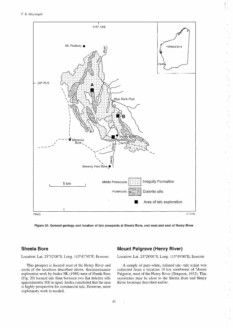
- 23" 25'5
, _---
1 15" 45'E
Mt. Padbury 0
.
Middle Proterozoic . : : : lrregully Formation I I 5 km . . . . . . .
Proterozoic Dolerite sills
I Area of talc exploration I I
PEA23 17.11.95
Figure 20. General geology and location of talc prospects at Sheela Bore, and west and east of Henry River
Sheela Bore Mount Palgrave (Henry River)
Location: Lat. 23"32'00"S, Long. 115"47'30"E; EDMUND Location: Lat. 23"28'00"S, Long. 115"49'00"E; EDMUND
This prospect is located west of the Henry River and south of the locations described above. Reconnaissance exploration work by Imdex NL (1988) west of Sheela Bore (Fig. 20) located talc float between two flat dolerite sills approximately 500 m apait. Imdex concluded that the area is highly prospective for commercial talc. However, more exploratory work is needed.
A sample of pure-white, foliated talc-talc schist was collected from a location 19 krn southwest of Mount Palgrave, west of the Henry River (Simpson, 1952). This occurrence may be close to the Sheela Bore and Henry River locations described earlier.
62

GSWA Miizeral Resources Bulletin 16 Talc, pyroplzyllite and 117agriesite iiz Western Australia
Pyrophyllite in Western Australia
Pyrophyllite is a hydrous aluminium silicate, A1,03.4Si0,.H,0, which usually occurs in spherulitic aggregates of small crystals, radiating needle-like crystals, or fine-grained foliated lamellae with platy cleavage. The colour can vary from white to pale-green, pale yellow, buff, or light- to dark-grey. Pyrophyllite may be used as a substitute for talc. It has similar physical properties and end uses, but has different composition and mode of occurrence to talc. Furthermore, unlike talc, pyrophyllite is markedly refractory (Harben and Bates, 1990a). Deposits of economic importance occur as hydrothermal alteration products of acidic volcanic rocks such as rhyolite and, less commonly, in schist derived from metamorphism of volcanic ash.
Pyrophyllite is not mined in Western Australia. Only a few occurrences are known. The only deposit of possible commercial interest is at Pinnacle Well, and that at Kangaroo Bore appears to be significant. There is very little information available on other occurrences.
Pinnacle We1 I Location: Lat. 28"41'00"S, Long. 121"22'00"E; LEONORA
Pinnacle Well is located 22 km north-northeast of Leonora, in the Eastern Goldfields of the Yilgarn Craton. A report by Southern Ventures NL (Ward, 1990) indicated that the area was explored for pyrophyllite and gold between 1989 and 1990. Seven rock-chip samples of pyrophyllite collected from a prominent ridge in the vicinity of Pinnacle Well (Fig. 21) had chemical compositions similar to material at Pambula in New South Wales, where pyrophyllite is produced. Average assays for silica, alumina and iron oxide of the rock chip samples are as follows:
Pinnacle Well PainbLila (Average %) (Average %)
SiO, 76.9 75.7 A1203 17.5 18.8 Fe203 0.73 0.38
The area was further explored by 396 m of drilling across the pyrophyllite ridge. Assay results from the drilling indicate that the A1,0, content of this pyrophyllite is marginally higher than that published for the Pambula pyrophyllite, and has specifications suitable for refractory applications. The colour of the pyrophyllite may be grey, white, red or brown. Brightness and opacity have not been tested.
The inferred resource is approximately 10 Mt, but more drilling is necessary to confirm this figure. Accord- ing to Ward (1 990) there is potential for reserves further afield.
Kangaroo Bore Location: Lat. 29"26'40"S, Long. 122O27'25"E; EDJUDINA
Kangaroo Bore is about 6 km northwest of Mount Celia, approximately 210 km by road northeast of Kalgoorlie.
Exploration drilling for gold by Union Development Corporation in 1987 at Kangaroo Bore intersected pyrophyllite (Graindorge, 1988) in quartz-sericite- muscovite schists of Archaean age. Petrographic studies indicated that these schists contain assemblages of quartz- sericite-muscovite-pyrophyllite(-paragonite-kaolinite- chlorite). The underlying rock is a quartz-muscovite- dolomite-chlorite-calcite schist.
The thickness of pyrophyllite-bearing rock is variable and extends from the surface to a depth of about 170 m. Qualitative estimates indicate approximately 40% pyrophyllite at certain intervals, and the presence of this mineral has been confirmed by XRD. Associated minerals are calcite, dolomite, chlorite, andalusite and pyrite, with some arsenopyrite. Native gold is present in some samples associated with pyrophyllite alteration.
Marble Bar Location: Lat. 21"15'00"S, Long. 119"44'00"E; MARBLE BAR
Pyrophyllite is known from the Archaean Mount Roe Basalt, approximately 2 km south of the Comet gold mine (also referred to as south of Starrs Find) and some 100 m south of the Marble Bar-Wittenoom road. Carbonate rock with a chalk-like matrix and nodules of pyrophyllite is known at this locality (Hickman A. H., 1993, pers. comm.). An analysed sample of this material (Lab No. 15594/72) comprises an aggregate of fine-grained illite and pyrophyllite, with a small amount of a fine-grained pale- brown material (GSWA, 1972).
Pyrophyllite is also known from the Mount Roe Basalt, 10 km north of Paraburdoo (Blight, D. F., 1995, pers. comm.).
Mount Leopold Location: Lat. 20"58'00"S, Long. 116"30'00"E; DAMPIER
Pyrophyllite occurs with diaspore at Mount Leopold, southwest of Dampier. It is associated with the Mount Roe Basalt near the base of the Fortescue Group in a stratigraphic position similar to that of the Marble Bar occurrence. One sample examined from the locality contained 60.7% diaspore and 35.7% pyrophyllite, but further details are unknown (GSWA, 1970).
Browning We1 I Location: Lat. 21"12'00"S, Long. 118"21'00" E; PYRAMID
63

P. B. Abeysiizghe
I 121" 2 2 E
-7-H /-\ \ (-J------
I 10 km
/ / I I
b I
AUSTRALIA
I PBA24
Laverton
Kalgoorlie
, Area explored / / for pyrophyllite
- Main road
Track --
17 11 95
Figure 21. Location map of Pinnacle Well pyrophyllite deposit
Pyrophyllite was reported 75 m south of MC 1187, approximately 6 km northeast of Browning Well on Sandy Creek. The claim datum peg is 1.5 km south of the northwest corner of Yandeearra Reserve 24490. The pyrophyllite is assumed to have come from drill core, but no other geological information is available (GSWA, 1970). However, the associated geology, as seen from the published maps, appears to be felsic volcanic and basaltic rocks of the Archaean Warrawoona Group.
Tabba Tabba Location: Lat. 2O050O0"S, Long. 118'54'00"E (approx- imately); PORT HEDLAND
A sample of pyrophyllite held at the CC in Perth is recorded from 3 km south of Tank Pool (this appears to be a local name). No other information is available (GSWA, 1970).
64

GSWA Mineral Resources Bulletin I 6 Talc, pyrophyllite niid inngnesite i r z Westeriz Austrnlin
Part I!
65

P. B. Abeysirighe
66

Chapter 5
Mineralogy, mode of occurrence and uses of magnesite
Mineralogy Magnesite, MgCO,, is the magnesium end member of an isomorphous series of carbonate minerals having calcite (CaCO,) and siderite (FeCO,) as the Ca and Fe end members. With increase in calcium, the magnesite becomes dolomite, and with iron, becomes breunnerite. Pure magnesite has a theoretical composition of 47.8% MgO and 52.2% CO, but is rarely found in nature, the natural mineral being almost always an isomorphous mixture of the series.
Natural magnesite occurs as crystalline (or bone) and cryptocrystalline (or amorphous) varieties. The two types differ in crystal structure, as well as in their mode of formation. The cryptocrystalline variety is massive and has a conchoidal fracture, a hardness of 3.5 to 5.0 and S.G. of 2.9 to 3.0. Crystalline magnesite is softer, of hardness 3.5 to 4.0, and with a higher S.G. of 3.02 (increasing with iron content). Both varieties show a range of colours from white to buff to black, commonly with tinges of red, blue, yellow and grey. The colour of magnesite does not usually indicate its quality.
Mode of occurrence Magnesite occurs as a replacement mineral in carbonate rocks, as an alteration product of ultramafic rocks, as a vein-filling material, and as a sedimentary rock (Bain, 1924). Magnesite deposits are classified in three ways: on the basis of type localities (Pohl and Siegel, 1986); crystal size (Schmid, 1987); or geological setting (Bain, 1924). According to Abu-Jaber and Kimberley (1992), the classification based on type localities is unsatisfactory because type names are not self-explanatory and the classification is not adaptable. Neither do these authors recommend crystal size as a basis for classification because it does not indicate overlapping ranges among vein and sedimentary deposits. They, instead, proposed two methods of classification, based on geological setting (Table 25), or genetic interpretation.
Geologic setting classification The first classification of Abu-Jaber and Kimberley (1992) is based on the fact that magnesite deposits occur mainly in two geologic settings, namely sedimentar-y-hosted, and ultramafic-associated deposits. They named the former
Table 25. Classification of magnesite deposits by geologic setting
Present clnssifcntiori
Stratabound Cheriiicnl
Marine authigenic Lacustrine authigenic Marine replacement Lacustrine replacement
Clnstic
Ultramafic Vein Mnssive
NOTES: o/krAbo-Jnbcr and Kimbcl-Icy (1992)
type as stratabound deposits in chemical sedimentary rocks and the latter as ultramafic-associated deposits (Table 25). The following notes summarize the two geological settings. Detailed descriptions are available from Abu-Jaber and Kimberley (1992).
Ultramafic-associated deposits In comparison with the stratabound deposits, the ultramafic-associated type does not form large deposits. The average magnesite content of these deposits is generally between 10 and 20%, although economically recoverable content is between 3 and 10%. The deposits appear in rocks with ages varying from Archaean to Phanerozoic, occurring as either veins or massive bodies formed by metasomatic replacement of large volumes of ultramafic rocks by CO, of magmatic origin (Wellman, 1942; Griffis, 1972). The depth of metasomatism can be greater than one kilometre, and Takasawa and Kuroda (1974) interpreted some such massive bodies as carbonatites. Vein-type magnesite deposits are more widespread, and their mode of formation - the source of the carbon, the pressure-temperature conditions, and the volatiles required to precipitate magnesite - is controversial. Abu-Jaber and Kimberley (1992) are of the view that magnesite veins form in near- surface environments at low temperatures and pressures and that magnesium is derived from the alteration of serpentine. They proposed the following generalized reactions of serpentine alteration:
67

P. B. ABeysirigAe
12Mg,Si,O,(OH), (serpentine) + 36HCO-, + 4Fe,04 + 0,3 12FeSi,O,(OH) (nontronite) + 36MgC0, (magnesite) + 360H + 1 8H,O
or
Mg@i205(OH)4 (serpentine) + 3HC0-3 3 2Si02 + 3MgC03 (magnesite) + 2H20 + 30H-
The source of carbon is from metamorphic alteration of carbonaceous sedimentary rocks deep within the crust, and the precipitation of magnesite is caused by an increase in pH resulting from a combination of wallrock alteration and degassing of rising water.
Magnesite is also commonly formed by weathering of serpentine- and olivine-rich rocks, and the chemical reactions involved can be written as follows:
2H4Mg2FeSi209 (antigorite) + 4H,CO, + 0 3 4MgC0, (magnesite) + Fe,0,.H20 (limonite) + 4Si0, + 7H,O
or
3Mg3FeSi,0, (olivine) + 3C0, + 4H,O + 0 s ZH,Mg,Si,O, (seipentine) + Fe,O, + 3MgC0, (magnesite) + 2Si0,
or
H4Mg,Si,0, (serpentine) + 3C0,- 3MgC0, (magnesite) + 2Si0, + 2H,O
Stratabound deposits Stratabound deposits are mostly chemical sedimentary rocks ranging from stratiform-authigenic beds to irregular replacements of limestone and dolostone (Abu-Jaber and Kimberley, 1992). Large deposits of this type are known in the southern Ural Mountains in Siberia, north and east China, Rum Jungle in northern Australia, and in Nepal. Replacement-type magnesite deposits described by Bain (1924) and Harben and Bates (1990b) might possibly be assigned to this category. Both stratiform-authigenic and replacement-type deposits have more commercial value than ultramafic-associated deposits, because they are more extensive and of higher quality. In replacement-type deposits, the magnesite is possibly formed by replacement of country rock by magnesium-rich fluids that enter the system through fissures, cleavage planes and capillary openings. Replacement is selective and the minerals formed depend largely on the country rocks. For example, carbonate-rich country rocks may produce magnesite and dolomite, but alteration of carbonates associated with quartzose country rocks may produce predominantly diopside, talc and serpentine, and negligible quantities of dolomite. Replacement can be arrested at any stage, according to the porosity and the permeability of the host rocks. Replacement-type deposits are found in USA, Brazil, Spain, Austria and Czech Republic.
Genetic classification The genetic classification is based on three factors: the source of the fluid; the mode of fluid supply; and the cause
of precipitation. There are diverse views on these matters (Pohl, 1989); this classification seems to be of more theoretical interest and will not be discussed in this Bulletin.
Other deposit types The newly discovered Kunwarara and other associated magnesite deposits of the Queensland Magnesia Project Joint Venture (Qmag) in Australia, and Salda Lake magnesite deposit in Turkey, have geological characteristics common to ultramafic-associated as well as chemical replacement-type ore bodies and are therefore discussed separately. The Kunwarara deposit, which is owned by Queensland Metals Corporation Ltd (60%) and Pancontinental Mining Ltd (40%), contains more than 400 Mt of high-grade magnesite. The deposit averages 40 to 45% by volume (ranging from 20 to 95%) of cryptocrystalline magnesite nodules and lumps, ranging from several millimetres to a metre in diameter, in a matrix of soft mudstone-sandstone-earthy magnesite, and is underlain by dolomitic mudstone, sandstone or gravel. The Salda Lake and Kunwarara deposits consist of cryptocrystalline magnesite containing a small amount of iron. Both are presumed to have been derived from magnesite stockwork veins in serpentinite that are weathered, eroded and subsequently transported and deposited in lacustrine environments. Schmid (1987) considered that the present-day geology of Turkey’s Salda Lake deposit shows the different stages of magnesite development that have taken place at the Kunwarara deposit. On this basis, he proposed the following sequence of events for the formation of secondary magnesite in such deposits:
1. Deep weathering and erosion of primary serpentine rocks with magnesite stockworks caused by heavy rainfall;
2. Fluvial transport of the eroded magnesite- serpentine material to basins or lagoons, followed by decomposition, then sedimentation as mud with a high magnesium carbonate and hydrated magnesium carbonate content;
3. Waterlevel fluctuations causing cycles of drying and overflow of magnesite mud along the edges of the basins. Additional intake of carbon dioxide from the atmosphere caused crystallization of the half-dry mud matrix into cryptocrystalline magnesite nodules and lumps;
4. Periodic wave movements or water flow during the crystallization phase wash and remove non-crystallized impurities of SiO,, Fe,O,, A1,0, and CaO from the newly formed magnesite nodules and lumps;
5. In deep lakes, e.g. Salda Lake (190 m), washed, non- crystallized impurities settle in deeper parts of the lakes, and large storms form onshore gravel dunes (up to 10 m high) of highly concentrated clean magnesite;
6. In shallow lakes (e.g. the Kunwarara deposits, which formed in basins between 10 and 20 m deep)
I
68

GSWA Mirzerul Resources B~illetiri I6 Talc, pyropliyllite nrzd ningiiesite in Western Ausrralin
Table 26. Synthetic magnesites from seawater or brine
Producer or magimite Kilri Lime/ MgO CaO SiO, Fe,O, AI,O, B P , Density Other product, by country (a) silica (g/c111’)
-
USA H W Ludington 96A Ludington 98 Martin Marietta 98
Mexico Penoles-Quimica del Rey RY-99-AD RT-99-SAD
Ireland Premier Periclase
UK Steeley Pelletised 31PHO
Netherlands Magnesia International
Italy Sardamag Cogema
Japan Ube 98 Shin Nihon SSS
Israel Dead Sea Periclase
3.0 96.6 2.3 0.7 0.20 0.20 0.02 3.42 1 .0 98 0.7 0.6 0.2 0.2 0.08 3.42 3.0 97 2.2 0.7 0.20 0.20 0.02 3.42
S S S
S S
R
R
S
R R
R R
S
R
7.0 7.0
99.01 0.7 98.94 0.7
0.10 1.10
0.10 0.10
0.09 0.09
0.003 0.003
3.40 3.40 0.07 Cr,O,
4.0 96.8 2.3 0.6 0.2 0.2 0.04 3.44
5.0 97 1.9 0.4 0.2 0.2 0.05 3.43
3.44 3.8 98.5 0.65 0.17 0.45 0.07 0.01
4.0 4.0
96.8 2.3 97.0 2.2
0.55 0.5
0.15 0.15
0.20 0.15
0.05 0.04
3.42 3.40
98.3 0.8 98.6 1.0
0.8 ’ 0.3
0.05 0.06
0.05 0.06
0.05 0.08
3.40 3.41 3.0
3.0 99.4 0.3 0.08 0.14 0.06 0.01 3.45
Yugoslavia Magnohrom YU5 Chemical grade 2.9 99.3 0.4 0.15 0.06 0.05 0.01 3.31
NOTES: rifler Duncan (1986) (a) S -shaft kiln, R - rotary kiln
deposition of the washed non-crystallized impurities took place around the magnesite nodules or in hollows and pores within the lumps, to form a sand-clay matrix with interbedded magnesite nodules and lumps, and dolomitic magnesite and sandstone layers;
magnesium hydroxide, which is concentrated in settling tanks, washed and filtered. The filter cake is then calcined in a Herreschoff multiple-hearth furnace, briquetted in high-pressure rolls and sintered in a rotary or pressurized shaft kiln to produce high-density magnesia (Harben and Bates, 1990b). In the case of brine, magnesium hydroxide is produced by reaction with dolomitic lime in stirred reactors. The magnesium hydroxide thus formed is thickened, filtered and calcined to produce magnesia (Coope, 1987).
Magnesia produced from seawater and brine has a uniform composition, and has advantages because it can be produced to required specifications (Table 26). This is especially important in the case of refractory grades where industry demands so-called first-grade magnesia with very high purity and density, and a high 1ime:silica ratio (Harben and Bates, 1990b; Schmid, 1984). Natural magnesite is virtually excluded from this market. Most producers of magnesia from seawater and brines produce some caustic magnesia for sale. However, such production tends to be a small sideline to the output of refractory magnesia (Industrial Minerals, 1987a). Prior to the early 1970s, about 85 70 of magnesia requirements of industrialized countries were from synthetic magnesia, but this was severely curtailed by the sharp increase in energy costs in the 1970s. Synthetic magnesia is produced in USA, Japan,
7. The newly formed magnesite horizons in the shallow lake basins are buried and compacted by soil cover. There is part encrustation of silica-rich impurities as a skin around the magnesite nodules, the lumps, and in pores. Finally, the action of circulating subsurface groundwaters with high bicarbonate content causes crystallization and an increase in the density of the magnesite.
Magnesia from seawater and brine Seawater and brine are important sources of magnesia, especially in countries where natural magnesite is scarce (e.g. Japan). Production of magnesia from seawater is based on the removal of carbon dioxide from the water by the addition of sulfuric acid, or slaked lime to precipitate CaCO,. The decarbonated water is then mixed with a slurry of calcined dolomite or lime to precipitate
69

P. B. ADeysirzghe
UK, Italy, Mexico, Netherlands, Israel, France, Norway, and Germany.
ses rned magnesia
Approximately 90% of the magnesite output is dead burned to produce refractory magnesia either in the form of loose grains or shaped bricks (Bates, 1969). Dead- burned magnesia, also known as magnesia clinker, sintered magnesia, or periclase (Harben and Bates, 1990b) resists chemical attack and is highly refractory. It is prepared by calcining magnesite or magnesium hydroxide at 1500” to 2000°C. The dead-burned magnesite presently available on the market can generally be subdivided into three categories according to raw material source (as given in Table 27). Magnesite refractory bricks are widely used in the steel industry to line basic open-hearth furnaces and converters, and are also used in copper smelters, cement kilns, and other high-temperature installations. Refractory bricks may be made of magnesia alone or magnesia mixed with chromite, silica or olivine. Magnesia refractories in use a few decades ago contained 4 or 5% iron oxide, a comparable percentage of silica, and minor amounts of alumina and lime. The present-day refractory industry requires much more rigid specifications. For example, the raw material should contain more than 95% MgO, less than 1% Fe,O,, a 1ime:silica ratio of 2:1, and a bulk density of 3.4 g/cm3. New and developing steelmaking procedures have also increased the demand for high-quality magnesia- based refractories at the expense of other refractory types (Coope, 1990), e.g. magnesia-carbon bricks, based on high-grade sintered magnesia and graphite, are now used widely in both primary and secondary steelmaking. The specifications for magnesia-carbon refractories are even more stringent, and synthetic magnesia from seawater dominates usage because only a few natural magnesites can meet such requirements (Coope, 1987). Magnesite producers are now trying to improve the quality of refractory magnesite by increasing its bulk density and crystal size.
Caustic magnesia Most magnesia-consuming industries require an active magnesium compound known as caustic magnesia (also known as caustic calcined magnesia or light- burned magnesia), produced by calcining magnesite to temperatures of 700” to 1000°C to drive off carbon dioxide. The main uses of caustic magnesia prepared from natural magnesia are as follows.
Agriculture - animal feeds, fertilizer
Products containing 80 to 85% MgO are used in the agricultural sector for animal feedstuffs and fertilizers. Magnesium is vital for nutritional metabolism and in the nervous system, and its deficiency can lead to an animal disease known as grass staggers. Calcined magnesite
containing 85% MgO is used for pasture dusting, free- access mineral mixes and in food supplements to overcome magnesium deficiency (Industrial Minerals, 1987a). The levels of common impurities CaO, SiO,, A1,0, and Fe,O, are not critical, but the product must be free from toxic elements (Coope, 1983).
Magnesia is used as a fertilizer to correct soil deficiencies but has to compete with kieserite, a hydrous magnesium sulfate mineral, which is more soluble and considered to be better for the purpose. However, there is some evidence to show that kieserite is too soluble and can be too easily leached from the soil. Calcined magnesite contains 48% Mg compared to 16% Mg in kieserite and the price of both is about the same.
Construction
Magnesia is used in the construction sector for making special cements and insulating boards. For example, oxychloride (or Sorel) cement prepared by mixing finely ground magnesia with a solution of magnesium chloride, is a tough, dense cement suited for heavy-duty interior flooring such as those in railway cars and stations, schools, hospitals and other public places (Bates, 1969). The magnesia should have low iron (for reason of colour) and low calcium (which affects the cement setting) (Industrial Minerals, 1987a). The ‘Heraklith’ insulating boards, produced by subsidiaries of the Radex Group in Australia, Austria and Greece, use magnesia, magnesium sulfate, woodchips and polystyrene.
Other industrial applications
Pulp and paper - for the preparation of magnesium sulfite lye used in the ‘magnefite’ paper-making process (Industrial Minerals, 1987a)
Rubber - used to control vulcanization and curing in neoprene rubbers and other elastomers
Abrasives - used as a binder in grinding wheels
Lubricating oils - used as an additive to neutralize acids
Plastics, paints and adhesives - used as a flame- retardant filler
Flux in steelmaking - normally used when magnesia is more readily available than dolomite or olivine
Chemicals - magnesia is a starting point for the production of other magnesium salts such as magnesium sulfate and magnesium nitrate
Pharmaceuticals - special grades of oxide, hydroxide and carbonate are used in antacids, cosmetics, toothpaste, ointments and Milk of Magnesia
Steel coatings - used to coat grain-oriented silicon steel for electrical transformer cores
Fused magnesia - caustic magnesia is used as a raw material for fused magnesia products.
70

GSWA Mirzernl Resources Bulletirz 16 Talc, pyroplzyllfte arid riicrgriesite iri Western Airsrralia
Table 27. Analyses and bulk densities of typical dead-burned magnesite
Dead-burrier1 qiialities by raw riinter,iril source
Seawater and brine magnesia Dead Sea Periclase Israel 99.40 Cogeina 3 I Italy 97.00 Ludington Exhibit A USA 96.60 UBE 98 Japan 98.30 British High Quality England 97.00 Sardamag 3 I Italy 96.80 Billiton Holland 98.50
Percentage
0.30 0.08 0.14 0.06 0.01 0.15 3.45 2.20 0.50 0.12 0.15 0.04 0.10 3.40 2.30 0.70 0.20 0.20 0.02 0.15 3.40 0.80 0.80 0.05 0.05 0.05 0.15 3.40 2.00 0.60 0.10 0.20 0.03 0.15 3.40 2.30 0.55 0.15 0.20 0.05 0.15 3.42 0.65 0.17 0.45 0.07 0.01 0.10 3.44
Cryptocrystalline low-iron natural magnesite Euboea E 21 A Greece 95.70 Euboea Magflot A Greece 96.00 Yerakini Periclase A Greece 95.50 Yerakini Periclase D Greece 91.50 Kumas Turkey 96.50 Magnohrom MK-I Yugoslavia 95.50
Macrocrystalline low-iron and iron-rich natural magnesite Typ 9090 China 92.40 Typ 8790 China 90.00 Flotation Grade North Korea 95.10 Normal Grade North Korea 91.90 Diinag N Spain 92.90 Breitenau B 91 Austria 91.00 Sinter L Radex Austria 90.00 Lubenik Czech Republic 87.00 Jelsava S Czech Republic 88.00 Magnesitas M 20 Brazil 94.50 China 98 (foreseen) China 98.00 China 97 C:S (foreseen) China 97.20 China 96 (foreseen) China 96.50 China 95 C:S (foreseen) China 95.50
2.20 1.30 0.64 0.06 0.01 0.10 3.45 2.30 0.80 0.75 0.04 0.01 0.10 3.40 1.60 2.60 0.08 0.12 0.01 0.10 3.35 2.00 5.50 0.15 0.25 0.01 0.12 3.30 1.50 1.25 0.35 0.04 0.01 0.15 3.40 2.00 1.70 0.60 0.20 0.01 0.20 3.35
1.25 1.30 1.60 1.80 2.95 2.40 3.00 3.10 2.70 0.80 0.80 1.40 1.20 2.50
3.50 1.00 5.80 1.10 1.20 1.2s 4.00 1.10 0.80 3.20 0.50 5.70 1.00 5.00 1.60 8.00 0.90 7.50 1.30 2.70 0.60 0.40 0.70 0.45 1.50 0.50 1.30 0.50
1.50 0.01 1.60 0.01 0.56 0.01 0.70 0.01 0.15 0.01 0.20 0.01 1.00 0.01 1.00 0.01 0.50 0.10 0.80 0.01 0.20 0.01 0.15 0.01 0.30 0.01 0.30 0.01
0.15 3.20 0.15 3.15 0.20 3.25 0.40 3.15 0.10 3.25 0.12 3.30 0.15 3.35 0.20 3.25 0.16 3.25 0.15 3.35 0.10 3.40 0.10 3.40 0.10 3.35 0.15 3.35
NOTE: rifler Schmid (1984)
Environmental applications
A very strong interest is emerging in the use of magnesia and magnesium hydroxide in environmental applications for water treatment, flue-gas desulfurization and as a boiler fuel additive (Coope, 1990; Industrial Minerals, 1987a). Calcined magnesia is one of the most powerful yet environmentally friendly alkali agents which can be used in the fields of effluent treatment and toxic-waste disposal. Magnesia and magnesium hydroxide have so far been used selectively because of their high cost and the availability of other alkalis such as lime, caustic soda and soda ash, but significant advantages of magnesia over other alkalis have been recognized recently. Magnesia is better for neutralizing acids, for example, because less material is required and it is more easily transported and handled.
CSIRO of Australia in collaboration with Qmag is engaged in a major research program to evaluate the commercial application of calcined MgO in the following
from solutions; removing solids from suspension; removing algae and other organic material; removing dyes; treat- ing paper and pulp effluents; removing phosphorus and ammonia from effluents; removing oil from water; scrubbing waste gases.
Fused magnesia
Fused magnesia is one of the most useful end products of calcined magnesia. Most production of this grade is from high-purity natural magnesite, but more specialized products are based on high-purity synthetic magnesia. Fusion is achieved in electric arc furnaces at temperatures of about 2850°C. Fused magnesia is mainly used for electrical insulation in water-heating elements, cookers, irons, washing machines, and coffee machines (Industrial Minerals, 1987a).
areas: Natural magnesite containing more than 95% MgO and
lime to silica ratios favouring silica is also used for insulation applications.
neutralizing acids; stabilizing tailings dumps and sludge pits; removing metals
71

P. B. Abeysirzglie
Source of magnesium metal Recent trends indicate that natural magnesite is gaining recognition as a major source of magnesium metal. The traditional raw materials for magnesium metal production have been mainly seawater and brine using the electrolytic process, or dolomite using the silicothermic process (Coope, 1990). In 1990, two plants in Canada began commercial production of magnesium metal from natural magnesite using a process involving chlorination followed by electrolysis. Qmag has plans to produce magnesium metal from the Kunwarara natural magnesite. The Mineral Processing Licencing Company (MPLC) has developed a process to produce magnesium metal by mixing raw magnesite with chlorine and carbon monoxide in a single stage reactor at 1000" to 1050°C (Harben and Bates, 1990b). The molten material thus produced contains anhydrous magnesium chloride, from which magnesium metal is won in an electrolytic cell.
Mining methods Large, massive, replacement-type deposits such as those in China, North Korea, CIS, Spain, USA and Canada are mined by opencut methods. Some of the deeper ore bodies in Greece, Turkey, and India are also mined by opencut methods, where the ore to waste ratio is high (Coope, 1987). The Kunwarara deposit in Queensland is mined by opencut methods.
Several Austrian and Czech Republic deposits located in mountainous tesrain are mined by underground methods. Some of these operations use room and pillar mining, involving chambers up to 60 m high, made using machinery such as electric shovels and 50 t underground haulage trucks.
beneficiation The traditional processing of magnesite begins with crushing, screening and washing. In countries such as Greece, Turkey and India, where labour costs are comparatively low, hand sorting is also common, depending on the nature of the ore (e.g. white magnesite associated with dark serpentine). However, companies such as Grecian Magnesite Co. in Greece, use optical sorting by photometric ore sorters, particularly for finer fractions (Coope, 1987). Further processing is generally not required for agricultural grades of caustic magnesia and for lower quality brickmaking grades of dead-burned magnesia. If the quality of the ore is high enough, further processing may not be needed even for industrial grades of caustic magnesia and regular quality brick- making grades of dead-burned magnesia, but magnetic
separation, heavy media separation, flotation and partial calcination (Duncan, 1986) are generally used to remove impurities from magnesite ore. The impurities are commonly a combination of dolomite, quartz, talc, chlorite, serpentine, phlogopite, pyrite, magnetite and graphite.
Beneficiation techniques may differ, depending on the nature of the ore. For example, operations in the USA, Austria, Spain (Navarras), Czech Republic, and North Korea tend to grade magnesite ore into three fractions (Coope, 1987):
1. Graded lump material for direct charging into a furnace shaft kiln for either calcining or sintering.
2. A medium-sized fraction from which principal impurities are removed by heavy media separation, using drums for the 10-60 mm fraction and cyclones for -10 mm material.
3. A fine fraction, which may or may not need further grinding before beneficiation by flotation.
The beneficiation plant at Kunwarara deposit consists of three main sections, namely primary scrubbing, heavy- medium separation, and product handling (Keane, 1992). In the primary scrubbing section the ore is attritioned and washed with log washers and vibrating screens. The scrubbed and sized (>16 mm) product then proceeds to the heavy-medium drum circuit for separation of light gangue material including clay and sandstone, where it is crushed, sized to <20 mm and rescrubbed. The heavy- media cyclone circuit then separates the magnesite into two quality streams, of S.G. 2.55 to 2.75, and S.G. +2.75.
Chemical beneficiation Chemical beneficiation techniques are used to upgrade natural magnesite or to process brines to high-quality magnesia (Coope, 1989). The Sulzer process involves leaching calcined magnesia with calcium chloride and carbon dioxide to produce a magnesium leach liquor which is then converted to nesquehonite (MgC0,.3H20) by reacting with ammonia and carbon dioxide. Refractory magnesia of reasonably high density can then be obtained from nesquehonite by means of a calcining Ipelletisingl sintering route. The Ruthner process involves a spray roasting process to convert magnesium chloride to magnesia. Magnesium chloride is obtained from natural magnesite by treating waste flue dust with hydrochloric acid.
72

Chapter 6
Production and market trends
World production The world production of natural magnesite in 1994 was 16 Mt (Table 28). The principal producing countries of natural magnesite are China, North Korea, CIS, Turkey, Australia, Czech Republic, Austria and Greece, and of these, China, North Korea and CIS contributed 64% of world production in 1994 (Fig. 22). The output from Australia in 1994 was 5% of global production due to increased output from the Kunwarara and related deposits in Queensland. Global trends in the production of natural magnesite between 1981 and 1994 indicate an increase between 1981 and 1989, peaking at 20 Mt in 1989, then dropping to 16.3 Mt in 1994 (Fig. 23).
Market and demand for magnesite
Clarke (1992) reported that toward the end of 1989 it was considered that the magnesia markets would gain momentum, leading to an increase in price. However, in terms of the dollar value of the day the prices of dead-burned and calcined varieties increased from around $275 and $250 in 1984 to around $470 and $460 in 1987, and decreased to around $415 and $410 respectively in 1989. Subsequently the price of the dead-burned variety increased to around $580 in 1992 and then dropped to around $540 in 1994, whereas that of calcined material increased to around $420 in 1994. The price of crude or raw magnesite marginally increased from around $90 in 1984 to around $135 in 1987, but dropped to a consistent $65 in 1994 (Fig. 24). The industry has been forced to slim down, restructure, save costs and, at the same time, produce higher quality products. Permanent or temporary closures of plants were common after 1990.
Changing demand for dead-burned magnesite by refractory producers have resulted in magnesia becoming essentially a 'two grade' industry (Mining Journal, 1992). The best grade has a higher MgO content, a controlled limesilica ratio, a higher density, and a low boron content. Density and MgO content are not so important for the lower grade product. The market for the best grade is dominated by synthetic magnesite producers such as Japan and USA, and the market for the lower grade product is dominated by the natural magnesite producers, notably China and North Korea. Although the demand for high-
performance refractories has benefited the synthetic magnesite producers, oversupply of lower grades has resulted in lower prices. The main threat to European magnesite producers is the cheap supply from China, and the European Commission has brought in anti-dumping duties on imports of dead-burned and caustic-calcined magnesite from China (Industrial Minerals, 1992). Some major producers, such as FIMISCO in Greece, have gone into liquidation because of cheap Chinese supplies. The entry of Queensland magnesia from Qmag into the market has been welcomed by some producers of refractories. This operation is expected to become the world's largest supplier of refractory-grade magnesia and its effect on the world market is yet to be seen. Kunwarara was expected to produce 15 000 t per year of dead-burned product and 25 000 t per year of electrofused magnesia by the year 1995 (Mining Journal, 1992; The Miner, 1992). It is believed that Kunwarara may reduce many manufacturers' reliance on Chinese magnesite, which might become more expensive due to both Chinese exporting policies and increasing domestic demand. It is apparent that a combination of high quality and production-cost advantages will determine the market trends for magnesia products.
China China is the largest supplier of natural magnesite, with an annual production of approximately 5.0 Mt a year. The largest deposits are located approximately 60 to 70 km south and southeast of Anshan in Liaoning Province, approximately 650 km northeast of Beijing. The magnesite mineralization is known to extend for more than 200 km and is thought to contain around 3000 Mt. The deposits are in an upper Precambrian sequence of quartzite, sandstone, dolomite, schist and marble striking at 60" to 80" (Schmid, 1984). The schists contain tourmaline, staurolite, andalusite, sericite, biotite and talc. Minor intrusions of 'porphyritic greenstones' and quartz porphyries are known.
The magnesite is medium grained to coarsely crystal- line, ranging from white or pale pink to shades of grey. It occurs as conformable beds 40 to 500 m thick within dolomite and minor schist. The contact between the magnesite and dolomite is not always clear and at times talc is present.
Operations in the early 1980s mined approximately 50 Mt per year of ore and waste to produce about 70 000 t
73

Table 28. World production of natural magnesite ~ ~ ~
1981 I982 I983 I984 J985 I986 1987 1988 I989 1990 1991 I992 I993 1994(e) (‘000 toiiiies oj crude 01 e)
Australia Austria Brazil Canada China Czech Republic Greece India
2 Nepal North Korea Poland South Aftica Spain Turkey USA USSR (CIS) Yugoslavia Zimbabwe Total
26 1 159
790 50
2 000 2 500
962 463
(8)
1 900 1 1 57
476 784 250
4 200 300
60 15 988
30 1031
750 35
2 000 2 500
967 41 8
1 900 17 32
534 910 200
4 500 328
61 16 213
(a)
21 1006
745 100
2 000 2 500
89 1 435
15 2 500
16 23
597 725 200
4 500 304 24
16 602
67 1 183
724 I12
2 400 2 500 1 064
418 44
2 500 21 33
692 723 I50
5 000 374
22 18 027
58 1255
623 136
3 400 2 500
846 42 I 20
2 500 19 29
682 I 137
100 5 000
419 19
19 164
41 I084
649 144
3 400 2 500
944 460
63 2 500
21 61
588 1 307
100 5 000
423 28
19 313
54 947 650 150
3 400 2 500
842 420
50 2 500
22 75
396 1 190
I00 5 000
403 29
18 728
63 1 122
680 200
3 400 2 500
848 508 45
2 500 24 74
473 I 126
100 5 000
382 30
19 075
65 1 199
700 200
3 500 2 700
850 480
28 3 000
24 76
470 1 199
100 5 000
364 33
19 988
65 1179
700 200
3 500 2 700
697 500 25
3 000 23
114 460 850 100
5 000 268
33 19 414
365 1100
700 220
3 500 2 400
550 500
25 3 000
23 I20 420 900 100
4 640 250
33 18 846
250 995 880 200
2 600 1 400
47 1 550 (a)
3 000 (a) (a)
400 1 200
(a) 3 800
195 (a)
15 941
800 627 880 180
5 000 1 200
450 450 (a)
3 000 (a) (a)
400 1300
(a) 3 000
55 (a)
17 342
800 684 900 200
5 000 600 500 400 (a)
3 000 (a) (a)
400 1300
(a) 2 500
15 (a)
16 299
NOTES: uJierCoope(1989, 1991 to 1995) (a) not available (e) 1994 ligures a t e preliminary or eslimnted

GSWA Minerd Resout ces Bulletin 16 Tnlc, p ) roplijdlite nrid riingnesrte i n Westetri Aiistr nlra
~
of dead-burned magnesite, 80 000 t of caustic-calcined magnesite and 300 000 t of dead-burned dolomite (Lebauer, 1982). The main operator is the Liaoning Magnesite Company.
CIS (Commonwealth of Independent States) The CIS (former USSR) is a large producer of natural magnesite, with an annual output of approximately 2.5 Mt. A large proportion of the magnesite is produced from the area around Satka, Ufa Province, in the southern Ural Mountains. The magnesite is in upper Precambrian to Cambrian dolomite, marl, conglomerate, sandstone, slate and phyllite. It occurs mainly in two parallel series of lenses within a belt 8 km long. Recent discoveries in the mountains of Eastern Siberia are said to contain more than 2000 Mt of magnesite, although the grade is
Czech Republic 4%
PEA13 8 3 9 6
Figure 22. Global production of natural magnesite, 1994. Source of data: Coope (1995)
20
18
16
14
g 12 C c 0 c 0 - 10
5 8
6
4
2
0
.- -
1981 1983 1985 1987 1989 1991 1993
0 Rest of world Austria North Korea
Australia Turkey CIS . . . . . . . . . 0 . . . . . . . . . Greece Czech Republic China
31 .I 0.96 PBA14
Figure 23. Global production of natural magnesite, 1981 to 1994. Source of data: Coope (1989, 1991 to 1995)
75

P. B. Abeysirzghe
600
500
400 dead burned
5 300 3
tA a
crudelraw 200
100
0
1979 1981 1983 1985 1987 1989 1991 1993
PBAl5 11.3.96
Figure 24. Trends in prices of magnesite - for dead burned, calcined, and crudelraw varieties, 1979 to 1994. Sources of data: Industrial Minerals (1979 to 1994)
30C
25C
20c
9 15C
1 oc
5c
C 1940 1945 1950 1955 1960 1965 1970 1975 1980 1985 1990
a South Australia Queensland
New South Wales Western Australia PBA16 11.3.96
Figure 25. Production of magnesite in Australia, 1940-1994. Sources: Kalix et al. (1966); Australian Mineral Industry Annual Review (1967 to 1989); ABARE (1993, 1994, 1995); verbal advice from Mines and Energy, South Australia and New South Wales Department of Mineral Resources
76

GSWA Mineral Resources Bulletin 16 Talc, pyrophyllite arid rriagiiesite in Westeru Australia
low and there is a high talc content (Harben and Bates, 1990b). Despite its large production, the former Soviet Union was a major importer of natural magnesite products from North Korea. The major operators in CIS are Magnesite Refractory Works (MRW), Vnukovsky Refractory Works (VRW) and Bogdanovichsky Refractory Works (BRW), all located in Russia.
North Korea The deposits in China continue along strike into North Korea, and include the enormous deposits at Tansengun, South Kankyo Province, and Gosui in North Kankyo Province (Comstock, 1963), with a production of natural magnesite of around 3 Mt per year.
Austria The production of magnesite in Austria is concentrated in the southern part of the country in a belt of metamorphosed sedimentary rocks known as the greywacke zone (Harben and Bates, 1990b). Annual production of natural magnesite from Austria is approximately 0.7 Mt. The main producing companies are Radex, Tiroler (a subsidiary of Radex), and Veitscher.
Greece The production of natural magnesite from Greece is approximately 0.5 Mt per year, with major contributions from mines in the Chalkidiki Peninsula in the north, and from the island of Euboea in the Aegean Sea. The associated rock types include shelf carbonates, shale, greywacke, volcaniclastic rocks and a discontinuous belt of mafic-ultramafic rocks. The ultramafic complex contains veins up to 2 m wide consisting of magnesite with minor dolomite, quartz, chalcedony and calcite (Harben and Bates, 1990b). The main producers are the Grecian Magnesite Company, Magnomin General Mining Co., and Mining Trading and Manufacturing Ltd. FIMISCO, which was a leading natural magnesite producer, announced its liquidation in February 1992.
Turkey Turkey produces more than 1 Mt of natural magnesite per year. Most comes from the provinces of Eskisehir and Kutahya. Magnesite is also produced at Konya, 240 km south of Ankara, from stockwork deposits, with magnesite infilling web-like cracks in serpentine. The main producers are Kutahya Manyezit Isletmeleri AS and Sumerbank.
Czech Republic The Czech Republic produces approximately 0.8 Mt of natural magnesite per year from a series of deposits between the towns of Kosice and Lucenec, in the extreme east of the country near the border with Poland, Hungary and CIS (Kuzvart, 1981). The magnesite is considered
to have been formed by hydrothermal replacement of fine-grained dolomite during the Cretaceous. The main producing company is Slovenske Magnezitove Zavody.
Mining of magnesite in Brazil is almost exclusively from deposits around Brumado in Southwestern Bahia, approximately 1000 km from Belo Horizonte. The annual production of natural magnesite is around 0.9 Mt, and approximately 340 000 t of dead-burned magnesia and 20 000 t of caustic-calcined magnesia is also produced. Magnesite is associated with upper Precambrian dolomite and quartzite overlying Precambrian gneiss and schist, and is intruded by small amphibolite and rhyolite dykes. The dolomite, together with talc, quartz and magnesite, tends to be in lenticular deposits up to 900 m long. The major deposit of crystalline magnesite of commercial interest is in an isolated mountain chain in the area of Serra das Eguas. Magnesite occurs in blade-like aggregates, euhedral crystals, and massive aggregates, in a range of colours from white to light-grey to an orange- red variety that contains disseminated hematite (Harben and Bates, 1990b). The main producer is Magnesite SA.
An annual production of nearly 0.4 Mt of natural magnesite comes mainly from two centres in India. The larger deposits are at Salem, approximately 280 km southwest of Madras in Tamil Nadu Province in southern India. White cryptocrystalline magnesite occurs as veins associated with dunite, peridotite and pyroxenite (Harben and Bates, 1990b), and output from this area is approximately 460 000 t per year. The second centre is Almora in Uttar Pradesh Province, where coarsely crystalline magnesite is associated with dolomite, talc, siliceous limestone, and pyrite-bearing shale. Production from this area is approximately 24 000 t per year (Coope, 1983). The main producers are Dalmia Magnesite Corporation, Tamil Nadu Magnesite Ltd, Burn Standard Co. Ltd, Belpahar Refractories Ltd, and the Steel Authority of India.
Australia Australian magnesite production is shown in Figure 25. The total Australian output from 1940 to 1994 is approximately 2.8 Mt, of which New South Wales produced 1.99 Mt, Queensland 0.71 Mt, Western Australia 0.08 Mt, and South Australia 0.07 Mt. However, Queensland produced 278 622 t during 1994 compared to 15 553 t from New South Wales and 1228 t from South Australia, and is emerging as a major new source following the discovery of the Kunwarara deposits in the Rockhampton area in 1985. Western Australia has been a moderate producer in the past, but no magnesite has been mined since 1984. There is no mining currently in Victoria, Tasmania or Northern Territory, and past production has been insignificant.

P. B. Abeysirighe
Table 29. Magnesite production from Western Australia, 1915 to 1994 (tonnes)
~ ~ ~ ~ ~ ~
Total (toizrzes)
Westonin Year Bmidnlup Coolgnr d1e Biilorig Mount Himt Nor thnrii
1915 1916 1917 1918 1938 1940 1941 1942 1946 1947 1948 1949 1950 1951 1952 1953 1954 1956 1959 1961 1962 1963 1964 1965 1966 1967 1968 1970 1971 1972 1975 1977 1984
Total 1985-94
-
- -
19 9 779
228 6 576 1 600
202 137
1 184 169
2 215 61 30
5 119 23 897 16 729
67 945 -
-
10 26 1
25 -
- 474
21 41
350 1072
20 93
461
- 2 929
61 1 99 21
I07
-
102
11 74
27
425
-
-
-
-
9
-
1 583
611 99 21
107 10
261 102 25 11 74
977 2 066 1 858
775 1 072
20 93
85 1 19
9 779 228
6 598 1 600
202 137
1 279 169
2 215 61 30
5 119 23 906 16 729
0 77 104
NOTES: Banclalup Production from MC76, 77 -Basic Raw hlaterials Co. Ltd. (1959-1963); Magnesite (WA) Ply Ltd (1964-1967); Norseman Gold Mines NL (1968 and 1970): Magnesitc (WA) Pty Ltd. (1971, 1972 and 1975); M74/76,77,9, 10- Norseman Gold Mines NL (1977 and 1984) Production from MCI 16-1 19 -Austin Glass Mftrs Co.: ML87, 91, 92, PA6600 - Scahill and Gibbons; ML94 - Swan Portland Ltd Production from MCIOY - BIO~CII Hill Pty Ltd; ML3Y (1946 only) - Jones, R. L. C: PAl409Y (1956 only) - Frank, C. 8.: 59H - Sheppard, W.; MC25/1109 [ 1977 only) - Seurico Nominees Pty Ltd Production from MC17E --Jones, R. L. C.
Production from MC60-Read. J. E.: Nell, L. R.; Flelcher, R. F.
Coolgsrdie Bulong
Mount Hunt Northani Production irom private land Westonia
Queensland Continuous production of magnesite began in Queensland as late as 1978, but will undoubtedly increase in the future. The most important deposit in Queensland is that owned by Qmag at Kunwarara, approximately 60 km northwest of Rockhampton. This deposit, centred at latitude 22'55's and longitude 150'13'E, is reported to contain a measured resource of 1200 Mt ore covering 63 km2 and is considered to be the largest cryptocrystalline magnesite deposit in the world (Queensland Metals Corporation Ltd, 1992). Production from this deposit in the December quarter of 1994 was 691 595 t of ore, 56 202 t of beneficiated magnesite, 13 650 t of dead-burned magnesia and 4260 t of electrofused magnesia. A brief description of the geology of the deposit is given in Chapter 5.
Kunwarara forms part of the Hillview project area, which also includes magnesite deposits at Oldman, located 5 km southeast (more than 124 Mt with 58 Mt of raw magnesite, at an inferred grade of 93.7% MgO). The Triple Four deposit, 28 km west of Kunwarara, contains 35 Mt of raw magnesite at an indicated grade of 92.3% MgO in a total resource of 77 Mt (Industrial Minerals, 1987b). Other deposits in the Rockhampton area are at Marlborough, Merimal and Yaamba. Yaamba, 35 km north of Rockhampton, has reserves of approximately 188 Mt. The magnesite occurs as nodules within alluvial clay and Cainozoic sand and gravel overlying serpentinite basement (Harben and Bates, 1990b).
Other magnesite occurrences in Queensland include Mount Pring, 16 km west-southwest of Bowen, where the
78

GSWA Mirzeral Resources Bulletin 16 Talc, pyroplryllite arid iiingrzesite f r z Westerif Airstralin
Table 30. Total value of magnesite from Western Australia, 1915 to 1994 (SACIS)
Yenr- Bnrzrlulcip Coolgnrdie Bulorzg Moirrit Hunt Northorii Westonin Totnl ($AUS)
$ value of &iy
1915 -
1916 -
1917 -
1918 -
1938 -
1940 -
1941 -
1942 -
1946 -
1947 -
1948 -
1949 -
1950 -
1951 -
1952 -
1953 -
1954 -
1956 -
1959 148 00 1961 129 954 20 1962 3 18640 1963 88 155 90 1964 20 039 70 1965 3 17640 1966 1 958 52 1967 10 755 96 1968 2411 50 1970 31 60000 1971 900 00 1972 450 00 1975 102 244 00 1977 637 315 00 1984 215 936 00
Total 1248 231.58 1985-94 -
-
- -
-
24.00 460.00
200.00
-
-
- 3 382.00
114.00 350.00
1 740.14 5 685.00
146.00 51500
2 452.60 - - -
-
- -
-
1 468.00 -
-
-
-
-
-
- -
16 536.74
1 202.00 194.00 42.00
668.00 -
-
175.00
52.50 146.00
-
-
148.00
2 198.00
-
-
-
-
384.00
134.00 -
-
5 343.50
1202.00 194.00 42.00
668.00 24.00
460.00 175.00 200.00
52.50 146.00
6 352.42 9 428.36 7 650.16 3 938.14 5 685.00
146.00 515.00
4 162.60 148.00
129 954.20 3 186.40
88 333.10 20 039.70 3 176.40 1958.52
12 223.96 2 411.50
31 600.00 900.00 450.00
102 244.00 637 449.00 215 936.00
0.00 1 291 051.96
NOTES: Bandalup - MC76,77 and M74/76,77,9, 10 Coolgardie-MC116-119; ML87,91,92;PA66OOandhlL94 Bulong- Value of produckion from PA1409Y; MCIOY: MC3Y. 59H and hlC25/1109 Mount Hunt - MC17E Northam -Private land Westonia - MC60
mineral forms veins (mostly less than 30 cm wide) associated with weathered serpentinite (Brooks, 1976). Other deposits are known near Forsayth, Herberton, and Bowen in north Queensland, the Clermont-Capella District in central Queensland, Degilbo, Kilkivan, Toowoomba and Ipswich in southeast Queensland (McLeod, 1965), Upper Widgee and west-southwest of Gympie (Brooks, 1976).
New South Wales Current production in New South Wales is from the Thuddungra deposits, approximately 35 km by road northwest of Young. Magnesite occurs as small irregular veins and nodules within the weathering zone of intrusive Silurian serpentinites and adjacent metasedimentary rocks (Lishmund, 1976b). A reserve of about 12.4 Mt is reported for the Thuddungra deposits, which include Baileys, Noakes and Young (Louthean, 1993). Devex Ltd has
79
recently signed a Heads of Agreement with Toyota Tsusho Corporation and Mitsubishi Materials Corporation for further development of its magiiesite operations at Thuddungra (Industrial Minerals, 1992).
The Fifield deposits are located approximately 30 km northeast of Condobolin in the Western Division. Magnesite occurs as veins and nodules up to 60 cm in diameter within the zone of weathering of intrusive Alaskan mafic-ultramafic bodies, typically beneath soil cover about 2 m thick. This area has been explored and, although reserves are extensive, figures are not available. The area produced 925 000 t of magnesite up until 1975.
Other deposits of magnesite in New South Wales are at Crow Mountain near Barraba, Attunga, and Woodsreef, where the magnesite occurs in weathered serpentinite as irregular veins and pods up to a few metres wide and as extensive stockworks. At Warialda west of Cargelligo,

P. B. Abeysiizghe
magnesite is probably derived from nepheline-bearing olivine basalt. At Mineral Hill, magnesite is associated with chlorite schists.
South Australia Magnesite has been produced from a number of localities in South Australia with some of the main deposits being associated with upper Proterozoic rocks at Port Germein Gorge, Mundallio, Copley, Witchelina, Balcanoona, Eyre Peninsula and the Mount Lofty Ranges.
The Port Germein deposits are approximately 24 km north of Port Pirie. The highest grade magnesite is confined to a belt of massive pale-grey brecciated magnesite. The associated rocks are dolomite, dolomitic shale, sandstone and chert. In the Mundallio area, approximately 19 km northeast of Port Augusta, magnesite is interbedded with dolomite, shale, chert and thin bands of quartzite. In the Copley and Witchelina areas, magnesite beds occur in a belt from approximately 5 km southwest of Copley and extending for 27 km in a northwesterly direction. In this belt magnesite is interbedded with steeply dipping calcareous shale, dolomitic limestone and subordinate quartzite and grit, At Balcanoona, white coarsely crystalline magnesite forms in a number of
irregular pods metasomatically replacing the Balcanoona Dolomite. Magnesite is commonly intimately associated with graphite in the Eyre Peninsula. Weathering and subsequent reaggregation of deposits associated with graphite have resulted in high-grade cryptocrystalline masses, such as the one at Tumby Bay. There has been minor production of magnesite from the vicinity of Torrens Gorge in the Mount Lofty Ranges (Johns, 1976; McLeod, 1965).
Western Australia
Although magnesite is known from many places in Western Australia, total production between 1915 and 1984 was only 77 104 t valued at $1.3 million. The last officially recorded mining was by Norseman Gold Mines NL in 1984 from the Bandalup deposit close to Ravensthorpe (16 729 t valued at $215 936). Magnesite has also been mined at Coolgardie, Bulong and Northam (Tables 29 and 30). The geology of the magnesite deposits in Western Australia is discussed in Chapter 7.
80

Chapter 7
Magnesite in Western Australia
The known magnesite occurrences in Western Australia (Fig. 26) can be broadly grouped into two categories based on their geologic associations:
(a) magnesite in altered serpentinous ultramafic rocks of Archaean age, e.g. Bulong, Coolgardie and some deposits in the Ravensthorpe area; magnesite in Tertiary sedimentary rocks, e.g. some deposits at Bandalup near Ravensthorpe.
Deposits of association (a) are widespread in the State, and are discussed by tectonic province below. Deposits of association (b) are so far known only from the Ravensthorpe district (at Bandalup) and are described with the other magnesite deposits in the Southern Cross Province. Deposits of commercial grade are known from both association types, but none is being exploited at present. The last recorded production was in 1984 from the Bandalup deposit, then owned by Norseman Gold Mines NL.
(b)
For this discussion the magnesite occurrences in Western Australia are grouped by tectonic units as shown in Figure 26, and are described under the following headings:
1. Southern Cross Province of the Yilgarn Craton Ravensthorpe district Munglinup minor occurrences
2. Eastern Goldfields of the Yilgarn Craton Bulong Coolgardie Mount Burges Lawlers Eulaminna Siberia (Waverley) Comet Vale minor occurrences
3. Minor occurrences in other tectonic units
Southern Cross Province, Yilgarn Craton
Raven st ho r pe district The commercially exploitable magnesite deposits in the Ravensthorpe district are located near the boundary
of the Archaean Yilgarn Craton and the Proterozoic Albany-Fraser Orogen. The geological succession in the Ravensthorpe area consists of mafic and ultramafic rocks alternating with sedimentary rocks and felsic volcanics, with a minimum age of approximately 2900 million years (Richards et al., 1966; Jeffrey, 1956). Middle to upper Eocene Pallinup Siltstone of the Plantagenet Group, unconformably overlying these older rocks (Thom et al., 1977), is a favourable host for magnesite mineralization. The siltstone is commonly fossiliferous, containing bivalves, gastropods, echinoids, bryozoans and sponges. The main magnesite deposits are in the Bandalup area associated with Archaean rocks and the overlying Tertiary Plantagenet Group.
Historical background
Important deposits of magnesite in the Ravensthorpe district are located at Bandalup, approximately 30 km east of Ravensthorpe (Fig. 26). However, magnesite in the district was first reported from the vicinity of Kundip in 1909 (Woodward, 1909). The first recorded application for a mineral tenement for magnesite was lodged in September 1913, when exclusive rights were sought to prospect and mine magnesite over 190 ha of land, 3.5 km north of Mount Desmond. However, prior to 1913 local magnesite had been used by the Phillips River Gold and Copper Company Ltd to manufacture bricks for lining converters. Between 1959 and 1984, 67 945 t of magnesite valued at $1.25 million was produced from the Bandalup mine (Tables 29 and 30), comprising 20 292 t of magnesite extracted in the late 1960s by opencut mining from deposit N2W (Fig. 27), and a further 19 951 t from deposit N2E between 1983 and 1984. The 1983-1984 production of 16 729 t was shipped by Norseman Gold Mines NL to Queensland Alumina Limited. There has been no production since 1984.
Geology
The rocks in the area consist mainly of an Archaean sequence of alternating mafic and ultramafic rocks containing interbedded sandstone, quartzite, phyllite and chert (Fig. 17). Further east, and also near Kundip, these rocks are unconformably overlain by the Tertiary Plantagenet Group and superficial Quaternary deposits. The following is a summary of the stratigraphy of the rocks.
81

P. B. Abeysirighe
Quaternary - Residual soil, sand and alluvium Tertiary Plantagenet Group - mainly Pallinup
Proterozoic Mount Barren Beds - dolomite, phyllite
Archaean - granitic, sedimentary, felsic, mafic and
Siltstone
and quartzite
ultramafic rocks
Two mafic units are recognized within the Archaean sequence. One unit outcropping mainly along the foot of the Ravensthorpe Range near Desmond and around Kundip (Thom et al., 1977) consists of basaltic lava, tuff and agglomerate with minor felsic volcanic rocks, and the other, exposed along the Jerdacuttup River and Bandalup Creek, contains pillow lavas with variolitic structures and arnygdaloidal cavities. These rocks have undergone upper greenschist to amphibolite facies metamorphism. The ultramafic rocks are extensively serpentinized and are well-exposed on the eastern slope of the Ravensthorpe Range. They contain thin layers of chlorite-tremolite rock outlining sills or flows of peridotite. Talc, chlorite and amphibole schists are present in the shear zones. The ultramafic rocks commonly host magnesite deposits (Locations B1 to B8 and L1, Fig. 27).
The Achaean sedimentary sequence consists of weakly metamorphosed shale, siltstone, sandstone, polymictic conglomerate and chert. Some magnesite deposits are associated with these sedimentary rocks.
In the northern Bandalup Creek area, ultramafic rocks are overlain by the Tertiary Plantagenet Group and poorly lithified green sands that are commonly replaced by magnesite. The serpentinite at Bandalup Hill is capped by thick Tertiary laterite.
The Archaean rocks in the Ravensthorpe area are folded into an ?overturned synclinal structure with a northwesterly axis. The northeastern limb of the fold has southwesterly to southerly dips of about 40°, i t is extensively intruded by granitoid. The beds in the southwestern limb dip steeply to the west. The synclinal structure is cut by a number of northeasterly and north- northeasterly trending faults.
Magnesite deposits in the Ravensthorpe area occur as massive, structureless bodies that overlie many rock types. Based on their geologic associations, they can be assigned to the two categories of deposits mentioned above: those associated with Archaean ultramafic rocks; and those associated with the Eocene Pallinup Siltstone of the Plantagenet Group (Ellis, 1941 ; Johnson and Gleeson, 1951; Simpson, 1952; Sofoulis, 1958; Butler, 1961; Faulkner, 1962; Thomas, 1972; Thom et al., 1977; Younger, 1985; and Locsei, 1986).
Magnesite deposits in Archaean ultramafic rocks
Residual magnesite deposits are developed over Archaean serpentinite, amphibolite, quartzite and schist. Faulkner (1962) defined two varieties of deposit - ‘a lean superficial type; and a dense accumulate type’. The
& PAST MAGNESITE PRODUCTION Bandalup Coolgardie Bulong Northam (52) Westonia (20) Mount Hunt (42) - SIGNIFICANT DEPOSIT Munglinup Mount Burges Law I ers Eulaminna Siberia (Waverley) Comet Vale
MINOR OCCURRENCE 1 Bamboo Creek 2 Braeside 3 Warrawoona 4 Lionel 5 Jimblebar 6 Yallalong 7 Geraldine (Ajana) 8 Northern Gully 9 Meekatharra
10 Gabanintha 11 Yalgoo 12 Ninghanboun Hills 13 Rothsay 14 Mulermurra 15 Sandstone 16 Boodarockin 17 Bullfinch 18 Southern Cross 19 Moorine Rock 20 Westonia 21 Burracoppin 22 Nungarin 23 Kununoppin 24 Dowerin 25 Tammin 26 Baandee 27 Merredin 28 Doodlakine 29 Ardath
30 Lookout Hill 31 Kondinin 32 Bremer Range 33 Laverton 34 Eucalyptus 35 OraBanda 36 Bardoc 37 Broad Arrow 38 Paddington 39 Kanowna 40 Kalgoorlie-Boulder 41 Kurrawang 42 MountHunt 43 Golden Ridge 44 Feysville 45 Nepean 46 Bullabulling 47 Larkinville 48 Higginsville
49 Norseman 50 Namban 51 Goomalling 52 Northam 53 York 54 Dangin 55 Corrigin, Kumminin 56 Kulin 57 Stirling Range 58 Pallinup River
(Hopbush Soak)
PBA29A 31.10.96
Figure 26. Magnesite in Western Australia: areas of past production, significant deposits and minor occurrences
lean type is usually 1.0 to 2.5 m thick, and overlain by a soil horizon typically 0.5 to 1.0 m thick. The dense type forms as lenticular lumpy bodies with well-defined margins, occurring at low-lying to intermediate physio- graphic levels, adjacent to creeks. Thickness varies
82

GSWA Mirierol Resources Bulletin 16 Tole, pyroplzyllite arzd iiingriesife iiz Western Aiistrolin
I I I I 122" 114"
MAGNESITE IN WESTERN AUSTRALIA
, 200 km ,
4. ' ' . .. . PILBARA CRATON
. . . . _ _ . . . . _ _ 5.' '..:
-__. . . ,
i .. , ..:-- . _ _ _ .. * .
. NARRYER ' : : : : ;' TERRANE ' _ ._ - . . _ -
I , . .
36"
I I I I I PBA29 31.10.96
83

00 P
PBA28
lF ,. Talc sample
33" 36's
- Main road Road
-/- Fence -C'- River/ Creek - , 4km ,
31.10.96
Figure 27. Deposits and occurrences of magnesite in the Bandalup and Ravensthorpe area

GSWA Mineral Resources Bulletin 16 Tulc, pyrophyllite and riiagnesite iii Western Australin
between 0.5 and 10.0 m, and the lump magnesite varies from hard, flinty (locally dolomitic) material to soft, porous and chalky material, and at times lies directly on siliceous metasedimentary rocks. Basement rocks are commonly present as either isolated boulders or as thin remnants.
The following descriptions are based on exploration reports by Faulkner (1962) and Locsei (1986). Localities of the various deposits are shown on Figure 27.
Location: Lat. 33"35'05"S, Long. 120"08'45"E; RAVENS- THORPE
B1, B2,B5 (Bandalup Creek, south of West Coast High way)
Location: Lat. 33037m20tts, Long. 1200181507qE; Magnesite outcrops in this area are associated with
serpentinites, both are exposed along northerly trending ridges. Some magnesite outcrops contain surficial travertine. Small tonnages of magnesite, for use in the
THORPE
Outcrops of magnesite are restricted to the crests and upper slopes of prominent ridges, and are typically associated with mafic outcrops and heavy rubble. Minor outcrops of jaspilite, amphibolite and quartzite are also present. The depth of the magnesite ranges between 1.5 and 2.5 m. The resource available from this area is considered to be insignificant.
Magnesite is associated with small exposures of hornblende-bearing mafic rocks over an area of 37 ha. Johnson and Gleeson (1951), on a reconnaissance visit to the area, made a resource approximation of 330 000 t, based on generalized assumptions. Exploration pits show that magnesite is well-developed as boulders (concretions) between 2.5 and 5 m in diameter. Most boulders are massive although some are relatively soft and readily breakdown into finer material. Inferred resources for this area are about 176 500 t of lump magnesite (Faulkner, 1962).
B3 (6 km northeast of Kundip)
Location: Lat. 33"39'45"S, Long. 120°13'55"E; RAVENS- THORPE
6 7 (approximately 8 km east of Ravensthorpe)
South of the Jerdacuttup River, and approximately 6 km northeast of Kundip, is a magnesite occurrence associated with mainly serpentinous schist. The inferred resource is more than 100 000 t. However, the deposit is considered to be uneconomic because of anticipated problems in selective mining of the deposit.
B4 (north of South Coast Highway)
Location: Lat. 33"36'00"S, Long. 12Oo15'30"E; RAVENS- THORPE
Three distinct magnesite bodies, typically in the form of dense surface accumulations, occur along and parallel to a creek. As indicated by pits, depth of magnesite does not exceed 3 m. A sample (117325) of magnesite studied using XRPD yielded less than 5% halite, and less than 1% of an unidentified component at peak 3.54A.
Ravensthorpe copper smelter, werebbtained from this area in the early 1900s by surface picking and from shallow veins, but there is now insufficient lump magnesite available to be commercially significant.
8 8 (14 to 17.5 km east of Ravensthorpe)
Location: Lat. 33"35'40"S, Long. 120"13'30"E and Lat. 33"36'20"S, Long. 120" 12'00"E; RAVENSTHORPE
Scattered exposures of magnesite lie on the east and west of the Jerdacuttup River. Some outcrops have well- developed exteriors with 'cauliflower-like' appearance, and a thin travertine layer is commonly developed on surface nodules. These exposures are associated with metamorphosed mafic rocks and minor metasedimentary rocks. The magnesite is not very thick; there are no indications of significant reserves.
L 1 (approximately 3 km southeast of Bandalup Hill)
Location: Lat. 33"39'55"S, Long. 120O23'40"E; RAVENS- THORPE
Magnesite overlies serpentinite on a laterite-capped hill, approximately 3 km southeast of Bandalup Hill. The magnesite is a hard, white material with karst-like surfaces, though in some outcrops it may contain a brown dolomitic coating, and in places the magnesite extends laterally under the laterite. Exploration drilling for nickel in the area intersected magnesite at depths of between 15 and 46 m in three holes, drilled at 100 m intervals (Locsei, 1986). Based on this information, Locsei has suggested that a deposit may contain in excess of 5 Mt of magnesite.
The westerly exposures are associated with a heavy mantle of chalcedonic and jasperoidal silica. The inferred resource in this area is approximately 20 000 t.
Magnesite in Eocene Pallinup Siltstone
Bandalup deposit (NI to N5)
B6 (eastern slope of Ravensthorpe Range and Location: Lat. 33"36'40"S, Long. 120"21'30"E; RAVENS- THORPE south of Jerdacuttup River)
Location: Lat. 33"33'05"S, Long. 120"08'10"E; RAVENS- THORPE
Extensive replacement deposits of magnesite occur in sandy sediments of the upper Eocene Pallinup Siltstone,
85

P. B. Abeysiizghe
PBA118
Figure 28. Photographs of magnesite exposures at Bandalup southern wall of exposure in deposit N4E Top:
Lower: Costean in deposit N5N
23.12.96
86

GSWA Mineral Resources Biilletiii 16
approximately 3 km northeast of Bandalup Hill (Fig. 28), adjacent to the South Coast Highway. The Pallinup Siltstone unconformably overlies deeply weathered Archaean quartz-mica schist, metamosphosed sandstone and volcanic rocks, and the magnesite occurs at several levels separated by layers of Tertiary sand. The deposits are composed mainly of nodules of magnesite up to 0.75 m in diameter, but also contain soft earthy or clayey material that may be either structureless or incoherent. They have a maximum thickness of approx- imately 7 m, with an average mineable thickness of 4 m.
The Bandalup deposits are scattered, but fall into broad groups referred to as eastern, western and southern. Butler (1961) inferred a resource of approximately 455 700 t in three deposits, whereas Thomas (1972) proposed eight discrete deposits (Fig. 27) with a recoverable resource of approximately 1 167 000 t, based on exploratory percussion drilling and a bulk sampling program involving trenching and pitting.
Other magnesite occurrences
Impure, light-brown to grey, medium-grained, friable magnesite and dolomite are commonly exposed along a westerly track from Kundip (Fig. 27). Chemical analyses of five samples show MgO values ranging between 8.81% and 39.0% (Table 31). High percentages of nickel in some of these samples indicate derivation from ultramafic rocks.
Many other small occurrences of magnesite with no commercial significance are associated with sheared and altered ultramafic socks in the Ravensthorpe area.
Quality of magnesite
Magnesite in Archaean rocks
Analytical data for magnesite samples associated with Archaean socks in the area are given on Table 32. The results indicate a wide variation in chemical composition,
Table 31. Chemical analyses of magnesite from the Kundip area and Munglinup (major and trace elements)
GSWA no.
Lab no. Locality
1 I7307 I 1 7326 117327 I I7328 Kuizdip Kimdip Kcrndip Kuridip
7 26 27 28
SiO, TiO,
Fe203 FeO MnO
CaO Na20
MgO
K20
CO2 p2°5
S H20+ H20- Rest Total
As Ba Cr cu La Mn Ni Pb Rb Sb Sr V Zn Zr
5.39 <0.05
0.07 0.34 0.16
<0.05 33.3 13.00 0.23
<0.05 <0.05 45.4 <0.01
2.1 0.48 0.19
100.66
<4 48
124 33 <5
27 1 610 <4 <2 <4
628 <3 10 <5
7.48 0.08 2.11 0.33 0.24
<0.05 20.20 26.1 0.26 0.62
<0.05 41.2 <0.01
1.54 0.59 0.13
100.88
<4 162 21 95 13
102 33
5 36 <4
588 15 28 49
4.26 <0.05
0.75 0.36
<o. I <0.05 39.00
6.64 0.28 0.29
<0.05 46.2 <0.01
1.65 0.55 0.07
100.05
<4 62 15 17 6
153 19 <4 19 <4
329 12 9
<5
percentage 7.16 0.06 0.91 0.25
<o. 1 <o.os
8.81 39.8 0.29 0.17
<o.os 41.7 0.02 1.66 0.56 0.14
101.53
parts per million <4
141 12 32 <5 88 31 <4
8 <4
868 <3
4 89
I 17329 Kiuidip
29
I17337 Mung l i i i~p
35
11 7338 MiiiigliiiiqJ
36
5.34 <0.05
0.43 0.15
<O.l <0.05 25.6 23.1 0.25 0.12
<0.05 44.7 <0.01
2.07 0.75 0.12
102.63
<4 60 12 57 <5
285 42 <4
6 <4
722 12 4
27
1.11 <0.05
0.66 0.07
<o. 1 <0.05 47.20
0.37 0.22
10.05 ~ 0 . 0 5 50.20 <0.01
0.52 0.12 0.08
100.55
<4 < l I
11 143
6 45
176 <4 <2 <4 10 16
148 29
0.11 <0.05 <0.05 <0.05 <o. 1 <0.05 48.00
0.45 0.24
<0.05 10.05 51.00 10.01
0.31 0.12 0.01
100.24
<4 <11 <4 39 <5 26 13 <4 <2 <4 23
3 26 27
NOTES: Analyses: CC Sample locations - 117307, I 1 17326-1 17329 are indicated on Figure 27; samples I17337 - Lat. 33'39'35''s. Long. 120'5 I'IVE; I17338 - Lat. 33'39'45'3 Long. 120'51'14"E
87

Table 32. Chemical analyses of magnesite in Archaean associations in the Bandalup area (major and trace elements)
GSWAno. BAI BA2n BA26 BA3 BA4 BA5 117304 117305 117306 117318 117321 117322 117323 117324 117325 117331 117332 11733.3 5 Locality BI 87 83 LI 82 B2 B2 B2 B4 B6 B6 B7 Lab no 790 791 792 793 794 795 4 5 6 18 21 22 23 24 25 31 32 33
SiO, TiO,
Fe203 FeO M n O MgO CaO Na20 K20 P205 co2 S H,O+ H2O- Rest Total
4.28
0.38 0.76
- 36.08
2.63 3.49
- 41.30
6.35 4.61
- 19.56
0.43 I .45
- 1.17
0.16 0.50
- 1.39
0.26 0.42
- 0.72
<0.05 0.17
<0.05 <o. 1 <0.05 46.10
1.98 0.26
~ 0 . 0 5 <0.05 50.00 <0.01
0.90 0.23 0.04
100.40
9.71 <0.05
0.23 0.81 0.1 1
<0.05 25.10 20.40
0.25 co.05 <0.05 41.10 <0.01
2.56 1.04 0.20
101.51
0.74 <0.05 <0.05
0.18 <o. 1 <0.05 44.20
3.47 0.23
<0.05 <0.05 49.40 <0.01
0.94 0.21 0.07
99.44
<0.05 <0.05 <0.05 <0.05 <o. I <0.05 47.30 0.98 0.20
<0.05 ~ 0 . 0 5 50.80 <0.01
0.24 <o. 1
0.18 99.70
0.57 <0.05 <0.05 <0.05 <o. 1 <0.05 47.10
1.37 0.23
<0.05 <0.05 50.80 <0.01
0.50 10.1
0.03 100.60
0.37 10.05 <0.05
0.06 <O.l <0.05 47.40
1.28 0.21
<0.05 <0.05 51.00 <0.01
0.42 <o. 1
0.02 100.76
0.35 10.05
0.10 <0.05 <o. 1 <0.05 46.20
1.68 0.79
<0.05 10.05 49.90
0.10 0.99 0.23 0.02
100.36
<0.05 <0.05 <0.05 <0.05 <o. 1 <0.05 48.60
0.42 0.40
<0.05 <0.05 52.00 <0.01
0.36 <o. I
0.01 101.79
<0.05 <0.05 <0.05 <0.05 <o. 1 <0.05 47.60 0.48 0.5 1
<0.05 10.05 51.70 <0.01
0.28 <o. 1
0.01 100.58
1 1.20 0.05 0.74 0.47 0.44
<0.05 6.38
37.50 0.25 0.06
10.05 36.10 0.04 3.43 1.76 0.18
98.60
12.30 0.09 1.54 0.56 0.92
<0.05 7.71
38.40 0.36 0.09
<0.05 35.60 0.02 2.97 1.15 0.16
101.87
3.40 <0.05
0.15 0.17 0.44
<0.05 29.90 18.30 0.60
<0.05 <0.05 45.30 <0.01
0.98 0.17 0.12
99.53
- 42.02 2.09
- 1 1.78 16.70
-
5.53 11.50
- 24.60 15.13
-
45.03 1.90
-
38.97 8.92
- 46.73 -
- 21.16 -
- 9.40 -
- 32.57 -
-
49.55 -
-
48.62 - - - -
98.58 -
96.26 -
91.84 -
78.69 -
93.74 -
98.31
parts per million 48 <4 <4 55 <1 1 < 1 I
249 159 40 123 73 10
5 <5 <5 162 21 6 14 470 129 1286
16 <4 <4 2 <2 <2
10 13 <4 484 110 54
23 3 <3 18 5 <3 1 1 <5 20
As Ba Cr cu La M n Ni Pb Rb Sb SI. V Zn Zr
nd nd nd nd nd nd nd nd nd nd nd nd nd nd
nd nd nd n d nd nd nd nd nd nd nd nd nd nd
nd nd nd nd nd nd nd nd nd nd nd nd nd nd
nd nd nd nd nd nd nd nd nd nd nd nd n d nd
nd nd nd nd nd nd nd nd n d nd nd nd nd nd
nd nd nd n d nd nd nd nd nd nd nd nd nd nd
<4 17 5
27 <5 1 1 22 25 <2
7 116
3 55 6
<4 < I 1
58 47 <5 57 45 <4 <2
4 76 6
<3 14
<4 21 11 30 <5 32 44 <4 1 2 <4 62 <3
3 16
<4 < I 1
6 54 <5 44 37 <4 <2 <4 70 5 5
14
<4 <11 <4 18 <5
240 44 <4 <2 <4 20 <3 <3 30
<4 <11
5 27 <5 59 31 <4 1 2 <4 19 1 3 15 30
5 135 256 106 <5
246 232 <4
3 <4
606 22 11 35
<4 136 249 106 <5
26 1 24 1 <4
5 <4
426 33 15 25
<4 <11 198 21 <5
115 413 <4 <2
9 23 1
15 5
<5
NOTES: S;\mples790-795,BandalupCreekarea--nfterJohnson andGleeson (1951); analyses OTssmples 117304-117306,117318,117321-117325, and 117331-1 17333-by CC Sample locations 117304- Lat. 33"3617"S, Long. 120"18'32E 117305 -La[. 33"35'06S, Long. 120°08'46E: 117306- Lat. 33"39'45"S, Long. 120"13'54"E I17318 - Lat. 33"39'56S, Long. 120°23'38"E 117321 - Lat. 33"38'14"S, Long. 120"19'23"E; 117322-Lat. 33O37'18"S, Long. 120"15'53"E 117323-Lat. 33"37'10"S, Long. 120"1900E 117324-Lat. 33°37'08"S, Long. 12O018'36E 117325-Lat. 33"3607"S, Long. 120"15'18"E; I17331 --at. 33"33'05"S, Long. 120"08'00"E; 117332- Lat. 33"33'08"S, Long. 120"08'15"E 117333 - Lnt. 33'35'03''s. Long. 120"08'46E nd - no1 determined

GSWA Mineral Resources Bulletiri 16 Talc, pyropliyllite arid ningrzesite in Westerri Austrnlin
Table 33. Chemical analyses of magnesite in association with Pallinup Siltstone in the Bandalup area
GSWA 110. 11 7301 117302 117311 117312 117313 117314 117315 117316 117317 117319 117320 Locality N2 W N2 W N2E N2E N2E N2W N4E N4E N3 N5N N5S Lab 110 1 2 11 12 13 14 15 16 17 19 20
SiOz TiO, A1203 Fe@,
blg0
Na,O K?o p,oj CO? S H,O+ H,O- Rest Total
FeO MnO
CaO
As Ba Cr cu La Mn Ni Pb Rb Sb Sr V Zn Zr
0.16 <0.05 <0.05 <0.05 <O. 1 <0.05 47.70 0.73 0.78
<0.05 <0.05 50.30 0.06 0.50 0.47 0.01
100.71
<4 < I 1 <4 15 <5 62 45 <4 <2 4
10 <3 16 15
<0.05 <0.05 <0.05 <0.05 <O. 1 <0.05 48.10 0.74 0.36
<0.05 <0.05 49.90 <0.01
0.42 0.17 0.01
99.70
<4 < I I
5 22 <5 22 48 <4 <2 <4 11 <3 14 29
<0.05 <0.05 <0.05 <0.05 <O. I ~ 0 . 0 5 48.00 0.46 0.47
<0.05 <0.05 50.30 <0.01
0.34 <0. 1
0.02 99.59
<4 <11 <4 26 <5 20 85 <4 <2 <4 14 <3
5 30
<0.05 <0.05 <0.05 <0.05 <0.1 <0.05 48.00 0.43 0.30
<0.05 <0.05 50.30 <0.01
0.40 <o. 1
0.02 99.45
<4 < I 1 <4 39 <5
8 74 <4 <2
4 18 <3
4 30
percentage <0.05 <0.05 <0.05 <0.05 <0.05 <0.05 <0.05 <0.05 <O. 1 <0. 1 <0.05 <0.05 47.80 48.30
0.56 0.54 0.22 0.25 <0.05 <0.05 <0.05 <0.05 5 1.20 50.60 <0.01 <0.01
0.3 1 0.36 <o. 1 0.10
0.01 0.01 100.10 100.16
parts per million <4 <4
<I1 <I 1 <4 <4 25 22 7 <5
20 42 41 70 <4 <4 <2 <2 <4 <4 30 14 <3 <3
3 12 27 31
<0.05 <0.05 <0.05 <0.05 <O. 1 <0.05 47.20 0.86 0.87
<0.05 <0.05 51.00 0.05 0.77 0.49 0.01
101.25
<4 <I I <4 24 <5 39 11 <4 <2 <4 26 <3
3 21
<0.05 <0.05 <0.05 <0.05 <0.05 <0.05 <0.05 <0.05 <o. I <O. 1 <0.05 <0.05 47.70 48.20
1.51 0.54 0.31 0.23
<0.05 <0.05 <0.05 <0.05 50.90 5 1.20 <0.01 <0.01
0.47 0.26 0.15 <0.01 0.01 0.03
100.05 100.46
<4 I1 <4 28 <5 31 28 <4 <2 <4 38 <3
3 22
<4 <11 <4 24 <5 75
166 <4 <2 <4 17 4
<3 31
<0.05 <0.05 <0.05 <0.05 <0. 1 <0.05 46.90
0.88 1.36
<0.05 <0.05 49.80
0.08 0.54 0.31 0.18
99.88
<4 <11 <4 12
<5 5
13 <4 <2
7 73 <3
3 7
1.91 <0.05 <0.05 <0.05 10. 1 <0.05 46.20
I .82 0.25
<0.05 <0.05 49.30 <0.01
I .05 0.21 0.01
100.76
<4 13 <4 30 <5 32 13 <4 <2 <4 94 <3
3 11
NOTES: Analyses: CC Localities are shown on Figure 21
and some samples can only be classified as silicates of magnesium and calcium. A summary of the chemical variations is given below:
% MgO 5.53 to 48.60 CaO 0.42 to 38.40 SiO, <0.05 to 41.30 Fe,O, <0.05 to 4.61 A1,0, <0.05 to 6.35 CO, 9.40 to 49.55
Typically, the samples contain higher amounts of Cr and Ni than those from the Pallinup Siltstone magnesites (Table 33), confirming their derivation from ultramafic rock. In particular, sample 117318 at locality L1, associated with laterite over serpentinite, has a Ni content of 1286 ppm.
Most of the magnesite deposits associated with the Archaean rocks in the region are subeconomic because of their small size and variable grade. However, deposits B1, B2 and possibly B5 adjacent to Bandalup Creek, are of high quality and contain mineable high-grade magnesite.
Magnesite in Eocene Pallinup Siltstone
Table 33 gives chemical analyses of eleven samples of magnesite collected from the deposits (Fig. 27). Note that deposits NI to N5 may be subdivided further into east, west, north or south (annotated as E, W, N or S on the figure). These eleven samples are of higher quality than those with Archaean associations and show the following chemical variations:
% MgO 46.20 to 48.30 CaO <0.43 to 1.82 Si02 ~ 0 . 0 5 to 1.91 A1203 <0.05 Fe203 <0.05 Ti02 ~ 0 . 0 5
Trace element analyses indicate that the Cr content of these samples is low (<4 ppm), compared with those associated with the Archaean ultramafidmafic rocks. Ni values are commonly lower and more uniform than values in magnesites from the Archaean association.
Silica occurs mostly as free silica and not as a silicate, whereas most of the deleterious lime is in the form of
89

P. B. Abeysiriglie
calcite. XRPD studies of magnesite sample 117317 from the N3 deposit indicate less than 1% of an unidentified impurity at peak 3.54& but the lack of other diagnostic XRPD peaks made it impossible to identify the trace components in the sample. A factor that affects the quality of the Pallinup magnesite is the presence of a significant amount of montmorillonitic clay and chalky magnesite (Younger, 1985). The montmorillonite is extremely difficult to wash off because of its hydrophylic nature, and the handling of chalky material causes continuous attrition and creation of fines. Younger (1985) stated that the future of the magnesite deposits is uncertain unless a way can be found to produce crude coarse lump magnesite of +50 mm size.
Total reserves
Magnesite in Archaean rocks
A total inferred resource of 300 000 t of variable grade but likely to be in excess of 46% MgO is estimated to be present in the B 1 to B5 deposits, but the other Archaean deposits are considered to be subeconomic. The L1 deposit, approximately 3 km southeast of Bandalup Hill, has a pre-resource estimate of some 5 Mt of magnesite (Locsei, 1986). However, this figure is based on information from only three drillholes and should be treated with caution.
Magnesite in Eocene Pallinup Siltstone
Thomas (1972) reported an indicated resource of 1 271 524 t of magnesite in the Pallinup Siltstone, 3 km northeast of Bandalup Hill. This total is made up of indicated and inferred resources of 1 167 028 t of +2" (+50.8 mm) and -2+1/4" (-50.8 mm +6.35 mm) material. Reserves in the tailings stockpile (-2" (-50.8 mm) material) are estimated to be 17 120 t. Another possible resource of 87 380 t is known in the top 12" (30.5 cm) of the deposit, and in the -1/4" (-6.35 mm) fractions.
Of these, deposit N2W contains about 15%, N3 about 12%, and N4E about 48% of the indicated resources (Younger, 1985). Deposit N2W also has the highest indicated quality of all the deposits, at 21.8% recoverable magnesite. Deposit N3 has 12.1%, and N4E has 18.6% recoverable magnesite.
Origin
The magnesite in the Ravensthospe district was formed both as residual deposits associated with Archaean ultramafic and mafic rocks, and as a chemical replacement product within the Pallinup Siltstone.
Residual deposits
Field relationships suggest that residual weathering of high magnesian basalts and ultramafic rocks during the Cainozoic gave rise to most of the magnesite deposits in these rocks. The high Cr and Ni content of these deposits strongly supports this, and chemical transformation may be explained by the processes described by Abu-Jaber
and Kimberley (1992), referred to in chapter 5 of this Bulletin.
Chemical replacement deposits
Butler (1961) suggested that magnesite within the Pallinup Siltstone was due to deposition of magnesite from solutions containing magnesium extracted from the serpentinites. He considered that the presence of nodular bodies throughout the deposit gave support to such a mechanism. He also suggested that the restriction of the deposit to shallow depths favoured supergene enrichment. The depletion of Cr and Ni in these samples is in agreement with such a hypothesis. It is possible that alkaline groundwater, rich in magnesium derived from weathered serpentinites, percolated through sandy sediments of the Late Eocene Pallinup Siltstone following their post-Eocene uplift above sea level (Fetherston, 1987). The magnesite probably replaced poorly lithified green sands of the Plantagenet Group, and is separated by layers of umeplaced sands. The various stages of replacement can be observed up to the final stage of coarse nodular magnesite.
Munglinup Location: Lat. 33"39'35"S, Long. 120'51'15"E; RAVENS- THORPE
Munglinup is approximately 75 km east of Ravens- thorpe. Magnesite was found in a shaft sunk for graphite on a tributary of the Oldfield River (Blatchford, 1917; Simpson, 1952). Magnesite is developed between foliae of graphite and seems to be a weathering product of carbonated peridotite within gneissic host rocks. The continuity of the peridotite can be traced by surface magnesite boulders, which commonly contain opal.
Magnesite is also widely associated with graphite veins in a number of trenches in 'Halberts main zone' of graphite workings at Young River. Two analyses from this locality indicate that the magnesite is of high quality, containing 47.2% and 48.0% MgO respectively (Table 31). The proportion of magnesite in veins increases southward.
Minor occurrences Magnesite is commonly associated with serpentinous ultramafic socks in many localities in the Southern Cross Province of the Yilgarn Craton. Available inform- ation on some of these occurrences is summarized in Table 34, and available analytical data is summarized in Table 35.
Eastern Goldfields, Yilgarn Craton
A brief description of the geology of the Eastern Goldfields is given in Chapter 4. All known occurrences
90
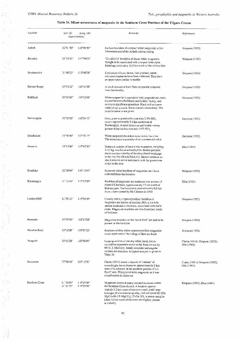
GSWA Miriernl Resources Bulletirz 16 Talc, pyrophyllite mid rnngriesiie iri Western Australin
Table 34. Minor occurrences of magnesite in the Southern Cross Province of the Yilgarn Craton
Locality
Ardath
Baandee
Boodarockin
Bremer Range
Bullfinch
Burracoppin
Doodlakine
Dowerin
Kondinin
Kununoppin
LookoutHill
Merredin
Moorine Rock
Nungarin
Sandstone
Southern Cross
kff. (s) LOf7g. ( E ) Reri7arks References (app roxininte)
Suiface boulders of compact white magnesite, a few kilometres east of the Ardath railway siding
Simpson (1952) 32"01'50" I IX"05'40"
3 l"36'40" 117"59'00" 'Coralloidal' boulders of dense white inagnesite Simpson (1952) thought to be associated with a serpentinitic dyke, found approximately 12.8 km north of the railway Line
32"31'20" 120"41'00"
30"56'00" I19"05'00"
3 l"0020" 1 I X"48'00" Specimens of hard, dense, fine-grained, cream- Simpson ( 1 952) coloured magnesite have been collected. They have an appearance similar to marble
A small amount of hard flinty magnesite is known from this locality
Simpson (1952)
White magiiesite is associated with serpentinous rocks located between Bullfinch and Golden Valley, and occurs in significant quantities. Hard, soft and pure varieties are present. Some contain chalcedony. The exact location is not given
Simpson ( I 952)
3 l"2020" 1 IX"24'45"
31°3640 117"52'15"
31"11'40" 117"02'30"
32"3000" 118"16'00"
31°12'40" 117"55'20"
31'59'20" I19"03'20"
31"29'20" 118"17'00"
31"1600" 119"07'20"
31'1 1'20" 1 I X"06'00"
27"58'40" 119"16'30"
31"16'00 119"21'00" 3 1021'35'' 119~21'00"
Hard, pure magnesite that contains 2.5% SiO? occurs approximately 9.6 kin northwest of Burracoppin. A more siliceous and friable variety present at the surface contains 16% SiO?
White magnesite boulders occur in this location. The occurrence is possibly of no commercial value
Scattered nodules of hard white magnesite, weighing 1-1 3 kg, overlie an anthophyllite-biotite gneiss in the immediate vicinity of the chrysoheryl workings in this locality (Block DAA41). Similar nodules are also known to occur associated with the greenstone schist in the area
Scattered white boulders of magnesite have been collected from this location
Boulders of magnesite are scattered over an area of about 0.8 hectares, approximately 1 I km south of Kununoppin. The location is approximately 0.8 km from a farm owned by Mr Clausen in 1940
Creamy white, cryptocrystalline boulders of magnesite are known at Lookout Hill, a few kilo- metres southeast of Holleton, associated with mafic rocks. h4agnesite boulders are also found just south of Holleton
Magnesite boulders of the 'usual kind' are said to be present at this location
Boulders of dirty whitecryptocrystalline magnesite occur northwest of the siding at Moorine Rock
Large quantities of creamy white, hard, micro- crystalline magnesite occur on the farm owned by Mr G. J. McCorry. Small lenticular and angular cavities are common. A typical analysis is given in Table 35
Clarke (1914) noted a deposit of 'cement' of exceedingly dense character, approximately 2 km west of Sandstone, in the northern portion of old Pyx Claim. This proved to be magnesite and was considered to be siliceous
Magnesite occurs at many isolated locations within the Southern Cross district. A location approx- imately 3.2 km south of the town could yield large tonnages of commercial quality, and contained 45.02% MgO (~94.1% MgCO,) (Table 35), whereas samples taken 12 km south of the town are slightly porous and chalky
91
Simpson (1952)
Simpson ( 1 952)
Ellis (1963)
Simpson (1952)
Ellis (1963)
Simpson (1952)
Simpson (1 952)
Simpson (1952)
Clarke (1914); Simpson (1952); Ellis ( I 963)
Clarke (1914); Simpson (1952); Ellis(1963)
Simpson (1952); Ellis (1963)

P. B. Abeysinghe
Table 34. (continued)
Locality Lot. (S) Long. (El Reriinrks Refewices (app roxiim te)
Tammin 3 1°3000" 1 17"25'00" Numerous boulders of magnesite up to 4.5 kg in weight Simpson (1952); Ellis (1963) were found in a cleared paddock, approximately 17.5 kin hearing 330" from Tammin. The magnesite is hard and lies on a grey, clayey loam mixed with quartz grit. It is considered to he high grade, although the quantity available is k'ery small. The country rock is weathered gneiss and granitoid with pegmatite, as seen from the heaps of rock on the cleared paddock, but there is also float material of a mafic rock in the area
Westonia 3 l"1635" 124"38'20" Large nodules and boulders of pure magnesite have been collected from a lease known as Edna May Deeps, where small hands of Archaean peridotite and serpent- inite are known to occur. In 1963 production of 22 t valued at $177 was recorded from MC60. Concretions of impure magnesite are also known in soil near Bodallin Soak
Blatchford and Honman (1917); Simpson (1952); Ellis (1963)
of magnesite in this province are associated with serpentinitic ultramafic rocks of the greenstone belts, and are confined to an area bounded by Lawlers to the north, Norseman to the south, Coolgardie to the west, and Bulong to the east. None of the occurrences is exploited at present, although there has been past production from some localities. The last recorded production was 95 t from Coolgardie in 1967, out of a total production of 2929 t between 1938 and 1967 (Table 29). However, Bulong - known to contain larger deposits than Coolgardie - had produced only 1583 t up to 1956. Most occurrences elsewhere in the Eastern Goldfields appear to be small and have not been exploited commercially. A number, however, have potential for development, although information on these is sparse.
Table 35. Chemical analyses of magnesite from Nungarin and Southern Cross
Niingnriii Soutl7errz Cross Soutlzern Cross Sample no. 7 30 31
co, MgO FeO CaO MnO SiO,
Fe203 TiO, H@+ H2O- NaCl
5 1.04 46.08
0 1 .oo
0 0.60 0.25 0.03
0.24 Inc. above
percentage 46.05 42.98
0.14 0.70
0 6.66 0.64 1.28 0.06 0.73 1.13
tr
49.13 45.02
0 0 0
2.56 1.09 0.73
nd nd nd
Bulong Location: Lat. 3O045'O0"S, Long. 12lo5000"E; KURNALPI
Historical background
Bulong is an abandoned townsite 37 km east of Kalgoorlie. The presence of magnesite about 4 km east-northeast of the town has been known to the Department since 1897, and samples were collected for quality assessment in 1904 (Feldtmann, 1916, 1919; Simpson, 1952). In September 1913, application was made for a reserve of 258 ha, between Bulong and the western edge of Lake Yindarlgooda, and in 1914 bulk samples of Bulong magnesite were sent by The Magnesia Syndicate Limited to South Australia and Germany. Results were encouraging and 838 t were mined and marketed between 1915 and 1918 (Table 29). There was no production between 1919 and 1940 due to competition from suppliers in New South Wales and South Australia. Demand for the mineral increased during World War I1 because of restrictions in overseas supplies, particularly from Austria. To meet its steelmalung needs, Broken Hill Proprietary Limited (BHP) acquired and surveyed mineral claim MC IOU, and produced 628 t during the years 1941, 1947, 1949 and 1951 (Table 29). In 1946 and 1956, 108 t were produced from mineral claims MC 3Y and PA 1409Y, and in 1977 there was recorded production of 9 t from MC 25/1109. The total output from the area between 1915 and 1956 was 1583 t valued at $5344 (Table 30), but there is no record of production since 1978.
Physiography 0
The ridge west of the main magnesite area is approx- imately 80 m above the bed of the salt lake, and extends a considerable distance to the south before it widens out to become a complex of hills approximately 5 km southeast of the abandoned townsite.
so3 Total 99.24 100.37 98.53
NOTES: (fief Simpson (1952)
11 - trace nd - not determined
92

GSWA Minerul Resources Bulletin 16 Talc, pyroplzyllire mid iiingizesite iri Wesreriz Airstrdin
30" 45's
I
\ \ \
Fault, inferred --
% Ms Magnesite quarry
Ms Magnesite .- $ i i l l t : f l f l t Siliceous/chalcedonic s ::::::::::: m f x k over ultramafic . . . . . . . . . ._ s
Intermediate fragmental rw (d rocks
, 2 km I
PBA26 31.10.96
Figure 29. Generalized geology of the Bulong area
Geology The main rock units distinguished in the Bulong area consist of serpentinized peridotite and komatiite (Fig. 29) of Archaean age. The peridotites form the core of the Bulong Complex and are both laterally and vertically bounded by thin spinifex-textured komatiite flows and interflow sedimentary rocks.
The Bulong Complex was first defined by Williams (1970) as a discordant, layered intrusive body, approx-
imately 38 km long and 5 km thick, made up of multiple injections of magma. The complex ranges in composition from serpentinized peridotite to gabbro. Moeskops (1973, 1977) suggested that the complex formed from a series of ultramafic magmas that were introduced as largely concordant, extensive, flat-lying sheets, and that their crystalline products were subsequently folded and metamorphosed to greenschist facies. Ahmat (1995) re- interpreted the complex as a sequence of komatiite flows having mostly serpentinized peridotites at the core. The newly defined Bulong Complex now extends northward
93

P. B. Abeysirighe
to about 5 km north-northeast of the Unknown mine, a strike length of more than 70 km. To the south, the complex grades into ultramafic rocks that continue around the Bulong Anticline to about 16 km east of Mount Monger homestead.
Magnesite deposits occur mostly within the siliceous caprock of the serpentinized peridotites of the Bulong Complex exposed at the western edge of Lake Yindarlgooda.
To the southwest of the Bulong Complex are some medium- to coarse-grained Archaean gabbros that have formed in either an intrusive or extrusive environment. To the east of the Archaean sequence are Recent alluvial deposits, mainly confined to Lake Yindarlgooda, which consist of gypsum, saline clay and silt.
Magnesite deposits The largest magnesite bodies in the area lie within a northerly trending unit nearly 3.7 km long and parallel to the western edge of Lake Yindarlgooda that consists of siliceous and serpentinous rock with magnesite (Fig. 30). Within this unit magnesite is widespread. One deposit ranges in width from approximately 600 m in the north and central area to 100 m in the south, and covers about 150 ha, with the southern end of the deposit being approximately 1.2 km from the south side of the basin (Feldtmann, 1919; Simpson, 1952). Immediately south of Magnesite Creek, surface deposits of nodular magnesite have a maximum thickness of around 0.3 m and cover an area of approximately 6 ha. Other, smaller, deposits in the area include one to the south and three to the north of the main unit. The northernmost deposit is the largest of these, and is about 1.5 km north of Magnesite Creek, occupying a basin about 800 in long and more than 600 m wide, an area of approximately 36 ha. A few insignificant occurrences are also present north of the above deposits, and also in two places at the contact zone of pebble breccias and seipentinite.
Field evidence indicates that magnesite in all the above deposits was formed in situ, and occurs as veins of variable strike and dip within serpentinite of the Bulong Complex. The various stages of replacement of the host serpentinite can be seen, even up to advanced stages in which silica veins occur as stockworks with magnesite (Thorn, 1976). Most veins are subhorizontal and short, and both parallel and crosscutting veins are common. Some of the large veins strike at 015", with steep west-southwesterly dips (Feldtmann, 1919). The veins form small, resistant ridges (Fig. 31). The thickness of the veins varies from a few mm to 0.5 m. There are three abandoned quarries in the area around Magnesite Creek. The dimensions of these quarries vary from 12 m to 42 m in length, 5 m to 6 m in width and 3 m to 6 m in depth. The information froin the quarries, along with test pits and shafts, indicates the depth of magnesite mineralization to be approximately 5 m. The magnesite vein density in the quarries and the surrounding pits is over 50%, and a few hundred metres to the south the veining decreases to around 40%. Further south a trench approximately 3 m deep indicates a vein density of approximately 30%. The magnesite in the
94
deposits is white, dense (or very slightly porous) and fine grained.
Quality
Chalcedonic and opaline silica, derived from the host rock serpentinites are common impurities of magnesite in the area. Nickeliferous magnesite in various shades of green was noted at some localities (Williams, 1970). XRPD studies on sample 117355 Lat. 30"45'04"S and Long. 121"50'06"E (Fig. 30) indicate 75-85% magnesite, 10- 20% quartz, and traces of chlorite, interlayered chlorite and mica, and possibly smectite.
Chemical analyses of five samples, collected from abandoned quarries and the surrounding area (Table 36), show the following range of chemical compositions:
% MgO 31.60 to 46.2 CaO 0.15 to 1.15 SiO, 2.84 to 32.80 A1203 <0.05 Fe,O, -t FeO <0.1
Iron oxide and alumina, although not significant impurities, result in discolouration of the calcined material. Soluble salts (mainly NaCl) may be impregnated in the magnesite, which entails washing for many industrial uses. Selective mining is required to overcome serious impurity problems.
The high Ni and Cr content of the samples confirm an ultramafic source for the magnesite.
Resources
Although the published information from Bulong lacks resource figures, the area probably contains a substantial resource of recoverable magnesite of high quality.
Origin
Simpson (1952) considered the Bulong deposit to be a normal product of carbonation of seipentine-rich rocks by meteoric waters rich in carbonic acid, and postulated the following reaction:
2H4Mg,FeSi,0, (antigorite) + 4H,CO, + 0 3 4MgC0, (magnesite) + Fe,O,.H,O (limonite) + 4Si0, + 7H,O
Feldtmann (1919) suggested that magnesite was formed by the carbonation of olivine as well as serpentine, as follows:
3Mg,FeSi,O, (olivine) + 3C0, + 4H,O + 0 3 2H4Mg,Si,0, (serpentine) +Fe,O,+ 3MgC0, (magnesite) t 2Si0,
or
H,Mg,Si,O, (serpentine) + 3C0, 3 3MgC0, (magnesite)+ 2Si0, + 2H,O

GSWA Mineral Resources B~rlletirz 16 Tdc , pjrophyllite arid rnngrzesrte in Western Airstrnlin
I 121" 50'
L--
30" 45'
PBA25 31.10.96
Figure 30. Main geological units associated with magnesite at Bulong, and sample locations for magnesite
95

P. B. Abeysinghe
23.12.96 PBA117
Figure31. Veins of magnesite at Bulong. Photographs taken at sample location 117354 (shown on Figure 30)
Another plausible mechanism for the alteration of serpentine in ultramafic rocks is given by the following chemical reactions (Abu-Jaber and Kimberley, 1992):
12Mg,Si,05(OH), (serpentine) + 36HCO-, + 4Fe30, + 0, - 12FeSi,O,(OH) (nontronite) + 36MgC0, (magnesite) + 360H- +18H,O
or
96
Mg,Si,O,(OH), (serpentine) + 3HCO-, * 2530, + 3MgC0, (magnesite) + 2H,O + 3(OH)
Coolgardie Location: Lat. 3O053'4O"S, Long. 121°11'20"E; KALGOORLIE
Simpson (1952) regarded Coolgardie as being second only to Bulong as a source of magnesite in Western

CSWA Mineral Resources Bulletin I6 Talc, pyrophyllite arid ningriesite iiz Western Aiistrnlia
Table 36. Chemical analyses of magnesite from Bulong (major and trace elements)
GSWA izo. Lab no.
SiO, TiO, A1203
FeO MnO MgO CaO Na,O K2O
co2 'Z05
S H,O+ H,O- LO1 Rest Total
As Ba Cr c u La Mn Ni Pb Rb Sb Sr V Zn Zr
I I7352 11 7353 11 7354 I 1 12 13
I 1 7355 11 7356 14 15
29 <0.05 <0.05
0.05 10.1 10.05 33.5 0.29 0.16
<0.05 <0.05 35.4 0.04 1.25
0.02 0.07
99.76
<o. 1
<4 <11
17 6
<5 132 47 1 <4 <2 <4 <5 <2 <3 19
percentage 19.5 32.8 <0.05 <0.05 <0.05 <0.05 <0.05 <0.05 <0.1 <0.1 <0.05 <0.05 38.00 31.6 0.21 0.15 0.18 0.16
<0.05 <0.05 <0.05 <0.05 41.00 34.5 0.02 <0.01 0.68 0.81
<o. 1 0.15 0.01 <0.01 0.09 0.06
99.68 100.23
parts per million <4 <4
<11 <11 6 5 6 7
<5 <5 194 187 629 415 <4 <4 <2 <2 <4 <4 <5 <5 <2 <2 <3 <3 24 18
16.8 <0.05 <0.05 ~ 0 . 0 5 <0.1 <0.05 39.7 0.35 0.20
<0.05 <0.05 41.8 <0.01
0.63 0.23
<0.01 0.07
99.78
<4 22 13 6
<5 123 426 <4 <2
5 <5 <2 1 3 24
2.84 <0.05 <0.05 <0.05 <o. 1 <0.05 46.2
1.15 0.23
<0.05 <0.05 48.4
0.01 0.80 0.26 0.01 0.07
99.96
<4 <11 <4 I1 <5
163 507 <4 <2
5 <5 <3 <3 25
NOTES: Locations of samples are shown on Figure 30 Analyses by CC
Australia. The production of magnesite from the area to date is 2929 t valued at $16 536, of which 2834 t was produced between 1938 and 1956 and the remaining 95 t in 1967 (Tables 29 and 30). The material has been used in refractories and in the production of Sore1 cement.
Geology The main rock types distinguished in the area are fresh to altered and metamorphosed varieties of Archaean ultramafic rocks, basalt and gabbro (Fig. 32). The magnesite in the area occurs with serpentinite.
Magnesite localities
Feldtmann (1919), McMath (1950) and Simpson (1952) described occurrences of magnesite in an area approx- imately 6.5 km northeast of Coolgardie (Fig. 32). McMath (1950) stated that the magnesite occurs as flat lenses along two ridges trending east-northeast, and suggested the
possibility of similar lenses at depth. The magnesite at the surface is hard and nodular, and that at depth is soft but coherent. Simpson (1952) described scattered boulders extending I80 m in a northwesterly direction within soil overlying weathered serpentinite. A pit containing loose boulders and pebbles of magnesite extending to a depth of 7.6 m was described from the same area. Magnesite is found on former mineral leases ML87 (6.5 km northeast of Coolgardie), ML91 and ML92 (7 km northeast of Coolgardie) as a series of shallow veins, and is typically microgranular, porous and friable. Simpson (1952) also mentioned a small occurrence on former ML77 (5.5 km northeast of Coolgardie), and on ML78 (1 km east of Coolgardie) magnesite in shallow veins associated with asbestiform actinolite.
An occurrence of relatively pure magnesite associated with mafic to ultramafic rocks was noted in a trench (Lat. 30"54'35"S, Long. 121"12'10"E) a few kilometres east of the gold mining area (sample 117349, Fig. 32).
Quality
The analyses of a number of samples of magnesite from the above mineral leases (Table 37) indicate that they are of high quality, having MgO ranging from 42.19 to 47.36%. Two analyses given by McMath (1950) indicated that soft coherent magnesite assaying 47.25% MgO (=98.82% MgCO,) has a higher MgO content than the hard nodular magnesite that assays 42.19% MgO (38 .24% MgCO,). Three samples gave high nickel values, suggesting an ultramafic source. Typically, Cr is also high.
Origin
Field relationships and chemical data strongly suggest that the magnesite has formed as an alteration product of serpentinite. The chemical reactions involved could be those postulated by Abu-Jaber and Kimberley (1992), discussed in Chapter 5.
Mount B u rges Location: Lat. 30"5040"S, Long. 121"05'05"E; KALGOORLIE
Abundant creamy-white magnesite boulders are reported from a location north of a hill 22.5 km along the Kunanalling road from Coolgardie (Simpson, 1952). Scattered outcrops of magnesite, ranging from light creamy brown to creamy white, also occur in several locations approximately 4 km north-northwest from the railway track, along Eight Mile Rock - D road (Fig. 32). The magnesite in some of these outcrops is cryptocrystalline, hard to soft, and seems to be of good quality. However, two samples collected from the area had MgO values ranging from 39.6% to 44.8% with a significant amount of silica (Table 37).
Lawlers Location: Lat. 28"03'55"S, Long. 120'38'46"E; LEONORA
97

P. B. Abeysiiighe
121" 05'E
COOLGARDIE /
I 3 k m ,
Metamorphosed shale and chert . . . . . . , . . . . . . . . . . . . . . Metamorphosed gabbro, minor dolerite . . . . . . .
Metamorphosed high-Mg basalt
F j ,,. -, Ultramafic rocks (undifferentiated)
- Railway line
High way
Road --- -+ Anticline (approximate) -+ Syncline (approximate)
Probable fault
2 Magnesite prospect
--
Magnesite locality with past production
PBA27 23.1 1.95
Figure 32. Generalized geological map, showing the main areas of magnesite at Coolgardie (after Hunter, 1988)
98

2 s Table 37. Chemical analyses of magnesite from Coolgardie and Mount Burges (major and trace elements)
GSWAiio 117347 117348 117349 17 18 19 20 21 22 23 24 25 26 6564/48 6S65/48 117343 117344 5 Moiiiit Bulges Mowit Bulges 2 ?
5
As
Ba
Cr
cu La
Mn
Ni
Pb
Rb
Sb
Sr
V
Zn
Zr
2.57 <0.05 <0.05
0.1 I <o. I
<0.05 43.50
3.27 0.2 I
<0.05 <0.05 47.60 0.05 1.69 0.21
- - - - -
0.05 99.26
<4
22
27
23
<5
41
174
<4
<2
4
I14
9
4
<5
0.70 <0.05 <0.05
0.07 <0. I
<0.05 45.00
2.91 0.21
<0.05 <0.05 49.10
0.06 1 .OO 0.11
- - - - -
0.07 99.23
<4
23
44
35
<5
284
270
<4
<2
6
149
6
8
<5
0.71 <0.05 <0.05
0.09 <O. 1
<0.05 46.70
1.37 0.21
<0.05 <0.05 50.60 0.03 0.81 0 17
- - - - -
0.09 100.78
1 1
17
36
45
<5
211
48 1
<4
<2
4
45
5
14
20
0.06
0.22 tr 0 0
47.50 0.28
-
- - -
51.29
0.19 0.17 0.17 0.01
-
- - - -
99.89
-
-
-
-
-
- -
-
-
-
-
-
-
-
percentage 0.20 0.24
0.09 0.34 0.08 0.04
- -
tr tr
47.03 47.72 0 0.02
- -
- - - - - -
51.20 51.88 - -
0.58 0.38 0 92 0.14 0.05
0 0.15
- - - - - - -
- -
100.82 100.24
parts per million - -
0.72 6.04
0.60 0.75 0.06 1 .07
tr II'
47.14 43.44 0.02 0.98
- -
- -
- - - - - -
51.25 45.75 - - - - - - - nd - - - - - - - - - -
99.79 98.03
9.48 <0.05 <0.05
0.15 <o. I
<0.05 39.60 5.02 0.20
<0.05 <0.05 41.40 <0.01
2.69 1.70
- - - - -
0.07 100.31
<4
11
61
32
1 5
59
173
<4
<2
<4
250
I I
8
<5
5 <0.05 2 <0.05 2
0.06 g <0.1 =
44.80 'r
4.26
<0.05 2. 1.94 0.19
<0.05 <0.05 46.20
0.01 1.70 0.69
-
-
0.07 99.92
<4
235
21
<2
6 8'
% . - 2
nd - no1 determined 2 NOTES: Samples 117347-1 17349 analyses- CC; Samples 117347 - Lat. 30"53'03"S, Long. 12I01057"E; I17348 - Lat. 30"53'38"S, Long. 121'1 1'21"E 117349-Lat. 30"51'36S, Long. 12l012'O9"E; Samples I17343 - Lat. 35°50'03"S,
Long. 121"04'28"E 117344-Lat. 30"49'52"S, Long. 121°04'41"E Sarnplcs 17-26- rrfra,-Simpson (1952): Samples 6564/48 and 6565/48 - r,lrerMcMath (1950)
11 - trace (a) included above
d 2

P. B. Abeysirighe
PBAl i9 23.12.96
Figure 33. Photograph of surface pebbles and boulders of magnesite at Lawlers
A large deposit of magnesite is located approximately 4 km northwest from Joes Bore and approximately 11 km east of the office of the Lawlers Gold Project, approx- imately 115 km northeast of Leonora. The main deposit covers an area about 1.6 km long and 300 to 400 m wide, but the depth is unknown (Thom, 1976; Thom and Barnes, 1977). Other deposits lie south and west of the main deposit.
The magnesite in the main deposit is hard and indurated on the surface and has a layered appearance at shallow depth. Discontinuous flat-lying layers of thick nodular magnesite occur within the soil, and scattered pebbles and boulders of magnesite are common on the surface (Fig. 33). Magnesite is solid at one metre depth, but has not been tested below this. XRPD studies of sample 117368 from this location (Lat. 28'03'56"S, Long. 120°38'46"E) indicated 85-95% magnesite, less than 5% quartz, and traces of calcite, dolomite, chlorite, interlayered chlorite and mica, and possibly smectite.
South of the main deposit, magnesite on the surface tends to be chalcedonic, slightly discoloured, and impure. Sample 117371, collected 500 m south of 117368, assayed 43.3% MgO, and XRPD studies indicated 55-65% magnesite, 5-10% calcite, 5-10% dolomite, 1 5 2 5 % sepiolite, and <5% quartz. Chemical analyses of seven samples collected from north to south in the main deposit indicate that MgO contents varied between 42.30% and 46.60% with the exception of the low values in sample 117370 that assayed 24.6% MgO and 24.4% CaO (Table 38); this latter sample is also more ferruginous (0.18% Fe,O,) and weathered than the other samples. The Fe,O, contents of the rest of the samples were <0.05%. The Cr content of all the samples is comparable to those
100
collected from other localities such as Bulong, but the Ni content is lower.
There has been no production from the deposit, but a small quantity excavated from a pit of approximately 5 m x 5 m x 1.5 m has been dumped close to a track along a power line located about a kilometre north of the deposit. There are no outcrops of other rock types in the vicinity of the pit. However, nearby holes drilled in search of gold indicate that the area consists dominantly of weathered ultramafic to mafic rocks.
Eulaminna Location: Lat. 28"57'40"S, Long. 121'47'00"E (approx- imately); LAVERTON
Outcrops of magnesite occur approximately 1.6 km east of the old Eulaminna railway station, on the Leonora- Laverton road (Clarke, 1925b; Thom, 1976). The magnesite is associated with a north-trending ridge of ultramafic rocks, and the outcrops are fairly continuous for about 2 km. The deposit is thought to be shallow, small, and to have a high silica content, although no systematic work has been done to assess the grade and reserves.
Siberia (Waverley) Location: Lat. 3Oo14'30"S, Long. 120'59'55"E; KALGOORLIE
Siberia is now an abandoned township, with a large number of old mine shafts sunk into sheared, chloritic ultramafic rocks. Magnesite was encountered when excavating a Government well on Reserve 4251, and

GS1V.A Mineral Resources Bulleriri 16 Talc, pyrophyllire arid rizagrzesite irz Westerrz Aiutmlia
Table 38. Chemical analyses of magnesite from Lawlers (major and trace elements)
Lab no. 24 GSWA no. I 17367
25 26 27 28 29 30 1 I7368 117369 117370 117371 117372 117373
Si02 Ti02 A1203
Fe203 FeO MnO MgO CaO Na20 K20
C02 p2°5
S HzO+ H20- Rest Total
As Ba Cr c u La Mn Ni Pb Rb Sb Sr V Zn Zr
0.99 <0.05 <0.05 <0.05 <o. 1 <0.05 46.6 0.9 0.37
<0.05 <0.05
0.06 0.74 0.21 0.04
98.61
48.7
<4 <11
99 15 <5
391 15 <4 <2 <4
187 3
<3 <5
1.67 <0.05 <0.05 <0.05 <0.1 <0.05 46.3 0.94 0.27
<0.05 <0.05 48 0.11 0.88 0.14 0.43
98.74
<4 43
196 26 <5
181 10 <4 <2
6 3 923
<3 4
<5
percentage 2 3.53
<0.05 <0.05 <0.05 0.18 <0.05 0.18 <o. 1 <o. 1 <0.05 <0.05 45.4 24.6
2.53 24.4 0.22 0.22
<0.05 <0.05 <0.05 <0.05 48 44.7 <0.01 <0.01
0.97 1.36 0.56 0.23 0.06 0.16
99.74 99.56
parts per million <4 <4 28 '469
111 20 20 30 <5 <5
185 103 10 17 <4 <4 <2 <2 <4 <4
313 779 <3 9
3 3 <5 8
2.07 <0.05 <0.05
0.05 <0. 1 <0.05 43.3 4.13 0.18
<0.05 <0.05 48 <0.01
1.08 0.27 0.05
99.13
<4 29 24 23 <5
175 11 <4 <2 14
329 9 3
<5
1.78 <0.05 <0.05 <0.05 <o. 1 <0.05 45.9
1.77 0.18
<0.05 <0.05 48.7 <0.01
0.92 0.2 0.04
99.49
<4 23 77 15 <5
190 29 <4 <2 <4
178 <3 <3 15
2.3 <0.05 <0.05 <0.05 <o. 1 <0.05 42.3 5.14 0.18
<0.05 4 . 0 5 48 <0.01
1.43 0.34 0.07
99.76
<4 44 16 29 <5
338 21 <4 <2 <4
445 7 4
<5
NOTES: Analyses-CC; samples 117367, 117368 and 117369 are a11 close by at Lat. 28"03'56"S, Long. 120"38'46E sample 117370 -Lat. 28°01'21''S, Long. 120"38'28"E sample 117371 --at. 28"0422"S, Long. 120°38'41"E sample 117372 - Lat. 28OO4'33"S, Long. 120°38'44"E; sample I17373 - Lat. 28'04'43"S, Long. 120°38'53"E
subsequent drilling has indicated that the occurrence is significant (Simpson, 1952; Ellis, 1963). One sample from this location contained 47.09% MgO (~98.6% MgCO,) (Table 39). Magnesite has also been found in shafts sunk in alluvium in the same area.
The area is accessed by the road to the Davyhurst mine from the main Kalgoorlie-Menzies road. At Lat. 30"14'39"S, Long. 120"59'50"E, approximately 1.5 km east of the junction at Siberia, pure creamy-white magnesite occurs as isolated boulders associated with chert, chalcedony and ironstone in some excavated gravel dumps. Two samples, 117364 and 117365, collected from this locality assayed 41.50% and 40.40% MgO respectively and contained high silica (Table 39). The high Ni content of these samples (3719 ppm, 5466 ppm) suggest their source rocks are ultramafic. The occurrence is probably not commercial.
Comet Vale Location: Lat. 29"56'40"S, Long. 120"07'50"E; MENZIES
Magnesite-bearing rocks are known about 1.5 km from the old railway station at the abandoned town of Comet Vale. Commercially exploitable deposits were known in some localities in the Comet Vale area, and in 1920 a small tonnage was mined. Porcelanous nodules of magnesite associated with greenstone containing talc schist, serpentinite and carbonated peridotite, occur at the Gladstone gold mine and southeast and east of the town. The analyses of three samples from this location indicated that MgO percentages vary from 44.96% ( ~ 8 7 . 3 % MgCO,) to 48.38% (~99.1% MgCO,), with two samples having 5.76 and 4.76% SiO, due to the presence of chalcedony (Table 39) (Feldtmann, 1919; Jutson, 1921; Simpson, 1952; Ellis, 1963).
101

P. B. Abeysinghe
Sample 117366 (Lat. 29"56'42"S, Long. 120"07'49"E), collected approximately 300 m east of the Menzies- Kalgoorlie road at Comet Vale, was cryptocrystalline, hard, and white or creamy in colour. However, chemical analysis of this sample gave only 36.60% MgO with a high silica content (Table 39). Here, magnesite is scattered over an area of approximately 10 m x 25 m and has been tested by a small pit of about 2 m x 2 m x 1 m. The high Ni content of 710 ppm in the sample suggests the derivation of magnesite from ultramafic rocks close by. Approximately 100 m northeast of this site is a small shaft with dumps of ultramafic chloritic schist with thin veins and coatings of magnesite.
Magnesite also occurs on a laterite ridge east of Comet Vale, and on the western shore of Lake Goongarrie (a few km east of Comet Vale). The rocks along the shore of Lake Goongarrie are carbonated and contain antigorite, talc, chromite and approximately 10% of a slightly ferruginous magnesite. An asbestos vein associated with magnesite occurs approximately 3.2 km north of the Goongarrie locality.
Minor occurrences Table 40 gives some details of minor occurrences in the Eastern Goldfields of the Yilgarn Craton, with some sparse geological information.
Minor occurrences in other tectonic units The following tectonic units contain a number of minor occurrences of magnesite. The available information on these is summarized in the tables indicated:
South Western terranes of the Yilgarn Craton (Tables 41 and 42) Murchison terrane, Yilgarn Craton (Table 43) Northampton Complex (Table 44) Narryer Terrane (Table 44) Albany-Fraser Orogen (Table 44) North Pilbara granite-greenstone terrane (Table 45)
Table 39. Chemical analyses of magnesite from Siberia, Comet Vale, Kalgoorlie, Bullahulling and Hopbush Soak (major and trace elements) -
Localit) Sibel ia Siberia Siberia Cornet Comet Cornet Curtier Kalg- Kalg- Vale Vale Vale Vale oorlie oorlie
Sariiple fio 32 I I7364 I 1 7365 14 15 16 I 1 7366 28 29
Bulla- Hopbiirh bLrlliflg Soak
10 27
co, MgO FeO CaO MnO SiO, AI,O, Fe,o, H20+ H20- NaCl so, SrO TiO, Na,O K20 p205 S Rest Total
As Ba Cr cu La Mn Ni Pb Rb Sb Sr V Zn Zr
51.62 47.09
0 tr 0
0.16 0.61 0.20 0.16 0.12
tr 0.08
- - - - - - -
100.04
- - - - - - - - - - - - - -
43.2 41.5 <o. 1 0.16
<0.05 12.9
<0.05 0.08 I .44 0.17
- - -
<0.05 0.21
<0.05 <0.05 <0.01
0.49 100.15
<4 <I 1
21 37 <5 69
3 719 <4 42
4 10 <3 <3 25
42.1 5 1.72 40.4 48.38 <0. 1 0 0.32 0
<0.05 0 12.9 0.50 0.2 I 0.28 0.25 (a) 2.13 0 0.37 tr
- - - - - -
<0.05 - 0.21 -
<0.05 - <0.05 - <0.01 -
0.72 -
99.61 100.88
<4 - <I 1 -
31 - 46 - <5 -
I69 - 5 466 -
<4 - <2 -
23 - 4
8 3
-
- -
21 -
percent 48.10 46.84 44.96 45.38
0 Tr 0 1.63 0 0
5.76 4.76 1.38 0.90
(a) (a) tr tr
- - - - - -
- - - -
100.20 99.51
parts per million
40.70 36.60 <0.01
1.76 <0.05
20.1 <0.05
0.05 0.56 <o. 1
- - -
<0.05 0.17
<0.05 <0.05 <0.01
0.1 I 100.05
<4 19 31 13 <5 94
710 <4 <2 <4 95 43 <3
6
NOTES: Samples 117364-1 17366 -analyses CC: Locations: sample I17364 - Lat. 30"14'28"S. Long. 120"59'55"E; sample 117365 - Lat. 30"14'39"S, Long. 120"5950"E; sample 117366 - Lat. 29"5642"S, Long. 120'07'49"E. other samples - rrfrer Simpson (1952) tr - trace _ _ not determined (a) included with above
102

GSWA Mineml Resources Bulletin 16 Tnlc, pyi-oplzyllite nrid riingriesite irz Western Australia
Table 40. Minor occurrences of magnesite in the Eastern Goldfields of the Yilgarn Craton
LocnlitJ Lnt. (S) Lorzg. (E) (npproxifiinte)
Reriinrks References
Bardoc
Broad Arrow
Bullabulling
Eucalyptus
30°21'00" 121'1 8'00" Magnesite boulders of the 'usual type'are said to occur west of Hilda GML2495, where under- lying rocks are Archaean greenstones
Siinpson (1952)
30O2640" 121"20'00" Magnesite occurs as boulders and shallow Simpson (1952) veins, possibly in commercial quantities, associated with a weathered ultramafic rock. Most of the high-grade material contains more than 98% MgCO, and is slightly porous and friable, but some magnesite is harder and contains significant chalcedony, including one example which contained more than 62% chalcedony
30°58'00" 120°55'00"
29"12'00" 122"ll'OO"
Feysville 30"57'00" 121"36'00"
Golden Ridge 30"51'00" 121°40'00"
Higginsville 31"45'00" 121"42'00" (Hopbush Soak)
Kalgoorlie-Boulder 30°44'00" 12 l"28'00"
Specimens of high-grade white magnesite have been collected from boulders and shallow veins at a locality 11 km northeast of the railway siding. A typical specimen from the locality assays 98.92% MgCO, (Table 39)
At Gibraltar, approximately 8 km southeast of Bullabulling, a few veins of magnesite are associated with mafic schists, notably on the Lloyd George GML.1580. They are considered to be too small to have any commercial value
A good outcrop of inagnesite is reported at the 12 mile peg (19.3 km) on the Yundamindera- Linden road, just southeast of Eucalyptus. The quality of the magnesite is said to be similar to that mined at Bulong
Rocks containing fuchsite-quartz-breunnerite occur at the Celebration GM, and are thought to have formed by the carbonation of serpentinous rocks
Ferruginous inagnesite (breunnerite) occurs in association with chlorite and talc in rocks approximately 1 km north of a quartz blow on GML3945
Cream and white magnesite is known from a location 3.2 km north of Hopbush Soak, east of Higginsville. A typical sample from this location contained 46.50% MgO (Table 39). A small superficial deposit of magnesite is associated with ultrabasic rocks, at a location between the 412 and 413 mile pegs (663 km and 664.6 km)
Ferruginous magnesite (breunnerite) is found at a number of localities in the Kalgoorlie- Boulder area as follows: a bright-green fuchsite-quartz-breunnerite rock forms several nai-row bands in the greenstone complex just east of Kalgoorlie, in what is presently an active area of gold mining; a rock from Mount Charlotte (GML211) contained 16% ankerite and 38.1% breunnerite; and another from Hyman GML4406 contained 49.2% breunnerite and 4.6% ankerite
Serpentine rocks on the northwestern shore of Hannans Lake have broad zones of massive, coarsely crystalline, olive-coloured carbonate material and one analysis indicates that there is 38% breunnerite and 19% ankerite present. Other constituent minerals include fuchsite, actinolite, quartz, magnesite, chromite and rutile.
Simpson (1952); Feldtinann (1925); Ellis (1963)
Honinan (1917); Siinpson (1 952)
Simpson (1952)
Simpson (1952)
Simpson (1952); Sofoulis ( 1966)
Simpson (1952)
103

P. B. Abeysirighe
Table 40. (continued)
Locality Lat. (S) Long. (E) (approxiniate)
Remarks References
Kalgoorlie-Boulder (cont.) Talcose bands are also present Rocks from a small area near Bonnie Lass GML796, to the east of the city, show less carbonation but more talc and little or no quartz. Analysis indicates 13.0% breunnerite and 16% ankerite
Surface concretions and shallow veins of rel- atively pure magnesite are associated with breunnerite at a few localities. An analysis of a sample from Belgravia GML4419 east of the city indicates 99.09% MgCO,, and close to this location a fibrous white magnesite with jasper carries appreciable SrO and CaO
Magnesite impregnated with chalcedony is found between the old Leviathan Battery and Mount Hunt
Kanowna 30°30'00" 121"24'30" Ferruginous magnesite (hreunnerite) occurs in carbonated greenstones in this area, one analysis indicated that the greenstone contains 13.2% breunnerite and 35.8% ankerite. Rocks with fuchsite-magnesite-quartz assemblages are known in the Main Reef zone at Kanowna
Jutson (1912); Simpson (1916, 1952); Ellis (1963)
Kurrawang 30°51'40" 121°20'00" A peculiar form of indurated magnesite, probably formed by concretionary action in the laterite profile, occurs on the hreakaways of the eastern slope of the Kurrawang ridge, approximately 5 km south-southeast of Kurrawang
Honman (1914); Simpson (1952); Ellis (1963)
Larkinville 31"28'20" 121 "28'30" Feldtmann (1935); Simpson (1952); Ellis (1963)
Irregular veins of apparently siliceous magnesite are known in the altered greenstones of the area. A dense, hard, pure white variety of magnesite also occurs at the surface in a few places
Laverton 28"37'40" 122"24'00" Simpson (1952) Boulders of good quality, dense, white magnesite, sometimes with a chalky surface, occur in surface soil at Laverton
Mount Hunt 30°50'40" 121°30'30" According to the records of the Department of Minerals and Energy, in 1956 287 t of magnesite valued at $1326 was mined from MC17E held by R. L. Jones. No other information is available on this deposit
DME production statistics (unpublished)
Large boulders made of intimate mixtures of white cryptocrystalline magnesite and chalcedony in approximately equal proportions have been collected from the surface. Some boulders are covered with a thin layer of cream-coloured travertine
Simpson (1952) Nepean 31°1000' 121°05'00'
32°12'00" 121°46'00" Nodular magnesite was found in a small shear zone in an adit at the Hardy Norseman GML21 White cryptocrystalline magnesite is found in the surface soil near the Nellie May GML873, 14.5 km northeast of Norseman, and a sample contained 96.5% MgCO, and 3.5% CaCO,. Peridotites, pyroxenites, and norites are wide- spread in the area
Magnesite also occurs as a deep weathering product over ultramafic rocks associated with the Jimberlana intrusion that extends from northeast of Norseman to Round Top Hill on
Campbell (1906); Simpson (1952); Gower and Bunting (1976)
Norseman
Gower and Bunting (1976)
104

GSWA Mineral Resources Bulletin 16
Table 40. (continued)
Talc, pyroplzyllite and magriesire in Westem Australia
Locality Lat. ( S ) Long. (E) (approxiinore)
Remarks References
Norseman (cont.)
Ora Banda
Paddington
30°22'00" 121"02'30"
30'29'40" 121°20'00"
LAKE JOHNSTON. Magnesite is more abundantly developed over the ultramafic portions of the intrusion
Boulders of magnesite are scattered over the surface of serpentinitic rocks southwest of Ora Banda townsite, especially near the Black Flag road
Dense white magnesite and chalcedonic magnesite boulders occur on the surface and as shallow seams associated with serpentinite approximately 1.6 km south of the railway siding. Talc-breunnerite schist occurs in an old mine dump near a serpentinous rock (exact location not given)
Jutson (1914); Simpson (1952); Ellis (1963)
Simpson (1 952); Feldtmann (1915)
105

P. B. Abeysirighe
Table 41. Minor occurrences of magnesite in the South Western terranes of the Yilgarn Craton
Locality Lot. (S) L o q . ( E ) Reinarks References (upproxiiiiate)
Corrigin and Kumminin 32"19'40" 117O52'00"
Dangin
Goomalling
Kulin
Namban
Northam
York
32O02'40" 1 17°18'00"
31"17'40" 1 16°50'00"
32'40'20" 11 8O09'30"
30"23'00" 1 16"00'30"
31'39'20" 116"42'30"
31O50'40" 116°45'30"
Analyses of two bulk samples of boulders of hard cryptocrystalline magnesite from a location just south of Corrigin contained 46.92 and 44.56% MgO (Table 42). Hard, white concretionary magnesite also occurs at a few places north and south of the road from Kumminin to Coirigin, and large boulders of magnesite occur on Fawcetts Farm in the Kumminin area. One sample from Fawcetts Farm contained 46.64% MgO. Commercial deposits are unknown
Sitnpson (1952); Ellis (1963)
Numerous veins of magnesite up to 7.6 cm thick occur in weathered mafic rocks in a railway cutting approximately 2 km west of Dangin. Magnesite nodules are also developed in soil in this area. While the magnesite is high grade, the quantity available is thought to be insignificant for any commercial operation. Small quantities of white coralloidal magnesite are developed on a inafic dyke intruding granitic gneiss on location 12487 north of Dangin
Occasional nodules of magnesite are known in soil covering serpentine rocks in the immediate vicinity of the town
White boulders of magnesite are common in the vicinity of Kulin, and high-grade nodular magnesite occurs approximately 2.4 km northeast of Kulin, on the southeastern side of the railway line. However, no large deposits of commercial value are known
Large boulders of hard white magnesite are known from Wards Farm, 3.2 km we$ of the railway station. The material is said to have been used to make the font in a church at Moora
Ellis (1963); Simpson (1952)
Simpson (1952)
Simpson (1952); Ellis ( I 963)
Simpson (1952)
Between 1948 and 1950 there was recorded production of 4338 t of magnesite, valued at $19 437, from private property, located approximately 4.5 km east of Northam close to the Great Eastern Highway (Tables 29 and 30). The material was used as a flux in the charcoal-iron industry at Wundowie. It is of poor quality, and around 38% MgO and 41 % CO,. Dense white magnesite boulders also occur on the slopes of Mount Dick
Simpson (1952)
Small amounts of magnesite are known from a location 4.8 km north of York, overlying ultramafic dykes. The analysis of a typical specimen indicates that it is high grade, containing 47.62% MgO (=99.61% MgCO,) (Table 42)
Simpson (1952); Ellis (1963)
106

GSWA Mineral Resoirrces Bulletin 16 Talc, pyrophyllite and magizesite iri Western Australia
Table 42. Chemical analyses of magnesite from Corrigin, Kumminin, York, Bamboo Creek and Jimblebar, and breunnerite from Warrawoona
LOCfl l i tJ Corrigin Corrigin York Kii~iimirzin Bamboo Creek Jiriiblebar Warrnwoorza Warrnvvoorin Snmple no. 4 5 9 6 I 2 5787 5757
CO, MgO FeO CaO MnO SiO, *lZ03 Fe203 H20+ H,O- Na20 K20 TiO, FeS, Total
5 1.20 46.92
0 tr 0
0.60 1 .oo
(a) -
- 99.72
50.13 44.56
0 1.92
0 1.02 1.74
(a) -
-
99.37
51.35 41.62
0 0 0
0.58 0.42 0.30 0.24 0.26
-
100.77
percentage 50.90 24.48 46.64 20.22
0 5.14 tr 0 0 tr
1.16 47.00 1.56 1.92
(a) (a) - -
- -
100.26 99.36
50.31 42.10
1.57 4.62
-
98.60
32.60 28.89
3.52 2.68 0.35
26.65 2.03 2.06 0.92 0.16 0.29 0.09 0.16 0.17
100.57
23.03 32.30 4.72
Tr 0.11
30.63 1.68 5.94 0.52 0.15 0.41 0.1 1 0.52 0.20
100.32
NOTES. rifier. Simpson (1952) (a) included above ti = trace
107

P. B. Abgsiizglze
Table 43. Minor occurrences of magnesite in the Murchison terrane of the Yilgarn Craton ~~
Remarks References
Gabanintha 26"5600"
26"3600" Meekatharra
28'53'00"
Ninghanboun Hills 29"1200
Rothsay 29"17'00"
Yalgoo 28"21'00"
I I8"39'00" Lumps of surface concretionary magnesite associated with a rock containing veinlets of chrysotile and magnetite were recovered from the Lady Alma copper mine (MU). Concretionai-y magnesite occurs at a location 33.5 km east of Nannine on the Sandstone- Meekatharra road, in the vicinity of the 'Copper King' workings
Magnesite is known in narrow veins and as boulders at several localities around Meekatharra. At Ingliston United GML, many veinlets of magnesite occur in the lode formation, and boulders are strewn over the surface of the lease. Lumps of magnesite embedded in laterite overlie carbonated peridotites and pyroxenites at the Ingliston Extended GML (GML398), and specimens of magnesite were found down to 24 m as white porcelanous material, or occasionally as friable masses, intergrown with a white magnesium silicate, possibly sepiolite
Two types of breunnerite-bearing rocks are known in the Meekatharra area. At the Paddys Flat Group of mines, especially in the Commodore, Ingliston, Ingliston Extended and Globe GMLs fuchsi te-breunnerite-quartz rock derived from carbonated peridotites is characterized by the presence of bright-green chromium mica. The breunnerite in these rocks is white to pale-green in colour, and a typical specimen assays 8.59% FeO, 0.87%, Fe,O,, 35.69% SiO,, 26.20% CO,, and 20.46% MgO. Talc- breunnerite-ankerite rock is also found in the Paddys Flat area, but is generally less abundant than the fuchsite-breunnerite-quartz rock at Meekatharra
H. W. B. Talbot (1920) reported a 'deposit of impure and opalized magnesite' associated with a greenstone ridge approximately 0.8 km south of Mulermurra. The greenstones at the southern end of the ridge may be sheared and weathered peridotite
A few boulders of creamy u-hite magnesite are assoc- iated with the sei-pentine and mafic rocks at the eastern end of the Ninghanboun Hills
A few boulders of creamy white porcelanous magnesite associated with serpentinized Archaean greenstones occur at GMLIOI in the Rothsay GM
Surface boylders of magnesite occur near the Dollar G M
I 1 8"3000"
I18"12'00"
116"25'00"
I16"52'00"
I 16"4 1 '00"
Simpson (1952); Ellis (1963)
Farquharson (1912); Clarke (1916); Simpson (1952); Ellis (1963)
Talbot ( I 920); Simpson ( 1 952); Ellis (1963)
Simpson ( I 952)
Simpson(l952)
Simpson ( 1 952)
108

GSWA Mineral Resources Bulletin I6 Talc, pyrophyllite arid riiagiiesite irz Westerri Australin
Table 44. Minor occurrences of magnesite in the Northampton Complex, Narryer Terrane and the Albany-Fraser Orogen
Locality Lat. (S) Lorig. ( E ) Tectonic irriit (approxiniote)
Reiiinrks References
Geraldine (Ajana)
Northern Gully
Yallalong
Pallinup River
Stirling Range
27"4600" 114°41'30" Northampton Complex Boulders of dense white magnesite with specks of graphite were found by Mr R. C. Wilson at a location on a lead mining lease east of Mary Springs. The area consists of granite and gneiss with veins of graphite intruded by dolerite dykes
28"43'00" 114"55'00"
27"2600" 1 15"31'00"
34"26'00" 118"48'20"
Northampton Complex Breunnerite occurs as a gangue mineral with siderite, quartz and galena at the Lady Sanipson lead mine
Small amounts of rnagnesite and long, fibrous, silicified tremolite are associated with ultramafic rocks south of Yallalong homestead
Narryer Terrane
Albany-Fraser Orogen 'Coralloidal' and fossil-like concretions of white microgranular magnesite occur at a location 9.6 km inland from the mouth of the Pallinup River. A vein of magnesite was also noted in weathered serpentinite near a graphite vein in the same area
Simpson (1952)
Simpson (1952)
Hocking et al. (1982)
Simpson (1952)
34"24'00" 118"02'00" Albany-FraserOrogen , Magnesite boulders have been collected from Simpson (1952) the foot of the Stirling Range, but the exact location is not known
Locality
Bamboo Creek
Braeside
Jimblebar
Lionel
Warrawoona
Table 45. Minor occurrences of magnesite in the north Pilbara granite-greenstone terrane
Lot. (S) Long. (E) (appro.rrriiate)
Reillarks Refemices
20"56'00"
2 1 12'00"
23'28'00"
21 "39'40"
2 1"20'00"
120"2'00" Small veins of coarsely crystalline white to Simpson (1952) pale-grey magnesite occur in a greenstone in the Kitchener GM. An analysis of some fine-grained material from a depth of 128 m in a bore indicates that it is breunnerite (Table 42)
121"'00" Magnesite occurs as a gangue mineral with limonite, siderite and calcite in a low-grade vein of copper ore (malachite) in basalt
Simpson (1952)
120°1 1'00" White magnesite filling small short veins up to 5 cm thick in older Precambrian jaspilites occurs east of Jimblebar Gap in the Ophthalmia Range. An analysis of a sample gave 42.10% MgO (Table 42)
Simpson (1952)
120"06'30" A coarsely crystalline vein of ferruginous magnesite was found in serpentine rock in a shaft at one of the asbestos leases. Another vein of similar appearance at the same location proved to be ankerite
The Archaean peridotites throughout this area are highly carbonated and contain significant amounts of finely granular ferruginous magnesite that is probably derived from antigorite and other ferro- magnesian minerals. Analyses of two samples from near the Juneau GML 479 and near GML 531 are given in Table 42
119"53'00"
Simpson (1952)
Simpson (1952)
109

110

References
ABARE, 1992, Talc, in Commodity Statistical Bulletin: Australian Bureau of Agricultural and Resource Economics, p. 352-356.
ABARE, 1993, Magnesium: Australian Bureau of Agricultural and Resource Economics, Quarterly Mineral Statistics, vol. 5 , no. 4, December quarter, 1993.
ABARE, 1994, Magnesium: Australian Bureau of Agricultural and Resource Economics, Quarterly Mineral Statistics, vol. 6, no. 2, June quarter, 1994.
ABARE, 1995, Magnesium: Australian Bureau of Agricultural and Resource Economics, Quarterly Mineral Statistics, vol. 7, no. 2, June quarter, 1995.
ABU-JABER, N. S., and KIMBERLEY, M. M., 1992, Origin of ultramafic-hosted vein magnesite deposits: Ore Geology Reviews, V. 7, p. 155-191.
AHMAT, A. L., 1995, Geology of the Kanowna 1:lOOOOO sheet: Western Australia Geological Survey, 1: 100 000 Geological Series Explanatory Notes, 28p.
ANDREWS, P. R. A,, 1986, Processing talc in Canada - A review of studies at CANMET: Industrial Minerals, No. 225, June, 1986, p. 63-69.
AOUKAR, N., 1991, Three Springs talc operation annual report, 01/07/90-30/06/91 on Lease M70/101, M70/243, Western Mining Corporation Limited report: Western Australia Geological Survey, M-Series report (confidential).
AOUKAR, N., 1992, Three Springs talc operation, annual tenement report, 10/12/90-09/12/91 on Lease E70/699, Western Mining Corporation Limited report: Western Australia Geological Survey, M-Series report (confidential).
ASTRO MINING NL, 1987, Quarterly Report to shareholders: Astro Mining NL, December 1986 (unpublished).
AUSTRALIAN MINERAL INDUSTRY ANNUAL REVIEW, 1967 to 1989, Talc and magnesite production statistics, in Australian Mineral Industry Annual Review, various years between 1965 and 1987: Australia, Bureau of Mineral Resources, Geology and Geophysics.
BAIN, G. W., 1924, Types of magnesite deposits and their origin:
BAKER, G. F. U., 1976, Talc-Coodawa deposit at Three Springs, W.A., irz Economic Geology of Australia and Papua New Guinea, Volume 4, Industrial Minerals and Rocks edited by C. L. KNIGHT: Australasian Institute of Mining and Metallurgy, Monograph 8, p. 398401.
New York, Dover Publications.
Economic Geology, v. 19, p. 412-433.
BATES, R. L., 1969, Geology of the Industrial Rocks and Minerals:
BAXTER, J. L., and LIPPLE, S. L., 1985, Perenjori, W. A.: Western Australia Geological Survey, 1 :250 000 Geological Series Explanatory Notes, 32p.
Australia Geological Survey, Annual Report for 1952, p. 31. BERLIAT, K., 1 9 5 5 , Notes on ‘Coodawa’ talc deposit: Western
BERLIAT, K., 1955b, Notes on a talc deposit near Bolgart: Western Australia Geological Survey, Annual Report for 1952, p. 30-31.
BLAKE, T. S., and McNAUGHTON, N. J., 1984, A geochronological framework for the Pilbara region, irz Archaean and Proterozoic Basins of the Pilbara, Western Australia - evolution and mineralization potential edited by J. R. MUHLING, D. I. GROVES, and T. S . BLAKE: University of Western Australia, Geology Department and University Extension, Publication, no. 9 , p. 1-22.
BLATCHFORD, T., 1899, The geology of the Coolgardie goldfield: Western Australia Geological Survey, Bulletin 3, p. 40.
BLATCHFORD, T., 1912, The mining geology of the Kanowna Main Reef Line, Kanowna, North-East Coolgardie Goldfield: Western Australia Geological Survey, Bulletin 47.
BLATCHFORD, T., 1917, Interim report on the graphite deposits at I Munglinup, Eucla Division: Western Australia Geological Survey,
Bulletin 76.
BLATCHFORD, T., 1919, The country between Hopetoun and the Fitzgerald River: Western Australia Geological Survey, Annual Report for 1918, p. 11.
BLATCHFORD, T., and HONMAN, C. S., 1917, The geology and mineral resources of the Yilgarn Goldfield, Part 11 1. The belt north of Southern Cross, including Westonia: Western Australia Geological Survey, Bulletin 71.
BLOCKLEY, J. G., 1956, The petrology of the Bayley’s group of leases: University of Western Australia, B.Sc.(Hons) thesis (unpublished).
BLOUNT, A. M., 1987, Summary of mineralogy of the Mount Seabrook talc and associated rocks: Western Australia Geological Survey, Mineral Resources Report 193 (unpublished).
BLOUNT, A. M., 1988, Supplement to 12/15/87 report of Mount Seabrook Mineralogy: Western Australia Geological Survey, Mineral Resources Report 194 (unpublished).
BLOUNT, A. M., and PARKINSON, G. A,, 1991, Hydrothermal alteration haloes and enlarged soil anomalies over concealed talc bodies, southwestern Montana: Ore Geology Reviews, v . 6, p. 185-193.
BOURBON, W. B., 1982, The origin of talc in the Allamoore district, Texas, in Proceedings, Seventeenth Forum on the Geology of Industrial Minerals edited by G. S. AUSTIN: New Mexico Bureau of Mines, Mineral Resources Circular 182, p. 77-84.
BROOKS, J. H., 1976, Magnesite - Queensland, in Economic Geology of Australia and Papua New Guinea, Volume 4, Industrial Minerals and Rocks edited by C. L. KNIGHT: Australasian Institute of Mining and Metallurgy, Monograph 8, p. 215.
BROWN, C. E., 1973, Talc, in United States Mineral Resources edited by D.A. BROBST and W.P.PRATT: US Geological Survey Professional Paper 820, p. 619-626.
BROWN, J. S., and ENGEL, A. E. J., 1956, Revision of Grenville stratigraphy and structure in the Balmat-Edwards District, Northwest Adirondacks, New York: Geological Society America, Bulletin, v. 67, No. 12, p. 1599-1622.
Industrial Minerals, No. 280, January 1991, p. 17-24. BURGER, J., 1991, Talc, USA and Europe competitive markets:
111

P. B. Abeysinghe
BUTLER, R. J. T., 1961, The magnesite deposits of the Ravensthorpe area, Western Australia, Basic Materials Co. Pty Limited: Western Australia Geological Survey, M-Series Open File, Item 5853 (unpublished).
CAMPBELL, W. D., 1906, The geology and mineral resources of the Norseman District, Dundas Goldfield: Western Australia Geological Survey, Bulletin 2 1.
CAMPBELL, W. D., 1909, Miscellaneous mineral notes: Western Australia Geological Survey, Annual Report for 1908, p. 17.
CARTER, J. D., and LIPPLE, S. L., 1982, Moora, W. A,: Western Australia Geological Survey, 1 :250 000 Geological Series Explanatory Notes, 25p.
CHIDESTER, A. H., ENGEL, A. E. J., and WRIGHT, L. A., 1964, Talc resources of the United States: US Geological Survey, Bulletin 1167, 61p.
CLARKE, E. de C., 1914, Notes on the geology and mining at Sandstone and Hancocks, East Murchison Goldfield: Western Australia Geological Survey, Bulletin 63.
CLARKE, E. de C., 1916, The geology and ore deposits of Meekatharra, Murchison Goldfield: Western Australia Geological Survey, Bulletin 68.
CLARKE, E. de C., 1925a, The geology of a portion of the East Coolgardie and North-East Coolgardie Goldfields, including the mining centres of Mount Monger and St Ives: Western Australia Geological Survey, Bulletin 90.
CLARKE, E. de C., 1925b, The field geology and broader mining features of the Leonora-Duketon district, including parts of the North Coolgardie, Mount Margaret, and East Murchison Goldfields: Western Australia Geological Survey, Bulletin 84, p. 47.
CLARKE, G., 1992, Magnesia around the world Hard times in soft markets - again: Industrial Minerals, No. 295, April 1992, p. 45-75.
COMSTOCK, H. B., 1963, Magnesium and magnesium compounds, a materials survey: United States Bureau of Mines, Information Circular 8201, 128p.
COOPE, B., 1983, Magnesia markets - refractory contraction and caustic stagnation: Industrial Minerals, No. 191, August 1983, p. 57-81.
COOPE, B., 1987, The world magnesia industry - smaller but fitter ... and purer!: Industrial Minerals, No. 233, February 1987,
COOPE, B., 1989, Magnesia markets - fit for optimism: Industrial
COOPE, B., 1990, Magnesite and magnesia: Metals & Minerals Annual
p. 21-28.
Minerals, No. 264, September 1989, p. 45-57.
Review, Industrial Minerals, p. 101.
COOPE, B., 1991, Magnesite and magnesia: Metals & Minerals Annual Review, Industrial Minerals, p. 115.
Review, Industrial Minerals, p. 99. COOPE, B., 1992, Magnesite and magnesia: Metals & Minerals Annual
COOPE, B., 1993, Magnesite and magnesia: Metals & Minerals Annual
COOPE, B., 1994, Magnesite and magnesia: Metals & Minerals Annual Review, Industrial Minerals, p. 92.
COOPE, B., 1995, Magnesite and magnesia: Metals & Minerals Annual Review, Industrial Minerals, p. 86.
COOPER, J. D., and HARTWELL, J. W., 1970, Talc, soapstone and pyrophyllite, in Mineral Facts and Problems, 1970 Edition: United States Department of the Interior, Bureau of Mines, Bulletin 650, p. 1267-1281.
DANIELS, J. L., 1975, Bangemall Basin, in The Geology of Western Australia: Western Australia Geological Survey, Memoir 2 , p. 147-159.
Review, Industrial Minerals, p. 115.
DICKSON, T., 1982, North American talc: Industrial Minerals, No. 183, December 1982, p. 75-78.
DUNCAN, L. R., 1986, Synthetic and natural magnesias - their past, present and future: Industrial Minerals, No. 226, July 1986, p. 4 3 4 9 .
ELLIS, H. A,, 1941, The talc, magnesite and vermiculite deposits of the S.W. Division: Western Australia Geological Survey, Annual Report for 1940, p. 7.
ELLIS, H. A,, 1944, Talc and soapstone deposits: Western Australia Geological Survey, Annual Report for 1943, p. 10-1 1.
ELLIS, H. A,, 1951, Report on a talc deposit on MC14E, Mount Monger: Western Australia Geological Survey, Annual Report for 1949, p. 14.
ELLIS, H. A,, 1963, Notes on the occurrence of magnesite, vermiculite, talc in Western Australia (Taken from field notes by the former Government Mineralogist): Western Australia Geological Survey report (unpublished).
FARQUHARSON, R. T., 1912, Petrological contributions to the geology of Western Australia: Western Australia Geological Survey, Bulletin 43.
FARQUHARSON, R. T., 1921, Petrological descriptions, in The mining geology of Comet Vale and Goonganie, North Coolgardie Goldfield: Western Australia Geological Survey, Bulletin 79, p. 10-13, 20, 28, 37, 72.
FAULKNER, J. W., 1962, Prospecting and testing of the magnesite deposits at Ravensthorpe, Western Australia, Broken Hill Pty Co Ltd and Pickands Mather & Co International: Western Australia Geological Survey, M-Series Open File, Item 1614 (unpublished).
FELDTMANN, F. R., 1915, The North End (Kalgoorlie): Western
FELDTMANN, F. R., 1916, Contributions to the study of the geology and ore deposits of Kalgoorlie, East Coolgardie Goldfield, Part 11 1. The North End of Kalgoorlie: Western Australia Geological Survey, Bulletin 69, p. 33.
Australia Geological Survey, Annual Report for 1914, p. 28,30,41.
FELDTMANN, F. R., 1918, Recent developments at the magnesite deposits of Bulong: Western Australia Geological Survey, Annual Report for 1917, p. 12-13.
FELDTMANN, F. R., 1919, The magnesite deposits of Bulong, North- East Coolgardie Goldfield: Western Australia Geological Survey, Bulletin 82.
FELDTMANN, F. R., 1925, The auriferous lodes of the Gibraltar district: Western Australia Geological Survey, Bulletin 91.
FELDTMANN, F. R., 1935, The Larkinville Gold Mining Centre, Coolgardie Goldfield: Western Australia Geological Survey, Annual Report for 1934, p. 13-26.
FELDTMANN, F. R., and FARQUHARSON, R. A., 1913, Contributions to the study of the geology and ore deposits of Kalgoorlie, East Coolgardie Goldfield, Part 11: Western Australia Geological Survey, Bulletin 51.
FETHERSTON, M., 1987, Magnesite deposits in Western Australia with special reference to the Bandalup area: Western Australia Geological Survey, Mineral Resources Report No. 190 (unpublished).
FORMAN, F. G., 1944, Soapstone at Glen Lynn, South-West Division: Western Australia Geological Survey, Annual Report for 1942, p. 9.
GEOLOGICAL SURVEY OF WESTERN AUSTRALIA, 1990, Geology and Mineral Resources of Western Australia: Western Australia Geological Survey, Memoir 3, 827p.
GIBSON, C. G., 1907, The geology and mineral resources of Lawlers, Sir Samuel and Darlot (East Murchison Goldfield), Mount Ida (North Coolgardie Goldfield), and a portion of the Mount Margaret Goldfield: Western Australia Geological Survey, Bulletin 28.
112

GSWA Mineral Resources Bulletin 16
GOWER, C. F., and BUNTING, J. A,, 1976, Lake Johnston, W.A.: Western Australia Geological Survey, 1 :250 000 Geological Series Explanatory Notes 27p.
GRAINDORGE, J. M., 1985, Livingstone talc prospect - Phase 1 exploration reconnaissance geology and appraisal of the drilling data: Thames Mining NL Report (unpublished).
GRAINDORGE, J. M., 1986, Livingstone talc prospect - Phase 2 exploration detail geology and appraisal of the drilling and geochemical data: Thames Mining NL Report (unpublished).
GRAINDORGE, J. M., 1988, Mount Celia joint venture project, surrender technical report for the period 9.10.1987 to 23.5.1988 for the conditional surrendering of six Prospecting Licences, six Mining Leases and two Gold Mining Leases in favour of Mining Leases 39/154, 39/155, 39/156, vols 1 and 2, Union Oil Development Corporation: Western Australia Geological Survey, M-Series report M4 122 (confidential).
GRAY, N. M., and LOW, G. H., 1950, Summary of significant geological and economic observations on geological survey of MC 14E - talc, Mount Monger: Western Australia Geological Survey, Mineral Resources Report No 1991/11 (unpublished).
GRIFFIN, T. J., 1990a, Eastern Goldfields Province, in Geology and Mineral Resources of Western Australia: Western Australia Geological Survey, Memoir 3, p. 77-79.
GRIFFIN, T. J., 1990b, Southern Cross Province, in Geology and Mineral Resources of Western Australia: Western Australia Geological Survey, Memoir 3, p. 60-77.
GRIFFIN, T. J., 1990c, North Pilbara granite-greenstone terrane, in Geology and Mineral Resources of Western Australia: Western Australia Geological Survey, Memoir 3, p. 128-156.
GRIFFIS, R., 1972, Genesis of a magnesite deposit, Deloro Twp.,
GRTFFITHS, J., 1992, Australian minerals - down under but not out:
Ontario: Economic Geology, v. 67, p. 63-71.
Industrial Minerals, No. 298, July 1992, p. 56.
Filenote 125/1970 (unpublished). GSWA, 1970, Pyrophyllite: Western Australia Geological Survey,
GSWA, 1972, Marble Bar 1:250 000 re-mapping programme: Western Australia Geological Survey, Filenote 104/1972 (unpublished).
HARBEN, P. W., and BATES, R. L., 1990a, Talc, irz Industrial Minerals - geology and world deposits: United Kingdom, Metal Bulletin PIC, Industrial Minerals Division, p. 274-281.
HARBEN, P. W., and BATES, R. L., 1990b, Magnesite and magnesia, in Industrial Minerals - geology and world deposits: United Kingdom, Metal Bulletin PIC, Industrial Minerals Division, p. 153-160.
HICKMAN, A. H., 1983, Geology of the Pilbara Block and its environs:
HICKMAN, A. H., 1986, Stratigraphy, structure, and economic geology of the Mount Monger area, Eastern Goldfields Province: Western Australia Geological Survey, Report 16.
Western Australia Geological Survey, Bulletin 127.
HICKMAN, A. H., THORNE, A. M., and TRENDALL, A. F., 1990, Excursion No. 5: Pilbara and Hamersley Basin, in Third International Archaean Symposium, Perth, 1990, Excursion Guidebook edited by S. E. HO, J. E. GLOVER, J. S. MYERS and J. R. MUHLING: University of Western Australia, Geology Department and University Extension Service Publication no. 21, p. 1-58.
HIERN, M. N., 1976, Talc - South Australia, in Economic Geology of Australia and Papua New Guinea, Volume 4, Industrial Minerals and Rocks edited by C. L. KNIGHT: Australasian Institute of Mining and Metallurgy, Monograph 8, p. 394-396.
HOCKING, R. M., van de GRAAFF, W. J. E., BLOCKLEY, J. G., and BUTCHER, B.P., 1982, Ajana, W.A.: Western Australia Geological Survey, 1:250 000 Geological Series Explanatory Notes, 27p.
113
Talc, pyroplzjdlite mid iizagrzesite i r z Western Aiistralin
HODGES, M. K., and LALOR, R. M., 1985, Summary report Seabrook talc deposit, Western Australia, Westside Mines NL: Western Australia Geological Survey, M-Series Open File, Item 2480 (unpublished).
HONMAN, C. S., 1914, The geology of the countiy between Kalgoorlie and Coolgardie: Western Australia Geological Survey, Bulletin 56.
HONMAN, C . S., 1916, The geology of the country south of Kalgoorlie, including the mining centres of Golden Ridge and Feysville: Western Australia Geological Survey, Bulletin 66.
HONMAN, C. S., 1917, The geology of the North Coolgardie Goldfield: Western Australia Geological Survey, Bulletin 73.
HOPKINS, G. M. F., 1991, Preliminary assessment of talc resources on Battersby farm M70/608: Western Mining Corporation Limited, WA Operations, Technical Report T/TST/OO2 (unpublished).
HUNTER, W. M., 1988, Kalgoorlie, sheet 3136: Western Australia Geological Survey, 1: 100 000 geological series.
IMDEX NL, 1988, Brief summary report on fieldwork undertaken November 1988: Western Australia Geological Survey, M-Series C-File (unpublished).
IMDEX NL, 1990, Annual report 20/12/89 to 19/12/90, Imdex NL and AMTE Holdings Pty Ltd: Westein Australia Geological Survey, M-Series Open File, Item 6839 (unpublished).
INDUSTRIAL MINERALS, 1979 to 1994, Prices: Industiial Minerals,
INDUSTRIAL MINERALS, 1987a, Caustic magnesia - industry follows a declining herd: Industrial Minerals, No. 233, February 1987, p. 43-48.
INDUSTRIAL MINERALS, 1987b, Australia: Queensland magnesite interest intensifies: Industrial Minerals, No. 234, March 1987,
INDUSTRIAL MINERALS, 1992, World of Minerals: Australia - New jv partner for magnesite upgrade; and Europe - Provisional anti-dumping duties on Chinese magnesia: Industrial Minerals, No. 302, November 1992, p. 9-10.
INDUSTRIAL MINERALS, 1993a, A happy new year?: Industrial Minerals, No. 304, January 1993, p. 7.
INDUSTRIAL MINERALS, 1993b, World of Minerals: Australia - Gwalia extends talc reserves: Industria1 Minerals, No. 306, March 1993, p. 8.
JEFFREY, P. M., 1956, The radioactive age of four Western Australian pegmatites by the potassium and rubidium methods: Geochim. et Cosmochim. Acta, v. 10, p. 191-195.
JOHNS, R. K., 1976, Magnesite - South Australia, in Economic Geology of Australia and Papua New Guinea, Volume 4, Industrial Minerals and Rocks edited by C. L. KNIGHT: Australasian Institute of Mining and Metallurgy, Monograph 8, p. 219-220.
JOHNSON, W., 1950, A geological reconnaissance survey of part of the area included between the limits lat. 24"O'S to 29"0'S, and long. 115'30'E to 11 8"30'E, including parts of the Yalgoo, Murchison, Peak Hill and Gascoyne Goldfields: Western Australia Geological Survey, Bulletin 106, p. 90, 91, 103.
JOHNSON, W., and GLEESON, J. S., 1951, Bandalup Creek magnesite deposit, Oldfield District, South-West Land Division of W.A.: Western Australia Geological Survey, Annual Report for 1949: p. 4 5 4 6 .
JUTSON, J. T., 1914, The mining geology of Ora Banda, Broad Arrow Goldfield: Western Australia Geological Survey, Bulletin 54.
JUTSON, J. T., 1921, The mining geology of Comet Vale and Goongarrie, North Coolgardie Goldfield: Western Australia Geological Survey, Bulletin 79.
KALIX, Z., FRASER, L. M., and RAWSON, R. I., 1966, Australian Mineral Industry - Production and Trade, 1842-1964: Australia,
, nos. 136 to 327, January 1979 to December 1994 (various).
p. 8.

P. B. Abeysirighe
Bureau of Mineral Resources, Geology and Geophysics, Bulletin No. 81.
KEANE, G., 1992, Magnesite - the wonder mineral of the future: Australian Mining, May 1992, p. 20-22.
Industrial Minerals, No. 162, March 1981, p. 19-35.
Industrial Minerals, No. 180, September 1982, p. 39-43.
LIBBY, W. G., 1988, Petrological Report 1493 - twelve samples from the Mount Seabrook talc deposit: Western Australia Geological Survey, Petrological Report (unpublished).
KUZVART, M., 1981, Industrial minerals and rocks of Czechoslovakia:
LEBAUER, L. R., 1982, The refractory raw materials of China:
LIPPLE, S. L., 1975, The Mount Seabrook talc deposit: Western Australian Geological Survey, Annual Report for 1974, p. 65-67.
LISHMUND, S. R., 1976a, Talc and pyrophyllite -New South Wales, in Economic Geology of Australia and Papua New Guinea, Volume 4, Industrial Minerals and Rocks edired by C. L. KNIGHT Australasian Institute of Mining and Metallurgy, Monograph 8, p. 391-393.
LISHMUND, S. R., 1976b, Magnesite - New South Wales, in Economic Geology of Australia and Papua New Guinea, Volume 4, Industrial Minerals and Rocks edited by C. L. KNIGHT: Australasian Institute of Mining and Metallurgy, Monograph 8, p. 216.
LOCSEI, J., 1986, Bandalup Hill lateritic nickel prospect, E74/40: Western Australia Geological Survey, M-Series Open File, Item 2903 (unpublished).
LOGAN, B. W., and CHASE, L. R., 1961, The stratigraphy of the Moora Group, Western Australia: Royal Society of Western Australia, Journal, v. 44, p. 14-26.
LOUTHEAN, R., (editor) 1993, Magnesite and talc, in Register of Australian Mining, 1993/1994: Resource Information Unit Ltd in association with Australian Business Monthly and the Australian Stock Exchange (Perth), p. 160, 314.
Western Australia Geological Survey, Bulletin 4. MAITLAND, A. G., 1900, The mineral wealth of Western Australia:
MAITLAND, A. G., and MONTGOMERY, A., 1908, The geological features and mineral resources of the Pilbara Goldfield: Western Australia Geological Survey, Bulletin 40.
MARSHALL, T. R., 1990, Annual report on Exploration Licence 70/418, Camamah talc project, Carnamah, Western Australia, Period December 1988 to 20 December 1989: Western Australia Geologic.al Survey, M-Series Open File, Item 7396 (unpublished).
Marymia Exploration NL, June Quarter 1993 (unpublished). MARYMIA EXPLORATION NL, 1993, Report to shareholders:
MATHESON, R. S., 1944, Investigation of the Meaney’s Bridge soapstone deposit: Western Australia Geological Survey, Annual Reports for 1941 and 1942, p. 10.
MATHESON, R. S., 1945, Report on soapstone deposit, approximately 7 miles east-southeast of Moora: Western Australia Geological Survey, Annual Report for 1944, p. 43.
MATHESON, R. S., 1946, Report on ‘Coodawa’ talc deposit: Western Australia Geological Survey, Annual Report for 1945 p. 23-26.
MATHESON, R. S., 1950, Report on talc deposit MC 145, Mount Monger: Western Australia Geological Survey, Mineral Resources Report No. 1991/4 (unpublished).
MAZZONI, P. P., 1990, Annual report, Exploration Licences 52/146 and 52/401, Western Mining Corporation Limited, Exploration Division - Minerals (Australasia) Report: Western Australia Geological Survey, M-Series Open File, Items 5262, 4086, 6892, 7273 (unpublished).
McCULLOCH, M. T., COMPSTON, W., and FROUDE, D., 1983, Sm-Nd and Rb-Sr dating of Archaean gneisses, eastern Yilgarn
Block, Western Australia: Geological Society of Australia, Journal, v. 30, p. 149-153.
McLEOD, I. R., 1965, Magnesite and dolomite, irz Australian mineral industry - the mineral deposits: Australia Bureau of Mineral Resources, Geology and Geophysics, Bulletin 72, p. 381-399.
Geological Survey, Annual Report for 1948. McMATH, J. L., 1950, Miscellaneous reports: Western Australia
MIDDLETON, D. D., 1989, Geological report on reconnaissance investigations of the Mount Taylor talc deposit - Exploration Licence 5 1/203, Murchison Mineral Field, annual report for C. W. Reindler: Western Australia Geological Survey, M-Series Open File, Item 4296 (unpublished).
MINING JOURNAL, 1992, Compound interest in magnesium: London, Mining Journal, August 28 1992, p. 152.
MOESKOPS, P. G., 1973, The Bulong serpentinite and environments of nickel mineralisation near Kalgoorlie, Western Australia: University of London (Imperial College), PhD thesis (unpublished).
MOESKOPS, P. G., 1977, New type of igneous layering due Lo fractionation of Archaean ultramafic magma: Nature, v. 267, p. 508-509.
MONKS, T. F., 1983, Maroonah base metal and talc prospect - Final report Temporary Reserve 8714 H, Kalgoorlie Southern Gold Mines NL: Western Australia Geological Survey, M-Series Open File, Item 2482 (unpublished).
Minerals NL, Report No. 92.023 (unpublished). MONKS, T. F., 1992a, Mount Seabrook Annual Report 1991: Gwalia
MONKS, T. F., 1992b, Mount Seabrook Annual Report 1992, 19 December 1991 to 18 December 1992: Gwalia Minerals NL, Report No. 92.059 (unpublished).
MORRIS, P. A,, and JONES, D. C., 1990, Report on soapstone occurrence, Mount Hardey estate, York: Western Australia Geological Survey, Mineral Resources Report No. 201 (unpublished).
MUHLING, P. C., and BRAKEL, A. T., 1985, Geology of the Bangemall Group - the evolution of an intracratonic Proterozoic basin: Western Australia Geological Survey, Bulletin 128.
MULRYAN, H. T., 1990, East Asia and Australia - dynamic factors in world talc business: Industrial Minerals, Ninth International Congress, March 1990, p. 90-202.
MYERS, J. S., 1988, Early Archaean Narryer Gneiss Complex, Yilgarn Craton, Western Australia: Precambrian Research, v. 38, p. 297-308.
MYERS, J. S., 1989, Thrust sheets on the southern foreland of the Capriconi Orogen, Robinson Range, Western Australia: Western Australia Geological Survey, Professional Papers, Report 26, p. 127-130.
MYERS, J. S., 1990a, Pinjarra Orogen, in Geology and Mineral Resources of Western Australia: Western Australia Geological Survey, Memoir 3, p. 265-273.
MYERS, J. S., 1990b, Western Gneiss Terrane, in Geology and Mineral Resources of Western Australia: Western Australia Geological Survey, Memoir 3, p. 13.
MYERS, J. S., 1995, Esperance S151, W.A.: Western Australia Geological Survey, 1: 1 000 000 Geological Series (second edition).
MYERS, J. S., in prep., Archaean geology of the Eastern Goldfields of Western Australia - regional overview, in Archaean granite- greenstone geology of Western Australia: Precambrian Research (special volume).
MYERS, J. S., and WILLIAMS, I. R., 1985, Origin of granite- greenstone patterns, Yilgarn Block, Western Australia: Precambrian Research, v. 27, p. 153-163.
NORMS, M. S., 1990, Annual report, Exploration Licence 52/146, Mount Seabrook, Peak Hill Mineral Field, Western Mining
1 I4

GSWA Mineral Resources Bulletin 16 Talc, pyroplzyllite and magliesite in Western A~stralia
Corporation Limited, Exploration Division: Western Australia Geological Survey, M-Series Open File, Items 5262, 4086, 6892, 7273 (unpublished).
Industrial Minerals, No. 294, March 1992, p. 24-37.
PARKS, J., 1991, Kundip mineral sands project, aircore drilling programme E74/134, Marymia Exploration NL: Western Australia Geological Survey, M-Series Open File report (unpublished).
PLAYFORD, P. E., COCKBAIN, A. E., and LOW, G. H., 1976, Geology of the Perth Basin: Western Australia Geological Survey, Bulletin 124.
O’DRISCOLL, M., 1992, Talc review, consolidation and competition:
POHL, W., 1989, Comparative geology of magnesite deposits and occurrences, in Magnesite, geology, mineralogy, geochemistry and formation of Mg-carbonates edited by P. MOLLER: Berlin, Borntreger, Monograph Series on Mineral Deposits, v. 28, p. 1-13.
POHL, W., and SIEGEL, W., 1986, Sediment-hosted magnesite deposits, in Handbook of Stratiform Ore Deposits edited by K. H. WOLF Amsterdam, Elsevier, v. 14, p. 223-310.
QUEENSLAND METALS CORPORATION LTD, 1992, Report to shareholders: Queensland Metals Corporation Limited, Quarterly Report, September 1992 (unpublished).
Westein Australia, Department of Geology (unpublished).
RICHARDS, J. R., BERRY, H., and RHODES, J. M., 1966, Isotopic and lead-alpha ages of some Australian zircons: Geological Society of Australia, Journal, v. 13, p. 69-96.
ROBBINS, J., 1985, UK cosmetics - make-up minerals: Industrial Minerals, No. 216, September 1985, p. 75-89.
ROE, L. A,, and OLSON, R. H., 1983, Talc, in Industrial Minerals and Rocks, 5th Edition edited by S. J. LEFOND: Society of Mining Engineers, American Institute of Mining, Metallurgical, and Petroleum Engineers, Inc., vol. 2, p. 1275-1301.
SAINT-SMITH, E. C., and FARQUHARSON, R. A,, 1913, The geology and mineral resources of the Yilgarn Goldfield, Part 1. Southern Cross: Western Australia Geological Survey, Bulletin 49.
READ, J. F., 1971, Report on Three Springs Talc leases: University of
SCHMID, 1. H., 1984, China - the magnesite giant: Industrial Minerals,
SCHMID, I. H., 1987, Turkey’s Salda Lake - a genetic model for Australia’s newly discovered inagnesite deposits: Industrial Minerals, No. 239, August 1987, p. 19-31.
Industrial Minerals, No. 237, June 1987, p. 40-51.
Geological Survey, Bulletin 19.
SIMPSON, E. S., 1912, Miscellaneous mineral notes: Western Australia Geological Survey, Bulletin 48, p. 107-108.
SIMPSON, E. S . , 1916, Analyses of Western Australian rocks, meteorites and natural waters: Western Australia Geological Survey, Bulletin 67.
SIMPSON, E. S., 1952, Minerals of Western Australia: Perth,
No. 203, August 1984, p. 2 7 4 5 .
SCHOBER, W., 1987, Talc in Europe: optimistic views are prevailing:
SIMPSON, E. S., 1905, Minerals of economic value: Western Australia
Government Printer, v. 3, p. 612-618.
SOFOULIS, J., 1958, The geology of the Phillips River Goldfield: Western Australia Geological Survey, Bulletin 110, 145p.
SOFOULIS, J., 1966, Widgiemooltha, W.A.: Western Australia Geological Survey, 1 :250 000 Geological Series Explanatory Notes, 24p.
TAKASAWA, K., and KURODA, Y., 1974, A quartz-magnesite rock in the Setogawa zone, central Japan: Geological Society of Japan, Journal, v. 80, p. 425-427.
TALBOT, H. W. B., 1920, A geological reconnaissance in the southerly portion of the Yalgoo Goldfield: Western Australia Geological Survey, Annual Report for 1919, p. 9.
TALBOT, H. W. B., and SIMPSON, E. S., 1926, A geological reconnaissance of part of the Ashburton drainage basin, with notes on the country southwards to Meekatharra: Western Australia Geological Survey, Bulletin 85.
THE MINER, 1992, New report reviews magnesium compounds: The Miner, November 1992, p. 15.
THOM, J. H., 1976, Magnesite - Western Australia, in Economic Geology of Australia and Papua New Guinea, Volume 4, Industrial Minerals and Rocks edited bg C. L. KNIGHT: Australasian Institute of Mining and Metallurgy, Monograph 8, p. 220-221.
THOM, R., and BARNES, R. G., 1977, Leonora, W.A.: Western Australia Geological Survey, 1:250 000 Geological Series Explanatory Notes, 31p.
THOM, R., and CHIN, R. J., 1984, Bremer Bay, W.A.: Western Australia Geological Survey, 1 :250 000 Geological Series Explanatory Notes, 20p.
THOM, R., LIPPLE, S . L., and SANDERS, C. C., 1977, Ravensthorpe, W.A.: Western Australia Geological Survey, 1:250 000 Geological Series Explanatory Notes, 40p.
THOMAS, W. N., 1972, Report on assessment of reseives of recoverable magnesite in the Ravensthorpe magnesite deposits - Basic Materials Co. Pty Ltd and Norseman Gold Mines NL: Western Australia Geological Survey, M-Series Open File, Item 5853
. (unpublished).
THYNNE, D. S., 1991, Exploration Licence 70/418 Carnamah, Annual Report to the Mines Department, Western Australia, period 21 December 1989 to 20 December 1990, Commercial Minerals Limited Report: Western Australia Geological Survey, M-Series Open File, Item 7396 (unpublished).
THYNNE, D. S., 1992, Exploration Licence 70/418 Carnamah, Annual Report to the Mines Department, Western Australia for year ending 20 December 1991, Commercial Minerals Limited Report: Western Australia Geological Survey, M-Series Open File, Item 7396 (unpublished).
UNIMIL PTY LTD, 1984, Surrender Report - Maroonah talc prospect PL 08/106, PL 08/107: Western Australia Geological Survey, M-Series Open File, Item 2483 (unpublished).
US BUREAU of MINES, 1977 to 1993, Production statistics of talc, in Minerals Yearbook Volume 1 Metals and Minerals: United States Department of the Interior, Bureau of Mines, Minerals Yearbooks betweeu 1974 and 1990 (various).
US BUREAU of MINES, 1993, Talc and pyrophyllite: United States Department of the Interior, Bureau of Mines, Mineral Commodity Summaries 1993, p. 172-173.
US BUREAU of MINES, 1995, Talc and pyrophyllite: United States Department of the Interior, Bureau of Mines, Mineral Commodity Summaries 1995, p. 168-169.
WARD, C. W., 1990, Annual Report - Pinnacle Well, Exploration Licence E37/153, Southern Ventures NL: Western Australia Geological Survey, M-Series Open File, Item 4754 (unpublished).
WATKINS, K. P., 1990, Murchison Province, in Geology and Mineral Resources of Western Australia: Western Australia Geological Survey, Memoir 3, p. 32-60.
WATKINS, K. P., and HICKMAN, H., 1990, Geological evolution and mineralization of the Murchison Province, Western Australia: Western Australia Geological Survey, Bulletin 137.
WELLMAN, H. W., 1942, Talc-magnesite and quartz-inagnesite rock, Cobb-Takaka district: New Zealand Journal of Science and Technology, v. 24 (3B), p. 103-127.
WELLS, I. R., 1965, Talc, soapstone and pyrophyllite, irz Mineral Facts and Problems, 1965: United States Department of the Interior, Bureau of Mines, Bulletin 630, p. 919-927.
115

P B Abeysrnghe
WENHAM, M E , 1976, Talc - Western Australia, in Economic Geology of Australia and Papua New Guinea, Volume 4, Industrial
WILLIAMS, I R , 1970, Kumalpi, W A Western Australia Geological Survey, 1 250 000 Geological Series Explanatory Notes, 37p
Minerals and Rocks edited by C. L. KNIGHT Australasian Institute of Mining and Metallurgy, Monograph 8, p. 397.
WILLIAMS, I, R,, 1987, Late Proterozoic glacigene in the Little Sandy Desert, Western Australia: Australian Journal of Earth
WESTERN MINING CORPORATION LIMITED, 1980, Terminal Sciences, v. 34, p. 153-155.
WILLIAMS, I R , 1990, Bangemall Basin, in Geology and Mineial Resources of Western Australia Western Australia Geological
WILLIAMS, I R , and MYERS, J S , 1987, Archaean geology of the
repoit on exploration on mineial claims in the Coorow area, December 1977 to May 1980, Mineral Claims 70/17020-17021, Western Mining Corpora~on Limited, Exploration Division Western Survey 3, 308-329 Australia Geological Survey, M-Seiies Open File, Item 61 11
WILDE, A , 19'03 The J1mpelding Metamorphic In the Toodyay Mount Narryer region, Western Australla Western Australia Geological Survey, Report 22 atea and the Balingup Metamorphic Belt and associated granitic
locks of the southwestein Yilgarn Block Geological Society - - Australia (W A Division), Inteinational Archaean Symposium, 2nd, Peith, W A , 1980, Excursion Guide
WIN=% H G F I 1974, Petrogenesls of metamoPhic rocks New York, Springer-Verlag, 320p
WILDE, S. A,, and LOW, G. H., 1978, Perth, W.A.: Western Australia Geological Survey, 1:250 000 Geological Series Explanatory Notes, 36p.
WILDE, S. A,, and PIDGEON, R. T., 1986, Geology and geochronology of the Saddleback Greenstone Belt in the Archaean Yilgarn Block, southwestern Australia: Australian Journal of Earth Sciences, v. 33, p. 491-501.
WILDE, S. A., and WALKER, I. W., 1982, Collie, W.A.: Western Australia Geological Survey, 1:250 000 Geological Series Explanatory Notes, 39p.
WITT, W. K., 1992, Visit to talc prospect, Hopetoun: Western Australia Geological Survey, Mineral Resources Report 1992/1 (unpublished).
WOODWARD, H. P., 1909, Gold and copper deposits of the Phillips River Goldfield: Western Australia Geological Survey, Bulletin 35, 108p.
YOUNGER, A., 1985, Bandalup magnesite project, Ravensthorpe, Western Australia, Norseman Gold Mines NL: Western Australia Geological Survey, M-Series Open File, Item 5853 (unpublished).
116

Index of localities
Ajana 109 Ardath 91
Baandee 91 Balingup 49, 52 Balkuling 54 Bamboo 61 Bamboo Creek 107, 109 Bandalup 56, 78-81, 84-89 Bandalup Creek 82, 85, 89 Bandalup Hill 82, 85, 87, 90 Bardoc 103 Battersby’s farm 34 Beverley 54 Bodallin Soak 92 Bolgart 24-25, 52 Boodarockin 91 Boulder 50, 103 Braeside 109 BremerBay 55 Bremer Range 9 1 Bridgetown 24-25, 49, 51 Broad Arrow 103 Browning Well 64 Bullabulling 102-103 Bullfinch 55, 91 Bulong 50, 78-81, 92-97 Burracoppin 9 1
Carnamah 29, 36 Collie 54 Comet gold mine 63 Comet Vale 50, 81, 101-102 Coodawa 29, 31, 36 Coolgardie 50, 78-81, 92, 96, 98, 99 Coondle 54 Coorow 29, 34, 36 Corrigin 106-107 Cue 58 Culham 54
Dangin 106 Darlot 50 Desmond 82 Donnelly River 54 Donnybrook 54 Doodlakine 91 Dowerin 91
Eucalyptus 103 Eulaminna 81, 100
Feysville 50, 103 Fowler’s farm 36
Gabanintha 108 Geraldine 109 Gibraltar 103 Glen Lynn 24-25, 49, 51-52 Golden Ridge 50, 103 Goomalling 54, 106 Greenbushes 52
Hamersley Siding 54 Henry River 60, 62-63
Higginsville 103 (Hopbush Soak) 103
Holleton 91 Hopbush Soak 102-103 Hopes Hill 55
Ingliston Extended gold mine 59
Jacobs Ladder 27 Jasper Hill 58 Jerdacuttup River 82, 85 Jimblebar 107, 109 Joes Bore 100
Kalgoorlie 50, 102-103 Kangaroo Bore 63 Kanowna 50 Kingston 59 Kirup 54 Kitchener mine 61 Kondinin 91 Kulin 106 Kumminin 106-107 Kundip 53, 55-57, 81-82, 85, 87 Kununoppin 91
Lake Goongarrie 102 Lake Yindarlgooda 92, 94 Lass O’Gowrie mining centre 47 Laverton 104 Lawlers 50, 81, 97, 100-101 Linden 50 Lionel 109 Livingstone 38-39, 44-45 Livingstone Find 39 Livingstone Find gold workings 43 Livingstone prospect 39 Livingstone talc prospect 43, 44 Locality L1
Loganberry 47-48 Lookout Hill 91 Lyalls Hill 54
Magnesite Creek 94 Manjimup 54 Marble Bar 63 Marchagee 21, 29, 32, 36 Maroonah 60 McPhees Range 61 Meanys Bridge 52 Meekatharra 58, 108 Merredin 91 Mooloo Downs 46 Moora 38 Moorine Rock 91 Mount Bakewell 52 Mount Burges 81, 97, 99 Mount Celia 63 Mount Desmond 81 Mount Dick 106 Mount Francisco 61 Mount Gould 38-39, 46 Mount Hardy 52
Bandalup Hill 89
1 1 7

P. B. Abeysiiighe
Mount Hunt 78-79, 104 Mount Lainb 27 Mount Leopold 63 Mount Magnet 59 Mount Maitland 38 Mount Monger 24-25, 27, 4 6 4 8 Mount Palgrave 62-63 Mount Seabrook 22, 24, 26, 3 7 4 4 , 49 Mount Seabrook 3 1, 45 Mount Seabrook talc mine 39 Mount Taylor 38-39, 4 5 4 6 Mulerinurra 108 Mulgarrie 50 M~i l la ly~p 52, 54 Munglinup 81, 87, 90
Nainban 106 Nepean 104 Ninghanboun Hills 59, 108 Niven’s property 36 Norseman 104 Northain 78, 79, 80, 106 Northern Gully 109 Nungarin 91, 92
Ora Banda 50, 105
Paddington 50, 105 Pallinup River 109 Paraburdoo 63 Peake Station 61 Pinnacle Well 63-64 Plutonic gold mine 59 Poona 59 Pykes Hollow 50
Ravensthorpe 56, 80, 81, 84-85, 90 Ravensthorpe Range 53, 82, 85 Reedys Maranoa Leases 58 Rothsay 108
Sandstone 55, 91 Sandy Creek 64 Shamrock GML 58 Sheela Bore 62 Siberia 50, 102
(Waverley) 81, 100 Soanesville 61 Southern Cross 55, 91-92 Southern Cross Well 39, 4 4 4 5 St Johns Brook 54 Starrs Find 63 Stirling Range 109
Tabba Tabba 64 Tammin 92 Three Springs Trillbar 38, 44 Trillbar prospect 45 Turkey Hill 55
Wagerup 54 Warrawoona 61, 107, 109 Waverley 81 Wellington Mill 54 Westonia 78, 79, 92 Wilgarup 54 Windanya 50 Winja Well 39, 44 Wongamine 54
Yalgoo 108 Yallalong 109 Yaloginda 59 Yarra Yarra Creek 46 York 52, 106, 107 Young River 90 Yoweragabbie 59
22, 24, 25, 27, 29, 31-36, 38, 39, 42, 49, 60
1 1 8