
Summary of Work Weasel Lake Area Yukon Territory, NTS ...
149
T Summary of Work Weasel Lake Area Yukon Territory, NTS 115 G/13 Yukon Mining Incentives Program Economic Development, Government ofthe Yukon Box 2703, Whitehorse, Yukon YIA 2C6 File Number 01-066 John Peter Ross, December 2001
-
Upload
khangminh22 -
Category
Documents
-
view
2 -
download
0
Transcript of Summary of Work Weasel Lake Area Yukon Territory, NTS ...
T Summary of Work Weasel Lake Area
Yukon Territory, NTS 115 G/13 Yukon Mining Incentives Program
Economic Development, Government ofthe Yukon Box 2703, Whitehorse, Yukon YIA 2C6
File Number 01-066 John Peter Ross, December 2001
902 VIA NO>inA'3SyOH=liHM S0i2XO5 Od
AHvysn SHObnosaa "s S3NIW 'AOd3N3 NOXHA
Summary of Work Weasel Lake Area
Yukon Territory, N.T.S. 105 G/13
for
Yukon Mining Incentives Program
Economic Development Govermnent ofthe Yukon
Box 2703, Whitehorse, Yukon Yl A 2C6
File Number 01-066
Jolm Peter Ross, Prospector December 2001
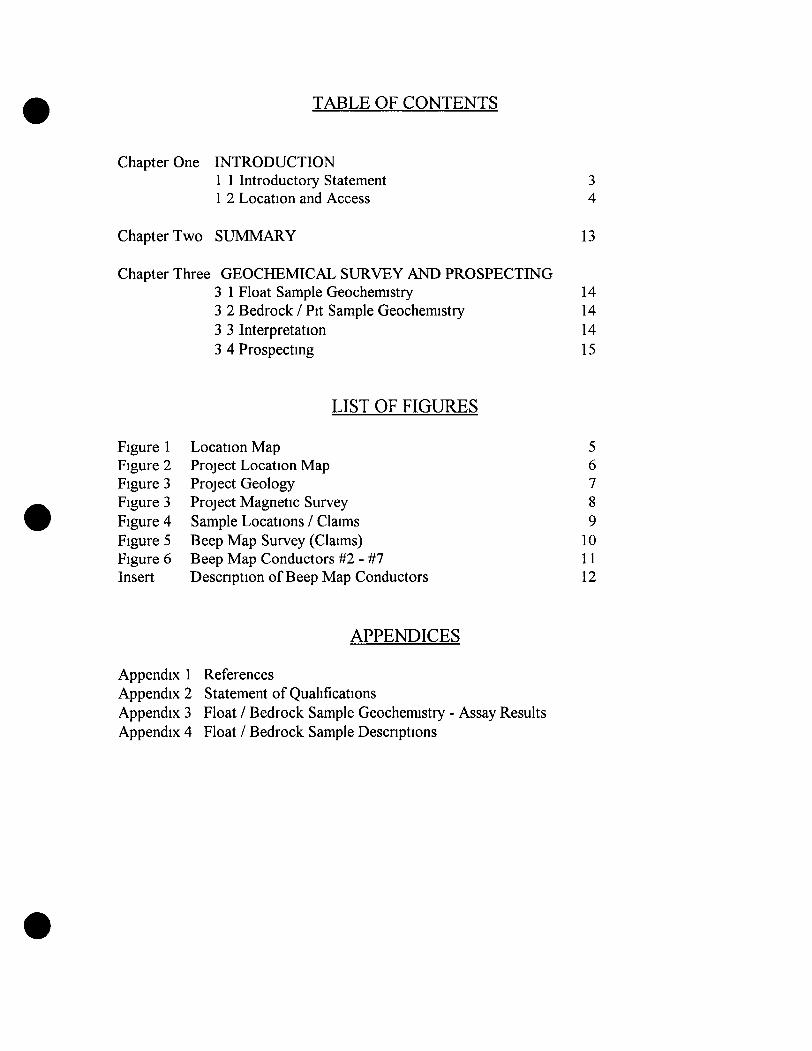
TABLE OF CONTENTS
Chapter One INTRODUCTION 1 1 Introductory Statement 1 2 Location and Access
3 4
Chapter Two SUMMARY 13
Chapter Three GEOCHEMICAL SURVEY AND PROSPECTING 3 1 Float Sample Geochemistry 14 3 2 3edrock / Pit Sample Geochemistry 14 3 3 Interpretation 14 3 4 Prospecting 15
LIST OF FIGURES
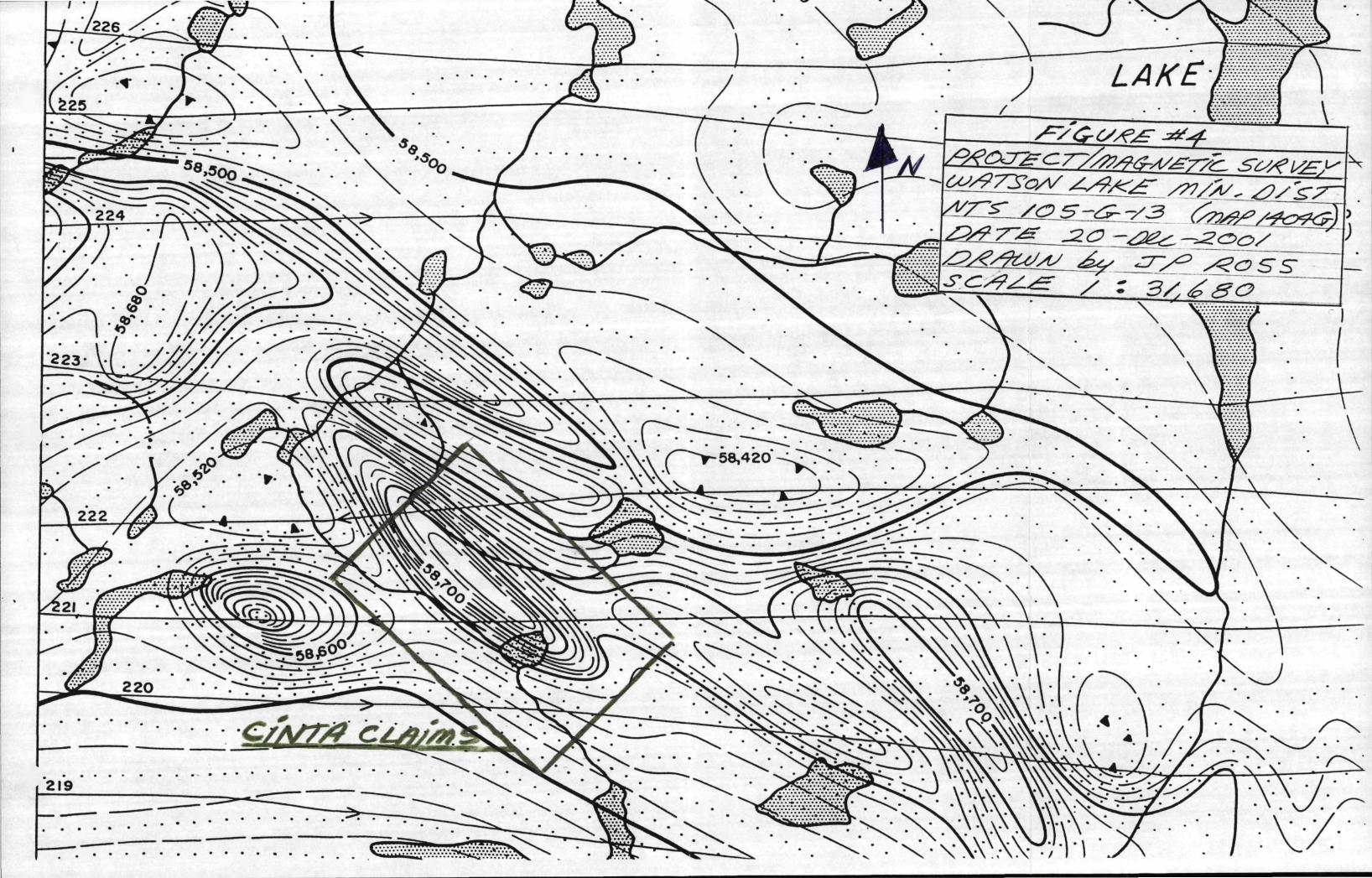
Figure 1 Figure 2 Figure 3 Figure 3 Figure 4 Figure 5 Figure 6 Insert
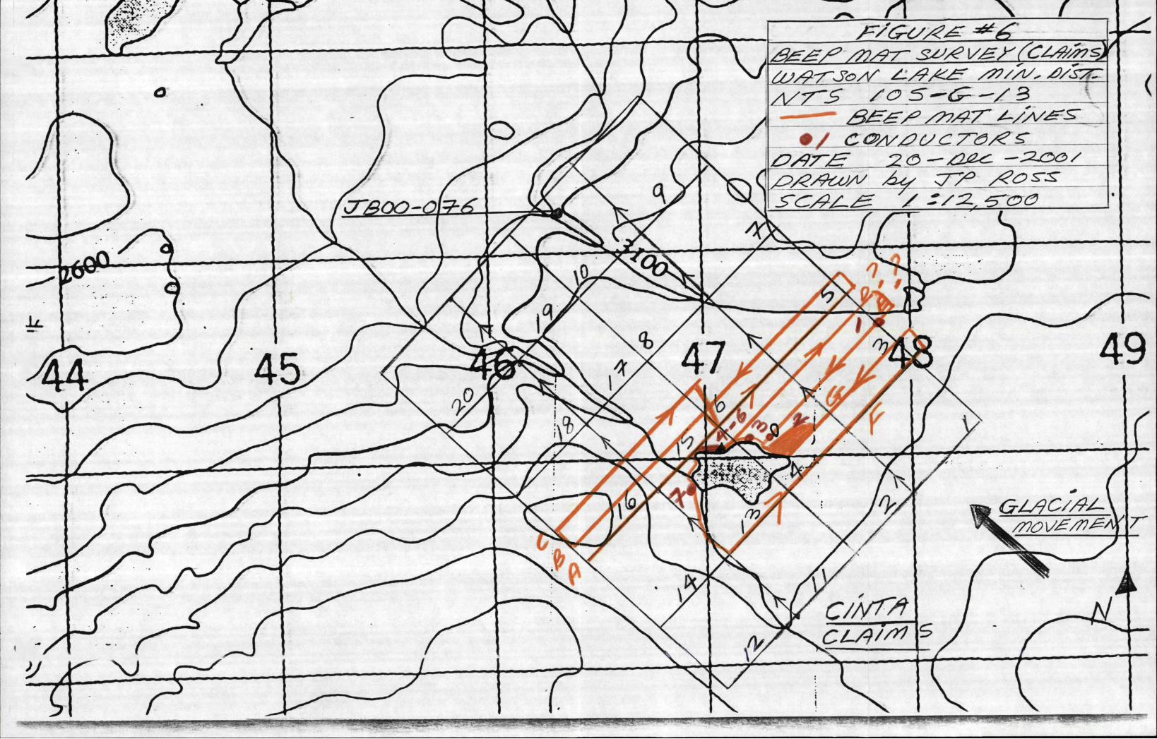
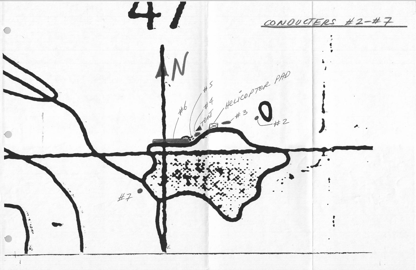
Location Map Project Location Map Project Geology Project Magnetic Survey Sample Locations / Claims 3eep Map Survey (Claims) 3eep Map Conductors #2 - #1 Description of 3eep Map Conductors
APPENDICES
5 6 7 8 9
10 11 12
Appendix 1 References Appendix 2 Statement of Qualifications Appendix 3 Float / 3edrock Sample Geochemistry - Assay Results Appendix 4 Float / 3edrock Sample Descriptions
C h a p t e r One : I N T R O D U C T I O N
1 1 Introductory Statement
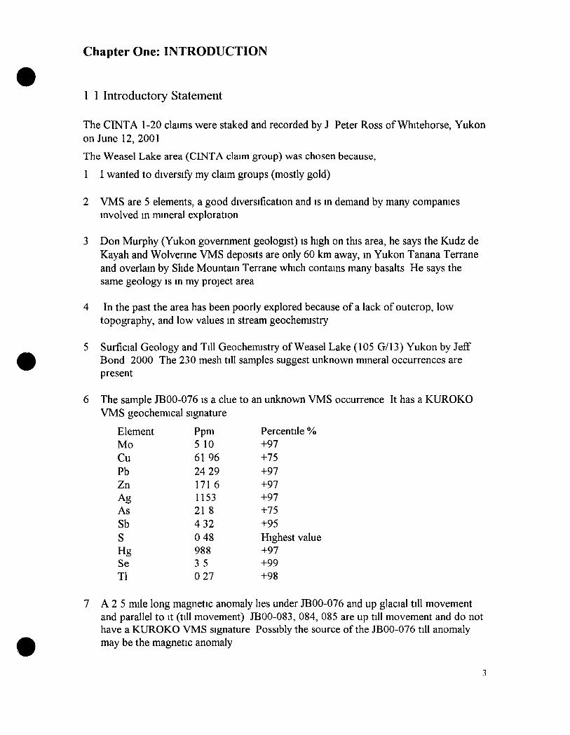
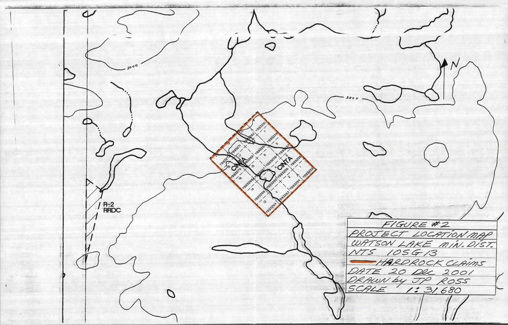
The CINTA 1-20 claims were staked and recorded by J Peter Ross of Whitehorse, Yukon on June 12,2001
The Weasel Lake area (CINTA claim group) was chosen because,
1 I wanted to diversify my claim groups (mostly gold)
2 VMS are 5 elements, a good diversification and is in demand by many companies involved in mineral exploration
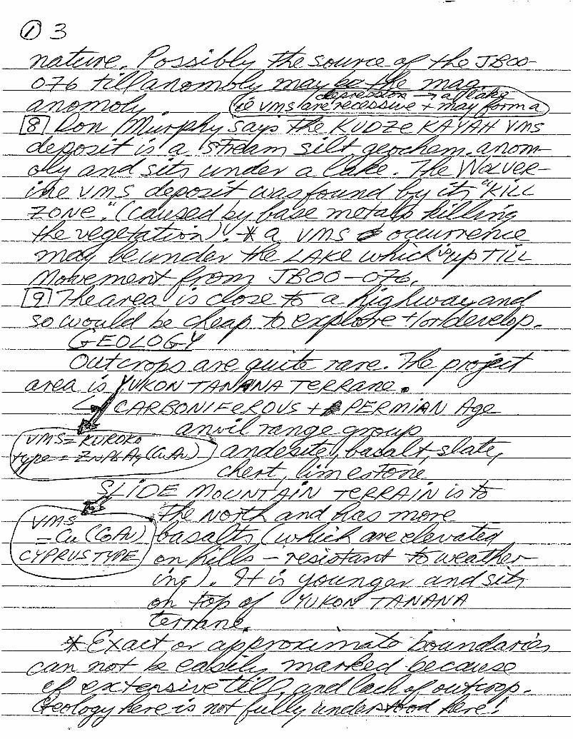
3 Don Murphy (Yukon government geologist) is high on this area, he says the Kudz de Kayah and Wolverme VMS deposits are only 60 km away, in Yukon Tanana Terrane and overlain by Slide Mountain Terrane which contains many basalts He says the same geology is in my project area
4 In the past the area has been poorly explored because of a lack of outcrop, low topography, and low values in stream geochemistry
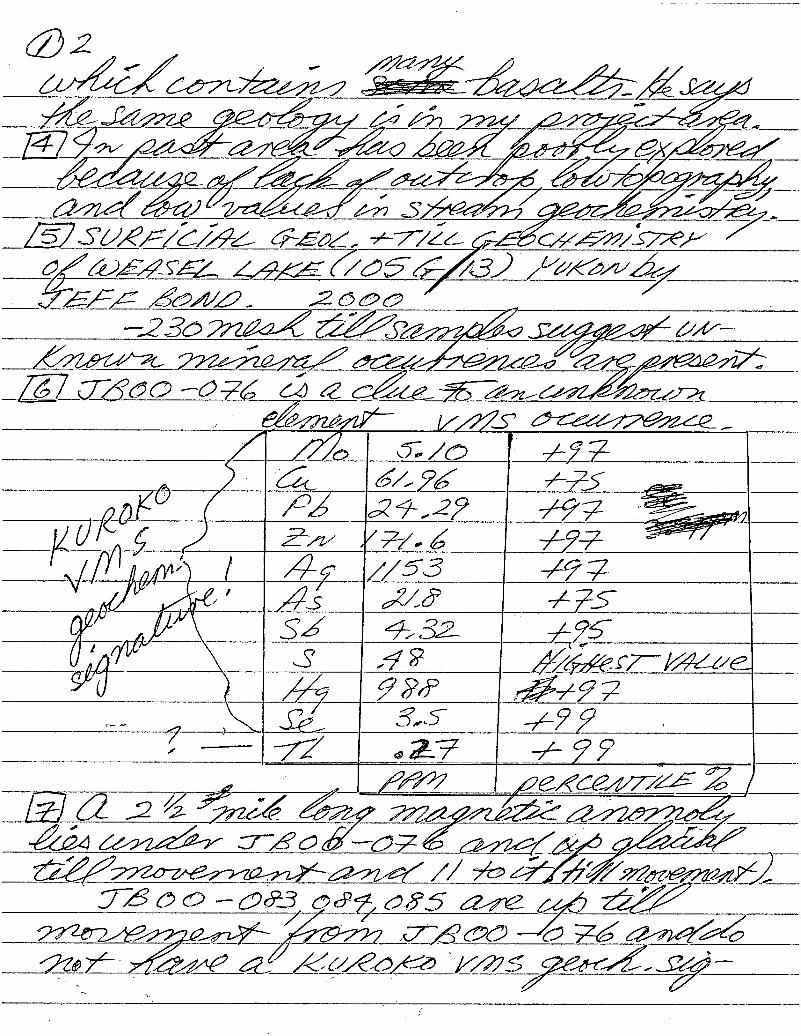
5 Surficial Geology and Till Geochemistry of Weasel Lake (105 G/13) Yukon by Jeff 3ond 2000 The 230 mesh till samples suggest unknown mineral occurrences are present
The sample JBOO-076 is a clue to VMS geochemical
Element Mo Cu Pb Zn Ag As Sb S Hg Se Tl
signature
Ppm 5 10 61 96 24 29 171 6 1153 21 8 4 32 0 48 988 3 5 0 27
an unknown VMS occurrence It has a KUROKO
Percentile % +97 +75 +97 +97 +97 +75 +95 Highest value +97 +99 +98
7 A 2 5 mile long magnetic anomaly lies under JBOO-076 and up glacial till movement and parallel to it (till movement) JBOO-083, 084, 085 are up till movement and do not have a KUROKO VMS signature Possibly the source ofthe JBOO-076 till anomaly may be the magnetic anomaly

8 Don Murphy says the Kudz de Kayah VMS deposit is a stream silt geochemical anomaly and sits under a lake i e ) VMS are recessive and may form a depression or a lake The Wolverine deposit was found by it's 'Kill Zone" (caused by base metals killing the vegetation) A VMS occurrence may be under the lake which is up-till movement from JBOO-076
9 The area is close to a highway and so would be cheap to explore and/or develop
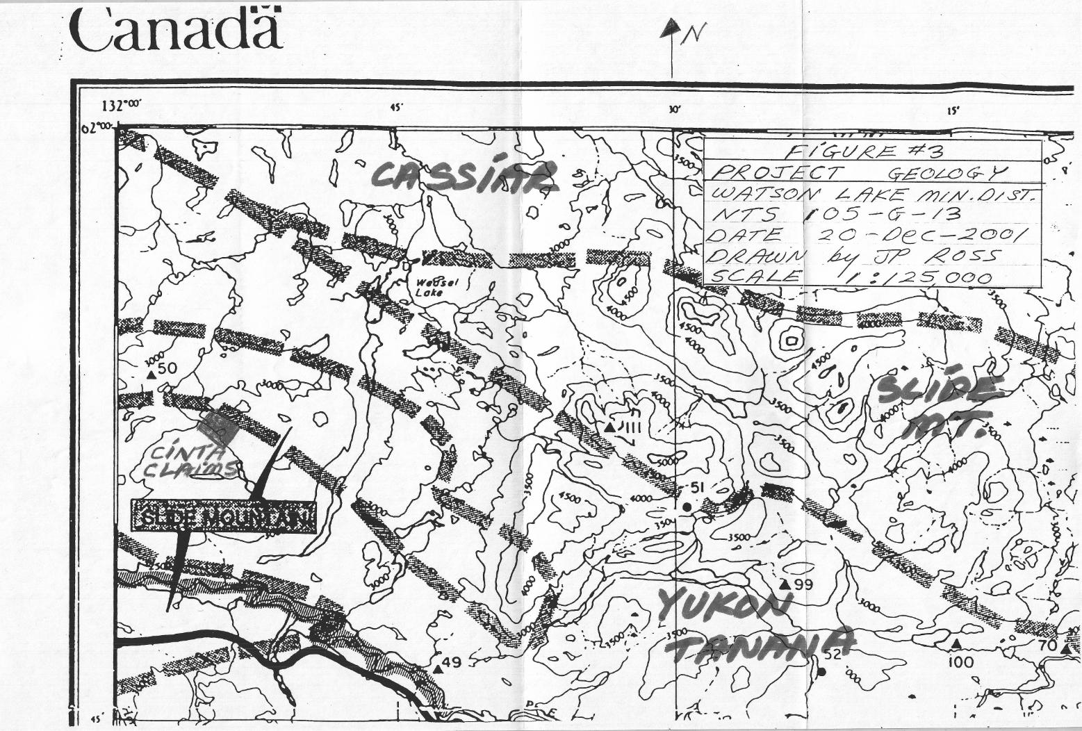
10 Geology Outcrop is quite rare The project area is Yukon Tanana Terrane VMS=KUROKO, type=Zn, Pb, Ag, (Cu, Au) Carbomferous and Permian Age Anvil Range Grroup Andesite, basalt, slatey chert and limestone
Slide Mountain Terrane is to the north and has more basalts (which are elevated on hills and are resistant to weathering) It is younger and sits on top ofthe Yukon Tanana Terrane
Exact or approximate boundaries can not be easily determined because of extensive till, and lack of outcrop The geology here is not fully understood
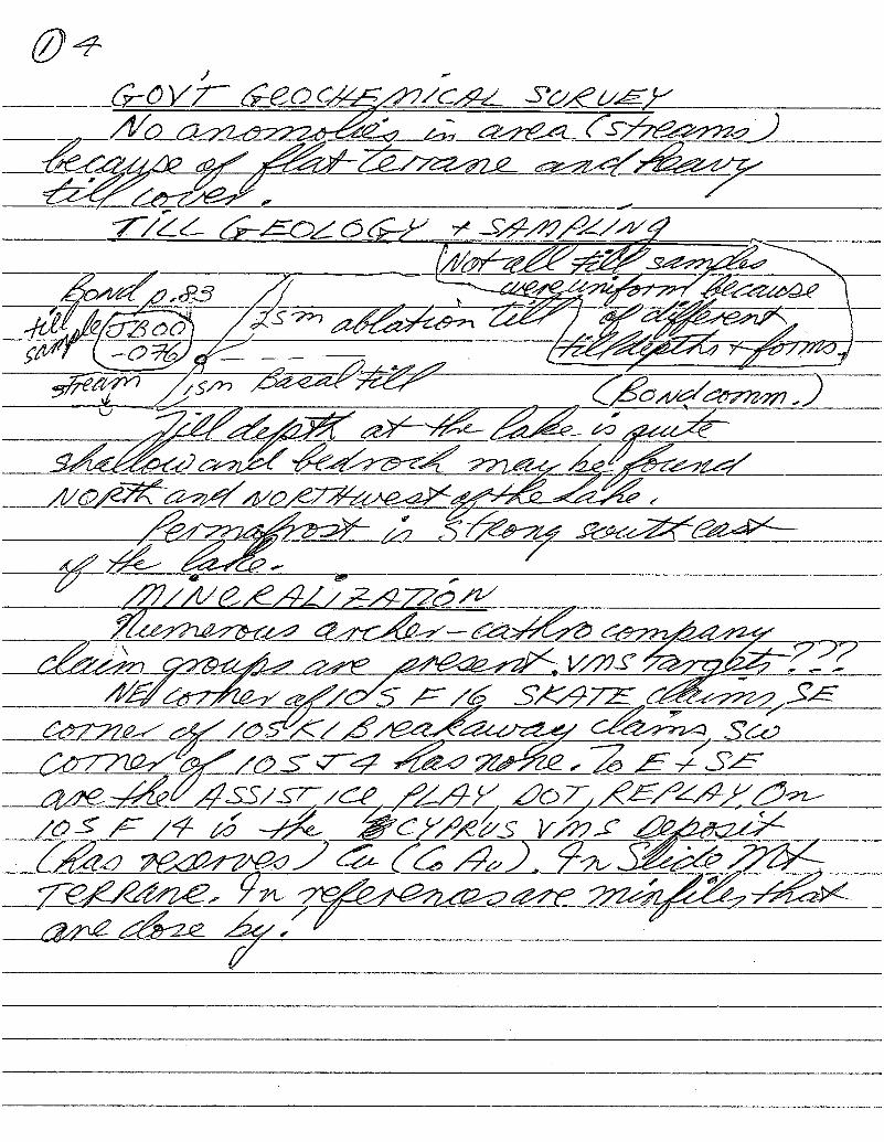
11 Government geochemical survey found no anomalies in the area (streams) because of flat terrane and heavy till cover
12 Till depth at the lake is quite shallow and bedrock may be found north and northwest ofthe lake Permafrost is strong southeast ofthe lake
13 Mineralization in the area Numerous Archer Cathro company claim groups are present VMS targets'?
Northeast corner of 105 F/16 SKATE claims, southeast corner of 105 H/\ BREAKAWAY claims, southwest corner of 105 J/4 has none To the east and southeast are the ASSIST, ICS, PLAY, DOT, REPLAY On 105 F/14 is the CYPRUS VMS deposit (has reserves) Cu (Co Au), in Slide Mt Terrane In references are Minfile occurrences that are close by
14 On the first trip J P Ross prospected and staked and recorded the CINTA 1-20 claims, J P Ross took 7 bedrock samples and 2 float samples
On the second trip J P Ross did a partial Beep Mat survey ofthe claims Seven conductors were found J P Ross dug up one conductor to a depth of-106" (2 7 m) J P Ross took 24 pit samples, 1 float and 1 bedrock sample Results were poor The best value was Pd 107 ppb
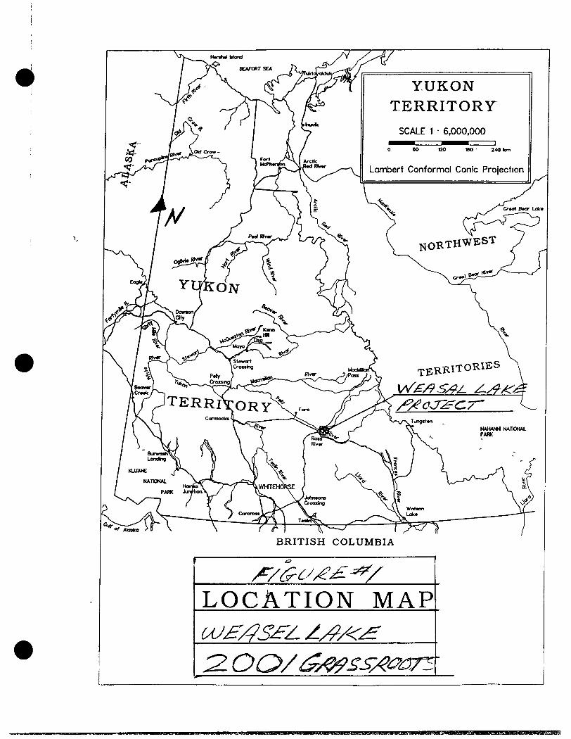
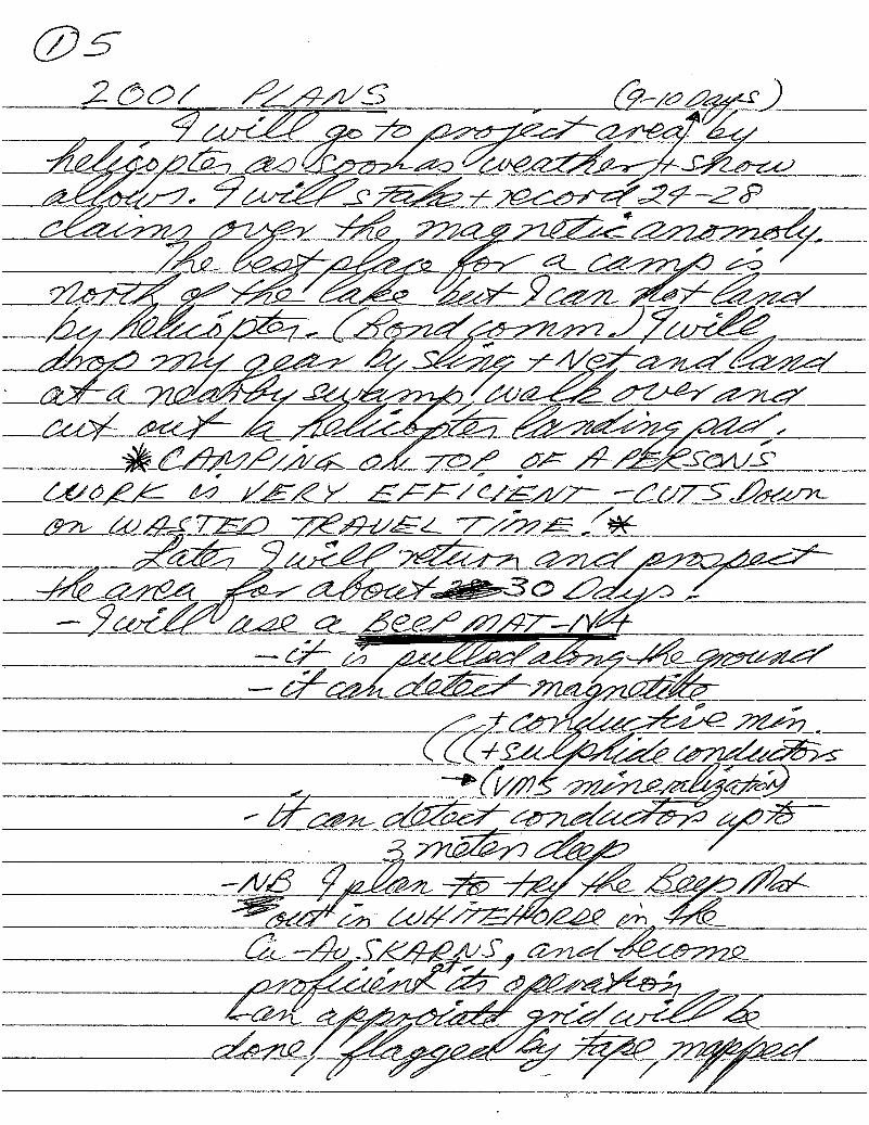
1 2 Location and Access
Access was by helicopter about 34 km southeast of Ross River A landing pad was prepared at the north end ofthe lake
YUKON TERRITORY
L O C A T I O N MAP uJ^/?S£'Z. AA^/<^ 2 . 0 0 / ^y^^Sy^mn'
r^rnKf^^KKsamr^mimeKsm m9ia^Btmtsmf'9^y^jsa
' i r " " r T'iiinii Tit -• i r '•" lY i-'^-tlMif . - W i . ^ - , ^ . . . v ^ * . j f « - , - . f - i t - g ^ ^ . 1 « r ,,,»,'%.'*i^&%ffi>[iri&ti irgErt,^
/=y<^c/ye^ ^:2L y^/ec^cr^<:iy- yO(^y^7yh^x;;^y^iy> ^ ^ ^ Z S ^ : ^ ^ . ^ ^ ^ ^ yz^/;iy. y^y^T: /VT^S' _ y ^ S C ^ y 3
'yy^y^^:^y^o^y<_^^^y<>7^ yPy^T^s ^ c > y2^<i. J2 ^ ^ z
CT" y'"^ y n ^ >"—' / ^ >• .—4 ^ ^ /-«, ^
^
SCypy.^^ / L L ^ / ^ 6 8 o
Sa 5oo
224
/
y /
y
'223
- ^ j
; ^ ^
\ ^r
222 I • • • * • • • ^ ^ ^ J
( »~ 58^420
\
/
L/l/<£
y^ycz-o /eyS ^ ^ \
yyeocr^<zyy::^^^y(y^^^ s x iyy i ^
3^^^^^^—=^^ r^^S^ - ^ ^ ^ / < > ^ ^ y ^ ^ ^ § y y ^ ^ ^ -
\ - -
\ \
^ ^
\
• •
!2I
• w**
220
219
c/pV?;?^ g^f^^ • • •
V T "
Jx:
/ 9 ^ ^ y ypyPT- sy y y^ycc/yk:hsT\
yyy^^ yo s^c^^^y^ L j S ^ ^ y ypyypy^ y ^ / / y ^ ^
/ c ayy/pcyyzyj^/^:^
7-y> yeo^:^
<
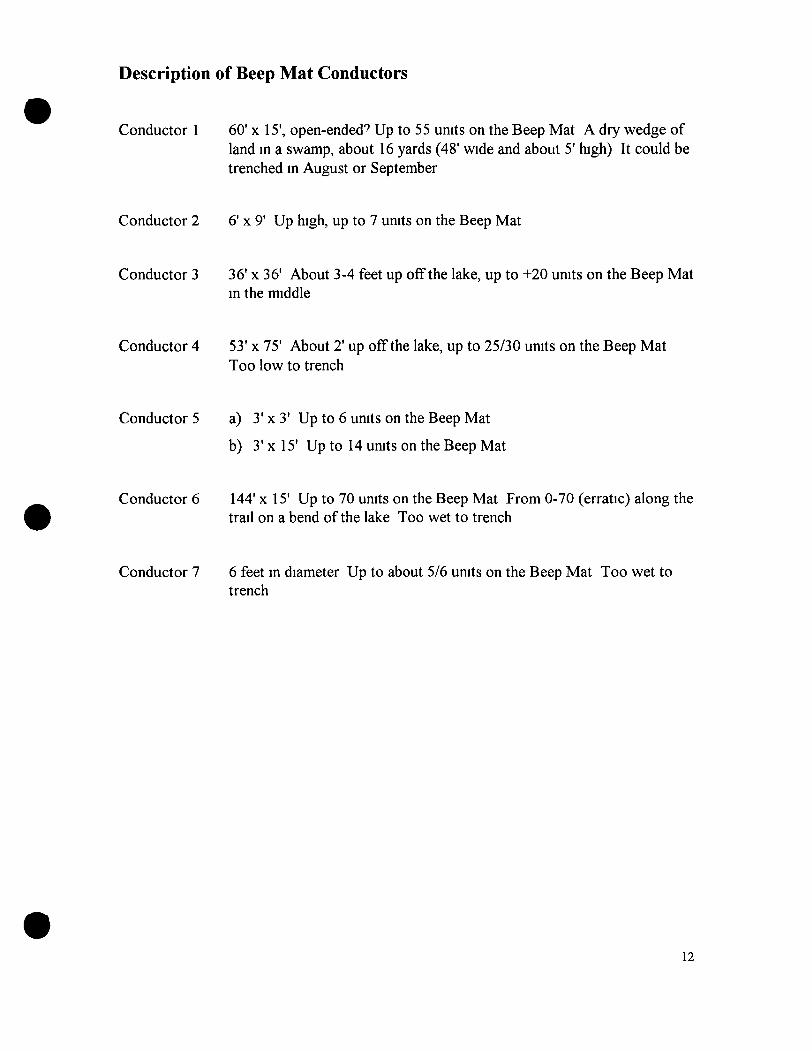
Description of Beep Mat Conductors
Conductor 1 60' x 15', open-ended' Up to 55 units on the Beep Mat A dry wedge of land in a swamp, about 16 yards (48' wide and about 5' high) It could be trenched in August or September
Conductor 2 6' x 9' Up high, up to 7 units on the Beep Mat
Conductor 3 36' x 36' About 3-4 feet up off the lake, up to +20 units on the Beep Mat in the middle
Conductor 4 53' x 75' About 2' up off the lake, up to 25/30 units on the Beep Mat Too low to trench
Conductor 5 a) 3' x 3' Up to 6 units on the Beep Mat
b) 3' x 15' Up to 14 units on the Beep Mat
Conductor 6 144' x 15' Up to 70 units on the Beep Mat From 0-70 (erratic) along the trail on a bend ofthe lake Too wet to trench
Conductor 7 6 feet in diameter Up to about 5/6 units on the Beep Mat Too wet to trench
12
C h a p t e r Two: S U M M A R Y
1) J Peter Ross took no soil or silt samples
2) J Peter Ross took 2 float samples and 7 bedrock samples on the first trip and 1 float and 1 bedrock sample on the second trip
3) J Peter Ross dug up the #3 conductor to a depth of-106" (2 7 m) and took 24 pit samples on the second trip The samples were tested for Au (30g) fire assay and 30 element ICP Three samples were tested for Pt and Pd
The best rock sample returned 107 ppb Pd
Dates worked
J Peter Ross - May 24-31, June 1-7, August 24-31, September 1-15, 2001
13
C h a p t e r T h r e e : G E O C H E M I C A L SURVEY and P R O S P E C T I N G
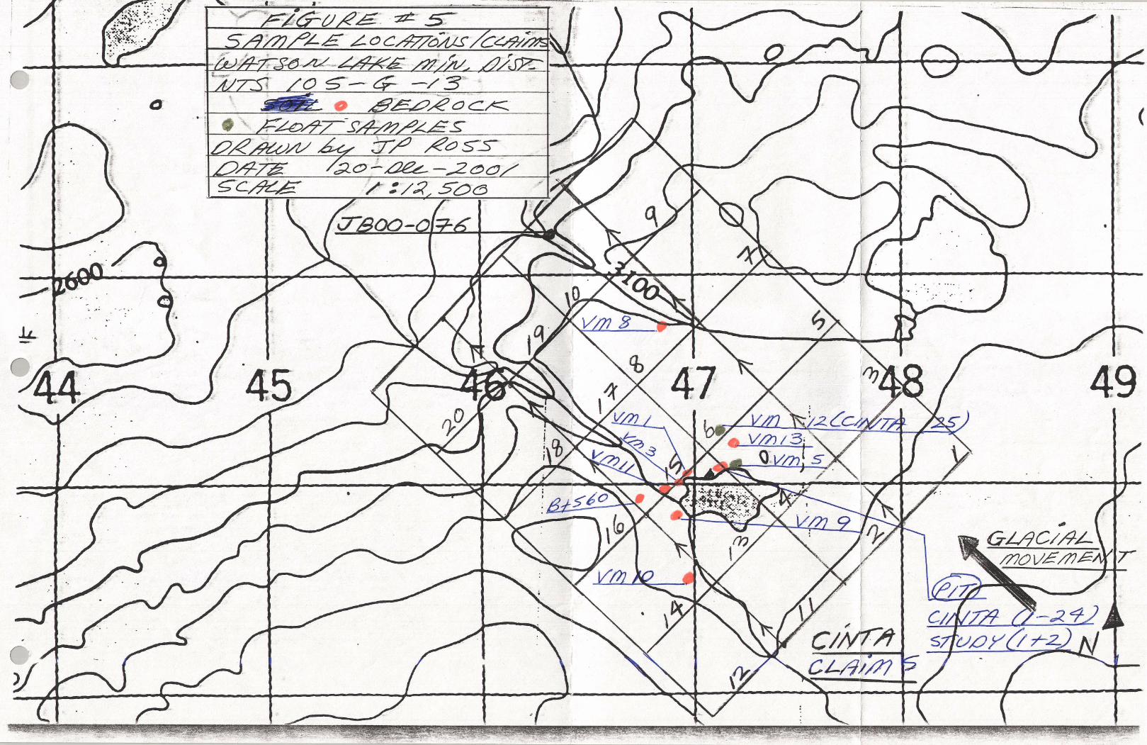
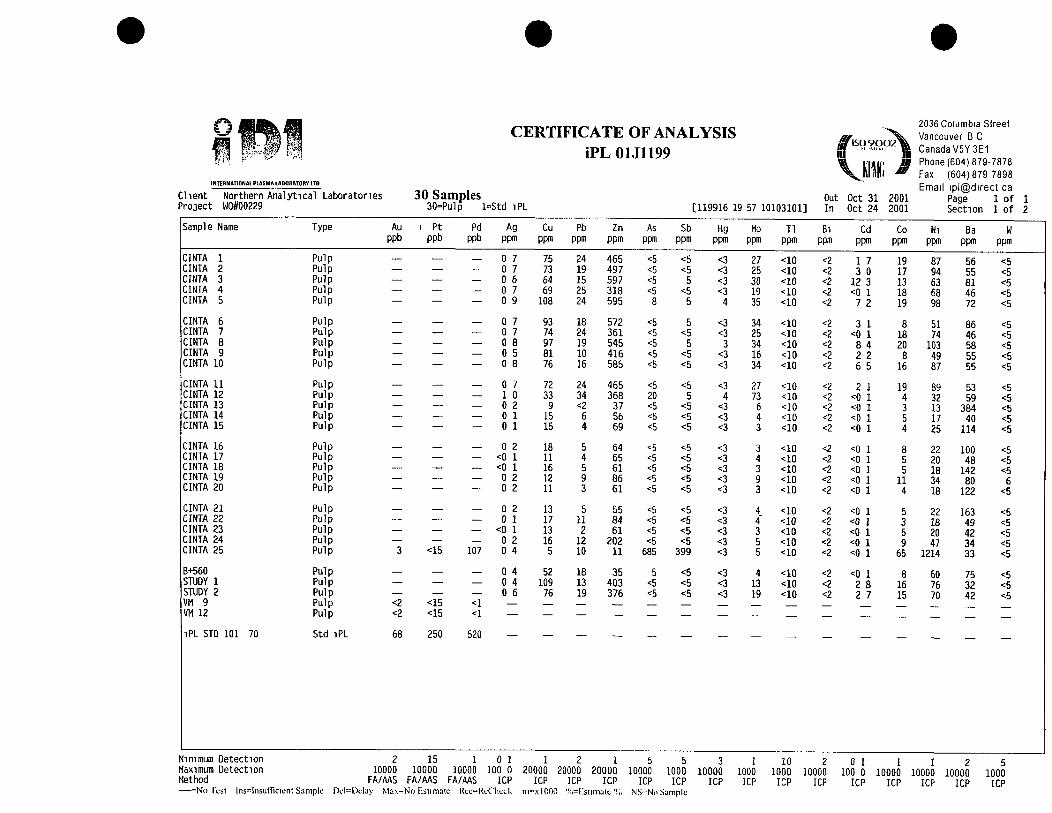
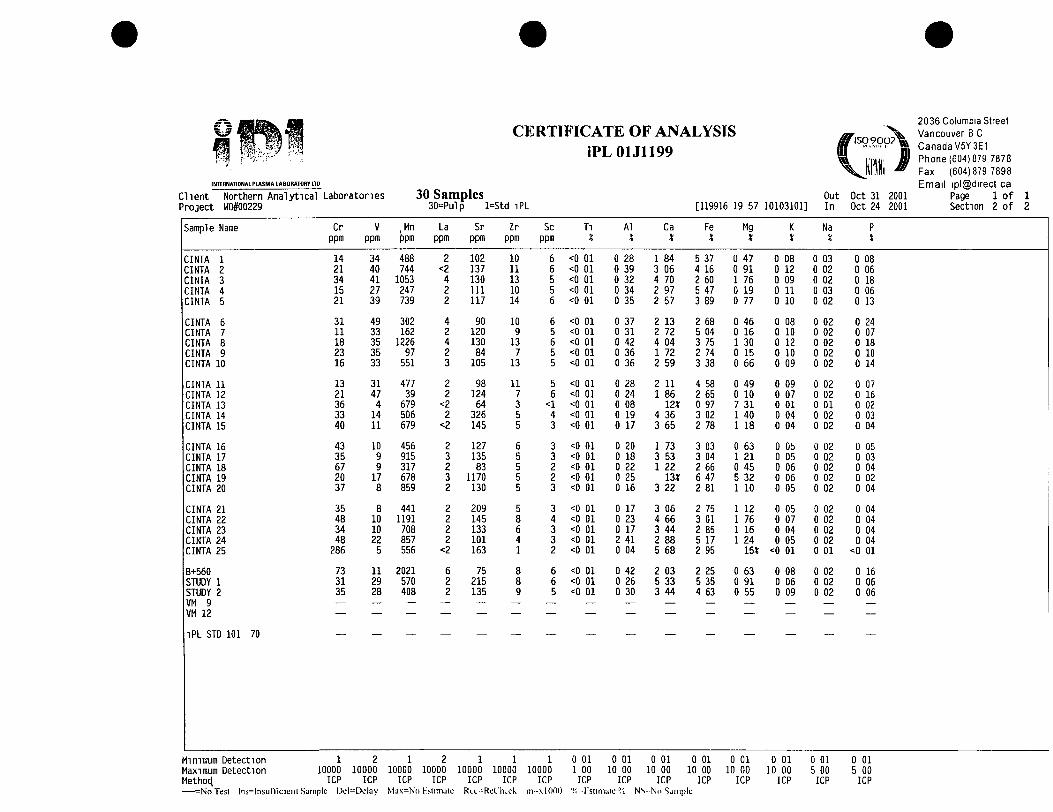
3 1 Float Sample Geochemistry
Three (3) float samples were taken The sample locations were marked with orange flagging tape Samples were tested for Au (30g) FAA and 30 element ICP CINTA 25 is a larger sample of VM12 Both were tested again for Au Pt Pd (FA/AAS-30g)
3 2 Bedrock / Pit Sample Geochemistry
Eight (8) bedrock samples were taken The sample locations were marked with orange flagging tape Samples were tested for Au (30g) FAA and 30 element ICP VM9 was also tested for Au Pt Pd (FA/AAS-30g)
Twenty-four (24) pit/bedrock samples were taken a various depths in the pit (Conductor #3) and tested for Au (30g) FAA and 30 element ICP
3 3 Interpretation
I took samples at all outcrops I saw and recorded descriptions ofthe rock
VM9 was an outcrop elevated in Ni, Cr, Mg (Sb) Mg an ultramafic rock, tested for Pt and Pd
VM12 was a rough angular float (very hard to break) elevated in As, Sb, Ni, Cr and Mg, an ultramafic rock, tested for Pt and Pd
CINTA 25 was a larger sample of VM12 and ran 107 ppb Pd
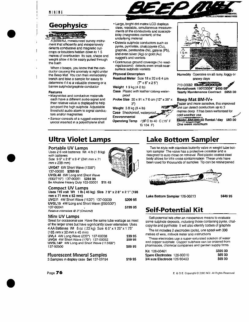
J P Ross used a Beep Mat for the first time It can detect sulphides, graphite, and conductors to a depth of 3m Seven conductors were located and mapped #3 Conductor was chosen for trenching because it was large, close to the lake, had no water problems, close to the tent and I wanted to see if the Beep Mat worked
At 85" (216 cm) 1 hit decomposed bedrock'
From top to bottom every day I placed the day's excavation in a distinct pile "outside the conductor anomaly" and tested it the same night and next morning with the Beep Mat
Readings on the Beep Mat slowly rose (except for 1 day) as the depth increased
J P Ross took samples ofthe bedrock"^ At regular intervals
Finally at -106" (270 cm) the excavated material produced a reading of 11-12 units when placed outside the conductor anomaly The bedrock read -500 units on the Beep Mat, also It was getting very hard to dig
14
I knew graphite was conductive, the bedrock was a black sticky goo, I thought it was graphite But it was not conductive when placed on the ground and tested with the Beep Mat Perhaps the graphite was not dense enough to read as a conductor on the Beep Mat
Numerous needle crystals (sim quartz) were seen and identified by Don Murphy as gypsum crystals Gypsum is a sulphate An alteration process changes sulphides to sulphates Numerous crystals resembled sphalerite but zinc, lead and copper values were low
The numerous (common all over the bedrock) gypsum crystals suggest sulphides "were" present, but what kind*? Is this a fault zone that I dug up* (graphite*?)
3 4 Prospecting
The project still has promise
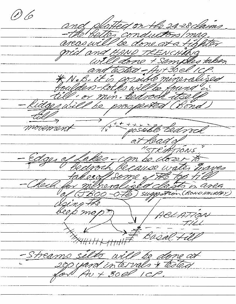
Conductor #1 should be dug up Till sample JBOO-076 still has no source A VMS under the lake has not been disproved or proven A till sample line at 50' intervals should be done along the claim line on Beep Mat survey hne A and 3 About 1000' of terrain is dry and covers a cross section ofthe magnetic anomaly A strong VMS anomaly (Pb Zn Cu Ag Sb Hg As) in till would be encouraging enough for more exploration
15

Appendix 1
References
Surficial Geology and Till Geochemistry of Weasel Lake (105 G/13) Yukon by Jeff Bond 2000
Kelly, K D 1990 Interpretation of Data from Admiralty Island, Alaska US Geological Survey Bulletin #1950 p A1-A9
Geology of Canadian Mineral Deposit Types, Geological Survey of Canada, 1955
105 G Finlayson Lake Minfile and Minfiles 105G 049, 105G 050, 105G 051, 105G 099, 105G111
105 J Minfiles (northwest ofthe project area) 105J 018, 105J 027, 105J 028
105 K Minfiles (north ofthe project area) 105K 097, 105K 098
Open File 1648, 1987 Geochemistry/silts 105 G Finlayson Lake
Open File 468, 1977 105 G Finlayson Lake D J Tempelman Kluit
Geophysical Paper, Map 1404G, Weasel Lake Yukon Territory
Beep Mat Instrumentation GDD Inc , 3700 Boul de la Chaudiere, St Foy, PQ GIX 434
Personal Communication
Jeff Bond, Surficial Geologist, Yukon Geology Program Don Murphy, Senior Project Geologist, Yukon Geology Program Ken Galambos, Mineral Development Geologist, Yukon Geology Program J P Loiselle - prospector who owns and uses a Beep Mat

^ffSrin?Ti.STr?Tni.^7L_. ; " ? ( ' f T ^ ^ ' ' ^ - ^ - ^ ' ^ ' ' ' ' - — ' ^
BOND - Tiu GEOCHEMISTKY, WEASEL LAKE
survey area. This level of sample density provides a high level of regional information for future exploration
The samples taken for geochemical analysts were
representative of either basal till or colluviated basal till.
ICP MS instrumentation combined with an aqua-regia
digestion were used to analyse the -230 mesh fraction of
the till samples The geochemical results indicated
numerous anomalies in base metals, gold and platinum
group pathfinders They include
• Potential epithermal gold mineralization in the
northwest corner of the map area. This is supported by
a multi-element anomaly in Hg, Sb, Ag, As, Au and TI at
station jBOO-155 This may be related to the Finlayson
Lake fault zone and Tertiary mafic volcanics in the area
• Base metal anomalies in zinc and copper in the westem
part of the map area Anomalies occur both within
Yukon-Tanana Terrane and in ancient North American
rocks of the Cassiar Platform Most anomalies are not
associated with current claim holdings in the area
• Clusters of platinum group element pathfinders in the
northeast part of the map area These coincide with
mafic basalts
ACKNOWLEDGEMENTS Funding for this project was provided by the Yukon
Geology Program, consisting of Yukon Economic
Development and Indian and Northern Affairs Canada,
Exploration and Geological Services Division Many
thanks are owed to Jeffrey Boyce for assisting with the
field program and for contributing to its success Much
appreciated assistance was also provided by Cheryl
Peters, Victor Bond, Lara Melnik and Darren Holcombe
Exceptional transportation services were provided by
Brian and Warren at Inconnu Lodge/Kluane Airways
Thanks also to Inconnu Lodge for their hospitality and
expediting service Much appreciated assistance was
gained from Gordon Nevin and Gary Stronghill at the
Yukon Geology Program for pulling together the
geochemical figures and surficial geology map Thanks to
Leyla Weston and Bill LeBarge for editing this paper
REFERENCES Bobrowsky, PT, Paulen, R , Little, E, Prebble, A ,
Ledwon, A and Lett, R, 1998 Till geochemistry of the
Louis Creek-Chu Chua Creek area (NTS 92P/1E and
92P/8E) British Columbia Ministry of Energy, Mines and
Petroleum Resources, Open File 1998-6
Bond, J D , 2000 Surficial geology and till geochemistry
of Weasel Lake (105G/13), central Yukon
(1 50 000 scale) Exploration and Geological Services
Division, Yukon, Indian and Northern Affairs Canada,
Open File 2000-9
Eyies, N , 1983 Glacial Geology A Landsystems
Approach In Glacial Geology - An Introduction for
Engineers and Earth Scientists, N EyIes (ed ), Pergamon
Press, Britain, p 1-18
Gordey, S P and Makepeace, A J, 1999 Yukon Digital
Geology S P Gordey and A | Makepeace (comp ),
Geological Survey of Canada, Open File D3826,
Exploration and Geological Services Division, Yukon,
Indian and Northern Affairs Canada, Open File
1999-1 (D)
Hoffman, S ] , 1986 Geothermal Exploration - The Soil
Survey In Exploration Geochemistry Design and
Interpretation of Soil Surveys, I M Robertson (ed ),
Society of Economic Geologists, Reviews in Economic
Geology, vol 3, p 19-38
Hornebrook, E H W and Friske, PW B , 1988 Regional Stream and Water Geochemical Data, Southeastern Yukon (lOSG) Geological Survey of Canada, Open File 1648
Jackson, L £ Jr, 1994 Terrain inventory and Quaternary
history of Pelly River area, Yukon Territory Geological
Survey of Canada, Memoir 437, 41 p
Yukon MINFILE, 1997 Exploration and Geological
Services Division, Yukon, Indian and Northern Affairs
Canada
YUKON EXPLORATION AND GEOLOGY 2000 87
".•f"i'*T'-;'r'"r
n i N I N G
Geophysics-
A powerful, miniaturized survey instrument that efficiently and inexpensively detects conductive and magnetic outcrops or boulders hidden down to 1 5 metres of overburden Its size, shape and weight allow it to be easily pulled through the bush
When It beeps, you know that the conductor causing the anomaly is nght under the Beep Mat You can then immediately trench and take a sample for assay to determine it it is a valuable showing or a barren sulphide/graphite conductor
Features • Magnetites and conductive materials
each have a different audio signal and their relative value is displayed to help pin-point the high sulphide Adjustable threshold audio alarm to signal conductors and/or magnetites
• Sensor consists of a rugged waterproof unicoil inserted m a polyethylene shell
nu. INDUSTRIES
• Large, bnght dot matnx LCD displays clear, readable, simultaneous measurements of the conductivity and susceptibility (magnetites content) of the underlying matenal
• Detects sulphide conductors such as pynte, pyrrhotite, chalcopynte (Cu), graphite, pentlandite (Ni), galena (Pb), and even silver (Ag) or gold (Au) nugget's and veinlets
• Continuous ground coverage (1o readings/second) detects even small near-surface sulphide veinlets
Physical Description Readout Meter Size 18 x 20 x 6 4 cm
(7" X 8" x 2 5") Weight 1 9 kg (4 2 lb) Case Plastic with leather casing water
proof Probe Size 30 x 91 x 7 6 cm (12" x 36" x
3") Weight 3 8 kg (8 4 lb) Case Shockproof, waterproof., Environmental . **^ ' * '^ ' ' ' Operating Temp -1CPC to40 C (15" F
to 104 F)
- ^ s t e i « ^ .
15m y^ - j ; : ; ' ^ . - : ^ : •BBIT7 &•-; y Nasafi
Humidity Operates on all rainy, foggy or snowy days
710-00082 a ^ ^ ^ O ^ ^ _ ^ Rental/week 190^00a4"'"$490 0 0 ^ Yearly Maintenance Contract $950 00
Beep Mat BM-IV+ aster and more sensitive, this improved
tinit can detect conductors up to 3 metres deep It has been wintensed for cold weather use . y Bch£,.$IO'J}00.00 Rental / day One week minimum
S80 00
Ultra Violet Lamps Portable UV Lamps Uses 2 6 volt battenes Wt 4 lb (1 8 kg) with battenes Size 9 5" X 2 8" x 9 4" (241 mm x 71 mm X 238 mm) UVG47 SW Short Wave (1350*) 137-00090 $269 95 UVGL48 6W Long and Short Wave (930/710*) 137-00051 S284 95 6v Alkaline Heavy Duty 103-00001 S11 45
Compact UV Lamps Uses 115 volt Wt 1 lb ( 45 kg) Size 7 8" x 2 8" x 2 1" (198 mm X 71 mm x 53 mm) UVG11 4W Short Wave (1120*) 137-00039 $209 95 UVGL15 4W Long and Short Wave (650/500*) 137-00041 . $199 95 Relative intensities @ 3" (Om/cm2)
Mini UV Lamps Great for occasional use Have the same tube wattage as most of the larger ones but have significantly lower intensities Uses 4 AA Battenes Wt 8 oz (23 kg) Size 6 5" x 1 25" x 1 75" (165 mm x 32 mm x 45 mm) UVL4 4W Long Wave (230*) 137-00038 $39 95 UVG4 4W Short Wave (170*) 137-00052 $59 95 UVSL14P 4W Long and Short Wave (113/68*) 137-90500 $89 95
Fluorescent Mineral Samples 3 Samples in display case Set 137-00194
Lake Bottom Sampler Two fin style with stainless butterfly valve in weight tube bot
tom sampler The valve has a protective crossbar and is designed to auto close on retneval Red plastic coated steel body allows for little cross contamination These units have been used for thousands of samples Tip can be resharpened
Lake Bottom Sampler 126-00213
Self-Potential Kit
$449 95
$19 95
Self-potential kits offer an inexpensive means to evaluate some sulphide deposits, including those containing pyrite, chalcopynte and pyrrhotite It will also identify bodies of graphite
The kit includes 2 electrodes (pots), one spool with 300 metres of wire, millivolt meter and instructions
These electrodes use a super-saturated solution of water and copper sulphate Copper sulphate can be ordered from pharmacies, chemical companies and garden supply firms
Kit 126-00401 $595 00 Spare Electrodes 126-90010 SSS 00 3/4 size Electrode 126-90403 $65 00
Page 7 6 E & O E Copyright © 2000 NCI All Rights Reserved
VOLCANIC-ASSOCIATED MASSIVE SULFIDE DEPOSITS (MODELS 24a-b, 28a, Singer, 1986a,b; Cox, 1986)
by Cliff D Taylor, Robert A Zierenberg, Richard J Goldfarb, :, V James E Kilbum, Robert R Seal II, and M Dean Kleinkopf
SUMMARY OF RELEVANT GEOLOGIC. GEO EN VI RON MENTAL. AND GEOPHYSICAL INFORMATION Deposit geology Volcanic-associated massive sulfide (VMS) deposits range from lens shaped to sheet-like bodies of sulfide-mmeral-nch rock spatially associated with volcanic rocks rangmg in composition from basalt to rhyolite (fig 1) VMS deposits can be divided into three general categories Cyprus-type deposits (Model 24a, Singer, 1986a) tend to be small, medium-grade deposits nch in copper and zinc They are generally lens or mound shaped accumulations of massive pyrite developed in ophiolite-related, extrusive basalt sequences They are typically underlain by copper-rich "stringer-zones" composed of anastomosing quartz-sulfide mineral veins in extensively chlontized basalt Kuroko deposits (Model 28a, Singer, 1986b) are typically developed m intermediate to felsic volcanic rock and are generally mterpreted to have formed m extensional environments associated with arc volcanism They are commonly high grade and can be very large Relative to Cyprus-type deposits, they generally have much higher contents of zinc, lead. Sliver, and antimony, which reflects the composition of their felsic volcanic host rocks They also have mound-Iike morphology and the abundance of coarse clastic sulfide minerals withm many of these deposits attests to a moderately high energy, seafloor depositional setting Kuroko-type deposits also tend to be underlain by copper-rich stnnger zones and commonly have well developed geochemical zonation with progressive zinc, lead, and silver enrichment both vertically and laterally away from vent centers Besshi-type deposits (Model 24b, Cox, 1986) are present in mixed volcanic-sedimentary environments Deposits of this type are commonly hosted by turbidites that have been intruded by basaltic sills These deposits are typically copper-rich and contain small abundances of lead and other lithophile elements In contrast to other volcanic-hosted deposits, many Besshi-type deposits form thin, laterally extensive sheets of pyrrhotite- and (or) pyrite-rich massive sulfide rock, however, the characteristics of Besshi-type deposits vary considerably Slack (1993) presents an expanded definition of Besshi-type deposits that mcludes deposits such as those in the Ducktown, Tenn, district and the large Windy Craggy deposit in British Columbia.
MASSIVE SULPHIDE LENS Slrat i f icf l f inn
Massive rubbly or b recc la ted s t ruc ture (strong chemica l zonation pat tern)
Bedded or l aye red s t ruc ture (chemical ly heterogenous)
Cpy £ Py £ Po sulphide mineralization
chloritic hydrothermal alteration
Py • Sp t On sulphide mineralization
serici t ic-chlori t ic hydrothermal alteration
Figure 1 Essenual charactensUcs of an idealized volcanogemc massive sulfide deposit (modified from Lydon, 1984) Mineral abbreviations as follows Sp, sphalente, Gn, galena, Py, pynte, Ba, bante, Cpy, chalcopynte, Po, pyrrhoute, and Hem, hematite
137
Metal mobility from solid mine wastes Soluble sulfate salt minerals derived from weathering and oxidation of sulfide minerals in mine dumps and tailings piles represent a potential source of metal contamination and acid generation As percolating surface and ground water evaporates during dry periods, efflorescent metal-sulfate salt minerals form encrustations around and below the base of the piles, which effectively stores acidity and metals released during sulfide mineral breakdown Subsequent rainfall or snowmelt following a dry period is likely to release a highly concentrated pulse of acid mine water Mine dumps associated with lead-rich VMS deposits (Kuroko-type) may be a source of lead contamination due to high concentrations of soluble secondary lead minerals
Secondary minerals in tailings impoundments include a variety of iron oxyhydroxides (goethite, lepidocrocite, akaganeite, maghemite, and femhydnte), sulfates (gypsum, bassanite, jarosite, hydronium jarosite, melantente, goslante, ferrohexahydnte, epsomite, hexahydnte, siderotil, rozenite, anglesite, alunogen, and copiapite), and mmerals such as marcasite, covellite, and native sulfur (Jambor, 1994) Pore water from tailings impoundments associated with the Heath Steele, New Brunswick, deposit are acidic (pH 1 8 to 5 2), have Eh of 280 to 580 mV, and contain significant dissolved metal abundances, includmg 0 3 to 600 mg/I copper, 0 8 to 11 mg/I lead, 23 to 4,880 mg/1 zmc, 1,200 to 36,000 mg/I iron, and 600 to 67,600 mg/I sulfate (Boorman and Watson, 1976) Similarly, pore water from tailings unpoundments associated with the Waite Amulet, Quebec, deposit are acidic (pH 2 5 to 6 0), have Eh of 200 to 700 mV, and contain significant dissolved metal abundances, including as much as 65 mg/1 copper, as much as 5 mg/1 lead, as much as 250 mg/1 zinc, as much as 8,000 mg/1 iron, and as much as 20,000 mg/1 sulfate (Blowes and Jambor, 1990) Finally, pore water fh)m tailings impoundments associated with the Kidd Creek, Ontario, deposit are acidic (pH 3 5 to 7 5), have Eh of 50-500 mV, and contain significant dissolved metal abundances, including 0 to 38 mg/I copper, 0 to 2 mg/I lead, 0 to 6,200 mg/1 zinc, 0 to 350 ne/\ arsenic, 1 to 990 mg/1 iron, and 1,860 to 27,000 mg/1 sulfate (AI and others, 1994)
Extremely fine grinding required for beneficiation of VMS ore may enhance airborne transport of lead-arsenic-cadmium-antimony-bearing dust This phenomenon is most probable in semi-and to and regions m which strong winds prevail
Soil, sediment signatures prior to mining The elemental suite and magnitude of geochemical anomalies in soil and sediment collected from undisturbed VMS deposits depend upon a number of factors, including VMS deposit type, extent of ore outcrop or overburden, climate, topography, etc Stream sediment samples collected below Kuroko-type deposits in temperate rain forest on Admiralty Island, Alaska, contain 5 to 10 weight percent iron, as much as 10,000 ppm barium, hundreds to several thousand ppm zinc, hundreds of ppm lead, tens to hundreds of ppm arsenic, copper, and nickel, as well as 0 to 20 ppm silver, bismuth, cadmium, mercury, molybdenum, and antimony (Kelley, 1990, Rowan and others, 1990, Taylor and others, 1992, C D Taylor, unpub data, 1995)
Stream sediment geochemical signatures associated with undisturbed to variably disturbed Cyprus and Besshi VMS deposits in the Prince William Sound, Alaska, are similar to those just described They contain 10 to 40 weight percent iron, several hundred ppm barium, hundreds of ppm arsenic and zinc, tens to hundreds of ppm lead, hundreds to thousands of ppm copper, and 0 to 20 ppm silver, bismuth, mercury, molybdenum, and antimony (R J Goldfarb, unpub data, 1995)
Potential environmental concems associated with mineral processing Tailings ponds below mills are likely to contain high abundances of lead, zinc, cadmium, bismuth, antimony, and cyanide and other reactants used in flotation and recovery circuits Highly pyntic-pyrrhotitic orebodies that are exposed to oxidation by air circulating through open adits, manways, and exploration drill holes may evolve SOj gas, in some cases, spontaneous combustion can cause sulfide ore to bum Tailings that contain high percentages of non-ore iron sulfide minerals have extremely high acid-generatmg capacity Surficial stockpiles of high-sulfide mineral ore are also potential sources of metal-rich mine water
Smelter signatures Most base-metal rich ore concentrates are smelted In most cases, concentrates eire shipped to custom smelters, and therefore do not contribute to the environmental impact in the immediate mine vicinity Larger districts are often served by a smelter co-located in the district Data compiled by Gulson and others (1994) document the relationship between lead in soil near smelters and blood lead in children, similar data for the LeadviUe, Colo, area indicate similar trends Additional data may be available for the Trail, British Columbia and El Paso, Tex smelters
142
I30<>00' 6fe°00'
132000' ISCOO' 6lO00
0 l_
20 I
40 |_
60 I
KILOMETERS - SCALE I iOOOOOO
SURFICIAL GEOLOGY
+ R +
Unconsolidated sur f i c ia l deposits.
Bedrock exposures; includes discontinuous veneer of undivided q lac la l d r i f t .
YUKON MINFILE N GEOLOGY PROGRAM
WHITEHORSE
MSNFJLE: PAGE NO: UPDATED:
105G 049 1 of 1
/ /77
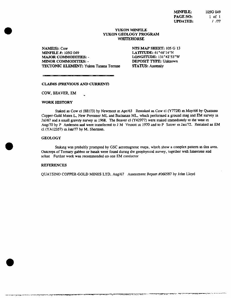
NAME(S): Cow NTS MAP SHEET: 105 G 13 MINFILE #: 105G 049 LATITUDE: 61 "'46' 14"N MAJOR COMMODITIES: - LONGITUDE: 131°42'53"W MINOR COMMODITIES: - DEPOSIT TYPE: Unknown TECTONIC ELEMENT: Yukon Tanana Terrane STATUS: Anomaly
CLAIMS (PREVIOUS AND CURRENT)
COW, BEAVER, EM
WORK HISTORY
Staked as Cow cl (88173) by Newmont m Apr/63 Restaked as Cow cl (Y7728) m May/66 by Quatsmo Copper-Gold Mmes L, New Fnvateer ML and Buchanan ML, which performed a ground mag and EM survey m Jul/67 and a small gravity survey m 1968. The Beaver cl (Y42977) were staked mraiediately to the west m Aug/70 by P Anderson and were transferred to J M Vemott m 1970 and to P Sotrer m Jan/72. Restaked as EM cl (YA12357) m Jan/77 by M. Sherman.
GEOLOGY
Stakmg was probably prompted by GSC aeromagnetic maps, which show a complex pattern m this area. Outcrops of Ternary gabbro or basalt were foimd durmg the geophysical survey, together with limestone and schist Further work was reconmiended on one EM conductor
REFERENCES
QUATSINO COPPER-GOLD MINES LTD, Aug/67 Assessment Report #060587 by John Lloyd
,CT~v-»«.!i'JA-]..m'ijH,te->^- " " - " " • - ' • " ' - ' " - ™«„-=™.-~, , -..-•-. - ^ • • „ - . , . • , » ^ - . . •-,-,,-,™_,,—•.•--^3STS3—=-•
YUKON MINFILE YUKON GEOLOGY PROGRAM
WHITEHORSE
MINFILE: PAGE NO: UPDATED:
105G 050 I of 1
/ /78
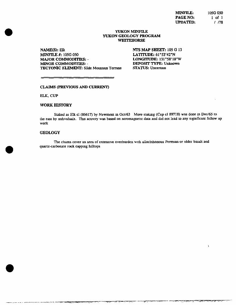
NAME(S): Elk MINFILE #: 105G 050 MAJOR COMMODITIES: -MINOR COMMODITIES: -TECTONIC ELEMENT: Slide Mountam Terrane
NTS MAP SHEET: 105 G 13 LATITUDE: 6r53 '42"N LONGITUDE: 131*'58'18"W DEPOSIT TYPE: Unknown STATUS: Uncertam
CLAIMS (PREVIOUS AND CURRENT)
ELK, CUP
WORK HISTORY
Staked as Elk cl (86617) by Newment m Oct/63 More stakmg (Cup cl 89718) was done m Dec/65 to the east by mdividuals. This activity was based on aeromagnetic data and did not lead to any significant follow up work
GEOLOGY
The clauns cover an area of extensive overburden with allochthonous Penman or older basalt and quartz-carbonate rock cappmg hilltops
.,.wj.t^..^'.iavv
YUKON MINFILE YUKON GEOLOGY PROGRAM
WHITEHORSE
MINFILE: PAGE NO: UPDATED:
105G 051 1 of 1
08/21/96
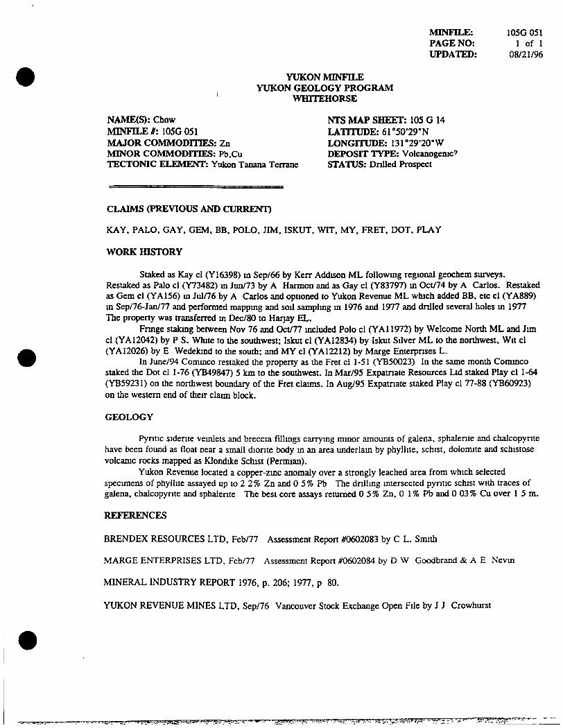
NAME(S): Chow NTS MAP SHEET: 105 G 14 MINFILE #: 105G 051 LATITUDE: 61 °50'29"N MAJOR COMMODITIES: Zn LONGITUDE: 13r29'20"W MINOR COMMODITIES: Pb.Cu DEPOSIT TYPE: Volcanogemc' TECTONIC ELEMENT: Yukon Tanana Terrane STATUS: Drilled Prospect
CLAIMS (PREVIOUS AND CURRENT)
KAY, PALO, GAY, GEM, BB, POLO, JIM, ISKUT, WIT. MY, FRET, DOT, PLAY
WORK HISTORY
Staked as Kay cl (Y16398) m Sep/66 by Kerr Addison ML followmg regional geochem surveys. Restaked as Palo cl (Y73482) m Jun/73 by A Harmon and as Gay cl (Y83797) m Oct/74 by A Carlos. Restaked as Gem cl (YA156) m Jul/76 by A Carlos and optioned to Yukon Revenue ML which added BB, etc cl (YA889) m Sep/76-Jan/77 and performed mappmg and sod samplmg m 1976 and 1977 and drilled several holes m 1977 The property was transferred m Dec/80 to Harjay EL.
Frmge stakmg between Nov 76 and Oct/77 mcluded Polo cl (YAI1972) by Welcome North ML and Jim cl (YA12042) by P S. White to die southwest; Iskut cl (YA12834) by Iskut Silver ML to the northwest. Wit cl (YA12026) by E Wedekmd to the south; and MY cl (YA12212) by Marge Enterpnses L.
In June/94 Commco restaked the property as the Fret cl 1-51 (YB50023) In the same month Commco staked the Dot cl 1-76 (YB49847) 5 km to the southwest. In Mar/95 Expatnate Resources Ltd staked Play cl 1-64 (YB59231) on the northwest boundary of the Fret claims. In Aug/95 Expatnate staked Play cl 77-88 (YB60923) on the westem end of their claim block.
GEOLOGY
Pyntic sidente veinlets and breccia fillmgs carrymg minor amoimts of galena, sphalente and chalcopynte have been found as float near a small dionte body m an area underlam by phyllite, schist, dolomite and schistose volcamc rocks mapped as Klondike Schist (Permian).
Yukon Revenue located a copper-zmc anomaly over a strongly leached area from which selected specimens of phyllite assayed up to 2 2 % Zn and 0 5 % Pb The dnllmg mtersected pyntic schist with traces of galena, chalcopynte and sphalente The best core assays remmed 0 5 % Zn, 0 1 % Pb and 0 03 % Cu over 1 5 m.
REFERENCES
BRENDEX RESOURCES LTD, Feb/77 Assessment Report #0602083 by C L. Smith
MARGE ENTERPRISES LTD, Feb/77 Assessment Report #0602084 by D W Goodbrand & A E Nevm
MINERAL INDUSTRY REPORT 1976, p. 206; 1977, p 80.
YUKON REVENUE MINES LTD, Sep/76 Vancouver Stock Exchange Open File by J J Crowhurst
,.^„.^,.^j.._.,,,M..,^,jLjg..,,.^5u-ayje.y;at,;i»«iw,j-<By;^^^^ ';jMi!»»;;r-^5i:' ':::.';,>^.'!--]J--^i,.'iif^s!f'^'."J''^%.'.-<^^ird^^ •-•"J---- .y-'j'^rvj.a-r'^^'"'-"'^'"
YUKON MINFILE YUKON GEOLOGY PROGRAM
WHITEHORSE
MINFILE: PAGE NO: UPDATED:
105G099 1 of 1
04/08/94^
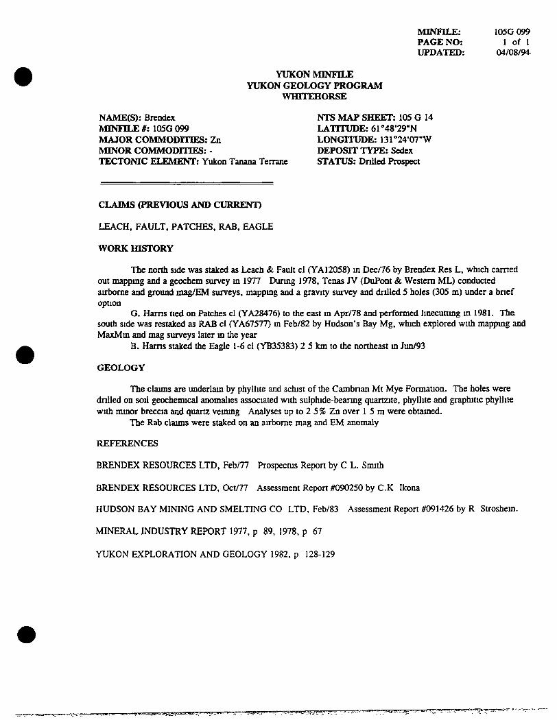
NAME(S): Brendex NTS MAP SHEET: 105 G 14 MINFILE #: 105G 099 LATITUDE: 61'48*29"N MAJOR COMMODITIES: Zn LONGITUDE: 131"'2407"W MINOR COMMODITIES: - DEPOSIT TYPE: Sedex TECTONIC ELEMENT: Yukon Tanana Terrane STATUS: Dnlled Prospect
CLAIMS (PREVIOUS AND CURRENT)
LEACH, FAULT, PATCHES. RAB, EAGLE
WORK HISTORY
The north side was staked as Leach & Faidt cl (YA12058) m Dec/76 by Brendex Res L, which earned out mappmg and a geochem survey m 1977 Durmg 1978, Tenas JV (DuPont & Western ML) conducted airborne and ground mag/EM surveys, mappmg and a gravity survey and dnlled 5 holes (305 m) under a bnef option
G. Hams tied on Patches cl (YA28476) to the east m Apr/78 and performed Imecuttmg m 1981. The south side was restaked as RAB cl (YA67577) m Feb/82 by Hudson's Bay Mg, which explored with mappmg and MaxMm and mag surveys later m the year
B. Hams staked the Eagle 1-6 cl (YB35383) 2 5 km to die northeast m Jun/93
GEOLOGY
The claims are imderlam by phyllite and schist of the Cambnan Mt Mye Formauon. The holes were dnlled on soil geocheimcal anomalies associated with sulphide-bearmg quartzite, phyllite and graphitic phyllite with mmor breccia and quartz veimng Analyses up to 2 5 % Zn over 1 5 m were obtamed.
The Rab claims were staked on an airborne mag and EM anomaly
REFERENCES
BRENDEX RESOURCES LTD, Feb/77 Prospectus Report by C L. Smith
BRENDEX RESOURCES LTD, Oct/77 Assessment Report #090250 by CK Ikona
HUDSON BAY MINING AND SMELTING CO LTD, Feb/83 Assessment Report #091426 by R Stroshem.
MINERAL INDUSTRY REPORT 1977, p 89, 1978, p 67
YUKON EXPLORATION AND GEOLOGY 1982, p 128-129
3MyT?na^vffegw»yEgygaaa?*FT

YUKON MINFILE N GEOLOGY PROGRAM
WHITEHORSE
MINFILE: PAGE NO: UPDATED:
105G 111 1 of 1
07/31/95
NAME(S): Tor NTS MAP SHEET: 105 G 13 MINFILE #: 105G 111 LATITUDE: 61 "'52'28-N MAJOR COMMODITIES: - LONGITUDE: nrSS'Se 'W MINOR COMMODITIES: - DEPOSIT TYPE: Unknown TECTONIC ELEMENT: Slide Mountam Terrane STATUS: Uncertam
CLAIMS (PREVIOUS AND CURRENT)
TOR, NECK, PIN
WORK HISTORY
Staked as Tor cl (YB15155) m Jul/88 by Welcome North ML, which earned out prospectmg and sod samplmg later m the year.
In Jun/94 Commco Ltd. staked die Pm cl 1-29 (YB49923) 10 km to die northwest and die Neck ci 1-71 (YB49952) 12 km to the northwest
GEOLOGY
The claims are cover zones of quartz-carbonate alteration m serpentinized tmits of the Permo-Carbomferous Anvil-Campbell Allochthon Geochemical response was flat.
REFERENCES
YUKON MINING AND EXPLORATION OVERVIEW 1988, p 26-27
•>-«nr^sffi33S!aKr3;;;^imr!!ft^^ • • " -V.^ i .SS^^** '^"
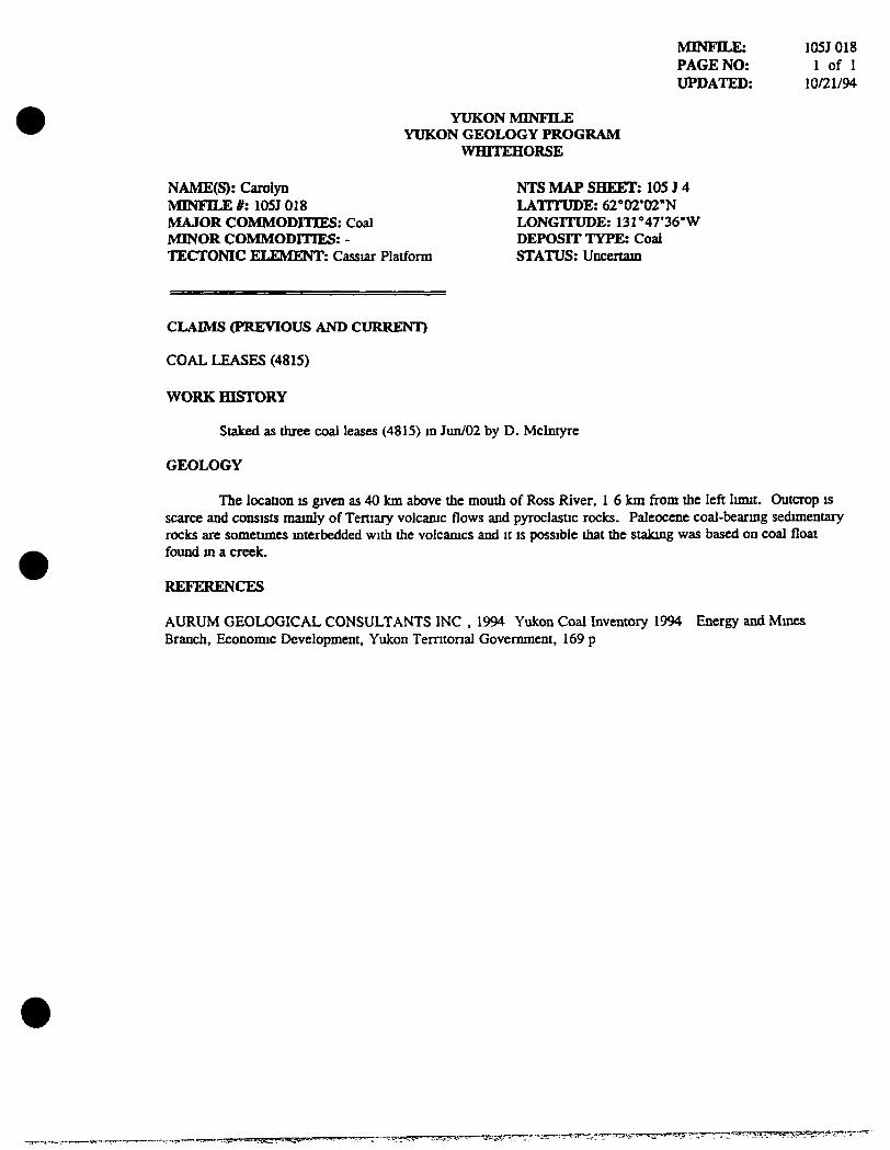
NAME(S): Carolyn MINFILE #: 105J 018 MAJOR COMMODITIES: Coal MINOR COMMODITIES: -TECTONIC ELEMENT: Cassiar Platform
YUKON MINI<ILE YUKON GEOLOGY PROGRAM
WHITEHORSE
MINFJLE: PAGE NO: UPDATED:
105J 018 1 of 1
10/21/94
NTS MAP SHEET: 105 J 4 LATITUDE: 62'*02*02"N LONGITUDE: 131''47'36"W DEPOSIT TYPE: Coal STATUS: Uncertam
CLAIMS (PREVIOUS AND CURRENT)
COAL LEASES (4815)
WORK HISTORY
Staked as three coal leases (4815) m Jun/02 by D. Mclntyre
GEOLOGY
The location is given as 40 km above the mouth of Ross River, 1 6 km from the left limit. Outcrop is scarce and consists mainly of Tertiary volcamc flows and pyroclastic rocks. Paleocene coal-bearmg sedimentary rocks are sometimes mterbedded with the voicamcs and it is possible that the stakmg was based on coal float foimd m a creek.
REFERENCES
AURUM GEOLOGICAL CONSULTANTS INC , 1994 Yukon Coal Inventory 1994 Branch, Economic Development, Yukon Temtonal Government, 169 p
Energy and Mmes
i];ai?S5*y^',7-
YUKON MINFILE YUKON GEOLOGY PROGRAM
WHITEHORSE
MINFILE: PAGE NO: UPDATED:
105J 027 1 of 1
/ /89
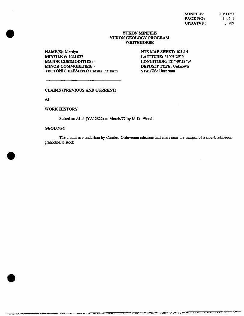
NAME(S): Manlyn MINFILE #: I05J 027 MAJOR COMMODITIES: -MINOR COMMODITIES: -TECTONIC ELEMENT: Cassiar Platform
NTS MAP SHEET: 105 J 4 LATITUDE: 6r03*29"N LONGITUDE: 13r49'58"W DEPOSIT TYPE: Unknown STATUS: Uncertam
CLAIMS (PREVIOUS AND CURRENT)
AJ
WORK HISTORY
Staked as AJ cl (YA12822) m March/77 by M D Wood.
GEOLOGY
The claims are imderlam by Cambro-Ordovician siltstone and chert near the margm of a mid-Cretaceous granodionte stock
iwi»wL.-„a.'- ri.fff 'Vi'^' ' - * *» j j = * . ' »» '? i ' . " i • t>Lg4i!g ' J'-.-.V.A""-lM- ••..^^^fT^'k-i'r •1i^?/^^\^r'^^ • ' ^ . ^ •^ i f .ZM' . . .
YUKON MBMI'lLE YUKON GEOLOGY PROGRAM
WHITEHORSE
MINFILE: PAGE NO: UPDATED:
105J 028 1 of 1
07/28/95
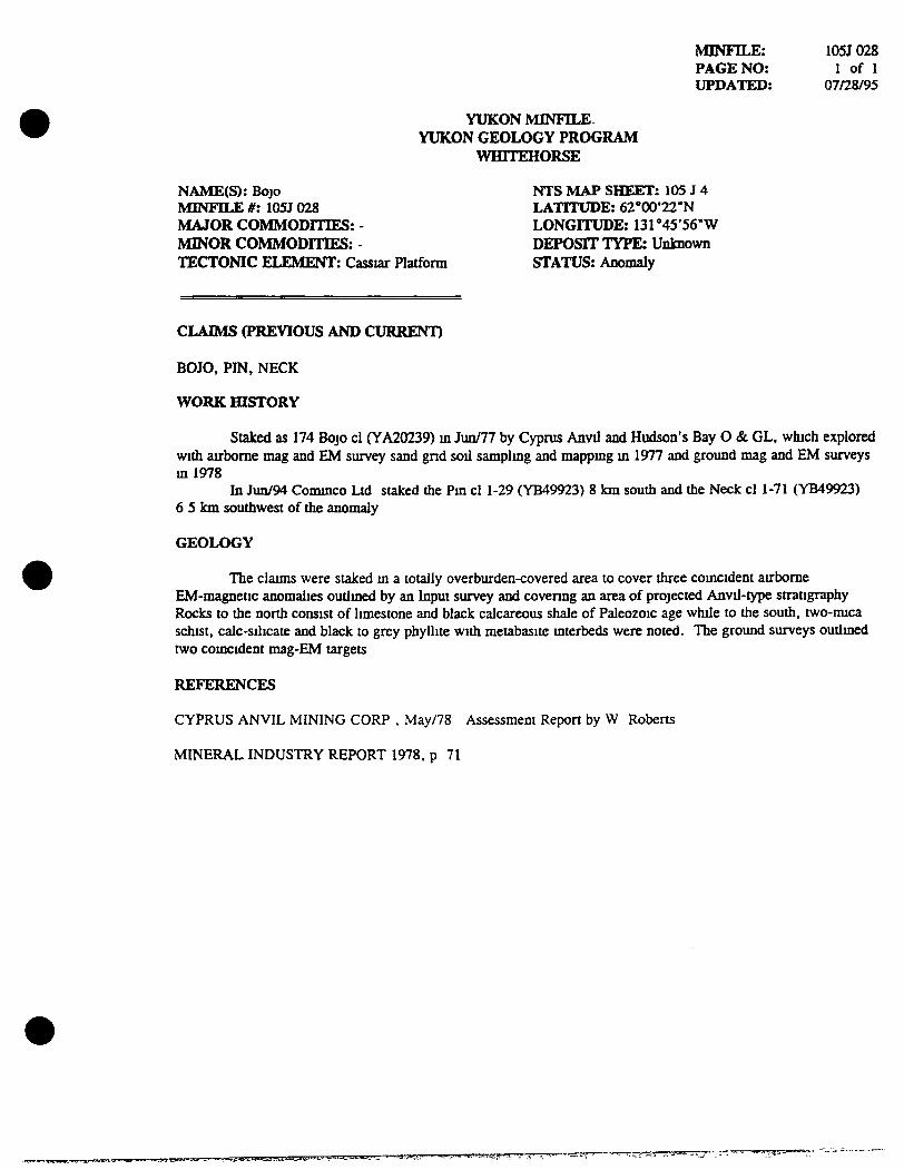
NAME(S): Bojo NTS MAP SHEET: 105 J 4 MINFILE #: 105J 028 LATITUDE: 62°00'22-N MAJOR COMMODITIES: - LONGITUDE: 13r45'56"W MINOR COMMODITIES: - DEPOSIT TYPE: Unknown TECTONIC ELEMENT: Cassiar Platform STATUS: Anomaly
CLAIMS (PREVIOUS AND CURRENT)
BOJO. PIN, NECK
WORK HISTORY
Staked as 174 Bojo cl (YA20239) m Jun/77 by Cyprus Anvil and Hudson's Bay O & GL. which explored with airborne mag and EM survey sand gnd sod samplmg and mappmg m 1977 and ground mag and EM surveys ml978
In Jun/94 Commco Ltd staked the Pm cl 1-29 (YB49923) 8 km soudi and the Neck cl 1-71 (YB49923) 6 5 km southwest of the anomaly
GEOLOGY
The claims were staked m a totally overburden-covered area to cover three comcident airborne EM-magnetic anomalies oudmed by an Input survey and covermg an area of projected Anvil-type stratigraphy Rocks to the north consist of limestone and black calcareous shale of Paleozoic age while to the south, two-mica schist, calc-silicate and black to grey phyllite with metabasite mterbeds were noted. The ground surveys outlmed two comcident mag-£M targets
REFERENCES
CYPRUS ANVIL MINING CORP , May/78 Assessment Report by W Roberts
MINERAL INDUSTRY REPORT 1978, p 71
praaK:sr^.iBii.'j^^'^.<
YUKON IVflNFILE YUKON GEOLOGY PROGRAM
WHITEHORSE
MINFILE: PAGE NO: UPDATED:
105K 097 1 of 1
/ /89
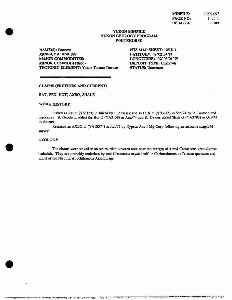
NAME(S): Petancic MINFILE #: 105K 097 MAJOR COMMODITIES: -MINOR COMMODITIES: -TECTONIC ELEMENT: Yukon Tanana Terrane
NTS MAP SHEET: 105 K 1 LATITUDE: 62'02'54"N LONGITUDE: 132''05'01"W DEPOSIT TYPE: Unknown STATUS: Uncertam
CLAIMS (PREVIOUS AND CURRENT)
RAT, FEX. HOT; AXBO. SHALE
WORK HISTORY
Staked as Rat cl (Y83133) m Jul/74 by J Acklack and as FEX cl (Y80613) m Sep/74 by R. Blusson and associates B. Goodwm added the Hot cl (YA3138) m Aug/74 and R. Davies added Shale cl (YA3793) m Oct/74 to die east.
Restaked as AXBO cl (YA18574) m Jun/77 by Cyprus Anvd Mg Corp followmg an aurborae mag-EM survey
GEOLOGY
The claims were staked m an overburden-covered area near the margm of a imd-Cretaceous granodionte badiolidi. They are probably imderlam by mid-Cretaceous crystal mff or Carbomferous to Tnassic quartzite and schist of the Nisutlm Allochthonous Assemblage
YUKON MINi'lLE YUKON GEOLOGY PROGRAM
WHITEHORSE
MINFn^: PAGE NO: UPDATED:
105K098 1 offl
08/28/96
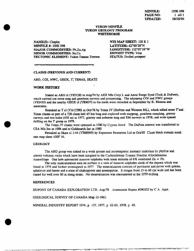
NAME(S): Chaplm NTS MAP SHEET: 105 K 1 MINFILE #: 105K 098 LATITUDE: 6 r 00'28"N MAJOR COMMODITIES: Pb,Zn,Ag LONGITUDE: 13Z*'07'59"W MINOR COMMODITIES: Ba,Cu DEPOSIT TYPE: Vem TECTONIC ELEMENT: Yukon Tanana Terrane STATUS: Dnlled prospect
CLAIMS (PREVIOUS AND CURRENT)
ARO. COJ. NWC, GEOX, T; TENAS, SKATE
WORK HISTORY
Staked as ARO cl (Y83128) m Aug/74 by AEX Mis Corp L and Anvil Range Synd (Teck & DuPont), which earned out recce mag and geochem surveys and prospectmg. The adjommg COJ and NWC groups (Y83435) and the nearby GEOX cl (Y80637) to the north were recorded m September by R. Blusson and associates.
Restaked as T cl (YAI 1590) m Oct/76 by Tenas JV (DuPont and Western ML), which added more T'and Tenas claims as part of a 728 claim belt 45 km long and explored with mappmg, geochem samplmg, gravity surveys and two holes (455 m) m 1977. gravity and airborne mag and EM surveys m 1978; and wide spaced dnlling on the T group m 1979.
The Tenas JV claims were optioned m 1980 by Cyprus Anvd The DuPont mterest was transferred to CSA Mis Inc m 1984 and to Goldsearch Inc m 1985
Restaked as Skate cl 1-44 (YB68969) by Expatnate Resources Ltd m Oct/95 Claim block extends soudi mto map sheet 105F 16.
GEOLOGY
The ARO group was staked on a weak gossan and aeromagnetic anomaly underlam by phyllite and altered volcamc rocks which have been assigned to die Carbomferous-Triassic Nisudm Allochthonous Assemblage One hole mtersected massive sulphides with some sections of 6% combmed Zn + Pb.
The only mmeralization seen on surface is a vem of massive sulphides south of the deposit which was found m 1974 and further mvestigated m 1977 The mmeralization consists of pyrrhotite and pynte with galena, sphalente and bante and a trace of chalcopynte and arsenopynte. It ranges from 15 to 60 cm wide and has been traced for well over 60 m along stnke. No mmeralization was encountered m the 1979 dnllmg
REFERENCES
DUPONT OF CANADA EXPLORATION LTD, Aug/78 Assessment Report #090335 by C A Ager.
GEOLOGICAL SURVEY OF CANADA Map 13-1961.
MINERAL INDUSTRY REPORT 1974, p 137, 1977, p 62-63, 1978, p 40.

Appendix 2
STATEMENT OF QUALIFICATIONS
I, John Peter Ross, do hereby certify that I
1 am a qualified prospector with mailing address,
B1-2002 Centennial Street Whitehorse, Yukon Canada Y1A3Z7
2 graduated from McGill University m 1970 with a B Sc General Science
3 have attended and finished completely the following courses,
1974 - BC &. Yukon Chamber of Mines, Prospecting Course 1978 - United Keno Hill Mmes Limited, Elsa, Yukon, Prospecting Course 1987 - Yukon Chamber of Mines, Advanced Prospecting Course 1991 - Exploration Geochemistry Workshop, GSC Canada 1994 - Diamond Exploration Short Course, Yukon Geoscience Forum 1994 - Yukon Chamber of Mines, Alteration and Petrology for Prospectors 1994 - Applications of Multi-Parameter Surveys (Whitehorse), Ron Shives, GSC 1994 - Drift Exploration in Glaciated and Mountainous Terrain, BCGS 1995 - Applications of Multi-Parameter Surveys, (Vancouver) Ron Shives, GSC 1995 - Diamond Theory and Exploration, Short Course # 20, GSC Canada 1996 - New Mineral Deposit Models ofthe Cordillera, MDRU 1997 - Geochemical Exploration in Tropical Environments, MDRU 1998 - Metallogeny of Volcanic Arcs, Cordilleran Roundup Short Course 1999 - Volcanic Massive Sulphide Deposits, Cordilleran Roundup Short Course 1999 - Pluton-Related (Thermal Aureole) Gold, Yukon Geoscience Forum 2000 - Sediment Hosted Gold Deposits, MDRU 2001 - Volcanic Processes, MDRU
4 did all the work and the writing of this report
5 have been on the Yukon Prospectors Assistance and Yukon Mining Incentive Program 1986-2001
6 have been on the British Columbia Prospectors' Assistance Program 1989 - 1990, 2001
7 have a 100% interest in the claims descnbed in this report at the present time

Appendix 3
Float / Bedrock Sample Geochemistry - Assay Results

Northern Analytical Laboratones ltd
105 Copper Road Whtehorse, Yukon
Y1A2Z7 Ph (867)668-4968 Fax (867)668-4890
E-mail NAL@yknet yk ca
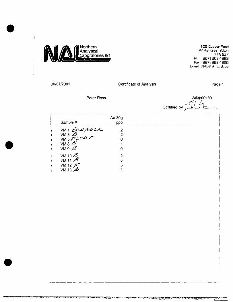
30/07/2001 Certificate of Analysis
Peter Ross # of pages (not including this page) 1
W0# 00183 /
Certified by
Date Received 12/07/01 Justin Lemphers (Senior Assayer)
ISAMPLE PREPARATION
Code r
#o f Samples
9 Type
rock
ANALYTICAL METHODS SU^
Symbol Units Element Au 3bg ppb Gold
Preparation Description (All wet samples are dried first) | Crush to-10 mesh,
1MARY Method (A assay)
(G geochem) G FA/AAS
riffle split 200g, pulven
Fusion/Digestion 30g FA / aqua regia
ze to-100 mesh 1
Lower Limit
5
Upper Limit 7000
AAS = atomic absorption spectrophotometry FA = fire assay
lOOOppb = Ippm = Ig/mt = 0 0001% = 0 029166oz/ton
' '•^^^'^ •"-"-•-A"'-- ••W»w,^tg;J«^g«SJ^s^aii!!^^^^^ ^S-^T^I^SK^g^jJJgffliaii'-Jg?:^;?^?-^^
Northern Analytical Laboratories ltd
105 Copper Road Whitehorse, Yukon
Y1A2Z7 Ph (867)668-4968 Fax ( 8 6 7 ) 6 6 8 ^ 8 9 0
E-mail NAL@yknet yk ca
30/07/2001 Certificate of Analysis Page 1
Peter Ross
Certified by
W<D#Q0183
y
Sample # Au 30g
ppb
VM 1 Se^y:>/^o c /c^ VM3 ><5 V M 5 / ^ ^ ^ ^ ^ VMS / ^ VM9 / ^
VM 1 0 / ^ VM 11 yO VM12 ^ VM13 A
2 2 0 1 0
2 5 3 1
^;3pr'=?"5'»T^S3r7T™5'>»?"9=?35?"E»»oB-==r=55» V--eJtB-i?i^.- 'iar3w''^*--**'wii'""-"-?'~ y-.t.i&*»SHir,-"
IHTERNATIDNAl PlASMfl LAflORATORV JTD
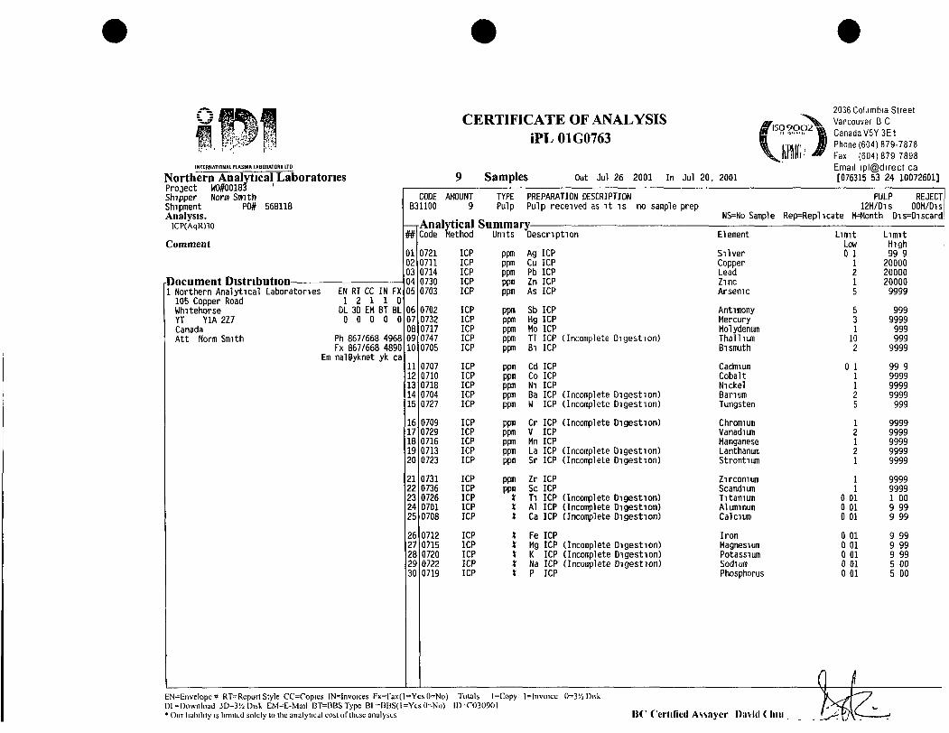
Northern Analytical Laboratories Project W0#00183 ' Shipper Norm Smith Shipment P0# 568118 Analysis.
ICP(AqR)30
Comment
Document Distribution 1 Northern Analytical Laboratories 105 Copper Road Whitehorse YT YIA 2Z7 Canada Att Norm Smith
EN RT CC IN FX 1 2 1 1 0
DL 3D EM BT BL 0 C 0 0 0
Ph 867/668 4968 Fx 867/668 4890
Era nalPyknet yk ca
CERTIFICATE OF ANALYSIS iPL 01G0763
Samples Out Jul 26 2001 In Jul 20. 2001
2036 Columbia Street Vancouver B 0 Canada V5Y3E1 Phone(604)879-7878 Fax (604)879 7898 Email ipl@direct ca [076315 53 24 10072601]
CODE AMOUNT B31100 9
TYPE Pulp
PREPARATION DESCRIPTION Pulp received as i t i s no sample prep
Analytical Summary Code Method Umts Descr ipt ion
0721 ICP ppm Ag ICP 0711 ICP ppm Cu ICP 0714 ICP ppm Pb ICP 0730 ICP ppm Zn ICP 0703 ICP ppm As ICP
0702 ICP ppm Sb ICP 0732 ICP ppm Hg ICP 0717 ICP ppm Mo ICP 0747 ICP ppm Tl ICP (Incomplete Digestion) 0705 ICP ppm Bl ICP
0707 ICP ppm Cd ICP 0710 ICP ppm Co ICP 0718 ICP ppm Nl ICP 0704 ICP ppm Ba ICP (Incomplete Digestion) 0727 ICP ppm M ICP (Incomplete Digestion)
0709 ICP ppm Cr ICP (Incomplete Digestion) 0729 ICP ppm V ICP 0716 ICP ppm Mn ICP 0713 ICP ppm La ICP (Incomplete Digestion) 0723 ICP ppm Sr ICP (Incomplete Digestion)
0731 ICP ppm Zr ICP 0736 ICP ppm Sc ICP 0726 ICP X Tl ICP (Incomplete Digestion) 0701 ICP * Al ICP (Incomplete Digestion) 0708 ICP * Ca ICP (Incomplete Digestion)
0712 ICP X Fe ICP 0715 ICP * Mg ICP (Incomplete Digestion) 0720 ICP * K ICP (Incomplete Digestion) 0722 ICP * Na ICP (Incomplete Digestion) 0719 ICP X P ICP
NS=No Sample Rep=Replicate
PULP REJECT 12M/D1S OOM/Dis
H=Honth Dis=Discard
Element
Silver Copper Lead Zinc Arsenic
Antimony Mercury Molydenum Thallium Bismuth
Cadmium Cobalt Nickel Barium Tungsten
Chromium Vanadium Manganese Lanthanum Strontium
Zirconium Scandium Titanium Aluminum Calcium
Iron Magnesium Potassium Sodium Phosphorus
Limit Low 0 1
1 2 1 5
5 3 1 10 2
0 1 1 1 2 5
1 2 1 2 1
1 1
0 01 0 01 0 01
0 01 0 01 0 01 0 01 0 01
Limit High 99 9 20000 20000 20000 9999
999 9999 999 999
9999
99 9 9999 9999 9999 999
9999 9999 9999 9999 9999
9999 9999
00 99 99
99 99 99 00 00
EN^Envelope# RT=Rcport Style CC=Copics IN=lnvoices Fx=rax(l==YcsO=No) Totals l=Copy l^ lnvoic i ; 0=3'/j Disk Dl •'Download 3D=3'/; Disk i:M=r;-Mail BT=BBSTypc Bl -BBS( l=Ycs( l= 'No) 111-0)30901 * Our liability is limited solely to tlie analylic:jl cost of tlitsc analyses l iC f'crlil lcd Assayer David ( liiii
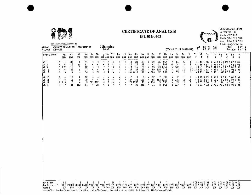
CERTIFICATE OF ANALYSIS iPL 01G0763
INTERNATIONAL PLASMA LABORATORY LTD
Client Northern Analyttcal Laboratories Project W0#00183 9=Pufp [076315 53 24 10072601]
Out In
Jul Jul
26 20
2001 2001
2036 Columbia Street Vancouver B C Canada V5Y3E1 Phone(604)879 7878 Fax (604)879-7898 Email ipl@direct ca
Page 1 of Section 1 of
Sample Name Ag Cu Pb Zn As Sb Hg Mo Tl Bi Cd Co Ni Ba W Cr V Mn La Sr Zr Sc Ti Al Ca Fe ppm ppm ppm ppm ppm ppm ppm ppm ppm ppm ppm ppm ppm ppm ppm ppm ppm ppm ppm ppm ppm ppm % X X X
Mg X
Na X
VM 1 VM 3 VM 5 VM 8 VM 9
VM 1 0 VM 1 1 VM 1 2 VM 1 3
0 2
0 3
30 15 13 55
7
19 15 5
26
6 11 9 8
2 9 4
162
91 61 62 77 14
12 79 9
91 601 492
< 28
8 12 3
29
28 25 15 29
< 65 1319
< 2 9 < 27 35 < 78 1392 < 7 39
88 119 120 163 110
8 108 46
361
49 41 33 59
504
92 55
274 31
16 557 11 593 13 1751
118 713 12 547
7 96 103 1319
5 395 8 918
2 32 6
64 34
942 22 93
2 215
79 227
5 3 1
11 1
1 2 1 7
3 < 1 40 2 < 1 38 6 < 0 59 5 0 28 2 49 5 < 0 13
1 14 3 3
58 67 19* 63 46
< 0 16 0 03 < 2 73 4 04 < 0 03 2 54 < 0 37 7 12
2 66 1 04 0 09 0 02 0 05 2 96 0 59 0 23 0 02 0 06 1 94 0 36 0 07 0 01 0 05 4 04 1 75 0 04 0 03 0 05 3 40 15t0 02 0 01 <
0 62 0 13 0 01 0 01 0.01 5 12 2 49 0 08 0 02 0 06 3 13 16* < 0 01 < 2 79 3 95 0 08 0 02 0.03
Mm Limit 0 1 1 2 1 5 5 3 1 10 2 0 1 1 1 2 5 1 2 1 2 1 1 1 0 01 0 01 0 01 Max Reported* 99 9 20000 20000 20000 9999 999 9999 999 999 9999 99 9 9999 9999 9999 999 9999 9999 9999 9999 9999 9999 9999 1 00 9 99 9 99 Method ICP ICP ICP ICP ICP ICP ICP ICP ICP ICP ICP ICP ICP ICP ICP ICP ICP ICP ICP ICP ICP ICP ICP ICP ICP
No Test lns=lnsurricienl Sample Del-Delay Max^No rslimate Kee=Re( heck ni-xlODO 'li I'stimjle';(, NS-No S iinpk.l'=Pi:lp
0 01 0 01 0 01 0 01 0 01 9 99 9 99 9 99 5 00 5 00
ICP ICP ICP ICP ICP

Northern ^2?^ copper Road Analytical whitehorse, YUton Laboratories ltd p ^ (867)668-4968
Fax (867)668^890 E-mail NAL@yknet yk ca
19/10/2001 Certificate of Analysis
# of pages (not including this page) 1 Peter Ross ,
W0# 00229
' / Certified by • '
Justin Lemphers (Senior Assayer) Date Received 19/09/01
ISAMPLE PREPARATION
Code r
#of Samples
27 Type
rock Preparation Descnf Crush to-10 mesh.
ANALYTICAL METHODS SUMMARY
Symbol "Au 30g
Units ppb
Element Gold
Method (A assay) (G geochem)
G FA/AAS
)tion (All wet samples are dned first) riffle split 200g, pulverize to -100 mesh 1
Fusion/Digestion 30g FA / aqua regia
Lower Limit
5
Upper Limit 7000
AAS = atomic absorption spectrophotometry FA = fire assay
1 oz/ton = 34 286 g/mt lOOOppb = ippm = 1g/mt = 0 0001% = 0 029166ozyton
• i - imm.- ML-Li . . i . a IL I . • ' ^ - u j j i u i .•».JBJ^t«>--^r. ':V- '?..a-,'---i*L».Tit«.«<;ii»,:4jfe,^.... w:.^ j - - {g i~. 'y j tTj>, '« l f«. . i iJ . i :y J, - • - ' - ' " . • ^ ^gV i ^ i aHBgA ' ^g ' ' • ' • • "S^^ ' ' ' y

Northern Analytical Laboratories ltd
105 Copper Road Whitehorse, Yukon
Y1A2Z7 Ph (867) 668-4968 Fax (867)668^890
E-mail NAL@yknet yk ca
19/10/2001 Certificate of Analysis Page 1
Peter Ross 00229
Sample # AuSOg
ppb
B.560 ^ ^ y ^ ^ ^ ^ CINTA-1 y / 7 ^ CINTA-2 '^ CINTA-3 ^'' CINTA-4 / ,
CINTA-5 CINTA-6 CINTA-7 CINTA-8 CINTA-9
CINTA-10 f / CINTA-11 / / CINTA-12 / / CINTA-13 / / CINTA-14 / /
CINTA-15 / ' ' CINTA-16 " CINTA-17 / ' CINTA-18 / / ClNTA-19 / '
CINTA-20 / / CINTA-21 // CINTA-22 / ' CINTA-23 '^ ClNTA-24 / ^ y U > / ^ T ~
STUDY-1 / ^ / y ~ STUDY-2 ^^
10 16 13 13 17
16 10 14 12 13
13 12 12 5 5
5 <5 <5 6 7
8 9 9 11 8
9 13
Certified by ^
"yifsmtsw-.i •nr^'j' m'.' "5=<a>i>w!«!7<wwi«r»TO'T33™-!ix;^^ •"?3^1?!
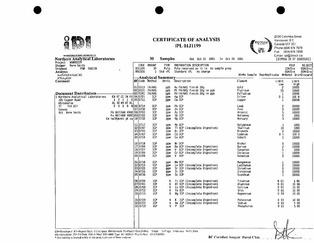
CERTIFICATE OF ANALYSIS iPL01Jn99
INTERNATIONAL PLASMA LABORATORY LTD
Northern Analytical Laboratories Project WO#00229 Shipper Norm Smith Shipment P0# 568139 Analysis
Au./Pt/Td(FA/AAS 30) ICP(AqR)30
C o m m e n t
Document Distribution-1 Northern Analytical Laboratories
105 Copper Road Whitehorse YT YIA i n Canada Att Norm Smith
EN RT CC IN FX 1 2 1 1 0
DL 3D EM BT BL O O O O O
Ph 867/668 4968 Fx 867/668 4890
Em nalPyknet yk ca
30 Samples Out Oct 31 2001 In Oct 24 2001
2036 Columbia Street Vancouver B C Canada V5Y3E1 Phone (604) 879 7878 Fax (604)879 7898 Email ipl@direct ca [119916 19 57 10103101]
Analytical Summary # Code Method Units Description
CODE AMOUNT TYPE PREPARATION DESCRIPTION B31100 30 Pulp Pulp received as it is no sample prep B82100 1 Std iPL Standard iPL no charge
0313 FA/AAS 0331 FA/AAS 0341 FA/AAS 0721 ICP 0711
0714 0730 0703 0702 0732
0717 0747 0705 0707 0710
0718 0704 0727 0709 0729
0716 0713 0723 0731 0736
0726 0701 0708 0712 0715
0720 0722 0719
ICP
ICP ICP ICP ICP ICP
ICP ICP ICP ICP ICP
ICP ICP ICP ICP ICP
ICP ICP ICP ICP ICP
ICP ICP ICP ICP ICP
ICP ICP ICP
ppb Au FA/AAS finish 30g ppb Pt FA/AAS finish 30g in ppb ppb Pd FA/AAS finish 30g in ppb ppm Ag ICP ppm Cu ICP
ppm Pb ICP ppm Zn ICP ppm As ICP ppm Sb ICP ppm Hg ICP
ppm Ho ICP ppm Tl ICP (Incomplete Digestion) ppm Bl ICP ppm Cd ICP ppm Co ICP
ppm Nl ICP ppm Ba ICP (Incomplete Digestion) ppm W ICP (Incomplete Digestion) ppm Cr ICP (Incomplete Digestion) ppm V ICP
ppm Mn ICP ppm La ICP (Incomplete Digestion) ppm Sr ICP (Incomplete Digestion) ppm Zr ICP ppm Sc ICP
* Tl ICP (Incomplete Digestion) * Al ICP (Incomplete Digestion) * Ca ICP (Incomplete Digestion) X Fe ICP * Mg ICP (Incomplete Digestion)
* K ICP (Incomplete Digestion) * Na ICP (Incomplete Digestion) * P ICP
NS=No Sample
Element
Gold Platinum Palladium Silver Copper
Lead Zinc Arsenic Antimony Mercury
Molydenum Thallium Bismuth Cadmium Cobalt
Nickel Barium Tungsten Chromium Vanadium
Manganese Lanthanum Strontium Zirconium Scandium
Titanium Aluminum Calcium Iron Magnesium
Potassium Sodium Phosphorus
Rep=Repl i cate
PULP REJECT 12M/D1S QOM/Dis OOM/Dis OOM/Dis
M=Month Dis=Discard
L imi t Low
2 15 1
0 1 1
2 1 5 5 3
1 10 2
0 1 1
0 0 0 0 0
0 0 0
1 2 5 1 2
1 2 1 1 1
01 01 01 01 01
01 01 01
Limit High
10000 10000 10000 100 0 20000
20000 20000 10000 1000
10000
1000 1000
10000 100 0 10000
10000 10000 1000
10000 10000
10000 10000 10000 10000 10000
1 00 10 00 10 00 10 00 10 00
10 00 5 00 5 00
EN=Rnvelope# RT=Rcport Style COCopies lN=Invoices Fx=Fax(l=Yes 0=No) Totals l=^ropy l^lnvoiee 0=3'i Disk DL^Download 3D--3'/i Disk F.M-l: Mail BT=BBSType Ul =HBS(l=Yes ()=No) 1D=C03(WC)1 • Our liability is liniiled solely to the analylieal cost of these analyses B C Cer t i f i ed Assayer David Chi i i
, , n) O
J
i/j
E
3 O
O
<o
CS
J t r)
> 3
43
>
/
T—
>-LO
> ro
'b-Oo
cn 1
^ oo
r^
(3
(1>
t=
9
oo
CT>
C
O
h^
o
Li.
:^ r!o's u
^'-
' <u •-
c
1 lpl@ Page Secti
ra
E
LU
r-l t-H
O
O
OO
O
JC
VJ
CO
O
J
so l-M
(»
O
H
U
^ &N
< CC
T>
in Ul lo
m
tn
in tn tn en in
in
in tn
in m
in tn in
in tn
tn
m
in in
in
tn tn in j
j v
vv
vv
vv
vv
v v
vv
vv
vv
v V
v
vv
vv
vv
vl
l
lOtn
t-Hv
oc
Nj
to
inc
ot
nin
co
o^
^c
s^
CD
CX
DC
NJO
CV
J c
oc
no
j^c
o in
c\jc
\j i
int
no
o^
r"
^ c
o^
tn
tn
in
inin
co
^t
-n
CS
^^
CO
CM
t
^^
j-
^c
on
f^
co
^ I
CT
>i—
co
oo
cT
i c
oc
oc
sc
oto
cT
^'^
co
Ln
^i-
co
int
ni-
H^
inn
inC
T^
to c
oto
in SS
I I
r^ o n I—I O
J
I—ll—li-Ht—*i—I
i-Hi—tl—ti-Ht-H
T-HOOI^^
I I
vv
vv
v
vv
vv
v
vv
vv
v
vv
vv
v
vv
vv
v
vv
v
rNj
Q.
Q.
C3
C
3
C3
O
O
1—
t I—
I I-H
1—
1 1—
1
vv
vv
v
n
n
n
CT
Lfi
Lfi
in
u
n
IT)
O
O
O
^ C
D
1—11—
I *—1
1—
t.—I
vv
vv
v
O
O
C3 C3 O
rH
t—
I 1—
t i—(
1—1
v
vv
vv
n
^ r
o
CO
CO
O
O
^ C
3
^ r-t
t-H »—
t 1—t
1—I
vv
vv
v
CO
T
TC
O
o^
m
O
O
C3 ^
O
1—t
t—(
1—I r
H
f-( v
vv
vv
^'
^r
CO
un
i
n
ro PO
CO C
O C
O
VV
VV
V
oo
o r
H
I-I T
-* V
VV
ro
m
C
O
1
I
vv
vl
l
Ln
mL
nm
co
Ln
inL
nin
m
V
V
v V
If) r-
rv.
CO
m
"
^ C
T> o
^ «—
( o
>
'^
^-
m
ro
i
n
VV
VV
V
c\j
T-i
in
k
D
m
r-
lO
'iS-
T-H
0
0
tn
C
O i
n
':*• i
n
CO
':^ o
^ C
3
in
I I
un
C
O r-.
to
C
Ti
"^
*^
cn
t
n
^D
^
CO
in
C
O
^o
C
O o
t
^ 'rj'
CO
in
-tr
in
C
T)
CO
)
i-t C
SJ C
M C
3
CO
ro
o
i I
I r-t
.—t T
-H
.-I
1—I r-t
i I
I I
r^ tv
. i
o
C3
<
3
O O
C
D
r^ r^
CO
in CO
r
--
o
cvj i-t i-i
O
(3
C
D O
^
CD
I—t
O
C3
^
Od
I-I
1-1
cu
C
VJ
CVJ 1-H 1
-1 O
J ^
^ "
^ ^
D I I
I II
II II
I II M
il
l 1
11
15
II
I v"^
II II
I M
il
l II
II I
II 11
I
II II
I I
II
I I
II II
I II
II I
II II
MM
in
i
n
c3
1
-11
—*
in
V
V
O
J
o. a. CL a. o
. 0
.0
.0
.0
.0
. O
. O.O
. O.O
. O
. 0.0
.0.
o.
O. C
1.0. o
. o.
O. O
. O. O
.O.
-r—
.—
I—
r
—r
-.—
r—
r—
r—
^
i—
r—
.—
r—
r~
i—
.— .—
r-
.— r—
i—
^
r—
i—
r-
.—
.—
"O
1—I OJ OO "
j-in
vo P-N
CO CTt CD
1—1 CM CO in
I—I
r—I «—t 1—t
I—I l-H
< < < < <c < < < <c
<c < < < < <:
Zz
Sz
g
gZ
Z^
^ Z
ZZ
ZZ
tJ
(_>
e
j C
_3 t_
J O
C
J (
JO
O
C_3 <_3
(_3
CJ
CJ
"^
r-v C
O C
Tt C
D
(—1
1—t 1—
t i-H C
O
< < <
<<
Z
ZZ
ZZ
CJ
CJ
CJ
CJ
CJ
1-t
CX
J
O
>- >
-0%O
d *£
) Q
O
1-1
i
n
rs
ZD
•
-.
H_
__
_ +
I_
P:
ES
CJ
CJ
LJ
CJ
CJ
CO
to
o
o
D>
:
>
< <
< <
<
CERTIFICATE OF ANALYSIS iPL01J1199
INtERNATIONAL PLASMA LABORATORY LTD
Client Project
Northern Analytical Laboratories W0#00229
30 Samples 30=Pulp l=Std iPL [119916 19 57 10103101]
Out In
Oct 31 Oct 24
2001 2001
2036 Columbia Street Vancouver B C Canada V5Y3E1 Phone (604) 879 7878 Fax (604)879 7898 Email ipl@direct ca
Page 1 of Section 2 of
Sample Name
CINTA 1 CINTA 2 CINTA 3 CINTA 4 CINTA 5
CINTA 6 CINTA 7 CINTA 8 CINTA 9 CINTA 10
CINTA 11 CINTA 12 CINTA 13 CINTA 14 CINTA 15
CINTA 16 CINTA 17 CINTA 18 CINTA 19 CINTA 20
CINTA 21 CINTA 22 CINTA 23 CINTA 24 CINTA 25
B-i-560 STUDY 1 STUDY 2 VM 9 VM 12
iPL STD 101 70
Cr ppm
14 21 34 15 21
31 11 18 23 16
13 21 36 33 40
43 35 67 20 37
35 48 34 48 286
73 31 35
—
—
V ppm
34 40 41 27 39
49 33 35 35 33
31 47 4 14 11
10 9 9 17 8
8 10 10 22 5
11 29 28
—
—
Iipm
488 744
1053 247 739
302 162
1226 97 551
477 39 679 506 679
456 915 317 678 859
441 1191 708 857 556
2021 570 408
—
—
La ppm
2 <2 4 2 2
4 2 4 2 3
2 2 <2 2 <2
2 3 2 3 2
2 2 2 2 <2
6 2 2
—
—
Sr ppm
102 137 130 Ul 117
90 120 130 84 105
98 124 64 326 145
127 135 83
1170 130
209 145 133 101 163
75 215 135
—
—
Zr ppm
10 11 13 10 14
10 9 13 7 13
11 7 3 5 5
6 5 5 5 5
5 8 6 4 1
8 8 9
—
—
Sc ppm
6 6 5 5 6
6 5 6 5 5
5 6 <1 4 3
3 3 2 2 3
3 4 3 3 2
6 6 5
—
—
Tl %
<0 01 <0 01 <0 01 <0 01 <0 01
<0 01 <0 01 <0 01 <0 01 <0 01
<0 01 <0 01 <0 01 <0 01 <0 01
<0 01 <0 01 <0 01 <0 01 <0 01
<0 01 <0 01 <0 01 <0 01 <0 01
<0 01 <0 01 <0 01
—
—
Al X
0 28 0 39 0 32 0 34 0 35
0 37 0 31 0 42 0 36 0 36
0 28 0 24 0 08 0 19 0 17
0 20 0 18 0 22 0 25 0 16
0 17 0 23 0 17 2 41 0 04
0 42 0 26 0 30
—
—
Ca *
1 84 3 06 4 70 2 97 2 57
2 13 2 72 4 04 1 72 2 59
2 11 1 86 12*
4 36 3 65
1 73 3 53 1 22 13*
3 22
3 06 4 66 3 44 2 88 5 68
2 03 5 33 3 44
—
—
Fe X
5 37 4 16 2 60 5 47 3 89
2 68 5 04 3 75 2 74 3 38
4 58 2 65 0 97 3 02 2 78
3 03 3 04 2 66 6 47 2 81
2 75 3 01 2 85 5 17 2 95
2 25 5 35 4 63
—
—
Mg *
0 47 0 91 1 76 0 19 0 77
0 46 0 16 1 30 0 15 0 66
0 49 0 10 7 31 1 40 1 18
0 63 1 21 0 45 5 32 1 10
1 12 1 76 1 16 1 24 15*
0 63 0 91 0 55
—
—
0 0 0 0 0
0 0 0 0 0
0 0 0 0 0
0 0 0 0 0
0 0 0 0 <0
0 0 0
K *
08 12 09 11 10
08 10 12 10 09
09 07 01 04 04
05 05 06 06 05
05 07 04 05 01
08 06 09
—
--
Na *
0 03 0 02 0 02 G 03 0 02
0 02 0 02 0 02 0 02 0 02
0 02 0 02 0 01 0 02 0 02
0 02 0 02 0 02 0 02 0 02
0 02 0 02 0 02 0 02 0 01
0 02 0 02 0 02
—
—
0
p *
08 0 06 0 0 0
0 0 0 0 0
0 0 0 0 0
0 0 0 0 0
0 0 0 0 <0
0 0 0
18 06 13
24 07 18 10 14
07 16 02 03 04
05 03 04 02 04
04 04 04 04 01
16 06 06
—
—
Minir.ium Detection 1 2 Maximum Detection 10000 10000 Method ICP ICP
=No Test lns=InsLiftlcieiit Sample Del-Delay
1 2 1 1 1 10000 10000 10000 10000 10000
ICP ICP ICP ICP ICP Max=N() Fstimjte Ree=--ReC'hLek ni=xl00l)
0 01 0 01 0 01 0 01 1 00 10 00 10 00 10 00
ICP ICP ICP ICP ';; -rstimate "-(, NS-No Sample
0 01 10 00 ICP
0 01 10 00 ICP
0 01 5 00 ICP
0 01 5 00 ICP
Appendix 4
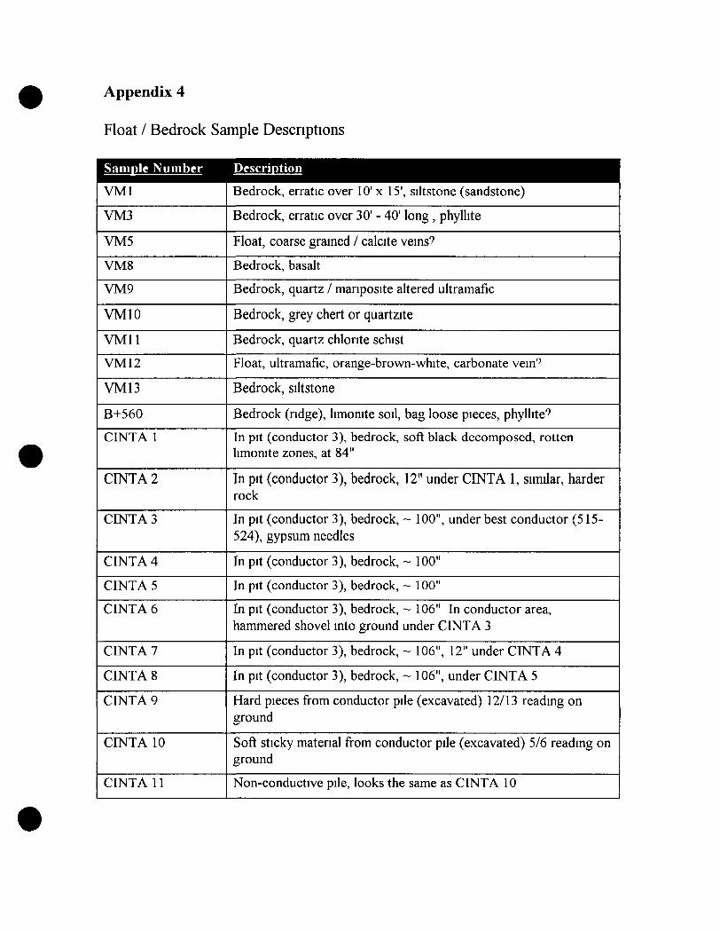
Float / Bedrock Sample Descriptions
SaiiiDle Number Descriotion
VMl
VM3
VM5
VMS
VM9
VMIO
VMll
VMl 2
VM13
B+560
CINTA 1
CINTA 2
CINTA 3
CINTA 4
CINTA 5
CINTA 6
CINTA 7
CINTA 8
CINTA 9
CINTA 10
CINTA 11
Bedrock, erratic over 10' x 15', siltstone (sandstone)
Bedrock, erratic over 30' - 40' long, phyllite
Float, coarse grained / calcite veins?
Bedrock, basalt
Bedrock, quartz / mariposite altered ultramafic
Bedrock, grey chert or quartzite
Bedrock, quartz chlorite schist
Float, ultramafic, orange-brown-white, carbonate vein''
Bedrock, siltstone
Bedrock (ndge), limonite soil, bag loose pieces, phyllite"
In pit (conductor 3), bedrock, soft black decomposed, rotten limonite zones, at 84"
In pit (conductor 3), bedrock, 12" under CINTA 1, similar, harder rock
In pit (conductor 3), bedrock, ~ 100", under best conductor (515-524), gypsum needles
In pit (conductor 3), bedrock, ~ 100"
In pit (conductor 3), bedrock, ~ 100"
In pit (conductor 3), bedrock, ~ 106" In conductor area, hammered shovel into ground under CINTA 3
In pit (conductor 3), bedrock, ~ 106", 12" under CINTA 4
In pit (conductor 3), bedrock, ~ 106", under CINTA 5
Hard pieces from conductor pile (excavated) 12/13 reading on ground
Soft sticky material from conductor pile (excavated) 5/6 reading on ground
Non-conductive pile, looks the same as CINTA 10

Sample Descriptions (continued)
Samnle Number Descrmtion
CINTA 12
CINTA 13-24
CINTA 13
CINTA 14
CINTA 15
CINTA 16
CINTA 17
CINTA 18
CINTA 19
CINTA 20
CINTA 21
CINTA 22
CINTA 23
CINTA 24
STUDY 1
STUDY 2
CINTA 25
Deep in hole, large porous piece, porous weathered white-brown areas
Angular pieces, decomposed bedrock from upper +80" in pit (conductor 3)
Quartz rich rock, lots of orange quartz
Interesting quartz stockwork
Sihstone, stockwork of fine orange quartz
*? white quartz and limonite
Siltstone, interesting white-brown quartz stockwork
Siltstone and quartz stringers
Siltstone and quartz stringers
Siltstone and milky quartz and orange areas
Siltstones, quartz stringers and sulphides and limonite
Interesting quartz stockwork
Siltstone and lots of fine quartz stockworks
Limonite siltstone and quartz stnngers
Hard pieces at bottom of pit (conductor 3) Opaque crystals, red-brown, colourless (gypsum)
Smaller pieces at bottom of pit (conductor 3)
2-3 feet across, angular, limonite on edge brownish and white stnngers, trace manposite

Z93/ 4 044®/ 7 §K’26735Kc307'5
%W24W227772&4(37/620)3&2flWM/Kéifi/K/VKK Q&a 2742/4.) __W67772’&@ K8 FQKMJWZZ/éy/7fiéfl4/Ki744flmfl/flzézM/K/fl/ (2072:27ng2:27%K/Q
/&%&/2 K242 W52é/Maw/7 flag: 76/242277420 44 JK/QWM 3&312422£57220
2777742 227 5‘6 44/3 / 4%& 424—444443 1/474”KK2/K4Ka 577/22:
gA/Ajéwflfi/w)Qm/ 2‘77 FKK _.v/KygzflK/él27/54 MK/M24222%52&5:444/:24444/%:422W24457072742247; K24
/K/K 5/242/222éflr/795,7flWKé/Mfl
flfl/z/ 4724/24/44; rEKK2724/4 K2197 92/24/94444724(K/KE/L/ K/ngfld‘W/K K292/) 4
KKGVECT 45%)(92/4/6215;
4I
_ K/"Kfa/MS” /7&:/ 2 2K / 2 44 /77 :72;7é 4’44 , 9772262229477 4 4 .
K / 20429) l/fl / fl? 4
“[7 V2275 42W {QKWMKW2/2K4cfl~44447é/4M7KD/L KKVK/m (Z/Mflfl/fi792K 44_
42277742242224 272. Z76%?2‘27 KW? 25722274477722
77744. 77744544 44 42275444424242K4922224 %/K27424‘K4724- 444222/272{272/445VMS‘WW 4 ,2m 22/262722 77722442274firm/MQK/afl 4
4_@6742562 M4&44 44 4 44-
\mmrflxkaQkk \MWNR‘ $13me $NNQQxQQMQQQMNN QQKS“fikwL \?%§Q®%\wa KRQQ\N am%%JNWO§QQ!
§§Q &1HAWBQ XSNm &\ \QNWMWQAQQQ
\ QWQW‘ QQNMJg
QM mm\6 4. .mm M.g V Sp Qmm . $NM
5% \ hm Qrmm QM\quw k “MU? \N\‘m «$1M.<2 $53 \ «W. §er Qm.E \xi ‘ku Qua $mm.% «K: / wk «wwkw QM.$53 / rn M % RQHNI\mem5 V \Rfl mQ QQM
x w/ hm. Q km\ ‘_II\|. QN em.“ *I V W . <
\\\m ‘ IQNQRQQQN\
\Em MR WNQ §Q QQQQQQK§QQIQQAVA‘QNNQQ §§Q§§\\ $an\\:QQ&VA\
K%%®\Bmww %%fi§wm QQQQQQNQQQ 1%QQflair\Q QNQQQBQ\Qm\QQ\W\Q}
Q3W%%5:9:M‘42.4/%572444~
4184V47; 4/44zy444444/4//%/ 4%/4/44444/4844444%/444MM?>/%%:44§m _4 VflZS 44444444244
_.___277 /__4/:444/4: 44/4/44WM774?,J_4474444414444 7360’”0%
_4@7%6/484/44 6&8W8 /74/?
4444/244 44‘__Wfi/_4: 4,4/44247;!54/fi/M/4 7424M, 7
—-W4/m—, z 444/44/4444)
\ [4%44444444744 75/74/44%/4
W2“?%43' 64444474 4/ W&%4448_ _.;_4//fl/M/éMM/fi v
_“.i4i.4%7%%/6MZflé/{fi/zflf/égflfl
$62
7724 56506056 ¥5M/7/y/
/ 7 fi/MZ’W M\fléyy/ 693 WwwM66266) \
(@6423/{%%66/’666 e. Z???"Wmfl (76/ £ .. .
m 66/ ‘
.___ __.. - WL//%MWfi
W6/W6/é%MZ//
WIWM/M7fl77fé/MM «6%
7%M S/fl67/M MMM‘M
fl/fléflflZ/zzflflcg/V
ZWWM WM—rflwW _MWW56 j???
M666/6 56627;:626M:667677j/6/ 66/6677(6meMW5°66
WWM/(Pfféz %6%6%Z £74556776M/6gs/56/66 6666 667,6666666664:95 fl/4 [0 ~% ?66/766/45 V777! M
6 Ma WMW/éé (57%)f7z/ MMW767W 7% 729/meMZZZMW_W%¢e é//
'52QQ/ _//4/44/3 '24 (74/4/7444?)
__._._V 4563:;444V 44flWflW/4J%WW5;:4447 7W7%474M2744'43
42%WW 7%2/77244212Z4fl
44/244....__.4-————/’
4, /4§§72/W477
//23/4/4294?) 40 M4224
“444%4444/4M; _é4“ WW/JW
%.644Z_Wfl44 4 74/ 44: flMJ‘a/t/S444,44 M 4444 444721/444 4447-5444/74.472 44447749 7442444 77434454%
gjfafj4W74’Z/Z7.W
W_42754 WWSQW44)2
4- ,7M MQ464/27472/1/4
.2M44444???4,7422% 2
44— ~ 4244heb/VWKWZIW/Zz/W
4 W444sz/W/MMZ474g/,494“' 5‘ 9724290W447
424 $7 44 ~74 W454444744if 47 444/244442 %( . .
#4 294449425} 4444/ 47224@4445?424/424M477
14444 4 ,44/424/9244/444fl
555%55// 5552/524200/555777%55‘ 55722555555575?5855555555; 5755544247“ 52;W/W/é’éfl/Vfl 5652/ ' 4,:. __/ M42672? 53/555,555
WW5/5243/5/5/5%/Vo2:€2 5%5’WPW552557555575555/57/2725 5/ _ 5/;
“5/55/5555/52/55575555\//5375//
W3' #9 + "'\+/+
W555 * , 5—5555/5%7/55// :
505/2/5755; /775575 54/55/55 5/552/55
F77 V75/W5WW55525
"5556/ WMéMM/Q/fia 455254
. M/‘flo5 ~05) 555527755(52125555,)/k/5/%__ \ /// '1
:55105555W51555 555%0555/5755 55557
?%57 24 35//c:/
} fl 7——MW554%/MW
géfllMé/L/QM:%/W240 >5 %k/fl//a?‘ zMMflWM/fl/ flm Mww
Z3;M7WMMW(22%: flflZé/é 72” ”225%. 56276567,.—
Mf7%flgflég4547?,75/W&//57’(/75’7/‘77/ 7#557sz 4%MMfifléMk/ .5
M&fl/a///73;MA;7/66/1/55/65/7 44,553: @575)71WMWW///fl5/5“Z/‘/sWWSM/WM-- ,fmMW5" /a - ' flflflm//
WW/flé/Mfl/
é» Safl/E/C/“ZZ ZZZZZKZ Z.Z7724 Zfac/ZZZZ0F wfl/éS/QA Mflfi //C‘>5§’—//5 )‘Z/Z/Ko/véc/ (777/135 ja/Xfl Jaaé .
«» Z6544)” KZD /7?c9 ,ZZ/ZeZ/ZZW/m/ w: fl/ZwfimWZW/é/ZQ’Z/AZ/Z/Vfl , ZZZQZ/fl .#5 Z5524 ya/ZVZVZZZZZW/Wézs’oZ/Z/ZZZ ? g
Z/ZZZZé fl/z/Z/Z/sa/L/ MKé'fl/Z/HZEZfl/ig/ng /&5w7% /0.§'<§r’—05'0
/&6&0570&547-0???
,, - /@5 6~///,*/&5 17"772% (M0ffé/ZUéS7'afl//0Tf67j
//0§TJ’a/dj/&5J3;Z /05J2928«Z/ZZK?22_ zffl/ZflmZ/WJJLJ
/&ZK&/¥//é:>¢<’/@759
’fl/flfl/ F/ZZ—i m’ZaQ r/Z51%53423/273)/&5 6' F/MZ/Z/Ja/V 44/6?
/@/£/V x4725 Z286 /97%7/&5 Z, .fl/A/Zflflfcm/ ZZ/ce.£217 75/7/waKZa/r
f. éfiéflfl/{Z/f2Z4 //Z/efl r/fl/Z/ /Z&Z CF; '' wgflyg Mflfl Xy/ZZM/ 72%
%veéfl Mflf Z '7“”/L/S’TflzV/vg/W/afl/ Mfl /A/C
3ZZZM/Z%//Z57‘:WW M/fléé/ZZMZQ/Z (21/26 ZZZ
'"1” Iz- ‘“""'__,...._~.—4~ ‘ 4 ,.V //‘III‘;'—;:A=
L_aéfQ/Vflé M/Wjfl/W/Z/fi7721/1/ ‘
”WZZy/éw /£fl//QV/Q‘Myz/QZ‘
__:/%_Mméwj /W//W 4%,7/Za¢¢€//Q K&f/ééé7éé4/ mmé
7%412/44$szfl,
-még5'7“ we: WWWM/WW-géflcar/r 7fl/éf—C’ Q
we,W /?%
MINING
Geophysics .
Beep Mat BM-IV
’;"’;“A powe’rfuil, ininiaturizeo survey instru-
ment that efficiently and inexpensivelydetects conductive and magnetic out-crops or boulders hidden down to 1.5metres of overburden. Its size, shape andweight allow it to be easily pulled throughthe bush.
When it beeps, you know that the con—ductor causing the anomaly is right under
the Beep Mat. You can then immediatelytrench and take a sample for assay todetermine if it is a valuable showing or abarren sulphide/graphite conductor.
Features:
- Magnetites and conductive materialseach have a different audio signal andtheir relative value is displayed to help
pin-point the high sulphide._Adjustable
- Large, bright dot matrix LCD displays
Clear, readable, simultaneous measure-ments of the conductivity and suscepti-
bility (magnetites content) of theunderlying material.
- Detects sulphide conductors such as:pyrite, pyrrhotite, chalcopyrite (Cu),graphite, pentlandite (Ni), galena (Pb),and even silver (Ag) or gold (Au)nugget's and veinlets.
- Continuous ground coverage (1 0 read-ings/second): detects even small near-surface sulphide veinlets.
Physical Description:
Readout Meter: Size 18 x 20 x 6.4 cm
(7" x 8" x 2.5").
Weight: 1.9 kg (4.2 lb).
Case: Plastic with leather casing water-
proof.
Probe Size: 30 x 91 x 7.6 cm (12" x 36" x
3").
Weight: 3.8 kg (8.4 lb).
Humidity: Operates on all rainy, foggy or
snowy days.
710-00082 <Each...§9,ooo.oo> /Rental/week‘1gotoooo4:$490.o /Yearly Maintenance Contract...$950.00
Beep Mat BM-IV+Faster and more sensitive, this improved
threshold audio alarm to signal conduc-tors and/or magnetites. .
- Sensor consists of a rugged waterproofunicoil inserted in a polyethylene shell.
Environmental:
Operating Temp.: -
/finit can detect conductors up to 3
Case: Shockproof waterproof. . / metres deep. It has been winterised for
,.C»»{C;'40cc(15~ F { Each...$10,000.’00 Rental/day...$80.00vto/104° F)
cold weather use. /”
One wee mIriImum
Ultra Violet LampsPortable UV LampsUses 2 6 volt batteries. Wt: 4 lb (1.8 kg) ‘with batteries.
Size: 9.5" x 2.8" x 9.4" (241 mm x 71mm x 238 mm).
UVG47: 6W Short Wave (1350*)137-00090. . .$269.95UVGL48: 6W Long and Shon Wave(930/710*) 137-00051...$284.956v Alkaline Heavy Duty 103—00001...$11.45
Compact UV LampsUses 115 volt. Wt.: 1 lb (.45 kg). Size: 7.8" x 2.8" x 2.1 " (198
mm x 71 mm x 53 mm).
UVG11: 4W ShOrt Wave (1120*) 137-00039 ..............$209.95UVGL15: 4W Long and Short Wave (650/500*)137-00041 .....................................................................$199.95Relative intensities @ 3" (Om/cm2)
Mini UV LampsGreat for occasional use. Have the same tube wattage as most
of the larger ones but have significantly lower intensities. Uses4AA Batteries. Wt.: 8 oz. (.23 kg). Size: 6.5" x 1.25" x 1.75"(165 mm x 32 mm x 45 mm)nUVL4: 4W Long Wave (230*) 137-00038.._..
UVG4: 4w Short Wave (170*) 1370005212...UVSL14P: 4W Long and Short Wave (113/68*)
....$39.95
137-90500 .......................................................................$89.95
Fluorescent Mineral Samples3 Samples in display case. Set 137-00194 ....................$19.95
Page 76
Lake Bottom SamplerTwo fin style with stainless butterfly valve in weight tube bot-
tom sampler. The valve has a protective crossbar and isdesigned to auto close on retrieval. Red plastic coated steelbody allows for little cross contamination. These units havebeen used for thousands of samples. Tip can be resharpened.
Lake Bottom Sampler 126-00213............................$449.95
SeIf-Potential KitSelf-potential kits offer an inexpensive means to evaluate
some sulphide deposits, including those containing pyrite, chal-copyrite and pyrrhotite. It will also identify bodies of graphite.
The kit includes 2 electrodes (pots), one spool with 300metres of wire, millivolt meter and instructions.
These electrodes use a super-saturated solution of waterand copper sulphate. Copper sulphate can be ordered from
pharmacies, chemical companies and garden supply firms.
Kit 126-00401 .......................................................$595.00Spare Electrodes 126-90010 ................................$65.003/4 size Electrode 126-90403 ................................$65.00
E. & O.E. Copyright © 2000 NCl. All Rights Reserved.
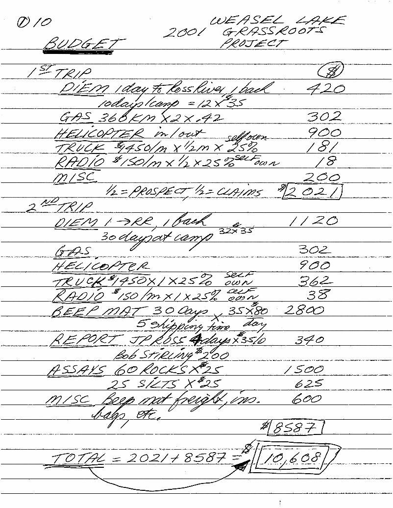
0) A9 ' 405/4554 274,25,Z'Qé/ 676/7255”20071C
52.9fo 56472562’
/gffl/fl ‘ @2/2/97 /¢%/ 27?ng //2/ 34,2Q/&WW2/2 2%:
6795 35/2/27 ?xxn/a 3022222027272 w‘v/W- , 2 2/» 900Wfléfl /4f0/fl:(YVVMX 5% /5’/flflfl/Q 279/ /x2s 255‘“:60w /9 ,QZ/S’C ‘ 2QQ _
//2—;/§/€flS/£€7’/; 42/72/27; "72 Q2 /)
2 ”“7765/
fl/E/W / ”9/66 /M3 2 , //ZO
5’0@7ng2’35M5 Q 302fi/gQ/Qeflfzxz . ?QQ
2:294/¢f@></ X25 33%" , 352KALQ/Q /5’Q%X/X25Z i650“; ._ 3 8'
555/ ”747’ 3 OW353% 28005342217mM g@ -.
K/E/Q/Zf Wz/écrmxss/ ‘ 34a_ 2252222255262
”2225/4/12 Q2/&Q€§Kg’2§ /SQQf 25 5/23“ X£25
”7/56 _ M \
22v)
?“ “
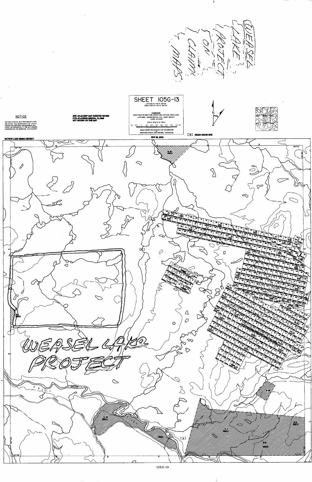
NOHCE
nus up :5 sum: As A nsumunm nun):ran vmlcu n1: 0:0"!sz or main:AFFAIRS AND nonmzu nzvzwmeur VNLLAcct" WREsPOImInJ" roa Anv ERRORS.mAccqucIEs on Ominous WNAstEVER
EEEADJMENTMIPS‘EHGDEXI!IIEHALCIAIG
NOTEHOWNON1HBMMP
SHEET :IOSG-l3LATITUDE 6" 45.70 62'00'
LONGITUDE BI‘SO'TQ ISZ‘ODI
CANADADEMRTMENTWWRTHEM AFNIRS AND NATIONAL RBDURCES
NORYHERN ADMINSYRAYION AND LANDS ERANCHLANDS DIVISION
SCALE ”EMILE Yo I NCO!
FY an o u. u.- .... .... y... m. m.
SUED was! THE “320m" onus MINISTER
NOWAFINRS AND MHONAL RESMCES
mu
uovznzno
I2'00
\
C?)
h .1
A [38%
/
%
MW
V :_ M?" ’
mV
\..,\ a m.
..,\ p ‘0a. Q. Q
s Q\ .1:
any . ” i 3\
1 ( w» a i a \ r” /
lOSG-B
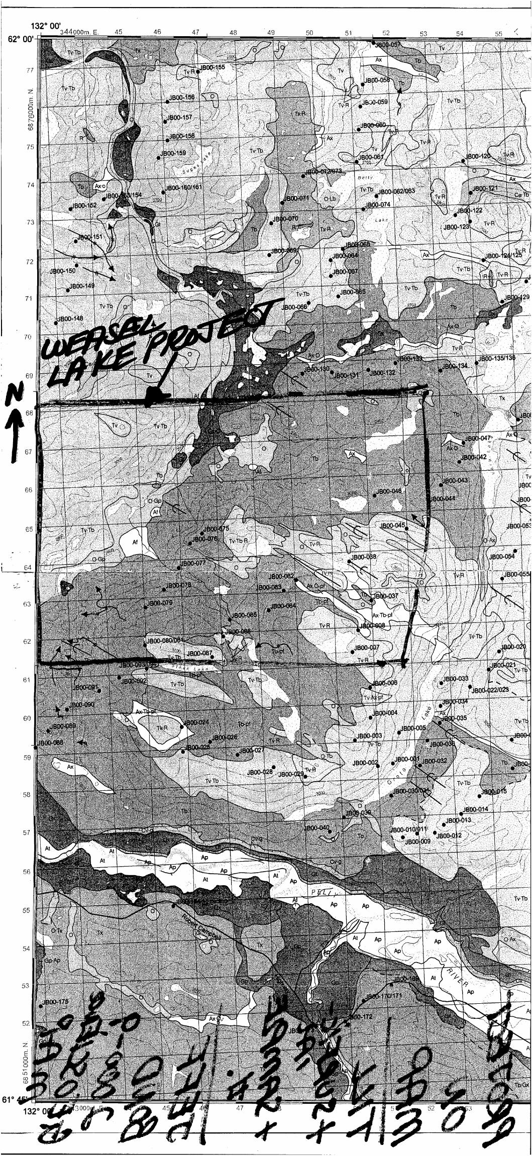
132° 00'
62° 00'
5875mm,N
61°
344000m. E. 45
48 ‘ 4.9
(.71 O

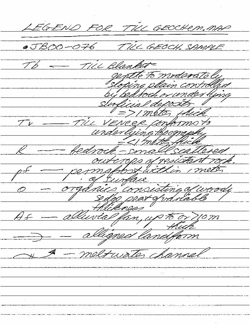
5555240 5—25 7724 56305454550
a 52359’5$6 7742, 55am5/95/55
77 «~— 775/, 5/5/55":
52/2255¢M/555%
_ P/Z —
77/ 775 1/5535 \555?:wa '
WW5”555W/
5 «55755/5555)5725/5522!5/75/5527“
4,: _——~ 5555/55[Mmkawa/ 525'
,_ “fl 5%56/%W9%J
mj”WWW/5W
survey area. This level of sample density provides a highlevel of regional information for future exploration.
The samples taken for geochemical analysis wererepresentative of either basal till or coiluviated basal till.lCP-MS instrumentation combined with an aqua-regiadigestion were used to analyse the —230 mesh fraction ofthe till samples. The geochemical results indicated
numerous anomalies in base metals, gold and platinumgroup pathfinders. They include:
0 Potential epithermal gold mineralization in the
northwest corner of the map area. This is supported by '
a multi-element anomaly in Hg, Sb, Ag, As, Au and TI at
station 1300-155. This may be related to the Finlayson
Lake fault zone and Tertiary mafic volcanics in the area.
t Base rfiétal'incfihalies in zinc and copper in the westerhpart of the map area. Anomalies occur both within
VYukon-Tanana Terrane and in ancient North Americam
rocks of the Cassiar Platform. Most anomalies are not ‘1assdciated with current claim holdings in the area.
0 Clusters of platinum group element pathfinders in the
northeast part of the map area. These coincide with
mafic basalts.
ACKNOWLEDCEMENTSFunding for this project was provided by the Yukon
Geology Program, consisting of Yukon Economic
Development and Indian and Northern Affairs Canada,
Exploration and Geological Services Division. Many
thanks are owed to Jeffrey Boyce for assisting with the
field program and for contributing to its success. Much
appreciated assistance was also provided by Cheryl
Peters, Victor Bond, Lara Melnik and Darren Holcombe.
Exceptional transportation services were provided by
Brian and Warren at lnconnu Lodge/Kluane Airways. .
Thanks also to lnconnu Lodge for their hospitality and
expediting service. Much appreciated assistance was
gained from Gordon Nevin and Gary Stronghill at the
Yukon Geology Program for pulling together the
geochemical figures and surficial geology map. Thanks to
Leyla Weston and .Bill LeBarge for editing this paper.
YUKON EXPLORATION AND GEOLOGY>2000
BOND — TILL GEOCHEMISTRY, WEASEL LAKE
REFERENCESBobrowsky, P.T., Paulen, R., Little, E., Prebble, A.,
Ledwon, A. and Lett, R., 1998. Till geochemistry of the
Louis Creek—Chu Chua Creek area (NTS 92P/1E and
92P/8E). British Columbia Ministry of Energy, Mines and
Petroleum Resources, Open File 1998-6.
Bond, J.D., 2000. Surficial geology and till geochemistry
of Weasel Lake (1050/13), central Yukon
(1 :50 000 scale). Exploration and Geological Services
Division, Yukon, lndiari and Northern Affairs Canada,
Open File 2000-9.
Eyles, N., 1983. Glacial Geology: A Landsystems
Approach. In: Glacial Geology - An Introduction for
Engineers and Earth Scientists, N. Eyles (ed.), Pergamon
Press, Britain, p. 1-18.
Gordey, SP. and Makepeace, A.J., 1999. Yukon Digital
Geology. S.P. Gordey and AJ. Makepeace (comp.),'
Geological Survey of Canada, Open File D3826,
Exploration and Geological Services Division, Yukon,
‘ Indian and Northern Affairs Canada, Open File
1999-1(D). '
Hoffman, 5.1., 1986. Geothermal Exploration - The Soil
Survey. In: Exploration Geochemistry: Design and
Interpretation of Soil Surveys, J.M. Robertson (ed.),
Society of Economic Geologists, Reviews in Economic
Geology, vol. 3, p. 19-38.
Hornebrook, E.H.W. and Friske, P.W.B., 1988. Regional
Stream and Water Geochemical Data, Southeastern
Yukon (105(3). Geological Survey of Canada, Open File
1648.
Jackson, L.E. Jr., 1994. Terrain inventory and Quaternary
history of Pelly River area, Yukon Territory. Geological
Survey of Canada, Memoir 437, 41 p.
Yukon MINFILE, 1997. Exploration and Geological
Services Division, Yukon, Indian and Northern Affairs
Canada.
87
—
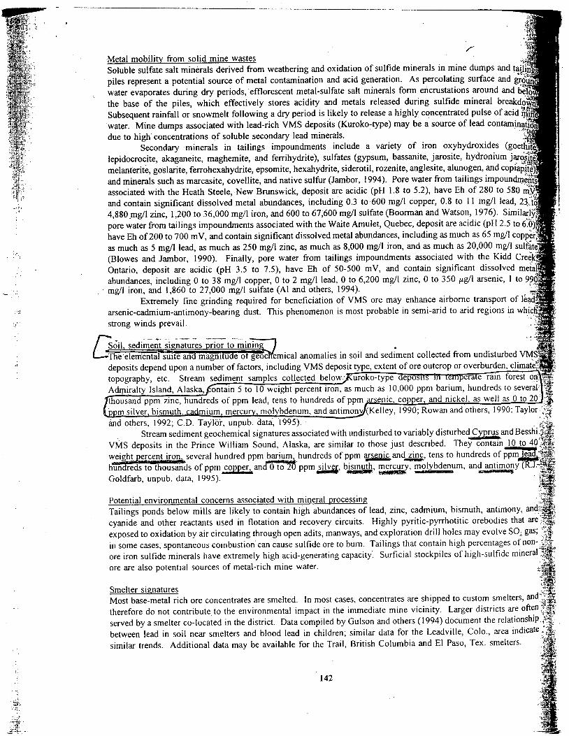
' Metal mobility from solid mine wastes
Soluble sulfate salt minerals derived from weathering and oxidation of sulfide minerals1n mine dumps and ta11m 1
piles represent a potential source of metal contamination and acid generation. As percolating surface and gr_6u-n»;1
water evaporates during dry periods, efflorescent metal-sulfate salt minerals form encrustations around and b
the base of the piles, which effectively stores acidity and metals released during sulfide mineral breakd
Subsequent rainfall or snowmelt following a dry period15 likely to release a highly concentrated pulse of acid'
'water Mine dumps associated with lead-rich VMS deposits (Kuroko—type) may be a source of lead contamf ation
due to high concentrations of soluble secondary lead minerals.
Secondary minerals in tailings impoundments include a variety of iron oxyhydroxides (goet
lepidocrocite, akaganeite, maghemite, and ferrihydrite), sulfates (gypsum, bassanite, jarosite, hydronium‘Jam
melanterite, goslarite, ferrohexahydrite, epsomite, hexahydrite, siderotil, rozenite, anglesite, alunogen, and copiap
and minerals such as marcasite, covellite, and native sulfur (Jambor, 1994) Pore water from tailings impoundm
associated with the Heath Steele, New Brunswick, deposit are acidicv(pH 1.8 to 5.2), have Eh of 280 to 580
and contain significant dissolved meta1 abundances, including 0.3 to 600 mg/l copper, 0.8 to 11 mg/l lead, 23',"
4,8807mg/1 2111c, 1,200 to 36,000 mg/l iron, and 600 to 67,600 mg/l sulfate (Boorman and Watson, 1976). Simil
pore water from tailings impoundments associated with the Waite Amulet, Quebec, deposit are acidic (pH 2.5 to
have Eh of 200 to 700 mV, and contain significant dissolved metal abundances including as much as 65 mg/1 copp.
as much as 5 mg/l lead as much as 250 mg/l zinc, as much as 8,000 mg/l iron, and as much as 20,000 mg/l sulfate
(Blowes and Jambor, 1990). Finally, pore water from tailings impoundments associated with the Kidd Creek
Ontario, deposit are acidic (pH 3.5 to 7.5), have Eh of 50-500 mV, and contain significant dissolved meta1.
abundances, including 0 to 38 mg/l copper, O to 2 mg/l 1ead,0 to 6,200 mg/l zinc, 0 to 350 pg/l arsenic, 1 to 990‘mg/l iron, and 1,860 to 27,000 mg/l sulfate (A1 and others, 1.994)
Extremely fine grinding required for beneficiation of VMS ore may enhance airborne transport of leads
arsenic-cadmium--a11timony—bearing dust. This phenomenon is most probable1n semi——arid to arid regions in W111
strong winds prevail. '
E $011,sed11nent signat111es prior to mining ’
' Thee1emental su1te and magnitude 01 geoc emical anomalies1n. soil and sediment collected from undisturbed.VMS «1:
topography, etc. Stream sediment samples co11ected beIOW'
Admiralty Island,A1ask_a, ontain 5 to 10 weight percent iron, as much as 10,000 ppm barium, hundreds to seve1a1
thousand ppm zinc,hund1eds of ppm lead, tens to hundreds of ppm aLenic, copper, and nickel, as well as O to 20’ '
msilver bismuth ca mium, mercuerolybdenum, and antimgy/(Kelley, 1990, Rowan and others, 1990; Taylor
and others, 1992; C.D. Taylor, unpub data 1995).
Stream sediment geochemical signatures associated with undisturbed to variably disturbed Cy ms and Bess
VMS deposits in the Prince Wiiiiam Sound, A1aska, a1e similar to those just described. They contain10to 40
weight ercent iron several hundred ppm barium, hundreds of ppm arsgmcand.3111: tens to hundreds of ppmlea
hunafieds to thousands of ppm copper: andmppmmsilver, bismuth, mercugy, molybdenum, andantimony(
Go1dfarb, unpub. data, 1995).
J.‘
Potential environmental concerns associated with mineral processing
Tailings ponds below mills are likely to contain high abundances of lead, zinc, cadmium, bismuth, antimony, and
cyanide and other reactants used 111 flotation and recovery circuits. Highly pyritic-pyrrhotitic orebodies that are
exposed to oxidation by air circulating through open adits, manways, and exploration drill holes may evolve SO2 gas;
in some cases spontaneous combustion can cause sulfide ore to bum.Taili11gs that contain high percentages of non-
ore iron sulfide minerais have extremely high acid--ge11erat1ng capacity. Surficial stockpiles of high--su1fide mineral
ore are also potential sources of metal-rich mine water.
Smelter signatures
Most base-metal rich ore concentrates are sme1ted.1n most cases, concentrates are shipped to custom smelters and
therefore do not contribute to the environmental impact in the immediate mine vicinity. Larger districts are often
served by a smelter co-located1n the district. Data compiled by Gulson and others ( 1994) d0cument the relationship
between lead in 5011 near smelters and blood lead in children; similar data for the Leadv111e, C010, area indicate
similar trends. Additionai data may be available for the Trail, British Columbia and E1 Paso, Tex smelters
142
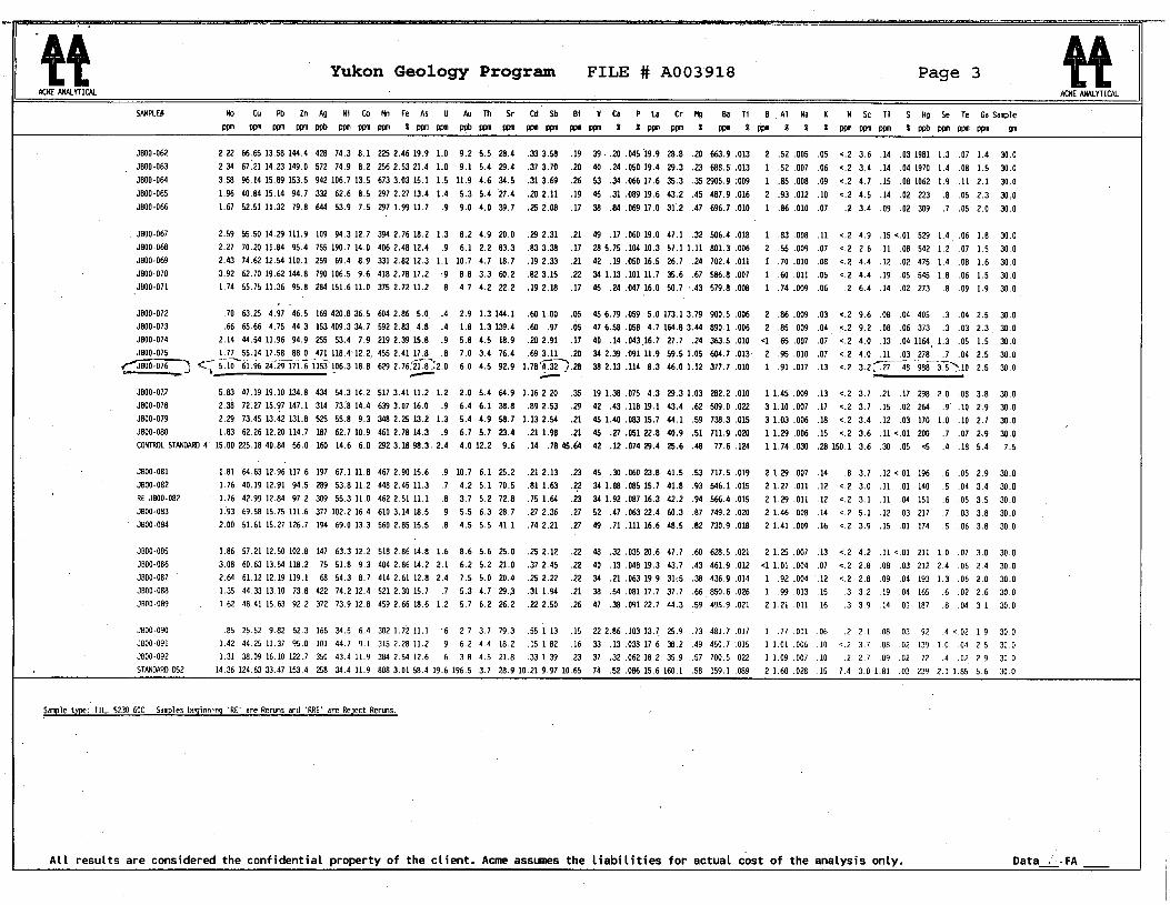
%% ' Yukon Geology Program FILE # A003‘918 1 , Page 3
NumAwurnou MMEAWMVUOM
5400129 Mo Cu 00 Zn Ag 01 Co Mn Fe 45 0 An In Sr 66 so 01 'v ca P La Cr. Mg 00 11 0 , 41 Na K . M Sc Tl s Hg Se Te Ga 500016mmmmwbvm'vmm Kmmvpbwnmvmwnmmlipwnmlmkmizxmnmmzwbwnumnm 91"
3000-062 - 2:22 66.65 13.50 144.4 420 74.3 0.1 225 2.46 19.9 1.0 9.2 5.5 20.4 .33 3.50 .19 39 ..20 .045 19.9 20.0 .20 663.9 .013 2 .52 .006 .05 <.2 3.6 .14 .03 1901 1.3 .07 1.4 30.03000-063 2.34 67.21 14.23 149.0 572 74.9 0.2 256 2.53 21.4 1.0 9.1 5.4 29.4 .37 3.70 .20 40 .24 .050 19.4 29.3 .23 600.5 .013 1 .52 .007 .06 <.2 3.4 .14 .04 1970 1.4 .00 1.5 30.0JBOO~064 3.53 96.14 15.09 153.5 942 106.7 13.5 673 3.03 15.1 1.5 11.9 4.6 34.5 .31 3.69 .26 53 .34 .066 17.6 35.3 .35 2905.9 .009 1 .05 .000 .09 <.2 4.7 .15 .00 1062 1.9 .11 2.1 30.03000 065 1.96 40.04 15.14 94.7 332 62.6 3.5 297 2.27 13.4 1.4 5.3 5.4 '27.4 .20 2.11 .19 45 .31 .009 19.6 43.2 .45 407.9 .016 2 .93 .012 .10 <.2 4.5 .14 .02 223 .3 .05 2.3 30.03000-066 1.67 52.51 11.32 79.3 644 53.9 7.5 297 1.99 11.7 .9 9.0 4.0 39.7 .25 2.00 .17 30 .04 .069 17.0 31.2 .47 696.7 .010 1 .36 .010 .07 .2 3.4 .09 .02 309 .7 .05 2.0 30.0
. 3000-067 2.59 55.50 14.29 111.9 109 94.3 12.7 394 2.76 10.2 1.3 0.2 4.9 20.0 .29 2.31 .21 49 .17 .060 19.0 47.1 .32 506.4 .010 1 .03 .000 .11 <.2 4.9 .15 <.01 529 1.4. .06 1.0 30.03000-060 2.27 70.20 11.34 95.4 755 190.7 14.0 406 2.43 12.4 .9 6.1 2.2 03.3 .03 3.30 .17 20 5.75 .104 10.3 57.1 1.11 001.3 .006 2 .55 .009 .07 <.2 2.6 .11 .00 542 1.2 .07 1.5 30.0J800»069 2.43 74.62 12.54 110.1 259 69.4 0.9 331 2.02 12.3 1.1 10.7 4.7 10.7 .19 2.33 .21 42 .19 .050 16.5 26.7 .24 702.4 .011 1 .70 .010 .00 <.2 4.4 .12 .02 475 1.4 .00 1.6 30.03000-070 3.92 62.70 19.62 144.0 790 106.5 9.6 410 2.70 17.2 .9 0.0 3.3 60.2 .02 3.15 .22 34 1.13 .101 11.7 35.6 .67 506.0 .007 1 .60 .011 .05 <.2 4.4 .19 .05 545 1.3 .06 1.5 30.0.JB°°'°71 1.74 55.75 11.36 95.0 234 151.6 11.0 375 2.72 11.2 .0 4.7 4.2 22.2 .19 2.10 .17 45 .24 .047 16.0 50.7 >.43 579.0 .000 1 .74 .009 .06 .2 6.4 .14 .02 273 .0 .09 1.9 30.0
3000.072 .70 63.25 4.97 46.5 169 420.0 36.5 604 2.06 5.0_ .4 2.9 1.3 144.1 .60 1.00 .05 45 6.79 .059 5.0 173.1 3.79 900.5 .006 2 .06 .009 .03 <.2 9.6 .03 .04 405 .3 .04 2.5 30.03000-073 .66 65.66 4.75 44.3 153 409.3 34.7 592 2.03 4.3 .4 1.0 1.3 139.4 .60 .97 .05 47 6.50 .050 4.7 164.0 3.44 090.1 .006 2 .05 .009 .04 ‘ 5.2 9.2 .00 .06 373 .3 .03 2.3. 30.03300-074 2.14 44.54 11.96 94.9 255 53.4 7.9 219 2.39 15.0 .9 5.0 4.5 10.9 .20 2.91 .17 40 .14 .043‘16.7 27.7 .24 363.5 .010 <1 .65 .007 .07 <.2 4.0 .13 .04 1164. 1.3 .05 1.5 30.03000-075 1.77 55.14 17.50 00.0 .471 110.4~12.2, 455 2.41 17.0 .3 7.0 3.4 76.4 .69 3.11 .20 34 2.39 .091 11.9 59.5 1.05 604.7 .013- 2 .95 .010 .07 <.2 4.0 .11 .03 >270 .7 .04 2.5 30.0W} 5:: 57107619524721.7175;1153106310.3 629 [email protected] 6.0 4.5 92.9 17033;).23 302.13 .114 0.3 46.01.12 377.7 .010 1 91.017 .13 <.2 3.27.2730 9367375110 2.5 30.0
3000-077 5.03 47.19 19.10 134.0 434 54.3 14.2 517 3.41 11.2 1.2 2.0 5.4 64.9 1.16 2.20 .35 19 1.30 .075 4.3 29.3 1.03 202.2 .010 1 1.45 .009 .13 <:2 3.7 .21 .17 290 2.0 .00 3.0 30.0mmm 2mnmu$um3un0m4m3mm09 M61a0.w2u n42m1mn1u4u5wmm 3mmw.u q3715m2a.9m29am3000-079 2.29 73.45 13.42 131.0 525 55.0 9.3 340 2.25 13.2 1.3 5.4 4.9 50.7 1.13 2.54 .21 45 1.40 .003 15.7 44.1 .59 730.3 .015 3 1.03 .006 .10 <.2 3.4 .12 .03 170 1.0 .10 2.7 30.03000.000 1.03 62.26 12.20 114.7 107 62.7 10.9 461 2.70 14.3 .9 6.7 5.7 23.4 .21 1.93 .21 45 .27 .051 22.0 40.9 .51 711.9 .020 1 1.29 .006 .15 <.2 3.6 .11 <.01 200 .7 .07 2.9 30.0CONTROL STANDARD 4 15.00 225.18 40.84 56.0 160 14.6 6.0 292 3.18 98.3. 2.4 4.0 12.2 9.6 .14 .78 45.64 42 .12 .074 29.4 25.6 .48 77.6 .124 1 1.74 .030 .28 150.1 3.6 .30 .05 <5 .4 .18 5.4 7.5
3800-081 1.81 64.63 12.96 117.6 197 67.1 11.8 467 2.90 15.6 .9 10.7 6.1 25.2 .21 2.13 .23 45 .30 .060 23.8 41.5 .53 717.5 .019 2 1.29 .007 .14 .8 3.7 .12 <.01 196 .6 .05 2.9 30.0
J800-082 1.76 40.19 12.91 94.5 289 53.8 11.2 448 2.45 11.3 .7 4.2 5.1 70.5 .81 1.63 .22 34 1.88 .085 15.7 41.8 .93 546.1 .015 2 1.27 .011 .12 <.2 3.0 .11 .01 140 .5 .04 3.4 30.0
' RE 3800-082 ' 1.76 42.99 12 84 97.2 309 55.3 11.0 462 2.51 11.1 ' .8 3.7 5.2 72.8 .75 1.64 .23 34 1.92 .087 16.3 42.2 .94 566.4 .015 2 1.29 .011 .12 <.2 3.1 .11 .04 151 .6 .05 3.5 30.0
J800-083 1393 69.58 15.75 111.6 377 102.2 16.4 610 3.14 18.5 .9 5.5 6.3 28.7 .27 2.36 .27 52 .47 .063 22.4 60.3 .87 749.2 .020 2 1.46 .008 .14 <.2 5.1 .12 .03 217 .7 .03 3.8 30.0
J800-084 2.00 51.61 15.27 126.7 194 69.0 13.3 560 2.85 15.5 .8 4.5 5.5 41.1 .74 2.21 .27 49 .71 .111 16.6 48.5 .82 730.9 .018 2 1.41 .009 .16 <.2 3.9 .15 .01 174 .5 .06 3.8 30.0
J800<085 1.86 57.21 12.50 102.8 147 63.3 12.2 518 2.86 14.8 1.6 8.6 5.6 25.0 .25 2.12 .22 48 .32 .035 20.6 47.7 .60 628.5 .021 2 1.25 .007 .13 <.2 4.2 .11 <.01 211 1.0 .07 3.0 30.0
3800v086 3.08 60.63 13.54 118.2 75 51.8 9.3 404 2.86 14.2 2.1 6.2 5.2 21.0 .37 2.45 .22 40 .13 .048 19.3 43.7 .43 461.9 .012 <1 1.01 .004 .07 <.2 2.8 .08 .03 212 2.4 .06 2.4 30.0
3800-087 2.64 61.12 12.19 119.1 68 54.3 8.7 414 2.61 12.8 2.4 7.5 5.0 20.4 .25 2.22 .22 34 .21 .063 19.9 31:5, .38 436.9 .014 1 .92 .004 '.12 <.2 2.8 .09 .04 193 1.3 .06 2.0 30.0
3800—088 1.35 44.33 13.10 73.8 422 74.2 12.4 521 2.30 15.7 .7 5.3 4.7 29.3 .31 1.94 .21 38 .54 .081 17.7 37.7 .66 _850.6 .026 l .99 .013 .15 .3 3.2 .19 '.04 165 .6 .02 2.6 30.0
JBOD-089 . 1.62 48.41 15.63 92.2 372 73.9 12.8 459 2.66 18.6 1.2 5.7 6.2 26.2 .22 2.50 .26 47 .38 .091 22.7 44.3 .59 495.9 .021 2 1.21 .011 .16 .3 3.9 .14 .01 187 .8 .04 3.1 30.0
J800v090 .85 25.52 9.82 62.3 166 34.5 6.4 302 1.72 11.1 .6 2.7 3.7 79.3 .55 1.13 .15 22 2.86 .103 13.7 25.9 .73 481.7 .017 1 .77 .011 .06 .2 2.1 .08 .03 92 .4 <.02 1.9 30.0
J800-091 1.42 44.25 11.37 95.0 101 44.7 9.1 315 2.28 11.2 .9 6.2 4.4 18.2 .15 1.82 .16 33 .13 .038 17.6 38.2 .49 450.7 1015 l 1.01 .006 .10 <.2 3.7 .08 .02 139 1.0 .04 2.5 30.0
J800-092 1.31 38.09 16.10 122.7 350 43.4 11.9 384 2.54 12.6 .6 3.8 4.5 21.8 .33 1.39 .23 37 .32 .062 18.2 35.9 .57 700.5 .022 1 1.09 .007 .10 .2 2.7 .09 .02 72 .4 .02_ 2.9 30.0
STANDARD 052 14.36 124.63 33.47 153.4 258 34.4 11.9 808 3.01 58.4 19.6 196.5 3.7 28.9 10.21 9.97 10.65 74 .52 .086 15.6 160.1 .58 159.1 .089 2 1.68 .028 .15 7.4 3.0 1.81 .03 239 2.1 1.85 5.6 30.0 Sample type; TILL 5230 606. Samg1es beginnfing 'RE‘ are Reruns and ’RRE‘ are Rejgct Reruns.
All results are considered the confidential property of the client. Acme assumes the liabilities for actual cbst of the analysis only. Data_;:-FA

%tile Range
0- 2525.1 - 50
50.1 -75
75.1-90
90.1—95
951-197
97.1 —99
99,1 . 100
PDT"
0— 1.531.531 -1.815
1.816- 2.383
2.383 — 3.128
3.129 - 3.623
3.624 - 4.297
4.298 - 6.576
6.577 — 7.9
105K” 105W 7051/3
105F/16 1056/13 7059'”
105F/9 105972 7056/1 7
105913National Topographic SystemTransverse Mercator Projection
NAD 1983UTM Grid Zone 9
Kilometers
' YUKONGEOLOGY PROGRAM
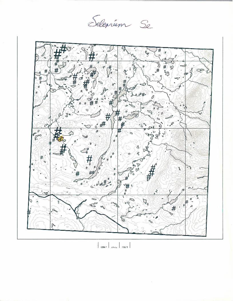
_mind;12...:
Time“_
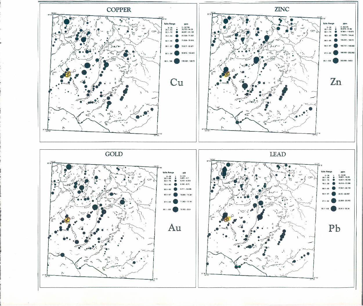
3|‘45'
IH‘DD'
COPPER
111 00‘
51111. Range mm
0- 25 - 0 32.121125.1.60 0 32728-4425
60.1- 711 O «251-51125
751- so . 51125-11927
gm . 95 . 71338-18316
90.1- 97 . 70.917. 95,571
9m. 99 . 90.672-102.421
99.1 -100 . 102522- 1211.73
8|‘45’0‘
11‘El 00’
111u- ngo
0- 2526.1-60
50.1-15
76.1-90
90.1-95
96.1-91
99.1 -100
.. . :n a
...000-
Zn
ppm
0- 00.515501175-970597.051 - 113.575
119573 - 144“
1“A41 - 182.12
162.721 - 168332
1&833- 262552
282553- 3485
51‘6‘
I37
5111": Range ppb
0 - 25 - a -2.925.1 - 60 t 2.901 - 4.750.1» 75 O 4.701- 5.125
711.1 -90 . 3.125 - 5.71
”1-55 . 1711-1031]!
95.1 - s7 . 10.806 -11.361
971.95 . 11062-13151
99.1-100 . 13.152 . 29.9
Au
51' 45’50'
51,111: Range
0- 25
26.1» 60
50.1- 10
70.11 90
97.1- 99
Pb
..
.
C9111- 95 .
991-100 .
mm
0. 10.5510001-123512301-153111
10319-171195
11.537- 10.113
10.12 - 3.067
22.050 - 16.812
16.613 - 36.24
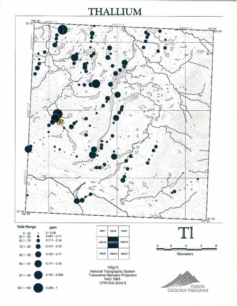
THALLIUM13”“ 00’ 3455202! 35 . 2'5.
62" 00'
62° 00'
$300
an.N
882%
{58313000m,
Nfl.»
61°45'132°00'
' 61°45131°3o'
%tile Range ppm0 25 . 0 _ 0 09 105% 105/4 105K?
251-50 0 0.091-0.1150.1-75 . o.111-o.14 105915 1056,14
75.1-90 . o.141-o.15 2 o 2 4 6
901.95 . 0.151-0.17 70599 105912 1056’" Kilometers
95.1—97 . o.171-0.19105913
National Topographic System97.1-99 . 0.191 -O.258 Transverse MercatorProjection
NAD1983UTM Grid Zone 9 W
99.1-100 0.259-1 ' ' RUN. QEGLGG‘! ?ROQRRM
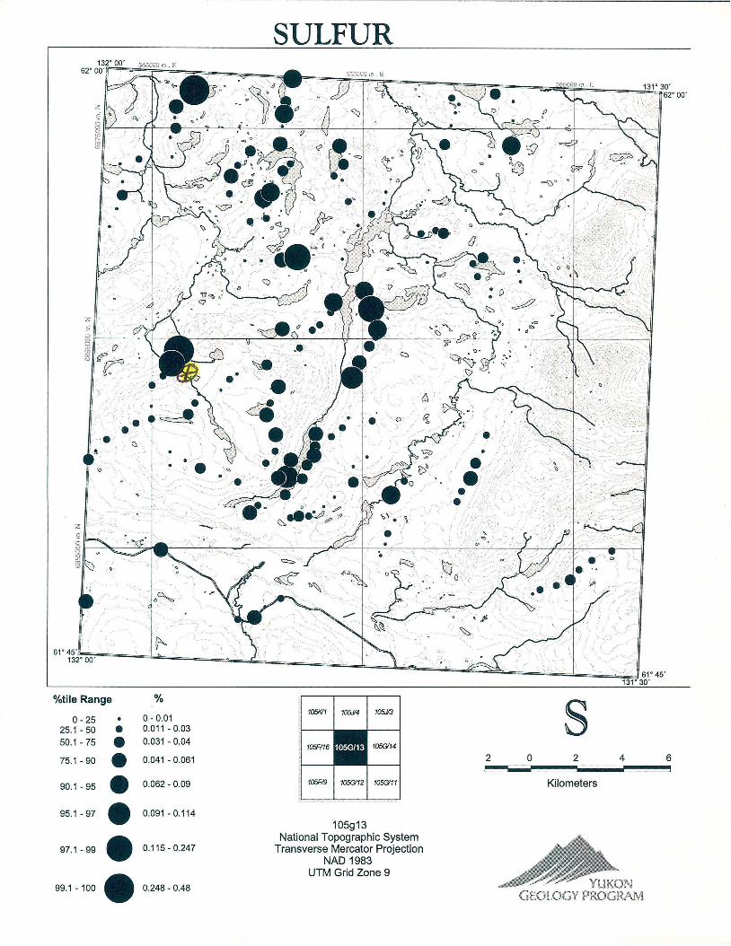
SULFUR
131° 30'62'00'
2:
g .,
61° 45'
132° 00'
61°45'131° 30'
%tile Range %0 25 . 0 _ 0 01 105K/1 10514 1051/3
25,1 . 50 0 0.011 — 0.03
50-1 ' 75 . 0'031 ' 0'04 105F/16 1056/13 105G”75.1 - 90 . 0.041 - 0.061 2 0 2 4 6
90.1 _ 95 . 0.052 _ 0.09 105F/9 1056/12 1050/11 Kilometers
95.1 -97 . 0.091 - 0.114
105913National Topographic System
97_1 _ 99 . 0.115- 0.247 Transverse Mercator Projection
NAD 1983UTM Grid Zone 9
99.1 - 100 . 0.24s — 0.48 ’ ' WKQNSKELGQY ?Kfifimm

EI'AE'm'uc' 13w s" 15‘D,
van: Rum
0-25251- 50
501» 75
751-90
99I-100
Z
0O
0
971—99 . zamannsoag
ppm
0-“44001 ~55 25
58251-32 55
82 551 - 12348
123 £81>172 745
I77 748- 284 4
426 09— 897 2
SPAS
13v arts0
'm
wneRInuc ppb
0.25 . 0-3715251.50 . 87751-152501.75 0 15200152125
751.90 . 212 501. 3583
901.95 . 35330142955
951-97 . 529651-88BM
g7 ._99 . 8894M . ugem
99‘400 . 1498911-2‘020
Hg
Wile Range ppm
0-25 . o 1488251.50 n 1439405501.75 . 2081-2583
751 no . 2584 3,303
901.95 . saos-nas
951-97 . 3m 4425
97‘.“ . 4427-812
991-100 . 3121-15137
52 w'
mileflmoc me
0-15 - 0-104251-50 0 10401-137501-75 . 13701-1a35
751-90 . 16351.25“;
901-95 . 28481-303
951.07 . 3030I-32738
J971.99 . 32739-55517
991-100 . 56518-4845
As
SILVER
FPO
0415575
sunsRunn-
‘HS751<231
u 00-25
251~50
231001
-350
50l-75
350001<5178
901-95.
5179m-78715
751590
787151-97499
97‘991-1fl77‘8
1077‘81
137‘
991-1“)
951
97
971-99
2 Q 2 4
Kilometres
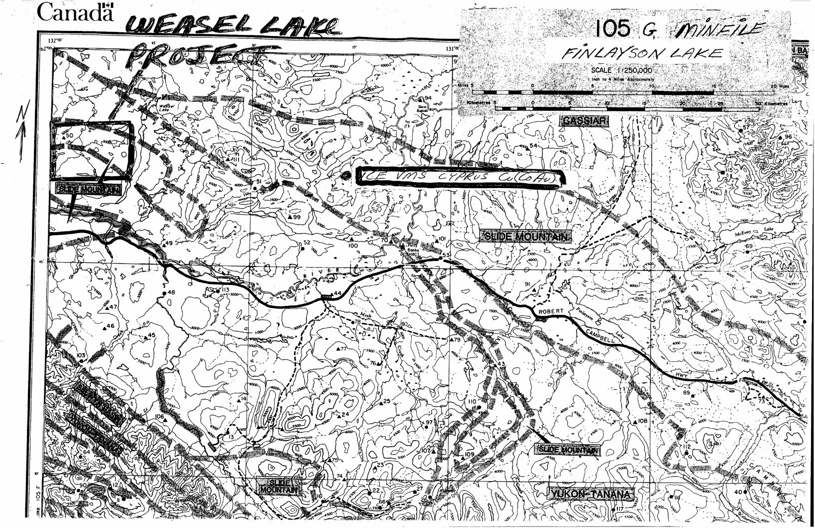
CanadaI W '
5 I
:05
F
-ake
s5
8
W. . mV m .‘
\
W
I \~
“n
, ~
‘ D ‘T" » ”aw”
, [p «7 _
'WWWWWW , W: W ~ W‘-
M&MI Ia __$~
1.
??Véfl3» ff
\g
éfi?
$%‘5’
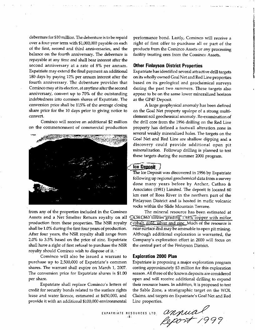
debenture for $10 million. The debenture is to be repaid performance bond. Lastly, Cominco will receive aover a four—year term with $1,000,000 payable on each right of first offer to purchase all or part of theof the first, second and third anniversaries, and the products from the Cominco Assets or any processingbalance on the fourth anniversary. The debenture is facility treating ores from the Cominco Assets.repayable at any time and shall bear interest after the
second anniversary at a rate of 8% per annum. Other Finlayson District PropertiesExpatriate may extend the final payment an additional Expatriate has identified several attractive drill targets180 days by paying 12% per annum interest after the on its wholly owned Goal Net and Red Line propertiesfourth anniversary. The debenture provides that based on its geological and geochemical surveysCominco may at its election, at anytime after the second during the past two summers. These targets alsoanniversary, convert up to 70% of the outstanding appear to be on the same lower mineralized horizon
indebtedness into comrhon shares of Expatriate. The as the GP4F Deposit.
conversion price shall be 115% of the average closing A large geophysical anomaly has been defined
share price for the 10 days prior to giving notice to on the Goal Net property upslope of a strong multi-convert. element soil geochemical anomaly. Re-examination of
Cominco will receive an additional $2 million the drill core from the 1996 drilling on the Red Line
on the commencement of commercial production property has defined a footwall alteration zone in
several weakly mineralized holes. The targets on theGoal Net and Red Line are shallow dipping and a
discovery could provide additional open pit
mineralization. Followup drilling is planned to test
these targets during the summer 2000 program.
(wThe Ice Deposit was discoveredin 1996 by Expatriate
following up regional geochemical data from a survey
done many years before by Archer, Cathro &Associates (1981) Limited. The deposit is located 60
km east of Ross River in the northern part of theFinlayson District and is hosted in mafic volcanic
_ ‘ rocks within the Slide Mountain Terrane.
from any of the properties included in the Cominco The mineral resource has been estimated atAssets and a Net‘Smelter Return royalty on all C4‘36fil‘g6‘373n’fiéfg‘fa'd‘ihg'1"4‘8'%"E'015}3er withiinifior
_...._~_u—_—_—._..
shall be 10% during the first fouryears of production. nearsurface and may be amenable to open pit mining
After four years, the NSR royalty shall range from Although additional exploration is warranted, the2.0% to 3.5% based on the price of zinc. Expatriate Company’s exploration effort in 2000 will focus on
shall have a right of first refusal to purchase the NSR the central part of the Finlayson District.royalty should Cominco wish to dispose of it. ‘ '
Cominco will also be issued a warrant to Exploration 2000 Plan
purchase up to 2,500,000 of Expatriate’s comrnon Expatriate is proposing a major exploration program
shares. The warrant shall expire on March 1, 2007. costing approximately $3 million for this explorationThe conversion price for Expatriate shares is $1.00 season. All three of the known deposits are consideredper share. open and will receive additional drilling to expand
Expatriate shall replace Cominco’s letters of their resource bases. In addition, it is proposed to test
credit for security bonds related to the surface rights the Sable Zone, a stratigraphic target on the WOL
lease and water licence, estimated at $450,000, and Claims, and targets on Expatriate’s Goal Net and Red
provide it with an additional $100,000 environmental Line properties. I
EXPATRIATE RESOURCES LTD.
. W9?
MINFILE: 1056 049
PAGE NO: 1 of 1UPDATED: / /77
YUKON MINFILEYUKON GEOLOGY PROGRAM
WHITEHORSE
NAME(S): Cow ‘ NTS MAP SHEET; 105 G 13MINFILE #: IOSG 049 ' LATITUDE: 61°46'14"N‘MAJOR COMMODITIES: 4 LONGITUDE: 131°42'53"WMINOR COMMODITIES: - DEPOSIT TYPE: UnknownTECTONIC ELEMENT: Yukon Tanana Terrane STATUS: Anomaly
CLAIMS (PREVIOUS AND CURRENT)
COW,‘BEAVER, EM
WORK HISTORY
Staked as Cow cl (88173) by Newmont in Apr/63. Restaked as Cow cl (Y7728) in May/66 by Quatsino
Copper—Gold Mines L, New Privateer ML and Blichanan ML, which performed a ground mag and EM survey inJul/67 and a small gravity survey in 1968. The Beaver c1 (Y42977) were staked immediately to the west in
Aug/70 by P. Anderson and were transferred to J.M. Veinott in 1970 and to P. Sotrer in Jan/72. Restaked as EM
c1 (YA12357) in Jan/77 by M. Sherman.
GEOLOGY
Staking was probably prompted by GSC aeromagnetic maps, which show a complex pattern in this area.
Outcrops of Tertiary gabbro or basalt were found during the geophysical survey, together with‘limestone and _schist. Further work was recommended on one EM conductor. ‘ »
REFERENCES
QUATSINO COPPER-GOLD MINES LTD, Aug/67. Assessment Report #060587 by John Lloyd.
MINFILE: 1056 050PAGE N0: 1 of 1UPDATED: ‘ / I78
YUKON NIINFILEYUKON GEOLOGY PROGRAM
WHITEHORSE
NAME(S): lElk V NTS MAP SHEET: 105 G 13MINFILE #: 1056 050 LATITUDE: 61 °53'42"NMAJOR COMMODITIES: - » LONGITUDE: 131°58'18"WMINOR COMMODITIES: -. DEPOSIT TYPE:' UnknownTECTONIC ELEMENT: Slide Mountain Terrane STATUS: Uncertain
CLAIMS (PREVIOUS AND CURRENT)
ELK, CUP
WORK HISTORY
Staked as Elk cl (86617) by Newment in Oct/63. More staking (Cup cl 89718) was done in Dec/65 tothe east by individuals. This activity was based on aeromagnetic data and did not 1ead to any significant follow upwork.
GEOLOGY
The claims cover an area of extensive overburden with allochthonous Permian or older basalt and
quanZ-carbonate rock capping hilltops.
MINFILE: 105G 051PAGE NO: 1 of l
UPDATED: 08/21/96
YUKON MINFILE
YUKON GEOLOGY PROGRAM
WHITEHORSE
NAME(S): Chow NTS MAP SHEET: 105 G 14MINFILE #: 1056 051 - LATITUDE: 61°50'29"NMAJOR COMMODITIES: Zn LONGITUDE: 131°29'20"W
MINOR COMMODITIES: Pb,Cu DEPOSIT TYPE: Volcanogenic?
TECTONIC ELEMENT: Yukon Tanana Terrane STATUS: Drilled Prospect
CLABVIS (PREVIOUS AND CURRENT)
KAY, PALO, GAY, GEM, BB, POLO, JIM, ISKUT, WIT, MY, FRET, DOT, PLAY
WORK HISTORY
Staked as Kay cl (Y16398) in Sep/66 by Kerr Addison ML following regional geochem surveys.Restaked as Palo c1 (Y73482) in Jun/73 by A. Harmon and as Gay c1 (Y83797) in Oct/74 by A. Carlos. RestakedasGem cl (YA156) in Ju1/76 by A. Carlos and optioned to Yukon Revenue ML which added BB, etc cl (YA889)in Sep/76-Jan/77 and performed mapping and soil sampling in 1976 and 1977 and drilled several holes in 1977.The property was transferred in Dec/80 to Harjay EL.
Fringe staking between Nov 76 and Oct/77-included Polo c1 (YA11972) by Welcome North ML and Jim .
cl (YA12042) by P.S. White to the southwest; Iskut c1 (YA12834) by Iskut Silver ML to the northwest; Wit c1
(YA12026) by E. Wedekind to the south; and MY cl (YA12212) by Marge Enterprises L. .1n June/94 Cominco restaked the property as the Fret cl 1-51 (YBSOOZ3). In the same month Cominco
staked the Dot c1 1-76 (YB49847) 5 km to the southwest. In MaI/95 Expatriate Resources Ltd 'staked Play c1 1-64
(YB59231) on the northwest boundary of the Fret claims. In Aug/95 Expatriate staked Play CI 77-88 (YB60923)
on the western end of their claim block.
GEOLOGY
' Pyritic siderite veinlets and breccia fillings carrying minor amounts of galena, sphalerite and chalcopyritehave been found as float near a small diorite body in an area underlain by phyllite, schist, dolomite and schistosevolcanic rocks mapped as Klondike Schist (Permian).
Yukon Revenue loomed a copper-zinc anomaly over a strongly leached area from which selected
specimens of phyllite assayed up to 2.2% Zn and 0.5% Pb. The drilling intersected pyritic schist with traces of
galena, chalcopyrite and sphalerite. The best core assays returned 0.5% Zn, 0.1% Pb and 0.03% Cu over 1.5 m.
REFERENCES
BRENDEX RESOURCES LTD, Feb/77. Assessment Report #0602083 by C .L. Smith.
MARGE ENTERPRISES LTD, Feb/77. Assessment Report #0602084 by D.W. Goodbrand & A.E. Nevin.
MINERAL INDUSTRY REPORT 1976, p. 206; 1977, p. 80. .
YUKON REVENUE MINES LTD, Sep/76. Vancouver Stock Exchange Open File by J .J . Crowhurst.
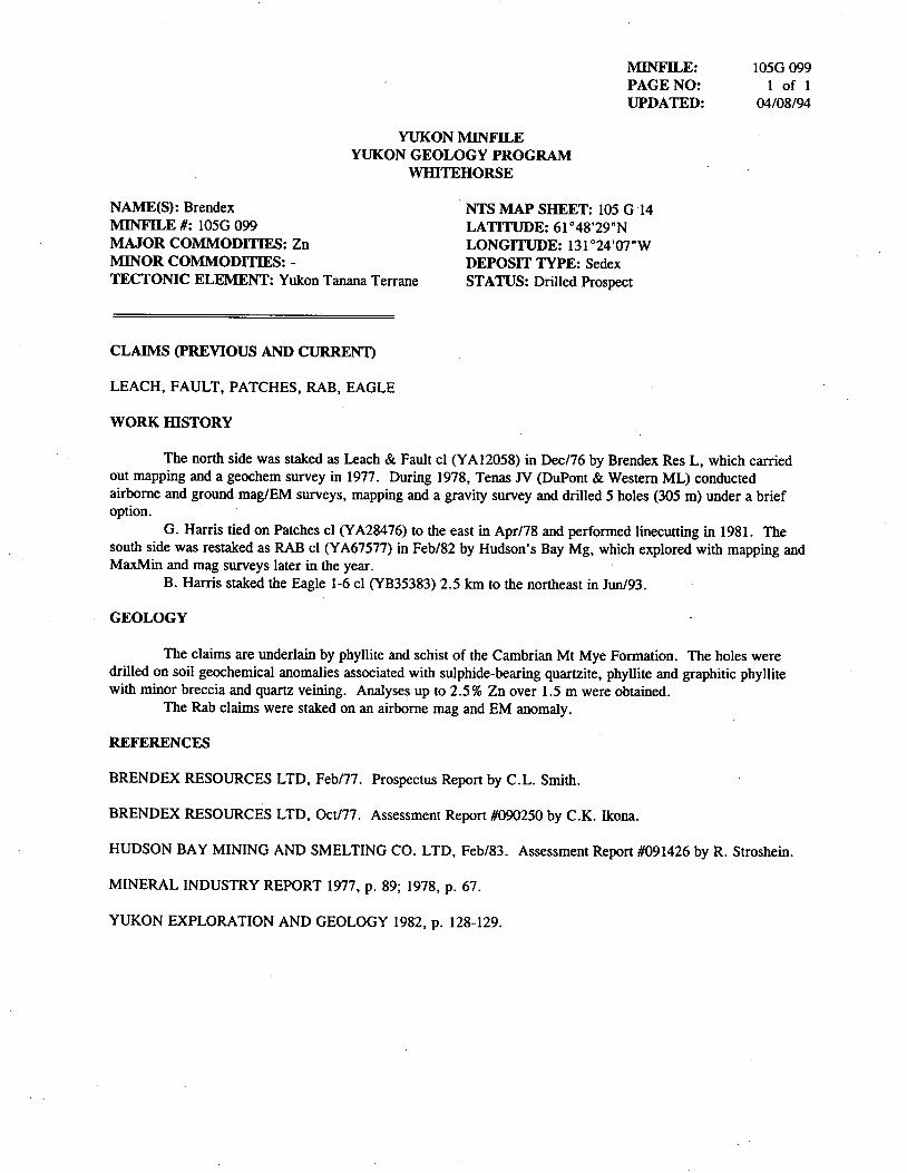
MINFILE: 1056 099
PAGE NO: 1 of 1UPDATED: 04/08/94
YUKON MINFILEYUKON GEOLOGY PROGRAM
WHITEHORSE
NAME(S): Brendex ' NTS MAP SHEET: 105 G '14MINFILE #: 1056 099 LATITUDE: 61°48'29"NMAJOR COMMODITIES: Zn LONGITUDE: 131°24'07"WMINOR COMMODITIES: - DEPOSIT TYPE: SedexTECTONIC ELEMENT: Yukon Tanana Terrane STATUS: Drilled Prospect
CLAIMS (PREVIOUS AND CURRENT)
LEACH, FAULT, PATCHES, RAB, EAGLE
WORK HISTORY
The north side was staked as Leach & Fault c1. (YA12058) in Dec/76 by Brendex Res L, which carriedout mapping and a geochem survey in 1977. During 1978, Tenas JV (DuPont & Western ML) conductedairborne and ground mag/EM surveys, mapping and a gravity survey and drilled 5 holes (305 111) under a briefoption.
G. Hanis tied on Patches cl (YA28476) to the east in Apr/78 and performed linecuttingm 1981. Thesouth side was restaked as RAB cl (YA67577)1n Feb/82 by Hudson's Bay Mg, which explored with mapping and
MaxMin and mag surveys later1n the year.
B. Harris staked the Eagle 1-6 c1 (YB35383) 2.5 km to the northeast1n Jun/93.
GEOLOGY
The claims are underlain by phyllite iand schist of the Cambrian Mt Mye Formation. The holes weredrilled on soil geochemical anomalies associated with sulphide-bearing quartzite, phyllite and graphitic phyllitewith minor breccia and quartz veining. Analyses up to 2.5% Zn over 1.5 m were obtained.
The Rab claims were staked on an airborne mag and EM anomaly.
REFERENCES
BRENDEX RESOURCES LTD, Feb/77. Prospectus Report by C.L. Smith.
BRENDEX RESOURCES LTD, Oct/77. Assessment Report #090250 by CK. Ikona.
HUDSON BAY MINING AND SMELTING CO. LTD, Feb/83. Assessment Report #091426 by R. Stroshein.
MINERAL INDUSTRY REPORT 1977, p. 89; 1978, p. 67.
YUKON EXPLORATION AND GEOLOGY 1982, p. 128-129.
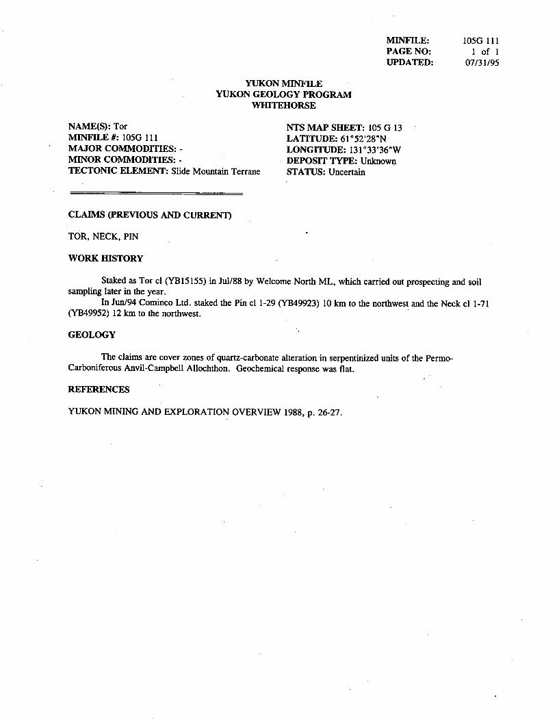
MINFILE: 1056 111PAGE NO: 1 of lUPDATED: 07/3 1 /95
YUKON MINFILEYUKON GEOLOGY PROGRAM
WI-IITEHORSE
NAME(S): Tor NTS MAP SHEET: 105 G 13MINFILE #: IOSG 111 LATITUDE: 61°52'28"NMAJOR COMIVIODITIES: - LONGITUDE: 131°33'36"WMINOR COMNIODITIES: - 1 DEPOSIT TYPE: UnknownTECTONIC ELEMENT: Slide Mountain Terrane STATUS: Uncertain
CLAIMS (PREVIOUS AND CURRENT)
TOR, NECK, PIN
WORK HISTORY
Staked as Tor c1 (YB15155) in Jul/88 by Welcome North ML, which carfied out prospecting and soilsampling later in the year.
In Jun/94 Cominco Ltd. staked the Pin cl 1-29 (YB49923) 10 km to the northwest and the Neck cl 1-71
(YB49952) 12 km to the northwest.
_ GEOLOGY
The claims are cover zones of quartz-carbonate alteration1n serpentinized units of the Permo-
Carboniferous Anvil--Campbell Allochthon. Geochemical response was flat.
REFERENCES
YUKON MINING AND EXPLORATION OVERVIEW 1988, p. 26-27.
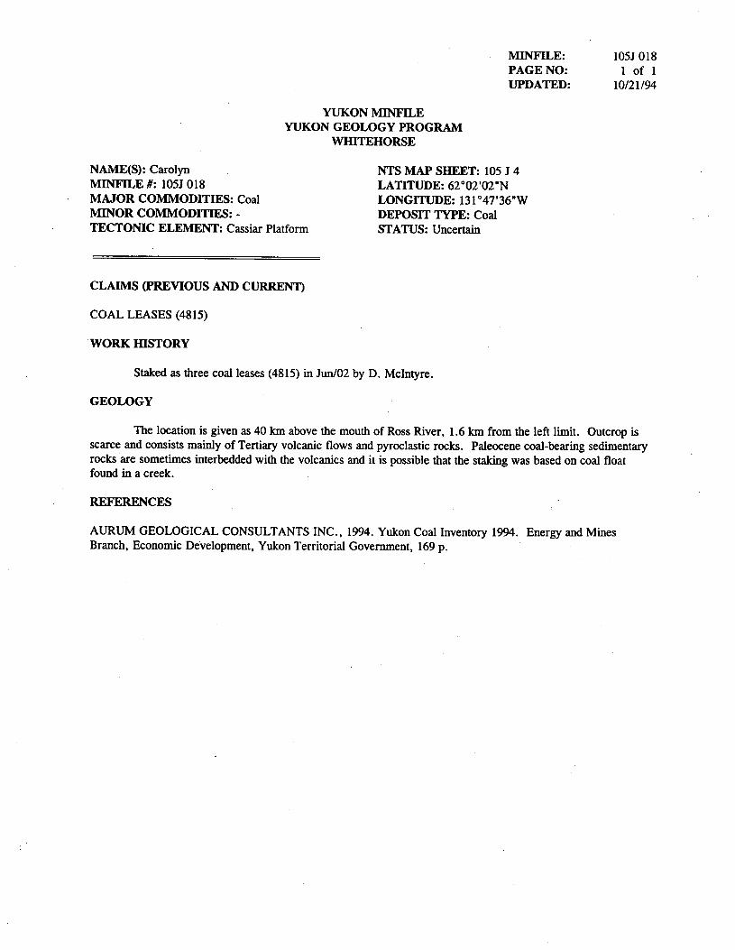
MINFILE: 105] 018PAGE NO: 1 of 1
UPDATED: 10/21/94
YUKON MINFILE
YUKON GEOLOGY PROGRAM
WHITEHORSE
NAME(S): Carolyn V ' NTS MAP SHEET: 105 J 4
MINFILE #: 105J 018 LATITUDE: 62°02'02"N
MAJOR COMMODITIES: Coal LONGITUDE: 131°47'36'W
MINOR COMMODITIES: - DEPOSIT TYPE: Coal
TECTONIC ELEMENT: Cassiar Platform STATUS: Uncertain
CLAIMS (PREVIOUS AND CURRENT)
COAL LEASES (4815)
"WORK HISTORY
Staked as three coal leases (4815) in Jun/02 by D. McIntyre.
GEOLOGY
The location is given as 40 km above the mouth of Ross River, 1.6 km from the left limit. Outcrop isscarce and consists mainly of Tertiary volcanic flows and pyroclastic rocks. Paleocene coal-bearing sedimentaryrocks are sometimes interbedded with the volcanics and it is possible that the staking was based on coal floatfound in a creek.
REFERENCES
AURUM GEOLOGICAL CONSULTANTS INC., 1994. Yukon Coal Inventory 1994. Energy and Mines
Branch, Economic De'velopment, Yukon Territorial Govermnent, 169 p. ' '
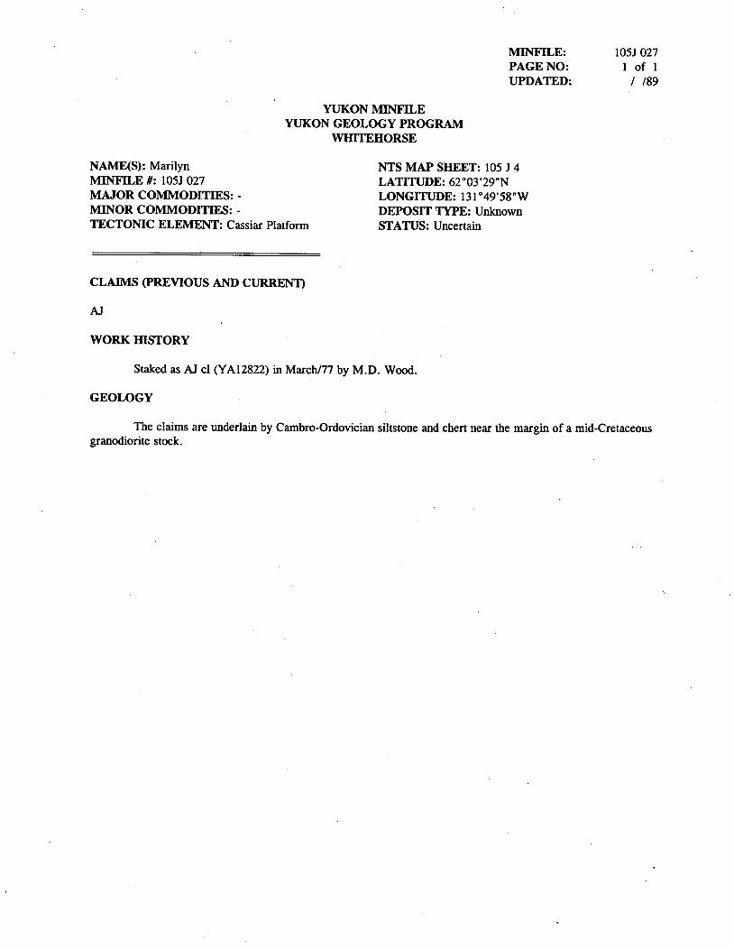
IVIINFILE: 105] 027
PAGE NO: 1 of l
UPDATED: / /89
YUKON MINFILE
YUKON GEOLOGY PROGRAM
WHITEHORSE
NAME(S): Marilyn NTS MAP SHEET: 105 J 4 _
MINFILE #: 105] 027 LATITUDE: 62°03'29"N
MAJOR COMMODITIES: - LONGITUDE: 131°49'58"W
MINOR COMMODITIES: - DEPOSIT TYPE: Unknown
TECTONIC ELEMENT: Cassiar Platform STATUS: Uncertain
CLAIMS (PREVIOUS AND CURRENT)
AJ
WORK HISTORY
Staked as A] c1 (YA12822) in Marqh/77 by MD. Wood.
GEOLOGY
The claims are underlain by Cambro-Ordovician siltstonc and chcrt near the margin of a mid~Cretaceousgranodiorite stock.
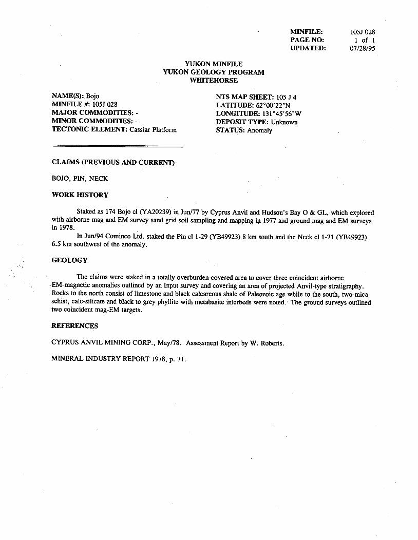
MINFILE: 105] 028PAGE NO: 1 of l
UPDATED: 07/28/95
YUKON MlNFILEYUKON GEOLOGY PROGRAM
WHITEHORSE
NAME(S):. Bojo NTS MAP SHEET: 105 J 4MINFILE #: 105] 028 LATITUDE: 62°00'22"NMAJOR COMMODITIES: - . LONGITUDE: 131°45'56"WMINOR COMMODITIES: - DEPOSIT TYPE: UnknownTECTONIC ELEMENT: Cassiar Platform STATUS: Anomaly
CLAIIVIS (PREVIOUS AND CURRENT)
BOJO, PIN, NECK
WORK HISTORY
Staked as 174 Bojo cl (YA20239) in Jun/77 by Cyprus Anvil and Hudson' 5 Bay 0 & GL, which exploredwith airborne mag and EM survey sand grid soil sampling and mapping in 1977 and ground mag and EMsurveysin 1978.
In Jun/94 Cominco Ltd. staked the Pin' cl 1-29 (YB49923) 8 km south and the Neck cl 1-71 (YB49923)6.5 km southwest of the anomaly.
GEOLOGY
The claims were staked in a totally overburden-covered area to cover three coincident airborne1. EM--magnetic anomalies outlined by an Input survey and covering an area of projected Anvil——tyPe stratigraphyRocks to the north consist of limestone and black calcareous shale of Paleozoic age while to the south, two-micaschist, calc-silicate and black to grey phyllite with metabasite interbeds were noted. The ground surveys outlinedtwo coincident mag—EM targets.
REFERENCES
CYPRUS ANVIL MINING CORR, May/78. Assessment Report by W. Roberts.
MINERAL INDUSTRY REPORT 1978, p. 71.
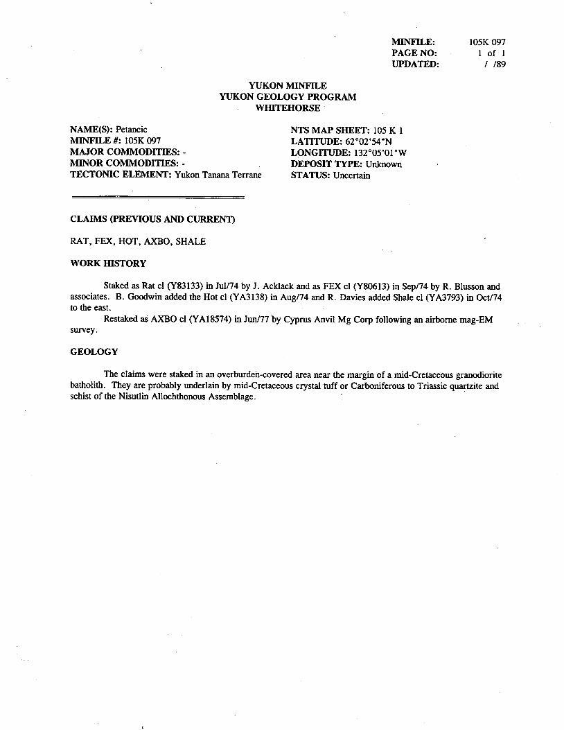
MINFILE: 105K O97PAGE NO: 1 of l
UPDATED: / /89
YUKON IVIINFILE
YUKON GEOLOGY PROGRAM
WHITEHORSE '
NAME(S): Petancic NTS MAP SHEET: 105 K 1
MINFILE #: 105K 097 LATITUDE: 62°02'54"N
MAJOR COMMODITIES: - LONGITUDE: 132°05'01"W
MINOR COMMODITIES: - . DEPOSIT TYPE: Unknown
TECTONIC ELEMENT: Yukon Tanana Terrane STATUS: Uncertain '
CLAIMS (PREVIOUS AND CURRENT)
RAT, FEX,- HOT, AXBO, SHALE
WORK HISTORY
Staked as Rat cl (Y83133) in JuI/74 by J. Acklack and as FEX c1 (Y80613) in Sep/74 by R. Blusson and
associates. B. Goodwin added the Hot cl (YA3138)1n Aug/74 and R. Davies added Shale c1 (YA3793)1n Oct/74
to the east.
Restaked as AXBO c1 (YA18574)1n Jun/77 by Cyprus Anvil Mg Corp following an airborne mag—EMsurvey.
GEOLOGY
The claims were staked in an overbuxde'n-covered area near the margin of a mid-Cretaceous granodiorite
batholith. They are probably underlain by mid-Cretaceous crystal ruffor Carboniferous to Triassic quartzite and
schist of the Nisutlin Allochthonous Assemblage.
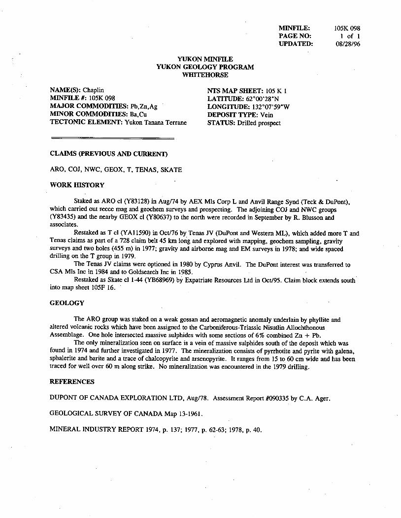
MINFILE: 105K 098PAGE NO: 1 of 1UPDATED: 08/28/96
YUKON MINFILEYUKON GEOLOGY PROGRAM
WHITEHORSE
NAME(S): Chaplin NTS MAP SHEET: 105 K 1MINFILE #: 105K 098 LATITUDE: 62°00'28"NMAJOR COMMODITIES: Pb,Zn,Ag ' LONGITUDE: 132°07'59"WMINOR COMMODITIES: Ba,Cu DEPOSIT TYPE: VeinTECTONIC ELEMENT: Yukon Tanana Terrane STATUS: Drilled prospect
CLAIMS (PREVIOUS AND CURRENT)
ARO, c0], ch, GEOX, T, TENAS, SKATE
WORK HISTORY
Staked as ARO cl (Y83128) in Aug/74 by AEX Mls Corp L and Anvil Range Synd (Teck & DuPont),which carried out recce mag and geochem surveys and prospecting. The' adjoining CO] and NWC groups(Y83435) and the nearby GEOX cl (Y80637) to the north were recorded in September by R. Blusson andassocxates.
Restaked as T c1 (YA11590) in 0ct/76 by Tenas JV (DuPont and Western ML), which added more T andTenas claims as part of a 728 claim belt 45 km long and explored with mapping, geochem sampling, gravitysurveys and two holes (455 m) in 1977; gravity and airborne mag and EM surveys in 1978; and wide spaceddrilling on the T group in 1979.
The Tenas JV claims were optioned in 1980 by Cyprus Anvil The DuPont interest was transferred toCSA Mls IncIn 1984 and to Goldsearch Incm 1985.
Restaked as Skate cl 1-44 (YB68969) by Expatriate Resources Ltdin Oct/95.C1aim block extends southinto map sheet 105F 16. '
GEOLOGY
The ARC group was staked on a weak gossan and aeromagnetic anomaly underlain by phyllite andaltered volcanic rocks which have been assigned to the Carboniferous-Triassic Nisutlin AllochthonousAssemblage. One hole intersected massive sulphides with some sections of 6% combined Zn + Pb.
The only mineralization seen on surface is a vein of massive sulphides south of the deposit which wasfound in 1974 and further investigated in 1977. The mineralization consists of pyrrhotite and pyrite with galena,sphalerite and barite and a trace of chalcopyrite and arsenopyrite. It ranges from 15 to 60 cm wide and has beentraced for well over 60 m along strike. No mineralization was encountered in the 1979 drilling.
REFERENCES
DUPONT OF CANADA EXPLORATION LTD, Aug/78. Assessment Report #090335 by CA. Ager.
GEOLOGICAL SURVEY OF CANADA Map 13-1961.
MINERAL INDUSTRY REPORT 1974, p. 137; 1977, p. 62-63; 1978, p. 40.
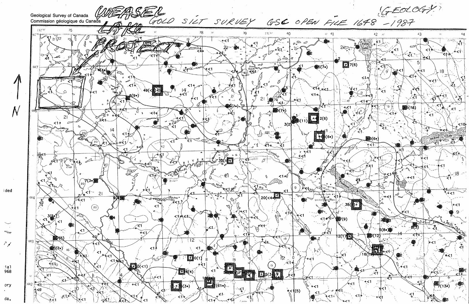
_ _ ‘ (5150216é7V‘M5/47,j’u/éz/f/(75¢0/”P/z/f/é%8’//%>¥
ided
. ‘{5711:. s l Ink: #1
11nd}
:ia]968
ory da,
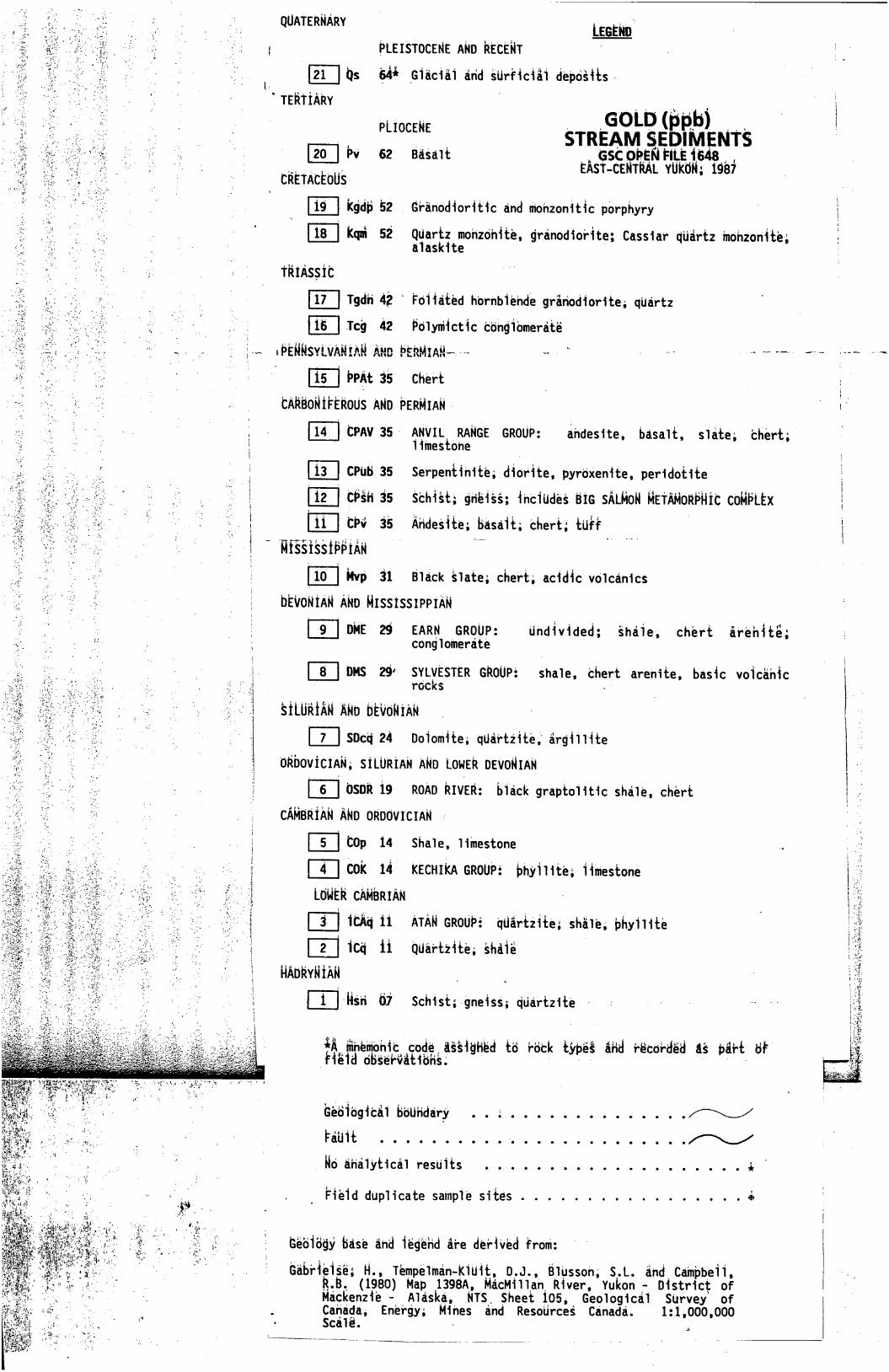
'».5'..
..
'‘
-,
1.(11m
1
.__-<
_.1_.'
__‘
4._._
___“<_<
__
_.<,_1__
.1._
1.—.
.
QUATERNARY LEGEND-; PLEISTOCENE AND AtcENT ‘
l Os 6&1 madam éti‘d sur‘r1c111 débd§115~‘TERTiARY '
PLtoCENE- GOLD“?Rb)-1 4, . STREAM SEDIMENTS
|2o 1 W ‘52 Pagan GSC OPEN FILE1648 , .1 . .- EAsT-CENTRAL Yuk’dN; 19117
CRETActoUs
Kg'dfi 52 _ GPAnod1or1t1c a‘nd mohzon1t1c pbrphyry
ani 52 quartz monzOn11:e, granod1o'r1te; Cass1ar ‘q‘tia'rfz mo‘nzon1te,a1ask1te
TAIASsiC
:17 I ngP 42 ' Fd11d£éd hbrnb1éhdé grafiod1or1te; qurtz
Ic‘g‘ 112 P'o'1yni1ct1c 'c’dh‘g1bmerd1zé
I15 ‘ PPAt 3% Cheri
tAAPoNtPtAoUs AND PERNIAN-
[III CPAV 35‘ AMVH. RANGE (yunw: éhdes1te, basalt, $1116; thért;11mes£ohe
- CPuLi 35 Serpen11n1ié; <11or11ze, pyr‘dXen1te, per1d01;11.e
:12 | CP§H 35 sch1s1; gfié1ss; 1nc1udes 316 sALNoN NETANoRPNic coNPth111' CPV 35 Andes1te;Basa1t; chart; {dff
Nf',1sstPPIAN "
10 Mvp 31 B1éck §1ate; Cheri; ac1d1c vo1cén1cs
tiONiAN AND NIsstsSIPPIAN
9 m 29 EARN- GROUP' Undivided; §ha’1e, chér’t areh1té;cong1omerate
[114$ 29' SYLyESTER GROUP: Sha1e, thert areh1’te, bas1c vo1c'é'n1c» FGCKS .'
siLURiAN AND bEvoNiAN
‘ 7| SDcd 24 Do1om1te. qUartz1te, arg11111e
0RDOVICIAN, SILURIAN AND LONER DEVONIAN
. s 050R 19 ROAD RIVER: b1ack grap£o11t1c shd1e, chért
cANBRiAN AND 0RDOVICIAN
5 ‘ COp 14 Sha1e, 11mestone
lllll Cok 11 KECHIKA GROUPi bhy1111e; 11mestone
LdNER CAMBRIAN
[ZZZ] 1ch 11 ATAN GROUPé dfifir1211é; sh51é; bhy111£é
1cq 11 huar£21té; ghaié
NADNYNiAN
l“ -MSM 61 Sch1st;-gne1ss; ddarfzité
iA‘Mnemon1c codé Asg1ghéd 16 rack tybéE Ahd réc0rdé3 11 pfirf 81V11é1d observét1ons.
hé61bgic51 Bbufidary . ................ //"\\L,//1:31.111: .......Q..'. ....... . .....N
No ana1y11ca1 resu1ts ...... . ............. A
F1e1d dup11cate samp1e s1tes ................. &
Gé613§y B&sé find 1égéfid APe déP1VPd from:
Gabr1e1se,H., Tempe1man-K1U1L, D. J., B1Ussoh, S. L. and Cdmpbe11,(1980) Map 1398A, MacM111an R1ver, Yukon - D1str1ct of
Mackenz1e - A1aska, NTS Sheet 105. Geo1ogjca1 SUrvey of. Cahada, Energy; M1nes and ResoUrceé Canada. 1:1,0005000. Sca1é.
a
1§EKRSYLVAIMIALIMAAli“D PERMIAN‘L'“ .._. -- fl 7 _ > V 1-" v ’a".S-.. - v—n.
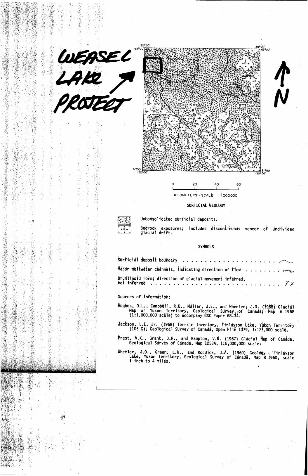
132°oo'62°OO'
d' .ra°oo
6|°OO'J’ ' .. " = .. .: swoo‘«32°00 I30°00'
40 so
y-O N O
KmOMETERS-SCALE :Joooooo
SUkFICIAL hEoLch
'Uhton501idated sUrficia] deposits.
~Be§rogk expgsUres: inc10de$ désééfi£ih0005 veheer o? Undividedg1ac1a1 dr+rt.
SYMBOLS
§u+ffcia1 aéfios%t defidéky . . . . . . . . . ; . . . . . ; . . . . . /r\\\,
fiéjdr Mé1fwé£er Chahheis; ind§cafing direciioh of ?iow . . . . . . . . *Hfiga
Drfifilipoid fdfm; direction of g1ac131 movemeni in?éfred;Hot 1hfe‘rred O O O O O O O C O C O I O I .
SoUrCes of ihforhéfioh:
) G1écié1HUghes, 0.L.; Campbé11. R,B., Mu11er, J.E., and whééIer; J.ofi (196* h.’t- M‘b 6-1968Map, of“ YukOn Territory, .Geological Surveyi-of Canada
(121,0005000 scélé) to accompany GSC Paper 68-34.
Jfitk§0h5‘L.E; Jr. (1968) Tarré§nxlnventory, F1h1éx§bn Lake, YEkon.Teryii6?y(105 G); Géb1bgicé1 SUrvey of Canada; Opeh F11é 1379; 1:12 ,000 sca1é.
Présf, V,K., Grant, D.R., and Rampton, V.N. (1967)'01acia1 flap 6? Céhdda,Gedlogita] Sdrvéy of Cénada, Map 1253A, 1:5,000,000 sca1e;
NEéé]er,, J.0., Green;_ L.H., and Rodd%ck, J.A.‘ (1960)_ Geoldgy :ifFih1éysonLake, Yukon Territory, Geological SUrvey 0F Cénadfi, Map 8-1960, scé1e1 1hch to 4 m11és. '
!.
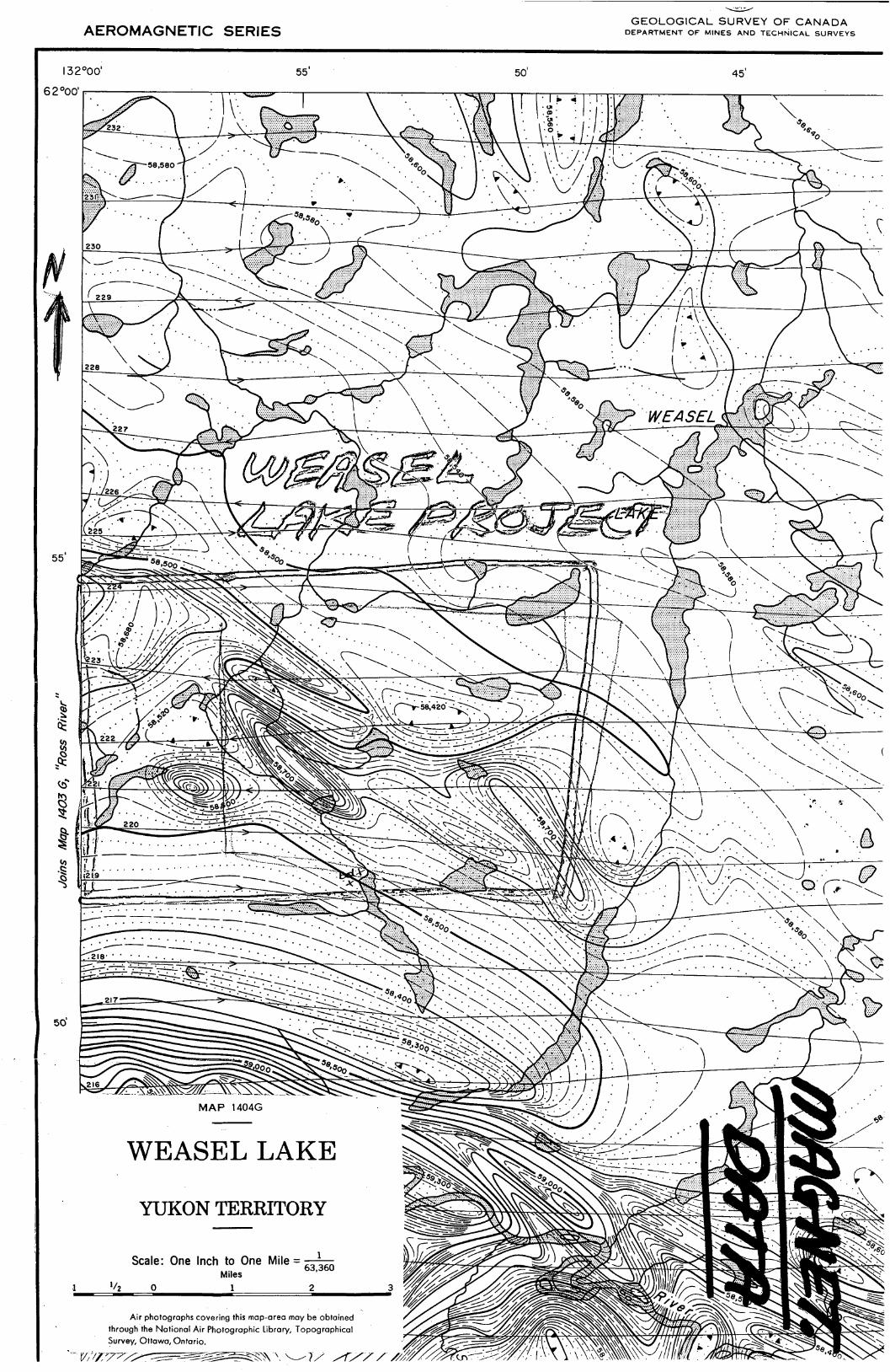
GEOLOGICAL SURVEY OF CANADAAEROMAGNETIC SERIES DEPARTMENT OF MINES AND TECHNICAL SURVEYS
I32°oo' 55'
62°00' ..
Ross
River"
II
Join
sMap
/403
6‘,
50'
MAP 1404G
WEASEL LAKE
YUKON TERRITORY
. . _ 1Scale. One InchNEiclaesOne Mlle — 63.360
.1 1/z o 1/ %/ ’\ \ - @l/f‘ 5° "
Air photographs covering this mop-oreo moy Eeiobtoined ’- ‘ g/i/M ', ‘/. ., ‘9’. F\\\\ \through'the National Air Photographic Library, Topographical \ //////f:\\\ \ H . I
' $urvey, Ottawa, Ontario.
"‘V2’/1’77//‘—7”RX“v77 ///////é////m/////~f~ k®\\\\\\\///l ta .' V A 5°" 0‘
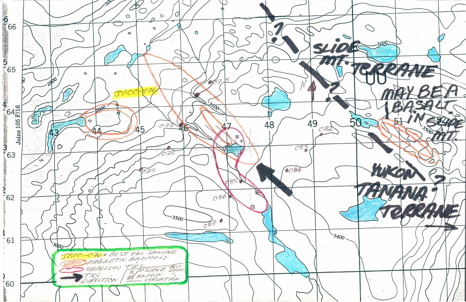
a £637” 7/44 73””7/0/5 \’ flyflM/ZE'WC fl/fflfl4a
4'7“"
//..4_'51?!“ fcczsw r c .X/k
'Z’Zd/V.7/44 F /‘/
g/fléfcflfl/v /‘Z M:7%/fl~77fl}t/ < S \
i A
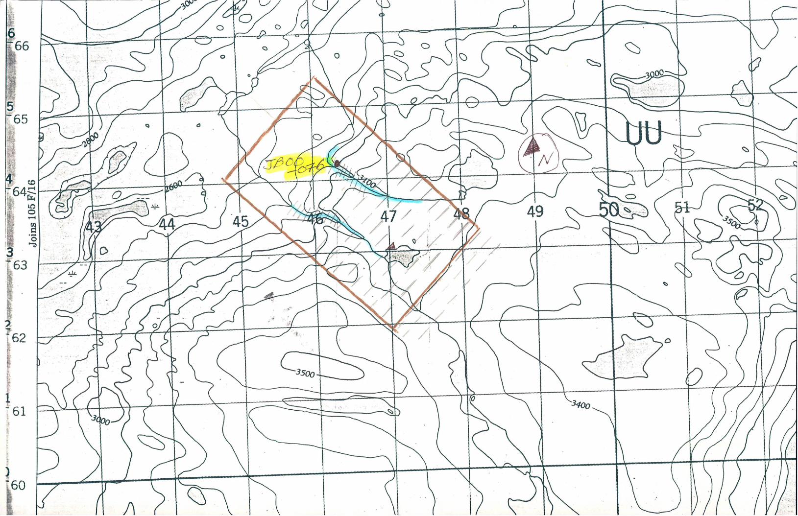
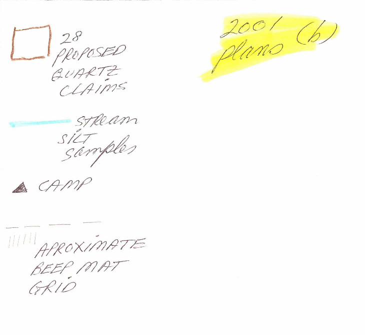
.8 mm fyflfl/fla
5/47
A, 09/7,”
'1 I fli/fléX/Mfl75
flffi/jM/W’(F%Vfl
@/ ' Z00/‘- 0 Lb
4444552442773”
W474;4/47 44442447”
[224/4244444 434472547—
4:4444%44445é4zz/44 67447)W24 2447642425444/¢Q%4444_4447~64 £54244/7444/444$7.44? @753?/4.42772 45244/
___%fl(:4/
%%44 _% 2 4/7444/4% //-— Km”(/44
Mil_(___.Aflr;/@5~F g),
77;;@if’M 2%0/4/(4/4 ”WW/SZL‘Z/W_
£44444z-44 ,4_ 342’ 7“ ' ‘ .Mé/EZZQ/ZW74% 44444494244/Gr44444444444441442471444444443444444444244% 4744444444564472/7 444444437)
L__J242444?“w4444454j/44442447~
/% 24444477; 4444474794444 @442244 4444444/444 (44472407444444j@724 444744, 4444??%W5,4495%?i474
“7224424 4444 744/ / M48
4{4442247244477444424471444%4744/72 74 /%4Z4‘4//fl4444644/mfii, Q4%7744g/77444 24'"
4444 444444444474Z§m_~_44ZC4V7
2,7545 7%”4777732972 WWW
427772,7757;75/3 (/7775J/ (722,257 5 449767557 .. 57777725777
3/5557/4:749275572577/2257
447757747777574/7/5774 572/57K4475
.. 54:55: ”/97 4571774727444237512777 "195755727446 M55574577%7577M5Z/5 :‘Wf7%ZW %7Efl//// 05/4 2255) ¢5/4/4M552
44:5 4%%54p 7674455,” 4577/“7795“521552 54 57/7@7755 57777557557(8.520%97557 W “ %/7/74,, / /
?€me 4/ A555550W 424 ,6270W/é_
{flmfifizM///74 2% 71455474 33572 727351???7957 7747/VW/W @77/
fiM/W_ _____ A / 273W7%7Mm/W.W44/?,%2 /7§45@% 77927 547977 rz/ 5/7757 7%,7174/64/27r
/~é1 5%7774747:77%;M5227 WM? Wzfiégi/
4¢ 75—75“55/72474/ 7&7fl/5 5777757 47&/74. 45/4 %7/W455W575275.4 WMMM 7 96297247257 MMM‘
77 55167” ,
Hg“@/J7x/W7?6‘”/%75447%W%55054 7%/62W/MM
7553/4750”%/Q”//W//sz7
093/4978
@ 572727?777 @7/éM/%€77%W/.,47774777WQQ
Vr7é 57W7%27/2 %¢e%//M__ _- 4/ 37972722479777 M77W 74745177477
74 77/9747_7%7€77%727477e @x/Qfiz/7/2 0%A7 7%77:, Cs”W[674/4 //5/9 77/4. -
l/4772é , %é?M//%/727WWW//WKMLK/a 17/ .. 77%
@wwflMmé. 7.4M?7777/ M77£47,777
“Wfifim7
774/V7747&MQ%WM/MM%g7” 7477/7/7 7mg4WM€ZW%M777/524 4777'777:7 4.777177%W57
77; 7? 77M 2977% 07/..
fl/é 74/9/77 £48047: 3: 7’46
'75, M 7776/mWW7/7747/m
8&72/757977777 Q’A’/f’07:.QC%v¢?/7‘:7%//. 7W5W
Wffl/%7zdWMWM%/
747%)W-7 mm:7747477
0?%4/47 55M .— flW/MWmflM
_.._::/I/7__:7&57M [720777 4 57557777//%
@WWWMM w/Maéa/zmw
7’73. >AZ:@77771/7744/72’ " _<.7L:Q5 . " ,;___-_._.
_.@Q/7%é Z? 764 [417%,7 0:4777747;
“/22? QW/l/ 277797952 /,44{M W, ,7/
£67677; 777.7% 52777 77 7/
WQa/éw771/729?
.7
?%Wfl?/¢2/W#/747/%W//WmMm/’ WW (M/zé/éza/L/Zce éw
5’” 7777/7W{Wx/fwjjr/Vo/ ’7”. 77747776247/5/70 ..
u’ ’9
7%77/69/4427; M 74? 77/22/# mW’Wé‘wwwflé/é 42 fl4W7%;27/77744M?AM K5747 WMZ/P/m/ WA 7
‘ 47'
/#/#z/ 77:724Xm /;/’Jy/fl/Z/éwW .7:&700z4# 442/47 664745723 '
757767277 7,67%;77/67; M7%
WQfl/fl/fl 7’4flw/ flg/V/ ' flé
Wflzfl , M ~74E‘ fl/WZ’W /V4/ 4—7;;
v/Zé4flg# M
V/fl‘MZéw/é . $12,774 ”/5
54427 F 757% fl/er;
flzaflgg’/ 537/ /6&444/ >Sée// ) W4?"‘74?7%7417é72/4/ § ./
/;JW:WM- fl/flJZ/ZzJ/éz//74/714/4
WWWW.44946/9715,7.23/74 fl/é/
__Q;Z‘3.2€7(fl/ gw_é/j’gé 574:4:97677””7%./
,4’ ?% 47M %/yMp; //
. fifléfléés‘flegj#%%gz#
NIINFILE: 105F 080PAGE NO: 1 of 2 -
UPDATED: 07/ 14/95
YUKON MINFILE
YUKON GEOLOGY PROGRAM
WHITEHORSE
NAME(S): Nokluit NTS MAP SHEET: 105 F 8
MINFILE #: 105F 080 LATITUDE: 61°29'00"N
MAJOR COMMODITIES: Th,REE,Nb,Ag,Pb LONGITUDE: 132°10'00"W
MINOR COMMODITIES: U,F,Ba,Zn,Cu,Au DEPOSIT TYPE: Vein
TECTONIC ELEMENT: Cassiar Platform STATUS: Prospect
CLAIMS 4
,1 ' ’9‘U _ r_,______ .. .\
KAY? NOKLUIT, KETZA; LANCER: DIG.' 7 "" i . 7"
WORK HISTORY
The syenite stock and associated fluorite and barite were first noted by British Yukon ECL on its Kay CI
(69843), staked in Oct/54 and mapped in 1955. The radioactiVity and rare earth minerals were discovered byUkon JV (Chevron and Kerr Addison), which staked the Nokluit cl (YA567) in Aug/76 and explored with
mapping, soil sampling and radiometric surveys in 1976 and 1977 and wide-spaced rock sampling in 1979.
The north side was restaked as Ketza c1 (YA72436) in Oct/84 by a joint venture between Quillo’ Res Inc
and High River Res L“, which performed mapping and geochem sampling in 1985. In 1987, Canamax Res Incperformed airborne mag, geochem and VLF-EM surveys under an option. The claims were transferred toCanamax in May/89 then returned to Quillo and High River in Dec/89_.
Restaked as Lancer claims (YB33962) in May/91 by J. Dodge, who prospected and sampled that year
and transferred the claims to Dodgex Ltd in Jan/92. Dodge added the Lancer 9—10 cl (YB_46275) and the Dig 1-2
c1.(YB46273) in Sep/93, and performed hand trenching, sampling and a scintillometer survey. In June/94 Dodge
carried out further trenching on Lancer cl 8 (YB33969).
GEOLOGY
{r&adioactive and rare earth ifiirierals are associated withmmwm skarns peripheral to a small ,‘Mississippian syenite stock cutting Cambrian carbonate rocks. Similar minerahzation 1s found nearby 1n narrow y
siliceous vems cumng trachyte and tuff of Mississipplan age. Assays range up to 3200 ppm Th, 74 ppm U, 2000 ' '
ppm Ce, 2000 ppm La, 2000 ppni Nd, 2000 ppm Y and 0.95% Cbzos. The best chip sample collected in 1979contained 1.2% rare earth elements and 0.5% niobium across 10 m. _
Mapping by J. Dodge in 1991 showed that the rare earth elements are concentrated throughout a 3 to 8 m
wide silicified and carbonatized zone in a metasomatized syenite dyke. The zone is slightly radioactive and has astrike of 120°a11d a subvertical dip. Petrographic analysis of a piece of leucocratic syenite showed that it consistsalmost entirely of fresh perthitic K feldspar, with up to 10% plagioclase, 10% quartz and 16% carbonate. Alongthe mineralized zone the syenite is altered to an almost structureless quartz-carbonate rock with relict lathtextures. A more melanocratic phase of the syenite stock consisted of 53% albite and 28% aegirine, and lesseramounts of carbonate, hematite, fluorite, phlogopite and quartz.
Two galena-sphalerite showings were located by Quillo/High River. Grab samples of galena—rich and
sphalerite-rich talus about 2 km northwest assayed 42.8% Pb, 1230. 8 g/t Ag, 4.8% Zn and 0.07 g/t Au; and17.7% Zn, 1.0% Pb, 48.0 g/t Ag and 0.03 g/t Au, respectively. This mineralization occurs in Lower Cambrianlimestone near a major northwest-trending regional fault. _
The secorid showing, one km to the northwest, consists of a northeast-trending vein swarm inSiluro-Devonian carbonate rocks. Individual veins are less than 4 cm wide within a zone that is 30 m wide. Agrab sample assayed 918.8 g/t Ag, 25.1% Pb, 0.1% Cu and 0.07% Zn.
MINFILE: 105F 080PAGE NO: 2 of 2UPDATED: 07/21/95
REFERENCES
BRITISH‘YUKON EXPLORATION CO. LTD, Jan/56. Assessment Report by A.E. Aho & W.A. Padgham.
DODGEX LTD, Jul/9Q. Assessment Report #093036 by J .8. Dodge.
DODGEX LTD, May/94. Assessment Report #093196 by LS. Dodge.
MINERAL INDUSTRY REPORT 1976, p. 190-191; 1977, p. 80.
QUILLO RESOURCES INC./HIGH RIVER RESOURCES LTD, Mar/86. Assessment Report by C.G. Verleyr
UKON JOINT VENTURE, Jan/77, Db‘cl79 & Jan/80. Assessment Reports #090574 & 090577 by AR. Archer.
YUKON EXPLORATION 1987, p. 153. I ~
YUKON GEOLOGY & EXPLORATION 1979-80, p. 55—59, 175.
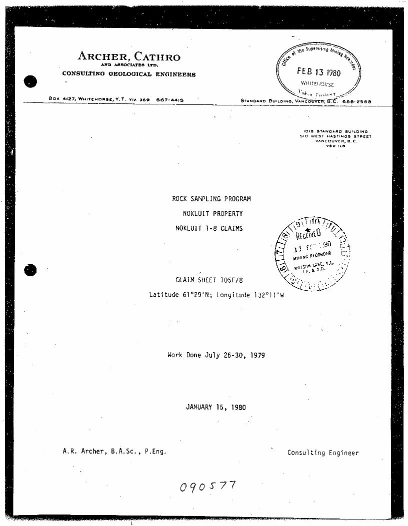
ARCHER,-CATHROum mmms LTD.
CONSULTING GEOLOGICAL ENGINEERS
Box «27,Wnntnons:,Y.T. vu :59 667-4495
<upflvisf‘x. \r. f . _\ me 3 I11," \
(
4"\J,1
a..
2y-&\6
FEB 131980\‘v’HHEHCfiSE
\ )ul“;.’1 r1:l\:.€-‘(Y"-/;’r"
Snnouzo BUILDING, VAnco’Uth‘, 87C. eoe~2see
IOIG SYANOARD BUILDING
SIC WEST HASTINGS SYREEY
VANCOUVER, B.C.
v68 lLb
ROCK SAMPLING PROGRAM
NOKLUIT PROPERTY
NOKLUIT 1-8 CLAIMS
CLAIM SHEET 105F/8
Latitude 61°29'N; Longitude 132°11'w
Work Done.Ju1y 26-30, 1979
JANUARY 15, 1980
A.R. Archer, B.A.$c., P.Eng.
Consulting Engineer
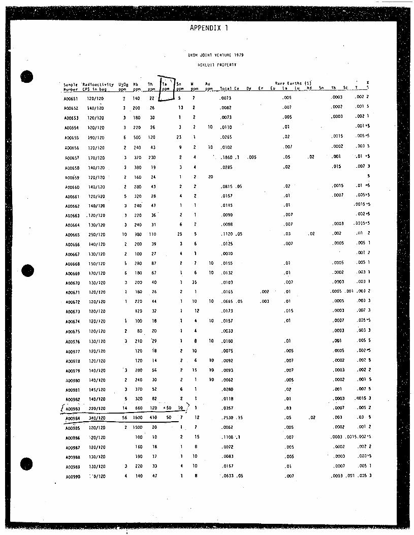
APPENDIX 1
UKON JOHN VUHURE I979
HOKLUH PROPER”
' 50mph ‘RafloachHy U308 Nb 1h F1511 H Au ere [arthx (’J
.Numbcr CPS in bag ppm_ppfl| ppm ppm ppm ppm ppm 10151 Ce Dy Er (0 LI Lu Nd
400551 120/120 2 140 22' . . 5 .0073 .005
400052 140/120 3 .200 26 13 .0002 ' .007
400553 1201120 3 30 1 .0073 .005
400054 120/120 26 3 ‘ .01
400055 190/120 . 120 23 1.02
400055 120/120 43 .007
400657 170/120 230 i . . .05
400650 140/120 19 .02
400059 120/120 ' 24
400060 140/120 4:
4001561 120/120 , 20
400052 140/120 ' 47
400603 .120/120 30
400654 130/120 3 31
400655 250/120
A00666 140/120
400667 130/120
400560 150/120
400059 170/120
400670 130/120
400571 120/120
A00672 120/120
400673 120/120
400574 1201120
400575 120/120
4009 76 130/120
400977 120/120 ' . . . .00225
400970 120/120 . . ' . . .002 5
400979 140/120 ' .0093 . . .002 2
400900 140/120 .0052' . , . .001 5
400901 145/120 _ .0200 . . .007 5
400902 140/120 __ . __ .0110 . . .0015 3
[400900 _ 220/120 .. 1 .0357 . V . .005 2
Y 400904 340/120 7 ' .2530 .15 . . . . .03 5
400905 120/120 ' , .0052 l. . .001 2
400905 120/120 I . . . 0015.002 .5
400907 120/120 . . .0002 .002 2
400900 130/120 . ‘ .0003 .' ' .0003 .00315
400909 130/120 .0157 . .0007 .005 1
400990 20/120 -.0633 .05 . .0003 .031 .005 3,
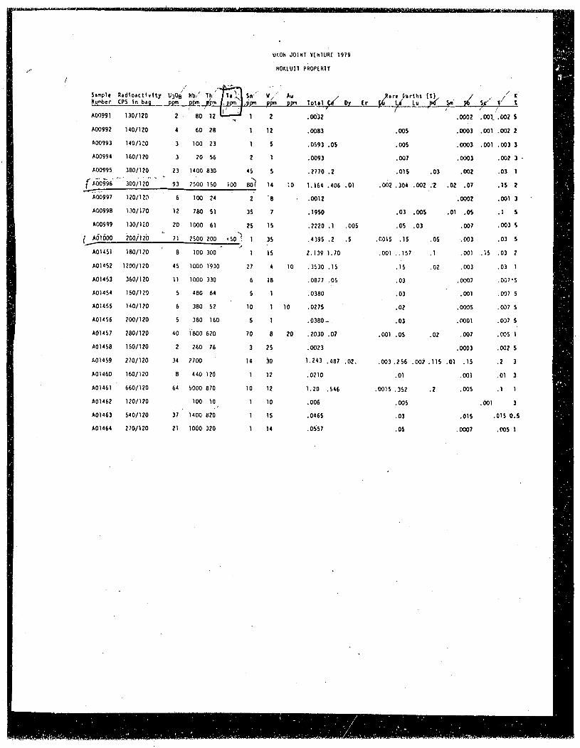
0205 00131 vtn1uat 1979
P0"
.31 . #3031011 23005311
i." ‘ A 1'
1:11;: 2121:1122}; 11:121. :52 3:. :3; 12.1.1321. .. 124154411192 ..4 ,2 s." 2’:300991 130/120 '2 . I 50’ 12 ‘1‘" 1 2 .0032, / - I .0002 [.001/.002 5300992 140/120 4 50 25 1 12 .0053 . .005 .0003 .001 .002 2
.300993 140/120 3 100 23 1 s '.0593 .05 .005 .0003 .001 .003 3_ 300994 150/120 3 20 55 2 1 .0093 .007 .0003 .002 3 - ,
in 300995 350/120 . 23 1400 530 45 5 .2770 .2 .015 .03 .002 .03 1 .4’ f_ 2; {"300505 'Il300/120v‘ 93 2500 150 100 '30? 14 10 1.154 .405 .01 .002 .304 .002 :2 .02 .07 .15' 2 1
" (300997 120/120 ' ' 5 100 24 i 2' '5 1 .0012 ' I .0002 .0013 '300995 130/120 12 250 51 35 7 .1950 .03 .005 .01 .05 .1 5
‘L. 300999 130/120 20 1000 51 25 15 .2220 .1 .005 .05 .03 .007 .003 5
1? 1 361000 2o0i120 L 71 2500 200 <50 1 1 35 .4395 .2 .5 .0015 .15 .05 .003 .03 5
2: " 301451 150/120 ' a 100 300 5 J 1 15 2.139 1.70 .001 ..157 .1 .001 .15 .03 2
il 301452 1200/120 . 45 1000 1930 27 4 10 .3530 .15 .15 4.02 .003 .03 1
j‘ 301453 350/120 11 1000 330 5 1a .0571 .05 .03 .0007 .001-5
4; 3m4u 1w/uo 5 mo u 5 1 .omo 03 ' .m1 .m7s
in 301455 140/120 5 300 52 ' 10 1 10 .0275 ‘ ' .02 . .0005 .007 5
”3 301455 200/120 5 300 150 5 1 .0350- . ‘ .03 .0001 .037 5
301457 250/120 40 1500 520 70 a 20 .2030 .07 .001 .05 .02 .007 .005 1
301455 150/120 2 250 75 3 25 .0023 .0003 .002 5
301459 270/120 34 2700 ’ 14 30 1.243 .407 .02. .003 .256 .002 .115 .01 .15 .2 3
301450 150/120 s 440 120 1 12 .0210 .01 .001 .01 3
301451 ‘ 550/120 54 5000 070 10 12 1.20 .545 .0015 .352 .2 .005 .1 1 1
301452 120/120 100 10) 1 10 .005 .005 .001 3301453 540/120 37 ” 1400 520 1 15 .0455 .03 .015 .015 0.5
A0146. 270/120 21 1000 320 I N .0557 .05 .0007 ' .005 I
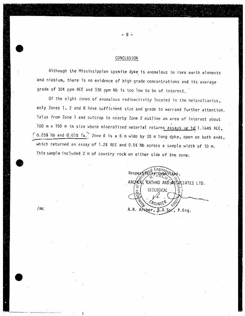
6214225325
A1though the Mississippian syenite dyke is anoma1ous in rare earth elements
and niobium, there is no evidence of high grade concentrations and its average
grade of 304 ppm REE and 336-ppm Nb is too 10w to be of interest.‘
0f the eight zbnes of anomalous radioactivity located in the metavolcanics,
on1y Zones 1, 2 and 6 have sufficient size and grade to warrant further attention.
Ta1us from Zone 1 and outcrop in nearby Zone 2 ohtline an area of interest about
100 m x 150 m in size where mineralized material returns aésags ug t3?1.164% REE,
{'0.25% Nb and 0.03% Taj: Zone 6 is a 6-m wide by 30 m Iong dyke, open on both ends,
whith returned an assay of 1.2% REE and 0.5% Nb across a sample width of 10 m.
This samp1e included va of country rock on either side of the zone.
IATES LTD.
/mc
4”"?
‘
‘RESULTS OF PROSPECTING ' '.‘ YMIP 1992
'IJAMES s. DODGE
32412
INTRODUCTION
The 1992 YMIP prospect1ng program by the writer was focused on thesearch for yttr1um, n1ob1um, z1rcon1um, and rare earths (REE) 1n theM1ss1ss1pp1an syen1te terrane of the St. Cyr Range of the Pe11y
‘- Mounta1ns 1n south-centra1 YukOn. Three areas chosen were: Por4 ."‘'cup1ne Creek, C1out1er Creek, and Ketza R1ver D1str1ct.
Incent1ve for the search for a new Y+Nb+Zr+REE depos1t was the favor-'ab1e resu1ts the wr1ter ach1eved in re-eva1uat1ng the former Nok1u1toccurrence under the 1991 YMIP. Staked as the LANCER c1a1ms, thedepos1t was shown to be an extens1ve metasomat1zed syen1te d1ke w1thprobab1e-econom1c concentrat1ons of Y+Nb+Zr and attract1ve REE cred1ts.*
As on the LANCER property,?deta11ed ground rad1ometr1¢ scanning ofzOutcrops 15 the on1y cost-effective method of prospect1nq, s1nce 1n 'this sty1e of m1nera11zat1on the accompany1ng thor1um and, to a 1esserdegree, urah1um m1nera1s serve as pathf1nder s1gnatures.
' AThand-he1dScintrex 015-4 1ntegrat1ng gamma ray spectrometer Wascarried 1n a 219-zag and/or c1ose1y spaced mu1t1p1e para11e1 traverseconfigurat1on over access1b1e syen1te outcrOp areas. This procedure,ca11ed "Prospect1on Systematique“ was demonstrated to the writer 1n1958 by the French Atomic Energy Comm1ss1on at ve1n-type, overburdenconcea1ed uranium depos1ts 1n metrop011tan France.
-The 015—4 perm1tted a déscr1m1nat1on of source of gamma radiat1on, 1. e. ,'proport1onate1y from uranium, thor1um, and potassium. Because of vary-1ng 1ntens1ty of K-metasomat1Sm 1n the syenite terrane, frequent re—~eva1uat1on of "background", v1s—a-v15 thor1um+uran1um, Va1ues wasrequ1red.
' From the LANCER 1nvest1gat1on, the DreSence of purp1e f1uor1tewas to:-ho pnnsidoraa a r91iab1e v1sua11nd1cator of 11ke1y accompany1ng con-{centrat1ons d'f Y+Nb+Zr. f ~ ~
A1though the LANCER ve1n-type mode1 was uppermost 1n the wr1ter'sprospect1ng ant1c1pat1on, the potent1a1 for a carbonat1te or even asyen1te tuff strat1form depos1t (Brockman 1n Western Austra11a) was'a1so be1ng cons1dered. S1nce both of these 1atter two sett1ngs exh1b1tre1at1ve1y weak gamma rad1at10n signatures, uneasy f1e1d dec1s1ons keptevo1v1ng as to the prudent extent of rock samp11ng to be undertaken. O_nthe other hand, 1t d1d broaden the 1nvestigat1ve spectrum wh1ch, in fact,1ed to a surpris1ng discovery.
* Subsequent1y, dur1ng 2 days 1n.1992 (outside the YMIP), abo1d, cont1nuous 300+ meter extens1on of the LANCER Ve1nwas discovered wh1ch from four samp1es representat1ve ofover 70 kg of outcrop samp11ng y1e1ded probab1e—econom1cva1ues 1n Y+Nb+Zr1 1latal_iflf§rred m1nera1 resource now 15 7
1 1,500,000 tonnes grad1nc 0.15% Y701, 0. 62% Nb205, 1.10% ZF02'ahd ‘ ° E0' en at depth.
Ministry of Energy. Mines andPetroleum Resources
Mineral ResourcesDivision
$11.7“2*"J . . V
.’ 5‘
‘ 2 2‘,5tAx
I
‘.
Geological Survey BranchHon. Jack Davis, Minister
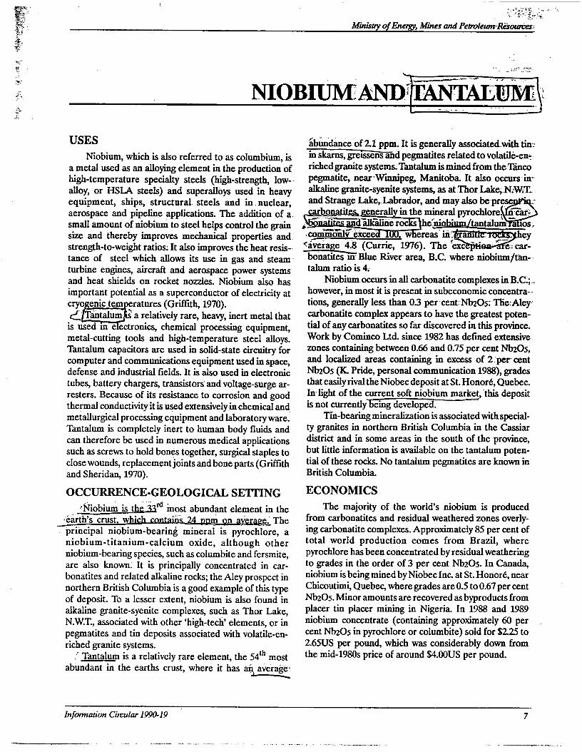
NIOBIUMANDULANTWALEJM
Minisoy ofEnergy, Mines and PeavlewrinéIi-owcesr I
USES
Niobium, which is also referred to as columbium, isa metal used as an alloying element in the production ofhigh-temperature specialty steels (high-strength, low--alloy, or HSIA steels) and superallbys used in heavyequipment, ships, structural. steels and in nuclear,aerospace and pipeline applications. The addition of a».small amount of niobium to steel helps control the grainsize and therebymptoVes mechanical properties and.’strength-to-weight ratios: It also improves the heat resis-vtance of steel which allows its use in gas and steam-turbine engines, aircraft and aerospace power systemsand heat shields on rocket nozzles. Niobium also hasimportant potential as a superconductor of electricity atcryo__ enic tem eratures (Griffith, 1970).(j: a relatively rare, heavy,1nert metal thatis used 1n e ectronics, chemical processing equipment,mctal-cutting tools and high-temperature steel alloys.Tantalum capacitors are used in solid-state circuitry forcomputer and communications equipment used in space,defense and industrial fields. It is also used in electronictubes, battery chaxgers, transistors and voltagc-surge ar-resters. Because of its resistance to corrosion and goodthermal conductivity it is used extensively in chemical and_metallurgical processing equipment and laboratory ware.Tantalum is completely inert to human body fluids andcan therefore be used in numerous medical applicationssuch as screws to hold bones together, surgical staples toclose wounds, replacementjoints and bone parts (Griffithand Sheridan, 1970).
OCCURRENCE-GEOLOGICAL SETTING
WmInqst abundant element1n the«'éarth’s crust whi
'V principal niobium~~bearing mineral ispyrochlore, aniobium-titanium-calcium oxide, although otherniobium-bearing species, such as columbite and fersmite,are also known. It is principally concentrated in car~bonatites and related alkaline rocks; the Aley prospect innorthern British Columbia is a good example of this typeof deposit. To a lesser extent, niobium is also found inalkaline granite-syenite complexes, such as Thor Lake,N.W.T., associated with other ‘high-tech’ elements, or inpegmatites and tin deposits associated with volatile-en-riched granite systems.
Tantalum is a relatively rare element, the 54‘h most
abundant in the earths crust, where it has an aVefag'e:
K
'ibhnilance ’of 2.1 ppm. It is generally associatedwith tin:' in skams, gre1ssens and pegmatites related to volatilé-ene-riched granite systems. Tantalum is mined from therTancopegmatite, nearWinnipeg, Manitoba. It also occurs in“alkaline granite-syenite systems, as at That Lake,.N.W.~T..and Strange Lake,Labrador, and may also beprese: , . :-
bonatites1nBlue River. area, B.C. where niobium/tan-talum ratio is 4.
Niobiumoccurs in all carbonatite complexes in B‘.C.';-.however, in most it is present in subeconomic concentra-«tions, generally less than 0.3 per'centrszos: TESTAICY“carbonatite complex appears to have the greatest poten-tial of any carbonatites so far discovered in this province.Work by Cominco Ltd. since 1982 has defined extensivezones containing between 0.66 and 0.75 per cent szOs,and localized areas containing in excess of 2 [per centszOs (K. Pride, personal communication 1988), gradesthat easily rival the Niobec deposit at St. Honoré, Quebec.In light of the current soft niobium market, this depositis not currently eing developed.
Tin-bearing mineralization is associated with special-ty granites in northern British Columbia in the Cassiardistrict and in some areas in the south of the province,but little information is available on the tantalum poten-tial of these rocks. No tantalum pcgmatitcs are known-inBritish Columbia.
ECONOMICS
The majority of the world’s niobium is producedfrom carbonatites and residual weathered zones overly-ing carbonatite complexes. Approximately 85 per cent oftotal world production comes from Brazil, wherepyrochlore has been concentrated by residual weatheringto grades in the order of 3 per cent Nb205. In Canada,niobium is being mined by Niobec Inc. at St. Honoré, nearChicoutimi, Quebec, where grades are 0.5 to 0.67 per cent
Nb205. Minor amounts are recovered as byproducts fromplacer tin placer mining in Nigeria. In 1988 and 1989niobium concentrate (containing approximately 60 percent szOs in pyrochlore or columbite) sold for $2.25 to2.65US per pound, which was considerably down frOmthe mid-19805 price of around $4.00US per pound.
- Information Circular 1990-19
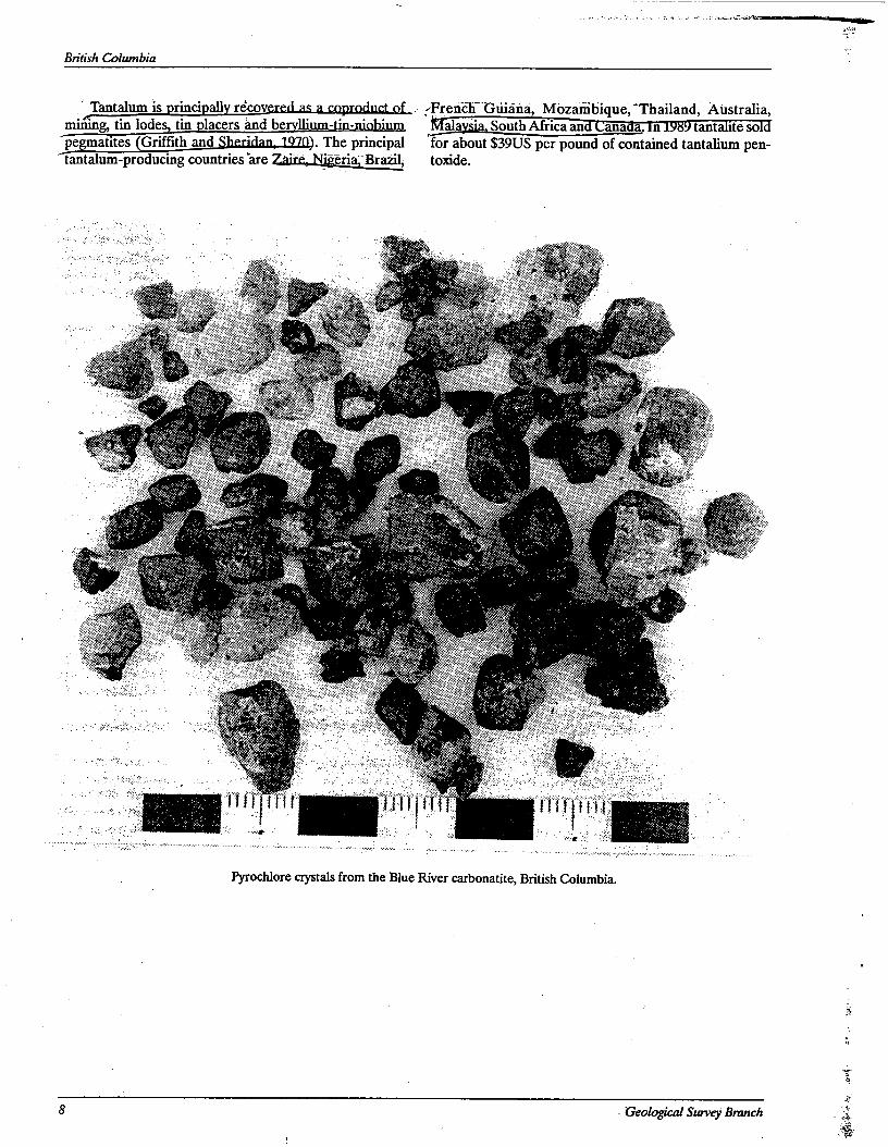
British Columbia
Tantalummis principally recovered a: a copmdnct of (French Guiana, Mozanibique’, ‘Thailand, Australia,mining, tin lodcs tin lacers and be lli a1 ia South Africa an mm a. tant te sopegmamcs (Griffith and Sheridan,_1.910). The.principal for about $39US per pound of contained tantalium pen-tantalum-producing countries are ' " ' Brazil, toxide.
Pyrochlore crystals from the Blue River carbonatite, British Columbia.
8 , Geological Survey Branch
«wA
H&n‘
x-
Ministly ofEnergy, Mines and Petrolewn'REsowces
TARGETSINBRITISHCOLUMBIA
"High-tech" elements are commonly hosted by, or.associated with the rock types identical in the accompany-ing table. In British Columbia, a number of carbonatite-syenite complexes and volatile—rich or "specialty" graniteshave been diScovered and others may be recognized inthe future. These rocks are good exploration targets for _a number of the "high-tech" elements and will bedescribed in more detail in the following sections. Car'-bonate-hosted lead.-zinc.and volcanogenic massive sul-phide deposits are present in British Columbia; some areknown to have anomalous concentrations of galliumandgermanium and therefore should always be analyzed forthose two elements.
Peralkaline granite-syenite complexes are importantin that they may host significant quantities of a numberof "high-tech" metals.‘ Copper-rich breccia pipes are im-portant potential gallium and germanium hosts. Neitherof these environments have been recognized in BritishColumbia; however, brief descriptions are included in thisreport as no a priori reason exists for their absence.Bauxite deposits do not occur in British Columbia; theconditions for their formation (deep tropical weathering)never existed in this part of the world. Other deposit typesmentioned are less important and, while they should notbe overlooked by the prospector or geologist, will not bedealt with in any detail here.
CARBONATITE - SYENITE SYSTEMS
Carbonatite/syenite complexes are mined for lan-thanides, yttrium and niobium. They may also containsignificant concentrations of zirconium and can be
anomalous in tantalum. InAfrica, Biazil and the USSR.they are also mined for associated copper, phosphate(apatite), iron and vermiculite. Nepheline syenite is quar-ried in Ontario for use in the glass industry (Currie, 1976).In the Jordan River area of British Columbia, northwest
of Revelstoke, molybdenum associated witha nephelinesyenite gneiss complex was extensively explored inthelate 19605 (Fyles, 1970).
DESCRIPTION '
Carbonatites are igneous rocks composed of morethan ‘50 per cent primary carbonate minerals,predominantly calcite or dolomite. Common accessoryminerals include. olivine, pyroxene (often sodic), am-phibole (also, often sodic), phlogopite, apatite, mag:netite, ilmenite, zircon columbite and pyrochlore. Otherminerals such as feldspars, fluorite and vrare-earth car-bonates may also be present. Carbonatites occur'mostcommonly as intrusive bodies; they may form as dikes,sills, plugs, veins or segregations in other alkaline rocks.Less common are extrusive carbonatite flows, tuffs or
agglomerates. Metasomatic rocks (fenites), which are‘ generally enriched in sodium and ferric iron and depletedin silica, are often developed marginal to intrusive car-bonatites or carbonatite complexes.
Carbonatites can be associated with nephelinite ornephelinite/nepheline syenite complexes (e.g. the IceRiver complex near Field, B.C.; Currie; 1975, 1976), withnepheline or sodalite syenites only (e.g. Paradise Lakecarbonatite, near Blue River, B.C.; Pell, 1987), or with
weakly alkaline syenites (e.g. Lonnie complex, near Man-
ROCK TYPE/DEPOSIT TYPE
\Carbonatite-syenite complexes ’Volat1lE-r16h gramte systems
ASSOCIATED ELEMENTS
1' Nb, Y, REE, Zr, gTaQ', Be Ta, Y, Ree, Nb ,’
'*Peralkaline granite-syenite systems (3 Be, Nb, Ta, ee, 1', Ga 3”Carbonatehostedlad--zinc deposits W“
Zinc-rich volcanogenic massive sulphide deposits Ga*Sediment-hosted, copper-rich breccia pipes and oxidized equivalents Ga, Ge*Bauxite deposits GaCoals GeIron oxide deposits GeSedimentary phosphorites Y* Not known to occur in British Columbia
Information Circular 1990-19 13
Bn'tish Columbia
son Creek, B.C.; Currie, 1976; Pell, 1987). Thenephelinites associated with carbonatite complexes con-tain varying amounts of pyroxene (generally sodic ortitanium-bearing) and nepheline. Nepheline and sodalitesyenites generally contain potassium feldspar, nephelineand plagioclase feldspar with or without sodalite, with
‘ ,biotite or pyroxene as the common mafic phase. Weaklyalkaline syenites do not contain feldspathoids. In all cases,the associated rocks are devoid of quartz as with thecarbonatites. .
In the field, carbonatites resemble marbles or other
carbonate rocks, but in British Columbia most can be
recognized by their unique qrangish brown to dark red-dish brown weathering colour, unusual mineral as-semblage (apatite, olivine, pyroxene, magnetite, zirc0n,etc.) and anomalous radioactivity (the scintillometer is auseful prospecting tool). Other distinctive minerals suchas purple fluorite may also be associated with carbonatitecomplexes. The most common associated igneous rocktypes are quartz-free syenites and nepheline or sodalitesyenites which are usually white to greyish weathering.When present, nepheline can be identified in handspecimen by its slightly greyish colour and greasy lustre,while-sodalite can be easily recognized by its distinctiveultramarine blue colour. .
”The fenites, or metasomatic alteration zones as-sociated with intrusive carbonatite complexes, vary frombeing almost non-existent to forming halos extendingseveral hundreds of metres into the hostrocks. Theirnature is also highly variable, dependant on the originallithology and the composition ofthe fluids associated withthe alkaline rocks. In general, calcsilicate and biotite-richhostrocks are altered to sodic pyroxene and amphibole-rich rocks; quartzo—feldspathic protoliths (granites orquartz and feldspar-rich sedimentary rocks) are alteredto rocks of syenitic or monzonitic composition; and car-bonate hostrocks are altered to iron and magnesium-richcarbonates that may contain fluorite and rare-earthminerals.
Geochemically, carbonatites and related alkaline
rocks are undersaturated with respect to silica and maycontain high concentrations of elements such as stron-tium (generally 1000 ppm), barium, niobium and rareearths. Mineralization generally occurs in primary mag-matiedeposits; commonly,“ra;e—metal enriched phases,
crystallized directly from the melt, occur as accessory or,less commonly, rock formingminerals.
DISTRIBUTION
In British Columbia, carbonatites, syenite gneissesand related alkaline rocks are present in a broad zonewhich follows the Rocky Mountain Trench. They occur inthree discrete areas (Figure‘Z): along the western edge ofthe'Foreland Belt, east of the Rocky Mountain Trenchand immediately east of the Trench in the Cassiar Moun-
» tains (northeastern Omineca Belt); along the easternedge of the Omineca Belt; and within the Omineca Beltin the vicinity of the Frenchman Cap dome, a core gneisscomplex. '
Carbonatites and related rocks in the Foreland andnortheastern Omineca belts are generally present inlarge, multiphaseintrusive and extrusive complexes withextensive 'metasomatic or contact metamorphic altera-tion halos overprinting Middle Cambrian to MiddleDevonian miogeoclinal hostrocks. Carbonatites along theeastern margin of the Omineca Belt are found westwardfrom the'Rocky Mountain Trench for 50 kilometres ormore. All the intrusions within this belt are hosted by latePrecambrian (Upper Proterozoic) to early Cambrianmetasedimentary rocks. They form foliated sill-likebodies and are associated with only minor amounts offenitization. Along the margins of the Frenchman Capgneiss dome, intrusive and extrusive carbonatites andsyenite gneiss bodies are conformable in a mixed parag-neiss succession of probable late Proterozoic toEocambrian age (Pell and Hoy, 1989; Pell, in prepara-tion).
Alkaline igneous rocks intruding Paleozoic strata inthe Foreland and northeastern Omineca belts are ofDevono-Mississippian and possibly Silurian ages. Car-bonatites and syenites hosted by Precambrian rocks in theeastern Omineca Belt are predominantly Devono-Missis-sippian. All have been deformed and metamorphosed tosome degree; those in the Foreland and northeasternOmineca belts were subjected to sub-greenschist togreenschist facies metamorphism, while those elsewherein the Omineca belt attained upper amphibolite facies(Pell and Héy, 1989; Pell, 1987, and in preparation).
Caxbonatites with the best economic potential for"high-tech" elements appear to be those ofmid-Paleozoicage hosted by Paleozoic sediments that are found in theRocky Mountains and eastern Cassiar Mountains, how-ever, carbonatites found elsewhere should not be over-
looked.
:1vogfiiLE-RICHGRANI'TES‘In'many parts of the world, "specialty" or volatile-en-
riched granitoids of ‘topaz-rhyolite’ affinity are metal-logenically linked to deposits of a varietyofhigh-techmetallic and non-metallic minerals suchas beryllium,yttrium, rrare-earths, niobiumtand to depositsxof tin,tungsten,'"molybdenum and possibly gold. Importantdeposit types include: Climax-type molybdenum-tungsten porphyries; silver-lead-zinc manto deposits,such as Santa Eulalia, Mexico and Midway, BritishColumbia; tin skarn deposits; replacement fluoritedeposits, for exampleLas Cuevas, Mexico or berylliumdeposits such as Spor Mountain, Utah.
14 Geological Survey Brunch
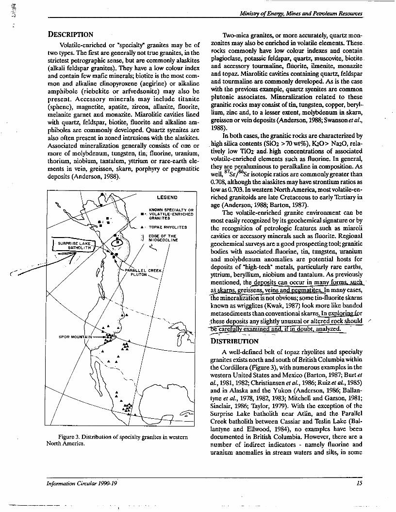
Minisay ofEnergy, Mines and Petmleum Resowtes
DESCRIPTION
Volatile-enriched or "specialty" granites may be oftwo types. The first are generally not true granites, in thestn'ctest petrographic sense, but are commonly alaskites(alkali feldspar granites). They have a low colour indexand contain few mafic minerals; biotite is the most com-
mon and alkaline clinopyroxene (aegirine) or alkalineamphibole (riebekite or arfvedsonite) may also bepresent. Accessory minerals may include titanite(sphene), magnetite, apatite, zircon, allanite, fluorite,melanite garnet. and monazite. Miarolitic cavities linedwith quartz feldspar, biotite, fluorite and alkaline am-phiboles are commonly developed.. Quartz syenites arealso often present in zoned intrusions with the alaskites.Associated mineralization generally consists of one ormore of molybdenum, .tungsten, tin; fluorine, uranium,
thorium, niobium, tantalum, yttrium or. rare-earth ele-ments in vein, greissen, skarn, porphyry or pegmatiticdeposits (Anderson, 1988).
LEGEND
KNOWN SPECIALTY OR1. VOLATILE-ENRICHEDGRANITES
A : TOPAZ RHYOLITES
3 EDGE OF THEMIOGEOCLlNE
aSURPRISE LAKEBATHOLITH
PARALLEL CREEKPLUTON\
spon MOUNTAtN—>
fl0 ‘-
Figure 3. Distribution of specialty granites in westernNorth America.
TWo-mica granites, or more accurately, quartz mon-zonites may also be enriched in volatile elements.vThese.rocks commonly have low colour indexes and containplagioclase, potassicfeldspar, quartz, muscovite,.biotitehand accessory tourmaline, fluorite, ihnenite, monaziteand topaz. Miarolitic cavities containing quartz, feldsparand tourmalinevare commonly developed. As is the casewith the previous example, quartz syenites are commonplutonic associates. Mineralization related to thesegranitic rocks may consist of tin, tungsten, copper, beryl--lium, zinc and, to a lesser extent, molybdenum inskarn,greissen or vein deposits (Anderson, 1988; Swanson et al.,1988).
Inboth cases,.the granitic rocks are characterized byhigh silica contents (SiOz >70 wt%), K20> NazO, rela-
' tively low TiOz' andvbigh concentrations of associatedvolatile-enriched elements such as fluorine. In general,they are peraluminous to peralkalinein composition. Aswell, 87'Sr/86Srisotopic ratios are commonly greater than0.708, although the alaskites may have strontiumratios aslow as 0.703. In western NorthAmerica, most volatile-en--riched gxanitoids are late Cretaceous to early Tertiary inage (Anderson, 1988; Barton, 1987).
The volatile-enriched granite . environment can bemost easily recognized by its geochemical signature or bythe recognition of petrologic features such as miarolicavities or accessory minerals such as fluorite. Regionalgeochemical surveys area good prospecting tool; graniticbodies with associated fluorine, tin, tungsten, uranium
and molybdenum anomalies are potential hosts fordeposits of "high-tech'.‘ metals, particularly rare earths,yttrium, beryllium, niobium and tantalum. As previouslymentioned, the de' asits can occur in man form uch 'as skarns eissens, veins and e atites. In many cases,
the mineralizationIs not obvious; some tin-fluorite skarnsknown as wrigglites (Kwak, 1987) look more like bandedmetasediments than conventional skarnngfiorthese deposits any slightly unusual or altered rock should ,“rearefully exammed and, if m doubt, analged.
DISTRIBUTION
A well-defined belt of topaz rhyolites and specialtygranites exists north and south of British Columbia withinthe Cordillera (Figure 3), with numerous examples in thewestern United States and Mexico (Barton, 1987; Burt etal., 1981, 1982; Christiansen et al., 1986; Ruiz et al., 1985)and in Alaska and the Yukon (Anderson, 1986; Ballan-tyne et al., 1978, 1982, 1983; Mitchell and Garson, 1981;
Sinclair, 1986; Taylor, 1979); With the exception of theSurprise Lake batholith near Atlin, and the ParallelCreek batholith between Cassiar and Teslin Lake (Bal-lantyne and Ellwood, 1984), no examples have beendocumented in British Columbia. However, there are anumber of indirect indicators - namely fluorine anduranium anomalies in stream waters and silts, in some
Information Circular 199049 15
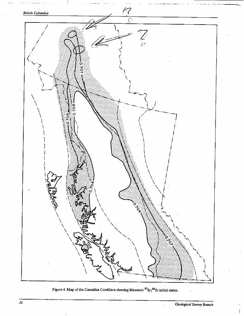
British Columbia
“.r,»..m_“_~...‘........ . . ., .. . ._ »~....___-—.~——..a-.ua—_..._‘
\
~TH:25.—\--—...§ Figure 4. Map of the Canadian Cordillera showing Mesozoic 878r/86Sr initial ratios.
16Geological Survey Brunch
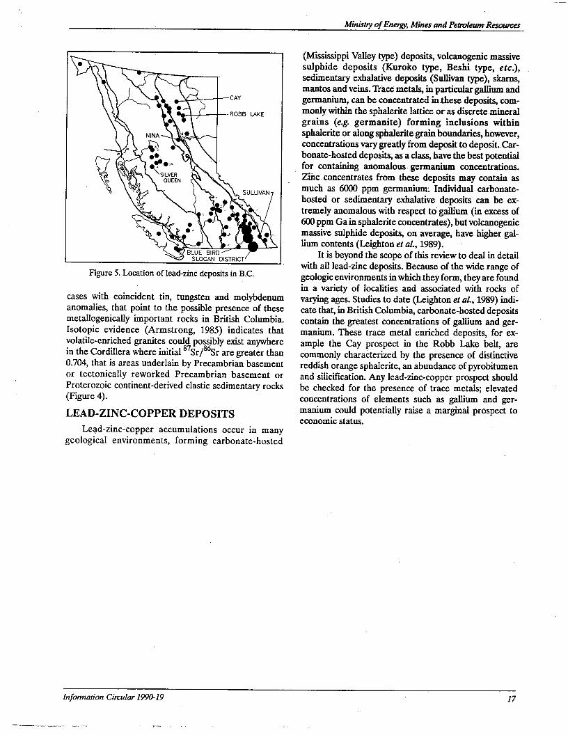
SULLIVAN
‘ BLUE BIRDSLOCAN DISTRICT
Figure 5. Location of lead-zinc deposits in BC.
cases with coincident tin, tungsten and molybdenumanomalies, that point to the possible presence of thesemetallogenically important rocks in British Columbia.Isotopic evidence (Armstrong, 1985) indicates thatvolatile-enriched granites could possibly exist anywherein the Cordillera where initial 87Sr/868r are greater than0.704, that is areas underlain by Precambrian basementor tectonically reworked Precambrian basement orProterozoic continent-derived clastic sedimentary rocks(Figure 4).
LEAD-ZINC-COPPER DEPOSITS
Lead-zinc-copper accumulations occur in manygeological environments, forming carbonate-hosted
Minisny ofEnergy, Mines and PetroleumResoumes
(Mississippi Valley type) deposits, volcanogenic massivesulphide deposits (Kuroko type, Beshih type, etc.), .sedimentary exhalative deposits (Sullivan type), skams,mantos and veins. Tr'ace‘ metals, in'particular galliumandgermanium, can be concentrated inthese deposits, com-monly within the sphalerite lattice or'as discretemineralgrains (e.g. germanite) forming inclusions withinsphalerite or along sphalerite grain boundaries, however,concentrations vary greatly from deposit to deposit.,Car-bonate-hosted deposits, as a class, have the best potentialfor containing anomalous germanium concentrations.Zihc. concentrates from these deposits may contain asmuch as 6000 ppm germanium: Individual carbonate-hosted or sedimentary exhalative deposits can be ex-tremely anomalous with respect to' gallium (in excess of7600 ppm Ga in sphalerite concentrates), but volcanogenicmassive sulphide deposits, on average, have higher gal-lium contents (Leighton et a1., 1989). ‘
It is beyond the scope of this review to deal in detailwith all lead-zinc deposits. Because of the wide range ofgeologic environments in which they form, they are foundin a variety of localities and associated with rocks ofvarying ages. Studies to date (Leighton et 01., 1989) indi-cate that, in British Columbia, carbonate-hosted deposits
contain the greatest concentrations of gallium and ger-manium. These trace metal enriched deposits, for ex-ample the Cay prospect in the Robb Lake belt, arecommonly characterized by the presence of distinctivereddish orange sphalerite, an abundance of pyrobitumenand silicification. Any lead-zinc-copper prospect should .be checked for the presence of trace metals; elevatedconcentrations of elements such as gallium and ger-manium could potentially raise a marginal prospect toeconomic status.
Information Cin‘ular 1990-19 17
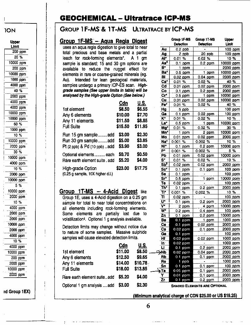
'ION
Upper
Limit200 ppm '
5 20 %
10000 ppm
200 ppm
10000 ppm
1000 ppm
4000 ppm
40 %
2000 ppm
4000 ppm
4000 ppm
10000 ppm
10000 ppm
60 %
lm1000 ppm1" 1o %
10000 ppm
2000 ppm
30 %
10000 ppm—
, 4000 ppm‘ 1o %
‘ 2000 ppm1 10000 ppm
’" 5 %10000 pp—m
5 2000 ppm10 %
5 2000 ppm“WEE
1? 2000 ppm
' 4000 ppm
10 %
" 10000 ppm‘W‘”70003;?
510000 ppm2000 ppm
nd Group 1EX)
GEOCHEMICAL -- Ultratrace. ICP-MS'
GROUP 1F'-MS“'& 1T'-MS' ULTRATRACE BY ICP-MS
Group 1FZMS'-~Agua Regia Digestuses an aqua regia digestion to give total to neartotal precious and base metals and a partialleach for rock-lorming elements‘. A 1 gmsample is standard; 15 and 30 gm options areavailable to reduce the nugget effect forelements in rare or coarse-grained minerals (eg.Au). Intended for lean geological materials,samples undergo a pn'mary ICP-ES scan. High-grade samples (See upper limits In table) will beanalysed by the High-grade Option (See below.)
QC!!! U-_$-1st element $8.50 $6.55Any 6 elements $10.00 $7.70Any 1 1 elements $11.50 $8.85Full Suite $15.50 $11.95
Run 15 gm sample ........ add $3.00 $2.30Run 30 gm sample ........ add $5.00 $3.85Pt (2 ppb) & Pd (10 ppb) ..add $3.90 $3.00
Optional elements .......... each $0.70 $0.50Rare earth elementsuite.add $5.20 $4.00
High-grade Option $23.00 $17.75(0.25 9 sample, 10X higher d.|.)
Grbup 1Ti’MS -- 4-Acid Digest likeGloup 1E, uses a 4-Acid digestion on a 0.25 gmsample for total to near total concentrations onall elements including rock-lonning elements.Some elements are partially lost due tovolatilizationt. Optional 1 9 analysis available.
Detection limits may change without notice dueto nature of some samples. Massive sulphidesamples will cause elevated detection limits.
9% LS.-1$t element $1 1 .00 $8.50Any 6 elements $12.50 $9.65Any 11 elements $14.00 $10.78.:FUII Suite $18.00 $13.85
Flare earth elementsuite..add $5.20 $4.00
Optional1gmanalysis....add $3.00 $2.30
Au
.Alt
8!
Ba'
BI
03'
CdCo
Cr'
Cu
Fe'
GaKi
Lat
Mn'Mo
Na‘
NI'Pt
Pbst
Sc'
SeSr“
TeTh‘TI.
TIU.
V.
w.
Zn
Be
09
Cs
GeHf
ln “
Ll
RbRe
TaYZr.
Group 1F-MS Group ”-148 Upper
Detection Detection Umlt‘
0.2 - 1
2 20 100
0.01 °/o 0.02 % 10 %
0.1 0.2 10000
1 - , 2000
0.5 1 ' 1
. .04
0.01 % 0.02 % 400.01 0.02
0.1 0.2
0.5 1 10000
0.01 0. ' 1
0.01 0.02 % 40
5 - 100
0.1 0.02
0.01 0.02 % 10
0.5 1
0.01 0.02 %
1 2
0.01 0.02
0.001 0.002 %
0.1 0.2
0.001 0.002 %
0.01 0.02
0.01 0.02 °/o
0.02 0.02
0.1 .1
0.1 -
0.5 1
0.02 -
0.1 0.2
0.001 . %
0.02 -
0.1 0.22 4
0.2 0.4 1
0.1 0.2 1
1 1
2000
0.1 2000- 100
0.02 1
- 10.2 2000
0.04
0.1 2000- 1000
0.1 1
0.1 2000
0.1 2000
0.2 2000
SHADED ELEMENTS ARE OPTIONAL
(Minimum analytical charge of CDN $25.00 or US $19.25)
6
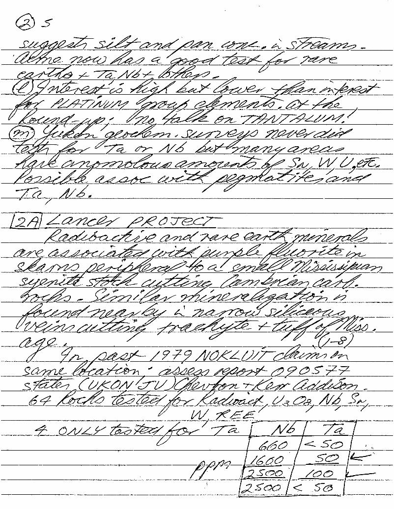
®5Q5M/%&%QM/m 4:774, Q5%Q&QéQ QQQO/ZQQczéQQQQ/ZZ94/é7/ZQQE
74773737wé75747 fl
x&%WW/A/// MQQ/afigféy%%:___-__L9é/;_ _ /7Q%flm77%7‘QQQ/Q/@941 MW777WQQQQ/(QQ/
énag/' QQQQQQ75§7 ‘30 MVé/Qél
/%QZM// z&:QQQ:QwQZ%:/ 7ZAVQ7QQQ/72/QWQ/
72¢QQQQ72QQQQQQ7 fQMQ77QQMEQQQ7¥ Aygyfiég _
&%%QC£é&égméé7&%&6(Q%MU¢5Z Q§7%ékkxQEQW477W%Q/M/WMM6g::Z§gS%;é7zQQQQQQQQ77 ” .
—~Zf%%mWZEZQQQQQ 4.Z%$7z&fl/J?Q%%%%QQ_I
Z7EQQQQQ2§EL 77QaQ7£QZ§74Zégéééiz:QQQ_QQQ , '7 ”(7
QZIAM%;L/9¥9AWXZ&%7' Qflme
S&mflé%%€%n¢%%%wfi%%%&9&5¥;3%(QKQ/j/{77/J%W7&7/7%QEQ;27SQQ/M/Q @Zéézéy/EW (/ng W7 51/
M%;K72E
74 @A/Qé/wa/EQ/ 7” F fl/Qf 727A 7 6/0 < 5Q /
/;
/¢wflééflfl / fzjléfiSQO/Zoo kfrv
LZSQQ < 5b[
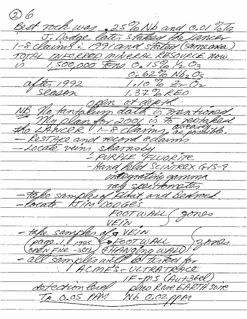
995’ ' -WMW 995%6/65515/30/ Z7;
’ 7655/55: 5/55/2552‘75é5/W5/
/7§6%W/£ /99/5W%Z‘4/95/572655559
fm ///5<255@9 514/5555 765555555 75752
#54555,555 @g 5 5.7% /2,535;521% 5/52 67‘;
55/57/772 /,/5 ‘Z 7,2,: 52,/ £65657: // 5 $2 2/5225
, 5,5551 45/55/76”547%: %%M/5477 M5.)_5541>é57155/_________ ,. - - _,, ,' 0255/ :5 #2555;@/
:15; "21/555 54115fl542¢5 4?Ww 5959/6965 641%WM0964:4775)
-———~24564?7M/415/ Mmzfg555/6555 5755/55/7355745644”35ng 6—5:?7MW555W
656/5@6752655/257254
, V575 , J”r%55,_-/4_59V£/W /
555;: / 25,53; "- 555775651: 525765(6556/5/25 4393/W544 55,552/1/
W5545é5/%//f2522/57“ /246/551? (/5755752/765:
. , /5 5715 641/7257/25627165735716% [/5675 5/555375370215872 059.; f/M 4V5 6762//5/5\/ l I
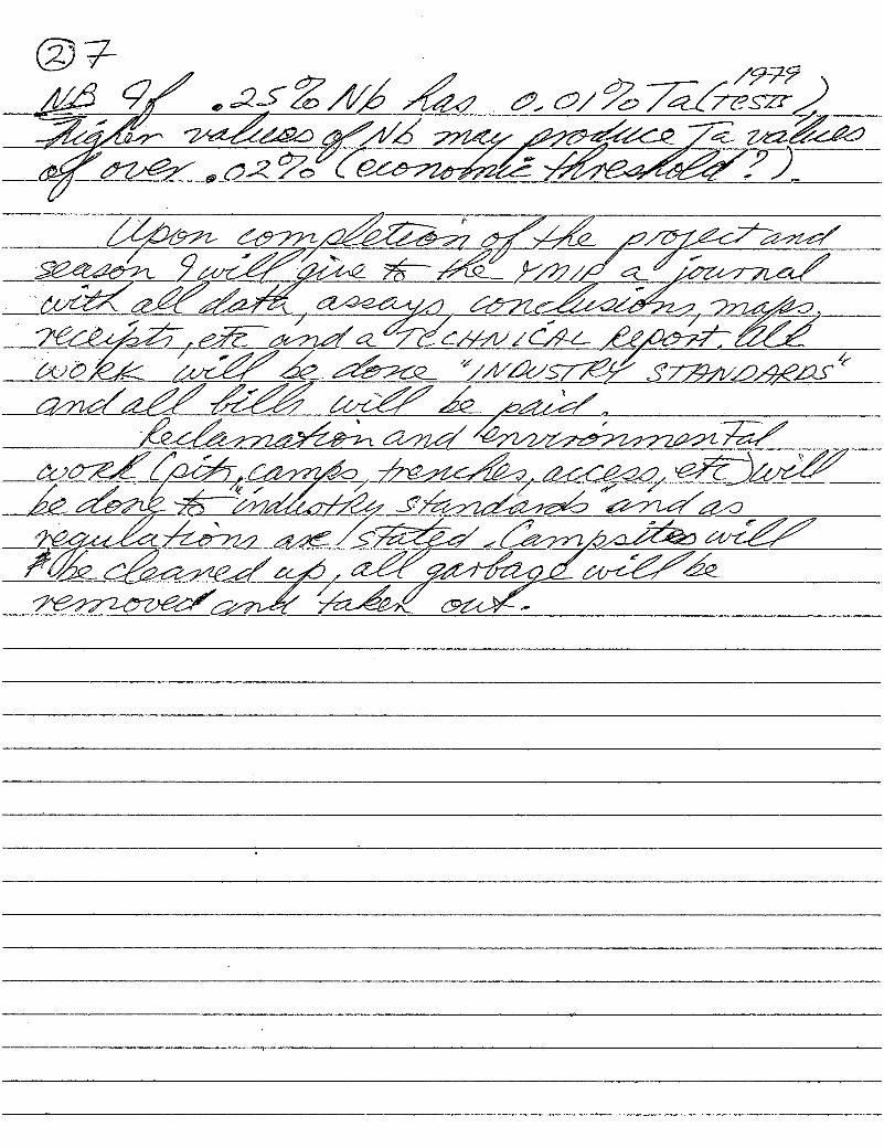
QMlxm M\ MMNMRRM MSMNNNNMWRNKMW) §k§t§hw§\§§\waxmfi MRS
K&kaQNNR\§»§M\\§\M&
, , §§§KR M§Vfi§
ufi§%§&\\m&§\gmm:§§\®\A §&\\§ \\\k§§h§§xfihw
§§W§$id§§SMQM ,Mkmwdi1N§wx§w§§v§u¢§§§
gk ¥MW$§§§§
?\w%§flm\§ &\\§§§§§§N\§\w®x&Q&Ngfix

@8WW
6:42.266 72767 7777577743 6 6c:/fl//%/€/W 666664777676«77
7,6666 5//6/_2666 772/777)
6066/1/7/fl6/ //~&ZQ/M774 )77£076;?;WJMW/
——66557673 6/: /€64f6’6677776 ym/fl/QQLi972 7627/WQ\7 5’-am
”777/6/74765 /@5 /7 Qz/75fM/Cfl/
6656???? 6697647/‘27
/6 S”#flé/7__’ /69§F&/.§:735/771/6//66756723, 76577667,765377792/
«— 0722777 F/& /775 3 (7)) /67676696647666 7776445/567:(Qflfi6/66/7577; 5636772 $467667?(57%66, s , ZMJfi/flx 7777
' :.~ ~ * 746767 / 772.—— [777J66 64/6.6? 677/; 67/67» 67666777665
Q775) 62/ 6/67/7777; 74567/7767’776,2 5’, 6667747647776” [/54766.5.94
67%7, 67:2. 725/4 ,£7 6747666/7/9’7‘75/6—{75fl4W792?
77/7/6756WA!“ ,666 666/667 (9%WWW
' «7 6766/27/27
/ 6257C 7%7%?476:74 W6 6M1
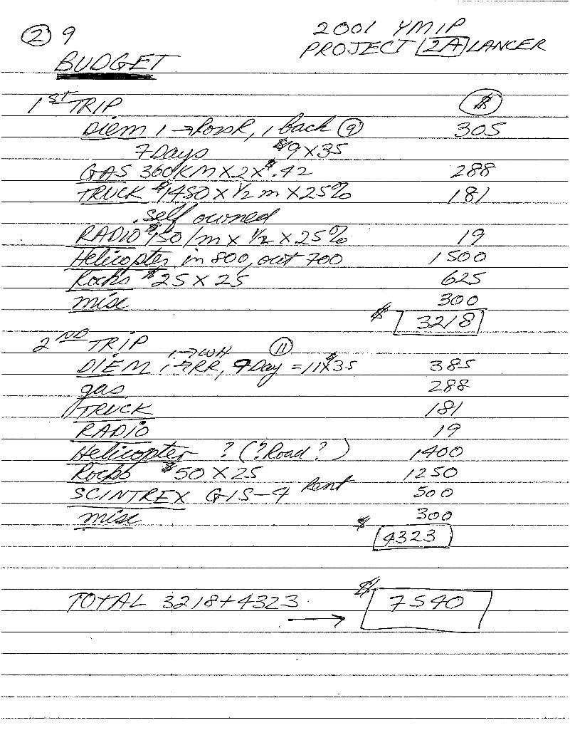
9 2650/ WM/2
fiéE—BEW‘22072014/97591/654
/ Sfflg/fl/-\,5
WW /*'§/a97&/€ /%0Z@59535;
:24? 527ng
MM;Si/(MX’ZX22’ 2 288‘W_7Z3Z/CK /7/‘5&X/,mx,zgg
H
MW/8/
W/&/ (3—/774 X///'2(><,2§Z . ,
WSX:2;5
W’45
-‘ . % 560(}
#412779}? * 732/37
fl/ffli 272/52(2%” / 2/6 9% ://X?; 3 52;
[flflék2.338
' 2227/25CA:
W{W ?CVW/7)/40@
E54 ’55 xzs A2 50:
SC/WMEX (7*/51—? xfi/xzrj 5&0
W{% '.
7%? E 3C3§
3523 )
737744 Sg/574323- 2255a /' ”—71 /
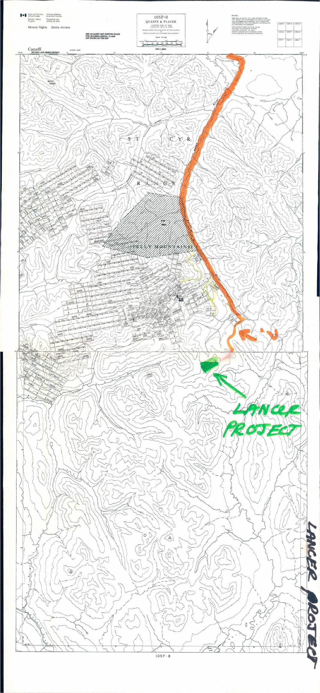
I&l lndlan and Noflher'l AllalresAlfalrs Canada
Northem AllarsP gram
e! cu Nord Canada
Programme desaflalres du Noni
Indiennes
Mineral Rights Droits miniers
105F-9
QUARTZ & PLACERLATITUDE 31'39‘ TO u‘ds‘
"""s-L43.
\\ 4‘! Q? ‘v-E , ‘ '; ’ __ w . — . . , ‘j . ' «NLQI «gkévlii L13, , .. _ g y . -.... ‘ "'"§ ' _ . f. _ fiififié)
u i : .‘ ‘1‘ V _ F . ,Uy". I - -' '1', . -, ' l v .4.~.,.;;,;_v_.' {Nfl' . /{I ~' ._ > ‘0 I " '3 . I ‘ i ."j r V ‘ ‘ .‘
7 I' .. ‘ ‘ ' " > ‘ u ~- " 0' ‘
fig
\
’9'90"
"W‘W‘qua;
-.:.-
NflNFILE: 105F 014
PAGE NO: 1 of 1UPDATED: 08/20/96
YUKON MINFILEYUKON GEOLOGY PROGRAM '
WHITEHORSE
NAME(S): Sonny NTS MAP SHEET: 105 F 8MINFILE #: 105F 014 LATITUDE: 61°29'00"NMAJOR COMMODITIES: Ag,Pb,Au ' LONGITUDE: 132°17'00"WMINOR COMMODITIES: Cu DEPOSIT TYPE: VeinTECTONIC ELEMENT: Cassiar Platform STATUS: Showing
-11.;CLAIMS
RAIN, GREY, CALCO, SONNY, SUNNY, SHARON, PH, REO, JO, PIZZA, ST PETER, JESSIE, GP, RIBA
WORK HISTORY
Staked as Rain CI (71341) in Sep/55 by British Yukon EL, which conducted mapping, rock trenching and g;sampling in 1956—57. Restaked by P. Versluce as Grey CI (79545) in Ju1/62, as Calco and Sonny cl (88979) in :1Oct/64, and as Sunny c1 (Y13292) in Ju1/66. The Sharon c1 (Yl7688) were tied on to the east side by Northwest 1‘EL (International Utilities and Hudson's Bay '0 & GCL) in Apr/67, which performed prospecting and geochem ' _ e?"sampling in Aug/67. Versluce added the PH cl (Y28688) to the west and southeast in Oct/68.
Restaked as Reo 1-12 cl (YA46895) in Feb/SO by l. Jacobsen, who added a second group of Reo 25-32cl (YA46919) 3.2 km to the east, and as Jo cl (YA70320) in Aug/83 by M. Tremblay. Restaked as Pizza c1(YA90283) in Sep/85 by Cruiser Mls L, and as St Peter, Jessie Sonny, GP, etc (YA99516)1n 0ct/87 by GoldenPavilion Res L, which carried out mapping, geochem, mag and VLF EM surveys, and hand trenchingIn 1987.
Restaked as Riba cl 1-6 (YB60978)by R.Berdah1 in Aug/95.
GEOLOGY
3%
Rich tetrahedrite float assaying 17 800 g/t Ag is rumoured to have been founcisin this vicinity i111955.The area is underlain by Cambrian limestone and dolomite. No mineralization was found in 1967 although a ’sma11,well defined lead anomaly was outlined on the Chalco 4 and 5 claims. The 1987 Work located 35showings, 25 of which are mantos.
The main zone is 1.2 km long and averages about 8 m wide. It is marked by conspicuous gossans andcovers a string of showings, including the Ridley, Main, Gray and Young showings.» The mineralogy changesalong strike from siderite, pyrite and pyrrhotite with high gold values at the Ridley and Main'ghowings, to pyrite,arsenopyrite, pyrrhotite and galena with high silver values at the Young and Gray Showings.
Trenching on the Main Showing exposed material grading up to 9.9 g/t Au, while samples from the GrayShowing returned up to 274.3 g/t Ag and 1.5% Pb.
Other showings consist mostly of massive quanz veins some of which return elevated gold values or are
mineralized with copper.
REFERENCES
NORTHWEST EXPLORATION LTD, Nov/67. Assessment Report #018888 & 018889 by AR. Archer.
YUKON EXPLORATION 1987, p. 151-152.
MINFILE: 105F 015PAGE NO: 1 of 1
UPDATED: 03/04/93
YUKON MINFILEYUKON GEOLOGY PROGRAM
WI-IITEHORSE
NAME(S): Kay NTS MAP SHEET: 105 F 8MINFILE #: 105F 015 LATITUDE: 61°29'15"NMAJOR COMMODITIES: Pb,Zn,Ag LONGITUDE: 132°08'57"WMINOR COMMODITIES: Cu,F,Ba,REE,Sb DEPOSIT TYPE: Mississippi ValleyTECTONIC ELEMENT: Cassiar Platform STATUS: Prospect
CLAIMS (PREVIOUS AND CURRENT)
. KAY, PYRITE, SHARON, KATZ, PESCOD, FRED
WORK HISTORY
Staked as Kay cl (69843) in Oct/54 by H. Versluce for British Yukon ECL, which performed mappingand minor trenching in 1955 and added Pyrite cl (71410) on the southwest side in Sep/55. Restaked as part of alarge block of Sharon c1‘(Y17657) staked to the east in Apr/67 by Northwest EL(Intemationa1 Utilities L &
Hudson's Bay 0 & GCL), which conducted geochem surveys and prospecting in Aug/67.Restaked as Katz cl (YA90571) in Feb/86 by Noranda, which performed mapping and soil sampling in
1986. S. Patnode tied on Pescod cl (YA90287) to the east in Nov/85 and transferred them to Fairficld Mls L,
which performed soil sampling in 1986 and mapping and road work in 1987. Fairchild optioned the claims to
Cons Rio Plata Res L, Which added Fred C] (YB12079) to the west in May/88.
GEOLOGY
Galena and sphalerite occur with chalcopyrite and tetrahedrite in quartz—barite-fluorite veins, fracturezones and breccia zones, and disseminated in wall rock. The veins and breccia zones cut Early Cambrian
limestone and dolomite and overlying Devonian carbonates and Mississippian phyllite and mafic volcanic rocks.
Chip samples across a 2.5 m wide, ESE-trending galena-quartz vein averaged 1210 g/t Ag, 27% Pb,16.5% Zn, 0.5% Cu and 0.4% Sb, while a specimen from a secondary structure returned 40 g/t Ag, 1.0% Pb and0.7% Zn across 0.5 m.
REFERENCES
BRITISH YUKON EXPLORATION CO. LTD, Jan/56. Assessment Report by AB. Aho & W.A. Padgham.
GEOLOGICAL SURVEY OF CANADA, Paper 68-68, p. 76-77. -
NORTHWEST EXPLORATION LTD, Nov/67. Assessment Report #018892 by AR. Archer.
YUKON EXPLORATION 1985-86, p. 221-222.
MINFILE: 105F 016
PAGE NO: 1 of 1UPDATED: 03/04/93
YUKON MINFILEYUKON GEOLOGY PROGRAM
WHITEHORSE
NAME(S): Sharon ' NTS MAP SHEET: 105 F 9MINFILE #: 105F 016 LATITUDE: 61°30'00"NMAJOR COMMODITIES: Ag,Pb LONGITUDE: 132°08'00"WMINOR COMMODITIES: - DEPOSIT TYPE: VeinTECTONIC ELEMENT: Cassiar Platform STATUS: Prospect
CLAMS
SLOCO, BEAR, MAC, JANET, SHARON, KET, REO, KETZA
WORK HISTORY
Staked as Sloco cl (70232)1n Mar/55 by E. Brooke, and Bear cl (70415)1n May/55 by R.J. Lindsay & I.
Goulter. Hand trenching was done on both properties. Restaked as Mac cl (75677)1n May/61 by Dualco Synd,and as Janet, etc c1 (Yl7322)1n Feb/67 by E. Brodhagen. The Janet group was optioned1n April to Northwest EL(Internationa1_Uti1ities and Hudson's Bay 0 & GCL), which added the Sharon c1 (Yl7579) in Apr/67 and exploredwith geochem sampling and prospecting in 1967 and bulldozer trenching in 1968. The claims were transferred toER. Mead in 0ct/71.
Restaked as Ket cl (YA388) in Aug/76 by Noranda, which explored with gcochem sampling, mapping
and an EM survey in 1976; and as Reo 17-24 cl (YA46911) in Feb/8O by I. Jacobsen. Restaked as Ketza cl(YA72455) in Oct/84 by a joint venture between Quillo Res Inc and High River Res L, which performed mappingand geochemical sampling in 1986 and transferred the property to Canamax Res1n 1986. Canamax explored withan airborne mag survey and geochemical and VLF EM surveys in 1987 before transferring the claims back to
High River and Quillo1n Dec/89.
GEOLOGY
Most geochemical anomalies on the property were found to be caused by weakly mineralized quartzlenses in phyllite, but bulldozer trenching exposed two north-trending veins about 460 m apart. The veins cutMiddle Cambrian phyllite and thin-bedded quartzite with intermixed tuffaceous lenses. The first vein returned
202.3 g/t Ag and 5.5% Pb over a width of 0.6 m for a length of 21 m, and the second returned 476.6 g/t Ag and
20.6% Pb over a width of 1.8 m and length of 21.3 m.Noranda found two small showings of possible replacement mineralization.
REFERENCES
GEOLOGICAL SURVEY OF CANADA, Paper 68-68, p. 76-77.
NORTHWEST EXPLORATION LTD, Nov/67. Assessment Reports #018888 & 9 by AR. Archer.
NORTHWEST EXPLORATION LTD, May/1968. Assessment Report #092932 by AR. Archer
NORTHWEST EXPLORATION LTD, Dec/l968. Assessment Report #092914 by AR. Archer.
YUKON EXPLORATION 1985—86, p. 217-218.
MINFILE: 105F 072PAGE NO: 1 of 1
UPDATED: / /77
YUKON MINFILEYUKON GEOLOGY PROGRAM
WHITEHORSE
NAME(S): Young NTS MAP SHEET: 105 F 8MINFILE #: 105F 072 LATITUDE: 61°25'33"NMAJOR COMMODITIES: Cu LONGITUDE: 132° 11'50"wMINOR COMMODITIES: - DEPOSIT TYPE: SkamTECTONIC ELEMENT: Cassiar Platform STATUS: Showing
CLAIMS (?REVIOUS AND CURRENT)
MUMS
WORK HISTORY
Staked as Mums c1 (YA537) in Aug/76 by Utah ML, which performed mapping and geochem samplingin 1976.
GEOLOGY
Chalcopyrite and pyrrhotite occur at the contact between a Cretaceous granodiorite stock and shale,
carbonate and volcanic rocks of Cambro-Ordovician age.
REFERENCES
MINERAL INDUSTRY REPORT 1977, p. 80.
MINFILE: 105F 081PAGE NO: 1 of 1UPDATED: 04/ 18/94
YUKON MINFILECANADA YUKON ECONONIIC DEVELOPMENT PLAN
MINERAL RESOURCES SUBAGREEMENT
NAME(S): Guano NTS MAP SHEET: 105 F 8MINFILE #: 105F 081 I LATITUDE: 61°29'00"NMAJOR COMMODITIES: Th,REE,Nb . LONGITUDE: 132°25'00"WMINOR COMMODITIES: U,F DEPOSIT TYPE: SkarnTECTONIC ELEMENT: Yukon Tanana Terrane STATUS: Prospect
CLAIMS
GUANO, WHITE, PS
WORK HISTORY
Staked as Guano, etc. cl (YA242) in Jul--Sep/76 by Ukon JV (Chevron and Kerr Addision), which
explored with mapping, geochem and radiometric surveys in 1976 and 1977 and wide--spaced rock samplingin
1979.
Restaked as White and PS cl (YB978)1n Aug/87 by Mountain Province Mining Inc, which performedmapping and sampling laterin the year andm 1988. Mountain Province conducted a 14 hole (1100 m) diamond
drill program on the White claimsin 1993.
GEOLOGY
A skam containing serpentine, actinolite, tremolite, idocrase, magnetite and radioactive and rare earthminerals occurs at the Contact of a Mississippian syenite stock which intrudes Lower Paleozoic carbonate rocks.Widely scattered, 5 to 30 cm wide quartz veins are found within all units. Disseminated purple fluorite isabundant in the syenitel.
The best chip sample collected in 1979 contained 0.13 % rare earth elements and 0.09% niobium across50 m. Grab samples from theskarn and veins assayed up to 0.675% U308, 1.30% Th02, 5.5% rare earthelements and 2.15% Nb205. The samples were also analysed for W, Sn, Ta and Au but returned onlybackground values.
REFERENCES
CRONIK, F., May/79‘. Geology of the Guano—Guayes rare earth element bearing skam propeny. Unpublished
M.Sc. thesis, University of British Columbia. -
MINERAL INDUSTRY REPORT 1976, p. 192.
UKON JOINT VENTURE, Jan/77 and Jan/80. Assessment Reports #090574 & 090577 by AR. Archer.
YUKON GEOLOGY & EXPLORATION 1979-80, p. 5-59, 175.
MINFILE: 105F 117
PAGE NO: 1 of 1UPDATED: / I90
YUKON MINFILEYUKON GEOLOGY PROGRAM
WHITEHORSE '
NAME(S): Amerlin NTS MAP SHEET: 105 F 9MINFILE #: 105F 117 LATITUDE: 61°30'12"NMAJOR COMMODITIES: Au LONGITUDE: 132°16'27"WVMINOR COMMODITIES: Ag, Pb, Cu DEPOSIT TYPE: UnknownTECTONIC ELEMENT: Cassiar Platform STATUS: Showing
CLAIMS (PREVIOUS AND CURRENT)
KETZA, HR, BRAULT
WORK HISTORY
Staked as Ketza & HR cl (YA74202) in Oct/84 by a joint venture between Quillo Res Inc and High River
Res L, which performed mapping and geochem sampling in 1985 and transferred the property to Canamax Res L,which carried out mapping, geochem and mag surveys in 1987 and road construction in 1988. The claims werereturned to Quillo and High River'1n Dec/89.
R. Rivet tied on Brault c1(Y99835) to the west and south1n Mar/87 and transferred them to Quillo Res .Inc1n 0ct/88.
GEOLOGY
Two showings of massive sulphide float were found. One is a 7 by 0.8 m lens of pyrrhotite and _arsenopyrite at the foctwall contact of an ENE-trending quartz vein. This showing occurs at the top of a bed of
Lower Cambrian limestone which is unconformably overlain by shale. A grab sample assayed 10.3 g/t Au, 0.24
g/t Ag, 1.7% As and 0.2% Pb.
The other showing consists of pyrrhotite-pyrite talus aiong a northwest-trending fault that cuts carbonate
rocks. A grab sample assayed 17.1 g/t Ag, 0.03 g/t Au, 0.5% Pb and 0.1% Cu.
REFERENCES
QUILLO RESOURCES INC., AND HIGH RIVER RESOURCES LTD, Mar/86. Assessment Report #091688
by CC. Verley.
YUKON EXPLORATION 1985-86, p. 227-228; 1987, p. 153.
YUKON GEOLOGY VOL. 2, p. 8—26.
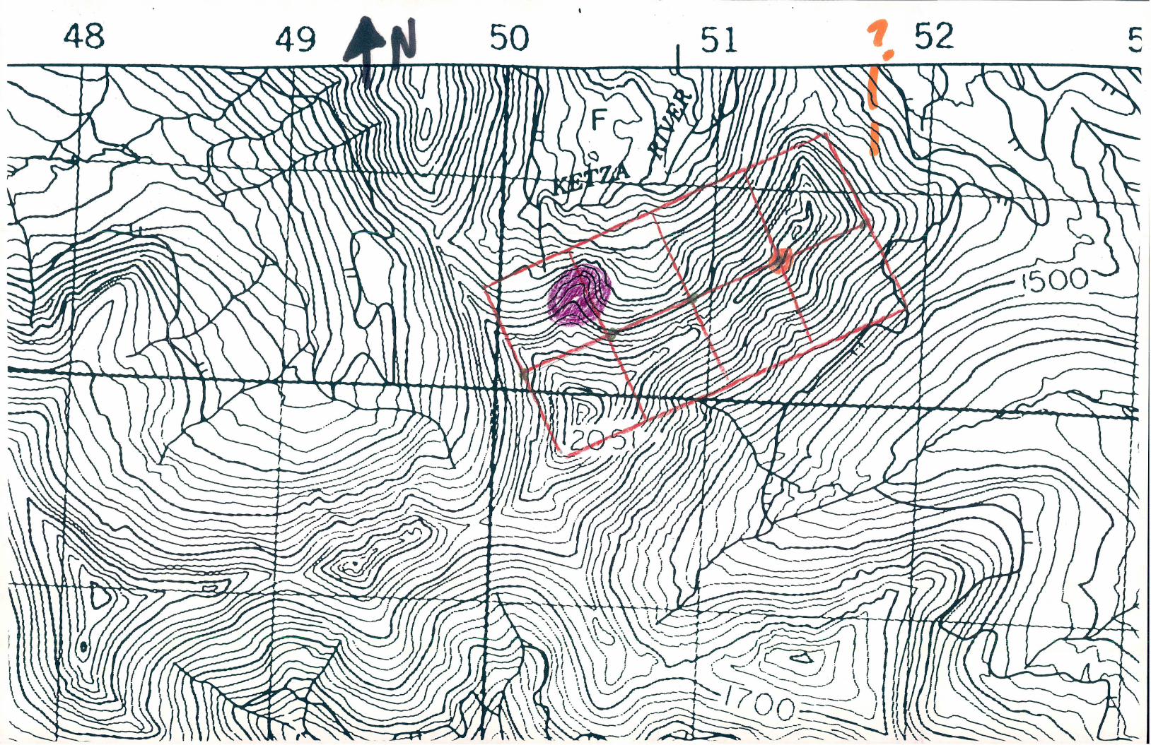
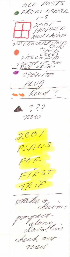
0/9 £5573”GF/(p/M A/é’fl/(Z’fl
3‘” /
' ??aibfffl
. , flzu(144/247;
WW3“azflm/Lcef/€995)
. ’ (37‘6)S/7§ 0”254/47—
7AM 77/0/13 ?M
'M' gfgwg
g awin‘ flt'W/K/ ?
A73?72%?
gféémy
WWMg?{m ’91;
rflM MWWw/
\NU . Q\~OO . - OPP
.133y33333333 33333.33.
3333333333 3.3.33- 3 33.33}333333333
. 33333.3.3333.333333.33 33.33..3333.33333.313.333.33. 3, 3m
.3333 3333333333333 \3333,_3.3.3.33 1.33.3.3.\\333333m31. 1.34.33333\33333333\HWQK3
333333.33. 3.3... \\ 3.3331133.313-- 11-11.113-33133331-133- N. . M3 .3 33.3.3.33%L11-
$33 «3.3m 3M3 333%3kg
33333333333333 33%.»3
3.33.. 3333133333333 3\W113.333§3 . .1. 333333-
3.. 333333333333 .. 3,. 33.3333333.333 333\333333333
3.3 3.3333R33. mo SN
\.\. 3.33.333 .133. .393.33.33.--__3333.33.3333
3.3.M333
3333333333....
,® \\
§\§§§\Q§\ XII;\\uu\\ am
éy§N§xEfig$$me %\$\& \hmnWfixx9mm\mmkmkfl
[MMSRQ§xN\$\N \kfixfl vmwnl\\§Q\MVM®Y Q§§l
§N§K§$\Q §R\N\$ \Q\V\\
_ \QQK N\\MWNX‘XMWVINQHEQKRRMWWNW;\ .
§§$ \NfimmV Nw) $3\§%\\MV1\&\§ §k\&%§w w a
i§\RX §§§m Kkfi RNNWg
ikflm §§\N\Q§\§§§K ,
k%§\\\ 4%$§M\\\%§N \
O77@flgzflng
, - 77’7/777'745 MC, Q/flWéM 7/5“70545/472 WK 775 797774
77W/773/727, 7/3 74974//5%7/é/
——~ floflMf/MK WMM/é’K/Kcé/KWmLfl£7755 ((72727. M779 79 7o
( 1/@506/73 ,”0705/7 7474/5 /65@ (/7099?)
§£0577 JMfl/g/ M570//¢#¢9f:/cfiSM
*7 M7797"? 7/4374 44724744/ 4977; 695577777flaJWC/<
*9@flW/fi 77M47’77g5’ My 5779634474A /fl, .5713 ~— 5/2.
6%”§/464/775 0472/ 47/77/€/%7577“ 77/55”

@/‘ ag g&&/ é—wgSXcfiOfi
méf/fléff _ 115/146}? gaffk
g/g/W /——7/@/éyé, m 4;.
/ ”—7501,; 4 ;%WU/5&5—
! f 7’30 x Z, X ‘ L
25% /?
WflSS/Q/é’ /_§5/z'7:r Xi? J K3% ( 455772%6 .3/m Wxiga/ ?@ j
V (596
737%4 /??%aéfiw
.''I
‘V-L
-.{4"“1.
IW‘
’ *
~ {mwbfi 7"'ne3>=;‘ “2W.“ 7‘“ '
Geological Surireyof Canada
Geology of Canada, no. 8
GEOLOGY OF
CANADIANMINERAL DEPOSIT
TYPES
'1.
.,‘
r...
“,
,.,
VI..
13,:
,A
V
MM???“W:
'3W
.;.<:.,.>-
'fl
mp2:
mumwflmgmi3.2mm,
edited by
CR. Eckstrand, W.D. Sinclair, and RI. Thorpe
1995
This is volume P-l of the Geological Society of America’s Geology of North America series
produced as part of the Decade of North American Geology project.
IVIV
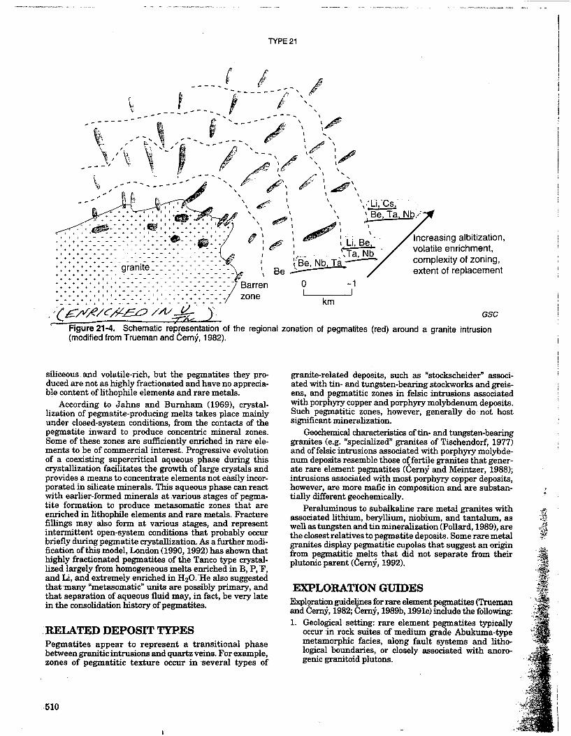
TYPE 21
\
- 'Barren. +
i i + 1 + 1 i + f + 1 i 1 zone++§+~¢¢4- ............
‘ .{E/V/é/cfizgo Meg:
III
,9vffi‘ I
II(
Bey»
‘\-"Li,‘Cs" ’ ,,\---‘ .9. Be, TaI Nb/
Increasing albitization,
volati|e enrichment,
complexity of zoning,extent of replacement
\
l .
II-~ ; .,l Y
. ,‘\Ta,Nb ‘Be, Nb Ta/—’
0 ~1|___l
km
GSC
Figure 21-4. Schematic refaresentation of the regional zonation of pegmatites (red) around a granite intrusion(modified from Trueman and Cam}, 1982).
siliceous . and volatile-n’ch, but the pegmatites they pro-duced are not as highly fractionated and have no apprecia-ble content of lithophile elements and rare metals.
According to Jahns and Burnham (1969), crystal-lization of pegmatite-producing melts takes place mainlyunder closed-system conditions, from the contacts of thepegmatite inward to produce concentric mineral zones.Some of these zones are sufficiently enriched in rare ele-ments to be of commercial interest. Progressive evolutionof a coexisting supercritical aqueous phase during thiscrystallization facilitates the growth of large crystals andprovides a means to concentrate elements not easily incor-porated in silicate minerals. This aqueous phase can reactwith earlier-formed minerals at various stages of pegma-tite formation to produce metasomatic zones that areenriched in lithophile elements and rare metals. Fracturefillings may also form at various stages, and representintermittent open-system conditions that probably occurbriefly during pegxnatite crystallization. As a further modi-fication ofthis model, London (1990, 1992) has shown thathighly 'fi'actionated pegmatites of the Tanco type crystal-lized largely from homogeneous melts enriched in B, P, 'F,and Li,.and extremely enriched in H20."He also suggestedthatmany “metasomatic” units are possibly primary, andthat separation of aqueous fluid may, in fact, be very latein the consolidation history ofpegmatites.
IRELATED DEPOSIT TYPESPegmatites appear to represent a transitional phasebetween granitic intrusions and quartz veins. For example,zones of pegmatitic texture occur in 'several types of
“.510
granite-related deposits, such as “stockscheider” associ-ated with tin- and tungsten-bearing stockworks and greis-ens, and pegmatitic zones in felsic intrusions associatedwith porphyry copper and porphyry molybdenum deposits.Such pegmatitic zones, however, generally do not hostsignificant mineralization.
Geochemical characteristics offin— and tungsten-bearinggranites (e.g. “specialized” granites of Tischendorf, 1977)and of felsic intrusions associated with porphyry molybde-num deposits resemble those of fertile granites that gener-ate rare element pegmatites (Gem); and Meintzer, 1988);intrusions associated with most porphyry copper deposits,however, are more mafic in composition and are substan-tially different geochemically.
Peraluminous to subalkaline rare metal granites withassociated lithium, beryllium, niobium, and tantalum, aswell as tungsten and tin mineralization (Pollard, 1989), arethe closest relatives to pegmatite deposits. Some rare metalgranites display pegmatitic cupolas that suggest an originfrom pegmatitn'c melts that did not separate from theirplutonic parent (Cemfi, 1992).
EIG’LORATION GUIDES
Explgration guidelines for rare element pegmatites (Truemanand Cemj', 1982; Cemjl, 1989b, 1991c) include the following.
1. Geological setting: rare element pegmatites typicallyoccur,;in rock suites. of medium grade .Abukuma-typemetamorphic facies, along fault systems and litho—logical boundaries, or closely associated with anoro-genic granitoid plutons.
I.ii

.1‘
";
1.151
ii.-
1.Murfgwga,
.,
2.- Regional zoning: identification ofzonal patterns ofpeg-matite distribution can help isolate specific areas ofinterest.
3. Fractionation: mineral assemblages and.chemistry ofindividual minerals in pegmatites indicate fractiona-s.tion levels and economic potential.
4.. Geochemical approaches: rim” die ersion aureole .‘in host rocks (e.g. Li, Rb, '03, Be, YE), secondary‘disper-sion halos in oyerhprden, and light plus heavy mineralsin stream sediments‘(e.g. beryl, spodumene, tourma-liné', columbit'e-tantaite) help identify target areas at 'both regional and local scales.
5. Geophysical approaches: radiometric surveys may begseful for identifying parent, anites and/or associatedpea; -. 'tes that are enriched , ..;,oliil9msurveys can ne use- . outline pegmatites in host rocksof contrasting density.
ACKNOWLEDGMENTP. Cemy reviewed the paper and provided many con-structive comments.
SELECTED BIBLIOGRAPHY
References marked with asterisks (*) are considered to be the best sourcesof general information on this deposit type.-
Bellasis, J.WM. and van dér Heyde, C.1962: Operations at Kemetivi Tin Mines Ltd., Southern Rhodesia;
Chamber ofMines Journal, v. 4, no. 9 (Sept), p. 36-41.
Breaks, F.W. and Moore, JM” Jr.
1992: The Ghost Lake batholith, Superior Province of northwesternOntario: a fertile, S-type, peraluminous granite - rare-elementpegmatite system; The Canadian Mineralogist, v. 30, p. 835-875.
‘Cameron, EN., Jahns, R.H., McNair, A., and Page, LB.1949: Internal structure of granitic pegmatites; Economic Geology,
Monograph 2, 115 p.Carter, TR. and Colvine, AJC. .
1985: Metallic mineral deposits of the Grenville Province, southeasternOntario; The Canadian Institute of Mining and Metallurgy
v Bulletin, v. 78, no. 875, p. 95-106.I
Cerny, P.1982a: Anatomy and classification of granitic pegmatites; jg Granitic
Pegmatites in Science and Industry, (ed.) P. Cemy; MineralogicalAssociation of Canada; Short Course Handbook, v. 8, p. 1-39.
1982b: The Tanco pegmatite at Bernie Lake, southeastern Manitoba; '3Granitic Pegmatites in Science and Industry, (ed.) P. Cami;Mineralogical Association ofCanada, Short Course Handbook, v. 8,
p. 527-543. -*19820‘: Granitic Pegmatites in Science and Industry, (ed.) P. Cemf;
Mineralogical Association ofCanada, Short Course Handbook, v. 8,
555 p. ‘1989a: Characteristics ofpegmatite deposits oftantalum; ix; Lanthanides,
Tantalum and Niobium, (ed.) P. Mbller, P. Cemy", and F. Saupé;Society for Geology Applied to Mineral Deposits, SpecialPublication No. 7, Springer-Verlag, Berlin, p. 192-236.
1989b: Exploration strategy and methods for pegmatite deposits oftantalum; i; Lantham'des, Tantalum and Niobium, (ed.) P. Mfiller,P. Cami, and F. Saupé; Society for Geology Applied to MineralDeposits, Special Publication No. 7, Springer-Verlag, Berlin,p. 274-302.
1990: Distribution, affiliation and derivation of rare-element pegmatitesin the Canadian Shield; Geologische Rundschau, Band 79, Hefi; 2,p. 163-226.
19913: Fertile granites of Precambrian rare-element pegmatife fields: isgeochemistry controlled by tectonic setting or source lithologies?;Precambrian Research, v. 51, p. 429-468.
*1991b: Rare-element pegmatites, Part I: anatnmy and internal evolutionof pegmatite deposits; Geoscience Canada, v. 18, no. 2, p. 49-67.
GRANITIC PEGMATITES
V
Cami P. (cont)’1991c: Rare-element pegmatites, Part 11: regional to global environments
and petmgenesis; Geoscience Canada, v. 18, no. 2, p. 68-81.,
1992: Geochemical and petrogenetic features of mineralization inrare-metal granitic pegmatites in the light of current research;
v I . Applied Geochemistry, v. 7, p. 393-416.
Cerny, P. and Meintzer, RE.1988: Fertile granites in-the Archean and Proterozoic fields of
rare-element pegmatites: crustal environment, geochemistry andpetrogenetic relationships; igrRecent Advances in the Geology ofGranite-Related Mineral Deposits, (ed.) R.P. Taylor andDP. Strong; The Canadian Institute of Mining and Metallurgy,
’ Special Volume 39, p. 170-207.éemy, P., Meintzer, R.E., and Anderson, AJ.1985: Extreme fractionationin rare-element graniticpegmatites: selected
examples of data and mechanism; The Canadian Mineralogist,v. 23, . 381-421.
Grouse, RA, emf, P., Trueman, D.L., and Burt, 11.0.1984: The Tanco pegmatite, southeastern Manitoba; i__I_1 The Geology of
Industrial Minerals in Canada, (ed.) G.R. Guillet and W. Martin;The Canadian Institute of Mining and Metallurgy, SpecialVolume 29, p. 169-176.
Evans, RK.1978: Lithium reserves and resources; Energy, v. 3, p. 379-385.
Flanagan, J.T.'
1978: Lithium deposits and potential of Quebec and Atlantic provinces,
Canada; Energy, v. 3, p. 391-398.
Ginsburg, A.I. '1984: The geological condition ofthe location and the formation ofgranitic
pegmatites; Proceedings of the 27‘“ International GeologicalCongress, v. 15 (Non-metallic Mineral Ores), VNU Science Press,
Utrecht, The Netherlands, p. 245-260.
Hatcher, M.I. and Bolitho, EC.1982: The Greenbushes pegmatite, south-west Western Australia; '2
Granitic‘ Pegmatites in Science and Industry, (ed.) P. Cemy;Mineralogical Association ofCanada, Short Course Handbook, v. 8,p. 513.525.
Hutchinson, RW.1955: Regional zonation of pegmatites near Ross Lake, District of
Mackenzie, Northwest Territories; Geological Survey of Canada,
Bulletin 34, 50 p.
Jahns, RH. ‘1955: The study ofpegmatites; 13 Economic Geology, FifiiethAnniversary
Volume, (ed.) A.M. Bateman; p. 1025-1130.
*Jahns, RH. and Burnham, C.W.
1969: Experimental studies of pegmatite genesis: I. A model for thederivation and crystallization of granitic pegmatites; EconomicGeology, v. 64, p. 843-864.
Knight, ND.
1986: Lithium; 13 Australian Mineral Industry Annual Review for 1983,
Bureau of Mineral Resources, Geology and Geophysics, Canberra,Australia, p. 181-182.
Knight, NJ). and Wallace, D.A. _
1982: Tantalum and niobium; i._n_ Australian Mineral Industry AnnualReview for 1980, Bureau of Mineral Resources, Geology and
Geophysics, Canberra, Australia, p. 253-256.
Kunasz, I.
1982: F'oote Mineral Company - Kings Mountain 0 eration; 13 GraniticPegmatites in Science and Industry, (ed.) P. emi; MineralogicalAssociation of Canada, Short Course Handbook, v. 8, p. 505-511.
Lasmanis, R.
1978: Lithium resources in the Yellowknife area, Northwest Territories,
Canada; Energy, v. 3, p. 399-407.
London, D.
1986: Magmatic-hydrothermal transition in the Tanco rare element
pegmatite: evidence from fluid inclusions and phase-equilibrium
experiments; The American Mineralogist, v. 71, p. 376-395.
. *1990: Internal differentiation of rare-element pegmatites; a synthesis of
recent research; '3 Ore-Bearing Granite Systems; Petrogenesis and
Mineralizing Processes, (ed.) H.J. Stein and J.L. Hannah;
Geological Society ofAmerica, Special Paper 246, p. 35-50.
1992: The application of experimental petrology to the genesis and
crystallization of granitic pegmatites; The Canadian Mineralogist,
v. 30, p. 499-540.
Martin, HJ.1964: The Bikita tinfield; Southern Rhodesia Geological Survey Bulletin,
no. 58, p. 114-132.
_Martin, R.F. and (Jeni, P. (ed.)*1992: Granitic pegmatites; The Canadian Mineralogist, v. 30, p. 497-954.
511
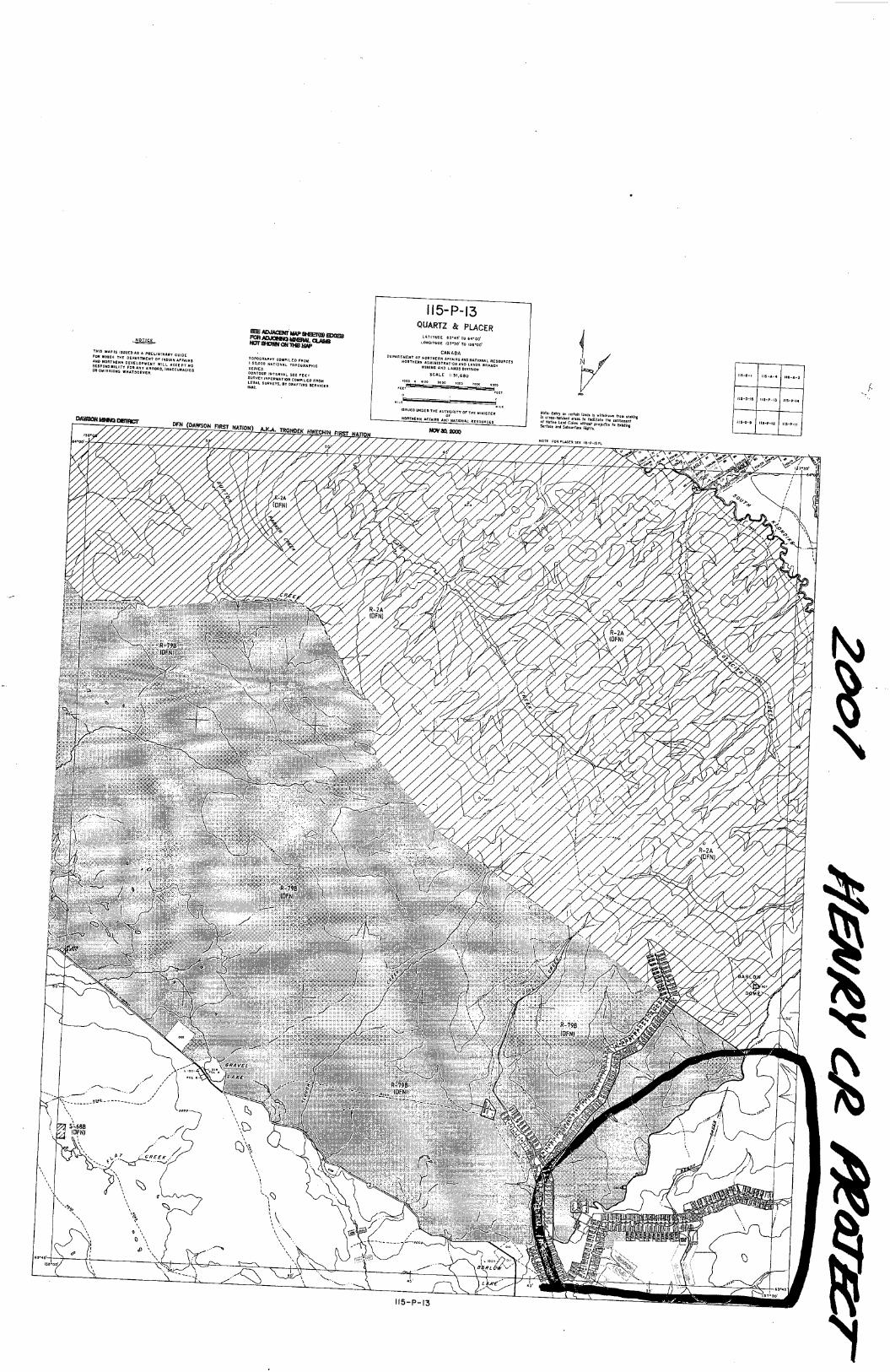
NQTICE
Tm: sums ISSUED AS A PRELIMINARV GUIDE
mmmwm
ummwmmmMWMWmmmmw
mPaGRAMv COMPILfD raw1:50.000 NATIONAL Tuvocmrmcssmes.couroun VNYERVAL sun FEEYsuavzv mrcnmnau COMPILED FROMLEGAL sukvzvs, av nnrrmq SERVICE!ma.
ll5-P-l3QUARTZ & momLunun: eru'ro 6000'LfiNflITUDE m'w' re 138‘00'
CANADAosnnmsur or mourns“ Arums AND NATIONAL nssounczsNORYNERN ADMINISYEAHON mo LANDS annexmums AND LAND! mvlsnon
SCALE l: SLSGOum e moo ma 5mm 7mm ma'HEEEEEE’!"o
zuanm_m‘cssuzn u~nzn 7N: Aumumn or ms mmsrsnnrncamsan "mas mv NAYIONAL nzsouaci:
Z...
uoT: row Duct: SEE ”5-9-13 9-.
liv'sa‘
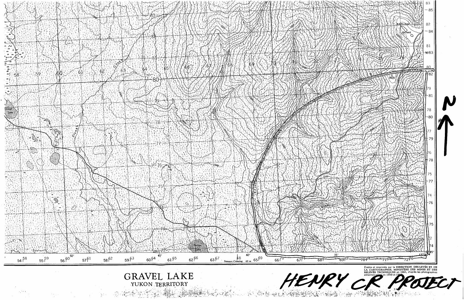
. 9 , 50 . _. . 3 5 ,. 6 , , . 4O ,
55F 56 $30 57?31 . 58f52 59f3 v 61?5 6216 , -_ , u
GRAVEL LAKEYUKON mERRI'leRY _ _
Etablie et imprimée par la DIRECTIONDES LEvEs 121 DELA CARTOGRAPHIE, MINISTERE DES M1NES_ET DESRELEVES TECHNIQUES en 1961, d'aprés les photographiesaériennes '
‘35 I.
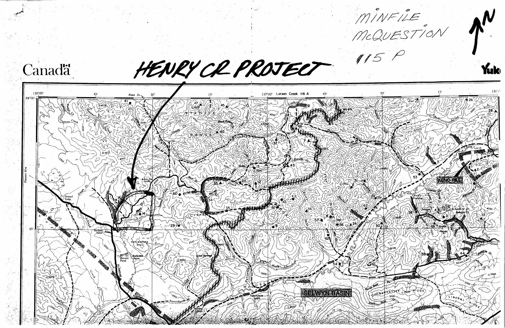
CanadaV
’
Daww"
50m
MINFILE: 115P 014PAGE NO: 1 of 1
. UPDATED: / I90
YUKON MINFILE ,YUKON GEOLOGY PROGRAM '
WHITEHORSE
NAME(S)’: Clear cm?" NTS MAP SHEET: 115 P 13MINFILE #:115p 014 ' LATITUDE: 63°46'46"NMAJOR comonrrmsi: UTh LONGITUDE: 137°33'09"wMINOR COM1v10DrrIES:—-‘—_’ DEPOSIT TYPE: PorphyryTECTONIC ELEMENT: Selwyn Plutonic Suite STATUS: Showing
CLAIMS (PREVIOUS AND CURRENT)
HKW, RUSS, URA, DAD, CUT
WORK HISTORY
First staked in Jun/55 by J . Hanna and G. Karens as HKW CI (57989), which were surrounded by fringestakers later in the year. Karens restaked the property in Oct/66 as Russ c1 (Y15092), which were hand trenchedby R. Newsom and J.Snc11 in 1967 under option, and reoptionedm 1969 to a group of Whitehorse businessmenwho added more Russ cl (Y37897)_'1n May/6_9 and transferred the option briefly to Newmont, which conducted
2airBOrne and ground scintillometersurveys and bulldozer trenchingm 1970. Karens added more Russ C]1n Jul/71(Y56089) and Dec/72(Y65830).
Restaked as 448 URA, etc. c1 (Y90349) in Apr-Oct/75 by R.G. Hilker & P. Hammond. The propertywas optioned by Beach Gold ML, which carried out ground and airborne radiometric surveys and drilled 4 holes(288.0 m)111 1975. Restaked by Hilker as Dad c1 (YA31746)1n Aug/78 and optioned to Jewel Res L, whichperformed geochem and radiometric surveys in 1979 and added more Dad cl'1n May/86.
Restaked as Cut c1 (YB23859)1n Mar/89 by R. Stack.
GEOLOGY
The presence of the rare earth silicate allanite was recognizedm a placer concentrate from Clear Creek. in 1951. The staking covers a fractured, slightly gossaned, feldspar porphyry phase within a granitic intrusion
that cuts Paleozoic? metamorphic rocks. Radiometric response is about four times background within an area 180m square.
Samples of porphyritic granite assayedin 1955 returned up to 0. 12% U30,3 but more recent sampling hasfailed to reveal more than0.01% 1598,although slightly higher thorium assays have been obtained. The 1975drilling gave disappointingresults.
REFERENCES
I GEOLOGICAL SURVEY OF CANADA Paper 51-10, p. 14.
WESTERN MINER, Apr/56, p. 56.
ACE R. PARKER AND ASSOC. LTD, Jun/70. Assessment Report #060619 by AR. Parker & D.G. Mark.
BEACH GOLD MINES LTD, May/75. Vancouver Stock Exchange Open File Report by J.W. MacLeod.
MINERAL INDUSTRY REPORT, 1975, p.- 81-82
JEWEL RESOURCES LTD, Sep/78. Prospectus Report #061853 by J.R. Poloni.
NORTHERNVMINER, 31 May/79.
MINFILE: ,' 115F060PAGE NO: 1 of lUPDATED: 07/26/95
YUKON MINFILEYUKON GEOLOGY PROGRAM
WHITEHORSE
NAME(S): Lost Horses NTS MAP SHEET: 115 P 14MINFILE #: 115? 060 _ LATITUDE: 63°49'03“NMAJOR COMMODITIES: - LONGITUDE: 137°22’56"WMINOR COMMODITIES: - DEPOSIT TYPE: UnknownTECTONIC ELEMENT: Selwyn Basin STATUS: Uncertain
CLAIMS (PREVIOUS AND CURRENT)
LOST HORSES, HP
WORK HISTORY
Staked as Lost Horses c1 (YBZ3480) in Jun/89 by 6176 Yukon L. In Dec/94 L. Hart staked the HP c1 1-
30 (YBS3028) 3 km northwest of the occurrence.
GEOLOGY
The claims ire underlain by schist, quartzite and limestone of the Late Proterozoic-Early CambrianHyland Group, sbme 1 km east of the Barney stock, a granite intrusion of mid Cretaceous age.
REFERENCES
MURPHY, D.C., HEON, D., AND HUNT, J ., 1993a. Geological overview of Clear Creek map area, western
Selwyn Basin (NTS 115P/14). In: Yukon Exploration and Geology 1992, Exploration and Geological Services
Division, Yukon, Indian and Northern Affairs Canada.
MURPHY, D.C., HEON, D., AND HUNT, J ., 1993b. Geological map of Clear Creek map area, western
Selwyn Basin (NTS 115P/14). In: Yukon Exploration and Geology 1992, Exploration and Geological Services
Division, Yukon, Indian and Northern Affairs Canada, Open File 1993-1(G), 1:50 000.
MINFILE: 115? 029PAGE NO: 1 of 1UPDATED: 06/24/93
YUKON MINFILEYUKON GEOLOGY PROGRAM
WHITEHORSE
NAME(S): Thoroughfare NTS MAP SHEET: 115 P 14
MINFILE #: llSP 029 LATITUDE: 63°45'31"NMAJOR COMMODITIES: - LONGITUDE: 137°23'08"WMINOR COMMODITIES: - DEPOSIT TYPE: UnknownTECTONIC ELEMENT: Selwyn Plutonic Suite STATUS: Uncertain
CLAIMS (PREVIOUS AND CURRENT)
C.C. .
WORK HISTORY
Staked as C.C. c1 (YA29785) in May/78 by Norman Bunniester.
GEOLOGY
The claims are underlain by medium to coarse grained granite of the mid Cretaceous Twin Sisters
batholith, and thick Pleistocene stream. gravels.
REFERENCES
MURPHY, D.C., HEON, D., AND HUNT, J ., 1993a. Geological overview of Clear Creek map area, westem
Selwyn Basin (NTS 115P/ 14). In: Yukon Exploration and Geology 1992, Exploration and Geological Services
Division, Yukon, Indian and Northern Affairs Canada.
MURPHY, D.C., HEON, D., AND HUNT, J ., 1993b. Geological map of Clear Creek map area, western
Selwyn Basin (NTS llSP/14). In: Yukon Exploration and Geology 1992, Exploration and Geological Services
Division, Yukon, Indian and Northern Affairs Canada, Open File 1993-1(G), 1:50 000.
MINFILE: 115? 014PAGE NO: 1 of lUPDATED: / I90
YUKON MINFILEYUKON GEOLOGY PROGRAM
WHITEHORSE
NAME(S): Clear Creek NTS MAP SHEET: 115 P 13MINFILE #: 115P 014 LATITUDE: 63°46'46"NMAJOR COMMODITIES: U,Th LONGITUDE: 137°33'09"WMINOR COMMODITIES: - DEPOSIT TYPE: PorphyryTECTONIC ELEMENT: Selwyn Plutonic Suite STATUS: Showing
CLAMS (PREVIOUS AND CURRENT)
HKW, RUSS, URA, DAD, CUT
'WORK HISTORY
First staked in Jun/55 by J . Hanna and G. Karens as HKW c] (57989), which were surrounded by fringestakers later in the year. Karens restaked the property in Oct/66 as Russ c1 (Y15092), which were hand trenchedby R. Newsom and J. Snell in 1967 under option, and reoptioned in 1969 to a group of Whitehorse businessmenwho added more Russ c1 (Y37897) in May/69 and transferred the option briefly to Newmont, which conductedairborne and ground scintillometer surVCys and bulldozer trenching in 1970. Karens added more Russ CI in Jul/71(Y56089) and Dec/72(Y65830).
V Restaked as 448 URA, etc. c1 (Y90349) in Apr-Oct/75 by R.G. Hilker & P. Hammond. The propertywas optioned by Beach Gold ML, which carried out ground and airborne radiometric surveys and drilled 4 holes
(288.0 m) in 1975. Restaked by Hilker as Dad cl (YA31746) in Aug/78 and optioned to Jewel Res L, which
performed geochem and radiometric surveys in 1979 and added more Dad CI in May/86.
Restaked as Cut c1 (YB23859)- in Mar/89 by R. Stack.
. GEOLOGY
The presence of the rare earth silicate allanite was recognized in a placer concentrate from Clear Creek
in 1951. The staking covers a fractured, slightly gossaned, feldspar porphyry phase within a granitic intrusionthat cuts Paleozoic? metamorphic rocks. Radiometric response is about four times background within an area 180
m square.
Samples of porphyr‘itic granite assayed'in 1955 retumed uh to 0.12% U308 but more recent sampling hasfailed to reveal more than 0.01% U308, although slightly higher thorium assays have been obtained. The 1975
drilling gave disappointing results.
REFERENCES
GEOLOGICAL SURVEY OF CANADA Paper 51-10, p. 14.,
'WESTERN MINER, Apr/56, p. 56.
ACE R. PARKER AND ASSOC. LTD, Jun/70. Assessment Report #060619 by AR. Parker & D.G. Mark.
BEACH GOLD MINES LTD, May/75. Vancouver Stock Exchange Open File Report by J.W. MacLeod.
MINERAL INDUSTRY REPORT, 1975, p. 81-82
JEWEL RESOURCES LTD, Sep/78. Prospectus Report #061853 by JR. Poloni.
NORTHERN MINER, 31‘ May/79.
MINFILE: USP 015PAGE NO: 1 of l
UPDATED: / I81
YUKON MINFILEYUKON GEOLOGY PROGRAM
WHITEHORSE
NAME(S): Barlow NTS MAP SHEET: 115 P 13MINFILE #: 115? 015 LATITUDE: 63°48‘25"N
_' MAJOR COMMODITIES: - LONGITUDE: 137°39'29"WMINOR COMMODITIES: - DEPOSIT TYPE: UnknownTECTONIC ELEMENT: Selwyn Basin STATUS: Uncertain
CLAIMS (PREVIOUS AND CURRENT)
CARMELA, LUCKY STRIKE
WORK HISTORY
Staked as Carmela cl (15183) in Aug/27 by M. Pavisic. The Lucky Strike cl (39179) was staked
somewhere nearby in Jan/40 by T. Gergich.
GEOLOGY
The claims are staked on alluvium that could include gold-bearing "White Channel" gravel, overlying
Paleozoic? metasedimentary rocks.

m_.,-9
..,4
...>
.Wv.
.~..
.4u.
x.w“
.m“
.-,.
m...
_.~...L....~.
...‘-.
..._
.._‘
..,,
..~M.mm.“
mm
.4..-»_
A
_.b,
«Nfloa‘x
W(‘1'
w‘'"’30-??7
PROTEROZOIC
LEGEND
(QUATERNARYPOST-GLACIAL
20 Stream deposits, a/Iuvium
Sur/icia/ deposits21 undivided TERTIARY AND LATER '
' PLIOCENE (7) AND LATER
Stream deposits, a/luvium;193, "White Channel gravel"
SELKIRK GROUP
Basalt, andesite
CENOZOIC
A
17:, rhyo/ite, trachyte; 17b, granite and syenite porp/vyries, trachyte
EOCENEO) OR LATERCARMACKS GROUP
16 Andesite, rhyo/ite, trachyte, dacite
EOCENE (7)J. :
Conglomerate, arkose, sandstone, silt, clay
K _
JURASSIC AND/OR CRETACEOUSCOAST mmusnous (13.14)
Granite, granodiorite, quartz monzonite
Syenite, monzonite MESOZOIC
J¥
.
63
Gabbro, peridotite, serpentine, a‘iqrite
CARBONIFEROUS (1’) T00) CRETACEOUS
11 Andesite, trachyte
_ f, . .
10a, conglomerate, chart, tu”, slate; 10b, phy/Iite, quartzite;
10c, quartzite, chert, phyI/ite, limestone
Limestone, slate, phyI/ite, quartzite
PAL/EOZOIC
' ' ORDOVICIAN (7) OR EARLIER
7. Varico/ourec/ slate
6. Qualtz/te, slate, phy/lite, limestone
KLONDIKE GROUP
‘ Schist, orthogneiss
\YUKON GROUP (1-4)
Schist, quartzite, phyI/ite, limestone
schist, phyl/ite,Schist, quartzite, limestonelimestone
Quartzite, schist
Geo/qgical boundary (approximate, assumed)..........................N
Limestone of various ages ............................................-==
Bedding, tops known (inclined, overturned) ................................ XX
Bedding, tops unknown (horizontal, inclined, vertical) ........................+//
Schistosity, {o/iation (inclined, vertical). ‘ , . ‘ . . . . . . . . . . . , . . ‘ . . . . . . . .' ........ MMFault (defined, approximate, assumed) ...............................WNW N
Antic/r'ne ...................................................._$_
Geo/ogy by H. S. Bostock, (911649119
Cartography by the Geological Survey of Canada, I963
Main mar"
Dawson50m
a
0) q
Paragneiss, quartzite,
9%Us a
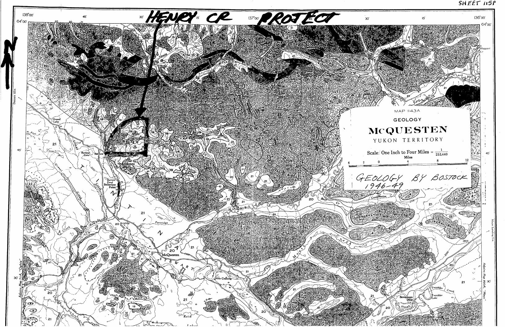
Dawson
50m
SHEE‘F ”5F
.. Hagynrt
(,‘r
/
MAPH43A
GEOLOGY ‘ , z. A
McQUESTEN ~ aYUKON TERRITORY I
45’
Séalef One Inch to Four Miles =m ‘ \ 45,
.0 V Miles 8 12 ~
i §§§M$¥ 6f 6497264
Z5.D
E/‘ i
iu.a
)>
3—g.
.
:-
III
\
§30' R
b
S
g 30
E
LIo-
\
.s-
h
,0
‘
‘S<( _.
”OKDW
1 ,
VGIOPBYIIGAL.IUIIAIY Inralr
. on tho 7' 19
.4. '-i 'nuns anal: anon? ' 4 *. f, - ,6; . 7
(amm mm) ‘73" ~‘,
nuwooa lining District. raucn' _‘\ \(res l115-r-13) "
Latitude 630 32'! . ,‘ ~- luau - ~21" y—»m¢1tuo 137' #7!!! . n:nmrmr'u }
,7’ ll‘i ‘2“! \l
‘. . ours“! ‘IA thl [Ix
.by
J98 '3. mmsdASlM me;mmnr 001801313285 0mm. mtohno, ‘Mon W
‘le‘ w .— ~ I. .4 ~ I ). '\Datod (é‘ '3 "7 5 i . 9/0 .51‘| I.’ :\ c. \ 7
I“c?“ mspm; as cmcs ‘7
-
‘\. w
/- "
“hr"..
\’. ~mrmoizss, m. , /4
'tn.
1‘“: I fir
1-: Do at M. 1970 (w
'Thif: rcpcrt lw r-“mia'v! 7"; 12‘s' ' G:;§‘;xca‘. 1it-'.- : ~- [HR (2'?! it ‘_::-' ‘-
y.“ 0.“..tfi x: . !~ . -(‘ ~ _‘ .2" ‘13:“, ~ :9.Lu L1- !"JZ. ‘ ‘. . . . Lu. . .....u
1m... :-1£,Lo.am_____JIJ: '9‘9é6~Juno 197 ' *
,ntcmttutl
(7:71." ' ‘-.~: fixation work unfi:
. -'.u.x Quartz Mining Ac.S;c;..;z :. \u
I ). .-’ .’ .=- £122.75: é'7f_/____ 7‘
""tr /’
“W"
/T
!W R lTORY \KEY MAP '- - 50 Mi. CAnfi‘cxsu‘M
H PROPERTY LOCATION MAP
of tho
RUSS CLAIM GROUP
DAWSON CITY MINING DISTRICT
YUKON TERRITORY
:ALE- as noted
ACE?!5PARKER 6 ASSOCIATES‘ZTD'3”r. .' ms 517 ”(ms .:~. 56)vaxif rws
FAVE 'JUNE 4 497° : SEALIL... _ _ .. .6...,.._‘.“.___....__.__._.4
I.-.—...... .. .... _V. 7 .‘ “....-......-v..-..._4
I
DRAWN BY :' .é/é/é' '__‘_ -_._.- . .V _. _, ..,-.__... . .___-__4
; JRWG Noi
.
- ~—-—.—4 L__.___ .-..V”-.._...___..- . -... 4-- .—.—. . - .6, .....q
‘\._
\lkp‘w’ot. - STcwacr-\—~—'-‘_'\ U
(Dana
\
\ (Alt \-\
\.
4..., iw-“W‘IEM -“,‘m.’ ~o~w~lfl
30 :2 1;? 45 30
GSC OPEN FILE 1650
CHNHDH - YUKON
-15
MINERHL DEVELOPMENT
HGREEMENT (1984-1989)
KILOMETRES
URRNIUMIN
STREQM URTERSl
'61.
!
PPB xTILE90—D-nax
.oo- -98C]
.70— -95D
.50— —90C‘)
.44- -7o
.03- -n1N1219 SRMPLES
YUKON 1988
NTS 11SP
(PART OF 105M]
PPB61.90
2.?0
1.50
0.44
0.03
XTILE
MHX
95
90
70
MIN
1219 SAMPLES
um.-
nw
.,..
H LN
00
15-
L63 3C
~15
GSC OPEN FILE 1650'
-CHNHDH — YUKONMINERHL DEVELOPMENT
HGREEMENT (1984—1989)
KILOMETRES
FLUURIUEIN
STREQ" UQTERS
PPB %TILE1910- -nax
300— -98E
200— -95E
150— -90G
90- -70A
60- -5o
20-' -MIN1219 SAMPLES
YUKON 1988
NTS IISP
[PRRT 0F 105M]
PPB xTILE1910 Max
200 95
15b 90
90 7o
60
20 MIN1219 SHMPLES
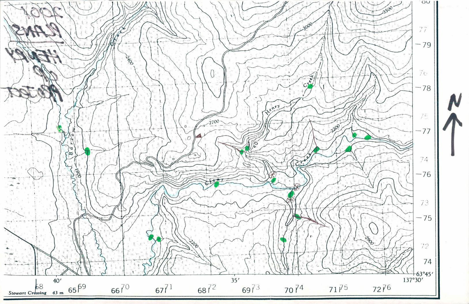
63°45'137°3o'
Stewart Cr wing 43 m‘8 65P9 ’ __ 71175 72?6
2
3%g.“ emfisfixbx»gag.
\\%§qu9 MNNQERRW
\§\\mfim m».
b$$$$wa

// SHEET 105 d—4“TICE
LATIYUDE 52' ad To 62%;N O Lonsrruos var 30‘ To 132-00'
:ms MAP 8 135qu {35 A PREL'M'NARY ”DE‘ son wmcn THE neggwgg‘s‘oosfigmfim _2:??? 3:;21mm: Lm FDRW ERRORS. _ ‘ DEPARTMENT OFNORnERN Amxns AND NATIONAL RESOURCES N I05 K-a ms 4-5 :05 J46
INACCURACDES 0a mgi‘ssmns WHATSOEVER ow ADJADEIT IMP SENS) axes '
THE SHEET BEFORE9PM SURVE'S “AVE MIG"wmmSEEN MA .______.. .4DE GI “'3 MAP SCALE ‘fz MILE To I Wm ____ msK-I :05 4-4 I05 «1
am a w m,m,mumawmmw LawmmmmLJ,J_L__1._._1._J_|__J.._L___I I-
_rm
qmmtmwmm II‘BS'E‘I AFEflDc-noeeflvaimooma.
fififim gag K w “E . m(SSUED sv AUTHORH’Y OF THE MKMSTER '05 H6 ‘05 0-” 1056‘”
New Entry un cerfaln lands rs M&hdr v f t k
_mm 4min: 3" ””5""!
NADA N W Home I wxraoflmsmum tomamo “f ”5's"1:";“3:535:3“31‘? m “”“”‘”’
osmnmam'omonmem was mo "mom; assumes:,W 5 b
Surfing and gunman Rwhfs Mn *0 Exxshng
NORTHERN ADMINISTRATION ANO LANDS same” *o
LAMS DIVISION
SCALES IZMILE Ta 1 INCH
30'
m. uoa .m w» wine m. I-n'n‘ ’- |ssuEn moan mnuggomw DFNE mNISTER Mm Emy en (ertam lands )5 ulthdravn from syakmg
"07mg?” “‘55 “‘0 N‘Y‘WAL RESOURCES' m cmsmarmed areas to mum: m: scmmznl‘uf Nam: Land (mm wlfhuuf prejudvn m EsthngSurface and Subsurrm mgnrs
mimmumcsmm
D
p msgi-zon Ron
'vor ,\21 ‘no.\¢‘/ l2
nnsuRow \
A
m 715
\Mx/J,m)\\\
‘ , g
. ‘
> 3‘
DD ‘ .
-.1
105F-16
.
1056-13 ,1


![[Michel Foucault]-Security, Territory, Population](https://static.fdokumen.com/doc/165x107/63330bf24e0143040300ef76/michel-foucault-security-territory-population.jpg)


