
SUMMARY OF ARCHEOLOGICAL STUDIES OF THE SITE OF MEDIEVAL SAURAN IN 2004 - 2009
50
INTERNATIONAL JOURNAL OF EURASIAN STUDIES Drift (SH11S) си/ % a % 4% «134897 The Commercial Press
-
Upload
independent -
Category
Documents
-
view
1 -
download
0
Transcript of SUMMARY OF ARCHEOLOGICAL STUDIES OF THE SITE OF MEDIEVAL SAURAN IN 2004 - 2009
INTERNATIONAL JOURNAL OF EURASIAN STUDIES
Drift ( SH11S)
си/ % a % 4%«134897 T h e C o m m e r c ia l P re ss
First Edition
Copyright © 2011 by The Editors-in-Chief
All rights reserved. No part of this book may be reproduced in any form or by any means without permission in writing from the publisher.
ISBN 978-7-100-08518-2
I. International Journal of Eurasian Studies П. YU Taishan, LI Jinxiu
FOUNDED BY
The Foundation for East-West Understanding & Cooperation
Published by The Commercial Press 36 Wang Fu Jing Street, Beijing 100710, China Printed in the People ’ s Republic of China
Sum m ary o f Ar c h e o l o g ic a l St u d ie s o f t h e Site o f
M edieval Sa u r a n in 2004 - 2009
Erbulat A. Smagulov
The city o f Sauran was one o f the most famous and im portant cities o f medieval
Kazakhstan situated on the Great Silk Road in the Syr-Darya river basin. Its past is
preserved in the occupation layers of the Sauran Archaeological Complex (hereinafter
referred to as SAC), comprising two major monuments-the site o f the ancient city of
Karatobe (mid-1st millennium CE-first half of 14th century CE) and the city of Sauran
proper (14th-18th centuries). The monuments o f the Sauran complex are situated
administratively in the Turkestan district 40-50 km west of the city of Turkestan (PI. VI-1) along the highway and railroad in the province of Southern Kazakhstan. Generally, in
Central Asian historiography the area of the middle course of the Syr Darya river basin
is characterized as a marginal zone in the development of Central Asian urban culture, as
determined by specific local factors.The cycle of recent preliminary archaeological studies has provided some answers to
important questions of dating and location, historical topography and cultural peculiarities
of the medieval city, and the results underscored the urgency and prospects of extensive
studies with a view to laying the foundations for a museum at the site of the monuments,
and made it possible to develop specific programs for subsequent archaeological study
preserving the most representative structures (objects) for the purpose of founding an
Architectural and Archaeological Open Air Museum.[1] Archaeological work on various
scales and of different types has been carried out at structural elements o f the Sauran
Archaeological Complex during recent years, and the major task of this article is
familiarizing readers with some of this work.
— 1 9 9 —
International Journal o f Eurasian Studies
I. History of the Study of the Sauran Archaeological Complex
Almost one and a half centuries have passed since the scientific community, for historical
reasons through Russian researchers and travelers, learnt of the site of the ancient city of
Sauran, and so it makes sense to provide a brief summary of the major historical stages in
its study.As an archaeological monument, Sauran was mentioned in the papers of almost all
distinguished Russian researchers in the historiography of this part of the world. Those
publications were of course descriptive and educational in character. Fascinated by the
picturesque nature and the mystery of these colossal ruins and the intuitive sense that this
city was once of great importance for the history of the region, these researchers attempted to
integrate what they observed with data supplied by medieval authors. The city was mentioned
in R I. Lerh’s works, R I. Pashino’s itinerary, and A. P. Fedchenko’s reports. These researchers
all wrote about Sauran’s surviving walls, and the ruins of the medrese.[2] The first excavations
at the site of the ancient city were conducted by academician A. Gejns as early as 1866. But the
level of develooment of Russian archeology at that time was still far from being able to solve
or even articulate the problems which arose during excavation. A. Gejns had dug two pits about one meter deep and found pieces of broken earthen crockery and other “trash”. “Not a single
interesting artifact” captured his attention, so all findings remained intact.[3]Scientific investigation of the Sauran ruins was initiated by the Southern Kazakhstan
Archaeological Expedition (SKAE) in the late 1940s under the direction of Prof. A. N.
Bemshtam, who developed a visual layout of the monument and dated the ancient city on,
the basis of the uncovered artifacts.141 The location of the city immediately become one of the j
matters subject to dispute. If the location of the site of Sauran of the 13th-18th centuries was
established, the pre-Mongol site of the city was not precisely located, since no strata were j
discovered with artifacts dating back to the period before the 13th century. It became clear
that the city had been relocated at some time between the 13th and 14th centuries. This is a
fairly common historical phenomenon for cities in general and for Central Asia in particular. ||
The location of early Sauran [5] aroused all manner of speculation by authors writing about the historical geography of the region. Only more detailed historical study and topographic I
surveys made it possible to locate early Sauran in the area of the city of Karatobe adjacent j
to the later-dated Sauran and situated 3 km. south of it. Preliminary archaeological study of J
the city dated its upper occupation layer or the upper limit of the period of vigorous urban I
growth to the 12th-13th centuries.161 It turned out that features of the upper occupation layer j
— 2 0 0 —
Summary o f A rcheological Studies o f the Site o f M edieval Sauran in 2004-2009
as well as the topography of the site of an ancient city are similar to those of the cities dated
иск to the 10th-12th centuries. Here topography clearly indicated a “Citadel”, “Shakhristan”, and “Rabat”, all the fundamental structural elements of the medieval city [7] developed on
, foundations laid down in antiquity.
The 1970s and 1980s were marked by brisk archaeological studies carried out by
Southern Kazakhstan Integrated Archaeological Expedition (SKIAE, under direction of K. A. Akishev) in Southern Kazakhstan, and Sauran once again attracted experts’ attention. As
a result of decoding aerial photos of the northwestern city neighborhood, traces of the kariz
|(the underground drainage galleries supplying ground water to the city) were registered Ground observations followed, and a detailed paper was published, which related these traces
to the kariz built with funding supplied by the local religious and financial potentate Mir-
■Arab [8] and mentioned by the medieval author Zeinatdine Wasifi. Fieldwork with a view
to conducting an archaeological study of the Sauran kariz was carried out by SKIAE in
11986-88. Thus three lines of kariz were discovered and there was made an assumption that all
[three lines could make up the huge system mentioned by Wasifi with a source running around
the medieval fortress of Mirtobe (PL VI-9).[91 But the excavation of some vertical wells only revealed an underground horizontal conduit at a depth of 7m.
Later study of the kariz systems in the vicinity of Sauran continued within the
framework of the Turkestan Archaeological Expedition’s (TAE headed by Smagulov E.A.) ■fork program, which resulted in the acquisition of unique data.[10]
At the turn of the century TAE also surveyed stratigraphy of the ancient cities of Sauran and Karatobe.[U] An open test pit made in the Sauran urban core circled with fortifications
revealed strata of the 13th-18th centuries and excavations carried out at Karatobe helped date
its upper occupation layer, i.e. the upper limit of vigorous urban growth, back to the 12th-
■3th centuries. The stratigraphy and its relationship to the geological time scale turned out
to be in succession which made it possible to conclude that the cultural stratification of these
■wo sites represent history and culture of one and the same historical city of Sauran, and the
burial grounds discovered under the initial construction horizon of the later-dated Sauran
«came the reason for advancing the hypothesis that the new city was built in the second half
of the 13th-beginning of the 14th century at the site of an old city cemetery.[12] Thus, we can p speak of the chronological and territorial succession of these two monuments that in its turn
strengthens an argument in favor of the localization of the early or ancient city of Sauran at the site of the ancient city of Karatobe.
The reference by Makdisi in the 10th century to “the seven walls of Sauran” allegedly
--- 201 ----
International Journal o f Eurasian Studies
encircling the city,[13] provided an incorrect benchmark in searching for topographic
realities. It must be admitted that this phrase is probably a mythological literary expression,
an idiosyncratic сНсЬё to emphasize the strength of the city’s fortifications. It should be mentioned that the sacred number seven is also used in the description of the impregnable
stronghold made of various metals and encircling Kangdiz, the legendary capital city of the
Tur tribe, built by Siyavush in Kangh in the remote eastern reaches of Iranian territory.[l4]
Nevertheless, the detailed topographic survey of the city of Karatobe did reveal a unique
layout o f fortified city walls with salient angles purposefully built to strengthen its
fortification properties. Such design features of fortified walls had not been seen previously
in the fortifications of Medieval Kazakhstan.
Thus, we may assert that Sauran of the 4th (?)-13th centuries was located at the site of4
the ancient city of Karatobe and, not later than first half of the 14th century, was relocated to
a new site under the same name.[15]
If previous archaeological studies of this monument were conducted intermittently, after
2004, when the site of an ancient city was entered in the state’s “cultural heritage” program,
the comprehensive study of this remarkable architectural and archaeological monument
was systematized. The Institute of Archaeology named after A. H. Margulan selected the
sites with the greatest potential for investigation and excavation with the express purpose of preserving and founding an Open Air Museum.1161 The excavation has now been completed
of the ruins of the Cathedral Mosque of the 14th-15th centuries and the medrese [17] of the 16th century, as well as the investigation of the country mosque-namazgoh and suburban
homesteads. Digging at the site of the main northern gateway and the site of the building
situated opposite the mosque (Dig3) is coming to an end, as well as the excavation of the
main street of the city running from the north front gateway to the square.[18]
As opposed to the site of late Sauran, the study of other monuments in the “Sauran
Archaeological Complex” has not yet been entered in the “cultural heritage” state program
and their detailed study is a matter for the future. As yet we have been fortunate to get private
sponsors involved in the study of the ancient city of Karatobe-Antique Sauran.[ 191 Excavations at the sites yielded an abundance of artifacts which convincingly showed that Sauran in the
11th-13th centuries was one of the largest and most developed medieval cities in all respects and there is every indication that it was inferior to none in scale and importance, including
even Otrar or other cities of Central Asia.[20] New materials discovered at Karatobe testify to
an advanced urban lifestyle, and the highly developed trading activities and craftsmanship among the people living in Sauran.[2l]
— 2 0 2 —
Sum m ary o f A rcheological Studies o f the Site o f Medieval Sauran in 2004-2009
II. The Sauran Archaeological Complex
At a new stage of study we came to an understanding of the whole complex of diverse
monuments concentrated in the Sauran micro-oasis of about 46km2 in area. Systemic
generalization of archaeological, historical, and topographical data led us to revise our understanding of an archaeological monument remaining at the site of Sauran, once the most
famous medieval city of Kazakhstan. We now realized it occupied a vast space in the basin
of the middle and lower reaches of the Tastaksay and Maidantal rivers with well preserved
archaeological traces of various elements of urban architecture, which had been developing
over the course of time. We now scientifically view the site of an ancient city as part of “an
archaeological complex”, with well preserved city monuments, a surviving necropolis, and
residential suburbs with diverse elements of rural development or with traces of agricultural
development. The uniqueness o f Sauran is that all the fundamental elements of this
archaeological complex are still in a satisfactory state of preservation and available for study.
These elements (structures) are adjacent to each other, and often overlapping.1221
In the literature on the subject from the time of its first archaeological survey, the city
of Sauran has been regarded and described as a standalone city, oval in plan and encircled by
fortified walls (Pis. VI-2, 3, 4).[23] The suburban zone with traces of mediaeval agricultural and irrigation layout planning is presumed to have been a vast farming district, the area of which
has been variously and approximately estimated. Visual examination and aerial photography
clearly revealed homesteads encircled by rectangular gardens and vineyards. Since P. Lerh, the
city of Mirtobe located 6 km north [241 of Sauran has been described as having a relationship
with the latter (PI. VI-8). Researchers believe that this small fortification located close to the
barrow (sardoba) [25] with a garden-park nearby was named after Mir-Arab, the nickname of
the local sayyid Emir Abdallah, who according to Zeinatdine Wasifi was notable for building
and presenting two unique life-giving kariz systems [26] to the city. At the end of the 1960s,
as a result of decoding aerial photographs of the suburbs, the traces of the kariz supplying
groundwater to the city [27] were discovered. The early history of Sauran is also related to the
city of Karatobe, located 3km south of the late medieval fortress with cultural layers dating
back to the period from the 1st century to the 13th century (PI. VI-7).[28]
The history of the city of Sauran, given our present level of knowledge, is thus reasonably
linked with a number of heterogeneous localized archaeological monuments of various degrees
of complexity. Naturally each has its own distinct structure but together they form an ensemble
(complex) tied by synchronous and diachronous structural links which characterize the
— 203 —
Internationa] Journal o f Eurasian Studies
phenomenon of a medieval city which is more amenable to study than if each monument wei
taken separately. Therefore, while analyzing and summarizing materials and observations, it
advisable to use the concept of “Sauran Archaeological Complex”, which provides a better an
more comprehensive understanding of the medieval urban culture of Kazakhstan.1291
First we need to provide a brief description of the principal structural elements of th “Sauran Archaeological Complex”.
1. The ancient city o f Sauran
Decoding aerial photos of the ancient city together with the interpretation of topographi
plans and visual observations makes it possible to describe Sauran of the 14th to 18t!
centuries as a typical late medieval city of Central Asia. Its city planning was developed i;
the post-Mongol period, when the new city was founded in the previously undeveloped area The cities of that time were characterized by an encircled vast area forming the urban cor
(fortress, “kala") with a compact grid layout surrounded with an urban fringe with farmhous planning at least as large in area. The urban core encircled by the wall was oval in plan iusid
the fortress, some sections of which have survived and rising in place 3 to 6-7 meters abov
the original ground (Pis. VI-2, 3, 4). This central part of the city (or “kala”) extends 800m fron
northeast to southwest and 650m from northwest to southeast. The area of the “kala” tower
3-3,5m above the surrounding area. The wall of the city is built upon a stylobate 2-3m high. I detailed visual study of the surviving wall segments revealed that it had been built in at leas
two stages-the original wall (stage I) and its later refurbishment and renovation (stage II).
Initially the wall had castellated parapets still visible in parts of the walls of a later dati (PI. VI-4). Apparently, there was a shooting ground on top of the wall, which must havt
been very thick at the top (at least 2m) and even thicker at the bottom. The wall, which wai
initially vaulted and castellated and which featured regularly spaced notches, was made о
plastered adobe brick. As a result of refurbishment and renovation, segments of the wall
which were completely destroyed, must have been re-erected while those which survivec
were covered with new armored walling. The top course of the new wall was elevated no
less than 2-3m above the previous level. The wall was crowned with four round-shapec double-tiered towers protruding from its outer line.
There were two gateways leading to the city (PL VI-2). The front gateway is in the
northeastern segment of the wall representing a strong fortified structure flanked with twc
double-tiered towers protruding outward. The gateway was made in the shape of a domec
— 204 —
Summ ary o f A rcheological Studies o f the Site o f Medieval Sauran in 2004-2009
passage 20 meters long and paved with broad slabs. Outside the wall a deck, serving as a support for a wooden gangway over the wide (8-10m) moat, was attached to the area near the
gateway. Segments of the wall near the gateway and towers all the way down to the bottom
of the moat were covered with a layer of fired square-shaped bricks. The second gateway was
made in the southeastern side of the city wall. Apparently there was also a third, emergency entrance made in the shape of an opening, 1.20m wide and 1.7m high, in the tower on the eastern side of the city wall.
Outside there was made a wide moat encircling the wall; today in some places it is 3m
deep and 15-20m wide. An outcrop of rock from the moat was* utilized to make a rampart 1-1.5m high and up to 5m wide.
The main street running from a small square near the northeastern front gateway divides
the inner territory of the city into two identical zones lying to the northeast and southwest. At
a distance of 150m from the southeastern edge of the fortress wall it abuts against the street
running perpendicular and in a northwest-southeast direction. One of its sections leads to the
southeastern gateway. Besides the two main streets, a number of small streets and cul-de-
sacs, which make up the branching street network of the city of the 14th-18th centuries, have been traced in the topography of the city.
Some sections of the main street are 10m wide. The city street network can be clearly
identified today in a depression between the elevated (up to 1-1.5m) residential areas or some
monumental structures branching off the main street.
At a distance of 200m from the northern gateway, this main street runs into a big city
square, 140 x 60m in size. At the point of intersection, its width reaches 18m. Barrows more than two meters high and covered with brick debris rise to the right and left of the street.
Archaeological excavations revealed that to the left were the ruins of a medrese with the two minarets (prayer towers) mentioned by Wasifi and which survived down to the 19th
century.[30] Opposite the medrese was another monumental structure with a doorway made in
I a shape of an arched man paved with cobblestones (PI. VI-5). The excavation of this building
I has not yet been completed.
The square was rectangular with a long axis across the main street (Pis. VI-2, 20). Along
■ the perimeter of the square were huge barrows, under which lay ruins of buildings made of
■square burnt bricks. Fragments of bricks found in large numbers on these barrows testify to this
■ effect. Many of them were found on the northwestern and northeastern edges of the square.
Along the northwestern edge of the square was found the site of a square measuring
■approximately 30 x 35m in size. In 2001, the Turkestan Archaeological Expedition (TAE)
— 205 —
International Journal o f Eurasian Studies
carried out preliminary excavations at this site, which made it possible to suggest that it was I
the city’s Jami Mosque,11311 and further excavations in 2004-2006 proved this idea to be true. 1
We excavated the ruins of the mosque, which must have been Jami Mosque of Sauran of the I
14th-15th centuries with a closed yard and iwan planning.1321
City outskirts. Around the fortified walls of the city at a distance of about 500-1 600щЯ
away were discovered ruins of farmsteads forming areas of various housing densities. Each Я
farmstead included the house (preserved in various shapes of undulating land) and a plot of I land encircled by a wall. The land was mainly used for melon or gourd orchards, gardensB
vineyards, and grain crops. Plots of land and farmsteads are integrated into a uniform 1
irrigation system comprising a head canal and small canals (aryks) branching from it. It is a
quite natural that the most densely populated area was the area along the bank of the stream* and canals. The biggest houses measured 150 x 110m and 180 x 90m in size and occupied |
parcels of land ranging from 1.5 to 1.8 hectares. The medium-size farmsteads occupied an area of about 1 hectare, and the small farmsteads occupied less than 0.5 hectare. The
majority of farmsteads were medium-sized. According to preliminary figures obtained by]
decoding aerial photographs, there were more than 900 farmsteads in the suburbs of Sauran.
The most densely populated area was to the north, northwest and west of the city walls.Unearthed artifacts (pottery, coins) made it possible to date the farmsteads in the vicinity of
Sauran to the period between the 13th-14th and 15th-18th centuries. About 800m north of the city
we excavated a dwelling of one farmstead which we dated to the 17th-18th century. (PI. VI-6)
N ecropolis. The late medieval necropolis o f the city was located at a distance] 200-300m east of the southeastern tower. Here, in rectangular shaped sites measuring j
40-60 x 40-80m and surrounded with swollen clay walls one can distinguish small fences
of the torkulak type enclosing subsiding graves, ruins of tombs, and sepulchral barrows. |
This necropolis is still worshipped by locals. O f the ruined tomb structures discovered at this site, the largest is believed to be the tomb of the saint Karakan-ata.[l9] It is very
likely that the legends of the locals echo the veneration of the saints, as well as possibly political figures, of medieval Sauran, in the vicinity of which they have been buried. The
interweaving of actual events with myths and legends makes it difficult for us to form a clear picture of life in medieval Sauran.
Further detailed study of the topography of the ancient city will probably lead us to discover other important zones of the city. The delimitation, description, and study of the structural
elements of the city are an indispensable part of the archaeological investigation of urban
formations. In our case one of the tasks of paramount importance was defining the city’s historical
— 206 —
Summ ary o f Archeological Studies o f the Site o f M edieval Sauran in 2004-2009
boundaries and providing an adequate description of the zone outside the walls of the fort.
2. The Ancient City of Karatobe: Ancient Sauran
The ancient city o f Karatobe is the next significant large component o f the Sauran
Archaeological Complex. The historical profile of the city of Sauran based on original sources [33] cannot be complete without the written '‘Nasabnama’’ (History) of the khodjas of
Southern Kazakhstan. Transmitted orally from generation to generation for many centuries, it
was presumably first recorded in the 11th-12th century. This comparatively recently published
source enables us to see the role the city of Sauran played in the penetration of Islam into
the region in the first half of the 8th century. It mentioned that Sauran was formerly known
as “Sulhan” and it was the site of fierce fighting between Muslims and infidels, whereupon a new city was built (which was probably the rebuilding of the former city). For example, the
history describes how Muslims after fierce fighting defeated the army of Tubbat-dar, probably
the local Christian (pagan?) governor, who escaped to Sauran: “Hadrat Shah ‘Abd al-‘Aziz-
bab has become a martyr in this battle of Sairam. Thereafter Tubbat-dar, padishah of Sulhan,
which the Turks now call Sauran, escaped...” . Upon the seizure of Suzak, the Muslims approached Sauran from the northern foothills of the Karatau Mountains: “Thereafter Ishak-
bab, having laid siege to the city of Sulhan and fighting several days and nights, killed forty thousand infidel Christians. Seven thousand Muslims became martyrs. Tubbat-dar, padishah,
with two other padishahs of common origin was killed by the Christians. Afterwards Hadrat Ishak-baba converted the land of Turkestan [that is] Jassy, as well as Sujri, Kamak, Ikan,
Temir-Kufkan, Bagistan, Yetti-kand, Altmysh, Otrar, Sygnak and other regions and places
and all people settled in the land from sea to sea, which the Turk tribes call Tengiz, to become
Mohammedans”. It seems that the conquest of Sauran marked the subordination of the
Southern Kazakhstan region to the Arab-Muslim armies and the mass conversion of the local
urban population to Islam. However, the complete and final conversion to Islam took quite
a long time: “Thereafter [after the conquest of Sauran/Sulhan, he (Hadrat Ishak-baba)] built
three fortifications (walls) standing one around the other, encircling each other, and seven | cathedral mosques; he conducted a war with infidel magicians for eighty years”.[34]
In light of this information it becomes clear that the origins in Southern Kazakhstan folk
legends of a number of “saintly martyrs” is related to such ancient cities as Sajram, Otrar, and
uran, which used to be the heartland of the fight against Muslim expansion, and after the conquest
ere turned into outposts for the propagation of the new religion and culture. The history provided
— 207 —
International Journal o f Eurasian Studies
us with clues in our search for the similarities and the nature of some innovations in the medieva
culture of the region. For example, the fortification technique (“cornered defensive installation’
used in the layout of the external fortified walls encircling the ancient city of Karatobe (Ancien
Sauran) could have been borrowed from the late Roman built-up fortifications of Byzantium.
Visual topographic surveys and the study of all available detailed aerial photographs о j the city of Karatobe made it possible to present this site as a composite monument of urban
culture. Its topographic survey showed that the three spaces encircled by walls were almost strictly concentrically inscribed within each other (PI. VI-7).
The external walls circumscribed almost a perfect circle with a zigzag outline measuring
1900-2000m in diameter and 3km2 in area. The walls had straight segments sometimes
forming right angles here and there with other segments in the shape of an arc. They are
poorly identified at the site but can be clearly decoded in the aerial photographs. We noticed
that there seemed to be no regular fortification towers along the perimeter of this wall, but
there were characteristic turnings of the wall at right angles which were not dictated by the
topography. Apparently this is a specific built up technique used to construct fortifications
which ensured that the flank defense of the most critical segments of the wall could be
conducted from the upper gun slot gallery crowning the wall. As far back as antiquity walls
crowned with meandering and castellated parapets were known in theory as “built-up
fortification”. According to expert opinion, this technique was also used in the construction of the southern wall of the city of Pendjikent in Central Asia.1351
The area inside the wall was unevenly built up with high housing density, mainly in the
west. A continuous housing development area occupied approximately a quarter of the inner
area. The rest of the area most probably had no continuous development and could have
been used for stationing a military camp consisting of light mobile structures. Judging by the
serpentine riverbeds two small rivers flowed in the north of this area. The city proper with
its continuous development was located between these two riverbeds. This site was initially
square with a lateral length of each side of about 550m occupying an area of approximately
0.3km2. The northwest comer of this area was at right angles. The other corners of this square
site turned were cut and deformed due to recent leveling for fields and canals.
In the middle of this site the main barrow (ancient citadel) of the ancient city of irregular
oval shape with its straight south wall towered 6-8m above the surrounding square area. The area of the ancient citadel was 340 x 280m. Right in the center of this barrow a swollen
rectangular area measuring 130 X' 115m can be clearly identified on the micro-topographical
plan. The highest point of the whole city is registered on top of a solid barrow situated in the
— 208 —
Summ ary o f A rcheological Studies o f the Site o f Medieval Sauran in 2004-2009
southeastern area of the site.
Today we can reconstruct three rows of concentric fortified walls (defense lines) in
the city of Karatobe. The first (external) wall encircling an area of 3km2 was about four
kilometers long. The curved line of this wall attracted our attention. The inner almost square
area of the city was encircled with a 2200m-long wall. A roughly lOOOm-long wall encircled
the oval shaped citadel situated in the center of the square.
As mentioned above, the upper limit of busy urban life in Karatobe is dated back to the 13th century.1361 This implies that the topography of the city described above characterizes
the city of the 9th-10th centuries, i.e, in the Samanid and Karakhanid periods, a time of
rapid growth of cities and sedentary culture in the region [37] on the whole, when urban life in Southern Kazakhstan reached its fullest flourishing.
The above-mentioned natural landscape features testify to the fact that the city was founded and initially built in accordance with strict city-building and architectural design. Its
preliminary topographic and architectonic description (concentric zoning, fortification rationale,
water situation, etc.) speak well for its high-level city-building art. Considering the fact that the
old city has been slightly affected by the latest agricultural activity and its upper construction
horizons of the 11th-13th centuries have not been overlaid with later-dated occupation layers, it must be admitted that this monument deserves long-term integrated investigation.
3. Mir-Tobe
A unique monument of country landscape gardening for medieval culture of Kazakhstan is the
next component element of the Sauran Architectural Complex, which is Mirtobe. Usually this
monument is described as a square fortification with a lateral length of approximately 70m and
up to 5-6m high walls with some sort of land leveling and ruins of dwellings in its vicinity.[38]
This area was described by the well-known author of the beginning of the 16th century
Zeinetdine Wasifi[39] quoted on more than one occasion. It must be noted that the data given
by him on the whole matches the district map material. Moreover, the interpretation of detailed
aerial photographs made it possible to adjust and update them.[40] In addition to the square fortress of Mirtobe proper, we can clearly identify one more rectangle (PI. VI-8) of similar
dimensions to the east of it. Probably, here we have the strongly swollen ruins of the earlier
fortifications that was not renovated under Mir-Arab who preferred to build a new one nearby.As far as the charbag (garden-park) is concerned, it may either match the walled area
around the fortress (at the first stage) or most likely was another layout design fenced about
— 209 —
International Journal o f Eurasian Studies
with straight walls. There are projections of regularly spaced towers along the southern wall.
The area of the enclosure is approximately 300 x 800m. This layout design was actually built
on the kariz lines and was somehow was connected with them, although it is not yet clear how.
Inside the walls there was a pool as well as the ruins of some structure that must have been the
utility rooms described by Wasifi. A line of another kariz is traced outside the wall. The area inside has a specific “comb” plan typical of vineyards and in the center there is a square shaped
depression measuring 35 x 30m, which is assumed to be the ruins of a sardoba, a special domed
underground facility mentioned by Wasifi for underground water collection and storage.
On the basis of the detailed survey of agricultural and irrigational works in the area
of Mirtobe and north of Sauran it was established that the kariz of Sauran and Mirtobe
structurally are not linked with each other and belong to different systems. They even use
different underground water resources and consist of two kariz systems located in different zones.1411 According to Wasifi the source of the kariz built by Mir-Arab to supply water to the
city of Sauran was located near Mirtobe but to date we have found no confirmation of this,
nor any information regarding the dimensions of the “Mir-Arab kariz”.1Л2]
4. Kariz
We were fortunate in acquiring new material using the “geological and archaeological”
approach in our exploration, record keeping and documentation. The applied procedure made
it possible to identify, document and map the traces of 235 kariz (actually there are many
more) of various length in the area of medieval Sauran. If we assume that under the ring-type
network clearly visible on the surface there are underground drainage galleries and measure these, then the total length of these exceeds 110km.
It is established that the medieval city of Sauran was located in the lower delta of three
former mountain streams-Tastaksay, Aksay and Maidantal flowing from southern slopes of
the Karatau Mountains towards Syr Darya River. They make three talus trains converging
in the area of the antique cities of Karatobe and Sauran at the junction of their surface and underground waters. The Maidantal River has the largest surface and underground water flow,
and its basin is a major water resource region. The flow of the Aksay River is not so high, but
since it runs through central and low-lying country, it has middle and lower watercourses,
fed by water at the junction of underground waters from two other streams. Except for the
main canyon of the Tastaksay and Maidantal rivers and the lower reaches of the Aksay River, which have low but perennial flows, all other streams flow only in spring.
---- 210 —

Summary o f A rcheological Studies o f the Site o f Medieval Sauran in 2004-2009
An exceptionally high concentration of kariz [43] traces has been discovered along
these river beds. There is documentary evidence that the two Sauran kariz mentioned
in the work of Wasifi were by no means unique and their structures have not yet been revealed. Kariz lines were built not only to supply water to the city, but also to irrigate
the fields, and so they must have appeared here well before those built by Mir-Arab. In
the arid environment of Central Asia, agriculture and large settlements could not have been satisfied only with mountain stream flows, which were fed mainly by floodwaters
in spring. There was usually an acute water shortage in such hot-arid zones in summer.
In order to meet this deficit and set up a reliable water base for agriculture, kariz were
constructed using favorable local hydrological conditions and ensuring stable life-giving
water for the crops and settlements (PI. V I-10).
We have a long recorded and documented tradition of the utilization of underground water resources for the purposes of water supply to cities (Sauran, Turkestan) and the irrigation of the
fields and gardens in the medieval period. The question arises of dating the kariz and studying
their design and the origins of this technology in the region. In view of the importance of water
resources in the local extremely arid environment we may consider the Sauran kariz water
supply and irrigation system to be one of the most important elements of the archaeological complex. There is not enough information about kariz in Medieval Arab and Persian written
sources, although in the description of any city of Central Asia or Khurasan water resources are
usually mentioned. It is significant that in V.V. Bartol’d’s fundamental review, only the kariz of Merv, Ferava, and Sauran are mentioned. [44] The ecological value of kariz water is now being
recognized by contemporary hydro-ecologists,[45] and it is well known that kariz water is an
object of veneration in the traditional culture of Central Asia. This water is treated as a “holy
gift” sanctified by the rural nomadic and semi-nomadic people and the residents of the cities.
For example, local residents of Samarkand until recently firmly believed in the miraculous
medicinal properties of the Obirakhmat and Obimakhshat channel waters. These channels
originate from underground spring waters (karasu).[46]The kariz system, in addition to utilizing seasonal surface waters by means of
“fogaHs” and “aryks” clearly defined in the micro-topography of the area, ensured the
operation of the vast agricultural zone situated in the basin of the above-mentioned rivers
and in the vicinity of the city of Sauran. The traces of medieval agricultural and irrigation
projects are clearly defined on the ground and are little impaired by recent activities. Their
extent covers and integrates the above-mentioned component elements o f the Sauran j Archaeological Complex. On the whole this monument of the developed agricultural region
— 211 —
International Journal o f Eurasian Studies
of Sauran provides documentary information in support of the unique agricultural character
of Central Asian cities.
III. Summary of the 2004-2009 archaeological investigations
1. Ancient City of Karatobe
In 2006 we started digging an area (Dig 2) of 15 x 15m in the SW section of the central barrow
of Karatobe, which was supposed to be its citadel. The purpose was to excavate and study
ruins of monumental citadel structures. However, the results failed to prove our assumptions.
The stratigraphic data obtained and investigations made at Karatobe citadel (Dig 2) can be
summarized as follows: Building structures of the upper construction horizon (UCH) were
uncovered only on the southern and western sides of the barrow and, according to stratigraphy
(1-2 layers) and outward appearance (walls, clay sofa, family hearth, and kitchen-midden), they represent fragments of a common residential unit towards the center, occupied by a layered
trash dump. This construction horizon yielded a complex of original pottery of rough artistic
execution characterized by echoes of “late Karakhanid” (PI. VI-13). Only in the 5th layer was the top section of disintegrated walls of the second construction horizon (CH 2) was exposed. The
base of the comer wall of some structure occurred in the middle of the 7th layer, i.e. the walls up
to 1.2-1.4m high remained an integral part of this horizon. A stratified trash dump with fragments
of glazed ceramics apparently of the “Karakhanid period” abutted on these walls. The third and I
the lowest construction horizon to date was marked in the 8th and 9th layers. As this dig showed
in the highest central part of an ancient city there was a barrow made up of inclined ashy trash I
interlayers at least 4.5m thick accumulated for a long time (11 th-13th centuries). This would mean j
that a permanent trash dump was located right in the center of the city! We wanted to find the 1
reason for this, but to that end we had to significantly expand and deepen the area of digging.
We managed to study the stratigraphy of the upper occupation layers of the larger areal
(Dig 1) in the SE comer of the citadel (PI. VI-12). The area of digging at the level of the j UCH exceeded 2000m2. Here we discovered compact planning of a residential community 1
consisting of from one-to three-room houses. Some may be characterized as houses of well-1
to-do sections of the urban population. Of particular note, the house of one well-to-do local!
had an antechamber with built-in niches and inscription ornament on clay fillet decorating thel
ceiling. There were nine rooms in the house, each of them having a tandoor (mud stove) and ;
Sum m ary o f A rcheological Studies o f the Site o f Medieval Sauran in 2004-2009
built-in clay sofa (PI. VI-12 rooms 25, 29). Room 14 was a semi-open antechamber with a
sofa and passage to the left leading to the mehmanhana (living room 12) with a toilet facility
(rooms 18,19) and a second passage to the right leading to a living space with two tandoor
built at different times (room 25). A semi-open courtyard leads to the front (inner) lobby (room
20). Deep niches or closets were built into the walls, and to the right there was a wide sofa
and flat stone column base in the center of the room. On top of the niches below the ceiling there was a ribbon cornice made of natural clay engraved with epigraphic ornament. This
inner lobby leads to the main living space (room 29) with a П-shaped sofa, large tandoor, and
fireplace in the corner. The other door in the lobby opened on an enfilade consisting of three
rooms (rooms 28, 27, 21), the far room (room 21) obviously being a storeroom and the other
two with wide sofas (rooms 28, 27) being bedrooms.In all the other smaller houses the room with the tandoor (mud stove) made into a large
clay sofa is considered to be the principal living space of the house. The interiors of the
dwellings also include built-in fireplaces, granaries, central columns, etc. We found glazed
pottery on a mass scale that we dated by direct analogy back to the 13th century; it was
decorated with yellow, black, and dark-brown drawings against the background of green and
yellow color enamel (PI. VI-13). There was an abundance of ceramics with scratched ornament
and green, acid-yellow, and manganese color spots and stains painted in the most diverse
variations. Open vessels were predominantly made in the form of bowls with flat or disc-shaped
concave bottoms with elbow bends at the top. The most frequent elements found in the d6cor
were triangles in various versions and four-leafed rosettes with yellow-or green-color spots or
a combination of scratched and spotty ornament, as well as segmentation and concentric bands filled with contrasting varicolored dots and stains. A special group of unglazed pottery was
found consisting of jugs with figured painting on the external surface and made with brown-red
or black engobe coating against light-colored background. The most widespread elements of its
decor were spiral-shaped rosettes framed with dots, as well as S-like figures, bands of shaded
triangles, and a combination of straight and wavy lines (PI. VI-14).The second construction horizon (CH2) has been investigated on a smaller area (about
300m2), but it became clear that the layout of UCH, slightly modified, is similar to that of
CH2. There are two types of glazed ceramics including those with three-color painting in
brown, red and green against light-color background and the same painting under transparent
water-white color enamel and those with scratched ornament on engobe coating under slightly
colored enamel of light and dark green color. The elements of ornament are diverse and include
spiral-shaped figures, leaves, flaky netting, and wavy and straight lines. Among the unglazed
— 213 —
International Journal o f Eurasian Studies
pottery we can single out a complex of ceramics covered with red dense engobe on a glossy
surface and various ornaments made by combining stamped and incised, scratched, and pressed-
in lines. This complex of ceramics is similar to that of 12th century Otrar, Chach, and Sogd.
CH2 yielded a series of more than twenty copper and silver coins. According to P. Petrov, coins
of Khorezmshah Mohammed ibn Tekesh are the most common identifiable coins. Therefore the
upper limit of CH2 may be dated back to the first half of the 12th century.
CH2 overlays a stratum of desolation; a number of kitchen-middens, detritus pits, and
ash disposal areas were found in the ruins of houses. So it appears that this site of urban
development must have been abandoned at some time in the 11th century, possibly in the first
half of the century. The habitable area in the city was reduced and former structures included
detritus pits; their ruins were covered with kitchen midden, which yielded few items of
ceramics of the 11th century.Only a small area (20 x 15m) of the third construction horizon (CH3) has been excavated
to date, and its ruins occur at the level of the 5th-7th layers. The rooms are of various plans, ranging from trapezoidal to rectangular and square. The direction of the walls, and the layout
of rooms intended for various purposes in the dwelling houses of CH2 and CH3 have no
successive relationship, as observed in the buildings of UCH and CH2. Characteristics of the
building materials, as well as the construction process, changed. The main building material
was rectangular adobe bricks of high quality. Mandatory elements of room decoration were
sofas plastered with fine-dispersed clay and floor altars made of ceramic or clay situated in the
center of the room (PI. VI-15). Ceramics were represented by domestic ware of excellent quality
painted in two colors (black and red) against a light background. Ornamental patterns were
mostly plant motifs and epigraphic patterns in the form of horizontally elongated inscriptions
under the serrated edge of the bowl. It is necessary to mention principal morphological
characters of this complex. Vessels were mainly made in the form of semi-spherical and cone-
shaped bowls with disc-shaped and slightly concave round bottoms. Unglazed pottery was represented by pots, jugs, kettles, and mugs. Similar pottery dating back to the second half of
the lOth-beginning of the 11th centuries comes from Sogd and Chach.Earlier dated construction horizons were discovered at a site measuring 260m2 on the
eastern edge of the barrow above the earlier citadel of the city. It is slightly inclined to the
east. At its western edge Rj point of-281 is fixed relative to the R0(trig point at the top of the
barrow in the center of the city).The UCH on the slope here is almost completely weathered and washed away. The second
construction horizon (CH2) is in a better state of preservation. Ruins of its structures have been
— 214 —
Summ ary o f A rcheological Studies o f the Site o f Medieval Sauran in 2004-2009
fixed at a depth of -350cm or 70cm from the original ground level. They are mostly represented
by ruins of foundations made from quarry stones. The decayed wood that must have been used
as waterproofing was above the foundations. Upon removing this construction horizon (CH2)
we started excavating the rooms of the third construction horizon (PI. VI-17). Diggings included the ruins of a room measuring 2.33 x 3.4m in area. The first level of the floor was marked at the
depth of-446cm, the second at-462cm, with all levels relative to R0.
While excavating structures of the CH2 we found some interesting artifacts, including
amulets made in the shape of a pair of boots (one was whole, the other a fragment) (PI.
VI-18-1,2).[47] Diggings of the upper layer yielded a miniature chalcedony with a picture
of a duck (PI. VI-18-6) and an ornamented pendant made of turquoise (PI. VI-18-5). In the
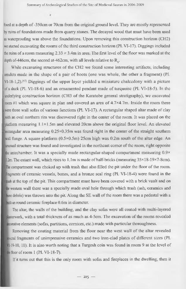
underlying construction horizon (CH3 of the Karatobe general stratigraphy), we excavated
room #1 which was square in plan and covered an area of 4.7><4.7m. Inside the room there
were three wall sofas of various functions (PI. VI-17). A rectangular shaped altar made of clay
with an oval northern rim was discovered right in the center of the room. It was placed on the platform measuring l.lx l.5 m and elevated 20cm above the original floor level. An elevated
rectangular area measuring 0.25x0.35m was found right in the center of the straight southern
wall flange. A square platform (0.5x0.5m) 25cm high was 0.2m south of the altar edge. An unusual structure was found and investigated in the northeast corner of the room, right opposite
the antechamber. It was a specially made rectangular-shaped compartment measuring 0.9x
1.2m. The extant wall, which rises to 1.1m is made of half-bricks (measuring 35xl8-19x7-8cm).
e compartment was choked up with trash that also filled the pit under the floor of the room.
Fragments of ceramic vessels, bones, and a bronze seal ring (PI. VI-18-4) were found in the
>h at the top of the pit. This compartment must have been covered with a brick vault and on
e western wall there was a specially made oval hole through which trash (ash, ceramics and
~ne debris) was thrown into the pit. Along the SE wall of the room there was a pedestal with a
built-in round ceramic fireplace 0.6m in diameter.The altar, the walls of the building, and the clay sofas were all coated with multi-layered
blasterwork, with a total thickness of as much as 4-5cm. The excavation of the rooms revealed
decorative elements (sofas, partitions, cornices, etc.) made with particular thoroughness.Removing the coating material from the floor near the west wall of the altar revealed
several fragments of unimpressive ceramics and two iron-clad plates of different sizes (PI.
VI-19-10, 11). It is also worth noting that a Turgesh coin was found in room 9 at the level of
the floor of room 1 (PI. VI-18-7).j If it turns out that this is the only room with sofas and fireplaces in the dwelling, then it
— 215 —
International Journal o f Eurasian Studies
must have been a living space with strongly pronounced religious attributes, or it was used as
a special space for worship like a home chapel. While clearing the room we noticed that when
it was abandoned the doorway at the end of the passage was walled up which is why it was
subsequently preserved in an undamaged condition. Only when we have expanded and completed
the excavation will we be able to retrace events at this site of residential development.The wall of the underlying construction horizon (CH4) was found under room #1, the
upper level of which (floor) was at a depth of-566 from the bench mark and the next was at a
depth of-656cm. The top of an arched passage was traced in the south wall of the underlying
construction horizon at a depth of-584cm, but these horizons have not been excavated yet.
Room #2 has an area of 4.5x5.25m. As yet we have retraced two stages related to the
rearrangement of the interior of this room. There were clay sofas and a round altar in the
center of the room. Therefore room #2 may be attributed to a group of premises for worship
just like room #1 and must have been part of the same dwelling house, but was built only
after room #1 was abandoned.Room #1 has a multi-level floor. On the upper floor level was found a horseshoe-shaped
ceramic altar (0.5x0.75m), llcm-high walls of the altar were sunk into the floor, and in the
center there was a round hole measuring 12cm in diameter and 9cm in depth. A tandoor (mud
stove), 67cm in diameter, was built into the northern sofa opposite the altar; one tandoor was
mounted inside the other, and the flue door (12cm high and 8cm wide) was at floor level.
The excavation of room #2 yielded a bronze belt buckle, a stone mould used to make
jewelry, a knife handle made of bone, and an iron-clad plate (PI. VI-19-3,9).
The second (first from the bottom) period of construction made room #2 habitable and is
related to the 8th and 9th layers. The southern side of the room is almost square (4.35x4.45m)
and its northern side is lengthened 85cm by the western wall segment. Sofas were made
along the full length of the perimeter of the room except for the threshold. At a distance of
75cm from the northeast comer of the room was a khum (big vessel) without a bottom which
would have been used as a drainage duct. A round clay altar was discovered in the center of the room; it was 85cm in diameter with a hole in the center measuring 12cm in diameter
and 10cm deep. At a distance of only 10cm beneath this altar was another round altar 50cm
in diameter with a hole in the center measuring 14-15cm in diameter and 8cm deep. Upon
removing the remains of this altar underneath, we uncovered a hearth measuring 104 x 38cm.
The remains of three clay on-floor hearth-altars, one under the other, were excavated in this
room, as well as round ceramic altars-on the upper floor level.
In the northern part of the extended area (above room 4 and room 8, PI. VI-17) we found
-- 2l6 —
Summ ary o f Archeological Studies o f the Site o f Medieval Sauran in 2004-2009
the remains of the second construction horizon, the walls of which were made of pahsa (clay).
We managed to trace in part two rooms, but failed to determine their area and elements of their interiors. At the depth of-376 we fixed the base of the pahsa (clay) walls of the rooms
dated from CH2. A stratum of backfilling occurred below in the rooms dated from CH3.
The layout of these rooms turned out to be completely different from those occurring in the
overlying horizon. In the upper part of this backfilling we found fragments of polished black
pottery engraved with a runic inscription (PI. VI-20).[48! xWalls from 1.3m to 1.4m high survived in room #4 which dated from CH3. The room
was square (4.65x4.65m). The doorway, approximately 0.9m wide, opened off the vestibule
passage in the western wall of the room. Along the perimeter of the room there were clay
sofas 0.95m wide; the one located near the southeastern corner had rounded off contours
and was wider than the others, while the sofa against the western wall was narrow-only
0.77m with a tandoor (mud stove) built into it with an opening 0.3m in diameter and 0.5m
high. Niches with edge moldings were built in the western, northern and southern walls.
There is an interesting composition made of edge molding in the shape of doorway (?) with
a decorated top in southern comer of the SW wall. At a small distance from the southeastern
comer there are two columns, supporting a rectangular carved frieze (PI. VI-21). The whole composition is made with artistic molding and later improved carving on natural clay which
has then been coated with a layer of gypsum and clay mix. It is probably only a part of a
greater composition decorating the center of this wall, but most of it together with the wall
was later destroyed by a dust pit.In the center of the room at a depth of-590cm from the benchmark there was a
horseshoe-shaped altar, the walls of which were made of adobe brick to a height of 15cm.
Below it was a square altar with rounded western side and a hole 18cm in diameter. The
height of the altar was 10 to 15cm.Excavation of room #4 exposed 8 levels of well-coated flooring, the total thickness of which
was 25cm. Excavated in part were rooms #3, 8, 9, 6, and 7; these were service rooms bearing
some relation to three other excavated rooms, apparently all of them forming three separate
buildings when the area of digging is later extended, and each having a central living space used
also as a space for worship. The ambiguous functional, confessional, ethnic and cultural purposes
of such rooms [49] provide an interesting challenge to archaeology in Central Asia.
It is worth mentioning the variety of architectural techniques and dёcor of the rooms,
which include polychrome painting on natural clay, alabaster molding and plastering, walls and other architectural surfaces painted red, as well as earthen strap molding and carving on
— 217 —
International Journal o f Eurasian Studies
natural clay, niches, friezes, etc. Rooms with similar altars in houses of the rich were also
found in a number of other monuments of Southern Kazakhstan of the 8th-10th centuries, ]
such as Altyntobe, Kujruktobe, Sidak, and Turkestan Kultobe. Here we were lucky enough'*
for the first time to retrace detailed stratigraphy and to date the change from clay wall altanfl
to ceramic altars. In the future, the area of digging (Digl) must be extended westward ашш
northward so it will be possible to excavate some households of CH3 and get an insight 1
into the planning of houses, residential areas, and the development of the citadel in genera*
Stratigraphic features of this part of the citadel are determined by some monumental structure in the lower construction horizons that must have been used in any event up to the period
of CH2. The preliminary spatiotemporal horizon of this site might be as follows: the uppee
construction horizon (UCH, practically non extant, save for some kitchen middens) may*
be dated back to the 12th-13th centuries; CH2: pahsa (clay) walls, room with cerami*
altar, 10th-11th centuries; CH3: rooms #4, 2, 9, and 5 with multilevel floors, and repeated underlying monumental building planning, 8th-9th centuries.
Archaeological digging has yielded a large collection of various handicraft items!
including ceramic, metal, glass tableware, craftsman’s tools, various jewelry and adornments!
belt accessories (PI. VI-16), and items of household use, some produced locally and some! obviously imported, brought along caravan routes of the Great Silk Road from handicraft!
centers of Maverranahr (Ma Wara un Nahr or Transoxiana), Khurasan, the Middle East, and!
China. These collections of artifacts provide detailed information on the culture and mode of I life of the people of the major developed urban centers.[50]
The archaeological stratigraphy of Karatobe makes it possible to identify several
stages in the development of techniques for manufacturing artifacts on a mass scale, and the j
evolution of their forms and artistic dёcor, especially of medieval ceramics from the mid-lOth !
to the 13th centuries. We have also studied more closely the process of planning dwelling houses and residential urban districts, building technologies, etc.
Thus the archaeological studies getting underway in Karatobe provided prospects for the preservation of the site and the founding of an open-air museum revealing segments of
the medieval city of Sauran so that visitors can see evidence of its spectacular flourishing, as
well as providing an opportunity to investigate the early stages of urbanization in the region,
as well as the ethnic and cultural history of the region. Segments of urban development have
been prepared for the opening of a museum, including dwelling houses, public buildings, and
fortifications, of the period from the 10th-13th centuries, together with sites of late medieval
Sauran located nearby which visually demonstrate the process of development of urban
— 218 —
Summ ary o f Archeological Studies o f the Site o f M edieval Sauran in 2004-2009
culture in Southern Kazakhstan during the Middle Ages.
2. Central Square of the Ancient City of Sauran. Mosque
As mentioned above the remains of public buildings can be traced along the perimeter of the
central city square. One such building situated on the western side of the square is presumed to be the former Cathedral Mosque of the city (Pis. VI-22, 23).
It has been established that the structure existed over two fundamental periods. In
the second period it ceased to be used for its intended purpose and has been exposed to
significant destruction when adapted to other purposes.[51] We found traces of temporary
hearths and bonfires in the section supposed to be the mihrab of the Mosque.
Digging carried out at the site showed that the Mosque was constructed using traditional
closed courtyard planning. All the rooms along the perimeter of the courtyard faced the
central courtyard (“sahn”), which had an area of 15.3x 17.8m. On the southwestern side of
the courtyard was the principal part of the Mosque, the mihrab (“zulla”), the arched front portal of which faced the courtyard. The plan of this principal part of the complex had a
five-aisled and double-column design with a covering arch (PI. VI-23).[52] The width of the
entrance niche is 6m. The arch rested upon massive pylons. The doorway 2.95m wide leads
to a square (6><6m) hall in front of the mihrab niche. The area of the hall has been slightly
extended by three niches 0.75m deep. The principal axis mounted mihrab was in one more
niche measuring 0.75m in depth right in the center of the SW wall. Judging by the traces on the floor it was 1.5m wide and 1.2m deep. A hoard of copper coins wrapped in small cloth
bundles each containing several coins was found in this hall under the square fired bricks.
There was a total of 114 coins.[53] This was the only find of this type to date. Locals used to bring whatever alms (“sadaka”) to the mosque as small change wrapped in bundles, as
copper coins were in greatest demand in everyday life. Bundles with coins were probably
buried under the floor of the central hall of the mosque at a time when the disintegrating
building had been abandoned, but was still visited by pilgrims as a sacred place of worship.
Therefore this hoard of coins may date from the time of the mosque’s destruction. In any
event, the Sauran hoard of copper coins found in the mosque testifies to the fact that copper
coins were used extensively by locals to support their economic and commercial activities
and even penetrated the spiritual life of the city, which was feasible only from the end of the
16th to the beginning of the 17th centuries when the city was characterized by a high level of monetary relationships.
ш ju u i nai ui L,ui asidil JIUU1CS
Unfortunately, the wall with the mihrab, as well as all the external walls of the structure!
and some columns or pylons, on which an arched dome system rested, turned out to be completely without brick; there was not even brick flooring in some of the rooms. In a pile
inside the central hall we found fragments of the base of the collapsed interior dome. The
width of passages between the columns bearing the arched dome is 2.75cm; the width of each
column is 1.15cm. It is obvious that the dome of the central mihrab hall was 6m in diameter and eight domes on its sides had a diameter of 3m.
The area of the mihrab (“.zulla”) along the line of the wall was approximately 31 xl
12m and the area of the whole complex was 31*34т or a bit over 1000m2. In its layout!
the mosque is classified as a traditional closed courtyard type of the late Middle Ages. The
isolated portal-dome double-column type mihrab is facing the courtyard, on three sides of
which there was arch and domed one-column gallery. Sauran Mosque is an example of one of
the versions of composite design. Similar Cathedral Mosques of larger dimensions are fount
nearby in Otrar (14th-15th centuries), Samarkand (Bibi-khanym, 167><109m, end of the 14tl century), Tashkent (Jami Mosque, 91x36.5m, end of the 15th century) and in Bukhara (Kaljan Mosque, 126x81.4m, first quarter of the 16th century).
The wide front portal of the mihrab, the principal part of the mosque, faces the closed!
type courtyard, at the center of which there is a principal axis mounted well with some capital
structure above.[54] Next to it is a wide (16m) and deep (6m) iwan opening onto the courtyaij
(PI. VI-23). The design features the symmetrical axis line of the mihrab, the entrance to thi
mihrab hall, and the well perpendicular to the axis of the front portal, which means thafl
facing the square, the southeast front wall slightly deviates from the axis of the rectangule courtyard, and that the front portal is asymmetrical to the whole structure.[55] Such an unusuJ
layout of the complex was probably dictated by the location of the mosque. It was built on
the north-western edge of a rectangular plaza and according to tradition the mihrab and one
of the principal design axes must have been oriented south-westwards. The Sauran architect! were thus challenged in much the same way as later Samarkand architects when perparin*
the design of the Tilla-kari Mosque in the Samarkand Registan. In both cases the front portal axis is perpendicular to the mihrab’s axis of symmetry.
Stepping over the threshold, the visitor finds himself in a small domed square room (3.1 x3.5m). The wall opposite the front door was blind (or may have comprised a large decorative
lattice); to the left and right of the front door there were archways probably leading to eveJ smaller domed square rooms (2.6x2.6m) with exit doors opening onto the big courtyard and
other premises of the complex. To the left there was the high arch of the front iwan leading ttj
— 2 2 0 —
Summary of A rcheological Studies o f the Site o f Medieval Sauran in 2004-2009
the mihrab of the Mosque; across the courtyard there were four arches of the west enfilade of
domed rooms and to the right a wide iwan with flat roofing resting upon three columns.
From the fragments of surviving brickwork we were able to establish that the thickness of the external wall was 1.4m. The SE section of the front wall to the right of the front
portal was made of 9-10 layers of brickwork, most of which have survived. It was an end
mil segment of a large room (5.2x5.6m), which was used as a ceramic workshop for a long
lime during the second period after the Mosque ceased to be used for its intended purpose.
Probably some parts of the Mosque had already been destroyed, and others adapted to workshops. At that time a large round double-deck kiln (diameter: 2.0m) for firing ceramic
■ares was built in the above-mentioned corner room.
The round tank (D1.9m) found in the courtyard close to the comer with the calcinating kiln
and well structure can also be referred to the second period. The tank was buried in the ground at a depth of 50-65cm and encircled with clamp fired brickwork. A water drainage chute faced with
brick ran all the way to the tank across the entire courtyard of the Mosque in a SW-NE direction
■kirting the walls of the well structure. This round tank was probably used to soak pot clay.Digging at the site of the early Cathedral Mosque situated in the central square of Sauran
is now completed. Although the Cathedral Mosque is classified as an architectural model of the
Central Asian version of the “classical” hypostyle Mosque, there are few convincing arguments
regarding the origin of this architectural style.11561 The state of preservation of the stmctural
elements makes it possible to revive the architectural aspects of this interesting building (PI.
VI-24). Two exactly dated periods of its existence (as well as of the other public buildings of
■central square of Sauran) testify to some historic event which brought about a significant change in the medieval cities in the region. A similar phenomenon took place in the neighboring city of
■Otrar. Here the Mosque of the 14th-15th centuries was much bigger but of similar style, and it
no was ruined and replaced by ordinary dwelling houses in the 16th century.1571Medrese. A massive rectangular barrow lay on the north-eastern side of the central
| square of Sauran, and we assumed that the ruins of a large structure made of fired brick
lay concealed under the barrow. Archaeological digging at the site revealed an outstanding
itructure that could be identified as the medrese, which according to Wasifi was built at the end of the 15th-beginning of 16th century and the minarets of which remained intact until the
lecond half of the 19th century.1581 The medrese was built in 1515 on the orders of Ubajdulla khan,
governor of Bukhara. Sejid Shamsaddin Muhammad Kurty,[59! a friend of Wasifi, was appointed
chief priest. In his memoirs Wasifi described this medrese as having marvelous “swinging”
' arets, one of which was ruined in 1867 and the other in 1878.[60]
— 221 —
International Journal o f Eurasian Studies
The medrese was a rectangular (31.5><28m) courtyard complex. Protruding from the
front arched portal were two minarets on either side along a northwestern orientation (PL
VI-26). The diameter of each minaret base was 3.3m. At the bottom it was brick bonded
with the front wall and portal, and only a half semicircle of it protruded from the front wall.
The body of the minaret up to the roofing was probably solid and above it was hollow with a
spiral staircase inside. One can get to the tower via the roof. The steps leading to the roof in
the north wall of the north-east antechamber have survived.Minarets were built on the rectangular shape footing (3.5x2.75m) 3m deep. The
minaret footing was made of solid fired brick masonry (23-25x23-25x5-6cm) using clay
mortar with a high level of ash impurities. To make the footing a pit was dug penetrating
the underlying occupation layer. The bottom layer was made of masonry brick placed
on edge by piling up 4-5 pieces in a staggered order. There was no bonding mortar used
between the bricks, and they were only watered with a liquid mix of water and ash. Above were six layers of brick masonry placed flat-wise using lime mortar with a high content of
ash. Above was another layer of bricks placed on edge in the order mentioned above and then
another five layers of brick were placed horizontally, and this pattern was repeated all the
way down the footing depth.
The edge of the lm-high base of the medrese protruding from the front wall was
decorated with a double row of fired brick fragments. The entrance staircase, 3.3m wide and 4.5m long, cut through the base leading up to the threshold of the arched iwan, which was 2.5m
wide, and 2.25m deep (PI. VI-25). The wide steps were covered with large (45 x45x7cm)
fired bricks. The threshold was paved with solid flat stones.
Above the front iwan there is an arch resting upon protruding pylons extended thanks
to the closely coupled minarets. Once you enter the 1,9m-wide doorway you find yourself in an antechamber 5.8 x 2.9m in area. The front door is through a niche measuring 0.25-0.30m
deep and 3.3m wide. There are wide clay sofas (1.3x1.7m) in the comers next to the entrance.
The antechamber leads to two octagonal rooms, one on either side. The octagonal room to
the left has an exit to the “darshana” (classrooms) and the courtyard. In the north wall we
discovered the base of a staircase, most probably, leading to the minarets via the roof. The room to the right has passages leading to the courtyard and most likely to the mosque, which
is unfortunately completely destroyed.
The rectangular courtyard (18x15m) was paved with bricks, which survive between
two bands of dandana (band of bricks placed on end) 2m long. The bricks of the pavement
in the center of the courtyard have been removed, with only a surviving segment. The first
— 2 2 2 —
Summ ary o f Archeological Studies o f the Site o f Medieval Sauran in 2004-2009
band of the dandana edges the courtyard along the pylon base line and the second is made at a distance of 2.5m and limiting the area to 11.7 x 8.5m. In the courtyard we found two
principal axis-mounted iwans located opposite each other, both facing the courtyard. The area
of the south-east iwan (540><540cm) is covered with a pointed dome (a fragment of which was found on the floor). The thickness of the weight-bearing walls was 155-156cm. The walls
and massive supporting pylons were made of both adobe and fired bricks.While digging in the rooms, it became clear that before their destruction they had been
abandoned for some time when a thick drift band was formed, following which they were made habitable again. In front of each room there is an area with tashnau (drainage) buried in
the floor. Wall niches were found in some rooms surviving in a more or less satisfactory state.
The walls (back, side, front) in which niches were made must have been chosen arbitrarily.
The floors in the rooms are covered with both whole and scrap fired bricks. At the time when
the medrese functioned, they made the rooms more comfortable. Thus, for example, it was
established that to heat the rooms they made stoves with chimney pipes in the comer of the room passing through the clay sofa and as a result the initial level of the sofas was slightly
elevated. Chimney pipes (22cm in width) were made of fired bricks placed on the edge and
the grooves formed were covered with whole bricks. Incense burners used to bum the herb
“adraspan”, the smoke of which considered to ward off evil spirits (actually disinfectant),
were found in many of the cells. They were made of vertically placed fired bricks of 25x 25cm in dimension, buried 25cm deep in the floor. We may assume that all the rooms were
covered with the domed roof since arch-shaped fragments of the dome and gypsum tiles
trapezium-shaped in cross-section which were used to decorate the roof were found in a scrap
heap. The walls were mainly plastered with gypsum mortar, except in some places faced with
unglazed polished bricks. The portals were coated with decorative polychrome glaze.Altogether 30 rooms of the complex in various states of preservation have been excavated,
some of which were used as passages, antechambers, and iwans, but mainly as one-roomed
cells or units called “hudjra” where the teachers and students of the medrese lived.
The fully excavated medrese constituted an architectural ensemble with one more
fundamental building across the street made of fired brick with a portal once covered with polychrome glaze coating (PI. VI-27). It was established that the base of the fa?ade walls
of this building ran for a distance of 18m that was the section width along the main street
running from the north front gate to the central square of the city. There was one axis-
mounted front portal, i.e. such structures forming an architectural and planning composition
of the “kosh/kos” style when the front walls of the buildings face each other (PI. VI-22).
— 223 —
International Journal o f Eurasian Studies
Such planning was typical of medieval cities of the Muslim East.[61] Hence it appears that the general plan of this complex was that of a rectangular enclosure-courtyard type with a
protruding front portal on the west fagade facing the facade of the medrese.[b2]By 2009 we had excavated half of the assumed area of this architectural complex,
but as yet have been unable to determine its functional purpose. If we proceed from the
assumption that the architectural ensembles of Central Asian cities starting from the Timurid
period “are characterized mostly by a complex of various religious and cultic buildings,
including the mosques for everyday and Friday public worship; the hanaka, institutions for
religious rites of Sufi community dervishes; the medrese, medieval institutions of higher
education”,[63] then the location of the hanaka in the central square of Sauran has not yet
been identified. Therefore it is quite possible that this is that very building, situated opposite
the medrese in a “kosh/kos” composition, just like in the Samarkand Muhammad-Sultan
ensemble, where the medrese is opposite the hanaka', or like the original ensemble of the
Timurid Registan,[64] where in the second half of the 15 th century the grand portal of Ulugbek
medrese was opposed to the splendid portal of the hanaka with a huge dome behind (as
known today on the site of the hanaka, there is the later Shir-dor medrese). The north side
of the square was occupied by a two-tiered caravan-sarai with a portal fagade spaced into arched segments. According to experts, the outline of this portal fagade was used in the]
construction of the Tilla-kari Mosque. Although digging continues at the “Sauran Registan”I
and is far from complete, we can confidently assert that we are lucky to be dealing with a
magnificent example of an urban ensemble of religious (and secular?) architecture decorating
the central square of the city. Apparently, this ensemble opens up a perspective on the!
monumental public buildings situated on both sides of the almost 200m long section of the!
central street (avenue) from the “Registan” to the inner square in front of the northern front!
gates of Sauran. This is also demonstrated by the topography of the ruins along the street!
fully paved with quarry tiles. Historians and architects call such an architectural ensemble a!
“longitudinal-axial”,[65] along which housing had a perspective view of the city’s enfilade ofi
monumental buildings with richly decorated facades and arched portals facing each other!
The principle of spatial architectural design of this most representative urban development!
was probably laid down during the historic period, when in the first quarter of the 14th j century (or at the end of the 13th century) Sauran under Ordu’s descendants temporarily!
became one of the capitals of Kok-Orda due to the relocation of the political center of the thial
Juchid’s principality from the banks of the Irtysh river to the Syr Darya.[66] As far as we know
at that time the city was relocated from the site of an ancient city of Karatobe to a new place, ,
— 224 —
Summ ary o f A rcheological Studies o f the Site o f Medieval Sauran in 2004-2009
where now the walls of late Sauran rise. Most likely, this relocation of the city was related to
a substantial restructuring of the state and political system as a result of the disintegration of
the Mongol empire in the last quarter of the 13th century and the founding of new states in
Eurasia. According to written sources of 1320, Sasy-Buka, the governor of Kok-Orda died and was buried in the city. His son Erzen built medrese, hanaka and mosques in Sauran and
other cities of Southern Kazakhstan.[67] Sauran played the role of capital city for a long time
being the residence of governors of various dynasties. In the 1480s the city was governed by
Irenchi-sultan, son of Janibek, one of the first Kazakh khans.[68]
It is interesting to note that in the second quarter of the 15th century a number of Golden
Horde cities, including the capital were relocated in the Volga region and in the whole North
Caspian region. This was followed by what is known as the “problem of two capital cities”. To
explain this phenomenon, researchers have put forward a number of hypotheses ranging from
internal and foreign policy to the environmental ecology. A comparatively recently published
article casts doubt on these hypotheses save one, the explanation provided by changes in
environmental ecology. According to V.V. Pachkalov,[69] new archaeological investigations
and the analysis of accumulated numismatic collections indicate that there was a catastrophic
transgression of the Caspian Sea in the second quarter of the 14th century and this played a
major role in the relocation of a number of cities of the North Caspian region and in particular
in the relocation of the capital city and the founding of Sarai al-Jedid (“New Sarai”).
Of course, although such a solution refers to the cities of the Volga and Jaiik region,[70]
this does not preclude this emergency and other factors in that historical period having an
influence in other geographical zones of Eurasia, namely in the Aral region. As we all know
the climate and ecology of the Caspian and Aral regions produce feed-back so we may speak
of regression of the Aral Sea and its basin while transgression of the Caspian Sea occurs.
L. N. Gumilev (71] describes this as the “concept of Eurasian humidification heterochrony”,
the phenomenon whereby the floor of the Aral Sea is exposed due to current regression.
Significant shallowing of the Aral starting from the 14th century (or in the second half
of the 13th century) may testify to the ongoing increasing aridity of the Syr Darya river
basin, one of the principal rivers in the region. An extreme shortage of water could also be
observed in large urban centers located in its basin, such as Sauran. Of late there has been
convincing archaeological evidence of the fall in the level of water in the Aral Sea in the 16th
century. Kazakhstan’s archaeologists have recently discovered and investigated the ruins of settlements and necropolises dating to the 14th century [72] situated on the construction
of branched kariz system which rely on deep seated ground water.[73] It must have been
— 225 —
International Journal o f Eurasian Studies
difficult if at all possible to supply the ancient city of Sauran (on the site of the ancient city of
Karatobe) with enough kariz water for its needs. The environment of an area of 3-3.5km to
the north, at the junction of water bearing detrital cones of three local small streams running
down from the Karatau [741 mountains, must have been more favorable.
It is unlikely that there might be only one reason however convincing for the relocation of a large city to a new site. Probably, one more factor is related to the case with Sauran,
which G.A. Fedorov-Davydov [75] discussed with regard to the Volga region cities. The aspiration of the local elites to become independent from the power of the Karakorum
Great Khans may have also served as a sufficient supplementary motivation or rationale for implementing great town planning projects.
The implementation of such large-scale town planning was possible only in a capital
city as an act of centrally organized political will, the onset of which was related to the fact of
relocation and the laying down of new city foundations from scratch. The khans of a young
state yielding to no other post-Mongol dynasty rulers could have carried out such active
construction and implemented ambitious architectural projects. Naturally the authors of such architectural and town planning projects adhered to the overall development of city planning and architecture in Central Asia.
N o t e s
[1] Байпаков K.M., Смагулов E.A. Средневековый город Сауран (Алматы: 2005).
[2] Гейнс А.К. Собрание литературных трудов, т.2 (СПб.: 1989), 225, 262-266.
[3] Топография Оренбургской губернии. Сочинение П .И . Р ы чкова. 1762 г. (О ренбург: 1887),
18-19; Jlepx П. И. А рх ео л о ги ческая п оезд ка в Т у ркестан ски й край в 1867 г. (СПб.:.,
1870), 14, 21 , 31; П аш ино П .И . Т уркестан ски й край в 1866 г. П утевы е заметки (СПб,
1868), 59-60; Ф едченко А .П . П у теш естви я в Т уркестан (М .: 1950), 46.
[4] Б ернш там А .Н . Проблемы древней истории и этногенеза Южного Казахстана.-Изв. АН КазССР,
серия археолог. (67) 1950, №2, с. 82; А геева Е .И ., П ацевич Г.И. Из истории оседлых поселенийи
городов Южного Казахстана. ТИИАЭ, т. 5. 1958, с. 107-110.
[5] А геева Е .И ., П ац еви ч Г.И. Из и стори и о седл ы х п о сел ен и й и го р о д о в ..., с. 109-110;
Байпаков К.М . С редневековая городская культура Ю ж ного К азахстан а и Семиречья в
V I-начале X III в. А лм а-А та, 1986, с. 27.
[6] Байпаков К.М., Смагулов Е.А. Средневековый город Сауран, с.62-67.
Summ ary o f A rcheological Studies o f the Site o f M edieval Sauran in 2004-2009
[7] Свод памятников истории и культуры Казахстана. Южно-Казахстанская область, с.307; Байпаков К.М.
Средневековые города Казахстана на Великом Шелковом пути. Алматы, 1998, с.65-70.
[8] Акишев К.А., Байпаков К.М. Кяризы Саурана//Вестник АН Каз.ССР, 4, 1973, с.76-78.
[9] Грошев В.А. Древняя ирригация Юга Казахстана. Алматы, 1996, с .184-186; Excavating vertical wells
they failed to reach underground water-bearing horizons.
[10] Смагулов E.A. Кяризы Туркестанского оазиса// Известия МОН РК, НАН РК, сер. общественных
наук, №1, 2003, с .172-189; Deom J.M., Sala R. The 232 Karez o f the Sauran region//CoxpaHeHHe и
использование объектов культурного и смешанного наследия современной Центральной Азии.
Алматы, 2005, с. 120-132.
[11] Смагулов Е ., Туякбаев М ., Ерж игитова А. Краткие итоги исследований Туркестанской
археологической экспедиции в 1999г.//Известия МОН РК, НАН РК, №1, 2000; Байпаков К.М.,
Смагулов Е.А. Средневековый город Сауран. Алматы, 2005, с. 74-77.
[12] Смагулов Е., Туякбаев М., Ержигитова А. Краткие итоги исследований Туркестанской
археологической экспедиции в 1999г...
[13] МИИТ,т.1, с .185.
[14] Птицын Г.В. К вопросу о географии «Шах-наме»//ТОВЭ, t.IV, 1947, с.305-309; Кляшторный С.Г.
История Центральной Азии и памятники рунического письма.СПб., 2003, с.213-216.
[15] Смагулов Е.А. Сауранский археолгический комплекс// Известия НАН РК, 1, 2007, с. 126-134.
[16] Digs at the site of late Sauran were carried out under scientific direction of K.M.Baipakov, academician,
and director of the Institute of Archaeology named after A. Margulan (Alma-Ata). Apart from the staff of
the Institute, S. Akylbek (v.Shaulder), A.Erzhigitova (Shymkent), O.Lushpenko, N.Stolyarova (Tashkent),
T.Krupa (Kharkov), A.Jumabayev (Bishkek), E.Zilivinskaya, and S.Yatsenko (Moscow) were all involved
in the work carried out at the site of Sauran.
[17] It is established that this very medrese was described by Wasifi, an author of the 16th c.; and its one-of-a-
kind swinging minarets were destroyed by the end of the 19th c. The unusual architecture of this structure
attracted G.A.Pugachenkova’s attention. (Пугаченкова Г.А. Сауранские башни// Труды САГУ, вып.ЬУП,
Ташкент, 1954; Байпаков К.М., Акылбек С. Медресе средневекового Саурана//Археология степной
Евразии. Алматы-Кемерово, 2008).
[18] Байпаков К., Смагулов Е.А., Ержигитова А., Туякбаев М. и др.// Исследования городищи
средневекового Саурана // М емлекегпк “Мэдени мура» багдарламасы бойынша 2005 жылгы
Археологияльщ зерттеулер жайлы есеп. Алматы, 2005, с.304-307; Смагулов Е.А. Архитектура
Саурана//Промышленность Казахстана, 1, 2006., с.96-97.
[19] The 2006-2008 excavations have been sponsored by Social Fund “Olketanu” (Taraz) and we deeply
appreciate the help rendered by its director E.Baimurzin.
— 227 —
International Journal o f Eurasian Studies
[20] Смагулов E.A., Столярова Н.П. Городище Каратобе-древний Сауран// Материалы международной
научно-практической конференции «Древний Тараз и тюркская цивилизация». Тараз, 2007г., 22-24
октября. С. 105-108; Смагулов Е.А. Средневековый Сауран: на перекрестке проблем и мнений//
Материалы международной научной конференции «Роль степных городов в цивилизации номадов»,
посвященной 10-летнему юбилею г.Астана. 2 июля 2008г. Астана, 2008, С. 190-197.
[21] Смагулов Е.А., Ержигитова А.А. Исследования Древнего Саурана//Известия НАН РК, сер.обществ.
наук, №1, 2009. С.236-257.
[22] Смагулов Е.А. “Сауранский археологический комплекс...”, 126-134.
[23] Jlepx П. И. Археологическая поездка в Туркестанский край в 1867 г..., с. 16-17; Свод памятников
истории и культуры Казахстана. Южно-Казахстанская область. Алматы. 1994, с.308-310.
[24] Свод памятников истории и культуры Казахстана. Южно-Казахстанская область. Алматы. 1994, с.307.
[25] “Serdabe” according to P.Lerh. Underground water storage reservoir covered with a dome. (Jlepx П.
Археологическая поездка..., с. 14). “Sardob” was a commonly used utility service and water supply -
facility in the cities of Central Asia, Khurasan, and the Middle East.
[26] Байпаков K.M., Смагулов E.A. Средневековый город Сауран. Алматы, 2005, с. 74-77. Mir-i Arab or Abdallah
al-Iamani al-Hadramauti, also known as the “builder” of medrese in Registan of Bukhara named after him-Mir-i
Arab medrese (see about him: Бабаджанов Б. Мир-и Араб//Культура кочевников на рубеже веков (XLX-XX,
ХХ-ХХ1вв): Проблемы генезиса и трансформации. Мат. Международной конференции, г.Алматы, 1995,1
с.88-102; Джураева Г.А. Мир-и Араб и политическая жизнь в Бухаре в ХУ1в//Духовенство и политическая
жизнь на ближнем и среднем Востоке в период феодализма. (М., 1985, с.74-79).
[27] Акишев К.А., Байпаков К.М. “Кяризы Саурана...”, 76-78.
[28] Свод памятников истории и культуры Казахстана. Южно-Казахстанская область, с.307; Байпаков K.M.J
Смагулов Е.А. Средневековый город Сауран..., с.62-65.
[29] Смагулов Е.А. “Сауранский археологический комплекс...”, 126-134.
[30] Пугаченкова Г.А. Сауранские башни// Труды САГУ, вып.ЬУП, Ташкент, 1954.
[31] С м агулов Е .А . Город Сауран: перспективы исследования, консервации и музеефикации// ОтаЛ
тарихы. №1-2, 2000, с. 100-109.
[32] Смагулов Е.А., Туякбаев М.К., Ержигитова А.А. Жума мечеть на Регистане Саурана/Ютчет об!
археологических исследованиях по Государственной программе «Культурное наследие», Алматы, 2007*
с.173-176.
[33] См.напр.: Байпаков К.М., Смагулов Е.А. Средневековый город Сауран. Алматы, 2005, с.60-62.
[34] Муминов А.К. Кокандская версия исламизации Туркестана//Подвижники ислама. Культ святых 1
суфизм в Средней Азии и на Кавказе. М., с.138-140.
[35] Беленицкий А.М., Бентович И.Б., Большаков О.Г. Средневековый город Средней Азии. Л., 1973, С .2 0 Я
— 228 —
Summary of A rcheological Studies o f the Site o f Medieval Sauran in 2004-2009
Семенов F.JI. Город и замок в раннесредневековом Согде//Культурные связи народов Средней Азии и
Кавказа. Древность и средневековье. М., 1990, с.60.
[36] Смагулов Е.А., Ержигитова А.А. Продолжение исследования стратиграфии Древнего Саурана //
Отчет об археологических исследованиях по Государственной программе «Культурное наследие» в
2008г. Алматы, 2009, с.204-210 .
[37] Беленицкий А.М., Бентович И.Б., Большаков О.Г. Средневековый город Средней Азии. Л., 1973, с.195.
[38] Свод памятников истории и культуры Казахстана. Южно-Казахстанская область.., с.307.
[39] Болдырев А.Н. Зайнатдин Васифи-таджикский писатель XVIb. М., 1957.
[40] In this article we used the aerial photographs and other materials o f R. Sala and J.M. Deom. I take this
opportunity of thanking R. Sala and J.M. Deom for their contribution to our joint work.
[41] Deom J.M., Sala R. The 232 Karez o f the Sauran region//CoxpaHeHne и использование объектов
культурного и смешанного наследия современной Центральной Азии. Алматы, 2005, с.120-132.
[42] Смагулов Е.А. Кяризы Туркестанского оазиса// Известия МОН РК, НАН РК, сер. общ-ых наук, №1,
2003, с. 172-190; Байпаков К.М., Смагулов Е.А. Средневековый город Сауран..., с.73-80.
[43] For a description of the traces of the kariz found in the area, see the following papers: Акишев K.A.,
Байпаков К.М. Кяризы Саурана.., с.76-78; Смагулов Е.А. Кяризы Туркестанского оазиса..., с. 172-190.
[44] Бартольд В.В. К истории орошения Туркестана//Сочинения, т.Ш, М., 1965, с.130, 138. 225.
[45] Турсунов А.А. От Арала до Лобнора. Гидроэкология бессточных бассейнов Центральной Азии.
Алматы, 2002.
[46] Исамиддинов М.Х. Истоки городской культуры Самаркандского Согда. Ташент, 2002, с. 16.
[47] These finds together with “boot” decorated with tree image (PI. VI-17-3), earlier discovered in the same dig
(CH2), extend the range of forms of popular amulets in the 10th- 12th centuries.
[48] This find was shown to I.L.Kyzlasov, who kindly agreed to give his expert opinion for which I would like to
express my appreciation. In his comprehensive view, he noted in particular that “it is beyond any doubt that
inscriptions discovered in Sauran do not belong to the famous Asian runic character set commonly called
Orkhon-Yeniseian script. At the same time all these graphic signs are characteristic features of the so called
Achiktash runic script of Central Asia. Probably we should withhold comment about this still mysterious
cultural phenomenon. However, archaeological dating of the above mentioned epigraphic material suggests that
it belonged to early Oguz or an even earlier substrate. The time and environment of the Achiktash runic script
existence is yet to be determined. E.Smagulov’s findings contribute to this purpose to a considerable degree and
new archaeological discoveries in Sauran, hopefully, will facilitate it”. As well as: “It is important that Achiktash
runic script luckily found on the artifacts from Sauran belongs to the west branch of the runic script, the so-called
Eurasian group of its own origin, independent of Orkhon-Yeniseian script by any standard”. (Кызласов И.Л.
Экспертное заключение о характере надписей на обломках глиняного сосуда, обнаруженных в 2008 г. на
--- 229 ----
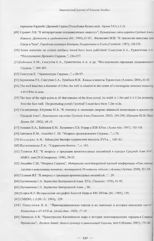
International Journal o f Eurasian Studies
городище Каратобе (Древний Сауран (Республика Казахстан)). Архив ТАЭ, с. 1-2).
[49] Гуревич Л.В. “К интерпретации пенджикентских «капелл»”, Культурные связи народов Средней Азии и
Кавказа. Древность и средневековье (М.: 1990),.67-87; Филанович М.И. “К типологии святилищ огня
Согда и Чача”, Городская культура Бактрии-Тохаристана и Согда (Ташкент: 1987), 148-156.
[50] Some materials on certain artifacts found have been published: Смагулов E.A., Ержигитова A.A.
“Исследования Древнего Саурана..”, 236-257.
[51]Байпаков К.М., Смагулов Е.А., Ержигитова А.А. и др. “Исследования городища средневекового
Саурана..”, 304-307.
[52] Смагулов Е. “Архитектура Саурана...”, с.96-97.
[53] Бурнашева Р.З., Смагулов Е.А., Туякбаев М.К. Клады и монеты Туркестана (Алматы: 2006), 61-63.
[54] The well head has a diameter o f 0,9m; the well is situated in the center o f a rectangular structure measuring
4.4x4.95m in area.
[55] The base of the right pylon is all that remains of the front portal. Its width is 1.8m and it is 2.2m protruding
from the face wall. The protruding portal (“peshtak”) must have been 7.2m wide.
[56] См.например: Юсупова M.A. “К генезису и эволюции дворово-айванной композиции в архитектуре
Средней Азии”, Культурное наследие Средней Азии (Ташкент, 2002), 284-290; Шукуров Ш.М. Образ
Храма (М.: 2002), 46-53.
[57] Акишев К.А., Байпаков К.М.. Ерзакович Л.Б. Отрар в XIII-XVbb. (Алма-Ата: 1987), 103-108.
[58] Байпаков К.М., Акылбек С. Ш. “Медресе средневекового Саурана...”, с.76.
[59] Б олды рев А .Н . Зайнаддин Васифи-таджикский писатель XVI в..., 160-161.
[60] П угаченкова Г. А. “ Сауранские башни...”, с. 163.
[61] Гулямов Я.Г. “К вопросу о традиции архитектурных ансамблей в городах Средней Азии XVb”,
ИМКУ, вып.29 (Самарканд: 1998), 29-35.
[62] Акылбек С.Ш. “Медресе Саурана”, Материалы международной научной конференции «Роль степных
городов в цивилизации номадов», посвященной 10-летнему юбилею г.Астана (Астана: 2008), 321-329.
[63] Гулямов Я.Г. “К вопросу о традиции архитектурных ансамблей...”, 29.
[64] Пугаченкова Г.А. Зодчество Центральной Азии. XVb. (Ташкент: 1976), 91-95.
[65] Пугаченкова Г.А. Зодчество Центральной Азии..., 96.
[66] Егоров В.Л. Историческая география Золотой Орды в XIII-XIVbb. (М.: 1985), 129.
[67] СМИЗО, т. 2 (М.-Л.: 1941), 129.
[68 ] П и щ у л и н а К. А. “ Присырдарьинские города и их значение в истории казахских ханств”,
Казахстан в XV-XVII вв. (Алма-Ата: 1969), 17-18.
[69] Пачкалов А.В. “Трансгрессия Каспийского моря и история золотоордынских городов в Северном
Прикаспии”, Восток-Запад: диалог культур и цивилизаций Евразии, вып.8 (Казань: 2007), 171-180.
— 230 —
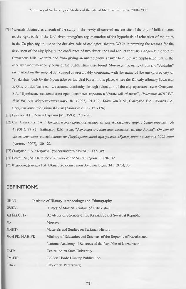
Summ ary o f A rcheological Studies o f the Site o f M edieval Sauran in 2004-2009
[70] Materials obtained as a result of the study of the newly discovered ancient site of the city of Jaiik situated
on the right bank of the Ural river, strengthen argumentation of the hypothesis of relocation of the cities
in the Caspian region due to the decisive role of ecological factors. While interpreting the reasons for the
desolation of the city lying at the confluence of two rivers: the Ural and its tributary Chagan at the foot of
Cretaceous hills, we refrained from giving an unambiguous answer to it, but we emphasized that in the
one-layer monument only coins of the Uzbek khan were found. Moreover, the name of this site “Shakafni”
(as marked on the map of Jenkinson) is presumably consonant with the name of the unexplored city of
“Shakashin” built by the Nogai tribe on the Ural River in this place, where the Kindaly tributary flows into
it. Only on this basis can we assume continuity through relocation of the city upstream, (see: Смагулов
Е.А. “Проблемы исследования средневековых городов в Уральской области”, Известия МОН РК,
НАН РК, сер. общественных наук, №1 (2002), 91-102; Байпаков К.М., Смагулов Е.А., Ахатов ГА.
Средневековое городище Жайык (Алматы: 2005), 121-126).
[71] Гумилев J1.H. Ритмы Евразии (М., 1993), 271-297.
[72] См.: Смагулов Е.А. “Находка и исследование мазара на дне Аральского моря”, Отан тарихы, №
4 (2001), 77-82; Байпаков К.М. и др. “Археологические исследования на дне Арала”, Отчет об
археологических исследования по Государственной программе «Культурное наследие» 2006 года
(Алматы: 2007), 120-122.
[73] Смагулов Е.А. “Кяризы Туркестанского оазиса..”, 172-189.
[74] Deom J.M., Sala R. “The 232 Karez of the Sauran region..”, 120-132.
[75] Федоров-Давыдов Г.А. Общественный строй Золотой Орды (М.: 1973), 80.
DEFINITIONS
ИИАЭ - Institute o f History, Archaeology and Ethnography
ИМКУ- History of Material Culture of Uzbekistan
АН Каз.ССР- Academy of Sciences of the Kazakh Soviet Socialist Republic
М,- Moscow
МИИТ- Materials and Studies on Turkmen History
МОН РК, HAH PK Ministry of Education and Sciences of the Republic of Kazakhstan,
National Academy of Sciences of the Republic of Kazakhstan
САГУ- Central Asian State University
СМИЗО- Golden Horde History Publication
СПб.- City of St. Petersburg
— 231 —
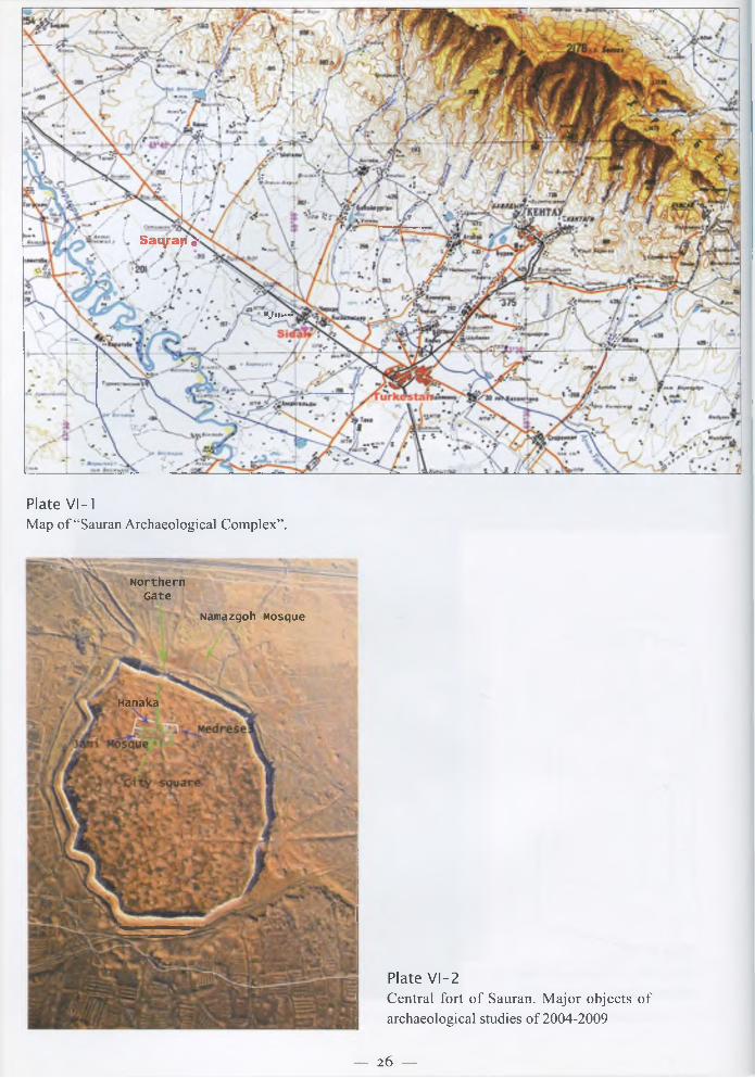
S a iy a p J -
UJery*»i
Plate VI-1Map of “Sauran Archaeological Complex”.
Plate VI—2Central fort of Sauran. Major objects of archaeological studies of 2004-2009
NorthernGate
Namazgoh Mosque
Hanaka
— 26 —

Plate VI-3Outward appearance o f Sauran north-east wall segment.
Plate VI-4Inner face o f west wall segment. Structure o f early wall under the later dated foundation.
— 27 —
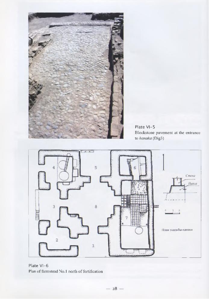
Plate VI-5B lockstone pavem ent at the entrance to hanaka (Dig3)
( menti
llaxca
План усадьоы-ханаки
Plate VI-6Plan o f farmstead No. 1 north o f fortification
— 28 —
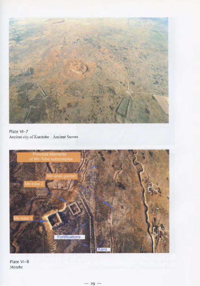
Plate VI-7Ancient city o f Karatobe - A ncient Sauran
Plate VI-8Mirtobe
— 29 —
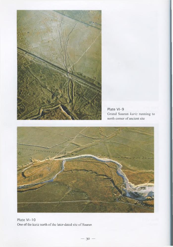
Plate VI-10One o f the kariz north o f the later-dated site o f Sauran
— 30 —
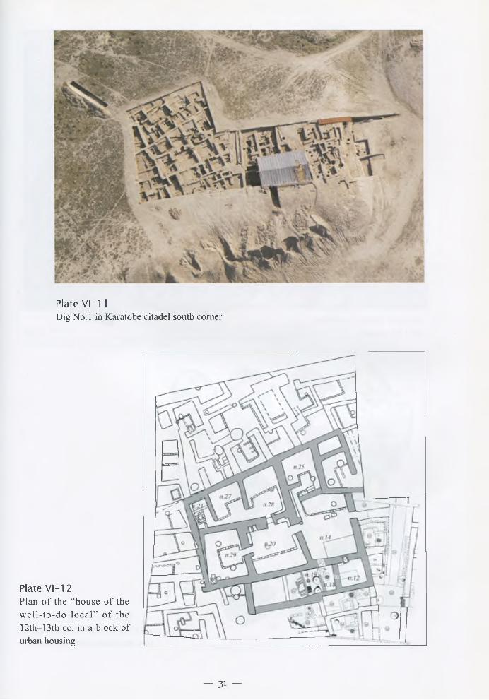
Plate VI-11Dig N o .l in Karatobe citadel south com er
Plate VI-12Plan o f the “house o f the w e ll- to -d o lo c a l” o f th e 12th—13th cc. in a block o f urban housing
— 31 —
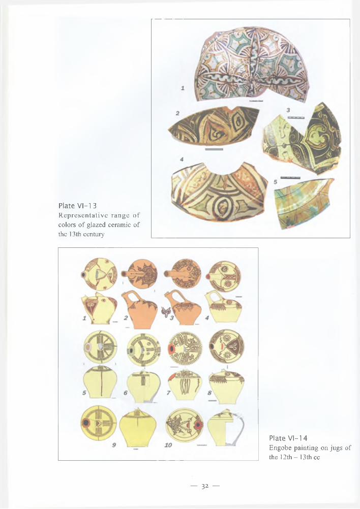
Plate VI-1 3Representative range of colors of glazed ceramic of the 13th century
Plate VI-14Engobe painting on jugs of the 12th - 13th cc
— 32 —
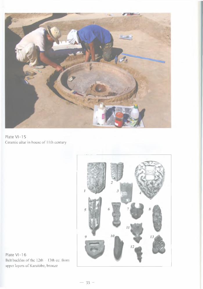
Plate VI-1 5Ceramic altar in house o f 11th century
Plate VI-16Belt buckles o f the 12th - 13th cc. from upper layers o f Karatobe, bronze
— 33 —
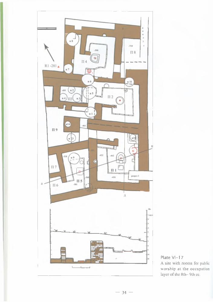
Plate VI-1 7A site with rooms for public worship at the occupation layer of the 8th- 9th cc.
— 3 4 —

Plate VI-18Some artifacts from K aratobe occupation layers o f the 8 th -12 th cc.: 1-3 ceramic; 4,7,8 - bronze; 5- turquoise; 6- chalcedony
Plate VI-19Finds from the floor o f the construction h o riz o n o f th e 8 th - 9 th cc .: 1-3 - bronze; 4-11 — iron
— 35 —
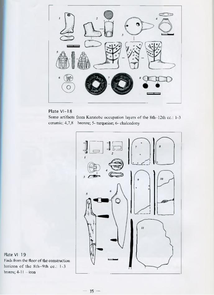
Plate VI-1 8Some artifacts from K aratobe occupation layers o f the 8 th -12 th cc.: 1-3 ceramic; 4,7,8 — bronze; 5- turquoise; 6- chalcedony
Plate VI-19Finds from the floor o f the construction horizon o f th e 8 th - 9 th cc .: 1-3 - bronze; 4-11 - iron
— 35 —
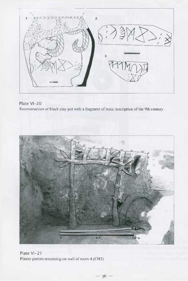
Plate VI-20Reconstruction o f black clay pot with a fragment o f runic inscription o f the 9th century
Plate VI-21Plaster pattern rem aining on wall o f room 4 (CH3)
— 36 —
Hanaka
City square
Plate VI-22Principal sites excavated in the central square o f Sauran
Plate VI- 23Plan o f Jami M osque o f Sauran
— 3 7 ^

Plate VI-24Alternate reconstruction o f Sauran M osque
Plate VI-25Front staircase and ruins o f the front portal o f Sauran Medrese
- 38 -
Plate VI-26Plan o f Sauran M edrese (according to Baipakov, Akym bek, 2008)
Plate VI-27Fragments o f glazed “hanaka” portal tiles


![Industriae Theatrum Ex Silesia: Showing the functioning of a medieval industry in a contemporary industrial conurbation, [in:] Archeological Heritage: Methods of Education and Popularization,](https://static.fdokumen.com/doc/165x107/63359538a1ced1126c0adc00/industriae-theatrum-ex-silesia-showing-the-functioning-of-a-medieval-industry-in.jpg)