Appendix G4: Historic and Archeological Resources Technical ...
39
Appendix G4: Historic and Archaeological Resources Technical Report ATTACHMENT G4-1 Historic Aerials
-
Upload
khangminh22 -
Category
Documents
-
view
0 -
download
0
Transcript of Appendix G4: Historic and Archeological Resources Technical ...

Appendix G4: Historic and Archaeological Resources Technical Report
ATTACHMENT G4-1 Historic Aerials

6/23/2020 | ST_OMFS_Ph2 | FigG4-1.X_Attchmt_HistoricAerials_7k.mxd
Area of Impact
FWLE Elevated TrackFWLE At-Grade Track
Data Sources: King County; Cities of Des Moines, Federal Way, Kent (2019).
OMF South
FIGURE G4-1.1 1937 Historic Aerial
Midway Landfill Alternative0 500 1,000 Feet±

6/23/2020 | ST_OMFS_Ph2 | FigG4-1.X_Attchmt_HistoricAerials_7k.mxd
Area of Impact
FWLE Elevated TrackFWLE At-Grade Track
Data Sources: King County; Cities of Des Moines, Federal Way, Kent (2019).
OMF South
FIGURE G4-1.2 1957 Historic Aerial
Midway Landfill Alternative0 500 1,000 Feet±

6/23/2020 | ST_OMFS_Ph2 | FigG4-1.X_Attchmt_HistoricAerials_7k.mxd
Area of Impact
FWLE Elevated TrackFWLE At-Grade Track
Data Sources: King County; Cities of Des Moines, Federal Way, Kent (2019).
OMF South
FIGURE G4-1.3 1965 Historic Aerial
Midway Landfill Alternative0 500 1,000 Feet±

TDLE Design OptionTDLE Preferred Alternative
6/23/2020 | ST_OMFS_Ph2 | FigG4-1.X_Attchmt_HistoricAerials_7k.mxd
Area of Impact
Mainline Elevated TrackMainline At-Grade Track
FWLE Elevated Track
Data Sources: King County; Cities of Des Moines, Federal Way, Kent (2019).
OMF South
FIGURE G4-1.4 1935 Historic Aerial
Mainline Track Options0 500 1,000 Feet±

TDLE Design OptionTDLE Preferred Alternative
6/23/2020 | ST_OMFS_Ph2 | FigG4-1.X_Attchmt_HistoricAerials_7k.mxd
Area of Impact
Mainline Elevated TrackMainline At-Grade Track
FWLE Elevated Track
Data Sources: King County; Cities of Des Moines, Federal Way, Kent (2019).
OMF South
FIGURE G4-1.5 1957 Historic Aerial
Mainline Track Options0 500 1,000 Feet±
TDLE Design OptionTDLE Preferred Alternative
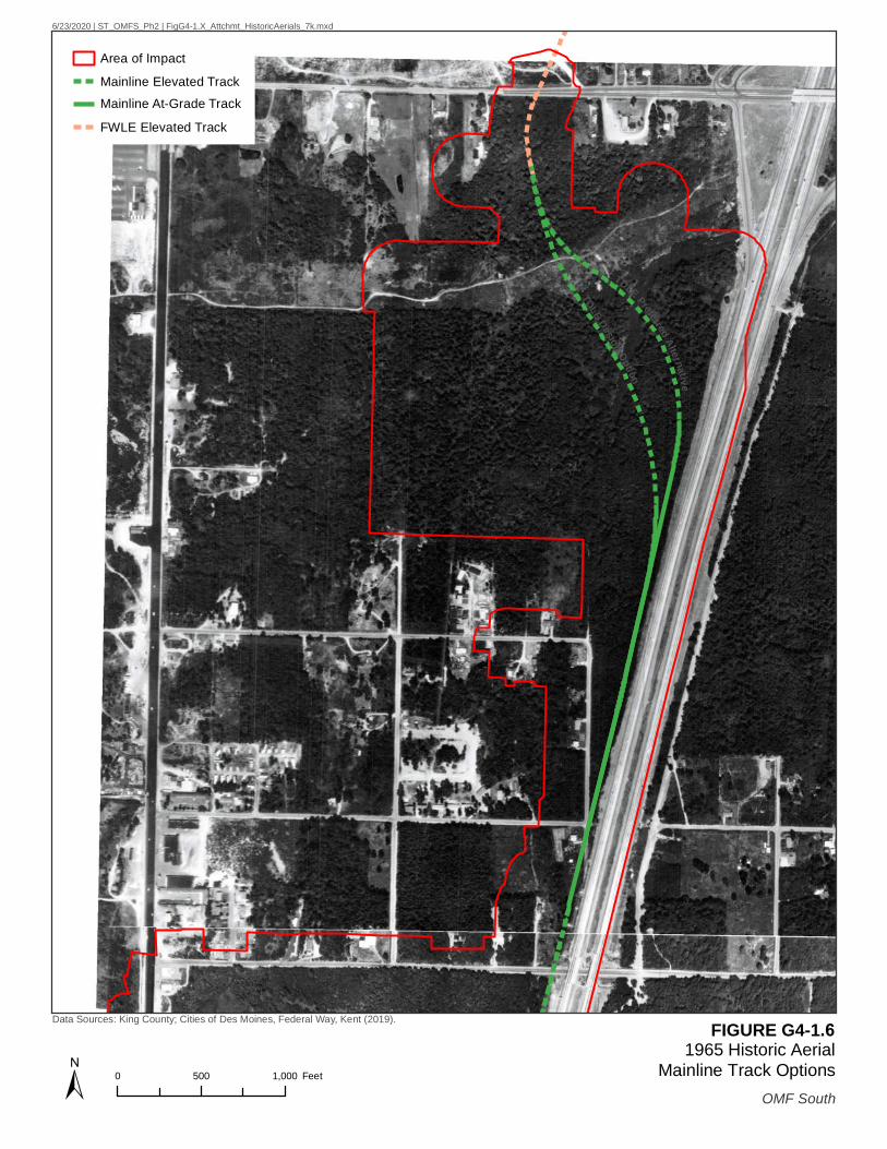
6/23/2020 | ST_OMFS_Ph2 | FigG4-1.X_Attchmt_HistoricAerials_7k.mxd
Area of Impact
Mainline Elevated TrackMainline At-Grade Track
FWLE Elevated Track
Data Sources: King County; Cities of Des Moines, Federal Way, Kent (2019).
OMF South
FIGURE G4-1.6 1965 Historic Aerial
Mainline Track Options0 500 1,000 Feet±
TDLE Design OptionTDLE Preferred Alternative
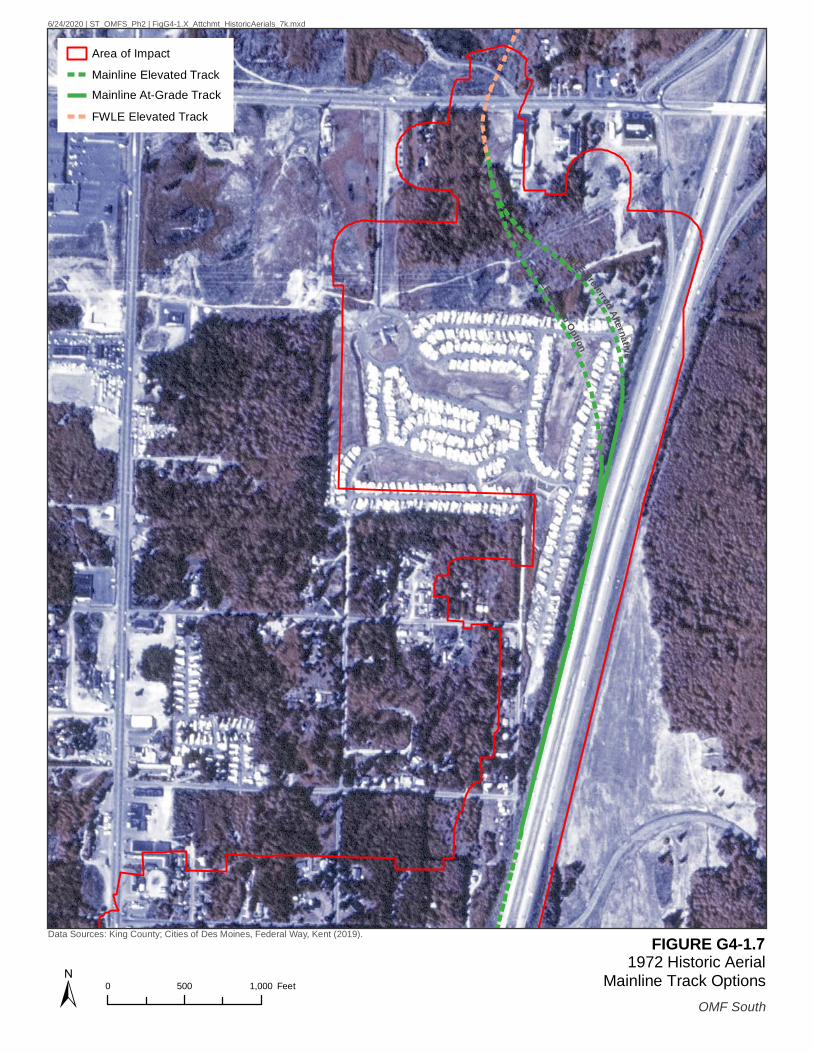
6/24/2020 | ST_OMFS_Ph2 | FigG4-1.X_Attchmt_HistoricAerials_7k.mxd
Area of Impact
Mainline Elevated TrackMainline At-Grade Track
FWLE Elevated Track
Data Sources: King County; Cities of Des Moines, Federal Way, Kent (2019).
OMF South
FIGURE G4-1.7 1972 Historic Aerial
Mainline Track Options0 500 1,000 Feet±

TDLE Design OptionTDLE Preferred Alternative
6/24/2020 | ST_OMFS_Ph2 | FigG4-1.X_Attchmt_HistoricAerials_7k.mxd
Area of Impact
Mainline Elevated TrackMainline At-Grade Track
FWLE Elevated Track
Data Sources: King County; Cities of Des Moines, Federal Way, Kent (2019).
OMF South
FIGURE G4-1.8 1991 Historic Aerial
Mainline Track Options0 500 1,000 Feet±

6/23/2020 | ST_OMFS_Ph2 | FigG4-1.X_Attchmt_HistoricAerials_7k.mxd
Area of Impact
Mainline Elevated TrackMainline At-Grade Track
Data Sources: King County; Cities of Des Moines, Federal Way, Kent (2019).
OMF South
FIGURE G4-1.9 1935 Historic Aerial
South 336th Street Alternative0 500 1,000 Feet±

6/24/2020 | ST_OMFS_Ph2 | FigG4-1.X_Attchmt_HistoricAerials_7k.mxd
Area of Impact
Mainline Elevated TrackMainline At-Grade Track
Data Sources: King County; Cities of Des Moines, Federal Way, Kent (2019).
OMF South
FIGURE G4-1.10 1941 Historic Aerial
South 336th Street Alternative0 500 1,000 Feet±

6/23/2020 | ST_OMFS_Ph2 | FigG4-1.X_Attchmt_HistoricAerials_7k.mxd
Area of Impact
Mainline Elevated TrackMainline At-Grade Track
Data Sources: King County; Cities of Des Moines, Federal Way, Kent (2019).
OMF South
FIGURE G4-1.11 1957 Historic Aerial
South 336th Street Alternative0 500 1,000 Feet±

6/23/2020 | ST_OMFS_Ph2 | FigG4-1.X_Attchmt_HistoricAerials_7k.mxd
Area of Impact
Mainline Elevated TrackMainline At-Grade Track
Data Sources: King County; Cities of Des Moines, Federal Way, Kent (2019).
OMF South
FIGURE G4-1.12 1965 Historic Aerial
South 336th Street Alternative0 500 1,000 Feet±

6/24/2020 | ST_OMFS_Ph2 | FigG4-1.X_Attchmt_HistoricAerials_7k.mxd
Area of Impact
Mainline Elevated TrackMainline At-Grade Track
Data Sources: King County; Cities of Des Moines, Federal Way, Kent (2019).
OMF South
FIGURE G4-1.13 1972 Historic Aerial
South 336th Street Alternative0 500 1,000 Feet±

6/24/2020 | ST_OMFS_Ph2 | FigG4-1.X_Attchmt_HistoricAerials_7k.mxd
Area of Impact
Mainline Elevated TrackMainline At-Grade Track
Data Sources: King County; Cities of Des Moines, Federal Way, Kent (2019).
OMF South
FIGURE G4-1.14 1991 Historic Aerial
South 336th Street Alternative0 500 1,000 Feet±

6/23/2020 | ST_OMFS_Ph2 | FigG4-1.X_Attchmt_HistoricAerials_7k.mxd
Area of Impact
Mainline Elevated TrackMainline At-Grade Track
Data Sources: King County; Cities of Des Moines, Federal Way, Kent (2019).
OMF South
FIGURE G4-1.15 1935 Historic Aerial
South 344th Street Alternative0 500 1,000 Feet±

6/24/2020 | ST_OMFS_Ph2 | FigG4-1.X_Attchmt_HistoricAerials_7k.mxd
Area of Impact
Mainline Elevated TrackMainline At-Grade Track
Data Sources: King County; Cities of Des Moines, Federal Way, Kent (2019).
OMF South
FIGURE G4-1.16 1941 Historic Aerial
South 344th Street Alternative0 500 1,000 Feet±
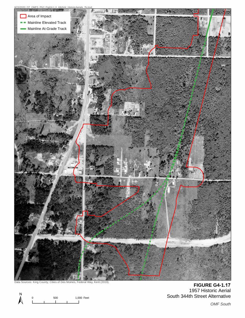
6/23/2020 | ST_OMFS_Ph2 | FigG4-1.X_Attchmt_HistoricAerials_7k.mxd
Area of Impact
Mainline Elevated TrackMainline At-Grade Track
Data Sources: King County; Cities of Des Moines, Federal Way, Kent (2019).
OMF South
FIGURE G4-1.17 1957 Historic Aerial
South 344th Street Alternative0 500 1,000 Feet±

6/23/2020 | ST_OMFS_Ph2 | FigG4-1.X_Attchmt_HistoricAerials_7k.mxd
Area of Impact
Mainline Elevated TrackMainline At-Grade Track
Data Sources: King County; Cities of Des Moines, Federal Way, Kent (2019).
OMF South
FIGURE G4-1.18 1965 Historic Aerial
South 344th Street Alternative0 500 1,000 Feet±

6/24/2020 | ST_OMFS_Ph2 | FigG4-1.X_Attchmt_HistoricAerials_7k.mxd
Area of Impact
Mainline Elevated TrackMainline At-Grade Track
Data Sources: King County; Cities of Des Moines, Federal Way, Kent (2019).
OMF South
FIGURE G4-1.19 1972 Historic Aerial
South 344th Street Alternative0 500 1,000 Feet±
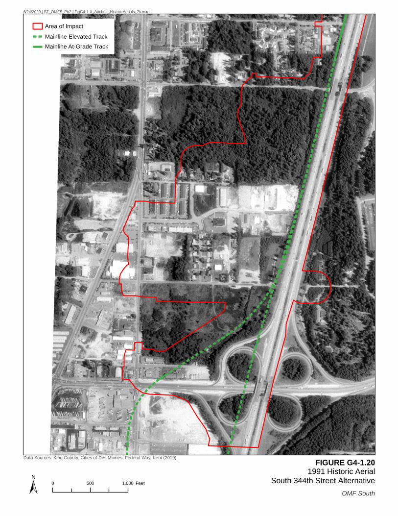
6/24/2020 | ST_OMFS_Ph2 | FigG4-1.X_Attchmt_HistoricAerials_7k.mxd
Area of Impact
Mainline Elevated TrackMainline At-Grade Track
Data Sources: King County; Cities of Des Moines, Federal Way, Kent (2019).
OMF South
FIGURE G4-1.20 1991 Historic Aerial
South 344th Street Alternative0 500 1,000 Feet±

Appendix G4: Historic and Archaeological Resources Technical Report
ATTACHMENT G4-2 Archaeological Shovel Probe Log

OMF South
March 2021 Page G4-2.1 | Attachment G4-2
OMF South: ATCRC Shovel Probe Log – First Field Session, February 2020
SP Field ID Strata # Depth (cm) Description Cultural Materials Notes
1 NP6
1 28 Grey brown silty loam, 5% rounded gravels. Negative
2 38 Light brown fine sandy loam, with 5% round gravels, concrete fragments.
Negative
3 48 Yellowish brown silty loam, 15% rounded to sub-rounded gravel - cobbles.
Negative Glacial
Lat (°N): -122.307762 Long (°W): 47.300495 Termination: Glacial Material
2 NP5
1 10 Loose dry non-plastic dark brown sandy loam with roots and 2% gravel. Gradual smooth transition.
Negative
2 25 Loose dry non-plastic brown sandy loam with roots 4% gravel - cobbles. Smooth sharp transition.
Negative Charcoal 15 35-40cm. Root burn.
3 50
Loose soil non-plastic tan orange sandy loam with roots and 10% gravel - cobbles. Smooth sharp transition.
Negative
4 64 Yellowish brown silty loam, 15% rounded to sub-rounded gravel - cobbles.
Negative Glacial
Lat (°N): 47.300473 Long (°W): -122.308160 Termination: Glacial Material
3 NP4
1 19 Grey brown silty loam, with 15% rounded to sub-rounded gravel - cobbles and rootlets.
Negative
2 38 Yellowish brown silty loam, 15% rounded to sub-rounded gravel - cobbles.
Negative Glacial
Lat (°N): 47.300528 Long (°W): -122.308511 Termination: Glacial Material
4 NP3
1 18 Grey brown silty loam, 15% rounded to sub-rounded gravel and cobbles. Negative
2 29 Yellowish brown silty loam, 15% round to sub-rounded gravel - cobbles.
Negative Glacial
Lat (°N): 47.300473 Long (°W): -122.308833 Termination: Glacial Material
5 NP2
1 10 Loose hard dry non plastic dark brown sandy loam with many roots, 3% gravel. Clear smooth transition.
Negative
2 30 Dry loose non-plastic brown sandy loam, with many roots 5% gravel - cobbles. Sharp smooth transition.
Negative
2 40 Grey-brown sandy loam, with many rounded to sub-round gravels and cobbles.
Negative Glacial
Lat (°N): 47.300502 Long (°W): -122.309221 Termination: Glacial Material
6 NP1
1 5 Brown silty loam, 10% rounded gravels. Rootlets. Negative
2 22 Brown silty loam, mottled with grey silty loam, with >5% gravels. Negative
3 44 Yellowy brown fine sandy loam with 15% round - sub-rounded gravel and cobbles.
Negative Glacial
Lat (°N): 47.300515 Long (°W): -122.309532 Termination: Glacial Material

OMF South
OMF South: ATCRC Shovel Probe Log – First Field Session, February 2020 (continued)
March 2021 Page G4-2.2 | Attachment G4-2
SP Field ID Strata # Depth (cm) Description Cultural Materials Notes
7 NC1
1 18 Dark brown soft moist loam, with 5% gravel and cobbles. Negative
2 40 Grey brown moist semi-plastic sand-silt with clay pockets and 5% cobbles and gravel and charcoal.
Negative
3 60 Very loose moist non-plastic unsorted, brown and grey silty sand with 5% gravels and cobbles.
Negative Auger beginning at 90cmbs
4 105
Very loose, moist, non-plastic, unsorted, brown, grey, and orange silty sand with 5% gravels and cobbles.
Negative
5 110 Compact grey silt weathered to orange with >5% gravels. Negative Possible glacial
material
Lat (°N): -122.310115 Long (°W): 47.300388 Termination: Auger refusal
8 NC2
1 25 Dark brownish loam with plenty of organics, with 5% gravels. Negative
2 27 Red loam. Decomposed cedar and bark. Negative
3 55 Grey brown plastic and soft silt and coarse sand with 10% gravel and 5% cobble.
Negative
4 62 Grey and yellow brown silt and coarse sand with 10% gravels and cobbles.
Negative Glacial
Lat (°N): -122.310144 Long (°W): 47.300117 Termination: Glacial material
9 NC6 1 10 Humic layer. Brown loose loam with
10% round gravels. Concrete 10+ cm
Lat (°N): -122.310060 Long (°W): 47.299762 Termination: Concrete, possible utility
10 NC3
1 17 Dark brown soft and somewhat plastic silt/loam. Negative Fill
2 40 Light brown dry soft and semi-plastic clayey silt with 5% pebbles. Negative Fill
3 50 Gray slightly dry soft and semi-plastic clayey silt. Negative Fill
4 55 Hard brown dry silt and coarse sand with 10% sub-rounded gravel. Negative Fill
5 105 Grey highly plastic very soft clay with silt at top. Ground water at top. Negative
Lat (°N): -122.310582 Long (°W): 47.299729 Termination: >100 cm
11
NC4 1 3 Black brown loam with loose organics. Negative
2 25 Grey brown dry hard semi-plastic silty/clay with 5% gravels. Negative
3 44 Grey brown and red brown silty/clay and burnt root. Negative
4 50 Grey dry soft semi-plastic silty loam with >5% gravels. Negative
5 54 Orange brown coarse sand and silt with 15% gravels. Negative Glacial
Lat (°N): -122.310687 Long (°W): 47.299482 Termination: Glacial material

OMF South
OMF South: ATCRC Shovel Probe Log – First Field Session, February 2020 (continued)
March 2021 Page G4-2.3 | Attachment G4-2
SP Field ID Strata # Depth (cm) Description Cultural Materials Notes
12 NC5
1 5 Humic layer. Loose dark brown loam. Negative
2 45 Very loose soft non-plastic dry brown silt with fragments of hard grayish silt and 5% rounded gravel.
Negative
3 90 Very loose soft dry non-plastic silt with 5% rounded gravel. Negative
4 95 Soft grey moist and highly plastic silty clay. Negative
5 100 Unsorted, somewhat firm, moist, semi-plastic silt with 10% gravels. Plastic film
Lat (°N): -122.311027 Long (°W): 47.299164 Termination: Depth
13 NC7
1 5 Humic layer. Brown loose loam with lots of organics. Negative
2 55 Brown light brown loose semi coarse sand with 10% round gravels.
Negative Construction fill.
Lat (°N): -122.310746 Long (°W): 47.298896 Termination: Boulder
14 NC8
1 25 Humic layer. Dark brown loam with lots of organics and 5% rounded gravels.
Negative
2 55 Grey brown very compact coarse loam and sand with 10% rounded gravels.
Negative Glacial
Lat (°N): -122.311013 Long (°W): 47.298673 Termination: Glacial material
15 NC9
1 6 Dark brown soft slightly plastic loam. Negative
2 25 Dry loose non-plastic tan/grey sandy loam, 15% sharp gravels and cobbles.
Negative Glacial
Lat (°N): -122.311195 Long (°W): 47.298475 Termination: Glacial material
16 NC17
1 10 Dark brown loose soft loam with 5% gravel. Negative On Levee
2 50 Brown loose loam with 5% round to angular gravel. Negative
3 65 Grey very compact semi-coarse sand with 10% sub-rounded gravels.
Negative Glacial Outwash
Lat (°N): 47.299613 Long (°W): -122.312386 Termination: Extreme compaction, boulder (Glacial Material)
17 NC16
1 7 Humic layer. Dark brown loam. Negative On Levee
2 40 Very loose brown dry and non-plastic sandy silt with 8% gravel to cobbles.
Negative
3 52 Dry loose non-plastic tan/grey sandy loam, 15% gravels and cobbles.
Negative Glacial
Lat (°N): 47.299137 Long (°W): -122.312447 Termination: Glacial material
18 NC10
1 25 Brown compact loam with 15% sub-angular gravels. Negative
2 40 Orange brown very compact silty loam with 10% rounded gravels and cobbles.
Negative Glacial
Lat (°N): 47.298578 Long (°W): -122.312419 Termination: Glacial material

OMF South
OMF South: ATCRC Shovel Probe Log – First Field Session, February 2020 (continued)
March 2021 Page G4-2.4 | Attachment G4-2
SP Field ID Strata # Depth (cm) Description Cultural Materials Notes
19 NC11
1 5 Humic layer. Soft moist dark brown loam. Negative
2 18 Dark brown soft and non-plastic loose silt with 8% coarse sand to small rounded cobbles.
Negative
3 26 Orange brown unsorted silt to large rounded pebbles. Negative Glacial
Lat (°N): 47.298557 Long (°W): -122.312693 Termination: Glacial material
20 NC12
1 10 Humic layer. Brown dark loam with >5% gravels. Negative
2 20 Loose brown loam with 5% gravels. Negative
3 30 Brown and red sand with 10% rounded gravels. Negative Glacial
Lat (°N): 47.299120 Long (°W): -122.313082 Termination: Glacial material
21 NC13
1 15 Humic layer. Dark brown loam. Negative
2 62
Loose dark brown dry and non-plastic silt to sand with 5% rounded gravel with occasional slate fragments. Lens of firm grey clay between 42-54 and 35-39 disrupted halfway through the probe.
Negative
3 72 Non plastic very compact very coarse sand with 15+% gravels. Negative Compacted stream bed
Lat (°N): 47.299358 Long (°W): -122.313077 Termination: Refusal: Cobbles
22 NC14
1 20 Humic fill. Brown loose fill. Negative
2 70 Dark brown compact fill. Negative
Lat (°N): 47.299387 Long (°W): -122.312791 Termination: Refusal- Cobbles
23 NC15
1 10 Dark brown loose loam with >5% gravels and rootlets.
2 30 Brown loose loam with 5% rounded gravels. Red roof tile. Not historic.
3 45 Red-brown loose loam with 5% rounded gravels. Negative
4 50 Orange brown coarse sand with 5-10% gravels. Negative Glacial
Lat (°N): 47.299124 Long (°W): -122.312808 Termination: Glacial material
24 NP14
1 5 Blackish brown silty loam, with many rootlets. Negative
2 15 Grey fine sandy loam, 15% sub-rounded to sub-angular gravel - cobbles, very compact.
Negative Fill. Highly compacted access roadway
Lat (°N): 47.298583 Long (°W): -122.312045 Termination: Roadway
25 NP15
1 20 Brown silty loam, many rootlets. Negative
2 24 Yellowish brown fine sandy loam with 15% rounded to sub-rounded gravel - cobbles.
Negative Glacial
Lat (°N): 47.298337 Long (°W): 47.298337 Termination: Glacial material
26 NP16 1 14
Grey fine sandy loam, 15% sub-rounded to sub-angular gravel - cobbles, very compact. Covered in light vegetation.
Negative Compacted glacial covered in light vegetation
Lat (°N): 47.298073 Long (°W): -122.312004 Termination: Glacial material

OMF South
OMF South: ATCRC Shovel Probe Log – First Field Session, February 2020 (continued)
March 2021 Page G4-2.5 | Attachment G4-2
SP Field ID Strata # Depth (cm) Description Cultural Materials Notes
27 NP17
1 6 Humic layer loose dry non-plastic dark brown sandy loam, with 2% gravel.
Negative
2 57 Grey fine sandy loam, 15% sub-rounded to sub-angular cobbles and gravels, very compact.
Negative Fill
3 60 Grey-brown sandy loam, with many rounded to sub-round gravels and cobbles.
Negative Glacial
Lat (°N): 47.298381 Long (°W): -122.311645 Termination: Glacial material
28 NP18
1 10 Brown silty loam, many rootlets. Negative
2 22 Grey-brown sandy loam, with many rounded to sub-round gravels and cobbles.
Negative Glacial
Lat (°N): 47.298301 Long (°W): -122.311218 Termination: Glacial material
29 NP19
1 7 Humic layer. Loose dry non-plastic dark brown sandy loam, with 3% gravels. Sharp transition.
Negative
2 38 Grey-brown sandy loam, with many rounded to sub-round gravels and cobbles.
Negative Glacial
Lat (°N): 47.298129 Long (°W): -122.311003 Termination: Glacial material
30 NP20
1 8 Humic layer. Brown silty loam. Negative
2 35 Yellowish brown silty loam, with 15% rounded to sub-rounded cobbles and gravels and rootlets.
Negative Glacial
3 42 Grey-brown sandy loam, with many rounded to sub-round gravels and cobbles.
Negative Glacial
Lat (°N): 47.297936 Long (°W): -122.310704 Termination: Glacial material
31 NP21
1 27 Humic layer. Loose dry, non-plastic, dark brown, sandy loam, with 1% gravel. Smooth gradual transition.
Negative
2 70 Dry loose non-plastic dark brown sandy loam, 15% gravels and cobbles.
Negative Fill
Lat (°N): 47.297940 Long (°W): -122.310179 Termination: Refusal- root
32 NP22
1 5 Humic layer. Loose dry, non-plastic dark brown, sandy loam, with 1% gravels.
Negative
2 32 Yellowish brown compact silty loam, 15% rounded to sub-rounded cobbles and gravels.
Negative Glacial
Lat (°N): 47.297913 Long (°W): -122.309790 Termination: Glacial material
33 NP23
1 8 Blackish brown silty loam, with rootlets. Negative
2 38 Yellowish brown compact silty loam, 15% rounded to sub-rounded cobbles and gravels.
Negative Glacial
Lat (°N): 47.297923 Long (°W): -122.309523 Termination: Glacial material

OMF South
OMF South: ATCRC Shovel Probe Log – First Field Session, February 2020 (continued)
March 2021 Page G4-2.6 | Attachment G4-2
SP Field ID Strata # Depth (cm) Description Cultural Materials Notes
34 NP24
1 8 Dark brown silty loam, with many rootlets. Negative
2 34 Yellowish brown compact silty loam, 15% rounded to sub-rounded cobbles and gravels.
Negative Glacial
3 44 Grayish brown sandy loam, 15% rounded to sub-rounded cobbles and gravel.
Negative Glacial
Lat (°N): 47.297929 Long (°W): -122.308835 Termination: Glacial material
35 NP25
1 10 Brown silty loam, many rootlets. Negative
2 29 Yellowish brown fine sandy loam, 15% sub-rounded to sub-angular cobbles and gravels.
Negative Glacial
3 39 Grayish brown sandy loam, 15% rounded to sub-rounded cobbles and gravel.
Negative Glacial
Lat (°N): 47.297901 Long (°W): -122.308488 Termination: Glacial material
36 NP26
1 6 Humic layer. Brown silty loam, many rootlets. Negative
2 25 Yellowish brown fine sandy loam, with 15% rounded to sub-rounded cobbles and gravels.
Negative Glacial
3 35 Grayish brown sandy loam, 15% rounded to sub-rounded cobbles and gravel.
Negative Glacial
Lat (°N): 47.297840 Long (°W): -122.308203 Termination: Glacial material
37 NP27 1 15 Dark brown silty loam, with many
roots. Negative
Lat (°N): 47.297637 Long (°W): -122.308197 Termination: Extensive root system
38 NP28 1 10 Dark brown silty loam, with many
rootlets. Negative
Lat (°N): 47.297391 Long (°W): -122.308154 Termination: Utilities (PVC pipe)
39 NP29
1 7 Dark brown silty loam with many rootlets. Negative
2 32 Yellowish brown fine sandy loam, 15% rounded to subrounded cobbles and gravels.
Negative Glacial
Lat (°N): 47.297291 Long (°W): -122.308198 Termination: Glacial material
40 NP7
1 4 Humic layer. Loose dry non-plastic dark brown sandy loam with 4% gravel. Clear smooth transition.
Negative
2 24 Loose damp, non-plastic brown sandy loam, with 7% gravel - cobbles. Sharp smooth transition.
Negative
3 60 Grey-brown sandy loam, with many rounded to sub-round gravels and cobbles.
Negative Glacial
Lat (°N): 47.298063 Long (°W): -122.306225 Termination: Glacial Material
41 NP8
1 8 Brown silty loam, with grass rootlets. Negative
2 12 Grey fine sandy loam with many round to sub-round gravel - cobbles. Very compact.
Negative

OMF South
OMF South: ATCRC Shovel Probe Log – First Field Session, February 2020 (continued)
March 2021 Page G4-2.7 | Attachment G4-2
SP Field ID Strata # Depth (cm) Description Cultural Materials Notes
3 22 Grey-brown sandy loam, with many rounded to sub-round gravels and cobbles.
Negative Glacial
Lat (°N): 47.298111 Long (°W): -122.305770 Termination: Glacial Material
42 NP9
1 5 Humic layer. Brown gravelly fill. Negative
2 30 Grey-brown sandy loam, with many rounded to sub-round gravels and cobbles.
Negative Glacial
Lat (°N): 47.298366 Long (°W): -122.306260 Termination: Glacial Material
43 NP10
1 14 Grey fine sandy loam, 15% sub-rounded to sub-angular gravel - cobbles, very compact.
Negative Fill
Lat (°N): 47.298413 Long (°W): -122.305910 Termination: Fill Verification
(Mound created 2015-Google Earth)
44 NP11
1 15 Grey fine sandy loam, 15% sub-rounded to sub-angular gravel - cobbles, very compact.
Negative Fill
Lat (°N): 47.298368 Long (°W): -122.305510 Termination: Fill Verification
(Mound created 2015-Google Earth)
45 NP12
1 12 Grey fine sandy loam, 15% sub-rounded to sub-angular gravel - cobbles, very compact.
Negative
Lat (°N): 47.298283 Long (°W): -122.305712 Termination: Fill Verification
(Mound created 2015-Google Earth)
46 NP13
1 10 Grey fine sandy loam, 15% sub-rounded to sub-angular gravel - cobbles, very compact.
Negative Fill
Lat (°N): 47.298269 Long (°W): -122.306011 Termination: Fill Verification
(Mound created 2015-Google Earth)
47 A NC28A
1 15 Brown loose loam with 5% gravels. Negative
2 20 Brick fragments in black loose semi-burnt soil.
Modern brick fragments and burnt unidentified material.
Lat (°N): -122.307409 Long (°W): 47.296970 Termination: Densely packed unset modern bricks
47B NC28B
1 15 Brown loose loam with 5% gravels. Negative Offset 5-meters West of NC28A
2 30 Skewed brick fragments in black loose semi-burnt soil.
Modern brick fragments two >1cm, clear glass fragments, one ceramic fragments, 1 stone brick, 1 fragment of charcoal
No diagnostic material
3 40 Orange brown coarse sand with 15% rounded cobbles and gravel. Negative Glacial
Lat (°N): -122.307454 Long (°W): 47.296941 Termination: Glacial material
48 NC29
1 8 Medium brown semi-plastic soft loam. Negative
2 30 Poorly sorted loose non-plastic brown silt with 5% rounded cobbles. Negative
3 42 Glacial Unsorted hard and nonplastic orange and brown silt with 10% rounded gravels.
Negative
Lat (°N): Long (°W): Termination: Glacial material

OMF South
OMF South: ATCRC Shovel Probe Log – First Field Session, February 2020 (continued)
March 2021 Page G4-2.8 | Attachment G4-2
SP Field ID Strata # Depth (cm) Description Cultural Materials Notes
49 NP30 1 35
Grey fine compact sandy loam with 15% round to sub-rounded cobbles and gravels.
Negative
Modified gravel roadway, ca. 2005, utilities to east, boulder to north, slope west
Lat (°N): 47.296648 Long (°W): -122.307306 Termination: Extreme compaction
50 NC30
1 15 Black brown soft wet semi-plastic loam. Negative
2 45 Very compact grey sandy silty clay with 15+% sub-angular rounded gravels and 1 rounded boulder.
Negative
Lat (°N): -122.307462 Long (°W): 47.296493 Termination: Boulder and extreme compaction
51 NP31 1 35 Dark brown silty loam, with 15%
subangular cobbles and gravels. Brick fragments and burnt unidentified material.
SE corner of landform with utilities to east and south
Lat (°N): 47.296287 Long (°W): -122.307250 Termination: Extreme compaction
52 NC20 1 60
Brown loose loam and sand with 15-20% gravels. Concrete rubble and cobbles.
Negative Modern fill
Lat (°N): -122.308395 Long (°W): 47.296557 Termination: Refusal
53 NC19 1 70
Modern fill. Brown loose loam with fine sand and 10% round gravels and 5% round cobbles.
Negative
Lat (°N): -122.308503 Long (°W): 47.296430 Termination: Concrete
54 NC18 1 15 Modern trash pile. Negative
Lat (°N): -122.308681 Long (°W): 47.296289 Termination: Refusal / Concrete
55 NC27
1 1 Bark chips. Negative
2 20 Moist, soft, grey, semi-plastic, silty loam. Negative Topsoil
3 25 Grey and orange non-plastic and unsorted silt with 5% pebbles and gravels.
Negative Glacial
Lat (°N): -122.309580 Long (°W): 47.295965 Termination: Glacial material
56 NC26
1 1 Bark chips. Negative
2 10 Moist, soft, grey, semi-plastic, silty loam. Negative Topsoil
3 17 Grey and orange non-plastic and unsorted silt with 5% pebbles and gravels.
Negative Glacial
Lat (°N): -122.309985 Long (°W): 47.295748 Termination: Glacial material
57 NC25
1 20 Brown grey semi plastic loose loam with >3% rounded gravels. Negative Topsoil
2 35 Orange mottled brown coarse sand with 10% rounded gravels. Negative Glacial
Lat (°N): -122.309861 Long (°W): 47.295562 Termination: Glacial material
58 NC24
1 1 Bark chips. Negative
2 10 Moist, soft, grey, semi-plastic, silty loam. Negative Topsoil
3 30 Unsorted brown soft, loose, non-plastic silt with 5% subangular pebbles.
Negative Modern fill
Lat (°N): -122.309996 Long (°W): 47.295361 Termination: Sprinkler system
59 NC23 1 1 Bark chips. Negative

OMF South
OMF South: ATCRC Shovel Probe Log – First Field Session, February 2020 (continued)
March 2021 Page G4-2.9 | Attachment G4-2
SP Field ID Strata # Depth (cm) Description Cultural Materials Notes
2 10 Topsoil. Moist, soft, grey, semi-plastic, silty loam. Negative
3 15 Glacial Grey and orange non-plastic and unsorted silt with 5% pebbles and gravels.
Negative
Lat (°N): -122.309798 Long (°W): 47.295334 Termination: Glacial material
60 NC22
1 12 Dark brown loam soft and somewhat plastic clayey silt with high organic content.
Negative In standing water
2 20 Dark brown dry and loose non-plastic silt with low clay content. Negative
3 30 Glacial Orange silt with small rounded gravel. Negative
Lat (°N): -122.308641 Long (°W): 47.295251 Termination: Glacial material
61 NC21
1 12 Dark brown loam soft and somewhat plastic clayey silt with high organic content.
Negative
2 20 Dark brown dry and loose non-plastic silt with low clay content. Negative
3 30 Orange silt with small rounded gravel. Negative Glacial
Lat (°N): -122.308353 Long (°W): 47.295252 Termination: Glacial material

OMF South
March 2021 Page G4-2.10 | Attachment G4-2
OMF South: ATCRC Shovel Probe Log – 45KI1542 Historic Period Foundation, June 2020
SP Field # Strata # Depth (cm) Description Cultural Materials Notes
01-1 C3
1 20 Dark brown loose, unsorted silty loam/trash. Glass, plastic
2 78 Loose brown silty fill. Negative Moist below ~75 cm
3 85 Beige, compact, unsorted silt to cobbles, 20% gravel-cobbles. Negative Glacial
Latitude: -122.312232 Longitude: 47.299105 Termination: Glacial material
01-2 C1
1 26 Medium brown loose, unsorted silty loam/trash, 25% gravel-gobbles.
Glass, hair band, plastic, charcoal
2 40 Compact, unsorted beige silt to cobbles, 40% gravel-cobbles. Negative Glacial
Latitude: -122.312229 Longitude: 47.299061 Termination: Glacial material
01-3 JM3
1 40 Dark brown silty loam and trash with gravel to cobbles.
Metal barrel tie fragment, twist knob, nail/key
2 70 Orangish brown glacial material with rodent burrows. Negative Glacial
Latitude: -122.312128 Longitude: 47.299088 Termination: Glacial material
01- 4 C2
1 12 Dark brown loose, unsorted silty loam/trash, 20% gravel-cobbles.
Glass, metal fragments, cloth, plastic, terra cotta
2 60 Medium brown loose cobbly silt. Negative Fill
3 100 Light gray sandy silty material Negative Fill (?) auger from 60 cmbs
Latitude: 47.299046 Longitude: -122.312121 Termination: cobble layer
01- 5 JM1
1 25 Loose dark brown loam with modern debris. Marbles, crack pipe
2 40 Light brown to light orange-brown sandy silt.
Sampling contaminated by wall collapse Glacial
Latitude: 47.299012 Longitude: -122.312236 Termination: Glacial material
01- 6 JM2
1 ~15 Dark brown loam and modern trash.
Plastics, foil, charcoal, assorted modern trash
2 ~35 Bright orange silt, mottled below 30 cm Charcoal
Burned wood layer around 30 cm interrupting orange silt
3 70 Mottled orange glacial material. Negative Glacial, auger from 60 cmbs
Latitude: 47.299009 Longitude: -122.312164 Termination: Glacial material
01- 7 JM6
1 10 Dark brown loam and trash. Glass, plastics, crack pipe
2 25 Mottled light brown silty sand with gravel-cobbles.
Red brick, Fiestaware fragments
3 60 Orange glacial material. Negative Glacial
Latitude: 47.299021 Longitude: -122.312038 Termination: Glacial material
01- 8 C4
1 10 Dark brown loose, unsorted silty loam/trash. Glass
2 40 Orange-beige compact, unsorted silt to pebbles. Negative Glacial
Latitude: 47.298965 Longitude: -122.312216 Termination: Glacial material
01- 9 JM7
1 20 Dark brown loam. Negative
2 50 Brown silty sand to sand with gravel and cobbles. Negative
3 70 Orange glacial material. Negative Glacial
Latitude: 47.298981 Longitude: -122.312023 Termination: Glacial material

OMF South
OMF South: ATCRC Shovel Probe Log – 45KI1542 Historic Period Foundation, June 2020 (continued)
March 2021 Page G4-2.11 | Attachment G4-2
SP Field # Strata # Depth (cm) Description Cultural Materials Notes
01- 10 C5
1 8 Dark brown loose, unsorted silty loam/trash.
Glass shards, glass bottle, plastic shards, plastic bag, needle cap
2 25 Light brown gravelly silt. Negative Fill
3 45 Light orange/beige compact, unsorted silt to cobbles. Negative Glacial
Latitude: 47.298915 Longitude: -122.312232 Termination: Glacial material
01- 11 JM4
1 15 Brown loam Negative
2 35 Orange glacial material Negative
Latitude: -122.312134 Longitude: 47.298941 Termination: Glacial material
01- 12 JM5
1 10 Brown loam. Melted glass, crack pipe fragment, glass fragments
2 20 Light brown loam. Negative
3 30 Orange glacial material Negative Glacial
Latitude: 47.298932 Longitude: -122.312071 Termination: Glacial material
01- 13 ND3
1 30 Black brown loose sandy loam with 5% rounded gravels.
Modern nails, glass, metal fragments @ 5 cm
2 40 Orange-brown compact coarse sand with 10-15% gravels. Negative Glacial
Latitude: 47.298937 Longitude: -122.311991 Termination: Glacial material
01- 14 C6
1 26 Dark brown loose, unsorted silty loam/trash. Glass, plastic
2 37 Orange-beige compact, unsorted silt to pebbles Negative Glacial
Latitude: 47.298904 Longitude: -122.312152 Termination: Glacial material
01- 15 ND1
1 12 Black brown loose wet loam with 5% rounded gravels (3-7 cm). Negative
2 33 Orange very compact coarse sand with 15% rounded gravel. Negative Glacial
Latitude: 47.298935 Longitude: -122.311990 Termination: Glacial material
01- 16 C9
1 16 Dark brown loose, unsorted silty loam. Negative
2 30 Dark beige compact, unsorted silt to cobbles. Negative Glacial
Latitude: 47.298888 Longitude: -122.311991 Termination: Glacial material
01- 17 C10
1 20 Dark brown loose, unsorted silty loam
Aluminum can, brick, roof tile, metal rod
2 35 Beige, compact, unsorted silt to cobbles. Negative Glacial
Latitude: 47.298863 Longitude: -122.312232 Termination: Glacial material
01- 18 C7
1 25 Dark brown loose, unsorted silty loam/trash. Pants, shoe, reflector, glass Moved, too close to ant
colony
2 35 Beige, compact, unsorted silt to cobbles, 40% gravel-cobbles Negative Glacial
Latitude: 47.298860 Longitude: -122.312150 Termination: Glacial material
01- 19 C8
1 30 Dark brown loose, unsorted silty loam. Negative
2 42 Orange-beige compact, unsorted silt to pebbles. Negative Glacial
Latitude: 47.298855 Longitude: -122.312052 Termination: Glacial material

OMF South
OMF South: ATCRC Shovel Probe Log – 45KI1542 Historic Period Foundation, June 2020 (continued)
March 2021 Page G4-2.12 | Attachment G4-2
SP Field # Strata # Depth (cm) Description Cultural Materials Notes
01- 20 ND2
1 20 Black brown loose sandy loam with 5% rounded gravels (3-7 cm). Negative
2 35 Mixed brown loam and gray sand with 3% gravel (1-5 cm). Negative
3 60 Red-brown sandy loam w/ 10% subangular gravel. Negative
4 66 Orange-brown coarse sand with 10% subrounded gravel. Negative Glacial
Latitude: 47.298866 Longitude: -122.311947 Termination: Glacial material / Aggressive ant attack

OMF South
March 2021 Page G4-2.13 | Attachment G4-2
OMF South: ATCRC Shovel Probe Log – 45KI1543 Historic Period Debris Scatter, June 2020
SP Field # Strata # Depth (cm) Description Cultural Materials Notes
02- 1 ND4
1 5 Brown loose sandy loam.
6+ brick fragments
2 glass fragments
1 brown beer bottle
2 30 Brown loose sandy loam with layer of jumbled bricks.
12+ brick fragments
6+ roof tile fragments (smooth on one side)
3 clear glass shards
3 35 Gray and brown mottled soil with ceramic inclusions.
20+ small brick fragments (<5 cm)
4 large brick fragments
1 whole brick
2 plastic fragments
4 42 Gray silty loam with 5% rounded gravel. None Fill
5 44 Brown/gray sandy loam with 5% rounded gravel. None Fill
6 50 Orange/brown compact silt to coarse sand with 10% gravel. None Glacial
Latitude: 47.296956 Longitude: -122.307414 Termination: Glacial material
02- 2 ND5
1 20 Brown loose sandy loam with 5% rounded gravel and 5% brick fragments.
12+ brick fragments
2 30 Brick rubble and charcoal in sandy loam. None
Latitude: 47.296985 Longitude: -122.307412 Termination: brick density
02- 3 ND6 1 20 Brown loose sandy loam with 5%
gravel and 5% brick fragments. None Whole brick density at 20 cm
Latitude: 47.297003 Longitude: -122.307413 Termination: brick density
02- 4 ND7
1 22 Brown loose sandy loam with 5% gravel. 2 ceramic fragments
2 32 Orange compact silt to coarse sand with 10% rounded gravel. None Glacial
Latitude: 47.297017 Longitude: -122.307409 Termination: Glacial material
02- 5 ND8
1 12 Brown loose sandy loam with 5% rounded gravel. None Fill
2 25 Orange/brown compact silt to coarse sand with 10% rounded gravel. None Glacial
Latitude: 47.297033 Longitude: -122.307411 Termination: Glacial material
02- 6 ND12
1 20 Brown loose sandy loam with 5% rounded gravel. None Fill
2 30 Orange compact silt to coarse sand with 15% rounded gravel. None Glacial
Latitude: 47.297013 Longitude: -122.307459 Termination: Glacial material
02- 7 ND11
1 20 Brown loose sandy loam with 5% rounded gravel. None Fill
2 40 Orange/brown compact silt to coarse sand with 10% rounded gravel. None Glacial
Latitude: 47.296988 Longitude: -122.307460 Termination: Glacial material

OMF South
OMF South: ATCRC Shovel Probe Log – 45KI1543 Historic Period Debris Scatter, June 2020 (continued)
March 2021 Page G4-2.14 | Attachment G4-2
SP Field # Strata # Depth (cm) Description Cultural Materials Notes
02- 8 ND10
1 25 Brown loose sandy loam with 5% rounded gravel and large cedar roots.
2 brick fragments between 10 and 15 cm
2 35 Orange/brown compact silt to coarse sand with 10% subrounded gravel. None
Latitude: 47.296966 Longitude: -122.307455 Termination: Glacial material
02- 9 ND9
1 25 Brown loose sandy loam with 5% rounded gravel and 1 large (10 by 20 cm) angular cobble
5 brick fragments
1 charcoal fragment
2 36 Orange/brown compact silt to coarse sand with 10% subrounded gravel. None Glacial
Latitude: 47.296943 Longitude: -122.307457 Termination: Glacial material
02- 10 ND13
1 16 Brown loose sandy loam with 5% rounded gravel. 1 brick fragment
2 26 Orange compact silt to coarse sand with 10% rounded gravel. None Glacial
Latitude: 47.296931 Longitude: -122.307468 Termination: Glacial material
02- 11 ND14
1 20 Brown loose sandy loam with 10% rounded gravel Plastic sheet at 20 cm Fill
2 37 Light brown loose sandy loam with 10% rounded gravel. None Fill
3 43 Orange compact silt to coarse sand with 15% rounded gravel None Glacial
Latitude: 47.296932 Longitude: -122.307493 Termination: Glacial material
02- 12 ND15
1 25 Brown loose sandy loam with 5% rounded gravel. None Fill
2 35 Orange compact silt to coarse sand with 10% rounded gravel. None Glacial
Latitude: 47.296933 Longitude: -122.307517 Termination: Glacial material
02- 13 C11
1 20 Loose brown sandy cobbly loam and brick fragments.
5 clear unleaded glass shards, 1-2 cm
2 leather patches, 1-4 cm
1 plastic fragment, 3 cm
~50 brick fragments, 0.5-10 cm
2 36 Gray sand and brick.
13 clear unleaded glass shards
4 whole bricks
~30 brick fragments
3 46 Compact cobbly brown silt to sand. None Glacial
Latitude: 47.296937 Longitude: -122.307374 Termination: Glacial material
02- 14 C12
1 30 Loose brown silty loam and brick fragments with 10% gravel.
10 cm length wire
5 clear unleaded glass shards
~25 brick fragments, 0.5-10 cm
2 40 Compact cobbly brown silt to sand. None Glacial
Latitude: 47.296937 Longitude: -122.307342 Termination: Glacial material
02- 15 C13 1 10 Extremely compact light gray silt with
5% rounded to subrounded gravel. None Pro-glacial lacustrine sediment
Latitude: 47.296920 Longitude: -122.307271 Termination: Glacial material

OMF South
OMF South: ATCRC Shovel Probe Log – 45KI1543 Historic Period Debris Scatter, June 2020 (continued)
March 2021 Page G4-2.15 | Attachment G4-2
SP Field # Strata # Depth (cm) Description Cultural Materials Notes
02- 16 C14
1 29 Loose brown sandy loam and brick fragments with 10% gravel.
6 clear unleaded glass shards, 0.75-3 cm 1 fragment stone countertop, 8 cm
~50 brick fragments
2 39 Compact cobbly brown silt to sand None Glacial
Latitude: 47.296910 Longitude: -122.307430 Termination: Glacial material
02- 17 C15 1 12 Loose brown sandy loam and brick
fragments with 10% grave.l
5 clear unleaded glass shards, 0.25-3 cm
~60 brick fragments
Latitude: 47.296884 Longitude: -122.307433 Termination: brick density
02- 18 C16 1 21 Loose brown sandy loam and brick
fragments with 10% grave.l
8 clear unleaded glass shards
1 white unleaded glass shard
1 green unleaded glass shard
~40 brick fragments
Latitude: 47.296854 Longitude: -122.307439 Termination: brick density
02- 19 C17
1 29 Loose brown sandy loam and brick fragments with 10% gravel.
~30 clear unleaded glass shards 2 white unleaded glass shards
1 green unleaded glass shard
2 leather patches
~40 brick fragments
2 39 Compact cobbly brown silt to sand None Glacial
Latitude: 47.296816 Longitude: -122.307439 Termination: Glacial material
02- 20 C18
1 20 Loose brown sandy loam and brick fragments with 10% gravel to cobbles.
5 clear unleaded glass shards
2 white plastic fragments
2 leather patches
~30 brick fragments
2 30 Compact cobbly brown silt to sand None Glacial
Latitude: 47.296775 Longitude: -122.307439 Termination: Glacial material
02- 21 C19
1 15 Loose brown sandy loam with 10% gravel. 1 white tile fragment Fill
2 25 Compact cobbly tan silt to sand None Glacial
Latitude: 47.296706 Longitude: -122.307440 Termination: Glacial material
02- 22 ND16
1 15 Brown loose sandy loam with 5% rounded gravel. None Fill
2 33 Extremely compact gray silt with 20% gravel to cobbles None Pro-glacial lacustrine
sediment
Latitude: 47.296682 Longitude: -122.307445 Termination: Glacial material
02- 23 C20
1 12 Loose brown silty loam with 10% gravel. None Fill
2 40 Extremely compact light gray silt with 5% rounded to subrounded gravel and pebbles.
None Pro-glacial lacustrine sediment
Latitude: 47.296652 Longitude: -122.307450 Termination: Glacial material

OMF South
OMF South: ATCRC Shovel Probe Log – 45KI1543 Historic Period Debris Scatter, June 2020 (continued)
March 2021 Page G4-2.16 | Attachment G4-2
SP Field # Strata # Depth (cm) Description Cultural Materials Notes
02- 24 C21
1 94 Compact pale to tan very fine arkosic sand with 10% gravel and cobbles.
Asphalt masses at 25-40 cm and 40-60 cm
Brick fragments below 50 cm
2 100 Extremely compact light gray very fine sand with gravel to cobbles. None Pro-glacial lacustrine
sediment
Latitude: 47.296282 Longitude: -122.307344 Termination: Glacial material
02- 25 C22 1 20 Compact brown sand with 10% gravel
to cobbles Unmarked PVC pipe Fill
Latitude: 47.296281 Longitude: -122.307379 Termination: Unmarked PVC pipe pair, no wire found or odor detected
02- 26
C22.1 Moved 30cm east
1 15 Loose light brown sandy loam with 3% pebbles. None Fill
2 45
Extremely compact light gray very fine sand with moderate mottling. Contains 20% gravel to small cobbles including identifiably metamorphic clasts.
None Pro-glacial lacustrine sediment
Latitude: 47.296281 Longitude: -122.307379 Termination: Glacial material
02- 27 AV1
1 10 Dark yellowish brown sandy loam with 30% sub round-subangular pebbles and cobbles.
3 brick fragments Fill
2 22 Yellowish brown sandy loam with 40% sub round-angular pebbles and cobbles.
2 brick fragments Fill
3 28 Light olive brown silty sand with 30% round pebbles, cobbles, and boulders. 3 brick fragments Fill
4 45 Strong brown silty sand 45% round-angular pebbles, cobbles, and boulders.
None Fill
5 70 Olive brown, silty sand with 45% round-sub round pebbles, cobbles, and boulders.
2 brick fragments Fill
6 90 Light brownish grey silty sand with >45% round-sub round pebbles, cobbles, boulders
None Fill
7 95 Light grey silt with 50% well rounded pebbles and cobbles. None Pro-glacial lacustrine
sediment
Latitude: 47.296305 Longitude: -122.307311 Termination: Glacial material
Notes for SP: Auger and shovel refusal- breaker bar used to proceed with excavation from 15cm.
All strata boundaries are sharp, clear, and well defined.

OMF South
OMF South: ATCRC Shovel Probe Log – 45KI1543 Historic Period Debris Scatter, June 2020 (continued)
March 2021 Page G4-2.17 | Attachment G4-2
SP Field # Strata # Depth (cm) Description Cultural Materials Notes
02- 28 AV2
1 18 Very dark greyish brown sandy loam with 20% round-subangular pebbles and cobbles.
Numerous machine-made brick fragments, cut stone block fragments, a ceramic tile fragment, and charcoal films and degraded concentrations
Fill
2 20 Black sandy loam with 20% round-subangular pebbles and cobbles
Nondiagnostic clear glass fragments; numerous machine-made brick fragments, cut stone block fragments, a wire nail, an unidentified metal fragment, and charcoal films and degraded concentrations.
Fill
3 45 Yellowish brown silty sand with 35% rounded-subangular pebbles, cobbles, and boulders.
None Fill
4 65 Brown silty sand 45% rounded-subangular pebbles, cobbles, and boulders.
None Fill
5 90 Light grey silt with 45% well rounded pebbles and cobbles. None
Pro-glacial lacustrine sediment from the early Vashon Stade
Latitude:47.296333 Longitude: -122.307309 Termination: Glacial material
Notes for SP: Auger and shovel refusal, breaker bar used to proceed with excavation from 15cm.
All strata boundaries are sharp, clear, and well defined.