TEXAS ARCHEOLOGICAL SOCIETYVolume 86/2015
254
Tamra L. Walter, Editor Timothy K. Perttula, Assistant Editor Published by at Austin 2015 Bulletin of the T EXAS A RCHEOLOGICAL S OCIETY Volume 86/2015
-
Upload
khangminh22 -
Category
Documents
-
view
0 -
download
0
Transcript of TEXAS ARCHEOLOGICAL SOCIETYVolume 86/2015

Tamra L. Walter, Editor
Timothy K. Perttula, Assistant Editor
Published by
at Austin
2015
Bulletin of the
TEXAS ARCHEOLOGICAL SOCIETY Volume 86/2015


iii
Texas Archeological Society
CONTENTS
The 2000 TAS Field School: Archeological Investigations in the Alamito Creek Basin, Presidio County, Texas
Richard W. Walter . . . . . . . . . . . . . . . . . . . . . . . . . . . . . . . . . . . . . . . . . . . . . . . . . . . . . . . . . . . . . . . . . . 1
Archeological Investigations at the Dalbey Site (41DL350), Dallas, TexasS. Alan Skinner, C. Britt Bousman, and Jesse Todd. . . . . . . . . . . . . . . . . . . . . . . . . . . . . . . . . . . . . . . . 61
A Reanalysis of the Hussie Miers and El Caido Sites: Plains Biographic Rock Art and the Southern Plains Ethnographic Record
Michael P. Jordan . . . . . . . . . . . . . . . . . . . . . . . . . . . . . . . . . . . . . . . . . . . . . . . . . . . . . . . . . . . . . . . . . 87
Dating the Upper Toyah Component at Rowe Valley (41WM437) Or Establishing A New Temporal Context for Subsistence and Site Use at Rowe Valley
Haley E. Rush, Elton R. Prewitt, C. Britt Bousman, and Leslie L. Bush. . . . . . . . . . . . . . . . . . . . . . . 109
A Steatite Vessel Fragment from 41SS178, San Saba County, Texas: Consideration of Late Prehistoric Connections between the Northwestern and Southern Plains
Christopher Lintz and Daniel Prikryl . . . . . . . . . . . . . . . . . . . . . . . . . . . . . . . . . . . . . . . . . . . . . . . . . 131
Aboriginal Ceramics from the North Central Region of TexasLinda W. Ellis, Timothy K. Perttula, and Wilson W. Crook, III . . . . . . . . . . . . . . . . . . . . . . . . . . . . . . 159
The Midland Calvarium and the Early Human Habitation of the AmericasMatthew S. Taylor . . . . . . . . . . . . . . . . . . . . . . . . . . . . . . . . . . . . . . . . . . . . . . . . . . . . . . . . . . . . . . . . 193
A Late Archaic Multiple Burial at Lake Ray HubbardCatrina Banks Whitley and S. Alan Skinner . . . . . . . . . . . . . . . . . . . . . . . . . . . . . . . . . . . . . . . . . . . . 209
The Discovery and Study of the Mexican War Mass Grave at Resaca de la PalmaThomas R. Hester . . . . . . . . . . . . . . . . . . . . . . . . . . . . . . . . . . . . . . . . . . . . . . . . . . . . . . . . . . . . . . . . 237
List of Authors . . . . . . . . . . . . . . . . . . . . . . . . . . . . . . . . . . . . . . . . . . . . . . . . . . . . . . . . . . . . . . . . . . . . . . . . . . .249


Bulletin of the Texas Archeological Society 86 (2015)
The 2000 TAS Field School: Archeological Investigations in the Alamito
Creek Basin, Presidio County, Texas
Richard W. Walter
ABSTRACT
The Texas Archeological Society 2000 field school was held in the Alamito Creek basin of the Marfa Plain in Presidio County, Texas. Seven study areas (Areas A-G) were delineated for purposes of archeological survey, and test excavations were conducted at selected sites. Findings concerning archeological sites recorded in areas A-F, along with the results of site testing in areas C and F, are described and discussed. Survey results and larger-scale field school excavations carried out along Perdiz Creek in Area G, as well as investigations at the historic Davis-Herrera homesite on the Chihuahua Trail, have been reported previously by Cason (2005) and Wharton (2007). Taken together, findings from the 2000 field school constitute virtually the first substantive, scientifi-cally derived, archeological data set for the Marfa Plain, a major physiographic zone in the Texas Big Bend.
INTRODUCTION
In June of 2000, the Texas Archeological So-ciety (TAS) annual field school was held on the MacGuire Ranch located in northeastern Presidio County (Figure 1). The field school was held in cooperation with the Center for Big Bend Stud-ies (CBBS) and the Department of Behavioral and Social Sciences at Sul Ross State University. Long-time TAS members and CBBS archeologists Robert Mallouf and Andy Cloud served as direc-tors for the project. The ranch encompasses ca. 60,000 acres and is situated in the Marfa Plain, a major physiographic feature of the Big Bend that was poorly known archeologically prior to the field school (Mallouf 2000:2, 2001a:14).
The ranch was divided into seven study areas (Areas A-G) for the purpose of organization and field-work logistics (Figure 2). These areas consisted of:
• the high elevated grasslands and drainage systems of the Marfa Plain (Areas A-E);
• the main stem of the Alamito Creek basin (Area F);
• the basaltic Frenchman Hills and attendant drainages such as Perdiz and Julia creeks (Area G) (see Cason 2005); and
• the Chihuahua Trail roughly parallelling Alamito Creek (Area F).
Crews were dispersed among each of these ar-eas to conduct archeological survey investigations, along with limited test excavations at chosen sites. Also, the “Chihuahua Trail Crew” was assigned to detect remnants of the Chihuahuan Trail within Area F and to also investigate the 19th century Davis-Herrera adobe home site, school, and chapel located a few miles to the south of the project area at Alamito (formally called Plata), Texas.
Results from a number of sites investigated during the 2000 TAS field school have previously been published. This includes Cason (2005) using the survey and test excavation results in survey Area G as comparative data to sites in an environ-mentally contrasting area in the Glass Mountains of Brewster County, Texas; McClure (2001) for faunal analysis from a test excavation at San Este-ban rockshelter in Area F; Wharton (2002, 2007) concerning the work of Fullen and Wharton’s TAS crew at the historic Davis-Herrera home site that became part of a preservation effort that included the ceremonial placement of a Texas Historical Marker on the site in May 2000 (Cloud 2001) and the privately funded construction of a protective

2 Texas Archeological Society
shed roof over the main adobe ruin in 2002; a brief discussion of the Chihuahua Trail by Scism (2002); and a brief article of a Folsom preform discovered during the field school (Mallouf and
Figure 1. Tri-county area showing the location of the TAS field school on the Marfa Plain, Presidio County, Texas.
Seebach 2006:141). Additionally, findings from a test excavation (Mallouf n.d.a.) and documenta-tion of rock art at San Esteban Rockshelter (Boren n.d.) are currently nearing completion. This article

Walter—Archeological Investigations in the Alamito Creek Basin, Presidio County, Texas 3
Figure 2. Detail of survey Areas A–G.

4 Texas Archeological Society
describes sites recorded and limited subsurface testing done during the reconnaissance survey in Areas A-F (excluding work conducted at San Esteban Rockshelter), test excavations in Areas C and F, and additional findings of the Chihuahua Trail survey crew.
The field school attracted over 350 partici-pants, and every attempt was made to maximize data returns from across the extensive project area. As is always the case, the TAS membership provided a very capable and enthusiastic work-force, and their achievements during the project are noteworthy. As a result of the field school, the legendary Marfa Plain was for the first time added to the growing number of eastern Trans-Pecos physiographic zones that are yielding significant new archeological data. Long a subject of inter-est to historians, the Marfa Plain was in contrast marginalized by archeologists for many years. As of 2000, this high grassland remained virtually unknown archeologically. The 2000 field school findings thus provide the first substantive archeo-logical data set for the area, and a foundation for future research.
ENVIRONMENTAL BACKGROUND
Physiography
The MacGuire Ranch is located in north-eastern Presidio County, Texas (see Figure 1). The 60,000 acre ranch is located on the Marfa Plateau (often referred to as the Highland Coun-try) within the Basin and Range physiographic province and the Mexican central plateau of the northeastern portion of the Chihuahuan Desert (Blair 1950:105; Wells 1977:67). Elevation ranges from ca. 4200 to 4700 ft. amsl. The project area is drained by Alamito Creek and its laterals, includ-ing Mimbres, Julia, and Perdiz creeks, as well as unnamed tributaries. Alamito Creek drains in a general south-southeast direction, and the flood-plain is sometimes over two miles wide. In the project area this broad floodplain is bordered on the west by basaltic uplands (Frenchmen Hills) and on the east by a pronounced linear escarpment that represents the terminus of an extensive ash flow. Within the northern portion of the project area are high-elevated grasslands with limited topographic relief. Local springs either discharge along bedding planes and fractures from extrusive
igneous units or from alluvial deposits within the Alamito Creek basin (Brune 1981). Surface sedi-ments can be characterized generally as silt loam on fan pediments; clay loam on alluvial flats, plains, and fan skirts; clay loam on drainage ways and inset fans; gravelly clay loam to fine sandy loam on erosional remnants; and very gravelly loam on fan remnants and ballenas (USDS NRCS 2009).
Flora
The project area is in the Chihuahuan Desert biotic province (Brown 1982). Vegetation within the Marfa Plain can be generally classified as desert grassland, although in some areas the en-croachment of desert scrub has occurred. This is primarily a result of the historic introduction of livestock.
Desert scrub occurs primarily in marginal grassland areas and along lower elevations, while many species such as Catclaw Mimosa, Cane Cholla, prickly pear, Honey Mesquite, Soaptree Yucca, Spanish Dagger, and broomweeds occur at varied elevations within the grassland community (Powell 1998:7–8). The Alamito Creek drainage supports some riparian vegetation that includes Screwbean, Honey Mesquite, Rio Grande Cotton-wood, and willows.
Fauna
The faunal diversity of the eastern Trans-Pecos/Big Bend (ETP/BB) region is exceptionally high (Davis and Schmidly 1994). Mammals that occur in the region include black-tailed jackrab-bit, desert cottontail, collared peccary, mule deer, squirrels, gophers, mice, porcupines, mountain lions, coyotes, bobcats, grey fox, kit fox, badgers, raccoons, ringtail cats, striped skunks, spotted skunks, and hog-nosed skunks, and 23 species of bats (Schmidly 1977; Yancey 1997).
Birds common to the area are roadrunners, blue quail, mourning dove, lesser nighthawks, northern mockingbird, and a variety of raptors (Wauer and Fleming 2002). Reptiles include whiptails, western collared lizards, horned lizards, western coachwhips, western diamondback rattlesnakes, Trans-Pecos copperheads, Yellow Mud Turtles, and Desert Box turtles (Wauer and Fleming 2002). Amphibians include Leopard frogs and Spadefoot Toads (Schmidt and Smith 1944).

Walter—Archeological Investigations in the Alamito Creek Basin, Presidio County, Texas 5
Toolstone Resources
The ETP/BB region is rich in high quality stone available in a number of settings that in-clude but are not limited to: (1) secondary deposits within alluvial fans and stream-load deposits that contain a large variety of cryptocrystalline stones; (2) exposed limestone beds containing chert and novaculite; and (3) igneous uplifts that contain felsite, rhyolite, chalcedony, and agate. It is worth noting that some of this raw material macroscopi-cally mimics stone from sources outside of the region, such as Alibates agatized dolomite, Tecovas Formation jasper, and a wide array of Edwards Unit chert (Seebach 2011:5–6, 47, 271).
Along the western boundary of the project area, the Frenchmen Hills consist primarily of Petan Basalt, which is made up of trachyandesite porphyry containing an abundant amount of white-colored chalcedony; this is the result of late stage remobilization of free silica that has subsequently recrystallized in gas cavities (Cook 1970:14-15, 22). It was a major source of chalcedony used in the production of chipped stone tools (Figure 3).
The Frenchmen Hills overlie and are bound on the east by the Tascotal Formation, with upper and lower layers. The upper layer consists of sandstone, tuffaceous sandstone, and conglomerate containing pebble to cobble-size limestone, igneous rocks, chert, tuff, and sandy tuff. The lower layer consists of tuff and tuffaceous fine-grained sandstone.
The Tascotal Formation is bordered on the east by old Quaternary alluvium that contain some chert and quartzite. The Alamito Creek stream load de-posits consist of cryptocrystalline material suitable for stone tool manufacturing (Barnes 1979). Areas adjacent to and northeast of San Esteban Lake lie within the Perdiz Conglomerate Unit and include conglomeritic sandstone composed of clasts of a wide variety of both volcanic and Cretaceous rocks (King and Beikman 1978). Raw material types of the Perdiz Conglomerate that are suitable for the production of stone tools include basalt, banded rhyolite, rhyolitic welded tuff, riebeckite rhyolite, chert, chalcedony, and agate (Mallouf 1993; Ing et al. 1996). Outcrop-ping east of the Perdiz Conglomerate Unit is Mitchell Mesa Welded Tuff, the result of a massive, cliff-forming, single ash flow (Barnes 1979).
Figure 3. Exposed vein of chalcedony in the Petan Basalt Formation, a major source for toolstone.
6 Texas Archeological Society
Paleoenvironments
Paleoenvironmental data within the region are mostly based on studies of packrat middens found at Maravillas Canyon and Rio Grande Village in the Big Bend. Grasses that were present during the late Wisconsin period (11,000-22,000 years ago) are relatively common in woodland assemblages, some of which indicate a southern expansion of typical Great Plains species such as Little bluestem and Big bluestem. Other Big Bend grass species identified during this time such as Black grama, Sand dropseed, and Sideoats grama have been documented as serving as sources of seed grains, hair brushes, and brooms for prehistoric groups (Van Devender 1995:80–84 and Table 3.1; Abbott et al. 1996:Table 3). Between 11,500 and 10,500 B.P., trees and shrubs included papershell piñon, juniper, hinkley oak, and sotol. The climate during this time consisted of mild winters, substantially cooler summers, and higher annual precipitation that primarily fell during the winter months (Van Devender 1986, 1990). By 10,300 B.P., the hinkley oak declined dramatically and shrub oak increased. Papershell piñon disappeared altogether while juni-pers persisted for another thousand years. Between 8,000 and 4,000 B.P., the regional vegetation tran-sitioned from a xeric woodland into a desert/scrub community (Van Devender 1990).
HISTORY OF INVESTIGATIONS
One of the first archeological sites noted in the ETP/BB region was San Esteban rockshelter. Peabody (1909:202-216) provided a brief written description of some of the rock art there. E. B. Sayles (1920) visited San Esteban shelter. Confus-ingly, the misinterpretation of Sayles’ field notes led to the assignment of three additional trinomi-als (41PS99, 41PS100, and 41PS101), but these trinomials were later retired in 1995 (Johnathan H. Jarvis, personal communication, 2014). A. T. Jackson (1938) recorded San Esteban rockshelter and designated it as “Site No. 31,” and in 1939 Forest Kirkland meticulously copied the rock im-agery at San Esteban using watercolors (Kirkland and Newcomb 1967:127-129). However, James E. Corbin (1960) was the first to officially record San Esteban rockshelter on a State of Texas Archeo-logical Site Data Form, providing supplementary photographs and drawings of the rock imagery. San Esteban rockshelter was at that time assigned
the state trinomial of 41PS20. Miriam Lowrance (1988:98-104) further recorded the rock imagery at San Esteban in 1967 and 1968. In 1999, Bob Hext, then the Chairman of the Art Department at Sul Ross State University (SRSU), carried out a rock art recording field school at San Esteban Shelter. That same year, Robert Mallouf instrument mapped San Esteban Shelter with the help of students from his SRSU anthropology class (Robert Mallouf, personal communication, 2013). During the 2000 TAS field school, rock art recording and test ex-cavations were conducted at San Esteban shelter. Another site, 41PS103, is located directly north of San Esteban rock shelter (Texas Archeological Sites Atlas 1999b).
In the early 1920s, V. J. Smith visited “San Estaban Bluff,” a rockshelter designated as his Location #74; and “San Eustaven Rock Shelter Group,” an area of 50+ rockshelters below the bluff and dam designated as Location #75. He collected ground stone tools and scraper fragments at the shelter and a square mano at the rock shelter group site (Smith 1927). In the 1930s, several other sites within the study area were visited by Sayles (1935). Three of these sites are clustered together in a small, dry side canyon that joins another unnamed canyon draining into San Esteban Spring. Two of these sites are small rockshelters (41PS92 and 41PS93) close to tinajas within the bedrock drain-age. The other site, 41PS94, is cursorily described and reportedly consists of several bedrock mortar holes that are next to the aforementioned tinajas. Three other sites, 41PS95, 41PS96, and 41PS97, are tightly clustered on the southwest side of the canyon that drains directly into San Esteban spring. All are described as small rockshelters, one with an associated lithic procurement area, and the other two with associated refuse middens. 41PS97 was noted to contain black on white pottery. Two other sites, 41PS98 and 41PS102, are located within an archeologically complex area that was assigned the trinomial 41PS818 by the 2000 TAS field school survey team. Sayles (1932) described 41PS98 as a small rock shelter with an associated midden deposit along with numerous small rock shelters in the immediate vicinity. Sayles also noted that many of these rockshelters were used by Mexican laborers on an irrigation project nearby and that entrances to some of the shelters were walled-in by well-laid stone masonry.
In 1938, the Peabody Museum of Archaeol-ogy and Ethnology of Harvard University and Sul

Walter—Archeological Investigations in the Alamito Creek Basin, Presidio County, Texas 7
Ross State College joined forces to investigate the association of cultural deposits with geological deposits. Drs. Kirk Bryan and Claude Albritton made up the geologic team working with Sul Ross staff archeologists J. Charles Kelley and T. N. Campbell. This interdisciplinary research ap-proach was well ahead of its time and was one of the first geoarcheological investigations conducted in the United States. The investigations established a basic stratigraphic sequence for the Big Bend, and moreover, established the stratigraphic dating of buried cultural deposits relative to regional al-luvial deposits. The resulting cultural units were defined as the Pecos River, Chisos, and Livermore foci (roughly correlated with the Middle Archaic, Late Archaic, and Late Prehistoric periods) in general association with the Neville, Calamity, and Kokernot alluvial units, respectively (Albritton and Bryan 1939; Kelley et al. 1940).
Other pioneering investigations occurred at two sites within the Alamito Creek drainage. Lo-cated ca. 35 km south of the study area is the Shiner site (41PS26), a buried multi-component site where two pit houses with interior unlined hearths, ce-ramics, chipped stone tools, and projectile points were recognized in association with the Calamity and Kokernot alluvial formations. Another site, the Williams site (41PS53), is located near the tiny vil-lage of Casas Piedras. A human burial and portions of an indeterminate-type black on white pottery vessel were discovered while cutting a new diver-sion ditch. The irrigation ditch exposed a profile of the Kokernot formation overlying the Calamity formation—cultural material and features were all associated with the uppermost Kokernot formation (Kelley et al. 1940).
Following a long period of sporadic arche-ological investigations in the ETP/BB region, the Texas Parks and Wildlife Department (TPWD) in 1992 initiated a volunteer program coined as “Texas Adventures.” The program included research in the Alamito Creek basin and was led by scientists of various disciplines under the jurisdiction of the TPWD. This included archeological reconnaissance of state-owned tracts of the Cienega Mountains, portions of which are now part of the northern panhandle section of Big Bend Ranch State Park. The study area was divided into seven segments, including one in which Alamito Creek enters a small canyon system. Some 24 archeological sites were recorded along the stream course, often on elevated silt terraces
next to the confluences of arroyo systems and in canyon shelters along Alamito Creek. Findings of the reconnaissance along Alamito Creek included buried Late Prehistoric and Late Archaic deposits on silt terraces and a number of rockshelters. The Bravo Bluff site (41PS567) was one of the more important sites found along Alamito Creek. This tuff shelter contained not only buried and stratified cultural deposits, but a wide variety of pictographs and petroglyphs. Based on a combination of projectile point types and rock imagery, the site was intermittently occupied from Late Archaic through Historic times (Mallouf 1993).
Further studies and investigations have been conducted since the 2000 TAS field school. These include Cason’s (2005) comparative landscape study of feature distributions within different en-vironmental contexts, accomplished by comparing the findings of the 2000 TAS field school survey and test excavations along Perdiz Creek (Area G) with findings from survey and test excavations at Gilliland Canyon in the Glass Mountains, some 69 km east-northeast of the Area G study area. In 2002, Robert Mallouf collaborated with Bill Hub-bard, landowner of the property that contains San Esteban shelter, for its designation as a Texas State Archeological Landmark (Mallouf 2002).
In 2008 and 2009, CBBS archeologists con-ducted subsurface investigations at the David Williams site (41PS1020), an Early Archaic buried open campsite located along Alamito Creek and within Area F of the 2000 TAS field school (Boren 2010). In 2011, a linear survey was conducted by Atkins International Engineering Company for the Gonzales Transmission Line that transects Area A of the 2000 TAS field school (Rowe 2011). One of the more significant sites, 41PS1142, is located just outside the Marfa city limits. The site is a historic cemetery and associated artifact scatter that contains four mechanically-disturbed Mexican cairn burials with headstones dated between 1896 and 1900. Hundreds of glass, ceramic, and metal artifacts were present that date as late as the early 1920s. Another site, 41PS144, is an early 20th cen-tury historic dump associated with Fort D. A. Rus-sel. Two other sites, 41PS143 and 41PS145, were considered prehistoric artifact scatters although the latter site contained a possible hearth.
A brief reconnaissance in August 2006 of the headwaters of Long Draw, a western tributary of Alamito Creek, resulted in the preliminary record-ing of 24 prehistoric sites. Of note was a high

8 Texas Archeological Society
incidence of Middle and Late Archaic occupations and a contrasting paucity of evidence for Late Prehistoric use (Mallouf n.d.b). The confluence of Long Draw with Alamito Creek lies within Area F of the field school project.
In summary, very few cultural resource surveys have been conducted within the Marfa Plateau and highlands proper. In 1991, two previ-ously unknown prehistoric lithic reduction sites (41JD143 and 41JD144) were recorded just below the eastern flanks of the Sierra Vieja and near the mouth of Vieja Pass (Winchell 1992). In 1999, Texas Department of Transportation archeologists surveyed a segment of the right-of-way on U.S. Highway 90. The remnant of a historic masonry structure (41JD178) was noted along with a pos-sible pre-1920 artifact scatter containing glass artifacts.
CULTURE HISTORY
The culture history of the ETP/BB region re-mains poorly defined as compared to most other regions in Texas. While various datasets that are vital to understanding the variability and adapta-tions of prehistoric lifeways through time are lacking, efforts to correct such deficiencies are well underway. The chronological framework in the ETP-BB region is divided into six periods: Paleoindian (13,500–8,500 B.P. or 11,500–6,500 B.C.), Archaic (6,500 B.C.–A.D. 700), Tran-sitional Late Archaic (ca. 2,950–1,250 B.P. or 1000 B.C.–A.D. 700), Late Prehistoric (A.D. 700–1535) (which includes the Livermore Phase [A.D. 750-1200], the La Junta Phase [A.D. 1200-1400], and the Cielo Complex [A.D. 1330-1680]), Protohistoric (A.D. 1535–1700) (which includes the Concepción Phase [A.D. 1535–1693]), and the Historic period (A.D. 1700–1950) which includes the Spanish Colonial Sub-Period (A.D. 1700-1821), the Conchos Phase (1683-1760), the Alamito Phase (A.D. 1700-1845), the Mexican Sub-Period (A.D. 1821-1835), the Republic of Texas Sub-Period (A.D. 1836-1845), the Texas Statehood Sub-Period (Post-1845), and the Presi-dio Phase (Post-1850). A review of these periods is beyond the scope of this article; however, sum-maries of each can be found elsewhere (see Kelley et al. 1940; Mallouf 1985, 1999, 2005; Thompson 1985; Ing and Savage 1996; Alex 1999; Cloud 2004; Seebach 2004; Keller et al. n.d.).
OBJECTIVES AND METHODOLOGY
The primary objective of the 2000 TAS field school was to gather base-line data from prehistoric and historic sites within a physiographic zone not previously subjected to archeological investiga-tion: the Marfa Plain and associated Alamito Creek basin. This was accomplished by conducting a reconnaissance-level survey of the project area and test excavations at selected sites (Mallouf and Cloud 2000). The reconnaissance was employed to maximize the recovery of archeological data across large areas, targeted to specific landforms:
• terraces and floodplains along the main stem of tributary drainages;
• the junctures of valleys and valley walls;• rock shelters or caves;• elevated landforms within the basin;• cut bank exposures;• flat or level benches along sloping portions
of the landscape; and• high settings overlooking the basin.
Prehistoric sites were designated under the criterion that they contained one or more of the following:
• burned or fire-cracked rock;• features;• buried cultural deposits; and• over 15 pieces of debitage and/or several
functionally and/or temporally-diagnostic tools.
Meager surface scatters of lithic material and/or less than three tools and buried faunal materials exposed in cut banks were considered isolated finds (Mallouf and Cloud 2000). Newly discovered sites were recorded by completing a State of Texas Data Form. Sites were plotted on a photocopy of the appropriate 7.5' USGS quadrangle map. Sketches of site maps, features, and rock shelters were also completed for each site. Features were assigned sequential numbers for each site. Photographs were taken of site overviews, features, and artifacts. Temporally

Walter—Archeological Investigations in the Alamito Creek Basin, Presidio County, Texas 9
diagnostic artifacts and unusual specimens were plotted, collected, and assigned artifact numbers. Collected artifacts were bagged and appropriately labeled (Mallouf and Cloud 2000).
Subsurface excavations were conducted at varying levels of intensity. This included the cleaning of arroyo cut banks and shovel tests to determine the presence of buried cultural deposits as well as the excavation of one or more 1 x 1 m test units at selected sites that warranted further investigations. Shovel testing was conducted at sites with poor surface visibility and where the depositional environment warranted the need to determine the presence/absence and depth of ar-cheological deposits (Mallouf and Cloud 2000).
Sites selected for testing were chosen in large part prior to the field school. The intent of these test excavations was to determine the nature, depth, and integrity of the cultural deposits. Test excavations were set up on a north/south grid system in 1 x 1 m and/or 1 x 2 m units. An elevation datum was placed within or adjacent to a site to allow verti-cal control within excavation units. Test units were excavated in arbitrary 10 cm levels. All units were excavated completely through the cultural deposit and into the underlying sterile deposit. In situ ar-tifacts were recorded relative to the unit and level through triangulation, and photographs were taken prior to removal. All artifactual materials and special samples were bagged and labeled as to unit, level, and specific elevation relative to the arbitrary datum. In situ artifacts were assigned a provenience with numerical designation on the excavation level floor plan. Charcoal was recovered with a trowel or twee-zers and placed in an aluminum bag. Samples were labeled as to provenience and an assigned number entered into a sample log. Bags were labeled with the appropriate information such as name and field num-ber of the site, test unit and level designation, name of excavator, and date of excavation. Remaining feature matrix or sediment excavated from arbitrary levels at test units was screened through 1/8-inch mesh hardware. Features were mapped using trian-gulation procedures. Excavation of features involved the placement of units in such a way as to bisect the feature. Roughly one half of the feature would be excavated and a wall would be retained along the bisectional cut for profiling purposes. The feature excavation was treated as one unit instead of using arbitrary 10 cm levels (Mallouf and Cloud 2000).
After being transferred to the TAS field labora-tory, all stone and ceramic artifacts were cleaned
with brushes and well water. Fresh water mussel shell fragments were left as is since most were unstable and easily prone to flaking when cleaned with water and a soft brush. Metal artifacts were not washed with water, but merely dry-brushed as needed. After cleaning, artifacts were cataloged and enumerated with a lot number consisting of the site trinomial, and provenience (i.e., unit and level), and placed into polyethylene zip-lock bags. Botanical remains were left alone and simply housed in vials. Sediment samples were stored in boxes on open shelving in strong polyethylene bags. Digital images were stored on curation-ap-proved media, and placed in appropriate protective sleeves. All field notes and forms were copied onto acid-free paper. All materials collected and archival data generated will be held eventually at the Mu-seum of the Big Bend, Sul Ross State University, Alpine, Texas.
RESULTS OF THE SURVEY
As mentioned earlier, the reconnaissance sur-vey of the high-elevated grasslands and drainage systems of the Marfa Plain entailed seven study areas (Areas A-G) and the discovery of 31 sites. Findings within Area G were previously reported by Cason (2005) and will not be repeated here. Findings from Areas A–F are presented below.
Area A
Area A is within the northeasternmost portion of the MacGuire Ranch close to the Marfa city limits. The area is flat to gently rolling plains, alluvial flats, and fan outskirts surrounding the Alamito creek drainage. Vegetation along Alamito Creek is far less dense within Area A compared to the more robust riparian zone downstream in Area F. The survey crew targeted areas adjacent to and on either side of Alamito Creek and along the more prominent landforms. Two prehistoric open campsites, one prehistoric artifact scatter, and one multi-component (Late Prehistoric/Protohistoric and historic) site were discovered (Table 1).
41PS806
41PS806 is a 30 x 125 m prehistoric artifact scatter located on an alluvial terrace fronting the east side of Alamito Creek. Gravels on the site were

10 Texas Archeological Society
Tem
p.
Site
No.
St
ate
Tri
nom
ial
Site
T
ype
Cul
tura
l A
ffili
atio
n A
rtifa
cts/
Mat
eria
ls
Obs
erve
d A
rtifa
cts/
Mat
eria
ls
Col
lect
ed
Feat
ures
O
bser
ved
Wor
k Pe
rfor
med
Res
ults
of
Shov
el
Tes
ting
A-1
41
PS80
6 A
rtifa
ct
Scat
ter
Unk
now
n Pr
ehis
toric
U
nifa
ces,
Bifa
ces,
Man
o,
FCR
N
one
Non
e Pe
dest
rian
Surv
ey; S
hove
l Te
stin
g
Neg
ativ
e
A-2
41
PS80
7 O
pen
Cam
psite
H
isto
ric
Car
tridg
e ca
sing
s, ch
ain,
m
ilita
ry in
sign
ia, g
un
com
pone
nt
Car
tridg
e ca
sing
s, ch
ain,
mili
tary
in
sign
ia, g
un
com
pone
nt
Hea
rth a
nd
ston
e ca
irn
Pede
stria
n su
rvey
N
/A
A-6
41
PS80
8 N
/A
N/A
Si
de-n
otch
ed a
rrow
poi
nt
ca. 3
0 cm
bel
ow su
rfac
e;
test
ed c
obbl
es a
t ca.
230
cm
bel
ow su
rfac
e
Unk
now
n N
one
note
d;
burie
d so
il ho
rizon
s
Vis
ual
exam
inat
ion
of
prof
ile in
cu
tban
k ex
posu
re
N/A
A-5
41
PS80
9 O
pen
Cam
psite
U
nkno
wn
Preh
isto
ric
Deb
itage
, Bifa
ces,
FCR
N
one
Hea
rths;
two
or
thre
e ap
pear
in
tact
Pede
stria
n su
rvey
N
/A
A-4
41
PS81
0 A
rtifa
ct
Scat
ter
Unk
now
n Pr
ehis
toric
U
nifa
ces,
Bifa
ces,
Man
o N
one
Non
e Pe
dest
rian
Surv
ey
N/A
Tabl
e 1.
Sum
mar
y of
site
s rec
orde
d in
Are
a A.
Tabl
e 1.
Sum
mar
y of
site
s rec
orde
d in
Are
a A
.

Walter—Archeological Investigations in the Alamito Creek Basin, Presidio County, Texas 11
thought to be resting on a Pleistocene-age surface. The site contains a diffuse scatter of debitage (in-cluding cores and tested cobbles), chipped stone tools, and a ground stone tool, including unifacial and bifacial scrapers, multi-pointed gravers, inde-terminate-type biface fragments, and a single mano fragment. No cultural features were observed. Because no temporally diagnostic artifacts were encountered, the site is of unknown prehistoric cultural affiliation.
Sediment within the site area is typically a silt loam from the modern ground surface down to just over 50 cm bs (USDA 2009). Because of the nature of the depositional environment, two shovel tests were excavated to a depth of 30 cm bs that produced negative results. Profiles indicated a gravel pavement overlying ca. 10 cm of gravelly fine sandy loam, in turn overlying 20 cm of calcare-ous fine sandy loam.
41PS807
41PS807 is a 40 x 50 m historic special-use campsite. The site is situated on an alluvial ter-race adjacent to and east of Alamito Creek. Fea-tures consist of a large concentration of charcoal void of rocks, a small rock cairn, and an historic artifact scatter. The large concentration of char-coal is apparently a hearth feature; the exact function of the cairn is unknown. Artifacts were
undoubtedly related to the long-term military presence at Marfa. A concentration of horse-shoes, horse shoe nails, and .45 cal. cartridge casings were encountered on the east side of the site. Also, two sanitary cans were observed. Two cartridge casings were collected: one, a .45 cal. cartridge casing with a military head stamp that indicates that the cartridge was manufactured by United States Cartridge Co., Lowell, Mas-sachusetts, in 1917 (International Ammunition Association 2009); the other is a .30-06 cartridge casing with a military head stamp that was manu-factured by the Union Metallic Company, Bridge-port, Connecticut, in November 1905 (Steinhauer 2002). Interestingly, this cartridge was fired with-out discharge and was later perforated in order to empty out the gunpowder for disarmament. Also, two slide components for a Colt single-action, semi-automatic, .45 cal. M1911 pistol (Wikipe-dia 2009) were discovered (Figure 4). One slide indicated a manufacture date of August 1929. Other military artifacts included insignia for shirt collars (Steffen 1979:63 and Figure 42) and other equipment (Figure 5).
In addition, a complete formal biface was col-lected (Figure 6). The biface has convex lateral margins toward the proximal end and is alterna-tively beveled at the distal end and measures 46.2 mm in length, 23.9 mm in width, and is 6.5 mm thick. This biface is typical of those found at Cielo
Figure 4. Slide component of a Colt .45 caliber M11911 pistol from 41PS807.

12 Texas Archeological Society
Figure 5. Sample of military artifacts found at 41PS807: a, bridle slack chain; b, perforated .30-06 cartridge; c-f, miscellaneous cavalry buttons and pins.
Figure 6. Two-edge beveled knife found at 41PS807.

Walter—Archeological Investigations in the Alamito Creek Basin, Presidio County, Texas 13
complex and other Late Prehistoric campsites in the ETP/BB region. The knife is made of a grayish-brown, fine-grained, opaque chert with fine seams in the material. The material is vitreous with areas of a pink hue suggesting that the material was heat-treated.
41PS807 likely represents a short-term military encampment or special use site, after the post leased land from several ranches to use as maneuver grounds in the early 1920s and after the post was named Fort D. A. Russell in 1929. Based solely on the beveled knife, the site contains a Late Prehistoric component. It is not known if the two-beveled knife is associated with the aforementioned cairn or is simply an isolated find.
41PS808
41PS808 is a buried prehistoric campsite. A side-notched arrow point (Figure 7) was discovered partially exposed ca. 30 cm bs along the eastern cut bank of Alamito Creek. Also, a buried soil horizon
was observed ca. 1 m below a cumulic A horizon. Gravelly sandy loam to sandy loam was observed below the soil horizon to a depth of ca. 2.6 m bs, and several pieces of fire-cracked rock (FCR) were noted within this stratum. Possible tested cobbles and debitage were noted within a lower stratum that consisted of gravelly (cobble-size) sand. The pres-ence of the arrow point indicates a Late Prehistoric component. Cultural material observed in two lower strata as well indicate that older components may be present.
41PS809
41PS809 is a small, 12 x 16 m, prehistoric open campsite situated on a small point between Alamito Creek to the east and an arroyo to the west. Four hearths, a diffuse scatter of debitage, and bifacial preforms were noted. Some of the hearths were partially buried and appeared intact. Although no temporally diagnostic artifacts were encountered, the intact features have the potential to provide chronometric and botanical data.
Figure 7. Late Prehistoric side-notched arrow point found at 41PS808.

14 Texas Archeological Society
41PS810
41PS810 is a 40 x 80 m prehistoric artifact scat-ter. The site is situated adjacent to and east of Alamito creek on an alluvial terrace and is ca. 100 m south of the confluence of Four Mile Draw and Alamito Creek. Debitage, a tested cobble, early stage bifaces, a scraper, and a mano were scattered across the site. No thermal features were observed. Field notes did not mention any signs of buried deposits.
Isolated Finds
Locality A-3 was revisited on July 23, 2009 by CBBS archeologists to determine if there were any cultural remains associated with a single bone that was found eroding out of the eastern cut bank of Alamito Creek. The bone was discovered within a weakly developed soil exposed along the cut bank. Upon inspection, no cultural material was observed with the exception of a single vitreous, historic whiteware sherd located ca. 5.0 m away from where the bone fragment was discovered. The bone fragment was examined by a faunal specialist and appeared to be an ilium fragment of a modern bison. Substantial calcium carbonate mineralization and manganese staining of the bone suggested that the bone was of significant antiquity (Sarah Willett, personal communication, 2009). The presence of one bison ilium fragment and one whiteware fragment did not warrant site designa-tion. Nevertheless, the presence of bison bone in the eastern Trans-Pecos is extremely rare.
Area B
Area B is within a highland setting (see Fig-ure 2) that contains fan piedmonts, alluvial flats, plains, fan skirts, inset fans, and fan and erosional remnants. Segments of two ephemeral drainages, Long Draw and Chambers Draw, transect Area B in a northeast/southwest direction. The survey crew reconnoitered targeted areas on either side of Nopal Road, which truncates Area B in a north/south direction. Two prehistoric open campsites were recorded (Table 2).
41PS811
Site 41PS811 is a 50 x 150 m prehistoric open campsite situated on a flat sandy terrace south/southeast and adjacent to the upper reaches of
Chambers Draw. The site has two small thermal features (hearths) and a diffuse scatter of debitage, chipped stone tools, and ground stone. No dateable deposits were observed in either of the hearths. The chipped stone assemblage consists of debitage, unifacial retouched flakes, indeterminate-type biface fragments, and projectile points. Raw material types represented at the site were blue-gray chert, rhyolite, and chalcedony. The ground stone assemblage con-sists of an expedient metate and one formal metate. Three recovered dart points of the Pandale, Langtry, and Palmillas types indicate that the site was repeat-edly occupied throughout the entire Archaic period (Figure 8) (Turner et al. 2011:128, 145-146).
41PS812
Site 41PS812 is a 100 x 100 m open campsite located on a grassy flat ca. 200 m southeast of Long Draw. The site contains a diffuse and light scatter of FCR, debitage, chipped stone tools, and ground stone. Although no discrete features were encountered, there were areas with higher concen-trations of FCR. Chipped stone tools consisted of expediently retouched unifaces and two early stage bifaces. The one ground stone tool was a mano. The site is of an unknown prehistoric affiliation.
Area C
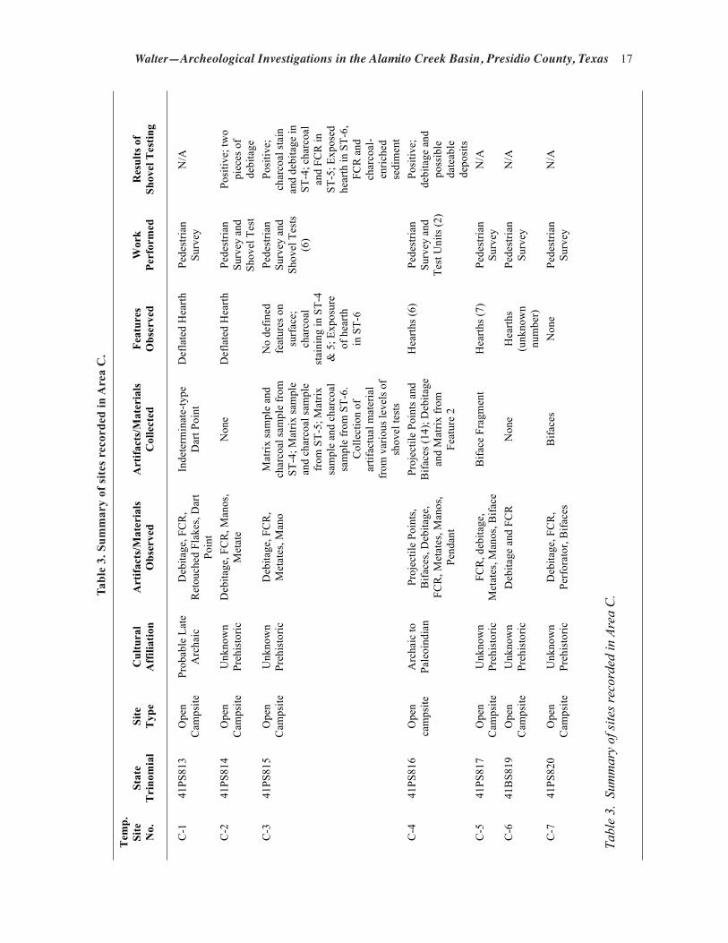
Area C is located south of the southeastern and southwestern corners of Areas A and B, respec-tively (see Figure 2). The area includes the uplands and lowlands on either side of the lower reaches of Chambers Draw and an approximate 4 km swath on either side of Antelope Draw. The area has alluvial flats, plains, fan skirts, ephemeral drainages, inset fans, erosional remnants and mesas, fan remnants, and ballenas. Seven sites were discovered, six of which are clustered within a ca. 500 x 500 m area near Antelope Draw (Table 3). The remaining site was discovered along Chambers Draw.
41PS813
Site 41PS813 is a 50 x 70 m prehistoric open campsite situated on a sandy alluvial flat ca. 130 m north of Antelope Draw. A single deflated and surficial thermal feature was discovered along the eastern side of the site. The artifact assemblage consists of a diffuse scatter of FCR, debitage, and chipped stone tools; much of the debitage was

Walter—Archeological Investigations in the Alamito Creek Basin, Presidio County, Texas 15
Tem
p.
Site
N
o.
Stat
e T
rino
mia
l Si
te
Typ
e C
ultu
ral
Aff
iliat
ion
Art
ifact
s/M
ater
ials
Obs
erve
d A
rtifa
cts/
Mat
eria
ls
Col
lect
ed
Feat
ures
O
bser
ved
Wor
k Pe
rfor
med
B-1
41
PS81
1 O
pen
Cam
psite
Ea
rly to
La
te
Arc
haic
Deb
itage
, ret
ouch
ed fl
akes
, bifa
ce
frag
men
ts, h
amm
erst
one,
exp
edie
nt
and
form
al m
etat
es, d
art p
oint
s
Palm
illas
, Pan
dale
, an
d La
ngtr
y da
rt po
ints
Two
smal
l he
arth
s Pe
dest
rian
Surv
ey
B-2
41
PS81
2 O
pen
Cam
psite
U
nkno
wn
Preh
isto
ric
Deb
itage
, uni
face
s, bi
face
s,
FCR
scat
ter
Non
e N
o di
scre
te
feat
ures
Pe
dest
rian
Surv
ey
Tabl
e 2.
Sum
mar
y of
site
s rec
orde
d in
Are
a B.
Tabl
e 2.
Sum
mar
y of
site
s rec
orde
d in
Are
a B
.

16 Texas Archeological Society
Figure 8. Early, Middle, and Late Archaic dart points found at 41PS811: a, Pandale; b, Langtry; c, Palmillas.
retouched and/or utilized. One Palmillas type dart point was discovered that is indicative of Middle to Late Archaic occupations (Turner et al. 2011:145).
41PS814
Site 41PS814 is a 50 x 70 m prehistoric open campsite located ca. 100 south of 41PS813 and only ca. 30 m north of Antelope Draw. The site contains a deflated hearth and a diffuse scatter of FCR, debitage, and ground stone. The ground stone assemblage includes one metate and one mano, both with only slight usage. The results of two shovel tests indicated the presence of buried cultural mate-rials (debitage and FCR). The debitage assemblage (n=18) includes six hard hammer flake fragments, four indeterminate-type flake fragments, one soft hammer flake, and seven pieces of shatter. Raw material is dominated by chalcedony (n=16). Other material types are rhyolite and hornfels. A profile drawing of one of the shovel tests (ST-2) indicates ca. 5 cm of recent unconsolidated sand overlying ca. 20 cm of unconsolidated sand intermixed with pebble-sized gravels that in turn overlies ca. 20 cm
of compact sandy clay loam. No carbon remains or temporally diagnostic artifacts were encountered.
41PS815
Site 41PS815 is a 50 x 70 m prehistoric open campsite of unknown age that is adjacent to and south of an unnamed ephemeral drainage asso-ciated with Antelope Draw. Low-lying coppice dunes and inter-dune areas are present. A heavy concentration of artifacts is exposed on the sur-face within a ca. 20 x 20 m area. The remaining area contains a light and diffuse scatter of arti-facts. The site contains FCR, debitage, ground stone (informal metates and manos), and a single scraper. Three of six shovel tests revealed buried cultural deposits, including what appeares to be a buried thermal feature (see Results of Excava-tions, below).
41PS816
Site 41PS816 is a large 200 x 320 prehistoric open campsite (see Figure 31, below). The site
Walter—Archeological Investigations in the Alamito Creek Basin, Presidio County, Texas 17
Tem
p.
Site
N
o.
Stat
e T
rino
mia
l Si
te
Typ
e C
ultu
ral
Aff
iliat
ion
Art
ifact
s/M
ater
ials
O
bser
ved
Art
ifact
s/M
ater
ials
C
olle
cted
Fe
atur
es
Obs
erve
d W
ork
Perf
orm
ed
Res
ults
of
Shov
el T
estin
g
C-1
41
PS81
3 O
pen
Cam
psite
Pr
obab
le L
ate
Arc
haic
D
ebita
ge, F
CR
, R
etou
ched
Fla
kes,
Dar
t Po
int
Inde
term
inat
e-ty
pe
Dar
t Poi
nt
Def
late
d H
earth
Pe
dest
rian
Surv
ey
N/A
C-2
41
PS81
4 O
pen
Cam
psite
U
nkno
wn
Preh
isto
ric
Deb
itage
, FC
R, M
anos
, M
etat
e N
one
Def
late
d H
earth
Pe
dest
rian
Surv
ey a
nd
Shov
el T
est
Posi
tive;
two
piec
es o
f de
bita
ge
C-3
41
PS81
5 O
pen
Cam
psite
U
nkno
wn
Preh
isto
ric
Deb
itage
, FC
R,
Met
ates
, Man
o M
atrix
sam
ple
and
char
coal
sam
ple
from
ST
-4; M
atrix
sam
ple
and
char
coal
sam
ple
from
ST -
5; M
atrix
sa
mpl
e an
d ch
arco
al
sam
ple
from
ST-
6.
Col
lect
ion
of
artif
actu
al m
ater
ial
from
var
ious
leve
ls o
f sh
ovel
test
s
No
defin
ed
feat
ures
on
surf
ace;
ch
arco
al
stai
ning
in S
T-4
& 5
; Exp
osur
e of
hea
rth
in S
T-6
Pede
stria
n Su
rvey
and
Sh
ovel
Tes
ts
(6)
Posi
tive;
ch
arco
al st
ain
and
debi
tage
in
ST- 4
; cha
rcoa
l an
d FC
R in
ST
-5; E
xpos
ed
hear
th in
ST-
6,
FCR
and
ch
arco
al-
enric
hed
sedi
men
t C
-4
41PS
816
Ope
n ca
mps
ite
Arc
haic
to
Pale
oind
ian
Proj
ectil
e Po
ints
, B
iface
s, D
ebita
ge,
FCR
, Met
ates
, Man
os,
Pend
ant
Proj
ectil
e Po
ints
and
B
iface
s (14
); D
ebita
ge
and
Mat
rix fr
om
Feat
ure
2
Hea
rths (
6)
Pede
stria
n Su
rvey
and
Te
st U
nits
(2)
Posi
tive;
de
bita
ge a
nd
poss
ible
da
teab
le
depo
sits
C
-5
41PS
817
Ope
n C
amps
ite
Unk
now
n Pr
ehis
toric
FC
R, d
ebita
ge,
Met
ates
, Man
os, B
iface
B
iface
Fra
gmen
t H
earth
s (7)
Pe
dest
rian
Surv
ey
N/A
C-6
41
BS8
19
Ope
n C
amps
ite
Unk
now
n Pr
ehis
toric
D
ebita
ge a
nd F
CR
N
one
Hea
rths
(unk
now
n nu
mbe
r)
Pede
stria
n Su
rvey
N
/A
C-7
41
PS82
0 O
pen
Cam
psite
U
nkno
wn
Preh
isto
ric
Deb
itage
, FC
R,
Perf
orat
or, B
iface
s B
iface
s N
one
Pede
stria
n Su
rvey
N
/A
Tabl
e 3.
Sum
mar
y of
site
s rec
orde
d in
Are
a C
.
Tabl
e 3.
Sum
mar
y of
site
s re
cord
ed in
Are
a C
.

18 Texas Archeological Society
is situated on a sandy flat that contains small, localized areas of low-lying coppice dunes. Antelope Draw is ca. 300 m to the south. An ephemeral drainage joins with Alamito Creek ca. 100 m west of the site. A mechanically excavated drainage adjacent to a berm is located along the western and northern margins of the site. Also, a fence line, access road, and the Atchison Topeka and Santa Fe railroad run parallel to each other and are located adjacent and north of the site.
A small number of hearths, bifaces, projectile points, manos, metates, and occasional pieces of FCR and debitage were scattered across most of the site area. However, two inter-dune areas (A and B) contain a moderate number of features and artifacts. Area A measures ca. 65 x 65 m and had three hearths (F-1, 2, and 4), one mano, three biface fragments, and five projectile points. In addition, a pendant fragment made of kaolinite
was discovered within this area (Figure 9). Area B measures ca. 38 x 42 m and contained one hearth (F-3), one mano, one projectile point, and a small concentration of FCR.
The chipped stone assemblage includes deb-itage, bifaces, and projectile points. Debitage consists of a variety of raw material types and represents both hard and soft hammer reduction. Two bifaces are noted, one an indeterminate type biface fragment with extensive unifacial retouch along the dorsal surface and only minimal retouch along the ventral surface. The lateral margin along the dorsal surface has a steep-angled bit and was likely used as a scraper. The artifact is made of a gray, fine-grained, opaque chert. The other biface is a small sub-triangular, cursorily made, piece. The distal tip and one proximal corner are missing. This latter biface is made of a pale red and white banded, fine-grained, opaque chert.
Figure 9. Kaolinite pendant fragment found at 41PS816.

Walter—Archeological Investigations in the Alamito Creek Basin, Presidio County, Texas 19
Projectile point types indicate a wide range of occupational episodes extending from the Late Paleoindian to Late Archaic periods, or ca. 12,200–1250 B.P. Two projectile points were recovered that are associated with the Late Paleoindian period (Figure 10a-b). One is a Golondrina (Turner et al. 2011:110–111) that is made of material macro-scopically identical to Edwards Formation chert. The lateral margins of the blade are reworked, almost to the point of exhaustion. Both stem and basal margins have been ground.
The second dart point is a contracting stem, lanceolate-shaped point made of a pinkish to reddish-gray, fine-grained opaque chert (see Figure 10b). Damage is apparent on the distal and ventral
surface along the lateral margin. Both lateral mar-gins of the blade are reworked. A small area of one side of the stem is lightly ground. The proximal portion of the stem is more pointed than convex and biconvex in cross section. The flaking along both sides of the stem exhibits bilateral symmetry and has similar attributes to the Hell Gap type (Turner and Hester 1999:129). The Golondrina dart point was found ca. 3.5 m from F-3 and the Hell Gap-like dart point was found ca. 4.5 m from F-2.
Three other dart points from 41PS816 appear to be a distinct style and are similar to diminutive versions of the Dalton types (Figure 11a–c) (Justice 2002; Turner et al. 2011). The lateral margins of the blades were reworked and are alternate beveled
Figure 10. Late Paleoindian projectile points found at 41PS816: a, re-worked Golondrina; b, Hell Gap-like.

20 Texas Archeological Society
while the stem and basal margins are heavily ground. Two of the points have faint shoulders, but the shoulders on one (Figure 11b) appear to be the result of extensive grinding along both margins of the stem. These points exhibit impact fractures per-pendicular to the transverse fracture on the distal end. Basal thinning flakes are apparent on all three specimens and the points are made of variegated fine-grained opaque chert.
Another dart point (see Figure 11d) has a minimal amount of retouch flaking on both dorsal and ventral surfaces of the blade. A single flake has been alternately removed on either side of the stem with no further retouch flaking. The dart point is an expediently made Pandale dart point associated with the Early Archaic period (Turner et al. 2011:168–169). Another recovered dart point has an expanding stem and concave base and is made of a dark gray chert. The distal end, both shoulders, and the proximal corner of the stem are missing. The basal edge is ground. The general morphology of this dart point is vaguely similar to the expanding stemmed and corner-notched series of dart points recovered in both Late Paleoindian and Early Archaic contexts at the Wilson-Leonard
site, and to the Baker/Bandy series of the Lower Pecos region (Collins et al. 1998:220–223; Turner et al. 2011:62–63).
Middle and Late Archaic dart points also were recovered during the recording of 41PS816. The Middle Archaic dart point resembles the Jora type, a dart point considered by some to be a Langtry variant (Ohl n.d.). This specimen is made of a light brownish-gray, fine-grained, opaque chert (Figure 12a). Two probable Late Archaic corner-notched dart points also were recovered; one exhibits wide corner notches and pronounced barbs resembling the San Pedro type (Justice 2002:202). The stem is short and slightly expanding with a slightly convex base. It is made of a striated gray and grayish-white, fine-grained, opaque chert (Figure 12b). Another indeterminate type dart point of likely Late Archaic age is highly fragmented. The lateral margins of the blade are damaged, the shoulders or barbs are missing, and the proximal portion of the base is missing. The only recognizable attribute is that the specimen is corner-notched and has an expanding stem. This specimen is made of a brownish-gray and white, fine-grained, opaque chert.
Figure 11. Late Paleoindian and Early Archaic dart points recovered at 41PS816: a–c, Dalton; d, Pandale.

Walter—Archeological Investigations in the Alamito Creek Basin, Presidio County, Texas 21
Six thermal features were observed at 41PS816 and were noted as partially intact. Two of the six thermal features were chosen for test excavations. Two 1 x 1 m units were laid out, straddling a por-tion of two hearths (see Results of Excavations sec-tion below). The site was again revisited by CBBS archeologists in June 2009 in hopes of finding ad-ditional early projectile point styles in association with thermal features that could contain dateable deposits. Although no additional Paleoindian and Early Archaic type points were discovered, one hearth was discovered partially buried at the base of a small dune hummock. This oval-shaped hearth was ca. 70 cm in maximum diameter and consisted of ca. 30 igneous rocks, most of which did not show definitive attributes of thermal alteration. Heavy carbonate mineralization was apparent on all of the cobbles. No dateable deposits were observed.
41PS817
Site 41PS817 is a 45 x 75 m prehistoric open campsite situated on an alluvial flat that is draped
with small coppice dunes. The site is ca. 50 m south of Antelope Draw. Seven hearths, debitage, chipped stone tools, and ground stone were noted during the survey. No temporally diagnostic arti-facts were encountered. Some of the hearths ap-peared intact and, therefore, they have potential to provide chronometric and botanical data.
41PS819
Site 41PS819 is a 30 x 45 m prehistoric open campsite. The site is located on a sandy flat ca. 500 m northwest of an ephemeral drainage in Antelope Draw, ca. 100 m south of the Atchison, Topeka, and Santa Fe Railroad, and ca. 80 m north/northwest of 41PS813. The site has a light scatter of debitage and FCR, and three deflated thermal features. No temporally diagnostic arti-facts or dateable deposits were encountered. Be-cause of the meager number and surficial nature of artifacts, coupled with an absence of buried and dateable deposits, the research potential for this site is poor.
Figure 12. Middle and Late Archaic dart points found at 41PS816: a, Jora; b, San Pedro-like.

22 Texas Archeological Society
41PS820
Site 41PS820 is a 45 x 80 m prehistoric open campsite located on a pronounced, flat-topped ridge between and at the juncture of an ephemeral drainage with Chambers Draw to the west, and an unnamed ephemeral drainage to the south/southeast. The site contains a light scatter of FCR, debitage, and chipped and ground stone tools. No features were observed. The ground surface at 41PS820 was deflated with no apparent buried deposits. Based on the absence of intact features and dateable deposits, coupled with the absence of temporally diagnostic artifacts, this site has a limited research potential.
Chipped stone tools consist of a hafted biface made of yellowish-brown jasper and an inde-terminate type biface made of semi-translucent white chalcedony. Also, a piece of shatter made of thermally altered chalcedony was collected with fine unifacial retouch flaking on one end. The one ground stone tool is a shallow basin-type metate fragment made of basalt.
Area D
Area D is directly east of Area E and is located on the eastern side of MacGuire Ranch (see Figure 2). Landforms within this study unit include fan pied-monts, alluvial flats, plains, fan skirts, and erosion remnants truncated by small drainage ways. Only one site was discovered within Area D (Table 4).
41PS821
Site 41PS821 is a small prehistoric open camp-site that is located on the north side of a small, remnant playa lake. The site consists of a structural feature and a minor lithic scatter. The feature is a ca. 7 x 10 m oval-shaped alignment that consists of ca. 80 stones. No entryway is apparent, and this feature is atypical of the stacked-stone structures of the Cielo complex. No artifacts were found within or immediately adjacent to the feature. However, a small artifact scatter is located ca. 2.5 m to the east and consists of large flakes, a core, and early stage bifaces.
Isolated Finds
The one isolated find in Area D consists of a dart point fragment. The distal portion of the blade,
a portion of one lateral margin, the shoulders or barbs, both margins of the stem, and a portion of the base are missing. This specimen appears to be corner-notched with a straight base and is suspect-ed to be of Late Archaic period age. All specimen fractures are the result of thermal alteration, and it is made of a semi-translucent, fine-grained, white chalcedony.
Area E
The northwest corner of Area E is located ca. 1 km south of San Esteban rock shelter and extends ca. 4 km to the south. The western bound-ary is adjacent to and east of the existing Atchison Topeka and Santa Fe railroad and extends east for ca. 4 km (see Figure 2). The most pronounced geographic feature of Area E is a long escarpment that rises some 90 m above the Alamito Creek floodplain. This escarpment, or rim, is the termi-nus of a massive Mitchell Mesa tuff ash flow. A small area just below this escarpment contains fan aprons, fan skirts, and inset fans of gravelly loam derived from the tuff. The slope just below the escarpment consists of gravelly residuum and col-luvium that has weathered from the escarpment. To the east of the escarpment the geographic set-ting is a mixture of alluvial flats, plains, fan skirts, erosional remnants, and low-lying hills truncated by small drainages.
Special attention was given to surveying the escarpment for rock shelters that could contain per-ishable materials. As a result, two small rock shel-ters were recorded (Table 5), both located along the base of the escarpment. No other sites were recorded, either below or east of the escarpment.
41PS823
Site 41PS823 is a small prehistoric rock shelter (5.5 m deep x 6.6 m wide x 2.7 m high), located in the face of a bluff overlooking the Alamito Creek basin. Vegetation obscures the shelter talus. The ceiling is smoke-blackened at the rear of the shel-ter, and a very light scatter of debitage is visible at the entrance. Raw material types represented are chalcedony and chert. Graffiti was scratched on the back of the wall that reads “DW99.” A single decorticate flake with unifacial retouch flak-ing along one lateral margin was discovered. No carbon remains or temporally diagnostic artifacts were noted.

Walter—Archeological Investigations in the Alamito Creek Basin, Presidio County, Texas 23
Tem
p.
Site
N
o.
Stat
e T
rino
mia
l Si
te
Typ
e C
ultu
ral
Aff
iliat
ion
Art
ifact
s/M
ater
ials
O
bser
ved
Art
ifact
s/M
ater
ials
C
olle
cted
Fe
atur
es
Obs
erve
d W
ork
Perf
orm
ed
Res
ults
of
Shov
el
Tes
ting
D-1
41
PS82
2 Sh
ort-t
erm
R
esid
entia
l B
ase
Cam
p
Unk
now
n Pr
ehis
toric
FC
R, l
ithic
deb
itage
, cor
es,
early
stag
e bi
face
s Pr
ojec
tile
Poin
t and
C
ore
Stru
ctur
al
Rem
nant
and
H
earth
Pede
stria
n Su
rvey
N
/A
Tabl
e 4.
Sum
mar
y of
site
s rec
orde
d in
Are
a D
.
Tem
p.
Site
N
o.
Stat
e T
rino
mia
l Si
te
Typ
e C
ultu
ral
Aff
iliat
ion
Art
ifact
s/M
ater
ials
O
bser
ved
Art
ifact
s/M
ater
ials
C
olle
cted
Fe
atur
es
Obs
erve
d W
ork
Perf
orm
ed
Res
ults
of
Shov
el
Tes
ting
E-1
41PS
823
Roc
kshe
lter
Unk
now
n Pr
ehis
toric
Li
thic
deb
itage
, uni
face
N
one
Non
e Pe
dest
rian
Surv
ey
N/A
E-2
41PS
824
Roc
kshe
lter
Unk
now
n Pr
ehis
toric
Li
thic
deb
itage
, bifa
cial
ly-
reto
uche
d sc
rape
r N
one
Smal
l cul
tura
l ta
lus
Pede
stria
n Su
rvey
N
/A
Tabl
e 5.
Sum
mar
y of
site
s rec
orde
d in
Are
a E
Tabl
e 4.
Sum
mar
y of
site
s rec
orde
d w
ithin
Are
a D
.
Tem
p.
Site
N
o.
Stat
e T
rino
mia
l Si
te
Typ
e C
ultu
ral
Aff
iliat
ion
Art
ifact
s/M
ater
ials
O
bser
ved
Art
ifact
s/M
ater
ials
C
olle
cted
Fe
atur
es
Obs
erve
d W
ork
Perf
orm
ed
Res
ults
of
Shov
el
Tes
ting
D-1
41
PS82
2 Sh
ort-t
erm
R
esid
entia
l B
ase
Cam
p
Unk
now
n Pr
ehis
toric
FC
R, l
ithic
deb
itage
, cor
es,
early
stag
e bi
face
s Pr
ojec
tile
Poin
t and
C
ore
Stru
ctur
al
Rem
nant
and
H
earth
Pede
stria
n Su
rvey
N
/A
Tabl
e 4.
Sum
mar
y of
site
s rec
orde
d in
Are
a D
.
Tem
p.
Site
N
o.
Stat
e T
rino
mia
l Si
te
Typ
e C
ultu
ral
Aff
iliat
ion
Art
ifact
s/M
ater
ials
O
bser
ved
Art
ifact
s/M
ater
ials
C
olle
cted
Fe
atur
es
Obs
erve
d W
ork
Perf
orm
ed
Res
ults
of
Shov
el
Tes
ting
E-1
41PS
823
Roc
kshe
lter
Unk
now
n Pr
ehis
toric
Li
thic
deb
itage
, uni
face
N
one
Non
e Pe
dest
rian
Surv
ey
N/A
E-2
41PS
824
Roc
kshe
lter
Unk
now
n Pr
ehis
toric
Li
thic
deb
itage
, bifa
cial
ly-
reto
uche
d sc
rape
r N
one
Smal
l cul
tura
l ta
lus
Pede
stria
n Su
rvey
N
/A
Tabl
e 5.
Sum
mar
y of
site
s rec
orde
d in
Are
a E
Tabl
e 5.
Sum
mar
y of
site
s rec
orde
d w
ithin
Are
a E
.

24 Texas Archeological Society
41PS824
Site 41PS824 is a small prehistoric rock shel-ter (2.8 m deep x 4.5 m wide x 2.0 m high), also located in the face of the bluff. A small, unnamed ephemeral drainage is located ca. 80 m to the north. The ceiling is smoke-blackened and debitage is visible across a minor cultural talus that extends ca. 4.5 m from the shelter entrance. An oval chert biface with a steeply beveled dorsal edge was re-covered. The dorsal edge exhibits unifacial retouch flaking and appears to have served as a scraper. No perishable material, carbon remains, or temporally diagnostic artifacts were discovered.
The Main Stem of the Alamito Creek Basin (Area F)
Archeological reconnaissance of the main stem of the Alamito Creek basin (Area F) resulted in the identification of five new sites and one extensive site complex containing virtually hundreds of sites. The following section provides results of these investigations.
41PS818
As mentioned earlier, 41PS818 is actually an archeological complex that consists of many small rock shelters, small to large midden deposits, a Cielo complex-like open campsite, and historic structures and associated artifacts. This area was separated into sub-areas designated as Kid’s Hill locality (including the Cielo-like campsite), North and West Extensions (the rock shelters), and South Extension (historic structures).
The Rock shelters (West Extension)
An impressive total of 145 mostly small, natural alcoves were investigated within an ex-tensive, horizontally exposed tuff landform that is part of the larger Mitchell Mesa formation (Barnes 1979). Most of the natural alcoves occur in the West Extension Area (Figure 13). These small natural alcoves were formed as a result of large gas pockets within a single-event ash flow. Out of the 145 rock shelters, 42 contain cultural remains (Table 6). Not only did prehistoric hunter/gatherers make use of these small rock shelters, but historic laborers during the construction of the San Esteban irrigation system and the Kansas
City, Mexico, and Orient Railroad did as well (Figure 14). Fourteen rock shelters contain only debitage or functionally undiagnostic artifacts and, consequently are of unknown prehistoric affiliation. Thirteen other rock shelters contain both prehistoric and historic artifacts. Three have prehistoric artifacts and stacked-rock alignments that served as walls; these stone walls most likely are associated with the historic period. Four rock shelters have only historic artifacts, while seven contain stacked-rock walls with neither prehis-toric nor historic artifacts.
Surprisingly, the survey team recovered only two temporally diagnostic prehistoric artifacts. The first artifact was a Cliffton type arrow point or a Perdiz arrow point preform (Turner and Hester 1999:208; Turner et al. 2011:206) found at RR-29, a small rock shelter (Figure 15; see Table 6). The point is sub-triangular in shape, with minimal re-touch flaking along the lateral margins of the blade, shoulders, and stem. The arrow point has defined shoulders with a contracting stem, and is made of a fine-grained, opaque, brown agate.
The second artifact is a tubular stone pipe pre-form (Turner et al. 2011:280–283) found in a crack between two boulders that had fallen from the roof of a rock shelter (Figure 16 and Table 7; see also Table 6). No cultural deposits were observed; however, intact deposits may be present under the fallen debris. The pipe preform is made of a very pale brown welded tuff containing tiny vesicles. Part of the exterior portion has been painted with an iron oxide pigment, perhaps hematite, along the length of the stem and partially around the chamber rim. Very faint linear incised lines are visible both parallel and perpendicular to the long axis of the preform. It is unclear if these faint inci-sions represent the early makings of a design or are a result of shaping the stone. The chamber or bowl is conical in shape, and measures 29.3 mm in maximum diameter at the opening, and it is drilled to a maximum depth of ca. 38.0 mm. The distal end of the preform gradually contracts towards the proximal end of the stem. No attempts were made to drill from the stem end. The overall dimensions are 154.2 mm in maximum length and 55.6 mm in maximum diameter.
The Kid’s Hill Locality
The Kid’s Hill Locality is a large cultural talus deposit that contains a mixture of FCR, debitage,

Walter—Archeological Investigations in the Alamito Creek Basin, Presidio County, Texas 25
chipped stone tools, ceramics (both prehistoric and historic), glass, and metal artifacts. Located ca. 10 m down slope from a small rock shelter (see Table 6: RR-37), this talus deposit was chosen for children to learn the basic methods of survey and excavation, hence the name “Kid’s Hill Locality” (see Results of Test Excavations, below). The
survey involved children flagging and identifying various surface artifacts. A rectangular-shaped stacked-rock structure remnant is within the mid-den deposits (Figure 17). Field notes indicated that the walls were ca. 10. 2 ft. wide and the south wall was ca. 12.25 ft. long. The north end of the structure is open and void of stacked rock. The
Figure 13. Map of 41PS818 showing numerous rock shelters (designated as RR) that contain cultural materials.

26 Texas Archeological Society
Figure 14. Example of stacked rock wall associated with rock shelter (RR-28) at 41PS818.
interior portion contains a significant amount of wall fall. Along with some debitage, an unspeci-fied type of Winchester shotgun shell and a tin can were observed within the structure and indicate its historic use. Both prehistoric and historic artifacts were observed at this locality. Prehistoric artifacts consisted of debitage (including cores), ground stone, a unifacial-flaked chopper tool, and a ham-merstone. Field notes indicate that chalcedony was the dominant stone type along with chert and rhyo-lite. Historic artifacts included solder-sealed cans, a tobacco tin, sheet metal fragments, an iron leaf spring to a wagon, Mexican and Anglo-American ceramics, and various colored glass sherds.
The Possible Cielo Complex Site
Four oval-to-elongated curvilinear-shaped single-course to stacked rock alignments are di-rectly west-northwest and upslope from the Kid’s Hill excavation area (Figure 18). The features are situated on top of a pronounced hill with outcrops of tuff bedrock surrounding the perimeter of the landform. Three of the features were most likely residential and/or shelter-type structures while one appears to be some kind of ramada-like structure. Large cobbles to boulder-size rocks of tuff were collected on the site and/or nearby for construc-tion of the dwellings. Stones were placed one to two courses high. Most of the openings are wider compared to the entryways of typical Cielo
complex wickiups (Table 8) (Mallouf 1999). Yet the structures are located on a strategic well-elevated landform that provided a panoramic view of the Alamito Creek basin to the south and the canyon drainage to the west and north.
A light and diffuse scatter of debitage and FCR were outside of the structures while the interior of the structures had been cleared of rocks and contained one to three pieces of debitage. No chipped stone tools or projectile points were encountered. The only temporally-diagnostic ar-tifact is a body sherd of red-slipped El Paso brownware found ca. 30 cm outside of the westernmost stone of F-1 (Figure 19). The temper has a “salt and pepper” appearance with coarse angular granules of granite
typical of the El Paso area. The sherd could be from either a El Paso Bichrome or Polychrome vessel found at various sites in the ETP/BB re-gion, but most commonly in the region these types are found at village sites in the La Junta area near present-day Presidio. Ceramics are very rare at Cielo complex sites, so much so that Cielo sites are considered an aceramic cultural manifestation (Mallouf 1985, 1999).
Two of the features in this area (F-1 and F-2) have the potential to contain shallow, but buried, cultural deposits within their interiors. Six possible bedrock mortars were recorded at the northern end of the landform. However, after returning to the site and re-examining these features, they appear to be natural, but unusually round and cylindrical, depressions in the Mitchell Mesa tuff. Three other possible mortar holes were located down slope and east of the landform.
The Rock Houses
The ruins of two historic rock houses were re-corded within the area designated as the “Southern Extension” of Area F (41PS818) and are identified as House No. 1 and House No. 2 (Table 9). Further descriptions of house attributes and artifacts within and adjacent to the houses are provided below.
House No. 1 was located ca. 180 m south/southeast of the Kid’s Hill locality and just below the Mitchell Mesa escarpment (Figure 20). The

Walter—Archeological Investigations in the Alamito Creek Basin, Presidio County, Texas 27
Tabl
e 6.
Roc
k sh
elte
r at
trib
utes
at 4
1PS8
18.
Fiel
d I.D
. Su
b-Fe
atur
es
Cul
tura
l Mat
eria
l C
ultu
ral A
ffili
atio
n C
omm
ents
RR
-7
Stac
ked
rock
wal
l N
one
Poss
ible
His
toric
N
one
RR
-9
Non
e Fi
re c
rack
ed ro
ck
Unk
now
n Pr
ehis
toric
N
one
RR
-10
Stac
ked
rock
wal
l, m
orta
r hol
e Th
ree
nails
driv
en in
to fa
ce o
f roc
k sh
elte
r abo
ve e
ntra
nce,
one
nai
l on
floor
, sm
all-c
alib
er c
artri
dge,
bur
nt w
ood,
deb
itage
, FC
R in
Tal
us
Unk
now
n Pr
ehis
toric
/His
toric
N
one
RR
-11
Non
e Ti
n ca
ns
His
toric
Sm
oke-
blac
kene
d ce
iling
R
R-1
2 St
acke
d ro
ck w
all,
Scra
pe m
arks
(art
or a
brad
ed li
nes?
), M
orta
r hol
e N
one
Unk
now
n Pr
ehis
toric
/Pos
sibl
e H
isto
ric
Non
e
RR
-13A
N
one
FCR
, Mod
ified
deb
itage
U
nkno
wn
Preh
isto
ric
Non
e R
R-1
5 St
acke
d-ro
ck w
all
Non
e Po
ssib
le H
isto
ric
Non
e R
R-1
6 H
earth
D
ebita
ge o
n ta
lus
Unk
now
n Pr
ehis
toric
N
one
RR
-17
Non
e D
ebita
ge, s
ever
al m
anos
U
nkno
wn
Preh
isto
ric
Smok
e-bl
acke
ned
ceili
ng
RR
-18
Non
e D
ebita
ge (c
hert)
, Wor
ked
cobb
le
Unk
now
n Pr
ehis
toric
Sm
oke-
blac
kene
d ce
iling
RR
-19
Non
e D
ebita
ge
Unk
now
n Pr
ehis
toric
D
ebita
ge o
n ta
lus d
epos
its
RR
-21
Non
e H
amm
er st
ones
, deb
itage
, FC
R
Unk
now
n Pr
ehis
toric
D
ebita
ge o
n Ta
lus
RR
-23
Non
e D
ebita
ge
Unk
now
n Pr
ehis
toric
D
ebita
ge n
otic
ed o
n ta
lus
RR
-24
Stac
ked
rock
wal
l D
ebita
ge, m
anos
, ham
mer
ston
es, T
ools
(scr
aper
s), C
oke
bottl
e U
nkno
wn
Preh
isto
ric/H
isto
ric
Loot
ed, b
ackf
ill p
ile o
utsi
de
RR
-25
Non
e D
ebita
ge (c
hert
and
chal
cedo
ny),
Cor
es (c
hert)
U
nkno
wn
Preh
isto
ric
Deb
itage
and
cor
es o
bser
ved
on
talu
s R
R-2
6 Pl
aced
rock
s G
lass
, Uni
face
s, Ti
n sa
rdin
e ca
n, 2
sard
ine
can
lids,
leat
her
shoe
sole
2 m
bel
ow e
ntra
nce
Unk
now
n Pr
ehis
toric
/His
toric
U
nifa
ces m
ade
of d
ark
gray
ch
ert a
nd fo
und
on ta
lus
RR
-27
Stac
ked
rock
wal
l D
ebita
ge
Unk
now
n Pr
ehis
toric
/Pos
sibl
e H
isto
ric
Smok
e-bl
acke
ned
ceili
ng
RR
-28
Stac
ked
rock
wal
l Ti
n ca
n, D
ebita
ge
Unk
now
n Pr
ehis
toric
/His
toric
N
one
RR
-29
Non
e Pe
rdiz
pre
form
or C
liffto
n ty
pe a
rrow
poi
nt
Late
Pre
hist
oric
N
one
RR
-31
Stac
ked-
rock
wal
l G
lass
, Deb
itage
U
nkno
wn
Preh
isto
ric/H
isto
ric
Ash
y ta
lus

28 Texas Archeological Society
Tabl
e 6.
Roc
k sh
elte
r at
trib
utes
at 4
1PS8
18. (
Con
tinue
d)
Fiel
d I.D
. Su
b-Fe
atur
es
Cul
tura
l Mat
eria
l C
ultu
ral A
ffili
atio
n C
omm
ents
RR
-32
Stac
ked-
rock
wal
l D
ebita
ge, B
one,
Cor
e U
nkno
wn
Preh
isto
ric/P
ossi
ble
His
toric
N
one
RR
-33
Stac
ked-
rock
wal
l G
lass
, Deb
itage
(cha
lced
ony,
che
rt, a
nd rh
yolit
e)
Unk
now
n Pr
ehis
toric
/His
toric
N
one
RR
-42
Mor
tar h
oles
C
loud
blo
wer
pip
e (A
5), M
etal
can
U
nkno
wn
Preh
isto
ric/H
isto
ric
Col
laps
ed ro
of; A
5, p
ipe
colle
cted
from
cr
evic
e be
twee
n bo
ulde
rs
RR
-43
Roc
k st
ruct
ure
in fr
ont o
f Roc
k Sh
elte
r, M
orta
r hol
e D
ebita
ge
Unk
now
n Pr
ehis
toric
R
ock
colla
pse
in fr
ont/b
lock
ing
entra
nce
to
Roc
k Sh
elte
r R
R-4
4 St
acke
d-ro
ck w
all
Bro
wn
bottl
e gl
ass,
Tin
cans
, deb
itage
U
nkno
wn
Preh
isto
ric/H
isto
ric
Non
e R
R-4
6 St
acke
d-ro
ck w
all;
bedr
ock
mor
tar
Deb
itage
(che
rt), T
in c
ans,
Gla
ss
Unk
now
n Pr
ehis
toric
/His
toric
A
djac
ent a
nd e
ast o
f Chi
huah
ua T
rail
RR
-47
Stac
ked-
rock
wal
l and
pill
ar; E
tche
d w
ritin
g on
pill
ar
Leat
her b
oot,
Whi
tew
are,
Man
o, D
ebita
ge,
Gla
ss, B
roke
n m
orta
r,Pes
tle o
n ta
lus,
Shot
gun
sh
ell,
Util
ized
deb
itage
Unk
now
n Pr
ehis
toric
/His
toric
A
djac
ent a
nd e
ast o
f Chi
huah
ua T
rail;
has
par
titio
n w
all
that
ove
rlook
s tra
il
RR
-49
Stac
ked-
rock
wal
l D
ebita
ge, T
in c
ans
Unk
now
n Pr
ehis
toric
/His
toric
A
djac
ent a
nd e
ast o
f Chi
huah
ua T
rail;
has
pa
rtitio
n w
all t
hat o
verlo
oks t
rail
RR
-50
Non
e D
ebita
ge, T
in c
ans
Unk
now
n Pr
ehis
toric
/His
toric
N
one
RR
51
Non
e D
ebita
ge
Unk
now
n Pr
ehis
toric
U
nkno
wn
RR
-65
Non
e Sh
oe so
le, G
lass
H
isto
ric
Non
e R
R-6
6 N
one
Deb
itage
U
nkno
wn
Preh
isto
ric
Non
e R
R-6
7 St
acke
d-st
one
wal
l N
one
Poss
ible
His
toric
N
one
RR
-73
Stac
ked-
ston
e w
all
Non
e Po
ssib
le H
isto
ric
Non
e R
R-7
4 St
acke
d-st
one
wal
l N
one
Poss
ible
His
toric
N
one
RR
-80
Stac
ked-
ston
e w
all
Tin
cans
, Whi
tew
are
shar
ds, D
ebita
ge,
Man
os, B
ones
U
nkno
wn
Preh
isto
ric/H
isto
ric
Non
e
RR
-81
Non
e N
one
Poss
ible
His
toric
B
lue
pain
t ins
ide
door
face
R
R-9
3 N
one
Deb
itage
U
nkno
wn
Preh
isto
ric
Non
e R
R-1
08
Stac
ked-
rock
wal
l N
one
Poss
ible
His
toric
N
one
Tabl
e 6.
Roc
k sh
elte
r attr
ibut
es a
t 41P
S18.
Gla
ss, B
roke
n m
orta
r, Pe
stle
on
talu
s, Sh
ot g
un

Walter—Archeological Investigations in the Alamito Creek Basin, Presidio County, Texas 29
Figure 15. Perdiz preform or Cliffton type arrow point found at rock shelter RR-29.
Figure 16. Tubular pipe preform found at rock shelter RR-42.

30 Texas Archeological Society
Figure 17. Historic stacked-rock structure (RR-37) at the Kid’s Hill locality.
house is rectangular in shape with the long axis orientated ca. 320 degrees north. The portions of the walls that are still standing are of uncut field-stone and mud mortar with chinking stones. The walls average ca. 50 cm thick. The interior contains mostly collapsed wall fall and vegetation. A portion of the dirt floor is visible within the northeast corner.
No artifacts were observed inside the structure. Historic ceramics, glass, and metal artifacts were collected ca. 30 m east of a two-track road adjacent to and west of the structure and ca. 15 m north of the house. Ceramic artifacts (Figure 21) consisted of: (1) two conjoined porcelain plate fragments with
the Wheeling Pottery Co. maker’s mark, manufac-turers of dinnerware from 1879 to ca. 1910 (Kovel and Kovel 1986:76f); (2) porcelain dinnerware frag-ments decorated with blue-colored floral designs; (3) an indeterminate type fragment of vitreous, olive-colored, glazed earthenware (not salt-glazed); and (4) a hand and forearm component to a china doll that was produced anytime from 1840 until as late as the 1930s (Coleman et al. 1986). Glass artifacts included colorless, amethyst, and green-colored glass. Both colorless and green-colored glass have been made from ca. 1860 to the present. Amethyst-colored glass, however, is a result of the use of
Material
Method of Pipe
Construction
Overall Length (mm)
Maximum Diameter
(mm)
Minimum Diameter
(mm)
Width Bowl Opening
(mm)
Depth of Bowl (mm)
Shape of Bowl
Method of Bowl
Constrution Type
Design
Welded Tuff
Scraping 154.2 55.6 N/A 29.3 38 Conical Drilled after Gouging
Cross- Hatched
Table 7. Dimensional and morphological attributes of stone pipe preform.
Feature Designation Morphology
Exterior Dimensions
(m)
Interior Dimensions
(m)
Width of Entranceway
(m) Outward Direction
of Entranceway
Artifacts within the Interior Comments
F1 Elongated curvilinear
ca. 3.8 x 6.8 ca. 1.8 x 5.0 ca. 5.0 West/Southwest ca. three pieces of debitage
Possible Habitation Shelter
F2 Oval ca. 4.8 x 4.8 ca. 4.2 x 4.2 ca. 2.8 Southwest Unknown number of debitage
Eight to 10 iron bolts had been placed on rock next to
entryway; Possible Habitation Shelter
F3 Oval ca. 2.9 x 3.6 ca. 1.7 x 1.8 ca. 1.2 West/Northwest None reported
Possible Small Habitation Shelter or Lookout
F4 Elongated Curvilinear
ca. 2.2 x 4.6 ca. 1.0 x 3.0 ca. 3.0 South/Southwest One piece of debitage
Possible Ramada/Shade Shelter
Table 8. Structural feature attributes at Cielo-like site at 41PS818.
Table 7. Dimensional and morphological attributes of stone pipe preform.

Walter—Archeological Investigations in the Alamito Creek Basin, Presidio County, Texas 31
Figure 18. Plan view map of the probable Cielo complex locality at 41PS818.
manganese in order to give the glass a clearer color. Nevertheless, after time, the ultraviolet rays of the sun turns the glass an amethyst color. Manganese was used in glass from ca. 1880–1925 (Newman 1970:74). The finish and neck components of three bottle fragments were collected. Finishes consist of English Ring (deep lip or packer), prescription, and crown types (IMACS 1992). Metal artifacts consist of a large machine-cut nail with the distal end missing. The nail was at least a 9d pennyweight and more likely a 20d pennyweight when complete.
Nails that are 20d or longer were commonly used for large construction such as framing a house, or the construction of corrals using larger-sized milled lumber or timber. Machine-cut nails were the most common type of nail variety made between ca. 1830-1890, although they are still manufactured today for special projects such as securing wood to concrete, restorations, and remodeling projects (Fontana and Greenleaf 1962:54–55).
House No. 2 is located 48.6 m north of House No. 1. The two-room house is rectangular in shape

32 Texas Archeological Society
Mat
eria
l
Met
hod
of
Pipe
C
onst
ruct
ion
Ove
rall
Len
gth
(mm
)
Max
imum
D
iam
eter
(m
m)
Min
imum
D
iam
eter
(m
m)
Wid
th B
owl
Ope
ning
(m
m)
Dep
th
of B
owl
(mm
) Sh
ape
of B
owl
Met
hod
of
Bow
l C
onst
rutio
n T
ype
Des
ign
Wel
ded
Tuff
Sc
rapi
ng
154.
2 55
.6
N/A
29
.3
38
Con
ical
D
rille
d af
ter
Gou
ging
C
ross
- H
atch
ed
Tabl
e 7.
Dim
ensi
onal
and
mor
phol
ogic
al a
ttrib
utes
of s
tone
pip
e pr
efor
m.
Feat
ure
Des
igna
tion
Mor
phol
ogy
Ext
erio
r D
imen
sion
s (m
)
Inte
rior
D
imen
sion
s (m
)
Wid
th o
f E
ntra
ncew
ay
(m)
Out
war
d D
irec
tion
of E
ntra
ncew
ay
Art
ifact
s w
ithin
the
Inte
rior
C
omm
ents
F1
Elon
gate
d cu
rvili
near
ca
. 3.8
x 6
.8
ca. 1
.8 x
5.0
ca
. 5.0
W
est/S
outh
wes
t ca
. thr
ee
piec
es o
f de
bita
ge
Poss
ible
Hab
itatio
n Sh
elte
r
F2
Ova
l ca
. 4.8
x 4
.8
ca. 4
.2 x
4.2
ca
. 2.8
So
uthw
est
Unk
now
n nu
mbe
r of
debi
tage
Eigh
t to
10 ir
on b
olts
had
bee
n pl
aced
on
rock
nex
t to
entry
way
; Pos
sibl
e H
abita
tion
Shel
ter
F3
Ova
l ca
. 2.9
x 3
.6
ca. 1
.7 x
1.8
ca
. 1.2
W
est/N
orth
wes
t N
one
repo
rted
Poss
ible
Sm
all H
abita
tion
Shel
ter o
r Loo
kout
F4
Elon
gate
d C
urvi
linea
r ca
. 2.2
x 4
.6
ca. 1
.0 x
3.0
ca
. 3.0
So
uth/
Sout
hwes
t O
ne p
iece
of
debi
tage
Po
ssib
le R
amad
a/Sh
ade
Shel
ter
Tabl
e 8.
Str
uctu
ral f
eatu
re a
ttrib
utes
at C
ielo
-like
site
at 4
1PS8
18.
Tabl
e 8.
Str
uctu
ral f
eatu
re a
ttri
bute
s at C
ielo
com
plex
-like
site
at 4
1PS8
18.

Walter—Archeological Investigations in the Alamito Creek Basin, Presidio County, Texas 33
Figure 19. Red-slipped brownware sherd found at the Cielo locality.
with the long axis oriented ca. 320 degrees north. The construction type is the same as House No. 1, using field stone and mud mortar intermixed with small angular stones. There are two door openings, one for each room, along the southwestern wall and interior corners. No window openings were observed, possibly because significant portions of the walls had collapsed. A vertical seam is present along what was once the northeastern corner of the northern room (Room No. 1), indicating that the second, southern room (Room No. 2), was a later addition. Like House No. 1, the walls are ca. 50 cm wide. The interior dimensions of Room No. 1 are ca. 4.2 m long x 3.6 m wide. The interior dimen-sions for Room No. 2 are ca. 3.6 x 3.6 m. Linear bulldozed areas are adjacent to and perpendicular to the northwest and southeast walls. Both bladed areas are ca. 15–20 m long and 7–10 m wide and have compromised the integrity of this site.
Various types of historic ceramics, glass, and metal were noted on the surface; unfortunately, many of these artifacts were within areas impacted by the bulldozer. The survey crew noted the pres-ence of whiteware, flow blue ware, and transfer
print ware, along with a fragment of a porcelain figurine that appears to be a colonial man holding some type of vessel. Amethyst and brown-colored glass fragments were noted. Metal artifacts ob-served were evaporative milk cans, a metal hoe blade, a .35 caliber Remington cartridge casing, and a blasting powder can. The presence of the blasting powder can strongly suggests that the resi-dents of the house were at one time associated with the construction of the Santa Fe railroad in 1929.
A clay marble and a chipped stone tool are the only artifacts collected from this house feature. The undecorated clay marble measures 20.50 mm in diameter. The marble is unglazed and was probably made of low-fired kaolin (Figure 22). Clay marbles were produced as early as the 1700s, but were most common from ca. 1880 until the 1920s (Randall and Webb 1988:14–15). The second artifact is a small biface with the proximal end and the distal tip missing. Both lateral margins are serrated and are at a 30˚ angle along dorsal sides of the blade. The biface is made of fine-grained, semi-translu-cent, white chalcedony, and measures 37.1 mm in length, 16.2 mm in width, and 6.2 mm in thickness.

34 Texas Archeological Society
Tabl
e 9.
Sum
mar
y of
site
s rec
orde
d in
Are
a F.
St
ate
Tri
nom
ial
Site
T
ype
Cul
tura
l A
ffili
atio
n A
rtifa
cts/
Mat
eria
ls O
bser
ved
Art
ifact
s/M
ater
ials
C
olle
cted
Fe
atur
es
Obs
erve
d W
ork
Perf
orm
ed
41PS
818
See
Tabl
es 6
–8*
41PS
825
Ope
n ca
mps
ite
Mid
dle
to L
ate
Arc
haic
, Lat
e Pr
ehis
toric
Deb
itage
, chi
pped
and
gro
und
ston
e Ar
enos
a, P
alm
illas
, Fri
o,
Alaz
an, P
erdi
z typ
e pr
ojec
tile
poin
ts; e
nd-
scra
per,
unm
odifi
ed b
lade
, be
vele
d kn
ife fr
agm
ents
Inde
term
inat
e-ty
pe th
erm
al
feat
ures
, inc
ipie
nt
ring
mid
dens
, re
fuse
mid
dens
Pede
stria
n su
rvey
, tes
t ex
cava
tions
41PS
826
Spec
ial U
se si
te
Unk
now
n Pr
ehis
toric
N
one
Non
e Tw
o ci
rcul
ar-
shap
ed ro
ck c
airn
s Pe
dest
rian
surv
ey
41PS
827
Ope
n ca
mps
ite
Unk
now
n Pr
ehis
toric
D
ebita
ge
Non
e H
earth
s Pe
dest
rian
surv
ey
41PS
828
Dam
and
irr
igat
ion
syst
em
Unk
now
n Pr
ehis
toric
M
etal
arti
fact
s (co
nstru
ctio
n ha
rdw
are,
sani
tary
can
s)
Non
e D
am a
nd
irrig
atio
n sy
stem
, st
ruct
ure
rem
nant
s
Pede
stria
n su
rvey
41PS
831
Ope
n ca
mps
ite
Early
to L
ate
Arc
haic
, Lat
e Pr
ehis
toric
Deb
itage
, chi
pped
and
gro
und
ston
e Ba
ndy,
Lan
gtry
Pal
mill
as,
Shum
la, T
oyah
type
pr
ojec
tile
poin
ts
Hea
rths
Pede
stria
n su
rvey
* 41
PS81
8 te
ntat
ivel
y re
pres
ents
seve
ral d
iffer
ent t
ype
site
s. A
lso,
see
41PS
818
in th
e “R
esul
ts o
f Sur
vey”
and
the
“Res
ults
of E
xcav
atio
n” se
ctio
ns.
Tabl
e 9.
Sum
mar
y of
site
s rec
orde
d in
Are
a F

Walter—Archeological Investigations in the Alamito Creek Basin, Presidio County, Texas 35
Figure 20. Overview of House No. 1 at 41PS818.
Figure 21. Sample of ceramic artifacts collected just outside of House No. 1.

36 Texas Archeological Society
Two isolated finds were recovered within this southern extension of the 41PS818 complex. The first is a corner-notched, expanding stemmed dart point. The dimensions of the point are 29.5 mm in length, 18.5 mm in width, and 5.6 mm in thickness. It is made of an opaque, fine-grained, white chert. The opposing shoulders are not pro-portionate and one lateral margin is reworked. The vitreous luster of the chert suggests that the material was either heat-treated or simply dis-carded into a fire. The second isolate was a steel axe head with the inscription “Mann Edged Tool Company.” The Mann Edge Tool Company was established in 1895 and is one of the few Ameri-can companies still in the business of making axes (Lammond 2010).
The Alamito Creek Site (41PS825)
The Alamito Creek site is an extensive (ca. 420 x 1400 m) multi-component site (see Figure 34 in “Results of Excavations” section, below). The long axis and northeastern boundary of the site area hugs the southwest-facing side of Alamito Creek. The southernmost portion of
the site extends only a few meters south of the southern MacGuire Ranch boundary fence line. An east-west bladed road parallels the boundary fence line. The northern site boundary is located where the Alamito Creek channel turns in a more northerly direction. Another bladed road truncates the site in a general northwest/southeast direction, roughly parallel to the creek channel. Other less traveled roads truncate the site in a general east-west direction.
The site is situated on and along the margin of an alluvial terrace. Surface sediments are silty clay loam to gravelly fine sandy loam (USDS NRCS 2009). A narrow riparian zone borders the north-eastern edge of the site while a desert scrubland floral community is located in the southwestern portion of the site.
Numerous hearths, incipient ring middens, refuse middens, burned and fire-cracked rock scat-ters, chipped and ground stone tools, and debitage are diffusely scattered across this extensive site. The northern portion of the site area contains light to dense scatters of historic artifacts. The surface recovery of Jora, Hueco, Palmillas, Frio (Turner et al. 2011:60, 106, 145), and various indeterminate
Figure 22. Historic clay marble collected from House No. 2.

Walter—Archeological Investigations in the Alamito Creek Basin, Presidio County, Texas 37
Figure 23. Dart points found at 41PS825: a, Jora; b, Hueco; c, Palmillas; d, Frio; e–f, indeterminate.
type dart points indicates Middle, Late, and most likely Transitional Late Archaic occupations (Figure 23). The presence of Alazan and Perdiz arrow points (Turner et al. 2011:176, 206; Mallouf 2013:202–205) is also indicative of Late Prehis-toric and Protohistoric occupations (Figure 24). Interestingly, chipped stone tools include an end scraper (made on a flake), an unmodified blade,
and beveled knives (Figure 25), all typical in Cielo complex and Perdiz-bearing tool assemblages in the ETP/BB region (Mallouf 1999:69). Although much of the site’s integrity was compromised by the construction and maintenance of roads and erosion, some features remain intact. Areas of carbon-stained sediment indicate that dateable deposits are present.

38 Texas Archeological Society
Figure 24. Arrow points found at 41PS825: a, Alazan; b–c, Perdiz.
Figure 25. Chipped stone tools recovered from 41PS825: a, end-scraper; b, blade; c–e, beveled knife fragments.

Walter—Archeological Investigations in the Alamito Creek Basin, Presidio County, Texas 39
41PS826
Site 41PS826 is most likely a special use site since it only consists of two circular-shaped cairns located on the south side of a small hill. One cairn measures 1.65 x 1.70 m and the other 2.30 x 2.50 m. The cairns are located ca. 1.65 m from one another. The cairns are too big to be early survey markers, but could be markers for human inter-ments; nevertheless, the exact function of these cairns is unknown. Although there is no solid evi-dence to indicate a temporal affiliation, the cairns are suspected to be prehistoric.
41PS827
Site 41PS827 is a ca. 14 x 17 m prehistoric open campsite located between an unnamed ephem-eral drainage and Antelope Draw located ca. 200 m to the southeast. The site consists of two ring-type hearths that are ca. 12 m apart. Both hearths measure ca. 1.0 x 1.5 m. Seven pieces of debitage were encountered near one of the hearths. Because
temporally diagnostic artifacts were absent, the site is of an unknown prehistoric affiliation.
41PS828
Site 41PS828 is an extensive historic dam and irrigation system associated with San Esteban Lake (Figure 26). Construction of the lake began in 1910 and was completed in 1912 by the aforementioned St. Stephan Land and Irrigation Company, some 17 years prior to the completion of the Kansas City, Mexico and Orient railroad (Thompson 1985, Vol. II:71-72, 91). The TAS survey crew identified the dam and a portion of the irrigation system. The buttressed-type dam does not have a spillway, but instead has three gate valves under the dam deck. The segments of the irrigation system consist of a concrete-lined ditch that meanders in a south-southeast direction ca. 1,180 ft. where it connects to a post and beam-supported metal trough that runs in a south-southeast direction ca. 230 ft. This trough empties into an earthen irrigation ditch that continues in a south-southeast direction ca. 650
Figure 26. Women at San Esteban dam ca. 1920. Courtesy of Marfa Public Library, Marfa, Texas.

40 Texas Archeological Society
ft. until it enters a tunnel that runs in a southeast direction ca. 700 ft. After exiting the tunnel, the waterway extends another 5,675 ft. before emp-tying into an open field area to the southwest. In sum, the system is ca. 1.5 miles in length. The canal, trough, and tunnel vary from 3-6 ft. wide. The stone rubble of a number of small buildings is located on a terrace directly across Alamito Creek from the tunnel entrance. Sanitation cans and construction hardware such as nuts and bolts are scattered along the irrigation system.
The St. Stephan irrigation company planned to settle between 500 and 800 families on small, irrigated farm tracts of 10, 20, and 40 acres. The irrigation system was to provide water for an area 11 miles long and 2.5 miles wide. Three years after the dam was completed, the state of Texas authorized 25,500 acre-feet of water to irrigate 8,500 acres, but the lake started silting in after the drought of 1928. By 1962, the lake was reduced to 400 acre-feet to irrigate only 200 acres of land, and by 1969, the lake was limited to recreational use only (Texas State Historical Association 2010).
41PS831
Site 41PS831 is a large (120 x 400 m) prehis-toric open campsite that is situated adjacent to and east of Alamito Creek. An abandoned two-track road truncates the southern portion of the site in a general east-west direction while a small unnamed ephemeral tributary of Alamito Creek crosses the northernmost portion of the site in a general north-south direction. The Kansas City, Mexico and Orient railroad is ca. 80 m east of the western site boundary. The southernmost portion of the site extends an unknown distance past the MacGuire Ranch boundary. The vegetative community is desert scrub, although the westernmost part of the site is adjacent to the riparian zone along Alamito Creek. The site contains numerous hearths, a dense scatter of debitage, along with a small number of chipped and ground stone artifacts.
Approximately 52 hearths were noted within the central portion of the site. Most of the hearths average ca. 1.5 m in maximum diameter, with some partially exposed along the walls of shallow gul-lies. No carbon remains were noted. Chipped stone artifacts include unifaces, cores, and formal and informal bifaces, including projectile points. The presence of Bandy, Langtry, Palmillas, Shumla, and
Durango Notched dart points and a Toyah arrow point (Figure 27) indicates that the site was occu-pied from Early Archaic through Late Prehistoric times (Justice 2002:208-211; Turner et al. 2011). The distribution of the Durango Notched type dart points extends well beyond the core area of the Colorado Plateau (Justice 2002:Map 22).
THE CHIHUAHUA TRAIL SURVEY
As mentioned earlier, the Chihuahua Trail was used mostly during the mid-19th century by freighters traveling between Presidio and Indi-anola, Texas. A goal of the 2000 TAS field school was to identify and record physical remnants of the Chihuahua Trail and associated artifacts within the MacGuire Ranch property. Moreover, this survey served as a catalyst for a long-running project with the goal of identification and reconstruction of the trail throughout the ETP/BB (Scism 2002:13).
The Chihuahua Trail crew began work at a previously known segment of the trail in Area F and near the foot of San Esteban tinaja. The trail was quite obvious in places since wagon ruts had worn down into the bedrock (Figure 28). Where the trail was not physically visible, a metal detector was used to locate temporally diagnostic artifacts of the period; the distribution of these artifacts would hopefully help with the detection of the route of the Chihuahua Trail. However, many historic artifacts within this particular part of the survey area could have been associated with the construction of San Esteban dam and irrigation canal, the building of the railroad, or military activities of Camp Marfa. Consequently, a major problem for the survey crew was to confidently identify artifacts directly associ-ated with the trail. After the 2000 TAS field school, members of the Chihuahua Trail Crew attended seminars to learn more and recognize artifacts used during this time (Scism 2002:13).
Artifacts directly associated with the trail were not observed by the survey crew in Areas A, B, and C, although aerial photographs clearly revealed segments of the trail in Areas C. A small segment of the trail may have been relocated as a result of us-ing metal detectors ca. 120 m south of San Esteban tinaja in Area F. Here, the survey crew detected 32 artifacts within a ca. 100 m long by ca. 20 m-wide swath that paralleled the railroad for ca. 65 m, then turned southeast for another 35 m.

Walter—Archeological Investigations in the Alamito Creek Basin, Presidio County, Texas 41
Figure 27. Examples of projectile types from 41PS831: a, Bandy; b, Langtry; c, Shumla; d, Durango Notched; e, Ensor (?); f, Toyah.
Artifacts found during the trail survey included cut nails, along with some metal pot fragments, a horseshoe, a knife, and amethyst, green, and brown-colored glass fragments. Two other recov-ered artifacts obviously not associated with the Chihuahua Trail are discussed below.
Isolated Finds
Two isolated finds were discovered during the course of the Chihuahua Trail survey. One artifact was a metal button depicting an oriental runner drawing a two-wheeled cart called a rickshaw that seated one person holding an umbrella. This button likely belonged to a Chinese railroad laborer (Fig-ure 29). The other isolate was a Folsom dart point preform (see Mallouf and Seebach 2006:Figure 1),
the only artifact found during the field school that was affiliated with the early Paleoindian sub-period (ca. 12,900-12,000 B.P. or 10,900-10,000 B.C.) (Figure 30). The Folsom preform is made of a lo-cal, high quality, very pale brown to yellow to dark yellowish-brown (10YR 7/4-7/6-4/4) streaked and speckled, fine-grained, opaque chert (Table 10).
The preform is a single-flute preform as de-scribed by Tunnell and Johnson (2000:11). The first fluting was successful along the obverse face. The base was reworked and beveled for the second fluting on the reverse face; however, a platform nipple for the second fluting is absent. The preparation of a central fluting ridge was accomplished by the removal of ribbon flakes. The specimen exhibits a transverse fracture that occurred either during or subsequent to the first

42 Texas Archeological Society
fluting. Although the transverse fracture hints of a manufacture-break, it is unknown as to the exact cause of the fracture.
Because of the rarity of this find a latter at-tempt was made to locate buried deposits. Exca-vation and examination of six backhoe trenches were conducted by Robert Mallouf and CBBS staff members shortly after the field school. Although the backhoe trench exposed Late Pleistocene soils, no cultural material was encountered. Several other trips to the site were made in hopes of finding addi-tional surface artifacts. The return visits recovered a grand total of two pieces of nondescript debitage (Robert Mallouf, personal communication, 2011).
RESULTS OF TEST EXCAVATIONS
Limited test excavations were conducted at two prehistoric campsites in Area C (41PS815 and 41PS816). In Area F, more extensive test excava-tions were conducted at the Kid’s Hill locality (41PS818) and in two areas of the Alamito Creek site (41PS825). As mentioned earlier, the excava-tion in talus deposits at the Kid’s Hill locality was
primarily intended to instruct children in the fundamentals of excavation and recording, while excavations at 41PS815, 41PS816, and 41PS825 were to assess the nature, extent, and integrity of buried archeological deposits.
41PS815
As mentioned earlier, 41PS815 is a small prehistoric open campsite with an artifact concentration within a 20 x 20 m area. Six shovel tests were excavated at 20 m intervals within the artifact concentration. Shovel Tests 1-3 were culturally sterile. Thin gravel lenses were encountered at 60 cm bs. Shovel Test 4 (ST-4) was placed within a small coppice dune just west of the aforemen-tioned artifact concentration. Isolated pockets of oxidized sediment intermixed with charcoal were encountered between 3–8 cm bs in Level 1. A majority of FCR in Level 2 were clustered within the southwest quadrant of the shovel test from 22-36 cm bs and appeared to
be a buried hearth. A large amount of charcoal was encountered above the probable hearth. Sur-prisingly enough, very little charcoal was found within the tightly knit concentration of FCR. ST-5 was placed adjacent to the south side of ST-4 to see if FCR continued in that direction. Oxidized and carbon-stained sediment was encountered ca. 14 cm bs and continued to ca. 38 cm bs within this shovel test. The oxidized and carbon-stained anomaly in ST-4 was adjacent to and northeast of the FCR exposed in ST-4 and additional FCR ex-posed within the northwestern quadrant of ST-5 in Level 2 (20-40 cm bs). The cluster of FCR in ST-4 and ST-5 was resting on a more compact surface. The carbon-stained anomaly that was void of FCR may represent the discard of ash from the hearth. Artifact recovery consisted of only one pressure flake of chalcedony from the upper 20 cm of ST-4. Another shovel test (ST-6) was placed within an inter-dune location that exhibited carbon-stained sediment. Fire-cracked rock, oxidized and carbon-stained sediment, and charcoal were encountered within the upper 20 cm of ST-6. The FCR was dif-fusely scattered across the unit with no definitive morphology. Light carbon staining and charcoal flecks were encountered at varying elevations in
Figure 28. Segment of the Chihuahua Trail with ruts worn down into the Mitchell Mesa tuff.

Walter—Archeological Investigations in the Alamito Creek Basin, Presidio County, Texas 43
Level 2. The profile drawing of the south, west, and north walls demonstrated discontinuous and isolated pockets of oxidized sediment intermixed with charcoal and a diffuse scatter of FCR. The discontinuous nature of cultural materials indi-cates that subsurface integrity was likely impacted by a combination of natural agents such as alluvial deflation/deposition and bioturbation. An undu-lating and culturally sterile, compact, calcareous loam was encountered at 29–36 cm bs. The shovel test profiles indicate that ca. 20 cm of slightly compact fine sandy loam overlies ca. 10–15 cm of moderately compact sandy loam, which in turn overlies a compact, calcareous loam. Although the surface inspection and shovel tests did not produce any temporally diagnostic artifacts, the site does contain buried dateable deposits associ-ated with thermal features and thus has potential for further archeological research.
41PS816
As mentioned earlier, site 41PS816 is a large (200 x 320 m) prehistoric open campsite (Figure 31) that contained thermal features, and chipped stone and ground stone tools. Various projectile point types indicate multiple occupations from Late Paleoindian to Late Archaic times. Given a close proximity of Late Paleoindian projectile points with two hearths (F-1 and F-3), two 1 x 1 m test units were placed over half of each feature to expose a profile and to recover dateable matrices.
In Unit One at F-1, a number of igneous FCR were clustered within the upper 10 cm of uncon-solidated sandy loam (Level 1) in the northern half of the unit. No carbon remains or other artifacts were encountered in this upper level. The sec-ond level consisted of pockets of unconsolidated sandy loam overlying an undulating and compact
Figure 29. A brass button depicting a Chinese man drawing a rickshaw.

44 Texas Archeological Society
tuffaceous-like surface. This underlying cemented surface appeared to be culturally sterile. A single medial section of an indeterminate type flake made of fine-grained, opaque, grayish-brown chert was recovered in the screen. In profile, F-1 had no dis-crete morphology, and FCR occurred within a loose sandy loam void of carbon remains, suggesting that the subsurface integrity of F-1 was compromised by sheet wash action.
Unit Two in F-2 was excavated in 10 cm levels to a maximum depth of 20 cm bs. One piece of debitage was found on the surface and another was found in screening. No additional FCR were encountered. The first 9.5 cm of the deposits were a loose sand while the lower 10.5 cm was of slightly compact sandy loam. No dateable deposits were encountered.
Figure 30. Dorsal and ventral views of Folsom preform.
Table 10. Dimensions for the Folsom point preform recovered in Area F. Medial Width
(mm) Medial Thickness
in Flute (mm) Medial Thickness in Cross Section (mm)
Basal Thickness in Flute (mm)
Basal Width (mm)
32.2 4.7 5.3 4.5 24.3
Table 10. Dimensions for the Folsom point preform recovered in Area F. Results from the excavation indicated an ab-
sence of carbon and/or botanical remains. It is note-worthy to mention that the USDA sediment profile for this area typically consists of 1.5 m of sandy clay loam that overlies clay loam (United States Department of Agriculture 2009). The presence of sand and sandy loam instead of the presence of sandy clay loam and clay loam may have resulted from alluvial deflation and may thus explain the lack of intact deposits.
Kid’s Hill Locality at 41PS818
Journal entry for 15 June, 2000: “We dug and dug and dug and dug. We are very

Walter—Archeological Investigations in the Alamito Creek Basin, Presidio County, Texas 45
Figu
re 3
1. S
ketc
h m
ap o
f 41P
S816
.

46 Texas Archeological Society
tired and hungry. We sift and sift and sift and sift; and we drank water and limeon-ade. We are very hot and sweaty.”
— Jenna Boyd (age 7 ½ years)
A cultural talus at 41PS818 was chosen for children to learn excavation, recovery, and record-ing techniques that was ca. 10 m down slope from a small rock shelter (Figure 32). The area was ap-propriately coined the “Kid’s Hill Locality.” The objective was to teach children basic excavation
techniques and recording of findings. The crew was divided into two age groups: elementary and middle school ages. Twelve conjoining 1 x 1 m units were placed in an L-shaped configuration—five units run-ning north/south and seven running east/west. The middle school students excavated the units running north and south (Units A1–A5) while the elementary school students excavated units running east and west (Units A–G). With the exception of Units B and C, Units A–G were excavated as a single level and terminated at ca. 30 cm bs. All were excavated to a depth of 30–40 cm bs. By the end of the field
Figure 32. Sketch of the Kid’s Hill Locality, 41PS818. Not to scale.

Walter—Archeological Investigations in the Alamito Creek Basin, Presidio County, Texas 47
school, midden deposits were still being exposed in all units and continued to an unknown depth. These units were perpendicular to and down slope from Units A1–A5, all but one of which were excavated to bedrock. Depths of the A1-A5 units ranged from ca. 35–47 cm bs. Unit A5 was only excavated to 28 cm bs due to time constraints.
Sediment was reported as a gravelly loam from alluvial and colluvial deposition with an increas-ing percentage of gravels with depth. The mid-den deposit was very dark gray to black-colored carbon-enriched sediment intermixed with large numbers of debitage and FCR. Subsurface deposits contained a mix of prehistoric and historic artifacts. No stratified cultural components or sub-features were identified. Because of the nature of these mixed deposits, only a limited and general discus-sion of the findings is provided.
A total of ca. 2,095 artifacts were recovered during excavations. Debitage, unsurprisingly, was the most common artifact class recovered (ca. 78 percent) and represented all phases of reduction, including both hard and soft hammer technology; non-cortical hard hammer flakes were dominant. The high availability of chalcedony within the nearby Frenchmen Hills likely explains why chal-cedony was the dominant raw material. Other tool stone types consisted of rhyolite, chert, quartzite, jasper, felsite, mudstone, and obsidian. A single piece of debitage made of obsidian (a soft ham-mer tertiary bifacial thinning flake) was submitted for non-destructive trace element analysis (X-Ray Fluorescence). Results of the analysis indicate that the source is from Lago Barreal in central Chihua-hua, Mexico. Although its presence is the nearest known source other than Rio Grande secondary deposits, it is only one of two specimens known to occur in an archeological context in the ETP/BB region (Shackley 2010:4-5 and Figure 1).
Chipped stone artifacts from the excava-tions consist of retouched and/or utilized flakes, unifaces, bifaces, projectile points, and a single bi-perforated, discoidal bead made of kaolinite. A wide variety of projectile points were recovered from the Kid’s Hill Locality and include Almagre-like, Van Horn, Livermore, Toyah, and Perdiz types (Turner et al. 2011:169, 198, 206, 213; Zubieta 1999:24–25, 28–32), indicating that the site was occupied from Middle Archaic to Protohistoric times (Figure 33 and Table 11). Ground stone arti-facts consist of mano and metate fragments and a single abrading stone fragment.
Historic artifacts consist of solarized and green, aqua, brown, and amethyst-colored glass. Vessel forms that were recognized include fragments of bottles, plates, cups, and windowpane. Ceramic types were vitreous whiteware and Mexican earthenware and represented tableware and storage jars. Metal artifacts include wire nails, washers, a sheep shear component, and banding. Based on the presence of a solarized bottle fragment with an applied lip and amethyst and aqua-colored glass, the historic artifact assemblage likely dates to the early 20th century (Newman 1970; IMACS 1992).
The Alamito Creek Site (41PS825)
As described in a preceding section, the Alami-to Creek site (41PS825) is a large multi-component open campsite (Figure 34). Four features were chosen for test excavations.
Feature 1
Feature 1 (F-1) was an incipient midden de-posit that measured ca. 9 m in maximum diameter. The feature was oval-shaped and contained carbon-stained sediments. A crescent-shaped mound of FCR was located within the southern half of the midden. Three continuous units were placed on a north/south grid line within the interior portion of the feature in an area with only a sparse number of FCR. The units were numbered from south to north: Units 3, 1, and 2 respectively.
The three units were excavated to culturally sterile sediment at a depth of ca. 55 cm bs. The west wall profile indicated that there was ca. 10 cm of recent aeolian fill overlying ca. 30 cm of carbon-stained sediment, in turn overlying ster-ile, yellowish-hued, calcareous sediment. Very few artifacts were recovered from this feature. A moderate number of FCR were encountered at ca. 20–40 cm bs, but were variable in density. Pieces of charcoal were scattered within the units between ca. 10–40 cm bs. Although samples were collected, radiocarbon assays are considered problematic giv-en their mixed context within the midden deposit.
A small amount of debitage was recovered and represented mostly hard hammer reduction technology. Two chipped stone tools were collected from screening. One was an indeterminate-type, early-stage biface made of black, fine-grained, opaque chert that was recovered from excavated fill within the upper 2 cm of Unit 1. The other

48 Texas Archeological Society
Figure 33. Examples of dart and arrow points recovered from excavations at the Kid’s Hill locality, 41PS818: a, Almagre-like; b–c, Van Horn; d, side-notched dart point-Ensor or San Pedro-like; e, Toyah; f–h, Perdiz.
tool was a unifacial retouched lateral section of an indeterminate-type flake made of white-colored chalcedony. This specimen was encountered ca. 10 cm above the culturally sterile sediment (ca. 50 cm bs). Raw material in the debitage was dominated by chalcedony with a lesser number of specimens made of chert, agate, and rhyolite. Extensive animal burrowing was observed throughout the excavation, especially in Unit 2.
Feature 2 and Sub-Feature 6
Feature Two (F-2) was an oval-shaped incipient ring midden that measured ca. 9.5 m in maximum diameter. The “ring” component was continuous around the entire feature although vegetation ob-scured the eastern portion. Excavation began with the placement of four continuous 1 x 1 m units along a north/south base line and within the feature’s inte-rior. The units were numbered from south to north:
Units 4, 1, 2, and 3, respectively. Prior to excavation, an Alazan type arrow point was discovered on the ground surface 81 cm south of Unit 4 (see Figure 24). The northwestern quadrant of Unit 3 extended into the exposed FCR “ring” portion of the midden. A fair amount of charcoal and bone were recovered from the upper levels of Unit 3 and newly exposed FCR appeared to be part of the interior slope of the ring. After further excavation, the newly exposed rocks were much larger and had not yet been subjected to the degree of thermal alteration as those within the ring. To further complicate interpretations, the rocks in Unit 3 were clustered within the eastern portion of Unit 3 while the western portion contained an acacia stump surrounded by rock-free, carbon-stained sedi-ment intermixed with charcoal and bone.
In Unit 4, bone fragments were collected from Level 2 (20–30 cm bs) and were identified as bone scrap (Mammalia), a burned phalange (Aves), and five pieces of another phalange (Mammalia) that

Walter—Archeological Investigations in the Alamito Creek Basin, Presidio County, Texas 49
Tabl
e 11
. Attr
ibut
es o
f pro
ject
ile p
oint
s rec
over
ed fr
om e
xcav
atio
ns a
t the
Kid
’s H
ill lo
calit
y at
41P
S818
, and
at o
ther
Fie
ld S
choo
l site
s.
Typ
e/St
yle
Lot
N
o.
Tes
t U
nit
Lev
el
Len
gth
(mm
)
Max
imum
W
idth
(m
m)
Max
imum
T
hick
ness
(m
m)
Stem
L
engt
h (m
m)
Nec
k W
idth
(m
m)
Bas
e W
idth
(m
m)
Wei
ght
(g)
Mat
eria
l C
omm
ents
Jora
-like
29
7-1
A3
Surf
ace
to
bedr
ock
N/A
N
/A
5.4
10.8
15
.8
10.7
4.
9 D
ark
gray
, gra
y, a
nd
light
gra
y ba
nded
ch
ert
Non
e
Van
Hor
n 29
5-1
A5
Surf
ace
50.7
N
/A
6.2
13.4
13
.0
13.5
6.
1 Y
ello
wis
h-br
own
and
blue
-gra
y m
oss
agat
e N
one
Van
Hor
n 29
6 A
2 Le
vel 1
N
/A
N/A
4.
9 12
.8
11.6
12
.8
4.8
Pink
ish-
red,
gra
y an
d w
hite
stria
ted
cher
t N
one
Pais
ano-
like
293-
1 D
Le
vel 1
N
/A
N/A
7.
7 N
/A
N/A
N
/A
4.2
Gra
yish
-bro
wn
cher
t N
one
Inde
term
inat
e-ty
pe si
de-
notc
hed
dart
poin
t
288-
2 B
Su
rfac
e to
be
droc
k N
/A
N/A
5.
1 N
/A
N/A
N
/A
1.6
Bla
ck, g
ray,
and
red
mot
tled
cher
t Th
erm
al-a
ltere
d
Inde
term
inat
e ty
pe si
de-
notc
hed
dart
poin
t
297-
2 A
3 Su
rfac
e to
be
droc
k N
/A
N/A
6.
6 N
/A
N/A
N
/A
4.9
Sem
i- tra
nslu
cent
w
hite
cha
lced
ony
Non
e
Inde
term
inat
e-ty
pe d
art p
oint
28
8-1
B
Leve
l 1
N/A
N
/A
6.6
N/A
N
/A
N/A
3.
6 Li
ght t
o da
rk g
ray
spec
kled
che
rt
Two
deep
se
rrat
ions
alo
ne
one
late
ral
mar
gin
Inde
term
inat
e-ty
pe d
art p
oint
28
9-1
C
Leve
l 1
N/A
18
.5
7.6
10.9
11
.3
15.6
3.
5 R
eddi
sh-b
row
n to
da
rk re
ddis
h-br
own
mot
tled
cher
t
Vag
uely
sim
ilar
to S
an P
edro
se
ries
Inde
term
inat
e-ty
pe d
art p
oint
28
7 C
Su
rfac
e N
/A
N/A
N
/A
N/A
N
/A
N/A
N
/A
Dar
k re
ddis
h-br
own
cher
t
Vag
uely
sim
ilar
to S
an P
edro
se
ries
Live
rmor
e 29
5-2
A5
surf
ace
N/A
N
/A
3.6
N/A
6.
0 N
/A
0.8
Yel
low
ish-
brow
n ch
ert
Orig
inal
flak
e sc
ar(s
) on
both
do
rsal
and
ve
ntra
l sur
face
s
Toya
h 28
9.2
C
Leve
l 1
N/A
N
/A
3.0
N/A
N
/A
N/A
0.
8 Y
ello
wis
h-re
d an
d re
d, g
radu
ated
Ja
sper
N
one
Perd
iz
293-
2 D
Le
vel 1
20
.1
12.0
2.
7 7.
2 6.
3 N
/A
0.5
Red
dish
-bro
wn
and
gray
che
rt N
one
Perd
iz
293-
3 D
Le
vel 1
N
/A
11.8
3.
3 7.
3 5.
2 N
/A
0.5
Pink
ish-
brow
n,
yello
wis
h-br
own,
an
d br
own,
ban
ded
cher
t
Ther
mal
-alte
red
Perd
iz
288-
3 B
Le
vel 1
N
/A
17.8
3.
2 5.
9 6.
5
0.9
Ligh
t bro
wn,
re
ddis
h-br
own,
and
w
hite
ban
ded
cher
t N
one

50 Texas Archeological Society
Figu
re 3
4. S
ketc
h m
ap o
f the
Ala
mito
Cre
ek si
te (4
1PS8
25).
No
scal
e.

Walter—Archeological Investigations in the Alamito Creek Basin, Presidio County, Texas 51
were too fragmentary for species identification (Willett 2010). A small basin-shaped thermal feature was exposed in the west wall of Unit 4 and labeled F-6, a sub-feature of F-2. This feature was first encountered in Level 3 of Unit 4 where a charred lechugilla leaf was found adjacent to the feature. The feature was then pedestalled, removing the surrounding sediment. The feature extended ca. 25 cm below the bottom of the cultural stratum and ca. 35 cm into Unit 4, and was ca. 50–60 cm wide within the west wall profile (Figure 35). Pieces of FCR were situated just off the edge of the pit, suggesting that the feature might have been rock-lined. The profile view indicates that the feature was basin-shaped. A sample of feature fill was collected and the remaining matrix was screened through 1/14-inch mesh hardware. A sample of woody charcoal from the F-6 fill yielded two sigma calibrated age ranges of 530-420 B.P. (A.D 1420-1530) and 390-320 B.P. (A.D. 1560-1630) (Beta 280028).
Feature 3
Feature 3 (F-3) is an incipient burned rock mid-den that measures ca. 8.0 m in maximum diameter. Three 1 x 1 m units were placed along a north/south
base line and numbered from north to south, Units 1, 2, and 3, respectively. Four 10 cm levels were excavated in Units 1 and 2, while only two levels were excavated in Unit 3. In Level 1, FCR (n=14) were diffusely scattered, both vertically and hori-zontally, across the units. A significant increase in the number of FCR occurred in Level 2 (ca. 10–20 cm bs), with an amorphous concentration of FCR occurring within the eastern portion of the units. A ca. 70 x 80 cm cluster of FCR was encountered in Level 4 in the south and north halves of Units 1 and 2 and was suspected to be a disarticulated thermal feature. No oxidized sediment or pit outline was noted. Two charcoal samples were collected from within and under the FCR. Fire-cracked rock was fairly sorted with most averaging ca. 8–12 cm in maximum diameter. Rodent disturbance was noted throughout the three units. Only 18 pieces of deb-itage was recovered in the feature excavations; the debitage represented hard hammer reduction. Raw material types were dominated by chalcedony, along with some rhyolite and chert.
A profile of the east wall of the three units was drawn, and the stratigraphy was generally de-scribed as follows: the upper 3-10 cm consisted of recent aeolian deposition that consisted of a gray
Figure 35. Feature 6 exposed in west wall of Unit 4 at the Alamito Creek site (41PS825).

52 Texas Archeological Society
silty loam. In Levels 2 and 3 (ca. 15-36 cm bs), sediment consisted of a dark gray, carbon-enriched, sandy clay loam intermixed with a small number of pebble-sized gravels.
Feature 4
Feature 4 is located within the northern por-tion of the site and adjacent to the west cut bank of Alamito Creek (see Figure 34). An approximate 50 x 50 m area contained a relatively dense scatter of FCR, ground stone, hammerstones, and lithic debitage that consisted of tested cobbles, cores, flakes, and shatter. Also, discrete clusters of FCR and carbon-stained sediment were visible at several locations within this area and likely represented deflated and disarticulated thermal features—the area was designated as “Feature 4.”
Three adjoining 1 x 1 m units were originally placed in a north/south direction (with Test Unit 1 located at the southern end) near the cut bank of Alamito Creek to assess the presence and the context of subsurface archeological remains. Two contiguous units, TU-1 and TU-2, were oriented in north/south. Although TU-3 was placed at the northern end, the unit was never excavated. In-stead, another 1 x 1 m unit, TU-4, was placed adja-cent to and east of TU-1. A datum was set up at an arbitrary elevation of 100.00 m. Four 10 cm levels within each unit were excavated to an approximate depth of 40 cm bs (Jameson 2009).
In TU-1, a single unspecified type of mano (not collected) was encountered in situ within Level 1 (ca. 0–10 cm bs). Also, debitage and a single inde-terminate type biface fragment made of fine-grained, semi-translucent, white-colored chalcedony were recovered in this level. A few FCR spalls were dif-fusely scattered horizontally across the level. In TU-2, Level 1 produced a significantly higher number of debitage along with a few pieces of FCR. Rodent burrows were evident within the lower portion of the level containing FCR and debitage. In TU-4, lithic debitage and two small fragmentary pieces of bone were recovered. No FCR was encountered. Sedi-ment within Level 1 in all three units was recorded as light brown sandy clay loam intermixed with organic materials from the surface.
In TU-1, debitage was recovered and an indeter-minate type arrow point fragment of white-colored chalcedony was recovered in situ from Level 2 (ca. 10–20 cm bs). The specimen is thermally altered with the distal end, sections of both lateral margins
of the blade, and the lateral margin of the stem miss-ing. The stem is slightly contracting with a slightly concave base. In TU-2, debitage and one small bone fragment were recovered. A single biface fragment and debitage were recovered from TU-4. The deb-itage count decreased from Level 1. Only a small number of FCR were sporadically encountered in all three test units. Also, small rootlets and some rodent burrows were observed in these units.
In Level 3 (ca. 20–30 cm bs), a slight decrease in the number of debitage was noted in TU-1 as compared to that of the overlying level; the fre-quency of debitage in TU-2 and TU-4 was similar to that of Level 2. A single burned bone fragment was recovered from TU-2 while additional small bone fragments were recovered in TU-4. Also, in TU-4, one piece of modified debitage and one me-dial section of an indeterminate type projectile point were recovered. The number of FCR encountered in Level 3 for all three units remained low. All artifacts in Level 3 were found during screen recovery. Small rootlets and the presence of rodent burrows were evident in Levels 2 and 3. Sediment was slightly darker in Levels 2 and 3 and was described as a brown sandy clay loam with an increase in calcium carbonate content in parts of Level 3 in TU-2.
In Level 4 (ca. 30–40 cm bs), a significant drop in debitage was noted for TU-1 and TU-2. Debitage recovered in TU-4 remained relatively consistent with those recovered from the overlying levels. FCR was diffusely scattered, both horizontally and vertically within the units. Most of the debitage recovered came from the upper portion of Level 4. The sediment in all three units consisted of a brown sandy clay loam, with the presence of a caliche-enriched stratum occurring at the bottom of the level in TU-2 and TU-4.
In addition, a pit-like feature was discovered on the western cut bank of Alamito Creek and ad-jacent to the excavation area. The feature contained a concentration of charcoal, ash, and fire-cracked rock located ca. 27 cm above the bottom of the pit (Figure 36). Jameson (2009) noted that photo-graphs were taken and a macro-botanical sample was collected for future submittal. Unfortunately, the macro-botanical sample and profile drawing were lost or misplaced.
Feature 5
Feature 5 (F-5) was a ca. 36 x 50 m area where two thermal features and a relatively dense amount

Walter—Archeological Investigations in the Alamito Creek Basin, Presidio County, Texas 53
of FCR, debitage, and chipped stone tools were exposed along the apron of a tight-knit series of small coppice dunes. The area was ca. 15 m west/northwest of F-3. The southern end of this area was truncated by a gen-eral west to east-trending ranch road. Another thermal feature was exposed within this road and appeared to be relatively intact. Unlike Features 1–4, there was no visible carbon-stained sediment with F-5. Given the substantial amount of artifacts eroding out of the edge of the dunes, it was strongly suspected that buried and intact deposits are present.
Three continuous 1 x 1 m units were set up in a north/south direction within the interior portion of the cop-pice dune field. Because of time constraints, only a single test unit was actually excavated to assess the potential for intact buried deposits. The unit was excavated to ca. 70 cm bs. The first level was excavated to 20 cm bs and the remaining five levels were taken down in 10 cm intervals.
The first 30 cm consisted of recently depos-ited sediments. Two flake fragments made of chalcedony were found during screen recovery from the upper 20 cm of the unit. The sediment within Level 3 (ca. 30–40 cm bs) became more compact and contained a diffuse scatter of FCR, debitage (n=64), and a single biface fragment. The compact clay loam appeared to be a weakly developed soil.
A substantial debitage assemblage within Level 3 is overwhelmingly dominated by hard hammer flakes. Shatter and flake fragments are the most common type of debitage. Raw material is domi-nated by chalcedony, along with lesser numbers of rhyolite, chert, orthoquartzite, and agate. Most of the chalcedony debitage was localized in the southeastern quadrant of the unit: a significant percentage (48 percent) of this debitage exhibited thermal alteration. Stream-worn cortex was evident on some of the rhyolite and chert debitage, indicat-ing that these raw materials were likely available a short distance away in the Alamito Creek drainage system. A rough cortex noted on chalcedony deb-itage indicates that source areas were in the nearby outcrops of the Frenchmen Hills. The only chipped stone tool recovered from Level 3 was a lateral section of an indeterminate type, early stage biface
made of chalcedony. The biface fragment exhibited extensive thermal alteration.
A drastic decrease in artifact frequency and change in sediment occurred in Levels 4 and 5. Only four pieces of debitage were noted (not col-lected) in Level 5 (50-60 cm bs). Unconsolidated loamy sand became more calcareous within the lower 5 cm of Level 4 (ca. 45-50 cm bs) and the frequency of carbonates increased with depth, and extended to the bottom of Level 6 (ca. 70 cm bs).
The stratigraphy of Unit 1 consisted of ca. 30 cm of unconsolidated silty clay loam that overlay ca. 8 cm of an anthropogenic clay loam. The clay loam capped ca. 17 cm of unconsolidated, calcare-ous, fine sandy loam intermixed with small pebble-sized gravels. The lowest sediments consisted of slightly compact fine sandy loam intermixed with caliche nodules.
SUMMARY
The 2000 TAS field school was extremely im-portant in that the survey and test excavations were the first substantive archeological investigation of the Marfa Plateau. Since the 2000 TAS field school, only a minuscule number of archeological inves-tigations have been conducted in this unique area.
The TAS archeological investigations included a reconnaissance survey of the high elevated grasslands and drainage systems of the Marfa Plain (Areas A-E and G) and the main stem of the Alamito Creek basin (Area F). The survey resulted
Figure 36. A pit-like feature exposed along the cut bank of the Alamito Creek site (41PS825).

54 Texas Archeological Society
in the discovery of 23 previously unrecorded sites. Seventeen sites were discovered in the Marfa Plain and associated drainages and six were discovered within the Alamito Creek drainage (Table 12). A total of 39 small occupied rock shelters, one Cielo complex residential camp, and two historic structures (all within a localized ca. 0.18 km2 area) were lumped into a single site (41PS818) in the Alamito Creek area, and another five sites were recorded along the Alamito Creek drainage. Test excavations were conducted at two sites in Area C and two sites in Area F.
The overwhelming majority of prehistoric open campsites discovered during the survey were not surprisingly situated near to or adjacent to Alamito Creek and associated drainages (e.g., Antelope, Chambers, Long Draw, and unnamed drainages). Four of these sites were discovered within the elevated grasslands adjacent to Alamito Creek (Area A). One site with significant research potential consists of a historic encampment and/or special use site (41PS807) affiliated with military maneuvers sometime in the 1920s. This site has the potential to address research questions related to post-Mexican Revolution defenses in the 1920s. It is also noteworthy that a single bison ilium frag-ment was found within the cut bank of Alamito Creek. To date, it is rare to find bison remains in the ETP/BB region.
Although cultural remains were surficial, temporally diagnostic artifacts within the highland setting (Area B) indicate that resources within this area were exploited during the entire Archaic period. Within both upland and lowland environ-ments adjacent to two draws that drain into Alamito Creek (Area C), six of seven newly discovered sites are situated within a 500 x 500 m area adjacent to Chambers Draw. Although buried dateable depos-its were encountered at 41PS815, the subsurface integrity of the site has been impacted by alluvial agents and bioturbation. Another site, 41PS816, was repeatedly occupied from Late Paleoindian to Late Archaic times. Unfortunately, the results of test excavations indicated that alluvial deflation had compromised the integrity of features and artifacts here as well.
Only one site (41PS821) was discovered dur-ing the reconnaissance of Area D, an upland setting that consists of a mix of various landforms, mostly flats and plains. This site is adjacent to a playa-like depression and consists of a single structural rem-nant, atypical of those of the Cielo complex. No
temporally diagnostic artifacts were encountered at the site. Two rock shelters were recorded along the 90 m high escarpment of the Mitchell Mesa tuff (Area E). No buried, stratified, cultural deposits and/or temporally diagnostic artifacts were noted in Area E.
A variety of site types were recorded near and adjacent to Alamito Creek (Area F). This is not surprising since major tributaries of the Rio Grande watershed such as Alamito Creek were not only vital freshwater resources, but supported edible wild plants and game for people during prehistoric and historic times. Site types contained in the ar-cheologically complex area designated as 41PS818 consist of numerous small rock shelters, a short-term residential site, and two historic rock struc-tures. Other site types outside of 41PS818 consist of open prehistoric campsites, a rock cairn, an extensive historic dam and irrigation system, and that portion of the Chihuahua Trail that transected the MacGuire Ranch and a part of the adjoining Bar Triangle Ranch.
The numerous small rock shelters at 41PS818 were occupied during prehistoric and historic times as well. Prehistoric artifacts included FCR, unmodified and modified debitage, ground stone, a projectile point, and a tubular stone pipe (cloud blower) preform. This stone pipe preform is one of only two tubular pipe finds documented in the ETP/BB region (Kelley et al. 1940:76; CBBS 2007). Based on the association of tubular stone pipes with temporally diagnostic projectile points in other parts of Texas, the pipes are thought to have been used from Late Archaic to Late Prehistoric times (Collins 1969:39 and Table 11; Turner et al. 2011:280). A single Cliffton arrow point (a Perdiz arrow point preform) was found in one of the small rock shelters and indicates its Late Prehistoric use. Historic artifacts found associated with these rock shelters include sanitary and meat cans, nails, car-tridge casings, bottle glass, and a shoe sole. Some of the rock shelters had crude, dry-stacked walls that protected laborers from the elements during the construction of the San Esteban dam and ir-rigation system between 1910 and 1912, and the construction of the Kansas City, Mexico and Orient railroad line between Paisano Pass and Presidio in 1929. Excavations at the Kid’s Hill locality (a cultural talus below one of these small rock shel-ters) provided a substantial inventory of temporally diagnostic artifacts that indicated occupation as early as the Middle Archaic period extending into

Walter—Archeological Investigations in the Alamito Creek Basin, Presidio County, Texas 55
Tabl
e 12
. Sum
mar
y of
site
s rec
orde
d in
Are
as A
–F d
urin
g th
e 20
00 T
AS
Fiel
d Sc
hool
.
Are
a Si
te T
ype
Geo
grap
hic
Sett
ing
Tem
pora
l Per
iod
Site
I.D
.
A
Arti
fact
Sc
atte
r A
lluvi
al te
rrac
e ad
jace
nt to
Ala
mito
Cre
ek
Unk
now
n Pr
ehis
toric
41
PS80
6, 4
1PS8
10
Ope
n
Cam
psite
H
isto
ric
41PS
807
Ope
n C
amps
ite
Late
Pre
hist
oric
41
PS80
8
Ope
n C
amps
ite
Kno
ll ad
jace
nt to
and
bet
wee
n A
lam
ito
Cre
ek a
nd a
rroy
o U
nkno
wn
Preh
isto
ric
41PS
809
B
Ope
n C
amps
ite
Allu
vial
terr
ace
adja
cent
to C
ham
bers
Dra
w
Mul
ti-co
mpo
nent
; Ear
ly to
Lat
e A
rcha
ic
41PS
811
Ope
n C
amps
ite
Allu
vial
terr
ace
near
Lon
g D
raw
U
nkno
wn
Preh
isto
ric
41PS
812
C
Ope
n C
amps
ite
Allu
vial
terr
ace
near
Ant
elop
e D
raw
Pr
obab
le L
ate
Arc
haic
41
PS81
3
Ope
n C
amps
ite
Allu
vial
terr
aces
nea
r Cha
mbe
rs a
nd
Ant
elop
e dr
aws a
nd/o
r ass
ocia
ted
drai
nage
s U
nkno
wn
Preh
isto
ric
41PS
814,
41P
S815
, 41P
S817
, 41
PS81
9, 4
1PS8
20
Ope
n C
amps
ite
Cop
pice
dun
e fie
ld b
etw
een
Ant
elop
e D
raw
an
d un
nam
ed e
phem
eral
dra
inag
e of
A
lam
ito C
reek
Mul
ti-co
mpo
nent
; Lat
e Pa
leoi
ndia
n, E
arly
-Lat
e A
rcha
ic
41PS
816
D
Ope
n C
amps
ite
Gra
ssla
nd fl
at a
djac
ent t
o pl
aya
lake
U
nkno
wn
Preh
isto
ric
41PS
821
E R
ocks
helte
r Es
carp
men
t of M
itche
ll M
esa
tuff
ov
erlo
okin
g A
lam
ito C
reek
bas
in
Unk
now
n Pr
ehis
toric
41
PS82
3, 4
1PS8
24
F
Roc
kshe
lter
Out
crop
of M
itche
ll M
esa
tuff
ne
ar A
lam
ito C
reek
Unk
now
n Pr
ehis
toric
41
PS81
8: R
R-9
, RR
-13A
, RR
-16,
RR
-17
, RR
-18,
RR
-19,
RR
-21,
RR
-23,
RR
-25
, RR
-43,
RR
-51,
RR
-66,
RR
-93
Poss
ible
His
toric
41
PS81
8: R
R-7
, RR
-15,
RR
-67,
RR
-73,
R
R-7
4, R
R-8
1, R
R-1
08
Mul
ti-co
mpo
nent
; Unk
now
n Pr
ehis
toric
and
H
isto
ric
41PS
818:
RR
-10,
RR
-24,
RR
-26,
RR
-28
, RR
-31,
RR
-33,
RR
-42,
RR
-44,
RR
-46
, RR
-47,
RR
-49,
RR
-50,
RR
-80
His
toric
41
PS81
8: R
R-1
1, R
R-6
5 U
nkno
wn
Preh
isto
ric a
nd P
ossi
ble
His
toric
41
PS81
8: R
R-1
2, R
R-2
7, R
R-3
2 La
te P
rehi
stor
ic
41PS
818:
RR
-29
Res
iden
tial
base
cam
p Pr
onou
nced
hill
adj
acen
t to
Ala
mito
Cre
ek
Poss
ible
Lat
e Pr
ehis
toric
/Pro
tohi
stor
ic
41PS
818:
Pos
sibl
e C
ielo
site
His
toric
st
ruct
ures
A
djac
ent t
o bl
uff o
f Mitc
hell
Mes
a U
nkno
wn
Preh
isto
ric a
nd H
isto
ric
41PS
818:
His
toric
stru
ctur
es
Cul
tura
l tal
us
Bel
ow sm
all r
ock
shel
ter w
ithin
an
outc
rop
of M
itche
ll M
esa
tuff
nea
r Ala
mito
Cre
ek
Mid
dle
Arc
haic
to L
ate
Preh
isto
ric
(pos
sibl
y Pr
otoh
isto
ric)
41PS
818:
Kid
s Hill
Loc
ality
Ope
n ca
mps
ite
Adj
acen
t to
Ala
mito
Cre
ek
Mid
dle
to L
ate
Arc
haic
, Lat
e Pr
ehis
toric
to
Prot
ohis
toric
41
PS82
5: A
lam
ito C
reek
Site
Spec
ial U
se
site
Pr
onou
nced
hill
U
nkno
wn
Preh
isto
ric
41PS
826
Ope
n ca
mps
ite
Allu
vial
terr
ace
betw
een
Ala
mito
Cre
ek a
nd
unna
med
eph
emer
al d
rain
age
Unk
now
n Pr
ehis
toric
41
PS82
7
Dam
and
irr
igat
ion
syst
em
Ala
mito
Cre
ek d
rain
age
His
toric
41
PS82
8
Ope
n ca
mps
ite
Allu
vial
terr
ace
adja
cent
to A
lam
ito C
reek
Ea
rly to
Lat
e A
rcha
ic, L
ate
Preh
isto
ric
41PS
831

56 Texas Archeological Society
the early part of the 20th century. Sourcing of an obsidian artifact indicated trade/interaction of prehistoric hunter/gatherers with the Lago Barreal region in Chihuahua, Mexico, or possibly indirect trade from the La Junta villagers.
A likely Cielo complex site was discovered on a promontory at 41PS818 and is the only site that contains prehistoric habitation structures. The pres-ence of a single decorated El Paso brownware body sherd suggests its Late Prehistoric affiliation. Other localities at 41PS818 were related to the construc-tion of the San Esteban dam and associated irriga-tion system and/or the Kansas City, Mexico and Orient Railroad. These included the ruins of one stacked-rock structure and two rock houses. Vari-ous glass, ceramic, and metal artifacts indicated an occupation sometime between the late 1800s and ca. 1930, coinciding with the aforementioned con-struction projects. It is recommended that, when time and resources allow, each of the rock shelters (with associated cultural materials), historic rock houses, and the possible Cielo complex locality should be re-recorded as separate sites and reas-signed new state trinomials (including rock shelter 41PS98 recorded by Sayles in the early 1930s).
The San Esteban Dam and irrigation system (41PS828) is significant in addressing research domains related to early commercial land develop-ment, economic development, dam construction, and irrigation technology for agriculture during the early 20th century. While the Chihuahua Trail as a whole has enormous potential to address even earlier economic development and trade issues, problems of identifying artifacts that are directly associated with the trail offered little, if any, infor-mation related to operations performed by freight-ing endeavors, changes in freighting operations, and habits of the travelers. The two rock houses, mentioned above, are likely related to the Kansas City, Mexico and Orient railroad line, and may have research value related to the construction, op-eration, and economic importance of early railroad systems in the region.
Temporally diagnostic artifacts found during the survey indicate that the Alamito Creek site was oc-cupied from Middle Archaic period through historic times. The presence of both large and small thermal features are consistent with food processing that occurred at various levels over an extended period. Findings from excavations at this site also indicate the use of incipient ring middens during the Late Prehistoric period.
NOTES
Figures 1-2 were drafted by David Hart and Letitia Wetterauer, Figures 3, 14, 17, 20, 28, 35, and 36 were taken by Curt Harrell, Figure 13 was prepared by Sam Cason and Letitia Wetterauer, Letitia Wetterauer prepared Figures 18, 31-32, and 34. The other figures were taken by the author.
ACKNOWLEDGMENTS
As with any project of this magnitude, the assistance of a great many people was needed to achieve success. While it is not possible to list everyone who helped us along the way, I would like to mention a few people whose contributions were essential and greatly appreciated.
First and foremost, I extend gratitude to the owners and manager of the MacGuire Ranch, John and Betty Macguire and David Williams, who al-lowed access to their land and provided necessary facilities, including space for a field laboratory and a conference hall, for the 375 participants of the field school. Also allowing access to adjacent and nearby lands were W. B. Hubbard and Jack Brown. Without the cooperation of these folks, the field school could never have materialized. I would also like to acknowledge the help of Mon-roe Elms, who, along with David Williams, took the field school directors to a number of known sites for a pre-project evaluation of the ranch’s archeological resources.
As is typically the case, the officers and mem-bership of the Texas Archeological Society (TAS) very adeptly designed and executed the field camp for this large group of participants. Joan Few, the TAS 2000 president, was an active participant and along with Anne Fox and Margie Fullen, oversaw field laboratory activities. The field camp supervi-sors, Jim Blanton and Marvin Glasgow, overcame all obstacles and kept the camp running smoothly and efficiently, even when the traditional TAS deluge of biblical proportions arrived towards the end of the project. Jerry Grubis and Bob Crosser comprised the mapping team, and although faced with an enormous workload, they successfully mapped a large number of the sites chosen for excavations.
Field school directors for the project were Robert Mallouf and Andy Cloud of the Center for Big Bend Studies at Sul Ross State University.

Walter—Archeological Investigations in the Alamito Creek Basin, Presidio County, Texas 57
Dawn Temple served as field assistant to the directors, and, subsequent to fieldwork, played a major role in organizing and structuring the data recovered during the course of the project. Persons assigned as supervisors of the seven survey area crews included Johnny Byers (Area A), Bret Williams (Area B), Jay Hornsby (Area C), Bill Chaney (Area D), James Smith (Area E), Margaret Howard and Andie Comini (Area F), and Bob Shelby (Area G). It fell to Jim Warren’s determined crew to locate and document the 100+ rock shelters associated with an extensive tuff exposure in Area F.
Subsurface investigations at selected indi-vidual sites were supervised by Joan Few, Pat Mercado-Allinger, and Doug Boyd (Kid’s Hill site); Bryan Jameson, Elton Prewitt, and Bill Parnell (Alamito Creek site); Wayne Clampitt (Lost Pottery site); Gerald Humphries, Sue Gross, and Steve Carpenter (Windy Springs site); Jimmy Smith and Glynn Osburn (Gallie site); Sam Cason and Art Tawater (Metate site); Tom Alex, Mac Hibbetts, and Preston McQuarter (Perdiz Creek site); and Bill Sherman and Joe Nichols (Marfa Lake Paleontological site). Joe Nichols also served as soil scientist for the project.
Investigations at the historic Davis-Herrera home site, located to the south of the main project area in Plata, were under the direction of Lou Ful-len and Brenda Whorton, who were assisted with technical expertise by Dick Gregg. The historic Chihuahua Trail crew was led by Vicki Scism, Elvis Allen, and Smitty Schmiedlin.
Rock art recording was carried out at San Esteban Rockshelter under the direction of Teddy Lou Stickney, Reeda Peel, and Bob Hext. The shelter was instrument-mapped by Robert Mallouf and his students from Sul Ross State University in 1999, just prior to the TAS field school in 2000. TAS subsurface testing of the shelter floor deposit was carried out under the supervision of Jim Corbin and Debra Beene.
Special evening programs for TAS partici-pants and visitors were provided by Robert Mal-louf, Andy Cloud, Dan Potter, David Alloway, John Yates, Frank Daugherty, Gerald Raun, and Bob Hext. Special studies of materials recovered during the field school were carried out by Phil Dering (macro-botanical), Steve Shackley (obsid-ian), and Sarah Willet (faunal).
REFERENCES CITED
Abbott, J. T., R. Mauldin, P. E. Patterson, W. N. Trierweiler, R. J. Hard, C. R. Lintz, and C. L. Tennis
1996 Significance Standards for Prehistoric Archeological Sites at Fort Bliss: A Design for Further Research and the Management of Cultural Resources. Techni-cal Report No. 01735-18. TRC Mariah Associates Inc., Austin.
Albritton, C. C., Jr. and K. Bryan1939 Quaternary Stratigraphy of the Davis Mountains,
Trans-Pecos Texas. Bulletin of the Geological Soci-ety of America 50:1423-1474.
Alex, T. C.1999 Archeological Data Recovery at Site 41BS908: A 9,000
Year-old Site in the Chisos Basin, Big Bend National Park. The Journal of Big Bend Studies 11:1-21.
Amick, D. S.1995 Patterns of Technological Variation among Folsom
and Midland Projectile Points in the American Southwest. Plains Anthropologist 40:23–38.
Barnes, V. E. 1979 Geologic Atlas of Texas Marfa Sheet. W. H. Von
Streeruwitz Memorial Edition, Bureau of Economic Geology, The University of Texas at Austin.
Blair, W. F.1950 The Biotic Provinces of Texas. Texas Journal of Sci-
ence 2(1):93–117.
Boren, R.2010 The David Williams Site. La Vista de la Frontera
21:5.n.d. The Rock Art of San Esteban Shelter, Presidio
County, Texas. Manuscript in preparation, Center for Big Bend Studies, Alpine.
Brown, D. E.1982 Biotic Communities of the American Southwest-
United States and Mexico. Desert Plants 4:1–132.
Brune, G.1981 Springs of Texas. Branch-Smith, Inc., Fort Worth,
Texas.
Cason, S. S.2005 Prehistoric Archeological Investigations at Perdiz
Creek. Bulletin of the Texas Archeological Society 76:61-102.
2008 Cultural Resource Inventory for Additions to the City of Marfa Water and Wastewater System Improvement Project, Presidio County, Texas. Report of Investiga-tions No. 752 EP. Geo-Marine, Inc., El Paso.

58 Texas Archeological Society
Center for Big Bend Studies (CBBS)2007 Site form and notes on Site 02-143. Document on file.
Cloud, W. A.2001 Alamito Historical Marker. La Vista de la Frontera
14(1):3.2004 The Arroyo de la Presa Site: A Stratified Prehistoric
Campsite Along the Rio Grande, Presidio County, Trans-Pecos Texas. Reports in Contract Archeology 9, Center for Big Bend Studies, Sul Ross State Uni-versity, and Archeological Studies Program Report 56, Texas Department of Transportation, Environ-mental Affairs Division, Austin.
Coleman, D. S., E. A. Coleman, and E. J. Coleman (editors)1986 The Collector’s Encyclopedia of Dolls. Crown Pub-
lishers, New York.
Collins, M. B.1969 Text Excavations at Amistad International Reservoir,
Fall, 1967. Papers No. 16. Texas Archeological Sal-vage Project, The University of Texas at Austin.
Collins, M. B., J. Guy, and S. W. Dial1998 The Archaic Period, 8800 to 1300 B.P. In Wilson-
Leonard: An 11,000-year Archeological Record of Hunter-Gatherers in Central Texas. Vol. I: Intro-duction, Background, and Syntheses, assembled and edited by M. B. Collins, pp. 211-270. Studies in Archeology 31, Texas Archeological Research Laboratory, The University of Texas at Austin, and Archeology Studies Program, Report 10, Texas De-partment of Transportation, Environmental Affairs Division, Austin.
Cook, B. G.1970 Petrochemistry of the Buck Hill Volcanic Series,
Cathedral Mountain Quadrangle, Brewster County, Texas. Master’s thesis, Rice University, Houston.
Corbin, J. E.1960 41PS20, Texas Archeological Society – Site Survey
Form, March 5, 1960. Texas Archeological Sites Atlas Electronic Document accessed July 3, 2014.
Davis, W. and D. Schmidly1994 The Mammals of Texas. University of Texas Press,
Austin.
Fontana, B. L. and J. C. Greenleaf1962 Johnny Ward’s Ranch: A Study in Historical Archae-
ology. The Kiva 28:1-2.
IMACS1992 Intermountain Antiquities Computer System
(IMACS), Department of Anthropology, The Uni-versity of Utah. Electronic document, http://www.anthro.utah.edu/labs/imacs.html, accessed August 7, 2009.
International Ammunition Association2009 http://www.cartridgecollectors.org/headstamp-
codes_bottom.htm. Electronic document, accessed June 25, 2009.
Jackson, A. T.1938 Picture-Writing of Texas Indians. Anthropological
Papers Volume II and Publication No. 3809. The University of Texas at Austin.
Jameson, B.2009 MacGuire Ranch, Alamito No. 1, Area F (4). File
document, Center for Big Bend Studies, Sul Ross State University, Alpine.
Justice, N. D.2002 Stone Age Spear and Arrow points of the South-
western United States. Indiana University Press, Bloomington and Indianapolis.
Keller, D. W., W. A. Cloud, S. S. Cason, R. W. Gray, R. W. Walter, T. C. Alex, B. L. Alex, R. D. Boren, A. J. Ohl, and R. J. Mallouf.
n.d. A Sampling of Archeological Resources in Big Bend National Park, Texas. MS in progress, Center for Big Bend Studies, Sul Ross State University, Alpine.
Kelley, J. C., T. N. Campbell, and D. J. Lehmer1940 The Association of Archaeological Materials with
Geological Deposits in the Big Bend Region of Texas. West Texas Historical and Scientific Society, Publication No. 10.
King, P. B. and H. M. Beikman1978 The Cenozoic Rocks; A Discussion to Accompany
the Geologic Map of the United States. Professional Paper 904. U. S. Geological Survey, Washington, D.C.
Kirkland, F. and W. W. Newcomb Jr.1967 The Rock Art of Texas Indians. Reissued 1996, Uni-
versity of Texas Press, Austin.
Kovel, R. and T. Kovel1986 Kovel’s New Dictionary of Marks: Pottery and Por-
celain, 1850 to the Present. Crown Publishers, New York.
Lammond, T.2010 The Lincoln Axe: Some History and Information.
Electronic document. www.yesteryearstools.com/YesteryearsTools/Lincoln Axe.html, accessed Febru-ary 21, 2012.
Lowrance, M.1988 Rock Art of Presidio County. The Artifact Vol. 26,
No. 3. El Paso Archaeological Society, Inc., El Paso.

Walter—Archeological Investigations in the Alamito Creek Basin, Presidio County, Texas 59
Mallouf, R. J.1985 A Synthesis of Eastern Trans-Pecos Prehistory. Mas-
ter’s thesis, Department of Anthropology, University of Texas at Austin.
1993 Archaeology of the Cienega Mountains of Presidio County, Texas. The Artifact 31 (1):1–44.
1999 Comments on the Prehistory of Far Northeastern Chihuahua, the La Junta District, and the Cielo Complex. Journal of Big Bend Studies 11:49–92.
2000 CBBS to Sponsor Texas Archeological Society Field School 2000: The View from the Chihuahua Trail. La Vista de la Frontera 13(1):2-3.
2002 January 17, 2002 Letter to Mr. Mark Denton, Ar-cheology Division, Texas Historical Commission, Austin, Texas concerning attached SAL nomination for San Esteban Rockshelter, Presidio County, Texas.
2013 Some New and Revised Projectile Point Classifica-tions for the Eastern Trans-Pecos and Big Bend Region of Texas. In Archaeological Explorations of the Eastern Trans-Pecos and Big Bend: Collected Papers, Vol. 1, edited by P. Dasch and R. J. Mallouf, pp. 191-214. Papers of the Trans-Pecos Archaeologi-cal Program, No. 6. Center for Big Bend Studies, Sul Ross State University, Alpine.
n.d.a Archaeological Testing of San Esteban Rockshelter, Presidio County, Texas. Manuscript in preparation, Center for Big Bend Studies, Sul Ross State Univer-sity, Alpine.
n.d.b A Reconnaissance of the Headwaters of Long Draw, Marfa Plain. Notes on file, Center for Big Bend Stud-ies, Sul Ross State University, Alpine.
Mallouf, R. J. and W. A. Cloud2000 Texas Archeological Society Field School 2000:
Project Overview and Procedures Manual, MacGuire Ranch, Alamito Creek and Marfa Plain, Presidio County, Texas. Field manual on file at the Center for Big Bend Studies, Sul Ross State University, Alpine.
Mallouf, R. J. and J. D. Seebach2006 Filling in the Blanks: Early Paleoamericans in the
Texas Big Bend. Current Research in the Pleistocene 23:124-127.
McClure, B.2001 Faunal Remains from the San Esteban Rockshelter,
41PS20: Preliminary Report. Texas Archeology 45(1):12.
Newman, T. S.1970 A Dating Key for Post-Eighteenth Century Bottles,
Historical Archaeology 4:70-75.
Ohl, A. J.n.d. The Middle Archaic People of Eastern Trans-Pecos
Texas: Their Life and Times. Manuscript in prepa-ration, Center for Big Bend Studies, Sul Ross State University, Alpine.
Peabody, C.1909 A Reconnaissance Trip in western Texas. American
Anthropologist 11:202–216.
Powell, A. M.1998 Trees and Shrubs of the Trans-Pecos and Adjacent
Areas. University of Texas Press, Austin.
Randall, M. E. and D. Webb1988 Greenberg’s Guide to Marbles. Greenberg Publishing
Company, Sykesville, Maryland.
Rowe, R. A.2011 A Cultural Resources Survey of the Proposed 138-kV
Alamito Creek Substation to Gonzales Substation Transmission Line, Presidio County, Texas. Project No. 100018895, Atkins, Austin.
Sayles, E. B.1920 41PS99, Unnamed Form, Feb. 19, 1920. The Texas
Archeological Sites Atlas, Electronic File document accessed July 3, 2014.
1932 41PS98, Unnamed Form, Feb. 19, 1932. The Texas Archeological Sites Atlas, Electronic File document accessed July 3, 2014.
1935 An Archaeological Survey of Texas. Medallion Pa-pers, Vol. 27. Gila Pueblo, Globe, Arizona.
Schmidly, D.1977 The Mammals of Trans-Pecos Texas. Texas A & M
University Press, College Station.
Schmidt, K. P. and T. F. Smith1944 Amphibians and Reptiles of the Big Bend Region of
Texas. Zoological Series of Field Museum of Natural History, Volume 29, No. 5. Chicago.
Scism, V.2002 The Long Walk to Presidio. La Vista de la Frontera
15(1):13.
Scobee, B.1963 Don Milton Faver: Founder of a Kingdom. West
Texas Historical and Scientific Society Publication 19:41-45.
Seebach, J. D.2004 Past and Present at the Chispa Creek Folsom Site,
Culberson County, Texas. Journal of Big Bend Stud-ies 16:1-30.
2011 El Despoblado: Folsom and Late Paleoindian Occu-pation of the Trans-Pecos, Texas. Ph.D. dissertation, Department of Anthropology, Southern Methodist University, Dallas.
Smith, V. J.1927 Some Notes on Dry Rock Shelters in Western Texas.
American Anthropologist 29(2):286–290.

60 Texas Archeological Society
Steffen, R.1979 The Horse Soldier 1776–1943: The United States
Cavalryman: His Uniforms, Arms, Accoutrements, and Equipments; Vol. IV: World War I, the Peace-time Army, World War II, 1917–1943. University of Oklahoma Press, Norman.
Steinhauer, C.2002 Cartridge Headstamp Guide. CD-ROM, Calgary,
Canada.
Texas Archeological Sites Atlas 1999 41PS102, 41PS103, and 41JD103; Site Digitization
Data, Electronic document, http://nueces.thc.state.tx.
Texas State Historical Association2010 San Esteban Lake. Electronic document, www.tsha-
online.org/handbook/online/articles/ros05, accessed July 25, 2014.
Thompson, C.1985 History of Marfa and Presidio County, Texas 1535–
1946. 2 Vols. Nortex Press, Austin.
Tunnell, C. and L. Johnson2000 Comparing Dimensions for Folsom Points and Their
By-products from the Adair-Steadman and Linden-meier Sites and Other Localities. Archeological Reports Series, No. 1. Archeology Division, Texas Historical Commission, Austin.
Turner, E. S. and T. R. Hester1999 A Field Guide to Stone Artifacts of Texas Indians.
Gulf Publishing, Houston.
Turner, E. S., T. R. Hester, and R. L. McReynolds2011 Stone Artifacts of Texas Indians. Taylor Trade Pub-
lishing, Lanham, Maryland.
United States Department of Agriculture, Natural Resources Conservation Service (USDS NRCS)
2009 Web Soil Survey. Presidio County, Texas, Electronic Document, http://websoilsurvey.nrcs.usda.gov/app/Web SoilSurvey.aspx. Accessed June 6, 2009.
Van Devender, T. R.1986 Pleistocene Climates and Endemism in the Chi-
huahuan Desert Flora. In Papers from the Second Symposium on Resources of the Chihuahuan Desert Region, United States and Mexico, October 1983, edited by J. C. Barlow, A. M. Powell, and B. N. Tim-mermann, pp. 20-21. Sul Ross University, Alpine.
1990 Late Quaternary vegetation and climate of the Chihuahuan Desert, United States and Mexico. In Packrat Middens: The Last 40,000 Years of Biotic Change, edited by J. L. Betancourt, T. R. Van Dev-ender, and P. S. Martin, pp. 104-133. University of Arizona Press, Tucson.
1995 Desert Grassland History: Changing Climates, Evo-lution, Biogeography, and community Dynamics. In The Desert Grassland, edited by M. P. McClaran and T. R. Van Devender, pp. 68-99. University of Arizona Press, Tucson.
Wauer, R. and C. M. Fleming. 2002 Naturalist’s Big Bend: An Introduction to the Trees
and Shrubs, Wildflowers, Cacti, Mammals, Birds, Reptiles and Amphibians, Fish, and Insects. Texas A&M University Press, College Station.
Wells, P. V.1977 Post-Glacial Origin of the Present Chihuahuan
Desert Less than 11,500 Years Ago. In Transactions of the Symposium on the Biological Resources of the Chihuahuan Desert Region, United States and Mexico, edited by R. H. Wauer and D. H. Riskind, pp. 67–83. Transactions and Proceedings Series 3. National Park Service, Santa Fe.
Wharton, B. B.2002 Davis-Herrera Site. Current Archeology in Texas
4(1):20–21.
Wharton, B. B., with contributions by R. L. Gregg and K. L. Fallwell
2007 The Davis-Herrera Ranch Site (41PS622), Presi-dio County, Texas. Journal of Big Bend Studies 19:223-250.
Wikipedia2009 M1911 pistol, Electronic document, http://
en.wikipedia.org/wiki/M1911_Colt_pistol, accessed June 18, 2009.
Winchell, F.1992 Cultural Resources Monitoring/Survey of a JTK-6
Action, Van Horn, Texas Sector. Miscellaneous Report of Investigations, No. 33. Geo-Marine, Inc., Plano.
Willet, S.2010 Analysis of bone from 41PS825, Area 1, Feature 2,
Unit 4, Level 2 (20–30 cm bs). MS on file, Center for Big Bend Studies, Sul Ross State University, Alpine.
Yancey, F. D. II1997 The Mammals of Big Bend Ranch State Park, Texas.
Special Publications 39. Museum of Texas Tech University, Lubbock.
Zubieta, L. F.1999 Jora Dart Points from Cueva Encantada, Coahuila,
Mexico. Journal of Big Bend Studies 11:23–36.

Bulletin of the Texas Archeological Society 86 (2015)
Archeological Investigations at the Dalbey Site (41DL350), Dallas, Texas
S. Alan Skinner, C. Britt Bousman, and Jesse Todd
ABSTRACT
The Dalbey site (41DL350) is a prehistoric archeological site exposed in the west bank of the Trinity River in Dallas, Texas. The 6+ m thick floodplain deposit contains four buried paleosols and burned clay surfaces. Previously a human burial was found eroding out of the base of the bank near the south end of the site and was radiocarbon-dated to cal A.D. 970-1040. Trenching and testing were carried out by AR Consultants in 2003 and 2005 at the north end of the site prior to construction of the Loop 12 Boat Ramp. A geoarcheological profile in the middle of the site was recorded in order to define the geological context of the site and compare the north and the south portions. Trenching the riverbank along the ramp centerline confirmed the presence of burned clay surfaces reported by Tim Dalbey, who called the site to the attention of the Texas Historical Com-mission. Testing of 7 m3 of sediment from between 4-6 m below the surface failed to define living surfaces adjacent to hearth stains. The small artifact assemblage recovered included lithic debris, fire-cracked rock, bone fragments, mussel and snail shells, and a single Gary dart point. Radiocarbon dating documented occupation from cal. A.D. 460 to A.D. 1340 with underlying sediments dating older than cal. 135 B.C. The site represents repeated occupation during the Late Archaic and Late Prehistoric periods for the purpose of acquiring riverine and floodplain foods.
INTRODUCTION
The site (Figure 1) was first discovered in 1993 during an AR Consultants, Inc. (ARC) survey of the proposed Little Lemmon Lake Park (Skinner and Whorton 1993) and is recorded as 41DL350. The site deposit is exposed in the west bank of the Trinity River channel and extends downstream from the Loop 12 bridge. Since 1993, the site has been visited several times in conjunction with future projects (Kahl n.d.). In 2001 and 2002, the site was evaluated by Tim Dalbey (2003) in anticipation of plans for the construction of a con-crete parking lot and boat ramp just downstream from the Loop 12 bridge. It was Dalbey’s goal to convince planners of the site’s significance so they would avoid and preserve it. Because of Dalbey’s interest in the site and the unexpected discovery of a human burial downstream from the proposed boat ramp location, the Texas Historical Commission (THC) and the City of Dallas agreed to have the immediate area of the proposed boat ramp tested to determine if significant cultural resources were present and would be endangered by the proposed
construction. In recognition of Dalbey’s concern for and attention to the site, it has been designated the Dalbey site.
Surface soils at the Dalbey site, in the center of the Trinity River floodplain, are mapped as Trinity clay, formed on alluvium (Coffee et al. 1980:67-68). Dalbey (2003) documented the alluvial sedi-ments at the site as a 5-6 m deep deposit exposed in the right river bank. These consisted of an upper 1.5 m thick layer of sandy loam that rested above a buried paleosol (Dalbey 2003:Figure 2). The surface of a second paleosol was recorded at 3 m bs. Parts of a disarticulated buffalo were found at the base of and in the second paleosol. The second paleosol is marked by thin layers of charcoal, burned clay lenses, and accumulations of fresh-water mussel shell along with scattered deer bones eroding out of the bank. Dalbey recovered a bison skull below the second paleosol and documented a third paleosol at approximately 4.75 m bs. The bison bones were noted when the site was first re-corded but the river was at a higher level and the presence of the lower artifact-bearing sediments was not recognized (Skinner and Whorton 1993).
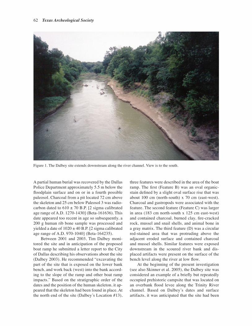
62 Texas Archeological Society
A partial human burial was recovered by the Dallas Police Department approximately 5.5 m below the floodplain surface and on or in a fourth possible paleosol. Charcoal from a pit located 72 cm above the skeleton and 25 cm below Paleosol 3 was radio-carbon dated to 610 ± 70 B.P. [2 sigma calibrated age range of A.D. 1270-1430] (Beta-161636). This date appeared too recent in age so subsequently, a 200 g human rib bone sample was processed and yielded a date of 1020 ± 40 B.P. [2 sigma calibrated age range of A.D. 970-1040] (Beta-164235).
Between 2001 and 2003, Tim Dalbey moni-tored the site and in anticipation of the proposed boat ramp he submitted a letter report to the City of Dallas describing his observations about the site (Dalbey 2003). He recommended “excavating the part of the site that is exposed on the lower bank bench, and work back (west) into the bank accord-ing to the slope of the ramp and other boat ramp impacts.” Based on the stratigraphic order of the dates and the position of the human skeleton, it ap-peared that the skeleton had been found in place. At the north end of the site (Dalbey’s Location #13),
three features were described in the area of the boat ramp. The first (Feature B) was an oval organic-stain defined by a slight oval surface rise that was about 100 cm (north-south) x 70 cm (east-west). Charcoal and gastropods were associated with the feature. The second feature (Feature C) was larger in area (183 cm north-south x 125 cm east-west) and contained charcoal, burned clay, fire-cracked rock, mussel and snail shells, and animal bone in a gray matrix. The third feature (D) was a circular red-stained area that was protruding above the adjacent eroded surface and contained charcoal and mussel shells. Similar features were exposed downstream in the scoured river bank and dis-placed artifacts were present on the surface of the bench level along the river at low flow.
At the beginning of the present investigation (see also Skinner et al. 2005), the Dalbey site was considered an example of a briefly but repeatedly occupied prehistoric campsite that was located on an overbank flood levee along the Trinity River channel. Based on Dalbey’s dates and surface artifacts, it was anticipated that the site had been
Figure 1. The Dalbey site extends downstream along the river channel. View is to the south.

Skinner et al.—Archeological Investigations at the Dalbey Site (41DL350), Dallas, Texas 63
occupied for less than a thousand years before the present for the primary purpose of harvesting lo-cally available riverine food resources, and hunting and gathering animals and plants. It appeared that the occupied levee banks had flooded regularly and that artifacts and burned surfaces were sealed in place by thin silt layers.
METHODOLOGY
The primary purpose of this investigation was to document the stratigraphy, identify and evaluate the stratigraphic context of features and artifacts, and obtain radiocarbon dates to define the chronologi-cal extent of the prehistoric occupations. It seemed likely that the floodplain surface had been disturbed prior to and during construction of the nearby four-lane Loop 12 bridge. However, the presence of an in situ buried deposit had not been investigated when the bridge was constructed and probably would not have been done in conjunction with boat ramp con-struction had Dalbey not voiced his concern about the site. The area to be affected by construction of the boat ramp (Figure 2) was roughly 130 m east-west and extending west from the river’s edge and was a maximum of 30 m north-south. Much of this area was a parking lot but the remaining area is a 23 m wide and 45 m long boat ramp.
Excavation began in 2003 by first clearing vegetation from the edge and slope of the river bank (Figure 3). Subsequently, a trackhoe was used to excavate trenches (Figure 4). Trenching revealed loose trash-filled matrix over the surface and edge of the floodplain that required stepping the riverbank trench so that it would be possible to place test units at any prehistoric features exposed in the trench. After digging two trenches it was apparent that there was nowhere else to excavate trenches within the affected area that had archeo-logical potential. Six 1 x 1 m units were positioned to investigate burned clay features and to secure an artifact sample. Fill from the six excavation units was dry-screened through 1/4-inch mesh hardware cloth. We found no evidence of human burials or other features. We also had advised the City of Dallas and the contractor that we had encountered a perched water table that resulted in slumping walls. Without THC authorization the boat ramp contractor then began earthwork to create the boat ramp cut. This excavation was ceased at the request of the THC, which determined that further
archeological investigations were warranted under the terms of the Antiquities Permit.
An additional six 1 x 1 m units were approved by the THC and funded by the City of Dallas. We planned to begin excavation in March 2004 but at that time and for the subsequent year and a half the Trinity repeatedly flooded and inundated the site. It was not until the end of June 2005 that the river level reached a point when the site was exposed long enough to allow excavations to proceed. We planned to water screen in the field but this would have slowed excavation, and without clean water, water screening was impractical and uneconomical. The day excavation concluded, the site was once again flooded. In order to expedite excavation, it was decided to shovel scrape each 10 cm level and place the matrix into 4 mil plastic bags for immedi-ate removal and subsequent water screening. This resulted in the collection of nine tons of moist clay matrix that had to be screened elsewhere. Water screening was done using 1/8-inch mesh screens. The matrix from each bag was emptied into a plas-tic bucket that was then filled with water containing two cups of baking soda to serve as a deflocculant to break down the clays. The bucket was stirred and allowed to percolate before the sediment/water mixture was placed on the screen for washing.
GEOARCHEOLOGICAL INVESTIGATIONS
The geological profile (ARC Profile 1 on Figure 5) was located in the center of the site for the purpose of relating the boat ramp testing to Dalbey’s (2003) stratigraphic description further downstream. Our profile description is presented in Table 1. A nearby rock-filled basin was recorded and a radiocarbon sample collected from it. Three buried organic-stained A horizons are described as Zones 5, 7, and 9. It is most likely that the promi-nent soil described in Zone 5 would be termed the West Fork Paleosol by Ferring (1990:56-57). Sediments exposed in the 2003/2005 excavations are below Zone 9 and represent a very heavily weathered matrix. Weathering likely occurred due to the regular and repeated inundation by the river. Matrix in the Test Units (TU) 6-12 described be-low is similar to that where the burial was found and similar to Zone 9. Radiocarbon dates from the geoarcheological Profile 1, the excavations, and Dalbey’s samples are presented in Table 2.

64 Texas Archeological Society
Figure 2. River bank contour map of the Dalbey site showing the locations of Dalbey’s burial, the geological profile, the rock-filled hearth, and the 2005 testing block just down slope from the 2003 units.
Of particular interest is the rock-filled hearth that appeared to be in Zone 7. Limestone rocks up to 6 cm in diameter filled the hearth basin, marked by burned clay and containing small pieces
of charcoal. The hearth was 48 cm long and no more than 10 cm deep in cross-section. The pit bottom was not visible, and the hearth was not excavated. Charred wood from the hearth matrix

Skinner et al.—Archeological Investigations at the Dalbey Site (41DL350), Dallas, Texas 65
Figure 3. Project area looking west from the Loop 12 bridge. The boat ramp area spans the width of the slope from the saplings on the left to the brush on the right and down to the river bank.
Figure 4. Trackhoe excavating Trench 2. View is to the west. Crew members are standing on the bench at the base of the slope. Trench 1 had been backfilled.

66 Texas Archeological Society
Table 1. Profile 1 cut bank on west bank of the Trinity River at 41DL350.
Zone Depth (cm) Description
1 0-58 Dark gray (10YR4/1) firm sandy clay loam, medium strong sub-angular blocky structure, many roots and rootlets, few snail shells and fragments, occasional thin lenses of small pebbles (≤2 mm in diameter), common insect and earth-worm filled burrows and casts, clear smooth lower boundary. A horizon.
2 58-106 Light olive brown (2.5Y5/3) firm (dry) friable (wet) loam with common (40 per-cent) earth worm and insect burrows filled with dark grayish-brown (2.5Y4.2) clay loam, medium moderate sub-angular blocky structure, common roots and rootlets that decrease down profile, clear smooth lower boundary. B horizon.
3 106-258 Light olive brown (2.5Y5/3) firm to friable silt loam, medium moderate sub-an-gular blocky structure, thin ≤ 1 mm pale yellow (2.5Y8/2) sand lenses, common insect and earth worm burrows filled with dark grayish-brown (2.5Y4/2) clay loam, gradual smooth lower boundary. C1 horizon.
4 258-301 Dark gray (10YR4/1) friable clay loam to very pale brown (10YR7/3) sand in alternating lenses with fine faint brown (7.5YR4/3) redox features (mottles), weak coarse sub-angular blocky structure, common insect and earth worm bur-rows in-filled with brown (10YR4/3) clay loam, few rootlets, thin 2 cm thick oxidized sediment horizon with charcoal 5 cm above lower boundary, abrupt irregular (bioturbated) to smooth lower boundary. C2 horizon.
5 301-368 Very dark gray (10YR3/1) very firm clay loam, fine to medium strong angular blocky structure, charcoal snail shell fragment, few rootlets, insect and earth worm burrows filled with brown (10YR5/3) clay loam and light yellowish-brown (2.5Y6/3) sand, <1 percent CaCO3 filaments in root pores, clear smooth lower boundary. 2A horizon. Bulk soil sample was col-lected from between 328-340 cm that has a conventional age of 1520 ± 50 B.P. (Beta-208104).
6 368-450 Brown (10YR4/3) firm sandy clay loam, fine to medium moderate sub-angular blocky structure, common fine to coarse distinct dark yellowish-brown to yellowish-brown (10YR4/6-5/6) redox features (mottles), common 2-5 percent CaCO3 filaments along ped faces and root pores, small burrows filled with dark gray (10YR4/1) clay loam, abrupt smooth lower boundary. 2B horizon.
7 450-486 Brown (10YR4/3) friable clay loam, fine to medium moderate angular to sub-angular blocky structure, visible clay films on ped faces, 10 percent me-dium faint gray (5B5/1) redox features (mottles) surrounded by strong brown (7.5YR5/6) redox features (mottles), 1 percent CaCO3 filaments in root pores, bone fragment at 467 cm, scattered charcoal throughout, clear smooth lower boundary. 3A1 horizon. Bulk soil sample was collected between 456-469 cm and dated 2880 ± 60 B.P. (Beta-208105).
8 486-511 Brown (10YR5/3) friable clay loam, fine moderate sub-angular blocky structure, 10 percent distinct medium gray (10YR6/1 to yellowish-brown (10YR5/6) redox features (mottles), common charcoal fragments throughout, ≤ 1 percent CaCO3 filaments in root pores, clear smooth lower boundary. 3B1 horizon.

Skinner et al.—Archeological Investigations at the Dalbey Site (41DL350), Dallas, Texas 67
Zone Depth (cm) Description
9 511-543+ Dark grayish-brown (10YR4/2) friable clay loam with more clay than zone 8, fine moderate sub-angular blocky structure, 10 percent fine to medium distinct gray (10YR4/1) redox features (mottles), two in situ buried hearths with very distinct oxidized reddish-brown (5YR4/4) clay loam bodies and white (10YR8/1) thin ash lenses with charcoal fragments and bone fragments, lower boundary not observed. 3A2 horizon. Charcoal was collected from the hearth between 532-543 cm and yielded a conventional age of 2170 ± 40 B.P. (Beta-208106).
Table 2. Radiocarbon assays collected from 41DL350.
Sample No. δ13C Corrected AgeProvenience (Beta) (B.P.) δ13C Sampled Material
hearth 161636 610 ± 70 N/A charcoal
human burial 164235 1020 ± 40 N/A human bone
rock hearth, ~450 cm bd 207120 1170 ± 40 -24.5 charcoal
TU 2, 430-440 cm bd 184057 1310 ± 40 -24.2 charcoal
TU 6, 466-476 cm bd 184060 1450 ± 40 -25.0 charcoal
TU 8, 540-550 cm bd 207122 1400 ± 40 -24.9 charcoal
TU 11, 550-560 cm bd 207121 1480 ± 40 -24.0 charcoal
TU 8, 560-570 cm bd 207123 1490 ± 40 -24.0 charcoal
TU 9, 570-580 cm bd 207124 1440 ± 40 -25.4 charcoal
Profile 1, Zone 5, 208104 1520 ± 50 -19.5 organic sediment 328-340 cm bs
Profile 1, Zone 7, 208105 2880 ± 60 -18.7 organic sediment 456-469 cm bs
Profile 1, Zone 9, 208106 2170 ± 40 -22.0 charcoal 532-543 cm bs
cm bd: centimeters below datum
Table 1. (Continued)

68 Texas Archeological Society
was collected, submitted for AMS-radiocarbon dating and resulted in an conventional age estimate of 1170 ± 40 B.P. (see Table 2). A single piece of quartzite was recorded at the edge of the hearth in the cut bank. No evidence of a burned clay surface was noted in the riverbank flanking the hearth
Figure 5. Schematic profiles at 41DL350 showing relationship between Dalbey’s and 2005 profiles. Elevations are approximate.
and the radiocarbon sample was the only material collected. This conventional age is clearly not in agreement with Beta-208105, also in Zone 7 (see Table 2). In addition, Dalbey (2003) reports two conventional radiocarbon assays measured on charcoal from a feature and on human bone from

Skinner et al.—Archeological Investigations at the Dalbey Site (41DL350), Dallas, Texas 69
a burial more than 50 m downstream from Profile 1. These are 1020 ± 40 B.P. (Beta-164235) and 610 ± 70 B.P. (Beta-161636). We could not record their exact location in relation to Profile 1, but Dalbey (2003) suggested that these two dates come from an inset fill that appeared to sit unconformably on alluvial sediments vertically below Zone 9. If this is correct, then the radiocarbon assays support Dal-bey’s model of deposition. However, the sediments
and their depths at Dalbey’s investigations were not described in detail during the current geoarcheo-logical efforts and direct proof was not collected.
The radiocarbon assays from 41DL350 were calibrated with OxCal (Bronk Ramsey 2013) to further investigate the apparent dilemma caused by the inverse ages between Beta-208105 and Beta-208106 in Zones 7 and 9. Figure 6 and Table 3 present the resulting age distributions with the ages
Figure 6. Calibrated radiocarbon ages using OxCal program.

70 Texas Archeological Society
arranged stratigraphically from top to bottom, with the upper two samples representing the assays from the inset fill identified by Dalbey (2003).
The results of the calibration plots and ma-terials dated can be used to suggest that sample Beta-208105 is not an accurate age estimate. This assay measured bulk sediments from the buried soil that comprises Zone 7. The most reasonable explanation for the anomaly is that this sample was contaminated by older carbon. If this interpreta-tion is correct then this would imply that there is very little difference in age between Zones 5 and 7. Also, this indicates that the burial documented by Dalbey is significantly younger that the Zone 5 sediments.
If we inspect the charcoal dates that were measured in relation to the elevation datum, and constrain the calibrations by depth, these suggest that rapid sedimentation occurred in the excavation area. The OxCal plot of calibrated modeled age and depth using a 2 sigma error envelope illustrates the age/depth model (Figure 7). This set of radiocarbon dates span approximately 115 years when 140 cm of sediment accumulated. This equates to 1.217 cm/yr. If we fit a linear regression to calculate an age/depth model using the mean modeled ages in Table 3 (Age AD = -0.8393 depth+1071.3), the coefficient of determination is extremely high, R2=0.9993. These data can be used to suggest that this was a function of repeated low energy over-bank flooding that did not significantly disturb the
archeological materials and the upper portion of this sequence appears to have accumulated at the same rate as the lower portion. This model can be used to suggest that the burial documented by Dal-bey and the other associated radiocarbon sample (Beta-164235) may be significantly younger than the excavated sediments in TU 2-11 and Dalbey’s interpretation that the burial was placed in an in-filled cut is probably correct.
SITE TESTING
When the site was first visited, a silt fence near the edge of the channel spanned the width of the study area but the fence had been silted in and then run over in various places. Trash in the form of auto parts, concrete chunks, and plastic bags was found to be imbedded in the upper part of the riverbank, but the lower part of the slope appeared undisturbed and resembled the site area down river where bison bones and a human burial had been found below Dalbey’s second paleosol and where there appeared to be an undisturbed deposit extending from the floodplain surface down to the river level.
Due to the depth of the deposit, it was neces-sary to use a trackhoe rather than a backhoe to explore the floodplain sediments to the full thick-ness of the site deposit and to search for features. Two trenches were excavated and then TU 1-6
Table 3. Calibrated ages and 2 sigma ranges A.D./B.C.
Sample 14C Age(Beta) B.P. sigma Cal. Age Cal. lower Cal. upper
161636 610 70 1350 A.D. 1275 A.D. 1435 A.D.164235 1020 40 1020 A.D. 895 A.D. 1155 A.D.207120 1170 40 855 A.D. 725 A.D. 975 A.D.184057 1310 40 710 A.D. 650 A.D. 775 A.D.184060 1450 40 605 A.D. 545 A.D. 660 A.D.207121 1480 40 575 A.D. 430 A.D. 655 A.D.207122 1400 40 635 A.D. 570 A.D. 680 A.D.207123 1490 40 565 A.D. 430 A.D. 650 A.D.207124 1440 40 610 A.D. 545 A.D. 660 A.D.208104 1520 50 525 A.D. 420 A.D. 635 A.D.208105 2880 60 1065 B.C. 1260 B.C. 905 B.C.208106 2170 40 250 B.C. 365 B.C. 105 B.C.

Skinner et al.—Archeological Investigations at the Dalbey Site (41DL350), Dallas, Texas 71
Figure 7. Stratigraphically constrained calibrated age estimates using depth below datum.

72 Texas Archeological Society
were excavated. Trench 1 was set back from the river bank in the western part of the boat ramp area where the ramp is now situated at a relatively shallow depth below the present ground surface. The trench was 7 m long and 1.35 m wide. It was excavated to a maximum depth of 2.38 m, which is lower than the expected depth of the ramp excava-tion. The south wall of the trench was scraped and a profile drawn. Excavation revealed that the matrix exposed in both sides of the trench was recent fill and contained layers of plastic and other historic trash to the depth of a dipping silty clay and sand layer that is present at 111 cm bs near the west end and 213 cm bs at the east end of the trench. Below that were laminae of sand and silty clay that did not contain historic artifacts but were obviously recently deposited, possibly in conjunction with construction of the Loop 12 bridge. No evidence of undisturbed sediments was found in Trench 1, nor were prehistoric artifacts recovered or fea-tures observed. Consequently, there was no reason to further excavate in this part of the floodplain deposits as we had dug deeper than the area of potential effects of the parking lot. This is unfor-tunate because we do not know if buried cultural materials are present away from the edge of the channel. However, the reported but unconfirmed presence of 41DL78 near the south end of Little Lemmon Lake in a similar setting may be a hint that buried sites are present in settings away from the river bank. Furthermore, floodplain surveys and test excavations upstream in the vicinity of the Central Wastewater Treatment Plant (Skinner et al. 1991; Skinner and Whorton 1993; Buysee 2000) and within the Dallas Floodway (Cliff et al. 1998, 1999; Frederick et al. 2006) have located sites exposed in the floodplain, but none has a profile such as that described for the Dalbey site. We do not know where the river bank was at the time of occupation, although a sterile zone at 41DL318 separated the two components and may indicate that the river was close at hand.
Trench 2 was excavated in the cut bank by first placing the trackhoe at the edge of the bank and scraping the slope. This revealed that the upper 2 m of the floodplain matrix contained historic fill like that encountered in Trench 1. Apparently the floodplain sediments in this area were removed and then refilled with new sediment and trash. This is not the case in other parts of the site down-stream. The upper 2 m of fill were then removed and a surface for the trackhoe constructed so that
it could reach to the bench at the river’s edge. By creating the surface, it was possible to excavate the trench to approximately the river level and then move the dirt to the floodplain where it could be inspected. This excavation revealed that there was a narrow zone of undisturbed clay loam that extended upslope to a height of approximately 2 m above the elevation of the bench. Several apparently burned clay surfaces were exposed in the trench wall and are discussed below. The upper portion of the original river bank had been removed west of the river bank and this created a depression that had subsequently been filled with a sandy loam and clay loam matrix. The filled depression was not recognized before trench ex-cavation and it formed a perched surface on which water seeped on the floor of Trench 2 and continu-ally flowed to the area of the test units.
Excavation of Trench 2 revealed that the only area in the boat ramp that contained an undisturbed geologic deposit was approximately 5 m wide. The stepping needed to make the trench walls safe from fill slumping was further aggravated by water seepage and required that the full width of the area of potential effects be excavated (see Figure 2). Therefore, there were no other locations to place the originally planned third and fourth trenches. Furthermore, emphasis had been placed on exca-vating undisturbed deposits near the base of the slope where Dalbey had previously observed clay-lined hearths and noted buried artifacts that were eroding out of undisturbed sediments.
Test Units (TU) 1-6 were excavated in undis-turbed sediments near the base of the slope slightly above the elevation of the human burial reported by Dalbey; this elevation was reported to have been 5.58 m below the floodplain surface (Dalbey 2003) near the south end of the site, but we could not plot its exact location or elevation. TU 1 and TU 2 were placed at the eastern edge of Trench 2 in the vicinity of an apparent burned surface. TU 4 was excavated into the bank adjacent to TU 1 and TU 2. TU 3 was located to explore below the bench surface and TU 5 and TU 6 were excavated to explore apparent burned surfaces exposed in the walls of Trench 2. Artifacts from these six units are itemized in Table 4. Charcoal, ash, and fire-reddened clay were found dispersed throughout TU 1 and TU 2 and were concentrated within the 4.3-4.4 m below datum (bd) zone that appeared to be a surface on which burning had occurred. It was impossible to define the limits of burning
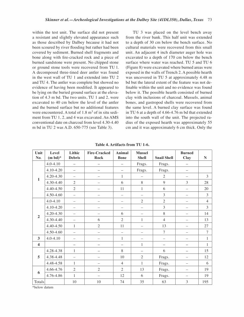
Skinner et al.—Archeological Investigations at the Dalbey Site (41DL350), Dallas, Texas 73
within the test unit. The surface did not present a resistant and slightly elevated appearance such as those described by Dalbey because it had not been scoured by river flooding but rather had been covered by sediment. Burned shell fragments and bone along with fire-cracked rock and a piece of burned sandstone were present. No chipped stone or ground stone tools were recovered from TU l. A decomposed three-tined deer antler was found in the west wall of TU 1 and extended into TU 2 and TU 4. The antler was complete but showed no evidence of having been modified. It appeared to be lying on the buried ground surface at the eleva-tion of 4.3 m bd. The two units, TU 1 and 2, were excavated to 40 cm below the level of the antler and the burned surface but no additional features were encountered. A total of 1.8 m3 of in situ sedi-ment from TU 1, 2, and 4 was excavated. An AMS conventional date on charcoal from level 4.30-4.40 m bd in TU 2 was A.D. 650-775 (see Table 3).
TU 3 was placed on the level bench away from the river bank. This half unit was extended to a depth of 30 cm below the bench surface. No cultural materials were recovered from this small unit. An adjacent 4 inch diameter auger hole was excavated to a depth of 170 cm below the bench surface where water was reached. TU 5 and TU 6 (Figure 8) were excavated where burned areas were exposed in the walls of Trench 2. A possible hearth was uncovered in TU 5 at approximately 4.48 m bd but the lateral extent of the feature was not de-finable within the unit and no evidence was found below it. The possible hearth consisted of burned clay with inclusions of charcoal. Mussels, animal bones, and gastropod shells were recovered from the same level. A burned clay surface was found in TU 6 at a depth of 4.66-4.76 m bd that extended into the south wall of the unit. The projected ra-dius of the exposed hearth was approximately 55 cm and it was approximately 6 cm thick. Only the
UnitNo.
Level(m bd)*
Lithic Debris
Fire-Cracked Rock
Animal Bone
Mussel Shell Snail Shell
Burned Clay N
1
4.0-4.10 – – – Frags. Frags. –4.10-4.20 – – – Frags. Frags. –4.20-4.30 – – 1 – 2 – 34.30-4.40 2 – 6 8 9 3 284.40-4.50 2 – 11 1 6 – 204.50-4.60 – – – – 3 – 3
2
4.0-4.10 – – – 2 2 – 44.10-4.20 – – – – 3 – 34.20-4.30 – – 6 – 8 – 144.30-4.40 – 6 2 1 4 – 134.40-4.50 1 2 11 – 13 – 274.50-4.60 – – – – 7 – 7
3 4.0-4.10 – – 1 – – – 14 – – – 1 – – 1
54.28-4.38 1 – 8 – 6 – 154.38-4.48 – – 10 2 Frags. – 124.48-4.58 1 – 4 1 Frags. – 6
64.66-4.76 2 2 2 13 Frags. – 194.76-4.86 1 – 12 6 Frags. – 19
Totals 10 10 74 35 63 3 195*below datum
Table 4. Artifacts from TU 1-6.

74 Texas Archeological Society
northeast quarter of the feature was uncovered due to the compact moist overburden that would have to have been removed manually. A concentration of shell was uncovered in the center of the clay surface and a bone and flake were also recovered. Charcoal was collected from the same level but just outside it and the AMS date was A.D. 545-660 (see Table 3). This was the deepest feature excavated in 2003. As elsewhere, snail and mussel shell frag-ments, bone fragments, three pieces of lithic debris, and two pieces of fire-cracked rock were recovered from the unit in the two excavated levels. Excava-tion was discontinued due to the low artifact yield, lack of features, as well as the absence of plant remains from meaningful contexts.
A total of 10 pieces of lithic debris was col-lected from TU 1, 2, 5, and 6; TU 3 and 4 contained no lithic debris. TU 1 contained a quartzite inte-rior (i.e., non-cortical) and a secondary flake (i.e., with some cortex on its outer surface), a quartzite interior chip (a chip, as the term is used here, is a flake that is missing its platform or is otherwise the distal part of a flake) and a small piece of quartzite shatter. A single quartzite interior flake was recov-ered from TU 2. TU 5 had two quartzite chips, one being an interior and the other being a secondary chip. Three pieces of lithic debris were recovered from TU 6. Two of these pieces were chert, one an interior flake and the other an interior chip. The third piece was a primary (i.e., its outer surface is completely covered with cortex) quartzite shatter.
TU 2 contained eight of the 10 pieces of fire-cracked rock recovered in the excavations. Seven pieces of limestone and one piece of quartzite were also recovered. One additional piece of fire-cracked rock from TU 2 at a depth of 4.30-4.40 m bd had evidence of possible grinding on the surface. One piece of fire-cracked rock was collected from TU 6 between 4.66-4.76 m bd.
Most of the faunal materials consisted of small fragments measuring from 4-19 mm in maximum length. The total number of bones examined was 152, of which 44 were unidentifiable. Eighty six of the bones were from a fragmented deer antler. Other species represented include Eastern Cot-tontail (Sylvilagus floridanus), Eastern Box Turtle (Terrapine carolina), turtle (Testudinata), and fish (Teleost sp.). Based on the faunal evidence, the inhabitants of this site were consuming deer and various smaller mammals, turtles, and fish.
The gastropod (snail) fauna is indicative of constant perennial vegetation that consisted of
woods, downed logs, as well as leaf and forest debris. The bivalve (mussel) fauna indicate a medium to large-sized stream where the water was of low to medium quality. The stream has a mud substrate based upon the abundance of Plec-tomerus dombeyanus.
At the conclusion of the 2003 investigation, it was apparent that a vertically stratified deposit remained preserved near the base of the slope just above where the boat ramp was to be extended into the river. This is illustrated as Figure 9, a schematic cross-section that corresponds to the centerline of the boat ramp and extends from the present flood-plain surface down to the river level. As shown in the profile, sandy fill mixed with post-World War II trash extends from the present floodplain surface down to the now truncated floodplain sediments. Trench 2 cut into the original floodplain matrix as had all six TUs and Auger Holes 1 and 2. Based on the two calibrated radiocarbon dates, it appeared that occupation in TU 2 occurred between A.D. 650-775 and that the burned surface in TU 6 dated slightly earlier at A.D. 545-660 (see Table 3).
Occupation of the Dalbey site along the river bank was apparently regularly repeated but short-lived based on the numerous ephemeral and apparently burned clay surfaces and the lim-ited artifact assemblage recovered. The faunal remains indicate food acquisition and immediate consumption. The two radiocarbon dates indicate occupation at the end of the Late Archaic. Unfor-tunately, the limited artifact assemblage recovered did not contain any projectile points, ceramics, or other artifacts with which to evaluate the ad-equacy of the radiocarbon dates.
Excavation ceased in 2003 due to a variety of factors but primarily because units had been excavated to the proposed boat ramp level and no burials, distinct stratigraphy or features, and few artifacts had been found. Soon after archeologi-cal excavation ceased, the contractor cleared the floodplain surface for the parking lot and dug the ramp area by expanding the stepped cut created by Trench 2. The ramp excavation uncovered ad-ditional trash and concrete fill in the upper 2 m and encountered the perched water table. This work was ultimately halted by the THC. The contractor then backfilled the ramp cut to avoid erosion in anticipation of further archeological investigations.
An additional scope of work was prepared by ARC and ultimately approved by the THC and the City of Dallas. When the work began again in

Skinner et al.—Archeological Investigations at the Dalbey Site (41DL350), Dallas, Texas 75
July 2005, despite a year and a half of flooding, the mapping reference point had remained in place on the bench. This allowed us to relate the 2003 TU to the 2005 excavation units as shown in Figure 8.
It had been planned to excavate a 2 x 3 m block that was situated on the bench at the bottom of the slope and adjacent to the river. Unfortunately the river edge eroded away part of the level bench and
repeated drainage from upslope continued to soak the southwest corner of the block. Consequently, the location of that unit was moved to the northwest corner of the grid (Figure 10). This extended the investigation of the river bank deposit more than 1 m below the bottom of TU 6, which is above the normal low water level. Excavation proceeded by excavating all six units in the block to 10 cm below
Figure 8. Plan map showing TU 7-12 excavated during 2005 and their horizontal relationship to the 2003 units and to the low water river edge.

76 Texas Archeological Society
Figu
re 9
. Sca
led
sche
mat
ic p
rofil
e al
ong
the
boat
ram
p ce
nter
line
show
ing
the
vario
us se
dim
ents
, TU
s, an
d tra
ckho
e tre
nch
exte
nt, a
long
with
the
river
leve
l on
Oct
ober
2,
200
3. N
ote
the
grad
e of
the
prop
osed
boa
t ram
p cu
t.

Skinner et al.—Archeological Investigations at the Dalbey Site (41DL350), Dallas, Texas 77
Figure 10. TU 7-12 during excavation. The block is in the center of the ramp and had reached the base of the boat ramp cut. Vegetation and drainage channels mark the area excavated by the contractor. Overhead view is from the Loop 12 bridge.
the mapping stake and continuing down in 10 cm levels to 100 cm. One unit (TU 11) was continued to 120 cm below datum.
Because soil was shovel scraped and then bagged and removed for subsequent fine screening, our in-field impression was that artifact densities were low and varied little per level, except that it was apparent that a distinct occupation surface occurred between 5.70-5.80 m bd in each of the six units. The scraped surfaces were regularly inspected for features or obvious artifact concentrations but none were found. Despite generally clear, hot, and humid weather, the block was inundated twice; once due to an upstream water release and the second time due to an intense localized rainstorm. Within an hour after finishing excavation, the block was inundated completely as the result of several hours of intense rain.
As shown in Figure 11, only a single zone containing artifacts was encountered. The matrix in the entire block was described by Bousman as an olive brown (2.5Y4/4) clay loam with fine moderate to strong angular blocky structure, and common bluish-gray (10B5/1) gleyed redox features (mottles). The lower boundary of this heav-ily weathered matrix was not observed.
Small pieces of charcoal and charcoal stains were present in the matrix but a dis-tinct living surface littered with artifacts was not visible either during scraping or at the completion of a level or in the wall profiles except as shown in Figure 11. Artifact densities bear out the presence of a recognizable occupation surface as shown by reviewing Table 5. Exclusive of snails probably not used for food and thus natu-rally accumulated, and charcoal fragments that may also not be cultural in origin, almost 50 percent of the artifacts recovered from excavation are from the 5.70-5.80 m bd level. Stone artifacts are rare. The Camden variety Gary dart point (Schambach 1982:60-61) is in the 5.70-5.80 m bd level in TU 12. Two pieces of lithic debris are virtually the only evidence of stone tool manufacture or resharpen-ing. Likewise, the number of pieces of fire-cracked rock is very low but it is also the case that there is virtually no rock available in the floodplain so hearth rock in the form of limestone chunks/slabs or quartzite gravels may be accessible no closer than 4-5 km from the site. Animal bone fragments
far outweigh the number of mussel shells and this probably indicates that the river channel near the site was not a prime source for mussel harvesting. Burnt clay was only recovered from the 5.80-5.90 m bd level in TU 9. Charcoal was recovered from throughout the deposit and the variety of trees represented in the charcoal may indicate that the charcoal is not cultural in origin. However, the trees match those in the Trinity River bottomland forest today.
Four radiocarbon samples from TU 8, 9, and 11 were submitted for dating (see Table 3). The highest sample from within the block is from the 5.40-5.50 m bd level in TU 8 and yielded a cali-brated age range of 570-680 A.D. (Beta-207122). The next sample was from 5.50-5.60 m bd in TU 11 and the AMS calibrated age range is 430-655 A.D. (Beta-207121). The third sample is from

78 Texas Archeological Society
Unit No.
Level in m bd
Lithic Debris
Fire-Cracked Rock
Animal Bone
Mussel Shell
Snail Shell Charcoal Other N
7 5.20-5.30 1 - - 1 3 - - 55.30-5.40 - - 11 1 11 - - 235.40-5.50 - - - - 8 T - 85.50-5.60 - 3 14 - 10 - - 275.60-5.70 - - - 5 4 T - 95.70-5.80 - - 3 5 9 S=3 - 205.80-5.90 - - 1 - 1 - - 25.90-6.0 - - 12 - 2 T - 14
8 5.0-5.20 - - - 1 1 T - 25.20-5.30 - - 1 1 14 T - 165.30-5.40 - - 34 3 4 T - 415.40-5.50 - - 1 - - T - 15.50-5.60 - - - 1 4 - - 55.60-5.70 - 1 - 1 10 S=2 - 145.70-5.80 1 - 23 13 13 T - 505.80-5.90 - - - 1 - S=13 - 145.90-6.00 - - 1 1 - T - 2
Table 5. Artifacts from TU 7-12.
Figure 11. Profile of the north wall of TUs 7-9 showing the living surface.
41DL350Soil Profile-North Wall

Skinner et al.—Archeological Investigations at the Dalbey Site (41DL350), Dallas, Texas 79
Unit No.
Level in m bd
Lithic Debris
Fire-Cracked Rock
Animal Bone
Mussel Shell
Snail Shell Charcoal Other N
9 5.0-5.20 - - 3 1 2 - - 65.20-5.30 - - 33 1 6 T - 405.30-5.40 - - 4 - 10 T 1 J 155.40-5.50 - - 6 - 5 - - 115.50-5.60 - - 4 1 8 - - 135.60-5.70 - - 14 2 7 T - 235.70-5.80 - - 6 - 1 T - 75.80-5.90 - - 9 2 3 T 6-BC 205.90-6.00 - - 13 - 1 S=18 - 32
10 5.20-5.30 - - - 2 - T - 25.30-5.40 - - - 2 2 - - 45.40-5.50 - - - - 11 - - 115.50-5.60 - - - 1 4 T - 55.60-5.70 - - 2 2 3 S=11 - 185.70-5.80 - 1 11 5 6 - - 235.80-5.90 - - 11 1 1 T - 135.90-6.00 - - 1 - 4 T - 5
11 5.20-5.30 - - - 1 - T - 15.30-5.40 - - 11 - 1 T - 125.40-5.50 - - 1 - 4 - - 55.50-5.60 - - 36 1 6 T - 435.60-5.70 - - 1 T - 15.70-5.80 - 1 3 7 3 T - 145.80-5.90 - - 21 3 2 T - 265.90-6.00 - - 67 1 2 T - 706.00-6..10 - - - - 1 T - 16.10-6.20 - - - - - T -
12 5.30-5.40 - - - - - - -5.40-5.50 - - 5 1 2 T - 85.50-5.60 - - 4 - - T - 45.60-5.70 - - 5 3 - T - 85.70-5.80 - - 30 2 3 T GP 365.80-5.90 - - 29 - 1 - - 305.90-6.00 - - 1 1 - - - 2
Total 2 6 431 75 193 S=47 8 762
T=Traces of charcoal; S=sample analyzed; BC=Burnt Clay; GP=Gary Point; J=Adult Human Molar.
Table 5. (Continued)

80 Texas Archeological Society
5.60-5.70 m bd level in TU 8 and the calibrated age range is 430-650 A.D. (Beta-207123). The deepest sample was from level 5.70-5.80 m bd in TU9 and it yielded a calibrated age range of 545-660 A.D. (Beta-207124).
These dates provide a simple sequence that can be modeled in OxCal using the sequence function so that the ages are constrained by the stratigraphic position of the samples (Figure 12). The estimated start-date for this series is A.D. 568 ± 56 and the end-date is A.D. 652 ± 55. All four dates are from tight contexts and demonstrate that the sedimentation rate averaged 0.4 cm per year during this time interval.
Both pieces of lithic debris from the 2005 work are chert. One is a secondary flake from 5.70-5.80 m bd in TU 8 and the other is a piece of shatter from TU 7. The Gary dart point (Figure 13) is com-plete and was resharpened along all edges except one of the two shoulders where fine retouch from the original knapping is still preserved. Resharpen-ing exposed the grainy quartzite under the slightly patinated surface. The point weighs 4.5 grams and
Figure 12. OxCal plot of constrained calibrated radiocarbon ages from TU 8, 9, and 11.
measures 36.4 x 19.0 x 7.9 mm in length, width, and thickness.
An unthinned biface, probably a rejected piece, and a bifacial mano of sandstone were found eroding out of the bank downstream from the excavation block. The mano weighs 388 grams and measures 126.0 x 91.6 x 24.6 mm in length, width, and thickness. The biface is fine-grained quartzite and is roughly triangular in shape. It was thinned by percussion and shows no evi-dence of secondary retouch. It weighs 6.0 g and measures 30.3 x 21.6 x 9.6 mm in length, width, and thickness.
Plectomerus dombeyanus, which prefers a mud substrate, is quite prominent in the upper levels but almost absent in the lower levels of the TU, whereas Tritogonia verrucosa, which prefers moderate to high quality water, is present in the lower levels. The mollusks demonstrate that the Trinity River substrate in the vicinity of 41DL350 has become muddier and decreased in quality over time, and the water was cleaner in the lower levels. The river environment changed minimally,

Skinner et al.—Archeological Investigations at the Dalbey Site (41DL350), Dallas, Texas 81
possibly due to the shifting of gravel bars, because Quadrula nodulata was found only in the 5.70-5.80 m bd level in TU 8.
The sediments found in the 2003/2005 excava-tions are below Zone 9 and represent a very heavily weathered matrix. Weathering is likely to have oc-curred due to regular inundation by the river. The matrix in the block excavation appears to be similar to that where Dalbey described the burial.
It appears that the floodplain habitat that in-cluded permanent vegetation, trees, downed limbs, and leaf and forest debris along the Trinity River adjacent to 41DL350 did not vary over time from the lower portion of the deposits to the present day. The river’s substrate may have changed as well as the quality of the water and the influx of clay slightly at various times from the lowest level to the present day. Possibly three stable surfaces are present, two in the upper portion and one in the lower portion of the excavated part of the site. Prehistoric burned clay surfaces are visible in the river bank and may mark areas that were used to steam the mussels in the past. Severe burning of the shell may have resulted from either accidental or intentional inclusion in fires.
In summary, testing in the boat ramp project area revealed that the upper sediments are no lon-ger present. It appears that a slightly more intense prehistoric occupation was present in the zone investigated in 2003 than in the deeper 2005 block excavation. Nevertheless, the natural environment
Figure 13. Gary dart point recovered in 2005. Illustrated by Lance K. Trask.
based on sediment deposition rates, faunal and charcoal remains, and the few artifacts and occu-pation surfaces found appear to have been roughly unchanged over time and floodplain adaptations remained constant. Occupation in the boat ramp area spanned the period from approximately A.D. 570 to A.D. 650. Based on the testing results, it is predicted that sediments containing scattered cul-tural materials may continue below the water line.
The radiocarbon dates present an interesting set of questions with regard to the placement of the burial in the geologic context of the Dalbey site. The burial appears to have been in or on the same matrix uncovered in the 2005 block and it was at ap-proximately the same elevation as the bench surface adjacent to the block. Consequently, it is logical to expect that the date of the rock-filled hearth, which is more than 1 m above the adjacent bench surface, would be younger than A.D. 930, the burial date, and possibly younger than the higher pit date of A.D. 1340. Likewise, if the burial date is associ-ated with the matrix that is lower than Zone 9 (see Table 1), it is also logical to expect that the block sediments might date in the A.D. 900s. However, the four calibrated dates from the block range A.D. 570-650. Therefore, it is possible that the burial is out of primary context, although the sediments do not support this conclusion, or that the human remains were placed in a cut-and-fill deposit.
CONCLUSIONS
The Dalbey site is a deeply stratified Late Archaic to Late Prehistoric site that exhibits stratigraphic elements more refined than Ferring’s general Trinity River sequence. Based on his recalibration, the elevation of the West Fork Paleosol appears to match Lawrence’s (2010:187-189) Synchronous Event IV. These multiple stacked fining upward deposits from the proposed level of the boat ramp cut upward are capped by a paleosol and the site represents a preferred campsite location. Similar sites have been recorded upstream but do not present the same deeply stacked occupation sequence nor have they been as well dated despite the more extensive vertical and horizontal testing that has been done.
Trackhoe trenching in the boat ramp project area discovered that the upper 2-3 m of the floodplain sequence had been removed and then backfilled (Figure 14). Dalbey’s description of

82 Texas Archeological Society
the stratigraphy at the south end of the site and Profile 1 in the center of the site demonstrates that evidence of prehistoric occupation begins about 1 m below the present ground surface and extends to the river level and possibly below. The river may have been near at hand during the sequence of deposition that was preserved above low river flow but the presence of mussel shells, gastropods, and flood sediments does not indicate where the river channel was throughout that time. An unknown amount of the site was eroded by Trinity River flooding and during the course of this investigation more than 0.5 m of the low bench eroded away and new artifacts were repeatedly deflated onto the slope of the bench or exposed in the freshly scoured river bank. Excavation below the base level of the boat ramp hints at the presence of further buried deposits but exploration of these deposits was outside the scope of this investigation and as shown by testing, the recognition of living
surfaces or artifact associations is likely to be difficult whenever the site is revisited.
Occupation must have been on a seasonal basis due to regular inundation that would have prohibited year round occupation or even permanent seasonal occupation. The small faunal assemblage does not pinpoint a season of occupation, but Martin (1995:244-245) believes that the Trinity River flood-plain was generally occupied during the summer and fall when nuts and various animals would have been available to be harvested. Todd (2000:93) concurs with the results of the Joe Pool Lake study and the faunal remains from the Dalbey site fit his expecta-tions for a site of this type during this time period. The site is certainly not a “shell lens” site although shell fragments were found scattered throughout the matrix along with animal bone and an occasional stone artifact. If a larger bone sample had been recovered from an extensive block excavation or if nut shells or tubers had been recovered, it might
Figure 14. The boat ramp and side slopes are shown in this picture as is the initial construction of the coffer dam. The white layer in the right cut is road rock that is in the mixed overburden attributed to bridge construction and which extends to the depth that corresponds to the top of the trackhoe motor.

Skinner et al.—Archeological Investigations at the Dalbey Site (41DL350), Dallas, Texas 83
have been possible to more adequately determine the season or seasons when the site was occupied. By nature of the site setting, it is possible that there never was sufficient intensity or duration of occu-pation to have deposited and preserved seasonally sensitive plant or animal remains. This situation is similar to hearth-centered artifact distributions described by Binford (1978) where the stay was not long enough for the accumulation of maintenance debris to have become a nuisance. This contrasts with the living surface described at the Aiken site at Lake Granbury (Skinner 1971:208-227), but it is possible that distinct surfaces may be present at the Dalbey site and await discovery.
The artifact sample from the Dalbey site is similar to those assemblages recovered from 41DL318 and other sites in the Central Waste Water Treatment Plant area just upstream (Buysee 2000). Lithic artifacts in the form of lithic debris and an occasional projectile point were found at 41DL318 and 41DL319/357 but none were found in trenches and test pits at 41DL337, 41DL338, 41DL355, and 41DL356. Four sites had discarded animal bone and mussel shell fragments in a density similar to the Dalbey site. It is apparent that chipped stone tool manufacture and maintenance were not common activities at the site as has also been shown to be the case in the tested sites just upstream. The paucity of chipped stone tools may be an indication that hunting was not a prominent activity at the site even though animal bones were present. The chipped stone and faunal assemblages from the Dalbey site are similar to that from the Rough Green site (41TR162) (Skinner et al. 1999) on the West Fork of the Trinity River except that hearth rock and mus-sel shells were more readily available on the West Fork where the floodplain is narrower and where sandstone is exposed in the valley walls. The Rough Green site has tentatively been interpreted as a bur oak collecting site. At the Dalbey site, occupation must have been brief as it was impossible to define a living floor within a 1 x 1 m unit although burned clay was found in the units and burned clay features were exposed in the river bank.
The Dalbey site is an unusual find in the Trinity River basin, particularly in Dallas County. Prehis-toric sites have been found in floodplain, terrace, and upland settings but virtually none of the known sites have revealed deep vertically stratified deposits. Extensive testing in the Trinity River floodplain in downtown Dallas, the Elm Fork below Lake Lewis-ville (Anthony and Brown 1994; Largent et al. 2004;
Prikryl 1990), and in the West Fork watershed by Geo-Marine, AR Consultants, and others has not ex-posed a similar site deposit. Testing and excavation as part of the Lake Ray Roberts studies in the Elm Fork watershed north of Denton (Skinner and Baird 1985; Prikryl and Yates 1987; Ferring and Yates 1997) found several vertically stratified sites as well as a deeply buried occupation zone at the Aubrey Clovis site (Ferring 2001). Although apparently oc-cupied between A.D. 570-1350, occupation surfaces at the Dalbey site are ephemeral and must indicate brief occupation by small family groups between repeated flooding episodes. Artifact assemblages are restricted to almost nothing but faunal remains. At that, an average of only 136 artifacts was found in each cubic meter excavated in the archeological deposits. Plant remains were primarily charcoal, which came from the sediment matrix but must also be associated with the clay surfaces. Although a rock-filled basin hearth was found in the riverbank near Profile 1, no recognizable living surface was present adjacent to the top of the basin and the basin was not distinctly oxidized by firing. As noted at Joe Pool Lake (Peter and McGregor 1988:351-367) and elsewhere in Dallas (Skinner et al. 1978:72), sites such as Dalbey have been under-reported and need further attention. While excavation of such sites is a slow process with low artifact yields, even when large blocks are excavated, these site deposits offer the opportunity to study brief occupation episodes when they can be isolated in the field. Consequently, the dateable and vertically stratified deposits present at the Dalbey site make the site locally and region-ally significant.
ACKNOWLEDGMENTS
We want to thank Tim Dalbey for calling attention to the site. Years of experience in the Trinity River area and more than a year and a half of monitoring the site led him to produce a report that describes his site findings along the exposed bank of the Trinity River. Omega Construction, in particular Eric Starnes, Office Engineer, and Tommy Hancock, Project Manager, are thanked for their help. Also Snow Excavating and Alliance Area Surveying assisted the project. Mary Ayala of the City of Dallas’ Trinity River Corridor Project, Skipper Scott, Fort Worth District office of the U.S. Army Corps of Engineers, and Bill Martin, THC, were also very helpful.

84 Texas Archeological Society
REFERENCES CITED
Anthony, D. and D. O. Brown (editors) 1994 Archeological Investigations in the Denton Creek
Floodplain, Data Recovery Excavations at 41DL270, Denton and Dallas Counties, Texas. Archeology Se-ries 37. Hicks & Company, Austin.
Binford, L. R. 1978 Dimensional Analysis of Behavior and Site Struc-
ture: Learning from an Eskimo Hunting Stand. American Antiquity 43:330-361.
Bronk Ramsey, C. 2013 OxCal 4.2. URL http://c14.arch.ox.ac.uk.
Buysee, J. L. 2000 An Evaluation of Sites within the Proposed Dallas
Floodway Extension Project, Dallas County, Texas. Miscellaneous Reports of Investigations No. 195. Geo-Marine, Inc., Plano.
Cliff, M. B., S. M. Hunt, M. Prior, S. Gaither, and W. Autin 1998 Archeological, Architectural, Archival, and Geoar-
cheological Investigations of the Proposed Dallas Floodway Extension Project, Dallas County, Texas. Miscellaneous Report of Investigations No. 152. Geo-Marine, Inc., Plano.
Cliff, M. B., D. Shanabrook, S. M. Hunt, W. Autin, and M. Prior 1999 Buried Archeological Site Potential in the Dallas
Floodway Project Area. Miscellaneous Reports of Investigations No. 187. Geo-Marine, Inc., Plano.
Coffee, D. R., R. H. Hill, and D. D. Ressel 1980 Soil Survey of Dallas County, Texas. USDA, Soil
Conservation Service in cooperation with the Texas Agricultural Experiment Station.
Dalbey, T. S. 2003 Letter to Mary Ayala dated 18 February, 2003. Letter
on file at AR Consultants, Inc. and the Texas Histori-cal Commission.
Ferring, C. R. 1990 Late Quaternary Geology and Geoarchaeology of
the Upper Trinity River Drainage Basin, Texas. Field Trip #11 Guidebook. Geological Society of America, 1990 Annual Meeting, Dallas.
2001 The Archaeology and Paleoecology of the Aubrey Clovis Site (41DN479), Denton County, Texas. Center for Environmental Archaeology, University of North Texas, Denton.
Ferring, C. R. and B. C. Yates 1997 Holocene Geoarchaeology and Prehistory of the Ray
Roberts Lake Area, North Central Texas. Institute of Applied Sciences, North Texas State University, Denton.
Frederick, C. D., L. K. Trask, and S. A. Skinner 2006 Archaeological Testing for the Trinity River Park-
way. Cultural Resources Report 2006-32. AR Con-sultants, Inc., Dallas.
Kahl, K. n.d. Loop 12 Boat Ramp Archaeological Assessment.
Manuscript provided by Lopez-Garcia, Dallas.
Largent, F. B., Jr., C. Lintz, and M. H. Huhnke 2004 An Archeological Survey and Geoarcheological
Evaluation of the Huffines Communities Property at the Intersection of Interstate Highway 35 and the State Highway 121 Bypass, Denton County, Texas. Miscellaneous Reports of Investigations No. 314. Geo-Marine, Inc., Plano.
Lawrence, K. 2010 A Recalibrated Chronological Framework for Texas
Archaeology-Geoarchaeology. Master’s thesis sub-mitted to Department of Anthropology, Texas State University-San Marcos.
Martin, W. A. 1995 Prehistoric Subsistence Strategies in North-Central
Texas: Evidence from Joe Pool Lake and Richland/Chambers Reservoir. In Advances in Texas Archeol-ogy, Contributions from Cultural Resource Manage-ment, edited by J. E. Bruseth and T. K. Perttula, pp. 203-256. Cultural Resource Management Report 5. Department of Antiquities Protection, Texas Histori-cal Commission, Austin.
Peter, D. E. and D. E. McGregor 1988 Late Holocene Prehistory of the Mountain Creek
Drainage. Joe Pool Lake Archaeological Project, Volume I, Archaeology Research Program, Institute for the Study of Earth and Man, Southern Methodist University, Dallas.
Prikryl, D. J. 1990 Lower Elm Fork Prehistory, A Redefinition of Cul-
tural Concepts and Chronologies along the Trinity River, North-Central Texas. Office of the State Ar-cheologist Report 37. Texas Historical Commission, Austin.
Prikryl, D. J. and B. C. Yates 1987 Test Excavations at 41CO141, Ray Roberts Res-
ervoir, Cooke County, Texas. Institute of Applied Sciences, North Texas State University, Denton.
Schambach, F. F. 1982 An Outline of Fourche Maline Culture in Southwest
Arkansas. In Arkansas Archaeology in Review, ed-ited by N. L. Trubowitz and M. D. Jeter, pp. 132-197, Research Series No. 15. Arkansas Archeological Survey, Fayetteville.

Skinner et al.—Archeological Investigations at the Dalbey Site (41DL350), Dallas, Texas 85
Skinner, S. A. 1971 Prehistoric Settlement of the De Cordova Bend
Reservoir, Central Texas. Bulletin of the Texas Ar-cheological Society 42:149-269.
Skinner, S. A. and L. Baird (assemblers) 1985 The Archaeology and History of Lake Ray Rob-
erts, “Settlement in a Marginal Zone,” Volume III. Cultural Resources Report 85-11. AR Consultants, Dallas.
Skinner, S. A., C. B. Bousman, J. Todd, J. Craver, T. A. Jennings, L. L. Bush, and A. Tawater
2005 Archaeological Investigation at the Dalbey Site (41DL350), Dallas, Texas. Cultural Resources Re-port 2005-35. AR Consultants, Inc., Dallas.
Skinner, S. A., S. C. Caran, and L. K. Trask 1999 Archaeological Excavations in River Legacy Park,
Arlington, Texas. Cultural Resources Report 99-41. AR Consultants, Dallas.
Skinner, S. A., J. J. Richner, and M. R. Johnston 1978 Dallas Archaeological Potential, Procedures for
Locating and Evaluating Prehistoric Resources. Re-search Report 111. Archaeology Research Program, Southern Methodist University, Dallas.
Skinner, S. A. and B. B. Whorton 1993 Archaeological Survey of the Little Lemmon Lake
Project. Cultural Resources Report 93-3. AR Con-sultants, Dallas.
Todd, J. 2000 Subsistence Strategies of the Late Prehistoric In-
habitants of the Upper Trinity River Basin. Master’s thesis, Department of Anthropology, The University of Texas at Arlington.


Bulletin of the Texas Archeological Society 86 (2015)
A Reanalysis of the Hussie Miers and El Caido Sites: Plains Biographic Rock Art and the Southern Plains
Ethnographic Record
Michael Paul Jordan
ABSTRACT
While scholars have incorporated ethnographic data into their analyses of Biographic Tradition rock art sites on the Northern Plains, studies of Southern Plains rock art have made more limited use of the ethnographic record. Reanalysis of select scenes and figures from two Southern Plains Biographic tradition rock art sites—the Hussie Miers (41VV327) and El Caido sites—demonstrates the utility of an ethnographically informed approach. Comparison of the pictographs and petroglyphs with ethnographic data, including nineteenth cen-tury Kiowa and Comanche drawings executed on paper, has facilitated the identification of items of material culture, as well as the interpretation of several scenes. At the Hussie Miers site, the reinterpretation of items of material culture has raised questions regarding the dating of the site, as well as the identity of the non-Native combatants depicted in one of the panels.
INTRODUCTION
In this article, I present a reanalysis of select scenes and figures from two Southern Plains Bio-graphic Tradition sites: Hussie Miers (41VV327) and El Caido. The Hussie Miers site is located along a tributary of the Devils River in southwest Texas. The site consists entirely of pictographs. While Late Prehistoric Red Monochrome style images comprise the majority of the rock art at the site, a panel consisting of five combat scenes (Figure 1) belongs to the Plains Biographic style (Turpin 1989:105). The El Caido site is situated approximately one mile south of the Rio Grande in Coahuila, Mexico. Both pictographs and petro-glyphs are present, the latter consisting of incised images with painted elements (Labadie et al. 1997:14-15, 19).
Biographic Tradition rock art is found through-out the Plains region. Documented sites extend from Alberta, Canada, to northern Mexico (Keyser 2004:65; Keyser and Klassen 2001:Map 14.1). Previous studies of Plains Biographic Tradition rock art have focused primarily on sites located on the Northern Plains (Keyser 1987, 1991, 1996, 2007, 2009; Keyser and Klassen 2003; Keyser and Cowdrey 2008; Keyser et al. 2004, 2006; Klassen et al. 2000). However, archeologists have identified
several Biographic Tradition sites on the Southern Plains, including sites in the Texas Panhandle (Parsons 1987), southwest Texas (Turpin 1986, 1989), and northern Coahuila, Mexico (Labadie et al. 1997; Turpin 1988).
While the earlier Ceremonial tradition rock art is characterized by static figures, Plains Biographic rock art is marked by the depiction of action se-quences. Episodes of warfare, including combat and horse raiding, figure prominently in this tradi-tion (Keyser 1989:87, 2004:65; Keyser and Klas-sen 2001:224, 228). Keyser (2004:65) notes that “[h]umans, horses, weapons, and track sequences (both horse hoofprints and human footprints) com-pose more than 90 percent of the art.” Additionally, tallies or counts recording the number of enemies killed, horses stolen, and weapons captured also appear in the art.
Biographic rock art was the “predominant Plains art tradition from the 1600s on” (Keyser 2004:67). The earliest recorded Biographic rock art sites are located on the Southern Plains and date to the 1500s. The tradition experienced a fluorescence in the eighteenth century and sites dating between 1750 and 1850 are found throughout the Plains (Keyser 2004:65, 67; Keyser and Cowdrey 2008:20; Keyser and Klassen 2001:224). After 1880, the production of Biographic tradition rock art largely

Jordan—A Reanalysis of the Hussie Miers and El Caido Sites 8988 Texas Archeological Society
ceased (Keyser and Cowdrey 2008:20).1 Biographic rock art is characterized by a trend toward increas-ing realism and later examples often feature detailed depictions of clothing and accoutrements, including weapons and horse tack (Keyser 2004:65, 69; Key-ser and Cowdrey 2008:20).
Biographic rock art is seen as a precursor to works on hide and paper and the more general term Biographic art is used to refer not only to rock art, but to works in these media as well (Keyser 1989:87; Keyser and Cowdrey 2008:20). Indeed, at least two books on Plains rock art devote chapters to drawings executed on hide and paper (Keyser 2004; Keyser and Klassen 2001). The term robe art has been applied to works on hide and as such encompasses a variety of objects including robes, war shirts, tipi covers, and tipi liners (Keyser and Klassen 2001:257). Similarly, the term ledger art is used in a generic sense to refer to works on paper due to the fact that some of these drawings appear in the pages of repurposed account books (Greene 2004:22; Keyser and Klassen 2001:257; McLaugh-lin 2013:41; Szabo1994:xiv).2
Ethnographic sources, including robe and ledger art, have proved especially useful in the identification of items of material culture depicted in Biographic tradition rock art. The correct identification of these items often has implications for the interpretation of these scenes. As Keyser and Klassen (2003:7) noted “[c]orrect identification of material culture items is frequently key to understanding Plains Biographic art, since such items were used to advance the nar-rative aspect of this art tradition.” For example, the identity of a figure may be communicated via its association with tribally distinctive clothing or regalia (Keyser 1991; Keyser and Klassen 2001; Keyser and Cowdrey 2008:23, 25). Material culture can also be of assistance in dating rock art sites. At the Joliet site, several Crow figures are depicted with regalia associated with the Hot Dance, a variant of the Plains Grass Dance. The Crow obtained the Hot Dance from the Hidatsa in 1875, indicating that the panel must have been created sometime thereafter (Keyser and Cowdrey 2008:27-28).
While archeologists studying Southern Plains rock art sites have acknowledged the utility of
Figure 1. Drawing of a panel at the Hussie Miers site depicting combat scenes (Illustration by David G. Robinson, reprinted courtesy of Solveig Turpin).

Jordan—A Reanalysis of the Hussie Miers and El Caido Sites 89
incorporating the ethnographic record into their analyses, they have yet to recognize the full poten-tial of this approach. Parsons (1987:257), building on Keyser’s work on Northern Plains biographic art, was an early proponent of using what he termed “Plains Indian portable pictorial art,” i.e., robe and ledger art, in the interpretation of rock art and he ably demonstrated the advantages of this approach in his analysis of the Mujares Creek and Verbena sites.3 Turpin (1989) and LaBadie et al. (1997) are to be commended for their efforts in documenting Biographic tradition rock art sites on the Southern Plains. However, their analyses and interpretations of the Hussie Miers and El Caido sites are limited by a lack of familiarity with the ethnography and material culture of nineteenth century Southern Plains tribes, including the Kiowa, Comanche, and Plains Apache. In reanalyzing figures from these two sites, I have made extensive use of the eth-nographic record. Comparing the rock art images with nineteenth century ledger drawings and ethno-graphic specimens in museum collections has led to the identification of previously unidentified items of material culture, as well as the reclassification
of previously misidentified objects. In addition, the ethnographic record has provided information on nineteenth century cultural practices and beliefs that has served as the basis for new interpretations of the symbolism and significance of objects and figures depicted at these sites.
HAIRPLATES: SOUTHERN PLAINS MEN’S FASHION
Figures at both the Hussie Miers site and the El Caido site are depicted with long lines accen-tuated by circles extending from their heads and hanging down to their feet. Describing the warrior at the Hussie Miers site (see Figure 1), Turpin (1989:106) interpreted this feature as representing the man’s hair, observing that “[t]he protagonist is distinguished by his long ornamented hair, per-haps braided in the Cheyenne fashion, that reaches the ground whether he is afoot or mounted.” In describing one of the mounted figures in Panel A at the El Caido site (Figure 2), Labadie et al. (1997:18) were influenced by Turpin’s earlier
Figure 2. Pictograph from Panel A at the El Caido site depicting a mounted figure wearing a set of hairplates (reprinted courtesy of La Tierra).

Jordan—A Reanalysis of the Hussie Miers and El Caido Sites 9190 Texas Archeological Society
identification of the “long braided hair style” worn by the warrior at the Hussie Miers site. Describing the figure at the El Caido site, they noted that “[t]he rider is depicted with a long decorated ponytail hairdo” (Labadie et al. 1997:18). Indeed, citing the similarity in the figures’ hairstyles, Labadie et al. (1997:29-30) posited a possible connection between the two sites, going so far as to argue that the warrior who appears in Panel A at El Caido might be the same individual represented at the Hussie Miers site.
In their drawings on hide and paper, Plains Indian artists often employed what Petersen (1971:54) referred to as a “costume-symbol” to identify members of enemy tribes. Artists depicted distinctive elements of tribal dress and adornment in an effort to convey the tribal affiliation of figures in their drawings. The depiction of tribally distinc-tive hairstyles served as a way for artists to identify the affiliation of enemy combatants. For example, Crow warriors were frequently rendered wearing a hair style that combined a pompadour with a long net-like section extending down their backs (Afton et al. 1997:246 and Plate 127; Petersen 1971:54, 289). Kiowa artists typically depicted Navajo men and women wearing their hair tied up in a club at the back of the head (McCoy 1987:58, 60 and Plates 4 and 12; Petersen 1971:290). Given that this practice was widespread amongst nineteenth century Plains Indian artists, it is conceivable that the artists responsible for the drawings at the El Caido and Hussie Miers sites may have employed hairstyles as markers of ethnic or tribal identity.
However, a comparison of the depictions of the protagonist at the Hussie Miers site (Jordan 2001:123) and the mounted figure in Panel A at the El Caido site with nineteenth century drawings by Southern Plains ledger artists indicates that the artists responsible for the pictographs were not depicting a particular hair style, but rather an item of material culture. What Turpin (1989) and Laba-die et al. (1997) have interpreted as the warriors’ braids are actually sets of hairplates. Hairplates consisted of a “set of metal disks of graduated size attached to a strap of hide, braided buffalo hair, or trade cloth, which was worn trailing from the back of the head” (Greene 2001a:1045). Although the metal discs were sometimes obtained through trade, Plains Indian artists also manufactured them by hammering silver coins into the desired dimensions (Greene 2001a:1045; Hail 1980:141). The Kiowa language offers linguistic evidence of
this practice. The Kiowa term for money—â’dal-hâñ’gya—literally translates as “hair metal,” a reference to the use of silver coins in the manu-facture of hairplates (Mooney 1979:255).4
It is difficult to determine precisely when hairplates came into vogue on the Southern Plains. According to Greene (2001a:1045), coin silver did not become available until the early nineteenth century. Kiowa pictographic calendars record an attack on a party of American traders in the winter of 1832-1833 in which the Kiowa captured a num-ber of silver coins. According to ethnologist James Mooney’s Kiowa consultants this was the first time the tribe had encountered coins and they hammered the specie into discs to make hairplates. The Kiowa commemorated the event, referring to this winter as the “winter that they captured the money” (Mooney 1979:254-255).
In 1834, artist George Catlin painted a portrait of a Kiowa man wearing hairplates. Catlin accom-panied Colonel Henry Dodge’s dragoon expedition, which visited a Comanche village located near the Wichita Mountains (Mooney 1979:264-265). There, Catlin painted a portrait of Little Bluff (Figure 3), the principal chief of the Kiowa at the time. The artist carefully rendered the leather strap on which the metal discs were mounted passing over Little Bluff’s right shoulder (Catlin 1973:71, 74 and Figure 178). Taken together, the Catlin painting and the information collected by Mooney indicates that Southern Plains men were wearing hairplates as early as the 1830s.
Hairplates remained in fashion among the Kiowa during the ensuing decades and on into the reservation era. Both the Smithsonian Institu-tion, National Museum of Natural History, and the Denver Art Museum hold examples of nineteenth century Kiowa hairplates in their collections (Conn 1982:Figures 77 and 144; Merrill et al. 1997:27, 309). Between 1875 and 1878, Kiowa men imprisoned at Fort Marion in San Augustine, Florida, created drawings depicting their lives on the Plains (Berlo 1982:11-12; Szabo 2001:51). In many of their drawings, the artists rendered Kiowa men wearing hairplates (Harris 1989:Plates 22, 25, 28, and 30-31; Petersen 1971:Plate 37; Szabo 2011:Plates 2, 4, 6, and 13). A drawing (Figure 4) by an unidentified Kiowa prisoner depicts five men standing outside a tipi with its sides rolled up. All of the men wear hairplates that extend to near the ground.5 Reservation era Kiowa drawings also doc-ument the use of hairplates (Greene 2001b:Plate

Jordan—A Reanalysis of the Hussie Miers and El Caido Sites 91
42 and Figure 10.6; McCoy 1987:Plates 1, 15, and 31-32).
Plains Indian artists employed certain items of dress as ethnic markers. For example, Kiowa, Cheyenne, and Arapaho ledger artists typically por-trayed their Pawnee enemies wearing distinctive black painted or dyed moccasins with elongated or flared ankle flaps (Cowdrey 1999:23, 44; McCoy 1987: 61 and Plate 21; Petersen 1971:54, 291).6 Similarly, Kiowa artists depicted their Navajo foes wearing certain elements of dress, including two-piece moccasin leggings painted or dyed red and mountain lion hide war caps (McCoy 1987:58, 60, 66 and Plates 4, 12, and 49). While it is tempt-ing to suggest that artists at the Hussie Miers and El Caido sites may have employed hairplates in a similar manner, perhaps using them to denote Kiowa identity, this is unlikely.7
Hairplates were not worn exclusively by the Kiowa. By the mid-nineteenth century they were
in widespread use among the tribes of the Southern and Central Plains (Conn 1982:144). Both Plains Apache and Comanche men wore them (Foster and McCollough 2001:931; Kavanaugh 2001:891, 2008:459). In addition, pre-reservation era draw-ings on paper by Southern Cheyenne and Southern Arapaho artists docu-ment the widespread use of hairplates by members of these tribes as well. A book of Cheyenne drawings collected during the sack of Tall Bull’s Dog Soldier village in July 1869 included 40 drawings in which Cheyenne warriors were depicted wearing hair-plates (Afton et al. 1997).8 Peter W. Edwards collected a book of South-ern Arapaho drawings between 1870 and 1872 (Afton 1990:cii; Petersen 1990:xi). The book contained 10 drawings of Southern Arapaho men wearing hairplates (Petersen 1990).9 Given their widespread popularity amongst the Southern Plains tribes, hairplates have limited diagnostic potential and cannot function as indi-cators or markers of tribal affiliation.
Nonetheless, hairplates represent a valuable addition to the Plains bio-graphic rock art lexicon. While they may not be useful in determining
tribal affiliation, they can be of assistance in dat-ing rock art sites. Based on the evidence presented above, Southern Plains men began making and using hairplates in the early 1830s. Depictions of warriors wearing hairplates therefore suggest a terminus post quem of 1830 for a rock art site and can be used to distinguish between eighteenth and nineteenth century sites.
NINETEENTH CENTURY MILITARY MATERIAL CULTURE
In her analysis of the combat scenes at the Hussie Miers site, Turpin (1989:106) identified three of the protagonist’s adversaries as Euro-American soldiers on the basis of their headgear and narrow waists, which she interpreted as repre-senting “belted jackets.” She identified the head-gear worn by the men as European-styled “spiked
Figure 3. George Catlin 1834. Detail from Téh-tóot-sah (better known as Tohausen, Little Bluff), First Chief. Notice the set of hairplates. (Smithsonian American Art Museum, Washington D.C., Gift of Mrs. Joseph Harrison, Jr. 1985.66.62).

Jordan—A Reanalysis of the Hussie Miers and El Caido Sites 9392 Texas Archeological Society
helmets” (Turpin 1989:106). Turpin (1989:106) based her dating of the site on the U.S. military’s adoption of the helmet, noting that, “[a]t Hussie Miers, the style of helmets hints at a very late date for this panel. Prussian-influenced formal dress uniforms, including spiked helmets, were not ad-opted until 1871, suggesting that this pictograph was painted during the final decade of warfare in this region.” Based on her interpretation of the headgear, Turpin identified the figures as U.S. soldiers and dated the creation of the rock art to 1871 or later. Critically, both the identification of the Euro-American figures and the date for the creation of the pictograph hinge on the identifica-tion of the headgear.
The plumed helmets in question were in-troduced in 1872 when the War Department
announced the adoption of new uniform guidelines for the Army and therefore they would have been issued during the final years of military campaign-ing on the Southern Plains (Katcher 1985:43-44; Steffen 1978:107, 109; Howell 1982:34-35). However, as Turpin (1989:106) herself noted, these helmets comprised part of the soldiers’ dress uniform. Indeed, the new regulations set forth in General Order No. 76, dated July 27, 1872, specified that the helmets were part of the full dress uniform for officers and enlisted men and were not intended for field service. Instead, the regulations prescribed a black felt fatigue hat for use by offi-cers and enlisted men while on campaign or on the march (Steffen 1978:107, 109-110, 115). The very design of the helmet rendered its use on campaign impractical. It lacked a wide brim to shield the
Figure 4. Unidentified artist (Kiowa) 1875-1878. Drawing depicting five warriors wearing hairplates; the man second from the right holds a lance with two clusters or whorls of clipped crow feathers (National Anthropological Archives, Smithsonian Institution, Washington, D.C., 98-54_14).

Jordan—A Reanalysis of the Hussie Miers and El Caido Sites 93
wearer from the elements and was festooned with a variety of ornaments, including tassels, cords, and a horse-hair plume (Steffen 1978:110 and Figure 161 and Color Plate V). The helmet together with all of the trimmings weighed a full pound (How-ell 1982:47). Describing the helmets, Hallowell (1982:41) observed that they were “useless for other than strictly dress wear.”
Given that the plumed helmets were not worn on campaign, the initial identification of the head-gear worn by the Euro-American figures depicted at the Hussie Miers site appears to be incorrect. This has implications for both the identification of the Euro-American figures, as well as the dating of the rock art panel. If the figures are not wearing the plumed helmets prescribed in the 1872 regulations, then there is no basis for identifying them as U.S. cavalrymen or assigning the rock art a post-1872 date. If the figures do not represent U.S. cavalry-men, who are they? Fortunately, nineteenth century Kiowa ledger drawings offer a possible clue.
Following the end of the Red River War in 1875, the Kiowa warrior Etahdleuh was imprisoned
Figure 5. Etahdleuh (Kiowa) 1876-1877. Drawing of a Kiowa warrior attempting to fend off three Mexican soldiers. Note the exceptionally tall red and yellow pompoms that adorn the soldiers’ shakos (Rice County Historical Society, Faribault, Minnesota. Cat. No. 247 B-1).
at Fort Marion in San Augustine, Florida.10 During his incarceration, Etahdleuh produced a number of drawings detailing his life on the Plains (Earenfight 2007:109, 111, 113, 134; Greene 2013a; Look-ingbill 2007:35-36; Petersen 1971:135 and Plates 31-34). In two of these drawings (Figures 5 and 6), he documented his participation in engagements with Mexican military forces. In both drawings, Etahdleuh depicted his Mexican adversaries wear-ing shakos adorned with extremely tall pompoms (Greene 2013a:Figures 5-6). The artist at Hussie Miers may have been depicting this type of head-gear. Given the site’s proximity to the Rio Grande and the Mexican states of Coahuila and Chihuahua, a depiction of an encounter with Mexican forces would not be out of place.11
Both the Kiowa and Comanche conducted raids into Mexico (Rivaya-Martínez 2014:399-400; Turpin 1995:554). The Kiowa pictographic calendars studied by James Mooney recorded six such raids (Mooney 1979:276, 282, 293, 296, 300-301, 306). These six raids likely represent only a fraction of the overall number of raids Kiowa

Jordan—A Reanalysis of the Hussie Miers and El Caido Sites 9594 Texas Archeological Society
warriors conducted in Mexico. The events recorded in the Kiowa calendars were selected because they were considered unique and therefore particularly memorable (Greene 2009:2). With one exception, the raids recorded in the calendars resulted in the loss of Kiowa men’s lives. The sole exception may have been considered noteworthy because the raiding party was comprised entirely of older men (Mooney 1979:276, 282, 293, 296, 300-301, 306). Numerous successful Kiowa raids, those in which the party did not sustain casualties, likely went unrecorded.
While the identification of the three Euro-American figures at the Hussie Miers site as Mexi-can soldiers is not conclusive, the site’s proximity to the Mexican border, coupled with Kiowa draw-ings depicting Mexican soldiers wearing headgear similar to that depicted at the site, indicate that this interpretation warrants further investigation. Research in Mexican archives may reveal records documenting engagements between the Mexican military and Southern Plains warriors in the vicin-ity of the Hussie Miers site.
CLIPPED CROW FEATHERS AND PROTECTIVE MEDICINE
In each of the combat scenes at the Hussie Miers site the protagonist is depicted in association with a lance. In the scene that appears in the upper left side of the panel (see Figure 1), the lance is adorned with two circular ornaments. A similarly decorated lance appears in a sketch by William Bollaert depicting objects captured from a Co-manche raiding party that attacked Corpus Christi, Texas, in 1844. The lance in Bollaert’s drawing features three circular ornaments: one near the base of the blade, another at the midpoint of the shaft, and one near the butt of the shaft (Ewers 1969:167 and Figure 18). In their drawings on paper, Kiowa warriors frequently depicted themselves and their comrades wielding lances with similar circular ornaments (Greene 2001b:Figures 4.3 and 4.7 and Plate 7; McCoy 1987:Plates 2-5, 13, 17, 19-20, 25, and 47-49; McCoy 1996:Figure 6; Merrill et al. 1997:Figures 66-67; Smithsonian Institu-tion 2012a; Szabo 2011:Plates 17 and 27-28). A
Figure 6. Etahdleuh (Kiowa) 1876-1877. Drawing of two Kiowa warriors being pursued by a Mexican soldier. The soldier’s shako features a tall pompom (Etnografiska Museet, Stockholm, Sweden. Cat No. 1900.32.254).

Jordan—A Reanalysis of the Hussie Miers and El Caido Sites 95
drawing (Figure 7) by an unidentified Kiowa artist, created while he was imprisoned at Fort Marion, features a mounted warrior carrying such a lance.
A review of the ethnographic literature on the Kiowa and Comanche indicates that these circu-lar ornaments are feather “whorls” comprised of clipped crow feathers. In a 1933 interview with Waldo Wedel and Wallace Hoebel, Comanche con-sultant Frank Chekovi described lances decorated with “crow feather pieces,” i.e., clipped crow feath-ers, arranged in a fringe. These feather ornaments were typically affixed near where a man would grasp the lance or at the butt of the lance. Lances adorned in this manner were called haikorohkO, lit-erally “crow necklace” (Kavanagh 2008:267). The term may refer to the way in which the feathers, which were strung on a buckskin cord, encircled the shaft of the lance.
Brevet Major General A. M. McCook collected a Comanche lance in August 1873 at Fort McKavett, Texas, that matches the descriptions of a haikorohkO provided by Frank Chekovi and Quassyah. The lance (Catalog Number E15697-0), which is part of the Smithsonian Institution’s National Museum of Natural History’s collection, features an ornament of crow feathers. The clipped feathers are attached to a buckskin thong that has been wound around the shaft near the butt end. A lance bearing similar clipped feather whorls appears in a photograph of Red Horned Bull, an Oglala warrior (Figure 8).
In addition, a possible feather whorl is in a collection of Comanche artifacts assembled by Jean Louis Berlandier. The objects are part of the National Museum of Natural History’s collection. Berlandier collected the Comanche material be-tween 1828 and 1851. Among the objects that he
Figure 7. Unidentified artist (Kiowa) 1875-1878. Drawing of three mounted warriors. The warrior on the right carries a lance with two black circles representing clusters of clipped crow feathers. The figure in the middle wears a set of hair plates (National Anthropological Archives, Smithsonian Institution, Washington D.C., MS. 392,725 08528219).

Jordan—A Reanalysis of the Hussie Miers and El Caido Sites 9796 Texas Archeological Society
acquired is a 54 cm long feather ornament, con-sisting of clipped feathers attached to a buckskin lace. Based on its length, Ewers (1969:167, 184 and Figure 31) suggests that the object may have been worn as a headband or a necklace.12 However, it may instead have been intended to be wrapped around the shaft of a lance.
As the aforementioned Kiowa ledger drawings attest, Kiowa warriors also adorned their lances with clipped crow feather ornaments. Among the Kiowa, crow feathers were believed to be imbued with protective medicine or spiritual power. Ac-cording to Kiowa mythology, Crow stole Thunder’s wife. The latter attempted to kill Crow by hurling
Figure 8. Photo of an Red Horned Bull (Oglala) holding a lance with two clusters or whorls of clipped crow feathers (Anadarko Heritage Museum, Anadarko, Oklahoma).

Jordan—A Reanalysis of the Hussie Miers and El Caido Sites 97
lightning bolts at him, but Crow successfully dodged them, escaping with his life. Consequently, Crow was seen as possessing the quality of being difficult to hit or strike. Kiowa warriors carried crow feathers into battle in order to tap into this source of power. By adorning themselves with crow feathers they sought to make themselves less likely to be struck by their enemies’ arrows and bullets (LaBarre 1935:923-924).
The Comanche also attributed protective prop-erties to crow feathers. Observing crows in nature, the Comanche noted that they would flock together to attack and drive off owls. To the Comanche, owls symbolized death, disease, and enemy war-riors. Just as crows stood in opposition to owls, they also stood in opposition to these negative forces (Gelo 1986:3). Consequently, the Coman-che believed that crows possessed “life-preserving power” that could be harnessed by humans. This belief persisted into the reservation period and beyond and was expressed in the practice of af-fixing crow feathers to the doors of homes and children’s bedposts (Gelo 1986:221). The earlier, pre-reservation Comanche practice of adorning lances with crow feathers was likely rooted in this belief in the feathers’ protective medicine.
The artist who created the panel at the Hussie Miers site was careful to depict the clipped crow feathers on the protagonist’s lance. His decision to in-clude the feather ornaments may have been motivated by more than a mere desire to render an accurate rep-resentation of his own or his comrade’s armaments. In Comanche society, the haikorohkO was reserved for men who had distinguished themselves in combat and thereby earned the right to wear eagle feather bonnets (Kavanagh 2008:267). For a Comanche artist, the lance would have served as a mark of distinction. By depicting a man with such a lance, the artist could communicate information regarding the warrior’s martial prowess and past exploits.
While combat scenes served to commemorate the protagonist’s brave deeds and celebrate his courage, the drawings simultaneously functioned as religious testimonials demonstrating the ef-ficacy of the warrior’s spiritual medicine (Keyser and Klassen 2001:216-217). As Jordan (2012:29) observes with regard to works on paper, “drawings of men overpowering their enemy or emerging unscathed from showers of bullets or arrows may be read as ‘religious testimonies’ that index the efficacy of the protagonist’s personal medicine, which is often referenced in the drawing through
the depiction of his shield.” The artist at the Hussie Miers site was careful to depict not only the pro-tagonist’s shield, but also the protective medicine attached to his lance.
Armed only with his lance, the protagonist charges a dismounted foe armed with a bow and what appears to be a long gun (Turpin 1989:106). The protagonist’s choice of a lance contrasts with his opponent’s preference for long range weapons. In order to strike the enemy warrior, the protagonist had to move within the effective range of his op-ponent’s weapons, exposing himself to enemy fire as he closed the distance between them. Although he emerged unharmed, an arrow fired by the enemy warrior lodged itself in his shield. Viewed against the backdrop of this narrative action, the feather whorls take on added significance. Since clipped crow feather ornaments were viewed as protective medicine by both the Comanche and Kiowa, per-haps the artist intended to underscore their efficacy by illustrating the protagonist emerging safely and triumphantly from his brush with danger.
In the remaining four combat scenes at Hussie Miers the protagonist’s lance is decorated with tri-angular shapes. These triangles represent another variant of the clipped crow feather ornaments. Un-like the globular feather whorls discussed above, these objects resembled feather cones. Quassyah, a Comanche, described a lance adorned in this manner and Hoebel included a sketch of it in his field notes (Kavanagh 2006:391 and Figure 6). The Kiowa art-ist Silver Horn illustrated a warrior wielding a lance with a similar conical ornament (Greene 2001b:Plate 15). The feathers were strung on a cord that was tied around the lance shaft. A second string, running approximately halfway up the shaft of the feathers, served to hold them in place, creating the distinctive conical shape. Since these ornaments also incor-porated clipped crow feathers, they likely carried the same association with protective medicine as the feather whorls. Consequently, all of the combat scenes at Hussie Miers may be understood not only as accounts of an individual warrior’s bravery and martial prowess, but also as testimonies to the power of his protective medicine.
COMMEMORATING THE RESCUE OF A COMRADE
Ethnographic data can also aid in the inter-pretation of a pictograph from Panel A at the El

Jordan—A Reanalysis of the Hussie Miers and El Caido Sites 9998 Texas Archeological Society
Caido site. The image (Figure 9) consists of two men mounted on a single horse and is rendered in red and yellow pigment (Labadie et al. 1997:19 and Figure 6). Viewed on its own, the significance of the drawing is not readily apparent. However, nine-teenth century drawings on paper by Cheyenne and Arapaho warriors contain similar depictions of men riding double (Calloway 2012:Plate 38; Greene 1996:74 and Plate 1; Bates et al. 2003:Figures 4 and 5; Smithsonian Institution 2012b). These draw-ings include additional narrative details, discussed below, that enable them to be recognized as rescue scenes. For example, a book of drawings captured during the destruction of Tall Bull’s Dog Soldier village contains Cheyenne warriors’ depictions of their martial exploits. Four of the drawings depict mounted men rescuing comrades whose horses have played-out due to exhaustion or have been wounded or killed (Afton et al. 1997:xix, 24, 52, 59, 210 and Plates 16, 30, 34, and 103).
These drawings were intended to highlight the rescuer’s bravery and self-sacrifice by documenting his willingness to expose himself to danger in an attempt to save his comrade. To emphasize the risk involved, artists depicted the strength of the enemy
force. Enemy combatants are shown pursuing and firing on the men as they make their escape. In a two page drawing from the McDonald ledger, an Arapaho warrior rescues a comrade, exposing himself to the concentrated fire of 22 U.S. soldiers. The artist depicts the Arapaho warriors engulfed in a cloud of bullets (Greene 1996:74 and Plate 1).
It was also common for artists to depict the imperiled warrior’s horse. Some men went so far as to illustrate the precise nature of the horse’s wounds. For example, a drawing in the Dog Soldier ledger book features a horse that is bleeding pro-fusely from a gunshot wound in its side. In another drawing from the book it is evident that a horse’s right foreleg has been shattered by a bullet (Afton et al. 1997:Plates 16 and 103). This level of detail is more difficult to achieve in the medium of rock art. It is therefore not surprising that these elements are missing from the pictograph at the El Caido site. The artist appears to have employed a form of pictorial shorthand, trusting that the depiction of two men riding double would be sufficient to suggest the act of rescuing a companion.
Both the Kiowa and Comanche considered it a great honor to save a comrade who had been
Figure 9. Pictograph of two men riding a single horse from Panel A at the El Caido site (Reprinted courtesy of La Tierra).

Jordan—A Reanalysis of the Hussie Miers and El Caido Sites 99
unhorsed in combat. Among the Kiowa, rescuing a comrade was considered one of the most heroic deeds that a man could perform and the act con-tributed to a man’s prestige and social standing (Mishkin 1940:39-40). Similarly, a Comanche war-rior who rescued a comrade was afforded certain honors, including the right to wear a war bonnet. Indeed, ownership of a bonnet, which could be earned through the performance of a variety of brave deeds, carried with it an obligation to assist one’s imperiled companions. If a warrior ignored the plight of an unhorsed comrade he not only faced public censure, but also forfeited the right to wear a bonnet (Kavanagh 2008:57, 263, 316).
In both Kiowa and Comanche society insti-tutionalized practices existed to ensure that men received recognition for their martial feats. When Kiowa warrior societies paraded around camp, any society member who had rescued a dismounted comrade was permitted to reenact and publicize his exploit by riding with another
man mounted behind him (LaBarre 1935:1211; Swan and Jordan 2011:155). The Kiowa warrior Etahdleuh illustrated this practice in a drawing of a warrior society parade (Figure 10). The Comanche observed a similar custom. Prior to departing on a raid, Comanche warriors would mount and ride through camp. At this time, a man who had saved a dismounted comrade in battle might call attention to his deed by taking up another man behind him and riding double as the party paraded. Commenting on this practice, Post Oak Jim, a Comanche elder, observed that “two riders on one horse [was] a sign of honor” (Kavanagh 2008:137).
Thus, this rather enigmatic pictograph can be understood as a depiction of a man perform-ing one of the most celebrated feats a Kiowa or Comanche warrior could achieve. While narrative details frequently depicted in rescue scenes drawn on paper are absent, the ethnographic record and the testimony of Post Oak Jim suggest that the image of two men riding double would have been
Figure 10. Etahdleuh (Kiowa) 1876-1877. Drawing of two Kiowa warriors riding double in a warrior society parade (Etnografiska Museet, Stockholm, Sweden. Cat No. 1900.32.254).

Jordan—A Reanalysis of the Hussie Miers and El Caido Sites 101100 Texas Archeological Society
sufficiently evocative on its own. Members of the artist’s community, as well as members of neighboring Plains tribes, would have understood the pictograph as commemorating an act of heroism in which a mounted warrior rescued a comrade.
WARRIOR SOCIETY REGALIA
Knowledge of Southern Plains material culture, specifically military society regalia, can aid in the inter-pretation of another image the El Cai-do site. This figure appears in Panel B (Figure 11) and is one of two incised and painted pedestrian warriors. The warrior is rendered in a frontal pose, with arms outstretched and bent at the elbow. The individual’s left leg is turned to the right and bent at the knee. Narrow incised lines extending from below the arms and along the edges of the legs appear to represent fringe (Labadie et al. 1997:24). On the Southern Plains, hide clothing, including men’s shirts and leggings, was frequently adorned with long, twisted fringe (Hail 1980:69; Hovens 2010:224). The individual holds a saber or sword in his left hand and an object identified as a rifle in his right.13 In addition, the figure features a “red-painted cape or sash across the shoulders which hangs along the individual’s right side” (Labadie et al. 1997:24). Two aspects of the figure’s regalia, the red sash and the sword, warrant further scrutiny.
Nineteenth century Kiowa ledger drawings depict warriors wearing capes or shawls (Harris 1989:Figures 21 and 36; McCoy 1987:Plate 50; Szabo 2011:Plate 4 and Figures 32-33, 2007:Figure 91), however the item worn by the figure at the El Caido site does not appear to be a shawl. It extends down to a point just above the figure’s knees and is therefore longer than the waist length shawls de-picted in the drawings. Furthermore, unlike a shawl, the item extends diagonally across the figure’s chest.
Kiowa artists created drawings on paper depict-ing warriors wearing similar items. Like the figure
at the El Caido site, these warriors wear sashes that pass across their chests and hang down at their side. While a few of the sashes that appear in the Kiowa drawings are black, most are red (Berlo 1996:Catalog Number 70; McCoy 1987:Plate 46; Smithsonian Institution 2012a). These objects can be identified as no-retreat sashes (Berlo 1996:146; Meadows 2010:222-223; Mooney 1979:284-285 [1898]). No-retreat sashes are depicted in several drawings produced by Kiowa artists incarcerated at Fort Marion (Figures 12-14).
No-retreat sashes were associated with cer-tain warrior societies and were worn by indi-viduals who occupied specific offices within these
Figure 11. Image of a warrior wearing a no-retreat sash from Panel B at the El Caido site (reprinted courtesy of La Tierra).

Jordan—A Reanalysis of the Hussie Miers and El Caido Sites 101
Figure 12. Unidentified artist (Kiowa) 1875-1878. Two page drawing of a dance. The mounted figure on the left and the pedes-trian figure on the far right both wear no-retreat sashes. The latter figure has a lance decorated with two clipped crow feather whorls (National Anthropological Archives, Smithsonian Institution, Washington D.C. MS 392,725 08528208 and 08528209).
Figure 13. Unidentified artist (Kiowa) 1875-1878. Drawing of three mounted warriors. The figure on the right wears a no-retreat sash and a distinctive headdress associated with the Sentinel or Scout Dogs Society (National Anthropological Archives, Smithsonian Institution, Washington D.C. MS 392,725, 08528220).

Jordan—A Reanalysis of the Hussie Miers and El Caido Sites 103102 Texas Archeological Society
sodalities. A sash owner was under an obligation to stand his ground in combat. Should the enemy begin to prevail, he was expected to stake himself down by driving a lance or arrow through the end of his sash. Anchored in this manner, the sash owner could not retreat unless a comrade removed the arrow or lance pinning him in place. If he was not freed, he was obligated to remain and fight even in the face of overwhelming odds (Meadows 1999:213, 2010:222-223).
The use of no-retreat sashes among Southern Plains tribes is well documented. Two members of the Kiowa Unafraid of Death or Skunkberry Society wore red cloth sashes.14 Certain members of the tribe’s Sentinel or Scout Dogs Society also owned no-retreat sashes. While the two leaders of the society shared a black sash, other select members wore red sashes made of elk hide or cloth (Meadows 2010:136, 222-223). Among the Qua-hada Comanche no-retreat sashes made of bison hide were worn by members of both the Big Horses and Little Horses societies. In addition, individual Comanche men occasionally made personal vows never to retreat in battle. These men also wore no-retreat sashes (Kavanagh 2008:267-268; Meadows 1999:278-281, 289). No-retreat sashes were em-ployed by the Plains Apache, as well. Officers in the Manatidie or Blackfeet Society included four lance bearers, each of whom wore a sash. Similarly, no-retreat sashes served as the emblems of office for the four leaders of the tribe’s Klintidie or Horsemen’s Society (Meadows 1999:205-207, 212-213). Given its widespread distribution on the Southern Plains,
the no-retreat sash has limited diagnostic potential as far as assigning tribal affiliation is concerned.
Swords and sabers were used as symbols of authority by the officers of three Kiowa warrior societies. The leadership of each of these societies included two whipmen, who were responsible for recruiting initiates, maintaining order during society functions, and ensuring that the members partici-pated in the society’s dances (Meadows 1999:50). One whipman in each society carried a sword or a saber as his emblem of office (Meadows 2010:28, 37, 222). In the Mountain Sheep and the Horse Headdresses societies these men carried straight swords. The term straight sword may refer to the Model 1840 Noncommissioned Officers Sword or the Model 1860 Staff and Field Officers Sword, both of which featured straight blades (McChristian 1995:26, 139-140 and Figures 105 and 106). One of the whipmen in the Sentinel or Scout Dogs So-ciety carried a weapon described simply as a sword (Meadows 2010:222), suggesting that it may have had a curved blade. The weapon wielded by the figures at the El Caido site has a curved blade and appears to be a saber.
The warrior is depicted both wearing a no-retreat sash and carrying a saber, raising the possi-bility that he is one of the Kiowa Sentinel or Scout Dogs Society whipmen. The society’s whipmen shared a red no-retreat sash, which either man was free to wear (Meadows 2010:223). However, the fact that the warrior is depicted in association with both a no-retreat sash and a saber is not conclusive evidence of his tribal affiliation or warrior society
Figure 14. Koba (Kiowa) 1875-1878. Drawing of members of the Sentinel or Scout Dogs Society. Six of the men wear no-retreat sashes (Mandeville Library and Plains Ledger Art Publishing Project, UC San Diego, La Jolla, California, Koba-Russell Sketchbook, Plate 21. View the complete book at plainsledgerart.org.).

Jordan—A Reanalysis of the Hussie Miers and El Caido Sites 103
membership. The figure is not depicted wearing the distinctive headdress associated with the Sentinel or Scout Dogs Society. Members of the society wore headdresses comprised of red painted owl feathers (Meadows 2010:227). Drawings of society members wearing these headdresses occur in Kiowa ledger art (Harris 1989:Plate 13; McCoy 1997:Plate 46; Smithsonian Institution 2012c). The fact that the figure at the El Caido site is not depicted wearing such a headdress argues against his identification as a member of the society.
Regardless of his tribal affiliation, the no-retreat sash serves to delineate the warrior’s stature within his tribal community, identifying him as either a member or officer of a warrior society. Individuals were selected to serve as officers in Plains warrior societies on the basis of their prior martial accom-plishments (Meadows 1999:43, 205, 212; Kroeber 1983:157). Consequently, depictions of men wear-ing warrior society regalia reference not only the offices that these men held, but also their war re-cords. These emblems indexed the very exploits that qualified these men to hold office (Jordan 2012:24).
Analysis of this static figure at the El Caido site indicates that the artist attempted to convey information regarding his standing within his tribe. The figure is depicted with a sword, an item that was carried as badge of office by the leaders of several Kiowa warrior societies. In addition, the warrior wears a no-retreat sash. Regardless of whether the sash is intended to denote the figure’s membership in a particular warrior society or his service as an officer in one of these societies, it marks him as a man of distinction.
While the drawing represents a departure from the scenes of combat and horse stealing character-istic of the Biographic tradition, it nonetheless evi-dences a focus on male martial achievement, rank, and social status. A corollary for this drawing can be found in ledger art. Plains Indian artists occasion-ally created portraits in which warriors are depicted displaying distinctive lances that identify them as warrior society officers (Jordan 2012:29). The figure at the El Caido site suggests that similar portraits depicting men with their warrior society insignia may be found in Southern Plains biographic rock art.
CONCLUSIONS
A great deal of ethnographic data on the South-ern Plains tribes has emerged since the reports
on the Hussie Miers and El Caido sites were first published in 1989 and 1997. Important sources include studies of Southern Plains military societ-ies (Meadows 1999, 2010), as well as the edited and annotated notes of the 1933 ethnographic field school among the Comanche (Kavanagh 2008). In addition, the last decade has seen the publication of a number of studies of Southern Plains drawings (Calloway 2012; Earenfight 2007; Greene 2013a, 2013b; Szabo 2007, 2011). Online databases, including the Smithsonian Institution Research Information Service and the Plains Indian Ledger Art site maintained by the University of California San Diego, provide access to images drawn by nineteenth century Kiowa and Southern Cheyenne artists. Consequently, there is a growing body of comparative work available to contemporary schol-ars interested in exploring Biographic tradition rock art on the Southern Plains.
The existence of a rich body of data on the eth-nography of the Southern Plains tribes eliminates the need to look for ethnographic analogies and comparative material in the records of Northern Plains tribes. Keyser and Klassen (2001:243) noted that “[t]he wide distribution of Biographic rock art clearly indicates its pan-Plains cultural affiliations, with most basic forms, designs, and compositional expressions being shared among all Plains groups.” However, an emphasis on these shared properties has led researchers to propose interpretations of Southern Plains rock art based on ethnographic data derived from Northern Plains tribes. Such an approach can obscure the existence of regional and tribal variations. For example, Labadie et al. (1997:19) suggest that the headdresses worn by the two men depicted riding double in Panel A at the El Caido site mark the men as members of a warrior society, noting that “[f]eather and horn bonnets were badges of membership in warrior or police societies in many Plains tribes.” The sources cited in support of this contention reference examples drawn exclusively from Northern Plains tribes.15 A review of the ethnographic literature on the Kiowa, Comanche, and Apache, the tribes most likely af-filiated with the El Caido site, indicates that horned bonnets did not function as emblems of warrior society membership in these tribes. While Plains tribes shared many traits, each possessed its own distinctive sets of beliefs and practices.
The results of the present study suggest the utility of revisiting previously recorded Southern Plains biographic rock art sites in light of newly

Jordan—A Reanalysis of the Hussie Miers and El Caido Sites 105104 Texas Archeological Society
available ethnographic data on Southern Plains tribes. Reanalysis of the images at the Hussie Miers and El Caido sites led to the documentation of two items of material culture that had not been identified in previous studies of the sites, as well as the correct identification of two additional ob-jects which researchers had initially misidentified. At the Hussie Miers site, Turpin’s identification of the Euro-American figures’ headgear as U.S. military dress helmets led her to assign the site a post-1871 date and to identify the figures as U.S. troops. However, this identification now appears incorrect. The artist was more likely representing a form of headgear worn by Mexican soldiers. This revelation opens up the range of possible dates for the petroglyphs.
Furthermore, the identification of hairplates worn by the protagonist at the Hussie Miers site and a mounted figure in Panel A at the El Caido site has implications for the dating of both sites. While the presence of horses and firearms date these sites to the Historic period, the presence of hairplates indicates that the sites date no earlier than the 1830s. Thus, the recognition of hairplates as part of the biographic rock art lexicon provides archeologists with another tool for dating Historic period rock art.
Incorporating the Southern Plains ethno-graphic record into the analysis of these sites has also yielded new interpretations. Identification of the clusters of clipped crow feathers adorning the protagonist’s lance at the Hussie Miers site focuses attention on the role of spiritual power or medicine in Plains Indian warfare. The depiction of crow feathers, which the Kiowa and Comanche consid-ered to be a form of protective medicine, suggest that the combat scenes were intended to function simultaneously as religious narratives, testifying to the efficacy of the warrior’s medicine. At the El Caido site, the no-retreat sash worn by a figure in Panel B demonstrates how depictions of static figures can nonetheless reference martial exploits. While the figure is not shown engaged in combat, his no-retreat sash testifies to his bravery and mar-tial prowess. The sash serves as an emblem of his prior exploits, as well as the behavior expected of him in future engagements.
Comparison of the pictograph of two figures mounted on a single horse at the El Caido site with Cheyenne drawings on paper and Kiowa and Comanche ethnographic accounts has revealed that the image represents a warrior rescuing
his unhorsed comrade, a deed that the Kiowa and Comanche recognized and celebrated as a war honor. While this act is depicted in several ledger drawings (Calloway 2012:Plate 38; Greene 1996:74 and Plate 1; Bates et al. 2003:Figures 4-5; Smithsonian Institution 2012b), the image at the El Caido site is the only portrayal of this war honor appearing in Plains Biographic rock art.
Several studies of Biographic tradition rock art sites on the Northern Plains have identified items of material culture that can serve as ethnic markers (Keyser 1991; Keyser and Cowdrey 2008; Sund-strom and Keyser 1998). As Keyser and Klassen (2001:243) note, “the analysis of the material cul-ture depicted in rock art may point to ethnic styles, since certain objects may be restricted to specific cultural groups.” Unfortunately, it is not possible to assign a tribal affiliation to either of the rock art sites in this study on the basis of the material culture depicted in the drawings. The Kiowa, Co-manche, and Plains Apache shared similar clothing styles and their warrior societies employed related regalia. While the analysis of additional Southern Plains Biographic rock art sites may reveal objects of material culture that were used exclusively by a single group and that are therefore capable of serv-ing as ethnic markers, the objects represented at the El Caido and Hussie Miers sites saw widespread use among the Southern Plains tribes.
Ultimately, an interdisciplinary approach to the study of Southern Plains Biographic rock art offers the best potential for enhancing our understanding of this art form. Discussing the requisite knowl-edge required to interpret Plains Indian drawings on paper, McLaughlin (2013:46) underscores the necessity of “a deep and sustained engagement with historical, biographical, and ethnographic sources on nineteenth-century Plains Indian cul-tures, U.S. westward expansion, and both Plains and U.S. military history and material culture.” The study of historic Biographic rock art demands similar expertise. And, for scholars studying South-ern Plains rock art, one can add to McLaughlin’s list knowledge of Mexican military history and uniforms. It is unlikely that a single scholar could possess the breadth of knowledge described by McLaughlin. The expertise required to situate Biographic rock art in its cultural and historical contexts calls for an interdisciplinary approach. One can envision a research team comprised of archeologists, ethnologists specializing in the eth-nohistory and material culture of specific tribes,

Jordan—A Reanalysis of the Hussie Miers and El Caido Sites 105
and nineteenth century military historians. Such interdisciplinary collaborations appear to point the way forward.
ENDNOTES
1. The last documented example of Biographic rock art is a petroglyph at Writing-On-Stone that was created in 1924 and features an automobile (Keyser 2004:67).
2. Anthropologists have criticized the tendency to apply the term “ledger art” to all Plains Indian drawings on paper. They maintain that the uncritical use of the term obscures important issues of materiality, form, and function. Greene (2004:22) argues that bound books of drawings differ from drawings on unbound sheets of paper. An important quality of the former is their ability to serve as “compendia hold-ing the pictured deeds together, maintaining some essential sense of connection that would be lost if the images were separate, unrelated representations.” McLaughlin has pro-posed a further distinction between pre-reservation books that Plains Indian warriors captured and subsequently used to record their martial exploits and reservation era drawing books. She advocates the use of the term “war books” to refer to those objects seized as war trophies, arguing that these objects’ unique biographies warrant a separate clas-sification (McLaughlin 2013:48-49).
3. Parsons offers an analysis of two Plains Indian rock art sites, the Mujares Creek site, located in Oldham County, Texas and the Verbena site, located in Garza County, Texas. He correctly interprets one rock art panel at the Mujares Creek site as a tally of captured weapons. Using ethnographic sources, including ledger drawings, he is able to identify two of the weapons as bow lances. Bow lances, essentially large bows fitted with metal blades or points, were carried by the officers and members of several Plains Indian warrior societies. Based on the location of the site and the distribution of the bow lance in Plains Indian tribes, Parsons concludes that the weapons depicted at Mujares Creek were most likely captured from the Southern Cheyenne. He posits that the Kiowa captured the weapons in 1837 when they defeated a large Cheyenne force and created the petroglyph to commemorate their victory (Parsons 1987:261-267).
4. The Kiowa first encountered silver coins in the winter of 1832-1833 when a raiding party under the lead-ership of Lame Old Man attacked a caravan of Missouri merchants near the South Canadian River in the Texas panhandle. According to Josiah Gregg, the party was returning from Santa Fe and was carrying approximately ten thousand dollars in specie (Mooney 1979:255 [1898]).
5. The drawing likely depicts men gathering for a warrior society meeting. The presences of weapons, the
face paint worn by the figure on the right, and the painted horse with a scalp hanging from its bridle, all convey a martial tone. The covers of tipis were frequently rolled up during warrior society feasts and dances to accommodate the large number of attendees and allow spectators to view the proceedings (Swan and Jordan 2011:156).
6. For a photograph of Pawnee men’s moccasins see Cowdrey (1999:Figure 13).
7. In an earlier essay (Jordan 2011:123) discussing the Hussie Miers site, the author posited that “the depiction of a set of hair plates [sic] strongly suggests a Kiowa origin” for the pictographs. In light of evidence that members of several Southern Plains tribes adopted hairplates, the author no longer sees the objects as markers of tribal affiliation.
8. See Plates 13, 19, 30, 32- 34, 36-37, 42, 44, 53, 55-57, 59, 61, 65, 68, 70, 81, 86, 90, 95-96, 101-104, 107-108, 110-112, 113, 116, 128, 132, 134, 136, 140.
9. See Plates 38, 44, 52, 70, 92, 94, 98, 106, 110, 116.10. Etahdleuh was one of 72 Southern Plains prison-
ers sent east following the end of the Red River War. In addition to 26 Kiowa compatriots, his fellow prisoners included members of the Southern Cheyenne, Southern Arapaho, Comanche, and Caddo tribes (Lookingbill 2006:42). For biographical information on Etahdleuh see Lookingbill (2007:30-56) and Petersen (1971:135-159).
11. Initially, the author identified the headgear worn by the non-Native combatants at the Hussie Miers site as representing “one of the numerous styles of maned or crested helmets worn by Mexican cavalry units at least as early as 1835” (Jordan 2001:124). However, the discovery of the drawings by Etahdleuh depicting Mexican lancers wearing shakos adorned with tall pompoms, has led the author to reject this interpretation.
12. Ewers (1969:184) identifies the clipped feath-ers as turkey vulture feathers. While Ewers may have misidentified the feathers, it is conceivable that the Comanche used turkey vulture and crow feathers inter-changeably since both birds eat carrion. In Comanche belief, crows were symbolically associated with warfare since the birds often visited battlefields to feed on the slain (Gelo 1986:5, 220).
13. A second pedestrian figure depicted in Panel B at the El Caido site also carries a sword (LaBadie et. al. 1997:24 and Figure 13).
14. It is possible that one of the two sashes was made of hide (Meadows 2010:140).
15. Howard (1954:23) notes that among the Dakota the horned headdress was associated with the Stronghearts society and suggests that it may have served as an em-blem for certain “Plains-Ojibway, Plains-Cree, Mandan, Hidatsa, and Crow” warrior societies as well. He makes no reference to its use among Southern Plains tribes.

Jordan—A Reanalysis of the Hussie Miers and El Caido Sites 107106 Texas Archeological Society
REFERENCES CITED
Afton, J., D. F. Halaas, and A. E. Masich 1990 The Edwards Ledger Book and Its Artists. In The
Edwards Ledger Drawings: Folk Art by Arapaho Warriors, edited by K. D. Petersen, pp. cii–ciii. David A. Schorsch, New York.
1997 Cheyenne Dog Soldiers: A Ledgerbook History of Coups and Combat. Colorado Historical Society, Denver.
Bates, C. D., B. B. Kahn, B. L. Lanford, and K. E. Kahn 2003 The Cheyenne Arapaho Ledger Book from the Pam-
plin Collection. Robert B. Pamplin Jr., Portland, Oregon.
Berlo, J. C. 1982 Wo-Haw’s Notebooks: 19th Century Kiowa Indian
Drawings in the Collections of the Missouri Histori-cal Society. Gateway Heritage 3(2):2-13.
Calloway, C. G. (editor)2012 Ledger Narratives: The Plains Indian Drawings of
the Lansburgh Collection at Dartmouth College. University of Oklahoma Press, Norman.
Catlin, G. 1973 Letters and Notes on the Manners, Customs, and
Conditions of North American Indians. Dover Pub-lications, New York.
Conn, R.1982 Circles of the World: Traditional Art of the Plains
Indians. Denver Art Museum, Denver.
Cowdrey, M. 1999 Arrow’s Elk Society Ledger: A Southern Cheyenne
Record of the 1870’s. Morning Star Gallery, Santa Fe, New Mexico.
Earenfight, P. (editor)2007 A Kiowa’s Odyssey: A Sketchbook from Fort Marion.
University of Washington Press, Seattle.
Ewers, J. C. (editor) 1969 The Indians of Texas in 1830 by Jean Louis Ber-
landier. Smithsonian Institution Press, Washington, D.C.
Foster, M. W. and M. McCollough 2001 Plains Apache. In Handbook of North American
Indians, Volume 13 Plains, Part 2 of 2, edited by R. J. DeMallie, pp. 926-940. Smithsonian Institution, Washington, D.C.
Gelo, D. J.1986 Comanche Belief and Ritual. Ph.D. dissertation,
Department of Anthropology, Rutgers University, New Brunswick, New Jersey.
Greene, C. S. 1996 McDonald Ledger. In Plains Indian Drawings 1865-
1935: Pages from a Visual History, edited by J. C. Berlo, pp. 74-75. Harry N. Abrams, New York
2001a Art Until 1900. In Handbook of North American Indians, Volume 13 Plains, Part 2 of 2, edited by R. J. DeMallie, pp. 1039-1054. Smithsonian Institution, Washington, D.C.
2001b Silver Horn: Master Illustrator of the Kiowa. Uni-versity of Oklahoma Press, Norman.
2004 From Bison Robes to Ledgers: Changing Contexts in Plains Indian Drawings. European Review of Native American Studies 18(1):21-29.
2009 One Hundred Summers: A Kiowa Calendar Record. University of Nebraska Press, Lincoln.
2013a Buffalo and Longhorn: A Medicine Complex Re-vealed. American Indian Art Magazine 38(4):42-53.
2013b Being Indian at Fort Marion: Revisiting Three Draw-ings. American Indian Quarterly 37(4):289-316.
Hail, B. 1980 Hau, Kola: The Plains Indian Collection of the
Haffenreffer Museum of Anthropology. Haffenreffer Museum of Anthropology, Bristol, Rhode Island.
Harris, M. F. 1989 Between Two Cultures: Kiowa Art from Fort Marion.
Pogo Press, St. Paul, Minneapolis.
Hovens, P. 2010 The Ten Kate Collection 1882-1888: American In-
dian Material Culture. European Review of Native American Studies Monographs 4. ZKF Publishers, Altenstadt, Germany.
Howell, E. 1982 United States Army Headgear 1855-1902: Catalog
of United States Army Uniforms in the Collections of the Smithsonian Institution. National Museum of History and Technology, Washington, D.C.
Jordan, M. P. 2001 An Ethnographic Approach to the Reading of Kiowa
Rock Art: An Analysis of the Hussie Miers and Mu-jares Creek Sites. In Ethnoarchaeology and Hunter-Gatherers: Pictures at an Exhibition, edited by K.J. Fewster and M. Zvelebil, pp. 121-126. Archaeopress, Oxford, England.
2012 Striving for Recognition: Ledger Drawings and the Construction and Maintenance of Social Status During the Reservation Period. In Ledger Narra-tives: The Plains Indian Drawings of the Lansburgh Collection at Dartmouth College, edited by C. G. Calloway, pp. 20-33. University of Oklahoma Press, Norman.

Jordan—A Reanalysis of the Hussie Miers and El Caido Sites 107
Katcher, P. 1985 US Cavalry on the Plains 1850-90. Men-at-Arms
168. Osprey, London.
Kavanagh, T. W. 2001 Comanche. In Handbook of North American Indi-
ans, Volume 13 Plains, Part 2 of 2, edited by R. J. DeMallie, pp. 886-906. Smithsonian Institution, Washington, D.C.
2008 Comanche Ethnography: Field Notes of E. Adamson Hoebel, Waldo R. Wedel, Gustav G. Carlson, and Robert H. Lowie. University of Nebraska Press, Lincoln.
Kroeber, A. 1983 The Arapaho. University of Nebraska Press, Lincoln.
Keyser, J. D. 1987 A Lexicon for Historic Plains Indian Rock Art:
Increasing Interpretive Potential. Plains Anthropolo-gist 32(115):43-71.
1989 Ledger Book Art: A Key to Understanding Northern Plains Biographic Rock Art. In Rock Art of the West-ern Canyons, edited by M. J. Tate, P. D. Friedman, and J. S. Day, pp. 87–111. Memoir 3. Colorado Archaeological Society, Denver Museum of Natural History.
1991 A Thing to Tie on the Halter: An Addition to the Plains Rock Art Lexicon. Plains Anthropologist 36(136):261-267.
1996 Painted Bison Robes: The Missing Link in the Biographic Art Style Lexicon. Plains Anthropologist 41(155):29-52.
2004 Art of the Warriors: Rock Art of the American Plains. University of Utah Press, Salt Lake City.
2007 Turner Rockshelter: A Blackfeet Redoubt in the Heart of Crow Country. Plains Anthropologist 52(201):9-27.
2009 A Petroglyph Robe from Atherton Canyon, Montana. Plains Anthropologist 54(212):347-353.
Keyser, J. D. and M. Cowdrey 2008 Northern Plains Biographic Rock Art: Ethnogra-
phy Written on Stone. Archaeology in Montana 49(1):19-34.
Keyser, J. D. and M. A. Klassen 2001 Plains Indian Rock Art. University of Washington
Press, Seattle.2003 Every Detail Counts: More Additions to the Plains
Biographic Rock Art Lexicon. Plains Anthropologist 48(184):7-20.
Keyser, J. D., L. Sundstrom, and G. Poetschat 2006 Women in War: Gender in Plains Biographic Rock
Art. Plains Anthropologist 51(197):51-70.
Keyser, J. D., R. L. Tanner, and D. T. Vlcek 2004 Pictures by the Seedskadee: A Preliminary Analysis
of the Biographic Rock Art of the Green River Ba-sin, Southwestern, Wyoming. Plains Anthropologist 49(190):129-151.
Klassen, M. A., J. D. Keyser, and L. L. Loendorf 2000 Bird Rattle’s Petroglyphs at Writing-On-Stone: Con-
tinuity in the Biographic Rock Art Tradition. Plains Anthropologist 45(172):189-201.
Labadie, J., K. Labadie, T. Sayther, and D. Stuart 1997 A First Look at the El Caido Site: A Historic Rock
Art Site in Far Northern Coahuila, Mexico. La Tierra (Journal of the Southern Texas Archaeological As-sociation) 24(1):14-31.
LaBarre, W.1935 Typescript of Students’ Notes [Combined Notes of
William Bascom, Donald Collier, Weston LaBarre, Bernard Mishkin, and Jane Richardson of the 1935 Laboratory of Anthropology Field School, Led by Alexander Lesser.]. Papers of Weston LaBarre. National Anthropological Archives, Smithsonian Institution, Washington, D.C.
Lookingbill, B. D. 2006 War Dance at Fort Marion: Plains Indian War Pris-
oners. University of Oklahoma Press, Norman.2007 “Because I Want to Be a Man”: A Portrait of Etah-
dleuh Doanmoe. In A Kiowa’s Odyssey: A Sketch-book from Fort Marion, edited by P. Earenfight, pp. ___. University of Washington Press, Seattle.
McChristian, D. C. 1995 The U.S. Army in the West, 1870-1880: Uniforms,
Weapons, and Equipment. University of Oklahoma Press, Norman.
McCoy, R. 1987 Kiowa Memories: Images from Indian Territory,
1880. Morning Star Gallery, Santa Fe, New Mexico.1996 Searching for Clues in Kiowa Ledger Drawings:
Combining James Mooney’s Fieldwork and the Barber Collection of the Cincinnati Art Museum. American Indian Art Magazine 21(3):54-61.
McLaughlin, C. 2013 A Lakota War Book from the Little Bighorn: The Pic-
tographic “Autobiography of Half Moon.” Peabody Museum Press, Cambridge, Massachusetts.
Meadows, W. C. 1999 Kiowa, Apache, and Comanche Military Societies.
University of Texas Press, Austin.2010 Kiowa Military Societies: Ethnohistory and Ritual.
University of Oklahoma Press, Norman.

Jordan—A Reanalysis of the Hussie Miers and El Caido Sites 109108 Texas Archeological Society
Merrill, W. L., M. K. Hansson, C. S. Greene, and F. J. Reuss 1997 A Guide to the Kiowa Collections at the Smithsonian
Institution. Smithsonian Contributions to Anthropol-ogy 40. Smithsonian Institution Press, Washington, D.C
Mishkin, B. 1940 Rank and Warfare among the Plains Indians.
Monograph 3. American Ethnological Society, J. J. Augustin, New York.
Mooney, J. 1979 Calendar History of the Kiowa Indians. Smithsonian
Institution Press, Washington, D.C.
Parsons, M. L. 1987 Plains Indian Portable Art as a Key to Two Texas
Historic Rock Art Sites. Plains Anthropologist 32(117):257-274.
Petersen, K. D. 1971 Plains Indian Art from Fort Marion. University of
Oklahoma Press, Norman.1990 The Edwards Ledger Drawings: Folk Art by Arapaho
Warriors. David A. Schorsch, New York.
Rivaya-Martínez, J. 2014 A Different Look at Native American Depopulation:
Comanche Raiding, Captive Taking, and Population Decline. Ethnohistory 61(3):391-418.
Smithsonian Institution2012a Exercise book containing drawings by anonymous
Kiowa artist, 1875-1878. http://siris-archives.si.edu/ipac20/ipac.jsp?session=R4C548T569719.2333&menu=search&aspect=subtab157&npp=50&ipp=20&spp=20&profile=all&ri=2&source=%7E%21siarchives&index=.GW&term=exercise+book+containing+drawings+by+anonymous&aspect=subtab157&x=15&y=10, accessed March 4, 2015.
2012b Anonymous Cheyenne Drawing of Bald Eagle, Iden-tified by Name Glyph, Rescuing Warrior with Shield, Ca. 1880s. http://siris-archives.si.edu/ipac20/ipac.jsp?session=142UE0K739180.70760&profile=all&source=~!siarchives&view=subscriptionsummary&uri=full=3100001~!255699~!71&ri=2&aspect=subtab157&menu=search&ipp=20&spp=20&staffonly=&term=NAA+MS+4653&index=.GW&uindex=&aspect=subtab157&menu=search&ri=2, accessed January 28, 2015.
2012c Book of drawings by Anonymous Kiowa artist, 1875. http://siris-archives.si.edu/ipac20/ipac.jsp?session=C425G8629985J.28381&menu=search&aspect=subtab157&npp=50&ipp=20&spp=20&profile=all&ri=&source=%7E%21siarchives&term=MS+392725&index=.GW&aspect=subtab157&term=&index=.AW&term=&index=.SW&term=&index=.TW&term=&index=.FW&x=12&y=11, accessed March 5, 2015.
2015 Comanche Lance http://collections.nmnh.si.edu/search/anth/?v=g0, accessed March 5, 2015.
Szabo, J. M. 1994 Howling Wolf and the History of Ledger Art. Uni-
versity of New Mexico Press, Albuquerque.2001 From General Souvenir to Personal Momento: Fort
Marion Drawings and the Significance of Books. In Painters, Patrons, and Identity: Essays in Native American Art to Honor J. J. Brody, edited by J. M. Szabo, pp. 49-70. University of New Mexico Press, Albuquerque.
2007 Art from Fort Marion: The Silberman Collection. University of Oklahoma Press, Norman.
2011 Imprisoned Art, Complex Patronage: Plains Draw-ings by Howling Wolf and Zotom at the Autry Na-tional Center. School for Advanced Research Press, Santa Fe, New Mexico.
Steffen, R. 1978 The Horse Soldier 1776-1943 - The United States
Cavalryman: His Uniforms, Arms, Accoutrements, and Equipment, Vol. 2: The Frontier, the Mexican War, the Civil War, the Indian Wars. University of Oklahoma Press, Norman.
Sundstrom, L. and J. D. Keyser 1998 Tribal Affiliation of Shield Petroglyphs from the
Black Hills and Cave Hills. Plains Anthropologist 43(165):225-238.
Swan, D. C. and M. P. Jordan 2011 Tipis and the Warrior Tradition. In Tipi: Heritage of
the Great Plains, edited by N. B. Rosoff and S. K. Zeller, pp. 145-164. University of Washington Press, Seattle.
Turpin, S. A. 1986 Bailando Rock Shelter and Meyer Springs: Icono-
graphic Parallels. La Tierra (Journal of the Southern Texas Archaeological Association) 13(1):5-8.
1988 Arroyo de Los Indios: A Historic Pictograph in Northern Coahuila, Mexico. Plains Anthropologist 33(120):279-284.
1989 The End of the Trail: An 1870s Plains Combat Auto-biography in Southwest Texas. Plains Anthropologist 34(124):105-110.
1995 The Lower Pecos River Region of Texas and North-ern Mexico. Bulletin of the Texas Archeological Society 66:541-560.

Bulletin of the Texas Archeological Society 86 (2015)
Jordan—A Reanalysis of the Hussie Miers and El Caido Sites 109
Dating the Upper Toyah Component at Rowe Valley (41WM437) Or Establishing A New Temporal Context
for Subsistence and Site Use at Rowe Valley
Haley E. Rush, Elton R. Prewitt, C. Britt Bousman, and Leslie L. Bush
ABSTRACT
The Rowe Valley site (41WM437) is a large-scale Toyah phase campsite on the southern bank of the San Gabriel River in eastern Central Texas. It has an artifact assemblage typical of Toyah sites that includes Perdiz and other arrow points, unifacial scrapers, bifacial knives, ceramics, and bison remains. Although bison re-mains can dominate the faunal assemblages of Toyah sites, at Rowe Valley the majority of the faunal remains examined are deer and antelope. Part of the dominance of the faunal assemblage by these ungulates is likely due to differential hunting strategies employed for different-sized animals. Charcoal from eight features was radiocarbon-dated; the results show there were at least two significant occupations pre-dating Spanish move-ment into Central Texas. These dates and the results of other limited studies combine with observations from the excavations to support characterization of Toyah people as focused hunter-gatherers who often lived and hunted in large groups.
INTRODUCTION
The latter part of the Late Prehistoric period of Central Texas or the Toyah phase is distinguished from the earlier Austin phase by a distinct set of artifacts that appear at or near A.D. 1300 or 650 radiocarbon years before present (B.P.) and spread rapidly across Central and South Texas (Arnn 2012; Collins 2004; Johnson 1994; Kenmotsu and Boyd 2012a, 2012b; Prewitt 1981, 1985). The Toyah phase continues until approximately 250 B.P. or A.D. 1700. A unique lithic toolkit is part of the distinct set of artifacts; this toolkit includes Perdiz arrow points, beveled bifacial knives, unifacial blade end scrapers, and the common use of blade core technology for the production of flake blade tools. Ceramics are also included in this distinct artifact assemblage. Ceramics generally occur in low numbers compared to other artifact types at Toyah sites, but this is the first time pottery appears in the archeological record in Central Texas and its presence helps to distinguish the Toyah phase from previous and coeval cultural entities. The nature of this complete tool kit is believed to reflect a heavier reliance on hunting than in the preced-ing Austin phase (Arnn 2012:52-56; Black 1986;
Johnson 1994:241-242; Ricklis and Collins1994:9; Kenmotsu and Boyd 2012a). A widely held belief is that the adoption of the Toyah lithic toolkit was due to a shift in focus from hunting and gathering to a greater reliance upon hunting. This supposition was supported by the fact that during early excavations of Toyah phase sites it was often noted that these materials occurred with bison remains, which are unknown in Austin phase contexts. Other notable characteristics include rare maize remains (Jelks 1962; Harris 1985; Holloway 1988) and evidence of living surfaces and possible structures (Black 1986; Johnson 1994; Kenmotsu and Boyd 2012a; Prewitt 1981).
Dillehay (1974) was among the first who assessed the presence and absence of bison at archeological sites in Texas over nearly a 12,000 year period. His conclusions placed the Austin phase in a bison absence period and the Toyah phase in a bison presence period, thus supporting the hypothesis that the change in technology from the Austin phase to the Toyah was a response to bison. Dillehay attributed the movements of bison into Central and South Texas to climatic changes. Others (Baugh 1986; Lynott 1979) found that bison were present during the parts of the Late

110 Texas Archeological Society
Prehistoric period that Dillehay reported to be an absence period and, indeed, this is the case from the Red River valley northward. Huebner’s 1991 study confirmed Dillehay’s original hypothesis that there was no definitive evidence of bison during the Austin phase in Central Texas. This has led some researchers to question whether the lithic tool kit (and possibly other artifact types) that appears in Toyah phase sites was indeed a reaction to the re-introduction of bison (Mauldin, et al. 2012).
Mauldin et al. (2012) recently hypothesized that bison likely never left the Central Texas region, but that there simply were periods of greater densities in localized environments. However, if this is the case, their remains simply are not archeologically visible (Prewitt 2012). There is evidence that hunting was becoming more important in the Austin phase than preceding temporal periods and that, perhaps, the lithic toolkit and the observation of bison remains at Toyah sites suggests Toyah hunter-gatherers were continuing on this trajectory, but their efforts were even more focused on hunting (Prewitt 1981). In their study, Mauldin et al. (2012:110) suggest that the number of bison in Central Texas actually was dimin-ishing during the Toyah phase and that bison would have occupied patchier environments, and therefore could not likely have been a resource that was always counted upon to be available. Their conclusion is that Toyah adaptations actually reflect a wide diet breadth as opposed to a narrow one with a bison focus.
The presence and influence of bison on the Toyah artifact assemblage is often stressed when examining Toyah sites and the Toyah phase. There is little doubt when reviewing the literature that bison are present at many of these sites. There are, however, many Toyah sites that do not contain bi-son bone and it has been argued that the importance of bison has been overstated (Arnn 2012:57; Black 1986; Dering 2008; Gilmore 2007, 2012; Johnson 1994; Rush 2013).
The lithic toolkit particular to Toyah, however, seems well adapted for aspects of systematic hunt-ing, butchery, and other highly repetitive activities associated with systematic and frequent, if not specialized, bison procurement (Ricklis and Col-lins 1994:14). This toolkit’s appearance coincides with what appears to be the expansion of the range of bison, back into Central Texas (Mauldin et al. 2012:106), with some reaching the northern edges of South Texas.
Although bison may never have been com-pletely absent from Central and South Texas, they
certainly have greater archeological visibility, and thus a presumed greater population density, during the Toyah phase than the earlier Austin phase (Prewitt 2012:188). However, Mauldin et al. (2012:106-107) hypothesize that the creation of a highly specialized lithic toolkit was due to the unpredictable locations of bison during the Toyah phase in order to maximize the productivity of bi-son acquisition. Other cross-cultural comparative studies of technological adaptations suggest that hunter-gatherers do develop specialized tools when they undertake frequent, repetitive activities such as would occur with frequent butchery of bison and other large ungulates (Bousman 1993; Hayden and Garrett 1988). We suggest, however, that the Toyah folk could just as easily have borrowed the toolkit (other than the Perdiz points) from their neighbors north of the Red River rather than reinvent identi-cal paraphernalia.
Irrespective of their cultural affiliation it is likely that people would have added bison to their diet when possible. Dering’s (2008:72-74) study indicates that people continued to use flex-ible mobility strategies that focused on various resources in the unpredictable environment of Central and South Texas. Arnn (2012:75) hy-pothesizes that the reliance on bison as a primary food source in the Central Texas region seems unlikely because of the diverse environments that comprise it, a concept that is supported by the archeological record.
The importance placed on bison and the sig-nificant impact they had on the Toyah people and their material culture has made understanding Toyah economic strategies implicitly and explicitly tied to understanding how bison were exploited. This focus on bison by archeologists has over-shadowed the fact that, although many large Toyah sites contain bison remains, these sites also contain significant quantities of deer and antelope remains. Clearly, bison were utilized at many Central Texas Toyah sites; however, the extent to which bison served as a primary food resource is less certain across the entire geographic region. Alternatively, the fact remains that white-tailed deer remains are more common at Toyah sites than bison and it has been suggested this animal is the real focus of these hunters (Arnn 2012). In light of these studies and hypotheses, we undertook a detailed analysis of the faunal remains at Rowe Valley (41WM437), but first an overview of the site and excavation methods is presented.
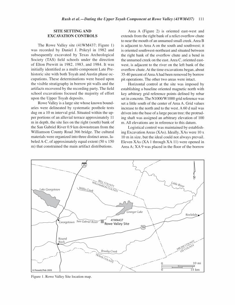
Rush et al.—Dating the Upper Toyah Component at Rowe Valley (41WM437) 111
SITE SETTING AND EXCAVATION CONTROLS
The Rowe Valley site (41WM437; Figure 1) was recorded by Daniel J. Prikryl in 1982 and subsequently excavated by Texas Archeological Society (TAS) field schools under the direction of Elton Prewitt in 1982, 1983, and 1984. It was initially identified as a multi-component Late Pre-historic site with both Toyah and Austin phase oc-cupations. These determinations were based upon the visible stratigraphy in borrow pit walls and the artifacts recovered by the recording party. The field school excavations focused the majority of effort upon the Upper Toyah deposits.
Rowe Valley is a large site whose known bound-aries were delineated by systematic posthole tests dug on a 10 m interval grid. Situated within the up-per portions of an alluvial terrace approximately 11 m in depth, the site lies on the right (south) bank of the San Gabriel River 0.9 km downstream from the Williamson County Road 366 bridge. The cultural materials were organized into three distinct areas, la-beled A-C, of approximately equal extent (50 x 150 m) that constrained the main artifact distributions.
Rockdale
RoundRock
Georgetown
0
0
10 mi
15 km
NBELL COUNTY
WILLIAMSON COUNTY
TRAVIS COUNTY
MILAM COUNTY
LEE COUNTY
San Gabriel River
Willis Creek
Brushy Creek
Little River
Granger Lake
Lake Georgetown
41WM437Rowe Valley Site
35
79
Figure 1. Rowe Valley Site location map.
Area A (Figure 2) is oriented east-west and extends from the right bank of a relict overflow chute to near the mouth of an unnamed small creek. Area B is adjacent to Area A on the south and southwest; it is oriented southwest-northeast and situated between the right bank of the overflow chute and a bend in the unnamed creek on the east. Area C, oriented east-west, is adjacent to the river on the left bank of the overflow chute. At the time excavations began, about 35-40 percent of Area A had been removed by borrow pit operations. The other two areas were intact.
Horizontal control at the site was imposed by establishing a baseline oriented magnetic north with key arbitrary grid reference points defined by rebar set in concrete. The N1000/W1000 grid reference was set a little south of the center of Area A. Grid values increase to the north and to the west. A 60 d nail was driven into the base of a large pecan tree; the protrud-ing shaft was assigned an arbitrary elevation of 100 m. All elevations are in reference to this datum.
Logistical control was maintained by establish-ing Excavation Areas (XAs). Ideally, XAs were 10 x 10 m in size, but the ideal could not always prevail. Eleven XAs (XA 1 through XA 11) were opened in Area A; XA 9 was placed in the floor of the borrow

112 Texas Archeological Society
pit to sample Austin phase deposits and is not ad-dressed in this article. One, XA 12, was placed in Area B and also is not addressed here. As a rule, ex-cavation areas were divided into 4 x 4 m quadrants, and these into 2 x 2 m excavation units. Two-meter wide N-S and E-W walk paths in each XA allowed control of foot traffic during excavations. The 2 x 2 m units were divided into 1 x 1 m cells des-ignated by their sub-cardinal directions: northwest, northeast, southeast, and southwest. Notes were recorded on the basis of the 2 x 2 m units with the southeast corner taken as the unit designator. Excava-tion and artifact control, however, was by the 1 x 1 m cells and by level (10 cm) or sub-level (5 cm).
A total of 387 1 x 1 m cells was excavated that contained Upper Toyah material at Rowe Valley. XAs 1 and 5 had 36 cells each; XAs 2, 3, 6, and 10 had 48 cells each; XA 4 had 69 cells; XA 7 had 26 cells; XA 8 had 16 cells; and XA 11 had 12 cells. When excavations began, 10 cm levels were used; field ob-servations led to the distinction of two separate Toyah
components, an Upper and a Lower, during the 1982 field season. After that distinction was made, excava-tions were adjusted to 5 cm sub-levels and focused on the Upper component. The smaller vertical excavation increment was applied for the remainder of the exca-vations. Most of the data presented and discussed be-low concerning the artifacts recovered and the features encountered are from the Upper Toyah stratigraphic zone. The majority of the excavated matrix was water screened with traditional 1/4-inch mesh screen. Many of the artifacts recovered were piece plotted, includ-ing tools, large flakes, bones, and cultural materials excavated in association with features.
SITE FORMATION PROCESS AND ALLUVIATION FROM THE
SAN GABRIEL RIVER
As noted above, the identified features and the recovered cultural debris are hosted in a
Figure 2. Rowe Valley Site map.
Excavation unit
Backhoe trench
Datum pin set in concrete
Borrow pit
Access Road
No. 3
San Gabriel River
No. 4
No. 2
No. 1
Creek bed
Overfl
ow Ch
ute
99.0
99.5
99.5
99.0
99.0
98.5
98.5
99.0
N920/W970
N1020/W970
N920/W1050
N1020/W1050
Area A
Area B
Area C
41WM437Rowe Valley SiteContour Map
0
0 30 m
100 ft
Contour interval .25 m
N

Rush et al.—Dating the Upper Toyah Component at Rowe Valley (41WM437) 113
thick alluvial terrace of the San Gabriel River. Aggradation of the terrace is achieved through over bank flooding. Such floods are intermittent, and flood frequency varies through time. Most of them result in gentle slack-water sediment deposition as was observed at the nearby Loeve-Fox site (41WM2330) during excavations conducted between 1972 and 1978 (Prewitt 1982:16 and Table 2). These types of over bank floods move gentle currents across the higher terraces and result in negligible displacement of either feature components or artifacts and debris. Indeed, they introduce small quantities of fine-grained sediments that, over time, bury and seal the cultural materials in undisturbed alluvial contexts.
Less frequent are major flood episodes such as the famous Thrall flood that dumped over 38 inches of rain at Thrall and over 30 inches at other nearby towns between September 8 and 10, 1921 (Scarbrough 1990; NOAA 2015). The Williamson County Sun (WCM) reported that the waters of the San Gabriel River reached the highest mark known up to that time and reported over 23 inches of rain in a 24 hour period (WCM 1921). These types of floods introduce much greater quantities of fine-to-coarse-grained sediments, and generate entirely new terrace surfaces in some areas and erode sediments in others. At Loeve-Fox evidence of sediments deposited by the 1921 flood event was easily observed by the quantities of early 20th century farm equipment debris encountered in fluvial deposits (Prewitt 1982:16). This flood, which was observed to be about 4.25 km wide just downstream at Circleville, deposited about 12-15 cm of sediment over the Rowe Valley site. We consider, then, that the features and materials excavated at Rowe Valley are in primary associa-tion, albeit consideration of turbation generated by plant roots and burrowing animals of various sorts must be kept in mind.
CULTURAL MATERIAL SUMMARY
Cultural materials recovered include lithic tools and debris, ceramic sherds, bone and shell ornaments, burned rocks, and faunal remains. Most of the lithic items recovered from Rowe Valley are consistent with the artifacts normally expected at a Toyah site. These include Perdiz and Cliffton arrow points, beveled bifaces, end scrapers made on flake blades, and unifacial flake drills. A large
quantity of non-tool lithic debitage (n=32,133) was also recovered from Rowe Valley. One chipping station alone contained over 6,000 pieces (for distributions and density maps of artifact types see Prewitt [2012] and Rush [2013]).
Items not necessarily diagnostic of Toyah but that commonly are found associated with it include Cuney, Lott, Guerrero, and untyped arrow points. Cuney usually is associated with the Caddo in East Texas and the Guerrero point with the Mission-era Texas coastal plain, but the Lott type is associated with the Garza Complex on the Southern High Plains of western Texas. Recently Boyd (2012) has included the Garza Complex within the umbrella of a “Northern Toyah” that abuts the northwestern margin of the “Classic” Toyah cultural area (John-son 1994).
The ceramic assemblage recovered at Rowe Valley is consistent with other Toyah assemblages, both in type and paucity. The sherds appear to rep-resent approximately eight different vessels that are representative of three different cultural traditions commonly associated with the Toyah cultural area (Prewitt 2012:200). Three of the vessels are clas-sified as Leon Plain, a type that is occasionally created locally but examples have been sourced to East Texas and the Texas Coast (Perttula et al. 2003; Prewitt 1981; see, however, discussion in Creel et al. [2013:66-69]). A Patton Engraved jar and a Bullard Brushed jar are both types generally associated with the southern Caddo pottery tradi-tion in East Texas. A burnished jar with tenoned handles similar to Goliad Plain ware is usually associated with the coastal region of Texas and provides another link to the coastal Toyah groups.
Several ceramic sherds from Rowe Valley were included in a petrographic study and Instrumental Neutron Activation Analysis (INAA) (Perttula et al. 2003); these were incorporated later into a larger study reported by Creel et al. (2013). Although the petrographic analysis was inconclusive, the initial INAA study placed the Patton Engraved, Bullard Brushed, and one untyped vessel (“Leon Plain”) into the Titus Cluster. The Titus Cluster covered the area of the Titus phase, a post-A.D. 1430 East Texas Caddo tradition. Only one sherd, from the Goliad Plain vessel, was sourced to Central Texas; however, its companions in the group are from Coryell and McLennan counties to the northwest (Perttula et al. 2003:Table 6). The study reported by Creel et al. (2013:65) supports the Caddo origin of the Bullard Brushed and Patton Engraved

114 Texas Archeological Society
vessels while placing the Goliad Plain vessel more appropriately on the coastal plains.
FEATURE CONTEXT AND CULTURAL STRATIGRAPHY
Three general categories of features were en-countered: animal processing locations, tool manu-facturing locations, and heating features (Prewitt 2012:198). Animal processing features tended to be clustered on the northwestern outskirts of Area A (Figure 3). The tool manufacturing features (or chipping stations) consist of variously sized con-centrations of lithic debris. Some appear to indicate specific classes of tools were being manufactured at particular locations. Heating features include eight hot rock cooking stations, three probable boiling stone dumps, one charcoal- and ash-filled pit, and three burned clay pits (Figure 3). Two of the hot rock cooking features are associated with the Lower Toyah component while all the others are in the Upper Toyah component.
To put the cooking features and cultural ma-terials into context, it is instructive to look at their vertical distributions. To do this, the raw waste flake counts, including those in discrete chipping stations, from XA 1 through XA7, XA 11, and parts of XA 10 were collapsed to the W1000 grid line. The raw counts were assigned density value ranges and the corresponding cells shaded accordingly. The distribution of identified projectile points was then superimposed on the shaded cells. As is clearly shown in Figure 4, the Upper Toyah com-ponent is about 25 cm thick and dips slightly from north to south; it begins at elevation 99.45-99.20 m in the north and slopes to elevation 99.40-99.15 m in the south.
The Lower Toyah component also is about 25 cm thick and follows the same north-south dip; it begins at elevation 99.20-98.95 m in the north and slopes to elevation 99.15-98.90 m toward the south. Some of the flake density variations can be ascribed to the significantly less excava-tions carried out in the Lower Toyah as opposed to the extensive excavations in the Upper Toyah. However, a Lower Toyah chipping station shows clearly at the N998-N1000 segment. Further, the underlying Austin phase component shows much greater density of flakes than the overlying Lower Toyah. The Austin component is at least 35 cm thick; it begins at elevation 98.95 m in the
north and slopes to 98.90 m in the south. Whether the excavations penetrated the full extent of the Austin component is unknown but the presence of a single Darl dart point indicates at least a minor Late Archaic component near the base of the excavations.
Superimposing the cooking feature locations on the same vertical flake density chart is also informative (Figure 5). Eleven of these features are clearly associated with the Upper Toyah com-ponent, although Feature 3.3 does penetrate to near the top of the Lower Toyah. Feature 3.1 and Feature 3.3 occupy the same north-south horizontal space, but Feature 3.3 extends about 5 cm deeper than Feature 3.1. Two features, Feature 3.6 and Feature 7.10, are comfortably in the Lower Toyah component. No cooking features were encountered in the underlying Austin component.
FAUNAL ANALYSIS
Approximately 33 percent of the over 10,000 specimen faunal assemblage was analyzed by Rush (2013). All faunal remains analyzed were from the Upper Toyah component as illustrated above in Figures 4 and 5. In general, the condition of the bone at Rowe Valley was poor. As a rule, the bones were highly fragmented and the cortical surfaces were quite rough. More detailed analyses (see Rush 2103) demonstrated that much of the fragmentation of bone at Rowe Valley was not related to purposeful human activities (i.e., not associated with marrow extraction or grease production) but rather that trampling by humans, animals, or later site formation processes are likely the responsible agents. This conclusion was largely based on assessing the Freshness Factor Index (FFI) for analyzed faunal materials following methods developed by Alan Outram (Outram 1998, 2000, 2005) and then putting each bone fragment into a size class following others (see Ricklis and Collins 1994; Gilmore 2012). Generally, large mammal remains (deer and antelope) dominate the assemblage, but a fair amount of very large mammal remains (bison) are included. Based on those faunal remains analyzed the minimum number of individuals (MNI) for identifiable large and very large mammals are five deer and one bison (Table 1). We presume the actual numbers of each species are higher based on field observations of diagnostic bones

Rush et al.—Dating the Upper Toyah Component at Rowe Valley (41WM437) 115
Stone-lined hearth
Burned clay pit
Burned clay andcharcoal hearth
Chipping station
Hearth cleanout
Borrow pit
Animal ProcessingArea
F-2.6a
F-2.2
F-6.7F-6.4
F-6.1
F-3.1F-3.3
F-4.4
F-4.8F-4
F-11.1
F-7.10
F-2.1
F-2.6b
41WM437Rowe Valley SiteFeature Locations
N
0
0 12 m
40 ft
Figure 3. Horizontal distribution of features: butchery, thermal, and knapping.
not included in our study and the fact that not all butchery features or specimens were analyzed. Field observations will be included below in discussing patterns for the use of mammals.
Comparisons between bison remains and deer (and deer-sized animals) demonstrated that there were different hunting/butchery strategies prac-ticed for large and very large mammals. Large mammals (i.e., deer) were represented nearly completely (including portions of the axial and appendicular elements) in butchery features, while most elements from very large mammal remains (i.e., bison) were from appendicular elements (Tables 2 and 3). More than half of the identifiable deer bones were from the axial
skeleton. This is much higher than the percentage of axial skeletal elements that were identified for bison. The null hypothesis that each skeletal part (skull, axial, limb) would be equally represented by deer, bison, and unidentified remains can be strongly rejected with a chi-square test at a <0.01 level of confidence (Table 4). This dichotomy suggests that deer were hunted close to camp, transported as complete carcasses, and butchered at the site. Bison were apparently hunted at some distance from camp, field butchered near the kill location, and selected parts transported to camp for final butchery.
When adjusted residuals are calculated, there is further indication that bison and deer skeletal
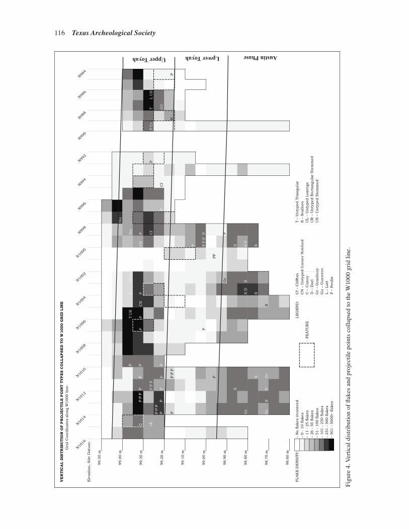
116 Texas Archeological Society
Figu
re 4
. Ver
tical
dis
tribu
tion
of fl
akes
and
pro
ject
ile p
oint
s col
laps
ed to
the
W10
00 g
rid li
ne.
VE
RT
ICA
L D
IST
RIB
UT
ION
OF
PR
OJE
CT
ILE
PO
INT
TY
PE
S C
OL
LA
PS
ED
TO
W10
00
GR
ID L
INE
Gri
d C
oord
inat
es a
lon
g W
1000 lin
e:
N1016
N1014
N1012
N1010
N1008
N1006
N1004
N1002
N1000
N998
N996
N994
N992
N990
N988
N986
N984
Ele
vati
on, S
ite
Dat
um
:
99.5
0 m
99.4
0 m
Gu
PT
UR
LC
f G
uG
u
99.3
0 m
CP
P P
PP
PP
PC
NP
CN
P
UL
P P
PC
fP
P C
rT
L U
S
99.2
0 m
P P
P
PP
PP
PP
Cf
GU
PP P
PP
P
99.1
0 m
P
99.0
0 m
PP P
PP
PPP
98.9
0 m
Gr
P
SS
98.8
0 m
Gr
S D
SS
P
SS
S
98.7
0 m
Gr
SP
Gr
S
98.6
0 m
FLA
KE
DE
NS
ITY:
– N
o flak
es r
ecov
ered
LE
GE
ND
:
Cf –
Cliffto
nT
– U
nty
ped
Tri
angu
lar
– 0 -
10 fla
kes
CN
– U
nty
ped
Cor
ner
Not
ched
S –
Sca
llor
n–
11 -
25 fla
kes
C –
Cu
ney
UL –
Un
typed
Loz
enge
– 26 -
50 fla
kes
D –
Dar
lU
R –
Un
typed
Rec
tan
gula
r S
tem
med
– 51 -
100 fla
kes
Gr
– G
ran
bu
ryU
S –
Un
typed
Ste
mm
ed–
101 -
250 fla
kes
Gu
– G
uer
rero
– 251 -
500 fla
kes
L –
Lot
t–
501 -
5000+ fla
kes
P –
Per
diz
- FE
ATU
RE
Upper Toyah Lpwer Toyah Austin Phase
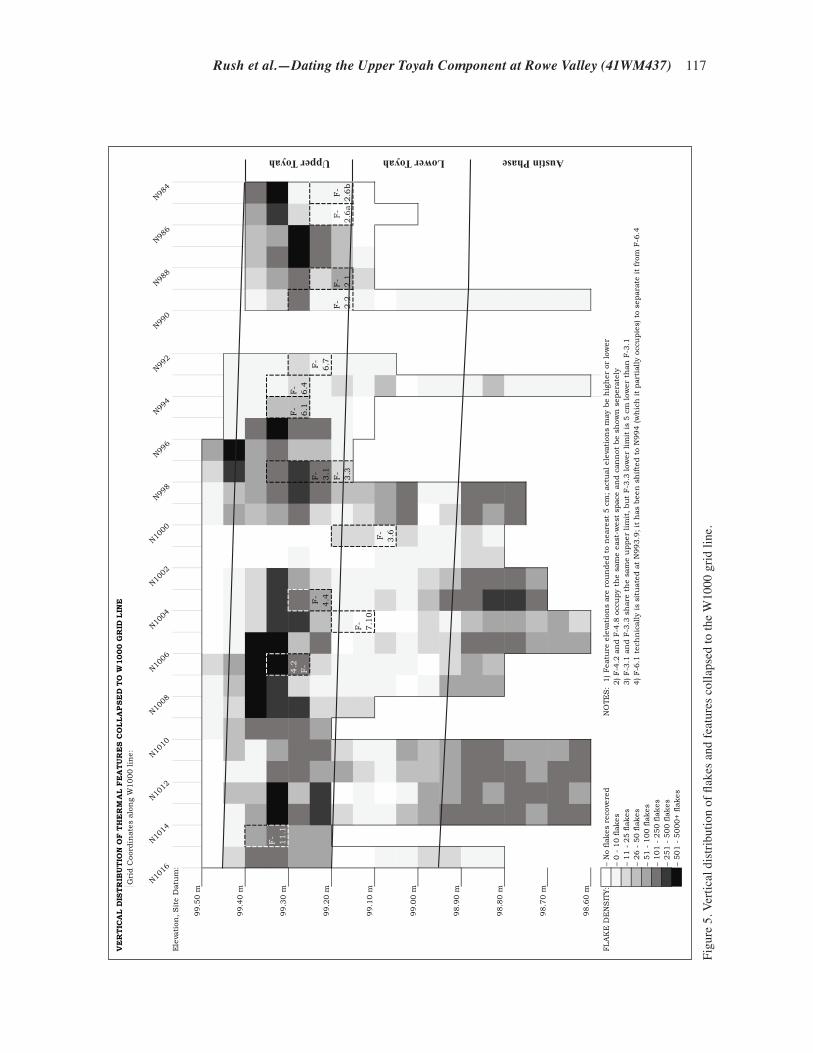
Rush et al.—Dating the Upper Toyah Component at Rowe Valley (41WM437) 117
Figu
re 5
. Ver
tical
dis
tribu
tion
of fl
akes
and
feat
ures
col
laps
ed to
the
W10
00 g
rid li
ne.
VE
RT
ICA
L D
IST
RIB
UT
ION
OF
TH
ER
MA
L F
EA
TU
RE
S C
OL
LA
PS
ED
TO
W10
00
GR
ID L
INE
Gri
d C
oord
inat
es a
lon
g W
1000 lin
e:
N1016
N1014
N1012
N1010
N1008
N1006
N1004
N1002
N1000
N998
N996
N994
N992
N990
N988
N986
N984
Ele
vati
on, S
ite
Dat
um
:
99.5
0 m
99.4
0 m
99.3
0 m
F-
11
.14
.2
F-
F-
6.1
F-
6.4
99.2
0 m
F-
4.4
F-
3.1
F-
6.7
F-
3.3
F-
2
.2F
-2
.1F
-2
.6a
F-
2.6
b
99.1
0 m
F-
7.1
0F
-3
.6
99.0
0 m
98.9
0 m
98.8
0 m
98.7
0 m
98.6
0 m
FLA
KE
DE
NS
ITY:
– N
o flak
es r
ecov
ered
NO
TES
: 1
) Fea
ture
ele
vati
ons
are
rou
nded
to
nea
rest
5 c
m; ac
tual
ele
vati
ons
may
be
hig
her
or
low
er–
0 -
10 fla
kes
2) F-4
.2 a
nd F
-4.8
occ
upy
the
sam
e ea
st-w
est
spac
e an
d c
ann
ot b
e sh
own
sep
erat
ely
– 11 -
25 fla
kes
3) F-3
.1 a
nd F
-3.3
sh
are
the
sam
e u
pper
lim
it, bu
t F-3
.3 low
er lim
it is
5 c
m low
er t
han
F-3
.1–
26 -
50 fla
kes
4) F-6
.1 t
ech
nic
ally
is
situ
ated
at
N993.9
; it
has
bee
n s
hifte
d t
o N
994 (w
hic
h it
par
tial
ly o
ccu
pie
s) t
o se
par
ate
it fro
m F
-6.4
– 51 -
100 fla
kes
– 101 -
250 fla
kes
– 251 -
500 fla
kes
– 501 -
5000+ fla
kes
Upper Toyah Lower Toyah Austin Phase
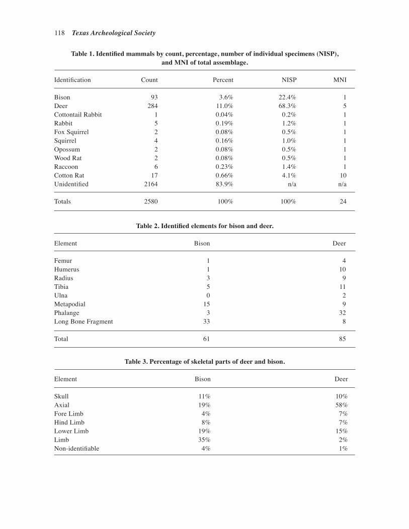
118 Texas Archeological Society
Table 1. Identified mammals by count, percentage, number of individual specimens (NISP), and MNI of total assemblage.
Identification Count Percent NISP MNI
Bison 93 3.6% 22.4% 1Deer 284 11.0% 68.3% 5Cottontail Rabbit 1 0.04% 0.2% 1Rabbit 5 0.19% 1.2% 1Fox Squirrel 2 0.08% 0.5% 1Squirrel 4 0.16% 1.0% 1Opossum 2 0.08% 0.5% 1Wood Rat 2 0.08% 0.5% 1Raccoon 6 0.23% 1.4% 1Cotton Rat 17 0.66% 4.1% 10Unidentified 2164 83.9% n/a n/a
Totals 2580 100% 100% 24
Table 2. Identified elements for bison and deer.
Element Bison Deer
Femur 1 4Humerus 1 10Radius 3 9Tibia 5 11Ulna 0 2Metapodial 15 9Phalange 3 32Long Bone Fragment 33 8
Total 61 85
Table 3. Percentage of skeletal parts of deer and bison.
Element Bison Deer
Skull 11% 10%Axial 19% 58%Fore Limb 4% 7%Hind Limb 8% 7%Lower Limb 19% 15%Limb 35% 2%Non-identifiable 4% 1%

Rush et al.—Dating the Upper Toyah Component at Rowe Valley (41WM437) 119
Table 4. Bison, deer, and unidentified element counts, percentages, and chi-square goodness-of-fit test by skeletal part.
Skull Axial Limb Unidentified Total Element
Deer 27 (10%) 166 (58%) 91 (32%) 0 (0%) 284Bison 10 (11%) 18 (19%) 62 (67%) 3 (3%) 93Unidentified 6 (0%) 144 (7%) 1164 (54%) 850 (39%) 2164
Total 43 328 1317 853 2541 χ2 =866.97 df=6 CVα 0.01=16.812
elements are differentially represented in the as-semblage (Table 5). The axial elements are ex-tremely overrepresented for the deer while deer limb bones are underrepresented. Axial elements for bison do not deviate from the expected values, although bison limb bones are overrepresented. Skull elements are overrepresented for both deer and bison.
Based on mature deer antler racks and a bison calf maxilla, the faunal remains analyzed are likely from a late fall or early winter occupation. Bison generally begin giving birth in early April or May, but are known to give birth as late as October or November (Berger and Cunningham 1999:113-118; McHugh 1972; Roe 1951). The seasonality is further corroborated by the presence of mature deer antlers still attached to the skull. Although whitetail deer have highly variable mating seasons based on environmental factors, mating season is generally accepted to be from December to Janu-ary (De Young and Miller 2011:324-331), and they shed their antlers shortly afterward. During winter, bison herds would have begun splitting into nurs-ery and male herds (Roe 1951), making large herd kills unlikely as the herds would tend to be more
Table 5. Adjusted residuals of bison, deer, and unidentified skeletal part.
Unidentified Skull Axial Limb Element
Deer 10.83 24.29 -7.08 -12.71Bison 6.90 1.89 2.92 -6.31Unidentified -13.25 -22.53 4.74 14.60
fragmented in the winter months. Likewise, deer would have been hunted in small groups or indi-vidually during these seasons.
THE ASSAYED HEATING FEATURES AND WOOD IDENTIFICATION
Feature designations are a combination of the XA number and the sequence in which they were encountered. All things comprised of more than a single element or were otherwise not transportable intact were labeled as a potential feature. Feature 2.1, then, is understood to be the first feature en-countered in XA 2. Some “features” initially as-signed numbers turned out to be rodent burrows or rotted root strains, so there are gaps in the number sequence due to the discounted “features.”
The 13 identified hot rock heating features occur in four forms: stones placed into shallow basins (seven examples; F-2.1, F-2.2, F-2.6a, F-3.1, F-4.4, F-4.5, and F-6.7), stones placed on flat sur-faces (two examples; F-7-10 and F-11.1), mounded boiling stone dumps placed on flat surfaces (three examples; F-2.2b, F-6.4, and F-4.8) and a charcoal

120 Texas Archeological Society
and ash-filled pit (F-3.3). All three of the boiling stone dumps are located immediately adjacent to shallow basin hearths. In two of these instances another basin hearth is located 2-3 m distant. At least two hearths (Feature 4.4 and Feature 6.7) are accompanied by immediately adjacent discrete areas of “clean out” comprised of charcoal, ash, and small hearthstone fragments. Not all hot rock cooking features are illustrated herein; Figures 6-8 (below) illustrate typical characteristics of each form of hot rock cooking feature, basin hearths with cleanout, and flat hearths.
Lump wood charcoal samples for AMS ra-diocarbon assay were taken from eight features: four shallow basin hearths (Feature 2.1, Feature 2.2, Feature 3.1, and Feature 4.4), two flat hearths (Feature 7.10 and Feature 11.1), one hearth clean out (Feature 6.1 adjacent to the shallow basin hearth Feature 6.7), and a charcoal- and ash-filled pit (Feature 3.3). Charcoal from one lower Toyah component feature (Feature 7.10) was selected by Prewitt and submitted for assay before realizing the error of that sample selection. The laboratory performing the assays (Direct AMS, Seattle, Wash-ington) requested that the samples be 0.3 g or more, but not less than 0.1 g. Accordingly, single-lump samples were selected where possible (D-AMS 5609 and D-AMS 5612), and in all cases the few-est lumps needed to achieve the desired threshold were selected. Only one sample (D-AMS 5613) was less than 0.3 g; this sample from F-3.3 was 0.09 g. Charcoal was identified to the lowest pos-sible taxonomic level prior to sending the samples for assay.
Plants identified in the Rowe Valley samples are given in Table 6. All plant remains were wood charcoal. The wood identified as elm is consistent with the anatomical group that includes cedar elm (Ulmus crassifolia). Given the site location, the buckeye (Aesculus sp.) specimen is most likely Texas buckeye (A. glabra var. arguta) or red buckeye (A. pavia). Buckeyes, sumacs, and hollies (yaupons) in Central Texas are shrubs or small trees in contrast to elms and oaks, which are taller canopy trees. The trees and shrubs identified at Rowe Valley would have been available on or near the floodplain of the San Gabriel River during Toyah times.
Feature 2.1 is a circular cluster of burned limestone cobbles situated primarily in the southeast and northeast 1 x 1 m cells in unit N988W10002. The tops of the uppermost stones
were encountered at 99.26 m elevation while the tops of the lower stones were at 99.20 m; the lowest stones rested at 99.18 m. The core of this feature (at N988.6W1002.63) is about 75 cm in diameter. Displaced stones adjacent to the perimeter extends the diameter to about 1 m. The stones are set in a shallow basin, and at least two of the cobbles near the center were fractured in place. All of the com-ponent stones exhibit reddish to pinkish-gray color and angular fractures common to burned limestone cobbles and pebbles. Abundant burned clay and charcoal lumps were noted in the gray ashy fill of the basin. A canine mandible rested adjacent to the northwest edge of this feature at an elevation of 99.20 m.
Feature 2.2 is an oval cluster of burned limestone cobbles in the northwest cell of unit N988W1008. The uppermost stones were encoun-tered at 99.31 m elevation; the tops of the lower stones were at 99.19 m and they rested on a surface at 99.16 m. The oval core of this feature is about 50 cm north-south and 60 cm east-west with the center located at N989.57W1009.40. Displaced stones around the perimeter form a larger oval about 65 cm northeast-southwest by 90 cm northwest-south-east. The cobbles were placed in a shallow basin. The gray ashy fill contained numerous burned clay lumps, and charcoal was abundant. The component cobbles are pinkish-gray and exhibit the angular fractures associated with heating elements.
Feature 3.1 is an oval cluster of burned limestone cobbles situated primarily in the north-west cell of Unit N996W1006 (Figure 6). The uppermost cobbles were encountered at 99.34 m elevation, the lower ones at 99.24 m, and they rested on a surface at 99.18 m. The core of this feature is about 70 cm northeast-southwest and 60 cm northwest-southeast. The center is at N997.70W1007.80. Displaced stones around the perimeter increase the size of the oval to 80 cm northeast-southwest and 1.10 m northwest-south-east. The shallow basin containing the cobbles has gray ashy fill with burned clay and charcoal. Both burned and unburned small bone fragments and chert chips were also abundant in the fill. A bone bead was adjacent to the southwest edge of this feature, and a small concentration of chert flakes and chips was adjacent to its northwest edge.
Feature 3.3 is a shallow pit that was only partially excavated. The 1.60 m north-south axis is centered at grid coordinate N997W1000 and extends a maximum of 45 cm west of the W1000

Rush et al.—Dating the Upper Toyah Component at Rowe Valley (41WM437) 121
Table 6. Rowe Valley wood charcoal identification for radiocarbon assays.
Feature Catalog Lot Botanical Common Raw RadiocarbonNo.* No.* Name Name Count Sample No.
2.1 539 Quercus sect. Red group 2 D-AMS 5608 Lobatae oak2.1 539 Ulmus sp. Elm 1 D-AMS 5608
2.2 586 Quercus sect. Red group 2 D-AMS 5610 Lobatae oak2.2 586 Quercus sect. White group 2 D-AMS 5610 Quercus oak2.2 586 Ulmus sp. Elm 1 D-AMS 5610
3.1 540 Ulmus sp. Elm 1 D-AMS 5609
3.3 774 Ulmus sp. Elm 6 D-AMS 5613
4.4 945 Quercus sect. Red group 2 D-AMS 5614 Lobatae oak4.4 945 Ulmus sp. Elm 1 D-AMS 5614
6.1 602 Aesculus sp. Buckeye 2 D-AMS 56116.1 602 Rhus sp. Sumac 1 D-AMS 5611
7.10 1491 Ulmus sp. Elm 4 D-AMS 5615
11.1 670 Ilex sp. Holly/ 1 D-AMS 5612 Yaupon
*Materials are separated by botanical name; multiple species comprise some samples
line. Projected to its estimated size, this shallow pit or basin is about 1.75 m in diameter and is centered at N997W995.40. Unique among the thermal features encountered at this site, this pit was encountered at 99.26 m elevation and extended only 10 cm in depth to 99.16 m. The gray ashy fill contained abundant charcoal flecks and small lumps of burned clay. There were relatively few burned rock fragments present, and those observed were small angular pieces of limestone burned to a bright reddish cast. Field notes for this feature in-dicate a small charcoal twig from the fill exhibited a cut groove around one end. Very few artifacts of any sort, including chipping debris, were found in or around this feature, unlike most of the areas excavated. A notable exception is a Perdiz arrow point found about 40 cm away from the southwest edge of the pit.
Feature 4.4 is a large complex hearth that extends over parts of 4 1 x 1 m cells in the west-ern half of unit N1002W1002 and eastern half of N1002W1004 (Figure 7). The tops of the upper-most stones encountered were at 99.32 m elevation and the tops of the lowest stones were at 99.21 m; they rested on a surface estimated to be at 99.18 m elevation. The core is a circular cluster of burned and fractured cobbles placed in a shallow basin. It extends 75 m north-south and 70 cm east-west, and is centered at coordinates N1003.42W1004. While no distinct coloration of the fill was noted, the matrix contained abundant small soft burned clay nodules and charcoal flecks, and a fair number of charcoal lumps. Extending southeast from the core is an oval area of burned clay lumps and char-coal. This area is 70 cm wide southwest-northeast and extends 40 cm to the southeast, presumably

122 Texas Archeological Society
N998W1007
N998W1009
41WM437Rowe Valley SiteFeature 3.1Stone Hearth
Elevations are in meters relative toarbitrary site datum of 100 m
0 40 cm
Burned RockCharcoal Fleck or LumpBurned ClayGrid Coordinate
99.31
99.31
99.31
99.33
99.30 99.25
99.29
99.27
99.29
99.23
99.31
99.28
99.24
99.2999.26
99.34
Figure 6. Feature 3.1 basin hearth (Upper Toyah).
0 40 cm
Elevations are in meters relative toarbitrary site datum of 100 m
41WM437Rowe Valley SiteFeature 4.4Stone Hearth
Burned RockCharcoal Fleck or LumpBurned ClayGrid CoordinatePerdiz Point
N1002W1005
N1003W1005
N1003W1003
N1004W1003
N1002W1004
N1004W1005
N1002W1003
N1003W1004
99.30
99.30
99.30
99.2999.28
Figure 7. Feature 4.4 basin hearth with cleanout (Upper Toyah).

Rush et al.—Dating the Upper Toyah Component at Rowe Valley (41WM437) 123
representing clean out from the hearth proper. The overall configuration of the two components is kidney-shaped. A few burned rocks are scat-tered east-northeast of the hearth core, but greater quantities are scattered around its west and south sides. Chert flakes and chips were more common on the eastern side.
Feature 6.1 is an irregularly shaped area of clean out materials adjacent to the northwest sides of the Feature 6.7 hearth and Feature 6.4 boiling stone dump. It is comprised of charcoal lumps and flecks in gray ashy sediment inter-spersed with burned limestone cobble fragments of varying sizes. It extends from coordinates N994.55W1016.35 to the edge of Feature 6.7 at coordinates N993.10W1015.35. The lens of burned rocks and abundant charcoal was first encountered at 99.32 m elevation. Its variable thickness ranged from 2-7 cm, and it lapped onto the northwest lip of Feature 6.7; that basin hearth was encountered at an elevation of 99.29 m.
Feature 7.10 is a small circular group of burned rocks centered at coordinates N1004W1014
and extended into four adjacent 1 x 1m cells (Fig-ure 8). The tops of the uppermost stones were encountered at 99.21 m elevation; they rest on a flat sloping surface that dips from 99.16 m on the east to 99.13 m on the west. Scattered charcoal was present in this flat hearth, but was not abundant. Small bone fragments, both burned and unburned, were abundant and distributed in and around the hearth. A flake blade was adjacent to the north edge while a core chopper rested on the east edge; flakes were scattered in and around the hearth, and a very large cobble hammerstone rested at the same elevation only 50 cm to the northeast. Over 60 percent of the small cobbles comprising this hearth are friable conglomerates. The remainder consist of typical fragments of burned stream-rolled lime-stone cobbles. The form and composition of this feature compares well with the single Toyah hearth reported at the Loeve-Fox site just a few kilometers downstream (Prewitt 1974:72 and Figure 15c).
Feature 11.1 is a circular cluster of burned limestone cobbles and fragments located in the two western cells of unit N1014W996. The tops of the
N1004W1014
Elevations are in meters relative to arbitrary site datum of 100 m
0 40 cmBurned RockCharcoal Fleck or LumpGrid Coordinate
99.13
99.1399.13
99.16
99.16
99.16
99.15
99.15
99.14
99.1599.16
99.16
Figure 8. Feature 7.10 flat hearth (Lower Toyah).

124 Texas Archeological Society
uppermost cobbles were encountered at 99.42 m elevation while the lower ones were at 99.35 m. This is a flat hearth with the stones resting on a surface at 99.33 m elevation. The core of it comprises closely-placed cobbles extending 70 cm north-south and 60 cm east-west. Many of the cobbles are fractured in place and indicate no significant displacement sub-sequent to abandonment. Stones scattered around the north and west sides of the core area extend its size to 1.50 m north-south and 1.0 m east-west. Charcoal lumps and flecks were moderately abun-dant in and around this hearth. A chert core rested at the top of its northern edge while a ceramic sherd rested near its center. Bone scraps, chert flakes, and artifacts were scattered around this hearth.
DATING THE TOYAH COMPONENTS AT ROWE VALLEY
The eight radiocarbon samples were selected because of their clear associations with the various features (described above) and amount of available charcoal. The charcoal samples were submitted to Direct AMS in Bothell, Washington. The δ13C corrected AMS age estimates are presented in Table 7. Each of the individual radiocarbon ages was calibrated in OxCal. A careful analysis of the calibrated ages for the new Rowe Valley radiocar-bon samples is justified, as these are very close in age to the initial occupation of Central Texas by a number of immigrant Native American groups and by the first Spanish explorers and eventually
missionaries, but the individual calibrations reflect a wide age span at two standard deviations (95.4 percent probability).
After the initial ages were calibrated in OxCal, various models were used to refine the calibrated ages. First, all of the samples were input into Ox-Cal to test whether these represented a single age estimate for the Upper Toyah occupation. Initially, the eight assays were summed (calibrated age frequency distributions totaled). This produced four modes that span the period from A.D. 1450 to A.D. 1950 (Figure 9); the younger 200 years of this range is an unlikely age estimate considering the prehistoric artifact assemblage and the constrained feature occurrences and stratigraphy, although this provides one chronological hypothesis.
In order to more rigorously test the hypothesis of radiocarbon sample homogeneity, all the assays were combined (frequency distributions aver-aged) in OxCal. OxCal uses statistical procedures known as Acomb and Chi-Square statistics. The Acomb value (http://c14.arch.ox.ac.uk/oxcal3/math_ag.htm, accessed August 9, 2014) must be equal to or greater than the An estimate for these to be considered the same age. “An” is calculated through the formula: 1/√(2n), and thus it is depen-dent on sample size. The combination statistics for all the assays are: Agreement n=8, Acomb=0.8% (An=25.0%), and the Chi-Square statistic (χ2) =36.838, df=1, p value < 0.00001. Both results suggest that the degree of variability is too great to consider these assays as coming from a single occupation. At that point we asked if any samples
Table 7. Radiocarbon samples, proveniences, measurement data, and individual calibrations in OxCal. All samples were lump wood charcoal collected from feature contexts.
Direct AMS Feature δ13C‰ Fraction of Radiocarbon Calibrated age, No. modern age 2 sigma range, A.D.
pMC 1 σ error B.P.±1 sigma
D-AMS 5608 2.1 -19.5 97.67 0.3 189 + 25 1654-1950*D-AMS 5609* 3.1 -19.8 95.86 0.28 340 + 23 1474-1636D-AMS 5610 2.2 -20.6 96.49 0.29 287 + 24 1515-1662D-AMS 5611 6.1 -27.2 97.36 0.34 215 + 28 1644-1950*D-AMS 5612 11.1 -25.7 96.98 0.28 246 + 23 1529-1950*D-AMS 5613 3.3 -25.1 96.51 0.29 285 + 24 1516-1663D-AMS 5614 4.3 -24.3 96.85 0.29 257 + 24 1523- 1800D-AMS 5615* 7.10 -23.0 95.58 0.28 363 + 24 1452-1633
*gray highlighted rows in Figure 10 indicate which samples are in the Older Age Group.

Rush et al.—Dating the Upper Toyah Component at Rowe Valley (41WM437) 125
1
Figure 9. Summed Rowe Valley calibrated radiocarbon ages with 2 sigma age spans.
Figure 9. Summed Rowe Valley calibrated radiocarbon ages with 2 sigma age spans.
can be considered coeval, and we began to group the dates and run combination statistics on all pairs, building up to larger groupings with the goals of arriving at the smallest number of temporal groups. This procedure allows for a minimal age model hypothesis to be constructed in contrast to the summed calibration model discussed above and illustrated in Figure 9. The results are discussed below and illustrated in Figure 10.
Samples D-AMS 5608, 5610, 5611, 5612, 5613, and 5614 can be combined statistically using the combination statistics in OxCal (Agreement n=6, Acomb=40.0% (An=28.9%) and the χ2 = 10.717, df=5, p value=0.0573), and we called these six samples the Younger Age Group. When combined (averaged) in OxCal, the 2 sigma (95.4 percent prob-ability) age range is A.D. 1645-1664. This means
that statistically there is over a 95 percent chance that all these samples date to this 19 year span in the middle of the 17th century. While the Chi-Square statistic is marginal, nevertheless we hypothesize that these six samples may make up a very precise age estimate for most of the dated features (Features 2.1, F2.2, F3.3, F4.4, F6.1, and F11.1) in the Upper Toyah component at Rowe Valley.
Rowe Valley Samples D-AMS 5609 and 5615 should not be combined with the Younger Age Group. However, these two samples, called the Older Age Group, statistically can be combined (averaged) in OxCal and the 2 sigma (95.4 percent probability) range produced two age modes of A.D. 1469-1525 (44.3 percent) and A.D. 1556-1632 (51.1 percent). The combination statistics indicate that the sample ages are statistically

126 Texas Archeological Society 1
Figure 10. Combined (averaged) Rowe Valley calibrated radiocarbon ages with 2 sigma age
spans (dark frequency distributions) plotted over unmodeled calibrated sample age estimates
(light frequency distributions).
Figure 10. Combined (averaged) Rowe Valley calibrated radiocarbon ages with 2 sigma age spans (dark frequency distributions) plotted over unmodeled calibrated sample age estimates (light frequency distributions).
indistinguishable from each other (Agreement n=2, Acomb=103.3% (An=50.%) and the χ2=0.390, df=1, p value = 0.532). These dates from the Older Age Group are significantly older than the dates in the Younger Age Group and confirm at a minimum there are at least two sequential Toyah components present in the site. It is unclear which of the two age modes in the Older Age Group is the more ac-curate age estimate for Features 3.1 and 7.10.
This chronological hypothesis (Younger and Older Age Groups) is in agreement with the observed site stratigraphy and the artifacts recov-ered from Rowe Valley. The Younger Age Group
accords well with the Upper Toyah component and the various “exotic” artifact groups; that is, the im-ported ceramics and the arrow points from distant external regions are well within their expected age ranges. Within the Older Age Group, Feature 7.10 is precisely within the age range expected for the Lower Toyah component. However, Feature 3.1 requires additional consideration. It is stratigraphi-cally within the Upper Toyah, yet dates to the Lower Toyah. Whether this anomaly is a function of old wood being burned, older rings sampled from the core in a younger sample selected for dat-ing, undetected buried ground surface undulations,

Rush et al.—Dating the Upper Toyah Component at Rowe Valley (41WM437) 127
or other causes remains undetermined. The patterns of fire wood selection in Toyah sites have yet to be studied in detail beyond the identification of tree species. This could be an important issue, but to our knowledge fire wood selection has not be ana-lyzed in detail in any region in the South Central United States.
DISCUSSION AND CONCLUSION
The calibrated radiocarbon dating results sup-port the observed vertical stratigraphy that shows at least two separate occupations occurred during the Toyah phase at Rowe Valley. Both the Younger and Older Age groups clearly predate the entrance of the Spanish into Central Texas. The “clean out” of fea-tures Feature 4.4 and Feature 6.7 demonstrate that the site probably was visited at least twice during the time represented by the Younger Age Group, but it is likely that additional visits occurred based on the quantity of materials present and the horizontal distribution of cultural materials. The six features in the Younger Age Group date to a 19 year span in the middle 17th century, a time that appears to predate the first appearance of Spanish explorers into the eastern portion of Central Texas (Nickels and Bous-man 2010:17-22; Wade 2003) unless one accepts the possible foray of Luis de Moscoso Alvarado’s men into Central Texas during his western trip from East Texas in 1542 (Swanton 1985).
The Younger Age Group date suggests inten-sive use of the Rowe Valley locale near the end of the Toyah phase; this is after the Spanish are documented in more distant parts of Texas. How-ever, the absence of direct Spanish contact at the Rowe Valley site is supported by the fact that no historic cultural materials were observed or col-lected (i.e., glass beads or metal artifacts) and no European fauna such as horses, pigs, or goats were identified. However, a complete analysis of faunal remains would be needed to conclusively confirm that. The data from the ceramics and arrow points suggest that although those people who lived at Rowe Valley did not have contact with the Span-ish, they did have contact with peoples that lived in the adjacent East Texas and Coastal regions as well as the Southern High Plains to the northwest. This conclusion is very much in keeping with the Toyah phase mobility and social interactions dis-cussed at length in Kenmotsu and Boyd (2012a) and by Arnn (2012).
None of the analyzed faunal materials were from the specific 1 x 1 m units where the dated features were located. However, the focus on ana-lyzing faunal materials recovered from the Upper Toyah component of the site makes it possible to associate the use of Younger Group thermal features and the hunting and butchery strategies. Further, the activity areas were covered with low velocity alluvial deposits from the San Gabriel River making the associations reasonably secure.
Bison were certainly utilized at Rowe Valley, like other Toyah sites, but did not serve as the sole economic pursuit. Deer are and have been ubiqui-tous in Central Texas and would have been widely available, especially during the fall and winter months. Whole deer carcasses can be transported with relatively little effort and deer are shown to be a more frequently utilized resource when compared to bison (Arnn 2012; Black 1986). Bison in the area surrounding Rowe Valley were possibly occupy-ing specialty patches (Mauldin et al. 2012), and their movements were focused in the upland black prairie grasslands as opposed to the bottomlands (i.e., where Rowe Valley is located). The presence of bison remains, however, does suggest that bison were indeed available and that the people that were living at Rowe Valley utilized them. The ratio of bison remains to deer remains suggests that bison hunts occurred away from the main campsite. Although it is difficult to know the level at which field butchery takes place, conclusions regarding which mammal resource was more utilized cannot be firmly made since bones present in archeologi-cal contexts do not equate with meat use or how intensively a resource was relied upon.
We conclude that Rowe Valley was a large campsite whose location along the San Gabriel River provided access to a wide variety of food and other resources. Those that inhabited and utilized the site did so intensively and returned to it mul-tiple times. While this might suggest that the Toyah occupants may have been somewhat more seden-tary than those who lived there during the Austin phase, they were still quite mobile. The presence of ceramics from eastern and coastal Texas and ar-row points from those areas and from the northwest suggests cultural interactions with groups from multiple adjacent—yet distant—regions during a time of looming cultural upheaval. And finally, it would be fruitful in the future to look at Rowe Valley in the light of the “trade fairs” as suggested by Creel et al. (2013:77) and the locations of an

128 Texas Archeological Society
agglomerated village called “Rancheria Grande” as suggested by Gilmore (1984).
ACKNOWLEDGEMENTS
The authors thank the Travis County Archelog-ical Society and the hundreds of Texas Archeologi-cal Society members who worked at Rowe Valley during three consecutive field schools for making this study possible. We thank the Texas Archeologi-cal Society for arranging funding for the radiocar-bon assays reported herein, and Kerza A. Prewitt, who graciously provided the graphics and editorial support. Ernest L. Lundelius, Jr.’s collegiality and help in all matters faunal are greatly appreciated. We appreciate the comments of an anonymous reviewer, Dan Prikryl, and Tamara Walter.
REFERENCES CITED
Arnn, J. W., III 2012 Land of the Tejas: Native Identity and Interaction in
Texas, A.D. 1300 to 1700. The University of Texas Press, Austin.
Baugh, S.1986 Late Prehistoric Bison Distribution in Oklahoma.
In “Current Trends in South Plains Archaeol-ogy,” Plains Anthropologist 31 (114, pt 2; Memoir 21):83-110.
Berger, J. and C. Cunningham 1999 Bison: Mating and Conservation in Small Popula-
tions. Columbia University Press, New York.
Black, S. L. 1986 The Clemente and Hermina Hinojosa Site, 41JW8: A
Toyah Horizon Campsite in Southern Texas. Special Report No.18. Center for Archaeological Research, The University of Texas at San Antonio.
Bousman, C. B.1993 Hunter-Gatherer Adaptations, Economic Risk and
Tool Design. Lithic Technology 18(1&2):59-86.
Boyd, D.K. 2012 What is the Northern Toyah Phase? The Toyah Phe-
nomenon on the Texas Southern Plains. In The Toyah Phase of Central Texas: Late Prehistoric Economic and Social Processes, edited by N. A. Kenmotsu and D. K. Boyd, pp. 128-151. Texas A&M University Press, College Station.
Bronk Ramsey, C.2013 OxCal, v 4.2.3. (https://c14.arch.ox.ac.uk/oxcal/Ox-
Cal.html, accessed September 8, 2014).
Collins, M. B.2004 Archeology in Central Texas. In The Prehistory of
Texas, edited by T. K. Perttula, pp. 101-126. Texas A&M University Press, College Station.
Creel, D., J. R. Ferguson, and N. A. Kenmotsu2013 A Compositional Analysis of Central Texas Hunter-
Gatherer Ceramics and its Implications for Mobility, Ethnic Group Territory, and Interaction. Bulletin of the Texas Archeological Society 84:29-83.
Dering, P. 2008 Late Prehistoric Subsistence Economy on the Ed-
wards Plateau. Plains Anthropologist 53(205):59-77.
DeYoung, R. W. and K. V. Miller 2011 White-tailed Deer Behavior. In Biology and Manage-
ment of White-tailed Deer, edited by D. G. Hewitt, pp. 324-331. CRC Press, Boca Raton, Florida.
Dillehay, T. D. 1974 Late Quaternary Bison Population Changes
in the Southern Plains. Plains Anthropologist 19(65):180-196.
Gilmore, K. K.1984 Letter to E. R. Prewitt, July 1984. Rowe Valley files,
Center for Archaeological Studies, Texas State Uni-versity, San Marcos.
Gilmore, Z. 2007 Large Mammal Utilization and Subsistence Stress
in Late Prehistoric South Texas. Master’s thesis, Department of Anthropology, University of Southern Illinois, Carbondale.
2012 Bone Processing and Subsistence Stress in Late Prehistoric South Texas. In The Toyah Phase of Central Texas: Late Prehistoric Economic and Social Processes, edited by N. A Kenmotsu and D. K. Boyd, pp. 111–127. Texas A&M University Press, College Station.
Harris, E. S. 1985 An Archaeological Study of the Timmeron Rockshel-
ter (41HY95), Hays County, South Central Texas. Special Publication 4. Southern Texas Archaeologi-cal Association, San Antonio.
Hayden, B. and R. Garrett1988 Specialization in the Paleolithic. Lithic Technology
17(1):12-18.
Holloway, R. G. 1988 Pollen Analysis of 41MI8, Mills County, Texas.
Contribution 4. Laboratory of Quaternary Studies, Department of Anthropology, Eastern New Mexico State University, Portales.

Rush et al.—Dating the Upper Toyah Component at Rowe Valley (41WM437) 129
Huebner, J.A.1991 Late Prehistoric Bison Population in Central and
South Texas. Plains Anthropologist. 36(137) 343-358.
Jelks, E. B.1962 The Kyle Site: A Stratified Central Texas Aspect in Hill
County, Texas. Archaeology Series No. 5. Department of Anthropology, The University of Texas, Austin.
Johnson, L., Jr.1994 The Life and Times of Toyah-Culture Folk: The Buck-
hollow Encampment Site 41KM16 Kimble County, Texas. Report 38. Office of the State Archeologist, Texas Historical Commission, Austin.
Kenmotsu, N. A. and D. K. Boyd (editors)2012a The Toyah Phase of Central Texas: Late Prehistoric
Economic and Social Processes. Texas A&M Uni-versity Press, College Station.
Kenmotsu, N. A. and D. K. Boyd2012b The Toyah Phase in Texas: An Introduction and Ret-
rospective. In The Toyah Phase of Central Texas: Late Prehistoric Economic and Social Processes, edited by N. A. Kenmotsu and D. K. Boyd, pp. 1-18. Texas A&M University Press, College Station.
Lynott, M. 1979 Prehistoric Bison Populations of Northcentral
Texas. Bulletin of The Texas Archeological Society 50:89-101.
Mauldin, R., J. Thompson, and L. Kemp 2012 Reconsidering the Role of Bison in the Terminal Late
Prehistoric (Toyah) Period in Texas. In The Toyah Phase of Central Texas: Late Prehistoric Economic and Social Processes, edited by N. A. Kenmotsu and D. K. Boyd, pp. 90-110. Texas A&M University Press, College Station.
McHugh, T.1972 The Time of the Buffalo. Alfred A. Knopf, Inc., New
York.
National Oceanic and Atmospheric Administration (NOAA)2015 Major Texas Storms, Thrall Flood, 1921. (http://
www.floodsafety.noaa.gov/states/tx-flood.shtml, accessed February 15, 2015).
Nickels, D. L. and C. B. Bousman2010 Archaeological Testing at San Marcos Springs
(41HY160) for the Texas Rivers Center, Hays County, Texas. Archaeological Studies Report No. 13. Center for Archaeological Studies, Texas State University, San Marcos.
Outram, A.K. 1998 The Identification and Paleoeconomic Context of
Prehistoric Bone Marrow and Grease Exploitation. Dissertation, Department of Archaeology, University of Durham.
2000 A New Approach to Identifying Bone Marrow and Grease Exploitation: Why the “Indeterminate” Frag-ments Should not be Ignored. Journal of Archeologi-cal Science. 44 (No. 28):401-410.
2002 Identifying Dietary Stress in Marginal Environ-ments: Bone Fats, Optimal Foraging Theory, and the Seasonal Round. In Colonisation, Migration, and Marginal Areas, edited by M. Mondini, S. Munoz, and S. Wickler, pp. 74-85 Oxbow Books, Oxford.
Perttula, T. K., S. A. Iruegas, and H. Neff 2003 Caddoan Pottery in Central Texas: Geochemical
Analyses of Ceramics from Fort Hood and Vicinity. Archeological Resource Management Series, Re-search Report No. 51. U. S. Army Fort Hood, Fort Hood, Texas.
Prewitt, E. R. 1974 Archeological Investigations at the Loeve-Fox Site,
Williamson County, Texas. Research Report 49. Texas Archeological Survey, The University of Texas at Austin.
1981 Cultural Chronology in Central Texas. Bulletin of the Texas Archeological Society 52:65-89.
1982 Archeological Investigations at the Loeve-Fox, Lo-eve and Tombstone Bluff Sites in the Granger Lake District of Central Texas. Archaeological Investiga-tions at the San Gabriel Reservoir Districts, Central Texas, Vol. 4, edited and compiled by T. R. Hays. Institute of Applied Sciences, North Texas State University, Denton.
1985 From Circleville to Toyah: Comments on Central Texas Chronology. Bulletin of the Texas Archeologi-cal Society 54:201–238.
2012 Toyah: Reflections on Evolving Perceptions. In The Toyah Phase of Central Texas: Late Prehistoric Economic and Social Processes, edited by N. A. Kenmotsu and D. K. Boyd, pp. 181-204. Texas A&M University Press, College Station.
Reimer, P. J., E. Bard, A. Bayliss, J. W. Beck, P. G. Blackwell, C. Bronk Ramsey, P. M. Grootes, T. P. Guilderson, H. Haflidason, I. Hajdas, C. Hatt, T. J. Heaton, D. L. Hoffmann, A. G. Hogg, K. A. Hughen, K. F. Kaiser, B. Kromer, S. W. Manning, M. Niu, R. W. Reimer, D. A. Richards, E. M. Scott, J. R. Southon, R. A. Staff, C. S. M. Turney, and J. van der Plicht.
2013 IntCal13 and Marine13 Radiocarbon Age Calibra-tion Curves 0-50,000 Years cal BP. Radiocarbon 55(4):1869-1887.
Ricklis, R. A. and M. B. Collins (editors)1994 Archaic and Late Prehistoric Human Ecology in the
Middle Onion Creek Valley. Studies in Archeology 19. Texas Archeological Research Laboratory, The University of Texas at Austin.

130 Texas Archeological Society
Roe, F. G.1951 The North American Buffalo: A Critical Study of the
Species in Its Wild State. University of Toronto Press, Toronto.
Rush, H. E.2013 The Rowe Valley site (41WM437): A Study of Toyah
Period Subsistence Strategies in Central Texas. Mas-ter’s thesis, Department of Anthropology, Texas State University, San Marcos.
Scarbrough, C. S.1990 Land of Good Water, Takachue Pouetsu: A William-
son County, Texas History. Williamson County Sun Publishers, Georgetown.
Swanton, J. R.1985 Final Report of the United States De Soto Expedition
Commission (originally issued 1939). Smithsonian Institution Press, Washington D.C.
Wade, M. F.2003 The Native American of the Texas Edwards Plateau:
1582-1799. The University of Texas Press, Austin.
Williamson County Sun (WCS1921 Waters of the San Gabriel Reach Highest Mark
Ever Known: The Floods of Williamson County 1921, 1957, and 2007. The Williamson County Historical Commission (http://www.williamson-county-historical-commission.org/SAN_GABRI-EL_flood_of_1921_in_Williamson_County_Texas.pdf, accessed 24 January 2015).

Bulletin of the Texas Archeological Society 86 (2015)
A Steatite Vessel Fragment from 41SS178, San Saba County, Texas: Consideration of Late Prehistoric Connections
between the Northwestern and Southern Plains
Christopher Lintz and Daniel Prikryl
ABSTRACT
Archeological testing at 41SS178 in San Saba County, Texas, recovered a stone steatite vessel rim sherd from Late Prehistoric contexts containing diagnostic arrow points from both Austin and Toyah phases and probably dating between ca. A.D. 1000 and 1600. The scarcity of stone bowl technology and absence of comparable steatite vessels from Texas suggests that the vessel was probably from a distant source. The inability to geo-chemically source steatite limits source identifications to vessel form comparisons. Prehistoric steatite vessels are commonly made in three places in North America: the Appalachian Mountains in the Eastern United States during Middle-Late Archaic times; the northwestern Plains during the Late Prehistoric through Historic times; or the West Coast from Archaic through Late Prehistoric times. The vessel form and temporal context of the San Saba County specimen suggests a closer relationship with the northwestern Plains than other areas. It is postulated that the vessel arrived in Texas from the northwest as part of the same kinds of interaction that brought some 115 northwestern Plains obsidian artifacts to the southern Plains.
INTRODUCTION
Recent testing to assess impacts to 41SS178 of a proposed foot bridge over a tributary creek within the Lower Colorado River Authority’s San Saba River Nature Park recovered a small rim sherd of a ground stone steatite vessel (Hixon et al. 2011:38). The site is near the confluence of Mill Creek and the San Saba River within the city limits of San Saba, Texas. Prehistoric steatite artifacts from Texas are rare and a soapstone vessel fragment from Central Texas is unique. Herein we describe the form and context of the stone vessel fragment and examine the formation processes and occur-rence of steatite. Geochemical sourcing studies of steatite are in their early stages of development. The range of geochemical variation of steatite quarries from the three vessel manufacturing areas in North America remains unknown. Compara-tive studies of archeological steatite vessel forms in North America suggest that this vessel most closely resembles those from the northwestern Plains in shape and age. Its presence in a Central Texas site is postulated to be related to the kinds of interactions that occurred between aboriginal
groups with the transport of obsidian between the northwestern and southern Plains during the Late Prehistoric period.
DESCRIPTION
The vessel fragment is a small (1.80 x 1.62 cm) piece of soft, silvery-gray steatite or soapstone with a greasy or slick feel. The specimen measures 0.51 cm thick at the body portion furthest from the lip and narrows to a thickness of 0.41 cm at a bevel juncture point some 0.29 cm below the lip. At that point the exterior edge of the vessel is markedly beveled to form a nearly pointed rim. Prominent manufactur-ing striations parallel to the rim axis are present on the interior surface. The exterior body has striations perpendicular to the lip, while the exterior rim bevel has abrasion marks parallel to the rim (Figure 1). The striation orientations suggest that the later stages of vessel shaping were made with a coarse abrading stone. A concentric circle chart indicates that the vessel had a projected orifice diameter of about 20 cm. This projected diameter suggests that the sherd is from a bowl or cup, rather than a pipe or

Lintz and Prikryl—A Steatite Vessel Fragment from 41SS178, San Saba County, Texas 133132 Texas Archeological Society
smaller artifact. The vessel height is unknown, but the rim slope from a plane perpendicular to the lip axis indicates that the upper vessel body probably had a relatively deep, conical form.
CONTEXT AND POSSIBLE CULTURAL AFFILIATION OF THE SAN SABA,
TEXAS SPECIMEN
The specimen was recovered during screening fill from Unit 2 South, level 2 (99.7-99.6 m below datum point) at 41SS178 (Hixon et al. 2011:38). The survey phase placed 17 shovel tests and two backhoe trenches to delineate site limits of about 105 x 75 m, which is bounded on three sides by the incised channel of Mill Creek. The testing phase included two more backhoe trenches and three 1 x 2 m hand-excavated units excavated to depths of 1 m each. The northern half of the northernmost 1 x 2 m unit was subsequently excavated down an additional 50 cm as was the southern half of the southernmost 1 x 2 m unit.
Culturally and temporally diagnostic imple-ments recovered during the testing phase include two contracting stemmed Perdiz points (one each from levels 1 and 2), three plainware pottery sherds (one each from levels 1, 2, and 3) and four small, stemmed or corner-notched arrow points loosely resembling the corner-notched Scallorn type (two from level 2, and one each from levels 3 and 7; Fig-ure 2). Considerable morphological variation exists in the range of point forms assigned to the Scal-lorn type from this site. They vary from minimally modified corner-notched flakes to spike-like forms with only slight shoulders and basal tangs. Based on the distribution of these diagnostic projectile points, the steatite vessel fragment was recovered from the lower portion of a probable Toyah phase component (ca. A.D. 1250-1600, as indicated by Perdiz points and Leon Plain pottery) or the upper portion of a probable Austin phase component (ca. A.D. 1000-1250, as indicated by Scallorn points).
A charcoal sample from level 3 (20-30 cm below surface), yielded a conventional age of 870 ± 40 B.P. (Beta-287767) and a calibrated two
Figure 1. Steatite vessel fragment from 41SS178, San Saba County, Texas.

Lintz and Prikryl—A Steatite Vessel Fragment from 41SS178, San Saba County, Texas 133
Figure 2. Composite contexts of the steatite bowl and diagnostic arrow points from 41SS178.
standard deviation age range of A.D. 1040-1260 for the zone below the fill containing the stone vessel rim. Thus, the steatite vessel post-dates A.D. 1000 and is unquestionably associated with the Late Pre-historic period at the site (e.g., Collins 1995:385; Prewitt 1981, 1985).
Although the site is only some 500 m from the edge of town, less than a half dozen historic arti-facts were recovered from 41SS178 from all phases of the project. The scarcity of historic remains on site suggests that the steatite stone bowl fragment is not an intrusive 20th century artifact that has worked its way into prehistoric subsurface contexts by bioturbation processes.
STEATITE COMPOSITION AND FORMATION
Steatite or soapstone is composed mostly of talc, a hydrated magnesium silicate that natu-rally formed by one of two ways (Greene 1995:5;
Truncer 2004a:489). The more common manner of formation involves the metamorphic alteration of ultramafic rocks, such as periodite or other dark mantle rocks rich in irons and magnesium but low in silica. Typically these ultramafic rocks are chemically altered during bedrock deformation associated with heating in subduction zones by plate tectonics. The less common way that steatite forms is by hydrothermal chemical replacement changes, or metasomatism, which adds chemicals and silica and alters carbonate-rich sedimentary rock, such as dolomite (Greene 1995:5; Truncer 2004a 489). Steatite derived from altered periodite forming near tectonic boundaries sometimes con-tain ubiquitous microscopic inclusions of chromite and nickel sulfides and from one to three percent of iron oxides; whereas steatite formed from hydro-thermic changes of dolomites do not contain these sulfides, and usually have less than one percent iron oxide (Jim Burton, personal communication 2011; Greene 1995:10). These differences make it possible to differentiate between the two forms of

Lintz and Prikryl—A Steatite Vessel Fragment from 41SS178, San Saba County, Texas 135134 Texas Archeological Society
steatite. Steatite is very soft, measuring only 1.0 on the Mohs hardness scale. It is easily cut and ground into a variety of forms with simple imple-ments. One advantage of the metamorphic kind of steatite is that it is resistant to thermal shock, and it functions well as fire-proof cooking containers.
Few geological talc-bearing districts occur in Arkansas (n=1), Texas (n=2), and New Mexico (n=1) of the south-central United States (Greene 1995). The closest reported source of steatite to 41SS178 is about 72 km from San Saba near the southern margin of the Precambrian Llano Uplift or Central Texas Mineral Belt (Beste 2005:395; Fig-ure 3). As many as 17 soapstone mining prospects have been geologically mapped for the region, with most occurring along the southern part of the Llano Uplift and with serpentine occurrences associated with Packsaddle schist (Dietrich and Lonsdale 1958; Green 1995:65). These steatite outcrops are generally small, non-commercial, exposures of ocean floor serpentine that has been altered by metamorphism and the heat from intrusive igne-ous rocks and conform to the ultramarfic type of steatite formation processes (Barnes et al. 1950).
Modern commercial soapstone and talc mines are present along the Allamoore Formation exposed near the south end of the Sierra Diablo Mountains
about 16 km west of Van Horn, in Hudspeth and Culbertson counties, and some 585 km west of San Saba, Texas (Bourbon 1982; King 1965; King and Flawn 1953). Here a series of at least 20 mines and 23 prospects of steatite and talc outcrop in a 24 km long segment of the formation derived from altered sedimentary rocks (Greene 1995:63). Large-scale commercial mining of these deposits began in 1952, and by 1994 about 8,880,000 tons have been mined from the Allamoore Formation quarries (Greene 1995:65).
The earliest geological survey of Texas re-ported other occurrences of impure “soapstone deposits” from Frio, Bandera, and either Bexar or Kendall counties (Dumble 1889:61). However, since none are associated with igneous or metamor-phic regions or known talc-deposits, their identifi-cations as steatite sources are regarded as unlikely (Greene 1995; Swanson 1995).
SOAPSTONE ARTIFACTS FROM ARCHEOLOGICAL SITES IN TEXAS
A search of the Texsite Atlas electronic da-tabase found a few reported soapstone or steatite artifacts attributed to two groups (Figure 4). First
are late 19th or early 20th century historic soapstone utilitarian or decorative ware artifacts that in-clude a soapstone pencil, a tailor’s seam-marking bar, and a sherd from a decorative soapstone urn, bowl, or ashtray from historic homesteads in Atascosa, Bell, and Marion counties.
The second soapstone group consists of legitimate prehistoric artifacts that occur as pendants and pipes. Soapstone pendants are reported from two sites in Presidio and Brewster counties south of the Allamoore Formation deposits in far West Texas. The rare occurrences of prehistoric soapstone pipes are reported from Central and South Texas. Two steatite elbow pipes have been reported from Burnet and Bosque counties northeast of the Llano Uplift soapstone sources region of Central Texas (Field 1956:172; Olds 1965:129). The Figure 3. Steatite occurrences in Texas relative to the location of 41SS178.

Lintz and Prikryl—A Steatite Vessel Fragment from 41SS178, San Saba County, Texas 135
specimen from Burnet County has an outward fac-ing anthropomorphic head carved in the bowl which may represent an indigenous copy of European trade pipes. Two tubular or conical pipes are reported from Uvalde and Live Oak counties in South Texas (Brown et al. 1982; Chandler 1995:10; Texas Beyond History 2005). These kinds of pipes are sometimes called cloud-blower forms and are commonly found in northern Mexico and South Texas westward to El Paso, Southern Arizona, and beyond (Switzer 1969:27-34). The orifice diameters of the two South Texas steatite pipes range from 2.5-3 cm to 6.4 cm, which is considerably smaller than the projected 20 cm diameter of the San Saba vessel fragment.
The Texsite files also list four other steatite or soapstone specimens attributed to prehistoric contexts. Unfortunately they are not described, but merely listed as two pieces of worked steatite found in Jasper and Navarro counties, an unmodified piece of steatite from Panola County, and a “soapstone abrader” from Nueces County. Unless the abrader is a socio-technic item that represents a ritualistic artifact based on the selection of an overly-soft, non-utili-tarian material to absurdly represent a metaphor for heavy-duty work implements (cf. Brown 1976:148), the raw material attributed to the abrading stone is probably misidentified in the database.
A search of the Texsite database for the oc-currence of ground stone bowls turned up several examples of mortar holes, but no reported examples of portable stone vessels. One shallow stone bowl
not yet in the Texsite database and made from a non-steatite rock was recovered during the 2013 Texas Archeological Society field school from a Late Ar-chaic component at the Eagle Bluff site (41ME147) in Medina County. Illustration of the fragmentary specimen shows the vessel to be a small (ca. 6.5 cm diameter), shallow, dish-shaped bowl (Hester 2013:12 and Figure 17). The differences in vessel form, lithic resource material, and age from the San Saba specimen clearly show that it was not part of the same stone vessel manufacturing tradition.
In summary, steatite artifacts are rarely recovered from prehistoric contexts in Texas. Most identifiable prehistoric steatite implements from Texas are con-fined to jewelry or pipes. No comparable steatite stone bowls have been reported from Texas, and indeed, no sustained stone bowl manufacturing industries were extant in Texas or the southern Plains. Based on the absence of comparable kinds of artifacts, the solitary San Saba steatite vessel was probably not made in Texas. So the question remains: what is the prob-able source of the steatite vessel rim sherd found at 41SS178 in San Saba County?
OCCURRENCE OF STEATITE OUTCROPS IN VESSELS: EASTERN
NORTH AMERICA
The distribution of talc, and related minerals—steatite/soapstone, and serpentine deposits—in
Figure 4. Distribution of historic and prehistoric artifacts made of steatite listed in the Texsite database.

Lintz and Prikryl—A Steatite Vessel Fragment from 41SS178, San Saba County, Texas 137136 Texas Archeological Society
North America as summarized by Greene (1995) and Truncer (2004a) reflects high densities of bedrock exposures in primarily three geographical areas (Figure 5 a-b). These include:
1. approximately 135 talc-deposit dis-tricts occur in the Appalachian Moun-tain range extending from east-central Alabama northeastward through 15 states and the District of Columbia to southwestern Maine;
2. approximately 32 main talc districts across the Sierra Nevada, Coastal, and Cascade Mountain ranges of Califor-nia, western Nevada, southwestern and northeast Oregon, and across Washington state; and
3. approximately 14 main talc districts in the northwestern Great Plains, mostly in the Yellowstone and surrounding mountainous areas of Wyoming, southwestern Montana, and east-central Idaho.
Less common are relatively small talc and related materials districts in the Superior region of Wisconsin, the Ouachita Mountains of west-central Arkansas, the Llano Uplift of Central Texas, the basin and range areas of the Texas Trans-Pecos, and the San Andrea Mountains of south-central New Mexico. Of all these outcrop occurrences, aboriginal stone bowl industries utilizing steatite/soapstone are present only in the three main areas. The age and style of vessel morphology differs to a great degree from one area to another. The fol-lowing briefly summarizes the steatite stone bowl manufacturing industries to isolate temporal and form characteristics that are comparable to the example found in San Saba County.
Occurrence of Steatite Vessels: Appalachian Mountains of Eastern North America
Along the East Coast/Appalachian Mountains area, more than 50 of the 135 geological talc-deposit districts have documented quarries used for the manufacture of steatite bowls. These prehis-toric quarries extend across east-central Alabama, northern Georgia, the western margins of both North and South Carolina, western Virginia, central Maryland, southeast Pennsylvania, as well as Con-necticut, Rhode Island, and Massachusetts (Truncer
2004a:489, 2004b, 2006). Other New England steatite outcrops in Vermont, New Hampshire, and Maine were not used as vessel quarries. Truncer (2004a:490) postulates that steatite vessel quarries correlate to the distribution of nut mast-dominated woodlands, whereas the steatite outcrops not as-sociated with stone vessels coincide with conifer/hardwood forests with low mast yields. Truncer also maintains that vessels made from the meta-morphic form of steatite are used to process nuts due to their superior ability to withstand heat. Crushed steatite was among the earliest kinds of pottery tempers used in the Mid-Atlantic states, and its ability to stand up to high temperatures was undoubtedly one of its desirable attributes (Griffin 1952:Figure 21).
The range of artifacts made of steatite in the Eastern United States includes pipes, figurines, and cooking vessels (Figure 6 a-c). Since most steatite vessel fragments are small, the range of vessel forms is uncertain. Some stone vessels are large-mouth, rectangular-to-oval bowls with flat bottoms and occasional lug handles and/or rare surface deco-rations (Tuck 1978:38; Griffin 1952:Figures 21, 138, 147). Other steatite cooking utensils are per-forated flat griddle-like containers (Custer 1989).
In the Eastern United States, steatite vessel fragments are usually found as isolated fragments within 550 km of the nearest outcrop source, al-though some fragments from southern Florida are about 950 km from the closest bedrock outcrop (Truncer 2004a:490 and Figure 2). Abundant stone vessel sherds have been reported from sites in east-ern Tennessee, western South Carolina, southern Virginia, southeast Pennsylvania, and Connecticut within 125 km of the steatite outcrops. Some of these sites may contain multiple steatite vessel fragments found in graves, caches (non-graves), and in habitation refuse (Truncer 2004a:495).
Caches of steatite vessel fragments are known to occur only in the lower Mississippi River val-ley—especially at Claiborne in south Mississippi (Gagliano and Webb 1970), and Poverty Point in northeast Louisiana (Gibson 1996, 2001; Webb 1944, 1982). At the latter site, a single oval pit southwest of the big mound yielded thousands of soapstone vessel fragments. No complete or restorable vessels were recovered and only a few refit sherds were present from this context (Gibson 1996). However, sherds from the pit con-joined other fragments from ridge-top locales up to 1.2 km away from the Poverty Point site. Both

Lintz and Prikryl—A Steatite Vessel Fragment from 41SS178, San Saba County, Texas 137
Figure 5. Distribution of talc deposits (A) and prehistoric steatite quarries (B) in the coterminous United States.
Claiborne and Poverty Point are about 550 km west and southwest of the nearest steatite outcrop in east-central Alabama. In contrast, the San Saba
Texas specimen is about 1,150 km from the closest Eastern United States steatite quarry in Alabama.
A compilation of 95 radiocarbon and five

Lintz and Prikryl—A Steatite Vessel Fragment from 41SS178, San Saba County, Texas 139138 Texas Archeological Society
a b c
d e f g
h i j
k lm
o
n
p q r
Southern California Vessel Forms
Figure 6. Variation in steatite vessel forms in the coterminous United States.
a b c
d e fg
h i j
kl
m
n
o
p q r
Northwestern Plains Vessel Forms
Appalachian Vessel Forms Eastern U.S.

Lintz and Prikryl—A Steatite Vessel Fragment from 41SS178, San Saba County, Texas 139
thermoluminescence dates from Eastern U.S. contexts yielding steatite vessel fragments indi-cate vessel usage from ca. 4300 B.C. to 50 B.C. during the Middle and Late Archaic periods, with most fragments dating between 2100 B.C. and 500 B.C. (Truncer 2004a:496-506). The earliest stone vessels predate the occurrence of pottery, but considerable temporal overlap exists in the two technologies (Sassaman 2006). The persistence of stone and ceramic vessel technologies reinforces the notion that steatite vessels may have operated in a different functional or symbolic realm from that of pottery containers, perhaps due to differ-ences in cooking temperatures, or porosity.
Occurrence of Steatite Vessels: Northwestern Great Plains
of North America
Geologists have identified at least 14 steatite or talc-bearing districts in the northwestern Plains, including 12 ultramarfic sources in Wyoming, one ultramarfic source from Idaho, and one carbon-ate source from Montana (Greene 1995). At least seven steatite vessel quarries have been found in the Laramie, Big Horn, Wind River, Gros Ventre, and Teton Mountain ranges of Wyoming (Adams 2006:Figure 1; Frison 1982; Wedel 1954; see Fig-ure 5b). Some steatite vessel quarries have partially delineated vessel preforms, stubs of successfully-removed vessel blanks, split vessel fragments, stone choppers to rough-out container preforms, and scrapers thought to have been used to hollow out the bowls (Frison 1982). The final vessel shap-ing usually occurred at sites away from the quarry sources. The northwestern Plains steatite vessel industries are about 1,360 km from the San Saba, Texas specimen.
Frison (1982:282) documents 11 steatite ves-sels from Wyoming. The typical northwestern Plains vessel shapes are dominated by: tall “flow-er-pot” conical vessels with flat, flanged bases, hemispherical bowls, and cup-like vessels. Some conical vessel rims curve inward slightly and lips range from rounded, flattened, or pointed (Frison 1982:281). Many vessels have a small notch-like dimple along the rim to facilitate pouring (see Figure 6). Very few vessels are decorated. Two Wyoming vessels have a raised collar or band be-low their rims. The interior surfaces tend to show more care in manufacture than the rough-scratched and abraded exterior surfaces. The dimensions
of 11 relatively complete vessels range from 7.1 to 25.2 cm tall, 9.5 to 23.8 cm in diameter at the orifice/rim, and 5.5 by 14.5 cm in diameter at the base. Although vessel walls often ranged from 8.6 to 10.5 cm thick, on some vessels, the walls may have areas ground to less the 0.2 cm thick, and some even have holes worn through their walls. Rarely drill holes are placed on opposite sides of the vessel to facilitate carrying; and occasionally paired drilled holes along a crack allowed damaged vessels to be sewn and stabilized.
The greatest occurrence of steatite vessel fragments is from northwestern Wyoming, Idaho, and Montana (Frison 1982:283, 285). Vessel frag-ments are occasionally found on the foothills of the Bighorn, Beartooth, Absaroka, Washakie, Teton, Gros Ventre, Owl Creek, Wind River, Rattlesnake, Seminoe, and Salt River Mountain ranges. Some vessel fragments occur above timberline eleva-tions, but most fragments are from lake shorelines and mountain passes.
Both Frison (1982) and Wedel (1954) sug-gest that most steatite vessels probably date to the early Historic period, for stone pots are mentioned among early historic descriptions of Shoshonean groups by Lewis and Clark (Schoolcraft 1851; Thwaites 1904-05; Lowie 1924). Vessels are also archeologically associated with bison horn sheaths and projectile point forms attributed to the historic period. The morphological similarity of steatite vessels to conical, flat-bottom ceramic vessels of the Intermountain Tradition suggests there may be a cultural connection between them, if not continuity in form. The conical ceramic vessel form has been radiocarbon-dated as early as A.D. 1100-1200 and persisted for perhaps 500 years (Frison 1982:284). Only 22 of 195 recorded soapstone bowls are from Late Prehistoric contexts (A.D. 1000-1500), whereas 30 vessels have metal implement manufacturing marks suggesting that stone bowl production persisted into the early A.D. 1800s Adams (2006:534).
Occurrence of Steatite Vessels: Western North America
Steatite bowls are widespread and common in the far West and extend from the Arctic, the Northwest Coast, and throughout California (Ad-ams 2006). Geologically, talc-producing districts in the lower coterminous United States include 18 in California, three in Nevada, one in Oregon,

Lintz and Prikryl—A Steatite Vessel Fragment from 41SS178, San Saba County, Texas 141140 Texas Archeological Society
and 10 in Washington (Greene 1995; see Figure 5). More than two-thirds are ultramarfic forms, but carbonate forms of steatite are also present, especially along the Sierra Nevada Mountains outcrop exposures.
The types of vessels commonly found in the Arctic consist of small, relatively flat bowls that served as oil lamps (Fitzhugh and Crowell 1988; Willey 1966). The Northwest Coast groups histori-cally made elaborately carved vessels of argillite for the tourist trade. But prehistoric soapstone manufacturing industries in the Northwest Coast began as early as 5,000 years ago and produced lip ornaments, ear spools, pendants, and other jewelry rather than stone bowls or other containers (Dahm 1994). Most of these steatite objects are too far away to be seriously considered as a possible source of the San Saba, Texas, vessel fragment.
Prehistoric manufacture of steatite ollas, bowls, and tray-like vessels were common and widespread across California (Adams 2006; Heizer and Treganza 1944, 1972; Wlodarski 1979). Flat tray-like drip pans for collecting cooking grease were made near the Klamath River basin in north-ern California, and tall cylindrical jars were made in the Stockton-Lodi area of the central interior val-ley (see Figure 6). One of the more famous steatite olla manufacturing areas is Santa Catalina Island, located some 1,850 km away from the San Saba specimen from Central Texas (Wlodarski 1979). Carved olla technology began about 4,000 years ago, but the most intensive stone bowl production, involving trade into the interior San Joaquin valley and Sierra foothills, occurred during the Late Pre-historic period. Even though basketry was highly developed, the steatite vessel industry supplied products primarily used for supplemental cooking.
The common vessel forms are globular ollas, wide mouth hemispherical bowls, asymmetrical bowls, and flat griddle plates with low rims and a drilled hole used to assist dragging the plates from fires. Steatite was also commonly shaped into jewelry and effigy charms with inlayed shell beads.
THE STATUS OF STEATITE GEOCHEMICAL SOURCING STUDIES
The range of parent materials altered by either thermal subduction or hydrothermal chemical re-placements are expected to reflect great chemical variations within steatite outcrops, so extensive
testing of sources is required to document their chemical perimeters at any source area (Ken-neth Sassman, personal communication, 2011). Pioneering geochemical studies examined trace elements (TE) and rare earth elements (REE) to quantitatively characterize steatite source differ-ences using a variety of methods. Early spectro-graphic steatite studies lacked precision and robust sample sizes necessary to yield conclusive results (Bullen and Howells 1943). Other investigations tried combined atomic absorption and optical min-eralogy techniques (Turnbaugh and Keifer 1979; Turnbaugh et al. 1984). Still other studies used Instrumental Neutron Activation Analysis (INAA) to measure REE abundances and delineate source differences (Allen et al. 1975, 1984; Holland et al. 1981; Luckenbach et al. 1975; Rogers et al. 1983). These studies had hoped that TE and REE concentrations would remain relatively constant across lateral occurrences of a steatite outcrop, even though drastic changes may occur in overall mineralogy (Allen and Pannell 1978). But the REE occurrences among metamorphically-altered mineral components proved to be relatively low and bordered on the lower levels of instrument measurements using INAA procedures (Allen et al. 1984; Frey 1984).
Some outcrops were found to have tremendous variations within a single source exposure. Other researchers using radiochemical separation-INAA on REE and ultramafic complexes found wide and inconsistent variation in rare earth elements from intra-source samples (Moffat and Butler 1986). Model mineralogy involving petrographic studies of bulk steatite samples can yield very heterogeneous results within a single source area, reflecting an uneven distribution of TE and REE concentrations over short distances even within a quarry. Clearly to overcome these variances, large bulk samples would have to be ground and well mixed, resulting in the inevitable destruction of artifacts to obtain comparative sourcing geochemi-cal results. Thus, alternate avenues of analysis were needed to overcome this undesirable consequence of investigations.
One attempt to advance the analysis involved using INAA combined with microprobe sampling points on 400 unground steatite samples from eight Appalachian quarries coupled with multivariate statistics used to investigate an expanded range of target elements to include TE, REE, minor trace el-ements, and transition metals (Truncer et al. 1998).

Lintz and Prikryl—A Steatite Vessel Fragment from 41SS178, San Saba County, Texas 141
The results suggested that rare earth elements were less useful than relying on transitional metals in differentiating sources at a regional level, but pos-sibly not at the quarry level.
Other researchers explored the use of expanded elemental lists employing results from INAA and Inductively Coupled Plasma-Mass Spectometry (ICP-MS) (Jones et al. 2007). The combination of the two analytical approaches increased the confi-dence of REE concentration measurements over the use of INAA alone based on the study of soapstone source samples from Shetland, England. However, identification on critical TE, REE, and transitional metals to differentiate quarries remains elusive.
Other approaches have investigated the use of basic electron microprobes analysis (EMPA) to characterize fundamental mineral composition, chemistry, and textural variations between steatite sources (Ige and Swanson 2008). The microprobe application has tremendous advantages over the mixed bulk chemistry approach by being able to recognize specific mineral compositions within samples.
Building on these studies, Radko (2011) used traditional thin section point counts to characterize the modal and textural variability from samples derived from 10 artifacts and three quarries. He then employed both electron microprobes and x-ray diffraction methods to examine the constituent chemical compositional data of the talc, chlorite, oxide, and amphibole (dark-colored chain silicate mineral) components of steatite samples from both quarry and artifact specimens. Applying multivari-ate statistics to the data resulted in the identifica-tion of low calcium amphibole and titanium-iron oxides (ilmenites) as the specific minerals that best segregated the quarries and provided strong correlations with the artifact samples.
Despite these encouraging results, consider-ably more work needs to be completed on many more quarries throughout the United State before the full utility of geochemical methods is devel-oped for identifying steatite quarry sources for specific artifacts. Unfortunately, the lack of com-parable geochemical studies using broad suites of metals, and REE for the Wyoming, most Califor-nia, and known Texas steatite sources, hinders the ability to correlate the San Saba, Texas, sample to known steatite outcrops. This lack of an existing comparative steatite database was the primary reason for not pursuing geochemical studies on the vessel fragment from San Saba, Texas.
DISCUSSIONS: POSSIBLE NORTHERN-SOUTHERN
PLAINS INTERACTIONS
The foregoing survey suggests that steatite is a naturally-occurring soft rock used by prehistoric people to make mostly charms, ornaments, pipes, and occasionally cooking vessels. Steatite cooking vessels may have been independently invented multiple times and places in North America. The manufacture of stone vessels from the Eastern United States developed during the Middle Archaic period but persisted alongside the manufacture and use of clay ceramic vessels. Stone vessels on the West coast were also made during the Archaic and persisted into the Late Prehistoric period. The stone vessels on the northwest Plains developed during the Late Prehistoric and persisted into Historic periods (ca. A.D. 1000 to 1850).
Based on the lip form and projected orifice di-ameter, the steatite rim sherd from San Saba County, Texas, appears to be most similar to the shape and size of soapstone vessels from western Wyoming (Adams 2006; Frison 1982). While many of the Wyoming vessels are attributed to Protohistoric Nu-mic and Historic Shoshonean groups, a few steatite vessel fragments have been found in Late Prehistoric contexts, and indicate the technology has sufficient time-depth to have been contemporaneous with the age of the San Saba County specimen.
The Texas rim form example and temporal context is unlike the forms and ages of steatite vessels from Archaic contexts in Eastern United States (Truncer 2004a) and California/West Coast regions (Wlodarski 1979). The vessel rim form most closely resembles the deep flower-pot ves-sel shapes and general ages of stone vessels from the northwestern Plains. We postulate that the San Saba specimen was carried about 1,360 to 1,900 km to Central Texas from some steatite outcrop sources in central or western Wyoming. These northwestern Plains steatite sources are about 20 to 66 percent farther from 41SS178 than the closest Southeastern U.S. Appalachian steatite source in Alabama. But the distance to Wyoming is compa-rable to the distance to the nearest reported steatite sources in southern California.
As discussed above, no geochemical character-ization methods have been used to identify the origin for the stone vessel from 41SS178 due to the lack of comparative source deposit data, especially from Texas, the northwestern Plains, and the West Coast.

Lintz and Prikryl—A Steatite Vessel Fragment from 41SS178, San Saba County, Texas 143142 Texas Archeological Society
THE NORTHWEST-SOUTHERN PLAINS OBSIDIAN CONNECTION
So what is such a rare and exotic stone bowl doing so far from the northwestern Plains in pre-historic times? The archeological record suggests that this steatite vessel fragment is not the only artifact reflecting probable connections between the northwestern Plains and Texas. An opportu-nistic compilation of reported sourced obsidian maintained by the senior author indicates at least 41 artifacts from 25 Texas sites are attributed to two obsidian sources in the same general area as the northwestern Plains steatite outcrops (Baugh and Nelson 1987; Hester et al. 1986; Kibler 2005). Most Texas obsidian specimens derived from the northwestern Plains are from the Malad source in southeast Idaho (n=39 artifacts from 23 Texas sites), but smaller frequencies are also sourced to Obsidian Cliff, in northwest Wyoming (n=2 artifacts from two Texas sites). While it may seem that the two Obsidian Cliff source pieces are oc-currence anomalies, when obsidian sourcing stud-ies are expanded to include sourced obsidian from Oklahoma, Kansas, and Texas, no fewer than five different northwestern Plains obsidian sources are present on the southern Plains as represented by 115 artifacts from 71 archeological sites (Tables 1 and 2). The northwestern Plains obsidian sources are generally located northwest of the Wyoming steatite quarries, and movements of obsidian from this region to the southern Plains would have passed within a few score kilometers of the north-western Plains steatite quarries (Figure 7).
The northwestern Plains sources represent between 9.3 and 18.5 percent of the identified reported sourced obsidian in the database from Kansas (34 of 285 pieces; 11.9 percent), Okla-homa (40 of 216 pieces; 18.5 percent) and Texas (41 of 443 pieces; 9.3 percent). Whereas volcanic glass artifacts from Obsidian Cliff, Wyoming, are comparatively rare in Texas (n=2), 21 other pieces from this source area have been found in greater abundance in Oklahoma and Kansas. The combined sources from Malad, Idaho (n=85; 73.9 percent), and Obsidian Cliffs, Wyoming (n=27; 23.5 percent), account for 97.4 percent of all the recorded northwestern Plains obsidian sources in the three state southern Plains database. Three other northwestern Plains obsidian sources are represented by two temporally undiagnostic flakes and a Late Paleoindian projectile point recovered
from two sites in the Oklahoma panhandle and one site in western Oklahoma. Single obsidian flakes from Owyhee, Idaho, and Teton Pass (also known as Fish Creek), Wyoming, sources are from the central and eastern counties in the Oklahoma pan-handle, and a Scottsbluff point most likely made from Wright Creek obsidian outcropping near the Obsidian Cliffs source was recovered from Washita County in west-central Oklahoma.
The five northwestern Plains obsidian sources are located about 1850 to 2000 km from the San Saba, Texas, site, and are generally northwest of the seven steatite stone vessel quarries found in various mountain ranges in Wyoming (Adams 2006). Any direct or indirect movement of obsidian from these sources would pass close to a number of steatite outcrops in Wyoming, which range from 1300 to 1800 km from the San Saba, Texas, locality.
The nature of the interaction is indicated by the kinds of artifacts made of northwestern Plains obsidians on the southern Plains. Of the 115 obsid-ian artifacts, only 21 (18.3 percent) are identifiable tools. These include 12 projectile points, six biface fragments, one scraper, and two unifaces. The non-tool assemblage consists of one core and 72 flakes; the latter most likely represent tool manufacture or maintenance activities. An additional 21 artifacts have not been identified as to type. Overall, the northwestern Plains artifact assemblage is character-istic of a generalized hunting tool kit and does not reflect exotic status items, such as eccentrics pieces. This is not unexpected as the foreign obsidian in Texas occurs primarily among the relatively mobile hunter-gatherer band level groups in Central Texas. These people were probably organized around ex-tended family ties, rather than elite headmen/chiefs requiring symbols of office and power.
The age of the southern Plains-northwestern Plains interaction is inferred directly from tempo-rally diagnostic artifacts made from northwestern Plains obsidian, and indirectly from ascribed cultur-al affiliation of the sites yielding the obsidian materi-als based on presumed associations with other kinds of temporally diagnostic materials. Although the widths of hydration rims absorbed on the surface of obsidian was once touted as being a possible direct dating method, further research has identified issues making the method problematic (cf. Miller 1996).
Of the dozen projectile points made of north-western Plains obsidian sources, four (33 percent) are either unspecified or too fragmentary for iden-tification. One specimen from western Oklahoma

Lintz and Prikryl—A Steatite Vessel Fragment from 41SS178, San Saba County, Texas 143
Kan
sas
Okl
ahom
aTe
xas
Sum
Art
ifact
sSu
m S
ites
Arti
fact
sSi
tes
Arti
fact
sSi
tes
Arti
fact
sSi
tes
No
Perc
ent
No
Perc
ent
Idah
o: O
wyh
ee0
01
10
01
0.9
11.
4 M
alad
239
2321
3923
8573
.953
74.7
Wyo
min
g: O
bsid
ian
Clif
f11
514
82
227
23.5
1521
.1 W
right
Ck.
00
11
00
10.
91
1.4
Tet
on P
ass/
Fis
h C
k.0
01
10
01
0.9
11.
4Su
m It
ems
3440
4111
5Pe
rcen
t Ite
ms
29.6
34.8
35.7
100.
00Su
m si
tes
1432
2571
Perc
ent S
ites
19.7
45.1
35.2
100.
0
Tabl
e 1.
Cou
nt a
nd P
erce
nt o
f nor
thw
este
rn P
lain
s Obs
idia
n A
rtifa
cts o
n so
uthe
rn P
lain
s Site
s by
Stat
e.
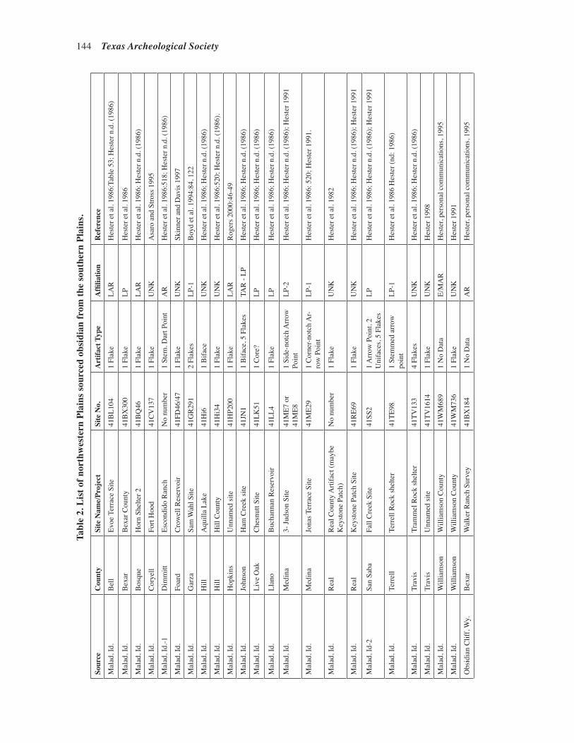
Lintz and Prikryl—A Steatite Vessel Fragment from 41SS178, San Saba County, Texas 145144 Texas Archeological Society
Sour
ceC
ount
ySi
te N
ame/
Proj
ect
Site
No.
Art
ifact
Typ
eA
ffilia
tion
Ref
eren
ce
Mal
ad, I
d.B
ell
Evoe
Ter
race
Site
41B
L104
1 Fl
ake
LAR
Hes
ter e
t al.
1986
:Tab
le 5
3; H
este
r n.d
. (19
86)
Mal
ad, I
d.B
exar
Bex
ar C
ount
y41
BX
300
1 Fl
ake
LPH
este
r et a
l. 19
86
Mal
ad, I
d.B
osqu
eH
orn
Shel
ter 2
41B
Q46
1 Fl
ake
LAR
Hes
ter e
t al.
1986
; Hes
ter n
.d. (
1986
)
Mal
ad, I
d.C
orye
ll Fo
rt H
ood
41C
V13
71
Flak
eU
NK
Asa
ro a
nd S
tross
199
5
Mal
ad, I
d.-1
Dim
mitt
Esco
ndid
o R
anch
No
num
ber
1 St
em. D
art P
oint
A
RH
este
r et a
l. 19
86:5
18; H
este
r n.d
. (19
86)
Mal
ad, I
d.Fo
ard
Cro
wel
l Res
ervo
ir41
FD46
/47
1 Fl
ake
UN
KSk
inne
r and
Dav
is 1
997
Mal
ad, I
d.G
arza
Sam
Wah
l Site
41G
R29
12
Flak
esLP
-1B
oyd
et a
l. 19
94:8
4, 1
22
Mal
ad, I
d.H
illA
quill
a La
ke41
Hi6
1
Bifa
ceU
NK
Hes
ter e
t al.
1986
; Hes
ter n
.d. (
1986
)
Mal
ad, I
d.H
illH
ill C
ount
y41
Hi3
41
Flak
eU
NK
Hes
ter e
t al.
1986
:520
; Hes
ter n
.d. (
1986
).
Mal
ad, I
d.H
opki
nsU
nnam
ed si
te41
HP2
001
Flak
eLA
RR
oger
s 200
0:46
-49
Mal
ad, I
d.Jo
hnso
nH
am C
reek
site
41JN
11
Bifa
ce, 5
Fla
kes
TAR
- LP
H
este
r et a
l. 19
86; H
este
r n.d
. (19
86)
Mal
ad, I
d.Li
ve O
akC
hesn
utt S
ite41
LK51
1 C
ore?
LPH
este
r et a
l. 19
86; H
este
r n.d
. (19
86)
Mal
ad, I
d.Ll
ano
Buc
hann
an R
eser
voir
41LL
41
Flak
eLP
Hes
ter e
t al.
1986
; Hes
ter n
.d. (
1986
)
Mal
ad, I
d.M
edin
a3-
Juds
on S
ite41
ME7
or
41M
E81
Side
-not
ch A
rrow
Po
int
LP-2
Hes
ter e
t al.
1986
; Hes
ter n
.d. (
1986
); H
este
r 199
1
Mal
ad, I
d.M
edin
aJo
nas T
erra
ce S
ite41
ME2
91
Cor
ner-n
otch
Ar-
row
Poi
ntLP
-1H
este
r et a
l. 19
86: 5
20; H
este
r 199
1.
Mal
ad, I
d.R
eal
Rea
l Cou
nty
Arti
fact
(may
be
Key
ston
e Pa
tch)
No
num
ber
1 Fl
ake
UN
KH
este
r et a
l. 19
82
Mal
ad, I
d.R
eal
Key
ston
e Pa
tch
Site
41R
E69
1 Fl
ake
UN
KH
este
r et a
l. 19
86; H
este
r n.d
. (19
86);
Hes
ter 1
991
Mal
ad, I
d-2
San
Saba
Fall
Cre
ek S
ite41
SS2
1 A
rrow
Poi
nt, 2
U
nifa
ces,
5 Fl
akes
LPH
este
r et a
l. 19
86; H
este
r n.d
. (19
86);
Hes
ter 1
991
Mal
ad, I
d.Te
rrel
lTe
rrel
l Roc
k sh
elte
r41
TE98
1 St
emm
ed a
rrow
po
int
LP-1
Hes
ter e
t al.
1986
Hes
ter (
nd: 1
986)
Mal
ad, I
d.Tr
avis
Tram
mel
Roc
k sh
elte
r41
TV13
34
Flak
esU
NK
Hes
ter e
t al.
1986
; Hes
ter n
.d. (
1986
)
Mal
ad, I
d.Tr
avis
Unn
amed
site
41TV
1614
1 Fl
ake
UN
KH
este
r 199
8
Mal
ad, I
d.W
illia
mso
nW
illia
mso
n C
ount
y41
WM
689
1 N
o D
ata
E/M
AR
Hes
ter,
pers
onal
com
mun
icat
ions
, 199
5
Mal
ad, I
d.W
illia
mso
nW
illia
mso
n C
ount
y41
WM
736
1 Fl
ake
UN
KH
este
r 199
1
Obs
idia
n C
liff,
Wy.
Bex
arW
alke
r Ran
ch S
urve
y41
BX
184
1 N
o D
ata
AR
Hes
ter,
pers
onal
com
mun
icat
ions
, 199
5
Tabl
e 2.
Lis
t of n
orth
wes
tern
Pla
ins s
ourc
ed o
bsid
ian
from
the
sout
hern
Pla
ins.
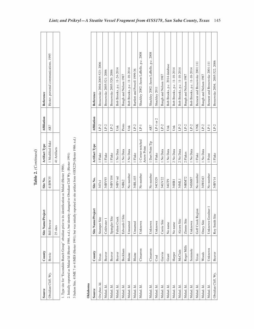
Lintz and Prikryl—A Steatite Vessel Fragment from 41SS178, San Saba County, Texas 145
Sour
ceC
ount
ySi
te N
ame/
Proj
ect
Site
No.
Art
ifact
Typ
eA
ffilia
tion
Ref
eren
ce
Obs
idia
n C
liff,
Wy.
Bow
ieB
ill B
rew
er41
BW
351
Mod
ified
flak
eA
R?
Hes
ter,
pers
onal
com
mun
icat
ions
, 199
5
25 si
tes
41 A
rtifa
cts
1. T
ype
site
for “
Esco
ndid
o R
anch
Gro
up”
obsi
dian
prio
r to
its id
entifi
catio
n as
Mal
ad (H
este
r 198
6).
2. In
itial
ly re
porte
d as
Mal
ad Id
(Hes
ter 1
986,
n.d
.), b
ut id
entit
y ch
ange
d to
Obs
idia
n C
liff W
y. (H
este
r 199
1)
3 Ju
dson
Site
, 41M
E 7
or 4
1ME8
(Hes
ter 1
991)
; but
was
initi
ally
repo
rted
as si
te a
rtifa
ct fr
om 4
1BX
229
(Hes
ter 1
986,
n.d
.)
Okl
ahom
a
Sour
ceC
ount
ySi
te N
ame/
Proj
ect
Site
No.
Art
ifact
Typ
eA
ffilia
tion
Ref
eren
ce
Ow
yhee
, Id.
Texa
s St
ampe
r Site
34Tx
11
Flak
eLP
-2B
roso
wsk
e 20
04;2
005:
523;
200
6
Mal
ad, I
d.B
eave
rC
oldw
ater
134
BV
931
Flak
eLP
-2B
roso
wsk
e 20
05:5
21; 2
006
Mal
ad, I
d.B
eave
rSp
angl
er S
ite34
BV
104
1 Fl
ake
LP-2
Bro
sow
ske
2005
:520
; 200
6
Mal
ad, I
d.B
eave
rFu
lton
Cre
ek34
BV-
nd1
No
Dat
aU
nk
Bob
Bro
oks,
p.c.
11-
24-2
014
Mal
ad, I
d.B
eckh
amEd
war
ds I
Site
34B
k21
No
Dat
aPr
oto
Bau
gh a
nd N
elso
n 19
87
Mal
ad, I
d.B
lain
eU
nnam
edN
o nu
mbe
r3
No
Dat
aU
nkB
ob B
rook
s, p.
c. 1
1-18
-201
4
Mal
ad, I
d.B
lain
eU
nnam
ed34
BL1
031
Flak
eLP
-2B
artle
tt an
d Po
wel
l 199
9:36
Mal
ad, I
d.C
imar
ron
Unk
now
nN
o nu
mbe
r1
Cor
ner-n
otch
ed
A
rrow
Poi
ntLP
-1Sh
ackl
ey 2
002;
Jaso
n La
Bel
le, p
.c. 2
008
Mal
ad, I
d.C
imar
ron
Unk
now
nN
o nu
mbe
r1
Dar
t Poi
nt T
ipA
R?
Shac
kley
200
2; Ja
son
LaB
elle
, p.c
. 200
8
Mal
ad, I
d.C
oal
Unk
now
n34
CO
291
Flak
eLP
-1 o
r 2Sh
ackl
ey 2
011
Mal
ad, I
d.G
arvi
nC
urrie
Site
34G
V22
1 N
o D
ata
LP-2
Bau
gh a
nd N
elso
n 19
87
Mal
ad, I
d.G
rant
No
nam
e34
GT9
1 N
o D
ata
Unk
Bob
Bro
oks,
p.c.
201
4 da
taba
se
Mal
ad, I
d.H
arpe
rN
o na
me
34H
R1
2 N
o D
ata
Unk
Bob
Bro
oks,
p.c.
11-
18-2
014
Mal
ad, I
d.M
cCla
inA
lcor
n Si
te34
ML1
2 N
o D
ata
LP-2
Bob
Bro
oks,
p.c.
11-
18-2
014
Mal
ad, I
d.R
oger
Mill
sZi
mm
s Site
34
RM
722
Flak
esLP
-2B
augh
and
Nel
son
1987
Mal
ad, I
d.Se
min
ole
Unk
now
n34
SM87
1 N
o D
ata
LP-2
Bob
Bro
oks,
p.c.
11-
18-2
014
Mal
ad, I
d.Te
xas
Gof
f Cre
ek R
egio
nN
o nu
mbe
r1
Flak
eU
NK
Bem
ent a
nd B
roso
wsk
e 20
01:1
11
Mal
ad, I
d.W
oods
Om
ey S
ite34
WO
431
No
Dat
aLP
-2B
augh
and
Nel
son
1987
Mal
ad, I
d.U
nkno
wn
Unk
now
n G
oodn
er 1
No
num
ber
1 Po
int
LP-1
Bem
ent a
nd B
roso
wsk
e 20
01:1
11
Obs
idia
n C
liff,
Wy.
Bea
ver
Roy
Sm
ith S
ite34
BV
141
Flak
eLP
-2B
roso
wsk
e 20
04,
2005
:522
, 200
6
Tabl
e 2.
(Con
tinue
d)

Lintz and Prikryl—A Steatite Vessel Fragment from 41SS178, San Saba County, Texas 147146 Texas Archeological Society
Sour
ceC
ount
ySi
te N
ame/
Proj
ect
Site
No.
Art
ifact
Typ
eA
ffilia
tion
Ref
eren
ce
Obs
idia
n C
liff,
Wy.
Bea
ver
Unn
amed
34B
V17
13
Poin
ts, 3
Bifa
ces
LAR
Bem
ent a
nd B
roso
wsk
e 20
01:1
11
Obs
idia
n C
liff,
Wy.
Cim
arro
n U
nkno
wn
No
num
ber
1 Sc
rape
rU
NK
Shac
kley
200
2; Ja
son
LaB
elle
, p.c
. 200
8
Obs
idia
n C
liff,
Wy.
Gra
ntN
o na
me
34G
T47
1 Fl
ake
LP-2
Bob
Bro
oks,
p.c.
11-
18-2
014
Obs
idia
n C
liff,
Wy.
Kay
Ham
mon
s34
KA
201
Flak
eLP
-1B
ob B
rook
s p.c
. 201
4 da
taba
se
Obs
idia
n C
liff,
Wy.
Kay
Hud
sonp
illar
34K
A73
2 Fl
akes
LP-1
Bob
Bro
oks p
.c. 2
014
data
base
Obs
idia
n C
liff,
Wy.
May
esPo
hly
Shel
ter
34M
Y54
1 Fl
ake
LP-1
Grif
fin e
t al.
1969
Obs
idia
n C
liff,
Wy.
Now
ata
Law
renc
e34
NW
61
Flak
eLP
-2B
ob B
rook
s p.c
. 201
4 da
taba
se
Teto
n Pa
ss/
Fish
Cre
ek, W
y.B
eave
rO
dess
a Yat
es34
Bv1
001
Flak
eLP
-2B
roso
wsk
e 20
05:5
20; 2
006
Wrig
ht C
reek
Wy.
Was
hita
Flam
ing
Site
34W
A1
1 Sc
otts
bluf
f Poi
ntPa
leo
Hof
man
and
Bla
ckm
ar 2
012
29 si
tes
40 A
rtifa
cts
Kan
sas
Sour
ceC
ount
ySi
te N
ame/
Proj
ect
Site
No.
Arti
fact
Typ
eA
ffilia
tion
Ref
eren
ce
Mal
ad, I
d.C
lay
Schw
ab H
ill S
ite14
CY
415
1 B
iface
, 1 F
lake
LP1
Loga
n 20
09
Mal
ad, I
d.Je
wel
lW
hite
Roc
k Si
te14
JW1
1 Fl
ake
LP1
Loga
n 20
10; H
ughe
s 200
9
Mal
ad, I
d.Je
wel
lW
arne
Site
(N
W ri
dge
lobe
)14
JW24
7 Fl
akes
LP-1
Lo
gan
and
Ban
ks 1
993;
Log
an e
t al.
2001
; Hoa
rd e
t al
. 200
8
Mal
ad, I
d.Le
aven
wor
thEv
ans S
ite14
LV10
791
Flak
eLA
R to
LP
Loga
n 20
04b:
37; H
oard
et a
l. 20
08
Mal
ad, I
d.M
ontg
omer
y In
finity
Site
14M
Y30
52
Flak
esLP
Haw
ley
and
Hug
hes 1
999;
Hoa
rd e
t al.
2008
Mal
ad, I
d.O
sage
Unn
amed
14O
S365
1 N
o D
ata,
1 F
lake
LP-2
Sh
ackl
ey 2
005a
; Hoa
rd e
t al.
2008
Mal
ad, I
d.O
ttaw
a M
inne
apol
is
14O
T51
No
Dat
aLP
-2
Shac
kley
200
5b; H
oard
et a
l. 20
08
Mal
ad, I
d.Pa
wne
eN
o na
me
14PA
357
1 Fl
ake
LP-1
Hoa
rd e
t al.
2008
Mal
ad, I
d.R
ice
No
nam
e14
RC
301
1 N
o D
ata
Prot
o Sh
ackl
ey 2
005b
; Hoa
rd e
t al.
2008
Mal
ad, I
d.R
iley
No
nam
e14
RY60
31
Flak
eLP
-1R
oper
200
0; H
oard
et a
l. 20
08
Mal
ad, I
d.Sa
line
No
Nam
e14
SA44
71
Flak
eA
RR
oper
200
6; H
oard
et a
l. 20
08.
Mal
ad, I
d.Sh
erid
anA
lber
t Bel
l Site
14SD
305
3 Fl
akes
LP-2
Rop
er 2
003;
Hoa
rd e
t al.
2008
Obs
idia
n C
liff,
Wy.
Jew
ell
No
nam
e14
JW6
2 N
o D
ata
LP-2
Ritt
erbu
sh a
nd L
ogan
200
6:56
-57;
Hoa
rd e
t al.
2008
Obs
idia
n C
liff,
Wy.
Jew
ell
Mon
tana
Cre
ek E
ast
14JW
466
Flak
esLP
-2R
itter
bush
and
Log
an 2
006:
56-5
7; L
ogan
200
4a;
Hoa
rd e
t al.
2008
Tabl
e 2.
(Con
tinue
d)

Lintz and Prikryl—A Steatite Vessel Fragment from 41SS178, San Saba County, Texas 147
Sour
ceC
ount
ySi
te N
ame/
Proj
ect
Site
No.
Art
ifact
Typ
eA
ffilia
tion
Ref
eren
ce
Obs
idia
n C
liff,
Wy.
Prat
tN
o N
ame
14PT
506-
WSU
1 D
ebita
geLP
-2
Shac
kley
200
9; H
oard
et a
l. 20
08
Obs
idia
n C
liff,
Wy.
Rile
yU
nkno
wn
nam
e14
RY60
11
Flak
eLP
-1R
oper
200
0; H
oard
et a
l. 20
08
Obs
idia
n C
liff,
Wy.
Wya
ndot
teTr
owbr
idge
Site
14W
Y1
1 Fl
ake
LAR
-LP-
1H
ughe
s 199
5; R
oper
200
0; H
oard
et a
l. 20
08
17 si
tes
34 A
rtifa
cts
Cul
tura
l Affi
liatio
n
Pale
o=Pa
leoI
ndia
n (p
re-6
,000
B.C
.)Pr
oto=
Prot
ohis
toric
(Lat
e C
eram
ic P
erio
d A
.D. 1
500-
1700
)
AR
=A
rcha
ic (P
re- A
.D./B
.C.)
His
t=H
isto
ric (A
.D. 1
700-
pres
ent)
E/M
AR
=Ea
rly o
r Mid
dle A
rcha
ic (6
000
- 150
0 B
.C.)
Unk
= U
nkno
wn
affil
iatio
n
L A
R=
Late
Arc
haic
(150
0 B
.C .-
A.D
./B.C
.)
T A
R=
Tran
sitio
nal A
rcha
ic (E
arly
Woo
dlan
d in
Eas
tern
Kan
sas B
.C./A
.D. -
A
.D. 5
00)
LP=
Late
Pre
hist
oric
gen
eral
(A.D
. 500
- 15
00)
LP-1
=La
te P
rehi
stor
ic 1
(Ear
ly C
eram
ic, W
oodl
and
Perio
d A
.D. 5
00 -
1000
)
LP-2
=La
te P
rehi
stor
ic 2
(Mid
dle
Cer
amic
, Pla
ins V
illag
e Pe
riod
A.D
. 100
0 - 1
500)
Tabl
e 2.
(Con
tinue
d)

Lintz and Prikryl—A Steatite Vessel Fragment from 41SS178, San Saba County, Texas 149148 Texas Archeological Society
Figure 7. Locations of steatite and obsidian quarries in the northwestern plains.
is a Scottsbluff point attributed to the Late Paleo-indian period. Two other projectile points are suf-ficiently large to be classified as dart points, prob-ably Archaic in age, and one of these is a stemmed or corner-notched form, which could reflect a Late Archaic period form. The other five specimens are small arrow points. Three are corner-notched forms, one is a side-notched form, and the other is unspecified. The direct evidence based on point morphology suggests that obsidian from north-western Plains sources was moving to the southern Plains since late Paleoindian times (ca. 8450 to 8850 years ago); however, most projectile point forms probably date to the Late Archaic through Late Prehistoric II periods (ca. 2500 to 500 years
ago). The high incidence of corner-notched arrow points may reflect the most intense interaction period between ca. 1000 and 2000 years ago.
This temporal range of interac-tion based on only a dozen artifacts is mirrored by the cultural affilia-tions ascribed to sites containing the obsidian artifacts (Table 3). Solitary northwestern Plains obsidian artifacts have been reported from single sites assigned to the Late Paleoindian and the Early/Middle Archaic periods. Five obsidian artifacts are from gen-eralized Archaic period sites which provide little indication of which millennia are represented. However, based on assigned site affiliations, more regular contacts between the northwestern and southern Plains be-gan in the Late or Transitional Archaic and intensified throughout the Late Prehistoric I (Woodland) and II (Vil-lage) periods. This pattern is indicated by 17 obsidian artifacts (14.8 percemt) attributed to Late Archaic/Transitional to Late Prehistoric period sites, the 14 artifacts (12.2 period) from general Late Prehistoric period sites artifacts, the 23 artifacts (20.0 percent) from the Late Prehistoric I/early ceramic period, and the 31 artifacts (27.0 percent) from the Late Prehistoric II/middle ceramic/Plains Village period (Table 3). After the Late Prehistoric period, the frequency of northwestern Plains artifacts on the southern Plains
drops off significantly. Only two obsidian artifacts are from Protohistoric/late ceramic period sites, and none are from Historic period aboriginal sites.
The 115 artifacts from northwestern Plains obsidian sources are from 50 of 436 counties (11.6 percent) over the three state region. In Kansas, these include 34 artifacts from 17 sites recovered from 13 counties. Oklahoma reports 40 artifacts from 29 sites spread across 17 counties, and Texas has 41 artifacts from 25 sites in 20 counties.
Sixteen sites have multiple obsidian artifacts attributed to northwestern Plains sources (see Table 2). Twelve of the 50 counties contain multiple sites with obsidian artifacts from the northwestern Plains. Half of these counties have multiple sites
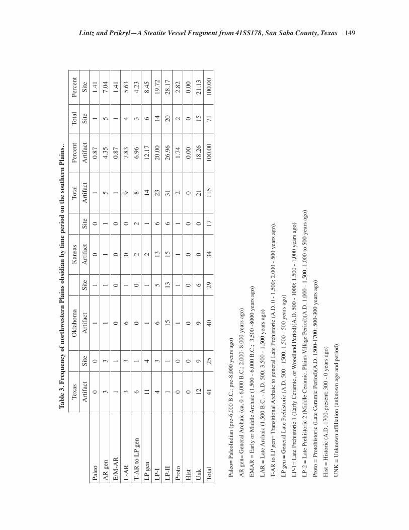
Lintz and Prikryl—A Steatite Vessel Fragment from 41SS178, San Saba County, Texas 149
Tabl
e 3.
Fre
quen
cy o
f nor
thw
este
rn P
lain
s obs
idia
n by
tim
e pe
riod
on
the
sout
hern
Pla
ins..
Texa
s
Okl
ahom
a
Kan
sas
To
tal
Perc
ent
Tota
l Pe
rcen
tA
rtifa
ctSi
teA
rtifa
ctSi
teA
rtifa
ctSi
teA
rtifa
ctA
rtifa
ctSi
teSi
tePa
leo
00
11
00
10.
871
1.41
AR
gen
33
11
11
54.
355
7.04
E/M
-AR
11
00
00
10.
871
1.41
L-A
R3
36
10
09
7.83
45.
63T-
AR
to L
P ge
n6
10
02
28
6.96
34.
23LP
gen
114
11
21
1412
.17
68.
45LP
-I4
36
513
623
20.0
014
19.7
2LP
-II
11
1513
156
3126
.96
2028
.17
Prot
o0
01
11
12
1.74
22.
82H
ist
00
00
00
00.
000
0.00
Unk
129
96
00
2118
.26
1521
.13
Tota
l41
2540
2934
1711
510
0.00
7110
0.00
Pale
o= P
aleo
Indi
an (p
re-6
,000
B.C
.; pr
e-8,
000
year
s ago
)
AR
gen
= G
ener
al A
rcha
ic (c
a. 0
- 6,
000
B.C
.; 2,
000-
8,0
00 y
ears
ago
)
EMA
R =
Ear
ly o
r Mid
dle A
rcha
ic (1
,500
- 6,
000
B.C
.; 3
,500
-800
0 ye
ars a
go)
LAR
= L
ate A
rcha
ic (1
,500
B.C
. - A
.D. 5
00; 3
,500
- 1,
500
year
s ago
)
T-A
R to
LP
gen=
Tra
nsiti
onal
Arc
haic
to g
ener
al L
ate
Preh
isto
ric (A
.D. 0
- 1,
500;
2,0
00 -
500
year
s ago
).
LP g
en =
Gen
eral
Lat
e Pr
ehis
toric
(A.D
. 500
- 15
00; 1
,500
- 50
0 ye
ars a
go)
LP-1
= La
te P
rehi
stor
ic 1
(Ear
ly C
eram
ic, o
r Woo
dlan
d Pe
riod)
(A.D
. 500
- 10
00; 1
,500
- 1,
000
year
s ago
)
LP-2
= L
ate
Preh
isto
ric 2
(Mid
dle
Cer
amic
, Pla
ins V
illag
e Pe
riod)
(A.D
. 1,0
00 -
1,50
0; 1
,000
to 5
00 y
ears
ago
)
Prot
o =
Prot
ohis
toric
(Lat
e C
eram
ic P
erio
d)(A
.D. 1
500-
1700
; 500
-300
yea
rs a
go)
His
t = H
isto
ric (A
.D. 1
700-
pres
ent;
300
- 0 y
ears
ago
)
UN
K =
Unk
now
n af
filia
tion
(unk
now
n ag
e an
d pe
riod)

Lintz and Prikryl—A Steatite Vessel Fragment from 41SS178, San Saba County, Texas 151150 Texas Archeological Society
with northwestern Plains obsidian from a single source, and the other six have sites with multiple northwestern Plains obsidian sources. Not a single one of the 12 counties with multiple sites have ar-tifacts from different northwestern Plains sources, even though some, such as Odessa Yates in Okla-homa, have artifacts from New Mexican or other Southwestern obsidian sources (Brosowske 2004, 2005, 2006). This lack of multi-sourced north-western obsidian found at single sites suggests that the obsidian moved as single-source package units, rather than from the amassing of samples from northwestern Plains sources before being transported to the southern Plains, or the meeting of various northwestern Plains groups with access to different obsidian sources in rendezvous places on the southern Plains.
Figure 8 compares the density distribution of all obsidian in the current data compilation relative
to the frequency and percent per county of the combined northwestern Plains obsidian across Kansas, Oklahoma, and Texas. A comparison of the distribution of the entire obsidian database against either of the two maps showing the northwestern Plains obsidian frequency and percent shows that the southern high plains of Texas has been well sampled for sourced obsidian. Yet, except for the Oklahoma panhandle region, the northwestern Plains obsidian rarely occurs on the short grass plains of western Kansas or Texas. The paucity of obsidian in the western counties may suggest that northwestern Plains obsidian found in Central and South Texas sites does not reflect the kinds of material density drop-off that might be from down-the-line economic models of obsidian traded from one group to the next. Instead, the frequency distribution south of Kansas shows the northwestern Plains obsidian to be concentrated along the counties of the Oklahoma
Figure 8. Distribution of obsidian specimens in the current database, frequency and percent of northwestern Plains obsidian in the southern Plains.

Lintz and Prikryl—A Steatite Vessel Fragment from 41SS178, San Saba County, Texas 151
panhandle and along the Balcones Escarpment/Central Texas Hill country.
In Kansas and Oklahoma, the northwestern obsidian artifacts are scattered in counties with low frequencies across the tall grass prairies and woodlands of central and eastern Kansas and Oklahoma (see Figure 8). However, when the percentage of northwestern Plains obsidian per county is considered, the highest percentage of northwestern Plains obsidian in Kansas and Okla-homa is perhaps surprisingly located in the eastern and northeastern counties within these states, rather than in the northwestern counties closest to the obsidian outcrop sources. Indeed the counties in western Oklahoma and Kansas have low to moder-ate percentages of northwestern Plains obsidians, which reflect the occurrences of moderate amounts of obsidian from New Mexican and other South-western sources. In light of the periods of obsidian
occurrences on the southern Plains, it has been suggested that the low frequency/high percentage occurrence in the northeastern parts of Kansas perhaps reflects the southwestern spread of these exotic kinds of obsidian from the Hopewellian and Oneota interaction sphere(s) of Ohio, Illinois, and Iowa (Griffin et al. 1969; Hatch et al. 1990; Hughes 1992, 1995; Roper 2000). However, due to the paucity and distribution of counties in Texas with high percentages of northwestern Plains obsidian, a different source route may be operating in Texas.
When the distributions of the obsidian from each northwestern source area are plotted, other patterns emerge (Figure 9). As previously dis-cussed, Malad and Obsidian Cliffs obsidians domi-nate the distribution of northwestern Plains types across the southern Plains. Malad is abundantly represented across all three states, especially in Central Texas, the Oklahoma panhandle, and west
Figure 9. Distribution of Malad, Obsidian Cliff, and minor other obsidian sources in the southern Plains.

Lintz and Prikryl—A Steatite Vessel Fragment from 41SS178, San Saba County, Texas 153152 Texas Archeological Society
central Oklahoma proper and across central and northeastern Kansas. In contrast, Obsidian Cliffs obsidian occurs across the northern tiers of coun-ties in the Oklahoma panhandle and Oklahoma proper, and in a few counties in Kansas; it is very rarely present in Texas.
The most insightful information pertains to the distribution of minor obsidian sources, where Owyhee and Teton Pass/Fish Creek obsidian oc-curs in the Oklahoma panhandle, and the Wright Creek obsidian occurs in western Oklahoma. The absence of these minor source obsidians in north-eastern Kansas and Oklahoma where low frequen-cies, but high percentages, of northwestern Plains obsidians occur suggest that they are not linked to Malad or Obsidian Cliff obsidian movements from Idaho and northwestern Wyoming into the Missouri and Mississippi river valleys.Their presence in the Oklahoma panhandle and western Oklahoma is derived from routes and movement mechanisms other than the spread of materi-als along the Hopewellian/Oneota interaction sphere(s). The high incidence of obsidian across the Oklahoma panhandle and across northern Oklahoma may reflect routes southward along the Trapper’s/Cherokee Trial along the eastern side of the Rocky Mountains and then eastwards along the Picuris/Taos/Osage trail across the Great Salt Plain in northwestern Oklahoma (Ferring et al. 1976:36-45; Foreman 1925; Lecompte 1986:67; McDermott 1940:250, 272).
The correlation of Malad obsidian artifacts with 10 Central Texas counties along the Balcones Escarpment has long been recognized (Hester et al. 1986; Kibler 2005). But the significance of these patterns remains uncertain. Undeniably, the Bal-cones Escarpment is a region with an abundance of springs and a tremendous habitat diversity that is unique for conditions on the Plains (Kay 1998). The paucity of northwestern Plains obsidian south-east of the Balcones Escarpment might reflect the extent of northwestern prehistoric Plains people drawn to this moderately unique habitat within the Plains region. Alternatively, the obsidian occur-rence in Central Texas may reflect the movement of small parties of nomadic people northwestward towards the unique resources of the Yellowstone region. Further examination of northwestern Plains lithic assemblages for Edwards Plateau or Alibates chert debris, or studies of Central Texas lithic as-semblages for Harteville Uplift, Spanish Diggings, or Flat-Top cherts documentation may help resolve
the movements of northwestern Plains obsidian to the Texas region.
SUMMARY AND CONCLUSIONS
This article documents the presence of a steatite bowl fragment from a Central Texas site that is attributed to sources from the northwestern Plains based on the absence of a local steatite bowl industry, and similarities in vessel age and form be-tween the Texas specimen and steatite vessels made elsewhere in the coterminous North America. The current inability to geochemically source steatite using REE or metals renders as tentative positive source identification of the steatite. However, the suggestion of a northwestern Plains connection with Texas based on the San Saba steatite bowl sherd is strengthened by examining the occur-rence of northwestern Plains obsidian across the southern Plains. The most intense period of obsid-ian movement into Kansas, Oklahoma, and Texas occurred during the Late Prehistoric Period I/II (ca. 500-1500 years B.P.) when an estimated 59.1 percent of northwestern Plains obsidians attributed to a period are recovered. The Late Prehistoric context of the San Saba steatite vessel fragment is also supported by the presence of eight artifacts of Malad, Idaho, obsidian recovered from the Fall Creek site (41SS1) located less than 100 river km (ca 40 straight-line km) from 41SS178 and within the same county (Hester et al. 1986; Hester 1991).
Our contention is that the projected diameter of the San Saba bowl makes this artifact substan-tially larger than other steatite objects from Texas, and similarities in vessel rim form and Late Pre-historic temporal context all point to a northwest-ern Plains source of manufacture for the vessel. The northwestern-southern Plains connection is strengthened by the occurrence of obsidian from the same region as the steatite bowl quarries in the northwestern Plains. Unworked nodules and small artifacts of steatite have been rarely reported from sites in Texas and adjacent areas of the southern Plains (cf. Pillaert 1963). But most, if not all, may be from steatite sources other than from the north-western Plains.
The distribution of northwestern Plains obsid-ian across Kansas, Oklahoma, and Texas supports the absence of neighbor-to-neighbor or down-the-line exchange from the northwestern Plains sources. Instead, the distribution suggests obsidian

Lintz and Prikryl—A Steatite Vessel Fragment from 41SS178, San Saba County, Texas 153
movements along two routes. One involves the connections of obsidian between the northwestern Plains and the upper Missouri River valley with a secondary spread along the Hopewellian and later Oneota interaction spheres toward the southwest into northeastern Kansas and Oklahoma. The second route involves the possible movement of obsidian south along the eastern side of the Rocky Mountains front range along the Taos/Trapper’s/Cherokee trail and then eastward across the Okla-homa panhandle towards the Great Salt Plains resources, and perhaps spreading southeastward across Texas. This latter route passes close to the Teton, Gros Ventre, and Wind River, Wyoming, mountain ranges containing steatite outcrop quar-ries used by Late Prehistoric and Historic period people for making stone vessels. Although the mechanism of steatite and obsidian movements has yet to be discerned, further efforts to identify minor “unknown chert” debris in Late Prehistoric assemblages may provide the insights needed to refine the connections between these two areas.
ACKNOWLEDGEMENTS
We would like to thank Dr. Kenneth Sassa-man (University of Florida), Dr. Michael Glascock (University of Missouri), and Rich Adams (Office of the State Archaeologist, Wyoming) for their guidance to sources on the steatite literature. The information provided by Dr. Jim Burton (Univer-sity of Wisconsin, Madison) was especially helpful in understanding the geochemical context of the Wyoming region as it relates to talc deposits across North America. Dr. Thomas Hester’s help is also appreciated for sharing some of his unpublished pioneering sourcing data from his Texas Obsid-ian Project database. Laura Nightingale provided access to the steatite vessel sample curated at the Texas Archeological Research Laboratory. Useful comments on this manuscript were provided by Dr. Tim Baugh and Doug Boyd. Helpful comments and encouragements were obtained from Mr. Nick Ma-calusco, and Drs. Robert Brooks, Scott Brosowske, Donna Roper, Robert Hoard, and Brad Logan, who assisted in up-dating the senior author’s obsidian database for the Plains areas north of Texas. Dr. Jason LaBelle also provided access to his unpub-lished obsidian sourcing data from the Uncle Bill Baker collection from sites in the western Okla-homa panhandle at the No Man’s Land Museum in
Goodwell, Oklahoma. The locations and correla-tions of obsidian source names used in this paper are derived from the Northwest Research Obsidian Studies Laboratory Source Catalog (http://www.sourcecatalog.com/).
REFERENCES CITED
Adams, R.2006 The Greater Yellowstone Ecosystem, Yellowstone
Bowls and the Mountain Shoshone. World Archaeol-ogy 38(3):528-546.
Allen, R. O., A. H. Luckenbach, and C. G. Holland 1975 The Application of Neutron Activation Analysis to
a Study of Prehistoric Steatite Artefacts and Source Materials. Archaeometry 17:69-83.
Allen, R. O., H. Hamroush, C. Nagle, and W. Fritzhugh1984 Use of Rare Earth Element Analysis to Study the
Utilization of Soapstone along the Labrador Coast. In Archaeological Chemistry III, edited by J. B. Lambert, pp. 3-18. Advances in Chemistry Services 205. American Chemical Society, Washington D.C.
Allen, R. O. and S. E. Pannell 1978 Rare Earth Element Distribution Patterns to Char-
acterize Soapstone Artifacts. In Archaeological Chemistry II, edited by G. F. Carter, pp. 230-257. Advances in Chemistry Services 171. American Chemical Society, Washington D.C.
Asaro, F. and F. Stross 1995 Appendix H: Obsidian X-Ray Fluorescence Data.
In NRHP Significance Testing of 57 Prehistorical Archaeological Sites on Fort Hood, Texas, Volume II, edited by J. T. Abbott and W. N. Trierweiler, pp. H1-H3. Archaeological Resource Management Series Research Report 34. U.S. Army, Fort Hood, Texas.
Barnes, V. E., D. A. Shock, and W. A. Cunningham1950 Utilization of Texas Serpentinite. Publication No.
5020. The University of Texas, Austin.
Bartlett, R., with contributions by V. Powell1999 Archaeological Investigations of Three sites in
Blaine County, Oklahoma: Prehistoric Occupations in the Western Cross Timbers 34BL102, 34BL103 and 34BL104. Report in Highway Archaeology No. 15. Oklahoma Department of Transportation Environmental Studies Branch, Planning Division, Oklahoma City.
Baugh, T. and F. Nelson, Jr.1987 New Mexico Obsidian Sources and Exchange on the
Southern Plains. Journal of Field Archaeology 14: 313-329.

Lintz and Prikryl—A Steatite Vessel Fragment from 41SS178, San Saba County, Texas 155154 Texas Archeological Society
Bement, L. and S. Brosowske2001 Appendix B: Results of Obsidian Source Prove-
nience Analysis. In Streams in No Man’s Land: A Cultural Resource Survey in Beaver and Texas Coun-ties, Oklahoma, by L. Bement and S. Brosowske, pp. 109-112. Archeological Resource Survey Report 43. Oklahoma Archeological Survey, Norman.
Beste, R. C.2005 A Location Guide for Rock Hounds in the United
States. Hobbit Press, St. Louis.
Bourbon, W. B.1982 The Origin of Talc in the Allamoore District, Texas.
In Industrial Rocks and Minerals of the Southwest, pp. 77-84. Circular No. 182. New Mexico Bureau of Mines and Mineral Resources, Socorro.
Boyd, D., J. Peck, S. Tomka, K. Kibler, and M. D. Freeman1994 Data Recovery at Lake Alan Henry (Justiceburg
Reservoir), Garza and Kent Counties: Phase III, Season 3. Reports of Investigations No. 93. Prewitt and Associates, Inc., Austin.
Brosowske, S.2004 Obsidian Procurement and Distribution during the
Middle Ceramic Period of the Southern High Plains: Evidence for the Emergence of Regional Trade Centers. Council of Texas Archeologists Newsletter 28(2):16-28.
2005 The Evolution of Exchange in Small Scale Societies of the Southern High Plains. Ph.D. Dissertation, De-partment of Anthropology, University of Oklahoma, Norman.
2006 Interpreting Distributional Patterns of Obsidian on the Southern Plains. Paper presented at the 64th An-nual Plains Anthropological Conference, Topeka, Kansas.
Brown, J. A.1976 Spiro 4 Studies: The Artifacts. Second Part of the
Third Annual Report of Caddoan Archaeology-Spiro Focus Research. The Stovall Museum of Science and History, the University of Oklahoma and the University of Oklahoma Research Institute, Norman.
Brown, K. M., D. R. Potter, G. D. Hall, and S. L. Black1982 Excavations at 41LK67, A Prehistoric Site in the
Choke Canyon Reservoir, South Texas. Choke Can-yon Series, Volume 7. Center for Archaeological Research, The University of Texas at San Antonio.
Bullen, R. P. and D. H. Howells 1943 Spectrographic Analysis of Some New England Ste-
atite. Bulletin of the Massachusetts Archaeological Society 4(4):62-64.
Chandler, C. K.1995 Stone Pipes from Bexar County, Texas. La Tierra
22(1):6-11.
Collins, M. B.1995 Forty Years of Archeology in Central Texas. Bulletin
of the Texas Archeological Society 66:361-400.
Custer, J.1989 Prehistoric Cultures of the Delmarva Peninsula:
An Archaeological Study. Associated University Presses, Cranbury New Jersey.
Dahm, I. R. 1994 Cultural and Social Dimensions of the Prehistoric
Gulf Coast Soapstone Industry. Master’s Thesis, De-partment of Anthropology, Simon Frazier University, British Columbia, Vancouver.
Dietrich, J. W. and J. T. Lonsdale1958 Mineral Resources of the Colorado River Industrial
Development Association Area. Report of Investiga-tions No. 37. Bureau of Economic Geology, Univer-sity of Texas, Austin.
Dumble, E. T.1889 Reports of Geologists from Southern Texas. Texas
Geological and Mineralogical Survey, First Report of Progress. Department of Agriculture, Insurance Statistics and History. State Printing Office, Austin.
Ferring, C. R., D. Crouch, and T. Spivey1976 An Archaeological Reconnaissance of the Salt Plains
of Northwestern Oklahoma. Contributions Number 4. Museum of the Great Plains, Lawton.
Frey, F.1984 Rare Earth Element Abundances in Upper Mantle
Rocks. In Rare Earth Element Geochemistry, edited by P. Henderson, pp. 153-204. Developments in Geochemistry 2. Elsevier, Amsterdam.
Field, A.1956 Archeological Investigations in Lampasas, Burnett,
Llano and San Saba Counties, Texas. Bulletin of the Texas Archeological Society 27:161-184.
Fitzhugh W. H. and A. Crowell 1988 Crossroads of Continents: Cultures of Siberia and
Alaska. Smithsonian Institution Press, Washington D.C.
Frison, G.1982 Sources of Steatite and Methods of Prehistoric Pro-
curement and Use in Wyoming. Plains Anthropolo-gist 27(98):273-286.
Foreman, G.1925 Early Trails through Oklahoma. Chronicles of Okla-
homa 3(2):99-119.
Gagliano, S. M. and C. H. Webb1970 Archaic-Poverty-Point Transition at the Pearl River
Mouth. Southeastern Archaeological Conference Bulletin 12:47-72.

Lintz and Prikryl—A Steatite Vessel Fragment from 41SS178, San Saba County, Texas 155
Gibson, J.1996 Poverty Point: A Terminal Archaic Culture of the
Lower Mississippi Valley. http://www.crt.state.la.us/archaeology/virtualbooks/poverpoi/popo.htm.
2001 The Ancient Mounds of Poverty Point: Place of Rings. University of Florida Press, Gainesville.
Greene, R. C.1995 Talc Resources of the Coterminous United States (Pre-
liminary manuscript report). U.S. Geological Survey, Open File Report OF 95-586 Menlo Park, California. http://pubs.usgs.gov/of/1995/0586/report.pdf.
Griffin, J. B. (editor)1952 Archaeology of Eastern United States. University of
Chicago Press, Chicago.
Griffin, J. B., A. Gordus, and G. Wright1969 Identification of the Sources of Hopewellian Ob-
sidian in the Middle West. American Antiquity 34(1):1-14.
Hatch, J.W., J. W. Michels, C. M. Stevenson, B. E. Scheetz, and R. A Geidel
1990 Hopewellian Obsidian Studies: Behavioral Impli-cations or Recent Sourcing and Dating Research. American Antiquity 55(3):461-479.
Hawley, M. F. and R. E. Hughes1999 A Source Study of Obsidian from the Infinity
Site (14MY305), Kansas. Plains Anthropologist 44(169):297-305.
Heizer, R. F. and A. E. Treganza 1944 Mines and Quarries of the Indians of California. Cal-
ifornia Journal of Mines and Geology 40:291-359.1972 Mines and Quarries of the Indians of California.
Ballena Press, Ramona, California.
Hester, T. R.1991 Notes on South Texas Archaeology: 1991-1. An
Overview of the Results of the Texas Obsidian Project. La Tierra 18(1):4-7.
1998 Notes on South Texas Archaeology 1998-1. From Dalton to Perdiz: A Tale of Urban Looting in Travis County, Texas. La Tierra 25(1):6-10.
n.d. Texas Obsidian Project. Manuscript developed ca. 1986, provided by the author.
Hester, T. R. (assembler)2013 Archeology at Eagle Bluff (41ME147) And Other
Studies: the Fall 2013 TAS Field School, Hondo. Texas Archeology (Newsletter of the Texas Archeo-logical Society) 57(4):12.
Hester, T., F. Asaro, and F. Stross 1982 Results of Some Recent Studies by the Texas Obsid-
ian Project. Journal of the Houston Archaeological Society 73:8-10.
Hester, T., F. Asaro, H. Michel, F. Stross, and F. Nelson Jr. 1986 Trace Element and Trace Element Sources Studies
on an Obsidian Artifact from Site 41LK51, Live Oak County, Texas. In The Prehistoric Sites at Choke Canyon Reservoir, South Texas: Results of Phase II Archaeological Investigations, edited by G. Hall, T. R. Hester, and S. L. Black, pp. 510-522. Choke Canyon Series Volume 10. Center for Archaeological Research, University of Texas at San Antonio.
Hixon, C., A., D. J. Prikryl, G. T. Goode, and A. F. Malof2011 Archaeological Test Excavations at 41SS178, LCRA
San Saba River Nature Park, San Saba County, Texas. Cultural Resource Report 15. Lower Colorado River Authority, Austin.
Hoard, R., C. T. Bevitt, and J. McLean2008 Source Determination of Obsidian from Kansas
Archaeological Sites Using Compositional Analy-sis. Transactions of the Kansas Academy of Science 111(3/4):219-229.
Hofman, J. and J. Blackmar2012 A Cody Complex site on the Southern Prairie Plains.
Plains Anthropologist 57(224):393-410
Holland, C. G., S. E. Pannell, and R. O. Allen 1981 Geographical Distribution of Soapstone Artifacts
from 21 Aboriginal Quarries in the Eastern US. Quarterly Bulletin of the Archaeological Society of Virginia 35:200-208.
Hughes, R.1992 Another Look at Hopewell Obsidian Studies. Ameri-
can Antiquity 57(3):515.1995 Source Identification of Obsidian from the Trow-
bridge Site (14WY1), A Hopewellian Site in Kansas. Midcontinental Journal of Archaeology 20(1):105-113.
2009 Appendix 2: Geochemical Analysis of an Obsidian Flake from Feature 1, White Rock Site. Letter Re-port 2009-52. Geochemical Research Laboratories, Portola Valley, California.
Ige, O. A. and S. Swanson2008 Provenience studies of Esie Sculptural Soapstone
from Southwestern Nigeria. Journal of Archaeologi-cal Science 35:1553-1565.
Jones, R. E., V. Kilikoglou, V. Olive, Y. Bassiakos, R. Ellam, I. S. J. Bray, and D. C. W. Sanderson
2007 A New Protocol for the Chemical Characterization of Steatite—Two Case Studies in Europe: The Shetland Islands and Crete. Journal of Archaeological Science 34:626-641.
Kay, M.1998 The Great Plains Setting. In Archaeology on the
Great Plains, edited by R. Wood, pp 16-47. Univer-sity Press of Kansas, Lawrence.

Lintz and Prikryl—A Steatite Vessel Fragment from 41SS178, San Saba County, Texas 157156 Texas Archeological Society
Kibler, K.2005 Broader Continental Connections through the Gulf
Coastal Plain of Texas. In Gulf Coast Archaeology: The Southeastern United States and Mexico, edited by N. M. White, pp. 197-204. University Press of Florida, Gainesville.
King, P. B. 1965 Geology of the Sierra Diablo Region, Texas. Profes-
sional Paper 480. U.S. Geological Survey, Washing-ton, D.C.
King, P. B. and P. T. Flawn1953 Geology and Mineral Deposits of Precambrian
Rocks of the Van Horn Area, Texas. Publication 5301. University of Texas, Bureau of Economic Geology, Austin.
Lecompte, J.1986 Trails. In A Literature Review and Limited Archaeo-
logical Reconnaissance of Cultural Resources on the Banning Lewis Project Area, El Paso County, Colorado, by J. Anderson, J. Lecompte, and C. Lintz, pp. 67-69. Pioneer Archaeological Consultants, Inc. Longmont.
Logan, B.2004a Lovewell Renaissance: Archaeological Investiga-
tions at Lovewell Reservoir, Jewell County, Kan-sas—2004. Current Archaeology in Kansas 5:53-66.
2004b Archaeological Investigations at the Evans Locality Stranger Creek Valley, NE Kansas (2003). Report Submitted to Historic Preservation Office in fulfill-ment of KSHS Grant 20-03-18216-005. Department of Sociology, Anthropology and Social Work, Kan-sas State University, Manhattan.
2009 The Riley Rankin Collection: Artifacts from Prehis-toric Sites in Clay County, Kansas. Current Archae-ology in Kansas 8:59-65
2010 Archeological Investigations at the White Rock (14JW1) and Bergstron (14JW17) Sites, Lovewell Reservoir, Jewell County, Kansas. Department of Sociology, Anthropology and Social Work, Kansas State University, Manhattan,
Logan, B. and W. Banks1993 White Rock Revisited: Archaeological Investigations
of the White Rock and Warne Sites, Lovewell Reser-voir, Jewell County, Kansas. Project Report Series 85. University of Kansas, Lawrence.
Logan, B., R. Hughes, and D. Henning2001 Western Oneota Obsidian: Sources and Implications.
Plains Anthropologist 46(175):55-64.
Lowie, R.1924 Notes on Shoshonean Ethnography. Anthropological
Papers 20(3):185-314. American Museum of Natural History, New York.
Luckenbach, A. H., C. G. Holland, and R. O. Allen1975 Soapstone Artifact: Tracing Prehistoric Trade Pat-
terns in Virginia. Science 187:57-58.
McDermott, J. F.1940 Tixier’s Travels on the Osage Prairies. University of
Oklahoma Press, Norman.
Miller, M.1996 The Chronometric and Relative Chronology Project.
Section III: Obsidian Hydration Dating. Archaeolog-ical Technical Report No. 5. Anthropology Research Center and Department of Sociology and Anthropol-ogy, University of Texas at El Paso, El Paso.
Moffat, D. and S. J. Butler 1986 Rare Earth Element Distribution Patterns in Shetland
Steatite—Consequences for Artefact Provenancing Studies. Archaeometry 28(1):101-115.
Olds, D.1965 Report on Materials from Brawley’s Cave, Bosque
County, Texas. Bulletin of the Texas Archeological Society 36:111-152.
Prewitt, E.1981 Cultural Chronology in Central Texas. Bulletin of the
Texas Archeological Society 52:65-89.1985 From Circleville to Toyah: Comments on Central
Texas Chronology. Bulletin of the Texas Archeologi-cal Society 54:201-238.
Pillaert, E. E.1963 The McLemore Site of the Washita River Focus.
Bulletin of the Oklahoma Anthropological Society 11:1-114.
Radko, N. C.2011 Mineralogy and Mineral Chemistry of Southeastern
Piedmont Soapstones: Implications for Sourcing Prehistoric Soapstone Artifacts. Masters of Science Thesis, University of Georgia, Athens.
Ritterbush, L. W. and B. Logan2006 The Montana Creek Sites, Archeological Investiga-
tions at Lovewell Reservoir, Jewell County, Kansas 2004. Submitted to Nebraska-Kansas Area Office Great Plains Region, Bureau of Reclamation. De-partment of Sociology, Anthropology, and Social Work, Kansas State University, Manhattan.
Rogers, M., R. Allen, C. Nagle, and W. Fitzhugh1983 The Utilization of Rare Earth Elements Concentra-
tions for the Characterization of Soapstone Quarries. Archaeometry 25(2):186-195.
Rogers, R.2000 Excavations at Site 41HP200, Hopkins County,
Texas. Document No 000211. PBS&J, Austin.

Lintz and Prikryl—A Steatite Vessel Fragment from 41SS178, San Saba County, Texas 157
Roper, D. C.2000 Source Area Analysis of Obsidian from Early
Ceramic Period Context near Manhattan. Current Archaeology in Kansas 1:8-11.
2003 100 Degrees West Latitude: Exploring Cultural Dynamics at the Western Edge of the Central Plains Tradition. Paper presented at the 61st Plains Anthro-pological Conference, Fayetteville, Arkansas.
2006 The Central Plains Tradition. In Kansas Archeology, edited by R. J. Hoard and W. E. Banks, pp. 105-132. Kansas State Historical Society and University of Kansas Press, Topeka.
Sassaman, K.2006 Dating and Explaining Soapstone Vessels: A Com-
ment on Truncer. American Antiquity 71(1):141-156.
Schoolcraft, H. R.1851 Historical and Statistical Information Respecting
the History, Condition and Prospects of the Indian Tribes of the United States, Part 1. Lippencott, Grambo, Philadelphia.
Shackley, S.2002 Appendix C: Source Provenance of Obsidian Arti-
facts from Various Prehistoric Contexts in Crosby County, Texas. In A Cultural Resources Inventory of the L7 Ranch, Crosby County, Texas, by D. Nick-els, pp. 267-276. Archaeological Studies Report 1. Center for Archaeological Studies, Southwest Texas State University, San Marcos.
2005a Source Provenience of Obsidian Artifacts form Pre-historic Sites in Kansas. Report on file, Archaeology Office, Kansas State Historical Society, Lawrence.
2005b Source Provenience of Obsidian Artifacts from Pre-historic Sites in Kansas and Nebraska. Berkley Ar-chaeological XRF Laboratory Report. Report on file at the Kansas State Archaeologist Office, Lawrence.
2009 Source Provenience of Obsidian Artifacts from Ar-chaeological Sites from Middle Ceramic Contexts in Pratt County, Kansas. Report submitted to N. Ma-caluso, Wichita State University, Wichita, Kansas.
2011 An Energy-Dispersive X-ray Fluorescence Analysis of One Obsidian Artifacts (sic) from 35CO29, (sic) Coal County, Oklahoma. Letter report from the Archaeological X-ray Fluorescence Spectrometry Laboratory, Albuquerque, New Mexico.
Skinner, C. and K. Davis1997 Appendix H: X-Ray Fluorescence Analysis of Arti-
fact Obsidian From sites 41FD41 and 41FD46/47, Foard County, Texas. In Adaptations within the Lower Rolling Plains of Northcentral Texas, Crow-ell Reservoir, Foard County, Texas, by D. Peter, R. Proctor, and M. Green, pp. H1-H15. Miscellaneous Report 122. Geo-Marine Inc. Plano.
Swanson, E.1995 Geo-Texas: A Guide to the Earth Sciences. Texas
A&M University Press, College Station.
Switzer, R.1969 Tobacco, Pipes and Cigarettes of the Prehistoric
Southwest. Special Report 8. El Paso Archaeological Society, El Paso.
Texas Beyond History2005 Fragments of the Past: Artifacts from Kincaid Shel-
ter. In Kincaid Shelter: 13,000 Years in the Sabinal River Valley. http://www.texasbeyondhistory.net/kincaid/past.html.
Thwaites, R. C. (editor)1904-05 Original Journals of the Lewis and Clarke Ex-
pedition. 8 Volumes. Antiquarian Press, New York.
Truncer, J.2004a Steatite Vessel Age and Occurrence in Temper-
ate Eastern North America. American Antiquity 69(3):487-513.
2004b Steatite Vessel Manufacture in Eastern North Amer-ica. BAR International Series 1326. ArcheoPress, Oxford, England.
2006 Taking Variation Seriously: The Case of Steatite Ves-sel Manufacture. American Antiquity 71(1):157-163.
Truncer, J., M. D. Glascock, and H. Neff1998 Steatite Source Characterization of Eastern North
America: New Results Using Instrumental Neutron Activation Analysis. Archaeometry 40(1):28-44.
Tuck, J.1978 Regional Cultural Development, 3000 to 300 B.C. In
Handbook of North American Indians, Volume 15: Northeast, edited by B. Trigger, pp. 28-43. Smith-sonian Institution, Washington, D.C.
Turnbaugh, W. A. and T. H. Keifer 1979 Chemical Variation in Selected Soapstone Quarries
of Southern New England. Man in the Northeast 18:32-47.
Turnbaugh, W. A., S. P. Turnbaugh, and T. H. Keifer1984 Characterizations of Selected Soapstone Sources
in Southern New England. In Prehistoric Quarries and Lithic Production, edited by J. E. Erickson and B. Purdy, pp. 129-138. Cambridge University Press, Cambridge.
Webb, C. H.1944 Stone Vessels from a Northeast Louisiana Site.
American Antiquity 9:386-394.1982 The Poverty Point Culture. Second edition, revised.
Geoscience and Man 17. School of Geoscience, Louisiana State University, Baton Rouge.

Lintz and Prikryl—A Steatite Vessel Fragment from 41SS178, San Saba County, Texas 159158 Texas Archeological Society
Wedel, W. R.1954 Earthenware and Steatite Vessels from Northwestern
Wyoming. American Antiquity 19:403-409.
Willey, G.1966 Introduction to American Archaeology: Volume 1.
Prentice-Hall, Englewood Cliffs, New Jersey.
Wlodarski, R.1979 Catalina Island Soapstone Manufacture. Jour-
nal of California and Great Basin Anthropology 1(2):331-355.

Bulletin of the Texas Archeological Society 86 (2015)
Lintz and Prikryl—A Steatite Vessel Fragment from 41SS178, San Saba County, Texas 159
Aboriginal Ceramics from the North Central Region of Texas
Linda W. Ellis, Timothy K. Perttula, and Wilson W. Crook, III
ABSTRACT
Ceramics began to be made and used by the aboriginal populations of North Central Texas possibly as early as ca. A.D. 200 in the Trinity River basin, but more generally are found in sites dating between ca. A.D. 900-1600 in most other parts of the region. Only among aboriginal populations in the upper Red River, upper Trinity River, and the East Fork of the Trinity River were ceramic vessels an important technological part of artifact assemblages; ceramic assemblages are especially sparse in the Brazos and Colorado River basins in the region. In this article we discuss the diverse character of the aboriginal ceramic assemblages documented to date in North Central Texas, which primarily feature plain shell-tempered wares of Late Prehistoric Plains Village age and/or grog-, bone-, and grit-tempered plain wares and decorated wares that strongly resemble East Texas Caddo ceramics in decorative styles.
INTRODUCTION
North Central Texas is an environmentally diverse ecoregion with respect to its geology, physiography, vegetation, climate, soils, wildlife, and hydrology (Bureau of Economic Geology 1996a, 1996b; Raisz 1957). Its western margins are bounded by the Rolling Plains (Figure 1). Moving eastward, the region encompasses the river valleys of the Oak Woods and Prairies and the grasslands of the Blackland Prairie. These resource-rich habitats would have provided a variety of plant and animal resources for the early inhabitants of North Central Texas.
Culturally, the North Central Texas archeologi-cal region is bounded by the Red River on the north and extends roughly from the edge of the Black-land Prairie on the east into the eastern portions of the Rolling Plains on the west (see Figure 1). Its southern margins are generally seen as encompass-ing the drainage basins of the upper Trinity River, the middle and upper Brazos River, the middle and upper Red River basin, the uppermost part of the Sabine River basin, and portions of the upper Colorado River basin (Lynott 1981). However, these boundaries are relatively fluid and tend to shift as new information is added to the cumulative body of archeological knowledge for this region. Like much of the greater Central Texas region, the
North Central Texas archeological region can be viewed as a geographic transitional zone whose ar-cheology reflects cultural influences from adjacent archeological regions and whose margins are often defined more by what they are not than by what they are (Fields et al. 2002; Kenmotsu et al. 1993; Perttula 2004). Much of the region falls within what is generally believed to be the southernmost extension of the Plains Village adaptation after ca. A.D. 1200 and thus the aboriginal communities living there are part of a frontier margin of cultural interaction and transmission with many neighbor-ing cultural groups.
Late Prehistoric sites often show marked in-ter- and intra-regional differences in settlement patterns, chronology, and artifact assemblages. Ceramic assemblages, in particular, suggest the existence of generalized boundaries among the indigenous groups occupying and interacting in the region. The aboriginal ceramics found in North Central Texas often reflect cultural influences from several directions at different points in time. Somewhere between A.D. 700 and A.D. 900, for example, plain sandy paste pottery (common in East, Southeast, and East Central Texas regions) appears in the archeological record, but in low frequencies. By around A.D. 1000, decorated grog, sand, and bone-tempered pottery begin to dominate ceramic assemblages. Shell-tempered technology

160 Texas Archeological Society
may have been present in the region by as early as A.D. 200 (Bruseth and Martin 1987; McGregor and Bruseth 1987; Reimer et al. 2004), based on a few sherds from four sites in the Richland-Chambers creek area of the Trinity River basin. However, the use of shell temper did not become a ubiquitous part of ceramic assemblages in parts of the region until sometime around A.D. 1200-1300 (see Lynott 1975; Ross 1966), when a distinctive Southern Plains-related shell-tempered ware ap-pears. In general, ceramic assemblages found in the North Central Texas archeological region often exhibit a range of technological attributes similar to ceramic traditions found along the Red River and the Washita and Canadian rivers in central and western Oklahoma (i.e., Nocona Plain, see Drass 1997, 1998), to the east (i.e., various Caddo types in East Texas), and the west/northwest (Mogollon and Panhandle types). Much is still unknown about the ceramic sequences in this region, or the full character of different ceramic traditions that may have existed in the region through time. Whether
any of these wares were actually manufactured in North Central Texas during the Late Prehistoric period is an intriguing research question that remains to be fully addressed, as does the meaning of the appearance of Puebloan trade wares from north central and southern New Mexico in North Central Texas sites (see Lorrain and Hoffrichter 1968; Crook 2013).
Ceramic-bearing archeological sites are relatively scarce in North Central Texas, and the frequency of ceramic sites appears to decrease from east to west. This east/west gradient may simply be a factor of the relatively low number of sites recorded in many of the western counties; however, this does not ap-pear to be the case if we look at the results of an intensive survey con-ducted in the South Bend Reservoir area in the late 1980s (Saunders et al. 1992). The survey area included portions of Throckmorton, Young, and Stephens counties in the Rolling Plains (see Figure 1) and followed the main channels and associated tributaries of the Brazos River and the Clear Fork of the Brazos. In an
area encompassing more than 39,000 acres, 586 sites with prehistoric components were identified. Of those, only seven sites (1.2 percent) yielded pre-historic ceramics, and the total number of ceramics recovered from all seven sites only numbered 46 sherds. Similarly, a survey conducted along the Concho and Colorado rivers in the proposed O. H. Ivie Reservoir area also identified a proportionately small number of ceramic-bearing sites (Lintz et al. 1993; Treece et al. 1993; Wooldridge 1981). In an area encompassing more than 19,000 acres, 369 sites with prehistoric components were identified. Of those, only seven sites (1.9 percent) had prehis-toric ceramics. This suggests that ceramic-bearing sites are indeed scarce in the western portions of this archeological region. By contrast, prehistoric ceramic sherds were abundant at a number of sites along Richland and Chambers creeks in the eastern part of the region in the Trinity River basin, as over 7600 sherds were recovered from test excavations and data recovery alone; the ceramic assemblages at five of the sites ranged between 379-4967 sherds
Figure 1. Map of the North Central Texas region and biotic regions.

Ellis et al.—Aboriginal Ceramics from the North Central Region of Texas 161
(Bruseth and Martin 1987; McGregor and Bruseth 1987). In 103 studied Late Prehistoric sites along the East Fork of the Trinity, of all sizes, from major villages to small campsites, more than 76 percent have ceramics associated with them (Crook and Hughston 2008b).
CERAMIC ASSEMBLAGES ACROSS THE REGION
In the discussion that follows, we begin in the northern and eastern part of the region, with as-semblages in the Red, upper Trinity and upper Sa-bine River basins (see Figure 1). We then consider selected sites and assemblages in the western and southern parts of the region, namely with assem-blages in the Brazos and Colorado River basins.
Red River
In the upper Red River basin in the Rolling Plains, ceramics from prehistoric sites along the Little Wichita River in Clay County are primarily plain shell-tempered, and a few are decorated with cord marks or have a row of appliqued nodes below the rim (Krieger 1946:131); some rims have an ex-terior clay strip. The vessels have globular bodies as well as flat or round bases, as well as handles and lugs. Krieger (1946:132) also noted thick fin-ger-molded bowl rim sherds. Both shell-tempered and cord-marked pottery sherds have been found on sites on the Red and Pease rivers in Wilbarger County (Krieger 1946:134); Krieger (1946:134) noted that “Wilbarger County appears to mark the western limits of shell-tempered pottery,” but
that shell-tempered pottery is found along the Red River from the Rolling Plains east through the Western and Eastern Cross-Timbers in Montague, Cooke, and Grayson counties (see Figure 1).
Excavations in Bryan County, Oklahoma, sites at Lake Texoma have recovered two differ-ent kinds of apparently locally-made aboriginal ceramic wares. The first is a heavily shell-tempered ware, with relatively thick walls, either jars or bowls, and both forms have flat bases (Bell and Baerreis 1951:47). The shell-tempered ceramics are generally plain. The other ware is tempered with grog or bone, with jars and bowls; when they are decorated, the vessels have horizontal incised lines or vertical tabs on the rim (Bell and Baerreis 1951:Plate 8). Sherds from possible trade vessels found in these sites are apparently from ca. A.D. 1100-1300 Red River Caddo decorated vessels.
There are abundant aboriginal ceramics from Area F at the Haley’s Point site (34Ma15), in the eastern Cross Timbers on the Red River at the up-per end of Lake Texoma (Rohn 1998; Brack 2000). Approximately 3500 shell-tempered sherds have been recovered in excavations in several areas of the site (Brack 2000:126), most notably in Area F. These occur in association with several house structures and numerous storage/refuse pits. Cali-brated two sigma radiocarbon dates from Area F range from A.D. 1150-1300, with median calibrat-ed ages between A.D. 1220-1280. The assemblage (Table 1) represents an early expression of the plain shell-tempered wares that occur along this part of the Red River, in the upper Trinity River basin, and elsewhere in North Central Texas.
More than 98 percent of the ceramic sherds from the Haley’s Point site are shell-tempered;
Table 1. Ceramic sherd assemblage from Area F at the Haley’s Point site.
Type* Temper No. Percent
Woodward Plain, var. Haley’s Point shell 1887 98.3Sanders Plain grog 10 0.5Paris Plain (?) grog 4 0.2Type II (plain) grog-bone 14 0.7White-slipped grog-bone 3 0.2Sand-tempered Plain sand-bone 1 0.1
Totals 1919 100.0
*based on Rohn (1998)

162 Texas Archeological Society
Rohn (1998) notes that about 35 percent also have crushed limestone and/or bone temper, and Brack (2000:129) suggests that upwards of 80 percent of the sherds may have limestone inclusions, likely because the potters used fossil shell as a temper. The remainder of the sherds from Area F at the Haley’s Point site comprise plain or slipped sherds from grog, bone, and sand-tempered vessels (see Table 1). The shell-tempered sherds are from deep bowls and barrel-shaped jars with smoothed vessel surfaces, direct rims, and flat disk and stilt-defined bases (Rohn 1998:121-123); about 6 percent of the base sherds are rounded in profile (Brack 2000:135). Vessel walls have a mean thick-ness of 6.4 mm, and bases range from 6.0-21.0 mm in thickness. The only form of decoration on these shell-tempered vessels are appliqued bands (from one to three bands) or collars on the rim and smoothed into the lip (Rohn 1998:Figures 45, 47-48; Brack 2000:Figure 17). Comparable plain shell-tempered wares are present at other Lake Texoma sites in Grayson and Montague counties (Brack 2000:155-156).
About 2 percent of the analyzed sherds from Haley’s Point are considered to be exotic or non-locally manufactured pottery, primarily pointing to Caddo sources along the Red River in East Texas or southeast Oklahoma (Brack 2000:147-155). These include grog, shell-in-grog, grog-bone, and grog-grit-bone-tempered plain wares, as well as several grog-tempered engraved sherds that may be from Spiro Engraved or Holly Fine Engraved ves-sels (generally dated between ca. A.D. 900-1200 in Caddo sites in the region), and red-slipped and grog-tempered Sanders Plain, dating between ca. A.D. 1100-1300.
Rohn (1998:129) differentiates between the shell-tempered ceramics found at Haley’s Point, which he identifies as Woodward Plain, var. Haley’s Point, and Nocona Plain, found in Plains Village sites in central and western Oklahoma and northern Texas (e.g., Drass 1997:195). This differentiation is based on the suggestion that the shell-tempered pottery at Haley’s Point has more elaborate rim treatments than Nocona Plain; limestone was com-monly used as a temper; flat bases are predominant, whereas Nocona Plain has rounded bases; and the absence at Haley’s Point of “lugs, handles, appli-qued nodes, punctation, or incising found in small numbers” on Nocona Plain (Rohn 1998:129). The most recent description of Nocona Plain, however, by Drass (1997:195) indicates that appliqued strips
or bands are sometimes present on the vessel rim (and Krieger [1946:132] had mentioned appliqued strips), and bases are flat or round; limestone tem-per is also present as a non-plastic in other Red River and upper Trinity River plain shell-tempered assemblages (see Martin 1994; Prikryl 1990; Prikryl and Perttula 1995). Brack (2013 personal communication) also has identified shell-tempered grog in the Haley’s Point ceramics, and suggests it was a common technological practice.
It is possible that the distinctions between No-cona Plain and Woodward Plain on the Red River in the Lake Texoma region, and perhaps in other parts of the Southern Plains, that Rohn (1998) and Brack (2000) have identified represent temporal changes in vessel form and rim treatment of the locally manufactured shell-tempered wares. That is, the shell-tempered wares may have changed primarily from barrel-shaped jars with flat bases and appliqued bands between ca. A.D. 1200-1300 to post-A.D. 1300 jars in Henrietta and Washita phase Plains Village sites that have globular bod-ies, everted rims, and both round and flat bases, as well as rare decorative elements such as appliqued nodes, fillets, lip tabs, and trailed, brushed, incised, punctated, and impressed lines and rows (Brack 2000:210). In fact, Brack (2000:215) states that “Nocona Plain and Woodward Plain probably rep-resent closely related geographic varieties within a single type, rather than two exclusive types.”
The Dillard site (41CO174) on Fish Creek at its confluence with the Red River has an extensive ceramic sherd assemblage (n=754) in an archeologi-cal component that has been dated to A.D. 1260-1420 (2 sigma calibrated range of two dates, Martin 1994:Table 12). The vast majority (98.5 percent) of the sherds are from shell, limestone, and shell-limestone-tempered Nocona Plain jars and bowls made by coiling clay and smoothing the interior and exterior vessel surfaces. There are also 11 sherds of grit- and bone-tempered Lindsay Cordmarked vessels. These may represent a trade ware obtained from Plains Village, Washita phase, peoples that lived in south central Oklahoma (Martin 1994:164). A single sherd from a Caddo water bottle is also in the assemblage, but it is undecorated. Perttula et al. (1996) also report on the recovery of East Texas Caddo Crockett Curvilinear Incised vessel sherds from a pre-A.D. 1300 context at another site along this part of the Red River in North Central Texas.
Similar kinds of shell-tempered pottery were found at the roughly contemporaneous Chicken

Ellis et al.—Aboriginal Ceramics from the North Central Region of Texas 163
House site (41CO156) on Fish Creek by Lorrain (1969). This shell-tempered pottery is from plain flat-based flowerpot-shaped vessels as well as bowls (Prikryl and Perttula 1995:191; Brack 2000:175). The rims have appliqued collars similar to those seen at the Haley’s Point site (Brack 2000:Figure 21), and one body sherd has two parallel rows of fingernail punctations. The Glass and Coyote sites on the Red River in Montague County have ceramic assemblages dominated by a plain, smoothed, shell-tempered Nocona Plain ware (Lorrain 1967:198; see also Brack [2000:101-107, 112-122]). This ware is primarily in the form of large jars with flat disk bases and everted rims. The few decorated sherds have appliqued nodes on the rim (Brack 2000:Figures 7 and 11a). Other ceramics in the assemblage include non-tempered, thick, and hand-molded Redware “mugs” or small cups from 40-80 mm in diameter, often with corn cob impressions on their outer surfaces (Prikryl and Perttula 1995:Figure 11i). This Redware pottery, probably functioning as paint cups, is also found in Washita River and Turkey Creek phase sites and Zimms complex sites in southwestern Oklahoma Plains Village sites (Brooks and Drass 2005). The Glass site also has a few sherds of a thin black (smudged?) shell-tempered ware.
Martin (2005:144-145, 152) reported the recovery of shell-tempered ceramic sherds from Nocona Plain vessels at the Sivells Bend site (41CO159), located on a Red River alluvial ter-race, as well as at the Beck site (41CO179) on Fish Creek, a tributary to the Red River. There were also sherds with no apparent temper that may have derived from a water bottle. Another site in the area (41CO176) had very thick grog and bone-tempered pottery that may have been cord-marked, perhaps from a Lindsay Cordmarked vessel.
Just north of the Red River in Cotton County, Oklahoma, the Burton #1 site (34CT39) has ce-ramic sherds from archeological deposits that date (calibrated two sigma age ranges) from A.D. 1165-1310, A.D. 1355-1385, and A.D. 1280-1440 (Stokes 2003:32). The sherds are tempered with bone and quartz sand, and have a sandy, gritty, paste. Two of the sherds have rows of tool puncta-tions (Stokes 2003:Figure 9a-b).
In the Kemp Bottoms along the Red River, in Oklahoma opposite eastern Grayson County in Texas, Albert (1984:54, 84-85 and Figure 30e) reported the recovery of grog, grit, limestone, and shell-tempered pottery in association with
a Bonham arrow point at the Steakley #1 site (34Br161). The body sherds are thick (10-11.7 mm), and one grog-shell-tempered sherd has rows of tool punctates. Thick grog and grit-tempered plain wares were also noted at 34Br165, along with an engraved sherd with a narrow hatched zone (Albert 1984:Figure 25j). Albert (1984:132-133) suggests these sites may have been occupied by “Caddoan farmers” prior to ca. A.D. 1300, al-though the occurrence of shell-tempered pottery in the assemblage suggests it more likely dates after ca. A.D. 1300 if they were “Caddoan” farmers (see Perttula et al. 2012).
East Fork of the Trinity River
Harris (1936, 1945) noted that ceramics stylistically and technologically akin (i.e., grog-tempered, with high proportions of decorated sherds) to East Caddo wares occur on sites on the East Fork and Elm Fork of the Trinity River, as do other sites with plain and heavily shell-tempered ceramics. Krieger (1946:137) considered the lat-ter “very likely identical to Nocona Plain.” The sites with the shell-tempered pottery—found in Collin, Dallas, Denton, Kaufman, and Rockwall counties (see Figure 1)—were initially linked with the Henrietta focus by Krieger (1946:137). Later, Stephenson (1952), Lynott (1975), Crook and Hughston (2008), and others have postulated that the Late Prehistoric peoples along the East Fork represent a separate culture that shares material culture characteristics of both the Henrietta phase to the west as well as with Caddo cultures to the east. The stylistic similarities of the grog-, grit-, and bone-tempered ceramics found in sites along the East Fork to East Texas Caddo wares have been suggested by Todd (2014) and Crook (2014a) to be the result of either: (a) trade wares, (b) locally manufactured ceramic copies of Caddo pottery; (c) actual ceramics from Caddo settlements, or (d) a combination of the above.
Crook and Hughston are in the process of completing a 42 year re-evaluation of the Late Prehistoric cultures of the East Fork. As part of this study, they have documented all the collec-tions from previous excavations in the area plus those of most local avocational collectors. To date, this comprises a total of nearly 32,000 ar-tifacts, of which 10,208 are pottery sherds. From this study, four major areas where ceramic vessels have been traded or acquired by East Fork groups
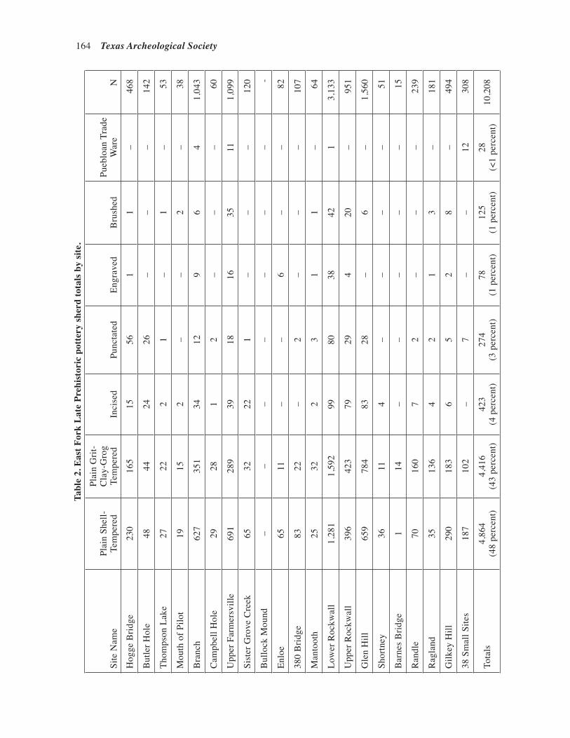
164 Texas Archeological Society
Tabl
e 2.
Eas
t For
k L
ate
Preh
isto
ric
pott
ery
sher
d to
tals
by
site
.
Site
Nam
ePl
ain
Shel
l-
Tem
pere
d
Plai
n G
rit-
Cla
y-G
rog
Tem
pere
dIn
cise
dPu
ncta
ted
Engr
aved
Bru
shed
Pueb
loan
Tra
de
War
eN
Hog
ge B
ridge
230
165
1556
11
–46
8
But
ler H
ole
4844
2426
––
–14
2
Thom
pson
Lak
e27
222
1–
1–
53
Mou
th o
f Pilo
t19
152
––
2–
38
Bra
nch
627
351
3412
96
41,
043
Cam
pbel
l Hol
e29
281
2–
––
60
Upp
er F
arm
ersv
ille
691
289
3918
1635
111,
099
Sist
er G
rove
Cre
ek65
3222
1–
––
120
Bul
lock
Mou
nd–
––
––
––
-
Enlo
e65
11–
–6
––
82
380
Brid
ge83
22–
2–
––
107
Man
toot
h25
322
31
1–
64
Low
er R
ockw
all
1,28
11,
592
9980
3842
13,
133
Upp
er R
ockw
all
396
423
7929
420
–95
1
Gle
n H
ill65
978
483
28–
6–
1,56
0
Shor
tney
3611
4–
––
–51
Bar
nes
Brid
ge1
14–
––
––
15
Ran
dle
7016
07
2–
––
239
Rag
land
3513
64
21
3–
181
Gilk
ey H
ill29
018
36
52
8–
494
38 S
mal
l Site
s18
710
2–
7–
–12
308
Tota
ls4,
864
(48
perc
ent)
4,41
6(4
3 pe
rcen
t)42
3(4
per
cent
)27
4(3
per
cent
)78
(1 p
erce
nt)
125
(1 p
erce
nt)
28(<
1 pe
rcen
t)10
,208

Ellis et al.—Aboriginal Ceramics from the North Central Region of Texas 165
were identified. These include: (1) an initial introduction of pottery to the East Fork region from Woodland period Fourche Maline cultures to the northeast along the Red River in East Texas and southeast Oklahoma, (2) continuing trade to the northeast with people of the Sanders phase centered around Lamar County (see Figure 1), (3) trade to the west pri-marily with peoples of the Henrietta phase, but also a minor amount of trade wares from the Pueblo peoples of north central and southeastern New Mexico, and (4) trade with the Caddo peoples of the Upper Neches, Angelina, and Sabine River basins in East Texas. As noted above, ce-ramics are common in all manner of sites on the East Fork. Larger sites, such as Lower Rockwall (41RW1), Upper Rockwall (41RW2), Glen Hill (41RW4), Hogge Bridge (41COL1), Upper Farmersville (41COL34), Branch (41COL9), and Gilkey Hill (41DL406) have large ceramic assem-blages, typically in excess of 500 sherds. Smaller sites have assemblages on the order of 50-250 sherds (Table 2).
The shell-tempered plain ware listed in Table 2 is predominantly of the Nocona Plain type. The grit-grog-tempered plain ware is predominantly Williams Plain with minor amounts of plain grog-tempered wares, including what has been identified as Sanders Plain. Incised wares consist of Canton Incised, Crockett Curvilinear Incised, Davis In-cised, Dunkin Incised, Maydelle Incised, Haley Complicated Incised, and Foster Trailed Incised, all Caddo types (Suhm and Jelks 1962). Punctated wares are predominantly Monkstown Fingernail Impressed with lesser amounts of Pennington Punctated-Incised, Weches Fingernail Impressed, Harleton Appliqued, and Killough Pinched. En-graved wares are predominantly from Sanders Engraved vessels with minor amounts of Holly Fine Engraved, Hickory Fine Engraved, Poynor Engraved, and Hempstead Engraved sherds. Fi-nally, Puebloan trade ware sherds included in Table 2 are from Chupadero Black-on-White, Santa Fe Black-on-White, Chaco Black-on-White, Jemez Black-on-White, Black Mesa Black-on-White, Mimbres Black-on-White, Rio Grande Glaze, and Zuni Glaze vessels.
In the assemblages from the 58 sites listed in Table 2, plain shell-tempered sherds (Nocona Plain) comprise 48 percent of the overall assem-blage sample, while plain grog- and grit-tempered sherds represent another 44 percent of the sample. These sherds are predominantly from Williams Plain vessels, suggesting that they are from pre-A.D. 1200 aboriginal occupations. The remainder of the East Fork of the Trinity sherd assemblages are decorated grog- and grit-tempered sherds (n=900, 8.8 percent of the total sherd sample), including sherds with incised (n=423), punctated (n=274), brushed (n=125), and engraved (n=78) decorative elements. These sherds are from East Texas Caddo wares. The range of East Texas Caddo ceramic types are local wares in both pre- and post-A.D. 1300 Caddo communities, including communities on the Red River and Pineywoods Frankston phase Caddo groups in the upper Neches River basin and Titus phase Caddo groups in the upper Sabine and Big Cypress stream basins (Pert-tula and Selden 2014).
One of the largest ceramic assemblages along the East Fork is present at the Lower Rockwall site (41RW1). A total of 3133 sherds of all types have been recorded from the site (see Table 2), including 1291 shell-tempered plain sherds (41 percent), 1592 grit-grog-tempered plain sherds (51 percent), and 259 (8 percent) decorated Caddo incised, engraved, punctated, and brushed sherds
Figure 2. Maydelle Incised vessel reconstructed from 34 sherds found by a local collector in the early 1960s at the Lower Rockwall site (41RW1).
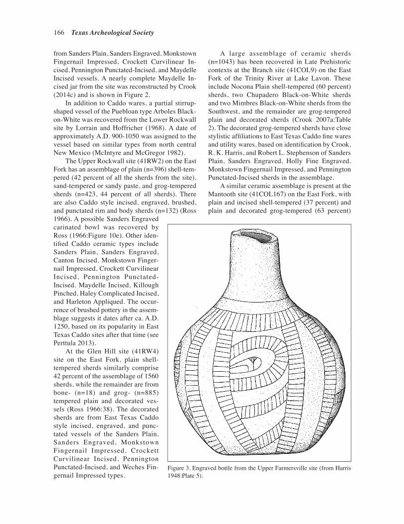
166 Texas Archeological Society
from Sanders Plain, Sanders Engraved, Monkstown Fingernail Impressed, Crockett Curvilinear In-cised, Pennington Punctated-Incised, and Maydelle Incised vessels. A nearly complete Maydelle In-cised jar from the site was reconstructed by Crook (2014c) and is shown in Figure 2.
In addition to Caddo wares, a partial stirrup-shaped vessel of the Puebloan type Arboles Black-on-White was recovered from the Lower Rockwall site by Lorrain and Hoffricher (1968). A date of approximately A.D. 900-1050 was assigned to the vessel based on similar types from north central New Mexico (McIntyre and McGregor 1982).
The Upper Rockwall site (41RW2) on the East Fork has an assemblage of plain (n=396) shell-tem-pered (42 percent of all the sherds from the site), sand-tempered or sandy paste, and grog-tempered sherds (n=423, 44 percent of all sherds). There are also Caddo style incised, engraved, brushed, and punctated rim and body sherds (n=132) (Ross 1966). A possible Sanders Engraved carinated bowl was recovered by Ross (1966:Figure 10e). Other iden-tified Caddo ceramic types include Sanders Plain, Sanders Engraved, Canton Incised, Monkstown Finger-nail Impressed, Crockett Curvilinear Incised, Pennington Punctated-Incised, Maydelle Incised, Killough Pinched, Haley Complicated Incised, and Harleton Appliqued. The occur-rence of brushed pottery in the assem-blage suggests it dates after ca. A.D. 1250, based on its popularity in East Texas Caddo sites after that time (see Perttula 2013).
At the Glen Hill site (41RW4) site on the East Fork, plain shell-tempered sherds similarly comprise 42 percent of the assemblage of 1560 sherds, while the remainder are from bone- (n=18) and grog- (n=885) tempered plain and decorated ves-sels (Ross 1966:38). The decorated sherds are from East Texas Caddo style incised, engraved, and punc-tated vessels of the Sanders Plain, Sanders Engraved, Monkstown Fingernail Impressed, Crockett Curvilinear Incised, Pennington Punctated-Incised, and Weches Fin-gernail Impressed types.
A large assemblage of ceramic sherds (n=1043) has been recovered in Late Prehistoric contexts at the Branch site (41COL9) on the East Fork of the Trinity River at Lake Lavon. These include Nocona Plain shell-tempered (60 percent) sherds, two Chupadero Black-on-White sherds and two Mimbres Black-on-White sherds from the Southwest, and the remainder are grog-tempered plain and decorated sherds (Crook 2007a:Table 2). The decorated grog-tempered sherds have close stylistic affiliations to East Texas Caddo fine wares and utility wares, based on identification by Crook, R. K. Harris, and Robert L. Stephenson of Sanders Plain, Sanders Engraved, Holly Fine Engraved, Monkstown Fingernail Impressed, and Pennington Punctated-Incised sherds in the assemblage.
A similar ceramic assemblage is present at the Mantooth site (41COL167) on the East Fork, with plain and incised shell-tempered (37 percent) and plain and decorated grog-tempered (63 percent)
Figure 3. Engraved bottle from the Upper Farmersville site (from Harris 1948:Plate 5).
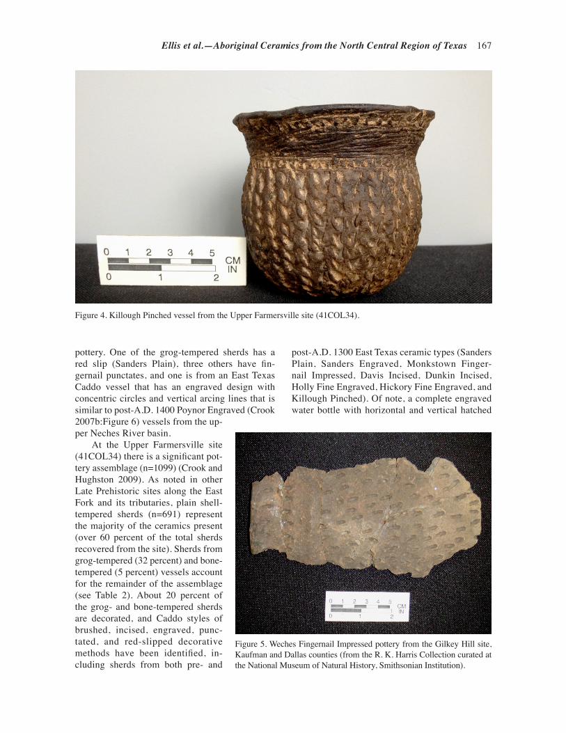
Ellis et al.—Aboriginal Ceramics from the North Central Region of Texas 167
pottery. One of the grog-tempered sherds has a red slip (Sanders Plain), three others have fin-gernail punctates, and one is from an East Texas Caddo vessel that has an engraved design with concentric circles and vertical arcing lines that is similar to post-A.D. 1400 Poynor Engraved (Crook 2007b:Figure 6) vessels from the up-per Neches River basin.
At the Upper Farmersville site (41COL34) there is a significant pot-tery assemblage (n=1099) (Crook and Hughston 2009). As noted in other Late Prehistoric sites along the East Fork and its tributaries, plain shell-tempered sherds (n=691) represent the majority of the ceramics present (over 60 percent of the total sherds recovered from the site). Sherds from grog-tempered (32 percent) and bone-tempered (5 percent) vessels account for the remainder of the assemblage (see Table 2). About 20 percent of the grog- and bone-tempered sherds are decorated, and Caddo styles of brushed, incised, engraved, punc-tated, and red-slipped decorative methods have been identified, in-cluding sherds from both pre- and
Figure 4. Killough Pinched vessel from the Upper Farmersville site (41COL34).
Figure 5. Weches Fingernail Impressed pottery from the Gilkey Hill site, Kaufman and Dallas counties (from the R. K. Harris Collection curated at the National Museum of Natural History, Smithsonian Institution).
post-A.D. 1300 East Texas ceramic types (Sanders Plain, Sanders Engraved, Monkstown Finger-nail Impressed, Davis Incised, Dunkin Incised, Holly Fine Engraved, Hickory Fine Engraved, and Killough Pinched). Of note, a complete engraved water bottle with horizontal and vertical hatched
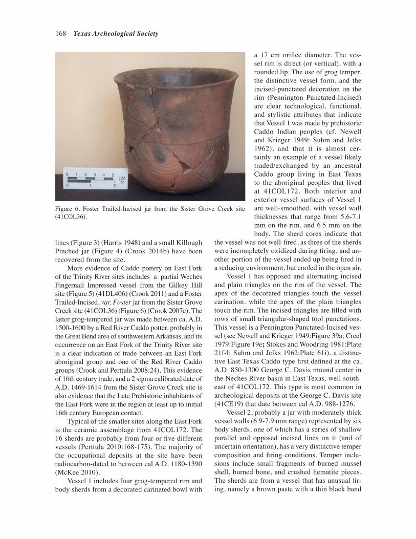
168 Texas Archeological Society
lines (Figure 3) (Harris 1948) and a small Killough Pinched jar (Figure 4) (Crook 2014b) have been recovered from the site.
More evidence of Caddo pottery on East Fork of the Trinity River sites includes a partial Weches Fingernail Impressed vessel from the Gilkey Hill site (Figure 5) (41DL406) (Crook 2011) and a Foster Trailed-Incised, var. Foster jar from the Sister Grove Creek site (41COL36) (Figure 6) (Crook 2007c). The latter grog-tempered jar was made between ca. A.D. 1500-1600 by a Red River Caddo potter, probably in the Great Bend area of southwestern Arkansas, and its occurrence on an East Fork of the Trinity River site is a clear indication of trade between an East Fork aboriginal group and one of the Red River Caddo groups (Crook and Perttula 2008:24). This evidence of 16th century trade, and a 2 sigma calibrated date of A.D. 1469-1614 from the Sister Grove Creek site is also evidence that the Late Prehistoric inhabitants of the East Fork were in the region at least up to initial 16th century European contact.
Typical of the smaller sites along the East Fork is the ceramic assemblage from 41COL172. The 16 sherds are probably from four or five different vessels (Perttula 2010:168-175). The majority of the occupational deposits at the site have been radiocarbon-dated to between cal A.D. 1180-1390 (McKee 2010).
Vessel 1 includes four grog-tempered rim and body sherds from a decorated carinated bowl with
a 17 cm orifice diameter. The ves-sel rim is direct (or vertical), with a rounded lip. The use of grog temper, the distinctive vessel form, and the incised-punctated decoration on the rim (Pennington Punctated-Incised) are clear technological, functional, and stylistic attributes that indicate that Vessel 1 was made by prehistoric Caddo Indian peoples (cf. Newell and Krieger 1949; Suhm and Jelks 1962), and that it is almost cer-tainly an example of a vessel likely traded/exchanged by an ancestral Caddo group living in East Texas to the aboriginal peoples that lived at 41COL172. Both interior and exterior vessel surfaces of Vessel 1 are well-smoothed, with vessel wall thicknesses that range from 5.6-7.1 mm on the rim, and 6.5 mm on the body. The sherd cores indicate that
the vessel was not well-fired, as three of the sherds were incompletely oxidized during firing, and an-other portion of the vessel ended up being fired in a reducing environment, but cooled in the open air.
Vessel 1 has opposed and alternating incised and plain triangles on the rim of the vessel. The apex of the decorated triangles touch the vessel carination, while the apex of the plain triangles touch the rim. The incised triangles are filled with rows of small triangular-shaped tool punctations. This vessel is a Pennington Punctated-Incised ves-sel (see Newell and Krieger 1949:Figure 39a; Creel 1979:Figure 19e; Stokes and Woodring 1981:Plate 21f-l; Suhm and Jelks 1962:Plate 61i), a distinc-tive East Texas Caddo type first defined at the ca. A.D. 850-1300 George C. Davis mound center in the Neches River basin in East Texas, well south-east of 41COL172. This type is most common in archeological deposits at the George C. Davis site (41CE19) that date between cal A.D. 988-1276.
Vessel 2, probably a jar with moderately thick vessel walls (6.9-7.9 mm range) represented by six body sherds, one of which has a series of shallow parallel and opposed incised lines on it (and of uncertain orientation), has a very distinctive temper composition and firing conditions. Temper inclu-sions include small fragments of burned mussel shell, burned bone, and crushed hematite pieces. The sherds are from a vessel that has unusual fir-ing, namely a brown paste with a thin black band
Figure 6. Foster Trailed-Incised jar from the Sister Grove Creek site (41COL36).

Ellis et al.—Aboriginal Ceramics from the North Central Region of Texas 169
visible in the sherd core along the vessel’s interior surface, suggesting it was smudged during firing.
Vessels 2 and 4 (see below) from 41COL172 are suspected to be of local manufacture, primarily because of the different kinds of tempers that were used, as well as the firing conditions exhibited by Vessel 2, the exterior roughening of Vessel 4, and the poorly executed incised decoration on Vessel 2.
The five sherds from Vessel 3, a carinated bowl, are undecorated. It is also probably of Caddo origin given the occurrence of grog temper in the paste. The vessel was tempered with grog and small bits of crushed hematite. Vessel 3 was fired in a reducing environment, and cooled in the open air, leaving either one or both vessel surfaces with thin oxidized surfaces visible in the sherd cores. The vessel is well smoothed on both interior and exterior vessel surfaces, and the vessel walls range only from 6.6-6.9 mm in thickness.
Vessel 4 (one body sherd) has small bits of what appear to be burned bone added to the paste. There is no evidence of surface treatment, and in fact the exterior sherd surface is roughened and unsmoothed. It is from a vessel fired in a reduc-ing environment, and then cooled in the open air, leaving a thin oxidized band visible on the exterior surface of the sherd core. It has moderately thick body walls (7.4 mm), and may be from a jar.
Finally, 41DL203 along Rowlett Creek in the East Fork of the Trinity River basin also has shell-tempered ceramics. They are from archeological deposits with a two sigma calibrated age range of A.D. 1310-1440 (Tinsley and Dayton 2011:68). The few sherds are from plain shell-tempered ves-sels made from local clays.
Elm Fork of the Trinity River
Prikryl’s (1990) summary of the archeologi-cal record on the lower Elm Fork of the Trinity River mentions aboriginal ceramic sherds at 37 sites (16 percent of the sample of 238 sites in the study area), with samples ranging from one to 196 sherds per site. One site (41DN49) had two Southwestern sherds, and another (41DN260) had a number of sherds from at least one Bullard Brushed vessel; this Caddo vessel likely originated in the upper Neches River basin in East Texas. Prikryl (1990:77) suggests that aboriginal ceramics began to be made in the area between 1250-750 B.P. (A.D. 700-1200), and that they were primarily grog-tempered wares with incised, punctated, and
brushed decorative elements. The ceramics from lower Elm Fork sites that date from 750-250 B.P. (A.D. 1200-1700) are tempered with bone, crushed limestone, and fossil shell, not just shell temper (i.e., Nocona Plain) (Prikryl 1990:80).
Aboriginal ceramics are abundant on sites along the Elm Fork of the Trinity River at Lake Lewisville in contexts dating only between ca. A.D. 1250-1425. These ceramics are overwhelm-ingly plain shell-tempered Nocona Plain globular-shaped jars and bowls (Brown and Lebo 1991; Ferring and Yates 1998). These vessels have smoothed interior and exterior surfaces, and are relatively thick-walled (mean thickness of 7.5 mm at 41DN26, Ferring and Yates 1998:71). Shell-tempered sherds comprise more than 90 percent of the assemblages, with a few sherds from grog- and bone-tempered vessels. Decorated vessels are extremely rare in the Elm Fork sites, consisting of a few sherds with simple incised lines, several with an interior red slip, and two cord-marked sherds from 41DN372. These may be from Plains Village Lindsay Cordmarked vessels (e.g., Drass 1997:192-193).
Upstream at Lake Ray Roberts on the Elm Fork, only a few of the sites investigated by Fer-ring and Yates (1997) have aboriginal ceramics. These occur in contexts dated between 693 ± 70 B.P. (A.D. 1187-1327) and 474 ± 100 B.P. (A.D. 1376-1576), indicating that they are basically contemporaneous with the ceramic-bearing Late Prehistoric sites at Lake Lewisville. Ceramic sherds are almost uniformly from plain, smoothed, shell-tempered vessels with rounded lips that have been typed as Nocona Plain (Ferring and Yates 1997:192, 212, 261, 266). At the Calvert site (41DN102), 299 sherds were recovered in three block excavations. Only 1.7 percent of the sherds were not shell-tempered, and they included one plain sherd with no temper, and four sherds with grit temper. Two of these sherds were decorated with fingernail punctations.
West Fork of the Trinity River
The best known aboriginal sites with ceramics on the West Fork of the Trinity are the Cobb-Pool (41DL148) and Baggett Branch (41DL149) sites, as well as 41DL184 (see Raab 1982; Peter and McGregor 1988), at Joe Pool Lake on Mountain Creek. Ceramics from the Cobb-Pool site repre-sent wares tempered with grog and decorated with

170 Texas Archeological Society
incised, incised-punctated, and punctated elements (Raab 1982:17 and Figure IV-8).
There is an extensive and diverse ceramic sherd assemblage (n=641) from the Cobb-Pool site. Calibrated radiocarbon dates from features and Structure 2 range from A.D. 1080 ± 79, A.D. 1247 ± 24, and A.D. 1275 ± 90 (Peter and Mc-Gregor 1988:Table 9-27). Peter and McGregor
Table 3. Decorative elements in the Cobb-Pool site ceramic assemblage.
Decorative Vessel Non-vessel element lots lots N
Brushed 10 – 10Brushed-Incised 3 1 4Engraved 15 1 16Incised 34 11 45Incised-Punctated 4 2 6Punctation 60 68 128Slipped 3 2 5
Totals 129 85 214
Figure 7. Selected decorated sherds from the Cobb-Pool site: a, incised; b-d, punctated; e, incised-punctated, Kiam Incised.
(1988:158) suggests that the ceramics are part of a single component occupied between A.D. 1000-1200, although the radiocarbon dates suggest the occupation probably lasted until ca. A.D. 1300 or later. Approximately 33 percent of the sherd assemblage at the site is decorated (Table 3) and the remainder are from plain wares. The plain to decorated sherd ratio is 2.0.

Ellis et al.—Aboriginal Ceramics from the North Central Region of Texas 171
Almost 60 percent of the decorated sherds have punctated decorative elements (Figure 7b-d). Another 21 percent have incised lines (Figure 7a), 7 percent are engraved fine wares; 6.5 percent have brushed marks; 2.8 percent are incised-punctated (Figure 7e); and 2 percent have a red slip on one or both vessel surfaces. The decorated sherds have close stylistic similarities to pre-A.D. 1300 East Texas Caddo wares—with the exception of the brushed sherds, which become common only after ca. A.D. 1250 in East Texas contexts (Pert-tula 2013)—and pre-ca. A.D. 1300 types such as Canton Incised, Davis Incised, Crockett Curvilin-ear Incised, Kiam Incised, and Weches Fingernail Impressed have been identified in collections ob-tained by R. King Harris from the site (Peter and McGregor 1988:131).
The assemblage includes sherds from ves-sels tempered with shell (10 percent), grog (58 percent), sand-bone (4 percent), sand (5 percent), sand-shell (4 percent), grog-sand-shell (7 percent), grog-shell (5 percent), and grog-sand (9 percent) (Peter and McGregor 1988:Tables 9-13 and 9-16). The principal tempers—alone or in combination with other non-plastics—at Cobb-Pool are grog (79 percent), shell (26 percent), and sand (29 percent). The sherds tempered with shell (as the sole tem-per or in combination with other non-plastics) are decorated with either random punctations; incised lines; engraved lines; an interior/exterior red slip; and brushing.
At the Baggett Branch site, test excavations recovered grog- and bone-tempered body and base sherds; body sherds were decorated with shallow incised and brushed lines and marks (Raab 1982:23). This assemblage is thought to be associated with an uncalibrated radiocarbon date of A.D. 1200 ± 200. A later occupation was inves-tigated during data recovery work at the site, and its archeological deposits also had ceramic sherds; there is a calibrated date of A.D. 1454 ± 65 for this occupation. The 163 sherds found at the site during the data recovery were sorted into 12 vessel lots, but only four of the vessels (Vessels 2-5) are rep-resented by more than three sherds. Two of these vessels have shell temper (Vessels 3 and 4), and the other two (Vessels 2 and 5) are grog-tempered.
The shell-tempered vessel lots were a punctated bowl (Vessel 3) and a plain jar (Vessel 5). Vessel 2, the first of the grog-tempered vessel lots, is a flat-bottomed jar with brushed and brushed-incised marks and lines (Peter and McGregor 1988:Figure
10-10). Vessel 5 has at least two rows of tool punctations on the rim panel. The other vessel lots are identified as follows: shell-tempered incised (Vessel 1); shell-tempered plain (Vessel 9); grog-tempered slipped (Vessel 6); grog-tempered plain (Vessels 7, 8, and 12); grog-tempered appliqued (Vessel 11); and sandy paste excised (Vessel 10) (Peter and McGregor 1988:216-220). Although the grog-tempered and shell-tempered ceramics are found together in the same shallow deposits (i.e., all but one sherd was found from 0-30 cm bs), Peter and McGregor (1988:241) suggest that they are from at least two temporally sequent occupations, the most recent occupation having shell-tempered ceramics as well as Perdiz and Fresno arrow points. The older occupation with grog-tempered ceramics dates to the earlier part of the Late Prehistoric period.
The few ceramic sherds from 41DL184 rep-resent four different vessels. All the vessels are grog-tempered. One has a brushed exterior surface, and another has tool punctated elements (Peter and McGregor 1988:111-112). Peter and McGregor (1988:125) suggest the site may represent a single occupation dating from ca. A.D. 1200-1300.
There are a few ceramic sherds from the Fort Worth Nature Center Gravel Quarry site (41TR113) in the West Fork of the Trinity River basin. They consist exclusively of body sherds from relatively thin-walled vessels tempered, fired, smoothed, and decorated in several different ways. The analysis of the prehistoric sherds suggests that they are from a minimum of five different vessels. At least four of the vessels from the site are tempered with grog (or crushed fired clay) and the other has abundant burned pieces of mussel shell. The sherds from the grog-tempered vessels are decorated either with tool punctations or with a red clay wash, while the shell-tempered sherds are undecorated. The grog-tempered pottery from the Fort Worth Nature Cen-ter Gravel Quarry may have its origins in pre-A.D. 1300 East Texas Caddo ceramic traditions, as much of the Caddo ceramics found in East Texas are also grog-tempered (either before or after ca. A.D. 1300), but instrumental neutron activation analysis and detailed petrographic analysis of sherds from the site are needed to definitively establish the provenience and manufacture locale of the sherds found at this upper Trinity River basin settlement.
The first possible grog-tempered vessel at the site appears to be a jar that has a sandy paste, probably from the use of a naturally sandy clay in vessel manufacture, smoothed interior vessel

172 Texas Archeological Society
walls, relatively thick body walls (8.0-8.4 mm), and it was fired in a reducing environment, but cooled in the open air. This firing left the exterior surface lighter-colored than the vessel interior surface. Both sherds have a single tool punctate on them as decoration, suggesting that the body of the jar had widely-spaced and probably randomly placed tool punctations. Similar vessel lots of sherds have been documented from the Cobb-Pool site (41DL148) in the upper Trinity River basin in ca. A.D. 1000-1300 contexts (Peter and McGregor 1988:Table 9-12).
The other three possible grog-tempered vessels from the Fort Worth Nature Center Gravel Quarry site have a thin red wash on either interior and/or exterior surfaces. Two of the vessels were fired in a reducing environment and cooled in the open air, while the other was incompletely oxidized during firing. Vessel walls range between 6.6-7.7 mm in thickness. Two of the possible vessels have a red wash on both vessel surfaces, while the third has a red wash on only the exterior surface. One of the 44 vessel lots (Vessel 25) at the Cobb-Pool site has sherds with an interior and exterior slip that was reddish-yellow on the interior and dark brown on the exterior (Peter and McGregor 1988:1545), suggesting it was not well-fired. Two of the three sherds in this vessel lot were tempered with grog and shell, which probably hints at its manufacture during the latter part of the occupation in the 13th century A.D. (Peter and McGregor 1988:194, 198), given the possible late adoption of shell-tempered pottery in this part of the upper Trinity River ba-sin around A.D. 1300 (Daniel E. McGregor, 2010 personal communication).
The last vessel in the small sherd assemblage from 41TR113 is represented by two plain shell-tempered body sherds, probably from a Nocona Plain jar or bowl (Suhm and Jelks 1962:115). These sherds are from a vessel, again most likely a jar, with thin body walls (4.8 mm), that was fired and cooled in a reducing or low oxygen environment.
As we have already noted, shell-tempered pot-tery (Nocona Plain) is abundant in both Washita River and Henrietta phase sites on the Southern Plains in northern Texas and southern Oklahoma, and is present as well at ca. post-A.D. 1300 sites in the Dallas-Fort Worth area in the upper Trinity River basin (Daniel E. McGregor, 2010 personal communication). Drass (1997:87) notes that by A.D. 1300, between 71-96 percent of the ceram-ics at Washita phase sites are shell-tempered,
increasing “dramatically through time” from earlier Paoli phase (ca. A.D. 900-1300) contexts. These earlier sites tend to have less than 12 percent shell-tempered pottery. “In general, there is an increase in shell temper from very small amounts at the early Paoli sites to predominantly shell tempered ceramics at Washita River phase sites dating be-tween A.D. 1300 and 1450” (Drass 1997:88).
Shell-tempered pottery is also the principal ceramic ware in post-A.D. 1300 Henrietta phase sites in the upper Trinity, Brazos, and Red River basins in northern Texas. At the Harrell site on the Brazos River, for example, shell-tempered pottery comprises 97 percent of the sherd assemblage (n=597) (Krieger 1946). That percentage is 98.6 in post-A.D. 1430 sites (n=292 sherds) on the Elm Fork of the Trinity (Ferring and Yates 1997), and, as mentioned above, 79 percent at the 14th century A.D. Dillard site sherds (n=754) on the Red River are shell-tempered (Martin 1994). About 20 per-cent of the sherds from this site are tempered with limestone instead of shell, and another 30 percent have both shell and limestone tempers; the only non-shell or limestone-tempered sherds are grit and bone-tempered cordmarked Washita River phase pottery (cf. Drass 1997:Tables 18 and 19).
The shell-tempered pottery from the Fort Worth Nature Center Gravel Quarry site has affili-ations with post-A.D. 1300 Southern Plains cul-tures on the Red, Brazos, and Washita rivers to the north and west of here, as well as with Late phase (ca. A.D. 1300-1600) Late Prehistoric period sites elsewhere in the upper Trinity River basin (Ferring and Yates 1997; Peter and McGregor 1988:367).
Another West Fork of the Trinity River site with ceramics is 41TR198. The few sherds from the site occur in occupational deposits dated to ca. A.D. 900 (Peter and Harrison 2011:iv, 231). The undecorated sherds are from poorly fired and unsmoothed vessels with a gritty paste and a fine grit temper. Peter and Harrison (2011:151) argue that “the limited number of sherds together with the contexts of the finds suggest that experimen-tation with ceramic technology was occurring much earlier in northcentral Texas than previously thought.” Ferring (1995) reports on the occur-rence of shell-tempered ceramic sherds from the George King site in the headwaters of the Denton Creek basin in the upper West Fork. The shell-tempered sherds are found in a component with bison remains and an uncalibrated radiocarbon date of A.D. 1425 ± 60.

Ellis et al.—Aboriginal Ceramics from the North Central Region of Texas 173
South Fork of the Trinity River
The Bell Camp site (41PR107) on the South Fork of the Trinity River has pre-A.D. 1300 Caddo style pottery sherds (Todd et al. 2009:Figure 3). Among them are Weches Fingernail Impressed, var. Weches rim and body sherds, Crockett Cur-vilinear Incised body sherds, and a slipped Holly Fine Engraved body sherd.
Trinity River and Major Tributaries
Richner (1982) reports on aboriginal ceramic sherds from a number of sites in Henderson and Freestone counties in the proposed Tennessee Colony Lake area in the mid-Trinity River basin. The largest samples came from midden deposits at the Brown’s Creek site (n=237, 41FT5) and a floodplain rise at the Hound Dog site (n=137, 41HE247). The ceramics from the Brown’s Creek and Hound Dog sites appear to date primarily before ca. A.D. 1300, and the decorated sherds from the Brown’s Creek site are incised (n=24), punctated (n=13), brushed (n=4), and slipped (n=1) (Richner 1982:142). Notably, 14 percent of the sherds are tempered with shell, 2.5 percent have bone temper, and the remainder have grit-, grog-, and/or sand non-plastic inclusions. At the Bazette Bridge site (41HE47) in the project area, with a corrected radiocarbon date of A.D. 1493 from the archeological deposits, the relatively thin-walled (6.3-6.6 mm mean thickness) sherds are grog-, grit-, and shell-tempered, and a number of sherds
also have a sandy paste. Decorated sherds have incised, brushed, and appliqued elements (Richner 1982:83). Incised-punctated and brushed ceramic sherds were also recovered from the Winston site (41HE245) from a context radiocarbon-dated to between A.D. 1456-1657 (Richner 1982:221).
Investigations in the Richland-Chambers Reservoir in Freestone and Navarro counties in the Post Oak Savanna and Blackland Prairie (see Figure 1) recovered substantial amounts of pre-historic ceramics from sites dating as early as ca. A.D. 200 to as late as ca. A.D. 1650 (Bruseth and Martin 1987; McGregor and Bruseth 1987). The earliest pottery from these sites is reputed to be a plain shell-tempered ware, including 19 sherds from Adams Ranch (41NV177), one sherd each from 41FT158 and 41FT161B, eight sherds from 41FT200, and a handful of shell-tempered sherds from Bird Point Island (41FT201). In the case of Bird Point Island, the few shell-tempered sherds (<1 percent of the assemblage of 4967 sherds) were found in contexts post-dating A.D. 1000 (Bruseth and Martin 1987:112-113). This temporal context for the shell-tempered sherds is consistent with the post-A.D. 1000 assemblages from the Brown’s Creek and Bazette Bridge sites in the same general locale (see Richner 1982). At Adams Ranch, how-ever, six shell-tempered sherds were found in basal deposits dating from ca. A.D. 200-700 in a large pit (Feature 1), as well as in ca. A.D. 800-1000 Zone 2 deposits (n=2 sherds) in the same feature. Bruseth and Martin (1987:261) comment that
Table 4. Decorated sherd assemblages from selected Richland-Chambers Reservoir sites (from Bruseth and Martin 1987; McGregor and Bruseth 1987).
Decorative Method 41NV173 41NV182 41NV203 41NV177 41FT201
Engraved 23.1* 11.9 9.2 10.2 6.5Brushed 2.3 – 22.4 9.5 5.1Incised 59.8 26.2 27.6 26.0 42.2Punctated 6.5 30.0 39.5 26.0 24.3Incised-Punctated 2.8 1.2 1.3 8.7 3.4Slipped – 2.4 – 7.9 0.6Other** 5.6 28.6 – 11.8 17.8
Total Decorated Sherds 216 84 76 127 1078
*percentage; **represents sherds apparently with a combination of decorative elements, but no specific decorative methods are identified by either Bruseth and Martin (1987) or McGregor and Bruseth (1987).

174 Texas Archeological Society
shell-tempered sherds were “limited to this basal layer and to pits intrusive into this layer from the subsequent layer (Zone 2).”
Plain sandy paste pottery is thought to char-acterize ca. A.D. 700-900 ceramic assemblages in the Richland-Chambers Reservoir (McGregor and Bruseth 1987:Figure 15-2), but this ware appears to be contemporary with plain and decorated grog and bone-tempered wares that are “part of the ce-ramic tradition of East Texas which began around A.D. 800” (Bruseth and Martin 1987:229); this ceramic tradition continued until ca. A.D. 1650 in this part of the Trinity River basin. The principal decorative methods in the Richland-Chambers Res-ervoir assemblages include sherds from engraved and slipped fine ware vessels and sherds from brushed, incised, punctated, and incised-punctated utility ware vessels with East Texas Caddo styles (Table 4). Fine wares comprise no more than 23.1 percent of the decorated sherds at any one of the sites. Utility wares are dominated by sherds with incised and punctated decorative elements, but jars with brushing marks are relatively common at the Polecat Hill (41NV203), Adams Ranch, and Bird Point Island sites.
Post-ca. A.D. 1400 fine wares and utility ware sherds at sites such as Bird Point Island, Little Cedar Creek (41NV173), and Polecat Hill stylisti-cally resemble upper Neches River basin Frankston phase Caddo ceramics (McGregor and Bruseth 1987:116). In particular, Poynor Engraved sherds are present (Bruseth and Martin 1987:Figures 8-2e-g and 8-3c; McGregor and Bruseth 1987:Figures 11-19a-h, 13-5g) in the fine wares, and the utility wares include Killough Pinched and La Rue Neck Banded (Bruseth and Martin 1987:Figure 8-2h-j) jar sherds; these utility wares are also known to be associated with Poynor Engraved in upper Neches River basin Caddo assemblages (Perttula 2013).
The Pecan Springs site (41EL11) in Ellis County, on an eastward-flowing tributary to the Trinity River, has a small assemblage (n=99 sherds) from shell-tempered (n=21) plain wares and grog- and bone-tempered sherds (n=78); about 26 percent of the latter have a distinctive paste with crushed quartz particles (Sorrow 1966:46). The brushed, engraved, incised, punctated-incised, and appliqued sherds appear to be from post-A.D. 1400 Late Caddo vessels, including a sherd from a Poynor Engraved vessel (Sorrow 1966:Figure 23k) that was very likely from a vessel made in the up-per Neches River basin in East Texas.
Story (1965:222-234) described ceramic assemblages from the Lacy (41HE70), Wild Bull (41HE61), and Gossett Bottoms (41KF7) sites on Cedar Creek, a major southward-flowing tributary to the Trinity River in the Post Oak Savannah. The ceramics include sherds from a few plain shell-tempered (2.4 percent), bone-tempered (27 percent), grog-tempered (35 percent, including one strap handle), and sand-tempered (2.7 percent) jars and bowls. The sandy-tempered sherds may be from Goose Creek Plain, var. unspecified vessels, and thus this ware’s occurrence would mark the manufacture and use of pre-A.D. 900 Woodland period vessels in this part of the Trinity River basin. The decorated sherds (e.g., engraved, brushed, incised, trailed, brushed-incised, punctated, punctated-incised, and pinched) closely resemble East Texas Caddo styles (Story 1965:Figures 24 and 25a-h), particularly with post-A.D. 1400 upper Neches River basin ceramics. This is evident by the fact that almost 42 percent of the decorated sherds are from jars with brushed rim and/or body markings. Such brushed jars become common in the upper Neches River basin only after ca. A.D. 1250 (Perttula 2013), and they come to dominate Caddo utility wares in the basin by the 15th century A.D.
Upper Sabine River Basin
One site in the upper part of the Sabine River basin in the Blackland Prairie has an interesting assortment of aboriginal ceramics. The 110 sherds from 41HU39 are tempered either with grog (n=21), grog and sand (n=18), sand (n=8), sand and shell (n=17), grog-sand and shell (n=5), grog and shell (n=30), and shell (n=9). The proportion of sherds with shell-temper is 55 percent (Black et al. 1994:Table 4), which would suggest an occupation of the site well after ca. A.D. 1250. The sherds are from vessels with a fine paste and relatively thin vessel walls (an average of 5.73 mm). Only one grog and sand-tempered sherd is decorated, and it has several rows of tool punctations.
Brazos River Basin Sites
Ceramic-bearing sites in the Brazos River Basin are relatively scarce. When they do occur, ceramic assemblages often exhibit distinct regional influences, especially to the east towards East Texas Caddo cultures (e.g., Watt 1953). However, the dearth of controlled excavations

Ellis et al.—Aboriginal Ceramics from the North Central Region of Texas 175
from well-dated contexts has made it difficult to establish a chronological sequence for a number of the different kinds of ceramic assemblages documented in the area. It is widely known that East Texas Caddo ceramics of both pre-A.D. 1400 and post-A.D. 1400 manufacture are well distributed in “the area from the Brazos River valley around Waco south to the Georgetown area…by contrast, the occurrence of Caddo pottery in Central Texas after about A.D. 1400 is much more widespread” (Creel et al. 2013:74). After ca. A.D. 1400, Caddo ceramics are apparently more abundant in the “Blackland Prairie just below the Balcones Escarpment, from about the Colorado River (maybe as far as the San Marcos River) north to the Brazos River valley in the vicinity of Waco” (Creel et al. 2013:75; see also Perttula et al. 2003:Figure 16 and Table 9).
While some of the earliest archeological investigations in the state occurred in this region, this early work was often poorly recorded and done in a non-systematic manner, making it difficult to interpret the archeological findings (Fox 1939; Ray 1929, 1938, 1947; Sayles 1935). Several more systematic surveys were undertaken in the 1960s (Malone and Briggs 1970), 1970s (Etchieson et al. 1978, 1979), and 1980s (Thurmond et al. 1981; Wulfkuhle 1986). However, few ceramics
were recovered during these investigations and when they were recovered, only limited ceramic descriptions were provided or the ceramics were simply classified as unidentifiable (e.g., Wulfkuhle 1986).
One exception is the pottery sherds recovered at four sites at Lake Whitney on the Brazos River (Stephenson 1970): the Stansbury, Pictograph Shelter, Buzzard Shelter (see also Long 1961), and Sheep Shelter. At Pictograph Shelter, 15 sherds from six different East Texas Caddo vessels were recovered in deposits dominated by Scallorn ar-row points, and thus they likely predate ca. A.D. 1200. They are grit- and grog-tempered, and have red slips or washes or engraved lines (Stephen-son 1970:129-130). Pre-A.D. 1200 Caddo vessel sections were recovered from Buzzard Shelter, including Holly Fine Engraved (sherds from two different grog-tempered vessels) and grog-grit-bone-tempered Dunkin Incised sherds, as well as bone-tempered engraved sherds, and plain grog- and bone-tempered vessels. One sherd has a sandy paste, and may be from a Goose Creek Plain, var. unspecified vessel (Stephenson 1970:166-171). The 39 sherds at the Sheep Shelter are from at most seven or eight different East Texas Caddo style vessels of probable ca. A.D. 1200-1400 age, including an engraved and red-slipped bottle, two
Table 5. Ceramic sherd assemblages identified during the South Bend Reservoir Survey (Saunders et al. 1992).
Site Number Location of Site No. of Sherds Paste Decoration Type
41YN7 Unnamed Tributary of the Brazos Clear Fork 1 Grog-tempered Undecorated Sanders
Plain*
41YN118 Brazos River 2 Untempered Clay Undecorated Unknown
41YN182 Brazos Clear Fork 1 Shell-tempered Undecorated Nocona Plain
41YN266 Brazos River 1 Grog-tempered Undecorated Sanders Plain*
41YN327 Brazos River 14 Shell-tempered Undecorated Nocona Plain1 Untempered Clay Undecorated Unknown3 Calcite-tempered Undecorated Unknown
41YN366 Unnamed Tributary of the Brazos Clear Fork 1 Shell-tempered Undecorated Nocona Plain
41YN425 Brazos Clear Fork 22 Grog-Tempered Undecorated Sanders Plain*
*unless the sherds have a red-slip on one or both surfaces, they would not be classified as Sanders Plain in the current Caddo ceramic taxonomy (Brown 1996:401-403 and Figures 2-19l, 2-34g, 2-37a-l, 2-38d, 2-39d, k, n-q, and 2-42b; Perttula and Selden 2014), but simply as an unidentified plain grog-tempered ware

176 Texas Archeological Society
Canton Incised jars, a plain carinated bowl, a plain grog-bone-tempered bottle, a grog-grit-tempered brushed jar, and a cross-hatched incised bone-tempered vessel (Stephenson 1970:199-201). Late 18th to early 19th century Caddo ceramics (n=18 sherds from 11 different vessels) were recovered in excavations in several parts of the Stansbury site (Stephenson 1970:76-79). They included sherds from Womack Engraved and Patton Engraved, Historic Caddo ceramic types manufactured and used by Caddo peoples in either the upper Red and Sabine River basins or the Neches-Angelina River basins in East Texas.
One intensive survey conducted in the South Bend Reservoir area in the late 1980s (Saunders et al. 1992) provided more detailed descriptions of the recovered ceramic sherds. The survey included portions of Throckmorton, Young, and Stephens counties (see Figure 1) and followed the main channels and associated tributaries of the Brazos and the Clear Fork of the Brazos Rivers. Only sev-en of the 586 sites with prehistoric components had aboriginal ceramics, but the total number recovered from all seven sites numbered only 46 sherds. All of the prehistoric ceramic-bearing sites were found in Young County (Table 5).
Two pottery types were identified, including Nocona Plain and Sanders Plain, as defined by Krieger (1946) and Suhm and Jelks (1962). While fairly detailed descriptions of the ceramic attri-butes were provided, the data was presented as a group summary, thus making it difficult to relate the attributes to specific sites. Further, no specific chronological relationships could be established because the sherds came from surface collections.
Nocona Plain sherds were recovered from 41YN182, 41YN327, and 41YN366. The majority of the recovered ceramics were small body frag-ments that provided little indication of vessel shape and size. However, two rim sherds from 41YN327 suggest that at least two vessels were represented at this site. Both rim sherds were from Nocona Plain vessels that had rounded and undecorated lip edges. One rim was direct in profile and one was thinned. One of the rim sherds appears to be from a restricted bottle with an orifice diameter of approximately 11 cm.
Pastes were relatively homogenous, with a dense compact appearance. Crushed shell had been added, representing less than 30 percent of the total paste volume. Paste colors varied from light gray to dark gray. Exterior and interior surfaces had been
either smoothed or lightly burnished and uniformly finished. Vessel wall thicknesses ranged from 4-8 mm, with a mean thickness of 6.1 ± 1.1 mm.
The 24 sherds typologically classified as Sand-ers Plain were recovered from 41YN7, 41YN266, and 41YN425. The sherds had been tempered with crushed sherds or grog that represented less than 20 percent of the total paste volume. Their exterior surfaces had been finished in a consistent manner and the majority had lightly burnished exterior surfaces; without slips on either one or both sherd surfaces, these sherds would not be classified as Sanders Plain in the current Caddo ceramic taxon-omy (see Perttula and Selden 2014). The majority of the interior surfaces had been smoothed. None of the sherds were large enough to assess vessel size or shape; however, the vessel walls appear to have been relatively thick, averaging between 7-9 mm, with a mean thickness of 8.3 ± 0.1 mm.
Coloration varied in the sherd assemblages. The one sherd recovered from 41YN7 had a white exterior surface and the sherd recovered at 41YN266 had a brown exterior surface. The exte-rior surface color of the 22 sherds from 41YN425 was most often tan, but in a few cases gray or brown. Interior coloration is predominately gray or tan, and the majority of the paste cores were black.
Since 41YN425 included both transitional Archaic and Late Prehistoric lithic artifacts, the ce-ramic assemblage at this site may be representative of more than one time period. Given their overall thickness and coloration, it is possible that some of the grog-tempered ceramics at this site may well have been from Williams Plain vessels, dated to the Woodland period in East Texas, and contempora-neous at least in part with the Transitional Archaic period in North Central Texas.
Six sherds were not typologically identifiable. Three undecorated body sherds recovered from 41YN327 had calcite inclusions embedded in a homogenous paste matrix. The small mineral inclu-sions were angular and appear to have been crushed into fine to silt-sized grains before being added to the paste. The tiny parallel striations observed on several of the inclusions, and the fact that these inclusions reacted strongly to hydrochloric acid, suggest that they may have come from fossilifer-ous rock.
Two of the sherds had been smoothed on both their exterior and interior surfaces, while one sherd had burnished exterior and interior surfaces. The sherds ranged from 4-8 mm in thickness.

Ellis et al.—Aboriginal Ceramics from the North Central Region of Texas 177
Ceramics with similar paste inclusions have a wide distribution. Matson (1935) identified similar aplastics in sherds recovered from five sites in the Abilene area (discussed below). Simi-larly, limestone-calcite-tempered pottery has been found in sites in the upper Trinity River Basin (Rohn 1998; Brack 2000) and the upper Red River basin (Drass 1997).
Three plain body sherds with no apparent tem-per were recovered from two of the sites, 41YN118 and 41YN327. While microscopic examination of the paste detected a few isolated mineral inclu-sions, the well-consolidated paste matrix was com-posed almost entirely of pure clay. All three sherds were relatively thick, ranging from 8-10 mm.
The surfaces of these three non-tempered sherds were somewhat irregular and uneven. The exterior and interior surfaces of the two sherds re-covered from 41YN118 were burnished and brown in color. The sherd recovered from 41YN327 has a brown, burnished exterior surface, but its interior had been smoothed and is light red in color.
Based on their association with time diagnostic lithic artifacts (e.g., Fresno and Clifton projectile points), the Nocona Plain ceramics most likely date after ca. A.D. 1200-1500. At 41YN425, the presence of an untyped dart point among the surface-collected grog-tempered wares may also suggest the presence of Woodland period pottery. In summary, the occurrence of technologically variable pottery at these seven sites point to occu-pations at different times by aboriginal groups with contacts and affiliations to the north/northeast and the west, with occupations occurring at different points in time.
Forrester (1988:39, 42) described sherds from two different Nocona Plain shell-tempered ves-sels from the Bee Mountain Shelter No. 2 on the Brazos River in Bosque County, Texas, one a jar and the other a possible water bottle. The jar had a very thick base (14-15 mm). The vessel sherds were probably associated with a post-A.D. 1200 occupation in the rock shelter that also had Perdiz and Cliffton arrow points.
Five ceramics were recovered in archeological investigations at 41BQ285 on the North Bosque River in a component that dates from the late 13th to the mid-17th century A.D. (Griffith et al. 2010). Technological, stylistic, petrographic, and instru-mental neutron activation analysis of the sherds indicated that four of the sherds were manufactured from Central Texas clays; two were plain and two
had simple fingernail punctated designs. The fifth sherd is a grog-tempered carinated engraved bowl (Perttula et al. 2010). Taking all ceramic analyses into account, Perttula et al. (2010) concluded that this engraved sherd was from a vessel made from a Central Texas clay source. What prehistoric aborigi-nal group made this sherd remains to be determined.
The Blum Rockshelter on the Nolands River in Hill County had 88 sherds from probably five different vessels, all recovered from post-A.D. 1200 contexts with Perdiz arrow points. One grog-tempered vessel section may be from a Poynor Engraved bottle (see Jelks 1953:Plate 19u), Vessel 2 is a plain grog-grit-tempered bowl with charred residue on its exterior surface, while Vessel 3 is a grog- and bone-tempered bowl with diagonal incised lines and punctations (Jelks 1953:205). Vessel 4 is a bone-tempered jar with rows of fin-gernail impressions, and Vessel 5 is a grog- and bone-tempered bottle with engraved pendant tri-angles (Jelks 1953:Plate 19y). Jelks (1953:206) concluded that these vessels “seem to be Caddoan ware. It is safe to assume that all are trade items from the east.”
Other sites in the Brazos River basin in North Central Texas have been excavated where pri-marily pre-A.D. 1200/1300 Caddo sherds were recovered, including sherds from a section of a Hickory Engraved bottle from Kyle Rockshelter, along with two plain bone-tempered sherds and a plain sandy paste body sherd (Jelks 1962:60-61). Several sites at Aquilla Lake, including the Mc-Donald site (41HI105, with n=127 sherds, most of them plain or from the undecorated lower portions of vessels), has Caddo style ceramics of the types Kiam Incised, Canton Incised, Maydelle Incised, and Bullard Brushed (Brown 1987:48-14).
There were a few plain ceramic rim and body sherds from ca. A.D. 900-1200 and post-A.D. 1200 zones at Bear Creek Shelter (41HI17) on the Bra-zos River at Lake Whitney (Lynott 1978:43). One sherd from the older deposits was tempered with grog, and another was tempered with limestone. The sherd from a Toyah phase zone had a fine sandy temper.
One of the earliest ceramic-bearing sites ex-cavated in North Central Texas was the Harrell site (41YN1) (Fox 1939; Hughes 1942; Krieger 1946; Texas Beyond History 2013). Located on the floodplain of the Brazos River in south central Young County, the Harrell site assemblage in-cluded roughly 597 sherds, all of which occurred

178 Texas Archeological Society
in the upper stratigraphic levels. Approximately 80 percent of the ceramics were shell-tempered wares which were classified as Nocona Plain. The paste matrix of the remaining sherds included those that exhibited no apparent temper and those with white clay lumps as probable grog temper. Two sherds were considered “trade pieces”: one was an appar-ent southeastern New Mexico ceramic ware and one was a Poynor Engraved sherd from a Caddo group living in the upper Neches River basin in East Texas.
Krieger (1946) noted the similarities between the sherds found at the Harrell site and whole ceramic vessels found in graves in East Central Oklahoma and Northeast Texas. Thus, Krieger (1946) believed the Harrell site to be the south-ernmost expression of the Plains Village tradition and considered the site to be the “type site” of the Henrietta Focus. Subsequent investigations at the Harrell site point to intermittent occupations that date between ca. A.D. 800 and A.D. 1500.
The ceramics from the Harrell site were later reexamined by Brack (2000; see also Brayshaw [1970]), who determined that between 25 and 30 separate vessels are represented in the assemblage. He concluded that most of the vessels were round-bottomed jars with restricted necks averaging 15 cm in diameter, many of which flared out at the rims. At least four bowls were also represented in the collection. The vast majority of the sherds (98 percent) are plain shell-tempered wares; however, a few exhibit simple decorations, primarily rows of appliqued nodes. Other decorative techniques appearing on the vessel body were vertical finger-nail marks, incised diagonal lines, and stamped impressions. From Brack’s (2000) comparative study of shell-tempered pottery from North Texas and Oklahoma, the pottery found at the Harrell site was believed to be the most technologically varied, but Brack agreed with Krieger’s earlier conclusion that the pottery found at the Harrell site closely re-sembled pottery found at Plains Village sites along the Red River and the Washita/Canadian River drainages in southern and western Oklahoma.
Interestingly, the Harrell site assemblage displayed a rather heterogeneous mix of culturally distinct artifacts, including both Southwest and Caddo pottery types. Also recovered were marine shells from the Pacific and the Gulf of Mexico, sandstone pipes, and obsidian from the Rocky Mountains. The presence of exotic goods and an admixture of ceramic types suggest contacts
with, and/or occupation of the site by, a variety of cultural groups.
The geographic location of the Harrell site places it in a boundary zone bordered by differ-ent ecoregions and cultural zones. Situated on the eastern flank of the Rolling Plains in the Western Cross Timbers ecoregion of southern Young County (see Figure 1), approximately 15 km west of the Cross Timbers and 15 km east of the Broken Red Plains at the confluence of the Salt and Clear Forks of the Brazos River, the site would have been a favorable place on the landscape. If one as-sumes that different artifact styles (i.e., projectile points and pottery types) and exotic goods (i.e., marine shell) reflect culturally (linguistically, economically, politically, and socially) distinct peoples, then the artifact assemblages recovered at the Harrell site suggest that different cultural groups occupied and/or interacted at this location over a substantial period of time.
The O. W. Hill site (41YN2) is located ap-proximately 2.5 km northeast of the Harrell site. Originally identified and excavated by the Works Progress Administration (Fox 1939), this relative-ly large site included 21 hearth features, a large lithic assemblage, ceramics, worked bone, and a sizable quantity of faunal material. The archeo-logical data suggest multiple occupations at the site over a fairly long period of time (Brayshaw 1970; Denton 1984).
Eleven sherds were recovered at 41YN2, and five of the 11 had been tempered with mussel shell. A smoothly polished bead measuring 2 cm in length was also recovered and was believed to be shell-tempered. The paste matrix of the remaining sherds was not noted; however, this group of sherds was described as being thinner than the mussel shell-tempered group. One sherd was decorated with punctations, and two sherds that appeared to be from the same vessel had shallow incised par-allel lines (Brayshaw 1970; Denton 1984). While overall vessel size and shape was difficult to deter-mine, the three rim sherds found in the collection were relatively thin, ranging from 3.6-4.8 mm in thickness. One of the rims had an outward flaring lip. Despite their sketchy descriptions, this small assemblage seems to represent different ceramic types. One interesting observation is that among the diverse faunal assemblage from the site, mussel shell was negligible. This suggests that the shell-tempered wares found at the O.W. Hill site were probably manufactured elsewhere.

Ellis et al.—Aboriginal Ceramics from the North Central Region of Texas 179
Table 6. Attributes recorded for pottery sherds recovered from 13 sites in Abilene, Texas.
Site No.*
No. of Sherds Paste Surface Finish Color Rim Attributes
1 39 Nine sherds are grit-tempered; 27 sherds have calcium phosphate inclusions.
Surfaces are predominantly smoothed, but five sherds have brushed surfaces.
Colors range from a light red to a light tan to brown to dark gray and grayish-black.
Four rims are included in the sample. Their rim form is straight, and thinned in profile with rounded lip edges.
3 1 Grit-tempered with a medium fine texture.
Roughly smoothed exterior surface with a number of deep incised gouges. Smoothed interior surface.
Smoked discolored exterior and a black interior.
No rims.
5 7 All are tempered with very fine grit and their paste is fine.
Three rims are smoothed and decorated with horizontal incised lines; two body sherds have narrow, shallow striations; two body sherds are smoothed.
Paste core is black; surfaces are smoked discolored.
Three rims are included in the sample: two rims are straight; one rim is slightly everted.
8 1 Has calcium phosphate inclusions and the texture is fine.
Both exterior and interior surfaces are smoothed.
Paste core is bluish-gray and its surfaces are tan.
No rims.
9 1 Has calcium phosphate inclusions and the texture is fine.
Both exterior and interior surfaces are smoothed.
Exterior surface is tan to buff in color; interior is tan.
No rims.
Perhaps some of the earliest work done in the Upper Brazos River basin was done by Cyrus Ray. Ray (1935:75) recorded numerous Late Prehistoric sites in the Abilene area; however, many were sur-face scatters that he observed in plowed fields. In 1935, Ray published a general article on what he termed the “pottery complex artifacts” of the region, providing rough counts and a cursory description of 20 sites in the Abilene area from which pottery sherds had been recovered. Most of the pottery-bear-ing sites described by Ray (1935) contained all or most of the Toyah lithic assemblage and the ceram-ics included a wide variety of wares, including Rio Grande glaze ware from New Mexico (confirmed by H. P. Mera [Ray 1935: 84]). Unfortunately, docu-mentation for many site locations is unclear and with the exception of an article by Griffin (1935), little
or no detailed analyses were ever conducted on the recovered ceramics.
The only detailed data on pottery recovered at the ceramic-bearing sites described by Ray (1935) comes from an analysis done by James B. Griffin (1935) and Frederick Matson 1935). Griffin (1935) looked at a sample of the pottery recovered from 13 sites near Abilene, Texas. His analysis in most cases included descriptions of the type of tempering material, texture of the paste and aplastics, surface finish, color, and any rims present in the assemblage (Table 6).
Roughly 55 percent of the analyzed sherds were described as having “calcium phosphate” inclusions that were uniformly white in color (Mat-son 1935). Analyses indicate that this tempering material has optical properties resembling those of the mineral Collophanite. This amorphous mineral

180 Texas Archeological Society
Site No.*
No. of Sherds Paste Surface Finish Color Rim Attributes
10 2 Both are grit-tempered with a medium fine texture.
Roughened exterior surfaces, one sherd having narrow striations. Interior surfaces are smoothed.
Exterior and interior surfaces are brown but heavily blackened from cooking.
No rims.
11 1 Has calcium phosphate inclusions and the texture is fine.
Both exterior and interior surfaces are smoothed.
Paste core is bluish-gray and its surfaces are grayish-tan.
No rims.
13 9 Three have fine grit pastes; one is non-tempered; five have calcium phosphate inclusions.
All are undecorated and have smoothed surfaces.
Not provided. One rim sherd has a pronounced shoulder and a short contracting rim with a thinned lip edge.
14 25 Two temper types. Group 1 (n=6) has calcium phosphate inclusions, with a fine texture. Group 2 (n=19) contains fine grit temper, and a medium texture.
17 sherds have a smooth finish, and four sherds have a rough finish. Three sherds have a striated surface.
The predominant color is tan.
One rim sherd is rounded in profile and slopes outward.
15 25 All are tempered with white calcium phosphate inclusions that make up around 33 percent of the paste matrix. Their paste texture is fine and compact.
All are undecorated and their exterior and interior surfaces had been smoothed. Narrow horizontal striations that occur on some sherds resulted from use of a specific smoothing tool.
Paste cores are light bluish-gray; exterior surfaces are a light tan.
No rims.
17 27 Three distinct temper types. Group 1 (n=14) is grit-tempered, with a fine to medium texture. Group 2 (n=11) has calcium phosphate inclusions, with a fine texture. Group 3 (n=2) includes both calcium phosphate and crushed shell inclusions, with a fine texture.
Group 1 sherds have smoothed surfaces; Groups 2 and 3 also have smoothed surfaces, but are not nearly as hard as the sherds in Group 1.
Group 1 sherds are grayish-black or grayish-tan, but are distinctly darker than the sherds in Groups 2 and 3 whose colors are brown and tan.
Three rim sherds are present in Group 1. All three rims are straight in profile. Two have rounded lip edges and the third rim has a flat lip.
Table 6. (Continued)

Ellis et al.—Aboriginal Ceramics from the North Central Region of Texas 181
Site No.*
No. of Sherds Paste Surface Finish Color Rim Attributes
18 16 Predominantly grit-tempered (n=13), but three sherds have calcium phosphate inclusions. Twelve sherds have a medium fine texture and four sherds have a fine texture.
The surface finishes are mostly striated or roughened (possibly by brushing). Nine sherds were decorated. Decorative elements include fingernail punctations, narrow parallel incised lines, intersecting diagonal incised lines, incised chevron, and fingernail “gashes.”
Colors range from black to grayish-brown to gray.
One rim sherd had an inward curving lip and shallow diagonal incised lines.
19 7 All are tempered with very fine grit and white calcium phosphate. Their paste texture is fine.
All are undecorated and their exterior and interior surfaces had been smoothed.
Exterior and interior surfaces are light bluish-gray and paste cores are most often the same.
No rims.
*No Texas site trinomials could be correlated
Table 6. (Continued)
occurs in sedimentary phosphatic limestones and is the dominant material in fossil bone in which the microstructure of the original bone is usually preserved. This microstructure was noted on frag-ments of the aplastic inclusions in several of the analyzed sherds. Amorphous deposits of “bone phosphate” are known to occur in a number of states outside Texas (Matson 1935).
The paste fabric of several of the analyzed sherds also contained calcite, identifiable because it effervesced upon the addition of Hydrochloric acid. Calcite is a polymorphous mineral that occurs in almost every type of environment. It is a crystalline form that often binds with other compounds (such as limestone). Thus, the white aplastics that appears in many of the ceramics in North Central Texas appear to be at least two different mineral types that can oc-cur separately or they co-occur in the same formation. Petrographic analysis of those ceramics containing white mineral aplastics would aid in characterizing the various types of “white” inclusions in ceramic sherd pastes, and could eventually enable the identi-fication of potential source deposits.
As can be seen from the preceding discussion, Brazos River basin sites with aboriginal ceramic
assemblages are not especially prevalent in the prehistoric archeological record and are techno-logically variable. While shell-tempered wares are heavily represented, other potentially informa-tive temper types are also found. Unfortunately, most of the recovered ceramics are from surface collections that are often poorly or inconsistently described. Even among those ceramic-bearing sites, such as the Harrell site, that have been more extensively excavated, the recovered assemblages have never been critically evaluated and are lack-ing in securely dated components. Thus, it is dif-ficult to make more than general statements about the spatial distribution of the ceramics found in the Brazos River basin or to date their occurrence in time with any degree of confidence.
Colorado River Basin Sites
Some of the earliest archeological work in the state was done in the Colorado River basin area by Cyrus Ray and E. B. Sayles. Unfortunately, the results of many of these investigations have never been fully reported and aboriginal ceramics

182 Texas Archeological Society
Table 7. Ceramic attributes for aboriginal pottery recovered from seven sites in the O. H. Ivie Reservoir area.
Site No.*No. of Sherds Paste Texture
Surface/ Decoration Thickness Reference
41CC222 2 (same vessel)
The paste matrix of both sherds consists of clay with small bone inclusions.
Fine -grained Undecorated exterior and Interior surfaces that had been well-smoothed.
4.5 mm and 5.0 mm
Recovered during sur-vey (Wool-ridge 1981)
41CC131 731 714 had been tempered with bone, and some also included he-matite, sand, and/or calcite. Seventeen had undefined pastes.
Predominantly fine-grained (n=729); 2 were medium-grained.
Eleven exte-rior and interior surface finishing and decorative techniques were observed.
Ranged from 3 mm to 7 mm
Recovered during data recovery (Treece et al. 1993)
41CN19 1 Sand-tempered
Fine-grained Sherd is from a Polychrome vessel. Painted/burnished exte-rior and painted interior.
8 mm Recovered during data recovery (Treece et al. 1993)
41CN64 6 Paste matrix of all six sherds con-sists of clay with bone and calcite inclusions.
Texture ranged from coarse-grained (n=2) to fine to me-dium-grained (n=4)
Exterior surfaces are smoothed; interior sur-faces are rough smoothed.
Ranged from 4- 9.5 mm
Recovered during sur-vey (Wool-ridge 1981)
are rarely mentioned. Much of our information on pottery in this portion of North Central Texas comes from a survey (Wooldridge 1981) and later excavations (Lintz et al. 1993) conducted along the Concho and Colorado rivers in the proposed O. H. Ivie (formerly Stacy) Reservoir area. Similar to the archeological record in the Brazos River basin, only a proportionately small number of ceramic-bearing sites were identified during these investi-gations (Treece et al. 1993; Wooldridge 1981). In an area encompassing more than 19,000 acres, 369 sites having prehistoric components were identi-fied. Of those, only seven sites (1.9 percent) had aboriginal ceramic sherds. However, two of the seven sites (41CC 131 and 41RN169 yielded fairly large numbers of ceramics (Table 7).
Data recovery investigations were undertaken at the Currie site (41CC131), located on and within an alluvial terrace of the Concho River 3.4 km upstream from its confluence with the Colorado River. Three stratified components were identi-fied during the investigation. Radiocarbon dates indicate that the site was intermittently occupied between A.D. 756 and A.D. 1790, with a large number of dates clustering around A.D. 1500 (Lintz et al. 1993:126-127).
A total of 731 sherds were recovered from 41CC131, all of which were typologically classi-fied as Leon Plain. While the basic ceramic attri-butes were provided in table format (Treece et al. 1993:Table C-6), some key attribute data was only presented in summary form, thus making it difficult

Ellis et al.—Aboriginal Ceramics from the North Central Region of Texas 183
Site No.*No. of Sherds Paste Texture
Surface/ Decoration Thickness Reference
41CN95 48 All had bone temper. Some sherds also included he-matite, sand, and/or calcite inclusions.
Texture ranged from medium (n=3) to fine-grained (n=45)
Two incised sherds with smoothed interior surfaces, and one sherd with a polished exterior and a roughly smoothed interi-or. The remainder had burnished, smoothed, or irregular surface finishes.
Ranged from 4-9 mm
47 recov-ered during data recov-ery (Treece et al. 1993); one sherd recovered during sur-vey (Wool-ridge 1981)
41RN3 3 All had bone temper.
Fine-grained Two Doss Redware sherds. Exterior surfaces were smoothed (n=1) and bur-nished (n=2). Interior surfaces were smoothed.
Ranged from 3-5 mm
Recovered during data recovery (Treece et al. 1993)
41RN169 319 All had bone temper. Some sherds also included he-matite, sand, and/or calcite inclusions.
Texture ranged from medium (n=300) to fine-grained (n=19)
Exterior surfaces were smoothed (n=301), burnished (5), irregular (6), and seven sherds were described only as being incised. Interior surfaces were smoothed (n=310), irregular (n=6), or brushed (n=3).
Ranged from 3-7 mm
Recovered during data recovery (Treece et al. 1993)
Table 7. (Continued)
to estimate the total number of sherds with specific combinations of attributes. For example, pastes in the table were identified as bone-tempered; however, in the report discussions, it was also noted that he-matite, sand, and calcite were also observed in the paste matrix of a large number of the sherds. This is significant because not all ceramics with bone inclu-sions belong to the Leon Plain type and the various combinations of tempering agents in a paste matrix can be better characteristic of specific ceramic types.
Vessel form was largely indeterminate in the 41CC131 sherds, but the assemblage includes sherds from four jars and five bowls. Unfortu-nately, the sherds were listed separately in the table and no notations were made as to whether they could have been part of the same vessel (Treece et al. 1993:Table C-6). Furthermore, 11 different surface finishing and/or decorative techniques were observed on the ceramics from this site. While the majority were classified as having smoothed

184 Texas Archeological Society
or burnished exterior and/or interior surfaces, 43 sherds had been enhanced with some form of deco-rative treatment. These included: painted/burnished (n=17); painted/smoothed (n=5); painted/brushed (n=1); brushed (n=15); incised (n=1); incised/burnished (n=1); incised/painted (n=2); or slipped (n=1). Since Leon Plain, by definition, does not include decorated ceramics, these 43 sherds would be from typologically distinct wares. At least three of the painted ceramics were from either bowls or jars. Attributes such as paste and thickness would be critical to making typological distinctions, but unfortunately, there is no way to correlate paste, decorative treatment, and/or thickness because a significant level of detail is not provided in the Treece et al. (1993) report.
The Rocky Branch site (41RN169) is located on a terrace at the confluence of Rocky Branch and the Colorado River. The site was described as hav-ing three occupation zones that included a Toyah phase zone dating to ca. A.D. 1450. A total of 319 sherds were recovered during investigations. As with the 41CC131 ceramics, the ceramic data for this site was presented in table format. Seven in-cised sherds were recovered at this site.
Sites 41CC222, 41CN19, 41CN64, 41CN95, and 41RN3 also contained small numbers of technologically variable prehistoric ceramics (see Table 7). For example, only one sherd from a sand-tempered Polychrome vessel was recovered at 41CN19. Among the three sherds found at 41RN3 were two sherds classified as Doss Redware. At 41CN95, 48 sherds were recovered. Among those were two incised sherds.
The analyses of sherds from these seven sites illustrate a common problem encountered when trying to interpret ceramic data from some pub-lished reports. The sherds at these sites appear to have been classified as Leon Plain simply because they contained crushed bone temper. However, the paste often included other tempering agents in addition to the crushed bone and no attempt was made to account for the various combinations and correlate them with the technological variations in surface treatment and thickness. Since bone inclu-sions are also regularly found in Caddo ceramics, it may be that some of the sherds that were char-acterized as incised or brushed are in fact Caddo ceramics, or ceramics from some non-Toyah phase ceramic tradition. This may be especially the case with regard to 41CC131 given the radiocarbon dates obtained from this site that range from A.D
756 to A.D. 1790. Given the presence of three stratified components at the site, a reanalysis of these sherds could provide new information on the character of ceramic wares in the upper Colorado River basin in North Central Texas.
Finally, in a recent study by Creel et al. (2013), a large scale compositional analysis of Central Texas ceramics from Late Prehistoric Toyah phase hunter-gatherer assemblages was undertaken. Among the many ceramic samples were several samples from Brown, Coleman, Jones, Runnels, and Taylor counties, including six samples from 41CC131 and several from the E. B Sayles col-lections. The data suggests that the Concho/Colo-rado River confluence is a relatively significant area where several of the observed compositional clusters overlap (Creel et al. 2013:71). This study adds greatly to our understanding of some of the definitional issues involving the Leon Plain type. It also illustrates that more detailed analyses, and in some cases reanalysis, of ceramic assemblages need to be done in order to fully understand the aboriginal ceramics from this area.
SUMMARY AND CONCLUSIONS
Like many other regions across Texas, ceram-ics are a key component of the artifact assemblage present in aboriginal sites in North Central Texas. The ceramics found in these sites in North Central Texas have a complex history. Ceramics in North Central Texas demonstrate a long period of use, possibly being introduced as early as A.D. 200 in some parts of the Trinity River basin but are more prolific in sites dating from A.D. 900-1600. However, ceramic usage is not homogeneous across the region. In the aboriginal populations of the upper Red River, the upper Trinity River, and the East Fork of the Trinity, ceramic vessels were an important part of the overall toolkit. Conversely, to the west in the upper Brazos and Colorado basins, ceramic usage was fairly sparse. Furthermore, in the western portions of North Central Texas, particularly in sites in the upper Brazos and upper Colorado River basins, the technological and stylistic character of the ceramic assemblages have never been critically evaluated and they lack secure radiocarbon-based temporal ranges.
Across North Central Texas sherds from plain ware vessels dominate ceramic assemblages, often

Ellis et al.—Aboriginal Ceramics from the North Central Region of Texas 185
comprising 90-100 percent of the total ceramics present in a site. This plain ware is typically repre-sented by shell-tempered wares of Late Prehistoric Plains Village age and/or grog-, bone-, and grit-tempered wares that strongly resemble East Texas Caddo ceramics in style. As would be expected, shell-tempered wares dominate the ceramics in the Red River basin portion of North Central Texas and decrease in abundance in sites in the upper Sabine, Trinity, and Brazos River basins; bone-tempered ceramics are particularly abundant in Colorado River basin sites in the region. Grog-tempered ceramics are more abundant in the eastern part of the region, most notably in the Trinity River basin and its major tributaries, and decreases in abundance moving west toward the plains. Locales in the middle of these two ceramic manufacturing centers, such as the upper Trinity River basin and the East Fork of the Trinity, have ceramic assem-blages with nearly equal amounts of shell or grog-tempered ceramic wares.
Much of the shell-tempered pottery present in North Central Texas, both in appearance and vessel type, is similar to the defined type Nocona Plain from the southern Plains and the upper Red River basin; Brack (2000) labels the same ware as Woodward Plain for shell-tempered assemblages at Lake Texoma on the Red River. The grog-, bone-, and grit-tempered plain ware sherds dat-ing before ca. A.D. 1200 found in North Central Texas sites has been considered similar to that described as the thick-walled Williams Plain from Northeast Texas and southeastern Oklahoma sites, although Williams Plain sherds are common only in East Texas Caddo sites in the Red and Sulphur River basins. Thinner-walled grog-, bone-, and grit-tempered plain wares in North Central Texas and East Texas are from currently typologically unidentified ceramics.
How much of this plain ware pottery is the result of local manufacture and how much of it is due to trade? In general, assemblages with large sherd sample sizes (ca. 1000+ sherds) are likely from vessels that were made on the site or are from vessels made in a local community, even if there is no direct evidence of manufacture (i.e., pits used for firing pottery; preserved clay coils; firing discards). For example, a small hint of local manufacture was found at the Upper Farmersville site in Collin County in the East Fork of the Trinity River where a Nocona Plain-like vessel was found to have fallen apart during firing and
was discarded in a trash pit. However, as has been observed in East Texas (Perttula 2013), direct evidence of pottery manufacture even in areas known to be large ceramic production centers is extremely rare; typically preserved clay coils are the only archeological evidence for on site manufacture.
One thing is clear: temporal and spatial dif-ferences in the character of aboriginal ceramic assemblages in North Central Texas indicate the existence of different manufacturing traditions and/or broad scale interactions with neighboring groups with different ceramic traditions. To assess the various technological traditions evidenced in ceramic assemblages in North Central Texas will require consistent evaluation of the ceramic attributes associated with ceramic manufacturing behavior (see Ellis et al. 2010). When enhanced with petrographic and trace element geochemical studies (Instrumental Neutron Activation Analy-sis), we will hopefully clarify the origin of the region’s ceramics.
In addition to plain ware vessels and vessel sherds, a number of decorated wares (both util-ity ware and fine ware) have been recovered in North Central Texas sites (especially in the upper Trinity and Brazos River basins) that in both type and style resemble ceramic types made by Caddo peoples throughout East Texas. While a number of individual types can be identified in sherd as-semblages, they are never present in any great abundance, typically comprising only a few percent of the total ceramic assemblage at any given site. Moreover, when whole vessels have been found, they tend to show extensive repair and preserva-tion to extend their life after accidental breakage. This observation, coupled with their rarity, sup-ports the hypothesis that unlike the plain ware, the decorated vessels are imported trade ware and, as such, are highly valued objects in North Central Texas communities.
Concurrent with trade between Caddo peoples and the aboriginal communities living in the Southern Plains of North Central Texas is a fur-ther link between North Central Texas aboriginal groups and the Puebloan peoples of northern and southeastern New Mexico. While not abundant, Pueblo pottery, obsidian artifacts, turquoise, red coral, and Olivella sp. shell from Baja California have all been found in East Fork of the Trin-ity River sites (Crook 2013). Similarly, marine shells from the Pacific and the Gulf of Mexico,

186 Texas Archeological Society
sandstone pipes, and obsidian from the Rocky Mountains have been recovered at the Harrell site in the Brazos River basin (Brack 2000; Krieger 1946). Moreover, based on the pottery types pres-ent, this trade persisted from at least A.D. 1000 to as late as A.D. 1400-1500 (Crook 2013).
The general abundance of trade activities that can be documented in the occurrence of ce-ramic vessels and other goods in North Central Texas sites then begs the question: what did the inhabitants of North Central Texas have to trade in exchange for these ceramics and other goods? A number of natural resources are abundant in the region but items like white-tailed deer and various kinds of toolstone, etc. were not unique enough to have been valued as a trade item with other aborigi-nal peoples living in other parts of the Southern Plains, East Texas, or the Puebloan world. Instead, the key trade items likely included access to buf-falo (for meat and hides) on the western edge of the region and large stands of bois d’arc wood in the eastern part of North Central Texas, especially along the East Fork of the Trinity and in a few locales in the upper Red River basin. The latter, along with the English yew tree, is the finest wood for the construction of bows in the world (Bush 2014). As such, bois d’arc was in continual demand by those people who lived outside its natural range. This would have included the aboriginal peoples of the Southern Plain, the Puebloan peoples of New Mexico, the Spiroan trade centers of eastern Okla-homa and their extensive trade partners, and even some of the more southern Caddo groups.
ACKNOWLEDGMENTS
Daniel E. McGregor provided insights into the use of shell-tempered pottery in the upper Trin-ity River basin, as well as information about the ceramics from the Cobb-Pool site. Lance Trask prepared several figures for this article. We are also grateful to Dr. James Krakker of the Smithsonian Institution (Museum Support Center) for allowing Wilson Crook access to the R. K. Harris collection, and to Ms. Laura Nightengale who offered us un-limited access to the East Fork collections present at the Texas Archeological Research Laboratory in Austin. Finally, we would also like to thank the Texas Archeological Research Laboratory Library staff for their assistance in locating unpublished archival materials.
REFERENCES CITED
Albert, L. E.1984 An Archeological Survey along the Red River: The
Kemp Bottoms Area, Bryan County, Oklahoma. Archeological Resource Survey Report No. 19. Oklahoma Archeological Survey, Norman.
Bell, R. E. and D. A. Baerreis1951 A Survey of Oklahoma Archaeology. Bulletin of the
Texas Archeological and Paleontological Society 22:7-100.
Black, A., C. Brandimarte, and M. S. F. Tomka1994 Archeological Investigations at Lake Tawakoni State
Park, Hunt County, Texas. Texas Parks and Wildlife Department, Public Lands Division, Cultural Re-sources Program, Austin.
Brack, M. L.2000 Shell Tempered Ceramics of the Late Prehistoric
Southern Plains: Toward a Cultural Understanding of Nocona Plain. Master’s thesis, Department of Anthropology, Wichita State University, Wichita.
Brayshaw, T. C., Jr.1970 The Henrietta Focus of the Possum Kingdom Basin.
Master’s thesis, Department of Anthropology, Uni-versity of Texas, Austin.
Brooks, R. L. and R. R. Drass2005 Ceramic Paint Cups and Lids Among the Southern
Plains Villagers of Western and Central Oklahoma. Plains Anthropologist 50(194):143-157.
Brown, D. O. (compiler)1987 Archeology at Aquilla Lake, 1978-1982 Investiga-
tions. 3 Vols. Research Report 81. Texas Archeologi-cal Survey, The University of Texas at Austin.
Brown, J. A.1996 The Spiro Ceremonial Center. The Archaeology of
Arkansas Valley Caddoan Culture in Eastern Okla-homa. 2 Vols. Memoir No. 29. Museum of Anthro-pology, University of Michigan, Ann Arbor.
Brown, K. L. and S. A. Lebo1991 Archaeological Testing of the Lewisville Lake Shore-
line, Denton County, Texas. Institute of Applied Sciences, University of North Texas, Denton.
Bruseth, J. E. and W. A. Martin (editors)1987 The Bird Point Island and Adams Ranch Sites:
Methodological and Theoretical Contributions to North Central Texas Archaeology. Richland Creek Technical Series, Volume II. Archaeology Research Program, Institute for the Study of Earth and Man, Southern Methodist University, Dallas.

Ellis et al.—Aboriginal Ceramics from the North Central Region of Texas 187
Bureau of Economic Geology1996a Physiographic Map of Texas. Bureau of Economic
geology, The University of Texas at Austin.1996b River Basin Map of Texas. Bureau of Economic
Geology, The University of Texas at Austin
Bush, L. L.2014 Evidence for a Long-Distance Trade in Bois d’Arc
Bows in 16th Century Texas (Maclura pomifera, Moraceae). Journal of Texas Archeology and History 1:51-69.
Creel, D. G.1979 Archeological Investigations at the George C. Davis
Site, Cherokee County, Texas, Summer 1978. Texas Antiquities Permit Series, Report No. 1. Texas A&M University and Texas Antiquities Committee, Col-lege Station and Austin.
Creel, D. G., J. R. Ferguson, and N. A. Kenmotsu2013 A Compositional Analysis of Central Texas Hunter-
Gatherer Ceramics and Its Implications for Mobility, Ethnic Group Territory, and Interaction. Bulletin of the Texas Archeological Society 84:29-84.
Crook, W. W., III2007a The Branch Site (41COL9): A Large, Diagnostic Late
Prehistoric Occupation in Collin County, Texas. The Record 55(2):30-44.
2007b The Mantooth Site (41COL167: A Mid-Size Late Prehistoric Occupation in Collin County, Texas. The Record 55(2):45-57.
2007c An Unusual Ceramic Vessel from the Sister Grove Creek Site, Collin County, Texas. The Record 55(2):69-73.
2011 The Gilkey Hill Site (41KF42/41DL406): A Large Late Prehistoric Occupation in Dallas County, Texas. Archeological Journal of the Texas Prairie-Savannah 1(1):9-17.
2013 Puebloan Intrusive Artifacts in Archeological Sites Along the East Fork. Archeological Journal of the Texas Prairie Savannah 3:36-43.
2014a New Evidence for Ceramic Trade Between the Late Prehistoric Occupants of the East Fork and the Caddo Peoples. Paper presented at the 56th Caddo Conference, Tyler, Texas.
2014b A Small Killough Pinched Vessel from the Up-per Farmersville Site (41COL34), Collin County, Texas. Archeological Journal of the Texas Prairie-Savannah 4:44-50.
2014c A Maydelle Incised Jar from the Lower Rockwall Site (41RW1), Rockwall County, Texas. Archeologi-cal Journal of the Texas Prairie-Savannah 4:50-56.
Crook, W. W., III and M. D. Hughston2008 The Late Prehistoric of the East Fork of the Trinity
River: A Redefinition of the Wylie Focus. Paper presented at the Texas Archeological Society 79th Annual Meeting, Lubbock.
2009 The Upper Farmersville Site (41COL34): A Large Diagnostic Late Prehistoric Occupation in Collin County, Texas. The Record 56(1):25-46.
Crook, W. W., III and T. K. Perttula2008 A Foster Trailed-Incised Vessel from the Sister Grove
Creek Site (41COL36, Collin County, Texas). Caddo Archeology Journal 18:22-25.
Denton, J. T.1984 Archeological Testing at Site 41YN2, Young County.
Texas Department of Highways and Public Transpor-tation, Austin.
Drass, R. R.1997 Cultural Change on the Eastern Margins of the
Southern Plains. Studies in Oklahoma’s Past No. 19, Oklahoma Archeological Survey, and Memoir No. 7, Oklahoma Anthropological Society, Norman.
1998 The Southern Plains Villagers. In Archaeology on the Great Plains, edited by W. R. Wood, pp. 415-455. University Press of Kansas, Lawrence.
Ellis, L.W., T. K. Perttula, S. Tomka, C. Lintz, R. Shelton, H. Shafer, J. Arnn, W. Troell, C. Frederick, and D. Creel
2010 Summary Report of the CTA Ceramics Protocol Committee. Council of Texas Archeologists, Austin. http://counciloftexasarcheologists.org/wordpress/wp-content/uploads/CTA-Ceramic-Summary-Report.pdf, accessed July, 2014.
Etchieson, G. M., R. D. Speer, and J. T. Hughes1978 Archeological Investigations in the Truscott Res-
ervoir Area, King and Knox Counties, Texas. Ar-cheological Research Laboratory, West Texas State University, Canyon.
1979 Archeological Investigations in the Crowell Reser-voir Area, Foard, King, and Knox Counties, Texas. Archeological Research Laboratory, West Texas State University, Canyon
Ferring, C. R.1995 Middle Holocene Environments, Geology, and Ar-
chaeology in the Southern Plains. In Archaeological Geology of the Archaic Period in North America, edited by E. A. Bettis III, pp. 21-35. Special Paper 297. Geological Society of America, Boulder.
Ferring, C. R. and B. C. Yates1997 The Archaeology and Geoarchaeology at Lake Ray
Roberts, Cooke and Denton Counties, Texas. Insti-tute of Applied Sciences, University of North Texas, Denton.
1998 Archaeological Investigations at Five Prehistoric Sites at Lewisville Lake, Denton County, Texas. Center for Environmental Archaeology, University of North Texas, Denton.

188 Texas Archeological Society
Fields, R. C., L. W. Klement, C. B. Bousman, S. A. Tomka, E. F. Gadus, and M. A. Howard
2002 Archeological Impact Evaluations and Surveys in the Texas Department of Transportation’s Bryan, Corpus Christi, San Antonio, and Yoakum Districts, 2000-2001. Archeological Studies Program, Report 35, Texas Department of Transportation, Environmental Affairs Division, and Reports of Investigations No. 33, Prewitt and Associates, Inc., Austin.
Forrester, R. E.1988 Analysis of Non-Perishable Remains from Two
Adjacent Rock Shelters in Northern Bosque County, Texas. In The Record, Fiftieth Anniversary Edition, edited by B. McKee, pp. 36-53. Dallas Archeological Society, Dallas.
Fox, G.1939 Field Data and Reports on the Harrell Site (N-5).
Manuscripts on file, Texas Archeological Research Laboratory, The University of Texas at Austin.
Griffin, J. B.1935 Report on Pottery Sherds from Near Abilene, Texas.
Bulletin of the Texas Archeological and Paleonto-logical Society 7:57-67.
Griffith, T. B., K. W. Kibler, and D. K. Boyd2010 National Register Testing at 41BQ285, Bosque County,
Texas: FM 56 Bridge Replacement at the North Bosque River. Archeological Studies Program Report No. 101, Texas Department of Transportation, Environmental Affairs Division, and Reports of Investigations No. 160, Prewitt and Associates, Inc., Austin.
Harris, R. K.1936 Indian Campsites of the Upper Trinity River Drain-
age. Bulletin of the Texas Archeological and Pale-ontological Society 8:113-133.
1945 Bone Implement Burial, Collin County, Texas. Bul-letin of the Texas Archeological and Paleontological Society 16:84-89.
1948 A Pottery Site Near Farmersville, Texas. The Record 6(10):38-45.
Hughes, J. T.1942 An Archeological Report on the Harrell Site of
North-Central Texas. Master’s thesis, Department of Anthropology, The University of Texas at Austin.
Jelks, E. B.1953 Excavations at the Blum Rockshelter. Bulletin of the
Texas Archeological and Paleontological Society 24:189-207.
1962 The Kyle Site: A Stratified Central Texas Aspect Site in Hill County, Texas. Archaeology Series, No. 5. Department of Anthropology, The University of Texas at Austin.
Kenmotsu, N. A. and T. K. Perttula (editors)1993 Archeology in the Eastern Planning Region, Texas:
A Planning Document. Cultural Resource Manage-ment Report 3. Department of Antiquities Protection, Texas Historical Commission, Austin.
Krieger, A. D.1946 Culture Complexes and Chronology in Northern
Texas With Extensions of Puebloan Datings to the Mississippi Valley. Publication No. 4640. The Uni-versity of Texas at Austin.
Lintz, C., W. N. Trierweiler, A. C. Earls, F. M. Oglesby, M. Blum, P. L. O’Neill, J. Kuhl, R. Holloway, L. Scott-Cummings, and D. Scurlock
1993 Cultural Resource Investigations in the O. H. Ivie Reservoir, Concho, Coleman, and Runnels Counties, Texas. Volume I: Project Introduction, Setting and Methods. Technical Report 346-1. Mariah Associ-ates, Inc., Austin.
Long, J. K. III1961 Three Central Texas Aspect Sites in Hill County,
Texas. Bulletin of the Texas Archeological Society 30:223-252.
Lorrain, D.1967 Artifacts from Prehistoric Sites. In A Pilot Study
of Wichita Indian Archaeology and Ethnohistory, assembled by R. E. Bell, E. B. Jelks, and W. W. Newcomb, pp. 197-203. Final report for Grant GS-964. National Science Foundation, Washington, DC.
1969 Archaeological Excavations in the Fish Creek Reservoir. Contributions in Anthropology No. 4. Department of Anthropology, Southern Methodist University, Dallas.
Lorrain, D. and N. Hoffrichter1968 The Lower Rockwall Site, Rockwall County, Texas.
Report to the National Park Service by the Salvage Project of Southern Methodist University, Dallas.
Lynott, M. J.1975 Archeological Investigations at Lake Lavon, 1974.
Contributions in Anthropology 16. Southern Meth-odist University, Dallas.
1978 An Archaeological Assessment of the Bear Creek Shelter, Lake Whitney, Texas. Research Report 115. Archaeology Research Program, Southern Methodist University, Dallas.
1981 A Model of Prehistoric Adaptation in Northern Texas. Plains Anthropologist 26:97-110.
Malone, J. M. and A. K. Briggs1970 Archeological Reconnaissance in the Miller Creek
Reservoir Area. Office of the State Archeologist, Texas Historical Commission, and Texas Water Development Board, Austin.

Ellis et al.—Aboriginal Ceramics from the North Central Region of Texas 189
Martin, E. R.1994 The Dillard Site: A Late Prehistoric Plains Village
Site in Cooke County, Texas. Bulletin of the Texas Archeological Society 62:105-200.
Martin, W. A.2005 Documenting Archeological Sites in Cooke and
Grayson Counties, Texas. Bulletin of the Texas Ar-cheological Society 76:123-163.
Matson, F. R. 1935 Identification of Aplastic Present in Pottery Sherds
From Texas. Bulletin of the Texas Archeological and Paleontological Society 7:68-69.
McGregor, D. E. and J. E. Bruseth (editors)1987 Hunter-Gatherer Adaptations along the Prairie Mar-
gin: Site Excavations and Synthesis of Prehistoric Archaeology. Richland Creek Technical Series, Vol-ume III. Archaeology Research Program, Institute for the Study of Earth and Man, Southern Methodist University, Dallas.
McIntyre, A. J. and D. E. McGregor1982 A Petrographic Analysis of Southwestern Trade Ves-
sel Recovered in Rockwall County, Texas. In Season One (1982) Mitigation of Prehistoric Archeology in the Richland/Chambers Reservoir, Navarro and Freestone Counties, Texas: Interim Report, edited by A. J. McIntyre, pp. 513-520. Archaeology Research Program, Southern Methodist University, Dallas.
McKee, A.2010 Archaeological Testing and Data Recovery Exca-
vations at Site 41COL172, Collin County, Texas. Miscellaneous Reports of Investigations No. 513. Geo-Marine, Inc., Plano.
Newell, H. P. and A. D. Krieger1949 The George C. Davis Site, Cherokee County, Texas.
Memoirs No. 5. Society for American Archaeology, Menasha, Wisconsin.
Perttula, T. K.2004 The Prehistoric and Caddoan Archeology of the
Northeast Texas Pineywoods. In The Prehistory of Texas, edited by T. K. Perttula, pp. 370-407. Texas A&M University Press, College Station.
2010 Ceramic Analysis. In Archaeological Testing and Data Recovery Excavations at Site 41COL172, Collin County, Texas, by A. McKee, pp. 168-175. Miscellaneous Reports of Investigations No. 513. Geo-Marine, Inc., Plano.
2013 Caddo Ceramics in East Texas. Bulletin of the Texas Archeological Society 84:181-212.
Perttula, T. K. and R. Z. Selden Jr.2014 Ancestral Caddo Ceramics in East Texas. Journal of
Northeast Texas Archaeology 48:9-58.
Perttula, T. K., S. A. Iruegas, and H. Neff2003 Caddoan Pottery in Central Texas: Geochemical
Analyses of Ceramics from Fort Hood and Vicin-ity. Archeological Resource Management Series, Research Report No. 51. United States Army Fort Hood, Fort Hood, Texas.
Perttula, T. K., E. R. Martin, and B. Nelson1996 Caddo Ceramics on the Red River in North Central
Texas. Journal of Northeast Texas Archaeology 8:51-57.
Perttula, T. K., D. G. Robinson, J. Ferguson, and M. D. Glascock2010 Analysis of Aboriginal Ceramic Sherds. In National
Register Testing at 41BQ285, Bosque County, Texas: FM 56 Bridge Replacement at the North Bosque River, by T. B. Griffith, K. W. Kibler, and D. K. Boyd, pp. 85-104, Archeological Studies Program Report No. 101, Texas Department of Transportation, Environmental Affairs Division, and Reports of Investigations No. 160, Prewitt and Associates, Inc., Austin.
Perttula, T. K., M. B. Trubitt, and J. S. Girard2012 The Use of Shell-Tempered Pottery in the Caddo
Area of the Southeastern United States. Southeastern Archaeology 30(2):242-267.
Peter, D. E. and J. Harrison2011 Archaeological Data Recovery (41TR198) and
Survey within the Riverside Oxbow Project, Tarrant County, Texas. Miscellaneous Reports of Investiga-tions No. 467. Geo-Marine, Inc., Plano.
Peter, D. E. and D. E. McGregor (editors)1988 Late Holocene Prehistory of the Mountain Creek
Drainage. Joe Pool Lake Archaeological Project, Volume I. Archaeology Research Program, Institute for the Study of Earth and Man, Southern Methodist University, Dallas.
Prikryl, D. J.1990 Lower Elm Fork Prehistory: A Redefinition of Cul-
tural Concepts and Chronologies along the Trinity River, North-Central Texas. Office of the State Ar-cheologist Report 37. Texas Historical Commission, Austin.
Prikryl, D. J. and T. K. Perttula1995 North Central Texas. Bulletin of the Texas Archeo-
logical Society 66:189-195.
Raab, L. M.1982 Archaeological Investigations at Lakeview Lake:
1979 and 1980. Archaeological Monographs No. 2. Archaeology Research Program, Department of An-thropology, Southern Methodist University, Dallas.
Raisz, E.1957 Landforms of the United States. Sixth edition. Cam-
bridge, Massachusetts.

190 Texas Archeological Society
Ray, C. N.1929 A Differentiation of the Prehistoric Cultures of the
Abilene Section. Bulletin of the Texas Archeological and Paleontological Society 1:7-22.
1932 Archeological Research in Central West Texas. Bul-letin of the Texas Archeological and Paleontological Society 4:63-70.
1935 The Pottery Complex Artifacts of the Abilene Region. Bulletin of the Texas Archeological and Paleontological Society. 7:70-88.
1938 The Clear Fork Complex. Bulletin of the Texas Ar-cheological and Paleontological Society 10:193-247.
Richner, J. J.1982 Tennessee Colony III. Archaeology Research
Program, Department of Anthropology, Southern Methodist University, Dallas.
Rohn, A.1998 Haley’s Point on the Red River, Marshall County,
Oklahoma (Area F). Publications in Anthropol-ogy Number 4. Wichita State University, Wichita, Kansas.
Ross, R. E.1966 The Upper Rockwall and Glen Hill Sites, Forney
Reservoir, Texas. Papers No. 9. Texas Archeological Salvage Project, The University of Texas at Austin.
Saunders, J. W., C. S. Mueller-Wille, and D. L. Carson (editors)1992 An Archeological Survey of the Proposed South Bend
Reservoir Area: Young, Stephens, and Throckmor-ton Counties, Texas. Archeological Surveys No. 6. Archeological Research Laboratory, Texas A&M University, College Station.
Sayles, E. B.1935 An Archaeological Survey of Texas. Medallion
Papers XVII. Gila Pueblo, Globe, Arizona.
Smith, V. J.1936 Pottery Horizons of Texas. Bulletin of the Texas
Archeological and Paleontological Society 8:94-112.
Sorrow, W. M.1966 The Pecan Springs Site, Bardwell Reservoir, Texas.
Papers No. 10. Texas Archeological Salvage Project, The University of Texas at Austin.
Stephenson, R. L.1952 The Hogge Bridge Site and the Wylie Focus. Ameri-
can Antiquity 17(4):299-312.1970 Archeological Investigations in the Whitney Res-
ervoir Area, Central Texas. Bulletin of the Texas Archeological Society 41:37-277.
Stokes, J. and J. Woodring1981 Native-Made Artifacts of Clay. In Archeological
Investigations at the George C. Davis Site, Cherokee County, Texas: Summers of 1979 and 1980, edited by D. A. Story, pp. 135-238. Occasional Papers No. 1. Texas Archeological Research Laboratory, The University of Texas at Austin.
Stokes, R. J.2003 Variation in Southern Plains Village Subsistence and
Material Culture Patterns in Cotton County, Okla-homa: Archaeological Investigations at the Burton #1 Site (34CT39). Oklahoma Archeology 51(1):9-46.
Story, D. A.1965 The Archeology of Cedar Creek Reservoir, Hender-
son and Kaufman Counties, Texas. Bulletin of the Texas Archeological Society 36:163-257.
Suhm, D. A. and E. B. Jelks (editors)1962 Handbook of Texas Archeology: Type Descriptions.
Special Publication No. 1, Texas Archeological So-ciety, and Bulletin No. 4, Texas Memorial Museum, Austin.
Texas Beyond History2013 The Harrell Site. http://www.texasbeyondhistory.net/
harrell/index.html, accessed March 2013.
Thurmond, J. P., M. D. Freeman, and S. L. Andrews1981 A Preliminary Assessment of the Cultural Resources
in the Brazos Natural Salt Pollution Control Project, Kent, King, and Stonewall Counties, Texas. Reports of Investigations No. 18. Prewitt and Associates, Inc., Austin.
Tinsley, C. M. and C. Dayton (editors)2011 Archaeological Testing and Data Recovery Exca-
vations at Site 41DL203, President George Bush Turnpike-Eastern Extension from SH 78 to IH 30, Dallas County, Texas. Miscellaneous Reports of Investigations No. 484. Geo-Marine, Inc., Plano.
Todd, J. 2014 The Prehistoric Archaeology of the Upper Trinity
River Basin, Eastern North Central Texas. Archeologi-cal Journal of the Texas Prairie-Savannah 4:1-43.
Todd, J., M. Glasgow, H. Norris, and B. Lang2009 Prehistoric Archeology along a portion of the Clear
and South Forks of the Trinity River, Parker County, Texas. The Record 56(1):47-57.
Treece, A. C., C. Lintz, W. N. Trierweiler, J. M. Quigg, and K. A. Miller
1993 Cultural Resource Investigations in the O. H. Ivie Reservoir, Concho, Coleman, and Runnels Coun-ties, Texas. Volume IV: Data Recovery Results from Ceramic Sites. Technical Report 346-IV. Mariah Associates, Inc., Austin.

Ellis et al.—Aboriginal Ceramics from the North Central Region of Texas 191
Watt, F. H.1953 Pottery Diffusions of Central Brazos Valley. Central
Texas Archeologist 6:57-85.
Wooldridge, H. G.1981 A Cultural Resource Inventory and Assessment of
the Proposed Stacy Reservoir, Concho, Coleman, and Runnels Counties, Texas, Volume III, Prehistoric Cultural Resources. Document No. 81052. Espey, Huston, and Associates, Inc., Austin.
Wulfkuhle, V. A.1986 Investigations into the Prehistory of the Upper Clear
Fork of the Brazos River: Fisher and Jones Counties, Texas. Master’s thesis, Department of Anthropology, The University of Texas at Austin.


Bulletin of the Texas Archeological Society 86 (2015)
The Midland Calvarium and the Early Human Habitation of the Americas
Matthew S. Taylor
ABSTRACT
Craniometric analysis of Paleoindian human crania from North and South America has raised vital questions concerning the initial human settlement of the New World. Most researchers have reported a cranial morphology distinct from that of more recent American Indian populations. Paleoindian crania exhibit a generalized mor-phology that some researchers have likened to recent Melanesians, Australians, and other Pacific populations. In this report, the calvarium from the Midland site (dated to 11,600 B.P.) is remeasured and compared with data from South American Paleoindians and world-wide cranial data collected by W.W. Howells. Morphometric analysis reveals that the Midland calvarium is most similar to modern Japanese and several prehistoric Pacific Rim populations. This finding is consistent with recent DNA analysis and previous work on Paleoindian mor-phometrics. The evidence from the Midland calavarium also lends support to the hypothesis that the Americas were originally settled by at least two morphologically diverse populations.
INTRODUCTION
The initial human habitation of the Americas is one of the major issues in American archeology (Dillehay 2009). The traditional interpretation for early human settlement is that a relatively small population of hunter-gatherers migrated over land across the Bering Strait from northeast Asia (Haynes 2005). Other hypotheses have suggested maritime migrations along the coastlines (Flad-mark 1979). The timing and speed of these migra-tions has been debated (Hamilton and Buchanan 2007), but the best evidence suggests humans inhabited North America by at least 13,500 years ago (Pitblado 2011; Lepper 2014).
The physical remains of Paleodindians have helped to shed light on human migration to the Americas. Craniometrics, DNA analysis, dental nonmetrics, and biological surveys of extant Na-tive American populations have been employed to decipher the origins and migration patterns of the earliest Americans. However, the number of human remains that date to the Paleoindian period is quite small (Lepper 2014). Data from every individual is an invaluable resource and as much information as possible should be reported.
The purpose of this article is to present new information for craniometric studies of the first
Americans. Previously unpublished data from a Paleoindian individual from the Scharbauer (Mid-land) site is compared with individuals of Paleo-indian date. This data is also compared to W.W. Howells’ collection of world-wide craniometric variation. The results of this analysis are then evaluated in light of current theories regarding the first human habitation of the New World.
BACKGROUND
According to various studies (Hubbe et al. 2007; Jantz and Spradley 2014; Neves et al. 2005; Powell and Steele 1992; Steele and Powell 1992, 1999), cranial remains of Paleoindian date ex-hibit morphology somewhat divergent from what is typical for late prehistoric and modern Native Americans. Neves and coworkers (2003) have observed that recent Native Americans resemble northeastern Asians, while Paleoindians have a generalized morphology more similar with Austra-lians, Melanesians, and Africans. Other researchers have drawn comparisons between Paleoindians and the prehistoric Jomon of Japan (Brace et al. 2014). Although the meaning of these differences is a source of discussion (see Gill 2014; Owsley and Jantz 2001; Swedlund and Anderson 1999, 2003),

194 Texas Archeological Society
craniometric analysis can provide useful informa-tion on the population history of the Americas. In both North and South America, the number of human remains that date to the Paleoindian time period is relatively small (Neves et al. 2005). Therefore, detailed data from each available speci-men is important for increasing the sample size and improving the statistical power of analyses.
Recently, DNA was extracted from a Clovis-era individual (Anzick-1) from Montana. Research-ers determined that the genome of this individual is closely related to modern American Indians (Rasmussen et al. 2014). This interpretation is consistent with genetic studies of recent Native Americans (Kemp and Schurr 2010) and DNA analysis of coprolites dating to the Paleoindian period (Gilbert et al. 2008). However, Rasmus-sen and coworkers (2014) found evidence that an ancient population split had occurred before the Clovis period. One of these lineages remained in the northern part of the Americas while the other is found in South America (Rasmussen et al. 2014). Skeletal evidence for this proposed split was docu-mented by Stojanowski and coworkers (2013), who noticed a clear morphological distinction between North and South American Paleoindians.
To explain the dichotomy between North and South American samples, Neves and coworkers (2005) have suggested a “two-main biological components model.” They hypothesize that two early populations with different cranial morpholo-gies settled the Americas. This idea has been dis-cussed by Gill (2014), who postulated that the two components came to the Americas by different routes. One, featuring a cranial morphology simi-lar to the modern Ainu and Polynesians, migrated by boat and entered the continents from the sea. The second population, which reflected a more “typical” Native American morphology, crossed over Beringia by land and into the Americas. The similarity between Ainu and Polynesian crania with the earliest Paleoindians does not mean they have a direct connection to either group. Rather, the Ainu, Polynesians, and Paleoindians may share a com-mon ancestry (Jantz and Spradley 2014).
ARCHEOLOGICAL CONTEXT
In 1953, vocational archeologist Keith Glass-cock found human skeletal remains exposed by wind erosion near Monahans Draw (Wendorf et
al. 1955:4) south of the city of Midland, Texas (Figure 1). Archeological salvage excavations were conducted by Fred Wendorf (Museum of New Mexico), Alex Krieger (University of Texas), and Jack Hughes (Panhandle-Plains Historical Mu-seum). Artifacts included Paleoindian stone tools, Early Holocene faunal remains, and the fragmentary bones of a single human (Wendorf et al. 1955). The artifacts from the Midland site were scattered across five localities over a small dunefield. The human remains were found in Locality 1, a “blowout” or deflation basin, along Monahans Draw (Wendorf et al. 1955). Among the artifacts recovered at the site was a new type of dart point subsequently classi-fied as a Midland point. These points, essentially unfluted Folsom points, have generated considerable interest and debate among archeologists (Agogino 1969; Bousman et al. 2004).
The site location is near the southern edge of the Llano Estacado, a semi-arid, flat, nearly fea-tureless plain that is found in northwestern Texas and eastern New Mexico (Wendorf 1961). The sur-face geology of the Midland site is the Blackwater Draw Formation, which is characterized by Pleis-tocene eolian deposits. The local area is heavily modified by dunes, eastward flowing intermittent streams, and by occasional seasonal lakes, known locally as “playas” (Holliday 1989, 1995).
Based upon site stratigraphy and uranium series dating, Wendorf and Krieger (1959:77-78) suggested that the skeleton may date to as early as 20,000 years Before Present (B.P.), but probably between 13,400 and 10,000 B.P. After a reanalysis of the Midland site and a new geoarcheological survey of the locality, Holiday and Meltzer (1996; see also Holiday 1997:102) suggested that the skeleton dated (at the eldest) to the Folsom period. Direct dating of the remains by U-series methods produced an average date of 11,600 ± 800 years B.P. (McKinney 1992).
The human remains from the Midland site were first examined by T. Dale Stewart (1955) of the Smithsonian Institution. Stewart reconstructed the skull and completed a standard osteological analysis. He concluded that the remains represent-ed an adult female around 30 years of age at death. Stewart reported that the cranium was notably long and narrow, unlike those observed from later pe-riods of North American prehistory. However, he pointed out that the dilochocrany of the Midland cranium was morphologically similar to Archaic and Late Prehistoric remains found in other parts

Taylor—The Midland Calvarium and the Early Human Habitation of the Americas 195
of Texas, particularly those from the Lower Pecos (near the junction of the Pecos and Devils Rivers with the Rio Grande) and Big Bend regions (Stew-art 1935, 1955). The “Paleoindian” morphology of later Texas hunter-gatherer populations was also commented on by Neumann (1952), who suggested it was evidence of biological continuity from the first human inhabitants of the Americas.
MATERIALS AND METHODS
The state of preservation of the Midland indi-vidual restricts the number of observable measure-ments. The cranial remains consist of a calvarium, with the base and face missing or represented by small fragments. Measurements were taken from the Midland calvarium (Figure 2) following Howells (1973, 1989). The calvarium displayed
no evidence of artificial modeling or post-mortem taphonomic deformation. A total of 20 measure-ments was taken from the remains. Some of these measurements had previously been recorded by Stewart (1955), but new, previously unreported data is presented in Table 1.
Midland can only be compared statistically with other females because of sexual dimorphism. Craniometric measurements between females and males are significantly different (Franklin et al. 2005; Giles and Elliot 1963). Inclusion of males in the sample would fatally skew the results. Therefore, well-documented male crania, such as Kennewick Man, are excluded from this analysis.
Midland was compared to a data set of female Paleoindian crania from North and South America. In the North American sample, only data from Midland and a female individual found at Pelican Rapids, Minnesota, could be employed. Pelican
Figure 1. The location of the Scharbauer, or Midland, site (41MD1) on the southern edge of the Llano Estacado in western Texas.

196 Texas Archeological Society
Measurement Value (mm)
Maximum Cranial Length 183*Maximum Cranial Breadth 126*Maximum Frontal Breadth 101Minimum Frontal Breadth 90*Bistephanic Breadth 87Frontal Chord 107*Frontal Arc 120*Frontal Fraction 55Frontal Subtense 18Parietal Chord 116*Parietal Arc 128*Parietal Fraction 52Parietal Subtense 26Bregma-Opisthocranion Chord 151Porion-Bregma Chord 116*
Measurement Value (mm)
Porion-Bregma Arc 150*Porion-Lambda Chord 108Porion-Apex Chord 120*Biasterion Breadth 97Mastoid Length 22Mastoid Breadth 10Parietal thickness 7*
Cranial Index 68.85*Porion-Height Index 75.08Fronto-Parietal Index 71.43
Frontal Angle 143°Parietal Angle 132°
Table 1. Measurements recorded from the Midland cranial remains. Values marked with an asterisk (*) were originally published by Stewart (1955).
Figure 2. Right lateral view of the Midland calvarium.

Taylor—The Midland Calvarium and the Early Human Habitation of the Americas 197
Rapids was selected because the published raw data contained enough variables to compare with Midland. The number of female Paleoindians in North America is tiny and, often, published reports do not include every possible observable measure-ment. The South American sample was much larger and included individuals found at several sites in Brazil (Table 2).
The data from Midland was then compared with W.W. Howells data representing world-wide craniometric variation (1989). Howells’ samples and their geographic origin are listed in Table 3. Average cranial measurements from early South American crania employed in the first round of analysis were added to Howells’ database for comparative purposes. Only female crania were se-lected for analysis. Craniometric data was analyzed via Mahalanobis distance analysis using SPSS version 22. Mahalanobis distance (Mahalanobis 1936) is a robust statistic for evaluating biological distance. Raw data is transformed into standardized uncorrelated scores, which takes into account the scale of the data. It neutralizes any potential bias of correlated traits by using the inverse of the vari-ance-covariance matrix of cranial measurements. (De Maesschalck et al. 2000). Results were illus-trated with dendrograms using hierarchical cluster analysis with average linkage between groups. Average linkage between groups is expressed in a dendrogram by determining the average similarity between cases (via squared Euclidean distance).
RESULTS
The measurements taken from the Midland cranium are listed in Table 1. These measurements include those previously published by Stewart (1955) and new ones recorded by the author. A total of 10 variables were selected for comparison with
Paleoindian female crania (Table 4) and Howell’s data for world-wide female cranial variation (see Table 3). Table 5 contains the Mahalanobis matrix calculated from the Paleoindian sample. Tables 6a and b show the Mahalanobis matrix for the Howells data set.
Figure 3 illustrates the results of the Mahala-nobis calculations comparing Midland with female Paleoindians. Not surprisingly, the two North American individuals are most similar to each other. However, there is close affinity with several of the South American individuals.
Figure 4 is a dendrogram comparing the Mid-land and South American crania with Howells’ world-wide data. Midland and the South Ameri-can Paleoindians (PaleoSA) are broadly grouped with other North American samples (Santa Cruz, Eskimo) but also show affinity with some African (Bushmen) and East Asian (Atayal, South Japan) samples.
DISCUSSION
One of the major problems of Paleoindian skeletal research is that low sample sizes may fatally bias statistical analysis. Small samples are inherently problematic for scientific research (Hoyle 1999). Neves et al. (2005) have advocated a strategy of comparing several isolated individuals from different geographic areas in order to mitigate any potential error. Analysis of the Midland indi-vidual adds another source of data for the shallow pool that represents the Paleoindian sample. Based upon various studies of Paleoindian remains from across the Americas, the original human settlers possessed a generalized cranial morphology dis-tinct from later generations of Native Americans (Hubbe et al. 2004; Jantz and Spradley 2014). The measurements from Midland are consistent with
Table 2. Dates of the samples included in the analysis.
Specimen/Sample Date (B.P.) Source
Midland, Texas 11600 ± 800 McKinney 1992Pelican Rapids, Minnesota 7840 Owsley and Jantz 1999Sumidouro, Brazil >8000 Neves et al. 2007Santana do Riacho, Brazil 8200-9500 Neves et al. 2003Cerca Grande, Brazil 8000-11000 Neves et al. 2004Capelinha, Brazil 8860 ± 60 Neves et al. 2005

198 Texas Archeological Society
Table 3. W.W. Howells data for world-wide cranial variation in female samples. Only those measurements comparable to the Midland calvarium are listed.
N GOL XCB XFB ASB MDB STB FRC FRS PAC PAS
Norse 55 180.0 136.3 114.3 106.7 11.7 111.7 108.0 25.5 109.5 23.1
Zalavar 45 176.4 136.9 115.7 107.8 11.8 113.6 107.5 26.5 110.6 23.7
Berg 53 170.5 140.4 118.7 108.2 11.5 117.7 106.2 26.5 105.2 23.3
Egypt 53 175.6 135.6 111.4 104.4 10.8 109.8 108.1 26.0 110.5 23.8
Teita 50 174.7 126.5 108.1 100.9 10.3 103.4 105.7 27.0 109.7 23.7
Dogon 53 169.8 132.2 109.1 100.5 10.4 106.6 105.7 25.6 107.7 22.2
Zulu 46 179.0 131.7 113.7 103.3 11.0 112.3 109.4 27.7 112.0 23.2
Bushman 49 171.7 128.6 106.7 102.0 9.2 104.0 105.1 28.2 105.3 21.0
Australia 49 181.1 127.5 106.2 104.5 10.8 100.2 105.9 25.3 110.3 22.6
Tasmania 42 185.4 138.4 113.0 109.3 13.2 106.2 110.3 25.0 115.8 24.7
Tolai 54 174.6 127.9 106.7 103.2 11.6 100.6 103.0 23.5 112.6 25.2
Mokapu 49 175.4 138.7 112.0 102.7 12.3 109.6 111.3 24.4 105.6 22.4
Buriat 54 171.8 148.4 121.8 112.1 11.3 118.6 110.0 25.7 102.7 21.0
Eskimo 55 180.9 131.0 108.8 105.5 11.5 100.8 109.6 26.7 111.6 23.7
Peru 55 169.0 134.9 112.1 105.3 10.7 109.2 105.1 23.3 104.1 22.6
Andaman 35 160.1 131.1 106.1 95.7 10.3 103.5 101.6 23.7 102.3 22.9
Arikara 27 171.1 136.5 112.8 105.4 11.1 107.9 105.6 23.4 104.1 22.6
Ainu 38 178.7 137.1 114.9 106.7 11.3 111.9 108.7 26.7 110.7 22.8
N Japan 32 171.1 133.5 110.6 104.1 10.8 108.4 105.1 25.3 106.8 21.5
S Japan 41 172.5 133.7 110.6 103.7 10.6 107.7 106.4 25.6 109.6 23.5
Hainan 38 170.6 135.0 111.8 101.6 10.6 109.9 108.3 25.3 109.0 24.2
Atayal 18 168.1 131.9 109.1 105.4 10.3 106.3 104.6 25.8 108.8 24.1
Guam 27 175.3 136.4 112.0 105.3 11.6 110.6 110.6 27.2 109.5 23.8
Easter I 36 180.6 128.4 106.2 101.4 12.8 103.4 109.7 26.5 109.3 23.1
Moriori 51 178.1 137.7 110.0 104.9 12.2 104.9 108.1 22.5 106.5 22.6
Santa Cruz 51 172.2 135.0 108.7 106.5 12.2 104.3 104.9 23.1 101.8 21.3
*GOL: Maximum Cranial Length; XCB: Maximum Cranial Breadth; XFB: Maximum Frontal Breadth; ASB: Biasterion Breadth; MDB: Mastoid Breadth; STB: Bistephanic Breadth; FRC: Frontal Cord; FRS: Frontal Subtense; PAC: Parietal Chord; PAS Parietal Subtense.

Taylor—The Midland Calvarium and the Early Human Habitation of the Americas 199
Tabl
e 4.
Indi
vidu
al m
easu
rem
ents
of P
aleo
indi
an c
rani
a in
clud
ed in
the
com
para
tive
anal
ysis
.
Indi
vidu
alC
ode
Sex
GO
LX
CB
XFB
STB
FRC
FRS
PAC
PAS
ASB
MD
BSo
urce
Mid
land
MID
LAN
DFe
mal
e18
312
610
187
107
1811
626
9710
This
arti
cle
Pelic
an R
apid
sPE
LIC
AN
RFe
mal
e17
913
811
110
610
522
109
2011
48
Ow
sley
and
Jant
z,
1999
Sum
idou
ro 7
SH07
Fem
ale
176
123
105
105
194
2410
722
106
8N
eves
et a
l. 20
07Su
mid
ouro
8SH
08Fe
mal
e18
513
111
611
311
326
113
2211
313
Nev
es e
t al.
2007
Sum
idou
ro 1
0SH
10Fe
mal
e17
913
211
010
811
523
124
2911
117
Nev
es e
t al.
2007
Sum
idou
ro 1
4SH
14Fe
mal
e17
412
710
610
510
724
108
2411
014
Nev
es e
t al.
2007
Sum
idou
ro 1
5SH
15Fe
mal
e17
212
410
710
710
626
116
2794
8N
eves
et a
l. 20
07Su
mid
ouro
17
SH17
Fem
ale
166
136
110
110
104
2310
021
104
13N
eves
et a
l. 20
07Sa
ntan
a do
Ria
cho
5aSR
5AFe
mal
e17
712
210
198
104
2511
122
102
11N
eves
et a
l. 20
03Sa
ntan
a do
Ria
cho
12SR
12Fe
mal
e17
111
810
198
106
2211
528
105
10N
eves
et a
l. 20
03C
erca
Gra
nde
1353
CG
1353
Fem
ale
181
134
111
105
108
2710
520
103
10N
eves
et a
l. 20
04C
erca
Gra
nde
1388
CG
1388
Fem
ale
174
130
108
107
108
2611
126
104
12N
eves
et a
l. 20
04
µ17
6.4
128.
410
7.3
104.
111
4.8
23.8
111.
323
.910
5.3
11.2
σ5.
46.
14.
76.
925
.22.
56.
23.
26.
12.
3*G
OL:
Max
imum
Cra
nial
Len
gth;
XC
B: M
axim
um C
rani
al B
read
th; X
FB: M
axim
um F
ront
al B
read
th; A
SB: B
iast
erio
n B
read
th; M
DB
: Mas
toid
Bre
adth
; STB
: Bis
teph
anic
B
read
th; F
RC
: Fro
ntal
Cor
d; F
RS:
Fro
ntal
Sub
tens
e; P
AC
: Par
ieta
l Cho
rd; P
AS
Parie
tal S
ubte
nse.

200 Texas Archeological Society
Tabl
e 5.
Mah
alan
obis
mat
rix
for
Mid
land
, Pel
ican
Rap
ids,
and
Sout
h A
mer
ican
Pal
eoin
dian
s.
M
idla
ndPe
lican
rSH
07SH
08SH
10SH
14SH
15SH
17SR
5ASR
12C
G13
53C
G13
88M
idla
nd0.
000
254.
140
662.
250
991.
603
1633
.107
2505
.297
1528
.663
1554
.928
687.
616
2574
.338
3580
.005
3706
.377
Pelic
anr
254.
140
0.00
083
8.32
296
2.01
217
73.1
5225
41.3
7915
99.0
4017
56.4
1988
7.35
727
64.6
3937
16.3
1036
25.9
52
SH07
662.
250
838.
322
0.00
016
20.9
8499
1.14
619
68.1
0198
9.64
210
65.2
3087
9.07
219
39.0
9829
22.1
6943
05.7
89
SH08
991.
603
962.
012
1620
.984
0.00
025
74.9
7734
80.9
3225
17.1
4423
58.0
5011
65.5
6334
49.1
5645
28.7
4027
79.3
31
SH10
1633
.107
1773
.152
991.
146
2574
.977
0.00
012
64.2
3978
6.60
812
03.5
9117
90.8
7912
92.0
0519
69.9
1051
46.3
67
SH14
2505
.297
2541
.379
1968
.101
3480
.932
1264
.239
0.00
011
04.6
7821
21.2
8327
77.0
9118
66.2
2517
02.8
4160
15.1
46
SH15
1528
.663
1599
.040
989.
642
2517
.144
786.
608
1104
.678
0.00
011
85.2
0017
03.1
0515
88.8
9722
69.5
1252
00.0
57
SH17
1554
.928
1756
.419
1065
.230
2358
.050
1203
.591
2121
.283
1185
.200
0.00
012
23.2
2812
28.2
7925
51.9
5850
87.6
18
SR5A
687.
616
887.
357
879.
072
1165
.563
1790
.879
2777
.091
1703
.105
1223
.228
0.00
023
91.6
8536
09.0
6139
06.7
05
SR12
2574
.338
2764
.639
1939
.098
3449
.156
1292
.005
1866
.225
1588
.897
1228
.279
2391
.685
0.00
014
54.0
5660
98.8
61
CG
1353
3580
.005
3716
.310
2922
.169
4528
.740
1969
.910
1702
.841
2269
.512
2551
.958
3609
.061
1454
.056
0.00
070
86.4
42
CG
1388
3706
.377
3625
.952
4305
.789
2779
.331
5146
.367
6015
.146
5200
.057
5087
.618
3906
.705
6098
.861
7086
.442
0.00
0

Taylor—The Midland Calvarium and the Early Human Habitation of the Americas 201
Tabl
e 6a
: Mah
alan
obis
mat
rix
for
Mid
land
(MID
LA
ND
), th
e po
oled
Sou
th A
mer
ican
sam
ple
of P
aleo
indi
ans (
PAL
EO
SA) a
nd
How
ell’s
dat
a fo
r w
orld
-wid
e fe
mal
e cr
ania
l var
iatio
n.
Tabl
e 6a
: Mah
alan
obis m
atrix for M
idland
(MID
LAND)
, the
poo
led So
uth Am
erican
sample of Paleo
indian
s (PA
LEOS
A) and
How
ell’s data for w
orld-‐w
ide female cran
ial v
ariatio
n.
NO
RSE
ZA
LAV
AR
B
ERG
EG
YPT
TE
ITA
D
OG
ON
ZU
LU
BU
SHM
AN
A
UST
RA
LIA
TA
SMA
NIA
TO
LAI
MO
KA
PU
BU
RIA
T ES
KIM
O
NO
RSE
0.
00
4.52
1.
90
22.0
3 90
.74
4.83
1.
55
9.14
41
.82
10.1
0 13
.67
13.7
6 1.
12
0.41
ZALA
VA
R
4.52
0.
00
12.2
7 46
.50
135.
75
0.01
11
.37
26.5
0 18
.84
28.1
2 33
.90
34.0
5 10
.14
2.21
BER
G
1.90
12
.27
0.00
10
.99
66.3
9 12
.78
0.02
2.
71
61.5
3 3.
24
5.38
5.
44
0.10
4.
07
EGY
PT
22.0
3 46
.50
10.9
9 0.
00
23.3
5 47
.47
11.8
8 2.
79
124.
55
2.30
0.
99
0.97
13
.21
28.4
3
TEIT
A
90.7
4 13
5.75
66
.39
23.3
5 0.
00
137.
41
68.5
5 42
.29
255.
75
40.3
0 33
.97
33.8
3 71
.68
103.
31
DO
GO
N
4.83
0.
01
12.7
8 47
.47
137.
41
0.00
11
.85
27.2
4 18
.23
28.8
8 34
.74
34.8
8 10
.60
2.43
ZULU
1.
55
11.3
7 0.
02
11.8
8 68
.55
11.8
5 0.
00
3.16
59
.48
3.73
6.
01
6.07
0.
03
3.55
BU
SHM
AN
9.
14
26.5
0 2.
71
2.79
42
.29
27.2
4 3.
16
0.00
90
.05
0.02
0.
45
0.47
3.
86
13.4
1
AU
STR
ALI
A
41.8
2 18
.84
61.5
3 12
4.55
25
5.75
18
.23
59.4
8 90
.05
0.00
93
.01
103.
30
103.
55
56.6
3 33
.96
TASM
AN
IA
10.1
0 28
.12
3.24
2.
30
40.3
0 28
.88
3.73
0.
02
93.0
1 0.
00
0.27
0.
28
4.49
14
.56
TOLA
I 13
.67
33.9
0 5.
38
0.99
33
.97
34.7
4 6.
01
0.45
10
3.30
0.
27
0.00
0.
00
6.96
18
.80
MO
KA
PU
13.7
6 34
.05
5.44
0.
97
33.8
3 34
.88
6.07
0.
47
103.
55
0.28
0.
00
0.00
7.
03
18.9
1
BU
RIA
T 1.
12
10.1
4 0.
10
13.2
1 71
.68
10.6
0 0.
03
3.86
56
.63
4.49
6.
96
7.03
0.
00
2.88
ESK
IMO
0.
41
2.21
4.
07
28.4
3 10
3.31
2.
43
3.55
13
.41
33.9
6 14
.56
18.8
0 18
.91
2.88
0.
00
PER
U
5.51
20
.01
0.94
5.
50
51.5
2 20
.65
1.21
0.
46
77.7
0 0.
69
1.82
1.
85
1.66
8.
92
AN
DA
MA
N
2.66
0.
24
9.05
40
.00
124.
47
0.32
8.
28
21.6
6 23
.38
23.1
2 28
.39
28.5
2 7.
24
0.98
AR
IKA
RA
0.
03
5.26
1.
46
20.4
8 87
.57
5.59
1.
16
8.15
44
.01
9.06
12
.46
12.5
5 0.
79
0.65
AIN
U
1.42
11
.00
0.03
12
.27
69.4
7 11
.48
0.00
3.
36
58.6
4 3.
95
6.28
6.
34
0.02
3.
35
NJA
PAN
33
.08
62.0
5 19
.13
1.12
14
.24
63.1
7 20
.30
7.45
14
9.28
6.
63
4.22
4.
17
22.0
2 40
.83
SJA
PAN
0.
56
8.27
0.
39
15.5
5 77
.01
8.68
0.
25
5.16
52
.08
5.89
8.
68
8.76
0.
10
1.93
HA
INA
N
12.2
1 1.
87
23.7
4 67
.05
169.
53
1.69
22
.48
42.4
8 8.
83
44.5
2 51
.72
51.9
0 20
.74
8.16
ATA
YA
L 0.
21
6.67
0.
85
17.9
4 82
.22
7.05
0.
62
6.58
47
.95
7.40
10
.49
10.5
7 0.
36
1.20
GU
AM
7.
81
24.2
2 2.
01
3.60
45
.29
24.9
2 2.
40
0.05
85
.79
0.15
0.
81
0.84
3.
02
11.7
9
EAST
ER
0.46
2.
10
4.22
28
.83
104.
06
2.31
3.
69
13.6
8 33
.54
14.8
5 19
.12
19.2
3 3.
01
0.00
MO
RIO
RI
12.3
8 31
.86
4.58
1.
38
36.0
8 32
.67
5.17
0.
25
99.7
1 0.
12
0.03
0.
04
6.05
17
.28
SAN
TAC
RU
Z 1.
64
11.6
1 0.
01
11.6
4 67
.97
12.1
0 0.
00
3.03
60
.03
3.59
5.
84
5.90
0.
05
3.69
MID
LAN
D
2.17
12
.94
0.01
10
.38
64.8
6 13
.46
0.05
2.
40
63.0
3 2.
91
4.95
5.
01
0.17
4.
46
PALE
OSA
1.
47
11.1
5 0.
03
12.1
1 69
.09
11.6
3 0.
00
3.27
58
.98
3.86
6.
17
6.23
0.
02
3.43

202 Texas Archeological Society
Tabl
e 6b
: Mah
alan
obis m
atrix for M
idland
(MID
LAND)
, the
poo
led So
uth Am
erican
sample of Paleo
indian
s (PA
LEOS
A) and
How
ell’s data for w
orld-‐w
ide female cran
ial v
ariatio
n.
PE
RU
A
ND
AM
AN
A
RIK
AR
A
AIN
U
NJA
PAN
SJ
APA
N
HA
INA
N
ATA
YA
L G
UA
M
EAST
ER
MO
RIO
RI
SAN
TAC
RU
Z M
IDLA
ND
PA
LEO
SA
NO
RSE
5.
51
2.66
0.
03
1.42
33
.08
0.56
12
.21
0.21
7.
81
0.46
12
.38
1.64
2.
17
1.47
ZALA
VA
R
20.0
1 0.
24
5.26
11
.00
62.0
5 8.
27
1.87
6.
67
24.2
2 2.
10
31.8
6 11
.61
12.9
4 11
.15
BER
G
0.94
9.
05
1.46
0.
03
19.1
3 0.
39
23.7
4 0.
85
2.01
4.
22
4.58
0.
01
0.01
0.
03
EGY
PT
5.50
40
.00
20.4
8 12
.27
1.12
15
.55
67.0
5 17
.94
3.60
28
.83
1.38
11
.64
10.3
8 12
.11
TEIT
A
51.5
2 12
4.47
87
.57
69.4
7 14
.24
77.0
1 16
9.53
82
.22
45.2
9 10
4.06
36
.08
67.9
7 64
.86
69.0
9
DO
GO
N
20.6
5 0.
32
5.59
11
.48
63.1
7 8.
68
1.69
7.
05
24.9
2 2.
31
32.6
7 12
.10
13.4
6 11
.63
ZULU
1.
21
8.28
1.
16
0.00
20
.30
0.25
22
.48
0.62
2.
40
3.69
5.
17
0.00
0.
05
0.00
BU
SHM
AN
0.
46
21.6
6 8.
15
3.36
7.
45
5.16
42
.48
6.58
0.
05
13.6
8 0.
25
3.03
2.
40
3.27
AU
STR
ALI
A
77.7
0 23
.38
44.0
1 58
.64
149.
28
52.0
8 8.
83
47.9
5 85
.79
33.5
4 99
.71
60.0
3 63
.03
58.9
8
TASM
AN
IA
0.69
23
.12
9.06
3.
95
6.63
5.
89
44.5
2 7.
40
0.15
14
.85
0.12
3.
59
2.91
3.
86
TOLA
I 1.
82
28.3
9 12
.46
6.28
4.
22
8.68
51
.72
10.4
9 0.
81
19.1
2 0.
03
5.84
4.
95
6.17
MO
KA
PU
1.85
28
.52
12.5
5 6.
34
4.17
8.
76
51.9
0 10
.57
0.84
19
.23
0.04
5.
90
5.01
6.
23
BU
RIA
T 1.
66
7.24
0.
79
0.02
22
.02
0.10
20
.74
0.36
3.
02
3.01
6.
05
0.05
0.
17
0.02
ESK
IMO
8.
92
0.98
0.
65
3.35
40
.83
1.93
8.
16
1.20
11
.79
0.00
17
.28
3.69
4.
46
3.43
PER
U
0.00
15
.83
4.75
1.
34
11.5
8 2.
55
34.1
4 3.
57
0.20
9.
14
1.37
1.
14
0.77
1.
29
AN
DA
MA
N
15.8
3 0.
00
3.23
7.
96
54.5
0 5.
67
3.47
4.
36
19.5
9 0.
91
26.5
2 8.
48
9.63
8.
09
AR
IKA
RA
4.
75
3.23
0.
00
1.05
31
.18
0.34
13
.41
0.08
6.
91
0.71
11
.23
1.24
1.
70
1.09
AIN
U
1.34
7.
96
1.05
0.
00
20.8
0 0.
19
21.9
6 0.
54
2.57
3.
48
5.42
0.
01
0.08
0.
00
NJA
PAN
11
.58
54.5
0 31
.18
20.8
0 0.
00
25.0
1 85
.49
28.0
2 8.
74
41.3
1 4.
98
19.9
8 18
.31
20.5
9
SJA
PAN
2.
55
5.67
0.
34
0.19
25
.01
0.00
18
.02
0.09
4.
18
2.03
7.
67
0.28
0.
52
0.21
HA
INA
N
34.1
4 3.
47
13.4
1 21
.96
85.4
9 18
.02
0.00
15
.62
39.5
7 7.
95
49.1
9 22
.81
24.6
7 22
.17
ATA
YA
L 3.
57
4.36
0.
08
0.54
28
.02
0.09
15
.62
0.00
5.
46
1.28
9.
37
0.68
1.
03
0.57
GU
AM
0.
20
19.5
9 6.
91
2.57
8.
74
4.18
39
.57
5.46
0.
00
12.0
5 0.
52
2.29
1.
75
2.50
EAST
ER
9.14
0.
91
0.71
3.
48
41.3
1 2.
03
7.95
1.
28
12.0
5 0.
00
17.5
9 3.
83
4.61
3.
57
MO
RIO
RI
1.37
26
.52
11.2
3 5.
42
4.98
7.
67
49.1
9 9.
37
0.52
17
.59
0.00
5.
01
4.19
5.
31
SAN
TAC
RU
Z 1.
14
8.48
1.
24
0.01
19
.98
0.28
22
.81
0.68
2.
29
3.83
5.
01
0.00
0.
04
0.00
MID
LAN
D
0.77
9.
63
1.70
0.
08
18.3
1 0.
52
24.6
7 1.
03
1.75
4.
61
4.19
0.
04
0.00
0.
07
PALE
OSA
1.
29
8.09
1.
09
0.00
20
.59
0.21
22
.17
0.57
2.
50
3.57
5.
31
0.00
0.
07
0.00
Tabl
e 6b
: Mah
alan
obis
mat
rix
for
Mid
land
(MID
LA
ND
), th
e po
oled
Sou
th A
mer
ican
sam
ple
of P
aleo
indi
ans (
PAL
EO
SA) a
nd
How
ell’s
dat
a fo
r w
orld
-wid
e fe
mal
e cr
ania
l var
iatio
n.

Taylor—The Midland Calvarium and the Early Human Habitation of the Americas 203
the hypothesis that Paleoindians possessed a mor-phology representing a real biological entity, rather than statistical error due to small sample size.
Previously, Neves et al. (2005) had proposed a “two main biological components model” to explain early migrations to the Americas. This model has some merit, even though their two components were likely made up of multiple small migrations over generations. Genetic evidence from the Anzick-1 individual is consistent with a proposed early split between Paleoindian populations in North and South America (Rasmussen et al. 2014).
Therefore, the morphological similarity be-tween Midland and the Pelican Rapids individual is expected. Since they are both North American crania, they should be the most similar since they are
the most geographically proximate (Wright 1943). It may also be evidence of geographic restrictions on the migration of peoples (and by extension, their genes). Ramachandran and Rosenberg (2011) have hypothesized that the geographic orientation of the Americans inhibited north-south gene flow. While North and South American Paleoindians shared a common ancestry, later migrations from northeast Asia may not have contributed much to the genome of South American populations.
Like other Paleoindian crania, Midland shares some morphological similarities with Pacific populations. Statistical comparisons in this study between Midland and Howells world-wide cranio-metric sample produce some intriguing, but not unexpected results. She most closely resembles
Figure 3. Dendrogram illustrating the Mahalanobis results comparing Midland, Pelican Rapids, and South American Paleoindians.
Dendogram using Average Linkage (Between Groups)Rescaled Distance Cluster Combine
MIDLAND 1
PELICANR 2
SH07 3
SR5A 9
SH08 4
SH10 5
SH15 7
SH14 6
SH17 8
SR12 10
CG1353 11
CG1388 12
0 5 10 15 20 25

204 Texas Archeological Society
modern Japanese and prehistoric Tasmanians. There is a slightly more distant relationship with prehistoric Atayals (the aboriginal tribe of Tai-wan) and Eskimos. It should be noted that the lack of a face on the Midland calvarium prevents a more refined statistical analysis, but the present results are intriguing. The Mahalanobis calcula-tions demonstrate that there is little morphological
similarity with recent Native Americans. This has been previously observed among other Paleoindian crania. Her similarity to prehistoric Atayals and Tasmanians fits with previous research linking Paleoindians (particularly South American indi-viduals) with early Pacific populations.
The craniometric data from Midland and other Paleoindians reflect considerable morphological
Figure 4. Dendrogram illustrating the Mahalanobis matrix comparing Midland, South American Paleoindians (PALEOSA), and Howell’s world-wide female cranial variation.
BUSHMAN 8
PALEOSA 28
BERG 3
SANTACR 26
ESKIMO 14
ATAYAL 22
SJAPAN 20
MIDLAND 27
TASMANIA 10
NORSE 1
HAINMAN 21
EASTER 24
ANDAMAN 16
AINU 18
ZALAVAR 2
ARIKARA 17
DOGON 6
ZULU 7
PERU 15
AUSTRALIA 9
MOKAPU 12
GUAM 23
EGYPT 4
MORIORI 25
BURAT 13
NJAPAN 19
TEITA 5
TOLAI 11
0 5 10 15 20 25
Dendogram using Average Linkage (Between Groups)Rescaled Distance Cluster Combine
Taylor—The Midland Calvarium and the Early Human Habitation of the Americas 205
diversity. How this fits in with DNA research and later descendant groups is still an open question. The DNA evidence from Anzick-1 strongly sug-gests that Paleoindians are ancestral to modern American Indians. Paleoindians may have a some-what different cranial morphology, this should not be taken as an implication that they are not the ancestors of Native Americans. As mentioned by Stewart (1955), Midland does exhibit morphologi-cal similarity to later Archaic populations in Texas. Given that cranial morphometrics are not static through time (Weisensee and Jantz 2014), one can-not rule out the lineal descent of Paleoindians to modern Native Americans by measurements alone.
In addition, one should also realize that Na-tive American populations were not genetically isolated. Once the pathway to the continent was established (by land, sea, or both), nothing would have prevented later populations from migrating from Asia to the Americas. Indeed, gene flow likely went the other way as well: from the Americas to Asia (Jantz and Spradley 2014).
One should not discount the possibility that human migration from other regions had an ef-fect on the modern Native American genome. For example, there is compelling evidence that groups of Polynesians landed on the coasts of North and South America after A.D. 1300 (see chapters in Jones et al. 2011). This migration would have re-sulted in gene flow between populations. Indeed, Gonçalves et al. (2013) reported that two mtDNA haplogroups associated with Polynesians was found among Botocudo Indians from Brazil. Paleo-indians may have been the first people to migrate to the Americas, but they were not the last.
Employing a combination of DNA and cranio-metric research, a clearer picture of the initial human settlement of the Americas emerges. There was an initial, early population stratum that occupied both continents, followed closely by a second (and closely related) group that inhabited mostly North America. The data from the Midland site are consistent with this model. The affinity that Midland exhibits with some South American crania should not be surpris-ing, since they both share a common ancestry with the earliest inhabitants of the Americas.
CONCLUSIONS
The new data provided from Midland is consistent with previous findings about the
craniometric diversity of the earliest Americans. These populations had a generalized morphology that was just as diverse as modern American Indians. While Paleoindian morphology was different from their modern descendants, there is ample evidence they are the direct ancestors of Native Americans. The passage of time and continued gene flow from other parts of the world has had an effect on cranial shape and morphometrics.
The new measurements from the Midland crania provide vital information that quantifies the craniometric diversity of the Paleoindians. Although the sample size is low, it is apparent that morphological variation was considerable. This implies that the earliest inhabitants of the Ameri-cas did not originate from a single migration or a single population. While our understanding of early migrations is incomplete at best, future dis-coveries and advances in research methods will undoubtedly refine current hypotheses. It is the hope of the author that the data from the Midland site will inform future research and refine our understanding of the earliest Americans.
ACKNOWLEDGEMENTS
The author wishes to thank the following individuals for their assistance with this report: Dr. Michael Collins, Laura Nightengale, and the Scharbauer family. Gratitude is also due to the staff at the Texas Archeological Research Laboratory (The University of Texas at Austin) for providing research space and equipment.
REFERENCES CITED
Agogino, G. A. 1969 The Midland Complex–Is it Valid? American Anthro-
pologist 71:1117-1118.
Bousman, C. B., B. W. Baker, and A. C. Kerr 2004 Paleoindian Archeology in Texas. In The Prehistory
of Texas, edited by T. K. Perttula, pp. 15-97. Texas A&M University Press, College Station.
Brace, C. L., A. R. Nelson, and P. Qifeng2004 Peopling of the New World: A Comparative Cra-
niofacial View. In The Settlement of the American Continents: A Multidisciplinary Approach to Human Biogeography, edited by C. M. Barton, G. A. Clark, D. Yesner, and G. A. Pearson, pp. 28-38. University of Arizona Press, Tucson.

206 Texas Archeological Society
Brace, C. L., N. Seguchi, A. R. Nelson, P. Qifeng, H. Umeda, M. Wilson, and M. L. Brace
2014 The Ainu and Jomon Connection. In Kennewick Man: The Scientific Investigation of an Ancient American Skeleton, edited by D. W. Owsley and R. L. Jantz, pp. 463-471. Texas A&M University Press, College Station.
Bradley, B. and D. Stanford 2004 The North Atlantic Ice-Edge Corridor: a Possible
Palaeolithic Route to the New World. World Archae-ology 36:459-478.
Dillehay, T. D.2009 Probing Deeper into First American Studies. Pro-
ceedings of the National Academy of Sciences 106:971-978.
Fladmark, K. R.1979 Routes: Alternate Migration Corridors for Early Man
in North America. American Antiquity 44:55-69.
Gilbert, M., P. Thomas, D. L. Jenkins, A. Götherstrom, N. Naveran, J. L. Sanches, M. Hofreiter, P. F. Thomsen, J. Binladen, T. F.G. Higham, R. M. Yohe II, R. Parr, L. S. Cummings, and E. Willerslev.
2008 DNA from Pre-Clovis Human Coprolites in Oregon, North America. Science 320:786-789.
Giles, E. and O. Elliot1963 Sex Determination by Discriminant Function
Analysis of Crania. American Journal of Physical Anthropology 21:53-68.
Gill, G. W.2014 Morphological Features that Reflect Population
Affinities. In Kennewick Man: The Scientific Inves-tigation of an Ancien American Skeleton, edited by D. W. Owsley and R. L. Jantz, pp. 503-518. Texas A&M University Press, College Station.
Gonçalves, V. F., J. Stenderup, C. Rodrigues-Carvalho, H. P. Silva, H. Gonçalves-Dornelas, A. Líro, T. Kivisild, A.-Sapfo Malaspinas, P. F. Campos, M. Rasmussen, E. Willerslev, and S. D. J. Pena
2013 Identification of Polynesian mtDNA haplogroups in remains of Botocudo Amerindians from Brazil. Proceedings of the National Academy of Sciences 110:6465-6469.
Hamilton, M. J. and B. Buchanan2007 Spatial Gradients in Clovis-Age Radiocarbon Dates
Across North America Suggest Rapid Colonization from the North. Proceedings of the National Acad-emy of Sciences 104:15625-15630.
Haynes Jr., C. V. 2005 Clovis, Pre-Clovis, Climate Change, and Extinction.
In Paleoamerican Origins: Beyond Clovis, edited by R. Bonnichson, B. T. Lepper, D. Stanford, and M. R. Waters, pp. 113-132. Center for the Study of the First Americans, College Station.
Holliday, V. T. 1989 The Blackwater Draw Formation (Quaternary): A 1.4
Plus M.Y. Record of Eolian Sedimentation and Soil Formation on the Southern High Plains. Geological Society of America Bulletin 101:1598-1607.
1995 Late Quaternary Stratigraphy of the Southern High Plains. In Ancient Peoples and Landscapes, edited by E. Johnson, pp. 289-313. Museum of Texas Tech University, Lubbock.
1997 Paleoindian Geoarchaeology of the Southern High Plains. University of Texas Press, Austin.
Holliday, V. T. and D. J. Meltzer 1996 Geoarchaeology of the Midland (Paleoindian) Site,
Texas. American Antiquity 61:755-771.
Howells, W. W. 1973 Cranial Variation in Man: a Study by Multivariate
Analysis of Patterns of Difference Among Recent Human Populations. Papers of the Peabody Museum of Archaeology and Ethnology, Vol. 67. Harvard University, Cambridge.
1989 Skull shapes and the map. Papers of the Peabody Museum of Archaeology and Ethnology, Vol. 79. Harvard University, Cambridge.
Hoyle, R. H.1999 Preface. In Statistical Strategies for Small Research
Samples, edited by R. H. Hoyle, pp. xv-xxi. Sage Publications, Thousand Oaks, California.
Hubbe, M., W. A. Neves, H. L. do Amaral, and N. Guidon. 2007 Brief Communication: “Zuzu” Strikes Again –
Morphological Affinities of the Early Holocene Human Skeleton from Toca dos Coqueiros, Piaui, Brazil. American Journal of Physical Anthropology 13:285-291.
Hubbe, M., W. A. Neves, J. P.V. Atui, C. Cartelle, and M.A. Perereira da Silva
2004 A New Early Human Skeleton from Brazil: Support for the “Two Main Biological Components Model” for the Settlement of the Americas. Current Research in the Pleistocene 21:77-81.
Jantz, R. L. and M. K. Spradley2014 Cranial Morphometric Evidence for Early Holocene
Relationships and Population Structure. In Kenne-wick Man: The Scientific Investigation of an Ancient American Skeleton, edited by D. W. Owsley and R. L. Jantz, pp. 472-491. Texas A&M University Press, College Station.
Jones, T. L., A. A. Story, E. A. Matisoo-Smith, and J. M. Ramírez-Aliaga
2011 Polynesians in America: Pre-Columbian Contacts with the New World. Altamira Press, Lanham, Maryland.

Taylor—The Midland Calvarium and the Early Human Habitation of the Americas 207
Kemp, B. M. and T. G. Schurr 2010 Ancient and Modern Genetic Variation in the Ameri-
cas. In Human Variation in the Americas, edited by B. M. Auerbach, pp. 12-50. Center for Archaeologi-cal Investigations Occasional Paper No. 38. Southern Illinois University, Carbondale.
Lepper, B. T.2014 The People Who Peopled America. In Kennewick
Man: The Scientific Investigation of an Ancient American Skeleton, edited by D. W. Owsley and R. L. Jantz, pp. 7-29. Texas A&M University Press, College Station.
McKinney, C. R. 1992 Midland Woman: the Oldest American. Geological
Society of America Abstracts with Programs 24:A26.
Neumann, G. K. 1952 Archeology and Race in the American Indian. In
Archeology of Eastern United States, edited by J. B. Griffin, pp. 13-34. University of Chicago Press, Chicago.
Neves, W. A., R. Gonzalez-Jose, M. Hubbe, R. Kipnis, A. G. M. Araujo, and O. Blasi
2004 Early Holocene Human Skeletal Remains from Cerca Grande, Lagoa Santa, Central Brazil, and the Origins of the First Americans. World Archaeology 36:479-501.
Neves, W. A., M. Hubbe, M. M. M. Okumura, R. Gonzalez-Jose, L. Figuti, S. Eggers, and P. A. Dantas de Blasis
2005 A New Early Holocene Human Skeleton from Brazil: Implications for the Settlement of the New World. Journal of Human Evolution 48:403-414.
Neves W. A., A. Prous, R. González-José, R. Kipnis, and J. Powell
2003 Early Holocene Human Skeletal Remains from San-tana do Riacho, Brazil: Implications for the Settle-ment of the New World. Journal of Human Evolution 45:19-42.
Neves, W. A., M. Hubbe, and L. B. Pilό2007 Early Holocene Human Skeletal Remains from
Sumidouro Cave, Lagoa Santa, Brazil: History of Discoveries, Geological and Chronological Context, and Comparative Cranial Morphology. Journal of Human Evolution 52:16-30.
Owsley, D. W. and R. L. Jantz1999 Databases for Paleo-american Skeletal Biology Re-
search. In Who Were the First Americans?, edited by R. Bonnichsen, pp. 79-96. Center for the Study of the First Americans, Oregon State University, Corvalis.
2001 Archaeological Politics and the Public Interest in Paleoamerican Studies: Lessons from Gordon Creek Woman and Kennewick Man. American Antiquity 66:565-575.
Pitblado, B. L. 2011 A Tale of Two Migrations: Reconciling Recent
Biological and Archaeological Evidence for the Pleistocene Peopling of the Americas. Journal of Archaeological Research 19:327-375.
Powell, J. F. and J. C. Rose1999 Report on the Osteological Assessment of the “Ken-
newick Man” Skeleton. National Park Service Arche-ology and Ethnography Program, Washington D.C.
Powell, J. F. and D. G. Steele1992 A Multivariate Craniometric Analysis of North
American Paleoindian Remains. Current Research in the Pleistocene 9:59-62.
Rachmandan, S. and N. A. Rosenberg2011 A Test of the Influence of Continental Axes of Ori-
entation on Patterns of Human Gene Flow. American Journal of Physical Anthropology 146:515-529.
Rasmussen, M., S. L. Anzick, M. R. Waters, P. Skoglund, M. DeGiorgio, T. W. Stafford Jr., S. Rasmussen, I. Moltke, A. Albrechtsen, S. M. Doyle, G. D. Poznik, V. Gudmundsdottir, R. Yadav, A.-Sapfo Malaspinas, S. S. White V, M. E. Allentoft, O. E. Cornejo, K. Tambets, A. Eriksson, P. D. Heintzman, M. Karmin, T. S. Korneliussen, D. J. Meltzer, T. L. Pierre, J. Stenderup, L. Saag, V. M. Warmuth, M. C. Lopes, R. S. Malhi, S. Brunak, T. Sicheritz-Ponten, I. Barnes, M. Collins, L. Orlando, F. Balloux, A. Manica, R. Gupta, M. Metspalu, C. D. Bustamante, M. Jakobsson, R. Nielsen, and E. Willerslev
2014 The Genome of a Late Pleistocene Human from a Clovis Burial Site in Western Montana. Nature 506:225-229.
Steele, D. G. and J. F. Powell1992 The Peopling of the Americas: the Paleobiological
Evidence. Human Biology 63:301-336.1999 Peopling of the Americas: a Historical and Compara-
tive Perspective. In Who Were the First Americans?, edited by R. Bonnichsen, pp. 97-126. Center for the Study of the First Americans, Oregon State Univer-sity, Corvalis.
Stewart, T. D. 1935 Skeletal Remains from Southwestern Texas. Ameri-
can Journal of Physical Anthropology 20:213-231.1955 Description of the Human Skeletal Remains. In The
Midland Discovery, by F. Wendorf, A. D. Krieger, C. C. Albritton, and T. D. Stewart, pp. 77-90. University of Texas Press, Austin.
Stojanowski, C. M., K. M. Johnson, and W. N. Duncan2013 Sinodonty and Beyond: Hemispheric, Regional,
and Intracemetery Approaches to Studying Dental Morphological Variation in the New World. In An-thropological Perspectives on Tooth Morphology: Genetics, Evolution, Variation, edited by G. R. Scott and J. D. Irish, pp. 408-452. Cambridge University Press, Cambridge.

208 Texas Archeological Society
Swedlund, A. C. and D. Anderson1999 Gordon Creek Woman Meets Spirit Cave Man: New
Interpretations and Protocols Regarding the Peopling of the Americas. American Antiquity 64:569-576.
2003 Gordon Creek Woman Meets Spirit Cave Man: a Re-sponse to Comment by Owsley and Jantz. American Antiquity 68:161-167.
Weisensee, K. E. and R. L. Jantz2014 Secular Changes in Craniofacial Morphology of the
Portuguese Using Geometric Morphometrics. Ameri-can Journal of Physical Anthropology 145:548-559.
Wendorf, F.1961 A General Introduction to the Ecology of the Llano
Estacado. In Paleoecology of the Llano Estacado, edited by F. Wendorf, pp. 12-21. Museum of New Mexico Press, Santa Fe.
Wendorf, F. and A. D. Krieger1959 New Light on the Midland Discovery. American
Antiquity 25:66-78.
Wendorf, F., A. D. Krieger, C. C. Albritton, and T. D. Stewart1955 The Midland Discovery: a Report on the Pleistocene
Human Remains from Midland, Texas. University of Texas Press, Austin.
Wright, S.1943 Isolation by Distance. Genetics 28:114-138.

Bulletin of the Texas Archeological Society 86 (2015)
A Late Archaic Multiple Burial at Lake Ray Hubbard
Catrina Banks Whitley and S. Alan Skinner
ABSTRACT
Human skeletal remains were found eroding from the lake bed of Lake Ray Hubbard in September 2011 in the area of 41DL8. The fisherman that found the remains reported their presence to the local police department. The Dallas Homicide Squad and a representative from the Dallas Medical Examiner’s Office exhumed some of the remains. The exhumed skeletal elements were taken to the Medical Examiner’s Office for identifica-tion, where they were determined to be human. The following day, Dallas Homicide, a Dallas County Medical Examiner’s representative, and researchers from the University of North Texas removed additional skeletal remains. Ultimately, Dallas Water Utilities contracted with AR Consultants, Inc., (ARC) to complete the re-covery of all bone fragments from the discovery site and to insure that no further burials were in the immedi-ate vicinity. ARC completed excavations and surveyed the shoreline to explore for the presence of additional human skeletal remains or burials. Analysis of the remains and associated artifacts indicates that they are of Native American ancestry and radio-carbon dating of two bone samples, with permission of the Wichita and Affiliated Tribes, attributes the burials to the Late Archaic period: cal. 1380-1130 B.C. and cal. 1120-930 B.C. Four adult males were found to have been interred in a single burial pit; one had a developmental defect resulting in complete external auditory atresia. All the individuals were middle-aged adults, between 35-45 years-at-death. Seven Late Archaic dart points were found in association with the remains. The remains and associated artifacts were repatriated to the Wichita and Affiliated Tribes.
INTRODUCTION
Archeological site 41DL8 was first reported in 1941 by Robert C. Hatzenbuehler of the Dal-las Archeological Society (DAS) during survey of plowed fields located south of Rowlett Creek, just upstream from its junction with the East Fork of the Trinity River (Figure 1). At the time, the site was described as being 900 ft. from Rowlett Creek and resting on yellow clay that probably corresponds to Altoga silty clay (Coffee et al. 1980:Sheet 21). Artifacts on the farmed site surface included arrow points, blades, scrapers, flakes, pottery sherds, and mussel shells (Texas Archeological Sites Atlas 2011). The site was revisited in the summer of 1963 in conjunction with the anticipated construction of Forney Res-ervoir, now known as Lake Ray Hubbard (Harris and Suhm 1963:17). The site was reported to be a small Wylie Focus campsite that was badly eroded and had occupational debris exposed over an area
roughly 300 x 225 ft. in size. No investigation was recommended at the site. The site was apparently inundated by the lake and was not visible when the City of Garland, Texas, was planning to con-struct John Paul Jones Park (Nunley 1984). The site was not visited again until the late summer of 2011 when the lake level dropped due to a major drought. The drought exposed a section of the lake bed near the John Paul Jones Park boat ramp.
A local fisherman noticed bones and teeth eroding from the lakeshore near his chosen fish-ing spot. He discovered the remains around 7:30 p.m. on September 22, 2011, and reported the location to the Garland Police Department around 6:30 a.m. the following morning. The Garland Police Department then notified the Dallas Po-lice Department (DPD) as they have jurisdiction over the land that underlies the city-owned lake. Thinking that this might be a modern burial site, the Dallas Homicide Unit (DHU) was notified of the discovery. Ultimately, an officer with the DHU

210 Texas Archeological Society
and a representative from the Dallas Medical Examiner’s Office (DMEO) responded to the scene.
Once on the scene, exploratory digging by the DHU officer and the DMEO representative commenced. The recovered remains were then taken to the DMEO, where they were determined to be human in origin. The DHU and DMEO rep-resentative returned to the scene to complete recovery of the remains Saturday morning. The DHU detec-tives set a grid of unknown size that divided the excavation area into four quadrants, with the center of the grid approximately in the middle of the location of the remains.
Shovels and rakes were utilized in the recovery process and the re-mains were collected by quadrant. Since the quadrants were not es-tablished until after the exploratory digging, the exact provenience of the bones was not obtained during the DHU work. Notes or an excavation map were also not available; how-ever, some excavation pictures were available. Detective Edgar J. Quirk (personal communication 2011) saw the orientation of the remains during recovery and he indicated that the exposed body was lying on its side in a fetal position. Figure 2 shows the skeletal elements in situ while Mr. Ingraham, with the University of North Texas Laboratory of Forensic Anthropol-ogy, was excavating, but the photographs do not show element portions that would have been use-ful in determining the orientation of the remains; subsequent analysis indicates four individuals were buried in the same pit. The photographs did allow some reconstruction of the leg flexure. From these photographs, Detective Quirk’s assessment that the individual was in a “fetal position” was confirmed in that at least one individual was buried in a flexed or semi-flexed position. The size and shape of the excavated pit also indicate that all four individuals were buried in a flexed or semi-flexed position.
Excavations ceased when a dart point was found. At this time, the detectives contacted the University of North Texas Laboratory of Forensic
Anthropology (UNTLFA) and UNTLFA completed the excavation (Figure 3) of the remaining in situ skeletal elements (mainly the lower limbs). Two additional dart points were encountered during the excavations; back dirt was not screened for addi-tional remains or points. It is unclear when three more points were uncovered because only three dart points were photographed in the field (Figure 4). At least two points, B and C (Figure 4b-c), were excavated by UNTLFA.
Once excavations were complete and Dallas Water Utilities (DWU) was determined to be the party responsible for this portion of the lake, the scene was barricaded and patrolled by the DPD and DWU until the recovery of the human remains was completed. DWU asked AR Consultants, Inc.
Figure 1. Site location from the Forney Reservoir Survey report.
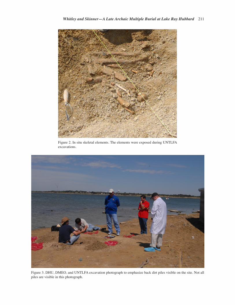
Whitley and Skinner—A Late Archaic Multiple Burial at Lake Ray Hubbard 211
Figure 2. In situ skeletal elements. The elements were exposed during UNTLFA excavations.
Figure 3. DHU, DMEO, and UNTLFA excavation photograph to emphasize back dirt piles visible on the site. Not all piles are visible in this photograph.

212 Texas Archeological Society
(ARC) to gather the bones, records, and other information and then to conduct additional exca-vations at the site of the apparent burial in order to retrieve any remaining bones and artifacts and to explore the site area from which the bones had been recovered. The Texas Historical Commis-sion, Archeology Division, issued an Antiquities Permit (#6112) to recover the remaining skeletal remains and associated artifacts from the discov-ery area.
In September 2011, the location was relatively dry and photographs of the scene and personal communication with UNTLFA staff indicated that the matrix was easily excavated. The lake level at the time of discovery on September 22, 2011, was 429.93 feet. ARCs excavations were postponed by several days due to precipitation. The lake level remained constant in October and November; however, precipitation in early December resulted in the gain of 1.01 feet (Lakes On-Line, http://ray-hubbard.uslakes.info/Level.asp, accessed January 30, 2012). This resulted in extremely sticky, wet clay at the site during ARC excavations that com-menced on December 8, 2011, and were completed on December 12, 2011.
A thin layer of ice coated the lake bed surface and the weather was cloudy and 31 degrees on the morning of December 8. Upon arrival, it was ap-parent that the excavated pit had been filled with some of the back dirt from the previous excava-tion. Fragments of human skeletal remains were scattered across the site, although all collected fragments were found within the barricaded area. Dense bone fragments were concentrated near the DHU pit; these were not individually point plotted. A grid was set using a retaining wall as a baseline and the northeast corner of the retaining wall as the main datum point.
All human remains and lithic artifacts outside the bone concentrations were point-plotted. Several quartzite flakes were also piece-plotted and may have been scattered with the bone elements. Most of the point-plotted items were skeletal fragments and included small pieces of long bone, crania, mandible, femur, and possibly the acetabulum.
A 5 x 6 m area was gridded for scraping and recovery within the dense bone concentrations (Figure 5). Our initial research design designated a 3 x 3 m grid for horizontal control, but the exten-sive bone scatter required the larger grid. Setting
Figure 4. Dart points photographed in the field by DHU.
ab c

Whitley and Skinner—A Late Archaic Multiple Burial at Lake Ray Hubbard 213
up the grid proved difficult due to the wet clay and shoes quickly became coated with large amounts of sticky clay. Only one individual was allowed inside the grid area while staking the site. In order to prevent loss of bone or tracking bone across the site, boots were scraped clean of adhering mud in each unit. Removal of sediment from the boots limited further site disturbance, since clay adher-ence to footwear was significant and the excavator tended to sink several inches in some locations while trying to stake the grid. Two by two m sec-tions were initially gridded and then divided into 1 x 1 m units as excavation progressed. This allowed the excavators to quarter each 2 x 2 m section. All units were identified by their northeast corner and consisted of 1 x 1 m units.
Surface troweling of the sediments to collect the numerous bone fragments commenced in N5E6. The crew worked in a counter-clockwise direction, scraping N5E6, then N5E5 and N5E4, until the shoreline was reached, and then moving to the south. Sediment troweling continued until a hard-packed sterile sediment was reached, approximately 10 cm below the lake bed surface. No bones were evident on the cleared surfaces. The outermost area was troweled first, and then the crew moved in 1 m intervals toward the location of the DHU pit. All units were hand troweled. Shovel scraping to 5 cm bs was attempted in N5E6 as a
Figure 5. 41DL8 site map showing the pit defined by DHU as well as the area gridded and scraped by ARC.
method of removing back dirt left by the DHU and UNTLFA excavations, but the clay was too thick and sticky. Each unit was hand-troweled to 10 cm bs.
Field screening was impossible, and thus all sediment was bagged and brought to the laboratory for wa-ter screening. The crew collected ap-proximately four 30-40 pound bags of sediment per 1 x 1 m unit. The number of bags collected depended upon the thickness of piled backdirt left after the previous excavations.
In unit N2E2, numerous teeth and several small mandibular frag-ments were found in a concentrated pile on the surface. The concentra-tion included molars, incisors, and pre-molars. Two additional teeth were found within the first 2 cm in the unit’s southeast corner. This unit was chosen to excavate to 20 cm bs
to look for additional remains as the original DHU pit had not yet been located and the concentration resembled the original find. Accordingly, three quadrants of this unit were excavated to 20 cm bs to search for additional in situ remains and also gar-ner an understanding of the sterile sediment depth and appearance. Sterile sediment was encountered at approximately 8-10 cm bs, depending upon the amount of back dirt present. All bones and teeth were found in the first 10 cm. The sterile sediment was mottled clay (33 percent each pale red, reddish-yellow, and pale brown). The back dirt was clay (light yellowish-brown and brown), depending upon the amount of drying of the clay before the Munsell color was recorded. The sediments below 10 cm were extremely waterlogged and excavation was difficult and slow. Within 10 minutes of excavating to 15-20 cm bs, groundwater began seeping into the excavation pit (Figure 6). The image in Figure 6 was taken a few hours after excavation of that unit on December 9, 2011.
A 6 x 6 cm pocket of skeletal elements was in the northwest corner of Unit N3E2 and the south-west corner of Unit N4E2. Depth to the top of the remains was 11 cm and the base of the feature was 18 cm. Reconstruction from DHU photographs indicates a back dirt pile was located in this vicin-ity and the stake for the DHU grid located in this general area. The feature contained two upended

214 Texas Archeological Society
long bone shafts and a mixture of rib and cranial fragments. Since the photograph showed a stake in the general area of the feature and that the feature was of similar size as the wooden stake used by DHU, it is highly probable the remains washed into the hole that remained after DHU collected the stakes from their grid. No definitive feature outline could be determined.
Troweling in the center of the gridded area resulted in the discovery of the pit excavated by DHU, DMEO, and UNTLFA. The area was de-lineated and all sediments collected. The pit con-tained back dirt from prior excavation with bone fragments mixed throughout the pit fill. The pit continually filled with water once a depth of 15 cm was reached; however, sediment removal continued to 25 cm, at which point a distinct change in the texture of the sterile soil had been reached. No additional remains were found at the level of the sterile sediments or in the pit walls. Remains were not piece plotted within each unit due to the small fragment sizes and since skeletal elements were
not in situ but were scattered across the site. Ad-ditionally, it was unclear if certain back dirt piles corresponded with the DHU and DMEO quadrants since their excavations occurred over several days, and their grid had only been employed on the sec-ond day of excavation.
Between Thursday, December 8, 2011 and Friday, December 9, 2011, the water level rose approximately 10-20 cm and encroached upon the excavation units. Excavation proved difficult due to the water-logged conditions and texture of the wet clay and units excavated to 10 cm bs had stand-ing water at the base within 30 minutes.
All excavated sediment was water screened in the ARC laboratory. An estimated 2,340 pounds of sediment were brought to the lab for water screening and, due to the amount of clay, water screening took two weeks to complete. The col-lected sediment was mixed with baking soda and water to dissolve the clay so the slurry could be easily screened. All material was screened through 1/8-inch mesh in order to recover small bone
Figure 6. View of site showing excavation unit and water line.

Whitley and Skinner—A Late Archaic Multiple Burial at Lake Ray Hubbard 215
fragments. The process was highly successful, recovering over 12,900 countable bone fragments, including a malleus, a middle ear ossicles.
Once the sediment was water screened, the screened material was dried and re-bagged, ac-cording to original unit. Large amounts of calcium carbonate nodules were present in all screened material. The skeletal fragments were hand sorted from the calcium carbonate. Any remains larger than 1 mm were separated from the debris, trash, and calcium carbonate. Identifiable fragments that could be assigned to a skeletal element or category of skeletal element were then sorted and stored by unit separate from the remaining unidentifiable bone fragments. Both identifiable and unidentifi-able bone fragments collected via the screening process were counted and cataloged per collection bag and the total gram weight per bag tallied: 998 total identifiable fragments and 11,298 unidentifi-able fragments collected during screening. Bone fragments less than 1 mm were not sorted or counted and the matrix, consisting of small bone fragments and calcium carbonate nodules, was combined and saved for repatriation. A total of 12,913 fragments were collected in the ARC, DHU, DMEO, and UNTLFA work.
All remains collected by ARC were bagged, counted, and weighed by unit. Due to the disturbed context, fragments identifiable to a specific element were matched as best as possible with the bones collected by DHU, DCME, and UNTLFA. Hori-zontal control of the identifiable fragments pro-vided no clear indication of body position or ori-entation, but did provide evidence that the remains were not in situ and had been highly disturbed. Without the possibility of identifying individuals, all remains were analyzed as a co-mingled burial. Bone fragments were sorted and reconstructed as best as possible. Minimum number of individuals was calculated per element: i.e., femora, tibiae, talus, humerus, etc.
HUMAN REMAINS ANALYSIS
Methods, Reconstruction and MNI
Laboratory methods followed Stodder et al.’s (2010) recommendation for working with com-mingled remains. All fragments were sorted ac-cording to element, when possible, and counted. Long bone sorting included categories for bone that
could not be identified by element and were sorted as large long bone fragments (tibia, femur, and humeral fragments) and small long bone fragments (radius, ulna, and fibula). Fragments were matched, when possible, to larger elements. Reconstruction efforts focused on the bones that would yield the most information, such as the femur, tibia, and humerus. Only a few refits were possible on the crania and very few identifiable cranial fragments were present.
Minimum number of individuals (MNI) was calculated after refitting was complete. Non-repeat-able skeletal elements for features were counted. Only one element or feature could be identified in several cases, but several elements, including the talus, anterior crest of the tibia, medial deltoid attachment on the humerus, complete patella, and right radial notch on the ulna, all indicate a MNI of four individuals (Table 1). Skeletal elements could not be matched between individuals; how-ever, skeletal elements could be paired within the element in many cases. For example, two femora could be identified as belonging to the same in-dividual, but reconstructing which set of femora belonged with which set of humeri or tibiae was not possible.
Reconstruction of most skeletal elements was also impossible due to the highly fragmented con-dition of the skeletal elements and trabecular bone. The bone fragmentation was due to a combination of the age of the skeleton and the use of shovels and rakes by DHU and the DMEO. Auricular sur-faces were present on some fragments of ilium, but the surface was either too highly eroded or had evidence of fresh breaks that precluded analysis. The extreme fragmentary condition of the ilium, ischium, and pubis prevented using these bones for sex or age estimation.
Sex Estimation
The innominates and skull were too highly fragmented to be reconstructed. Although some fragments were large, the portions needed for sex assessment were damaged. The greater sciatic notch was visible on several ilia fragments, but most were too small for an accurate identification. On the skull, only six supra orbital edges were available for analy-sis, but none were larger than 10 mm in width. Of the three temporal bones identifiable, two had fresh breaks through the mastoid processes.
Individual sex was determined using talus

216 Texas Archeological Society
Table 1. Minimum Number of Individuals (MNI) per Skeletal Element.
Element Portion Count MNI
Temporal Mastoid Process 2 right, 1 left 2C1 Dens facet 1 - single 1C2 Dens 1 - single 1Clavicle Based on deltoid attachment 2 right, 3 left 3Scapula Right Glenoid Fossa 2 right, 3 left 3Ilium Right greater sciatic notch 2 right, 3 left, 1 unsided 3Ischium Ischial Tuberosity 3 right, 4 left 4Pubis Superior Ramus 2 right 2Humerus Trochlea 2 left, 2 right 2 Capitulum 1 left, 2 right 2 Olecranon Fossa 2 left, 2 right 2 Medial Deltoid Attachment 4 left, 4 right 4Radius Right Neck 1 unsided 1 Right Radial Tuberosity 1 (1 left) 1Ulna Radial Notch 4 left, 2 right 4Femur Left Gleuteal Attachment 4 left, 3 right 4 Femoral Neck/Head 3 right, 2 left 3Patella Whole Element 3 left, 4 right 4Tibia Anterior Crest 4 right, 4 left 4 Tibial Tuberosity 3 unsidedFibula Malleolus 2 left, 2 right 2MT1 Right Base/Right Head 1 left 1MT5 Right Base 2 left, 1 right 2Hamate 1 right 1Lunate 2 right 2Scaphoid 2 right 2Capitate 1 right, 1 left 1Triquetral 2 left, 1 right 2Foot Navicular 2 left, 2 right 2Cuboid 1 left, 1 right 1Calcaneus Right Posterior Talar Surface 3 right, 2 left 3 Calcaneal Tuberosity 1 left, 2 right 1Talus Posterior Calcaneal Surface 4 left, 2 right 4 Right Navicular Articular Surface 3 left, 4 right 4
measurements. Measurements followed the proto-cols set in Steele (1976) and Barrett et al. (2001). Barrett et al. (2001) used the talus to estimate the sex of individuals in an Archaic Native American
population. Their sex determinations were based upon volume of the talus, calculated by obtain-ing the product of the talus length, width, and height. Only two tali from 41DL8 were complete

Whitley and Skinner—A Late Archaic Multiple Burial at Lake Ray Hubbard 217
enough for volume measurements (Table 2) and both indicate the individuals were male. Wilbur (1998) utilized talus dimension to estimate sex in prehistoric Native American remains from West Central Illinois and tested the results against ad-ditional populations. Comparisons with Wilbur’s (1998:185) talus breadth section points indicate that all tali trochlea breadth measurements are consistent with males.
One temporal bone had a complete mastoid process. This mastoid process size is consistent with a male/probable male, with a score of 4/5. Scoring was based upon criteria in Buikstra and Ubelaker (1994). A developmental defect of the external auditory meatus is present on this bone and it is unclear if this condition affects the size of the mastoid process.
Age
The fragmented nature of the remains precluded the use of typical aging methods. Of the skeletal elements that could be assessed, the most accurate post-cranial age that could be identified was “adult.” The best preserved skeletal elements of these indi-viduals were the teeth. Wear patterns were significant and the amount of wear on the molars indicated the individuals were at least in their mid-30s, based upon Lovejoy’s (1985) criteria. However, using wear pat-terns for aging is difficult because cultural factors, such as types of food consumed, texture of the foods, and tool use of the teeth, can alter the rate at which teeth wear. Sciulli (1997:231) indicates that Ohio
Valley Late Archaic populations had extreme rates of wear with low frequencies of pathologies. Root transparency is a more accurate method for aging in-dividuals than tooth wear. Lamendin et al. (1992) and Prince and Ubelaker (2002) used root transparency for dental aging and Prince and Ubelaker (2002:114) found the technique is most accurate for individuals 30 to 69 years of age. Prince and Ubelaker (2002) also indicated that sex should be taken into account when employing this method and may result in an over-estimation of age. Unfortunately, their formulae correcting for ancestry and sex did not include Native American root transparency calculations, and there-fore Lamendin et al. (1992) calculations are utilized. Due to the lack of bone preservation, this method of aging was the best option.
Before age could be estimated, teeth were sorted by “individual” based upon wear patterns, presence of alveolar bone in which teeth could be refitted after being sorted by tooth type, and color. Maxillary and mandibular molars were also checked for fit, ensur-ing wear patterns matched. Lamendin et al. (1992) methods were used on single rooted teeth. Only a few teeth could be measured for root transparency since many of the teeth had taphonomic changes in which calcium carbonate infiltrated the root of the tooth, starting at the apex. Tooth root transparency was measured using Mituyoto Digital calipers to the 0.01 mm level. Teeth were placed on a light board and tooth root transparency was measured on the labial side of the tooth.
Root height was measured from the apex to the crown on the labial side of the tooth and
Table 2. Talus Measurements and Sex Estimation.
Bone ID Talus Trochlea Sex Estimate
Length Width Height Volumea Breadth LengthTalus
VolumebTrochlea Breadthc
1 60.0 49.5 35.5 105.44 34.44 36.4 M M2 53.5 45.0 32.0 77.04 31.19 – M M3 – – – – 30.64 – – M4 – – – – 31.19 – – M5 – – – – 33.19 – – M6 – – – – 34.14 – – M
aUnits for column are cm3. All other measurements are mm.bAllocation rule = if volume>73 sex = male (Barrett et al. 2001)c Allocation section point = if trochlea breadth > 30.5 mm (Wilbur 1998)M = male

218 Texas Archeological Society
periodontosis height was also measured on the labial portion. The formula used to calculate age was (0.18xP)+(0.42xT)+25.53=age estimation. All age es-timates fell in the middle adult range, with individuals in the late 30s (Table 3); they can be categorized as Middle Adult (30-50 years of age-at-death).
Stature
Stature estimates were calculated on long bones in which segments of reconstructed bone could be measured. Complete reconstruction was impossible on the tibia, femora, and humeri, as most epiphyses were missing. Femoral heads had the greatest survival rate of the epiphyses of the tibia, femora, and humeri, although only two could be refit. Long bone lengths were reconstructed from segment analysis, and segment analysis calcu-lations were based on formula found in Steele and McKern (1969). Their regression formulae were based upon prehistoric American Indian popula-tions of Mississippian period cultural affinities.
Genovés (1967) stature formulae were used because the Genovés sample probably most closely resembles the population under study. Sciulli et al. (1990:276) also designed stature regression formu-lae that included Late Archaic skeletal remains and represented almost half of the skeletal sample. The stature estimates were similar to those calculated utilizing Genovés (1967) formulae (Table 4). Bone numbers for each skeletal element were generated randomly and do not correlate to each other across elements. Thus, the humerus under “Bone No. 1” is not from the same individual listed as “Bone No. 1” femur. No stature estimates could be calculated for bones 4, 5, 6, and 8 for all elements.
Stature reconstructions from the Genovés (1967) formula indicate that the males range in height from 156.77 cm to 172.04 cm. Average stature of the individuals, including results of all the tibiae and femora from the Genovés formula, is 163.81 cm and the use of the Sciulli et al. (1990) formulae resulted in an average 163.70 cm; stature estimates did not include results from the humerus as this bone is less reliable for indi-cating stature. Femora 3 and 7 were matched and resulted in similar stature reconstructions. Stature estimates that were based upon more segments have greater accuracy than those based upon one segment; thus, there is the potential that some of the calculations have underestimated the height of the individuals.
The average stature of the four males at 41DL8 is 164.23 cm using Genové’s formulae; the stature estimate derived from femur #3 was excluded from the final average stature since it was determined femora #3 and #7 were from the same individual. This average is slightly less than that for other stat-ure estimates for Native American in Texas (Table 5). However, stature ranges indicate that at least one stature estimate from 41DL8 (158.96 cm) was less than the shortest stature listed in the ranges of the other reports, with 41AU36 and 41AU37 reporting the lowest male stature at 163.3 cm. It is unclear to what degree the use of segment analysis influenced the stature estimates at 41DL8. It is also unclear whether the short statured individual was also the same individual with the external auditory atresia, and, as a result, was malnourished dur-ing childhood due to the developmental defect or whether there was a condition associated with the disease that resulted in stunting (see below).
Table 3. Age Estimation Based Upon Root Transparency.
Individual ToothRoot
HeightPeriodontosis
HeightTransparency
Height P TAge
Estimate
3 UI1 14.47 2.8 3.81 19.35 26.33 40.13 LI2 15.66 1.91 3.91 12.20 24.97 38.24 LI2 14.81 2.50 3.08 16.88 20.80 37.34 C 14.44 2.51 4.23 17.38 29.29 41.02 I2 13.21 1.59 3.73 12.04 28.24 39.6
*All measurements in mmP=(Periodontosis Height x 100)/Root Height; T=(Transparency Height x 100)/Root Height

Whitley and Skinner—A Late Archaic Multiple Burial at Lake Ray Hubbard 219
Table 4. Stature Estimations (in cm).
Bone No. Humerus Femur Tibia
Staturea Statureb SD Staturec SD Statured SD Staturee SD
1 161.75 – – – – 169.04 5.91 168.30 6.462 161.75 164.74 5.88 166.39 6.30 161.34 5.52 157.16 6.063 156.77 6.38 157.74 6.30 172.04 4.87 172.46 5.424 – – – – – – – – –5 – – – – – – – – –6 – – – – – – – – –7 – 158.96 6.38 160.12 6.30 – – – –8 – – – – – – – – –
Staturea = From table in Genovés (1967)Statureb = From Genovés (1967) = (2.26*Femur)+66.379)-2.5 = stature ± 3.417Statured = From Genovés (1967) = (1.96*Tibia)+93.752)-2.5 = stature ± 2.812SD Femur Genovés (1967) = (2.26*SD from segment analysis)+3.417SD Tibia Genovés (1967) = (1.96*SD from segment analysis)+2.812Staturec = From Scuilli et al. (1990) = (2.45*Femur)+43.56)-10.5 = stature ±3.34Staturee = From Scuilli et al. (1990) = (2.71*Tibia)+50.25)-10.5 = stature ± 3.36SD Femur Scuilli et al. (1990) = (2.26*SD from segment analysis)+3.34SD Tibia Scuilli et al. (1990) = (1.96*SD from segment analysis)+3.36*Tibia calculation for Bone #2 - added 10 cm per Scuilli et al. (1990) due to formula resulting in measurement less than 153.5 cm.Bone numbers for the elements are independent of other elements. They do not correspond to individuals but are randomly assigned by skeletal element.
Table 5. Estimated Stature of Individuals (in cm) at 41DL8 with Comparative Data for Other Texas Native Americans.
Population Males Range
41DL8a 164.23 158.96-172.0441AU36 and 41AU37b 167.90 163.30-175.5041RW4c 167.91 167.61-168.07East Fork of Trinity Riverd 167.82 166.26-168.97Texas Indiansb 165.40 164.00-166.50
a Average values were calculated using the long bone stature from Table 4, excluding bone 3. Bone 3 was excluded because bones 3 and 7 of the femur represent the same individual.b Malina and Bramblett (1981:336).c Recalculated from Ellzey et al. (1966). Only males were included (n=3) and stature was reconstructed from femoral length.d Recalculated from Navey (1974). Average includes males only (n=5).

220 Texas Archeological Society
Pathology
Little pathology was present on the skeletal remains. There was no evidence of porotic hyper-ostosis or any changes associated with malnutrition or nutritional deficiencies. Dental caries were mini-mal and were present on six of the 54 teeth. Caries included occlusal and mesial dental caries and were small, between 1-2 mm in size. One ante-mortem loss was recorded. Periodontal degeneration was minimal and could be observed on several molars. Use of the dental aging technique by Lamendin et al. (1992) required recording periodontal degen-eration. The measurements all indicate minor to moderate periodontosis. Periodontal disease was not present on the few fragments of alveolar bone available for analysis.
Dental wear was moderate to severe on all teeth. Dental wear patterns were recorded accord-ing to the scoring in Buikstra and Ubelaker (1994). Most first and second maxillary and mandibular molars were worn until dentin was exposed across the surface of the tooth. Wear was greatest in individual 3’s teeth and all had dentin exposure across the entire surface. Although attrition was significant on the Molar 1 and Molar 2, secondary dentin formation was not present and wear had not exposed the pulp cavity.
Polishing indicative of occupa-tional use was present on the incisors of individuals 3 and 4. The lingual portion of the upper incisors was worn smooth on the lingual surface and almost obliterated the presence of shoveling. In individual 4, polishing was also present on the lingual side of the maxillary incisors. The maxillary left canine and right second incisor also had evidence of wear on the la-bial surface of the teeth. A flattened location was evident across the labial surface, consistent with material be-ing pulled across the surface or filing. The flattened area was oriented in a mesial/distal pattern and was present only on inferior portions of the teeth closest to the occlusal plane.
The only temporal bone with an undamaged external auditory meatus exhibited a developmental defect. In this case, the external auditory meatus and the tympanic bone failed
to develop. As a result, only a bifurcated slight depression was present at the location where the external auditory canal should have developed (Figure 7). This condition is known as external auditory atresia and this case is the most severe expression of the condition. Complete atresia re-sults in a tympanic plate that does not develop and the styloid process is usually missing or is not fully formed (Barnes 1994:198). Aplasia of the external auditory meatus can also result in malformation of the external ear. Although auditory atresia can be acquired, complete atresia is generally the result of congenital defects (Hodges et al. 1990).
Atresia can be associated with many differ-ent syndromes and congenital defects, such as Treacher Collins syndrome. However, the condi-tion can also occur as an isolated phenomenon. Isolated incidences of the defect are more common in males than females (2:1) and more commonly occur on the right (65 percent) than the left ear (Gorlin et al. 1995). Due to destruction of the internal structure of the ear, the presence or mal-formation of the ossicles could not be observed but the breakage revealed a pneumaticized area in the location where the internal acoustic meatus should have been present. The sulcus sigmoideus was also absent. Atresia of the auditory meatus is
Figure 7. Right temporal bone with a developmental defect of the external auditory meatus.
Whitley and Skinner—A Late Archaic Multiple Burial at Lake Ray Hubbard 221
classified into three conditions, ranked by severity, with Type III most closely associated with Treacher Collins Syndrome. This individual must be ranked a Type II since the deformity of a tympanic cavity is not able to be observed and radiographs are not present to evaluate the degree of pneumatization of the mastoid process (typology defined in Gorlin et al. [1995:92]). The condition affects Native Americans at a much higher rate than in the general population, with a rate at 1:2000 Native American births as compared to 1:15,000 white births.
With the severe form present in this case, this individual likely suffered from complete hearing loss in this ear, which would have made life chal-lenging. Unilateral hearing loss can result in an inability to localize sound on a horizontal plane (Humes et al. 1980), as well as communication issues associated with speech and language delays (Lieu 2004). There is the potential that this indi-vidual suffered from associated syndromes that could have resulted in further life complications and challenges; such information would require DNA analysis since the fragmentary nature of the bones prevented observations for additional bone developmental defects. Only a few accounts of this condition are reported in the archeological literature and are from seven cases found in Peru, a cave in New Mexico, and a mound in Arkansas (Hrdlicka 1933), historic Canada (Swanston et al. 2011), the Late Woodland in Iowa (Hodges et al. 1990), Anglo-Saxon England (Wells 1962), and a historic case from Slovakia (Masnicova and Benus 2001). The 41DL8 case is the oldest radiocarbon-dated example of this developmental defect and possibly the oldest known archeological case. The only additional case that may date to a similar period and be from an individual with a hunter-gatherer subsistence pattern is the New Mexico case. It is listed by Hrdlicka (1933) as being “col-lected by Edgar B. Howard” and was found in a cave west of Carlsbad, New Mexico. Howard did excavate several Basketmaker Period (2000 B.C.-A.D. 500) burials in Burnett Cave (Heffner 1932) before Hrdlicka’s report was published in 1933.
Radiocarbon Dates and Isotope Results
Five Native American tribes were contacted about the remains in order to alert them of the re-mains and potential cultural affiliation. After analy-sis of the associated dart points, the preponderance of the evidence indicated the Wichita and Affiliated
Tribes and the Caddo Nation of Oklahoma were culturally affiliated with the human remains and NAGPRA consultation occurred. The Caddo Na-tion deferred any decisions regarding the remains to the Wichita and Affiliated Tribes.
With the permission of the Wichita and Affili-ated Tribes, cortical bone from the femora of two individuals was submitted to Beta Analytic, Inc. for radiocarbon dating. These bone segments were chosen due to the good cortical bone preservation and the fact that the fragments could be specified as belonging to two different individuals. Beta Analytic, Inc. reported that bone collagen was well preserved and each sample provided adequate amounts of carbon for the analysis and measure-ments to proceed normally.
Segments of bone were randomly chosen from two individuals, with samples taken from Femur No. 5 and No. 7. Each bone sample was washed with deionized water, the surface was scraped free of the outer layers, a small portion was crushed gently, and a cold and dilute hydrochloric acid was applied until the apatite was removed. Any rootlets present among the collagen were removed. A so-dium hydroxide (NaOH) pretreatment was applied to be certain no secondary organic acids were pres-ent (Beta Analytic collagen extraction protocols, http://www.radiocarbon.com/pretreatment-carbon-dating.htm, accessed August 22, 2012).
Radiocarbon analysis results indicate the remains date to the Late Archaic period (1500 B.C. to A.D. 600; Table 6). The conventional radiocarbon age on Femur No. 5 was 3010 ± 30 B.P. (Beta-327106), with a two sigma calibra-tion of 1130-1380 B.C. The Femur No. 7 has a conventional radiocarbon age of 2860 ± 30 B.P. (Beta-327107), and a two sigma calibrated age range of 930-1120 B.C.
The lack of overlap in the dates indicates that these two individuals had not been alive at the same time. The insufficient contextual data as-sociated with the excavation prevents evaluating the depositional relationship of the remains. Since we are unsure of the exact association of the re-mains and whether the remains were articulated or disturbed, we offer three scenarios that may have resulted in the differing radiocarbon ages. One, the burial pit could have been re-opened for subse-quent burial of individuals on multiple occasions. Due to the good preservation of the cortical bone, it is more likely that the remains were covered between burial events if this scenario occurred.
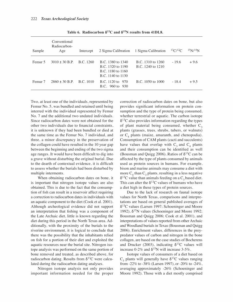
222 Texas Archeological Society
Two, at least one of the individuals, represented by Femur No. 5, was bundled and retained until being interred with the individual represented by Femur No. 7 and the additional two undated individuals. Since radiocarbon dates were not obtained for the other two individuals due to financial constraints, it is unknown if they had been bundled or died at the same time as the Femur No. 7 individual, and three, a minor discrepancy in the preservation of the collagen could have resulted in the 10 year gap between the beginning and ending of the two sigma age ranges. It would have been difficult to dig into a grave without disturbing the original burial. Due to the dearth of contextual evidence, it is difficult to assess whether the burials had been disturbed by multiple interments.
When obtaining radiocarbon dates on bone, it is important that nitrogen isotope values are also obtained. This is due to the fact that the consump-tion of fish can result in a reservoir affect requiring a correction to radiocarbon dates in individuals with an aquatic component to the diet (Cook et al. 2001). Although archeological evidence did not support an interpretation that fishing was a component of the Late Archaic diet, little is known regarding the diet during this period in the North Texas area. Ad-ditionally, with the proximity of the burials to the riverine environment, it is logical to conclude that there was the possibility that the inhabitants relied on fish for a portion of their diet and exploited the aquatic resources near the burial site. Nitrogen iso-tope analysis was performed on the same portion of bone removed and treated, as described above, for radiocarbon dating. Results from δ13C were calcu-lated during the radiocarbon dating analyses.
Nitrogen isotope analysis not only provides important information needed for the proper
correction of radiocarbon dates on bone, but also provides significant information on protein con-sumption and the type of protein being consumed, whether terrestrial or aquatic. The carbon isotope δ13C also provides information regarding the types of plant material being consumed, whether C3 plants (grasses, trees, shrubs, tubers, or walnuts) or C4 plants (maize, amaranth, and chenopodia). Consumption of CAM plants (cacti and succulents) have values that overlap with C3 and C4 plants and their consumption can be identified as well (Bousman and Quigg 2006). Ratios of δ13C can be affected by the type of plants consumed by animals used as protein sources in humans. For example, bison and marine animals may consume a diet with more C4 than C3 plants, resulting in a less negative δ13C value than animals feeding on a C3 based diet. This can alter the δ13C values of humans who have a diet high in these types of protein sources.
Due to the lack of research on faunal isotope values for North Texas, comparisons and interpre-tations are based on general published averages of δ13C values (Larsen 1997; Schoeninger and Moore 1992), δ15N values (Schoeninger and Moore 1992; Bousman and Quigg 2006; Cook et al. 2001), and interpretations of values reported from other Archaic and Woodland burials in Texas (Bousman and Quigg 2006). Enrichment values, differences in the prey-predator values of carbon and nitrogen in the bone collagen, are based on the case studies of Bocherens and Drucker (2003), indicating δ13C values will increase 0-2% and δ15N will increase 3-5%.
Isotope values of consumers of a diet based on C3 plants will generally have δ13C values ranging from -22% to -38% (Larsen 1997), or -20% to -24%, averaging approximately -26% (Schoeninger and Moore 1992). Those with a diet mostly comprised
Table 6. Radiocarbon δ13C and δ15N results from 41DL8.
Sample
Conventional Radiocarbon-
Age Intercept 2 Sigma Calibration 1 Sigma Calibration 13C/12C 15N/14N
Femur 5 3010 ± 30 B.P. B.C. 1260 B.C. 1380 to 1340 B.C. 1320 to 1190 B.C. 1180 to 1160 B.C. 1140 to 1130
B.C. 1310 to 1260B.C. 1240 to 1210
- 19.6 + 9.6
Femur 7 2860 ± 30 B.P. B.C. 1010 B.C. 1120 to 970 B.C. 960 to 930
B.C. 1050 to 1000 - 18.4 + 9.5

Whitley and Skinner—A Late Archaic Multiple Burial at Lake Ray Hubbard 223
of C4 foods will have stable carbon isotope values that range from -9% to -21% (Larsen 1997) or -9% to -16%, with a mode of -12% (Schoeninger and Moore 1992). Consumers of cactus and succulents will have a range falling somewhere between the two, with rates closer to C4 (Schoeninger and Moore 1992). Bousman and Quigg (2006) place the divi-sion between C3 and CAM/ C4 diets at -14% δ13C. Nitrogen values for terrestrial diets generally fall between +8% to +10% δ15N. Evidence of fish or ma-rine protein sources generally results in higher δ15N values, above +12% (calculated from Schoeninger and Moore [1992] data). However, data from Kat-zenberg and Weber (1999) indicates some fish may have lower δ15N, with one reported as +7.3%, and that fish δ15N can widely vary (Cook et al. 2001). Thus, future studies in the isotope values of ter-restrial and freshwater resources in the North Texas region would be extremely useful in interpreting subsistence patterns since a baseline from the local animals is needed to accurately calculate enrich-ment values.
The δ15N values at +9.5% and +9.6% from Femora No. 5 and No. 7 indicate the neither of the individuals consumed freshwater fish (Table 7). The values fall within the typical values of a terrestrial-based diet, in which individuals consumed mam-mals such as deer and elk. Therefore, although they resided, or were buried, next to a riverine environ-ment, fish were not exploited by these individuals for protein resources. If we compare these values to results found in Shoeninger and Moore (1992), the meat consumption is consistent with mule deer at Pecos Pueblo (δ15N between 9-11%). The protein consumption was likely focused on browsing mam-mals such as deer and on nuts, both of which were likely in abundance in the area.
The δ13C data, at -19.6% and -18.4% (see Tables 6 and 7), indicate a dietary concentration on C3 plants and consumption of protein sources that relied more heavily on C3 plants for their diet. Although slightly outside the range stated by Schoeninger and Moore (1992) of -20% to -34%, the values represent a diet almost purely based on C3 plants with the individuals from Lake Ray Hubbard probably consuming some C4 plant materials, CAM (cactus or succulents), or an occasional bison, resulting in the slightly higher δ13C values. When compared to the CAM-based diets reported in Bousman and Quigg (2006), it is easily discerned that the values reflect a greater C3 component in their diet. Only a few individuals from Seminole Sink have δ13C
values comparable to the individuals from Lake Ray Hubbard. Thus, the δ13C and δ15N values for both individuals indicate they had a hunter-gatherer subsistence pattern focused on browsing mammals and wild plant foods.
These results are consistent with the overall subsistence patterns reported for Cooper Lake sites in the upper Sulphur River basin dating to the same time period (Fields 2004). Late Archaic subsistence patterns from this East Texas area entailed hunting of animals found in woodland and woodland-edge areas, with gathering of wild plant foods, including nuts, tubers, and seeds. Fields (2004) reports use of aquatic environments within the hunting zone; however, the isotope values from Lake Ray Hub-bard do not suggest the use of freshwater resources.
ASSOCIATED FUNERARY OBJECTS
Besides the presence of several pieces of fine-grained quartzite lithic debris, the only artifacts found directly associated with the grave were seven dart points (Figure 8 and Table 8). Each point is almost complete and the tip of dart point 1 was found during matrix washing. The three incom-plete points are missing the tip or the base. The points were inspected by a variety of authorities and their consensus is that the points are probably early Late Archaic in age (Elton Prewitt, personal communication 2012; Karl Kibler, personal com-munication 2012; and Dan McGregor, personal communication 2012). All three reviewers stated that the points are similar to Untyped Group 1 dart points described from the Higginbotham site at Lake Waco (Mehalchick and Kibler 2008:300-307) that have been dated between 380-1270 B.C. at that site. However, all three authorities agree that the stems of the specimens from 41DL8 are too short for the points to fit into that group of dart points.
Several of the dart points have evidence of having been reworked. There is no evidence that the raw materials were heat-treated before they were manufactured. The raw materials listed in Table 8 were identified by Larry Banks of Para-dise, Texas (personal communication 2012) and Don Wyckoff of Norman, Oklahoma (personal communication 2012). Detailed descriptions of the three raw materials are provided by Banks (1990).
The Edwards chert is from Central Texas and is distinct from the Uvalde or Ogallala gravel cherts that are found in the Dallas/Fort Worth area (Banks

224 Texas Archeological Society
Table 7. Human δ13C and δ15N Values from 41DL8 and other Texas Archaic sites.
Site Trinomial Sample Component δ13C δ15N
Lake Ray Hubbard 41DL8 RHB#5FEMUR Early Late Archaic -19.6 9.6Lake Ray Hubbard 41DL8 RHB#7FEMUR Early Late Archaic -18.4 9.5Bering Sinkhole 41KR241 CCNR-68032 Late Archaic -16.7 8.1Bering Sinkhole 41KR241 CCNR-38033 Late Archaic -16.5 9.7Bering Sinkhole 41KR241 CCNR-38034 Late Archaic -17.5 8.2Bering Sinkhole 41KR241 CCNR-38035 Late Archaic -15.9 7.5Bering Sinkhole 41KR241 CCNR-38036 Late Archaic -16.1 7.1Bering Sinkhole 41KR241 CCNR-38037 Late Archaic -16.5 7.7Bering Sinkhole 41KR241 CCNR-38038 Late Archaic -15.8 7.8Bering Sinkhole 41KR241 CCNR-38039 Middle Archaic -16.2 6.9Bering Sinkhole 41KR241 CCNR-38040 Middle Archaic -16.0 7.3Bering Sinkhole 41KR241 CCNR-38041 Middle Archaic -15.2 7.5Bering Sinkhole 41KR241 CCNR-38042 Middle Archaic -16.6 8.3Bering Sinkhole 41KR241 CCNR-38043 Early Archaic -15.2 9.0Bering Sinkhole 41KR241 CCNR-38044 Early Archaic -15.2 7.4Bering Sinkhole 41KR241 CCNR-38045 Early Archaic -14.3 8.5Bering Sinkhole 41KR241 CCNR-38046 Early Archaic -14.9 9.6Bering Sinkhole 41KR241 CCNR-38047 Early Archaic -13.7 8.8Conejo shelter 41VV162 1 Late Archaic -12.6 10.2Conejo shelter 41VV162 2 Late Archaic -13.9 12.6Conejo shelter 41VV162 3 Late Archaic -12.6 10.5Conejo shelter 41VV162 4 Late Archaic -14.6 16.6Skyline Shelter 41VV930 1 Late Archaic -15.7 5.3Seminole Sink 41VV620 541 Early Archaic -13.2 –Seminole Sink 41VV620 1755 Early Archaic -15.5 –Seminole Sink 41VV620 798.1 Early Archaic -18.1 –Seminole Sink 41VV620 571 Early Archaic -18.4 –Seminole Sink 41VV620 70 Early Archaic -13.7 –Seminole Sink 41VV620 1527.9 Early Archaic -22.1 –Seminole Sink 41VV620 171 Early Archaic -12.0 –Seminole Sink 41VV620 1450 Early Archaic -11.4 –ELCOR Cave X41CV12 Skull 1 Late Archaic -13.0 –ELCOR Cave X41CV12 Skull 5 Late Archaic -12.3 –
Adapted from Bousman and Quigg (2006:Table 1) and Skinner (1978:Table 1) with Lake Ray Hubbard data added.

Whitley and Skinner—A Late Archaic Multiple Burial at Lake Ray Hubbard 225
Table 8. Description of Dart Points from Site 41DL8.
Dart Point
LxWxTh(mm) Grams
Raw Matl* Description
1 53.39x29.54x7.43 9.6 OQ Straight blade edges, barbed shoulders, corner notched, straight stem edges and base
2 79.11x33.87x6.86 19.1+ ED Straight and convex blade edges, barbed shoulders, corner notched, straight stem edges, base missing
3 63.59x30.02x7.98 12.4 ED Straight blade edges, barbed shoulders, corner notched, convex stem edges and straight base
4 60.93+x38.13x6.27 15.1+ ED Slightly convex blade edges, pronounced barbed shoulders, corner notched, and base missing
5 47.26x30.72x6.27 6.6 OQ Straight blade edges, strong barbed shoulders, corner notched, straight stem edges, slightly convex base
6 53.51+x29.47x7.28 10.3+ ED Tip missing, slightly convex blade edges, barbed shoulders, corner notched, straight stem edges and base
7 48.03+x30.91x6.97 8.6+ JV Slightly convex blade edges, barbed shoulders, corner notched, slightly expanding stem edges, base uncertain
*OQ=Ogalalla quartzite, ED=Edwards chert, JV=Johns Valley chert
Figure 8. Dart points 1-7 from 41DL8.

226 Texas Archeological Society
1990:60-61). Ogallala quartzite (Banks 1990:56-57) is found in the upland gravel fields in North Central Texas (Byrd 1971; Menzer and Slaughter 1971; Trask 2005). The Johns Valley chert is from southern Oklahoma but actually contains older Ar-kansas River gravels that were mixed in the more recent Johns Valley formation (Banks 1990:45-47).
CONCLUSIONS AND RECOMMENDATIONS
The discovery of four prehistoric Native American skeletons associated in a single pit at 41DL8 presents the opportunity to review a wealth of information about prehistoric burials from sites in the well-studied East Fork watershed. Buri-als from 14 sites (Figure 9) in the watershed are tabulated below (Table 9) based on a compilation provided by W.W. Crook, III (personal communi-cation 2012) and with the addition of more recent information from sites along Spring Creek (Peter and Clow 2000; Linder-Linsley 1996) and Rowlett Creek (Cliff et al. 1996; Hibbs and Hibbs 2006) above where it empties into Lake Ray Hubbard. This sample represents the results of extensive ar-cheological investigations by various professionals and avocationals of this North Central Texas water-shed; all of the sites except 41DL8 and 41DL396 date to the Late Prehistoric (ca. A.D. 800-1400). Comparable data are not presently available from other watersheds in the Trinity River basin, such as the Elm Fork, West Fork, Mountain Creek, White Rock Creek, Richland/Chambers Creeks, and Cedar Creek, although major investigations have been done in each of these areas. In addition, no comparable mass of information is available from the upper parts of the Neches, Sabine, Sulphur, or Brazos River watersheds.
In part, this opportunity is due to the foresight of the members of the DAS to get permission to conduct excavations before lake construction be-gan after World War II throughout the East Fork valley. Subsequent studies at Lake Lavon and Lake Ray Hubbard were further facilitated because DAS members had published the results of their studies in their journal, The Record. This publication high-lighted the presence of sites containing features, such as Wylie Focus pits and house floors, as well as site locations that are near the margin of the Caddo archeological area, and emphasized that site and artifact preservation was excellent.
Site 41DL8 stands out from the other sites listed in Table 9 because it is the only site that dates to the Late Archaic and where seven dart points are associated with the four adult male skeletons that were discovered. While evidence of Late Pre-historic occupation was implied for the site when it was first recorded and again when Lake Ray Hubbard was surveyed for archeological sites, the presence of the seven dart points in association with the radiocarbon-dated remains indicates that these remains represent the oldest known burial along the East Fork.
The summary of burials within the Lake Lavon and East Fork watershed in Table 9 also reveals a pattern unusual to North Texas. An apparent Late Prehistoric pattern of interring multiple individuals within a single pit is demonstrated by the reported findings of 95 burials at 13 other sites that occur in the middle reaches of the East Fork watershed between Interstate Highway 20 and the upper end of Lake Lavon. The burials contain a combination of adults or adults and children in flexed positions. On the East Fork, including 41DL8, 57 individu-als were buried individually in flexed positions, while the remaining 42 individuals were buried in a total of 12 pits in multiples of from two to seven. The majority of skeletons were adults and it is expected that infants are under-represented since their remains are more friable and do not survive well and/or may be buried in a separate location from adults.In rare cases decapitated bodies were apparently placed in pits but with no grave goods except that Burial 40 at the Lower Rockwall site had three dart points in it.
A review of the literature reveals that sites with burials are not reported for the area upstream from Lake Lavon nor are any reported at sites south from Interstate 20 to the Trinity River junction. Upstream in Dallas County, burials are reported from the White Rock Spillway site (Kirkland and Harris 1941; Harris 1949; Hatzenbuehler and Harris 1949), from the Dalbey site (Skinner et al. 2005), and from Mountain Creek (Peter and McGregor 1988:113-115; Skinner et al. 2007:1). Of these burials, no confirmed multiple burials are reported; however Feature 1 at the Baggett Branch site (41DL149) at Joe Pool Lake could have been a grave with two individuals but the description is inconclusive (Peter and McGregor 1988). Oth-erwise, all the reported burials from these areas are single interments, had few or no artifacts, and appear to be Late Prehistoric in age. Almost no

Whitley and Skinner—A Late Archaic Multiple Burial at Lake Ray Hubbard 227
Figure 9. Sites with multiple burials shown on a map of major watersheds in North Texas.
Table 9. East Fork Watershed Burial Descriptions.
Site Bur#* Bodies Offerings Description Reference
Hogge Bridge(41COL1)
1 1 None Adult undetermined sex; flexed; in pit rim
Stephenson 1952
2 1 None Adult undetermined sex; flexed; in pit rim
3 5 None 2 males, infant, female, adolescent; flexed and superimposed; in pit rim
4 2 None 2 adults undetermined sex; both flexed; in pit rim
5 1 None Adult male; flexed; in pit rim6 1 None Adult undetermined sex;
flexed; in pit rim7 2 None 2 adults undetermined sex;
both flexed; in pit rimButler Hole(41COL2)
8 1 8” bone awl Child undetermined sex; flexed on left side; outside pit
Housewright and Wilson 1942

228 Texas Archeological Society
Site Bur#* Bodies Offerings Description Reference
9 1 13 bone flak-ing tools
Adult undetermined sex; flexed on left side facing west; outside pit
10 1 None Adult undetermined sex; cremated; outside pit
11 2 Conch shell gorget, bone flaking tool
Adult male and child; flexed with adult holding child; outside pit
12 1 None Adult undetermined sex; flexed; outside pit
Branch(41COL9)
13 1 None Adult undetermined sex; flexed; outside pit
Crook, personal communication
14 1 None Adult undetermined sex; flexed; outside pit
Upper Farmersville(41COL34)
15 1 8 Bison scapula hoes
Adolescent undetermined sex; flexed with left side facing east; outside pit
16 2 Sanders En-graved water bottle
Adult male and female; flexed facing each other; outside pit
17 1 11 bone beads Child undetermined sex; flexed on left side facing west; outside pit
18 1 Boatstone Adult undetermined sex; cremation; outside pit
19 1 None Adult undetermined sex; flexed; outside pit
20 1 None Adult undetermined sex; flexed; outside pit
21 1 3 bone beads, mano, bone awl, 6 pol-ished stones, mussel shell paint pot
Child undetermined sex; flexed on left side facing west; in pit rim
22 6 None Adults undetermined sex; unflexed no orientation; in pit rim
23 3 None Adults undetermined sex; no orientation, decapitated; in pit rim
Sister Grove(41COL36)
24 1 Gary dart point
Adult female; flexed on left side facing east; in pit rim
Lynott 1975; Hanna 1940
25 1 None Adult female; flexed on left side facing east; in pit rim
Table 9. (Continued)

Whitley and Skinner—A Late Archaic Multiple Burial at Lake Ray Hubbard 229
Site Bur#* Bodies Offerings Description Reference
26 1 None Adult male; flexed on left side with 3 arrow points in ribs; outside pit
27 1 None Adult undetermined sex; flexed on left side facing east; outside pit
28 1 None Adult undetermined sex; flexed on left side facing east; outside pit
Lower Rockwall (41RW1)
29 1 Bone tools nearby
Adult undetermined sex; flexed; outside pit
Blair 1960; Lorrain et al. 1968
30 1 Bone tools nearby
Adult undetermined sex; flexed; outside pit
31 1 Bone tools nearby
Adult undetermined sex; flexed; outside pit
32 1 Bone tools nearby
Adult undetermined sex; flexed; outside pit
33 1 Bone tools nearby
Adult undetermined sex; flexed; outside pit
34 1 Bone tools nearby
Adult undetermined sex; flexed; outside pit
35 1 Bone tools nearby
Adult undetermined sex; flexed; outside pit
36 1 Bone tools nearby
Adult undetermined sex; flexed; outside pit
37 1 Boatstone, knife
Adult male; flexed on left side facing north; outside pit
38 1 None Adult undetermined sex; badly disturbed; outside pit
39 1 Dart point, scraper, round stone
Adult undetermined sex; flexed on left side facing west; outside pit
40 1 None Adult male; decapitated with 3 embedded dart points; in pit rim
41 1 None Adult female (skull only); fac-ing west; in pit rim
42 1 Calcite crys-tals
Adult female; flexed on left side facing west; inside pit
Table 9. (Continued)

230 Texas Archeological Society
Site Bur#* Bodies Offerings Description Reference
Upper Rock-wall (41RW2)
43 7 Bone needles, awls, arrow points nearby
Adults undetermined sex; no orientation; outside pit
Ross 1966; Harris 1948, 1960; Har-ris, Perkins, and Sollberger 1957; Sollberger and Har-ris 1949
44 1 Dart point; 208 conch shell beads
Adult undetermined sex; cremation with red ochre; outside pit
45 1 None Adult undetermined sex; cremation; outside pit
46 1 None Adult undetermined sex; flexed on left side facing west; outside pit
47 1 None Adult undetermined sex; cremation; outside pit
48 1 None Adult undetermined sex; flexed on left side facing north; outside pit
49 1 None Adult undetermined sex; cremation; outside pit
50 1 None Child undetermined sex; flexed on left side facing south; outside pit
51 1 13 conch shell beads
Adult undetermined sex; bundle burial facing west; outside pit
52 1 None Adult undetermined sex; bundle burial disarticulated; outside pit
53 1 Shell beads, Sanders En-graved vessel, worked shell
Adult female; flexed on left side facing south; inside pit
54 1 Conch shell beads
Adult female; flexed on back facing east; inside pit
Glen Hill(41RW4)
55 1 None Adult male; flexed on right side facing east; in pit rim
Ross 1966
56 1 None Adult male; flexed on right side facing west; in pit rim
57 1 None Adult male; flexed on left side facing north; dart point in chest; in pit
58 1 None Adult male; flexed on left side facing north; inside pit
59 1 None Child undetermined sex; flexed on left side facing north; inside pit
Table 9. (Continued)

Whitley and Skinner—A Late Archaic Multiple Burial at Lake Ray Hubbard 231
Site Bur#* Bodies Offerings Description Reference
60 1 Dart point, red ochre
Adult female; flexed on left side facing east; in pit rim
61 1 None Adult female; flexed on back facing south; inside pit
Gilkey Hill(41DL406)
62 1 None Adult female; flexed on left side facing east; outside pit
63 1 None Child undetermined sex; flexed on left side facing east; outside pit
64 1 None Adult undetermined sex; cremation; outside pit
Ragland(41KF4)
65 2 None Adult female and child; un-flexed on left side facing east; outside pit
Spring Creek(41DL373)
66 1 None Approximately 50 year old fe-male; dated A.D. 1155-1275.
Linder-Linsley 1996; Peter and Clow 2000
Harbor Pointe(41DL369)
67 4 Shell gorget and 16 shell beads
2 adult males, adult female, and sub-adult less than 12 years old; dated A.D. 1010-1165.
Cliff et al. 1996
41DL396 68 3 None 3 males, 2 adults and a 12 year old child; semi-flexed in a pit
Hibbs and Hibbs 2006
41DL8 69 4 7 early Late Archaic dart points
4 adult males; flexed in a pit, dated early Late Archaic
This article
TOTAL 14 sites
69 burials
99skeletons
57 single interments12 multiple interments41 burials without artifacts28 burials with artifacts
*Burial numbers are arbitrarily assigned.
Table 9. (Continued)
burials were found and reported at excavations in the West Fork and the Elm Fork watersheds and the few found were also single interments with no associated grave goods. A burial containing two flexed females and an expanding stem dart point is reported from the Pecan Springs site (Sorrow 1966:8) at Lake Bardwell, in Ellis County.
To the east, no multiple burials were found in the Sulphur River watershed despite years of excavation at nearby Cooper Lake and only single interments are reported from Lake Fork Reservoir (Bruseth and Perttula 1981) and the Yarbrough site
(Johnson 1962:220-224) in the upper Sabine River watershed. No burials were found at the Limerick site at Lake Tawakoni (Duffield 1961), but it was noted that artifacts from the site do not show any affinity to those described from Wylie focus sites in the adjacent East Fork watershed (Duffield 1961:111-112). Certainly, Late Prehistoric sites in the East Fork watershed are not considered to be Caddo by the Caddo Nation or by most authors. The only comparable data come from the Sanders site (41LR2) in Lamar County (Krieger 1946:175; Jackson et al. 2000) where 60 individuals were

232 Texas Archeological Society
uncovered and 12 were in individual graves and the remaining 48 were in nine graves each containing from three to eight bodies. Other Red River Caddo sites and multiple burial graves have been reported downstream at the Sam Kaufman (Roitsch) site (Skinner et al. 1969:26-36) and the Belcher Mound site (Webb 1959:66-116).
In the East Fork, grave goods were found in less than half of the graves and the common artifact types are bone tools and marine shell ornaments. No locally made pottery is reported to have been found with any of the burials and Caddo Sanders Engraved pottery (a water bottle and another vessel) is the only pottery type reported as funerary offerings. Miscel-laneous artifacts include dart points but not arrow points, a boatstone, a mano, a mussel shell paint pot, a chipped stone knife, calcite crystals, a round stone, and red ochre. Grave goods are not as prominent as they are in the Caddo area to the east and northeast.
In summary, the discovery of an early Late Ar-chaic burial pit containing four adult male Native Americans is consistent with a Late Prehistoric pat-tern in parts of the Upper Trinity River watershed of burying multiple individuals in a single burial pit. This pattern appears to be primarily unique to the East Fork basin within the Trinity River watershed. Elsewhere, single interment is the primary burial pattern. How-ever, the grave at 41DL8 appears to be an exception since the associated dart points and the radiocarbon dates indicate that at least two of the individuals had been placed in the ground more than 1500 years be-fore the Late Prehistoric sites (Wylie Focus) listed in Table 9. This lends support to the argument that the Wylie Focus is a concept (Bruseth and Martin 1987) that needs further exploration (Crook and Hughston 2015:158-160). The investigation at 41DL8 supports an interpretation that Late Prehistoric occupants of the East Fork valley were linear descendants of earlier Late Archaic Native Americans
ACKNOWLEDGEMENTS
We wish to thank the following people and groups for their assistance during this investiga-tion. First we want to thank Steve Wallace for discovering the bones, recognizing their impor-tance, and notifying the responsible authorities. The Dallas Police Department (DPD) Homicide Division is to be thanked for stepping forward in evaluating the discovery site and contacting the office of the Dallas Medical Examiner. DPD also provided security for the discovery location before
and through the excavations done by ARC. The University of North Texas Forensic Laboratory conducted preliminary exposure and demonstrated that the bones were prehistoric and archeological. Terry Holmes and Bertram Vanderberg of Dallas Water Utilities arranged to get the discovery site investigated and assisted with coordination with the Wichita and Affiliated Tribes. Excavation was done by the senior author who was assisted by Katy Pocklington. The soil matrix was processed by the ARC office staff including Rachel Hearn and Molly Hall. W.W. “Dub” Crook, Jr. of the Houston Archeological Society provided us with burial information from a manuscript on Collin County archeology that he and Mark Hughston have now published. Terri Parton, President, and Gary Mc-Adams, Cultural Planner, of the Wichita and Af-filiated Tribes, facilitated approval of radiocarbon dating of two femur fragments and the repatriation of the bones and funerary artifacts. Radiocarbon dates were processed at Beta Analytic, Inc. and the cost was underwritten by ARC. A cedar box for the remains was made by Justin Boxwell.
REFERENCES CITED
Banks, L. D.1990 From Mountain Peaks to Alligator Stomachs: A
Review of Lithic Sources in the Trans-Mississippi South, the Southern Plains, and Adjacent Southwest. Memoir #4. Oklahoma Anthropological Society, Norman.
Barnes, E.1994 Development Defects of the Axial Skeleton in Pa-
leopathology. University Press of Colorado, Niwot, Colorado.
Barrett, C., W. Cavallari, and P. W. Sciulli2001 Estimation of Sex from the Talus in Prehis-
toric Native Americans. Collegium Antropolicum 25(1):13-19.
Blair, B.1960 A Burial at Lower Rockwall. The Record 15(1):5-6.
Bocherens, H. and D. Drucker2003 Trophic Level Isotopic Enrichment of Carbon and
Nitrogen in Bone Collagen: Case Studies from Recent and Ancient Terrestrial Ecosystems. Inter-national Journal of Osteoarchaeology 13:46-53.
Bousman, C. B. and M. Quigg2006 Stable Carbon Isotopes from Archaic Human Re-
mains in the Chihuahuan Desert and Central Texas. Plains Anthropologist 51(198):123-139.

Whitley and Skinner—A Late Archaic Multiple Burial at Lake Ray Hubbard 233
Bruseth, J. E. and W. A. Martin1987 The Wylie Focus: Cultural Reality or Archaeo-
logical Myth? In The Bird Point Island and Adams Ranch Sites, Methodological and Theoretical Contributions to North Central Texas Archaeol-ogy, edited by J. E. Bruseth and W. A. Martin, pp. 267-284. Richland Creek Technical Series Volume II. Archaeology Research Program, Institute for the Study of Earth and Man, Southern Methodist University, Dallas.
Bruseth, J. E. and T. K. Perttula1981 Prehistoric Settlement Patterns at Lake Fork Reser-
voir. Report No. 2. Texas Antiquities Permit Series, Texas Historical Commission, Austin.
Buikstra, J. and D. Ubelaker (editors)1994 Standards for Data Collection from Human Skeletal
Remains. Research Series No. 44. Arkansas Archeo-logical Survey, Fayetteville.
Byrd, C.L.1971 Origin and History of the Uvalde Gravels of Central
Texas. Baylor Geological Studies Bulletin 20, Waco.
Capasso, L., K. A. R. Kennedy, and C. A. Wilczak1999 Atlas of Occupational Markers on Human Remains.
1st Edition. Journal of Paleontology Monographic Publication Edigrafital S.p.A., Teramo, Italy.
Cliff, M. B., D. E. Peter, S. M. Hunt, D. Shannabrook, T. Carter, and V. Green
1996 Archeological Evaluation of the Harbor Point Site (41DL369), Dallas County, Texas. Miscellaneous Report of Investigations No. 120. Geo-Marine, Inc., Plano.
Coffee, D. R., R. H. Hill, and D. D. Ressel1980 Soil Survey of Dallas County, Texas. United States
Department of Agriculture, Soil Conservation Service in cooperation with the Texas Agricultural Experiment Station, Washington, D.C.
Cook, G. T., C. Bonsall, R. E. M. Hedges, K. McSweeney, V. Boronean, and P. B. Pettitt
2001 A Freshwater Diet Derived 14C Reservoir Effect at the Stone Age. Radiocarbon 43(2A):453-460.
Crook, W. W. III and M. D. Hughston2015 The Late Prehistoric of the East Fork. A Redefini-
tion of Cultural Concepts Along the East Fork of the Trinity River, North Central Texas. CreateSpace, Charleston, SC.
Doehner, K. and R. E. Larson1978 Archaeological Research at the Proposed Cooper
Lake, Northeast Texas, 1974-1975. Research Re-port 108. Archaeology Research Program, Southern Methodist University, Dallas.
Duffield, L. F.1961 The Limerick Site at Iron Bridge Reservoir, Rains
County, Texas. Bulletin of the Texas Archeological Society 30:51-116.
Fields, R. C.2004 The Archeology of the Post Oak Savannah of East-
Central Texas. In The Prehistory of Texas, edited by T. K. Perttula, pp. 347-369. Texas A&M University Press, College Station.
Genovés, Santiago1967 Proportionality of the Long Bones and their Relation
to Stature among Mesoamericans. American Journal of Physical Anthropology 26:67-78.
Gorlin, R. J., H. V. Toriello, and M. M. Cohen, Jr.1995 Hereditary Hearing Loss and Its Syndromes. Oxford
Monographs on Medical Genetics No. 28. Oxford University Press, Oxford.
Hanna, H., Jr.1940 A Burial in Collin County. The Record 1(9):37-38.
Hanna, H., Jr. and R. K. Harris1948 Burial 5, Site 27B1-1. The Record 7(2):35-37.
Harris, R. K.1945 Bone Implement Burial, Collin County, Texas. Bul-
letin of the Texas Archeological and Paleontological Society 16:84-89.
1947 An Infant Burial. The Record 6(4):18-19.1948 Two Cremated Burials: Site 27B1-1 (RW1). The
Record 7(2):7-9.1949 Burial 7, Site 27A5-19. The Record 7(7):24-25.1960 Burial 1, Site 27BI-2 Rockwall County and Burial 5,
Site 18D4-1, Collin County. The Record 15(2):8-10.
Harris, R. K., J. Perkins, and J. B. Sollberger1957 Burials 6, 7, 8 and 9. Site 27B1-1. The Record
14(3):12-15.
Harris, R. K. and D. A. Suhm (editors)1963 An Appraisal of the Archeological Resources of
Forney Reservoir, Collin, Dallas, Kaufman, and Rockwall Counties, Texas. Report submitted to the National Park Service by the Texas Archeological Salvage Project. The University of Texas, Austin.
Hatzenbuehler, R. and R. K. Harris1949 Burial 5, Site 27A5-19. The Record 7(6):21-22.
Hawkey D. and C. F. Merbs 1995 Activity-Induced Musculoskeletal Stress Markers
(MSM) and Subsistence Strategy Changes Among Ancient Hudson Bay Eskimos. International Journal of Osteoarchaeology 5:324-338.
234 Texas Archeological Society
Heffner, E. H.1932 Archaeological News: Notes on Recent Archaeo-
logical Excavations and Discoveries, Other News. American Journal of Archaeology 36(1):43-73.
Hibbs, T. and M. Hibbs2006 Ray Hubbard Reservoir Burial Site (41DL396). The
Record 54:12-15.
Hodges, D. C., L. A. Harker, and S. J. Schermer1990 Atresia of the External Acustic Meatus in Prehistoric
Populations. American Journal of Physical Anthro-pology 83:77-81.
Housewright, R. and L. Wilson1942 A Flaking Tool Burial at Butler Hole, Collin County,
Texas. The Record 3(7):40-44.
Hrdlicka, A.1933 Seven Prehistoric American Skulls with Complete
Absence of External Auditory Meatus. American Journal of Physical Anthropology 17:355-377.
Humes, L. E., S. K. Allen, and F. H. Bass1980 Horizontal Sound Localization Skills of Unilaterally
Hearing-Impaired Children. Audiology 19:508-518.
Jackson, A. T., M. S. Goldstein, and A. D. Krieger 2000 The 1931 Excavations at the Sanders Site, Lamar
County, Texas, Notes on the Fieldwork, Human Osteology, and Ceramics. Archival Series 2. Texas Archeological Research Laboratory, The University of Texas at Austin.
Johnson, L., Jr.1962 The Yarbrough and Miller Sites of Northeastern
Texas, With a Preliminary Definition of the La Harpe Aspect. Bulletin of the Texas Archeological Society 32:141-284.
Katzenberg, M. A. and A. Weber1999 Stable Isotope Ecology and Palaeodiet in the Lake
Baikal Region of Siberia. Journal of Archaeological Science 26:651-659.
Kirkland, F. and R. K. Harris1941 Two Burials Below the White Rock Lake Spillway.
The Record 2(10):49-54.
Krieger, A. D.1946 Culture Complexes and Chronology in Northern
Texas with Extension of Puebloan Datings to the Mississippi Valley. Publication No. 4640. The Uni-versity of Texas, Austin.
Lamendin, H., E. Baccino, J. F. Humbert, J.C. Tavernier, R. M. Nossintchouk, and A. Zerilli
1992 A Simple Technique for Age Estimation in Adult Corpses: The Two Criteria Dental Method. Journal of Forensic Sciences 37(5):1373-1379.
Larsen, C. S.1997 Bioarchaeology: Interpreting Behavior from the
Human Skeleton. Cambridge University Press, Cam-bridge, United Kingdom.
Lieu, J. E.2004 Speech-language and educational consequences of
unilateral hearing loss in children. Arch Otolaryngol Head Neck Surg. 130(5):524-30.
Linder-Linsley, S. E.1996 Spring Creek Park Preserve: Excavation of Human
Remains: Site 41DL373, Dallas County, Texas. Draft Report on file, Southern Methodist University, Dallas.
Lorrain, D., N. Hoffrichter, and B. Butler1968 The Lower Rockwall Site, Rockwall County, Texas.
Report submitted to the National Park Service by the Salvage Project. Southern Methodist University, Dallas.
Lovejoy, O.1985 Dental Wear in the Libben Population: Its Functional
Pattern and Role in the Determination of Adult Skel-etal Age at Death. American Journal of Physical Anthropology 68:47-56.
Lynott, M. J.1975 Archaeological Excavations at Lake Lavon 1974.
Contribution in Anthropology No. 16. Department of Anthropology, Institute for the Study of Earth and Man, Southern Methodist University, Dallas.
Malina, R. M. and C. A. Bramblett1981 Skeletal and Dental Materials from the Ernest Witte
(41AU36) and LeonardK (41AU37) Sites. In Aliens Creek: A Study in the Cultural Prehistory of the Lower Brazos River Valley, Texas, by G. D. Hall, pp. 325-352. Research Report No. 61. Texas Archeologi-cal Survey, the University of Texas at Austin.
Martin, W. A.1987 The Adams Ranch Site. In The Bird Point Island and
Adams Ranch Sites, Methodological and Theoretical Contributions to North Central Texas Archaeology, edited by J. E. Bruseth and W. A. Martin, pp. 199-264. Richland Creek Technical Series, Volume II. Archaeology Research Program, Institute for the Study of Earth and Man. Southern Methodist Uni-versity, Dallas.
Masnicova, S. and R. Benus2001 Atresia of an External Acoustic Meatus in an Indi-
vidual from Historical Bratislava (Slovakia). Anthro-pological Science 109(4):315-323.
Mehalchick, G. and K. W. Kibler2008 Hunters and Gatherers of the North Bosque River
Valley: Excavations at the Baylor, Britton, McMil-lan, and Higginbotham Sites, Waco Lake, McLennan County, Texas. Reports of Investigations No. 156. Prewitt and Associates, Inc., Austin.

Whitley and Skinner—A Late Archaic Multiple Burial at Lake Ray Hubbard 235
Menzer, F. J. and B. H. Slaughter1971 Upland Gravels in Dallas County and Their Bearing
on the Former Extent of the High Plains Physiographic Province. Texas Journal of Science 22(2-3):217-222.
Navey, L.1975 Human Skeletal Remains from the East Fork of
the Trinity River. In Archaeological Excavations at Lake Lavon 1974, by M. J. Lynott, pp. 89-115. Contributions in Anthropology No. 16. Department of Anthropology, Institute for the Study of Earth and Man, Southern Methodist University, Dallas.
Nunley, P.1984 Letter Report: Preliminary Cultural Resources Sur-
vey of Portions of 111 Ranch Park, John Paul Jones Expansion, and the Rowlett Creek Natural Area Development, with addenda. Cultural Resources Consultants, Dallas.
Peter, D. E. and V. G. Clow (editors)2000 An Archeological and Osteological Investigation
of 41DL373, Spring Creek Park Preserve, Dallas County, Texas. Miscellaneous Report of Investiga-tions No. 186. Geo-Marine, Inc., Plano.
Peter, D. E. and D. E. McGregor1988 Site 41DL184. In Late Holocene Prehistory of the
Mountain Creek Drainage, edited by D. E. Peter and D. E. McGregor, pp. 199-244. Joe Pool Lake Archaeological Project, Volume I. Archaeology Research Program, Institute for the Study of Earth and Man, Southern Methodist University, Dallas.
Prince, D. and D. H. Ubelaker2002 Application of Lamendin’s Adult Dental Aging
Technique to a Diverse Skeletal Sample. Journal of Forensic Sciences 47(1):107-116.
Ross, R. E.1966 The Upper Rockwall and Glen Hill Sites, Forney Reser-
voir, Texas. Papers of the Texas Archeological Salvage Project No. 9. The University of Texas at Austin.
Schoeninger, M. J. and K. Moore1992 Bone Stable Isotope Studies in Archaeology. Journal
of World Prehistory 6(2):247-296.
Sciulli, P. W. 1997 Dental Evolution in Prehistoric Native Americans
of the Ohio Valley Area. I. Wear and Pathol-ogy. International Journal of Osteoarchaeology 7:507-524.
Skinner, S. A.1978 A Secondary Burial Cache from West Texas. Journal
of Field Archaeology 5(4):484-489.1980 Preadaptation for the Southern Cult in the Caddoan
Heartland. Louisiana Archaeology 6:207-221.
Skinner, S. A., R. K. Harris, and K. M. Anderson1969 Archaeological Investigations at the Sam Kaufman
Site, Red River County, Texas. Contributions in Anthropology No. 5. Department of Anthropology, Southern Methodist University, Dallas.
Skinner, S. A., J. Todd, and A. Todd2007 The Ubil Site and the White Rock Escarpment. The
Record 55(1):1-47.
Skinner, S. A., C. B. Bousman, J. Todd, J. Craver, T. A. Jen-nings, L. Bush, and A. Tawater
2005 Archaeological Investigation at the Dalbey Site (41DL350), Dallas, Texas. Cultural Resources Re-port 2005-35. AR Consultants, Inc., Dallas.
Sollberger, J. B. and R. K. Harris1949 Burials 6 and 7, Site 27B1-1. The Record 7(8):27-28.
Sorrow, W. M.1966 The Pecan Springs Site, Bardwell Reservoir, Texas.
Papers of the Texas Archeological Salvage Project No. 10. The University of Texas at Austin.
Steele, D. G. 1976 The Estimation of Sex on the Basis of the Talus and
Calcaneus. American Journal of Physical Anthropol-ogy 45:581-588.
Steele, D. G. and C. A. Bramblett1988 Anatomy and Biology of the Human Skeleton. Texas
A&M University Press, College Station.
Steele, D. G. and T. W. McKern1969 A Method for Assessment of Maximum Long Bone
Length and Living Stature from Fragmentary Long Bones. American Journal of Physical Anthropology 31:215-28.
Stephenson, R. L.1952 The Hogge Bridge Site and the Wylie Focus. Ameri-
can Antiquity 17:299-312.
Stodder, A. L.W. and A. J. Osterholtz2010 Analysis of the Processed Human Remains from
the Sacred Ridge Site: Methods and Data collection Protocol. In Animas-LaPlata Project Volume XV – Bioarchaeology, edited by E. M. Perry, A. L.W. Stod-der, and C. A. Bollong, pp. 243-278. Anthropological Research Paper No. 10. Southwest Environmental Consultants, Phoenix.
Swanston, T., Y. Carter, C. Hopkins, E. G. Walker, and D. M. L. Cooper
2011 Developmental Fusion of the Malleus and Incus in a Late 19th-Century Case of Aural Atresia. Inter-national Journal of Osteoarchaeology doi:10.1002/oa.1286.

236 Texas Archeological Society
Trask, L. K.2005 The Tealwood Uvalde Gravel Quarries of Mesquite,
Texas. The Record 52(October):1-3.
Trotter, M. and G. C. Gleser1952 Estimation of Stature from Long Bones of Ameri-
can Whites and Negros Born Between 1840 and 1924. American Journal of Physical Anthropology 10:463-514.
1958 A Re-Evaluation of Estimation of Stature Based on Measurements of Stature Taken During life and of Long Bones After Death. American Journal of Physi-cal Anthropology 47:355-356.
Webb, C. H.1959 The Belcher Mound, A Stratified Caddoan Site in
Caddo Parish, Louisiana. Memoir 16. Society for American Archaeology, Salt Lake City.
Wells, C1962 Three Cases of Aural Pathology of Anglo-Sax-
on Date. Journal of Laryngology and Otology 76:931-933.
Wilbur, A. K.1998 The Utility of Hand and Foot Bones for the De-
termination of Sex and the Estimation of Stature in a Prehistoric Population from West-Central Il-linois. International Journal of Osteoarchaeology 8:180-191.

Bulletin of the Texas Archeological Society 86 (2015)
The Discovery and Study of the Mexican War Mass Grave at Resaca de la Palma
Thomas R. Hester
ABSTRACT
In early April 1967, a mass grave of Mexican soldiers war dead was excavated at Resaca de la Palma, the site of the second battle of the Mexican War. The human remains, found accidentally during construction activities, were reported to the Texas Archeological Research Laboratory at The University of Texas and three students who worked at the laboratory were sent to the locale near Brownsville. The mass grave was excavated and documented, and the skeletal materials and associated artifacts were returned to Austin. Over a number of years, the human remains, along with the artifacts, were analyzed, and results appeared in a Master’s thesis and several scientific publications. In September 2008, the soldiers’ remains and artifacts were returned to the Mexican Government for reinterment.
INTRODUCTION
In late March 1967, Dr. Dee Ann Story, Di-rector of The University of Texas’ Texas Archeo-logical Research Laboratory (TARL), received a telephone call describing the discovery of human bones at a housing subdivision constructed by Alton Gloor of Brownsville (Figure 1). Dredg-ing to develop a man-made, or artificial, lake off the south side of the Resaca de la Palma had exposed a mass grave. Dr. Story asked three of her students, Michael B. Collins, Thomas R. Hester, and Thomas Ellzey, to go from Austin to Browns-ville to check out the reported discovery (Hester 1978:71; Westcott et al. 2012:19). She offered a vehicle, and a little travel and gasoline money! This three-person team arrived at Resaca de la Palma on April 1. The following article chronicles the excavation, study, and subsequent reinterment of the remains.
BRIEF HISTORY OF THE BATTLE
The Battle of Resaca de la Palma (known to the Mexican Army as the Resaca de la Guerrero [DePalo 1997]) was the second military encounter of the Mexican War, occurring on May 9, 1846, the day after the Battle of Palo Alto on May 8 (Figure 2).
Ratliff (1994) states that 5000-6000 Mexican troops fought under General Mariano Arista, with about 2200 American soldiers commanded by Brigadier General Zachary Taylor. The fighting was fierce, described as hand-to-hand combat as the Mexican soldiers were in thick brush (chapar-ral) near the Rio Grande, requiring that U.S. in-fantry and cavalry regiments break into groups to fight their way through the thorn brush (Figure 3).
General Zachary Taylor, in his formal report to the Army’s adjutant general, noted that his forces buried 200 Mexican soldiers “on the day succeed-ing the battle.” According to official American gov-ernment documents, the troops buried 262 Mexican dead on the battlefield. The Mexican army, how-ever, reported 160 deaths and 228 wounded (NPS 1997:61, 63). Some citizens of Brownsville wrote of seeing scattered bones from unburied bodies in the battlefield area as late as 1848.
A late 20th century study of the condition of the battlefield was done by Neil C. Mangum, regional historian for the National Park Service. He assembled numerous maps from the time of the battle and located various reference points. However, he reported that Resaca de la Palma had been destroyed as a battlefield, with modern houses lining the Resaca, the channel of which has been deepened, as well as at least two ponds that have been created in recent years (see also Perttula 1996).

238 Texas Archeological Society
Figure 1. Landscape around the man-made lake off the Resaca de la Palma in April 1967. In the center of the photograph, note the white university vehicle and two archaeologists examining the exposed mass grave. This waterway had been highly modified, dredged and widened in preparation for a housing subdivision. Looking approximately west-northwest. TARL archives.
Figure 1. Landscape around the man-made lake off the Resaca de la Palma in April 1967 (Courtesy of TARL). In the center of the photograph, note the white university vehicle and two archeologists examining the exposed mass grave. This waterway had been highly modified, dredged, and widened in preparation for a housing subdivision. Looking approximately west-northwest.
Figure 1. Landscape around the man-made lake off the Resaca de la Palma in April 1967. In the center of the photograph, note the white university vehicle and two archaeologists examining the exposed mass grave. This waterway had been highly modified, dredged and widened in preparation for a housing subdivision. Looking approximately west-northwest. TARL archives.
Figure 2. Map of the Lower Rio Grande Valley, 1846. Location of Resaca de la Palma is indicated (Haecker 1994:Figure 9).

Hester—The Discovery and Study of the Mexican War Mass Grave at Resaca de la Palma 239
FIELDWORK: EXCAVATION OF THE MASS GRAVE
Upon arrival at the site of the mass grave, we met with those responsible for the construction, and they took steps to limit access to the area. There were a number of interested people (a view of the daily gallery is seen in Figure 15) and at least a few who had dug into the skeletal remains exposed in the cut bank of the man-made lake. We were able to photograph some of the finds that were dug up before we got to the site. These include a crossbelt insignia (Westcott et al. 2012), with a cutout “10” dominating it (Figure 4). This evidently related to the Mexican 10th Infantry, major participants in the battle.
The creation of a man-made lake off a resaca channel, using a dredge (see Figure 5), exposed the human remains. The burial pit was seen best from the edge of the water. We cleared the area just below the surface adjacent to the observed skeletal deposit. We were aided by Louis Oden, Jr. who used his dragline to help scrape the locale (Figure 6), removing sterile fill above the mass grave.
An area of darkened soil, with some bones visible, made it possible for us to mark the extent
Figure 2. Map of the Lower Rio Grande Valley, 1846. Location of Resaca de la Palma is indicated. From Haecker (1994: Fig. 9).
Figure 3. A Scene at the Battle of Resaca de la Palma: The Charge of Captain Mays’ Cavalry. From Coffin (1883:315).
Figure 4. Crossbelt Insignia of the 10th Infantry, Mexican Army. Though removed before the archaeologists arrived, an observer believes it may have been associated with Burial 19.
Figure 3. A Scene at the Battle of Resaca de la Palma: The Charge of Captain Mays’ Cavalry (Coffin 1883).
Figure 2. Map of the Lower Rio Grande Valley, 1846. Location of Resaca de la Palma is indicated. From Haecker (1994: Fig. 9).
Figure 3. A Scene at the Battle of Resaca de la Palma: The Charge of Captain Mays’ Cavalry. From Coffin (1883:315).
Figure 4. Crossbelt Insignia of the 10th Infantry, Mexican Army. Though removed before the archaeologists arrived, an observer believes it may have been associated with Burial 19.
Figure 4. Crossbelt Insignia of the 10th Infantry, Mexican Army. Though removed before the archeologists arrived, an observer believes it may have been associated with Burial 19.
of the burial pit (see Figure 6). North and south datum stakes, used for measuring within the pit area, were established along the lake’s edge. The area was roughly 10 x 14 feet. As we began to trowel on the edges of the darkened area, more and more skeletal materials were exposed (Figures 7-11). Collins directed the overall excavations and assignment of burial designations. This was a dif-ficult task, as it was immediately clear that there were multiple individuals, many overlapping, or
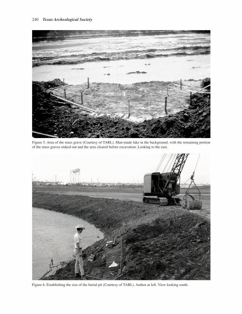
240 Texas Archeological Society
Figure 5. Area of the Mass Grave. Man-made lake in the background, with the remaining portion of the mass graves staked out and the area cleared before excavation. Looking to the east. TARL archives.
Figure 6. Establishing the Size of the Burial Pit. Author at left. View looking south. TARL archives.
Figure 6. Establishing the size of the burial pit (Courtesy of TARL). Author at left. View looking south.
Figure 5. Area of the Mass Grave. Man-made lake in the background, with the remaining portion of the mass graves staked out and the area cleared before excavation. Looking to the east. TARL archives.
Figure 6. Establishing the Size of the Burial Pit. Author at left. View looking south. TARL archives.
Figure 5. Area of the mass grave (Courtesy of TARL). Man-made lake in the background, with the remaining portion of the mass graves staked out and the area cleared before excavation. Looking to the east.

Hester—The Discovery and Study of the Mexican War Mass Grave at Resaca de la Palma 241
lying atop or under other remains. And, as we exposed the remains, it was also obvi-ous that partial skeletons represented some individuals. As these observations were confirmed, we realized that the victims from the battle had been dropped or thrown into a large grave pit. Among the bones were a number of bone and shell buttons, wire collar clasps, and other items that were part of the clothing on the bodies at the time of burial (e.g., Figure 7). Further, we exposed the crumbling remnants of at least two “canteens,” and perhaps a cartridge box of wood and metal.
For a bit of flavor of the hectic pace of the excavations, some excerpts from my field notes follow:
“…canteen and objects are below back of #8 [Burial 8]. Above the canteen, near spout, was a box-like object nearly ¾ as wide as canteen; went to pieces; heavy box—probably an ammo box; object on top.
...ca. .5’ N of #12 skull were humerus frag, and ulna and radius…#31.
…under chest of #21, remains of legs of #24 were found, crossed at the feet; but-
ton at spot where legs cross.
…below #’s 14 & 14 is a partial burial (#23); the legs of #23 are under chest of #15; 2 buttons are N of n. tibia.
Figure 7. Close-up view of artifacts in place. These include a metal button and a stain from a decayed item. The latter, the darkened area, shown here, may have been a cartridge box, as the long pin at the top has been identified as a “flintlock vent pick”. Length of the “vent pick” is about 8 cm. TARL archives.
Figure 8. Human crania exposed, along with some additional human remains. The jumbled array of crania indicates the complexity of the situation. TARL archives.
Figure 7. Close-up view of artifacts in place (Courtesy of TARL). These include a metal button and a stain from a decayed item. The latter, the darkened area, shown here, may have been a cartridge box, as the long pin at the top has been identified as a “flintlock vent pick.” Length of the “vent pick” is about 8 cm.
Figure 7. Close-up view of artifacts in place. These include a metal button and a stain from a decayed item. The latter, the darkened area, shown here, may have been a cartridge box, as the long pin at the top has been identified as a “flintlock vent pick”. Length of the “vent pick” is about 8 cm. TARL archives.
Figure 8. Human crania exposed, along with some additional human remains. The jumbled array of crania indicates the complexity of the situation. TARL archives.
Figure 8. Human crania exposed, along with some additional human remains (Courtesy of TARL). The jumbled array of crania indicates the complexity of the situation.
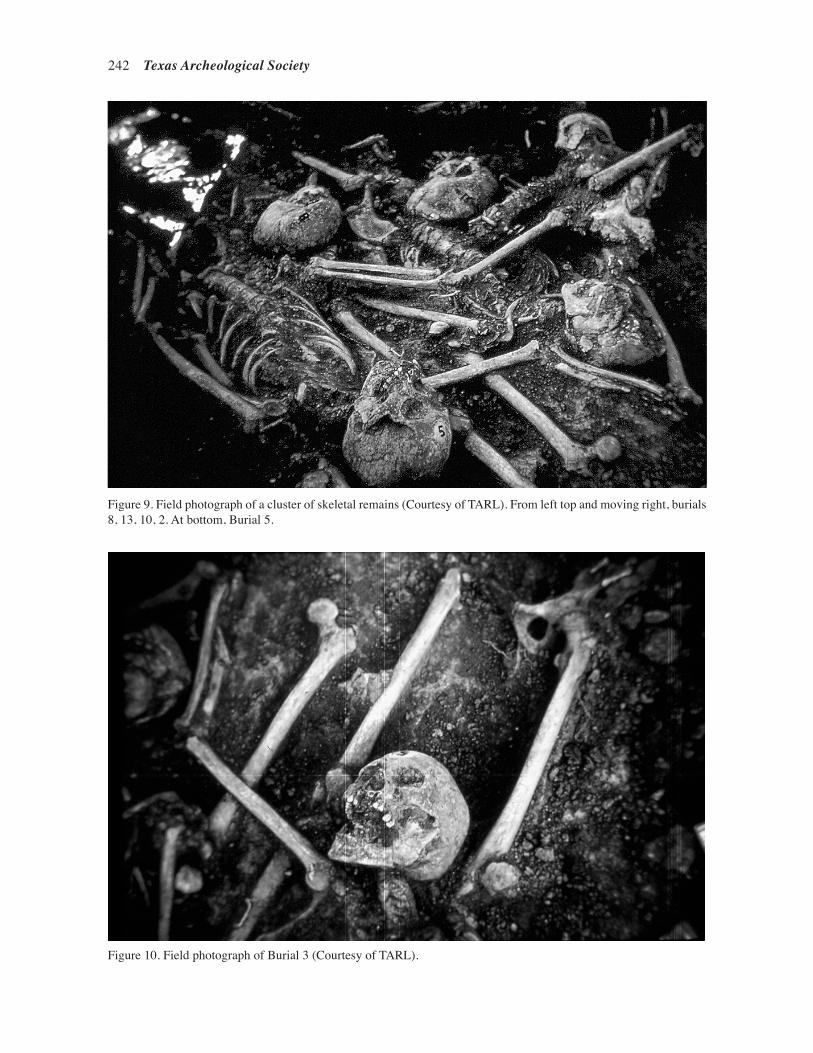
242 Texas Archeological Society
Figure 9. Field photograph of a cluster of skeletal remains. From left top and moving right, burials 8, 13, 10, 2. At bottom, Burial 5. TARL archives.
Figure 10. Field photograph of Burial 3. TARL archives
Figure 9. Field photograph of a cluster of skeletal remains (Courtesy of TARL). From left top and moving right, burials 8, 13, 10, 2. At bottom, Burial 5.
Figure 9. Field photograph of a cluster of skeletal remains. From left top and moving right, burials 8, 13, 10, 2. At bottom, Burial 5. TARL archives.
Figure 10. Field photograph of Burial 3. TARL archives Figure 10. Field photograph of Burial 3 (Courtesy of TARL).

Hester—The Discovery and Study of the Mexican War Mass Grave at Resaca de la Palma 243
We also noticed that the bones and skulls bore signs indicative of battle wounds (impacted musket balls, and cuts made by sabers and knives). Westcott et al. (2012:18) claims that 58 percent of the Mexican soldiers had “unhealed, battle-related injuries.”
ARTIFACTS WITH THE BURIALS
Certainly the most comprehensive list of artifacts discovered among the burials is found in Ratliff (1993:Ap-pendix 3). Some of the decayed ob-jects observed in the field could not be collected (canteen; cartridge box). The most numerous of the artifacts were, of course, bone buttons from clothing and uniforms. Most are of bone (124 specimens, with four or five holes), some of metal (n=9), and even a few of shell (n=7). Copper eye-hooks, typically found at the collars of shirts, numbered about 18, and the clasps that fit into the hooks included 14 specimens. There were small metal buckles of the type that might have been on straps for canteens or for cartridge boxes. The badly decayed remnants of a wooden canteen were found near Burial 12. Two metal scab-bard tips were also found. Adhering to the scabbard tips were small remnants of leather and cloth. At least 13 cloth fragments were documented, scattered among the burials. Metal fragments, corroded unidentifiable pieces, were also scattered, with 14 specimens recorded. A small metal “nib” was ap-parently part of an ornament or weapon. A small rusted crucifix is recorded in the field notes but was not later found in the collections.
With Burial 16 was one of the knife scabbard tips (and maybe a second; the records are unclear), along with three metal buckles, and two eyehooks and one clasp. Details of specific buttons or other artifacts with the burials are found in Ratliff (1993: Appendix 3). Seventeen of the skeletons had one or more associated artifacts.
There are several distinctive artifacts, includ-ing numerous musket balls (one still embedded
Figure 11. Plan of Burials Excavated at the Resaca de la Palma Mass Grave. Based on field drawings by Thomas R. Hester. (from Wescott et al. 2012:Figure 1; they have divided the burials into North, Central and Southern groupings). The original cut that exposed the mass grave is along the right; see Figures 5, 6. (Courtesy of the Texas Archeological Society)
Figure 11. Plan of Burials Excavated at the Resaca de la Palma Mass Grave (Courtesy of the Texas Archeological Society from Wescott et al. 2012:Figure 1; they have divided the burials into North, Central and Southern groupings). Based on field drawings by Hester. The original cut that exposed the mass grave is along the right (see Figures 5 and 6).
in a tibia). Some of these, along with three other potentially diagnostic artifacts, were taken from the partly exposed remains after the discovery of the mass grave, and prior to our arrival. The specimens were briefly made available at the site for photography, but were not donated to the site collection. Of the three artifacts discussed here, one is an oval crossbelt insignia, about 7 cm long, with the number “10” cut into and through the metal (see Figure 4). The artifact had a small hook at one end on the opposite side. The association of the item with one of the burials identified the occupant as a member of the 10th Light Infan-try of the Mexican Army. Though the crossbelt insignia was found before excavations started,

244 Texas Archeological Society
the finder told Collins that it occurred with the remains we subsequently labeled as Burial 19 (Ratliff 1994:204).
Another metal artifact is rectangular, with angled corners (Figure 12). It has a small protru-sion in the center of the back surface. The artifact
is likely a belt plate from a Mexican cartridge box. The piece measures about 6 cm long and 4.5 mm wide and cannot be linked to a specific burial.
There is also a hunting horn emblem with either the number 7 or a fragmentary 4 in the en-circled area (Figure 13). It is about 6 cm long, has two protruding spikes on the back, and has been attributed by Ratliff (1993:116 and Figure 39) to a shako insignia typical of the Mexican 4th Light In-fantry. Westcott et al. (2012:5) describe the insignia as a “shako badge” from the Mexican 7th Infantry. They record this object as having been associated with Burial 8 from the mass grave.
Figure 12. Both Sides of a Mexican cartridge box belt plate. See Haecker (1994, Figure 57 m, n) for an example from of the Battle of Palo Alto.
Figure 13. Hunting Horn Insignia from One Burial, Possibly of the 7th Light Infantry.
Figure 14. Hunting horn insignia. Item bears the number of the Mexican 6th Light Infantry. One of two found by Norman Bateman on the Battlefield, and not from the mass grave. (Bateman notes housed at TARL).
Figure 12. Both Sides of a Mexican cartridge box belt plate. See Haecker (1994:Figure 57m, n) for an example from the Battle of Palo Alto.
Figure 12. Both Sides of a Mexican cartridge box belt plate. See Haecker (1994, Figure 57 m, n) for an example from of the Battle of Palo Alto.
Figure 13. Hunting Horn Insignia from One Burial, Possibly of the 7th Light Infantry.
Figure 14. Hunting horn insignia. Item bears the number of the Mexican 6th Light Infantry. One of two found by Norman Bateman on the Battlefield, and not from the mass grave. (Bateman notes housed at TARL).
Figure 13. Hunting horn insignia from one burial, possibly of the 7th Light Infantry. Another such artifact was later discovered as a surface find (see Figure 14).
Figure 12. Both Sides of a Mexican cartridge box belt plate. See Haecker (1994, Figure 57 m, n) for an example from of the Battle of Palo Alto.
Figure 13. Hunting Horn Insignia from One Burial, Possibly of the 7th Light Infantry.
Figure 14. Hunting horn insignia. Item bears the number of the Mexican 6th Light Infantry. One of two found by Norman Bateman on the Battlefield, and not from the mass grave. (Bateman notes housed at TARL).
Figure 14. Hunting horn insignia. Item bears the number of the Mexican 6th Light Infantry. One of two found by Norman Bateman on the Battlefield, and not from the mass grave (Bateman notes housed at TARL).
Hefter (2008:63) states that the 7th Light Infantry was not present at Resaca de la Palma, though this insignia suggests differently. Based on the illustrations in Hefter (2008:Plate XVI A), the specimen seems much too small for the prominent hunting horn emblem as they have been portrayed on the front of a shako. However, specimens of this size may well have adorned cartridge boxes.
ANALYSIS: STUDYING THE HUMAN REMAINS
Al B. Wesolowsky, a physical anthropology student at The University of Texas, took on the task, beginning in June 1967, of processing the hu-man remains from Resaca de la Palma. He washed and boxed the skeletal materials and over the coming months, and off and on for several years, Wesolowky studied the skeletal remains, with his analysis consisting of taking measurements, noting pathological abnormalities, and obtaining information on sex and age. His work resulted in a substantial compilation of notes and records filed at the Texas Archeological Research Laboratory.
Ratliff (1993, 1994) carried out a comprehen-sive analysis of the Resaca de la Palma burials for his Master’s thesis at The University of Texas at Austin. He first re-inventoried the remains, and then proceeded to try to determine the age of each individual at the time of death. He also looked closely at the sex of each individual, and estimated the range in stature. Ratliff went further in depth with his osteological studies: disease, injury (be-fore and at the battle), and pathologies associated with the age of each person.
Ratliff (1994:195) stated that he found 31 “primary burials” that he could document through the field notes and his analysis. As noted earlier

Hester—The Discovery and Study of the Mexican War Mass Grave at Resaca de la Palma 245
in this article, most of the burials were partial or incomplete and/or commingled with the remains of other soldiers. He felt that at least four individuals were women (soldaderas).
Subsequently, Diane Wilson re-examined the possible female burials at Resaca de la Palma. Her conclusions (notes to Hester) were that these deter-minations of sex were in error. She identified one of the burials (later shown to be unrelated to the col-lection) to be “probable male,” another (Burial 3) as “probable male,” one definitely as male (Burial 11), and Burial 10 as “sex indeterminate.”
Ratliff (1994:201) also noted the “lack of combat trauma,” but see Wescott et al. (2012) for a very different view. He did note the frequency of fractures, torn ligaments, and generally rough condition of the feet. Much of the latter is probably related to pre-Army farm or ranch life of soldiers, perhaps aggravated by military service. Examples of knee injuries, a fractured (healed) mandible, and miscellaneous pre-Battle pathologies may derive from horse kicks, personal disputes, or simply ac-cidents (Ratliff 1994:203).
In 2012, Wescott and colleagues published a detailed study of the battle-related injuries observed on the remains from the mass grave. Their analysis pointed to the presence of 27-36 individuals (in contrast to Wesolowsky’s estimate of 30, and Ratliff’s 31). A burial identified as possibly female by Ratliff (1993) was found to be from a different
archeological site and had been placed in error with the Resaca de la Palma group. It was determined that projectiles (musket balls) were the most common cause of death, as seen for possibly 12 of the individuals. Cuts or “sharp-edged trauma” was seen on some skeletons (Wescott et al. 2012:11), and impact of blunt objects was noted on two. Overall, 58 percent of the individuals analyzed exhibited battle-linked wounds. The wounds related to sword and saber cuts reflect the hand-to-hand combat that typified the battle.
STABLE CARBON ISOTOPE ANALYSIS: GLIMPSES AT DIET
In the early 1990s, the late Jeffrey A. Huebner (a doctoral student who worked with the author at The University of Texas at Austin) began a program of research involving stable carbon isotope ratio analysis to study human and animal diets. Numerous publications resulted. As part of his project, Huebner sampled small pieces of bones from six Resaca de la Palma burials. The actual laboratory work was done by Krueger Enterprises, Inc., a division of Geochron Laboratories, in Cambridge, Massachusetts. Results were reported to Huebner in November 1993. The studies were funded by a grant to Hester from the Advanced Research Program of the Texas Higher Education Coordinating Board.
Figure 15 . Daily crowd watches the archeological team excavate and document the mass grave. Looking south. TARL archives
Figure 15. Daily crowd watches the archeological team excavate and document the mass grave (Courtesy of TARL).

246 Texas Archeological Society
Jones (2009) published a stable carbon isotope study on the Resaca de la Palma remains—a study that could not have been done without her use of Huebner’s data, with curiously slight attribution, found in the TARL records. Data for one sample of skeletal remains could not be confirmed, and so the results for five individuals were used. Similar to Huebner’s original interpretations of the mass grave stable isotope data, Jones (2009:142) report-ed that each of the five soldiers represent “maize dependent populations” and that four of these had “freshwater or marines resources” also represented in terms of diet.
WHAT IS TO BE DONE WITH THE BONES?: 1970-2008
According to the late Curtis Tunnell, longtime state archeologist and executive director of the Texas Historical Commission, an official letter was sent in the 1970s by the Commission (or the associated Texas Antiquities Committee) to persons at the Instituto Na-cional de Antropologia e Historia (INAH) in Mexico City with an offer to return the human remains and artifacts to Mexico. The reply was that the materials were not wanted in Mexico and that they could be disposed of in any way they chose.
While Director of TARL at The University of Texas at Austin, I began receiving letters related to the reburial of the Mexican soldiers from the mass grave at Resaca de la Palma. The requests came from different individuals or groups, with different goals for proposed reburial. In April 1996, Kevin R. Young, of Forest View Historical Services (San Antonio, Texas) wrote letters to both the Consulate General of Mexico in San Antonio and to Governor George W. Bush. In these let-ters, he suggested that the “Mexican soldados and soldaderas” found in 1967 and “still in the hands of the University of Texas at Austin,” be returned to the Mexican Government. In July 1996, Ruben Arvizu of Hollywood, California, inquired about the remains. At that time, and since, Mr. Arvizu has been concerned about American soldiers from the Mexican War buried in Mexico, and while he was not asking for any sort of direct exchange (for the Resaca de la Palma remains), he continued to follow the matter. It was at this time that the legal counsel for the University of Texas System (then, Dudley Dobie, and later, Patti Ohlendorf) consulted with me, and it was their opinion that the remains
be returned only through an official request from the Government of Mexico.
In August 1996, the Casamata Museum of Re-gional History in Matamoros, Mexico, contacted Bruce Aiken of Brownsville, then a commissioner on the Texas Historical Commission, to request the return of the Resaca de la Palma remains for reinterment in Matamoros, in association with a monument dedicated to them. Mr. Aiken brought the request to the attention of the Texas Histori-cal Commission; he was advised of the need for official Mexican government involvement for the return of the burials.
In the late 1990s, Roberto Gamboa Mascare-nas, Consul General of Mexico in Austin, contacted the author and we had numerous useful discussions about a way in which the Resaca de la Palma skel-etal material could be formally returned to Mexico. In August 1997, he wrote to me, making a formal request on behalf of the Republic of Mexico, for the return of the soldiers from the mass grave. They were to be buried with full military honors in Mexico City. The University of Texas at Austin legal counsel’s office felt that the letter should come, formally, from the Government of Mexico. Mr. Gamboa later moved to another Consulate post in another city, and no further progress was made on the matter.
In a summary provided by Darrell Creel in 2013, he related what transpired while he was Director of TARL:
In the first part of 2008, the Mexican Consul General’s Austin, Texas office con-tacted the Texas Archeological Research Laboratory (TARL) at The University of Texas at Austin regarding the remains of Mexican Army soldiers from the battle of Resaca de la Palma. The Consul General, Rosalba Ojeda, and staff subsequently visited TARL to view and discuss repa-triation of these remains. As a result, on July 17, 2008, the Consul General sent a formal request to the Vice President for Legal Affairs at the University of Texas at Austin for repatriation of the soldiers’ remains to Mexico.
According to standard policy and proce-dure at TARL, the Deaccessions Commit-tee met on September 9, 2008, to discuss the request and voted unanimously to deacession the remains and transfer

Hester—The Discovery and Study of the Mexican War Mass Grave at Resaca de la Palma 247
them to the Mexican Government. This deaccession was also approved by the Vice President for Legal Affairs at the University of Texas at Austin. The Consul General was promptly notified and then began arranging for the transfer of the re-mains. On December 3, 2008, the Consul General on behalf of the Mexican Gov-ernment took possession of the soldiers’ remains and transferred them to Mexico City for reinterment.
ACKNOWLEDGMENTS
Special thanks are due to Michael Collins for supervising the excavations and staying involved with project research over these many years. The late Tom Ellzey worked with us at the site, and guarded it at night to keep away possible looters. Al B. Wesolowsky did yeoman’s work on the process-ing and continuing analysis of the remains from the mass grave, beginning in June 1967, and compiled a vast amount of data on the physical anthropology, now filed at TARL. Many other archeologists and physical anthropologists worked with the human and cultural materials, in terms of analysis and curation; these included Dee Ann Story, Curtis Tunnell, Darrell Creel, Laura Nightengale, Nor-man Bateman, Carolyn Spock, Rosario Casarez, Eric Ratliff, Diane Wilson, Timothy K. Perttula, and Tom Fort (Museum of South Texas, Edinburg).
I am particularly grateful to Ruben Arvizu, of Atlanta, Georgia, for encouraging me to write this “first hand” account of Resaca de la Palma. His concern for the history of the Mexican War has impressed me since he first contacted me in the mid-1990s.
REFERENCES CITED
Coffin, C. C.1883 Building the Nation. Harper and Brothers, New York.
DePalo, W. A., Jr.1997 The Mexican National Army, 1822-1852. Texas
A&M University Press, College Station.
Haecker, C. M.1994 A Thunder of Cannon: Archeology of the Mexican-
American War Battlefield of Palo Alto. Professional Papers 52. Southwest Cultural Resources Center. National Park Service, Santa Fe.
Hefter, J.2008 The Mexican Soldier 1837-1847: Organization,
Dress & Equipment. Edited and expanded by P. R. Wilson. The Virtual Armchair General, Oklahoma City.
Hester, T. R.1978 The Archaeology of the Lower Rio Grande Valley
of Texas, In The Proceedings, An Exploration of a Common Legacy, pp. 66-79. Texas Historical Com-mission, Austin.
Jones, C. A.2009 Stable Isotope Analysis of the Diet of the Mexi-
can War Dead from the Battle of Resaca de la Palma. Bulletin of the Texas Archeological Society 80:133-144.
National Park Service 1997 Draft General Management Plan Environmental
Assessment. Palo Alto Battlefield National Historic Site—Texas. National Park Service, Brownsville, Texas. Cultural Resources Center, National Park Service, Santa Fe.
Perttula, T. K.1996 Archeological Investigation of Mexican-American
War Battlefields in Texas. CRM News and Views 8(1):6-8. Department of Antiquities Protection, Texas Historical Commission, Austin.
Ratliff, E. A.1993 Life and Death in the Mexican Army: An Analysis of
Skeletal Remains From the Battle of the Resaca de la Palma, May 1, 1846. Master’s Thesis, Department of Anthropology, The University of Texas at Austin.
1994 Human Skeletal Remains from the Battle of Resaca de la Palma. Appendix B, pp. 189-208. In A Thunder of Cannon: Archeology of the Mexican-American WarBattlefield of Palo Alto, by C. M. Haecker, pp. 189-208. Professional Papers 52. Southwest Cultural Resources Center. National Park Service, Santa Fe.
Wescott, D. J., L. E. Baker, D. C. Wernecke, and M. B. Collins2012 A Mass Grave of Mexican Soldiers from the Resaca
de la Palma Battlefield (41CF3): Demography and Battle-Related Injuries. Bulletin of the Texas Archeo-logical Society 83:1-22.


Bulletin of the Texas Archeological Society 86 (2015)
List of Authors
C. Britt Bousman, Texas State University, San Marcos and GAES, University of Witwatersrand, Johannesburg
Leslie L. Bush, Microbotanical Analysis, Manchaca
Wilson W. Crook, Houston Archeological Society, Kingwood
Linda W. Ellis, ACS: Archeological Consulting Services, Lago Vista
Thomas R. Hester, University of Texas, Professor Emeritus, Marble Falls
Michael P. Jordan, Texas Tech University, Lubbock and Research Associate with the National Museum of Natural History, Smithsonian Institute, Washington, D.C.
Christopher Lintz, Texas Parks and Wildlife Department, Wildlife Division, Austin
Timothy K. Perttula, Archeological & Environmental Consultants, LLC, Austin
Elton R. Prewitt, Texas State University, San Marcos and SHUMLA School, Inc., Comstock
Daniel Prikryl, LCRA Cultural Resources, Lower Colorado River Authority, Austin
Haley E. Rush, Cox McClain Environmental, Austin and Texas State University, San Marcos
S. Alan Skinner, AR Consultants, Inc., Richardson
Matthew S. Taylor, University of Washington, Seattle
Jesse Todd, AJC Environmental, LLC, Carrollton
Richard W. Walter, Center for Big Bend Studies, Sul Ross State University, Alpine
Catrina Banks Whitley, Office of Archaeological Studies, Museum of New Mexico, Santa Fe