Sudbury Campus Master Plan - Laurentian University
65
Sudbury Campus Master Plan Plan directeur du campus de Sudbury September 2013 Septembre 2013
-
Upload
khangminh22 -
Category
Documents
-
view
0 -
download
0
Transcript of Sudbury Campus Master Plan - Laurentian University
Sudbury Campus Master Plan Plan directeur du campus de Sudbury September 2013Septembre 2013
(Photo Source: © Laurentian University.)
Laurentian University935 Ramsey Lake Rd, Greater Sudbury, Ontario, P3E 2C6(705) 675-1151
Sudbury Campus Master Plan Plan directeur du campus de Sudbury September 2013Septembre 2013
This document was developed by Laurentian University in collaboration with DIALOG Inc.
and MMM Inc. and with input from a broad range of stakeholders from the Laurentian
community.
ACKNOWLEDGEMENTS
The project was initiated and approved through the Advisory Committee:
Barbara Bolton Chancellor of Thorneloe University, former Board member
Jason Ferrigan Planner, City of Greater Sudbury
Terrance Galvin Director, School of Architecture
Denise Gauthier-Frohlick Aboriginal Student Affairs
Ryan Hicks Student and Residence Assistant
Norm Lajeunesse Director - PPP
Nellie Lanteigne Part-time student representative
Ron Larwood Manager, Campus Recreation
Chris Mercer Chief of Staff LU
Brad Parkes Director – Capital Projects
David Pearson Prof – Earth Sciences
Stephan Plante Alumnus
Amanda Schweinbenz Associate Professor, Human Kinetics
Tom Zsolnay (CHAIR) University Advancement
The project benefited from the administrative support of:
Joscelyne Meilleur, Administrative Assistant, Capital Projects Office, Laurentian University
We gratefully acknowledge their valued input and support.
Brad, Parkes
Director of Capital Projects, Laurentian University
FOREWORD 1
1.0 // INTRODUCTION 3
1.1 Study Purpose and Goals 3
1.2 Team 4
1.3 Process 4
1.4 Stakeholder & Public Engagement 5
2.0// SETTING THE STAGE FOR GROWTH AND CHANGE 8
2.1 Campus Evolution 9
2.2 The University and its Neighbours 12
2.3 Existing Conditions, Issues & Opportunities 14
3.0// THE VISION 18
3.1 Vision 18
3.2 Principles 22
4.0 // THE PLAN 24
4.1 The Conceptual Plan 25
4.2 The Big Moves 25
4.3 Open Space Framework 36
4.4 Built Form Framework 41
4.5 Movement Framework 45
4.6 Infrastructure Framework 51
4.7 Sustainability 54
5.0 // IMPLEMENTING THE PLAN 56
5.1 Campus Master Plan: A Living Document 57
5.2 Phasing Strategy 57
5.3 Partnership Opportunities 59
5.4 Administration of the Plan 59
CONTENTS
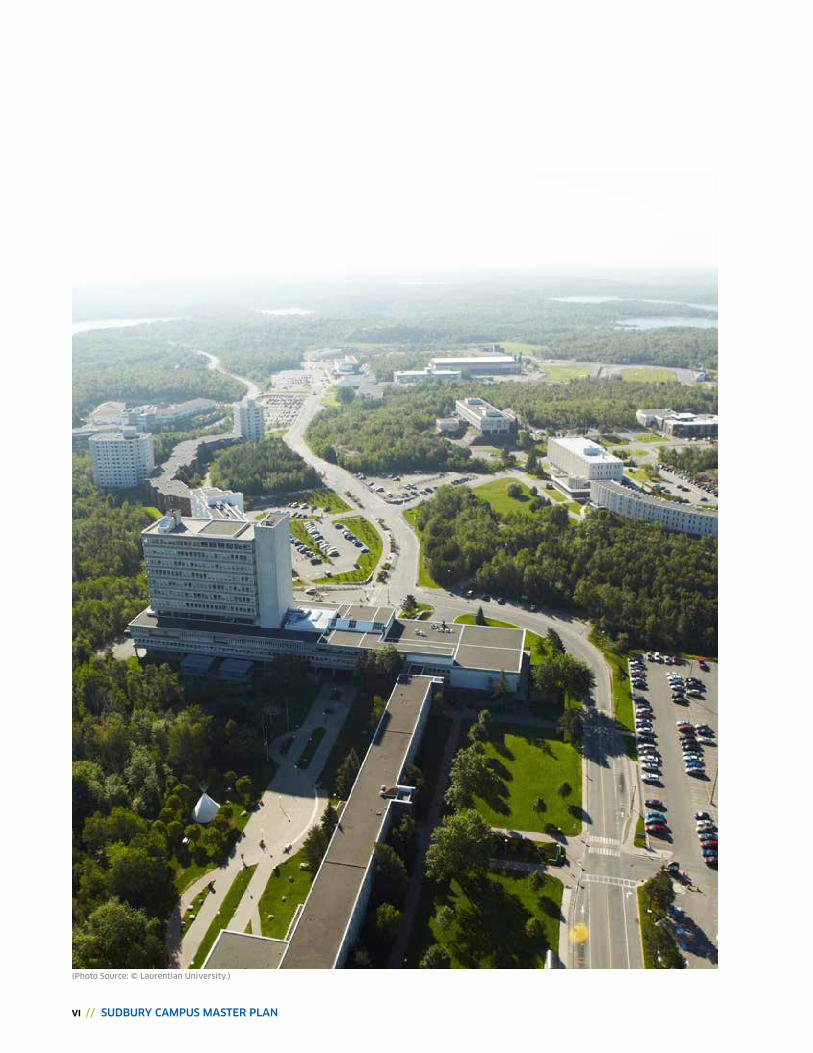
vi // SUDBURY CAMPUS MASTER PLAN
(Photo Source: © Laurentian University.)
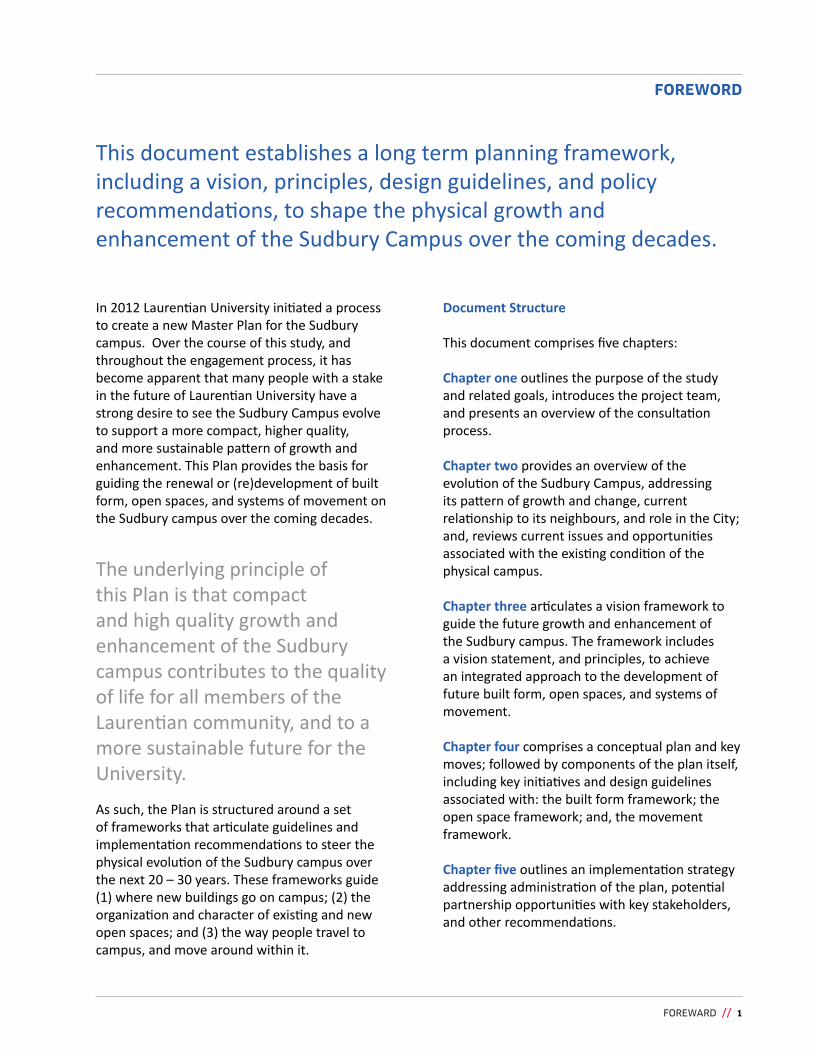
This document establishes a long term planning framework, including a vision, principles, design guidelines, and policy recommendations, to shape the physical growth and enhancement of the Sudbury Campus over the coming decades.
FOREWARD // 1
FOREWORD
In 2012 Laurentian University initiated a process to create a new Master Plan for the Sudbury campus. Over the course of this study, and throughout the engagement process, it has become apparent that many people with a stake in the future of Laurentian University have a strong desire to see the Sudbury Campus evolve to support a more compact, higher quality, and more sustainable pattern of growth and enhancement. This Plan provides the basis for guiding the renewal or (re)development of built form, open spaces, and systems of movement on the Sudbury campus over the coming decades.
The underlying principle of this Plan is that compact and high quality growth and enhancement of the Sudbury campus contributes to the quality of life for all members of the Laurentian community, and to a more sustainable future for the University.
Document Structure
This document comprises five chapters:
Chapter one outlines the purpose of the study and related goals, introduces the project team, and presents an overview of the consultation process.
Chapter two provides an overview of the evolution of the Sudbury Campus, addressing its pattern of growth and change, current relationship to its neighbours, and role in the City; and, reviews current issues and opportunities associated with the existing condition of the physical campus.
Chapter three articulates a vision framework to guide the future growth and enhancement of the Sudbury campus. The framework includes a vision statement, and principles, to achieve an integrated approach to the development of future built form, open spaces, and systems of movement.
Chapter four comprises a conceptual plan and key moves; followed by components of the plan itself, including key initiatives and design guidelines associated with: the built form framework; the open space framework; and, the movement framework.
Chapter five outlines an implementation strategy addressing administration of the plan, potential partnership opportunities with key stakeholders, and other recommendations.
As such, the Plan is structured around a set of frameworks that articulate guidelines and implementation recommendations to steer the physical evolution of the Sudbury campus over the next 20 – 30 years. These frameworks guide (1) where new buildings go on campus; (2) the organization and character of existing and new open spaces; and (3) the way people travel to campus, and move around within it.
2 // SUDBURY CAMPUS MASTER PLAN
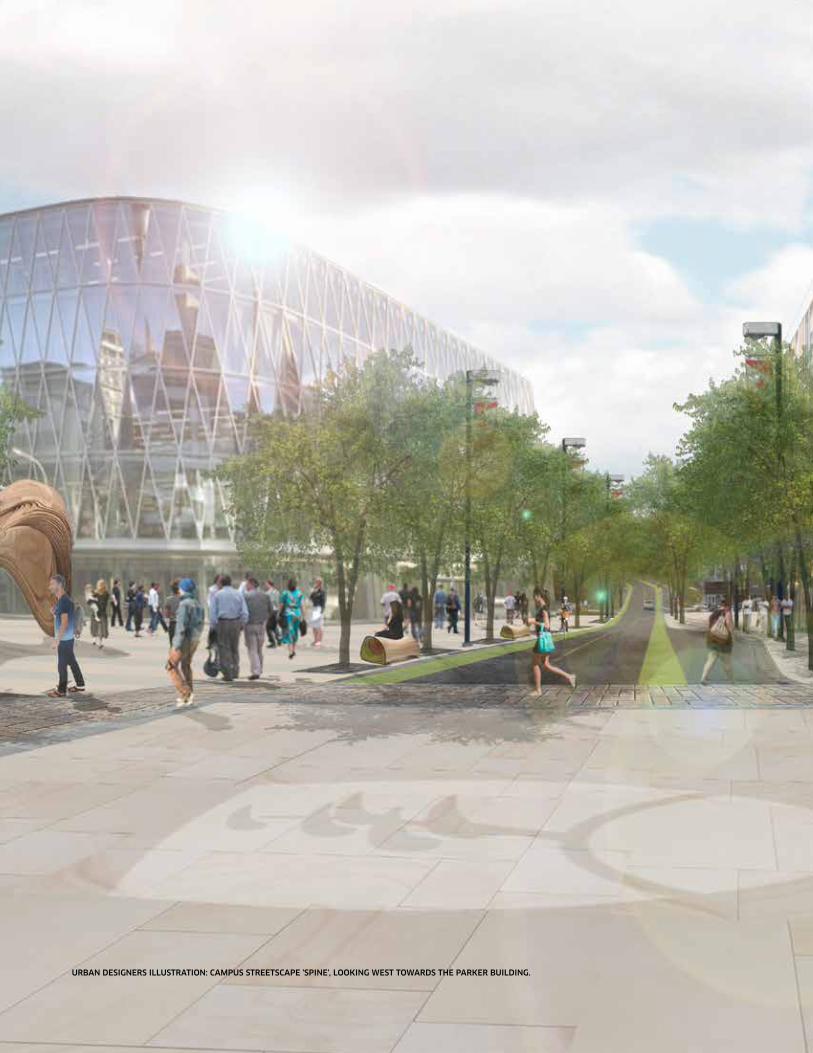
URBAN DESIGNERS ILLUSTRATION: CAMPUS STREETSCAPE 'SPINE', LOOKING WEST TOWARDS THE PARKER BUILDING.
intRODUCtiOn // 3
1.0 // INTRODUCTIONIn 2012 Laurentian University initiated a process to prepare a new Master Plan for the Sudbury campus. The planning effort represents an important opportunity for the University to re-examine and realign the evolving physical design of the campus with current and future priorities for the campus community and the University’s policy framework.
1.1 PurPOSE
This Plan is an evolution and departure from the previous Campus Master Plan (CMP), prepared for the University in 1992. Overall, this Campus Master Plan provides a long term planning and design framework to guide positive physical change and growth on the Sudbury campus over the coming decades.
More specifically, the Master Plan is intended to:
• align with, and be informed by, the overall strategic direction of the University;
• support the academic mission of the University and provide a range of productive learning environments;
• enhance campus livability, legibility for faculty, staff, students and visitors;
• make the campus more welcoming and accessible to adjacent neighbourhoods, and to off-campus users of campus facilities;
• support a more livable, community-based campus, with an expanded scale of services/amenities;
• be both comprehensive and strategic – expressing a Vision for the physical campus, as well as articulating 'big moves' toward implementing the plan and achieving the Vision;
• address site and building accessibility, including public transit, pedestrian networks, cycling networks, vehicular networks servicing, and parking;
• improve physical connections, circulation, and relationships between Laurentian University and its three federated partner universities;
• provide an open space framework and guidelines that shape and connect a system of great exterior places;
• respond to the unique ecology and topography of the Sudbury campus;
• be based on a shared vision, generated through the broad engagement of students and the campus community; and
• have a strong foundation of support from key stakeholders and the campus community, positioning the Plan for implementation.
4 // SUDBURY CAMPUS MASTER PLAN
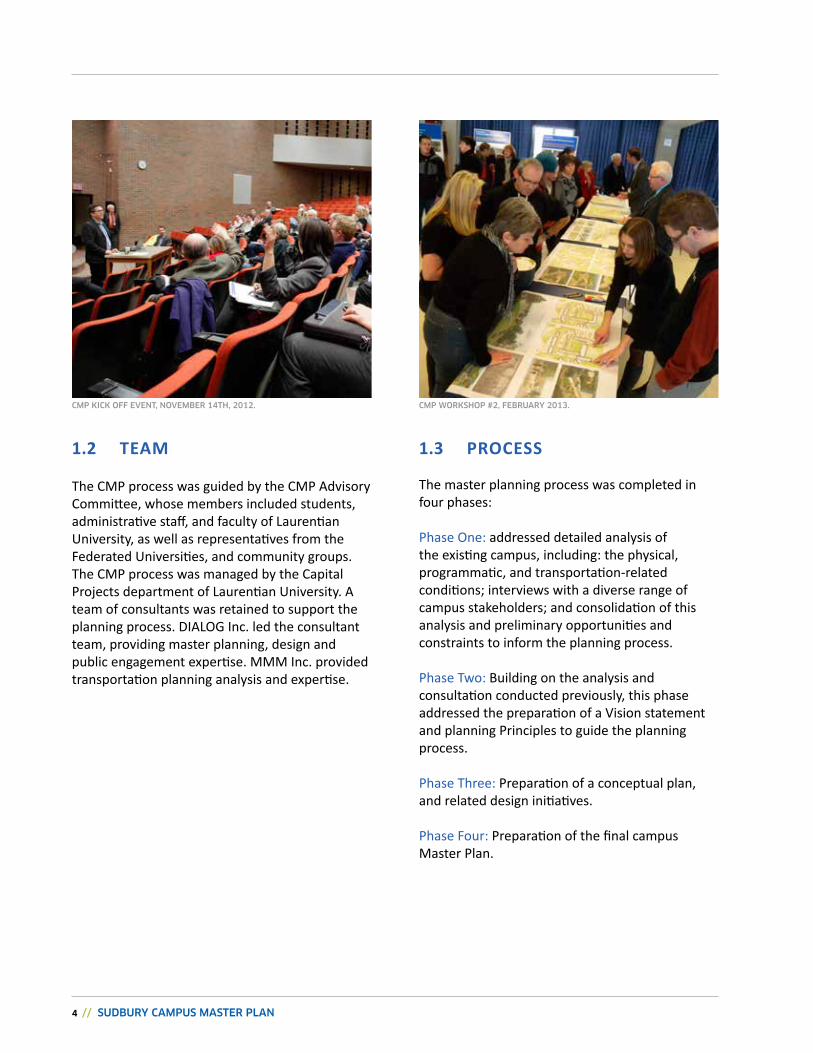
1.2 TEAM
The CMP process was guided by the CMP Advisory Committee, whose members included students, administrative staff, and faculty of Laurentian University, as well as representatives from the Federated Universities, and community groups. The CMP process was managed by the Capital Projects department of Laurentian University. A team of consultants was retained to support the planning process. DIALOG Inc. led the consultant team, providing master planning, design and public engagement expertise. MMM Inc. provided transportation planning analysis and expertise.
1.3 PrOCESS
The master planning process was completed in four phases:
Phase One: addressed detailed analysis of the existing campus, including: the physical, programmatic, and transportation-related conditions; interviews with a diverse range of campus stakeholders; and consolidation of this analysis and preliminary opportunities and constraints to inform the planning process.
Phase Two: Building on the analysis and consultation conducted previously, this phase addressed the preparation of a Vision statement and planning Principles to guide the planning process.
Phase Three: Preparation of a conceptual plan, and related design initiatives.
Phase Four: Preparation of the final campus Master Plan.
CMP KICK OFF EVENT, NOVEMBER 14TH, 2012. CMP WORKSHOP #2, FEBRUARY 2013.
intRODUCtiOn // 5
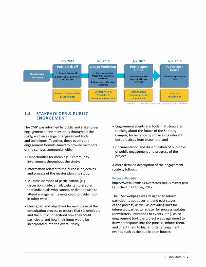
1.4 STAKEhOLDEr & PubLiC ENGAGEMENT
The CMP was informed by public and stakeholder engagement at key milestones throughout the study, and via a range of engagement tools and techniques. Together, these events and engagement formats aimed to provide members of the campus community with:
• Opportunities for meaningful community involvement throughout the study;
• Information related to the purpose objectives, and process of the master planning study;
• Multiple methods of participation, (e.g. discussion guide, email, website) to ensure that individuals who cannot, or did not wish to attend engagement events could provide input in other ways;
• Clear goals and objectives for each stage of the consultation process to ensure that stakeholders and the public understood how they could participate and how their input would be incorporated into the overall study;
• Engagement events and tools that stimulated thinking about the future of the Sudbury Campus, for instance by showcasing relevant best practices from elsewhere; and
• Documentation and dissemination of outcomes of public engagement and progress of the project.
A more detailed description of the engagement strategy follows:
Project Websitehttp://www.laurentian.ca/content/campus-master-planLaunched in October, 2012.
The CMP webpage was designed to inform participants about current and past stages of the process, as well as providing links for interested parties to register for process updates (newsletters, invitations to events, etc.). As an engagement tool, the project webpage aimed to draw participants into the process, inform them, and direct them to higher order engagement events, such as the public open houses.
Stakeholder Interviews
Public Kick-off
1. Campus Planning 101
2. Open House: draft vision and principles
Design Workshop
1. Workshop on draft Master Plan Conceptual
Directions
2. Open House: Workshop Outcomes
Public Open House
Refined Master Plan Conceptual Design
Framework
Public Open House
Present Campus Master Plan
Nov. 2012 Feb. 2013 Apr. 2013 Sept. 2013
Analysis: Opportunities & Constraints
Develop Vision, Principles &
Conceptual Directions
Prepare Master Plan
Refine Campus Conceptual Design
Framework
FIGURE 1. STAKEHOLDER & PUBLIC ENGAGEMENT DIAGRAM.
6 // SUDBURY CAMPUS MASTER PLAN
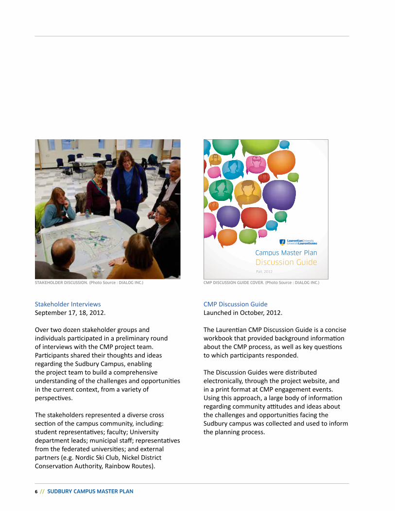
Stakeholder Interviews September 17, 18, 2012.
Over two dozen stakeholder groups and individuals participated in a preliminary round of interviews with the CMP project team. Participants shared their thoughts and ideas regarding the Sudbury Campus, enabling the project team to build a comprehensive understanding of the challenges and opportunities in the current context, from a variety of perspectives.
The stakeholders represented a diverse cross section of the campus community, including: student representatives; faculty; University department leads; municipal staff; representatives from the federated universities; and external partners (e.g. Nordic Ski Club, Nickel District Conservation Authority, Rainbow Routes).
CMP Discussion GuideLaunched in October, 2012.
The Laurentian CMP Discussion Guide is a concise workbook that provided background information about the CMP process, as well as key questions to which participants responded.
The Discussion Guides were distributed electronically, through the project website, and in a print format at CMP engagement events. Using this approach, a large body of information regarding community attitudes and ideas about the challenges and opportunities facing the Sudbury campus was collected and used to inform the planning process.
Discussion GuideCampus Master Plan
Fall, 2012
STAKEHOLDER DISCUSSION. (Photo Source : DIALOG INC.) CMP DISCUSSION GUIDE COVER. (Photo Source : DIALOG INC.)
intRODUCtiOn // 7
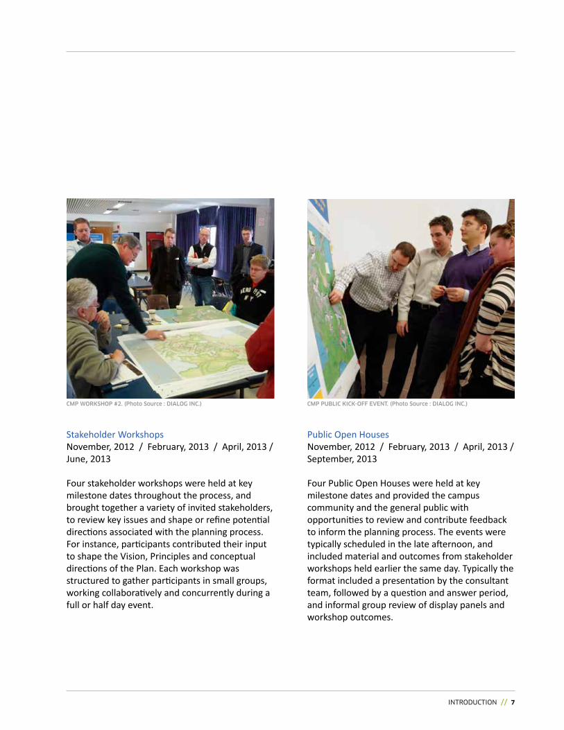
Stakeholder WorkshopsNovember, 2012 / February, 2013 / April, 2013 / June, 2013
Four stakeholder workshops were held at key milestone dates throughout the process, and brought together a variety of invited stakeholders, to review key issues and shape or refine potential directions associated with the planning process. For instance, participants contributed their input to shape the Vision, Principles and conceptual directions of the Plan. Each workshop was structured to gather participants in small groups, working collaboratively and concurrently during a full or half day event.
Public Open HousesNovember, 2012 / February, 2013 / April, 2013 / September, 2013
Four Public Open Houses were held at key milestone dates and provided the campus community and the general public with opportunities to review and contribute feedback to inform the planning process. The events were typically scheduled in the late afternoon, and included material and outcomes from stakeholder workshops held earlier the same day. Typically the format included a presentation by the consultant team, followed by a question and answer period, and informal group review of display panels and workshop outcomes.
CMP WORKSHOP #2. (Photo Source : DIALOG INC.) CMP PUBLIC KICK-OFF EVENT. (Photo Source : DIALOG INC.)
8 // SUDBURY CAMPUS MASTER PLAN
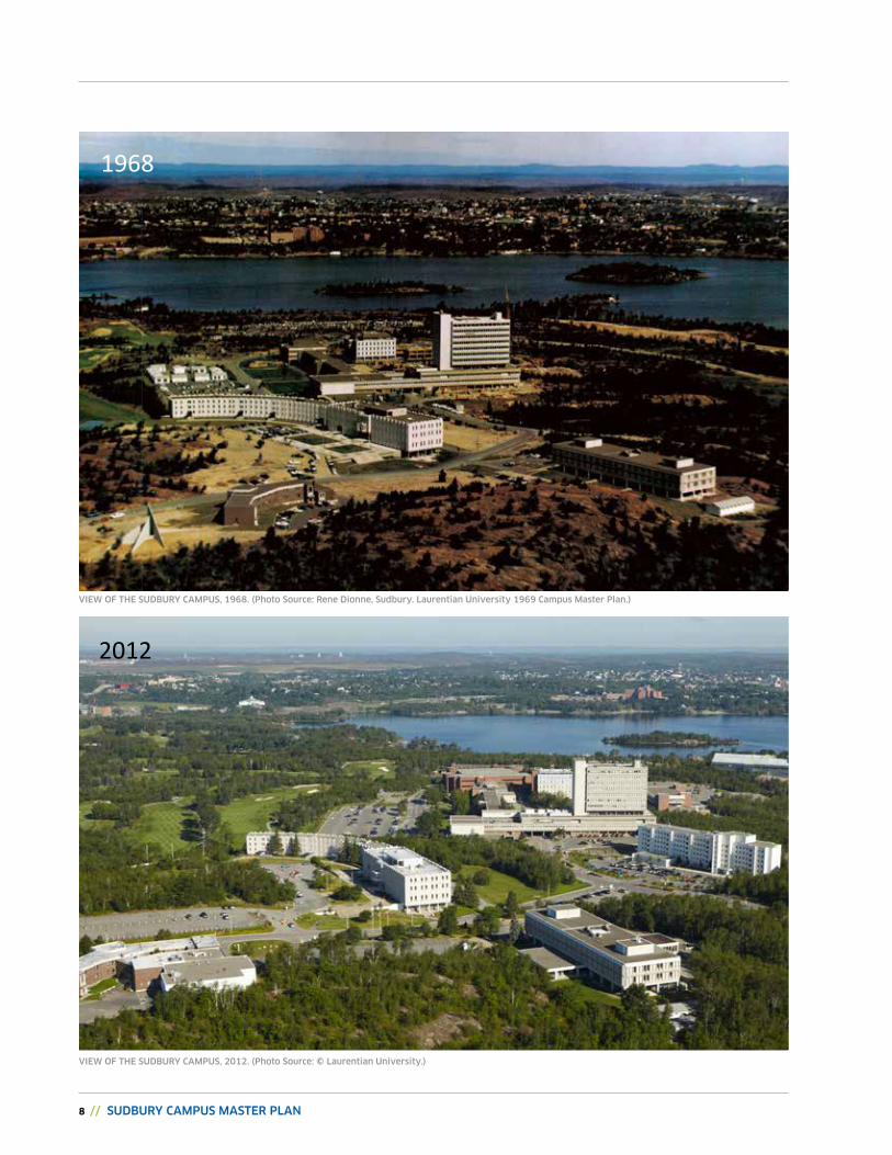
viEw of ThE SUDBURY CAMPUS, 1968. (Photo Source: Rene Dionne, Sudbury. Laurentian University 1969 Campus Master Plan.)
viEw of ThE SUDBURY CAMPUS, 2012. (Photo Source: © Laurentian University.)
1968
2012
CHAPTER 2: SETTING THE STAGE FOR GROWTH AND ENHANCEMENT // 9
The Northern Ontario Landscape
Of the six sites considered, the Ramsey Lake site offered unique and attractive qualities as a setting for a northern university. The geography made possible good road access and egress points; the varied topography included valley lands suitable for playing fields, and high ground where buildings might overlook the expansive views of the breathtaking natural setting typical of northern Ontario, formed of an abundance of varied rock, scrub, and water. Just beyond, views encompassed the city of Sudbury skyline, which has continued to grow closer, enriching the relationship between the campus and the surrounding communities.
2.0 // SETTING THE STAGE FOR GROWTH AND CHANGEThe establishment of Laurentian University in 1960 as a degree-granting institution under the auspices of the Ministry of Training, Colleges, and Universities was preceded by more than a half-century by the founding of College Sacré-Coeur in 1913 by Jesuit Fathers.
2.1 Campus EvOLuTiON
It was the first and for many years the only institution of higher learning in northern Ontario, and it would later adopt the name of University of Sudbury in 1957. In 1960 and 1961 respectively, Huntington University and Thorneloe University were founded and joined with the University of Sudbury in the Laurentian Federation.
At the outset the institution occupied temporary quarters in downtown Sudbury, consisting of nine classrooms, thirty offices, four laboratories, and a library of about 50,000 volumes. The Board of Governors initiated a search for a permanent campus site, and in fall of 1961 decided to acquire 500 acres south of Ramsey Lake.
10 // SUDBURY CAMPUS MASTER PLAN
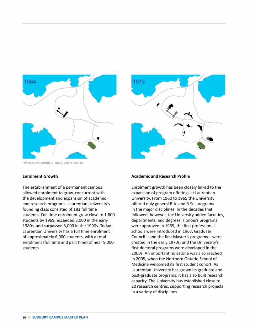
Enrolment Growth
The establishment of a permanent campus allowed enrolment to grow, concurrent with the development and expansion of academic and research programs. Laurentian University’s founding class consisted of 183 full time students. Full time enrolment grew close to 1,800 students by 1969, exceeded 3,000 in the early 1980s, and surpassed 5,000 in the 1990s. Today, Laurentian University has a full time enrolment of approximately 6,000 students, with a total enrolment (full time and part time) of near 9,000 students.
Academic and Research Profile
Enrolment growth has been closely linked to the expansion of program offerings at Laurentian University. From 1960 to 1965 the University offered only general B.A. and B.Sc. programs in the major disciplines. In the decades that followed, however, the University added faculties, departments, and degrees. Honours programs were approved in 1965, the first professional schools were introduced in 1967, Graduate Council – and the first Master’s programs – were created in the early 1970s, and the University’s first doctoral programs were developed in the 2000s. An important milestone was also reached in 2005, when the Northern Ontario School of Medicine welcomed its first student cohort. As Laurentian University has grown its graduate and post-graduate programs, it has also built research capacity. The University has established close to 20 research centres, supporting research projects in a variety of disciplines.
1964 1973
PhYSiCAL EvoLUTioN of ThE SUDBURY CAMPUS.
CHAPTER 2: SETTING THE STAGE FOR GROWTH AND ENHANCEMENT // 11
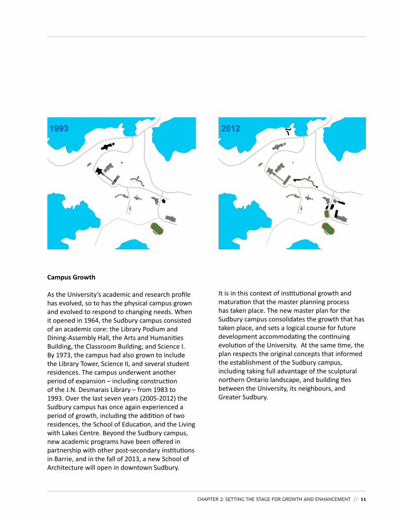
Campus Growth
As the University’s academic and research profile has evolved, so to has the physical campus grown and evolved to respond to changing needs. When it opened in 1964, the Sudbury campus consisted of an academic core: the Library Podium and Dining-Assembly Hall, the Arts and Humanities Building, the Classroom Building, and Science I. By 1973, the campus had also grown to include the Library Tower, Science II, and several student residences. The campus underwent another period of expansion – including construction of the J.N. Desmarais Library – from 1983 to 1993. Over the last seven years (2005-2012) the Sudbury campus has once again experienced a period of growth, including the addition of two residences, the School of Education, and the Living with Lakes Centre. Beyond the Sudbury campus, new academic programs have been offered in partnership with other post-secondary institutions in Barrie, and in the fall of 2013, a new School of Architecture will open in downtown Sudbury.
It is in this context of institutional growth and maturation that the master planning process has taken place. The new master plan for the Sudbury campus consolidates the growth that has taken place, and sets a logical course for future development accommodating the continuing evolution of the University. At the same time, the plan respects the original concepts that informed the establishment of the Sudbury campus, including taking full advantage of the sculptural northern Ontario landscape, and building ties between the University, its neighbours, and Greater Sudbury.
1993 2012
12 // SUDBURY CAMPUS MASTER PLAN
Residential Community /
Communauté Résidentielle
sudbuRyyaCht Club /
Club nautique de sudbuRy
sCienCenoRth / sCienCe
noRd
health sCienCes noRth & sudbuRy
Regionalhospital / hoRizon
santé-noRd et l'hôpital Régional
de sudbuRy
JamesJeRomespoRts
Complex /Complexe
spoRtif James-JeRome
Nepahwin Lake
Lake Laurentian
Bethel Lake
Ramsey Lake
Ramsey Lake Road
South Bay Road
Paris
Str
eet
Campusgateway /
poRtail du Campus
Campusgateway /
poRtail du Campus
pedestRian and CyClist aCCess / aCCès pouR les piétons et les
CyClistesBennett
Lake
L a u r e n t i a n U n i v e r s i t y
Residential Community /
Communauté Résidentielle
Residential Community /
Communauté Résidentielle
Regent Street Loac
hs Road
lake lauRentian
ConseRvation aRea / aiRe de ConseRvation
du laC lauRentien
idylwylde golf CouRse / Club de
golf
CHAPTER 2: SETTING THE STAGE FOR GROWTH AND ENHANCEMENT // 13
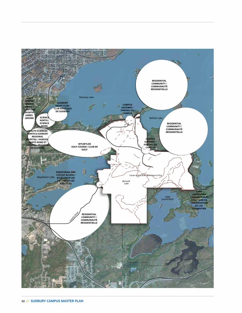
2.2 ThE uNivErsiTy aNd iTs NEiGhbOurs
“The establishment of the University in Sudbury gave the city a new and important regional identity and the impact of university life on the community has been and will continue to be profound. Quite apart from its normal function the University is serving as a cultural and recreational centre of some significance” Thomas Howarth, Laurentian University Master Plan (1969)
“Sudbury residents of all ages come to our campus and benefit from all we have to offer”Dr. Judith Woodsworth, former President, Laurentian University
Laurentian University is the largest post-secondary institution in the City of Greater Sudbury, a regional urban centre with a population of 160,000. Located in a natural setting, and surrounded by five lakes, the university campus is located within minutes (5 km) of Downtown Sudbury. The Sudbury campus is directly adjacent residential neighbourhoods to the northeast of campus, around Bennett Lake, and to the southwest of campus, accessed by the Loach’s Road Trail. Laurentian University’s neighbours also include the Idylwylde Golf & Country Club, as well as the Sudbury Regional Hospital, and Science North.
Laurentian University’s Sudbury campus serves as an important community institution for its neighbours, and for the residents of Greater Sudbury. It is a centre of learning, recreation, and entertainment. Community members attend events at Laurentian’s theatres; make use of the campus’ athletic facilities (the Laurentian Community Track, Olympic Gold Pool, and multi-use gymnasiums); and, partake of the University’s academic offerings. The University hosts community activities ranging from summer camps to athletic meets, and both neighbours and the Greater Sudbury community use Laurentian’s unique sandy beach as well as the network of trails for hiking, running, biking, snow-shoeing, and cross-country skiing.
14 // SUDBURY CAMPUS MASTER PLAN
Founders square
residences
Federated universities
health/ Wellness + athletics
Long Term Care
Campus services
2.3 ExisTiNG CONdiTiONs, issuEs, & OppOrTuNiTiEs
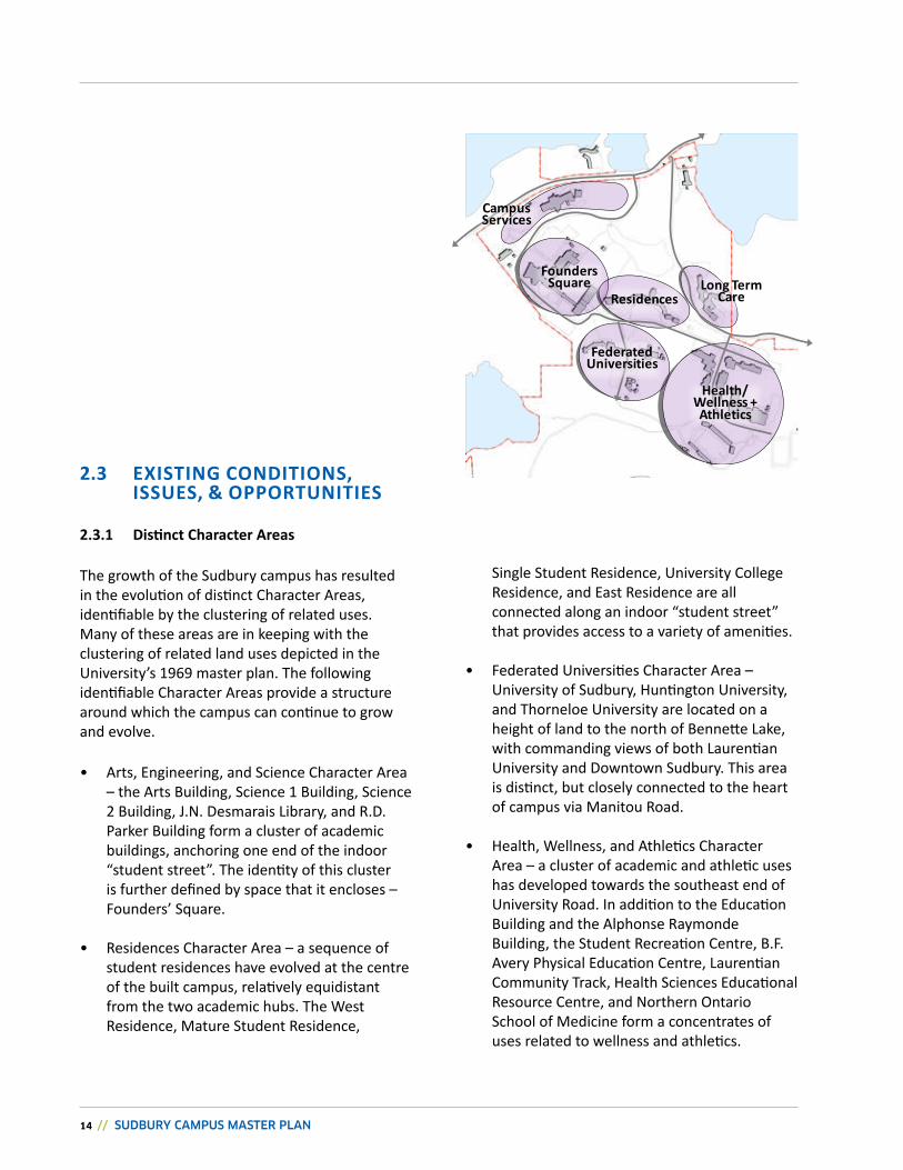
2.3.1 Distinct Character Areas
The growth of the Sudbury campus has resulted in the evolution of distinct Character Areas, identifiable by the clustering of related uses. Many of these areas are in keeping with the clustering of related land uses depicted in the University’s 1969 master plan. The following identifiable Character Areas provide a structure around which the campus can continue to grow and evolve.
• Arts, Engineering, and Science Character Area – the Arts Building, Science 1 Building, Science 2 Building, J.N. Desmarais Library, and R.D. Parker Building form a cluster of academic buildings, anchoring one end of the indoor “student street”. The identity of this cluster is further defined by space that it encloses – Founders’ Square.
• Residences Character Area – a sequence of student residences have evolved at the centre of the built campus, relatively equidistant from the two academic hubs. The West Residence, Mature Student Residence,
Single Student Residence, University College Residence, and East Residence are all connected along an indoor “student street” that provides access to a variety of amenities.
• Federated Universities Character Area – University of Sudbury, Huntington University, and Thorneloe University are located on a height of land to the north of Bennette Lake, with commanding views of both Laurentian University and Downtown Sudbury. This area is distinct, but closely connected to the heart of campus via Manitou Road.
• Health, Wellness, and Athletics Character Area – a cluster of academic and athletic uses has developed towards the southeast end of University Road. In addition to the Education Building and the Alphonse Raymonde Building, the Student Recreation Centre, B.F. Avery Physical Education Centre, Laurentian Community Track, Health Sciences Educational Resource Centre, and Northern Ontario School of Medicine form a concentrates of uses related to wellness and athletics.
CHAPTER 2: SETTING THE STAGE FOR GROWTH AND ENHANCEMENT // 15
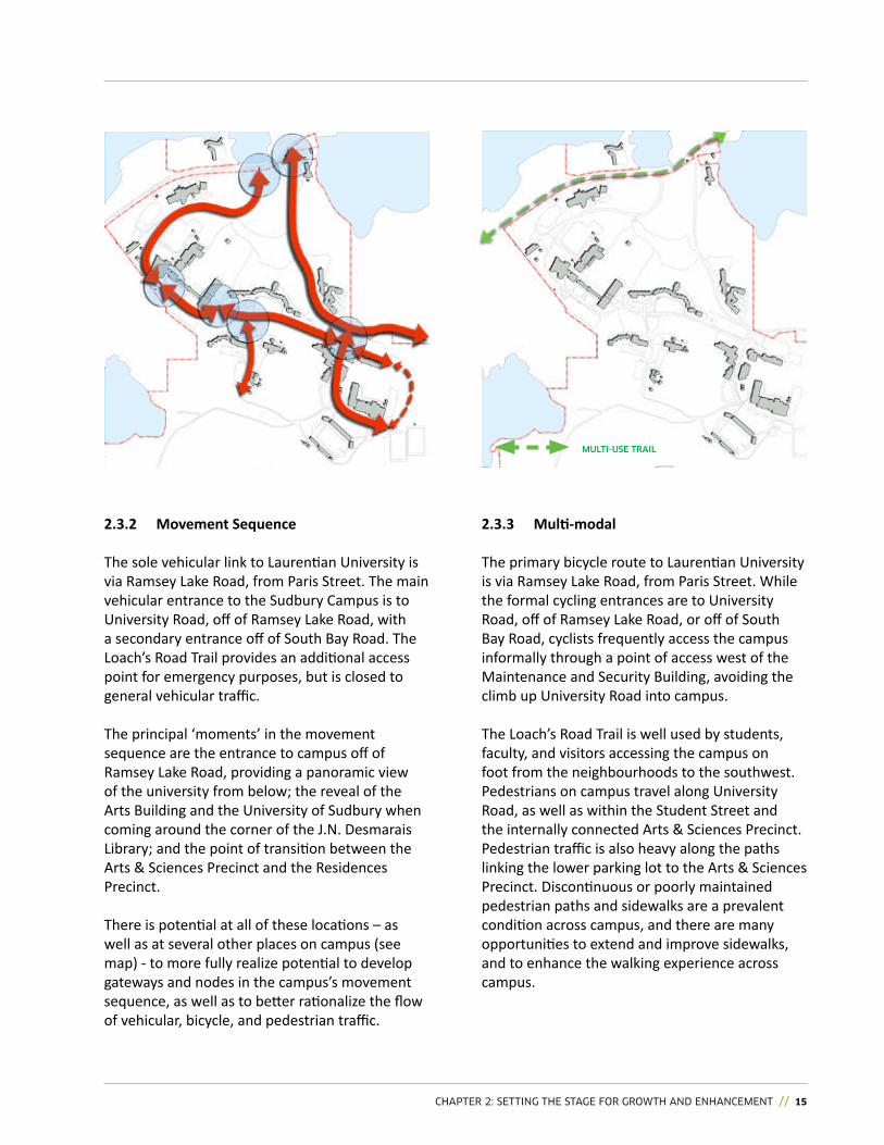
2.3.2 movement sequence
The sole vehicular link to Laurentian University is via Ramsey Lake Road, from Paris Street. The main vehicular entrance to the Sudbury Campus is to University Road, off of Ramsey Lake Road, with a secondary entrance off of South Bay Road. The Loach’s Road Trail provides an additional access point for emergency purposes, but is closed to general vehicular traffic.
The principal ‘moments’ in the movement sequence are the entrance to campus off of Ramsey Lake Road, providing a panoramic view of the university from below; the reveal of the Arts Building and the University of Sudbury when coming around the corner of the J.N. Desmarais Library; and the point of transition between the Arts & Sciences Precinct and the Residences Precinct.
There is potential at all of these locations – as well as at several other places on campus (see map) - to more fully realize potential to develop gateways and nodes in the campus’s movement sequence, as well as to better rationalize the flow of vehicular, bicycle, and pedestrian traffic.
2.3.3 Multi-modal
The primary bicycle route to Laurentian University is via Ramsey Lake Road, from Paris Street. While the formal cycling entrances are to University Road, off of Ramsey Lake Road, or off of South Bay Road, cyclists frequently access the campus informally through a point of access west of the Maintenance and Security Building, avoiding the climb up University Road into campus.
The Loach’s Road Trail is well used by students, faculty, and visitors accessing the campus on foot from the neighbourhoods to the southwest. Pedestrians on campus travel along University Road, as well as within the Student Street and the internally connected Arts & Sciences Precinct. Pedestrian traffic is also heavy along the paths linking the lower parking lot to the Arts & Sciences Precinct. Discontinuous or poorly maintained pedestrian paths and sidewalks are a prevalent condition across campus, and there are many opportunities to extend and improve sidewalks, and to enhance the walking experience across campus.
MULTi-USE TRAiL
16 // SUDBURY CAMPUS MASTER PLAN
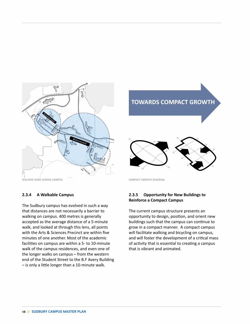
2.3.4 a Walkable Campus
The Sudbury campus has evolved in such a way that distances are not necessarily a barrier to walking on campus. 400 metres is generally accepted as the average distance of a 5-minute walk, and looked at through this lens, all points with the Arts & Sciences Precinct are within five minutes of one another. Most of the academic facilities on campus are within a 5- to 10-minute walk of the campus residences, and even one of the longer walks on campus – from the western end of the Student Street to the B.F Avery Building – is only a little longer than a 10-minute walk.
2.3.5 Opportunity for New buildings to reinforce a Compact Campus
The current campus structure presents an opportunity to design, position, and orient new buildings such that the campus can continue to grow in a compact manner. A compact campus will facilitate walking and bicycling on campus, and will foster the development of a critical mass of activity that is essential to creating a campus that is vibrant and animated.
TOWards COmpaCT GrOWTh
wALKiNG RADii ACRoSS CAMPUS. CoMPACT GRowTh DiAGRAM.
CHAPTER 2: SETTING THE STAGE FOR GROWTH AND ENHANCEMENT // 17
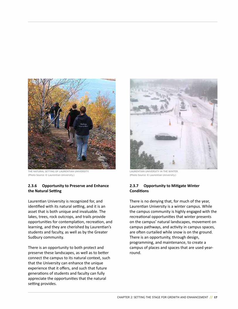
2.3.6 Opportunity to preserve and Enhance the Natural Setting
Laurentian University is recognized for, and identified with its natural setting, and it is an asset that is both unique and invaluable. The lakes, trees, rock outcrops, and trails provide opportunities for contemplation, recreation, and learning, and they are cherished by Laurentian’s students and faculty, as well as by the Greater Sudbury community.
There is an opportunity to both protect and preserve these landscapes, as well as to better connect the campus to its natural context, such that the University can enhance the unique experience that it offers, and such that future generations of students and faculty can fully appreciate the opportunities that the natural setting provides.
2.3.7 Opportunity to Mitigate Winter Conditions
There is no denying that, for much of the year, Laurentian University is a winter campus. While the campus community is highly engaged with the recreational opportunities that winter presents on the campus’ natural landscapes, movement on campus pathways, and activity in campus spaces, are often curtailed while snow is on the ground.There is an opportunity, through design, programming, and maintenance, to create a campus of places and spaces that are used year-round.
TOWards COmpaCT GrOWTh
ThE NATURAL SETTiNG of LAURENTiAN UNivERSiTY.
(Photo Source: © Laurentian University.)
LAURENTiAN UNivERSiTY iN ThE wiNTER.
(Photo Source: © Laurentian University.)
18 // SUDBURY CAMPUS MASTER PLAN
CHAPTER 3: THE VISION // 19
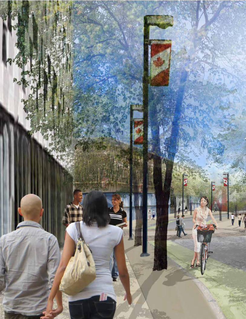
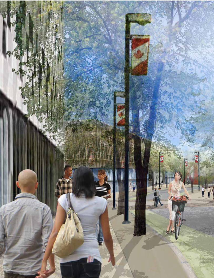
3.0 // THE VISION
The Laurentian University Sudbury Campus is a destination of choice for students, faculty, staff, and members of the Greater Sudbury community. The Sudbury Campus is a leader in sustainability, advanced research, and innovation. It is a modern campus epitomized by the high quality of its facilities, open spaces, and landscapes. It is an active, vibrant village of connected spaces that encourage walking and cycling, and that supports transit use. It is a jewel of Northern Ontario that celebrates its natural and cultural history. It is an open, inviting part of the City of Greater Sudbury, and a resource that supports the local community.
LEFT, AND FOLLOWING PAGE: URBAN DESIGNERS ILLUSTRATION OF ThE vISION FOR ThE CAMPUS STREETSCAPE SPINE.
20 // SUDBURY CAMPUS MASTER PLAN
CHAPTER 3: THE VISION // 21
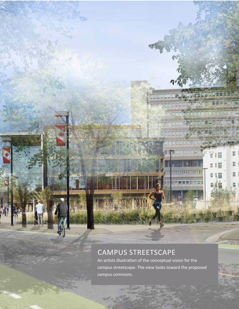
CAMPUS STREETSCAPEAn artists illustration of the conceptual vision for the campus streetscape. The view looks toward the proposed campus commons.
22 // SUDBURY CAMPUS MASTER PLAN
CONNECT PEOPLE, PLACES, ANd PROGRAMS.
CLUSTER ACTIvITy, SERvICES, ANd AMENITIES TO bUILd vIbRANCy ANd fOSTER SyNERGIES.
bUILd UPON OUR UNIqUE IdENTITy, hERITAGE, ANd AREAS Of STRENGTh.
The Sudbury Campus will protect, celebrate, and leverage its unique assets and attributes – the Northern Ontario terrain and climate; the first Nations presence; the university’s academic history; and, Laurentian’s relationship with its federated partners.
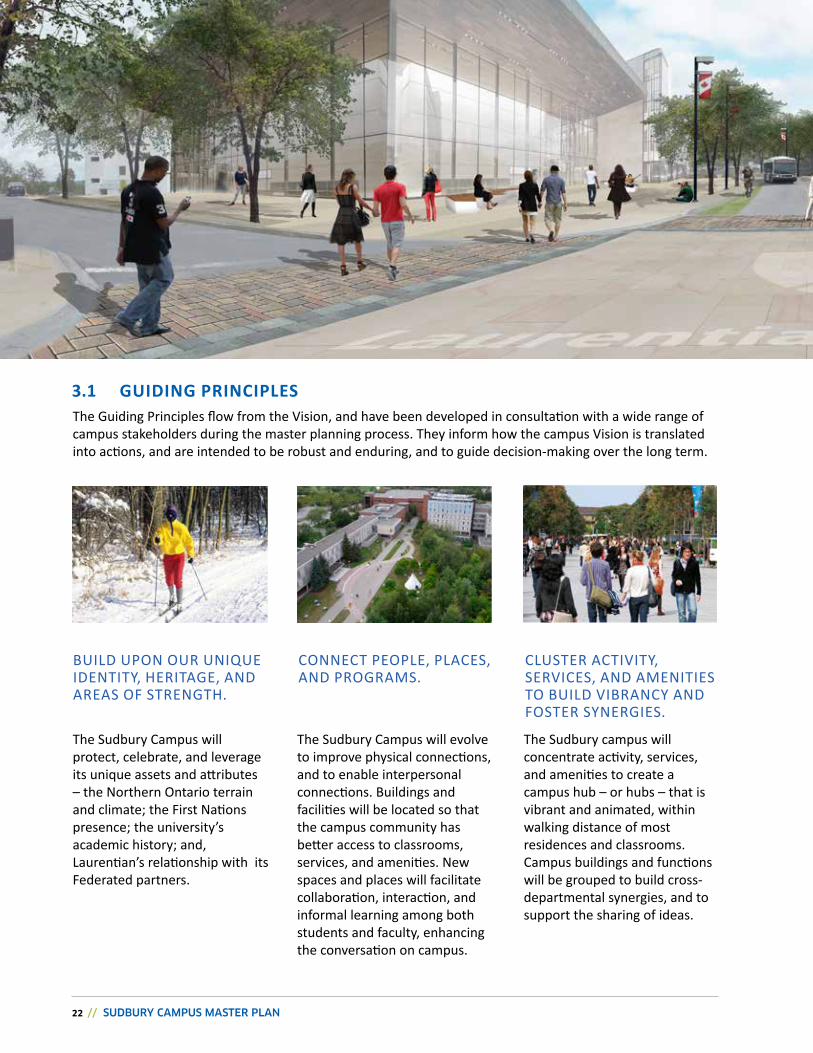
3.1 GUIDING PRINCIPLESThe Guiding Principles flow from the vision, and have been developed in consultation with a wide range of campus stakeholders during the master planning process. They inform how the campus vision is translated into actions, and are intended to be robust and enduring, and to guide decision-making over the long term.
The Sudbury Campus will evolve to improve physical connections, and to enable interpersonal connections. buildings and facilities will be located so that the campus community has better access to classrooms, services, and amenities. New spaces and places will facilitate collaboration, interaction, and informal learning among both students and faculty, enhancing the conversation on campus.
The Sudbury campus will concentrate activity, services, and amenities to create a campus hub – or hubs – that is vibrant and animated, within walking distance of most residences and classrooms. Campus buildings and functions will be grouped to build cross-departmental synergies, and to support the sharing of ideas.
CHAPTER 3: THE VISION // 23
IMPROvE MOvEMENT TO, ANd wIThIN, ThE SUdbURy CAMPUS.
CULTIvATE AN ENvIRONMENT ThAT IS wELCOMING.
bECOME SUSTAINAbLE, AdAPTAbLE, ANd RESILIENT.
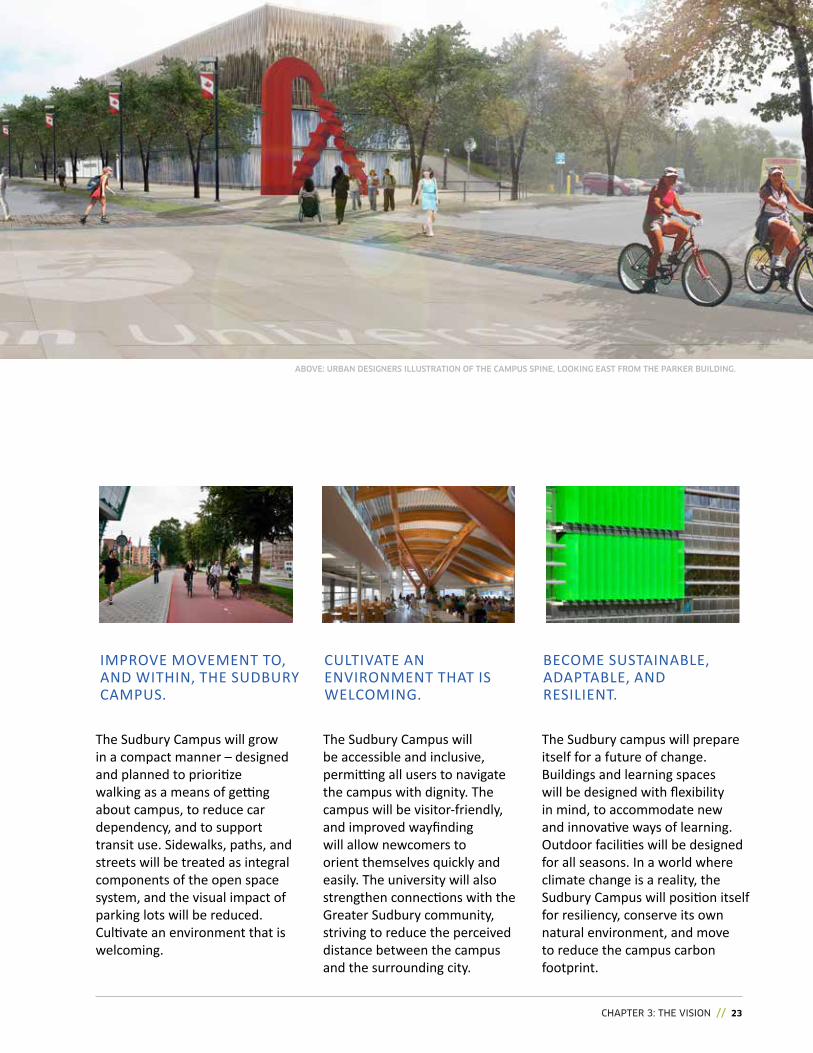
The Sudbury Campus will grow in a compact manner – designed and planned to prioritize walking as a means of getting about campus, to reduce car dependency, and to support transit use. Sidewalks, paths, and streets will be treated as integral components of the open space system, and the visual impact of parking lots will be reduced. Cultivate an environment that is welcoming.
The Sudbury Campus will be accessible and inclusive, permitting all users to navigate the campus with dignity. The campus will be visitor-friendly, and improved wayfinding will allow newcomers to orient themselves quickly and easily. The university will also strengthen connections with the Greater Sudbury community, striving to reduce the perceived distance between the campus and the surrounding city.
The Sudbury campus will prepare itself for a future of change. buildings and learning spaces will be designed with flexibility in mind, to accommodate new and innovative ways of learning. Outdoor facilities will be designed for all seasons. In a world where climate change is a reality, the Sudbury Campus will position itself for resiliency, conserve its own natural environment, and move to reduce the campus carbon footprint.
ABOvE: URBAN DESIGNERS ILLUSTRATION OF ThE CAMPUS SPINE, LOOKING EAST FROM ThE PARKER BUILDING.
24 // SUDBURY CAMPUS MASTER PLAN
THE PLAN // 25
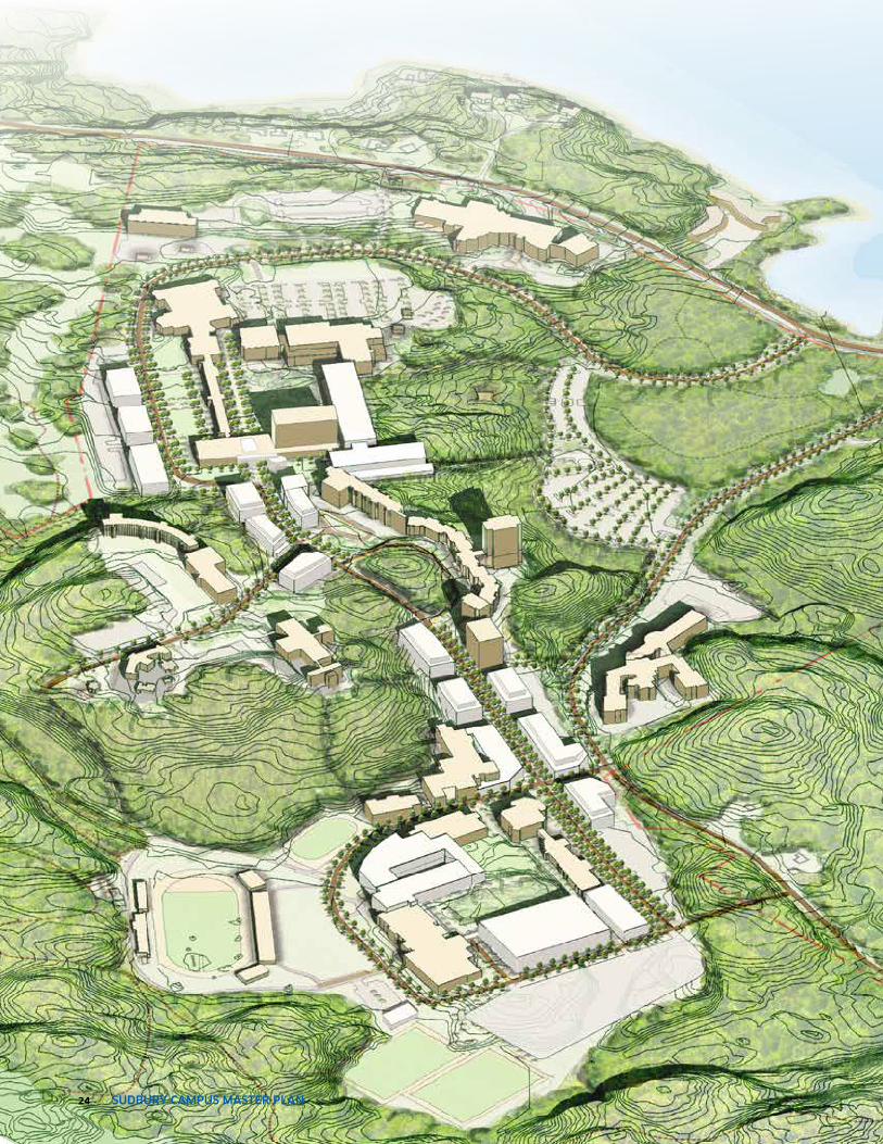
4.0 // THE PLANThe Concept Plan illustrated on the following pages embodies the Master Plan Vision and Principles, and supports a decision making framework to grow and enhance Laurentian’s Sudbury Campus over the coming decades.
4.1 CONCEPT PLAN
Developed in consultation with a wide range of stakeholders, the Concept Plan includes a number of components that work together to shape how and where the Sudbury campus will: create or enhance open spaces; locate and shape new development; and support multi-modal movement to and within campus. These broad objectives are introduced through six Big Moves.
4.2 Big MOvEs
Building on the Vision and Planning Principles, the Big Moves are a series of interventions and design strategies that will define a new structure for the Sudbury campus, providing a basis for moving the Concept Plan forward. The Big moves are essentially the driving ideas for change that form the basis for the Open Space Framework, Built Form Framework, and Movement Framework.
LEFT: CMP CONCEPT PLAN MODEL.
PRECEDENT: PEDESTRIAN SUPPORTIVE CAMPUS STREETSCAPE.
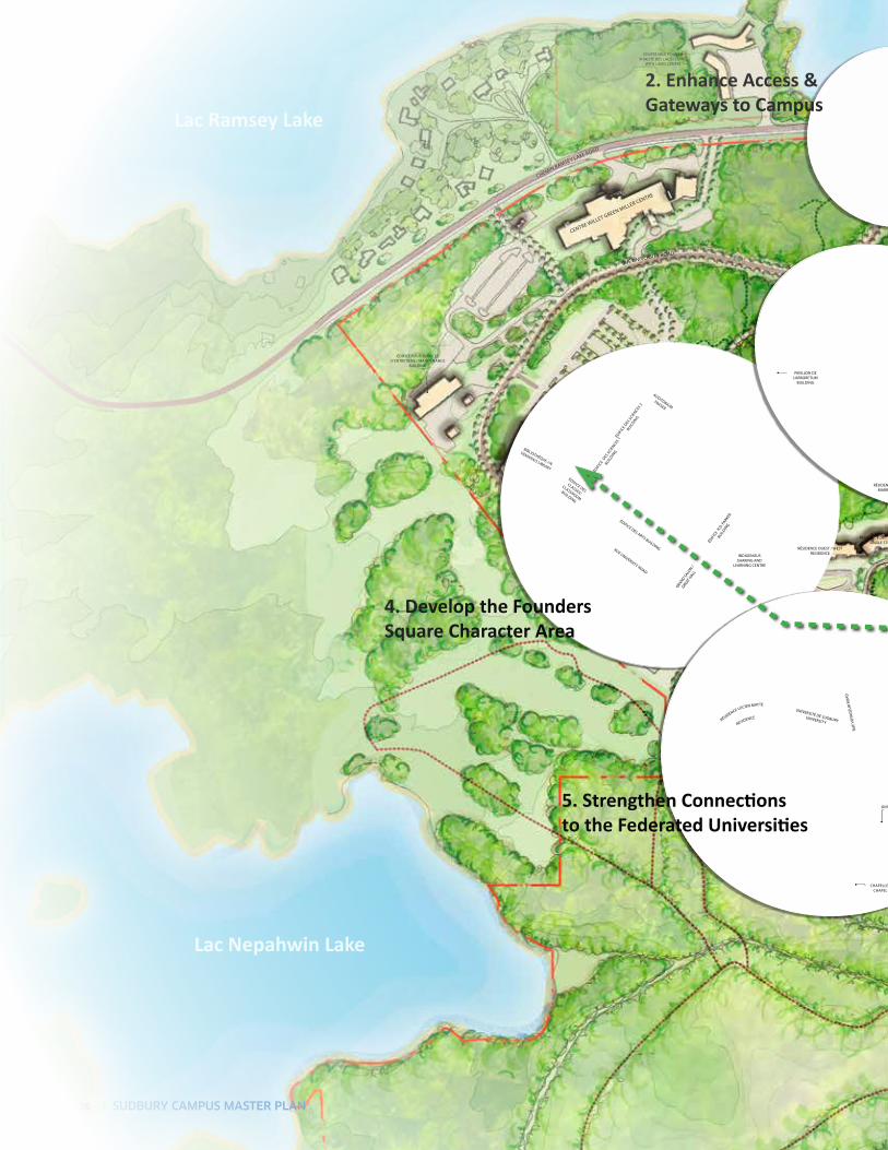
2. Enhance Access & gateways to Campus
5. Strengthen Connections to the Federated Universities
4. Develop the Founders square Character Area
Lac Ramsey Lake
Lac Nepahwin Lake
CENTRE WillET GREEN MillER CENTRE
ÉDiF
iCE D
ES SC
iENCES
2
BUilDiN
G
ÉDiF
iCE
DES SC
iENCES
1
BUilDiN
G
PAVillON DE l’ARBORETUM
BUilDiNG
ÉDiFiCE POUR SERViCES D’ENTRETiENS / MAiNTENANCE
BUilDiNG
UNiVERSiTÉ ThORNElOPE UNiVERSiTy
ChAPEllE / ChAPEl
UNiVERSiTÉ DE SUDBURy UNiVERSiTy
AUDiTORiUMFRASER
BiBliOThÈQUE J.N.
DEMARAiS liBRARy
ÉDiFiCE DES
ClASSES/
ClASSROOM
BUilDiNG
ÉDiF
iCE
R.D. P
ARkER
BUilDiN
G
GRAND SAlO
N /
GREAT h
All
ÉDiFiCE DES ARTS BUilDiNG
RÉSiDENCE lUCiEN MATTE
RESiDENCE
RÉSiDENCE OUEST / WEST RESiDENCE
CENTRE VAlE POUR lA ViTAliTÉ DES lACS / liViNG
WiTh lAkES CENTRE
RÉSiDENCE DES ÉTUDiANTS CÉliBATAiRESSiNGlE STUDENTS RESiDENCE
RÉSiDENCE DES ÉTUDiANTS MARiÉS ET ADUlTES / MARRiED AND ADUlT STUDENTS RESiDENCE
RUE UNiVERSiTy ROAD
RUE UNiVERSiTy ROAD
RUE
VOyA
GEU
R RO
AD
ChEMiN RAMSEy lAkE ROAD
iNDiGENOUS ShARiNG AND
lEARNiNG CENTRE
26 // SUDBURY CAMPUS MASTER PLAN
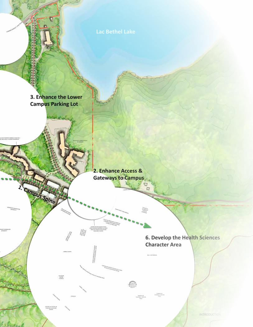
2. Enhance Access & gateways to Campus
3. Enhance the Lower Campus Parking Lot
5. Strengthen Connections to the Federated Universities 6. Develop the Health sciences
Character Area
Lac Bethel Lake
UNiVERSiTÉ ThORNElOPE UNiVERSiTy
GARD
ERiE
ET
Chil
D
AND
FAM
ily C
ENTR
E
CENTRE DE RESSOURCES POUR l’ÉDUCATiON EN MATiÈRE DE SANTÉ
/ hEAlTh SCiENCES EDUCATiON RESOURCE CENTRE
ÉCOlE DE MÉDECiNE DU NORD DE
l’ONTARiO/ NORThERN ONTARiO
SChOOl OF MEDiCiNE
VillA DE ST. JOSEPh’S VillA OF SUDBURy
MAiSONETTE DU lAC BEThEl lAkE
COTTAGE
ChAPEllE / ChAPEl
UNiVERSiTÉ hUNTiNGTON UNiVERSiTyPAVillON AlPhONSE
RAyMOND BUilDiNG
RÉSiDENCE DU COllÈGE l’UNiVERSiTAiRE /
UNiVERSiTy COllEGE RESiDENCE
RÉSiDENCE EST / EAST RESiDENCE
RÉSiDENCE DES ÉTUDiANTS CÉliBATAiRESSiNGlE STUDENTS RESiDENCE
RÉSiDENCE DES ÉTUDiANTS MARiÉS ET ADUlTES / MARRiED AND ADUlT STUDENTS RESiDENCE
CENTRE D’ÉCUATiON PhySiQUE B.F. AVERy
PhySiCAl EDUCATiON CENTRE
CEN
TRE
DE
RÉCR
ÉATi
ON
ÉTU
DiA
NTE
/ S
TUD
ENT
RECR
EATi
ON
Al
CEN
TRE
ÉDiF
iCE
DE
l’ÉD
UCA
TiO
N/
SCh
OO
l O
F ED
UCA
TiO
N
TENNiS COURTS
TERRAiN DE FOOTBAll/ SOCCER
FiElD
TERRAiN DE FOOTBAll/ SOCCER
FiElD
CENTRE D’ACTiViTÉS DE PlEiN AiR/ OUTDOOR
CENTRE
CONCESSiON
STANDS/ GRADiNS
STANDS / GRADiNS
STADiUM
ChEMiN SOUTh BAy ROAD
ChEM
iN SO
UTh
BAy ROAD
RUE UNiVERSiTy ROAD
ChEMiN RAMSEy lAkE ROAD
ChEM
iN S
OU
Th B
Ay R
OA
D
RUE DE l’ÉDiFiCE AThlÉTiQUE/ AThlETiC BUilDiNG ROAD
EVENT OVER FlOW PARkiNG
BUS / CAR PARkiNG
OUTDOOR CENTRE
STORAGE
POTENTiAl SECONDARy CAMPUS ENTRANCE
1. Campus spine
POTENTiAl COMMUNiTy USE
RECREATiONAl FACiliTy
iNTroducTioN // 27
28 // SUDBURY CAMPUS MASTER PLAN
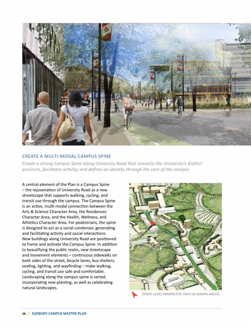
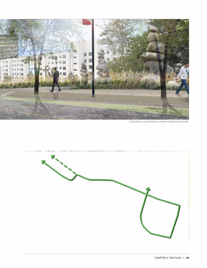
1Create a strong Campus Spine along University Road that connects the University’s distinct precincts, facilitates activity, and defines an identity through the core of the campus.
CreaTe a MuLTi-MODaL CaMPuS SPine
a central element of the Plan is a Campus Spine – the rejuvenation of university road as a new streetscape that supports walking, cycling, and transit use through the campus. The Campus Spine is an active, multi-modal connection between the arts & Science Character area, the residences Character Area, and the Health, Wellness, and athletics Character area. For pedestrians, the spine is designed to act as a social condenser, generating and facilitating activity and social interactions.new buildings along university road are positioned to frame and activate the Campus Spine. in addition to beautifying the public realm, new streetscape and movement elements – continuous sidewalks on both sides of the street, bicycle lanes, bus shelters, seating, lighting, and wayfinding – make walking, cycling, and transit use safe and comfortable. Landscaping along the campus spine is varied, incorporating new planting, as well as celebrating natural landscapes.
STREET LEVEL PERSPECTIVE VIEw (AS ShOwN ABOVE).
cHAPTEr 4: THE PLAN // 29
CONCEPTUAL ILLUSTRATION: CAMPUS STREETSCAPE SPINE.
30 // SUDBURY CAMPUS MASTER PLAN
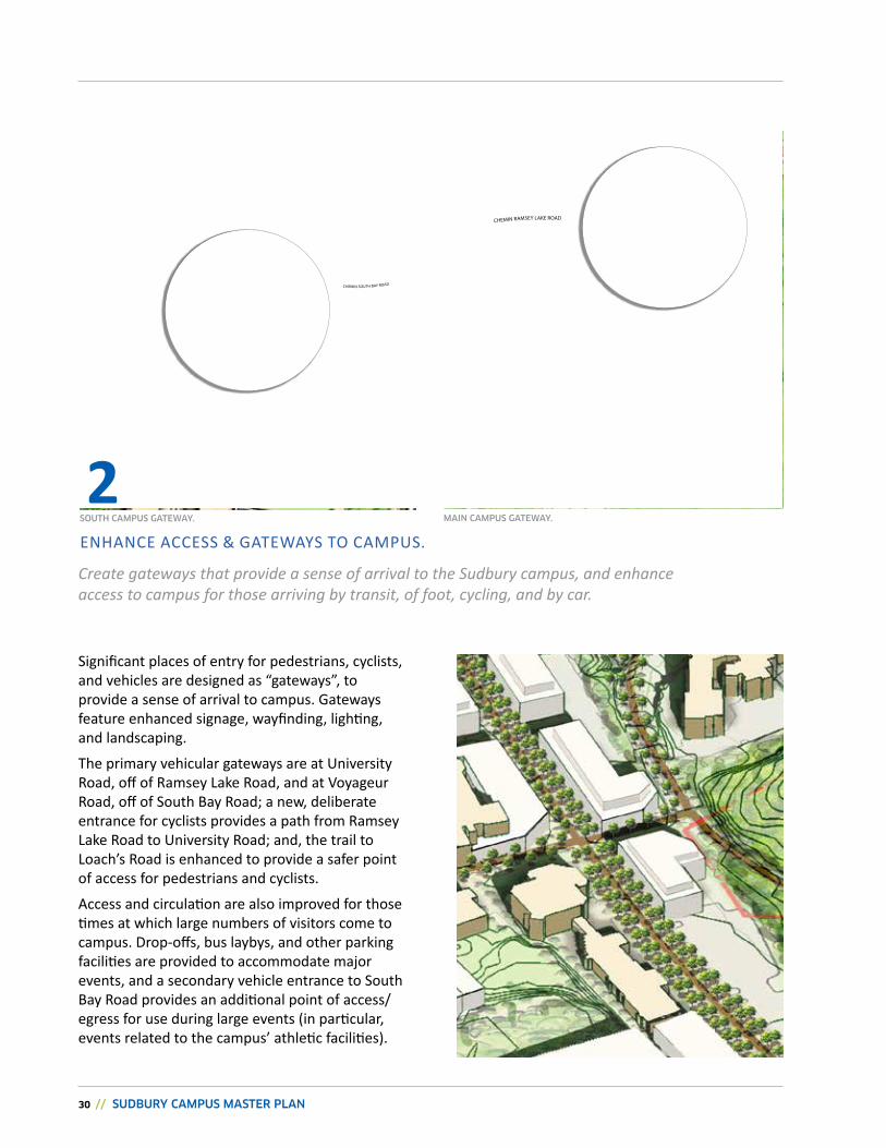
Significant places of entry for pedestrians, cyclists, and vehicles are designed as “gateways”, to provide a sense of arrival to campus. Gateways feature enhanced signage, wayfinding, lighting, and landscaping.
The primary vehicular gateways are at university road, off of ramsey Lake road, and at Voyageur road, off of South Bay road; a new, deliberate entrance for cyclists provides a path from ramsey Lake road to university road; and, the trail to Loach’s road is enhanced to provide a safer point of access for pedestrians and cyclists.
access and circulation are also improved for those times at which large numbers of visitors come to campus. Drop-offs, bus laybys, and other parking facilities are provided to accommodate major events, and a secondary vehicle entrance to South Bay road provides an additional point of access/egress for use during large events (in particular, events related to the campus’ athletic facilities).
Create gateways that provide a sense of arrival to the Sudbury campus, and enhance access to campus for those arriving by transit, of foot, cycling, and by car.
enhanCe aCCeSS & GaTewayS TO CaMPuS.
image
2SOUTh CAMPUS gATEwAY. MAIN CAMPUS gATEwAY.
ChEMiN RAMSEy lAkE ROAD
ChEMiN SOUTh BAy ROAD
cHAPTEr 4: THE PLAN // 31
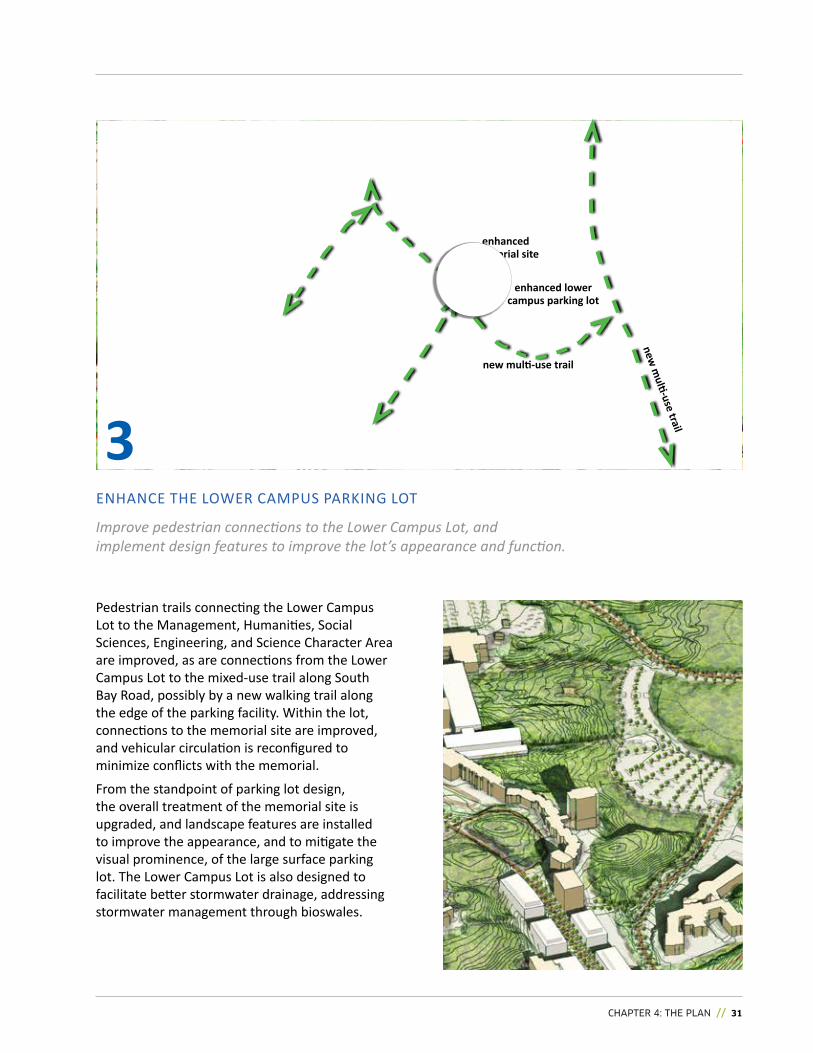
enhanCe The LOwer CaMPuS ParkinG LOT
Improve pedestrian connections to the Lower Campus Lot, and implement design features to improve the lot’s appearance and function.
Pedestrian trails connecting the Lower Campus Lot to the Management, humanities, Social Sciences, engineering, and Science Character area are improved, as are connections from the Lower Campus Lot to the mixed-use trail along South Bay road, possibly by a new walking trail along the edge of the parking facility. within the lot, connections to the memorial site are improved, and vehicular circulation is reconfigured to minimize conflicts with the memorial.
From the standpoint of parking lot design, the overall treatment of the memorial site is upgraded, and landscape features are installed to improve the appearance, and to mitigate the visual prominence, of the large surface parking lot. The Lower Campus Lot is also designed to facilitate better stormwater drainage, addressing stormwater management through bioswales.
3
enhanced lower campus parking lot
enhanced memorial site
new multi-use trail
new m
ulti-use trail
32 // SUDBURY CAMPUS MASTER PLAN
2. Completing the Founders square
1. Creating a new
campus commons
3. Define a new Quad
Potential development
Potential development
DeVeLOP The FOunDerS Square CharaCTer area
4
Potential development
potential new building (beyond)
parking lot road commons
The Commons: Section A-A
potential new entrance and indigenous Sharing and learning Centre
indigenous sharing and Learning Centre (isLC)
A
A
B
B
as the university grows, and as the activity in and around this busy Character area grows more intense, communal spaces become more precious and treasured. New buildings in this Character area are located to complete the arts & Sciences quad, and to define new gathering spaces. The height and massing of new buildings are scaled to support the character and function of quads and commons, as well as to minimize shadows, and to mitigate the potential wind impact of new development on those spaces.
This Character Area features three important open spaces:
1. The Campus Commons: a new space created adjacent to the residences, where university road passes the r.D. Parker Building. This location is an important node for pedestrian movement on campus, bringing together activity from this Character Area; the Lower Campus Parking Lot; the student street; and, the Campus Spine. The new Campus Commons integrates open space, built form, and movement at this busy node with the aim to create a vibrant student-focused centre on campus.
Complete the Quads while celebrating the natural landscape, and establish a new campus commons.
cHAPTEr 4: THE PLAN // 33
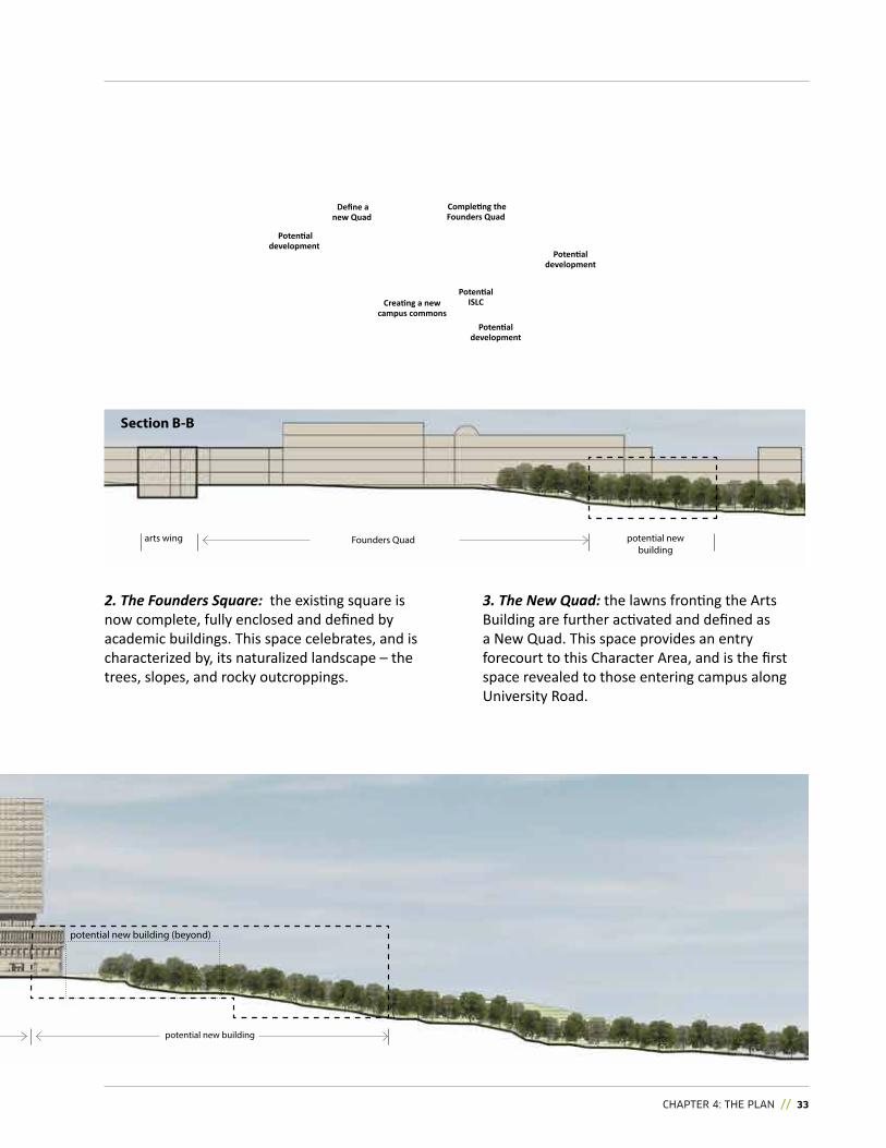
Completing the Founders Quad
Creating a new campus commons
Define a new Quad
Potential development
Potential development
Potential development
potential new building
potential new building (beyond)
potential new building
arts wing Founders Quad
Section B-B
2. The Founders Square: the existing square is now complete, fully enclosed and defined by academic buildings. This space celebrates, and is characterized by, its naturalized landscape – the trees, slopes, and rocky outcroppings.
3. The New Quad: the lawns fronting the arts Building are further activated and defined as a new quad. This space provides an entry forecourt to this Character area, and is the first space revealed to those entering campus along university road.
Potential isLC
34 // SUDBURY CAMPUS MASTER PLAN
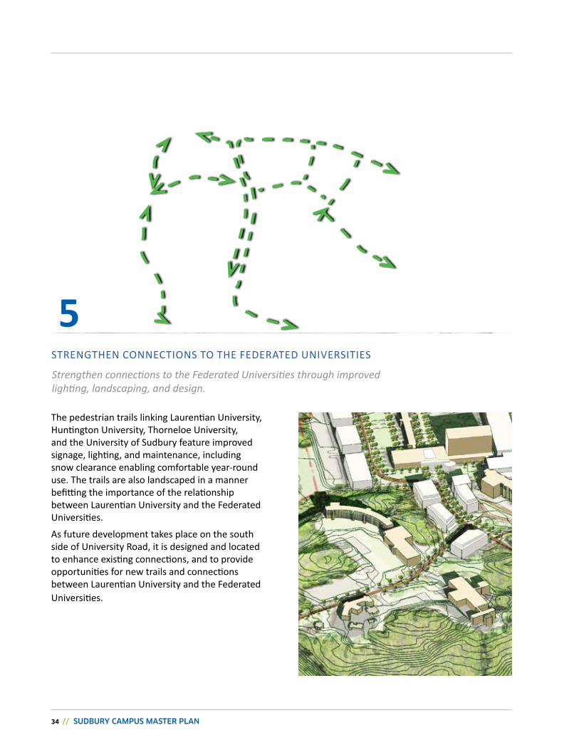
STrenGThen COnneCTiOnS TO The FeDeraTeD uniVerSiTieS
5Strengthen connections to the Federated Universities through improved lighting, landscaping, and design.
The pedestrian trails linking Laurentian university, huntington university, Thorneloe university, and the university of Sudbury feature improved signage, lighting, and maintenance, including snow clearance enabling comfortable year-round use. The trails are also landscaped in a manner befitting the importance of the relationship between Laurentian university and the Federated universities.
As future development takes place on the south side of university road, it is designed and located to enhance existing connections, and to provide opportunities for new trails and connections between Laurentian university and the Federated universities.
cHAPTEr 4: THE PLAN // 35
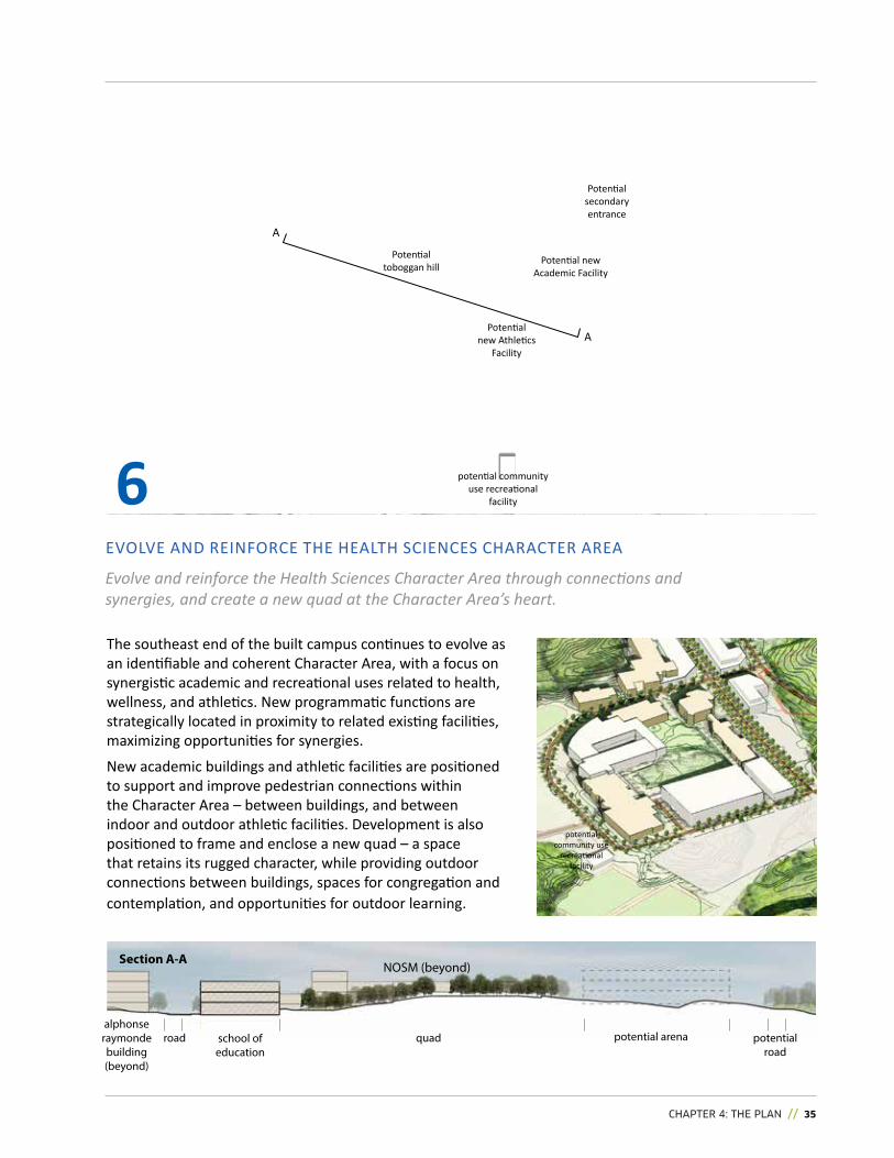
eVOLVe anD reinFOrCe The heaLTh SCienCeS CharaCTer area
Potential new athletics
Facility
Potential toboggan hill
Potential secondary entrance
Potential new academic Facility
6
school of education
road quad potential arena
Section A-A
alphonse raymonde building (beyond)
potential road
NOSM (beyond)
A
A
Evolve and reinforce the Health Sciences Character Area through connections and synergies, and create a new quad at the Character Area’s heart.
The southeast end of the built campus continues to evolve as an identifiable and coherent Character area, with a focus on synergistic academic and recreational uses related to health, wellness, and athletics. new programmatic functions are strategically located in proximity to related existing facilities, maximizing opportunities for synergies.
new academic buildings and athletic facilities are positioned to support and improve pedestrian connections within the Character Area – between buildings, and between indoor and outdoor athletic facilities. Development is also positioned to frame and enclose a new quad – a space that retains its rugged character, while providing outdoor connections between buildings, spaces for congregation and contemplation, and opportunities for outdoor learning.
potential community use
recreational facility
potential community use recreational
facility
36 // SUDBURY CAMPUS MASTER PLAN
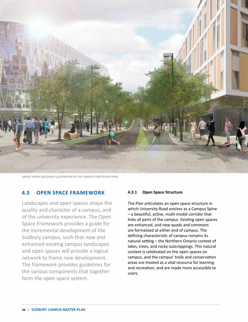
4.3.1 Open space structure
The Plan articulates an open space structure in which university road evolves as a Campus Spine – a beautiful, active, multi-modal corridor that links all parts of the campus. existing open spaces are enhanced, and new quads and commons are formalized at either end of campus. The defining characteristic of campus remains its natural setting – the northern Ontario context of lakes, trees, and rocky outcroppings. This natural context is celebrated on the open spaces on campus, and the campus’ trails and conservation areas are treated as a vital resource for learning and recreation, and are made more accessible to users.
Landscapes and open spaces shape the quality and character of a campus, and of the university experience. The Open Space Framework provides a guide for the incremental development of the Sudbury campus, such that new and enhanced existing campus landscapes and open spaces will provide a logical network to frame new development. The framework provides guidelines for the various components that together form the open space system.
4.3 OPEN sPACE FrAMEwOrk
ABOVE: URBAN DESIgNERS ILLUSTRATION OF ThE CAMPUS STREETSCAPE SPINE.
cHAPTEr 4: THE PLAN // 37
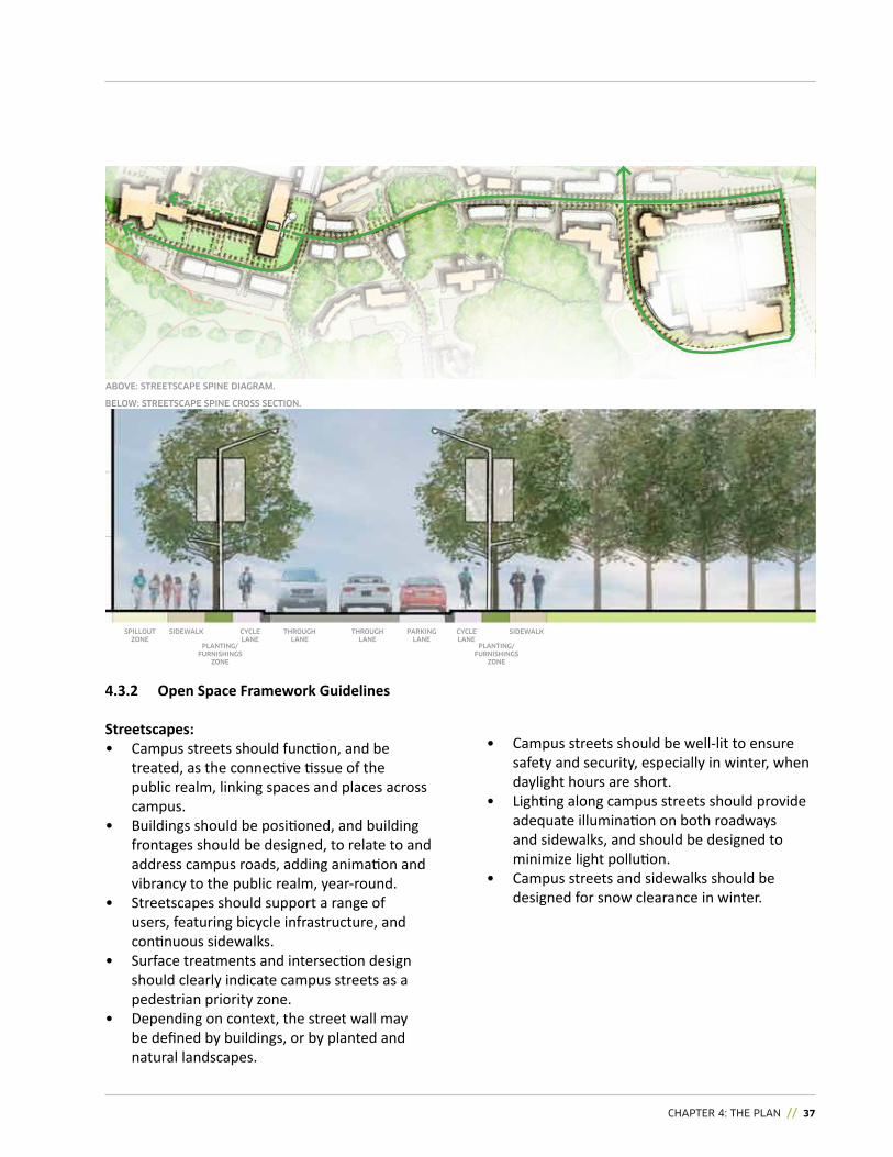
• Campus streets should be well-lit to ensure safety and security, especially in winter, when daylight hours are short.
• Lighting along campus streets should provide adequate illumination on both roadways and sidewalks, and should be designed to minimize light pollution.
• Campus streets and sidewalks should be designed for snow clearance in winter.
4.3.2 Open space Framework guidelines
streetscapes:• Campus streets should function, and be
treated, as the connective tissue of the public realm, linking spaces and places across campus.
• Buildings should be positioned, and building frontages should be designed, to relate to and address campus roads, adding animation and vibrancy to the public realm, year-round.
• Streetscapes should support a range of users, featuring bicycle infrastructure, and continuous sidewalks.
• Surface treatments and intersection design should clearly indicate campus streets as a pedestrian priority zone.
• Depending on context, the street wall may be defined by buildings, or by planted and natural landscapes.
Option 1
Option 2ABOVE: STREETSCAPE SPINE DIAgRAM.
BELOw: STREETSCAPE SPINE CROSS SECTION.
CYCLE LANE
PLANTINg/ FURNIShINgS
ZONE
SIDEwALK ThROUgh LANE
CYCLE LANE
ThROUgh LANE
PARKINg LANE
SPILLOUT ZONE
PLANTINg/ FURNIShINgS
ZONE
SIDEwALK
38 // SUDBURY CAMPUS MASTER PLAN
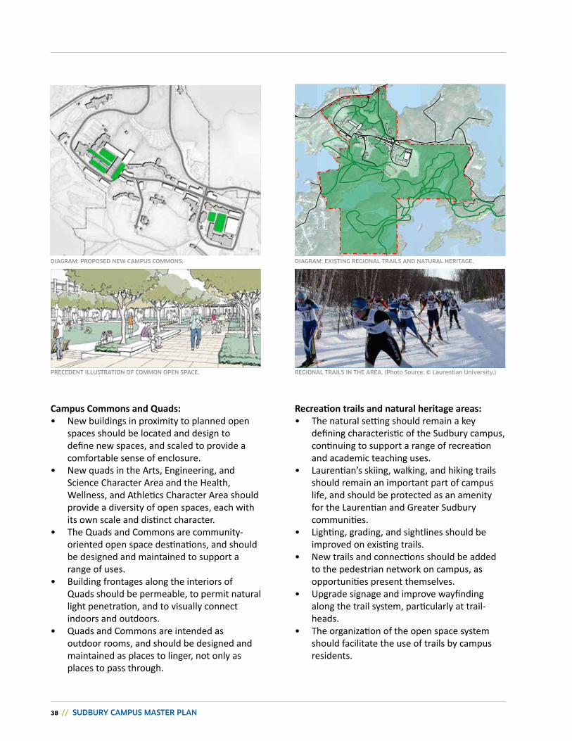
Campus Commons and Quads:• new buildings in proximity to planned open
spaces should be located and design to define new spaces, and scaled to provide a comfortable sense of enclosure.
• new quads in the arts, engineering, and Science Character area and the health, wellness, and athletics Character area should provide a diversity of open spaces, each with its own scale and distinct character.
• The quads and Commons are community-oriented open space destinations, and should be designed and maintained to support a range of uses.
• Building frontages along the interiors of quads should be permeable, to permit natural light penetration, and to visually connect indoors and outdoors.
• quads and Commons are intended as outdoor rooms, and should be designed and maintained as places to linger, not only as places to pass through.
Recreation trails and natural heritage areas:• The natural setting should remain a key
defining characteristic of the Sudbury campus, continuing to support a range of recreation and academic teaching uses.
• Laurentian’s skiing, walking, and hiking trails should remain an important part of campus life, and should be protected as an amenity for the Laurentian and Greater Sudbury communities.
• Lighting, grading, and sightlines should be improved on existing trails.
• new trails and connections should be added to the pedestrian network on campus, as opportunities present themselves.
• upgrade signage and improve wayfinding along the trail system, particularly at trail-heads.
• The organization of the open space system should facilitate the use of trails by campus residents.
PRECEDENT ILLUSTRATION OF COMMON OPEN SPACE.
DIAgRAM: PROPOSED NEw CAMPUS COMMONS. DIAgRAM: EXISTINg REgIONAL TRAILS AND NATURAL hERITAgE.
REgIONAL TRAILS IN ThE AREA. (Photo Source: © Laurentian University.)
cHAPTEr 4: THE PLAN // 39
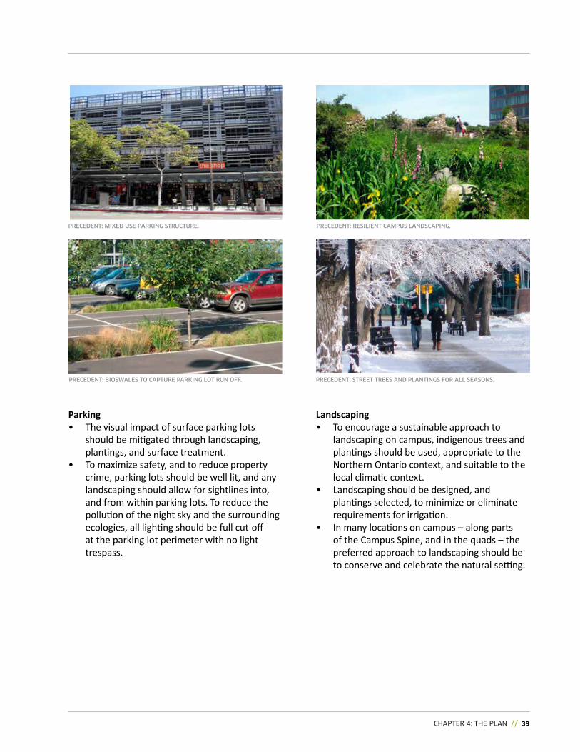
Landscaping• To encourage a sustainable approach to
landscaping on campus, indigenous trees and plantings should be used, appropriate to the northern Ontario context, and suitable to the local climatic context.
• Landscaping should be designed, and plantings selected, to minimize or eliminate requirements for irrigation.
• in many locations on campus – along parts of the Campus Spine, and in the quads – the preferred approach to landscaping should be to conserve and celebrate the natural setting.
Parking• The visual impact of surface parking lots
should be mitigated through landscaping, plantings, and surface treatment.
• To maximize safety, and to reduce property crime, parking lots should be well lit, and any landscaping should allow for sightlines into, and from within parking lots. To reduce the pollution of the night sky and the surrounding ecologies, all lighting should be full cut-off at the parking lot perimeter with no light trespass.
PRECEDENT: BIOSwALES TO CAPTURE PARKINg LOT RUN OFF.
PRECEDENT: RESILIENT CAMPUS LANDSCAPINg.PRECEDENT: MIXED USE PARKINg STRUCTURE.
PRECEDENT: STREET TREES AND PLANTINgS FOR ALL SEASONS.
40 // SUDBURY CAMPUS MASTER PLAN
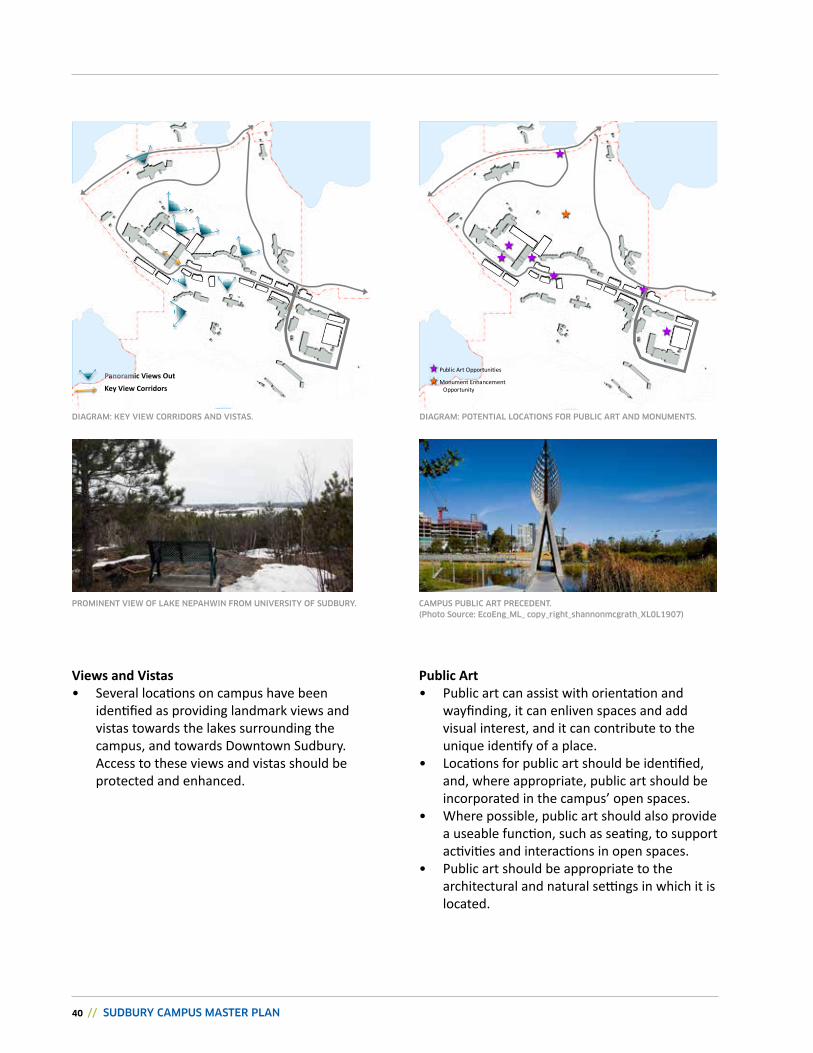
views and vistas• Several locations on campus have been
identified as providing landmark views and vistas towards the lakes surrounding the campus, and towards Downtown Sudbury. Access to these views and vistas should be protected and enhanced.
Public Art• Public art can assist with orientation and
wayfinding, it can enliven spaces and add visual interest, and it can contribute to the unique identify of a place.
• Locations for public art should be identified, and, where appropriate, public art should be incorporated in the campus’ open spaces.
• Where possible, public art should also provide a useable function, such as seating, to support activities and interactions in open spaces.
• Public art should be appropriate to the architectural and natural settings in which it is located.
Panoramic views Outkey view Corridors
DIAgRAM: KEY VIEw CORRIDORS AND VISTAS.
PROMINENT VIEw OF LAKE NEPAhwIN FROM UNIVERSITY OF SUDBURY.
Public Art Opportunities
Monument Enhancement Opportunity
DIAgRAM: POTENTIAL LOCATIONS FOR PUBLIC ART AND MONUMENTS.
CAMPUS PUBLIC ART PRECEDENT.
(Photo Source: EcoEng_ML_ copy_right_shannonmcgrath_XL0L1907)
cHAPTEr 4: THE PLAN // 41
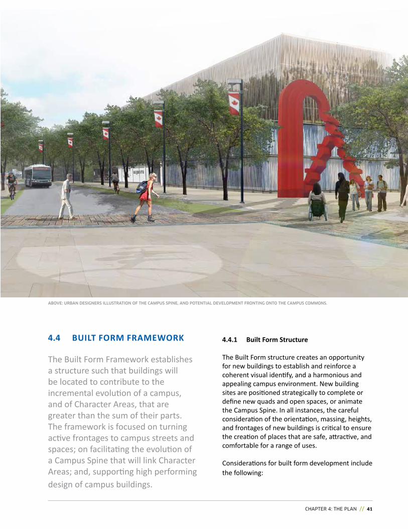
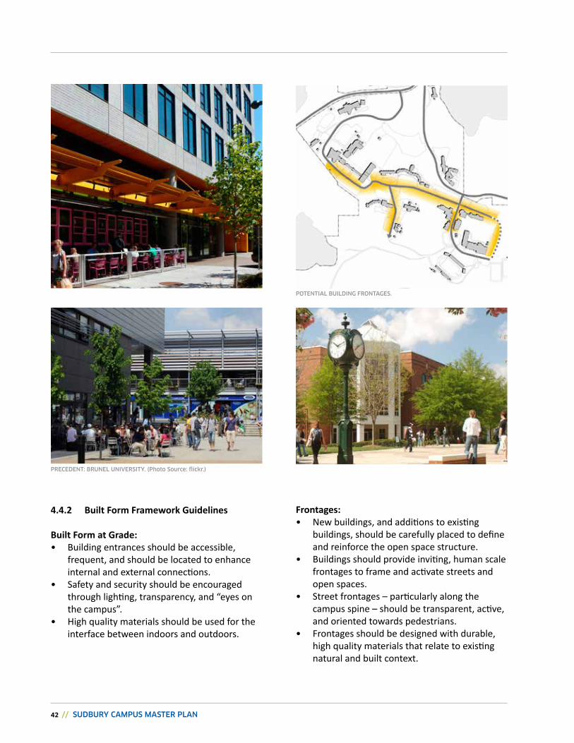
The Built Form Framework establishes a structure such that buildings will be located to contribute to the incremental evolution of a campus, and of Character Areas, that are greater than the sum of their parts. The framework is focused on turning active frontages to campus streets and spaces; on facilitating the evolution of a Campus Spine that will link Character areas; and, supporting high performing design of campus buildings.
ABOVE: URBAN DESIgNERS ILLUSTRATION OF ThE CAMPUS SPINE, AND POTENTIAL DEVELOPMENT FRONTINg ONTO ThE CAMPUS COMMONS.
4.4.1 Built Form structure
The Built Form structure creates an opportunity for new buildings to establish and reinforce a coherent visual identify, and a harmonious and appealing campus environment. New building sites are positioned strategically to complete or define new quads and open spaces, or animate the Campus Spine. in all instances, the careful consideration of the orientation, massing, heights, and frontages of new buildings is critical to ensure the creation of places that are safe, attractive, and comfortable for a range of uses.
Considerations for built form development include the following:
4.4 BuiLT FOrM FrAMEwOrk
42 // SUDBURY CAMPUS MASTER PLAN
4.4.2 Built Form Framework guidelines
Built Form at grade:• Building entrances should be accessible,
frequent, and should be located to enhance internal and external connections.
• Safety and security should be encouraged through lighting, transparency, and “eyes on the campus”.
• high quality materials should be used for the interface between indoors and outdoors.
Frontages: • new buildings, and additions to existing
buildings, should be carefully placed to define and reinforce the open space structure.
• Buildings should provide inviting, human scale frontages to frame and activate streets and open spaces.
• Street frontages – particularly along the campus spine – should be transparent, active, and oriented towards pedestrians.
• Frontages should be designed with durable, high quality materials that relate to existing natural and built context.
POTENTIAL BUILDINg FRONTAgES.
PRECEDENT: BRUNEL UNIVERSITY. (Photo Source: flickr.)
cHAPTEr 4: THE PLAN // 43
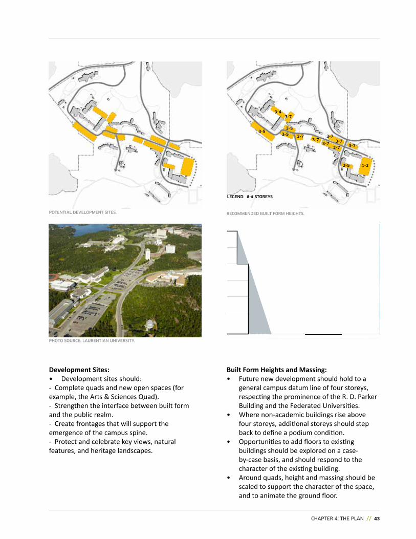
Built Form Heights and Massing:• Future new development should hold to a
general campus datum line of four storeys, respecting the prominence of the r. D. Parker Building and the Federated universities.
• where non-academic buildings rise above four storeys, additional storeys should step back to define a podium condition.
• Opportunities to add floors to existing buildings should be explored on a case-by-case basis, and should respond to the character of the existing building.
• around quads, height and massing should be scaled to support the character of the space, and to animate the ground floor.
RECOMMENDED BUILT FORM hEIghTS.
Development sites:• Development sites should:- Complete quads and new open spaces (for example, the arts & Sciences quad).- Strengthen the interface between built form and the public realm.- Create frontages that will support the emergence of the campus spine.- Protect and celebrate key views, natural features, and heritage landscapes.
to be updated
POTENTIAL DEVELOPMENT SITES.
PhOTO SOURCE: LAURENTIAN UNIVERSITY.
1-22-5
3-73-7
2-7
3-73-73-5
3-5
3-73-4
3-5
LEgEND: #-# STOREYS
3-7
3-7
44 // SUDBURY CAMPUS MASTER PLAN
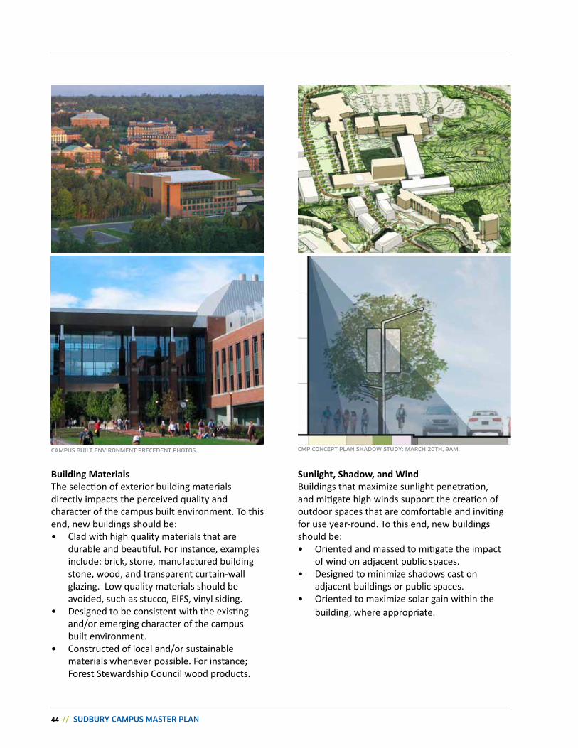
sunlight, shadow, and windBuildings that maximize sunlight penetration, and mitigate high winds support the creation of outdoor spaces that are comfortable and inviting for use year-round. To this end, new buildings should be:• Oriented and massed to mitigate the impact
of wind on adjacent public spaces.• Designed to minimize shadows cast on
adjacent buildings or public spaces.• Oriented to maximize solar gain within the
building, where appropriate.
CMP CONCEPT PLAN ShADOw STUDY: MARCh 20Th, 9AM.
Building MaterialsThe selection of exterior building materials directly impacts the perceived quality and character of the campus built environment. To this end, new buildings should be:• Clad with high quality materials that are
durable and beautiful. For instance, examples include: brick, stone, manufactured building stone, wood, and transparent curtain-wall glazing. Low quality materials should be avoided, such as stucco, eiFS, vinyl siding.
• Designed to be consistent with the existing and/or emerging character of the campus built environment.
• Constructed of local and/or sustainable materials whenever possible. For instance; Forest Stewardship Council wood products.
CAMPUS BUILT ENVIRONMENT PRECEDENT PhOTOS.
cHAPTEr 4: THE PLAN // 45
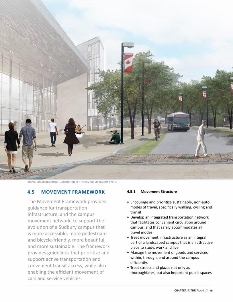
The Movement Framework provides guidance for transportation infrastructure, and the campus movement network, to support the evolution of a Sudbury campus that is more accessible, more pedestrian- and bicycle-friendly, more beautiful, and more sustainable. The framework provides guidelines that prioritize and support active transportation and convenient transit access, while also enabling the efficient movement of cars and service vehicles.
4.5.1 Movement structure
• encourage and prioritize sustainable, non-auto modes of travel, specifically walking, cycling and transit
• Develop an integrated transportation network that facilitates convenient circulation around campus, and that safely accommodates all travel modes
• Treat movement infrastructure as an integral part of a landscaped campus that is an attractive place to study, work and live
• Manage the movement of goods and services within, through, and around the campus efficiently.
• Treat streets and plazas not only as thoroughfares, but also important public spaces
ABOVE: URBAN DESIgNERS ILLUSTRATION OF ThE CAMPUS MOVEMENT 'SPINE'.
4.5 MOvEMENT FrAMEwOrk
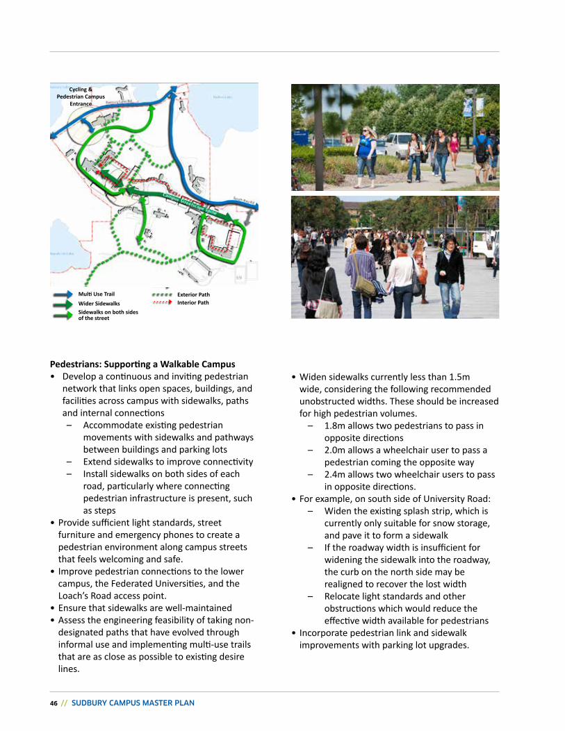
46 // SUDBURY CAMPUS MASTER PLAN
Multi Use Trailwider sidewalkssidewalks on both sides of the street
Cycling & Pedestrian Campus
Entrance
Pedestrians: Supporting a Walkable Campus• Develop a continuous and inviting pedestrian
network that links open spaces, buildings, and facilities across campus with sidewalks, paths and internal connections
– accommodate existing pedestrian movements with sidewalks and pathways between buildings and parking lots
– extend sidewalks to improve connectivity – Install sidewalks on both sides of each
road, particularly where connecting pedestrian infrastructure is present, such as steps
• Provide sufficient light standards, street furniture and emergency phones to create a pedestrian environment along campus streets that feels welcoming and safe.
• improve pedestrian connections to the lower campus, the Federated universities, and the Loach’s road access point.
• ensure that sidewalks are well-maintained • assess the engineering feasibility of taking non-
designated paths that have evolved through informal use and implementing multi-use trails that are as close as possible to existing desire lines.
Exterior Pathinterior Path
• widen sidewalks currently less than 1.5m wide, considering the following recommended unobstructed widths. These should be increased for high pedestrian volumes.
– 1.8m allows two pedestrians to pass in opposite directions
– 2.0m allows a wheelchair user to pass a pedestrian coming the opposite way
– 2.4m allows two wheelchair users to pass in opposite directions.
• For example, on south side of university road: – widen the existing splash strip, which is
currently only suitable for snow storage, and pave it to form a sidewalk
– if the roadway width is insufficient for widening the sidewalk into the roadway, the curb on the north side may be realigned to recover the lost width
– Relocate light standards and other obstructions which would reduce the effective width available for pedestrians
• Incorporate pedestrian link and sidewalk improvements with parking lot upgrades.
cHAPTEr 4: THE PLAN // 47
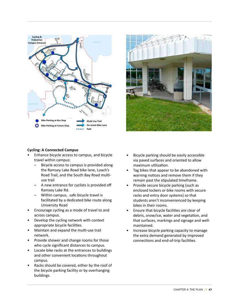
ramsey Lake
Nepahwin Lake
Bethel Lake
55
Bike Parking at Bus stop
Bike Parking at Future stop
Cycling & Pedestrian
Campus Entrance
Cycling: A Connected Campus• enhance bicycle access to campus, and bicycle
travel within campus: – Bicycle access to campus is provided along
the ramsey Lake road bike lane, Loach’s road Trail, and the South Bay road multi-use trail
– a new entrance for cyclists is provided off ramsey Lake rd.
– within campus, safe bicycle travel is facilitated by a dedicated bike route along university road
• encourage cycling as a mode of travel to and across campus.
• Develop the cycling network with context appropriate bicycle facilities.
• Maintain and expand the multi-use trail network.
• Provide shower and change rooms for those who cycle significant distances to campus.
• Locate bike racks at the entrances to buildings and other convenient locations throughout campus.
• racks should be covered, either by the roof of the bicycle parking facility or by overhanging buildings.
• Bicycle parking should be easily accessible via paved surfaces and oriented to allow maximum utilization.
• Tag bikes that appear to be abandoned with warning notices and remove them if they remain past the stipulated timeframe.
• Provide secure bicycle parking (such as enclosed lockers or bike rooms with secure racks and entry door systems) so that students aren’t inconvenienced by keeping bikes in their rooms.
• ensure that bicycle facilities are clear of debris, snow/ice, water and vegetation, and that surfaces, markings and signage and well-maintained.
• increase bicycle parking capacity to manage the extra demand generated by improved connections and end-of-trip facilities.
Multi Use Trail
On-street Bike LanePath
48 // SUDBURY CAMPUS MASTER PLAN
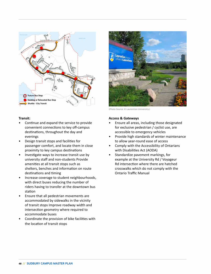
ramsey Lake
Nepahwin Lake
Bethel Lake
Transit:• Continue and expand the service to provide
convenient connections to key off-campus destinations, throughout the day and evenings
• Design transit stops and facilities for passenger comfort, and locate them in close proximity to key campus destinations
• investigate ways to increase transit use by university staff and non-students Provide amenities at all transit stops such as shelters, benches and information on route destinations and timing
• Increase coverage to student neighbourhoods, with direct buses reducing the number of riders having to transfer at the downtown bus station
• Ensure that all pedestrian movements are accommodated by sidewalks in the vicinity of transit stops improve roadway width and intersection geometry where required to accommodate buses
• Coordinate the provision of bike facilities with the location of transit stops
Access & gateways• Ensure all areas, including those designated
for exclusive pedestrian / cyclist use, are accessible to emergency vehicles
• Provide high standards of winter maintenance to allow year-round ease of access
• Comply with the accessibility of Ontarians with Disabilities act (aODa)
• Standardize pavement markings, for example at the university rd / Voyageur rd intersection where there are hatched crosswalks which do not comply with the Ontario Traffic Manual
Future Bus stop
Existing or Relocated Bus StopShuttle - City Transit
(Photo Source: © Laurentian University.)
cHAPTEr 4: THE PLAN // 49
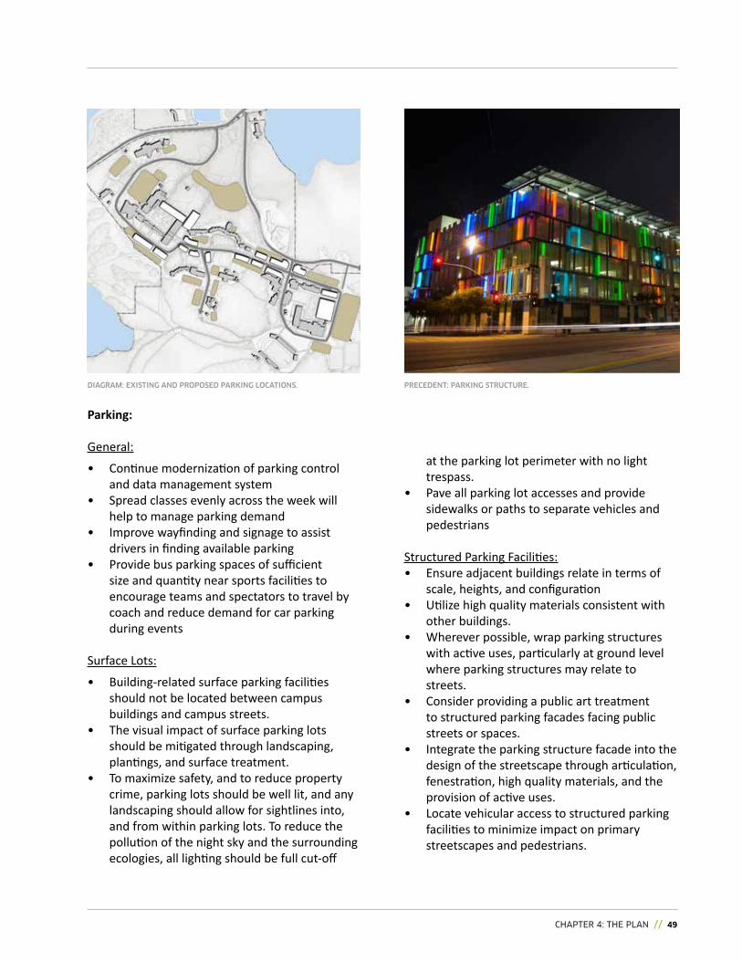
DIAgRAM: EXISTINg AND PROPOSED PARKINg LOCATIONS.
Parking:
General:
• Continue modernization of parking control and data management system
• Spread classes evenly across the week will help to manage parking demand
• improve wayfinding and signage to assist drivers in finding available parking
• Provide bus parking spaces of sufficient size and quantity near sports facilities to encourage teams and spectators to travel by coach and reduce demand for car parking during events
Surface Lots:
• Building-related surface parking facilities should not be located between campus buildings and campus streets.
• The visual impact of surface parking lots should be mitigated through landscaping, plantings, and surface treatment.
• To maximize safety, and to reduce property crime, parking lots should be well lit, and any landscaping should allow for sightlines into, and from within parking lots. To reduce the pollution of the night sky and the surrounding ecologies, all lighting should be full cut-off
at the parking lot perimeter with no light trespass.
• Pave all parking lot accesses and provide sidewalks or paths to separate vehicles and pedestrians
Structured Parking Facilities:• Ensure adjacent buildings relate in terms of
scale, heights, and configuration• utilize high quality materials consistent with
other buildings. • Wherever possible, wrap parking structures
with active uses, particularly at ground level where parking structures may relate to streets.
• Consider providing a public art treatment to structured parking facades facing public streets or spaces.
• Integrate the parking structure facade into the design of the streetscape through articulation, fenestration, high quality materials, and the provision of active uses.
• Locate vehicular access to structured parking facilities to minimize impact on primary streetscapes and pedestrians.
PRECEDENT: PARKINg STRUCTURE.
50 // SUDBURY CAMPUS MASTER PLAN
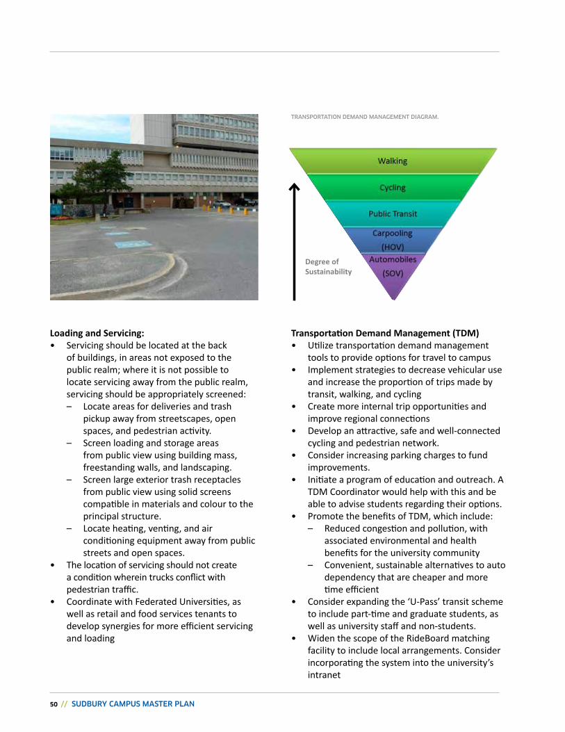
Transportation Demand Management (TDM)• utilize transportation demand management
tools to provide options for travel to campus• Implement strategies to decrease vehicular use
and increase the proportion of trips made by transit, walking, and cycling
• Create more internal trip opportunities and improve regional connections
• Develop an attractive, safe and well-connected cycling and pedestrian network.
• Consider increasing parking charges to fund improvements.
• initiate a program of education and outreach. a TDM Coordinator would help with this and be able to advise students regarding their options.
• Promote the benefits of TDM, which include: – reduced congestion and pollution, with
associated environmental and health benefits for the university community
– Convenient, sustainable alternatives to auto dependency that are cheaper and more time efficient
• Consider expanding the ‘u-Pass’ transit scheme to include part-time and graduate students, as well as university staff and non-students.
• widen the scope of the rideBoard matching facility to include local arrangements. Consider incorporating the system into the university’s intranet
Degree of sustainability
Loading and servicing:• Servicing should be located at the back
of buildings, in areas not exposed to the public realm; where it is not possible to locate servicing away from the public realm, servicing should be appropriately screened:
– Locate areas for deliveries and trash pickup away from streetscapes, open spaces, and pedestrian activity.
– Screen loading and storage areas from public view using building mass, freestanding walls, and landscaping.
– Screen large exterior trash receptacles from public view using solid screens compatible in materials and colour to the principal structure.
– Locate heating, venting, and air conditioning equipment away from public streets and open spaces.
• The location of servicing should not create a condition wherein trucks conflict with pedestrian traffic.
• Coordinate with Federated universities, as well as retail and food services tenants to develop synergies for more efficient servicing and loading
TRANSPORTATION DEMAND MANAgEMENT DIAgRAM.
cHAPTEr 4: THE PLAN // 51
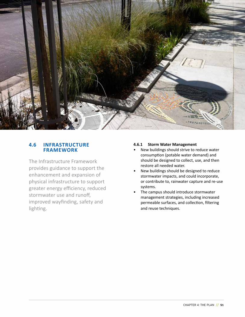
The infrastructure Framework provides guidance to support the enhancement and expansion of physical infrastructure to support greater energy efficiency, reduced stormwater use and runoff, improved wayfinding, safety and lighting.
4.6.1 storm water Management• New buildings should strive to reduce water
consumption (potable water demand) and should be designed to collect, use, and then restore all needed water.
• New buildings should be designed to reduce stormwater impacts, and could incorporate, or contribute to, rainwater capture and re-use systems.
• The campus should introduce stormwater management strategies, including increased permeable surfaces, and collection, filtering and reuse techniques.
4.6 iNFrAsTruCTurE FrAMEwOrk
52 // SUDBURY CAMPUS MASTER PLAN
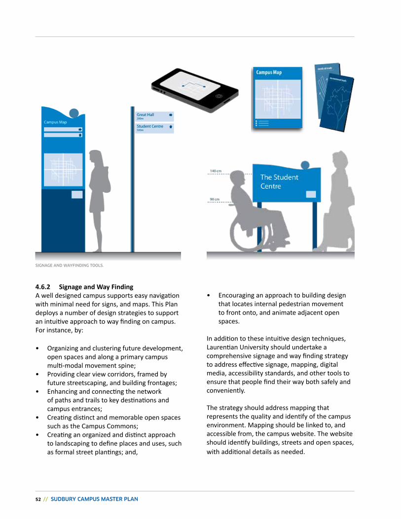
4.6.2 signage and way Findinga well designed campus supports easy navigation with minimal need for signs, and maps. This Plan deploys a number of design strategies to support an intuitive approach to way finding on campus. For instance, by:
• Organizing and clustering future development, open spaces and along a primary campus multi-modal movement spine;
• Providing clear view corridors, framed by future streetscaping, and building frontages;
• enhancing and connecting the network of paths and trails to key destinations and campus entrances;
• Creating distinct and memorable open spaces such as the Campus Commons;
• Creating an organized and distinct approach to landscaping to define places and uses, such as formal street plantings; and,
• Encouraging an approach to building design that locates internal pedestrian movement to front onto, and animate adjacent open spaces.
in addition to these intuitive design techniques, Laurentian university should undertake a comprehensive signage and way finding strategy to address effective signage, mapping, digital media, accessibility standards, and other tools to ensure that people find their way both safely and conveniently.
The strategy should address mapping that represents the quality and identify of the campus environment. Mapping should be linked to, and accessible from, the campus website. The website should identify buildings, streets and open spaces, with additional details as needed.
SIgNAgE AND wAYFINDINg TOOLS.
cHAPTEr 4: THE PLAN // 53
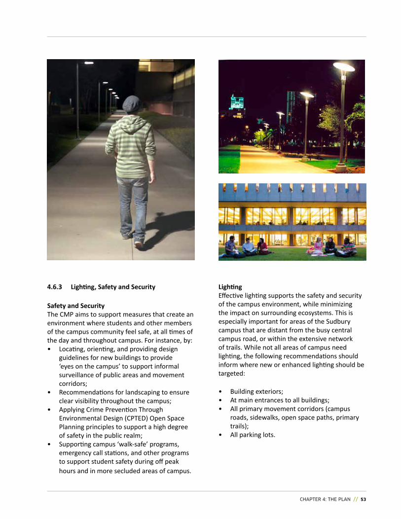
4.6.3 Lighting, Safety and Security
safety and securityThe CMP aims to support measures that create an environment where students and other members of the campus community feel safe, at all times of the day and throughout campus. For instance, by: • Locating, orienting, and providing design
guidelines for new buildings to provide ‘eyes on the campus’ to support informal surveillance of public areas and movement corridors;
• recommendations for landscaping to ensure clear visibility throughout the campus;
• applying Crime Prevention Through environmental Design (CPTeD) Open Space Planning principles to support a high degree of safety in the public realm;
• Supporting campus ‘walk-safe’ programs, emergency call stations, and other programs to support student safety during off peak hours and in more secluded areas of campus.
Lightingeffective lighting supports the safety and security of the campus environment, while minimizing the impact on surrounding ecosystems. This is especially important for areas of the Sudbury campus that are distant from the busy central campus road, or within the extensive network of trails. While not all areas of campus need lighting, the following recommendations should inform where new or enhanced lighting should be targeted:
• Building exteriors;• At main entrances to all buildings;• all primary movement corridors (campus
roads, sidewalks, open space paths, primary trails);
• All parking lots.
54 // SUDBURY CAMPUS MASTER PLAN
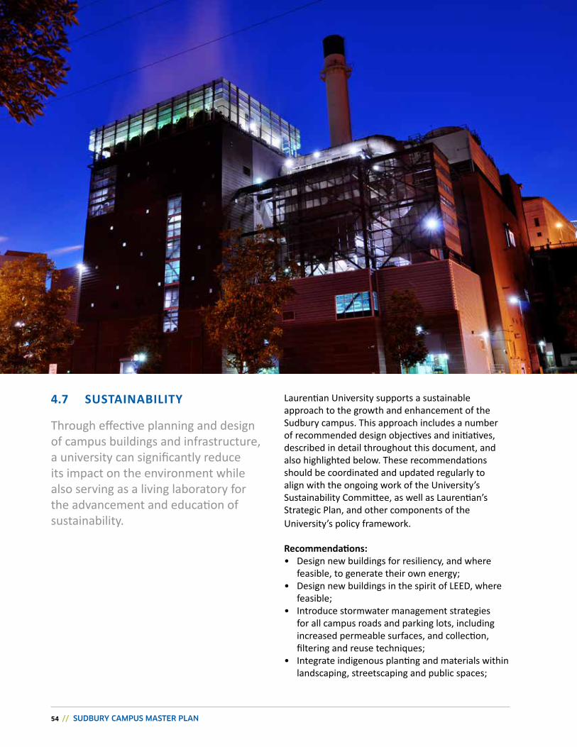
Laurentian university supports a sustainable approach to the growth and enhancement of the Sudbury campus. This approach includes a number of recommended design objectives and initiatives, described in detail throughout this document, and also highlighted below. These recommendations should be coordinated and updated regularly to align with the ongoing work of the university’s Sustainability Committee, as well as Laurentian’s Strategic Plan, and other components of the university’s policy framework.
Recommendations:• Design new buildings for resiliency, and where
feasible, to generate their own energy;• Design new buildings in the spirit of LEED, where
feasible;• Introduce stormwater management strategies
for all campus roads and parking lots, including increased permeable surfaces, and collection, filtering and reuse techniques;
• integrate indigenous planting and materials within landscaping, streetscaping and public spaces;
Through effective planning and design of campus buildings and infrastructure, a university can significantly reduce its impact on the environment while also serving as a living laboratory for the advancement and education of sustainability.
4.7 susTAiNABiLiTY
cHAPTEr 4: THE PLAN // 55
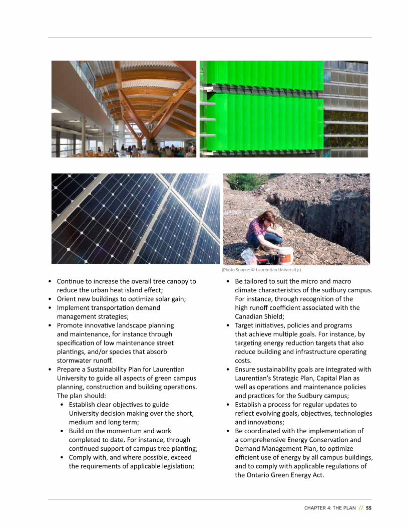
• Continue to increase the overall tree canopy to reduce the urban heat island effect;
• Orient new buildings to optimize solar gain;• implement transportation demand
management strategies;• Promote innovative landscape planning
and maintenance, for instance through specification of low maintenance street plantings, and/or species that absorb stormwater runoff.
• Prepare a Sustainability Plan for Laurentian university to guide all aspects of green campus planning, construction and building operations. The plan should: • establish clear objectives to guide
university decision making over the short, medium and long term;
• Build on the momentum and work completed to date. For instance, through continued support of campus tree planting;
• Comply with, and where possible, exceed the requirements of applicable legislation;
• Be tailored to suit the micro and macro climate characteristics of the sudbury campus. For instance, through recognition of the high runoff coefficient associated with the Canadian Shield;
• Target initiatives, policies and programs that achieve multiple goals. For instance, by targeting energy reduction targets that also reduce building and infrastructure operating costs.
• ensure sustainability goals are integrated with Laurentian’s Strategic Plan, Capital Plan as well as operations and maintenance policies and practices for the Sudbury campus;
• Establish a process for regular updates to reflect evolving goals, objectives, technologies and innovations;
• Be coordinated with the implementation of a comprehensive energy Conservation and Demand Management Plan, to optimize efficient use of energy by all campus buildings, and to comply with applicable regulations of the Ontario Green energy act.
(Photo Source: © Laurentian University.)
56 // SUDBURY CAMPUS MASTER PLAN
5.0 // IMPLEMENTINg THE PLANThe Campus Master Plan is intended to be a ‘living document’, written and structured to provide the University with a flexible decision-making framework, to accommodate specific opportunities and needs, as they emerge.
CHAPTER 5: IMPLEMENTATION OF THE PLAN // 57
5.1 CAMPUS MASTER PLAN: A LIVING DOCUMENT
As such, the Campus Master Plan will continue to evolve, like the campus itself, while remaining true to its constituting vision.
Some aspects of the Campus Master Plan may evolve over time. These include: the specific use, height, and architecture of individual buildings; their integration with the surrounding environment; and the configuration of outdoor spaces.
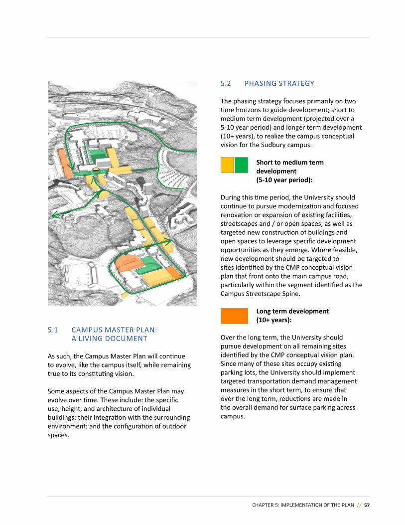
5.2 PHASING STRATEGY
The phasing strategy focuses primarily on two time horizons to guide development; short to medium term development (projected over a 5-10 year period) and longer term development (10+ years), to realize the campus conceptual vision for the Sudbury campus.
Short to medium term development (5-10 year period):
During this time period, the University should continue to pursue modernization and focused renovation or expansion of existing facilities, streetscapes and / or open spaces, as well as targeted new construction of buildings and open spaces to leverage specific development opportunities as they emerge. Where feasible, new development should be targeted to sites identified by the CMP conceptual vision plan that front onto the main campus road, particularly within the segment identified as the Campus Streetscape Spine.
Long term development (10+ years):
Over the long term, the University should pursue development on all remaining sites identified by the CMP conceptual vision plan. Since many of these sites occupy existing parking lots, the University should implement targeted transportation demand management measures in the short term, to ensure that over the long term, reductions are made in the overall demand for surface parking across campus.
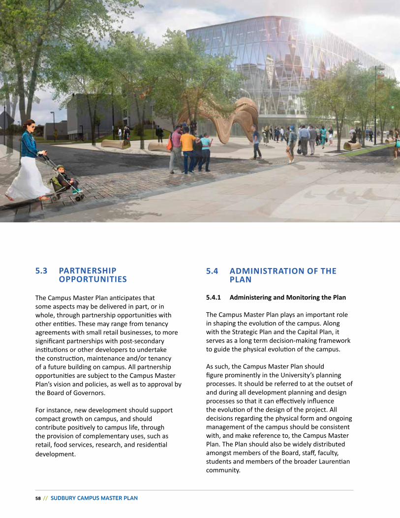
58 // SUDBURY CAMPUS MASTER PLAN
5.3 PartnerShiP OPPOrtunitieS
The Campus Master Plan anticipates that some aspects may be delivered in part, or in whole, through partnership opportunities with other entities. These may range from tenancy agreements with small retail businesses, to more significant partnerships with post-secondary institutions or other developers to undertake the construction, maintenance and/or tenancy of a future building on campus. All partnership opportunities are subject to the Campus Master Plan’s vision and policies, as well as to approval by the Board of Governors.
For instance, new development should support compact growth on campus, and should contribute positively to campus life, through the provision of complementary uses, such as retail, food services, research, and residential development.
5.4 adminiStratiOn Of the PLan
5.4.1 administering and monitoring the Plan
The Campus Master Plan plays an important role in shaping the evolution of the campus. Along with the Strategic Plan and the Capital Plan, it serves as a long term decision-making framework to guide the physical evolution of the campus.
As such, the Campus Master Plan should figure prominently in the University’s planning processes. It should be referred to at the outset of and during all development planning and design processes so that it can effectively influence the evolution of the design of the project. All decisions regarding the physical form and ongoing management of the campus should be consistent with, and make reference to, the Campus Master Plan. The Plan should also be widely distributed amongst members of the Board, staff, faculty, students and members of the broader Laurentian community.
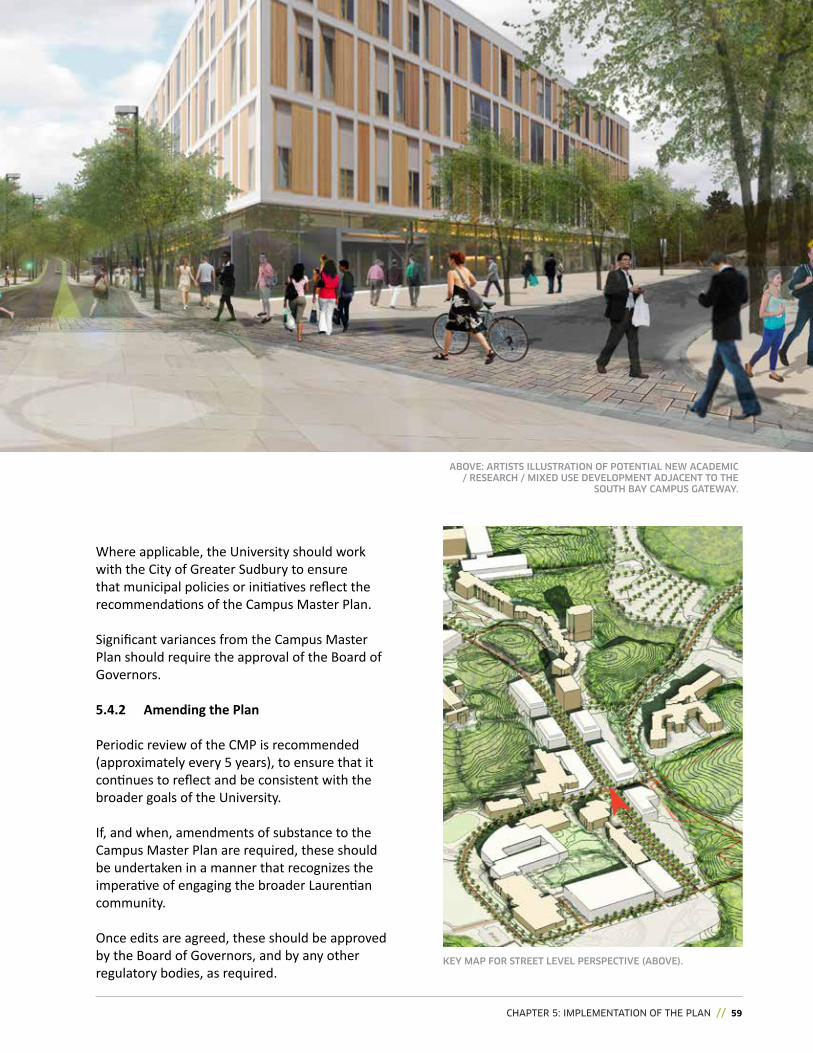
CHAPTER 5: IMPLEMENTATION OF THE PLAN // 59
Where applicable, the University should work with the City of Greater Sudbury to ensure that municipal policies or initiatives reflect the recommendations of the Campus Master Plan.
Significant variances from the Campus Master Plan should require the approval of the Board of governors.
5.4.2 amending the Plan
Periodic review of the CMP is recommended (approximately every 5 years), to ensure that it continues to reflect and be consistent with the broader goals of the University.
If, and when, amendments of substance to the Campus Master Plan are required, these should be undertaken in a manner that recognizes the imperative of engaging the broader Laurentian community.
Once edits are agreed, these should be approved by the Board of Governors, and by any other regulatory bodies, as required.
KEY MAP foR STREET LEvEL PERSPECTivE (ABovE).
ABovE: ARTiSTS iLLUSTRATioN of PoTENTiAL NEw ACADEMiC / RESEARCh / MixED USE DEvELoPMENT ADjACENT To ThE
SoUTh BAY CAMPUS gATEwAY.