
Subsurface topography to enhance the prediction of the spatial distribution of soil wetness
14
HYDROLOGICAL PROCESSES Hydrol. Process. 17, 2567–2580 (2003) Published online in Wiley InterScience (www.interscience.wiley.com). DOI: 10.1002/hyp.1273 Subsurface topography to enhance the prediction of the spatial distribution of soil wetness V. Chaplot 1 * and C. Walter 2 1 IRD-UR049, Ambassade de France, BP 06, Vientiane, Laos 2 UMR Sol, Agronomie, Spatialisation, ENSA-INRA, 65, rue Saint Brieuc 35042, Rennes Cedex, France Abstract: The estimation of the spatial distribution of soil wetness within a catchment is one of the most important issues in hydrological and erosion modelling. So far, such models have been based on soil surface topographic information only. However, soil hydrology is also controlled by subsurface flow pathways that may not be explained only by surface terrain features. This study examined how the topography of the lower limit of the soil cover could improve quantitative modelling for the spatial prediction of soil wetness. The study was conducted in an agricultural catchment of the Armorican Massif (western France) characterized by impermeable granitic saprolites. Two digital elevation models (DEMs) with a 10-m grid mesh and with a 0Ð3 m vertical resolution were generated from field investigations throughout the catchment. One DEM was a numerical representation of the soil surface and the other described the topography of the boundary between the soil cover and the underlying impermeable saprolite. Soil wetness () was surveyed systematically from 1996 to 1997 along a hillslope. The sampling scheme consisted of 149 nodes of a 10-m grid where at 0–10 cm was estimated using time-domain reflectometry. The value of at depths of 20–30, 50–60 and 110–120 cm was estimated for a subset of 112 data points using a gravimetric method. For both surface and subsurface DEMs, soil wetness at all depths significantly correlated with the topographic attributes, namely the distance to the stream bank, the elevation above the stream bank (E), the downslope gradient, the revised compound topographic index (CTI), and the specific monodirectional and multidirectional catchment areas. The best correlations were observed between 10 of winter 1996 and the physically based attributes E and CTI estimated by using the subsurface DEM (r D 0Ð83 and 0Ð86, respectively). Two multiple non-linear regression models for 10 spatial prediction were generated using non-autocorrelated topographic attributes estimated from both surface and subsurface topography. Model validation using a new set of 41 data points showed root mean square errors (RMSE) lower than 10% of the 10 range. The model based on subsurface topography decreased RMSE by 43%. Prediction errors were not spatially distributed. Finally, theses results are discussed in respect of processes involved in hillslope hydrology. Copyright 2003 John Wiley & Sons, Ltd. KEY WORDS soil water content; DEM; modelling; hydrology; landscape INTRODUCTION Soil wetness determines the production of surface runoff, which is the driving mechanism for nutrient and sediment transport in landscapes. For this reason, a better representation of the spatial and temporal variations of soil wetness is needed. Since the studies of Beven and Kirkby (1979) it is well accepted that the prevailing wetness state at a point is related to the ratio of the area drained per unit contour length (A), possibly varying over time (Barling et al., 1994; Beven and Freer, 2001), divided by the local slope gradient (S). Modelling approaches for predicting soil wetness based upon physical concepts have more recently taken advantage of topographic attributes other than A and S. Among these attributes, several were shown to be related to zones of water accumulation in soils: the elevation above the stream bank (E, Crave and Gascuel, 1996); the downslope gradient (DG, M´ erot et al., 1995), which is the ratio between E and the shortest * Correspondence to: V. Chaplot, IRD—UR 049, Ambassade de France, BP 06 Vientiane, RPD Laos. E-mail: [email protected] Received 25 February 2002 Copyright 2003 John Wiley & Sons, Ltd. Accepted 8 January 2003
-
Upload
sorbonne-fr -
Category
Documents
-
view
1 -
download
0
Transcript of Subsurface topography to enhance the prediction of the spatial distribution of soil wetness

HYDROLOGICAL PROCESSESHydrol. Process. 17, 2567–2580 (2003)Published online in Wiley InterScience (www.interscience.wiley.com). DOI: 10.1002/hyp.1273
Subsurface topography to enhance the prediction of thespatial distribution of soil wetness
V. Chaplot1* and C. Walter2
1 IRD-UR049, Ambassade de France, BP 06, Vientiane, Laos2 UMR Sol, Agronomie, Spatialisation, ENSA-INRA, 65, rue Saint Brieuc 35042, Rennes Cedex, France
Abstract:
The estimation of the spatial distribution of soil wetness within a catchment is one of the most important issues inhydrological and erosion modelling. So far, such models have been based on soil surface topographic informationonly. However, soil hydrology is also controlled by subsurface flow pathways that may not be explained only bysurface terrain features. This study examined how the topography of the lower limit of the soil cover could improvequantitative modelling for the spatial prediction of soil wetness. The study was conducted in an agricultural catchmentof the Armorican Massif (western France) characterized by impermeable granitic saprolites. Two digital elevationmodels (DEMs) with a 10-m grid mesh and with a 0Ð3 m vertical resolution were generated from field investigationsthroughout the catchment. One DEM was a numerical representation of the soil surface and the other describedthe topography of the boundary between the soil cover and the underlying impermeable saprolite. Soil wetness (�)was surveyed systematically from 1996 to 1997 along a hillslope. The sampling scheme consisted of 149 nodesof a 10-m grid where � at 0–10 cm was estimated using time-domain reflectometry. The value of � at depths of20–30, 50–60 and 110–120 cm was estimated for a subset of 112 data points using a gravimetric method. Forboth surface and subsurface DEMs, soil wetness at all depths significantly correlated with the topographic attributes,namely the distance to the stream bank, the elevation above the stream bank (E), the downslope gradient, the revisedcompound topographic index (CTI), and the specific monodirectional and multidirectional catchment areas. The bestcorrelations were observed between �10 of winter 1996 and the physically based attributes E and CTI estimatedby using the subsurface DEM (r D 0Ð83 and 0Ð86, respectively). Two multiple non-linear regression models for �10
spatial prediction were generated using non-autocorrelated topographic attributes estimated from both surface andsubsurface topography. Model validation using a new set of 41 data points showed root mean square errors (RMSE)lower than 10% of the �10 range. The model based on subsurface topography decreased RMSE by 43%. Predictionerrors were not spatially distributed. Finally, theses results are discussed in respect of processes involved in hillslopehydrology. Copyright 2003 John Wiley & Sons, Ltd.
KEY WORDS soil water content; DEM; modelling; hydrology; landscape
INTRODUCTION
Soil wetness determines the production of surface runoff, which is the driving mechanism for nutrient andsediment transport in landscapes. For this reason, a better representation of the spatial and temporal variationsof soil wetness is needed. Since the studies of Beven and Kirkby (1979) it is well accepted that the prevailingwetness state at a point is related to the ratio of the area drained per unit contour length (A), possibly varyingover time (Barling et al., 1994; Beven and Freer, 2001), divided by the local slope gradient (S).
Modelling approaches for predicting soil wetness based upon physical concepts have more recently takenadvantage of topographic attributes other than A and S. Among these attributes, several were shown to berelated to zones of water accumulation in soils: the elevation above the stream bank (E, Crave and Gascuel,1996); the downslope gradient (DG, Merot et al., 1995), which is the ratio between E and the shortest
* Correspondence to: V. Chaplot, IRD—UR 049, Ambassade de France, BP 06 Vientiane, RPD Laos. E-mail: [email protected]
Received 25 February 2002Copyright 2003 John Wiley & Sons, Ltd. Accepted 8 January 2003

2568 V. CHAPLOT AND C. WALTER
distance to the stream (D); the compound topographic index (CTI, Moore et al. 1993) and revised CTI(CTI D ln(AMU/DG), Merot et al., 1995), where AMU is the upslope contributing and multidirectional area(Quinn et al., 1991); and the terrain curvature (Burt and Butcher, 1986; Thompson et al., 2001).
Furthermore, the increased accuracy of digital elevation models (DEMs), a widely available data sourcerepresenting the continuously varying topographic surface of landscapes (Moore et al., 1991), can also improvespatial estimations of soil wetness. The use of DEMs of low horizontal resolution overestimate the extensionof soils saturated by water through a systematic overestimation of upslope contributing areas (Quinn et al.,1991; Zhang and Montgomery, 1994; Farajalla and Vieux, 1995; Brasington and Richards, 1998) or downslopegradient (Chaplot et al., 2000a) and an underestimation of slope angles (Zhang and Montgomery, 1994;Thompson et al., 2001).
Another promising direction for the improvement of soil wetness prediction models could be to betterconsider soil properties (O’Loughlin, 1986; Moore et al., 1988; Gerla, 1999; Gomez and Plaza, 2001). Soilcover affects water movements in hillslopes through the soil’s natural tendency to become less permeablewith increasing depth. Finally, lateral fluxes occur along slopes thus increasing soil wetness in the downslopedirection. Local soil saturation occurs in hillslopes when the accumulated water flux, the product of theupslope catchment A and the area drainage flux q, passing across an element of contour of length b, exceedsthe product of the local soil transmissivity T and the local surface gradient S (Equation 1, O’Loughlin, 1986):
Aq/b ½ TS �1�
So far, modelling approaches for the prediction of soil wetness assume both lateral surface and subsurfaceflows to be defined by surface topography. However, subsurface flow pathways may be even more affected inlandscapes by continuously varying subsurface topographic features such as horizons, saprolites or bedrockupper limits. Until now, little work has been done at the watershed level to evaluate how soil wetness modelscould be improved by taking into account such features. In the Armorican Massif, soils have developed intoa loamy material of 1 to 3 m depth overlying impermeable granitic or schistic saprolites. Recent soil wetnessprediction models showed high prediction errors that have to be addressed (Crave and Gascuel-Odoux, 1996;Chaplot et al., 2000b). In an agricultural watershed of 4Ð5 ha, a systematic survey over 1996–1997 allowedsoil water content at several depths (0–10, 20–30, 50–60 and 110–120) to be compared with terrain attributesestimated from DEMs of, in the first case the soil surface topography and, in the second case, the topographyof the boundary between the soil cover and the underlying impermeable saprolite.
MATERIALS AND METHODS
Site description
The study area is located in the eastern part of the Armorican Massif (western France), a complex basementof Proterozoic and Palaeozoic bedrock. It is a granitic catchment of about 4Ð5 ha located in the upper part ofthe ‘La Roche’ stream catchment (7Ð8 km2), a first-order stream with a mean flow discharge over 1995–1997of 59 L s�1 (Grimaldi and Chaplot, 2000). This 4Ð5 ha catchment is characterized by hillslopes 150 to 250 mlong with a mean elevation range of 10 m. Hillslope topography is relatively smooth with slope angles varyingfrom 0 to 2% close to the stream bank and on summits, to 6% on the backslope.
In the Armorican Massif, granites and schists are the two dominant substrata, comprising 80% of theregion’s surface. Other substrates include mica schists, orthogneisses and sedimentary rocks. Deep mechanicalweathering of the bedrock occurred during the Variscan orogeny, where mylonitization and strong fracturingoccurred. This weathering produced deep saprolites (>30 m), rich in kaolin and mainly impermeable (Wyns,1991). During the late Miocene and early Quaternary, saprolites were subjected to erosion, owing to strongcyclic climatic regime changes from periglacial to temperate and to a succession of tectonic movements (VanVliet-Lanoe et al., 1998). Finally, saprolites have been overlain by aeolian deposits during the past 300 kyr
Copyright 2003 John Wiley & Sons, Ltd. Hydrol. Process. 17, 2567–2580 (2003)

PREDICTION OF SOIL WETNESS 2569
from west to east of the Armorican Massif. Subsequent to their deposition the aeolian sediments were locallyreworked on slopes by solifluction, water erosion and local alluviation (Le Calvez, 1979). Owing to thepresence of subsurface impermeable layers, water drainage tends to accumulate in favourable locations suchas hillslope hollows and footslopes, where waterlogged soils are observed (Chaplot et al., 2000a). Well drainedsoils characterize upper parts of hillslopes.
At the study site, the soil cover has developed into a loamy material overlying a typical impermeablegranitic saprolite (Curmi et al., 1998). The depth of the soil cover varies from 0Ð8 to 3 m. Variations in soildepth do not seem to be linked directly to the topography of the soil surface. Soils are variably distributedalong slopes, from loamy Hapludalfs (Soil Survey Staff, 1999) upslope, Aqualfs and Glossaqualfs backslopeand downslope and Fluvaquentic Sphagnofibrists and/or Dystrochrepts near the stream bank.
Fluvaquentic Sphagnofibrists, which occur along the stream banks, are characterized by a high organicmatter accumulation (mean of 350 kg C m�2; Chaplot et al., 2001). Previous studies have also shown thatloamy horizons of Hapludalfs, Aqualfs and Glossaqualfs are marked by low hydraulic permeability, i.e.average values of 0Ð007 m day�1 (Curmi et al., 1998), whereas underlying saprolites exhibit much lowerpermeability (<0Ð005 m day�1; Grimaldi and Chaplot, 2000).
Climate is oceanic with a yearly mean precipitation and temperature for the past 20 years of 898 mm and10Ð1 °C, respectively.
The study watershed is situated in a part of the Armorican Massif with relatively moderate agricultureintensification. From 1995 to 1997, almost 65% of its total surface area was under pasture, the remainingsurface being under corn. One particular aspect of land-use distribution in landscapes is that the near-streambank zones were exclusively under pasture.
Field study
Soil samples were taken from a limited area of the 4Ð5 ha catchment, a hillslope 160 m long with a 10-maltitude range. Volumetric soil wetness at depth ranges 0–10 cm (�10), 20–30 cm (�30), 50–60 cm (�60) and110–120 cm (�120) was measured from January 1996 to August 1997. Time-domain reflectometry (TDR)was used for topsoil wetness, whereas �30, �60 and �120 were evaluated using a gravimetric method. Thesampling set for �10 was composed of 149 nodes of a 10-m grid. In addition, from this main sampling set,112 data points were randomly selected for �30, �60 and �120 estimation. In order to calculate the gravimetrichumidity, the samples (150–300 g) were weighed before and after drying at 105 °C for 72 h. The volumetricsoil wetness was then calculated using the bulk density of each undisturbed horizon using 250-ml volumecylinders (Chaplot et al., 2001).
Sixteen sampling surveys were performed over the study period with a sampling frequency varyingthroughout the year to focus on rainy and dry periods. Thus, the time between two sampling surveys wasincreased in winter and in summer. Each survey was taken not less than 24 h after the last rainfall event.In order to lessen the working time in the field, only one transect of the study hillslope was investigatedeach time. When significant differences with the previous survey were observed, i.e., either wetter or drierconditions in soils, the whole hillslope was investigated.
The coordinates (longitude and latitude) of each of the 149 sampling points were derived from a singlegeoreferenced point using a theodolite. In order to perform measurements at identical locations, permanentsticks were positioned over the hillslope from the first survey. At the end of 1997 the depth to the uppersurface of the saprolite was estimated from morphological description using augered holes at each of the 149locations. The contact between loamy soil cover and compact sandy clayed saprolite was distinct. In addition,saprolite determination was facilitated by a clear rusty or grey matrix depending on the duration of conditionsof saturation by water.
The wettest and driest situations on 11 December 1996 and 9 April 1997, respectively, will be presentedhere.
Copyright 2003 John Wiley & Sons, Ltd. Hydrol. Process. 17, 2567–2580 (2003)

2570 V. CHAPLOT AND C. WALTER
Topographic analysis
Two DEMs with a 10-m resolution and a 0Ð3-m vertical precision have been generated over the studycatchment from a detailed topographic survey using a theodolite. The first DEM is a numerical representationof the soil surface topography. Four-hundred and ninety-four additional points over the 4Ð5 ha catchmentwere added to the initial data set of 149 data point inside the selected hillslope along the central depressionof the catchment. The second DEM, of the upper boundary of saprolites, was generated over the catchmentusing (i) the set of 149 data points for which the depth to saprolite upper boundary was determined by augerhole; (ii) the set of 494 data points for which, owing to the difficulty of field investigation, we considered atheoretical depth to the saprolite upper boundary equal to 1Ð5 m, corresponding to the mean depth observedat the study site.
For DEM construction we used the GRID tool of Arc Info 7Ð1 (ESRI, 1997). The fitting procedure(‘TOPOGRID’ function of Arc/Info 7Ð1 Geographic Information System, Hutchinson, 1989) ensures thesmoothest fit to point and contoured elevation data taking into account specified break-lines such as riversor ravines. The actual stream bank position was used in the drainage enforcement algorithm of TOPOGRID,which attempted to modify the DEM to yield continuous drainage surfaces.
Several topographic attributes or indexes were derived from this DEM. Previous studies in the ArmoricanMassif have shown a strong relationship between the soil wetness and/or the duration of saturation by waterin soils and the elevation above the stream bank considering the shortest flow path from each cell to thestream (E) (Crave and Gascuel, 1996); the downslope gradient (DG) (Merot et al., 1995), which is the ratiobetween E and the shortest distance to the stream (D); the upslope contributing and multidirectional area(AMU) expressed in metres per unit width perpendicular to the flow direction, as defined by (Quinn et al.,1991); and the revised compound topographic index [CTI D ln(AMU/DG)]. The CTI approach differs fromthose most commonly adopted (e.g. McKenzie and Ryan, 1999) because the downslope gradient (DG) replacesthe local slope gradient (S). Other topographic attributes include the altitude of data points (A); the specificmonodirectional catchment area (AMO, Moore and Grayson, 1991); the stream power index (SPI, Bell et al.,1994; SPI D AMU ð S); and the profile, plan and tangential curvatures (Curvpr, Curvpl, Curvta, Zevenbergenand Thorne, 1987). Variables D, A and E have been estimated from theodolite measurements. VariablesS, AMO and the curvatures were derived using the GRID function of Arc-Info (ESRI, 1994). Finally, weestimated AMU using software developed at ENSA Rennes (Squividant, 1994) based on the algorithm ofQuinn et al. (1991).
Statistical analysis and modelling
The relationship between topographic attributes estimated using (i) soil surface topography and (ii) thetopography of the upper boundary of saprolite was investigated. In addition, correlation coefficients between�10 on 11 December 1996 and 9 April 1997 and the two sets of topographic attributes are presented. Finally,the relationship between �10 on 11 December 1996 and topographical attributes estimated using the surfaceand the subsurface topography has been investigated by using non-linear regression analysis for 119 randomlychosen data points of the model construction set. The multiple regression method was used because it is apractical tool that furnishes direct quantitative results and allows us to use easily accessible variables suchas terrain attributes to predict soil wetness, a variable difficult to access. This relationship may be used todirectly predict soil wetness over large areas. Regression analyses (Neter et al., 1989) were performed withthe Statistica package for use on a personal computer (Statsoft, 1996). The estimation method used was theQuasi-Newton, with the maximum likelihood function as the loss function. Only parameters with statisticalsignificance at the 0Ð001 level were considered for computing predictive equations and reporting results
��10�Ł D constant C e�topographic attributes� �1�
The estimation of topsoil wetness ���Ł at a given point was determined by the regression model (Equation 1)considering topographic attributes. Two situations were considered for �10 estimation: (i) the use of surface
Copyright 2003 John Wiley & Sons, Ltd. Hydrol. Process. 17, 2567–2580 (2003)
PREDICTION OF SOIL WETNESS 2571
topography; (ii) the use of subsurface topography, i.e. the topography of the saprolite upper boundary. Thevalidation of these regression models was performed using the remaining set of 30 data points. Statisticalparameters were computed: the mean error, ME, and the root mean standard error, RMSE, between estimatedtopsoil water content (��Ł and observed values. The ME and RMSE values were computed as follow:
ME D 1
n
n∑iD1
[���Ł � �] �2�
RMSE D{
1
n
n∑iD1
[���Ł � �]2
}0Ð5�3�
The values for ME and RMSE decrease with increasing regression model accuracy.
RESULTS AND DISCUSSIONS
The climatic context of the study period
The years 1996 and 1997 showed mean precipitation of 709 and 741 mm, respectively. These values areslightly lower than the 30-year mean of 898 mm. The year 1996 was characterised by a dry autumn and anexceptionally wet winter with a rainfall of 160 mm in December compared with 98 mm, the 30-year mean.In 1997, rainfall was distributed uniformly over the year, except in March and April, which were dry. The9 April 1997 followed 45 days with a total rainfall of less than 15 mm against 100 mm for the mean valueof the past 30 years. Temperatures over 1996 were close to normal (mean of 10Ð2 °C against 10Ð1 °C). Thecoldest temperatures occurred in November and February (mean temperatures of 3 and 4 °C respectively) andthe warmest in July and August (17 and 18 °C respectively). The year 1997, with a mean of 11Ð7 °C, waswarmer. In 1997, January was the coldest month with a mean of 2 °C and August with a mean of 20 °C thewarmest one.
The relationship between topographical attributes estimated using surface and subsurface DEMs
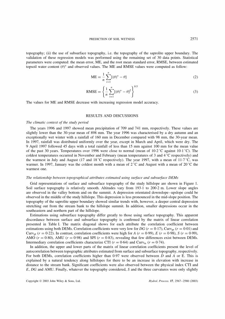
Grid representations of surface and subsurface topography of the study hillslope are shown in Figure 1.Soil surface topography is relatively smooth. Altitudes vary from 193Ð1 to 200Ð2 m. Lower slope anglesare observed in the valley bottom and on the summit. A depression orientated downslope–upslope could beobserved in the middle of the study hillslope. This depression is less pronounced in the mid-slope position. Thetopography of the saprolite upper boundary showed similar trends with, however, a deeper central depressionstretching out from the stream bank to the hillslope summit. In addition, smaller depressions occur in thesoutheastern and northern part of the hillslope.
Estimations using subsurface topography differ greatly to those using surface topography. This apparentdiscordance between surface and subsurface topography is confirmed by the matrix of linear correlationpresented in Table I. The matrix diagonal shows for each attribute the correlation coefficient betweenestimations using both DEMs. Correlation coefficients were very low for DG (r D 0Ð17), Curvpr (r D 0Ð01) andCurvpl (r D 0Ð22). In contrast, correlation coefficients were high for A (r D 0Ð99), E (r D 0Ð98), S (r D 0Ð99),AMO (r D 0Ð80), AMU (r D 0Ð98) and SPI (r D 0Ð83), revealing that few differences exist between DEMs.Intermediary correlation coefficients characterize CTI (r D 0Ð64) and Curvta (r D 0Ð74).
In addition, the upper and lower parts of the matrix of linear correlation coefficients present the level ofautocorrelation between topographic attributes estimated from surface and subsurface topography, respectively.For both DEMs, correlation coefficients higher than 0Ð97 were observed between D and A or E. This isexplained by a natural tendency along hillslopes for there to be an increase in elevation with increase indistance to the stream bank. Significant coefficients were also observed between the physical index CTI andE, DG and AMU. Finally, whatever the topography considered, S and the three curvatures were only slightly
Copyright 2003 John Wiley & Sons, Ltd. Hydrol. Process. 17, 2567–2580 (2003)

2572 V. CHAPLOT AND C. WALTER
192
343.
58
343.
60
343.
62
343.
72343.
66
2413
2413
.08
196
194
343.
64
343.
70
343.
68
2413
.04
200
m
199
m
198
m
197
m
196
m
195
m
194
m
199
m
198
m19
7 m
196
m19
5 m
194
m
193
m Latit
ude
(Km
)Longitude (Km)
B. Saprolite topography
A. Surface topography
Alti
tude
(m
)
Figure 1. Numerical representation of the soil surface topography (A) and the topography of the saprolite upper boundary (B) of the studyhillslope using 10-m DEMs (‘La Roche’ site, western France). For both DEMs, contour lines with a 0Ð5 m interval are shown in dark lines
correlated to the other topographic attributes. Finally, the depth to saprolite upper boundary (SD) was notsignificantly correlated with surface or subsurface terrain attributes.
Predicting volumetric soil wetness using topographical attributes
Correlation coefficients between the volumetric topsoil wetness (�10) on 11 December 1996 and 9 April1997 and selected topographical factors are presented in Table II. Correlation coefficients ranged between0Ð02 on 9 April 1997 for Curvpl estimated using surface topography, to 0Ð86 on 11 December 1996 for Eand CTI from subsurface topography. Higher correlation coefficients were observed on 11 December thanon 9 April 1997. For instance, the correlation coefficient between �10 and E decreased from 0Ð86 to 0Ð63 forsurface topography and from 0Ð85 to 0Ð64 for subsurface topography. Such a decrease is also observed for D,A, DG, CTI and AMU. On 11 December 1996, neither soil surface nor saprolite upper boundary topographiessignificantly affected the correlation coefficient for D, SD, A and AMU. However, for DG and CTI, r wasmuch higher when using subsurface topography than the soil surface topography. This is also the case on 9April 1997 for DG and CTI, where r increased from 0Ð28 to 0Ð57 and from 0Ð19 to 0Ð47, respectively.
On 11 December 1996, soil wetness at the different depths (0–10, 20–30, 50–60 and 110–120 cm) ispresented as a function of the elevation above the stream (ES) (Figure 2). Values for �10 ranged from 22 to
Copyright 2003 John Wiley & Sons, Ltd. Hydrol. Process. 17, 2567–2580 (2003)

PREDICTION OF SOIL WETNESS 2573
Tabl
eI.
Cor
rela
tion
mat
rixe
sfo
r(i
)so
ilan
dto
pogr
aphi
cat
trib
utes
esti
mat
edus
ing
the
10-m
DE
Mof
the
uppe
rbo
unda
ryof
sapr
olit
e(i
nit
alic
)an
d(i
i)to
pogr
aphi
cfa
ctor
ses
tim
ated
usin
gth
e10
-mD
EM
ofth
eso
ilsu
rfac
e(n
orm
alfo
nt).
The
foll
owin
gat
trib
utes
are
cons
ider
ed:
dist
ance
toth
est
ream
bank
(D);
soil
dept
h(S
D);
alti
tude
(A);
elev
atio
ndi
ffer
ence
toth
est
ream
bank
(E);
the
‘dow
nslo
pegr
adie
nt’
(DG
),w
hich
repr
esen
tsth
era
tio
betw
een
Ean
dth
edi
stan
ceto
the
stre
amba
nk;
the
revi
sed
com
poun
dto
pogr
aphi
cin
dex
(CT
I);
the
slop
egr
adie
nt(S
),i.e
.th
esp
ecifi
cm
onod
irec
tiona
lca
tchm
ent
area
(AM
O);
the
spec
ific
mul
tidi
rect
iona
lca
tchm
ent
area
(AM
U);
the
stre
ampo
wer
inde
x(S
PI)
(Bel
let
al.,
1994
,SP
ID
AM
Uð
S);
the
profi
le(C
urv p
r�,
plan
(Cur
v pl�
and
tang
entia
l(C
urv t
a�cu
rvat
ures
.Dat
ase
tof
149
poin
ts.C
orre
latio
nco
effic
ient
sbe
twee
nto
pogr
aphi
cat
trib
utes
estim
ated
usin
gsu
rfac
ean
dsa
prol
iteup
per
boun
dary
topo
grap
hies
are
unde
rlin
ed
Var
iabl
eV
aria
ble
DSD
AE
DG
CT
IS
AM
OA
MU
SPI
Cur
v pr
Cur
v pl
Cur
v ta
D1Ð0
00Ð3
0Ł0Ð9
9Ł0Ð9
9Ł0Ð0
5�0
Ð54Ł
�0Ð08
�0Ð28
Ł�0
Ð64Ł
�0Ð13
0Ð27Ł
0Ð14
�0Ð19
Ł
SD0Ð3
0Ł1Ð0
00Ð2
8Ł0Ð3
1Ł0Ð1
2�0
Ð27Ł
�0Ð14
�0Ð20
Ł�0
Ð26Ł
�0Ð18
Ł0Ð2
0Ł0Ð1
6Ł�0
Ð18Ł
A0Ð9
8Ł0Ð1
30Ð9
9Ł0Ð9
9Ł0Ð0
8�0
Ð56Ł
�0Ð09
�0Ð28
Ł�0
Ð65Ł
�0Ð14
0Ð28Ł
0Ð14
�0Ð21
Ł
E0Ð9
7Ł0Ð1
5Ł0Ð9
8Ł0Ð9
8Ł0Ð1
4Ł�0
Ð61Ł
�0Ð09
�0Ð30
Ł�0
Ð67Ł
�0Ð14
0Ð29Ł
0Ð16Ł
�0Ð21
Ł
DG
0Ð73Ł
0Ð06
0Ð75Ł
0Ð81Ł
0Ð17Ł
�0Ð62
Ł�0
Ð120Ð0
6�0
Ð08�0
Ð120Ð2
2Ł0Ð2
0Ł�0
Ð13C
TI
�0Ð62
Ł�0
Ð22Ł
�0Ð61
Ł�0
Ð63Ł
�0Ð88
Ł0Ð6
4Ł�0
Ð20Ł
0Ð39Ł
0Ð80Ł
0Ð01
�0Ð37
Ł�0
Ð28Ł
0Ð20Ł
S�0
Ð06�0
Ð13�0
Ð05�0
Ð040Ð2
2Ł�0
Ð31Ł
0Ð99Ł
�0Ð26
Ł�0
Ð37Ł
0Ð76Ł
�0Ð01
�0Ð06
0Ð08
AM
O�0
Ð30�0
Ð32Ł
�0Ð26
Ł�0
Ð28Ł
�0Ð36
Ł0Ð4
9Ł�0
Ð130Ð8
0Ł0Ð5
6Ł0Ð3
0Ł�0
Ð42Ł
�0Ð42
0Ð29Ł
AM
U�0
Ð64Ł
�0Ð27
Ł�0
Ð62Ł
�0Ð65
Ł�0
Ð73Ł
0Ð82Ł
�0Ð38
Ł0Ð5
5Ł0Ð9
8Ł�0
Ð12�0
Ð31Ł
�0Ð20
Ł0Ð1
4SP
I�0
Ð16Ł
�0Ð29
Ł�0
Ð14�0
Ð150Ð0
5�0
Ð090Ð7
4Ł0Ð4
4Ł�0
Ð080Ð8
3Ł�0
Ð32Ł
�0Ð36
Ł0Ð2
8Ł
Cur
v pr
�0Ð01
�0Ð35
Ł0Ð0
80Ð0
70Ð1
8Ł�0
Ð070Ð0
20Ð0
10Ð0
30Ð0
90Ð0
10Ð8
0Ł�0
Ð83Ł
Cur
v pl
0Ð18Ł
�0Ð14
0Ð24Ł
0Ð23Ł
0Ð27Ł
�0Ð16
Ł0Ð0
5�0
Ð22Ł
�0Ð14
�0Ð10
0Ð75Ł
0Ð22Ł
�0Ð49
Ł
Cur
v ta
0Ð15
�0Ð05
0Ð19Ł
0Ð20Ł
0Ð18Ł
�0Ð1
�0Ð04
�0Ð45
Ł�0
Ð13�0
Ð37Ł
0Ð56Ł
0Ð83Ł
0Ð74Ł
Cor
rela
tions
sign
ifica
ntat
p<
0Ð5
Copyright 2003 John Wiley & Sons, Ltd. Hydrol. Process. 17, 2567–2580 (2003)

2574 V. CHAPLOT AND C. WALTER
Tabl
eII
.C
orre
lati
onco
effic
ient
sbe
twee
nth
evo
lum
etri
cso
ilw
etne
ssof
the
tops
oil
(0–
10cm
)on
11D
ecem
ber
1996
and
9A
pril
1997
and
soil
and
topo
grap
hica
lfa
ctor
ses
timat
edus
ing
the
10-m
digi
tal
elev
atio
nm
odel
(DE
M)
ofth
eup
per
boun
dary
ofth
esa
prol
itean
dof
the
soil
surf
ace.
Dis
tanc
eto
the
stre
amba
nk(D
);so
ilde
pth
(SD
);al
titu
de(A
);el
evat
ion
diff
eren
ceto
the
stre
amba
nk(E
);th
e‘d
owns
lope
grad
ient
’(D
G),
whi
chre
pres
ents
the
rati
obe
twee
nE
and
the
dist
ance
toth
est
ream
bank
;th
ere
vise
dco
mpo
und
topo
grap
hic
inde
x(C
TI)
;th
esl
ope
grad
ient
(S),
the
spec
ific
mon
odir
ectio
nal
catc
hmen
tar
ea(A
MO
);th
esp
ecifi
cm
ulti
dire
ctio
nal
catc
hmen
tar
ea(A
MU
);th
est
ream
pow
erin
dex
(SPI
)(B
ell
etal
.,19
94,
SPI
DA
MU
ðS)
;th
epr
ofile
(Cur
v pr�
,pl
an(C
urv p
l�an
dta
ngen
tial
(Cur
v ta�
curv
atur
es.
Dat
ase
tof
149
poin
ts
DE
MD
ate
Var
iabl
e
DSD
AE
DG
CT
IS
AM
OA
MU
SPI
Cur
v pr
Cur
v pl
Cur
v ta
10-m
ofso
ilsu
rfac
e11
Dec
embe
r19
96�0
Ð85Ł
�0Ð37
Ł�0
Ð84Ł
�0Ð86
Ł0Ð2
3Ł0Ð4
4Ł�0
Ð100Ð3
2Ł0Ð6
2Ł�0
Ð05�0
Ð20Ł
�0Ð06
0Ð16
9A
pril
1997
�0Ð63
Ł�0
Ð13�0
Ð62Ł
�0Ð63
Ł0Ð2
8Ł0Ð1
9�0
Ð110Ð1
50Ð4
1Ł�0
Ð09�0
Ð110Ð0
20Ð0
5
10-m
ofup
per
boun
dary
11D
ecem
ber
1996
�0Ð85
Ł�0
Ð47Ł
�0Ð80
Ł�0
Ð83Ł
�0Ð81
Ł0Ð8
6Ł�0
Ð130Ð4
0Ł0Ð6
3Ł0Ð1
0�0
Ð14�0
Ð25Ł
�0Ð17
ofsa
prol
ites
9A
pril
1997
�0Ð64
Ł�0
Ð15�0
Ð62Ł
�0Ð65
Ł�0
Ð57Ł
0Ð47Ł
�0Ð15
0Ð22Ł
0Ð42Ł
�0Ð10
�0Ð15
�0Ð21
Ł�0
Ð09
Ł Cor
rela
tions
sign
ifica
ntat
p<
0Ð5.
Copyright 2003 John Wiley & Sons, Ltd. Hydrol. Process. 17, 2567–2580 (2003)

PREDICTION OF SOIL WETNESS 2575
0-10 cm
Soi
l wet
ness
(%
)
20
40
60
80
100
20-30 cm
Surface topography
Saprolite topography
Elevation above the stream bank (m)
Soi
l wet
ness
(%
)
20
40
60
80
100
50-60 cm
Elevation above the stream bank (m)
110-120 cm
Surface topography
Saprolite topography
Surface topography
Saprolite topography
Surface topography
Saprolite topography
0 2 4 6 8 0 2 4 6 8
Figure 2. Soil wetness at several depths (0–10, 20–30, 50–60 and 110–120 cm) as a function of the elevation above the stream (ES)estimated from surface topography and from the topography of the saprolite upper boundary. Data for 11 December 1996 (wet period)
89%, whereas values for �30, �60 and �110 were between 10 and 90%. No significant differences were observedbetween topographies. Soil wetness at all depths studied decreased with increasing elevation above the stream.Between 0 to 4 m, values for �10 decreased sharply. Up to 4 m, values for �10 decreased only slightly. For �greater than 10 cm, a similar pattern could be observed, i.e., a decrease of soil wetness with increasing ES.However, between elevations of 0–2 m, the 50–60 and 110–120 cm samples exhibited a great degree ofscattering. Between 2 and 8 m altitude, soil wetness showed limited variations (Figure 2). On 9 April, the �10
range of values is much smaller (between 8 and 54%). The same decrease in values for �10 with increasingES is observed but with greater scattering below 4 m (Figure 3).
Figure 4 presents the soil wetness data on 11 December 1996 as function of compound topographic index(CTI). Using the topography of the saprolite upper boundary, soil wetness at all depths studied increasedwith increasing CTI, whereas using surface topography, CTI variations do not affect �. The �30, �60 and�110 values exhibited a greater range for CTI estimated using subsurface topography. On 9 April, greaterscattering characterized the samples for subsurface topography and no significant trend is observed for surfacetopography.
Non-linear exponential estimations have been considered here because topsoil wetness was relatedexponentially to elevation difference to the stream bank and the revised compound topographic indexCTI as topographical attributes. Then, exponential regression analyses (Neter et al., 1989) were performed.Multiple regressions between topsoil water content (�10� from 11 December and topographic attributesnonautocorrelated estimated using surface or saprolite upper boundary topographies have been generated
Copyright 2003 John Wiley & Sons, Ltd. Hydrol. Process. 17, 2567–2580 (2003)

2576 V. CHAPLOT AND C. WALTER
Compound topographic index (CTI)108642
Top
-soi
l wet
ness
(%
)
20
40
60
80
Elevation above the stream bank (m)
Top
-soi
l wet
ness
(%
)
20
40
60
80Surface topographySaprolite topography
Surface topographySaprolite topography
0 2 4 6 8
Figure 3. Topsoil wetness (0–10 cm) as a function of the elevation above the stream (ES) and the compound topographic index (CTI) on9 April 1997 (dry period)
as follows:
��10�surf D 19Ð96 C e[4Ð38��0Ð39ðE���0Ð05ðCTI�] r2 D 0Ð80 �4�
��10�saprolite D 123Ð60 C e[3Ð69��0Ð56ðE�C�0Ð03ðCTI�] r2 D 0Ð89 �5�
Both equations included the physically based topographic attributes of index, elevation difference above thestream bank (E) and compound topographic index (CTI). Mean error, ME, and root mean square error, RMSE,between estimations and observations on 30 data points of the validation set were lower for Equation (5) thanfor Equation (4). Mean error and RMSE were �0Ð1 and 6Ð04 for surface topography and �0Ð04 and 3Ð81for the topography of the saprolite upper boundary, respectively (Table III). The use of the topography ofthe saprolite upper boundary reduced RMSE by 43%. The topography of the saprolite upper boundary alsoseemed to better predict �10 mean and standard deviation (Table III).
An error analysis was performed by plotting RMSE of topsoil water content (�10� over the study area.The RMSE for regressions using surface and subsurface topography is presented in Figure 5. Errors were notdistributed in a spatial pattern, i.e. RMSE did not significantly vary whatever the position within the hillslope,the altitude or the distance from the stream bank.
Copyright 2003 John Wiley & Sons, Ltd. Hydrol. Process. 17, 2567–2580 (2003)

PREDICTION OF SOIL WETNESS 2577S
oil w
etne
ss (
%)
20
40
60
80
100
Compound topographic index (CTI)2 4 6 8 10 2 4 6 8 10
Soi
l wet
ness
(%
)
20
40
60
80
100
Compound topographic index (CTI)
0-10 cm 20-30 cm
50-60 cm 110-120 cm
Surface topographySaprolite topography
Surface topographySaprolite topography
Surface topographySaprolite topography
Surface topographySaprolite topography
Figure 4. Soil wetness at several depths (0–10; 20–30; 50–60 and 110–120 cm) as function of the compound topographic index (CTI)estimated from surface topography and from the topography of the saprolite upper boundary. Data for 11 December 1996 (wet period)
Table III. Mean of observed and estimated topsoil wetness (�10� usingsurface topography [(�10�Ł
surface] and the topography of the saprolite upperboundary [(�10�Ł
saprolite]; standard deviation (SD); mean error, ME and rootmean square error, RMSE between estimations and observations
Mean SD ME RMSE
Observed �10 38Ð8 17Ð5(�10�Ł
surface 38Ð7 16Ð3 �0Ð10 6Ð04(�10�Ł
saprolite 38Ð8 16Ð8 �0Ð04 3Ð81
CONCLUSION
In this study of an agricultural catchment, soil wetness (�) estimated over 1996–1997 at 0–10, 20–30,50–60 to 110–120 cm was significantly correlated with the topographic attributes, elevation above thestream bank (E) and compound topographic index (CTI). Crave and Gascuel (1996) also demonstrated highcorrelation between � and E under similar conditions of the Armorican Massif but with a schistose saprolite.Therefore, topography is confirmed as being one of the most important determinants of soil wetness spatialdistribution. The best correlations were observed during wet seasons. During dry seasons with a large amountof data scattering, other environmental factors such as evapo-transpiration could affect soil wetness spatialdistribution.
Copyright 2003 John Wiley & Sons, Ltd. Hydrol. Process. 17, 2567–2580 (2003)

2578 V. CHAPLOT AND C. WALTER
15
0
343.
58
343.
60
343.
62
343.
72343.
66
2413
2413
.0810
5
343.
64
343.
70
343.
68
2413
.04
Latit
ude
(Km
)
Longitude (Km)
Validation setConstruction set Using saprolite topography
Using surface topography
RM
SE
of t
opso
il w
etne
ss
(cm
3 cm
-3)
Figure 5. Root mean square error (RMSE) between topsoil wetness (�10� predicted using regression models at the 30 data points ofthe validation set from topographical attributes estimated using either surface or subsurface topography, respectively. Location of both
construction and validation sets in the study hillslope (‘La Roche’ site, Western France)
The present study revealed that topographic attributes estimated using the DEM of the saprolite upperboundary better explained the spatial distribution of � than topographic attributes estimated using the DEMof the soil surface. Using the topography of the saprolite greatly improved the soil wetness spatial prediction.The very low permeability of saprolites (<0Ð005 m day�1, Grimaldi and Chaplot, 2000) induces the lateralflux of water in soils along slopes and is responsible for increasing soil wetness in the downslope direction.This could explain the greater accuracy of � spatial distribution using subsurface topography and gives supportto the suggestion these water fluxes are mainly driven by the topography of the saprolite upper boundary.One reasonable explanation for this is that the lateral water fluxes in soils along slopes induced by the verylow permeability of the saprolite are mainly driven by the topography of the saprolite upper boundary.
The DEM gives accurate prediction of soil wetness spatial distribution. However, to obtain better accuracywe can use subsurface topography. Modelling soil wetness spatial distribution using the topography of asubsurface feature such as the saprolite upper boundary may be extended to other areas also characterized bya non-parallelism between surface and subsurface topographies. This should be the case of numerous naturalsystems. For these situations, taking into account the topography of hydrological discontinuities would alsoimprove the prediction of the trajectory of flows down hillslopes and consequently the estimation of the spatialdistribution of soil wetness.
Despite DEMs of surface topography now being widely available, numerical representations of thetopography of subsurface discontinuities are not easily accessible over large areas. Indeed, no convenientdata bases are offered for representing the continuously varying topography of subsurface discontinuities ofthe Earth. Such information may be spatially accessed using for instance geophysical techniques. Chaplotet al. (2001) on the same study site showed a high correlation between the apparent resistivity obtained usingthe radio magneto tellurique (RMT) and the depth to saprolite upper boundary (r2 D 0Ð51). Other geophysicalmethods such as GPR may also be relevant to estimate the spatial variations of subsurface features includingthe depth to the saprolite upper boundary (Dominic et al., 1995; Lapen et al., 1996; Freeland et al., 1998).However, these last techniques need a great amount of field work and data processing that could not be entirelyjustified for such a purpose. Finally, a promising possibility of accessing the depth to the saprolite upperboundary is to generate quantitative soil–landscape models. Indeed, such models that relate soil properties tomore accessible soil-forming factors, such as surface topography or geology, have shown their usefulness inestimating the soil depth over large areas (e.g. Gessler et al., 1995; Bourennane et al., 2000).
Copyright 2003 John Wiley & Sons, Ltd. Hydrol. Process. 17, 2567–2580 (2003)

PREDICTION OF SOIL WETNESS 2579
REFERENCES
Barling D, More D, Grayson B. 1994. A quasi dynamic wetness index for characterising the spatial distribution of zones of surface saturationand water content. Water Resource Research 30: 1029–1044.
Bell JC, Robert LC, Havens WM. 1994. Soil drainage class probability mapping using soil–landscape model. Soil Science Society of AmericaJournal 58: 464–470.
Beven K, Freer J. 2001. A dynamic TOPMODEL. Hydrological Processes 10: 1993–2011.Beven KJ, Kirkby MJ. 1979. A physically based variable contributing area model of basin hydrologie. Hydrological Sciences Bulletin 24:
43–69.Bourennane H, King D, Couturier A. 2000. Comparison of kriging with external drift and simple linear regression for predicting soil horizon
thickness with different sample densities. Geoderma 97: 255–271.Brasington J, Richards K. 1998. Interactions between model predictions, parameters and DTM scales for Topmodel. Computer Geoscience
24: 299–314.Burt TP, Butcher DP. 1986. Development of topographic indices for use in semi-distributed hillslope runoff models. In Geomorphology and
Land Management , Slaymaker O, Balteanu D (eds). Gebruder Borntraeger: Berlin; 1–19.Chaplot V, Walter C, Curmi P. 2000a. Improving soil hydromorphy prediction according to DEM resolution and available pedological data.
Geoderma 97: 405–422.Chaplot V, Walter C, Curmi P. 2000b. The use of auxiliary geophysical data to improve a soil–landscape model. Soil Science 165:
961–970.Chaplot V, Walter C, Curmi P, Hollier-Larousse A. 2001. Mapping field-scale hydromorphic horizons using Radio-MT electrical resistivity.
Geoderma 102: 61–74.Crave A, Gascuel-Odoux C. 1996. The influence of topography on time and space distribution of soil surface water content. Hydrological
Processes 11: 203–210.Curmi P, Durand P, Gascuel-Odoux C, Merot P, Walter C, Taha A. 1998. Hydromorphic soils, hydrology and water quality: spatial
distribution and functional modeling at different scales. Nutrient Cycling in Agrosecosystems 50: 127–142.Dominic DF, Egan K, Carney C, Wolfe PJ, Boardman MR. 1995. Delineation of shallow stratigraphy using ground penetrating radar. Journal
of Applied Geophysics 33: 167–175.ESRI. 1994. Understanding GIS. The ARC/INFO Method . ESRI: 380 New York Street, Redlands, CA 92273; 300 pp.Farajall NS, Vieux BE. 1995. Capturing the essential spatial variability in distributed hydrological modeling infiltration parameters.
Hydrological Processes 9: 55–68.Freeland RS, Yoder RE, Ammons JT. 1998. Mapping shallow underground features that influence site-specific agricultural production.
Journal of Applied Geophysics 40: 19–27.Gerla PJ. 1999. Estimating the ground-water contribution in wetlands using modeling and digital terrain analysis. Wetlands 19:
394–402.Gessler PE, Moore ID, McKenzie NJ, Ryan PJ. 1995. Soil-landscape modelling and the spatial prediction of soil attributes. International
Journal of Geographical Information Systems 9: 421–432.Gomez-Plaza A, Martinez-Mena M, Albaladejo J, Castillo VM. 2001. Factors regulating spatial distribution of soil water content in small
semiarid catchments. Journal of Hydrology 253: 211–226.Grimaldi C, Chaplot V. 2000. Nitrate removal in headstreams. Influence of exchanges between stream and near-bank environment. Water,
Air and Soil Pollution 124: 95–112.Hutchinson MF. 1989. A new procedure for gridding elevation and stream line data with automatic removal of spurious pits. Journal of
Hydrology 106: 211–232.Lapen DR, Moorman BJ, Price JS. 1996. Using ground penetrating radar to delineate subsurface features along a wetland catena. Soil Science
Society of America Journal 60: 923–931.Le Calvez L. 1979. Genese des formations limoneuses de Bretagne centrale. Essai de modelisation. MS thesis, University of Rennes, Rennes.Merot P, Ezzahar B, Walter C, Aurousseau P. 1995. Mapping waterlogging of soils using digital terrain models. Hydrological Processes 9:
27–34.McKenzie NJ, Ryan PJ. 1999. Spatial prediction of soil properties using environmental correlation. Geoderma 89: 67–94.Moore ID, Grayson RB. 1991. Terrain-based catchment partitioning and runoff prediction using vector elevation data. Water Resource
Research 27: 1177–1191.Moore ID, O’Loughlin EM, Burch GJ. 1988. A contour-based topographic model for hydrological and ecological applications. Earth Surface
Processes and Landforms 13: 305–320.Moore ID, Gessler PE, Nielsen GA, Peterson GA. 1993. Soil attribute prediction using terrain analysis. Soil Science Society of America
Journal 57: 443–452.Neter J, Wasserman W, Kutner MH. 1989. Applied Linear Regression Models , 2nd edn. Richard D. Irwin: Homewood.O’Loughlin EM. 1986. Prediction of surface saturation zones in natural catchments by topographic analysis. Water Resource Research 22:
794–804.Quinn P, Beven K, Chevallier P, Planchon O. 1991. The prediction of hillslope flow paths for distributed hydrological modelling using
digital terrain models. Hydrological Processes 5: 59–80.Soil Survey Staff. 1999. Soil Taxonomy. A Basic System of Soil Classification for Making and Interpreting Soil Surveys , 2nd edn. United
States Department of Agriculture: Washington, DC.Squividant H. 1994. MNTsurf: logiciel de traitement des modeles numeriques de terrain. Doc. E.N.S.A.R: Rennes, France, 36 pp.StatSoft. 1995. Statistica for Windows. Computer Program Manual . Statsoft, Inc.: 2325 East 13th Street, Tulsa, OK 74104.Thompson J, Bell J, Butler C. 2001. Digital elevation model resolution: effects on terrain attribute calculation and quantitative soil–landscape
modeling. Geoderma 100: 67–89.
Copyright 2003 John Wiley & Sons, Ltd. Hydrol. Process. 17, 2567–2580 (2003)

2580 V. CHAPLOT AND C. WALTER
Van Vliet-Lanoe B, Laurent M, Hallegouet B, Margerel JP, Chauvel JJ, Michel Y, Moguedet G, Trautman F, Vauthier S. 1998. The Mio-Pliocene of the Armorican Massive. New data. Compte Rendu l’Acadamic des Sciences 326: 333–340.
Wyns R. 1991. L’utilisation des paleosurfaces continentales en cartographie thematique probabiliste. Geologie de la France 3: 3–9.Zevenbergen LW, Thorne CR. 1987. Quantitative analysis of land surface topography. Earth Surface Processes and Landforms 12:
47–56.Zhang W, Montgomery DR. 1994. Digital elevation model grid size, landscape representation, and hydrological simulations. Water Resources
Research 30: 1019–1028.
Copyright 2003 John Wiley & Sons, Ltd. Hydrol. Process. 17, 2567–2580 (2003)