Structure of the Alima and associated anticlines in the foreland basin of the southern Atlas...
17
Lithosphere doi: 10.1130/L119.1 2011;3;76-91 Lithosphere P. Riley, C. Gordon, J.A. Simo, B. Tikoff and M. Soussi southern Atlas Mountains, Tunisia Structure of the Alima and associated anticlines in the foreland basin of the Email alerting services articles cite this article to receive free e-mail alerts when new www.gsapubs.org/cgi/alerts click Subscribe to subscribe to Lithosphere www.gsapubs.org/subscriptions/ click Permission request to contact GSA http://www.geosociety.org/pubs/copyrt.htm#gsa click official positions of the Society. citizenship, gender, religion, or political viewpoint. Opinions presented in this publication do not reflect presentation of diverse opinions and positions by scientists worldwide, regardless of their race, includes a reference to the article's full citation. GSA provides this and other forums for the the abstracts only of their articles on their own or their organization's Web site providing the posting to further education and science. This file may not be posted to any Web site, but authors may post works and to make unlimited copies of items in GSA's journals for noncommercial use in classrooms requests to GSA, to use a single figure, a single table, and/or a brief paragraph of text in subsequent their employment. Individual scientists are hereby granted permission, without fees or further Copyright not claimed on content prepared wholly by U.S. government employees within scope of Notes © 2011 Geological Society of America on January 26, 2011 lithosphere.gsapubs.org Downloaded from
Transcript of Structure of the Alima and associated anticlines in the foreland basin of the southern Atlas...

Lithosphere
doi: 10.1130/L119.1 2011;3;76-91Lithosphere
P. Riley, C. Gordon, J.A. Simo, B. Tikoff and M. Soussi southern Atlas Mountains, TunisiaStructure of the Alima and associated anticlines in the foreland basin of the
Email alerting servicesarticles cite this article
to receive free e-mail alerts when newwww.gsapubs.org/cgi/alertsclick
Subscribe to subscribe to Lithospherewww.gsapubs.org/subscriptions/click
Permission request to contact GSAhttp://www.geosociety.org/pubs/copyrt.htm#gsaclick
official positions of the Society.citizenship, gender, religion, or political viewpoint. Opinions presented in this publication do not reflectpresentation of diverse opinions and positions by scientists worldwide, regardless of their race, includes a reference to the article's full citation. GSA provides this and other forums for thethe abstracts only of their articles on their own or their organization's Web site providing the posting to further education and science. This file may not be posted to any Web site, but authors may postworks and to make unlimited copies of items in GSA's journals for noncommercial use in classrooms requests to GSA, to use a single figure, a single table, and/or a brief paragraph of text in subsequenttheir employment. Individual scientists are hereby granted permission, without fees or further Copyright not claimed on content prepared wholly by U.S. government employees within scope of
Notes
© 2011 Geological Society of America
on January 26, 2011lithosphere.gsapubs.orgDownloaded from
76 www.gsapubs.org | Volume 3 | Number 1 | LITHOSPHERE
INTRODUCTION
In the far-foreland of mountain belts, including the Sunda Shelf of Indonesia, the Alpine Mountains of Europe, the Algerian Atlas Moun-tains, the southern North Sea, and the Rocky Mountains of the western United States, fault reactivation is documented as a mechanism for fold development (e.g., Ziegler, 1983; Letouzey et al., 1990; Wise and Obi, 1992; Vially et al., 1994; Remmelts, 1995). Preexisting faults have long been acknowledged as zones of weakness in crustal rocks during subse-quent tectonic activity, and they are commonly favored for reactivation over new fault generation (e.g., Donath and Cranwell, 1981; Etheridge, 1986; Holdsworth et al., 1997). Factors such as the orientation of the fault, the coeffi cient of sliding friction, and the state of stress are thought to control the conditions under which a fault is reactivated (Letouzey, 1990). Examples of fault reactivation have been documented in physical experi-ments (e.g., Koopman et al., 1987; Buchanan and McClay, 1991; Sassi et al., 1993), in seismic data (Ziegler, 1983; Etheridge et al., 1985; Letouzey et al., 1990), and in the fi eld (e.g., Holdsworth et al., 1997).
In order to study reactivated faults directly, they must breach the sur-face and retain kinematic indicators from multiple episodes of activity or retain changes in deformation products such as cataclasites within brec-cias (White, 1986; Holdsworth et al., 1997). The presence of salt can further complicate the causal relationship between reactivated faults and folding. The movement of salt through the subsurface can generate salt-cored anticlines, which can be diffi cult to distinguish from folds formed from fault reactivation. Thus, it is necessary to gather evidence from stratigraphy (e.g., Etheridge, 1986; White, 1986), geometric similarity (e.g., Etheridge, 1986; Holdsworth et al., 1997), and geophysical data to deduce whether fault reactivation is a viable mechanism for fold forma-
tion. Additionally, folds associated with fault reactivation may exhibit synchronous, local brittle extensional structures and particular joint pat-terns (Unruh and Twiss, 1998; Cooper et al., 2006).
This study examines the E-W–trending Alima anticline to investigate folding mechanisms in the Metlaoui region of the southern Tunisian Atlas Mountains. The Alima anticline is one in a series of en echelon folds in the distal Atlas fold-and-thrust belt of central Tunisia. Geologic map-ping, fracture data, gravity data, and seismic data are utilized to establish whether far-foreland, brittle deformation associated with the Alpine orog-eny generated folds in the Metlaoui region. In addition, these data are used to investigate whether salt diapirism or fault reactivation played a larger role in the generation of the Alima anticline and similar folds in the south-ern Tunisian Atlas Mountains. Geophysical data are then used to establish episodes of folding since the Cretaceous.
TECTONIC SETTING
The Atlas Mountains extend 2000 km from the Atlantic margin of Morocco to the Mediterranean coast of northern Tunisia (Fig. 1). The Tunisian Atlas Mountains are bounded to the north by the Tell-Rif chain, to the south by the Saharan Platform, and to the east by the Sahel block (Fig. 1; Ben Ferjani et al., 1990; Burollet, 1991; Swezey, 1996; Hlaiem, 1999; Bouaziz et al., 2002).
In Tunisia, the Atlas Mountains began as a series of failed rift basins associated with the breakup of Pangea and opening of the Neotethys from the Permian to the Early Cretaceous (Laville and Petit, 1984; Winterer and Hinz, 1984; Andrieux et al., 1989; Stets, 1992; Grasso et al., 1999; Dhahri and Boukadi, 2010). Although extension occurred throughout this time, two main rifting events are recognized in the
Structure of the Alima and associated anticlines in the foreland basin of the southern Atlas Mountains, Tunisia
P. Riley1, C. Gordon2, J.A. Simo3, B. Tikoff1, and M. Soussi4
1DEPARTMENT OF GEOSCIENCE, UNIVERSITY OF WISCONSIN–MADISON, 1215 W. DAYTON ST., MADISON, WISCONSIN 53706, USA2DRAGON MINING SWEDEN AB, PAUTRÄSK 100, 921 31 STORUMAN, SWEDEN3EXXONMOBIL UPSTREAM RESEARCH COMPANY, 3120 BUFFALO SPEEDWAY, HOUSTON, TEXAS 77098, USA4DÉPARTEMENT DE GÉOLOGIE, FACULTÉ DES SCIENCES DE TUNIS, UNIVERSITÉ DE TUNIS EL MANAR, 2092 TUNIS, TUNISIA
ABSTRACT
Based on data presented in this study, the E-W–trending Alima anticline in the Metlaoui region of the southern Tunisian Atlas Mountains formed due to far-foreland, brittle deformation. The Alima anticline is one in a series of en echelon folds in the Atlas fold-and-thrust belt of North Africa. Geologic mapping indicates that the Alima anticline has a steep southern limb, a gently dipping northern limb, and per-vasive normal fault sets. Fracture orientations suggest that fracturing occurred early in the fold history as a synfolding process, not as a pre- or postdeformational process. Gravity data show positive Bouguer anomalies near fold crests, not the negative anomalies that would be expected if the anticline were salt cored. Seismic data, collected along lines in basins surrounding the Alima anticline, suggest the presence of several high-angle reverse faults. Based on surface and subsurface studies, we attribute the development of the Alima anticline to far-foreland deformation associated with late Cenozoic contraction. N-S–directed elongation in the Triassic reoriented to NW-SE–directed shortening in the Miocene, causing Triassic normal faults to be reactivated as oblique-slip reverse faults. A comparison of the Alima anticline to other anticlines in the region suggests that several different styles of folding are present, each representing a different time of initiation.
LITHOSPHERE; v. 3; no. 1; p. 76–91. doi: 10.1130/L119.1
For permission to copy, contact [email protected] | © 2011 Geological Society of America
on January 26, 2011lithosphere.gsapubs.orgDownloaded from
LITHOSPHERE | Volume 3 | Number 1 | www.gsapubs.org 77
Structure of the Alima and associated anticlines, southern Atlas Mountains | RESEARCH
Tunisian Atlas Mountains. The fi rst extensional deformation occurred from the Jurassic to the Early Cretaceous and formed E-W–striking normal faults and basins such as the Fault of Chotts and Chotts Basin (Guiraud et al., 1987; Ben Ferjani et al., 1990; Zouari et al., 1999; Soua et al., 2009). The second phase of rifting occurred during the Early Cretaceous and generated NW-SE–striking normal faults and basins, such as the Gafsa fault and basin (Guiraud et al., 1987; Boccaletti et al., 1990; Soua et al., 2009). The development of the basins (grabens and half grabens) resulted in stratigraphic variations in southern and central Tunisia (Bishop, 1988; Bédir, 1995; Hlaiem et al., 1997; Hlaiem, 1999; Soussi and Ben Ismaïl, 2000). In late Early Cretaceous (late Aptian to early Albian), extension was interrupted by a brief period of contrac-tion, termed the “Austrian Phase” (Ben Ayed, 1986; Guiraud et al., 1987; Khomsi et al., 2004), but extension resumed in the Late Creta-ceous (Bédir, 1995; Bouaziz et al., 2002).
Although the timing is not well established (Zargouni, 1986; Zouari et al., 1999; Khomsi et al., 2006), Mesozoic extension switched to con-traction in the Late Cretaceous–early Paleocene with the closing of the Tethys and convergence of Africa and Eurasia (Bédir, 1995; Gomez et al., 1998; Beauchamp et al., 1999; Hlaiem, 1999; Frizon de Lamotte et al., 2000; Bouaziz et al., 2002). Late Cretaceous to present contraction occurred dominantly in two major events in Tunisia: the Atlasic contrac-tional event and the Alpine contractional event (Tlig et al., 1991; Outtani et al., 1995; Bouaziz et al., 2002; Masrouhi et al., 2007, 2008). The fi rst major event (i.e., the Atlasic event) corresponds to NW-SE to NNW-SSE shortening, and it caused signifi cant inversion of Mesozoic basins dur-ing the early and late Eocene (Dercourt et al., 1986; Ricou et al., 1986; Gealey, 1988; Ben Ferjani et al., 1990; Bouaziz et al., 2002; Bracène and Frizon de Lamotte, 2002). The Cenozoic contraction reactivated major Mesozoic normal faults, causing the NW-SE–striking Gafsa fault to reactivate as an oblique right-lateral strike-slip fault (Zargouni and Ruhland, 1981; Zargouni and Trémolières, 1985), and the E-W–striking Fault of Chotts to reactivate as a transpressional feature (Zargouni and Trémolières, 1985; Ben Ayed, 1993; Outtani et al., 1995).
The second major event, the Alpine event, began during the middle to late Miocene and is interpreted to have been the major orogenic episode in Tunisia (Rouvier, 1977; Ben Ferjani et al., 1990; Bobier et al., 1991). During this event, NW-SE–oriented shortening progressively deformed
northern and central Tunisia from north to south. Metamorphism and nappe emplacement occurred in the Tell-Rif Chain in northern Tunisia, and basin inversion is interpreted to have formed the vergent NE-SW–trending folds in the northern Tunisian Atlas (Boccaletti et al., 1990). In the southern Tunisian Atlas Mountains, this orogeny again reactivated major Mesozoic normal faults, such as the Gafsa fault (Bobier et al., 1991). Southwest of the Gafsa fault, in the far-foreland of the orogeny, E-W– to ENE-WSW–trending folds developed (Bouaziz et al., 2002; Khomsi et al., 2009). After a period of late Pliocene extension, contrac-tion resumed during the early Pleistocene, reactivating strike-slip faults and Atlas folds (Ben Ayed, 1986; Chihi, 1992; Bouaziz et al., 2002). Minor contractional events continued throughout the Pleistocene, and NW-SE regional shortening continues as a result of slow convergence between North Africa and Eurasia (Dlala and Hfaiedh, 1993; Rebai, 1993; Chihi, 1995; Bouaziz et al., 2002).
STRUCTURE AND STRATIGRAPHY OF THE METLAOUI REGION
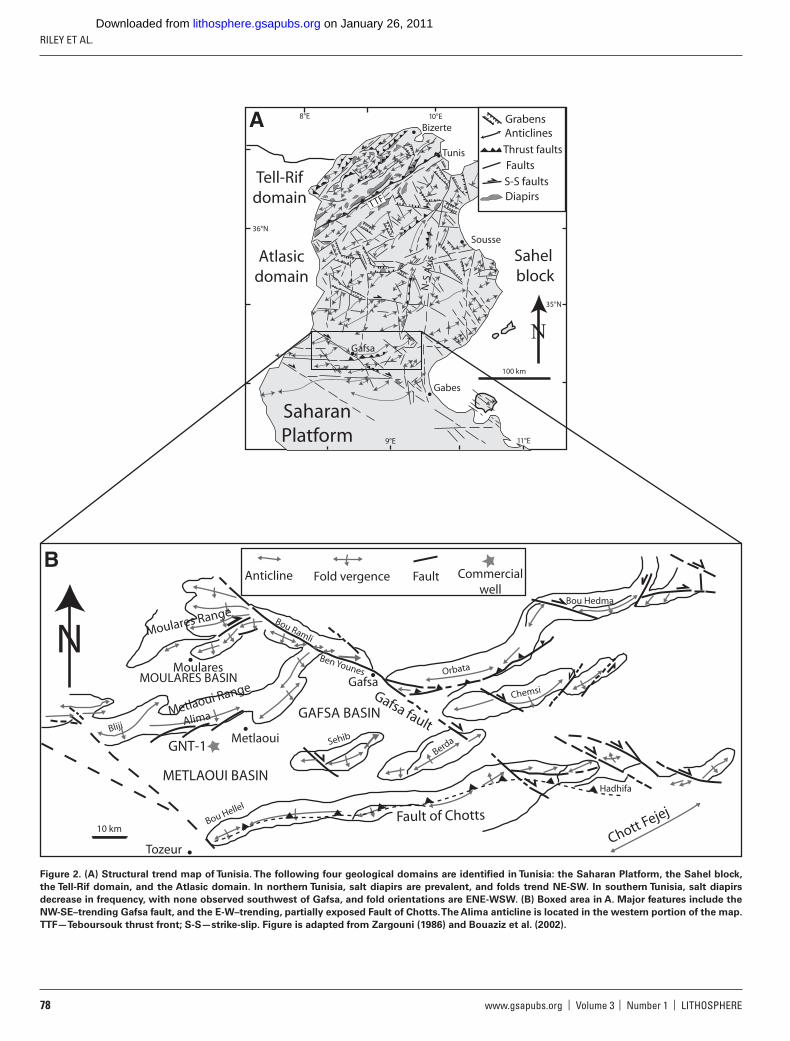
This study focuses on the southern Tunisian Atlas Mountains, specifi -cally the Metlaoui region between the Gafsa fault and the Fault of Chotts; the Fault of Chotts is interpreted as a blind thrust fault that cores the Chott Range (Hlaiem, 1999) (Fig. 2). The Gafsa fault bounds the area to the north, and the Fault of Chotts marks the southern boundary. Both faults are major right-lateral oblique-slip features interpreted as reactivated basement faults (Hlaiem, 1999). The Gafsa fault currently displays right-lateral strike-slip movement, although evidence from seismic data sug-gests multiple past movement directions and reactivations (e.g., Boukadi and Bédir, 1996; Hlaiem 1999). The Fault of Chotts is associated with a number of E-W–oriented anticlines, and evidence from seismic studies suggests several reactivation episodes (Hlaiem, 1999).
The Metlaoui region is characterized by broad synclines and tight anti-clines that create large depressions and narrow, continuous E-W–trending ranges, respectively (Fig. 2). The anticlines are south vergent, with south-ern limbs near vertical and locally overturned, and regional-scale faults are oriented NW-SE and E-W. The en echelon folds that comprise the Met-laoui and Moulares Ranges, including the Alima anticline, are similar in deformational style, with arcuate and segmented, right-stepping fold axes. Fold axes are 8–25 km long, but typically ~17 km, and anticline widths vary from 5 to 10 km. The anticlines commonly have a second, tighter anticline off the southern fl ank. The tighter folds are sometimes associated with normal faults, growth faults in Cenozoic strata, and Quaternary allu-vium deformed around the anticlines (Ahmadi et al., 2004).
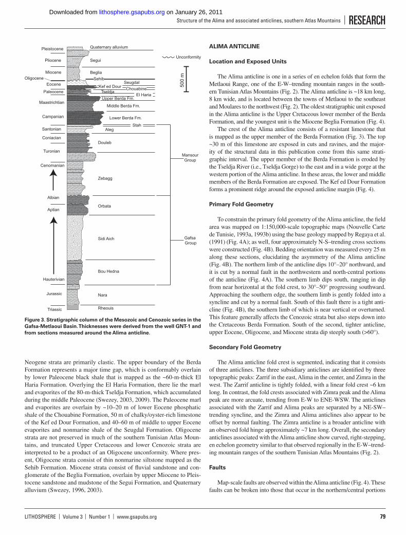
Stratigraphic data (Fig. 3) from the Metlaoui region are derived from well GNT-1 (Fig. 2; Ben Ferjani et al., 1990; Hlaiem, 1999), which was drilled near the center of the Metlaoui Basin, and from stratigraphic data obtained from outcrops around the Alima anticline. Well GNT-1 is 4800 m deep and terminates in Jurassic strata. Combined, the Jurassic and Creta-ceous strata are >3900 m thick and are dominated by carbonate and marly shale (Fig. 3). The Jurassic strata consist of relatively thin (350–500 m) limestone of the Nara Formation. The Nara Formation is overlain by Lower Cretaceous carbonate and sandstone (~1550 m) that are mapped as the Gafsa Group. The Gafsa Group is overlain by the Mansour Group, which is ~1550 m of Middle Cretaceous marly limestone and shale. The Mansour Group is overlain by Late Cretaceous chalky limestone and shale (550 m), collectively mapped as the Berda Formation. The Berda Forma-tion is subdivided into lower and upper limestone members separated by a middle shale member.
In the center of the Metlaoui Basin, the Mesozoic section is con-formably overlain by ~950 m of Cenozoic strata. In this area, Paleo-gene lithologies vary from shale and carbonate to evaporites, whereas
Saharan AtlasHigh plateau
Moroccan
Meseta
High Atlas
Tell-Rif
Tunisian Atlas
Rif
Betic chain
PyreneesIberian Range
Apennines
Atl
anti
c O
cean
Mediterranean Sea
40°N
0° 10°EIntracontinental
fold beltsContinental
platformsCrystalline
massifsAlpine chains
Thrust fronts
N
30°N
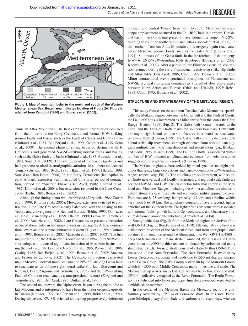
Figure 1. Map of mountain belts to the north and south of the Western
Mediterranean Sea. Boxed area indicates location of Figure 2A. Figure is
adapted from Zargouni (1986) and Bouaziz et al. (2002).
on January 26, 2011lithosphere.gsapubs.orgDownloaded from
RILEY ET AL.
78 www.gsapubs.org | Volume 3 | Number 1 | LITHOSPHERE
11°E
100 km
35°N
37°
10°E8°E
36°N
9°E
SaharanPlatform
Tell-Rifdomain
Atlasicdomain
Sahel block
Bizerte
Tunis
Sousse
Gabes
Gafsa
N-S
Axi
s
Grabens
Thrust faults
Faults
S-S faultsDiapirs
Anticlines
TTF
A
Gafsa
Metlaoui
Moulares
Tozeur
BlijiAlima
Sehib
Bou Hellel
Berda
Chemsi
Orbata
Bou Hedma
Bou Ramli
Ben Younes
Hadhifa
10 km
N
GNT-1
METLAOUI BASIN
MOULARES BASINGafsa fault
Fault of Chotts
Chott Fejej
Anticline Fold vergence Fault Commercialwell
Metlaoui Range
Moulares Range
B
GAFSA BASIN
Figure 2. (A) Structural trend map of Tunisia. The following four geological domains are identifi ed in Tunisia: the Saharan Platform, the Sahel block,
the Tell-Rif domain, and the Atlasic domain. In northern Tunisia, salt diapirs are prevalent, and folds trend NE-SW. In southern Tunisia, salt diapirs
decrease in frequency, with none observed southwest of Gafsa, and fold orientations are ENE-WSW. (B) Boxed area in A. Major features include the
NW-SE–trending Gafsa fault, and the E-W–trending, partially exposed Fault of Chotts. The Alima anticline is located in the western portion of the map.
TTF—Teboursouk thrust front; S-S—strike-slip. Figure is adapted from Zargouni (1986) and Bouaziz et al. (2002).
on January 26, 2011lithosphere.gsapubs.orgDownloaded from
LITHOSPHERE | Volume 3 | Number 1 | www.gsapubs.org 79
Structure of the Alima and associated anticlines, southern Atlas Mountains | RESEARCH
Neogene strata are primarily clastic. The upper boundary of the Berda Formation represents a major time gap, which is conformably overlain by lower Paleocene black shale that is mapped as the ~60-m-thick El Haria Formation. Overlying the El Haria Formation, there lie the marl and evaporites of the 80-m-thick Tseldja Formation, which accumulated during the middle Paleocene (Swezey, 2003, 2009). The Paleocene marl and evaporites are overlain by ~10–20 m of lower Eocene phosphatic shale of the Chouabine Formation, 50 m of chalky/oyster-rich limestone of the Kef ed Dour Formation, and 40–60 m of middle to upper Eocene evaporites and nonmarine shale of the Seugdal Formation. Oligocene strata are not preserved in much of the southern Tunisian Atlas Moun-tains, and truncated Upper Cretaceous and lower Cenozoic strata are interpreted to be a product of an Oligocene unconformity. Where pres-ent, Oligocene strata consist of thin nonmarine siltstone mapped as the Sehib Formation. Miocene strata consist of fl uvial sandstone and con-glomerate of the Beglia Formation, overlain by upper Miocene to Pleis-tocene sandstone and mudstone of the Segui Formation, and Quaternary alluvium (Swezey, 1996, 2003).
ALIMA ANTICLINE
Location and Exposed Units
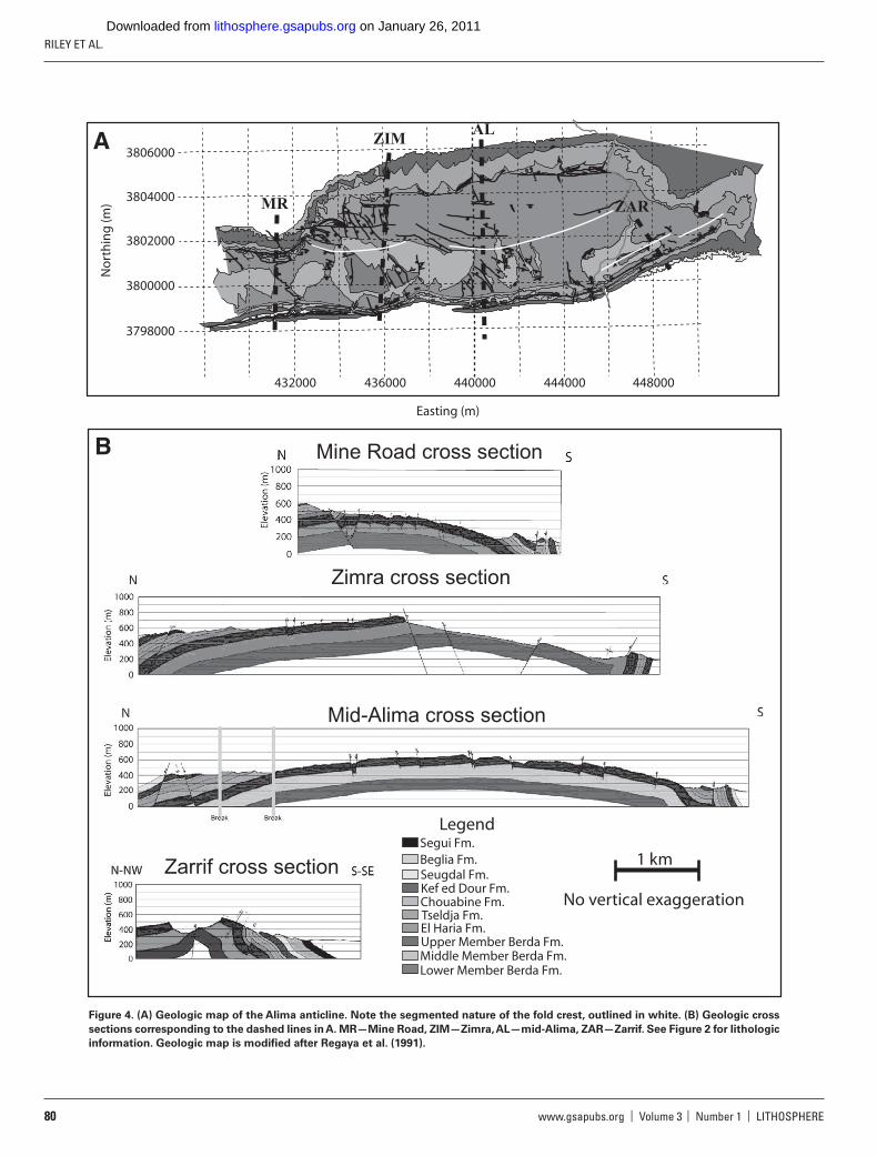
The Alima anticline is one in a series of en echelon folds that form the Metlaoui Range, one of the E-W–trending mountain ranges in the south-ern Tunisian Atlas Mountains (Fig. 2). The Alima anticline is ~18 km long, 8 km wide, and is located between the towns of Metlaoui to the southeast and Moulares to the northwest (Fig. 2). The oldest stratigraphic unit exposed in the Alima anticline is the Upper Cretaceous lower member of the Berda Formation, and the youngest unit is the Miocene Beglia Formation (Fig. 4).
The crest of the Alima anticline consists of a resistant limestone that is mapped as the upper member of the Berda Formation (Fig. 3). The top ~30 m of this limestone are exposed in cuts and ravines, and the major-ity of the structural data in this publication come from this same strati-graphic interval. The upper member of the Berda Formation is eroded by the Tseldja River (i.e., Tseldja Gorge) to the east and in a wide gorge at the western portion of the Alima anticline. In these areas, the lower and middle members of the Berda Formation are exposed. The Kef ed Dour Formation forms a prominent ridge around the exposed anticline margin (Fig. 4).
Primary Fold Geometry
To constrain the primary fold geometry of the Alima anticline, the fi eld area was mapped on 1:150,000-scale topographic maps (Nouvelle Carte de Tunisie, 1993a, 1993b) using the base geology mapped by Regaya et al. (1991) (Fig. 4A); as well, four approximately N-S–trending cross sections were constructed (Fig. 4B). Bedding orientation was measured every 25 m along these sections, elucidating the asymmetry of the Alima anticline (Fig. 4B). The northern limb of the anticline dips 10°–20° northward, and it is cut by a normal fault in the northwestern and north-central portions of the anticline (Fig. 4A). The southern limb dips south, ranging in dip from near horizontal at the fold crest, to 30°–50° progressing southward. Approaching the southern edge, the southern limb is gently folded into a syncline and cut by a normal fault. South of this fault there is a tight anti-cline (Fig. 4B), the southern limb of which is near vertical or overturned. This feature generally affects the Cenozoic strata but also steps down into the Cretaceous Berda Formation. South of the second, tighter anticline, upper Eocene, Oligocene, and Miocene strata dip steeply south (>60°).
Secondary Fold Geometry
The Alima anticline fold crest is segmented, indicating that it consists of three anticlines. The three subsidiary anticlines are identifi ed by three topographic peaks: Zarrif in the east, Alima in the center, and Zimra in the west. The Zarrif anticline is tightly folded, with a linear fold crest ~6 km long. In contrast, the fold crests associated with Zimra peak and the Alima peak are more arcuate, trending from E-W to ENE-WSW. The anticlines associated with the Zarrif and Alima peaks are separated by a NE-SW–trending syncline, and the Zimra and Alima anticlines also appear to be offset by normal faulting. The Zimra anticline is a broader anticline with an observed fold hinge approximately ~7 km long. Overall, the secondary anticlines associated with the Alima anticline show curved, right-stepping, en echelon geometry similar to that observed regionally in the E-W–trend-ing mountain ranges of the southern Tunisian Atlas Mountains (Fig. 2).
Faults
Map-scale faults are observed within the Alima anticline (Fig. 4). These faults can be broken into those that occur in the northern/central portions
500
m
Pleistocene
Pliocene
MioceneOligocene
Eocene
Paleocene
Maastrichtian
Campanian
Santonian
Coniacian
Turonian
Cenomanian
Albian
Aptian
Hauterivian
Jurassic
Triassic
Quaternary alluvium
Rheouis
Nara
Bou Hedna
Sidi Aich
Orbata
Zebagg
Douleb
Aleg
Lower Berda Fm.
Middle Berda Fm.
Upper Berda Fm.
Stah
TseldjaEl Haria
Beglia
Segui
Sehib
ChouabineKef ed DourSeugdal
MansourGroup
Gafsa Group
Unconformity
Figure 3. Stratigraphic column of the Mesozoic and Cenozoic series in the
Gafsa-Metlaoui Basin. Thicknesses were derived from the well GNT-1 and
from sections measured around the Alima anticline.
on January 26, 2011lithosphere.gsapubs.orgDownloaded from
RILEY ET AL.
80 www.gsapubs.org | Volume 3 | Number 1 | LITHOSPHERE
B
1 km
No vertical exaggeration
Segui Fm.Beglia Fm.Seugdal Fm.Kef ed Dour Fm.Chouabine Fm.Tseldja Fm.
Upper Member Berda Fm.El Haria Fm.
Middle Member Berda Fm.Lower Member Berda Fm.
Legend
Mine Road cross section
Zarrif cross section
Zimra cross section
Mid-Alima cross section
A
3798000
3800000
3802000
3804000
3806000
448000444000440000436000432000
Easting (m)
No
rth
ing
(m) MR
ZIMAL
ZAR
Figure 4. (A) Geologic map of the Alima anticline. Note the segmented nature of the fold crest, outlined in white. (B) Geologic cross
sections corresponding to the dashed lines in A. MR—Mine Road, ZIM—Zimra, AL—mid-Alima, ZAR—Zarrif. See Figure 2 for lithologic
information. Geologic map is modifi ed after Regaya et al. (1991).
on January 26, 2011lithosphere.gsapubs.orgDownloaded from

LITHOSPHERE | Volume 3 | Number 1 | www.gsapubs.org 81
Structure of the Alima and associated anticlines, southern Atlas Mountains | RESEARCH
of the anticline, and those that occur in the steeply dipping southern limb. For all observed faults, offset bedding suggests normal motion, although an unobserved strike-slip component may also exist. In the northern/cen-tral portions of the Alima anticline, faulting is densest near the secondary Zimra Peak anticline. In this area, faults are generally oriented N-S and E-W and have >10 m throw. The lone exception is an E-W–trending nor-mal fault with >100 m of throw (Fig. 4). Southeast of the Zimra fold crest, faults trend approximately NW-SE, rather than the N-S trend observed in the northwest. Progressing eastward in the central portion of the anticline, normal faults become arcuate, WNW-ESE–trending features. Elsewhere in the northern/central portions of the anticline, minor (meter-scale offset) limb-parallel normal faults are observed.
On the southern fl ank of the Alima anticline, apparent normal faults occur mostly within the lower Cenozoic strata, but they are occasionally observed in the upper member of the Berda Formation. Apparent offset along these faults in the southern limb varies, but it is generally 30–80 m, as inferred from stratigraphic offset. Whether these faults contain a sig-nifi cant component of strike-slip movement is unknown, but fault steps are commonly joined by strike-slip faults, which are present around the exposed margin of the anticline (Fig. 4). Two dextral faults with relatively large (~100 m) displacement trend in the same orientations (NW-SE) and are located in the southeastern and southwestern limbs of the Alima anti-cline (Fig. 4).
Fractures
Fracture data were collected along the top of the upper member of the Berda Formation. This top surface is an exposed pavement at numerous localities around the Alima anticline. Three stations were established on the northern limb of the anticline, and four stations were established on the southern limb. The number of transects and the length of each transect varied at each station because of variations in local exposure, fracture frequency, and accessibility. All fracture sets are subperpendic-ular to bedding, and fracture orientations are reported through a series of rose diagrams (Fig. 5). The plotted fracture patterns obtained from the southern fl ank of the Alima anticline initially appeared random, so the fracture orientations were then rotated. Rotation of the bedding to horizontal was done by a horizontal-axis rotation, where the strike of the bedding is the rotational axis and the magnitude of the rotation is the dip. The average trace lengths for each fracture set at corresponding stations were plotted in bar graphs to illustrate changes in fracture length between stations (Fig. 5). In addition, fracture spacing (the perpendicu-lar distance between a fracture and another fracture within that set) was determined for each transect (Fig. 5).
The results of the fracture analyses indicate that the following two dominant fracture sets are present throughout the anticline: one set ori-ented approximately N-S, and one set oriented approximately E-W (Fig. 5). Only at station P2 does there appear to be an obvious third frac-ture set (oriented NE-SW). The fracture sets on the northern limb of the anticline have similar orientations, but the fracture sets on the southern limb show more variation. Zargouni (1986) examined fractures along the southern limb of the Metlaoui Range and noted similar fracture orienta-tions on the southern fl ank of the Alima anticline. Disregarding station P2, the average trace length of fracture sets tends to increase westward, whereas the average spacing of fracture sets decreases to the west. The longest trace lengths are found at station P2, and the most closely spaced fractures, in addition to the greatest concentration of faulting, are located in the northwestern corner of Zimra peak. Neither of the two fracture sets preferentially transect or terminate into the other (i.e., mutually crosscut-ting), suggesting the fracture sets formed contemporaneously.
GRAVITY DATA
Gravity Data Collection
Gravity measurements were recorded using a Lacoste and Ram-berg G-series gravimeter (G19). Associated Global Positioning System (GPS) measurements for each station were recorded using a Leica 9500 GPS receiver. GPS locations for each station were processed using the software program SKI, and base stations were corrected to allow for >0.1 cm (0.04 in.) precision in the horizontal and vertical directions.
Gravity measurements were collected along fi ve N-S–trending tran-sects crossing the Alima anticline and one E-W–trending transect near the eastern Alima anticline fold axis (Fig. 6). Transects ranged from 7 km to 12 km in length, with gravity measurements recorded at ~400 m intervals along each transect, covering ~30 km in the E-W direction and ~15 km in the N-S direction. Raw gravity data were then corrected for tidal effects using the software program QCtool. Base-station gravity measurements were taken at the beginning and end of each collection in order to correct for instrument drift and to tie each daily occupa-tion together. Although kilometer-scale gravity measurements exist for northern Tunisia (e.g., Jallouli et al., 2005) and southern Tunisia in the Telemzan High area (Gabtni et al., 2006), the small-scale and location of our survey did not allow ties into any regional survey. Due to the small scope of the gravity survey, latitudinal gravity corrections were done with respect to the base station. After tidal infl uences, instrument drift, and latitude were corrected, free-air and Bouguer corrections were applied using a density of 2.67 g/cm3. Terrain corrections were applied using the methods outlined by Hammer (1939) out to the J-ring using unpublished Matlab code (M. Oliver and S. Giorgis, 2006, personal commun.). To correct for regional trends in the gravity data (e.g., Mon-tesinos et al., 2005), each transect’s gravity data were plotted along a two-dimensional (2-D) trend. A linear regression was then used to iden-tify the regional trend within each transect. The regional trend was then subtracted from gravity data, allowing smaller anomalies in the data to be observed.
Results of Gravity Measurements
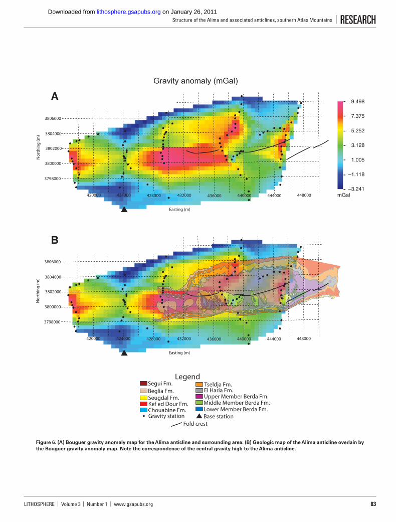
The resulting complete Bouguer gravity anomaly map ranges from −3.24 mGal in the northwest of the gravity survey to +9.50 mGal in the central portion (Fig. 6A). Bouguer anomalies are reported relative to the base station used for instrumental drift corrections. Gravity anomalies shown in Figure 6A are broadly E-W trending, with minor trends in the NE-SW direction. The major feature shown by the gravity map is an elongate, E-W–trending gravity high in the center of the survey. Grav-ity anomalies decrease on all edges of this feature, except on the NE corner, where a 5 km extension of the gravity high occurs. In addition to the central gravity high, two other gravity highs are observed: one on the eastern margin of the survey area, and the other on the western mar-gin. The gravity anomalies are segmented in the E-W direction, with the E-W–elongate highs separated by narrow, N-S–trending low anomalies. Finally, the major gravity high is clearly delineated from its surround-ings, with relative gravity anomalies decreasing in all directions.
Figure 6B shows the relation of the gravity data to the Alima anti-cline geology. The E-W trend of the gravity data appears to refl ect the overall structure of folding in the Metlaoui Range, with its E-W–trend-ing en echelon folds. Although the gravity survey area is largely in the western portion of the Alima anticline, the scale of the prominent gravity high matches the scale of folds in this region. The central gravity high is ~15 km in the E-W direction and ~7 km in the N-S direction. Fold axes
on January 26, 2011lithosphere.gsapubs.orgDownloaded from

RILEY ET AL.
82 www.gsapubs.org | Volume 3 | Number 1 | LITHOSPHERE
Fracture spacing dataC
Fracture setFracture setFracture set
Fracture set Fracture set Fracture set
P1
P2P3P4
P5P6
No spacing data for P7
North limb
South limb
Avg
. spa
cing
(m
)
Avg
. spa
cing
(m
)
Avg
. spa
cing
(m
)
Avg
. spa
cing
(m
)
Avg
. spa
cing
(m
)
Avg
. spa
cing
(m
)
1.0
0.80.6
0.2
0.4
0
1.0
0.80.6
0.2
0.4
0
1.0
0.80.6
0.2
0.4
0
1.0
0.80.6
0.2
0.4
0
1.0
0.80.6
0.2
0.4
0
1.0
0.80.6
0.2
0.4
0
Fracture trace-length dataB
Fracture set Fracture set Fracture set
Fracture set Fracture set Fracture set Fracture set
P1
P2P3P4
P5P6
P7
North limb
South limb
Avg
. len
gth
(m)
Avg
. len
gth
(m)
Avg
. len
gth
(m)
Avg
. len
gth
(m)
Avg
. len
gth
(m)
Avg
. len
gth
(m)
Avg
. len
gth
(m)
0.5
0.40.3
0.1
0.2
0
0.5
0.40.3
0.1
0.2
0
0.5
0.40.3
0.1
0.2
0
0.5
0.40.3
0.1
0.2
0
0.5
0.40.3
0.1
0.2
0
0.5
0.40.3
0.1
0.2
0
0.5
0.40.3
0.1
0.2
0
Fracture orientation dataA
P1
P2P3P4
P5P6
P7
3798000
3800000
3802000
3804000
3806000
448000444000440000436000432000428000
P1
P2P3P4
P5P6
P7
Figure 5. Fracture data from the Alima anticline: (A) orientation data; (B) trace-length data; and (C) spacing data. Ranges of uncertainty are shown on
the bar graphs for fracture trace length and spacing.
on January 26, 2011lithosphere.gsapubs.orgDownloaded from
LITHOSPHERE | Volume 3 | Number 1 | www.gsapubs.org 83
Structure of the Alima and associated anticlines, southern Atlas Mountains | RESEARCH
3798000
3800000
3802000
3804000
3806000
448000444000440000436000432000428000424000420000
Easting (m)
No
rth
ing
(m)
A
Gravity anomaly (mGal)
03
3798000
3800000
3802000
3804000
3806000
448000444000440000436000432000428000424000420000
Easting (m)
No
rth
ing
(m)
B
Segui Fm.Beglia Fm.Seugdal Fm.Kef ed Dour Fm.Chouabine Fm.
Tseldja Fm.
Upper Member Berda Fm.El Haria Fm.
Middle Member Berda Fm.Lower Member Berda Fm.
Gravity station Base stationFold crest
Legend
9.498
7.375
5.252
3.128
1.005
–1.118
–3.241mGal
Figure 6. (A) Bouguer gravity anomaly map for the Alima anticline and surrounding area. (B) Geologic map of the Alima anticline overlain by
the Bouguer gravity anomaly map. Note the correspondence of the central gravity high to the Alima anticline.
on January 26, 2011lithosphere.gsapubs.orgDownloaded from
RILEY ET AL.
84 www.gsapubs.org | Volume 3 | Number 1 | LITHOSPHERE
in this area are ~17 km long (E-W) and 5–10 km wide. In addition, the segmentation of the gravity data in the E-W direction closely refl ects the segmentation of the en echelon folds of this area, with the major gravity anomaly in the central portion of the gravity study occurring in concor-dance with the Alima anticline. The fold limbs coincide with the gravity high in the western portion of the anticline, indicating that a gravity high is associated with the anticline. However, the major central grav-ity high does not follow topography, and gravity highs are not observed at the fold crest. The central gravity high occurs in the southwest, and mostly along the southern limb of the Alima anticline. In addition, both the NE-SW–trending gravity high and the gravity high observed in the eastern study area correspond to areas between fold crests, rather than the fold crests themselves.
Construction of Gravity Models
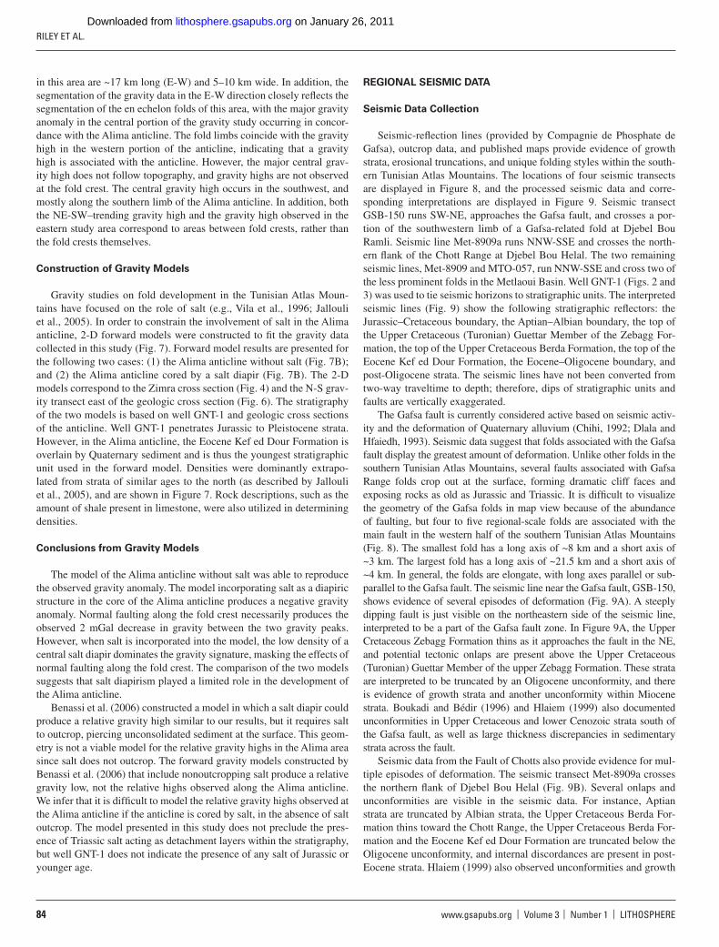
Gravity studies on fold development in the Tunisian Atlas Moun-tains have focused on the role of salt (e.g., Vila et al., 1996; Jallouli et al., 2005). In order to constrain the involvement of salt in the Alima anticline, 2-D forward models were constructed to fi t the gravity data collected in this study (Fig. 7). Forward model results are presented for the following two cases: (1) the Alima anticline without salt (Fig. 7B); and (2) the Alima anticline cored by a salt diapir (Fig. 7B). The 2-D models correspond to the Zimra cross section (Fig. 4) and the N-S grav-ity transect east of the geologic cross section (Fig. 6). The stratigraphy of the two models is based on well GNT-1 and geologic cross sections of the anticline. Well GNT-1 penetrates Jurassic to Pleistocene strata. However, in the Alima anticline, the Eocene Kef ed Dour Formation is overlain by Quaternary sediment and is thus the youngest stratigraphic unit used in the forward model. Densities were dominantly extrapo-lated from strata of similar ages to the north (as described by Jallouli et al., 2005), and are shown in Figure 7. Rock descriptions, such as the amount of shale present in limestone, were also utilized in determining densities.
Conclusions from Gravity Models
The model of the Alima anticline without salt was able to reproduce the observed gravity anomaly. The model incorporating salt as a diapiric structure in the core of the Alima anticline produces a negative gravity anomaly. Normal faulting along the fold crest necessarily produces the observed 2 mGal decrease in gravity between the two gravity peaks. However, when salt is incorporated into the model, the low density of a central salt diapir dominates the gravity signature, masking the effects of normal faulting along the fold crest. The comparison of the two models suggests that salt diapirism played a limited role in the development of the Alima anticline.
Benassi et al. (2006) constructed a model in which a salt diapir could produce a relative gravity high similar to our results, but it requires salt to outcrop, piercing unconsolidated sediment at the surface. This geom-etry is not a viable model for the relative gravity highs in the Alima area since salt does not outcrop. The forward gravity models constructed by Benassi et al. (2006) that include nonoutcropping salt produce a relative gravity low, not the relative highs observed along the Alima anticline. We infer that it is diffi cult to model the relative gravity highs observed at the Alima anticline if the anticline is cored by salt, in the absence of salt outcrop. The model presented in this study does not preclude the pres-ence of Triassic salt acting as detachment layers within the stratigraphy, but well GNT-1 does not indicate the presence of any salt of Jurassic or younger age.
REGIONAL SEISMIC DATA
Seismic Data Collection
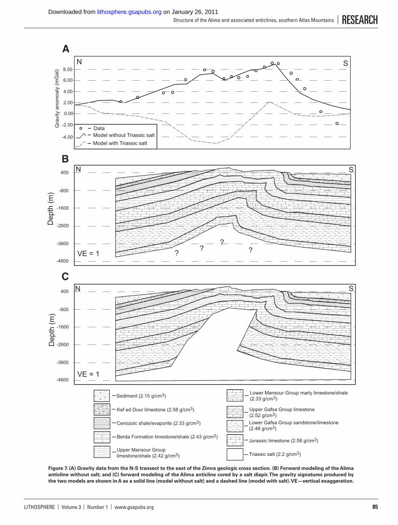
Seismic-refl ection lines (provided by Compagnie de Phosphate de Gafsa), outcrop data, and published maps provide evidence of growth strata, erosional truncations, and unique folding styles within the south-ern Tunisian Atlas Mountains. The locations of four seismic transects are displayed in Figure 8, and the processed seismic data and corre-sponding interpretations are displayed in Figure 9. Seismic transect GSB-150 runs SW-NE, approaches the Gafsa fault, and crosses a por-tion of the southwestern limb of a Gafsa-related fold at Djebel Bou Ramli. Seismic line Met-8909a runs NNW-SSE and crosses the north-ern fl ank of the Chott Range at Djebel Bou Helal. The two remaining seismic lines, Met-8909 and MTO-057, run NNW-SSE and cross two of the less prominent folds in the Metlaoui Basin. Well GNT-1 (Figs. 2 and 3) was used to tie seismic horizons to stratigraphic units. The interpreted seismic lines (Fig. 9) show the following stratigraphic refl ectors: the Jurassic–Cretaceous boundary, the Aptian–Albian boundary, the top of the Upper Cretaceous (Turonian) Guettar Member of the Zebagg For-mation, the top of the Upper Cretaceous Berda Formation, the top of the Eocene Kef ed Dour Formation, the Eocene–Oligocene boundary, and post-Oligocene strata. The seismic lines have not been converted from two-way traveltime to depth; therefore, dips of stratigraphic units and faults are vertically exaggerated.
The Gafsa fault is currently considered active based on seismic activ-ity and the deformation of Quaternary alluvium (Chihi, 1992; Dlala and Hfaiedh, 1993). Seismic data suggest that folds associated with the Gafsa fault display the greatest amount of deformation. Unlike other folds in the southern Tunisian Atlas Mountains, several faults associated with Gafsa Range folds crop out at the surface, forming dramatic cliff faces and exposing rocks as old as Jurassic and Triassic. It is diffi cult to visualize the geometry of the Gafsa folds in map view because of the abundance of faulting, but four to fi ve regional-scale folds are associated with the main fault in the western half of the southern Tunisian Atlas Mountains (Fig. 8). The smallest fold has a long axis of ~8 km and a short axis of ~3 km. The largest fold has a long axis of ~21.5 km and a short axis of ~4 km. In general, the folds are elongate, with long axes parallel or sub-parallel to the Gafsa fault. The seismic line near the Gafsa fault, GSB-150, shows evidence of several episodes of deformation (Fig. 9A). A steeply dipping fault is just visible on the northeastern side of the seismic line, interpreted to be a part of the Gafsa fault zone. In Figure 9A, the Upper Cretaceous Zebagg Formation thins as it approaches the fault in the NE, and potential tectonic onlaps are present above the Upper Cretaceous (Turonian) Guettar Member of the upper Zebagg Formation. These strata are interpreted to be truncated by an Oligocene unconformity, and there is evidence of growth strata and another unconformity within Miocene strata. Boukadi and Bédir (1996) and Hlaiem (1999) also documented unconformities in Upper Cretaceous and lower Cenozoic strata south of the Gafsa fault, as well as large thickness discrepancies in sedimentary strata across the fault.
Seismic data from the Fault of Chotts also provide evidence for mul-tiple episodes of deformation. The seismic transect Met-8909a crosses the northern fl ank of Djebel Bou Helal (Fig. 9B). Several onlaps and unconformities are visible in the seismic data. For instance, Aptian strata are truncated by Albian strata, the Upper Cretaceous Berda For-mation thins toward the Chott Range, the Upper Cretaceous Berda For-mation and the Eocene Kef ed Dour Formation are truncated below the Oligocene unconformity, and internal discordances are present in post-Eocene strata. Hlaiem (1999) also observed unconformities and growth
on January 26, 2011lithosphere.gsapubs.orgDownloaded from
LITHOSPHERE | Volume 3 | Number 1 | www.gsapubs.org 85
Structure of the Alima and associated anticlines, southern Atlas Mountains | RESEARCH
Gra
vity
ano
moa
ly (
mG
al)
-2.00
0.00
6.00
8.00
2.00
4.00
400
-600
-1600
-3600
-2600
-4600
-4.00
400
-600
-1600
-3600
-2600
-4600
Triassic salt (2.2 g/cm3)
Jurassic limestone (2.58 g/cm3)
Lower Gafsa Group sandstone/limestone(2.48 g/cm3)
Upper Gafsa Group limestone(2.52 g/cm3)
Lower Mansour Group marly limestone/shale(2.33 g/cm3)
Upper Mansour Group limestone/shale (2.42 g/cm3)
Berda Formation limestone/shale (2.43 g/cm3)
Cenozoic shale/evaporite (2.33 g/cm3)
Kef ed Dour limestone (2.58 g/cm3)
Sediment (2.15 g/cm3)
Model without Triassic saltData
Model with Triassic salt
VE = 1
VE = 1
S
S
SN
N
??
? ?
N
A
C
B
Dep
th (
m)
Dep
th (
m)
Figure 7. (A) Gravity data from the N-S transect to the east of the Zimra geologic cross section. (B) Forward modeling of the Alima
anticline without salt; and (C) forward modeling of the Alima anticline cored by a salt diapir. The gravity signatures produced by
the two models are shown in A as a solid line (model without salt) and a dashed line (model with salt). VE—vertical exaggeration.
on January 26, 2011lithosphere.gsapubs.orgDownloaded from

RILEY ET AL.
86 www.gsapubs.org | Volume 3 | Number 1 | LITHOSPHERE
strata in Upper Cretaceous and Cenozoic strata on the northern fl ank of Djebel Bou Helal (Chott fold), as well as a more deformed southern limb and large thickness discrepancies across the fault in Mesozoic and Cenozoic strata.
Several less conspicuous folds exist in the Gafsa, Metlaoui, and Moulares basins. These folds are generally ~12 km long and ~7 km wide, and they are covered by Miocene and younger strata (Figs. 9C and 9D). The seismic lines show the southward vergence of these folds, and the strata below the Eocene Kef ed Dour Formation are parallel with no unconformities, as opposed to strata seen in seismic data from the Gafsa- and Chott-related folds. However, the seismic lines from Met-8909 and MTO-057 are very different from each other in terms of deformational style and growth strata. Seismic line Met-8909 shows a more gentle fold-ing style and lacks growth strata, but Quaternary alluvium is deformed around this anticline (Fig. 9C). In contrast, seismic line MTO-057 shows a steep southern fl ank and growth strata where Oligocene and younger strata vary in thickness across the anticline (Fig. 9D). Quaternary allu-vium is also being actively folded around this anticline. Farther south of the anticline, seismic line MTO-057 shows another structure where a southward-dipping normal fault displaces Lower Cretaceous and Juras-sic strata, and Lower Cretaceous strata thicken toward the fault from the south. Above the fault tip, Upper Cretaceous strata are gently folded.
DISCUSSION
Models for Alima Anticline Development
Several models of folding have been proposed for the southern Tuni-sia Atlas Mountains. Outtani et al. (1995) and Hlaiem (1999) interpreted anticlines developed in the southern Tunisian Atlas Mountains to result from ramp-related folding that deformed the sedimentary cover over rigid (Paleozoic and older) strata during a single tectonic event. In this context, folding above a Middle Cretaceous décollement led to the development of the Alima anticline (Outtani et al., 1995). However, seismic data refute the fault-bend fold interpretation as it applies to the Metlaoui region. The fault-bend fold model requires the presence of gently dipping thrust faults to form fault-bend folds in the sedimentary cover of the southern Atlas Mountains. Reverse faults associated with the Chott Range have dips >45° (Hlaiem, 1999), not the 10° and 40° expected with fault-bend fold ramps (Serra, 1977; Boyer and Elliot, 1982; Jamison and Pope, 1996). On a larger scale, most folds in the southern Tunisian Atlas Mountains are en echelon and underlain by steeply dipping reverse faults (Chihi, 1992; Bédir, 1995). Furthermore, the faults in the southern Tunisian Atlas Mountains are not confi ned to the Cretaceous strata. Instead, the faults cut Jurassic strata with no evidence of thrust ramp development in Cretaceous strata.
GSB-1
50
Gafsa fault
Alima
Redeyef
Moulares
Chott Range
Met-8909
Met-8909a
MTO
-057
Metlaoui
Chott El Djerid
Chott El Gharsa
20 km
Quaternary
Sehib and Beglia Fm.Seugdal, Kef ed Dour, and Chouabine Fm.Tseldja and El Haria Fm.
Douleb, Aleg, and Stah Fm.Berda Fm.
Zebagg Fm.Orbata Fm.
Anticline
Syncline
Fault
Subsurface fault
City
Seismic transect
Legend
8°15′E 8°45′E
34°30′N
34°15′N
Figure 8. Geologic map of the western half of the southern Tunisian Atlas Mountains and the locations of the seismic lines presented in Figure 9.
on January 26, 2011lithosphere.gsapubs.orgDownloaded from
LITHOSPHERE | Volume 3 | Number 1 | www.gsapubs.org 87
Structure of the Alima and associated anticlines, southern Atlas Mountains | RESEARCH
Detachment faulting along salt beds is an alternate mechanism for fold development in the southern Tunisian Atlas Mountains. Although no salt is observed at the surface in the Metlaoui region, Triassic salt is abundant in northern Tunisia, and a Triassic salt diapir (Hadifa) is present in the Chott Range located east of the Gafsa fault (Snoke et al., 1988; Hlaiem et al., 1997). Accumulations of salt can localize deformation to the thinner overburden overlying the salt bodies (Letouzey et al., 1995), and exten-sion during the early Mesozoic may have facilitated detachment folding through the aggregation of salt bodies within the basin. However, gravity, seismic, and stratigraphic data do not support the involvement of Triassic salt in the development of the Alima anticline. Due to the low density of salt with respect to other rock types, the presence of salt should produce a gravity low if diapiric doming produced the Alima anticline. Although gravity lows associated with anticlines north of the fi eld area have been interpreted as a product of salt domes (Jallouli et al., 2005), the Alima anticline is associated with relative gravity highs, and the best fi t forward model for the Alima anticline did not incorporate salt (Fig. 7). Further-more, seismic-refl ection lines in the Metlaoui region also do not suggest salt diapirism in the subsurface around the Alima anticline. Finally, well
GNT-1, which penetrates 5 km of stratigraphy, shows no accumulation of salt of Jurassic age or younger. It is conceivable that salt involvement may have occurred in a manner similar to the “salt glacier” model proposed by Vila et al. (1994, 1996). In this model, salt is present not as an individual bed, but as a component of siliciclastic or carbonate mudstone, and the salt still acts as a zone of weakness. However, in all salt models of the Tunisian Atlas, Triassic salt is modeled above Early Cretaceous (Albian/Aptian) rocks. If this were the case for the Metlaoui region folds, then (1) some indication of salt in well GNT-1 should be present, which penetrates Jurassic rocks; (2) salt should be observed in the seismic data, which show stratigraphy down to the Early Cretaceous; and (3) the gravity signature of such a shallow, low-density feature would be apparent in both the gravity data and modeling. Based on the far-foreland nature of the stratigraphy, the gravity observations and forward model, and the well data, salt appears to have had limited involvement in fold development in the Metlaoui region.
Folds above E-W–striking faults farther south (i.e., Fault of Chotts) are interpreted to have formed from oblique reactivation of Mesozoic normal faults; the data in this study support a similar model for development of the Alima anticline and other folds in the Metlaoui region. Fold geometry
.
.
A B
C D
Two-
way
trav
eltim
e (s
)
Two-
way
trav
eltim
e (s
)
Two-
way
trav
eltim
e (s
)
Two-
way
trav
eltim
e (s
)
Two-
way
trav
eltim
e (s
)Tw
o-w
ay tr
avel
time
(s)
Two-
way
trav
eltim
e (s
)Tw
o-w
ay tr
avel
time
(s)
Poor resolution
Poor resolution
Gafsafault
Figure 9. Seismic-refl ection lines and interpretations. Surface trajectories are presented in Figure 8. (A) Line GSB-150 runs SW
to NE across the Moulares Basin and terminates within a fold related to the Gafsa fault. (B) Line Met-8909a runs NNW to SSE
across the southern portion of the Metlaoui Basin and terminates midway through the Chott Range. (C) Line Met-8909 runs
NNW to SSE across the northern half of the Metlaoui Range. (D) Line MTO-057 runs NNW to SSE across the northern half of
the Metlaoui Basin east of line Met-8909. Two interpretations are proposed for this seismic line.
on January 26, 2011lithosphere.gsapubs.orgDownloaded from

RILEY ET AL.
88 www.gsapubs.org | Volume 3 | Number 1 | LITHOSPHERE
in reactivation models includes tight, vergent anticlines and broad syn-clines, with en echelon, arcuate fold crests (Letouzey et al., 1995), i.e., the same geometry observed at the Alima anticline and surrounding synclines (Figs. 10 and 11). Theoretical and physical models have documented the evolution of folds in multiple orientations of reactivation, and both orthog-onal and oblique reactivation can produce the observed fold geometry at Alima (Letouzey, 1990; Letouzey et al., 1990; Vially et al., 1994; Letouzey et al., 1995; Tindall and Davis, 1999). During orthogonal reactivation, new reverse faults typically develop (Letouzey, 1990; Letouzey et al., 1990, 1995; Outtani et al., 1995), which is not observed at the Alima anticline. For oblique reactivation, the optimal orientation for oblique reactivation
(20°–40°) is similar to the angle between Cenozoic shortening (NW-SE) and some preexisting Mesozoic normal faults (E-W), and it does not pre-dict the development of new thrusts. We therefore favor oblique reactiva-tion over orthogonal reactivation.
The oblique reactivation model (Letouzey et al., 1995) also predicts en echelon, vergent folds with en echelon fault traces, tear faults, and some-times second, tighter anticlines when multiple detachment surfaces are included in the model (Figs. 10 and 11). The fracture sets are inferred to have formed early in the folding history, parallel and perpendicular to the curved and segmented fold crests. Thus, the existence of arcuate and segmented fold crests is likely not the result of subsequent rotation or deformation. The direction of shortening in the southern Tunisian Atlas Mountains is NW-SE, and therefore the relative direction of elongation is NE-SW (Zargouni, 1986), orthogonal to arcuate faults in the Alima struc-ture mapped in this study. In addition, the Alima anticline is composed of right-lateral, en echelon folds (i.e., the respective anticlines associated with Zimra, Zarrif, and Alima peaks), with arcuate fold axes offset by tear faults, as predicted by models of oblique-slip reactivation in the presence of detachment layers (Vially et al., 1994).
Direct evidence of an extensional structure being reactivated as a contractional structure is limited to the fault visible in the seismic line MTO-057 (Fig. 9D). The fault displays normal offset, suggesting exten-sion, but the overlying strata are gently folded, suggesting that the fault has accommodated contraction. Since it is the overlying strata that have been folded, we interpret the fault to have fi rst accommodated extension, and then contraction.
Regionally, the Alima anticline was produced in a convergent tectonic setting, but brittle deformation is locally expressed as normal faulting and extensional fracturing. Both normal faults and extensional fractures domi-nantly strike either subparallel to or perpendicular to fold crests. The pat-terns in brittle deformation seen on the Alima anticline are similar to brit-tle deformation patterns observed in the forelands of other mountain belts. Laramide uplifts in the western United States exhibit similar structural patterns (e.g., Engelder et al., 1997; Bergbauer and Pollard, 2004), and seismic data have revealed that Teapot Dome (a doubly plunging anticline associated with Laramide deformation) is asymmetric, with a gently dip-ping eastern limb and steeply dipping western limb (Cooper et al., 2006). Both the Alima anticline and Teapot Dome exhibit normal faulting along the periphery, commonly subparallel or perpendicular to the fold hinge, despite having formed in a contractional setting. Kinematic studies of fault populations associated with Laramide folds in the western United States also suggest that elongation, rather than shortening, is likely to occur par-allel to the fold hinge, facilitating the development of fractures and normal faults perpendicular to the hinge (Wise and Obi, 1992; Narr, 1993; Varga, 1993). Thus, the normal faulting observed in the Upper Cretaceous upper member of the Berda formation is likely a product of extension in the outer (younger) strata of the anticline.
Fold History in the Metlaoui Region
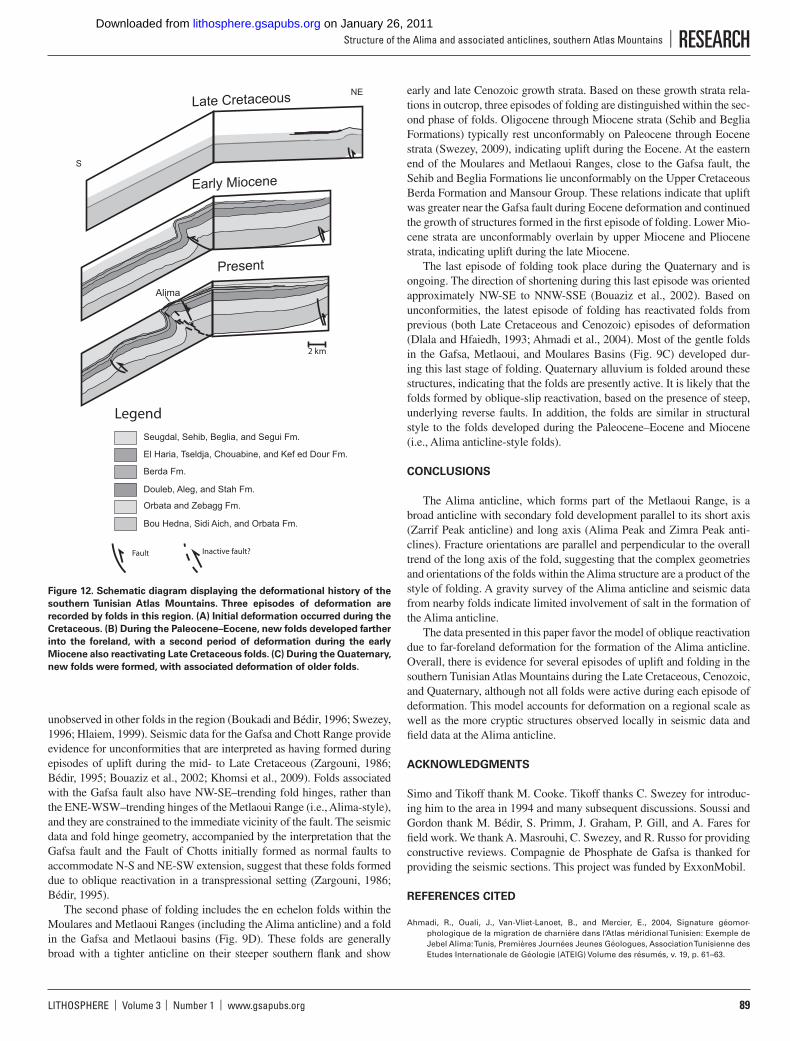
Based on timing relations and deformation styles observed from seismic-refl ection lines and outcrop data, folds of the southern Tunisian Atlas Mountains are classifi ed into three categories (Fig. 12). The three categories correspond to episodes of contraction previously identifi ed in the mid- to Late Cretaceous, throughout the Cenozoic, and occurring present-day (Ben Ferjani et al., 1990; Bobier et al., 1991; Bédir, 1995; Bouaziz et al., 2002). Folds associated with the Gafsa fault and the Fault of Chotts fi rst developed during the mid- to Late Cretaceous and repre-sent the fi rst phase of folding (Fig. 12A). Both of these faults have been interpreted as reactivated basement faults, and they show characteristics
A
C
BAlimaStah es SoudaSif El Leham
Reactivated normal fault
Synthetic en echelon faults
SN
Figure 10. Schematic diagrams of the three models discussed as potential
mechanisms of deformation in the southern Tunisian Atlas Mountains. (A)
Conceptual model of oblique slip inversion from physical experiments
(adapted from Vially et al., 1994). (B) Fault-bend/propagation folding
model, to explain deformation in the southeastern Algerian Atlas Moun-
tains and in the western half of the southern Tunisian Atlas Mountains
(Outtani et al., 1995). (C) An example of detachment folding.
Figure 11. Block diagram built from computerized tomographic scan
images of a physical model of oblique inversion along a basement fault
(from Letouzey et al., 1995).
on January 26, 2011lithosphere.gsapubs.orgDownloaded from
LITHOSPHERE | Volume 3 | Number 1 | www.gsapubs.org 89
Structure of the Alima and associated anticlines, southern Atlas Mountains | RESEARCH
unobserved in other folds in the region (Boukadi and Bédir, 1996; Swezey, 1996; Hlaiem, 1999). Seismic data for the Gafsa and Chott Range provide evidence for unconformities that are interpreted as having formed during episodes of uplift during the mid- to Late Cretaceous (Zargouni, 1986; Bédir, 1995; Bouaziz et al., 2002; Khomsi et al., 2009). Folds associated with the Gafsa fault also have NW-SE–trending fold hinges, rather than the ENE-WSW–trending hinges of the Metlaoui Range (i.e., Alima-style), and they are constrained to the immediate vicinity of the fault. The seismic data and fold hinge geometry, accompanied by the interpretation that the Gafsa fault and the Fault of Chotts initially formed as normal faults to accommodate N-S and NE-SW extension, suggest that these folds formed due to oblique reactivation in a transpressional setting (Zargouni, 1986; Bédir, 1995).
The second phase of folding includes the en echelon folds within the Moulares and Metlaoui Ranges (including the Alima anticline) and a fold in the Gafsa and Metlaoui basins (Fig. 9D). These folds are generally broad with a tighter anticline on their steeper southern fl ank and show
early and late Cenozoic growth strata. Based on these growth strata rela-tions in outcrop, three episodes of folding are distinguished within the sec-ond phase of folds. Oligocene through Miocene strata (Sehib and Beglia Formations) typically rest unconformably on Paleocene through Eocene strata (Swezey, 2009), indicating uplift during the Eocene. At the eastern end of the Moulares and Metlaoui Ranges, close to the Gafsa fault, the Sehib and Beglia Formations lie unconformably on the Upper Cretaceous Berda Formation and Mansour Group. These relations indicate that uplift was greater near the Gafsa fault during Eocene deformation and continued the growth of structures formed in the fi rst episode of folding. Lower Mio-cene strata are unconformably overlain by upper Miocene and Pliocene strata, indicating uplift during the late Miocene.
The last episode of folding took place during the Quaternary and is ongoing. The direction of shortening during this last episode was oriented approximately NW-SE to NNW-SSE (Bouaziz et al., 2002). Based on unconformities, the latest episode of folding has reactivated folds from previous (both Late Cretaceous and Cenozoic) episodes of deformation (Dlala and Hfaiedh, 1993; Ahmadi et al., 2004). Most of the gentle folds in the Gafsa, Metlaoui, and Moulares Basins (Fig. 9C) developed dur-ing this last stage of folding. Quaternary alluvium is folded around these structures, indicating that the folds are presently active. It is likely that the folds formed by oblique-slip reactivation, based on the presence of steep, underlying reverse faults. In addition, the folds are similar in structural style to the folds developed during the Paleocene–Eocene and Miocene (i.e., Alima anticline-style folds).
CONCLUSIONS
The Alima anticline, which forms part of the Metlaoui Range, is a broad anticline with secondary fold development parallel to its short axis (Zarrif Peak anticline) and long axis (Alima Peak and Zimra Peak anti-clines). Fracture orientations are parallel and perpendicular to the overall trend of the long axis of the fold, suggesting that the complex geometries and orientations of the folds within the Alima structure are a product of the style of folding. A gravity survey of the Alima anticline and seismic data from nearby folds indicate limited involvement of salt in the formation of the Alima anticline.
The data presented in this paper favor the model of oblique reactivation due to far-foreland deformation for the formation of the Alima anticline. Overall, there is evidence for several episodes of uplift and folding in the southern Tunisian Atlas Mountains during the Late Cretaceous, Cenozoic, and Quaternary, although not all folds were active during each episode of deformation. This model accounts for deformation on a regional scale as well as the more cryptic structures observed locally in seismic data and fi eld data at the Alima anticline.
ACKNOWLEDGMENTS
Simo and Tikoff thank M. Cooke. Tikoff thanks C. Swezey for introduc-ing him to the area in 1994 and many subsequent discussions. Soussi and Gordon thank M. Bédir, S. Primm, J. Graham, P. Gill, and A. Fares for fi eld work. We thank A. Masrouhi, C. Swezey, and R. Russo for providing constructive reviews. Compagnie de Phosphate de Gafsa is thanked for providing the seismic sections. This project was funded by ExxonMobil.
REFERENCES CITED
Ahmadi, R., Ouali, J., Van-Vliet-Lanoet, B., and Mercier, E., 2004, Signature géomor-phologique de la migration de charniére dans l’Atlas méridional Tunisien: Exemple de Jebel Alima: Tunis, Premières Journées Jeunes Géologues, Association Tunisienne des Etudes Internationale de Géologie (ATEIG) Volume des résumés, v. 19, p. 61–63.
Present
Alima
Late Cretaceous NE
S
Early Miocene
2 km
Legend
Seugdal, Sehib, Beglia, and Segui Fm.
El Haria, Tseldja, Chouabine, and Kef ed Dour Fm.
Berda Fm.
Douleb, Aleg, and Stah Fm.
Orbata and Zebagg Fm.
Bou Hedna, Sidi Aich, and Orbata Fm.
Fault Inactive fault?
Figure 12. Schematic diagram displaying the deformational history of the
southern Tunisian Atlas Mountains. Three episodes of deformation are
recorded by folds in this region. (A) Initial deformation occurred during the
Cretaceous. (B) During the Paleocene–Eocene, new folds developed farther
into the foreland, with a second period of deformation during the early
Miocene also reactivating Late Cretaceous folds. (C) During the Quaternary,
new folds were formed, with associated deformation of older folds.
on January 26, 2011lithosphere.gsapubs.orgDownloaded from
RILEY ET AL.
90 www.gsapubs.org | Volume 3 | Number 1 | LITHOSPHERE
Andrieux, J., Frizon de Lamotte, D., and Braud, J., 1989, A structural scheme for the Western Mediterranean area in Jurassic and Early Cretaceous times: Geodinamica Acta, v. 3, p. 5–15.
Beauchamp, W., Allmendinger, R., Barazangi, M., Demnati, A., El Alji, M., and Dahmani, M., 1999, Inversion tectonics and the evolution of the High Atlas Mountains, Morocco, based on a geological-geophysical transect: Tectonics, v. 18, p. 163–184, doi:10.1029/1998TC900015.
Bédir, M., 1995, Mécanismes Géodynamiques des Bassins Associés aux Couloirs de Coulissement de la Marge Atlasique de la Tunisie [thése doctorate etat]: Tunis, Tunisia, Faculté des Sciences, Université Tunis II, 416 p.
Benassi, R., Jallouli, C., Hammami, M., and Turki, M.M., 2006, The structure of Jebel El Mourra, Tunisia: A diapiric structure causing a positive gravity anomaly: Terra Nova, v. 18, p. 432–439, doi:10.1111/j.1365-3121.2006.00709.x.
Ben Ayed, N., 1986, Evolution Tectonique de l’Avant-Pays de la Chaîne Alpine de Tunisie du Début du Mésozoïque à l’Actuel [thése doctorate etat]: Paris, Université Paris Sud Orsay, 327 p.
Ben Ayed, N., 1993, Evolution Tectonique de l’Avant-pays de la Chaîne Alpine de Tunisie du Début du Mésozoïque à l’Actuel: Annales Mines et Géologique de Tunisie, v. 32, 286 p.
Ben Ferjani, A., Burollet, P.F., and Mejri, F., 1990, Petroleum Geology of Tunisia: Tunis, Enter-prise Tunisienne d’Activites Petrolieres (ETAP), 194 p.
Bergbauer, S., and Pollard, D.D., 2004, A new conceptual fold-fracture model including pre-folding joints, based on the Emigrant Gap anticline, Wyoming: Geological Society of America Bulletin, v. 116, p. 294–307, doi:10.1130/B25225.1.
Bishop, W.F., 1988, Petroleum geology of east-central Tunisia: American Association of Petro-leum Geologists Bulletin, v. 75, p. 1033–1058.
Bobier, C., Viguier, C., Chaari, A., and Chine, A., 1991, The post-Triassic sedimentary cover of Tunisia: Seismic sequences and structure: Tectonophysics, v. 195, p. 371–410, doi:10.1016/0040-1951(91)90222-E.
Boccaletti, M., Cello, G., and Tortorici, L., 1990, First order kinematic elements in Tunisia and the Pelagian block: Tectonophysics, v. 176, p. 215–228, doi:10.1016/0040-1951(90)90267-C.
Bouaziz, S., Barrier, E., Soussi, M., Turki, M., and Zouari, H., 2002, Tectonic evolution of the northern African margin in Tunisia from paleostress data and sedimentary record: Tec-tonophysics, v. 357, p. 227–253, doi:10.1016/S0040-1951(02)00370-0.
Boukadi, N., and Bédir, B., 1996, L’halocinèse en Tunisie: Contexte tectonique et chronologie des événements: Paris, France, Comptes Rendus de l’Académie des Sciences, v. 322, série II, p. 587–594.
Boyer, S.E., and Elliot, D., 1982, Thrust systems: American Association of Petroleum Geolo-gists (AAPG) Bulletin, v. 66, p. 1196–1230.
Bracène, R., and Frizon de Lamotte, D., 2002, The origin of intraplate deformation in the Atlas system of western and central Algeria: From Jurassic rifting to Cenozoic-Quaternary inversion: Tectonophysics, v. 357, p. 207–226, doi:10.1016/S0040-1951(02)00369-4.
Buchanan, P.G., and McClay, K.R., 1991, Sandbox experiments of inverted listric and planar fault systems: Tectonophysics, v. 188, p. 97–115, doi:10.1016/0040-1951(91)90317-L.
Burollet, P.F., 1991, Structures and tectonics of Tunisia: Tectonophysics, v. 195, p. 359–369, doi:10.1016/0040-1951(91)90221-D.
Chihi, L., 1992, Seismotectonic study in central and southern Tunisia: Tectonophysics, v. 209, p. 175–178, doi:10.1016/0040-1951(92)90021-W.
Chihi, L., 1995, Les fossés néogènes à quaternaires de la Tunisie et de la Mer pélagienne: Étude structurale et leur signifi cation dans le cadre géodynamique de la Méditerranée centrale [thèse doctorat ès science]: Tunis, Faculté des Sciences, Université Tunis II, 566 p.
Cooper, S.P., Goodwin, L.B., and Lorenz, J., 2006, Fracture and fault patterns associ-ated with basement-cored anticlines: The example of Teapot Dome, Wyoming: American Association of Petroleum Geologists (AAPG) Bulletin, v. 90, p. 1903–1920, doi:10.1306/06020605197.
Dercourt, J., Zonenshain, L.P., Ricou, L.E., Kazmin, V.G., Le Pichon, X., Knipper, A.L., Grandjac-quet, C., Sbortshikov, I.M., Geyssant, J., Lepvrier, C., Pechersky, D.H., Boulin, J., Sibuet, J.C., Savostin, L.A., Sorokhtin, O., Westphal, M., Bazhenov, M.L., Lauer, J.P., and Biju-Duval, B., 1986, Geological evolution of the Tethys belt from the Atlantic to the Pamirs since the Lias: Tectonophysics, v. 123, p. 241–315, doi:10.1016/0040-1951(86)90199-X.
Dhahri, F., and Boukadi, N., 2010, The evolution of pre-existing structures during the tectonic inversion process of the Atlas chain of Tunisia: Journal of African Earth Sciences, v. 56, p. 139–149, doi:10.1016/j.jafrearsci.2009.07.002.
Dlala, M., and Hfaiedh, M., 1993, Le séisme du 7 Novembre 1989 à Metlaoui (Tunise méri-dionale): Une tectonique active en compression: Paris, France, Comptes Rendus de l’Académie des Sciences, v. 317, no. 10, p. 1297–1302.
Donath, F.A., and Cranwell, R.M., 1981, Probabilistic treatment of faulting in geologic media, in Carter, N.L, Friedman, M., Logan, J.M., and Stearns, D.W., eds., Mechanical Behavior of Crustal Rocks: Washington, D.C., American Geophysical Union, p. 231–241.
Engelder, T., Gross, M.R., and Pinkerton, P., 1997, An analysis of joint development in thick sandstone beds of the Elk Basin anticline, Montana-Wyoming, in Hoak, T.E., Klawitter, A.L., and Blomquist, P.K., eds., Fractured Reservoirs: Characterization and Modeling: Denver, Colorado, Rocky Mountain Association of Geologists, p. 1–18.
Etheridge, M.A., 1986, On the reactivation of extensional fault systems: Philosophical Trans-actions of the Royal Society of London, series A: Mathematical and Physical Sciences, v. 317, no. 1536, p. 179–195.
Etheridge, M.A., Branson, J.C., and Stuart-Smith, P.G., 1985, Extensional basin: Forming structures in Bass Strait and their importance for hydrocarbon exploration: Australian Petroleum Exploration Association (APEA) Journal, v. 25, no. 1, p. 344–361.
Frizon de Lamotte, D., Bezar, B.S., and Bracène, R., 2000, The two main steps of Atlas build-ing and geodynamics of the Western Mediterranean: Tectonics, v. 19, no. 4, p. 740–761, doi:10.1029/2000TC900003.
Gabtni, H., Jallouli, C., Mickus, K.L., Zouari, H., and Turki, M.M., 2006, The location and nature of the Telemzan High–Ghadames basin boundary in the southern Tunisia based on
gravity and magnetic anomalies: Journal of African Earth Sciences, v. 44, p. 303–313, doi:10.1016/j.jafrearsci.2005.11.021.
Gealey, W.K., 1988, Plate tectonic evolution of the Mediterranean–Middle East region: Tecto-nophysics, v. 155, p. 285–306, doi:10.1016/0040-1951(88)90270-3.
Gomez, F., Allmendinger, R., Barazangi, M., Er-Raji, A., and Dahmani, M., 1998, Crustal short-ening and vertical strain partitioning in the middle Atlas Mountains of Morocco: Tecton-ics, v. 17, p. 520–533, doi:10.1029/98TC01439.
Grasso, M., Torelli, L., and Massoldi, G., 1999, Cretaceous-Palaeogene sedimentation pat-terns and structural evolution of the Tunisian shelf, offshore the Pelagian Islands (central Mediterranean): Tectonophysics, v. 315, p. 235–250, doi:10.1016/S0040-1951(99)00285-1.
Guiraud, R., Bellion, Y., Benkhelil, J., and Moreau, C., 1987, Post-Hercynian tectonics in northern and western Africa: Geological Journal, v. 22, p. 433–466, doi:10.1002/gj.3350220628.
Hammer, S., 1939, Terrain corrections for gravimeter stations: Geophysics, v. 16, p. 29–50.Hlaiem, A., 1999, Halokinesis and structural evolution of the major features in eastern and
southern Tunisian Atlas: Tectonophysics, v. 306, p. 79–95, doi:10.1016/S0040-1951(99)00045-1.
Hlaiem, A., Biju-Duval, B., Vially, R., Laatar, E., and M’Rabet, A., 1997, Burial and thermal his-tory modeling of the Gafsa-Metlaoui intracontinental basin (southern Tunisia): Impli-cations for petroleum exploration: Journal of Petroleum Geology, v. 20, p. 403–426, doi:10.1111/j.1747-5457.1997.tb00924.x.
Holdsworth, R.E., Butler, C.A., and Roberts, A.M., 1997, The recognition of reactivation during continental deformation: Journal of the Geological Society of London, v. 154, p. 73–78, doi:10.1144/gsjgs.154.1.0073.
Jallouli, C., Chikhaoui, M., Braham, A., Turki, M.M., Mickus, K., and Benassi, R., 2005, Evi-dence for Triassic salt domes in the Tunisian Atlas from gravity and geological data: Tectonophysics, v. 396, p. 209–225.
Jamison, W.R., and Pope, A., 1996, Geometry and evolution of a fault-bend fold: Mount Ber-tha anticline: Geological Society of America Bulletin, v. 108, p. 208–224, doi:10.1130/0016-7606(1996)108<0208:GAEOAF>2.3.CO;2.
Khomsi, S., Bédir, M., and Ben Jemia, M.G., 2004, Mise en évidence et analyse d’une struc-ture atlasique ennoyée au front de la Chaîne alpine Tunissienne: Comptes Rendus Geo-science, v. 336, p. 1293–1300.
Khomsi, S., Bédir, M., Soussi, M., Ben Jemia, G.-M., and Ben Ismail-Lattrache, K., 2006, Mise en évidence en subsurface d’événments compressifs Éocène moyen-supérieur en Tunisie orientale (Sahel): Généralité de la phase atlasique en Afrique du Nord: Comptes Rendus Geoscience, v. 338, p. 41–49.
Khomsi, A., Ben Jemia, M.G., Frizon de Lamotte, D., Maherssi, C., Echihi, O., and Mezni, R., 2009, An overview of the Late Cretaceous–Eocene positive inversions and Oligo-Miocene subsidence events in the foreland of the Tunisian Atlas: Structural style and implications for the tectonic agenda of the Maghrebian Atlas system: Tectonophysics, v. 475, p. 38–58, doi:10.1016/j.tecto.2009.02.027.
Koopman, A., Speksnijder A., and Horsfi eld, W.T., 1987, Sandbox model studies of inversion tectonics: Tectonophysics, v. 137, p. 379–388, doi:10.1016/0040-1951(87)90329-5.
Laville, E., and Petit, J.P., 1984, Role of synsedimentary strike-slip faults in the formation of Moroccan Triassic basins: Geology, v. 12, p. 424–427, doi:10.1130/0091-7613(1984)12<424:ROSSFI>2.0.CO;2.
Letouzey, J., 1990, Fault reactivation, inversion and fold-thrust belt, in Letouzey, J., ed., Petroleum and Tectonics in Mobile Belts: Paris, Éditions Technip, p. 101–128.
Letouzey, J., Werner, P., and Marty, A., 1990, Fault reactivation and structural inversion: Back-arc and intraplate compressive deformations: Examples of the eastern Sunda Shelf (Indonesia): Tectonophysics, v. 183, p. 341–362, doi:10.1016/0040-1951(90)90425-8.
Letouzey, J., Colletta, B., Vially, R., and Chermette, J.C., 1995, Evolution of salt-related struc-tures in compressional settings, in Jackson, M.P.A., Roberts, D.G., and Snelson, S., eds., Salt Tectonics: A Global Perspective: American Association of Petroleum Geolo-gists (AAPG) Memoir 65, p. 41–60.
Masrouhi, A., Ghanmi, M., Youssef, M.B., Vila, J.M., and Zargouni, F., 2007, Mise en évidence d’une nappe de charriage à deux unités paléogénes au plateau de Lansarine (Tunisie du Nord): Défi nition d’un nouvel élément structural de l’Atlas Tunissien et reevaluation du calendrier des serrages tertiaires: Comptes Rendus Geoscience, v. 339, p. 441–448.
Masrouhi, A., Ghanmi, M., Slama, M.M.B., Youssef, M.B., Vila, J.M., and Zargouni, F., 2008, New tectono-sedimentary evidence constraining the timing of the positive tectonic inversion and the Eocene Atlasic phase in northern Tunisia: Implication for the North African paleo-margin evolution: Comptes Rendus Geoscience, v. 340, p. 771–778.
Montesinos, F.G., Arnoso, J., and Benavent, M., 2005, New study of the local gravity fi eld of El Hierro (Canary Islands): Fisica de la Tierra, v. 17, p. 113–127.
Narr, W., 1993, Deformation of basement in basement involved, compressive structures, in Schmidt, C.J., Chase, R.B., and Erslev, E.A., eds., Laramide Basement Deformation in the Rocky Mountain Foreland of the Western United States: Geological Society of America Special Paper 280, p. 107–124.
Nouvelle Carte de Tunisie, 1993a, Ar-redayyif (1st ed.): Tunis, Offi ce de la Topographie et de la Cartographie de Tunisie, 1 sheet, scale 1:150,000.
Nouvelle Carte de Tunisie, 1993b, Metlaoui (1st ed.): Tunis, Offi ce de la Topographie et de la Cartographie de Tunisie, 1 sheet, scale 1:150,000.
Outtani, F., Addoum, B., Mercier, E., Frizon de Lamotte, D., and Andrieux, J., 1995, Geometry and kinematics of the South Atlas Front, Algeria and Tunisia: Tectonophysics, v. 249, p. 233–248, doi:10.1016/0040-1951(95)00022-F.
Rebai, S., 1993, Recent tectonics in northern Tunisia: Coexistence of compressive and exten-sional structures: Annales Tectonicae, v. 7, p. 129–141.
Regaya, K., Laatar, S., Chaouachi, A., 1991, Cartes Géologique, Metlaoui (1st ed.): Tunis, l’Offi ce National des Mines de Tunisie, 1 sheet, scale 1:100,000.
on January 26, 2011lithosphere.gsapubs.orgDownloaded from
LITHOSPHERE | Volume 3 | Number 1 | www.gsapubs.org 91
Structure of the Alima and associated anticlines, southern Atlas Mountains | RESEARCH
Remmelts, G., 1995, Fault-related salt tectonics in the southern North Sea, The Netherlands, in Jackson, M.P.A., Roberts, D.G., and Snelson, S., eds., Salt Tectonics: A Global Perspec-tive: American Association of Petroleum Geologists (AAPG) Memoir 65, p. 261–272.
Ricou, L.E., Dercourt, J., Geyssant, J., Grandjacquet, C., Lepvrier, C., and Biju-Duval, B., 1986, Geological constraints on the Alpine evolution of the Mediterranean Tethys: Tectono-physics, v. 123, p. 83–122, doi:10.1016/0040-1951(86)90194-0.
Rouvier, H., 1977, Geologie de l’Extreme Nord-Tunisien [thesis]: Paris, France, Université Pierre et Marie Curie, 1000 p.
Sassi, W., Colletta, B., Balé, P., and Paquereau, T., 1993, Modeling of structural complexity in sedimentary basins: The role of pre-existing faults in thrust tectonics: Tectonophysics, v. 226, p. 97–112, doi:10.1016/0040-1951(93)90113-X.
Serra, S., 1977, Styles of deformation in the ramp regions of overthrust faults, in Heisey, E.L., Lawson, D.E., Norwood, E.R., Wach, P.H., and Hale, L.A., eds., Wyoming Geologi-cal Association Guidebook, 29th Annual Field Conference: Casper, Wyoming, Wyoming Geological Association, p. 487–498.
Snoke, A.W., Schamel, S., and Karasek, R., 1988, Structural evolution of Djebel Debadib anti-cline: A clue to the regional tectonic style of the Tunisian Atlas: Tectonics, v. 7, p. 497–516, doi:10.1029/TC007i003p00497.
Soua, M., Echihi, O., Herkat, M., Zaghbib-Turki, D., Smaoui, J., Fahfakh-Ben Jemia, H., and Bel-ghaji, H., 2009, Structural context of the paleogeography of the Cenomanian-Turonian anoxic event in the eastern Atlas basins of the Maghreb: Comptes Rendus Geoscience, v. 341, p. 1029–1037.
Stets, J., 1992, Mid-Jurassic events in the western High Atlas (Morocco): Geologische Rund-schau, v. 81, p. 69–84, doi:10.1007/BF01764540.
Swezey, C.S., 1996, Structural controls on Quaternary depocentres within the Chotts Trough region of southern Tunisia: Journal of African Earth Sciences, v. 22, p. 335–347, doi:10.1016/0899-5362(96)00012-7.
Swezey, C.S., 2003, The role of climate in the creation and destruction of continental strati-graphic records: An example from the northern margin of the Sahara Desert, in Cecil, C.B., and Edgar, N.T., eds., Climate Controls on Stratigraphy: Society for Sedimentary Geology (SEPM) Special Publication 77, p. 207–225.
Swezey, C.S., 2009, Cenozoic stratigraphy of the Sahara, northern Africa: Journal of African Earth Sciences, v. 53, p. 89–121, doi:10.1016/j.jafrearsci.2008.08.001.
Tindall, S.E., and Davis, G.H., 1999, Monocline development by oblique-slip fault-propaga-tion folding: The East Kaibab monocline, Colorado Plateau, Utah: Journal of Structural Geology, v. 21, p. 1303–1320, doi:10.1016/S0191-8141(99)00089-9.
Tlig, S., Erraoui, L., Ben Aissa, L., Alaouni, R., and Tagorti, M.-A., 1991, Tectogenèses alpine et atlasique: Deux événements distincts dans l’historie géologique de la Tunisie: Corréla-tion avec les événements cle’s en Méditerranée: Comptes Rendus Geoscience, v. 312, p. 295–301.
Unruh, J.R., and Twiss, R.J., 1998, Coseismic growth of basement-involved anticlines: The Northridge-Laramide connection: Geology, v. 26, p. 335–338, doi:10.1130/0091-7613(1998)026<0335:CGOBIA>2.3.CO;2.
Varga, R.J., 1993, Rocky Mountain foreland uplifts: Products of a rotating stress fi eld or strain partitioning?: Geology, v. 21, p. 1115–1118, doi:10.1130/0091-7613(1993)021<1115:RMFUPO>2.3.CO;2.
Vially, R., Letouzey, J., Bénard, F., Haddadi, N., DesForges, G., Askri, H., and Boudjema, A., 1994, Basin inversion along the North African margin, the Saharan Atlas (Algeria), in Roure, F., ed., Peri-Tethyan Platforms: Paris, Éditions Technip, p. 79–118.
Vila, J.M., Youssef, M.B., Charriere, A., Chikhaoui, M., Ghanmi, M., Kamoun, F., Peybernes, B., Saadi, J., Souquet, P., and Zarbout, M., 1994, Discovery of Triassic rocks interbedded within the Albian of southwest of Kef, Tunisia: Extension of the submarine “salt glacier” domain in Algeria and Tunisia: Comptes Rendus de l’Academie des Sciences, serie II, v. 318, p. 1661–1667.
Vila, J.M., Ben Youssef, M., Chikhaoui, M., and Ghanmi, M., 1996, Deuxiéme étude de surface d’un grand “glacier de sel” sous marin albien (250 km2?): Les masses triasiques du “diapir” de Ben Gasseur et de l’anticlinal du Kef (nord-ouest Tunisien): Bulletin de la Société Géologique de France, v. 167, p. 235–246.
White, S.H., 1986, Fault-zone reactivation: Kinematics and mechanisms: Philosophical Trans-actions of the Royal Society of London, series A: Mathematical and Physical Sciences, v. 317, p. 81–97, doi:10.1098/rsta.1986.0026.
Winterer, E.L., and Hinz, K., 1984, The evolution of the Mazagan continental margin: A syn-thesis of geophysical and geological data with results of drilling during DSDP Leg 79, in Leckie, R.M., and Blakeslee, J.H., eds., Initial reports of the Deep Sea Drilling Project: Las Palmas, Grand Canary Island to Brest, France, July–December, 1979: College Sta-tion, Texas, Texas A&M University, Ocean Drilling Program, v. 79, p. 893–919.
Wise, D.U., and Obi, C.M., 1992, Laramide basement deformation in an evolving stress fi eld, Bighorn Mountain front, Five Springs area, Wyoming: American Association of Petro-leum Geologists (AAPG) Bulletin, v. 76, p. 1586–1600.
Zargouni, F., 1986, Tectonique de l’Atlas Méridional de Tunisie, Évolution Geometrique et Cin-ematique des Structures en Zone de Cisaillement [thèse doctorate etat]: Tunis, Tunisia, Université de Tunis, 304 p.
Zargouni, F., and Ruhland, M., 1981, Style des déformations du Quaternaire récent lié au coulisse-ment de l’Atlas méridional de Tunisie: Comptes Rendus Geoscience, v. 292, p. 912–915.
Zargouni, F., and Trémolières, P., 1985, Déformations tectoniques postérieures au dépots de la série due Segui (Plio-Villafranchien) dans l’Atlas méridional Tunisien: Actes du Pre-mier National des Sciences de la Terre Tunis, v. 1, p. 531–543.
Ziegler, P.A., 1983, Inverted basins in the Alpine foreland, in Bally, A.W., ed., Seismic Expres-sion of Structural Styles; a Picture and Work Atlas, Volume 3: American Association of Petroleum Geologists (AAPG) Studies in Geology, v. 15, p. 3.3.3–3.3.12.
Zouari, H., 1995, Evolution Géodynamique de l’Atlas Centro-Méridional de la Tunisie: Stratig-raphie, Analyse Géométrique, Ciné-Matique et Tectono-Sédimentaire [thèse doctorate etat]: Tunis, Tunisia, Université de Tunis, 278 p.
Zouari, H., Turki, M.M., Delteil, J., and Stephen, J.-F., 1999, Tectonique transtensive de la paléo-marge Tunisienne au cours de l’Aptien-Campanien: Bulletin de la Société Géologique de France, v. 170, p. 295–301.
MANUSCRIPT RECEIVED 3 AUGUST 2010REVISED MANUSCRIPT RECEIVED 13 OCTOBER 2010MANUSCRIPT ACCEPTED 14 OCTOBER 2010
Printed in the USA
on January 26, 2011lithosphere.gsapubs.orgDownloaded from