Stratigraphy, archaeological context, pottery and radiocarbon dates
63
Ladder of Time at Tel Rehov Stratigraphy, archaeological context, pottery and radiocarbon dates Amihai Mazar, Hendrik J. Bruins, Nava Panitz-Cohen and Johannes van der Plicht 13 Abstract Six excavation seasons conducted between 1997–2003 at Tel Rehov south of Beth Shean revealed rich data related to the 12th–8th centuries BCE. In Area D, six stratigraphic phases (D-7 to D-3) relate to the Iron Age I. Occupation layers of the Iron Age IIA were explored in Areas B, C, D, E, F and G. In each of these areas, three to four stratigraphic phases from this period were found. The correlation between the various areas is not an easy task, yet we suggested strata numbers which, though tentative, provide a general stratigraphic framework for the entire site. All three strata, VI– IV, produced typical pottery assemblages. The pottery of Stratum VI differs from the later two later in details, yet all three belong to the Iron IIA horizon. The rich assemblages from Strata V–IV are identical to those found in Strata VB and VB–IVA at Megiddo and related sites and thus the correct dating of Tel Rehov strata is crucial for the ongoing debate over the chronology of the Iron Age in the Southern Levant. 14 C dates of samples from Tel Rehov were measured at three laboratories. Altogether, 70 dates are now available: 15 at the Weizmann Institute, 9 at the University of Arizona (both published in Radio- carbon 2001), 34 at Groningen laboratories (published in the journal Science [April 2004]) and 30 additional dates from Groningen. An additional five are being prepared at the Weizmann Institute. This paper will present the nature and contexts of the samples and discuss the various questions raised in this research. Some major points are: 1. The dates measured at the Weizmann Institute during the late 1990s are consistently too low by 50–100 years when compared to those from Arizona and Groningen. 2. The stratigraphic sequence and 14 C dates from Area D are in accord with the conventional chronology of the Iron Age I in Israel. The uppermost phase in this sequence (concentration of pits from level D-3) yielded a limited pottery assemblage which appears to belong to the end of this period. The 14 C dates and other archaeological considerations call for the termination of the Iron Age I somewhere in the first quarter of the 10th century BCE. 3. The few dates from Stratum VI and many from the destruction of Stratum V fall in the last quarter of the 10th century BCE. Wiggle matching enables to date Stratum VI close to the mid-10th century and Stratum V to the later half of that century. The 14 C dates from Stratum IV indicate that its violent destruction occurred during the 9th century, not later than ca. 830 BCE, yet a more precise date within this time depends on archaeological and historical considerations. These dates at Tel Rehov fit the ‘extended conventional chronology’ for the Iron IIA in Israel (ca. 980–840/830 BCE). 4. Historical events like the raid of Shoshenq I and the Aramean wars may be taken into con- sideration as causing some of the destruction layers at Tel Rehov, though such identifications remain tentative.
-
Upload
independent -
Category
Documents
-
view
0 -
download
0
Transcript of Stratigraphy, archaeological context, pottery and radiocarbon dates
Ladder of Time at Tel Rehov
Stratigraphy, archaeological context, pottery and radiocarbon dates
Amihai Mazar, Hendrik J. Bruins, Nava Panitz-Cohen and Johannes van der Plicht
13
Abstract
Six excavation seasons conducted between 1997–2003 at Tel Rehov south of Beth Shean revealed rich data related to the 12th–8th centuries BCE. In Area D, six stratigraphic phases (D-7 to D-3) relate to the Iron Age I. Occupation layers of the Iron Age IIA were explored in Areas B, C, D, E, F and G. In each of these areas, three to four stratigraphic phases from this period were found. The correlation between the various areas is not an easy task, yet we suggested strata numbers which, though tentative, provide a general stratigraphic framework for the entire site. All three strata, VI–IV, produced typical pottery assemblages. The pottery of Stratum VI differs from the later two later in details, yet all three belong to the Iron IIA horizon. The rich assemblages from Strata V–IV are identical to those found in Strata VB and VB–IVA at Megiddo and related sites and thus the correct dating of Tel Rehov strata is crucial for the ongoing debate over the chronology of the Iron Age in the Southern Levant.
14C dates of samples from Tel Rehov were measured at three laboratories. Altogether, 70 dates are now available: 15 at the Weizmann Institute, 9 at the University of Arizona (both published in Radio-carbon 2001), 34 at Groningen laboratories (published in the journal Science [April 2004]) and 30 additional dates from Groningen. An additional five are being prepared at the Weizmann Institute. This paper will present the nature and contexts of the samples and discuss the various questions raised in this research. Some major points are:
1. The dates measured at the Weizmann Institute during the late 1990s are consistently too low by 50–100 years when compared to those from Arizona and Groningen.
2. The stratigraphic sequence and 14C dates from Area D are in accord with the conventional chronology of the Iron Age I in Israel. The uppermost phase in this sequence (concentration of pits from level D-3) yielded a limited pottery assemblage which appears to belong to the end of this period. The 14C dates and other archaeological considerations call for the termination of the Iron Age I somewhere in the first quarter of the 10th century BCE.
3. The few dates from Stratum VI and many from the destruction of Stratum V fall in the last quarter of the 10th century BCE. Wiggle matching enables to date Stratum VI close to the mid-10th century and Stratum V to the later half of that century. The 14C dates from Stratum IV indicate that its violent destruction occurred during the 9th century, not later than ca. 830
BCE, yet a more precise date within this time depends on archaeological and historical considerations. These dates at Tel Rehov fit the ‘extended conventional chronology’ for the Iron IIA in Israel (ca. 980–840/830 BCE).
4. Historical events like the raid of Shoshenq I and the Aramean wars may be taken into con- sideration as causing some of the destruction layers at Tel Rehov, though such identifications remain tentative.

194 THE BIBLE AND RADIOCARBON DATING
5. The dates measured at Tel Rehov are important for substantiating the chronology of Phoenicia, Cyprus and Greece, since imported pottery from all three regions was found at Tel Rehov in stratigraphic contexts.
Introduction
Tel Rehov is a large site, covering 10 hectares, situated at an important geographic junction in the Jordan Valley, 5 km south of Beth Shean (Figs. 13.1–3).
Figure 13.1. Location map of Tel Rehov.
Six excavation seasons between the years 1997 to 2003 revealed complex stratigraphic sequences in seven excavation areas, yielding rich material assemblages from the end of the Late Bronze to theend of the Iron Age IIB. The most widely exposed and explored period is the Iron Age IIA (10th–9thcenturies BCE),1 which was excavated in six excavation areas (Mazar 1999, 2003b, in press a, in press b).2 The rich material culture assemblages from Tel Rehov provide a major contribution to
1. The definition of Iron IIA in this article follows that of Mazar and others, relating to most of the 10th and 9th
centuries BCE as one integral cultural unit (Coldstream and Mazar 2003: 40-44; see Mazar [Chapter 2, this volume]).
2. The excavations at Tel Rehov, directed by A. Mazar, have been conducted since 1997 under the auspices of the
Institute of Archaeology of the Hebrew University and generously sponsored by Mr John Camp. Our thanks to Mr Harm-
Jan Streurman, Mrs Anita T. Aerts-Bijma and Mr Stef Wijma for carefully preparing and measuring the radiocarbon samples
in the Centre for Isotope Research of Groningen University.

LADDER OF TIME AT TEL REHOV 195
many aspects of material culture relating to northern Israel in the 12th–8th centuries BCE. Large well stratified and restorable pottery assemblages and a large number of 14C dates based on short-lived organic samples from a sequence of well stratified loci provide important data for the currently debated subject of Iron Age chronology. The main results were already published earlier (Bruins, van der Plicht and Mazar 2003a; Mazar and Carmi 2001) and raised controversy (Bruins, van der Plicht and Mazar 2003b; Finkelstein and Piaseztky 2003a, 2003b; Gilboa and Sharon 2003; Mazar 2004).
Figure 13.2. Tel Rehov: topographic map and areas of excavation.
196 THE BIBLE AND RADIOCARBON DATING
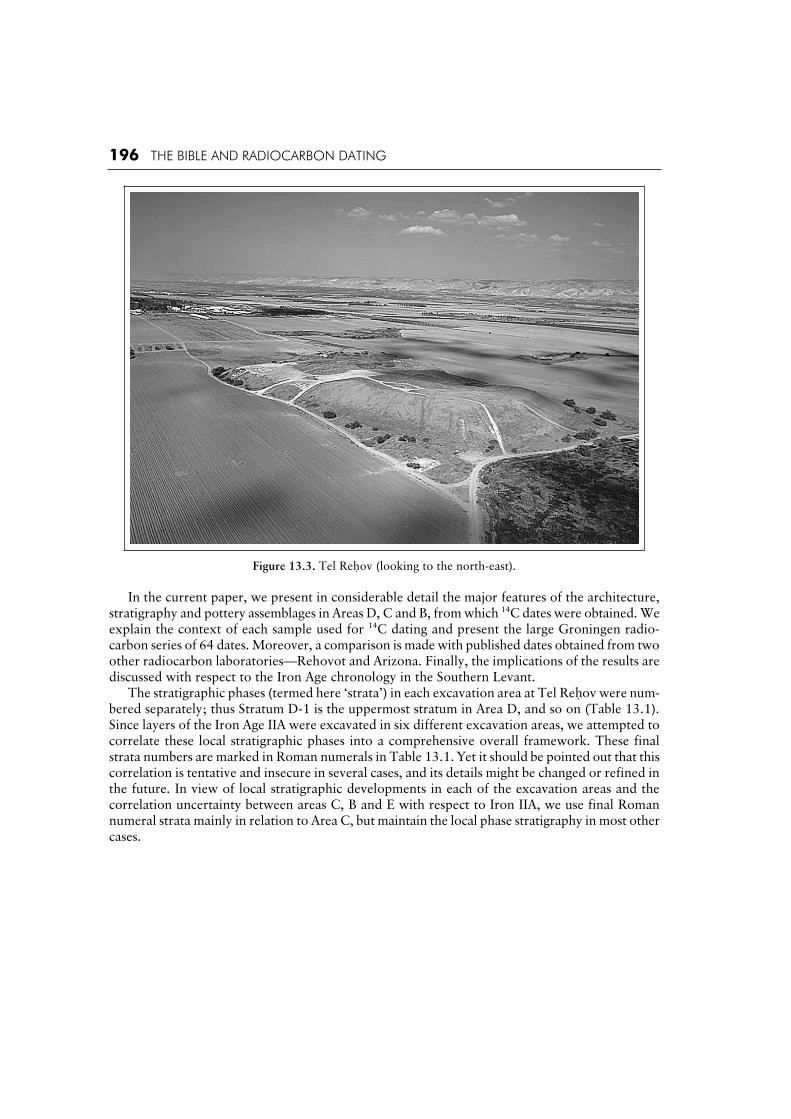
Figure 13.3. Tel Rehov (looking to the north-east).
In the current paper, we present in considerable detail the major features of the architecture, stratigraphy and pottery assemblages in Areas D, C and B, from which 14C dates were obtained. We explain the context of each sample used for 14C dating and present the large Groningen radio-carbon series of 64 dates. Moreover, a comparison is made with published dates obtained from two other radiocarbon laboratories—Rehovot and Arizona. Finally, the implications of the results are discussed with respect to the Iron Age chronology in the Southern Levant. The stratigraphic phases (termed here ‘strata’) in each excavation area at Tel Rehov were num-bered separately; thus Stratum D-1 is the uppermost stratum in Area D, and so on (Table 13.1). Since layers of the Iron Age IIA were excavated in six different excavation areas, we attempted to correlate these local stratigraphic phases into a comprehensive overall framework. These final strata numbers are marked in Roman numerals in Table 13.1. Yet it should be pointed out that this correlation is tentative and insecure in several cases, and its details might be changed or refined in the future. In view of local stratigraphic developments in each of the excavation areas and the correlation uncertainty between areas C, B and E with respect to Iron IIA, we use final Roman numeral strata mainly in relation to Area C, but maintain the local phase stratigraphy in most other cases.

LADDER OF TIME AT TEL REHOV 197
Table 13.1. Stratigraphic table of Tel Rehov, showing the correlation between the different excavation areas.
Genera Stratum
Local Strata in Individual Excavation Areas Period Conventional Time frame (BCE)
II - - - - - B-2 A-2 Iron Age IIB/C
After 732
III - - B-3
A-3a
A-3b
Iron Age IIB Until 732
IV - C-1a E-1a F-1 G-1 B-4* A-4
V D-1(?) C-1b E-1b 2 2 5a*
5b
VI D-2 C-2 E-2 F-3-4 G-3 B-6 Iron Age IIA
Until ca. 830–840
From ca. 980
VII D-3
D-4
D-5
C-3
Iron Age
IB
Until 990–980
ca. 1130 (?)
D-6
D-7
Iron Age IA 12th century
D-8 D-9a
D-9b
Late Bronze IIB
13th century
D-10
Late Bronze
I-IIA
15th–14th century
D-11 MB/LBI 16th century
* Needs further clarification in the future. It is possible that 5a should be correlated with general Stratum IV.
14C Dates from Tel Rehov: An Overview3
The following groups of 14C dates from Tel Rehov were published previously: (a) A total of 15 dates from seven loci, measured during the years 1998–99 in the 14C Labora-
tory of the Weizmann Institute in Rehovot (hereafter: Rehovot, laboratory code RT) measured conventionally by Liquid Scintillation Counting (LSC) (Mazar and Carmi 2001; cited in the present paper, Tables 13.2 and 13.4). Nine of these were charred grain samples from Locus 2425 of Area C; three were samples of olive stones from various phases in Area D, and an additional three samples consisted of charred timber used for construction in Areas C and E. Also included is one date from Stratum D-3 prepared at Rehovot and measured at Tucson (RTT-3805).
(b) Nine dates of charred grain from Locus 2425 were measured in the AMS laboratory of the University of Arizona (hereafter: Arizona, laboratory code AA; Mazar and Carmi 2001: 1338; cited in the present paper, Table 13.4).
(c) A series of 34 dates of charred grains and olive stones from 14 loci, measured during 2001–2002 at the Radiocarbon Laboratories of the University of Groningen were published in 2003 (Bruins, van der Plicht and Mazar 2003a, 2003b; Tables 13.2 and 13.3 in the present paper). The two Groningen 14C labs, situated at the Centre for Isotope Research (hereafter Groningen), have separate pre-treatment and different measurement procedures: (1) con-ventional radiometry by Proportional Gas Counting (PGC); (2) AMS. The laboratory radio-carbon date codes are GrN and GrA, respectively (see van der Plicht and Bruins [Chapter 14, this volume] for a more extensive treatment of laboratory procedures).
3. All 14 dates in this paper were calibrated in OxCal 3.9 (Bronk Ramsey 2003).

Table
13.2
. R
adio
carb
on d
atin
g r
esult
s fr
om
Iro
n A
ge
I Str
ata
in A
rea
D a
t T
el R
eho
v.
GrN
: G
ronin
gen
PG
C m
eth
od
.; G
rA:
Gro
nin
gen
, A
MS m
eth
od
; R
T:
Reh
ovo
t L
SC
met
ho
d (
cite
d f
rom
Maz
ar a
nd
Car
mi
20
01
); R
TT
: R
eho
vot,
AM
S (
see
foo
tno
te 9
).
Stra
tum
and
Per
iod
Locu
s B
asket
C
har
red
Org
anic
Mat
eria
l
Lab
. N
o.
14C
Dat
e
(BP)
13C
(‰)
14C
Dat
e B
P o
r
Ave
rage
use
d i
n
cali
bra
tion
1 C
alib
rate
d D
ate
1998 C
urv
e O
xC
al v
3.9
(yea
r B
CE)
2 C
alib
rate
d D
ate
1998 C
urv
e O
xC
al v
3.9
(yea
r B
CE)
18
58
2
83
95
O
live
sto
nes
R
T-3
12
0
26
70
± 4
0
–2
0.8
0
Sam
e 8
92
–8
80
(1
1.4
%)
83
6–7
99
(5
6.8
%)
90
0–7
95
(9
5.4
%)
28
62
2
84
93
O
live
sto
nes
R
TT
-38
05
2
80
0 ±
20
Sam
e 1
00
0–9
85
(6
.7%
)
97
5–9
50
(2
4.8
%)
94
5–9
05
(3
6.7
%)
1010–890 (
95
.4%
)
2862
28493
Olive
sto
nes
G
rA-1
90
33
GrN
-26119
28
35
± 4
5
27
20
± 3
0
–2
3.0
3
–2
2.3
3
2835 ±
45
1046–920 (
68
.2%
) 1128–896 (
93
.5%
)
877–857 (
1.9
%)
4815
48105
Olive
sto
nes
G
rA-1
67
57
2820 ±
50
–22.5
1
sam
e 1042–1031 (
3.8
%)
1022–901 (
64
.4%
)
1126–891 (
87
.0%
)
881–835 (
8.4
%)
48
16
4
81
03
O
live
sto
nes
Char
coal
GrA
-128
89
GrA
-168
48
28
70
± 7
0
28
95
± 4
0
–2
5.2
9
–2
4.4
1
2870 ±
70
1188–1181 (
2.1
%)
1150–1144 (
1.6
%)
1128–970 (
55
.2%
)
960–928 (
9.3
%)
1260–1228 (
3.8
%)
1221–894 (
88
.8%
)
87
8–8
39
(2
.9%
)
D-3
Iro
n I
B
4830
48115
Olive
sto
nes
G
rA-2
10
44
GrA
-210
56
GrA
-211
83
GrA
-223
02a
GrA
-223
02b
GrA
-223
29a
GrA
-223
29b
28
45
± 3
5
28
25
± 3
5
28
20
± 5
0
27
30
± 5
0
28
20
± 4
0
28
10
± 5
0
27
60
± 4
0
–2
2.0
5
–2
3.3
0
–2
3.3
5
–2
3.0
0
sam
e
–2
2.6
3
sam
e
firs
t 3 d
ates
28
32
± 2
2
5 c
oh
eren
t d
ates
28
27
± 1
8
1004–970 (
40
.0%
)
95
9–9
34
(2
8.2
%)
1001–971 (
39
.9%
)
95
8–9
37
(2
8.3
%)
1044–918 (
95
.4%
)
1018–916 (
95
.4%
)

1836
48450
Olive
sto
nes
G
rN-2
6121
GrA
-188
25
28
90
± 3
0
28
70
± 5
0
–2
2.9
5
–2
2.9
9
2885 ±
26
1125–1119 (
3.3
%)
1112–1098 (
10.0
%)
1087–1059 (
18.0
%)
1053–1005 (
36.9
%)
1189–1179 (
2.9
%)
1154–1143 (
2.2
%)
1129–996 (
86
.3%
)
990–974 (
2.5
%)
955–943 (
1.6
%)
1845
48556
See
ds
GrA
-210
46
GrA
-210
57
GrA
-211
84
29
05
± 3
5
29
45
± 3
5
29
20
± 5
0
–2
2.4
9
–2
3.1
0
–2
4.1
2
2924 ±
22
1208–1202 (
3.6
%)
1189–1179 (
7.2
%)
1154–1142 (
8.1
%)
1129–1108 (
15.1
%)
1102–1067 (
23.7
%)
1065–1050 (
10.4
%)
1254–1244 (
2.3
%)
1212–1199 (
6.2
%)
1192–1139 (
25.7
%)
1132–1020 (
61.2
%)
D-4
Iro
n I
B
1845
28243
Olive
sto
nes
R
T-3
121
2800 ±
40
–21.1
0
sam
e
999–902 (
68.2
%)
1044–887 (
81.6
%)
8
84–833 (
13.8
%)
1876
28536
Olive
sto
nes
R
T-3
119
2685 ±
40
–20.7
0
sam
e
896–876 (
18.1
%)
8
58
–8
52
(4
.2%
)
841–802 (
45.9
%)
905–797 (
95.4
%)
2836
28352
Olive
sto
nes
G
rN-2
6118
GrA
-188
26
29
20
± 3
0
29
50
± 5
0
–2
2.2
8
–2
2.4
6
2928 ±
26
1209–1201 (
5.1
%)
1190–1178 (
7.9
%)
1159–1141 (
11.3
%)
1130–1108 (
13.8
%)
1102–1067 (
20.8
%)
1066–1050 (
9.2
%)
1257–1239 (
4.9
%)
1213–1197 (
7.4
%)
1194–1138 (
28.1
%)
1133–1018 (
55.0
%)
D-6
Iro
n I
A
2874
28701
Olive
sto
nes
G
rA-1
90
34
GrN
-26120
29
35
± 4
5
28
80
± 3
0
–2
2.1
4
–2
2.3
6
2897 ±
25
1126–1040 (
60.6
%)
1032–1020 (
7.6
%)
1210–1200 (
2.0
%)
1191–1177 (
4.5
%)
1161–1141 (
4.6
%)
1130–1000 (
84.3
%)

Table
13.3
. C
alib
rate
d G
ronin
gen
rad
ioca
rbo
n d
ates
fro
m I
ron I
IA S
trat
a of
Tel
Reh
ov.
Loca
lSt
ratu
m &
G
ener
alSt
ratu
m
Arc
hit
ectu
ral
Un
it
Locu
s B
asket
C
har
red
Org
anic
Mat
eria
l
Lab
. N
o.
14C
Dat
e (B
P)
13C
(‰)
14C
Dat
e B
P
or
Ave
rage
use
d i
n
cali
bra
tion
1 C
alib
rate
d
Dat
e 1
99
8
Curv
e O
xC
al
v3.9
(yea
r B
CE)
2 C
alib
rate
d
Dat
e 1
99
8 C
urv
e O
xC
al v
3.9
(y
ear
BC
E)
C-1
aIV
Buildin
g F
D
estr
uct
ion
54
98
5
47
02
C
erea
l gra
ins
GrA
-211
52
GrA
-211
54
GrA
-212
67
GrA
-223
01a
GrA
-223
01b
GrA
-223
30a
GrA
-223
30b
27
70
±
50
2
73
0 ±
5
0
27
60
±
35
27
10
±
45
2
77
5 ±
4
0
27
60
±
50
27
85
±
40
–2
2.5
4–2
2.2
8–2
2.7
4
–2
2.3
4sa
me
–2
2.3
2
sam
e
3 d
ates
2
75
5 ±
2
5
all
7 d
ates
2
75
8 ±
1
6
91
8–8
93
(25.0
%)
87
9–8
37
(43.2
%)
91
8–8
95
(28.2
%)
87
7–8
40
(40.0
%)
970–959 (
6.0
%)
93
4–8
30
(89.4
%)
969–960 (
4.7
%)
92
6–8
33
(90.7
%)
E-1
b ?
?
Co
urt
yard
in
San
ctuar
y
26
18
4
62
81
O
live
sto
nes
G
rA-1
72
60
2
74
5 ±
4
0
–2
1.9
8
27
45
±
40
9
15
–8
33
(68.2
%)
997–988 (
1.4
%)
974–953 (
7.4
%)
94
5–8
11
(86.5
%)
B-5
IV o
r V
?B
elow
D
estr
uct
ion
Lay
er
6229
62430
See
ds
GrA
-241
08
GrA
-241
09
GrA
-241
11
GrA
-241
12
GrN
-28368
27
65
±
45
2
77
0 ±
4
5
27
80
±
45
27
50
±
45
2
73
5 ±
3
0
–2
3.6
0 a
lkal
i –2
3.6
0 a
lkal
i –2
4.3
0 s
eed
s
–2
6.4
0 s
eed
s –2
3.6
0 t
ota
l
all
5 d
ates
2
75
5 ±
1
8
91
5–8
95
(24.1
%)
87
7–8
39
(44.1
%)
968–961 (
3.8
%)
92
5–8
32
(91.6
%)
B-5
?
V ?
0
.2 m
abo
ve
Wal
l 1241 o
f Str
atum
B-5
1224
41016
Olive
sto
nes
G
rN-2
7365
2765 ±
15
–22.9
8
2765 ±
15
967–962 (
5.2
%)
92
2–8
96
(37.9
%)
87
6–8
58
(16.8
%)
85
2–8
42
(8.3
%)
970–959 (
8.6
%)
93
4–8
90
(48.0
%)
88
2–8
35
(38.8
%)
B-5
VStr
atum
V
Des
truct
ion
Lay
er
42
18
42
23
6
Oli
ve s
ton
es
Oli
ve s
ton
es
Oli
ve s
ton
es
Char
coal
Char
coal
Char
coal
GrA
-210
34
GrA
-210
47
GrA
-211
79
GrA
-210
42
GrA
-210
53
GrA
-211
80
27
60
±
35
2
82
0 ±
3
5
27
70
±
50
2
76
5 ±
3
5
27
50
±
35
26
90
±
50
–2
1.8
6–2
1.7
6
–2
2.4
3–2
3.8
0–2
5.6
2
–2
6.3
6
Oli
ve s
ton
es
27
86
±
22
995–991 (
1.9
%)
97
3–9
56
(19.4
%)
94
2–8
99
(46.9
%)
99
9–8
95
(83.7
%)
87
7–8
41
(11.7
%)
C-1
b
V
Buil
din
g E
Flo
or
surf
ace
in r
oo
m
6449
64756
Olive
sto
nes
G
rA-2
44
55
GrA
-244
56
GrA
-244
97
27
75
±
45
27
50
±
45
2
74
5 ±
4
5
–2
3.7
3
n/a
n/a
27
57
±
26
9
19
–8
93
(26.5
%)
87
9–8
37
(41.7
%)
971–957 (
7.1
%)
93
8–8
30
(88.3
%)

C-1
bV
Str
atum
V
Des
truct
ion
Lay
er
24
22
2
44
08
C
erea
l G
rain
s G
rN-2
7361
GrN
-27362
GrN
-27412
27
64
±
11
2
77
7 ±
1
3
27
85
±
28
–2
2.1
1–2
2.1
5
–2
2.4
3
27
71
±
8
96
9–9
61
(1
1.2
%)
92
5–8
97
(55.7
%)
872–870 (
1.3
%)
97
0–9
59
(12.7
%)
93
5–8
94
(62.0
%)
87
8–8
40
(20.7
%)
C-1
bV
Str
atum
V
Des
truct
ion
Lay
erB
uildin
g G
So
uth
ern
roo
m
24
41
24
57
9
Cer
eal
Gra
ins
Coar
seM
idd
le
Fin
e fr
acti
on
GrN
-26116
GrN
-26117
GrN
-27363
GrN
-27385
GrN
-27386
28
10
±
20
2
77
5 ±
2
5
27
45
±
15
2
77
1 ±
1
5
27
61
±
15
–2
2.6
4–2
3.1
4
–2
2.6
6–2
2.3
1–2
2.3
7
all
5 d
ates
2
76
7 ±
7
967–962 (
6.6
%)
92
2–8
96
(52.1
%)
874–864 (
9.5
%)
969–960 (
8.7
%)
93
0–8
93
(57.3
%)
87
9–8
38
(29.4
%)
C-1
b o
r a
V o
r IV
D
estr
uct
ion
Lay
erB
uildin
g G
Mid
dle
ro
om
24
44
24
64
7
Cer
eal
Gra
ins
Fin
e
frac
tion
GrN
-27364
GrN
-27413
27
64
±
11
2
86
6 ±
2
1
–2
2.1
5–2
2.0
42764 ±
11
966–963 (
3.5
%)
92
1–8
96
(42.0
%)
87
6–8
60
(16.5
%)
850–844 (
6.3
%)
969–960 (
7.0
%)
93
0–8
91
(49.3
%)
88
1–8
36
(39.1
%)
C-1
b o
r a
V o
r IV
D
estr
uct
ion
Lay
erB
uildin
g G
Mid
dle
ro
om
2425
Conti
n-
uat
ion o
f
2444
24
30
6
Cer
eal
Gra
ins
GrN
-26114
GrN
-26115
27
75
±
20
2
80
0 ±
2
0
–2
2.4
2–2
1.4
52
78
8 ±
14
9
71
–9
59
(2
0.7
%)
93
5–9
03
(47.5
%)
998–981 (
5.7
%)
97
6–8
96
(86.9
%)
876–860 (
2.8
%)
C-2
VI
Buil
din
g A
Bel
ow
bo
wl
above
flo
or
44
26
44
16
6
Cer
eal
Gra
ins
Fin
e C
har
coal
Fin
e C
har
coal
Fin
e
Char
coal
Bo
ne
GrN
-27366
GrA
-210
43
GrA
-210
54
GrA
-211
82
GrA
-214
17
27
61
± 1
4
27
55
±
35
2
80
5 ±
3
5
28
00
±
50
28
40
±
45
–2
2.4
8
–2
5.5
0–2
4.7
4–2
4.6
8
–1
9.6
4
all
5 d
ates
27
72
± 1
1
96
9–9
60
(12.4
%)
92
8–8
97
(52.2
%)
873–868 (
3.6
%)
97
1–9
58
(14.0
%)
93
6–8
93
(59.5
%)
87
9–8
39
(21.9
%)
D-2
V/V
I
Ref
use
deb
ris
18
23
1
81
83
O
live
sto
nes
G
rN-2
61
13
GrA
-190
30
27
60
±
30
27
50
±
50
–2
2.1
5
–2
3.2
9
27
57
± 2
6
91
9–8
93
(26.9
%)
87
9–8
37
(41.3
%)
971–957 (
7.3
%)
93
9–8
30
(88.1
%)
D-2
V/V
IR
efuse
dep
osi
ts1802
18119
Olive
sto
nes
G
rN-2
6112
2805 ±
15
–22.4
6
2805 ±
15
997–989 (
8.5
%)
97
4–9
54
(25.9
%)
94
4–9
19
(33.8
%)
99
9–9
13
(91.8
%)
912–905 (
3.6
%)

202 THE BIBLE AND RADIOCARBON DATING
Moreover, 30 additional Groningen dates from Tel Rehov are presented in this paper (included in Tables 13.2 and 13.3). Therefore, the entire Groningen series of Tel Rehov totals an impressive 64 radiocarbon dates, the largest lab series available for a single Iron Age site in the Levant (see also van der Plicht and Bruins [Chapter 14, this volume], for intercomparison and quality control assessment of the Groningen series; and Bruins et al. [Chapter 15, this volume], for Bayesian mod-elling of the Groningen Tel Rehov dates through statistical stratigraphic analysis, with emphasis on the Iron Age IIA destruction events). Virtually all organic samples used in the 14C age determinations from Tel Rehov (except the three mentioned in section [a] above) are short-lived and came generally from the best stratigraphic contexts available in each stratum, as explained in detail below.4 Tables 13.2–4 provide details concerning all these dates.5 There are 23 Groningen dates of Iron Age I strata (derived from 8 different loci) and 41 Groningen dates of Iron IIA strata (from 13 different loci). Moreover, published 14C dates from other labs are also included in the tables and the text.6
The Iron Age I
The Iron Age I was explored at Tel Rehov mainly in Area D (Figs. 13.4–5), where a step trench was excavated on the western slope of the lower city (Mazar 1999: 9-16). The first excavations resulted in a 5 m wide trench, which was subsequently widened to 10 m in certain parts. Eleven strata were determined in this section, numbered D-11 to D-1 (Table 13.1). Strata D-11 to D-8 belong to the Late Bronze Age, D-7 to D-3 to the Iron Age I and D-2 and D-1 to the Iron Age IIA. The latest three strata can be correlated with the stratigraphy in the adjacent Area C, as indicated in Table 13.1. The steep slope of the tell in this area limited the spatial exposure of each stratum to no more than about 20–40 m2.
Stratum D-6.The underlying Stratum D-7 contained several walls and floors, while D-6 included only several floor surfaces but very little architecture. The pottery from both these strata is similar to that of Tel Beth Shean Level VI (University of Pennsylvania excavations) and Strata S-4 and S-3 (Hebrew University excavations; Mazar 1993, 2003a: 324, 333-37). Therefore, it is safe to date Stratum D-6 to the Iron Age IA,7 parallel to the time of the Egyptian XXth Dynasty (most probably between the time of Ramesses III and Ramesses VI). It is noteworthy to mention that the small amount of pottery from D-6 included two sherds of imported Mycenaean IIIC ceramics. Samples of charred olive stones from three loci of Stratum D-6 were dated, one locus at Rehovot and two at Groningen (both PGC and AMS techniques). The results are as follows:
Locus 1876. Accumulation of floor surfaces (striations) in Square P4. The surfaces were between levels 82.19–82.93 m; the particular sample came from level 82.77 m. Dated at Rehovot (RT-3119) to 2685 40 BP, which is 243 BP years younger than the average of two Groningen dates presented below. The calibrated age of the Rehovot date lies in the 9th century BCE. This is much too young by all standards, as already stated in the initial publication (Mazar and Carmi 2001: 1336), and the above date is consequently rejected.
4. Finkelstein and Piaszetky (2003a, 2003b) criticize some of our contexts as unreliable. We reject this criticism, and
explain the nature of each context in some detail in the following paragraphs. 5. Much of the data and following discussion, mainly concerning the Iron Age I, appears also in Bruins, Mazar and van der Plicht (in press).
6. The tables don’t include three dates of charred beams published previously by Mazar and Carmi 2001: 1337, Table 5. 7. We use here the term Iron IA for the period of the Egyptian 20th Dynasty, following the terminology in Stern
(ed.) 1993. It is worth pointing out that some Israeli scholars include this period in the Late Bronze Age (Ussishkin 1985; Gilboa and Sharon 2003).

Figure 13.4. Area D: general view (looking east).

Fig
ure
13
.5.
Are
a D
: sc
hem
atic
sec
tio
n.
LADDER OF TIME AT TEL REHOV 205
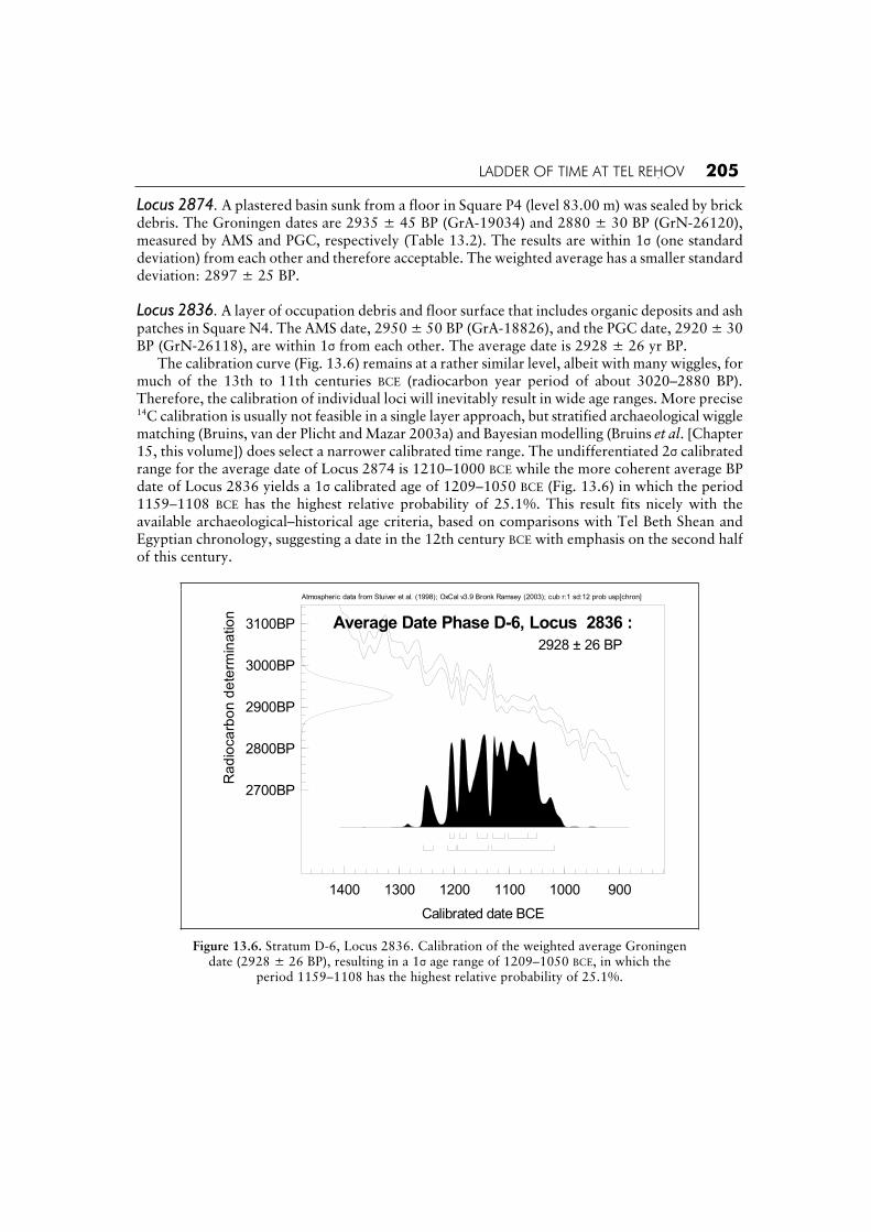
Locus 2874. A plastered basin sunk from a floor in Square P4 (level 83.00 m) was sealed by brick debris. The Groningen dates are 2935 ± 45 BP (GrA-19034) and 2880 ± 30 BP (GrN-26120), measured by AMS and PGC, respectively (Table 13.2). The results are within 1 (one standard deviation) from each other and therefore acceptable. The weighted average has a smaller standard deviation: 2897 ± 25 BP.
Locus 2836. A layer of occupation debris and floor surface that includes organic deposits and ash patches in Square N4. The AMS date, 2950 ± 50 BP (GrA-18826), and the PGC date, 2920 ± 30 BP (GrN-26118), are within 1 from each other. The average date is 2928 ± 26 yr BP. The calibration curve (Fig. 13.6) remains at a rather similar level, albeit with many wiggles, for much of the 13th to 11th centuries BCE (radiocarbon year period of about 3020–2880 BP). Therefore, the calibration of individual loci will inevitably result in wide age ranges. More precise 14C calibration is usually not feasible in a single layer approach, but stratified archaeological wiggle matching (Bruins, van der Plicht and Mazar 2003a) and Bayesian modelling (Bruins et al. [Chapter 15, this volume]) does select a narrower calibrated time range. The undifferentiated 2 calibrated range for the average date of Locus 2874 is 1210–1000 BCE while the more coherent average BP date of Locus 2836 yields a 1 calibrated age of 1209–1050 BCE (Fig. 13.6) in which the period 1159–1108 BCE has the highest relative probability of 25.1%. This result fits nicely with the available archaeological–historical age criteria, based on comparisons with Tel Beth Shean and Egyptian chronology, suggesting a date in the 12th century BCE with emphasis on the second half of this century.
Atmospheric data from Stuiver et al. (1998); OxCal v3.9 Bronk Ramsey (2003); cub r:1 sd:12 prob usp[chron]
1400 1300 1200 1100 1000 900
Calibrated date BCE
2700BP
2800BP
2900BP
3000BP
3100BP
Ra
dio
ca
rbo
n d
ete
rmin
atio
n
Average Date Phase D-6, Locus 2836 :
2928 ± 26 BP
Figure 13.6. Stratum D-6, Locus 2836. Calibration of the weighted average Groningen date (2928 ± 26 BP), resulting in a 1 age range of 1209–1050 BCE, in which the
period 1159–1108 has the highest relative probability of 25.1%.

206 THE BIBLE AND RADIOCARBON DATING
Figure 13.7. Area D: selected pottery from Stratum D-4.

LADDER OF TIME AT TEL REHOV 207
Strata D-5 and D-4.Going up in the stratigraphy, Strata D-5 and D-4 constitute two distinct architectural periods. Both relate in spatial–urban terms to a north–south oriented street that is flanked by buildings on both sides. The occupation debris of D-5, which is sealed by that of D-4, has hardly been excavated. However, a substantial area of Stratum D-4 was exposed, yielding a well-defined Iron Age IB pottery assemblage (Fig. 13.7 presents the main pottery types represented in this assemblage). Pottery vessels are often painted in red, but in this pottery assemblage red slip is very rare and burnish does not appear at all. Floor surfaces of Stratum D-4 were excavated in the street as well as in a courtyard paved with cobble stones. The original floor surfaces in both cases were raised from time to time during the lifespan of this city, resulting in a succession of striated floor surfaces, some of which could be dated by 14C.
Locus 1845 (Phase D-4b). A cluster of charred seeds found on the Stratum D-4b cobble floor of the courtyard, below thick accumulation of occupation striations.8 The seeds were dated by both the Rehovot and Groningen labs. The Rehovot date (RT-3121) is 2800 ± 40 BP and the calibrated age lies in the 10th century BCE, which would fit the ‘low chronology’ (Mazar and Carmi 2001: 1336, Table 3). The three AMS dates from Groningen are older than the Rehovot date by more than a century: 2905 ± 35 (GrA-21046), 2945 ± 35 (GrA-21057) and 2920 ± 50 BP (GrA-21184). The Groningen results are close to each other, mostly within 1 , indicating high-quality dates with robust repeatability (Scott [ed.] 2003). The weighted average for these dates is 2924 ± 22 yr BP, while the chi-squared test (Bronk Ramsey 2003) underlines the high degree of coherence of the three AMS dates, T = 0.7, which is very low compared to the 5% confidence limit of 6.0, above which T should not rise. The calibrated 1 age range is 1208–1050 BCE.
Locus 1836 (Phase D-4a). Locus 1836 marks a series of striated floor surfaces accumulated above cobble floor 1845. A cluster of charred olive stones was found at the bottom of this accumulation, close to cobble floor 1845 (level 84.18 m). The two Groningen dates, measured by both PGC and AMS, gave very similar results: 2890 ± 30 yr BP (GrN-26121) and 2870 ± 50 yr BP (GrA-18825), respectively (Table 13.2). The chi-squared test shows the high level of coherence between the dates: T = 0.1, which is well below 3.8, the 5% confidence level (Fig. 13.8). The weighted average is 2885 ± 26 yr BP, being 39 radiocarbon years younger than the average of the sample found on cobble floor 1845, which neatly fits the stratigraphy. This difference in the BP dates may reflect the time that passed between the accumulation of these respective floor surfaces. The calibrated 1date of Locus 1836 (Fig. 13.8) is 1124–1120 (2.8%), 1112–1098 (9.9%), 1086–1060 (17.7%) and 1053–1005 (37.8%) BCE. Taking the stratigraphic sequence into consideration, a date in the 11th century BCE for Stratum D-4 is most likely. The lowest floor (1845) may be dated to the early or mid-11th century and the striations on top of it (Locus 1836) were accumulated during the second half of the 11th century. Indeed the highest relative probability (37.8%) of the 1 calibrated age range of the higher floor surfaces in Stratum D-4 (Locus 1836) is the period 1053–1005 BCE (Fig. 13.8). The Groningen dates for both D-4 loci support the conventional archaeological age for Iron IB period, to which this stratum belongs in terms of pottery typology (see Fig. 13.7). The single Rehovot date is much younger than all five Groningen dates of D-4.
8. Basket 28243 came from squares N-P-4 at level 83.80 m; basket 48556 came from Square N5 at level 84.05 m.

208 THE BIBLE AND RADIOCARBON DATING
Atmospheric data from Stuiver et al. (1998); OxCal v3.9 Bronk Ramsey (2003); cub r:2 sd:12 prob usp[strat]
1300 1200 1100 1000 900 800
Calibrated date BCE
2600BP
2700BP
2800BP
2900BP
3000BP
3100BP
Ra
dio
ca
rbo
n d
ete
rmin
atio
n R_Combine Tel Rehov Phase D-4a Locus 1836 :
2885 ± 26 BPX2-Test: df=1 T=0.1(5% 3.8)
Figure 13.8. Stratum D-4a, Locus 1836. Calibration of the weighted average Groningen date (2928 ± 26 BP), resulting in a 1 age range of 1124–1005 BCE,in which the period 1053–1005 has the highest relative probability of 37.8%.
Stratum D-3. More than 30 small and shallow pits concentrated in an accumulation layer less than one meter thick make up Stratum D-3. Some of the pits penetrated the underlying destruction debris of Stratum D-4 and some cut each other. Thus, the activity represented by these pits might have lasted quite some time. Some of the pits were covered with thin white plaster while others were not. The function of these pits remains obscure; it seems that they were used for storage or refuse, with the former option appearing more reasonable. The small amount of pottery sherds found in the pits are of similar types as the pottery from Stratum D-4 (Fig. 13.9 presents a selec-tion of the main types). The pits were sealed by a thick layer of debris (Locus 1802, Stratum D-2) containing Iron IIA pottery. Ten 14C dates of charred olive stones from five different pits are available (Table 13.2). The olive stones were always found together in clusters inside the pits. Thus, their stratigraphic context should be considered reliable.
Pit 4830. A shallow, unplastered and ill-defined pit in Square Q-4. The concentration of olive pits found here at level 85.15 m could also belong to an occupation layer between the pits. In any event, this locus is above the uppermost brick debris of Stratum D-4, and is cut by Pit or Bin 2872, attributed to Stratum D-3 or D-2. Seven AMS dates were measured at Groningen, in two sets. The triplicate results of the first AMS series are as follows: 2845 ± 35 BP (GrA-21044), 2825 ± 35 BP (GrA-21056) and 2820 ± 50 BP (GrA-21183). These results are very close, within 1 from each other. The chi-squared test underscores the high quality of this first series of three AMS measure-ments, as T = 0.2, which is very small compared to the 5% confidence limit of 6.0. The weighted average date is 2832 ± 22 BP.

LADDER OF TIME AT TEL REHOV 209
Figure 13.9. Area D: selected pottery from Stratum D-3.
The calibrated age (Fig. 13.10) gives two possible options in the 1 range: 1004–970 (40.0%) and 959–934 (28.2%) BCE. The first period (1004–970 BCE) has the highest relative probability. Notice that the date is too old for the 975–955 BCE wiggle, which is excluded in the 1 range (Fig. 13.10). The latter wiggle fits very well with Stratum VI of Area C (presented below). Since Stratum VI overlies Stratum VII, which can be equated with Stratum D-3 in ceramic terms, the period 1004–970 BCE is also preferable in sequential stratigraphic terms. The second set of four measurements resulted in two dates similar to the first series, 2820 ± 40 BP (GrA-22302b), 2810 ± 50 BP (GrA-22329a), and two younger dates, 2730 ± 50 BP (GrA-22302a), 2760 ± 40 BP (GrA-22329b). The youngest and oldest dates of the two series are still within the 2 overlap range. Hence, in physical–statistical terms all dates are acceptable. Here we are at the limit of measurement resolution and measurement variability inherent in radiocarbon dating (Mook and Waterbolk 1985: 10), discussed by van der Plicht and Bruins (Chapter 14, this volume). Taking the weighted average of all seven dates, 2807 ± 16 BP, the chi-squared test shows the lower coherence between the dates, as T = 5.3, but still well acceptable in comparison to the 5% confidence limit of 12.6. The calibrated age of 2807 ± 16 BP still favours the latter half of the 10th century BCE, but the younger range has only a slightly lower relative probability: 997–953 (34.9%), 945–920 (33.4%) BCE (Fig. 13.11).

210 THE BIBLE AND RADIOCARBON DATING
Atmospheric data from Stuiver et al. (1998); OxCal v3.9 Bronk Ramsey (2003); cub r:2 sd:12 prob usp[strat]
1200 1100 1000 900 800
Calibrated date BCE
2600BP
2700BP
2800BP
2900BP
3000BP
Ra
dio
ca
rbo
n d
ete
rmin
atio
n R_Combine Tel Rehov D-3 Locus 4830 :
2832 ± 22 BP (First AMS series)X2-Test: df=2 T=0.2(5% 6.0)
Figure 13.10. Stratum D-3, Locus 4830. Calibration of the weighted average Groningen date (2832 ± 22 BP) of the first AMS series (3 dates). The period 1000–970 BCE has the highest
relative probability of 40.0%. Notice that the date is too old for the 975–955 BCE wiggle, which is excluded in the 1 range. The latter wiggle fits very well with Stratum VI of
Area C, overlying Stratum VII which is similar in terms of ceramics to Stratum D-3.
Atmospheric data from Stuiver et al. (1998); OxCal v3.9 Bronk Ramsey (2003); cub r:2 sd:12 prob usp[strat]
1100 1000 900 800
Calibrated date BCE
2600BP
2700BP
2800BP
2900BP
3000BP
Ra
dio
ca
rbo
n d
ete
rmin
atio
n R_Combine Tel Rehov D-3 Locus 4830 :
Average 5 coherent dates 2827 ± 18 BPX2-Test: df=4 T=0.4(5% 9.5)
Figure 13.11. Stratum D-3, Locus 4830. Calibration of the weighted average Groningen date (2827 ± 18 BP) of 5 coherent AMS dates of two series.
Notice again the exclusion of the 975–955 wiggle.

LADDER OF TIME AT TEL REHOV 211
It is clear that the difference of 115 midpoint BP years between the oldest date 2845 ± 35 BP (GrA-21044) and the youngest date 2730 ± 50 (GrA-22302a) is quite large. The repeatability of the second series is clearly inferior to that of the coherent first series. Since two dates of the second series are similar to the results of the first series, we have altogether five coherent dates. The two young dates are outliers, not in the classical sense as they are within the 2 overlap range, but in comparative terms. If one only takes the consistent five dates of Locus 4830, the weighted average becomes 2827 ± 18 BP, while the chi-squared test shows an excellent coherence, T = 0.4, which is very low in comparison to the 5% confidence limit of 9.5. The calibrated date of 2827 ± 18 BP is 1001–971 (39.9%) and 958–937 (28.3%) BCE, again favouring the oldest three decades of the 10th century BCE, while the wiggle of 971–958 BCE (fitting Stratum VI) is excluded in the 1 range. In conclusion, the most probable date of Stratum D-3 Locus 4830, both in terms of calibration and sequential stratigraphy, is the period 1000–970 BCE.
Pit 4816. This is a plastered pit cut into mudbrick wall 4859 of Phase D-4. The olive stones were found between two plastered surfaces in the pit, at level 85.40 m. The amount of material was small, even for AMS, resulting in a date with a somewhat larger standard deviation (2870 ± 70 BP [GrA-12889]). The 1 calibrated range is 1188–1181 (2.1%), 1150–1144 (1.6%), 1128–970 (55.2%), 960–928 (9.3%) BCE. Fine charcoal from the same layer was dated separately, also by AMS, giving a date of 2895 ± 40 BP (GrA-16848). The results are close to each other, within 1 ,while the charcoal is slightly older than the olive pit fragments, as might be expected. The calibrated results favour the 11th and 10th centuries BCE. Pit 4815. This is a large and deeply cut pit, with many layers of debris. A cluster of 15 charred olive stones was found at levels 85.15–85.30 m. A single Groningen measurement gave a date of 2820 ± 50 BP (GrA-16757), which is identical to one of the dates from Pit 4830. The relatively large standard deviation of 50 BP years results in a rather wide 1 calibrated age range: 1042–1031 (3.8%), 1022–901 (64.4%) BCE. A date from 1000–950 BCE has the highest relative probability, being the principal area of intersection of the mid-point of the BP date with the calibration curve, resulting in the highest peaks.
Pit 2862. This is a shallow plastered pit. Olive stones were found at level 85.70 m. An AMS measurement from Groningen gave a date of 2835 ± 45 BP (GrA-19033), which is very similar to the dating results for Pit 4815 and Pit 4830 (Fig. 13.12). However, a PGC date from Groningen of the same material is much younger, 2720 ± 30 BP (GrN-26119). This is a rare outlier with a difference of about 4 , which is too much. The reason for the discrepancy is due to the small amount of material, which was too little for normal PGC measurement, as presented in detail by van der Plicht and Bruins (Chapter 14, this volume). A sample from the same organic material from Pit 2862 was more recently measured at Rehovot by AMS resulting in a date of 2800 20 BP (RTT 3805; average of three dates).9 This result is only slightly younger than the above Groningen AMS date, remaining within the 2 range and therefore similar in physical–mathematical terms. The Groningen date has a calibrated 1age range of 1046–920 (68.2%) BCE and the Rehovot–Tucson date covers the entire 10th century BCE.
9. This result was obtained by E. Boaretto (Weizmann Institute of Science), A. Gilboa (Haifa University) and I.
Sharon (Hebrew University) as part of a research project on ‘A New, 14
C-Based, Chronology for the Early Phoenician Iron
Age—Implications for the Regional and Supra-Regional Spheres’ supported by the Israel Science Foundation of the Israel
Academy of Sciences and Humanities (grant no. 778/00).

212 THE BIBLE AND RADIOCARBON DATING
Atmospheric data from Stuiver et al. (1998); OxCal v3.9 Bronk Ramsey (2003); cub r:2 sd:12 prob usp[strat]
1300 1200 1100 1000 900 800
Calibrated date BCE
2500BP
2600BP
2700BP
2800BP
2900BP
3000BP
3100BP
Ra
dio
ca
rbo
n d
ete
rmin
atio
n Tel Rehov D-3 Locus 2862 GrA-19033 : 2835±45BP
68.2% probability 1045-920 BCE
Figure 13.12. Stratum D-3, Locus 2862. Calibration of a single AMS date with a typical standard deviation of 45 years, which results in a rather wide time range. The 11th and 10th centuries BCE
are most probable in the 2 range. The graph shows that the central part of the 1 range, the first 30 years of the 10th century BCE, has the highest relative probability. Notice the substantial drop
in probability in relation to the 975–955 BCE wiggle.
Pit 1858. This is one of the largest and well-defined pits in this stratum. A single measurement of olive stones at Rehovot during the 1990s provided a low date of 2670 40 (RT-3120), resulting in a calibrated age range in the 9th century BCE (Mazar and Carmi 2001: 1336; see also Table 13.2 in the present paper). This low date stands in contrast to the other dates from the Stratum D-3 pits and should be rejected. In conclusion, the calibrated dates from Stratum D-3 loci provide a wide range of possibilities in the 11th and 10th centuries BCE. The youngest average coherent dates in the series have their high-est calibrated relative probability in the first three decades of the 10th century (1000–970 BCE),which supports the suggestion by Mazar (above p. 210, this volume) to place the boundary for the transition from Iron I to Iron IIA at about 980 BCE.
The Iron Age IIA
The excavation of Iron Age IIA strata at Areas B, C, D, E, F and G at Tel Rehov has yielded a vast amount of data concerning this period. Separate stratigraphic phases were counted in each of these excavation areas, and the correlation of these local phases into a comprehensive stratigraphic frame is not easy due to the complex development of the city during this time. The three general strata numbers VI, V and IV (Tables 13.1 and 13.3) are terms used to describe three major stratigraphic phases detected in most of the excavation areas. Yet the local stratigraphy in each excavation area or part of an area is sometimes more complex; in certain places there were more than three Iron IIA phases, and in others less than three. Thus, the correlation between the different areas is complex and should be taken as tentative. Radiocarbon dates from this period are available from Area C, D, B and E.

LADDER OF TIME AT TEL REHOV 213
Radiocarbon Dating in the 10th and 9th Centuries BCE: Introduction to Problems and
Solutions
Atmospheric data from Stuiver et al. (1998); OxCal v3.9 Bronk Ramsey (2003); cub r:2 sd:12 prob usp[strat]
1000 980 960 940 920 900 880 860 840 820
Calibrated date BCE
2650BP
2700BP
2750BP
2800BP
2850BP
Ra
dio
ca
rbo
n d
ete
rmin
atio
n
Figure 13.13. Detailed shape of the calibration curve, linking the historical period 1000–820 BCE on the x-axis, covering the Iron Age IIA period, with the
corresponding radiocarbon BP time-scale on the y-axis.
The detailed calibration curve covering the Iron Age IIA period (Fig. 13.13) shows a fundamental problem for radiocarbon dating in the 10th and 9th centuries BCE. Radiocarbon dates in the range of about 2770–2750 BP, with a standard deviation ( ) of 20 or higher, can be related to three different historical periods (975–955, 930–890 and 880–835 BCE). This means that short-lived organic samples (charred seeds) from these three historical periods will have similar radiocarbon BP dates. It is clear that arranging radiocarbon dates only according to their BP dates in terms of older or younger (Finkelstein and Piasetzky 2003c) does not work in such cases. Indeed, the paradox is that the comparatively older part of the 10th century BCE, 975–955 BCE, has youngerradiocarbon BP dates than the period 955–935 BCE. How then can one decide whether a radio-carbon date in the range of 2770–2750 BP belongs to the early–middle 10th century, late 10th century or middle 9th century BCE? One possible solution is to lower the standard deviation ( , or sigma value). This can be accomplished in Groningen by high-precision radiometry (PGC), which can give a standard deviation as low as about 12 BP years, provided the sample is sufficiently large (>10 grams of C). A of about 12 BP years is the absolute lower limit on single measurements, due to the of the oxalic acid standard. However, multiple measurements of the same sample material, including AMS on small samples, may enable the calculation of a weighted average that can result in very low standard deviations, below 10. For example, five Groningen PGC dates were obtained from charred cereal grains within a secure destruction layer of Iron Age IIA Stratum V (Locus 2441), which resulted in a weighted average of 2767 ± 7 BP (Fig. 13.29). The BP date in the above example is in the problematic range of 2750–2770, as outlined above, usually having three possible historical dates (975–955, 930–890 or 880–835 BCE). Looking at Figure 13.29

214 THE BIBLE AND RADIOCARBON DATING
shows that the 2767 ± 7 BP date, because of its small , is largely below the 975–955 BCE wiggle and above the 880–835 BCE plateau, while it hits the calibration curve in the historical range of 922–896 BCE, which has by far the highest relative probability of 52.1% out of 68.2% in the 1range. The additional advantage in the latter case is that the average date is likely to be more accurate as well. Single 14C measurements may be some time distance away from the actual date, as indi-cated by the standard deviation (Mook and Waterbolk 1985: 10). Multiple measurements of the same sample are likely to result in an average date with a higher precision (smaller ) and also a higher accuracy, in other words, closer to the real age (van der Plicht and Bruins 2001), provided the radiocarbon lab does not have a systematic bias towards older or younger dates. Indeed, laboratory quality becomes of paramount importance in our use of radiocarbon dating, pushing the method to its very limit of resolution. Systematic dating errors do sometimes occur, as happened in the radiocarbon laboratory of the British Museum during 1980–84 (Bowman, Ambers and Leese 1990), when dates were systematically too young. The 14C results of a number of Iron IIA Stratum V destruction dates measured in Groningen are unambiguous with regard to their position on the calibration curve and provide the pivotal anchor of radiocarbon dating at Tel Rehov (Bruins et al. [Chapter 15, this volume]; Bruins, van der Plicht and Mazar 2003a; Finkelstein and Piasetzky 2003a). Based on the secure dates for the Stratum V destruction, radiocarbon results from other strata can now be placed on the calibration curve in successive stratigraphic order (Fig. 13.45) by logical deduction (Bruins, van der Plicht and Mazar 2003a) or by Bayesian statistics (Bruins et al. [Chapter 15, this volume]), if the stratigraphic order is clear.
Area D: Radiocarbon Dates from Iron IIA Refuse Debris The uppermost layers in Area D (Strata D-1 and D-2) consist of thick refuse debris (Loci 1802 and 1823) which must be earlier than Stratum IV (Local Stratum C-1a) in the adjacent Area C since structures of this city were found in a higher level. The refuse debris could be related to either or both Strata VI and V in the adjacent Area C (local Strata C-1b and C-2), on the basis of relative levels, though there is no direct stratigraphic contact with these strata. Stratum D-2 contains homogeneous Iron IIA pottery, including a unique red-slipped juglet and a globular jug painted with red concentric circles. This layer, which accumulated above the pits of Phase D-3, was probably dumped from the nearby buildings in Area C (Strata VI and V). Two clusters of charred olive stones from Stratum D-2 were dated. The sample Stratum D-2, Square P4, Locus 1802, Basket 18119, level 86.11 m is from a layer of occupation debris south of Wall 1820; it included a one meter thick accumulation (87.19–86.10 m) close to the slope of the mound. A cluster of charred olive stones was found in the lowest level of this layer. The sample of olive stones was large enough for PGC radiometry in Groningen, resulting in a high-precision date with a low standard deviation: 2805 ± 15 BP (GrN-26112). The calibration of this date gives an age exclusively situated in the 10th century BCE (Fig. 13.14). The 1 range is 997–989 (8.5%), 974–954 (25.9%), 944–919 (33.8%) BCE and the 2 range is 999–913 (91.8%) and 912–905 (3.6%) BCE. The actual date for Locus 1802 from these possible options could be either older or younger than the 975–955 BCE wiggle on the calibration curve. The second cluster of charred olive seeds (Stratum D-2, Square P4, Locus 1823, Basket 18183, level 86.07 m) is from 90 cm thick refuse debris (levels 86.35–85.67 m), partly below Locus 1802. The sample was dated in Groningen by both PGC and AMS. The results are almost identical: 2760 ± 30 BP (GrN-26113) and 2750 ± 50 BP (GrA-19030). The weighted average date is 2757 ± 26 BP, while the chi-squared test confirms the extremely high coherence, as T = 0, whilst the 5% confidence limit is 3.8. The 1 calibrated age is 919–893 (26.9%), 879–837 (41.3%) BCE and the

LADDER OF TIME AT TEL REHOV 215
2 age is 971–957 (7.3%), 939–830 (88.1%) BCE. The 14C dates for Locus 1823 are precisely in the problematic range of 2770–2750 BP (Fig. 13.13), similar to some of the dates for Strata VI, V and IV in Area C (see next section). The standard deviation of the above average is still 26 yr BP, which makes the date rather wide: 2783–2731 BP in the 1 range. Both the 10th and the 9th centuries BCE are possible calibration options. Hence, it is difficult to correlate these refuse layers on the basis of the 14C dates with Strata VI, V or IV, as very small changes in the BP date may shift the 14Ccorrelation to either Stratum. Here we have reached intrinsic limitations of both field archaeology and radiocarbon dating.
Atmospheric data from Stuiver et al. (1998); OxCal v3.9 Bronk Ramsey (2003); cub r:1 sd:12 prob usp[chron]
1100 1000 900 800
Calibrated date BCE
2650BP
2700BP
2750BP
2800BP
2850BP
2900BP
2950BP
3000BP
Radio
carb
on d
ete
rmin
ation
Phase D2 Locus 1802 : GrN-26112 2805±15BP
Figure 13.14. Stratum D-2, Locus 1802. Calibration of the high-precision PGC date (2832 ± 22 BP) of a refuse layer with Iron IIA ceramics overlying Iron I Stratum D-3.
The calibrated date is exclusively in the 10th century BCE.
Area C: The Iron IIA Stratigraphy, Architecture, Pottery Assemblages and
Radiocarbon Dates Area C is located at the north-western end of the lower city (Fig. 13.15). Here a total area of ca. 560 m2 was exposed during five seasons of excavations. A maximum depth of 3.5 m was reached going from the soil surface to the lowest point of excavation. Four main strata were identified: denoted in local stratigraphic terms as Phases C1a, C1b, C2 and C3. These are correlated with the comprehensive stratigraphic terminology of Tel Rehov as Strata IV–VII, mainly applied so far in Area C (see Table 13.1). Stratum VII, the oldest layer in Area C, was reached only in a very limited section. This stratum corresponds to Stratum D-3 in Area D (latest Iron Age I phase). Strata VI–IV were widely exposed during the excavations. Following the final destruction of Stratum IV, the lower city was entirely abandoned. The excavation of Area C revealed material remains in a way as desired by every archaeologist: buildings destroyed with their entire contents intact. A particular advantage is provided by the existence of two consecutive destruction levels (Strata V and IV) in several places.

216 THE BIBLE AND RADIOCARBON DATING
Hundreds of complete restorable vessels from these sealed contexts present us with a secure ceramic sequence. Charred seeds and olive stones from some of these very contexts provided a stratigraphic sequence of 14C dates of great significance. The integration of this rich and com-prehensive data constitutes a robust chronological framework, both in relative and absolute terms.
Figure 13.15. Area C: general view (looking west).
In the following, we present the stratigraphic contexts of the secure loci from which charred organic samples were collected for 14C dating, along with their representative ceramic assemblages. It should be realised that the ceramics described here form only a part of the much wider typological repertoire from this period found at Tel Rehov. The nature of the architectural remains in Area C is consistent in all the three Strata VI–IV. Excavated buildings were solely composed of mudbricks without any use of stones even in their foundations. The town plan consists of densely built, intricate series of inter-related structures; many of these had shared walls, or were constructed as ‘back to back’ units. A feature typical of all Stratum V construction is the massive use of wooden beams in the foundations of the walls, as well as in the floor makeup (Mazar 1999: 21-22). No streets or alleyways were detected, though a few courts and open areas are known. It appears that the area excavated is part of a densely built and well planned urban block of buildings. The architecture, both in terms of construction technique, as well as in terms of planning, is virtually unique in comparison to known architecture of this period in other parts of the country. The three consecutive Strata VI–IV show a great deal of continuity, as buildings were recon-structed along similar lines, while some elements were re-used with only minor renovations and floor raisings. It must be emphasized that the architectural history of the buildings in Area C is complex and entails repairs, restorations, additions and renovations alongside new constructions,

LADDER OF TIME AT TEL REHOV 217
so that it is not always possible to correlate these actions with the main strata. However, the stratigraphic picture is clear in those contexts that were terminated by a violent destruction. The contexts that underwent multiple renovations are somewhat less definitive.
Stratum VI (Fig. 13.16). The remains of Stratum VI in Area C include at least four main units—Building A, at the north-western part of the area; Building B, south of Building A, with a large rectangular room and entrances leading to additional parts of the building to the east and north; part of Building C in the south of the area; and a large building only partly exposed under Buildings E and F of Stratum V–IV at the north-eastern extension of Area C. Only Building A and its ceramic finds will be presented below, as 14C dates are available only from this structure.
Figure 13.16. Area C: plan of Stratum VI—Buildings A and B.

218 THE BIBLE AND RADIOCARBON DATING
Building A measures ca. 5 m × 6 m. It consists of an entrance in its north-eastern corner, which led into a square room (Locus 4429). To the south of this room was a slightly smaller room (Locus 4420); a wide wall separates these two eastern rooms from two small, narrow chambers on the west, which possibly functioned as storage cells. The stratigraphic attribution of this building to Stratum VI is based on several considerations: the walls were built of hard yellow bricks, typical of Stratum VI; the western wall was constructed above a wall of Stratum VII. The poor preservation of the walls, showing signs of brick slippage and cracks, indicate that the building might have been damaged by an earthquake. Prior to its reconstruction and renovation during Stratum V (desig-nated Building D), the building was levelled off and filled in. A clear line of ‘repair’ can be seen, levelling the uneven tops of the walls, above which are the rebuilt walls of Building D (Fig. 13.17).
Figure 13.17. Repair line in Building A (looking south).
The finds in the building were scanty and it seems that it was abandoned with its contexts removed. The pottery recovered included one complete and one almost complete vessel (Fig. 13.18:4, 13) and a variety of sherds, a large proportion of which were red-slipped and burnished, while several were painted in red. Additional finds in this building are bones, flints, grindstones, as well as a seal, a bead and a faience pendant.
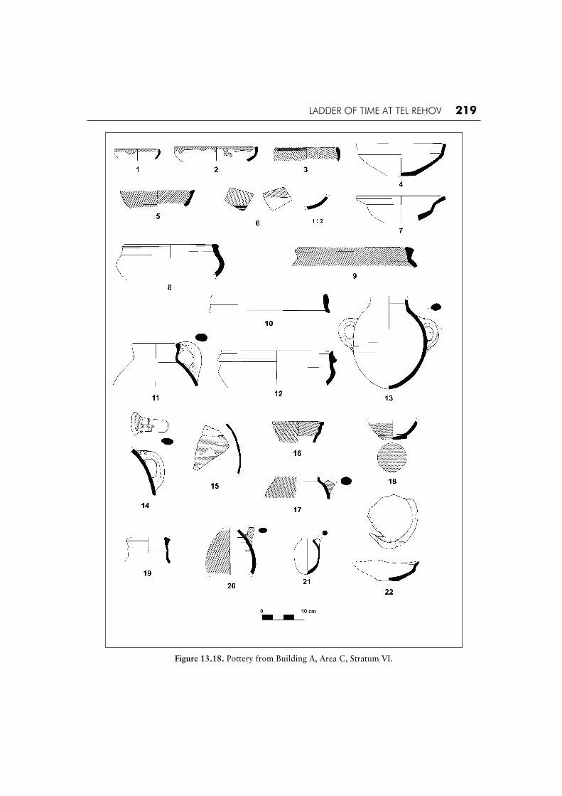
LADDER OF TIME AT TEL REHOV 219
Figure 13.18. Pottery from Building A, Area C, Stratum VI.

220 THE BIBLE AND RADIOCARBON DATING
The pottery from Building A (Fig. 13.18). Bowls: Alongside a few hemispherical bowls (Fig. 13.18:1-3), the majority are carinated, with a soft, blunt carination usually just above mid-body, a plain or everted rim and a flat base (Fig. 13.18:4-5).This carinated bowl type continues into Strata V–IV. The bowls with red slip also bear hand burnish inside and outside. Several bowls have a red band on the rim interior and exterior, which drips down. Chalices: One chalice has a wide everted rim and shallow softly carinated bowl (Fig. 13.18:7). This shape is typical of the numerous chalices uncovered throughout Area C in all three Iron Age IIA strata, though its rim is slightly longer. Kraters: Two main krater types are represented in this building: a wide-necked krater with thickened rim (Fig. 13.18:8-9) and a krater with a short rounded vertical neck (Fig. 13.18:10), which on analogy to more complete examples (i.e. Fig. 13.23:8), has a body with a high rounded carination. Both types continue in Strata V–IV. Amphoriskos: An almost complete amphoriskos (Fig. 13.18:13) is well made, but undecorated, though many vessels of this type at our site were red-slipped or painted in red. Such amphorae are found in Strata V–IV as well, though the later examples often had a rounder body. Cooking pots: The cooking pot rims from this building are varied, some with straight exteriors and some with up-turning ends (Fig. 13.18:12). The cooking jugs mostly have slightly concave necks and slightly thickened inner rims (Fig. 13.18:11). The cooking pots and cooking jugs con-tinue unchanged in Strata V–IV. Closed vessels: It is impossible to determine whether the following sherds belong to amphoriskoi, storage jars or jugs: the main characteristic is the rather careless red painted design with mainly straight or wavy horizontal bands, as well as amorphic patterns (Fig. 13.18:14-15). Such sherds were quite common in Stratum VI, and continue to be found throughout Strata V–IV. Jugs: The most typical jug is a narrow neck with a grooved rim exterior (Fig. 13.18:16); some are wider, with a ridge at mid-neck (Fig. 13.18:19). The body is mostly rounded with a short shoulder (Fig. 13.18:17), though a few are oval (Fig. 13.18:20). The base is always a disc base (Fig. 13.18:18). The jugs are almost all covered with a deep red slip and polished burnish, often with visible vertical burnish lines. Juglets: The juglets have short bodies with wide rounded bases and sloping shoulders (Fig. 13.18:21). Many had red slip and vertical burnish. Lamps: The only lamp found in Building A has an everted rim and a wide flat base (Fig. 13.18:22). General: No storage jars were found in Building A. It should be noted that no ‘Hippo’-type storage jars have been found in any Stratum VI context in Area C so far. It is not clear whether this is a chronological or functional issue, in light of the fact that such jars become common in the subsequent Strata V–IV. This pottery assemblage differs from that of the previous Stratum VII (represented mainly by the pits of Area D, Stratum D-3) in the appearance of several new forms and specifically in the appearance of red slip and irregular hand burnish, which is unknown in Stratum Phase D-3, but became the hallmark of the Iron IIA period. Thus, the transition between these two pottery periods (late Iron I and Iron IIA) is quite distinct.
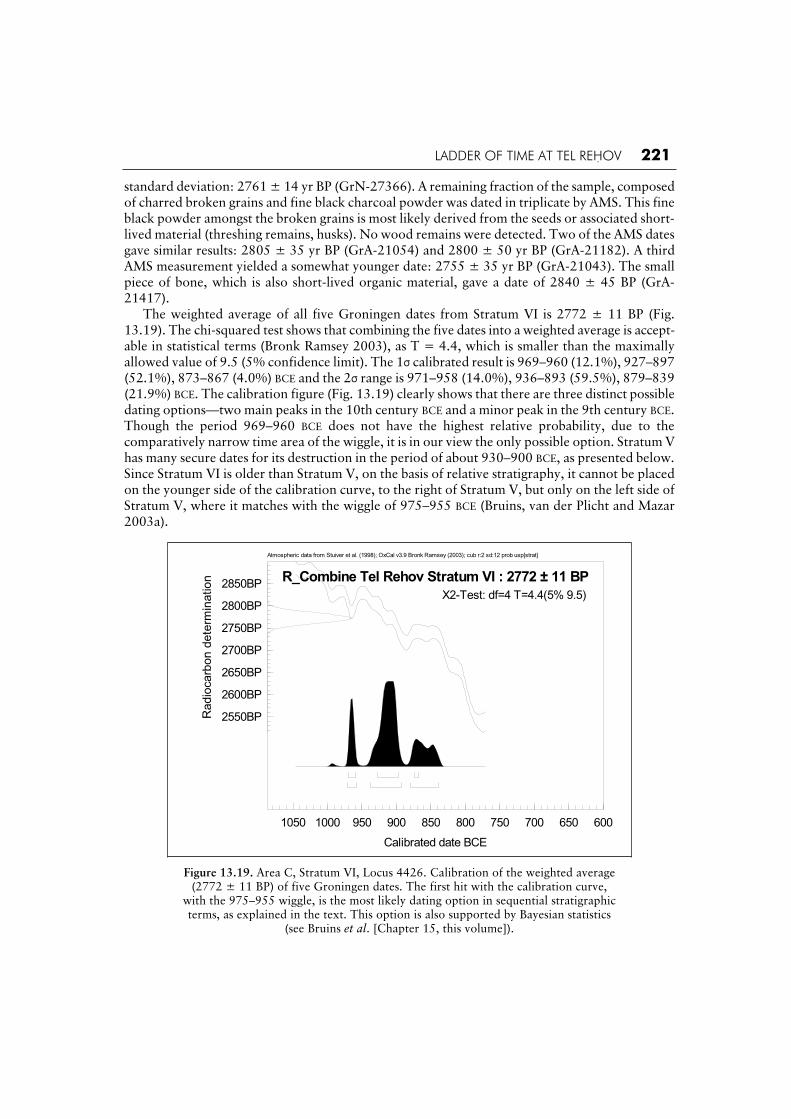
The 14C dates from Stratum VI, Building A. Basket 44166, Locus 4426, level 85.45 m (Table 13.3). A concentration of charred grains, fine charcoal powder and a small piece of bone were found covered by a bowl above a beaten earth floor in the south-western room of Building A. The amount of grains was large enough to make one PGC measurement in Groningen, which resulted in a high-precision date having a small
LADDER OF TIME AT TEL REHOV 221
standard deviation: 2761 ± 14 yr BP (GrN-27366). A remaining fraction of the sample, composed of charred broken grains and fine black charcoal powder was dated in triplicate by AMS. This fine black powder amongst the broken grains is most likely derived from the seeds or associated short-lived material (threshing remains, husks). No wood remains were detected. Two of the AMS dates gave similar results: 2805 ± 35 yr BP (GrA-21054) and 2800 ± 50 yr BP (GrA-21182). A third AMS measurement yielded a somewhat younger date: 2755 ± 35 yr BP (GrA-21043). The small piece of bone, which is also short-lived organic material, gave a date of 2840 ± 45 BP (GrA-21417). The weighted average of all five Groningen dates from Stratum VI is 2772 ± 11 BP (Fig. 13.19). The chi-squared test shows that combining the five dates into a weighted average is accept-able in statistical terms (Bronk Ramsey 2003), as T = 4.4, which is smaller than the maximally allowed value of 9.5 (5% confidence limit). The 1 calibrated result is 969–960 (12.1%), 927–897 (52.1%), 873–867 (4.0%) BCE and the 2 range is 971–958 (14.0%), 936–893 (59.5%), 879–839 (21.9%) BCE. The calibration figure (Fig. 13.19) clearly shows that there are three distinct possible dating options—two main peaks in the 10th century BCE and a minor peak in the 9th century BCE.Though the period 969–960 BCE does not have the highest relative probability, due to the comparatively narrow time area of the wiggle, it is in our view the only possible option. Stratum V has many secure dates for its destruction in the period of about 930–900 BCE, as presented below. Since Stratum VI is older than Stratum V, on the basis of relative stratigraphy, it cannot be placed on the younger side of the calibration curve, to the right of Stratum V, but only on the left side of Stratum V, where it matches with the wiggle of 975–955 BCE (Bruins, van der Plicht and Mazar 2003a).
Atmospheric data from Stuiver et al. (1998); OxCal v3.9 Bronk Ramsey (2003); cub r:2 sd:12 prob usp[strat]
1050 1000 950 900 850 800 750 700 650 600
Calibrated date BCE
2550BP
2600BP
2650BP
2700BP
2750BP
2800BP
2850BP
Ra
dio
carb
on
de
term
ina
tio
n R_Combine Tel Rehov Stratum VI : 2772 ± 11 BP
X2-Test: df=4 T=4.4(5% 9.5)
Figure 13.19. Area C, Stratum VI, Locus 4426. Calibration of the weighted average (2772 ± 11 BP) of five Groningen dates. The first hit with the calibration curve,
with the 975–955 wiggle, is the most likely dating option in sequential stratigraphic terms, as explained in the text. This option is also supported by Bayesian statistics
(see Bruins et al. [Chapter 15, this volume]).

222 THE BIBLE AND RADIOCARBON DATING
The alternative is to date Stratum VI to the last 28 years of the 10th century BCE, in about the same time frame as Stratum V (see next section). Indeed, Finkelstein and Piasetsky (2003b: 289, Fig. 2) suggest condensing both Strata VI and V to the years between 925 and 900 BCE. However, squeezing Stratum VI and Stratum V into a mere 25 years is not tenable since the duration of Stratum VI, the subsequent construction of Stratum V, its lifespan and its final destruction, includ-ing the changes observed in the pottery between these two strata require a longer time period. Indeed, Bayesian modelling in relation to the stratigraphy supports the selection of the wiggle around 965 BCE as the preferred dating option for Stratum VI (Bruins et al. [Chapter 15, this volume]). Moreover, the underlying Stratum VII corresponds with Stratum D-3 in Area D, which is dated to the late 11th to early 10th centuries BCE, fitting very well on the calibration curve to the left (older part) of the 975–955 wiggle.
Figure 13.20. Area C: plan of Stratum V.

LADDER OF TIME AT TEL REHOV 223
Stratum V in Area C (Fig. 13.20).The finds from Stratum V come mainly from two adjoining buildings located in the south-eastern part of Area C: Buildings G and H. They were both built with wooden beams incorporated into their foundations, as well as running under the floor makeup. Such wooden beams form an architectural hallmark of the Stratum V construction throughout Area C. Both buildings were destroyed by a fierce conflagration, leaving rich restorable pottery assemblages and numerous other objects as well. Though the pottery assemblages from both buildings are similar, a typological representation of each is presented below separately (Figs. 13.23–24). Samples of charred grain from both buildings (Locus 2422 from Building H and Loci 2425, 2444 and 2441 from Building G) were dated at Groningen. Eighteen additional samples from Locus 2425 were previously dated at Rehovot and Tucson.
Building H. This building occupies the south-eastern part of Area C. Its attribution to Stratum V is clear since two of its walls were constructed above Stratum VI architecture; the building was destroyed in fierce fire and in Stratum IV a new building (Building L) was constructed on top of the destruction layer, with a different plan. The plan of Building H is only partially known, as its entire eastern part was cut by later construction in Stratum IV and its southern part is beyond the limit of the excavation area. Parts of two rooms or large spaces were exposed and though no connection between them was uncovered, it seems that indeed they belong to one building. In the north, this building abuts Building G.
Figure 13.21. Collapsed Wall 2426 (looking south).
A unique trait in Building H was the nature of its destruction, which essentially is the result of its initial construction: while the floors and destruction debris of the western part of the building were found to be horizontal, the eastern part was found collapsed down at an angle of almost 45% to the east (Fig. 13.21). It seems that this eastern part collapsed into a sub-floor space, perhaps a basement of some kind, roofed by the wooden beams which also supported the floor above (Figs. 13.21–22). The burning of the building resulted in a massive collapse of destruction debris with

224 THE BIBLE AND RADIOCARBON DATING
numerous vessels10 and whole fallen bricks, onto this lower level. Excavation of the floor of this lower level in the southern part of the building yielded a ‘cultic corner’ with a pottery altar (‘cult stand’), a painted ‘petal’ chalice and a number of chalices and bowls. A concentration of burnt grain found near a Hippo-type storage jar in the southern part of the northern room (Locus 2422) is one of the samples discussed below.
Figure 13.22. Construction with wood beams in Building H (looking west).
Following the destruction of Building H, its western part remained an open area, while a new building (Building L) was constructed in Stratum IV directly above the collapsed destruction debris on the east.
Building G. This building is located north of Building H. It is an unusual building: rectangular in shape, the building measures 3.8 m × 8.4 m and is composed of three small square chambers that had no entrances and most likely were accessed by ladders from a higher level. This implies its use as a storage building or granary and, indeed, the central chamber (Loci 2425/2444) and southern-most chamber (Locus 2441) both contained a large amount of burnt grain, investigated by 14Cdating. The attribution of this building to Stratum V is based on its relationship to Building H to the south and Building M to the east, and especially its superposition above Stratum VI architecture (Building B, see Fig. 13.16). The south-eastern part of the southern room (Locus 2441) of this building suffered the same collapse down to the east as that noted above in Building H. The burnt collapsed layer penetrated underneath the northern part of Building L of Stratum IV and thus this destruction layer clearly belongs to Stratum V (Fig. 13.27). No later element was constructed above the central and northern rooms of Building G following its destruction and yet there is
10. See Mazar 1999: 22, Fig. 11 for a photo of selected vessels from the northern room.

LADDER OF TIME AT TEL REHOV 225
evidence for re-use of this part of the building in Stratum IV, as courtyard floors of Stratum IV abutted the top of the walls on both the east and west. There are three possible scenarios for the fate of this building during the time of Stratum IV:
1. The building was burnt at the end of Stratum V. The southern room collapsed to the south- east, the other two chambers remained standing. In Stratum IV the building itself remained as a useless ruin, though floors abutted the preserved top of the walls of the ruined building. In that case the finds in the chambers should be attributed to Stratum V.
2. The same, but with an assumption that the inhabitants of Stratum IV constructed floors on a higher level inside the northern two chambers of the building. These floors were above the present topsoil and disappeared due to erosion. In that case, too, the finds inside the chambers should be attributed to Stratum V.
3. Stratum IV people reutilized the original two northern chambers of the building, without changing the floor level. In that case, the finds in the destruction layer of these two rooms should be attributed to Stratum IV.
As described above, the charred grain from Building G that was subjected to 14C analysis comes from both the southern chamber (Locus 2441), whose destruction debris definitely belongs to Stratum V, as well as from the central chamber (Loci 2425 and 2444) whose stratigraphic attribution to Strata V or IV is open to interpretation as detailed above. This latter chamber yielded a large quantity of charred grain (Locus 2425) found above a beaten earth floor (Locus 2444), under a thick layer of collapsed and burnt bricks. Samples from Locus 2425 are from the grain heap itself; samples from Locus 2444 are from the bottom of the heap, just above the floor. Locus 2441 (the destruction layer of the southern room) yielded an extremely rich pottery assemblage of ca. 50 vessels of various types, while Room 2425 contained very small amounts of pottery. An additional group of pottery was revealed in the northern chamber (Locus 2460).
The pottery assemblage of Stratum V, Buildings G and H (Figs. 13.23–25). Bowls: Rounded bowls are relatively rare (Fig. 13.23:1) and the majority of bowls have a blunt carination slightly above mid-body, mostly with a short everted rim and flat base (Figs. 13.23:2; 13.24:1), as well as other rim and base variations (Figs. 13.23:3-5; 13.24:2-3). Note also the large bowl with thickened rim and low ring base; some of these have bar handles and are distorted (Fig. 13.24:5). Bowls with a short vertical rounded rim/neck and body with a round carination (Fig. 13.23:6) are also found, though not common. A unique type is a small deep rounded bowl with rounded base (Fig. 13.24:6). The majority of bowls are red-slipped inside and outside, or just out-side. Most of these also have irregular or horizontal hand burnish. Chalices: Chalices of a similar type and size were plentiful in both Buildings G and H. Their bowl is rounded with a soft carination below the everted rim and the foot has a pronounced ridge above the flaring base (Figs. 13.23:7; 13.24:4). Most chalices were red-slipped and some were also burnished. Kraters: Two basic krater types were found: a krater with a short rounded neck/rim, with a soft high carination (Fig. 13.23:8), and a krater with a straight wide neck with a slight ridge, and a carinated body; these have thickened rims, two or four handles and a ring base (Fig. 13.24:7). The kraters too were mostly red-slipped and hand burnished. Cooking pots: Cooking pots and cooking jugs were found in both buildings, while one large cooking amphora comes from Building H (Fig. 13.24:9). There are a number of variations of cooking pot rims, including long straight triangular rims, as well as a thickened rounded exterior triangle (Fig. 13.24:8) and a ‘pinched’ or upturned exterior (Fig. 13.23:9). The cooking jugs generally have sack-shaped bodies and slightly concave necks (Figs. 13.23:10; 13.24:10).

226 THE BIBLE AND RADIOCARBON DATING
Figure 13.23. Pottery from Building G, Area C, Stratum V.

LADDER OF TIME AT TEL REHOV 227
Figure 13.24. Pottery from Building H, Area C, Stratum V.

228 THE BIBLE AND RADIOCARBON DATING
Figure 13.25. Storage jars from Buildings G and H, Area C, Stratum V.

LADDER OF TIME AT TEL REHOV 229
Amphoriskoi: Small to medium sized amphoriskoi were common in Stratum V. The two basic types that were found are: an amphoriskos with an oval body, short shoulders and wide medium sized neck, disc base and two loop handles from the shoulder to the body (Figs. 13.23:11; 13.24:11). Most of these are red-slipped, hand burnished and some also bear a red painted design on top of the red slip, which sometimes include debased ‘Canaanite’ motifs such as vertical ladders and even a stylized palm tree (Figs. 13.23:11; 13.24:11). The second amphoriskos type has a small round or sack-shaped body with a wide neck and two large loop handles (Fig. 13.24:12); it is very similar to the one found in Stratum VI Building A (see above). These are either red-slipped and/or red painted with rather careless horizontal straight or wavy bands (see Fig. 13.36:4, Stratum IV, for an example). Storage jars: Numerous storage jars were found in Buildings G and H and essentially, almost all the Iron Age IIA storage jar types found at Tel Rehov are represented in these two buildings. The most common jar is the Hippo-type storage jar (Fig. 13.25:1, 5). Other storage jars include those with an oval shaped body, a tapering base, a short neck and a rounded rim (Fig. 13.25:2, 7); some of these have wider and rounder bodies (Fig. 13.25:6). A common jar type is characterised by a short round body and a long straight neck; many of these jars are covered with a reddish wash (Fig. 13.25:3, 8). Rarer is a jar with pronounced sloping shoulders, a short plain neck and a straight body (Fig. 13.25:9; in this example the handles were not preserved). A common type is the cylindrical hole-mouth jar, with two rim variations: a plain everted rim (Fig. 13.25:4) and a short neck with a thickened hammer-head rim (Fig. 13.25:10). Jugs: No typology can be formed for the jugs in these buildings as each one is represented basically by one example (Figs. 13.23:12-15; 13.24:13, 15). Most have flat or low ring bases and all have handles that extend from the rim to the shoulder. They are well formed and about half are red-slipped; of these only about half are also burnished. Juglets: The juglets all have short rounded bodies and rounded bases; some are quite squat (Fig. 13.23:16) and others are slightly more oval (Fig. 13.24:16). Most have a trefoil mouth and are covered with red slip, but not all are burnished. Lamps: Lamps were common in these two buildings. Most are of the shallow wide saucer bowl type with an everted shelf rim (Figs. 13.23:17; 13.24:17), while a less common type is deeper and has a flattened base (Fig. 13.24:18). Some of the lamps were red-slipped inside and outside. A cup and saucer in Building G (Fig. 13.23:18) is one of two found in Stratum V. Imports: A Cypriot Bichrome jug, found intact aside from its rim, was found in the destruction debris above the floor in the north-western part of Building H (Locus 1465; Fig. 13.24:14). General: The ceramic assemblages of Buildings G and H are characterized by a wide variety of vessel classes and types, including vessels for food preparation and serving, as well as for storage and cult. A very rough estimate, pending more exact quantitative registration, shows that ca. 35% of the vessels are red-slipped and burnished, while painted traditions do continue, either in rather careless red geometric patterns and sometimes in combination with the red slip. Though no Cypro-Phoenician Black on Red or White Painted vessels were found in these buildings, other Stratum V contexts (in Area C and other areas as well) did yield such sherds (for comparative discussion see below, pp. 242-43).
Radiocarbon dates from Stratum V in Area C (Table 13.3). Construction date. Two wood samples used in the construction of Stratum V buildings in Area C were dated at Rehovot (Mazar and Carmi 2001: 1337, Table 5). The first is an olive tree from Locus 1479, Building J, dated to 3070 40 BP (RT-2995) with a calibrated age of 1395–1264 BCE
(1 ). This date is at least 200 years earlier than the construction date of Stratum V and thus is an example of the ‘old wood effect’. Indeed, an olive tree can be very long-lived. The second sample

230 THE BIBLE AND RADIOCARBON DATING
was from an elm tree (Locus 1465, Building H) dated in Rehovot to 2875 25 BP (RT-2997).11
The calibrated age ranges are 1124–1000 (1 ) and 1188–940 BCE (2 ). This radiocarbon date is credible as an elm tree has a life span of up to 100 years. Thus, this last date strengthens the possibility that Stratum V was constructed during the 10th century BCE.
Figure 13.26. Stratum V pottery assemblage.
Figure 13.27. Stratum IV, Building L, above Stratum V destruction debris (looking south).
11. Attention that in Mazar and Carmi 2001: 1337 there is a typing mistake: the locus number in Table 5 should be 1465 rather than 1475.
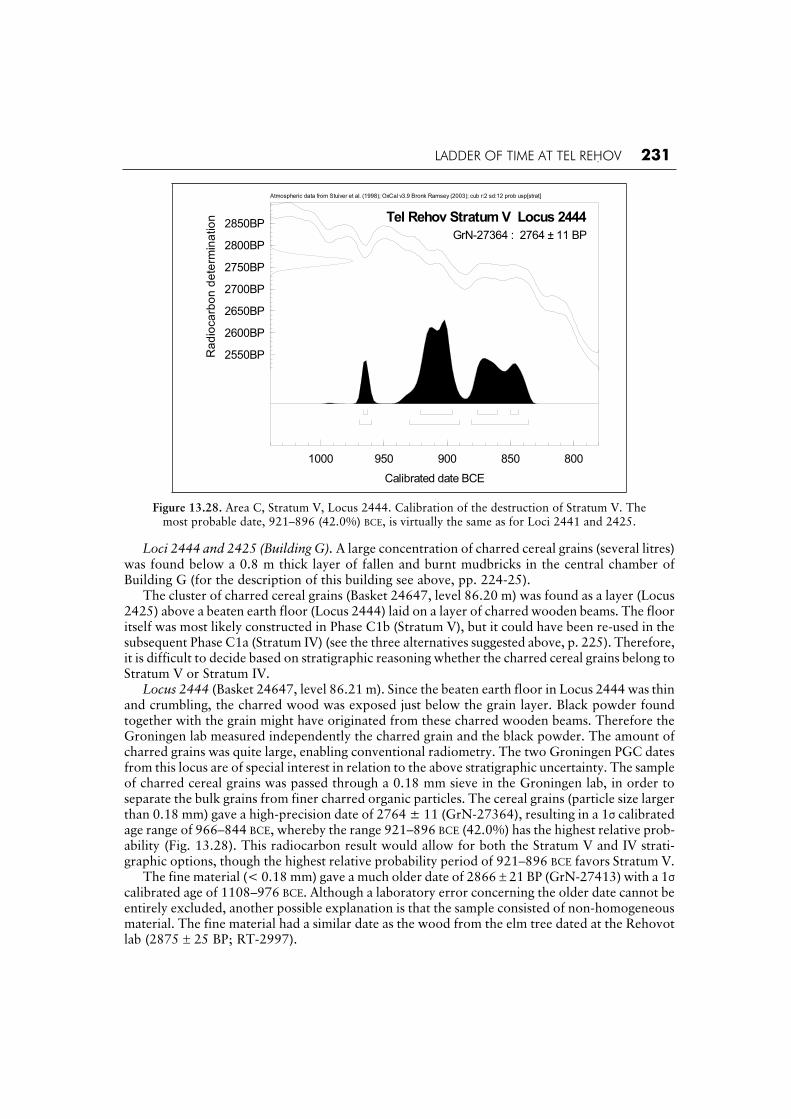
LADDER OF TIME AT TEL REHOV 231
Atmospheric data from Stuiver et al. (1998); OxCal v3.9 Bronk Ramsey (2003); cub r:2 sd:12 prob usp[strat]
1000 950 900 850 800
Calibrated date BCE
2550BP
2600BP
2650BP
2700BP
2750BP
2800BP
2850BPR
ad
ioca
rbo
n d
ete
rmin
atio
n Tel Rehov Stratum V Locus 2444
GrN-27364 : 2764 ± 11 BP
Figure 13.28. Area C, Stratum V, Locus 2444. Calibration of the destruction of Stratum V. The most probable date, 921–896 (42.0%) BCE, is virtually the same as for Loci 2441 and 2425.
Loci 2444 and 2425 (Building G). A large concentration of charred cereal grains (several litres) was found below a 0.8 m thick layer of fallen and burnt mudbricks in the central chamber of Building G (for the description of this building see above, pp. 224-25). The cluster of charred cereal grains (Basket 24647, level 86.20 m) was found as a layer (Locus 2425) above a beaten earth floor (Locus 2444) laid on a layer of charred wooden beams. The floor itself was most likely constructed in Phase C1b (Stratum V), but it could have been re-used in the subsequent Phase C1a (Stratum IV) (see the three alternatives suggested above, p. 225). Therefore, it is difficult to decide based on stratigraphic reasoning whether the charred cereal grains belong to Stratum V or Stratum IV. Locus 2444 (Basket 24647, level 86.21 m). Since the beaten earth floor in Locus 2444 was thin and crumbling, the charred wood was exposed just below the grain layer. Black powder found together with the grain might have originated from these charred wooden beams. Therefore the Groningen lab measured independently the charred grain and the black powder. The amount of charred grains was quite large, enabling conventional radiometry. The two Groningen PGC dates from this locus are of special interest in relation to the above stratigraphic uncertainty. The sample of charred cereal grains was passed through a 0.18 mm sieve in the Groningen lab, in order to separate the bulk grains from finer charred organic particles. The cereal grains (particle size larger than 0.18 mm) gave a high-precision date of 2764 ± 11 (GrN-27364), resulting in a 1 calibrated age range of 966–844 BCE, whereby the range 921–896 BCE (42.0%) has the highest relative prob-ability (Fig. 13.28). This radiocarbon result would allow for both the Stratum V and IV strati-graphic options, though the highest relative probability period of 921–896 BCE favors Stratum V. The fine material (< 0.18 mm) gave a much older date of 2866 21 BP (GrN-27413) with a 1calibrated age of 1108–976 BCE. Although a laboratory error concerning the older date cannot be entirely excluded, another possible explanation is that the sample consisted of non-homogeneous material. The fine material had a similar date as the wood from the elm tree dated at the Rehovot lab (2875 25 BP; RT-2997).

232 THE BIBLE AND RADIOCARBON DATING
Locus 2425. (Basket 24306, level 86.57 m). The large amount of charred grains was analyzed in three different radiocarbon labs, yielding a total of 20 dates (Tables 13.3 and 13.4): nine dates were measured in Rehovot, nine in Arizona (Mazar and Carmi 2001: 1338, Table 6) and two in Groningen (Bruins et al. 2003a; Table 13.3, this paper). Statistical examination of the results showed that the average Rehovot date (excluding one outlier in order to pass the chi-squared test) is 2699 ± 7 BP (T = 13.2, 5% = 14.1). The chi-squared value is high (13.2) with respect to the 5% confidence level, indicating that the Rehovot series is not coherent. The calibrated age lies entirely in the 9th century BCE. The average Arizona date for this locus is 2749 ± 16 BP (T = 7.1, 5% = 15.5), a difference of 50 BP years. The 1 calibrated range is 905–835 BCE and the 2 range is 930–830 BCE, giving most probability to the 9th century BCE, though the 10th century is still marginally feasible. The chi-squared value of 7.1 indicates that the Arizona series is significantly more coherent than the Rehovot series. The Arizona dates seem to support an association of the grains with Stratum IV on chronological considerations. However, the average of the two Groningen PGC dates from this locus is 2788 ± 14 BP, which is 89 BP years older than Rehovot and 39 BP years older than Arizona (Bruins et al. 2003b). The 1 calibrated age range is 971–959 (20.7%), 935–903 (47.5%) BCE and the 2 range is 998–981 (5.7%) 976–896 (86.9%) 876–860 (2.8%) BCE. Thus, a 10th-century BCE date for Locus 2425 is clearly determined by Groningen, with the highest relative probability in the period 935–903 BCE. This option is possible according to the Arizona date in the 2 range, while the Rehovot dates are by far the youngest, a tendency also noted for the Iron Age I dates, described above.
Table 13.4. Comparison of 21 14C dates from Locus 2425, measured at Rehovot (1998–99), Arizona (1998–99) and Groningen (2003).
Groningen (PGC) Arizona (AMS) Rehovot (LSC)
Year BP Year BP AA-30431-U3- Year BP RT-3122
2775 ± 20 GrN-26114 2830 55 11 2700 0 A
2800 ± 20 GrN-26115 2745 50 12 2655 25 A1
2730 45 13 2655 25 A2
2815 50 21 2720 20 B
2770 50 22 2700 25 B1
2710 45 23 2650 30 B2
2685 45 31 2725 15 BB
2760 60 32 2860 20 C
2740 50 33 2710 20 D
Locus 2441 (Building G). This locus marks a one meter thick collapse and destruction layer of the southern room in the three-chamber structure to which Locus 2425 also belongs. A relatively large amount of charred cereal grains was found in this thick destruction layer (Baskets 24441, 24579, 24580 all at level 86.60 m This collapse layer is sealed by walls of Building L that was founded in Stratum IV (see above, pp. 223-24, and Fig. 13.27). Moreover, Stratum VI remains were found below both the destruction layer 2441, as well as below Room 2444/2425. Hence, the charred grains can be clearly related to the destruction of Stratum V (local C-1b). All three baskets contained sufficient grains for PGC radiometry measurements. Basket 24441 gave a date of 2810 ± 20 BP (GrN-26116). Basket 24580 gave a similar date of 2775 ± 25 BP (GrN-26117). It is important to note that the dating results of these two baskets are identical to the two Groningen PGC dates of Locus 2425 from the same building (Table 13.4) and thus it may be possible to conclude that the charred grains from Locus 2425 also belong to the destruction of Stratum V, supporting option 1 and 2 of the three possible archaeological interpretations (see p. 225).

LADDER OF TIME AT TEL REHOV 233
Basket 24579 was a particularly large sample of charred cereal grains. In Groningen, during the pretreatment process, the material was separated into three size fractions (coarse: > 0.85 mm, fine: < 0.18 mm and medium: in between these values) by sieving. Each size fraction was dated separately, in order to evaluate the homogeneousness of the charred sample material. The results are as follows: 2745 ± 14 BP (GrN-27363) coarse, 2771 ± 15 BP (GrN-27385) medium and 2761 ± 15 BP (GrN-27386) fine. The coarse material is the youngest, but still within 1 of the oldest date for the medium-sized grains, while the date for the fine material is in between the two. Therefore, the results are the same in physical terms. Combining the three dates into a weighted average results in a date of 2758 ± 8 BP which is acceptable according to the chi-squared test (Bronk Ramsey 2003), as T = 1.7, which is well below the 5% confidence limit of 6.0. This aver-age BP date of Basket 24579 from Stratum V is similar as the average date for Stratum D-2 Locus 1823, some dates for Stratum VI and the average date of Stratum IV (2758 ± 16 BP), presented below. The results from Basket 24579 are younger than for the two other baskets of Locus 2441. Since the destruction layer of Locus 2441 marks a single event, and in the absence of archaeo-logical errors with regard to the three baskets, the spread in radiocarbon dates is probably due to the inherent variability in the reproducibility of radiocarbon dating (Mook and Waterbolk 1985: 10). Thus, we may combine all the dates from the three baskets of Locus 2441 into an overall weighted average (Fig. 13.29). The chi-squared test (Bronk Ramsey 2003) accepts the averaging of all dates, as T = 7.4, which is below the 5% maximally allowed confidence limit of 9.5. The weighted average of Locus 2441 is 2767 ± 7 BP. The 1 calibrated age is 967–962 (6.6%), 922–896 (52.1%), 874–864 (9.5%) BCE and the 2 calibrated age is 969–960 (8.7%), 930–893 (57.3%), 879–838 (29.4%) BCE (Fig. 13.29). The period 930–893 BCE has by far the highest relative probability (57.3%) in the 2 range for the destruction of Stratum V, based on the weighted average of all radiocarbon dates from Locus 2441.
Atmospheric data from Stuiver et al. (1998); OxCal v3.9 Bronk Ramsey (2003); cub r:2 sd:12 prob usp[strat]
1050 1000 950 900 850 800 750
Calibrated date BCE
2550BP
2600BP
2650BP
2700BP
2750BP
2800BP
2850BP
Ra
dio
ca
rbo
n d
ete
rmin
atio
n R_Combine Tel Rehov Stratum V Locus 2441
2767±7BP X2-Test: df=4 T=7.4 (5% 9.5)
Figure 13.29. Area C, Stratum V, Locus 2441. Calibration of the destruction of Stratum V according to the weighted average of all five dates from Locus 2441: 2767 ± 7 BP. This overall
result clearly favours the middle peak, which has by far the highest 1 relative probability: 922–896 (52.1%) BCE. The first peak, related to the wiggle of 975–955 BCE, fits with Stratum VI.

234 THE BIBLE AND RADIOCARBON DATING
Locus 2422 (Building H). A large concentration of charred grains (Basket 24408, level 86.40 m) was found close to the floor level of Building H, below a ca. 1 m thick destruction layer. The amount of grains was large enough to make three sub-samples in the lab, one making up the fine material (< 0.18 mm). The three Groningen PGC dates are coherent, also showing that the material is homogeneous in age: 2764 ± 11 BP (GrN-27361), 2777 ± 13 BP (GrN-27362) and for the fine parts of the charred grains 2785 ± 28 BP (GrN-27412). The weighted average of Locus 2422 is 2771 ± 8 BP (Fig. 13.30). The calculated chi-squared value, T = 0.9, is very low in com-parison to the 5% confidence limits of 6.0, which underlines the excellent internal consistency of the three dates. The 1 calibrated age is 969–961 (11.0%), 925–897 (56.2%), 871–870 (1.0%) BCE
and the 2 range is 970–959 (12.4%), 934–894 (61.7%), 878–840 (21.3%) BCE (Fig. 13.30). Evidently, the period 934–894 BCE has by far the highest relative probability for the destruction of Stratum V in Locus 2422.
Atmospheric data from Stuiver et al. (1998); OxCal v3.9 Bronk Ramsey (2003); cub r:2 sd:12 prob usp[strat]
1050 1000 950 900 850 800 750
Calibrated date BCE
2550BP
2600BP
2650BP
2700BP
2750BP
2800BP
2850BP
Ra
dio
ca
rbo
n d
ete
rmin
atio
n R_Combine Tel Rehov End Stratum V
Locus 2422 : 2771±8BPX2-Test: df=2 T=0.9(5% 6.0)
Figure 13.30. Area C, Stratum V, Locus 2422. Calibration of the destruction of Stratum V. The most probable date, 925–897 (56.2%) BCE, is virtually the same as for Locus 2441.
Conclusion: the destruction date of Stratum V in Loci 2422, 2441, 2425, 2444. The average Groningen dates for Loci 2425, 2441 and 2422 are all rather similar: 2788 ± 14 BP, 2767 ± 7 BP, 2771 ± 8 BP, respectively, while the single date for Locus 2444, 2764 ± 11 BP, is also in the same range. These radiocarbon results strongly suggest that the destruction of Buildings H and G of Stratum V in Area C occurred probably simultaneously in a severe conflagration, which is quite possible in relation to the stratigraphic evidence. The overall weighted average of the four destruc-tion loci results in an extremely precise date of 2770 ± 4 BP, well accepted by the chi-squared test, as T=2.2 versus the 5% confidence limit of 7.8. The 1 calibrated age range is 968-961 (9.4%), 924-897 (58.8%) BCE and the 2 calibrated range is 969-959 (11.2%), 932-894 (64.4%), 878-841 (19.9%) BCE. Thus the period 924-897 BCE has by far the highest relative probability in the 1range. The alternative period of 968-961 (9.4%) is unlikely, since this wiggle fits with Stratum VI in the correct stratigraphic order (Fig. 13.31).

LADDER OF TIME AT TEL REHOV 235
Atmospheric data from Stuiver et al. (1998); OxCal v3.9 Bronk Ramsey (2003); cub r:2 sd:12 prob usp[strat]
1000 950 900 850 800
Calibrated date BCE
2550BP
2600BP
2650BP
2700BP
2750BP
2800BP
2850BP
Ra
dio
ca
rbo
n d
ete
rmin
atio
n Tel Rehov - Destruction Stratum V - 2770 ± 4 BP
X2-Test: df=3 T=2.2 (5% 7.8)
Figure 13.31. Area C, Stratum V. Destruction of Stratum V, based on the combined average of Loci 2425, 2441, 2422, 2444. The most probable date is 924–897 (58.8%)
BCE, which is almost all the 68.2% in the 1 range.
Atmospheric data from Stuiver et al. (1998); OxCal v3.9 Bronk Ramsey (2003); cub r:2 sd:12 prob usp[strat]
1100 1000 900 800
Calibrated date BCE
2500BP
2600BP
2700BP
2800BP
2900BP
3000BP
Ra
dio
ca
rbo
n d
ete
rmin
atio
n R_Combine Tel Rehov Stratum V
Locus 6449 : 2757±26BPX2-Test: df=2 T=0.3(5% 6.0)
Figure 13.32. Area C, Stratum V, Locus 6449. The average date of this Locus is similar to Stratum IV. The period 879–837 (41.7%) BCE has the highest relative probability,
though the period 919–893 (26.5%) BCE is still significantly represented.

236 THE BIBLE AND RADIOCARBON DATING
Locus 6449 (Building E). This locus belongs to a building located in the north-western part of Area C (Square T-5), which has only been partly excavated. Locus 6449 forms a floor surface in a room; it was covered by destruction debris and sealed by a higher floor, attributed to Stratum IV, which was also covered by destruction debris. Charred olive stones were found together (Basket 64756, level 86.17 m) on the lower floor surface, related to Stratum V. Three Groningen AMS dates were measured: 2775 45 BP (GrA-24455); 2750 45 BP (GrA-24456) and 2745 45 BP (GrA-24497). The results are very coherent, within 1 from each other, underscored by the very low chi-squared value, T = 0.3, in relation to the 5% confidence limits of 6.0. The weighted average date is 2757 26 BP (Fig. 13.32), which is slightly younger than other Stratum V loci in Area C. Although the midpoint of the average date is identical to the average dates of Locus 5498 of Stratum IV, located nearby, and Basket 24579 of Stratum V Locus 2441, the standard deviation is larger. Thus, the calibration results are somewhat different, favouring the 9th century more than the 10th century BCE. The 1 calibrated age range is 919–893 (26.5%), 879–837 (41.7%) BCE and the 2 range is 971–957 (7.1%) and 938–830 (88.3%) BCE.
Figure 13.33. Area C: plan of Stratum IV.
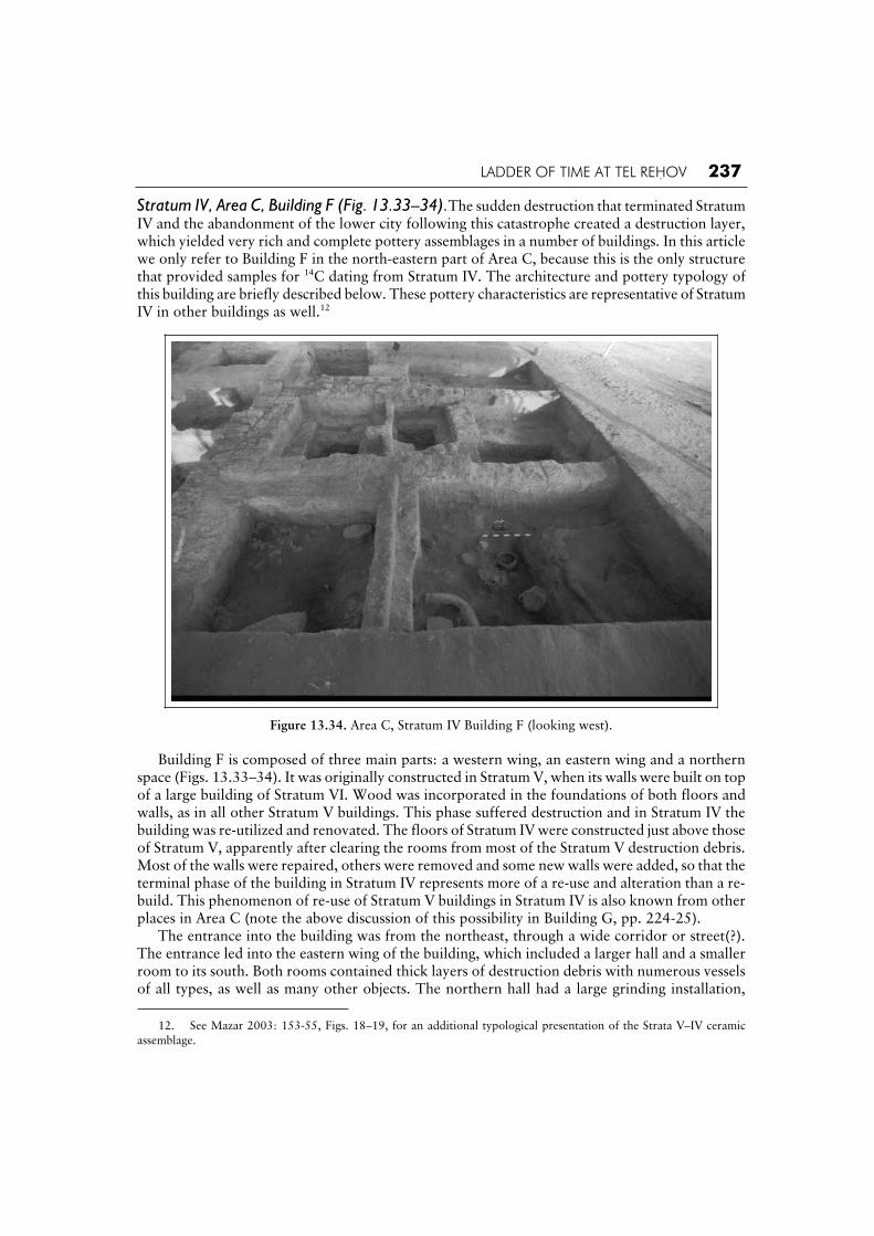
LADDER OF TIME AT TEL REHOV 237
Stratum IV, Area C, Building F (Fig. 13.33–34).The sudden destruction that terminated Stratum IV and the abandonment of the lower city following this catastrophe created a destruction layer, which yielded very rich and complete pottery assemblages in a number of buildings. In this article we only refer to Building F in the north-eastern part of Area C, because this is the only structure that provided samples for 14C dating from Stratum IV. The architecture and pottery typology of this building are briefly described below. These pottery characteristics are representative of Stratum IV in other buildings as well.12
Figure 13.34. Area C, Stratum IV Building F (looking west).
Building F is composed of three main parts: a western wing, an eastern wing and a northern space (Figs. 13.33–34). It was originally constructed in Stratum V, when its walls were built on top of a large building of Stratum VI. Wood was incorporated in the foundations of both floors and walls, as in all other Stratum V buildings. This phase suffered destruction and in Stratum IV the building was re-utilized and renovated. The floors of Stratum IV were constructed just above those of Stratum V, apparently after clearing the rooms from most of the Stratum V destruction debris. Most of the walls were repaired, others were removed and some new walls were added, so that the terminal phase of the building in Stratum IV represents more of a re-use and alteration than a re-build. This phenomenon of re-use of Stratum V buildings in Stratum IV is also known from other places in Area C (note the above discussion of this possibility in Building G, pp. 224-25). The entrance into the building was from the northeast, through a wide corridor or street(?). The entrance led into the eastern wing of the building, which included a larger hall and a smaller room to its south. Both rooms contained thick layers of destruction debris with numerous vessels of all types, as well as many other objects. The northern hall had a large grinding installation,
12. See Mazar 2003: 153-55, Figs. 18–19, for an additional typological presentation of the Strata V–IV ceramic
assemblage.

238 THE BIBLE AND RADIOCARBON DATING
dozens of loom weights were found and burnt wooden beams of what appears to have been a loom. An oven was found at its north-western corner. This room also yielded a unique pottery ‘model shrine’ decorated with an animal (bull or feline figure?) grasping two human heads in its claws. A pottery vessel found on the floor of this room (5498) contained charred grain, which was radiocarbon dated. The southern room was nicely plastered; it contained a large number of storage jars and other vessels, as well as a pottery object known as a ‘footbath’ type. The western wing is comprised of four consecutive small rooms. The northernmost room was wide open to the main hall. It included a grinding installation identical to the one in the main hall, though smaller. A very large concentration of pottery was found here, including the fragmentary remains of a pottery altar, decorated with three female figures made in a mold. From this room one could gain access to three additional rooms, arranged in a row, each of which was entered through its north-eastern corner and each of which was lined with brick benches. These benches and the floors that abutted them were built on top of the remnants of the Stratum V destruction debris that abutted the lowest courses of the buildings’ walls. These rooms contained large quantities of pottery. The southernmost room also contained a large heavy pottery box with a lid, found resting on a brick shelf. The plan of this western wing is unique in the architecture of the Iron Age II in Israel, and thus this building probably had some special function in addition to the utilitarian functions of grinding, baking and weaving, indicated by the various finds.
The pottery from Building F (Figs. 13.35–37). Bowls: Round side bowls are rare (Fig. 13.35:1) and the shallow wide open bowl with ring base in Fig. 13.35:2 is unique in our corpus. Carinated bowls of various types are the most common, usually with a blunt carination, everted rim and a flat or concave disc base, though other types include a low carination with a rounded or high ring base (Fig. 13.35:4-7). Large open bowls with hammer head rims and low ring bases are found as well; these are sometimes distorted (Fig. 13.35:3). Bowls with a short rounded rim/neck and a body with a round carination and a disc or flat base are also found (Fig. 13.35:8). A little over 50% of the bowls are red-slipped; of these about half are also burnished. Sometimes the red slip is rubbed away and visible only in small patches. Chalices: Chalices are very common in Stratum IV, all with a shallow bowl, everted rim and a foot with a ridge above the flaring base (Fig. 13.35:9). In a similar manner to the bowls, about 50% of these chalices are red-slipped, though they are rarely burnished. Kraters: Two basic krater types are found: a medium-large sized krater with a vertical neck, hammer head rim, two or four handles,13 a deep rounded body and a ring base (Fig. 13.35:10-11). The other krater type has a short rounded neck/rim and a deep body with high rounded shoulders and a ring base (Fig. 13.35:12). The kraters are mostly red-slipped, though the distribution between the two krater types differs: only about 40% of the necked type are red-slipped, often lacking burnish, while almost 90% of the round rimmed type are red-slipped and generally burnished as well, with horizontal hand burnish. Cooking pots: Cooking pots, cooking jugs and cooking amphorae were common in Stratum IV. The cooking pots show two basic variations: a vertical rim stance, with a triangular exterior that is straight or up-turned (Fig. 13.35:13), and more rarely, an inverted upper stance, with an up-turned rim (Fig. 13.35:14). The cooking jugs have slightly concave necks and sack-shaped bodies (Fig. 13.35:15). Cooking amphorae are somewhat less common than the other types (Fig. 13.35:16).
13. Several kraters of this type, with large deep barrel-shaped bodies, had as many as 9 handles in Stratum IV; such a
phenomenon was not noted in Stratum V, though this might be a contingency of exposure as of now.

LADDER OF TIME AT TEL REHOV 239
Figure 13.35. Pottery from Building F, Area C, Stratum IV.

240 THE BIBLE AND RADIOCARBON DATING
Figure 13.36. Pottery from Building F, Area C, Stratum IV (continued).

LADDER OF TIME AT TEL REHOV 241
Figure 13.37. Pottery from Building F, Area C, Stratum IV (continued).

242 THE BIBLE AND RADIOCARBON DATING
Amphoriskoi and Amphorae: Small and medium sized amphorae are common in Stratum IV. Three basic types were found: a small vessel with an oval shaped body and a flat or disc base. These are generally decorated, either with red slip or painted in red (Fig. 13.36:1); a medium sized amphora with a long neck and ridged exterior rim. Two loop handles extend from the neck and it has a ring base (Fig. 13.36:2).14 These are often red-slipped but seldom burnished; a third type has a wide round body and base and a vertical neck (Fig. 13.36:3-4). These are always decorated—either red-slipped or painted with rather careless geometric designs in red (i.e. Fig. 13.36:4). The examples shown here from Building F are quite large, though other such amphorae were smaller. Storage jars: The most common jar is the Hippo-type (Fig. 13.37:1). One of these carried an inscription incised after firing (Mazar 2003c: 178-81). Other common types are the oval shaped body with a thickened rim (Fig. 13.37:6) and the jar with a wide round body, round base and long vertical neck (Fig. 13.37:7); the latter is almost always covered with a thin red wash. Cylindrical holemouth jars are common as well, with both everted and thickened rims (Fig. 13.37:8). Less common are a variety of jars that are in fact related to each other in details of body shape or rim/neck shape, but differ in the combination of these elements (Fig. 13.37:2-5). Large, thick walled closed vessels with ring bases (‘krater/jars’) were used as storage vessels in Stratum IV. Jugs: The most common jug type in Stratum IV is an oval shaped jug with a wide vertical neck, trefoil mouth and ridged rim exterior (Fig. 13.36:5). These are mostly undecorated, though some bear traces of red slip but generally are not burnished; in some cases, red lines are painted on top of the red slip (i.e. Fig. 13.36:6). Other types are similar (Fig. 13.36:6), or differ in handle place-ment, base or body shape (Fig. 13.36:7). Figure 13.36:8 is a small squat jug with carinated shoul-der and lower body; this type is rare, but was also found in Stratum V (Fig. 13.23:14). Juglets: Juglets too were very common in Stratum IV. Most have short rounded bodies and bases, though several are squatter (Fig. 13.23:9-10). Black juglets are not common and most have a rounded body with narrow neck and handle that joins at mid-neck (Fig. 13.36:11). The one shown in Fig. 13.36:12, with its pointed base and handle from the neck, is unique in this stratum. It was found on Floor 5498, under a large wooden beam (of a loom?). Pyxis: Several small pyxides were found in Stratum IV, with a sack shaped body, narrow vertical neck and two small horizontal handles. They are all red-slipped but not burnished (Fig. 13.36:13). Lamps: Lamps are shallow, with everted shelf rims and wide rounded bases (Fig. 13.36:14); other buildings included flat-based lamps as well. Imports: Greek Sherds: Figure 13.36:15 shows a reconstruction of an Attic Early Middle Geometric I skyphos; two sherds of this vessel were found in the southern and middle rooms of the western wing of Building F (Coldstream and Mazar 2003: 35, Fig. 7). A body sherd of a Cypro-Phoenician closed vessel was found in Locus 5429 (not illustrated).
Summary. The pottery assemblage of Stratum IV is extremely varied and includes mostly types that continue from Stratum V, and some from Stratum VI as well. Isolated shapes begin to appear in Stratum IV, but the typological differences with previous strata are mainly quantitative. The amount of red slip slightly declines, comprising ca. 30% of the assemblage; hand burnish is still common. The painted tradition continues mainly on amphorae and other closed vessels, though in much smaller amounts. Though only one small sherd of Cypro-Phoenician Black on Red ware was found in Building F, other Stratum IV contexts (in Area C and other areas as well) did contain a number of high quality sherds and vessels of this ware, as well as White Painted sherds.
14. Though not shown in the contexts of Buildings H and G, this amphora type was found in Stratum V as well,
though it was an infrequent type at that time as opposed to in Stratum IV.

LADDER OF TIME AT TEL REHOV 243
The pottery of Strata VI–IV: general conclusions. The pottery assemblages of Strata VI–IV demonstrate a basic similarity of the pottery industry in typology, technology and decoration throughout the entire Iron IIA period. There is a modicum of continuity of ceramic types from Stratum VI to V, while the overwhelming majority of ceramic types of Stratum V continue into Stratum IV. Modes of decoration continue as well, primarily red slip and hand burnish, but also the notable red painted tradition that is still present in Stratum IV. However, despite this similarity, there are subtle differences that express themselves in the quantities of types and decoration modes, technological change and distribution of imports. These differences will become clearer with further research. The basic homogeneity of the ceramic assemblages of Strata VI–IV allows us to compare it as a unit to assemblages from other Iron Age IIA northern sites, in particular Tel ‘Amal Strata 3–4 (Levy and Edelstein 1972), Tell el-Hama (unpublished assemblage from a destruction layer), Megiddo VB and VA–IVB (Finkelstein, Zimhoni and Kafri 2000), Yoqne‘am Strata XV–XIV (Zarzecki-Peleg 1997), Ta‘anach Periods IIa–IIb (Rast 1978), Horvat Rosh Zayit, Strata III–IIa-b (Gal and Alexandre 2000), Tell el-Far‘ah (Tirzah) Stratum VIIb (Chambon 1984) and Jezreel (both the pre-Omride fills and the destruction layer, Zimhoni 1997: 13-56). Though regional differences exist, comparisons may also be made to Hazor Strata X–VIII (see comparative discussion in Zarzecki-Peleg 1997: 275-82). Thus, a framework of relative chronology is established that covers a number of strata at various sites, emphasizing the longevity of this ceramic assemblage. Based on the stratigraphic data combined with the 14C dates, we estimate the duration of this assemblage to be ca. 150 years. Such a duration of pottery types is known from other contexts as well, such as the Canaanite Late Bronze Age, when ceramic types and decorative modes continue from the 15th century BCE well into the 13th century BCE virtually unaltered. The cultural, social, economic and demographic implications of this homogeneity and longevity will be explored in future studies of these rich assemblages. Imported pottery in these and other Iron IIA contexts at Tel Rehov include Greek Proto-Geometric, Sub-Proto-Geometric and Middle Geometric sherds (Coldstream and Mazar 2003; Mazar 2004), Cypro-Phoenician Black on Red, Cypriot Bichrome and White Painted (Smith forth-coming) and Phoenician Bichrome. Establishing dates as precise as possible for the Tel Rehov context is thus a valuable contribution to elucidate the questionable ages of these Mediterranean pottery groups.
Destruction date of Stratum IV, based on radiocarbon dates from Building F. Basket 54702, Locus 5498, level 86.10 m. Charred grain was found inside a pottery jug above the beaten earth floor in the eastern side of the main room of Building F, under a 1.18 m thick layer of destruction debris. This is the best possible context for an homogeneous sample of grains. Seven AMS measurements of the charred cereal grains were made in Groningen and the results (Table 13.3) range from a low of 2710 ± 45 (GrA-22301a) to a high of 2785 ± 40 (GrA-22330b), while the other five dates are in between this range within 1 overlap from each other. It is noteworthy to mention that these dates were prepared and measured in two different periods. The weighted average of the first three measurements is virtually the same as the weighted average of the later series of four measurements, which underlines the robustness of reproducibility in the Groningen AMS lab, which is an important element of quality control. The excellent archaeologi-cal context of this sample also underlines the possible level of inherent variability of individual 14Cmeasurements (Mook and Waterbolk 1985: 10) of the same sample, up to 75 midpoint BP years in this case. These midpoint differences are covered by the standard deviation levels, which form an integral part of each BP date. The overall weighted average of the seven dates is 2758 ± 16 yr BP and the chi-squared test (Bronk Ramsey 2003) underlines the good level of coherence between the individual dates (Fig.

244 THE BIBLE AND RADIOCARBON DATING
13.38). The value for T = 2.1, which is much less than the critical 5% confidence limit of 12.6. Calibration of the average date gives a 1 age range of 918–895 (28.2%), 877–840 (40.0%) BCE
and a 2 range of 969–960 (4.7%), 926–833 (90.7%) BCE (down to 833 BCE in the 2 range). Thus, the 9th century period of 877–840 BCE has the highest relative probability. The alternative is the last quarter of the 10th century BCE, which does not make sense in stratigraphic terms, as the destruction of Stratum IV must be younger in age than the destruction of Stratum V.
Atmospheric data from Stuiver et al. (1998); OxCal v3.9 Bronk Ramsey (2003); cub r:2 sd:12 prob usp[strat]
1000 900 800
Calibrated date BCE
2500BP
2600BP
2700BP
2800BP
2900BP
Ra
dio
ca
rbo
n d
ete
rmin
atio
n R_Combine Tel Rehov - End Stratum IV
Locus 5498 : 2758±16BPX2-Test: df=6 T=2.1(5% 12.6)
Figure 13.38. Area C, Stratum IV, Locus 5498. Calibration of the destruction of Stratum IV. The period 877–840 (40.0%) BCE has the highest relative probability,
while the period 918–895 (28.2%) BCE remains significant.
Iron IIA samples in Area B Stratigraphy. Area B was excavated on the northern slope of the upper mound, overlooking the lower city (Fig. 13.39). Stratum B-6 was exposed in small probes only; floor surfaces and few fragmentary walls were revealed. The pottery is typical of the Iron Age IIA. Stratum B-5 (Fig. 13.40) contained the remains of four structures. Two buildings at the western and eastern edges of the area were only partly exposed; both were destroyed by heavy fire. Four rooms were partly excavated in the eastern building. The two southern rooms in this building were preserved to a height of over one meter; the walls were found covered by plaster and there were wooden beams at the foundations, as well as below the floors and walls, similar to Stratum V in Area C. Concerning the western building, only the eastern outer walls and small parts of three rooms were exposed, while the rest is beyond the limit of the excavation area. Remains of an additional structure were exposed between these two buildings, showing evidence of two building phases, denoted Phase B-5b and B-5a. Part of a fourth building was recovered in the southern part of Area B. Thus, Phase B-5 represents part of a densely built and well planned block of buildings, recalling the densely built quarters in Areas C and E. Both the eastern and western buildings were destroyed by heavy fire, but no indication of fire was detected in the central area or in the southern building.

LADDER OF TIME AT TEL REHOV 245
Figure 13.40. Area B: plan of Stratum B-5.
Figure 13.41. Area B: plan of Stratum B-4.
246 THE BIBLE AND RADIOCARBON DATING
The pottery found in all these buildings is typical for the Iron IIA period, yet there were no restorable assemblages like those of Areas C and E. In Stratum B-4 (Fig. 13.41) a major change in town planning occurred. The buildings of Stratum V went out of use and were replaced by two new features: a double wall system with a drain crossed the area from north-east to south-east; a badly preserved tower was related to this wall at the western part of the area. Both were perhaps part of a fortification system of the upper city. South of these remains appeared parts of dwellings and courtyards, having a surprisingly different spatial orientation than the fortification line. Though no restorable assemblages were found in this phase, all pottery sherds are typical of the Iron Age IIA period, as described in the previous section on Area C. During Stratum B-3, a 9 m wide city wall made of bricks was constructed, retaining the orientation of the previous double wall system and reutilizing the tower related to it as part of the new wall. The dwellings of the previous city continued to be in use, though altered, while the floors were raised. The small amount of pottery found on these floors is typical of the Iron IIB period. The violent destruction of this city, attested especially in Area A, can be safely attributed to the Assyrian conquest in 732 BCE. The subsequent Stratum B-2 showed remains of a few squatters and a grave containing an intact Assyrian ceramic bottle. Our original stratigraphic correlation between Area C and Area B was as follows:
Area C Area B General Stratum No. C-1a = B-4 = IV C-1b = B-5b and B-5a = V C-2 = B-6 = VI
Indeed, the pottery in all these layers is typical for Iron Age IIA. Yet this correlation may be questioned in light of the different urban developments in the two areas. As described above, in Area C there is a great deal of continuity in the urban planning between Strata V and IV. Area B, on the contrary, revealed a significant change in urban planning between Strata B-5 and B-4, while there is much architectural continuity between B-4 and B-3. Therefore, it seems possible that the destruction by fire of B-5 corresponds to the conflagration of Stratum IV in Area C, followed by the abandonment of the lower city. In such a case, Stratum B-4, though still belonging to Iron Age IIA, could have been constructed slightly after the destruction of the lower city. This might explain the construction of a fortification wall (the double wall system) in B-4. Thus, the following alternative stratigraphic correlation may be suggested:
Area C Area B General Stratum No. Abandoned lower city
= B4 = IIIB
C1a = B5a = IV C1b = B5b = V C2 = B6 = VI
At this stage, it is difficult to decide which of the two options is the correct one.
14C dates from Area B. Stratum B-5b, Locus 4218 (Basket 42236, level 90.75 m). Charred olive stones were found in the middle of a 40 cm thick layer of occupation debris in Square G-1, the central block in Area B. Locus 4218 is sandwiched between brick debris of Locus 4250 below and brick debris of Locus 3242 above. There were higher floor surfaces of Stratum B-5 above this surface.

LADDER OF TIME AT TEL REHOV 247
Basket 42236 contained 10 charred olive stones and also one small piece of charcoal; both types were dated separately in the Groningen lab. Three AMS measurements were made of the olive stones (Table 13.3): 2760 ± 35 (GrA-21034); 2820 ± 35 (GrA-21047); 2770 ± 50 (GrA-21179). The weighted average is 2786 ± 22 BP, approved by the chi-squared test that underlines the coherence of the series, as T = 1.6, well below the 5% confidence limit of 6.0. The 1calibrated date is 994–991 (1.7%), 973–956 (19.5%), 942–899 (47.0%) BCE and the 2 range is 999–895 (83.9%), 877–842 (11.5%) BCE. Clearly, the period 942–899 has the highest relative probability (Fig. 13.42).
Atmospheric data from Stuiver et al. (1998); OxCal v3.9 Bronk Ramsey (2003); cub r:2 sd:12 prob usp[strat]
1100 1000 900 800
Calibrated date BCE
2600BP
2700BP
2800BP
2900BP
3000BP
Ra
dio
ca
rbo
n d
ete
rmin
atio
n R_Combine Tel Rehov - End Stratum V
Locus 4218 : 2786±22BPX2-Test: df=2 T=1.6(5% 6.0)
Figure 13.42. Area B, Stratum V, Local Stratum B-5, Locus 4218. Calibration of the destruction of Stratum V in Area B, based on the combined date of three AMS measurements of charred olive
stones. The period 942–899 (47.0%) BCE has the highest relative probability.
Besides the olive stones, the charcoal piece was also subjected to three AMS measurements: 2765 ± 35 (GrA-21042), 2750 ± 35 (GrA-21053), 2690 ± 50 (GrA-21180). The weighted average date of the charcoal is 2744 ± 22 BP, which is significantly younger than the above average date for the charred olive stones. The chi-squared test approves the series of individual dates on which the average date for the charcoal is based, as T = 1.5, while the 5% confidence limit is 6.0. The 1 calibrated date for the charcoal is 902–891 (12.4%), 880–835 (55.8%) BCE and the 2 range is 967–962 (1.8%), 922–830 (93.6%) BCE. Thus, the highest relative probability is in the 9th century BCE. On the other hand, the average date for the olive pits (2786 ± 22 BP) is in the 10th century BCE, being very similar to the results of other Stratum V dates. The reason for the comparatively young date of the charcoal is not clear and may relate to a number of options, including occasional excessive radiocarbon measurement variability inherent to the system, as well as archaeologically-related uncertainties such as burrowing by animals. The coherent dates based on the cluster of 10 short-lived olive stones are to be preferred from any perspective in comparison to the dates based on one piece of charcoal.

248 THE BIBLE AND RADIOCARBON DATING
Stratum B-5a, Locus 6229 (Basket 62430, level 91.23 m). A concentration of charred grains was found on the floor of the southern room of the eastern building in Area C, under a layer of burnt destruction debris, more than one meter in thickness. The grains were dated in Groningen by both AMS and PGC. The four AMS measurements gave the following results: 2765 ± 45 (GrA-24108), 2770 ± 45 (GrA-24109), 2780 ± 45 (GrA-24111), 2750 ± 45 (GrA-24112). The AMS dating reproducibility of the cereal grains is outstanding, as all results are very close together within 1 .This high quality is reflected in the very low chi-squared value of T = 0.2, with respect to the 5% value of 7.8, in relation to the weighted average AMS date of 2766 ± 23 BP (Fig. 13.43). The calibrated age for 1 is 968–961 (6.8%), 923–895 (33.1%), 877–857 (17.6%), 853–841 (10.7%) BCE. The 2 calibrated age range is 973–956 (10.9%), 941–832 (84.5%) BCE. The highest relative probability is the period 923–895 BCE, but a date in the 9th century, before 832 BCE is also possible. The single PGC date (2735 ± 30 BP, GrN-28368) is somewhat younger than all four AMS dates, though within 1 overlap. Its 1 calibrated date is 899–887 (12.7%), 884–833 (55.5%) BCE situated entirely within the 9th century BCE, though the 2 range also includes the 10th century BCE: 969–960 (2.6%), 928–816 (92.8%).
Atmospheric data from Stuiver et al. (1998); OxCal v3.9 Bronk Ramsey (2003); cub r:2 sd:12 prob usp[strat]
1100 1000 900 800
Calibrated date BCE
2500BP
2600BP
2700BP
2800BP
2900BP
3000BP
Ra
dio
ca
rbo
n d
ete
rmin
atio
n R_Combine Tel Rehov Area B L6229
AMS : 2766±23BPX2-Test: df=3 T=0.2(5% 7.8)
Figure 13.43. Area B, Locus 6229. Calibration based on the combined date of four AMS measurements of charred grains. The period 923–895 (33.1%) BCE has the
highest relative probability, favouring linkage with Stratum V.
Combining all the dates, AMS and PGC, gives a weighted average of 2755 ± 18 BP. The chi-squared value T = 0.9 (5% 9.5) is also very much acceptable (Fig. 13.44). The 1 calibrated date is 915–895 (24.1%), 877–839 (44.1%) BCE, in which both the 10th and 9th centuries BCE are significant options, but the highest relative probability is in the 9th century BCE. The 2 calibrated range is 968–961 (3.8%), 925–832 (91.6%) BCE. In conclusion, Locus 6229 of Phase B-5 could belong to either general Stratum IV or V on stratigraphic grounds, and the 14C dates allow for both options. The more tenable option is that the heavy destruction of the building occurred with the destruction of general Stratum IV.

LADDER OF TIME AT TEL REHOV 249
Atmospheric data from Stuiver et al. (1998); OxCal v3.9 Bronk Ramsey (2003); cub r:2 sd:12 prob usp[strat]
1100 1000 900 800
Calibrated date BCE
2500BP
2600BP
2700BP
2800BP
2900BPR
ad
ioca
rbo
n d
ete
rmin
atio
n R_Combine Tel Rehov Area B L6229
AMS & PGC : 2755±18BPX2-Test: df=4 T=0.9(5% 9.5)
Figure 13.44. Area B, Locus 6229. Calibration based on four AMS dates and one PGC measurement, all of charred grains. The younger PGC date affects the calibration result and now the period 877–839 (44.1%) BCE is more likely, though the period 915–895 (24.1%) BCE remains
important. Linkage with Stratum IV is favoured according to this result.
Locus 1224, Square G-2, Basket 41016, Level 90.60 m. This context is not a good one; a concen-tration of olive pits was found in cleaning the western section of Square G2, about 0.2 m above the bricks of Wall 1241 of Stratum B-5. All remains of B-4 were washed away in this area, and thus the layer can be attributed to Stratum B-5 with some confidence. Sample GrN-27365 the BP date is 2765 ± 15 BP. The 1 calibrated age is 967–962 (5.2%), 922–896 (37.9%), 876–858 (16.8%), 852–842 (8.3%) BCE and the 2 age range is 970–959 (8.6%), 934–890 (48.0%), 882–835 (38.8%) BCE. The period with the highest relative probability in the 1 range is 922–896 BCE.
Iron IIA samples in Area E Area E, at the eastern part of the lower city of Tel Rehov, was identified as an open sanctuary (Mazar 1999: 23-28). It includes a spacious courtyard and several structures related to it. One sample from this area was dated. Locus 2618, Square E16, Basket 46281, Level 71.92 m, Stratum E-1b. The locus is a surface in the open courtyard of the sanctuary. In this courtyard occupation debris accumulated during a long time, up to a thickness of about 1 m. The olive stones in this sample were found at the lowest levels of this accumulation, which we tend to attribute to Stratum E-1b (probably to be correlated with general Stratum V). The AMS date is 2745 ± 40 BP (GrA-17260). Though the mid-point BP date is comparatively young, the large standard deviation covers many options concerning the actual date. The 1 calibrated age is 915–833 (68.2%) BCE. Both the late 10th and the 9th centuries BCE are included. The 2 age range covers a wider time span: 997–988 (1.4%), 974–953 (7.4%), 945–811 (86.5%) BCE. This is an example of a single date with a rather large standard

250 THE BIBLE AND RADIOCARBON DATING
deviation, normal for AMS measurements, which cannot give a definite dating answer, due to the shape of the calibration curve. A piece of olive wood found in Locus 1664 in Area E (local Stratum E1a, correlated with Stratum IV) was dated at Rehovot to 2770 ± 25 BP (RT-2996), calibrated in the 1 range to 970–840 BCE (Mazar and Carmi 2001: 1337, Table 5).
Conclusions
The Groningen dates of Tel Rehov are almost exclusively based on short-lived samples, found in a detailed stratigraphic sequence that covers both the Iron Age I and IIA cultural periods. The samples were pre-treated and measured in Groningen by conventional PGC radiometry (GrN) for large samples and AMS (GrA) for small samples. Therefore, results from the two Groningen labs enable ongoing intercomparison and quality control under the same roof, which is a great advantage for chronological studies in historical Near Eastern archaeology. The 14C method is pushed to the very limit of its time resolution capability—both precision and accuracy—in physical scientific terms. The repeatability of the measurements, which is a most important indicator of quality and accuracy, is generally outstanding, both within the AMS lab and in comparison with the PGC lab, although there are a few exceptions, mentioned above and also treated by van der Plicht and Bruins (Chapter 14, this volume). The 64 14C dates from Tel Rehov measured in Groningen, the 13 dates measured at Rehovot and the 9 dates measured at Tucson, were evaluated in relation to the stratigraphic sequence and the typological development of pottery, as presented above. The following concluding remarks can be made: 1. Stratum D-6 of the late Iron Age IA in Area D may be dated to a time span that covers the entire 12th and part of the 11th centuries BCE, based on three coherent dates from Groningen. The slightly younger date for Locus 2874 (GrN-26120) is still within the 1 overlap range of the other D-6 samples. Ceramic types in both Strata D-7 and D-6 seem to favour a date in the 12th century BCE, possibly contemporary with the end of the Egyptian presence at Beth Shean during the late 20th Dynasty (Mazar 2003a: 324 Table 1; 333-37).
2. Stratum D-4 of the Iron Age IB has a calibrated 1 age range that covers both the 12th and 11th centuries BCE. None of the calibrated dates from this level are younger than 1000 BCE, either in the 1 or 2 age range. In fact most dates are not later than the mid-11th century BCE. The rather flat calibration curve and many wiggles in this time period make more precise dating diffi-cult. The radiometric dates overlap with many of the Stratum D-6 dates. Considering the strati-graphic relations between D-6 and D-4, the existence of the additional Stratum D-5 between them, as well as the pottery typology, place D-4 in the 11th century BCE.
3. Stratum D-3 includes pits which are generally dated, according to the small amount of pottery (mainly small sherds) found in them, to the end of the Iron Age I. The youngest series of coherent Groningen dates of Stratum D-3 (Locus 4830) has the highest relative probability in the period 1000–970 BCE. The calibrated date in the 1 range clearly excludes the 975–955 BCE
wiggle, which requires younger BP dates, fitting Stratum VI of Area C, which overlies Stratum VII. The latter stratum is equivalent to Stratum D-3, marking the last phase of the Iron Age IB, just before the introduction at Tel Rehov of red-slipped and hand burnished ware at the beginning of Iron Age IIA. This transition occurred at Tel Rehov most probably during the first three decades of the 10th century BCE, according to the radiocarbon dates. The suggestion by Finkelstein and Piasetzky (2003a) that the transition from Iron I to Iron IIA took place around 920 BCE,contradicts the radiocarbon dating results as presented above.

LADDER OF TIME AT TEL REHOV 251
4. The 43 dates from Groningen related to Iron IIA contexts in three different strata at Tel Rehov provide extensive radiocarbon coverage of this controversial period. A fundamental problem of radiocarbon dating in the 10th and 9th centuries BCE is evident from the detailed calibration curve in Figure 13.13. Charred seeds from three different historical periods, 975–955, 930–890 and 880–835 BCE, will have similar radiocarbon dates in the range of about 2770–2750 BP, particularly if the standard deviation is above 20. As explained above, the comparatively older part of the 10th century BCE, 975–955 BCE, has younger radiocarbon BP dates than the period 955–935 BCE. Therefore, arranging radiocarbon dates according to their BP dates as older or younger (Finkelstein and Piasetzky 2003c) is in our view wrong in such cases. How then can one decide whether a radiocarbon date in the range of 2770–2750 BP belongs to the early–middle 10th century, late 10th century or middle 9th century BCE? The destruction of Stratum V provided large quantities of charred seeds that could be dated in Groningen by PGC radiometry, which can give very low standard deviations of individual measurements, with a standard deviation as low as about 12 BP years. Moreover, multiple measurements of the same sample material, including AMS on small samples, enabled the calculation of a weighted average that resulted in very low standard deviations (below 10). Thus, we obtained very precise results for the destruction of Stratum V for various loci, which almost exclusively favour the period 925–895 BCE. The many Groningen dates for the destruction of Stratum V provide the pivotal anchor of radiocarbon dating at Tel Rehov, enabling the positioning of the other Strata on the calibration curve in successive stratigraphic order (Fig. 13.45) by logical deduction (Bruins, van der Plicht and Mazar 2003a) or by Bayesian statistics (Bruins et al. [Chapter 15, this volume]).
1300 1200 1100 1000 900 800 BCE
3000BP
3100BP
2900BP
2800BP
2700BP
IVV
VI
D3
D4a
D4bD6
Figure 13.45. Placing the calibrated dates of the successive strata in stratigraphic order on the calibration curve (after Bruins, van der Plicht and Mazar 2003a).

252 THE BIBLE AND RADIOCARBON DATING
5. The additional advantage of multiple measurements of the same sample source is not only an increase in precision but also in accuracy. Single 14C measurements may be some time distance away from the actual date, as indicated by the standard deviation (Mook and Waterbolk 1985: 10). Multiple measurements are likely to result in a weighted average that is closer to the real age (van der Plicht and Bruins 2001), provided the radiocarbon lab does not have a systematic bias towards older or younger dates. 6. Since Stratum VI (= C-2) is older than Stratum V (= C1b), based on the stratigraphic sequence, its radiocarbon results must be placed on the calibration curve to the left (older) of Stratum V. The weighted average of all Stratum VI dates is 2772 ± 11 BP, which is almost the same as for Stratum V in BP years. The 1 calibrated date gives three possible age ranges: 969–960 (12.4%), 928–897 (52.2%), 873–868 (3.6%) BCE. It is clear that the period 928–897 BCE has the largest relative probability of 52.2%, which is the same period as determined for Stratum V. However, on stratigraphic archaeological grounds Stratum VI cannot be coeval with Stratum V, but must be older. Now we might argue that within this period of 928–897 BCE, the first half, 928–913 BCE, is the date of Stratum VI and the second half, 913–897 BCE, is the date of Stratum V, as more or less suggested by Finkelstein and Piasetzky (2003a). There are several problems with this option. The first is that the precise dates for Stratum V relate to its destruction, which, as a point date, has the highest relative probability around 910–914 BCE (Bruins et al. [Chapter 15, this volume]). Taking the period 928–913 BCE for Stratum VI does not leave any time whatsoever for the duration of the city of Stratum V, if it was destroyed around 913 BCE. Moreover, there are ceramic differences between Stratum VI and V that cannot be accounted for within such a very short period of only 5 or 10 years separation between the two strata. Concerning the two alternative dating options for Stratum VI, we can ignore the period 873–868 BCE, because it is younger than Stratum V, and its relative probability is very low (3.6%). However, the third dating option of 969–960 BCE is realistic, because it reflects a direct hit of the BP date with the calibration curve (Fig. 13.45) in a period that is older than Stratum V. Since Stratum VI overlies Stratum VII, which is similar to Stratum D-3, this radiocarbon option for Stratum VI fits very well indeed. The most probable radiocarbon date for the end of Stratum D-3 is the period 1000–970 BCE, which neatly predates the most realistic average date for Stratum VI, namely, 969–960 BCE. Considering the fact that the radiocarbon dates for Stratum VI come from only one locus, the actual duration of Stratum VI could have been the period 980–950 BCE, while that of Stratum V would be 950–910 BCE.
7. The sample from Building F, Stratum IV in Area C relates to the final destruction of the lower city at Tel Rehov. The 1 calibrated date has one option in the last part of the 10th century BCE and a more likely option in the 9th century BCE, but not later than 840 BCE (in 2 : 833 BCE).Any date between ca. 900 and 833 BCE is thus legitimate for the end of Stratum IV.
8. The problem of contradictory results obtained at different laboratories should be addressed. In our case, it can be clearly shown that most of the dates from Tel Rehov measured at the Weizmann lab during the late 1990s were younger by 100–150 years (BP years) as compared to the dates obtained at Groningen. These serious discrepancies raise suspicion that some of the Weizmann dates on samples from other sites like Dor and Megiddo, which were prepared during the 1990s (Finkelstein and Piasetzky 2003a, 2003b, 2003c; Gilboa and Sharon 2001, 2003; Mazar 2004; Sharon 2001), may also represent results that are too young. These dates should now be examined by other 14Claboratories. Thus, the far reaching conclusions of Gilboa and Sharon (2003) and the criticism of our results by Finkelstein and Piasetzky (2003a, 2003b), which is based to a large extent on dates measured at the Rehovot lab during the late 1990s, should be dismissed (Mazar 2004: 31-35).

LADDER OF TIME AT TEL REHOV 253
9. The implication of our research on the Iron Age chronology of the Levant should be noted. The stratigraphy, pottery sequence and radiometric dates at Tel Rehov as well as at other sites support a long duration for Iron Age IIA, from ca. 980 to ca. 840/830 BCE, in line with the view of Aharoni and Amiran (1958), Barkay (1992: 303), Ben-Tor (1992: 2) and Mazar (since 1997—Mazar 1997: 163-64; 1990: 40-42; Mazar and Carmi 2001: 1340; Coldstream and Mazar 2003: 40-44; Mazar [Chapter 2, this volume]); this system was accepted lately also by Herzog and Singer-Avitz (2004) and Ben-Shlomo, Shai and Maeir (2004).
10. Imported Phoenician, Cypriot and Greek pottery in the Iron Age IIA strata at Tel Rehov can be dated to the 10th–9th centuries BCE, and thus provide important links for dating pottery groups in these countries. In our view, the Cypriot chronology should be slightly raised in time, and the Cypriot Geometric II period should probably be obliterated (Gilboa and Sharon 2004; Smith forthcoming). The Greek chronology as suggested by Coldstream in 1968 can be maintained,provided that we utilize the extended dates for the Iron Age IIA as suggested here (see Coldstream and Mazar 2003; Mazar 2004 for further discussion). The suggestion of Gilboa and Sharon to lower the chronology of Cyprus and Greece by about 100 years in light of the 14C dates from Dor should be questioned in light of the noticed tendency at the Weizmann lab during the 1990s to produce dates that are too young, as explained above (Mazar 2004).
11. Some historical questions should be addressed here briefly. Rehov is mentioned aside Beth Shean and ‘the valley’ in the topographic list of Pharaoh Shoshenq I (biblical Shishak) at Karnak (Kitchen 1986: 187-239; B. Mazar 1986: 146). This is the only mention of Rehov in written documents of the first millennium BCE. Most scholars believe that Shoshenq destroyed (partly or completely) sites mentioned in his list (see, e.g., Finkelstein 2002), though Na‘aman (1998) sug-gested that perhaps no destructions accompanied this raid. We claim that a total or partial destruction of the city during this event is a very possible scenario, and thus it is legitimate to locate a destruction layer that would fit the event. The only candidate is the partial destruction by fire of Stratum V in Areas C and perhaps B. It should be noted, however, that this destruction was not total: not all the buildings were burnt, and many were renovated in the following Stratum IV. In Area C, some buildings went out of use, others continued from Stratum V to Stratum IV with very little change and still others were renovated, changed, and so on. The precise time of Shoshenq’s campaign is unclear: the date 925 BCE suggested by Kitchen (1986: 187-239; 2000: 40-41) is most widely cited, but his argumentation depends to a large extent on biblical chronology and leaves the door open for a somewhat higher or lower date. Andrew Shortland (Chapter 4, this volume) suggests a date ca. 920 BCE, based on internal Egyptian data. The best average date for the destruction of Stratum V based on the Groningen dates is within the last quarter of the 10th century BCE. Most of this range is slightly later than 925 and would better fit the date 917 BCE. We thus conclude that though the end of Stratum V and the transition to IV was a complex process, at least parts of the Stratum V city could have been destroyed during Shoshenq’s attack.15 Of course, one may claim that the partial destruction of Stratum V occurred as a result of some local event, for example an earthquake that caused local fires. Yet, if these were local events, they must have occurred close to the years when Shoshenq’s army passed through the Beth-Shean Valley and recorded at Rehov in the official Egyptian records as a raided town.
15. Finkelstein and Piasetzky (2003b: 286-77) suggested that the end of Stratum V should be correlated with
Jeroboam’s I conquest of the so far Canaanite Beth Shean valley. This is a most untenable suggestion, since the material
culture of Stratum V (as well as that of the previous Stratum VI) is identical to that of sites like Tell el-Far‘ah (Tirzah) VIIb,
Ta‘anach IIA–IIB, Megiddo IVB–VA etc. which are defined as Israelite by all scholars, including Finkelstein. Defining Tel
Rehov V as a Canaanite city (contemporary with Megiddo Stratum VIA according to Finkelstein) is an absurd suggestion,
since these two assemblages represent totally different material cultures (see also Mazar [Chapter 2, this volume]).

254 THE BIBLE AND RADIOCARBON DATING
12. The calibrated average radiocarbon date for the destruction of Stratum IV, according to the seven Groningen AMS dates of charred cereal grains from Building F, comprises the possible periods 918–895 (28.2%) and 877–840 (40.0%) BCE in the 1 range. The calibrated dates in the 2range are 969–960 (4.7%) and 926–833 (90.7%) BCE. The lowest end of this time range may allow us to relate the destruction and abandonment of the lower city at Tel Rehov to one of the historical events following the end of the Omride Dynasty. The invasions of Hazael king of Damascus between ca. 840–830 BCE are a possibility. Yet the resemblance of the pottery in Strata V and IV may allude to an even earlier date during the 9th century BCE for the destruction of Stratum IV. The significance of our results for the debate concerning the archaeological nature of the United Monarchy and the northern kingdom of Israel is discussed by Mazar elsewhere in this volume (see Chapter 2).
References
Aharoni, Y., and R. Amiran (1958) A New Scheme for the Subdivision of the Iron Age in Palestine. IEJ 8:171-84.
Barkay, G. (1992) The Iron Age II–III. In The Archaeology of Ancient Israel, edited by A. Ben-Tor (New Haven: Yale University Press): 302-73.
Ben-Shlomo, D., I. Shai and A. Maeir (2004) Late Philistine Decorated Ware (‘Ashdod Ware’): Typology, Chronology, and Production Centers. BASOR 335: 1-34.
Ben-Tor, A. (1992) Introduction. In The Archaeology of Ancient Israel, edited by A. Ben-Tor (New Haven: Yale University Press): 1-9.
Bowman, S.G.E., J.C. Ambers and M.N. Leese (1990) Re-evaluation of British Museum Radiocarbon Dates Issued between 1980 and 1984. Radiocarbon 32(1): 59-79.
Bronk Ramsey C. (2003). OxCal Program v3.9, Radiocarbon Accelerator Unit (Oxford: Oxford University Press).
Bruins, H.J., J. van der Plicht and A. Mazar (2003a) 14C Dates from Tel Rehov: Iron Age Chronology, Pharaohs, and Hebrew Kings. Science 300: 315-18.
—(2003b) Response to Comment on ‘14C Dates from Tel Rehov: Iron-Age Chronology, Pharaohs and Hebrew Kings’. Science 302: 568c.
Bruins, H.J., A. Mazar and J. van der Plicht (in press) The End of the 2nd Millennium BCE and the Transition from Iron I to Iron IIA: Radiocarbon Dates of Tel Rehov, Israel. In The Synchronization of the Civilization in the Second Millennium BCE, edited by M. Bietrak (Vienna: Austrian Academy).
Chambon, A. (1984) Tell el-Far‘ah I, L’Age du Fer (Paris: Édition Recherche sur les Civilisations). Coldstream, N., and A. Mazar (2003) Greek Pottery from Tel Rehov and Iron Age Chronology. IEJ 53:29-48. Finkelstein, I. (2002) The Campaign of Shoshenq I to Palestine. ZDPV 118: 109-35. Finkelstein, I., and E. Piasetzky (2003a) Comments on ‘14C Dates from Tel Rehov: Iron Age Chronology,
Pharaohs and Hebrew Kings’. Science 302: 658b. —(2003b) Wrong and Right: High and Low, 14C dates from Tel Rehov and Iron Age Chronology. Tel Aviv
30: 283-95. —(2003c) Recent Radiocarbon Results and King Solomon. Antiquity 77: 771-79. Finkelstein, I., O. Zimhoni and A. Kafri (2000) The Iron Age Pottery Assemblages from Areas F, K and H and
Their Stratigraphic Implications. In Megiddo III. The 1992–1996 Seasons, edited by I. Finkelstein, D. Ussishkin and B. Halpern (Tel Aviv: Institute of Archaeology, Tel Aviv University): 244-324
Gal, A., and Y. Alexandre (2000) Horbat Rosh Zayit: An Iron Age Storage Fort and Village (IAA Reports 8; Jerusalem: Israel Antiquities Authority).
Gilboa, A., and I. Sharon (2001) Early Iron Age Radiometric Dates from Tel Dor: Preliminary Implications for Phoenicia and Beyond. Radiocarbon 43: 1343-52.
—(2003) An Archaeological Contribution to the Early Iron Age Chronological Debate: Alternative Chronolo-gies for Phoenicia and their Effects on the Levant, Cyprus and Greece. BASOR 332: 7-80.

LADDER OF TIME AT TEL REHOV 255
Herzog, Z., and L. Singer-Avitz (2004) Redefining the Centre: The Emergence of State in Judah. Tel Aviv 31: 209-44.
Kitchen, K.A. (1986) The Third Intermediate Period in Egypt (Warminster: Aris & Phillips, 2nd edn). —(2000) The Historical Chronology of Ancient Egypt: A Current Assessment. In The Synchronization of
Civilizations in the Eastern Mediterranean in the Second Millennium B.C., edited by M. Bietak (Vienna: Österreichische Akademie der Wissenschaften): 39-52.
Levy, S., and G. Edelstein (1972) Cinq annèes de fouilles à Tel Amal (Nir David). RB 79: 325-67. Mazar, A. (1993) Beth Shean in the Iron Age: Preliminary Report and Conclusions of the 1990–1991
Excavations. IEJ 43: 201-29. —(1997) Iron Age Chronology: A Reply to I. Finkelstein. Levant 29: 157-67. —(1999) The 1997–1998 Excavations at Tel Rehov: Preliminary Report. IEJ 49: 1-42. —(2003a) Beth Shean in the Second Millennium B.C.E.: From Canaanite Town to Egyptian Stronghold. In
The Synchronization of Civilizations in the Eastern Mediterranean in the Second Millennium B.C., edited by M. Bietak (Vienna: Österreichische Akademie der Wissenschaften): 323–40.
—(2003b) The Excavations at Tel Rehov and their Significance for the Study of the Iron Age in Israel. Eretz Israel 27: 143-60 (Hebrew).
—(2003c) Three 10th–9th Century Inscriptions from Tel Rehov. In Saxa loquentur: Studien zur Archäologie Palästinas/Israels. Festschrift für Volkmar Fritz zum 65. Geburtstag, edited by C.G. Hertog, U. Hübner and S. Münger (Alter Orient und Altes Testament 302; Münster: Ugarit Verlag): 171-84.
—(2004) Greek and Levantine Iron Age Chronology: A Rejoinder. IEJ 54: 24-36. —(in press a) Tel Rehov: The Contribution of the Excavations to the Study of the Iron Age in Northern
Israel. In Proceeding of the Second International Congress on the Archaeology of the Ancient Near East(Winona Lake, IN: Eisenbrauns).
—(in press b) Tel Rehov. In The New Encyclopedia of Archaeological Excavations in the Holy Land,Supplementary Volume, edited by E. Stern (Jerusalem: Israel Exploration Society).
Mazar, A., and I. Carmi (2001) Radiocarbon Dates from Iron Age Strata at Tel Beth Shean and Tel Rehov.Radiocarbon 43: 1333-42.
Mazar, B. (1986) Pharaoh Shishak’s Campaign to the Land of Israel. In The Early Biblical Period, Historical Studies, by B. Mazar (ed. S. Ahituv and B.A. Levine; Jerusalem: Israel Exploration Society): 139-50.
Mook, W.G., and H.T. Waterbolk (1985) Handbook for Archaeologists. III. Radiocarbon Dating (Strasbourg: European Science Foundation).
Na‘aman, N. (1998) Shishak’s Campaign to Palestine as reflected by the Epigraphic, Biblical and Archaeo-logical Evidence. Zion 63: 247-76 (Hebrew).
Rast, W.E. (1978) Ta‘anach I: Studies in the Iron Age Pottery (Cambridge, MA: Harvard University Press). Scott, E.M. (ed.) (2003) The Third International Radiocarbon Intercomparison (TIRI) and the Fourth
International Radiocarbon Intercomparison (FIRI), 1990–2002. Radiocarbon 45(2): 135-408. Sharon, I. (2001) ‘Transition Dating’—A Heuristic Mathematical Approach to the Collation of Radiocarbon
Dates from Stratified Sequences. Radiocarbon 43: 345-54. Smith, J.S. (forthcoming) Evidence for Restructuring the Early Cypriot Iron Age from the Finds of Cypriot
Ceramics at Tel Rehov. Tel Rehov, Volume I. Stern, E. (ed.) (1993) The New Encyclopedia of Archaeological Excavations in the Holy Land (New York:
Simon & Schuster, rev. edn). Stuiver, M., et al. (1998) INTCAL98 Radiocarbon Age Calibration, 24,000-0 cal BP. Radiocarbon 40(3):
1041-84. Ussishkin, D. (1985) Levels VII and VI at Tell Lachish and the end of the Late Bronze Age in Canaan. In
Palestine in the Bronze and Iron Ages: Papers in Honor of Olga Tufnell, edited by J.N. Tubb (London: The Institute of Archaeology): 213-30.
Van der Plicht, J., and H.J. Bruins (2001) Radiocarbon Dating in Near-Eastern Contexts: Confusion and Quality Control. Radiocarbon 43(3):1155-66.
Zarzecki-Peleg, A. (1997) Hazor, Jokneam and Megiddo in the Tenth Century B.C.E. Tel Aviv 24: 258-88. Zimhoni, O. (1997) Studies in the Iron Age Pottery of Israel (Tel Aviv: Institute of Archaeology, Tel Aviv
University).