stormwater resource plan for the tahoe-sierra region
131
STORMWATER RESOURCE PLAN FOR THE TAHOE - SIERRA REGION February 28, 2018 Prepared for Tahoe Resource Conservation District by
-
Upload
khangminh22 -
Category
Documents
-
view
0 -
download
0
Transcript of stormwater resource plan for the tahoe-sierra region
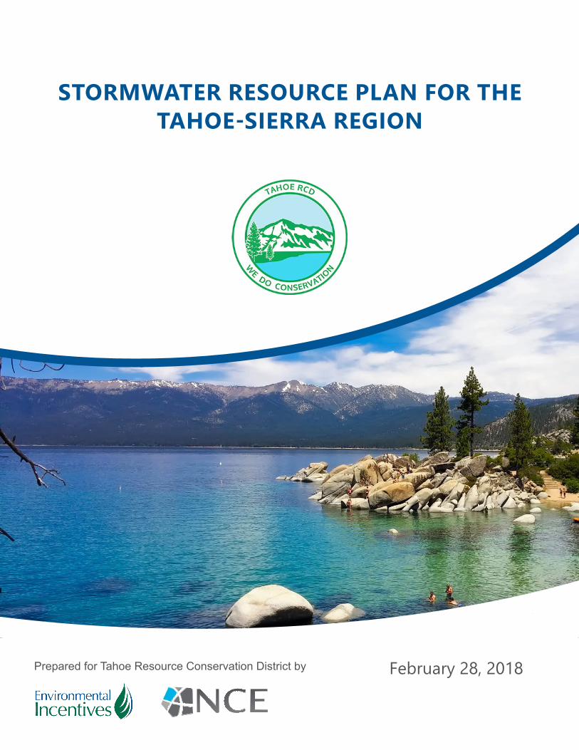
STORMWATER RESOURCE PLAN FOR THE TAHOE-SIERRA REGION
February 28, 2018Prepared for Tahoe Resource Conservation District by

Funding has been provided in full or in part through an agreement with the State Water Resources Control Board using funds from Proposition 1. The contents of this document do not necessarily reflect the views and policies of the foregoing, nor does mention of trade names or commercial products constitute endorsement or recommendation for use.
STORMWATER RESOURCE PLAN: TAHOE-SIERRA REGION PAGE 2
TAHOE-SIERRA REGION
TABLE OF CONTENTS TABLE OF CONTENTS .................................................................................................................................... 2
ACRONYMS .................................................................................................................................................. 4
EXECUTIVE SUMMARY ................................................................................................................................. 5
INTRODUCTION .......................................................................................................................................... 10
IMPLEMENTERS .............................................................................................................................................. 11
PARTNERS....................................................................................................................................................... 11
OTHERS ........................................................................................................................................................... 12
SECTION A. DESCRIPTION OF WATERSHED AND SUB-WATERSHEDS ...................................................... 13
WATERSHED BOUNDARIES (SWRP GUIDELINES SECTION A.I) ................................................................ 13
INTERNAL BOUNDARIES (SWRP GUIDELINES SECTION A.II) .................................................................... 13
WATER QUALITY PRIORITIZATION (SWRP GUIDELINES SECTION A. III) ................................................... 22
SURFACE AND GROUNDWATER QUALITY (SWRP GUIDELINES SECTION A. IV) .................................. 25
WATER SUPPLY (SWRP GUIDELINES SECTION A.V) .................................................................................. 31
NATIVE HABITATS (SWRP GUIDELINES SECTION A. VI) ............................................................................ 32
WATERSHED PROCESSES (SWRP GUIDELINES SECTION A.VII) ............................................................... 34
SECTION B. ORGANIZATION, COORDINATION & COLLABORATION..................................................... 36
IRWM PARTNERSHIP (SWRP GUIDELINES SECTION B.I & B.VI) ................................................................ 36
SWRP STAKEHOLDERS (SWRP GUIDELINES SECTION B.II & B.III) ............................................................. 36
REQUIRED DECISIONS (SWRP GUIDELINES SECTION B.V) ...................................................................... 38
OTHER CONSIDERATIONS (SWRP GUIDELINES SECTION B.IV & B.VII)................................................... 38
SECTIONS C&D METHODS & PROJECT PRIORITIZATION .......................................................................... 39
TAHOE IDENTIFICATION OF PROJECTS (SWRP GUIDELINES SECTION C.1) .......................................... 39
TAHOE METRICS-BASED ANALYSIS (SWRP GUIDELINES SECTION C.2) ................................................. 40
TAHOE GUIDANCE FOR PRIORITIZING PROJECTS (SWRP GUIDELINES SECTION D.1) ........................ 42
TAHOE WATER QUALITY ANALYSIS (SWRP GUIDELINES SECTION C.2.A) ............................................. 43
TAHOE MULTIPLE BENEFITS (SWRP GUIDELINES SECTION D.2) ............................................................... 44
TAHOE DATA MANAGEMENT (SWRP GUIDELINES SECTION C.3) ......................................................... 44
NON-TAHOE IDENTIFICATION OF PROJECTS (SWRP GUIDELINES SECTION C.1) ................................ 45
NON-TAHOE METRICS-BASED ANALYSIS (SWRP GUIDELINES SECTION C.2) ....................................... 45
NON-TAHOE GUIDANCE FOR PRIORITIZING PROJECTS (SWRP GUIDELINES SECTION D.1) ............. 47
NON-TAHOE WATER QUALITY ANALYSIS (SWRP GUIDELINES SECTION C.2.A) ................................... 49
NON-TAHOE MULTIPLE BENEFITS (SWRP GUIDELINES SECTION D.2) ..................................................... 50
NON-TAHOE DATA MANAGEMENT (SWRP GUIDELINES SECTION C.3) ............................................... 50
SECTION E. PLAN IMPLEMENTATION STRATEGY AND SCHEDULING OF PROJECTS ............................... 51
RESOURCES FOR PLAN IMPLEMENTATION (SWRP GUIDELINES SECTION E.1) ..................................... 51
IMPLEMENTATION PROGRAM (SWRP GUIDELINES SECTION E.2) ......................................................... 51
ADAPTIVE MANAGEMENT (SWRP GUIDELINES SECTION E.3) & PERFORMANCE MEASURES (SWRP GUIDELINES SECTION E.4) ........................................................................................................................... 53
STORMWATER RESOURCE PLAN: TAHOE-SIERRA REGION PAGE 3
TAHOE-SIERRA REGION
SECTION F. EDUCATION, OUTREACH, AND PUBLIC PARTICIPATION ..................................................... 57
PUBLIC EDUCATION & PARTICIPATION (SWRP GUIDELINES SECTION F.I & F.II) .................................. 57
AFFECTED COMMUNITIES (SWRP GUIDELINES SECTION F.III) ................................................................. 57
SPECIFIC AUDIENCES (SWRP GUIDELINES SECTION F.IV & F.V) ............................................................ 57
ENVIRONMENTAL INJUSTICE (SWRP GUIDELINES SECTION F.VI) ........................................................... 58
ENGAGEMENT & COMMUNICATION SCHEDULE (SWRP GUIDELINES SECTION F.VII) ....................... 58
APPENDIX A – COMMUNITY WATER SUPPLIERS
APPENDIX B – CDPH REGULATED WATER SYSTEMS
APPENDIX C – 303D LISTED WATERBODIES
APPENDIX D – TAHOE METRIC INFORMATION SHEETS
APPENDIX E – RANKED PROJECT LISTS FOR TAHOE PROJECTS
APPENDIX F – METRIC AND BENEFIT ESTIMTATES FOR EACH TAHOE PROJECT
APPENDIX G – ADDITIONAL TAHOE PROJECT INFORMATION
APPENDIX H – NON-TAHOE METRIC INFORMATION SHEETS
APPENDIX I – RANKED PROJECT LISTS FOR NON-TAHOE PROJECTS
APPENDIX J – METRIC AND BENEFIT ESTIMATES FOR EACH NON-TAHOE PROJECT
APPENDIX K – ADDITIONAL NON-TAHOE PROJECT INFORMATION
APPENDIX L – SWRP TRACKER PRODUCTS
APPENDIX M – PLANS FOR NEW DEVELOPMENTS OR REDEVELOPMENTS

STORMWATER RESOURCE PLAN: TAHOE-SIERRA REGION PAGE 4
TAHOE-SIERRA REGION
ACRONYMS
BMP Best management practices CDFW California Department of Fish and Wildlife CDPH California Department of Public Health CEQA California Environmental Quality Act CTC California Tahoe Conservancy CWA Clean Water Act CWD County Water District DAC Disadvantaged Community DWR Department of Water Resources EI Environmental Injustice EIP Environmental Improvement Program FSP Fine Sediment Particle HU Hydrologic Unit IRWM Integrated Regional Water Management IRWMP Integrated Regional Water Management Plan Lahontan RWQCB Water Quality Control Board Lahontan Region MCL Maximum Contaminant Levels MTBE Methyl tert-butyl ether MUN Municipal and Domestic Supply NGO Non-governmental Organizations NPDES National Pollutant Discharge Elimination System PCB Polychlorinated Biphenyls PCWA Placer County Water Agency PLRM Pollutant Load Reduction Model PLRP Pollutant Load Reduction Plan PM Performance Measures PUD Public Utility District Region Tahoe-Sierra Region SEZ Stream Environment Zones SMCL Secondary Maximum Contaminant Level SWRP Stormwater Resource Plan SWMP Stormwater Management Program State Water Board California State Water Resources Control Board TAC Technical Advisory Committee Tahoe-basin Lake Tahoe Basin Tahoe RCD Tahoe Resource Conservation District TDS Total Dissolved Solid TMDL Total Maximum Daily Load TN Total Nitrogen TP Total Phosphorous TRPA Tahoe Regional Planning Agency USEPA US Environmental Protection Agency USFS US Forest Service UST Underground Storage Tank WEPD Washoe Environmental Protection Department Water Boards State Water Resources Control Board and Regional Water Quality Control Boards Water Code Water Code… WDR Waste Discharge Requirement WQO Water Quality Objective
STORMWATER RESOURCE PLAN: TAHOE-SIERRA REGION PAGE 5
TAHOE-SIERRA REGION
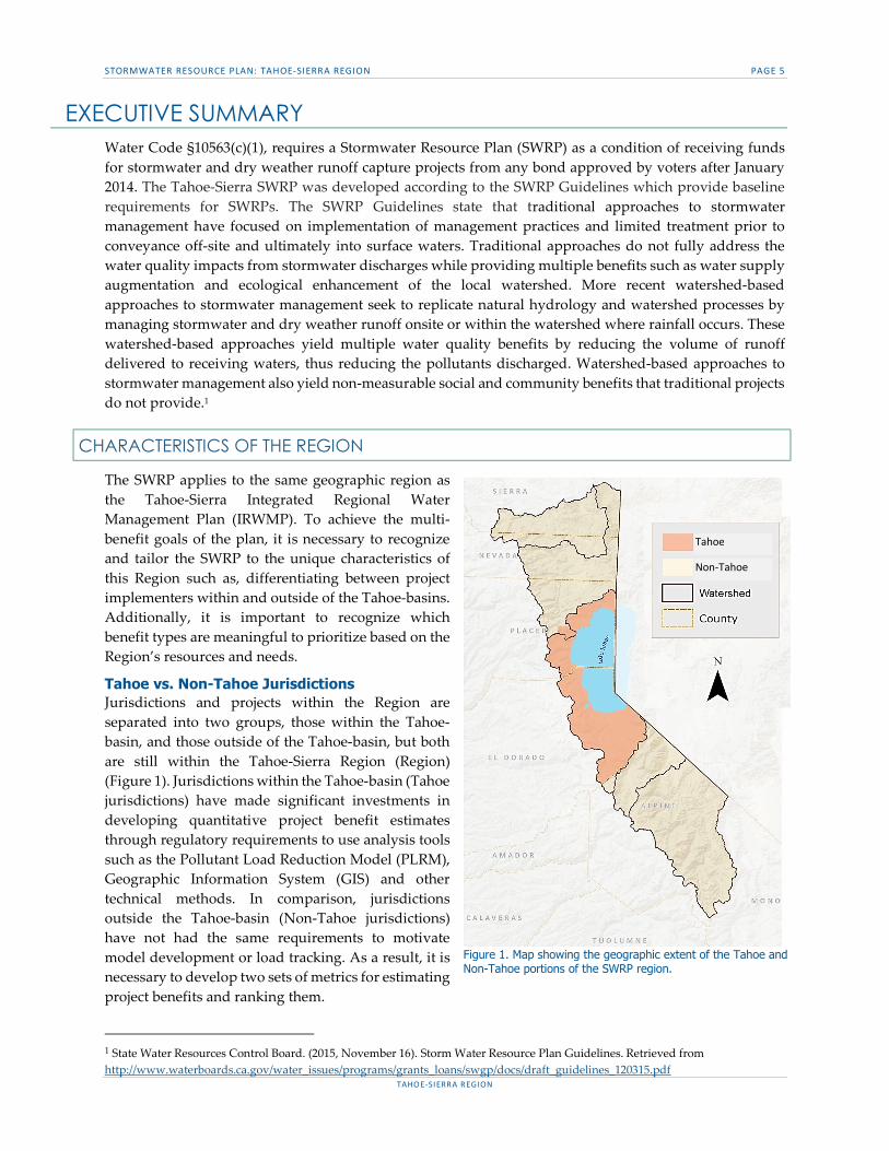
EXECUTIVE SUMMARY Water Code §10563(c)(1), requires a Stormwater Resource Plan (SWRP) as a condition of receiving funds for stormwater and dry weather runoff capture projects from any bond approved by voters after January 2014. The Tahoe-Sierra SWRP was developed according to the SWRP Guidelines which provide baseline requirements for SWRPs. The SWRP Guidelines state that traditional approaches to stormwater management have focused on implementation of management practices and limited treatment prior to conveyance off-site and ultimately into surface waters. Traditional approaches do not fully address the water quality impacts from stormwater discharges while providing multiple benefits such as water supply augmentation and ecological enhancement of the local watershed. More recent watershed-based approaches to stormwater management seek to replicate natural hydrology and watershed processes by managing stormwater and dry weather runoff onsite or within the watershed where rainfall occurs. These watershed-based approaches yield multiple water quality benefits by reducing the volume of runoff delivered to receiving waters, thus reducing the pollutants discharged. Watershed-based approaches to stormwater management also yield non-measurable social and community benefits that traditional projects do not provide.1
CHARACTERISTICS OF THE REGION
The SWRP applies to the same geographic region as the Tahoe-Sierra Integrated Regional Water Management Plan (IRWMP). To achieve the multi-benefit goals of the plan, it is necessary to recognize and tailor the SWRP to the unique characteristics of this Region such as, differentiating between project implementers within and outside of the Tahoe-basins. Additionally, it is important to recognize which benefit types are meaningful to prioritize based on the Region’s resources and needs.
Tahoe vs. Non-Tahoe Jurisdictions Jurisdictions and projects within the Region are separated into two groups, those within the Tahoe-basin, and those outside of the Tahoe-basin, but both are still within the Tahoe-Sierra Region (Region) (Figure 1). Jurisdictions within the Tahoe-basin (Tahoe jurisdictions) have made significant investments in developing quantitative project benefit estimates through regulatory requirements to use analysis tools such as the Pollutant Load Reduction Model (PLRM), Geographic Information System (GIS) and other technical methods. In comparison, jurisdictions outside the Tahoe-basin (Non-Tahoe jurisdictions) have not had the same requirements to motivate model development or load tracking. As a result, it is necessary to develop two sets of metrics for estimating project benefits and ranking them.
1 State Water Resources Control Board. (2015, November 16). Storm Water Resource Plan Guidelines. Retrieved from http://www.waterboards.ca.gov/water_issues/programs/grants_loans/swgp/docs/draft_guidelines_120315.pdf
Tahoe
Non-Tahoe
Figure 1. Map showing the geographic extent of the Tahoe and Non-Tahoe portions of the SWRP region.
STORMWATER RESOURCE PLAN: TAHOE-SIERRA REGION PAGE 6
TAHOE-SIERRA REGION
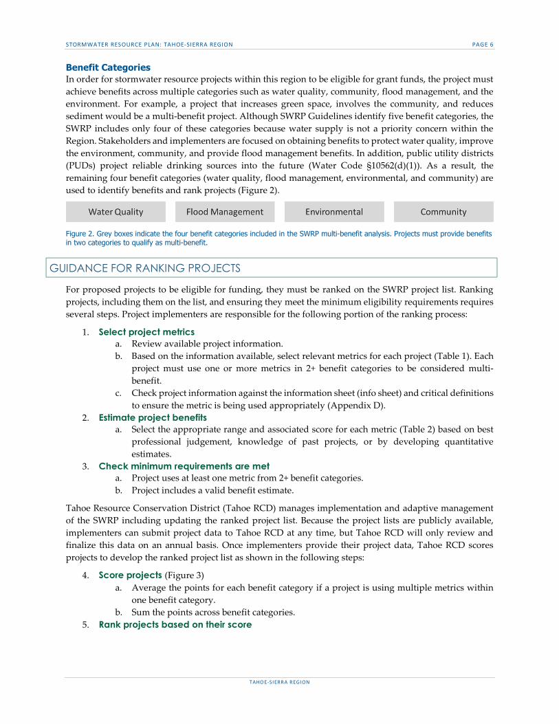
Benefit Categories In order for stormwater resource projects within this region to be eligible for grant funds, the project must achieve benefits across multiple categories such as water quality, community, flood management, and the environment. For example, a project that increases green space, involves the community, and reduces sediment would be a multi-benefit project. Although SWRP Guidelines identify five benefit categories, the SWRP includes only four of these categories because water supply is not a priority concern within the Region. Stakeholders and implementers are focused on obtaining benefits to protect water quality, improve the environment, community, and provide flood management benefits. In addition, public utility districts (PUDs) project reliable drinking sources into the future (Water Code §10562(d)(1)). As a result, the remaining four benefit categories (water quality, flood management, environmental, and community) are used to identify benefits and rank projects (Figure 2).
Figure 2. Grey boxes indicate the four benefit categories included in the SWRP multi-benefit analysis. Projects must provide benefits in two categories to qualify as multi-benefit.
GUIDANCE FOR RANKING PROJECTS
For proposed projects to be eligible for funding, they must be ranked on the SWRP project list. Ranking projects, including them on the list, and ensuring they meet the minimum eligibility requirements requires several steps. Project implementers are responsible for the following portion of the ranking process:
1. Select project metrics a. Review available project information. b. Based on the information available, select relevant metrics for each project (Table 1). Each
project must use one or more metrics in 2+ benefit categories to be considered multi-benefit.
c. Check project information against the information sheet (info sheet) and critical definitions to ensure the metric is being used appropriately (Appendix D).
2. Estimate project benefits a. Select the appropriate range and associated score for each metric (Table 2) based on best
professional judgement, knowledge of past projects, or by developing quantitative estimates.
3. Check minimum requirements are met a. Project uses at least one metric from 2+ benefit categories. b. Project includes a valid benefit estimate.
Tahoe Resource Conservation District (Tahoe RCD) manages implementation and adaptive management of the SWRP including updating the ranked project list. Because the project lists are publicly available, implementers can submit project data to Tahoe RCD at any time, but Tahoe RCD will only review and finalize this data on an annual basis. Once implementers provide their project data, Tahoe RCD scores projects to develop the ranked project list as shown in the following steps:
4. Score projects (Figure 3) a. Average the points for each benefit category if a project is using multiple metrics within
one benefit category. b. Sum the points across benefit categories.
5. Rank projects based on their score

STORMWATER RESOURCE PLAN: TAHOE-SIERRA REGION PAGE 7
TAHOE-SIERRA REGION
Figure 3. Project scoring method. Light grey boxes are metric scores within each benefit category (dark grey boxes). Light blue boxes show that metrics within each benefit category are averaged and then summed to determine the total project score (dark blue box).
Metrics for ranking projects and estimating benefits The following tables show the metrics implementers use to quantify the multiple benefits of their stormwater projects. The steps implementers should follow to apply these metrics to their projects are described in the “Guidance for ranking projects” section above. Separate sets of metrics are intended for use by Tahoe (Table 1) and Non-Tahoe (Table 2) jurisdictions based on the differing characteristics of these regions. The expected aggregate benefit of all planned projects on the SWRP project list is described in Sections C&D.
Table 1. Guidance for estimating Tahoe-basin benefits
2 The ranges for each metric intentionally overlap so that project implementers have flexibility when selecting point values for their project. This is intended to reflect that benefit estimates are preliminary and likely to adjust as projects develop. 3 Best Management Practice (BMP) 4 Disadvantaged Community (DAC)
METRIC NAME BENEFIT
CATEGORY UNITS
POINTS2 0 1 2 3 4 5
1 - Fine sediment load reduction Water Quality Pounds/yr 0 1 to 1000 900 to 2400 2200 to 3500 3100 to 4900 4400+
2 - Nitrogen load reduction Water Quality Pounds/yr 0 1 to 5 3 to 9 7 to 13 11 to 20 18+ 3 - Phosphorous load reduction
Water Quality Pounds/yr 0 1 to 18 16 to 30 27 to 50 45 to 70 65+
4 - Parcels with stormwater BMPs3 Water Quality Number 0 1 to 4 3 to 60 50 to 130 100 to 360 300+
5 - Linear feet of stream channel restored or enhanced
Environment Linear ft. 0 1 to 150 100 to 400 350 to 600 550 to 1000 800+
6 - Acres of habitat restored or enhanced Environment Acres 0 0.1 to 1 0.5 to 2 1.5 to 6 5 to 15 12+
7 - Facilities improved or created
Community Number 0 1 to 2 2 to 3 3 to 4 4 to 5 5+
8 - Tahoe DAC4 population served Community No Yes
9 - Community areas enhanced or created
Community No Yes
10 - Volume of stormwater reduced, stored or infiltrated Flood Mgmt. Acre Feet/yr 0 0.25 to 1 0.75 to 1.5 1.25 to 2.25 2 to 3 2.75+
STORMWATER RESOURCE PLAN: TAHOE-SIERRA REGION PAGE 8
TAHOE-SIERRA REGION
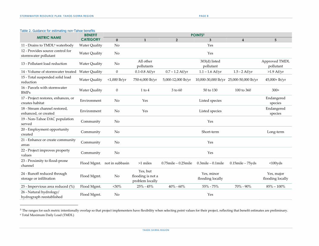
Table 2. Guidance for estimating non-Tahoe benefits
METRIC NAME BENEFIT
CATEGORY POINTS5
0 1 2 3 4 5 11 - Drains to TMDL6 waterbody Water Quality No Yes 12 - Provides source control for stormwater pollutant
Water Quality No Yes
13 - Pollutant load reduction Water Quality No All other pollutants
303(d) listed pollutant
Approved TMDL pollutant
14 - Volume of stormwater treated Water Quality 0 0.1-0.8 Af/yr 0.7 – 1.2 Af/yr 1.1 – 1.6 Af/yr 1.5 - 2 Af/yr >1.9 Af/yr 15 - Total suspended solid load reduction
Water Quality <1,000 lb/yr 750-6,000 lb/yr 5,000-12,000 lb/yr 10,000-30,000 lb/yr 25,000-50,000 lb/yr 45,000+ lb/yr
16 - Parcels with stormwater BMPs Water Quality 0 1 to 4 3 to 60 50 to 130 100 to 360 300+
17 - Project restores, enhances, or creates habitat Environment No Yes Listed species
Endangered species
18 - Stream channel restored, enhanced, or created Environment No Yes Listed species
Endangered species
19 - Non-Tahoe DAC population served
Community No Yes
20 - Employment opportunity created
Community No Short-term Long-term
21 - Enhance or create community areas
Community No Yes
22 - Project improves property values
Community No Yes
23 - Proximity to flood-prone channel
Flood Mgmt. not in subbasin >1 miles 0.75mile – 0.25mile 0.3mile – 0.1mile 0.15mile – 75yds <100yds
24 - Runoff reduced through storage or infiltration
Flood Mgmt. No Yes, but
flooding is not a problem locally
Yes, minor flooding locally
Yes, major flooding locally
25 - Impervious area reduced (%) Flood Mgmt. <30% 25% - 45% 40% - 60% 55% - 75% 70% - 90% 85% – 100% 26 - Natural hydrology/ hydrograph reestablished Flood Mgmt. No Yes
5 The ranges for each metric intentionally overlap so that project implementers have flexibility when selecting point values for their project, reflecting that benefit estimates are preliminary. 6 Total Maximum Daily Load (TMDL)
STORMWATER RESOURCE PLAN: TAHOE-SIERRA REGION PAGE 9
TAHOE-SIERRA REGION
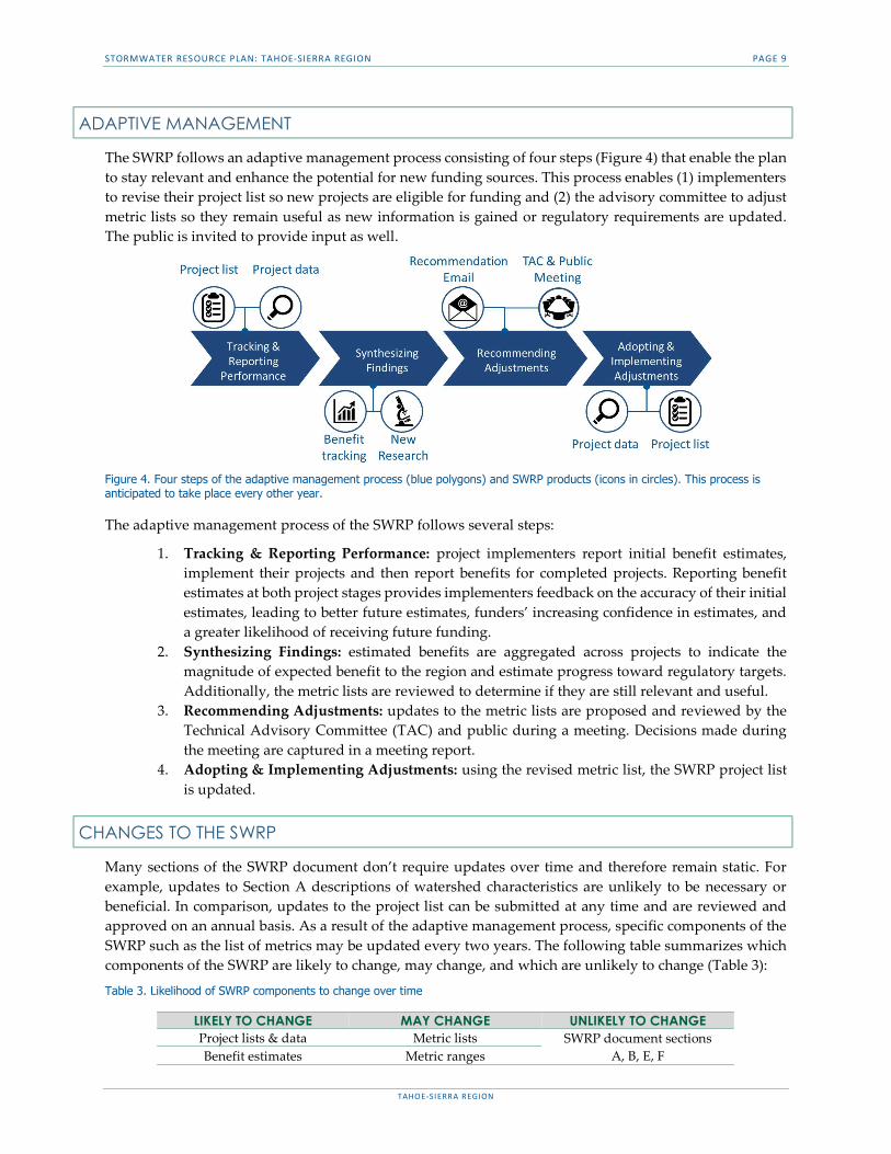
ADAPTIVE MANAGEMENT
The SWRP follows an adaptive management process consisting of four steps (Figure 4) that enable the plan to stay relevant and enhance the potential for new funding sources. This process enables (1) implementers to revise their project list so new projects are eligible for funding and (2) the advisory committee to adjust metric lists so they remain useful as new information is gained or regulatory requirements are updated. The public is invited to provide input as well.
Figure 4. Four steps of the adaptive management process (blue polygons) and SWRP products (icons in circles). This process is anticipated to take place every other year.
The adaptive management process of the SWRP follows several steps:
1. Tracking & Reporting Performance: project implementers report initial benefit estimates, implement their projects and then report benefits for completed projects. Reporting benefit estimates at both project stages provides implementers feedback on the accuracy of their initial estimates, leading to better future estimates, funders’ increasing confidence in estimates, and a greater likelihood of receiving future funding.
2. Synthesizing Findings: estimated benefits are aggregated across projects to indicate the magnitude of expected benefit to the region and estimate progress toward regulatory targets. Additionally, the metric lists are reviewed to determine if they are still relevant and useful.
3. Recommending Adjustments: updates to the metric lists are proposed and reviewed by the Technical Advisory Committee (TAC) and public during a meeting. Decisions made during the meeting are captured in a meeting report.
4. Adopting & Implementing Adjustments: using the revised metric list, the SWRP project list is updated.
CHANGES TO THE SWRP
Many sections of the SWRP document don’t require updates over time and therefore remain static. For example, updates to Section A descriptions of watershed characteristics are unlikely to be necessary or beneficial. In comparison, updates to the project list can be submitted at any time and are reviewed and approved on an annual basis. As a result of the adaptive management process, specific components of the SWRP such as the list of metrics may be updated every two years. The following table summarizes which components of the SWRP are likely to change, may change, and which are unlikely to change (Table 3):
Table 3. Likelihood of SWRP components to change over time
LIKELY TO CHANGE MAY CHANGE UNLIKELY TO CHANGE Project lists & data Metric lists SWRP document sections
A, B, E, F Benefit estimates Metric ranges

STORMWATER RESOURCE PLAN: TAHOE-SIERRA REGION PAGE 10
TAHOE-SIERRA REGION
INTRODUCTION The SWRP for the Tahoe-Sierra Integrated Regional Water Management (IRWM) Region is organized into five sections (Figure 5). Each section contains the information necessary to meet SWRP Guidelines and Water Code requirements and is tailored to the characteristics of the Region.
Figure 5. The primary content of sections A through F of the document are represented by a graphic and brief description (grey text).
Section A states that the SWRP region matches the Region so that existing planning efforts can be leveraged to the maximum extent possible. Additionally, sub-watershed boundaries within the Region are identified along with water quality regulations and impairments. This information is helpful context for decisions about benefit categories and metrics selected.
Section B identifies the responsibilities of the implementers, partners, and other stakeholders participating in SWRP development and implementation. Collaborating with these entities may lead to joint solutions to address obstacles inherent in watershed-scale stormwater management and helps to maximize benefits to natural resources, the community and the economy. This section is used to discover who is involved in delivering stormwater projects and making decisions.
Sections C&D outline the process for jurisdictions to propose their projects and benefit estimates for each project. The process for ranking each project list and determining the aggregate benefit of all listed projects is also described. The aggregate of project benefit estimates indicates progress toward meeting regulatory requirements, like water quality regulations. Due to the unique characteristics of the Region, separate guidance and metrics are developed for the Tahoe-basin and outside of the Tahoe-basin. Although all jurisdictions may use best professional judgement to provide benefit estimates for planned projects, Tahoe projects may have additional technical resources available, like the PLRM.
Section E guides adaptive management of the SWRP to ensure clear roles and procedures that maintain the project list, track progress toward regulatory requirements and update metrics. Pollutant load reduction targets within the Tahoe-basin are adjusted every 5 years when new municipal stormwater permits are adopted. A meaningful yet achievable adaptive management process ensures implementers remain eligible for funding over time as regulatory requirements change, and benefit priorities shift.
Section F identifies opportunities for public education and engagement during development of the SWRP including a public forum, open TAC meetings and a webpage where materials relevant to SWRP development are accessible to the public. Public participation during the development and implementation of the SWRP helps optimize the community-based benefits of watershed scale stormwater management.

STORMWATER RESOURCE PLAN: TAHOE-SIERRA REGION PAGE 11
TAHOE-SIERRA REGION
USER GUIDE
This user guide is designed to help users of the SWRP to find the most relevant sections of the document quickly. This guide is organized by user type including: implementers, partners, and other groups as defined below.
IMPLEMENTERS
Implementers are local municipalities or organizations within the Region who apply for bond funding to implement stormwater projects. The SWRP is one of several methods for implementers to prioritize their projects and support funding decisions. When reviewing the SWRP, implementers should focus on specific sections of the document which are likely to be most relevant to their needs and interests (Table 4).
Table 4. Examples of SWRP content relevant to project implementers
PARTNERS
Partners are agencies that regulate, fund and oversee the implementation of stormwater programs or projects. When reviewing the SWRP, partners should focus on specific sections of the document which are likely to be most relevant to their needs and interests (Table 5).
USER TYPE EXAMPLE USERS NEED FOCUS
Project implementers
City of South Lake Tahoe
Town of Truckee
South Tahoe PUD
Tahoe Regional Planning Agency (TRPA)
Truckee River Watershed Council
Alpine Watershed Group
El Dorado County
Placer County
Alpine County
California Tahoe Conservancy (CTC)
Tahoe RCD
Understand the steps for adding projects to the SWRP list
Understand project requirements for funding eligibility
Decide project multi-benefits
Section C Section D
Appendices E, F, I, J
Understand the adaptive management process ▫ how metrics may be revised over time ▫ role/ participation in the process
Section E

STORMWATER RESOURCE PLAN: TAHOE-SIERRA REGION PAGE 12
TAHOE-SIERRA REGION
Table 5. Examples of SWRP content relevant to project partners
OTHERS
Other groups may include non-governmental organizations (NGOs) and universities who have an interest in the development and implementation of the SWRP. When reviewing the SWRP, these groups should focus on specific sections of the document which are likely to be most relevant to their needs and interests (Table 6).
Table 6. Examples of SWRP content relevant to other groups
7 California State Water Resources Control Board (State Water Board)
USER TYPE EXAMPLE USERS NEED FOCUS
Plan reviewer
State Water Board7 Determine whether ▫ SWRP Guidelines are addressed ▫ Water Code requirements are met
Water Code and SWRP Guideline references
Ex: (SWRP Guidelines
Section A.i)
Ex: Water Code section 10565(c)
Local Regulator
Water Quality Control Board Lahontan Regional (Lahontan RWQCB)
Confirm description of regional characteristics and existing regulations is accurate
Section A
Agency familiar with
local conditions
TRPA
CTC
Ensure the SWRP builds on, compliments, and does not conflict with existing plans ▫ Understand how existing metrics
are leveraged
Sections C&D
▫ Understand how IRWM information is repurposed instead of recreated
IRWM references
USER TYPE EXAMPLE USERS NEED FOCUS
Researchers & universities
UN Reno, Desert Research Institute
UC Davis, Tahoe Environmental Research Center
Identify any inconsistencies between metric definitions and current scientific knowledge
Metrics in Appendices
D & H
Local NGOs League to Save Lake
Tahoe
Understand the methods and opportunities for public participation throughout development, implementation and adaptive management of the SWRP
Section F
STORMWATER RESOURCE PLAN: TAHOE-SIERRA REGION PAGE 13
TAHOE-SIERRA REGION
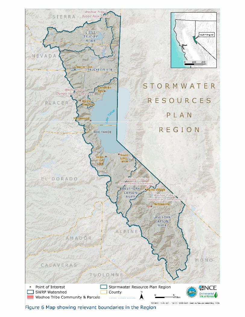
SECTION A. DESCRIPTION OF WATERSHED AND SUB-WATERSHEDS Section A of the SWRP identifies the SWRP boundary for the Region, watershed and sub-watershed boundaries within the Region, and water quality regulations and impairments within the major watersheds, including pollutants identified on the 303(d) list of impaired water bodies or with relevant TMDLs. Additionally, jurisdictions and projects are separated into two groups, those within the Tahoe-basin, and those outside of the Tahoe-basin, but both are still within the Region.
WATERSHED BOUNDARIES (SWRP GUIDELINES SECTION A.I)
The watershed boundaries for the SWRP are the watersheds used in the Tahoe-Sierra IRWMP and include the following five hydrologic units (HU) (i.e., watersheds): West Fork of the Carson River, East Fork of the Carson River, Lake Tahoe, Truckee River, and Little Truckee River (Figure 6). It is appropriate for these five watersheds which comprise the planning region used for the IRWMP to constitute the boundary for the SWRP because the IRWMP was also developed using a watershed-based approach in order to implement multi-benefit projects. The SWRP builds from the IRWMP’s multi-benefit watershed approach. The watersheds of the SWRP are consistent with SWRP Guidelines Section A. 1 through 5 and Water Code §10565(c) and 10562(b)(1) given that:
the watersheds are the union of several 12-hydrologic unit code watersheds, and are larger than 5 square miles; a scale suitable for quantitative analysis of stormwater and dry weather runoff patterns,
the watersheds are regional boundaries that allow for comprehensive integrated stormwater management as they did previously during IRWMP development, and
the watersheds contain multiple jurisdictions (City and County lands) to promote regional planning, and are not designed to single out a particular project.
INTERNAL BOUNDARIES (SWRP GUIDELINES SECTION A.II)
Internal boundaries within the watershed provide information about the following:
1. Opportunities to augment local water supply through groundwater recharge or storage for beneficial use of stormwater and dry weather runoff.
2. Opportunities for source control for both pollution and stormwater and dry weather runoff volume, onsite and local infiltration, and use of stormwater and dry weather runoff.
3. Projects to reestablish natural water drainage treatment and infiltration systems, or mimic natural system functions to the maximum extent feasible.
4. Opportunities to develop, restore, or enhance habitat and open space through stormwater and dry weather runoff management, including wetlands, riverside habitats, parkways, and parks.
5. Opportunities to use existing publicly owned lands and easements, including, but not limited to, parks, public open space, community gardens, farm and agricultural preserves, school sites, and government office buildings and complexes, to capture, clean, store, and use stormwater and dry weather runoff either onsite or offsite.
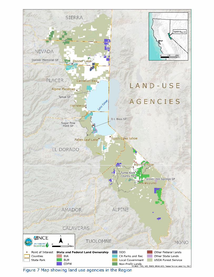
Section A.II of the SWRP Guidelines requires the SWRP document to describe internal boundaries within the watersheds, preferably in GIS format. The internal boundaries required by the SWRP Guidelines and pursuant to Water Code §10562(d) are illustrated in GIS format in the SWRP by the following figures and table:
STORMWATER RESOURCE PLAN: TAHOE-SIERRA REGION PAGE 14
TAHOE-SIERRA REGION
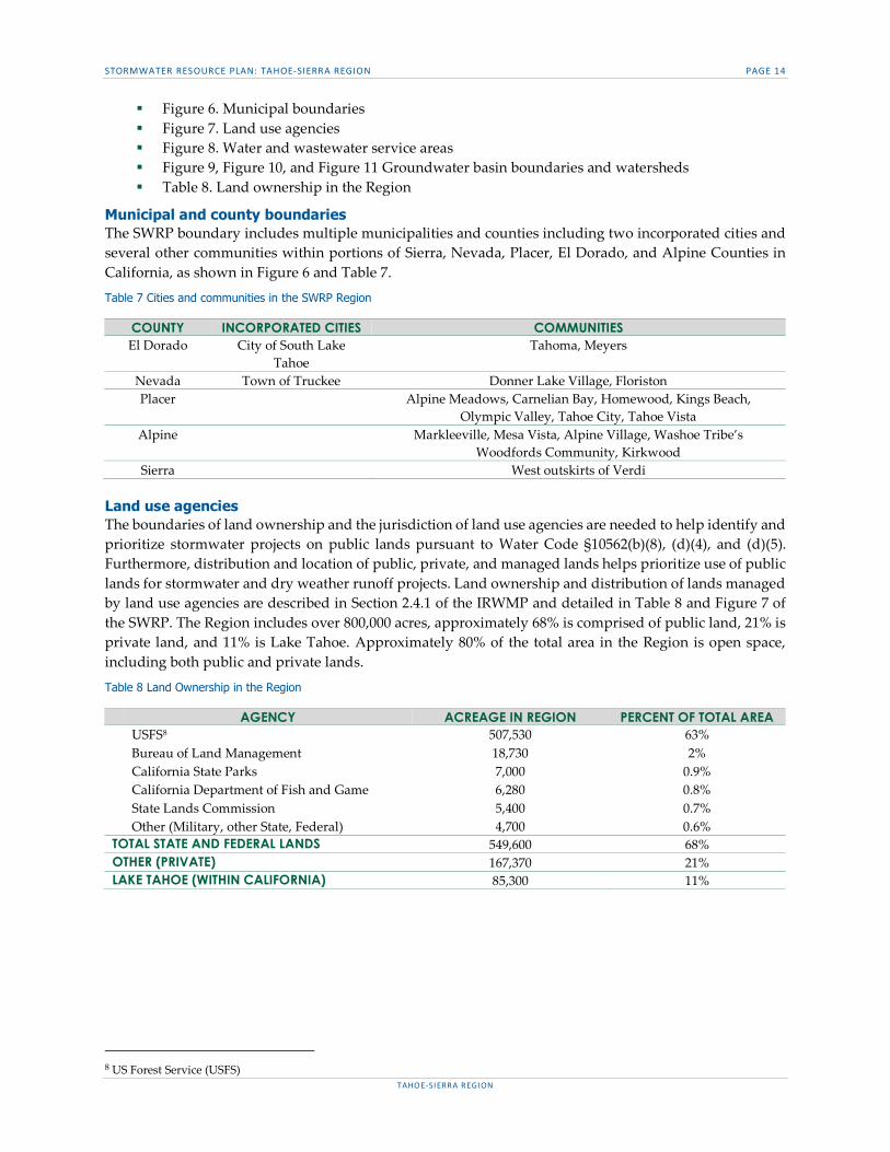
Figure 6. Municipal boundaries Figure 7. Land use agencies Figure 8. Water and wastewater service areas Figure 9, Figure 10, and Figure 11 Groundwater basin boundaries and watersheds Table 8. Land ownership in the Region
Municipal and county boundaries The SWRP boundary includes multiple municipalities and counties including two incorporated cities and several other communities within portions of Sierra, Nevada, Placer, El Dorado, and Alpine Counties in California, as shown in Figure 6 and Table 7.
Table 7 Cities and communities in the SWRP Region
Land use agencies The boundaries of land ownership and the jurisdiction of land use agencies are needed to help identify and prioritize stormwater projects on public lands pursuant to Water Code §10562(b)(8), (d)(4), and (d)(5). Furthermore, distribution and location of public, private, and managed lands helps prioritize use of public lands for stormwater and dry weather runoff projects. Land ownership and distribution of lands managed by land use agencies are described in Section 2.4.1 of the IRWMP and detailed in Table 8 and Figure 7 of the SWRP. The Region includes over 800,000 acres, approximately 68% is comprised of public land, 21% is private land, and 11% is Lake Tahoe. Approximately 80% of the total area in the Region is open space, including both public and private lands.
Table 8 Land Ownership in the Region
8 US Forest Service (USFS)
COUNTY INCORPORATED CITIES COMMUNITIES El Dorado City of South Lake
Tahoe Tahoma, Meyers
Nevada Town of Truckee Donner Lake Village, Floriston Placer Alpine Meadows, Carnelian Bay, Homewood, Kings Beach,
Olympic Valley, Tahoe City, Tahoe Vista Alpine Markleeville, Mesa Vista, Alpine Village, Washoe Tribe’s
Woodfords Community, Kirkwood Sierra West outskirts of Verdi
AGENCY ACREAGE IN REGION PERCENT OF TOTAL AREA USFS8 507,530 63% Bureau of Land Management 18,730 2% California State Parks 7,000 0.9% California Department of Fish and Game 6,280 0.8% State Lands Commission 5,400 0.7% Other (Military, other State, Federal) 4,700 0.6% TOTAL STATE AND FEDERAL LANDS 549,600 68% OTHER (PRIVATE) 167,370 21% LAKE TAHOE (WITHIN CALIFORNIA) 85,300 11%
STORMWATER RESOURCE PLAN: TAHOE-SIERRA REGION PAGE 15
TAHOE-SIERRA REGION
Figure 6 Map showing relevant boundaries in the Region
STORMWATER RESOURCE PLAN: TAHOE-SIERRA REGION PAGE 16
TAHOE-SIERRA REGION
Figure 7 Map showing land use agencies in the Region
STORMWATER RESOURCE PLAN: TAHOE-SIERRA REGION PAGE 17
TAHOE-SIERRA REGION
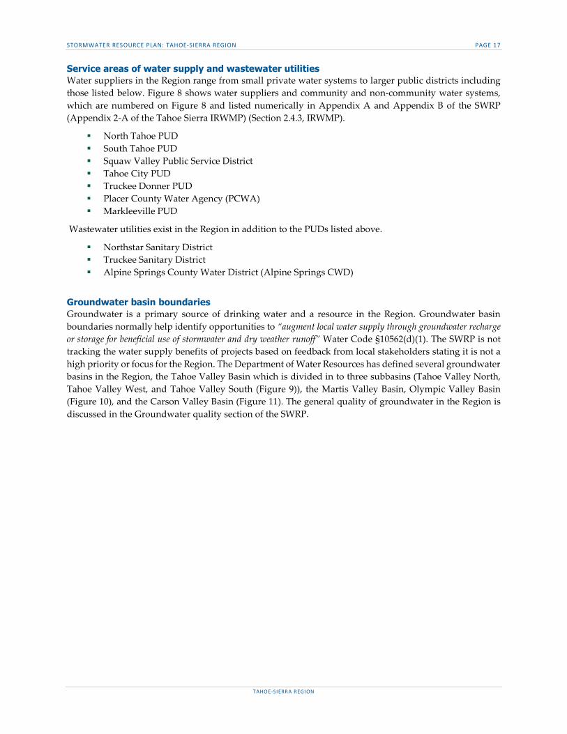
Service areas of water supply and wastewater utilities Water suppliers in the Region range from small private water systems to larger public districts including those listed below. Figure 8 shows water suppliers and community and non-community water systems, which are numbered on Figure 8 and listed numerically in Appendix A and Appendix B of the SWRP (Appendix 2-A of the Tahoe Sierra IRWMP) (Section 2.4.3, IRWMP).
North Tahoe PUD South Tahoe PUD Squaw Valley Public Service District Tahoe City PUD Truckee Donner PUD Placer County Water Agency (PCWA) Markleeville PUD
Wastewater utilities exist in the Region in addition to the PUDs listed above.
Northstar Sanitary District Truckee Sanitary District Alpine Springs County Water District (Alpine Springs CWD)
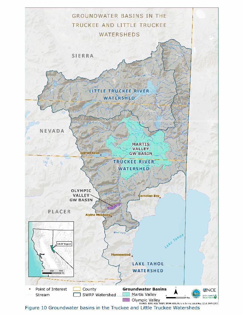
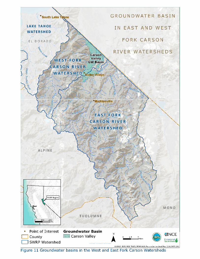
Groundwater basin boundaries Groundwater is a primary source of drinking water and a resource in the Region. Groundwater basin boundaries normally help identify opportunities to “augment local water supply through groundwater recharge or storage for beneficial use of stormwater and dry weather runoff” Water Code §10562(d)(1). The SWRP is not tracking the water supply benefits of projects based on feedback from local stakeholders stating it is not a high priority or focus for the Region. The Department of Water Resources has defined several groundwater basins in the Region, the Tahoe Valley Basin which is divided in to three subbasins (Tahoe Valley North, Tahoe Valley West, and Tahoe Valley South (Figure 9)), the Martis Valley Basin, Olympic Valley Basin (Figure 10), and the Carson Valley Basin (Figure 11). The general quality of groundwater in the Region is discussed in the Groundwater quality section of the SWRP.
STORMWATER RESOURCE PLAN: TAHOE-SIERRA REGION PAGE 18
TAHOE-SIERRA REGION
Figure 8 Water and wastewater service areas in the Region

STORMWATER RESOURCE PLAN: TAHOE-SIERRA REGION PAGE 19
TAHOE-SIERRA REGION
Figure 9 Groundwater basins in the Lake Tahoe Watershed
STORMWATER RESOURCE PLAN: TAHOE-SIERRA REGION PAGE 20
TAHOE-SIERRA REGION
Figure 10 Groundwater basins in the Truckee and Little Truckee Watersheds
STORMWATER RESOURCE PLAN: TAHOE-SIERRA REGION PAGE 21
TAHOE-SIERRA REGION
Figure 11 Groundwater basins in the West and East Fork Carson Watersheds

STORMWATER RESOURCE PLAN: TAHOE-SIERRA REGION PAGE 22
TAHOE-SIERRA REGION
WATER QUALITY PRIORITIZATION (SWRP GUIDELINES SECTION A. III)
SWRP Guidelines Section A.III requires a description of the water quality priorities within the watershed including applicable TMDLs and Clean Water Act (CWA), section 303(d) listed segments, and applicable National Pollutant Discharge Elimination System (NPDES) and waste discharge requirement (WDR) permits.
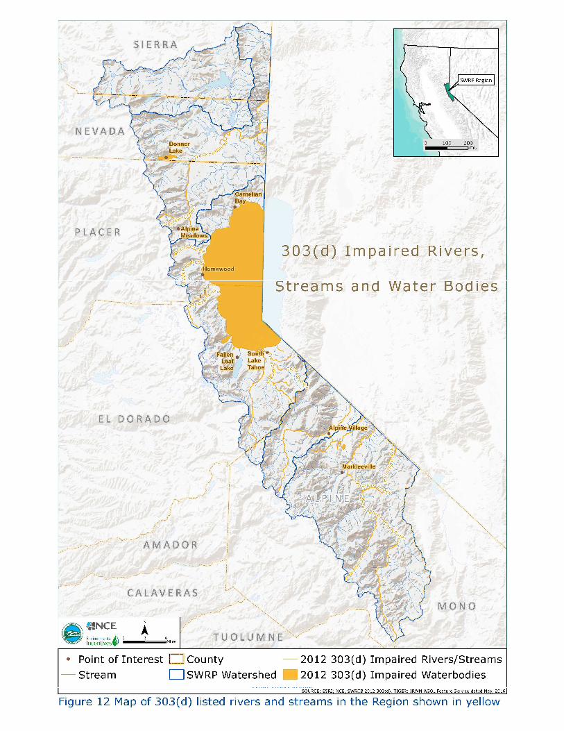
303(d) listings in the Region According to Section 303(d) of the CWA, once technology-based limits are put into place, the States must identify and list water segments that are not attaining water quality standards. States are then required to determine the point and nonpoint sources of pollutants causing impairment at each listed segment (Section 2.11.1 of the IRWMP) (Appendix C). General descriptions of these impairments are described for each HU, summarized in Table 9 and shown on Figure 12.
Table 9 Number of segments by pollutant, listed alphabetically
Lake Tahoe HU
In the Lake Tahoe HU there are twelve 303(d) listed waterbodies, including the Upper Truckee River and Lake Tahoe itself. Pollutants impacting the listed water bodies include nutrients, sediment, iron, chloride, and pathogens. Sources range from natural processes to urban runoff to mine tailings (Section 2.11.2.1 of the IRWMP). Elimination of grazing in some parts of the Upper Truckee River watershed have allowed the Upper Truckee River to be delisted for some of these pollutants (Section 2.11.2.2 of the IRWMP).
Truckee River and Little Truckee River HU
There are five listed waterbodies in the Truckee River HU, including the Truckee River itself (Section 2.11.2.2 of the IRWMP). Pollutants impacting the listed water bodies include sediment and priority organics. There are no listed waterbodies in the Little Truckee River HU.
East and West Fork Carson River HU
There is one 303(d) listed waterbody in the West Fork Carson River HU, and that is the West Fork Carson River itself (Section 2.11.2.3 of the IRWMP). There are eight 303(d) listed waterbodies in the East Fork Carson River HU including the East Fork Carson River. Pollutants impacting the listed waterbodies in the East and West Fork Carson River HUs include metals, nutrients, pathogens, sediment, TDS, and sulfate.
POLLUTANT # OF LISTED SEGMETNS POLLUTANT # OF LISTED SEGMETNS Aluminum 7 Low Dissolved Oxygen 1 Ammonia 1 Oxygen, Dissolved 4 Arsenic 10 Polychlorinated Biphenyls (PCB) 3 Boron 3 pH 1 Chlordane 1 Phosphorus 42
Chloride 12 Salinity/ Chlorides /
Total Dissolved Solids (TDS) 4 Copper 1 Sedimentation/Siltation 51 Fecal Coliform 25 Silver 6 Fluoride 2 Sulfates 11 Iron 27 TDS 21 Manganese 11 Total Kjeldahl Nitrogen 1 Mercury 13 Total Nitrogen as N 3 Metals 8 Total Petroleum Hydrocarbons 1 Nitrate 3 Trace Elements 1 Nitrogen 27 Turbidity 6 Oil and Grease 1 Unknown Toxicity 3
STORMWATER RESOURCE PLAN: TAHOE-SIERRA REGION PAGE 23
TAHOE-SIERRA REGION
Figure 12 Map of 303(d) listed rivers and streams in the Region shown in yellow.

STORMWATER RESOURCE PLAN: TAHOE-SIERRA REGION PAGE 24
TAHOE-SIERRA REGION
TMDLS in the Region The SWRP should describe “how it is consistent with and assists in, compliance with TMDL implementation plans and applicable National Pollutant Discharge Elimination System (NPDES) permits” Water Code §10562(b)(5). Water quality objectives (WQOs) are the pollutant limits established for a waterbody to protect beneficial use. TMDLs denote the quantity of the pollutant that can be assimilated by the waterbody and still meet the WQO. TMDLs determine the key pollutants and assign loads to pollutant sources to address impaired water bodies. Table 10 summarizes the TMDLs completed in the Region. The primary objective of all Tahoe Basin projects (Appendix F) is to reduce fine sediment particle loads in stormwater runoff, usually through infiltration. This objective is a direct response to the sediment TMDL in the Tahoe Basin. The Town of Truckee Truckee River Legacy Trail project also aims to reduce pollutant loads, including sediment (Appendix J) in response to the sediment TMDL for the Truckee River. Likewise, some Alpine County projects (Appendix J) provide pollutant load reductions to meet the various TMDLs in their county. WQOs in the Region limit the following constituents: ammonia, coliform bacteria, biostimulatory substances, chemical constituents, total residual chlorine, color, dissolved oxygen, floating materials, oil and grease, non-degradation of aquatic communities and populations, pesticides, pH, radioactivity, sediment, settleable materials, suspended materials, taste and odor, temperature, toxicity, and turbidity.
Table 10 TMDLs in the Region grouped by pollutant type
Lake Tahoe HU
Three TMDLs have been approved in the Lake Tahoe HU as of 2013. A sediment TMDL was approved for Heavenly Valley Creek in 2002, a sediment TMDL was approved for Blackwood Creek in 2008, and a sediment and nutrient (nitrogen and phosphorus) TMDL was approved for Lake Tahoe in 2011. In addition to TMDLs, TRPA has established environmental thresholds, goals and policies, and ordinances directed at protecting and improving water quality in Lake Tahoe and the Lake Tahoe-basin (Tahoe-basin). WQOs have also been established for all surface waters in the Lake Tahoe HU, and for specific water bodies. These include WQOs for TDS, nitrogen, phosphorus, iron, chloride, algal growth potential, biological indicators, clarity, electrical conductivity, plankton counts, suspended sediment, and transparency.
Truckee River and Little Truckee River HU
Sediment TMDLs have been approved for Squaw Creek (2007), Bronco Creek (2009), Gray Creek (2009), and the Truckee River (2009). A TMDL for “priority organics” (persistent organic compounds including pesticides and PCBs) has not yet been developed for Donner Lake. The Lahontan RWQCB has also established WQOs for all surface waters in the Little Truckee River HU and Truckee River for TDS,
IMPAIRED WATERBODY POLLUTANT ADOPTION BY LAHONTAN RWQCB APPROVAL BY USEPA Heavenly Valley Creek Sediments January 2001 Sept 30, 2002 Squaw Creek Sediments April 2006 July 27, 2007 Blackwood Creek Sediments Sediments October 2007 July 11, 2008 Bronco Creek Sediments May 2008 Not provided Truckee River Sediment May 2008 September 16, 2009 Gray Creek Sediment May 2008 Not provided Lake Tahoe Sediment Nov 2010 August 17, 2011 Ward Creek Sediment Not provided Not provided Bridgeport Reservoir Nutrients Not provided Not provided Crowley Reservoir Nutrients Not provided Not provided Bodie Creek Metals Not provided Not provided Donner Lake PCBs Not provided Not provided Susan River Toxicity Not provided Not provided Haiwee Reservoir Copper Not provided Not provided Indian Creek Reservoir Phosphorous July 2002 2003
STORMWATER RESOURCE PLAN: TAHOE-SIERRA REGION PAGE 25
TAHOE-SIERRA REGION
nitrogen, phosphorus, iron, chloride, algal growth potential and species composition. Total nitrogen (TN) loadings in Cold Creek are being addressed by a USFS restoration project.
East and West Fork Carson River HU
A phosphorus TMDL was approved for Indian Creek Reservoir in 2003. Additionally, metals from historic mining in Aspen Creek, Bryant Creek, and Leviathan Creek are being addressed through a Comprehensive Environmental Response, Compensation, and Liability Act or Superfund remediation program and ongoing Lahontan RWQCB work with an expected attainment date of 2019. The Lahontan RWQCB has also established WQOs including TDS, nitrogen, phosphorus, sulfate, boron, algal growth potential, sodium adsorption ratio, and species composition for all surface waters in the East and West Fork Carson River HUs as well as some specific water bodies (Section 2.11.3 of the IRWMP). NPDES permits in the Region SWRP Guidelines require “identification of applicable permits and descriptions of how they meet all applicable WDR permit requirements” Water Code §10562(b)(6). Table 11 shows the current NPDES permits within the Region. The Lahontan RWQCB has authority to implement and enforce the Lake Tahoe TMDL through NPDES permits issued to the California governmental entities (City of South Lake Tahoe, Placer County, El Dorado County, and the California Department of Transportation). The objectives of each project (Appendices F & J) aim to meet the requirements of the NPDES permits they are subject to.
Table 11 NPDES permits in the Region
WDR in the Region WDR for small construction projects, including utility and public works projects, that are conducted in certain sensitive watersheds of the Region other than the Lake Tahoe HU are regulated under R6T-2003-0004. This also includes WDRs for minor lake or streambed alteration projects throughout the Region that are not regulated by the US Army Corps of Engineers under CWA Section 404. Small construction projects disturbing at least 10,000 square feet of land disturbance, but less than one acre, are required to obtain coverage under the General Order if they are located in the following watersheds within the Region: Little Truckee River, Truckee River, West Fork Carson River, and East Fork Carson River. General WDR and NPDES permits for stormwater runoff associated with marina operations in the Lake Tahoe HU are regulated under R6T-2016-0038.
SURFACE AND GROUNDWATER QUALITY (SWRP GUIDELINES SECTION A. IV)
Surface water resources The SWRP should “identify activities that generate or contribute to the pollution of stormwater or dry weather runoff, or that impair their effective beneficial use” Water Code §10562(d)(7). Many waterbodies in the Region are considered to be impaired by pollutants including sediment, nutrients, and metals. For the protection of these waterbodies, quality of runoff is an issue in both urban and undeveloped areas. In urban areas, stormwater transports sediment and other pollutants from impermeable surfaces into receiving waterbodies. In undeveloped areas, the wetlands, meadows, and riparian areas that would naturally
PERMIT # DISCHARGE LOCATION 97-03-DWQ Industrial Stormwater General Permit Region 99-08-DWQ Construction Activity Stormwater General Permit Region (outside Lake Tahoe HU) R6T-2004-0025 Surface Water disposal to Treated Groundwater Region R6T-2011-0019 R6T-2016-0010
Stormwater Runoff Associated with Construction Activity Involving Land Disturbance Lake Tahoe HU
R6T-2017-0010 Stormwater/ Urban Runoff Discharge City of South Lake Tahoe, El Dorado County, Placer County
R6T-2014-0049 Limited Thread Discharge to Surface Water Region R6T-2016-0038 Stormwater Runoff Associated with Marina Operations Lake Tahoe HU
STORMWATER RESOURCE PLAN: TAHOE-SIERRA REGION PAGE 26
TAHOE-SIERRA REGION
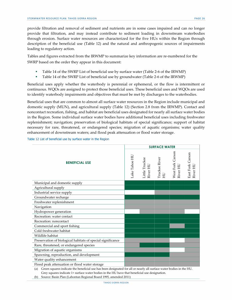
provide filtration and removal of sediment and nutrients are in some cases impaired and can no longer provide that filtration, and may instead contribute to sediment loading in downstream waterbodies through erosion. Surface water resources are characterized for the five HUs within the Region through description of the beneficial use (Table 12) and the natural and anthropogenic sources of impairments leading to regulatory action.
Tables and figures extracted from the IRWMP to summarize key information are re-numbered for the SWRP based on the order they appear in this document:
Table 14 of the SWRP List of beneficial use by surface water (Table 2-6 of the IRWMP) Table 14 of the SWRP List of beneficial use by groundwater (Table 2-6 of the IRWMP)
Beneficial uses apply whether the waterbody is perennial or ephemeral, or the flow is intermittent or continuous. WQOs are assigned to protect those beneficial uses. These beneficial uses and WQOs are used to identify waterbody impairments and objectives that must be met by discharges to the waterbodies.
Beneficial uses that are common to almost all surface water resources in the Region include municipal and domestic supply (MUN), and agricultural supply (Table 12) (Section 2.8 from the IRWMP). Contact and noncontact recreation, fishing, and habitat are beneficial uses designated for nearly all surface water bodies in the Region. Some individual surface water bodies have additional beneficial uses including freshwater replenishment; navigation; preservation of biological habitats of special significance; support of habitat necessary for rare, threatened, or endangered species; migration of aquatic organisms; water quality enhancement of downstream waters; and flood peak attenuation or flood water storage.
Table 12 List of beneficial use by surface water in the Region
BENEFICIAL USE
SURFACE WATER
Lake
Tah
oe H
U
Littl
e Tr
ucke
e Ri
ver H
U
Truc
kee
Rive
r H
U
Wes
t For
k C
arso
n Ri
ver H
U
East
For
k C
arso
n Ri
ver H
U
Municipal and domestic supply Agricultural supply Industrial service supply Groundwater recharge Freshwater replenishment Navigation Hydropower generation Recreation: water contact Recreation: noncontact Commercial and sport fishing Cold freshwater habitat Wildlife habitat Preservation of biological habitats of special significance Rare, threatened, or endangered species Migration of aquatic organisms Spawning, reproduction, and development Water quality enhancement Flood peak attenuation or flood water storage (a) Green squares indicate the beneficial use has been designated for all or nearly all surface water bodies in the HU.
Grey squares indicate 1+ surface water bodies in the HU have that beneficial use designation. (b) Source: Basin Plan (Lahontan Regional Board 1995, amended 2011)

STORMWATER RESOURCE PLAN: TAHOE-SIERRA REGION PAGE 27
TAHOE-SIERRA REGION
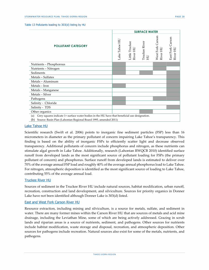
Surface water quality The Lake Tahoe HU is generally impaired by nutrients and sediments, although other impairments exist. There are no impairments in the Little Truckee River HU. The Truckee River HU is impaired by sediments and other organics. The West Fork Carson River HU is impaired by nutrients and pathogens while the East Fork Carson River HU is primarily impaired by metals. The full list of impaired waterways is included in Appendix C (Appendix 2-B in the IRWMP) and summarized in Table 13.
STORMWATER RESOURCE PLAN: TAHOE-SIERRA REGION PAGE 28
TAHOE-SIERRA REGION
Table 13 Pollutants leading to 303(d) listing by HU
Lake Tahoe HU
Scientific research (Swift et al. 2006) points to inorganic fine sediment particles (FSP) less than 16 micrometers in diameter as the primary pollutant of concern impairing Lake Tahoe’s transparency. This finding is based on the ability of inorganic FSPs to efficiently scatter light and decrease observed transparency. Additional pollutants of concern include phosphorus and nitrogen, as these nutrients can stimulate algal growth in Lake Tahoe. Additionally, research (Lahontan RWQCB 2010) identified surface runoff from developed lands as the most significant source of pollutant loading for FSPs (the primary pollutant of concern) and phosphorus. Surface runoff from developed lands is estimated to deliver over 70% of the average annual FSP load and roughly 40% of the average annual phosphorus load to Lake Tahoe. For nitrogen, atmospheric deposition is identified as the most significant source of loading to Lake Tahoe, contributing 55% of the average annual load.
Truckee River HU
Sources of sediment in the Truckee River HU include natural sources, habitat modification, urban runoff, recreation, construction and land development, and silviculture. Sources for priority organics in Donner Lake have not been identified although Donner Lake is 303(d) listed.
East and West Fork Carson River HU
Resource extraction, including mining and silviculture, is a source for metals, sulfate, and sediment in water. There are many former mines within the Carson River HU that are sources of metals and acid mine drainage, including the Leviathan Mine, some of which are being actively addressed. Grazing in scrub lands and riparian areas is a source of nutrients, sediment, and pathogens. Other sources for nutrients include habitat modification, waste storage and disposal, recreation, and atmospheric deposition. Other sources for pathogens include recreation. Natural sources also exist for some of the metals, nutrients, and pathogens.
POLLUTANT CATEGORY
SURFACE WATER
Lake
Tah
oe H
U
Littl
e Tr
ucke
e Ri
ver H
U
Truc
kee
Rive
r H
U
Wes
t For
k C
arso
n Ri
ver H
U
East
For
k C
arso
n Ri
ver H
U
Nutrients – Phosphorous Nutrients – Nitrogen Sediments Metals – Sulfates Metals – Aluminum Metals – Iron Metals – Manganese Metals – Silver Pathogens Salinity - Chloride Salinity - TDS Other organics (a) Grey squares indicate 1+ surface water bodies in the HU have that beneficial use designation. (b) Source: Basin Plan (Lahontan Regional Board 1995, amended 2011)
STORMWATER RESOURCE PLAN: TAHOE-SIERRA REGION PAGE 29
TAHOE-SIERRA REGION
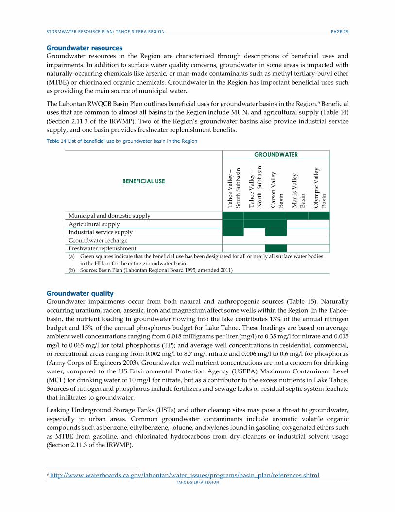
Groundwater resources Groundwater resources in the Region are characterized through descriptions of beneficial uses and impairments. In addition to surface water quality concerns, groundwater in some areas is impacted with naturally-occurring chemicals like arsenic, or man-made contaminants such as methyl tertiary-butyl ether (MTBE) or chlorinated organic chemicals. Groundwater in the Region has important beneficial uses such as providing the main source of municipal water.
The Lahontan RWQCB Basin Plan outlines beneficial uses for groundwater basins in the Region.9 Beneficial uses that are common to almost all basins in the Region include MUN, and agricultural supply (Table 14) (Section 2.11.3 of the IRWMP). Two of the Region’s groundwater basins also provide industrial service supply, and one basin provides freshwater replenishment benefits.
Table 14 List of beneficial use by groundwater basin in the Region
Groundwater quality Groundwater impairments occur from both natural and anthropogenic sources (Table 15). Naturally occurring uranium, radon, arsenic, iron and magnesium affect some wells within the Region. In the Tahoe-basin, the nutrient loading in groundwater flowing into the lake contributes 13% of the annual nitrogen budget and 15% of the annual phosphorus budget for Lake Tahoe. These loadings are based on average ambient well concentrations ranging from 0.018 milligrams per liter (mg/l) to 0.35 mg/l for nitrate and 0.005 mg/l to 0.065 mg/l for total phosphorus (TP); and average well concentrations in residential, commercial, or recreational areas ranging from 0.002 mg/l to 8.7 mg/l nitrate and 0.006 mg/l to 0.6 mg/l for phosphorus (Army Corps of Engineers 2003). Groundwater well nutrient concentrations are not a concern for drinking water, compared to the US Environmental Protection Agency (USEPA) Maximum Contaminant Level (MCL) for drinking water of 10 mg/l for nitrate, but as a contributor to the excess nutrients in Lake Tahoe. Sources of nitrogen and phosphorus include fertilizers and sewage leaks or residual septic system leachate that infiltrates to groundwater.
Leaking Underground Storage Tanks (USTs) and other cleanup sites may pose a threat to groundwater, especially in urban areas. Common groundwater contaminants include aromatic volatile organic compounds such as benzene, ethylbenzene, toluene, and xylenes found in gasoline, oxygenated ethers such as MTBE from gasoline, and chlorinated hydrocarbons from dry cleaners or industrial solvent usage (Section 2.11.3 of the IRWMP).
9 http://www.waterboards.ca.gov/lahontan/water_issues/programs/basin_plan/references.shtml
BENEFICIAL USE
GROUNDWATER
Taho
e V
alle
y –
Sout
h Su
bbas
in
Taho
e V
alle
y –
Nor
th S
ubba
sin
Car
son
Val
ley
Basi
n
Mar
tis V
alle
y Ba
sin
Oly
mpi
c V
alle
y Ba
sin
Municipal and domestic supply Agricultural supply Industrial service supply Groundwater recharge Freshwater replenishment (a) Green squares indicate that the beneficial use has been designated for all or nearly all surface water bodies
in the HU, or for the entire groundwater basin. (b) Source: Basin Plan (Lahontan Regional Board 1995, amended 2011)
STORMWATER RESOURCE PLAN: TAHOE-SIERRA REGION PAGE 30
TAHOE-SIERRA REGION
The SWRCB Geotracker website lists 51 open cleanup sites within the Region, not all of which impact groundwater. Additionally, there are 80 permitted USTs, and 256 closed sites in the Region. Nearly all of the cleanup sites are located around Lake Tahoe, in the Town of Truckee, or along Interstate-80. Responsible parties are addressing these open sites, which include petroleum, MTBE, and chlorinated hydrocarbon impacts, under the regulatory oversight of the Lahontan RWQCB. Water agencies use treatment and/or source blending to meet MCLs for water that is delivered to their customers (Section 2.11.3 of the IRWMP).
The Basin Plan assigns WQOs to groundwater for bacteria (coliform), chemical constituents, radioactivity, and taste and odor. 10
In groundwaters designated as MUN, the median concentration of coliform organisms over any seven-day period shall be less than 1.1/100 milliliters.
Groundwater designated as MUN shall not contain concentrations of chemical constituents in excess of the MCL or secondary maximum contaminant level (SMCL) based upon drinking water standards specified in the following provisions of Title 22 of the California Code of Regulations. Additionally, waters shall not contain concentrations of chemical constituents that adversely affect the water for beneficial uses.
Ground waters designated as MUN shall not contain concentrations of radionuclides in excess of the limits specified in Section 64443 (Radioactivity) of Title 22 of the California Code of Regulations.
Ground waters shall not contain taste or odor-producing substances in concentrations that cause nuisance or that adversely affect beneficial uses. For groundwaters designated as MUN, at a minimum, concentrations shall not exceed adopted SMCLs.
Table 15 Groundwater basin impairments in the Region
IMPAIRMENT
GROUNDWATER
Taho
e V
alle
y –
Sout
h Su
bbas
in
Taho
e V
alle
y –
Nor
th S
ubba
sin
Car
son
Val
ley
Basi
n
Mar
tis V
alle
y Ba
sin
Oly
mpi
c V
alle
y Ba
sin
Uranium Radon Arsenic Iron Magnesium TDS Nutrients VOCs (a) Grey squares indicate 1+ surface water bodies in the HU have that beneficial use designation. (b) Source: Basin Plan (Lahontan Regional Board 1995, amended 2011)
Tahoe Valley South groundwater subbasin
In the Tahoe Valley South groundwater subbasin, uranium, iron, and manganese have been detected in some wells at concentrations exceeding the respective primary or SMCLs. Arsenic, which is naturally occurring and has a primary MCL, has also been detected in some wells in the South Lake Tahoe groundwater subbasin, but at concentrations below the current MCL in all but one well, at which a treatment system is operating.
10 http://www.waterboards.ca.gov/lahontan/water_issues/programs/basin_plan/references.shtml
STORMWATER RESOURCE PLAN: TAHOE-SIERRA REGION PAGE 31
TAHOE-SIERRA REGION
MTBE contamination has impacted several South Tahoe PUD supply wells, requiring inactivation or reduction in pumping rate, installation of wellhead treatment systems, and pursuit of source area protection measures (Winzler & Kelley 2011). Some South Tahoe PUD supply wells are also impacted by chlorinated hydrocarbons, requiring treatment to meet the respective MCLs (Section 2.11.3 of the IRWMP).
Martis Valley groundwater basin
Arsenic affects some Truckee Donner PUD and PCWA groundwater wells in the Martis Valley groundwater basin, and manganese has been detected above the MCL in a PCWA groundwater well (Section 2.11.3 of the IRWMP).
Olympic Valley groundwater basin
Arsenic, iron, manganese, and TDS have been detected above the MCLs in monitoring wells in the east part of the Olympic Valley groundwater basin, but not in the production wells in the west part of the basin (Section 2.11.3 of the IRWMP).
WATER SUPPLY (SWRP GUIDELINES SECTION A.V)
Section A.V of the Guidelines requires a description of entities that provide potable and non-potable water supplies in the Region. Section 2.9.1.3 and Table 2-8 in the IRWMP identifies water suppliers and describes the volume and source. This information is summarized below.
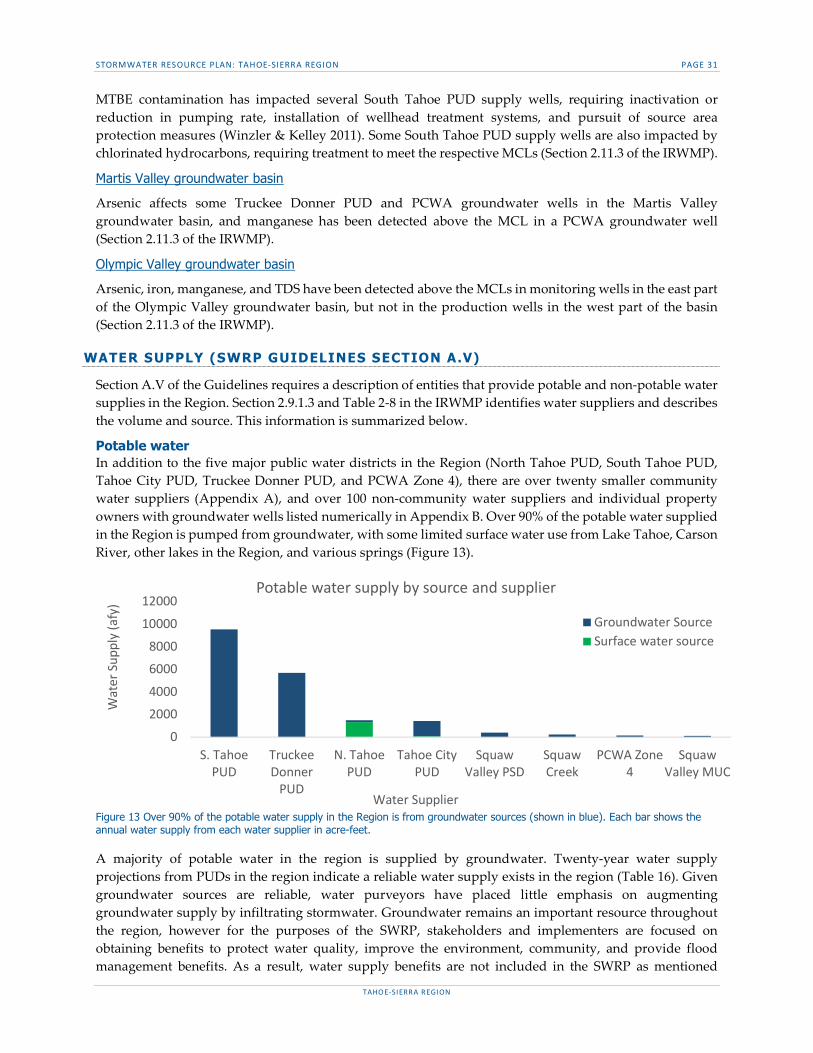
Potable water In addition to the five major public water districts in the Region (North Tahoe PUD, South Tahoe PUD, Tahoe City PUD, Truckee Donner PUD, and PCWA Zone 4), there are over twenty smaller community water suppliers (Appendix A), and over 100 non-community water suppliers and individual property owners with groundwater wells listed numerically in Appendix B. Over 90% of the potable water supplied in the Region is pumped from groundwater, with some limited surface water use from Lake Tahoe, Carson River, other lakes in the Region, and various springs (Figure 13).
Figure 13 Over 90% of the potable water supply in the Region is from groundwater sources (shown in blue). Each bar shows the annual water supply from each water supplier in acre-feet.
A majority of potable water in the region is supplied by groundwater. Twenty-year water supply projections from PUDs in the region indicate a reliable water supply exists in the region (Table 16). Given groundwater sources are reliable, water purveyors have placed little emphasis on augmenting groundwater supply by infiltrating stormwater. Groundwater remains an important resource throughout the region, however for the purposes of the SWRP, stakeholders and implementers are focused on obtaining benefits to protect water quality, improve the environment, community, and provide flood management benefits. As a result, water supply benefits are not included in the SWRP as mentioned
0
2000
4000
6000
8000
10000
12000
S. TahoePUD
TruckeeDonner
PUD
N. TahoePUD
Tahoe CityPUD
SquawValley PSD
SquawCreek
PCWA Zone4
SquawValley MUC
Wat
er S
uppl
y (a
fy)
Water Supplier
Potable water supply by source and supplier
Groundwater SourceSurface water source

STORMWATER RESOURCE PLAN: TAHOE-SIERRA REGION PAGE 32
TAHOE-SIERRA REGION
throughout the document. The exception is the Markleeville Mutual Water Company, which requires that new developments provide wells and increased storage because of difficulties meeting current and projected demand (Section 2.9.1.3 of the IRWMP).
Table 16 20-year water supply projection in Acre Feet per Year by water supplier in the Region
Non-potable water There are limited opportunities for additional water reclamation within the Region. The Porter- Cologne Act requires that all wastewater be exported from the Tahoe-basin with a few minor exceptions. The Porter-Cologne Act allows for approval of pilot reclamation projects in the Tahoe-basin, but none have been approved to date (as of July 2014). As a result, all wastewater in the northern part of the Tahoe-basin is collected by North Tahoe PUD or Tahoe City PUD and transported to T-TSA in Truckee for treatment and discharge to a disposal field in Martis Valley. Reclamation of this water for other uses is limited as the Settlement Act prohibits any reduction in return flow of treated wastewater to the Truckee River without offset or acquisition of water rights.
In the southern part of the Tahoe-basin, all wastewater is collected by South Tahoe PUD. South Tahoe PUD treats the wastewater and then pumps it to Alpine County over Luther Pass for storage in Harvey Place Reservoir and summer irrigation use by area ranches. Approximately 4.5 million gallons per day is pumped to Harvey Place Reservoir for reuse. In the year 2000, a special legislative act allowed South Tahoe PUD to install six fire hydrants at the base of the reclaimed water export pipeline to provide fire protection for a small community in the Lake Valley Fire Protection District service area that does not have municipal water service.
NATIVE HABITATS (SWRP GUIDELINES SECTION A. VI)
Significant ecological resources contribute to the recreation and tourism of the Region. The waterways provide habitat for common and sensitive fish, amphibian, and invertebrate species, while the adjacent terrestrial habitats support numerous bird, mammal, and plant species (Section 2.12 of the IRWMP).
Terrestrial habitats Table 17 summarizes the terrestrial habitat types for the different HU’s in the Region. (Adapted Table 2-14 of the IRWMP)
Table 17 Percent coverage of land cover types by HU
WATER SUPPLIER YEAR
2015 2020 2025 2030 2035 North Tahoe PUD 1,782 2,138 2,566 3,079 Not provided South Tahoe PUD 9,528 9,528 9,528 9,528 9,528 Tahoe City PUD 1,458 1,903 1,903 1,903 Not provided PCWA Zone 4 306 439 573 707 800
LAND COVER LAKE
TAHOE HU LITTLE TRUCKEE
RIVER HU TRUCKEE RIVER HU
WEST FORK CARSON RIVER HU
EAST FORK CARSON RIVER HU
% OF TOTAL
Agriculture 0% 0% 0% 5% 1% 0.7% Barren/ Other 1% 2% 4% 17% 13% 6.6% Conifer Forest 44% 74% 63% 39% 43% 51.3% Conifer Woodland 0% 0% 0% 0% 8% 2.1% Hardwood Forest 0% 1% 1% 1% 1% 0.7% Herbaceous 1% 3% 2% 4% 2% 2.2% Shrub 10% 13% 23% 34% 32% 21.1% Urban 5% 0% 4% 0% 0% 2.4% Water 37% 5% 1% 0% 0% 11.9% Wetland 1% 3% 1% 0% 0% 1%
STORMWATER RESOURCE PLAN: TAHOE-SIERRA REGION PAGE 33
TAHOE-SIERRA REGION
The general vegetation zones in the Region are subalpine, upper montane, montane, and sagebrush scrub in parts of the Carson River HUs. The predominant plant communities in the Region include Jeffrey Pine, Mixed Conifer, White Fir series, Red Fir series, Lodgepole Pine, and Aspen. At the higher elevations mixed subalpine forest, Western White Pine, Whitebark Pine, and Subalpine Meadow are common. Big Sagebrush is common in the lower elevations in the Truckee River and Carson River HUs. Alpine Grassland, Montane Meadow, and Sedge Meadow are also present (Section 2.12.1 of the IRWMP).
Aquatic habitats The many creeks, rivers, lakes, and wetlands in the Region provide native riparian and aquatic habitats. Releases from Prosser Creek, Boca, and Stampede dams support fisheries in the Truckee River and Pyramid Lake. Vernal pools are found in Martis Valley, supporting sensitive plant species.
The Region is in the historic ranges for the Lahontan Cutthroat Trout and the Paiute Cutthroat Trout, both of which are federally listed as threatened species. Currently the Paiute Cutthroat Trout is only found in Silver King Creek, a tributary to the East Fork Carson River. Populations of the Lahontan Cutthroat Trout are currently found in the following waters (Ascent Environmental 2013, The Nature Conservancy 2014):
Upper Truckee River above Meiss Meadows (in the Lake Tahoe HU) Fallen Leaf Lake/Glen Alpine watershed (in the Lake Tahoe HU) Lake Tahoe Pole Creek (in the Truckee River HU) Truckee River, at Granite Flat Campground Independence Lake (in the Little Truckee River HU) East Fork Carson River
Other fish species such as Brook, Rainbow, Brown, and Mackinaw/lake trout, and Kokanee Salmon are also found in the lakes and rivers of the Region. The California Department of Fish and Wildlife (CDFW) has named the following waters in the Region as Wild Trout Waters:
Heenan Lake in the East Fork Carson River HU, also named “Heritage Trout Water” for the Lahontan Cutthroat trout
East Fork Carson River upstream of the confluence with Wolf Creek East Fork Carson River from Hangman’s Bridge near Markleeville to the Nevada state line Martis Creek Reservoir Truckee River, between the confluence with Trout Creek and the confluence with Gray Creek Upper Truckee River upstream from the confluence with Showers Creek
There are no federally designated wild and scenic rivers in the Region, although there are several stretches being considered for listing. Approximately 10 miles of the East Fork of the Carson River, between Markleeville and the California-Nevada border, is designated as a California Wild and Scenic River. This designation prohibits the construction of dams, reservoirs, and diversion facilities along that stretch of river. The Region includes parts of the Carson-Iceberg and Mokelumne Wildernesses in the Toiyabe National Forest, and part of Desolation Wilderness in the El Dorado National Forest and LTBMU. The USFS has also designated Grass Lake as a Research Natural Area.
In the Tahoe-basin Stream Environment Zones (SEZ) are riparian areas, wetlands, and other areas with a seasonally high groundwater level and/or surface water. They protect water quality though infiltration, nutrient uptake, denitrification, and sediment capture. Protection of these areas is vital to the health of the lakes and rivers receiving the runoff (Section 2.12.2 of the IRWMP).
The terrestrial and aquatic habitats in the Region have potential to support endangered or special status species. These species are summarized in Table 2-15 of the IRWMP. There are no designated critical habitats in the Region for the endangered and special status species with potential to occur.
STORMWATER RESOURCE PLAN: TAHOE-SIERRA REGION PAGE 34
TAHOE-SIERRA REGION
Parks and open space Parks and other natural open spaces are shown in Figure 14 of the SWRP. Parks and open spaces include park lands owned by the California State Parks systems, national forests, and wilderness areas. The economy in the Region relies heavily on tourism and thus much of the publicly owned open space and parklands are managed for recreation and tourism.
WATERSHED PROCESSES (SWRP GUIDELINES SECTION A.VII)
Section A.VII of the SWRP Guidelines requires an identification of natural watershed processes and how those have been disrupted. Understanding how natural watershed processes have been disrupted is important in understanding how stormwater and dry weather runoff projects can minimize impacts of urbanization on stormwater and dry weather runoff. Natural watershed processes that influence runoff include precipitation patterns, infiltration, evaporation, and transpiration. Chapter 1 of the TRPA BMP Handbook describes the natural watershed processes that influence stormwater runoff in the Region.
Precipitation that falls as snow is stored temporarily in snow pack, and is released as water at varying rates depending on temperature, wind, solar radiation, and other climatic factors. Because 60 to 70 percent of the total precipitation in the Lake Tahoe Region falls as snow, hydrologic processes associated with snowmelt are important in understanding the overall water balance. Although rain and rain-on-snow events typically produce the highest rates of surface runoff, the amount of surface runoff from rain or snowmelt is affected by storage of water on the ground surface and in soils, by infiltration at the surface and from the soil into groundwater, and by losses back to the atmosphere through evaporation and transpiration (Section 1.2.1 of the TRPA BMP Handbook).
Urbanization changes land use in ways that influence stormwater quality and quantity. In a natural watershed, pervious and vegetated areas intercept and store precipitation through infiltration into the soil, uptake by vegetation, or storage in depressional features, such as wetlands. Urbanization increases impervious cover which reduces the amount of precipitation intercepted by vegetated areas and infiltrated into the subsurface. As a result, there are larger volumes of runoff produced, less precipitation is stored in groundwater and in the subsurface, and higher runoff volumes are transported downstream to receiving waters. Urbanization thus increases runoff volume and creates flashier systems that can cause or contribute to erosion, drainage, and flooding.
In addition to its impacts on runoff volumes, urbanization can impact water quality. Impervious surfaces, such as roads and parking lots, collect pollutants such as copper from brake pads, fine sediment and dirt, and oil and grease. When runoff travels across these surfaces it collects and transports these pollutant loads to surface waters. Agricultural land uses also influence stormwater runoff quantity and quality. Agricultural lands generally have lower infiltration capacity compared to natural lands, higher nutrient loads, and can be more susceptible to erosion due to the amount of exposed soil.
Urbanization in the Region has had the largest impact on land cover in and around the municipalities surrounding the Lake Tahoe shoreline, along the Upper Truckee River, and in the Truckee-Donner Region. These areas have the largest and most contiguous amount of residential and commercial properties throughout the Region, while the largest and most contiguous agricultural land uses occur in the Truckee and Carson River watersheds, as shown in Figure 14.

STORMWATER RESOURCE PLAN: TAHOE-SIERRA REGION PAGE 35
TAHOE-SIERRA REGION
Figure 14 Land Use in the Region

STORMWATER RESOURCE PLAN: TAHOE-SIERRA REGION PAGE 36
TAHOE-SIERRA REGION
SECTION B. ORGANIZATION, COORDINATION & COLLABORATION Development and implementation of the SWRP includes participation by local agencies, nongovernmental organizations, and the broader community Water Code §10565(a)&10562(b)(4). Collaborating with these entities may lead to joint solutions to address obstacles inherent in watershed scale stormwater management and helps to maximize benefits to natural and recreational resources, the community and the economy.
IRWM PARTNERSHIP (SWRP GUIDELINES SECTION B.I & B.VI)
The SWRP involves many of the stakeholders that are members of the IRWM (SWRP Guidelines Section B.I). There is a history of collaboration among these stakeholders and therefore no new or altered governance structures are required to support collaboration among agencies responsible for SWRP implementation (SWRP Guidelines Section B.VI).
SWRP STAKEHOLDERS (SWRP GUIDELINES SECTION B.II & B.III)
SWRP development is guided by a group of stakeholders referred to as the TAC to ensure the SWRP is appropriate for the Region and addresses regional stormwater priorities (Table 18). TAC members met consistently during SWRP development, facilitated by the Tahoe RCD, Environmental Incentives, and NCE. TAC members belong to one of the following three groups:
Facilitators: project funder (Tahoe RCD) and consultants (Environmental Incentives and NCE) who plan and execute TAC meetings as well as develop the SWRP.
Implementers: representatives from local jurisdictions and NGOs who apply for bond funding to implement stormwater and dry weather runoff capture projects (SWRP Guidelines Section B.II).
Partners: representatives from federal, state, and local agencies that currently support, fund, or otherwise have an interest in prioritizing stormwater and dry weather runoff capture projects.
Others: parties other than implementers or partners, such as NGOs, who have an interest in the development and implementation of the SWRP along with the general public (SWRP Guidelines Section B.III).
The following organizations participated in development and implementation of the SWRP as members of the TAC:
Table 18. SWRP TAC members
ORGANIZATION STAKEHOLDER GROUP El Dorado County Implementer City of South Lake Tahoe Implementer Alpine County Implementer Town of Truckee Implementer State Water Board Partner Lahontan RWQCB Partner TRPA Partner CTC Partner Desert Research Institute Other UC Davis Tahoe Environmental Research Center Other Placer County Implementer Truckee River Watershed Council Implementer Sierra County Implementer League to Save Lake Tahoe Other Alpine Watershed Group Implementer
STORMWATER RESOURCE PLAN: TAHOE-SIERRA REGION PAGE 37
TAHOE-SIERRA REGION
Implementer: Local jurisdictions Representatives from the local municipalities are the primary implementers of stormwater projects and currently comprise the core working members of the TAC (Table 19). Their role is to provide guidance on the development and implementation of the SWRP to ensure that the SWRP builds on, compliments, and does not conflict with existing priorities and plans. The responsibilities of the local municipalities include:
Providing relevant existing documents and maps to inform the development of the SWRP; Providing input on the metrics and analysis process used to prioritize projects; Reviewing components of the SWRP as they are produced by the development team; and Participating in collaborative meetings.
Table 19. Representatives from local municipalities
ORGANIZATION El Dorado County Placer County City of South Lake Tahoe Truckee River Watershed Council Alpine County Sierra County Town of Truckee South Tahoe PUD
Implementer: NGO Alpine Watershed Group is a local NGO whose role is to add their projects to the SWRP project list and implement their projects (Table 20).
Table 20. Representative from NGOs
ORGANIZATION Alpine Watershed Group
Partners: Regional government agencies Representatives from the regional government agencies in Table 21 are involved in regulating and overseeing the implementation of stormwater programs or projects by local jurisdictions or permittees. Their role is also to provide guidance and support in the development and implementation of the SWRP to ensure that the SWRP builds on, compliments, and does not conflict with existing priorities and plans. The responsibilities of regional government agency partners include:
Providing input on the metrics and analysis process used to prioritize projects; Reviewing components of the SWRP as they are produced by the development team; and Participating in collaborative meetings.
Table 21. Representatives from regional government agencies
Partners: Funding agencies The California State Water Resources Control Board (State Water Board) is the primary funding and oversight agency for the SWRP (Table 22). Their role is to manage the grant with the Tahoe RCD and provide support and expertise to the SWRP development team. The CTC is the secondary funding and oversight agency for the SWRP. The CTC is providing additional funds to enhance the State Water Board funded SWRP by adding Tahoe-basin specific components to the metrics and analysis process. Their role is to manage the grant with the Tahoe RCD and provide support to the SWRP development team. The responsibilities of the State Water Board include:
Providing insight into the purpose of the components, and ensuring that the products produced by the SWRP development team comply with the SWRP Guidelines; and
Participating in collaborative meetings.
ORGANIZATION TRPA Lahontan RWQCB
STORMWATER RESOURCE PLAN: TAHOE-SIERRA REGION PAGE 38
TAHOE-SIERRA REGION
The responsibilities of the CTC include:
Clearly expressing their needs and desires for the enhanced SWRP specific to the Tahoe-basin; Coordinating with University scientists; Ensuring the enhanced SWRP adequately addresses the unique needs of the Tahoe-basin; and Participating in collaborative meetings.
Table 22. Representatives from funding agencies
Other groups: Universities Representatives from the University of Nevada, Reno and the University of California, Davis have been conducting stormwater and other environmental research in the Region for decades (Table 23). The Universities’ responsibilities include:
Providing input into the metrics and analysis process used to prioritize projects in the Tahoe-basin when requested; and
Participating in collaborative meetings.
Table 23. Representatives from universities
Other groups: Nongovernmental organizations The League to Save Lake Tahoe is a local nonprofit that provides a critical link to the community in the Lake Tahoe-basin as their many education and outreach programs reach locals and visitors alike (Table 24). They are key stakeholders, but not primary TAC members. Their role is to engage the public in the SWRP development process when requested. Their primary responsibility is: contacting key members of the public and requesting participation when appropriate.
Table 24. Representatives from nongovernmental organizations in the Region
ORGANIZATION League to Save Lake Tahoe
REQUIRED DECISIONS (SWRP GUIDELINES SECTION B.V)
No decisions beyond what is already required for project approval are required by local, state, or federal regulatory agencies for SWRP implementation. Prior to construction of any public projects identified in the SWRP, projects are subject to California Environmental Quality Act (CEQA) review as well as approval by relevant regulatory agencies and local government. In the Tahoe-basin, environmental projects must be permitted at the project scale to ensure that they meet local codes as set forth by the TRPA. Project implementers are responsible for obtaining required approvals from state, federal, and local entities.
OTHER CONSIDERATIONS (SWRP GUIDELINES SECTION B.IV & B.VII)
Identification and discussion of public and community engagement is discussed in SWRP Section F (SWRP Guidelines Section B.IV). A description of the relationship of the SWRP to other existing planning documents and programs established by local agencies is included in Section E of this document. (SWRP Guidelines Section B.VII).
ORGANIZATION State Water Board California Tahoe Conservancy
ORGANIZATION UN Reno, Desert Research Institute UC Davis, Tahoe Environmental Research Center

STORMWATER RESOURCE PLAN: TAHOE-SIERRA REGION PAGE 39
TAHOE-SIERRA REGION
SECTIONS C&D METHODS & PROJECT PRIORITIZATION To achieve the multi-benefit objectives of the SWRP, it is necessary to understand what benefits planned projects are expected to generate, and how these benefits meet the WQOs within the Region. Before project benefits can be estimated, metrics must be identified that can quantify those benefits. Once benefits are quantified, estimates of total project benefit can be determined by aggregating the benefits across several benefit categories. The aggregate of project benefit estimates indicates progress toward meeting regulatory requirements, like water quality regulations.
The Region is characterized by open space with dispersed small urban populations. These communities have varying resources available to plan and implement stormwater projects. Jurisdictions within the Tahoe-basin (Tahoe jurisdictions) have made significant investments in developing quantitative project benefit estimates through regulatory requirements to use analysis tools such as the PLRM, GIS application, and other technical methods. In comparison, jurisdictions outside the Tahoe-basin (non-Tahoe jurisdictions) do not have the same regulatory requirements to develop quantitative project benefit estimates. As a result, it is necessary to develop two separate methodologies for identifying projects, selecting appropriate metrics, and estimating project benefits. The two methods are captured in two separate sections:
Projects led by jurisdictions in the Tahoe-basin (Guidance for Tahoe jurisdictions) Projects led by jurisdictions outside the Tahoe-basin (Guidance for non-Tahoe jurisdictions)
Although Tahoe metrics are intended for use by projects within the Tahoe-basin, and non-Tahoe metrics are intended for use by projects outside the Tahoe-basin, all projects may use any metric, as appropriate.
GUIDANCE FOR TAHOE JURISDICTIONS
Technically complex hydrologic models, like the PLRM and other specific quantitative metrics are used to characterize and estimate benefits for projects led by jurisdictions inside the Tahoe-basin. This approach ensures the effort previously expended by these jurisdictions to quantify the expected benefits of their projects in a technically defensible manner is utilized.
TAHOE IDENTIFICATION OF PROJECTS (SWRP GUIDELINES SECTION C.1)
According to the SWRP Guidelines, SWRPs shall include a metrics-based and integrated evaluation and analysis of multiple benefits within the watershed Water Code, §10562(b)(2).11 SWRP Guidelines identify five benefit categories for the metric-based evaluation of multiple project benefits including: water supply, water quality, flood management, environmental, and community benefits (Figure 15). The SWRP does not include metrics for the water supply category because water supply is not a priority concern within the Region Water Code §10562(d)(1). Therefore, prioritizing projects based on water supply benefits would not represent the needs of the Region. The decision to omit water supply metrics was verified with the jurisdictions implementing projects who agreed water supply is not a priority and should not be included in the SWRP. Projects are identified for each jurisdiction to address two or more of these four benefit categories.
Figure 15. Grey boxes indicate benefit categories included in the SWRP multi-benefit analysis.
11 State Water Resources Control Board. (2015, November 16). Storm Water Resource Plan Guidelines. Retrieved from http://www.waterboards.ca.gov/water_issues/programs/grants_loans/swgp/docs/draft_guidelines_120315.pdf
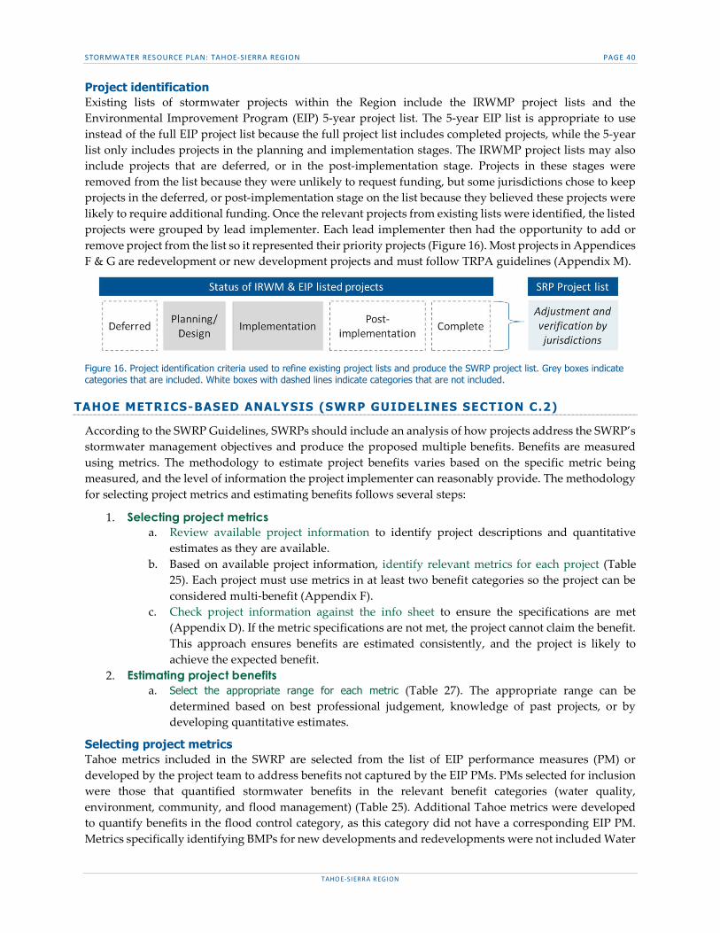
STORMWATER RESOURCE PLAN: TAHOE-SIERRA REGION PAGE 40
TAHOE-SIERRA REGION
Project identification Existing lists of stormwater projects within the Region include the IRWMP project lists and the Environmental Improvement Program (EIP) 5-year project list. The 5-year EIP list is appropriate to use instead of the full EIP project list because the full project list includes completed projects, while the 5-year list only includes projects in the planning and implementation stages. The IRWMP project lists may also include projects that are deferred, or in the post-implementation stage. Projects in these stages were removed from the list because they were unlikely to request funding, but some jurisdictions chose to keep projects in the deferred, or post-implementation stage on the list because they believed these projects were likely to require additional funding. Once the relevant projects from existing lists were identified, the listed projects were grouped by lead implementer. Each lead implementer then had the opportunity to add or remove project from the list so it represented their priority projects (Figure 16). Most projects in Appendices F & G are redevelopment or new development projects and must follow TRPA guidelines (Appendix M).
Figure 16. Project identification criteria used to refine existing project lists and produce the SWRP project list. Grey boxes indicate categories that are included. White boxes with dashed lines indicate categories that are not included.
TAHOE METRICS-BASED ANALYSIS (SWRP GUIDELINES SECTION C.2)
According to the SWRP Guidelines, SWRPs should include an analysis of how projects address the SWRP’s stormwater management objectives and produce the proposed multiple benefits. Benefits are measured using metrics. The methodology to estimate project benefits varies based on the specific metric being measured, and the level of information the project implementer can reasonably provide. The methodology for selecting project metrics and estimating benefits follows several steps:
1. Selecting project metrics a. Review available project information to identify project descriptions and quantitative
estimates as they are available. b. Based on available project information, identify relevant metrics for each project (Table
25). Each project must use metrics in at least two benefit categories so the project can be considered multi-benefit (Appendix F).
c. Check project information against the info sheet to ensure the specifications are met (Appendix D). If the metric specifications are not met, the project cannot claim the benefit. This approach ensures benefits are estimated consistently, and the project is likely to achieve the expected benefit.
2. Estimating project benefits a. Select the appropriate range for each metric (Table 27). The appropriate range can be
determined based on best professional judgement, knowledge of past projects, or by developing quantitative estimates.
Selecting project metrics Tahoe metrics included in the SWRP are selected from the list of EIP performance measures (PM) or developed by the project team to address benefits not captured by the EIP PMs. PMs selected for inclusion were those that quantified stormwater benefits in the relevant benefit categories (water quality, environment, community, and flood management) (Table 25). Additional Tahoe metrics were developed to quantify benefits in the flood control category, as this category did not have a corresponding EIP PM. Metrics specifically identifying BMPs for new developments and redevelopments were not included Water

STORMWATER RESOURCE PLAN: TAHOE-SIERRA REGION PAGE 41
TAHOE-SIERRA REGION
Code §10562(d)(6). This approach was considered overly prescriptive for the Region. Table 25 lists the Tahoe metrics that will be used to quantify benefits and subsequently rank projects.
Table 25. Tahoe metrics by benefit category
Each Tahoe metric is described in an info sheet that includes the units, definition, key terms, and specifications for estimating benefits (Appendix D). Info sheets provide the detailed guidance necessary to determine whether the project meets the specifications of the metric. If the specifications described in the info sheet are not met, the project cannot claim the benefit. This approach ensures benefits are estimated consistently as the project list is updated every two years.
Estimating project benefits Project benefits are estimated by reviewing the point ranges for each metric (Table 27) and selecting the range that most closely matches the quantified benefits of the project. If the expected project benefits for a metric are unknown they can be estimated through best professional judgement, or through more technically rigorous methods like the PLRM, or GIS analysis. When estimating project benefits, or selecting a range, conservative estimates should be used. There should be high confidence the project will achieve the bottom of the range. The top of the range can be an aspirational level of achievement.
Technical tools to estimate project benefits
Benefits should be estimated using the PLRM, through GIS analysis, or other quantitative tools (Table 26). A GIS analysis is conducted by running simple queries in mapping software to identify areas treated or number of facilities improved by a particular project.
Table 26. Methods for estimating Tahoe benefits
METRIC NAME BENEFIT
CATEGORY ESTIMATION METHOD PLRM GIS
1 - Fine sediment load reduction Water Quality X 2 - Nitrogen load reduction Water Quality X 3 - Phosphorous load reduction Water Quality X 4 - Parcels with stormwater BMPs Water Quality X 5 - Linear feet of stream channel restored or enhanced Environment X 6 - Acres of habitat restored or enhanced Environment X 7 - Facilities improved or created Community X 8 - Tahoe DAC population served Community X 9 - Community areas enhanced or created Community n/a n/a 10 - Volume of stormwater reduced, stored or infiltrated Flood Mgmt. X
The PLRM is a catchment-scale, continuous simulation model designed to predict average annual pollutant loads delivered to receiving waters via stormwater. The primary purpose of the PLRM is to assist water quality planners and project designers in quantitatively evaluating stormwater quality improvement
METRIC NAME WATER
QUALITY ENVIRONMENT COMMUNITY FLOOD
MGMT. 1 - Fine sediment load reduction X 2 - Nitrogen load reduction X 3 - Phosphorous load reduction X 4 - Parcels with stormwater BMPs X 5 - Linear feet of stream channel restored or enhanced X 6 - Acres of habitat restored or enhanced X 7 - Facilities improved or created X 8 - Tahoe DAC population served X 9 - Community areas enhanced or created X 10 - Volume of stormwater reduced, stored or infiltrated X

STORMWATER RESOURCE PLAN: TAHOE-SIERRA REGION PAGE 42
TAHOE-SIERRA REGION
alternatives for a project that that may involve complex combinations of source controls and stormwater treatment. The PLRM reports pollutant loads for total suspended solid, fine sediment, and total and dissolved species of phosphorus and nitrogen.12 The PLRM predicts pollutant loads using the following formula:
𝑃𝑜𝑙𝑙𝑢𝑡𝑎𝑛𝑡 𝐿𝑜𝑎𝑑 = 𝐴𝑟𝑒𝑎 ∗ 𝑃𝑟𝑒𝑐𝑖𝑝𝑖𝑡𝑎𝑡𝑖𝑜𝑛 ∗ 𝐶𝑜𝑛𝑛𝑒𝑐𝑡𝑖𝑣𝑖𝑡𝑦 ∗ 𝑃𝑜𝑙𝑙𝑢𝑡𝑎𝑛𝑡 𝐶𝑜𝑛𝑐𝑒𝑛𝑡𝑟𝑎𝑡𝑖𝑜𝑛13
TAHOE GUIDANCE FOR PRIORITIZING PROJECTS (SWRP GUIDELINES SECTION D.1)
According to SWRP Guidelines, project prioritization should use a metrics-driven approach to quantify multiple benefits to maximize water quality, flood management, environmental, and community benefits. Additionally, pursuant to Water Code §10562(b)(2) the SWRP should use “appropriate quantitative methods for prioritization of projects. (This should be accomplished by using a metrics-based and integrated evaluation and analysis of multiple benefits to maximize water supply, water quality, flood management, environmental, and other community benefits within the watershed.)”
To prioritize projects based on multiple benefit categories it is necessary to determine a system for scoring the metrics used to identify project benefits. The ranges for each point value are determined by reviewing the actual benefits of implemented projects. Data for completed projects is distributed across the 1 through 5 point values so there is a roughly equal likelihood of currently listed projects receiving each score. The result is a quantitative range for each 1 through 5 point value for each metric (Table 27). The ranges for each point value overlap to reflect that benefit estimates are made at early project stages often with low confidence. Using overlapping ranges provides implementers greater flexibility in selecting a point value and signals that estimates should not be overly precise, or extremely accurate.
Table 27. Guidance for estimating Tahoe benefits
12 El Dorado County Department of Transportation. (n.d.). PLRS PLRM Comparison (Rep.). CA: El Dorado County. 13 California Tahoe Conservancy. (2011). EL DORADO COUNTY – TAHOE BASIN 2009 POLLUTANT LOAD REDUCTION STRATEGY Update (Tech.). CA: El Dorado County Department of Transportation. 14 The point ranges for each metric intentionally overlap so that project implementers have flexibility when selecting point values for their project. This is intended to reflect that benefit estimates are often time preliminary, low-confidence estimates.
METRIC NAME BENEFIT
CATEGORY UNITS
POINTS14 0 1 2 3 4 5
1 - Fine sediment load reduction Water Quality Pounds/yr 0 1 to 1000 900 to 2400 2200 to 3500 3100 to 4900 4400+
2 - Nitrogen load reduction Water Quality Pounds/yr 0 1 to 5 3 to 9 7 to 13 11 to 20 18+ 3 - Phosphorous load reduction Water Quality Pounds/yr 0 1 to 18 16 to 30 27 to 50 45 to 70 65+ 4 - Parcels with stormwater BMPs Water Quality Number 0 1 to 4 3 to 60 50 to 130 100 to 360 300+
5 - Linear feet of stream channel restored or enhanced
Environment Linear ft. 0 1 to 150 100 to 400 350 to 600 550 to 1000 800+
6 - Acres of habitat restored or enhanced Environment Acres 0 0.1 to 1 0.5 to 2 1.5 to 6 5 to 15 12+
7 - Facilities improved or created
Community Number 0 1 to 2 2 to 3 3 to 4 4 to 5 5+
8 - Tahoe DAC population served Community No Yes
9 - Community areas enhanced or created
Community No Yes
10 - Volume of stormwater reduced, stored or infiltrated
Flood Mgmt. Acre Feet/yr 0 0.25 to 1 0.75 to 1.5 1.25 to 2.25 2 to 3 2.75+
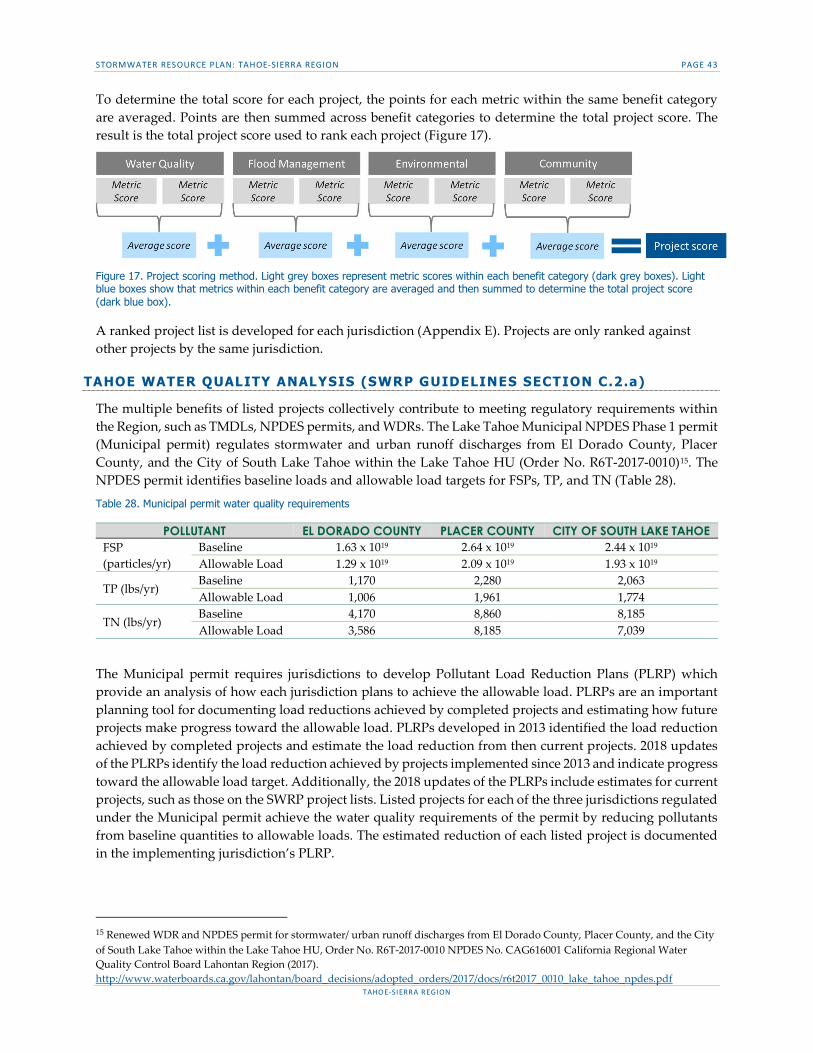
STORMWATER RESOURCE PLAN: TAHOE-SIERRA REGION PAGE 43
TAHOE-SIERRA REGION
To determine the total score for each project, the points for each metric within the same benefit category are averaged. Points are then summed across benefit categories to determine the total project score. The result is the total project score used to rank each project (Figure 17).
Figure 17. Project scoring method. Light grey boxes represent metric scores within each benefit category (dark grey boxes). Light blue boxes show that metrics within each benefit category are averaged and then summed to determine the total project score (dark blue box).
A ranked project list is developed for each jurisdiction (Appendix E). Projects are only ranked against other projects by the same jurisdiction.
TAHOE WATER QUALITY ANALYSIS (SWRP GUIDELINES SECTION C.2.a)
The multiple benefits of listed projects collectively contribute to meeting regulatory requirements within the Region, such as TMDLs, NPDES permits, and WDRs. The Lake Tahoe Municipal NPDES Phase 1 permit (Municipal permit) regulates stormwater and urban runoff discharges from El Dorado County, Placer County, and the City of South Lake Tahoe within the Lake Tahoe HU (Order No. R6T-2017-0010)15. The NPDES permit identifies baseline loads and allowable load targets for FSPs, TP, and TN (Table 28).
Table 28. Municipal permit water quality requirements
POLLUTANT EL DORADO COUNTY PLACER COUNTY CITY OF SOUTH LAKE TAHOE FSP (particles/yr)
Baseline 1.63 x 10¹⁹ 2.64 x 10¹⁹ 2.44 x 10¹⁹ Allowable Load 1.29 x 10¹⁹ 2.09 x 10¹⁹ 1.93 x 10¹⁹
TP (lbs/yr) Baseline 1,170 2,280 2,063 Allowable Load 1,006 1,961 1,774
TN (lbs/yr) Baseline 4,170 8,860 8,185 Allowable Load 3,586 8,185 7,039
The Municipal permit requires jurisdictions to develop Pollutant Load Reduction Plans (PLRP) which provide an analysis of how each jurisdiction plans to achieve the allowable load. PLRPs are an important planning tool for documenting load reductions achieved by completed projects and estimating how future projects make progress toward the allowable load. PLRPs developed in 2013 identified the load reduction achieved by completed projects and estimate the load reduction from then current projects. 2018 updates of the PLRPs identify the load reduction achieved by projects implemented since 2013 and indicate progress toward the allowable load target. Additionally, the 2018 updates of the PLRPs include estimates for current projects, such as those on the SWRP project lists. Listed projects for each of the three jurisdictions regulated under the Municipal permit achieve the water quality requirements of the permit by reducing pollutants from baseline quantities to allowable loads. The estimated reduction of each listed project is documented in the implementing jurisdiction’s PLRP.
15 Renewed WDR and NPDES permit for stormwater/ urban runoff discharges from El Dorado County, Placer County, and the City of South Lake Tahoe within the Lake Tahoe HU, Order No. R6T-2017-0010 NPDES No. CAG616001 California Regional Water Quality Control Board Lahontan Region (2017). http://www.waterboards.ca.gov/lahontan/board_decisions/adopted_orders/2017/docs/r6t2017_0010_lake_tahoe_npdes.pdf
STORMWATER RESOURCE PLAN: TAHOE-SIERRA REGION PAGE 44
TAHOE-SIERRA REGION
TAHOE MULTIPLE BENEFITS (SWRP GUIDELINES SECTION D.2)
The aggregate benefits of implemented SWRP projects are tracked through the SWRP tracker using metrics. Because each metric has a stated definition and values, it is possible to aggregate the benefits associated with each metric across projects. Each project reports a metric score for each metric used. Each metric score has a range shown in the metric table (Table 27). To aggregate quantitative metrics, the mid-point of each score range is used. As a result, the total expected benefit across multiple projects can be determined.
As a result, information is available about the water quality, environmental, community, and flood management benefits to the region from planned and implemented projects (Appendices F & G). Stormwater capture and use was not considered in this SWRP because water supply is not a primary concern as water supply in the region is plentiful and secure for the foreseeable future. This information is useful for understanding progress toward regulatory targets and community goals. Additionally, this information is useful when determining whether to update the metric list during the adaptive management process.
Each project or program implemented in accordance with the SWRP should address at least two “Main Benefits” as listed in Table 4 of the Guidelines and as many “Additional Benefits” as feasible (also listed in Table 4 of the guidelines. The SWRP uses benefit categories to represent “Main Benefits” and multiple metrics within each benefit category to provide “Additional Benefits”. The number of benefit categories achieved by each project is tracked in Appendix F.
TAHOE DATA MANAGEMENT (SWRP GUIDELINES SECTION C.3)
According to SWRP Guidelines, the SWRP should describe data collection and management including mechanisms by which data will be managed and stored, how data will be accessed by stakeholders and the public, and the frequency with which data will be updated.
Data location Data for all projects on the SWRP list and the list itself are publicly available on the Tahoe RCD website (http://tahoercd.org/stormwater-resources-plan/). In the future, this data will be incorporate with the existing EIP project tracker on the LT Info portal (https://eip.laketahoeinfo.org/)
Data available Project data are publicly available for download. Project data are provided to the Tahoe RCD by
the lead implementer of the project when the project is added to that jurisdiction’s SWRP list. Project data includes quantitative metrics that allow the project to be scored and ranked.
The SWRP project list is in the form of an excel document publicly available for download. Data for each project includes the project name and score by applicable metric, and rank. Projects are only ranked against other projects led by the same jurisdiction.
Data management Implementing jurisdictions can submit project data to Tahoe RCD at any time. On an annual basis, Tahoe RCD scores and ranks the project in an Excel sheet and adds it to the jurisdiction’s SWRP list. The Excel sheet used to score and rank projects is updated by Tahoe RCD so there is a record of the process and result. The project data and the resulting project list will be made publicly available on the Tahoe RCD website.

STORMWATER RESOURCE PLAN: TAHOE-SIERRA REGION PAGE 45
TAHOE-SIERRA REGION
GUIDANCE FOR NON-TAHOE JURISDICTIONS
Non-Tahoe metrics are used to characterize and estimate benefits for projects led by jurisdictions outside the Tahoe-basin. Non-Tahoe jurisdictions are often more focused on the flood management, community, and environmental benefits of stormwater projects than the water quality benefits. The list of metrics reflects these priorities by including several metrics to address each of these benefit categories.
NON-TAHOE IDENTIFICATION OF PROJECTS (SWRP GUIDELINES SECTION C.1)
SWRP Guidelines identify five benefit categories for the metric-based evaluation of multiple project benefits including: water supply, water quality, flood management, environmental, and community benefits Water Code §10562(b)(2).16 The SWRP does not include metrics for the water supply category because water supply is not a priority concern within the Region. Therefore, prioritizing projects based on water supply benefits would not represent the needs of the Region. The decision to omit water supply metrics was verified with the jurisdictions implementing projects who agreed water supply is not a priority and should not be included in the SWRP. The SWRP considers water quality, flood management, environmental, and community benefits from implemented projects (Figure 18). Projects are identified for each jurisdiction to address two or more of these four benefit categories.
Figure 18. Benefit categories included in the SWRP multi-benefit analysis.
Project identification The existing IRWMP project list may include projects that are completed, deferred, or in the post-implementation stage. Projects in these stages were removed from the list because they were unlikely to request funding, but some jurisdictions chose to keep projects in the deferred, or post-implementation stage on the list if they believed these projects were likely to require additional funding. Once the relevant projects from the IRWMP list were identified, the listed projects were grouped by lead implementer. Each lead implementer then had the opportunity to add or remove projects from the list so it represented their priority projects (Figure 19). Most projects in Appendices J & K are redevelopment or new development projects and must follow regional guidelines (Appendix M).
Figure 19. Project identification criteria used to refine existing project lists and produce the SWRP project list. Grey boxes indicated criteria that are included. White boxes with dashed lines indicate criteria that are not included.
NON-TAHOE METRICS-BASED ANALYSIS (SWRP GUIDELINES SECTION C.2)
According to this SWRP Guidelines, SWRPs should include an analysis demonstrating how projects address the SWRP’s stormwater management objectives and produce multiple benefits listed in Table 29. Benefits are measured using the previously identified non-Tahoe metrics. The methodology to estimate project benefits varies based on the specific metric selected, and the level of information the project implementer can reasonably provide. The methodology for selecting project metrics and estimating benefits follows several steps:
16 State Water Resources Control Board. (2015, November 16). Storm Water Resource Plan Guidelines. Retrieved from http://www.waterboards.ca.gov/water_issues/programs/grants_loans/swgp/docs/draft_guidelines_120315.pdf

STORMWATER RESOURCE PLAN: TAHOE-SIERRA REGION PAGE 46
TAHOE-SIERRA REGION
1. Selecting project metrics a. Review available project information to identify project descriptions and quantitative
estimates as they are available. b. Based on project information available, identify relevant metrics for each project (Table
29). Each project must use metrics in at least two benefit categories so the project is multi-benefit (Appendix ).
c. Check project information against the info sheet to ensure the specifications are met (Appendix ). If the metric specifications are not met, the project cannot claim the benefit. This approach ensures benefits are estimated consistently, and the project is likely to achieve the expected benefit.
2. Estimating project benefits a. Select the appropriate point value for each metric (Table 30) based on the criteria or
quantitative range of values. The point value can be determined based on best professional judgement, knowledge of past projects, or by developing quantitative estimates.
Selecting project metrics Non-Tahoe metrics included in the SWRP are developed by the project team through conversations with the non-Tahoe jurisdictions. Metrics specifically identifying BMPs for new developments and redevelopments were not included Water Code §10562(d)(6). As a result, metrics are developed that represent the priorities of these jurisdictions and address the four benefit categories (water quality, environment, community, and flood management) (Table 29).
Table 29. Non-Tahoe metrics by benefit category
Each non-Tahoe metric is described through an info sheet that includes the units, definition, key terms, and specifications for estimating benefits (Appendix H). Info sheets provide the guidance necessary to determine whether the project meets the specifications of the metric. For the estimated project benefits to be valid, the attributes of the project which result in that benefit must be checked against the specifications in the info sheet to verify the specifications are met. If the specifications in the info sheet are not met, the project cannot claim the benefit. This approach ensures benefits are estimated consistently, and the project is likely to achieve the expected benefit.
METRIC NAME WATER
QUALITY ENVIRONMENT COMMUNITY
FLOOD MGMT.
11 - Drains to TMDL waterbody X 12 - Provides source control for stormwater pollutant X 13 - Pollutant load reduction X 14 - Volume of stormwater treated X 15 - Total suspended solid load reduction X 16 - Parcels with stormwater BMPs X 17 - Project restores, enhances, or creates habitat X 18 - Stream channel restored, enhanced, or created X 19 - Non-Tahoe DAC population served X 20 - Employment opportunity created X 21 - Enhance or create community areas X 22 - Project improves property values X 23 - Proximity to flood-prone channel X 24 - Runoff reduced through storage or infiltration X 25 - Impervious area reduced (%) X 26 - Natural hydrology/ hydrograph reestablished X

STORMWATER RESOURCE PLAN: TAHOE-SIERRA REGION PAGE 47
TAHOE-SIERRA REGION
Estimating project benefits Project benefits are estimated by reviewing the point descriptions for each metric (Table 30) and selecting the description, or range that most closely matches the expected benefits of the project. If the expected benefit for a metric is unknown it can be estimated through best professional judgement or GIS analysis. When estimating a range, there should be high confidence the project will achieve the bottom of the range. The top of the range can be aspirational, but realistic for the project to achieve.
NON-TAHOE GUIDANCE FOR PRIORITIZING PROJECTS (SWRP GUIDELINES SECTION D.1)
According to SWRP Guidelines, project prioritization should use a metrics-driven approach to quantify multiple benefits to maximize water quality, flood management, environmental, and community benefits. Additionally, pursuant to Water Code §10562(b)(2) the SWRP should use “appropriate quantitative methods for prioritization of projects. (This should be accomplished by using a metrics-based and integrated evaluation and analysis of multiple benefits to maximize water supply, water quality, flood management, environmental, and other community benefits within the watershed.)”
To prioritize projects based on multiple benefit categories it is necessary to determine a system for scoring the metrics used to identify project benefits. The ranges for each point value are determined through conversations with jurisdictions and best professional judgement (Table 30). The ranges for each point value overlap to reflect that benefit estimates are made at early project stages often with low confidence. Using overlapping ranges provides implementers greater flexibility in selecting a point value and signals that estimates should not be overly precise, or extremely accurate.
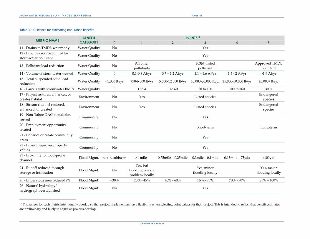
STORMWATER RESOURCE PLAN: TAHOE-SIERRA REGION PAGE 48
TAHOE-SIERRA REGION
Table 30. Guidance for estimating non-Tahoe benefits
METRIC NAME BENEFIT
CATEGORY POINTS17
0 1 2 3 4 5 11 - Drains to TMDL waterbody Water Quality No Yes 12 - Provides source control for stormwater pollutant Water Quality No Yes
13 - Pollutant load reduction Water Quality No All other
pollutants 303(d) listed
pollutant Approved TMDL
pollutant 14 - Volume of stormwater treated Water Quality 0 0.1-0.8 Af/yr 0.7 – 1.2 Af/yr 1.1 – 1.6 Af/yr 1.5 - 2 Af/yr >1.9 Af/yr 15 - Total suspended solid load reduction Water Quality <1,000 lb/yr 750-6,000 lb/yr 5,000-12,000 lb/yr 10,000-30,000 lb/yr 25,000-50,000 lb/yr 45,000+ lb/yr
16 - Parcels with stormwater BMPs Water Quality 0 1 to 4 3 to 60 50 to 130 100 to 360 300+ 17 - Project restores, enhances, or creates habitat Environment No Yes Listed species
Endangered species
18 - Stream channel restored, enhanced, or created
Environment No Yes Listed species Endangered
species 19 - Non-Tahoe DAC population served
Community No Yes
20 - Employment opportunity created
Community No Short-term Long-term
21 - Enhance or create community areas
Community No Yes
22 - Project improves property values
Community No Yes
23 - Proximity to flood-prone channel Flood Mgmt. not in subbasin >1 miles 0.75mile – 0.25mile 0.3mile – 0.1mile 0.15mile – 75yds <100yds
24 - Runoff reduced through storage or infiltration
Flood Mgmt. No Yes, but
flooding is not a problem locally
Yes, minor flooding locally
Yes, major flooding locally
25 - Impervious area reduced (%) Flood Mgmt. <30% 25% - 45% 40% - 60% 55% - 75% 70% - 90% 85% – 100% 26 - Natural hydrology/ hydrograph reestablished
Flood Mgmt. No Yes
17 The ranges for each metric intentionally overlap so that project implementers have flexibility when selecting point values for their project. This is intended to reflect that benefit estimates are preliminary and likely to adjust as projects develop.

STORMWATER RESOURCE PLAN: TAHOE-SIERRA REGION PAGE 49
TAHOE-SIERRA REGION
To determine the total score for each project the points for each metric within the same benefit category are averaged. Points are then summed across benefit categories to determine the total project score. The result is the total project score used to rank each project (Figure 20).
Figure 20. Project scoring method. Light grey boxes represent metric scores within each benefit category (dark grey boxes). Light blue boxes show that metrics within each benefit category are averaged and then summed to determine the total project score (dark blue box).
A ranked project list is developed for each jurisdiction (Appendix ). Projects are only ranked against other projects by the same jurisdiction.
NON-TAHOE WATER QUALITY ANALYSIS (SWRP GUIDELINES SECTION C.2.a)
The multiple benefits of listed projects collectively contribute to meeting regulatory requirements within the Region, such as TMDLs, NPDES permits, and WDRs. Outside the Lake Tahoe HU, the SWRCB NPDES permit (Phase II permit) sets WDRs for stormwater discharges from Municipal Separate Storm Sewer Systems (MS4s) including the Town of Truckee (Table 31) and the area of Placer County outside the Tahoe-basin but east of the Sierra Crest (Middle Truckee River Drainage). (Order No. 2013-0001-DWQ)18 The Town of Truckee and Placer County are the only agencies within the SWRP Region that are regulated by the Phase II permit.
TMDLs can also assign additional requirements to NPDES permittees through wasteload allocations. The Sediment TMDL for the Middle Truckee River was reviewed to identify wasteload allocations applicable to the Town of Truckee. Compliance with the TMDL requires implementation of a Stormwater Management Program (SWMP), monitoring and reporting of road sediment applied and removed, and adoption and enforcement of ordinances and policies to control sources of pollution in stormwater runoff. The Town of Truckee will continue to implement these actions SWRP and thus implementation of the SWRP will be consistent with the applicable NPDES and WDR's outside of the Tahoe-basin.
A wasteload allocation was assigned to urban runoff in the Town of Truckee on a subwatershed basis (Section 7 of the TMDL). Wasteload allocations for sediment in tons/year were assigned on the assumption that BMPs would be maintained with a removal efficiency of 50% (for sediment). To ensure the SWRP is consistent with the WDR (i.e., Phase II TMDL permit), projects should demonstrate that BMPs, low impact development or other practices are installed and maintained with at least a 50% sediment removal efficiency.
Table 31. Phase II permit water quality requirements
POLLUTANT TOWN OF TRUCKEE
Sediment
SWMP implementation Monitoring and reporting of road sediment applied and removed Adoption and enforcement of ordinances to control pollution in runoff BMPs maintained with 50% removal efficiency
18 WDRs for stormwater discharges from small municipal separate storm sewer systems (MS4s) (General permit), Water Quality Order No. 2013-0001 General permit No. CAS000004 California Regional Water Quality Control Board Lahontan Region (2013). http://www.swrcb.ca.gov/water_issues/programs/stormwater/docs/phsii2012_5th/order_final.pdf

STORMWATER RESOURCE PLAN: TAHOE-SIERRA REGION PAGE 50
TAHOE-SIERRA REGION
NON-TAHOE MULTIPLE BENEFITS (SWRP GUIDELINES SECTION D.2)
The aggregate benefits of implemented SWRP projects are tracked through the SWRP tracker using metrics. Because each metric has a stated definition and values, it is possible to aggregate the benefits associated with each metric across projects. Each project reports a metric score for each metric used. Each metric score has a range shown in the metric table (Table 27). To aggregate quantitative metrics, the mid-point of each score range is used. As a result, the total expected benefit across multiple projects can be determined.
As a result, information is available about the water quality, environmental, community, and flood management benefits to the region from planned and implemented projects (Appendices J & K). Stormwater capture and use was not considered in this SWRP because water supply is not a primary concern for the region. Water supply in the region is plentiful and secure for the foreseeable future. This information is useful for understanding progress toward regulatory targets and community goals. Additionally, this information is useful when determining whether to update the metric list during the adaptive management process.
Each project or program implemented in accordance with the SWRP should address at least two “Main Benefits” as listed in Table 4 of the Guidelines and as many “Additional Benefits” as feasible (also listed in Table 4 of the guidelines. The SWRP uses benefit categories to represent “Main Benefits” and multiple metrics within each benefit category to provide “Additional Benefits”. The number of benefit categories achieved by each project is tracked in Appendix .
NON-TAHOE DATA MANAGEMENT (SWRP GUIDELINES SECTION C.3)
Data location Data for all projects on the SWRP list and the list itself are publicly available on the Tahoe RCD website (http://tahoercd.org/stormwater-resources-plan/).
Data available Project data are publicly available for download. Project data are provided to the Tahoe RCD by
the lead implementer of the project when the project is added to that jurisdiction’s SWRP list. Project data includes quantitative metrics that allow the project to be scored and ranked.
The SWRP project list is in the form of an excel document publicly available for download. Data for each project includes the project name and score by applicable metric, and rank. Projects are only ranked against other projects led by the same jurisdiction.
Data management Implementing jurisdictions can submit project data to Tahoe RCD at any time. On an annual basis, Tahoe RCD scores and ranks the project in an Excel sheet and adds it to the jurisdiction’s SWRP list. The Excel sheet used to score and rank projects is updated by Tahoe RCD so there is a record of the process and result. The project data and the resulting project list will be made publicly available on the Tahoe RCD website.

STORMWATER RESOURCE PLAN: TAHOE-SIERRA REGION PAGE 51
TAHOE-SIERRA REGION
SECTION E. PLAN IMPLEMENTATION STRATEGY AND SCHEDULING OF PROJECTS
Procedures for implementation of the SWRP ensure clear roles and procedures to maintain the project list over time so that implementers remain eligible for funding. Additionally, these procedures demonstrate how implemented projects meet regulatory requirements and benefit communities. Pollutant load reduction targets within the Tahoe-basin are adjusted every 5 years when a new NPDES Phase I municipal permit is adopted. Projects implemented through the SWRP make progress toward meeting the regulatory targets set by the municipal permit. Outside the Tahoe-basin jurisdictions implement projects to achieve the Phase II permit, TMDL requirements, or benefit the community through ecosystem restoration and flood management. The intent of SWRP implementation and adaptive management is not to complete projects lists, but to achieve programmatic targets and make meaningful differences to communities.
RESOURCES FOR PLAN IMPLEMENTATION (SWRP GUIDELINES SECTION E.1)
According to the Water Code, the SWRP should identify the resources that the participating entities are committing for implementation of the Plan Water Code §10562(d)(8). Tahoe RCD will lead and pursue funding for activities to implement and adaptively manage the SWRP. Partnerships with the jurisdictions responsible for permit compliance and/or applying for bond funding may be pursued to secure funding. Although there is currently not a dedicated funding source for implementation and management of the SWRP, Tahoe RCD is committed to pursuing the necessary funding.
Funding is required to implement, as well as operate and maintain projects (Appendix G, Tahoe projects, Appendix K, non-Tahoe projects). In most cases, it is the responsibility of the project proponents to ensure that construction and operations and maintenance funding needs are met for each project. Jurisdictions are expected to rely primarily on State or Federal grants and loans for construction, and local funding for operation and maintenance of projects. Although funding for stormwater programs is limited there are some options which implementing agencies can consider to funding SWRP implementation including: operating funds, water enterprise funds, special taxes, assessments, private loans, and local bonds. Recent passage of SB231 does clarify that stormwater management fees are excluded from Proposition 218 restrictions. This clarification means that new stormwater fees can be passed by a 50% majority of voters rather than 66%; however, even the lowered barrier presents very a substantial hurdle and is not considered an easy path to new funding for stormwater projects. More specific estimates for how project costs will be financed are available for projects on the SWRP list which are also on the IRWMP list.19
Jurisdictions have a general understanding of the schedule for development and implementation of their projects based on initial project planning and best professional judgement (Appendix G, Tahoe projects, Appendix K, non-Tahoe projects). Additionally, jurisdictions in the Tahoe-basin are currently implementing fewer projects than was typical in previous years. Therefore, Implementers have the capacity and information necessary to plan and implement their projects as soon as funding becomes available. The timelines and funding requirements for projects will become more accurate and precise, as planning progresses.
IMPLEMENTATION PROGRAM (SWRP GUIDELINES SECTION E.2)
According to the Water Code, an entity developing a SWRP shall identify in the plan: projects and programs to ensure the effective implementation of the SWRP…to achieve multiple benefits. These projects and programs shall include the development of appropriate decision support tools and the data necessary to use the decision support tools.
19 Tahoe-Sierra IRWMP (Rep.). (2014, July). Table 8-2. Retrieved http://tahoesierrairwm.com/
abuxton
Highlight
abuxton
Highlight
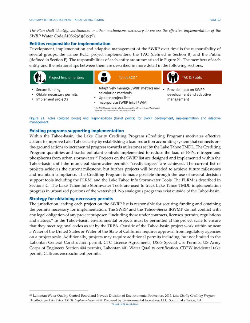
STORMWATER RESOURCE PLAN: TAHOE-SIERRA REGION PAGE 52
TAHOE-SIERRA REGION
The Plan shall identify…ordinances or other mechanisms necessary to ensure the effective implementation of the SWRP Water Code §10562(d)(8)&(9).
Entities responsible for implementation Development, implementation and adaptive management of the SWRP over time is the responsibility of several groups: the Tahoe RCD, project implementers, the TAC (defined in Section B) and the Public (defined in Section F). The responsibilities of each entity are summarized in Figure 21. The members of each entity and the relationships between them are described in more detail in the following sections.
Figure 21. Roles (colored boxes) and responsibilities (bullet points) for SWRP development, implementation and adaptive management.
Existing programs supporting implementation Within the Tahoe-basin, the Lake Clarity Crediting Program (Crediting Program) motivates effective actions to improve Lake Tahoe clarity by establishing a load reduction accounting system that connects on-the-ground actions to incremental progress towards milestones set by the Lake Tahoe TMDL. The Crediting Program quantifies and tracks pollutant controls implemented to reduce the load of FSPs, nitrogen and phosphorus from urban stormwater.20 Projects on the SWRP list are designed and implemented within the Tahoe-basin until the municipal stormwater permit’s “credit targets” are achieved. The current list of projects achieves the current milestone, but further projects will be needed to achieve future milestones and maintain compliance. The Crediting Program is made possible through the use of several decision support tools including the PLRM, and the Lake Tahoe Info Stormwater Tools. The PLRM is described in Sections C. The Lake Tahoe Info Stormwater Tools are used to track Lake Tahoe TMDL implementation progress in urbanized portions of the watershed. No analogous programs exist outside of the Tahoe-basin.
Strategy for obtaining necessary permits The jurisdiction leading each project on the SWRP list is responsible for securing funding and obtaining the permits necessary for implementation. The SWRP and the Tahoe-Sierra IRWMP do not conflict with any legal obligation of any project proposer, “including those under contracts, licenses, permits, regulations and statues.” In the Tahoe-basin, environmental projects must be permitted at the project scale to ensure that they meet regional codes as set by the TRPA. Outside of the Tahoe-basin project work within or near a Water of the United States or Water of the State of California requires approval from regulatory agencies on a project scale. Additionally, projects may require additional permits including, but not limited to the Lahontan General Construction permit, CTC License Agreements, USFS Special Use Permits, US Army Corps of Engineers Section 404 permits, Lahontan 401 Water Quality certification, CDFW incidental take permit, Caltrans encroachment permits.
20 Lahontan Water Quality Control Board and Nevada Division of Environmental Protection. 2015. Lake Clarity Crediting Program Handbook: for Lake Tahoe TMDL Implementation v2.0. Prepared by Environmental Incentives, LLC. South Lake Tahoe, CA.
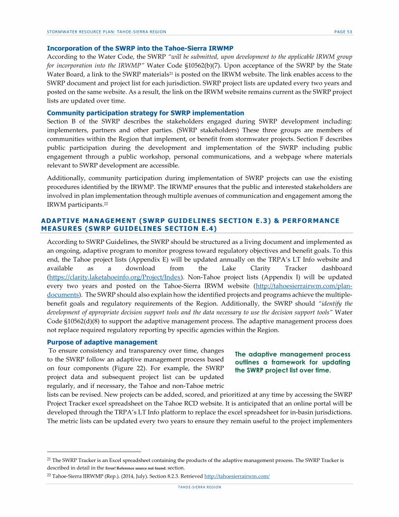
STORMWATER RESOURCE PLAN: TAHOE-SIERRA REGION PAGE 53
TAHOE-SIERRA REGION
Incorporation of the SWRP into the Tahoe-Sierra IRWMP According to the Water Code, the SWRP “will be submitted, upon development to the applicable IRWM group for incorporation into the IRWMP” Water Code §10562(b)(7). Upon acceptance of the SWRP by the State Water Board, a link to the SWRP materials21 is posted on the IRWM website. The link enables access to the SWRP document and project list for each jurisdiction. SWRP project lists are updated every two years and posted on the same website. As a result, the link on the IRWM website remains current as the SWRP project lists are updated over time.
Community participation strategy for SWRP implementation Section B of the SWRP describes the stakeholders engaged during SWRP development including: implementers, partners and other parties. (SWRP stakeholders) These three groups are members of communities within the Region that implement, or benefit from stormwater projects. Section F describes public participation during the development and implementation of the SWRP including public engagement through a public workshop, personal communications, and a webpage where materials relevant to SWRP development are accessible.
Additionally, community participation during implementation of SWRP projects can use the existing procedures identified by the IRWMP. The IRWMP ensures that the public and interested stakeholders are involved in plan implementation through multiple avenues of communication and engagement among the IRWM participants.22
ADAPTIVE MANAGEMENT (SWRP GUIDELINES SECTION E.3) & PERFORMANCE MEASURES (SWRP GUIDELINES SECTION E.4)
According to SWRP Guidelines, the SWRP should be structured as a living document and implemented as an ongoing, adaptive program to monitor progress toward regulatory objectives and benefit goals. To this end, the Tahoe project lists (Appendix E) will be updated annually on the TRPA’s LT Info website and available as a download from the Lake Clarity Tracker dashboard (https://clarity.laketahoeinfo.org/Project/Index). Non-Tahoe project lists (Appendix I) will be updated every two years and posted on the Tahoe-Sierra IRWM website (http://tahoesierrairwm.com/plan-documents). The SWRP should also explain how the identified projects and programs achieve the multiple-benefit goals and regulatory requirements of the Region. Additionally, the SWRP should “identify the development of appropriate decision support tools and the data necessary to use the decision support tools” Water Code §10562(d)(8) to support the adaptive management process. The adaptive management process does not replace required regulatory reporting by specific agencies within the Region.
Purpose of adaptive management To ensure consistency and transparency over time, changes to the SWRP follow an adaptive management process based on four components (Figure 22). For example, the SWRP project data and subsequent project list can be updated regularly, and if necessary, the Tahoe and non-Tahoe metric lists can be revised. New projects can be added, scored, and prioritized at any time by accessing the SWRP Project Tracker excel spreadsheet on the Tahoe RCD website. It is anticipated that an online portal will be developed through the TRPA’s LT Info platform to replace the excel spreadsheet for in-basin jurisdictions. The metric lists can be updated every two years to ensure they remain useful to the project implementers
21 The SWRP Tracker is an Excel spreadsheet containing the products of the adaptive management process. The SWRP Tracker is described in detail in the Error! Reference source not found. section. 22 Tahoe-Sierra IIRWMP (Rep.). (2014, July). Section 8.2.3. Retrieved http://tahoesierrairwm.com/
The adaptive management process outlines a framework for updating the SWRP project list over time.

STORMWATER RESOURCE PLAN: TAHOE-SIERRA REGION PAGE 54
TAHOE-SIERRA REGION
and support the multi-benefit goals of the Region. Updating progress toward regulatory requirements and multi-benefit goals every two years ensures listed projects are targeted to the needs of the Region.
Figure 22. Four components of the adaptive management process (blue polygons) and the SWRP Tracker products (icons in circles).
Adaptive management products The findings of each component of the process is captured through the SWRP Tracker (Appendix ) for Tahoe and non-Tahoe jurisdictions, as well as the EIP project tracker on the LT Info platform for Tahoe jurisdictions only. Each component captures specific information to inform the adaptive management process (Figure 23):
Project list: The current ranked project list for each jurisdiction. The Excel sheet SWRP Tracker for non-Tahoe jurisdictions and the online EIP project tracker for Tahoe jurisdictions.
Project data: Data for each SWRP project including the lead implementer, project status, expected benefits, and metrics.
Benefit tracking: Comparison of regulatory targets with estimated benefits of implemented projects and aggregates benefits of projects by category. Targets may have been updated due to new research.
Metrics: Tahoe and non-Tahoe metric lists and point ranges. Recommendation email: An email sent from Tahoe RCD to the TAC with proposed changes
to the SWRP. Potential changes include new projects, adjustments to the metric list and administrative changes made to the SWRP. A copy of the email is uploaded to the SWRP project website.
TAC & Public meeting: A meeting led by Tahoe RCD with the TAC and public in attendance. The purpose of the meeting is to review recommended changes. After the meeting a meeting report is written by Tahoe RCD and uploaded to the SWRP project website. The report summarizes the decisions made at the meeting about updates to the SWRP metrics.
Adaptive management procedure Each component of the adaptive management process follows several steps led by the entities responsible for implementation identified above (Tahoe RCD, Project Implementers, TAC & Public).
Figure 23. The first component of the adaptive management process involves reporting performance in a quantitative way.
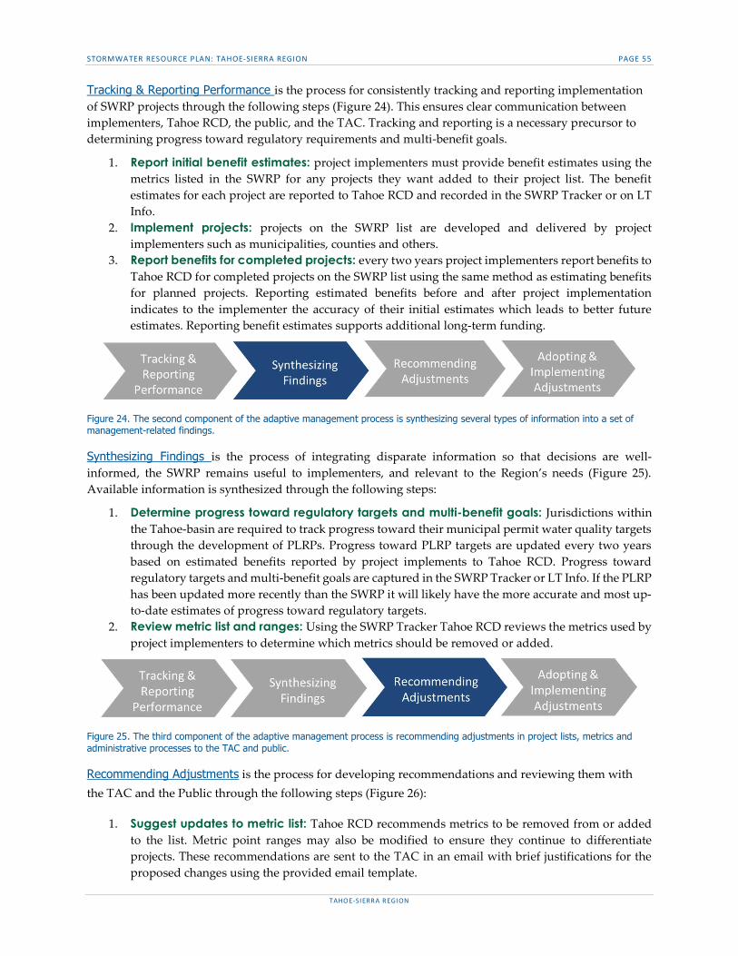
STORMWATER RESOURCE PLAN: TAHOE-SIERRA REGION PAGE 55
TAHOE-SIERRA REGION
Tracking & Reporting Performance is the process for consistently tracking and reporting implementation of SWRP projects through the following steps (Figure 24). This ensures clear communication between implementers, Tahoe RCD, the public, and the TAC. Tracking and reporting is a necessary precursor to determining progress toward regulatory requirements and multi-benefit goals.
1. Report initial benefit estimates: project implementers must provide benefit estimates using the metrics listed in the SWRP for any projects they want added to their project list. The benefit estimates for each project are reported to Tahoe RCD and recorded in the SWRP Tracker or on LT Info.
2. Implement projects: projects on the SWRP list are developed and delivered by project implementers such as municipalities, counties and others.
3. Report benefits for completed projects: every two years project implementers report benefits to Tahoe RCD for completed projects on the SWRP list using the same method as estimating benefits for planned projects. Reporting estimated benefits before and after project implementation indicates to the implementer the accuracy of their initial estimates which leads to better future estimates. Reporting benefit estimates supports additional long-term funding.
Figure 24. The second component of the adaptive management process is synthesizing several types of information into a set of management-related findings.
Synthesizing Findings is the process of integrating disparate information so that decisions are well-informed, the SWRP remains useful to implementers, and relevant to the Region’s needs (Figure 25). Available information is synthesized through the following steps:
1. Determine progress toward regulatory targets and multi-benefit goals: Jurisdictions within the Tahoe-basin are required to track progress toward their municipal permit water quality targets through the development of PLRPs. Progress toward PLRP targets are updated every two years based on estimated benefits reported by project implements to Tahoe RCD. Progress toward regulatory targets and multi-benefit goals are captured in the SWRP Tracker or LT Info. If the PLRP has been updated more recently than the SWRP it will likely have the more accurate and most up-to-date estimates of progress toward regulatory targets.
2. Review metric list and ranges: Using the SWRP Tracker Tahoe RCD reviews the metrics used by project implementers to determine which metrics should be removed or added.
Figure 25. The third component of the adaptive management process is recommending adjustments in project lists, metrics and administrative processes to the TAC and public.
Recommending Adjustments is the process for developing recommendations and reviewing them with the TAC and the Public through the following steps (Figure 26):
1. Suggest updates to metric list: Tahoe RCD recommends metrics to be removed from or added to the list. Metric point ranges may also be modified to ensure they continue to differentiate projects. These recommendations are sent to the TAC in an email with brief justifications for the proposed changes using the provided email template.
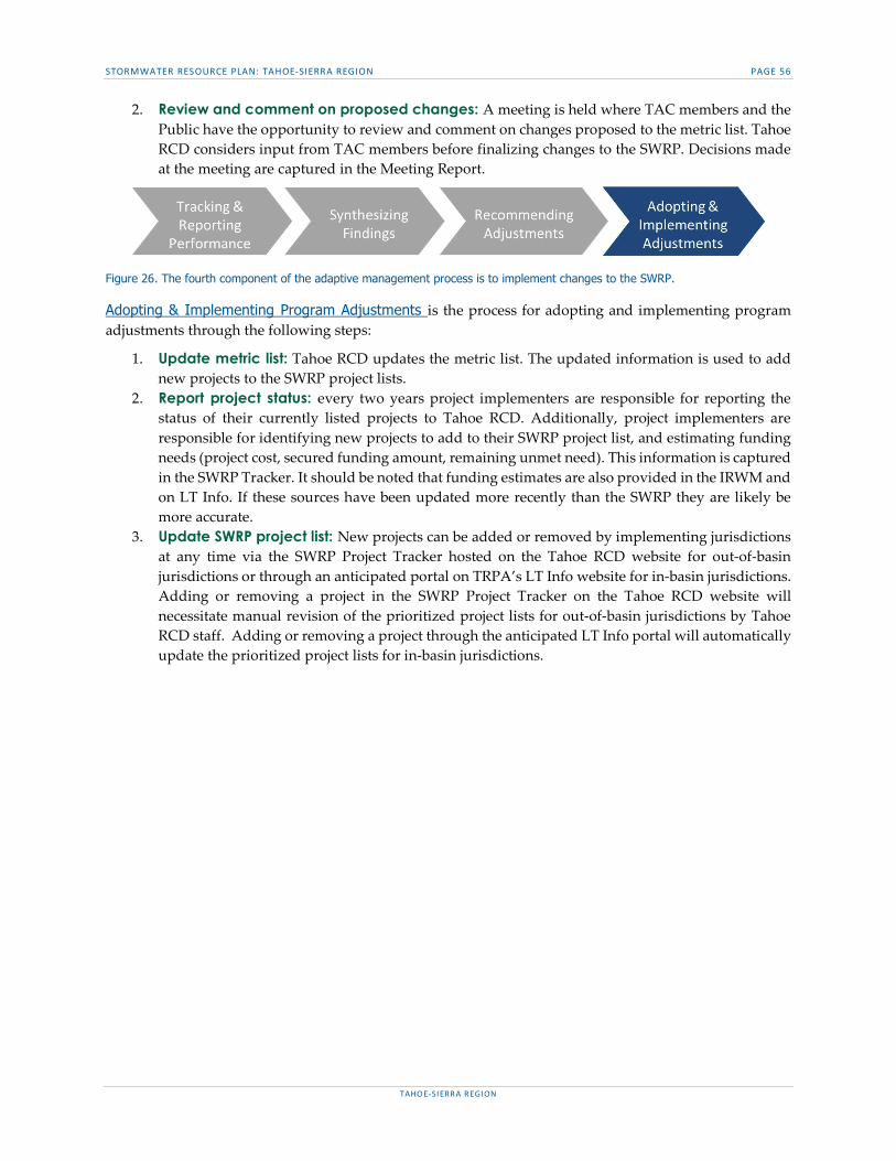
STORMWATER RESOURCE PLAN: TAHOE-SIERRA REGION PAGE 56
TAHOE-SIERRA REGION
2. Review and comment on proposed changes: A meeting is held where TAC members and the Public have the opportunity to review and comment on changes proposed to the metric list. Tahoe RCD considers input from TAC members before finalizing changes to the SWRP. Decisions made at the meeting are captured in the Meeting Report.
Figure 26. The fourth component of the adaptive management process is to implement changes to the SWRP.
Adopting & Implementing Program Adjustments is the process for adopting and implementing program adjustments through the following steps:
1. Update metric list: Tahoe RCD updates the metric list. The updated information is used to add new projects to the SWRP project lists.
2. Report project status: every two years project implementers are responsible for reporting the status of their currently listed projects to Tahoe RCD. Additionally, project implementers are responsible for identifying new projects to add to their SWRP project list, and estimating funding needs (project cost, secured funding amount, remaining unmet need). This information is captured in the SWRP Tracker. It should be noted that funding estimates are also provided in the IRWM and on LT Info. If these sources have been updated more recently than the SWRP they are likely be more accurate.
3. Update SWRP project list: New projects can be added or removed by implementing jurisdictions at any time via the SWRP Project Tracker hosted on the Tahoe RCD website for out-of-basin jurisdictions or through an anticipated portal on TRPA’s LT Info website for in-basin jurisdictions. Adding or removing a project in the SWRP Project Tracker on the Tahoe RCD website will necessitate manual revision of the prioritized project lists for out-of-basin jurisdictions by Tahoe RCD staff. Adding or removing a project through the anticipated LT Info portal will automatically update the prioritized project lists for in-basin jurisdictions.

STORMWATER RESOURCE PLAN: TAHOE-SIERRA REGION PAGE 57
TAHOE-SIERRA REGION
SECTION F. EDUCATION, OUTREACH, AND PUBLIC PARTICIPATION Public participation during the development and implementation of the SWRP attempted to maximize the community benefits of watershed scale stormwater management. Opportunities for public education and engagement during development of the SWRP included a public forum, open TAC meetings, personal communications, social media posts and shares, and a webpage where materials relevant to SWRP development were accessible to the public, Water Code §10562(b)(4).
PUBLIC EDUCATION & PARTICIPATION (SWRP GUIDELINES SECTION F.I & F.II)
Implementation of the SWRP did not require consideration of any major technical or policy issues, yet multiple opportunities for public engagement during development of the SWRP were pursued. Two public forums were held, one inside the basin on the south shore of Lake Tahoe and one outside of the basin in the Town of Truckee in December 2017 to inform the public about the purpose of the SWRP and to educate them about the multiple benefits stormwater projects can have to things they care about: water quality, habitat enhancement, recreational opportunities, and the economy. Additionally, all five TAC meetings were open to the general public. Forum and meeting locations, dates, and times were publicized with a 30-day notice via the outreach and communication methods and tools outlined below and were specifically targeted to the audiences named below. Meeting reports for public and TAC meetings, as well as draft SWRP products were posted for public comment on the Tahoe RCD website and shared via Tahoe RCD’s Facebook page.
AFFECTED COMMUNITIES (SWRP GUIDELINES SECTION F.III)
CEQA allows for public engagement in major decisions and processes related to environmental projects that will be implemented. Additionally, each jurisdiction follows their own protocols and procedures for encouraging public comment during project design and implementation such as open Board of Supervisors or City Council meetings and forums dedicated to hearing public comment on sensitive or contentious projects. The method of outreach to affected populations will be the responsibility of each jurisdiction implementing a project.
SPECIFIC AUDIENCES (SWRP GUIDELINES SECTION F.IV & F.V)
Specific audiences for whom the SWRP or stormwater projects in general might be relevant include developers, locally regulated commercial and industrial enterprises, school districts, and disadvantaged communities. A brief description of each is provided below. Efforts were made to contact representatives from each of these audiences to encourage them to attend one of the public forums held in December 2017 and review the draft SWRP. Leaders of the specific audiences were contacted directly via phone and/or email for participation in the public forum and SWRP draft review.
Ratepayers are not relevant within the Region because there is no fee structure in place to pay for stormwater. The primary nongovernmental/nonprofit organization involved in stormwater management in the Region is the League to Save Lake Tahoe (Section B).
Developers Developers or construction companies are often contracted to construct portions of the stormwater projects designed by the implementing jurisdictions.
Locally regulated commercial and industrial enterprises Local enterprises are currently enrolled in the statewide General Stormwater Industrial Permit which regulates industrial stormwater discharges and authorized non-stormwater discharges from industrial facilities in California. Though they are not required to implement stormwater projects, they are subject to effluent limitation guidelines and must develop Stormwater Pollution Prevention Plans.

STORMWATER RESOURCE PLAN: TAHOE-SIERRA REGION PAGE 58
TAHOE-SIERRA REGION
School districts Beginning in 2019, school districts in the state of California will be added to the statewide Phase II Municipal Stormwater Program General Permit. Inclusion in this permit requires school districts to control pollutants originating from their campuses. Thus, school districts in the Region will eventually need to implement stormwater projects.
Disadvantaged and climate vulnerable communities The Washoe Tribe is the primary disadvantaged community in the Region. Their population is largely dispersed within the Tahoe-basin and surrounding areas, and as such they are not concentrated in areas of frequent or excessive flooding, considerable habitat degradation, economic adversity, or poor water quality. However, they may face challenges associated with climate change and should be aware of the SWRP process. They have established the Washoe Environmental Protection Department (WEPD) which is responsible for carrying out protection of the natural and cultural resources and management for lands within the traditional territory and over 73,500 acres of trust and fee lands. A current WEPD project aims to identify the risks and vulnerabilities of the Tribe, Tribal Communities, and environmental resources related to climate change. These include more extreme weather events, higher temperatures, changes in timing and amount of precipitation, reduced snowpack, longer growing seasons, increased wildfire, increased pest infestations, changes in native plant and animal species, decreases in local air and water quality, and increases in invasive species, all of which may affect the health, safety, economic development, ability of Tribal members to collect/ hunt native plants and animals, and sovereignty of the Washoe Tribe.
The Washoe Tribe was engaged through direct communication between the SWRP development team and contacts from the Washoe Tribe.
ENVIRONMENTAL INJUSTICE (SWRP GUIDELINES SECTION F.VI)
The USEPA has developed a screening tool to identify Environmental Justice (EJ) concerns (EJSCREEN Maps, Version 2017 accessed at https://ejscreen.epa.gov/mapper/). This tool identifies Environmental and Demographic indicators that indicate where EJ concerns could arise but does not include the capability to identify environmental justice concerns related specifically to stormwater or dry weather runoff. The tool was used, in conjunction with local knowledge of stormwater related issues, to help identify whether there were runoff related environmental justice issues to address in the SWRP. While there are some minority and low-income populations within the SWRP Region (e.g., portions of the Town of Truckee, South Lake Tahoe, and Kings Beach), there are no apparent runoff-related issues occurring within these distinct areas. Stormwater and dry-weather runoff does not put disproportionate stress on areas with minority or low-income populations, rather impacts from stormwater runoff occur throughout urbanized areas within the SWRP Region (SWRP Guidelines Section F.VI).
ENGAGEMENT & COMMUNICATION SCHEDULE (SWRP GUIDELINES SECTION F.VII)
Previous public engagement A draft of the full SWRP was completed in October of 2017. It was posted on the Tahoe RCD website (http://tahoercd.org/stormwater-resources-plan/) in November 2017 prior to the two public forums. All relevant entities, including stakeholders (see Section B), specific audiences, and the general public were invited to comment on the document during the review period from December 3, 2017 through January 3, 2018. Public comments were solicited through an Excel spreadsheet on Tahoe RCD’s website, and were reviewed and incorporated into the document as appropriate.
The two public forums were intentionally scheduled at the beginning of the public draft comment period and occurred in South Lake Tahoe on December 6th (in basin) and in the Town of Truckee on December 7th, 2017 (out of basin). They provided an overview of the SWRP, focusing on the importance of the document and why it was developed as well as giving clear guidance on how to provide comments on the draft. The

STORMWATER RESOURCE PLAN: TAHOE-SIERRA REGION PAGE 59
TAHOE-SIERRA REGION
forums also allowed for public interaction with the implementing jurisdictions to discuss concerns, relevant projects, or other public needs (SWRP Guidelines Section F.VII.). All relevant entities, including stakeholders (see Section B), specific audiences, and the general public, were invited to the public forums.
Invitations to attend the public forums and comment on the draft SWRP were sent directly to the relevant entities via email and the general public through The League to Save Lake Tahoe’s contact list, posted on Tahoe RCD’s and implementing agencies social media platforms, and advertised in online news media and TRPA’s website 30 days in advance. Two email reminders to provide comments on the draft and attend the forums were sent one and two weeks prior to the forums.
Postings on Social Media
TRPA’s Facebook page (https://www.facebook.com/voiceforlaketahoe) TRPA’s Twitter page (https://twitter.com/TahoeAgency) Tahoe RCD’s Facebook page
(https://business.facebook.com/tahoercd/?business_id=10153455499298055) ▫ This post was shared on the following Facebook pages: Lake Mead Quagga updates, USFS
Lake Tahoe-basin Management Unit, Keep Tahoe Blue, Official City of South Lake Tahoe, Drink Tahoe Tap, South Lake Tahoe, and Truckee.
News Media online content
Tahoe Daily Tribune “Community Briefs Section” Lake Tahoe This Week’s event calendar Moonshine Ink Tap Calendar
Other online content
TRPA’s public workshop online (http://www.trpa.org/public-workshops-on-stormwater-resource-plan-december-6-7/)
Attendance at the public forums was minimal, but discussions during the overview presentation were positive and attendees were pleased with the opportunity to engage with representatives from their respective jurisdictions regarding stormwater projects that affect them.
Future public engagement Any future changes to this plan or the implementation of the SWRP require public engagement. In the unlikely case that revisions are necessary, the public will be engaged according to the engagement methods used in the development of the SWRP outlined above.
The SWRP adaptive management process includes a public meeting to review all proposed changes to the SWRP. Notice of this meeting will be publicly posted and a meeting report will be publicly available.

STORMWATER RESOURCE PLAN: TAHOE-SIERRA REGION
TAHOE-SIERRA REGION
APPENDIX A – COMMUNITY WATER SUPPLIERS Excerpt from IRWMP Section 2.9.1.3 Regional Water Supplies and Projections
Agate Bay Water Company Fulton Water Company Lake Forest Utility Company Lakeside Park Association Lukins Water Company Madden Creek Water Company McKinney Water District Rockwater Apartments Tahoe Cedars Water Company Tahoe Keys Homeowners Association Tahoe Park Water Company Tahoe Swiss Village Utility, Inc. Talmont Resort Improvement District Ward Well Water Company Truckee River HU (shown on Figure 2-9 of the IRWMP) Alpine Meadows Property Owners Association Alpine Springs CWD Floriston Water System Northstar Community Services District (Northstar CSD) Squaw Valley Mutual Water Company Squaw Valley Public Service District West Fork and East Fork Carson River HUs (shown on Figure 2-10 of the IRWMP) Markleeville Water Company Sierra Pines Mobile Home Park Woodfords Mutual Water Company Washoe Utilities Management Authority

STORMWATER RESOURCE PLAN: TAHOE-SIERRA REGION
TAHOE-SIERRA REGION
APPENDIX B – CDPH REGULATED WATER SYSTEMS Excerpt from IRWMP Appendix 2-A: California Department of Public Health (CDPH) Regulated Water Systems

Appendix 2-A: CDPH Regulated Water Systems
Fig No. System Name Population
Service
Connections Type(a) County
Primary
Source(b)
Floriston Water System 100 40 C Nevada GW
Truckee‐Donner PUD, Main 16,280 12,526 C Nevada GW
Truckee‐Donner PUD ‐ Hirschdale 48 20 C Nevada GW
Agate Bay Water Company 2,500 580 C Placer SW
Alpine Meadows Property Owners Asso 250 138 C Placer SW
Alpine Springs County Water District 200 663 C Placer GW
Fulton Water Company 500 902 C Placer SW
Lake Forest Utility Company 50 118 C Placer GW
Madden Creek Water Company 300 164 C Placer GW
Mckinney Water District 117 246 C Placer GW
North Tahoe PUD ‐ Main 5,000 3,326 C Placer SW
North Tahoe PUD ‐ Carnelian Woods 600 273 C Placer GW
North Tahoe PUD ‐ Dollar Cove 800 273 C Placer GW
Northstar C.S.D. 300 1,013 C Placer SW
Placer CWA ‐ Martis Valley 1,218 369 C Placer GW
Squaw Valley MWC 500 263 C Placer GW
Squaw Valley PSD 926 742 C Placer GW
Tahoe Cedars Water Company 2,775 1,114 C Placer GW
Tahoe City PUD ‐ Main 3,997 2,778 C Placer GW
Tahoe City PUD ‐ Alpine Peaks 12 95 C Placer GW
Tahoe City PUD ‐ Mckinney/Quail 750 506 C Placer SW
Tahoe Park Water Co ‐ Skyland/Nielsen 50 89 C Placer GW
Tahoe Park Water Company 750 440 C Placer GW
Tahoe Swiss Village Utility 300 378 C Placer SW
Tahoma Meadows Mutual Water Company 120 43 C Placer GW
Talmont Resort Improvement District 300 334 C Placer GW
Ward Well Water Company 375 224 C Placer GW
Lakeside Park Association 1,000 128 C El Dorado SW
Lukins Brothers Water Company 250 952 C El Dorado GW
Rockwater Apts. 50 24 C El Dorado GW
South Tahoe PUD ‐ Main 29,500 13,926 C El Dorado GW
Tahoe City PUD ‐ Rubicon 250 613 C El Dorado GW
Tahoe Keys Water Company 1,200 1,563 C El Dorado GW
Markleeville Water Co. 25 167 C Alpine SW
Sierra Pines Mobile Home Park 70 31 C Alpine GW
Woodfords Mutual Water Company 50 16 C Alpine GW
1 Camp Wasiu II, Sierra/NV Inc. 160 1 NC Sierra GW
2 TNF‐Little Truckee WS 75 1 NC Sierra GW
3 TNF‐Logger & Stampede RC 1,200 1 NC Sierra GW
4 Tahoe Timber Trails Water System 250 25 NC Nevada GW
5 U S Army Corp Of Engineers/Martis Creek 75 15 NC Nevada GW
Community Systems
Non‐Community Systems
Tahoe-Sierra IRWM Plan, July 2014Section 2 – Region DescriptionJ:\2012\1270036.00_STPUD Tahoe Sierra IRWMP\09-Reports\9.09-Reports\_Appendices\_final_appendices\2-A_CDPH_WaterSystems.xlsx
Appendix 2-A - Page 1 of 4

Appendix 2-A: CDPH Regulated Water Systems
Fig No. System Name Population
Service
Connections Type(a) County
Primary
Source(b)
6 U.S. Forest Service/Boca Rest CPGD 100 25 NC Nevada GW
7 U.S. Forest Service/Prosser CPGD 100 30 NC Nevada GW
8 United Trails Resort 100 35 NC Nevada GW
9 8200 Water System 1,000 4 NTNC Placer GW
10 Northstar At Tahoe Comstock Water System 25 2 NTNC Placer GW
11 Fir Crags Summer Home Tract 50 16 NC Placer GW
12 Goose Meadows 25 1 NC Placer GW
13 Granite Flat Campground 25 1 NC Placer GW
14 Kilner Park 25 1 NC Placer GW
15 Northstar Summit Deck & Grill 2,000 1 NC Placer GW
16 Silver Creek Campground 25 1 NC Placer GW
17 Silver Creek Summer Home Tract 25 23 NC Placer GW
18 Tahoe Vistana 50 2 NC Placer GW
19 Tamarack Lodge 25 1 NC Placer GW
20 Al Tahoe Elem/Stms (Water Sys) 1,300 4 NTNC El Dorado GW
21 Heavenly Ski Resort 1,000 2 NTNC El Dorado GW
22 South Shore Recreation Area 3,300 123 NTNC El Dorado GW
23 Station House Inn 30 100 NTNC El Dorado GW
24 Tahoe Valley Elementary School 700 1 NTNC El Dorado GW
25 A & A Lake Tahoe Inn 25 32 NC El Dorado GW
26 Alder Creek Tract 40 20 NC El Dorado GW
27 Alder Inn 25 24 NC El Dorado GW
28 Alpenrose Inn 40 19 NC El Dorado GW
29 Alpine Inn & Spa 25 38 NC El Dorado GW
30 Angora Lakes Resort 1,000 11 NC El Dorado GW
31 Baldwin Beach 200 1 NC El Dorado GW
32 Bayview Campground 100 2 NC El Dorado GW
33 Beverly Lodge 25 30 NC El Dorado GW
34 Ca State Parks ‐ D.L. Bliss 1,000 13 NC El Dorado SW
35 Ca State Parks ‐ Emerald Bay, Boat Campg 1,000 5 NC El Dorado SW
36 Ca State Parks ‐ Emerald Bay, Eagle Poin 1,000 13 NC El Dorado SW
37 Ca State Parks ‐ Emerald Bay, Vikingshol 2,800 2 NC El Dorado SW
38 Camp Concord 100 12 NC El Dorado GW
39 Camp Shelly 200 28 NC El Dorado GW
40 Cascade Mutual Water Company 60 32 NC El Dorado GW
41 Cathedral Water Association 25 22 NC El Dorado GW
42 Deerfield Lodge @ Heavenly 40 14 NC El Dorado GW
43 Eagle Falls 500 1 NC El Dorado GW
44 Echo Chalet Inc 40 10 NC El Dorado GW
45 Echo Lake Camp 150 11 NC El Dorado GW
46 Echo Peak Water Association 32 26 NC El Dorado GW
47 Echo Road Group Water Assoc 40 19 NC El Dorado GW
48 Econo Lodge 120 62 NC El Dorado GW
Tahoe-Sierra IRWM Plan, July 2014Section 2 – Region DescriptionJ:\2012\1270036.00_STPUD Tahoe Sierra IRWMP\09-Reports\9.09-Reports\_Appendices\_final_appendices\2-A_CDPH_WaterSystems.xlsx
Appendix 2-A - Page 2 of 4

Appendix 2-A: CDPH Regulated Water Systems
Fig No. System Name Population
Service
Connections Type(a) County
Primary
Source(b)
49 Emerald Pines Resort Cabins 100 1 NC El Dorado GW
50 Fallen Leaf Mutual Water Co 100 120 NC El Dorado SW
51 FLL Mutual 100 40 NC El Dorado GW
52 Glenridge Water Company 124 45 NC El Dorado GW
53 Heather Lake Road Tract 25 13 NC El Dorado GW
54 Heavenly Gondola 500 1 NC El Dorado GW
55 Heavenly Ski Resort 500 2 NC El Dorado GW
56 King's IV Condominiums 60 40 NC El Dorado GW
57 Mark Twain Motel 25 21 NC El Dorado GW
58 Matterhorn Motel 50 25 NC El Dorado GW
59 Midway Motel Annex 32 16 NC El Dorado GW
60 Mt Ralston Properties Assc Inc 100 80 NC El Dorado GW
61 National 9 60 32 NC El Dorado GW
62 North Echo Summit Water Association 84 42 NC El Dorado GW
63 Pinewood Inn 70 21 NC El Dorado GW
64 Pistante S Coyote Den 32 16 NC El Dorado GW
65 Rainbow Tract Water Assoc 25 23 NC El Dorado GW
66 Ski Run Management Company 25 2 NC El Dorado GW
67 Sky Lake Lodge 25 22 NC El Dorado GW
68 Spring Creek Tract Association 280 140 NC El Dorado GW
69 Stanford Sierra Camp 100 58 NC El Dorado SW
70 Summit Pines Apartments 25 15 NC El Dorado GW
71 Tahoe Chalet Inn 100 48 NC El Dorado GW
72 Tahoe Valley Lodge 42 21 NC El Dorado GW
73 Travel Inn 100 36 NC El Dorado GW
74 Vagabond Inn 30 36 NC El Dorado GW
75 Villa Tahoe Condominiums 44 22 NC El Dorado GW
76 Della Cella Cottages 0 7 NP El Dorado GW
77 Heavenly Valley Trailer Park 0 12 NP El Dorado GW
78 Lower Emerald Bay Tract 0 9 NP El Dorado GW
79 Pinewood Lodge 20 7 NP El Dorado GW
80 South Echo Summit Tract Civic 0 12 NP El Dorado GW
81 Truckee Creek Cottages 60 11 NP El Dorado GW
82 Diamond Valley School 100 3 NTNC Alpine GW
83 Early Learning Center 60 3 NTNC Alpine GW
84 Hope Valley Resort 25 20 NTNC Alpine GW
85 Bloomfield CG #1 25 1 NC Alpine GW
86 Ca State Parks ‐ Grover Hot Springs 1,000 11 NC Alpine SW
87 Carson River Resort 30 28 NC Alpine GW
88 Co. Of Alpine Social Services Bldg. 25 1 NC Alpine GW
89 Crystal Springs CG 25 7 NC Alpine GW
90 Hope Valley CG 25 7 NC Alpine GW
91 Indian Creek Res. CG (BLM) 30 26 NC Alpine GW
Tahoe-Sierra IRWM Plan, July 2014Section 2 – Region DescriptionJ:\2012\1270036.00_STPUD Tahoe Sierra IRWMP\09-Reports\9.09-Reports\_Appendices\_final_appendices\2-A_CDPH_WaterSystems.xlsx
Appendix 2-A - Page 3 of 4
Appendix 2-A: CDPH Regulated Water Systems
Fig No. System Name Population
Service
Connections Type(a) County
Primary
Source(b)
92 Shay Creek Summer Home Tract 32 32 NC Alpine GW
93 Silver Creek CG 25 15 NC Alpine GW
94 Snowshoe Springs CG 25 5 NC Alpine GW
95 Sorenson S HOA 25 15 NC Alpine GW
96 Sorenson S Resort 25 28 NC Alpine GW
97 Turtle Rock County Park 25 15 NC Alpine GW
98 Woodfords Station 30 2 NC Alpine GW
Notes:
(a) Water system type definitions:
C = Community: Serves at least 15 service connections used by year‐round residents or regularly
serves 25 year‐round residents.
NTNC = Non‐Transient Non‐Community: Serves at least the same 25 non‐residential individuals
during 6 months of the year.
NC = Transient Non‐Community: Regularly serves at least 25 non‐residential individuals
(transient) during 60 or more days per year.
(b) Primary source of water
GW = Ground Water
SW = Surface Water
Tahoe-Sierra IRWM Plan, July 2014Section 2 – Region DescriptionJ:\2012\1270036.00_STPUD Tahoe Sierra IRWMP\09-Reports\9.09-Reports\_Appendices\_final_appendices\2-A_CDPH_WaterSystems.xlsx
Appendix 2-A - Page 4 of 4
STORMWATER RESOURCE PLAN – 4.9 PUBLIC DRAFT
4.9 PUBLIC DRAFT –
Key of Water Systems on Map 8 Water and wastewater service areas
Name Letter Floriston Water System A Truckee- Donner PUD - Hirschdale B Placer CWA - Martis Valley C Northstar C.S.D. D Agate Bay Water Co. E North Tahoe PUD - Carnelian Woods F Fulton Water Co. G Squaw Valley PSD H Alpine Springs County Water District I Squaw Valley MWC J North Tahoe PUD - Dollar Cove K Lake Forest Utility Co. L Talmont Resort Improvement Dist. M Alpine Meadows Property Owners Association N Tahoe City PUD - Rubicon O Tahoe City PUD - Mckinney/Quail P Tahoe City PUD - Alpine Peaks Q Tahoe Park Water Company - Skyland/Nielsen R Tahoe Park Water Company S Ward Well Water Company T Tahoe Swiss Village Utility U Tahoma Meadows Mutual Water Company V Madden Creek,Tahoe Cedars Water Co. W Mckinney Water Dist. X Lakeside Park Association Y Tahoe Keys Water Company Z Lukins Brothers Water Company AA Rockwater Apartments BB Woodfords Mutual Water Company CC Sierra Pines Mobile Home Park DD Markleeville Water Company EE

STORMWATER RESOURCE PLAN: TAHOE-SIERRA REGION
TAHOE-SIERRA REGION
APPENDIX C – 303D LISTED WATERBODIES
Excerpt from IRWMP Appendix 2-B: 2010 California 303(d) List of Water Quality Limited Segments

Tahoe-Sierra IRWM Plan, July 2014Section 2 – Region DescriptionJ:\2012\1270036.00_STPUD Tahoe Sierra IRWMP\09-Reports\9.09-Reports\_Tables\_final_tables\2-13_303d_List-20131011.xls
Appendix 2-B – Page 1 of 4
Appendix 2-B: 2010 California 303(d) List of Water Quality Limited Segments
Water Body Name
Pollutant
Category Pollutant Final Listing Decision
Expected
TMDL
Completion
Date(a)
Expected
Attainment
Date(a)
USEPA
TMDL
Approved
Date(a)
Comments Included On 303(d) List Potential Sources
East Fork Carson River
Carson River, East Fork 48 Miles Salinity TDS(b) List on 303(d) list (TMDL required list) 2021 Source Unknown
Wolf Creek (Alpine County) 12 Miles SedimentSedimentation/
SiltationList on 303(d) list (TMDL required list) 2019
Agriculture: Range Grazing-Riparian and/or Upland
Unspecified Nonpoint Source
Silviculture
Metals/
MetalloidsSulfates List on 303(d) list (TMDL required list) 2019
This listing is expected to be addressed through the CERCLA
remediation process.
Resource Extraction: Acid Mine Drainage, Inactive Mining, Mill
Tailings, Mine Tailings;
Unspecified Nonpoint Source; Unspecified Point Source
Metals/
Metalloids
Aluminum, Iron,
Manganese,TDSList on 303(d) list (TMDL required list) 2019
This listing is expected to be addressed through the CERCLA
remediation process.
Natural Sources;
Resource Extraction: Acid Mine Drainage, Inactive Mining, Mill
Tailings, Mine Tailings;
Unspecified Nonpoint Source; Unspecified Point Source
Metals/
MetalloidsSilver List on 303(d) list (TMDL required list) 2019
This listing is expected to be addressed through the CERCLA
remediation process..
Natural Sources;
Resource Extraction: Acid Mine Drainage, Inactive Mining, Mill
Tailings, Mine Tailings;
Unspecified Nonpoint Source
Aspen Creek 1 MilesMetals/
MetalloidsMetals
List on 303(d) list (being addressed by action
other than TMDL)2019
This listing is being addressed through a CERCLA remediation
program and through ongoing work by Lahontan Water Board staff.
Natural Sources;
Resource Extraction: Acid Mine Drainage, Inactive Mining, Mine
Tailings;
Unspecified Nonpoint Source
Bryant Creek 5 MilesMetals/
MetalloidsMetals
List on 303(d) list (being addressed by action
other than TMDL)2019
This listing is being addressed through a CERCLA remediation
program and through ongoing work by Lahontan Water Board staff.
Resource Extraction: Acid Mine Drainage, Inactive Mining, Mine
Tailings;
Unspecified Nonpoint Source
Leviathan Creek 3 MilesMetals/
MetalloidsMetals
List on 303(d) list (being addressed by action
other than TMDL)2019
This listing is being addressed through a CERCLA remediation
program and through ongoing work by Lahontan Water Board staff.
Habitat Modification: Erosion/Siltation;
Resource Extraction: Acid Mine Drainage, Inactive Mining, Mine
Tailings
Indian Creek (Alpine County) 13 Miles Pathogens Pathogens List on 303(d) list (TMDL required list) 2019Agriculture: Grazing-Related Sources, Pasture Grazing-Riparian
and/or Upland
Indian Creek Reservoir 164 Acres Nutrients PhosphorusList on 303(d) list (being addressed by USEPA
approved TMDL)7/1/2003
Reservoir is eutrophic. Most significant source of nutrient loading is
release of phosphorus from sediment. The USEPA approved the
TMDL in 2003. Reductions in internal phosphorus loading from the
sediment are expected to ameliorate other problems associat
Agriculture: Pasture Grazing-Riparian and/or Upland;
Habitat Modification: Erosion/Siltation;
Hydromodification: Flow Regulation/Modification;
Municipal Wastewater;
Natural Sources: Internal Nutrient Cycling (primarily lakes)
West Fork Carson River
Nutrients Nitrogen List on 303(d) list (TMDL required list) 2019This listing may be addressed through revision of the water quality
objective rather than through a TMDL.
Agriculture: irrigation tailwater, storm runoff, subsurface drainage,
Pasture Grazing-Riparian and/or Upland, Range Grazing-Riparian
and/or Upland;
Atmospheric Deposition;
Habitat Modification: Erosion/Siltation, Habitat Modification, Removal
of Riparian Vegetation;
Hydromodification: Channel Erosion, Streambank
Modification/Destabilization;
Natural Sources;
Other Runoff: Highway Maintenance and Runoff;
Recreation Areas And Activities: Recreational and Tourism Activities
(non-boating);
Silviculture;
Waste Storage And Disposal: Wastewater - land disposal;
Pathogens Pathogens List on 303(d) list (TMDL required list) 2019
Agriculture: Agricultural Return Flows, Pasture Grazing-Riparian
and/or Upland; Natural Sources; Recreation Areas And Activities:
Recreational and Tourism Activities (non-boating)
Carson River, West Fork (Paynesville
to State Line)3 Miles Pathogens Pathogens List on 303(d) list (TMDL required list) 2019
Agriculture: irrigation tailwater, storm runoff, Pasture Grazing-Riparian
and/or Upland
Nutrients Nitrate List on 303(d) list (TMDL required list) 2021This listing may be addressed through revision of the water quality
objective rather than through a TMDL.Source Unknown
NutrientsNitrogen,
Phosphorus
Do Not Delist from 303(d) list (TMDL required
list)2019
This listing may be addressed through revision of the water quality
objective rather than through a TMDL.
Atmospheric Deposition;
Habitat Modification: Erosion/Siltation, Habitat Modification, Removal
of Riparian Vegetation;
Hydromodification: Channel Erosion, Streambank
Modification/Destabilization;
Natural Sources;
Other Runoff: Highway Maintenance and Runoff;
Recreation Areas And Activities: Recreational and Tourism Activities
(non-boating);
Silviculture
Nutrients NitrogenDo Not Delist from 303(d) list (TMDL required
list)2019
This listing may be addressed through revision of the water quality
objective rather than through a TMDL.
Waste Storage And Disposal: Onsite Wastewater Systems (Septic
Tanks)
Miles
4 Miles
18 Miles
4
Estimated Size
Affected
Monitor Creek
Carson River, West Fork (Woodfords
to Paynesville)
Carson River, West Fork
(Headwaters to Woodfords)

Tahoe-Sierra IRWM Plan, July 2014Section 2 – Region DescriptionJ:\2012\1270036.00_STPUD Tahoe Sierra IRWMP\09-Reports\9.09-Reports\_Tables\_final_tables\2-13_303d_List-20131011.xls
Appendix 2-B – Page 2 of 4
Appendix 2-B: 2010 California 303(d) List of Water Quality Limited Segments
Water Body Name
Pollutant
Category Pollutant Final Listing Decision
Expected
TMDL
Completion
Date(a)
Expected
Attainment
Date(a)
USEPA
TMDL
Approved
Date(a)
Comments Included On 303(d) List Potential Sources
Estimated Size
Affected
Lake Tahoe
4 MilesMetals/
MetalloidsIron List on 303(d) list (TMDL required list) 2019
This listing may be addressed through revision of the water quality
objective rather than through a TMDL.Natural Sources
4 Miles Nutrients Phosphorus List on 303(d) list (TMDL required list) 2019Natural Sources; Silviculture; Agriculture: Grazing-Related Sources
Metals/
MetalloidsIron List on 303(d) list (TMDL required list) 2019
This issue may be addressed through revision of the water quality
objective rather than through a TMDL.
Habitat Modification: Erosion/Siltation;
Natural Sources;
Urban Runoff: Non-industrial Permitted;
NutrientsNitrogen,
PhosphorusList on 303(d) list (TMDL required list) 2019
Agriculture: Pasture Grazing-Riparian and/or Upland;
Atmospheric Deposition;
Habitat Modification: Erosion/Siltation;
Urban Runoff: Non-industrial Permitted
Pathogens PathogensDo Not Delist from 303(d) list (TMDL required
list)2019 Source Unknown
Cold Creek 7 Miles Nutrients Total Nitrogen as NList on 303(d) list (being addressed by action
other than TMDL)2028
This listing is being addressed through a U.S. Forest Service
restoration project.Hydromodification: Agricultural Water Diversion
Salinity Chloride List on 303(d) list (TMDL required list) 2019This listing may be addressed by revision of the water quality
objective rather than through a TMDL.
Atmospheric Deposition; Natural Sources; Other Runoff:
Highway/Road/Bridge Runoff; Source Unknown;
SedimentSedimentation/
SiltationList on 303(d) list (TMDL required list) 2019
Construction/Land Development; Habitat Modification;
Hydromodification; Recreation Areas And Activities: Recreational and
Tourism Activities (non-boating); Unspecified Nonpoint Source;
Salinity Chloride List on 303(d) list (TMDL required list) 2019This listing may be addressed through revision of the water quality
objective rather than through a TMDL.
Atmospheric Deposition; Natural Sources; Other Runoff: Highway
Maintenance and Runoff; Source Unknown;
Nutrients Phosphorus List on 303(d) list (TMDL required list) 2019
Atmospheric Deposition; Habitat Modification: Erosion/Siltation;
Natural Sources; Recreation Areas And Activities: Recreational and
Tourism Activities (non-boating)
SedimentSedimentation/
Siltation
List on 303(d) list (being addressed by USEPA
approved TMDL)9/30/2002 Source Unknown
Tallac Creek (below Hwy 89) 1 Miles Pathogens Pathogens List on 303(d) list (TMDL required list) 2019Agriculture: Grazing-Related Sources, Pasture Grazing-Riparian
and/or Upland
Metals/
MetalloidsIron List on 303(d) list (TMDL required list) 2019
This listing may be addressed through revision of the water quality
objective rather than through a TMDL.
Habitat Modification: Erosion/Siltation;
Natural Sources;
Urban Runoff: Non-industrial Permitted
NutrientsNitrogen,
PhosphorusList on 303(d) list (TMDL required list) 2019
Atmospheric Deposition;
Habitat Modification: Erosion/Siltation;
Urban Runoff: Non-industrial Permitted
Pathogens PathogensDo Not Delist from 303(d) list (TMDL required
list)2019 Agriculture: Grazing-Related Sources
Metals/
MetalloidsIron List on 303(d) list (TMDL required list) 2019
This listing may be addressed through revision of the water quality
objective rather than through a TMDL.
Habitat Modification: Erosion/Siltation; Natural Sources; Unspecified
Nonpoint Source
Nutrients Phosphorus List on 303(d) list (TMDL required list) 2019
Atmospheric Deposition;
Construction/Land Development: Construction/Land Development;
Habitat Modification: Erosion/Siltation, Removal of Riparian
Vegetation;
Hydromodification: Streambank Modification/Destabilization,
Channelization, Hydromodification;
Natural Sources;
Other Runoff: Highway Maintenance and Runoff;
Silviculture;
Unspecified Nonpoint Source: Unknown Nonpoint Source, Nonpoint
Source
Metals/
MetalloidsIron List on 303(d) list (TMDL required list) 2015
This listing may be addressed through revision of the water quality
objective rather than through a TMDL.
Habitat Modification: Erosion/Siltation;
Hydromodification: Channel Erosion;
Natural Sources;
Other Runoff: Highway Maintenance and Runoff;
Silviculture;
Urban Runoff
10
Miles1
11 Miles
Miles
1 Miles
2 Miles
Truckee River, Upper (above
Christmas Valley)
Heavenly Valley Creek (USFS
boundary to Trout Creek)
Heavenly Valley Creek (source to
USFS boundary)
Trout Creek (above Hwy 50)
Trout Creek (below Hwy 50)
Truckee River, Upper (below
Christmas Valley)

Tahoe-Sierra IRWM Plan, July 2014Section 2 – Region DescriptionJ:\2012\1270036.00_STPUD Tahoe Sierra IRWMP\09-Reports\9.09-Reports\_Tables\_final_tables\2-13_303d_List-20131011.xls
Appendix 2-B – Page 3 of 4
Appendix 2-B: 2010 California 303(d) List of Water Quality Limited Segments
Water Body Name
Pollutant
Category Pollutant Final Listing Decision
Expected
TMDL
Completion
Date(a)
Expected
Attainment
Date(a)
USEPA
TMDL
Approved
Date(a)
Comments Included On 303(d) List Potential Sources
Estimated Size
Affected
Nutrients Phosphorus List on 303(d) list (TMDL required list) 2008
Atmospheric Deposition;
Habitat Modification: Erosion/Siltation;
Hydromodification: Channel Erosion;
Natural Sources;
Other Runoff: Highway/Road/Bridge Runoff;
Silviculture;
Urban Runoff: Urban Runoff--Erosion and Sedimentation, Other Urban
Runoff
SedimentSedimentation/
SiltationList on 303(d) list (TMDL required list) 2008
Construction/Land Development: Land Development;
Hydromodification: Channel Erosion;
Other Runoff: Highway/Road/Bridge Runoff;
Silviculture;
Unspecified Nonpoint Source;
Urban Runoff: Urban Runoff/Storm Sewers
Metals/
MetalloidsIron List on 303(d) list (TMDL required list) 2022
This listing may be addressed through revision of the water quality
objective rather than a TMDL.
Habitat Modification: Erosion/Siltation; Natural Sources; Unspecified
Nonpoint Source
NutrientsNitrogen,
PhosphorusList on 303(d) list (TMDL required list) 2022
Habitat Modification: Erosion/Siltation; Hydromodification: Streambank
Modification/Destabilization; Natural Sources; Resource Extraction;
Silviculture; Unspecified Nonpoint Source
Nutrients Nitrogen List on 303(d) list (TMDL required list) 2022 Atmospheric Deposition
Nutrients Phosphorus List on 303(d) list (TMDL required list) 2022 Agriculture: Grazing-Related Sources
SedimentSedimentation/
Siltation
List on 303(d) list (being addressed by USEPA
approved TMDL)7/11/2008
Agriculture: Range Grazing-Riparian and/or Upland; Atmospheric
Deposition; Construction/Land Development; Habitat Modification:
Erosion/Siltation; Hydromodification: Streambank
Modification/Destabilization; Natural Sources; Recreation Areas And
Activities: Recreational and Tourism Activities (non-boating);
Resource Extraction; Silviculture; Unspecified Nonpoint Source; Urban
Runoff: Surface Runoff
Metals/
MetalloidsIron List on 303(d) list (TMDL required list) 2019
This listing may be addressed through revision of the water quality
objective rather than through a TMDL.Silviculture; Natural Sources
Nutrients Phosphorus List on 303(d) list (TMDL required list) 2019 Natural Sources; Atmospheric Deposition; Habitat Modification;
Nutrients
Nitrogen,
Phosphorus,
Sedimentation/
Siltation
List on 303(d) list (TMDL required list) 2010
Agriculture: Grazing-Related Sources; Atmospheric Deposition;
Construction/Land Development: Highway/Road/Bridge Construction,
Land Development; Habitat Modification: Erosion/Siltation, Removal of
Riparian Vegetation; Hydromodification: Channel Erosion, Streambank
Modification/Destabilization; Natural Sources: Internal Nutrient Cycling
(primarily lakes), Natural Sources; Other Runoff:
Highway/Road/Bridge Runoff; Recreation Areas And Activities:
Recreational and Tourism Activities (non-boating); Sediment
Resuspension; Silviculture; Unspecified Nonpoint Source; Urban
Runoff: Erosion and Sedimentation, Non-industrial Permitted, Urban
Runoff/Storm Sewers, Other Urban Runoff
Nutrients Nitrogen List on 303(d) list (TMDL required list) 2010
Groundwater Loadings; Habitat Modification: Drainage/Filling Of
Wetlands; Marinas And Recreational Boating; Recreation Areas And
Activities: Golf course activities; Urban Runoff: Surface Runoff
SedimentSedimentation/
SiltationList on 303(d) list (TMDL required list) 2010 Hydromodification: Channelization
Nutrients Phosphorus List on 303(d) list (TMDL required list) 2010 Other Runoff: Highway Maintenance and Runoff
Truckee River
Truckee River 39 Miles SedimentSedimentation/
Siltation
List on 303(d) list (being addressed by USEPA
approved TMDL)9/16/2009
Agriculture: Range Grazing-Riparian and/or Upland;
Construction/Land Development: Construction/Land Development,
Highway/Road/Bridge Construction;
Habitat Modification: Erosion/Siltation;
Hydromodification: Channel Erosion, Streambank
Modification/Destabilization;
Natural Sources;
Recreation Areas And Activities: Recreational and Tourism Activities
(non-boating), Snow skiing activities;
Silviculture;
Unspecified Nonpoint Source;
Miles9
85364 Acres
Miles6
6 Miles
Ward Creek
Blackwood Creek
General Creek
Tahoe, Lake
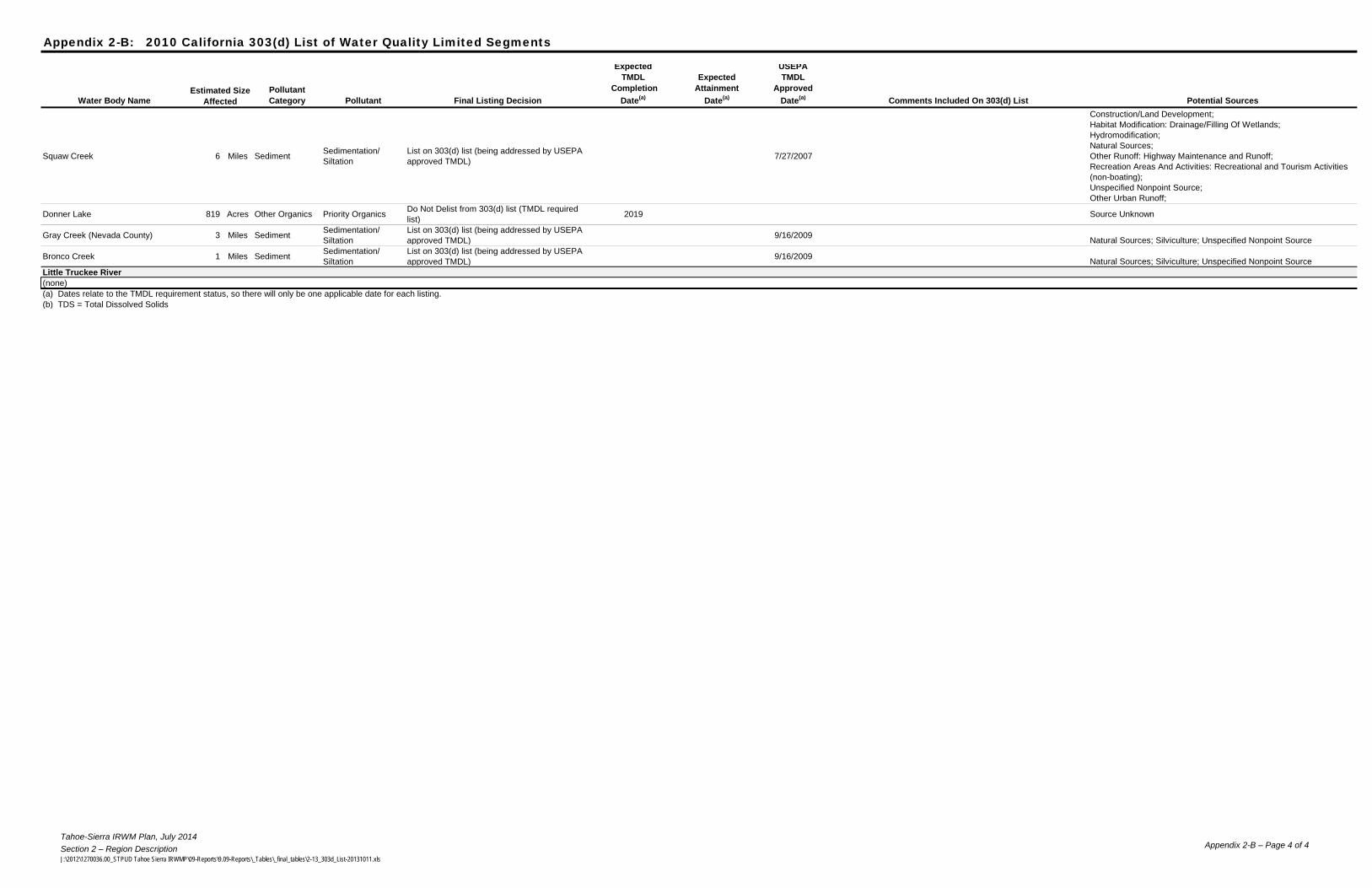
Tahoe-Sierra IRWM Plan, July 2014Section 2 – Region DescriptionJ:\2012\1270036.00_STPUD Tahoe Sierra IRWMP\09-Reports\9.09-Reports\_Tables\_final_tables\2-13_303d_List-20131011.xls
Appendix 2-B – Page 4 of 4
Appendix 2-B: 2010 California 303(d) List of Water Quality Limited Segments
Water Body Name
Pollutant
Category Pollutant Final Listing Decision
Expected
TMDL
Completion
Date(a)
Expected
Attainment
Date(a)
USEPA
TMDL
Approved
Date(a)
Comments Included On 303(d) List Potential Sources
Estimated Size
Affected
Squaw Creek 6 Miles SedimentSedimentation/
Siltation
List on 303(d) list (being addressed by USEPA
approved TMDL)7/27/2007
Construction/Land Development;
Habitat Modification: Drainage/Filling Of Wetlands;
Hydromodification;
Natural Sources;
Other Runoff: Highway Maintenance and Runoff;
Recreation Areas And Activities: Recreational and Tourism Activities
(non-boating);
Unspecified Nonpoint Source;
Other Urban Runoff;
Donner Lake 819 Acres Other Organics Priority OrganicsDo Not Delist from 303(d) list (TMDL required
list)2019 Source Unknown
Gray Creek (Nevada County) 3 Miles SedimentSedimentation/
Siltation
List on 303(d) list (being addressed by USEPA
approved TMDL)9/16/2009
Natural Sources; Silviculture; Unspecified Nonpoint Source
Bronco Creek 1 Miles SedimentSedimentation/
Siltation
List on 303(d) list (being addressed by USEPA
approved TMDL)9/16/2009
Natural Sources; Silviculture; Unspecified Nonpoint Source
Little Truckee River
(none)
(a) Dates relate to the TMDL requirement status, so there will only be one applicable date for each listing.
(b) TDS = Total Dissolved Solids
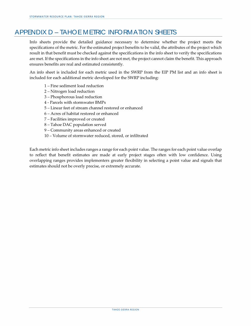
STORMWATER RESOURCE PLAN: TAHOE-SIERRA REGION
TAHOE-SIERRA REGION
APPENDIX D – TAHOE METRIC INFORMATION SHEETS Info sheets provide the detailed guidance necessary to determine whether the project meets the specifications of the metric. For the estimated project benefits to be valid, the attributes of the project which result in that benefit must be checked against the specifications in the info sheet to verify the specifications are met. If the specifications in the info sheet are not met, the project cannot claim the benefit. This approach ensures benefits are real and estimated consistently.
An info sheet is included for each metric used in the SWRP from the EIP PM list and an info sheet is included for each additional metric developed for the SWRP including:
1 – Fine sediment load reduction 2 – Nitrogen load reduction 3 – Phosphorous load reduction 4 - Parcels with stormwater BMPs 5 – Linear feet of stream channel restored or enhanced 6 – Acres of habitat restored or enhanced 7 – Facilities improved or created 8 – Tahoe DAC population served 9 – Community areas enhanced or created 10 – Volume of stormwater reduced, stored, or infiltrated
Each metric info sheet includes ranges a range for each point value. The ranges for each point value overlap to reflect that benefit estimates are made at early project stages often with low confidence. Using overlapping ranges provides implementers greater flexibility in selecting a point value and signals that estimates should not be overly precise, or extremely accurate.
Metric 1: Fine Sediment Load Reduction
Description
Units
Benefit Category
"The estimated amount of fine sediment prevented from entering Tahoe Basin urban stormwater, based on the guidelines laid out in the Lake Clarity Crediting Program Handbook and on the Lake Tahoe Info stormwater tool website. Fine sediment load is quantified in terms of the number of sediment particles with diameter of less than 16 micrometers. Reduction of fine sediment load benefits Lake Tahoe's clarity."
lbWater Quality
GuidanceCritical Definitions
Fine sediment particles – Inorganic sediment particles with diameter of less than 16 micrometers
Load reduction – The difference between the estimated average annual amount of pollutants entering Lake Tahoe under standard baseline conditions (as defined in the Lake Clarity Crediting Program Handbook) and the estimated average annual amount of pollutants entering the lake under current conditions resulting from water quality improvement projects.
Urban jurisdiction – These include counties, state highway departments and cities within the Tahoe Basin
Metric 2: Nitrogen Load Reduction
Description
Units
Benefit Category
"The estimated amount of nitrogen prevented from entering Tahoe Basin urban stormwater, based on the guidelines laid out in the Lake Clarity Crediting Program Handbook. The nitrogen load reduction is defined as the number of kilograms of nitrogen prevented from entering the lake. Reduction in nitrogen reduces the growth of algae and improves Lake Tahoe clarity."
lbWater Quality
GuidanceCritical Definitions
Load reduction – The difference between the estimated average annual amount of pollutants entering Lake Tahoe under standard baseline conditions (as defined in the Lake Clarity Crediting Program Handbook), and the estimated average annual amount of pollutants entering the lake under current conditions resulting from water quality improvement projects.
Urban jurisdictions – These include counties, state highway departments and cities within the Tahoe Basin.
TAHOE METRIC INFORMATION SHEETS

Metric 3: Phosphorous Load Reduction
Description
Units
Benefit Category
"The estimated amount of phosphorus prevented from entering Tahoe Basin urban stormwater, based on the guidelines laid out in the Lake Clarity Crediting Program Handbook. Phosphorus load reduction is defined as the number of kilograms of phosphorus removed. Reduction in phosphorus reduces the growth of algae and improves Lake Tahoe clarity."
lbWater Quality
GuidanceCritical Definitions
Load reduction – The difference between the estimated average annual amount of pollutants entering Lake Tahoe under standard baseline conditions (as defined in the Lake Clarity Crediting Program Handbook), and the estimated average annual amount of pollutants entering the lake under current conditions resulting from water quality improvement projects.
Urban jurisdiction – These include counties, state highway departments and cities within the Tahoe Basin.
Metric 4: Parcels with stormwater BMPs
Description
Units
Benefit CategorynumberWater Quality
GuidanceCritical Definitions
The number of developed parcels in the Tahoe Region with best management practices (BMPs) installed that emphasize removal of sediment particles and nutrients. The number of BMPs is counted through BMP certificates (issued and re-issued) at the facility or parcel level.
Retrofitted with BMPs – A parcel is considered to be retrofitted with BMPs when it has been awarded a BMP certificate through the TRPA BMP Retrofit Program. Both BMP certificate and source control certificate qualify as completed under this definition.
Public Facility – Public facilities include parking lots, campground, and buildings that are on land owned by public agencies, such as CTC, state parks and the USFS-LTBMU.
Has BMP Certificate – The parcel has been awarded a certificate to prove that BMPs have been installed on the property as recommended during the site evaluation.
Has Source Control Certificate – The parcel has been awarded a certificate to prove that source controls have been installed on the property as recommended during the site evaluation.

Metric 5: Linear Feet of Stream Channel Restored or Enhanced
Description
Units
Benefit Category
The length of stream channel that is restored or enhanced to regain natural or historic function and support species that rely on that habitat. Actions include stream channel reconstruction, creation or improvement of riparian corridor buffers and road crossing improvements. The goals of all actions are to enhance ecosystem health, benefit recreational use and improve water quality.
linear feetEnvironment
GuidanceCritical Definitions
Enhanced – Habitat is considered enhanced when actions are taken that heighten, intensify or improve one or more existing habitat functions for the benefit of special status species.
Restored – Habitat is considered restored when actions have been taken that re-establish or substantially rehabilitate that habitat with the goal of returning natural or historic functions and characteristics.
Special status species – Any species in the Tahoe Basin that is listed as threatened, endangered, sensitive or petitioned at the federal, state or regional level, or are included in the USFS list of sensitive species, species of concern, or species of interest, or included in TRPA’s threshold species list. Species may be listed because of low population or distribution, declining abundance or other factors.
Stream habitat – Any of the 64 established Tahoe watershed streams is considered stream habitat. The length of stream channel restored or enhanced is measured for this PM, but work done on land surrounding the channel is not counted (and is instead covered in the Acres of Habitat Restored or Enhanced Metric).
Metric 6: Acres of Habitat Restored or Enhanced
Description
Units
Benefit Category
Amount of habitat that is restored or enhanced in order to regain natural or historic function or characteristics to support native species. The goals of restoring and enhancing habitat are multi-faceted, but focus on ensuring the sustainability of habitats of significance and the processes that support them.
acresEnvironment
GuidanceCritical Definitions
Enhanced – Habitat is considered enhanced when actions are taken that heighten, intensify or improve one or more existing habitatfunctions for the benefit of special status species.
Restored – Habitat is considered restored when actions have been taken that re-establish or substantially rehabilitate that habitat withthe goal of returning natural or historic functions and characteristics.
Special status species – Any species in the Tahoe Basin that is listed as threatened, endangered, sensitive or petitioned at the federal,state or regional level, or are included in the USFS list of sensitive species, species of concern, or species of interest, or included in TRPA’sthreshold species list. Species may be listed because of low population or distribution, declining abundance or other factors.
Metric 7: Facilities Improved or Created
Description
Units
Benefit Category
The number of educational, recreational, lakefront or transit facilities improved or created in the Tahoe Basin each year. This PM works towards the desired condition of providing recreational opportunities while sustaining Lake Tahoe's natural setting as an outstanding recreational destination. It also measures service provided for educating the public about the unique natural and cultural elements of the Tahoe Basin.
numberCommunity
GuidanceCritical Definitions
Facility – A physical structure or designated site developed to accommodate users by providing public access, recreational opportunities, or educational and interpretive materials and displays. This is different than a program, which is a planned series of events, materials or presentations that provides the public with the knowledge to understand natural resource issues and the skills to participate meaningfully in the debates that surround them For example, an educational facility could be an environmental education center or trail signage, while an educational program could be a series of campfire presentations to students. Multiple signs along the same trail, around the same building, or describing the same program or features only count for 1 point. Multiple signs should not be counted as multiple points if they relate to the same feature or topic.
Created – Facilities are considered created when a new facility is constructed or designated on a previously unoccupied or privately owned site.
Improved – Facilities are considered improved when an action is taken to enhance an existing facility for the benefit of public use. Improvements do not include routine maintenance. A facility is considered improved with the inclusion or improvement of one or more new amenities (see Amenities definition below).
Amenities – Items that are conducive to the comfort, convenience or enjoyment of facilities. Amenities are not counted as facilities by themselves, but are used to create new or improve existing facilities. Amenities include but are not limited to fences, lighting systems, drinking water fountains, picnic tables, benches, refuse containers, bike racks, trellises, educational displays, playgrounds, parking lots with less than 8 spaces and restrooms under 500 sq. ft. Only 1 point should be counted for amenities in the same area. For example, multiple drinking water fountains around the same facility should only count for 1 point.
Facility Types
The following types of facilities define the unit of performance – a building & grounds, designated area, miscellaneous structure, trail/path or system facility created or improved. Only physical structures or designated areas that are designed to support public access, recreational opportunities, or educational materials are counted as a facility.
Building & Grounds – A physical structure with a roof and walls with a gross floor area over 500 sq. ft, and its surrounding lands as defined by the property boundary. A building must be at a permanent location and a complete structure – the structure cannot be modular or moved to another location in the future. Building & grounds facilities include visitor’s centers, environmental education centers, bus stations, libraries, ice rinks, and ski lodges.
Designated Area – An open area of land larger than 2,500 linear ft. delineated to provide public access, or recreational or educational opportunities. Designated area facilities include public beaches, parks, campgrounds, parking lots with 8 or more parking spaces, ski runs and areas of historical significance.
Miscellaneous Structure – A physical structure without a roof and walls. Miscellaneous structure facilities include boat launches, dams, public use piers, and uncovered swimming pools.
Trail & Path – An established path, track or other route used for travel that is 0.25 miles or longer. Trail & Path facilities include hiking paths, biking trails and paths, horseback riding trails, OHV trails, pedestrian walkways and access roads. Trail & Path facilities do not include state and local roads or highways, since these are not designed to enable public access specifically for recreation or education.
Facility Purpose
The intended purpose of the facility, which allows for reporting of accomplishments for the different action priorities under theRecreation Program. The same facility may qualify for multiple purposes. For example, a public beach could be both a recreational facilityand a lakefront access facility.
Recreation – Any activity performed during one's leisure or free time. Recreational activities are often done for amusement,enjoyment or pleasure. Recreational facilities are defined by their purpose of providing recreational opportunities for the public, andinclude beaches, boat launches, swimming pools, baseball fields, ice rinks, campgrounds, ski lodges, etc.
Transit – The carrying of people, goods or materials from one place to another. Transit facilities are defined by their purpose ofproviding transportation, and include bus shelters and benches, bus stations, “Park and Ride” lots, bicycle and pedestrian paths, etc.
Lakefront Access – An area along the shoreline that allows for public use of Lake Tahoe and its beaches. Does not include shorelineareas along other lakes in the Tahoe Basin. Lakefront access facilities are defined by their location along the shoreline, and includeshoreline parks, public beaches, public use piers, etc.
Education/Interpretation – The process of providing each visitor an opportunity to personally connect with a place. The goal of allinterpretive services is to increase each visitor's enjoyment and understanding of a natural area. Educational or interpretivefacilities are defined by their purpose of educating the public, and include improved educational signage along trails, environmentaleducation centers, visitor centers, etc.
Metric 8: Tahoe Disadvantaged Community Population ServedDescription
Units
Benefit Category
A project within the jurisdictional boundary (stormwater service area) of a stormwater management entity that qualifies as a DAC, or is implemented by a DAC, EDA, or is implemented by a separate entity but the project directly benefits a DAC or EDA.
noneCommunity
Critical Definitions
Disadvantaged Community (DAC) – Disadvantaged communities should be identified using the California Department of Water Resource DAC mapping tool and website (http://www.water.ca.gov/irwm/grants/resources_dac.cfm and https://gis.water.ca.gov/app/dacs/). Specifically the data layer "Disadvantaged Communities Places" should be used.
Economically Distressed Area (EDA) – EDAs should be identified using the California Department of Water Resource EDA mapping tool and guidelines on the website: http://www.water.ca.gov/irwm/grants/resources_eda.cfm
Direct Benefit – At least 50% of project construction occurs in and benefits the DAC or EDA.
Metric 9: Community Areas Enhanced or Created
Metric 8 - Enhance or create community areas
Description
Units
Benefit Category
The project will enhance or create recreational or public use areas.
noneCommunity
Critical DefinitionsEnhance – Public use areas are considered enhanced when actions are taken that heighten, intensify or improve one or more existing functions of the area for the benefit of the public.
Create – A public use area is created when a new facility or feature is constructed or designated on a previously unoccupied or privately owned site or when a previously privately held parcel or right-of-way is may public.
Public use area – A facility, parcel, or natural space that is open to public access.
Metric 10: Volume of Stormwater Reduced, Stored, or Infiltrated
Definition
Units
Benefit Category
The estimated volume of stormwater runoff reduced through storage, or infiltration. Reducing runoff volume decreases flood risk. The pollution reduction benefits of reducing stormwater volume is captured through metrics 1-3. This metric is only intended to quantify the flood mgmt. benefits of reducing stormwater volume.
acre-feet (af) Flood management
Critical DefinitionsStorage – Temporary capture of stormwater on the project site in a physical for natural containment structure so that it is unable to runoff. The water is released at a slow rate to limit flooding.
Infiltration – Structures designed to capture and infiltrate stormwater into the underlying soil.
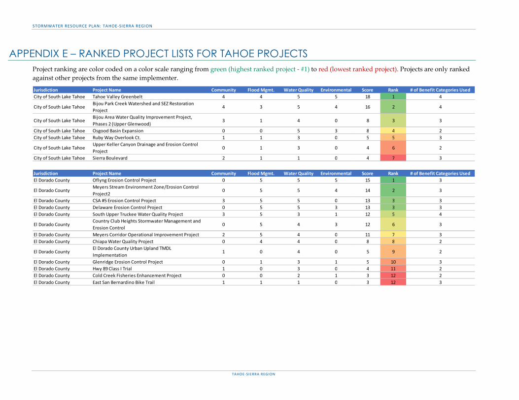
STORMWATER RESOURCE PLAN: TAHOE-SIERRA REGION
TAHOE-SIERRA REGION
APPENDIX E – RANKED PROJECT LISTS FOR TAHOE PROJECTS Project ranking are color coded on a color scale ranging from green (highest ranked project - #1) to red (lowest ranked project). Projects are only ranked against other projects from the same implementer.
Jurisdiction Project Name Community Flood Mgmt. Water Quality Environmental Score Rank # of Benefit Categories UsedCity of South Lake Tahoe Tahoe Valley Greenbelt 4 4 5 5 18 1 4
City of South Lake TahoeBijou Park Creek Watershed and SEZ Restoration Project
4 3 5 4 16 2 4
City of South Lake TahoeBijou Area Water Quality Improvement Project, Phases 2 (Upper Glenwood)
3 1 4 0 8 3 3
City of South Lake Tahoe Osgood Basin Expansion 0 0 5 3 8 4 2City of South Lake Tahoe Ruby Way Overlook Ct. 1 1 3 0 5 5 3
City of South Lake TahoeUpper Keller Canyon Drainage and Erosion Control Project
0 1 3 0 4 6 2
City of South Lake Tahoe Sierra Boulevard 2 1 1 0 4 7 3
Jurisdiction Project Name Community Flood Mgmt. Water Quality Environmental Score Rank # of Benefit Categories UsedEl Dorado County Oflyng Erosion Control Project 0 5 5 5 15 1 3
El Dorado County Meyers Stream Environment Zone/Erosion Control Project2
0 5 5 4 14 2 3
El Dorado County CSA #5 Erosion Control Project 3 5 5 0 13 3 3El Dorado County Delaware Erosion Control Project 0 5 5 3 13 3 3El Dorado County South Upper Truckee Water Quality Project 3 5 3 1 12 5 4
El Dorado County Country Club Heights Stormwater Management and Erosion Control
0 5 4 3 12 6 3
El Dorado County Meyers Corridor Operational Improvement Project 2 5 4 0 11 7 3El Dorado County Chiapa Water Quality Project 0 4 4 0 8 8 2
El Dorado County El Dorado County Urban Upland TMDL Implementation
1 0 4 0 5 9 2
El Dorado County Glenridge Erosion Control Project 0 1 3 1 5 10 3El Dorado County Hwy 89 Class I Trial 1 0 3 0 4 11 2El Dorado County Cold Creek Fisheries Enhancement Project 0 0 2 1 3 12 2El Dorado County East San Bernardino Bike Trail 1 1 1 0 3 12 3
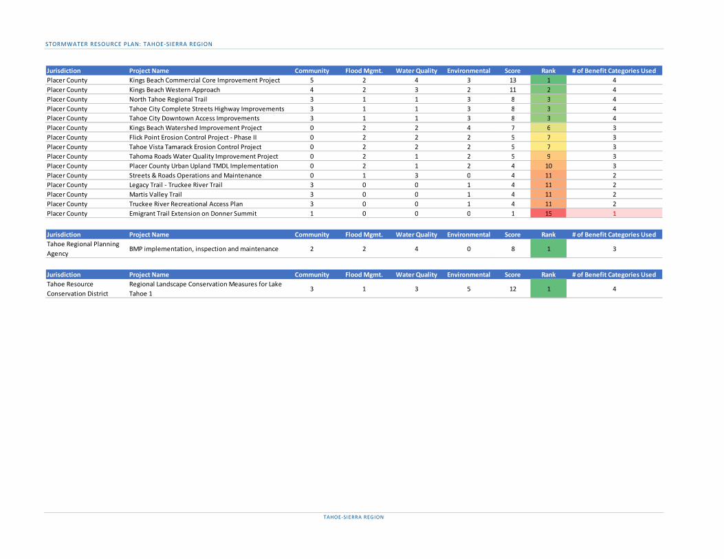
STORMWATER RESOURCE PLAN: TAHOE-SIERRA REGION
TAHOE-SIERRA REGION
Jurisdiction Project Name Community Flood Mgmt. Water Quality Environmental Score Rank # of Benefit Categories UsedPlacer County Kings Beach Commercial Core Improvement Project 5 2 4 3 13 1 4Placer County Kings Beach Western Approach 4 2 3 2 11 2 4Placer County North Tahoe Regional Trail 3 1 1 3 8 3 4Placer County Tahoe City Complete Streets Highway Improvements 3 1 1 3 8 3 4Placer County Tahoe City Downtown Access Improvements 3 1 1 3 8 3 4Placer County Kings Beach Watershed Improvement Project 0 2 2 4 7 6 3Placer County Flick Point Erosion Control Project - Phase II 0 2 2 2 5 7 3Placer County Tahoe Vista Tamarack Erosion Control Project 0 2 2 2 5 7 3Placer County Tahoma Roads Water Quality Improvement Project 0 2 1 2 5 9 3Placer County Placer County Urban Upland TMDL Implementation 0 2 1 2 4 10 3Placer County Streets & Roads Operations and Maintenance 0 1 3 0 4 11 2Placer County Legacy Trail - Truckee River Trail 3 0 0 1 4 11 2Placer County Martis Valley Trail 3 0 0 1 4 11 2Placer County Truckee River Recreational Access Plan 3 0 0 1 4 11 2Placer County Emigrant Trail Extension on Donner Summit 1 0 0 0 1 15 1
Jurisdiction Project Name Community Flood Mgmt. Water Quality Environmental Score Rank # of Benefit Categories UsedTahoe Regional Planning Agency
BMP implementation, inspection and maintenance 2 2 4 0 8 1 3
Jurisdiction Project Name Community Flood Mgmt. Water Quality Environmental Score Rank # of Benefit Categories UsedTahoe Resource Conservation District
Regional Landscape Conservation Measures for Lake Tahoe 1
3 1 3 5 12 1 4
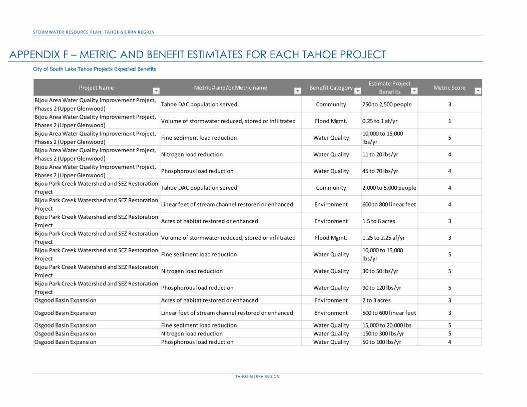
STORMWATER RESOURCE PLAN: TAHOE-SIERRA REGION
TAHOE-SIERRA REGION
APPENDIX F – METRIC AND BENEFIT ESTIMTATES FOR EACH TAHOE PROJECT City of South Lake Tahoe Projects Expected Benefits
Project Name Metric # and/or Metric name Benefit CategoryEstimate Project
BenefitsMetric Score
Bijou Area Water Quality Improvement Project, Phases 2 (Upper Glenwood)
Tahoe DAC population served Community 750 to 2,500 people 3
Bijou Area Water Quality Improvement Project, Phases 2 (Upper Glenwood)
Volume of stormwater reduced, stored or infiltrated Flood Mgmt. 0.25 to 1 af/yr 1
Bijou Area Water Quality Improvement Project, Phases 2 (Upper Glenwood)
Fine sediment load reduction Water Quality10,000 to 15,000 lbs/yr
5
Bijou Area Water Quality Improvement Project, Phases 2 (Upper Glenwood)
Nitrogen load reduction Water Quality 11 to 20 lbs/yr 4
Bijou Area Water Quality Improvement Project, Phases 2 (Upper Glenwood)
Phosphorous load reduction Water Quality 45 to 70 lbs/yr 4
Bijou Park Creek Watershed and SEZ Restoration Project
Tahoe DAC population served Community 2,000 to 5,000 people 4
Bijou Park Creek Watershed and SEZ Restoration Project
Linear feet of stream channel restored or enhanced Environment 600 to 800 linear feet 4
Bijou Park Creek Watershed and SEZ Restoration Project
Acres of habitat restored or enhanced Environment 1.5 to 6 acres 3
Bijou Park Creek Watershed and SEZ Restoration Project
Volume of stormwater reduced, stored or infiltrated Flood Mgmt. 1.25 to 2.25 af/yr 3
Bijou Park Creek Watershed and SEZ Restoration Project
Fine sediment load reduction Water Quality10,000 to 15,000 lbs/yr
5
Bijou Park Creek Watershed and SEZ Restoration Project
Nitrogen load reduction Water Quality 30 to 50 lbs/yr 5
Bijou Park Creek Watershed and SEZ Restoration Project
Phosphorous load reduction Water Quality 90 to 120 lbs/yr 5
Osgood Basin Expansion Acres of habitat restored or enhanced Environment 2 to 3 acres 3
Osgood Basin Expansion Linear feet of stream channel restored or enhanced Environment 500 to 600 linear feet 3
Osgood Basin Expansion Fine sediment load reduction Water Quality 15,000 to 20,000 lbs 5Osgood Basin Expansion Nitrogen load reduction Water Quality 150 to 300 lbs/yr 5Osgood Basin Expansion Phosphorous load reduction Water Quality 50 to 100 lbs/yr 4
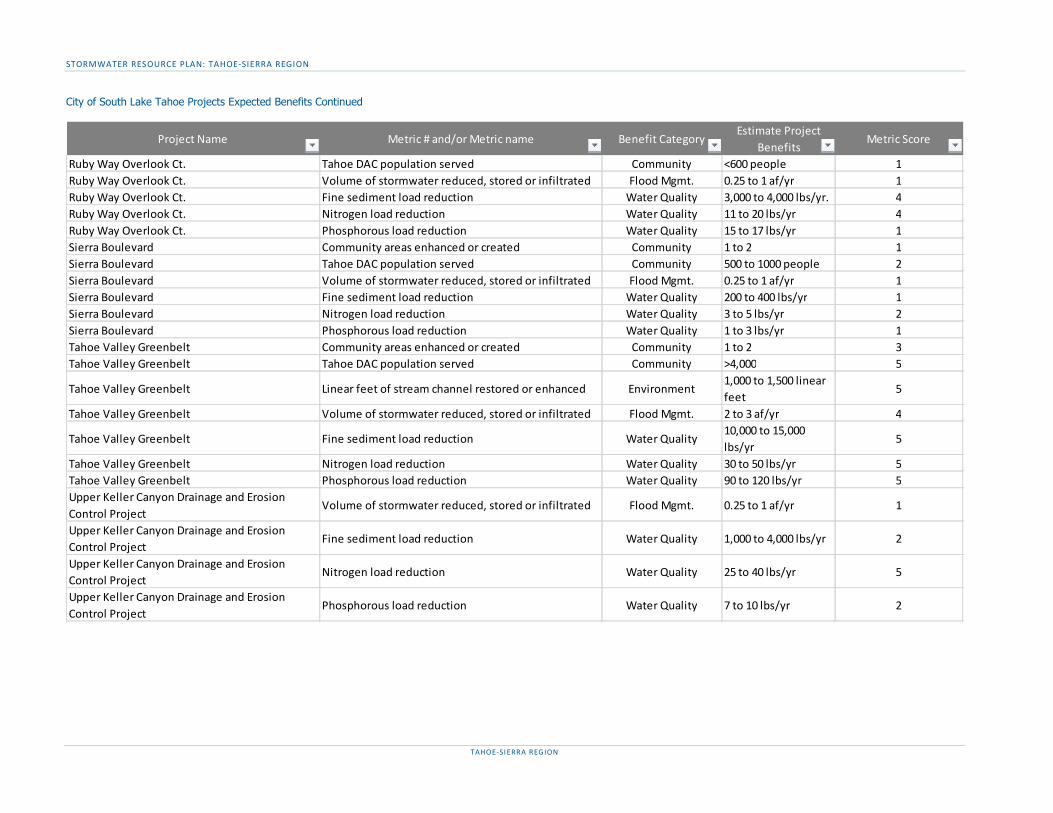
STORMWATER RESOURCE PLAN: TAHOE-SIERRA REGION
TAHOE-SIERRA REGION
City of South Lake Tahoe Projects Expected Benefits Continued
Project Name Metric # and/or Metric name Benefit CategoryEstimate Project
BenefitsMetric Score
Ruby Way Overlook Ct. Tahoe DAC population served Community <600 people 1Ruby Way Overlook Ct. Volume of stormwater reduced, stored or infiltrated Flood Mgmt. 0.25 to 1 af/yr 1Ruby Way Overlook Ct. Fine sediment load reduction Water Quality 3,000 to 4,000 lbs/yr. 4Ruby Way Overlook Ct. Nitrogen load reduction Water Quality 11 to 20 lbs/yr 4Ruby Way Overlook Ct. Phosphorous load reduction Water Quality 15 to 17 lbs/yr 1Sierra Boulevard Community areas enhanced or created Community 1 to 2 1Sierra Boulevard Tahoe DAC population served Community 500 to 1000 people 2Sierra Boulevard Volume of stormwater reduced, stored or infiltrated Flood Mgmt. 0.25 to 1 af/yr 1Sierra Boulevard Fine sediment load reduction Water Quality 200 to 400 lbs/yr 1Sierra Boulevard Nitrogen load reduction Water Quality 3 to 5 lbs/yr 2Sierra Boulevard Phosphorous load reduction Water Quality 1 to 3 lbs/yr 1Tahoe Valley Greenbelt Community areas enhanced or created Community 1 to 2 3Tahoe Valley Greenbelt Tahoe DAC population served Community >4,000 5
Tahoe Valley Greenbelt Linear feet of stream channel restored or enhanced Environment1,000 to 1,500 linear feet
5
Tahoe Valley Greenbelt Volume of stormwater reduced, stored or infiltrated Flood Mgmt. 2 to 3 af/yr 4
Tahoe Valley Greenbelt Fine sediment load reduction Water Quality10,000 to 15,000 lbs/yr
5
Tahoe Valley Greenbelt Nitrogen load reduction Water Quality 30 to 50 lbs/yr 5Tahoe Valley Greenbelt Phosphorous load reduction Water Quality 90 to 120 lbs/yr 5Upper Keller Canyon Drainage and Erosion Control Project
Volume of stormwater reduced, stored or infiltrated Flood Mgmt. 0.25 to 1 af/yr 1
Upper Keller Canyon Drainage and Erosion Control Project
Fine sediment load reduction Water Quality 1,000 to 4,000 lbs/yr 2
Upper Keller Canyon Drainage and Erosion Control Project
Nitrogen load reduction Water Quality 25 to 40 lbs/yr 5
Upper Keller Canyon Drainage and Erosion Control Project
Phosphorous load reduction Water Quality 7 to 10 lbs/yr 2

STORMWATER RESOURCE PLAN: TAHOE-SIERRA REGION
TAHOE-SIERRA REGION
El Dorado County Projects Expected Benefits
Project Name Metric # and/or Metric name Benefit CategoryEstimate Project
BenefitsMetric Score
Chiapa Water Quality Project Volume of stormwater reduced, stored or infiltrated Flood Mgmt. 3 af/yr 4Chiapa Water Quality Project Fine sediment load reduction Water Quality 5,500 lbs/yr 5Chiapa Water Quality Project Nitrogen load reduction Water Quality 55 lbs/yr 5Chiapa Water Quality Project Phosphorous load reduction Water Quality 20 lbs/yr 2Chiapa Water Quality Project Total suspended solid load reduction Water Quality 11,000 lbs/yr 3Cold Creek Fisheries Enhancement Project Acres of habitat restored or enhanced Environment 1 acres 1Cold Creek Fisheries Enhancement Project Linear feet of stream channel restored or enhanced Environment 150 linear feet 1Cold Creek Fisheries Enhancement Project Fine sediment load reduction Water Quality 1,000 lbs/yr 1Cold Creek Fisheries Enhancement Project Nitrogen load reduction Water Quality 41 lbs/yr 5Cold Creek Fisheries Enhancement Project Phosphorous load reduction Water Quality 7 lbs/yr 1Cold Creek Fisheries Enhancement Project Total suspended solid load reduction Water Quality 2,000 lbs/yr 1Country Club Heights Stormwater Management and Erosion Control
Acres of habitat restored or enhanced Environment 3 acres 3
Country Club Heights Stormwater Management and Erosion Control
Volume of stormwater reduced, stored or infiltrated Flood Mgmt. 8 af/yr 5
Country Club Heights Stormwater Management and Erosion Control
Fine sediment load reduction Water Quality 7,500 lbs/yr 5
Country Club Heights Stormwater Management and Erosion Control
Nitrogen load reduction Water Quality 75 lbs/yr 5
Country Club Heights Stormwater Management and Erosion Control
Phosphorous load reduction Water Quality 20 lbs/yr 2
Country Club Heights Stormwater Management and Erosion Control
Total suspended solid load reduction Water Quality 15,000 lbs/yr 3
CSA #5 Erosion Control Project Tahoe DAC population served Community 1,250 people 3CSA #5 Erosion Control Project Volume of stormwater reduced, stored or infiltrated Flood Mgmt. 12 af/yr 5CSA #5 Erosion Control Project Fine sediment load reduction Water Quality 30,000 lbs/yr 5CSA #5 Erosion Control Project Nitrogen load reduction Water Quality 400 lbs/yr 5CSA #5 Erosion Control Project Phosphorous load reduction Water Quality 115 lbs/yr 5CSA #5 Erosion Control Project Total suspended solid load reduction Water Quality 54,000 lbs/yr 5

STORMWATER RESOURCE PLAN: TAHOE-SIERRA REGION
TAHOE-SIERRA REGION
El Dorado County Projects Expected Benefits Continued
Project Name Metric # and/or Metric name Benefit CategoryEstimate Project
BenefitsMetric Score
Delaware Erosion Control Project Acres of habitat restored or enhanced Environment 5 acres 3Delaware Erosion Control Project Volume of stormwater reduced, stored or infiltrated Flood Mgmt. 20 af/yr 5Delaware Erosion Control Project Fine sediment load reduction Water Quality 20,000 lbs/yr 5Delaware Erosion Control Project Nitrogen load reduction Water Quality 260 lbs/yr 5Delaware Erosion Control Project Phosphorous load reduction Water Quality 75 lbs/yr 5East San Bernardino Bike Trail Facilities improved or created Community 2 1East San Bernardino Bike Trail Volume of stormwater reduced, stored or infiltrated Flood Mgmt. 0.5 af/yr 1East San Bernardino Bike Trail Fine sediment load reduction Water Quality 100 lbs/yr 1East San Bernardino Bike Trail Total suspended solid load reduction Water Quality 200 lbs/yr 1El Dorado County Urban Upland TMDL Implementation
Facilities improved or created Community 1 1
El Dorado County Urban Upland TMDL Implementation
Fine sediment load reduction Water Quality 15,000 lbs/yr 5
El Dorado County Urban Upland TMDL Implementation
Nitrogen load reduction Water Quality 200 lbs/yr 5
El Dorado County Urban Upland TMDL Implementation
Phosphorous load reduction Water Quality 57 lbs/yr 4
El Dorado County Urban Upland TMDL Implementation
Pollutant load reduction Water Quality 303d 3
El Dorado County Urban Upland TMDL Implementation
Provides source control for stormwater pollutant Water Quality yes 3
El Dorado County Urban Upland TMDL Implementation
Total suspended solid load reduction Water Quality 30,000 lbs/yr 3
Glenridge Erosion Control Project Acres of habitat restored or enhanced Environment 2 acres 1Glenridge Erosion Control Project Volume of stormwater reduced, stored or infiltrated Flood Mgmt. 1 af/yr 1Glenridge Erosion Control Project Fine sediment load reduction Water Quality 1,500 lbs/yr 2Glenridge Erosion Control Project Nitrogen load reduction Water Quality 21 lbs/yr 5Glenridge Erosion Control Project Phosphorous load reduction Water Quality 5 lbs/yr 1Hwy 89 Class I Trial Facilities improved or created Community 2 1Hwy 89 Class I Trial Fine sediment load reduction Water Quality 975 lbs/yr 1Hwy 89 Class I Trial Total suspended solid load reduction Water Quality 1,950 lbs/yr 2Hwy 89 Class I Trial Volume of stormwater reduced, stored or infiltrated Water Quality 4.8 lbs/yr 5
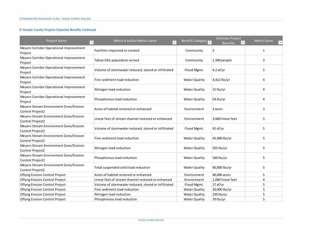
STORMWATER RESOURCE PLAN: TAHOE-SIERRA REGION
TAHOE-SIERRA REGION
El Dorado County Projects Expected Benefits Continued
Project Name Metric # and/or Metric name Benefit CategoryEstimate Project
BenefitsMetric Score
Meyers Corridor Operational Improvement Project
Facilities improved or created Community 2 1
Meyers Corridor Operational Improvement Project
Tahoe DAC population served Community 1,500 people 3
Meyers Corridor Operational Improvement Project
Volume of stormwater reduced, stored or infiltrated Flood Mgmt. 4.2 af/yr 5
Meyers Corridor Operational Improvement Project
Fine sediment load reduction Water Quality 4,412 lbs/yr 4
Meyers Corridor Operational Improvement Project
Nitrogen load reduction Water Quality 15 lbs/yr 4
Meyers Corridor Operational Improvement Project
Phosphorous load reduction Water Quality 54 lbs/yr 4
Meyers Stream Environment Zone/Erosion Control Project2
Acres of habitat restored or enhanced Environment 3 acres 3
Meyers Stream Environment Zone/Erosion Control Project2
Linear feet of stream channel restored or enhanced Environment 3,600 linear feet 5
Meyers Stream Environment Zone/Erosion Control Project2
Volume of stormwater reduced, stored or infiltrated Flood Mgmt. 41 af/yr 5
Meyers Stream Environment Zone/Erosion Control Project2
Fine sediment load reduction Water Quality 45,000 lbs/yr 5
Meyers Stream Environment Zone/Erosion Control Project2
Nitrogen load reduction Water Quality 555 lbs/yr 5
Meyers Stream Environment Zone/Erosion Control Project2
Phosphorous load reduction Water Quality 160 lbs/yr 5
Meyers Stream Environment Zone/Erosion Control Project2
Total suspended solid load reduction Water Quality 90,000 lbs/yr 5
Oflyng Erosion Control Project Acres of habitat restored or enhanced Environment 40,000 acres 5Oflyng Erosion Control Project Linear feet of stream channel restored or enhanced Environment 1,000 linear feet 4Oflyng Erosion Control Project Volume of stormwater reduced, stored or infiltrated Flood Mgmt. 17 af/yr 5Oflyng Erosion Control Project Fine sediment load reduction Water Quality 20,000 lbs/yr 5Oflyng Erosion Control Project Nitrogen load reduction Water Quality 250 lbs/yr 5Oflyng Erosion Control Project Phosphorous load reduction Water Quality 70 lbs/yr 5

STORMWATER RESOURCE PLAN: TAHOE-SIERRA REGION
TAHOE-SIERRA REGION
El Dorado County Projects Expected Benefits Continued
Placer County Projects Expected Benefits
Project Name Metric # and/or Metric name Benefit CategoryEstimate Project
BenefitsMetric Score
South Upper Truckee Water Quality Project Tahoe DAC population served Community 1,500 people 3South Upper Truckee Water Quality Project Acres of habitat restored or enhanced Environment 2 acres 1South Upper Truckee Water Quality Project Volume of stormwater reduced, stored or infiltrated Flood Mgmt. 8 af/yr 5South Upper Truckee Water Quality Project Fine sediment load reduction Water Quality 7,500 lbs/yr 5South Upper Truckee Water Quality Project Nitrogen load reduction Water Quality 100 lbs/yr 5South Upper Truckee Water Quality Project Phosphorous load reduction Water Quality 30 lbs/yr 2South Upper Truckee Water Quality Project Total suspended solid load reduction Water Quality 15,000 lbs/yr 1
Project Name Metric # and/or Metric name Benefit CategoryEstimate Project
BenefitsMetric Score
Emigrant Trail Extension on Donner Summit Enhance or create community areas Community yes 1Flick Point Erosion Control Project - Phase II Acres of habitat restored or enhanced Environment 0.1 acres 1Flick Point Erosion Control Project - Phase II Linear feet of stream channel restored or enhanced Environment 410 linear feet 2Flick Point Erosion Control Project - Phase II Impervious area reduced (%) Flood Mgmt. <30% 1Flick Point Erosion Control Project - Phase II Natural hydrology/ hydrograph reestablished Flood Mgmt. yes 3
Flick Point Erosion Control Project - Phase II Runoff reduced through storage or infiltration Flood Mgmt.Yes, but flooding is not a problem locally
1
Flick Point Erosion Control Project - Phase II Fine sediment load reduction Water Quality 3,000 lbs/year 3Flick Point Erosion Control Project - Phase II Nitrogen load reduction Water Quality 3 lbs/year 1Flick Point Erosion Control Project - Phase II Phosphorous load reduction Water Quality 3 lbs/year 1
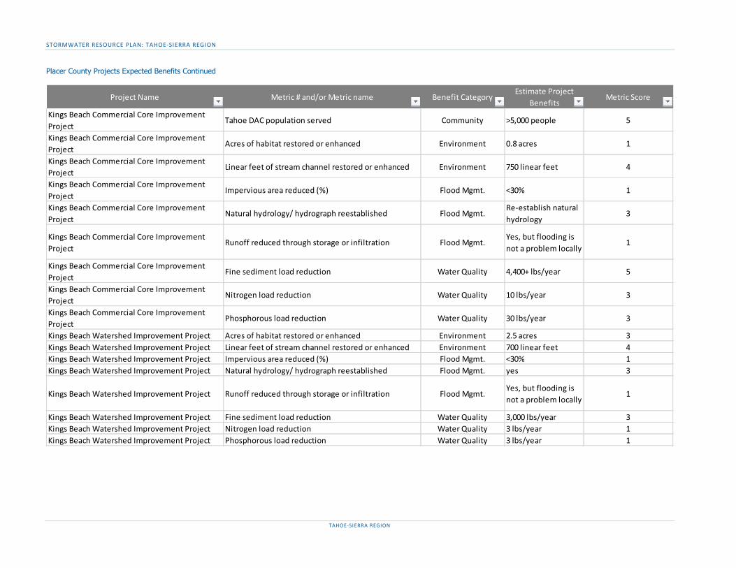
STORMWATER RESOURCE PLAN: TAHOE-SIERRA REGION
TAHOE-SIERRA REGION
Placer County Projects Expected Benefits Continued
Project Name Metric # and/or Metric name Benefit CategoryEstimate Project
BenefitsMetric Score
Kings Beach Commercial Core Improvement Project
Tahoe DAC population served Community >5,000 people 5
Kings Beach Commercial Core Improvement Project
Acres of habitat restored or enhanced Environment 0.8 acres 1
Kings Beach Commercial Core Improvement Project
Linear feet of stream channel restored or enhanced Environment 750 linear feet 4
Kings Beach Commercial Core Improvement Project
Impervious area reduced (%) Flood Mgmt. <30% 1
Kings Beach Commercial Core Improvement Project
Natural hydrology/ hydrograph reestablished Flood Mgmt.Re-establish natural hydrology
3
Kings Beach Commercial Core Improvement Project
Runoff reduced through storage or infiltration Flood Mgmt.Yes, but flooding is not a problem locally
1
Kings Beach Commercial Core Improvement Project
Fine sediment load reduction Water Quality 4,400+ lbs/year 5
Kings Beach Commercial Core Improvement Project
Nitrogen load reduction Water Quality 10 lbs/year 3
Kings Beach Commercial Core Improvement Project
Phosphorous load reduction Water Quality 30 lbs/year 3
Kings Beach Watershed Improvement Project Acres of habitat restored or enhanced Environment 2.5 acres 3Kings Beach Watershed Improvement Project Linear feet of stream channel restored or enhanced Environment 700 linear feet 4Kings Beach Watershed Improvement Project Impervious area reduced (%) Flood Mgmt. <30% 1Kings Beach Watershed Improvement Project Natural hydrology/ hydrograph reestablished Flood Mgmt. yes 3
Kings Beach Watershed Improvement Project Runoff reduced through storage or infiltration Flood Mgmt.Yes, but flooding is not a problem locally
1
Kings Beach Watershed Improvement Project Fine sediment load reduction Water Quality 3,000 lbs/year 3Kings Beach Watershed Improvement Project Nitrogen load reduction Water Quality 3 lbs/year 1Kings Beach Watershed Improvement Project Phosphorous load reduction Water Quality 3 lbs/year 1
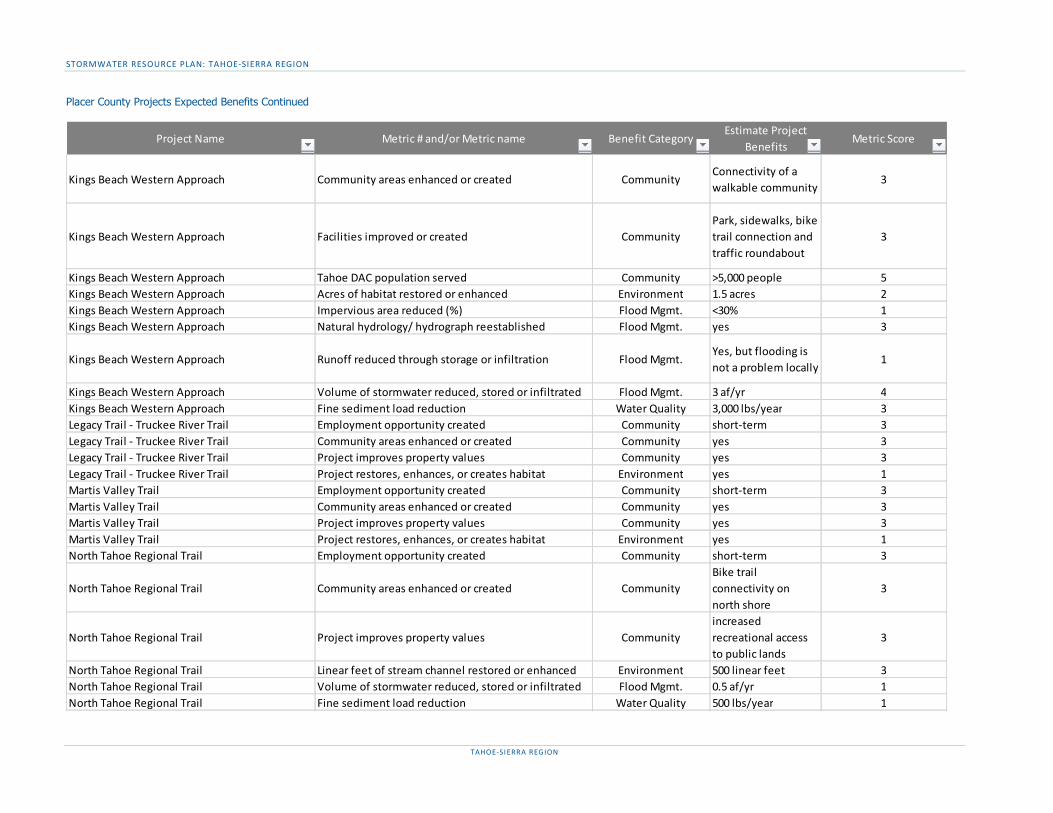
STORMWATER RESOURCE PLAN: TAHOE-SIERRA REGION
TAHOE-SIERRA REGION
Placer County Projects Expected Benefits Continued
Project Name Metric # and/or Metric name Benefit CategoryEstimate Project
BenefitsMetric Score
Kings Beach Western Approach Community areas enhanced or created CommunityConnectivity of a walkable community
3
Kings Beach Western Approach Facilities improved or created CommunityPark, sidewalks, bike trail connection and traffic roundabout
3
Kings Beach Western Approach Tahoe DAC population served Community >5,000 people 5Kings Beach Western Approach Acres of habitat restored or enhanced Environment 1.5 acres 2Kings Beach Western Approach Impervious area reduced (%) Flood Mgmt. <30% 1Kings Beach Western Approach Natural hydrology/ hydrograph reestablished Flood Mgmt. yes 3
Kings Beach Western Approach Runoff reduced through storage or infiltration Flood Mgmt.Yes, but flooding is not a problem locally
1
Kings Beach Western Approach Volume of stormwater reduced, stored or infiltrated Flood Mgmt. 3 af/yr 4Kings Beach Western Approach Fine sediment load reduction Water Quality 3,000 lbs/year 3Legacy Trail - Truckee River Trail Employment opportunity created Community short-term 3Legacy Trail - Truckee River Trail Community areas enhanced or created Community yes 3Legacy Trail - Truckee River Trail Project improves property values Community yes 3Legacy Trail - Truckee River Trail Project restores, enhances, or creates habitat Environment yes 1Martis Valley Trail Employment opportunity created Community short-term 3Martis Valley Trail Community areas enhanced or created Community yes 3Martis Valley Trail Project improves property values Community yes 3Martis Valley Trail Project restores, enhances, or creates habitat Environment yes 1North Tahoe Regional Trail Employment opportunity created Community short-term 3
North Tahoe Regional Trail Community areas enhanced or created CommunityBike trail connectivity on north shore
3
North Tahoe Regional Trail Project improves property values Communityincreased recreational access to public lands
3
North Tahoe Regional Trail Linear feet of stream channel restored or enhanced Environment 500 linear feet 3North Tahoe Regional Trail Volume of stormwater reduced, stored or infiltrated Flood Mgmt. 0.5 af/yr 1North Tahoe Regional Trail Fine sediment load reduction Water Quality 500 lbs/year 1
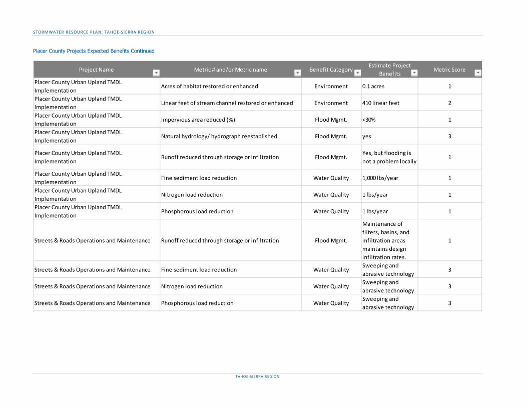
STORMWATER RESOURCE PLAN: TAHOE-SIERRA REGION
TAHOE-SIERRA REGION
Placer County Projects Expected Benefits Continued
Project Name Metric # and/or Metric name Benefit CategoryEstimate Project
BenefitsMetric Score
Placer County Urban Upland TMDL Implementation
Acres of habitat restored or enhanced Environment 0.1 acres 1
Placer County Urban Upland TMDL Implementation
Linear feet of stream channel restored or enhanced Environment 410 linear feet 2
Placer County Urban Upland TMDL Implementation
Impervious area reduced (%) Flood Mgmt. <30% 1
Placer County Urban Upland TMDL Implementation
Natural hydrology/ hydrograph reestablished Flood Mgmt. yes 3
Placer County Urban Upland TMDL Implementation
Runoff reduced through storage or infiltration Flood Mgmt.Yes, but flooding is not a problem locally
1
Placer County Urban Upland TMDL Implementation
Fine sediment load reduction Water Quality 1,000 lbs/year 1
Placer County Urban Upland TMDL Implementation
Nitrogen load reduction Water Quality 1 lbs/year 1
Placer County Urban Upland TMDL Implementation
Phosphorous load reduction Water Quality 1 lbs/year 1
Streets & Roads Operations and Maintenance Runoff reduced through storage or infiltration Flood Mgmt.
Maintenance of filters, basins, and infiltration areas maintains design infiltration rates.
1
Streets & Roads Operations and Maintenance Fine sediment load reduction Water QualitySweeping and abrasive technology
3
Streets & Roads Operations and Maintenance Nitrogen load reduction Water QualitySweeping and abrasive technology
3
Streets & Roads Operations and Maintenance Phosphorous load reduction Water QualitySweeping and abrasive technology
3

STORMWATER RESOURCE PLAN: TAHOE-SIERRA REGION
TAHOE-SIERRA REGION
Placer County Projects Expected Benefits Continued
Project Name Metric # and/or Metric name Benefit CategoryEstimate Project
BenefitsMetric Score
Tahoe City Complete Streets Highway Improvements
Employment opportunity created Community short-term 3
Tahoe City Complete Streets Highway Improvements
Community areas enhanced or created CommunityBike trail connectivity on north shore
3
Tahoe City Complete Streets Highway Improvements
Project improves property values Communityincreased recreational access to public lands
3
Tahoe City Complete Streets Highway Improvements
Linear feet of stream channel restored or enhanced Environment 500 linear feet 3
Tahoe City Complete Streets Highway Improvements
Volume of stormwater reduced, stored or infiltrated Flood Mgmt. 0.5 af/yr 1
Tahoe City Complete Streets Highway Improvements
Fine sediment load reduction Water Quality 500 lbs/year 1
Tahoe City Downtown Access Improvements Employment opportunity created Community short-term 3
Tahoe City Downtown Access Improvements Community areas enhanced or created CommunityBike trail connectivity on north shore
3
Tahoe City Downtown Access Improvements Project improves property values Communityincreased recreational access to public lands
3
Tahoe City Downtown Access Improvements Linear feet of stream channel restored or enhanced Environment 500 linear feet 3Tahoe City Downtown Access Improvements Volume of stormwater reduced, stored or infiltrated Flood Mgmt. 0.5 af/yr 1Tahoe City Downtown Access Improvements Fine sediment load reduction Water Quality 500 lbs/year 1Tahoe Vista Tamarack Erosion Control Project Acres of habitat restored or enhanced Environment 0.1 acres 1Tahoe Vista Tamarack Erosion Control Project Linear feet of stream channel restored or enhanced Environment 410 linear feet 2Tahoe Vista Tamarack Erosion Control Project Impervious area reduced (%) Flood Mgmt. <30% 1Tahoe Vista Tamarack Erosion Control Project Natural hydrology/ hydrograph reestablished Flood Mgmt. yes 3
Tahoe Vista Tamarack Erosion Control Project Runoff reduced through storage or infiltration Flood Mgmt.Yes, but flooding is not a problem locally
1
Tahoe Vista Tamarack Erosion Control Project Fine sediment load reduction Water Quality 3,000 lbs/year 3Tahoe Vista Tamarack Erosion Control Project Nitrogen load reduction Water Quality 3 lbs/year 1Tahoe Vista Tamarack Erosion Control Project Phosphorous load reduction Water Quality 3 lbs/year 1

STORMWATER RESOURCE PLAN: TAHOE-SIERRA REGION
TAHOE-SIERRA REGION
Placer County Projects Expected Benefits Continued
Project Name Metric # and/or Metric name Benefit CategoryEstimate Project
BenefitsMetric Score
Tahoma Roads Water Quality Improvement Project
Acres of habitat restored or enhanced Environment 0.1 acres 1
Tahoma Roads Water Quality Improvement Project
Linear feet of stream channel restored or enhanced Environment 410 linear feet 3
Tahoma Roads Water Quality Improvement Project
Impervious area reduced (%) Flood Mgmt. <30% 1
Tahoma Roads Water Quality Improvement Project
Natural hydrology/ hydrograph reestablished Flood Mgmt. yes 3
Tahoma Roads Water Quality Improvement Project
Runoff reduced through storage or infiltration Flood Mgmt.Yes, but flooding is not a problem locally
1
Tahoma Roads Water Quality Improvement Project
Fine sediment load reduction Water Quality 1,000 lbs/year 1
Tahoma Roads Water Quality Improvement Project
Nitrogen load reduction Water Quality 1 lbs/year 1
Tahoma Roads Water Quality Improvement Project
Phosphorous load reduction Water Quality 1 lbs/year 1
Truckee River Recreational Access Plan Employment opportunity created Community short-term 3Truckee River Recreational Access Plan Community areas enhanced or created Community yes 3Truckee River Recreational Access Plan Project improves property values Community yes 3Truckee River Recreational Access Plan Project restores, enhances, or creates habitat Environment yes 1
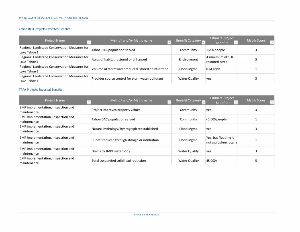
STORMWATER RESOURCE PLAN: TAHOE-SIERRA REGION
TAHOE-SIERRA REGION
Tahoe RCD Projects Expected Benefits
TRPA Projects Expected Benefits
Project Name Metric # and/or Metric name Benefit CategoryEstimate Project
BenefitsMetric Score
Regional Landscape Conservation Measures for Lake Tahoe 1
Tahoe DAC population served Community 1,200 people 3
Regional Landscape Conservation Measures for Lake Tahoe 1
Acres of habitat restored or enhanced EnvironmentA minimum of 100 restored acres
5
Regional Landscape Conservation Measures for Lake Tahoe 1
Volume of stormwater reduced, stored or infiltrated Flood Mgmt. 0.61 af/yr 1
Regional Landscape Conservation Measures for Lake Tahoe 1
Provides source control for stormwater pollutant Water Quality yes 3
Project Name Metric # and/or Metric name Benefit CategoryEstimate Project
BenefitsMetric Score
BMP implementation, inspection and maintenance
Project improves property values Community yes 3
BMP implementation, inspection and maintenance
Tahoe DAC population served Community <1,000 people 1
BMP implementation, inspection and maintenance
Natural hydrology/ hydrograph reestablished Flood Mgmt. yes 3
BMP implementation, inspection and maintenance
Runoff reduced through storage or infiltration Flood Mgmt.Yes, but flooding is not a problem locally
1
BMP implementation, inspection and maintenance
Drains to TMDL waterbody Water Quality yes 3
BMP implementation, inspection and maintenance
Total suspended solid load reduction Water Quality 45,000+ 5

STORMWATER RESOURCE PLAN: TAHOE-SIERRA REGION
TAHOE-SIERRA REGION
APPENDIX G – ADDITIONAL TAHOE PROJECT INFORMATION The following table details whether each Tahoe project provides an opportunity for source control, an opportunity to use publicly owned land and easements to capture, clean, store and use stormwater and dry weather runoff, and funding needs, sources, and expected project schedule.
City of South Lake Tahoe Projects
El Dorado County Projects
Project NameOpportunity for source control
Opportunity to use publically owned lands
and easements?
Estimated amount of funding needed
Expected year funding will be secured
Expected source of fundingExpected project completion year
Bijou Area Water Quality Improvement Project, Phases 2 (Upper Glenwood)
yes yes $ 1,000,000 2021 State and local mitigation funds 2025
Bijou Park Creek Watershed and SEZ Restoration Project
yes yes $ 8,000,000 2022 Federal, state and local mitigation funds 2025
Osgood Basin Expansion yes yes $ 2,000,000 2023 State and local mitigation funds 2025Ruby Way Overlook Ct. yes yes $ 700,000 2020 State and local mitigation funds 2022Sierra Boulevard yes yes $ 6,828,000 2019 Federal, state and local mitigation funds 2019Tahoe Valley Greenbelt yes yes $ 10,000,000 2020 Federal, state and local mitigation funds 2022Upper Keller Canyon Drainage and Erosion Control Project
yes yes $ 4,000,000 2023 State and local mitigation funds 2025
Project NameOpportunity for source control
Opportunity to use publically owned lands
and easements?
Estimated amount of funding needed
Expected year funding will be secured
Expected source of fundingExpected project completion year
Chiapa Water Quality Project yes yes $ 1,000,000 2020 State (tbd), fed (tbd), local (TRPA) 2022Cold Creek Fisheries Enhancement Project yes yes $ 1,570,000 2021 State(Prop 1 - FW), local (TRPA) 2025Country Club Heights Stormwater Management and Erosion Control
yes yes $ 400,000 2020 State (CTC Prop 68), local (TRPA) 2021
CSA #5 Erosion Control Project yes yes $ 50,000 2020State (IRWM-DAC), fed (USFS), local
(TRPA, CSA funds)2021
Delaware Erosion Control Project yes yes $ 1,000,000 2021 State (tbd), fed (tbd), local (TRPA) 2023
East San Bernardino Bike Trail yes yes $ 1,000,000 2019State (CTC Prop 68), fed (CMAQ, STBG),
local (TRPA)2020
El Dorado County Urban Upland TMDL Implementation
yes yes $ 20,000,000 2030 State (tbd), fed (tbd), local (TRPA) 2060
Glenridge Erosion Control Project yes yes $ 800,000 2022 State (tbd), fed (tbd), local (TRPA) 2024Hwy 89 Class I Trial yes no $ 2,110,000 2021 State (tbd), fed (tbd) 2023Meyers Corridor Operational Improvement Project
yes no $ 10,000,000 2022 State (tbd), fed (tbd) 2025
Meyers Stream Environment Zone/Erosion Control Project2
yes yes $ 500,000 2020 State (tbd), fed (tbd) 2022
Oflyng Erosion Control Project yes yes $ 900,000 2020 State (tbd), fed (tbd), local (TRPA) 2022South Upper Truckee Water Quality Project1 yes yes $ 605,000 2021 State (tbd), fed (tbd) 2023

STORMWATER RESOURCE PLAN: TAHOE-SIERRA REGION
TAHOE-SIERRA REGION
Placer County Projects
Tahoe RCD Projects
TRPA Projects
Project NameOpportunity for source control
Opportunity to use publically owned lands
and easements?
Estimated amount of funding needed
Expected year funding will be secured
Expected source of fundingExpected project completion year
Emigrant Trail Extension on Donner Summit no yes $ 1,100,000 2020 Rec Fees, County, Grants 2021Flick Point Erosion Control Project - Phase II yes yes $ 990,000 2022 Grants 2025Kings Beach Commercial Core Improvement Project
yes yes $ - 2018 na 2018
Kings Beach Watershed Improvement Project yes yes $ 1,500,000 2019 SNPLMA, TRPA 2020Kings Beach Western Approach yes yes $ 3,400,000 2020 RTP, CTC, Federal Grants 2021Legacy Trail - Truckee River Trail yes yes $ 8,000,000 2020 FLAP, Grants 2025Martis Valley Trail yes yes $ 2,200,000 2020 FLAP, Grants 2021North Tahoe Regional Trail yes yes $ 3,200,000 2021 County, CTC, TRPA, ATP 2025Placer County Urban Upland TMDL Implementation
yes yes $ 1,500,000 2025 County 2025
Streets & Roads Operations and Maintenance yes yes $ 1,500,000 2019 County, TRPA 2025Tahoe City Complete Streets Highway Improvements
yes yes $ 900,000 2020 County, ATP 2021
Tahoe City Downtown Access Improvements yes yes $ 1,400,000 2020 County 2022Tahoe Vista Tamarack Erosion Control Project yes yes $ 1,500,000 2021 CTC, TRPA, Grants 2022Tahoma Roads Water Quality Improvement Project
yes yes $ 450,000 2019 SNPLMA, TRPA 2020
Truckee River Recreational Access Plan yes yes $ 350,000 2019 County 2020
Project NameOpportunity for source control
Opportunity to use publically owned lands
and easements?
Estimated amount of funding needed
Expected year funding will be secured
Expected source of fundingExpected project completion year
Regional Landscape Conservation Measures for Lake Tahoe 1
yes yes $ 1,000,000 2024 Federal, state, local, private grants 2034
Project NameOpportunity for source control
Opportunity to use publically owned lands
and easements?
Estimated amount of funding needed
Expected year funding will be secured
Expected source of fundingExpected project completion year
BMP implementation, inspection and maintenance
yes yes $ 80,000 per year 2020 State IRWM funds 2 year award

STORMWATER RESOURCE PLAN: TAHOE-SIERRA REGION
TAHOE-SIERRA REGION
APPENDIX H – NON-TAHOE METRIC INFORMATION SHEETS Info sheets provide details and definitions for the use of each metric so it is possible to determine whether the metric applies to the project. For the estimated project benefits to be valid, the attributes of the project which result in that benefit must be checked against definition and units of the info sheet to ensure they are consistent.
11 - Drains to TMDL waterbody 12- Provides source control for stormwater pollutant 13 - Pollutant load reduction 14 - Volume of stormwater treated 15 - Total suspended solid load reduction 16 – Parcels with stormwater BMPs 17 - Project restores, enhances, or creates habitat 18 - Stream channel restored, enhanced, or created 19 – Non-Tahoe DAC population served 20 - Employment opportunity created 21 - Enhance or create community areas 22 - Project improves property values 23 - Proximity to flood-prone channel 24 - Runoff reduced through storage or infiltration 25 - Impervious area reduced (%) 26 - Natural hydrology/ hydrograph reestablished
Each metric info sheet includes ranges a range for each point value. The ranges for each point value overlap to reflect that benefit estimates are made at early project stages often with low confidence. Using overlapping ranges provides implementers greater flexibility in selecting a point value and signals that estimates should not be overly precise, or extremely accurate.
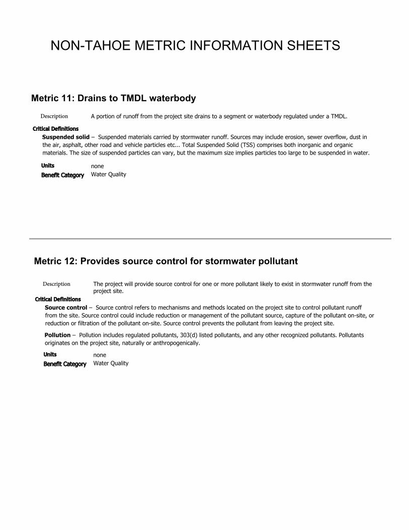
Metric 11: Drains to TMDL waterbodyDescription
Units
Benefit Category
A portion of runoff from the project site drains to a segment or waterbody regulated under a TMDL.
noneWater Quality
Critical DefinitionsSuspended solid – Suspended materials carried by stormwater runoff. Sources may include erosion, sewer overflow, dust in the air, asphalt, other road and vehicle particles etc... Total Suspended Solid (TSS) comprises both inorganic and organic materials. The size of suspended particles can vary, but the maximum size implies particles too large to be suspended in water.
Metric 12: Provides source control for stormwater pollutant
Description
Units
Benefit Category
The project will provide source control for one or more pollutant likely to exist in stormwater runoff from the project site.
noneWater Quality
Critical DefinitionsSource control – Source control refers to mechanisms and methods located on the project site to control pollutant runoff from the site. Source control could include reduction or management of the pollutant source, capture of the pollutant on-site, or reduction or filtration of the pollutant on-site. Source control prevents the pollutant from leaving the project site.
Pollution – Pollution includes regulated pollutants, 303(d) listed pollutants, and any other recognized pollutants. Pollutants originates on the project site, naturally or anthropogenically.
NON-TAHOE METRIC INFORMATION SHEETS
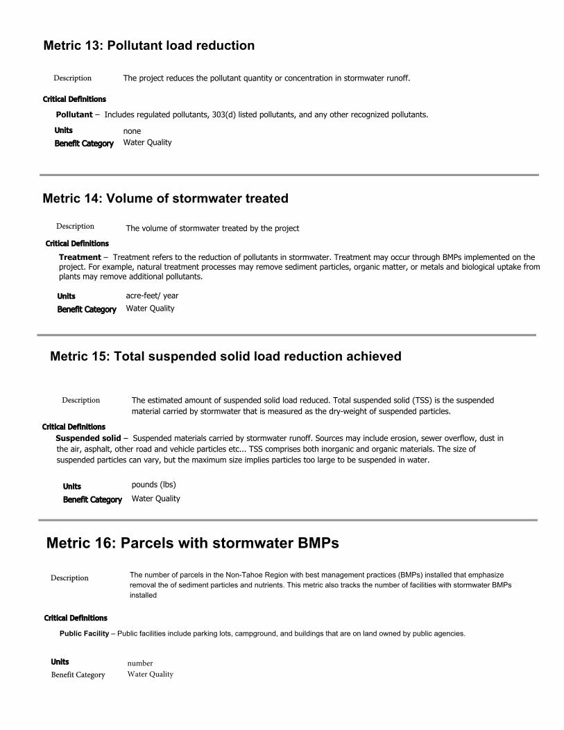
Metric 13: Pollutant load reduction
Description
Units
Benefit Category
The project reduces the pollutant quantity or concentration in stormwater runoff.
noneWater Quality
Critical Definitions
Pollutant – Includes regulated pollutants, 303(d) listed pollutants, and any other recognized pollutants.
Metric 14: Volume of stormwater treated
Description
Units
Benefit Category
The volume of stormwater treated by the project
acre-feet/ yearWater Quality
Critical Definitions
Treatment – Treatment refers to the reduction of pollutants in stormwater. Treatment may occur through BMPs implemented on the project. For example, natural treatment processes may remove sediment particles, organic matter, or metals and biological uptake from plants may remove additional pollutants.
Metric 15: Total suspended solid load reduction achieved
Description
Units
Benefit Category
The estimated amount of suspended solid load reduced. Total suspended solid (TSS) is the suspended material carried by stormwater that is measured as the dry-weight of suspended particles.
pounds (lbs)Water Quality
Critical DefinitionsSuspended solid – Suspended materials carried by stormwater runoff. Sources may include erosion, sewer overflow, dust in the air, asphalt, other road and vehicle particles etc... TSS comprises both inorganic and organic materials. The size of suspended particles can vary, but the maximum size implies particles too large to be suspended in water.
Metric 16: Parcels with stormwater BMPs
Description
Units
Benefit CategorynumberWater Quality
Critical Definitions
The number of parcels in the Non-Tahoe Region with best management practices (BMPs) installed that emphasize removal the of sediment particles and nutrients. This metric also tracks the number of facilities with stormwater BMPs installed
Public Facility – Public facilities include parking lots, campground, and buildings that are on land owned by public agencies.
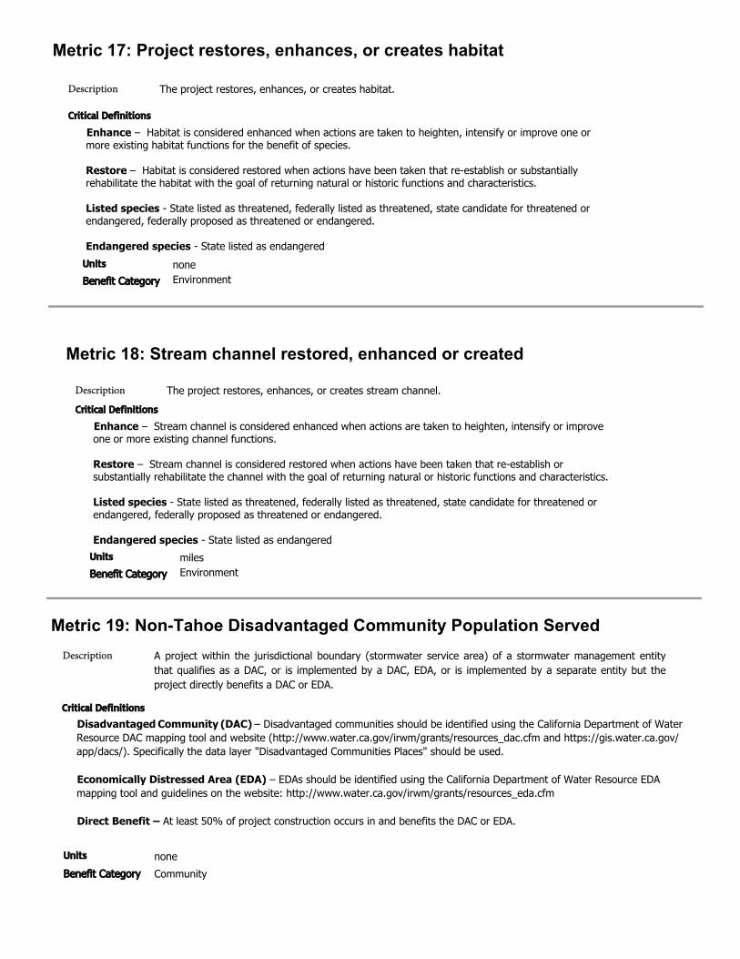
Metric 17: Project restores, enhances, or creates habitat
Description The project restores, enhances, or creates habitat.
Metric 18: Stream channel restored, enhanced or created
Units
Benefit CategorynoneEnvironment
Critical Definitions
Enhance – Habitat is considered enhanced when actions are taken to heighten, intensify or improve one or more existing habitat functions for the benefit of species.
Restore – Habitat is considered restored when actions have been taken that re-establish or substantially rehabilitate the habitat with the goal of returning natural or historic functions and characteristics.
Listed species - State listed as threatened, federally listed as threatened, state candidate for threatened or endangered, federally proposed as threatened or endangered.
Endangered species - State listed as endangered
Description The project restores, enhances, or creates stream channel.
Units
Benefit CategorymilesEnvironment
Critical Definitions
Enhance – Stream channel is considered enhanced when actions are taken to heighten, intensify or improve one or more existing channel functions.
Restore – Stream channel is considered restored when actions have been taken that re-establish or substantially rehabilitate the channel with the goal of returning natural or historic functions and characteristics.
Listed species - State listed as threatened, federally listed as threatened, state candidate for threatened or endangered, federally proposed as threatened or endangered.
Endangered species - State listed as endangered
Metric 19: Non-Tahoe Disadvantaged Community Population Served Description
Units
Benefit Category
A project within the jurisdictional boundary (stormwater service area) of a stormwater management entity that qualifies as a DAC, or is implemented by a DAC, EDA, or is implemented by a separate entity but the project directly benefits a DAC or EDA.
noneCommunity
Critical Definitions
Disadvantaged Community (DAC) – Disadvantaged communities should be identified using the California Department of Water Resource DAC mapping tool and website (http://www.water.ca.gov/irwm/grants/resources_dac.cfm and https://gis.water.ca.gov/app/dacs/). Specifically the data layer "Disadvantaged Communities Places" should be used.
Economically Distressed Area (EDA) – EDAs should be identified using the California Department of Water Resource EDA mapping tool and guidelines on the website: http://www.water.ca.gov/irwm/grants/resources_eda.cfm
Direct Benefit – At least 50% of project construction occurs in and benefits the DAC or EDA.

Metric 20: Employment opportunity created
Description
Units
Benefit Category
Operation and maintenance of the project will create 1+ employment opportunities.
noneCommunity
Metric 21: Enhance or create recreational and public use ares
Description
Units
Benefit Category
The project will enhance or create recreational or public use areas.
noneCommunity
Critical DefinitionsEnhance – Public use areas are considered enhanced when actions are taken that heighten, intensify or improve one or more existing functions of the area for the benefit of the public.
Create – A public use area is created when a new facility or feature is constructed or designated on a previously unoccupied or privately owned site or when a previously privately held parcel or right-of-way is may public.
Public use area – A facility, parcel, or natural space that is open to public access.
Metric 22: Project improves property values
Description
Units
Benefit Category
The project improves property values by providing benefits within the proximity of the property.
noneCommunity
Critical Definitions
Proximity – Because the Tahoe-Sierra region is predominantly rural, the project does not necessarily have to be located in a residential neighborhood, but the project must be to identify specific property which it will improve the value of because the property is located close enough to the project to reasonably claim benefit.
Metric 23: Proximity to flood-prone channel
Units
Benefit Category
The proximity of the project to flood-prone channel within the plan region.
noneFlood management
Description
Critical Definitions
Flood-prone channel – A channel that floods during a 10-year storm. A channel is considered to flood when stream waters are twice the maximum bankfull depth.
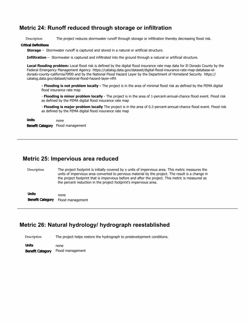
Metric 24: Runoff reduced through storage or infiltrationDescription The project reduces stormwater runoff through storage or infiltration thereby decreasing flood risk.
noneFlood management
Critical DefinitionsStorage – Stormwater runoff is captured and stored in a natural or artificial structure.
Infiltration – Stormwater is captured and infiltrated into the ground through a natural or artificial structure.
Local flooding problem: Local flood risk is defined by the digital flood insurance rate map data for El Dorado County by the Federal Emergency Management Agency. https://catalog.data.gov/dataset/digital-flood-insurance-rate-map-database-el-dorado-county-california70f00 and by the National Flood Hazard Layer by the Department of Homeland Security https://catalog.data.gov/dataset/national-flood-hazard-layer-nfhl
- Flooding is not problem locally - The project is in the area of minimal flood risk as defined by the FEMA digitalflood insurance rate map- Flooding is minor problem locally - The project is in the area of 1-percent-annual-chance flood event. Flood riskas defined by the FEMA digital flood insurance rate map- Flooding is major problem locally The project is in the area of 0.2-percent-annual-chance flood event. Flood riskas defined by the FEMA digital flood insurance rate map
Units
Benefit Category
Metric 25: Impervious area reducedDescription
Units
Benefit Category
The project footprint is initially covered by x units of impervious area. This metric measures the units of impervious area converted to pervious material by the project. The result is a change in the project footprint that is impervious before and after the project. This metric is measured as the percent reduction in the project footprint's impervious area.
noneFlood management
Metric 26: Natural hydrology/ hydrograph reestablished
Description
Units
Benefit Category
The project helps restore the hydrograph to predevelopment conditions.
noneFlood management
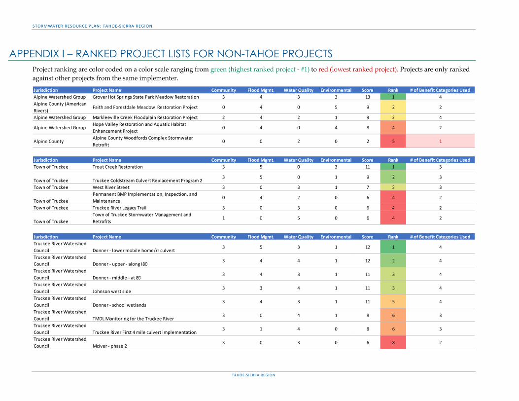
STORMWATER RESOURCE PLAN: TAHOE-SIERRA REGION
TAHOE-SIERRA REGION
APPENDIX I – RANKED PROJECT LISTS FOR NON-TAHOE PROJECTS Project ranking are color coded on a color scale ranging from green (highest ranked project - #1) to red (lowest ranked project). Projects are only ranked against other projects from the same implementer.
Jurisdiction Project Name Community Flood Mgmt. Water Quality Environmental Score Rank # of Benefit Categories UsedAlpine Watershed Group Grover Hot Springs State Park Meadow Restoration 3 4 3 3 13 1 4Alpine County (American Rivers)
Faith and Forestdale Meadow Restoration Project 0 4 0 5 9 2 2
Alpine Watershed Group Markleeville Creek Floodplain Restoration Project 2 4 2 1 9 2 4
Alpine Watershed GroupHope Valley Restoration and Aquatic Habitat Enhancement Project
0 4 0 4 8 4 2
Alpine CountyAlpine County Woodfords Complex Stormwater Retrofit
0 0 2 0 2 5 1
Jurisdiction Project Name Community Flood Mgmt. Water Quality Environmental Score Rank # of Benefit Categories UsedTown of Truckee Trout Creek Restoration 3 5 0 3 11 1 3
Town of Truckee Truckee Coldstream Culvert Replacement Program 23 5 0 1 9 2 3
Town of Truckee West River Street 3 0 3 1 7 3 3
Town of TruckeePermanent BMP Implementation, Inspection, and Maintenance
0 4 2 0 6 4 2
Town of Truckee Truckee River Legacy Trail 3 0 3 0 6 4 2
Town of TruckeeTown of Truckee Stormwater Management and Retrofits
1 0 5 0 6 4 2
Jurisdiction Project Name Community Flood Mgmt. Water Quality Environmental Score Rank # of Benefit Categories UsedTruckee River Watershed Council Donner - lower mobile home/rr culvert
3 5 3 1 12 1 4
Truckee River Watershed Council Donner - upper - along I80
3 4 4 1 12 2 4
Truckee River Watershed Council Donner - middle - at 89
3 4 3 1 11 3 4
Truckee River Watershed Council Johnson west side
3 3 4 1 11 3 4
Truckee River Watershed Council Donner - school wetlands
3 4 3 1 11 5 4
Truckee River Watershed Council TMDL Monitoring for the Truckee River
3 0 4 1 8 6 3
Truckee River Watershed Council Truckee River First 4 mile culvert implementation
3 1 4 0 8 6 3
Truckee River Watershed Council McIver - phase 2
3 0 3 0 6 8 2

STORMWATER RESOURCE PLAN: TAHOE-SIERRA REGION
TAHOE-SIERRA REGION
APPENDIX J – METRIC AND BENEFIT ESTIMATES FOR EACH NON-TAHOE PROJECT Alpine County and Alpine Watershed Group Projects Expected Benefits
Project Name Metric # and/or Metric name Benefit CategoryEstimate Project
BenefitsMetric Score
Alpine County Woodfords Complex Stormwater Retrofit
Drains to TMDL waterbody Water QualityDrains to West Fork Carson River
3
Alpine County Woodfords Complex Stormwater Retrofit
Pollutant load reduction Water Quality yes, sediment 1
Alpine County Woodfords Complex Stormwater Retrofit
Provides source control for stormwater pollutant Water Quality
Retrofit would capture and treat stormwater from existing parking lots
3
Alpine County Woodfords Complex Stormwater Retrofit
Volume of stormwater treated Water QualityCapture stormwater from .5 acre site
1
Faith and Forestdale Meadow Restoration Project
Acres of habitat restored or enhanced Environment 250 acres 5
Faith and Forestdale Meadow Restoration Project
Linear feet of stream channel restored or enhanced Environment5,000 to 10,000 linear feet
5
Faith and Forestdale Meadow Restoration Project
Natural hydrology/ hydrograph reestablished Flood Mgmt.Project goal to raise the water level in meadow
3
Faith and Forestdale Meadow Restoration Project
Proximity to flood-prone channel Flood Mgmt. <0.06 miles 5

STORMWATER RESOURCE PLAN: TAHOE-SIERRA REGION
TAHOE-SIERRA REGION
Alpine County and Alpine Watershed Group Projects Expected Benefits Continued
Project Name Metric # and/or Metric name Benefit CategoryEstimate Project
BenefitsMetric Score
Grover Hot Springs State Park Meadow Restoration
Enhance or create community areas CommunityState park, meadow, trails
3
Grover Hot Springs State Park Meadow Restoration
Non-Tahoe DAC population served CommunityMarkleeville PUD service area
3
Grover Hot Springs State Park Meadow Restoration
Acres of habitat restored or enhanced EnvironmentApprox 10 acres of meadow
4
Grover Hot Springs State Park Meadow Restoration
Linear feet of stream channel restored or enhanced Environment 300 linear feet 2
Grover Hot Springs State Park Meadow Restoration
Natural hydrology/ hydrograph reestablished Flood Mgmt.
Fixing headcuts in meadow, trail rehab to increase planar flow across meadow
3
Grover Hot Springs State Park Meadow Restoration
Proximity to flood-prone channel Flood Mgmt. <0.06 miles 5
Grover Hot Springs State Park Meadow Restoration
Drains to TMDL waterbody Water QualityEast Fork Carson has TMDLs in Alpine County
3
Hope Valley Restoration and Aquatic Habitat Enhancement Project
Acres of habitat restored or enhanced EnvironmentApprox 4 acres of meadow
3
Hope Valley Restoration and Aquatic Habitat Enhancement Project
Linear feet of stream channel restored or enhanced Environment 2,500 linear feet 5
Hope Valley Restoration and Aquatic Habitat Enhancement Project
Natural hydrology/ hydrograph reestablished Flood Mgmt.Restoring slow regime and water table connectivity
3
Hope Valley Restoration and Aquatic Habitat Enhancement Project
Proximity to flood-prone channel Flood Mgmt. <0.06 miles 5

STORMWATER RESOURCE PLAN: TAHOE-SIERRA REGION
TAHOE-SIERRA REGION
Alpine County and Alpine Watershed Group Projects Expected Benefits Continued
Project Name Metric # and/or Metric name Benefit CategoryEstimate Project
BenefitsMetric Score
Markleeville Creek Floodplain Restoration Project
Enhance or create community areas CommunityNew public use are with park setting
3
Markleeville Creek Floodplain Restoration Project
Non-Tahoe DAC population served CommunitySmall town of 200 population
1
Markleeville Creek Floodplain Restoration Project
Project improves property values CommunityCreates park like amenity in Markleeville area
3
Markleeville Creek Floodplain Restoration Project
Acres of habitat restored or enhanced EnvironmentRestores natural function
1
Markleeville Creek Floodplain Restoration Project
Linear feet of stream channel restored or enhanced EnvironmentRestores natural function
1
Markleeville Creek Floodplain Restoration Project
Impervious area reduced (%) Flood Mgmt.Restores existing disturbed area on a brownfield site
3
Markleeville Creek Floodplain Restoration Project
Natural hydrology/ hydrograph reestablished Flood Mgmt.Restores natural floodway of Markleeville Creek
3
Markleeville Creek Floodplain Restoration Project
Proximity to flood-prone channel Flood Mgmt.Restores natural floodway of Markleeville Creek
5
Markleeville Creek Floodplain Restoration Project
Drains to TMDL waterbody Water QualityDrains to East Fork Carson River
3
Markleeville Creek Floodplain Restoration Project
Pollutant load reduction Water Quality
May reduce pollutants from additional treatment Highway 89 drainage
1
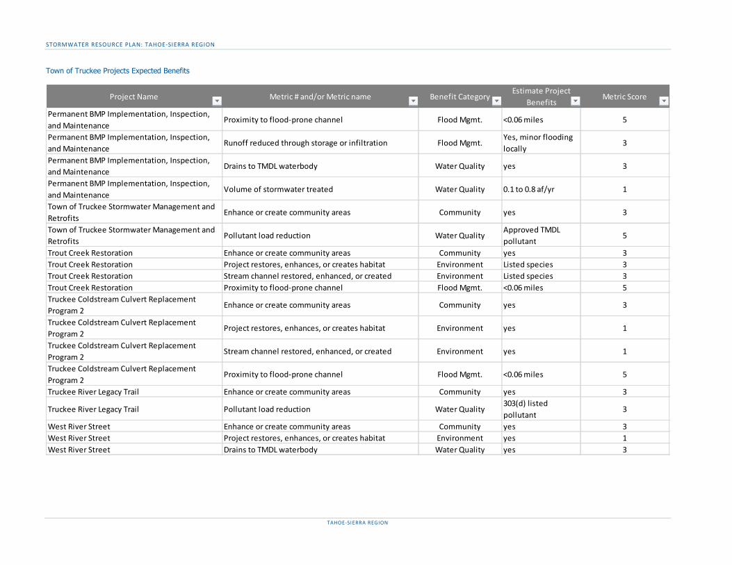
STORMWATER RESOURCE PLAN: TAHOE-SIERRA REGION
TAHOE-SIERRA REGION
Town of Truckee Projects Expected Benefits
Project Name Metric # and/or Metric name Benefit CategoryEstimate Project
BenefitsMetric Score
Permanent BMP Implementation, Inspection, and Maintenance
Proximity to flood-prone channel Flood Mgmt. <0.06 miles 5
Permanent BMP Implementation, Inspection, and Maintenance
Runoff reduced through storage or infiltration Flood Mgmt.Yes, minor flooding locally
3
Permanent BMP Implementation, Inspection, and Maintenance
Drains to TMDL waterbody Water Quality yes 3
Permanent BMP Implementation, Inspection, and Maintenance
Volume of stormwater treated Water Quality 0.1 to 0.8 af/yr 1
Town of Truckee Stormwater Management and Retrofits
Enhance or create community areas Community yes 3
Town of Truckee Stormwater Management and Retrofits
Pollutant load reduction Water QualityApproved TMDL pollutant
5
Trout Creek Restoration Enhance or create community areas Community yes 3Trout Creek Restoration Project restores, enhances, or creates habitat Environment Listed species 3Trout Creek Restoration Stream channel restored, enhanced, or created Environment Listed species 3Trout Creek Restoration Proximity to flood-prone channel Flood Mgmt. <0.06 miles 5Truckee Coldstream Culvert Replacement Program 2
Enhance or create community areas Community yes 3
Truckee Coldstream Culvert Replacement Program 2
Project restores, enhances, or creates habitat Environment yes 1
Truckee Coldstream Culvert Replacement Program 2
Stream channel restored, enhanced, or created Environment yes 1
Truckee Coldstream Culvert Replacement Program 2
Proximity to flood-prone channel Flood Mgmt. <0.06 miles 5
Truckee River Legacy Trail Enhance or create community areas Community yes 3
Truckee River Legacy Trail Pollutant load reduction Water Quality303(d) listed pollutant
3
West River Street Enhance or create community areas Community yes 3West River Street Project restores, enhances, or creates habitat Environment yes 1West River Street Drains to TMDL waterbody Water Quality yes 3

STORMWATER RESOURCE PLAN: TAHOE-SIERRA REGION
TAHOE-SIERRA REGION
TRWC Projects Expected Benefits
Project Name Metric # and/or Metric name Benefit CategoryEstimate Project
BenefitsMetric Score
Donner - lower mobile home/rr culvert Employment opportunity created Community yes 3Donner - lower mobile home/rr culvert Project improves property values Community yes 3
Donner - lower mobile home/rr culvert Project restores, enhances, or creates habitat Environmentrestores ~250 ft of eroding bank
1
Donner - lower mobile home/rr culvert Stream channel restored, enhanced, or created Environment
reduces sediment entering Donner Creek, enhances habitat
1
Donner - lower mobile home/rr culvert Proximity to flood-prone channel Flood Mgmt. <0.06 miles 5Donner - lower mobile home/rr culvert Drains to TMDL waterbody Water Quality yes 3Donner - lower mobile home/rr culvert Pollutant load reduction Water Quality yes, sediment 5Donner - lower mobile home/rr culvert Provides source control for stormwater pollutant Water Quality yes 3
Donner - lower mobile home/rr culvert Total suspended solid load reduction Water Qualityestimate <1,000 lbs/year
1
Donner - middle - at 89 Employment opportunity created Community short-term 3
Donner - middle - at 89 Project restores, enhances, or creates habitat Environmentrestores ~100 ft of eroding bank; expands floodplain
1
Donner - middle - at 89 Stream channel restored, enhanced, or created Environment
reduces sediment entering Donner Creek, enhances habitat
1
Donner - middle - at 89 Proximity to flood-prone channel Flood Mgmt. <0.06 miles 5
Donner - middle - at 89 Runoff reduced through storage or infiltration Flood Mgmt.Yes, minor flooding locally
3
Donner - middle - at 89 Drains to TMDL waterbody Water Quality yes 3Donner - middle - at 89 Pollutant load reduction Water Quality yes, sediment 5Donner - middle - at 89 Provides source control for stormwater pollutant Water Quality yes 3
Donner - middle - at 89 Total suspended solid load reduction Water Qualityestimate <1,000 lbs/year
1
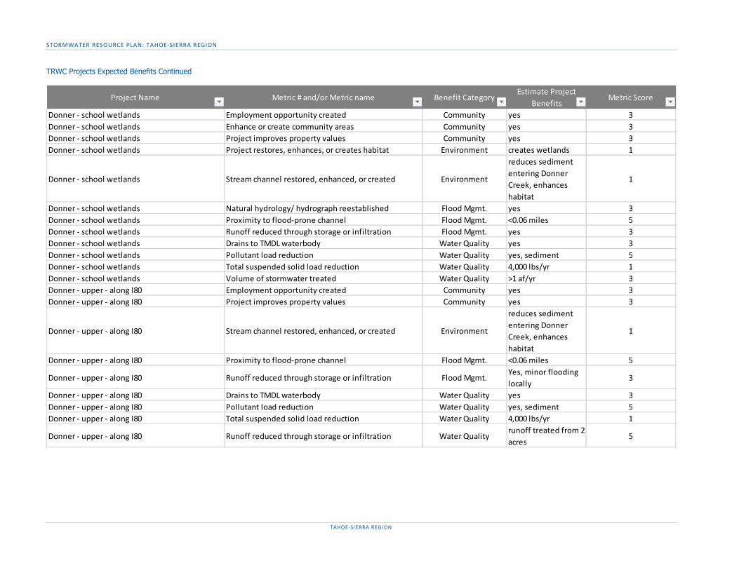
STORMWATER RESOURCE PLAN: TAHOE-SIERRA REGION
TAHOE-SIERRA REGION
TRWC Projects Expected Benefits Continued
Project Name Metric # and/or Metric name Benefit CategoryEstimate Project
BenefitsMetric Score
Donner - school wetlands Employment opportunity created Community yes 3Donner - school wetlands Enhance or create community areas Community yes 3Donner - school wetlands Project improves property values Community yes 3Donner - school wetlands Project restores, enhances, or creates habitat Environment creates wetlands 1
Donner - school wetlands Stream channel restored, enhanced, or created Environment
reduces sediment entering Donner Creek, enhances habitat
1
Donner - school wetlands Natural hydrology/ hydrograph reestablished Flood Mgmt. yes 3Donner - school wetlands Proximity to flood-prone channel Flood Mgmt. <0.06 miles 5Donner - school wetlands Runoff reduced through storage or infiltration Flood Mgmt. yes 3Donner - school wetlands Drains to TMDL waterbody Water Quality yes 3Donner - school wetlands Pollutant load reduction Water Quality yes, sediment 5Donner - school wetlands Total suspended solid load reduction Water Quality 4,000 lbs/yr 1Donner - school wetlands Volume of stormwater treated Water Quality >1 af/yr 3Donner - upper - along I80 Employment opportunity created Community yes 3Donner - upper - along I80 Project improves property values Community yes 3
Donner - upper - along I80 Stream channel restored, enhanced, or created Environment
reduces sediment entering Donner Creek, enhances habitat
1
Donner - upper - along I80 Proximity to flood-prone channel Flood Mgmt. <0.06 miles 5
Donner - upper - along I80 Runoff reduced through storage or infiltration Flood Mgmt.Yes, minor flooding locally
3
Donner - upper - along I80 Drains to TMDL waterbody Water Quality yes 3Donner - upper - along I80 Pollutant load reduction Water Quality yes, sediment 5Donner - upper - along I80 Total suspended solid load reduction Water Quality 4,000 lbs/yr 1
Donner - upper - along I80 Runoff reduced through storage or infiltration Water Qualityrunoff treated from 2 acres
5
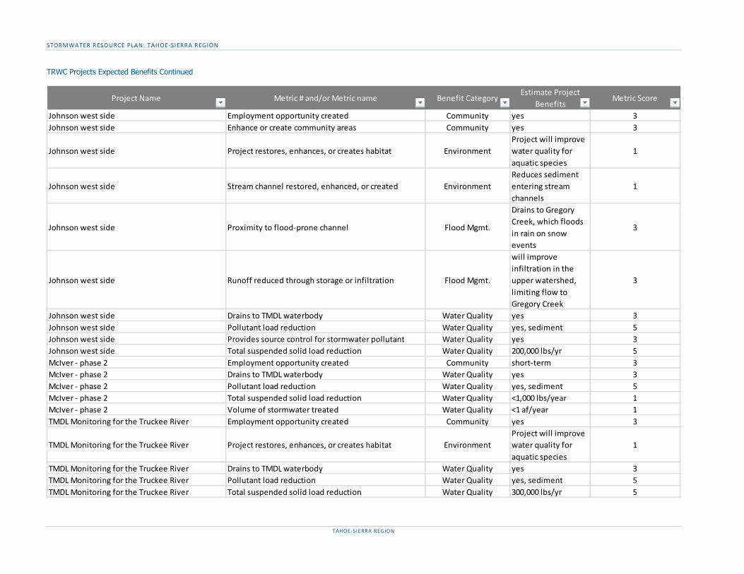
STORMWATER RESOURCE PLAN: TAHOE-SIERRA REGION
TAHOE-SIERRA REGION
TRWC Projects Expected Benefits Continued
Project Name Metric # and/or Metric name Benefit CategoryEstimate Project
BenefitsMetric Score
Johnson west side Employment opportunity created Community yes 3Johnson west side Enhance or create community areas Community yes 3
Johnson west side Project restores, enhances, or creates habitat EnvironmentProject will improve water quality for aquatic species
1
Johnson west side Stream channel restored, enhanced, or created EnvironmentReduces sediment entering stream channels
1
Johnson west side Proximity to flood-prone channel Flood Mgmt.
Drains to Gregory Creek, which floods in rain on snow events
3
Johnson west side Runoff reduced through storage or infiltration Flood Mgmt.
will improve infiltration in the upper watershed, limiting flow to Gregory Creek
3
Johnson west side Drains to TMDL waterbody Water Quality yes 3Johnson west side Pollutant load reduction Water Quality yes, sediment 5Johnson west side Provides source control for stormwater pollutant Water Quality yes 3Johnson west side Total suspended solid load reduction Water Quality 200,000 lbs/yr 5McIver - phase 2 Employment opportunity created Community short-term 3McIver - phase 2 Drains to TMDL waterbody Water Quality yes 3McIver - phase 2 Pollutant load reduction Water Quality yes, sediment 5McIver - phase 2 Total suspended solid load reduction Water Quality <1,000 lbs/year 1McIver - phase 2 Volume of stormwater treated Water Quality <1 af/year 1TMDL Monitoring for the Truckee River Employment opportunity created Community yes 3
TMDL Monitoring for the Truckee River Project restores, enhances, or creates habitat EnvironmentProject will improve water quality for aquatic species
1
TMDL Monitoring for the Truckee River Drains to TMDL waterbody Water Quality yes 3TMDL Monitoring for the Truckee River Pollutant load reduction Water Quality yes, sediment 5TMDL Monitoring for the Truckee River Total suspended solid load reduction Water Quality 300,000 lbs/yr 5
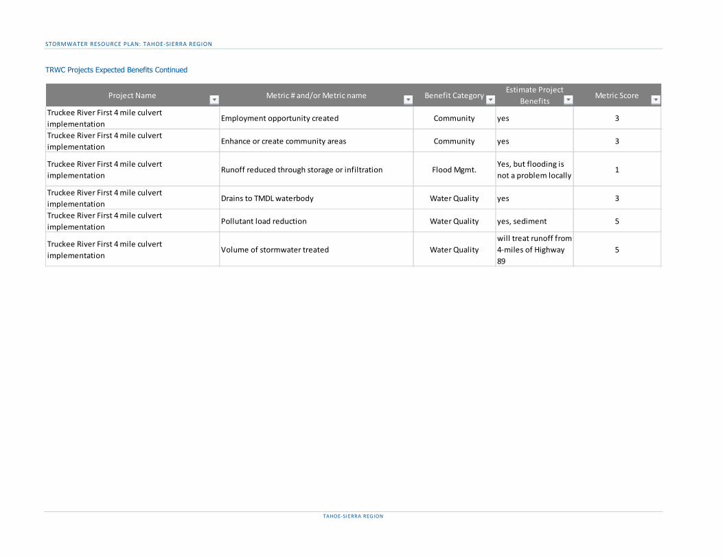
STORMWATER RESOURCE PLAN: TAHOE-SIERRA REGION
TAHOE-SIERRA REGION
TRWC Projects Expected Benefits Continued
Project Name Metric # and/or Metric name Benefit CategoryEstimate Project
BenefitsMetric Score
Truckee River First 4 mile culvert implementation
Employment opportunity created Community yes 3
Truckee River First 4 mile culvert implementation
Enhance or create community areas Community yes 3
Truckee River First 4 mile culvert implementation
Runoff reduced through storage or infiltration Flood Mgmt.Yes, but flooding is not a problem locally
1
Truckee River First 4 mile culvert implementation
Drains to TMDL waterbody Water Quality yes 3
Truckee River First 4 mile culvert implementation
Pollutant load reduction Water Quality yes, sediment 5
Truckee River First 4 mile culvert implementation
Volume of stormwater treated Water Qualitywill treat runoff from 4-miles of Highway 89
5
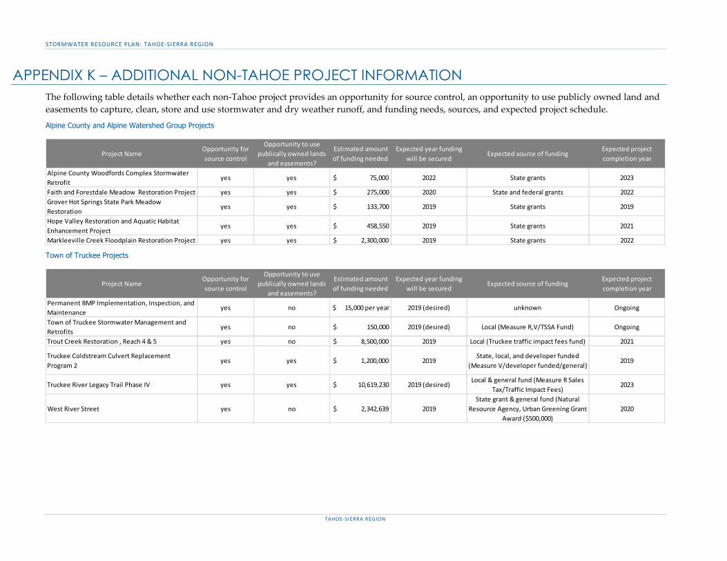
STORMWATER RESOURCE PLAN: TAHOE-SIERRA REGION
TAHOE-SIERRA REGION
APPENDIX K – ADDITIONAL NON-TAHOE PROJECT INFORMATION The following table details whether each non-Tahoe project provides an opportunity for source control, an opportunity to use publicly owned land and easements to capture, clean, store and use stormwater and dry weather runoff, and funding needs, sources, and expected project schedule.
Alpine County and Alpine Watershed Group Projects
Town of Truckee Projects
Project NameOpportunity for source control
Opportunity to use publically owned lands
and easements?
Estimated amount of funding needed
Expected year funding will be secured
Expected source of fundingExpected project completion year
Alpine County Woodfords Complex Stormwater Retrofit
yes yes $ 75,000 2022 State grants 2023
Faith and Forestdale Meadow Restoration Project yes yes $ 275,000 2020 State and federal grants 2022Grover Hot Springs State Park Meadow Restoration
yes yes $ 133,700 2019 State grants 2019
Hope Valley Restoration and Aquatic Habitat Enhancement Project
yes yes $ 458,550 2019 State grants 2021
Markleeville Creek Floodplain Restoration Project yes yes $ 2,300,000 2019 State grants 2022
Project NameOpportunity for source control
Opportunity to use publically owned lands
and easements?
Estimated amount of funding needed
Expected year funding will be secured
Expected source of fundingExpected project completion year
Permanent BMP Implementation, Inspection, and Maintenance
yes no $ 15,000 per year 2019 (desired) unknown Ongoing
Town of Truckee Stormwater Management and Retrofits
yes no $ 150,000 2019 (desired) Local (Measure R,V/TSSA Fund) Ongoing
Trout Creek Restoration , Reach 4 & 5 yes no $ 8,500,000 2019 Local (Truckee traffic impact fees fund) 2021
Truckee Coldstream Culvert Replacement Program 2
yes yes $ 1,200,000 2019State, local, and developer funded
(Measure V/developer funded/general)2019
Truckee River Legacy Trail Phase IV yes yes $ 10,619,230 2019 (desired)Local & general fund (Measure R Sales
Tax/Traffic Impact Fees)2023
West River Street yes no $ 2,342,639 2019State grant & general fund (Natural
Resource Agency, Urban Greening Grant Award ($500,000)
2020

STORMWATER RESOURCE PLAN: TAHOE-SIERRA REGION
TAHOE-SIERRA REGION
TRWC Projects
Project NameOpportunity for source control
Opportunity to use publically owned lands
and easements?
Estimated amount of funding needed
Expected year funding will be secured
Expected source of fundingExpected project completion year
Donner - lower mobile home/rr culvert yes no $ 180,000 2020 Private 2020Donner - middle - at 89 yes yes $ 150,000 2020 State, unknown 2020Donner - school wetlands yes yes $ 350,000 2020 State, unknown 2020Donner - upper - along I80 yes yes $ 200,000 2020 State, unknown 2020Johnson west side yes yes $ - na na 2019McIver - phase 2 yes yes $ 775,000 2019 State, unknown 2020TMDL Monitoring for the Truckee River yes no $ 150,000 2019 Unknown 2021Truckee River First 4 mile culvert implementation yes yes $ 150,000 2020 Unknown 2021

STORMWATER RESOURCE PLAN: TAHOE-SIERRA REGION
TAHOE-SIERRA REGION
APPENDIX L – SWRP TRACKER PRODUCTS
Project list See Appendix E & Appendix I
Project data See Appendix F, Appendix G, Appendix J, & Appendix K
Metric list See the Executive Summary or Sections C&D
Benefit Tracking
TAHOE BENEFITS FOR QUANTITATIVE METRICS NON-TAHOE BENEFITS FOR QUANTITATIVE METRICSRow Labels Sum of Project Benefit Row Labels Sum of Project Benefit
Community Flood Mgmt.Facilities improved or created 6.5 Proximity to flood-prone channel 0.284
Flood Mgmt. Impervious area reduced (%) 0.65Impervious area reduced (%) 1.35 Water QualityProximity to flood-prone channel 0.484 Total suspended solid load reduction 2625Runoff reduced through storage or infiltration 0 Volume of stormwater treated 0.45Volume of stormwater reduced, stored or infiltrated 25.25 Environment
Water Quality Acres of habitat restored or enhanced 26.25Fine sediment load reduction 79550 Linear feet of stream channel restored or enhanced 1925Nitrogen load reduction 199Phosphorous load reduction 717.5Runoff reduced through storage or infiltration 0Total suspended solid load reduction 219250Volume of stormwater reduced, stored or infiltrated 2.75Volume of stormwater treated 0.9
EnvironmentAcres of habitat restored or enhanced 59Linear feet of stream channel restored or enhanced 7175
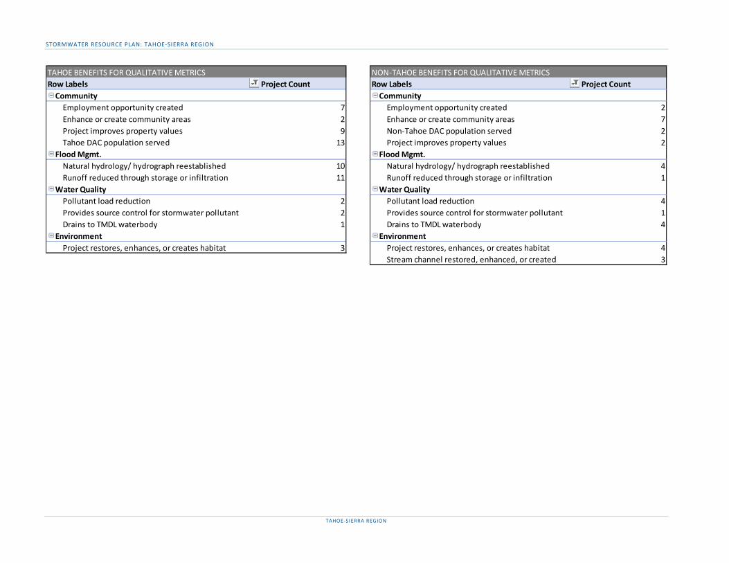
STORMWATER RESOURCE PLAN: TAHOE-SIERRA REGION
TAHOE-SIERRA REGION
TAHOE BENEFITS FOR QUALITATIVE METRICS NON-TAHOE BENEFITS FOR QUALITATIVE METRICSRow Labels Project Count Row Labels Project Count
Community CommunityEmployment opportunity created 7 Employment opportunity created 2Enhance or create community areas 2 Enhance or create community areas 7Project improves property values 9 Non-Tahoe DAC population served 2Tahoe DAC population served 13 Project improves property values 2
Flood Mgmt. Flood Mgmt.Natural hydrology/ hydrograph reestablished 10 Natural hydrology/ hydrograph reestablished 4Runoff reduced through storage or infiltration 11 Runoff reduced through storage or infiltration 1
Water Quality Water QualityPollutant load reduction 2 Pollutant load reduction 4Provides source control for stormwater pollutant 2 Provides source control for stormwater pollutant 1Drains to TMDL waterbody 1 Drains to TMDL waterbody 4
Environment EnvironmentProject restores, enhances, or creates habitat 3 Project restores, enhances, or creates habitat 4
Stream channel restored, enhanced, or created 3

STORMWATER RESOURCE PLAN: TAHOE-SIERRA REGION
TAHOE-SIERRA REGION
TAHOE BENEFITS FOR QUANTITATIVE METRICS NON-TAHOE BENEFITS FOR QUANTITATIVE METRICSRow Labels Sum of Project Benefit Row Labels Sum of Project Benefit
City of South Lake Tahoe Alpine CountyAcres of habitat restored or enhanced 7.5 Volume of stormwater treated 0.45Linear feet of stream channel restored or enhanced 2050 Town of TruckeeVolume of stormwater reduced, stored or infiltrated 5.75 Proximity to flood-prone channelFine sediment load reduction 23750 Volume of stormwater treatedNitrogen load reduction 91 Truckee River Watershed CouncilPhosphorous load reduction 228.5 Proximity to flood-prone channel 0.0568
El Dorado County Total suspended solid load reduction 2625Acres of habitat restored or enhanced 24.75 Alpine County (American Rivers)Linear feet of stream channel restored or enhanced 1650 Acres of habitat restored or enhanced 12Total suspended solid load reduction 166375 Linear feet of stream channel restored or enhanced 800Volume of stormwater reduced, stored or infiltrated 19.375 Proximity to flood-prone channel 0.0568Fine sediment load reduction 42350 Alpine Watershed GroupNitrogen load reduction 105.5 Acres of habitat restored or enhanced 14.25Phosphorous load reduction 462 Linear feet of stream channel restored or enhanced 1125
Placer County Proximity to flood-prone channel 0.1704Acres of habitat restored or enhanced 0.5 Impervious area reduced (%) 0.65Linear feet of stream channel restored or enhanced 1550Volume of stormwater reduced, stored or infiltrated 2.5Impervious area reduced (%) 0.7Fine sediment load reduction 13450Nitrogen load reduction 2.5Phosphorous load reduction 27
Tahoe Resource Conservation DistrictAcres of habitat restored or enhancedVolume of stormwater reduced, stored or infiltrated 0.375

STORMWATER RESOURCE PLAN: TAHOE-SIERRA REGION
TAHOE-SIERRA REGION
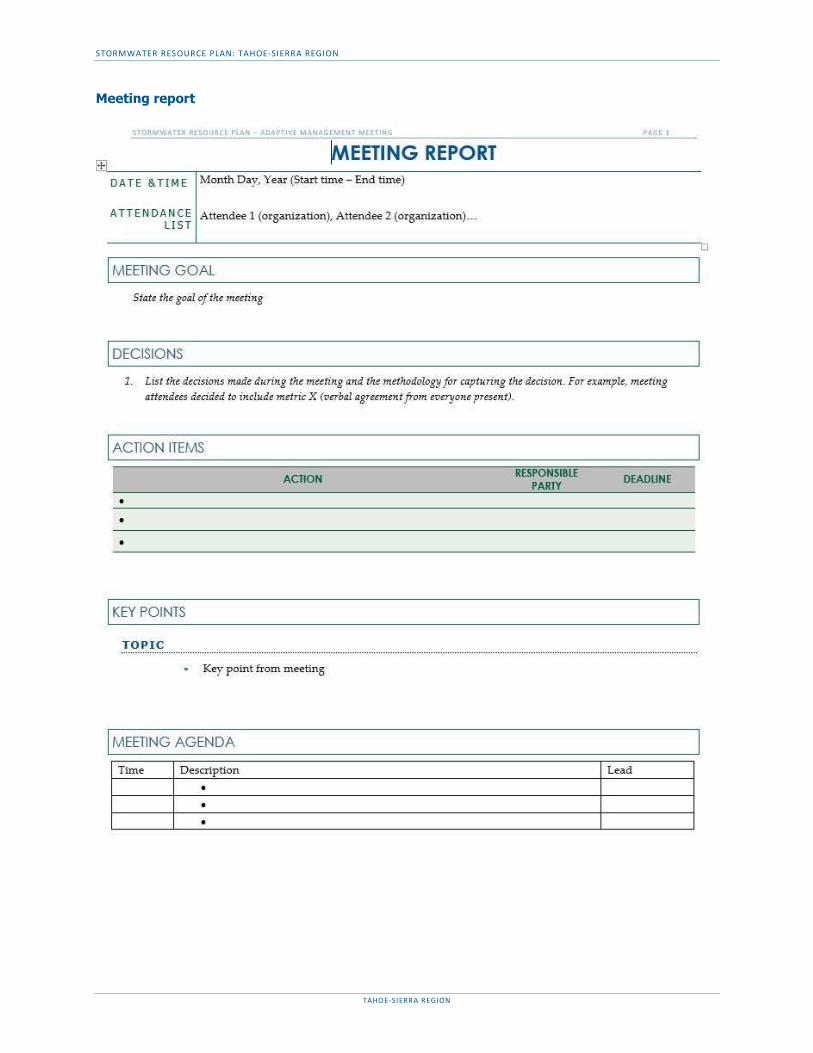
STORMWATER RESOURCE PLAN: TAHOE-SIERRA REGION
TAHOE-SIERRA REGION
Meeting report

STORMWATER RESOURCE PLAN: TAHOE-SIERRA REGION
TAHOE-SIERRA REGION
APPENDIX M – PLANS FOR NEW DEVELOPMENTS OR REDEVELOPMENTS
Tahoe Basin: Tahoe Regional Planning Agency Best Management Practices Handbook
http://www.tahoebmp.org/bmphandbook.aspx
Alpine County:
Development Standards
http://www.alpinecountyca.gov/DocumentCenter/View/1457
Town of Truckee:
Clean Water Program
https://www.townoftruckee.com/government/engineering-and-public-works/clean-water-program/documents
Development Code Section 18
https://www.townoftruckee.com/government/community-development/planning-division/plans-and-regulations/development-code/title-18-development-code

A - 1 Storm Water Resource Plan Self-Certification Checklist Revised: April 4, 2016
Storm Water Resource Plan Checklist
and Self-Certification
The following should be completed and submitted to the State Water Resources Control Board Division of Financial Assistance in support of a storm water resource plan /functionally equivalent plan. The documents submitted, including this checklist, will be used to determine State Water Board concurrence with the Storm Water Resource Plan Guidelines and statutory water code requirements. When combining multiple documents to form a functionally equivalent Storm Water Resource Plan, submit a cover letter explaining the approach used to arrive at the functionally equivalent document. The cover letter should explain how the documents work together to address the Storm Water Resource Plan Guidelines.
STORM WATER RESOURCE PLAN GENERAL CONTACT INFORMATION
Contact Info: Name Phone Number Email
Andrea Buxton 530.412.0456 [email protected]
Date Submitted to State Water Resource Control Board:
3/1/2018 (Administrative Draft)
Regional Water Quality Control Board:
Region 6 - Lahontan
Title of attached documents (expand list as needed):
4.11 Final_Tahoe-Sierra SWRP
STORM WATER RESOURCE PLAN INFORMATION Storm Water Resource Plan Title:
Stormwater Resource Plan for the Tahoe-Sierra Region
Date Plan Completed/Adopted:
2/28/2018 (Administrative Draft)
Public Agency Preparer:
Tahoe Resource Conservation District (TahoeRCD)
IRWM Submission: Upon acceptance of the SRP by the State Water Board, a link to the SRP document and SRP Tracker spreadsheet is posted on the IRWM website. The link enables public access to the SRP document and project list for each jurisdiction.
Plan Description:
Stormwater resource plan for the Tahoe-Sierra Region according to guidelines and Water Code requirements
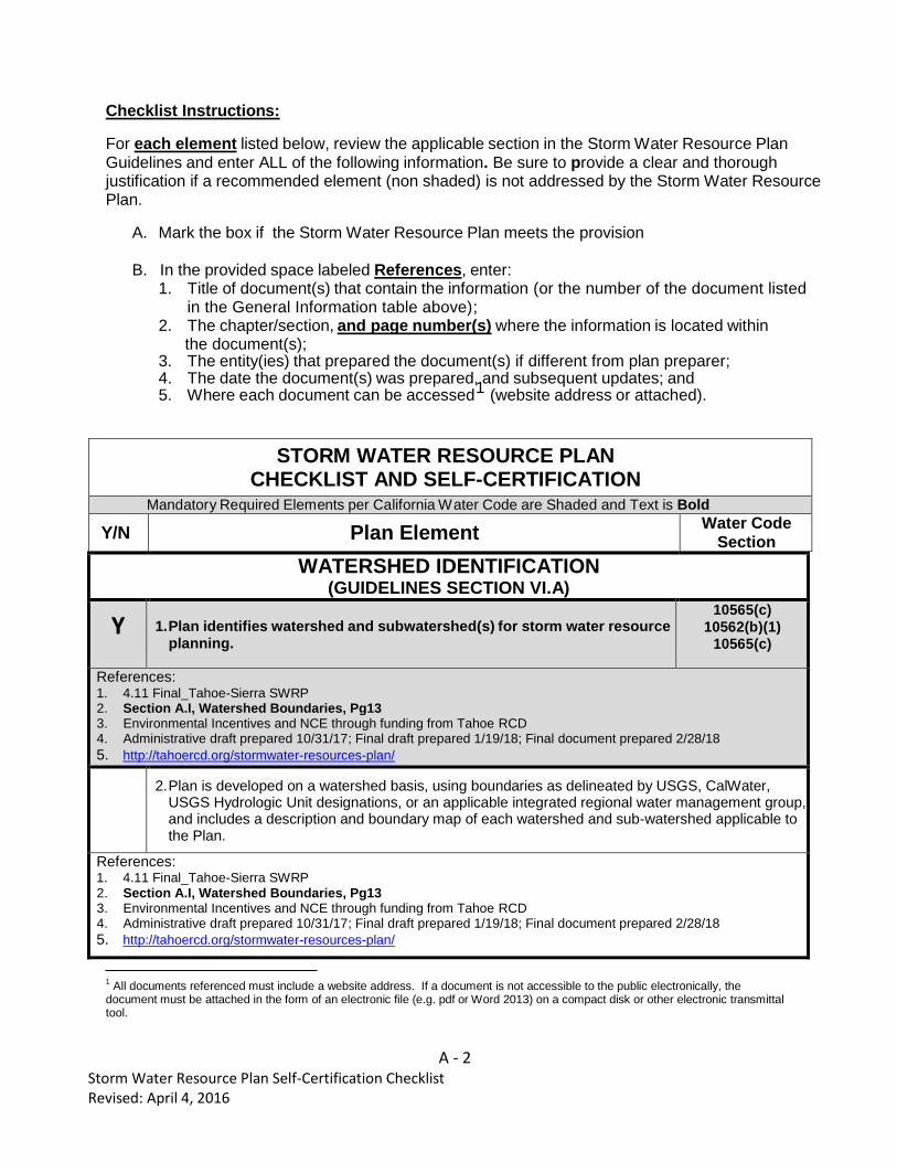
A - 2 Storm Water Resource Plan Self-Certification Checklist Revised: April 4, 2016
Checklist Instructions:
For each element listed below, review the applicable section in the Storm Water Resource Plan Guidelines and enter ALL of the following information. Be sure to provide a clear and thorough justification if a recommended element (non shaded) is not addressed by the Storm Water Resource Plan.
A. Mark the box if the Storm Water Resource Plan meets the provision
B. In the provided space labeled References, enter:
1. Title of document(s) that contain the information (or the number of the document listed in the General Information table above);
2. The chapter/section, and page number(s) where the information is located within the document(s);
3. The entity(ies) that prepared the document(s) if different from plan preparer; 4. The date the document(s) was prepared, and subsequent updates; and 5. Where each document can be accessed1 (website address or attached).
STORM WATER RESOURCE PLAN CHECKLIST AND SELF-CERTIFICATION
Mandatory Required Elements per California Water Code are Shaded and Text is Bold
Y/N Plan Element Water Code
Section
WATERSHED IDENTIFICATION (GUIDELINES SECTION VI.A)
Y 1. Plan identifies watershed and subwatershed(s) for storm water resource planning.
10565(c) 10562(b)(1)
10565(c)
References: 1. 4.11 Final_Tahoe-Sierra SWRP 2. Section A.I, Watershed Boundaries, Pg13 3. Environmental Incentives and NCE through funding from Tahoe RCD 4. Administrative draft prepared 10/31/17; Final draft prepared 1/19/18; Final document prepared 2/28/18
5. http://tahoercd.org/stormwater-resources-plan/
2. Plan is developed on a watershed basis, using boundaries as delineated by USGS, CalWater,
USGS Hydrologic Unit designations, or an applicable integrated regional water management group, and includes a description and boundary map of each watershed and sub-watershed applicable to the Plan.
References: 1. 4.11 Final_Tahoe-Sierra SWRP 2. Section A.I, Watershed Boundaries, Pg13 3. Environmental Incentives and NCE through funding from Tahoe RCD 4. Administrative draft prepared 10/31/17; Final draft prepared 1/19/18; Final document prepared 2/28/18
5. http://tahoercd.org/stormwater-resources-plan/
1
All documents referenced must include a website address. If a document is not accessible to the public electronically, the document must be attached in the form of an electronic file (e.g. pdf or Word 2013) on a compact disk or other electronic transmittal tool.

A - 3 Storm Water Resource Plan Self-Certification Checklist Revised: April 4, 2016
WATERSHED IDENTIFICATION (GUIDELINES SECTION VI.A)
3. Plan includes an explanation of why the watershed(s) and sub-watershed(s) are appropriate for storm water management with a multiple-benefit watershed approach;
References: 1. 4.11 Final_Tahoe-Sierra SWRP 2. Section A.I, Watershed Boundaries, Pg13 3. Environmental Incentives and NCE through funding from Tahoe RCD 4. Administrative draft prepared 10/31/17; Final draft prepared 1/19/18; Final document prepared 2/28/18
5. http://tahoercd.org/stormwater-resources-plan/
4. Plan describes the internal boundaries within the watershed (boundaries of municipalities; service areas of individual water, wastewater, and land use agencies, including those not involved in the Plan; groundwater basin boundaries, etc.; preferably provided in a geographic information system shape file);
References: 1. 4.11 Final_Tahoe-Sierra SWRP 2. Section A.II, Internal Boundaries, Pg13 3. Environmental Incentives and NCE through funding from Tahoe RCD 4. Administrative draft prepared 10/31/17; Final draft prepared 1/19/18; Final document prepared 2/28/18
5. http://tahoercd.org/stormwater-resources-plan/
5. Plan describes the water quality priorities within the watershed based on, at a minimum, applicable TMDLs and consideration of water body-pollutant combinations listed on the State’s Clean Water Act Section 303(d) list of water quality limited segments (a.k.a impaired waters list);
References: 1. 4.11 Final_Tahoe-Sierra SWRP 2. Section A.III, Water Quality Prioritization, Pg22 3. Environmental Incentives and NCE through funding from Tahoe RCD 4. Administrative draft prepared 10/31/17; Final draft prepared 1/19/18; Final document prepared 2/28/18
5. http://tahoercd.org/stormwater-resources-plan/
6. Plan describes the general quality and identification of surface and ground water resources within the watershed (preferably provided in a geographic information system shape file);
References: 1. 4.11 Final_Tahoe-Sierra SWRP 2. Section A.IV, Surface and Groundwater Quality, Pg25 3. Environmental Incentives and NCE through funding from Tahoe RCD 4. Administrative draft prepared 10/31/17; Final draft prepared 1/19/18; Final document prepared 2/28/18 5. http://tahoercd.org/stormwater-resources-plan/
7. Plan describes the local entity or entities that provide potable water supplies and the estimated volume of potable water provided by the water suppliers;
References: 1. 4.11 Final_Tahoe-Sierra SWRP 2. Section A.V, Water Supply, Pg31 3. Environmental Incentives and NCE through funding from Tahoe RCD 4. Administrative draft prepared 10/31/17; Final draft prepared 1/19/18; Final document prepared 2/28/18 5. http://tahoercd.org/stormwater-resources-plan/
8. Plan includes map(s) showing location of native habitats, creeks, lakes, rivers, parks, and other natural or open space within the sub-watershed boundaries; and
References: 1. 4.11 Final_Tahoe-Sierra SWRP 2. Section A.VI, Native Habitats, Pg32; Map : Land Use, Pg35 3. Environmental Incentives and NCE through funding from Tahoe RCD 4. Administrative draft prepared 10/31/17; Final draft prepared 1/19/18; Final document prepared 2/28/18 5. http://tahoercd.org/stormwater-resources-plan/
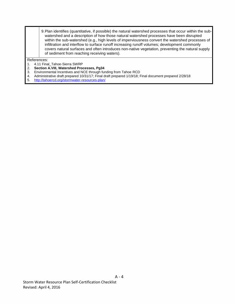
A - 4 Storm Water Resource Plan Self-Certification Checklist Revised: April 4, 2016
9. Plan identifies (quantitative, if possible) the natural watershed processes that occur within the sub-watershed and a description of how those natural watershed processes have been disrupted within the sub-watershed (e.g., high levels of imperviousness convert the watershed processes of infiltration and interflow to surface runoff increasing runoff volumes; development commonly covers natural surfaces and often introduces non-native vegetation, preventing the natural supply of sediment from reaching receiving waters).
References: 1. 4.11 Final_Tahoe-Sierra SWRP 2. Section A.VIII, Watershed Processes, Pg34 3. Environmental Incentives and NCE through funding from Tahoe RCD 4. Administrative draft prepared 10/31/17; Final draft prepared 1/19/18; Final document prepared 2/28/18 5. http://tahoercd.org/stormwater-resources-plan/
A - 5 Storm Water Resource Plan Self-Certification Checklist Revised: April 4, 2016
WATER QUALITY COMPLIANCE (GUIDELINES SECTION V)
Y 10. Plan identifies activities that generate or contribute to the pollution of storm 10562(d)(7) water or dry weather runoff, or that impair the effective beneficial use of storm water or dry weather runoff.
References: 1. 4.11 Final_Tahoe-Sierra SWRP 2. Section A.IV, Surface and Groundwater Quality, Pg25 3. Environmental Incentives and NCE through funding from Tahoe RCD 4. Administrative draft prepared 10/31/17; Final draft prepared 1/19/18; Final document prepared 2/28/18 5. http://tahoercd.org/stormwater-resources-plan/
Y 11. Plan describes how it is consistent with and assists in, compliance with total 10562(b)(5) maximum daily load implementation plans and applicable national pollutant discharge elimination system permits.
References: 6. 4.11 Final_Tahoe-Sierra SWRP 7. Section A.III, Water Quality Prioritization, TMDLs in the Region, Pg24 8. Environmental Incentives and NCE through funding from Tahoe RCD 9. Administrative draft prepared 10/31/17; Final draft prepared 1/19/18; Final document prepared 2/28/18 10. http://tahoercd.org/stormwater-resources-plan/
Y 12. Plan identifies applicable permits and describes how it meets all applicable 10562(b)(6) waste discharge permit requirements.
References: 1. 4.11 Final_Tahoe-Sierra SWRP 2. Section A.III, Water Quality Prioritization, NPDES permits in the Region, Pg25 3. Environmental Incentives and NCE through funding from Tahoe RCD 4. Administrative draft prepared 10/31/17; Final draft prepared 1/19/18; Final document prepared 2/28/18 5. http://tahoercd.org/stormwater-resources-plan/
ORGANIZATION, COORDINATION, COLLABORATION (GUIDELINES SECTION VI.B)
Y 13. Local agencies and nongovernmental organizations were consulted in Plan 10565(a) development.
References: 1. 4.11 Final_Tahoe-Sierra SWRP 2. Section B, Organization, Coordination & Collaboration, Pg36-38 3. Environmental Incentives and NCE through funding from Tahoe RCD 4. Administrative draft prepared 10/31/17; Final draft prepared 1/19/18; Final document prepared 2/28/18 5. http://tahoercd.org/stormwater-resources-plan/
Y 14. Community participation was provided for in Plan development. 10562(b)(4)
References: 6. 4.11 Final_Tahoe-Sierra SWRP 7. Section B, Organization, Coordination & Collaboration, Pg36-38 8. Environmental Incentives and NCE through funding from Tahoe RCD 9. Administrative draft prepared 10/31/17; Final draft prepared 1/19/18; Final document prepared 2/28/18 10. http://tahoercd.org/stormwater-resources-plan/
15. Plan includes description of the existing integrated regional water management group(s) implementing an integrated regional water management plan.
A - 6 Storm Water Resource Plan Self-Certification Checklist Revised: April 4, 2016
References: 1. 4.11 Final_Tahoe-Sierra SWRP 2. Section B.I, B.VI, IRWM Partnership, Pg36 3. Environmental Incentives and NCE through funding from Tahoe RCD 4. Administrative draft prepared 10/31/17; Final draft prepared 1/19/18; Final document prepared 2/28/18 5. http://tahoercd.org/stormwater-resources-plan/
ORGANIZATION, COORDINATION, COLLABORATION (GUIDELINES SECTION VI.B)
16. Plan includes identification of and coordination with agencies and organizations (including, but not limited to public agencies, nonprofit organizations, and privately owned water utilities) that need to participate and implement their own authorities and mandates in order to address the storm water and dry weather runoff management objectives of the Plan for the targeted watershed.
References: 6. 4.11 Final_Tahoe-Sierra SWRP 7. Section B.II, B.III, SWRP Stakeholders, Pg36 8. Environmental Incentives and NCE through funding from Tahoe RCD 9. Administrative draft prepared 10/31/17; Final draft prepared 1/19/18; Final document prepared 2/28/18 10. http://tahoercd.org/stormwater-resources-plan/
17. Plan includes identification of nonprofit organizations working on storm water and dry weather resource planning or management in the watershed.
References: 11. 4.11 Final_Tahoe-Sierra SWRP 12. Section B.II, B.III, SWRP Stakeholders, Pg36 13. Environmental Incentives and NCE through funding from Tahoe RCD 14. Administrative draft prepared 10/31/17; Final draft prepared 1/19/18; Final document prepared 2/28/18 15. http://tahoercd.org/stormwater-resources-plan/
18. Plan includes identification and discussion of public engagement efforts and community participation in Plan development.
References: 1. 4.11 Final_Tahoe-Sierra SWRP 2. Section B.IV, B.VII, Other Considerations, Pg38 3. Environmental Incentives and NCE through funding from Tahoe RCD 4. Administrative draft prepared 10/31/17; Final draft prepared 1/19/18; Final document prepared 2/28/18 5. http://tahoercd.org/stormwater-resources-plan/
19. Plan includes identification of required decisions that must be made by local, state or federal regulatory agencies for Plan implementation and coordinated watershed-based or regional monitoring and visualization
References: 1. 4.11 Final_Tahoe-Sierra SWRP 2. Section B.V, Required Decisions, Pg38 3. Environmental Incentives and NCE through funding from Tahoe RCD 4. Administrative draft prepared 10/31/17; Final draft prepared 1/19/18; Final document prepared 2/28/18 5. http://tahoercd.org/stormwater-resources-plan/
20. Plan describes planning and coordination of existing local governmental agencies, including where necessary new or altered governance structures to support collaboration among two or more lead local agencies responsible for plan implementation.
References: 1. 4.11 Final_Tahoe-Sierra SWRP 2. Section B.I, B.VI, IRWM Partnership, Pg36 3. Environmental Incentives and NCE through funding from Tahoe RCD
4. Administrative draft prepared 10/31/17; Final draft prepared 1/19/18; Final document prepared 2/28/18 5. http://tahoercd.org/stormwater-resources-plan/

A - 7 Storm Water Resource Plan Self-Certification Checklist Revised: April 4, 2016
21. Plan describes the relationship of the Plan to other existing planning documents, ordinances, and programs established by local agencies.
References: 1. 4.11 Final_Tahoe-Sierra SWRP 2. Section B.IV, B.VII, Other Considerations, Pg38 3. Environmental Incentives and NCE through funding from Tahoe RCD 4. Administrative draft prepared 10/31/17; Final draft prepared 1/19/18; Final document prepared 2/28/18 5. http://tahoercd.org/stormwater-resources-plan/
22. (If applicable)Plan explains why individual agency participation in various isolated efforts is appropriate.
References: n/a
QUANTITATIVE METHODS (GUIDELINES SECTION VI.C)
23. For all analyses: Plan includes an integrated metrics-based analysis to demonstrate that the Plan’s proposed storm water and dry weather capture projects and programs will satisfy the Plan’s identified water management objectives and multiple benefits.
References: 1. 4.11 Final_Tahoe-Sierra SWRP 2. Section C.2, Tahoe Metrics-Based Analysis, Pg40
Section C.2, Non-Tahoe Metrics-Based Analysis, Pg45 3. Environmental Incentives and NCE through funding from Tahoe RCD 4. Administrative draft prepared 10/31/17; Final draft prepared 1/19/18; Final document prepared 2/28/18 5. http://tahoercd.org/stormwater-resources-plan/
24. For water quality project analysis (section VI.C.2.a) Plan includes an analysis of how each project and program complies with or is consistent with an applicable NPDES permit. The analysis should simulate the proposed watershed-based outcomes using modeling, calculations, pollutant mass balances, water volume balances, and/or other methods of analysis. Describes how each project or program will contribute to the preservation, restoration, or enhancement of watershed processes (as described in Guidelines section VI.C.2.a)
References: 1. 4.11 Final_Tahoe-Sierra SWRP 2. Section C.2.a, Tahoe Water Quality Analysis, Pg43
Section C.2.a, Non-Tahoe Water Quality Analysis, Pg49 3. Environmental Incentives and NCE through funding from Tahoe RCD 4. Administrative draft prepared 10/31/17; Final draft prepared 1/19/18; Final document prepared 2/28/18 5. http://tahoercd.org/stormwater-resources-plan/
25. For storm water capture and use project analysis (section VI.C.2.b): Plan includes an analysis of how collectively the projects and programs in the watershed will capture and use the proposed amount of storm water and dry weather runoff.

A - 8 Storm Water Resource Plan Self-Certification Checklist Revised: April 4, 2016
References: 1. 4.11 Final_Tahoe-Sierra SWRP 2. Section D.2, Tahoe Multiple Benefits, Pg44
Section D.2, Non-Tahoe Multiple Benefits, Pg50 3. Environmental Incentives and NCE through funding from Tahoe RCD 4. Administrative draft prepared 10/31/17; Final draft prepared 1/19/18; Final document prepared 2/28/18 5. http://tahoercd.org/stormwater-resources-plan/
26. For water supply and flood management project analysis (section VI.C.2.c):
Plan includes an analysis of how each project and program will maximize and/or augment water supply.
References: n/a Water Supply is not a primary concern for the region. TAC members agreed excluding water supply from this SRP is the right decision for prioritizing benefits relevant to the Tahoe-Sierra Region.
27. For environmental and community benefit analysis (section VI.C.2.d): Plan includes a narrative of how each project and program will benefit the environment and/or community, with some type of quantitative measurement.
References: 1. 4.11 Final_Tahoe-Sierra SWRP 2. Section D.2, Tahoe Multiple Benefits, Pg44, Appendix F 3. Section D.2, Non-Tahoe Multiple Benefits, Pg50, Appendix J 4. Environmental Incentives and NCE through funding from Tahoe RCD 5. Administrative draft prepared 10/31/17; Final draft prepared 1/19/18; Final document prepared 2/28/18 6. http://tahoercd.org/stormwater-resources-plan/
28. Data management (section VI.C.3): Plan describes data collection and management, including: a) mechanisms by which data will be managed and stored; b) how data will be accessed by stakeholders and the public; c) how existing water quality and water quality monitoring will be assessed; d) frequency at which data will be updated; and e) how data gaps will be identified.
References: 1. 4.11 Final_Tahoe-Sierra SWRP 2. Section C.3, Tahoe Data Management, Pg44
Section C.3, Non-Tahoe Data Management, Pg50 3. Environmental Incentives and NCE through funding from Tahoe RCD 4. Administrative draft prepared 10/31/17; Final draft prepared 1/19/18; Final document prepared 2/28/18 5. http://tahoercd.org/stormwater-resources-plan/
IDENTIFICATION AND PRIORITIZATION OF PROJECTS (GUIDELINES SECTION VI.D)
Y 29. Plan identifies opportunities to augment local water supply through 10562(d)(1) groundwater recharge or storage for beneficial use of storm water and dry weather runoff.
References: 1. 4.11 Final_Tahoe-Sierra SWRP 2. Section C.1, Tahoe Identification of Projects, Pg39
Section A.2, Internal Boundaries, Groundwater basin boundaries, Pg13 3. Environmental Incentives and NCE through funding from Tahoe RCD 4. Administrative draft prepared 10/31/17; Final draft prepared 1/19/18; Final document prepared 2/28/18 5. http://tahoercd.org/stormwater-resources-plan/
A - 9 Storm Water Resource Plan Self-Certification Checklist Revised: April 4, 2016
Y 30. Plan identifies opportunities for source control for both pollution and dry 10562(d)(2) weather runoff volume, onsite and local infiltration, and use of storm water and dry weather runoff.
References: 1. 4.11 Final_Tahoe-Sierra SWRP 2. Section D.2, Tahoe Multiple Benefits, Pg44, Appendix G
Section D.2, Non-Tahoe Multiple Benefits, Pg50, Appendix K 3. Environmental Incentives and NCE through funding from Tahoe RCD 4. Administrative draft prepared 10/31/17; Final draft prepared 1/19/18; Final document prepared 2/28/18 5. http://tahoercd.org/stormwater-resources-plan/
Y 31. Plan identifies projects that reestablish natural water drainage treatment and 10562(d)(3) infiltration systems, or mimic natural system functions to the maximum extent feasible.
References: 1. 4.11 Final_Tahoe-Sierra SWRP 2. Section D.2, Tahoe Multiple Benefits, Pg44, Appendix F
Section D.2, Non-Tahoe Multiple Benefits, Pg50, Appendix J 3. Environmental Incentives and NCE through funding from Tahoe RCD 4. Administrative draft prepared 10/31/17; Final draft prepared 1/19/18; Final document prepared 2/28/18 5. http://tahoercd.org/stormwater-resources-plan/
Y 32. Plan identifies opportunities to develop, restore, or enhance habitat and open 10562(d)(4) space through storm water and dry weather runoff management, including wetlands, riverside habitats, parkways, and parks.
References: 1. 4.11 Final_Tahoe-Sierra SWRP 2. Section D.2, Tahoe Multiple Benefits, Pg44, Appendix F
Section D.2, Non-Tahoe Multiple Benefits, Pg50, Appendix J 3. Environmental Incentives and NCE through funding from Tahoe RCD 4. Administrative draft prepared 10/31/17; Final draft prepared 1/19/18; Final document prepared 2/28/18 5. http://tahoercd.org/stormwater-resources-plan/
Y 33. Plan identifies opportunities to use existing publicly owned lands and 10562(d)(5),
easements, including, but not limited to, parks, public open space, community 10562(b)(8) gardens, farm and agricultural preserves, school sites, and government office buildings and complexes, to capture, clean, store, and use storm water and dry weather runoff either onsite or offsite.
References: 1. 4.11 Final_Tahoe-Sierra SWRP 2. Section D.2, Tahoe Multiple Benefits, Pg44, Appendix G
Section D.2, Non-Tahoe Multiple Benefits, Pg50, Appendix K 3. Environmental Incentives and NCE through funding from Tahoe RCD 4. Administrative draft prepared 10/31/17; Final draft prepared 1/19/18; Final document prepared 2/28/18 5. http://tahoercd.org/stormwater-resources-plan/
IDENTIFICATION AND PRIORITIZATION OF PROJECTS (GUIDELINES SECTION VI.D)
Y
34. For new development and redevelopments (if applicable): 10562(d)(6) Plan identifies design criteria and best management practices to prevent storm water and dry weather runoff pollution and increase effective storm water and dry weather runoff management for new and upgraded infrastructure and residential, commercial, industrial, and public development.

A - 10 Storm Water Resource Plan Self-Certification Checklist Revised: April 4, 2016
References: 1. 4.11 Final_Tahoe-Sierra SWRP 2. Section C.1 Tahoe Identification of Projects, Pg40 3. Section C.1 Non-Tahoe Identification of Projects, Pg45 4. Appendix M – Links to regional guidelines for new developments and redevelopments 5. Environmental Incentives and NCE through funding from Tahoe RCD 6. Administrative draft prepared 10/31/17; Final draft prepared 1/19/18; Final document prepared 2/28/18 7. http://tahoercd.org/stormwater-resources-plan/
Y
35. Plan uses appropriate quantitative methods for prioritization of projects. 10562(b)(2) (This should be accomplished by using a metrics-based and integrated evaluation and analysis of multiple benefits to maximize water supply, water quality, flood management, environmental, and other community benefits within the watershed.)
References: 1. 4.11 Final_Tahoe-Sierra SWRP 2. Section D.1, Tahoe Guidance for Prioritizing Projects, Pg42
Section D.1, Non-Tahoe Guidance for Prioritizing Projects, Pg47 3. Environmental Incentives and NCE through funding from Tahoe RCD 4. Administrative draft prepared 10/31/17; Final draft prepared 1/19/18; Final document prepared 2/28/18 5. http://tahoercd.org/stormwater-resources-plan/
36. Overall: Plan prioritizes projects and programs using a metric-driven approach and a geospatial analysis of multiple benefits to maximize water supply, water quality, flood management, environmental, and community benefits within the watershed.
References: 1. 4.11 Final_Tahoe-Sierra SWRP 2. Section D.1, Tahoe Guidance for Prioritizing Projects, Pg42
Section D.1, Non-Tahoe Guidance for Prioritizing Projects, Pg47 3. Environmental Incentives and NCE through funding from Tahoe RCD 4. Administrative draft prepared 10/31/17; Final draft prepared 1/19/18; Final document prepared 2/28/18 5. http://tahoercd.org/stormwater-resources-plan/
37. Multiple benefits: Each project in accordance with the Plan contributes to at least two or more Main Benefits and the maximum number of Additional Benefits as listed in Table 4 of the Guidelines. (Benefits are not counted twice if they apply to more than one category.)
References: 1. 4.11 Final_Tahoe-Sierra SWRP 2. Section D.1, Tahoe Guidance for Prioritizing Projects, Pg42
Section D.1, Non-Tahoe Guidance for Prioritizing Projects, Pg47 3. Environmental Incentives and NCE through funding from Tahoe RCD 4. Administrative draft prepared 10/31/17; Final draft prepared 1/19/18; Final document prepared 2/28/18 5. http://tahoercd.org/stormwater-resources-plan/
IMPLEMENTATION STRATEGY AND SCHEDULE (GUIDELINES SECTION VI.E)
38. Plan identifies resources for Plan implementation, including: 1) projection of additional funding needs and sources for administration and implementation needs; and 2) schedule for arranging and securing Plan implementation financing.
A - 11 Storm Water Resource Plan Self-Certification Checklist Revised: April 4, 2016
References: 1. 4.11 Final_Tahoe-Sierra SWRP 2. Section E.1, Resources for Plan Implementation, Pg51, Appendix G & Appendix K 3. Environmental Incentives and NCE through funding from Tahoe RCD 4. Administrative draft prepared 10/31/17; Final draft prepared 1/19/18; Final document prepared 2/28/18 5. http://tahoercd.org/stormwater-resources-plan/
Y 39. Plan projects and programs are identified to ensure the effective 10562(d)(8) implementation of the storm water resource plan pursuant to this part and achieve multiple benefits.
References: 1. 4.11 Final_Tahoe-Sierra SWRP 2. Section E.1, Resources for Plan Implementation, Pg51, Appendix G & Appendix K
Section E.2, Implementation Program, Pg51 3. Environmental Incentives and NCE through funding from Tahoe RCD 4. Administrative draft prepared 10/31/17; Final draft prepared 1/19/18; Final document prepared 2/28/18 5. http://tahoercd.org/stormwater-resources-plan/
Y 40. The Plan identifies the development of appropriate decision support tools and 10562(d)(8) the data necessary to use the decision support tools.
References: 1. 4.11 Final_Tahoe-Sierra SWRP
Section E.2, Implementation Program, Pg51 Section E.3, Adaptive Management & Section E.4 Performance Measures, Pg53
2. Environmental Incentives and NCE through funding from Tahoe RCD 3. Administrative draft prepared 10/31/17; Final draft prepared 1/19/18; Final document prepared 2/28/18 4. http://tahoercd.org/stormwater-resources-plan/
41. Plan describes implementation strategy, including: a) Timeline for submitting Plan into existing plans, as applicable; b) Specific actions by which Plan will be implemented; c) All entities responsible for project implementation; d) Description of community participation strategy; e) Procedures to track status of each project; f) Timelines for all active or planned projects; g) Procedures for ongoing review, updates, and adaptive management of the Plan; and h) A strategy and timeline for obtaining necessary federal, state, and local permits.
References: 1. 4.11 Final_Tahoe-Sierra SWRP 2. Section E.2, Implementation Program, Pg51, Appendix G & Appendix K 3. Environmental Incentives and NCE through funding from Tahoe RCD 4. Administrative draft prepared 10/31/17; Final draft prepared 1/19/18; Final document prepared 2/28/18 5. http://tahoercd.org/stormwater-resources-plan/
Y 42. Applicable IRWM plan: 10562(b)(7) The Plan will be submitted, upon development, to the applicable integrated regional water management (IRWM) group for incorporation into the IRWM plan.
References: 1. 4.11 Final_Tahoe-Sierra SWRP 2. Section E.2, Implementation Program, Incorporation of this SRP into the Tahoe-Siera IRWMP, Pg51 3. Environmental Incentives and NCE through funding from Tahoe RCD 4. Administrative draft prepared 10/31/17; Final draft prepared 1/19/18; Final document prepared 2/28/18 5. http://tahoercd.org/stormwater-resources-plan/
IMPLEMENTATION STRATEGY AND SCHEDULE (GUIDELINES SECTION VI.E)
A - 12 Storm Water Resource Plan Self-Certification Checklist Revised: April 4, 2016
43. Plan describes how implementation performance measures will be tracked.
References: 5. 4.11 Final_Tahoe-Sierra SWRP 6. Section E.3, Adaptive Management & E.4 Performance Measures, Pg53 7. Environmental Incentives and NCE through funding from Tahoe RCD 8. Administrative draft prepared 10/31/17; Final draft prepared 1/19/18; Final document prepared 2/28/18 9. http://tahoercd.org/stormwater-resources-plan/
EDUCATION, OUTREACH, PUBLIC PARTICIPATION (GUIDELINES SECTION VI.F)
Y 44. Outreach and Scoping: 10562(b)(4)
Community participation is provided for in Plan implementation.
References: 1. 4.11 Final_Tahoe-Sierra SWRP 2. Section F, Education, Outreach, and Public Participation, Pg57 3. Environmental Incentives and NCE through funding from Tahoe RCD 4. Administrative draft prepared 10/31/17; Final draft prepared 1/19/18; Final document prepared 2/28/18 5. http://tahoercd.org/stormwater-resources-plan/
45. Plan describes public education and public participation opportunities to engage the public when considering major technical and policy issues related to the development and implementation.
References: 1. 4.11 Final_Tahoe-Sierra SWRP 2. Section F.I & F.II, Public Education & Participation, Pg57 3. Environmental Incentives and NCE through funding from Tahoe RCD 4. Administrative draft prepared 10/31/17; Final draft prepared 1/19/18; Final document prepared 2/28/18 5. http://tahoercd.org/stormwater-resources-plan/
46. Plan describes mechanisms, processes, and milestones that have been or will be used to facilitate public participation and communication during development and implementation of the Plan.
References: 1. 4.11 Final_Tahoe-Sierra SWRP 2. Section F.I & F.II, Public Education & Participation, Pg57 3. Environmental Incentives and NCE through funding from Tahoe RCD 4. Administrative draft prepared 10/31/17; Final draft prepared 1/19/18; Final document prepared 2/28/18 5. http://tahoercd.org/stormwater-resources-plan/
47. Plan describes mechanisms to engage communities in project design and implementation.
References: 6. 4.11 Final_Tahoe-Sierra SWRP 7. Section F.III, Affected Communities, Pg57 8. Environmental Incentives and NCE through funding from Tahoe RCD 9. Administrative draft prepared 10/31/17; Final draft prepared 1/19/18; Final document prepared 2/28/18 10. http://tahoercd.org/stormwater-resources-plan/
48. Plan identifies specific audiences including local ratepayers, developers, locally regulated commercial and industrial stakeholders, nonprofit organizations, and the general public.
A - 13 Storm Water Resource Plan Self-Certification Checklist Revised: April 4, 2016
References: 1. 4.11 Final_Tahoe-Sierra SWRP 2. Section F.IV & F.V, Specific Audiences, Pg57 3. Environmental Incentives and NCE through funding from Tahoe RCD 4. Administrative draft prepared 10/31/17; Final draft prepared 1/19/18; Final document prepared 2/28/18 5. http://tahoercd.org/stormwater-resources-plan/
EDUCATION, OUTREACH, PUBLIC PARTICIPATION (GUIDELINES SECTION VI.F)
49. Plan describes strategies to engage disadvantaged and climate vulnerable communities within the Plan boundaries and ongoing tracking of their involvement in the planning process.
References: 1. 4.11 Final_Tahoe-Sierra SWRP 2. Section F.IV & F.V, Specific Audiences, Disadvantaged and Climate Vulnerable Communities, Pg57 3. Environmental Incentives and NCE through funding from Tahoe RCD 4. Administrative draft prepared 10/31/17; Final draft prepared 1/19/18; Final document prepared 2/28/18 5. http://tahoercd.org/stormwater-resources-plan/
50. Plan describes efforts to identify and address environmental injustice needs and issues within the watershed.
References: 1. 4.11 Final_Tahoe-Sierra SWRP 2. Section F.VI, Environmental Injustice, Pg58 3. Environmental Incentives and NCE through funding from Tahoe RCD 4. Administrative draft prepared 10/31/17; Final draft prepared 1/19/18; Final document prepared 2/28/18 5. http://tahoercd.org/stormwater-resources-plan/
51. Plan includes a schedule for initial public engagement and education.
References: 1. 4.11 Final_Tahoe-Sierra SWRP 2. Section F.VII, Engagement & Communication Schedule, Pg58 3. Environmental Incentives and NCE through funding from Tahoe RCD 4. Administrative draft prepared 10/31/17; Final draft prepared 1/19/18; Final document prepared 2/28/18 5. http://tahoercd.org/stormwater-resources-plan/
DECLARATION AND SIGNATURE I declare under penalty of perjury that all information provided is true and correct to the best of my knowledge and belief.
Stormwater Program Manager 3/1/2018
Authorized Signature Title Date
Executive Director 11/21/2018
Authorized Signature Title Date
Public Agency