Compressor Surge Mitigation in Turbocharged Spark-Ignition ...
Upload
philippinesCategory
view
3download
0
Hazards associated with Typhoons:• Strong wind → (Damage to structures/vegetation)
• Heavy rains → Flood/flash flood/Landslide• Strong winds/Low pressure → Storm surge
Storm Surge: Typhoon Yolanda* @ Basey, W. Samar
L. A. Amadore, Ph.D.
Professorial Lecturer, IESM, UPD
Presented at:(1) *Forum on Typhoon Yolanda:
Development, Intensification, Track, Damages and Communicating Advisories
Venue: College of Science Auditorium, UPD on January 13, 2013Convenor: Institute of Environmental Science and Meteorology (IESM)
(2) *Philippine Working Group Meeting on Site Selection Assessment and Criteria
Venue: Environmental Science for Social Change1/F Manila Observatory, Ateneo de Manila University Campus
23 January 2014

Storm Surge: Typhoon Yolanda @ Basey, W. Samar
Dimensions/disciplines involve in a storm surge event:• meteorology (typhoon wind/pressure/ forward speed – the cause)• oceanography (ocean waves –wind waves/surge – Ekman spiral)• geography (bathymetry, topography - shape of coastline, etc) and • hydrology (heavy rains-riverine flood) • socio-econ-enviro-physical dimensions
Life and Property

Storm Surge• Storm surge is a rise of seawater above normal sea level on the coast, generated by the action of weather elements such as cyclonic (typhoon) wind and atmospheric pressure (NOAA)

What is a Storm Surge? (NOAA)
The storm surge is a long gravity wave; size = 4XRmw (Radius of maximum winds)
The storm surge is usually a single wave
A storm surge may last for several hours depending on the cyclone size and speed of movement (Jelensnianski, C.)

What causes Storm Surge? (NOAA)

• Storm size and intensity
• Storm forward speed (fast or slow)
• Angle of Approach to Coast (perpendicular vs. parallel
• Shape of the Coastline (convex vs concave)
• Width and Slope of the Ocean BottomWidth and Slope of the Ocean Bottom (Bathymetry)
Factors that Influence Storm Surge

Areas at High-Risk to Storm Surges
Storm Surge : Philippines
Historical Storm Surges• Typhoon of 1897 Sam ar-
Leyte area Casualty –1,300
• Typ Irm a (1988)-Bicol-Q uezon area: SSurge Ht: 3 -4.5m
• Typ Undang (1984)-Basey;Visayas : Casualty – 900+
• Typhoon Yolanda (2013)Tacloban city, Basey, Sam ar: Casualty: 5,500+
Maximum wind (KPH) Profile of Typhoon Yolanda (red, green) and its track (arrow) Typhoon positions from 8pm Nov 7 to 8pm Nov 8 - the typhoon locations (eye) were determined by Doppler radars of PAGASA.Typhoon Yolanda at 6AM, Nov 8, 2013. Over the San Pedro bay (between Samar and Leyte). The bay is shallow, contributing greatly to the generation of a high storm surge.

Storm Surge – Typhoon Yolanda• Typhoon Yolanda (International name: Haiyan) made its landfall in southern Guiuan, E. Samar at about 4:30AM, on November 8, 2013.
• It packed near-center maximum winds of 235 kilometers per hour with gustiness of up to 275 kph (PAGASA).
• It moved west-north-westwards at 39 kph and at about 6 AM, it was about 50 kilometers south of Tacloban city and Basey, W. Samar.
• Places confirmed to be significantly affected by the storm surge, to date, are the coastal towns of Hernani and Guiuan (E. Samar), Marabut and Basey (W. Samar), Tacloban city and nearby coastal towns (Palo, Tanauan, Tolosa, Dulag).
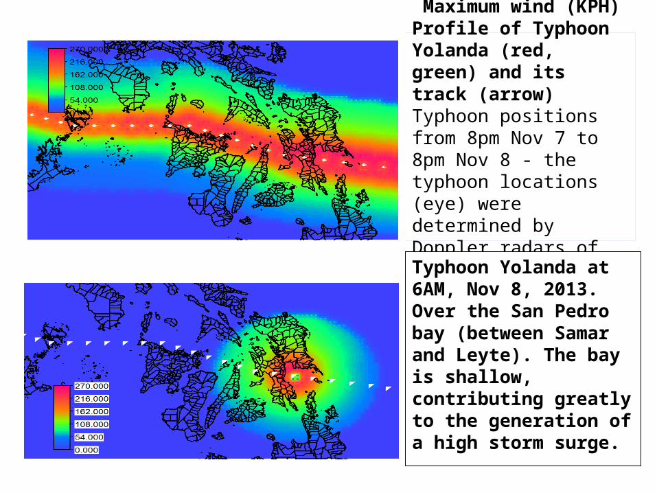
Conducted interviews and surveysOccular inspection
AREA VISITED
PAGASA STRIDE Team (Nov 2013)
6.39m
5.39m
5.53m
6.27m
5.75m
7.14m??
5.04m
2.26m
6.96m??
6.77m
6.61m
2.85m
????????
????
????
????
????
????
????
????
????????
????
Typhoon Yolanda’s track

BGY/MUNICIPALITY LAT LON H (msl)INUNDATIO
N
1 Bgy. Baras, Palo, LEYTE11°
09.848'125°
00.510' 6.39 800
2Bgy 60C Old Rd Sagcahan, TACLOBAN
11° 13.556'
125° 00.242' 5.75 600
3 Bgy 88 San Jose, TACLOBAN11°
12.656'125°
01.604' 6.27 500
4 Bgy San Jose, Dulag, LEYTE10°
59.108'125°
02.347' 2.85 200
5 Bgy Baybay, Basey E. Samar11°
17.021'125°
04.277' 5.53 500
6 Bgy Catadman, Basey E. SAMAR11°
16.290'125°
09.164' 5.39 800
7Bgy. Sulangan, Guiuan, E. SAMAR
10° 57.820'
125° 49.724' 7.14 800
8 Bgy Sapao, Guiuan, E. SAMAR11°
02.835'125°
45.524' 5.04 2000
9Bgy Aguinaldo Gen McArthur, E. SAMAR
11° 13.279'
125° 32.028' 2.26 80
10Bgy. Batang, Hernani, E. SAMAR
11° 17.958'
125° 36.162' 6.61 800
11Bgy 4 & 3 Poblacion Hernani, E. SAMAR
11° 19.384'
125° 37.040' 6.77 1000
12Bgy 3 Katabauan, Balangkayan, E. SAMAR
11° 28.048'
125° 30.428' 6.96 800
Actual Storm Surge Height (above msl)PAGASA STRIDE Team (Nov 2013

San Pedro BaySan Pedro BaySan Pedro Bay
San Pedro Bay

TRACKS of
TyphoonUndangNov 4, 1984
and
TyphoonYolandaNov 8, 2013
?
6AM, Nov 85AM, Nov 8
7AM, Nov 8
Recede
?


Hurricane Katrina ‘Storm Surge’

• Storm size and intensity: Intense– maximum wind @ 235 kph, – gust @ 275 kph, – minimum pressure @ 914 Hpa
Shape of the Coastline : Concave
Bathymetry: Shallow
San Pedro Bay
Storm forward speed: Fast @ 39 kphDistance of “eye” from Tac/Basey ~ 50km
•Storm size and intensity•Direction and speed of typhoon movement•Distance of “eye” from impact point/area•Shape of coastline•Bathymetry
Ingredients/Factors Favoring Storm Surge generation by Typhoon Yolanda at San Pedro-San Pablo Bay

Summary: Data comparison, Typhoon Yolanda (Haiyan)
Forecast Center
PAGASA10-min ave
RSMC (Tokyo)10-min ave
JTWC (Guam)1-min ave
Time 07/1800 UTC 07/1800 UTC 07/1800 UTC
Position 10.6N 126.9E 10.6N 126.9E 10.6N 127.0E
Max Sustained Wind
235 KPH 125KT (232 KPH)
170KT(315 KPH) (275 KPH)
Gustiness 275 KPH (175KT= (325 KPH)
205 KT (380 KPH) (330 KPH)
MSLP 914 HPa 895HPa
Movement WNW at 39 KPH W 37 KPH (20 KT)
2750 @ 39 KPH (21 KTS}
Following Simiu and Scanlon (1978), a multiplication factor of 0.871 is applied to convert between 1-min and 10-min winds.

Basey, W. Samar
Storm Surge: Typhoon Yolanda @ Basey, W. Samar

Basey, W. Samar
Storm Surge: Typhoon Yolanda @ Basey, W. Samar

Local residents’ account of the storm surge (Basey, W. Samar)
• Water level receded to a very low level, exposing the bottom of the sea, before the big wave (storm surge) came. This lasted for about 15-30 minutes, before the big wave (storm surge) came rushing towards town with Jinamok Island serving as a wave breaker.
The bathymetry (depth of sea/water) between the town of Basey and an island (Salvacion Island or Jinamok), about 1 kilometer southeast of Basey, varies between less than a meter and a little above 2 meters only during normal conditions.

• Some observers’ accounts refer to 3 big waves (the first wave was the biggest), which they referred to, as the surge itself, occurring in succession and causing the destruction of houses and human casualties.
• Upon verification (further questioning), it appears that the big waves referred to, were the big wind waves atop the storm surge, because such big waves occurred when the sea/water level was already high, i.e., the storm surge was already there.
Local residents’ account of the storm surge (Basey, W. Samar)
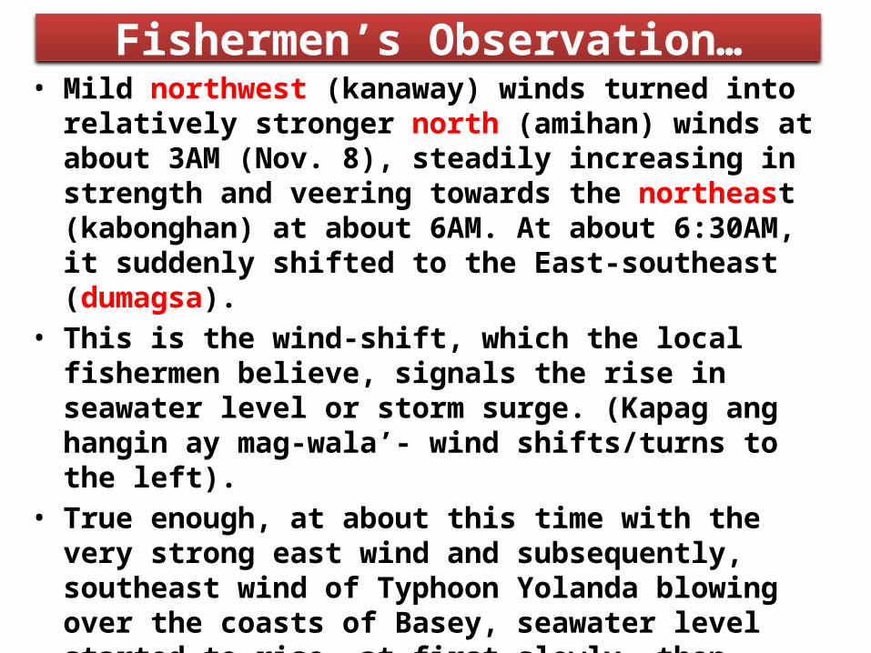
Fishermen’s Observation…• Mild northwest (kanaway) winds turned into relatively stronger north (amihan) winds at about 3AM (Nov. 8), steadily increasing in strength and veering towards the northeast (kabonghan) at about 6AM. At about 6:30AM, it suddenly shifted to the East-southeast (dumagsa).
• This is the wind-shift, which the local fishermen believe, signals the rise in seawater level or storm surge. (Kapag ang hangin ay mag-wala’- wind shifts/turns to the left).
• True enough, at about this time with the very strong east wind and subsequently, southeast wind of Typhoon Yolanda blowing over the coasts of Basey, seawater level started to rise, at first slowly, then rapidly. (Note: Typhoons passing north of Basey (i.e., wind direction backs from north (amihan) to west (salatan) do not generate storm surges)

Near-shore storm surge stages/profile
time(30 to 45 minutes)
Storm
Surg
e He
ight
(5
to
6.5
mete
rs)
MSL(receded)
(Level 1- knee deep)
(Level 2- waist deep)
(Level 3)
Observations at Jinamok island and coastal barangay of Canmanila.Many observers believe that the water receded as fast as it had risen.

• Accordingly, the storm surge came in as a fast-moving (with some hissing-like sound), swirling (alibundan), aboiling (parang kumukulo), blackish water (locally called lapok or hanang [or malapot na putik] – from the silt or sedimentation formed at the mouth of rivers of Basey). – When wind waves reach shallow waters, they amplifiy, break up, grow bigger, scouring/scraping the sea bottom, hence, transporting and mixing the silt (lapok) within the wave.
• This (lapok) is a distinct characteristic of the debris due to the storm surge as distinguished from the debris due to strong winds alone.
Local residents’ account of the storm surge (Basey, W. Samar)

Inland…• According to many local residents’ living some 300 meters away from the shoreline, sea water started to rise, slowly, at about 6AM, then the fast rise from about 7AM to 8AM (highest level), leveling off for a short while, then gradually receded starting at about 8:30 AM.
Local residents’ account of the storm surge (Basey, W. Samar)

• The destruction of houses attributed to the storm surge: – The big wind waves atop the surge – The big eddies/whirlpools (alibundan) in the fast rising water level.
– Floating debris (trees, wreckage/ruins of buildings, etc) – domino effect?
– Strong winds and the fast surging/ receding sea water itself.
Damage to houses and other properties
Damage to houses and other properties
• The storm surge inundation engulfed almost all of the town proper (poblacion) of Basey.
• Seawater level reached up to the second floor of some houses near the shores (about 3.5* meters from the ground floor) to just a few centimeters at the higher grounds of the town.
• In a house at the inner part of town near a river about 250 meters away from the shoreline, the height of water level was measured at 2.45 meters (8 ft) from the ground level (first floor of house).
• However, complete or near complete destruction of houses and other properties that could be directly attributed to the rampaging surge was confined along the coast to certain areas from the shores to several meters inland.
*5.5 meters from Mean Sea Level (PAGASA STRIDE Team)

Barangays Palaypay and northern Baybay
Almost complete destruction of light to medium-built houses by the storm surge up to some 280 meters from the seawall and bounding rivers
Brgy Palaypay is s deltaic plain at the confluence of two rivers (Buenavista and Sawa Rivers) which flow into the San Pedro Bay. The northeastern part of Brgy Baybay abutting Brgy Palaypay is a newly reclaimed area. This part of the town is a relatively low-lying, flat area.

Barangays Palaypay and Northern Baybay
Palaypay-BaybayBaywalk
NorthernBaybay
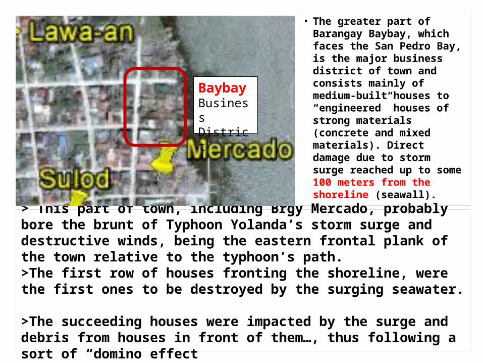
> This part of town, including Brgy Mercado, probably bore the brunt of Typhoon Yolanda’s storm surge and destructive winds, being the eastern frontal plank of the town relative to the typhoon’s path. >The first row of houses fronting the shoreline, were the first ones to be destroyed by the surging seawater.
>The succeeding houses were impacted by the surge and debris from houses in front of them…, thus following a sort of “domino effect
• The greater part of Barangay Baybay, which faces the San Pedro Bay, is the major business district of town and consists mainly of medium-built houses to “engineered” houses of strong materials (concrete and mixed materials). Direct damage due to storm surge reached up to some 100 meters from the shoreline (seawall).
BaybayBusinessDistrict

Storm Surge at Barangay Baybay
Storm Surge Memento

Barangays Mercado and Loyo

Storm Surge at Brgys. Mercado and Loyo
• Barangay Loyo (meaning, the other side of town?) and Barangay Mercado (formerly, the market place), the local government center, are at the southwestern edge of town; have houses of medium to strongly-built houses and facing also San Pedro Bay, the body of water separating the big islands of Leyte and Samar.
• The damage due to storm surge was confined to some 50 meters from the seawall.
• The ground gradually slopes upward (rises) from here, until it reaches the hills where the church, elementary school and the municipal hospital are located.

Barangay Mercado: The Government Center of Basey
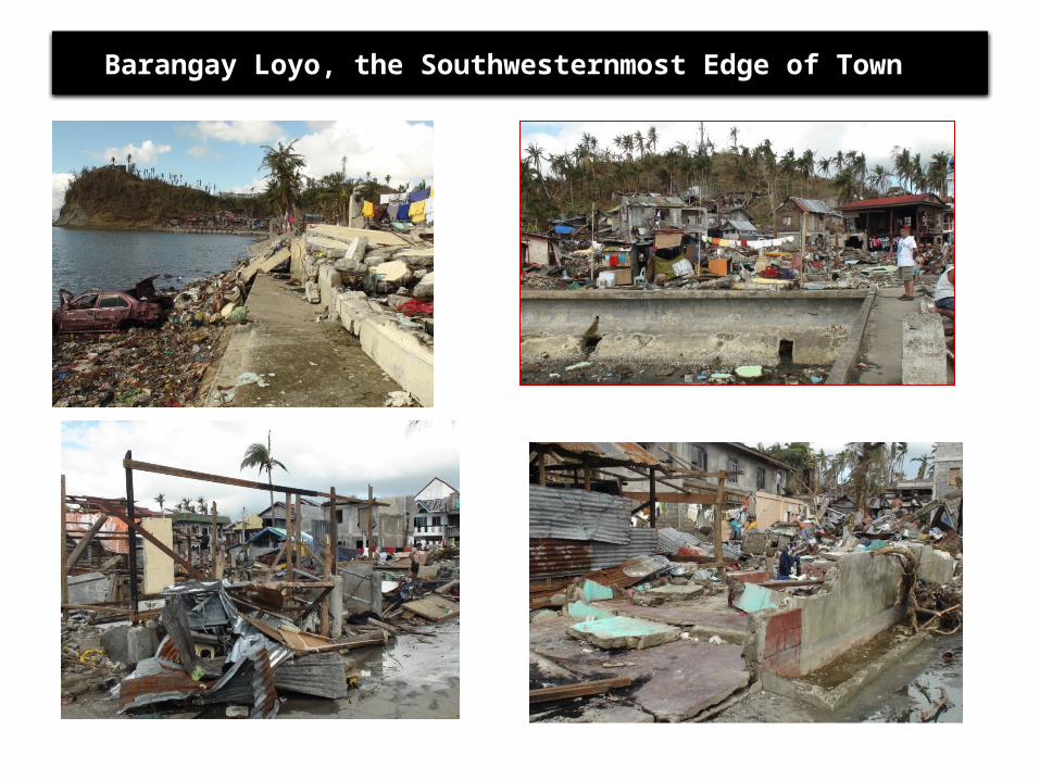
Barangay Loyo, the Southwesternmost Edge of Town

The “Domino” Effect
The first row of houses fronting the shoreline, were the first ones to be destroyed by the surging seawater. The succeeding houses were impacted by the surge and debris from houses in front of them…, thus following a sort of “domino effect” or pattern of destruction…, until it reached higher grounds or impacted on stronger structures or until the wave energy had lessened or dissipated

Views from inside town…
From Brgy Loyo towards the sea
From Brgy Baybay towards the sea
At Brgy Baybay (Nov. 9, 2013)
At Brgy Baybay (Nov. 18, 2013)
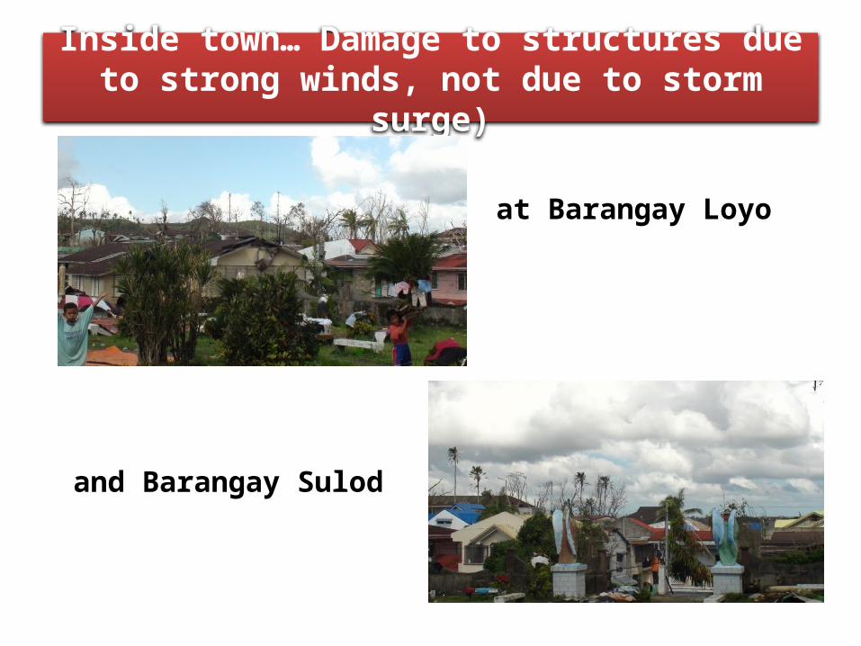
Inside town… Damage to structures due to strong winds, not due to storm
surge)
at Barangay Loyo
and Barangay Sulod

Casualties due to storm surge• The media is replete with stories of the destruction and loss of lives due to Typhoon Yolanda. As of now, more than 6,000 people are officially considered as victims (dead), most of them by drowning due to the storm surge.
• Consider this scenario: Imagine a body of water, about 5 meters high (~17 ft – conservative estimate, based on the observations of survivors), including the big waves surging to a residential area at about 39 kilometers per hour (speed of movement of the typhoon), together with a wind speed of 235 KPH (maximum winds of Typhoon Yolanda) constantly battering and eventually wrecking every structure along its path… what do you think would happen to its residents and people inside one-storey houses…, and in the vicinity?
Storm surges are responsible for 90% of all deaths in hurricanes! (Hurricanes and Storm Surges, Chap 8)
• For those who preferred to stay at home and ‘weather the storm’… Obvious?
• For those who preferred a ‘wait and see attitude’, then tried to outrun the surge, when they decided to evacuate to safer grounds. What to expect outside:– Fast rising seawater (surge) – Full force of the typhoon (winds >200 kph; heavy
rains)– Flying debris, floating debris…– Disorientation….(worst, if the surge happened a
night.. Panic…• For those who did not know what hit them or did
not know what a storm surge is and not knowing what to do… bless their souls!
• Etc…
Casualties due to storm surge
Local Concepts and Misconceptions about Storm
Surges• Random interview of Typhoon Yolanda’s survivors…, boils down to lack of understanding of what a storm surge is…, how about you, do you know what is a storm surge?
• There appears to be no local name for a storm surge… How can one relate the expected height of seawater level rise to a storm surge?
• Some misconstrue the storm surge or the rise in seawater level to be that of an ordinary spring tide (when the moon comes closest to the earth resulting in an extreme high tide called the Proxigean Spring Tide, locally termed as ‘dulok’ or extraordinary high tide).
• Some of those who were aware of the expected rise in sea level expected the storm surge to be similar to that of Typhoon Undang in 1984. The water level rose to about 2 meters in some areas during Typhoon Undang’s passage, but the casualty and damage to property paled in comparison with that of Typhoon Yolanda. – They reasoned out that they were able to survive the storm surge due to Typhoon Undang, with plenty to spare. Even their one-storey houses withstood the ravages of Typhoon Undang…, but not this time with Typhoon Yolanda!
Local Concepts and Misconceptions about Storm
Surges
• Misuse (and abuse) of the term ‘storm surge’ in the Philippines:– Sometimes, even if the typhoon is in the Batanes area, and some houses of very light materials are damaged due to big waves, say, in Cavite,… some authorities would attribute the damage in Cavite to a storm surge…but definitely, there could be no storm surge in Cavite, if the typhoon is somewhere else in Batanes.
– Mention of storm surge in almost every typhoon warning. Of course, not all typhoons generate storm surges
– People get confused with this type of information; they get the notion that a storm surge is a benign event and won’t get alarmed if the real storm surge occurs!
Local Concepts and Misconceptions about Storm
Surges

The way forward…According to disaster risk reduction parlance, • Risk (R) = Hazard (H) x Vulnerability (V) [x Exposure
(E)] Capacity (C) • How, then, can we reduce risk, and eventually, damage and casualty due to storm surge? From the formulation above, risk (R) can be reduced by reducing the hazard (H) and/or vulnerability (V) and exposure (E) and increasing the capacity (C).– Can we reduce the hazard?....vulnerability?...exposure?– Can we increase the coping capacity of the community and safeguards against disasters?

Reducing the hazard (H)
• Hazard, in this case, refers to the strong winds of the typhoon, the storm surge (and heavy rains). There is no existing technology to do this (weaken the typhoon).
• However, reducing the intensity/magnitude of the storm surge impinging on the community may be feasible, but at a considerable cost and imagination. Presently, the town of Basey has a 2-meter high (?) seawall surrounding the coastline. It was not breached by the surge but irreverently overtopped by it. Solutions?– A thick re-enforced 6-meter high seawall ( Expensive? Absurd?)… Refer to structural measures after the Ise Bay storm surge of Japan.
– Mangrove plantation along coastal areas (Excellent: this can be a breeding ground and sanctuary for some fish species. But, the plantation should be wide enough and the mangrove species should be tall enough in order to lessen the effects of storm surge. This would also mean relocation of residents in areas where the mangroves will be planted. An in-depth study of the effectiveness of this measure is in order.•Note: There are 17 coastal barangays, out of 51 barangays of Basey (including 4 barangays, in the poblacion).

Reducing the vulnerability (V)
• This means reducing the physical vulnerability (structures, vegetation, etc), social vulnerability (population, livelihood, poverty, etc) and economic vulnerability (source of income, direct potential and indirect potential damage, etc)– Physical vulnerability: Who would not like to live in well constructed, “engineered structures” that could withstand a powerful typhoon and storm surge?..., but how? Are our critical facilities (lifelines-hospitals, water, transport, communication, etc) typhoon-storm surge-proof?
– Social vulnerability: Is there a special plan for the very young and the very old, the incapacitated, etc, before disaster strikes? Are we prepared or capable of relocating residents to safer grounds? Have we identified those places yet?
• Economic vulnerability: Are institutions, communities, individuals economically prepared for disasters? What is the extent of subsistence and commercial agriculture and fishing in the community?

Increasing the Capacity (C)•Capacity is a combination of all strengths and resources available within a community, society or organization that can reduce the level of risk, or effects of a disaster (RA 10121- NDRRMC). This may be measured by the presence of:– highly organized, active and effective community and government organizations and programs
– Economic status of household and community – Highly organized, trained, prepared community organization - the BDRRMC
– Highly adequate and reliable Early Warning System – The interviewees (survivors) were unanimous in saying that the typhoon warning was quite adequate as far as the strength of Typhoon Yolanda was concerned but many denied, especially in the rural areas (barangays), that storm surge or the extraordinary rise in seawater level was mentioned in the warning, or they preferred to ignore it because of their lack of basic information about it.

Emphasis on education and public information campaign about storm
surges.• It appears that there is a dearth or lack of information and so many misconceptions about storm surges (Pls. see, Local Concepts and Misconceptions about Storm Surges). There should be a concerted effort and advocacy towards this end.
• A term or local name for storm surge that would connote danger or urgency should be coined and popularized (such as, Daluyong? Delubio?, etc…)
• or the present universally recognized term (name), storm surge, may ‘ring a bell’ in the future, after what Typhoon Yolanda and its accompanying storm surge did to Tacloban city and nearby communities.
• A storm surge is a rare phenomenon; not all typhoons generate storm surges, much more tropical depressions and tropical storms, they don’t. Do not use the name “storm surge” in vain; this might lead to the proverbial “boy crying wolf syndrome”; call a spade, a spade (literally).

Typhoon Yolanda, the Storm Surge, ETC… Beyond Science….
(Caution: you don’t have to read this!) • Long before people settled in the Philippines, the oceans, seas and lands of this world were already there, including typhoons consisting of very powerful winds, heavy rains and sometimes storm surges. The Creator must have a purpose in everything He creates. In this particular case, for example, a typhoon and other weather systems is one way of carrying some of the excess heat in the tropics to the cooler regions of the earth, otherwise, the temperate and polar regions of the world will become cooler and cooler with time, and we, people in the tropics will fry in the long run, if the excess heat will not be transported somewhere. (Every day we, in the tropics, receive more heat from the sun than those living, say, in Japan or Europe and other temperate countries).
• Typhoons, storm surges, heavy rains and floods and etcetera would occur even if there were no people in the Philippines, because it is a part of a greater plan. So, is it a form of punishment? Maybe, just a reminder that typhoons were always there for a purpose, before we populated the Philippines. Would it make sense if we just make the necessary adjustment to typhoon occurrences than petition for the alteration of the great design?
Copyright © 2022 FDOKUMEN