
Statewide Asset Data Collection and Management - Caltrans
411
Preliminary Investigation (PI-0234) Caltrans Division of Research, Innovation and System Information Statewide Asset Data Collection and Management: Survey of Practice Requested by Chad Baker, Geospatial Data Officer March 18, 2020 The Caltrans Division of Research, Innovation and System Information (DRISI) receives and evaluates numerous research problem statements for funding every year. DRISI conducts Preliminary Investigations on these problem statements to better scope and prioritize the proposed research in light of existing credible work on the topics nationally and internationally. Online and print sources for Preliminary Investigations include the National Cooperative Highway Research Program (NCHRP) and other Transportation Research Board (TRB) programs, the American Association of State Highway and Transportation Officials (AASHTO), the research and practices of other transportation agencies, and related academic and industry research. The views and conclusions in cited works, while generally peer reviewed or published by authoritative sources, may not be accepted without qualification by all experts in the field. The contents of this document reflect the views of the authors, who are responsible for the facts and accuracy of the data presented herein. The contents do not necessarily reflect the official views or policies of the California Department of Transportation, the State of California, or the Federal Highway Administration. This document does not constitute a standard, specification, or regulation. No part of this publication should be construed as an endorsement for a commercial product, manufacturer, contractor, or consultant. Any trade names or photos of commercial products appearing in this publication are for clarity only. Table of Contents Executive Summary ................................................................................................................. 2 Background ............................................................................................................................ 2 Summary of Findings .............................................................................................................. 2 Gaps in Findings ..................................................................................................................... 7 Next Steps .............................................................................................................................. 7 Detailed Findings ..................................................................................................................... 8 Background ............................................................................................................................. 8 Survey of Practice ................................................................................................................... 8 Related Research and Resources..........................................................................................36 Contacts ..................................................................................................................................47 Appendix A: Survey Questions..............................................................................................49
-
Upload
khangminh22 -
Category
Documents
-
view
10 -
download
0
Transcript of Statewide Asset Data Collection and Management - Caltrans

Preliminary Investigation (PI-0234)
Caltrans Division of Research, Innovation and System Information
Statewide Asset Data Collection and Management: Survey of Practice
Requested by Chad Baker, Geospatial Data Officer
March 18, 2020
The Caltrans Division of Research, Innovation and System Information (DRISI) receives and evaluates numerous research problem statements for funding every year. DRISI conducts Preliminary Investigations on these problem statements to better scope and prioritize the proposed research in light of existing credible work on the topics nationally and internationally. Online and print sources for Preliminary Investigations include the National Cooperative Highway Research Program (NCHRP) and other Transportation Research Board (TRB) programs, the American Association of State Highway and Transportation Officials (AASHTO), the research and practices of other transportation agencies, and related academic and industry research. The views and conclusions in cited works, while generally peer reviewed or published by authoritative sources, may not be accepted without qualification by all experts in the field. The contents of this document reflect the views of the authors, who are responsible for the facts and accuracy of the data presented herein. The contents do not necessarily reflect the official views or policies of the California Department of Transportation, the State of California, or the Federal Highway Administration. This document does not constitute a standard, specification, or regulation. No part of this publication should be construed as an endorsement for a commercial product, manufacturer, contractor, or consultant. Any trade names or photos of commercial products appearing in this publication are for clarity only.
Table of Contents
Executive Summary................................................................................................................. 2 Background ............................................................................................................................ 2 Summary of Findings.............................................................................................................. 2 Gaps in Findings..................................................................................................................... 7 Next Steps .............................................................................................................................. 7
Detailed Findings ..................................................................................................................... 8 Background............................................................................................................................. 8 Survey of Practice................................................................................................................... 8 Related Research and Resources..........................................................................................36
Contacts ..................................................................................................................................47 Appendix A: Survey Questions..............................................................................................49

Executive Summary
Background The California Department of Transportation (Caltrans) is investigating the use of a unified and coordinated statewide approach to transportation asset management. This practice takes a project-specific and programmatic approach to collecting and managing agency asset data, and Caltrans would like to capitalize on the efficiencies gained through a “collect data once, use it many times” strategy. Collection efforts may employ a range of tools, including Global Positioning System (GPS) devices, multisensor mobile mapping platforms, airborne and terrestrial LiDAR, surface geophysics, unmanned aerial systems and photogrammetric processes.
Caltrans is seeking information from other state transportation agencies about current and best practices for using a coordinated statewide approach to data collection and management, and lessons learned as these agencies collect, extract and manage transportation asset and roadway characteristics data. Experiences and knowledge from agencies with mature programs that collect and manage enterprise asset data are expected to inform the development of a Caltrans strategic statewide plan that will address the programmatic collection and management of field-collected roadway and roadside assets.
To assist Caltrans in this information-gathering effort, CTC & Associates conducted an online survey of state transportation agencies or other agencies expected to have experience with data collection and management. A literature search of publicly available resources about national and state practices and guidance supplemented the survey findings.
Summary of Findings
Survey of Practice An online survey was distributed to members of two American Association of State Highway and Transportation Officials (AASHTO) committees:
• Subcommittee on Asset Management. • Committee on Performance-Based Management.
In addition, the survey was distributed to a representative of the North Carolina Department of Public Safety (North Carolina DPS) who was expected to have experience with a coordinated statewide approach to asset data collection and management.
Representatives from 13 state departments of transportation (DOTs) and the North Carolina DPS responded to the survey. Twelve agencies have established a coordinated statewide approach to collecting and managing data on a range of agency assets. Two state DOTs have not established a coordinated statewide approach to multiasset data collection and management but are considering establishing a new program or expanding their current practices to allow for a coordinated statewide approach.
Findings from the 11 state transportation agencies and North Carolina DPS are presented in the following topic areas when provided:
• Program description.
Produced by CTC & Associates LLC 2

• Asset data collection. • Asset data management. • Assessment of agency practices.
Program Description Program Implementation
Use of a coordinated statewide approach varied considerably among these agencies, and with Kansas and Minnesota DOTs, varied by asset class. More than half of these agencies have used this approach for more than 10 years:
• 0 to 10 years: Alabama, Hawaii, Minnesota, New Hampshire, New York and Utah. • 10+ years: Minnesota and Virginia. • 20+ years: Delaware, Kansas, Minnesota and North Carolina DPS. • Approximately 30 years: Kansas and Mississippi. • 40+ years: Iowa.
Staffing
Three-quarters of the agencies use both consultants and in-house staff to collect, store and analyze data, depending on the task and the asset (Alabama, Delaware, Minnesota, Mississippi, New Hampshire, New York, North Carolina and Virginia). Three states use consultants only (Hawaii, Iowa and Utah), and one state uses in-house staff only (Kansas).
Frequency of Data Coordination and Collection
Half of the agencies coordinate and collect data annually (Hawaii, Iowa, Kansas, New York, Utah and Virginia). The remaining six agencies collect data in varying cycles (Alabama, Delaware, Minnesota, Mississippi, New Hampshire and North Carolina DPS). In Minnesota, coordination occurs continuously and varies by priority and effect on asset data quality. The respondent noted that the agency philosophy is to “collect data once and maintain its currency on an ongoing basis in real time.” The North Carolina DPS respondent said that imagery is collected one quarter of each year, and LiDAR is collected approximately every 10 years or as needed. None of the agencies responding to the survey collect data every two years or every three years, although Alabama DOT is aiming for a three-year cycle.
Type of Roadways
The three most common types of roadways where asset data is collected are state roads (Alabama, Hawaii, Kansas, Minnesota, Mississippi, New York, Utah and Virginia), all public roads (Iowa, New Hampshire, North Carolina DPS and Virginia), and ramps and connectors (Hawaii, Minnesota, New Hampshire and Virginia). Hawaii DOT collects data from county collector roads and above; Mississippi DOT gathers data on all state-maintained routes plus various routes on functionally classified roads for Highway Performance Monitoring System (HPMS) reporting.
Published Standards or Procedures
Eight agencies have adopted or published standards or procedures for collecting and managing asset data from their enterprise statewide programs (Iowa, Kansas, Minnesota, Mississippi, New Hampshire, North Carolina DPS, Utah and Virginia). In Minnesota, Mississippi and New
Produced by CTC & Associates LLC 3

Hampshire, these procedures are currently available internally as agencies work to create or standardize them.
Three respondents shared agency resources, including data dictionaries (Hawaii and Iowa) and district and state maps illustrating aspects of pavement performance (Kansas). Other resources cited were the Federal Highway Administration (FHWA) Highway Performance Monitoring System Field Manual (Mississippi) and issue papers that describe LiDAR data collection practices for land mapping (North Carolina).
Asset Data Collection Core Set of Assets
Eleven agencies collect data for bridges and pavement. Other assets that are commonly monitored are barriers (Alabama, Hawaii, Iowa, Minnesota, New Hampshire, New York, Utah and Virginia); drainage features (Hawaii, Iowa, Kansas, Minnesota, New Hampshire, New York, Utah and Virginia); and signs (Alabama, Hawaii, Iowa, Minnesota, New Hampshire, New York and Utah). None of the 11 agencies collect data on loop detectors. Agencies are least likely to collect data on cabinets, lands and buildings, marking or sign reflectivity, ramp meters, rights of way and roadside facilities.
Data Collection and Extraction Methods
Ten agencies use GPS devices in asset data collection and extraction (Alabama, Hawaii, Iowa, Kansas, Minnesota, Mississippi, New Hampshire, North Carolina DPS, Utah and Virginia). Other commonly used technology and tools are terrestrial LiDAR (Alabama, Hawaii, Iowa, Kansas, Minnesota, Mississippi, North Carolina DPS and Utah); manual data collection (Iowa, Kansas, Minnesota, Mississippi, New Hampshire, North Carolina DPS, Utah and Virginia); and mobile devices (Alabama, Iowa, Minnesota, Mississippi, New Hampshire, Utah and Virginia). Tools and technology least used are airborne LiDAR, photogrammetric processes and surface geophysics.
Utah DOT is currently experimenting with the use of unmanned aerial systems (UAS) for data collection and extraction. In addition to other methods, Hawaii DOT is using the laser crack measurement system (LCMS) to collect pavement condition data.
Data Collection and Coordination Practices
In 10 of 11 agencies, both in-house staff and contractors perform the field asset data collection, extraction and management, depending on the asset. New York State DOT uses contractors only for these functions. None of the participating agencies use in-house staff only.
Agencies in six states (Iowa, Kansas, Minnesota, New Hampshire, New York and Virginia) collect asset data in all stages of project delivery, from design through construction. This data is then entered into asset management information systems for future use.
To avoid duplication and still meet the competing demands for the type and extent of asset data, agencies primarily coordinate efforts with other functional areas. In Alabama, Minnesota and New Hampshire, specific business units within each agency coordinate data collection. Utah and Virginia DOTs distribute responsibility among multiple divisions and champions. Hawaii DOT has developed a data dictionary and tools that are used throughout the agency by functional units such as maintenance, design and safety. The Mississippi DOT’s Planning and Research divisions use the same contract for HPMS and PMS data collection and extraction,
Produced by CTC & Associates LLC 4

while North Carolina DPS coordinates large-scale data collection with the North Carolina Geographic Information Coordinating Council.
Data Quality Management Plan
Nine agencies have a data quality management plan for data collection. Four DOTs (Kansas, Mississippi, Utah and Virginia) have a plan that can be shared. (See Data Quality Management Plan in Detailed Findings for resources from Kansas, Mississippi and Utah.)
Five agencies (Iowa, Minnesota, New Hampshire and New York State DOTs and North Carolina DPS) have a plan but can’t share it because the plan is under development, is not a formal written document or varies by asset. Several respondents provided agency resources related to data collection and quality management resources, including 3D technologies and data collection vehicles (Hawaii) and the use of LiDAR for highway inventory data collection (Utah).
Asset Data Management Staff Access to Data
Data products. Respondents from 11 agencies described the products from the data collection and extraction efforts that are made available to staff, including extracted assets, imagery and point cloud data. All agencies make extracted assets available to staff, and all except Minnesota DOT make imagery available. The Minnesota DOT respondent noted that imagery and point cloud data are available to staff by special request. Point cloud data is available to staff in seven states: Alabama, Hawaii, Iowa, Mississippi, North Carolina, Utah and Virginia. Other products provided to staff are pavement management system data (Mississippi) and GIS data (New Hampshire).
Data distribution. Agency-hosted web-based applications are used by nine agencies to share asset data with staff (Hawaii, Iowa, Kansas, Minnesota, Mississippi, New Hampshire, New York, Utah and Virginia), and eight agencies use enterprise data warehouses (Hawaii, Iowa, Minnesota, Mississippi, New Hampshire, New York, Utah and Virginia). Only two state DOTs use consultant-hosted web applications (Hawaii and Iowa) or multiple data marts (Hawaii and Virginia). Less frequently used methods are separate databases (Hawaii, Minnesota, Mississippi, New Hampshire and Virginia); web services (Hawaii, Iowa, Minnesota, New York and Virginia); and separate geodatabases (Hawaii, Minnesota, New Hampshire and Virginia).
Asset Data Migration and Storage
Survey respondents reported three primary practices for asset data migration and storage: web services (Alabama, Iowa, Kansas (pavement data), Minnesota and New Hampshire), contractors (Hawaii), and mobile and paper processes (Kansas (bridge data)). Utah DOT is currently procuring a new maintenance/asset management system for data migration and storage.
Asset Data Delivery Format
To deliver asset data, five agencies use a standard format that is open to a third party, allowing full access to the data (Iowa, Kansas, New York and Utah DOTs and North Carolina DPS). The North Carolina DPS respondent added that agency data is available via a web site and is provided to North Carolina DOT. Only Alabama DOT uses a vendor proprietary format with a perpetual license provided to the state.
Produced by CTC & Associates LLC 5

Two state DOTs use both a vendor proprietary and standard format (Hawaii and Virginia). The Hawaii DOT respondent added that depending on the sensor (such as LiDAR) and data, the agency uses a combination of both proprietary and standard formats with access via REST services to third parties. Minnesota DOT uses a format specific to agency asset attribution parameters, and Mississippi DOT uses a format specified in HPMS and PMS, depending on the asset.
Assessment of Agency Practices Benefits
Eleven agencies indicated that implementing a coordinated statewide asset data collection and management approach enhanced their agencies’ operations. The key benefits reported were improved performance, streamlined resources, a more comprehensive view of assets and opportunities for increased funding.
The Alabama DOT respondent noted that centrally organizing data collection efforts has allowed enterprise systems to more easily leverage extracted data. In New Hampshire, moving most roadside collection to iPads and Esri cloud facilitates standardization and makes upkeep easier. Governance structure and central coordination also help ensure that data can be maintained. The Utah DOT respondent noted the benefit of aligning time and data.
Other agency respondents noted the beneficial impact on economies of scale (Minnesota), less duplication of resources (Iowa and Mississippi) and increased awareness of issues with certain construction types (Kansas). The Virginia DOT respondent noted that as a result of the data collection processes, the agency has developed a needs-based maintenance and operations program budget since 2006. In 2017, the state’s General Assembly provided additional funding for pavements and bridges, which began with presented needs from the data collected.
Challenges
The effort needed to coordinate data on an enterprise level is the most significant challenge experienced by respondents when using a statewide data collection and management approach (Alabama, Iowa, Minnesota, New Hampshire and Utah). Also challenging is addressing the different data needs of stakeholders and groups within the agency (Minnesota, Mississippi and North Carolina DPS). Additional issues include resources such as cost and staffing (Hawaii, Minnesota, New Hampshire and Virginia), and variable technologies, platforms and legacy data among districts (Minnesota).
Recommendations for Implementation
Nine agencies provided recommendations for other agencies developing a coordinated statewide program to collect and manage asset data. Most recommendations encouraged:
• Beginning with a strong foundation and consistent framework (Hawaii, Iowa, Minnesota, New Hampshire, Utah and Virginia).
• Establishing governance and coordination among stakeholders (Alabama, Iowa, Minnesota, New Hampshire, North Carolina DPS and Utah).
• Communicating to illustrate the benefits of this approach and to work through any challenges (Minnesota and Mississippi).
Produced by CTC & Associates LLC 6

Related Research and Resources A literature search of recent publicly available resources identified many national and state publications and resources related to data collection and management, and to remote and mobile data collection. An NCHRP project in progress anticipates developing a guide that compiles “principles, organizational strategies, governance mechanisms and practical examples for improving management of the processes for collecting data, developing useful information, and providing that information for decision making about management of the transportation system assets.” A 2018 FHWA case study describes how state transportation agencies define data governance and data management, and policies for implementing these practices in GIS. Other 2018 FHWA case studies address mobile applications for GIS, and a 2018 FHWA report summarized discussions from a peer exchange that looked at policies, technical tools and strategies, and staffing for data governance. Other resources addressed the use of imaging, intelligent transportation systems and LiDAR in asset data collection and management.
Gaps in Findings A limited number of survey respondents shared standards or procedures related to their agencies’ statewide program to collect and manage asset data. Also, though nine agencies reported having a data quality management plan for data collection, only three agencies were able to provide these plans. The remaining agencies reported that plans were still in draft form, were not part of a formal written document or varied from asset to asset. State transportation agency response to the survey was also limited.
Next Steps Moving forward, Caltrans could consider
• Examining the asset data collection and management standards, procedures and other resources provided by respondents for successful practices and policies.
• Reviewing the data quality management plans provided by Kansas, Mississippi and Utah DOTs.
• Following up with: o Utah DOT for online access to the agency’s enterprise statewide program
procedures (the public-facing web page is currently under construction). o Virginia DOT for access to the agency’s data quality management plan. o Iowa, Minnesota, New Hampshire and New York State DOTs and North Carolina
DPS for information about these agencies’ data quality management plans.
• Contacting the respondent from Delaware, who provided only a partial response to the survey. Additional feedback from this agency, which has established a coordinated statewide approach to multiasset data collection and management, could prove useful as Caltrans begins to develop a strategic statewide plan.
• Engaging with South Carolina and Wyoming DOTs—agencies that are considering establishing a new asset data collection and management program or expanding their current practices to allow for a coordinated statewide approach.
• Gathering information from agencies that did not respond to the survey to obtain further guidance and perspectives.
Produced by CTC & Associates LLC 7

Detailed Findings
Background Some state departments of transportation (DOTs) have implemented a unified and coordinated statewide approach to project-specific and programmatic mass data collection and data management of agency assets. These collection efforts may employ a range of tools, including Global Positioning System (GPS) devices, multisensor mobile mapping platforms, airborne and terrestrial LiDAR, surface geophysics, unmanned aerial systems and photogrammetric processes.
The California Department of Transportation (Caltrans) would like to capitalize on the efficiencies gained through a “collect data once, use it many times” strategy. To facilitate transitioning to a coordinated statewide approach to data collection and management, Caltrans is seeking information from other state transportation agencies about current and best practices, and lessons learned as these agencies collect, extract and manage transportation asset and roadway characteristics data. The experiences of agencies with mature programs to collect and manage enterprise asset data are expected to inform development of a future Caltrans strategic statewide plan that will address the programmatic collection and management of field-collected roadway and roadside assets.
To assist Caltrans in this information-gathering effort, CTC & Associates conducted an online survey of state DOTs and other agencies that examined the asset data collection and management practices and policies of these agencies. A literature search of publicly available resources about national and state practices and guidance supplemented the survey findings. Results from these efforts are presented in this Preliminary Investigation in two areas:
• Survey of practice. • Related research and resources.
Survey of Practice An online survey was distributed to members of two American Association of State Highway and Transportation Officials (AASHTO) committees:
• Subcommittee on Asset Management. • Committee on Performance-Based Management.
In addition, the survey was distributed to a representative of the North Carolina Department of Public Safety (North Carolina DPS) who was expected to have experience with a coordinated statewide approach to asset data collection and management.
Appendix A provides the survey questions. The full text of survey responses is presented in a supplement to this report.
Produced by CTC & Associates LLC 8

Summary of Survey Results Thirteen state DOTs responded to the survey:
• Alabama. • Kansas. • South Carolina. • Delaware (incomplete • Minnesota. • Utah.
response). • Mississippi. • Virginia. • Hawaii. • New Hampshire. • Wyoming. • Iowa. • New York.
The North Carolina DPS representative also responded to the survey.
Of these 14 agencies, respondents from DOTs in 11 states—Alabama, Delaware, Hawaii, Iowa, Kansas, Minnesota, Mississippi, New Hampshire, New York, Utah and Virginia—and North Carolina DPS reported that their agencies have established a coordinated statewide approach to collecting and managing data on a range of agency assets.
Agencies in two states—South Carolina and Wyoming—have not established a coordinated statewide approach to multiasset data collection and management but are considering establishing a new program or expanding their current practices to allow for a coordinated statewide approach. The South Carolina DOT respondent noted that the agency is reviewing LiDAR collection, and if it proceeds with such a plan, the collection of assets and asset extraction “will almost certainly be performed by a contractor.” Wyoming DOT is leveraging its biannual photolog of state routes to verify asset data previously gathered, such as for approaches, guardrails and signs. According to the Wyoming DOT respondent, the agency found that when it dispersed data collection and input, the consistency was not high enough to be reliable.
Below are findings from the 11 state transportation agencies and North Carolina DPS about their coordinated statewide approaches to asset data collection and management. Survey results are summarized in the following topic areas:
• Program description. • Asset data collection. • Asset data management. • Assessment of agency practices.
Note: The respondent from Delaware DOT provided a partial response to the survey. Feedback from this agency is included in this Preliminary Investigation where available.
Program Description Survey respondents provided the following information about their approach to asset data collection and management:
• Implementation of a coordinated statewide approach. • Staffing. • Frequency of data coordination and collection. • Types of roadways. • Published standards or procedures.
Produced by CTC & Associates LLC 9

Implementation of a Coordinated Statewide Approach Use of a coordinated statewide approach varied considerably among these agencies. More than half of the agencies responding to the survey have employed this approach for more than 10 years. Use ranged from 20 or more years (Delaware, Kansas, Minnesota, North Carolina DPS); approximately 30 years (Kansas and Mississippi); and more than 40 years (Iowa). The respondents from Kansas and Minnesota DOTs added that the length of time varies by asset class. The Minnesota DOT respondent also noted that “success has not been universal.”
The remaining five agencies (Alabama, Hawaii, New Hampshire, New York and Utah) have used this approach to asset data collection and management for less than 10 years. Survey results are summarized in Table 1.
Table 1. Implementation of a Coordinated Statewide Approach
State 0 to 2 Years
2 to 5 Years
7 to 10 Years Other Description
Alabama X N/A Delaware X More than 20 years. Hawaii X N/A
Iowa X More than 40 years, although processes have evolved.
Kansas X • Pavement: 30+ years. • Bridges: 20+ years.
Minnesota X
Varies by asset class: • Signs: 20 years with poor success. • Drainage culverts: 20 years with good success. • Traffic barriers: 2 years. • Traffic signals/ITS: 10+ years.
Mississippi X Nearly 30 years (since 1991). New Hampshire X N/A New York X N/A North Carolina DPS X Approx. 20 years (since 2000). Utah X N/A Virginia X More than 12 years.
Total 2 1 2 7
Staffing Eight agencies use both consultants and in-house staff to collect, store and analyze data, depending on the task and the asset (Alabama, Delaware, Minnesota, Mississippi, New Hampshire, New York, North Carolina and Virginia). In Alabama, an in-house LiDAR crew collects data for smaller projects, while contractors collect data for larger projects and perform most data extraction. New Hampshire DOT’s data flows to an Esri cloud service (for most assets) or to a special service (pavement). Data is then returned to the agency and integrated in its GIS. The North Carolina DPS respondent reported that a contractor collects and stores data in the state, and in-house staff performs quality control, analysis and use.
Produced by CTC & Associates LLC 10

-
Three states use consultants only (Hawaii, Iowa and Utah), and one state uses in-house staff only (Kansas). Survey results are summarized in Table 2.
Table 2. Responsibility for Multiasset Data Collection and Management
State Consultant/Contractor
In House Staff Other Description
Alabama X • An in-house LiDAR crew runs smaller projects and
contractors run larger projects. • Most extraction is performed by consultants.
Delaware X
• Consultants and in-house staff collect, store and analyze data, depending on the asset and asset owner.
• In-house staff collects most asset data sets related to Highway Performance Monitoring System (HPMS) reporting.
Hawaii X N/A Iowa X N/A Kansas X N/A
Minnesota X
• Asset Management Program Office coordinates data acquisition and maintenance, working with specialty offices (asset program managers) and district personnel to acquire and maintain data, including construction as-built and maintenance crew modifications to assets.
• Many data acquisition and maintenance techniques used: o Construction and GIS staff maintain legacy asset data. o Consultants conduct construction-related field surveys. o Internal staff uses field devices for some collection. o Asset management system work orders used for asset
data updating. o Statewide LiDAR contract implemented for asset data
collection and extraction. Mississippi X Both consultants and in-house staff collect and analyze data.
New Hampshire X
Collection depends on the asset: • Most assets: Data flows to an Esri cloud service. • Other assets (e.g., pavement): Data managed by a
special service. • Data is returned to DOT and integrated in GIS.
New York X • Consultant collects data. • In-house staff stores data in a geographical data
warehouse.
North Carolina DPS X
• Contractor collects and stores data. • In-house staff performs quality control, analysis and use.
Utah X N/A
Virginia X Consultants and in-house staff compile and analyze data. DOT stores data.
Total 3 1 8
Produced by CTC & Associates LLC 11

Frequency of Data Coordination and Collection At the enterprise level, half of the agencies coordinate and collect data annually. Collection cycles vary for the remaining six agencies. None of the states responding to the survey collect data every two years or every three years, although Alabama DOT is aiming for a three-year cycle. The respondent from Minnesota DOT reported that coordination occurs continuously and varies by priority and effect on asset data quality. He added that the agency philosophy is to “collect data once and maintain its currency on an ongoing basis in real time.” The North Carolina DPS respondent noted that imagery is collected one quarter of each year and LiDAR is collected approximately every 10 years or as needed. Table 3 summarizes survey results.
Table 3. Frequency of Data Coordination and Collection
State Annually Other Description
Alabama X
• Collection cycle still evolving. • Data Collection Section plans to formalize
schedule this year and is aiming for a three-year cycle (could run up to five years).
Delaware X N/A Hawaii X N/A Iowa X N/A Kansas X N/A
Minnesota X
• Coordination occurs continuously and varies by priority and effect on asset data quality.
• Agency philosophy: Collect data once and maintain its currency on an ongoing basis in real time.
Mississippi X • HPMS: Annually. • Pavement management system (PMS): Every
two years. New Hampshire X Asset-specific. New York X N/A
North Carolina DPS X • Imagery: One quarter each year. • LiDAR: Approx. every 10 years or as needed.
Utah X N/A Virginia X N/A
Total 6 6
Type of Roadways Respondents from 11 agencies indicated the types of roadways where asset data is collected including:
• All public roads. • National Highway System (NHS) only. • State roadways. • Ramps and connectors. • Local roadways.
Produced by CTC & Associates LLC 12

Asset data is most commonly collected on state roads (Alabama, Hawaii, Kansas, Minnesota, Mississippi, New York, Utah and Virginia) followed by all public roads (Iowa, New Hampshire, North Carolina DPS and Virginia) and ramps and connectors (Hawaii, Minnesota, New Hampshire and Virginia).
The Hawaii DOT respondent added that the agency collects data from county collector roads and above. In Mississippi, the agency gathers data on all state-maintained routes plus various routes on functionally classified roads for HPMS reporting. The respondent added that a contractor extracts some roadway features. In New Hampshire, data collection depends on the asset, but the focus is state roads for most assets. Table 4 summarizes survey results.
Table 4. Type of Roadway for Asset Collection
State All Public Roads
State Roads
Local Roads
NHS only
Ramps/Connectors Other Description
Alabama X N/A
Hawaii X X X X X County collector roads and above.
Iowa X N/A Kansas X X N/A Minnesota X X N/A
Mississippi X X
• All state-maintained routes. • Various routes on functionally
classified roads for HPMS reporting.
• Contractor extracts some roadway features.
New Hampshire X X X
• Asset-dependent. • Focus is state roadways for
most assets. New York X N/A North Carolina DPS X N/A
Utah X X N/A Virginia X X X X N/A
Total 4 8 2 3 4 3
Published Standards or Procedures Eight agencies—Iowa, Kansas, Minnesota, Mississippi, New Hampshire, North Carolina DPS, Utah and Virginia—have adopted or published standards or procedures for collecting and managing asset data from their enterprise statewide programs. Four agencies provided documentation for these standards and procedures (see Related Resources below).
Respondents from Minnesota, Mississippi and New Hampshire DOTs noted that procedures and practices are available internally as their agencies work to create or standardize them. Additional information provided by respondents follows:
Produced by CTC & Associates LLC 13

Iowa. The agency currently uses a vendor to extract data from imagery and request updates from local agencies annually. The agency’s data dictionary provides specifications of its current system (see Related Resources below).
Minnesota. The respondent noted that standards and procedures in Minnesota vary by asset class and methodology, and are available in various documents but no one single source. For example, LiDAR survey standards are part of a contract; as-built procedures are published; data maintenance expectations for signs and hydraulics processes are published as part of the asset management system implementation (see Related Resources below).
Mississippi. Mississippi DOT is working on data governance as an agency. Current resources are the HPMS Field Manual (see Related Resources below) and the DOT’s PMS procedures.
New Hampshire. The agency is currently standardizing its procedures. Elements have been published and are used internally.
North Carolina DPS. The respondent noted that the agency has developed issue papers that describe LiDAR data collection practices and explain how issues have been resolved. Note: She directed us to search for “LiDAR” at the agency’s document center (https://flood.nc.gov/ncflood/documentcenter.html?type=10) to access these issue papers. These publications (dated from 2001 to 2005) are provided in Related Resources below.
Utah. The agency is currently updating its web page to include the agency’s enterprise statewide program procedure.
Virginia. The Virginia DOT respondent said the agency has extensively documented the processes for pavement and bridge data collection. The respondent did not respond to follow-up requests to gather this documentation.
Related Resources Multiple States
Highway Performance Monitoring System Field Manual, Federal Highway Administration, December 2016. Field manual: https://www.fhwa.dot.gov/policyinformation/hpms/fieldmanual/ HPMS program: https://www.fhwa.dot.gov/policyinformation/hpms.cfm The HPMS program is a “national level highway information system that includes data on the extent, condition, performance, use and operating characteristics of the nation's highways. The HPMS contains administrative and extent of system information on all public roads, while information on other characteristics is represented in HPMS as a mix of universe and sample data for arterial and collector functional systems. Limited information on travel and paved miles is included in summary form for the lowest functional systems.” The field manual “provides a comprehensive overview of the HPMS program, and describes in detail the data collection and reporting requirements for HPMS. … The HPMS Field Manual is a valuable resource that guides the States as they address their HPMS data collection and reporting responsibilities. This manual includes detailed information on technical procedures, a glossary of terms, and various tables to be used as reference by those collecting and reporting HPMS data.
Produced by CTC & Associates LLC 14

Hawaii
2018 State of Hawaii Service Project Data Dictionary, Hawaii Department of Transportation, December 2018. See Attachment A. This document provides a classification of condition data reported by the agency.
Iowa
Geodatabase Documentation, Iowa Department of Transportation, October 2018. See Attachment B. Iowa DOT has developed this data dictionary to define the specifications of its current system and standardize communication of roadway data.
Kansas
Pavement Management Information System (PMIS), Kansas Department of Transportation, January 2020. http://www.ksdot.org/matreslab/pmis/reports.asp This web page provides links to district and state maps of performance, remaining life, roughness, transverse cracking, joint distress, rutting and faulting. The web page also briefly describes the legend used for each map (for example, good/fair/poor pavement surface conditions).
Minnesota
Note: Though not provided by the respondent, the following publication may be of value to Caltrans.
Transportation Asset Management Plan, Minnesota Department of Transportation, June 2019. www.dot.state.mn.us/assetmanagement/pdf/tamp/tamp.pdf From page 4 of the plan (page 10 of the PDF): [The transportation asset management plan (TAMP)] is a planning tool to help MnDOT further evaluate risks, develop mitigation strategies, analyze life cycle costs, establish asset condition performance measures and targets, and develop investment strategies. The TAMP formalizes and documents the following key information to meet federal requirements:
• Description and condition of pavements and bridges on the NHS. • Asset management objectives and measures. • Summary of gaps between targeted and actual performance. • Life cycle cost and risk management analysis. • Financial plan that addresses performance gaps. • Investment strategies and anticipated performance.
North Carolina
Note: The following issue papers, recommended by the survey respondent, address three phases of a project to define the use of LiDAR for collecting elevation data sets for land mapping and provide LiDAR specifications. The papers were produced from 2001 to 2005 and are available at https://flood.nc.gov/ncflood/documentcenter.html?type=10. (Under Document Type, select “Issue Papers.” Enter “LiDAR” in the search field.)
Produced by CTC & Associates LLC 15

Issue 50: Phase III Quality Control of Light Detection and Ranging (LiDAR) Elevation Data in North Carolina, North Carolina Cooperating Technical State Mapping Program, February 2005. https://flood.nc.gov/NCFLOOD_BUCKET/ISSUE/ip50_final_phaseIII_lidar_qc.pdf
Issue 37: Quality Control of Light Detection and Ranging (LiDAR) Elevation Data in North Carolina for Phase II of the NCFMP, North Carolina Cooperating Technical State Mapping Program, February 2004. https://flood.nc.gov/NCFLOOD_BUCKET/ISSUE/IP37-phaseII_lidar_qc.pdf
Issue 5: Quality Control of Light Detection and Ranging (LIDAR) Elevation Data in North Carolina, North Carolina Cooperating Technical State Mapping Program, October 2001. https://flood.nc.gov/NCFLOOD_BUCKET/ISSUE/IP05-lidar_qc.pdf
Issue 7: Light Detection and Ranging (LIDAR) Specifications, North Carolina Cooperating Technical State Mapping Program October 2001. https://flood.nc.gov/NCFLOOD_BUCKET/ISSUE/IP07-lidar_spec.pdf
Asset Data Collection Respondents provided information about the following general practices and policies of their agencies’ asset data collection program:
• Core set of assets. • Data collection and extraction methods. • Data collection and coordination practices. • Data quality management plan.
Core Set of Assets Using the following list of asset types, respondents from 11 agencies described the core assets of data collection efforts:
• Barrier (i.e., guardrail). • Bridges. • Cabinets. • Drainage features/culverts. • Intelligent transportation systems
(ITS). • Lands and buildings. • Loop detectors. • Marking reflectivity. • Model Inventory of Roadway
Elements (MIRE).
• Pavement. • Pavement markings. • Ramp meters. • Right of way (ROW). • Roadside facilities. • Roadside features. • Sign reflectivity. • Signal post. • Signs. • Structures/walls. • Other.
All 11 agencies collect data for bridges and pavement. Other assets that are commonly monitored are barriers (Alabama, Hawaii, Iowa, Minnesota, New Hampshire, New York, Utah and Virginia); drainage features (Hawaii, Iowa, Kansas, Minnesota, New Hampshire, New York,
Produced by CTC & Associates LLC 16
-
Utah and Virginia); and signs (Alabama, Hawaii, Iowa, Minnesota, New Hampshire, New York and Utah). None of the 11 agencies collect data on loop detectors. Agencies are least likely to collect data on cabinets, lands and buildings, marking or sign reflectivity, ramp meters, rights of way and roadside facilities.
Utah DOT collects data on the most asset types (17), followed by Hawaii and Minnesota DOTs (13 each) and New Hampshire DOT (12). Agencies collecting data on the least number of asset types are Kansas DOT (three) and North Carolina DPS (two).
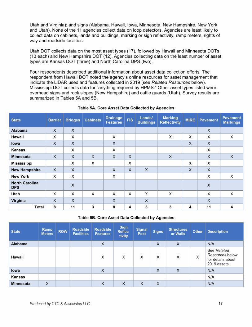
Four respondents described additional information about asset data collection efforts. The respondent from Hawaii DOT noted the agency’s online resources for asset management that indicate the LiDAR used and features collected in 2019 (see Related Resources below). Mississippi DOT collects data for “anything required by HPMS.” Other asset types listed were overhead signs and rock slopes (New Hampshire) and cattle guards (Utah). Survey results are summarized in Tables 5A and 5B.
Table 5A. Core Asset Data Collected by Agencies
State Barrier Bridges Cabinets Drainage Features ITS Lands/
Buildings Marking
Reflectivity MIRE Pavement Pavement Markings
Alabama X X X Hawaii X X X X X X X Iowa X X X X X Kansas X X X Minnesota X X X X X X X X Mississippi X X X X X New Hampshire X X X X X X X New York X X X X X North Carolina DPS X X
Utah X X X X X X X X X Virginia X X X X X
Total 8 11 3 8 4 3 3 4 11 4
Table 5B. Core Asset Data Collected by Agencies
State RampMeters ROW Roadside
Facilities Roadside Features
SignReflec tivity
Signal Post Signs Structures
or Walls Other Description
Alabama X X X N/A
Hawaii X X X X X X
See Related Resources below for details about 2019 assets.
Iowa X X X N/A Kansas N/A Minnesota X X X X X N/A
Produced by CTC & Associates LLC 17

-State RampMeters ROW Roadside
Facilities Roadside Features
SignReflec tivity
Signal Post Signs Structures
or Walls Other Description
Mississippi X Anything required by HPMS.
New Hampshire X X X X X
• Overhead signs (not all signs).
• Rock slopes. New York X X N/A North Carolina DPS N/A
Utah X X X X X X X X Cattle guards. Virginia X X X X X N/A
Total 3 2 3 6 3 4 7 6 4 N/A
Related Resources:
Roadview Explorer 5 Manual, Hawaii Department of Transportation, 2020. https://rvx.mandli.com/hawaii/help/index.php This web page provides links to information about asset data collected by Hawaii DOT in 2019 using the Roadview Explorer application. Five help videos include an introduction to the software; methods to search for assets, view them in Photolog and navigate the program; methods to view and sort pavement data based on customizable criteria; and a case study. Other links provide access to user documentation and features of the application.
“Asset Management,” Roadview LiDAR Viewer, Hawaii Department of Transportation, undated. See Attachment C. Adding and editing assets are discussed in this brief help resource for users.
Data Collection and Extraction Methods Respondents indicated which of the following technology and tools are used by their agencies to collect and extract asset data:
• GPS devices. • Photogrammetric processes. • LiDAR (airborne). • Photolog. • LiDAR (terrestrial). • Surface geophysics. • Manual data collection. • Unmanned aerial systems (UAS). • Mobile devices (smartphone, tablet). • Windshield survey. • Multisensor mobile mapping • Other.
platforms.
All of the 11 agencies except New York State DOT use GPS devices in asset data collection and extraction. Other commonly used technology and tools are terrestrial LiDAR (Alabama, Hawaii, Iowa, Kansas, Minnesota, Mississippi, North Carolina DPS and Utah); manual data collection (Iowa, Kansas, Minnesota, Mississippi, New Hampshire, North Carolina DPS, Utah
Produced by CTC & Associates LLC 18
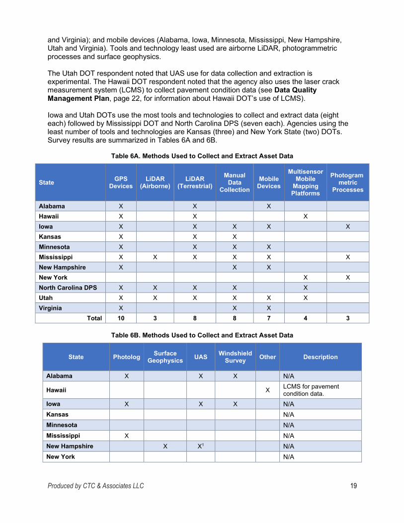
-
and Virginia); and mobile devices (Alabama, Iowa, Minnesota, Mississippi, New Hampshire, Utah and Virginia). Tools and technology least used are airborne LiDAR, photogrammetric processes and surface geophysics.
The Utah DOT respondent noted that UAS use for data collection and extraction is experimental. The Hawaii DOT respondent noted that the agency also uses the laser crack measurement system (LCMS) to collect pavement condition data (see Data Quality Management Plan, page 22, for information about Hawaii DOT’s use of LCMS).
Iowa and Utah DOTs use the most tools and technologies to collect and extract data (eight each) followed by Mississippi DOT and North Carolina DPS (seven each). Agencies using the least number of tools and technologies are Kansas (three) and New York State (two) DOTs. Survey results are summarized in Tables 6A and 6B.
Table 6A. Methods Used to Collect and Extract Asset Data
State GPS Devices
LiDAR (Airborne)
LiDAR (Terrestrial)
Manual Data
Collection Mobile
Devices
Multisensor Mobile
Mapping Platforms
Photogrammetric
Processes
Alabama X X X Hawaii X X X Iowa X X X X X Kansas X X X Minnesota X X X X Mississippi X X X X X X New Hampshire X X X New York X X North Carolina DPS X X X X X Utah X X X X X X Virginia X X X
Total 10 3 8 8 7 4 3
Table 6B. Methods Used to Collect and Extract Asset Data
State Photolog Surface Geophysics UAS Windshield
Survey Other Description
Alabama X X X N/A
Hawaii X LCMS for pavement condition data.
Iowa X X X N/A Kansas N/A Minnesota N/A Mississippi X N/A New Hampshire X X1 N/A New York N/A
Produced by CTC & Associates LLC 19

State Photolog Surface Geophysics UAS Windshield
Survey Other Description
North Carolina DPS X X N/A Utah X X N/A Virginia X X N/A
Total 5 1 4 5 1
1 UAS data collection in Utah is experimental.
Data Collection and Coordination Practices Survey respondents from 11 agencies briefly described data collection and coordination practices, including:
• Whether contractors or in-house staff performed data collection, extraction and management.
• Whether agencies collected asset data during project delivery phases (from design through construction) and entered the data into asset management information systems for future use.
• How agencies coordinated statewide data collection with other groups or units, meeting the competing demands for the type and extent of asset data without duplicating efforts.
Highlights of survey responses follow and are summarized in Table 7.
Responsibility for Data Collection, Extraction and Management
Ten of the 11 respondents reported that both agency staff and contractors perform the field asset data collection, extraction and management efforts within their agencies, depending on the asset. New York State DOT uses contractors only for these functions. None of the participating agencies use agency staff only.
Collecting Data During Project Delivery Phases
Agencies in six states—Iowa, Kansas, Minnesota, New Hampshire, New York and Virginia— collect asset data during project delivery phases (design through construction). This data is then entered into asset management information systems for future use.
Coordinating Data Collection to Avoid Duplication
Enterprise coordination with other functional areas is the primary practice reported by respondents to avoid duplication and still meet the competing demands for the type and extent of asset data, although the Alabama DOT respondent noted that “[it] is hard to say that there is no duplication.” In most cases, specific business units within each agency coordinate data collection:
• Alabama: Data Collection Section of the Maintenance Bureau. • Minnesota: Asset Management Project Office, with active participants in statewide
functional organizations such as traffic engineers, maintenance engineers and GIS specialists.
• New Hampshire: Central asset management office.
Produced by CTC & Associates LLC 20

Utah and Virginia DOTs distribute responsibility among multiple divisions and champions. Hawaii DOT has developed a data dictionary and tools that are used throughout the agency by functional units such as maintenance, design and safety.
The Mississippi DOT respondent noted that the agency’s Planning and Research divisions use the same contract for HPMS and PMS data collection and extraction. North Carolina DPS coordinates large-scale data collection with the North Carolina Geographic Information Coordinating Council, an organization within the North Carolina Department of Information Technology that promotes GIS technology and the “value of reliable geographic information for effective decision making” (see Related Resource below). Table 7 summarizes survey results.
Table 7. Data Collection and Coordination Practices
State Contractor Collects Data
Staff and Contractor
Collect Data
Data Collected During Project
Phases Description of Coordination Efforts
Alabama X
Data Collection Section of the Maintenance Bureau coordinates data collection of assets leveraged in enterprise GIS, though “it is hard to say that there is no duplication.”
Hawaii X
Development of agencywide data dictionary and tools that utilize the data needed by various offices (such as maintenance, design and safety).
Iowa X X Enterprise coordination.
Kansas X X
• Agency staff responsible for all data collection except local bridge inspection data.
• Bridge inspection data collected by consultants.
Minnesota X X
• Coordination through Asset Management Project Office (AMPO), which is responsible for understanding the various needs and uses of data through involvement with stakeholders and subject matter experts.
• Active participants in statewide functional organizations, such as traffic engineers, maintenance engineers and GIS specialists.
Mississippi X Planning and Research divisions use same contract for HPMS and PMS data collection and extraction (if needed).
New Hampshire X X Governance structure and central asset
management office. New York X X N/A
North Carolina DPS X
Partnership with the North Carolina Geographic Information Coordinating Council to coordinate large-scale data collection (see Related Resource below).
Produced by CTC & Associates LLC 21

State Contractor Collects Data
Staff and Contractor
Collect Data
Data Collected During Project
Phases Description of Coordination Efforts
Utah X
• Single project manager coordinates data for multiple groups.
• For structures and pavement data, champions from each division coordinate with the project manager.
Virginia X X Responsibility assigned to various divisions and areas of expertise.
Total 1 10 6
Related Resource:
North Carolina Geographic Information Coordinating Council, North Carolina Department of Information Technology, undated. https://it.nc.gov/about/boards-commissions/north-carolina-geographic-information-coordinating-council From the web site: The North Carolina Geographic Information Coordinating Council (GICC) was established by the NC [North Carolina] General Assembly to develop policies regarding the use of geographic information, geographic information systems (GIS), and related technologies. The Council is an organization of volunteers whose goals are to:
• Collaborate in geographic information and systems involving state, federal and local government agencies, academic institutions, private organizations and individuals across the state.
• Improve the quality, access, cost-effectiveness and utility of North Carolina’s geographic information and resources, and promote geographic information as a strategic resource.
• Efficiently collect, develop and use geographic information through voluntary exchange and sharing of data and technical know-how.
• Explore, guide and provide a framework for coordination including: o Developing standards. o Planning strategically. o Resolving policy and technical issues. o Providing central direction and oversight. o Advising the Governor and the Legislature as to needed directions,
responsibilities and funding regarding geographic information.
Data Quality Management Plan Nine agencies have a data quality management plan for data collection. Respondents from agencies in four of these states—Kansas, Mississippi, Utah and Virginia—reported having a plan that can be shared. See below for data quality management plans provided by respondents from all of these agencies except Virginia DOT; the respondent from that agency did not respond to follow-up requests for the plan.
Five agencies—Iowa, Minnesota, New Hampshire and New York State DOTs and North Carolina DPS—have a plan but can’t share it. The respondent from Minnesota DOT noted that
Produced by CTC & Associates LLC 22

data quality management plans vary by asset and are not documented within a single source. New Hampshire DOT’s data quality management plan is currently in draft form. The North Carolina DPS respondent reported that the plan is not a formal written document.
The respondents from Alabama and Hawaii DOTs reported that their agencies do not have a plan. The Hawaii DOT respondent did provide the agency’s management plan for quality pavement condition data.
Hawaii
Management Plan for Quality Pavement Condition Data, Highways Planning Survey Section, Hawaii Department of Transportation, January 2019. See Attachment D. From the plan goals (page 2 of the report, page 3 of the PDF):
This management plan begins by defining what data needs to be collected, how it will be collected, as well as how it will be reported and maintained after it is collected. Additionally, this plan will cover the process for reviewing and checking the data for acceptance, as well as all of the quality control measures required to assure the data is accurate and complete. This plan includes a contractor data quality management plan that describes the data collection equipment, calibration, certification, and operator training used to collect pavement condition data at highway speeds for HDOT [Hawaii DOT]. This document also includes the contractor’s quality control measures conducted before and during the data collection, during the data processing, and the checks to assure data completeness and validity.
Other topics include data collection (page 3 of the report, page 4 of the PDF), data metrics and protocols (page 6 of the report, page 7 of the PDF), and data issues (page 8 of the report, page 9 of the PDF).
LCMS, which is used for the pavement condition survey, is briefly discussed on page 3 of the plan (page 4 of the PDF):
The distress data will be collected using a 3D pavement scanner, a laser crack measuring system (LCMS), driven at highway speeds and processed with automated analysis. There will not be any manual data collection for the SHS [state highway system] or other routes annually collected.
A metric involving LCMS is discussed on page 6 of the plan (page 7 of the PDF): Faulting for jointed concrete pavements: Faulting computed based on AASHTO Standard R36-13 with the parameters specified in the HPMS Field Manual, using data measured with LCMS sensors.
Kansas
Kansas Pavement Condition Data Collection Quality Management Plan, Pavement Management, Kansas Department of Transportation, 2018. See Attachment E. Kansas DOT’s quality management plan addresses the data collection process (beginning on page 4 of the report), including collection vehicles, staff responsible for collecting data and quality control activities before and during data collection. Also included are discussions of the data processing and reporting processes (beginning on pages 10 and 12, respectively).
Produced by CTC & Associates LLC 23

Mississippi
Appendix 1: Pavement Management Manual, Development of a Pavement Management Manual and Data Quality Plan for the Mississippi Department of Transportation, Mississippi Department of Transportation, Gregory M. Duncan, Luis M. Sibaja Vargas, Prashant K. Ram and Kathryn A. Zimmerman, June 2017. https://mdot.ms.gov/documents/Research/Reports/Interim%20&%20Final/State%20Study%202 68%20-%20Development%20of%20a%20Pavement%20Management%20Manual%20and%20Data%2 0Quality%20Plan%20for%20MDOT.pdf The Pavement Management Manual is Appendix 1, beginning on page 57 of the PDF. Chapter 5 of the manual (page 78 of the PDF) describes the functional classification system for maintenance and rehabilitation. Current pavement management data collection practices are discussed in Chapter 6 (beginning on page 82 of the PDF). Additional topics include pavement performance modeling (Chapter 7, page 86 of the PDF), treatment selection (Chapter 8, page 88 of the PDF) and pavement management reporting (Chapter 9, page 92 of the PDF).
Utah
Quality Management Plan, Utah Department of Transportation, 2017. https://docs.google.com/a/utah.gov/viewer?a=v&pid=sites&srcid=dXRhaC5nb3Z8cGF2ZW1lbn R8Z3g6MzU2NjkzZDg2ZjE5OWUyNQ This plan describes the high-speed data collection and reporting activities of Utah DOT’s asset management contractor (Mandli Communications). From the executive summary:
The QM [quality management] plan outlines practices in place throughout the service project collection and processing efforts. It describes the roles and responsibilities for successful QM of a service project and presents examples of practices currently in use by Mandli for Quality Control (QC). Creating and maintaining an effective QM plan for Mandli service work includes specifying the data collection rating protocols to be used, establishing quality standards and acceptance criteria, identifying responsibilities, performing QC activities, monitoring and testing for acceptance, taking timely and appropriate corrective actions, and performing QM reporting.
Flowcharts on page 3 of the PDF illustrate the vehicle configuration and calibration predeployment activities along with data collection and extraction. A discussion of data collection begins on page 11 of the PDF; a discussion of data reduction and extraction begins on page 19 of the PDF. Appendix A summarizes the collection system configuration (photolog, positional orientation, LiDAR and LCMS) (page 25 of the PDF).
Related Resources Below are resources related to agencies’ statewide asset data collection and management efforts that were provided by respondents or obtained through a limited literature search.
Hawaii
“A Plan for Every Section of Every Road on Every Island,” Goro Sulijoadikusumo, 12th Annual National Conference on Transportation Asset Management, July 2018. http://onlinepubs.trb.org/onlinepubs/Conferences/2018/AssetManagement/SulijoadikusumoAPla nforEverySectionofEveryRoad.pdf This presentation discusses the history of the road information system project conducted on the Hawaiian Islands. It includes information on the technology used to gather data, reporting tools and the use of the data for project prioritization.
Produced by CTC & Associates LLC 24

Use of 3D Digital for Asset Management, 3D Engineered Models: Schedule, Cost and Post-Construction, Every Day Counts, Federal Highway Administration, April 26, 2016. https://connectdot.connectsolutions.com/p1ruf5vg9yn/?launcher=false&fcsContent=true&pbMod e=normal Complete series: https://www.fhwa.dot.gov/construction/3d/edc3webinars.cfm This webinar is one of seven webinars created by Federal Highway Administration under the third round of the Every Day Counts initiative to assist transportation agencies in adopting 3D engineered models. This presentation addresses the use of LiDAR and other tools for asset management.
“Integration of Point Cloud Data and Photo-Log Images of Highways Within VR-Design Studio,” Goro Sulijoadikusumo, FORUM8 International VR Symposium, Users Report, Vol. 107, 2014. http://www.forum8.co.jp/user/user107-e.htm This presentation describes Hawaii DOT’s use of the point-cloud Photo Processing Extension (PPE) plug-to add color to the point cloud data collected, using pixel data from the photo-log images of the target roads and surrounding structures.
Photolog to Digilog: 3D Asset Management, Hawaii Department of Transportation and Mandli Communications, 2014. http://www.heep.org/conference/archive/2014/files/presentations/photolog_to_digilog.pdf This presentation examines various data collection technologies and asset inventories.
Mandli X-35, Mandli Communications, 2020. https://www.mandli.com/solutions/mandli-x-35/ This vendor web site describes the features and functions of the data collection vehicle used by the Hawaii DOT contractor.
Roadview: Data Collection and Processing, Roadview, Inc., 2020. https://www.roadview.com/ This vendor web site describes Roadview, “an industry leader in the collection, reduction and delivery of large-scale, geo-referenced transportation data sets.”
Iowa
Guide to Life-Cycle Data and Information Sharing Workflows for Transportation Assets, David Jeong, Charle Jahren, Jennifer Shane, Kristen Cetin, Tuyen Le and Chau Le, Iowa Department of Transportation, Midwest Transportation Center and U.S. Department of Transportation, September 2018. http://publications.iowa.gov/28264/1/TR-714_Final%20Report_guide_to_life-cycle_data_and_info_sharing_w_cvr.pdf From the abstract:
The purpose of this research was to identify current data workflows and areas for improvement for five of the most common types of highway assets—signs, guardrails, culverts, pavements and bridges—and offer guidance to practitioners on how to better collect, manage and exchange asset data.
From the report's conclusions beginning on page 86 of the report (page 100 of the PDF):
• The research team’s interviews with highway professionals revealed that asset maintenance personnel are required to manually locate data in project documents and merge the data into asset management systems. In many cases, asset inventory data
Produced by CTC & Associates LLC 25

must be collected a second time from the field using mobile devices. Properly transferring the appropriate asset data in the right format to the operation and maintenance phases will reduce the costs of duplicating data collection efforts, which will, in turn, enhance productivity and reduce operation costs.
• An extensive review of the literature, manuals, project documents and software applications centering on data attributes was also conducted. These data were refined and organized in IDM [information delivery manual] documents in which the processes and data exchange relationships among the project players were visually represented. The study developed five separate IDMs for five different types of assets. Each IDM is composed of several PMs [process maps] and one ER [exchange requirement] matrix. In total, 15 PMs and 5 ER matrices were developed.
o PMs can help practitioners better understand the work process and interactions between involved parties for different types of projects (i.e., new construction, reconstruction, repair and maintenance).
o ER matrices showed who needs what data and who can provide the data.
• An ideal process map and suggestions for improvement were proposed to further streamline the workflows throughout the project life cycle and reduce duplicate data collection efforts during the operation and maintenance phases.
New, Web-Based System to Better Interconnect Iowa DOT Data, Blog Post, Transportation Matters for Iowa, Iowa Department of Transportation, July 2017. https://www.transportationmatters.iowadot.gov/2017/07/new-web-based-system-to-better-interconnect-iowa-dot-data-.html From the blog post: The Iowa Department of Transportation has long been a leader in the collection of transportation data, including things like traffic volumes, lane width and sufficiency ratings. Many custom data systems have been developed by or for us that use the latitude and longitude of the centerlines of every public roadway to give a common linear reference point to tie together many types of data. These systems, most notably the Geographic Information Management System (GIMS), provided access to a variety of information, but were sometimes complex to use and required a desktop application to access the data. In our quest to be smarter, simpler and customer driven, the interface for accessing many of the data sets is moving away from GIMS to a mobile-friendly web-based environment we are calling the Roadway Asset Management System (RAMS). …. RAMS uses a commercially available geographic information system (GIS) product called Roads and Highways as its foundation. Roads and Highways was developed by ESRI, a GIS mapping software company the Iowa DOT has worked with extensively over the years and provides a universal method to locate our business data.
Iowa DOT’s RAMS Administrator Mike Clement points out the “off-the-shelf” system will be much more user-friendly and allow any Iowa DOT employee with internet access and logged into the Iowa DOT’s network to view, analyze and manage data in the field.
Ryan Wyllie, with the Office of Research and Analytics, says, “As more data sets are brought into the system, they can easily be tied together for analysis purposes. For example, we can take our deer kill data and merge it with crashes, lighting and signing. We might see that instead of just needing to post a sign in an area with high deer hits, perhaps we should look at putting a new light in the area.”
Produced by CTC & Associates LLC 26

The team says using Road and Highways will also make updating data simpler be moving from a manual to an automated process. Clement said, “When there are any road changes, one update to the system will automatically make the same change across all data sets. Right now, users have to do a lot of manual updating.”
Utah
“Using Aerial LiDAR Technology to Update Highway Feature Inventory: Utah Departmentof Transportation,” GIS in Transportation, Federal Highway Administration, Spring 2017. (See pages 1-3 for the newsletter article cited.) https://www.gis.fhwa.dot.gov/newsletters/Newsletter_Spring2017.pdf This newsletter article briefly describes one of Utah DOT's GIS initiatives—the LiDAR-based Maintenance Feature Inventory. The agency uses mobile LiDAR data and airborne mapping “to provide effective information about road assets.” From the newsletter:
How has the use of the application/geospatial technologies met the transportation,business and/or technical needs of your agency or department? How do you know? State DOTs and transportation agencies are always looking for better techniques to reduce costs. Airborne LiDAR is much faster in data collection than conventional surveying methods. This project further demonstrated that the point density of airborne LiDAR data is sufficient for most highway assets. Also, airborne LiDAR has the advantage over ground-based inventory technologies of providing a different perspective; as a result, it can detect objects like bridges and culverts that may be hidden from the mobile platform (see Figures 2a and 2b). In addition, the data processing procedure proposed in this project improved the efficiency of airborne LiDAR. We conclude that airborne LiDAR is a highly promising technique that can serve as a complement to other techniques for highway inventory data collection.
“Highway Asset Inventory Data Collection Using Airborne LiDAR,” Yi He, Ziqi Song and Zhaocai Liu, Transportation Research Board 96th Annual Meeting, Paper #17-04058, 2017. Citation at https://trid.trb.org/view/1438599 From the abstract: The focus of this paper is to analyze the capability and strengths of airborne LiDAR in highway inventory data collection. A field experiment was conducted to collect airborne LiDAR data, and an ArcGIS-based algorithm was proposed to process the data. The results demonstrate the effectiveness of our proposed algorithm as well as the feasibility and high efficiency of airborne LiDAR for highway inventory data collection.
Related Resource:
“Highway Asset Inventory Data Collection Using Airborne LiDAR,” Yi He and Ziqi Song, SELECT Annual Meeting and Technology Showcase, September 2016. https://conference.usu.edu/selectshowcase/includes/Posters/TransportationInfrastructure/Hi ghway%20Asset%20Inventory%20Data%20Collection%20Using%20Airborne%20LiDAR.pd f This poster for an unrelated conference describes the project addressed in the TRB conference paper cited above.
Implementation of Aerial Lidar Technology to Update Highway Feature Inventory, Yi He, Ziqi Song, Zhaocai Liu and Rukhsana Lindsey, Utah Department of Transportation, December 2016. http://www.udot.utah.gov/main/uconowner.gf?n=34265018898672851 This report provides an overview of several data collection methodologies commonly used by
Produced by CTC & Associates LLC 27

state DOTs and discusses LiDAR and its capabilities and limitations in greater detail. The report also offers a comparison of the different types of LiDAR (airborne, mobile and terrestrial), and the advantages and disadvantages of each.
Geospatial 3D As-Found Surveys: A Key Component of Utah’s Integrated AssetManagement Program, Program Case Study: 3D Engineered Models: Schedule, Cost and Post-Construction, Every Day Counts, Federal Highway Administration, 2015. https://www.fhwa.dot.gov/construction/3d/hif15023.pdf From the introduction:
UDOT’s [Utah DOT's] vision for asset management is a cradle-to-cradle approach where asset information requirements in each phase of project delivery drive the way asset data is collected and used, leading to efficient business plans and truly lean asset management. Through cross-divisional synergies and leveraging parallel departmental initiatives, UDOT ultimately initiated an asset data collection program that is organically evolving into the first fully integrated asset management system in the United States, one that is producing results in the form of cost savings and process efficiencies.
This publication describes elements of Utah DOT's asset management program:
• UPlan is a web-based GIS platform that allows internal and external users to easily customize and share maps of geospatially located data.
• UGate is the agency's central GIS data repository. UGate pulls data from many different UDOT databases that the divisions then access through portals.
• Linear Bench, developed with consultant assistance, is a straight-line diagram application that complements UPlan in specific cases where there are so many assets in place that a map does not properly communicate the relationship between them (e.g., assets in a roadway).
• Esri’s Open Data provides easy and transparent access to all public UDOT data in multiple formats, not just in GIS format as UPlan does.
Utah DOT Leveraging LiDAR for Asset Management Leap, Phil Ellsworth, Utah Department of Transportation, 2013. https://www.udot.utah.gov/main/uconowner.gf?n=8336606666333974 From the introduction: In a world where LiDAR has revolutionized movie making, the Utah Department of Transportation is employing this impressive technology on a groundbreaking data collection project that will set the stage for vastly improved asset management—not just at UDOT, but across the country. After advertising a one-of-a-kind Request for Proposals (RFP) in the fall of 2011, UDOT has recently entered into a contract with Mandli Communications to gather, identify and process a wide variety of roadway assets along its entire 6,000+ center lane miles of [s]tate [r]outes and [i]nterstates. With the winning bidder (Mandli) proposing to use mobile LiDAR as its primary technology on the project (along with an array of other sensors), this UDOT contract may very well be the first of its kind in technological magnitude and scope.
Asset Data Management Additional aspects of agencies’ asset data management programs were discussed, including:
• Staff access to data. • Asset data migration and storage. • Asset data delivery format.
Produced by CTC & Associates LLC 28

Staff Access to Data Data Products
Respondents from 11 agencies described the products from the data collection and extraction efforts that are made available to staff, including extracted assets, imagery and point cloud data. All agencies make extracted assets available to staff, and all except Minnesota DOT make imagery available. The Minnesota DOT respondent noted that imagery and point cloud data are available to staff by special request. Point cloud data is available to staff in seven states: Alabama, Hawaii, Iowa, Mississippi, North Carolina, Utah and Virginia.
In addition to these products, Mississippi DOT provides PMS data to staff, and New Hampshire DOT provides GIS data. Hawaii DOT asset data is available through the agency’s Roadview Explorer application (see page 18 for information about this application). Utah DOT makes data available through UPlan, “a web-based GIS platform that allows internal and external users to easily customize and share maps of geospatially located data.” Table 8 summarizes survey responses.
Table 8. Data Products Available to Staff
State Extracted Assets Imagery Point
Cloud Other Description
Alabama X X X N/A
Hawaii X X X X Data available through Roadview Explorer application.
Iowa X X X N/A Kansas X X N/A
Minnesota X X Imagery and point cloud data available by special request.
Mississippi X X X X PMS data. New Hampshire X X X GIS. New York X X N/A North Carolina DPS X X X N/A
Utah X X X X Data available through Utah DOT UPlan web site.
Virginia X X X N/A Total 11 10 7 5
Data Distribution Methods
A range of methods are used by respondents to make asset data available to staff, including: • Agency-hosted web-based application. • On-premise file server. • Consultant-hosted web-based • Separate databases.
application. • Separate geodatabases. • Enterprise data warehouse. • Web services. • Multiple data marts.
Produced by CTC & Associates LLC 29

- --
--
Nine agencies (all except Alabama DOT and North Carolina DPS) use an agency-hosted web application to make asset data available to staff, and all except Alabama and Kansas DOTs and North Carolina DPS use enterprise data warehouses. Only two state DOTs use consultant-hosted web applications (Hawaii and Iowa) or multiple data marts (Hawaii and Virginia).
Less frequently used methods are separate databases (Hawaii, Minnesota, Mississippi, New Hampshire and Virginia); web services (Hawaii, Iowa, Minnesota, New York and Virginia); and separate geodatabases (Hawaii, Minnesota, New Hampshire and Virginia).
The respondent from North Carolina DPS reported that asset data is made available through North Carolina DOT. The New Hampshire DOT respondent noted that putting legacy systems like bridge management data in one location is “still a work in progress.” Table 9 summarizes survey responses.
Table 9. Methods Used to Share Asset Data With Staff
State AgencyHosted
Web App
Consultant Hosted
Web App
Data Ware house
MultipleData Marts
On Premise
File Server
Separate Databases
Separate Geo
databases Web
Services Other
Alabama X Hawaii X X X X X X X X Iowa X X X X Kansas X Minnesota X X X X X X Mississippi X X X X New Hampshire X X X X X
New York X X X North Carolina DPS X1
Utah X X X2
Virginia X X X X X X X Total 9 2 8 2 6 5 4 5
1 Through North Carolina DOT. 2 Available through Utah DOT UPlan site.
Asset Data Migration and Storage Asset data is migrated from mobile or other collection practices to storage through various mechanisms, primarily web services but also through contractors and paper or manual practices. Some state agencies participating in the survey, such as Kansas and Minnesota DOTs, use multiple processes, depending on the asset. For example, one collection vehicle in Kansas gathers pavement data that is migrated through solid-state drives; state-owned bridge data is collected on paper and entered into a bridge management system at agency headquarters; data for locally owned bridges is entered via a web portal. Survey responses are summarized below by practice:
Produced by CTC & Associates LLC 30

Web Services • Alabama. All non-LiDAR inventories or asset collection is migrated using web services
that are synced daily to features within an Alabama ArcGIS portal. LiDAR data is moved from a unit via hard drives for processing and then stored within an on-site file server.
• Iowa. Asset data is stored in a portal. • Kansas. Collection vehicle gathers pavement data that is transferred to storage through
solid-state drives. • Minnesota:
o Pavement. An annual pavement survey/van is a standalone process. o Roadside assets. Much of this data, if it is collected or updated manually, is
managed through GIS apps that sync with the agency’s transportation asset management system (TAMS) (AgileAssets).
• New Hampshire. Mobile data collection is migrated primarily with iPads to the Esri cloud and to the agency’s GIS.
Contractor • Hawaii. The data collection contractor submits all deliverables to Hawaii DOT, and data
is ingested into the agency’s enterprise system.
Mobile and Paper Processes • Kansas:
o State-owned bridges. Data is collected on paper and then entered into a bridge management system at agency headquarters.
o Locally owned bridges. Data is entered via a web portal.
Other • North Carolina DPS: Data is stored and provided by the key stakeholder. • Utah. The agency is currently procuring a new maintenance/asset management system
for this process.
Asset Data Delivery Format Respondents from 11 agencies described how data from agencies’ statewide asset collection effort is delivered:
• Vendor proprietary format, although a perpetual license is provided to the state. • Standard format that is open to a third party, allowing full access of the data. • Other format.
Alabama DOT is the only agency that uses a vendor proprietary format. Five agencies—Iowa, Kansas, New York and Utah DOTs and North Carolina DPS—use a standard format. The North Carolina DPS respondent added that agency data is available via a web site and is provided to North Carolina DOT.
Agencies in two states—Hawaii and Virginia—use both a vendor proprietary and standard format. The Hawaii DOT respondent added that depending on the sensor (such as LiDAR) and data, the agency uses a combination of both proprietary and standard formats with access via REST services to third parties. Table 10 summarizes survey results.
Produced by CTC & Associates LLC 31

Table 10. Format for Delivering Asset Data
State Vendor Format
Standard Format Other Description
Alabama X N/A
Hawaii X • Combination of proprietary and standard formats, depending on the
sensor (such as LiDAR) and data. • Access via REST services to third parties.
Iowa X N/A Kansas X N/A
Minnesota X Format specific to agency TAMS asset attribution parameters, since it is the source of record for most nonpavement/bridge data.
Mississippi X • Format specified in HPMS and PMS, depending on the asset. • Typically Access databases and/or CSV files.
New Hampshire X
• Externally: Some data available through GIS services, other tabular downloads.
• Internally: More data available through native systems, databases, data warehouse, GIS, etc.
New York X N/A North Carolina DPS X Data available via a web site and is provided to North Carolina DOT. Utah X N/A Virginia X Vendor proprietary and standard formats.
Total 1 5 5
Assessment of Agency Practices Benefits of a Coordinated Approach Respondents from 11 agencies indicated that their agencies’ operations were enhanced as a result of implementing a coordinated statewide asset data collection and management strategy. The New York State DOT respondent noted that since implementation had only begun, the value of this approach is not yet well understood. The Virginia DOT respondent said that the data collection process has led the agency to develop a needs-based maintenance and operations program budget since 2006. In 2017, the Commonwealth of Virginia’s General Assembly provided additional funding for pavements and bridges, which began with presented needs from the data collected.
The key benefits reported by nine respondents were: • Improved performance. • Streamlined resources. • Comprehensive view of assets. • Opportunities for increased funding.
Table 11 summarizes survey responses.
Produced by CTC & Associates LLC 32

Table 11. Benefits of a Coordinated Asset Data Collection and Management Strategy
Topic State Description
ImprovedPerformance
Alabama, Kansas, New Hampshire, North Carolina DPS, Utah
• Alabama. Extracted data more easily leveraged by enterprise systems. • Kansas. State is nationally recognized for its pavement quality. • New Hampshire:
o Moving most roadside collection to iPads and Esri cloud facilitates standardization and makes upkeep easier.
o Governance structure and central coordination help ensure data maintenance.
• North Carolina DPS. Statewide high-density LiDAR. • Utah. Time and data alignment.
Streamlined Resources
Iowa, Minnesota, Mississippi
• Iowa. Less duplication of collection and storage. • Minnesota. Unifying approach and quality contract management among
districts allow for statewide stakeholder collaboration, which leads to economies of scale.
• Mississippi. Using the same contract for HPMS and PMS reduces duplication/mobilization costs and time.
Comprehensive View of Assets Kansas Issues with certain construction types more apparent.
Increased Funding Virginia In 2017, additional funding for pavements and bridges from state's General Assembly.
Challenges with a Coordinated Approach According to the 11 respondents, implementing a statewide asset data collection and management approach was not without its challenges.
The primary challenges reported by respondents were: • Enterprise-level coordination. • Differing data needs among stakeholders. • Resources, including costs and staffing.
Table 12 summarizes survey responses.
Table 12. Challenges With a Coordinated Asset Data Collection and Management Strategy
Topic State Description
Alabama. Difficulty managing and organizing large data sets. Minnesota. Variance in districts’ legacy data.
Enterprise-LevelCoordination
Alabama, Iowa, Minnesota, New Hampshire, Utah
New Hampshire. Coordination takes time. One group wants to collect data quickly for its purpose only. Utah. Pulling information from a number of systems to obtain a comprehensive look at all agency assets.
Produced by CTC & Associates LLC 33

Topic State Description
Differing DataNeeds
Minnesota, Mississippi, North Carolina DPS
Minnesota. Variable buy-in for the need for asset data. Mississippi. Different segmentation of roadways. North Carolina DPS. Determining the needs and requirements of all end user agencies. Hawaii. Getting all staff up to speed. Minnesota. Competition for resources to collect and manage data versus
Resources (Cost,Staff)
Hawaii, Minnesota, New Hampshire, Virginia
deliver programs. New Hampshire. Only able to accommodate a limited number of ongoing collection efforts. Virginia. Expense: $38 million annually for bridge inspection data collection alone (consultants and in-house staff).
Other Minnesota, New York
Minnesota:
• Variable technologies and platforms among districts.
• Capturing as-constructed data. New York. Writing a specification to update asset data from construction projects.
Recommendations for Implementation Nine agencies provided recommendations for other agencies developing a coordinated statewide program to collect and manage asset data. Most recommendations encouraged:
• Beginning with a strong foundation and consistent framework. • Establishing governance and coordination among stakeholders. • Communicating to illustrate the benefits of this approach and to work through any
challenges.
Table 13 summarizes survey responses.
Table 13. Recommendations for Implementing a Coordinated Approach to Asset Data Collection
Topic State Description
Strong Foundationand Consistent Framework
Hawaii, Iowa, Minnesota, New Hampshire, Utah, Virginia
Hawaii. Build on existing programs and technologies and practices. Iowa: • Begin with a solid core network geodatabase repository. • Establish strong requirements or standards.
Minnesota: Build processes and consent prior to data collection. New Hampshire: Create a plan and commit resources to data maintenance. Utah: • Develop a well-defined list of attributes and data formats that agency
needs to collect. • Determine how agency will store data and frequency of data
collection.
Produced by CTC & Associates LLC 34

Topic State Description
Strong Foundationand Consistent Framework
Hawaii, Iowa, Minnesota, New Hampshire, Utah,
Virginia: • Use best practices from other states. • Engage outside assistance to set up a uniform process.
Virginia • Start with one or two assets (data collection is costly).
Governance and Coordination
Alabama, Iowa, Minnesota, New Hampshire, North Carolina DPS, Utah
Alabama: • Include stakeholders from outside central office on advisory
committees. • Consider organizational structure: current staff’s ability to extract
collected data. Iowa. Include all enterprisewide participants. Minnesota: Have a dedicated team with broad expertise. New Hampshire. Coordinate to avoid collection duplication. Utah: Create a single focal point who manages the program and works with all critical asset champions.
Communication Minnesota, Mississippi
Minnesota: Communicate needs/benefits of data. Mississippi. Communicate and work through challenges.
Other Mississippi Mississippi. Linear referencing important.
Note: The Utah DOT respondent recommended contacting Adam Radel and Scott Jones of Utah DOT for more information about developing a coordinated statewide program for asset data collection and management:
Scott Jones Director of Data, Technology and Analytics Utah Department of Transportation 801-965-4140, [email protected]
Adam Radel Department of Technology Services Utah Department of Transportation 801-427-0808, at [email protected]
Produced by CTC & Associates LLC 35

Related Research and Resources A literature search of recent publicly available resources identified publications that are organized into two topic areas:
• National guidance. • State research and practices.
National Guidance Citations are organized into the following topic areas:
• Data collection and management. • Remote and mobile data collection.
Data Collection and Management Project in Progress: NCHRP 08-115: Guidebook for Data and Information Systems forTransportation Asset Management, start date: August 2018; expected completion date: October 2019. (The TRB web site indicates that this project is currently “Active”; no final deliverables appear to be publicly available.) https://apps.trb.org/cmsfeed/TRBNetProjectDisplay.asp?ProjectID=4362 From the objective: The objective of this research is to develop a guidebook presenting principles, organizational strategies, governance mechanisms and practical examples for improving management of the processes for collecting data, developing useful information, and providing that information for decision making about management of the transportation system assets.
Data Governance and Data Management: Case Studies of Select Transportation Agencies, Michael Green and Anthony Lucivero, GIS in Transportation, Federal Highway Administration, July 2018. https://www.gis.fhwa.dot.gov/documents/GIS_Data_Governance_and_Data_Management_Cas e_Studies.pdf This report provides examples of how state DOTs “currently define the concepts of ‘data governance’ and ‘data management,’ and the formal or informal policies used to implement them within a context of geographic information systems (GIS)." Case studies were developed using feedback from four state DOTs—Arizona, Arkansas, Ohio and Texas. Lessons learned begin on page 13 and include:
• Without a governing body, implementing data governance is very difficult. • Data governance and data management have a symbiotic relationship. • A GIS-specific capability maturity model (GIS-CMM) would benefit state DOTs.
“Assessing the Maturity of Transportation Data Management Practices Based on aSurvey of State DOTs,” Isaac C. Oti and Nasir G. Gharaibeh, Transportation Research Board 97th Annual Meeting, Paper #18-01301, January 2018. Citation at https://trid.trb.org/view/1494834 From the abstract: This paper provides a quantitative assessment of the maturity of data stewardship, storage and warehousing, and integration practices for 16 transportation data groups based [on] a survey of 33 [to] 43 state DOTs. …The assessment results show that data management practice at the system monitoring and operations phases are likely to be more mature than other data groups. Roadway inventory data, in particular, seem to be significantly
Produced by CTC & Associates LLC 36

ahead. On the other end, real estate data and travel modeling data have the least mature data management practices. A comparison of the data management practices indicates that data stewardship is more mature than data integration, storage and warehousing practices. It is hoped that this assessment will help transportation agencies to optimize efforts to achieve sound agency-wide data management practices.
NCHRP Synthesis 508: Data Management and Governance Practices, Nasir Gharaibeh, Isaac Oti, David Schrank and Johanna Zmud, 2017. Publication available at https://www.nap.edu/catalog/24777/data-management-and-governance-practices From the abstract:
This synthesis provides information on current practices in data governance, data warehousing and cloud computing, data integration and sharing, and data quality assurance. The objective was to develop a collection of transportation agency data management practices and experiences. The information in this synthesis was gathered through a literature review, a two-phase online survey and follow-up interviews with four agencies. The report demonstrates how agencies currently access, manage, use and share data.
The following is a sampling of the conclusions appearing in Chapter 6, Conclusions and Future Research, beginning on page 37 of the report (page 44 of the PDF):
• Data governance. In most cases, DOTs have data stewards and data coordinators for managing individual data sets and coordinating data management within a business area (e.g., asset management, safety). What is lacking, in most cases, is a data governance council/board for policy making and coordination at the enterprise level.
• Data warehousing and cloud computing. Although there is a general agreement in the literature that transportation agencies collect and manage large amounts of data, most DOTs and local agencies do not have reliable estimates of the amount of data they maintain.
• Data integration and sharing. An area prime for reducing the duplication of data within DOTs is the creation of digital as-builts from 3-D models used in design and construction. However, the integration of these as-builts into legacy data management systems is challenging, in part because of the inherent limitations of legacy systems (e.g., some legacy systems do not use georeferenced data) and broader institutional issues (e.g., data owned/managed by different parts of the agency).
• Data quality. For DOTs, timeliness, accuracy and access security are most commonly evaluated. Conversely, consistency is the data quality dimension least evaluated by DOTs.
A Guide to Collecting, Processing and Managing Roadway Asset Inventory Data, NCHRP Project 20-07/Task 357, Kathryn A. Zimmerman and Kartik Manda, June 2015. http://sp.maintenance.transportation.org/Documents/NCHRP%2020-07_task%20357%20A%20Guide%20to%20Collecting,%20Processing,%20and%20Managing% 20Roadway%20Asset%20Inventory%20Data.pdf From the abstract: This project was initiated by the National Cooperative Highway Research Program to develop guidance for establishing and managing roadway asset inventories. The resulting Guide, which was written as a stand[-]alone document, can be used by transportation agencies to help make informed decisions on the type of technology most appropriate for collecting asset inventory information and the considerations that must be taken into account for
Produced by CTC & Associates LLC 37

processing and managing the data. The study concentrated on both manual and automated data collection approaches, including manual surveys, photogrammetric methods and remote sensing technology (e.g., mobile LiDAR).
The Guide includes considerations that should be evaluated during all phases of establishing or updating an asset inventory. First, the Guide addresses technical considerations that should be taken into account regardless of the data collection selected, such as developing criteria for classifying assets and developing data collection standards. Secondly, the Guide presents factors to consider in determining the appropriateness of each of the three technologies used in collecting inventory data. This section includes factors such as the level of accuracy required and the visibility of the asset from the road. Next, the Guide includes considerations for collecting the data, including differences depending on whether the data will be collected using in-house personnel or an outside contractor. Finally, the Guide suggests considerations for managing the data effectively, including topics such as storage requirements and update schedules.
RDIP Technical Assistance: Roadway Safety Data Program, Federal Highway Administration, undated. https://safety.fhwa.dot.gov/rsdp/rdip.aspx From the web site: The Roadway Data Improvement Program (RDIP) focuses on helping with an agency's process and practices for collecting, managing and utilizing their roadway data. Technical assistance can help your agency improve data collection across these key areas:
1. Roadway Data Collection and Technical Standards 2. Data Analysis Tools and Uses 3. Data Management and Governance 4. Data Sharing and Integration
A technical assistance team provided by the RDIP reviews and assesses a state’s roadway data system for the content of the data collected, ability to use, manage and share the data and to offer recommendations for improving the roadway data. The RDIP also examines the [s]tate's ability to coordinate and exchange roadway data with local agencies such as cities, counties and MPOs [metropolitan planning organizations]. The RDIP is ultimately intended to help states improve the roadway data the [s]tate uses to develop their Strategic Highway Safety Plan (SHSP), which supports the State's Highway Safety Improvement Program (HSIP).
Feasibility of a Model Inventory of Roadway Elements, MIRE MIS: MIRE Management Information System, Federal Highway Administration Safety Program, 2013. https://safety.fhwa.dot.gov/rsdp/downloads/feasibility.pdf This document describes the Model Inventory of Roadway Elements (MIRE) Management Information System (MIS) project that tested the feasibility of converting the MIRE listing and data dictionary of roadway and traffic data elements into an MIS. As the introduction notes, “FHWA developed MIRE as a recommended listing and data dictionary of roadway and traffic data elements critical to supporting highway safety management programs and tools. MIRE consists of 202 roadway and traffic data elements grouped under three major categories: 1) roadway segments, 2) roadway alignments, and 3) roadway junctions.” The project team examined mechanisms for data collection; processes for data handling and storage; details of data file structure; methods to assure the integration of MIRE data with crash data and other data types; and performance measures to assess and assure MIRE data quality and MIS performance.
Produced by CTC & Associates LLC 38

Related Resources:
“RIDOT’s Statewide Roadway and Asset Data Collection Project,” Rafiq Basaria, Daniel Behnke and Shane White, Rhode Island Department of Transportation, Esri User Conference, 2017. http://proceedings.esri.com/library/userconf/proc17/papers/533_125.pdf This presentation discusses Rhode Island DOT’s efforts to collect and manage asset data, including:
• Data integration through Esri Roads and Highways implementation. • Conversion from multiple linear referencing systems. • Supporting bidirectional data flow and consistent location referencing across
business systems. • Developing processes and identifying staffing and resources needed to guarantee
the ongoing maintenance and utility of the roadway location and MIRE inventory data.
• Managing data integration and assisting the agency in developing processes for integration of the new MIRE data into Esri Roads and Highways.
“Adding MIRE Attribution to the Enterprise Network Asset Data Model,” Greg Ciparelli (Connecticut Department of Transportation) and Marc Kratzschmar (Bentley Systems), March 2018. https://gis-t.transportation.org/wp-content/uploads/sites/51/2018/05/Adding-MIRE-Items-to-the-Enterprise-Network-Asset-Data-Model_Final_2018_03_21.pdf This presentation discusses how Connecticut DOT has incorporated the use of MIRE into its asset data collection and integration efforts.
Remote and Mobile Data Collection Mobile Applications for GIS: Case Studies of Select Transportation Agencies, Drew Quinton and Anthony Lucivero, GIS in Transportation, Federal Highway Administration, February 2019. https://www.gis.fhwa.dot.gov/case_studies/Mobile_Applications_for_GIS_Case_Studies.pdf This report presents case studies of five state transportation agencies “that have demonstrated experience in the field leveraging mobile application technology” to collect and manage geospatial asset data—Colorado, Kansas, Kentucky, Maryland and Missouri. The report's conclusion notes that “following in the footsteps of the agencies interviewed for this study should provide a practical basis on knowledge from which to begin the implementation process.”
GIS and Data Governance Peer Exchange Summary Report, Federal Highway Administration, 2018. https://www.gis.fhwa.dot.gov/reports/GIS_and_Data_Governance_Peer_Exchange_ARDOT.pdf This peer exchange included presentations from representatives of six DOTs—Arkansas, Connecticut, Iowa, Ohio, Michigan and Tennessee. Roundtable discussions included the following topics:
Data Governance Policy • Data catalogues can show how the data can be used, how it can be queried and who
to contact about it.
Produced by CTC & Associates LLC 39

• Databases should be unable to be duplicated, and centrally located. • Putting legacy applications into a database viewer to be visualized can be a useful
solution. Technical Tools for Data Governance
• Data access, collection and storage. Controlling access to data is a necessary step toward data governance. Agencies can have multiple data warehouses or servers, but it is necessary to minimize the number of data formats, tools and architectures to eliminate duplication of function and reduce the complexity of the overall system.
• Valuing data and making investments. The level of accuracy and detail required in data should be dictated by the importance of the data to an agency’s work, which should subsequently influence the direction of data governance efforts.
• Funding. Agencies should seek to justify funding of data governance by looking at how much money is routinely spent on cleaning data.
• Communication materials. Internal documents can be designed to serve multiple communications goals. Among these documents are introductory-level materials to help familiarize staff with data governance and technical information to assist in completing and operationalizing data governance processes and procedures.
• Starting the data governance process. The first step toward data governance should be conducting a capability maturity model (CMM)-style assessment with data owners and users. These staff members need to be well versed in GIS, but also open to change and hearing negative feedback.
Data Governance Staffing and Strategy • Agencies may need to create a new job series, new positions in their current
structure, or new staff with an IT background. The challenges of having mixed departments make it difficult to supervise GIS work when managers do not have that background.
• Agencies need formalized staff in positions where they can take charge of data governance and data quality assurance/quality control.
Related Resource:
“Data Governance and Data Management: State Examples,” 2019 AASHTO GIS-T Symposium, April 2019. https://gis-t.transportation.org/wp-content/uploads/sites/51/2019/04/GIS-and-Data-Governance-Peer-Exchange-GIST2019.pdf This presentation presents highlights of the peer exchange cited above and other FHWA activities related to data governance, including brief descriptions of how states are engaging in the areas of data governance and data management.
NCHRP Report 748: Guidelines for the Use of Mobile LIDAR in Transportation Applications, Michael J. Olsen, Gene V. Roe, Craig Glennie, Fred Persi, Marcus Reedy, David Hurwitz, Keith Williams, Halston Tuss, Anthony Squellati and Michael Knodler, 2013. Publication available at http://onlinepubs.trb.org/onlinepubs/nchrp/nchrp_rpt_748.pdf From the foreword: The objective of the project was to develop guidelines for the use of mobile LIDAR technology in transportation applications. The guidelines (1) are based on an analysis of current and emerging applications in areas such as project planning, project development, construction, operations, maintenance, safety, research and asset management; (2) address
Produced by CTC & Associates LLC 40

data collection methods, formatting and management, storage requirements, quality assurance, and the translation and formatting of derived products; and (3) are based on and organized around performance criteria such as data precision, local (relative) accuracy, network (absolute) accuracy and point density. …. The guidelines are organized into two parts. Part 1: Management and Decision Making provides guidance on the use and integration of mobile LIDAR data for a wide range of transportation applications without requiring in-depth knowledge of the technology; Part 2: Technical Considerations provides the details needed to completely specify the project requirements and appropriate deliverables.
State Research and Practices Citations are organized into the following topic areas and by state within each topic:
• Data collection and management. • Remote and mobile data collection. • Use of imaging. • Use of intelligent transportation systems. • Use of LiDAR.
Data Collection and Management Multiple States TRB Webinar: Practical Technology-Based Approaches to Highway InfrastructureMaintenance, Colorado Department of Transportation, Utah Department of Transportation and Texas Transportation Institute, April 2017. http://onlinepubs.trb.org/onlinepubs/webinars/170412.pdf This webinar includes two presentations that are relevant to asset data collection and management. The webinar begins with a presentation by Colorado DOT that examines how the agency is collecting data and the data it collects, and how the agency is expanding data beyond a simple inventory. The third presentation, “Evaluation of Emerging Technologies for Safety and Operations Infrastructure Inventory and Condition Assessment” by Texas Transportation Institute, begins on slide 70 and addresses Texas DOT’s examination of mobile high-speed data collection.
Connecticut “Connecticut DOT: Data Management for Asset Management,” William S. Pratt and Karen M. Riemer, 11th National Conference on Transportation Asset Management, July 2016. http://onlinepubs.trb.org/onlinepubs/conferences/2016/AssetMgt/73.FrancesHarrison.pdf This presentation discusses Connecticut DOT’s development of a transportation asset management plan, current asset inventory systems, identifying and harvesting assets, and the state’s Asset and Project Data Gap Assessment and Implementation Plan.
Produced by CTC & Associates LLC 41

Florida RCI Features and Characteristics Handbook, Florida Department of Transportation, August 2016. https://fdotwww.blob.core.windows.net/sitefinity/docs/default-source/statistics/rci/rcifchandbook.pdf?sfvrsn=bac2fc94_2 From the introduction: This handbook identifies and defines the data found in the Roadway Characteristics Inventory (RCI). This handbook also provides basic guidelines and considerations to assist the RCI data collector. The features and characteristics in RCI reflect the roadway data of interest to the Florida Department of Transportation. Illinois Investigation of Methods and Approaches for Collecting and Recording HighwayInventory Data, Huaguo Zhou, Mohammad Jalayer, Jie Gong, Shunfu Hu and Mark Grinter, Illinois Department of Transportation, June 2013. https://pdfs.semanticscholar.org/2841/5cf16baa003dc5f4dd7ab8a1b8d60eca70c0.pdf From the abstract: This research project sought to determine cost-effective methods to collect highway inventory data not currently stored in IDOT [Illinois DOT] databases for implementing the recently published Highway Safety Manual (HSM). The highway inventory data collected using the identified methods can also be used for other functions within the Bureau of Safety Engineering, other IDOT offices or local agencies. A thorough literature review was conducted to summarize the available techniques, costs, benefits, logistics and other issues associated with all relevant methods of collecting, analyzing, storing, retrieving and viewing the relevant data.
Related Resource:
“A Comprehensive Assessment of Highway Inventory Data Collection Methods,”Mohammad Jalayer, Huaguo Zhou, Jie Gong, ShunFu Hu and Mark Grinter, Journal of the Transportation Research Forum, Vol. 53, Issue 2, pages 73-92, Summer 2014. https://pdfs.semanticscholar.org/b250/4018d2bb7258421943b40361db49c9f55d28.pdf From the abstract:
The focus of this study is to characterize the capability of existing methods for collecting highway inventory data vital to the implementation of the recently published HSM [Highway Safety Manual]. More specifically, this study evaluated existing highway inventory methods through a nationwide survey and a field trial of identified promising highway inventory data collection (HIDC) methods on various types of highway segments. A comparative analysis was conducted to present an example [of] how to incorporate weights provided by state DOT stakeholders to select the most suitable HIDC method for the specific purpose.
Conclusions and recommendations begin on page 88 of the article (page 17 of the PDF) and include:
• The GPS data logger method can be employed for short distances, low speeds, and low to medium traffic volume roadways that are not obstructed by buildings or trees.
• Robotic total station technology can be employed for points of specific interest, such as intersections.
• The photo/video log method, together with high-resolution aerial imagery, can be used to collect roadside inventory data for large-scale statewide data collection.
• Mobile LiDAR technology can be utilized to gather highway inventory data with the
Produced by CTC & Associates LLC 42

highest data quality and completeness for serving multiple offices in state DOTs and local agencies. In order to share the costs of the mobile LiDAR data collection and processing, identifying multiple clients within the DOT is important.
Indiana A Synthesis Study on Collecting, Managing and Sharing Road Construction Asset Data, Hubo Cai, Chenxi Yuan, Timothy B. McClure and Phillip S. Dunston, Indiana Department of Transportation, September 2015. https://docs.lib.purdue.edu/cgi/viewcontent.cgi?article=3110&context=jtrp From the abstract:
The purpose of this project was to conduct a synthesis study to 1) assess the current status at INDOT [Indiana DOT] regarding the collection of asset data during the construction phase and the use of such data in the operation and maintenance (O&M) phase, and 2) develop a framework for INDOT to leverage the construction inspection and documentation process to collect data for assets. Data needs during O&M were identified through rounds of meetings with relevant INDOT business units. The current practice in construction documentation was investigated in detail. A survey of state highway agencies (SHAs) was conducted to assess the state-of-the-practice.
The report's recommendations for implementation begin on page 38 of the report (page 47 of the PDF) and include the following:
• Replace paper-based format with electronic files—electronic design files are passed on to construction engineers; electronic files are marked, modified and commented during the construction phase to reflect the as-constructed and as-built condition.
• Use the data needs assessment framework (Figure 5.1 in Section 5.1.2) to identify the data needs from INDOT business groups for all infrastructure assets to create a comprehensive view of what data items are needed by which business groups. The result forms the base for guiding the flow of asset data collected during construction into relevant asset management information systems and maintaining the data integrity across all information management systems in INDOT.
• Retain the association between plan assets and pay items as a part of the design documents to be included in the contract documents. The one-to-one relationship between a plan asset and a pay item allows bringing relevant information to construction engineers in real time.
• Adopt the guideline, especially its mapping mechanism, in the mobile construction documentation app. As illustrated in Section 5.6.4, the mapping mechanism integrates the collection of asset data items into the construction documentation process and the guideline enables the flow of these asset data items collected during the construction documentation process into suitable places in the corresponding asset management information systems.
Ohio Development of Transportation Asset Management Decision Support Tools, Eddie Chou, Ohio Department of Transportation, August 2017. https://rosap.ntl.bts.gov/view/dot/32802 From the abstract: This study developed a web-based prototype decision support platform to demonstrate the benefits of transportation asset management in monitoring asset performance, supporting asset funding decisions, planning budget tradeoffs and optimizing resource
Produced by CTC & Associates LLC 43

allocations. … A centralized transportation asset database that integrates data from various sources was built to support the data-driven decision support tools. This allows reports/presentations to be generated quickly and enables what-if analyses to be performed. A total of 23 functions were developed in five categories: inventory, condition, performance, investment and planning. The tradeoff analysis function is developed for evaluating funding levels versus performance and cross-asset budget allocation decisions.
Oregon Asset Management in Oregon: Roadway Safety Data and Analysis Case Study, Richard Brown, Federal Highway Administration Office of Safety, November 2016. https://safety.fhwa.dot.gov/rsdp/downloads/fhwasa16110.pdf From the abstract: Over several years, ODOT [Oregon DOT] implemented two new programs to manage their roadway assets, TransInfo and the Features, Attributes and Conditions [Survey]— Statewide Transportation Improvement Program (FACS-STIP) Tool. TransInfo is a statewide asset management system. It provides ODOT asset management staff with the most up-to-date statistics on assets and other features on the State highway system. The FACS-STIP Tool is a web-based program that provides information on an asset’s location, attributes and condition to all users with internet access.
Remote and Mobile Data Collection Michigan Monitoring Highway Assets With Remote Technology, Dye Management Group, Inc., Michigan Department of Transportation, July 2014. https://www.michigan.gov/documents/mdot/RC-1607_466453_7.pdf From the abstract:
The purpose of this research was to evaluate the benefits and costs of various remote sensing technology options and compare them to the currently used manual data collection alternative. The DMG’s [Dye Management Group, Inc., the report's author] evaluation was used to determine how useful and feasible it would be to perform inventory collection of the Michigan Department of Transportation’s (MDOT’s) twenty-seven high/medium priority assets. DMG performed a pilot project, using several selected routes in MDOT’s Southwest Region, to evaluate different remote technologies and to provide recommendations for how best to implement the most viable of these technologies as data collection tools and data centralization methods.
Results and recommendations include: • Remote technologies are capable of gathering highway asset data on most MDOT
assets. Notable exceptions include assets not readily visible from the roadway (e.g.[,] culverts).
• LiDAR technology, while useful in the appropriate application, produces a level of detail beyond that necessary for the assets identified under this study and was not considered a cost-effective alternative.
• Mobile imaging technology offers an opportunity to effectively gather highway asset data while decreasing worker exposure to traffic, increasing data accuracy and quality, speeding data collection, and reducing overall costs relative to manual data collection methods.
• DMG recommends that MDOT outsource data collection using mobile imaging technology to a vendor that can handle a project of this magnitude.
Produced by CTC & Associates LLC 44

Use of Imaging Georgia Exploration of Using GDOT’s Existing Videolog Images and Pavement Surface Imaging Data to Support Statewide Maintenance Practices, Zhaohua Wang and Yichang (James) Tsai, Georgia Department of Transportation, April 2016. http://g92018.eos-intl.net/eLibSQL14_G92018_Documents/14-22.pdf From the abstract: To maximize the return on investment, GDOT is seeking to utilize the existing videolog and pavement imaging data for extracting roadway asset data that is indispensable for supporting the statewide asset management and maintenance programs. For this purpose, this research project explored the utilization of GDOT’s existing videolog and pavement imaging data for extracting guardrails, rumble strips and traffic signs. Image-processing-based algorithms were developed, which were tested using both GDOT’s videolog images and the data collected by using the Georgia Tech Sensing Vehicle (GTSV).
Use of Intelligent Transportation Systems Michigan Management Procedures for Data Collected Via Intelligent Transportation Systems, Qiang Hong, Richard Wallace, Brian Reed, Anthony Gasiorowski and Eric Paul Dennis, Michigan Department of Transportation, July 2015. http://www.cargroup.org/wp-content/uploads/2017/02/MANAGEMENT-PROCEDURES-FOR-DATA-COLLECTED-VIA-INTELLIGENT-TRANSPORTATION-SYSTEMS.pdf This report “summarizes and discusses state-of-the-industry and best practices, national ITS research programs and their implications, and existing MDOT [Michigan DOT] plans and data systems.” The following are brief excerpts from Chapter 7, Conclusions and Recommendations, beginning on page 29 of this report (page 37 of the PDF):
• Develop a statewide master/strategic plan for database aggregation across ITS subsystems and programs.
• Each information model (GIS, TAMS, ITS, etc.) should contain best practices for database schema design and integration, leveraging a core geospatially enabled and accurate basemap (centerline and cadastral data layers), which are effectively maintained through the MGF [Michigan Geographic Framework].
• Statewide Light Detection and Ranging (LIDAR) and Orthophoto data sets should be collected on an annual or semiannual basis. Once the data are collected, they should be integrated with the baseline GIS data model within the data warehouse.
• Data aggregation should be undertaken in a series of phases by ITS subsystems and performed based on prioritization of the data sets. Based on the initial projections, the hardware and database type required to perform under this load condition would most likely be Oracle or DB2 running on dedicated application hardware with a separate storage platform/architecture.
• Data aggregation would be best served by integrating real-time data (one per minute or one per five-minute intervals) from key ITS subsystems, with a retention period of 45 days being represented as current data.
• After 12 months, data should be moved on an annual basis to secondary storage disks to allow for rapid access but represented as archival. This would allow for longer-term business analytics and metrics analysis/trending.
• The enterprise data warehouse would best be geographically dispersed within the [s]tate as regional nodes within a Database Management System (DBMS) High Availability (HA) Cluster.
Produced by CTC & Associates LLC 45

Use of LiDAR Multiple States Project in Progress: Uses and Challenges of Collecting LiDAR Data From a GrowingAutonomous Vehicle Fleet: Implications for Infrastructure Planning and InspectionPractices, Mountain-Plains Consortium, start date: October 2018; expected completion date: July 2022. Full project description at https://www.mountain-plains.org/research/downloads/2018-mpc-577.pdf University Transportation Center (UTC) project information at https://www.mountain-plains.org/research/downloads/2018-mpc-577-project-update.pdf From the UTC project information: The use of Light Detection and Ranging (LiDAR) technology has been growing in the transportation industry in recent years. The technology has been proven to provide precise, accurate and high-density point clouds that can be related to a global reference frame (El-Sheimy et al., 2005; Shan and Toth, 2009). Extensive research in the area has shown how this technology can be used for anything from construction quality control to safety assessments to infrastructure management (e.g.[,] Yu et al., 2015; Riviero et al., 2016; Pu et al., 2011; Geiger etal., 2012; Lato et al., 2012; He et al., 2017, Neupane et al., 2018; Rister et al., 2018).
Of particular interest for this project proposal is how transportation agencies can utilize the Big Data that will result from a growing fleet of autonomous vehicles. Agencies have had experience with Big Data in the past (Zhao et al., 2018). However, the Big Data of autonomous vehicles is likely to be of unprecedented magnitude (e.g.[,] Matthews, 2018; Marr, 2017; Clerkin, 2017). How will agencies handle such a data set, should they choose to collect it? How much data can agencies expect from a variety of different scenarios? Will they need to filter the data they receive? How many uses can they get out of these data? This proposed project will help agencies answer some of those questions.
Washington LiDAR for Data Efficiency, Kin S. Yen, Bahram Ravani and Ty A. Lasky, Washington State Department of Transportation, September 2011. https://www.wsdot.wa.gov/research/reports/fullreports/778.1.pdf From the conclusions and recommendations appearing in the executive summary: The study shows a cost efficiency that could be realized over time with using Mobile LiDAR to supplement or replace existing WSDOT [Washington State DOT] operations and processes. Purchasing and operating a Mobile LiDAR system has the potential to generate considerable savings, while meeting most WSDOT business requirements, although there are some key implementation issues that must be addressed. These include funding, procurement methods, organizational structure, compatibility, integration with existing data systems, best practices, accuracy standards, and universal user access to point cloud data. Further study to examine these and other implementation issues will provide the basis to best utilize this emerging technology of Mobile LiDAR in WSDOT business areas.
Produced by CTC & Associates LLC 46

Contacts CTC contacted the individuals below to gather information for this investigation.
State Agencies
Alabama Jeromy Barnes Assistant Bureau Chief, GIS/LRS Data
Management, Maintenance Alabama Department of Transportation 334-242-6419, [email protected]
Delaware Stephanie Johnson Assistant Director, Planning Delaware Department of Transportation 302-760-2117,
Hawaii Goro Sulijoadikusumo Planning Survey Engineer, Highways Hawaii Department of Transportation 808-587-1839,
Iowa Karen Carroll Manager, Strategic Performance Division Iowa Department of Transportation 515-239-1448, [email protected]
Kansas David Schwartz Performance Measures Manager,
Asset Management Kansas Department of Transportation 785-296-7441, [email protected]
Minnesota Dave Solsrud Program Manager, Asset Management Minnesota Department of Transportation 651-366-4934, [email protected]
Mississippi Cynthia (Cindy) Smith State Research Engineer Mississippi Department of Transportation 601-359-7647, [email protected]
New Hampshire Nicholas Alexander Administrator, Asset Management New Hampshire Department of
Transportation 603-271-1620,
New York Steven Wilcox Director, Maintenance Program
Planning Bureau New York State Department of
Transportation 518-527-4318, [email protected]
South Carolina Todd Anderson Director, Road Data Services South Carolina Department of
Transportation 803-737-1468, [email protected]
Utah Daniel Page Director, Assets, Maintenance and Facility
Management Division, Innovation and Technology
Utah Department of Transportation 801-965-4120, [email protected]
Produced by CTC & Associates LLC 47

Virginia Jennifer Ahlin Director, Asset Management Virginia Department of Transportation 804-786-6581,
Other Agencies
North Carolina Department of Public Safety Hope Morgan Risk Management/IT Manager North Carolina Emergency Management 919-609-8162, [email protected]
Wyoming Martin Kidner State Planning Engineer Wyoming Department of Transportation 307-777-4411, [email protected]
Produced by CTC & Associates LLC 48

Appendix A: Survey Questions The following survey was distributed to members of two American Association of State Highway and Transportation Officials (AASHTO) committees:
• Subcommittee on Asset Management. • Committee on Performance-Based Management.
In addition, the survey was distributed to a representative of the North Carolina Department of Public Safety who was expected to have experience with a coordinated statewide approach to asset data collection and management.
Statewide Asset Data Collection and Management (Required) Has your agency established a coordinated statewide approach to collecting and managing data on a range of agency assets?
• No (directs the respondent to Agencies Without a Statewide Program to Collect and Manage Asset Data)
• Yes (directs the respondent to Agencies With a Statewide Program to Collect and Manage Asset Data)
Agencies Without a Statewide Program to Collect and Manage Asset Data Is your agency considering establishing a new program or expanding its practices to allow for a coordinated statewide approach to multiasset data collection and management?
• No • Yes (please briefly describe your agency’s discussions or plans)
Note: After responding to the question above, the respondent is directed to the Wrap-Up section of the survey.
Agencies With a Statewide Program to Collect and Manage Asset Data
Program Description 1. How long has your agency collected and managed multiasset data statewide in a
coordinated fashion at the enterprise level?
• 0 to 2 years • 2 to 5 years • 5 to 7 years • 7 to 10 years • Other (please specify)
2. Please describe your agency’s approach to coordinated statewide multiasset data collection and management.
• Hire a consultant to collect, store and analyze data • In-house staff conducts the data collection and related activities • Other (please describe)
Produced by CTC & Associates LLC 49

3. How often does your agency coordinate and collect data at the enterprise level?
• Annually • Every 2 years • Every 3 years • Other (please describe)
4. On what roadways does the state collect asset data? Select all that apply. • All public roads • National Highway System only • State roadways • Ramps and connectors • Local roadways • Other (please describe)
5. Has your agency adopted or published standards or procedures for its enterprise statewide program to collect and manage asset data?
• No • Yes (Please respond to Question 5A.)
5A. Please briefly describe these standards or procedures. If documented, please provide a link or send any files not available online to [email protected].
Collecting Asset Data 1. Please describe the core or critical set of assets your agency collects. What specific types of
assets does your agency collect? Select all that apply. • Barrier (i.e., guardrail) • Pavement markings • Bridges • Ramp meters • Cabinets • Right of way • Drainage features/culverts • Roadside facilities • Intelligent transportation systems • Roadside features • Lands and buildings • Sign reflectivity • Loop detectors • Signal post • Marking reflectivity • Signs • Model Inventory of Roadway • Structures/walls
Elements (MIRE) • Other (please describe) • Pavement
2. What technology, tools and methods are used to collect and extract asset data? Select all that apply.
• GPS devices • Photogrammetric processes • LiDAR (airborne) • Photolog • LiDAR (terrestrial) • Surface geophysics • Manual data collection • Unmanned aerial systems • Mobile devices (smartphone, tablet) • Windshield survey • Multisensor mobile mapping • Other (please describe)
platforms 3. Who performs the field asset data collection, extraction and management?
• Agency staff • Contractor • Both (depends on the asset) • Other (please describe)
4. Please describe how your agency coordinates the statewide data collection to meet the competing demands for the type and extent of the asset data without duplicating efforts.
Produced by CTC & Associates LLC 50

5. Does your agency have a data quality management plan or something similar for data collection?
• No, we don’t have a plan. • Yes, we have a plan but can’t share it. • Yes, we have a plan and can share it. (Please respond to Question 5A.)
5A. Please provide a link to your agency’s data quality management plan or send any files not available online to [email protected].
6. Does your agency collect asset data during the project delivery phases (design through construction) that is entered into asset management information systems for future use?
• No • Yes
Managing Asset Data 1. What products from the data collection and extraction efforts are made available to staff?
Select all that apply.
• Extracted assets • Imagery • Point cloud • Other (please describe)
2. How is asset data made available to staff? Select all that apply.
• Agency-hosted web-based • On-premise file server application • Separate databases
• Consultant-hosted web-based • Separate geodatabases application • Web services
• Enterprise data warehouse • Other (please describe) • Multiple data marts
3. From the perspective of your agency’s unified statewide data collection effort, please describe how asset data is migrated from mobile or other collection practices to where it is stored.
4. In what format is the data from your agency’s statewide asset collection effort delivered?
• Vendor proprietary format, although a perpetual license is provided to the state • Standard format that is open to a third party, allowing full access of the data • Other format (please describe)
4A. Please use the space below to provide any additional comments about the format(s) data is delivered in.
Assessing Agency Practices 1. What successes has your agency experienced in connection with a coordinated statewide
asset data collection and management strategy? 2. What challenges has your agency experienced in connection with collecting and managing
asset data using a statewide approach? 3. What are your top three recommendations for other agencies developing a coordinated
statewide program to collect and manage asset data?
Produced by CTC & Associates LLC 51

4. Please provide links to documents associated with your agency’s statewide asset data collection and management efforts (other than those you have already provided). Send any files not available online to [email protected].
Wrap-Up Please use this space to provide any comments or additional information about your previous responses.
Produced by CTC & Associates LLC 52

!
4801 Tradewinds Parkway Madison, WI 53718 608-835-3500
2018 State of Hawaii Service Project Data Dictionary
Prepared by: Mandli Communications, Inc. Date Updated:Wednesday December 19, 2018
Date Created: Monday November 5, 2018Version: 1.1
© 2018 Mandli Communications, Inc. 1!

Revision History
Date Version Description Author
11/5/2018 1.0 Creation JP
12/19/2018 1.1 General Update to all Deliverables JP
© 2018 Mandli Communications, Inc. 2!

Table of Contents
Delivery Files 5
Routes Table 6
GPS_Table 7
MandliRouteData 9
CurveTable 11
GradeTable 13
Distress Table 15
Road Feature Inventory 24
Polygons 25
Bridges and Culverts 25
Lane Polygons 27
Shoulder Polygons 28
Medians 29
Tunnels 29
Pavement Messages 29
Bus Pads 31
Pull Box 31
Polylines 32
Guardrails and Jersey Barriers 32
Shoulder Polylines 33
Paint Stripping 34
Rumble Strips 34
© 2018 Mandli Communications, Inc. 3!

Raised Pavement Markers 35
Delineators 35
Curbs 35
ROW Barriers 36
Sidewalks 37
Driveway 37
Ditches 37
Points 39
Sign Faces 40
Sign Support 41
Intersections 43
Attenuators and End Treatments 43
ManHoles 46
Monuments 46
Catch Basins 46
Overpasses 46
Sign Bridge Vert Clearance 47
ADA Ramps 47
Signal Poles (Signalized Intersection Only) 47
Signal Heads (Signalized Intersection Only) 48
Signal Cabinets (Signalized Intersection Only) 49
Streetlight (Signalized Intersection Only) 49
Numetric Deliverables 50
Appendix A: Distress Data Source 54
© 2018 Mandli Communications, Inc. 4!

Delivery Files Table Description: Files required for Mandli Workstation
Attribute Extension Description
ROW IMAGES .jpg - 500 frames per mile - 3296 x 2472 - Approx. 120 degree viewing angle (9 cameras)
DOWN IMAGES .jpg - 500 frames per mile - 12 foot minimum width - min resolution: 4096 horizontal
GPS FILE .gps +/- 5 feet accuracy (95%)
RAW FILE .raw +/- 5 feet accuracy (95%)
LOG FILE .log DMI accurate to 0.001 mile per mile
HDL FILE .hdl
RDF FILE .rdf
FEA FILE .fea Feature tags
LCMS DATA .xml
LAS FILE .las LiDAR data delivered in LAS file format
Notes: • Ramps and collectors receive the same data deliverables as the mainline miles.
© 2018 Mandli Communications, Inc. 5!

Routes Table Table Description: Route log file data
Attribute Data Type Status Description Notes
FRAME NUMBER (5,0) DELIVERABLE Videolog image frame number (numbered sequentially starting at frame 1)
ISLAND VARCHAR2 (7) DELIVERABLE The island name
PREFIX VARCHAR2 (3) DELIVERABLE The route owner. SR is a state route, CR is a county route.
SR
ROUTE VARCHAR2 (20)
PROVIDED The route number H-1
LANE ID VARCHAR2 (3) DELIVERABLE The lane that is traveled. CTR is the lane closest to the median. SIN is the lane closest to the shoulder
i.e. CTR, SIN, CON, etc.
MILEPOST NUMBER (8,5) DELIVERABLE The distance from the beginning of the route
Miles
SIGN VARCHAR2 (3) DELIVERABLE The direction traveled. MP+
DATE_SHOT DATE DELIVERABLE The date the images and datawere recorded
mm/dd/yyyy
PICS NUMBER (3,0) DELIVERABLE The picture interval (frames per mile)
500
UNITS VARCHAR2 (4) DELIVERABLE The measurement unit used for the Milepost
Mile
TAG VARCHAR2 (20)
DELIVERABLE The description of the eventthat is being recorded
“Started Odometer”
SESSION_NAME VARCHAR2 (50)
DELIVERABLE Mandli naming convention Oahu_SR_H-1_CT R_+_2018
CYCLE NUMBER (4,0) DELIVERABLE Collection Cycle Year 2018
© 2018 Mandli Communications, Inc. 6!
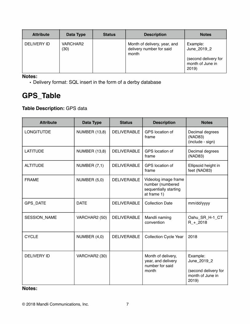
Attribute Data Type Status Description Notes
DELIVERY ID VARCHAR2 (30)
Month of delivery, year, anddelivery number for saidmonth
Example:June_2019_2
(second delivery for month of June in 2019)
Notes: • Delivery format: SQL insert in the form of a derby database
GPS_Table Table Description: GPS data
Attribute Data Type Status Description Notes
LONGITUTDE NUMBER (13,8) DELIVERABLE GPS location of frame
Decimal degrees (NAD83) (include - sign)
LATITUDE NUMBER (13,8) DELIVERABLE GPS location of frame
Decimal degrees (NAD83)
ALTITUDE NUMBER (7,1) DELIVERABLE GPS location of frame
Ellipsoid height infeet (NAD83)
FRAME NUMBER (5,0) DELIVERABLE Videolog image framenumber (numberedsequentially startingat frame 1)
GPS_DATE DATE DELIVERABLE Collection Date mm/dd/yyyy
SESSION_NAME VARCHAR2 (50) DELIVERABLE Mandli namingconvention
Oahu_SR_H-1_CT R_+_2018
CYCLE NUMBER (4,0) DELIVERABLE Collection Cycle Year 2018
DELIVERY ID VARCHAR2 (30) Month of delivery,year, and delivery number for said month
Example:June_2019_2
(second delivery for month of June in 2019)
Notes:
© 2018 Mandli Communications, Inc. 7!

• Delivery format: SQL insert in the form of a derby database
© 2018 Mandli Communications, Inc. 8!
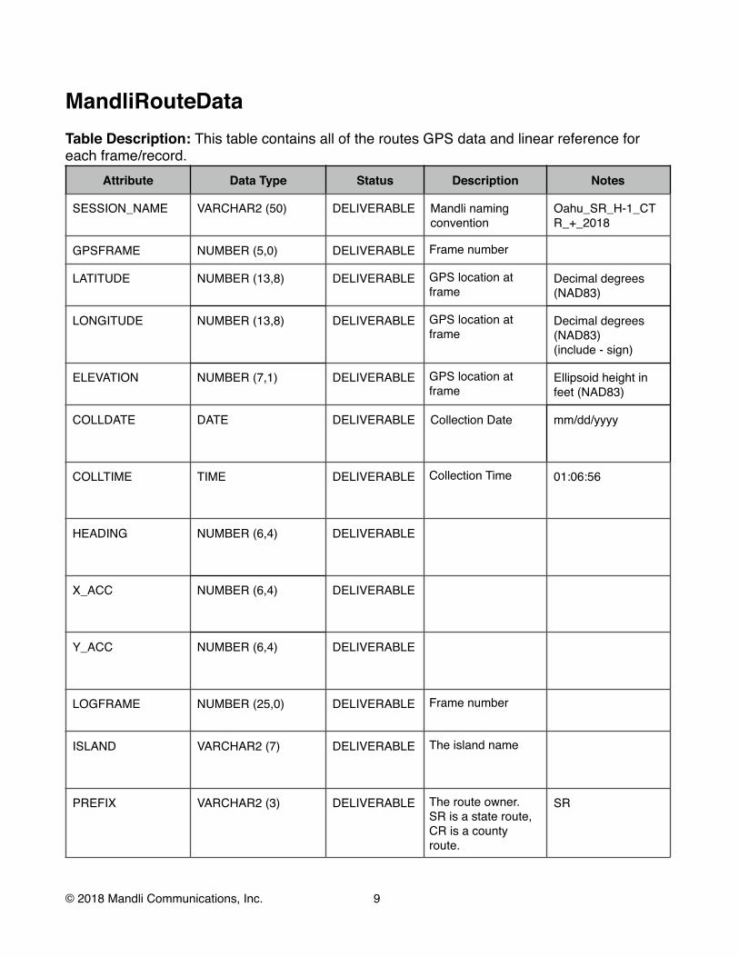
MandliRouteData Table Description: This table contains all of the routes GPS data and linear reference for each frame/record.
Attribute Data Type Status Description Notes
SESSION_NAME VARCHAR2 (50) DELIVERABLE Mandli namingconvention
Oahu_SR_H-1_CT R_+_2018
GPSFRAME NUMBER (5,0) DELIVERABLE Frame number
LATITUDE NUMBER (13,8) DELIVERABLE GPS location at frame
Decimal degrees (NAD83)
LONGITUDE NUMBER (13,8) DELIVERABLE GPS location at frame
Decimal degrees (NAD83) (include - sign)
ELEVATION NUMBER (7,1) DELIVERABLE GPS location at frame
Ellipsoid height infeet (NAD83)
COLLDATE DATE DELIVERABLE Collection Date mm/dd/yyyy
COLLTIME TIME DELIVERABLE Collection Time 01:06:56
HEADING NUMBER (6,4) DELIVERABLE
X_ACC NUMBER (6,4) DELIVERABLE
Y_ACC NUMBER (6,4) DELIVERABLE
LOGFRAME NUMBER (25,0) DELIVERABLE Frame number
ISLAND VARCHAR2 (7) DELIVERABLE The island name
PREFIX VARCHAR2 (3) DELIVERABLE The route owner. SR is a state route, CR is a county route.
SR
© 2018 Mandli Communications, Inc. 9!

Attribute Data Type Status Description Notes
ROUTE VARCHAR2 (20) PROVIDED The route number H-1
LANE_ID VARCHAR2 (3) DELIVERABLE The lane that is traveled. CTR is the lane closest to the median. SIN is the lane closest to the shoulder
i.e. CTR, SIN, CON, etc.
RTEMILE NUMBER (8,5) DELIVERABLE Measured distance at start of interval
miles
SIGN VARCHAR2 (3) DELIVERABLE The direction traveled.
+MP/-MP
LOGDATE DATE DELIVERABLE Collection Date mm/dd/yyyy
PICS NUMBER (3) DELIVERABLE The picture interval(frames per mile)
500
UNITS VARCHAR2 (4) DELIVERABLE The measurement unit used for the Milepost
Mile
TAG VARCHAR2 (20) DELIVERABLE The description ofthe event that is being recorded
“Started Odometer”
STATUS VARCHAR2 (20) DELIVERABLE Related to measured log mile
i.e. “Counting”,“Hold”
DELIVERY ID VARCHAR2 (30) Month of delivery,year, and delivery number for said month
Example:June_2019_2
(second delivery for month of June in 2019)
Notes: • Delivery format: SQL insert in the form of a derby database
© 2018 Mandli Communications, Inc. !10

CurveTable Table Description: Road curvature data.
Attribute Data Type Status Description Notes
GUID VARCHAR2 (50)
DELIVERABLE Concat Island, Prefix, route, lane id, direction, BMP, and EMP. Separated by underscores.
ISLAND VARCHAR2 (7) PROVIDED The island name
PREFIX VARCHAR2 (3) PROVIDED The route owner. SR is a state route, CR is a county route.
SR
ROUTE VARCHAR2 (20)
PROVIDED The route number H-1
LANE_ID VARCHAR2 (3) PROVIDED The lane that is traveled. CTR is the lane closest to the median. SIN is the lane closest to the shoulder
i.e. CTR, SIN, CON, etc
DIRECTION VARCHAR2 (3) DELIVERABLE The direction traveled.
+MP/-MP
SURVEYED DATE\TIME DELIVERABLE Date collected mm/dd/yyyy
BMP NUMBER (8,5) DELIVERABLE Linear Reference at Point of Curve
miles
EMP NUMBER (8,5) DELIVERABLE Linear Reference at Point of Tangent
miles
LENGTH NUMBER (8,5) DELIVERABLE Measured distance along curve
miles
CURVATURE NUMBER (5,2) DELIVERABLE Central Angle degrees
RADIUS NUMBER (8,2) DELIVERABLE Curve Radius feet
CURVECLASS VARCHAR2 (1) DELIVERABLE HPMS Curve Class [A, B, C, D, E, F]
B_LAT NUMBER (13,8) DELIVERABLE GPS Reference at Point of Curve
NAD83
E_LAT NUMBER (13,8) DELIVERABLE GPS Reference at Point of Curve
NAD83
© 2018 Mandli Communications, Inc. 11!

Attribute Data Type Status Description Notes
B_LON NUMBER (13,8) DELIVERABLE GPS Reference at Point of Curve
NAD83
E_LON NUMBER (13,8) DELIVERABLE GPS Reference at Point of Curve
NAD83
B_ELE NUMBER (7,1) DELIVERABLE GPS Reference at Point of Curve
NAD83
E_ELE NUMBER (7,1) DELIVERABLE GPS Reference at Point of Curve
NAD83
SOURCE VARCHAR (15) DELIVERABLE Collection cycle Always MS2018
LRM_NAME TEXT (10) PROVIDED Always CDS
DELIVERY ID VARCHAR2 (30)
Month of delivery,year, and delivery number for said month
Example:June_2019_2
(second delivery for month of June in 2019)
Notes: • Delivery format: SQL insert in the form of a derby database • Summary fields: `Starting Distance` - `Ending Distance`
• Summary breaks occur at natural curve breakpoints • Calculated based on road driven
• Coordinate System:• NAD83
© 2018 Mandli Communications, Inc. !12

GradeTable Table Description: Road grade data.
Attribute Data Type Status Description Notes
GUID VARCHAR2 (50)
DELIVERABLE Concat Island, Prefix, route, lane id, direction, BMP, and EMP. Separated by underscores.
ISALND VARCHAR2 (7) DELIVERABLE The island name
PREFIX VARCHAR2 (3) DELIVERABLE The route owner. SR is a state route, CR is a county route.
SR
ROUTE VARCHAR2 (20)
PROVIDED The route number H-1
LANE_ID VARCHAR2 (3) PROVIDED The lane that is traveled. CTR is the lane closest to the median. SIN is the lane closest to the shoulder
i.e. CTR, SIN, CON, etc
DIRECTION VARCHAR2 (3) DELIVERABLE The direction traveled.
+MP/-MP
SURVEYED DATE\TIME DELIVERABLE Date collected mm/dd/yyyy
BMP NUMBER (8,5) DELIVERABLE Linear Reference at Start of Grade Breakpoint
miles
EMP NUMBER (8,5) DELIVERABLE Linear Reference at Stop of GradeBreakpoint
miles
LENGTH NUMBER (8,5) DELIVERABLE Measured distance along grade segment
miles
GRADE NUMBER (5,2) DELIVERABLE Slope percent grade
GRADECLASS VARCHAR2 (1) DELIVERABLE HPMS Grade Class [A, B, C, D, E, F]
B_LAT NUMBER (13,8) DELIVERABLE GPS Reference at Point of Grade
NAD83
E_LAT NUMBER (13,8) DELIVERABLE GPS Reference at Point of Grade
NAD83
© 2018 Mandli Communications, Inc. !13

Attribute Data Type Status Description Notes
B_LON NUMBER (13,8) DELIVERABLE GPS Reference at Point of Grade
NAD83
E_LON NUMBER (13,8) DELIVERABLE GPS Reference at Point of Grade
NAD83
B_ELE NUMBER (7,1) DELIVERABLE GPS Reference at Point of Grade
NAD83
E_ELE NUMBER (7,1) DELIVERABLE GPS Reference at Point of Grade
NAD83
SOURCE VARCHAR2 (15)
DELIVERABLE Collection cycle Always MS2018
LRM_NAME VARCHAR2 (10)
PROVIDED Always CDS
DELIVERY ID VARCHAR2 (30)
Month of delivery,year, and delivery number for said month
Example:June_2019_2
(second delivery for month of June in 2019)
Notes: • Delivery format: SQL insert in the form of a derby database • Summary fields: `Starting Distance` - `Ending Distance`
• Summary breaks occur at natural grade breakpoints • Calculated based on road driven
• Coordinate System:• NAD83
© 2018 Mandli Communications, Inc. !14

Distress Table Table Description: Contains the IRI, rutting, faulting cross slope data, asphalt distress, andconcrete distress for every 0.01 miles of roadway.
Attribute Data Type Status Description Notes
GUID VARCHAR2 (50)
DELIVERABLE Concat Island, Prefix, route, lane id, direction, BMP, and EMP. Separated by underscores.
ISLAND VARCHAR2 (7) DELIVERABLE The island name
PREFIX VARCHAR2 (3) DELIVERABLE The route owner. SR is a state route, CR is a county route.
SR
ROUTE VARCHAR2 (20)
PROVIDED The route number H-1
LANE_ID VARCHAR2 (3) DELIVERABLE The lane that is traveled.
i.e. CTR, SIN, CON, etc.
DIRECTION VARCHAR2 (3) DELIVERABLE The direction traveled.
+MP/-MP
SURVEYED DATE\TIME DELIVERABLE Date collected mm/dd/yyyy
PAVETYPE VARCHAR2 (10)
DELIVERABLE Pavement type:• Concrete • Asphalt • Gravel
BMP NUMBER (8,5) DELIVERABLE Linear Reference at Start of interval
miles
EMP NUMBER (8,5) DELIVERABLE Linear Reference at Stop of interval
miles
IRI_LT NUMBER (3,0) DELIVERABLE Left wheel path IRI in/mile
IRI_RT NUMBER (3,0) DELIVERABLE Right wheel path IRI in/mile
© 2018 Mandli Communications, Inc. !15

Attribute Data Type Status Description Notes
RUT1 NUMBER (8,1) DELIVERABLE Area of rutting fallingbetween depths of 6to 13 mm
square feet
RUT2 NUMBER (8,1) DELIVERABLE Area of rutting fallingbetween depths of13 to 25 mm
square feet
RUT3 NUMBER (8,1) DELIVERABLE Area of rutting fallingabove 25 mm
square feet
RUT_LT NUMBER (4,2) DELIVERABLE Average left wheelpath rutting depth
Inches
RUT_RT NUMBER (4,2) DELIVERABLE Right wheel pathrutting
Inches
RUT_DL NUMBER (4,2) DELIVERABLE Average of Right andLeft rutting values
Inches
FAULT_AVG NUMBER (4,2) DELIVERABLE Average fault heightfor HPMS reporting
Inches
FAULTS1 NUMBER (3,0) DELIVERABLE Count of Distress Count of Low severity Faults
FAULTS2 NUMBER (3,0) DELIVERABLE Count of Distress Count of Medium severity Faults
FAULTS3 NUMBER (3,0) DELIVERABLE Count of Distress Count of Highseverity Faults
SPEED NUMBER (2,0) DELIVERABLE Speed of vehicle atsummary section start
mph
BRIDGEFLAG NUMBER (1,0) DELIVERABLE Section has a bridgefeature
0/1
CONST_FLAG NUMBER (1,0) DELIVERABLE Section has a construction feature
0/1
LNDEV_FLAG NUMBER (1,0) DELIVERABLE Section has a lane deviation feature
0/1
RR_FLAG NUMBER (1,0) DELIVERABLE Section has a railroad feature
0/1
SPDBP_FLAG NUMBER (1,0) DELIVERABLE Section has a speedbump feature
0/1
© 2018 Mandli Communications, Inc. !16

Attribute Data Type Status Description Notes
CF_AVG NUMBER (3,1) DELIVERABLE Average cross slope Percent Grade
CF_MAX NUMBER (3,1) DELIVERABLE Maximum cross slope
Percent Grade
LONGNWPS1 NUMBER (4,0) DELIVERABLE Length non-wheelpathlongitudinal crackseverity 1
Feet
LONGNWPS2 NUMBER (4,0) DELIVERABLE Length non-wheelpathlongitudinal crackseverity 2
Feet
LONGNWPS3 NUMBER (4,0) DELIVERABLE Length non-wheelpathlongitudinal crackseverity 3
Feet
FATS1 NUMBER (4,0) DELIVERABLE Area of Fatiguecrackingseverity 1
Square feet
FATS2 NUMBER (4,0) DELIVERABLE Area of Fatiguecrackingseverity 2
Square feet
FAST3 NUMBER (4,0) DELIVERABLE Area of Fatiguecrackingseverity 3
Square feet
ACPATS1 NUMBER (4,0) DELIVERABLE Area of Patch severity 1
Square feet
ACPATS2 NUMBER (4,0) DELIVERABLE Area of Patch severity 2
Square feet
ACPATS3 NUMBER (4,0) DELIVERABLE Area of Patch severity 3
Square feet
ACPATCTS1 NUMBER (3,0) DELIVERABLE Count of Patch severity 1
Count
ACPATCTS2 NUMBER (3,0) DELIVERABLE Count of Patch severity 2
Count
ACPATCTS3 NUMBER (3,0) DELIVERABLE Count of Patch severity 3
Count
© 2018 Mandli Communications, Inc. !17

Attribute Data Type Status Description Notes
EDGECRKS1 NUMBER (4,0) DELIVERABLE Length of Edgecracking severity 1
Feet
EDGECRKS2 NUMBER (4,0) DELIVERABLE Length of Edgecracking severity 2
Feet
EDGECRKS3 NUMBER (4,0) DELIVERABLE Length of Edgecracking severity 3
Feet
SHOVING NUMBER (5,0) DELIVERABLE Area of high severity Shoving
Square Feet
TRANLTHS1 NUMBER (4,0) DELIVERABLE Length of Transversecracks severity 1
Feet
TRANLTHS2 NUMBER (4,0) DELIVERABLE Length of Transverseracks severity 2
Feet
TRANLTHS3 NUMBER (4,0) DELIVERABLE Length of Transversecracks severity 3
Feet
TRANCTS1 NUMBER (3,0) DELIVERABLE Count Transverse cracks severity 1
Count
TRANCTS2 NUMBER (3,0) DELIVERABLE Count Transverse cracks severity 2
Count
TRANCTS3 NUMBER (3,0) DELIVERABLE Count Transverse cracks severity 3
Count
BLOCS1 NUMBER (5,0) DELIVERABLE Area of pavementaffected by Block cracking severity 1
Square feet
BLOCS2 NUMBER (5,0) DELIVERABLE Area of pavementaffected by Block cracking severity 2
Square feet
BLOCS3 NUMBER (5,0) DELIVERABLE Area of pavementaffected by Block cracking severity 3
Square feet
BLOCLTHS1 NUMBER (4,0) DELIVERABLE Length of Block cracking severity 1
Feet
BLOCLTHS2 NUMBER (4,0) DELIVERABLE Length of Block cracking severity 2
Feet
BLOCLTHS3 NUMBER (4,0) DELIVERABLE Length of Block cracking severity 3
Feet
© 2018 Mandli Communications, Inc. !18

Attribute Data Type Status Description Notes
RAVELING NUMBER (5,0) DELIVERABLE Area of Raveling or weathering severity 3
Square feet
BLEEDING NUMBER (5,0) DELIVERABLE Area of Bleedingseverity 3
Square feet
PHSM NUMBER (3,0) DELIVERABLE Count of small potholes
Count
PHMD NUMBER (3,0) DELIVERABLE Count of medium potholes
Count
PHLG NUMBER (3,0) DELIVERABLE Count of largepotholes
Count
SEALCRKS1 NUMBER (4,0) DELIVERABLE Length of SealedCracking severity 1
Feet
SEALCRKS2 NUMBER (4,0) DELIVERABLE Length of SealedCracking severity 2
Feet
SEALCRKS3 NUMBER (4,0) DELIVERABLE Length of SealedCracking severity 3
Feet
REFLECS1 NUMBER (3,0) DELIVERABLE Length of jointreflection cracking;Severity 1 transversecrack on asphaltoverlay
Feet
REFLECS2 NUMBER (3,0) DELIVERABLE Length of jointreflection cracking;Severity 2 transversecrack on asphaltoverlay
Feet
REFLECS3 NUMBER (3,0) DELIVERABLE Length of jointreflection cracking;Severity 3 transversecrack on asphaltoverlay
Feet
JOINTS NUMBER (3,0) DELIVERABLE Count of transverse joints
Count
JOINTSPACE NUMBER (3,0) DELIVERABLE Transverse jointspacing.
Feet
CBS1 NUMBER (3,0) DELIVERABLE Count of affected slabs with a severity 1 corner break
Count
© 2018 Mandli Communications, Inc. !19
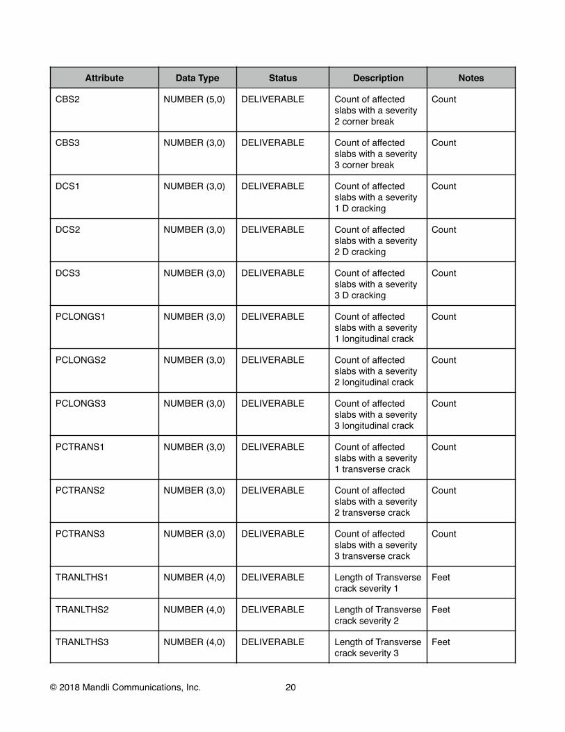
Attribute Data Type Status Description Notes
CBS2 NUMBER (5,0) DELIVERABLE Count of affected slabs with a severity 2 corner break
Count
CBS3 NUMBER (3,0) DELIVERABLE Count of affected slabs with a severity 3 corner break
Count
DCS1 NUMBER (3,0) DELIVERABLE Count of affected slabs with a severity 1 D cracking
Count
DCS2 NUMBER (3,0) DELIVERABLE Count of affected slabs with a severity 2 D cracking
Count
DCS3 NUMBER (3,0) DELIVERABLE Count of affected slabs with a severity 3 D cracking
Count
PCLONGS1 NUMBER (3,0) DELIVERABLE Count of affected slabs with a severity 1 longitudinal crack
Count
PCLONGS2 NUMBER (3,0) DELIVERABLE Count of affected slabs with a severity 2 longitudinal crack
Count
PCLONGS3 NUMBER (3,0) DELIVERABLE Count of affected slabs with a severity 3 longitudinal crack
Count
PCTRANS1 NUMBER (3,0) DELIVERABLE Count of affected slabs with a severity 1 transverse crack
Count
PCTRANS2 NUMBER (3,0) DELIVERABLE Count of affected slabs with a severity 2 transverse crack
Count
PCTRANS3 NUMBER (3,0) DELIVERABLE Count of affected slabs with a severity 3 transverse crack
Count
TRANLTHS1 NUMBER (4,0) DELIVERABLE Length of Transversecrack severity 1
Feet
TRANLTHS2 NUMBER (4,0) DELIVERABLE Length of Transversecrack severity 2
Feet
TRANLTHS3 NUMBER (4,0) DELIVERABLE Length of Transversecrack severity 3
Feet
© 2018 Mandli Communications, Inc. !20

Attribute Data Type Status Description Notes
JSPALLS1 NUMBER (3,0) DELIVERABLE Count of joints withconcrete joint spallseverity 1
Count
JSPALLS2 NUMBER (3,0) DELIVERABLE Count of joints withconcrete joint spallseverity 2
Count
JSPALLS3 NUMBER (3,0) DELIVERABLE Count of joints withconcrete joint spallseverity 3
Count
DIVSLABS1 NUMBER (3,0) DELIVERABLE Count of Divided Slabs Severity 1
Count
DIVSLABS2 NUMBER (6,0) DELIVERABLE Count of Divided Slabs Severity 2
Count
DIVSLABS3 NUMBER (3,0) DELIVERABLE Count of Divided Slabs Severity 3
Count
MAPCRKARS1 NUMBER (3,0) DELIVERABLE Count of slabs with Map CrackingSeverity 1
Count
MAPCRKARS2 NUMBER (3,0) DELIVERABLE Count of slabs with Map CrackingSeverity 2
Count
MAPCRKARS3 NUMBER (3,0) DELIVERABLE Count of slabs with Map CrackingSeverity 3
Count
POPOUTS NUMBER (3,0) DELIVERABLE Count of affected slabs with poppets
Count
BUCKLS1 NUMBER (3,0) DELIVERABLE Count of affected slabs with Bucklingor blowups Severity 1
Count
BUCKLS2 NUMBER (3,0) DELIVERABLE Count of affected slabs with Bucklingor blowups Severity 2
Count
BUCKLS3 NUMBER (3,0) DELIVERABLE Count of affected slabs with Bucklingor blowups Severity 3
Count
© 2018 Mandli Communications, Inc. !21
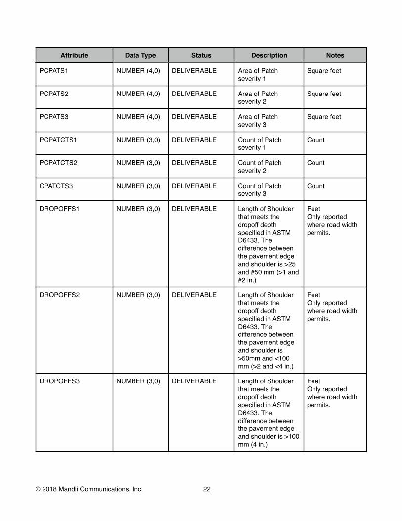
Attribute Data Type Status Description Notes
PCPATS1 NUMBER (4,0) DELIVERABLE Area of Patch severity 1
Square feet
PCPATS2 NUMBER (4,0) DELIVERABLE Area of Patch severity 2
Square feet
PCPATS3 NUMBER (4,0) DELIVERABLE Area of Patch severity 3
Square feet
PCPATCTS1 NUMBER (3,0) DELIVERABLE Count of Patch severity 1
Count
PCPATCTS2 NUMBER (3,0) DELIVERABLE Count of Patch severity 2
Count
CPATCTS3 NUMBER (3,0) DELIVERABLE Count of Patch severity 3
Count
DROPOFFS1 NUMBER (3,0) DELIVERABLE Length of Shoulder that meets the dropoff depthspecified in ASTM D6433. The difference between the pavement edgeand shoulder is >25 and #50 mm (>1 and#2 in.)
Feet Only reportedwhere road width permits.
DROPOFFS2 NUMBER (3,0) DELIVERABLE Length of Shoulder that meets the dropoff depthspecified in ASTM D6433. The difference between the pavement edgeand shoulder is >50mm and <100 mm (>2 and <4 in.)
Feet Only reportedwhere road width permits.
DROPOFFS3 NUMBER (3,0) DELIVERABLE Length of Shoulder that meets the dropoff depthspecified in ASTM D6433. The difference between the pavement edgeand shoulder is >100 mm (4 in.)
Feet Only reportedwhere road width permits.
© 2018 Mandli Communications, Inc. !22
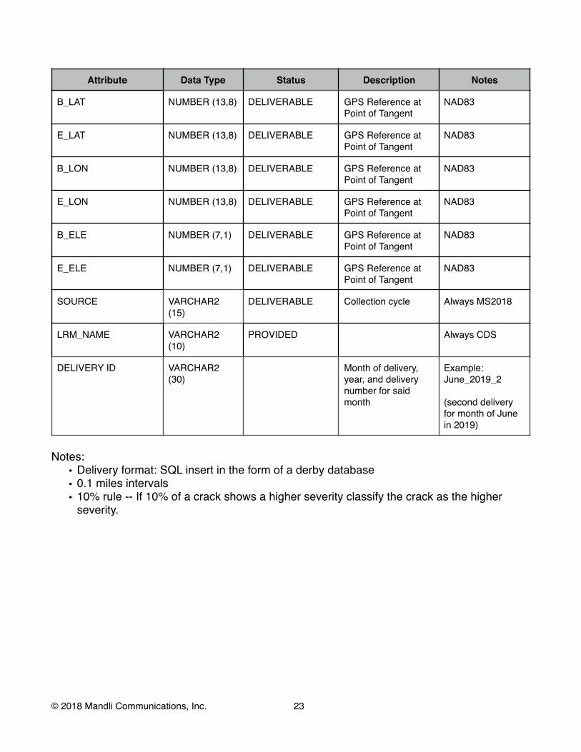
Attribute Data Type Status Description Notes
B_LAT NUMBER (13,8) DELIVERABLE GPS Reference at Point of Tangent
NAD83
E_LAT NUMBER (13,8) DELIVERABLE GPS Reference at Point of Tangent
NAD83
B_LON NUMBER (13,8) DELIVERABLE GPS Reference at Point of Tangent
NAD83
E_LON NUMBER (13,8) DELIVERABLE GPS Reference at Point of Tangent
NAD83
B_ELE NUMBER (7,1) DELIVERABLE GPS Reference at Point of Tangent
NAD83
E_ELE NUMBER (7,1) DELIVERABLE GPS Reference at Point of Tangent
NAD83
SOURCE VARCHAR2 (15)
DELIVERABLE Collection cycle Always MS2018
LRM_NAME VARCHAR2 (10)
PROVIDED Always CDS
DELIVERY ID VARCHAR2 (30)
Month of delivery,year, and delivery number for said month
Example:June_2019_2
(second delivery for month of June in 2019)
Notes: • Delivery format: SQL insert in the form of a derby database • 0.1 miles intervals • 10% rule -- If 10% of a crack shows a higher severity classify the crack as the higher
severity.
© 2018 Mandli Communications, Inc. !23

Road Feature Inventory Table Description: Line and polygon feature inventory table formatCommon Attributes: Common fields for the following line and polygon assets:
Attribute Data Type Status Description Notes
SESSION_NAME VARCHAR2 (50)
DELIVERABLE Mandli namingconvention
Oahu_SR_H-1_CT R_+_2016
BEG_FRAME NUMBER (5,0) DELIVERABLE Frame distance of section or asset start
END_FRAME NUMBER (5,0) DELIVERABLE Frame distance of section or asset start
ISLAND VARCHAR2 (7) DELIVERABLE The island name
PREFIX VARCHAR2 (3) DELIVERABLE The route owner. SR is a state route, CR is a county route.
SR
ROUTE VARCHAR2 (20)
PROVIDED The route number H-1
LANE_ID VARCHAR2 (3) DELIVERABLE The lane that is traveled.
i.e. CTR, SIN, CON, etc.
BMP NUMBER (8,5) DELIVERABLE Measured distance of section or asset begin
miles
EMP NUMBER (8,5) DELIVERABLE Measured distance of section or asset begin
miles
DIRECTION VARCHAR2 (3) DELIVERABLE Route direction -MP/+MP
SURVEYED DATE\TIME DELIVERABLE Collection Date MM/DD/YYYY
COMMENTS VARCHAR2 (50)
DELIVERABLE Rater comment on feature condition
Rater Comments
B_LAT NUMBER (13,8) DELIVERABLE GPS Location of section or asset start
Decimal degrees (NAD83)
B_LON NUMBER (13,8) DELIVERABLE GPS Location of section or asset start
Decimal degrees (NAD83) (include - sign)
© 2018 Mandli Communications, Inc. !24

Attribute Data Type Status Description Notes
B_ELE NUMBER (7,1) DELIVERABLE GPS Location of section or asset start
Ellipsoid height infeet (NAD83)
E_LAT NUMBER (13,8) DELIVERABLE GPS Location of section or asset end
Decimal degrees (NAD83)
E_LON NUMBER (13,8) DELIVERABLE GPS Location of section or asset end
Decimal degrees (NAD83) (include - sign)
E_ELE NUMBER (7,1) DELIVERABLE GPS Location of section or asset end
Ellipsoid height infeet (NAD83)
SOURCE VARCHAR2 (15)
DELIVERABLE Collection cycle Always MS2018
LRM_NAME VARCHAR2 (10)
PROVIDED Always CDS
DELIVERY ID VARCHAR2 (30)
Month of delivery,year, and delivery number for said month
Example:June_2019_2
(second delivery for month of June in 2019)
SDO GEOMETRY* ORACLE SPACIAL
Line or Polygon
Notes: • Assets will be extracted from the CTR lane only • *SDO Geometry will be provided in an appropriate format (i.e. GeoMedia, MDB table, etc) • Configuration of a Numetric Workbook.
Polygons Bridges and Culverts
Attribute Data Type Status Description Notes
BRIDGEID VARCHAR2 (7) DELIVERABLE Bridge deck ID
HPMS_CODE NUMBER (2,0) DELIVERABLE always 1
WIDTH NUMBER (3,0) DELIVERABLE Feet
© 2018 Mandli Communications, Inc. !25

SURF_TYPE VARCHAR2 (7) DELIVERABLE • Asphalt • Concrete • Steel • Wood • Other
CONDITION VARCHAR2 (4) DELIVERABLE Condition: • GOOD • FAIR • POOR
Derived from distress data
Notes: •
© 2018 Mandli Communications, Inc. !26

Lane Polygons Attribute Data Type Status Description Notes
LANE_TYPE VARCHAR2 (12) DELIVERABLE • Through Lane • Turn Right • Turn Left • Bike Lane • Accel Lane • Deccel Lane • HOV Lane • Climb Lane • Aux Lane • Parking Lane
(only whenpaint ispresent)
• Passing Lane • Peak Lane • Counter peak
Lane
LANE_MAT VARCHAR2 (8) DELIVERABLE • Asphalt • Concrete • Gravel • Other
LANE_WID NUMBER (4,1) DELIVERABLE Average width oflane polygon
Feet
LANE_LEN NUMBER (8,1) DELIVERABLE Length ofpolygon
Feet
LANE_AREA NUMBER (8,1) DELIVERABLE Area of polygon square feet
CONDITION VARCHAR2 (4) DELIVERABLE Condition: • GOOD • FAIR • POOR
Derived from distress data
Notes: •
© 2018 Mandli Communications, Inc. !27

Shoulder Polygons Attribute Data Type Status Description Notes
SHOULDER VARCHAR2 (14) DELIVERABLE • Left Shoulder • Right Shoulder
SHLDR_MAT VARCHAR2 (8) DELIVERABLE • Asphalt • Concrete • Gravel • Combination • None
SHLDR_WID NUMBER (4,1) DELIVERABLE Average width ofshoulder polygon
feet
SHLDR_LEN NUMBER (8,1) DELIVERABLE Length ofshoulder polygon
feet
SHLDR_AREA NUMBER (8,1) DELIVERABLE Area of shoulder polygon
square feet
HPMS_CODE NUMBER (2,0) DELIVERABLE • 2 • 3 • 5
• 2=Aphalt • 3=Concrete • 5=Combination
Notes: • Shoulder polygons will only be derived from paved shoulders. The other shoulder types
will be reported as polylines with SHLDR_MAT of none and zero for width and area. •
© 2018 Mandli Communications, Inc. !28

Medians Attribute Data Type Status Description Notes
MED_TYPE VARCHAR2 (20) DELIVERABLE • Curbed • Flexible • Rigid• Semi-rigid • Unprotected • No Median
LOCATION VARCHAR2 (5) DELIVERABLE Median location is always “Left"
WIDTH NUMBER (3,0) DELIVERABLE Median width in feet
HPMS_CODE NUMBER (2,0) DELIVERABLE • 1 • 2 • 3 • 4 • 5 • 6 • 7
• 1=No Median • 2=Unprotected • 2=Painted -
Passing • 2=Painted - No
Passing • 3=Curbed • 5=Flex • 6=Semi-rigid • 7=Rigid
PROTECTION VARCHAR2 (20) DELIVERABLE • Flexible • Semi-Rigid • Rigid• Unspecified
Notes: •
Tunnels Attribute Data Type Status Description Notes
HPMS_CODE NUMBER (2,0) DELIVERABLE always 2
Notes: •
Pavement Messages Attribute Data Type Status Description Notes
© 2018 Mandli Communications, Inc. !29

MESS_TYPE VARCHAR2(20) DELIVERABLE Message Type:• Right Turn
Arrow • Left Turn Arrow • Through Arrow • Stop Line • Yield Line • Text • Diagonal
Crosshatch Markings
• Chevron Crosshatch Markings
• Right Turn withThrough Arrows
• Left Turn with Through Arrows
• Left And RightTurn Arrows
• Left and RightTurn with Through Arrows
• Crosswalk • Line Extension • Bicycle • Shared Lane • Railroad
Crossing • Lane-
Reduction Arrow • Wrong Way
Arrow • HOV • Route Shield • Other • Unknown
Need Customer
Info
DESCRIPTION VARCHAR2(10) DELIVERABLE Pavement text description
DAMAGED VARCHAR2 (3) DELIVERABLE Yes or No
CONDITION VARCHAR2 (4) Condition: • GOOD • FAIR • POOR
Not filled out
by Mandli
© 2018 Mandli Communications, Inc. !30

INTENSITY VARCHAR2 (5) DELIVERABLE INTENSITY of the paintmarking:• Pass • Fail
Notes: •
Bus Pads Attribute Data Type Status Description Notes
DAMAGED VARCHAR2 (3) DELIVERABLE Yes or No
CONDITION VARCHAR2 (4) Condition: • GOOD • FAIR • POOR
Not filled out
by Mandli
Notes: •
Pull Box Attribute Data Type Status Description Notes
DAMAGED VARCHAR2 (3) DELIVERABLE Yes or No
CONDITION VARCHAR2 (4) Condition: • GOOD • FAIR • POOR
Not filled out by
Mandli
Notes: •
© 2018 Mandli Communications, Inc. !31

Polylines Guardrails and Jersey Barriers
Attribute Data Type Status Description Notes
TYPE VARCHAR2 (30) DELIVERABLE • Attenuators • Box Beam • Bridge Parapet • Cable Barrier • Constant Slope
Barrier • Jersey Barrier • Other • Thrie Beam • Unspecified • W-Beam
LOCATION VARCHAR2 (5) DELIVERABLE • Left • Right
HORZ_OFFST NUMBER (6,1) DELIVERABLE Average horizontaloffset of barrier
Feet
VERT_OFFST NUMBER (6,1) DELIVERABLE average verticaloffset from edge oftravel to barrier
Inches
POST_TYPE VARCHAR2 (20) DELIVERABLE Barrier post types:
• Steel • Wood • Concrete • Other
LENGTH NUMBER (4,0) DELIVERABLE Length of Guardrail Feet
DAMAGED VARCHAR2 (3) DELIVERABLE Yes or No
CONDITION VARCHAR2 (4) Condition: • GOOD • FAIR • POOR
Not filled out
by Mandli
Notes: •
© 2018 Mandli Communications, Inc. !32

Shoulder Polylines Attribute Data Type Status Description Notes
SHOULDER VARCHAR2 (14) DELIVERABLE • Left Shoulder • Right Shoulder
SHLDR_MAT VARCHAR2 (8) DELIVERABLE • Gravel • Earth • Curbed • Rigid• None
SHLDR_WID NUMBER (4,1) DELIVERABLE always zero feet
SHLDR_LEN NUMBER (8,1) DELIVERABLE Length ofshoulder polyline
feet
SHLDR_AREA NUMBER (8,1) DELIVERABLE always zero square feet
HPMS_CODE NUMBER (2,0) DELIVERABLE • 1 • 4 • 6 • 7
• 1=None • 4=Gravel • 6=Earth • 7=Curbed (No
Shoulder)
Notes: •
© 2018 Mandli Communications, Inc. !33

Paint Stripping Attribute Data Type Status Description Notes
LANE_MARK VARCHAR2 (50)
DELIVERABLE • White 12" Dashed Line, Single
• White 4" Dashed Line, Single • White 4" Solid Line, Lane
Separator • White 4" Solid Line, Single • White 6" Dashed Line, Single • White 6" Solid Line, Lane
Separator • White 6" Solid Line, Single • White 8" Dashed Line, Single • White 8" Solid Line, Lane
Separator • White 8" Solid Line, Single • Yellow 4" Dashed Line, Single • Yellow 4" Double Skip
Centerline • Yellow 4" Solid & Dashed
Lines, Double • Yellow 4" Solid Line, Single • Yellow 4" Solid Lines, Double • Yellow 6" Dashed Line, Single • Yellow 6" Solid & Dashed
Lines, Double • Yellow 6" Solid Line, Single • Yellow 6" Solid Lines, Double • Yellow 8" Dashed Line, Single • Yellow 8" Solid & Dashed
Lines, Double • Yellow 8" Solid Line, Single • Yellow 8" Solid Lines, Double • Parking Lane
INTENSITY VARCHAR2 (5) DELIVERABLE INTENSITY of the paint marking:• Pass • Fail
Notes: •
Rumble Strips Attribute Data Type Status Description Notes
© 2018 Mandli Communications, Inc. !34

TYPE VARCHAR2 (6) DELIVERABLE Type of rumblestrip:• Rolled • Milled
WITHPAINT VARCHAR2 (3) DELIVERABLE Rumble is located on the paint line:
• Yes • No
Notes: •
Raised Pavement Markers Attribute Data Type Status Description Notes
TYPE VARCHAR2 (5) DELIVERABLE • Nonreflective • Retroreflective
Notes: •
Delineators Attribute Data Type Status Description Notes
TYPE VARCHAR2 DELIVERABLE Type ofdelineator: • Ground-
Mounted Delineator
• Tubular Marker
LENGTH NUMBER (6,3) DELIVERABLE Length of roadwith delineators
Miles
HEIGHT NUMBER (6,1) DELIVERABLE average verticaloffset from edge oftravel to barrier
Inches
Notes: •
Curbs Attribute Data Type Status Description Notes
© 2018 Mandli Communications, Inc. !35

TYPE VARCHAR2 (15) DELIVERABLE Type of curb• Mountable • Non-Mountable • Gutter Only
REVEAL VARCHAR2 (10) DELIVERABLE Approximatedreveal of curb face: • 3 • 6 or more
Notes: •
ROW Barriers Attribute Data Type Status Description Notes
TYPE VARCHAR2 (30) DELIVERABLE Type of barrier:• Stock Fence • Chainlink
Fence • Concrete Cast-
In-Place Retaining Wall
• Rock RetainingWall
• SlopeProtection
• Soil Nail • Rock
Catchment Fencing
• Shotcrete • Gabion • Bin • Precast/MSE • Soldier Pile • Other Cast-In-
Place
LENGTH NUMBER (3,1) DELIVERABLE ROW Barrier length
Feet
HEIGHT NUMBER (3,1) DELIVERABLE Average heightof barrier from edge of travel
Feet
LOCATION VARCHAR2 (8) DELIVERABLE • Left • Right
Notes:
© 2018 Mandli Communications, Inc. !36

•
Sidewalks Attribute Data Type Status Description Notes
TYPE VARCHAR2 (10) DELIVERABLE Type ofsidewalk: • Asphalt • Concrete • Other
LENGTH NUMBER (5,0) DELIVERABLE Length ofsidewalk
Feet
Notes: •
Driveway Attribute Data Type Status Description Notes
TYPE VARCHAR DELIVERABLE • Residential • Commercial • Industrial/
Institutional • Other
WIDTH NUMBER (5,1) DELIVERABLE Width of driveway throat
Feet
SIDEWALK VARCHAR DELIVERABLE Yes or No
DAMAGED VARCHAR2 (3) DELIVERABLE Yes or No
Notes: •
Ditches Attribute Data Type Status Description Notes
TYPE VARCHAR DELIVERABLE • Paved • Unpaved • Other
LENGTH NUMBER (5,0) DELIVERABLE Length ofsidewalk
Feet
© 2018 Mandli Communications, Inc. !37

Notes: •
© 2018 Mandli Communications, Inc. ! 38

Points Table Description: Point feature inventory table formatCommon Attributes: Common fields for the following point assets:
Attribute Data Type Status Description Notes
ASSET_ID VARCHAR2 (30)
DELIVERABLE Mandli unique assetID
SESSION_NAME VARCHAR2 (50)
DELIVERABLE Mandli namingconvention
Oahu_SR_H-1_CT R_+_2016
FRAME NUMBER (5,0) DELIVERABLE Frame of asset
ISLAND VARCHAR2 (7) DELIVERABLE The island name
PREFIX VARCHAR2 (3) DELIVERABLE The route owner. SR is a state route, CR is a county route.
SR
ROUTE VARCHAR2 (20)
PROVIDED The route number H-1
LANE_ID VARCHAR2 (3) DELIVERABLE The lane that is traveled.
i.e. CTR, SIN, CON, etc.
MP NUMBER (8,5) DELIVERABLE Measured distance of asset
miles
DIRECTION VARCHAR2 (3) DELIVERABLE Route direction -MP/+MP
SURVEYED DATE\TIME DELIVERABLE Date collected MM/DD/YYYY
COMMENTS VARCHAR2 (50)
DELIVERABLE Rater comment on feature condition
Rater comments
LAT NUMBER (13,8) DELIVERABLE GPS Location of asset
Decimal degrees (NAD83)
LON NUMBER (13,8) DELIVERABLE GPS Location of asset
Decimal degrees (NAD83) (include - sign)
ELE NUMBER (7,1) DELIVERABLE GPS Location of asset
Ellipsoid height infeet (NAD83)
SOURCE VARCHAR2 (15)
DELIVERABLE Collection cycle Always MS2016
LRM_NAME VARCHAR2 (10)
PROVIDED Always CDS
© 2018 Mandli Communications, Inc. !39

Attribute Data Type Status Description Notes
DELIVERY ID VARCHAR2 (30)
Month of delivery,year, and delivery number for said month
Example:June_2019_2
(second delivery for month of June in 2019)
SDO GEOMETRY* ORACLE SPACIAL
Point
Notes: • Assets will be extracted from the CTR lane only • *SDO Geometry will be provided in an appropriate format (i.e. GeoMedia, MDB table, etc) • Configuration of a Numetric Workbook.
Sign Faces Attribute Data Type Status Description Notes
MUTCD VARCHAR2 (6) DELIVERABLE MUTCD code of sign face
R1-1
MUTCD_DES VARCHAR2 (255) DELIVERABLE MUTCD signdescription
Marker, STOP (Note any Variation)
LOCATION VARCHAR2 (8) DELIVERABLE Sign face location• Left • Right• Overhead
SIGN_TYPE VARCHAR2 (20) DELIVERABLE MUTCD group signface belongs to:-Regulatory-Warning-Guide -School
FACE_DIR VARCHAR2 (2) DELIVERABLE Facing Direction:• N • NE • E • SE • S • SW • W • NW
© 2018 Mandli Communications, Inc. !40

COLOR VARCHAR2 (8) DELIVERABLE Sign face color:• Yellow • White • Brown • Orange • Blue
FAC_COND VARCHAR2 (8) DELIVERABLE Sign FaceCondition: • GOOD • FAIR • POOR
INTENSITY VARCHAR2 (5) DELIVERABLE INTENSITY of the sign face:• Pass • Fail
LEGEND VARCHAR2 (255) DELIVERABLE Legend of sign textthat is not included in the MUTCD description
SIGN_HT NUMBER (4,0) DELIVERABLE Sign face height inches
SIGN_WD NUMBER (4,0) DELIVERABLE Sign face width inches
HORZ_OFFST NUMBER (6,1) DELIVERABLE Horizontal offset from edge of travelto sign
feet
VERT_OFFST NUMBER (6,1) DELIVERABLE Vertical offset from edge of travel tosign
feet
Notes: •
Sign Support Attribute Data Type Status Description Notes
© 2018 Mandli Communications, Inc. !41

TYPE VARCHAR2 (50) DELIVERABLE Sign Support Type• One Post - Metal • Two Post - Metal • 3+ Post - Metal • One Post - Wood • Two Post - Wood • 3+ Post Wood • Bridge/Overpass Mounted • Cantilever • Truss Bridge • Tube Bridge • Signal Pole • Utility Pole • Light Post/Luminaire • Span Wire • Other
SUPP_COND VARCHAR2 (4) DELIVERABLE Sign Support Condition:• GOOD • FAIR • POOR
Notes: •
© 2018 Mandli Communications, Inc. !42

Intersections Attribute Data Type Status Description Notes
INTER_TYPE VARCHAR2 (14) DELIVERABLE • At Grade • Stop Sign • Traffic Signal • Roundabout
LEGS NUMBER (2,0) DELIVERABLE Number of legs of theintersection
INTER_STR VARCHAR2 (50) DELIVERABLE Intersecting StreetName
COUNTS NUMBER (2,0) DELIVERABLE always 1
Notes: • Intersections will be divided into individual GeoMedia for each intersection type. •
Attenuators and End Treatments Attribute Data Type Status Description Notes
© 2018 Mandli Communications, Inc. !43

TYPE VARCHAR2 (100) DELIVERABLE Type = Cable Barrier • Brifen • Gibraltar • Mid-Span • No Type (Meets No
Classification) • Nu-Cable • Safence • Trinity CASS • Unidentifiable
(Damaged or Obstructed)
Type = W-Beam, Thrie Beam, Box Beam • Anchored Breakaway
Terminal • Barrier Transition • BEAT-SCCC • BEST • Buried • Eccentric Loader • ET-2000 • ET-Plus • Flared End Terminal • FLEAT 350 • FLEAT-MT • Mid-Span • Modified Eccentric
Loader • No Type (Meets No
Classification) • None • SKT 350 • Slotted Rail Terminal • SoftStop • Trend 350 Flared • Turned Down End • Unanchored End
Shoe • Unidentifiable
(Damaged or Obstructed)
• X-Lite • X-Tension
© 2018 Mandli Communications, Inc. !44

TYPE
(Continued)
VARCHAR2 (100) DELIVERABLE Type = Attenuators • Barrel Array • Barrier Transition • Brakemaster • Bullnose • CAT 350 • Compressor • G.R.E.A.T. • HEART • HEX-FOAM • Mid-Span • No Type (Meets No
Classification) • None • QuadGuard Elite • QuadGuard Narrow • QuadGuard Wide • QuadTrend • QUEST • REACT • TAU-II Narrow • TAU-II Wide • TRACC Narrow • TRACC Wide • TREND • Unidentifiable
(Damaged or Obstructed)
Type = Unspecified, Other • Mid-Span • None
LOCATION VARCHAR2 (5) DELIVERABLE • Left • Right
DAMAGED VARCHAR2 (3) DELIVERABLE Yes or No
CONDITION VARCHAR2 (4) DELIVERABLE Condition: • GOOD • FAIR • POOR
Will be left blank for customer use
BARRIER_ID VARCHAR2 (30) DELIVERABLE Mandli Asset ID from the parent barrier
Notes: •
© 2018 Mandli Communications, Inc. !45
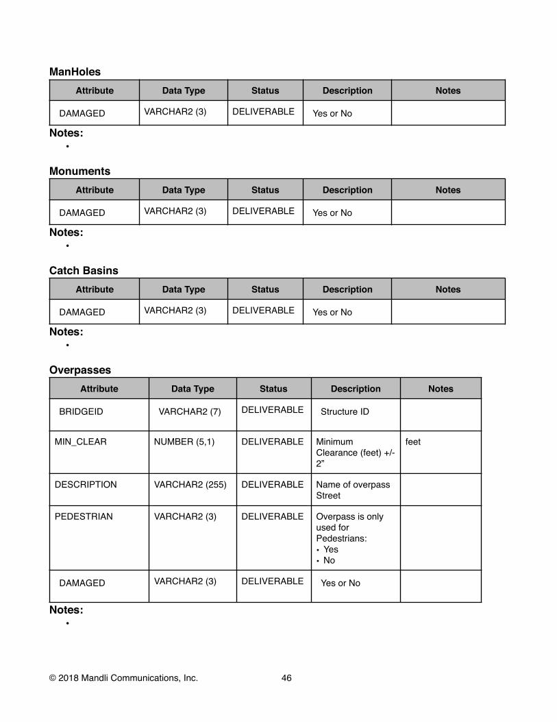
ManHoles Attribute Data Type Status Description Notes
DAMAGED VARCHAR2 (3) DELIVERABLE Yes or No
Notes: •
Monuments Attribute Data Type Status Description Notes
DAMAGED VARCHAR2 (3) DELIVERABLE Yes or No
Notes: •
Catch Basins Attribute Data Type Status Description Notes
DAMAGED VARCHAR2 (3) DELIVERABLE Yes or No
Notes: •
Overpasses Attribute Data Type Status Description Notes
BRIDGEID VARCHAR2 (7) DELIVERABLE Structure ID
MIN_CLEAR NUMBER (5,1) DELIVERABLE Minimum Clearance (feet) +/- 2”
feet
DESCRIPTION VARCHAR2 (255) DELIVERABLE Name of overpass Street
PEDESTRIAN VARCHAR2 (3) DELIVERABLE Overpass is only used for Pedestrians: • Yes • No
DAMAGED VARCHAR2 (3) DELIVERABLE Yes or No
Notes: •
© 2018 Mandli Communications, Inc. !46

Sign Bridge Vert Clearance Attribute Data Type Status Description Notes
BRIDGEID VARCHAR2 (7) DELIVERABLE Structure ID
MIN_CLEAR NUMBER (5,1) DELIVERABLE Minimum Clearance (feet) +/- 2”
feet
DESCRIPTION VARCHAR2 (255) DELIVERABLE Name of overpass Street
DAMAGED VARCHAR2 (3) DELIVERABLE Yes or No
Notes: •
ADA Ramps Attribute Data Type Status Description Notes
TYPE VARCHAR2 DELIVERABLE Type of curb ramp:• Side Flare • Parallel • Other • Missing
DETEC_WARN VARCHAR2 (3) DELIVERABLE Detectable warning:• Yes • No
DAMAGED VARCHAR2 (3) DELIVERABLE Yes or No
Notes:
Signal Poles (Signalized Intersection Only) Attribute Data Type Status Description Notes
© 2018 Mandli Communications, Inc. !47

POLE_TYPE VARCHAR2 DELIVERABLE Type of signal pole:• Double Mast Arm
Pole • Double Mast Arm
Pole with Luminary Extension
• Single Mast Arm Pole • Single Mast Arm Pole
with Luminary Extension
• Other
HEADS NUMBER DELIVERABLE Number of signal heads
DAMAGED VARCHAR2 (3) DELIVERABLE Yes or No
Notes: •
Signal Heads (Signalized Intersection Only) Attribute Data Type Status Description Notes
HEAD_TYPE VARCHAR2 DELIVERABLE Signal head type:• 1 SIGNAL SECTION • 2 SIGNAL SECTIONS • 3 SIGNAL SECTIONS • 4 SIGNAL SECTIONS • 5 SIGNAL SECTIONS • HAWK • Ped • School • Railroad • Other
DIRECTION VARCHAR2 (2) DELIVERABLE Facing Direction:• N • NE • E • SE • S • SW • W • NW
VISORS VARCHAR2 (3) DELIVERABLE Presents of visors: • Yes • No
© 2018 Mandli Communications, Inc. !48

Attribute Data Type Status Description Notes
BACKPLATE VARCHAR2 (3) DELIVERABLE Presents of backplate• Yes • No
DAMAGED VARCHAR2 (3) DELIVERABLE Yes or No
Notes: •
Signal Cabinets (Signalized Intersection Only) Attribute Data Type Status Description Notes
DAMAGED VARCHAR2 (3) DELIVERABLE Yes or No
Notes: •
Streetlight (Signalized Intersection Only) Attribute Data Type Status Description Notes
TYPE VARCHAR2 (8) DELIVERABLE Type ofStreetlights:• Roadway• Mast • Other
POLE_TYPE VARCHAR2 (8) DELIVERABLE Pole type:• Wood • Aluminum • Other
DAMAGED VARCHAR2 (3) DELIVERABLE Yes or No
Notes: •
© 2018 Mandli Communications, Inc. !49
Numetric Deliverables PFES-PFES Section Table
Table Description: Provided by HDOT and used to update the PFES system. Attribute Data Type Status Description Notes
SECTIONID VARCHAR2 (50) DELIVERABLE Concatenation of
Island, Route, Direction, and BMP
JOIN_NAME VARCHAR2 (50) DELIVERABLE Concatenation of Island, Route, and Direction
ISLANDS VARCHAR2 (10) PROVIDED The island name
ROUTE VARCHAR2 (50) PROVIDED Hawaii route name
DIRECTION VARCHAR2 (3) DELIVERABLE Route direction -MP/+MP
FUN_CLASS VARCHAR2 (50) PROVIDED Functional Classification
BMP DOUBLE (6,2) PROVIDED Section Begin Mile Point
EMP DOUBLE (6,2) PROVIDED Section End Mile Point
LENGTH DOUBLE (8,4) DELIVERABLE Section Length
NOTES
SURF_TYPE VARCHAR2 (50) PROVIDED Pavement Surface Type
LST_TRT_YR VARCHAR2 (5) PROVIDED Last Treatment Year
LST_TRT_TP VARCHAR2 (50) PROVIDED Last Treatment Type
URBAN_CODE VARCHAR2 (50) PROVIDED HPMS Urban Code
PFES-Mandli Condition Data
Table Description: Tenth mile Mandli condition report is organized into Hawaii provided PFES sections. The fields below are in addition to the condition fields in the Distress Table. The condition fields are summarized or average based on the mile points provided by HDOT.
Attribute Data Type Status Description Notes
SECTIONID VARCHAR2 (50)
DELIVERABLE Concatenation of Island, Route, Direction, and BMP
© 2018 Mandli Communications, Inc. !50
Attribute Data Type Status Description Notes
JOIN_NAME VARCHAR2 (50)
DELIVERABLE Concatenation of Island, Route, and Direction
ISLAND VARCHAR2 (10)
PROVIDED The island name
ROUTE VARCHAR2 (50)
PROVIDED Hawaii route name
ROAD_TYPE VARCHAR2 (50)
PROVIDED Hawaii road type
FUN_CLASS VARCHAR2 (50)
PROVIDED Functional Classification
SURF_TYPE VARCHAR2 (50)
PROVIDED Pavement Surface Type
LST_TRT_YR VARCHAR2 (5) PROVIDED Last Treatment Year
LST_TRT_TP VARCHAR2 (50)
PROVIDED Last Treatment Type
NOTES VARCHAR2 (50)
PROVIDED Hawaii Provided Notes
SEC_BMP DOUBLE (6,2) PROVIDED Section Begin Mile Point
SEC_EMP DOUBLE (6,2) PROVIDED Section End Mile Point
LENGTH DOUBLE (8,4) DELIVERABLE Section Length
SUM_LENGTH DOUBLE (8,4) DELIVERABLE Length of all lanes withinsection
CYCLE INT (4) DELIVERABLE Collection Cycle Year
Notes: • Table will be plotted over an LRS provided by Hawaii.
PFES-Mandli Surface Area Report
Table Description: Reported in 0.001 mile intervals Attribute Data Type Status Description Notes
SECTIONID VARCHAR2 (50) DELIVERABLE Concatenation of Island,
Route, Direction, and BMP
BMP DOUBLE (6,2) PROVIDED Section Begin Mile Point Miles
© 2018 Mandli Communications, Inc. !51

Attribute Data Type Status Description Notes
EMP DOUBLE (6,2) PROVIDED Section End Mile Point Miles
SECTIONPAVETYPE VARCHAR2 (50) PROVIDED Pavement type defined inthe PFES section
ASPHALTSA DOUBLE (10,2) DELIVERABLE Asphalt surface areawithin PFES section
Square Feet
CONCRETESA DOUBLE (10,2) DELIVERABLE Concrete surface area within PFES section
Square Feet
GRAVELSA DOUBLE (10,2) DELIVERABLE Gravel surface area within PFES section
Square Feet
COMBSA DOUBLE (10,2) DELIVERABLE Combination surface area within PFES section
Square Feet
PFES-Traffic Count Table
Table Description: HPMS traffic count data summarized by PFES section Attribute Data Type Status Description Notes
SECTIONID VARCHAR2 (50)
DELIVERABLE Concatenation of Island, Route, Direction, and BMP
BMP DOUBLE (6,2) PROVIDED Section Begin Mile Point Miles
EMP DOUBLE (6,2) PROVIDED Section End Mile Point Miles
avg_aadt INT DELIVERABLE Average of Average Annual
Daily Traffic reported in HPMS sections that fall within the PFES section
avg_aadt_combo
INT DELIVERABLE Average of Average AnnualDaily Traffic for combinationtracks reported in HPMS sections that fall within the PFES section
avg_aadt_single_unit
INT DELIVERABLE Average of Average AnnualDaily Traffic for single unittrucks and buses reported inHPMS sections that fall within the PFES section
max_aadt INT DELIVERABLE Maximum of Average Annual
Daily Traffic reported in HPMS sections that fall within the PFES section
© 2018 Mandli Communications, Inc. !52
Attribute Data Type Status Description Notes
max_aadt_combo
INT DELIVERABLE Maximum of Average AnnualDaily Traffic for combinationtracks reported in HPMS sections that fall within the PFES section
max_aadt_single_unit
INT DELIVERABLE Maximum of Average AnnualDaily Traffic for single unittrucks and buses reported inHPMS sections that fall within the PFES section
min_aadt INT DELIVERABLE Minimum of Average Annual
Daily Traffic reported in HPMS sections that fall within the PFES section
min_aadt_combo
INT DELIVERABLE Maximum of Average AnnualDaily Traffic for combinationtracks reported in HPMS sections that fall within the PFES section
min_aadt_single_unit
INT DELIVERABLE Maximum of Average AnnualDaily Traffic for single unittrucks and buses reported inHPMS sections that fall within the PFES section
© 2018 Mandli Communications, Inc. !53

Appendix A: Distress Data Source Table Description: All distress types and the data source (automatic or manual).
Distress Type Pavement Type Source Reporting
TRANSVERSE ASPHALT Automated Count/Length
ALLIGATOR ASPHALT Automated Area
BLOCK ASPHALT Automated Length/Area
LONGITUDINAL NWP CRACKING ASPHALT Automated Length
SEALED CRACKING ASPHALT Automated Length
POTHOLES ASPHALT Automated Count
JOINT REFLECTION CRACKING ASPHALT Manual Count
RAVELING ASPHALT Automated Area
BLEEDING ASPHALT Automated Area
EDGE CRACKING ASPHALT Manual Length
SHOVING ASPHALT Manual Length
PATCHING ASPHALT/CONCRETE Manual Area/Count
CORNER BREAK CONCRETE Manual Slab Count
DURABILITY CRACKING CONCRETE Manual Slab Count
LONGITUDINAL CONCRETE Manual Slab Count/Length
TRANSVERSE CONCRETE Manual Slab Count/Length
TRANSVERSE JOINT CONCRETE Automated/Manual Count
JOINT SPALLING CONCRETE Manual Slab Count
MAP CRACKING CONCRETE Manual Slab Count
DIVIDED SLAB CONCRETE Manual Slab Count
POPOUTS CONCRETE Manual Slab Count
BUCKLING CONCRETE Manual Slab Count
© 2018 Mandli Communications, Inc. !54

Geodatabase Documentation
Date: Wednesday, October 17, 2018 Time: 9:58:21 AM
Summary Information and Links
0 Feature Datasets and 81 Feature Classes No Topology Datasets No Geometric Networks No Rasters 18 Tables (Object Classes) No Relationship Classes 155 Domains
Feature Datasets and Child Classes
Rasters
Workspace-Level Tables and Feature Classes
LRS_Centerline_Sequence - Table Lrs_Edit_Log - Table Lrs_Event_Behavior - Table Lrs_Locks - Table Lrs_Metadata - Table LRS_Route - Table LRS_Calibration_Point - Feature Class LRS_Centerline - Feature Class LRS_Redline - Feature Class LRSE_ACCESSCONTROL - Feature Class LRSE_ADJACENTCITYNUMBER - Feature Class LRSE_ADJACENTCOUNTYNUMBER - Feature Class LRSE_CITYNUMBER - Feature Class LRSE_COMMERCIALNETWORK - Feature Class LRSE_CONSTRUCTIONHISTORY - Feature Class LRSE_COSTGROUP - Feature Class LRSE_COUNTYNUMBER - Feature Class LRSE_DOMAINCODE - Feature Class LRSE_EXPANSIONFACTOR - Feature Class LRSE_FACILITYTYPE - Feature Class LRSE_FEDFUNCTIONALCLASS - Feature Class LRSE_HANDT - Feature Class LRSE_HIGHWAYRESPONSIBILITY - Feature Class LRSE_HPMSSAMPLESECTIONS - Feature Class LRSE_ICECORRIDORS - Feature Class LRSE_INSTITUTIONALNUMBER - Feature Class LRSE_LANETYPE - Feature Class LRSE_LEFTSHOULDERCURBED - Feature Class LRSE_LEFTSHOULDERRUMBLE - Feature Class LRSE_LEFTSHOULDERTIED - Feature Class LRSE_LEFTSHOULDERTYPE - Feature Class LRSE_LEFTSHOULDERWIDTH - Feature Class LRSE_MAINTENANCECONTRACT - Feature Class LRSE_MAINTENANCECOSTCENTER - Feature Class LRSE_MAINTENANCEDISTRICT - Feature Class LRSE_MAINTENANCESERVICELVL - Feature Class
PRAMS.pdf[1/10/2020 3:10:13 PM]

LRSE_MANAGEMENTSECTIONS - Feature Class LRSE_MEDIANTYPE - Feature Class LRSE_MEDIANWIDTH - Feature Class LRSE_MINIMUM_SPEEDLIMIT - Feature Class LRSE_NATIONALHIGHWAYSYSTEM - Feature Class LRSE_NUMBERLANES - Feature Class LRSE_PARKINGTYPE - Feature Class LRSE_PLANNINGCLASS - Feature Class LRSE_PROJECT_SCOPING - Feature Class LRSE_REFERENCEPOSTS - Feature Class LRSE_RIGHTSHOULDERCURBED - Feature Class LRSE_RIGHTSHOULDERRUMBLE - Feature Class LRSE_RIGHTSHOULDERTIED - Feature Class LRSE_RIGHTSHOULDERTYPE - Feature Class LRSE_RIGHTSHOULDERWIDTH - Feature Class LRSE_ROADFUNCTION - Feature Class LRSE_ROADOWNERSHIP - Feature Class LRSE_ROADSTATUS - Feature Class LRSE_ROADSYSTEM - Feature Class LRSE_ROUTEDOMINANCE - Feature Class LRSE_ROUTEQUALIFIER - Feature Class LRSE_ROUTESCOUNTYSIGNED - Feature Class LRSE_ROUTESIGNING - Feature Class LRSE_ROUTESINSTITUTIONAL - Feature Class LRSE_ROUTESMUNICIPALE911 - Feature Class LRSE_ROUTESRAMP - Feature Class LRSE_ROUTESSECONDARYE911 - Feature Class LRSE_ROUTESSTATESIGNED - Feature Class LRSE_RRCROSSINGS - Feature Class LRSE_SPECIALSYSTEM - Feature Class LRSE_SPEEDLIMIT - Feature Class LRSE_STATEFREIGHTNETWORK - Feature Class LRSE_STRATEGICHIGHWAY - Feature Class LRSE_STRUCTURECONTROL - Feature Class LRSE_STRUCTUREONANDUNDER - Feature Class LRSE_SURFACETYPE - Feature Class LRSE_SURFACEWIDTH - Feature Class LRSE_TERRAIN - Feature Class LRSE_THROUGHLANES - Feature Class LRSE_TIM_ALT_ROUTES - Feature Class LRSE_TIM_CLOSURE - Feature Class LRSE_TOLLROAD - Feature Class LRSE_TRAFFIC - Feature Class LRSE_TRAFFICATRLOCATION - Feature Class LRSE_TRUCKROUTE - Feature Class LRSE_TYPEAREA - Feature Class LRSE_TYPEDEVELOPMENT - Feature Class LRSE_URBANAREACODE - Feature Class LRSE_URBANLOCATION - Feature Class LRSE_WIDENINGPOTENTIAL - Feature Class LRSN_IOWA_LRS_NETWORK - Feature Class
Relationship Classes
Domains
ACCESS_CONTROL_ID
PRAMS.pdf[1/10/2020 3:10:13 PM]

AGGREGATE_CLASS_ID AGGREGATE_TYPE_ID AT_GRADE_CROSSING_ID BASE_TYPE_ID CITY_NUMBER_ID COMMERCIAL_NETWORK_ID COST_GROUP_ID COUNTY_NUMBER_ID CURBED_ID CURVE_SPEED_ADVISORY_ID dActivityType DIRECTION_ID dLRSNetworks DOMAIN_CODE_ID dReferentMethod FACILITY_TYPE_ID FED_FUNCTIONAL_CLASS_ID GEOGRAPHIC_IDENTIFIER_ID GEOGRAPHIC_IDENTIFIER_LU H_AND_T_ID HIGHWAY_RESPONSIBILITY_ID ICE_CORRIDOR_ID INSTITUTION_NUMBER_ID LANE_POSITION_ID LANE_TYPE_ID MAINTENANCE_CONTRACT_ID MAINTENANCE_COST_CENTER_ID MAINTENANCE_DISTRICT_ID MAINTENANCE_GARAGE_ID MAINTENANCE_RESIDENCY_ID MAINTENANCE_SERVICE_LV_ID MEASUREMENT_METHODS_ID MEDIAN_BARRIER_TYPE_ID MEDIAN_TYPE_ID NATIONAL_HIGHWAY_SYSTEM_ID NUMBER_LANES_ID OWNER_CODE_ID PARKING_TYPE_ID PASSING_RESTRICTION_ID PAVEMENT_MATERIAL_ID PLANNING_CLASS_ID PROJECT_WORK_TYPE_ID RAMP_SEQUENCE_ID REMOVAL_TYPE_ID ROAD_FUNCTION_ID ROAD_STATUS_ID ROAD_SYSTEM_ID ROADWAY_ENTRANCE_ID ROUTE_DIRECTION_LU ROUTE_QUALIFIER_ID ROUTE_SIGNING_ID RR_AAR_CODE_ID RR_AWHORNCHK_ID RR_BRANCH_ID RR_CANTI_FLASH_TYPE_ID RR_CHANGE_REASON_LU RR_CHANNEL_ID RR_COMMPOWER_ID RR_CROSSING_CODE_ID RR_CROSSING_SURFACE_ID RR_DEVELTYPEID_ID RR_DIVISION_ID
PRAMS.pdf[1/10/2020 3:10:13 PM]

RR_DOWNST_ID RR_EMONITORDVCE_ID RR_EMRGNCYSRVC_ID RR_ENSSIGN_ID RR_EXEMPT_ID RR_GATECONF_ID RR_GATECONFTYPE_ID RR_HEALTHMONITOR_ID RR_HWTRFPSIG_ID RR_HWYCLASSCD_ID RR_HWYCLASSRDTPID_ID RR_HWYNEAR_ID RR_HWYNRSIG_ID RR_HWYPVED_ID RR_HWYSPEEDPS_ID RR_HWYSYS_ID RR_HWYTRAFSIGNL_ID RR_ILLUMINA_ID RR_INTRPRMP_ID RR_LLSOURCE_ID RR_LOW_GRND_ID RR_LT1MOV_ID RR_LT1PASSMOV_ID RR_MAST_BACKLIGHT_ID RR_MAST_FLASH_TYPE_ID RR_MAST_SIDELIGHT_ID RR_MONITOR_DEVICE_ID RR_NEAR_CITY_ID RR_NOSIGNS_ID RR_OPENPUB_ID RR_OTHSGN_ID RR_PAVEMENT_MARKINGS_ID RR_PED_SIDEWALK_ID RR_POSXING_ID RR_POSXING_LU RR_PREMPTYPE_ID RR_PRVXSIGN_ID RR_SAME_TRACKS_ID RR_SCHLBUSCHK_ID RR_SEPARATE_TRACKS_ID RR_SGNLEQP_ID RR_SPECPRO_ID RR_SPSELIDS_ID RR_STATUS_ID RR_STATUS_LU RR_STHWY1_ID RR_SUB_DIVISION_ID RR_TRAFLNTYPE_ID RR_TYPETRNSRVCIDS_ID RR_TYPEXING_ID RR_TYPEXING_LU RR_WHISTBAN_ID RR_XANGLE_ID RR_XINGADJ_ID RR_XPURPOSE_ID RUMBLE_TYPE_ID SHOULDER_TIED_ID SHOULDER_TYPE_ID SPECIAL_SYSTEM_ID SPEED_LIMIT_ID STATE_FREIGHT_NETWORK_ID STOP_RESTRICTION_ID
PRAMS.pdf[1/10/2020 3:10:13 PM]

STRATEGIC_HWY_NETWORK_ID STRUC_HIST_SIG_ID STRUC_KIND_CROSS_ID STRUC_MAINT_DESC_ID STRUC_NBIA_ITEM_ID STRUC_STATUS_ID STRUC_TWIN_DIVIDED_ID STRUC_TYPE_RECORD_ID STRUC_VERT_REF_FEA_ID STRUCTURE_CODE_ID SURFACE_TREATMENT_ID SURFACE_TYPE_ID SYSTEM_CODE_ID SYSTEM_CODE_LU TERRAIN_ID TIM_ALT_TYPE_ID TIM_DIVERSION_TYPE_ID TOLL_AUTHORITY_ID TOLL_CHARGED_ID TOLL_STATUS_ID TOLL_TYPE_ID TRANSPORTATION_DISTRICT_ID TRAVEL_DIRECTION_ID TRUCK_ROUTE_ID TYPE_AREA_ID TYPE_DEVELOPMENT_ID URBAN_AREA_CODE_ID URBAN_LOCATION_ID WIDENING_POTENTIAL_ID YES_NO_ID
LRS_Calibration_Point - FeatureClass
Name LRS_Calibration_Point ShapeType Point FeatureType Simple AliasName RAMS.LRS_Calibration_Point HasM false HasZ false HasAttachments false
Description LRS_Calibration_Point
Field DataType Length AliasName Description Domain DefaultValue IsNullable Precision Scale EFFECTIVE_START_DATE Date 8 EFFECTIVE_START_DATE EFFECTIVE_START_DATE true EFFECTIVE_END_DATE Date 8 EFFECTIVE_END_DATE EFFECTIVE_END_DATE true NETWORK_ID SmallInteger 2 NETWORK_ID NETWORK_ID dLRSNetworks true 5 0 ROUTE_ID String 15 ROUTE_ID ROUTE_ID true MEASURE Double 8 MEASURE MEASURE true 38 8 SYSTEM_CREATE_DATE Date 8 SYSTEM_CREATE_DATE SYSTEM_CREATE_DATE true SYSTEM_MOD_DATE Date 8 SYSTEM_MOD_DATE SYSTEM_MOD_DATE true USER_CREATE String 100 USER_CREATE USER_CREATE true USER_MOD String 100 USER_MOD USER_MOD true
LRS_Centerline - FeatureClass
PRAMS.pdf[1/10/2020 3:10:13 PM]

Name LRS_Centerline ShapeType Polyline FeatureType Simple AliasName RAMS.LRS_Centerline HasM false HasZ true HasAttachments false
Description LRS_Centerline
Field DataType Length AliasName Description Domain DefaultValue IsNullable Precision Scale EFFECTIVE_START_DATE Date 8 EFFECTIVE_START_DATE EFFECTIVE_START_DATE true EFFECTIVE_END_DATE Date 8 EFFECTIVE_END_DATE EFFECTIVE_END_DATE true ROADWAYIDGUID GUID 38 ROADWAYIDGUID ROADWAYIDGUID true SYSTEM_CREATE_DATE Date 8 SYSTEM_CREATE_DATE SYSTEM_CREATE_DATE true SYSTEM_MOD_DATE Date 8 SYSTEM_MOD_DATE SYSTEM_MOD_DATE true USER_CREATE String 100 USER_CREATE USER_CREATE true USER_MOD String 100 USER_MOD USER_MOD true
LRS_Redline - FeatureClass
Name LRS_Redline ShapeType Polyline FeatureType Simple AliasName RAMS.LRS_Redline HasM false HasZ false HasAttachments false
Description LRS_Redline
Field DataType Length AliasName Description Domain DefaultValue IsNullable Precision Scale FROMMEASURE Double 8 FROMMEASURE FROMMEASURE true 38 8 TOMEASURE Double 8 TOMEASURE TOMEASURE true 38 8 ROUTE_ID String 15 ROUTE_ID ROUTE_ID true ROUTE_NAME String 30 ROUTE_NAME ROUTE_NAME true EFFECTIVE_DATE Date 8 EFFECTIVE_DATE EFFECTIVE_DATE true ACTIVITYTYPE SmallInteger 2 ACTIVITYTYPE ACTIVITYTYPE dActivityType true 5 0 NETWORK_ID SmallInteger 2 NETWORK_ID NETWORK_ID true 5 0 SYSTEM_CREATE_DATE Date 8 SYSTEM_CREATE_DATE SYSTEM_CREATE_DATE false SYSTEM_MOD_DATE Date 8 SYSTEM_MOD_DATE SYSTEM_MOD_DATE true USER_CREATE String 100 USER_CREATE USER_CREATE false USER_MOD String 100 USER_MOD USER_MOD true
LRSE_ACCESSCONTROL - FeatureClass
Name LRSE_ACCESSCONTROL ShapeType Polyline FeatureType Simple AliasName RAMS.LRSE_ACCESSCONTROL HasM true HasZ true
PRAMS.pdf[1/10/2020 3:10:13 PM]
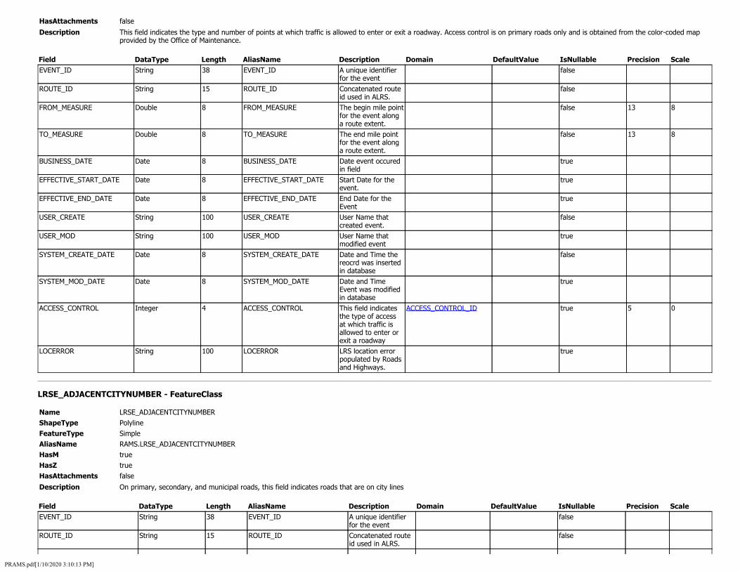
HasAttachments false
Description This field indicates the type and number of points at which traffic is allowed to enter or exit a roadway. Access control is on primary roads only and is obtained from the color-coded map provided by the Office of Maintenance.
Field DataType Length AliasName Description Domain DefaultValue IsNullable Precision Scale EVENT_ID String 38 EVENT_ID A unique identifier
for the event false
ROUTE_ID String 15 ROUTE_ID Concatenated route id used in ALRS.
false
FROM_MEASURE Double 8 FROM_MEASURE The begin mile point for the event along a route extent.
false 13 8
TO_MEASURE Double 8 TO_MEASURE The end mile point for the event along a route extent.
false 13 8
BUSINESS_DATE Date 8 BUSINESS_DATE Date event occured in field
true
EFFECTIVE_START_DATE Date 8 EFFECTIVE_START_DATE Start Date for the event.
true
EFFECTIVE_END_DATE Date 8 EFFECTIVE_END_DATE End Date for the Event
true
USER_CREATE String 100 USER_CREATE User Name that created event.
false
USER_MOD String 100 USER_MOD User Name that modified event
true
SYSTEM_CREATE_DATE Date 8 SYSTEM_CREATE_DATE Date and Time the reocrd was inserted in database
false
SYSTEM_MOD_DATE Date 8 SYSTEM_MOD_DATE Date and Time Event was modified in database
true
ACCESS_CONTROL Integer 4 ACCESS_CONTROL This field indicates the type of access at which traffic is allowed to enter or exit a roadway
ACCESS_CONTROL_ID true 5 0
LOCERROR String 100 LOCERROR LRS location error populated by Roads and Highways.
true
LRSE_ADJACENTCITYNUMBER - FeatureClass
Name LRSE_ADJACENTCITYNUMBER ShapeType Polyline FeatureType Simple AliasName RAMS.LRSE_ADJACENTCITYNUMBER HasM true HasZ true HasAttachments false
Description On primary, secondary, and municipal roads, this field indicates roads that are on city lines
Field DataType Length AliasName Description Domain DefaultValue IsNullable Precision Scale EVENT_ID String 38 EVENT_ID A unique identifier
for the event false
ROUTE_ID String 15 ROUTE_ID Concatenated route id used in ALRS.
false
PRAMS.pdf[1/10/2020 3:10:13 PM]
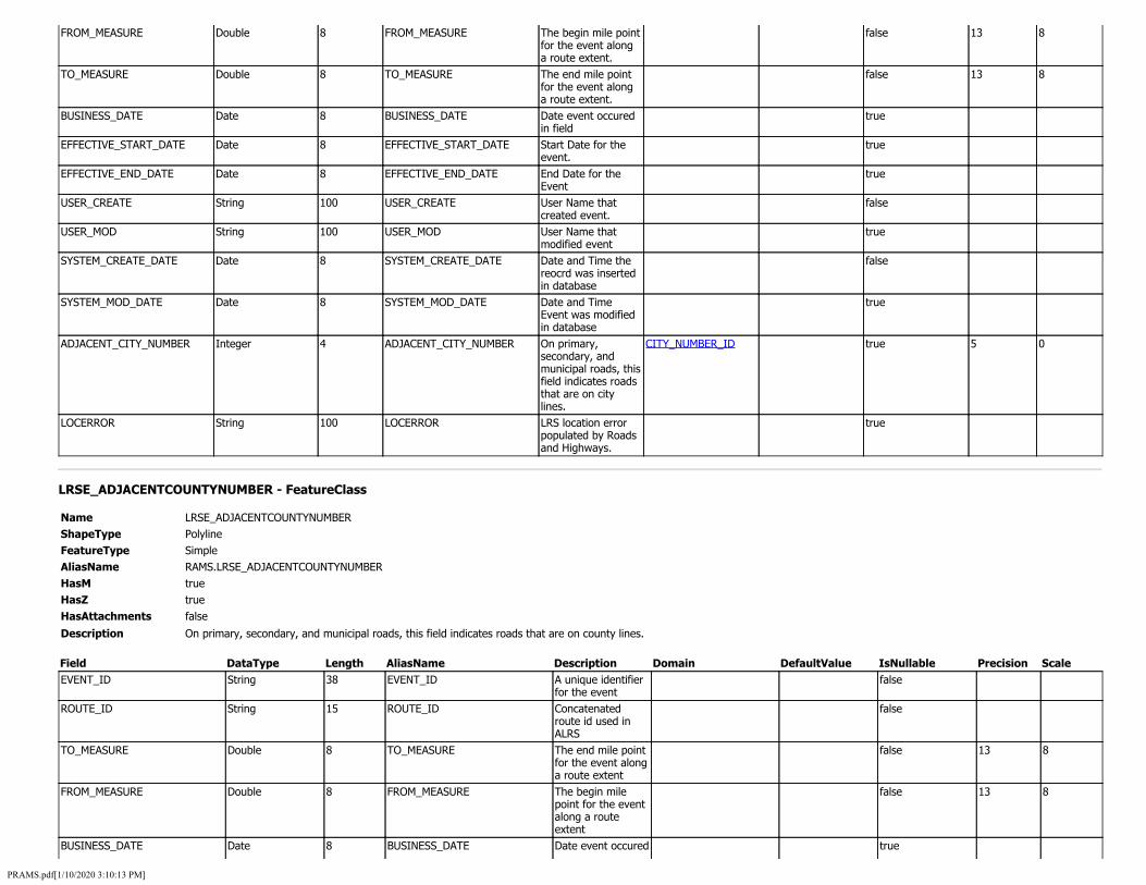
FROM_MEASURE Double 8 FROM_MEASURE The begin mile point for the event along a route extent.
false 13 8
TO_MEASURE Double 8 TO_MEASURE The end mile point for the event along a route extent.
false 13 8
BUSINESS_DATE Date 8 BUSINESS_DATE Date event occured in field
true
EFFECTIVE_START_DATE Date 8 EFFECTIVE_START_DATE Start Date for the event.
true
EFFECTIVE_END_DATE Date 8 EFFECTIVE_END_DATE End Date for the Event
true
USER_CREATE String 100 USER_CREATE User Name that created event.
false
USER_MOD String 100 USER_MOD User Name that modified event
true
SYSTEM_CREATE_DATE Date 8 SYSTEM_CREATE_DATE Date and Time the reocrd was inserted in database
false
SYSTEM_MOD_DATE Date 8 SYSTEM_MOD_DATE Date and Time Event was modified in database
true
ADJACENT_CITY_NUMBER Integer 4 ADJACENT_CITY_NUMBER On primary, secondary, and municipal roads, this field indicates roads that are on city lines.
CITY_NUMBER_ID true 5 0
LOCERROR String 100 LOCERROR LRS location error populated by Roads and Highways.
true
LRSE_ADJACENTCOUNTYNUMBER - FeatureClass
Name LRSE_ADJACENTCOUNTYNUMBER ShapeType Polyline FeatureType Simple AliasName RAMS.LRSE_ADJACENTCOUNTYNUMBER HasM true HasZ true HasAttachments false
Description On primary, secondary, and municipal roads, this field indicates roads that are on county lines.
Field DataType Length AliasName Description Domain DefaultValue IsNullable Precision Scale EVENT_ID String 38 EVENT_ID A unique identifier
for the event false
ROUTE_ID String 15 ROUTE_ID Concatenated route id used in ALRS
false
TO_MEASURE Double 8 TO_MEASURE The end mile point for the event along a route extent
false 13 8
FROM_MEASURE Double 8 FROM_MEASURE The begin mile point for the event along a route extent
false 13 8
BUSINESS_DATE Date 8 BUSINESS_DATE Date event occured true
PRAMS.pdf[1/10/2020 3:10:13 PM]

in the field EFFECTIVE_START_DATE Date 8 EFFECTIVE_START_DATE Start Date for the
event true
EFFECTIVE_END_DATE Date 8 EFFECTIVE_END_DATE End Date for the event
true
USER_CREATE String 100 USER_CREATE User Name that created event
false
USER_MOD String 100 USER_MOD User Name that modified event
true
SYSTEM_CREATE_DATE Date 8 SYSTEM_CREATE_DATE Date and time the record was inserted into database
false
SYSTEM_MOD_DATE Date 8 SYSTEM_MOD_DATE Date and Time Event was modified in database
true
ADJACENT_COUNTY_NUMBER Integer 4 ADJACENT_COUNTY_NUMBER On primary, secondary, and municipal roads, this field indicates roads that are on county lines.
COUNTY_NUMBER_ID true 5 0
LOCERROR String 100 LOCERROR LRS location error populated by Roads and Highways.
true
LRSE_CITYNUMBER - FeatureClass
Name LRSE_CITYNUMBER ShapeType Polyline FeatureType Simple AliasName RAMS.LRSE_CITYNUMBER HasM true HasZ true HasAttachments false
Description Indicates whether the road segment lies within the city by containing the four digit city number
Field DataType Length AliasName Description Domain DefaultValue IsNullable Precision Scale EVENT_ID String 38 EVENT_ID A unique identifier
for the event false
ROUTE_ID String 15 ROUTE_ID Concatenated route id used in ALRS
false
FROM_MEASURE Double 8 FROM_MEASURE The begin mile point for the event along a route extent.
false 13 8
TO_MEASURE Double 8 TO_MEASURE The end mile point for the event along a route extent.
false 13 8
BUSINESS_DATE Date 8 BUSINESS_DATE Date event occured in field
true
EFFECTIVE_START_DATE Date 8 EFFECTIVE_START_DATE Start Date for the event.
true
EFFECTIVE_END_DATE Date 8 EFFECTIVE_END_DATE End Date for the Event
true
USER_CREATE String 100 USER_CREATE User Name that created event.
false
PRAMS.pdf[1/10/2020 3:10:13 PM]

USER_MOD String 100 USER_MOD User Name that modified event
true
SYSTEM_CREATE_DATE Date 8 SYSTEM_CREATE_DATE Date and Time the reocrd was inserted in database
false
SYSTEM_MOD_DATE Date 8 SYSTEM_MOD_DATE Date and Time Event was modified in database
true
CITY_NUMBER Integer 4 CITY_NUMBER Indicates whether the road segment lies within the city by containing the four digit city number.
CITY_NUMBER_ID true 5 0
LOCERROR String 100 LOCERROR LRS location error populated by Roads and Highways.
true
LRSE_COMMERCIALNETWORK - FeatureClass
Name LRSE_COMMERCIALNETWORK ShapeType Polyline FeatureType Simple AliasName RAMS.LRSE_COMMERCIALNETWORK HasM true HasZ true HasAttachments false
Description This field indicates whether or not the road is on a truck route on the primary road system only
Field DataType Length AliasName Description Domain DefaultValue IsNullable Precision Scale EVENT_ID String 38 EVENT_ID A unique identifier
for the event false
ROUTE_ID String 15 ROUTE_ID Concatenated route id used in ALRS
false
FROM_MEASURE Double 8 FROM_MEASURE A ROUTE EXTENTint for the event along a route extent
false 13 8
TO_MEASURE Double 8 TO_MEASURE The end mile point for the event along a route extent
false 13 8
BUSINESS_DATE Date 8 BUSINESS_DATE Date event occured in the field
true
EFFECTIVE_START_DATE Date 8 EFFECTIVE_START_DATE Start Date for the event
true
EFFECTIVE_END_DATE Date 8 EFFECTIVE_END_DATE End Date for the event
true
USER_CREATE String 100 USER_CREATE User Name that created event
false
USER_MOD String 100 USER_MOD Name that modified event
true
SYSTEM_CREATE_DATE Date 8 SYSTEM_CREATE_DATE Time record was inserted into database
false
SYSTEM_MOD_DATE Date 8 SYSTEM_MOD_DATE Date and time record was modified in
true
PRAMS.pdf[1/10/2020 3:10:13 PM]

database COMMERCIAL_NETWORK Integer 4 COMMERCIAL_NETWORK Is the road
segment part of the commercial network
COMMERCIAL_NETWORK_ID true 5 0
LOCERROR String 100 LOCERROR LRS location error populated by Roads and Highways
true
LRSE_CONSTRUCTIONHISTORY - FeatureClass
Name LRSE_CONSTRUCTIONHISTORY ShapeType Polyline FeatureType Simple AliasName RAMS.LRSE_CONSTRUCTIONHISTORY HasM true HasZ true HasAttachments false
Description LRSE_CONSTRUCTIONHISTORY
Field DataType Length AliasName Description Domain DefaultValue IsNullable Precision Scale EVENT_ID String 38 EVENT_ID EVENT_ID false ROUTE_ID String 15 ROUTE_ID ROUTE_ID false FROM_MEASURE Double 8 FROM_MEASURE FROM_MEASURE false 13 8 TO_MEASURE Double 8 TO_MEASURE TO_MEASURE false 13 8 BUSINESS_DATE Date 8 BUSINESS_DATE BUSINESS_DATE true EFFECTIVE_START_DATE Date 8 EFFECTIVE_START_DATE EFFECTIVE_START_DATE true EFFECTIVE_END_DATE Date 8 EFFECTIVE_END_DATE EFFECTIVE_END_DATE true USER_CREATE String 100 USER_CREATE USER_CREATE false USER_MOD String 100 USER_MOD USER_MOD true SYSTEM_CREATE_DATE Date 8 SYSTEM_CREATE_DATE SYSTEM_CREATE_DATE false SYSTEM_MOD_DATE Date 8 SYSTEM_MOD_DATE SYSTEM_MOD_DATE true LAYER_YEAR Integer 4 LAYER_YEAR LAYER_YEAR true 5 0 SURFACE_THICKNESS Single 4 SURFACE_THICKNESS SURFACE_THICKNESS true 3 1 BASE_THICKNESS Single 4 BASE_THICKNESS BASE_THICKNESS true 3 1 REMOVAL_THICKNESS Single 4 REMOVAL_THICKNESS REMOVAL_THICKNESS true 3 1 AGGREGATE_SOURCE String 20 AGGREGATE_SOURCE AGGREGATE_SOURCE true REMARKS String 200 REMARKS REMARKS true SUBDRAIN_PROJ_NUMBER String 20 SUBDRAIN_PROJ_NUMBER SUBDRAIN_PROJ_NUMBER true SUBDRAIN_PERCENT Integer 4 SUBDRAIN_PERCENT SUBDRAIN_PERCENT true 5 0 SURFACE_TREATMENT String 2 SURFACE_TREATMENT SURFACE_TREATMENT SURFACE_TREATMENT_ID true PROJECT_WORK_TYPE String 1 PROJECT_WORK_TYPE PROJECT_WORK_TYPE PROJECT_WORK_TYPE_ID true SURFACE_MATERIAL String 3 SURFACE_MATERIAL SURFACE_MATERIAL PAVEMENT_MATERIAL_ID true SUBDRAIN_MULTI String 1 SUBDRAIN_MULTI SUBDRAIN_MULTI YES_NO_ID true REMOVAL_TYPE String 3 REMOVAL_TYPE REMOVAL_TYPE REMOVAL_TYPE_ID true AGGREGATE_CLASS_ID String 1 AGGREGATE_CLASS_ID AGGREGATE_CLASS_ID AGGREGATE_CLASS_ID true AGGREGATE_TYPE String 10 AGGREGATE_TYPE AGGREGATE_TYPE AGGREGATE_TYPE_ID true COMPLEX String 1 COMPLEX COMPLEX YES_NO_ID true BASE_MATERIAL String 3 BASE_MATERIAL BASE_MATERIAL PAVEMENT_MATERIAL_ID true SUB_MATERIAL String 3 SUB_MATERIAL SUB_MATERIAL PAVEMENT_MATERIAL_ID true LOCERROR String 100 LOCERROR LOCERROR true
PRAMS.pdf[1/10/2020 3:10:13 PM]

PROJECT_NUMBER String 36 PROJECT_NUMBER PROJECT_NUMBER true SUB_THICKNESS Single 4 SUB_THICKNESS2 SUB_THICKNESS true 3 1
LRSE_COSTGROUP - FeatureClass
Name LRSE_COSTGROUP ShapeType Polyline FeatureType Simple AliasName RAMS.LRSE_COSTGROUP HasM true HasZ true HasAttachments false
Description This field is used on municipal or urban road segments and indicates the ROW cost group code in the following manner for all road systems.
Field DataType Length AliasName Description Domain DefaultValue IsNullable Precision Scale EVENT_ID String 38 EVENT_ID A unique identifier
for the event false
ROUTE_ID String 15 ROUTE_ID Concatenated route id used in ALRS
false
FROM_MEASURE Double 8 FROM_MEASURE The begin mile post along a route extent
false 13 8
TO_MEASURE Double 8 TO_MEASURE The end mile post along a route extent
false 13 8
BUSINESS_DATE Date 8 BUSINESS_DATE Date event occured in the field
true
EFFECTIVE_START_DATE Date 8 EFFECTIVE_START_DATE Start Date for the event
true
EFFECTIVE_END_DATE Date 8 EFFECTIVE_END_DATE End Date for the event
true
USER_CREATE String 100 USER_CREATE User Name that created event
false
USER_MOD String 100 USER_MOD Name that modified event
true
SYSTEM_CREATE_DATE Date 8 SYSTEM_CREATE_DATE Time record was inserted into database
false
SYSTEM_MOD_DATE Date 8 SYSTEM_MOD_DATE Date and time record was modified in database
true
COST_GROUP Integer 4 COST_GROUP This field is used on municipal or urban road segments and indicates the ROW cost group code in the following manner for all road systems.
COST_GROUP_ID true 5 0
LOCERROR String 100 LOCERROR LRS location error populated by Roads and Highway
true
LRSE_COUNTYNUMBER - FeatureClass
Name LRSE_COUNTYNUMBER ShapeType Polyline FeatureType Simple
PRAMS.pdf[1/10/2020 3:10:13 PM]

AliasName HasM HasZ HasAttachments Description
RAMS.LRSE_COUNTYNUMBER true true false
The number assigned to the county name in the county_name field.
Field DataType Length AliasName Description Domain DefaultValue IsNullable Precision Scale EVENT_ID String 38 EVENT_ID A unique identifier
for the event false
ROUTE_ID String 15 ROUTE_ID Concatenated route id used in ALRS
false
FROM_MEASURE Double 8 FROM_MEASURE begin mile point for event along a route extent
false 13 8
TO_MEASURE Double 8 TO_MEASURE End mile point for event along a route extent
false 13 8
BUSINESS_DATE Date 8 BUSINESS_DATE Date event occured in field
true
EFFECTIVE_START_DATE Date 8 EFFECTIVE_START_DATE Start date for the event
true
EFFECTIVE_END_DATE Date 8 EFFECTIVE_END_DATE End date of event true USER_CREATE String 100 USER_CREATE Username of who
created event false
USER_MOD String 100 USER_MOD Username that modified event
true
SYSTEM_CREATE_DATE Date 8 SYSTEM_CREATE_DATE Date and time record was inserted into database
false
SYSTEM_MOD_DATE Date 8 SYSTEM_MOD_DATE Date and time event was modified in database
true
COUNTY_NUMBER Integer 4 COUNTY_NUMBER County number COUNTY_NUMBER_ID false 5 0 LOCERROR String 100 LOCERROR LRS location error
populated by roads and highway
true
LRSE_DOMAINCODE - FeatureClass
Name LRSE_DOMAINCODE ShapeType Polyline FeatureType Simple AliasName RAMS.LRSE_DOMAINCODE HasM true HasZ true HasAttachments false
Description This field identifies the federal, state or local agency having control over the land thru which the road segment passes.
Field DataType Length AliasName Description Domain DefaultValue IsNullable Precision Scale EVENT_ID String 38 EVENT_ID A unique identifier
for the event false
ROUTE_ID String 15 ROUTE_ID Generated from LRS Iowa Network
false
FROM_MEASURE Double 8 FROM_MEASURE begin mile point for event along a route
false 13 8
PRAMS.pdf[1/10/2020 3:10:13 PM]

extent TO_MEASURE Double 8 TO_MEASURE End mile point for
event along a route extent
false 13 8
BUSINESS_DATE Date 8 BUSINESS_DATE Date event occured in field
true
EFFECTIVE_START_DATE Date 8 EFFECTIVE_START_DATE Start date for the event
true
EFFECTIVE_END_DATE Date 8 EFFECTIVE_END_DATE End date for the event
true
USER_CREATE String 100 USER_CREATE Username of who created event
false
USER_MOD String 100 USER_MOD Username that modified event
true
SYSTEM_CREATE_DATE Date 8 SYSTEM_CREATE_DATE Date and time record was inserted into database
false
SYSTEM_MOD_DATE Date 8 SYSTEM_MOD_DATE Date and time event was modified in database
true
DOMAIN_CODE Integer 4 DOMAIN_CODE This field identifies the federal, state, local agency having control over the land through which the road segment passes.
DOMAIN_CODE_ID true 5 0
LOCERROR String 100 LOCERROR LRS location error populated by roads and highway
true
LRSE_EXPANSIONFACTOR - FeatureClass
Name LRSE_EXPANSIONFACTOR ShapeType Polyline FeatureType Simple AliasName EXPANSION FACTOR HasM true HasZ true HasAttachments false
Description LRSE_EXPANSIONFACTOR
Field DataType Length AliasName Description Domain DefaultValue IsNullable Precision Scale EVENT_ID ROUTE_ID FROM_MEASURE TO_MEASURE BUSINESS_DATE EFFECTIVE_START_DATE EFFECTIVE_END_DATE USER_CREATE USER_MOD SYSTEM_CREATE_DATE SYSTEM_MOD_DATE EXPANSION_FACTOR
String String Double Double Date Date Date String String Date Date Single
38 15 8 8 8 8 8 100 100 8 8 4
EVENT_ID ROUTE_ID FROM_MEASURE TO_MEASURE BUSINESS_DATE EFFECTIVE_START_DATE EFFECTIVE_END_DATE USER_CREATE USER_MOD SYSTEM_CREATE_DATE SYSTEM_MOD_DATE EXPANSION_FACTOR
EVENT_ID ROUTE_ID FROM_MEASURE TO_MEASURE BUSINESS_DATE EFFECTIVE_START_DATE EFFECTIVE_END_DATE USER_CREATE USER_MOD SYSTEM_CREATE_DATE SYSTEM_MOD_DATE EXPANSION_FACTOR
false false false false true true true false true false true true
13 13
5
8 8
4
PRAMS.pdf[1/10/2020 3:10:13 PM]
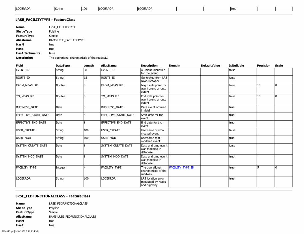
LOCERROR String 100 LOCERROR LOCERROR true
LRSE_FACILITYTYPE - FeatureClass
Name LRSE_FACILITYTYPE ShapeType Polyline FeatureType Simple AliasName RAMS.LRSE_FACILITYTYPE HasM true HasZ true HasAttachments false
Description The operational characteristic of the roadway.
Field DataType Length AliasName Description Domain DefaultValue IsNullable Precision Scale EVENT_ID String 38 EVENT_ID A unique identifier
for the event false
ROUTE_ID String 15 ROUTE_ID Generated from LRS Iowa Network
false
FROM_MEASURE Double 8 FROM_MEASURE begin mile point for event along a route extent
false 13 8
TO_MEASURE Double 8 TO_MEASURE End mile point for event along a route extent
false 13 8
BUSINESS_DATE Date 8 BUSINESS_DATE Date event occured in field
true
EFFECTIVE_START_DATE Date 8 EFFECTIVE_START_DATE Start date for the event
true
EFFECTIVE_END_DATE Date 8 EFFECTIVE_END_DATE End date for the event
true
USER_CREATE String 100 USER_CREATE Username of who created event
false
USER_MOD String 100 USER_MOD Username that modified event
true
SYSTEM_CREATE_DATE Date 8 SYSTEM_CREATE_DATE Date and time event was modified in database
false
SYSTEM_MOD_DATE Date 8 SYSTEM_MOD_DATE Date and time event was modified in database
true
FACILITY_TYPE Integer 4 FACILITY_TYPE The operational characteristic of the roadway.
FACILITY_TYPE_ID true 5 0
LOCERROR String 100 LOCERROR LRS location error populated by roads and highway
true
LRSE_FEDFUNCTIONALCLASS - FeatureClass
Name LRSE_FEDFUNCTIONALCLASS ShapeType Polyline FeatureType Simple AliasName RAMS.LRSE_FEDFUNCTIONALCLASS HasM true HasZ true
PRAMS.pdf[1/10/2020 3:10:13 PM]

HasAttachments false
Description LRSE_FEDFUNCTIONALCLASS
Field DataType Length AliasName Description Domain DefaultValue IsNullable Precision Scale EVENT_ID String 38 EVENT_ID EVENT_ID false ROUTE_ID String 15 ROUTE_ID ROUTE_ID false FROM_MEASURE Double 8 FROM_MEASURE FROM_MEASURE false 13 8 TO_MEASURE Double 8 TO_MEASURE TO_MEASURE false 13 8 BUSINESS_DATE Date 8 BUSINESS_DATE BUSINESS_DATE true EFFECTIVE_START_DATE Date 8 EFFECTIVE_START_DATE EFFECTIVE_START_DATE true EFFECTIVE_END_DATE Date 8 EFFECTIVE_END_DATE EFFECTIVE_END_DATE true USER_CREATE String 100 USER_CREATE USER_CREATE false USER_MOD String 100 USER_MOD USER_MOD true SYSTEM_CREATE_DATE Date 8 SYSTEM_CREATE_DATE SYSTEM_CREATE_DATE false SYSTEM_MOD_DATE Date 8 SYSTEM_MOD_DATE SYSTEM_MOD_DATE true FED_FUNCTIONAL_CLASS Integer 4 FED_FUNCTIONAL_CLASS FED_FUNCTIONAL_CLASS FED_FUNCTIONAL_CLASS_ID true 5 0 LOCERROR String 100 LOCERROR LOCERROR true
LRSE_HANDT - FeatureClass
Name LRSE_HANDT ShapeType Polyline FeatureType Simple AliasName RAMS.LRSE_HANDT HasM true HasZ true HasAttachments false
Description This field is used in creating the H and T maps. It is a computer generated field.
Field DataType Length AliasName Description Domain DefaultValue IsNullable Precision Scale EVENT_ID String 38 EVENT_ID A unique identifier
for the event false
ROUTE_ID String 15 ROUTE_ID Generated from LRS Iowa Network
false
FROM_MEASURE Double 8 FROM_MEASURE begin mile point for event along a route extent
false 13 8
TO_MEASURE Double 8 TO_MEASURE End mile point for event along a route extent
false 13 8
BUSINESS_DATE Date 8 BUSINESS_DATE Date event occured in field
true
EFFECTIVE_START_DATE Date 8 EFFECTIVE_START_DATE Start date for the event
true
EFFECTIVE_END_DATE Date 8 EFFECTIVE_END_DATE End date for the event
true
USER_CREATE String 100 USER_CREATE Username of who created event
false
USER_MOD String 100 USER_MOD Username that modified event
true
SYSTEM_CREATE_DATE Date 8 SYSTEM_CREATE_DATE Date and time record was inserted into database
false
PRAMS.pdf[1/10/2020 3:10:13 PM]

SYSTEM_MOD_DATE Date 8 SYSTEM_MOD_DATE Date and time event was modified in database
true
H_AND_T Integer 4 H_AND_T This field is used in creating the H and T maps. It is a computer generated field.
H_AND_T_ID true 5 0
LOCERROR String 100 LOCERROR LRS location error populated by roads and highway
true
LRSE_HIGHWAYRESPONSIBILITY - FeatureClass
Name LRSE_HIGHWAYRESPONSIBILITY ShapeType Polyline FeatureType Simple AliasName RAMS.LRSE_HIGHWAYRESPONSIBILITY HasM true HasZ true HasAttachments false
Description Indicates the level of service provided by the highway
Field DataType Length AliasName Description Domain DefaultValue IsNullable Precision Scale EVENT_ID String 38 EVENT_ID A unique identifier
for the event false
ROUTE_ID String 15 ROUTE_ID Generated from LRS Iowa Network
false
FROM_MEASURE Double 8 FROM_MEASURE begin mile point for event along a route extent
false 13 8
TO_MEASURE Double 8 TO_MEASURE End mile point for event along a route extent
false 13 8
BUSINESS_DATE Date 8 BUSINESS_DATE Date event occured in field
true
EFFECTIVE_START_DATE Date 8 EFFECTIVE_START_DATE Start date for the event
true
EFFECTIVE_END_DATE Date 8 EFFECTIVE_END_DATE End date for the event
true
USER_CREATE String 100 USER_CREATE Username of who created event
false
USER_MOD String 100 USER_MOD Username that modified event
true
SYSTEM_CREATE_DATE Date 8 SYSTEM_CREATE_DATE Date and time record was inserted into database
false
SYSTEM_MOD_DATE Date 8 SYSTEM_MOD_DATE Date and time event was modified in database
true
HIGHWAY_RESPONSIBILITY String 1 HIGHWAY_RESPONSIBILITY Indicates the level of service provided by the highway
HIGHWAY_RESPONSIBILITY_ID true
LOCERROR String 100 LOCERROR LRS location error populated by
true
PRAMS.pdf[1/10/2020 3:10:13 PM]

roads and highway
LRSE_HPMSSAMPLESECTIONS - FeatureClass
Name LRSE_HPMSSAMPLESECTIONS ShapeType Polyline FeatureType Simple AliasName RAMS.LRSE_HPMSSAMPLESECTIONS HasM true HasZ true HasAttachments false
Description Within the extent of all Federal-aid eligible roads, a random selection of roadway sections is used to represent various attributes at a system-wide level for the purposes of assessing the performance and condition of the network. This process helps to reduce any burden that may be imposed on the States to perform data collection to meet their HPMS reporting requirements. These sections of the network are referred to as Sample Panel sections. Moreover, the Sample Panel sections are selected randomly and are intended to give a statistically valid representation of the State's road network. Due to the structure of the HPMS data model, the States are not required to extract the Sample Panel data items, as long as the data in their submittal covers the Sample Panel. States are encouraged to submit their entire dataset for each data item. FHWA will dynamically assign values to the Sample Panel sections, using the data provided by the States. This should help to lessen the data processing burden on States that are currently collecting more than the minimum coverage.
Field DataType Length AliasName Description Domain DefaultValue IsNullable Precision Scale EVENT_ID String 38 EVENT_ID A unique identifier
for the event false
ROUTE_ID String 15 ROUTE_ID Generated from LRS Iowa Network
false
FROM_MEASURE Double 8 FROM_MEASURE begin mile point for event along a route extent
false 13 8
TO_MEASURE Double 8 TO_MEASURE End mile point for event along a route extent
false 13 8
BUSINESS_DATE Date 8 BUSINESS_DATE Date event occured in field
true
EFFECTIVE_START_DATE Date 8 EFFECTIVE_START_DATE Start date for the event
true
EFFECTIVE_END_DATE Date 8 EFFECTIVE_END_DATE End date for the event
true
USER_CREATE String 100 USER_CREATE Username of who created event
false
USER_MOD String 100 USER_MOD Username that modified event
true
SYSTEM_CREATE_DATE Date 8 SYSTEM_CREATE_DATE Date and time record was inserted into database
false
SYSTEM_MOD_DATE Date 8 SYSTEM_MOD_DATE Date and time event was modified in database
true
HPMS_SAMPLE_ID String 12 HPMS_SAMPLE_ID Unique ID for HPMS Sample
true
PEAK_LANES SmallInteger 2 PEAK_LANES The number of lanes in the peak direction of flow during the peak period.
true 2 0
COUNTER_PEAK_LANES SmallInteger 2 COUNTER_PEAK_LANES The number of lanes in the counter-peak direction of flow during the peak period.
true 2 0
TURN_LANES_R SmallInteger 2 TURN_LANES_R The presence of true 2 0
PRAMS.pdf[1/10/2020 3:10:13 PM]

right turn lanes at a typical intersection.
TURN_LANES_L SmallInteger 2 TURN_LANES_L The presence of left turn lanes at a typical intersection
true 2 0
AADT_SINGLE_UNIT Integer 4 AADT_SINGLE_UNIT Annual Average Daily Traffic for single-unit trucks and buses
true 10 0
PCT_PEAK_SINGLE Double 8 PCT_PEAK_SINGLE Peak hour single-unit truck and bus volume as a percentage of total AADT
true 8 3
AADT_COMBINATION Integer 4 AADT_COMBINATION Annual Average Daily Traffic for Combination Trucks
true 10 0
PCT_PEAK_COMBINATION Double 8 PCT_PEAK_COMBINATION Peak hour combination truck volume as a percentage of total AADT
true 8 3
K_FACTOR Double 8 K_FACTOR The design hour volume (30th largest hourly volume for a given calendar year) as a percentage of AADT
true 8 3
DIR_FACTOR Double 8 DIR_FACTOR The percent of design hour volume (30th largest hourly volume for a given calendar year) flowing in the higher volume direction
true 8 3
FUTURE_AADT Integer 4 FUTURE_AADT Forecasted AADT true 8 0 PCT_GREEN_TIME Double 8 PCT_GREEN_TIME The percent of
green time allocated for through-traffic at intersections
true 8 3
NUMBER_SIGNALS SmallInteger 2 NUMBER_SIGNALS A count of the signalized at-grade intersections
true 3 0
STOP_SIGNS SmallInteger 2 STOP_SIGNS A count of the at-grade intersections with stop signs
true 3 0
AT_GRADE_OTHER SmallInteger 2 AT_GRADE_OTHER A count of the intersections without stop sign or signal controls
true 3 0
SIGNAL_TYPE Integer 4 SIGNAL_TYPE The predominant type of signal system on a sample section
true 5 0
LANE_WIDTH SmallInteger 2 LANE_WIDTH The measure of existing lane width
true 3 0
PCT_PASS_SIGHT Double 8 PCT_PASS_SIGHT The percent of a Sample Panel section meeting the sight distance requirement for
true 8 3
PRAMS.pdf[1/10/2020 3:10:13 PM]
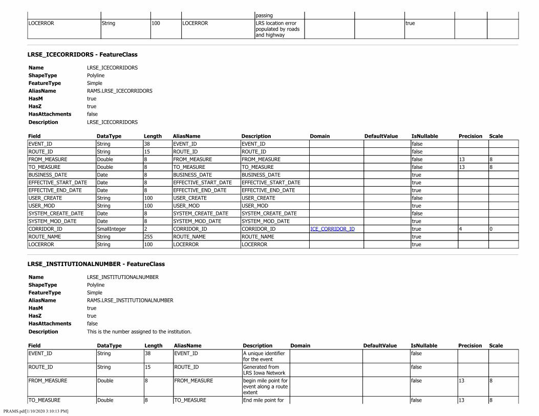
passing LOCERROR String 100 LOCERROR LRS location error
populated by roads and highway
true
LRSE_ICECORRIDORS - FeatureClass
Name LRSE_ICECORRIDORS ShapeType Polyline FeatureType Simple AliasName RAMS.LRSE_ICECORRIDORS HasM true HasZ true HasAttachments false
Description LRSE_ICECORRIDORS
Field DataType Length AliasName Description Domain DefaultValue IsNullable Precision Scale EVENT_ID String 38 EVENT_ID EVENT_ID false ROUTE_ID String 15 ROUTE_ID ROUTE_ID false FROM_MEASURE Double 8 FROM_MEASURE FROM_MEASURE false 13 8 TO_MEASURE Double 8 TO_MEASURE TO_MEASURE false 13 8 BUSINESS_DATE Date 8 BUSINESS_DATE BUSINESS_DATE true EFFECTIVE_START_DATE Date 8 EFFECTIVE_START_DATE EFFECTIVE_START_DATE true EFFECTIVE_END_DATE Date 8 EFFECTIVE_END_DATE EFFECTIVE_END_DATE true USER_CREATE String 100 USER_CREATE USER_CREATE false USER_MOD String 100 USER_MOD USER_MOD true SYSTEM_CREATE_DATE Date 8 SYSTEM_CREATE_DATE SYSTEM_CREATE_DATE false SYSTEM_MOD_DATE Date 8 SYSTEM_MOD_DATE SYSTEM_MOD_DATE true CORRIDOR_ID SmallInteger 2 CORRIDOR_ID CORRIDOR_ID ICE_CORRIDOR_ID true 4 0 ROUTE_NAME String 255 ROUTE_NAME ROUTE_NAME true LOCERROR String 100 LOCERROR LOCERROR true
LRSE_INSTITUTIONALNUMBER - FeatureClass
Name LRSE_INSTITUTIONALNUMBER ShapeType Polyline FeatureType Simple AliasName RAMS.LRSE_INSTITUTIONALNUMBER HasM true HasZ true HasAttachments false
Description This is the number assigned to the institution.
Field DataType Length AliasName Description Domain DefaultValue IsNullable Precision Scale EVENT_ID String 38 EVENT_ID A unique identifier
for the event false
ROUTE_ID String 15 ROUTE_ID Generated from LRS Iowa Network
false
FROM_MEASURE Double 8 FROM_MEASURE begin mile point for event along a route extent
false 13 8
TO_MEASURE Double 8 TO_MEASURE End mile point for false 13 8
PRAMS.pdf[1/10/2020 3:10:13 PM]
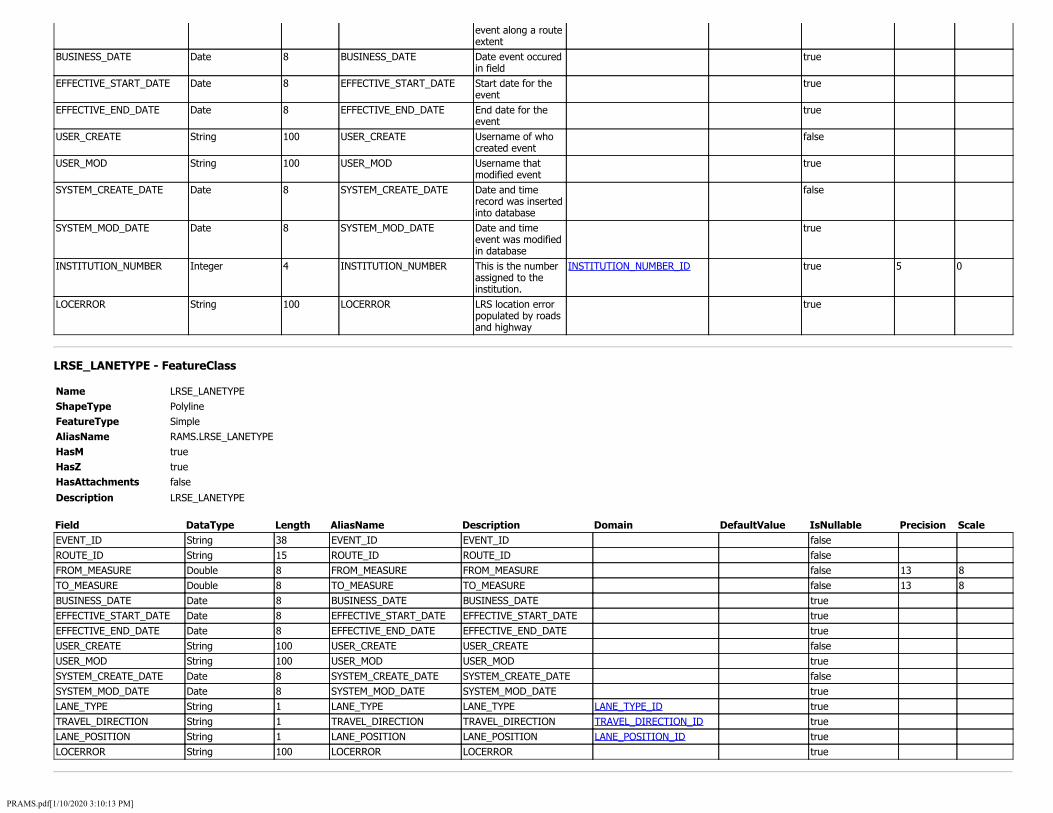
event along a route extent
BUSINESS_DATE Date 8 BUSINESS_DATE Date event occured in field
true
EFFECTIVE_START_DATE Date 8 EFFECTIVE_START_DATE Start date for the event
true
EFFECTIVE_END_DATE Date 8 EFFECTIVE_END_DATE End date for the event
true
USER_CREATE String 100 USER_CREATE Username of who created event
false
USER_MOD String 100 USER_MOD Username that modified event
true
SYSTEM_CREATE_DATE Date 8 SYSTEM_CREATE_DATE Date and time record was inserted into database
false
SYSTEM_MOD_DATE Date 8 SYSTEM_MOD_DATE Date and time event was modified in database
true
INSTITUTION_NUMBER Integer 4 INSTITUTION_NUMBER This is the number assigned to the institution.
INSTITUTION_NUMBER_ID true 5 0
LOCERROR String 100 LOCERROR LRS location error populated by roads and highway
true
LRSE_LANETYPE - FeatureClass
Name LRSE_LANETYPE ShapeType Polyline FeatureType Simple AliasName RAMS.LRSE_LANETYPE HasM true HasZ true HasAttachments false
Description LRSE_LANETYPE
Field DataType Length AliasName Description Domain DefaultValue IsNullable Precision Scale EVENT_ID String 38 EVENT_ID EVENT_ID false ROUTE_ID String 15 ROUTE_ID ROUTE_ID false FROM_MEASURE Double 8 FROM_MEASURE FROM_MEASURE false 13 8 TO_MEASURE Double 8 TO_MEASURE TO_MEASURE false 13 8 BUSINESS_DATE Date 8 BUSINESS_DATE BUSINESS_DATE true EFFECTIVE_START_DATE Date 8 EFFECTIVE_START_DATE EFFECTIVE_START_DATE true EFFECTIVE_END_DATE Date 8 EFFECTIVE_END_DATE EFFECTIVE_END_DATE true USER_CREATE String 100 USER_CREATE USER_CREATE false USER_MOD String 100 USER_MOD USER_MOD true SYSTEM_CREATE_DATE Date 8 SYSTEM_CREATE_DATE SYSTEM_CREATE_DATE false SYSTEM_MOD_DATE Date 8 SYSTEM_MOD_DATE SYSTEM_MOD_DATE true LANE_TYPE String 1 LANE_TYPE LANE_TYPE LANE_TYPE_ID true TRAVEL_DIRECTION String 1 TRAVEL_DIRECTION TRAVEL_DIRECTION TRAVEL_DIRECTION_ID true LANE_POSITION String 1 LANE_POSITION LANE_POSITION LANE_POSITION_ID true LOCERROR String 100 LOCERROR LOCERROR true
PRAMS.pdf[1/10/2020 3:10:13 PM]

LRSE_LEFTSHOULDERCURBED - FeatureClass
Name LRSE_LEFTSHOULDERCURBED ShapeType Polyline FeatureType Simple AliasName RAMS.LRSE_LEFTSHOULDERCURBED HasM true HasZ true HasAttachments false
Description This field indicates whether the left side or inside shoulder has a curb.
Field DataType Length AliasName Description Domain DefaultValue IsNullable Precision Scale EVENT_ID String 38 EVENT_ID A unique identifier
for the event false
ROUTE_ID String 15 ROUTE_ID Generated from LRS Iowa Network
false
FROM_MEASURE Double 8 FROM_MEASURE begin mile point for event along a route extent
false 13 8
TO_MEASURE Double 8 TO_MEASURE End mile point for event along a route extent
false 13 8
BUSINESS_DATE Date 8 BUSINESS_DATE Date event occured in field
true
EFFECTIVE_START_DATE Date 8 EFFECTIVE_START_DATE Start date for the event
true
EFFECTIVE_END_DATE Date 8 EFFECTIVE_END_DATE End date for the event
true
USER_CREATE String 100 USER_CREATE Username of who created event
false
USER_MOD String 100 USER_MOD Username that modified event
true
SYSTEM_CREATE_DATE Date 8 SYSTEM_CREATE_DATE Date and time record was inserted into database
false
SYSTEM_MOD_DATE Date 8 SYSTEM_MOD_DATE Date and time event was modified in database
true
LEFT_SHOULDER_CURBED Integer 4 LEFT_SHOULDER_CURBED This field indicates whether the left side or inside shoulder has a curb.
CURBED_ID true 5 0
LOCERROR String 100 LOCERROR LRS location error populated by roads and highway
true
LRSE_LEFTSHOULDERRUMBLE - FeatureClass
Name LRSE_LEFTSHOULDERRUMBLE ShapeType Polyline FeatureType Simple AliasName RAMS.LRSE_LEFTSHOULDERRUMBLE HasM true HasZ true HasAttachments false
PRAMS.pdf[1/10/2020 3:10:13 PM]

Description This field indicates whether a rumble strip exists on the left side or inside shoulder.
Field DataType Length AliasName Description Domain DefaultValue IsNullable Precision Scale EVENT_ID String 38 EVENT_ID A unique identifier
for the event false
ROUTE_ID String 15 ROUTE_ID Generated from LRS Iowa Network
false
FROM_MEASURE Double 8 FROM_MEASURE begin mile point for event along a route extent
false 13 8
TO_MEASURE Double 8 TO_MEASURE End mile point for event along a route extent
false 13 8
BUSINESS_DATE Date 8 BUSINESS_DATE Date event occured in field
true
EFFECTIVE_START_DATE Date 8 EFFECTIVE_START_DATE Start date for the event
true
EFFECTIVE_END_DATE Date 8 EFFECTIVE_END_DATE End date for the event
true
USER_CREATE String 100 USER_CREATE Username of who created event
false
USER_MOD String 100 USER_MOD Username that modified event
true
SYSTEM_CREATE_DATE Date 8 SYSTEM_CREATE_DATE Date and time record was inserted into database
false
SYSTEM_MOD_DATE Date 8 SYSTEM_MOD_DATE Date and time event was modified in database
true
LEFT_SHOULDER_RUMBLE Integer 4 LEFT_SHOULDER_RUMBLE This field indicates whether a rumble strip exists on the left side or inside shoulder.
RUMBLE_TYPE_ID true 5 0
LOCERROR String 100 LOCERROR LRS location error populated by roads and highway
true
LRSE_LEFTSHOULDERTIED - FeatureClass
Name LRSE_LEFTSHOULDERTIED ShapeType Polyline FeatureType Simple AliasName RAMS.LRSE_LEFTSHOULDERTIED HasM true HasZ true HasAttachments false
Description This field indicates if the left side or inside shoulder is tied to the roadway surface.
Field DataType Length AliasName Description Domain DefaultValue IsNullable Precision Scale EVENT_ID String 38 EVENT_ID A unique identifier
for the event false
ROUTE_ID String 15 ROUTE_ID Date event occured in field
false
FROM_MEASURE Double 8 FROM_MEASURE begin mile point for event along a route
false 13 8
PRAMS.pdf[1/10/2020 3:10:13 PM]

extent TO_MEASURE Double 8 TO_MEASURE End mile point for
event along a route extent
false 13 8
BUSINESS_DATE Date 8 BUSINESS_DATE Date event occured in field
true
EFFECTIVE_START_DATE Date 8 EFFECTIVE_START_DATE Start date for the event
true
EFFECTIVE_END_DATE Date 8 EFFECTIVE_END_DATE End date for the event
true
USER_CREATE String 100 USER_CREATE Username of who created event
false
USER_MOD String 100 USER_MOD Username that modified event
true
SYSTEM_CREATE_DATE Date 8 SYSTEM_CREATE_DATE Date and time record was inserted into database
false
SYSTEM_MOD_DATE Date 8 SYSTEM_MOD_DATE Date and time event was modified in database
true
LEFT_SHOULDER_TIED Integer 4 LEFT_SHOULDER_TIED This field indicates if the left side or inside shoulder is tied to the roadway surface.
SHOULDER_TIED_ID true 5 0
LOCERROR String 100 LOCERROR LRS location error populated by roads and highway
true
LRSE_LEFTSHOULDERTYPE - FeatureClass
Name LRSE_LEFTSHOULDERTYPE ShapeType Polyline FeatureType Simple AliasName RAMS.LRSE_LEFTSHOULDERTYPE HasM true HasZ true HasAttachments false
Description This field indicates the left side or inside shoulder type for all road systems using the following criteria.
Field DataType Length AliasName Description Domain DefaultValue IsNullable Precision Scale EVENT_ID String 38 EVENT_ID A unique identifier
for the event false
ROUTE_ID String 15 ROUTE_ID Generated from LRS Iowa Network
false
FROM_MEASURE Double 8 FROM_MEASURE begin mile point for event along a route extent
false 13 8
TO_MEASURE Double 8 TO_MEASURE End mile point for event along a route extent
false 13 8
BUSINESS_DATE Date 8 BUSINESS_DATE Date event occured in field
true
EFFECTIVE_START_DATE Date 8 EFFECTIVE_START_DATE Start date for the event
true
EFFECTIVE_END_DATE Date 8 EFFECTIVE_END_DATE End date for the true
PRAMS.pdf[1/10/2020 3:10:13 PM]

event USER_CREATE String 100 USER_CREATE Username of who
created event false
USER_MOD String 100 USER_MOD Username that modified event
true
SYSTEM_CREATE_DATE Date 8 SYSTEM_CREATE_DATE Date and time record was inserted into database
false
SYSTEM_MOD_DATE Date 8 SYSTEM_MOD_DATE Date and time event was modified in database
true
LEFT_SHOULDER_TYPE Integer 4 LEFT_SHOULDER_TYPE This field indicates the left side or inside shoulder type for all road systems using the following criteria.
SHOULDER_TYPE_ID true 5 0
LOCERROR String 100 LOCERROR LRS location error populated by roads and highway
true
LRSE_LEFTSHOULDERWIDTH - FeatureClass
Name LRSE_LEFTSHOULDERWIDTH ShapeType Polyline FeatureType Simple AliasName RAMS.LRSE_LEFTSHOULDERWIDTH HasM true HasZ true HasAttachments false
Description This field indicates the width of the left side or inside shoulder to the nearest foot. It is used on all road systems.
Field DataType Length AliasName Description Domain DefaultValue IsNullable Precision Scale EVENT_ID String 38 EVENT_ID A unique identifier
for the event false
ROUTE_ID String 15 ROUTE_ID Generated from LRS Iowa Network
false
FROM_MEASURE Double 8 FROM_MEASURE begin mile point for event along a route extent
false 13 8
TO_MEASURE Double 8 TO_MEASURE End mile point for event along a route extent
false 13 8
BUSINESS_DATE Date 8 BUSINESS_DATE Date event occured in field
true
EFFECTIVE_START_DATE Date 8 EFFECTIVE_START_DATE Start date for the event
true
EFFECTIVE_END_DATE Date 8 EFFECTIVE_END_DATE End date for the event
true
USER_CREATE String 100 USER_CREATE Username of who created event
false
USER_MOD String 100 USER_MOD Username that modified event
true
SYSTEM_CREATE_DATE Date 8 SYSTEM_CREATE_DATE Date and time record was inserted into database
false
PRAMS.pdf[1/10/2020 3:10:13 PM]
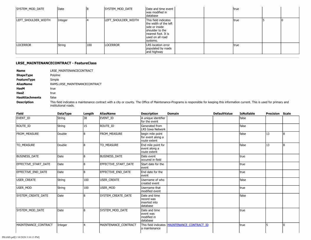
SYSTEM_MOD_DATE Date 8 SYSTEM_MOD_DATE Date and time event was modified in database
true
LEFT_SHOULDER_WIDTH Integer 4 LEFT_SHOULDER_WIDTH This field indicates the width of the left side or inside shoulder to the nearest foot. It is used on all road systems.
true 5 0
LOCERROR String 100 LOCERROR LRS location error populated by roads and highway
true
LRSE_MAINTENANCECONTRACT - FeatureClass
Name LRSE_MAINTENANCECONTRACT ShapeType Polyline FeatureType Simple AliasName RAMS.LRSE_MAINTENANCECONTRACT HasM true HasZ true HasAttachments false
Description This field indicates a maintenance contract with a city or county. The Office of Maintenance-Programs is responsible for keeping this information current. This is used for primary and institutional roads.
Field DataType Length AliasName Description Domain DefaultValue IsNullable Precision Scale EVENT_ID String 38 EVENT_ID A unique identifier
for the event false
ROUTE_ID String 15 ROUTE_ID Generated from LRS Iowa Network
false
FROM_MEASURE Double 8 FROM_MEASURE begin mile point for event along a route extent
false 13 8
TO_MEASURE Double 8 TO_MEASURE End mile point for event along a route extent
false 13 8
BUSINESS_DATE Date 8 BUSINESS_DATE Date event occured in field
true
EFFECTIVE_START_DATE Date 8 EFFECTIVE_START_DATE Start date for the event
true
EFFECTIVE_END_DATE Date 8 EFFECTIVE_END_DATE End date for the event
true
USER_CREATE String 100 USER_CREATE Username of who created event
false
USER_MOD String 100 USER_MOD Username that modified event
true
SYSTEM_CREATE_DATE Date 8 SYSTEM_CREATE_DATE Date and time record was inserted into database
false
SYSTEM_MOD_DATE Date 8 SYSTEM_MOD_DATE Date and time event was modified in database
true
MAINTENANCE_CONTRACT Integer 4 MAINTENANCE_CONTRACT This field indicates a maintenance
MAINTENANCE_CONTRACT_ID true 5 0
PRAMS.pdf[1/10/2020 3:10:13 PM]

contract with a city or county. The Office of Maintenance-Programs is responsible for keeping this information current. This is used for primary and institutional roads.
LOCERROR String 100 LOCERROR LRS location error populated by roads and highway
true
LRSE_MAINTENANCECOSTCENTER - FeatureClass
Name LRSE_MAINTENANCECOSTCENTER ShapeType Polyline FeatureType Simple AliasName RAMS.LRSE_MAINTENANCECOSTCENTER HasM true HasZ true HasAttachments false
Description Number made up of a two digit cost center identifier, district number, residency number and garage number
Field DataType Length AliasName Description Domain DefaultValue IsNullable Precision Scale EVENT_ID String 38 EVENT_ID A unique false
identifier for the event
ROUTE_ID String 15 ROUTE_ID Generated from false LRS Iowa Network
FROM_MEASURE Double 8 FROM_MEASURE begin mile point false 13 8 for event along a route extent
TO_MEASURE Double 8 TO_MEASURE End mile point for false 13 8 event along a route extent
BUSINESS_DATE Date 8 BUSINESS_DATE Date event true occured in field
EFFECTIVE_START_DATE Date 8 EFFECTIVE_START_DATE Start date for the true event
EFFECTIVE_END_DATE Date 8 EFFECTIVE_END_DATE End date for the true event
USER_CREATE String 100 USER_CREATE Username of who false created event
USER_MOD String 100 USER_MOD Username that true modified event
SYSTEM_CREATE_DATE Date 8 SYSTEM_CREATE_DATE Date and time false record was inserted into database
SYSTEM_MOD_DATE Date 8 SYSTEM_MOD_DATE Date and time true event was modified in database
PRAMS.pdf[1/10/2020 3:10:13 PM]

MAINTENANCE_COST_CENTER Integer 4 MAINTENANCE_COST_CENTER Number made up of a two digit cost center identifier, district number, residency number and garage number
MAINTENANCE_COST_CENTER_ID true 6 0
LOCERROR String 100 LOCERROR LRS location error populated by roads and highway
true
LRSE_MAINTENANCEDISTRICT - FeatureClass
Name LRSE_MAINTENANCEDISTRICT ShapeType Polyline FeatureType Simple AliasName RAMS.LRSE_MAINTENANCEDISTRICT HasM true HasZ true HasAttachments false
Description This field is used to identify the Maintenance District number. The District is assigned by the Office of Maintenance-Programs. This is used on primary and institutional roads. Districts 1-6
Field DataType Length AliasName Description Domain DefaultValue IsNullable Precision Scale EVENT_ID String 38 EVENT_ID A unique identifier
for the event false
ROUTE_ID String 15 ROUTE_ID Generated from LRS Iowa Network
false
FROM_MEASURE Double 8 FROM_MEASURE begin mile point for event along a route extent
false 13 8
TO_MEASURE Double 8 TO_MEASURE End mile point for event along a route extent
false 13 8
BUSINESS_DATE Date 8 BUSINESS_DATE Date event occured in field
true
EFFECTIVE_START_DATE Date 8 EFFECTIVE_START_DATE Start date for the event
true
EFFECTIVE_END_DATE Date 8 EFFECTIVE_END_DATE End date for the event
true
USER_CREATE String 100 USER_CREATE Username of who created event
false
USER_MOD String 100 USER_MOD Username that modified event
true
SYSTEM_CREATE_DATE Date 8 SYSTEM_CREATE_DATE Date and time record was inserted into database
false
SYSTEM_MOD_DATE Date 8 SYSTEM_MOD_DATE Date and time event was modified in database
true
MAINTENANCE_DISTRICT Integer 4 MAINTENANCE_DISTRICT This field is used to identify the Maintenance District number. The District is assigned by the Office of
MAINTENANCE_DISTRICT_ID true 5 0
PRAMS.pdf[1/10/2020 3:10:13 PM]
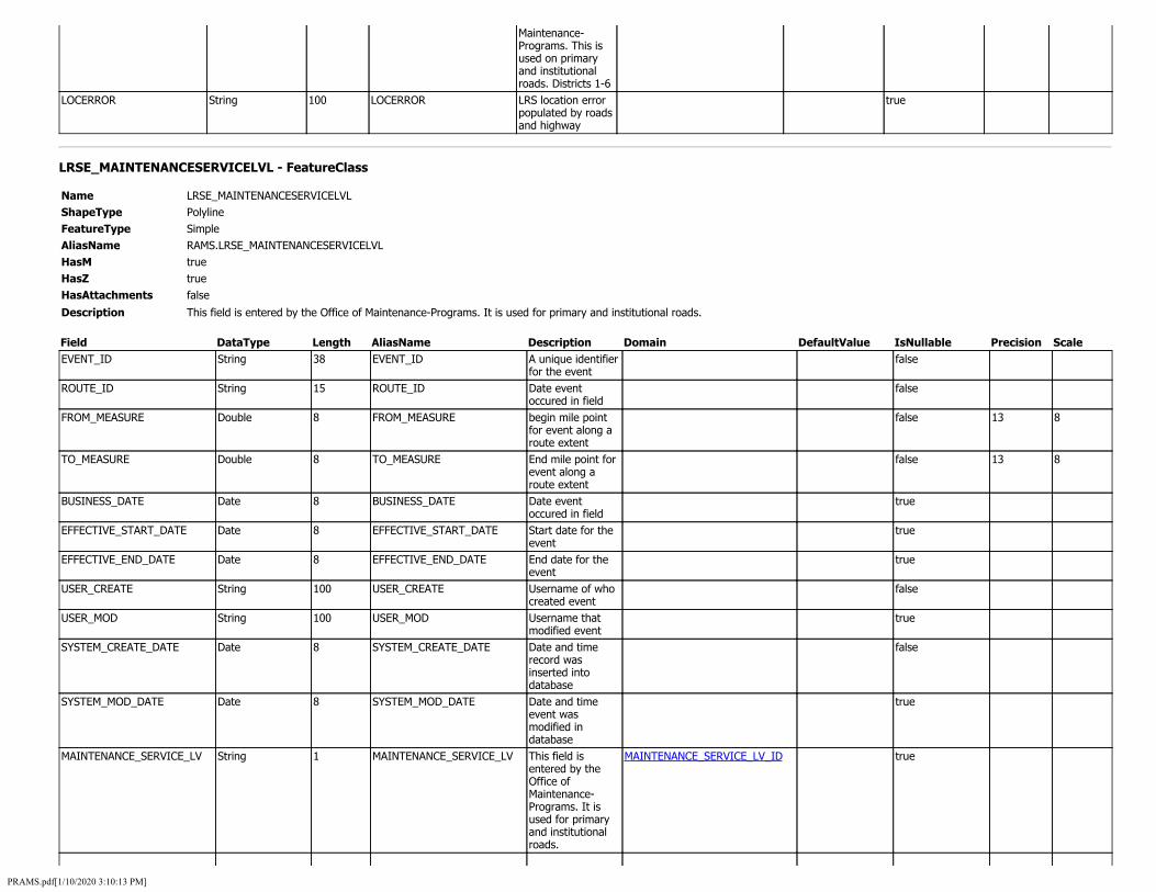
Maintenance-Programs. This is used on primary and institutional roads. Districts 1-6
LOCERROR String 100 LOCERROR LRS location error populated by roads and highway
true
LRSE_MAINTENANCESERVICELVL - FeatureClass
Name LRSE_MAINTENANCESERVICELVL ShapeType Polyline FeatureType Simple AliasName RAMS.LRSE_MAINTENANCESERVICELVL HasM true HasZ true HasAttachments false
Description This field is entered by the Office of Maintenance-Programs. It is used for primary and institutional roads.
Field DataType Length AliasName Description Domain DefaultValue IsNullable Precision Scale EVENT_ID String 38 EVENT_ID A unique identifier
for the event false
ROUTE_ID String 15 ROUTE_ID Date event occured in field
false
FROM_MEASURE Double 8 FROM_MEASURE begin mile point for event along a route extent
false 13 8
TO_MEASURE Double 8 TO_MEASURE End mile point for event along a route extent
false 13 8
BUSINESS_DATE Date 8 BUSINESS_DATE Date event occured in field
true
EFFECTIVE_START_DATE Date 8 EFFECTIVE_START_DATE Start date for the event
true
EFFECTIVE_END_DATE Date 8 EFFECTIVE_END_DATE End date for the event
true
USER_CREATE String 100 USER_CREATE Username of who created event
false
USER_MOD String 100 USER_MOD Username that modified event
true
SYSTEM_CREATE_DATE Date 8 SYSTEM_CREATE_DATE Date and time record was inserted into database
false
SYSTEM_MOD_DATE Date 8 SYSTEM_MOD_DATE Date and time event was modified in database
true
MAINTENANCE_SERVICE_LV String 1 MAINTENANCE_SERVICE_LV This field is entered by the Office of Maintenance-Programs. It is used for primary and institutional roads.
MAINTENANCE_SERVICE_LV_ID true
PRAMS.pdf[1/10/2020 3:10:13 PM]

LOCERROR String 100 LOCERROR LRS location error populated by roads and highway
true
LRSE_MANAGEMENTSECTIONS - FeatureClass
Name LRSE_MANAGEMENTSECTIONS ShapeType Polyline FeatureType Simple AliasName RAMS.LRSE_MANAGEMENTSECTIONS HasM true HasZ true HasAttachments false
Description LRSE_MANAGEMENTSECTIONS
Field DataType Length AliasName Description Domain DefaultValue IsNullable Precision Scale EVENT_ID String 38 EVENT_ID EVENT_ID false ROUTE_ID String 15 ROUTE_ID ROUTE_ID false FROM_MEASURE Double 8 FROM_MEASURE FROM_MEASURE false 13 8 TO_MEASURE Double 8 TO_MEASURE TO_MEASURE false 13 8 BUSINESS_DATE Date 8 BUSINESS_DATE BUSINESS_DATE true EFFECTIVE_START_DATE Date 8 EFFECTIVE_START_DATE EFFECTIVE_START_DATE true EFFECTIVE_END_DATE Date 8 EFFECTIVE_END_DATE EFFECTIVE_END_DATE true USER_CREATE String 100 USER_CREATE USER_CREATE false USER_MOD String 100 USER_MOD USER_MOD true SYSTEM_CREATE_DATE Date 8 SYSTEM_CREATE_DATE SYSTEM_CREATE_DATE false SYSTEM_MOD_DATE Date 8 SYSTEM_MOD_DATE SYSTEM_MOD_DATE true ORIG_KEY String 20 ORIG_KEY ORIG_KEY true MANAGE_SECTION_DESCRIPTION String 200 MANAGE_SECTION_DESCRIPTION MANAGE_SECTION_DESCRIPTION true LOCERROR String 100 LOCERROR LOCERROR true CONSTRUCTION_YEAR SmallInteger 2 CONYR CONSTRUCTION_YEAR true 4 0 RECONSTRUCTION_YEAR SmallInteger 2 RESYR RECONSTRUCTION_YEAR true 4 0 PAVTYP String 2 PAVTYP PAVTYP true
LRSE_MEDIANTYPE - FeatureClass
Name LRSE_MEDIANTYPE ShapeType Polyline FeatureType Simple AliasName RAMS.LRSE_MEDIANTYPE HasM true HasZ true HasAttachments false
Description The characteristics of the median on all road sections are entered using the following criteria. If median has a curb, the curb is placed on the inside shoulder. A barrier is .152 meters or more. A painted median is not considered a median.
Field DataType Length AliasName Description Domain DefaultValue IsNullable Precision Scale EVENT_ID String 38 EVENT_ID A unique identifier
for the event false
ROUTE_ID String 15 ROUTE_ID Generated from LRS Iowa Network
false
PRAMS.pdf[1/10/2020 3:10:13 PM]

FROM_MEASURE Double 8 FROM_MEASURE begin mile point for event along a route extent
false 13 8
TO_MEASURE Double 8 TO_MEASURE End mile point for event along a route extent
false 13 8
BUSINESS_DATE Date 8 BUSINESS_DATE Date event occured in field
true
EFFECTIVE_START_DATE Date 8 EFFECTIVE_START_DATE Start date for the event
true
EFFECTIVE_END_DATE Date 8 EFFECTIVE_END_DATE End date for the event
true
USER_CREATE String 100 USER_CREATE Username of who created event
false
USER_MOD String 100 USER_MOD Username that modified event
true
SYSTEM_CREATE_DATE Date 8 SYSTEM_CREATE_DATE Date and time record was inserted into database
false
SYSTEM_MOD_DATE Date 8 SYSTEM_MOD_DATE Date and time event was modified in database
true
MEDIAN_TYPE Integer 4 MEDIAN_TYPE The characteristics of the median on all road sections are entered using the following criteria. If median has a curb, the curb is placed on the inside shoulder. A barrier is .152 meters or more. A painted median is not considered a median.
MEDIAN_TYPE_ID true 5 0
LOCERROR String 100 LOCERROR LRS location error populated by roads and highway
true
LRSE_MEDIANWIDTH - FeatureClass
Name LRSE_MEDIANWIDTH ShapeType Polyline FeatureType Simple AliasName RAMS.LRSE_MEDIANWIDTH HasM true HasZ true HasAttachments false
Description This code indicates the width of the median between the edges of traffic lanes recorded to the nearest foot. This field is applicable for all road systems.
Field DataType Length AliasName Description Domain DefaultValue IsNullable Precision Scale EVENT_ID String 38 EVENT_ID A unique identifier
for the event false
ROUTE_ID String 15 ROUTE_ID Generated from LRS Iowa Network
false
FROM_MEASURE Double 8 FROM_MEASURE begin mile point for event along a route extent
false 13 8
PRAMS.pdf[1/10/2020 3:10:13 PM]

TO_MEASURE Double 8 TO_MEASURE End mile point for event along a route extent
false 13 8
BUSINESS_DATE Date 8 BUSINESS_DATE Date event occured in field
true
EFFECTIVE_START_DATE Date 8 EFFECTIVE_START_DATE Start date for the event
true
EFFECTIVE_END_DATE Date 8 EFFECTIVE_END_DATE End date for the event
true
USER_CREATE String 100 USER_CREATE Username of who created event
false
USER_MOD String 100 USER_MOD Username that modified event
true
SYSTEM_CREATE_DATE Date 8 SYSTEM_CREATE_DATE Date and time record was inserted into database
false
SYSTEM_MOD_DATE Date 8 SYSTEM_MOD_DATE Date and time event was modified in database
true
MEDIAN_WIDTH Integer 4 MEDIAN_WIDTH This code indicates the width of the median between the edges of traffic lanes recorded to the nearest foot. This field is applicable for all road systems.
true 5 0
LOCERROR String 100 LOCERROR LRS location error populated by roads and highway
true
LRSE_MINIMUM_SPEEDLIMIT - FeatureClass
Name LRSE_MINIMUM_SPEEDLIMIT ShapeType Polyline FeatureType Simple AliasName MINIMUM SPEED LIMIT HasM true HasZ true HasAttachments false
Description LRSE_MINIMUM_SPEEDLIMIT
Field DataType Length AliasName Description Domain DefaultValue IsNullable Precision Scale EVENT_ID String 38 EVENT_ID EVENT_ID false ROUTE_ID String 15 ROUTE_ID ROUTE_ID false FROM_MEASURE Double 8 FROM_MEASURE FROM_MEASURE false 13 8 TO_MEASURE Double 8 TO_MEASURE TO_MEASURE false 13 8 BUSINESS_DATE Date 8 BUSINESS_DATE BUSINESS_DATE true EFFECTIVE_START_DATE Date 8 EFFECTIVE_START_DATE EFFECTIVE_START_DATE true EFFECTIVE_END_DATE Date 8 EFFECTIVE_END_DATE EFFECTIVE_END_DATE true USER_CREATE String 100 USER_CREATE USER_CREATE false USER_MOD String 100 USER_MOD USER_MOD true SYSTEM_CREATE_DATE Date 8 SYSTEM_CREATE_DATE SYSTEM_CREATE_DATE false SYSTEM_MOD_DATE Date 8 SYSTEM_MOD_DATE SYSTEM_MOD_DATE true MINIMUM_SPEED_LIMIT Integer 4 MINIMUM_SPEED_LIMIT MINIMUM_SPEED_LIMIT SPEED_LIMIT_ID true 5 0
PRAMS.pdf[1/10/2020 3:10:13 PM]

LOCERROR String 100 LOCERROR LOCERROR true
LRSE_NATIONALHIGHWAYSYSTEM - FeatureClass
Name LRSE_NATIONALHIGHWAYSYSTEM ShapeType Polyline FeatureType Simple AliasName RAMS.LRSE_NATIONALHIGHWAYSYSTEM HasM true HasZ true HasAttachments false
Description This field indicates the state functional classification of the road segment. NATIONAL HIGHWAY SYSTEM
Field DataType Length AliasName Description Domain DefaultValue IsNullable Precision Scale EVENT_ID String 38 EVENT_ID A unique
identifier for the event
false
ROUTE_ID String 15 ROUTE_ID Generated from LRS Iowa Network
false
FROM_MEASURE Double 8 FROM_MEASURE begin mile point for event along a route extent
false 13 8
TO_MEASURE Double 8 TO_MEASURE End mile point for event along a route extent
false 13 8
BUSINESS_DATE Date 8 BUSINESS_DATE Date event occured in field
true
EFFECTIVE_START_DATE Date 8 EFFECTIVE_START_DATE Start date for the event
true
EFFECTIVE_END_DATE Date 8 EFFECTIVE_END_DATE End date for the eventt
true
USER_CREATE String 100 USER_CREATE Username of who created event
false
USER_MOD String 100 USER_MOD Username that modified event
true
SYSTEM_CREATE_DATE Date 8 SYSTEM_CREATE_DATE Date and time record was inserted into database
false
SYSTEM_MOD_DATE Date 8 SYSTEM_MOD_DATE Date and time event was modified in database
true
NATIONAL_HIGHWAY_SYSTEM Integer 4 NATIONAL_HIGHWAY_SYSTEM This field indicates the state functional classification of the road segment. NATIONAL HIGHWAY SYSTEM
NATIONAL_HIGHWAY_SYSTEM_ID true 5 0
LOCERROR String 100 LOCERROR LRS location error populated by roads and highway
true
PRAMS.pdf[1/10/2020 3:10:13 PM]
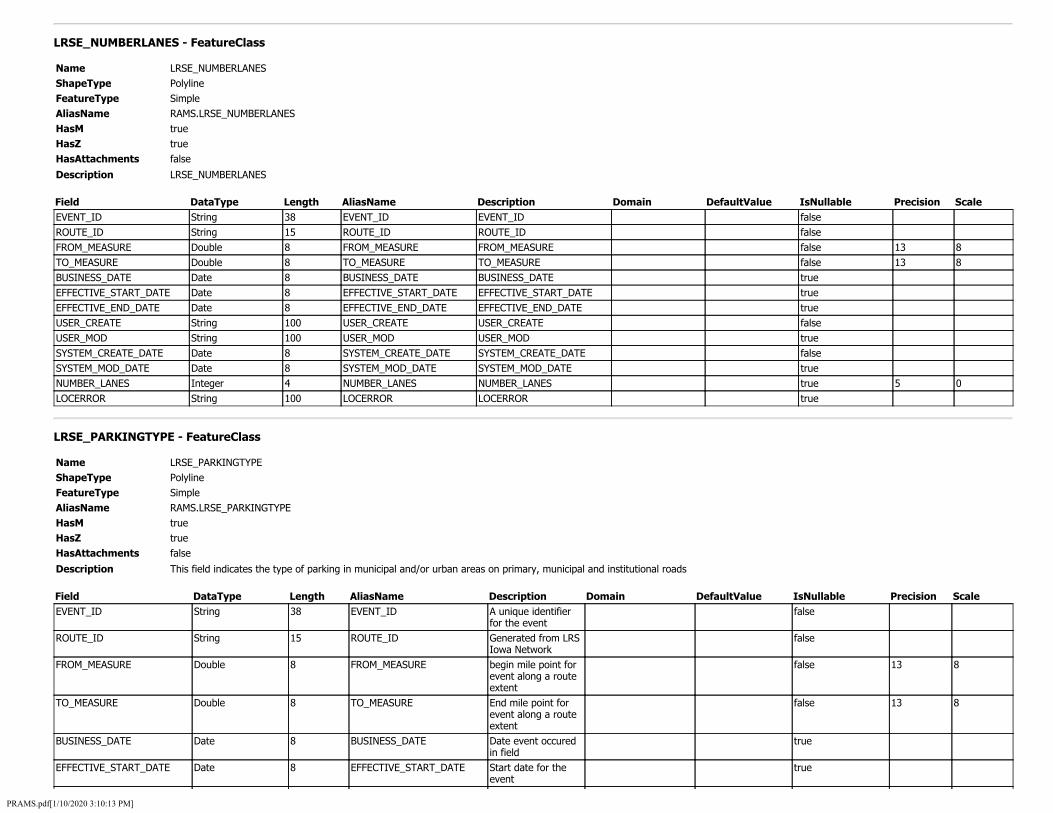
LRSE_NUMBERLANES - FeatureClass
Name LRSE_NUMBERLANES ShapeType Polyline FeatureType Simple AliasName RAMS.LRSE_NUMBERLANES HasM true HasZ true HasAttachments false
Description LRSE_NUMBERLANES
Field DataType Length AliasName Description Domain DefaultValue IsNullable Precision Scale EVENT_ID String 38 EVENT_ID EVENT_ID false ROUTE_ID String 15 ROUTE_ID ROUTE_ID false FROM_MEASURE Double 8 FROM_MEASURE FROM_MEASURE false 13 8 TO_MEASURE Double 8 TO_MEASURE TO_MEASURE false 13 8 BUSINESS_DATE Date 8 BUSINESS_DATE BUSINESS_DATE true EFFECTIVE_START_DATE Date 8 EFFECTIVE_START_DATE EFFECTIVE_START_DATE true EFFECTIVE_END_DATE Date 8 EFFECTIVE_END_DATE EFFECTIVE_END_DATE true USER_CREATE String 100 USER_CREATE USER_CREATE false USER_MOD String 100 USER_MOD USER_MOD true SYSTEM_CREATE_DATE Date 8 SYSTEM_CREATE_DATE SYSTEM_CREATE_DATE false SYSTEM_MOD_DATE Date 8 SYSTEM_MOD_DATE SYSTEM_MOD_DATE true NUMBER_LANES Integer 4 NUMBER_LANES NUMBER_LANES true 5 0 LOCERROR String 100 LOCERROR LOCERROR true
LRSE_PARKINGTYPE - FeatureClass
Name LRSE_PARKINGTYPE ShapeType Polyline FeatureType Simple AliasName RAMS.LRSE_PARKINGTYPE HasM true HasZ true HasAttachments false
Description This field indicates the type of parking in municipal and/or urban areas on primary, municipal and institutional roads
Field DataType Length AliasName Description Domain DefaultValue IsNullable Precision Scale EVENT_ID
ROUTE_ID
FROM_MEASURE
TO_MEASURE
BUSINESS_DATE
EFFECTIVE_START_DATE
String
String
Double
Double
Date
Date
38
15
8
8
8
8
EVENT_ID
ROUTE_ID
FROM_MEASURE
TO_MEASURE
BUSINESS_DATE
EFFECTIVE_START_DATE
A unique identifier for the event Generated from LRS Iowa Network begin mile point for event along a route extent End mile point for event along a route extent Date event occured in field Start date for the event
false
false
false
false
true
true
13
13
8
8
PRAMS.pdf[1/10/2020 3:10:13 PM]

EFFECTIVE_END_DATE Date 8 EFFECTIVE_END_DATE End date for the event
true
USER_CREATE String 100 USER_CREATE Username of who created event
false
USER_MOD String 100 USER_MOD Username that modified event
true
SYSTEM_CREATE_DATE Date 8 SYSTEM_CREATE_DATE Date and time record was inserted into database
false
SYSTEM_MOD_DATE Date 8 SYSTEM_MOD_DATE Date and time event was modified in database
true
PARKING_TYPE Integer 4 PARKING_TYPE This field indicates the type of parking in municipal and/or urban areas on primary, municipal and institutional roads
PARKING_TYPE_ID true 5 0
LOCERROR String 100 LOCERROR LRS location error populated by roads and highway
true
LRSE_PLANNINGCLASS - FeatureClass
Name LRSE_PLANNINGCLASS ShapeType Polyline FeatureType Simple AliasName RAMS.LRSE_PLANNINGCLASS HasM true HasZ true HasAttachments false
Description This field is a five-level classification for use in planning and programming for the primary road system. The Office of Systems Planning is responsible for providing the data for this field.
Field DataType Length AliasName Description Domain DefaultValue IsNullable Precision Scale EVENT_ID String 38 EVENT_ID A unique identifier
for the event false
ROUTE_ID String 15 ROUTE_ID Generated from LRS Iowa Network
false
FROM_MEASURE Double 8 FROM_MEASURE begin mile point for event along a route extent
false 13 8
TO_MEASURE Double 8 TO_MEASURE End mile point for event along a route extent
false 13 8
BUSINESS_DATE Date 8 BUSINESS_DATE Date event occured in field
true
EFFECTIVE_START_DATE Date 8 EFFECTIVE_START_DATE Start date for the event
true
EFFECTIVE_END_DATE Date 8 EFFECTIVE_END_DATE End date for the event
true
USER_CREATE String 100 USER_CREATE Username of who created event
false
USER_MOD String 100 USER_MOD Username that modified event
true
SYSTEM_CREATE_DATE Date 8 SYSTEM_CREATE_DATE Date and time record was inserted
false
PRAMS.pdf[1/10/2020 3:10:13 PM]

into database SYSTEM_MOD_DATE Date 8 SYSTEM_MOD_DATE Date and time event
was modified in database
true
PLANNING_CLASS Integer 4 PLANNING_CLASS This field is a five-level classification for use in planning and programming for the primary road system. The Office of Systems Planning is responsible for providing the data for this field.
PLANNING_CLASS_ID true 5 0
LOCERROR String 100 LOCERROR LRS location error populated by roads and highway
true
LRSE_PROJECT_SCOPING - FeatureClass
Name LRSE_PROJECT_SCOPING ShapeType Polyline FeatureType Simple AliasName PROJECT_SCOPING HasM true HasZ true HasAttachments false
Description LRSE_PROJECT_SCOPING
Field DataType Length AliasName Description Domain DefaultValue IsNullable Precision Scale EVENT_ID String 38 EVENT_ID EVENT_ID false ROUTE_ID String 15 ROUTE_ID ROUTE_ID false FROM_MEASURE Double 8 FROM_MEASURE FROM_MEASURE false 13 8 TO_MEASURE Double 8 TO_MEASURE TO_MEASURE false 13 8 BUSINESS_DATE Date 8 BUSINESS_DATE BUSINESS_DATE true EFFECTIVE_START_DATE Date 8 EFFECTIVE_START_DATE EFFECTIVE_START_DATE true EFFECTIVE_END_DATE Date 8 EFFECTIVE_END_DATE EFFECTIVE_END_DATE true USER_CREATE String 100 USER_CREATE USER_CREATE false USER_MOD String 100 USER_MOD USER_MOD true SYSTEM_CREATE_DATE Date 8 SYSTEM_CREATE_DATE SYSTEM_CREATE_DATE false SYSTEM_MOD_DATE Date 8 SYSTEM_MOD_DATE SYSTEM_MOD_DATE true PROJECT_SCOPE_ID String 38 PROJECT_SCOPE_ID PROJECT_SCOPE_ID true PSS_PIN_ID String 38 PSS_PIN_ID PSS_PIN_ID true LOCERROR String 100 LOCERROR LOCERROR true
LRSE_REFERENCEPOSTS - FeatureClass
Name LRSE_REFERENCEPOSTS ShapeType Point FeatureType Simple AliasName RAMS.LRSE_REFERENCEPOSTS HasM true HasZ true
PRAMS.pdf[1/10/2020 3:10:13 PM]

HasAttachments false
Description provides localized, but consistently placed points of reference from which to measure a linear location. The reference post LRM uses the mileposts along the primary routes. Note that the LRS does not allow using the post values as a representation of accumulated distance; this subsystem applies the posts and relative offsets to locate events. For example, the accumulated distance of 10.06 is not the same location as reference post 10, offset 6 miles.
Field DataType Length AliasName Description Domain DefaultValue IsNullable Precision Scale EVENT_ID String 38 EVENT_ID A unique identifier
for the event false
ROUTE_ID String 15 ROUTE_ID Generated from LRS Iowa Network
false
MEASURE Double 8 MEASURE Mile point for event along a route extent
false 13 8
BUSINESS_DATE Date 8 BUSINESS_DATE Date event occured in field
true
EFFECTIVE_START_DATE Date 8 EFFECTIVE_START_DATE Start date for the event
true
EFFECTIVE_END_DATE Date 8 EFFECTIVE_END_DATE End date for the event
true
USER_CREATE String 100 USER_CREATE Username of who created event
false
USER_MOD String 100 USER_MOD Username that modified event
true
SYSTEM_CREATE_DATE Date 8 SYSTEM_CREATE_DATE Date and time record was inserted into database
false
SYSTEM_MOD_DATE Date 8 SYSTEM_MOD_DATE Date and time event was modified in database
true
REFERENCE_POST_VALUE String 10 REFERENCE_POST_VALUE Reference post number printed on sign
true
REFERENCE_POST_NAME String 255 REFERENCE_POST_NAME Combination of reference post value, route name, and direction
true
OPPOSITE_SIDE String 1 OPPOSITE_SIDE Indicates if post is on non-cardinal side of road
true
VIRTUAL String 1 VIRTUAL Non-physical reference post for measuring purposes.
true
MEASURED_LAT Double 8 MEASURED_LAT Latitudinal position of post
true 8 5
MEASURED_LON Double 8 MEASURED_LON Longitudinal position of post
true 8 5
LOCERROR String 100 LOCERROR LRS location error populated by roads and highway
true
LRSE_RIGHTSHOULDERCURBED - FeatureClass
Name LRSE_RIGHTSHOULDERCURBED ShapeType Polyline FeatureType Simple AliasName RAMS.LRSE_RIGHTSHOULDERCURBED HasM true HasZ true
PRAMS.pdf[1/10/2020 3:10:13 PM]

HasAttachments false
Description This field indicates whether the right side or outside shoulder has a curb
Field DataType Length AliasName Description Domain DefaultValue IsNullable Precision Scale EVENT_ID String 38 EVENT_ID A unique identifier
for the event false
ROUTE_ID String 15 ROUTE_ID Generated from LRS Iowa Network
false
FROM_MEASURE Double 8 FROM_MEASURE begin mile point for event along a route extent
false 13 8
TO_MEASURE Double 8 TO_MEASURE End mile point for event along a route extent
false 13 8
BUSINESS_DATE Date 8 BUSINESS_DATE Date event occured in field
true
EFFECTIVE_START_DATE Date 8 EFFECTIVE_START_DATE Start date for the event
true
EFFECTIVE_END_DATE Date 8 EFFECTIVE_END_DATE End date for the event
true
USER_CREATE String 100 USER_CREATE Username of who created event
false
USER_MOD String 100 USER_MOD Username that modified event
true
SYSTEM_CREATE_DATE Date 8 SYSTEM_CREATE_DATE Date and time record was inserted into database
false
SYSTEM_MOD_DATE Date 8 SYSTEM_MOD_DATE Date and time event was modified in database
true
RIGHT_SHOULDER_CURBED Integer 4 RIGHT_SHOULDER_CURBED This field indicates whether the right side or outside shoulder has a curb
CURBED_ID true 5 0
LOCERROR String 100 LOCERROR LRS location error populated by roads and highway
true
LRSE_RIGHTSHOULDERRUMBLE - FeatureClass
Name LRSE_RIGHTSHOULDERRUMBLE ShapeType Polyline FeatureType Simple AliasName RAMS.LRSE_RIGHTSHOULDERRUMBLE HasM true HasZ true HasAttachments false
Description This field indicates whether a rumble strip exists on the right side or outside shoulder.
Field DataType Length AliasName Description Domain DefaultValue IsNullable Precision Scale EVENT_ID String 38 EVENT_ID A unique identifier
for the event false
ROUTE_ID String 15 ROUTE_ID Generated from LRS Iowa Network
false
FROM_MEASURE Double 8 FROM_MEASURE begin mile point for event along a route
false 13 8
PRAMS.pdf[1/10/2020 3:10:13 PM]

extent TO_MEASURE Double 8 TO_MEASURE End mile point for
event along a route extent
false 13 8
BUSINESS_DATE Date 8 BUSINESS_DATE Date event occured in field
true
EFFECTIVE_START_DATE Date 8 EFFECTIVE_START_DATE Start date for the event
true
EFFECTIVE_END_DATE Date 8 EFFECTIVE_END_DATE End date for the event
true
USER_CREATE String 100 USER_CREATE Username of who created event
false
USER_MOD String 100 USER_MOD Username that modified event
true
SYSTEM_CREATE_DATE Date 8 SYSTEM_CREATE_DATE Date and time record was inserted into database
false
SYSTEM_MOD_DATE Date 8 SYSTEM_MOD_DATE Date and time event was modified in database
true
RIGHT_SHOULDER_RUMBLE Integer 4 RIGHT_SHOULDER_RUMBLE This field indicates whether a rumble strip exists on the right side or outside shoulder.
RUMBLE_TYPE_ID true 5 0
LOCERROR String 100 LOCERROR LRS location error populated by roads and highway
true
LRSE_RIGHTSHOULDERTIED - FeatureClass
Name LRSE_RIGHTSHOULDERTIED ShapeType Polyline FeatureType Simple AliasName RAMS.LRSE_RIGHTSHOULDERTIED HasM true HasZ true HasAttachments false
Description This field indicates if the right side or outside shoulder is tied to the roadway surface.
Field DataType Length AliasName Description Domain DefaultValue IsNullable Precision Scale EVENT_ID String 38 EVENT_ID A unique identifier
for the event false
ROUTE_ID String 15 ROUTE_ID Generated from LRS Iowa Network
false
FROM_MEASURE Double 8 FROM_MEASURE begin mile point for event along a route extent
false 13 8
TO_MEASURE Double 8 TO_MEASURE End mile point for event along a route extent
false 13 8
BUSINESS_DATE Date 8 BUSINESS_DATE Date event occured in field
true
EFFECTIVE_START_DATE Date 8 EFFECTIVE_START_DATE Start date for the event
true
EFFECTIVE_END_DATE Date 8 EFFECTIVE_END_DATE End date for the true
PRAMS.pdf[1/10/2020 3:10:13 PM]

event USER_CREATE String 100 USER_CREATE Username of who
created event false
USER_MOD String 100 USER_MOD Username that modified event
true
SYSTEM_CREATE_DATE Date 8 SYSTEM_CREATE_DATE Date and time record was inserted into database
false
SYSTEM_MOD_DATE Date 8 SYSTEM_MOD_DATE Date and time event was modified in database
true
RIGHT_SHOULDER_TIED Integer 4 RIGHT_SHOULDER_TIED This field indicates if the right side or outside shoulder is tied to the roadway surface.
SHOULDER_TIED_ID true 5 0
LOCERROR String 100 LOCERROR LRS location error populated by roads and highway
true
LRSE_RIGHTSHOULDERTYPE - FeatureClass
Name LRSE_RIGHTSHOULDERTYPE ShapeType Polyline FeatureType Simple AliasName RAMS.LRSE_RIGHTSHOULDERTYPE HasM true HasZ true HasAttachments false
Description This field indicates the right side or outside shoulder type for all road systems using the following criteria.
Field DataType Length AliasName Description Domain DefaultValue IsNullable Precision Scale EVENT_ID String 38 EVENT_ID A unique identifier
for the event false
ROUTE_ID String 15 ROUTE_ID Generated from LRS Iowa Network
false
FROM_MEASURE Double 8 FROM_MEASURE begin mile point for event along a route extent
false 13 8
TO_MEASURE Double 8 TO_MEASURE End mile point for event along a route extent
false 13 8
BUSINESS_DATE Date 8 BUSINESS_DATE Date event occured in field
true
EFFECTIVE_START_DATE Date 8 EFFECTIVE_START_DATE Start date for the event
true
EFFECTIVE_END_DATE Date 8 EFFECTIVE_END_DATE End date for the event
true
USER_CREATE String 100 USER_CREATE Username of who created event
false
USER_MOD String 100 USER_MOD Username that modified event
true
SYSTEM_CREATE_DATE Date 8 SYSTEM_CREATE_DATE Date and time record was inserted into database
false
SYSTEM_MOD_DATE Date 8 SYSTEM_MOD_DATE Date and time event true
PRAMS.pdf[1/10/2020 3:10:13 PM]
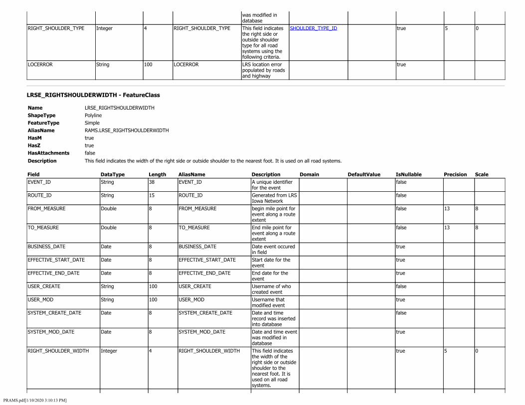
was modified in database
RIGHT_SHOULDER_TYPE Integer 4 RIGHT_SHOULDER_TYPE This field indicates the right side or outside shoulder type for all road systems using the following criteria.
SHOULDER_TYPE_ID true 5 0
LOCERROR String 100 LOCERROR LRS location error populated by roads and highway
true
LRSE_RIGHTSHOULDERWIDTH - FeatureClass
Name LRSE_RIGHTSHOULDERWIDTH ShapeType Polyline FeatureType Simple AliasName RAMS.LRSE_RIGHTSHOULDERWIDTH HasM true HasZ true HasAttachments false
Description This field indicates the width of the right side or outside shoulder to the nearest foot. It is used on all road systems.
Field DataType Length AliasName Description Domain DefaultValue IsNullable Precision Scale EVENT_ID String 38 EVENT_ID A unique identifier
for the event false
ROUTE_ID String 15 ROUTE_ID Generated from LRS Iowa Network
false
FROM_MEASURE Double 8 FROM_MEASURE begin mile point for event along a route extent
false 13 8
TO_MEASURE Double 8 TO_MEASURE End mile point for event along a route extent
false 13 8
BUSINESS_DATE Date 8 BUSINESS_DATE Date event occured in field
true
EFFECTIVE_START_DATE Date 8 EFFECTIVE_START_DATE Start date for the event
true
EFFECTIVE_END_DATE Date 8 EFFECTIVE_END_DATE End date for the event
true
USER_CREATE String 100 USER_CREATE Username of who created event
false
USER_MOD String 100 USER_MOD Username that modified event
true
SYSTEM_CREATE_DATE Date 8 SYSTEM_CREATE_DATE Date and time record was inserted into database
false
SYSTEM_MOD_DATE Date 8 SYSTEM_MOD_DATE Date and time event was modified in database
true
RIGHT_SHOULDER_WIDTH Integer 4 RIGHT_SHOULDER_WIDTH This field indicates the width of the right side or outside shoulder to the nearest foot. It is used on all road systems.
true 5 0
PRAMS.pdf[1/10/2020 3:10:13 PM]

LOCERROR String 100 LOCERROR LRS location error populated by roads and highway
true
LRSE_ROADFUNCTION - FeatureClass
Name LRSE_ROADFUNCTION ShapeType Polyline FeatureType Simple AliasName RAMS.LRSE_ROADFUNCTION HasM true HasZ true HasAttachments false
Description This field designates the difference between mainline and non-mainline road sections, and designates other normal roadway uses. (This field is applicable only to primary roads.)
Field DataType Length AliasName Description Domain DefaultValue IsNullable Precision Scale EVENT_ID String 38 EVENT_ID A unique identifier
for the event false
ROUTE_ID String 15 ROUTE_ID Generated from LRS Iowa Network
false
FROM_MEASURE Double 8 FROM_MEASURE begin mile point for event along a route extent
false 13 8
TO_MEASURE Double 8 TO_MEASURE End mile point for event along a route extent
false 13 8
BUSINESS_DATE Date 8 BUSINESS_DATE Date event occured in field
true
EFFECTIVE_START_DATE Date 8 EFFECTIVE_START_DATE Start date for the event
true
EFFECTIVE_END_DATE Date 8 EFFECTIVE_END_DATE End date for the event
true
USER_CREATE String 100 USER_CREATE Username of who created event
false
USER_MOD String 100 USER_MOD Username that modified event
true
SYSTEM_CREATE_DATE Date 8 SYSTEM_CREATE_DATE Date and time record was inserted into database
false
SYSTEM_MOD_DATE Date 8 SYSTEM_MOD_DATE Date and time event was modified in database
true
ROAD_FUNCTION Integer 4 ROAD_FUNCTION This field designates the difference between mainline and non-mainline road sections, and designates other normal roadway uses. (This field is applicable only to primary roads.)
ROAD_FUNCTION_ID true 5 0
LOCERROR String 100 LOCERROR LRS location error populated by roads and highway
true
PRAMS.pdf[1/10/2020 3:10:13 PM]

LRSE_ROADOWNERSHIP - FeatureClass
Name LRSE_ROADOWNERSHIP ShapeType Polyline FeatureType Simple AliasName RAMS.LRSE_ROADOWNERSHIP HasM true HasZ true HasAttachments false
Description The entity that has legal ownership of a roadway
Field DataType Length AliasName Description Domain DefaultValue IsNullable Precision Scale EVENT_ID String 38 EVENT_ID A unique identifier
for the event false
ROUTE_ID String 15 ROUTE_ID Generated from LRS Iowa Network
false
FROM_MEASURE Double 8 FROM_MEASURE begin mile point for event along a route extent
false 13 8
TO_MEASURE Double 8 TO_MEASURE End mile point for event along a route extent
false 13 8
BUSINESS_DATE Date 8 BUSINESS_DATE Date event occured in field
true
EFFECTIVE_START_DATE Date 8 EFFECTIVE_START_DATE Start date for the event
true
EFFECTIVE_END_DATE Date 8 EFFECTIVE_END_DATE End date for the event
true
USER_CREATE String 100 USER_CREATE Username of who created event
false
USER_MOD String 100 USER_MOD Username that modified event
true
SYSTEM_CREATE_DATE Date 8 SYSTEM_CREATE_DATE Date and time record was inserted into database
false
SYSTEM_MOD_DATE Date 8 SYSTEM_MOD_DATE Date and time event was modified in database
true
OWNER_CODE Integer 4 OWNER_CODE For apportionment, administrative, legislative, analytical, and national highway database purposes, and in cost allocation studies
OWNER_CODE_ID true 5 0
LOCERROR String 100 LOCERROR LRS location error populated by roads and highway
true
LRSE_ROADSTATUS - FeatureClass
Name LRSE_ROADSTATUS ShapeType Polyline FeatureType Simple AliasName RAMS.LRSE_ROADSTATUS
PRAMS.pdf[1/10/2020 3:10:13 PM]

HasM HasZ HasAttachments Description
true true false
Identifies the road segment as open, legal not open, or proposed.
Field DataType Length AliasName Description Domain DefaultValue IsNullable Precision Scale EVENT_ID String 38 EVENT_ID A unique identifier
for the event false
ROUTE_ID String 15 ROUTE_ID Generated from LRS Iowa Network
false
FROM_MEASURE Double 8 FROM_MEASURE begin mile point for event along a route extent
false 13 8
TO_MEASURE Double 8 TO_MEASURE End mile point for event along a route extent
false 13 8
BUSINESS_DATE Date 8 BUSINESS_DATE Date event occured in field
true
EFFECTIVE_START_DATE Date 8 EFFECTIVE_START_DATE Start date for the event
true
EFFECTIVE_END_DATE Date 8 EFFECTIVE_END_DATE End date for the event
true
USER_CREATE String 100 USER_CREATE Username of who created event
false
USER_MOD String 100 USER_MOD Username that modified event
true
SYSTEM_CREATE_DATE Date 8 SYSTEM_CREATE_DATE Date and time record was inserted into database
false
SYSTEM_MOD_DATE Date 8 SYSTEM_MOD_DATE Date and time event was modified in database
true
ROAD_STATUS Integer 4 ROAD_STATUS Identifies the road segment as open, legal not open, or proposed.
ROAD_STATUS_ID false 5 0
LOCERROR String 100 LOCERROR LRS location error populated by roads and highway
true
LRSE_ROADSYSTEM - FeatureClass
Name LRSE_ROADSYSTEM ShapeType Polyline FeatureType Simple AliasName RAMS.LRSE_ROADSYSTEM HasM true HasZ true HasAttachments false
Description Indicates the state assigned system for the segment of road.
Field DataType Length AliasName Description Domain DefaultValue IsNullable Precision Scale EVENT_ID String 38 EVENT_ID A unique identifier
for the event false
ROUTE_ID String 15 ROUTE_ID Generated from LRS Iowa Network
false
PRAMS.pdf[1/10/2020 3:10:13 PM]

FROM_MEASURE Double 8 FROM_MEASURE begin mile point for event along a route extent
false 13 8
TO_MEASURE Double 8 TO_MEASURE End mile point for event along a route extent
false 13 8
BUSINESS_DATE Date 8 BUSINESS_DATE Date event occured in field
true
EFFECTIVE_START_DATE Date 8 EFFECTIVE_START_DATE Start date for the event
true
EFFECTIVE_END_DATE Date 8 EFFECTIVE_END_DATE End date for the event
true
USER_CREATE String 100 USER_CREATE Username of who created event
false
USER_MOD String 100 USER_MOD Username that modified event
true
SYSTEM_CREATE_DATE Date 8 SYSTEM_CREATE_DATE Date event occured in field
false
SYSTEM_MOD_DATE Date 8 SYSTEM_MOD_DATE Date and time event was modified in database
true
ROAD_SYSTEM Integer 4 ROAD_SYSTEM Indicates the state assigned system for the segment of road.
ROAD_SYSTEM_ID true 5 0
LOCERROR String 100 LOCERROR LRS location error populated by roads and highway
true
LRSE_ROUTEDOMINANCE - FeatureClass
Name LRSE_ROUTEDOMINANCE ShapeType Polyline FeatureType Simple AliasName ROUTE DOMINANCE HasM true HasZ true HasAttachments false
Description LRSE_ROUTEDOMINANCE
Field DataType Length AliasName Description Domain DefaultValue IsNullable Precision Scale EVENT_ID String 38 EVENT_ID EVENT_ID false ROUTE_ID String 15 ROUTE_ID ROUTE_ID false FROM_MEASURE Double 8 FROM_MEASURE FROM_MEASURE false 13 8 TO_MEASURE Double 8 TO_MEASURE TO_MEASURE false 13 8 BUSINESS_DATE Date 8 BUSINESS_DATE BUSINESS_DATE true EFFECTIVE_START_DATE Date 8 EFFECTIVE_START_DATE EFFECTIVE_START_DATE true EFFECTIVE_END_DATE Date 8 EFFECTIVE_END_DATE EFFECTIVE_END_DATE true USER_CREATE String 100 USER_CREATE USER_CREATE false USER_MOD String 100 USER_MOD USER_MOD true SYSTEM_CREATE_DATE Date 8 SYSTEM_CREATE_DATE SYSTEM_CREATE_DATE false SYSTEM_MOD_DATE Date 8 SYSTEM_MOD_DATE SYSTEM_MOD_DATE true RTE_DOMINANCE Integer 4 RTE_DOMINANCE RTE_DOMINANCE true 5 0 LOCERROR String 100 LOCERROR LOCERROR true
PRAMS.pdf[1/10/2020 3:10:13 PM]

LRSE_ROUTEQUALIFIER - FeatureClass
Name LRSE_ROUTEQUALIFIER ShapeType Polyline FeatureType Simple AliasName RAMS.LRSE_ROUTEQUALIFIER HasM true HasZ true HasAttachments false
Description The route signing descriptive qualifier
Field DataType Length AliasName Description Domain DefaultValue IsNullable Precision Scale EVENT_ID String 38 EVENT_ID A unique identifier
for the event false
ROUTE_ID String 15 ROUTE_ID Generated from LRS Iowa Network
false
FROM_MEASURE Double 8 FROM_MEASURE begin mile point for event along a route extent
false 13 8
TO_MEASURE Double 8 TO_MEASURE End mile point for event along a route extent
false 13 8
BUSINESS_DATE Date 8 BUSINESS_DATE Date event occured in field
true
EFFECTIVE_START_DATE Date 8 EFFECTIVE_START_DATE Start date for the event
true
EFFECTIVE_END_DATE Date 8 EFFECTIVE_END_DATE End date for the event
true
USER_CREATE String 100 USER_CREATE Username of who created event
false
USER_MOD String 100 USER_MOD Username that modified event
true
SYSTEM_CREATE_DATE Date 8 SYSTEM_CREATE_DATE Start date for the event
false
SYSTEM_MOD_DATE Date 8 SYSTEM_MOD_DATE Date and time event was modified in database
true
ROUTE_QUALIFIER Integer 4 ROUTE_QUALIFIER The route signing descriptive qualifier
ROUTE_QUALIFIER_ID true 5 0
LOCERROR String 100 LOCERROR LRS location error populated by roads and highway
true
LRSE_ROUTESCOUNTYSIGNED - FeatureClass
Name LRSE_ROUTESCOUNTYSIGNED ShapeType Polyline FeatureType Simple AliasName RAMS.LRSE_ROUTESCOUNTYSIGNED HasM true HasZ true HasAttachments false
Description This field identifies numbers assigned to county roads
Field DataType Length AliasName Description Domain DefaultValue IsNullable Precision Scale
PRAMS.pdf[1/10/2020 3:10:13 PM]

EVENT_ID String 38 EVENT_ID A unique identifier for the event
false
ROUTE_ID String 15 ROUTE_ID Generated from LRS Iowa Network
false
FROM_MEASURE Double 8 FROM_MEASURE begin mile point for event along a route extent
false 13 8
TO_MEASURE Double 8 TO_MEASURE End mile point for event along a route extent
false 13 8
BUSINESS_DATE Date 8 BUSINESS_DATE Date event occured in field
true
EFFECTIVE_START_DATE Date 8 EFFECTIVE_START_DATE Start date for the event
true
EFFECTIVE_END_DATE Date 8 EFFECTIVE_END_DATE End date for the event
true
USER_CREATE String 100 USER_CREATE Username of who created event
false
USER_MOD String 100 USER_MOD Username that modified event
true
SYSTEM_CREATE_DATE Date 8 SYSTEM_CREATE_DATE Date and time record was inserted into database
false
SYSTEM_MOD_DATE Date 8 SYSTEM_MOD_DATE Date and time event was modified in database
true
ROUTE_NAME String 255 ROUTE_NAME This field identifies numbers assigned to county roads
true
PRIORITY Integer 4 PRIORITY Sets hierarchical precedence with lower numbers receiving higher priority
true 5 0
LOCERROR String 100 LOCERROR LRS location error populated by roads and highway
true
LRSE_ROUTESIGNING - FeatureClass
Name LRSE_ROUTESIGNING ShapeType Polyline FeatureType Simple AliasName RAMS.LRSE_ROUTESIGNING HasM true HasZ true HasAttachments false
Description The type of route signing
Field DataType Length AliasName Description Domain DefaultValue IsNullable Precision Scale EVENT_ID String 38 EVENT_ID A unique identifier
for the event false
ROUTE_ID String 15 ROUTE_ID Generated from LRS Iowa Network
false
FROM_MEASURE Double 8 FROM_MEASURE begin mile point for event along a route extent
false 13 8
PRAMS.pdf[1/10/2020 3:10:13 PM]
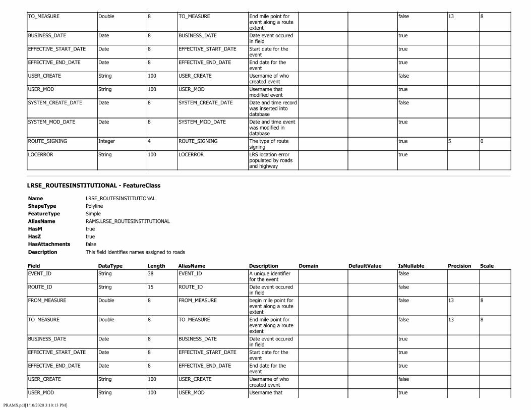
TO_MEASURE Double 8 TO_MEASURE End mile point for event along a route extent
false 13 8
BUSINESS_DATE Date 8 BUSINESS_DATE Date event occured in field
true
EFFECTIVE_START_DATE Date 8 EFFECTIVE_START_DATE Start date for the event
true
EFFECTIVE_END_DATE Date 8 EFFECTIVE_END_DATE End date for the event
true
USER_CREATE String 100 USER_CREATE Username of who created event
false
USER_MOD String 100 USER_MOD Username that modified event
true
SYSTEM_CREATE_DATE Date 8 SYSTEM_CREATE_DATE Date and time record was inserted into database
false
SYSTEM_MOD_DATE Date 8 SYSTEM_MOD_DATE Date and time event was modified in database
true
ROUTE_SIGNING Integer 4 ROUTE_SIGNING The type of route signing
true 5 0
LOCERROR String 100 LOCERROR LRS location error populated by roads and highway
true
LRSE_ROUTESINSTITUTIONAL - FeatureClass
Name LRSE_ROUTESINSTITUTIONAL ShapeType Polyline FeatureType Simple AliasName RAMS.LRSE_ROUTESINSTITUTIONAL HasM true HasZ true HasAttachments false
Description This field identifies names assigned to roads
Field DataType Length AliasName Description Domain DefaultValue IsNullable Precision Scale EVENT_ID String 38 EVENT_ID A unique identifier
for the event false
ROUTE_ID String 15 ROUTE_ID Date event occured in field
false
FROM_MEASURE Double 8 FROM_MEASURE begin mile point for event along a route extent
false 13 8
TO_MEASURE Double 8 TO_MEASURE End mile point for event along a route extent
false 13 8
BUSINESS_DATE Date 8 BUSINESS_DATE Date event occured in field
true
EFFECTIVE_START_DATE Date 8 EFFECTIVE_START_DATE Start date for the event
true
EFFECTIVE_END_DATE Date 8 EFFECTIVE_END_DATE End date for the event
true
USER_CREATE String 100 USER_CREATE Username of who created event
false
USER_MOD String 100 USER_MOD Username that true
PRAMS.pdf[1/10/2020 3:10:13 PM]

modified event SYSTEM_CREATE_DATE Date 8 SYSTEM_CREATE_DATE Date and time record
was inserted into database
false
SYSTEM_MOD_DATE Date 8 SYSTEM_MOD_DATE Date and time event was modified in database
true
ROUTE_NAME String 255 ROUTE_NAME This field identifies names assigned to roads
true
PRIORITY Integer 4 PRIORITY Sets hierarchical precedence with lower numbers receiving higher priority
true 5 0
LOCERROR String 100 LOCERROR LRS location error populated by roads and highway
true
LRSE_ROUTESMUNICIPALE911 - FeatureClass
Name LRSE_ROUTESMUNICIPALE911 ShapeType Polyline FeatureType Simple AliasName RAMS.LRSE_ROUTESMUNICIPALE911 HasM true HasZ true HasAttachments false
Description This field identifies names assigned to local roads
Field DataType Length AliasName Description Domain DefaultValue IsNullable Precision Scale EVENT_ID String 38 EVENT_ID A unique identifier
for the event false
ROUTE_ID String 15 ROUTE_ID Generated from LRS Iowa Network
false
FROM_MEASURE Double 8 FROM_MEASURE begin mile point for event along a route extent
false 13 8
TO_MEASURE Double 8 TO_MEASURE End mile point for event along a route extent
false 13 8
BUSINESS_DATE Date 8 BUSINESS_DATE Date event occured in field
true
EFFECTIVE_START_DATE Date 8 EFFECTIVE_START_DATE Start date for the event
true
EFFECTIVE_END_DATE Date 8 EFFECTIVE_END_DATE End date for the event
true
USER_CREATE String 100 USER_CREATE Username of who created event
false
USER_MOD String 100 USER_MOD Username that modified event
true
SYSTEM_CREATE_DATE Date 8 SYSTEM_CREATE_DATE Date and time record was inserted into database
false
SYSTEM_MOD_DATE Date 8 SYSTEM_MOD_DATE Date and time event was modified in
true
PRAMS.pdf[1/10/2020 3:10:13 PM]

database ROUTE_NAME String 255 ROUTE_NAME This field identifies
names assigned to local roads
true
PRIORITY Integer 4 PRIORITY Sets hierarchical precedence with lower numbers receiving higher priority
true 5 0
LOCERROR String 100 LOCERROR LRS location error populated by roads and highway
true
LRSE_ROUTESRAMP - FeatureClass
Name LRSE_ROUTESRAMP ShapeType Polyline FeatureType Simple AliasName RAMS.LRSE_ROUTESRAMP HasM true HasZ true HasAttachments false
Description This field identifies names assigned to ramps
Field DataType Length AliasName Description Domain DefaultValue IsNullable Precision Scale EVENT_ID String 38 EVENT_ID A unique identifier
for the event false
ROUTE_ID String 15 ROUTE_ID Generated from LRS Iowa Network
false
FROM_MEASURE Double 8 FROM_MEASURE begin mile point for event along a route extent
false 13 8
TO_MEASURE Double 8 TO_MEASURE End mile point for event along a route extent
false 13 8
BUSINESS_DATE Date 8 BUSINESS_DATE Date event occured in field
true
EFFECTIVE_START_DATE Date 8 EFFECTIVE_START_DATE Start date for the event
true
EFFECTIVE_END_DATE Date 8 EFFECTIVE_END_DATE End date for the event
true
USER_CREATE String 100 USER_CREATE Username of who created event
false
USER_MOD String 100 USER_MOD Username that modified event
true
SYSTEM_CREATE_DATE Date 8 SYSTEM_CREATE_DATE Date and time record was inserted into database
false
SYSTEM_MOD_DATE Date 8 SYSTEM_MOD_DATE Date and time event was modified in database
true
ROUTE_NAME String 255 ROUTE_NAME This field identifies names assigned to ramps
true
PRIORITY Integer 4 PRIORITY Sets hierarchical precedence with
true 5 0
PRAMS.pdf[1/10/2020 3:10:13 PM]

lower numbers receiving higher priority
LOCERROR String 100 LOCERROR LRS location error populated by roads and highway
true
LRSE_ROUTESSECONDARYE911 - FeatureClass
Name LRSE_ROUTESSECONDARYE911 ShapeType Polyline FeatureType Simple AliasName RAMS.LRSE_ROUTESSECONDARYE911 HasM true HasZ true HasAttachments false
Description This field identifies names assigned to secondary routes within the E911 System
Field DataType Length AliasName Description Domain DefaultValue IsNullable Precision Scale EVENT_ID String 38 EVENT_ID A unique identifier
for the event false
ROUTE_ID String 15 ROUTE_ID Generated from LRS Iowa Network
false
FROM_MEASURE Double 8 FROM_MEASURE begin mile point for event along a route extent
false 13 8
TO_MEASURE Double 8 TO_MEASURE End mile point for event along a route extent
false 13 8
BUSINESS_DATE Date 8 BUSINESS_DATE Date event occured in field
true
EFFECTIVE_START_DATE Date 8 EFFECTIVE_START_DATE Start date for the event
true
EFFECTIVE_END_DATE Date 8 EFFECTIVE_END_DATE End date for the event
true
USER_CREATE String 100 USER_CREATE Username of who created event
false
USER_MOD String 100 USER_MOD Username that modified event
true
SYSTEM_CREATE_DATE Date 8 SYSTEM_CREATE_DATE Date and time record was inserted into database
false
SYSTEM_MOD_DATE Date 8 SYSTEM_MOD_DATE Date and time event was modified in database
true
ROUTE_NAME String 255 ROUTE_NAME This field identifies names assigned to secondary routes within the E911 System
true
PRIORITY Integer 4 PRIORITY Sets hierarchical precedence with lower numbers receiving higher priority
true 5 0
LOCERROR String 100 LOCERROR LRS location error populated by roads
true
PRAMS.pdf[1/10/2020 3:10:13 PM]

and highway
LRSE_ROUTESSTATESIGNED - FeatureClass
Name LRSE_ROUTESSTATESIGNED ShapeType Polyline FeatureType Simple AliasName RAMS.LRSE_ROUTESSTATESIGNED HasM true HasZ true HasAttachments false
Description This field identifies names assigned to state roads
Field DataType Length AliasName Description Domain DefaultValue IsNullable Precision Scale EVENT_ID String 38 EVENT_ID A unique identifier
for the event false
ROUTE_ID String 15 ROUTE_ID Generated from LRS Iowa Network
false
FROM_MEASURE Double 8 FROM_MEASURE begin mile point for event along a route extent
false 13 8
TO_MEASURE Double 8 TO_MEASURE End mile point for event along a route extent
false 13 8
BUSINESS_DATE Date 8 BUSINESS_DATE Date event occured in field
true
EFFECTIVE_START_DATE Date 8 EFFECTIVE_START_DATE Start date for the event
true
EFFECTIVE_END_DATE Date 8 EFFECTIVE_END_DATE End date for the event
true
USER_CREATE String 100 USER_CREATE Username of who created event
false
USER_MOD String 100 USER_MOD Username that modified event
true
SYSTEM_CREATE_DATE Date 8 SYSTEM_CREATE_DATE Date and time record was inserted into database
false
SYSTEM_MOD_DATE Date 8 SYSTEM_MOD_DATE Date and time event was modified in database
true
ROUTE_NAME String 255 ROUTE_NAME This field identifies names assigned to state roads
true
PRIORITY Integer 4 PRIORITY Sets hierarchical precedence with lower numbers receiving higher priority
true 5 0
LOCERROR String 100 LOCERROR LRS location error populated by roads and highway
true
LRSE_RRCROSSINGS - FeatureClass
Name LRSE_RRCROSSINGS ShapeType Point
PRAMS.pdf[1/10/2020 3:10:13 PM]
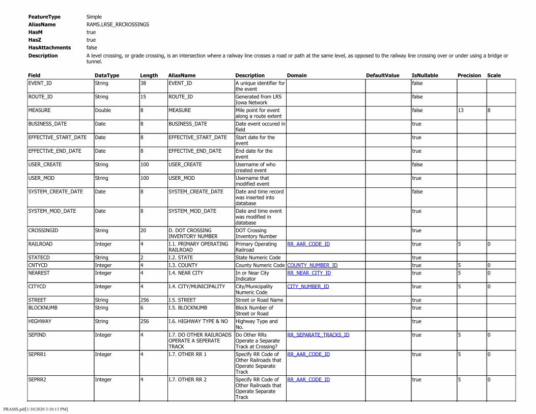
FeatureType Simple AliasName RAMS.LRSE_RRCROSSINGS HasM true HasZ true HasAttachments false
Description A level crossing, or grade crossing, is an intersection where a railway line crosses a road or path at the same level, as opposed to the railway line crossing over or under using a bridge or tunnel.
Field DataType Length AliasName Description Domain DefaultValue IsNullable Precision Scale EVENT_ID
ROUTE_ID
MEASURE
BUSINESS_DATE
EFFECTIVE_START_DATE
EFFECTIVE_END_DATE
USER_CREATE
USER_MOD
SYSTEM_CREATE_DATE
SYSTEM_MOD_DATE
CROSSINGID
RAILROAD
STATECD CNTYCD NEAREST
CITYCD
STREET BLOCKNUMB
HIGHWAY
SEPIND
SEPRR1
SEPRR2
String
String
Double
Date
Date
Date
String
String
Date
Date
String
Integer
String Integer Integer
Integer
String String
String
Integer
Integer
Integer
38
15
8
8
8
8
100
100
8
8
20
4
2 4 4
4
256 6
256
4
4
4
EVENT_ID A unique identifier for the event
ROUTE_ID Generated from LRS Iowa Network
MEASURE Mile point for event along a route extent
BUSINESS_DATE Date event occured in field
EFFECTIVE_START_DATE Start date for the event
EFFECTIVE_END_DATE End date for the event
USER_CREATE Username of who created event
USER_MOD Username that modified event
SYSTEM_CREATE_DATE Date and time record was inserted into database
SYSTEM_MOD_DATE Date and time event was modified in database
D. DOT CROSSING DOT Crossing INVENTORY NUMBER Inventory Number I.1. PRIMARY OPERATING Primary Operating RR_AAR_CODE_ID RAILROAD Railroad I.2. STATE State Numeric Code I.3. COUNTY County Numeric Code COUNTY_NUMBER_ID I.4. NEAR CITY In or Near City RR_NEAR_CITY_ID
Indicator I.4. CITY/MUNICIPALITY City/Municipality CITY_NUMBER_ID
Numeric Code I.5. STREET Street or Road Name I.5. BLOCKNUMB Block Number of
Street or Road I.6. HIGHWAY TYPE & NO Highway Type and
No. I.7. DO OTHER RAILROADS Do Other RRs RR_SEPARATE_TRACKS_ID OPERATE A SEPERATE Operate a Separate TRACK Track at Crossing? I.7. OTHER RR 1 Specify RR Code of RR_AAR_CODE_ID
Other Railroads that Operate Separate Track
I.7. OTHER RR 2 Specify RR Code of RR_AAR_CODE_ID Other Railroads that Operate Separate Track
false
false
false
true
true
true
false
true
false
true
true
true
true true true
true
true true
true
true
true
true
13
5
5 5
5
5
5
5
8
0
0 0
0
0
0
0
PRAMS.pdf[1/10/2020 3:10:13 PM]

SEPRR3 Integer 4 I.7. OTHER RR 3 Specify RR Code of Other Railroads that Operate Separate Track
RR_AAR_CODE_ID true 5 0
SEPRR4 Integer 4 I.7. OTHER RR 4 Specify RR Code of Other Railroads that Operate Separate Track
RR_AAR_CODE_ID true 5 0
SAMEIND Integer 4 I.8. DO OTHER RAILROADS OPERATE OVER YOUR TRACK
Do other RRs Operate Over Your Track at Crossing?
RR_SAME_TRACKS_ID true 5 0
SAMERR1 Integer 4 I.8. SAME RR 1 Specify RR Code(s) of Other Railroads that Operate Over Your Track at Crossing
RR_AAR_CODE_ID true 5 0
SAMERR2 Integer 4 I.8. SAME RR 2 Specify RR Code(s) of Other Railroads that Operate Over Your Track at Crossing
RR_AAR_CODE_ID true 5 0
SAMERR3 Integer 4 I.8. SAME RR 3 Specify RR Code(s) of Other Railroads that Operate Over Your Track at Crossing
RR_AAR_CODE_ID true 5 0
SAMERR4 Integer 4 I.8. SAME RR 4 Specify RR Code(s) of Other Railroads that Operate Over Your Track at Crossing
RR_AAR_CODE_ID true 5 0
RRDIV Integer 4 I.9. RAILROAD DIVISION OR REGION
Railroad Division or Region
RR_DIVISION_ID true 5 0
RRSUBDIV Integer 4 I.10. RAILROAD SUBDIVISION OR DISTRICT
Railroad Subdivision or District
RR_SUB_DIVISION_ID true 5 0
BRANCH Integer 4 I.11. BRANCH OR LINE NAME
Branch or Line Name RR_BRANCH_ID true 5 0
PRFXMILEPOST String 3 I.12. RR MILEPOST PREFIX RR Milepost Prefix true MILEPOST String 8 I.12. RR MILEPOST RR Milepost true SFXMILEPOST String 3 I.12. RR MILEPOST SUFFIX RR Milepost Suffix true RRID String 256 I.13. LINE SEGMENT Line Segment true TTSTNNAM String 256 I.14. NEAREST RR
TIMETABLE STATION Nearest RR Timetable Station Name
true
RRMAIN Integer 4 I.15. PARENT RR Parent RR RR_AAR_CODE_ID true 5 0 XINGOWNR Integer 4 I.16. CROSSING OWNER Crossing Owner RR_AAR_CODE_ID true 5 0 TYPEXING Integer 4 I.17. CROSSING TYPE Crossing Type RR_TYPEXING_ID true 5 0 XPURPOSE Integer 4 I.18. CROSSING PURPOSE Crossing Purpose RR_XPURPOSE_ID true 5 0 POSXING Integer 4 I.19. CROSSING POSITION Crossing Position RR_POSXING_ID true 5 0 OPENPUB Integer 4 I.20. PUBLIC ACCESS Public Access RR_OPENPUB_ID true 5 0 TYPETRNSRVCIDS Integer 4 I.21. TYPE OF TRAIN Type of Train RR_TYPETRNSRVCIDS_ID true 5 0 LT1PASSMOV Integer 4 I.22. LESS THAN 1
PASSENGER TRAIN PER DAY Less Than One Average Passenger Train Count Per Day?
RR_LT1PASSMOV_ID true 5 0
PASSCNT Integer 4 I.22. AVERAGE PASSENGER TRAIN COUNT PER DAY
Number Per Day true 5 0
DEVELTYPID Integer 4 I.23. TYPE OF LAND USE Type of Land Use RR_DEVELTYPEID_ID true 5 0 XINGADJ Integer 4 I.24. IS THERE AN
ADJACENT CROSSING Is there an Adjacent Crossing with a Separate Number?
RR_XINGADJ_ID true 5 0
XNGADJNO String 7 I.24. ADJACENT CROSSING NUMBER
If Yes, Provide Crossing Number
true
WHISTBAN Integer 4 I.25. QUIET ZONE TYPE Quiet Zone (FRA RR_WHISTBAN_ID true 5 0
PRAMS.pdf[1/10/2020 3:10:13 PM]

WHISTDATE SFXHSCORRID
HSCORRID LATITUDE
LONGITUDE
LLSOURCE
RRNAAR1 RRNAAR2 RRNAAR3 RRNAAR4 STNAAR1 STNAAR2 STNAAR3 STNAAR4 RRNAAR
STNAAR POLCONT
RRCONT
HWYCONT
DAYTHRU
NGHTTHRU
TOTALSWT
TOTALLTR
LT1MOV
WEEKTRNMOV
YEARTRNMOV
MAXTTSPD
MINSPD
MAXSPD
Date String
String Double
Double
Integer
String String String String String String String String String
String String
String
String
Integer
Integer
Integer
Integer
Integer
Integer
Integer
Integer
Integer
Integer
8 4
4 8
8
4
256 256 256 256 256 256 256 256 256
256 10
10
10
4
4
4
4
4
4
4
4
4
4
Provided) I.25. QUIET ZONE DATE Date Established I.26. HSR CORRIDOR HSR Corridor ID SUFFIX Suffix I.26. HSR CORRIDOR ID HSR Corridor ID I.27. LATITUDE Latitude in decimal
degrees (max 10 char., WGS84 std nn.nnnnnnn)
I.28. LONGITUDE Longitude in decimal degrees (max 11 char., WGS84 std -nnn.nnnnnnn)
I.29. LAT/LONG SOURCE Latitude/Longitude RR_LLSOURCE_ID Source
I.30.A. RAILROAD USE 1 Railroad Use I.30.B. RAILROAD USE 2 Railroad Use I.30.C. RAILROAD USE 3 Railroad Use I.30.D. RAILROAD USE 4 Railroad Use I.31.A. STATE USE 1 State Use I.31.B. STATE USE 2 State Use I.31.C. STATE USE 3 State Use I.31.D. STATE USE 4 State Use I.32.A. NARRATIVE (RR Railroad Narrative USE) I.32.B. NARRATIVE (STATE) State Narrative I.33. EMERGENCY Emergency NOTIFICATION PHONE Notification NUMBER (POSTED) Telephone No.
(Posted) I.34. RAILROAD Railroad Contact CONTACT(TELEPHONE NO) (Telephone No.) I.35. STATE State Contact CONTACT(TELEPHONE NO) (Telephone No.) II.1.A. TOTAL DAY THRU Total Day Thru Trains TRAINS (6 AM to 6 PM) II.1.B. TOTAL NIGHT THRU Night Thru Trains (6 TRAINS PM to 6AM) II.1.C. TOTAL SWITCHING Total Switching TRAINS Trains (6 AM to 6 PM) II.1.D. TOTAL TRANSIT Total Transit Trains TRAINS II.1.E. CHECK IF LESS THAN Check if Less Than RR_LT1MOV_ID ONE MOVEMENT PER DAY One Movement Per
Day II.1.E. HOW MANY TRAINS How many trains per PER WEEK week? II.2. YEAR OF TRAIN Year of Train Count COUNT DATA Data II.3.A. MAXIMUM Maximum Timetable TIMETABLE SPEED Speed II.3.B. TYPICAL SPEED Typical Speed Range MINIMUM Over Crossing (mph)
From II.3.B. TYPICAL SPEED Typical Speed Range MAXIMUM Over Crossing (mph)
To
true true
true true
true
true
true true true true true true true true true
true true
true
true
true
true
true
true
true
true
true
true
true
true
10
11
5
5
5
5
5
5
5
5
5
5
5
7
7
0
0
0
0
0
0
0
0
0
0
0
PRAMS.pdf[1/10/2020 3:10:13 PM]

MAINTRK SIDINGTRK YARDTRK TRANSITTRK
INDUSTRYTRK
SPSELIDS
SGNLEQP EMONITORDVCE HEALTHMONITOR
NOSIGNS
XBUCK
STOPSTD YIELDSTD ADVW10_1
ADVW10_2
ADVW10_3
ADVW10_4
ADVW10_11
ADVW10_12
LOW_GRND
LOW_GRNDSIGNS
PAVEMRK_STOP
PAVEMRK_SYMBOL
PAVEMRK_DYNENV
CHANNEL
EXEMPT ENSSIGN
OTHSGN
OTHSGN1
OTHDES1
Integer Integer Integer Integer
Integer
Integer
Integer Integer Integer
Integer
Integer
Integer Integer Integer
Integer
Integer
Integer
Integer
Integer
Integer
Integer
String
String
String
Integer
Integer Integer
String
Integer
String
4 4 4 4
4
4
4 4 4
4
4
4 4 4
4
4
4
4
4
4
4
1
1
1
4
4 4
1
4
10
II.4. MAIN TRACK COUNT Main II.4. SIDING TRACK COUNT Siding II.4. YARD TRACK COUNT Yard II.4. TRANSIT TRACK Transit COUNT II.4. INDUSTRY TRACK Industry COUNT II.5. TRAIN DETECTION Train Detection (Main RR_SPSELIDS_ID
Track Only) II.6. IS TRACK SIGNALED Is Track Signaled? RR_SGNLEQP_ID II.7.A. EVENT RECORDER Event Recorder RR_EMONITORDVCE_ID II.7.B. REMOTE HEALTH Remote Health RR_HEALTHMONITOR_ID MONITORING Monitoring III.1. SIGNS OR SIGNALS Are there Signs or RR_NOSIGNS_ID
Signals? III.2.A. CROSSBUCK Crossbuck Assemblies ASSEMBLIES (count) III.2.B. STOP SIGNS Stop Signs (R1-1) III.2.C. YIELD SIGN Yield Signs (R1-2) III.2.D. ADV WARN 10_1 Advance Warning COUNT Signs (W10-1) III.2.D. ADV WARN 10_2 Advance Warning COUNT Signs (W10-2) III.2.D. ADV WARN 10_3 Advance Warning COUNT Signs (W10-3) III.2.D. ADV WARN 10_4 Advance Warning COUNT Signs (W10-4) III.2.D. ADV WARN 10_11 Advance Warning COUNT Signs (W10-11) III.2.D. ADV WARN 10_12 Advance Warning COUNT Signs (W10-12) III.2.E. LOW GROUND Low Ground RR_LOW_GRND_ID CLEARANCE SIGN Clearance Signs
(W10-5) III.2.E. LOW GROUND Low Ground CLEARANCE SIGN COUNT Clearance Signs
(W10-5) count III.2.F. PAVEMENT Stop Line pavement RR_PAVEMENT_MARKINGS_ID MARKING - STOP LINES markings are present
based on MUTCD III.2.F. PAVEMENT Pavement Markings - RR_PAVEMENT_MARKINGS_ID MARKING - XING SYMBOLS RR Xing Symbols III.2.F. PAVEMENT Dynamic Envelope RR_PAVEMENT_MARKINGS_ID MARKING - DYNAMIC pavement markings ENVELOPE are present based on
MUTCD III.2.G. CHANNELIZATION Channelization RR_CHANNEL_ID DEVICES/MEDIANS Devices III.2.H. EXEMPT SIGNS Exempt Sign (R15-3) RR_EXEMPT_ID III.2.I. ENS SIGN ENS Sign Displayed RR_ENSSIGN_ID DISPLAYED (I-13) III.2.J. OTHER MUTCD Other MUTCD Signs RR_OTHSGN_ID SIGNS III.2.J. OTHER SIGNS Other MUTCD Signs: COUNT 1 Count III.2.J. OTHER SIGNS DESC Specify Type 1
true true true true
true
true
true true true
true
true
true true true
true
true
true
true
true
true
true
true
true
true
true
true true
true
true
true
5 5 5 5
5
5
5 5 5
5
5
5 5 5
5
5
5
5
5
5
5
5
5 5
5
0 0 0 0
0
0
0 0 0
0
0
0 0 0
0
0
0
0
0
0
0
0
0 0
0
PRAMS.pdf[1/10/2020 3:10:13 PM]

OTHSGN2 Integer 4 III.2.J. OTHER SIGNS COUNT 2
Other MUTCD Signs: Count
true 5 0
OTHDES2 String 10 III.2.J. OTHER SIGNS DESC 2
Specify Type true
OTHSGN3 Integer 4 III.2.J. OTHER SIGNS COUNT 3
Other MUTCD Signs: Count
true 5 0
OTHDES3 String 10 III.2.J. OTHER SIGNS DESC 3
Specify Type true
PRVXSIGN Integer 4 III.2.K. PRIVATE CROSSING SIGNS
Private Crossing Signs
RR_PRVXSIGN_ID true 5 0
LED String 256 III.2.L. LED ENHANCED SIGNS
LED Enhanced Signs true
GATES Integer 4 III.3.A. GATE ARMS (COUNT) - ROADWAY
Gate Arms: Roadway true 5 0
GATEPED Integer 4 III.3.A. GATE ARMS (COUNT) - PEDESTRIAN
Gate Arms: Pedestrian
true 5 0
GATECONF Integer 4 III.3.B. GATE CONFIGURATION
Gate Configuration RR_GATECONF_ID true 5 0
GATECONFTYPE Integer 4 III.3.B. GATE CONFIGURATION TYPE
Gate Configuration Type
RR_GATECONFTYPE_ID true 5 0
FLASHOV Integer 4 III.3.C. CANTILEVERED FLASHING LIGHT OVER TRAFFIC LANE
Cantilevered (or Bridged) Flashing Light Structures: Over Traffic Lane
true 5 0
FLASHNOV Integer 4 III.3.C. CANTILEVERED FLASHING LIGHT NOT OVER TRAFFIC LANE
Cantilevered (or Bridged) Flashing Light Structures: Not Over Traffic Lane
true 5 0
CFLASHTYPE Integer 4 III.3.C. CANTILEVERED FLASHING LIGHT TYPE
Cantilevered (or Bridged) Flashing Light Structures (Type)
RR_CANTI_FLASH_TYPE_ID true 5 0
FLASHPOST Integer 4 III.3.D. MAST MOUNTED FLASHING LIGHTS COUNT OF MASTS
Mast Mounted Flashing Lights (count of masts)
true 5 0
FLASHPOSTTYPE Integer 4 III.3.D. MAST MOUNTED FLASHING LIGHTS - TYPE
Mast Mounted Flashing Lights (Type)
RR_MAST_FLASH_TYPE_ID true 5 0
BKL_FLASHPOST Integer 4 III.3.D. MAST MOUNTED FLASHING LIGHTS -BACKLIGHTS
Mast Mounted Flashing Lights: Back Lights Included
RR_MAST_BACKLIGHT_ID true 5 0
SDL_FLASHPOST Integer 4 III.3.D. MAST MOUNTED FLASHING LIGHTS - SIDE LIGHTS
Mast Mounted Flashing Lights: Side Lights Included
RR_MAST_SIDELIGHT_ID true 5 0
FLASHPAI Integer 4 III.3.E. TOTAL COUNT OF FLASHING LIGHT PAIRS
Total Count of Flashing Light Pairs
true 5 0
AWDIDATE String 6 III.3.F. INSTALLATION DATE OF CURRENT ACTIVE WARNING DEVICES
Installation Date of Current Active Warning Devices
true
AWHORNCHK Integer 4 III.3.G. WAYSIDE HORN Wayside Horn RR_AWHORNCHK_ID true 5 0 AWHORNIDATE String 6 III.3.G. WAYSIDE HORN
DATE Wayside Horn Installed On
true
HWYTRAFSIGNL Integer 4 III.3.H. HIGHWAY TRAFFIC SIGNALS CONTROLLING CROSSING
Highway Traffic Signals Controlling Crossing
RR_HWYTRAFSIGNL_ID true 5 0
BELLS Integer 4 III.3.I. BELLS (COUNT) Bells true 5 0 SPECPRO Integer 4 III.3.J. NON-TRAIN ACTIVE
WARNING Non-Train Active Warning
RR_SPECPRO_ID true 5 0
PRAMS.pdf[1/10/2020 3:10:13 PM]

FLASHOTH Integer 4 III.3.K. OTHER FLASHING LIGHTS OR WARNING DEVICE - COUNT
Other Flashing Lights or Warning Devices: Count
true 5 0
FLATHOTHDES String 256 III.3.K. OTHER FLASHING LIGHTS OR WARNING DEVICE - SPECIFY TYPE
Other Flashing Lights or Warning Devices: Specify Type
true
HWYNRSIG Integer 4 III.4.A. DOES NEARBY HWY INTERSECTION HAVE TRAFFIC SIGNAL
Does Nearby Hwy Intersection have Traffic Signal?
RR_HWYNRSIG_ID true 5 0
INTRPRMP_NINT String 1 III.4.B. HIGHWAY TRAFFIC SIGNAL - NOT INTERCONNECTED
crossings equipped with active warning systems that do not have an electrical connection between the railroad active warning system and the traffic signal controller assembly for the purpose of preemption
RR_INTRPRMP_ID true
INTRPRMP_TRAF String 1 III.4.B. HWY TRAFFIC SIGNAL - FOR TRAFFIC SIGNALS
crossings having an electrical connection between the railroad active warning system and the traffic signal controller assembly for the purpose of preemption
RR_INTRPRMP_ID true
INTRPRMP_WARN String 1 III.4.B. HWY TRAFFIC SIGNAL - FOR WARNING SIGNS
signs that are electrically connected to a railroad crossing control circuit that is designed to illuminate the signs upon the approach or presence of a train
RR_INTRPRMP_ID true
PREMPTYPE Integer 4 III.4.C. HIGHWAY TRAFFIC SIGNAL PREEMPTION
Highway Traffic Signal Preemption
RR_PREMPTYPE_ID true 5 0
HWTRFPSIG Integer 4 III.5. HIGHWAY TRAFFIC PRE-SIGNALS
Highway Traffic Pre-Signals
RR_HWTRFPSIG_ID true 5 0
HWTRFPSIGSDIS Integer 4 III.5. HIGHWAY TRAFFIC PRE-SIGNALS - STORAGE DISTANCE
Highway Traffic Pre-Signals – Storage Distance
true 5 0
HWTRFPSIGLNDIS Integer 4 III.5. HIGHWAY TRAFFIC PRE-SIGNALS - STOP LINE DISTANCE
Highway Traffic Pre-Signals – Stop Line Distance
true 5 0
MONITORDEV_NON String 1 III.6. HIGHWAY MONITORING DEVICES -NONE
Highway Monitoring Device - None
RR_MONITOR_DEVICE_ID true
MONITORDEV_VIDEO String 1 III.6. HIGHWAY MONITORING DEVICES -PHOTO/VIDEO
Photo/Video Recording is the use of high-resolution cameras to photograph or record motorists driving under or around railroad crossing gates. The camera equipment is typically mounted in a 12-foot-high bullet-resistant cabinet.
RR_MONITOR_DEVICE_ID true
PRAMS.pdf[1/10/2020 3:10:13 PM]

There may be signes, installed on all street approaches to the crossing, that inform motorists that photo citations are being issued to violators at the crossing. Note – The Temporary installation of photo/video recording devices (e.g., for research purposed) are not to be reported.
MONITORDEV_VEH String 1 III.6. HIGHWAY MONITORING DEVICES -VEHICHLE PRESENCE
Vehicle Presence Detection is a system capable of detecting and reporting in real time the presence of a vehicle on the crossing. An example includes a series of looped wire, coils, or magnetometers that are placed below ground level within the field side and gauge side of the railroad tracks, at a distance between the approach gate and the exit gate. The loop detectors or magnetometers use a magnetic effect caused by the presence of a roadway vehicle, which then sends a signal to the exit gate to remain in the up position, or can send a signal to the train operator that a vehicle is still occupying the restricted area of the grade crossing.
RR_MONITOR_DEVICE_ID true
TRAFICLN String 2 IV.1. NUMBER OF CROSSING LANES
Traffic Lanes Crossing Railroad: Number of Lanes
true
TRAFLNTYPE Integer 4 IV.1. TYPE OF CROSSING LANES
Traffic Lanes Crossing Railroad – Type
RR_TRAFLNTYPE_ID true 5 0
HWYPVED Integer 4 IV.2. IS ROAD/PATHWAY PAVED
Is Roadway Paved? RR_HWYPVED_ID true 5 0
DOWNST Integer 4 IV.3. DOES TRACK RUN DOWN A STREET
Does Track Run Down a Street?
RR_DOWNST_ID true 5 0
ILLUMINA Integer 4 IV.4. IS CROSSING ILLUMINATED
Is Crossing Illuminated?
RR_ILLUMINA_ID true 5 0
XSURFDATE String 6 IV.5. CROSSING SURFACE INSTALLATION DATE
Crossing Surface: Installation Date
true
XSURFWIDTH Integer 4 IV.5. CROSSING SURFACE WIDTH
Crossing Surface: Width
true 5 0
PRAMS.pdf[1/10/2020 3:10:13 PM]

XSURFLENGTH
XSURFIDS_TIMBER
XSURFIDS_ASP
XSURFIDS_ASPTIM
XSURFIDS_CONCRETE
XSURFIDS_CONCRUB
XSURFIDS_RUBBER
Integer
String
String
String
String
String
String
4
1
1
1
1
1
1
IV.5. CROSSING SURFACE Crossing Surface: LENGTH Length IV.5. CROSSING SURFACE - Includes sectional RR_CROSSING_SURFACE_ID TIMBER treated timber and
full wood plank. Sectional treated timber consists of prefabricated units approximately 8 feet in length of treated timber individually installed and removed for maintenance and replacement purposes. Full wood plank consists of timber surface that covers the entire crossing area above the crossties, made of ties, boards, bridge ties, etc.
IV.5. CROSSING SURFACE - asphalt surface over RR_CROSSING_SURFACE_ID ASPHALT the entire crossing
area IV.5. CROSSING SURFACE - asphalt surface in the RR_CROSSING_SURFACE_ID ASPHALT TIMBER area between flange
timber planks or other material forming a flangeway openings that may include the use of rubber
IV.5. CROSSING SURFACE - includes concrete slab RR_CROSSING_SURFACE_ID CONCRETE and concrete
pavement. Concrete slab consists of pre-cast concrete sections that are usually individually installed and removable for maintenance and replacement purposes. Concrete pavement is a concrete surface that is continuous over the track area and is not removable except by destruction of the surface.
IV.5. CROSSING SURFACE - an installed crossing RR_CROSSING_SURFACE_ID CONCRETE RUBBER surface that consists
of both concrete and rubber materials.
IV.5. CROSSING SURFACE - preformed rubber RR_CROSSING_SURFACE_ID RUBBER sections that are
usually individually installed and removable for maintenance and replacement purposes
true
true
true
true
true
true
true
5 0
PRAMS.pdf[1/10/2020 3:10:13 PM]
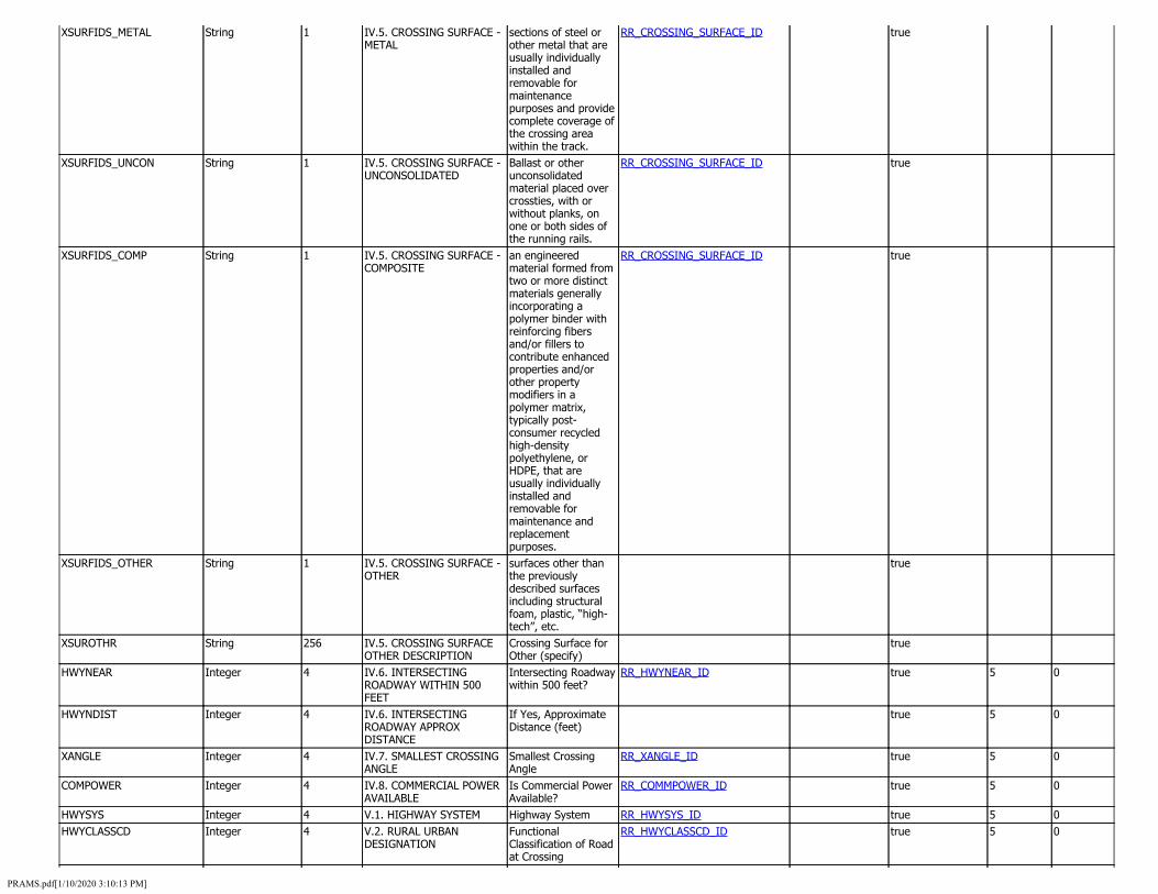
XSURFIDS_METAL
XSURFIDS_UNCON
XSURFIDS_COMP
XSURFIDS_OTHER
XSUROTHR
HWYNEAR
HWYNDIST
XANGLE
COMPOWER
HWYSYS HWYCLASSCD
String
String
String
String
String
Integer
Integer
Integer
Integer
Integer Integer
1
1
1
1
256
4
4
4
4
4 4
IV.5. CROSSING SURFACE - sections of steel or RR_CROSSING_SURFACE_ID METAL other metal that are
usually individually installed and removable for maintenance purposes and provide complete coverage of the crossing area within the track.
IV.5. CROSSING SURFACE - Ballast or other RR_CROSSING_SURFACE_ID UNCONSOLIDATED unconsolidated
material placed over crossties, with or without planks, on one or both sides of the running rails.
IV.5. CROSSING SURFACE - an engineered RR_CROSSING_SURFACE_ID COMPOSITE material formed from
two or more distinct materials generally incorporating a polymer binder with reinforcing fibers and/or fillers to contribute enhanced properties and/or other property modifiers in a polymer matrix, typically post-consumer recycled high-density polyethylene, or HDPE, that are usually individually installed and removable for maintenance and replacement purposes.
IV.5. CROSSING SURFACE - surfaces other than OTHER the previously
described surfaces including structural foam, plastic, “high-tech”, etc.
IV.5. CROSSING SURFACE Crossing Surface for OTHER DESCRIPTION Other (specify) IV.6. INTERSECTING Intersecting Roadway RR_HWYNEAR_ID ROADWAY WITHIN 500 within 500 feet? FEET IV.6. INTERSECTING If Yes, Approximate ROADWAY APPROX Distance (feet) DISTANCE IV.7. SMALLEST CROSSING Smallest Crossing RR_XANGLE_ID ANGLE Angle IV.8. COMMERCIAL POWER Is Commercial Power RR_COMMPOWER_ID AVAILABLE Available? V.1. HIGHWAY SYSTEM Highway System RR_HWYSYS_ID V.2. RURAL URBAN Functional RR_HWYCLASSCD_ID DESIGNATION Classification of Road
at Crossing
true
true
true
true
true
true
true
true
true
true true
5
5
5
5
5 5
0
0
0
0
0 0
PRAMS.pdf[1/10/2020 3:10:13 PM]

HWYCLASSRDTPID Integer 4 V.2. FEDERAL FUNCTIONAL CLASSIFICATION
Functional Classification of Road at Crossing
RR_HWYCLASSRDTPID_ID true 5 0
STHWY1 Integer 4 V.3. IS CROSSING ON STATE HIGHWAY SYSTEM
Is Crossing on State Highway System?
RR_STHWY1_ID true 5 0
HWYSPEED Integer 4 V.4. HIGHWAY SPEED LIMIT Highway Speed Limit (MPH)
true 5 0
HWYSPEEDPS Integer 4 V.4. HIGHWAY SPEED LIMIT POSTED
Highway Speed Limit - Posted or Statutory
RR_HWYSPEEDPS_ID true 5 0
AADTYEAR String 4 V.7. AADT YEAR Annual Average Daily Traffic (AADT)
true
AADT String 6 V.7. AADT Annual Average Daily Traffic (AADT)
true
PCTTRUK String 2 V.8. PERCENT TRUCKS Estimated Percent Trucks
true
SCHLBUSCHK Integer 4 V.9. REGULARLY USED BY SCHOOL BUSES
Regularly Used by School Buses?
RR_SCHLBUSCHK_ID true 5 0
SCHLBSCNT Integer 4 V.9. AVERAGE SCHOOL BUS PER DAY
Average No. of School Buses Passing Over the Crossing on a School Day
true 5 0
EMRGNCYSRVC Integer 4 V.10. EMERGENCY SERVICES ROUTE
Emergency Services Route
RR_EMRGNCYSRVC_ID true 5 0
CHANGE_REASON Integer 4 RAMS CHANGE REASON Reason for update to fields
RR_CHANGE_REASON_LU true 5 0
STATUS Integer 4 CROSSING STATUS This is a status field that we can use to track if a crossing is open to traffic, closed to traffic but still in our inventory or being built and pending completion.
RR_STATUS_ID true 5 0
STAGING_OFFSET Double 8 STAGING_OFFSET temporary field so we know how the crossing transistionjed from GIMS to RAMS. Will be removed in the next year
true 13 8
LOCERROR String 100 LOCERROR LRS location error populated by roads and highway
true
COMMENTS String 250 COMMENTS area for the Analytics office to make comments
true
NO_ROAD_DATA String 1 NO_ROAD_DATA flag that the crossing did not locate on a road correctly during the transistion from GIMS to RAMS. Will be removed in the next year
true
CROSSING_CODE Integer 4 CROSSING_CODE This is a code that lets us have multiple locations for a single crossing number. There are cases where a rail line crosses multiple lanes of roadway but the
RR_CROSSING_CODE_ID true 10 0
PRAMS.pdf[1/10/2020 3:10:13 PM]
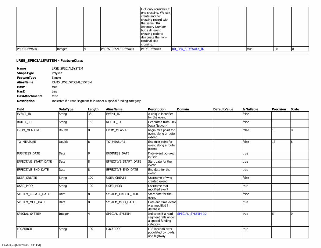
FRA only considers it one crossing. We can create another crossing record with the same FRA Inventory Number but a different crossing code to designate the non-cardinal side crossing.
PEDSIDEWALK Integer 4 PEDESTRIAN SIDEWALK PEDSIDEWALK RR_PED_SIDEWALK_ID true 10 0
LRSE_SPECIALSYSTEM - FeatureClass
Name LRSE_SPECIALSYSTEM ShapeType Polyline FeatureType Simple AliasName RAMS.LRSE_SPECIALSYSTEM HasM true HasZ true HasAttachments false
Description Indicates if a road segment falls under a special funding category.
Field DataType Length AliasName Description Domain DefaultValue IsNullable Precision Scale EVENT_ID String 38 EVENT_ID A unique identifier
for the event false
ROUTE_ID String 15 ROUTE_ID Generated from LRS Iowa Network
false
FROM_MEASURE Double 8 FROM_MEASURE begin mile point for event along a route extent
false 13 8
TO_MEASURE Double 8 TO_MEASURE End mile point for event along a route extent
false 13 8
BUSINESS_DATE Date 8 BUSINESS_DATE Date event occured in field
true
EFFECTIVE_START_DATE Date 8 EFFECTIVE_START_DATE Start date for the event
true
EFFECTIVE_END_DATE Date 8 EFFECTIVE_END_DATE End date for the event
true
USER_CREATE String 100 USER_CREATE Username of who created event
false
USER_MOD String 100 USER_MOD Username that modified event
true
SYSTEM_CREATE_DATE Date 8 SYSTEM_CREATE_DATE Start date for the event
false
SYSTEM_MOD_DATE Date 8 SYSTEM_MOD_DATE Date and time event was modified in database
true
SPECIAL_SYSTEM Integer 4 SPECIAL_SYSTEM Indicates if a road segment falls under a special funding category.
SPECIAL_SYSTEM_ID true 5 0
LOCERROR String 100 LOCERROR LRS location error populated by roads and highway
true
PRAMS.pdf[1/10/2020 3:10:13 PM]
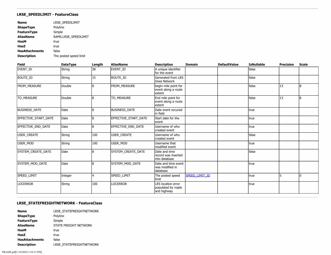
LRSE_SPEEDLIMIT - FeatureClass
Name LRSE_SPEEDLIMIT ShapeType Polyline FeatureType Simple AliasName RAMS.LRSE_SPEEDLIMIT HasM true HasZ true HasAttachments false
Description The posted speed limit
Field DataType Length AliasName Description Domain DefaultValue IsNullable Precision Scale EVENT_ID String 38 EVENT_ID A unique identifier
for the event false
ROUTE_ID String 15 ROUTE_ID Generated from LRS Iowa Network
false
FROM_MEASURE Double 8 FROM_MEASURE begin mile point for event along a route extent
false 13 8
TO_MEASURE Double 8 TO_MEASURE End mile point for event along a route extent
false 13 8
BUSINESS_DATE Date 8 BUSINESS_DATE Date event occured in field
true
EFFECTIVE_START_DATE Date 8 EFFECTIVE_START_DATE Start date for the event
true
EFFECTIVE_END_DATE Date 8 EFFECTIVE_END_DATE Username of who created event
true
USER_CREATE String 100 USER_CREATE Username of who created event
false
USER_MOD String 100 USER_MOD Username that modified event
true
SYSTEM_CREATE_DATE Date 8 SYSTEM_CREATE_DATE Date and time record was inserted into database
false
SYSTEM_MOD_DATE Date 8 SYSTEM_MOD_DATE Date and time event was modified in database
true
SPEED_LIMIT Integer 4 SPEED_LIMIT The posted speed limit
SPEED_LIMIT_ID true 5 0
LOCERROR String 100 LOCERROR LRS location error populated by roads and highway
true
LRSE_STATEFREIGHTNETWORK - FeatureClass
Name LRSE_STATEFREIGHTNETWORK ShapeType Polyline FeatureType Simple AliasName STATE FREIGHT NETWORK HasM true HasZ true HasAttachments false
Description LRSE_STATEFREIGHTNETWORK
PRAMS.pdf[1/10/2020 3:10:13 PM]

Field DataType Length AliasName Description Domain DefaultValue IsNullable Precision Scale EVENT_ID String 38 EVENT_ID EVENT_ID true ROUTE_ID String 15 ROUTE_ID ROUTE_ID true FROM_MEASURE Double 8 FROM_MEASURE FROM_MEASURE true 13 8 TO_MEASURE Double 8 TO_MEASURE TO_MEASURE true 13 8 BUSINESS_DATE Date 8 BUSINESS_DATE BUSINESS_DATE true EFFECTIVE_START_DATE Date 8 EFFECTIVE_START_DATE EFFECTIVE_START_DATE true EFFECTIVE_END_DATE Date 8 EFFECTIVE_END_DATE EFFECTIVE_END_DATE true USER_CREATE String 100 USER_CREATE USER_CREATE true USER_MOD String 100 USER_MOD USER_MOD true SYSTEM_CREATE_DATE Date 8 SYSTEM_CREATE_DATE SYSTEM_CREATE_DATE true SYSTEM_MOD_DATE Date 8 SYSTEM_MOD_DATE SYSTEM_MOD_DATE true STATE_FREIGHT_NETWORK Integer 4 STATE_FREIGHT_NETWORK STATE_FREIGHT_NETWORK STATE_FREIGHT_NETWORK_ID true 5 0 LOCERROR String 100 LOCERROR LOCERROR true
LRSE_STRATEGICHIGHWAY - FeatureClass
Name LRSE_STRATEGICHIGHWAY ShapeType Polyline FeatureType Simple AliasName RAMS.LRSE_STRATEGICHIGHWAY HasM true HasZ true HasAttachments false
Description The Strategic Highway Network (used for Department of Defense purposes)
Field DataType Length AliasName Description Domain DefaultValue IsNullable Precision Scale EVENT_ID String 38 EVENT_ID A unique identifier
for the event false
ROUTE_ID String 15 ROUTE_ID Generated from LRS Iowa Network
false
FROM_MEASURE Double 8 FROM_MEASURE begin mile point for event along a route extent
false 13 8
TO_MEASURE Double 8 TO_MEASURE End mile point for event along a route extent
false 13 8
BUSINESS_DATE Date 8 BUSINESS_DATE Date event occured in field
true
EFFECTIVE_START_DATE Date 8 EFFECTIVE_START_DATE Start date for the event
true
EFFECTIVE_END_DATE Date 8 EFFECTIVE_END_DATE End date for the event
true
USER_CREATE String 100 USER_CREATE Username of who created event
false
USER_MOD String 100 USER_MOD Username that modified event
true
SYSTEM_CREATE_DATE Date 8 SYSTEM_CREATE_DATE Date and time record was inserted into database
false
SYSTEM_MOD_DATE Date 8 SYSTEM_MOD_DATE Date and time event was
true
PRAMS.pdf[1/10/2020 3:10:13 PM]
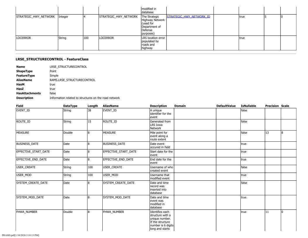
modified in database
STRATEGIC_HWY_NETWORK Integer 4 STRATEGIC_HWY_NETWORK The Strategic Highway Network (used for Department of Defense purposes)
STRATEGIC_HWY_NETWORK_ID true 5 0
LOCERROR String 100 LOCERROR LRS location error populated by roads and highway
true
LRSE_STRUCTURECONTROL - FeatureClass
Name LRSE_STRUCTURECONTROL ShapeType Point FeatureType Simple AliasName RAMS.LRSE_STRUCTURECONTROL HasM true HasZ true HasAttachments false
Description Information related to structures on the road network
Field DataType Length AliasName Description Domain DefaultValue IsNullable Precision Scale EVENT_ID String 38 EVENT_ID A unique
identifier for the event
false
ROUTE_ID String 15 ROUTE_ID Generated from LRS Iowa Network
false
MEASURE Double 8 MEASURE Mile point for event along a route extent
false 13 8
BUSINESS_DATE Date 8 BUSINESS_DATE Date event occured in field
true
EFFECTIVE_START_DATE Date 8 EFFECTIVE_START_DATE Start date for the event
true
EFFECTIVE_END_DATE Date 8 EFFECTIVE_END_DATE End date for the event
true
USER_CREATE String 100 USER_CREATE Username of who created event
false
USER_MOD String 100 USER_MOD Username that modified event
true
SYSTEM_CREATE_DATE Date 8 SYSTEM_CREATE_DATE Date and time record was inserted into database
false
SYSTEM_MOD_DATE Date 8 SYSTEM_MOD_DATE Date and time event was modified in database
true
FHWA_NUMBER Double 8 FHWA_NUMBER Identifies each structure with a unique number. If the structure number is 6 digits long and starts
true 11 0
PRAMS.pdf[1/10/2020 3:10:13 PM]
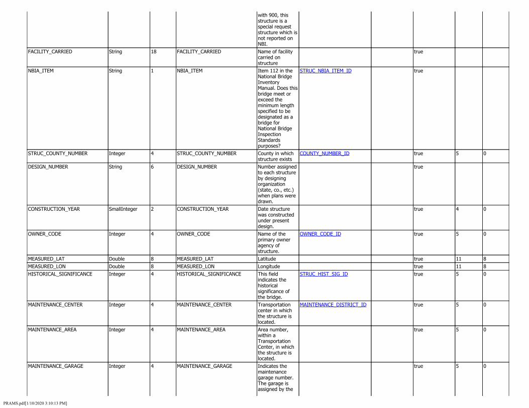
with 900, this structure is a special request structure which is not reported on NBI.
FACILITY_CARRIED String 18 FACILITY_CARRIED Name of facility carried on structure
true
NBIA_ITEM String 1 NBIA_ITEM Item 112 in the National Bridge Inventory Manual. Does this bridge meet or exceed the minimum length specified to be designated as a bridge for National Bridge Inspection Standards purposes?
STRUC_NBIA_ITEM_ID true
STRUC_COUNTY_NUMBER Integer 4 STRUC_COUNTY_NUMBER County in which structure exists
COUNTY_NUMBER_ID true 5 0
DESIGN_NUMBER String 6 DESIGN_NUMBER Number assigned to each structure by designing organization (state, co., etc.) when plans were drawn.
true
CONSTRUCTION_YEAR SmallInteger 2 CONSTRUCTION_YEAR Date structure was constructed under present design.
true 4 0
OWNER_CODE Integer 4 OWNER_CODE Name of the primary owner agency of structure.
OWNER_CODE_ID true 5 0
MEASURED_LAT Double 8 MEASURED_LAT Latitude true 11 8 MEASURED_LON Double 8 MEASURED_LON Longitude true 11 8 HISTORICAL_SIGNIFICANCE Integer 4 HISTORICAL_SIGNIFICANCE This field
indicates the historical significance of the bridge.
STRUC_HIST_SIG_ID true 5 0
MAINTENANCE_CENTER Integer 4 MAINTENANCE_CENTER Transportation center in which the structure is located.
MAINTENANCE_DISTRICT_ID true 5 0
MAINTENANCE_AREA Integer 4 MAINTENANCE_AREA Area number, within a Transportation Center, in which the structure is located.
true 5 0
MAINTENANCE_GARAGE Integer 4 MAINTENANCE_GARAGE Indicates the maintenance garage number. The garage is assigned by the
true 5 0
PRAMS.pdf[1/10/2020 3:10:13 PM]
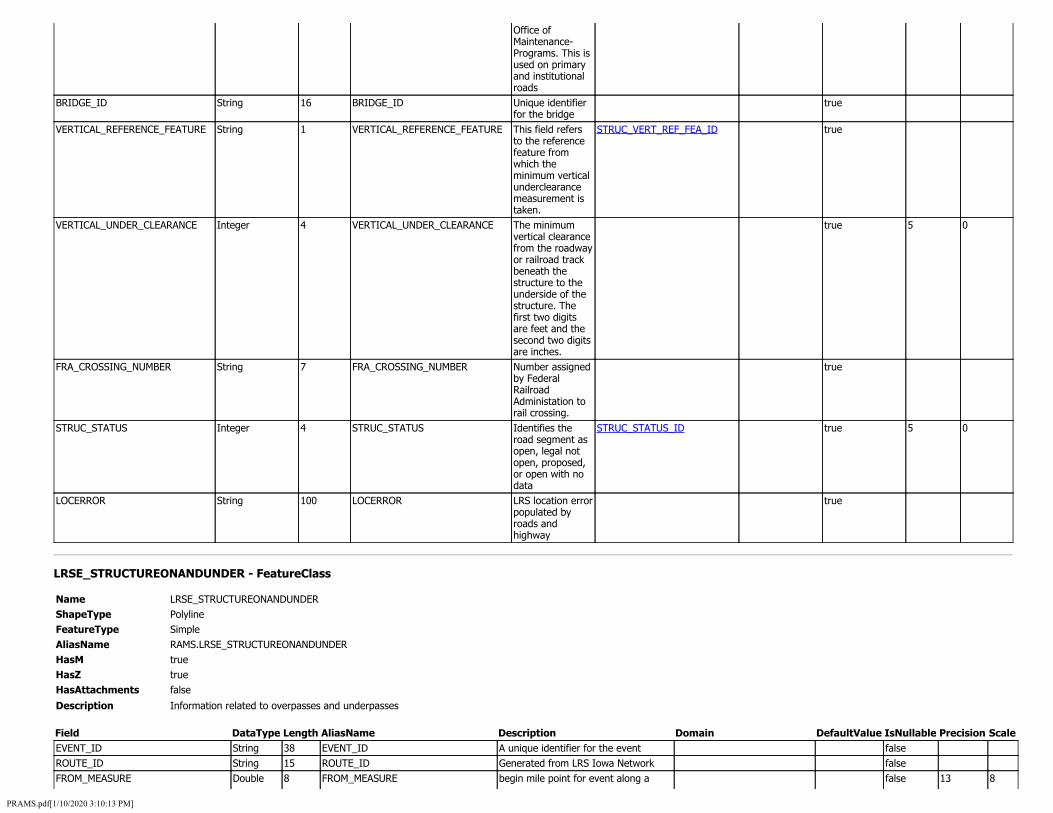
Office of Maintenance-Programs. This is used on primary and institutional roads
BRIDGE_ID String 16 BRIDGE_ID Unique identifier for the bridge
true
VERTICAL_REFERENCE_FEATURE String 1 VERTICAL_REFERENCE_FEATURE This field refers to the reference feature from which the minimum vertical underclearance measurement is taken.
STRUC_VERT_REF_FEA_ID true
VERTICAL_UNDER_CLEARANCE Integer 4 VERTICAL_UNDER_CLEARANCE The minimum vertical clearance from the roadway or railroad track beneath the structure to the underside of the structure. The first two digits are feet and the second two digits are inches.
true 5 0
FRA_CROSSING_NUMBER String 7 FRA_CROSSING_NUMBER Number assigned by Federal Railroad Administation to rail crossing.
true
STRUC_STATUS Integer 4 STRUC_STATUS Identifies the road segment as open, legal not open, proposed, or open with no data
STRUC_STATUS_ID true 5 0
LOCERROR String 100 LOCERROR LRS location error populated by roads and highway
true
LRSE_STRUCTUREONANDUNDER - FeatureClass
Name LRSE_STRUCTUREONANDUNDER ShapeType Polyline FeatureType Simple AliasName RAMS.LRSE_STRUCTUREONANDUNDER HasM true HasZ true HasAttachments false
Description Information related to overpasses and underpasses
Field DataType Length AliasName Description Domain DefaultValue IsNullable Precision Scale EVENT_ID String 38 EVENT_ID A unique identifier for the event false ROUTE_ID String 15 ROUTE_ID Generated from LRS Iowa Network false FROM_MEASURE Double 8 FROM_MEASURE begin mile point for event along a false 13 8
PRAMS.pdf[1/10/2020 3:10:13 PM]

route extent TO_MEASURE Double 8 TO_MEASURE End mile point for event along a route
extent false 13 8
BUSINESS_DATE Date 8 BUSINESS_DATE Date event occured in field true EFFECTIVE_START_DATE Date 8 EFFECTIVE_START_DATE Start date for the event true EFFECTIVE_END_DATE Date 8 EFFECTIVE_END_DATE End date for the event true USER_CREATE String 100 USER_CREATE Username of who created event false USER_MOD String 100 USER_MOD Username that modified event true SYSTEM_CREATE_DATE Date 8 SYSTEM_CREATE_DATE Date and time record was inserted
into database false
SYSTEM_MOD_DATE Date 8 SYSTEM_MOD_DATE Date and time event was modified in database
true
FHWA_NUMBER Integer 4 FHWA_NUMBER Identifies each structure with a unique number. If the structure number is 6 digits long and starts with 900, this structure is a special request structure which is not reported on NBI.
true 10 0
STRUCTURE_CODE String 1 STRUCTURE_CODE Used to indicate whether bridge record is over a feature or under a feature. Zero (0) indicating data for record over, greater than zero indicating data for record under a feature.
STRUCTURE_CODE_ID true
TYPE_RECORD Integer 4 TYPE_RECORD Describes direction and type of structure
STRUC_TYPE_RECORD_ID true 5 0
MAINT_MPOST_DISTANCE Single 4 MAINT_MPOST_DISTANCE Indicates miles, in tenths, from beginning of route within the state.
true 4 1
MAINT_DESCRIPTION String 1 MAINT_DESCRIPTION Maintenance description STRUC_MAINT_DESC_ID true MAINT_MPOST_ROUTE Integer 4 MAINT_MPOST_ROUTE Entered for all bridges with a
Printcode of 1 (indicating Primary). The majority of bridges use the route number of the traffic carried on the bridge. If there is a secondary or municipal street over a primary route, the underpass route(primary) number would be used. This is entered into the Underpass/Overpass screen on the bridge form. Used when adding a new bridge.
true 5 0
DESCRIPTION_FEATURE_CROSS String 25 DESCRIPTION_FEATURE_CROSS Name or description of feature being crossed. ex. Creek, Streem, Railroad
true
KIND_CROSS Integer 4 KIND_CROSS This field indicates what kind of crossing the structure crosses.
STRUC_KIND_CROSS_ID true 5 0
VERTICAL_CLEARANCE Integer 4 VERTICAL_CLEARANCE This field indicates in feet and inches the vertical clearance of the structure roadway width.
true 5 0
APPROACH_WIDTH Integer 4 APPROACH_WIDTH This field indicates the normal width of the roadway approaching the structure and is entered to the nearest foot. This includes both shoulders, roadways and median.
true 5 0
TWIN_DIVIDED String 1 TWIN_DIVIDED This field indicates if the structure is a twin or divided bridge. Twin structures are any pair of structures that bridge the same obstacle and are separate and carrying traffic in opposite directions. A divided structure is any single structure that is divided by a median or barrier. Underpasses that are divided are considered divided
STRUC_TWIN_DIVIDED_ID true
PRAMS.pdf[1/10/2020 3:10:13 PM]

structures although they may have unlimited horizontal clearance.
STRUCTURE_DESCRIPTION String 50 STRUCTURE_DESCRIPTION This is a text description of the structure location. Up to 50 characters.
true
HORIZONTAL_CLEARANCE Integer 4 HORIZONTAL_CLEARANCE This field indicates in feet and inches the horizontal clearance of the structure roadway width.
true 5 0
POSTED_CLEARANCE Integer 4 POSTED_CLEARANCE Clearence posted on sign at location true 5 0 LEFT_EDGE_PAVEMENT_VERTCLEAR Integer 4 LEFT_EDGE_PAVEMENT_VERTCLEAR LEFT_EDGE_PAVEMENT_VERTCLEAR true 5 0 LANE1_VERTCLEAR Integer 4 LANE1_VERTCLEAR LANE1_VERTCLEAR true 5 0 LANE2_VERTCLEAR Integer 4 LANE2_VERTCLEAR LANE2_VERTCLEAR true 5 0 LANE3_VERTCLEAR Integer 4 LANE3_VERTCLEAR LANE3_VERTCLEAR true 5 0 LANE4_VERTCLEAR Integer 4 LANE4_VERTCLEAR LANE4_VERTCLEAR true 5 0 LANE5_VERTCLEAR Integer 4 LANE5_VERTCLEAR LANE5_VERTCLEAR true 5 0 LANE6_VERTCLEAR Integer 4 LANE6_VERTCLEAR LANE6_VERTCLEAR true 5 0 LANE7_VERTCLEAR Integer 4 LANE7_VERTCLEAR LANE7_VERTCLEAR true 5 0 LANE8_VERTCLEAR Integer 4 LANE8_VERTCLEAR LANE8_VERTCLEAR true 5 0 LANE9_VERTCLEAR Integer 4 LANE9_VERTCLEAR LANE9_VERTCLEAR true 5 0 RIGHT_EDGE_PAVEMENT_VERTCLEAR Integer 4 RIGHT_EDGE_PAVEMENT_VERTCLEAR RIGHT_EDGE_PAVEMENT_VERTCLEAR true 5 0 VC_MEASUREMENT_METHOD Integer 4 VC_MEASUREMENT_METHOD VC_MEASUREMENT_METHOD MEASUREMENT_METHODS_ID true 5 0 LOCERROR String 100 LOCERROR LRS location error populated by roads
and highway true
LRSE_SURFACETYPE - FeatureClass
Name LRSE_SURFACETYPE ShapeType Polyline FeatureType Simple AliasName RAMS.LRSE_SURFACETYPE HasM true HasZ true HasAttachments false
Description The following table is used to show the surface of the road for all road systems.
Field DataType Length AliasName Description Domain DefaultValue IsNullable Precision Scale EVENT_ID String 38 EVENT_ID A unique identifier false
for the event ROUTE_ID String 15 ROUTE_ID Generated from LRS false
Iowa Network FROM_MEASURE Double 8 FROM_MEASURE begin mile point for false 13 8
event along a route extent
TO_MEASURE Double 8 TO_MEASURE End mile point for false 13 8 event along a route extent
BUSINESS_DATE Date 8 BUSINESS_DATE Date event occured true in field
EFFECTIVE_START_DATE Date 8 EFFECTIVE_START_DATE Start date for the true event
EFFECTIVE_END_DATE Date 8 EFFECTIVE_END_DATE End date for the true event
USER_CREATE String 100 USER_CREATE Username of who false created event
PRAMS.pdf[1/10/2020 3:10:13 PM]

USER_MOD String 100 USER_MOD Username that modified event
true
SYSTEM_CREATE_DATE Date 8 SYSTEM_CREATE_DATE Date and time record was inserted into database
false
SYSTEM_MOD_DATE Date 8 SYSTEM_MOD_DATE Date and time event was modified in database
true
SURFACE_TYPE Integer 4 SURFACE_TYPE The following table is used to show the surface of the road for all road systems.
SURFACE_TYPE_ID true 5 0
LOCERROR String 100 LOCERROR LRS location error populated by roads and highway
true
LRSE_SURFACEWIDTH - FeatureClass
Name LRSE_SURFACEWIDTH ShapeType Polyline FeatureType Simple AliasName RAMS.LRSE_SURFACEWIDTH HasM true HasZ true HasAttachments false
Description This field indicates the width of a road to the nearest foot for all road systems.
Field DataType Length AliasName Description Domain DefaultValue IsNullable Precision Scale EVENT_ID String 38 EVENT_ID A unique identifier
for the event false
ROUTE_ID String 15 ROUTE_ID Generated from LRS Iowa Network
false
FROM_MEASURE Double 8 FROM_MEASURE begin mile point for event along a route extent
false 13 8
TO_MEASURE Double 8 TO_MEASURE End mile point for event along a route extent
false 13 8
BUSINESS_DATE Date 8 BUSINESS_DATE Date event occured in field
true
EFFECTIVE_START_DATE Date 8 EFFECTIVE_START_DATE Start date for the event
true
EFFECTIVE_END_DATE Date 8 EFFECTIVE_END_DATE End date for the event
true
USER_CREATE String 100 USER_CREATE Username of who created event
false
USER_MOD String 100 USER_MOD Username that modified event
true
SYSTEM_CREATE_DATE Date 8 SYSTEM_CREATE_DATE Date and time record was inserted into database
false
SYSTEM_MOD_DATE Date 8 SYSTEM_MOD_DATE Date and time event was modified in database
true
SURFACE_WIDTH Integer 4 SURFACE_WIDTH This field indicates the width of a road to the nearest foot
true 5 0
PRAMS.pdf[1/10/2020 3:10:13 PM]

for all road systems. LOCERROR String 100 LOCERROR LRS location error
populated by roads and highway
true
LRSE_TERRAIN - FeatureClass
Name LRSE_TERRAIN ShapeType Polyline FeatureType Simple AliasName RAMS.LRSE_TERRAIN HasM true HasZ true HasAttachments false
Description This field indicates the type of terrain located on both sides of the road segments on the primary, secondary and institutional roads.
Field DataType Length AliasName Description Domain DefaultValue IsNullable Precision Scale EVENT_ID String 38 EVENT_ID A unique identifier
for the event false
ROUTE_ID String 15 ROUTE_ID Generated from LRS Iowa Network
false
FROM_MEASURE Double 8 FROM_MEASURE begin mile point for event along a route extent
false 13 8
TO_MEASURE Double 8 TO_MEASURE End mile point for event along a route extent
false 13 8
BUSINESS_DATE Date 8 BUSINESS_DATE Date event occured in field
true
EFFECTIVE_START_DATE Date 8 EFFECTIVE_START_DATE Start date for the event
true
EFFECTIVE_END_DATE Date 8 EFFECTIVE_END_DATE End date for the event
true
USER_CREATE String 100 USER_CREATE Username of who created event
false
USER_MOD String 100 USER_MOD Username that modified event
true
SYSTEM_CREATE_DATE Date 8 SYSTEM_CREATE_DATE Date and time record was inserted into database
false
SYSTEM_MOD_DATE Date 8 SYSTEM_MOD_DATE Date and time event was modified in database
true
TERRAIN Integer 4 TERRAIN This field indicates the type of terrain located on both sides of the road segments on the primary, secondary and institutional roads.
TERRAIN_ID true 5 0
LOCERROR String 100 LOCERROR LRS location error populated by roads and highway
true
LRSE_THROUGHLANES - FeatureClass
PRAMS.pdf[1/10/2020 3:10:13 PM]
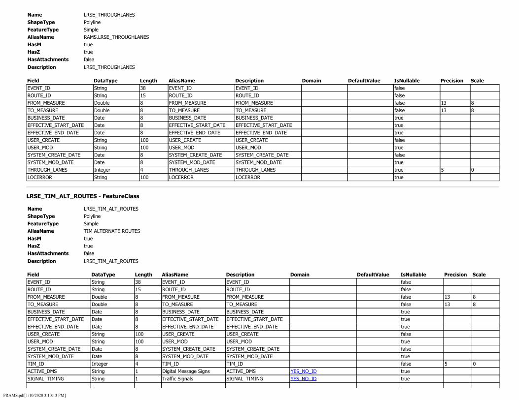
Name LRSE_THROUGHLANES ShapeType Polyline FeatureType Simple AliasName RAMS.LRSE_THROUGHLANES HasM true HasZ true HasAttachments false
Description LRSE_THROUGHLANES
Field DataType Length AliasName Description Domain DefaultValue IsNullable Precision Scale EVENT_ID String 38 EVENT_ID EVENT_ID false ROUTE_ID String 15 ROUTE_ID ROUTE_ID false FROM_MEASURE Double 8 FROM_MEASURE FROM_MEASURE false 13 8 TO_MEASURE Double 8 TO_MEASURE TO_MEASURE false 13 8 BUSINESS_DATE Date 8 BUSINESS_DATE BUSINESS_DATE true EFFECTIVE_START_DATE Date 8 EFFECTIVE_START_DATE EFFECTIVE_START_DATE true EFFECTIVE_END_DATE Date 8 EFFECTIVE_END_DATE EFFECTIVE_END_DATE true USER_CREATE String 100 USER_CREATE USER_CREATE false USER_MOD String 100 USER_MOD USER_MOD true SYSTEM_CREATE_DATE Date 8 SYSTEM_CREATE_DATE SYSTEM_CREATE_DATE false SYSTEM_MOD_DATE Date 8 SYSTEM_MOD_DATE SYSTEM_MOD_DATE true THROUGH_LANES Integer 4 THROUGH_LANES THROUGH_LANES true 5 0 LOCERROR String 100 LOCERROR LOCERROR true
LRSE_TIM_ALT_ROUTES - FeatureClass
Name LRSE_TIM_ALT_ROUTES ShapeType Polyline FeatureType Simple AliasName TIM ALTERNATE ROUTES HasM true HasZ true HasAttachments false
Description LRSE_TIM_ALT_ROUTES
Field DataType Length AliasName Description Domain DefaultValue IsNullable Precision Scale EVENT_ID String 38 EVENT_ID EVENT_ID false ROUTE_ID String 15 ROUTE_ID ROUTE_ID false FROM_MEASURE Double 8 FROM_MEASURE FROM_MEASURE false 13 8 TO_MEASURE Double 8 TO_MEASURE TO_MEASURE false 13 8 BUSINESS_DATE Date 8 BUSINESS_DATE BUSINESS_DATE true EFFECTIVE_START_DATE Date 8 EFFECTIVE_START_DATE EFFECTIVE_START_DATE true EFFECTIVE_END_DATE Date 8 EFFECTIVE_END_DATE EFFECTIVE_END_DATE true USER_CREATE String 100 USER_CREATE USER_CREATE false USER_MOD String 100 USER_MOD USER_MOD true SYSTEM_CREATE_DATE Date 8 SYSTEM_CREATE_DATE SYSTEM_CREATE_DATE false SYSTEM_MOD_DATE Date 8 SYSTEM_MOD_DATE SYSTEM_MOD_DATE true TIM_ID Integer 4 TIM_ID TIM_ID false 5 0 ACTIVE_DMS String 1 Digital Message Signs ACTIVE_DMS YES_NO_ID true SIGNAL_TIMING String 1 Traffic Signals SIGNAL_TIMING YES_NO_ID true
PRAMS.pdf[1/10/2020 3:10:13 PM]

DIVERSION_TYPE Integer 4 Type of Alternate Route DIVERSION_TYPE TIM_DIVERSION_TYPE_ID true 5 0 PRIORITY Integer 4 Priority PRIORITY TIM_ALT_TYPE_ID true 5 0 FROM_DESCR String 50 Beginning Of Segment FROM_DESCR true DIRECTION String 1 Direction DIRECTION true TIM_ALT_ROUTE Integer 4 TIM_ALT_ROUTE TIM_ALT_ROUTE false 5 0 TIM_ALT_ROUTE_SEQ Integer 4 Alternate Route Sequence TIM_ALT_ROUTE_SEQ false 5 0 LOCERROR String 100 LOCERROR LOCERROR true
LRSE_TIM_CLOSURE - FeatureClass
Name LRSE_TIM_CLOSURE ShapeType Polyline FeatureType Simple AliasName TIM CLOSURES HasM true HasZ true HasAttachments false
Description LRSE_TIM_CLOSURE
Field DataType Length AliasName Description Domain DefaultValue IsNullable Precision Scale EVENT_ID String 38 EVENT_ID EVENT_ID false ROUTE_ID String 15 ROUTE_ID ROUTE_ID false FROM_MEASURE Double 8 FROM_MEASURE FROM_MEASURE false 13 8 TO_MEASURE Double 8 TO_MEASURE TO_MEASURE false 13 8 BUSINESS_DATE Date 8 BUSINESS_DATE BUSINESS_DATE true EFFECTIVE_START_DATE Date 8 EFFECTIVE_START_DATE EFFECTIVE_START_DATE true EFFECTIVE_END_DATE Date 8 EFFECTIVE_END_DATE EFFECTIVE_END_DATE true USER_CREATE String 100 USER_CREATE USER_CREATE false USER_MOD String 100 USER_MOD USER_MOD true SYSTEM_CREATE_DATE Date 8 SYSTEM_CREATE_DATE SYSTEM_CREATE_DATE false SYSTEM_MOD_DATE Date 8 SYSTEM_MOD_DATE SYSTEM_MOD_DATE true TIM_ID Integer 4 TIM_ID TIM_ID false 5 0 CRITICAL_INTERSECTIONS String 1000 Critical Locations To
Monitor CRITICAL_INTERSECTIONS true
FROM_DESCR String 50 Beginning of Segment FROM_DESCR true ACTIVE_DMS String 1 Digital Message Sign ACTIVE_DMS YES_NO_ID true SIGNAL_TIMING String 1 Traffic Signals SIGNAL_TIMING YES_NO_ID true DIVERSION_TYPE Integer 4 Type of Alternate Route DIVERSION_TYPE TIM_DIVERSION_TYPE_ID true 5 0 PRIORITY Integer 4 Priority PRIORITY TIM_ALT_TYPE_ID true 5 0 PDF String 1000 PDF PDF true LOCERROR String 100 LOCERROR LOCERROR true
LRSE_TOLLROAD - FeatureClass
Name LRSE_TOLLROAD ShapeType Polyline FeatureType Simple AliasName RAMS.LRSE_TOLLROAD HasM true HasZ true
PRAMS.pdf[1/10/2020 3:10:13 PM]

HasAttachments false
Description This field indicates if the road segment traveled can be traveled with or without the payment of a toll.
Field DataType Length AliasName Description Domain DefaultValue IsNullable Precision Scale EVENT_ID String 38 EVENT_ID A unique identifier
for the event false
ROUTE_ID String 15 ROUTE_ID Generated from LRS Iowa Network
false
FROM_MEASURE Double 8 FROM_MEASURE begin mile point for event along a route extent
false 13 8
TO_MEASURE Double 8 TO_MEASURE End mile point for event along a route extent
false 13 8
BUSINESS_DATE Date 8 BUSINESS_DATE Date event occured in field
true
EFFECTIVE_START_DATE Date 8 EFFECTIVE_START_DATE Start date for the event
true
EFFECTIVE_END_DATE Date 8 EFFECTIVE_END_DATE End date for the event
true
USER_CREATE String 100 USER_CREATE Username of who created event
false
USER_MOD String 100 USER_MOD Username that modified event
true
SYSTEM_CREATE_DATE Date 8 SYSTEM_CREATE_DATE Date and time record was inserted into database
false
SYSTEM_MOD_DATE Date 8 SYSTEM_MOD_DATE Date and time event was modified in database
true
TOLL_CHARGED Integer 4 TOLL_CHARGED How toll is assessed on segment, one direction, both or not at all
TOLL_CHARGED_ID true 5 0
TOLL_AUTHORITY Integer 4 TOLL_AUTHORITY Entity that collects the toll
TOLL_AUTHORITY_ID true 5 0
TOLL_TYPE Integer 4 TOLL_TYPE Type of toll TOLL_TYPE_ID true 5 0 LOCERROR String 100 LOCERROR LRS location error
populated by roads and highway
true
LRSE_TRAFFIC - FeatureClass
Name LRSE_TRAFFIC ShapeType Polyline FeatureType Simple AliasName RAMS.LRSE_TRAFFIC HasM true HasZ true HasAttachments false
Description LRSE_TRAFFIC
Field DataType Length AliasName Description Domain DefaultValue IsNullable Precision Scale EVENT_ID String 38 EVENT_ID EVENT_ID false ROUTE_ID String 15 ROUTE_ID ROUTE_ID false
PRAMS.pdf[1/10/2020 3:10:13 PM]

FROM_MEASURE Double 8 FROM_MEASURE FROM_MEASURE false 13 8 TO_MEASURE Double 8 TO_MEASURE TO_MEASURE false 13 8 BUSINESS_DATE Date 8 BUSINESS_DATE BUSINESS_DATE true EFFECTIVE_START_DATE Date 8 EFFECTIVE_START_DATE EFFECTIVE_START_DATE true EFFECTIVE_END_DATE Date 8 EFFECTIVE_END_DATE EFFECTIVE_END_DATE true USER_CREATE String 100 USER_CREATE USER_CREATE false USER_MOD String 100 USER_MOD USER_MOD true SYSTEM_CREATE_DATE Date 8 SYSTEM_CREATE_DATE SYSTEM_CREATE_DATE false SYSTEM_MOD_DATE Date 8 SYSTEM_MOD_DATE SYSTEM_MOD_DATE true AADT Integer 4 AADT AADT true 10 0 TRUCK_AADT Integer 4 TRUCK_AADT TRUCK_AADT true 10 0 MOTORCYCLE Integer 4 MOTORCYCLE MOTORCYCLE true 10 0 AUTOMOBILE Integer 4 AUTOMOBILE AUTOMOBILE true 10 0 PICKUP Integer 4 PICKUP PICKUP true 10 0 BUS Integer 4 BUS BUS true 10 0 SU2AXLE Integer 4 SU2AXLE SU2AXLE true 10 0 SU3AXLE Integer 4 SU3AXLE SU3AXLE true 10 0 SU4AXLE Integer 4 SU4AXLE SU4AXLE true 10 0 ST4AXLE Integer 4 ST4AXLE ST4AXLE true 10 0 ST5AXLE Integer 4 ST5AXLE ST5AXLE true 10 0 ST6AXLE Integer 4 ST6AXLE ST6AXLE true 10 0 MT5AXLE Integer 4 MT5AXLE MT5AXLE true 10 0 MT6AXLE Integer 4 MT6AXLE MT6AXLE true 10 0 MT7AXLE Integer 4 MT7AXLE MT7AXLE true 10 0 SINGLEUNIT Integer 4 SINGLEUNIT SINGLEUNIT true 10 0 SINGMULTTRAILER Integer 4 SINGMULTTRAILER SINGMULTTRAILER true 10 0 ESTIMATE String 1 ESTIMATE ESTIMATE YES_NO_ID true PERCENT_TRUCK Integer 4 PERCENT_TRUCK PERCENT_TRUCK true 5 0 AADT_YEAR Integer 4 AADT_YEAR AADT_YEAR true 5 0 TRUCK_AADT_YEAR Integer 4 TRUCK_AADT_YEAR TRUCK_AADT_YEAR true 5 0 EXPANDED_AADT Double 8 EXPANDED_AADT EXPANDED_AADT true 10 2 SECTION_TYPE SmallInteger 2 SECTION_TYPE SECTION_TYPE true 1 0 HEADING1 String 34 HEADING1 HEADING1 true HEADING2 String 34 HEADING2 HEADING2 true HEADING3 String 34 HEADING3 HEADING3 true HEADING4 String 34 HEADING4 HEADING4 true DESCRIPTION String 34 DESCRIPTION DESCRIPTION true COMMENT6 String 34 COMMENT6 COMMENT6 true COMMENT7 String 34 COMMENT7 COMMENT7 true COMMENT8 String 34 COMMENT8 COMMENT8 true COMMENT9 String 34 COMMENT9 COMMENT9 true LOCERROR String 100 LOCERROR LOCERROR true DIRECTIONAL_AADT Integer 4 DIRECTIONAL_AADT DIRECTIONAL_AADT true 10 0 DIRECTIONAL_SINGLEUNIT Integer 4 DIRECTIONAL_SINGLEUNIT DIRECTIONAL_SINGLEUNIT true 10 0 DIRECTIONAL_SINGMULTTRAILER Integer 4 DIRECTIONAL_SINGMULTTRAILER DIRECTIONAL_SINGMULTTRAILER true 10 0 DIRECTIONAL_ESTIMATE String 1 DIRECTIONAL_ESTIMATE DIRECTIONAL_ESTIMATE YES_NO_ID true
LRSE_TRAFFICATRLOCATION - FeatureClass
Name LRSE_TRAFFICATRLOCATION
PRAMS.pdf[1/10/2020 3:10:13 PM]

ShapeType FeatureType AliasName HasM HasZ HasAttachments
Point Simple RAMS.LRSE_TRAFFICATRLOCATION true true false
Description Traffic count using Automated Traffic Recorder
Field DataType Length AliasName Description Domain DefaultValue IsNullable Precision Scale EVENT_ID String 38 EVENT_ID A unique identifier
for the event false
ROUTE_ID String 15 ROUTE_ID Generated from LRS Iowa Network
false
MEASURE Double 8 MEASURE Mile point for event along a route extent
false 13 8
BUSINESS_DATE Date 8 BUSINESS_DATE Date event occured in field
true
EFFECTIVE_START_DATE Date 8 EFFECTIVE_START_DATE Start date for the event
true
EFFECTIVE_END_DATE Date 8 EFFECTIVE_END_DATE End date for the event
true
USER_CREATE String 100 USER_CREATE Username of who created event
false
USER_MOD String 100 USER_MOD Username that modified event
true
SYSTEM_CREATE_DATE Date 8 SYSTEM_CREATE_DATE Start date for the event
false
SYSTEM_MOD_DATE Date 8 SYSTEM_MOD_DATE Username of who created event
true
ATR_NUMBER Integer 4 ATR_NUMBER Traffic count using Automated Traffic Recorder
true 5 0
LOCERROR String 100 LOCERROR LRS location error populated by roads and highway
true
LRSE_TRUCKROUTE - FeatureClass
Name LRSE_TRUCKROUTE ShapeType Polyline FeatureType Simple AliasName RAMS.LRSE_TRUCKROUTE HasM true HasZ true HasAttachments false
Description This field indicates whether or not the road is on a truck route on the primary road system only.
Field DataType Length AliasName Description Domain DefaultValue IsNullable Precision Scale EVENT_ID String 38 EVENT_ID A unique identifier
for the event false
ROUTE_ID String 15 ROUTE_ID Generated from LRS Iowa Network
false
FROM_MEASURE Double 8 FROM_MEASURE begin mile point for event along a route extent
false 13 8
PRAMS.pdf[1/10/2020 3:10:13 PM]
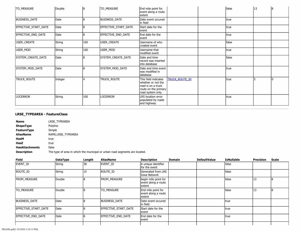
TO_MEASURE Double 8 TO_MEASURE End mile point for event along a route extent
false 13 8
BUSINESS_DATE Date 8 BUSINESS_DATE Date event occured in field
true
EFFECTIVE_START_DATE Date 8 EFFECTIVE_START_DATE Start date for the event
true
EFFECTIVE_END_DATE Date 8 EFFECTIVE_END_DATE End date for the event
true
USER_CREATE String 100 USER_CREATE Username of who created event
false
USER_MOD String 100 USER_MOD Username that modified event
true
SYSTEM_CREATE_DATE Date 8 SYSTEM_CREATE_DATE Date and time record was inserted into database
false
SYSTEM_MOD_DATE Date 8 SYSTEM_MOD_DATE Date and time event was modified in database
true
TRUCK_ROUTE Integer 4 TRUCK_ROUTE This field indicates whether or not the road is on a truck route on the primary road system only.
TRUCK_ROUTE_ID true 5 0
LOCERROR String 100 LOCERROR LRS location error populated by roads and highway
true
LRSE_TYPEAREA - FeatureClass
Name LRSE_TYPEAREA ShapeType Polyline FeatureType Simple AliasName RAMS.LRSE_TYPEAREA HasM true HasZ true HasAttachments false
Description The type of area in which the municipal or urban road segments are located.
Field DataType Length AliasName Description Domain DefaultValue IsNullable Precision Scale EVENT_ID String 38 EVENT_ID A unique identifier
for the event false
ROUTE_ID String 15 ROUTE_ID Generated from LRS Iowa Network
false
FROM_MEASURE Double 8 FROM_MEASURE begin mile point for event along a route extent
false 13 8
TO_MEASURE Double 8 TO_MEASURE End mile point for event along a route extent
false 13 8
BUSINESS_DATE Date 8 BUSINESS_DATE Date event occured in field
true
EFFECTIVE_START_DATE Date 8 EFFECTIVE_START_DATE Start date for the event
true
EFFECTIVE_END_DATE Date 8 EFFECTIVE_END_DATE End date for the event
true
PRAMS.pdf[1/10/2020 3:10:13 PM]

USER_CREATE String 100 USER_CREATE Username of who created event
false
USER_MOD String 100 USER_MOD Username that modified event
true
SYSTEM_CREATE_DATE Date 8 SYSTEM_CREATE_DATE Date and time record was inserted into database
false
SYSTEM_MOD_DATE Date 8 SYSTEM_MOD_DATE Date and time event was modified in database
true
TYPE_AREA Integer 4 TYPE_AREA The type of area in which the municipal or urban road segments are located.
TYPE_AREA_ID true 5 0
LOCERROR String 100 LOCERROR LRS location error populated by roads and highway
true
LRSE_TYPEDEVELOPMENT - FeatureClass
Name LRSE_TYPEDEVELOPMENT ShapeType Polyline FeatureType Simple AliasName RAMS.LRSE_TYPEDEVELOPMENT HasM true HasZ true HasAttachments false
Description This field indicates the predominant type of development. It is used for non-urban areas. Applies to all road systems.
Field DataType Length AliasName Description Domain DefaultValue IsNullable Precision Scale EVENT_ID String 38 EVENT_ID A unique identifier
for the event false
ROUTE_ID String 15 ROUTE_ID Generated from LRS Iowa Network
false
FROM_MEASURE Double 8 FROM_MEASURE begin mile point for event along a route extent
false 13 8
TO_MEASURE Double 8 TO_MEASURE End mile point for event along a route extent
false 13 8
BUSINESS_DATE Date 8 BUSINESS_DATE Date event occured in field
true
EFFECTIVE_START_DATE Date 8 EFFECTIVE_START_DATE Start date for the event
true
EFFECTIVE_END_DATE Date 8 EFFECTIVE_END_DATE End date for the event
true
USER_CREATE String 100 USER_CREATE Username of who created event
false
USER_MOD String 100 USER_MOD Username that modified event
true
SYSTEM_CREATE_DATE Date 8 SYSTEM_CREATE_DATE Date and time record was inserted into database
false
SYSTEM_MOD_DATE Date 8 SYSTEM_MOD_DATE Date and time event was modified in database
true
PRAMS.pdf[1/10/2020 3:10:13 PM]

TYPE_DEVELOPMENT Integer 4 TYPE_DEVELOPMENT This field indicates the predominant type of development. It is used for non-urban areas. Applies to all road systems.
TYPE_DEVELOPMENT_ID true 5 0
LOCERROR String 100 LOCERROR LRS location error populated by roads and highway
true
LRSE_URBANAREACODE - FeatureClass
Name LRSE_URBANAREACODE ShapeType Polyline FeatureType Simple AliasName RAMS.LRSE_URBANAREACODE HasM true HasZ true HasAttachments false
Description The U.S. Census Urban Area Code
Field DataType Length AliasName Description Domain DefaultValue IsNullable Precision Scale EVENT_ID String 38 EVENT_ID A unique identifier
for the event false
ROUTE_ID String 15 ROUTE_ID Generated from LRS Iowa Network
false
FROM_MEASURE Double 8 FROM_MEASURE begin mile point for event along a route extent
false 13 8
TO_MEASURE Double 8 TO_MEASURE End mile point for event along a route extent
false 13 8
BUSINESS_DATE Date 8 BUSINESS_DATE Date event occured in field
true
EFFECTIVE_START_DATE Date 8 EFFECTIVE_START_DATE Start date for the event
true
EFFECTIVE_END_DATE Date 8 EFFECTIVE_END_DATE End date for the event
true
USER_CREATE String 100 USER_CREATE Username of who created event
false
USER_MOD String 100 USER_MOD Username that modified event
true
SYSTEM_CREATE_DATE Date 8 SYSTEM_CREATE_DATE Date and time record was inserted into database
false
SYSTEM_MOD_DATE Date 8 SYSTEM_MOD_DATE Date and time event was modified in database
true
URBAN_AREA_CODE Integer 4 URBAN_AREA_CODE The U.S. Census Urban Area Code
URBAN_AREA_CODE_ID true 5 0
LOCERROR String 100 LOCERROR LRS location error populated by roads and highway
true
LRSE_URBANLOCATION - FeatureClass
PRAMS.pdf[1/10/2020 3:10:13 PM]

Name LRSE_URBANLOCATION ShapeType Polyline FeatureType Simple AliasName RAMS.LRSE_URBANLOCATION HasM true HasZ true HasAttachments false
Description Coded only for Des Moines, Council Bluffs and Davenport urban areas with a population of 200,000 or more people. The purpose of this data item is to identify the general character of the land surrounding each road segment. The process of doing so, however, must fully recognize that "pure" delineations are the exceptions rather than the rule. This field is applicable to all road systems.
Field DataType Length AliasName Description Domain DefaultValue IsNullable Precision Scale EVENT_ID String 38 EVENT_ID A unique identifier
for the event false
ROUTE_ID String 15 ROUTE_ID Generated from LRS Iowa Network
false
FROM_MEASURE Double 8 FROM_MEASURE begin mile point for event along a route extent
false 13 8
TO_MEASURE Double 8 TO_MEASURE End mile point for event along a route extent
false 13 8
BUSINESS_DATE Date 8 BUSINESS_DATE Date event occured in field
true
EFFECTIVE_START_DATE Date 8 EFFECTIVE_START_DATE Start date for the event
true
EFFECTIVE_END_DATE Date 8 EFFECTIVE_END_DATE End date for the event
true
USER_CREATE String 100 USER_CREATE Username of who created event
false
USER_MOD String 100 USER_MOD Username that modified event
true
SYSTEM_CREATE_DATE Date 8 SYSTEM_CREATE_DATE Date and time record was inserted into database
false
SYSTEM_MOD_DATE Date 8 SYSTEM_MOD_DATE Date and time event was modified in database
true
URBAN_LOCATION Integer 4 URBAN_LOCATION Coded only for Des Moines, Council Bluffs and Davenport urban areas with a population of 200,000 or more people. The purpose of this data item is to identify the general character of the land surrounding each road segment. The process of doing so, however, must fully recognize that "pure" delineations are the exceptions rather than the rule. This field is
URBAN_LOCATION_ID true 5 0
PRAMS.pdf[1/10/2020 3:10:13 PM]

applicable to all road systems.
LOCERROR String 100 LOCERROR LRS location error populated by roads and highway
true
LRSE_WIDENINGPOTENTIAL - FeatureClass
Name LRSE_WIDENINGPOTENTIAL ShapeType Polyline FeatureType Simple AliasName RAMS.LRSE_WIDENINGPOTENTIAL HasM true HasZ true HasAttachments false
Description LRSE_WIDENINGPOTENTIAL
Field DataType Length AliasName Description Domain DefaultValue IsNullable Precision Scale EVENT_ID String 38 EVENT_ID EVENT_ID false ROUTE_ID String 15 ROUTE_ID ROUTE_ID false FROM_MEASURE Double 8 FROM_MEASURE FROM_MEASURE false 13 8 TO_MEASURE Double 8 TO_MEASURE TO_MEASURE false 13 8 BUSINESS_DATE Date 8 BUSINESS_DATE BUSINESS_DATE true EFFECTIVE_START_DATE Date 8 EFFECTIVE_START_DATE EFFECTIVE_START_DATE true EFFECTIVE_END_DATE Date 8 EFFECTIVE_END_DATE EFFECTIVE_END_DATE true USER_CREATE String 100 USER_CREATE USER_CREATE false USER_MOD String 100 USER_MOD USER_MOD true SYSTEM_CREATE_DATE Date 8 SYSTEM_CREATE_DATE SYSTEM_CREATE_DATE false SYSTEM_MOD_DATE Date 8 SYSTEM_MOD_DATE SYSTEM_MOD_DATE true WIDENING_POTENTIAL Integer 4 WIDENING_POTENTIAL WIDENING_POTENTIAL WIDENING_POTENTIAL_ID true 5 0 LOCERROR String 100 LOCERROR LOCERROR true
LRSN_IOWA_LRS_NETWORK - FeatureClass
Name LRSN_IOWA_LRS_NETWORK ShapeType Polyline FeatureType Simple AliasName IOWA_LRS_NETWORK HasM true HasZ true HasAttachments false
Description The network feature class contains the route features for use in the ALRS. These routes have attributes, geometry that comes from the centerline feature class, and calibration that comes from the calibration point feature class. Combined these elements constitute a route with a LRM that can be used to locate events on that route. Each route should have a unique route identifier, called a routeID. This routeID can be a single field or a concatenation of multiple fields. If the network will use a concatenated routeID, all the fields that compose the routeID should be present in the network feature class, in addition to the routeID field.
Field DataType Length AliasName Description Domain DefaultValue IsNullable Precision Scale EFFECTIVE_START_DATE Date 8 EFFECTIVE_START_DATE Start date for the
event true
PRAMS.pdf[1/10/2020 3:10:13 PM]

EFFECTIVE_END_DATE Date 8 EFFECTIVE_END_DATE End date for the event
true
GEOGRAPHIC_IDENTIFIER String 5 GEOGRAPHIC_IDENTIFIER The geographic location of the associated route. The list of geographic identifiers has been derived using the City, County, and Park and Institution codes generated by the Iowa DOT.
GEOGRAPHIC_IDENTIFIER_ID true
SYSTEM_CODE String 1 SYSTEM_CODE Designates the type of route.
SYSTEM_CODE_ID true
ROUTE_NUMBER String 4 ROUTE_NUMBER Random number associated with the route
true
DIRECTION String 1 DIRECTION Cardinal direction of the route
ROUTE_DIRECTION_LU true
RAMP_SEQUENCE String 4 RAMP_SEQUENCE Identification sequence number of the ramp route in an interchange.
true
ROUTE_ID String 15 ROUTE_ID A unique identifier for the route consisting of the Route Descriptor, Geographic Identifier, System Code, Route Number, Direction, and Ramp sequence if present
true
SYSTEM_CREATE_DATE Date 8 SYSTEM_CREATE_DATE Start date for the event
true
SYSTEM_MOD_DATE Date 8 SYSTEM_MOD_DATE Date and time event was modified in database
true
USER_CREATE String 100 USER_CREATE Username of who created event
true
USER_MOD String 100 USER_MOD Username that modified event
true
ATR_FACTOR_PER_VOL_GROUP_2016 - Table
Name ATR_FACTOR_PER_VOL_GROUP_2016 AliasName TDS_OUTPUT.ATR_FACTOR_PER_VOL_GROUP_2016 HasAttachments false
Description ATR_FACTOR_PER_VOL_GROUP_2016
Field DataType Length AliasName Description Domain DefaultValue IsNullable Precision Scale F_CLASS Double 8 F_CLASS F_CLASS true 38 10 VOLUME_GROUP Double 8 VOLUME_GROUP VOLUME_GROUP true 38 10 SU_PEAK_PERCENT Single 4 SU_PEAK_PERCENT SU_PEAK_PERCENT true 5 3 SU_AVG_PERCENT Single 4 SU_AVG_PERCENT SU_AVG_PERCENT true 5 3
PRAMS.pdf[1/10/2020 3:10:13 PM]

COMBO_PEAK_PERCENT Single 4 COMBO_PEAK_PERCENT COMBO_PEAK_PERCENT true 5 3 COMBO_AVG_PERCENT Single 4 COMBO_AVG_PERCENT COMBO_AVG_PERCENT true 5 3 K_FACTOR Single 4 K_FACTOR K_FACTOR true 5 2 D_FACTOR Single 4 D_FACTOR D_FACTOR true 5 2
ATR_FACTOR_PER_VOL_GROUP_2017 - Table
Name ATR_FACTOR_PER_VOL_GROUP_2017 AliasName TDS_OUTPUT.ATR_FACTOR_PER_VOL_GROUP_2017 HasAttachments false
Description ATR_FACTOR_PER_VOL_GROUP_2017
Field DataType Length AliasName Description Domain DefaultValue IsNullable Precision Scale F_CLASS Double 8 F_CLASS F_CLASS true 38 10 VOLUME_GROUP Double 8 VOLUME_GROUP VOLUME_GROUP true 38 10 SU_PEAK_PERCENT Single 4 SU_PEAK_PERCENT SU_PEAK_PERCENT true 5 3 SU_AVG_PERCENT Single 4 SU_AVG_PERCENT SU_AVG_PERCENT true 5 3 COMBO_PEAK_PERCENT Single 4 COMBO_PEAK_PERCENT COMBO_PEAK_PERCENT true 5 3 COMBO_AVG_PERCENT Single 4 COMBO_AVG_PERCENT COMBO_AVG_PERCENT true 5 3 K_FACTOR Single 4 K_FACTOR K_FACTOR true 5 2 D_FACTOR Single 4 D_FACTOR D_FACTOR true 5 2
ATR_FACTORS_2017 - Table
Name ATR_FACTORS_2017 AliasName TDS_OUTPUT.ATR_FACTORS_2017 HasAttachments false
Description ATR_FACTORS_2017
Field DataType Length AliasName Description Domain DefaultValue IsNullable Precision Scale SITE SmallInteger 2 SITE SITE true 3 0 HOUR30AADT Integer 4 HOUR30AADT HOUR30AADT true 10 0 PERCENTOFAADT Single 4 PERCENTOFAADT PERCENTOFAADT true 5 2 AADT Integer 4 AADT AADT true 10 0 SU_PEAK_PERCENT Single 4 SU_PEAK_PERCENT SU_PEAK_PERCENT true 5 2 SU_AVG_PERCENT Single 4 SU_AVG_PERCENT SU_AVG_PERCENT true 5 2 COMBO_PEAK_PERCENT Single 4 COMBO_PEAK_PERCENT COMBO_PEAK_PERCENT true 5 2 COMBO_AVG_PERCENT Single 4 COMBO_AVG_PERCENT COMBO_AVG_PERCENT true 5 2 K_FACTOR Single 4 K_FACTOR K_FACTOR true 5 2 D_FACTOR Single 4 D_FACTOR D_FACTOR true 5 2
EV_TRAFFIC_0717 - Table
Name EV_TRAFFIC_0717 AliasName RAMS_STAGE.EV_TRAFFIC_0717 HasAttachments false
Description EV_TRAFFIC_0717
Field DataType Length AliasName Description Domain DefaultValue IsNullable Precision Scale EVENT_ID String 38 EVENT_ID EVENT_ID false ROUTE_ID String 15 ROUTE_ID ROUTE_ID false
PRAMS.pdf[1/10/2020 3:10:13 PM]

FROM_MEASURE Double 8 FROM_MEASURE FROM_MEASURE false 13 8 TO_MEASURE Double 8 TO_MEASURE TO_MEASURE false 13 8 BUSINESS_DATE Date 8 BUSINESS_DATE BUSINESS_DATE true EFFECTIVE_START_DATE Date 8 EFFECTIVE_START_DATE EFFECTIVE_START_DATE true EFFECTIVE_END_DATE Date 8 EFFECTIVE_END_DATE EFFECTIVE_END_DATE true USER_CREATE String 100 USER_CREATE USER_CREATE false USER_MOD String 100 USER_MOD USER_MOD true SYSTEM_CREATE_DATE Date 8 SYSTEM_CREATE_DATE SYSTEM_CREATE_DATE false SYSTEM_MOD_DATE Date 8 SYSTEM_MOD_DATE SYSTEM_MOD_DATE true AADT Integer 4 AADT AADT true 10 0 TRUCK_AADT Integer 4 TRUCK_AADT TRUCK_AADT true 10 0 MOTORCYCLE Integer 4 MOTORCYCLE MOTORCYCLE true 10 0 AUTOMOBILE Integer 4 AUTOMOBILE AUTOMOBILE true 10 0 PICKUP Integer 4 PICKUP PICKUP true 10 0 BUS Integer 4 BUS BUS true 10 0 SU2AXLE Integer 4 SU2AXLE SU2AXLE true 10 0 SU3AXLE Integer 4 SU3AXLE SU3AXLE true 10 0 SU4AXLE Integer 4 SU4AXLE SU4AXLE true 10 0 ST4AXLE Integer 4 ST4AXLE ST4AXLE true 10 0 ST5AXLE Integer 4 ST5AXLE ST5AXLE true 10 0 ST6AXLE Integer 4 ST6AXLE ST6AXLE true 10 0 MT5AXLE Integer 4 MT5AXLE MT5AXLE true 10 0 MT6AXLE Integer 4 MT6AXLE MT6AXLE true 10 0 MT7AXLE Integer 4 MT7AXLE MT7AXLE true 10 0 SINGLEUNIT Integer 4 SINGLEUNIT SINGLEUNIT true 10 0 SINGMULTTRAILER Integer 4 SINGMULTTRAILER SINGMULTTRAILER true 10 0 ESTIMATE String 1 ESTIMATE ESTIMATE true PERCENT_TRUCK Integer 4 PERCENT_TRUCK PERCENT_TRUCK true 5 0 AADT_COUNT_YEAR Integer 4 AADT_COUNT_YEAR AADT_COUNT_YEAR true 5 0 TRUCK_AADT_COUNT_YEAR Integer 4 TRUCK_AADT_COUNT_YEAR TRUCK_AADT_COUNT_YEAR true 5 0 EXPANDED_AADT Double 8 EXPANDED_AADT EXPANDED_AADT true 10 2 SECTION_TYPE SmallInteger 2 SECTION_TYPE SECTION_TYPE true 1 0 HEADING1 String 34 HEADING1 HEADING1 true HEADING2 String 34 HEADING2 HEADING2 true HEADING3 String 34 HEADING3 HEADING3 true HEADING4 String 34 HEADING4 HEADING4 true DESCRIPTION String 34 DESCRIPTION DESCRIPTION true COMMENT6 String 34 COMMENT6 COMMENT6 true COMMENT7 String 34 COMMENT7 COMMENT7 true COMMENT8 String 34 COMMENT8 COMMENT8 true COMMENT9 String 34 COMMENT9 COMMENT9 true
EV_TRAFFIC_0717B - Table
Name EV_TRAFFIC_0717B AliasName RAMS_STAGE.EV_TRAFFIC_0717B HasAttachments false
Description EV_TRAFFIC_0717B
Field DataType Length AliasName Description Domain DefaultValue IsNullable Precision Scale EVENT_ID String 38 EVENT_ID EVENT_ID false
PRAMS.pdf[1/10/2020 3:10:13 PM]
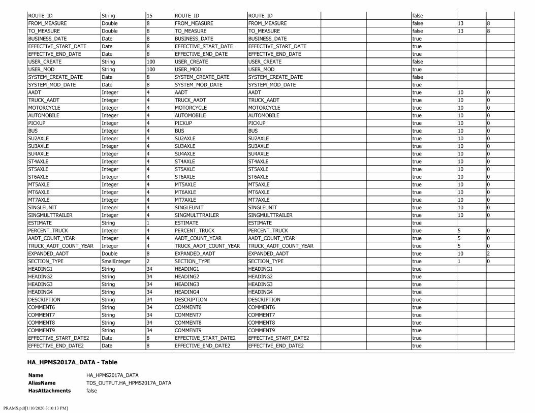
ROUTE_ID String 15 ROUTE_ID ROUTE_ID false FROM_MEASURE Double 8 FROM_MEASURE FROM_MEASURE false 13 8 TO_MEASURE Double 8 TO_MEASURE TO_MEASURE false 13 8 BUSINESS_DATE Date 8 BUSINESS_DATE BUSINESS_DATE true EFFECTIVE_START_DATE Date 8 EFFECTIVE_START_DATE EFFECTIVE_START_DATE true EFFECTIVE_END_DATE Date 8 EFFECTIVE_END_DATE EFFECTIVE_END_DATE true USER_CREATE String 100 USER_CREATE USER_CREATE false USER_MOD String 100 USER_MOD USER_MOD true SYSTEM_CREATE_DATE Date 8 SYSTEM_CREATE_DATE SYSTEM_CREATE_DATE false SYSTEM_MOD_DATE Date 8 SYSTEM_MOD_DATE SYSTEM_MOD_DATE true AADT Integer 4 AADT AADT true 10 0 TRUCK_AADT Integer 4 TRUCK_AADT TRUCK_AADT true 10 0 MOTORCYCLE Integer 4 MOTORCYCLE MOTORCYCLE true 10 0 AUTOMOBILE Integer 4 AUTOMOBILE AUTOMOBILE true 10 0 PICKUP Integer 4 PICKUP PICKUP true 10 0 BUS Integer 4 BUS BUS true 10 0 SU2AXLE Integer 4 SU2AXLE SU2AXLE true 10 0 SU3AXLE Integer 4 SU3AXLE SU3AXLE true 10 0 SU4AXLE Integer 4 SU4AXLE SU4AXLE true 10 0 ST4AXLE Integer 4 ST4AXLE ST4AXLE true 10 0 ST5AXLE Integer 4 ST5AXLE ST5AXLE true 10 0 ST6AXLE Integer 4 ST6AXLE ST6AXLE true 10 0 MT5AXLE Integer 4 MT5AXLE MT5AXLE true 10 0 MT6AXLE Integer 4 MT6AXLE MT6AXLE true 10 0 MT7AXLE Integer 4 MT7AXLE MT7AXLE true 10 0 SINGLEUNIT Integer 4 SINGLEUNIT SINGLEUNIT true 10 0 SINGMULTTRAILER Integer 4 SINGMULTTRAILER SINGMULTTRAILER true 10 0 ESTIMATE String 1 ESTIMATE ESTIMATE true PERCENT_TRUCK Integer 4 PERCENT_TRUCK PERCENT_TRUCK true 5 0 AADT_COUNT_YEAR Integer 4 AADT_COUNT_YEAR AADT_COUNT_YEAR true 5 0 TRUCK_AADT_COUNT_YEAR Integer 4 TRUCK_AADT_COUNT_YEAR TRUCK_AADT_COUNT_YEAR true 5 0 EXPANDED_AADT Double 8 EXPANDED_AADT EXPANDED_AADT true 10 2 SECTION_TYPE SmallInteger 2 SECTION_TYPE SECTION_TYPE true 1 0 HEADING1 String 34 HEADING1 HEADING1 true HEADING2 String 34 HEADING2 HEADING2 true HEADING3 String 34 HEADING3 HEADING3 true HEADING4 String 34 HEADING4 HEADING4 true DESCRIPTION String 34 DESCRIPTION DESCRIPTION true COMMENT6 String 34 COMMENT6 COMMENT6 true COMMENT7 String 34 COMMENT7 COMMENT7 true COMMENT8 String 34 COMMENT8 COMMENT8 true COMMENT9 String 34 COMMENT9 COMMENT9 true EFFECTIVE_START_DATE2 Date 8 EFFECTIVE_START_DATE2 EFFECTIVE_START_DATE2 true EFFECTIVE_END_DATE2 Date 8 EFFECTIVE_END_DATE2 EFFECTIVE_END_DATE2 true
HA_HPMS2017A_DATA - Table
Name HA_HPMS2017A_DATA AliasName TDS_OUTPUT.HA_HPMS2017A_DATA HasAttachments false
PRAMS.pdf[1/10/2020 3:10:13 PM]

Description HA_HPMS2017A_DATA
Field DataType Length AliasName Description Domain DefaultValue IsNullable Precision Scale ID String 38 ID ID false AADT_SINGLE_UNIT Integer 4 AADT_SINGLE_UNIT AADT_SINGLE_UNIT true 6 0 AADT_SINGLE_UNIT_CMT String 100 AADT_SINGLE_UNIT_CMT AADT_SINGLE_UNIT_CMT true PCT_PEAK_SINGLE Single 4 PCT_PEAK_SINGLE PCT_PEAK_SINGLE true 5 3 PCT_PEAK_SINGLE_CMT String 100 PCT_PEAK_SINGLE_CMT PCT_PEAK_SINGLE_CMT true AADT_COMBINATION Integer 4 AADT_COMBINATION AADT_COMBINATION true 6 0 AADT_COMBINATION_CMT String 100 AADT_COMBINATION_CMT AADT_COMBINATION_CMT true PCT_PEAK_COMBINATION Single 4 PCT_PEAK_COMBINATION PCT_PEAK_COMBINATION true 5 3 PCT_PEAK_COMBINATION_CMT String 100 PCT_PEAK_COMBINATION_CMT PCT_PEAK_COMBINATION_CMT true K_FACTOR SmallInteger 2 K_FACTOR K_FACTOR true 2 0 K_FACTOR_CMT String 100 K_FACTOR_CMT K_FACTOR_CMT true DIR_FACTOR SmallInteger 2 DIR_FACTOR DIR_FACTOR true 3 0 DIR_FACTOR_CMT String 100 DIR_FACTOR_CMT DIR_FACTOR_CMT true FUTURE_AADT Integer 4 FUTURE_AADT FUTURE_AADT true 6 0 FUTURE_AADT_CMT String 100 FUTURE_AADT_CMT FUTURE_AADT_CMT true SIGNAL_TYPE Integer 4 SIGNAL_TYPE SIGNAL_TYPE true 5 0 SIGNAL_TYPE_CMT String 100 SIGNAL_TYPE_CMT SIGNAL_TYPE_CMT true PCT_GREEN_TIME SmallInteger 2 PCT_GREEN_TIME PCT_GREEN_TIME true 2 0 PCT_GREEN_TIME_CMT String 100 PCT_GREEN_TIME_CMT PCT_GREEN_TIME_CMT true NUMBER_SIGNALS SmallInteger 2 NUMBER_SIGNALS NUMBER_SIGNALS true 2 0 NUMBER_SIGNALS_CMT String 100 NUMBER_SIGNALS_CMT NUMBER_SIGNALS_CMT true STOP_SIGNS SmallInteger 2 STOP_SIGNS STOP_SIGNS true 2 0 STOP_SIGNS_CMT String 100 STOP_SIGNS_CMT STOP_SIGNS_CMT true AT_GRADE_OTHER SmallInteger 2 AT_GRADE_OTHER AT_GRADE_OTHER true 2 0 AT_GRADE_OTHER_CMT String 100 AT_GRADE_OTHER_CMT AT_GRADE_OTHER_CMT true CAPACITY Integer 4 CAPACITY CAPACITY true 6 0 CAPACITY_CMT String 100 CAPACITY_CMT CAPACITY_CMT true ROUTE_NUMBER String 8 ROUTE_NUMBER ROUTE_NUMBER true ROUTE_NUMBER_CMT String 100 ROUTE_NUMBER_CMT ROUTE_NUMBER_CMT true ROUTE_SIGNING Integer 4 ROUTE_SIGNING ROUTE_SIGNING true 5 0 ROUTE_SIGNING_CMT String 100 ROUTE_SIGNING_CMT ROUTE_SIGNING_CMT true F_SYSTEM Integer 4 F_SYSTEM F_SYSTEM true 5 0 F_SYSTEM_CMT String 100 F_SYSTEM_CMT F_SYSTEM_CMT true PEAK_LANES SmallInteger 2 PEAK_LANES PEAK_LANES true 2 0 PEAK_LANES_CMT String 100 PEAK_LANES_CMT PEAK_LANES_CMT true COUNTER_PEAK_LANES SmallInteger 2 COUNTER_PEAK_LANES COUNTER_PEAK_LANES true 2 0 COUNTER_PEAK_LANES_CMT String 100 COUNTER_PEAK_LANES_CMT COUNTER_PEAK_LANES_CMT true TURN_LANES_R Integer 4 TURN_LANES_R TURN_LANES_R true 5 0 TURN_LANES_R_CMT String 100 TURN_LANES_R_CMT TURN_LANES_R_CMT true TURN_LANES_L Integer 4 TURN_LANES_L TURN_LANES_L true 5 0 TURN_LANES_L_CMT String 100 TURN_LANES_L_CMT TURN_LANES_L_CMT true SPEED_LIMIT SmallInteger 2 SPEED_LIMIT SPEED_LIMIT true 2 0 SPEED_LIMIT_CMT String 100 SPEED_LIMIT_CMT SPEED_LIMIT_CMT true TOLL_CHARGED Integer 4 TOLL_CHARGED TOLL_CHARGED true 5 0 TOLL_CHARGED_CMT String 100 TOLL_CHARGED_CMT TOLL_CHARGED_CMT true TOLL_TYPE Integer 4 TOLL_TYPE TOLL_TYPE true 5 0 TOLL_TYPE_CMT String 100 TOLL_TYPE_CMT TOLL_TYPE_CMT true MAINTENANCE_OPERATIONS Integer 4 MAINTENANCE_OPERATIONS MAINTENANCE_OPERATIONS true 5 0
PRAMS.pdf[1/10/2020 3:10:13 PM]

MAINTENANCE_OPERATIONS_CMT String 100 MAINTENANCE_OPERATIONS_CMT MAINTENANCE_OPERATIONS_CMT true COUNTY_CODE Integer 4 COUNTY_CODE COUNTY_CODE true 5 0 COUNTY_CODE_CMT String 100 COUNTY_CODE_CMT COUNTY_CODE_CMT true URBAN_CODE Integer 4 URBAN_CODE URBAN_CODE true 5 0 URBAN_CODE_CMT String 100 URBAN_CODE_CMT URBAN_CODE_CMT true FACILITY_TYPE Integer 4 FACILITY_TYPE FACILITY_TYPE true 5 0 FACILITY_TYPE_CMT String 100 FACILITY_TYPE_CMT FACILITY_TYPE_CMT true STRUCTURE_TYPE Integer 4 STRUCTURE_TYPE STRUCTURE_TYPE true 5 0 STRUCTURE_TYPE_CMT String 100 STRUCTURE_TYPE_CMT STRUCTURE_TYPE_CMT true ACCESS_CONTROL Integer 4 ACCESS_CONTROL ACCESS_CONTROL true 5 0 ACCESS_CONTROL_CMT String 100 ACCESS_CONTROL_CMT ACCESS_CONTROL_CMT true OWNERSHIP Integer 4 OWNERSHIP OWNERSHIP true 5 0 OWNERSHIP_CMT String 100 OWNERSHIP_CMT OWNERSHIP_CMT true THROUGH_LANES SmallInteger 2 THROUGH_LANES THROUGH_LANES true 2 0 THROUGH_LANES_CMT String 100 THROUGH_LANES_CMT THROUGH_LANES_CMT true HOV_TYPE Integer 4 HOV_TYPE HOV_TYPE true 5 0 HOV_TYPE_CMT String 100 HOV_TYPE_CMT HOV_TYPE_CMT true HOV_LANES SmallInteger 2 HOV_LANES HOV_LANES true 2 0 HOV_LANES_CMT String 100 HOV_LANES_CMT HOV_LANES_CMT true AADT Integer 4 AADT AADT true 6 0 AADT_CMT String 100 AADT_CMT AADT_CMT true ROUTE_QUALIFIER Integer 4 ROUTE_QUALIFIER ROUTE_QUALIFIER true 5 0 ROUTE_QUALIFIER_CMT String 100 ROUTE_QUALIFIER_CMT ROUTE_QUALIFIER_CMT true YEAR_LAST_IMPROV SmallInteger 2 YEAR_LAST_IMPROV YEAR_LAST_IMPROV true 4 0 YEAR_LAST_IMPROV_CMT String 100 YEAR_LAST_IMPROV_CMT YEAR_LAST_IMPROV_CMT true YEAR_LAST_CONSTRUCTION SmallInteger 2 YEAR_LAST_CONSTRUCTION YEAR_LAST_CONSTRUCTION true 4 0 YEAR_LAST_CONSTRUCTION_CMT String 100 YEAR_LAST_CONSTRUCTION_CMT YEAR_LAST_CONSTRUCTION_CMT true LAST_OVERLAY_THICKNESS Single 4 LAST_OVERLAY_THICKNESS LAST_OVERLAY_THICKNESS true 3 1 LAST_OVERLAY_THICKNESS_CMT String 100 LAST_OVERLAY_THICKNESS_CMT LAST_OVERLAY_THICKNESS_CMT true THICKNESS_RIGID Single 4 THICKNESS_RIGID THICKNESS_RIGID true 3 1 THICKNESS_RIGID_CMT String 100 THICKNESS_RIGID_CMT THICKNESS_RIGID_CMT true THICKNESS_FLEXIBLE Single 4 THICKNESS_FLEXIBLE THICKNESS_FLEXIBLE true 3 1 THICKNESS_FLEXIBLE_CMT String 100 THICKNESS_FLEXIBLE_CMT THICKNESS_FLEXIBLE_CMT true BASE_TYPE Integer 4 BASE_TYPE BASE_TYPE true 5 0 BASE_TYPE_CMT String 100 BASE_TYPE_CMT BASE_TYPE_CMT true BASE_THICKNESS SmallInteger 2 BASE_THICKNESS BASE_THICKNESS true 2 0 BASE_THICKNESS_CMT String 100 BASE_THICKNESS_CMT BASE_THICKNESS_CMT true CLIMATE_ZONE Integer 4 CLIMATE_ZONE CLIMATE_ZONE true 5 0 CLIMATE_ZONE_CMT String 100 CLIMATE_ZONE_CMT CLIMATE_ZONE_CMT true SOIL_TYPE Integer 4 SOIL_TYPE SOIL_TYPE true 5 0 SOIL_TYPE_CMT String 100 SOIL_TYPE_CMT SOIL_TYPE_CMT true NHS Integer 4 NHS NHS true 5 0 NHS_CMT String 100 NHS_CMT NHS_CMT true STRAHNET_TYPE Integer 4 STRAHNET_TYPE STRAHNET_TYPE true 5 0 STRAHNET_TYPE_CMT String 100 STRAHNET_TYPE_CMT STRAHNET_TYPE_CMT true TRUCK Integer 4 TRUCK TRUCK true 5 0 TRUCK_CMT String 100 TRUCK_CMT TRUCK_CMT true FUTURE_FACILITY Integer 4 FUTURE_FACILITY FUTURE_FACILITY true 5 0 FUTURE_FACILITY_CMT String 100 FUTURE_FACILITY_CMT FUTURE_FACILITY_CMT true CRACKING_LENGTH Single 4 CRACKING_LENGTH CRACKING_LENGTH true 6 1
PRAMS.pdf[1/10/2020 3:10:13 PM]

FULL_ROUTE_NUMBER String 50 FULL_ROUTE_NUMBER FULL_ROUTE_NUMBER true FUTURE_AADT_YEAR SmallInteger 2 FUTURE_AADT_YEAR FUTURE_AADT_YEAR true 4 0 IRI_DATE_VALUE Date 8 IRI_DATE_VALUE IRI_DATE_VALUE true ROUTE_NUMBER_VALUE_TEXT String 50 ROUTE_NUMBER_VALUE_TEXT ROUTE_NUMBER_VALUE_TEXT true TOLL_CHARGED_VALUE_TEXT String 50 TOLL_CHARGED_VALUE_TEXT TOLL_CHARGED_VALUE_TEXT true TOLL_TYPE_VALUE_TEXT String 50 TOLL_TYPE_VALUE_TEXT TOLL_TYPE_VALUE_TEXT true RUTTING_DATE_VALUE Date 8 RUTTING_DATE_VALUE RUTTING_DATE_VALUE true FAULTING_DATE_VALUE Date 8 FAULTING_DATE_VALUE FAULTING_DATE_VALUE true CRACKING_PERCENT_DATE_VALUE Date 8 CRACKING_PERCENT_DATE_VALUE CRACKING_PERCENT_DATE_VALUE true BEGIN_POINT Double 8 BEGIN_POINT BEGIN_POINT true 8 3 END_POINT Double 8 END_POINT END_POINT true 8 3 ROUTE_ID String 60 ROUTE_ID ROUTE_ID true SAMPLE_ID String 12 SAMPLE_ID SAMPLE_ID true TERRAIN_TYPE Integer 4 TERRAIN_TYPE TERRAIN_TYPE true 5 0 TERRAIN_TYPE_CMT String 100 TERRAIN_TYPE_CMT TERRAIN_TYPE_CMT true GRADES_A Single 4 GRADES_A GRADES_A true 6 3 GRADES_A_CMT String 100 GRADES_A_CMT GRADES_A_CMT true GRADES_B Single 4 GRADES_B GRADES_B true 6 3 GRADES_B_CMT String 100 GRADES_B_CMT GRADES_B_CMT true GRADES_C Single 4 GRADES_C GRADES_C true 6 3 GRADES_C_CMT String 100 GRADES_C_CMT GRADES_C_CMT true GRADES_D Single 4 GRADES_D GRADES_D true 6 3 GRADES_D_CMT String 100 GRADES_D_CMT GRADES_D_CMT true GRADES_E Single 4 GRADES_E GRADES_E true 6 3 GRADES_E_CMT String 100 GRADES_E_CMT GRADES_E_CMT true GRADES_F Single 4 GRADES_F GRADES_F true 6 3 GRADES_F_CMT String 100 GRADES_F_CMT GRADES_F_CMT true PCT_PASS_SIGHT SmallInteger 2 PCT_PASS_SIGHT PCT_PASS_SIGHT true 3 0 PCT_PASS_SIGHT_CMT String 100 PCT_PASS_SIGHT_CMT PCT_PASS_SIGHT_CMT true IRI SmallInteger 2 IRI IRI true 4 0 IRI_CMT String 100 IRI_CMT IRI_CMT true PSR Single 4 PSR PSR true 3 1 PSR_CMT String 100 PSR_CMT PSR_CMT true SURFACE_TYPE Integer 4 SURFACE_TYPE SURFACE_TYPE true 5 0 SURFACE_TYPE_CMT String 100 SURFACE_TYPE_CMT SURFACE_TYPE_CMT true RUTTING Single 4 RUTTING RUTTING true 3 1 RUTTING_CMT String 100 RUTTING_CMT RUTTING_CMT true FAULTING Single 4 FAULTING FAULTING true 4 1 FAULTING_CMT String 100 FAULTING_CMT FAULTING_CMT true CRACKING_PERCENT Single 4 CRACKING_PERCENT CRACKING_PERCENT true 4 1 CRACKING_PERCENT_CMT String 100 CRACKING_PERCENT_CMT CRACKING_PERCENT_CMT true ALTERNATIVE_ROUTE_NAME String 50 ALTERNATIVE_ROUTE_NAME ALTERNATIVE_ROUTE_NAME true ALTERNATIVE_ROUTE_NAME_CMT String 100 ALTERNATIVE_ROUTE_NAME_CMT ALTERNATIVE_ROUTE_NAME_CMT true LANE_WIDTH SmallInteger 2 LANE_WIDTH LANE_WIDTH true 2 0 LANE_WIDTH_CMT String 100 LANE_WIDTH_CMT LANE_WIDTH_CMT true MEDIAN_TYPE Integer 4 MEDIAN_TYPE MEDIAN_TYPE true 5 0 MEDIAN_TYPE_CMT String 100 MEDIAN_TYPE_CMT MEDIAN_TYPE_CMT true MEDIAN_WIDTH SmallInteger 2 MEDIAN_WIDTH MEDIAN_WIDTH true 2 0 MEDIAN_WIDTH_CMT String 100 MEDIAN_WIDTH_CMT MEDIAN_WIDTH_CMT true SHOULDER_TYPE Integer 4 SHOULDER_TYPE SHOULDER_TYPE true 5 0
PRAMS.pdf[1/10/2020 3:10:13 PM]
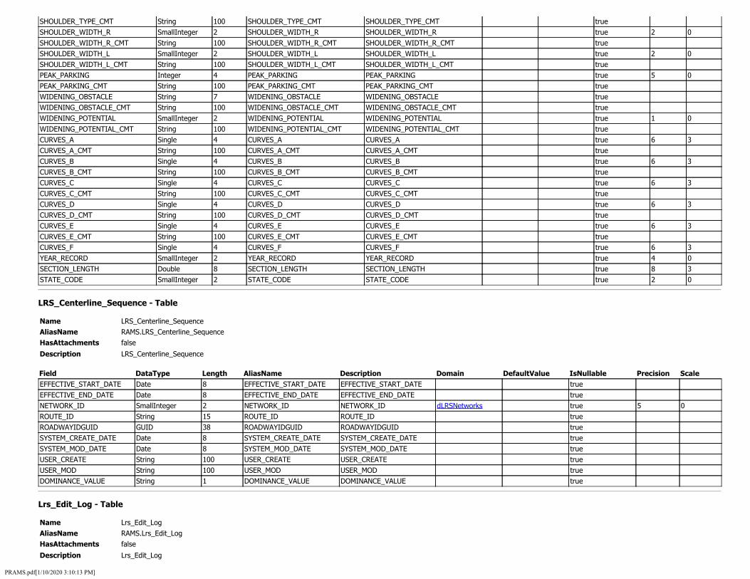
SHOULDER_TYPE_CMT String 100 SHOULDER_TYPE_CMT SHOULDER_TYPE_CMT true SHOULDER_WIDTH_R SmallInteger 2 SHOULDER_WIDTH_R SHOULDER_WIDTH_R true 2 0 SHOULDER_WIDTH_R_CMT String 100 SHOULDER_WIDTH_R_CMT SHOULDER_WIDTH_R_CMT true SHOULDER_WIDTH_L SmallInteger 2 SHOULDER_WIDTH_L SHOULDER_WIDTH_L true 2 0 SHOULDER_WIDTH_L_CMT String 100 SHOULDER_WIDTH_L_CMT SHOULDER_WIDTH_L_CMT true PEAK_PARKING Integer 4 PEAK_PARKING PEAK_PARKING true 5 0 PEAK_PARKING_CMT String 100 PEAK_PARKING_CMT PEAK_PARKING_CMT true WIDENING_OBSTACLE String 7 WIDENING_OBSTACLE WIDENING_OBSTACLE true WIDENING_OBSTACLE_CMT String 100 WIDENING_OBSTACLE_CMT WIDENING_OBSTACLE_CMT true WIDENING_POTENTIAL SmallInteger 2 WIDENING_POTENTIAL WIDENING_POTENTIAL true 1 0 WIDENING_POTENTIAL_CMT String 100 WIDENING_POTENTIAL_CMT WIDENING_POTENTIAL_CMT true CURVES_A Single 4 CURVES_A CURVES_A true 6 3 CURVES_A_CMT String 100 CURVES_A_CMT CURVES_A_CMT true CURVES_B Single 4 CURVES_B CURVES_B true 6 3 CURVES_B_CMT String 100 CURVES_B_CMT CURVES_B_CMT true CURVES_C Single 4 CURVES_C CURVES_C true 6 3 CURVES_C_CMT String 100 CURVES_C_CMT CURVES_C_CMT true CURVES_D Single 4 CURVES_D CURVES_D true 6 3 CURVES_D_CMT String 100 CURVES_D_CMT CURVES_D_CMT true CURVES_E Single 4 CURVES_E CURVES_E true 6 3 CURVES_E_CMT String 100 CURVES_E_CMT CURVES_E_CMT true CURVES_F Single 4 CURVES_F CURVES_F true 6 3 YEAR_RECORD SmallInteger 2 YEAR_RECORD YEAR_RECORD true 4 0 SECTION_LENGTH Double 8 SECTION_LENGTH SECTION_LENGTH true 8 3 STATE_CODE SmallInteger 2 STATE_CODE STATE_CODE true 2 0
LRS_Centerline_Sequence - Table
Name LRS_Centerline_Sequence AliasName RAMS.LRS_Centerline_Sequence HasAttachments false
Description LRS_Centerline_Sequence
Field DataType Length AliasName Description Domain DefaultValue IsNullable Precision Scale EFFECTIVE_START_DATE Date 8 EFFECTIVE_START_DATE EFFECTIVE_START_DATE true EFFECTIVE_END_DATE Date 8 EFFECTIVE_END_DATE EFFECTIVE_END_DATE true NETWORK_ID SmallInteger 2 NETWORK_ID NETWORK_ID dLRSNetworks true 5 0 ROUTE_ID String 15 ROUTE_ID ROUTE_ID true ROADWAYIDGUID GUID 38 ROADWAYIDGUID ROADWAYIDGUID true SYSTEM_CREATE_DATE Date 8 SYSTEM_CREATE_DATE SYSTEM_CREATE_DATE true SYSTEM_MOD_DATE Date 8 SYSTEM_MOD_DATE SYSTEM_MOD_DATE true USER_CREATE String 100 USER_CREATE USER_CREATE true USER_MOD String 100 USER_MOD USER_MOD true DOMINANCE_VALUE String 1 DOMINANCE_VALUE DOMINANCE_VALUE true
Lrs_Edit_Log - Table
Name Lrs_Edit_Log AliasName RAMS.Lrs_Edit_Log HasAttachments false
Description Lrs_Edit_Log
PRAMS.pdf[1/10/2020 3:10:13 PM]
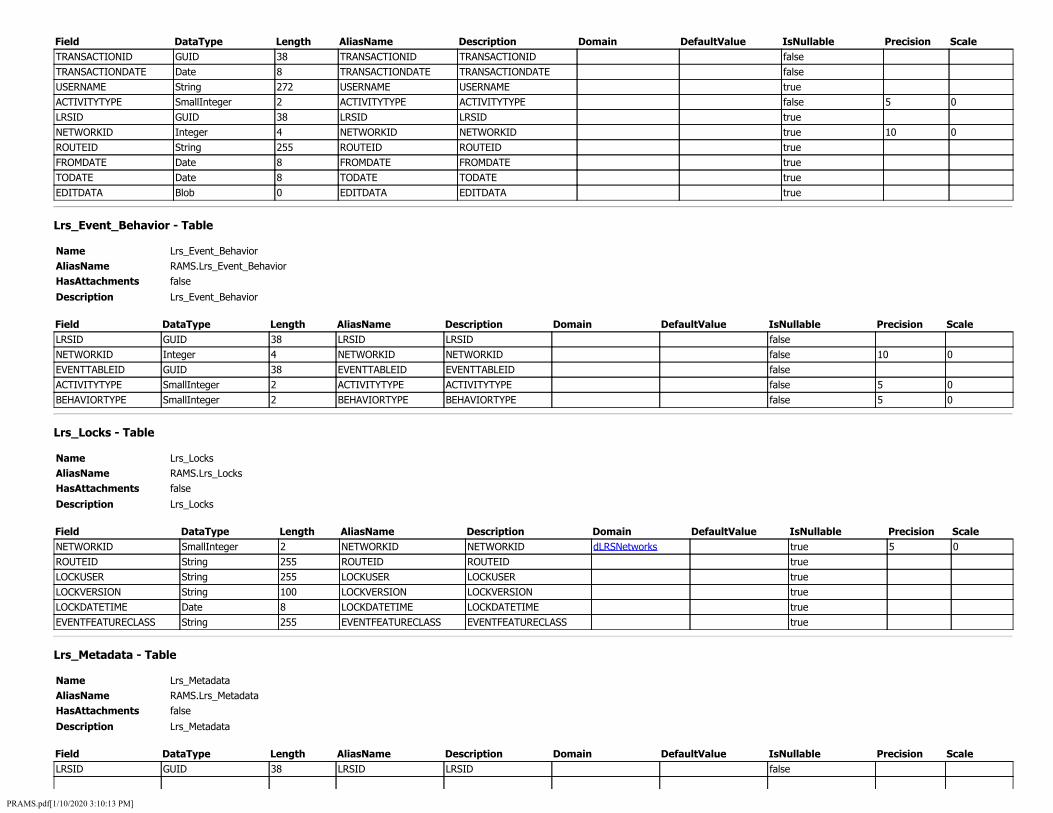
Field DataType Length AliasName Description Domain DefaultValue IsNullable Precision Scale TRANSACTIONID GUID 38 TRANSACTIONID TRANSACTIONID false TRANSACTIONDATE Date 8 TRANSACTIONDATE TRANSACTIONDATE false USERNAME String 272 USERNAME USERNAME true ACTIVITYTYPE SmallInteger 2 ACTIVITYTYPE ACTIVITYTYPE false 5 0 LRSID GUID 38 LRSID LRSID true NETWORKID Integer 4 NETWORKID NETWORKID true 10 0 ROUTEID String 255 ROUTEID ROUTEID true FROMDATE Date 8 FROMDATE FROMDATE true TODATE Date 8 TODATE TODATE true EDITDATA Blob 0 EDITDATA EDITDATA true
Lrs_Event_Behavior - Table
Name Lrs_Event_Behavior AliasName RAMS.Lrs_Event_Behavior HasAttachments false
Description Lrs_Event_Behavior
Field DataType Length AliasName Description Domain DefaultValue IsNullable Precision Scale LRSID GUID 38 LRSID LRSID false NETWORKID Integer 4 NETWORKID NETWORKID false 10 0 EVENTTABLEID GUID 38 EVENTTABLEID EVENTTABLEID false ACTIVITYTYPE SmallInteger 2 ACTIVITYTYPE ACTIVITYTYPE false 5 0 BEHAVIORTYPE SmallInteger 2 BEHAVIORTYPE BEHAVIORTYPE false 5 0
Lrs_Locks - Table
Name Lrs_Locks AliasName RAMS.Lrs_Locks HasAttachments false
Description Lrs_Locks
Field DataType Length AliasName Description Domain DefaultValue IsNullable Precision Scale NETWORKID SmallInteger 2 NETWORKID NETWORKID dLRSNetworks true 5 0 ROUTEID String 255 ROUTEID ROUTEID true LOCKUSER String 255 LOCKUSER LOCKUSER true LOCKVERSION String 100 LOCKVERSION LOCKVERSION true LOCKDATETIME Date 8 LOCKDATETIME LOCKDATETIME true EVENTFEATURECLASS String 255 EVENTFEATURECLASS EVENTFEATURECLASS true
Lrs_Metadata - Table
Name Lrs_Metadata AliasName RAMS.Lrs_Metadata HasAttachments false
Description Lrs_Metadata
Field DataType Length AliasName Description Domain DefaultValue IsNullable Precision Scale LRSID GUID 38 LRSID LRSID false
PRAMS.pdf[1/10/2020 3:10:13 PM]
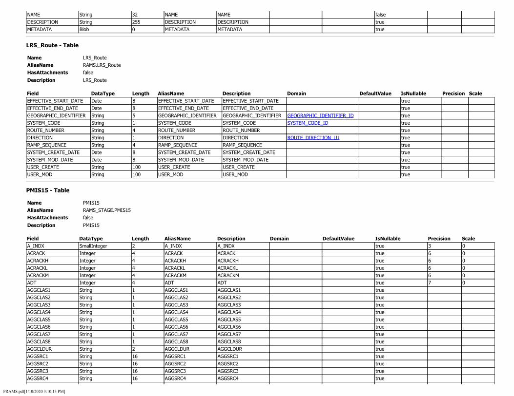
NAME String 32 NAME NAME false DESCRIPTION String 255 DESCRIPTION DESCRIPTION true METADATA Blob 0 METADATA METADATA true
LRS_Route - Table
Name LRS_Route AliasName RAMS.LRS_Route HasAttachments false
Description LRS_Route
Field DataType Length AliasName Description Domain DefaultValue IsNullable Precision Scale EFFECTIVE_START_DATE Date 8 EFFECTIVE_START_DATE EFFECTIVE_START_DATE true EFFECTIVE_END_DATE Date 8 EFFECTIVE_END_DATE EFFECTIVE_END_DATE true GEOGRAPHIC_IDENTIFIER String 5 GEOGRAPHIC_IDENTIFIER GEOGRAPHIC_IDENTIFIER GEOGRAPHIC_IDENTIFIER_ID true SYSTEM_CODE String 1 SYSTEM_CODE SYSTEM_CODE SYSTEM_CODE_ID true ROUTE_NUMBER String 4 ROUTE_NUMBER ROUTE_NUMBER true DIRECTION String 1 DIRECTION DIRECTION ROUTE_DIRECTION_LU true RAMP_SEQUENCE String 4 RAMP_SEQUENCE RAMP_SEQUENCE true SYSTEM_CREATE_DATE Date 8 SYSTEM_CREATE_DATE SYSTEM_CREATE_DATE true SYSTEM_MOD_DATE Date 8 SYSTEM_MOD_DATE SYSTEM_MOD_DATE true USER_CREATE String 100 USER_CREATE USER_CREATE true USER_MOD String 100 USER_MOD USER_MOD true
PMIS15 - Table
Name PMIS15 AliasName RAMS_STAGE.PMIS15 HasAttachments false
Description PMIS15
Field DataType Length AliasName Description Domain DefaultValue IsNullable Precision Scale A_INDX SmallInteger 2 A_INDX A_INDX true 3 0 ACRACK Integer 4 ACRACK ACRACK true 6 0 ACRACKH Integer 4 ACRACKH ACRACKH true 6 0 ACRACKL Integer 4 ACRACKL ACRACKL true 6 0 ACRACKM Integer 4 ACRACKM ACRACKM true 6 0 ADT Integer 4 ADT ADT true 7 0 AGGCLAS1 String 1 AGGCLAS1 AGGCLAS1 true AGGCLAS2 String 1 AGGCLAS2 AGGCLAS2 true AGGCLAS3 String 1 AGGCLAS3 AGGCLAS3 true AGGCLAS4 String 1 AGGCLAS4 AGGCLAS4 true AGGCLAS5 String 1 AGGCLAS5 AGGCLAS5 true AGGCLAS6 String 1 AGGCLAS6 AGGCLAS6 true AGGCLAS7 String 1 AGGCLAS7 AGGCLAS7 true AGGCLAS8 String 1 AGGCLAS8 AGGCLAS8 true AGGCLDUR String 2 AGGCLDUR AGGCLDUR true AGGSRC1 String 16 AGGSRC1 AGGSRC1 true AGGSRC2 String 16 AGGSRC2 AGGSRC2 true AGGSRC3 String 16 AGGSRC3 AGGSRC3 true AGGSRC4 String 16 AGGSRC4 AGGSRC4 true
PRAMS.pdf[1/10/2020 3:10:13 PM]
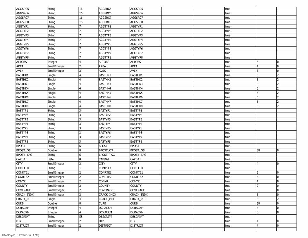
AGGSRC5 String 16 AGGSRC5 AGGSRC5 true AGGSRC6 String 16 AGGSRC6 AGGSRC6 true AGGSRC7 String 16 AGGSRC7 AGGSRC7 true AGGSRC8 String 16 AGGSRC8 AGGSRC8 true AGGTYP1 String 7 AGGTYP1 AGGTYP1 true AGGTYP2 String 7 AGGTYP2 AGGTYP2 true AGGTYP3 String 7 AGGTYP3 AGGTYP3 true AGGTYP4 String 7 AGGTYP4 AGGTYP4 true AGGTYP5 String 7 AGGTYP5 AGGTYP5 true AGGTYP6 String 7 AGGTYP6 AGGTYP6 true AGGTYP7 String 7 AGGTYP7 AGGTYP7 true AGGTYP8 String 7 AGGTYP8 AGGTYP8 true ALTOBS Integer 4 ALTOBS ALTOBS true 5 0 AREA SmallInteger 2 AREA AREA true 4 0 AVEK SmallInteger 2 AVEK AVEK true 3 0 BASTHK1 Single 4 BASTHK1 BASTHK1 true 5 2 BASTHK2 Single 4 BASTHK2 BASTHK2 true 5 2 BASTHK3 Single 4 BASTHK3 BASTHK3 true 5 2 BASTHK4 Single 4 BASTHK4 BASTHK4 true 5 2 BASTHK5 Single 4 BASTHK5 BASTHK5 true 5 2 BASTHK6 Single 4 BASTHK6 BASTHK6 true 5 2 BASTHK7 Single 4 BASTHK7 BASTHK7 true 5 2 BASTHK8 Single 4 BASTHK8 BASTHK8 true 5 2 BASTYP1 String 3 BASTYP1 BASTYP1 true BASTYP2 String 3 BASTYP2 BASTYP2 true BASTYP3 String 3 BASTYP3 BASTYP3 true BASTYP4 String 3 BASTYP4 BASTYP4 true BASTYP5 String 3 BASTYP5 BASTYP5 true BASTYP6 String 3 BASTYP6 BASTYP6 true BASTYP7 String 3 BASTYP7 BASTYP7 true BASTYP8 String 3 BASTYP8 BASTYP8 true BPOST String 6 BPOST BPOST true BPOST_OS Double 8 BPOST_OS BPOST_OS true 38 0 BPOST_TAG String 6 BPOST_TAG BPOST_TAG true CAPDAT Date 8 CAPDAT CAPDAT true CITY SmallInteger 2 CITY CITY true 4 0 COMPLEX String 1 COMPLEX COMPLEX true CONRTE1 SmallInteger 2 CONRTE1 CONRTE1 true 3 0 CONRTE2 SmallInteger 2 CONRTE2 CONRTE2 true 3 0 CONYR SmallInteger 2 CONYR CONYR true 4 0 COUNTY SmallInteger 2 COUNTY COUNTY true 2 0 COVERAGE SmallInteger 2 COVERAGE COVERAGE true 3 0 CRACK_INDX SmallInteger 2 CRACK_INDX CRACK_INDX true 3 0 CRACK_PCT Single 4 CRACK_PCT CRACK_PCT true 5 2 CURB Double 8 CURB CURB true 38 0 DCRACKH Integer 4 DCRACKH DCRACKH true 6 0 DCRACKM Integer 4 DCRACKM DCRACKM true 6 0 DESCRIPT String 58 DESCRIPT DESCRIPT true DIR SmallInteger 2 DIR DIR true 4 0 DISTRICT SmallInteger 2 DISTRICT DISTRICT true 4 0
PRAMS.pdf[1/10/2020 3:10:13 PM]

DROPOFF Double 8 DROPOFF DROPOFF true 38 0 EPOST String 6 EPOST EPOST true EPOST_OS Double 8 EPOST_OS EPOST_OS true 38 0 EPOST_TAG String 6 EPOST_TAG EPOST_TAG true FAULT Single 4 FAULT FAULT true 4 1 FAULT_INDX SmallInteger 2 FAULT_INDX FAULT_INDX true 3 0 FAULTAV Single 4 FAULTAV FAULTAV true 5 4 FCLASS SmallInteger 2 FCLASS FCLASS true 4 0 FLTPCT SmallInteger 2 FLTPCT FLTPCT true 3 0 FRICT SmallInteger 2 FRICT FRICT true 2 0 FRIDAT SmallInteger 2 FRIDAT FRIDAT true 4 0 FWD_DATE Date 8 FWD_DATE FWD_DATE true GARAGE SmallInteger 2 GARAGE GARAGE true 2 0 IRI Single 4 IRI IRI true 5 2 IRI_INDX SmallInteger 2 IRI_INDX IRI_INDX true 3 0 IRIDAT SmallInteger 2 IRIDAT IRIDAT true 4 0 ISHLDTHK Single 4 ISHLDTHK ISHLDTHK true 5 2 ISHLDTIE String 1 ISHLDTIE ISHLDTIE true ISHLDTYP String 10 ISHLDTYP ISHLDTYP true ISHLDWID Single 4 ISHLDWID ISHLDWID true 3 1 JTSPALLH Integer 4 JTSPALLH JTSPALLH true 6 0 JTSPALLM Integer 4 JTSPALLM JTSPALLM true 6 0 KIPSANN Double 8 KIPSANN KIPSANN true 11 0 KIPSCON Double 8 KIPSCON KIPSCON true 11 0 KIPSRES Double 8 KIPSRES KIPSRES true 11 0 L_INDX SmallInteger 2 L_INDX L_INDX true 3 0 LANES SmallInteger 2 LANES LANES true 4 0 LAYR1 SmallInteger 2 LAYR1 LAYR1 true 4 0 LAYR2 SmallInteger 2 LAYR2 LAYR2 true 4 0 LAYR3 SmallInteger 2 LAYR3 LAYR3 true 4 0 LAYR4 SmallInteger 2 LAYR4 LAYR4 true 4 0 LAYR5 SmallInteger 2 LAYR5 LAYR5 true 4 0 LAYR6 SmallInteger 2 LAYR6 LAYR6 true 4 0 LAYR7 SmallInteger 2 LAYR7 LAYR7 true 4 0 LAYR8 SmallInteger 2 LAYR8 LAYR8 true 4 0 LCRACK Integer 4 LCRACK LCRACK true 6 0 LCRACKH Integer 4 LCRACKH LCRACKH true 6 0 LCRACKL Integer 4 LCRACKL LCRACKL true 6 0 LCRACKM Integer 4 LCRACKM LCRACKM true 6 0 LCRACKWH Integer 4 LCRACKWH LCRACKWH true 6 0 LCRACKWL Integer 4 LCRACKWL LCRACKWL true 6 0 LCRACKWM Integer 4 LCRACKWM LCRACKWM true 6 0 LCURB String 1 LCURB LCURB true LLW_INDX SmallInteger 2 LLW_INDX LLW_INDX true 3 0 LRS_LENGTH Single 4 LRS_LENGTH LRS_LENGTH true 5 2 LW_INDX SmallInteger 2 LW_INDX LW_INDX true 3 0 LWCRACK Integer 4 LWCRACK LWCRACK true 6 0 MDIST SmallInteger 2 MDIST MDIST true 4 0 MEDIAN String 1 MEDIAN MEDIAN true MLEVEL String 1 MLEVEL MLEVEL true
PRAMS.pdf[1/10/2020 3:10:13 PM]

NHS String 1 NHS NHS true ORIGKEY String 19 ORIGKEY ORIGKEY true OSHLDTHK Single 4 OSHLDTHK OSHLDTHK true 5 2 OSHLDTIE String 1 OSHLDTIE OSHLDTIE true OSHLDTYP String 10 OSHLDTYP OSHLDTYP true OSHLDWID Single 4 OSHLDWID OSHLDWID true 3 1 PATCHAB Integer 4 PATCHAB PATCHAB true 6 0 PATCHAG Integer 4 PATCHAG PATCHAG true 6 0 PATCHES Single 4 PATCHES PATCHES true 6 1 PAVTHICK Single 4 PAVTHICK PAVTHICK true 5 2 PAVECODE String 20 PAVECODE PAVECODE true PAVTYP String 2 PAVTYP PAVTYP true PCI_2 SmallInteger 2 PCI_2 PCI_2 true 3 0 PCI_2DEF String 2 PCI_2DEF PCI_2DEF true PCLASS SmallInteger 2 PCLASS PCLASS true 4 0 PIN String 60 PIN PIN true PMIS_ID Integer 4 PMIS_ID PMIS_ID true 8 0 PMISYR SmallInteger 2 PMISYR PMISYR true 4 0 PROGCOM String 25 PROGCOM PROGCOM true PROGRAM SmallInteger 2 PROGRAM PROGRAM true 4 0 PROJECT1 String 60 PROJECT1 PROJECT1 true PROJECT2 String 60 PROJECT2 PROJECT2 true PROJECT3 String 60 PROJECT3 PROJECT3 true PROJECT4 String 60 PROJECT4 PROJECT4 true PROJECT5 String 60 PROJECT5 PROJECT5 true PROJECT6 String 60 PROJECT6 PROJECT6 true PROJECT7 String 60 PROJECT7 PROJECT7 true PROJECT8 String 60 PROJECT8 PROJECT8 true PROJTYP1 String 1 PROJTYP1 PROJTYP1 true PROJTYP2 String 1 PROJTYP2 PROJTYP2 true PROJTYP3 String 1 PROJTYP3 PROJTYP3 true PROJTYP4 String 1 PROJTYP4 PROJTYP4 true PROJTYP5 String 1 PROJTYP5 PROJTYP5 true PROJTYP6 String 1 PROJTYP6 PROJTYP6 true PROJTYP7 String 1 PROJTYP7 PROJTYP7 true PROJTYP8 String 1 PROJTYP8 PROJTYP8 true PROVIDER String 1 PROVIDER PROVIDER true RCURB String 1 RCURB RCURB true RDRDAT Date 8 RDRDAT RDRDAT true REMARKS1 String 26 REMARKS1 REMARKS1 true REMARKS2 String 26 REMARKS2 REMARKS2 true REMARKS3 String 26 REMARKS3 REMARKS3 true REMARKS4 String 26 REMARKS4 REMARKS4 true REMARKS5 String 26 REMARKS5 REMARKS5 true REMARKS6 String 26 REMARKS6 REMARKS6 true REMARKS7 String 26 REMARKS7 REMARKS7 true REMARKS8 String 26 REMARKS8 REMARKS8 true RESYR SmallInteger 2 RESYR RESYR true 4 0 RMVTHK1 Single 4 RMVTHK1 RMVTHK1 true 5 2 RMVTHK2 Single 4 RMVTHK2 RMVTHK2 true 5 2
PRAMS.pdf[1/10/2020 3:10:13 PM]

RMVTHK3 Single 4 RMVTHK3 RMVTHK3 true 5 2 RMVTHK4 Single 4 RMVTHK4 RMVTHK4 true 5 2 RMVTHK5 Single 4 RMVTHK5 RMVTHK5 true 5 2 RMVTHK6 Single 4 RMVTHK6 RMVTHK6 true 5 2 RMVTHK7 Single 4 RMVTHK7 RMVTHK7 true 5 2 RMVTHK8 Single 4 RMVTHK8 RMVTHK8 true 5 2 RMVTYP1 String 3 RMVTYP1 RMVTYP1 true RMVTYP2 String 3 RMVTYP2 RMVTYP2 true RMVTYP3 String 3 RMVTYP3 RMVTYP3 true RMVTYP4 String 3 RMVTYP4 RMVTYP4 true RMVTYP5 String 3 RMVTYP5 RMVTYP5 true RMVTYP6 String 3 RMVTYP6 RMVTYP6 true RMVTYP7 String 3 RMVTYP7 RMVTYP7 true RMVTYP8 String 3 RMVTYP8 RMVTYP8 true ROUTE SmallInteger 2 ROUTE ROUTE true 3 0 RUT Single 4 RUT RUT true 5 2 RUT_INDX SmallInteger 2 RUT_INDX RUT_INDX true 3 0 SLAB_CRACK Single 4 SLAB_CRACK SLAB_CRACK true 5 2 SPECIAL String 1 SPECIAL SPECIAL true SPEED SmallInteger 2 SPEED SPEED true 2 0 STRUC80 Single 4 STRUC80 STRUC80 true 5 2 STRUCAV Single 4 STRUCAV STRUCAV true 5 2 STRUCJTR Single 4 STRUCJTR STRUCJTR true 5 2 SUBDMULT String 1 SUBDMULT SUBDMULT true SUBDPCT SmallInteger 2 SUBDPCT SUBDPCT true 3 0 SUBDRAIN String 30 SUBDRAIN SUBDRAIN true SUBTHK1 Single 4 SUBTHK1 SUBTHK1 true 5 2 SUBTHK2 Single 4 SUBTHK2 SUBTHK2 true 5 2 SUBTHK3 Single 4 SUBTHK3 SUBTHK3 true 5 2 SUBTHK4 Single 4 SUBTHK4 SUBTHK4 true 5 2 SUBTHK5 Single 4 SUBTHK5 SUBTHK5 true 5 2 SUBTHK6 Single 4 SUBTHK6 SUBTHK6 true 5 2 SUBTHK7 Single 4 SUBTHK7 SUBTHK7 true 5 2 SUBTHK8 Single 4 SUBTHK8 SUBTHK8 true 5 2 SUBTYP1 String 3 SUBTYP1 SUBTYP1 true SUBTYP2 String 3 SUBTYP2 SUBTYP2 true SUBTYP3 String 3 SUBTYP3 SUBTYP3 true SUBTYP4 String 3 SUBTYP4 SUBTYP4 true SUBTYP5 String 3 SUBTYP5 SUBTYP5 true SUBTYP6 String 3 SUBTYP6 SUBTYP6 true SUBTYP7 String 3 SUBTYP7 SUBTYP7 true SUBTYP8 String 3 SUBTYP8 SUBTYP8 true SURFACE SmallInteger 2 SURFACE SURFACE true 2 0 SURTHK1 Single 4 SURTHK1 SURTHK1 true 5 2 SURTHK2 Single 4 SURTHK2 SURTHK2 true 5 2 SURTHK3 Single 4 SURTHK3 SURTHK3 true 5 2 SURTHK4 Single 4 SURTHK4 SURTHK4 true 5 2 SURTHK5 Single 4 SURTHK5 SURTHK5 true 5 2 SURTHK6 Single 4 SURTHK6 SURTHK6 true 5 2 SURTHK7 Single 4 SURTHK7 SURTHK7 true 5 2
PRAMS.pdf[1/10/2020 3:10:13 PM]

SURTHK8 Single 4 SURTHK8 SURTHK8 true 5 2 SURTYP1 String 3 SURTYP1 SURTYP1 true SURTYP2 String 3 SURTYP2 SURTYP2 true SURTYP3 String 3 SURTYP3 SURTYP3 true SURTYP4 String 3 SURTYP4 SURTYP4 true SURTYP5 String 3 SURTYP5 SURTYP5 true SURTYP6 String 3 SURTYP6 SURTYP6 true SURTYP7 String 3 SURTYP7 SURTYP7 true SURTYP8 String 3 SURTYP8 SURTYP8 true SYSTEM Integer 4 SYSTEM SYSTEM true 8 0 T_CRACK Integer 4 T_CRACK T_CRACK true 6 0 T_INDX SmallInteger 2 T_INDX T_INDX true 3 0 TCRACKH Integer 4 TCRACKH TCRACKH true 6 0 TCRACKL Integer 4 TCRACKL TCRACKL true 6 0 TCRACKM Integer 4 TCRACKM TCRACKM true 6 0 TREATMNT String 2 TREATMNT TREATMNT true TREATYR SmallInteger 2 TREATYR TREATYR true 4 0 TRUCKS Integer 4 TRUCKS TRUCKS true 7 0 TRYR SmallInteger 2 TRYR TRYR true 4 0 URBAN SmallInteger 2 URBAN URBAN true 3 0 WDRIVELN String 1 WDRIVELN WDRIVELN true WIDTH Single 4 WIDTH WIDTH true 4 1 FRIDATE Date 8 FRIDATE FRIDATE true IRIDATE Date 8 IRIDATE IRIDATE true SPEED_MODE SmallInteger 2 SPEED_MODE SPEED_MODE true 2 0 SPEED_MIN SmallInteger 2 SPEED_MIN SPEED_MIN true 2 0 CRACK_HPMS Single 4 CRACK_HPMS CRACK_HPMS true 5 2
SA_HPMSSAMPLES_AND_FEDFUNC - Table
Name SA_HPMSSAMPLES_AND_FEDFUNC AliasName TDS_OUTPUT.SA_HPMSSAMPLES_AND_FEDFUNC HasAttachments false
Description SA_HPMSSAMPLES_AND_FEDFUNC
Field DataType Length AliasName Description Domain DefaultValue IsNullable Precision Scale ID String 38 ID ID false ROUTEID String 15 ROUTEID ROUTEID true FROMMEASURE Double 8 FROMMEASURE FROMMEASURE true 13 8 TOMEASURE Double 8 TOMEASURE TOMEASURE true 13 8 HPMS_SAMPLE_ID String 12 HPMS_SAMPLE_ID HPMS_SAMPLE_ID true PREDOM_FED_FUNCTIONAL_CLASS Integer 4 PREDOM_FED_FUNCTIONAL_CLASS PREDOM_FED_FUNCTIONAL_CLASS true 5 0 PREDOM_EXPANDED_AADT Double 8 PREDOM_EXPANDED_AADT PREDOM_EXPANDED_AADT true 10 2 AVERAGE_EXPANSION_FACTOR Single 4 AVERAGE_EXPANSION_FACTOR AVERAGE_EXPANSION_FACTOR true 5 4
TRAFFIC_13CLASS - Table
Name TRAFFIC_13CLASS AliasName TDS_OUTPUT.TRAFFIC_13CLASS HasAttachments false
Description TRAFFIC_13CLASS
PRAMS.pdf[1/10/2020 3:10:13 PM]

Field DataType Length AliasName Description Domain DefaultValue IsNullable Precision Scale DATA_YEAR Integer 4 DATA_YEAR DATA_YEAR true 10 0 DESCRIPTION String 50 DESCRIPTION DESCRIPTION true PCT_MC Single 4 PCT_MC PCT_MC true 5 4 PCT_PC Single 4 PCT_PC PCT_PC true 5 4 PCT_PU Single 4 PCT_PU PCT_PU true 5 4 PCT_BUS Single 4 PCT_BUS PCT_BUS true 5 4 PCT_SU2AXLE Single 4 PCT_SU2AXLE PCT_SU2AXLE true 5 4 PCT_SU3AXLE Single 4 PCT_SU3AXLE PCT_SU3AXLE true 5 4 PCT_SU4AXLE Single 4 PCT_SU4AXLE PCT_SU4AXLE true 5 4 PCT_ST4AXLE Single 4 PCT_ST4AXLE PCT_ST4AXLE true 5 4 PCT_ST5AXLE Single 4 PCT_ST5AXLE PCT_ST5AXLE true 5 4 PCT_ST6AXLE Single 4 PCT_ST6AXLE PCT_ST6AXLE true 5 4 PCT_MT5AXLE Single 4 PCT_MT5AXLE PCT_MT5AXLE true 5 4 PCT_MT6AXLE Single 4 PCT_MT6AXLE PCT_MT6AXLE true 5 4 PCT_MT7AXLE Single 4 PCT_MT7AXLE PCT_MT7AXLE true 5 4
USER_TRACKING - Table
Name USER_TRACKING AliasName RAMS.USER_TRACKING HasAttachments false
Description USER_TRACKING
Field DataType Length AliasName Description Domain DefaultValue IsNullable Precision Scale VN String 50 VN VN true MODDATE Date 8 MODDATE MODDATE true 'IDOTCENTRAL\jclemen' Double 8 'IDOTCENTRAL\jclemen' 'IDOTCENTRAL\jclemen' true 38 10 'IDOTCENTRAL\JTaylo2' Double 8 'IDOTCENTRAL\JTaylo2' 'IDOTCENTRAL\JTaylo2' true 38 10 'IDOTCENTRAL\yli' Double 8 'IDOTCENTRAL\yli' 'IDOTCENTRAL\yli' true 38 10 'IDOTCENTRAL\kprasad' Double 8 'IDOTCENTRAL\kprasad' 'IDOTCENTRAL\kprasad' true 38 10 'RWYLLIE' Double 8 'RWYLLIE' 'RWYLLIE' true 38 10 'IDOTCENTRAL\alucius' Double 8 'IDOTCENTRAL\alucius' 'IDOTCENTRAL\alucius' true 38 10 'IDOTCENTRAL\hdiaz' Double 8 'IDOTCENTRAL\hdiaz' 'IDOTCENTRAL\hdiaz' true 38 10 'IDOTCENTRAL\PMAUER' Double 8 'IDOTCENTRAL\PMAUER' 'IDOTCENTRAL\PMAUER' true 38 10 'RAMS' Double 8 'RAMS' 'RAMS' true 38 10 'JDENKER' Double 8 'JDENKER' 'JDENKER' true 38 10 'IDOTCENTRAL\rwyllie' Double 8 'IDOTCENTRAL\rwyllie' 'IDOTCENTRAL\rwyllie' true 38 10 'IDOTCENTRAL\jdenker' Double 8 'IDOTCENTRAL\jdenker' 'IDOTCENTRAL\jdenker' true 38 10 'IDOTCENTRAL\gscheib' Double 8 'IDOTCENTRAL\gscheib' 'IDOTCENTRAL\gscheib' true 38 10 'IDOTCENTRAL\mclemen' Double 8 'IDOTCENTRAL\mclemen' 'IDOTCENTRAL\mclemen' true 38 10 'IDOTCENTRAL\rpeugh' Double 8 'IDOTCENTRAL\rpeugh' 'IDOTCENTRAL\rpeugh' true 38 10 'IDOTCENTRAL\NTGEORAMT$' Double 8 'IDOTCENTRAL\NTGEORAMT$' 'IDOTCENTRAL\NTGEORAMT$' true 38 10 'IDOTCENTRAL\jrenfro' Double 8 'IDOTCENTRAL\jrenfro' 'IDOTCENTRAL\jrenfro' true 38 10 'IDOTCENTRAL\ramsap' Double 8 'IDOTCENTRAL\ramsap' 'IDOTCENTRAL\ramsap' true 38 10 'JRENFRO' Double 8 'JRENFRO' 'JRENFRO' true 38 10 'IDOTCENTRAL\acarman' Double 8 'IDOTCENTRAL\acarman' 'IDOTCENTRAL\acarman' true 38 10 'IDOTCENTRAL\tsulli1' Double 8 'IDOTCENTRAL\tsulli1' 'IDOTCENTRAL\tsulli1' true 38 10 'IDOTCENTRAL\akoethe' Double 8 'IDOTCENTRAL\akoethe' 'IDOTCENTRAL\akoethe' true 38 10 'IDOTCENTRAL\rbuntin' Double 8 'IDOTCENTRAL\rbuntin' 'IDOTCENTRAL\rbuntin' true 38 10
PRAMS.pdf[1/10/2020 3:10:13 PM]
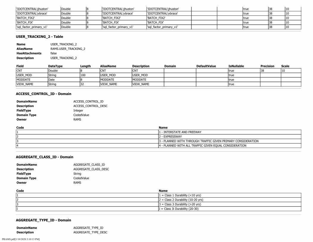
'IDOTCENTRAL\jhuston' Double 8 'IDOTCENTRAL\jhuston' 'IDOTCENTRAL\jhuston' true 38 10 'IDOTCENTRAL\vbrace' Double 8 'IDOTCENTRAL\vbrace' 'IDOTCENTRAL\vbrace' true 38 10 'BATCH_FIX2' Double 8 'BATCH_FIX2' 'BATCH_FIX2' true 38 10 'BATCH_FIX' Double 8 'BATCH_FIX' 'BATCH_FIX' true 38 10 'sql_factor_primary_v1' Double 8 'sql_factor_primary_v1' 'sql_factor_primary_v1' true 38 10
USER_TRACKING_2 - Table
Name USER_TRACKING_2 AliasName RAMS.USER_TRACKING_2 HasAttachments false
Description USER_TRACKING_2
Field DataType Length AliasName Description Domain DefaultValue IsNullable Precision Scale CNT Double 8 CNT CNT true 38 10 USER_MOD String 100 USER_MOD USER_MOD true MODDATE Date 8 MODDATE MODDATE true VIEW_NAME String 32 VIEW_NAME VIEW_NAME true
ACCESS_CONTROL_ID - Domain
DomainName ACCESS_CONTROL_ID Description ACCESS_CONTROL_DESC FieldType Integer Domain Type CodedValue Owner RAMS
Code Name 1 1 - INTERSTATE AND FREEWAY 2 2 - EXPRESSWAY 3 3 - PLANNED WITH THROUGH TRAFFIC GIVEN PRIMARY CONSIDERATION 4 4 - PLANNED WITH ALL TRAFFIC GIVEN EQUAL CONSIDERATION
AGGREGATE_CLASS_ID - Domain
DomainName AGGREGATE_CLASS_ID Description AGGREGATE_CLASS_DESC FieldType String Domain Type CodedValue Owner RAMS
Code Name 1 1 = Class 1 Durability (<10 yrs) 2 2 = Class 2 Durability (10-20 yrs) 3 3 = Class 3 Durability (>20 yrs) I I = Class 3i Durability (20-30)
AGGREGATE_TYPE_ID - Domain
DomainName AGGREGATE_TYPE_ID Description AGGREGATE_TYPE_DESC
PRAMS.pdf[1/10/2020 3:10:13 PM]

FieldType String Domain Type CodedValue Owner RAMS
Code Name C.LST. C.LST. = Crushed Limestone GRAVEL GRAVEL = Gravel C.ST/GR C.ST/GR SLAG SLAG QUARTZ QUARTZ C.CON. C.CON. CRUSHED CONCRETE C.GRAVL C.GRAVL CRUSHED GRAVEL CR.ST. CR.ST. CRUSHED STONE STONE STONE CONC.ST CONC.ST C.LST/G C.LST/G C.LST/Q C.LST/Q C.QTZT C.QTZT BASALT BASALT CHIPS CHIPS DOLOM. DOLOM. DUST DUST GRANITE GRANITE SAND SAND
AT_GRADE_CROSSING_ID - Domain
DomainName AT_GRADE_CROSSING_ID Description AT_GRADE_CROSSING_DESC FieldType Integer Domain Type CodedValue Owner RAMS
Code Name 1 1 - STOP SIGN 2 2 - TRAFFIC SIGNAL 3 3 - OTHER
BASE_TYPE_ID - Domain
DomainName BASE_TYPE_ID Description BASE_TYPE_DESC FieldType Integer Domain Type CodedValue Owner RAMS
Code Name 1 NO BASE 2 AGGREGATE 3 ASPHALT OR CEMENT STABILIZED
PRAMS.pdf[1/10/2020 3:10:13 PM]

5 HOT MIX AD (BITUMINOUS) 6 LEAN CONCRETE 7 STABILIZED OPEN-GRADED PERMEABLE 8 FRACTURED PCC
CITY_NUMBER_ID - Domain
DomainName CITY_NUMBER_ID Description CITY_NUMBER_DESC FieldType Integer Domain Type CodedValue Owner RAMS
Code Name 15 ACKLEY 17 ACKWORTH 22 ADAIR 35 ADEL 45 AFTON 50 AGENCY 52 AINSWORTH 55 AKRON 62 ALBERT CITY 65 ALBIA 70 ALBION 72 ALBURNETT 77 ALDEN 82 ALEXANDER 85 ALGONA 92 ALLEMAN 110 ALLERTON 112 ALLISON 125 ALTA 127 ALTA VISTA 130 ALTON 132 ALTOONA 135 ALVORD 155 AMES 165 ANAMOSA 170 ANDOVER 172 ANDREW 182 ANITA 187 ANKENY 192 ANTHON 195 APLINGTON 200 ARCADIA 202 ARCHER 207 AREDALE 215 ARION 217 ARISPE
PRAMS.pdf[1/10/2020 3:10:13 PM]

220 ARLINGTON 227 ARMSTRONG 232 ARNOLDS PARK 247 ARTHUR 252 ASBURY 265 ASHTON 272 ASPINWALL 277 ATALISSA 282 ATKINS 285 ATLANTIC 297 AUBURN 300 AUDUBON 310 AURELIA 315 AURORA 327 AVOCA 335 AYRSHIRE 345 BADGER 352 BAGLEY 367 BALDWIN 375 BALLTOWN 380 BANCROFT 385 BANKSTON 407 BARNES CITY 412 BARNUM 420 BASSETT 422 BATAVIA 425 BATTLE CREEK 432 BAXTER 437 BAYARD 452 BEACON 455 BEACONSFIELD 460 BEAMAN 470 BEAVER 487 BEDFORD 515 BELLE PLAINE 520 BELLEVUE 527 BELMOND 535 BENNETT 547 BENTON 562 BERKLEY 565 BERNARD 575 BERTRAM 587 BETTENDORF 595 BEVINGTON 652 BIRMINGHAM 672 BLAIRSBURG 675 BLAIRSTOWN 677 BLAKESBURG 682 BLANCHARD 687 BLENCOE
PRAMS.pdf[1/10/2020 3:10:13 PM]

697 BLOCKTON 702 BLOOMFIELD 707 BLUE GRASS 722 BODE 740 BONAPARTE 747 BONDURANT 750 BOONE 765 BOUTON 775 BOXHOLM 785 BOYDEN 792 BRADDYVILLE 800 BRADGATE 807 BRANDON 812 BRAYTON 817 BREDA 837 BRIDGEWATER 842 BRIGHTON 855 BRISTOW 857 BRITT 867 BRONSON 870 BROOKLYN 905 BRUNSVILLE 935 BUCK GROVE 937 BUCKEYE 952 BUFFALO 957 BUFFALO CENTER 977 BURLINGTON 990 BURT 997 BUSSEY 1015 CALAMUS 1027 CALLENDER 1030 CALMAR 1037 CALUMET 1040 CAMANCHE 1045 CAMBRIDGE 1080 CANTRIL 1087 CARBON 1105 CARLISLE 1122 CARPENTER 1125 CARROLL 1140 CARSON 1142 CARTER LAKE 1147 CASCADE 1152 CASEY 1162 CASTALIA 1165 CASTANA 1185 CEDAR FALLS 1187 CEDAR RAPIDS 1197 CENTER JUNCTION 1205 CENTER POINT
PRAMS.pdf[1/10/2020 3:10:13 PM]
1210 CENTERVILLE 1217 CENTRAL CITY 1225 CENTRALIA 1237 CHARITON 1242 CHARLES CITY 1250 CHARLOTTE 1252 CHARTER OAK 1255 CHATSWORTH 1265 CHELSEA 1272 CHEROKEE 1277 CHESTER 1300 CHILLICOTHE 1317 CHURDAN 1320 CINCINNATI 1327 CLARE 1330 CLARENCE 1332 CLARINDA 1337 CLARION 1347 CLARKSVILLE 1362 CLAYTON 1372 CLEAR LAKE 1385 CLEARFIELD 1387 CLEGHORN 1390 CLEMONS 1395 CLERMONT 1415 CLINTON 1422 CLIO 1425 CLIVE 1430 CLUTIER 1447 COBURG 1452 COGGON 1455 COIN 1465 COLESBURG 1467 COLFAX 1472 COLLEGE SPRINGS 1477 COLLINS 1480 COLO 1487 COLUMBUS CITY 1490 COLUMBUS JUNCTION 1492 COLWELL 1510 CONESVILLE 1525 CONRAD 1535 CONWAY 1542 COON RAPIDS 1550 COPPOCK 1557 CORALVILLE 1590 CORNING 1595 CORRECTIONVILLE 1597 CORWITH 1602 CORYDON
PRAMS.pdf[1/10/2020 3:10:13 PM]

1625 COTTER 1640 COULTER 1642 COUNCIL BLUFFS 1682 CRAIG 1695 CRAWFORDSVILLE 1700 CRESCENT 1705 CRESCO 1710 CRESTON 1725 CROMWELL 1747 CRYSTAL LAKE 1755 CUMBERLAND 1757 CUMMING 1762 CURLEW 1770 CUSHING 1775 CYLINDER 1787 DAKOTA CITY 1802 DALLAS CENTER 1815 DANA 1817 DANBURY 1822 DANVILLE 1827 DAVENPORT 1835 DAVIS CITY 1840 DAWSON 1845 DAYTON 1850 DE SOTO 1855 DE WITT 1862 DECATUR CITY 1867 DECORAH 1872 DEDHAM 1875 DEEP RIVER 1887 DEFIANCE 1900 DELAWARE 1902 DELHI 1905 DELMAR 1907 DELOIT 1910 DELPHOS 1912 DELTA 1920 DENISON 1935 DENVER 1942 DERBY 1945 DES MOINES 1972 DEXTER 1975 DIAGONAL 1987 DICKENS 1997 DIKE 2005 DIXON 2025 DOLLIVER 2032 DONAHUE 2040 DONNELLSON 2042 DOON
PRAMS.pdf[1/10/2020 3:10:13 PM]

2060 DOUGHERTY 2072 DOW CITY 2080 DOWS 2085 DRAKESVILLE 2100 DUBUQUE 2120 DUMONT 2130 DUNCOMBE 2132 DUNDEE 2140 DUNKERTON 2142 DUNLAP 2150 DURANGO 2152 DURANT 2160 DYERSVILLE 2162 DYSART 2170 EAGLE GROVE 2190 EARLHAM 2195 EARLING 2197 EARLVILLE 2200 EARLY 2215 EAST PERU 2240 EDDYVILLE 2247 EDGEWOOD 2267 ELBERON 2275 ELDON 2280 ELDORA 2290 ELDRIDGE 2297 ELGIN 2305 ELK HORN 2312 ELK RUN HEIGHTS 2315 ELKADER 2320 ELKHART 2322 ELKPORT 2335 ELLIOTT 2352 ELLSTON 2355 ELLSWORTH 2365 ELMA 2382 ELY 2387 EMERSON 2395 EMMETSBURG 2405 EPWORTH 2412 ESSEX 2417 ESTHERVILLE 2432 EVANSDALE 2442 EVERLY 2452 EXIRA 2455 EXLINE 2460 FAIRBANK 2462 FAIRFAX 2465 FAIRFIELD 2497 FARLEY
PRAMS.pdf[1/10/2020 3:10:13 PM]

2505 FARMERSBURG 2507 FARMINGTON 2512 FARNHAMVILLE 2515 FARRAGUT 2525 FAYETTE 2530 FENTON 2532 FERGUSON 2547 FERTILE 2620 FLORIS 2625 FLOYD 2642 FONDA 2647 FONTANELLE 2660 FOREST CITY 2680 FORT ATKINSON 2690 FORT DODGE 2697 FORT MADISON 2712 FOSTORIA 2737 FRANKLIN 2745 FRASER 2750 FREDERICKSBURG 2752 FREDERIKA 2755 FREDONIA 2762 FREMONT 2780 FRUITLAND 2802 GALT 2805 GALVA 2815 GARBER 2820 GARDEN GROVE 2835 GARNAVILLO 2837 GARNER 2845 GARRISON 2850 GARWIN 2865 GENEVA 2875 GEORGE 2895 GIBSON 2902 GILBERT 2905 GILBERTVILLE 2912 GILLETT GROVE 2920 GILMAN 2922 GILMORE CITY 2932 GLADBROOK 2955 GLENWOOD 2962 GLIDDEN 2972 GOLDFIELD 2977 GOODELL 2980 GOOSE LAKE 3007 GOWRIE 3015 GRAETTINGER 3017 GRAF 3020 GRAFTON
PRAMS.pdf[1/10/2020 3:10:13 PM]

3030 GRAND JUNCTION 3032 GRAND MOUND 3035 GRAND RIVER 3040 GRANDVIEW 3042 GRANGER 3052 GRANT 3062 GRANVILLE 3070 GRAVITY 3072 GRAY 3080 GREELEY 3102 GREENE 3107 GREENFIELD 3112 GREENVILLE 3125 GRIMES 3127 GRINNELL 3132 GRISWOLD 3142 GRUNDY CENTER 3147 GRUVER 3150 GUERNSEY 3162 GUTHRIE CENTER 3167 GUTTENBERG 3192 HALBUR 3212 HAMBURG 3217 HAMILTON 3222 HAMPTON 3230 HANCOCK 3240 HANLONTOWN 3252 HANSELL 3257 HARCOURT 3270 HARDY 3275 HARLAN 3285 HARPER 3287 HARPERS FERRY 3290 HARRIS 3300 HARTFORD 3305 HARTLEY 3310 HARTWICK 3315 HARVEY 3322 HASTINGS 3335 HAVELOCK 3340 HAVERHILL 3345 HAWARDEN 3350 HAWKEYE 3365 HAYESVILLE 3385 HAZLETON 3395 HEDRICK 3405 HENDERSON 3415 HEPBURN 3432 HIAWATHA 3472 HILLS
PRAMS.pdf[1/10/2020 3:10:13 PM]
3475 HILLSBORO 3485 HINTON 3505 HOLLAND 3515 HOLSTEIN 3520 HOLY CROSS 3542 HOPKINTON 3547 HORNICK 3557 HOSPERS 3562 HOUGHTON 3575 HUBBARD 3577 HUDSON 3590 HULL 3595 HUMBOLDT 3602 HUMESTON 3630 HUXLEY 3650 IDA GROVE 3660 IMOGENE 3665 INDEPENDENCE 3680 INDIANOLA 3700 INWOOD 3710 IONIA 3715 IOWA CITY 3720 IOWA FALLS 3742 IRETON 3755 IRWIN 3772 JACKSON JUNCTION 3782 JAMAICA 3792 JANESVILLE 3800 JEFFERSON 3817 JESUP 3820 JEWELL 3827 JOHNSTON 3830 JOICE 3835 JOLLEY 3870 KALONA 3875 KAMRAR 3877 KANAWHA 3892 KELLERTON 3895 KELLEY 3897 KELLOGG 3927 KENSETT 3942 KEOKUK 3948 KEOMAH VILLAGE 3950 KEOSAUQUA 3952 KEOTA 3960 KESWICK 3972 KEYSTONE 3985 KIMBALLTON 3992 KINGSLEY 4000 KINROSS
PRAMS.pdf[1/10/2020 3:10:13 PM]
4002 KIRKMAN 4005 KIRKVILLE 4010 KIRON 4012 KLEMME 4025 KNIERIM 4040 KNOXVILLE 4080 LA MOTTE 4082 LA PORTE CITY 4092 LACONA 4100 LADORA 4110 LAKE CITY 4135 LAKE MILLS 4150 LAKE PARK 4157 LAKE VIEW 4170 LAKESIDE 4182 LAKOTA 4185 LAMBS GROVE 4187 LAMONI 4190 LAMONT 4195 LANESBORO 4205 LANSING 4212 LARCHWOOD 4222 LARRABEE 4230 LATIMER 4237 LAUREL 4240 LAURENS 4245 LAWLER 4250 LAWTON 4252 LE CLAIRE 4255 LE GRAND 4257 LE MARS 4262 LE ROY 4280 LEDYARD 4290 LEHIGH 4292 LEIGHTON 4297 LELAND 4305 LENOX 4307 LEON 4315 LESTER 4317 LETTS 4325 LEWIS 4345 LIBERTYVILLE 4350 LIDDERDALE 4367 LIME SPRINGS 4377 LINCOLN 4382 LINDEN 4392 LINEVILLE 4395 LINN GROVE 4410 LISBON 4412 LISCOMB
PRAMS.pdf[1/10/2020 3:10:13 PM]
4427 LITTLE ROCK 4430 LITTLE SIOUX 4457 LIVERMORE 4477 LOCKRIDGE 4482 LOGAN 4487 LOHRVILLE 4490 LONE ROCK 4492 LONE TREE 4497 LONG GROVE 4515 LORIMOR 4525 LOST NATION 4545 LOVILIA 4552 LOW MOOR 4555 LOWDEN 4595 LU VERNE 4565 LUANA 4570 LUCAS 4587 LUTHER 4597 LUXEMBURG 4600 LUZERNE 4612 LYNNVILLE 4620 LYTTON 4625 MACEDONIA 4630 MACKSBURG 4640 MADRID 4647 MAGNOLIA 4650 MAHARISHI VEDIC CITY 4655 MALCOM 4657 MALLARD 4667 MALOY 4672 MALVERN 4682 MANCHESTER 4695 MANILLA 4697 MANLY 4702 MANNING 4710 MANSON 4737 MAPLETON 4742 MAQUOKETA 4750 MARATHON 4757 MARBLE ROCK 4762 MARCUS 4765 MARENGO 4775 MARION 4780 MARNE 4782 MARQUETTE 4797 MARSHALLTOWN 4802 MARTELLE 4805 MARTENSDALE 4812 MARTINSBURG 4820 MARYSVILLE
PRAMS.pdf[1/10/2020 3:10:13 PM]

4822 MASON CITY 4830 MASONVILLE 4832 MASSENA 4847 MATLOCK 4857 MAURICE 4865 MAXWELL 4870 MAYNARD 4872 MAYSVILLE 4880 MCCALLSBURG 4882 MCCAUSLAND 4885 MCCLELLAND 4892 MCGREGOR 4900 MCINTIRE 4922 MECHANICSVILLE 4930 MEDIAPOLIS 4935 MELBOURNE 4937 MELCHER-DALLAS 4945 MELROSE 4950 MELVIN 4952 MENLO 4962 MERIDEN 4975 MERRILL 4985 MESERVEY 5035 MIDDLETOWN 5052 MILES 5057 MILFORD 5075 MILLERSBURG 5077 MILLERTON 5085 MILLVILLE 5087 MILO 5092 MILTON 5095 MINBURN 5097 MINDEN 5110 MINGO 5130 MISSOURI VALLEY 5135 MITCHELL 5137 MITCHELLVILLE 5142 MODALE 5152 MONDAMIN 5160 MONMOUTH 5162 MONONA 5165 MONROE 5172 MONTEZUMA 5182 MONTICELLO 5190 MONTOUR 5195 MONTROSE 5205 MOORHEAD 5207 MOORLAND 5212 MORAVIA 5225 MORLEY
PRAMS.pdf[1/10/2020 3:10:13 PM]

5227 MORNING SUN 5235 MORRISON 5252 MOULTON 5257 MOUNT AUBURN 5262 MOUNT AYR 5292 MOUNT PLEASANT 5297 MOUNT STERLING 5300 MOUNT UNION 5302 MOUNT VERNON 5307 MOVILLE 5327 MURRAY 5330 MUSCATINE 5357 MYSTIC 5375 NASHUA 5392 NEMAHA 5397 NEOLA 5405 NEVADA 5412 NEW ALBIN 5427 NEW HAMPTON 5432 NEW HARTFORD 5437 NEW LIBERTY 5440 NEW LONDON 5442 NEW MARKET 5447 NEW PROVIDENCE 5450 NEW SHARON 5452 NEW VIENNA 5455 NEW VIRGINIA 5470 NEWELL 5472 NEWHALL 5482 NEWTON 5490 NICHOLS 5517 NODAWAY 5527 NORA SPRINGS 5547 NORTH BUENA VISTA 5555 NORTH ENGLISH 5557 NORTH LIBERTY 5565 NORTH WASHINGTON 5570 NORTHBORO 5580 NORTHWOOD 5587 NORWALK 5590 NORWAY 5607 NUMA 5630 OAKLAND 5631 OAKLAND ACRES 5642 OAKVILLE 5650 OCHEYEDAN 5655 ODEBOLT 5657 OELWEIN 5662 OGDEN 5667 OKOBOJI
PRAMS.pdf[1/10/2020 3:10:13 PM]

5682 OLDS 5687 OLIN 5692 OLLIE 5700 ONAWA 5720 ONSLOW 5732 ORANGE CITY 5737 ORCHARD 5742 ORIENT 5747 ORLEANS 5760 OSAGE 5772 OSCEOLA 5780 OSKALOOSA 5785 OSSIAN 5787 OSTERDOCK 5792 OTHO 5800 OTO 5822 OTTOSEN 5825 OTTUMWA 5832 OWASA 5845 OXFORD 5847 OXFORD JUNCTION 5852 OYENS 5860 PACIFIC JUNCTION 5865 PACKWOOD 5880 PALMER 5887 PALO 5897 PANAMA 5900 PANORA 5902 PANORAMA PARK 5915 PARKERSBURG 5917 PARNELL 5920 PATON 5922 PATTERSON 5927 PAULLINA 5947 PELLA 5957 PEOSTA 5970 PERRY 5980 PERSIA 5990 PETERSON 6012 PIERSON 6040 PILOT MOUND 6062 PIONEER 6072 PISGAH 6082 PLAINFIELD 6087 PLANO 6102 PLEASANT HILL 6112 PLEASANT PLAIN 6122 PLEASANTON 6125 PLEASANTVILLE 6130 PLOVER
PRAMS.pdf[1/10/2020 3:10:13 PM]
6142 PLYMOUTH 6150 POCAHONTAS 6170 POLK CITY 6175 POMEROY 6180 POPEJOY 6195 PORTSMOUTH 6197 POSTVILLE 6207 PRAIRIE CITY 6222 PRAIRIEBURG 6232 PRESCOTT 6235 PRESTON 6240 PRIMGHAR 6247 PRINCETON 6255 PROMISE CITY 6257 PROTIVIN 6265 PULASKI 6282 QUASQUETON 6287 QUIMBY 6297 RADCLIFFE 6307 RAKE 6312 RALSTON 6317 RANDALIA 6320 RANDALL 6322 RANDOLPH 6332 RATHBUN 6342 RAYMOND 6345 READLYN 6347 REASNOR 6360 RED OAK 6377 REDDING 6380 REDFIELD 6397 REINBECK 6405 REMBRANDT 6407 REMSEN 6410 RENWICK 6422 RHODES 6427 RICEVILLE 6437 RICHLAND 6447 RICKARDSVILLE 6450 RICKETTS 6457 RIDGEWAY 6467 RINARD 6472 RINGSTED 6475 RIPPEY 6492 RIVERDALE 6495 RIVERSIDE 6497 RIVERTON 6520 ROBINS 6537 ROCK FALLS 6542 ROCK RAPIDS
PRAMS.pdf[1/10/2020 3:10:13 PM]
6550 ROCK VALLEY 6567 ROCKFORD 6575 ROCKWELL 6577 ROCKWELL CITY 6585 RODMAN 6587 RODNEY 6597 ROLAND 6600 ROLFE 6610 ROME 6615 ROSE HILL 6630 ROSSIE 6650 ROWAN 6652 ROWLEY 6655 ROYAL 6670 RUDD 6675 RUNNELLS 0 RURAL 6687 RUSSELL 6692 RUTHVEN 6695 RUTLAND 6700 RYAN 6705 SABULA 6717 SAC CITY 6732 SAGEVILLE 6735 SAINT ANSGAR 6737 SAINT ANTHONY 6742 SAINT CHARLES 6745 SAINT DONATUS 6750 SAINT LUCAS 6752 SAINT MARYS 6755 SAINT OLAF 6757 SAINT PAUL 6762 SALEM 6770 SALIX 6775 SANBORN 6790 SANDYVILLE 6830 SCARVILLE 6832 SCHALLER 6840 SCHLESWIG 6865 SCRANTON 6867 SEARSBORO 6890 SERGEANT BLUFF 6907 SEYMOUR 6917 SHAMBAUGH 6920 SHANNON CITY 6932 SHARPSBURG 6940 SHEFFIELD 6945 SHELBY 6947 SHELDAHL 6950 SHELDON
PRAMS.pdf[1/10/2020 3:10:13 PM]

6955 SHELL ROCK 6962 SHELLSBURG 6965 SHENANDOAH 6982 SHERRILL 7007 SHUEYVILLE 7012 SIBLEY 7017 SIDNEY 7027 SIGOURNEY 7030 SILVER CITY 7055 SIOUX CENTER 7057 SIOUX CITY 7062 SIOUX RAPIDS 7075 SLATER 7085 SLOAN 7092 SMITHLAND 7125 SOLDIER 7130 SOLON 7135 SOMERS 7152 SOUTH ENGLISH 7170 SPENCER 7180 SPILLVILLE 7185 SPIRIT LAKE 7202 SPRAGUEVILLE 7210 SPRING HILL 7225 SPRINGBROOK 7237 SPRINGVILLE 7250 STACYVILLE 7257 STANHOPE 7260 STANLEY 7262 STANTON 7265 STANWOOD 7272 STATE CENTER 7357 STEAMBOAT ROCK 7402 STOCKPORT 7405 STOCKTON 7422 STORM LAKE 7430 STORY CITY 7432 STOUT 7440 STRATFORD 7442 STRAWBERRY POINT 7455 STRUBLE 7457 STUART 7467 SULLY 7490 SUMNER 7505 SUPERIOR 7507 SUTHERLAND 7512 SWALEDALE 7515 SWAN 7535 SWEA CITY 7545 SWISHER
PRAMS.pdf[1/10/2020 3:10:13 PM]
7555 TABOR 7575 TAMA 7597 TEMPLETON 7602 TENNANT 7617 TERRIL 7622 THAYER 7635 THOMPSON 7637 THOR 7640 THORNBURG 7642 THORNTON 7657 THURMAN 7662 TIFFIN 7672 TINGLEY 7677 TIPTON 7680 TITONKA 7692 TOLEDO 7702 TORONTO 7710 TRAER 7727 TREYNOR 7735 TRIPOLI 7752 TRUESDALE 7757 TRURO 7760 TURIN 7825 UDELL 7830 UNDERWOOD 7832 UNION 7845 UNIONVILLE 7855 UNIVERSITY HEIGHTS 7860 UNIVERSITY PARK 7872 URBANA 7875 URBANDALE 7920 UTE 7927 VAIL 7932 VALERIA 7952 VAN HORNE 7957 VAN METER 7960 VAN WERT 7965 VARINA 7967 VENTURA 7990 VICTOR 8002 VILLISCA 8010 VINCENT 8012 VINING 8017 VINTON 8032 VOLGA CITY 8045 WADENA 8050 WAHPETON 8052 WALCOTT 8060 WALFORD 8062 WALKER
PRAMS.pdf[1/10/2020 3:10:13 PM]
8065 WALL LAKE 8085 WALLINGFORD 8087 WALNUT 8107 WAPELLO 8140 WASHINGTON 8150 WASHTA 8155 WATERLOO 8160 WATERVILLE 8175 WAUCOMA 8177 WAUKEE 8180 WAUKON 8190 WAVERLY 8197 WAYLAND 8205 WEBB 8207 WEBSTER 8212 WEBSTER CITY 8217 WELDON 8222 WELLMAN 8227 WELLSBURG 8235 WELTON 8242 WESLEY 8250 WEST BEND 8252 WEST BRANCH 8255 WEST BURLINGTON 8257 WEST CHESTER 8260 WEST DES MOINES 8275 WEST LIBERTY 8280 WEST OKOBOJI 8290 WEST POINT 8295 WEST UNION 8305 WESTFIELD 8307 WESTGATE 8312 WESTPHALIA 8315 WESTSIDE 8319 WESTWOOD 8322 WHAT CHEER 8325 WHEATLAND 8365 WHITING 8370 WHITTEMORE 8375 WHITTEN 8422 WILLEY 8425 WILLIAMS 8427 WILLIAMSBURG 8432 WILLIAMSON 8471 WILTON 8477 WINDSOR HEIGHTS 8480 WINFIELD 8497 WINTERSET 8502 WINTHROP 8505 WIOTA
PRAMS.pdf[1/10/2020 3:10:13 PM]
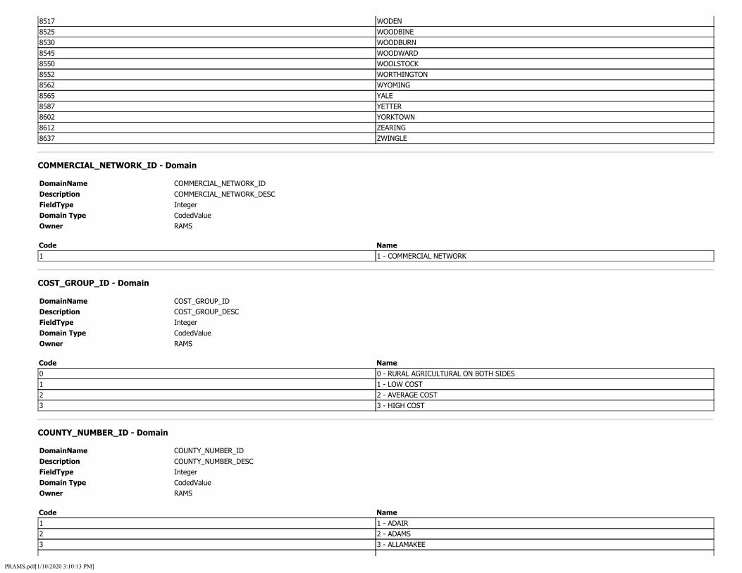
8517 WODEN 8525 WOODBINE 8530 WOODBURN 8545 WOODWARD 8550 WOOLSTOCK 8552 WORTHINGTON 8562 WYOMING 8565 YALE 8587 YETTER 8602 YORKTOWN 8612 ZEARING 8637 ZWINGLE
COMMERCIAL_NETWORK_ID - Domain
DomainName COMMERCIAL_NETWORK_ID Description COMMERCIAL_NETWORK_DESC FieldType Integer Domain Type CodedValue Owner RAMS
Code Name 1 1 - COMMERCIAL NETWORK
COST_GROUP_ID - Domain
DomainName COST_GROUP_ID Description COST_GROUP_DESC FieldType Integer Domain Type CodedValue Owner RAMS
Code Name 0 0 - RURAL AGRICULTURAL ON BOTH SIDES 1 1 - LOW COST 2 2 - AVERAGE COST 3 3 - HIGH COST
COUNTY_NUMBER_ID - Domain
DomainName COUNTY_NUMBER_ID Description COUNTY_NUMBER_DESC FieldType Integer Domain Type CodedValue Owner RAMS
Code Name 1 1 - ADAIR 2 2 - ADAMS 3 3 - ALLAMAKEE
PRAMS.pdf[1/10/2020 3:10:13 PM]

4567891011121314151617181920212223242526272829303132333435363738394041424344454647484950515253
4 - APPANOOSE 5 - AUDUBON 6 - BENTON 7 - BLACK HAWK 8 - BOONE 9 - BREMER 10 - BUCHANAN 11 - BUENA VISTA 12 - BUTLER 13 - CALHOUN 14 - CARROLL 15 - CASS 16 - CEDAR 17 - CERRO GORDO 18 - CHEROKEE 19 - CHICKASAW 20 - CLARKE 21 - CLAY 22 - CLAYTON 23 - CLINTON 24 - CRAWFORD 25 - DALLAS 26 - DAVIS 27 - DECATUR 28 - DELAWARE 29 - DES MOINES 30 - DICKINSON 31 - DUBUQUE 32 - EMMET 33 - FAYETTE 34 - FLOYD 35 - FRANKLIN 36 - FREMONT 37 - GREENE 38 - GRUNDY 39 - GUTHRIE 40 - HAMILTON 41 - HANCOCK 42 - HARDIN 43 - HARRISON 44 - HENRY 45 - HOWARD 46 - HUMBOLDT 47 - IDA 48 - IOWA 49 - JACKSON 50 - JASPER 51 - JEFFERSON 52 - JOHNSON 53 - JONES
PRAMS.pdf[1/10/2020 3:10:13 PM]

54 54 - KEOKUK 55 55 - KOSSUTH 56 56 - LEE 57 57 - LINN 58 58 - LOUISA 59 59 - LUCAS 60 60 - LYON 61 61 - MADISON 62 62 - MAHASKA 63 63 - MARION 64 64 - MARSHALL 65 65 - MILLS 66 66 - MITCHELL 67 67 - MONONA 68 68 - MONROE 69 69 - MONTGOMERY 70 70 - MUSCATINE 71 71 - O BRIEN 72 72 - OSCEOLA 73 73 - PAGE 74 74 - PALO ALTO 75 75 - PLYMOUTH 76 76 - POCAHONTAS 77 77 - POLK 78 78 - POTTAWATTAMIE 79 79 - POWESHIEK 80 80 - RINGGOLD 81 81 - SAC 82 82 - SCOTT 83 83 - SHELBY 84 84 - SIOUX 85 85 - STORY 86 86 - TAMA 87 87 - TAYLOR 88 88 - UNION 89 89 - VAN BUREN 90 90 - WAPELLO 91 91 - WARREN 92 92 - WASHINGTON 93 93 - WAYNE 94 94 - WEBSTER 95 95 - WINNEBAGO 96 96 - WINNESHIEK 97 97 - WOODBURY 98 98 - WORTH 99 99 - WRIGHT
CURBED_ID - Domain
DomainName CURBED_ID
PRAMS.pdf[1/10/2020 3:10:13 PM]

Description CURBED_DESC FieldType Integer Domain Type CodedValue Owner RAMS
Code Name 1 CURBED
CURVE_SPEED_ADVISORY_ID - Domain
DomainName CURVE_SPEED_ADVISORY_ID Description CURVE_SPEED_ADVISORY_DESC FieldType Integer Domain Type CodedValue Owner RAMS
Code Name 1 0 - 29 MPH 2 30 - 39 MPH 3 40 - 49 MPH 4 50 - 55 MPH
dActivityType - Domain
DomainName FieldType Domain Type Owner
dActivityType SmallInteger CodedValue SDE
Code Name 1 Create Route 2 Calibrate Route 3 Reverse Route 4 Retire Route 5 Extend Route 6 Reassign Route 7 Realign Route
DIRECTION_ID - Domain
DomainName DIRECTION_ID Description DIRECTION_DESC FieldType String Domain Type Range Owner RAMS
Minimum Value Maximum Value
dLRSNetworks - Domain
PRAMS.pdf[1/10/2020 3:10:13 PM]

DomainName dLRSNetworks FieldType SmallInteger Domain Type CodedValue Owner SDE
Code Name 1 IOWA_LRS_NETWORK
DOMAIN_CODE_ID - Domain
DomainName DOMAIN_CODE_ID Description DOMAIN_CODE_DESC FieldType Integer Domain Type CodedValue Owner RAMS
Code Name 10 10 - LOCAL AGENCY 11 11 - COUNTY CONSERVATION BOARD 12 12 - CITY PARKS BOARDS 13 13 - BOARD OF SUPERVISORS 14 14 - CITY COUNCILS 30 30 - STATE AGENCY 31 31 - BOARD OF REGENTS INSTITUTIONS 32 32 - SOCIAL SERVICES INSTITUTIONS 33 33 - DEPARTMENT OF NATURAL RESOURCES 34 34 - STATE FAIR BOARD 35 35 - DEPARTMENT OF PUBLIC INSTRUCTION 60 60 - FEDERAL AGENCY 62 62 - BUREAU OF INDIAN AFFAIRS 63 63 - INDIAN RESERVATION ACCESS ROAD 64 64 - U.S. FOREST SERVICE 66 66 - NATIONAL PARK SERVICE 68 68 - BUREAU OF LAND MANAGEMENT 70 70 - MILITARY RESERVATION 72 72 - CORPS OF ENGINEERS 74 74 - ENERGY RESEARCH AND DEVELOPMENT ADMINISTRATION 76 76 - TENNESSEE VALLEY AUTHORITY 78 78 - NATIONAL AERONAUTICS AND SPACE ADMINISTRATION 80 80 - FISH AND WILDLIFE SERVICES
dReferentMethod - Domain
DomainName FieldType Domain Type Owner
dReferentMethod SmallInteger CodedValue RAMS
Code 0
Name X/Y
PRAMS.pdf[1/10/2020 3:10:13 PM]

1 Length 2 Stationing 11 LRSE_STRUCTURECONTROL 12 LRSE_STRUCTUREONANDUNDER 13 LRSE_DOMAINCODE 14 LRSE_ROUTESIGNING 15 LRSE_ROUTEQUALIFIER 16 LRSE_HPMSSAMPLESECTIONS 17 LRSE_TOLLROAD 18 LRSE_WIDENINGPOTENTIAL 19 LRSE_THROUGHLANES 20 LRSE_MAINTENANCECOSTCENTER 21 LRSE_ICECORRIDORS 22 LRSE_RRCROSSING 23 LRSE_RRCROSSINGS 24 LRSE_1CONSTRUCTIONHISTORY 25 LRSE_CONSTRUCTIONHISTORY 26 LRSE_MANAGEMENTSECTIONS 27 LRSE_STATEFREIGHTNETWORK 28 LRSE_EXPANSIONFACTOR 29 LRSE_FEDFUNCTIONALCLASS 30 LRSE_NUMBERLANES 31 LRSE_LANETYPE 32 LRSE_TRAFFIC 33 LRSE_ROUTE_DOMINANCE 34 LRSE_ROUTEDOMINANCE 35 EV_PROJ_SCOPE 36 LRSE_PROJECT_SCOPING 37 LRSE_TIM_ALT_ROUTES 38 LRSE_TIM_CLOSURE 39 LRSE_MINIMUM_SPEEDLIMIT
FACILITY_TYPE_ID - Domain
DomainName FACILITY_TYPE_ID Description FACILITY_TYPE_DESC FieldType Integer Domain Type CodedValue Owner RAMS
Code Name 1 1 - ONE-WAY ROADWAY 2 2 - TWO-WAY ROADWAY 4 4 - RAMP 5 5 - NON MAINLINE 6 6 - NON INVENTORY DIRECTION 7 7 - PLANNED UNBUILT
FED_FUNCTIONAL_CLASS_ID - Domain
PRAMS.pdf[1/10/2020 3:10:13 PM]

DomainName Description FieldType Domain Type Owner
FED_FUNCTIONAL_CLASS_ID FED_FUNCTIONAL_CLASS_DESC Integer CodedValue RAMS
Code Name 1 1 - INTERSTATE 2 2 - PRINCIPAL ARTERIAL - OTHER FREEWAYS AND EXPRESSWAYS 3 3 - PRINCIPAL ARTERIAL - OTHER 4 4 - MINOR ARTERIAL 5 5 - MAJOR COLLECTOR 6 6 - MINOR COLLECTOR 7 7 - LOCAL
GEOGRAPHIC_IDENTIFIER_ID - Domain
DomainName GEOGRAPHIC_IDENTIFIER_ID Description GEOGRAPHIC_IDENTIFIER_DESC FieldType String Domain Type CodedValue Owner RAMS
Code Name M5787 CITY OF OSTERDOCK - M5787 M5902 CITY OF PANORAMA PARK - M5902 M5922 CITY OF PATTERSON - M5922 M6082 CITY OF PLAINFIELD - M6082 M6122 CITY OF PLEASANTON - M6122 M6222 CITY OF PRAIRIEBURG - M6222 M6282 CITY OF QUASQUETON - M6282 M6347 CITY OF REASNOR - M6347 P0527 SOO ACCESS - P0527 P0533 LITTLE SIOUX WMA - P0533 P0554 NEW ALBIN ACCESS - P0554 P0558 ALDO LEOPOLD WMA - P0558 P0575 RATHBUN FISH HATCHERY - P0575 P0581 ORLEAN FISH HATCHERY - P0581 P0596 ASHTON PITS WMA - P0596 P0600 BIG SPRINGS TROUT HATCHERY - P0600 I0745 IA NATIONAL GUARD, BOONE - I0745 I0750 OSCEOLA ARMORY - LOCATION PENDING - I0750 I0770 CEDAR RAPIDS ARMORY - I0770 I0775 IA NATIONAL GUARD, GLENWOOD - I0775 I0789 SIOUX CENTER ARMORY - 102 S MAIN - I0789 M6437 CITY OF RICHLAND - M6437 M6475 CITY OF RIPPEY - M6475 M6497 CITY OF RIVERTON - M6497 M6587 CITY OF RODNEY - M6587 M6610 CITY OF ROME - M6610 M6687 CITY OF RUSSELL - M6687
PRAMS.pdf[1/10/2020 3:10:13 PM]

M6742 CITY OF SAINT CHARLES - M6742 M6762 CITY OF SALEM - M6762 M6840 CITY OF SCHLESWIG - M6840 M6890 CITY OF SERGEANT BLUFF - M6890 M6982 CITY OF SHERRILL - M6982 M2922 CITY OF GILMORE CITY - M2922 M2980 CITY OF GOOSE LAKE - M2980 M3017 CITY OF GRAF - M3017 M3042 CITY OF GRANGER - M3042 M3070 CITY OF GRAVITY - M3070 M3080 CITY OF GREELEY - M3080 M3132 CITY OF GRISWOLD - M3132 M3192 CITY OF HALBUR - M3192 M3222 CITY OF HAMPTON - M3222 M3290 CITY OF HARRIS - M3290 M3305 CITY OF HARTLEY - M3305 M3385 CITY OF HAZLETON - M3385 M3415 CITY OF HEPBURN - M3415 M3525 CITY OF HOMESTEAD - M3525 M3590 CITY OF HULL - M3590 M3630 CITY OF HUXLEY - M3630 M3782 CITY OF JAMAICA - M3782 M3820 CITY OF JEWELL - M3820 M3948 CITY OF KEOMAH VILLAGE - M3948 M3972 CITY OF KEYSTONE - M3972 M4092 CITY OF LACONA - M4092 M4182 CITY OF LAKOTA - M4182 M4195 CITY OF LANESBORO - M4195 M4280 CITY OF LEDYARD - M4280 M4305 CITY OF LENOX - M4305 M4395 CITY OF LINN GROVE - M4395 M4490 CITY OF LONE ROCK - M4490 M4595 CITY OF LU VERNE - M4595 M4625 CITY OF MACEDONIA - M4625 M4667 CITY OF MALOY - M4667 M4710 CITY OF MANSON - M4710 M4750 CITY OF MARATHON - M4750 M4782 CITY OF MARQUETTE - M4782 M4822 CITY OF MASON CITY - M4822 M4870 CITY OF MAYNARD - M4870 M4930 CITY OF MEDIAPOLIS - M4930 M4950 CITY OF MELVIN - M4950 M4962 CITY OF MERIDEN - M4962 M5085 CITY OF MILLVILLE - M5085 M5130 CITY OF MISSOURI VALLEY - M5130 M5162 CITY OF MONONA - M5162 M7017 CITY OF SIDNEY - M7017 M7075 CITY OF SLATER - M7075 M7125 CITY OF SOLDIER - M7125 M7142 CITY OF SOUTH AMANA - M7142
PRAMS.pdf[1/10/2020 3:10:13 PM]

M7225 CITY OF SPRINGBROOK - M7225 M7260 CITY OF STANLEY - M7260 M7357 CITY OF STEAMBOAT ROCK - M7357 M7455 CITY OF STRUBLE - M7455 M7535 CITY OF SWEA CITY - M7535 M7637 CITY OF THOR - M7637 M7680 CITY OF TITONKA - M7680 M7727 CITY OF TREYNOR - M7727 M7875 CITY OF URBANDALE - M7875 M7952 CITY OF VAN HORNE - M7952 M8052 CITY OF WALCOTT - M8052 M8150 CITY OF WASHTA - M8150 M8175 CITY OF WAUCOMA - M8175 M8242 CITY OF WESLEY - M8242 M8255 CITY OF WEST BURLINGTON - M8255 M8322 CITY OF WHAT CHEER - M8322 C0001 COUNTY OF ADAIR - C0001 C0010 COUNTY OF BUCHANAN - C0010 C0014 COUNTY OF CARROLL - C0014 C0023 COUNTY OF CLINTON - C0023 C0029 COUNTY OF DES MOINES - C0029 C0036 COUNTY OF FREMONT - C0036 C0042 COUNTY OF HARDIN - C0042 C0045 COUNTY OF HOWARD - C0045 C0055 COUNTY OF KOSSUTH - C0055 C0058 COUNTY OF LOUISA - C0058 C0068 COUNTY OF MONROE - C0068 C0071 COUNTY OF O'BRIEN - C0071 C0077 COUNTY OF POLK - C0077 C0084 COUNTY OF SIOUX - C0084 C0090 COUNTY OF WAPELLO - C0090 M0022 CITY OF ADAIR - M0022 M0055 CITY OF AKRON - M0055 M0070 CITY OF ALBION - M0070 M0132 CITY OF ALTOONA - M0132 M0187 CITY OF ANKENY - M0187 M0265 CITY OF ASHTON - M0265 M0280 CITY OF ATHELSTAN - M0280 M0335 CITY OF AYRSHIRE - M0335 M0380 CITY OF BANCROFT - M0380 M0420 CITY OF BASSETT - M0420 M0470 CITY OF BEAVER - M0470 M0520 CITY OF BELLEVUE - M0520 M0595 CITY OF BEVINGTON - M0595 M0677 CITY OF BLAKESBURG - M0677 M0747 CITY OF BONDURANT - M0747 M0837 CITY OF BRIDGEWATER - M0837 M0952 CITY OF BUFFALO - M0952 M0990 CITY OF BURT - M0990 M1015 CITY OF CALAMUS - M1015
PRAMS.pdf[1/10/2020 3:10:13 PM]

M1122 CITY OF CARPENTER - M1122 M1162 CITY OF CASTALIA - M1162 M1210 CITY OF CENTERVILLE - M1210 M1252 CITY OF CHARTER OAK - M1252 M1317 CITY OF CHURDAN - M1317 M1347 CITY OF CLARKSVILLE - M1347 M1425 CITY OF CLIVE - M1425 M1452 CITY OF COGGON - M1452 M1467 CITY OF COLFAX - M1467 M1535 CITY OF CONWAY - M1535 M1597 CITY OF CORWITH - M1597 M1640 CITY OF COULTER - M1640 M1682 CITY OF CRAIG - M1682 M1787 CITY OF DAKOTA CITY - M1787 M1845 CITY OF DAYTON - M1845 M1902 CITY OF DELHI - M1902 M1935 CITY OF DENVER - M1935 M2072 CITY OF DOW CITY - M2072 M2120 CITY OF DUMONT - M2120 M2200 CITY OF EARLY - M2200 M2240 CITY OF EDDYVILLE - M2240 M2312 CITY OF ELK RUN HEIGHTS - M2312 M2432 CITY OF EVANSDALE - M2432 M2462 CITY OF FAIRFAX - M2462 M2547 CITY OF FERTILE - M2547 M2660 CITY OF FOREST CITY - M2660 M2755 CITY OF FREDONIA - M2755 M2802 CITY OF GALT - M2802 M2845 CITY OF GARRISON - M2845 M2905 CITY OF GILBERTVILLE - M2905 P0427 SCOTT I-29 WMA - P0427 P0433 SILVER LAKE (DICKINSON) WMA - P0433 M6422 CITY OF RHODES - M6422 M6447 CITY OF RICKARDSVILLE - M6447 M6472 CITY OF RINGSTED - M6472 M6495 CITY OF RIVERSIDE - M6495 M6550 CITY OF ROCK VALLEY - M6550 M6577 CITY OF ROCKWELL CITY - M6577 M6615 CITY OF ROSE HILL - M6615 M6650 CITY OF ROWAN - M6650 M6675 CITY OF RUNNELLS - M6675 M6695 CITY OF RUTLAND - M6695 M6737 CITY OF SAINT ANTHONY - M6737 M6745 CITY OF SAINT DONATUS - M6745 M6757 CITY OF SAINT PAUL - M6757 M6775 CITY OF SANBORN - M6775 M6867 CITY OF SEARSBORO - M6867 M6907 CITY OF SEYMOUR - M6907 M6932 CITY OF SHARPSBURG - M6932 M6950 CITY OF SHELDON - M6950
PRAMS.pdf[1/10/2020 3:10:13 PM]

M6965 CITY OF SHENANDOAH - M6965 M7027 CITY OF SIGOURNEY - M7027 M7057 CITY OF SIOUX CITY - M7057 M7130 CITY OF SOLON - M7130 M7135 CITY OF SOMERS - M7135 M7170 CITY OF SPENCER - M7170 M7237 CITY OF SPRINGVILLE - M7237 M7250 CITY OF STACYVILLE - M7250 M7422 CITY OF STORM LAKE - M7422 M7442 CITY OF STRAWBERRY POINT - M7442 M7512 CITY OF SWALEDALE - M7512 M7515 CITY OF SWAN - M7515 M7622 CITY OF THAYER - M7622 M7642 CITY OF THORNTON - M7642 M7702 CITY OF TORONTO - M7702 M7757 CITY OF TRURO - M7757 M7832 CITY OF UNION - M7832 M7920 CITY OF UTE - M7920 M7932 CITY OF VALERIA - M7932 M7965 CITY OF VARINA - M7965 M8045 CITY OF WADENA - M8045 M8060 CITY OF WALFORD - M8060 M8107 CITY OF WAPELLO - M8107 M8180 CITY OF WAUKON - M8180 M8205 CITY OF WEBB - M8205 M8227 CITY OF WELLSBURG - M8227 M8252 CITY OF WEST BRANCH - M8252 M8295 CITY OF WEST UNION - M8295 M8312 CITY OF WESTPHALIA - M8312 C0005 COUNTY OF AUDUBON - C0005 C0006 COUNTY OF BENTON - C0006 C0011 COUNTY OF BUENA VISTA - C0011 C0015 COUNTY OF CASS - C0015 C0019 COUNTY OF CHICKASAW - C0019 C0021 COUNTY OF CLAY - C0021 C0025 COUNTY OF DALLAS - C0025 C0028 COUNTY OF DELAWARE - C0028 C0031 COUNTY OF DUBUQUE - C0031 C0035 COUNTY OF FRANKLIN - C0035 C0037 COUNTY OF GREENE - C0037 C0043 COUNTY OF HARRISON - C0043 C0046 COUNTY OF HUMBOLDT - C0046 C0050 COUNTY OF JASPER - C0050 C0053 COUNTY OF JONES - C0053 C0057 COUNTY OF LINN - C0057 C0059 COUNTY OF LUCAS - C0059 C0063 COUNTY OF MARION - C0063 C0067 COUNTY OF MONONA - C0067 C0069 COUNTY OF MONTGOMERY - C0069 C0073 COUNTY OF PAGE - C0073
PRAMS.pdf[1/10/2020 3:10:13 PM]

C0078 COUNTY OF POTTAWATTAMIE - C0078 C0082 COUNTY OF SCOTT - C0082 C0083 COUNTY OF SHELBY - C0083 C0088 COUNTY OF UNION - C0088 C0093 COUNTY OF WAYNE - C0093 C0097 COUNTY OF WOODBURY - C0097 M0017 CITY OF ACKWORTH - M0017 M0045 CITY OF AFTON - M0045 M0082 CITY OF ALEXANDER - M0082 M0112 CITY OF ALLISON - M0112 M0130 CITY OF ALTON - M0130 M0172 CITY OF ANDREW - M0172 M0200 CITY OF ARCADIA - M0200 M0215 CITY OF ARION - M0215 M0247 CITY OF ARTHUR - M0247 M0297 CITY OF AUBURN - M0297 M0310 CITY OF AURELIA - M0310 M0352 CITY OF BAGLEY - M0352 M0422 CITY OF BATAVIA - M0422 M0452 CITY OF BEACON - M0452 M0527 CITY OF BELMOND - M0527 M0535 CITY OF BENNETT - M0535 M0675 CITY OF BLAIRSTOWN - M0675 M0697 CITY OF BLOCKTON - M0697 M0707 CITY OF BLUE GRASS - M0707 M0800 CITY OF BRADGATE - M0800 M0817 CITY OF BREDA - M0817 M0867 CITY OF BRONSON - M0867 M0935 CITY OF BUCK GROVE - M0935 M0997 CITY OF BUSSEY - M0997 M1027 CITY OF CALLENDER - M1027 M1040 CITY OF CAMANCHE - M1040 M1125 CITY OF CARROLL - M1125 M1140 CITY OF CARSON - M1140 M1152 CITY OF CASEY - M1152 M1205 CITY OF CENTER POINT - M1205 M1217 CITY OF CENTRAL CITY - M1217 M1250 CITY OF CHARLOTTE - M1250 M1255 CITY OF CHATSWORTH - M1255 M1320 CITY OF CINCINNATI - M1320 M1332 CITY OF CLARINDA - M1332 M1372 CITY OF CLEAR LAKE - M1372 M1390 CITY OF CLEMONS - M1390 M1422 CITY OF CLIO - M1422 M1455 CITY OF COIN - M1455 M1465 CITY OF COLESBURG - M1465 M1492 CITY OF COLWELL - M1492 M1525 CITY OF CONRAD - M1525 M1542 CITY OF COON RAPIDS - M1542 M1602 CITY OF CORYDON - M1602
PRAMS.pdf[1/10/2020 3:10:13 PM]
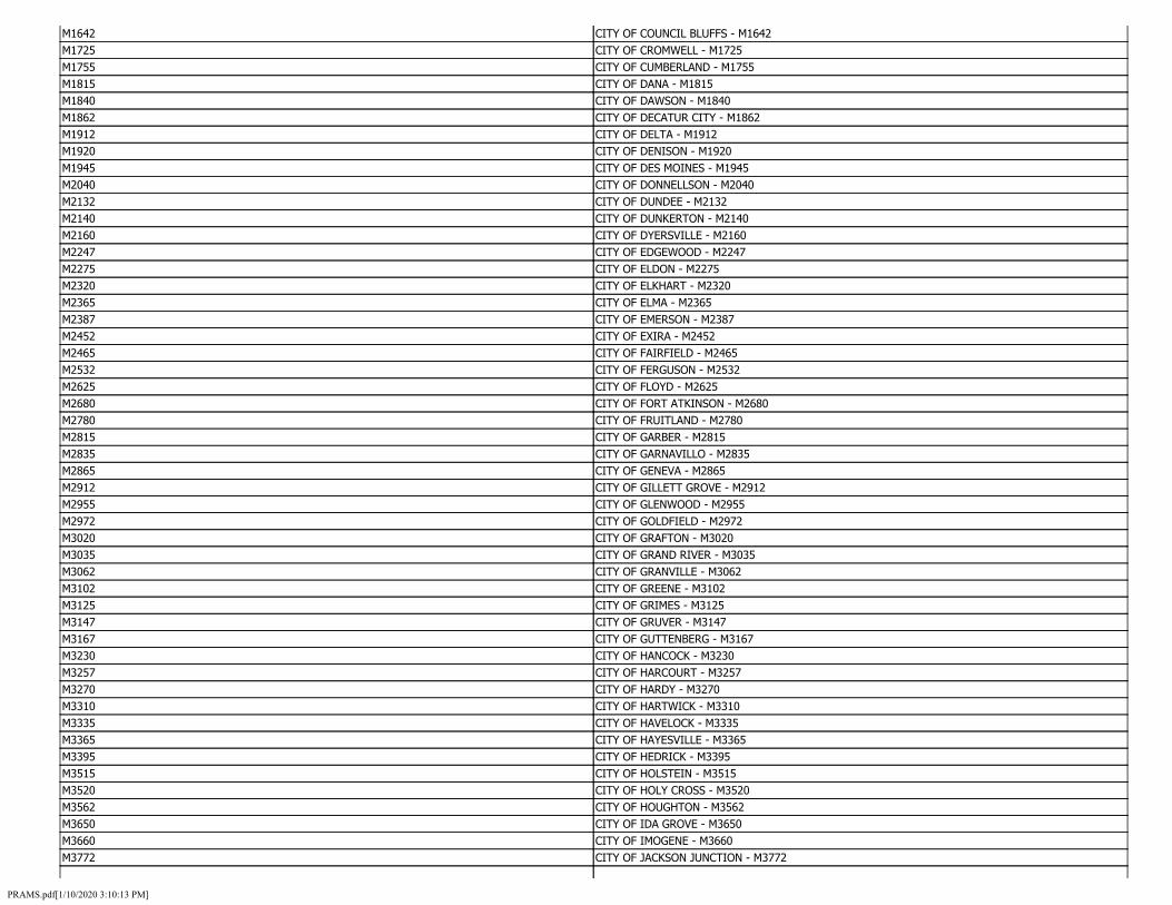
M1642 CITY OF COUNCIL BLUFFS - M1642 M1725 CITY OF CROMWELL - M1725 M1755 CITY OF CUMBERLAND - M1755 M1815 CITY OF DANA - M1815 M1840 CITY OF DAWSON - M1840 M1862 CITY OF DECATUR CITY - M1862 M1912 CITY OF DELTA - M1912 M1920 CITY OF DENISON - M1920 M1945 CITY OF DES MOINES - M1945 M2040 CITY OF DONNELLSON - M2040 M2132 CITY OF DUNDEE - M2132 M2140 CITY OF DUNKERTON - M2140 M2160 CITY OF DYERSVILLE - M2160 M2247 CITY OF EDGEWOOD - M2247 M2275 CITY OF ELDON - M2275 M2320 CITY OF ELKHART - M2320 M2365 CITY OF ELMA - M2365 M2387 CITY OF EMERSON - M2387 M2452 CITY OF EXIRA - M2452 M2465 CITY OF FAIRFIELD - M2465 M2532 CITY OF FERGUSON - M2532 M2625 CITY OF FLOYD - M2625 M2680 CITY OF FORT ATKINSON - M2680 M2780 CITY OF FRUITLAND - M2780 M2815 CITY OF GARBER - M2815 M2835 CITY OF GARNAVILLO - M2835 M2865 CITY OF GENEVA - M2865 M2912 CITY OF GILLETT GROVE - M2912 M2955 CITY OF GLENWOOD - M2955 M2972 CITY OF GOLDFIELD - M2972 M3020 CITY OF GRAFTON - M3020 M3035 CITY OF GRAND RIVER - M3035 M3062 CITY OF GRANVILLE - M3062 M3102 CITY OF GREENE - M3102 M3125 CITY OF GRIMES - M3125 M3147 CITY OF GRUVER - M3147 M3167 CITY OF GUTTENBERG - M3167 M3230 CITY OF HANCOCK - M3230 M3257 CITY OF HARCOURT - M3257 M3270 CITY OF HARDY - M3270 M3310 CITY OF HARTWICK - M3310 M3335 CITY OF HAVELOCK - M3335 M3365 CITY OF HAYESVILLE - M3365 M3395 CITY OF HEDRICK - M3395 M3515 CITY OF HOLSTEIN - M3515 M3520 CITY OF HOLY CROSS - M3520 M3562 CITY OF HOUGHTON - M3562 M3650 CITY OF IDA GROVE - M3650 M3660 CITY OF IMOGENE - M3660 M3772 CITY OF JACKSON JUNCTION - M3772
PRAMS.pdf[1/10/2020 3:10:13 PM]

M3817 CITY OF JESUP - M3817 M3877 CITY OF KANAWHA - M3877 M3892 CITY OF KELLERTON - M3892 M3960 CITY OF KESWICK - M3960 M4000 CITY OF KINROSS - M4000 M4082 CITY OF LA PORTE CITY - M4082 M4110 CITY OF LAKE CITY - M4110 M4187 CITY OF LAMONI - M4187 M4212 CITY OF LARCHWOOD - M4212 M4240 CITY OF LAURENS - M4240 M4262 CITY OF LE ROY - M4262 M4297 CITY OF LELAND - M4297 M4367 CITY OF LIME SPRINGS - M4367 M4392 CITY OF LINEVILLE - M4392 M4457 CITY OF LIVERMORE - M4457 M4492 CITY OF LONE TREE - M4492 M4555 CITY OF LOWDEN - M4555 M4565 CITY OF LUANA - M4565 M4612 CITY OF LYNNVILLE - M4612 M4655 CITY OF MALCOM - M4655 M4672 CITY OF MALVERN - M4672 M4702 CITY OF MANNING - M4702 M4742 CITY OF MAQUOKETA - M4742 M4762 CITY OF MARCUS - M4762 M4797 CITY OF MARSHALLTOWN - M4797 M4802 CITY OF MARTELLE - M4802 M4832 CITY OF MASSENA - M4832 M4865 CITY OF MAXWELL - M4865 M4885 CITY OF MCCLELLAND - M4885 M4922 CITY OF MECHANICSVILLE - M4922 M4945 CITY OF MELROSE - M4945 M4975 CITY OF MERRILL - M4975 M4985 CITY OF MESERVEY - M4985 M5077 CITY OF MILLERTON - M5077 M5092 CITY OF MILTON - M5092 M5097 CITY OF MINDEN - M5097 M5152 CITY OF MONDAMIN - M5152 M5165 CITY OF MONROE - M5165 M5172 CITY OF MONTEZUMA - M5172 M5212 CITY OF MORAVIA - M5212 M5235 CITY OF MORRISON - M5235 M5297 CITY OF MOUNT STERLING - M5297 M5300 CITY OF MOUNT UNION - M5300 M5375 CITY OF NASHUA - M5375 M5412 CITY OF NEW ALBIN - M5412 M5452 CITY OF NEW VIENNA - M5452 M5472 CITY OF NEWHALL - M5472 M5527 CITY OF NORA SPRINGS - M5527 M5570 CITY OF NORTHBORO - M5570 M5587 CITY OF NORWALK - M5587
PRAMS.pdf[1/10/2020 3:10:13 PM]

M5650 CITY OF OCHEYEDAN - M5650 M5692 CITY OF OLLIE - M5692 M5720 CITY OF ONSLOW - M5720 M5785 CITY OF OSSIAN - M5785 M5822 CITY OF OTTOSEN - M5822 M5845 CITY OF OXFORD - M5845 M5900 CITY OF PANORA - M5900 M5920 CITY OF PATON - M5920 M5990 CITY OF PETERSON - M5990 M6072 CITY OF PISGAH - M6072 M6125 CITY OF PLEASANTVILLE - M6125 M6170 CITY OF POLK CITY - M6170 M6180 CITY OF POPEJOY - M6180 M6255 CITY OF PROMISE CITY - M6255 M6287 CITY OF QUIMBY - M6287 M6322 CITY OF RANDOLPH - M6322 M6360 CITY OF RED OAK - M6360 M6377 CITY OF REDDING - M6377 M4630 CITY OF MACKSBURG - M4630 M5432 CITY OF NEW HARTFORD - M5432 M5470 CITY OF NEWELL - M5470 M5580 CITY OF NORTHWOOD - M5580 M5630 CITY OF OAKLAND - M5630 M5700 CITY OF ONAWA - M5700 M5772 CITY OF OSCEOLA - M5772 M0220 CITY OF ARLINGTON - M0220 M0282 CITY OF ATKINS - M0282 M0367 CITY OF BALDWIN - M0367 M0432 CITY OF BAXTER - M0432 M0487 CITY OF BEDFORD - M0487 M0682 CITY OF BLANCHARD - M0682 M0740 CITY OF BONAPARTE - M0740 M0842 CITY OF BRIGHTON - M0842 M0870 CITY OF BROOKLYN - M0870 M1030 CITY OF CALMAR - M1030 M1105 CITY OF CARLISLE - M1105 M1147 CITY OF CASCADE - M1147 M1242 CITY OF CHARLES CITY - M1242 M1265 CITY OF CHELSEA - M1265 M6312 CITY OF RALSTON - M6312 P0523 WILLOWS ACCESS WMA - P0523 P0568 GULL POINT STATE PARK - P0568 P0591 CENTER LAKE COMPLEX - P0591 P0605 BELLEVUE STATE PARK - P0605 I0780 SHELDON ARMORY - I0780 M6410 CITY OF RENWICK - M6410 M6630 CITY OF ROSSIE - M6630 M6732 CITY OF SAGEVILLE - M6732 M6920 CITY OF SHANNON CITY - M6920 M3150 CITY OF GUERNSEY - M3150
PRAMS.pdf[1/10/2020 3:10:13 PM]

M3275 CITY OF HARLAN - M3275 M3472 CITY OF HILLS - M3472 M3557 CITY OF HOSPERS - M3557 M3870 CITY OF KALONA - M3870 M4002 CITY OF KIRKMAN - M4002 M4135 CITY OF LAKE MILLS - M4135 M4325 CITY OF LEWIS - M4325 M4430 CITY OF LITTLE SIOUX - M4430 M4695 CITY OF MANILLA - M4695 M4765 CITY OF MARENGO - M4765 M4847 CITY OF MATLOCK - M4847 M5017 CITY OF MIDDLE AMANA - M5017 M5095 CITY OF MINBURN - M5095 M7505 CITY OF SUPERIOR - M7505 M7662 CITY OF TIFFIN - M7662 M7760 CITY OF TURIN - M7760 M8085 CITY OF WALLINGFORD - M8085 M8217 CITY OF WELDON - M8217 C0004 COUNTY OF APPANOOSE - C0004 C0017 COUNTY OF CERRO GORDO - C0017 C0039 COUNTY OF GUTHRIE - C0039 C0052 COUNTY OF JOHNSON - C0052 C0074 COUNTY OF PALO ALTO - C0074 C0087 COUNTY OF TAYLOR - C0087 C0098 COUNTY OF WORTH - C0098 M0165 CITY OF ANAMOSA - M0165 M0227 CITY OF ARMSTRONG - M0227 M0905 CITY OF BRUNSVILLE - M0905 M1037 CITY OF CALUMET - M1037 M8550 CITY OF WOOLSTOCK - M8550 M1802 CITY OF DALLAS CENTER - M1802 M4487 CITY OF LOHRVILLE - M4487 M1330 CITY OF CLARENCE - M1330 M1395 CITY OF CLERMONT - M1395 M1557 CITY OF CORALVILLE - M1557 M1710 CITY OF CRESTON - M1710 M1907 CITY OF DELOIT - M1907 M2032 CITY OF DONAHUE - M2032 M2150 CITY OF DURANGO - M2150 M2395 CITY OF EMMETSBURG - M2395 M2515 CITY OF FARRAGUT - M2515 M2820 CITY OF GARDEN GROVE - M2820 P0428 MCPAUL I-29 WMA - P0428 P0438 FRENCH CREEK WMA - P0438 P0442 HAWKEYE WMA - P0442 P0448 LITTLE MILL CREEK WMA - P0448 P0459 FOX HILLS WMA - P0459 P0464 DUDGEON LAKE WMA - P0464 P0475 CARDINAL MARSH WMA - P0475 P0479 LAHART WMA - P0479
PRAMS.pdf[1/10/2020 3:10:13 PM]

P0489 LAKIN SLOUGH WMA - P0489 P0495 MCMAHON ACCESS - P0495 P0499 UPPER DECATUR BEND WMA - P0499 P0512 MILE LONG ISLAND WMA - P0512 P0516 BIG WALL LAKE WMA - P0516 P0542 WEST SWAN LAKE WMA - P0542 P0549 RUSH LAKE (OSCEOLA) WMA - P0549 P0556 CASINO BAY MARINA - P0556 P0572 LOST GROVE LAKE WMA - P0572 P0582 TRIBOJI BEACH ACCESS - P0582 P0597 SWEET MARSH WMA - P0597 P0606 BIXBY STATE PRESERVE - P0606 P0615 FORT DEFIANCE STATE PARK - P0615 P0620 GULL POINT STATE PARK - P0620 P0624 LEDGES STATE PARK - P0624 P0636 PALISADES-KEPLER STATE PARK - P0636 P0643 PRAIRIE ROSE STATE PARK - P0643 P0653 LAKE OF THREE FIRES STATE PARK - P0653 P0666 RAINBOW BEND WMA - P0666 P0670 WILSON ISLAND STATE RECREATION AREA - P0670 P0682 LOWER GAR LAKE ACCESS STATE RECREATION AREA - P0682 P0694 HAWTHORN LAKE WMA - P0694 P0699 RIVERTON WMA - P0699 I0707 WOODWARD STATE RESOURCE CENTER - I0707 I0714 STATE TRAINING SCHOOL, ELDORA - I0714 I0746 STORM LAKE ARMORY - I0746 I0751 SPENCER ARMORY - I0751 I0759 CHARLES CITY ARMORY - I0759 I0764 NEWTON ARMORY - I0764 I0779 MUSCATINE ARMORY - I0779 I0785 COUNCIL BLUFFS OMS - I0785 I0790 OTTUMWA ARMORY - I0790 I0794 EAGLE GROVE ARMORY - I0794 I0816 IOWA STATE UNIVERSITY-FICK OBSERV. AND FARMS - I0816 I0850 CAMP DODGE, JOHNSTON - I0850 I0862 DES MOINES AREA COMM COLLEGE (AREA XI), ANKENY - I0862 I0874 IOWA LAKES COMM COLLEGE (AREA III), ESTHERVILLE - I0874 I0880 N. IOWA AREA COMM COLLEGE (AREA II), MASON CITY - I0880 I0913 UPPER MISSISSIPPI LAND ACQUISITION, ALLAMAKEE - I0913 I0927 CORALVILLE RESERVOIR - I0927 I0941 FORT DES MOINES MEMORIAL PARK - I0941 M7507 CITY OF SUTHERLAND - M7507 M7677 CITY OF TIPTON - M7677 M7927 CITY OF VAIL - M7927 M8250 CITY OF WEST BEND - M8250 C0095 COUNTY OF WINNEBAGO - C0095 M8370 CITY OF WHITTEMORE - M8370 M8425 CITY OF WILLIAMS - M8425 M8502 CITY OF WINTHROP - M8502 M8525 CITY OF WOODBINE - M8525
PRAMS.pdf[1/10/2020 3:10:13 PM]

M8587 CITY OF YETTER - M8587 M8637 CITY OF ZWINGLE - M8637 M0217 CITY OF ARISPE - M0217 M0455 CITY OF BEACONSFIELD - M0455 M0672 CITY OF BLAIRSBURG - M0672 M1850 CITY OF DE SOTO - M1850 M2025 CITY OF DOLLIVER - M2025 M2142 CITY OF DUNLAP - M2142 M2460 CITY OF FAIRBANK - M2460 M3577 CITY OF HUDSON - M3577 M3942 CITY OF KEOKUK - M3942 M4150 CITY OF LAKE PARK - M4150 M4382 CITY OF LINDEN - M4382 M4570 CITY OF LUCAS - M4570 M5687 CITY OF OLIN - M5687 M5792 CITY OF OTHO - M5792 M5880 CITY OF PALMER - M5880 M6062 CITY OF PIONEER - M6062 M6307 CITY OF RAKE - M6307 M6380 CITY OF REDFIELD - M6380 P0443 IOWA RIVER CORRIDOR WMA - P0443 P0453 BRIGHTON ACCESS - P0453 P0481 MEADOW LAKE WMA - P0481 P0494 KEG CREEK I29 WMA - P0494 P0508 WHITE HORSE ACCESS - P0508 P0519 MOUNT AYR WMA - P0519 P0557 CLEAR LAKE AREA - P0557 P0439 CLEAR CREEK WMA - P0439 P0441 BARBER CREEK WMA - P0441 P0445 WIESE SLOUGH WMA - P0445 P0449 DALTON POND WMA - P0449 P0451 KLUM LAKE WMA - P0451 P0452 CONE MARSH WMA - P0452 P0458 MIAMI LAKE WMA - P0458 P0461 INDIAN BLUFFS WMA - P0461 P0465 ELDON WMA - P0465 P0467 TROY MILLS WMA - P0467 P0471 VENTURA MARSH WMA - P0471 P0473 COON CREEK WMA - P0473 P0476 BLUFFTON FIR STAND STATE PRESERVE - P0476 P0477 BRIGHTS LAKE WMA - P0477 P0483 POLK CITY REFUGE - P0483 P0486 PERRY ACCESS WMA - P0486 P0488 MCCORD POND WMA - P0488 P0492 DEER ISLAND WMA - P0492 P0496 DUNBAR SLOUGH WMA - P0496 P0501 LOUISVILLE BEND WMA - P0501 P0503 BOONE FORKS WMA - P0503 P0509 SAC CITY ACCESS - P0509 P0510 WEEDLAND ACCESS - P0510
PRAMS.pdf[1/10/2020 3:10:13 PM]

P0513 BIGELOW COUNTY PARK - P0513 P0517 RINGGOLD WMA - P0517 P0521 BRADGATE WMA - P0521 P0531 SILVER LAKE (PALO ALTO) WMA - P0531 P0532 RUSH LAKE (PALO ALTO) WMA - P0532 P0541 GRASS LAKE WMA - P0541 P0547 BURR OAK LAKE WMA - P0547 P0551 FISH FARM MOUNDS WMA - P0551 P0552 SOUTHFORK ACCESS WMA - P0552 P0559 ELK CREEK WMA - P0559 P0565 OAKDALE - GEOLOGICAL SURVEY - P0565 P0569 UPPER IOWA RIVER WMA - P0569 P0576 THREE MILE LAKE WMA - P0576 P0577 OTTER CREEK MARSH WMA - P0577 P0584 LOESS HILLS STATE FOREST - P0584 P0588 BLOOD RUN HISTORIC SITE - P0588 P0593 DEER CREEK WMA - P0593 P0595 LAKE ODESSA WMA - P0595 P0601 LAKE AHQUABI STATE PARK - P0601 P0604 BEEDS LAKE STATE PARK - P0604 P0609 NORTH TWIN LAKE STATE PARK - P0609 P0612 LAKE DARLING STATE PARK - P0612 P0617 GEORGE WYTH STATE PARK - P0617 P0619 GREEN VALLEY STATE PARK - P0619 P0623 LACEY-KEOSAUQUA STATE PARK - P0623 P0625 LEWIS AND CLARK STATE PARK - P0625 P0630 MCGREGOR HEIGHTS (PIKES PEAK) - P0630 P0632 MILL CREEK STATE PARK - P0632 P0637 PAMMEL STATE PARK - P0637 P0639 GULL POINT STATE PARK - P0639 P0645 RED HAW STATE PARK - P0645 P0647 ROCK CREEK STATE PARK - P0647 P0650 SPRINGBROOK STATE PARK - P0650 P0655 UNION GROVE STATE PARK - P0655 P0656 VIKING LAKE STATE PARK - P0656 P0662 WILDCAT DEN STATE PARK - P0662 P0663 EAGLE LAKE STATE PARK - P0663 P0667 OAK GROVE STATE PARK - P0667 P0669 LAKE ANITA STATE PARK - P0669 P0674 SOUTH TWIN LAKE WMA - P0674 P0676 ELK ROCK STATE PARK - P0676 P0681 LAKE ICARIA COUNTY PARK - P0681 P0683 BADGER CREEK STATE RECREATION AREA - P0683 P0685 EMERSON BAY STATE RECREATION AREA - P0685 P0690 SHIMEK STATE FOREST - P0690 P0691 YELLOW RIVER STATE FOREST - P0691 P0693 STEPHENS STATE FOREST - P0693 P0698 PRINCETON WMA - P0698 I0702 MENTAL HEALTH INSTITUTE, CHEROKEE - I0702 I0709 IOWA JUVENILE HOME, TOLEDO - I0709
PRAMS.pdf[1/10/2020 3:10:13 PM]
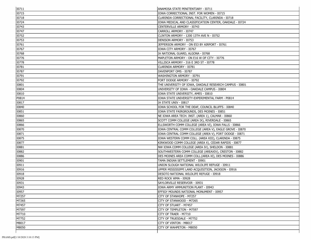
I0711 ANAMOSA STATE PENITENTIARY - I0711 I0715 IOWA CORRECTIONAL INST. FOR WOMEN - I0715 I0718 CLARINDA CORRECTIONAL FACILITY, CLARINDA - I0718 I0724 IOWA MEDICAL AND CLASSIFICATION CENTER, OAKDALE - I0724 I0743 CENTERVILLE ARMORY - I0743 I0747 CARROLL ARMORY - I0747 I0752 CLINTON ARMORY - 1200 13TH AVE N - I0752 I0753 DENISON ARMORY - I0753 I0761 JEFFERSON ARMORY - ON E53 BY AIRPORT - I0761 I0767 IOWA CITY ARMORY - I0767 I0768 IA NATIONAL GUARD, ALGONA - I0768 I0776 MAPLETON ARMORY - ON E16 W OF CITY - I0776 I0778 VILLISCA ARMORY - 316 E 3RD ST - I0778 I0781 CLARINDA ARMORY - I0781 I0787 DAVENPORT OMS - I0787 I0791 WASHINGTON ARMORY - I0791 I0792 FORT DODGE ARMORY - I0792 I0801 THE UNIVERSITY OF IOWA, OAKDALE RESEARCH CAMPUS - I0801 I0804 UNIVERSITY OF IOWA - OAKDALE CAMPUS - I0804 I0810 IOWA STATE UNIVERSITY, AMES - I0810 P0814 IOWA STATE UNIVERSITY-EXPERIMENTAL FARM - P0814 I0817 IA STATE UNIV - I0817 I0840 IOWA SCHOOL FOR THE DEAF, COUNCIL BLUFFS - I0840 I0851 IOWA STATE FAIRGROUNDS, DES MOINES - I0851 I0860 NE IOWA AREA TECH. INST. (AREA 1), CALMAR - I0860 I0865 SCOTT COMM COLLEGE (AREA IX), RIVERDALE - I0865 I0866 ELLSWORTH COMM COLLEGE (AREA VI), IOWA FALLS - I0866 I0870 IOWA CENTRAL COMM COLLEGE (AREA V), EAGLE GROVE - I0870 I0871 IOWA CENTRAL COMM COLLEGE (AREA V), FORT DODGE - I0871 I0875 IOWA WESTERN COMM COLL. (AREA XIII), CLARINDA - I0875 I0877 KIRKWOOD COMM COLLEGE (AREA X), CEDAR RAPIDS - I0877 I0881 NW IOWA COMM COLLEGE (AREA IV), SHELDON - I0881 I0882 SOUTHWESTERN COMM COLLEGE (AREAXIV), CRESTON - I0882 I0886 DES MOINES AREA COMM COLL.(AREA XI), DES MOINES - I0886 I0901 TAMA INDIAN SETTLEMENT - I0901 I0911 UNION SLOUGH NATIONAL WILDLIFE REFUGE - I0911 I0916 UPPER MISSISSIPPI LAND ACQUISITION, JACKSON - I0916 I0918 DESOTO NATIONAL WILDLIFE REFUGE - I0918 I0928 RED ROCK WMA - I0928 I0931 SAYLORVILLE RESERVOIR - I0931 I0943 IOWA ARMY AMMUNITION PLANT - I0943 I0957 EFFIGY MOUNDS NATIONAL MONUMENT - I0957 M7257 CITY OF STANHOPE - M7257 M7265 CITY OF STANWOOD - M7265 M7457 CITY OF STUART - M7457 M7597 CITY OF TEMPLETON - M7597 M7710 CITY OF TRAER - M7710 M7752 CITY OF TRUESDALE - M7752 M8017 CITY OF VINTON - M8017 M8050 CITY OF WAHPETON - M8050
PRAMS.pdf[1/10/2020 3:10:13 PM]

M8160 CITY OF WATERVILLE - M8160 M8235 CITY OF WELTON - M8235 M8260 CITY OF WEST DES MOINES - M8260 M0035 CITY OF ADEL - M0035 M0052 CITY OF AINSWORTH - M0052 M0077 CITY OF ALDEN - M0077 M8325 CITY OF WHEATLAND - M8325 M8365 CITY OF WHITING - M8365 M8375 CITY OF WHITTEN - M8375 M8427 CITY OF WILLIAMSBURG - M8427 M8432 CITY OF WILLIAMSON - M8432 M8480 CITY OF WINFIELD - M8480 M8505 CITY OF WIOTA - M8505 M8517 CITY OF WODEN - M8517 M8530 CITY OF WOODBURN - M8530 M8562 CITY OF WYOMING - M8562 M8565 CITY OF YALE - M8565 M8612 CITY OF ZEARING - M8612 M0192 CITY OF ANTHON - M0192 M0202 CITY OF ARCHER - M0202 M0272 CITY OF ASPINWALL - M0272 M0315 CITY OF AURORA - M0315 M0345 CITY OF BADGER - M0345 M0515 CITY OF BELLE PLAINE - M0515 M0587 CITY OF BETTENDORF - M0587 M0750 CITY OF BOONE - M0750 M0785 CITY OF BOYDEN - M0785 M1835 CITY OF DAVIS CITY - M1835 M1900 CITY OF DELAWARE - M1900 M1910 CITY OF DELPHOS - M1910 M2042 CITY OF DOON - M2042 M2130 CITY OF DUNCOMBE - M2130 M2267 CITY OF ELBERON - M2267 M2297 CITY OF ELGIN - M2297 M2442 CITY OF EVERLY - M2442 M2505 CITY OF FARMERSBURG - M2505 M2647 CITY OF FONTANELLE - M2647 M3602 CITY OF HUMESTON - M3602 M3800 CITY OF JEFFERSON - M3800 M3875 CITY OF KAMRAR - M3875 M3895 CITY OF KELLEY - M3895 M4005 CITY OF KIRKVILLE - M4005 M4185 CITY OF LAMBS GROVE - M4185 M4250 CITY OF LAWTON - M4250 M4315 CITY OF LESTER - M4315 M4452 CITY OF LITTLEPORT - M4452 M4552 CITY OF LOW MOOR - M4552 M1362 CITY OF CLAYTON - M1362 M1447 CITY OF COBURG - M1447 M1480 CITY OF COLO - M1480
PRAMS.pdf[1/10/2020 3:10:13 PM]

M1550 CITY OF COPPOCK - M1550 M1625 CITY OF COTTER - M1625 M1705 CITY OF CRESCO - M1705 M1817 CITY OF DANBURY - M1817 M1855 CITY OF DE WITT - M1855 M1972 CITY OF DEXTER - M1972 M2005 CITY OF DIXON - M2005 M2100 CITY OF DUBUQUE - M2100 M2205 CITY OF EAST AMANA - M2205 M2290 CITY OF ELDRIDGE - M2290 M2405 CITY OF EPWORTH - M2405 M2455 CITY OF EXLINE - M2455 M2642 CITY OF FONDA - M2642 M2737 CITY OF FRANKLIN - M2737 M2805 CITY OF GALVA - M2805 M2902 CITY OF GILBERT - M2902 M2932 CITY OF GLADBROOK - M2932 M3030 CITY OF GRAND JUNCTION - M3030 M3052 CITY OF GRANT - M3052 M3142 CITY OF GRUNDY CENTER - M3142 M3212 CITY OF HAMBURG - M3212 M3285 CITY OF HARPER - M3285 M3315 CITY OF HARVEY - M3315 M3350 CITY OF HAWKEYE - M3350 M3485 CITY OF HINTON - M3485 M3542 CITY OF HOPKINTON - M3542 M3700 CITY OF INWOOD - M3700 M3792 CITY OF JANESVILLE - M3792 M3835 CITY OF JOLLEY - M3835 M3985 CITY OF KIMBALLTON - M3985 M4012 CITY OF KLEMME - M4012 M4190 CITY OF LAMONT - M4190 M4245 CITY OF LAWLER - M4245 M4350 CITY OF LIDDERDALE - M4350 M4410 CITY OF LISBON - M4410 M4545 CITY OF LOVILIA - M4545 M4587 CITY OF LUTHER - M4587 M4647 CITY OF MAGNOLIA - M4647 M5225 CITY OF MORLEY - M5225 M5252 CITY OF MOULTON - M5252 M5302 CITY OF MOUNT VERNON - M5302 M5330 CITY OF MUSCATINE - M5330 M5392 CITY OF NEMAHA - M5392 M5427 CITY OF NEW HAMPTON - M5427 M5455 CITY OF NEW VIRGINIA - M5455 M5490 CITY OF NICHOLS - M5490 M5631 CITY OF OAKLAND ACRES - M5631 M5662 CITY OF OGDEN - M5662 M5760 CITY OF OSAGE - M5760 M5832 CITY OF OWASA - M5832
PRAMS.pdf[1/10/2020 3:10:13 PM]
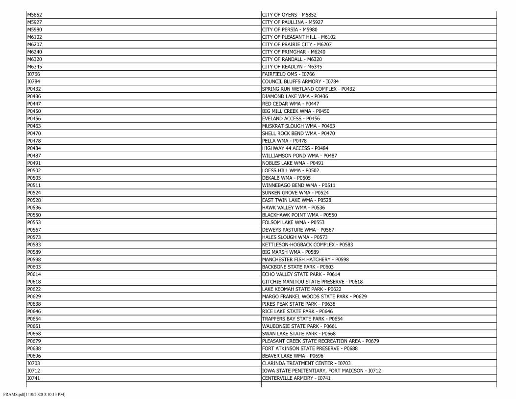
M5852 CITY OF OYENS - M5852 M5927 CITY OF PAULLINA - M5927 M5980 CITY OF PERSIA - M5980 M6102 CITY OF PLEASANT HILL - M6102 M6207 CITY OF PRAIRIE CITY - M6207 M6240 CITY OF PRIMGHAR - M6240 M6320 CITY OF RANDALL - M6320 M6345 CITY OF READLYN - M6345 I0766 FAIRFIELD OMS - I0766 I0784 COUNCIL BLUFFS ARMORY - I0784 P0432 SPRING RUN WETLAND COMPLEX - P0432 P0436 DIAMOND LAKE WMA - P0436 P0447 RED CEDAR WMA - P0447 P0450 BIG MILL CREEK WMA - P0450 P0456 EVELAND ACCESS - P0456 P0463 MUSKRAT SLOUGH WMA - P0463 P0470 SHELL ROCK BEND WMA - P0470 P0478 PELLA WMA - P0478 P0484 HIGHWAY 44 ACCESS - P0484 P0487 WILLIAMSON POND WMA - P0487 P0491 NOBLES LAKE WMA - P0491 P0502 LOESS HILL WMA - P0502 P0505 DEKALB WMA - P0505 P0511 WINNEBAGO BEND WMA - P0511 P0524 SUNKEN GROVE WMA - P0524 P0528 EAST TWIN LAKE WMA - P0528 P0536 HAWK VALLEY WMA - P0536 P0550 BLACKHAWK POINT WMA - P0550 P0553 FOLSOM LAKE WMA - P0553 P0567 DEWEYS PASTURE WMA - P0567 P0573 HALES SLOUGH WMA - P0573 P0583 KETTLESON-HOGBACK COMPLEX - P0583 P0589 BIG MARSH WMA - P0589 P0598 MANCHESTER FISH HATCHERY - P0598 P0603 BACKBONE STATE PARK - P0603 P0614 ECHO VALLEY STATE PARK - P0614 P0618 GITCHIE MANITOU STATE PRESERVE - P0618 P0622 LAKE KEOMAH STATE PARK - P0622 P0629 MARGO FRANKEL WOODS STATE PARK - P0629 P0638 PIKES PEAK STATE PARK - P0638 P0646 RICE LAKE STATE PARK - P0646 P0654 TRAPPERS BAY STATE PARK - P0654 P0661 WAUBONSIE STATE PARK - P0661 P0668 SWAN LAKE STATE PARK - P0668 P0679 PLEASANT CREEK STATE RECREATION AREA - P0679 P0688 FORT ATKINSON STATE PRESERVE - P0688 P0696 BEAVER LAKE WMA - P0696 I0703 CLARINDA TREATMENT CENTER - I0703 I0712 IOWA STATE PENITENTIARY, FORT MADISON - I0712 I0741 CENTERVILLE ARMORY - I0741
PRAMS.pdf[1/10/2020 3:10:13 PM]

I0744 WATERLOO AASF - I0744 I0758 OELWEIN ARMORY - I0758 I0762 IOWA FALLS ARMORY - I0762 I0765 FAIRFIELD ARMORY - I0765 I0773 KNOXVILLE ARMORY - I0773 I0777 RED OAK ARMORY - I0777 I0815 MCNAY RESEARCH FARM, ISU - I0815 I0863 DES MOINES AREA COMM COLLEGE (AREA XI), BOONE - I0863 I0868 INDIAN HILLS COMM COLLEGE (AREA XV), CENTERVILLE - I0868 I0883 SOUTHEASTERN COMM COLLEGE (AREA XVI), KEOKUK - I0883 I0902 WINNEBAGO INDIAN LAND - I0902 I0915 UPPER MISSISSIPPI LAND ACQUISITION, CLAYTON - I0915 I0942 WAVERLY NAVAL HOUSING - I0942 M7405 CITY OF STOCKTON - M7405 M7657 CITY OF THURMAN - M7657 M7830 CITY OF UNDERWOOD - M7830 M8065 CITY OF WALL LAKE - M8065 M8305 CITY OF WESTFIELD - M8305 M0065 CITY OF ALBIA - M0065 M0140 CITY OF AMANA - M0140 M0547 CITY OF BENTON - M0547 M0722 CITY OF BODE - M0722 M1770 CITY OF CUSHING - M1770 M1872 CITY OF DEDHAM - M1872 M2080 CITY OF DOWS - M2080 M2195 CITY OF EARLING - M2195 M2315 CITY OF ELKADER - M2315 M2525 CITY OF FAYETTE - M2525 M2697 CITY OF FORT MADISON - M2697 M3827 CITY OF JOHNSTON - M3827 M3952 CITY OF KEOTA - M3952 M4040 CITY OF KNOXVILLE - M4040 M4292 CITY OF LEIGHTON - M4292 M4412 CITY OF LISCOMB - M4412 M4657 CITY OF MALLARD - M4657 M4697 CITY OF MANLY - M4697 M4780 CITY OF MARNE - M4780 M4820 CITY OF MARYSVILLE - M4820 M4857 CITY OF MAURICE - M4857 M4935 CITY OF MELBOURNE - M4935 M4952 CITY OF MENLO - M4952 M5052 CITY OF MILES - M5052 M5110 CITY OF MINGO - M5110 M5160 CITY OF MONMOUTH - M5160 M5227 CITY OF MORNING SUN - M5227 M5262 CITY OF MOUNT AYR - M5262 M5405 CITY OF NEVADA - M5405 M5440 CITY OF NEW LONDON - M5440 M5565 CITY OF NORTH WASHINGTON - M5565 M5642 CITY OF OAKVILLE - M5642
PRAMS.pdf[1/10/2020 3:10:13 PM]

M5747 CITY OF ORLEANS - M5747 M5800 CITY OF OTO - M5800 M5917 CITY OF PARNELL - M5917 M5957 CITY OF PEOSTA - M5957 M6087 CITY OF PLANO - M6087 M6197 CITY OF POSTVILLE - M6197 M6257 CITY OF PROTIVIN - M6257 M6317 CITY OF RANDALIA - M6317 M5517 CITY OF NODAWAY - M5517 M5655 CITY OF ODEBOLT - M5655 M5847 CITY OF OXFORD JUNCTION - M5847 M6012 CITY OF PIERSON - M6012 M6492 CITY OF RIVERDALE - M6492 M6600 CITY OF ROLFE - M6600 M6830 CITY OF SCARVILLE - M6830 M6962 CITY OF SHELLSBURG - M6962 M7092 CITY OF SMITHLAND - M7092 M7575 CITY OF TAMA - M7575 M7735 CITY OF TRIPOLI - M7735 M8177 CITY OF WAUKEE - M8177 M8257 CITY OF WEST CHESTER - M8257 C0002 COUNTY OF ADAMS - C0002 C0027 COUNTY OF DECATUR - C0027 C0038 COUNTY OF GRUNDY - C0038 C0065 COUNTY OF MILLS - C0065 C0076 COUNTY OF POCAHONTAS - C0076 M0072 CITY OF ALBURNETT - M0072 M0182 CITY OF ANITA - M0182 M0277 CITY OF ATALISSA - M0277 M0575 CITY OF BERTRAM - M0575 M0775 CITY OF BOXHOLM - M0775 M0937 CITY OF BUCKEYE - M0937 M1185 CITY OF CEDAR FALLS - M1185 M1277 CITY OF CHESTER - M1277 M1595 CITY OF CORRECTIONVILLE - M1595 M1775 CITY OF CYLINDER - M1775 M2197 CITY OF EARLVILLE - M2197 M2335 CITY OF ELLIOTT - M2335 M2762 CITY OF FREMONT - M2762 M2895 CITY OF GIBSON - M2895 M3072 CITY OF GRAY - M3072 M3405 CITY OF HENDERSON - M3405 M3547 CITY OF HORNICK - M3547 M3742 CITY OF IRETON - M3742 M4222 CITY OF LARRABEE - M4222 M4482 CITY OF LOGAN - M4482 M4737 CITY OF MAPLETON - M4737 M4892 CITY OF MCGREGOR - M4892 M5035 CITY OF MIDDLETOWN - M5035 M5307 CITY OF MOVILLE - M5307
PRAMS.pdf[1/10/2020 3:10:13 PM]
M5450 CITY OF NEW SHARON - M5450 M5742 CITY OF ORIENT - M5742 M6232 CITY OF PRESCOTT - M6232 M6342 CITY OF RAYMOND - M6342 M6247 CITY OF PRINCETON - M6247 P0548 BIG SIOUX RIVER COMPLEX WMA - P0548 M6457 CITY OF RIDGEWAY - M6457 M6700 CITY OF RYAN - M6700 M6945 CITY OF SHELBY - M6945 P0430 WATERLOO CREEK WMA - P0430 P0455 SOUTH SKUNK RIVER ACCESS - P0455 P0469 GRANNIS CREEK WMA - P0469 P0493 WILLOW SLOUGH WMA - P0493 P0522 OTTOSEN POTHOLES WMA - P0522 P0544 FOUR MILE LAKE WMA - P0544 P0587 COLYN WMA - P0587 P0602 AMBROSE A. CALL STATE PARK - P0602 P0613 DOLLIVER MEMORIAL STATE PARK - P0613 P0644 PREPARATION CANYON STATE PARK - P0644 P0660 WAPSIPINICON STATE PARK - P0660 P0687 FAIRPORT RECREATION AREA - P0687 I0704 MENTAL HEALTH INSTITUTE, INDEPENDENCE - I0704 I0755 BURLINGTON ARMORY - I0755 I0772 OSKALOOSA ARMORY - I0772 I0788 DAVENPORT AASF - I0788 I0861 CLINTON COMM. COLLEGE (AREA IX), CLINTON - I0861 M7440 CITY OF STRATFORD - M7440 M7957 CITY OF VAN METER - M7957 C0091 COUNTY OF WARREN - C0091 M8477 CITY OF WINDSOR HEIGHTS - M8477 M0170 CITY OF ANDOVER - M0170 M2215 CITY OF EAST PERU - M2215 M2750 CITY OF FREDERICKSBURG - M2750 M4100 CITY OF LADORA - M4100 M6427 CITY OF RICEVILLE - M6427 M6467 CITY OF RINARD - M6467 M6520 CITY OF ROBINS - M6520 M6597 CITY OF ROLAND - M6597 M6652 CITY OF ROWLEY - M6652 M6735 CITY OF SAINT ANSGAR - M6735 M6750 CITY OF SAINT LUCAS - M6750 M6865 CITY OF SCRANTON - M6865 M6917 CITY OF SHAMBAUGH - M6917 M7007 CITY OF SHUEYVILLE - M7007 M7030 CITY OF SILVER CITY - M7030 M7152 CITY OF SOUTH ENGLISH - M7152 M7210 CITY OF SPRING HILL - M7210 M7432 CITY OF STOUT - M7432 M7490 CITY OF SUMNER - M7490 M7555 CITY OF TABOR - M7555
PRAMS.pdf[1/10/2020 3:10:13 PM]

M7692 CITY OF TOLEDO - M7692 M7825 CITY OF UDELL - M7825 M7960 CITY OF VAN WERT - M7960 M8032 CITY OF VOLGA CITY - M8032 M8155 CITY OF WATERLOO - M8155 M8207 CITY OF WEBSTER - M8207 M8290 CITY OF WEST POINT - M8290 M8319 CITY OF WESTWOOD - M8319 C0003 COUNTY OF ALLAMAKEE - C0003 C0012 COUNTY OF BUTLER - C0012 C0018 COUNTY OF CHEROKEE - C0018 C0030 COUNTY OF DICKINSON - C0030 C0034 COUNTY OF FLOYD - C0034 C0044 COUNTY OF HENRY - C0044 C0048 COUNTY OF IOWA - C0048 C0054 COUNTY OF KEOKUK - C0054 C0066 COUNTY OF MITCHELL - C0066 C0070 COUNTY OF MUSCATINE - C0070 C0081 COUNTY OF SAC - C0081 C0085 COUNTY OF STORY - C0085 C0099 COUNTY OF WRIGHT - C0099 M0050 CITY OF AGENCY - M0050 M0092 CITY OF ALLEMAN - M0092 M0195 CITY OF APLINGTON - M0195 M5825 CITY OF OTTUMWA - M5825 M5970 CITY OF PERRY - M5970 M6195 CITY OF PORTSMOUTH - M6195 M6332 CITY OF RATHBUN - M6332 P0539 HARMON LAKE WMA - P0539 P0564 BAYS BRANCH WMA - P0564 P0586 KIOWA MARSH WMA - P0586 I0723 STATE PENITENTIARY FARM 3, FORT MADISON - I0723 I0760 HAMPTON ARMORY - 315 12TH AVE NW - I0760 M6397 CITY OF REINBECK - M6397 M6575 CITY OF ROCKWELL - M6575 M6655 CITY OF ROYAL - M6655 M6752 CITY OF SAINT MARYS - M6752 M6955 CITY OF SHELL ROCK - M6955 M2962 CITY OF GLIDDEN - M2962 M3032 CITY OF GRAND MOUND - M3032 M3112 CITY OF GREENVILLE - M3112 M3252 CITY OF HANSELL - M3252 M3345 CITY OF HAWARDEN - M3345 M3505 CITY OF HOLLAND - M3505 M3680 CITY OF INDIANOLA - M3680 M3897 CITY OF KELLOGG - M3897 M4025 CITY OF KNIERIM - M4025 M4237 CITY OF LAUREL - M4237 M4377 CITY OF LINCOLN - M4377 M4525 CITY OF LOST NATION - M4525
PRAMS.pdf[1/10/2020 3:10:13 PM]

M4650 CITY OF MAHARISHI VEDIC CITY - M4650 M4805 CITY OF MARTENSDALE - M4805 M4882 CITY OF MCCAUSLAND - M4882 M5057 CITY OF MILFORD - M5057 M5142 CITY OF MODALE - M5142 M7055 CITY OF SIOUX CENTER - M7055 M7180 CITY OF SPILLVILLE - M7180 M7430 CITY OF STORY CITY - M7430 M7602 CITY OF TENNANT - M7602 M7845 CITY OF UNIONVILLE - M7845 M8012 CITY OF VINING - M8012 M8197 CITY OF WAYLAND - M8197 M8307 CITY OF WESTGATE - M8307 C0007 COUNTY OF BLACK HAWK - C0007 C0020 COUNTY OF CLARKE - C0020 C0033 COUNTY OF FAYETTE - C0033 C0049 COUNTY OF JACKSON - C0049 C0064 COUNTY OF MARSHALL - C0064 C0080 COUNTY OF RINGGOLD - C0080 C0094 COUNTY OF WEBSTER - C0094 M0125 CITY OF ALTA - M0125 M0207 CITY OF AREDALE - M0207 M0300 CITY OF AUDUBON - M0300 M0437 CITY OF BAYARD - M0437 M0562 CITY OF BERKLEY - M0562 M0702 CITY OF BLOOMFIELD - M0702 M0857 CITY OF BRITT - M0857 M1080 CITY OF CANTRIL - M1080 M1187 CITY OF CEDAR RAPIDS - M1187 M1272 CITY OF CHEROKEE - M1272 M1385 CITY OF CLEARFIELD - M1385 M1490 CITY OF COLUMBUS JUNCTION - M1490 M1757 CITY OF CUMMING - M1757 M1867 CITY OF DECORAH - M1867 M1987 CITY OF DICKENS - M1987 M2170 CITY OF EAGLE GROVE - M2170 M2355 CITY OF ELLSWORTH - M2355 M2497 CITY OF FARLEY - M2497 M5667 CITY OF OKOBOJI - M5667 M0327 CITY OF AVOCA - M0327 M0565 CITY OF BERNARD - M0565 M0812 CITY OF BRAYTON - M0812 M0977 CITY OF BURLINGTON - M0977 M1197 CITY OF CENTER JUNCTION - M1197 M1327 CITY OF CLARE - M1327 P0543 IOWA LAKE (EMMET) WMA - P0543 I0756 DUBUQUE ARMORY - I0756 M6542 CITY OF ROCK RAPIDS - M6542 M6790 CITY OF SANDYVILLE - M6790 M3322 CITY OF HASTINGS - M3322
PRAMS.pdf[1/10/2020 3:10:13 PM]
M3720 CITY OF IOWA FALLS - M3720 M4252 CITY OF LE CLAIRE - M4252 M4597 CITY OF LUXEMBURG - M4597 M4900 CITY OF MCINTIRE - M4900 M5182 CITY OF MONTICELLO - M5182 M7967 CITY OF VENTURA - M7967 M8280 CITY OF WEST OKOBOJI - M8280 C0026 COUNTY OF DAVIS - C0026 C0061 COUNTY OF MADISON - C0061 M0085 CITY OF ALGONA - M0085 M0792 CITY OF BRADDYVILLE - M0792 M1142 CITY OF CARTER LAKE - M1142 M1237 CITY OF CHARITON - M1237 M1477 CITY OF COLLINS - M1477 M1822 CITY OF DANVILLE - M1822 M2280 CITY OF ELDORA - M2280 M2712 CITY OF FOSTORIA - M2712 P0434 MINNEWASHTA LAKE WMA - P0434 P0454 SKUNK RIVER WMA - P0454 P0468 OTTERVILLE WMA - P0468 P0485 PLEASANT VALLEY WMA - P0485 P0506 SAND CREEK WMA - P0506 P0526 BLUEBIRD ACCESS - P0526 P0537 BARRINGER SLOUGH WMA - P0537 P0566 GREEN ISLAND WMA - P0566 P0590 RUTHVEN WILDLIFE AREA - P0590 P0611 CLEAR LAKE STATE PARK - P0611 P0631 MCINTOSH WOODS STATE PARK - P0631 P0648 FORNEY LAKE WMA - P0648 P0659 LAKE WAPELLO STATE PARK - P0659 P0677 BIG CREEK STATE PARK - P0677 P0689 MINES OF SPAIN STATE RECREATION AREA - P0689 I0722 STATE PENITENTIARY FARMS 1 AND 2, FORT MADISON - I0722 I0771 CHARITON ARMORY - 1415 LUCAS - I0771 I0803 UNIVERSITY OF IOWA - MACBRIDE NATURE RECREATION AREA - I0803 I0867 HAWKEYE INST. OF TECH. (AREA VII), WATERLOO - I0867 I0885 W. IOWA TECH. COMM COLLEGE (AREA XII), SIOUX CITY - I0885 M7202 CITY OF SPRAGUEVILLE - M7202 M8140 CITY OF WASHINGTON - M8140 M0110 CITY OF ALLERTON - M0110 M8471 CITY OF WILTON - M8471 M8552 CITY OF WORTHINGTON - M8552 M0285 CITY OF ATLANTIC - M0285 M1700 CITY OF CRESCENT - M1700 M2352 CITY OF ELLSTON - M2352 M3755 CITY OF IRWIN - M3755 M4257 CITY OF LE MARS - M4257 M5557 CITY OF NORTH LIBERTY - M5557 M6175 CITY OF POMEROY - M6175 P0429 CEDAR ROCK STATE PARK - P0429
PRAMS.pdf[1/10/2020 3:10:13 PM]

P0466 WHITE PINE HOLLOW STATE PRESERVE - P0466 P0540 GOOSE LAKE (KOSSUTH) WMA - P0540 P0437 CHRISTOPHERSON SLOUGH - P0437 P0446 CEDAR BOTTOMS WMA - P0446 P0457 CLIFFLAND ACCESS - P0457 P0462 PICTURED ROCKS COUNTY PARK - P0462 P0472 SIEWERS SPRINGS FISH HATCHERY - P0472 P0480 MITCHELL MARSH WMA - P0480 P0490 TYSON BEND WMA - P0490 P0498 ARTESIAN LAKE WMA - P0498 P0504 FIVE ISLAND LAKE WMA - P0504 P0515 ELM LAKE WMA - P0515 P0525 LIZARD LAKE WMA - P0525 P0538 MYRE SLOUGH WMA - P0538 P0546 CHEEVER LAKE STATE PRESERVE - P0546 P0555 ELINOR BEDELL STATE PARK - P0555 P0570 LAKE SUGEMA WMA - P0570 P0579 BANNER LAKES AT SUMMERSET STATE PARK - P0579 P0599 INGHAM-HIGH WETLAND COMPLEX - P0599 P0608 BOB WHITE STATE PARK - P0608 P0616 GEODE STATE PARK - P0616 P0621 HEERY WOODS STATE PARK - P0621 P0627 LAKE MANAWA STATE PARK - P0627 P0634 NINE EAGLES STATE PARK - P0634 P0640 PILOT KNOB STATE PARK - P0640 P0652 STONE STATE PARK - P0652 P0657 WALNUT WOODS STATE PARK - P0657 P0664 GOTCH COUNTY PARK - P0664 P0672 OKAMANPEDAN STATE PARK - P0672 P0678 VOLGA RIVER LAKE STATE RECREATION AREA - P0678 P0686 MARBLE BEACH STATE RECREATION AREA - P0686 P0695 NOBLES ISLAND ACCESS - P0695 I0705 MOUNT PLEASANT CORRECTIONAL FACILITY - I0705 I0710 IOWA VETERANS HOME, MARSHALLTOWN - I0710 I0716 CORRECTIONAL RELEASE CENTER - I0716 I0742 AUDUBON ARMORY - I0742 I0749 MASON CITY ARMORY - I0749 I0757 ESTHERVILLE ARMORY - I0757 I0763 MT PLEASANT ARMORY - I0763 I0774 MARSHALLTOWN ARMORY - NINTH & SUMMIT - I0774 I0783 LE MARS ARMORY - I0783 I0793 IA NATIONAL GUARD - I0793 P0802 IOWA LAKESIDE LABORATORY - P0802 I0812 IOWA STATE UNIVERSITY - LAKESIDE LABORATORY - I0812 I0830 IOWA BRAILLE AND SIGHT SAVING SCHOOL, VINTON - I0830 I0864 NE IOWA COMM COLLEGE (AREA 1), PEOSTA - I0864 I0869 INDIAN HILLS COMM COLLEGE (AREA XV), OTTUMWA - I0869 I0872 IOWA CENTRAL COMM COLLEGE (AREA V), WEBSTER CITY - I0872 I0879 MUSCATINE COMM COLLEGE (AREA IX), MUSCATINE - I0879 I0884 SOUTHEASTERN COMM COLLEGE (AREA XVI), W BURLING - I0884
PRAMS.pdf[1/10/2020 3:10:13 PM]

I0912 PORT LOUISA NATIONAL WILDLIFE REFUGE - I0912 I0919 NEIL SMITH NATIONAL WILDLIFE REFUGE - I0919 I0956 HERBERT HOOVER NATIONAL HISTORICAL SITE - I0956 M7635 CITY OF THOMPSON - M7635 M7855 CITY OF UNIVERSITY HEIGHTS - M7855 M8190 CITY OF WAVERLY - M8190 M8315 CITY OF WESTSIDE - M8315 M0127 CITY OF ALTA VISTA - M0127 M8422 CITY OF WILLEY - M8422 M8497 CITY OF WINTERSET - M8497 M8545 CITY OF WOODWARD - M8545 M8602 CITY OF YORKTOWN - M8602 M0232 CITY OF ARNOLDS PARK - M0232 M0375 CITY OF BALLTOWN - M0375 M0687 CITY OF BLENCOE - M0687 M1747 CITY OF CRYSTAL LAKE - M1747 M1942 CITY OF DERBY - M1942 M2162 CITY OF DYSART - M2162 M2382 CITY OF ELY - M2382 M2620 CITY OF FLORIS - M2620 M3715 CITY OF IOWA CITY - M3715 M3992 CITY OF KINGSLEY - M3992 M4230 CITY OF LATIMER - M4230 M4345 CITY OF LIBERTYVILLE - M4345 M1415 CITY OF CLINTON - M1415 M1510 CITY OF CONESVILLE - M1510 M1762 CITY OF CURLEW - M1762 M1887 CITY OF DEFIANCE - M1887 M2152 CITY OF DURANT - M2152 M2322 CITY OF ELKPORT - M2322 M2530 CITY OF FENTON - M2530 M2837 CITY OF GARNER - M2837 M2977 CITY OF GOODELL - M2977 M3107 CITY OF GREENFIELD - M3107 M3240 CITY OF HANLONTOWN - M3240 M3432 CITY OF HIAWATHA - M3432 M3595 CITY OF HUMBOLDT - M3595 M3932 CITY OF KENT - M3932 M4157 CITY OF LAKE VIEW - M4157 M4290 CITY OF LEHIGH - M4290 M4477 CITY OF LOCKRIDGE - M4477 M5205 CITY OF MOORHEAD - M5205 M5292 CITY OF MOUNT PLEASANT - M5292 M5442 CITY OF NEW MARKET - M5442 M5590 CITY OF NORWAY - M5590 M5732 CITY OF ORANGE CITY - M5732 M5915 CITY OF PARKERSBURG - M5915 M6130 CITY OF PLOVER - M6130 M6265 CITY OF PULASKI - M6265 I0713 NORTH CENTRAL CORRECTIONAL FAC., ROCKWELL CITY - I0713
PRAMS.pdf[1/10/2020 3:10:13 PM]

P0440 GOOSE LAKE (CLINTON) WMA - P0440 P0460 DEVOSS FOSTER WMA - P0460 P0474 MALANAPHY SPRINGS STATE PRESERVE - P0474 P0497 MIDDLE DECATUR BEND WMA - P0497 P0514 MORSE LAKE WMA - P0514 P0545 EAST SWAN LAKE WMA - P0545 P0562 RAND ACCESS - P0562 P0578 FOGLE LAKE WMA - P0578 P0594 STATE FOREST NURSERY - P0594 P0607 BLACK HAWK LAKE RECREATION RESERVE - P0607 P0626 LAKE MACBRIDE STATE PARK - P0626 P0641 PINE LAKE STATE PARK - P0641 P0658 WANATA STATE PARK - P0658 P0671 COLD SPRINGS STATE PARK - P0671 P0684 BRUSHY CREEK STATE RECREATION AREA - P0684 I0706 GLENWOOD STATE HOSPITAL AND SCHOOL - I0706 I0748 ATLANTIC ARMORY - 201 POPLAR ST - I0748 I0786 DAVENPORT ARMORY - I0786 I0820 UNIVERSITY OF NORTHERN IOWA, CEDAR FALLS - I0820 I0873 IOWA LAKES COMM COLLEGE (AREA III), EMMETSBURG - I0873 I0926 LAKE RATHBUN WMA - I0926 I0970 NATIONAL ANIMAL DISEASE LABORATORY - I0970 M8212 CITY OF WEBSTER CITY - M8212 M0412 CITY OF BARNUM - M0412 M0807 CITY OF BRANDON - M0807 M1975 CITY OF DIAGONAL - M1975 M2412 CITY OF ESSEX - M2412 M3665 CITY OF INDEPENDENCE - M3665 M4205 CITY OF LANSING - M4205 M4515 CITY OF LORIMOR - M4515 M4757 CITY OF MARBLE ROCK - M4757 M4880 CITY OF MCCALLSBURG - M4880 M5087 CITY OF MILO - M5087 M5190 CITY OF MONTOUR - M5190 M5327 CITY OF MURRAY - M5327 M5482 CITY OF NEWTON - M5482 M5682 CITY OF OLDS - M5682 M5860 CITY OF PACIFIC JUNCTION - M5860 M6142 CITY OF PLYMOUTH - M6142 M5397 CITY OF NEOLA - M5397 M5737 CITY OF ORCHARD - M5737 M6150 CITY OF POCAHONTAS - M6150 M6717 CITY OF SAC CITY - M6717 M7272 CITY OF STATE CENTER - M7272 M8002 CITY OF VILLISCA - M8002 C0013 COUNTY OF CALHOUN - C0013 C0051 COUNTY OF JEFFERSON - C0051 C0092 COUNTY OF WASHINGTON - C0092 M0407 CITY OF BARNES CITY - M0407 M1087 CITY OF CARBON - M1087
PRAMS.pdf[1/10/2020 3:10:13 PM]

M1387 CITY OF CLEGHORN - M1387 M1905 CITY OF DELMAR - M1905 M2745 CITY OF FRASER - M2745 M3162 CITY OF GUTHRIE CENTER - M3162 M4080 CITY OF LA MOTTE - M4080 M4620 CITY OF LYTTON - M4620 M5207 CITY OF MOORLAND - M5207 M5865 CITY OF PACKWOOD - M5865 M5555 CITY OF NORTH ENGLISH - M5555 P0610 BRUSH CREEK CANYON STATE PRESERVE - P0610 P0444 SYRACUSE WMA - P0444 P0482 ADAIR WMA - P0482 P0507 LIZARD CREEK WMA - P0507 P0560 HONEY CREEK DESTINATION RESORT - P0560 P0628 MAQUOKETA CAVES STATE PARK - P0628 P0673 LAKE CORNELIA STATE PARK - P0673 I0740 CORNING ARMORY - I0740 I0811 BRAYTON MEMORIAL FOREST, ISU - I0811 I0876 IOWA WESTERN COMM COLL. (AREA XIII),COUNCIL BLUFFS - I0876 M0425 CITY OF BATTLE CREEK - M0425 P0633 GULL POINT STATE PARK - P0633 P0665 KEARNY STATE PARK - P0665 P0675 HONEY CREEK STATE PARK - P0675 P0692 TEMPLER PARK STATE RECREATION AREA - P0692 I0754 PERRY ARMORY - I0754 I0769 KEOKUK ARMORY - I0769 I0782 SHENANDOAH ARMORY - I0782 I0852 STATE CAPITOL COMPLEX, DES MOINES - I0852 I0930 ROCK ISLAND ARSENAL - I0930 M7545 CITY OF SWISHER - M7545 M7990 CITY OF VICTOR - M7990 M0015 CITY OF ACKLEY - M0015 M2060 CITY OF DOUGHERTY - M2060 M2507 CITY OF FARMINGTON - M2507 M3007 CITY OF GOWRIE - M3007 M3927 CITY OF KENSETT - M3927 M4317 CITY OF LETTS - M4317 M4812 CITY OF MARTINSBURG - M4812 M5607 CITY OF NUMA - M5607 M6040 CITY OF PILOT MOUND - M6040 M5887 CITY OF PALO - M5887 P0642 PRAIRIE LAKE WMA - P0642 P0951 YELLOW BANKS PARK - P0951 S0031 STATE OF NEBRASKA - S0031 S0029 STATE OF MISSOURI - S0029 M2752 CITY OF FREDERIKA - M2752 M2875 CITY OF GEORGE - M2875 P0431 LEKWA MARSH WMA - P0431 P0435 JEMMERSON SLOUGH COMPLEX - P0435 M6407 CITY OF REMSEN - M6407
PRAMS.pdf[1/10/2020 3:10:13 PM]

M6450 CITY OF RICKETTS - M6450 M6537 CITY OF ROCK FALLS - M6537 M6585 CITY OF RODMAN - M6585 M6670 CITY OF RUDD - M6670 M6705 CITY OF SABULA - M6705 M6755 CITY OF SAINT OLAF - M6755 M6832 CITY OF SCHALLER - M6832 M6940 CITY OF SHEFFIELD - M6940 M7012 CITY OF SIBLEY - M7012 M7062 CITY OF SIOUX RAPIDS - M7062 M7185 CITY OF SPIRIT LAKE - M7185 M7402 CITY OF STOCKPORT - M7402 M7467 CITY OF SULLY - M7467 M7617 CITY OF TERRIL - M7617 M7672 CITY OF TINGLEY - M7672 M7860 CITY OF UNIVERSITY PARK - M7860 M8010 CITY OF VINCENT - M8010 M8087 CITY OF WALNUT - M8087 M8222 CITY OF WELLMAN - M8222 M8275 CITY OF WEST LIBERTY - M8275 S0019 STATE OF IOWA - S0019 C0009 COUNTY OF BREMER - C0009 C0016 COUNTY OF CEDAR - C0016 C0024 COUNTY OF CRAWFORD - C0024 C0032 COUNTY OF EMMET - C0032 C0041 COUNTY OF HANCOCK - C0041 C0047 COUNTY OF IDA - C0047 C0056 COUNTY OF LEE - C0056 C0062 COUNTY OF MAHASKA - C0062 C0072 COUNTY OF OSCEOLA - C0072 C0079 COUNTY OF POWESHIEK - C0079 C0086 COUNTY OF TAMA - C0086 C0096 COUNTY OF WINNESHIEK - C0096 M0062 CITY OF ALBERT CITY - M0062 M0155 CITY OF AMES - M0155 M0252 CITY OF ASBURY - M0252 M0385 CITY OF BANKSTON - M0385 M0460 CITY OF BEAMAN - M0460 M0652 CITY OF BIRMINGHAM - M0652 M0765 CITY OF BOUTON - M0765 M0855 CITY OF BRISTOW - M0855 M0957 CITY OF BUFFALO CENTER - M0957 M1045 CITY OF CAMBRIDGE - M1045 M1165 CITY OF CASTANA - M1165 M1225 CITY OF CENTRALIA - M1225 M1300 CITY OF CHILLICOTHE - M1300 M1337 CITY OF CLARION - M1337 M1430 CITY OF CLUTIER - M1430 M1487 CITY OF COLUMBUS CITY - M1487 M1590 CITY OF CORNING - M1590
PRAMS.pdf[1/10/2020 3:10:13 PM]

M1695 CITY OF CRAWFORDSVILLE - M1695 M1827 CITY OF DAVENPORT - M1827 M1875 CITY OF DEEP RIVER - M1875 M1997 CITY OF DIKE - M1997 M2085 CITY OF DRAKESVILLE - M2085 M2190 CITY OF EARLHAM - M2190 M2305 CITY OF ELK HORN - M2305 M2417 CITY OF ESTHERVILLE - M2417 M2512 CITY OF FARNHAMVILLE - M2512 M2690 CITY OF FORT DODGE - M2690 M2850 CITY OF GARWIN - M2850 M2920 CITY OF GILMAN - M2920 M3015 CITY OF GRAETTINGER - M3015 M3040 CITY OF GRANDVIEW - M3040 M3127 CITY OF GRINNELL - M3127 M3217 CITY OF HAMILTON - M3217 M3300 CITY OF HARTFORD - M3300 M3340 CITY OF HAVERHILL - M3340 M3445 CITY OF HIGH AMANA - M3445 M3475 CITY OF HILLSBORO - M3475 M3575 CITY OF HUBBARD - M3575 M3710 CITY OF IONIA - M3710 M3830 CITY OF JOICE - M3830 M3950 CITY OF KEOSAUQUA - M3950 M4010 CITY OF KIRON - M4010 M4170 CITY OF LAKESIDE - M4170 M4255 CITY OF LE GRAND - M4255 M4307 CITY OF LEON - M4307 M4427 CITY OF LITTLE ROCK - M4427 M4497 CITY OF LONG GROVE - M4497 M4640 CITY OF MADRID - M4640 M4682 CITY OF MANCHESTER - M4682 M4775 CITY OF MARION - M4775 M4830 CITY OF MASONVILLE - M4830 M4872 CITY OF MAYSVILLE - M4872 M4937 CITY OF MELCHER-DALLAS - M4937 M5075 CITY OF MILLERSBURG - M5075 M5137 CITY OF MITCHELLVILLE - M5137 M5195 CITY OF MONTROSE - M5195 M5257 CITY OF MOUNT AUBURN - M5257 M5357 CITY OF MYSTIC - M5357 M5437 CITY OF NEW LIBERTY - M5437 M5547 CITY OF NORTH BUENA VISTA - M5547 M5657 CITY OF OELWEIN - M5657 M5780 CITY OF OSKALOOSA - M5780 M5897 CITY OF PANAMA - M5897 M5947 CITY OF PELLA - M5947 M6112 CITY OF PLEASANT PLAIN - M6112 M6235 CITY OF PRESTON - M6235 M6297 CITY OF RADCLIFFE - M6297
PRAMS.pdf[1/10/2020 3:10:13 PM]

M4600 CITY OF LUZERNE - M4600 M5447 CITY OF NEW PROVIDENCE - M5447 M6405 CITY OF REMBRANDT - M6405 M6567 CITY OF ROCKFORD - M6567 M6692 CITY OF RUTHVEN - M6692 M6770 CITY OF SALIX - M6770 M6947 CITY OF SHELDAHL - M6947 M7085 CITY OF SLOAN - M7085 M7262 CITY OF STANTON - M7262 M7640 CITY OF THORNBURG - M7640 M7872 CITY OF URBANA - M7872 M8062 CITY OF WALKER - M8062 M8245 CITY OF WEST AMANA - M8245 C0008 COUNTY OF BOONE - C0008 C0022 COUNTY OF CLAYTON - C0022 C0040 COUNTY OF HAMILTON - C0040 C0060 COUNTY OF LYON - C0060 C0075 COUNTY OF PLYMOUTH - C0075 C0089 COUNTY OF VAN BUREN - C0089 M0135 CITY OF ALVORD - M0135 P0649 SHARON BLUFFS STATE PARK - P0649 I0717 FORT DODGE CORRECTIONAL FACILITY, FORT DODGE - I0717 I0878 MARSHALLTOWN COMM COLLEGE(AREA VI), MARSHALLTOWN - I0878 M1472 CITY OF COLLEGE SPRINGS - M1472 M3287 CITY OF HARPERS FERRY - M3287 M5135 CITY OF MITCHELL - M5135 I0917 UPPER MISSISSIPPI LAND ACQUISITION, LOUISA - I0917 S0046 STATE OF SOUTH DAKOTA - S0046 P0425 BARKLEY MEMORIAL PARK - P0425 P0697 BIRDLAND PARK - P0697 P0635 EASTER LAKE PARK - P0635 P0426 OLIN REC AREA ACCESS - P0426
GEOGRAPHIC_IDENTIFIER_LU - Domain
DomainName GEOGRAPHIC_IDENTIFIER_LU Description ID_GEOGRAPHIC_NAME FieldType String Domain Type CodedValue Owner SDE
Code Name M6407 M6407 - CITY OF REMSEN M6422 M6422 - CITY OF RHODES M6447 M6447 - CITY OF RICKARDSVILLE M6450 M6450 - CITY OF RICKETTS M6472 M6472 - CITY OF RINGSTED M6495 M6495 - CITY OF RIVERSIDE M6537 M6537 - CITY OF ROCK FALLS M6550 M6550 - CITY OF ROCK VALLEY
PRAMS.pdf[1/10/2020 3:10:13 PM]

M6577 M6577 - CITY OF ROCKWELL CITY M6585 M6585 - CITY OF RODMAN M6615 M6615 - CITY OF ROSE HILL M6650 M6650 - CITY OF ROWAN M6670 M6670 - CITY OF RUDD M6675 M6675 - CITY OF RUNNELLS M6695 M6695 - CITY OF RUTLAND M6705 M6705 - CITY OF SABULA M6737 M6737 - CITY OF SAINT ANTHONY M6745 M6745 - CITY OF SAINT DONATUS M6755 M6755 - CITY OF SAINT OLAF M6757 M6757 - CITY OF SAINT PAUL M6775 M6775 - CITY OF SANBORN M6832 M6832 - CITY OF SCHALLER M6867 M6867 - CITY OF SEARSBORO M6907 M6907 - CITY OF SEYMOUR M6932 M6932 - CITY OF SHARPSBURG M6940 M6940 - CITY OF SHEFFIELD M6950 M6950 - CITY OF SHELDON M6965 M6965 - CITY OF SHENANDOAH M7012 M7012 - CITY OF SIBLEY M7027 M7027 - CITY OF SIGOURNEY M7057 M7057 - CITY OF SIOUX CITY M7062 M7062 - CITY OF SIOUX RAPIDS M7130 M7130 - CITY OF SOLON M7135 M7135 - CITY OF SOMERS M7170 M7170 - CITY OF SPENCER M7185 M7185 - CITY OF SPIRIT LAKE M7237 M7237 - CITY OF SPRINGVILLE M7250 M7250 - CITY OF STACYVILLE M7402 M7402 - CITY OF STOCKPORT M7422 M7422 - CITY OF STORM LAKE M7442 M7442 - CITY OF STRAWBERRY POINT M7467 M7467 - CITY OF SULLY M7512 M7512 - CITY OF SWALEDALE M7515 M7515 - CITY OF SWAN M7617 M7617 - CITY OF TERRIL M7622 M7622 - CITY OF THAYER M7642 M7642 - CITY OF THORNTON M7672 M7672 - CITY OF TINGLEY M7702 M7702 - CITY OF TORONTO M7757 M7757 - CITY OF TRURO M7832 M7832 - CITY OF UNION M7860 M7860 - CITY OF UNIVERSITY PARK M7920 M7920 - CITY OF UTE M7932 M7932 - CITY OF VALERIA M7965 M7965 - CITY OF VARINA M8010 M8010 - CITY OF VINCENT M8045 M8045 - CITY OF WADENA M8060 M8060 - CITY OF WALFORD
PRAMS.pdf[1/10/2020 3:10:13 PM]
M8087 M8087 - CITY OF WALNUT M8107 M8107 - CITY OF WAPELLO M8180 M8180 - CITY OF WAUKON M8205 M8205 - CITY OF WEBB M8222 M8222 - CITY OF WELLMAN M8227 M8227 - CITY OF WELLSBURG M8252 M8252 - CITY OF WEST BRANCH M8275 M8275 - CITY OF WEST LIBERTY M8295 M8295 - CITY OF WEST UNION M8312 M8312 - CITY OF WESTPHALIA S0019 S0019 - STATE OF IOWA C0005 C0005 - COUNTY OF AUDUBON C0006 C0006 - COUNTY OF BENTON C0009 C0009 - COUNTY OF BREMER C0011 C0011 - COUNTY OF BUENA VISTA C0015 C0015 - COUNTY OF CASS C0016 C0016 - COUNTY OF CEDAR C0019 C0019 - COUNTY OF CHICKASAW C0021 C0021 - COUNTY OF CLAY C0024 C0024 - COUNTY OF CRAWFORD C0025 C0025 - COUNTY OF DALLAS C0028 C0028 - COUNTY OF DELAWARE C0031 C0031 - COUNTY OF DUBUQUE C0032 C0032 - COUNTY OF EMMET C0035 C0035 - COUNTY OF FRANKLIN C0037 C0037 - COUNTY OF GREENE C0041 C0041 - COUNTY OF HANCOCK C0043 C0043 - COUNTY OF HARRISON C0046 C0046 - COUNTY OF HUMBOLDT C0047 C0047 - COUNTY OF IDA C0050 C0050 - COUNTY OF JASPER C0053 C0053 - COUNTY OF JONES C0056 C0056 - COUNTY OF LEE C0057 C0057 - COUNTY OF LINN C0059 C0059 - COUNTY OF LUCAS C0062 C0062 - COUNTY OF MAHASKA C0063 C0063 - COUNTY OF MARION C0067 C0067 - COUNTY OF MONONA C0069 C0069 - COUNTY OF MONTGOMERY C0072 C0072 - COUNTY OF OSCEOLA C0073 C0073 - COUNTY OF PAGE C0078 C0078 - COUNTY OF POTTAWATTAMIE C0079 C0079 - COUNTY OF POWESHIEK C0082 C0082 - COUNTY OF SCOTT C0083 C0083 - COUNTY OF SHELBY C0086 C0086 - COUNTY OF TAMA C0088 C0088 - COUNTY OF UNION C0093 C0093 - COUNTY OF WAYNE C0096 C0096 - COUNTY OF WINNESHIEK C0097 C0097 - COUNTY OF WOODBURY
PRAMS.pdf[1/10/2020 3:10:13 PM]

M0017 M0017 - CITY OF ACKWORTH M0045 M0045 - CITY OF AFTON M0062 M0062 - CITY OF ALBERT CITY M0082 M0082 - CITY OF ALEXANDER M0112 M0112 - CITY OF ALLISON M0130 M0130 - CITY OF ALTON M0155 M0155 - CITY OF AMES M0172 M0172 - CITY OF ANDREW M0200 M0200 - CITY OF ARCADIA M0215 M0215 - CITY OF ARION M0247 M0247 - CITY OF ARTHUR M0252 M0252 - CITY OF ASBURY M0297 M0297 - CITY OF AUBURN M0310 M0310 - CITY OF AURELIA M0352 M0352 - CITY OF BAGLEY M0385 M0385 - CITY OF BANKSTON M0422 M0422 - CITY OF BATAVIA M0452 M0452 - CITY OF BEACON M0460 M0460 - CITY OF BEAMAN M0527 M0527 - CITY OF BELMOND M0535 M0535 - CITY OF BENNETT M0652 M0652 - CITY OF BIRMINGHAM M0675 M0675 - CITY OF BLAIRSTOWN M0697 M0697 - CITY OF BLOCKTON M0707 M0707 - CITY OF BLUE GRASS M0765 M0765 - CITY OF BOUTON M0800 M0800 - CITY OF BRADGATE M0817 M0817 - CITY OF BREDA M0855 M0855 - CITY OF BRISTOW M0867 M0867 - CITY OF BRONSON M0935 M0935 - CITY OF BUCK GROVE M0957 M0957 - CITY OF BUFFALO CENTER M0997 M0997 - CITY OF BUSSEY M1027 M1027 - CITY OF CALLENDER M1040 M1040 - CITY OF CAMANCHE M1045 M1045 - CITY OF CAMBRIDGE M1125 M1125 - CITY OF CARROLL M1140 M1140 - CITY OF CARSON M1152 M1152 - CITY OF CASEY M1165 M1165 - CITY OF CASTANA M1205 M1205 - CITY OF CENTER POINT M1217 M1217 - CITY OF CENTRAL CITY M1225 M1225 - CITY OF CENTRALIA M1250 M1250 - CITY OF CHARLOTTE M1255 M1255 - CITY OF CHATSWORTH M1300 M1300 - CITY OF CHILLICOTHE M1320 M1320 - CITY OF CINCINNATI M1332 M1332 - CITY OF CLARINDA M1337 M1337 - CITY OF CLARION M1372 M1372 - CITY OF CLEAR LAKE
PRAMS.pdf[1/10/2020 3:10:13 PM]

M1390 M1390 - CITY OF CLEMONS M1422 M1422 - CITY OF CLIO M1430 M1430 - CITY OF CLUTIER M1455 M1455 - CITY OF COIN M1465 M1465 - CITY OF COLESBURG M1487 M1487 - CITY OF COLUMBUS CITY M1492 M1492 - CITY OF COLWELL M1525 M1525 - CITY OF CONRAD M1542 M1542 - CITY OF COON RAPIDS M1590 M1590 - CITY OF CORNING M1602 M1602 - CITY OF CORYDON M1642 M1642 - CITY OF COUNCIL BLUFFS M1695 M1695 - CITY OF CRAWFORDSVILLE M1725 M1725 - CITY OF CROMWELL M1755 M1755 - CITY OF CUMBERLAND M1815 M1815 - CITY OF DANA M1827 M1827 - CITY OF DAVENPORT M1840 M1840 - CITY OF DAWSON M1862 M1862 - CITY OF DECATUR CITY M1875 M1875 - CITY OF DEEP RIVER M1912 M1912 - CITY OF DELTA M1920 M1920 - CITY OF DENISON M1945 M1945 - CITY OF DES MOINES M1997 M1997 - CITY OF DIKE M2040 M2040 - CITY OF DONNELLSON M2085 M2085 - CITY OF DRAKESVILLE M2132 M2132 - CITY OF DUNDEE M2140 M2140 - CITY OF DUNKERTON M2160 M2160 - CITY OF DYERSVILLE M2190 M2190 - CITY OF EARLHAM M2247 M2247 - CITY OF EDGEWOOD M2275 M2275 - CITY OF ELDON M2305 M2305 - CITY OF ELK HORN M2320 M2320 - CITY OF ELKHART M2365 M2365 - CITY OF ELMA M2387 M2387 - CITY OF EMERSON M2417 M2417 - CITY OF ESTHERVILLE M2452 M2452 - CITY OF EXIRA M2465 M2465 - CITY OF FAIRFIELD M2512 M2512 - CITY OF FARNHAMVILLE M2532 M2532 - CITY OF FERGUSON M2625 M2625 - CITY OF FLOYD M2680 M2680 - CITY OF FORT ATKINSON M2690 M2690 - CITY OF FORT DODGE M2780 M2780 - CITY OF FRUITLAND M2815 M2815 - CITY OF GARBER M2835 M2835 - CITY OF GARNAVILLO M2850 M2850 - CITY OF GARWIN M2865 M2865 - CITY OF GENEVA M2912 M2912 - CITY OF GILLETT GROVE
PRAMS.pdf[1/10/2020 3:10:13 PM]

M2920 M2920 - CITY OF GILMAN M2955 M2955 - CITY OF GLENWOOD M2972 M2972 - CITY OF GOLDFIELD M3015 M3015 - CITY OF GRAETTINGER M3020 M3020 - CITY OF GRAFTON M3035 M3035 - CITY OF GRAND RIVER M3040 M3040 - CITY OF GRANDVIEW M3062 M3062 - CITY OF GRANVILLE M3102 M3102 - CITY OF GREENE M3125 M3125 - CITY OF GRIMES M3127 M3127 - CITY OF GRINNELL M3147 M3147 - CITY OF GRUVER M3167 M3167 - CITY OF GUTTENBERG M3217 M3217 - CITY OF HAMILTON M3230 M3230 - CITY OF HANCOCK M3257 M3257 - CITY OF HARCOURT M3270 M3270 - CITY OF HARDY M3300 M3300 - CITY OF HARTFORD M3310 M3310 - CITY OF HARTWICK M3335 M3335 - CITY OF HAVELOCK M3340 M3340 - CITY OF HAVERHILL M3365 M3365 - CITY OF HAYESVILLE M3395 M3395 - CITY OF HEDRICK M3445 M3445 - CITY OF HIGH AMANA M3475 M3475 - CITY OF HILLSBORO M3515 M3515 - CITY OF HOLSTEIN M3520 M3520 - CITY OF HOLY CROSS M3562 M3562 - CITY OF HOUGHTON M3575 M3575 - CITY OF HUBBARD M3650 M3650 - CITY OF IDA GROVE M3660 M3660 - CITY OF IMOGENE M3710 M3710 - CITY OF IONIA M3772 M3772 - CITY OF JACKSON JUNCTION M3817 M3817 - CITY OF JESUP M3830 M3830 - CITY OF JOICE M3877 M3877 - CITY OF KANAWHA M3892 M3892 - CITY OF KELLERTON M3950 M3950 - CITY OF KEOSAUQUA M3960 M3960 - CITY OF KESWICK M4000 M4000 - CITY OF KINROSS M4010 M4010 - CITY OF KIRON M4082 M4082 - CITY OF LA PORTE CITY M4110 M4110 - CITY OF LAKE CITY M4170 M4170 - CITY OF LAKESIDE M4187 M4187 - CITY OF LAMONI M4212 M4212 - CITY OF LARCHWOOD M4240 M4240 - CITY OF LAURENS M4255 M4255 - CITY OF LE GRAND M4262 M4262 - CITY OF LE ROY M4297 M4297 - CITY OF LELAND
PRAMS.pdf[1/10/2020 3:10:13 PM]

M4307 M4307 - CITY OF LEON M4367 M4367 - CITY OF LIME SPRINGS M4392 M4392 - CITY OF LINEVILLE M4427 M4427 - CITY OF LITTLE ROCK M4457 M4457 - CITY OF LIVERMORE M4492 M4492 - CITY OF LONE TREE M4497 M4497 - CITY OF LONG GROVE M4555 M4555 - CITY OF LOWDEN M4565 M4565 - CITY OF LUANA M4612 M4612 - CITY OF LYNNVILLE M4640 M4640 - CITY OF MADRID M4655 M4655 - CITY OF MALCOM M4672 M4672 - CITY OF MALVERN M4682 M4682 - CITY OF MANCHESTER M4702 M4702 - CITY OF MANNING M4742 M4742 - CITY OF MAQUOKETA M4762 M4762 - CITY OF MARCUS M4775 M4775 - CITY OF MARION M4797 M4797 - CITY OF MARSHALLTOWN M4802 M4802 - CITY OF MARTELLE M4830 M4830 - CITY OF MASONVILLE M4832 M4832 - CITY OF MASSENA M4865 M4865 - CITY OF MAXWELL M4872 M4872 - CITY OF MAYSVILLE M4885 M4885 - CITY OF MCCLELLAND M4922 M4922 - CITY OF MECHANICSVILLE M4937 M4937 - CITY OF MELCHER-DALLAS M4945 M4945 - CITY OF MELROSE M4975 M4975 - CITY OF MERRILL M4985 M4985 - CITY OF MESERVEY M5075 M5075 - CITY OF MILLERSBURG M5077 M5077 - CITY OF MILLERTON M5092 M5092 - CITY OF MILTON M5097 M5097 - CITY OF MINDEN M5137 M5137 - CITY OF MITCHELLVILLE M5152 M5152 - CITY OF MONDAMIN M5165 M5165 - CITY OF MONROE M5172 M5172 - CITY OF MONTEZUMA M5195 M5195 - CITY OF MONTROSE M5212 M5212 - CITY OF MORAVIA M5235 M5235 - CITY OF MORRISON M5257 M5257 - CITY OF MOUNT AUBURN M5297 M5297 - CITY OF MOUNT STERLING M5300 M5300 - CITY OF MOUNT UNION M5357 M5357 - CITY OF MYSTIC M5375 M5375 - CITY OF NASHUA M5412 M5412 - CITY OF NEW ALBIN M5437 M5437 - CITY OF NEW LIBERTY M5452 M5452 - CITY OF NEW VIENNA M5472 M5472 - CITY OF NEWHALL
PRAMS.pdf[1/10/2020 3:10:13 PM]

M5527 M5527 - CITY OF NORA SPRINGS M5547 M5547 - CITY OF NORTH BUENA VISTA M5570 M5570 - CITY OF NORTHBORO M5587 M5587 - CITY OF NORWALK M5650 M5650 - CITY OF OCHEYEDAN M5657 M5657 - CITY OF OELWEIN M5692 M5692 - CITY OF OLLIE M5720 M5720 - CITY OF ONSLOW M5780 M5780 - CITY OF OSKALOOSA M5785 M5785 - CITY OF OSSIAN M5822 M5822 - CITY OF OTTOSEN M5845 M5845 - CITY OF OXFORD M5897 M5897 - CITY OF PANAMA M5900 M5900 - CITY OF PANORA M5920 M5920 - CITY OF PATON M5947 M5947 - CITY OF PELLA M5990 M5990 - CITY OF PETERSON M6072 M6072 - CITY OF PISGAH M6112 M6112 - CITY OF PLEASANT PLAIN M6125 M6125 - CITY OF PLEASANTVILLE M6170 M6170 - CITY OF POLK CITY M6180 M6180 - CITY OF POPEJOY M6235 M6235 - CITY OF PRESTON M6255 M6255 - CITY OF PROMISE CITY M6287 M6287 - CITY OF QUIMBY M6297 M6297 - CITY OF RADCLIFFE M6322 M6322 - CITY OF RANDOLPH M6360 M6360 - CITY OF RED OAK M6377 M6377 - CITY OF REDDING M4600 M4600 - CITY OF LUZERNE M4630 M4630 - CITY OF MACKSBURG M5432 M5432 - CITY OF NEW HARTFORD M5447 M5447 - CITY OF NEW PROVIDENCE M5470 M5470 - CITY OF NEWELL M5580 M5580 - CITY OF NORTHWOOD M5630 M5630 - CITY OF OAKLAND M5667 M5667 - CITY OF OKOBOJI M5700 M5700 - CITY OF ONAWA M5772 M5772 - CITY OF OSCEOLA M5787 M5787 - CITY OF OSTERDOCK M5825 M5825 - CITY OF OTTUMWA M5902 M5902 - CITY OF PANORAMA PARK M5922 M5922 - CITY OF PATTERSON M5970 M5970 - CITY OF PERRY M6082 M6082 - CITY OF PLAINFIELD M6122 M6122 - CITY OF PLEASANTON M6195 M6195 - CITY OF PORTSMOUTH M6222 M6222 - CITY OF PRAIRIEBURG M6282 M6282 - CITY OF QUASQUETON M6332 M6332 - CITY OF RATHBUN
PRAMS.pdf[1/10/2020 3:10:13 PM]

M6347 M6347 - CITY OF REASNOR P0527 P0527 - SOO ACCESS P0533 P0533 - LITTLE SIOUX WMA P0539 P0539 - HARMON LAKE WMA P0554 P0554 - NEW ALBIN ACCESS P0558 P0558 - ALDO LEOPOLD WMA P0564 P0564 - BAYS BRANCH WMA P0575 P0575 - RATHBUN FISH HATCHERY P0581 P0581 - ORLEAN FISH HATCHERY P0586 P0586 - KIOWA MARSH WMA P0596 P0596 - ASHTON PITS WMA P0600 P0600 - BIG SPRINGS TROUT HATCHERY I0723 I0723 - STATE PENITENTIARY FARM 3, FORT MADISON I0745 I0745 - IA NATIONAL GUARD, BOONE I0750 I0750 - OSCEOLA ARMORY - LOCATION PENDING I0760 I0760 - HAMPTON ARMORY - 315 12TH AVE NW I0770 I0770 - CEDAR RAPIDS ARMORY I0775 I0775 - IA NATIONAL GUARD, GLENWOOD I0789 I0789 - SIOUX CENTER ARMORY - 102 S MAIN M6397 M6397 - CITY OF REINBECK M6437 M6437 - CITY OF RICHLAND M6475 M6475 - CITY OF RIPPEY M6497 M6497 - CITY OF RIVERTON M6575 M6575 - CITY OF ROCKWELL M6587 M6587 - CITY OF RODNEY M6610 M6610 - CITY OF ROME M6655 M6655 - CITY OF ROYAL M6687 M6687 - CITY OF RUSSELL M6742 M6742 - CITY OF SAINT CHARLES M6752 M6752 - CITY OF SAINT MARYS M6762 M6762 - CITY OF SALEM M6840 M6840 - CITY OF SCHLESWIG M6890 M6890 - CITY OF SERGEANT BLUFF M6955 M6955 - CITY OF SHELL ROCK M6982 M6982 - CITY OF SHERRILL M2922 M2922 - CITY OF GILMORE CITY M2962 M2962 - CITY OF GLIDDEN M2980 M2980 - CITY OF GOOSE LAKE M3017 M3017 - CITY OF GRAF M3032 M3032 - CITY OF GRAND MOUND M3042 M3042 - CITY OF GRANGER M3070 M3070 - CITY OF GRAVITY M3080 M3080 - CITY OF GREELEY M3112 M3112 - CITY OF GREENVILLE M3132 M3132 - CITY OF GRISWOLD M3192 M3192 - CITY OF HALBUR M3222 M3222 - CITY OF HAMPTON M3252 M3252 - CITY OF HANSELL M3290 M3290 - CITY OF HARRIS M3305 M3305 - CITY OF HARTLEY
PRAMS.pdf[1/10/2020 3:10:13 PM]

M3345 M3345 - CITY OF HAWARDEN M3385 M3385 - CITY OF HAZLETON M3415 M3415 - CITY OF HEPBURN M3505 M3505 - CITY OF HOLLAND M3525 M3525 - CITY OF HOMESTEAD M3590 M3590 - CITY OF HULL M3630 M3630 - CITY OF HUXLEY M3680 M3680 - CITY OF INDIANOLA M3782 M3782 - CITY OF JAMAICA M3820 M3820 - CITY OF JEWELL M3897 M3897 - CITY OF KELLOGG M3948 M3948 - CITY OF KEOMAH VILLAGE M3972 M3972 - CITY OF KEYSTONE M4025 M4025 - CITY OF KNIERIM M4092 M4092 - CITY OF LACONA M4182 M4182 - CITY OF LAKOTA M4195 M4195 - CITY OF LANESBORO M4237 M4237 - CITY OF LAUREL M4280 M4280 - CITY OF LEDYARD M4305 M4305 - CITY OF LENOX M4377 M4377 - CITY OF LINCOLN M4395 M4395 - CITY OF LINN GROVE M4490 M4490 - CITY OF LONE ROCK M4525 M4525 - CITY OF LOST NATION M4595 M4595 - CITY OF LU VERNE M4625 M4625 - CITY OF MACEDONIA M4650 M4650 - CITY OF MAHARISHI VEDIC CITY M4667 M4667 - CITY OF MALOY M4710 M4710 - CITY OF MANSON M4750 M4750 - CITY OF MARATHON M4782 M4782 - CITY OF MARQUETTE M4805 M4805 - CITY OF MARTENSDALE M4822 M4822 - CITY OF MASON CITY M4870 M4870 - CITY OF MAYNARD M4882 M4882 - CITY OF MCCAUSLAND M4930 M4930 - CITY OF MEDIAPOLIS M4950 M4950 - CITY OF MELVIN M4962 M4962 - CITY OF MERIDEN M5057 M5057 - CITY OF MILFORD M5085 M5085 - CITY OF MILLVILLE M5130 M5130 - CITY OF MISSOURI VALLEY M5142 M5142 - CITY OF MODALE M5162 M5162 - CITY OF MONONA M7017 M7017 - CITY OF SIDNEY M7055 M7055 - CITY OF SIOUX CENTER M7075 M7075 - CITY OF SLATER M7125 M7125 - CITY OF SOLDIER M7142 M7142 - CITY OF SOUTH AMANA M7180 M7180 - CITY OF SPILLVILLE M7225 M7225 - CITY OF SPRINGBROOK
PRAMS.pdf[1/10/2020 3:10:13 PM]
M7260 M7260 - CITY OF STANLEY M7357 M7357 - CITY OF STEAMBOAT ROCK M7430 M7430 - CITY OF STORY CITY M7455 M7455 - CITY OF STRUBLE M7535 M7535 - CITY OF SWEA CITY M7602 M7602 - CITY OF TENNANT M7637 M7637 - CITY OF THOR M7680 M7680 - CITY OF TITONKA M7727 M7727 - CITY OF TREYNOR M7845 M7845 - CITY OF UNIONVILLE M7875 M7875 - CITY OF URBANDALE M7952 M7952 - CITY OF VAN HORNE M8012 M8012 - CITY OF VINING M8052 M8052 - CITY OF WALCOTT M8150 M8150 - CITY OF WASHTA M8175 M8175 - CITY OF WAUCOMA M8197 M8197 - CITY OF WAYLAND M8242 M8242 - CITY OF WESLEY M8255 M8255 - CITY OF WEST BURLINGTON M8307 M8307 - CITY OF WESTGATE M8322 M8322 - CITY OF WHAT CHEER C0001 C0001 - COUNTY OF ADAIR C0007 C0007 - COUNTY OF BLACK HAWK C0010 C0010 - COUNTY OF BUCHANAN C0014 C0014 - COUNTY OF CARROLL C0020 C0020 - COUNTY OF CLARKE C0023 C0023 - COUNTY OF CLINTON C0029 C0029 - COUNTY OF DES MOINES C0033 C0033 - COUNTY OF FAYETTE C0036 C0036 - COUNTY OF FREMONT C0042 C0042 - COUNTY OF HARDIN C0045 C0045 - COUNTY OF HOWARD C0049 C0049 - COUNTY OF JACKSON C0055 C0055 - COUNTY OF KOSSUTH C0058 C0058 - COUNTY OF LOUISA C0064 C0064 - COUNTY OF MARSHALL C0068 C0068 - COUNTY OF MONROE C0071 C0071 - COUNTY OF O'BRIEN C0077 C0077 - COUNTY OF POLK C0080 C0080 - COUNTY OF RINGGOLD C0084 C0084 - COUNTY OF SIOUX C0090 C0090 - COUNTY OF WAPELLO C0094 C0094 - COUNTY OF WEBSTER M0022 M0022 - CITY OF ADAIR M0055 M0055 - CITY OF AKRON M0070 M0070 - CITY OF ALBION M0125 M0125 - CITY OF ALTA M0132 M0132 - CITY OF ALTOONA M0187 M0187 - CITY OF ANKENY M0207 M0207 - CITY OF AREDALE
PRAMS.pdf[1/10/2020 3:10:13 PM]

M0265 M0265 - CITY OF ASHTON M0280 M0280 - CITY OF ATHELSTAN M0300 M0300 - CITY OF AUDUBON M0335 M0335 - CITY OF AYRSHIRE M0380 M0380 - CITY OF BANCROFT M0420 M0420 - CITY OF BASSETT M0437 M0437 - CITY OF BAYARD M0470 M0470 - CITY OF BEAVER M0520 M0520 - CITY OF BELLEVUE M0562 M0562 - CITY OF BERKLEY M0595 M0595 - CITY OF BEVINGTON M0677 M0677 - CITY OF BLAKESBURG M0702 M0702 - CITY OF BLOOMFIELD M0747 M0747 - CITY OF BONDURANT M0837 M0837 - CITY OF BRIDGEWATER M0857 M0857 - CITY OF BRITT M0952 M0952 - CITY OF BUFFALO M0990 M0990 - CITY OF BURT M1015 M1015 - CITY OF CALAMUS M1080 M1080 - CITY OF CANTRIL M1122 M1122 - CITY OF CARPENTER M1162 M1162 - CITY OF CASTALIA M1187 M1187 - CITY OF CEDAR RAPIDS M1210 M1210 - CITY OF CENTERVILLE M1252 M1252 - CITY OF CHARTER OAK M1272 M1272 - CITY OF CHEROKEE M1317 M1317 - CITY OF CHURDAN M1347 M1347 - CITY OF CLARKSVILLE M1385 M1385 - CITY OF CLEARFIELD M1425 M1425 - CITY OF CLIVE M1452 M1452 - CITY OF COGGON M1467 M1467 - CITY OF COLFAX M1490 M1490 - CITY OF COLUMBUS JUNCTION M1535 M1535 - CITY OF CONWAY M1597 M1597 - CITY OF CORWITH M1640 M1640 - CITY OF COULTER M1682 M1682 - CITY OF CRAIG M1757 M1757 - CITY OF CUMMING M1787 M1787 - CITY OF DAKOTA CITY M1845 M1845 - CITY OF DAYTON M1867 M1867 - CITY OF DECORAH M1902 M1902 - CITY OF DELHI M1935 M1935 - CITY OF DENVER M1987 M1987 - CITY OF DICKENS M2072 M2072 - CITY OF DOW CITY M2120 M2120 - CITY OF DUMONT M2170 M2170 - CITY OF EAGLE GROVE M2200 M2200 - CITY OF EARLY M2240 M2240 - CITY OF EDDYVILLE M2312 M2312 - CITY OF ELK RUN HEIGHTS
PRAMS.pdf[1/10/2020 3:10:13 PM]

M2355 M2355 - CITY OF ELLSWORTH M2432 M2432 - CITY OF EVANSDALE M2462 M2462 - CITY OF FAIRFAX M2497 M2497 - CITY OF FARLEY M2547 M2547 - CITY OF FERTILE M2660 M2660 - CITY OF FOREST CITY M2752 M2752 - CITY OF FREDERIKA M2755 M2755 - CITY OF FREDONIA M2802 M2802 - CITY OF GALT M2845 M2845 - CITY OF GARRISON M2875 M2875 - CITY OF GEORGE M2905 M2905 - CITY OF GILBERTVILLE P0427 P0427 - SCOTT I-29 WMA P0431 P0431 - LEKWA MARSH WMA P0433 P0433 - SILVER LAKE (DICKINSON) WMA P0435 P0435 - JEMMERSON SLOUGH COMPLEX P0437 P0437 - CHRISTOPHERSON SLOUGH P0439 P0439 - CLEAR CREEK WMA P0441 P0441 - BARBER CREEK WMA P0445 P0445 - WIESE SLOUGH WMA P0446 P0446 - CEDAR BOTTOMS WMA P0449 P0449 - DALTON POND WMA P0451 P0451 - KLUM LAKE WMA P0452 P0452 - CONE MARSH WMA P0457 P0457 - CLIFFLAND ACCESS P0458 P0458 - MIAMI LAKE WMA P0461 P0461 - INDIAN BLUFFS WMA P0462 P0462 - PICTURED ROCKS COUNTY PARK P0465 P0465 - ELDON WMA P0467 P0467 - TROY MILLS WMA P0471 P0471 - VENTURA MARSH WMA P0472 P0472 - SIEWERS SPRINGS FISH HATCHERY P0473 P0473 - COON CREEK WMA P0476 P0476 - BLUFFTON FIR STAND STATE PRESERVE P0477 P0477 - BRIGHTS LAKE WMA P0480 P0480 - MITCHELL MARSH WMA P0483 P0483 - POLK CITY REFUGE P0486 P0486 - PERRY ACCESS WMA P0488 P0488 - MCCORD POND WMA P0490 P0490 - TYSON BEND WMA P0492 P0492 - DEER ISLAND WMA P0496 P0496 - DUNBAR SLOUGH WMA P0498 P0498 - ARTESIAN LAKE WMA P0501 P0501 - LOUISVILLE BEND WMA P0503 P0503 - BOONE FORKS WMA P0504 P0504 - FIVE ISLAND LAKE WMA P0509 P0509 - SAC CITY ACCESS P0510 P0510 - WEEDLAND ACCESS P0513 P0513 - BIGELOW COUNTY PARK P0515 P0515 - ELM LAKE WMA
PRAMS.pdf[1/10/2020 3:10:13 PM]

P0517 P0517 - RINGGOLD WMA P0521 P0521 - BRADGATE WMA P0525 P0525 - LIZARD LAKE WMA P0531 P0531 - SILVER LAKE (PALO ALTO) WMA P0532 P0532 - RUSH LAKE (PALO ALTO) WMA P0538 P0538 - MYRE SLOUGH WMA P0541 P0541 - GRASS LAKE WMA P0546 P0546 - CHEEVER LAKE STATE PRESERVE P0547 P0547 - BURR OAK LAKE WMA P0551 P0551 - FISH FARM MOUNDS WMA P0552 P0552 - SOUTHFORK ACCESS WMA P0555 P0555 - ELINOR BEDELL STATE PARK P0559 P0559 - ELK CREEK WMA P0565 P0565 - OAKDALE - GEOLOGICAL SURVEY P0569 P0569 - UPPER IOWA RIVER WMA P0570 P0570 - LAKE SUGEMA WMA P0576 P0576 - THREE MILE LAKE WMA P0577 P0577 - OTTER CREEK MARSH WMA P0579 P0579 - BANNER LAKES AT SUMMERSET STATE PARK P0588 P0588 - BLOOD RUN HISTORIC SITE P0593 P0593 - DEER CREEK WMA P0595 P0595 - LAKE ODESSA WMA P0599 P0599 - INGHAM-HIGH WETLAND COMPLEX P0601 P0601 - LAKE AHQUABI STATE PARK P0604 P0604 - BEEDS LAKE STATE PARK P0608 P0608 - BOB WHITE STATE PARK P0609 P0609 - NORTH TWIN LAKE STATE PARK P0612 P0612 - LAKE DARLING STATE PARK P0616 P0616 - GEODE STATE PARK P0617 P0617 - GEORGE WYTH STATE PARK P0619 P0619 - GREEN VALLEY STATE PARK P0621 P0621 - HEERY WOODS STATE PARK P0623 P0623 - LACEY-KEOSAUQUA STATE PARK P0625 P0625 - LEWIS AND CLARK STATE PARK P0627 P0627 - LAKE MANAWA STATE PARK P0630 P0630 - MCGREGOR HEIGHTS (PIKES PEAK) P0632 P0632 - MILL CREEK STATE PARK P0634 P0634 - NINE EAGLES STATE PARK P0637 P0637 - PAMMEL STATE PARK P0640 P0640 - PILOT KNOB STATE PARK P0645 P0645 - RED HAW STATE PARK P0647 P0647 - ROCK CREEK STATE PARK P0650 P0650 - SPRINGBROOK STATE PARK P0652 P0652 - STONE STATE PARK P0655 P0655 - UNION GROVE STATE PARK P0656 P0656 - VIKING LAKE STATE PARK P0657 P0657 - WALNUT WOODS STATE PARK P0662 P0662 - WILDCAT DEN STATE PARK P0663 P0663 - EAGLE LAKE STATE PARK P0664 P0664 - GOTCH COUNTY PARK
PRAMS.pdf[1/10/2020 3:10:13 PM]

P0667 P0667 - OAK GROVE STATE PARK P0669 P0669 - LAKE ANITA STATE PARK P0672 P0672 - OKAMANPEDAN STATE PARK P0674 P0674 - SOUTH TWIN LAKE WMA P0676 P0676 - ELK ROCK STATE PARK P0678 P0678 - VOLGA RIVER LAKE STATE RECREATION AREA P0681 P0681 - LAKE ICARIA COUNTY PARK P0683 P0683 - BADGER CREEK STATE RECREATION AREA P0685 P0685 - EMERSON BAY STATE RECREATION AREA P0686 P0686 - MARBLE BEACH STATE RECREATION AREA P0695 P0695 - NOBLES ISLAND ACCESS P0698 P0698 - PRINCETON WMA I0702 I0702 - MENTAL HEALTH INSTITUTE, CHEROKEE I0705 I0705 - MOUNT PLEASANT CORRECTIONAL FACILITY I0709 I0709 - IOWA JUVENILE HOME, TOLEDO I0710 I0710 - IOWA VETERANS HOME, MARSHALLTOWN I0711 I0711 - ANAMOSA STATE PENITENTIARY I0715 I0715 - IOWA CORRECTIONAL INST. FOR WOMEN I0716 I0716 - CORRECTIONAL RELEASE CENTER I0718 I0718 - CLARINDA CORRECTIONAL FACILITY, CLARINDA I0724 I0724 - IOWA MEDICAL AND CLASSIFICATION CENTER, OAKDALE I0742 I0742 - AUDUBON ARMORY I0743 I0743 - CENTERVILLE ARMORY I0747 I0747 - CARROLL ARMORY I0749 I0749 - MASON CITY ARMORY I0752 I0752 - CLINTON ARMORY - 1200 13TH AVE N I0753 I0753 - DENISON ARMORY I0757 I0757 - ESTHERVILLE ARMORY I0761 I0761 - JEFFERSON ARMORY - ON E53 BY AIRPORT I0763 I0763 - MT PLEASANT ARMORY I0767 I0767 - IOWA CITY ARMORY I0768 I0768 - IA NATIONAL GUARD, ALGONA I0774 I0774 - MARSHALLTOWN ARMORY - NINTH & SUMMIT I0776 I0776 - MAPLETON ARMORY - ON E16 W OF CITY I0778 I0778 - VILLISCA ARMORY - 316 E 3RD ST I0781 I0781 - CLARINDA ARMORY I0783 I0783 - LE MARS ARMORY I0787 I0787 - DAVENPORT OMS I0791 I0791 - WASHINGTON ARMORY I0792 I0792 - FORT DODGE ARMORY I0801 I0801 - THE UNIVERSITY OF IOWA, OAKDALE RESEARCH CAMPUS P0802 P0802 - IOWA LAKESIDE LABORATORY I0804 I0804 - UNIVERSITY OF IOWA - OAKDALE CAMPUS I0810 I0810 - IOWA STATE UNIVERSITY, AMES I0812 I0812 - IOWA STATE UNIVERSITY - LAKESIDE LABORATORY P0814 P0814 - IOWA STATE UNIVERSITY-EXPERIMENTAL FARM I0830 I0830 - IOWA BRAILLE AND SIGHT SAVING SCHOOL, VINTON I0840 I0840 - IOWA SCHOOL FOR THE DEAF, COUNCIL BLUFFS I0851 I0851 - IOWA STATE FAIRGROUNDS, DES MOINES I0860 I0860 - NE IOWA AREA TECH. INST. (AREA 1), CALMAR
PRAMS.pdf[1/10/2020 3:10:13 PM]

I0864 I0864 - NE IOWA COMM COLLEGE (AREA 1), PEOSTA I0865 I0865 - SCOTT COMM COLLEGE (AREA IX), RIVERDALE I0866 I0866 - ELLSWORTH COMM COLLEGE (AREA VI), IOWA FALLS I0869 I0869 - INDIAN HILLS COMM COLLEGE (AREA XV), OTTUMWA I0870 I0870 - IOWA CENTRAL COMM COLLEGE (AREA V), EAGLE GROVE I0871 I0871 - IOWA CENTRAL COMM COLLEGE (AREA V), FORT DODGE I0872 I0872 - IOWA CENTRAL COMM COLLEGE (AREA V), WEBSTER CITY I0875 I0875 - IOWA WESTERN COMM COLL. (AREA XIII), CLARINDA I0877 I0877 - KIRKWOOD COMM COLLEGE (AREA X), CEDAR RAPIDS I0879 I0879 - MUSCATINE COMM COLLEGE (AREA IX), MUSCATINE I0881 I0881 - NW IOWA COMM COLLEGE (AREA IV), SHELDON I0882 I0882 - SOUTHWESTERN COMM COLLEGE (AREAXIV), CRESTON I0884 I0884 - SOUTHEASTERN COMM COLLEGE (AREA XVI), W BURLING I0886 I0886 - DES MOINES AREA COMM COLL.(AREA XI), DES MOINES I0901 I0901 - TAMA INDIAN SETTLEMENT I0911 I0911 - UNION SLOUGH NATIONAL WILDLIFE REFUGE I0912 I0912 - PORT LOUISA NATIONAL WILDLIFE REFUGE I0916 I0916 - UPPER MISSISSIPPI LAND ACQUISITION, JACKSON I0918 I0918 - DESOTO NATIONAL WILDLIFE REFUGE I0919 I0919 - NEIL SMITH NATIONAL WILDLIFE REFUGE I0928 I0928 - RED ROCK WMA I0931 I0931 - SAYLORVILLE RESERVOIR I0943 I0943 - IOWA ARMY AMMUNITION PLANT I0956 I0956 - HERBERT HOOVER NATIONAL HISTORICAL SITE I0957 I0957 - EFFIGY MOUNDS NATIONAL MONUMENT M7257 M7257 - CITY OF STANHOPE M7265 M7265 - CITY OF STANWOOD M7457 M7457 - CITY OF STUART M7597 M7597 - CITY OF TEMPLETON M7635 M7635 - CITY OF THOMPSON M7710 M7710 - CITY OF TRAER M7752 M7752 - CITY OF TRUESDALE M7855 M7855 - CITY OF UNIVERSITY HEIGHTS M8017 M8017 - CITY OF VINTON M8050 M8050 - CITY OF WAHPETON M8160 M8160 - CITY OF WATERVILLE M8190 M8190 - CITY OF WAVERLY M8235 M8235 - CITY OF WELTON M8260 M8260 - CITY OF WEST DES MOINES M8315 M8315 - CITY OF WESTSIDE M0035 M0035 - CITY OF ADEL M0052 M0052 - CITY OF AINSWORTH M0077 M0077 - CITY OF ALDEN M0127 M0127 - CITY OF ALTA VISTA M8325 M8325 - CITY OF WHEATLAND M8365 M8365 - CITY OF WHITING M8375 M8375 - CITY OF WHITTEN M8422 M8422 - CITY OF WILLEY M8427 M8427 - CITY OF WILLIAMSBURG M8432 M8432 - CITY OF WILLIAMSON
PRAMS.pdf[1/10/2020 3:10:13 PM]

M8480 M8480 - CITY OF WINFIELD M8497 M8497 - CITY OF WINTERSET M8505 M8505 - CITY OF WIOTA M8517 M8517 - CITY OF WODEN M8530 M8530 - CITY OF WOODBURN M8545 M8545 - CITY OF WOODWARD M8562 M8562 - CITY OF WYOMING M8565 M8565 - CITY OF YALE M8602 M8602 - CITY OF YORKTOWN M8612 M8612 - CITY OF ZEARING M0192 M0192 - CITY OF ANTHON M0202 M0202 - CITY OF ARCHER M0232 M0232 - CITY OF ARNOLDS PARK M0272 M0272 - CITY OF ASPINWALL M0315 M0315 - CITY OF AURORA M0345 M0345 - CITY OF BADGER M0375 M0375 - CITY OF BALLTOWN M0515 M0515 - CITY OF BELLE PLAINE M0587 M0587 - CITY OF BETTENDORF M0687 M0687 - CITY OF BLENCOE M0750 M0750 - CITY OF BOONE M0785 M0785 - CITY OF BOYDEN M1747 M1747 - CITY OF CRYSTAL LAKE M1835 M1835 - CITY OF DAVIS CITY M1900 M1900 - CITY OF DELAWARE M1910 M1910 - CITY OF DELPHOS M1942 M1942 - CITY OF DERBY M2042 M2042 - CITY OF DOON M2130 M2130 - CITY OF DUNCOMBE M2162 M2162 - CITY OF DYSART M2267 M2267 - CITY OF ELBERON M2297 M2297 - CITY OF ELGIN M2382 M2382 - CITY OF ELY M2442 M2442 - CITY OF EVERLY M2505 M2505 - CITY OF FARMERSBURG M2620 M2620 - CITY OF FLORIS M2647 M2647 - CITY OF FONTANELLE M3602 M3602 - CITY OF HUMESTON M3715 M3715 - CITY OF IOWA CITY M3800 M3800 - CITY OF JEFFERSON M3875 M3875 - CITY OF KAMRAR M3895 M3895 - CITY OF KELLEY M3992 M3992 - CITY OF KINGSLEY M4005 M4005 - CITY OF KIRKVILLE M4185 M4185 - CITY OF LAMBS GROVE M4230 M4230 - CITY OF LATIMER M4250 M4250 - CITY OF LAWTON M4315 M4315 - CITY OF LESTER M4345 M4345 - CITY OF LIBERTYVILLE M4452 M4452 - CITY OF LITTLEPORT
PRAMS.pdf[1/10/2020 3:10:13 PM]

M4552 M4552 - CITY OF LOW MOOR M1362 M1362 - CITY OF CLAYTON M1415 M1415 - CITY OF CLINTON M1447 M1447 - CITY OF COBURG M1480 M1480 - CITY OF COLO M1510 M1510 - CITY OF CONESVILLE M1550 M1550 - CITY OF COPPOCK M1625 M1625 - CITY OF COTTER M1705 M1705 - CITY OF CRESCO M1762 M1762 - CITY OF CURLEW M1817 M1817 - CITY OF DANBURY M1855 M1855 - CITY OF DE WITT M1887 M1887 - CITY OF DEFIANCE M1972 M1972 - CITY OF DEXTER M2005 M2005 - CITY OF DIXON M2100 M2100 - CITY OF DUBUQUE M2152 M2152 - CITY OF DURANT M2205 M2205 - CITY OF EAST AMANA M2290 M2290 - CITY OF ELDRIDGE M2322 M2322 - CITY OF ELKPORT M2405 M2405 - CITY OF EPWORTH M2455 M2455 - CITY OF EXLINE M2530 M2530 - CITY OF FENTON M2642 M2642 - CITY OF FONDA M2737 M2737 - CITY OF FRANKLIN M2805 M2805 - CITY OF GALVA M2837 M2837 - CITY OF GARNER M2902 M2902 - CITY OF GILBERT M2932 M2932 - CITY OF GLADBROOK M2977 M2977 - CITY OF GOODELL M3030 M3030 - CITY OF GRAND JUNCTION M3052 M3052 - CITY OF GRANT M3107 M3107 - CITY OF GREENFIELD M3142 M3142 - CITY OF GRUNDY CENTER M3212 M3212 - CITY OF HAMBURG M3240 M3240 - CITY OF HANLONTOWN M3285 M3285 - CITY OF HARPER M3315 M3315 - CITY OF HARVEY M3350 M3350 - CITY OF HAWKEYE M3432 M3432 - CITY OF HIAWATHA M3485 M3485 - CITY OF HINTON M3542 M3542 - CITY OF HOPKINTON M3595 M3595 - CITY OF HUMBOLDT M3700 M3700 - CITY OF INWOOD M3792 M3792 - CITY OF JANESVILLE M3835 M3835 - CITY OF JOLLEY M3932 M3932 - CITY OF KENT M3985 M3985 - CITY OF KIMBALLTON M4012 M4012 - CITY OF KLEMME M4157 M4157 - CITY OF LAKE VIEW
PRAMS.pdf[1/10/2020 3:10:13 PM]

M4190 M4190 - CITY OF LAMONT M4245 M4245 - CITY OF LAWLER M4290 M4290 - CITY OF LEHIGH M4350 M4350 - CITY OF LIDDERDALE M4410 M4410 - CITY OF LISBON M4477 M4477 - CITY OF LOCKRIDGE M4545 M4545 - CITY OF LOVILIA M4587 M4587 - CITY OF LUTHER M4647 M4647 - CITY OF MAGNOLIA M5205 M5205 - CITY OF MOORHEAD M5225 M5225 - CITY OF MORLEY M5252 M5252 - CITY OF MOULTON M5292 M5292 - CITY OF MOUNT PLEASANT M5302 M5302 - CITY OF MOUNT VERNON M5330 M5330 - CITY OF MUSCATINE M5392 M5392 - CITY OF NEMAHA M5427 M5427 - CITY OF NEW HAMPTON M5442 M5442 - CITY OF NEW MARKET M5455 M5455 - CITY OF NEW VIRGINIA M5490 M5490 - CITY OF NICHOLS M5590 M5590 - CITY OF NORWAY M5631 M5631 - CITY OF OAKLAND ACRES M5662 M5662 - CITY OF OGDEN M5732 M5732 - CITY OF ORANGE CITY M5760 M5760 - CITY OF OSAGE M5832 M5832 - CITY OF OWASA M5852 M5852 - CITY OF OYENS M5915 M5915 - CITY OF PARKERSBURG M5927 M5927 - CITY OF PAULLINA M5980 M5980 - CITY OF PERSIA M6102 M6102 - CITY OF PLEASANT HILL M6130 M6130 - CITY OF PLOVER M6207 M6207 - CITY OF PRAIRIE CITY M6240 M6240 - CITY OF PRIMGHAR M6265 M6265 - CITY OF PULASKI M6320 M6320 - CITY OF RANDALL M6345 M6345 - CITY OF READLYN I0713 I0713 - NORTH CENTRAL CORRECTIONAL FAC., ROCKWELL CITY I0766 I0766 - FAIRFIELD OMS I0784 I0784 - COUNCIL BLUFFS ARMORY P0432 P0432 - SPRING RUN WETLAND COMPLEX P0436 P0436 - DIAMOND LAKE WMA P0440 P0440 - GOOSE LAKE (CLINTON) WMA P0447 P0447 - RED CEDAR WMA P0450 P0450 - BIG MILL CREEK WMA P0456 P0456 - EVELAND ACCESS P0460 P0460 - DEVOSS FOSTER WMA P0463 P0463 - MUSKRAT SLOUGH WMA P0470 P0470 - SHELL ROCK BEND WMA P0474 P0474 - MALANAPHY SPRINGS STATE PRESERVE
PRAMS.pdf[1/10/2020 3:10:13 PM]

P0478 P0478 - PELLA WMA P0484 P0484 - HIGHWAY 44 ACCESS P0487 P0487 - WILLIAMSON POND WMA P0491 P0491 - NOBLES LAKE WMA P0497 P0497 - MIDDLE DECATUR BEND WMA P0502 P0502 - LOESS HILL WMA P0505 P0505 - DEKALB WMA P0511 P0511 - WINNEBAGO BEND WMA P0514 P0514 - MORSE LAKE WMA P0524 P0524 - SUNKEN GROVE WMA P0528 P0528 - EAST TWIN LAKE WMA P0536 P0536 - HAWK VALLEY WMA P0545 P0545 - EAST SWAN LAKE WMA P0550 P0550 - BLACKHAWK POINT WMA P0553 P0553 - FOLSOM LAKE WMA P0562 P0562 - RAND ACCESS P0567 P0567 - DEWEYS PASTURE WMA P0573 P0573 - HALES SLOUGH WMA P0578 P0578 - FOGLE LAKE WMA P0583 P0583 - KETTLESON-HOGBACK COMPLEX P0589 P0589 - BIG MARSH WMA P0594 P0594 - STATE FOREST NURSERY P0598 P0598 - MANCHESTER FISH HATCHERY P0603 P0603 - BACKBONE STATE PARK P0607 P0607 - BLACK HAWK LAKE RECREATION RESERVE P0614 P0614 - ECHO VALLEY STATE PARK P0618 P0618 - GITCHIE MANITOU STATE PRESERVE P0622 P0622 - LAKE KEOMAH STATE PARK P0626 P0626 - LAKE MACBRIDE STATE PARK P0629 P0629 - MARGO FRANKEL WOODS STATE PARK P0638 P0638 - PIKES PEAK STATE PARK P0641 P0641 - PINE LAKE STATE PARK P0646 P0646 - RICE LAKE STATE PARK P0654 P0654 - TRAPPERS BAY STATE PARK P0658 P0658 - WANATA STATE PARK P0661 P0661 - WAUBONSIE STATE PARK P0668 P0668 - SWAN LAKE STATE PARK P0671 P0671 - COLD SPRINGS STATE PARK P0679 P0679 - PLEASANT CREEK STATE RECREATION AREA P0684 P0684 - BRUSHY CREEK STATE RECREATION AREA P0688 P0688 - FORT ATKINSON STATE PRESERVE P0696 P0696 - BEAVER LAKE WMA I0703 I0703 - CLARINDA TREATMENT CENTER I0706 I0706 - GLENWOOD STATE HOSPITAL AND SCHOOL I0712 I0712 - IOWA STATE PENITENTIARY, FORT MADISON I0741 I0741 - CENTERVILLE ARMORY I0744 I0744 - WATERLOO AASF I0748 I0748 - ATLANTIC ARMORY - 201 POPLAR ST I0758 I0758 - OELWEIN ARMORY I0762 I0762 - IOWA FALLS ARMORY
PRAMS.pdf[1/10/2020 3:10:13 PM]

I0765 I0765 - FAIRFIELD ARMORY I0773 I0773 - KNOXVILLE ARMORY I0777 I0777 - RED OAK ARMORY I0786 I0786 - DAVENPORT ARMORY I0820 I0820 - UNIVERSITY OF NORTHERN IOWA, CEDAR FALLS I0863 I0863 - DES MOINES AREA COMM COLLEGE (AREA XI), BOONE I0868 I0868 - INDIAN HILLS COMM COLLEGE (AREA XV), CENTERVILLE I0873 I0873 - IOWA LAKES COMM COLLEGE (AREA III), EMMETSBURG I0883 I0883 - SOUTHEASTERN COMM COLLEGE (AREA XVI), KEOKUK I0902 I0902 - WINNEBAGO INDIAN LAND I0915 I0915 - UPPER MISSISSIPPI LAND ACQUISITION, CLAYTON I0926 I0926 - LAKE RATHBUN WMA I0942 I0942 - WAVERLY NAVAL HOUSING I0970 I0970 - NATIONAL ANIMAL DISEASE LABORATORY M7405 M7405 - CITY OF STOCKTON M7657 M7657 - CITY OF THURMAN M7830 M7830 - CITY OF UNDERWOOD M8065 M8065 - CITY OF WALL LAKE M8212 M8212 - CITY OF WEBSTER CITY M8305 M8305 - CITY OF WESTFIELD M0065 M0065 - CITY OF ALBIA M0140 M0140 - CITY OF AMANA M0412 M0412 - CITY OF BARNUM M0547 M0547 - CITY OF BENTON M0722 M0722 - CITY OF BODE M0807 M0807 - CITY OF BRANDON M1770 M1770 - CITY OF CUSHING M1872 M1872 - CITY OF DEDHAM M1975 M1975 - CITY OF DIAGONAL M2080 M2080 - CITY OF DOWS M2195 M2195 - CITY OF EARLING M2315 M2315 - CITY OF ELKADER M2412 M2412 - CITY OF ESSEX M2525 M2525 - CITY OF FAYETTE M2697 M2697 - CITY OF FORT MADISON M3665 M3665 - CITY OF INDEPENDENCE M3827 M3827 - CITY OF JOHNSTON M3952 M3952 - CITY OF KEOTA M4040 M4040 - CITY OF KNOXVILLE M4205 M4205 - CITY OF LANSING M4292 M4292 - CITY OF LEIGHTON M4412 M4412 - CITY OF LISCOMB M4515 M4515 - CITY OF LORIMOR M4657 M4657 - CITY OF MALLARD M4697 M4697 - CITY OF MANLY M4757 M4757 - CITY OF MARBLE ROCK M4780 M4780 - CITY OF MARNE M4820 M4820 - CITY OF MARYSVILLE M4857 M4857 - CITY OF MAURICE M4880 M4880 - CITY OF MCCALLSBURG
PRAMS.pdf[1/10/2020 3:10:13 PM]

M4935 M4935 - CITY OF MELBOURNE M4952 M4952 - CITY OF MENLO M5052 M5052 - CITY OF MILES M5087 M5087 - CITY OF MILO M5110 M5110 - CITY OF MINGO M5160 M5160 - CITY OF MONMOUTH M5190 M5190 - CITY OF MONTOUR M5227 M5227 - CITY OF MORNING SUN M5262 M5262 - CITY OF MOUNT AYR M5327 M5327 - CITY OF MURRAY M5405 M5405 - CITY OF NEVADA M5440 M5440 - CITY OF NEW LONDON M5482 M5482 - CITY OF NEWTON M5565 M5565 - CITY OF NORTH WASHINGTON M5642 M5642 - CITY OF OAKVILLE M5682 M5682 - CITY OF OLDS M5747 M5747 - CITY OF ORLEANS M5800 M5800 - CITY OF OTO M5860 M5860 - CITY OF PACIFIC JUNCTION M5917 M5917 - CITY OF PARNELL M5957 M5957 - CITY OF PEOSTA M6087 M6087 - CITY OF PLANO M6142 M6142 - CITY OF PLYMOUTH M6197 M6197 - CITY OF POSTVILLE M6257 M6257 - CITY OF PROTIVIN M6317 M6317 - CITY OF RANDALIA M5397 M5397 - CITY OF NEOLA M5517 M5517 - CITY OF NODAWAY M5655 M5655 - CITY OF ODEBOLT M5737 M5737 - CITY OF ORCHARD M5847 M5847 - CITY OF OXFORD JUNCTION M6012 M6012 - CITY OF PIERSON M6150 M6150 - CITY OF POCAHONTAS M6492 M6492 - CITY OF RIVERDALE M6600 M6600 - CITY OF ROLFE M6717 M6717 - CITY OF SAC CITY M6830 M6830 - CITY OF SCARVILLE M6962 M6962 - CITY OF SHELLSBURG M7092 M7092 - CITY OF SMITHLAND M7272 M7272 - CITY OF STATE CENTER M7575 M7575 - CITY OF TAMA M7735 M7735 - CITY OF TRIPOLI M8002 M8002 - CITY OF VILLISCA M8177 M8177 - CITY OF WAUKEE M8257 M8257 - CITY OF WEST CHESTER C0002 C0002 - COUNTY OF ADAMS C0013 C0013 - COUNTY OF CALHOUN C0027 C0027 - COUNTY OF DECATUR C0038 C0038 - COUNTY OF GRUNDY C0051 C0051 - COUNTY OF JEFFERSON
PRAMS.pdf[1/10/2020 3:10:13 PM]

C0065 C0065 - COUNTY OF MILLS C0076 C0076 - COUNTY OF POCAHONTAS C0092 C0092 - COUNTY OF WASHINGTON M0072 M0072 - CITY OF ALBURNETT M0182 M0182 - CITY OF ANITA M0277 M0277 - CITY OF ATALISSA M0407 M0407 - CITY OF BARNES CITY M0575 M0575 - CITY OF BERTRAM M0775 M0775 - CITY OF BOXHOLM M0937 M0937 - CITY OF BUCKEYE M1087 M1087 - CITY OF CARBON M1185 M1185 - CITY OF CEDAR FALLS M1277 M1277 - CITY OF CHESTER M1387 M1387 - CITY OF CLEGHORN M1595 M1595 - CITY OF CORRECTIONVILLE M1775 M1775 - CITY OF CYLINDER M1905 M1905 - CITY OF DELMAR M2197 M2197 - CITY OF EARLVILLE M2335 M2335 - CITY OF ELLIOTT M2745 M2745 - CITY OF FRASER M2762 M2762 - CITY OF FREMONT M2895 M2895 - CITY OF GIBSON M3072 M3072 - CITY OF GRAY M3162 M3162 - CITY OF GUTHRIE CENTER M3405 M3405 - CITY OF HENDERSON M3547 M3547 - CITY OF HORNICK M3742 M3742 - CITY OF IRETON M4080 M4080 - CITY OF LA MOTTE M4222 M4222 - CITY OF LARRABEE M4482 M4482 - CITY OF LOGAN M4620 M4620 - CITY OF LYTTON M4737 M4737 - CITY OF MAPLETON M4892 M4892 - CITY OF MCGREGOR M5035 M5035 - CITY OF MIDDLETOWN M5207 M5207 - CITY OF MOORLAND M5307 M5307 - CITY OF MOVILLE M5450 M5450 - CITY OF NEW SHARON M5742 M5742 - CITY OF ORIENT M5865 M5865 - CITY OF PACKWOOD M6232 M6232 - CITY OF PRESCOTT M6342 M6342 - CITY OF RAYMOND M5555 M5555 - CITY OF NORTH ENGLISH M6247 M6247 - CITY OF PRINCETON P0548 P0548 - BIG SIOUX RIVER COMPLEX WMA P0610 P0610 - BRUSH CREEK CANYON STATE PRESERVE M6457 M6457 - CITY OF RIDGEWAY M6700 M6700 - CITY OF RYAN M6945 M6945 - CITY OF SHELBY P0430 P0430 - WATERLOO CREEK WMA P0444 P0444 - SYRACUSE WMA
PRAMS.pdf[1/10/2020 3:10:13 PM]
P0455 P0455 - SOUTH SKUNK RIVER ACCESS P0469 P0469 - GRANNIS CREEK WMA P0482 P0482 - ADAIR WMA P0493 P0493 - WILLOW SLOUGH WMA P0507 P0507 - LIZARD CREEK WMA P0522 P0522 - OTTOSEN POTHOLES WMA P0544 P0544 - FOUR MILE LAKE WMA P0560 P0560 - HONEY CREEK DESTINATION RESORT P0587 P0587 - COLYN WMA P0602 P0602 - AMBROSE A. CALL STATE PARK P0613 P0613 - DOLLIVER MEMORIAL STATE PARK P0628 P0628 - MAQUOKETA CAVES STATE PARK P0644 P0644 - PREPARATION CANYON STATE PARK P0660 P0660 - WAPSIPINICON STATE PARK P0673 P0673 - LAKE CORNELIA STATE PARK P0687 P0687 - FAIRPORT RECREATION AREA I0704 I0704 - MENTAL HEALTH INSTITUTE, INDEPENDENCE I0740 I0740 - CORNING ARMORY I0755 I0755 - BURLINGTON ARMORY I0772 I0772 - OSKALOOSA ARMORY I0788 I0788 - DAVENPORT AASF I0811 I0811 - BRAYTON MEMORIAL FOREST, ISU I0861 I0861 - CLINTON COMM. COLLEGE (AREA IX), CLINTON I0876 I0876 - IOWA WESTERN COMM COLL. (AREA XIII),COUNCIL BLUFFS M7440 M7440 - CITY OF STRATFORD M7957 M7957 - CITY OF VAN METER C0091 C0091 - COUNTY OF WARREN M8477 M8477 - CITY OF WINDSOR HEIGHTS M0170 M0170 - CITY OF ANDOVER M0425 M0425 - CITY OF BATTLE CREEK M2215 M2215 - CITY OF EAST PERU M2750 M2750 - CITY OF FREDERICKSBURG M4100 M4100 - CITY OF LADORA M6405 M6405 - CITY OF REMBRANDT M6427 M6427 - CITY OF RICEVILLE M6467 M6467 - CITY OF RINARD M6520 M6520 - CITY OF ROBINS M6567 M6567 - CITY OF ROCKFORD M6597 M6597 - CITY OF ROLAND M6652 M6652 - CITY OF ROWLEY M6692 M6692 - CITY OF RUTHVEN M6735 M6735 - CITY OF SAINT ANSGAR M6750 M6750 - CITY OF SAINT LUCAS M6770 M6770 - CITY OF SALIX M6865 M6865 - CITY OF SCRANTON M6917 M6917 - CITY OF SHAMBAUGH M6947 M6947 - CITY OF SHELDAHL M7007 M7007 - CITY OF SHUEYVILLE M7030 M7030 - CITY OF SILVER CITY M7085 M7085 - CITY OF SLOAN
PRAMS.pdf[1/10/2020 3:10:13 PM]
M7152 M7152 - CITY OF SOUTH ENGLISH M7210 M7210 - CITY OF SPRING HILL M7262 M7262 - CITY OF STANTON M7432 M7432 - CITY OF STOUT M7490 M7490 - CITY OF SUMNER M7555 M7555 - CITY OF TABOR M7640 M7640 - CITY OF THORNBURG M7692 M7692 - CITY OF TOLEDO M7825 M7825 - CITY OF UDELL M7872 M7872 - CITY OF URBANA M7960 M7960 - CITY OF VAN WERT M8032 M8032 - CITY OF VOLGA CITY M8062 M8062 - CITY OF WALKER M8155 M8155 - CITY OF WATERLOO M8207 M8207 - CITY OF WEBSTER M8245 M8245 - CITY OF WEST AMANA M8290 M8290 - CITY OF WEST POINT M8319 M8319 - CITY OF WESTWOOD C0003 C0003 - COUNTY OF ALLAMAKEE C0008 C0008 - COUNTY OF BOONE C0012 C0012 - COUNTY OF BUTLER C0018 C0018 - COUNTY OF CHEROKEE C0022 C0022 - COUNTY OF CLAYTON C0030 C0030 - COUNTY OF DICKINSON C0034 C0034 - COUNTY OF FLOYD C0040 C0040 - COUNTY OF HAMILTON C0044 C0044 - COUNTY OF HENRY C0048 C0048 - COUNTY OF IOWA C0054 C0054 - COUNTY OF KEOKUK C0060 C0060 - COUNTY OF LYON C0066 C0066 - COUNTY OF MITCHELL C0070 C0070 - COUNTY OF MUSCATINE C0075 C0075 - COUNTY OF PLYMOUTH C0081 C0081 - COUNTY OF SAC C0085 C0085 - COUNTY OF STORY C0089 C0089 - COUNTY OF VAN BUREN C0099 C0099 - COUNTY OF WRIGHT M0050 M0050 - CITY OF AGENCY M0092 M0092 - CITY OF ALLEMAN M0135 M0135 - CITY OF ALVORD M0195 M0195 - CITY OF APLINGTON M0220 M0220 - CITY OF ARLINGTON M0282 M0282 - CITY OF ATKINS M0327 M0327 - CITY OF AVOCA M0367 M0367 - CITY OF BALDWIN M0432 M0432 - CITY OF BAXTER M0487 M0487 - CITY OF BEDFORD M0565 M0565 - CITY OF BERNARD M0682 M0682 - CITY OF BLANCHARD M0740 M0740 - CITY OF BONAPARTE
PRAMS.pdf[1/10/2020 3:10:13 PM]
M0812 M0812 - CITY OF BRAYTON M0842 M0842 - CITY OF BRIGHTON M0870 M0870 - CITY OF BROOKLYN M0977 M0977 - CITY OF BURLINGTON M1030 M1030 - CITY OF CALMAR M1105 M1105 - CITY OF CARLISLE M1147 M1147 - CITY OF CASCADE M1197 M1197 - CITY OF CENTER JUNCTION M1242 M1242 - CITY OF CHARLES CITY M1265 M1265 - CITY OF CHELSEA M1327 M1327 - CITY OF CLARE M6312 M6312 - CITY OF RALSTON P0523 P0523 - WILLOWS ACCESS WMA P0543 P0543 - IOWA LAKE (EMMET) WMA P0591 P0591 - CENTER LAKE COMPLEX P0605 P0605 - BELLEVUE STATE PARK I0756 I0756 - DUBUQUE ARMORY I0780 I0780 - SHELDON ARMORY M6410 M6410 - CITY OF RENWICK M6542 M6542 - CITY OF ROCK RAPIDS M6630 M6630 - CITY OF ROSSIE M6732 M6732 - CITY OF SAGEVILLE M6790 M6790 - CITY OF SANDYVILLE M6920 M6920 - CITY OF SHANNON CITY M3150 M3150 - CITY OF GUERNSEY M3275 M3275 - CITY OF HARLAN M3322 M3322 - CITY OF HASTINGS M3472 M3472 - CITY OF HILLS M3557 M3557 - CITY OF HOSPERS M3720 M3720 - CITY OF IOWA FALLS M3870 M3870 - CITY OF KALONA M4002 M4002 - CITY OF KIRKMAN M4135 M4135 - CITY OF LAKE MILLS M4252 M4252 - CITY OF LE CLAIRE M4325 M4325 - CITY OF LEWIS M4430 M4430 - CITY OF LITTLE SIOUX M4597 M4597 - CITY OF LUXEMBURG M4695 M4695 - CITY OF MANILLA M4765 M4765 - CITY OF MARENGO M4847 M4847 - CITY OF MATLOCK M4900 M4900 - CITY OF MCINTIRE M5017 M5017 - CITY OF MIDDLE AMANA M5095 M5095 - CITY OF MINBURN M5182 M5182 - CITY OF MONTICELLO M7505 M7505 - CITY OF SUPERIOR M7662 M7662 - CITY OF TIFFIN M7760 M7760 - CITY OF TURIN M7967 M7967 - CITY OF VENTURA M8085 M8085 - CITY OF WALLINGFORD M8217 M8217 - CITY OF WELDON
PRAMS.pdf[1/10/2020 3:10:13 PM]
M8280 M8280 - CITY OF WEST OKOBOJI C0004 C0004 - COUNTY OF APPANOOSE C0017 C0017 - COUNTY OF CERRO GORDO C0026 C0026 - COUNTY OF DAVIS C0039 C0039 - COUNTY OF GUTHRIE C0052 C0052 - COUNTY OF JOHNSON C0061 C0061 - COUNTY OF MADISON C0074 C0074 - COUNTY OF PALO ALTO C0087 C0087 - COUNTY OF TAYLOR C0098 C0098 - COUNTY OF WORTH M0085 M0085 - CITY OF ALGONA M0165 M0165 - CITY OF ANAMOSA M0227 M0227 - CITY OF ARMSTRONG M0792 M0792 - CITY OF BRADDYVILLE M0905 M0905 - CITY OF BRUNSVILLE M1037 M1037 - CITY OF CALUMET M1142 M1142 - CITY OF CARTER LAKE M8550 M8550 - CITY OF WOOLSTOCK M1802 M1802 - CITY OF DALLAS CENTER M4487 M4487 - CITY OF LOHRVILLE M1237 M1237 - CITY OF CHARITON M1330 M1330 - CITY OF CLARENCE M1395 M1395 - CITY OF CLERMONT M1477 M1477 - CITY OF COLLINS M1557 M1557 - CITY OF CORALVILLE M1710 M1710 - CITY OF CRESTON M1822 M1822 - CITY OF DANVILLE M1907 M1907 - CITY OF DELOIT M2032 M2032 - CITY OF DONAHUE M2150 M2150 - CITY OF DURANGO M2280 M2280 - CITY OF ELDORA M2395 M2395 - CITY OF EMMETSBURG M2515 M2515 - CITY OF FARRAGUT M2712 M2712 - CITY OF FOSTORIA M2820 M2820 - CITY OF GARDEN GROVE P0428 P0428 - MCPAUL I-29 WMA P0434 P0434 - MINNEWASHTA LAKE WMA P0438 P0438 - FRENCH CREEK WMA P0442 P0442 - HAWKEYE WMA P0448 P0448 - LITTLE MILL CREEK WMA P0454 P0454 - SKUNK RIVER WMA P0459 P0459 - FOX HILLS WMA P0464 P0464 - DUDGEON LAKE WMA P0468 P0468 - OTTERVILLE WMA P0475 P0475 - CARDINAL MARSH WMA P0479 P0479 - LAHART WMA P0485 P0485 - PLEASANT VALLEY WMA P0489 P0489 - LAKIN SLOUGH WMA P0495 P0495 - MCMAHON ACCESS P0499 P0499 - UPPER DECATUR BEND WMA
PRAMS.pdf[1/10/2020 3:10:13 PM]

P0506 P0506 - SAND CREEK WMA P0512 P0512 - MILE LONG ISLAND WMA P0516 P0516 - BIG WALL LAKE WMA P0526 P0526 - BLUEBIRD ACCESS P0537 P0537 - BARRINGER SLOUGH WMA P0542 P0542 - WEST SWAN LAKE WMA P0549 P0549 - RUSH LAKE (OSCEOLA) WMA P0556 P0556 - CASINO BAY MARINA P0566 P0566 - GREEN ISLAND WMA P0572 P0572 - LOST GROVE LAKE WMA P0582 P0582 - TRIBOJI BEACH ACCESS P0590 P0590 - RUTHVEN WILDLIFE AREA P0597 P0597 - SWEET MARSH WMA P0606 P0606 - BIXBY STATE PRESERVE P0611 P0611 - CLEAR LAKE STATE PARK P0615 P0615 - FORT DEFIANCE STATE PARK P0620 P0620 - GULL POINT STATE PARK P0624 P0624 - LEDGES STATE PARK P0631 P0631 - MCINTOSH WOODS STATE PARK P0636 P0636 - PALISADES-KEPLER STATE PARK P0643 P0643 - PRAIRIE ROSE STATE PARK P0648 P0648 - FORNEY LAKE WMA P0653 P0653 - LAKE OF THREE FIRES STATE PARK P0659 P0659 - LAKE WAPELLO STATE PARK P0666 P0666 - RAINBOW BEND WMA P0670 P0670 - WILSON ISLAND STATE RECREATION AREA P0677 P0677 - BIG CREEK STATE PARK P0682 P0682 - LOWER GAR LAKE ACCESS STATE RECREATION AREA P0689 P0689 - MINES OF SPAIN STATE RECREATION AREA P0694 P0694 - HAWTHORN LAKE WMA P0699 P0699 - RIVERTON WMA I0714 I0714 - STATE TRAINING SCHOOL, ELDORA I0722 I0722 - STATE PENITENTIARY FARMS 1 AND 2, FORT MADISON I0746 I0746 - STORM LAKE ARMORY I0751 I0751 - SPENCER ARMORY I0759 I0759 - CHARLES CITY ARMORY I0764 I0764 - NEWTON ARMORY I0771 I0771 - CHARITON ARMORY - 1415 LUCAS I0779 I0779 - MUSCATINE ARMORY I0785 I0785 - COUNCIL BLUFFS OMS I0790 I0790 - OTTUMWA ARMORY I0794 I0794 - EAGLE GROVE ARMORY I0803 I0803 - UNIVERSITY OF IOWA - MACBRIDE NATURE RECREATION AREA I0816 I0816 - IOWA STATE UNIVERSITY-FICK OBSERV. AND FARMS I0850 I0850 - CAMP DODGE, JOHNSTON I0862 I0862 - DES MOINES AREA COMM COLLEGE (AREA XI), ANKENY I0867 I0867 - HAWKEYE INST. OF TECH. (AREA VII), WATERLOO I0874 I0874 - IOWA LAKES COMM COLLEGE (AREA III), ESTHERVILLE I0880 I0880 - N. IOWA AREA COMM COLLEGE (AREA II), MASON CITY I0885 I0885 - W. IOWA TECH. COMM COLLEGE (AREA XII), SIOUX CITY
PRAMS.pdf[1/10/2020 3:10:13 PM]

I0913 I0913 - UPPER MISSISSIPPI LAND ACQUISITION, ALLAMAKEE I0927 I0927 - CORALVILLE RESERVOIR I0941 I0941 - FORT DES MOINES MEMORIAL PARK M7202 M7202 - CITY OF SPRAGUEVILLE M7507 M7507 - CITY OF SUTHERLAND M7677 M7677 - CITY OF TIPTON M7927 M7927 - CITY OF VAIL M8140 M8140 - CITY OF WASHINGTON M8250 M8250 - CITY OF WEST BEND C0095 C0095 - COUNTY OF WINNEBAGO M0110 M0110 - CITY OF ALLERTON M8370 M8370 - CITY OF WHITTEMORE M8425 M8425 - CITY OF WILLIAMS M8471 M8471 - CITY OF WILTON M8502 M8502 - CITY OF WINTHROP M8525 M8525 - CITY OF WOODBINE M8552 M8552 - CITY OF WORTHINGTON M8587 M8587 - CITY OF YETTER M8637 M8637 - CITY OF ZWINGLE M0217 M0217 - CITY OF ARISPE M0285 M0285 - CITY OF ATLANTIC M0455 M0455 - CITY OF BEACONSFIELD M0672 M0672 - CITY OF BLAIRSBURG M1700 M1700 - CITY OF CRESCENT M1850 M1850 - CITY OF DE SOTO M2025 M2025 - CITY OF DOLLIVER M2142 M2142 - CITY OF DUNLAP M2352 M2352 - CITY OF ELLSTON M2460 M2460 - CITY OF FAIRBANK M3577 M3577 - CITY OF HUDSON M3755 M3755 - CITY OF IRWIN M3942 M3942 - CITY OF KEOKUK M4150 M4150 - CITY OF LAKE PARK M4257 M4257 - CITY OF LE MARS M4382 M4382 - CITY OF LINDEN M4570 M4570 - CITY OF LUCAS M5557 M5557 - CITY OF NORTH LIBERTY M5687 M5687 - CITY OF OLIN M5792 M5792 - CITY OF OTHO M5880 M5880 - CITY OF PALMER M6062 M6062 - CITY OF PIONEER M6175 M6175 - CITY OF POMEROY M6307 M6307 - CITY OF RAKE M6380 M6380 - CITY OF REDFIELD P0429 P0429 - CEDAR ROCK STATE PARK P0443 P0443 - IOWA RIVER CORRIDOR WMA P0453 P0453 - BRIGHTON ACCESS P0466 P0466 - WHITE PINE HOLLOW STATE PRESERVE P0481 P0481 - MEADOW LAKE WMA P0494 P0494 - KEG CREEK I29 WMA
PRAMS.pdf[1/10/2020 3:10:13 PM]

P0508 P0508 - WHITE HORSE ACCESS P0519 P0519 - MOUNT AYR WMA P0540 P0540 - GOOSE LAKE (KOSSUTH) WMA P0557 P0557 - CLEAR LAKE AREA P0649 P0649 - SHARON BLUFFS STATE PARK P0665 P0665 - KEARNY STATE PARK P0675 P0675 - HONEY CREEK STATE PARK P0692 P0692 - TEMPLER PARK STATE RECREATION AREA I0717 I0717 - FORT DODGE CORRECTIONAL FACILITY, FORT DODGE I0754 I0754 - PERRY ARMORY I0769 I0769 - KEOKUK ARMORY I0782 I0782 - SHENANDOAH ARMORY I0852 I0852 - STATE CAPITOL COMPLEX, DES MOINES I0878 I0878 - MARSHALLTOWN COMM COLLEGE(AREA VI), MARSHALLTOWN I0930 I0930 - ROCK ISLAND ARSENAL M7545 M7545 - CITY OF SWISHER M7990 M7990 - CITY OF VICTOR M0015 M0015 - CITY OF ACKLEY M1472 M1472 - CITY OF COLLEGE SPRINGS M2060 M2060 - CITY OF DOUGHERTY M2507 M2507 - CITY OF FARMINGTON M3007 M3007 - CITY OF GOWRIE M3287 M3287 - CITY OF HARPERS FERRY M3927 M3927 - CITY OF KENSETT M4317 M4317 - CITY OF LETTS M4812 M4812 - CITY OF MARTINSBURG M5135 M5135 - CITY OF MITCHELL M5607 M5607 - CITY OF NUMA M6040 M6040 - CITY OF PILOT MOUND M5887 M5887 - CITY OF PALO I0917 I0917 - UPPER MISSISSIPPI LAND ACQUISITION, LOUISA P0642 P0642 - PRAIRIE LAKE WMA P0951 P0951 - YELLOW BANKS PARK S0031 S0031 - STATE OF NEBRASKA S0029 S0029 - STATE OF MISSOURI S0046 S0046 - STATE OF SOUTH DAKOTA P0584 P0584 - LOESS HILLS STATE FOREST P0639 P0639 - GULL POINT STATE PARK P0690 P0690 - SHIMEK STATE FOREST P0691 P0691 - YELLOW RIVER STATE FOREST P0693 P0693 - STEPHENS STATE FOREST I0793 I0793 - IA NATIONAL GUARD I0817 I0817 - IA STATE UNIV I0815 I0815 - MCNAY RESEARCH FARM, ISU P0568 P0568 - GULL POINT STATE PARK I0707 I0707 - WOODWARD STATE RESOURCE CENTER P0633 P0633 - GULL POINT STATE PARK P0635 P0635 - EASTER LAKE PARK
H_AND_T_ID - Domain
PRAMS.pdf[1/10/2020 3:10:13 PM]

DomainName H_AND_T_ID Description H_AND_T_DESC FieldType Integer Domain Type CodedValue Owner RAMS
Code Name 0 0 - SECONDARY WITH BANDING 1 1 - SECONDARY WITHOUT BANDING 2 2 - WIDE MUNICIPALS
HIGHWAY_RESPONSIBILITY_ID - Domain
DomainName HIGHWAY_RESPONSIBILITY_ID Description HIGHWAY_RESPONSIBILITY_DESC FieldType String Domain Type CodedValue Owner RAMS
Code Name A A - INTERSTATE ROUTES B B - MAJOR ARTERIAL SERVICE ROUTES C C - OTHER ARTERIAL SERVICE ROUTES D D - NON-ARTERIAL SERVICE ROUTES
ICE_CORRIDOR_ID - Domain
DomainName ICE_CORRIDOR_ID Description CORRIDOR_DESC FieldType SmallInteger Domain Type CodedValue Owner RAMS
Code Name 470 470 - I-380 terminus to IA 27 471 471 - IA 3 to US 75 472 472 - US 218 to IA 3 473 473 - NE border to I-29 474 474 - IL border to US 67 475 475 - NE border to I-29 477 477 - IA 14 to US 63 467 467 - IA 192 to I-80 478 478 - IA 175 to US 20 479 479 - Covington Road to Edgewood Road 1 1 - US 71 to IA 4 2 2 - US 30 to US 20 3 3 - US 71 to US 169 4 4 - US 71 to US 20 5 5 - US 59 to US 71 6 6 - US 59 to IA 175
PRAMS.pdf[1/10/2020 3:10:13 PM]

7891011121314151617181920212223242526272829303132333435363738394041424344454647484950515253545556
7 - US 20 to IA 3 8 - US 71 to US 169 9 - IA 3 to US 18 10 - US 20 to US 18 11 - SD border to IA 60 12 - US 18 to MN border 13 - IA 60 to US 71 14 - NE border to US 75 15 - Sioux City N CL to IA 10 16 - US 20 to IA 3 17 - I-29 to US 59 18 - NE border to US 59 19 - US 71 to IA 4 20 - US 30 to US 20 21 - MO border to US 34 22 - US 34 to US 65 23 - US 30 to US 20 24 - IA 38 to I-80 25 - IA 38 to Buffalo E CL 26 - US 218 to US 34 27 - IA 2 to US 34 28 - US 63 to US 218 29 - US 61 to US 218 30 - IA 21 to IA 1 31 - IA 64 to US 20 32 - US 18 to MN border 33 - US 65 to Cedar Falls W CL 34 - IA 9 to MN border 35 - IA 3 to US 52 36 - I-680 to IA 37 37 - US 30 to US 20 38 - IA 150 to I-380 39 - Waterloo E CL to IA 150 40 - US 63 to US 52 41 - IA 3 to US 18 42 - US 20 to IA 3 43 - IA 141 to US 30 44 - IA 5 to US 63 45 - IA 14 to US 63 46 - US 218 to US 63 47 - Mason City N CL to MN border 48 - I-35 to US 63 49 - US 169 to I-35 50 - IA 92 to Norwalk S CL 51 - Runnells E CL to IA 5 52 - I-35 to US 65 53 - US 65 to IA 5 54 - US 18 to IA 9 55 - US 18 to MN border 56 - IA 3 to US 18
PRAMS.pdf[1/10/2020 3:10:13 PM]

60
70
80
90
100
57 57 - US 20 to IA 3 58 58 - Ames N CL to US 20 59 59 - Ankeny N CL to US 30
60 - IA 64 to US 52 61 61 - US 61 to IL border 62 62 - Clinton N CL to US 52 63 63 - IA 92 to IA 22 64 64 - IA 70 to IA 38 66 66 - US 63 to I-80 67 67 - I-80 to US 30 68 68 - I-80 to IA 14 69 69 - US 34 to IA 5
70 - IA 2 to US 34 71 71 - MO border to IA 2 72 72 - MO border to IA 2 73 73 - US 63 to IA 21 74 74 - IA 146 to US 151 75 75 - I-80 to IA 146 76 76 - US 6 to US 151 77 77 - IA 21 to US 6 78 78 - I-80 to US 30 79 79 - IA 92 to I-80
80 - IA 78 to IA 92 81 81 - US 63 to IA 92 82 82 - IA 92 to I-80 83 83 - IA 38 to I-80 84 84 - US 59 to US 71 85 85 - IA 127 to IA 141 86 86 - I-29 to US 30 87 87 - US 20 to IA 7 88 88 - IA 3 to US 71 89 89 - US 169 to I-35
90 - Decorah E CL to IL border 91 91 - IA 9 to MN border 92 92 - IA 9 to MN border 93 93 - US 18 to IA 9 94 94 - US 63 to IA 150 95 95 - US 151 to IA 965 96 96 - US 18 to IA 9 97 97 - US 18 to MN border 98 98 - IA 9 to MN border 99 99 - NE border to IA 60
100 - IA 83 to IA 44 101 101 - US 59 to IA 148 102 102 - IA 141 to US 30 103 103 - IA 163 to I-80 104 104 - I-80 to US 65 105 105 - IA 330 to US 30 106 106 - IA 141 to I-35 107 107 - US 218 to IA 70
PRAMS.pdf[1/10/2020 3:10:13 PM]

110
115
120
125
130
135
140
145
150
155
108 108 - IA 149 to IA 1 109 109 - IA 1 to US 218
110 - IA 149 to IA 92 111 111 - IA 3 to IA 150 112 112 - IA 150 to IA 13 113 113 - IA 13 to US 52 114 114 - IA 3 to US 218
115 - IA 141 to US 20 116 116 - US 59 to US 30 117 117 - US 30 to IA 175 118 118 - IA 3 to US 18 119 119 - US 20 to IA 3
120 - I-35 to IA 14 121 121 - IA 14 to US 63 122 122 - I-80 to US 30 123 123 - US 30 to US 151 124 124 - US 151 to US 20
125 - US 67 to US 61 126 126 - US 61 to US 151 127 127 - US 151 to US 20 128 128 - IA 44 to IA 141 129 129 - US 169 to IA 141
130 - US 169 to I-35/80 131 131 - I-35 to US 65 133 133 - IA 60 to US 71 134 134 - IA 3 to IA 10
135 - US 34 to I-80 136 136 - US 34 to I-80 137 137 - US 71 to US 169 138 138 - US 34 to IA 92 139 139 - MO border to US 34
140 - US 71 to US 169 141 141 - MO border to US 34 142 142 - IA 2 to US 34 143 143 - US 59 to US 34 144 144 - US 34 to US 6
145 - US 59 to US 71 146 146 - MO border to US 34 147 147 - I-29 to US 59 148 148 - MO border to IA 2 149 149 - I-29 to US 59
150 - I-80 to US 59 151 151 - US 59 to US 71 152 152 - US 71 to US 169 153 153 - I-80 to US 30 154 154 - US 59 to US 71
155 - US 34 to US 63 156 156 - US 63 to US 218 157 157 - IA 22 to US 6 158 158 - US 30 to US 59
PRAMS.pdf[1/10/2020 3:10:13 PM]

159160161162163164165166167168169170171172173174175176177178179180181182183184185186187188189190191192193194195196197198199200201202203204205206207208
159 - IA 141 to Ankeny W CL 160 - US 18 to MN border 161 - I-35 to Mason City W CL 162 - IA 163 to I-80 163 - I-280 to IA 461 164 - I-235 to I-35/80 165 - IA 86 to MN border 166 - I-80 to US 30 167 - US 34 to I-80 168 - I-380 to IA 150 169 - IA 70 to US 61 170 - IA 60 to US 18 171 - US 20 to IA 60 172 - IA 1 to IA 70 173 - I-80 to US 30 174 - US 20 to IA 3 175 - US 30 to US 20 176 - I-80 to IA 141 177 - IA 92 to I-80 178 - IA 3 to US 18 179 - US 30 to IA 150 180 - US 34 to IA 92 181 - IA 27 to US 34 182 - US 61 to IA 27 183 - I-35/80 to Ankeny N CL 184 - IA 5 to I-235 185 - I-80 to US 30 186 - I-74 to I-80 187 - US 61 to I-74 188 - US 18 to Mason City N CL 189 - US 20 to IA 3 190 - I-80 to IA 330 191 - IA 5 to IA 163 192 - US 34 to IA 92 193 - MO border to US 34 194 - US 18 to MN border 195 - IA 3 to US 18 196 - US 30 to US 20 197 - IA 149 to IA 92 198 - MO border to US 34 199 - I-80 to US 30 200 - Louisa Co line to IA 38 201 - Burlington N CL to Muscatine Co line 202 - IA 2 to Burlington N CL 203 - US 34 to I-80 204 - US 30 to US 20 205 - US 18 to IA 9 206 - IA 3/IA 136 to US 18 207 - I-29 to 0.8 mi W of US 275 208 - IA 25 to I-35
PRAMS.pdf[1/10/2020 3:10:13 PM]

209210211212213214215216217218219220221222223224225226227228229230231232233234235236237238239240241242243244245246247248249250251252253254255256257258
209 - US 65 to IA 5 210 - IA 1 to US 218 211 - I-29 to US 59 212 - US 169 to IA 930 213 - I-35 to IA 14 214 - IA 14 to 3.3 mi E of US 63 215 - 3.3 mi E of US 63 to US 218 216 - I-380 to 2.4 mi W of IA 1 217 - 2.4 mi W of IA 1 to US 61 218 - US 61 to IL state line 219 - US 75 to 3.5 mi E of IA 140 220 - 3.5 mi E of IA 140 to US 59 221 - US 71 to US 169 222 - US 169 to I-35 223 - US 65 to IA 14 224 - SD state line to US 75 225 - US 65 to US 218 226 - US 52 to IA 76 227 - IA 14 to US 63 228 - I-280 to US 67 229 - I-80 to US 30 230 - IA 92 to Iowa City S CL 231 - US 59 to US 71 232 - IA 5 to US 63 233 - US 218 to US 61 234 - US 65/US 69 to IA 28 235 - E jct of IA 92 to W jct of IA 92 236 - US 34 to E jct of IA 92 237 - E16 to US 20 238 - US 151 to E16 239 - US 20 to IA 3 240 - US 69 to US 65 241 - US 30 to IA 14 242 - US 65 to US 30 243 - IA 3 to US 18 244 - I-35 to US 65 245 - US 63 to IA 1 246 - US 218 to US 61 247 - US 169 to I-35 248 - IA 150 to IA 13 249 - IA 141 to US 30 250 - US 71 to US 169 251 - US 63 to Decorah E CL 252 - US 30 to US 20 253 - US 6 to US 30 254 - IA 163 to I-80 255 - US 61 to US 6 256 - US 75 to US 18 257 - MO border to US 218 258 - IA 4 to IA 144
PRAMS.pdf[1/10/2020 3:10:13 PM]

260
270
280
290
300
310
259 259 - US 169 to I-35/80 260 - US 20 to US 52
261 261 - NE border to I-29 262 262 - US 61/IA 146 to I-80 263 263 - US 20/I-129 to SD border 264 264 - IA 175 to US 20/I-129 265 265 - IA 192 to I-680 266 266 - US 34 to I-80 267 267 - I-80 to US 30 268 268 - US 30 to IA 100 269 269 - IA 150 to US 20
270 - NE border to I-29 271 271 - I-280 to I-74 272 272 - E mixmaster to IA 14 273 273 - US 6/US 71 to US 169 274 274 - I-29 to I-80 275 275 - IL border to I-80 276 276 - MO border to US 34 277 277 - US 6 to IA 141 278 278 - US 30 to US 20 279 279 - IA 3 to US 18
280 - IA 160 to US 30 281 281 - US 69 to E mixmaster 282 282 - MO border to IA 2 283 283 - IA 13 to US 61 286 286 - IA 60 to US 71 287 287 - US 71 to US 169 288 288 - US 169 to I-35 289 289 - US 18 to MN border
290 - US 75 to IA 60 291 291 - US 20 to US 59 292 292 - US 30 to US 20 293 293 - US 20 to IA 3 294 294 - I-80 to US 30 295 295 - IA 2 to US 34 296 296 - MO border to US 34 297 297 - US 75 to US 59 298 298 - US 59 to US 71 299 299 - US 71 to US 169
300 - US 218 to I-380 301 301 - I-380 to US 20 302 302 - US 20 to IA 3 303 303 - US 63 to IA 150 304 304 - US 218 to US 63 305 305 - US 65 to US 218 306 306 - I-35 to US 65 307 307 - IA 3 to US 18 308 308 - IA 5 to IA 163 309 309 - US 65 to IA 14
310 - IA 2 to US 34
PRAMS.pdf[1/10/2020 3:10:13 PM]
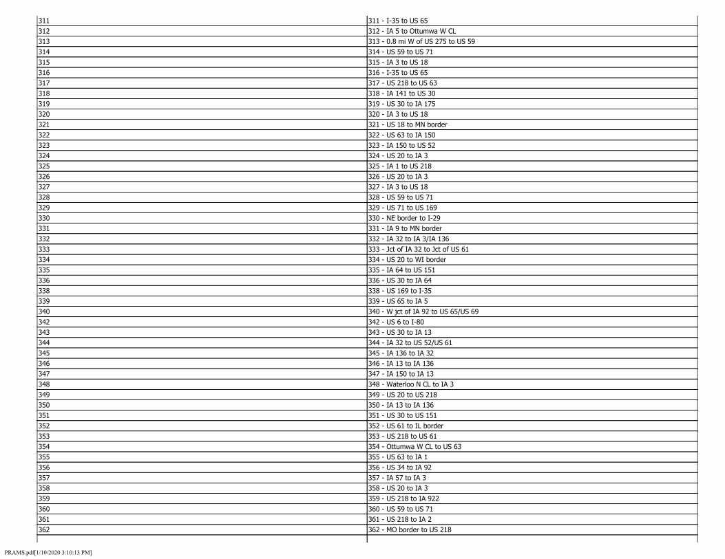
315
320
325
330
335
340
345
350
355
360
311 311 - I-35 to US 65 312 312 - IA 5 to Ottumwa W CL 313 313 - 0.8 mi W of US 275 to US 59 314 314 - US 59 to US 71
315 - IA 3 to US 18 316 316 - I-35 to US 65 317 317 - US 218 to US 63 318 318 - IA 141 to US 30 319 319 - US 30 to IA 175
320 - IA 3 to US 18 321 321 - US 18 to MN border 322 322 - US 63 to IA 150 323 323 - IA 150 to US 52 324 324 - US 20 to IA 3
325 - IA 1 to US 218 326 326 - US 20 to IA 3 327 327 - IA 3 to US 18 328 328 - US 59 to US 71 329 329 - US 71 to US 169
330 - NE border to I-29 331 331 - IA 9 to MN border 332 332 - IA 32 to IA 3/IA 136 333 333 - Jct of IA 32 to Jct of US 61 334 334 - US 20 to WI border
335 - IA 64 to US 151 336 336 - US 30 to IA 64 338 338 - US 169 to I-35 339 339 - US 65 to IA 5
340 - W jct of IA 92 to US 65/US 69 342 342 - US 6 to I-80 343 343 - US 30 to IA 13 344 344 - IA 32 to US 52/US 61
345 - IA 136 to IA 32 346 346 - IA 13 to IA 136 347 347 - IA 150 to IA 13 348 348 - Waterloo N CL to IA 3 349 349 - US 20 to US 218
350 - IA 13 to IA 136 351 351 - US 30 to US 151 352 352 - US 61 to IL border 353 353 - US 218 to US 61 354 354 - Ottumwa W CL to US 63
355 - US 63 to IA 1 356 356 - US 34 to IA 92 357 357 - IA 57 to IA 3 358 358 - US 20 to IA 3 359 359 - US 218 to IA 922
360 - US 59 to US 71 361 361 - US 218 to IA 2 362 362 - MO border to US 218
PRAMS.pdf[1/10/2020 3:10:13 PM]

370
380
390
400
410
363 363 - IA 92 to IA 1 364 364 - IA 1 to I-80 365 365 - US 18 to MN border 366 366 - I-80 to I-480/US 6 368 368 - NE border to I-29 369 369 - US 59 to US 6/US 71
370 - US 6 to US 59 371 371 - US 169 to W mixmaster 372 372 - IA 14 to US 63 373 373 - US 63 to US 151 374 374 - I-29 to NE border 375 375 - US 30 to I-380 376 376 - I-380 to IA 100 377 377 - I-380 to US 151 378 378 - Retired Start of Route to JCT of US 218/US63 379 379 - US 20 to US 218
380 - Cedar Falls W CL to US 218 381 381 - Jct of US 20 to Jct of US 52 382 382 - IA 5 to I-235 383 383 - I-235 to US 6 384 384 - US 6 to I-35/80 386 386 - I-35/80 to IA 28 387 387 - IA 28 to US 69 388 388 - IA 160 to I-35/80 389 389 - US 69 to I-235
390 - I-235 to I-80 391 391 - IA 29 to Sioux City N CL 392 392 - US 20/US 75 to IA 29 393 393 - I-29 to IA 12 394 394 - W mixmaster to IA 28 395 395 - IA 28 to US 69 396 396 - IA 28 to I-35 397 397 - Ankeny W CL to IA 160 398 398 - US 30 to Ames N CL 399 399 - US 63 to US 20
400 - IA 27 to US 218 401 401 - US 18 to US 52 402 402 - IA 9 to MN border 403 403 - IA 14 to IA 27 404 404 - IA 12 to US 75 405 405 - US 34 to IA 92 406 406 - IA 415 to E mixmaster 407 407 - IA 141 to IA 28 408 408 - I-80/I-235 to IA 160 409 409 - IA 1 to US 6
410 - I-74 to IL border 411 411 - US 6 to I-280 412 412 - IA 461 to I-74 413 413 - US 6 to I-80 414 414 - IL border to US 61/IA 146
PRAMS.pdf[1/10/2020 3:10:13 PM]
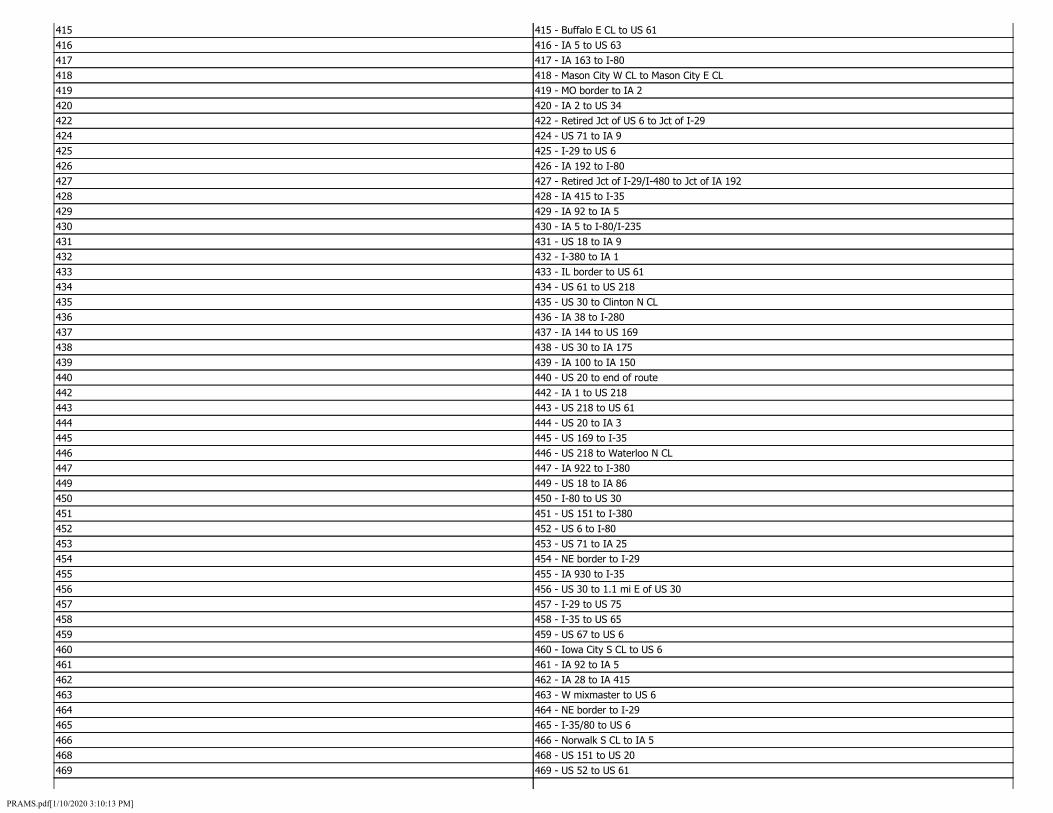
415
420
425
430
435
440
445
450
455
460
465
415 - Buffalo E CL to US 61 416 416 - IA 5 to US 63 417 417 - IA 163 to I-80 418 418 - Mason City W CL to Mason City E CL 419 419 - MO border to IA 2
420 - IA 2 to US 34 422 422 - Retired Jct of US 6 to Jct of I-29 424 424 - US 71 to IA 9
425 - I-29 to US 6 426 426 - IA 192 to I-80 427 427 - Retired Jct of I-29/I-480 to Jct of IA 192 428 428 - IA 415 to I-35 429 429 - IA 92 to IA 5
430 - IA 5 to I-80/I-235 431 431 - US 18 to IA 9 432 432 - I-380 to IA 1 433 433 - IL border to US 61 434 434 - US 61 to US 218
435 - US 30 to Clinton N CL 436 436 - IA 38 to I-280 437 437 - IA 144 to US 169 438 438 - US 30 to IA 175 439 439 - IA 100 to IA 150
440 - US 20 to end of route 442 442 - IA 1 to US 218 443 443 - US 218 to US 61 444 444 - US 20 to IA 3
445 - US 169 to I-35 446 446 - US 218 to Waterloo N CL 447 447 - IA 922 to I-380 449 449 - US 18 to IA 86
450 - I-80 to US 30 451 451 - US 151 to I-380 452 452 - US 6 to I-80 453 453 - US 71 to IA 25 454 454 - NE border to I-29
455 - IA 930 to I-35 456 456 - US 30 to 1.1 mi E of US 30 457 457 - I-29 to US 75 458 458 - I-35 to US 65 459 459 - US 67 to US 6
460 - Iowa City S CL to US 6 461 461 - IA 92 to IA 5 462 462 - IA 28 to IA 415 463 463 - W mixmaster to US 6 464 464 - NE border to I-29
465 - I-35/80 to US 6 466 466 - Norwalk S CL to IA 5 468 468 - US 151 to US 20 469 469 - US 52 to US 61
PRAMS.pdf[1/10/2020 3:10:13 PM]

65 65 - US 151 to US 61 337 337 - US 34 to IA 149 341 341 - IA 965 to IA 1 441 441 - Edgewood Road to I-380 448 448 - I-480/US 6 to Council Bluffs N CL 421 421 - I-80 to IA 906
INSTITUTION_NUMBER_ID - Domain
DomainName INSTITUTION_NUMBER_ID Description INSTITUTION_NUMBER_DESC FieldType Integer Domain Type CodedValue Owner RAMS
Code Name 482 ADAIR WMA 558 ALDO LEOPOLD WILDLIFE MNGT AREA 768 ALGONA ARMORY 602 AMBROSE A. CALL 711 ANAMOSA STATE PENITENTIARY 498 ARTESIAN LAKE WMA 596 ASHTON PITS 748 ATLANTIC ARMORY 742 AUDUBON ARMORY 603 BACKBONE 683 BADGER CREEK 579 BANNER LAKES AT SUMMERSET STATE PK 537 BARRINGER SLOUGH WMA 564 BAYS BRANCH WILDLIFE AREA 696 BEAVER LAKE 604 BEEDS LAKE 605 BELLEVUE 677 BIG CREEK 589 BIG MARSH WILDLIFE MGMT A 450 BIG MILL CREEK WMA 548 BIG SIOUX RIVER COMPLEX WMA 600 BIG SPRING FISH HATCHERY 516 BIG WALL LAKE WMA 513 BIGELOW COUNTY PARK 606 BIXBY 607 BLACK HAWK LAKE 550 BLACKHAWK POINT WMA 526 BLUEBIRD ACCESS 476 BLUFFTON FIR STAND STATE PRESERVE 608 BOB WHITE 745 BOONE ARMORY 503 BOONE FORKS WMA 521 BRADGATE WMA 811 BRAYTON MEMORIAL FOREST,
PRAMS.pdf[1/10/2020 3:10:13 PM]

453 BRIGHTON ACCESS 477 BRIGHTS LAKE WMA 610 BRUSH CREEK CANYON 684 BRUSHY CREEK 755 BURLINGTON ARMORY 547 BURR OAK LAKE WMA 475 CARDINAL MARSH WMA 747 CARROLL ARMORY 556 CASINO BAY MARINA 446 CEDAR BOTTOMS WMA 743 CEDAR FALLS ARMORY 770 CEDAR RAPIDS ARMORY 591 CENTER LAKE 741 CENTERVILLE ARMORY 771 CHARITON ARMORY 759 CHARLES CITY ARMORY 546 CHEEVER LAKE STATE PRESERVE 437 CHRISTOPHERSON SLOUGH 781 CLARINDA ARMORY 718 CLARINDA CORRECTIONAL FACILITY 703 CLARINDA TREATMENT CENTER 439 CLEAR CREEK WMA 611 CLEAR LAKE 457 CLIFFLAND ACCESS 752 CLINTON ARMORY 671 COLD SPRINGS 452 CONE MARSH WMA 473 COON CREEK WMA 927 CORALVILLE RESERVOIR 740 CORNING ARMORY 784 COUNCIL BLUFFS ARMORY 785 COUNCIL BLUFFS OMS 449 DALTON POND WMA 788 DAVENPORT AASF 786 DAVENPORT ARMORY 787 DAVENPORT OMS 593 DEER CREEK WILDLIFE AREA 492 DEER ISLAND WMA 505 DEKALB WMA 753 DENISON ARMORY 918 DESOTO BEND WILDLIFE REFUGE 460 DEVOSS FOSTER WMA 436 DIAMOND LAKE WMA 862 DMACC AREA XI ANKENY 886 DMACC AREA XI DES MOINES 863 DMACC--BOONE 613 DOLLIVER MEMORIAL 756 DUBUQUE ARMORY 464 DUDGEON LAKE WMA 496 DUNBAR SLOUGH WMA
PRAMS.pdf[1/10/2020 3:10:13 PM]
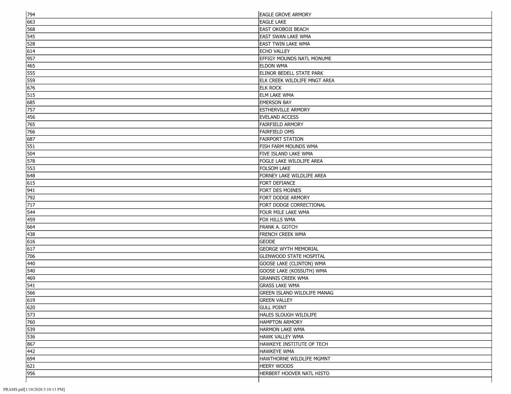
794 EAGLE GROVE ARMORY 663 EAGLE LAKE 568 EAST OKOBOJI BEACH 545 EAST SWAN LAKE WMA 528 EAST TWIN LAKE WMA 614 ECHO VALLEY 957 EFFIGY MOUNDS NATL MONUME 465 ELDON WMA 555 ELINOR BEDELL STATE PARK 559 ELK CREEK WILDLIFE MNGT AREA 676 ELK ROCK 515 ELM LAKE WMA 685 EMERSON BAY 757 ESTHERVILLE ARMORY 456 EVELAND ACCESS 765 FAIRFIELD ARMORY 766 FAIRFIELD OMS 687 FAIRPORT STATION 551 FISH FARM MOUNDS WMA 504 FIVE ISLAND LAKE WMA 578 FOGLE LAKE WILDLIFE AREA 553 FOLSOM LAKE 648 FORNEY LAKE WILDLIFE AREA 615 FORT DEFIANCE 941 FORT DES MOINES 792 FORT DODGE ARMORY 717 FORT DODGE CORRECTIONAL 544 FOUR MILE LAKE WMA 459 FOX HILLS WMA 664 FRANK A. GOTCH 438 FRENCH CREEK WMA 616 GEODE 617 GEORGE WYTH MEMORIAL 706 GLENWOOD STATE HOSPITAL 440 GOOSE LAKE (CLINTON) WMA 540 GOOSE LAKE (KOSSUTH) WMA 469 GRANNIS CREEK WMA 541 GRASS LAKE WMA 566 GREEN ISLAND WILDLIFE MANAG 619 GREEN VALLEY 620 GULL POINT 573 HALES SLOUGH WILDLIFE 760 HAMPTON ARMORY 539 HARMON LAKE WMA 536 HAWK VALLEY WMA 867 HAWKEYE INSTITUTE OF TECH 442 HAWKEYE WMA 694 HAWTHORNE WILDLIFE MGMNT 621 HEERY WOODS 956 HERBERT HOOVER NATL HISTO
PRAMS.pdf[1/10/2020 3:10:13 PM]

484 HIGHWAY 44 ACCESS 675 HONEY CREEK 830 IA BRAILLE AND SIGHT SAVING 872 IA CENTRAL COMM COLL-WEBS 873 IA LAKES COMM COLL--EMMET 874 IA LAKES COMM COLL-ESTHER 724 IA MEDICAL AND CLASSIFICATION 775 IA NATL GUARD--GLENWOOD 869 INDAIN HILLS COM COL 461 INDIAN BLUFFS WMA 868 INDIAN HILLS-CENTERVILLE 599 INGHAM LAKE WILDLIFE AREA 871 IOWA CENTRL COM COL AREA 767 IOWA CITY ARMORY 715 IOWA CORRECTIONAL INST.(W 762 IOWA FALLS ARMORY 709 IOWA JUVENILE HOME, TOLED 543 IOWA LAKE (EMMET) WMA 443 IOWA RIVER CORRIDOR WMA 840 IOWA SCHOOL FOR THE DEAF, 851 IOWA STATE FAIRGROUNDS 712 IOWA STATE PENITENTIARY 810 IOWA STATE UNIVERSITY 710 IOWA VETERANS HOME 876 IOWA WEST. COMM.COL.AREA 816 ISU 814 ISU - EXPERIM. FARM 817 ISU FARMS AND OTHER LANDS 802 ISU LAKESIDE LAB 815 ISU-MCNAY RESEARCH FARM 761 JEFFERSON ARMORY 435 JEMMERSON SLOUGH COMPLEX 665 KEARNEY 494 KEG CREEK I29 WMA 769 KEOKUK ARMORY 583 KETTLESON HOGBACK WILDLIFE AREA 586 KIOWA MARSH WILDLIFE 877 KIRKWOOD COMM COLL 451 KLUM LAKE WMA 773 KNOXVILLE ARMORY 623 LACEY-KEOSAUQUA 479 LAHART WMA 601 LAKE AHQUABI 669 LAKE ANITA 612 LAKE DARLING 681 LAKE ICARIA 622 LAKE KEOMAH 626 LAKE MACBRIDE 627 LAKE MANAWA 595 LAKE ODESSA WILDLIFE AREA
PRAMS.pdf[1/10/2020 3:10:13 PM]

653 LAKE OF THREE FIRES 926 LAKE RATHBUN 570 LAKE SUQEMA WILDLIFE 658 LAKE WANATA 659 LAKE WAPELLO 489 LAKIN SLOUGH WMA 624 LEDGES 431 LEKWA MARSH WMA 783 LEMARS ARMORY 625 LEWIS AND CLARK 448 LITTLE MILL CREEK WMA 533 LITTLE SIOUX WMA 507 LIZARD CREEK WMA 525 LIZARD LAKE WMA 502 LOESS HILL WMA 584 LOESS HILLS PIONEER STATE FOREST 572 LOST GROVE WILDLIFE 501 LOUISVILLE BEND WMA 682 LOWER GAR LAKE 474 MALANAPHY SPRINGS STATE PRESERVE 598 MANCHESTER FISH HATCHERY 776 MAPLETON ARMORY 628 MAQUOKETA CAVES 686 MARBLE BEACH 629 MARGO FRANKEL WOODS 912 MARK TWAIN REFUGE 774 MARSHALLTOWN ARMORY 878 MARSHALLTOWN COMM COLL 749 MASON CITY ARMORY 803 MCBRIDE NRA 488 MCCORD POND WMA 630 MCGREGOR HEIGHTS 631 MCINTOSH WOODS 495 MCMAHON ACCESS 428 MCPAUL I-29 WMA 481 MEADOW LAKE WMA 704 MENTAL HEALTH INSTITUTE 702 MENTAL HEALTH INSTITUTE 458 MIAMI LAKE WMA 497 MIDDLE DECATUR BEND WMA 512 MILE LONG ISLAND WMA 632 MILL CREEK 689 MINES OF SPAIN 633 MINI-WAKAN 434 MINNEWASHTA LAKE WMA 514 MORSE LAKE WMA 519 MOUNT AYR WMA 763 MT PLEASANT ARMORY 705 MT PLEASANT CORRECTIONAL 779 MUSCATINE ARMORY
PRAMS.pdf[1/10/2020 3:10:13 PM]

879 MUSCATINE COMM COLL 463 MUSKRAT SLOUGH WMA 538 MYRE SLOUGH WMA 713 N CEN CORR FAC-ROCKWELL C 880 N IA AREA COMM COLL-MASON 850 NAT, GUARD CAMP DODGE 970 NATIONAL ANIMAL DISEASE CENTER 860 NE IOWA AREA TECH INST AR 919 NEAL SMITH WILDLIFE REFUGE 864 NEICC PEOSTA 554 NEW ALBIN WMA 764 NEWTON ARMORY 716 NEWTON CORRECTIONAL FACIL 634 NINE EAGLES 695 NOBLES ISLAND 491 NOBLES LAKE WMA 0 NOT APPLICABLE 881 NW IOWA COMM COL-IV-SHELD 667 OAK GROVE 565 OAKDALE-GEOLGICAL SURVEY 635 OAKLAND MILLS 758 OELWEIN ARMORY 672 OKAMANPEDAN 750 OSCEOLA ARMORY 772 OSKALOOSA ARMORY 577 OTTER CREEK WILDLIFE AREA 468 OTTERVILLE WMA 522 OTTOSEN POTHOLES WMA 790 OTTUMWA ARMORY 636 PALISADES-KEPLER 637 PAMMEL 478 PELLA WMA 486 PERRY ACCESS WMA 754 PERRY ARMORY 462 PICTURED ROCKS COUNTY PARK 638 PIKES PEAK 639 PIKES POINT 640 PILOT KNOB 641 PINE LAKE 642 PIONEER 679 PLEASANT CREEK 485 PLEASANT VALLEY WMA 483 POLK CITY REFUGE 643 PRAIRIE ROSE 644 PREPARATION CANYON 698 PRINCETON WILDLIFE AREA 666 RAINBOW BEND 562 RAND ACCESS WILDLIFE AREA 575 RATHBUN FISH HATCHERY 587 RATHBUN WILDLIFE
PRAMS.pdf[1/10/2020 3:10:13 PM]

447 RED CEDAR WMA 645 RED HAW 777 RED OAK ARMORY 928 RED ROCK RESERVOIR 646 RICE LAKE 517 RINGGOLD WMA 699 RIVERTON WILDLIFE MANAGEM 647 ROCK CREEK 930 ROCK ISLAND ARSENAL 532 RUSH LAKE (PALO ALTO) WMA 549 RUSH LAKE-OSCEOLA-WMA 590 RUTHVEN WILDLIFE AREA 884 S EASTERN COMM COLL-BURLI 509 SAC CITY ACCESS 506 SAND CREEK WMA 931 SAYLORVILLE RES 865 SCOTT COMM COL ARE IX 427 SCOTT I-29 WMA 793 SERGEANT BLUFF ARMORY 649 SHARON BLUFFS 780 SHELDON ARMORY 470 SHELL ROCK BEND WMA 782 SHENANDOAH ARMORY 690 SHIMEK STATE FOREST 472 SIEWERS SPRINGS FISH HATCHERY 433 SILVER LAKE (DICKINSON) WMA 531 SILVER LAKE (PALO ALTO) WMA 789 SIOUX CENTER ARMORY 454 SKUNK RIVER WMA 527 SOO ACCESS 455 SOUTH SKUNK RIVER ACCESS 883 SOUTHEASTERN COMM COLL--K 552 SOUTHFORK ACCESS WMA 751 SPENCER ARMORY 581 SPIRIT LAKE HATCHERY 650 SPRING BROOK 651 SPRING LAKE 432 SPRING RUN WETLAND COMPLEX 852 STATE CAPITOL COMPLEX 594 STATE FOREST NURSERY 723 STATE PENITENTIARY FARM # 722 STATE PENITENTIARY FARMS 714 STATE TRAINING SCHOOL 693 STEPHENS ST FOR 652 STONE - PLYMOUTH CO 746 STORM LAKE ARMORY 524 SUNKEN GROVE WMA 882 SW COMM. COL.AREA 668 SWAN LAKE 597 SWEET MARSH WILDLIFE AREA
PRAMS.pdf[1/10/2020 3:10:13 PM]

444 SYRACUSE WMA 901 TAMA INDIAN SETTLEMENT 692 TEMPLAR POINT 576 THREE MILE LAKE WILD LIFE AREA 654 TRAPPERS BAY 582 TRIBOJI BEACH ACCESS 467 TROY MILLS WMA 567 TRUMBULL LAKE STATE PARK 674 TWIN LAKES 490 TYSON BEND WMA 804 U OF IA OAKDALE CAMPUS 655 UNION GROVE 911 UNION SLOUGH REFUGE 801 UNIVERSITY OF IOWA 820 UNIVERSITY OF NORTHERN IA 499 UPPER DECATUR BEND WMA 917 UPPER MISSISSIPPI LAND AC 915 UPPER MISSISSIPPI LAND AC 913 UPPER MISSISSIPPI LAND AC 916 UPPER MISSISSIPPI LAND ACQUISITION 557 VENTURA MARSH 471 VENTURA MARSH WMA 656 VIKING LAKE 778 VILLISCA ARMORY 678 VOLGA RIVER 885 W IA TECH COMM COLL-AREA 657 WALNUT WOODS 660 WAPSIPINICON 791 WASHINGTON ARMORY 744 WATERLOO AASF 569 WATERLOO CREEK WMA 430 WATERLOO CREEK WMA 661 WAUBONSIE 942 WAVERLY NAVAL HOUSING 510 WEEDLAND ACCESS 542 WEST SWAN LAKE WMA 508 WHITE HORSE ACCESS 466 WHITE PINE HOLLOW STATE PRESERVE 445 WIESE SLOUGH WMA 662 WILD CAT DEN 487 WILLIAMSON POND WMA 493 WILLOW SLOUGH WMA 523 WILLOWS ACCESS WMA 670 WILSON ISLAND 511 WINNEBAGO BEND WMA 707 WOODWARD STATE HOSPITAL 691 YELLOW RIVER STATE FOREST 951 YELLOW BANKS PARK 425 BARKLEY MEMORIAL PARK 697 BIRDLAND PARK
PRAMS.pdf[1/10/2020 3:10:13 PM]
LANE_POSITION_ID - Domain
DomainName LANE_POSITION_ID Description LANE_POSITION_DESC FieldType String Domain Type CodedValue Owner RAMS
Code Name 1 LANE 1 2 LANE 2 3 LANE 3 4 LANE 4 5 LANE 5 6 LANE 6 7 LANE 7 8 LANE 8 9 LANE 9
LANE_TYPE_ID - Domain
DomainName LANE_TYPE_ID Description LANE_TYPE_DESC FieldType String Domain Type CodedValue Owner RAMS
Code Name 1 1 - THROUGH LANE 3 3 - RIGHT TURN LANE 4 4 - LEFT TURN LANE 5 5 - CENTER TURN LANE 6 6 - EXIT LANE 7 7 - ENTRANCE LANE 8 8 - REVERSIBLE LANES 9 9 - OTHER 2 2 - CLIMBING LANE
MAINTENANCE_CONTRACT_ID - Domain
DomainName MAINTENANCE_CONTRACT_ID Description MAINTENANCE_CONTRACT_DESC FieldType Integer Domain Type CodedValue Owner RAMS
Code Name 1 MAINTENANCE CONTRACT
PRAMS.pdf[1/10/2020 3:10:13 PM]

MAINTENANCE_COST_CENTER_ID - Domain
DomainName MAINTENANCE_COST_CENTER_ID Description MAINTENANCE_COST_CENTER_DESC FieldType Integer Domain Type CodedValue Owner RAMS
Code Name 551602 551602 - AMES GARAGE 551604 551604 - MARSHALLTOWN GARAGE 551605 551605 - TAMA GARAGE 551607 551607 - GRUNDY CENTER GARAGE 551608 551608 - IOWA FALLS GARAGE 551609 551609 - WILLIAMS GARAGE 551611 551611 - FORT DODGE GARAGE 551612 551612 - GOWRIE GARAGE 551613 551613 - JEFFERSON GARAGE 551614 551614 - BOONE GARAGE 551802 551802 - MALCOM INTERSTATE GARAGE 551803 551803 - GRINNELL GARAGE 551804 551804 - NEWTON INTERSTATE GARAGE 551806 551806 - ALTOONA GARAGE 551807 551807 - DES MOINES NORTH GARAGE 551808 551808 - GRIMES GARAGE 551809 551809 - CARLISLE GARAGE 551810 551810 - HWY DIV HIGHWAY HELPER 552617 552617 - MASON CITY GARAGE 552634 552634 - CHARLES CITY GARAGE 552635 552635 - LATIMER GARAGE 552641 552641 - GARNER GARAGE 552655 552655 - ALGONA GARAGE 552656 552656 - SWEA CITY GARAGE 552666 552666 - OSAGE GARAGE 552698 552698 - HANLONTOWN GARAGE 552699 552699 - CLARION GARAGE 552803 552803 - WAUKON GARAGE 552807 552807 - WATERLOO GARAGE 552809 552809 - WAVERLY GARAGE 552812 552812 - ALLISON GARAGE 552819 552819 - NEW HAMPTON GARAGE 552822 552822 - ELKADER GARAGE 552833 552833 - WEST UNION GARAGE 552896 552896 - DECORAH GARAGE 553602 553602 - SIOUX CITY-HAMILTON GARAGE 553603 553603 - SIOUX CITY-LEEDS GARAGE 553604 553604 - CORRECTIONVILLE GARAGE 553605 553605 - SAC CITY GARAGE 553606 553606 - ROCKWELL CITY GARAGE 553607 553607 - SLOAN GARAGE 553608 553608 - IDA GROVE GARAGE
PRAMS.pdf[1/10/2020 3:10:13 PM]

553609 553609 - ONAWA GARAGE 553611 553611 - SOLDIER GARAGE 553612 553612 - DENISON GARAGE 553613 553613 - CARROLL GARAGE 553802 553802 - AKRON GARAGE 553803 553803 - LE MARS GARAGE 553804 553804 - CHEROKEE GARAGE 553805 553805 - STORM LAKE GARAGE 553806 553806 - ROCK VALLEY GARAGE 553807 553807 - ROCK RAPIDS GARAGE 553808 553808 - ALTON GARAGE 553810 553810 - ASHTON GARAGE 553812 553812 - SPENCER GARAGE 553813 553813 - POCAHONTAS GARAGE 553814 553814 - EMMETSBURG GARAGE 553815 553815 - SPIRIT LAKE GARAGE 554602 554602 - ADAIR GARAGE 554603 554603 - ATLANTIC GARAGE 554605 554605 - CLARINDA GARAGE 554606 554606 - CORNING GARAGE 554607 554607 - CRESTON GARAGE 554608 554608 - DESOTO GARAGE 554609 554609 - GREENFIELD GARAGE 554613 554613 - MOUNT AYR GARAGE 554614 554614 - PERRY GARAGE 554615 554615 - RED OAK GARAGE 554802 554802 - AVOCA INTERSTATE GARAGE 554803 554803 - COUNCIL BLUFFS NORTH GARAGE 554804 554804 - COUNCIL BLUFFS SOUTH GARAGE 554805 554805 - NEOLA GARAGE 554806 554806 - OAKLAND GARAGE 554807 554807 - PACIFIC JUNCTION GARAGE 554808 554808 - SIDNEY GARAGE 554810 554810 - MISSOURI VALLEY GARAGE 555604 555604 - CENTERVILLE GARAGE 555620 555620 - OSCEOLA GARAGE 555627 555627 - LEON GARAGE 555659 555659 - CHARITON GARAGE 555662 555662 - OSKALOOSA GARAGE 555663 555663 - KNOXVILLE GARAGE 555668 555668 - ALBIA GARAGE 555690 555690 - OTTUMWA GARAGE 555691 555691 - MARTENSDALE GARAGE 555826 555826 - BLOOMFIELD GARAGE 555829 555829 - BURLINGTON GARAGE 555830 555830 - WAPELLO GARAGE 555844 555844 - MT PLEASANT GARAGE 555851 555851 - FAIRFIELD GARAGE 555854 555854 - SIGOURNEY GARAGE 555856 555856 - DONNELLSON GARAGE
PRAMS.pdf[1/10/2020 3:10:13 PM]

555870 555870 - MUSCATINE GARAGE 555892 555892 - WASHINGTON GARAGE 556602 556602 - URBANA GARAGE 556603 556603 - NEWHALL GARAGE 556604 556604 - INDEPENDENCE GARAGE 556605 556605 - MANCHESTER GARAGE 556606 556606 - WILLIAMSBURG GARAGE 556607 556607 - CORALVILLE GARAGE 556608 556608 - CEDAR RAPIDS GARAGE 556609 556609 - MARION GARAGE 556802 556802 - TIPTON INTERSTATE GARAGE 556804 556804 - DEWITT GARAGE 556806 556806 - DUBUQUE GARAGE 556807 556807 - DYERSVILLE GARAGE 556808 556808 - MAQUOKETA GARAGE 556809 556809 - SABULA GARAGE 556810 556810 - ANAMOSA GARAGE
556812 - DAVENPORT INTERSTATE GARAGE 556812
MAINTENANCE_DISTRICT_ID - Domain
DomainName MAINTENANCE_DISTRICT_ID Description MAINTENANCE_DISTRICT_DESC FieldType Integer Domain Type CodedValue Owner RAMS
Code Name 1 1 - CENTRAL 2 2 - NORTHEAST 3 3 - NORTHWEST 4 4 - SOUTHWEST 5 5 - SOUTHEAST 6 6 - EAST CENTRAL
MAINTENANCE_GARAGE_ID - Domain
DomainName MAINTENANCE_GARAGE_ID Description MAINTENANCE_GARAGE_DESC FieldType Integer Domain Type CodedValue Owner RAMS
Code Name 22 22 30 30 54 54 51 51 91 91 34 34
PRAMS.pdf[1/10/2020 3:10:13 PM]
6 6 11 11 13 13 44 44 29 29 59 59 70 70 2 2 14 14 90 90 20 20 26 26 66 66 5 5 4 4 68 68 96 96 8 8 63 63 17 17 35 35 55 55 33 33 56 56 41 41 99 99 3 3 7 7 27 27 10 10 12 12 15 15 9 9 92 92 62 62 19 19 98 98
MAINTENANCE_RESIDENCY_ID - Domain
DomainName MAINTENANCE_RESIDENCY_ID Description MAINTENANCE_RESIDENCY_DESC FieldType Integer Domain Type CodedValue Owner RAMS
Code Name 6 6 8 8
PRAMS.pdf[1/10/2020 3:10:13 PM]

MAINTENANCE_SERVICE_LV_ID - Domain
DomainName MAINTENANCE_SERVICE_LV_ID Description MAINTENANCE_SERVICE_LV_DESC FieldType String Domain Type CodedValue Owner RAMS
Code Name A A - INTERSTATE B B C C
MEASUREMENT_METHODS_ID - Domain
DomainName MEASUREMENT_METHODS_ID Description MEASUREMENT_METHODS_DESC FieldType Integer Domain Type CodedValue Owner RAMS
Code Name 1 DEFAULT 8 DALLAS COUNTY 2001 - 2 FT 118 GIMS CENTERLINE 2005 MAP SOURCE 134 CROP FLIGHTS 2010 - USDA 135 CROP FLIGHTS 2010 - USDA 136 CROP FLIGHTS 2011 - USDA 137 CROP FLIGHTS 2011 - USDA 138 MANDLI LIDAR COLLECTION 2013 139 VERTICAL CLEARANCE FORM
MEDIAN_BARRIER_TYPE_ID - Domain
DomainName MEDIAN_BARRIER_TYPE_ID Description MEDIAN_BARRIER_TYPE_DESC FieldType Integer Domain Type CodedValue Owner RAMS
Code Name 1 1 - UNSPECIFIED 2 2 - FLEXIBLE 3 3 - SEMI-RIGID 4 4 - RIGID
MEDIAN_TYPE_ID - Domain
DomainName Description FieldType
MEDIAN_TYPE_ID MEDIAN_TYPE_DESC Integer
PRAMS.pdf[1/10/2020 3:10:13 PM]

Domain Type CodedValue Owner RAMS
Code Name 1 1 - HARD SURFACE WITHOUT BARRIER (RAISED MEDIAN) 2 2 - GRASS SURFACE WITHOUT BARRIER 3 3 - HARD SURFACE WITH BARRIER 4 4 - GRASS SURFACE WITH BARRIER 5 5 - BARRIER
NATIONAL_HIGHWAY_SYSTEM_ID - Domain
DomainName NATIONAL_HIGHWAY_SYSTEM_ID Description NATIONAL_HIGHWAY_SYSTEM_DESC FieldType Integer Domain Type CodedValue Owner RAMS
Code Name 1 1 - NHS 2 2 - MAJOR AIRPORT NHS CONNECTOR 3 3 - MAJOR PORT FACILITY NHS CONNECTOR 4 4 - MAJOR AMTRACK STATION NHS CONNECTOR 5 5 - MAJOR RAIL/TRUCK TERMINAL NHS CONNECTOR 6 6 - MAJOR INTER CITY BUS TERMINAL NHS CONNECTOR 7 7 - MAJOR PUBLIC TRANSPORTATION OR MULTI-MODAL PASSENGER TERMINAL NHS CONNECTOR 8 8 - MAJOR PIPELINE TERMINAL NHS CONNECTOR 9 9 - MAJOR FERRY TERMINAL NHS CONNECTOR
NUMBER_LANES_ID - Domain
DomainName NUMBER_LANES_ID Description NUMBER_LANES_DESC FieldType Integer Domain Type CodedValue Owner RAMS
Code Name 1 1 - LANE 2 2 - LANES 3 3 - LANES 4 4 - LANES 5 5 - LANES 6 6 - LANES 7 7 - LANES 8 8 - LANES 9 9 - LANES 10 10 - LANES
OWNER_CODE_ID - Domain
PRAMS.pdf[1/10/2020 3:10:13 PM]

DomainName OWNER_CODE_ID Description OWNER_CODE_DESC FieldType Integer Domain Type CodedValue Owner RAMS
Code Name 1 1 - STATE HIGHWAY AGENCY 2 2 - COUNTY HIGHWAY AGENCY 3 3 - TOWN OR TOWNSHIP HIGHWAY AGENCY 4 4 - CITY OR MUNICIPAL HIGHWAY AGENCY 11 11 - STATE PARK, FOREST, OR RESERVATION AGENCY 12 12 - LOCAL PARK, FOREST, OR RESERVATION AGENCY 21 21 - OTHER STATE AGENCY 25 25 - OTHER LOCAL AGENCY 26 26 - PRIVATE (OTHER THAN RR) 27 27 - RAILROAD 31 31 - STATE TOLL AUTHORITY 32 32 - LOCAL TOLL AUTHORITY 40 40 - OTHER PUBLIC INSTRUMENTALITY (I.E. AIRPORT) 50 50 - INDIAN TRIBE NATION 60 60 - OTHER FEDERAL AGENCY (NOT LISTED) 62 62 - BUREAU OF INDIAN AFFAIRS 63 63 - BUREAU OF FISH AND WILDLIFE 64 64 - U.S. FOREST SERVICE 66 66 - NATIONAL PARK SERVICE 67 67 - TENNESSEE VALLEY AUTHORITY 68 68 - BUREAU OF LAND MANAGEMENT 69 69 - BUREAU OF RECLAMATION 70 70 - CORPS OF ENGINEERS (CIVIL) 71 71 - CORPS OF ENGINEERS (MILITARY) 72 72 - AIR FORCE 73 73 - NAVY/MARINES 74 74 - ARMY 80 80 - OTHER
PARKING_TYPE_ID - Domain
DomainName PARKING_TYPE_ID Description PARKING_TYPE_DESC FieldType Integer Domain Type CodedValue Owner RAMS
Code Name 1 NO PARKING IS POSTED 2 PARALLEL ONE SIDE - NO PARKING OTHER SIDE 3 PARALLEL ONE SIDE - DIAGONAL OTHER SIDE 4 PARALLEL BOTH SIDES 5 DIAGONAL ONE SIDE - NO PARKING OTHER SIDE
PRAMS.pdf[1/10/2020 3:10:13 PM]

6 DIAGONAL BOTH SIDES 7 PARALLEL OR DIAGONAL ON ONE SHOULDER 8 PARALLEL OR DIAGONAL ON BOTH SHOULDERS 9 DIAGONAL CENTER - PARALLEL ON SIDES
PASSING_RESTRICTION_ID - Domain
DomainName PASSING_RESTRICTION_ID Description PASSING_RESTRICTION_DESC FieldType Integer Domain Type Range Owner RAMS
Minimum Value Maximum Value
PAVEMENT_MATERIAL_ID - Domain
DomainName PAVEMENT_MATERIAL_ID Description PAVEMENT_MATERIAL_DESC FieldType String Domain Type CodedValue Owner RAMS
Code Name AAC Type A Asphalt Cement Concrete ARC Asphalt Rubber Cement Concrete ASC Asphalt-Sand Surface Course ATB Asphalt Treated Base BAC Type B Asphalt Cement Concrete BRK Brick BSC Bituminous Seal Coat BTB Bituminous Treated Base CIP Cold in Place Recycled Asphalt CTB Cement Treated Base ECB Econocrete Base GBF Granular Backfill GND Diamond Grinding GSB Granular Subbase FOA Foamed Asphalt HMA Hot Mix Asphalt MSB Modified Subbase MSS Micro Surfacing PC7 10""-7""-10"" PCC Concrete Slab PC8 10""-8""-10"" PCC Concrete Slab PCB Portland Cement Base PCC Portland Cement Concrete RAC Recycled Asphalt Cement Concrete RPC Recycled PCC Pavement RSB Rolled Stone Base SAS Soil-Aggregate Subbase
PRAMS.pdf[1/10/2020 3:10:13 PM]

SBF Special Backfill SCS Soil-Cement Subbase SGT Subgrade Treatment SLS Soil-Lime Subbase SS Slurry Seal TBB Type B Asphalt Base UNK Unknown MAC Macadam (Large Stone/Chocked off - mostly on shoulders)
PLANNING_CLASS_ID - Domain
DomainName PLANNING_CLASS_ID Description PLANNING_CLASS_DESC FieldType Integer Domain Type CodedValue Owner RAMS
Code Name 1 1 - INTERSTATE 2 2 - COMMERCIAL AND INDUSTRIAL NETWORK 3 3 - AREA DEVELOPMENT 4 4 - ACCESS ROUTES 5 5 - LOCAL SERVICE
PROJECT_WORK_TYPE_ID - Domain
DomainName PROJECT_WORK_TYPE_ID Description PROJECT_WORK_TYPE_DESC FieldType String Domain Type CodedValue Owner RAMS
Code Name W W = widening project L L = left (inside) lane(s) only R R = right (outside) lane(s) only V V = various locations O O = original construction S S = resurfacing U U = unknown M M = maintenance
RAMP_SEQUENCE_ID - Domain
DomainName RAMP_SEQUENCE_ID Description RAMP_SEQUENCE_DESC FieldType String Domain Type Range Owner RAMS
PRAMS.pdf[1/10/2020 3:10:13 PM]

Minimum Value Maximum Value
REMOVAL_TYPE_ID - Domain
DomainName REMOVAL_TYPE_ID Description REMOVAL_TYPE_DESC FieldType String Domain Type CodedValue Owner RAMS
Code Name GND GND = Grinding MIL MIL = Milling SCR SCR = Heater Scarification
ROAD_FUNCTION_ID - Domain
DomainName ROAD_FUNCTION_ID Description ROAD_FUNCTION_DESC FieldType Integer Domain Type CodedValue Owner RAMS
Code Name 1 1 - MAINLINE - NE RAMP CURVE 2 2 - MAINLINE - SE RAMP CURVE 3 3 - MAINLINE - SW RAMP CURVE 4 4 - MAINLINE - NW RAMP CURVE 5 5 - MAINLINE - NE LOOP 6 6 - MAINLINE - SE LOOP 7 7 - MAINLINE - SW LOOP 8 8 - MAINLINE - NW LOOP 9 9 - MAINLINE - 1ST INNERLEG 10 10 - MAINLINE - 2ND INNERLEG 11 11 - MAINLINE - 3RD INNERLEG 12 12 - MAINLINE - 4TH INNERLEG 13 13 - MAINLINE - 5TH INNERLEG 14 14 - MAINLINE - 6TH INNERLEG 15 15 - MAINLINE - TEMPORARY CONNECTION 16 16 - MAINLINE - NORTH TANGENT 17 17 - MAINLINE - SOUTH TANGENT 18 18 - MAINLINE - EAST TANGENT 19 19 - MAINLINE - WEST TANGENT 20 20 - MAINLINE - EAST-WEST TANGENT 21 21 - MAINLINE - NORTH-SOUTH TANGENT 22 22 - MAINLINE - 7TH INNERLEG 23 23 - MAINLINE - 8TH INNERLEG 24 24 - MAINLINE - 9TH INNERLEG 25 25 - MAINLINE - 10TH INNERLEG 50 50 - NON-MAINLINE - SPECIAL CASE
PRAMS.pdf[1/10/2020 3:10:13 PM]

51 51 - NON-MAINLINE - NE RAMP CURVE 52 52 - NON-MAINLINE - SE RAMP CURVE 53 53 - NON-MAINLINE - SW RAMP CURVE 54 54 - NON-MAINLINE - NW RAMP CURVE 55 55 - NON-MAINLINE - NE LOOP 56 56 - NON-MAINLINE - SE LOOP 57 57 - NON-MAINLINE - SW LOOP 58 58 - NON-MAINLINE - NW LOOP 59 59 - NON-MAINLINE - 1ST INNERLEG 60 60 - NON-MAINLINE - 2ND INNERLEG 61 61 - NON-MAINLINE - 3RD INNERLEG 62 62 - NON-MAINLINE - 4TH INNERLEG 63 63 - NON-MAINLINE - 5TH INNERLEG 64 64 - NON-MAINLINE - 6TH INNERLEG 65 65 - NON-MAINLINE - TEMPORARY CONNECTION 66 66 - NON-MAINLINE - NORTH TANGENT 67 67 - NON-MAINLINE - SOUTH TANGENT 68 68 - NON-MAINLINE - EAST TANGENT 69 69 - NON-MAINLINE - WEST TANGENT 70 70 - NON-MAINLINE - EAST-WEST TANGENT 71 71 - NON-MAINLINE - NORTH-SOUTH TANGENT 72 72 - NON-MAINLINE - 7TH INNERLEG 73 73 - NON-MAINLINE - 8TH INNERLEG 74 74 - NON-MAINLINE - 9TH INNERLEG 75 75 - NON-MAINLINE - 10TH INNERLEG
ROAD_STATUS_ID - Domain
DomainName ROAD_STATUS_ID Description ROAD_STATUS_DESC FieldType Integer Domain Type CodedValue Owner RAMS
Code Name 0 0 - OPEN 1 1 - LEGAL NOT OPEN 2 2 - PROPOSED 4 4 - BORDER ROADS 5 5 - PENDING COMPLETION 6 6 - PRIVATE 7 7 - OTHER STATE ROADS 8 8 - CLOSED
ROAD_SYSTEM_ID - Domain
DomainName Description FieldType Domain Type
ROAD_SYSTEM_ID ROAD_SYSTEM_DESC Integer CodedValue
PRAMS.pdf[1/10/2020 3:10:13 PM]

Owner RAMS
Code Name 1 FARM TO MARKET 2 FARM TO MARKET EXTENSION 3 FARM TO MARKET EXTENSION LESS THAN 500 4 AREA SERVICE
ROADWAY_ENTRANCE_ID - Domain
DomainName ROADWAY_ENTRANCE_ID Description ROADWAY_ENTRANCE_DESC FieldType Integer Domain Type CodedValue Owner RAMS
Code Name 1 1 - COMMERCIAL 2 2 - INDUSTRIAL 3 3 - RECREATIONAL 4 4 - BUSINESS 5 5 - PRIVATE
ROUTE_DIRECTION_LU - Domain
DomainName ROUTE_DIRECTION_LU Description ROUTE_DIRECTION_DESCRIPTION FieldType String Domain Type CodedValue Owner SDE
Code Name N N - NORTH S S - SOUTH E E - EAST W W - WEST
ROUTE_QUALIFIER_ID - Domain
DomainName ROUTE_QUALIFIER_ID Description ROUTE_QUALIFIER_DESC FieldType Integer Domain Type CodedValue Owner RAMS
Code Name 1 NO QUALIFIER OR NOT SIGNED 2 ALTERNATE 3 BUSINESS ROUTE 4 BYPASS BUSINESS
PRAMS.pdf[1/10/2020 3:10:13 PM]

5 SPUR 6 LOOP 7 PROPOSED 8 TEMPORARY 9 TRUCK ROUTE 10 NONE OF THE ABOVE
ROUTE_SIGNING_ID - Domain
DomainName ROUTE_SIGNING_ID Description ROUTE_SIGNING_DESC FieldType Integer Domain Type CodedValue Owner RAMS
Code Name 2 2 - INTERSTATE 3 3 - U.S. 4 4 - STATE 5 5 - OFF INTERSTATE BUSINESS MARKER 6 6 - COUNTY 7 7 - TOWNSHIP 8 8 - MUNICIPAL 9 9 - PARKWAY MARKER OR FOREST ROUTE MARKER 10 10 - NONE OF THE ABOVE
RR_AAR_CODE_ID - Domain
DomainName RR_AAR_CODE_ID Description RR_AAR_CODE_DESC FieldType Integer Domain Type CodedValue Owner RAMS
Code Name 1 APNC 3 BJRY 13 BLK1 17 BLK2 20 BLK3 23 BLK4 24 BLK5 4 BNSF 5 BSV 36 BSVY 33 CBEC 6 CBGR 2 CBRX 7 CC 8 CCRY
PRAMS.pdf[1/10/2020 3:10:13 PM]

9 CEDR 31 CGAQ 10 CIC 38 CN 40 CP 29 CSSX 12 DAIR 21 DME 25 DWRV 14 IAIS 15 IANR 26 IANW 30 IARR 16 IATR 42 ICE 44 IOPX 46 IOWZ 68 ISRY 48 ISUZ 50 IWPZ 52 KCS 18 KJRY 19 NS 54 NS 0 OTHR 56 PGR 58 PNRC 28 SBSX 32 SIBY 34 SOO 22 TKEZ 11 UP 60 XIPH 62 XSSD 64 ZIAP 66 ZIWR 27 ZMBU 70 ICG 72 CNW 73 AMTRAK 75 TPW 77 KJR 79 CM 81 PP 83 ST 85 BN 87 XSIB 89 MID-AMERICAN ENERGY 91 JBS INCORPORATED
PRAMS.pdf[1/10/2020 3:10:13 PM]
RR_AWHORNCHK_ID - Domain
DomainName RR_AWHORNCHK_ID Description RR_AWHORNCHK_DESC FieldType Integer Domain Type CodedValue Owner RAMS
Code Name 1 YES 2 NO
RR_BRANCH_ID - Domain
DomainName RR_BRANCH_ID Description RR_BRANCH_DESC FieldType Integer Domain Type CodedValue Owner RAMS
Code Name 430 432 434 436 438 289 290 440 442 444 288 446 448 450 293 452 139 454 456 458 4 390 462 464 5 460 466 6 412 468
10TH AVE 10TH AVE SPUR 11 SUBDIVISION 12TH ST LINE 12TH ST SW 12TH STRT LINE 15TH AVE LEAD 1C-INTERCHANGE 1PS SPUR 1ST AVE 1ST AVE LINE 3RD SUBDIVISION 4TH ST SPUR ABANDONED ACKLEY IND LEAD ADM AGP SPUR TRACK AIR BASE AIR BASE BLUFF AIR BASE TRACK AIRPORT SPUR ALBERT LEA ALBIA-D MOINES ALBIA-DESMO ALBIA-DESMOINES ALBIA D MOINES ALDEN ALDEN LEAD ALDEN SPUR ALDEN YARD
PRAMS.pdf[1/10/2020 3:10:13 PM]

7 ALTOONA-PELLA 56 AMANA 8 AMES-EAGLE GR 470 AMES-EAGLEGR 138 AMPI SPUR TRACK 472 ANAMOSA LINE 282 ANKENY 78 ANKENY 10 ARMOUR DIAL LD 11 ARMSTRONG SPUR 374 ASHLAND-SIOUX C 474 ASPEN SPUR 12 ATLANTIC SPUR 476 AUDUBON 510 B-M 478 B.-M. 480 BACK LEAD 482 BALLON TRACK 484 BALLOON TRK 486 BARSTOW-CLINTON 488 BAYARD-C BLUFFS 490 BAYARD-HERNDON 492 BEACH-TRACK 13 BELMND-FORESTCY 494 BELMNO-FORESTCY 496 BELMOND 14 BELMOND SPUR 498 BIG E TRACK 500 BJRY 16 BLACKHAWK-LUMBR 15 BLACKHAWK ST SP 502 BLACKHAWKLUMBER 413 BLAIR SUB 504 BLAIR SUB. 506 BLANHRD-CBLUFFS 9 BLANK NUMBER 01 26 BLANK NUMBER 02 38 BLANK NUMBER 03 67 BLANK NUMBER 04 70 BLANK NUMBER 05 129 BLANK NUMBER 06 131 BLANK NUMBER 07 137 BLANK NUMBER 08 143 BLANK NUMBER 09 152 BLANK NUMBER 10 165 BLANK NUMBER 11 174 BLANK NUMBER 12 178 BLANK NUMBER 13 205 BLANK NUMBER 15 508 BM
PRAMS.pdf[1/10/2020 3:10:13 PM]

512 BN-JCT-CBLUFFS 19 BONDURANT LEAD 514 BONDURANT SPUR 194 BOONE 350 BOONE 518 BOONE-FREMONT 20 BOONE-MOVALLEY 21 BOONE-WOLF 516 BOONE SUB 520 BOOONE-WOLF 522 BORDEN TRACKS 524 BORDEN TRK 428 BRANCH 526 BRANCH 528 BREWERY LEAD 22 BRICK YARD TRK 530 BRISTOW SPUR 532 BROADWAY ST 23 BSV CONN TRK 367 BURL-LINDENWD 24 BURLGTN-STLOUIS 534 BURLINGTON 536 BURLINGTON YARD 538 BURT 540 BUSINESS TRACK 546 C & GW 420 C FALL IND LEAD 542 C FALLS IND LEA 544 C YARD 548 C.F.C.A. SPUR 550 C.T.HOPPER SPUR 27 CAL JCT-SOOCITY 552 CALMAR 28 CALMAR SPUR 80 CAMERON LEAD 29 CANFIELD LUMBER 30 CARNARVN-IDAGRV 196 CBLUFF 410 CCW TRANSFER 554 CEDAR FALLS BR 556 Cedar falls spur 31 CEDAR FALLSMAIN 558 CEDAR RAPIDS 560 CEDAR RAPIDS LN 562 CEDAR RAPIDS N. 33 CEDAR RPDS IND 32 CEDARFALLS-LYLE 564 CEDARRAPIDSSPUR 566 CELOTEX TRACK 295 CENTERVIL-ALBIA
PRAMS.pdf[1/10/2020 3:10:13 PM]
34 CENTRAL AVE LD 35 CEREAL LEAD TRK 36 CFALLS-MANLY 425 CFU SPUR 37 CHAPMAN LUMBER 568 CHARITON YARD 570 CHARLES CITY 572 CHEROKEE-SOOFLS 574 CHERRY LEAD 39 CHEVRON CHEM 576 CHK.MILL TRK 40 CIC TRANSFER 578 CITY 584 CITY-NO-3-SPUR 582 CITY-NO3 586 CITY-NO4 588 CITY-NO4-SPUR 590 CITY-YARDS 580 CITY N0 4 SPUR 17 CITY SWITCH TRK 43 CITY YARDS 44 CLAY EQUIP TRK 592 CLAY EQUIP. TRK 45 CLINTON 405 CLINTON 598 CLINTON-BOONE 46 CLINTON-CHICAGO 600 CLINTON-SUB 594 CLINTON SUB 596 CLINTON YARD 47 CLIVE-GRIMES 602 CLNTN-MRSHLLTWN 604 CNW INTERCHANGE 606 CNW TRANSFER 608 CO BLUFF-BAYARD 610 CO BLUFFS 612 CO BLUFFS SUB 53 COBLUFF-BAYARD 52 COBLUFF-PCFCJCT 207 COBLUFF INDSTRY 51 COBLUFF SWITCH 614 COLO MAIN 363 COLOR CONVERTIN 616 COLORADO MAIN 618 CONRAD 418 CONTINENTAL LEA 419 COOP SPUR TRACK 620 COOP TRACK 55 COUNCIL BLF YRD 622 COUNCIL BLUFFS
PRAMS.pdf[1/10/2020 3:10:13 PM]

626 CR-AMANA 57 CR-HILLS 58 CR-MAIN 624 CR HILLS 407 CR YARD 59 CRAPIDS-CFALLS 630 CRESTON-CUMB 60 CRESTON-GRNFLD 632 CRESTON-LICOLN 61 CRESTON-LINCOLN 628 CRESTON YARD 62 DAVENPORT-IACTY 634 DECORAH 638 DEERE-(D-30) 636 DEERE-(D30) 640 DEERE-LEAD 642 DES MOINES 654 DES MOINES-AMES 656 DES MOINES-GRND 658 DES MOINES-SLAT 660 DES MOINES-SLTR 644 DES MOINES AMES 646 DES MOINES PO 648 DES MOINES POWR 650 DES MOINES SUB 652 DES MOINES YD 662 DESMOINES 664 DESMOINES-GRAND 666 DIKE 668 DIKE SPUR 670 DM & CI 672 DM & CI RR 674 DM & CIRR YRD TRK 676 DM & CIRRYRDTRACK 1 DMU SWITCH TRK 678 DMW R.R. 680 DMW RY. 682 DOCK COMM 684 DOCK COMM A.29 686 DOCK COMM A.34 68 DOCK COMM A29 69 DOCK COMM A34 688 DOCK TRACK 71 DOWS LEAD 690 DOWS SPUR 416 DPORT PRIV SPUR 692 DRI 72 DSM-CLIVE 73 DSM-COBLUFFS 694 DSM-KCMO
PRAMS.pdf[1/10/2020 3:10:13 PM]

700
710
720
730
740
75 DSM-MAIN 696 DSM-MASONCY 417 DSM-RIPPEY 698 DSM-SLATER
DUB TANK-SPUR 79 DUBUQ TANK SPUR 702 DUBUQUE 81 DUBUQUE-WATRLOO 704 DUBUQUE SUB 706 DUBUQUE YARD 82 DUPONT SPUR 708 DWW RR
dysart spur 742 E''VILLE-BRICELN 744 E''VILLE-SIBLEY 84 E-W MAIN 712 E S CITY MILW Y 714 E""VILLE-SIBLEY 83 E. CARGILL TRK 87 EAGLEGR-BIGSIX 716 EAGLEGR-BURT 718 EAGLEGR-MARATHN
EAGLER-BURT 89 EAST INDUSTRY 90 EAST WYE TRACK 722 ELDRIDGE LINE 91 ELDRIDGE SPUR 724 ELDRIDGE SPUR IND 726 ELEVATOR 426 ELEVATOR SPUR 94 ELEVATOR TRACK 728 ELEVATOR TRK
ELK P TO CANTON 732 ELK TO CANTON 96 ELLIOTT LEAD 734 ELLSWORTH 97 ELLSWORTH LEAD 736 ELLSWORTH SPUR 98 ELY SPUR 738 ENGR-EQUIP-SPUR 391 ENTERPRISE-LEAD
ENTERPRISE LEAD 99 ENTERPRISE SPUR 256 ESTHERVILLE 115 ESTHRVL 86 ESTHRVL-MASONCY 746 FAIRGROUND SPUR 183 FAIRMONT 748 FAIRMONT BRANCH 100 FARMERS ELEV #1
PRAMS.pdf[1/10/2020 3:10:13 PM]

101 FARMLAND SPUR 25 FARMLAND WYE 102 FARNHAMVILLE LD 750 FARNHAMVILLE SP 752 FEDA 103 FEDA SPUR 104 FERRY-WILLMAR 754 FERRY WILLMAR 65 FIRESTONE LD 105 FIRST MISS TRK 106 FIRST ST TRACK 756 FIRST ST. TRK 107 FISHER SPUR 108 FLAGSTAD 758 FLINTYD-GRANGER 760 FLUGSTAD 762 FLUGSTAD SUB 392 FOREST CITY 109 FOREST CITY SP 764 FORMER BRMR LN 766 FORT DODGE 184 FORT DODGE BR 768 FORT DODGE SUB 770 FPL 415 FPL SPUR 772 FREIGHT HOUSE45 774 FRONT SPUR GPC 778 FRT-HO-LEAD 110 FRT-HO-SPUR 780 FRT-HO-TRK 776 FRT-HO LEAD 782 FT DODGE 287 FT DODGE IND 784 FT DODGE YD 171 FT MADISON-KCMO 786 FT MADISON YD 788 FTDDM & S 406 FTDDM AND S SPUR 112 FTDODGE 111 FTDODGE-CBLUFFS 790 FTDODGE-SOMERS 792 FTDODGE-SOOCTY 794 FTMADISON 365 FTMADISON-CONGO 796 GALES-CRESTON 798 GALES-PJCT 113 GALESBG-CRESTON 114 GATES RUBBER CO 800 GEORGIA PAC #1 802 GEORGIA PAC #2
PRAMS.pdf[1/10/2020 3:10:13 PM]

810
820
830
840
850
860
870
804 GILBERT SEED 808 GOLDFLD-E''VILLE 806 GOLDFLD-E""VILLE
GOODWIN BRICK#1 812 GOWRIE 814 GRANDJCT-TARA 816 GRIMES 206 GRN ISLAND SPUR 818 HALFA 117 HAMBURG SPUR 118 HANCOCK SPUR
HARLAN 822 HART PARR CONN. 824 HASTING-RAN. 826 HAWARDEN 119 HEINZ SPUR 828 HERRICK SPUR
HILLS BR 832 HILLS BR. 834 HILLS BRANCH 120 HOENER WALDORF 836 HOERNER WALDORF 838 HOLSTEIN
HORMEL #2 & #5 842 HORMEL TRK #2 844 HOUSE 846 HOUSE TRACK 122 HOUSE TRK 848 HYGRADE PACKING 123 IA CITY YARD
IAIS 134 IANR BYPASS TRK 124 IANR CONN TRACK 852 IASI 854 IBP HIDE HOUSE 856 IBP TRACK #1 & 2 125 IBP TRACK #1 AND 2 858 ICC 12
ICC 351 862 ICC TRK #43 240 ICE TRANSFER 864 IDA GROVE 866 IND 868 IND LEAD 126 IND LEAD SPUR 128 IND SPUR TRK 10
IND SPUR TRK10 872 IND TRK 386 IND TRK 159 132 IND TRK 3RD AND 4TH
PRAMS.pdf[1/10/2020 3:10:13 PM]

874 IND. TRK. 876 INDANOLA 878 INDCHRSTNSNBROS 127 INDEPENDENCE SP 880 INDIANOLA 133 INDIANOLA LEAD 882 INDIANOLA SPUR 884 INDUSTRIAL 886 INDUSTRIAL LEAD 888 INDUSTRIAL PARK 890 INDUSTRIAL TRK 892 INDUSTRY 135 INDUSTRY LEAD 894 INDUSTRY LINE 136 INDUSTRY SPUR 896 INDUSTRY SPUR#1 898 INDUSTRY SPUR#2 900 INDUSTRY SPUR#3 140 INDUSTRY TRACK 902 INDUSTRY TRACKS 904 INDUSTRY TRK 906 INDUSTRY TRKS 908 INDUSTRYLEAD 910 INNDUSTRY TRK 912 INRIP LEAD 142 INT MULT FOODS 914 INT.MULTI FOODS 916 INTERCHANGE TRK 144 IOWA BEEF TRACK 918 IOWA BEEF TRK. 920 IOWA FALLS 393 IOWA MFG LEAD 145 IOWACITY-NEWTON 924 IPS-IN-#1 926 IPS-MATERIAL 147 IPS-STORAGE#4 146 IPS SPUR 3 IPS SPUR 922 IPS TRK 264 IPSCO LEAD 148 ISU SPUR 928 J & M INDUS TRK 930 J.DEERE-LEAD 41 JACKSON ST SPUR 150 JD #14 151 JD #16 932 JEFFERSON-PERRY 424 JERRO TRACK 300 JEWELL 934 JEWELL BRANCH
PRAMS.pdf[1/10/2020 3:10:13 PM]
940
950
960
970
980
936 JOHN DEERE 153 JOHN DEERE LEAD 938 JOHN DEERE PLNT
JOHNSON BASKET 154 JOINT TRACK 942 JOINT TRK 155 JORDAN MILLWORK 239 JUNK YARD TRACK 948 K-D 952 K-D LINE 944 K.-D. 156 KANAWHA LEAD 946 KATELMAN SPUR 381 KC-CO BLUFF
KD AT MARKET 157 KENT SPUR 954 KEOKUK 193 KEOKUK INDUSTRY 956 KEOKUK YARD 958 KEOTA-WASHINGTN
KESLEY 962 KINGAN & CO.TRK 964 KJ MAIN 320 KLEMME 966 L & L DIST. TRK 159 L AND L DIST. TRACK 160 LAKE MILLS LEAD 177 LAURENS 88 LAURENS 968 LEAD
LEAD TRACK 161 LEAD TRACK #122 162 LEAD TRACK #26 972 LEAD,INDUSTRY 163 LEHIGH SPUR 421 LEMARS IND LEAD 18 LEMARS INDUSTRY 974 LEWIS & CLARK 976 LEWIS & CLARK 978 LEWIS & CLARK SPR 164 LEWIS AND CLARK SPUR
LIGHT CO SPUR 982 LIGHT CO. SPUR 166 LINKBELT LEAD 984 LUMBER TRACK 986 LUTHER 167 LUVERNE LEAD 988 LUVERNE SPUR 992 M'' TOWN-K.C. 1092 M''TOWN
PRAMS.pdf[1/10/2020 3:10:13 PM]
1100 M''TOWN-ALBIA 994 M''TOWN-HUDSON 1102 M''TOWN-OELWEIN 1096 M''TOWN K-C 1094 M''TOWN KC 1098 M''TOWN KMC 170 M'TOWN-HUDSON 185 M'TOWN-STMBTRCK 996 M & ST.L LINE 998 M & STL LINE 168 M AND ST.L LINE 360 M TOWN 396 M TOWN-ALBIA 990 M TOWN-K.C. 2 M YARDS 1000 M.TOWN KMC 1002 M+ST.L LINE 394 MAIN 173 MAIN-LEVEE-WYE 414 MAIN LINE 1004 MAIN. 1006 MAINLINE 175 MANCHTR-CRAPIDS 1008 MANF. SPUR 1010 MANLY YARD 1012 MANU. SPUR 1014 MANUF SPUR 176 MANUF SPUR 1016 MANUFACTURES SP 1018 MAPLERIV-IDAGRV 1020 MAQUOKETA 1022 MARATHN-ALBRTCY 1024 MARGRET-MASON C 1026 MARIN INDUS LD 1028 MARION 1030 MARION BR 395 MARION INDUS LD 1032 MARION LEAD 179 MARION SPUR 1034 MARMIS & SOLOMON 180 MARMIS AND SOLOMON 181 MARQUET-MASONCY 1036 MARQUETTE-MASON CITY 64 MARQUETTE N WYE 63 MARQUETTE S WYE 1038 MARSHALLTOWN 1042 MARSHALLTOWN-KC 362 MARSHALLTOWN IN 1040 MARSHALLTOWN KC 1044 MARSHLLTWN-K.C.
PRAMS.pdf[1/10/2020 3:10:13 PM]

1046 MASON 76 MASON CITY 1052 MASON CITY-COMUS 1048 MASON CITY DIV 1050 MASON CITY IOWA 187 MASONCY 182 MASONCY-AUSTIN 1054 MASONCY-BRICELN 1056 MASONCY-FTDODGE 1062 MASONCY-M''TOWN 1058 MASONCY-M TOWN 1060 MASONCY-M""TOWN 186 MASONCY-SHELDON 1064 MASONCY-STPAUL 340 MASONCY MTOWN 310 MASONCY SUB 1066 MASONOK-BRICELN 188 MATL TRK LADDER 1068 MC & CL LINE 1070 MC & CL LINE 1072 MC & CLRR CONN #8 190 MC AND CLRR CONN #8 189 MC LINE 1074 MENDOTA-CALMAR 1076 MEREDITH PLANT 1078 MILW SPUR 1080 MITCHELL 191 MONARCH TRACK 1082 MONARCH TRK 192 MONSANTO 1084 MONSANTO SPUR 371 MOOAR LINE 1086 MOULTON 423 MOULTON-DSM 1088 MOVALLEY-CBLUFF 364 MP59-FT MADISON 1090 MRLMFG & VILASCO 210 MUSCATINE-KCMO 197 MYSTIC MLNG CO. 1104 N INDUSTRIAL LD 1106 N WTRLOO IND LD 1108 NAHANT-OTTUMWA 379 NAPIER-PAC JCT 198 NAT BAT. CO. 199 NATIONAL-OATS 1110 ND LEAD SPUR 54 NEVADA CONNECTN 204 NEVADA WYE TRK 200 NEWTON-DSM 1112 NIAGARA SPUR
PRAMS.pdf[1/10/2020 3:10:13 PM]
1114 NIXON LEAD 397 NORTH OIL SPUR 202 NORTH SPUR 1116 NORTH. OIL SPUR 1118 NORTHLAND OIL S 203 NORTHRUP KING 411 NUTRA FLOW LEAD 1120 OAKLAND 1122 OELWEIN 1126 OELWEIN-HAMPTON 1124 OELWEIN SUB 1128 OLD CB & Q MAIN 1130 OLD M & STL 1132 OLD MAIN 1134 OLD MAIN LINE 1136 OLD MAIN SPUR 1138 OLD MILW. 398 OMAHA-IOWA 1140 OSCEOLA YARD 169 OSKALOOSA 1142 OSKALOOSA BR 209 OSKALOOSA SPUR 0 OTHER 1144 OTTUMWA 1148 OTTUMWA-KCMO 1146 OTTUMWA YARD 1150 OYENS YARD 380 PAC JCT-OMAHA 1152 PACIFIC JCT YD 1154 PACJCT-WMAHA 211 PACKING HO SPUR 1156 PALMER-ROYAL 1158 PAXTONVIERLING1 1160 PAXTONVIERLING2 1162 PAXTONVIERLING3 213 PAYNE-NEBR 1164 PEDDAK-ELLIOTT 1166 PELLA 1168 PELLA LINE 66 PERRY SPUR TRK 77 PERRY SUB 1170 PILLSBURY ELEV. 214 PJCT-HAMBURG 422 PLATINUM ETHAN 1172 POCAHONTAS 215 POWERHOUSE SPUR 1174 POWERPLANT 208 POWERPLANT LEAD 399 POWERVILLE SPUR 1176 PRIVATE TRACK
PRAMS.pdf[1/10/2020 3:10:13 PM]

1180
1190
1200
1210
1220
1230
216 PROGRESS PARK 400 PS SPUR 217 QUARRY SPUR 85 RAKE 401 RALSTON 1178 RAMP TRACK
RAPID CITY 218 RATH LEAD 1182 RATH SUPPLY TRK 1184 REA 1188 REA-FMC 219 REA SPUR 1186 READLYN-WAVERLY 1192 RED OAK-ELLIOT 1194 RED OAK-FARRAGT
RED OAK YARD 220 REDOAK-ELLIOTT 1196 REDOAK-FAR 221 REDOAK-FARRAGUT 1198 REDOAK-GRIS
REINBECK SPUR 222 RIVER LINE 223 RIVER TRACK 1202 ROCHESTER 224 ROCKWELL CITY 1204 ROGERTON LINE 1206 ROUNDHOUSE TRACK 212 ROYAL IND LD 1208 RUTLEDGE 372 S CITY-ABERDEEN
S CITY MILW YD 1212 S CITY TERM RY 1214 S.CITY-WILLMAR 1216 SABULA-LACRESCENT 227 SABULA-LACRESNT 228 SABULA-MUSCATIN 1218 SABULA-NAHANT
SABULA-OTTUMWA 402 SABULA-WDAVENPT 229 SACTON LINE 1222 SALINA ST SPUR 1224 SALINAS-ST-SPUR 230 SALINAS ST SPUR 1226 SANTACLAUS-IND 231 SARA LEE SPUR 1228 SCALE & HOUSE 232 SCRAP RAIL SPUR 233 SECOND ST TRACK
SECOND ST. TRK 361 SGT BLUFF
PRAMS.pdf[1/10/2020 3:10:13 PM]
1232 SHAVER YARD LD 404 SHAVER YARD LEA 291 SHEFFIELD-RCKWL 130 SHEFFIELD LEAD 1234 SHELL RCK-COULT 234 SHELLRO-COULTER 235 SHINE BROS SPUR 1236 SHORT 1238 SHORT LINE 236 SIDE TRACK 1240 SIDE TRACK #3 1242 SIDE TRK 1244 SIDE TRK #7 & 4 1246 SIDE TRKS #3 1248 SIDING 1250 SIOUX CITY 1254 SIOUX CITY-CALI 241 SIOUX CITY-MINN 238 SIOUX CITY-NEBR 242 SIOUX CITY-SDAK 330 SIOUX CITY SUB 1252 SIOUX CITY YARD 1256 SIOUX CTY-CLF J 1258 SIOUX QUALITY 1260 SIOUX RAPIDS 1264 SIOUXCITY-FERRY 1262 SIOUXCITYCALJCT 1266 SIOUXCTYCALIFJC 1268 SIOUXQUALITYTRK 1270 SOMERS 1272 SOO TRANSFER 1274 SOO TRANSFER TR 243 SOOCTY-SOOFALLS 244 SOOCTY-STJAMES 1276 SOUIX CITY 245 SOUTH YARD 1278 SPUR 246 SPUR FOUNDRY 247 SPUR TRACK 403 SRGNT BLUFF IND 1280 ST LOUIS BUR 248 STACY WYE-E.LEG 249 STACY WYE-W.LEG 250 STACYVILLE 1282 STANWOOD SPUR 294 STEAMBOAT ROCK 1284 STOCK YARD TRK 1286 STOCK YD 251 STOCK YD TRACK 1288 STOCK YDS
PRAMS.pdf[1/10/2020 3:10:13 PM]

1290 STOCKYARD TRACK 408 STONE CONTAINER 1292 STORM LAKE 252 STUB TRACK 1294 SUPERIOR 1296 SUTHERLAND LMBR 253 SWANWOOD IND LD 1298 SWISS VALLEY 254 SWITCH TRACKS 255 SWITCHING LEAD 1300 SWOFT & CP SPUR 1302 TAMA SPUR 116 TARA 257 TARA 1308 TARA-CO BLUFFS 1310 TARA-MALLARD 258 TARA-SIOUX CITY 1304 TARA -SIOUX CIT 1306 TARA SUB 1312 TEAM TRACKS 259 TEMPLEX TRACK 1314 THOMPSON 1316 TITONKA 260 TOWN LINE 261 TOWN TRACK 1318 TRACK #14 1320 TRACK #185 1322 TRACK 103 1324 TRACK 1853 1326 TRACK TO FRT HO 1328 TRACK#24 74 TRENTON 1330 TRENTON SUB 1332 TRIPOLI BRANCH 1334 TRK #14 & MAIN 1336 TRK #19 1338 TRK #49 1340 TRK #7 1342 TRK #9 384 TRK 10 1344 TRK 10 & 11 382 TRK 122 368 TRK 13 389 TRK 14 376 TRK 17 1346 TRK 17-25 383 TRK 185 377 TRK 19 385 TRK 2 366 TRK 24
PRAMS.pdf[1/10/2020 3:10:13 PM]

378 TRK 26 375 TRK 31 387 TRK 49 370 TRK 8 369 TRK 82 1348 TRK ICC 12 1350 TRK V310 1352 TRK#17 1354 TRK#17 & 13 1356 TRK#17, 14, & 31 1358 TRK#25 1360 TRK#25 & 19 1362 TRK#31 1364 TRK#9 1366 TRK.#19 1368 TRK.#26 1370 TRKS 10 & 11 262 UNION TRACK 1372 UNION TRK 172 UNKNOWN 1374 UP CONN 263 UP CONNECTING 48 UP INTERCHANGE 50 UP TRANSFER 1376 US YARD SPUR 265 US YARDS SPUR 1378 VILLISCA-CLAR 1380 VINTON-DYSART 266 VINTON SPUR 268 W'LOO ART ICETK 1382 W BURLINGTON 1384 W BURLINGTON YD 267 W. CARGILL TRK 1386 W.IND.LEAD 1388 WAGNER MFG. CO. 269 WALKER SPUR 1390 WALLACE IND SPU 409 WALLACE SPUR 270 WALNUT GROVE 1392 WALNUT GRV TRK 1396 WASH-JACKSON LD 42 WASHINGTN ST SP 1394 WASHINGTON BR 271 WATER WORK LEAD 272 WATER WORKS 1398 WATER WORKS SPR 1400 WATERLOO 274 WATRLOO 273 WATRLOO-FTDODGE 1402 WATRLOO-OELWEIN
PRAMS.pdf[1/10/2020 3:10:13 PM]

1410
1420
1430
1440
1450
1460
1470
1404 WAVERLY 1406 WAVERLY IND LD 275 WAVERLY SPUR 1408 WAVERLY SUB
WEAVER READYMIX 1412 WEB COUNTY BRDG 1414 WEISSMAN SPUR 276 WEISSMAN STEEL 277 WERTZ FEED CO#1 1416 WEST BEND SUB 278 WEST IND LEAD 1418 WEST SIDE BELT
WEST UNION 1422 WEST UNION BR. 279 WEST WYE TRACK 280 WICKMAN SPUR 373 WILLMAR-S CITY 1424 WILSON LEAD 281 WILSON PLANT#1 1426 WILSON PLANT#2 1428 WILSON PLANT#3
WILSON PLANT#4 1432 WILSON PLNT#2 & 3 1434 WILSONICING#1 & 2 1436 WINTERSET 1438 WOODWARD
WOODWARD SPUR 1442 WORTHINGTON 1444 wye spur 1446 WYE TAIL TRK 283 WYE TRACK 1448 WYE TRACK LINE
WYE TRK NO.176 284 X-OVER 1452 X OVER 1454 XC-COBLUFF 1456 YALE-WAUKEE 285 YALE SPUR 1458 YARD
YARD SWTICHING 286 YARD TRACK 1462 YARD TRACKS 1464 CARGILL LEAD 1466 BARTLETT 1468 MANLY
MOULTON-SUB 1472 COMMON SPUR 1474 MIDAMERICAN FRUITLAND
RR_CANTI_FLASH_TYPE_ID - Domain
PRAMS.pdf[1/10/2020 3:10:13 PM]
DomainName Description FieldType Domain Type Owner
RR_CANTI_FLASH_TYPE_ID RR_CANTI_FLASH_TYPE_DESC Integer CodedValue RAMS
Code Name 0 NONE 1 INCANDESCENT 2 LED
RR_CHANGE_REASON_LU - Domain
DomainName RR_CHANGE_REASON_LU Description RR_CHANGE_REASON FieldType Integer Domain Type CodedValue Owner RAMS
Code Name 1 FRA UPDATE 2 RAIL OFFICE 3 SUMMER INVENTORY 9 GIMS IMPORT 4 ANALYTICS EDIT 5 RR UPDATE
RR_CHANNEL_ID - Domain
DomainName RR_CHANNEL_ID Description RR_CHANNEL_DESC FieldType Integer Domain Type CodedValue Owner RAMS
Code Name 1 ALL APPROACHES 2 ONE APPROACH 3 MEDIAN - ALL APPROACHES 4 MEDIAN - ONE APPROACH 5 NONE
RR_COMMPOWER_ID - Domain
DomainName RR_COMMPOWER_ID Description RR_COMMPOWER_DESC FieldType Integer Domain Type CodedValue Owner RAMS
PRAMS.pdf[1/10/2020 3:10:13 PM]
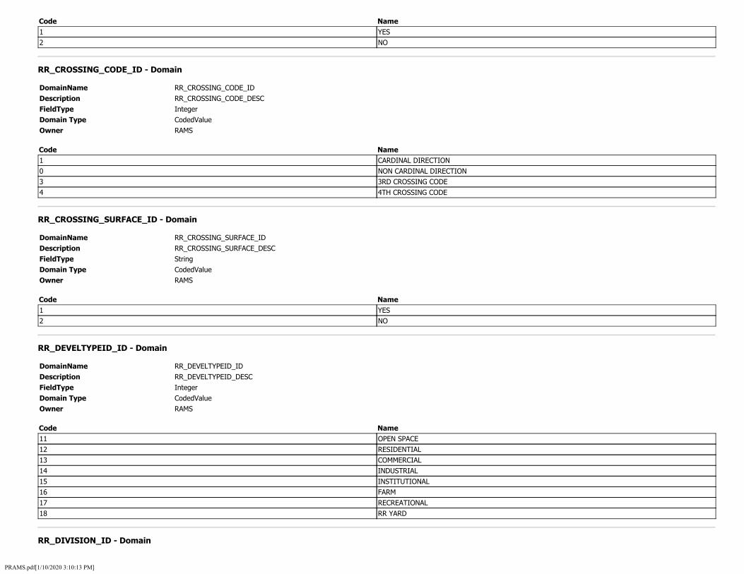
Code Name 1 YES 2 NO
RR_CROSSING_CODE_ID - Domain
DomainName RR_CROSSING_CODE_ID Description RR_CROSSING_CODE_DESC FieldType Integer Domain Type CodedValue Owner RAMS
Code Name 1 CARDINAL DIRECTION 0 NON CARDINAL DIRECTION 3 3RD CROSSING CODE 4 4TH CROSSING CODE
RR_CROSSING_SURFACE_ID - Domain
DomainName RR_CROSSING_SURFACE_ID Description RR_CROSSING_SURFACE_DESC FieldType String Domain Type CodedValue Owner RAMS
Code Name 1 YES 2 NO
RR_DEVELTYPEID_ID - Domain
DomainName RR_DEVELTYPEID_ID Description RR_DEVELTYPEID_DESC FieldType Integer Domain Type CodedValue Owner RAMS
Code Name 11 OPEN SPACE 12 RESIDENTIAL 13 COMMERCIAL 14 INDUSTRIAL 15 INSTITUTIONAL 16 FARM 17 RECREATIONAL 18 RR YARD
RR_DIVISION_ID - Domain
PRAMS.pdf[1/10/2020 3:10:13 PM]

DomainName RR_DIVISION_ID Description RR_DIVISION_DESC FieldType Integer Domain Type CodedValue Owner RAMS
Code Name 21 BLANK NO. 1 35 CEDAR 41 CEDAR-RAPIDS 37 CEDAR RAPIDS 39 CEDAR RIVER 26 CENTERVILLE 27 CENTRAL 43 CHARLES CITY 24 CHICAGO 28 COUNCIL 45 COUNCIL BLUFF 22 COUNCIL BLUFFS 32 CR 9 DAKOTA 47 DALLAS 49 DES 11 DES MOINES 51 DES MOINES DIV 53 DESMOINES 55 DESMOINESDIV 57 EA 59 east 61 EAST IOWA 63 EAST REGION 5 EASTERN 10 EVERIST 65 GALESBURG 14 GATEWAY 67 GULF 69 HANN 71 HANNIBAL 13 HEARTLAND 75 IL-IA 73 IL IA 81 ILL-IA 83 ILL-IOWA 77 ILL IA 79 ILL IOWA 6 ILLINOIS 85 IM D 87 IM&D 8 IOWA 89 IOWA FALLS 91 IWOA
PRAMS.pdf[1/10/2020 3:10:13 PM]

15 KANSAS CITY 93 LAKES 95 LAKESGO 97 LEASED/FOREIGN 99 LEASEDFOREIGN 101 LIN. DIV. 103 LINCOLN 30 MASON CITY 2 MIDWEST 105 MINN 107 MO-KAN 33 MOBERLY 109 NEBR 12 NEBRASKA 111 NONCORE 113 NONE 29 NORTH 19 NORTHERN 0 OTHER 115 OTT 117 OTTUMWA 31 QUAD CITIES 119 SOUTH 121 SOUTH REGION 20 SOUTHERN 25 SPRINGFIELD 3 SYSTEM 123 SYSTEM 125 THREE 23 TWIN CITIES 127 UNION PACIFIC 129 WAVERLY 131 WEST 133 WEST BEND 17 WEST IOWA 18 WESTERN 137 WLOO-TERMINAL 135 WLOO TERMINAL 139 IAIS 141 NORTH PLATTE
RR_DOWNST_ID - Domain
DomainName RR_DOWNST_ID Description RR_DOWNST_DESC FieldType Integer Domain Type CodedValue Owner RAMS
Code Name
PRAMS.pdf[1/10/2020 3:10:13 PM]

1 YES 2 NO
RR_EMONITORDVCE_ID - Domain
DomainName RR_EMONITORDVCE_ID Description RR_EMONITORDVCE_DESC FieldType Integer Domain Type CodedValue Owner RAMS
Code Name 1 YES 2 NO
RR_EMRGNCYSRVC_ID - Domain
DomainName RR_EMRGNCYSRVC_ID Description RR_EMRGNCYSRVC_DESC FieldType Integer Domain Type CodedValue Owner RAMS
Code Name 1 YES 2 NO
RR_ENSSIGN_ID - Domain
DomainName RR_ENSSIGN_ID Description RR_ENSSIGN_DESC FieldType Integer Domain Type CodedValue Owner RAMS
Code Name 1 YES 2 NO
RR_EXEMPT_ID - Domain
DomainName RR_EXEMPT_ID Description RR_EXEMPT_DESC FieldType Integer Domain Type CodedValue Owner RAMS
Code Name 1 YES CROSSING IS EXEMPT 2 NO CROSSING IS NOT EXEMPT
PRAMS.pdf[1/10/2020 3:10:13 PM]

RR_GATECONF_ID - Domain
DomainName RR_GATECONF_ID Description RR_GATECONF_DESC FieldType Integer Domain Type CodedValue Owner RAMS
Code Name 1 2 QUAD 2 3 QUAD 3 4 QUAD
RR_GATECONFTYPE_ID - Domain
DomainName RR_GATECONFTYPE_ID Description RR_GATECONFTYPE_DESC FieldType Integer Domain Type CodedValue Owner RAMS
Code Name 4 FULL (BARRIER) RESISTANCE 6 MEDIAN GATES
RR_HEALTHMONITOR_ID - Domain
DomainName RR_HEALTHMONITOR_ID Description RR_HEALTHMONITOR_DESC FieldType Integer Domain Type CodedValue Owner RAMS
Code Name 1 YES 2 NO
RR_HWTRFPSIG_ID - Domain
DomainName RR_HWTRFPSIG_ID Description RR_HWTRFPSIG_DESC FieldType Integer Domain Type CodedValue Owner RAMS
Code Name 1 YES 2 NO
PRAMS.pdf[1/10/2020 3:10:13 PM]

RR_HWYCLASSCD_ID - Domain
DomainName RR_HWYCLASSCD_ID Description RR_HWYCLASSCD_DESC FieldType Integer Domain Type CodedValue Owner RAMS
Code Name 0 RURAL 1 URBAN
RR_HWYCLASSRDTPID_ID - Domain
DomainName RR_HWYCLASSRDTPID_ID Description RR_HWYCLASSRDTPID_DESC FieldType Integer Domain Type CodedValue Owner RAMS
Code Name 11 INTERSTATE 12 OTHER FREEWAYS AND EXPRESSWAYS 13 OTHER PRINCIPAL ARTERIAL 16 MINOR ARTERIAL 17 MAJOR COLLECTOR 18 MINOR COLLECTOR 19 LOCAL
RR_HWYNEAR_ID - Domain
DomainName RR_HWYNEAR_ID Description RR_HWYNEAR_DESC FieldType Integer Domain Type CodedValue Owner RAMS
Code Name 1 YES 2 NO
RR_HWYNRSIG_ID - Domain
DomainName RR_HWYNRSIG_ID Description RR_HWYNRSIG_DESC FieldType Integer Domain Type CodedValue Owner RAMS
Code Name 1 YES
PRAMS.pdf[1/10/2020 3:10:13 PM]

2 NO
RR_HWYPVED_ID - Domain
DomainName RR_HWYPVED_ID Description RR_HWYPVED_DESC FieldType Integer Domain Type CodedValue Owner RAMS
Code Name 1 YES 2 NO
RR_HWYSPEEDPS_ID - Domain
DomainName RR_HWYSPEEDPS_ID Description RR_HWYSPEEDPS_DESC FieldType Integer Domain Type CodedValue Owner RAMS
Code Name 1 POSTED 2 STATUTORY
RR_HWYSYS_ID - Domain
DomainName RR_HWYSYS_ID Description RR_HWYSYS_DESC FieldType Integer Domain Type CodedValue Owner RAMS
Code Name 1 INTERSTATE HIGHWAY SYSTEM 2 OTHER NAT HWY SYSTEM (NHS) 3 FEDERAL AID, NOT NHS 8 NON FEDERAL AID
RR_HWYTRAFSIGNL_ID - Domain
DomainName Description FieldType Domain Type Owner
RR_HWYTRAFSIGNL_ID RR_HWYTRAFSIGNL_DESC Integer CodedValue RAMS
Code 1
Name YES
PRAMS.pdf[1/10/2020 3:10:13 PM]

2 NO
RR_ILLUMINA_ID - Domain
DomainName RR_ILLUMINA_ID Description RR_ILLUMINA_DESC FieldType Integer Domain Type CodedValue Owner RAMS
Code Name 1 YES 2 NO
RR_INTRPRMP_ID - Domain
DomainName RR_INTRPRMP_ID Description RR_INTRPRMP_DESC FieldType String Domain Type CodedValue Owner RAMS
Code Name 1 YES 2 NO
RR_LLSOURCE_ID - Domain
DomainName RR_LLSOURCE_ID Description RR_LLSOURCE_DESC FieldType Integer Domain Type CodedValue Owner RAMS
Code Name 1 ACTUAL 2 ESTIMATED
RR_LOW_GRND_ID - Domain
DomainName RR_LOW_GRND_ID Description RR_LOW_GRND_DESC FieldType Integer Domain Type CodedValue Owner RAMS
Code Name 1 YES 2 NO
PRAMS.pdf[1/10/2020 3:10:13 PM]

RR_LT1MOV_ID - Domain
DomainName RR_LT1MOV_ID Description RR_LT1MOV_DESC FieldType Integer Domain Type CodedValue Owner RAMS
Code Name 1 LESS THAN ONE MOVEMENT PER DAY 2 ONE OR MORE MOVEMENT PER DAY
RR_LT1PASSMOV_ID - Domain
DomainName RR_LT1PASSMOV_ID Description RR_LT1PASSMOV_DESC FieldType Integer Domain Type CodedValue Owner RAMS
Code Name 1 LESS THAN ONE PER DAY 2 ONE OR MORE PER DAY
RR_MAST_BACKLIGHT_ID - Domain
DomainName RR_MAST_BACKLIGHT_ID Description RR_MAST_BACKLIGHT_DESC FieldType Integer Domain Type CodedValue Owner RAMS
Code Name 1 YES 2 NO
RR_MAST_FLASH_TYPE_ID - Domain
DomainName RR_MAST_FLASH_TYPE_ID Description RR_MAST_FLASH_TYPE_DESC FieldType Integer Domain Type CodedValue Owner RAMS
Code Name 0 NONE 1 INCANDESCENT 2 LED
RR_MAST_SIDELIGHT_ID - Domain
PRAMS.pdf[1/10/2020 3:10:13 PM]

DomainName RR_MAST_SIDELIGHT_ID Description RR_MAST_SIDELIGHT_DESC FieldType Integer Domain Type CodedValue Owner RAMS
Code Name 1 YES 2 NO
RR_MONITOR_DEVICE_ID - Domain
DomainName RR_MONITOR_DEVICE_ID Description RR_MONITOR_DEVICE_DESC FieldType String Domain Type CodedValue Owner RAMS
Code Name 1 YES 2 NO
RR_NEAR_CITY_ID - Domain
DomainName RR_NEAR_CITY_ID Description RR_NEAR_CITY_DESC FieldType Integer Domain Type CodedValue Owner RAMS
Code Name 0 IN 1 NEAR
RR_NOSIGNS_ID - Domain
DomainName RR_NOSIGNS_ID Description RR_NOSIGNS_DESC FieldType Integer Domain Type CodedValue Owner RAMS
Code Name 1 YES 2 NO
RR_OPENPUB_ID - Domain
DomainName Description
RR_OPENPUB_ID RR_OPENPUB_DESC
PRAMS.pdf[1/10/2020 3:10:13 PM]

FieldType Integer Domain Type CodedValue Owner RAMS
Code Name 1 YES 2 NO
RR_OTHSGN_ID - Domain
DomainName RR_OTHSGN_ID Description RR_OTHSGN_DESC FieldType String Domain Type CodedValue Owner RAMS
Code Name 1 YES 2 NO
RR_PAVEMENT_MARKINGS_ID - Domain
DomainName RR_PAVEMENT_MARKINGS_ID Description RR_PAVEMENT_MARKINGS_DESC FieldType String Domain Type CodedValue Owner RAMS
Code Name 1 YES 2 NO
RR_PED_SIDEWALK_ID - Domain
DomainName RR_PED_SIDEWALK_ID Description RR_PED_SIDEWALK_DESC FieldType Integer Domain Type CodedValue Owner RAMS
Code Name 1 1 SIDE OF STREET 2 BOTH SIDES OF STREET
RR_POSXING_ID - Domain
DomainName Description FieldType Domain Type
RR_POSXING_ID RR_POSXING_DESC Integer CodedValue
PRAMS.pdf[1/10/2020 3:10:13 PM]

Owner RAMS
Code Name 1 AT GRADE 2 RR UNDER 3 RR OVER
RR_POSXING_LU - Domain
DomainName Description FieldType Domain Type Owner
RR_POSXING_LU RR_POSXING Integer CodedValue RAMS
Code Name 1 1 - AT GRADE 2 2 - RR UNDER 3 3 - RR OVER
RR_PREMPTYPE_ID - Domain
DomainName RR_PREMPTYPE_ID Description RR_PREMPTYPE_DESC FieldType Integer Domain Type CodedValue Owner RAMS
Code Name 1 SIMULTANEOUS 2 ADVANCE
RR_PRVXSIGN_ID - Domain
DomainName RR_PRVXSIGN_ID Description RR_PRVXSIGN_DESC FieldType Integer Domain Type CodedValue Owner RAMS
Code Name 0 NULL 1 YES 2 NO
RR_SAME_TRACKS_ID - Domain
DomainName RR_SAME_TRACKS_ID Description RR_SAME_TRACKS_DESC FieldType Integer
PRAMS.pdf[1/10/2020 3:10:13 PM]
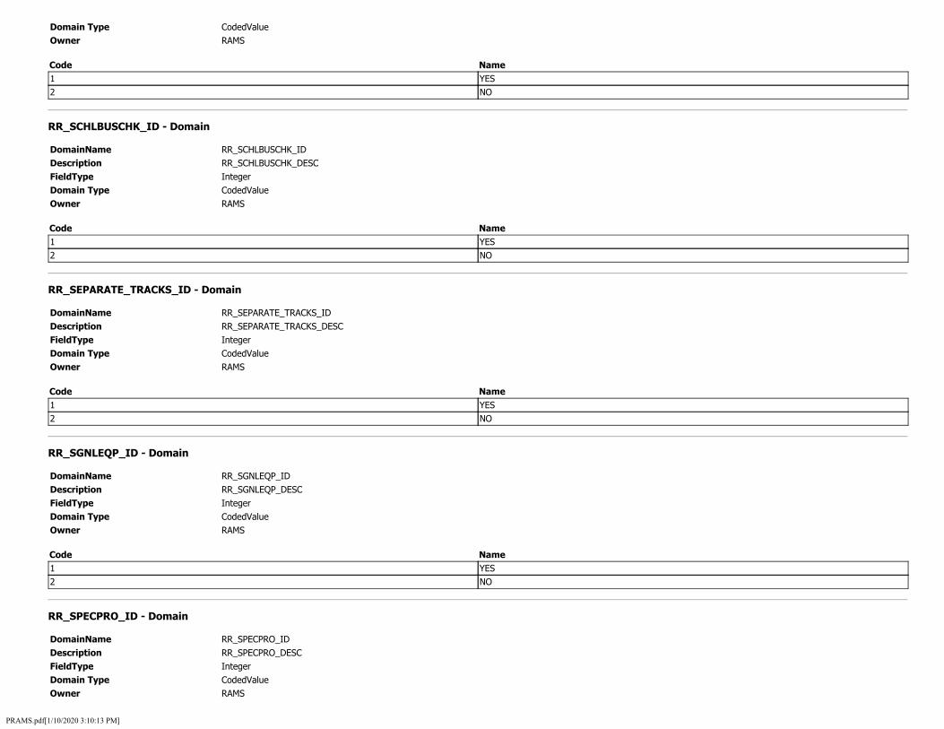
Domain Type CodedValue Owner RAMS
Code Name 1 YES 2 NO
RR_SCHLBUSCHK_ID - Domain
DomainName RR_SCHLBUSCHK_ID Description RR_SCHLBUSCHK_DESC FieldType Integer Domain Type CodedValue Owner RAMS
Code Name 1 YES 2 NO
RR_SEPARATE_TRACKS_ID - Domain
DomainName RR_SEPARATE_TRACKS_ID Description RR_SEPARATE_TRACKS_DESC FieldType Integer Domain Type CodedValue Owner RAMS
Code Name 1 YES 2 NO
RR_SGNLEQP_ID - Domain
DomainName RR_SGNLEQP_ID Description RR_SGNLEQP_DESC FieldType Integer Domain Type CodedValue Owner RAMS
Code Name 1 YES 2 NO
RR_SPECPRO_ID - Domain
DomainName RR_SPECPRO_ID Description RR_SPECPRO_DESC FieldType Integer Domain Type CodedValue Owner RAMS
PRAMS.pdf[1/10/2020 3:10:13 PM]

Code Name 0 NONE 1 FLAGGING / FLAGMAN 2 MANUALLY OPERATED SIGNALS 3 WATCHMAN 4 FLOODLIGHTING
RR_SPSELIDS_ID - Domain
DomainName RR_SPSELIDS_ID Description RR_SPSELIDS_DESC FieldType Integer Domain Type CodedValue Owner RAMS
Code Name 0 NONE 11 CONSTANT WARNING TIME 12 MOTION DETECTION 14 OTHER 16 AFO 17 PTC 18 DC
RR_STATUS_ID - Domain
DomainName RR_STATUS_ID Description RR_STATUS_DESC FieldType Integer Domain Type CodedValue Owner RAMS
Code Name 1 OPEN 2 CLOSED 3 NO TRAIN TRAFFIC -1 OPEN NO ROAD DATA
RR_STATUS_LU - Domain
DomainName Description FieldType Domain Type Owner
RR_STATUS_LU RR_STATUS Integer CodedValue RAMS
Code Name 1 1 - OPEN 2 2 - CLOSED 3 3 - NO TRAIN TRAFFIC
PRAMS.pdf[1/10/2020 3:10:13 PM]

-1 -1 - OPEN NO ROAD DATA
RR_STHWY1_ID - Domain
DomainName RR_STHWY1_ID Description RR_STHWY1_DESC FieldType Integer Domain Type CodedValue Owner RAMS
Code Name 1 YES 2 NO
RR_SUB_DIVISION_ID - Domain
DomainName RR_SUB_DIVISION_ID Description RR_SUB_DIVISION_DESC FieldType Integer Domain Type CodedValue Owner RAMS
Code Name 141 #4 143 #5 145 #N\A 147 0SKALOOSA 119 10 149 10-B 151 10TH SUBDIV. 121 11 153 11 B 155 11B 157 11TH 123 12 161 12-A 163 12-B 165 12-C 159 12A 167 12TH 125 13 169 13A 171 13C 127 14 173 14-B 175 14TH 129 15 131 16 177 16-A 179 16TH
PRAMS.pdf[1/10/2020 3:10:13 PM]

133 17 135 25 137 26 181 2ND 109 3 139 31 183 3RD 111 4 185 4-A 189 4-B 187 4B 113 5 191 5-A 195 5-C 193 5C 197 7TH 115 8 199 8TH 117 9 37 ABERDEEN 201 ALBERRT LEA 16 ALBERT LEA 203 ALBERT LEA SUB 205 ALDEN 2 ALDEN IND LD 207 AMANA 4 ANKENY 209 ANKENY BR 211 ANKENY IND LD 5 APPANOOSE 213 AUSTIN 50 BANKED TRACK 24 BAYARD 215 BAYARD SUB 84 BELL AV IND LD 217 BELL AVE IND L 219 BELMOND 221 BERESFORD 18 BLAIR 223 BLAIR SUB 225 Bondurant Ind Ld 19 BOONE 227 BOONE SUB 229 BOONE SUBS 8 BRISTOW 231 BRISTOW spur 9 BURLINGTON 233 BURLINGTON YD, 235 BURT 95 CB RIVR TRK LD
PRAMS.pdf[1/10/2020 3:10:13 PM]

237 CEADR RAPIDS 253 CEDAR-RAPIDS 239 cedar falls 241 CEDAR FLLS SUB 243 CEDAR RADIPS 245 cedar rapdis 11 CEDAR RAPIDS 247 Cedar Rapids Ind Ld 249 Cedar Rapids North Yard 251 cedar rapidss 23 CEDRRPDS IND 107 CFU 255 cfu spur 257 CHARITON YD, I 54 CHARLES CITY 12 CHEROKEE 259 CHICAGO 88 CHILLICOTHE 10 CLINTON 261 CLINTON SUB 93 CLINTON YARD 263 CLINTON YD, IA 265 CO BLUFFS 267 CONRAD 269 COUNCIL BLUFFS 13 COUNCILBLUFFS 66 CRESTON 89 CRESTON-GREENF 275 CRESTON-GREENFIELD 271 CRESTON SUB 273 CRESTON YD, IA 94 CURWOOD 96 DAVENPORT 15 DES MOINES 277 DES MOINES NS 279 DES MOINES SUB 281 DES MOINES YD, 283 DIKE 1 DMU TERMINAL 285 Dows Ind Ld 101 DSM YARDS 20 DUBUQUE 287 DUBUQUE SUB 289 DUBUQUE YD IA 291 DYSART 293 EA 295 Eagle Grove Ind Ld 17 EAGLEGROVE IND 297 EAST IOWA 299 EASTERN
PRAMS.pdf[1/10/2020 3:10:13 PM]

301 EIGHTEENTH 303 EIGHTH 100 ELDRIDGE 305 ELEVENTH 307 ELLSWORTH 33 ELLSWORTH IND 309 ESTHERVILE 26 ESTHERVILLE 27 FAIRMONT 311 Farnhamville Ind Ld 97 FARNHAMVLLE IN 313 FIFTEENTH 315 FIFTH 30 FIRST 317 FLUGSTAD 319 FLUGSTAD SUB 321 FOREST CITY 323 FOREST CITY SB 325 Fort Dodge 31 FORT DODGE IND 327 Fort Dodge Ind Ld 51 FORT DODGE SD 329 FORT DODGE ST 331 FORT DODGE SUB 333 FORT MADISON Y 335 FOUR 67 FOUR-A 68 FOUR-B 337 FOUR - A 339 FOUR - B 341 FOUR -B 343 FOURTEENTH 32 FOURTH 345 FT DODGE 347 FT DODGE SUB 349 FT MADISON YD 102 GARNER 35 GENEVA 351 GOWRIE 353 GRANGER 355 Great Western Council Bluffs 357 GREENE 34 GYPSUM LEAD 85 H 359 HALFA 29 HANNIBAL 361 HANNIBAL SUB 363 HARLAN 365 HAWARDEN 367 HAWARDEV
PRAMS.pdf[1/10/2020 3:10:13 PM]

369 HAWAREDN 371 HERNDON 373 HICKS 375 HILLS 377 HOLLINGSWORTH 379 HOLSTEIN 381 HOLTSTEIN 86 HOLWTH IND LD 47 HULL AV IND LD 383 Hull Ave Ind Ld 385 IAIS 387 IASI 38 IDA GROVE 39 IOWA CITY 389 IOWA FALLS 391 JACKSON 41 JEWELL 393 JEWELL SUB 395 KANAWAHA IND L 82 KANAWHA IND LD 42 KANSAS CITY 397 KELSEY 43 KEOKUK 399 KEOKUK YD IA 401 KEOKUK YD, IA 403 KESLEY 44 KLEMME 75 LAKE MILLS IND 405 Lake Mills Ind Ld 407 LAREDO 45 LAURENS 409 LAURENS SUB 411 LE MARS 413 LEMARS 72 LUVERNE IND LD 435 M''TOWN 415 M TOWN 417 MAINLY 419 malny 36 MANLY 77 MARCELINE 63 MARQUETTE 421 MARSAHLLTOWN 28 MARSHALL 423 MARSHALLTOWN 425 MARSHALLTOWN I 48 MARSHALLTWN LD 427 MASION CITY 49 MASON CITY 73 MASON CITY
PRAMS.pdf[1/10/2020 3:10:13 PM]

429 Mason City Ind Ld 431 MASON CITY SUB 21 MILWAUKEE 433 MOBERLY 22 NAPIER 437 NEBR 439 NEBRASKA 441 NEBRASKA DIV 443 NEWTON 445 NINTH 447 NONE 449 NS DES MOINES 451 NS: DES MOINES 453 NW 103 OELWEIN 455 OELWEIN SUB 80 OMAHA 457 OMAHA SUB 459 ONAWA 461 ONE 52 OSAGE 463 OSCEOLA YD, IA 53 OSKALOOSA 40 OSKALOOSA LEAD 465 OSKALOOSA SUB 0 OTHER 78 OTTUMWA 467 OTTUMWA SUB 469 OTTUMWA YD, IA 471 OWATANNO 6 OWATONNA 473 PACIFIC JCT YD 475 PALMER 477 PANORA 479 PARKERSBURG 57 PERRY 481 PERRY SUB 483 PERYY SUB 485 Powerville Ind Ld 58 RAKE 487 RAKE SUB 90 RED OAK-FARRAG 491 RED OAK-FARRAGUT 92 RED OAK-GRISWO 489 RED OAK YD, IA 14 RIVER 493 RIVER TRACK 495 RIVER TRACK LD 76 RIVER TRKLD-CB 497 ROCHESTER
PRAMS.pdf[1/10/2020 3:10:13 PM]

65 ROCKWELL IND 499 rockwell ind ld 25 ROELYN IND LD 501 ROELYND IND LD 503 ROYAL IND LD 56 ROYAL IND LEAD 7 SCENIC 505 SECOND 104 SERGEANT BLUFF 507 Sergeant Bluff Ind Ld 509 SEVENTEENTH 511 SEVENTH 99 SGT BLF IND LD 106 SHELDON 61 SIOUX CITY 513 SIOUX CITY EAS 515 SIOUX CITY EAST YD, IA 517 SIOUX CITY MIL 519 SIOUX CITY TER 91 SIOUX CITY YD 521 SIOUX CITY YD, 523 SIOUX CITY YD, IA 525 SIOUX FALLS 527 SIOUX RA 529 SIOUX RAPIDS 531 SIOUXCITY 533 SIXTEENTH 535 SIXTH 537 SOMERS 79 STACYVILLE 81 STEAMBOAT ROCK 547 SUB-DIVN 15 549 SUB-DIVN 16 539 SUBDIVISION 541 SUBDIVISION 1 543 SUBDIVISION 3 545 SUBDIVISION 4 105 SUBDIVISION1 69 SWANWOOD LEAD 64 TARA 551 TEN-B 553 TENTH 59 THIRD 555 THIRTEENTH 3 THREE 70 TRENTON 557 TRENTON SUB 559 TRRA: HANNIBAL 561 TWELFTH 563 Twelfth St. Lead C.Bluffs
PRAMS.pdf[1/10/2020 3:10:13 PM]

577 TWENTY-EIGHTH 581 TWENTY-FOURTH 583 TWENTY-NI12 585 TWENTY-NINTH 587 TWENTY-SEVENTH 589 TWENTY-SIXTH 565 TWENTY EIGHTH 567 TWENTY FIRST 569 TWENTY FOUR 571 TWENTY NINTH 573 TWENTY SIXTH 575 TWENTY THIRD 579 TWENTYFOURTH 60 UNKNOWN 62 UNKNOWN 591 WALL LACE 593 WALL LAKE 595 WASHINGTON 98 WATERLOO 597 Waterloo Ind Ld 71 WATERLOO LEAD 55 WAUKEE IND LD 599 WAVELY 83 WAVERLY 601 WAVERLY SUB 603 WEST BEND 605 WEST BURLINGTO 74 WEST IOWA 607 WESTERN 87 WICKMAN SPUR 46 WORTHINGTON 609 WORTHINGTON SU 611 YARDS 613 COUNCIL BLUFFS YD 615 ISRY 617 WORTHINGTON SUB 619 SIBLEY SPUR
RR_TRAFLNTYPE_ID - Domain
DomainName RR_TRAFLNTYPE_ID Description RR_TRAFLNTYPE_DESC FieldType Integer Domain Type CodedValue Owner RAMS
Code Name 1 ONE WAY TRAFFIC 2 TWO WAY TRAFFIC 3 DIVIDED TRAFFIC
PRAMS.pdf[1/10/2020 3:10:13 PM]

RR_TYPETRNSRVCIDS_ID - Domain
DomainName RR_TYPETRNSRVCIDS_ID Description RR_TYPETRNSRVCIDS_DESC FieldType Integer Domain Type CodedValue Owner RAMS
Code Name 11 FREIGHT 12 INTERCITY PASSENGER 13 COMMUTER 14 TRANSIT 15 SHARED USE TRANSIT 16 TOURIST / OTHER
RR_TYPEXING_ID - Domain
DomainName RR_TYPEXING_ID Description RR_TYPEXING_DESC FieldType Integer Domain Type CodedValue Owner RAMS
Code Name 2 PRIVATE 3 PUBLIC 1 PEDESTRIAN
RR_TYPEXING_LU - Domain
DomainName Description FieldType Domain Type Owner
RR_TYPEXING_LU RR_TYPEXING Integer CodedValue RAMS
Code Name 2 2 - PRIVATE 3 3 - PUBLIC 1 1 - PEDESTRIAN
RR_WHISTBAN_ID - Domain
DomainName RR_WHISTBAN_ID Description RR_WHISTBAN_DESC FieldType Integer Domain Type CodedValue Owner RAMS
PRAMS.pdf[1/10/2020 3:10:13 PM]

Code Name 0 NO 1 24 HOUR 2 PARTIAL 3 CHICAGO EXCUSED
RR_XANGLE_ID - Domain
DomainName RR_XANGLE_ID Description RR_XANGLE_DESC FieldType Integer Domain Type CodedValue Owner RAMS
Code Name 1 0-29 DEGREES 2 30-59 DEGREES 3 60-90 DEGREES
RR_XINGADJ_ID - Domain
DomainName RR_XINGADJ_ID Description RR_XINGADJ_DESC FieldType Integer Domain Type CodedValue Owner RAMS
Code Name 1 YES 2 NO
RR_XPURPOSE_ID - Domain
DomainName RR_XPURPOSE_ID Description RR_XPURPOSE_DESC FieldType Integer Domain Type CodedValue Owner RAMS
Code Name 1 HIGHWAY 2 PATHWAY PEDESTRIAN 3 STATION PEDESTRIAN
RUMBLE_TYPE_ID - Domain
DomainName Description FieldType Domain Type
RUMBLE_TYPE_ID RUMBLE_TYPE_DESC Integer CodedValue
PRAMS.pdf[1/10/2020 3:10:13 PM]

Owner RAMS
Code Name 2 LEFT SHOULDER RUMBLE 3 RIGHT SHOULDER RUMBLE
SHOULDER_TIED_ID - Domain
DomainName SHOULDER_TIED_ID Description SHOULDER_TIED_DESC FieldType Integer Domain Type CodedValue Owner RAMS
Code Name 1 SHOULDER TIED
SHOULDER_TYPE_ID - Domain
DomainName SHOULDER_TYPE_ID Description SHOULDER_TYPE_DESC FieldType Integer Domain Type CodedValue Owner RAMS
Code Name 1 1 - EARTH 2 2 - GRAVEL 6 6 - PAVED 7 7 - COMBO PAVED AND EARTH 8 8 - COMBO PAVED AND GRAVEL 9 9 - COMBO PAVED AND PAVED
SPECIAL_SYSTEM_ID - Domain
DomainName SPECIAL_SYSTEM_ID Description SPECIAL_SYSTEM_DESC FieldType Integer Domain Type CodedValue Owner RAMS
Code Name 2 2 - NATIONAL FOREST HIGHWAY SYSTEM 3 3 - NATIONAL FOREST DEVELOPMENT ROADS AND TRAILS 4 4 - NATIONAL PARK SERVICE PARKWAY 5 5 - NATIONAL PARK ROADS AND TRAILS 6 6 - INDIAN RESERVATION ROADS AND BRIDGES 10 10 - APPALACHAIN DEVELOPMENT HIGHWAY 15 15 - APPALACHAIN HIGHWAY ACCESS ROAD 25 25 - GREAT RIVER ROAD (23 U.S.C. 148)
PRAMS.pdf[1/10/2020 3:10:13 PM]

26 26 - LOESS HILLS SCENIC BYWAY SPINE (23 U.S.C.) 27 27 - LOESS HILLS SCENIC BYWAY LOOPS (23 U.S.C.) 30 30 - DEFENSE ACCESS ROAD (23 U.S.C. 210) 40 40 - ADDITION TO THE INTERSTATE SYSTEM (23 U.S.C. 139 (A)) 41 41 - ADDITION TO THE INTERSTATE SYSTEM (23 U.S.C. 139 (C)) 42 42 - ADDITION TO THE INTERSTATE SYSTEM (23 U.S.C. 135 (B)) 50 50 - CONGRESSIONAL HIGHWAY SYSTEM (AVENUE OF THE SAINTS)
SPEED_LIMIT_ID - Domain
DomainName SPEED_LIMIT_ID Description SPEED_LIMIT_DESC FieldType Integer Domain Type CodedValue Owner RAMS
Code Name 5 5 MPH 10 10 MPH 15 15 MPH 20 20 MPH 25 25 MPH 30 30 MPH 35 35 MPH 40 40 MPH 45 45 MPH 50 50 MPH 55 55 MPH 60 60 MPH 65 65 MPH 70 70 MPH
STATE_FREIGHT_NETWORK_ID - Domain
DomainName STATE_FREIGHT_NETWORK_ID Description STATE_FREIGHT_NETWORK_DESC FieldType Integer Domain Type CodedValue Owner RAMS
Code Name 1 STATE FREIGHT NETWORK
STOP_RESTRICTION_ID - Domain
DomainName STOP_RESTRICTION_ID Description STOP_RESTRICTION_DESC FieldType Integer Domain Type Range Owner RAMS
PRAMS.pdf[1/10/2020 3:10:13 PM]

Minimum Value Maximum Value
STRATEGIC_HWY_NETWORK_ID - Domain
DomainName STRATEGIC_HWY_NETWORK_ID Description STRATEGIC_HWY_NETWORK_DESC FieldType Integer Domain Type CodedValue Owner RAMS
Code Name 1 1 - ON THE STRATEGIC HIGHWAY NETWORK 2 2 - CONNECTOR
STRUC_HIST_SIG_ID - Domain
DomainName STRUC_HIST_SIG_ID Description STRUC_HIST_SIG_DESC FieldType Integer Domain Type CodedValue Owner RAMS
Code Name 1 1 - BRIDGE IS ON NATIONAL REGISTER OF HISTORICAL PLACES 2 2 - BRIDGE IS ELIGIBLE FOR NATIONAL REGISTER OF HISTORICAL PLACES 3 3 - BRIDGE IS POSSIBLY ELIGIBLE FOR NATIONAL REGISTER OF HISTORICAL PLACES 4 4 - HISTORICAL SIGNIFICANCE NOT DETERMINED AT THIS TIME 5 5 - BRIDGE IS NOT ELIGIBLE FOR NATIONAL REGISTER
STRUC_KIND_CROSS_ID - Domain
DomainName STRUC_KIND_CROSS_ID Description STRUC_KIND_CROSS_DESC FieldType Integer Domain Type CodedValue Owner RAMS
Code Name 1 1 - FORD 2 2 - FERRY 3 3 - RAILROAD AT GRADE 4 4 - OVER DRAINAGE 5 5 - OVER RAILROAD 6 6 - OVER RAILROAD AND STREAM 7 7 - UNDER RAILROAD (SIMPLE) 8 8 - UNDER RAILROAD (COMBINED) 9 9 - OVER PARK OR INSTITUTIONAL ROAD 10 10 - UNDER PARK OR INSTITUTIONAL ROAD 11 11 - OVER PRIVATE ROAD
PRAMS.pdf[1/10/2020 3:10:13 PM]

12 12 - UNDER PRIVATE ROAD 15 15 - TUNNEL 17 17 - UNDER PEDESTRIAN WALKWAY 18 18 - SIDE DITCH 20 20 - OVER INTERSTATE 21 21 - UNDER INTERSTATE 30 30 - OVER PRIMARY 31 31 - UNDER PRIMARY 40 40 - OVER ARTERIAL 41 41 - UNDER ARTERIAL 50 50 - OVER MAJOR COLLECTOR 51 51 - UNDER MAJOR COLLECTOR 52 52 - UNDER MINOR COLLECTOR 53 53 - OVER MINOR COLLECTOR 60 60 - OVER LOCAL 61 61 - UNDER LOCAL 62 62 - OVER TRAIL
STRUC_MAINT_DESC_ID - Domain
DomainName STRUC_MAINT_DESC_ID Description STRUC_MAINT_DESC_DESC FieldType String Domain Type CodedValue Owner RAMS
Code Name L L - LEFT BRIDGE SB_WB LANE OF TWIN BRIDGES R R - RIGHT BRIDGE NB_EB LANE OF TWIN BRIDGES S S - SINGLE BRIDGE ON NORMAL ROADWAY O O - OVERHEAD BRIDGE TRAVELING UNDER BRIDGE A A - RAMP - LOOP - OTHER NON-MAINLINE BRIDGE B B - BRIDGELET - STRUCTURE SMALLER THAN NBI BRIDGE X X - RAILROAD BRIDGE OVERHEAD P P - PEDESTRIAN BRIDGE OVERHEAD T T - TUNNEL
STRUC_NBIA_ITEM_ID - Domain
DomainName STRUC_NBIA_ITEM_ID Description STRUC_NBIA_ITEM_DESC FieldType String Domain Type CodedValue Owner RAMS
Code Name Y NBI Bridge N Non-NBI Bridge
STRUC_STATUS_ID - Domain
PRAMS.pdf[1/10/2020 3:10:13 PM]

DomainName STRUC_STATUS_ID Description STRUC_STATUS_DESC FieldType Integer Domain Type CodedValue Owner RAMS
Code Name 1 1 - OPEN 2 2 - CLOSED 3 3 - PENDING
STRUC_TWIN_DIVIDED_ID - Domain
DomainName STRUC_TWIN_DIVIDED_ID Description STRUC_TWIN_DIVIDED_DESC FieldType String Domain Type CodedValue Owner RAMS
Code Name 0 0 - NOT TWIN OR DIVIDED T T - TWIN D D - DIVIDED O O - NOT TWIN OR DIVIDED
STRUC_TYPE_RECORD_ID - Domain
DomainName STRUC_TYPE_RECORD_ID Description STRUC_TYPE_RECORD_DESC FieldType Integer Domain Type CodedValue Owner RAMS
Code Name 0 0 - ALL OTHER MAINLINE 2 2 - EASTBOUND 3 3 - WESTBOUND 4 4 - NORTHBOUND 5 5 - SOUTHBOUND 6 6 - RAMP OR LOOP 7 7 - SIDE DITCH BRIDGE
STRUC_VERT_REF_FEA_ID - Domain
DomainName STRUC_VERT_REF_FEA_ID Description STRUC_VERT_REF_FEA_DESC FieldType String Domain Type CodedValue Owner RAMS
PRAMS.pdf[1/10/2020 3:10:13 PM]
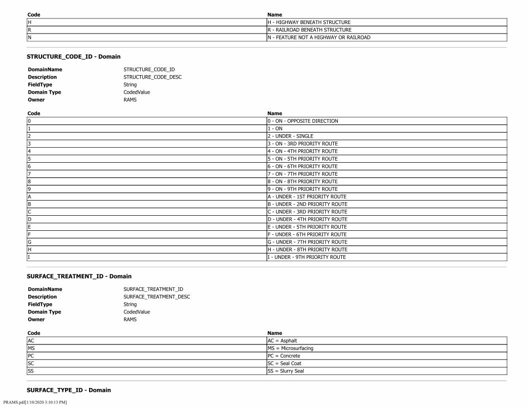
Code Name H H - HIGHWAY BENEATH STRUCTURE R R - RAILROAD BENEATH STRUCTURE N N - FEATURE NOT A HIGHWAY OR RAILROAD
STRUCTURE_CODE_ID - Domain
DomainName STRUCTURE_CODE_ID Description STRUCTURE_CODE_DESC FieldType String Domain Type CodedValue Owner RAMS
Code Name 0 0 - ON - OPPOSITE DIRECTION 1 1 - ON 2 2 - UNDER - SINGLE 3 3 - ON - 3RD PRIORITY ROUTE 4 4 - ON - 4TH PRIORITY ROUTE 5 5 - ON - 5TH PRIORITY ROUTE 6 6 - ON - 6TH PRIORITY ROUTE 7 7 - ON - 7TH PRIORITY ROUTE 8 8 - ON - 8TH PRIORITY ROUTE 9 9 - ON - 9TH PRIORITY ROUTE A A - UNDER - 1ST PRIORITY ROUTE B B - UNDER - 2ND PRIORITY ROUTE C C - UNDER - 3RD PRIORITY ROUTE D D - UNDER - 4TH PRIORITY ROUTE E E - UNDER - 5TH PRIORITY ROUTE F F - UNDER - 6TH PRIORITY ROUTE G G - UNDER - 7TH PRIORITY ROUTE H H - UNDER - 8TH PRIORITY ROUTE I I - UNDER - 9TH PRIORITY ROUTE
SURFACE_TREATMENT_ID - Domain
DomainName SURFACE_TREATMENT_ID Description SURFACE_TREATMENT_DESC FieldType String Domain Type CodedValue Owner RAMS
Code Name AC AC = Asphalt MS MS = Microsurfacing PC PC = Concrete SC SC = Seal Coat SS SS = Slurry Seal
SURFACE_TYPE_ID - Domain
PRAMS.pdf[1/10/2020 3:10:13 PM]
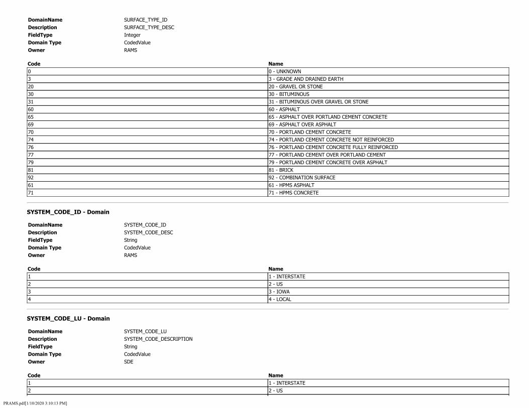
DomainName SURFACE_TYPE_ID Description SURFACE_TYPE_DESC FieldType Integer Domain Type CodedValue Owner RAMS
Code Name 0 0 - UNKNOWN 3 3 - GRADE AND DRAINED EARTH 20 20 - GRAVEL OR STONE 30 30 - BITUMINOUS 31 31 - BITUMINOUS OVER GRAVEL OR STONE 60 60 - ASPHALT 65 65 - ASPHALT OVER PORTLAND CEMENT CONCRETE 69 69 - ASPHALT OVER ASPHALT 70 70 - PORTLAND CEMENT CONCRETE 74 74 - PORTLAND CEMENT CONCRETE NOT REINFORCED 76 76 - PORTLAND CEMENT CONCRETE FULLY REINFORCED 77 77 - PORTLAND CEMENT OVER PORTLAND CEMENT 79 79 - PORTLAND CEMENT CONCRETE OVER ASPHALT 81 81 - BRICK 92 92 - COMBINATION SURFACE 61 61 - HPMS ASPHALT 71 71 - HPMS CONCRETE
SYSTEM_CODE_ID - Domain
DomainName SYSTEM_CODE_ID Description SYSTEM_CODE_DESC FieldType String Domain Type CodedValue Owner RAMS
Code Name 1 1 - INTERSTATE 2 2 - US 3 3 - IOWA 4 4 - LOCAL
SYSTEM_CODE_LU - Domain
DomainName SYSTEM_CODE_LU Description SYSTEM_CODE_DESCRIPTION FieldType String Domain Type CodedValue Owner SDE
Code Name 1 1 - INTERSTATE 2 2 - US
PRAMS.pdf[1/10/2020 3:10:13 PM]
3 3 - IOWA 4 4 - LOCAL
TERRAIN_ID - Domain
DomainName TERRAIN_ID Description TERRAIN_DESC FieldType Integer Domain Type CodedValue Owner RAMS
Code Name 1 1 - FLAT 2 2 - ROLLING 3 3 - HILLY
TIM_ALT_TYPE_ID - Domain
DomainName TIM_ALT_TYPE_ID Description TIM_ALT_TYPE_DESC FieldType Integer Domain Type CodedValue Owner RAMS
Code Name 0 PRIMARY 1 SECONDARY
TIM_DIVERSION_TYPE_ID - Domain
DomainName TIM_DIVERSION_TYPE_ID Description TIM_DIVERSION_TYPE_DESC FieldType Integer Domain Type CodedValue Owner RAMS
Code Name 0 LOCAL 1 GLOBAL
TOLL_AUTHORITY_ID - Domain
DomainName Description FieldType Domain Type Owner
TOLL_AUTHORITY_ID TOLL_AUTHORITY_DESC Integer CodedValue RAMS
Code 70
Name FRANK E. BAUER BRIDGE
PRAMS.pdf[1/10/2020 3:10:13 PM]

71 FORT MADISON BRIDGE 80 BELLEVUE BRIDGE 81 DECATUR BRIDGE 1033 CASSVILLE VILLAGE WI 82 PLATTSMOUTH BRIDGE
TOLL_CHARGED_ID - Domain
DomainName TOLL_CHARGED_ID Description TOLL_CHARGED_DESC FieldType Integer Domain Type CodedValue Owner RAMS
Code Name 1 TOLL CHARGED IN ONE DIRECTION ONLY 2 TOLL CHARGED IN BOTH DIRECTIONS 3 NO TOLL CHARGED
TOLL_STATUS_ID - Domain
DomainName TOLL_STATUS_ID Description TOLL_STATUS_DESC FieldType Integer Domain Type CodedValue Owner RAMS
Code Name 1 1 - TOLL CHARGED IN ONE DIRECTION 2 2 - TOLL CHARGED IN BOTH DIRECTION
TOLL_TYPE_ID - Domain
DomainName TOLL_TYPE_ID Description TOLL_TYPE_DESC FieldType Integer Domain Type CodedValue Owner RAMS
Code Name 1 THIS SECTION HAS TOLL LANES BUT NOT SPECIAL TOLLS (E.G. HOT LANES) 2 THIS SECTION HAS HOT LANES 3 THIS SECTION HAS OTHER SPECIAL TOLLS
TRANSPORTATION_DISTRICT_ID - Domain
DomainName TRANSPORTATION_DISTRICT_ID Description TRANSPORTATION_DISTRICT_DESC FieldType Integer Domain Type CodedValue
PRAMS.pdf[1/10/2020 3:10:13 PM]
Owner RAMS
Code Name 1 1 - CENTRAL 2 2 - NORTHEAST 3 3 - NORTHWEST 4 4 - SOUTHWEST 5 5 - SOUTHEAST 6 6 - EAST CENTRAL
TRAVEL_DIRECTION_ID - Domain
DomainName TRAVEL_DIRECTION_ID Description TRAVEL_DIRECTION_DESC FieldType String Domain Type CodedValue Owner RAMS
Code Name C C - CARDINAL N N - NON-CARDINAL
TRUCK_ROUTE_ID - Domain
DomainName TRUCK_ROUTE_ID Description TRUCK_ROUTE_DESC FieldType Integer Domain Type CodedValue Owner RAMS
Code Name 1 1 - FEDERAL TRUCK ROUTE 2 2 - STATE TRUCK ROUTE
TYPE_AREA_ID - Domain
DomainName TYPE_AREA_ID Description TYPE_AREA_DESC FieldType Integer Domain Type CodedValue Owner RAMS
Code Name 1 1 - CENTRAL BUSINESS DISTRICT 2 2 - FRINGE BUSINESS DISTRICT 3 3 - OUTLYING BUSINESS DISTRICT 4 4 - RESIDENTIAL AREA 5 5 - RURAL AREA
TYPE_DEVELOPMENT_ID - Domain
PRAMS.pdf[1/10/2020 3:10:13 PM]

DomainName TYPE_DEVELOPMENT_ID Description TYPE_DEVELOPMENT_DESC FieldType Integer Domain Type CodedValue Owner RAMS
Code Name 1 1 - RURAL 2 2 - DENSE
URBAN_AREA_CODE_ID - Domain
DomainName URBAN_AREA_CODE_ID Description URBAN_AREA_CODE_DESC FieldType Integer Domain Type CodedValue Owner RAMS
Code Name 801 ALGONA 422 AMES 845 ANAMOSA 803 ATLANTIC 804 BOONE 872 BURLINGTON 805 CARROLL 148 CEDAR RAPIDS 806 CENTERVILLE 808 CHARLES CITY 810 CLARINDA 811 CLEAR LAKE 873 CLINTON 46 COUNCIL BLUFFS 812 CRESTON 74 DAVENPORT 813 DECORAH 814 DENISON 71 DES MOINES 206 DUBUQUE 815 ESTHERVILLE 816 FAIRFIELD 874 FORT DODGE 817 FORT MADISON 841 GLENWOOD 818 GRINNELL 849 HUMBOLDT 820 INDEPENDENCE 821 INDIANOLA 327 IOWA CITY 822 IOWA FALLS
PRAMS.pdf[1/10/2020 3:10:13 PM]

823 KEOKUK 824 KNOXVILLE 825 LE MARS 846 MANCHESTER 826 MAQUOKETA 876 MARSHALLTOWN 877 MASON CITY 850 MCGREGOR 827 MOUNT PLEASANT 851 MOUNT VERNON 828 MUSCATINE 842 NEVADA 829 NEWTON 830 OELWEIN 852 ORANGE CITY 831 OSKALOOSA 878 OTTUMWA 832 PELLA 833 PERRY 834 RED OAK 835 SHENANDOAH 848 SIOUX CENTER 156 SIOUX CITY 836 SPENCER 853 SPIRIT LAKE 837 STORM LAKE 844 VINTON 838 WASHINGTON 150 WATERLOO 839 WAVERLY 840 WEBSTER CITY 879 WINTERSET
URBAN_LOCATION_ID - Domain
DomainName URBAN_LOCATION_ID Description URBAN_LOCATION_DESC FieldType Integer Domain Type CodedValue Owner RAMS
Code Name 1 1 - CENTRAL BUSINESS DISTRICT 2 2 - HIGH DENSITY BUSINESS 3 3 - LOW DENSITY COMMERCIAL 4 4 - HIGH DENSITY RESIDENTIAL 5 5 - LOW DENSITY RESIDENTIAL 6 6 - OTHER
WIDENING_POTENTIAL_ID - Domain
PRAMS.pdf[1/10/2020 3:10:13 PM]

DomainName WIDENING_POTENTIAL_ID Description WIDENING_POTENTIAL_DESC FieldType Integer Domain Type CodedValue Owner RAMS
Code Name 0 0 - LANES FEASIBLE 1 1 - LANE FEASIBLE 2 2 - LANES FEASIBLE 3 3 - LANES FEASIBLE 4 4 - LANES FEASIBLE 5 5 - LANES FEASIBLE 6 6 - LANES FEASIBLE 7 7 - LANES FEASIBLE 8 8 - LANES FEASIBLE 9 9 - OR MORE LANES FEASIBLE
YES_NO_ID - Domain
DomainName YES_NO_ID Description YES_NO_DESC FieldType String Domain Type CodedValue Owner RAMS
Code Name Y Y=Yes N N=No
PRAMS.pdf[1/10/2020 3:10:13 PM]

Asset Management Page 1 of 5
Asset Management
Roadside Features or Assets are ADDED directly in Roadview LiDAR Viewer.
ADD or create an Asset.
Use the Advance Retreat Controls to move along the route to Identify and tag an asset.
Right Clickng in the Point Cloud (LiDAR) to create the first point of the asset. This also exposes the Asset Selection List. Click on the specific asset that you are ADDING. All assets have at least one point.
Pressing ALT then the “A” key ADDS points to the selected asset. Additional points are added in the same manner.
file:///D:/Roadview%20LIDAR%20Viewer317/Help/asset.html 12/12/2019

Asset Management Page 2 of 5
Points (polyline vertexes) can be moved at any time by selecting the polyline and then clicking and dragging the desired point.
To ADD to the database click on any points to Display the Asset widget tools. A set of Icons in a grid arrangement is displayed. Click on the text file Icon to OPEN the database connection dialog.
file:///D:/Roadview%20LIDAR%20Viewer317/Help/asset.html 12/12/2019
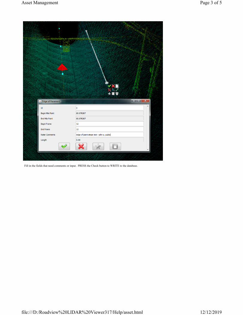
Asset Management Page 3 of 5
Fill in the fields that need comments or input. PRESS the Check button to WRITE to the database.
file:///D:/Roadview%20LIDAR%20Viewer317/Help/asset.html 12/12/2019

Asset Management Page 4 of 5
Look at the Routes Tab to expose the Asset subset. The asset is shown under the asset type with frame and mileage.
REPEAT this Process for all Assets. After an asset is entered clicking on that tag jumps the cloud to that location.
Editing an Existing Asset
Click on one of the asset points to highlight the polyline or polygon. Pick a point to edit. Move or adjust the point. ADD points as was performed previously. Click on the Database widget icon to access the database interface. Apply any text changes. PRESS the Check button to WRITE to the database. REPEAT this Process for all EDITS
Checking the Asset Table
file:///D:/Roadview%20LIDAR%20Viewer317/Help/asset.html 12/12/2019

Asset Management Page 5 of 5
Switch back to ROADVIEW WORKSTATION. Details are explained in that Help section.
Open the Search Assets Tab.
Searching per individual Asset categories (ie Edge of Pavement) displays the recorded ASSETS in the database.
The search can be further refined by filtering.
Back to Index
Previous Page Controls
Next to Legal
Jump to Appendix_Index
file:///D:/Roadview%20LIDAR%20Viewer317/Help/asset.html 12/12/2019

Management Plan for QualityPavement Condition Data
Hawaii Department of
Transportation (HDOT)
Highways Planning Survey Section
January 2019

Table of Contents
GOALS....................................................................................................................................................... 2
OBJECTIVES............................................................................................................................................... 2
MANAGEMENT ......................................................................................................................................... 3
COLLECTION.............................................................................................................................................. 3
QUALITY.................................................................................................................................................... 4
Contractor Qualification & Experience .................................................................................................. 4
Contractor Quality Control Plan............................................................................................................. 4
Data Quality.......................................................................................................................................... 5
Data Standards and Protocols ............................................................................................................... 6
DATA ACCEPTANCE ................................................................................................................................... 7
Ground Truth ........................................................................................................................................ 7
Data Issues............................................................................................................................................ 8
DATA MANAGEMENT................................................................................................................................ 9
COST......................................................................................................................................................... 9
RELATED DATA.......................................................................................................................................... 9
Appendix A Contractor Data Dictionary
Appendix B Contractor Quality Management Plan
Appendix C Contractor Equipment Certification Results
1

GOALS
HDOT has roughly 2,700 lane miles of roadway on the State Highway System (SHS), which is HDOT’s largest asset. To help become better stewards of these roadways, HDOT needs to know the pavement condition, and to know how the condition changes over time. This management plan for quality pavement condition data is intended to help ensure the ability to have current, complete, accurate, and usable data to help sustainably manage HDOT’s largest asset.
This plan is also being developed to meet the requirements stipulated by 23 CFR 490 for National Performance Management Measures. Specifically, HDOT will use this plan to collect and report pavement data required under 23 CFR 490.309 and 490.311.
This management plan begins by defining what data needs to be collected, how it will be collected, as well as how it will be reported and maintained after it is collected. Additionally, this plan will cover the process for reviewing and checking the data for acceptance, as well as all of the quality control measures required to assure the data is accurate and complete.
This plan includes a contractor data quality management plan that describes the data collection equipment, calibration, certification, and operator training used to collect pavement condition data at highway speeds for HDOT. This document also includes the contractor’s quality control measures conducted before and during the data collection, during the data processing, and the checks to assure data completeness and validity.
OBJECTIVES
Pavement surface condition surveys will be conducted annually across the entire SHS to satisfy HDOT’s data requirements for reporting, deterioration modeling, system analysis, funding needs forecasting, making project recommendations, various research activities, and monitoring. Additional Oahu mileages will also be annually surveyed that incorporate approximately 270 ramps in 35 interchanges which, combined with access and frontage roads make up another approximately 100 miles.
The surface condition data will include roughness with the International Roughness Index (IRI), wheel path rutting, environmental cracking, fatigue cracking, potholes, patching, raveling, bleeding, texture, joint spalling, joint faulting, and concrete slab cracking, along with other survey measures to additionally inventory, attribute, and assess the pavement characteristics.
Environmental cracking will include transverse, longitudinal, and block cracking types at low, medium and high severity levels, along with sealed cracks.
The same condition data will also be collected for roughly 2,100 miles of county routes across the entire state’s functionally classified roads, collectors and above.
Pavement condition evaluations will be done in conformance with the Strategic Highway Research Program (SHRP) Long-term Pavement Performance Program (LTPP) distress identification manual (Publication Number FHWA-RD-03-031). This pavement condition data shall be further processed and reported in accordance with the Federal Highway Administration (FHWA) Highway Performance
2

Monitoring System (HPMS) Field Manual definitions. A detailed data dictionary for each data element with definitions and units is included in the appendix.
MANAGEMENT
The Highways Planning Survey Section will be the data steward. They will set the collection requirements and data definitions. They will review and approve the data before publishing the data. They will process the reported data and provide 0.1 mile datasets for use as needed.
The tenth mile data will be used for pavement management section condition index values used in the PMS software. The PMS software will forecast future conditions for making project recommendations, providing program funding requirements, and reporting.
HDOT intends to annually report full-extent Highway Performance Monitoring System (HPMS) pavement data for the entire state federal aid system. The Interstate and Non-Interstate NHS condition data will be used for the national performance measure reporting.
Datasets will be made available for each Island, the Highways GIS web portal, and formatted for the Pavement Management System (PMS) software and Pavement Condition performance dashboards.
Datasets will be made available for various research projects, and other users as needed.
COLLECTION
Collection will be performed annually for the entire SHS in both directions. Pavement condition data is typically collected in 1 lane in each direction and reported in 0.1 mile increments. Additional lanes of data will be collected as needed on the Interstates and multi-lane facilities. Data has been collected in both directions since 2003, typically on a biennial basis.
The pavement condition survey will be conducted by a Data Collection Contractor through a goods and services agreement. The distress data will be collected using a 3D pavement scanner, a laser crack measuring system (LCMS), driven at highway speeds and processed with automated analysis. There will not be any manual data collection for the SHS or other routes annually collected.
High-resolution roadway images and pavement images will also be collected at 500 frames per mile per camera, and synchronized with the distress data. LIDAR data will also be collected and all data records will include the GPS coordinates and the date/times collected.
Data collection will be mapped to the current HDOT state route system at the time of collection, with the route and mileage information provided by the Highways Planning Survey Section.
Additional data collection requirements are included in the appendix.
3

QUALITY
HDOT has developed procedures and guidelines for managing the quality of the pavement condition data collection, processing and reporting activities since 2003. The guidelines are incorporated into HDOT’s Data Collection Contract specifications.
HDOT’s Data Quality Management Plan includes three components:
Contractor Qualification & Experience Contractor Quality Control Plan Data Acceptance
Contractor Qualification & Experience
Using a qualified contractor is the first component of the pavement condition data quality plan. Our experience has shown that there is a learning curve for both the State and the contractor. We will only be using contractors that have successfully completed similar sized and scoped projects, using the latest 3D laser crack measuring system and automated detection technology.
Interested contractors will be required to have sufficient staff and equipment to collect, process, and report a large amount of data in the defined amount of time. HDOT has used the same contractor since 2003.
The contractor will be required to collect, process, and deliver sample data from designated test sections to assure they are capable of reporting data that has the acceptable level of accuracy, at the required resolution, and with the required precision before starting the contract data collection program. This will assure the reported distress has been identified correctly (accurate), at the appropriate severity level (resolution), and repeatable so the data is consistent across the state (precise).
The selected contractor will be required to develop a work plan prior to data collection and submit their Data Dictionary to assure a full understanding of the collection and reporting requirements.
The selected contractor will be required to establish local control sites and assure all vehicles are working correctly before any data collection begins, and that all vehicles continue working correctly during the data collection period.
Contractor Quality Control Plan
The selected contractor will provide and follow an approved Quality Control Plan (QCP).
The QCP will describe the vehicles and equipment that will be used, including the calibration procedures and copies of vehicle certifications for profile data.
The QCP will describe the qualifications for the staff that will collect and the staff that will process the pavement distress data, including training and experience.
4

The QCP will describe the quality control practices employed to assure quality images and data. This will describe the daily data collection quality checks. This must include using control sections to verify consistency of the data during the data collection period.
The QCP will describe the data processing processes that will be used to validate accuracy, resolution and precision of the data collected. Accuracy indicates that the distress is identified correctly, e.g., fatigue cracking is identified as fatigue cracking instead of block cracking. Resolution indicates that severity levels are identified accurately, e.g., low severity longitudinal cracking is identified and recorded rather than omitted. Precision indicates that repeated ratings produce reasonably similar reported distress type, severity and extent combinations.
Data processing must include checks of reported data for completeness, validity, consistency with historical data and checks of the Route referencing to assure no gaps, overlaps, or data beyond the route limits.
The QCP will describe the data reporting process and what review will take place to assure the deliverables being submitted are valid and meeting the contract requirements.
The QCP must also describe which corrective actions will be taken if the results of the data checks are not acceptable.
The current contractor QCP is included in the appendix.
Data Quality
When compared with random sample ground truth data it is expected that the reported distress data will be within +/- 15 % accuracy, 90% of the time. The IRI data will be within +/- 5% accuracy, 95% of the time. The rutting will be within +/- 0.1” accuracy, 95% of the time. The GPS location will be within +/- 5’ accuracy, 95% of the time. The LRS location will be within +/-0.005 miles, 95% of the time.
5

Data Standards and Protocols
Collect process and report data following the listed standards and protocols.
Data Metric IRI for all pavement types
Cracking percent for all pavement types
Rutting for asphalt pavements
Faulting for jointed concrete pavements
Protocol
• IRI collection device in accordance with AASHTO Standard M328-14 • Collection of IRI data in accordance with AASHTO Standard R57-14 • Quantification of IRI data in accordance with AASHTO Standard R43-13 • Certification of IRI data in accordance with AASHTO Standard R56-14
• Collection of pavement surface images in accordance with AASHTO Standard PP 68-14 • Quantification of cracking from pavement surface images in accordance with AASHTO Standard PP 67-16 • Computation of Cracking Percent for each pavement type in accordance with the HPMS Field Manual
• Collection of transverse pavement profiles in accordance with AASHTO Standard PP 70-14 • Quantification of Rut Depth values in accordance with AASHTO Standard PP 69-14, with the modifications specified in the HPMS Field Manual
• Faulting computed based on AASHTO Standard R36-13 with the parameters specified in the HPMS Field Manual, using data measured with LCMS sensors.
6

DATA ACCEPTANCE
Contractor will not begin data collection until equipment certification results have been submitted and approved. Upon approval to begin data collection, Contractor will provide a KML file of all lanes and routes driven every day within 24 hours for preliminary acceptance against the approved schedule of collection. An initial imagery data set should be available within two weeks of survey for review. An initial pavement condition data set will be available within four weeks so the data acceptance review can begin and any required adjustments can be made while the data collection and processing is still being performed.
The data will be delivered in multiple formats, as defined in the accepted Contractor workplan, for review and acceptance.
All reported data is expected to be complete, correct and reported in compliance with the data dictionary.
The high-resolution roadway images, the pavement images and the distress data will be installed onto the HDOT data servers and configured for use by the Contractor.
HDOT or its contracted consultant will administer the data acceptance. Data and images will be reviewed for completeness and to check that it is within expected minimum and maximum values. The data will be checked for consistency and compared with historical values.
The distress data will be loaded onto an integrated workstation platform suitable for viewing roadway images, pavement images, and distress data at the same time. The pavement images will also include distress identified in colors indicating severity levels.
Ground Truth
Random sample sections will be selected and rated for comparison with the reported condition data. This will be from manual on-site surveys and / or review of the pavement and roadway images. The number and location for comparison will depend on the data. This will be a combination of randomly selected sections, and specifically targeted sections. Specifically targeted sections will ensure that sections with distress values of interest are checked. These will include a sufficient number of sections to ensure that all of the various types on distress and severity levels are being reported consistent with the actual distress type and severity.
The contractor will collect data with each of their vehicles on HDOT’s control site for verifying IRI data. HDOT will also collect profile data on the contractor’s control sites for verifying consistency.
7

Data Issues
All data issues will be reported to the data collection contractor as identified. The required action will depend on the type of issue following the process diagramed (copied from FHWA-HIF-18-032).
If the contractor does not meet the requirements of the QCP or if HDOT determines that the collected data does not meet the data dictionary requirements, HDOT can issue a stop work order and require corrective actions per the Contract specifications. This may include reprocessing or re-rating collected data using different criteria, or re-collecting all sections tested since the last checks that showed the contractor was meeting the contract requirements. Multiple violations could result in termination of the data collection contract.
8

DATA PRODUCTS & REPORTS
An HPMS acceptable full extent report of all required pavement data for all roads by pavement type and
a summary pavement report card following the HPMS guidelines for good, fair, poor condition ratings will
be available for publication. The IRI, faulting, rutting, and pavement distress data from the pavement
condition survey will also be summarized in at least four additional different pavement condition reports
needed for the HDOT Transportation Asset Management Plan (TAMP) besides the HPMS reports. The
first report should be an overall pavement report card by pavement type with good, fair, poor ratings
aggregated by routes on or off the National Highway System (NHS) and conforming to the TAMP. The
second report should be done for the State Highway System (SHS), which covers 92 routes, and to be
compatible for use by the HDOT Pavement Management System. Finally, a 3D pavement texture map by
pavement type with all areas of decreased skid resistance, slabs, potholes, patches and the distresses
color coded as low, medium, and high severity shall be delineated and available for publication.
COST
The condition data collection, processing and reporting costs are approximately $45/mile. Funding for condition data collection is provided by the Highways Planning Survey Section.
RELATED DATA
LIDAR point cloud data is usually collected concurrently with the pavement condition data. This LIDAR data has been used to extract multiple inventory data sets for other HPMS required assets, safety and traffic reports, and other maintenance and TAMP requirements. The LIDAR data is available for internal use through the workstation software.
Roadway images are being collected concurrently with the pavement condition data. These are published for internal use on the Highways GIS web portal, along with historical images.
CONTACT
Contact Person: Goro Sulijoadikusumo Address: State of Hawaii, Department of Transportation, Highways Division, Planning Branch 869 Punchbowl Street, Room 301 Honolulu, Hawaii 96813 Tel: (808)587-1839 Fax: (808)587-1787
9
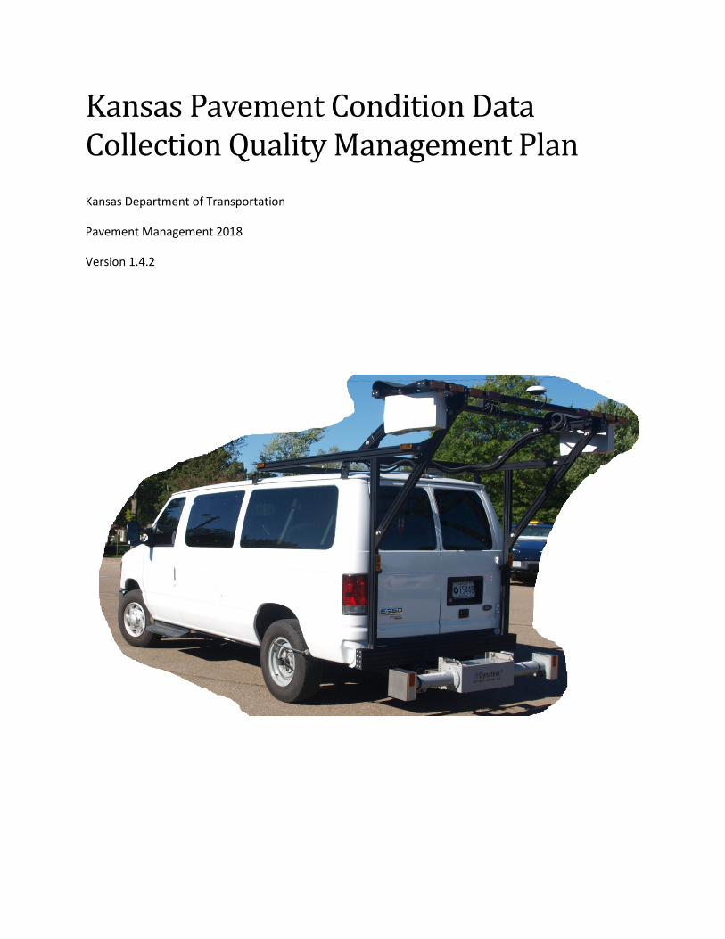
Kansas Pavement Condition Data Collection Quality Management Plan Kansas Department of Transportation
Pavement Management 2018
Version 1.4.2

Contents Overview/Purpose of Document Questions................................................................................................. 3
Overview/Purpose of Document .................................................................................................................. 4
Data Collection Process................................................................................................................................. 4
Data Processing Process .............................................................................................................................10
Data Reporting Processes ...........................................................................................................................12
Future Steps ................................................................................................................................................15
Appendix A – Troubleshooting....................................................................................................................16
Figure 1 - Annual Profiler Certification Letter Excerpt.................................................................................. 8 Figure 2 - Sample Verifier Output ................................................................................................................. 9 Figure 3 - Sample kml file from collection in red shown in Google Earth..................................................... 9 Figure 4 - Forward Image in Workstation ...................................................................................................11 Figure 5- Downward Range and Intensity Images with Overlays ...............................................................11
Table 1 - Quality Control Activities Before Data Collection .......................................................................... 5 Table 2 - Quality Control Activities During Data Collection .......................................................................... 6 Table 3 - Example KTA Median Values Comparison for Quality Assurance Screening ...............................14
2

Overview/Purpose of Document Questions Why does this document exist?
Data Collection Process
What do we collect?
How does the collection process work?
How is the process checked?
How is the checking process documented?
Data Processing Process
How does the processing process work? (within non-disclosure limits)
How is the transformation from data to info checked?
How is the checking process documented?
Data Reporting Processes
How is the info converted into the required reports? (again within non-disclosure limits)
How is the reporting process checked?
How is the reporting process documented?
Future Steps
3

Overview/Purpose of Document Why does this document exist? – it is required (and not a bad idea)
The Kansas Pavement Condition Data Quality Management Plan was completed largely to meet a federal requirement to have such a document. It is also probably a good idea to have this information documented both for succession planning purposes and to broaden the understanding of how the data is collected, processed, and reported. The layout of the document follows three basic parts of the process. The first section is collection of data. The second section is processing. And the third section is reporting. Within each of these sections are explanations about what is done, how it is done, how it is checked, and how those checks are documented.
Following submittal of the original version of this document, FHWA recommended changes that included adding Tables 1 and 2 showing quality control activities before and during collection, adding a description and process to show that KDOT was getting reasonable pavement data (see Data Reporting Process and Table 3), and more detail on checks and fixes to data collection when problems occur (see the Troubleshooting Appendix).
Data Collection Process What is collected? – location information, forward images, longitudinal profile elevations, and FIS files with proprietarily stored information about intensity and relative elevations for the pavement surface.
Pavement condition data collection is not widely understood, as many people think that the process involves taking a vehicle out on the road and returning with pavement surface attributes like International Roughness Index (IRI), and rutting, and cracking. However, none of those attributes are directly measured. Instead, the systems have fairly limited types of measures they make and record that can be processed to create measures such as IRI, rutting, faulting, cracking, etc. This section describes the data the system actually collects and how it is/can be checked to see that the collection process is being done properly and within reasonable tolerances.
KDOT’s Data Collection Vehicle
• 2012 Ford E-350 XLT Van • Pavemetrics Laser Crack
Measurement System • Dynatest 5051 Mark III/IV
Road Surface Profiler • Mandli DVX and RoW Imaging
KDOT Data Collection Personnel
Bureau of Construction and Materials
Pavement Management Unit
Pavement Evaluation Section
• Pavement Evaluation Specialist
• 3 Trained Operators on Staff • 1 Seasonal Operator
4
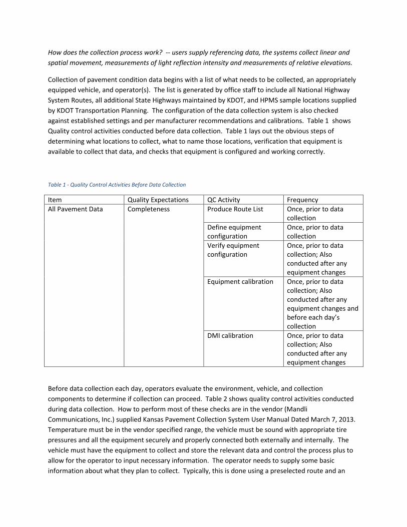
How does the collection process work? -- users supply referencing data, the systems collect linear and spatial movement, measurements of light reflection intensity and measurements of relative elevations.
Collection of pavement condition data begins with a list of what needs to be collected, an appropriately equipped vehicle, and operator(s). The list is generated by office staff to include all National Highway System Routes, all additional State Highways maintained by KDOT, and HPMS sample locations supplied by KDOT Transportation Planning. The configuration of the data collection system is also checked against established settings and per manufacturer recommendations and calibrations. Table 1 shows Quality control activities conducted before data collection. Table 1 lays out the obvious steps of determining what locations to collect, what to name those locations, verification that equipment is available to collect that data, and checks that equipment is configured and working correctly.
Table 1 - Quality Control Activities Before Data Collection
Item Quality Expectations QC Activity Frequency All Pavement Data Completeness Produce Route List Once, prior to data
collection Define equipment configuration
Once, prior to data collection
Verify equipment configuration
Once, prior to data collection; Also conducted after any equipment changes
Equipment calibration Once, prior to data collection; Also conducted after any equipment changes and before each day’s collection
DMI calibration Once, prior to data collection; Also conducted after any equipment changes
Before data collection each day, operators evaluate the environment, vehicle, and collection components to determine if collection can proceed. Table 2 shows quality control activities conducted during data collection. How to perform most of these checks are in the vendor (Mandli Communications, Inc.) supplied Kansas Pavement Collection System User Manual Dated March 7, 2013. Temperature must be in the vendor specified range, the vehicle must be sound with appropriate tire pressures and all the equipment securely and properly connected both externally and internally. The vehicle must have the equipment to collect and store the relevant data and control the process plus to allow for the operator to input necessary information. The operator needs to supply some basic information about what they plan to collect. Typically, this is done using a preselected route and an

indicator if they are collecting in a counting up or counting down direction. The routes are preloaded and named following a standard reference with county, route prefix, number, and suffix and the begin and end county milepost. The operator can override the milepost if they are not starting at the begin or end of the route within the county. Once collection has started, systems within the vehicle are collecting GPS and distance measurement to keep track of location. The forward and downward cameras are being triggered by a wheel encoder based on distance, and the Road Surface Profiler (RSP) is triggered based on time. In Kansas, typical data collection is performed on Monday through Thursday. At the end of a collection week, the data is transferred from the vehicle to the Pavement Management System Unit office for processing. The processing process is described in a later section. Table 2 provides a tabular form of the checks that occur during the collection process.
Table 2 - Quality Control Activities During Data Collection
Deliverable Quality Expectations QC Activity Frequency All Pavement Data Safety/Efficiency Mechanical Inspection Daily
Preventive maintenance program
According to Program
Completeness Verifier report After each Route Accuracy Subsystem checks
(sensors, computers, software)
Daily
Real-time quality monitoring (monitor error codes, images, and data streams during collection)
During Active Collection
Verifier report and KML Daily DMI calibration Monthly and/or tire
change Check environmental conditions (dry pavement surface, temperature within equipment operating range)
During Active Collection
How are the data collection processes checked? -- user supplied info is not really checked until the reporting process; GPS data is not checked other than that the system is collecting data and the coordinates provided are within bounding limits; linear referencing is checked by a periodic calibration process, the encoder is checked also through a periodic calibration process, intensity data and the
6

elevation measurement units are sent back to the manufacturer each year for service, each week height calibrations are performed on the RSP, and the RSP is certified annually by the equipment vendor.
Operators choose the route information to start the collection process. Methods to verify they selected the right route, are incrementing the linear referencing correctly, and are reasonably close to the correct begin and end points could be done with software, but historically these checks have not been needed or done. The driver is also an important piece of the data collection process. Both operators and drivers are trained to perform the necessary checks before collection, input the data needed to collect, monitor the computers during collection, maintain maps and logs, and drive to get good pavement data.
The GPS data is important but has not been checked historically other than relative to the operator supplied location, the GPS locations are reasonably consistent. The system contains an Inertial Measurement Unit as well as the GPS. During collection, the system monitors the GPS data and the IMU takes over if the GPS is not meeting established accuracy requirements. As well as the system monitoring the GPS data, each day’s runs are reported back to the Pavement Evaluation Specialist, Pavement Management Engineer, and vendor staff through an email that includes status information about the runs from a verifier program and kml files that show where the data was collected. If the GPS data is not reasonably correct, the kml files do not show up on maps correctly and so KDOT would know that something was not right with the GPS data. GPS data becomes more important with the process stipulated to remove bridge data from a state’s report. KDOT is working on a conflation process that will more consistently place the pavement data from year to year than relying on the linear distance alone.
The linear measurements are a function of a lot of variables and do change with tire wear and pressure and other influences. To keep the linear measurements in check, periodic trips to a known measured site are made and a procedure to calibrate the distance measure is followed. The calibration process results in an adjustment factor being stored in the system and then used for collection until a new calibration is performed. If the operators question the linear measurements while in the field and a long way from the calibration site, they know to look for locations with presumed distances to perform a calibration. Kansas has many county roads on the Public Land Survey System (PLSS) one-mile grid, so finding a location to use to check or calibrate can be done in many places. The calibration process updates both the DMI and the encoder used for linear distance measurement.
Finally, the RSP is “certified” by the vendor as part of annual maintenance on the vehicle. See Figure 1 for sample. They basically follow the process outlined in AASHTO R-56 and provide an annual certification to KDOT. The location they use is one that is also used for the vehicles that collect data in many other states. On a daily basis our operator/driver performs the manufacturer recommended bounce, block, and height tests to check that the height measurements are reasonable and that the accelerometers are reacting to vertical movement. These tests are described in the manufacturer’s documentation. We do not record any of the information from the block test, but simply use it as a pass/fail to continue with collection. The bounce test is recorded and are transferred from the drives along with the other data collected each week to the processing computers in the Pavement Management System Unit office. Height tests for the LCMS are stored in the data file (xml) generated in the data processing step, so these values are available for future reference.
7

Figure 1 - Annual Profiler Certification Letter Excerpt
How is the checking process documented?
KDOT has quite a bit of documentation of various checks of data quality, but the documents are simply part of the collection process not specifically targeting quality documentation. These documents include, outputs from the verifier that is run at the end of each route that is collected. This verifier checks and cross-checks a lot of the information that was collected and provides a quick color-code of Green/Orange/Red to give the operator feedback at the conclusion of each collection run. At the end of each day, these verifier reports and the aforementioned kml files are emailed back to the Pavement Evaluation Specialist, Pavement Management Engineer, and Mandli Communications customer support staff. Thus, every run and every collection day is a form of checking that the system is collecting data as expected. Figures 2 and 3 respectively show the text from part of a verifier daily summary and the kml file on a Google Map showing the locations collected. The verifier is pretty simple to follow. If the route shows as green, everything is good. If it is orange or red, the operator will investigate the concern and the appropriate response. The example in Figure 2 shows a route that was red due to a “Frame Count Mismatch”. The operator likely looked deeper to determine that for a fairly long route, getting 5153 Front images and left images but only 5152 downward (LCMS) images is not really a concern, so they kept the data and went on to collecting other routes. We train our operators to make these kinds of decisions. However, we also provide the troubleshooting appendix of this document to assist the operators and to help with consistency in how issues are resolved. If the operator cannot independently make a determination, they call the Pavement Evaluation Specialist, the Pavement Management Engineer, or vendor customer service at Mandli Communications for support.
8
Figure 2 - Sample Verifier Output
Figure 3 - Sample kml file from collection in red shown in Google Earth
9

Data Processing Process How does the processing process work? (within non-disclosure limits) – A lot of this processing step is a black box to users and some of it is proprietary and cannot be disclosed, but basically the data that was collected as described in the previous section is turned into information in this step.
The transformation from data to information requires quite a bit of processing. Some of these processes are established and well documented. Other processes are proprietary and not publicly documented. The processing for KDOT begins with transferring the collected data from the vehicle to office computers. Next, images are viewed for each route and compared to data collection logs for pavement surface type changes, and visual quality of the forward images. At this point, operator logs from collection are also reviewed and any noted concerns are addressed such as collection mileage needs to be reversed, wrong input start/stop, wrong route name, construction, bridge missed, frame mismatch. All of these are possible but very infrequent and can be dealt with before processing. QC Checker software provided by the Mandli Communications is also run on the data at this point. This software provides a report indicating where some typical problems occur such as images with noise, images with excessive cracking in the left wheelpath, images with unusual rutting characteristics, or collection issues such as speed or temperature. Each of these “errors” are indications that something happened that may impact the data quality. The noise issue is usually when road roughness causes the lasers to go out of range, like crossing a railroad track or some manhole covers, or vehicle lean in a tight turn. In most cases, the noise is just accepted, but if it is severe enough recollection is ordered. The excessive cracking in the left-wheelpath is often an indicator of the vehicle being driven too close to the centerline. Again, when the software identifies this issue, the data is reviewed and if necessary recollected. The rutting indication from the QC checker typically occurs when the road has curb and gutter or unusual edge conditions combined with a narrow lane or atypical vehicle position. Again, locations identified as having rutting issues by the checker are reviewed. Use of the QC Checker is documented in the LCMS QC Design 1.0.8 document supplied to KDOT by Mandli Communications in March 2016. When the data all appears to be ready for processing, and the frames where pavement type changes are identified, processing is started. Processing here means to select each of the routes that was run as inputs to a Pavemetrics software that interprets the collected data and generates four output images and a XML data file for each 1/200th of a mile section.
How is the transformation from data to info checked?
There is not a lot of checking of the processing at this level by KDOT. The process itself is proprietary, so most of the checking is simply looking at outputs for reasonableness. KDOT has invested significant effort into looking at these outputs in the form of data and images and worked with the system vendors to better understand the processing and to improve the outputs to better meet KDOT needs. The vendor provides viewing tools that link together all the images and data, so users can view the images associated with the reported data as shown in Figures 4 and 5.
10

Figure 4 - Forward Image in Workstation
Figure 5- Downward Range and Intensity Images with Overlays
How is the checking process documented?
Again, KDOT spends significant time analyzing and viewing the process outputs but not documenting quality checks. KDOT thinks of the review process more as a cooperative process with the manufacturer and vendor in that any concerns are raised with them, so they can be reviewed and addressed. An
11

example of this is the minimum temperature at which data collection is allowed. The equipment will not operate below freezing, this was done by the manufacturer because they are not comfortable with the quality of data collected in those conditions. KDOT raised some issues about some of the time-series data that seemed to be inconsistent and the vendor and manufacturer reviewed the relevant data and determined that the questionable data was collected at temperatures above freezing but below about 40 degrees Fahrenheit. This led to the manufacturer discouraging data collection below 40 and the vendor introducing software that checked the temperature before collection and issued warnings to the operators if temperatures are out of bounds. This interaction is not really documented, but partly led to the Quality Checker described above and became part of a system check instead of an external quality documentation effort. This is as good of place as any to point out that systems like the one used by KDOT to collect pavement condition data continue to be refined. Thus, as the systems get better at collecting and processing information, the amount of the year-to-year variability in the data due to the change in the processing versus the amount due to change in pavement surface conditions is unknown. This is an area that KDOT and our partner vendors and manufacturers will continue to monitor and evaluate.
Data Reporting Processes How is the info converted into the required reports? (again within non-disclosure limits) – two different reporting functions are followed to extract pavement condition information and generate the pavement pieces of the Highway Performance Monitoring System (HPMS) report and the reporting that KDOT does for state management and communication of pavement conditions. Currently this document only covers the reporting related to HPMS.
HPMS requirements were released in a December 2016 document entitled “Highway Performance Monitoring System Field Manual”. That document describes much more than the pavement attributes that must be reported, but the pieces of relevance for pavement condition reporting are 4-90 through 4-115. KDOT uses reporting software developed by the vendor to take the processed data and generate the elements required and described directly in the HPMS Field Manual or the standards it references. Unfortunately, most of this software was developed before the Field Manual was issued, so there is not an all-encompassing “Easy Button”. Currently, KDOT runs reports to generate HPMS data outputs at the finest resolution possible, that is at 1/200th of a mile. This allows pavement type changes, bridge locations, begin/end of routes all to be more precisely reported than just using the tenth of a mile incrementing required for federal reporting. The output reports are imported into a relational database for further processing and checking. Finally, the tenth mile HPMS compliant data is passed to KDOT Transportation Planning for further processing and submittal.
How is the reporting process checked?
The primary checking of the reporting process is a review of time-series data from 5 years of collecting and processing pavement condition data with this equipment and process. The process continues to evolve to better meet federal and state needs. Currently, KDOT is working through a conflation process to better locate the reported data spatially so that it will be consistent over time and so that the federal
12

process to remove bridges from the pavement data will more likely remove bridge data. KDOT is also working with the vendor to improve some of the reporting tools. The vendor’s tool currently over-reports cracking percent on concrete pavements because it includes both transverse and longitudinal cracked slabs where the federal rule only counts transverse cracked slabs. KDOT has also talked to the vendor about improving their algorithms for unusual concrete joint configurations like 6x6 slabs. See Figures 4 and 5 for an example. The vendor is also reviewing their interpretation of the asphalt percent cracking based on feedback from KDOT. While this is not specifically process checking, it shows that KDOT pays attention to the data at all levels and constantly strives to improve it to meet our needs.
How is the reporting process documented?
KDOT Pavement Management is not big on documentation for the sake of documentation. However, KDOT has some checks to the overall process performed early in each year’s collection process. To satisfy federal requirements for a “Data sampling, review and checking process,” KDOT proposes to collect the Kansas Turnpike data very early in the collection cycle and compute median values for IRI and rutting in northbound and eastbound sections. These statistics will be compared to the prior year’s data +/- 10% (20% for cracking since the variable was not publicly (and poorly) defined until December of 2016) to establish Quality Acceptance. It should be good enough for PM2 purposes and better than trying to make automated processes match subjective ratings!
The example of this process which will form the basis of future checks was done with the 2018 KTA frame-based data. The logic is that the Turnpike is being managed in a fashion that the pavement conditions measured do not change much from year to year. So, if the measured pavement condition does not change significantly from one year to the next, the data quality will be considered okay (at least it is consistent). An example of this comparison using the 2017 and 2018 data is in Table 3. If this test fails, KDOT will evaluate individual county turnpike data (for instance using northbound I-335 in Osage County and eastbound I-70 in Leavenworth County). This will be a similar check to the whole KTA, but easier to determine why disparities exist. If this check also fails, KDOT will consult with the Kansas FHWA Division Office to determine the cause for these discrepancies and will not use the data for HPMS reporting until the deviations can be documented and explained. Like much of this process, this check will need to be refined over time to address locations where actions are performed, maybe remove bridges and other known anomalies, eventually include conflation prior to the comparisons, etc.
13

Table 3 - Example KTA Median Values Comparison for Quality Assurance Screening
KTA Inventory Direction Miles
Median Avg IRI Median Avg RutVal
Miles of Zero CrkgPct
Median Avg non-zero CrkgPct
2017 values 224.132 42.9 0.097 175.057 7.131 Acceptable Range for 2018
38.6 – 47.2 0.087 - 0.107 5.705 – 8.557
2018 values 42.8 0.106 173.14 7.062
Osage 2017 values
10.524 43.9 0.090 7.704 4.109
Osage Acceptable Range for 2018
39.5 – 48.3 0.081 -0.099 3.287 – 4.931
Osage 2018 values
10.549 51.5 0.102 7.029 3.822
Leavenworth 2017 values
16.481 34.5 0.092 15.046 5.374 SMALL SAMPLE
Leavenworth Acceptable Range for 2018
31.1 – 38.0 0.083 – 0.101 4.299 – 6.449
Leavenworth 2018 values
16.5 35.9 0.101 14.925 7.759
This table shows that using this screen for data quality would have been met had it been in place in 2018. That is, the 2018 average values for the turnpike for IRI, Rut Value, and Cracking Percent were within 10% (20 for cracking) from the 2017 values. While this alone only shows consistency in the collected data from one year to the next, consistency in automated data should really be the goal to get quality over time. The next step towards quality is to determine how much of the variability in the data from one collection cycle to the next comes from changes in the pavement surface (what we really want to know) versus other factors like improvements in the collection system or process, equipment or operator variability, changes in the standards (like a more reasonable standard for cracking), environmental factors, etc. The bottom line is that KDOT will pay attention to the data we are collecting (as we were doing long before we were forced to write a document describing what we do) to meet our needs for quality data and to provide reasonably good data for federal purposes. We will document that we are making the effort to get good data for the federal purposes using the method shown in the table above. Note that the table above also shows that we would have had some additional digging to do if the check would not have passed at the system level as rutting failed for 2018 in the Osage County piece of the turnpike and cracking failed in the Leavenworth piece albeit a very small sample. In both cases, we would have dug deeper and tried to determine how different the 2018 data really is from the 2017 data for those locations and variables. At some point, we would document why they were showing the variability and consulted with the Kansas FHWA Division office.
14

Future Steps What will KDOT do to continue to get quality pavement data?
Clearly KDOT recognizes the need for quality data and can take some steps to enhance the effort and to document the effort. Specifically, KDOT will continue to evolve the process to collect the data and process it to meet the needs of FHWA and KDOT. Some of the work needed will be for the vendor to refine the tools they provide for reporting of the data. Other parts of the work will be for KDOT, such as the conflation process to remove much of the spatial error that is currently in the data that should improve the quality of the location of the data relative to the locations of the bridges that get removed. Finally, Appendix A of this document is a troubleshooting guide. At this point, it is largely a framework, but we will attempt to populate it over the next couple of years and see if it becomes a useful tool.
15

Appendix A – Troubleshooting This Troubleshooting Guide is intended to both document error resolution procedures and to help users identify data problems with some tools to remediate the problem.
Problem Occurs During: Problem is with: Description of Problem: Action:
Collection System Startup
Collection Vehicle Damaged Assess and Report to office Flat Tire Check for cause, fix, recalibrate DMI Won't Start Check for cause, check switch at battery, call office
Collection System Computer/Components
Won't Start Check start up procedure document and repeat process. If still fails, contact the office. Does Not Connect Check network settings for "collection", startup procedure document and repeat process. If still fails, contact the office. Gives Error Message If known error and resolution, do it. Else contact manufacturer.
“Fails" Block/Bounce/Burn
Block: if 1, 2, or 3" heights vary by more than 0.02", reclean lasers, reset to zero to restart block check, and try again. If still fails, call manufacturer. HPMS Height: follow manufacturer's guide for instructions and troubleshooting. Bounce: if file was not produced for bounce test, repeat procedure, if still does not produce file, start over all of the system start up procedures, if that fails call manufacturer. If test completes and IRI values exceed 15, check the surface under the lasers is adequate to perform test. If not, move vehicle, put plate or appropriate surface on the ground under laser and repeat tests. Burn: should cover at least 1 mile of data collection, run verifier to check that all systems are working normally. If GPS accuracy fails, follow manufacturer procedures.
Does Not Have Route List Reset the Mac Computer/Mesh. Reload route list from backup file. Contact office. Missing or Incorrect Info in Route List Add or correct route information. Contact office.
Collection System Operation
Collection System Computer/Components
Gives Error Message If known error and resolution, do it. Else contact manufacturer. Fog, Temperature, Moisture, or Other Weather Conditions Out of Range Do not collect Is Not Collecting Profile Data stop collection, recollect route Has Significant Linear Distance Discrepancy With End of Route check tire pressures and recalibrate DMI
route verifier indicates problems judge error severity for acceptance -- usually most "errors" are still acceptable. If RSP is missing or significant frame count mismatch, then recollect.
repeated verifier problems with frame mismatch Check DMI and wheel encoder. Recalibrate, replace, check and call office. route closed or anomalies note problem in log stating closure, crap on road, questionable weather, etc. [iPad/email stuff?] forward images are not aligned contact office to reset camera positions. forward images are fuzzy clean windshield and contact office to check focus. IRI graph does not match seat of pants stop collection, check all connections and settings, recollect and continue to monitor. RSP missing header note problem in log for correction before processing RSP wrong direction note problem in log for correction before processing and run RSP Reverser
16

Problem Occurs During: Problem is with: Description of Problem: Action:
Processing Software/Data
Drive appears empty when brought to office for processing These drives are in Apple format, dummy. Use HFS to extract the data to match desktop drive format. HFS gives error message during extract This is normal after about 600 GB of data transfer. Figure out where the software blew up and restart it from that point. RV7 won't load route This could be a lot of things, so a whole document of possible causes and solutions is available in the Cliff Notes for RV7.
pvt file does not list all frames This typically occurs when the pvt editor is started before all files have finished being extracted through HFS. Restart pvt editor or manually determine the appropriate frame ranges and enter them.
processed images have the measles Check the pick out module setting processed images show potholes Check the processing settings, mostly the checkboxes. processed images have continuous "crack" longitudinally through midframe
This is typically caused by an incorrect overlap setting. Typically, these are set by the manufacturer during annual system checks but can be set by KDOT. See manual for overlap setting instructions.
AASHTO bands dramatically change from frame to frame Check the lane mark memory setting.
Error occurs during LCMS processing Typically, this a problem with a source file or two. The typical remedy is to rerun just that file through processing. If it fails again, replace the file with the backup version and reprocess.
Quality Checker Summary File Lists Concerns The manufacturer provides a manual for what these concerns mean and how to address them. Error during copy to network drive There are lots of files and some are pretty large. Space can be an issue. Routes don't load into workstation Check that the loads are not coming from a mapped drive (should be //titan not H:). Try to reload files. Routes don't show up in workstation for collection year
Were they loaded to wrong year? Were they loaded from bad drive location? If so, reload them to right place from right location. If not, check for control (rtf) file and rebuild if necessary.
Reporting Software/Data TBD TBD
17