State of the Park Report - John Day Fossil Beds National ...
60
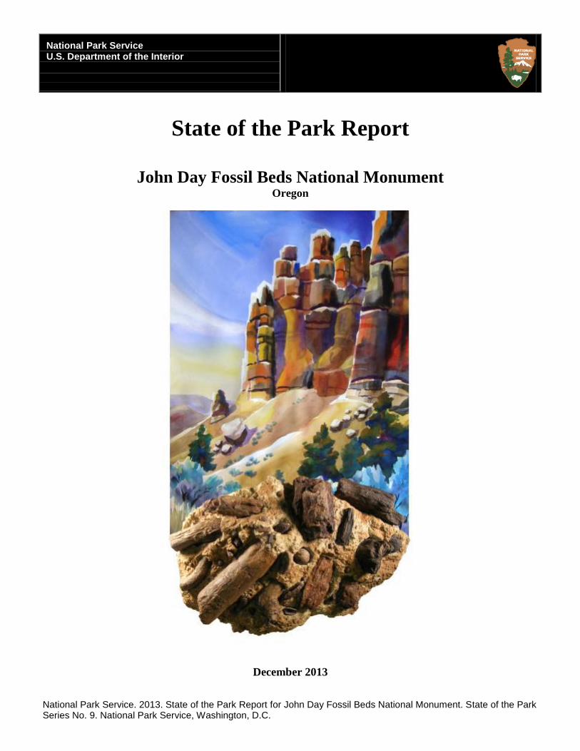
National Park Service U.S. Department of the Interior State of the Park Report John Day Fossil Beds National Monument Oregon December 2013 National Park Service. 2013. State of the Park Report for John Day Fossil Beds National Monument. State of the Park Series No. 9. National Park Service, Washington, D.C.
-
Upload
khangminh22 -
Category
Documents
-
view
2 -
download
0
Transcript of State of the Park Report - John Day Fossil Beds National ...
National Park Service U.S. Department of the Interior
State of the Park Report
John Day Fossil Beds National Monument
Oregon
December 2013
National Park Service. 2013. State of the Park Report for John Day Fossil Beds National Monument. State of the Park Series No. 9. National Park Service, Washington, D.C.
National Park Service. 2013. State of the Park Report for John Day Fossil Beds National Monument. State of the Park Series No. xx. National Park Service, Washington, D.C.
Disclaimer. This State of the Park report summarizes the current condition of park resources, visitor experience, and park
infrastructure as assessed by a combination of available factual information and the expert opinion and professional judgment of
park staff and subject matter experts. The internet version of this report provides the associated workshop summary report and
additional details and sources of information about the findings summarized in the report, including references, accounts on the
origin and quality of the data, and the methods and analytic approaches used in data collection and assessments of condition. This
report provides evaluations of status and trends based on interpretation by NPS scientists and managers of both quantitative and non-
quantitative assessments and observations. Future condition ratings may differ from findings in this report as new data and
knowledge become available. The park superintendent approved the publication of this report.
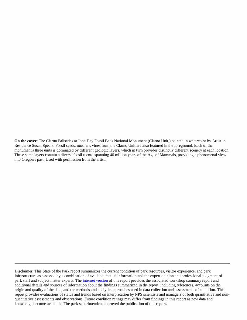
On the cover: The Clarno Palisades at John Day Fossil Beds National Monument (Clarno Unit,) painted in watercolor by Artist in
Residence Susan Spears. Fossil seeds, nuts, ans vines from the Clarno Unit are also featured in the foreground. Each of the
monument's three units is dominated by different geologic layers, which in turn provides distinctly different scenery at each location.
These same layers contain a diverse fossil record spanning 40 million years of the Age of Mammals, providing a phenomenal view
into Oregon's past. Used with permission from the artist.
State of the Park Report iii John Day Fossil Beds National Monument
Executive Summary
The mission of the National Park Service is to preserve unimpaired the natural and cultural resources and values of national parks for
the enjoyment, education, and inspiration of this and future generations. NPS Management Policies (2006) state that “The Service will
also strive to ensure that park resources and values are passed on to future generations in a condition that is as good as, or better than,
the conditions that exist today.” As part of the stewardship of national parks for the American people, the NPS has begun to develop
State of the Park reports to assess the overall status and trends of each park’s resources. The NPS will use this information to improve
park priority setting and to synthesize and communicate complex park condition information to the public in a clear and simple way.
The purpose of this State of the Park report is to:
Provide to visitors and the American public a snapshot of the status and trend in the condition of a park’s priority resources
and values;
Summarize and communicate complex scientific, scholarly, and park operations factual information and expert opinion using
non-technical language and a visual format;
Highlight park stewardship activities and accomplishments to maintain or improve the State of the Park;
Identify key issues and challenges facing the park to help inform park management planning.
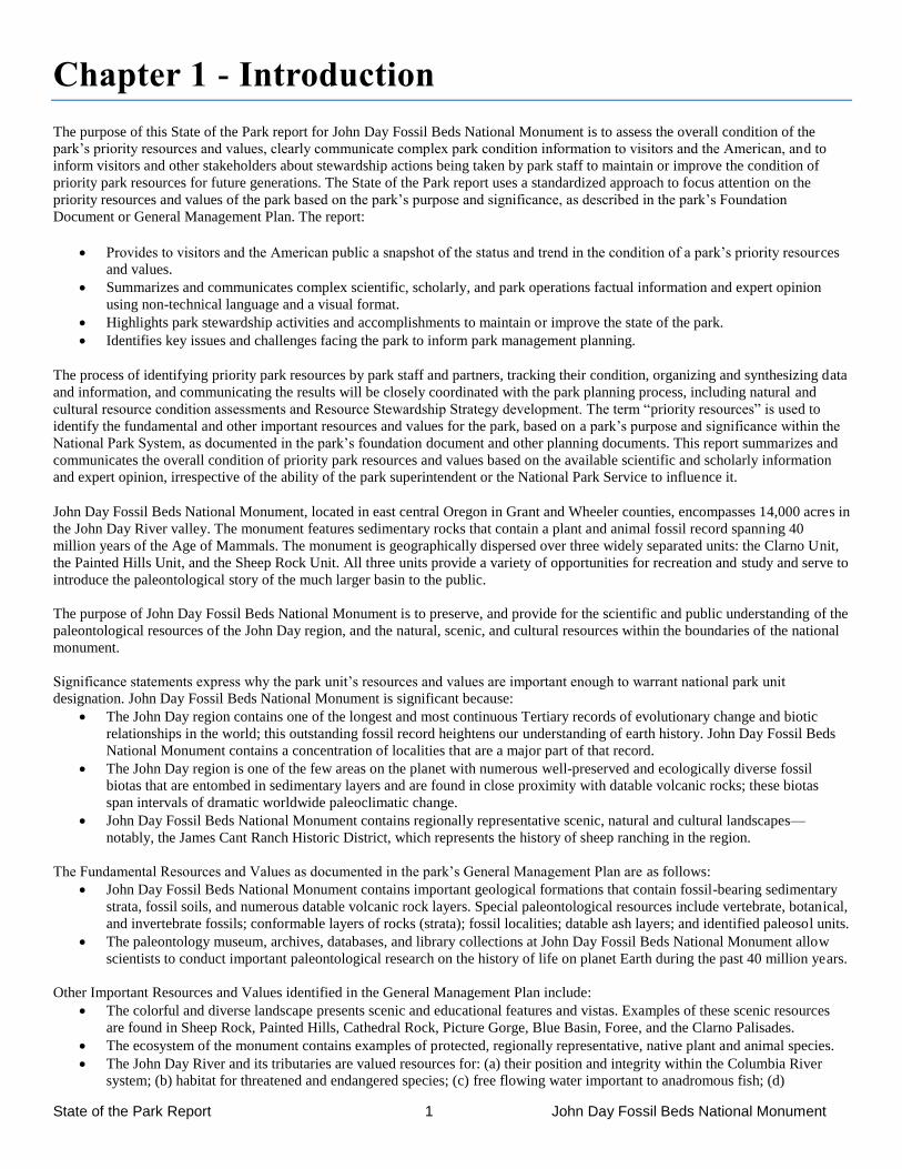
John Day Fossil Beds National Monument, located in east central Oregon in Grant and Wheeler counties, encompasses 14,000 acres in
the John Day River valley. The monument features sedimentary rocks that contain a plant and animal fossil record spanning 40
million years of the Age of Mammals. The monument is geographically dispersed over three widely separated units: the Clarno Unit,
the Painted Hills Unit, and the Sheep Rock Unit. All three units provide a variety of opportunities for recreation and study and serve to
introduce the paleontological story of the much larger basin to the public.
The purpose of John Day Fossil Beds National Monument is to preserve, and provide for the scientific and public understanding of the
paleontological resources of the John Day region, and the natural, scenic, and cultural resources within the boundaries of the national
monument. While there are other large paleontological sites in North America, including many protected by the National Park Service,
the John Day region’s diversity of fossil resources and the nearly continuous record of rocks over the last 50 million years are unique
(Fremd 2010). There are few other places on Earth, if any, where the past 50 million years is as accessible as it is in the John Day
region, for the collection and analysis of both a continuous fossil record and repeated layers of datable volcanic ash. Eight distinct
fossil assemblages preserve a great variety of vertebrate, invertebrate, plant, and trace fossils, representing remains of hundreds of
species (Dilhoff et al. 2009, Fremd 2010). Dating of volcanic layers provides time constraints on the age of these fossil assemblages,
and in some cases the age of a particular fossil can be narrowed down to less than a hundred thousand years, exceptional precision for
a fossil record from millions of years ago. Well known ages for each fossil assemblage permit comparisons to other deposits
throughout the region and elsewhere in the world, providing a framework to examine evolutionary and environmental changes through
time. The rich paleontological and geological records of this region combine to make it one of the best places in the world to study the
Earth’s history.
Significance statements express why the park unit’s resources and values are important enough to warrant national park unit
designation. John Day Fossil Beds National Monument is significant because:
The John Day region contains one of the longest and most continuous Tertiary records of evolutionary change and biotic
relationships in the world; this outstanding fossil record heightens our understanding of earth history. John Day Fossil Beds
National Monument contains a concentration of localities that are a major part of that record.
The John Day region is one of the few areas on the planet with numerous well-preserved and ecologically diverse fossil
biotas that are entombed in sedimentary layers and are found in close proximity with datable volcanic rocks; these biotas
span intervals of dramatic worldwide paleoclimatic change.
John Day Fossil Beds National Monument contains regionally representative scenic, natural and cultural landscapes—
notably, the James Cant Ranch Historic District, which represents the history of sheep ranching in the region.
The summary table, below, and the supporting information that follows, provides an overall assessment of the condition of priority
resources and values at John Day Fossil Beds National Monument based on scientific and scholarly studies and expert opinion. The
internet version of this report, available at http://www.nps.gov/stateoftheparks/joda/, provides additional detail and sources of
information about the resources summarized in this report, including references, accounts on the origin and quality of the data, and the
methods and analytical approaches used in the assessments. Reference conditions that represent “healthy” ecosystem parameters, and
regulatory standards (such as those related to air or water quality) provide the rationale to describe current resource status. In coming
years, rapidly evolving information regarding climate change and associated effects will inform our goals for managing park
resources, and may alter how we measure the trend in condition of park resources. Thus, reference conditions, regulatory standards,
and/or our judgment about resource status or trend may evolve as the rate of climate change accelerates and we respond to novel
conditions. In this context, the status and trends documented here provide a useful point-in-time baseline to inform our understanding
State of the Park Report iv John Day Fossil Beds National Monument
of emerging change, as well as a synthesis to share as we build broader climate change response strategies with partners.
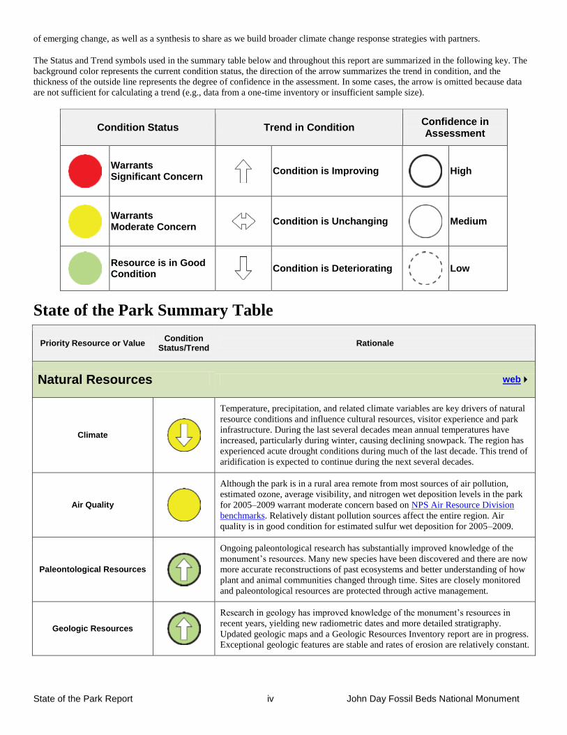
The Status and Trend symbols used in the summary table below and throughout this report are summarized in the following key. The
background color represents the current condition status, the direction of the arrow summarizes the trend in condition, and the
thickness of the outside line represents the degree of confidence in the assessment. In some cases, the arrow is omitted because data
are not sufficient for calculating a trend (e.g., data from a one-time inventory or insufficient sample size).
Condition Status Trend in Condition Confidence in Assessment
Warrants Significant Concern
Condition is Improving
High
Warrants Moderate Concern
Condition is Unchanging
Medium
Resource is in Good Condition
Condition is Deteriorating
Low
State of the Park Summary Table
Priority Resource or Value Condition
Status/Trend Rationale
Natural Resources web
Climate
Temperature, precipitation, and related climate variables are key drivers of natural
resource conditions and influence cultural resources, visitor experience and park
infrastructure. During the last several decades mean annual temperatures have
increased, particularly during winter, causing declining snowpack. The region has
experienced acute drought conditions during much of the last decade. This trend of
aridification is expected to continue during the next several decades.
Air Quality
Although the park is in a rural area remote from most sources of air pollution,
estimated ozone, average visibility, and nitrogen wet deposition levels in the park
for 2005–2009 warrant moderate concern based on NPS Air Resource Division
benchmarks. Relatively distant pollution sources affect the entire region. Air
quality is in good condition for estimated sulfur wet deposition for 2005–2009.
Paleontological Resources
Ongoing paleontological research has substantially improved knowledge of the
monument’s resources. Many new species have been discovered and there are now
more accurate reconstructions of past ecosystems and better understanding of how
plant and animal communities changed through time. Sites are closely monitored
and paleontological resources are protected through active management.
Geologic Resources
Research in geology has improved knowledge of the monument’s resources in
recent years, yielding new radiometric dates and more detailed stratigraphy.
Updated geologic maps and a Geologic Resources Inventory report are in progress.
Exceptional geologic features are stable and rates of erosion are relatively constant.
State of the Park Report v John Day Fossil Beds National Monument
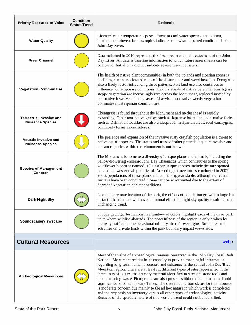
Priority Resource or Value Condition
Status/Trend Rationale
Water Quality
Elevated water temperatures pose a threat to cool water species. In addition,
benthic macroinvertebrate samples indicate somewhat impaired conditions in the
John Day River.
River Channel
Data collected in 2010 represents the first stream channel assessment of the John
Day River. All data is baseline information to which future assessments can be
compared. Initial data did not indicate severe resource issues.
Vegetation Communities
The health of native plant communities in both the uplands and riparian zones is
declining due to accelerated rates of fire disturbance and weed invasion. Drought is
also a likely factor influencing these patterns. Past land use also continues to
influence contemporary conditions. Healthy stands of native perennial bunchgrass
steppe vegetation are increasingly rare across the Monument, replaced instead by
non-native invasive annual grasses. Likewise, non-native weedy vegetation
dominates most riparian communities.
Terrestrial Invasive and Nuisance Species
Cheatgrass is found throughout the Monument and medusahead is rapidly
expanding. Other non-native grasses such as Japanese brome and non-native forbs
such as Dalmatian toadflax are also widespread. In riparian areas, reed canarygrass
commonly forms monocultures.
Aquatic Invasive and Nuisance Species
The presence and expansion of the invasive rusty crayfish population is a threat to
native aquatic species. The status and trend of other potential aquatic invasive and
nuisance species within the Monument is not known.
Species of Management Concern
The Monument is home to a diversity of unique plants and animals, including the
yellow-flowering endemic John Day Chaenactis which contributes to the spring
wildflower bloom at Painted Hills. Other unique species include the rare spotted
bat and the western whiptail lizard. According to inventories conducted in 2002–
2006, populations of these plants and animals appear stable, although no recent
surveys have been conducted. Some caution is warranted due to the extent of
degraded vegetation habitat conditions.
Dark Night Sky
Due to the remote location of the park, the effects of population growth in large but
distant urban centers will have a minimal effect on night sky quality resulting in an
unchanging trend.
Soundscape/Viewscape
Unique geologic formations in a rainbow of colors highlight each of the three park
units where wildlife abounds. The peacefulness of the region is only broken by
highway traffic and the occasional military aircraft overflights. Structures and
activities on private lands within the park boundary impact viewsheds.
Cultural Resources web
Archeological Resources
Most of the value of archaeological remains preserved in the John Day Fossil Beds
National Monument resides in its capacity to provide meaningful information
regarding long-term human processes and existence in the central John Day/Blue
Mountain region. There are at least six different types of sites represented in the
three units of JODA, the primary material identified in sites are stone tools and
manufacturing waste. Pictographs are also present within the monument and hold
significance to contemporary Tribes. The overall condition status for this resource
is moderate concern due mainly to the ad hoc nature in which work is completed
and the emphasis on inventory versus all other types of archaeological activity.
Because of the sporadic nature of this work, a trend could not be identified.
State of the Park Report vi John Day Fossil Beds National Monument
Priority Resource or Value Condition
Status/Trend Rationale
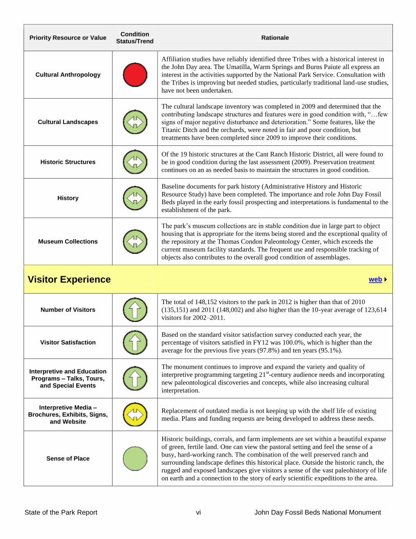
Cultural Anthropology
Affiliation studies have reliably identified three Tribes with a historical interest in
the John Day area. The Umatilla, Warm Springs and Burns Paiute all express an
interest in the activities supported by the National Park Service. Consultation with
the Tribes is improving but needed studies, particularly traditional land-use studies,
have not been undertaken.
Cultural Landscapes
The cultural landscape inventory was completed in 2009 and determined that the
contributing landscape structures and features were in good condition with, “…few
signs of major negative disturbance and deterioration.” Some features, like the
Titanic Ditch and the orchards, were noted in fair and poor condition, but
treatments have been completed since 2009 to improve their conditions.
Historic Structures
Of the 19 historic structures at the Cant Ranch Historic District, all were found to
be in good condition during the last assessment (2009). Preservation treatment
continues on an as needed basis to maintain the structures in good condition.
History
Baseline documents for park history (Administrative History and Historic
Resource Study) have been completed. The importance and role John Day Fossil
Beds played in the early fossil prospecting and interpretations is fundamental to the
establishment of the park.
Museum Collections
The park’s museum collections are in stable condition due in large part to object
housing that is appropriate for the items being stored and the exceptional quality of
the repository at the Thomas Condon Paleontology Center, which exceeds the
current museum facility standards. The frequent use and responsible tracking of
objects also contributes to the overall good condition of assemblages.
Visitor Experience web
Number of Visitors
The total of 148,152 visitors to the park in 2012 is higher than that of 2010
(135,151) and 2011 (148,002) and also higher than the 10-year average of 123,614
visitors for 2002–2011.
Visitor Satisfaction
Based on the standard visitor satisfaction survey conducted each year, the
percentage of visitors satisfied in FY12 was 100.0%, which is higher than the
average for the previous five years (97.8%) and ten years (95.1%).
Interpretive and Education Programs – Talks, Tours,
and Special Events
The monument continues to improve and expand the variety and quality of
interpretive programming targeting 21st-century audience needs and incorporating
new paleontological discoveries and concepts, while also increasing cultural
interpretation.
Interpretive Media – Brochures, Exhibits, Signs,
and Website
Replacement of outdated media is not keeping up with the shelf life of existing
media. Plans and funding requests are being developed to address these needs.
Sense of Place
Historic buildings, corrals, and farm implements are set within a beautiful expanse
of green, fertile land. One can view the pastoral setting and feel the sense of a
busy, hard-working ranch. The combination of the well preserved ranch and
surrounding landscape defines this historical place. Outside the historic ranch, the
rugged and exposed landscapes give visitors a sense of the vast paleohistory of life
on earth and a connection to the story of early scientific expeditions to the area.
State of the Park Report vii John Day Fossil Beds National Monument
Priority Resource or Value Condition
Status/Trend Rationale
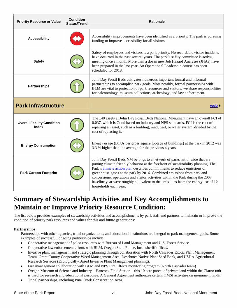
Accessibility
Accessibility improvements have been identified as a priority. The park is pursuing
funding to improve accessibility for all visitors.
Safety
Safety of employees and visitors is a park priority. No recordable visitor incidents
have occurred in the past several years. The park’s safety committee is active,
meeting once a month. More than a dozen new Job Hazard Analyses (JHAs) have
been prepared in the last year. An Operational Leadership course has been
scheduled for 2013.
Partnerships
John Day Fossil Beds cultivates numerous important formal and informal
partnerships to accomplish park goals. Most notably, formal partnerships with
BLM are vital to protection of park resources and visitors; we share responsibilities
for paleontology, museum collections, archeology, and law enforcement.
Park Infrastructure web
Overall Facility Condition Index
The 140 assets at John Day Fossil Beds National Monument have an overall FCI of
0.037, which is Good based on industry and NPS standards. FCI is the cost of
repairing an asset, such as a building, road, trail, or water system, divided by the
cost of replacing it.
Energy Consumption
Energy usage (BTUs per gross square footage of buildings) at the park in 2012 was
3.3 % higher than the average for the previous 4 years
Park Carbon Footprint
John Day Fossil Beds NM belongs to a network of parks nationwide that are
putting climate friendly behavior at the forefront of sustainability planning. The
Park’s climate action plan describes commitments to reduce emissions of
greenhouse gases at the park by 2016. Combined emissions from park and
concessioner operations and visitor activities within the Park during the 2007
baseline year were roughly equivalent to the emissions from the energy use of 12
households each year.
Summary of Stewardship Activities and Key Accomplishments to
Maintain or Improve Priority Resource Condition: The list below provides examples of stewardship activities and accomplishments by park staff and partners to maintain or improve the
condition of priority park resources and values for this and future generations:
Partnerships
Partnerships with other agencies, tribal organizations, and educational institutions are integral to park management goals. Some
examples of successful, ongoing partnerships include:
Cooperative management of paleo resources with Bureau of Land Management and U.S. Forest Service.
Cooperative law enforcement efforts with BLM, Oregon State Police, local sheriff offices.
Invasive plant management and strategic planning through collaboration with North Cascades Exotic Plant Management
Team, Grant County Cooperative Weed Management Area, Deschutes Native Plant Seed Bank, and USDA Agricultural
Research Services (Ecologically-Based Invasive Plant Management planning).
Fire management collaboration with BLM and NPS Fire Effects monitoring program (North Cascades team).
Oregon Museum of Science and Industry – Hancock Field Station—this 10 acre parcel of private land within the Clarno unit
is used for research and educational purposes. A General Agreement authorizes certain OMSI activities on monument lands.
Tribal partnerships, including Pine Creek Conservation Area.
State of the Park Report viii John Day Fossil Beds National Monument
Summer internship and guest scientist programs with Oregon Youth Conservation Corps, Northwest Youth Corps, Youth
Conservation Corps, Student Conservation Association, and GeoCorp program.
Supporting local community development with Oregon Paleo Lands Institute.
Natural Resources
Paleontology: Intensive surveys within the Sheep Rock unit have covered more than 75% of the badlands exposures, and
helped to preserve thousands of fossil specimens. New fossil species are regularly discovered in all three park units, and on
adjacent BLM lands, by park paleontologists.
Two recently published finds includes the earliest modern beaver in North America and the world’s oldest fisher; press
coverage of these finds created wide-spread general interest.
The park hosted two recent field conferences—Society of Vertebrate Paleontology, and Geological Society of America.
Recent geologic research has helped define stratigraphy of rock units in the Park, and combined with new radiometric dates
allows more precise dating of fossils (usually within 1 million years).
Park working with NOAA fisheries to increase threatened steelhead populations by restoring riparian vegetation and
improving fish passage in Bridge Creek at the Painted Hills Unit.
Collaboration with UCBN Inventory and Monitoring program for long-term monitoring and natural resource management.
o Radio telemetry study with bat species to determine location of roosts
o Vertebrate inventories (mammals, birds, reptiles, amphibians)
o Butterfly and moth inventories
o Upland and riparian vegetation monitoring
o Water quality and stream channel monitoring
Vegetation management program: Annually control invasive plant species through herbicide application (with an average of
over 100 acres treated each year), manual pulling, and biological control agents (stem-boring weevil for Dalmatian toadflax).
Restoration of abandoned agricultural fields to native grass communities. Initiated ecologically-based invasive plant
management (EBIPM) in partnership with USDA-ARS to improve weed management effectiveness and sustainability of the
program.
Cultural Resources
Completion of the cultural landscape inventory for the Cant Ranch Historic District.
Updated National Register of Historic Places nomination for the Cant Ranch Historic District.
Preservation of historic fruit tree varieties in the Cant Ranch orchard by grafting scions to period root stock.
Preservation treatment of the Cant Ranch outbuildings and landscape.
Increased knowledge of archeology through archeological surveys and testing projects including the discovery of pit houses
occupied by indigenous tribes.
Visitor Experience
Thomas Condon Paleontology Center is a world class facility for educating the public about the region’s fossil history and
the on-going story of scientific inquiry.
Social media—Significant updates to the website have substantially improved public access to information about the
monument. The park has established a popular Facebook page, YouTube channel, and Twitter account to increase relevancy
for virtual visitors.
Major revisions to publications are ongoing. Six publications have already been revised and are now available, with many
more on the way.
Created a new Jr. Ranger book in 2012 that focuses on the full range of primary and secondary park resources.
The popular horse kit traveling educational trunks are sent to schools as far away as Guam.
Eight new wayside exhibits were developed and installed at two popular park locations, the Clarno Picnic Area and the Island
in Time trail at Blue Basin.
Rangers completed a monument-wide wayside exhibit inventory and assessment in 2012.
Park Infrastructure
Prep lab and collection facility at Thomas Condon Paleontology Center are state of the art, allowing curation of park
resources at a level unprecedented within the National Park Service.
Energy efficiency: New residences were constructed at Painted Hills and Foree in 2009 and 2010. The Painted Hills house is
a net-zero energy home that actually results in an annual surplus back to the park’s energy bill.
The Red Scar Knoll trail was built at Painted Hills in 2011, providing a spectacular and popular visitor experience.
State of the Park Report ix John Day Fossil Beds National Monument
Key Issues and Challenges for Consideration in Management
Planning Strategic Sustainability
The greatest management challenge at John Day Fossil Beds, as at many other parks, is development of a strategic management
paradigm that will be sustainable into the future. We need to become lean and efficient with a focus on the core resources for which
the park was established. This is going to require some very difficult choices between important resources and core resources. This
will likely mean a conscious decision to let some important, but not core, resources and assets deteriorate.
A related significant challenge is maintaining employee skills and workplace satisfaction in the face of declining budgets, FTE
ceilings and the need to do less with less, which is not easy for highly dedicated employees to accept. A significant portion of the
long-term workforce at John Day Fossil Beds will be eligible for retirement within the next several years, so planning for workforce
transition will be important to retain institutional knowledge.
Lands Issues
John Day Fossil Beds National Monument was established in 1975. As described in the park’s Land Protection Plan, nearly one
quarter of the area within the boundary is in non-federal ownership and much of this non-federal land is privately owned. Associated
threats to park resources and visitor experience include trespass cattle, exotic plant control, access to NPS facilities and resources
across inholdings, and encroachment of development on park lands.
Community/Partnerships
In the modern world, no park is an island. To effectively manage park resources and provide a quality experience for park visitors,
John Day Fossil Beds National Monument needs to maintain multiple existing partnerships and seek to develop new partners in
innovative, non-traditional ways.
The park and our visitors contribute positively to local economies; continued economic development in rural communities surrounding
the park is important to provide necessary infrastructure for visitors to stay in the area long enough to experience the park’s resources,
as well as for support of NPS employees and management functions. We are part of the local communities and economies, and
cooperation with local efforts to expand necessary visitor services is appropriate.
Paleontology
John Day Fossil Beds National Monument was established because of world-class fossil resources. The park has an active and exciting
paleontology program with new species being described on an almost routine basis. This program is world renowned and very well-
respected. Since scientific integrity of paleontological resources is lost if the specimens erode out of their geologic context, the park
routinely prospects for new fossils becoming exposed through erosion. As a result, the park’s museum collection is literally expanding
every week. At some point, the park’s capacity for curating these specimens will be reached. Pre-planning for this eventuality will be
important for continued protection of these world-class resources.
The 2009 General Management Plan plans for opening the Hancock Mammal Quarry for research and interpretation. This site is of
great importance to scientists’ knowledge of vertebrate fossils from the early Tertiary Period. Preliminary analysis suggests that this is
the best late Eocene vertebrate site found in the western United States. Much information likely would be gained by reopening the
quarry, and it would add a new facet to the visitor experience. However, significant pre-planning and facility development would be
necessary to insure that this important resource could be adequately protected and interpreted.
Vegetation Management Decisions regarding sustainable management of vegetative communities within John Day Fossil Beds National Monument will be
important in the future, possibly necessitating re-evaluation of desired future conditions and perhaps even applicability of traditional
NPS policy regarding native communities. Invasive plant species are widespread and expanding within all three units, posing a
significant threat to native communities. Even if the entire park budget and all staff were to be dedicated solely to exotic plant
management, invasive plants could not be eradicated. The park is working on an innovative planning process to establish realistic
priorities and goals for treatment of exotic plants; however this will continue to be a huge management challenge for the foreseeable
future.
Although junipers are native to the monument, scientists believe that this species is encroaching on new areas and in densities that
may require some management action (Miller et al. 2005). Prescribed fire has been used over the past few decades to control junipers,
but there is disagreement over the application of burning because of the aggressive establishment of exotic understory species in areas
opened up by fire.
State of the Park Report x John Day Fossil Beds National Monument
Cultural Resources
The Cant Ranch Historic District is one of the most intact locally significant examples of a historic sheep/cattle ranch in Wheeler and
Grant Counties, Oregon, and is currently managed to maintain the historic features. This includes multiple historic structures including
four agricultural fields actively managed for harvest. Sustainable management of this district into the future may become increasingly
difficult as budgets and staffing declines.
A management plan for the park’s archeological resources, especially pictographs, is a critical need to protect these irreplaceable
resources. In 2013 meetings with each of the traditionally associated American Indian governments, the need for a formal plan to
manage and protect pictographs was raised as the tribes’ highest priority. The park lacks technical expertise to complete this planning
process and will require assistance from Pacific West Region staff to do so. Timely completion of this planning process is important
for resource protection and for maintaining good relations with traditionally associated tribal governments.
Visitor Opportunities and Relevancy
First-time visitors to the park often exclaim in awe that they had no idea there is such a fascinating resource right here in Oregon and
declare that they will be back to visit again now that they know about the amazing paleontology story. This park is quite remote.
Digital infrastructure that has become expected elsewhere is not available here. We do not have cell phone coverage in most of the
park or the surrounding areas. Internet infrastructure capabilities are limited. Even telephones often malfunction. Although the park
has an active following on Facebook and Twitter, as well as two web cameras, finding a way to provide digital experiences that the
modern visitor (both on-site and virtual visitors) expect continues to be challenging.
The Clarno Unit is the least developed of the park’s units. There is an extensive trail system that was informally created over time
rather than planned. The park’s 2009 General Management Plan calls for formalizing these unofficial trails. Careful planning and
development could result in a much expanded visitor experience, including new interpretive opportunities.
State of the Park Report 1 John Day Fossil Beds National Monument
Chapter 1 - Introduction
The purpose of this State of the Park report for John Day Fossil Beds National Monument is to assess the overall condition of the
park’s priority resources and values, clearly communicate complex park condition information to visitors and the American, and to
inform visitors and other stakeholders about stewardship actions being taken by park staff to maintain or improve the condition of
priority park resources for future generations. The State of the Park report uses a standardized approach to focus attention on the
priority resources and values of the park based on the park’s purpose and significance, as described in the park’s Foundation
Document or General Management Plan. The report:
Provides to visitors and the American public a snapshot of the status and trend in the condition of a park’s priority resources
and values.
Summarizes and communicates complex scientific, scholarly, and park operations factual information and expert opinion
using non-technical language and a visual format.
Highlights park stewardship activities and accomplishments to maintain or improve the state of the park.
Identifies key issues and challenges facing the park to inform park management planning.
The process of identifying priority park resources by park staff and partners, tracking their condition, organizing and synthesizing data
and information, and communicating the results will be closely coordinated with the park planning process, including natural and
cultural resource condition assessments and Resource Stewardship Strategy development. The term “priority resources” is used to
identify the fundamental and other important resources and values for the park, based on a park’s purpose and significance within the
National Park System, as documented in the park’s foundation document and other planning documents. This report summarizes and
communicates the overall condition of priority park resources and values based on the available scientific and scholarly information
and expert opinion, irrespective of the ability of the park superintendent or the National Park Service to influence it.
John Day Fossil Beds National Monument, located in east central Oregon in Grant and Wheeler counties, encompasses 14,000 acres in
the John Day River valley. The monument features sedimentary rocks that contain a plant and animal fossil record spanning 40
million years of the Age of Mammals. The monument is geographically dispersed over three widely separated units: the Clarno Unit,
the Painted Hills Unit, and the Sheep Rock Unit. All three units provide a variety of opportunities for recreation and study and serve to
introduce the paleontological story of the much larger basin to the public.
The purpose of John Day Fossil Beds National Monument is to preserve, and provide for the scientific and public understanding of the
paleontological resources of the John Day region, and the natural, scenic, and cultural resources within the boundaries of the national
monument.
Significance statements express why the park unit’s resources and values are important enough to warrant national park unit
designation. John Day Fossil Beds National Monument is significant because:
The John Day region contains one of the longest and most continuous Tertiary records of evolutionary change and biotic
relationships in the world; this outstanding fossil record heightens our understanding of earth history. John Day Fossil Beds
National Monument contains a concentration of localities that are a major part of that record.
The John Day region is one of the few areas on the planet with numerous well-preserved and ecologically diverse fossil
biotas that are entombed in sedimentary layers and are found in close proximity with datable volcanic rocks; these biotas
span intervals of dramatic worldwide paleoclimatic change.
John Day Fossil Beds National Monument contains regionally representative scenic, natural and cultural landscapes—
notably, the James Cant Ranch Historic District, which represents the history of sheep ranching in the region.
The Fundamental Resources and Values as documented in the park’s General Management Plan are as follows:
John Day Fossil Beds National Monument contains important geological formations that contain fossil-bearing sedimentary
strata, fossil soils, and numerous datable volcanic rock layers. Special paleontological resources include vertebrate, botanical,
and invertebrate fossils; conformable layers of rocks (strata); fossil localities; datable ash layers; and identified paleosol units.
The paleontology museum, archives, databases, and library collections at John Day Fossil Beds National Monument allow
scientists to conduct important paleontological research on the history of life on planet Earth during the past 40 million years.
Other Important Resources and Values identified in the General Management Plan include:
The colorful and diverse landscape presents scenic and educational features and vistas. Examples of these scenic resources
are found in Sheep Rock, Painted Hills, Cathedral Rock, Picture Gorge, Blue Basin, Foree, and the Clarno Palisades.
The ecosystem of the monument contains examples of protected, regionally representative, native plant and animal species.
The John Day River and its tributaries are valued resources for: (a) their position and integrity within the Columbia River
system; (b) habitat for threatened and endangered species; (c) free flowing water important to anadromous fish; (d)
State of the Park Report 2 John Day Fossil Beds National Monument
recreation; (e) water quality and quantity; (f) fisheries; (g) important hydrological resources within the near desert ecosystem;
(h) tribal interest in traditional use; and (i) riparian area habitat.
Archeological sites and pictographs are valued for their association with and representation of the cultural heritage of
American Indians and others.
The James Cant Ranch Historic District, listed on the National Register of Historic Places, contains irrigated bottomlands,
corrals, buildings, and landscape characteristics within the Sheep Rock Unit. It is valued for its intact cultural landscape that
represents ranching history.
Locations and maps of the Clarno, Painted Hills, and Sheep Rock units of John Day Fossil Beds National Monument
in northcentral Oregon.
State of the Park Report 3 John Day Fossil Beds National Monument
Chapter 2 - State of the Park
The State of the Park is summarized below for four categories—Natural Resources, Cultural Resources, Visitor Experience, and Park
Infrastructure—based on a synthesis of the park’s monitoring, evaluation, management, and information programs, and expert
opinion. Brief resource summaries are provided below for a selection of the priority resources and values of the park. Clicking on the
web symbol found in the tables and resource briefs below will take you to the internet site that contains content associated with
specific topics in the report.
The scientific and scholarly reports, publications, datasets, methodologies, and other information that were used as the basis for the
assessments of resource condition are referenced and linked throughout the report and through the internet version of this report that is
linked to the NPS IRMA data system (Integrated Resource Management Applications). The internet version of each report, and the
associated workshop summary report available from the internet site, provide additional detail and sources of information about the
findings summarized in the report, including references, accounts on the origin and quality of the data, and the methods and analytical
approaches used in data collection and the assessments of condition. Resource condition assessments reported in this State of the Park
report involve expert opinion and the professional judgment of park staff and subject matter experts involved in developing the report.
This expert opinion and professional judgment derive from the in-depth knowledge and expertise of park and regional staff gained
from their being involved in the day-to-day practice of all aspects of park stewardship and from the professional experience of the
participating subject matter experts. This expert opinion and professional judgment utilized available factual information for the
analyses and conclusions presented in this report. This State of the Park report was developed in a park-convened workshop.
The status and trends documented in Chapter 2 provide a useful point-in-time baseline measured against reference conditions that
represent “healthy” ecosystem parameters, or regulatory standards (such as those related to air or water quality). We also note that
climate change adaptation requires us to continue to learn from the past, but attempting to manage for conditions based on our
understanding of the historical “natural” range of variation will be increasingly futile in many locations. Thus, these reference
conditions, and/or our judgment about resource condition or trend may evolve as the rate of climate change accelerates and we
respond to novel conditions. Our management must be even more “forward looking,” to anticipate plausible but unprecedented
conditions, also recognizing there will be surprises. In this context, we will incorporate climate considerations in our decision
processes and management planning as we consider adaptation options that may deviate from traditional practices.
2.1. Natural Resources
Climate
web
Indicators of Condition Specific Measures
Condition
Status/Trend Rationale
Temperature
(historical)
Mean annual
temperature
Over the 117 year instrumental record (1895–2011) mean
annual temperature showed an increasing linear trend
(+0.09 °F) per decade. Seasonal temperature changes
were strongest in winter (+0.2 °F per decade). Data from
weather station near the park (Fisichelli 2013).
Temperature
(projected 2100)
Mean annual
temperature
Mean annual temperature, compared with the 1971–1999
average, is projected to increase 3–4 °F by mid-century
and 4–7 °F by the end of the century, depending on the
greenhouse gas emissions scenario (Fisichelli 2013).
Precipitation (historical)
Mean annual
precipitation
Annual precipitation increased slightly over the
instrumental record period (+0.2 inches per decade).
Seasonal precipitation showed the strongest increases in
winter (+0.1 inches per decade) and spring (+0.1 inches
per decade), which in combination with warmer winters
is increasingly falling as rain rather than snow. (Fisichelli
2013). Precipitation has been below average throughout
most of the last decade.
State of the Park Report 4 John Day Fossil Beds National Monument
Precipitation
(projected 2100)
Mean annual
precipitation
Annual precipitation by mid-century may increase
slightly (+1 to +5%), with the greatest increase coming in
winter (+5 to +10%) and a projected decrease in summer
(-10%), compared with 1971–1999 values (Kunkel et al.
2013). In combination with warming temperatures and
declining snowpacks, this is expected to result in an
overall net aridification and increasing drought stress.
Drought Index Normalized Palmer
Drought Severity
Index
The region has been ranked as experiencing moderate (-
2) to extreme (-4) drought for most of the last decade
(NOAA National Climatic Data Center).
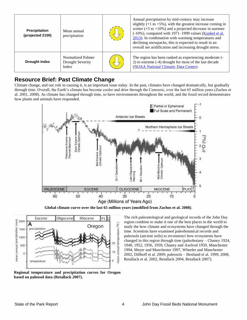
Resource Brief: Past Climate Change Climate change, and our role in causing it, is an important issue today. In the past, climates have changed dramatically, but gradually
through time. Overall, the Earth’s climate has become cooler and drier through the Cenozoic, over the last 65 million years (Zachos et
al. 2001, 2008). As climate has changed through time, so have environments throughout the world, and the fossil record demonstrates
how plants and animals have responded.
The rich paleontological and geological records of the John Day
region combine to make it one of the best places in the world to
study the how climate and ecosystems have changed through the
time. Scientists have examined paleobotanical records and
paleosols (ancient soils) to reconstruct how ecosystems have
changed in this region through time (paleobotany – Chaney 1924,
1948, 1952, 1956, 1959, Chaney and Axelrod 1959, Manchester
1994, Meyer and Manchester 1997, Wheeler and Manchester
2002, Dillhoff et al. 2009; paleosols – Bestland et al. 1999, 2008,
Retallack et al. 2002, Retallack 2004, Retallack 2007).
Regional temperature and precipitation curves for Oregon
based on paleosol data (Retallack 2007).
Global climate curve over the last 65 million years (modified from Zachos et al. 2008).
State of the Park Report 5 John Day Fossil Beds National Monument
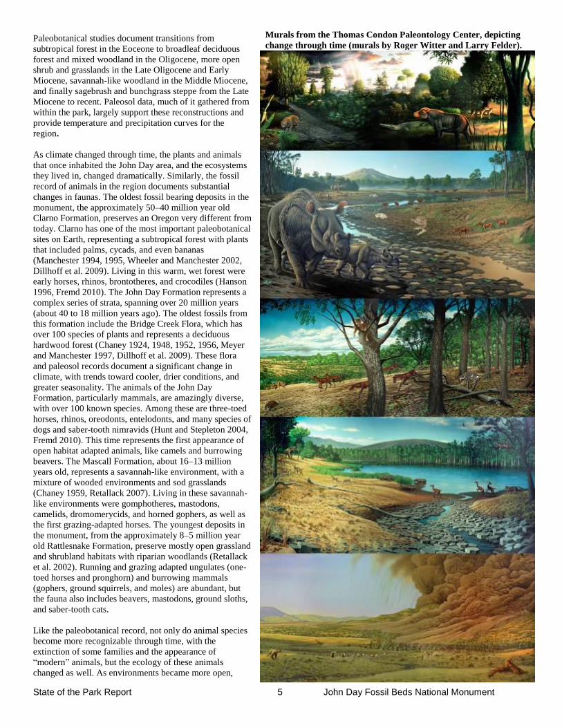
Paleobotanical studies document transitions from
subtropical forest in the Eoceone to broadleaf deciduous
forest and mixed woodland in the Oligocene, more open
shrub and grasslands in the Late Oligocene and Early
Miocene, savannah-like woodland in the Middle Miocene,
and finally sagebrush and bunchgrass steppe from the Late
Miocene to recent. Paleosol data, much of it gathered from
within the park, largely support these reconstructions and
provide temperature and precipitation curves for the
region.
As climate changed through time, the plants and animals
that once inhabited the John Day area, and the ecosystems
they lived in, changed dramatically. Similarly, the fossil
record of animals in the region documents substantial
changes in faunas. The oldest fossil bearing deposits in the
monument, the approximately 50–40 million year old
Clarno Formation, preserves an Oregon very different from
today. Clarno has one of the most important paleobotanical
sites on Earth, representing a subtropical forest with plants
that included palms, cycads, and even bananas
(Manchester 1994, 1995, Wheeler and Manchester 2002,
Dillhoff et al. 2009). Living in this warm, wet forest were
early horses, rhinos, brontotheres, and crocodiles (Hanson
1996, Fremd 2010). The John Day Formation represents a
complex series of strata, spanning over 20 million years
(about 40 to 18 million years ago). The oldest fossils from
this formation include the Bridge Creek Flora, which has
over 100 species of plants and represents a deciduous
hardwood forest (Chaney 1924, 1948, 1952, 1956, Meyer
and Manchester 1997, Dillhoff et al. 2009). These flora
and paleosol records document a significant change in
climate, with trends toward cooler, drier conditions, and
greater seasonality. The animals of the John Day
Formation, particularly mammals, are amazingly diverse,
with over 100 known species. Among these are three-toed
horses, rhinos, oreodonts, entelodonts, and many species of
dogs and saber-tooth nimravids (Hunt and Stepleton 2004,
Fremd 2010). This time represents the first appearance of
open habitat adapted animals, like camels and burrowing
beavers. The Mascall Formation, about 16–13 million
years old, represents a savannah-like environment, with a
mixture of wooded environments and sod grasslands
(Chaney 1959, Retallack 2007). Living in these savannah-
like environments were gomphotheres, mastodons,
camelids, dromomerycids, and horned gophers, as well as
the first grazing-adapted horses. The youngest deposits in
the monument, from the approximately 8–5 million year
old Rattlesnake Formation, preserve mostly open grassland
and shrubland habitats with riparian woodlands (Retallack
et al. 2002). Running and grazing adapted ungulates (one-
toed horses and pronghorn) and burrowing mammals
(gophers, ground squirrels, and moles) are abundant, but
the fauna also includes beavers, mastodons, ground sloths,
and saber-tooth cats.
Like the paleobotanical record, not only do animal species
become more recognizable through time, with the
extinction of some families and the appearance of
“modern” animals, but the ecology of these animals
changed as well. As environments became more open,
Murals from the Thomas Condon Paleontology Center, depicting
change through time (murals by Roger Witter and Larry Felder).
State of the Park Report 6 John Day Fossil Beds National Monument
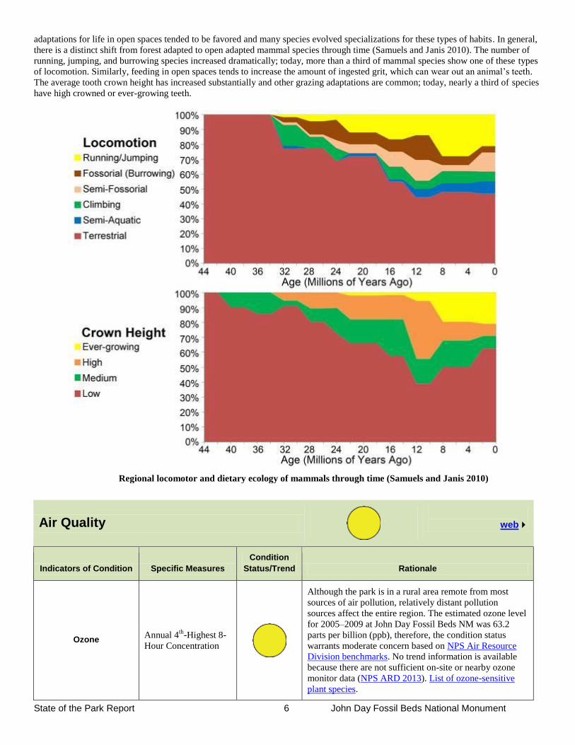
adaptations for life in open spaces tended to be favored and many species evolved specializations for these types of habits. In general,
there is a distinct shift from forest adapted to open adapted mammal species through time (Samuels and Janis 2010). The number of
running, jumping, and burrowing species increased dramatically; today, more than a third of mammal species show one of these types
of locomotion. Similarly, feeding in open spaces tends to increase the amount of ingested grit, which can wear out an animal’s teeth.
The average tooth crown height has increased substantially and other grazing adaptations are common; today, nearly a third of species
have high crowned or ever-growing teeth.
Air Quality
web
Indicators of Condition Specific Measures
Condition
Status/Trend Rationale
Ozone Annual 4
th-Highest 8-
Hour Concentration
Although the park is in a rural area remote from most
sources of air pollution, relatively distant pollution
sources affect the entire region. The estimated ozone level
for 2005–2009 at John Day Fossil Beds NM was 63.2
parts per billion (ppb), therefore, the condition status
warrants moderate concern based on NPS Air Resource
Division benchmarks. No trend information is available
because there are not sufficient on-site or nearby ozone
monitor data (NPS ARD 2013). List of ozone-sensitive
plant species.
Regional locomotor and dietary ecology of mammals through time (Samuels and Janis 2010)
State of the Park Report 7 John Day Fossil Beds National Monument
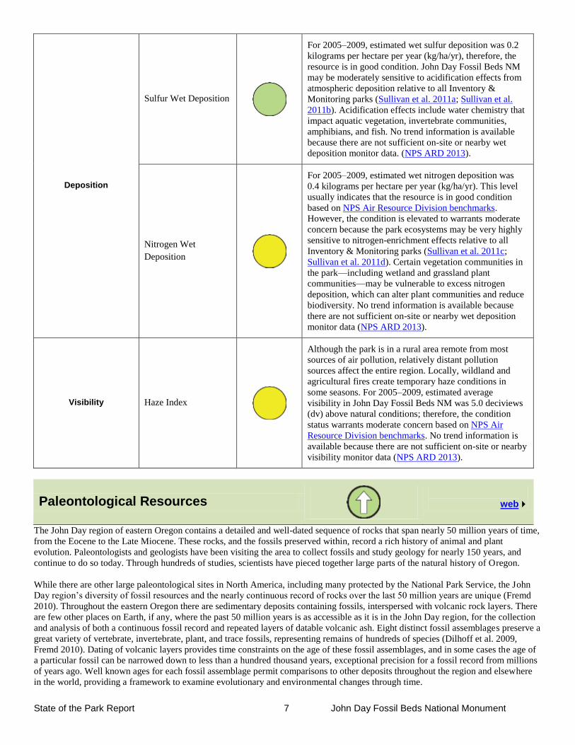
Deposition
Sulfur Wet Deposition
For 2005–2009, estimated wet sulfur deposition was 0.2
kilograms per hectare per year (kg/ha/yr), therefore, the
resource is in good condition. John Day Fossil Beds NM
may be moderately sensitive to acidification effects from
atmospheric deposition relative to all Inventory &
Monitoring parks (Sullivan et al. 2011a; Sullivan et al.
2011b). Acidification effects include water chemistry that
impact aquatic vegetation, invertebrate communities,
amphibians, and fish. No trend information is available
because there are not sufficient on-site or nearby wet
deposition monitor data. (NPS ARD 2013).
Nitrogen Wet
Deposition
For 2005–2009, estimated wet nitrogen deposition was
0.4 kilograms per hectare per year (kg/ha/yr). This level
usually indicates that the resource is in good condition
based on NPS Air Resource Division benchmarks.
However, the condition is elevated to warrants moderate
concern because the park ecosystems may be very highly
sensitive to nitrogen-enrichment effects relative to all
Inventory & Monitoring parks (Sullivan et al. 2011c;
Sullivan et al. 2011d). Certain vegetation communities in
the park—including wetland and grassland plant
communities—may be vulnerable to excess nitrogen
deposition, which can alter plant communities and reduce
biodiversity. No trend information is available because
there are not sufficient on-site or nearby wet deposition
monitor data (NPS ARD 2013).
Visibility Haze Index
Although the park is in a rural area remote from most
sources of air pollution, relatively distant pollution
sources affect the entire region. Locally, wildland and
agricultural fires create temporary haze conditions in
some seasons. For 2005–2009, estimated average
visibility in John Day Fossil Beds NM was 5.0 deciviews
(dv) above natural conditions; therefore, the condition
status warrants moderate concern based on NPS Air
Resource Division benchmarks. No trend information is
available because there are not sufficient on-site or nearby
visibility monitor data (NPS ARD 2013).
Paleontological Resources
web
The John Day region of eastern Oregon contains a detailed and well-dated sequence of rocks that span nearly 50 million years of time,
from the Eocene to the Late Miocene. These rocks, and the fossils preserved within, record a rich history of animal and plant
evolution. Paleontologists and geologists have been visiting the area to collect fossils and study geology for nearly 150 years, and
continue to do so today. Through hundreds of studies, scientists have pieced together large parts of the natural history of Oregon.
While there are other large paleontological sites in North America, including many protected by the National Park Service, the John
Day region’s diversity of fossil resources and the nearly continuous record of rocks over the last 50 million years are unique (Fremd
2010). Throughout the eastern Oregon there are sedimentary deposits containing fossils, interspersed with volcanic rock layers. There
are few other places on Earth, if any, where the past 50 million years is as accessible as it is in the John Day region, for the collection
and analysis of both a continuous fossil record and repeated layers of datable volcanic ash. Eight distinct fossil assemblages preserve a
great variety of vertebrate, invertebrate, plant, and trace fossils, representing remains of hundreds of species (Dilhoff et al. 2009,
Fremd 2010). Dating of volcanic layers provides time constraints on the age of these fossil assemblages, and in some cases the age of
a particular fossil can be narrowed down to less than a hundred thousand years, exceptional precision for a fossil record from millions
of years ago. Well known ages for each fossil assemblage permit comparisons to other deposits throughout the region and elsewhere
in the world, providing a framework to examine evolutionary and environmental changes through time.
State of the Park Report 8 John Day Fossil Beds National Monument
The rich paleontological and geological records of this region combine to make it one of the best places in the world to study the
Earth’s history. The animals and plants that once inhabited the area, and the ecosystems preserved here have changed dramatically
through time. The importance of the paleontological resources at John Day Fossil Beds National Monument cannot be overstated.
Fossils from the John Day region have been key to understanding the evolution of horses and dogs, and have provided insights into the
spread of grassland habitats through time (MacFadden 1994, Wang 1994, Wang et al. 1999, Wang and Tedford 2008, Retallack 2004,
2007, Retallack et al. 2002). New discoveries are regularly made by paleontologists; helping to give us a fuller picture of the region’s
past. Ongoing research efforts are helping to better reconstruct past environments and how they changed through time, allowing us a
more complete understanding of how species have evolved and became extinct. This paleontological research is informative to global
trends of change through time in the past, and is relevant for our understanding of current events like climate change and the fates of
endangered species.
While abundant in this region, paleontological resources represent non-renewable resources threatened by the constant, natural
processes of erosion and weathering. As the value of paleontological resources is in the information they contain, active management
of these resources is vital for their preservation. Given the abundance of scientifically significant fossils in the John Day region and
rapid rates of erosion, proper management of paleontological resources in many situations requires collection to prevent the loss of
specimens. “Cyclic prospecting” is the generally the preferred management strategy in the John Day region (Fremd 1995).
Indicators of Condition Specific Measures
Condition
Status/Trend Rationale
Knowledge
Species richness,
ecosystem
completeness,
percentage of
specimens with known
age ranges, resources
are understood in a
broader context
Ongoing paleontological research has substantially
improved knowledge of the monument’s resources. Many
new species have been discovered through work in the
field and collections, resulting in a number of new
publications (Samuels and Zancanella 2011, Calede and
Hopkins 2012, Samuels and Cavin 2013). Research has
also yielded more accurate reconstructions of past
ecosystems and better understanding of how plant and
animal communities changed through time (Samuels and
Janis 2010, Samuels et al. 2013). New radiometric data
and stratigraphic knowledge have helped refine the ages
of specimens, particularly in the Mascall Formation and
Turtle Cove Member of the John Day Formation (Schmitz
2013, Albright et al. 2008).
Inventory and
Conservation
Percentage of park
intensely surveyed,
number of threatened
fossil specimens
collected, specimens
are stabilized and
prepared by
professional staff
Sites are closely monitored and paleontological resources
are protected through active management. Cyclic
prospecting surveys have taken place in all three units of
the monument in recent years, while intensive surveys of
the Sheep Rock have covered more than 75% of badlands
exposures in the last 3 years. Over 3000 threatened fossil
specimens have been collected in the process from 2010
to 2012, a substantial increase over previous years (about
1400 from 2007 to 2009). Collected fossil specimens
receive conservation treatment by professional staff in a
state of the art fossil prep lab.
Resource Stability
Percentage of sites in
good condition,
completeness and
diversity of specimens
collected
Important fossil sites are stable in good condition in all
three units of the monument. Completeness of recovered
specimens is good, suggesting cyclic prospecting
activities are sufficient for preservation of threatened
resources. Diversity of recovered specimens is high,
including both macro and micro fossils, with vertebrate,
invertebrate, plant, and trace fossil materials represented.
State of the Park Report 9 John Day Fossil Beds National Monument
Resource Brief: New Species
The paleontology of the John Day Basin has been studied for about 150 years, but there is still much more to learn. Working under a
formal partnership with BLM, NPS paleontologists and researchers throughout the region discover new species regularly, both
through work in the field and continued study in the museum collections. They also often find previously undiscovered parts of
animals and plants, and more detailed information about when species lived. These new finds help scientists to continually refine our
understanding of the region’s history and allow them to build a more complete picture of Oregon’s past.
Examination of the history of investigations from the John Day Basin reveals how these continued efforts have added to our
knowledge of the region (Samuels, unpublished data). The first paper on John Day Formation was published by Leidy in 1870. In the
late 1800s, a flurry of early publications by Marsh, Cope, and Scott appeared, describing a large number of animal species. In the early
20th
century, the work of Merriam and his collaborators added substantially to knowledge of the John Day Formation. The second half
of the twentieth century showed a relatively steady pattern of further publication, with a substantial increase since 2004.
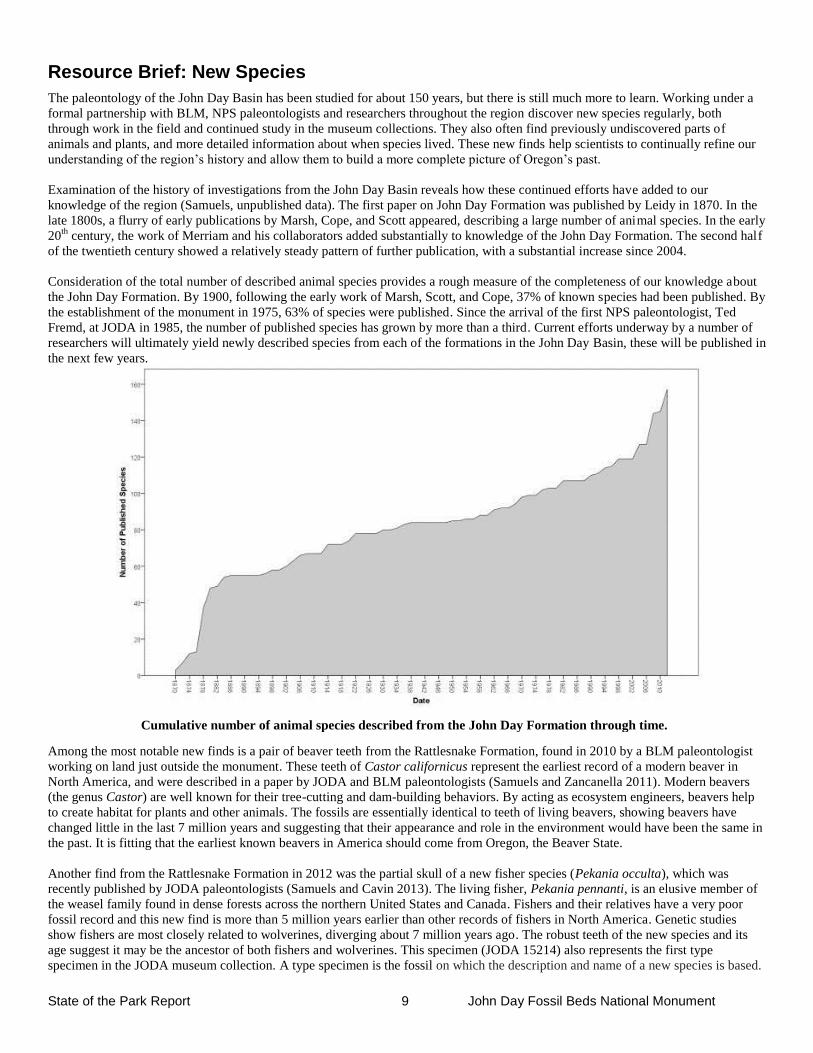
Consideration of the total number of described animal species provides a rough measure of the completeness of our knowledge about
the John Day Formation. By 1900, following the early work of Marsh, Scott, and Cope, 37% of known species had been published. By
the establishment of the monument in 1975, 63% of species were published. Since the arrival of the first NPS paleontologist, Ted
Fremd, at JODA in 1985, the number of published species has grown by more than a third. Current efforts underway by a number of
researchers will ultimately yield newly described species from each of the formations in the John Day Basin, these will be published in
the next few years.
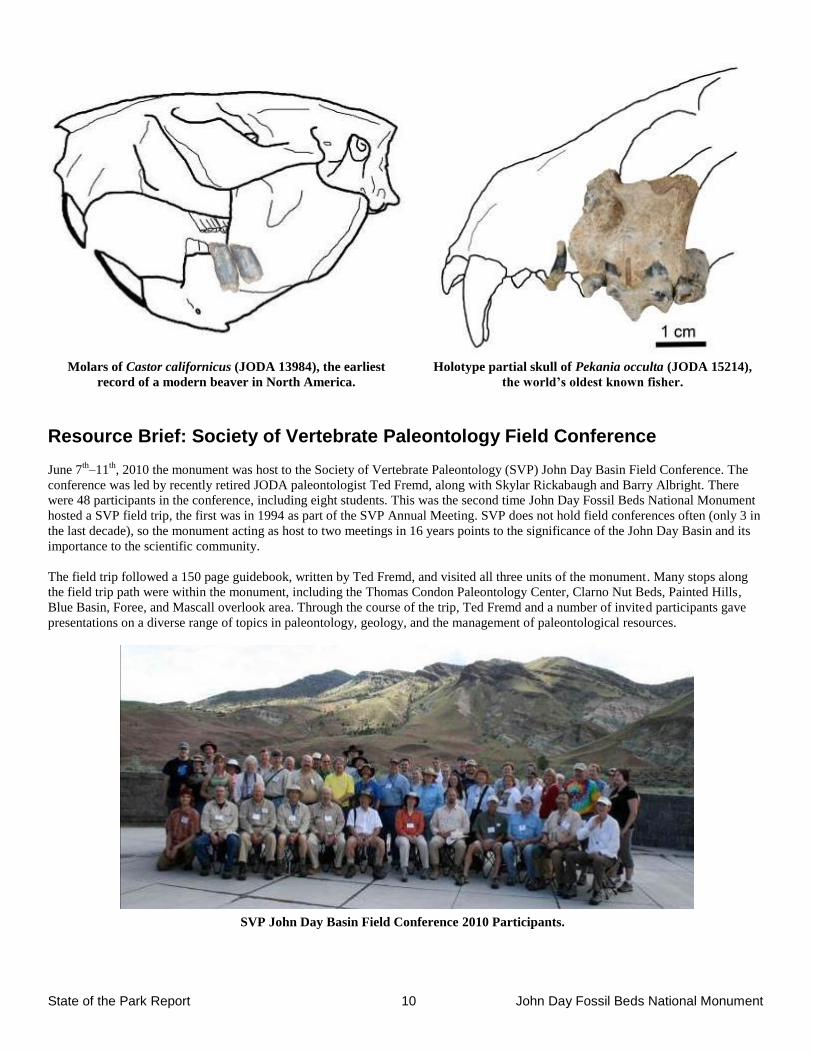
Among the most notable new finds is a pair of beaver teeth from the Rattlesnake Formation, found in 2010 by a BLM paleontologist
working on land just outside the monument. These teeth of Castor californicus represent the earliest record of a modern beaver in
North America, and were described in a paper by JODA and BLM paleontologists (Samuels and Zancanella 2011). Modern beavers
(the genus Castor) are well known for their tree-cutting and dam-building behaviors. By acting as ecosystem engineers, beavers help
to create habitat for plants and other animals. The fossils are essentially identical to teeth of living beavers, showing beavers have
changed little in the last 7 million years and suggesting that their appearance and role in the environment would have been the same in
the past. It is fitting that the earliest known beavers in America should come from Oregon, the Beaver State.
Another find from the Rattlesnake Formation in 2012 was the partial skull of a new fisher species (Pekania occulta), which was
recently published by JODA paleontologists (Samuels and Cavin 2013). The living fisher, Pekania pennanti, is an elusive member of
the weasel family found in dense forests across the northern United States and Canada. Fishers and their relatives have a very poor
fossil record and this new find is more than 5 million years earlier than other records of fishers in North America. Genetic studies
show fishers are most closely related to wolverines, diverging about 7 million years ago. The robust teeth of the new species and its
age suggest it may be the ancestor of both fishers and wolverines. This specimen (JODA 15214) also represents the first type
specimen in the JODA museum collection. A type specimen is the fossil on which the description and name of a new species is based.
Cumulative number of animal species described from the John Day Formation through time.
State of the Park Report 10 John Day Fossil Beds National Monument
Molars of Castor californicus (JODA 13984), the earliest
record of a modern beaver in North America.
Holotype partial skull of Pekania occulta (JODA 15214),
the world’s oldest known fisher.
Resource Brief: Society of Vertebrate Paleontology Field Conference
June 7th
–11th
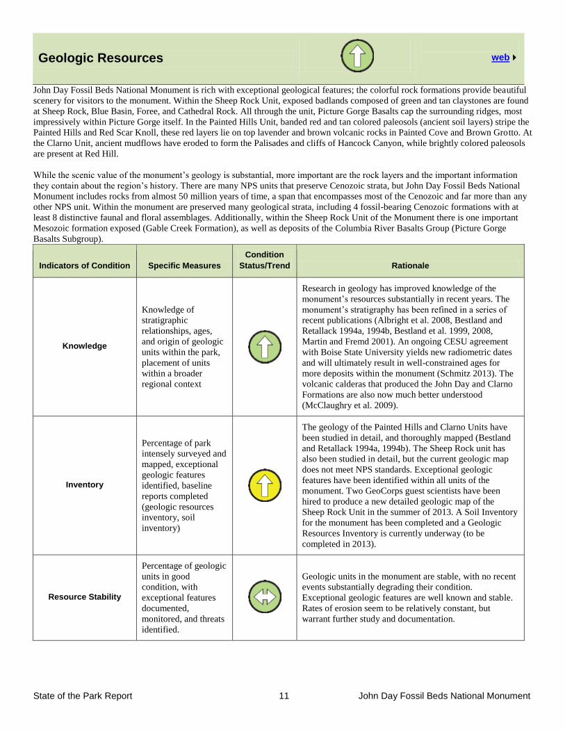
, 2010 the monument was host to the Society of Vertebrate Paleontology (SVP) John Day Basin Field Conference. The
conference was led by recently retired JODA paleontologist Ted Fremd, along with Skylar Rickabaugh and Barry Albright. There
were 48 participants in the conference, including eight students. This was the second time John Day Fossil Beds National Monument
hosted a SVP field trip, the first was in 1994 as part of the SVP Annual Meeting. SVP does not hold field conferences often (only 3 in
the last decade), so the monument acting as host to two meetings in 16 years points to the significance of the John Day Basin and its
importance to the scientific community.
The field trip followed a 150 page guidebook, written by Ted Fremd, and visited all three units of the monument. Many stops along
the field trip path were within the monument, including the Thomas Condon Paleontology Center, Clarno Nut Beds, Painted Hills,
Blue Basin, Foree, and Mascall overlook area. Through the course of the trip, Ted Fremd and a number of invited participants gave
presentations on a diverse range of topics in paleontology, geology, and the management of paleontological resources.
SVP John Day Basin Field Conference 2010 Participants.
State of the Park Report 11 John Day Fossil Beds National Monument
Geologic Resources
web
John Day Fossil Beds National Monument is rich with exceptional geological features; the colorful rock formations provide beautiful
scenery for visitors to the monument. Within the Sheep Rock Unit, exposed badlands composed of green and tan claystones are found
at Sheep Rock, Blue Basin, Foree, and Cathedral Rock. All through the unit, Picture Gorge Basalts cap the surrounding ridges, most
impressively within Picture Gorge itself. In the Painted Hills Unit, banded red and tan colored paleosols (ancient soil layers) stripe the
Painted Hills and Red Scar Knoll, these red layers lie on top lavender and brown volcanic rocks in Painted Cove and Brown Grotto. At
the Clarno Unit, ancient mudflows have eroded to form the Palisades and cliffs of Hancock Canyon, while brightly colored paleosols
are present at Red Hill.
While the scenic value of the monument’s geology is substantial, more important are the rock layers and the important information
they contain about the region’s history. There are many NPS units that preserve Cenozoic strata, but John Day Fossil Beds National
Monument includes rocks from almost 50 million years of time, a span that encompasses most of the Cenozoic and far more than any
other NPS unit. Within the monument are preserved many geological strata, including 4 fossil-bearing Cenozoic formations with at
least 8 distinctive faunal and floral assemblages. Additionally, within the Sheep Rock Unit of the Monument there is one important
Mesozoic formation exposed (Gable Creek Formation), as well as deposits of the Columbia River Basalts Group (Picture Gorge
Basalts Subgroup).
Indicators of Condition Specific Measures
Condition
Status/Trend Rationale
Knowledge
Knowledge of
stratigraphic
relationships, ages,
and origin of geologic
units within the park,
placement of units
within a broader
regional context
Research in geology has improved knowledge of the
monument’s resources substantially in recent years. The
monument’s stratigraphy has been refined in a series of
recent publications (Albright et al. 2008, Bestland and
Retallack 1994a, 1994b, Bestland et al. 1999, 2008,
Martin and Fremd 2001). An ongoing CESU agreement
with Boise State University yields new radiometric dates
and will ultimately result in well-constrained ages for
more deposits within the monument (Schmitz 2013). The
volcanic calderas that produced the John Day and Clarno
Formations are also now much better understood
(McClaughry et al. 2009).
Inventory
Percentage of park
intensely surveyed and
mapped, exceptional
geologic features
identified, baseline
reports completed
(geologic resources
inventory, soil
inventory)
The geology of the Painted Hills and Clarno Units have
been studied in detail, and thoroughly mapped (Bestland
and Retallack 1994a, 1994b). The Sheep Rock unit has
also been studied in detail, but the current geologic map
does not meet NPS standards. Exceptional geologic
features have been identified within all units of the
monument. Two GeoCorps guest scientists have been
hired to produce a new detailed geologic map of the
Sheep Rock Unit in the summer of 2013. A Soil Inventory
for the monument has been completed and a Geologic
Resources Inventory is currently underway (to be
completed in 2013).
Resource Stability
Percentage of geologic
units in good
condition, with
exceptional features
documented,
monitored, and threats
identified.
Geologic units in the monument are stable, with no recent
events substantially degrading their condition.
Exceptional geologic features are well known and stable.
Rates of erosion seem to be relatively constant, but
warrant further study and documentation.
State of the Park Report 12 John Day Fossil Beds National Monument
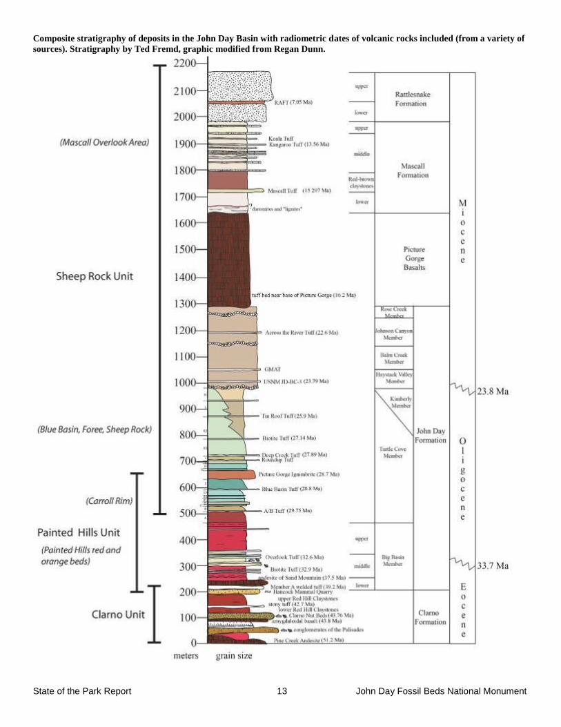
Resource Brief: Stratigraphy and Radiometric Dating
Over the last 20 years, knowledge of the stratigraphy and ages of rock units in the John Day Basin has improved dramatically.
Multiple researchers have worked in all three units of the monument and surrounding areas to produce a detailed stratigraphic
framework for this region. Contract work done by Greg Retallack and Eric Bestland provided a stratigraphic framework for the Clarno
and Painted Hills units of the monument, primarily rocks from the Clarno and John Day Formations (Bestland and Retallack 1994a, b,
Bestland et al. 1999). Hunt and Stepleton (2004) completely redefined the upper part of the John Day Formation, splitting the
“Haystack Valley Member” into a series of four distinct members. Albright et al. (2008) expanded on these studies to produce a
revised composite stratigraphy of the entire complex sequence of beds from the John Day Formation, including 7 members and more
than 20 lithostratigraphic units (Fremd 1994 et al. 1994). Bestland et al. (2008) refined the stratigraphy of the Mascall Formation,
while work continues on revision of the stratigraphy of the Rattlesnake Formation begun by Martin and Fremd (2001).
Radiometric dates from a number of sources have been combined with lithostratigraphic and magnetostratigraphic data to produce a
highly refined chronostratigraphy of rock layers exposed throughout the region. Many dates were part of the doctoral dissertation of
Carl C. Swisher, who used 40
Ar/39
Ar dating methods to provide ages for tuffs within the monument (Swisher 1992). To date, there are
20 radiometrically dated volcanic rock layers that occur within the monument and more layers that have been dated from surrounding
areas. While this is very good, this is only a fraction of what is available for dating, and some large sections of the stratigraphic
column do not have any volcanic rock layers dated. A current Cooperative Ecosystems Studies Unit (CESU) agreement with Dr. Mark
Schmitz at Boise State University (BSU) is designed to provide new radiometric dates and further refine the chronstratigraphy of the
region’s strata. The BSU lab uses the highest precision dating methods available, with U/Pb analyses of zircons yielding dates with an
error around 0.1%. Over the last several years, this collaborative project has yielded 3 new radiometric dates for units from within the
monument, and more samples will be analyzed this year. Continuation of the work Ted Fremd started several decades ago will provide
a better temporal framework for the region’s history, providing a substantial benefit to scientists and the public.
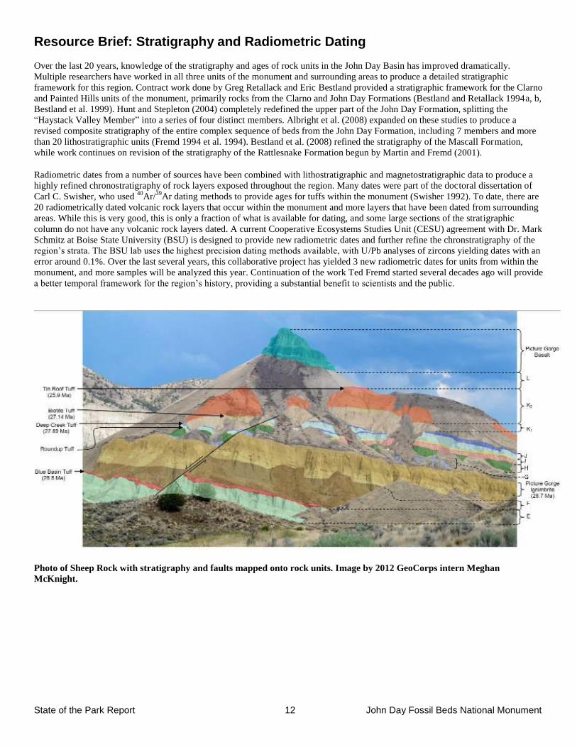
Photo of Sheep Rock with stratigraphy and faults mapped onto rock units. Image by 2012 GeoCorps intern Meghan
McKnight.
State of the Park Report 13 John Day Fossil Beds National Monument
Composite stratigraphy of deposits in the John Day Basin with radiometric dates of volcanic rocks included (from a variety of
sources). Stratigraphy by Ted Fremd, graphic modified from Regan Dunn.
State of the Park Report 14 John Day Fossil Beds National Monument
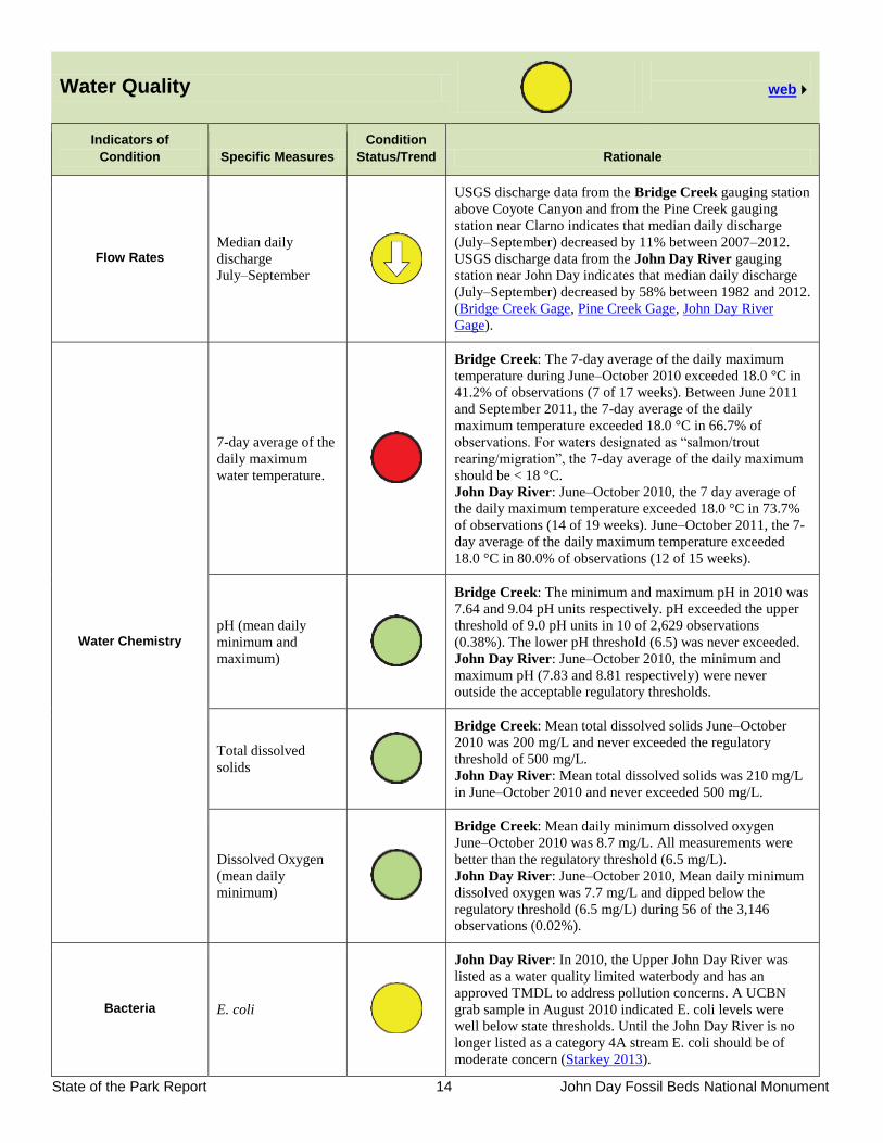
Water Quality
web
Indicators of
Condition Specific Measures
Condition
Status/Trend Rationale
Flow Rates Median daily
discharge
July–September
USGS discharge data from the Bridge Creek gauging station
above Coyote Canyon and from the Pine Creek gauging
station near Clarno indicates that median daily discharge
(July–September) decreased by 11% between 2007–2012.
USGS discharge data from the John Day River gauging
station near John Day indicates that median daily discharge
(July–September) decreased by 58% between 1982 and 2012.
(Bridge Creek Gage, Pine Creek Gage, John Day River
Gage).
Water Chemistry
7-day average of the
daily maximum
water temperature.
Bridge Creek: The 7-day average of the daily maximum
temperature during June–October 2010 exceeded 18.0 °C in
41.2% of observations (7 of 17 weeks). Between June 2011
and September 2011, the 7-day average of the daily
maximum temperature exceeded 18.0 °C in 66.7% of
observations. For waters designated as “salmon/trout
rearing/migration”, the 7-day average of the daily maximum
should be < 18 °C.
John Day River: June–October 2010, the 7 day average of
the daily maximum temperature exceeded 18.0 °C in 73.7%
of observations (14 of 19 weeks). June–October 2011, the 7-
day average of the daily maximum temperature exceeded
18.0 °C in 80.0% of observations (12 of 15 weeks).
pH (mean daily
minimum and
maximum)
Bridge Creek: The minimum and maximum pH in 2010 was
7.64 and 9.04 pH units respectively. pH exceeded the upper
threshold of 9.0 pH units in 10 of 2,629 observations
(0.38%). The lower pH threshold (6.5) was never exceeded.
John Day River: June–October 2010, the minimum and
maximum pH (7.83 and 8.81 respectively) were never
outside the acceptable regulatory thresholds.
Total dissolved
solids
Bridge Creek: Mean total dissolved solids June–October
2010 was 200 mg/L and never exceeded the regulatory
threshold of 500 mg/L.
John Day River: Mean total dissolved solids was 210 mg/L
in June–October 2010 and never exceeded 500 mg/L.
Dissolved Oxygen
(mean daily
minimum)
Bridge Creek: Mean daily minimum dissolved oxygen
June–October 2010 was 8.7 mg/L. All measurements were
better than the regulatory threshold (6.5 mg/L).
John Day River: June–October 2010, Mean daily minimum
dissolved oxygen was 7.7 mg/L and dipped below the
regulatory threshold (6.5 mg/L) during 56 of the 3,146
observations (0.02%).
Bacteria E. coli
John Day River: In 2010, the Upper John Day River was
listed as a water quality limited waterbody and has an
approved TMDL to address pollution concerns. A UCBN
grab sample in August 2010 indicated E. coli levels were
well below state thresholds. Until the John Day River is no
longer listed as a category 4A stream E. coli should be of
moderate concern (Starkey 2013).
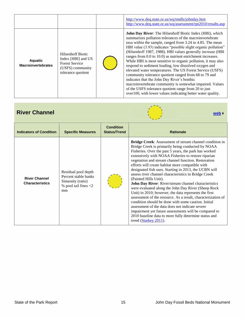
State of the Park Report 15 John Day Fossil Beds National Monument
http://www.deq.state.or.us/wq/tmdls/johnday.htm
http://www.deq.state.or.us/wq/assessment/rpt2010/results.asp
Aquatic
Macroinvertebrates
Hilsenhoff Biotic
Index [HBI] and US
Forest Service
(USFS) community
tolerance quotient
John Day River: The Hilsenhoff Biotic Index (HBI), which
summarizes pollution tolerances of the macroinvertebrate
taxa within the sample, ranged from 3.24 to 4.85. The mean
HBI value (3.93) indicates “possible slight organic pollution”
(Hilsenhoff 1987, 1988). HBI values generally increase (HBI
ranges from 0.0 to 10.0) as nutrient enrichment increases.
While HBI is most sensitive to organic pollution, it may also
respond to sediment loading, low dissolved oxygen and
elevated water temperatures. The US Forest Service (USFS)
community tolerance quotient ranged from 68 to 79 and
indicates that the John Day River’s benthic
macroinvertebrate community is somewhat impaired. Values
of the USFS tolerance quotient range from 20 to just
over100, with lower values indicating better water quality.
River Channel
web
Indicators of Condition Specific Measures
Condition
Status/Trend Rationale
River Channel
Characteristics
Residual pool depth
Percent stable banks
Sinuosity (ratio)
% pool tail fines <2
mm
Bridge Creek: Assessment of stream channel condition in
Bridge Creek is primarily being conducted by NOAA
Fisheries. Over the past 5 years, the park has worked
extensively with NOAA Fisheries to restore riparian
vegetation and stream channel function. Restoration
efforts will create habitat more compatible with
designated fish uses. Starting in 2013, the UCBN will
assess river channel characteristics in Bridge Creek
(Painted Hills Unit).
John Day River: River/stream channel characteristics
were evaluated along the John Day River (Sheep Rock
Unit) in 2010; however, the data represents the first
assessment of the resource. As a result, characterization of
condition should be done with some caution. Initial
assessment of the data does not indicate severe
impairment yet future assessments will be compared to
2010 baseline data to more fully determine status and
trend (Starkey 2011).
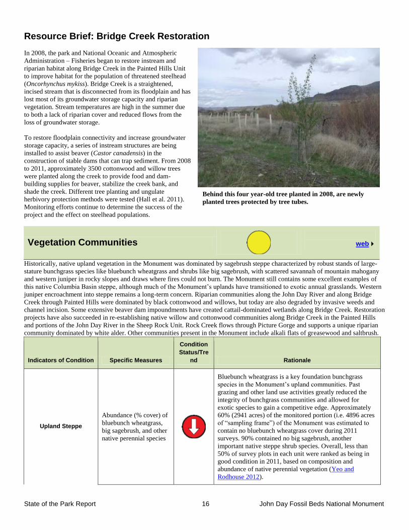
State of the Park Report 16 John Day Fossil Beds National Monument
Behind this four year-old tree planted in 2008, are newly
planted trees protected by tree tubes.
Resource Brief: Bridge Creek Restoration
In 2008, the park and National Oceanic and Atmospheric
Administration – Fisheries began to restore instream and
riparian habitat along Bridge Creek in the Painted Hills Unit
to improve habitat for the population of threatened steelhead
(Oncorhynchus mykiss). Bridge Creek is a straightened,
incised stream that is disconnected from its floodplain and has
lost most of its groundwater storage capacity and riparian
vegetation. Stream temperatures are high in the summer due
to both a lack of riparian cover and reduced flows from the
loss of groundwater storage.
To restore floodplain connectivity and increase groundwater
storage capacity, a series of instream structures are being
installed to assist beaver (Castor canadensis) in the
construction of stable dams that can trap sediment. From 2008
to 2011, approximately 3500 cottonwood and willow trees
were planted along the creek to provide food and dam-
building supplies for beaver, stabilize the creek bank, and
shade the creek. Different tree planting and ungulate
herbivory protection methods were tested (Hall et al. 2011).
Monitoring efforts continue to determine the success of the
project and the effect on steelhead populations.
Vegetation Communities
web
Historically, native upland vegetation in the Monument was dominated by sagebrush steppe characterized by robust stands of large-
stature bunchgrass species like bluebunch wheatgrass and shrubs like big sagebrush, with scattered savannah of mountain mahogany
and western juniper in rocky slopes and draws where fires could not burn. The Monument still contains some excellent examples of
this native Columbia Basin steppe, although much of the Monument’s uplands have transitioned to exotic annual grasslands. Western
juniper encroachment into steppe remains a long-term concern. Riparian communities along the John Day River and along Bridge
Creek through Painted Hills were dominated by black cottonwood and willows, but today are also degraded by invasive weeds and
channel incision. Some extensive beaver dam impoundments have created cattail-dominated wetlands along Bridge Creek. Restoration
projects have also succeeded in re-establishing native willow and cottonwood communities along Bridge Creek in the Painted Hills
and portions of the John Day River in the Sheep Rock Unit. Rock Creek flows through Picture Gorge and supports a unique riparian
community dominated by white alder. Other communities present in the Monument include alkali flats of greasewood and saltbrush.
Indicators of Condition Specific Measures
Condition
Status/Tre
nd Rationale
Upland Steppe
Abundance (% cover) of
bluebunch wheatgrass,
big sagebrush, and other
native perennial species
Bluebunch wheatgrass is a key foundation bunchgrass
species in the Monument’s upland communities. Past
grazing and other land use activities greatly reduced the
integrity of bunchgrass communities and allowed for
exotic species to gain a competitive edge. Approximately
60% (2941 acres) of the monitored portion (i.e. 4896 acres
of “sampling frame”) of the Monument was estimated to
contain no bluebunch wheatgrass cover during 2011
surveys. 90% contained no big sagebrush, another
important native steppe shrub species. Overall, less than
50% of survey plots in each unit were ranked as being in
good condition in 2011, based on composition and
abundance of native perennial vegetation (Yeo and
Rodhouse 2012).
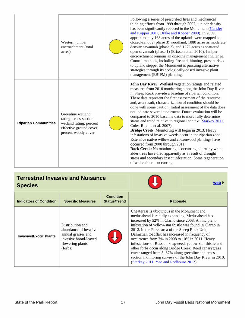
State of the Park Report 17 John Day Fossil Beds National Monument
Western juniper
encroachment (total
acres)
Following a series of prescribed fires and mechanical
thinning efforts from 1999 through 2007, juniper density
has been significantly reduced in the Monument (Cansler
and Kopper 2007, Drake and Kopper 2009). In 2009,
approximately 168 acres of the uplands were mapped as
closed-canopy (phase 3) woodland, 1080 acres as moderate
density savannah (phase 2), and 1272 acres as scattered
open savannah (phase 1) (Erixson et al. 2010). Juniper
encroachment remains an ongoing management challenge.
Control methods, including fire and thinning, present risks
to upland steppe; the Monument is pursuing alternative
strategies through its ecologically-based invasive plant
management (EBIPM) planning.
Riparian Communities
Greenline wetland
rating; cross-section
wetland rating; percent
effective ground cover;
percent woody cover
John Day River: Wetland vegetation ratings and related
measures from 2010 monitoring along the John Day River
in Sheep Rock provide a baseline of riparian condition.
These data represent the first assessment of the resource
and, as a result, characterization of condition should be
done with some caution. Initial assessment of the data does
not indicate severe impairment. Future evaluation will be
compared to 2010 baseline data to more fully determine
status and trend relative to regional context (Starkey 2011,
Coles-Ritchie et al. 2007).
Bridge Creek: Monitoring will begin in 2013. Heavy
infestations of invasive weeds occur in the riparian zone.
Extensive native willow and cottonwood plantings have
occurred from 2008 through 2011.
Rock Creek: No monitoring is occurring but many white
alder trees have died apparently as a result of drought
stress and secondary insect infestation. Some regeneration
of white alder is occurring.
Terrestrial Invasive and Nuisance
Species
web
Indicators of Condition Specific Measures
Condition
Status/Trend Rationale
Invasive/Exotic Plants
Distribution and
abundance of invasive
annual grasses and
invasive broad-leaved
flowering plants
(forbs)
Cheatgrass is ubiquitous in the Monument and
medusahead is rapidly expanding. Medusahead has
increased by 52% in Clarno since 2008. An incipient
infestation of yellow-star thistle was found in Clarno in
2012. In the Foree area of the Sheep Rock Unit,
Dalmatian toadflax has increased in frequency of
occurrence from 7% in 2008 to 10% in 2011. Heavy
infestations of Russian knapweed, yellow-star thistle and
other forbs occur along Bridge Creek. Reed canarygrass
cover ranged from 5–37% along greenline and cross-
section monitoring surveys of the John Day River in 2010.
(Starkey 2011, Yeo and Rodhouse 2012).
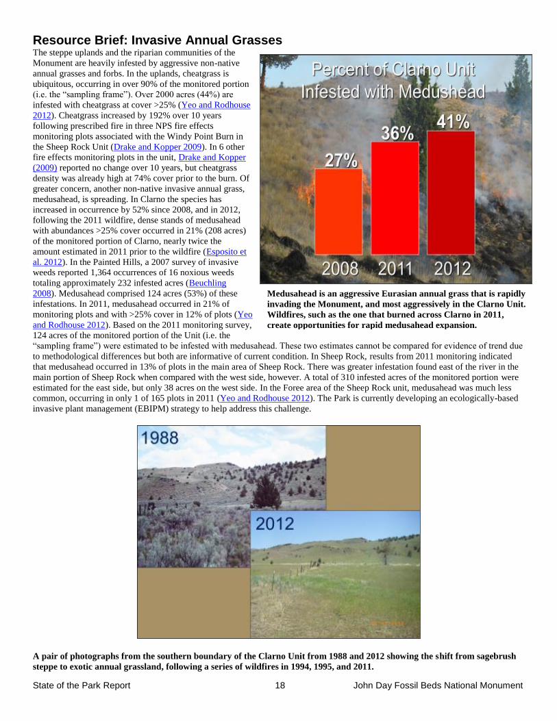
State of the Park Report 18 John Day Fossil Beds National Monument
Medusahead is an aggressive Eurasian annual grass that is rapidly
invading the Monument, and most aggressively in the Clarno Unit.
Wildfires, such as the one that burned across Clarno in 2011,
create opportunities for rapid medusahead expansion.
Resource Brief: Invasive Annual Grasses The steppe uplands and the riparian communities of the
Monument are heavily infested by aggressive non-native
annual grasses and forbs. In the uplands, cheatgrass is
ubiquitous, occurring in over 90% of the monitored portion
(i.e. the “sampling frame”). Over 2000 acres (44%) are
infested with cheatgrass at cover >25% (Yeo and Rodhouse
2012). Cheatgrass increased by 192% over 10 years
following prescribed fire in three NPS fire effects
monitoring plots associated with the Windy Point Burn in
the Sheep Rock Unit (Drake and Kopper 2009). In 6 other
fire effects monitoring plots in the unit, Drake and Kopper
(2009) reported no change over 10 years, but cheatgrass
density was already high at 74% cover prior to the burn. Of
greater concern, another non-native invasive annual grass,
medusahead, is spreading. In Clarno the species has
increased in occurrence by 52% since 2008, and in 2012,
following the 2011 wildfire, dense stands of medusahead
with abundances >25% cover occurred in 21% (208 acres)
of the monitored portion of Clarno, nearly twice the
amount estimated in 2011 prior to the wildfire (Esposito et
al. 2012). In the Painted Hills, a 2007 survey of invasive
weeds reported 1,364 occurrences of 16 noxious weeds
totaling approximately 232 infested acres (Beuchling
2008). Medusahead comprised 124 acres (53%) of these
infestations. In 2011, medusahead occurred in 21% of
monitoring plots and with >25% cover in 12% of plots (Yeo
and Rodhouse 2012). Based on the 2011 monitoring survey,
124 acres of the monitored portion of the Unit (i.e. the
“sampling frame”) were estimated to be infested with medusahead. These two estimates cannot be compared for evidence of trend due
to methodological differences but both are informative of current condition. In Sheep Rock, results from 2011 monitoring indicated
that medusahead occurred in 13% of plots in the main area of Sheep Rock. There was greater infestation found east of the river in the
main portion of Sheep Rock when compared with the west side, however. A total of 310 infested acres of the monitored portion were
estimated for the east side, but only 38 acres on the west side. In the Foree area of the Sheep Rock unit, medusahead was much less
common, occurring in only 1 of 165 plots in 2011 (Yeo and Rodhouse 2012). The Park is currently developing an ecologically-based
invasive plant management (EBIPM) strategy to help address this challenge.
A pair of photographs from the southern boundary of the Clarno Unit from 1988 and 2012 showing the shift from sagebrush
steppe to exotic annual grassland, following a series of wildfires in 1994, 1995, and 2011.
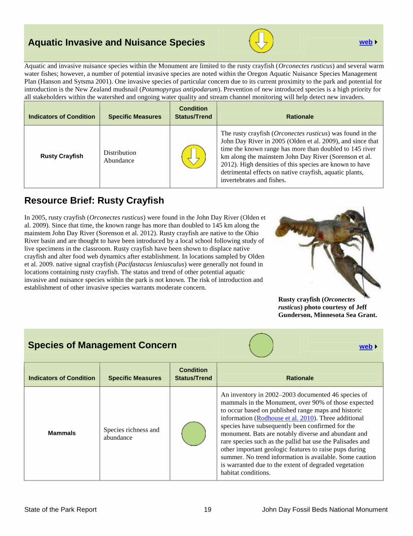
State of the Park Report 19 John Day Fossil Beds National Monument
Rusty crayfish (Orconectes
rusticus) photo courtesy of Jeff
Gunderson, Minnesota Sea Grant.
Aquatic Invasive and Nuisance Species
web
Aquatic and invasive nuisance species within the Monument are limited to the rusty crayfish (Orconectes rusticus) and several warm
water fishes; however, a number of potential invasive species are noted within the Oregon Aquatic Nuisance Species Management
Plan (Hanson and Sytsma 2001). One invasive species of particular concern due to its current proximity to the park and potential for
introduction is the New Zealand mudsnail (Potamopyrgus antipodarum). Prevention of new introduced species is a high priority for
all stakeholders within the watershed and ongoing water quality and stream channel monitoring will help detect new invaders.
Indicators of Condition Specific Measures
Condition
Status/Trend Rationale
Rusty Crayfish Distribution
Abundance
The rusty crayfish (Orconectes rusticus) was found in the
John Day River in 2005 (Olden et al. 2009), and since that
time the known range has more than doubled to 145 river
km along the mainstem John Day River (Sorenson et al.
2012). High densities of this species are known to have
detrimental effects on native crayfish, aquatic plants,
invertebrates and fishes.
Resource Brief: Rusty Crayfish
In 2005, rusty crayfish (Orconectes rusticus) were found in the John Day River (Olden et
al. 2009). Since that time, the known range has more than doubled to 145 km along the
mainstem John Day River (Sorenson et al. 2012). Rusty crayfish are native to the Ohio
River basin and are thought to have been introduced by a local school following study of
live specimens in the classroom. Rusty crayfish have been shown to displace native
crayfish and alter food web dynamics after establishment. In locations sampled by Olden
et al. 2009. native signal crayfish (Pacifastacus leniusculus) were generally not found in
locations containing rusty crayfish. The status and trend of other potential aquatic
invasive and nuisance species within the park is not known. The risk of introduction and
establishment of other invasive species warrants moderate concern.
Species of Management Concern
web
Indicators of Condition Specific Measures
Condition
Status/Trend Rationale
Mammals Species richness and
abundance
An inventory in 2002–2003 documented 46 species of
mammals in the Monument, over 90% of those expected
to occur based on published range maps and historic
information (Rodhouse et al. 2010). Three additional
species have subsequently been confirmed for the
monument. Bats are notably diverse and abundant and
rare species such as the pallid bat use the Palisades and
other important geologic features to raise pups during
summer. No trend information is available. Some caution
is warranted due to the extent of degraded vegetation
habitat conditions.
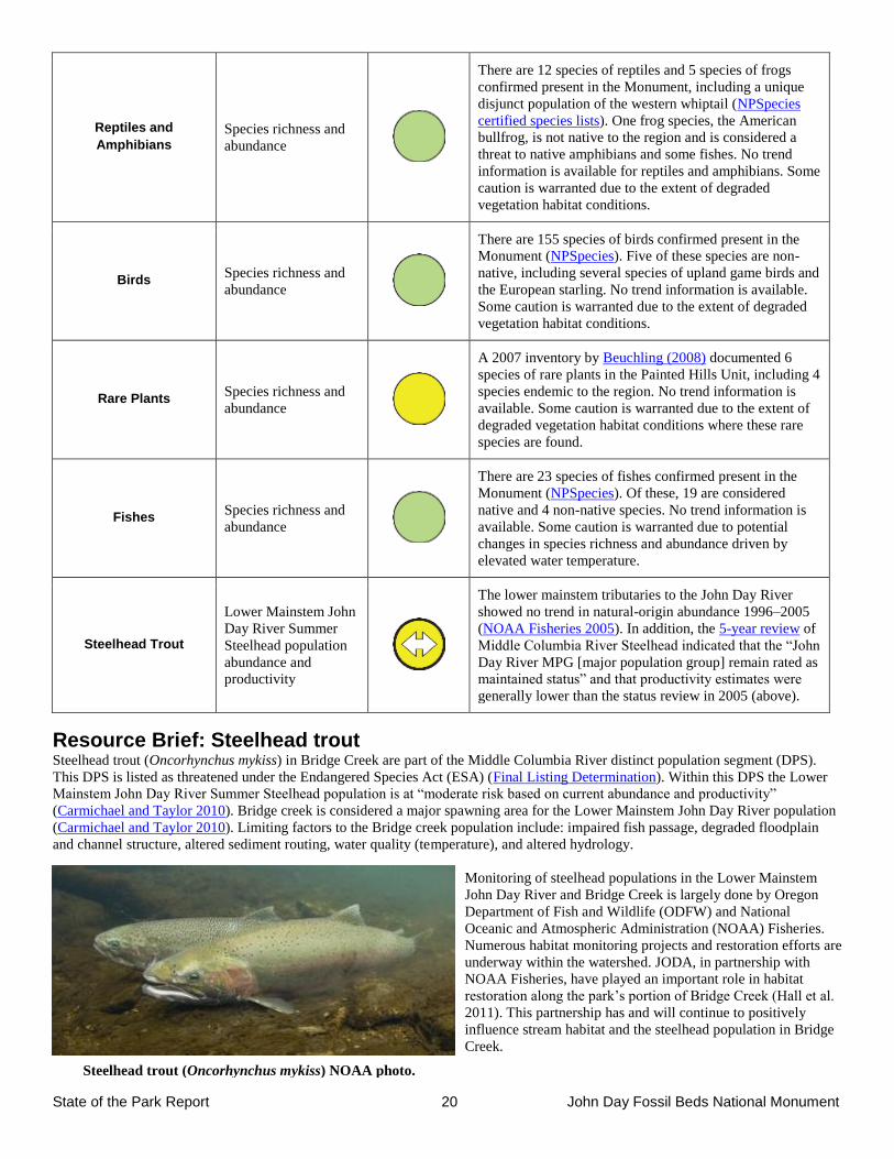
State of the Park Report 20 John Day Fossil Beds National Monument
Steelhead trout (Oncorhynchus mykiss) NOAA photo.
Reptiles and
Amphibians
Species richness and
abundance
There are 12 species of reptiles and 5 species of frogs
confirmed present in the Monument, including a unique
disjunct population of the western whiptail (NPSpecies
certified species lists). One frog species, the American
bullfrog, is not native to the region and is considered a
threat to native amphibians and some fishes. No trend
information is available for reptiles and amphibians. Some
caution is warranted due to the extent of degraded
vegetation habitat conditions.
Birds Species richness and
abundance
There are 155 species of birds confirmed present in the
Monument (NPSpecies). Five of these species are non-
native, including several species of upland game birds and
the European starling. No trend information is available.
Some caution is warranted due to the extent of degraded
vegetation habitat conditions.
Rare Plants Species richness and
abundance
A 2007 inventory by Beuchling (2008) documented 6
species of rare plants in the Painted Hills Unit, including 4
species endemic to the region. No trend information is
available. Some caution is warranted due to the extent of
degraded vegetation habitat conditions where these rare
species are found.
Fishes Species richness and
abundance
There are 23 species of fishes confirmed present in the
Monument (NPSpecies). Of these, 19 are considered
native and 4 non-native species. No trend information is
available. Some caution is warranted due to potential
changes in species richness and abundance driven by
elevated water temperature.
Steelhead Trout
Lower Mainstem John
Day River Summer
Steelhead population
abundance and
productivity
The lower mainstem tributaries to the John Day River
showed no trend in natural-origin abundance 1996–2005
(NOAA Fisheries 2005). In addition, the 5-year review of
Middle Columbia River Steelhead indicated that the “John
Day River MPG [major population group] remain rated as
maintained status” and that productivity estimates were
generally lower than the status review in 2005 (above).
Resource Brief: Steelhead trout Steelhead trout (Oncorhynchus mykiss) in Bridge Creek are part of the Middle Columbia River distinct population segment (DPS).
This DPS is listed as threatened under the Endangered Species Act (ESA) (Final Listing Determination). Within this DPS the Lower
Mainstem John Day River Summer Steelhead population is at “moderate risk based on current abundance and productivity”
(Carmichael and Taylor 2010). Bridge creek is considered a major spawning area for the Lower Mainstem John Day River population
(Carmichael and Taylor 2010). Limiting factors to the Bridge creek population include: impaired fish passage, degraded floodplain
and channel structure, altered sediment routing, water quality (temperature), and altered hydrology.
Monitoring of steelhead populations in the Lower Mainstem
John Day River and Bridge Creek is largely done by Oregon
Department of Fish and Wildlife (ODFW) and National
Oceanic and Atmospheric Administration (NOAA) Fisheries.
Numerous habitat monitoring projects and restoration efforts are
underway within the watershed. JODA, in partnership with
NOAA Fisheries, have played an important role in habitat
restoration along the park’s portion of Bridge Creek (Hall et al.
2011). This partnership has and will continue to positively
influence stream habitat and the steelhead population in Bridge
Creek.
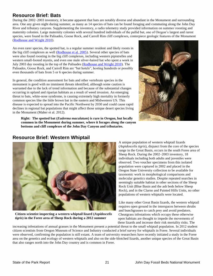
State of the Park Report 21 John Day Fossil Beds National Monument
Citizen scientist inspecting a western whiptail lizard (Aspidoscelis
tigris) in the Foree area of Sheep Rock during a 2012 summer
survey.
Resource Brief: Bats During the 2002–2003 inventory, it became apparent that bats are notably diverse and abundant in the Monument and surrounding
area. One any given night during summer, as many as 14 species of bats can be found foraging and commuting along the John Day
River and tributary canyons. Supplementing the inventory, a radio telemetry study provided information on summer roosting and
maternity colonies. Large maternity colonies with several hundred individuals of the pallid bat, one of Oregon’s largest and rarest
species, were found in the Palisades, Goose Rock, and Carroll Rim cliff complexes, centerpiece geologic features of the Monument
(Rodhouse and Wright 2010).
An even rarer species, the spotted bat, is a regular summer resident and likely roosts in
the big cliff complexes as well (Rodhouse et al. 2005). Several other species of bats
were also found roosting in the big cliff complexes, including western pipistrelles and
western small-footed myotis, and even one male silver-haired bat who spent a week in
July 2003 day roosting in the top of the Palisades (Rodhouse and Wright 2010). The
Palisades, Goose Rock, and Carroll Rim are “bat hotels”, hosting hundreds or possibly
even thousands of bats from 5 or 6 species during summer.
In general, the condition assessment for bats and other vertebrate species in the
monument is good with no imminent threats identified, although some caution is
warranted due to the lack of trend information and because of the substantial changes
occurring in upland and riparian habitats as a result of weed invasion. An emerging
threat to bats, white-nose syndrome, is causing extremely high mortality in formerly
common species like the little brown bat in the eastern and Midwestern US. This
disease is expected to spread into the Pacific Northwest by 2030 and could cause rapid
declines in regional bat populations that might affect those unique desert species living
in the Monument (Maher et al. 2012).
Resource Brief: Western Whiptail A unique population of western whiptail lizards
(Aspidoscelis tigris), disjunct from the core of the species
range in the Great Basin, occurs in the south Foree area of
Sheep Rock. During the 2002–2003 inventory, 18
individuals including both adults and juveniles were
observed. Two voucher specimens from this isolated
population were captured in 2002 and placed in the
Oregon State University collection to be available for
taxonomic work in morphological comparisons and
molecular genetics studies. Despite repeated searches in
seemingly suitable habitat in other sections of the Sheep
Rock Unit (Blue Basin and the ash beds below Sheep
Rock), and in the Clarno and Painted Hills Units, no other
populations of western whiptails were located.
Like many other Great Basin lizards, the western whiptail
requires open ground in the interspaces between shrubs
and bunchgrasses to catch prey and avoid predators.
Cheatgrass infestations which occupy these otherwise
open habitats are thought to impede the movements of
these lizards and increase their risk mortality risks. The
increasing infestations of annual grasses in the Monument present a potential threat to the small whiptail population. In 2012 student
citizen scientists from Oregon Museum of Science and Industry conducted a brief survey for whiptails in Foree. Several individuals
were observed, confirming the population is still extant. A team of university researchers have recently initiated a study in the Foree
area on the genetics and ecology of western whiptails and also on the side-blotched lizards, another unique species of the Great Basin
that also ranges north into the John Day country and is common in Foree.
Right: The spotted bat (Euderma maculatum) is rare in Oregon, but locally
common in the Monument during summer, where it forages along the canyon
bottoms and cliff complexes of the John Day Canyon and tributaries.
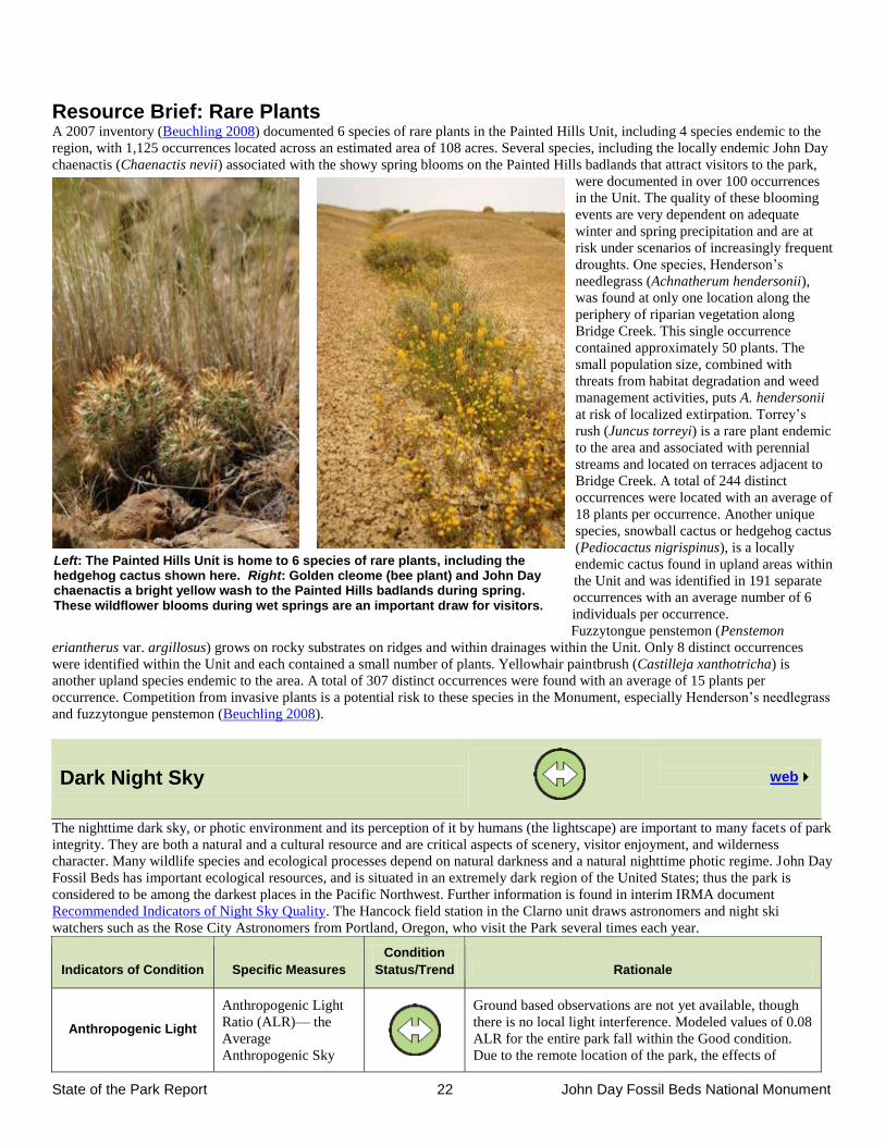
State of the Park Report 22 John Day Fossil Beds National Monument
Resource Brief: Rare Plants A 2007 inventory (Beuchling 2008) documented 6 species of rare plants in the Painted Hills Unit, including 4 species endemic to the
region, with 1,125 occurrences located across an estimated area of 108 acres. Several species, including the locally endemic John Day
chaenactis (Chaenactis nevii) associated with the showy spring blooms on the Painted Hills badlands that attract visitors to the park,
were documented in over 100 occurrences
in the Unit. The quality of these blooming
events are very dependent on adequate
winter and spring precipitation and are at
risk under scenarios of increasingly frequent
droughts. One species, Henderson’s
needlegrass (Achnatherum hendersonii),
was found at only one location along the
periphery of riparian vegetation along
Bridge Creek. This single occurrence
contained approximately 50 plants. The
small population size, combined with
threats from habitat degradation and weed
management activities, puts A. hendersonii
at risk of localized extirpation. Torrey’s
rush (Juncus torreyi) is a rare plant endemic
to the area and associated with perennial
streams and located on terraces adjacent to
Bridge Creek. A total of 244 distinct
occurrences were located with an average of
18 plants per occurrence. Another unique
species, snowball cactus or hedgehog cactus
(Pediocactus nigrispinus), is a locally
endemic cactus found in upland areas within
the Unit and was identified in 191 separate
occurrences with an average number of 6
individuals per occurrence.
Fuzzytongue penstemon (Penstemon
eriantherus var. argillosus) grows on rocky substrates on ridges and within drainages within the Unit. Only 8 distinct occurrences
were identified within the Unit and each contained a small number of plants. Yellowhair paintbrush (Castilleja xanthotricha) is
another upland species endemic to the area. A total of 307 distinct occurrences were found with an average of 15 plants per
occurrence. Competition from invasive plants is a potential risk to these species in the Monument, especially Henderson’s needlegrass
and fuzzytongue penstemon (Beuchling 2008).
Dark Night Sky
web
The nighttime dark sky, or photic environment and its perception of it by humans (the lightscape) are important to many facets of park
integrity. They are both a natural and a cultural resource and are critical aspects of scenery, visitor enjoyment, and wilderness
character. Many wildlife species and ecological processes depend on natural darkness and a natural nighttime photic regime. John Day
Fossil Beds has important ecological resources, and is situated in an extremely dark region of the United States; thus the park is
considered to be among the darkest places in the Pacific Northwest. Further information is found in interim IRMA document
Recommended Indicators of Night Sky Quality. The Hancock field station in the Clarno unit draws astronomers and night ski
watchers such as the Rose City Astronomers from Portland, Oregon, who visit the Park several times each year.
Indicators of Condition Specific Measures
Condition
Status/Trend Rationale
Anthropogenic Light
Anthropogenic Light
Ratio (ALR)— the
Average
Anthropogenic Sky
Ground based observations are not yet available, though
there is no local light interference. Modeled values of 0.08
ALR for the entire park fall within the Good condition.
Due to the remote location of the park, the effects of
Left: The Painted Hills Unit is home to 6 species of rare plants, including the hedgehog cactus shown here. Right: Golden cleome (bee plant) and John Day chaenactis a bright yellow wash to the Painted Hills badlands during spring. These wildflower blooms during wet springs are an important draw for visitors.
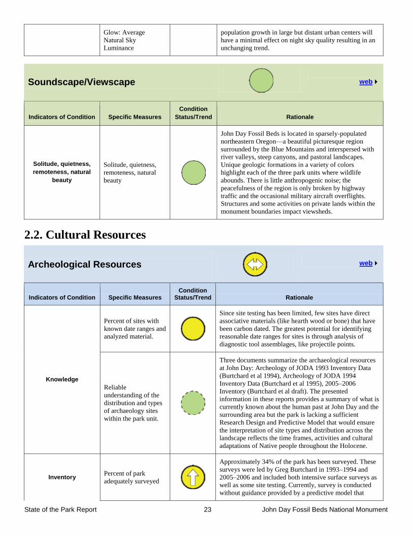
State of the Park Report 23 John Day Fossil Beds National Monument
Glow: Average
Natural Sky
Luminance
population growth in large but distant urban centers will
have a minimal effect on night sky quality resulting in an
unchanging trend.
Soundscape/Viewscape
web
Indicators of Condition Specific Measures
Condition
Status/Trend Rationale
Solitude, quietness,
remoteness, natural
beauty
Solitude, quietness,
remoteness, natural
beauty
John Day Fossil Beds is located in sparsely-populated
northeastern Oregon—a beautiful picturesque region
surrounded by the Blue Mountains and interspersed with
river valleys, steep canyons, and pastoral landscapes.
Unique geologic formations in a variety of colors
highlight each of the three park units where wildlife
abounds. There is little anthropogenic noise; the
peacefulness of the region is only broken by highway
traffic and the occasional military aircraft overflights.
Structures and some activities on private lands within the
monument boundaries impact viewsheds.
2.2. Cultural Resources
Archeological Resources
web
Indicators of Condition Specific Measures Condition
Status/Trend Rationale
Knowledge
Percent of sites with
known date ranges and
analyzed material.
Since site testing has been limited, few sites have direct
associative materials (like hearth wood or bone) that have
been carbon dated. The greatest potential for identifying
reasonable date ranges for sites is through analysis of
diagnostic tool assemblages, like projectile points.
Reliable
understanding of the
distribution and types
of archaeology sites
within the park unit.
Three documents summarize the archaeological resources
at John Day: Archeology of JODA 1993 Inventory Data
(Burtchard et al 1994), Archeology of JODA 1994
Inventory Data (Burtchard et al 1995), 2005–2006
Inventory (Burtchard et al draft). The presented
information in these reports provides a summary of what is
currently known about the human past at John Day and the
surrounding area but the park is lacking a sufficient
Research Design and Predictive Model that would ensure
the interpretation of site types and distribution across the
landscape reflects the time frames, activities and cultural
adaptations of Native people throughout the Holocene.
Inventory Percent of park
adequately surveyed
Approximately 34% of the park has been surveyed. These
surveys were led by Greg Burtchard in 1993–1994 and
2005–2006 and included both intensive surface surveys as
well as some site testing. Currently, survey is conducted
without guidance provided by a predictive model that
State of the Park Report 24 John Day Fossil Beds National Monument
identifies an adequate and reliable inventory sampling
strategy.
Percentage of survey
data included in the
Geographic
Information System
(GIS) meeting current
cultural resource
standards.
Paper and electronic survey and site data are maintained at
JODA and MORA. This information is not yet fully
archived. The percent of survey and site data documented
in GIS is currently unknown. This is due in large part to
the dispersed nature of the JODA data. MORA and PWRO
have managed the archaeological data for JODA over the
past decade. Thus, JODA does not have easy access to this
information for planning, developing a law enforcement
approach for protection or emergency response. Updating
GIS data included in PMIS project for 2016/17.
Documentation
Percentage of known
sites with adequate
National Register
documentation
ASMIS identifies 41 sites as potentially eligible for the
National Register. 0% of documented sites have
undergone the analysis for inclusion in the National
Register (Determination of Eligibility Process). A National
Register eligibility project is proposed for ONPS funding
consideration (in PMIS) for FY18.
Percentage of known
sites with adequate
site record
documentation
(Oregon State Site
Forms and ASMIS)
99% of identified sites have been documented with both
state and ASMIS site records. A few identified sites have
not been documented but there are plans for this activity in
the near future.
Physical Site Stability
Percentage of
archeological
resources in good
condition identified
through field analysis
and documented in
ASMIS
There are currently 140 sites recorded at John Day Fossil
Beds. Of these, 26 sites (18%) have been assessed for the
overall condition (physical stability + limited threats and
documented damage). 20 (14%) are documented in good
condition while 6 (4%) are noted as in fair condition. The
other sites have not been assessed (ASMIS 2012 data), but
a project to assess site conditions has been proposed in
PMIS.
Cultural Anthropology
web
Indicators of Condition Specific Measures Condition
Status/Trend Rationale
Knowledge
Sufficient research
exists to understand
the relationship of
affiliated Tribes to the
resources, places and
sites at John Day
Fossil Beds National
Monument.
Tribal affiliation studies have been completed but research
focusing on traditional land use and species or places of
Tribal significance have not been done. Research is
proposed in PMIS to identify traditional land uses.
Inventory Completeness of
inventories.
No known inventory of the Monument has been done to
identify landscapes or places important to contemporary
Tribes.

State of the Park Report 25 John Day Fossil Beds National Monument
Documentation
Tribal resource
interests are
documented in
working files and
archives.
Recent efforts in consultation and collaboration have
begun to define management approaches of places and
resources significant to Tribes.
Cultural Landscapes
web
Indicators of Condition Specific Measures Condition
Status/Trend Rationale
Knowledge
Sufficient research
exists to understand
the relationship of the
park cultural
landscapes to the
historic contexts of the
park.
The National Register Nomination for Cant Ranch
Historic District was completed in 1984 and the Historic
Resource Study was done in 2000. The Cultural
Landscape Report defines the acceptable treatment of the
Ranch and was finalized in 1996. A relatively new
Cultural Landscape Inventory was completed in 2009.
Together these documents consolidate current knowledge
concerning the period of significance associated with the
Cant Ranch.
Adequate research
exists to document and
preserve the cultural
landscape's physical
attributes, biotic
systems and uses
when those uses
contribute to historical
significance.
The documents noted above required research and field
assessments to identify the contributing features that
convey the history of ranching in general and Cant Ranch
in particular. Methods and strategies for the protection and
preservation of the cultural landscape were also researched
and guidance is provided in the Cultural Landscape
Report. However, research on pollarded elm trees and
appropriate tree selection for replacement is needed to
meet the changing needs for park operations and
stewardship of this cultural landscape.
Inventory
Percentage of
landscapes eligible for
the National Register
with accurate,
complete, and reliable
Cultural Landscape
Inventory (CLI) data.
To date, the Cant Ranch is the only identified cultural
landscape at John Day Fossil Beds. The research,
assessments, and documentation determined its eligibility
and the information has been reviewed by landscape
architects for completeness and reliability. 100% of known
cultural landscapes at the park unit have current and valid
data.
Documentation
Percentage of cultural
landscapes with
adequate National
Register
documentation.
100% of the Cant Ranch has been documented to meet the
defined National Register standards.
Research results are
disseminated to park
managers, planners,
interpreters, and other
NPS specialists and
incorporated into
appropriate park
planning documents.
Research reports are housed in the park library (CLR,
CLI) and in park archives. Cultural landscape preservation
is addressed in the 2009 General Management Plan and
2004 Fire Management Plan.
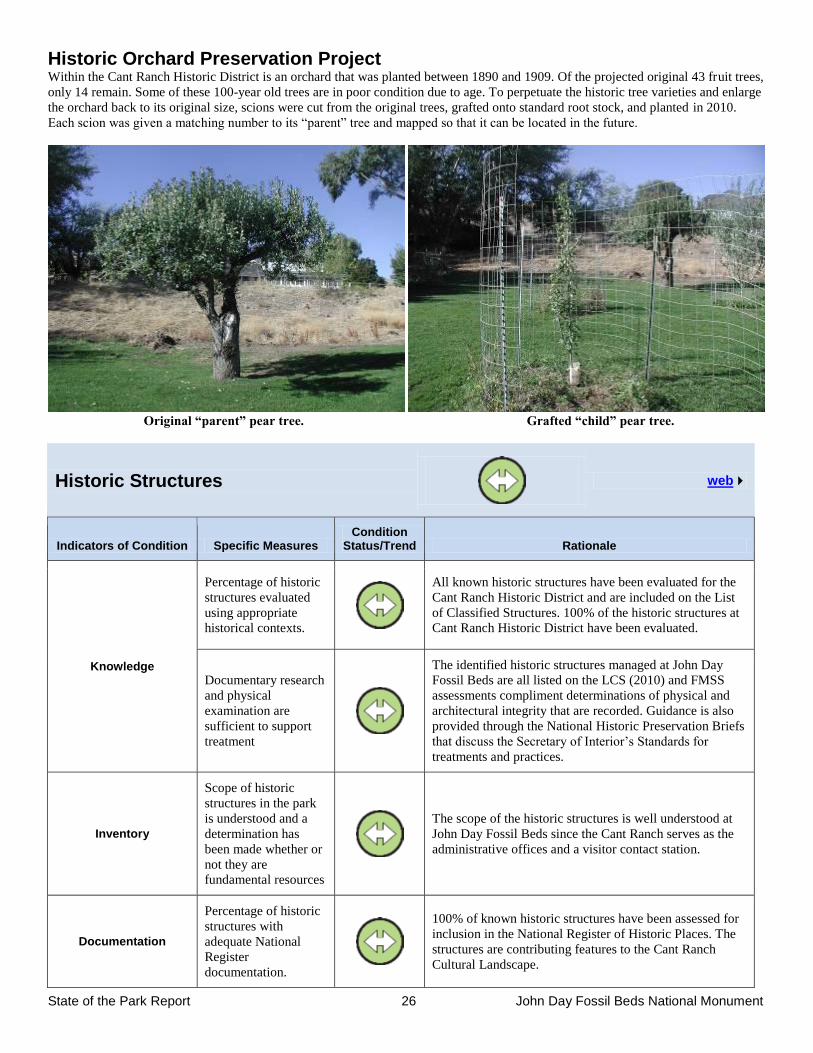
State of the Park Report 26 John Day Fossil Beds National Monument
Historic Orchard Preservation Project Within the Cant Ranch Historic District is an orchard that was planted between 1890 and 1909. Of the projected original 43 fruit trees,
only 14 remain. Some of these 100-year old trees are in poor condition due to age. To perpetuate the historic tree varieties and enlarge
the orchard back to its original size, scions were cut from the original trees, grafted onto standard root stock, and planted in 2010.
Each scion was given a matching number to its “parent” tree and mapped so that it can be located in the future.
Original “parent” pear tree. Grafted “child” pear tree.
Historic Structures
web
Indicators of Condition Specific Measures Condition
Status/Trend Rationale
Knowledge
Percentage of historic
structures evaluated
using appropriate
historical contexts.
All known historic structures have been evaluated for the
Cant Ranch Historic District and are included on the List
of Classified Structures. 100% of the historic structures at
Cant Ranch Historic District have been evaluated.
Documentary research
and physical
examination are
sufficient to support
treatment
The identified historic structures managed at John Day
Fossil Beds are all listed on the LCS (2010) and FMSS
assessments compliment determinations of physical and
architectural integrity that are recorded. Guidance is also
provided through the National Historic Preservation Briefs
that discuss the Secretary of Interior’s Standards for
treatments and practices.
Inventory
Scope of historic
structures in the park
is understood and a
determination has
been made whether or
not they are
fundamental resources
The scope of the historic structures is well understood at
John Day Fossil Beds since the Cant Ranch serves as the
administrative offices and a visitor contact station.
Documentation
Percentage of historic
structures with
adequate National
Register
documentation.
100% of known historic structures have been assessed for
inclusion in the National Register of Historic Places. The
structures are contributing features to the Cant Ranch
Cultural Landscape.
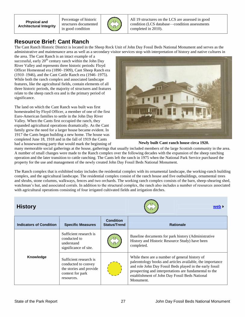
State of the Park Report 27 John Day Fossil Beds National Monument
Physical and Architectural Integrity
Percentage of historic
structures documented
in good condition
All 19 structures on the LCS are assessed in good
condition (LCS database—condition assessments
completed in 2010).
Resource Brief: Cant Ranch The Cant Ranch Historic District is located in the Sheep Rock Unit of John Day Fossil Beds National Monument and serves as the
administrative and maintenance area as well as a secondary visitor services stop with interpretation of history and native cultures in
the area. The Cant Ranch is an intact example of a
successful, early 20th
century ranch within the John Day
River Valley and represents three historic periods: Floyd
Officer Homestead era (1890–1909), Cant Sheep Ranch era
(1910–1946), and the Cant Cattle Ranch era (1946–1975).
While both the ranch complex and associated landscape
features, like the agricultural fields, contain elements of all
three historic periods, the majority of structures and features
relate to the sheep ranch era and is the primary period of
significance.
The land on which the Cant Ranch was built was first
homesteaded by Floyd Officer, a member of one of the first
Euro-American families to settle in the John Day River
Valley. When the Cants first occupied the ranch, they
expanded agricultural operations dramatically. As the Cant
family grew the need for a larger house became evident. In
1917 the Cants began building a new home. The house was
completed June 18, 1918 and in the fall of 1919 the Cants
had a housewarming party that would mark the beginning of
many memorable social gatherings at the house, gatherings that usually included members of the large Scottish community in the area.
A number of small changes were made to the Ranch complex over the following decades with the expansion of the sheep ranching
operation and the later transition to cattle ranching. The Cants left the ranch in 1975 when the National Park Service purchased the
property for the use and management of the newly created John Day Fossil Beds National Monument.
The Ranch complex that is exhibited today includes the residential complex with its ornamental landscape, the working-ranch building
complex, and the agricultural landscape. The residential complex consist of the ranch house and five outbuildings, ornamental trees
and shrubs, stone columns, walkways, fences and two orchards. The working ranch complex consists of the barn, sheep-shearing shed,
watchman’s hut, and associated corrals. In addition to the structural complex, the ranch also includes a number of resources associated
with agricultural operations consisting of four irrigated cultivated fields and irrigation ditches.
History
web
Indicators of Condition Specific Measures Condition
Status/Trend Rationale
Knowledge
Sufficient research is
conducted to
understand
significance of site.
Baseline documents for park history (Administrative
History and Historic Resource Study) have been
completed.
Sufficient research is
conducted to convey
the stories and provide
context for park
resources.
While there are a number of general history of
paleontology books and articles available, the importance
and role John Day Fossil Beds played in the early fossil
prospecting and interpretations are fundamental to the
establishment of John Day Fossil Beds National
Monument.
Newly built Cant ranch house circa 1920.
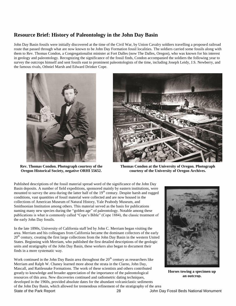
State of the Park Report 28 John Day Fossil Beds National Monument
Resource Brief: History of Paleontology in the John Day Basin
John Day Basin fossils were initially discovered at the time of the Civil War, by Union Cavalry soldiers travelling a proposed railroad
route that passed through what are now known to be John Day Formation fossil localities. The soldiers carried some fossils along with
them to Rev. Thomas Condon, a Congregationalist minister at Fort Dalles (now The Dalles, Oregon), who was known for his interest
in geology and paleontology. Recognizing the significance of the fossil finds, Condon accompanied the soldiers the following year to
survey the outcrops himself and sent fossils east to prominent paleontologists of the time, including Joseph Leidy, J.S. Newberry, and
the famous rivals, Othniel Marsh and Edward Drinker Cope.
Rev. Thomas Condon. Photograph courtesy of the
Oregon Historical Society, negative ORHI 55652.
Thomas Condon at the University of Oregon. Photograph
courtesy of the University of Oregon Archives.
Published descriptions of the fossil material spread word of the significance of the John Day
Basin deposits. A number of field expeditions, sponsored mainly by eastern institutions, were
mounted to survey the area during the latter half of the 19th
century. Despite harsh and rugged
conditions, vast quantities of fossil material were collected and are now housed in the
collections of American Museum of Natural History, Yale Peabody Museum, and
Smithsonian Institution among others. This material served as the basis for publications
naming many new species during the “golden age” of paleontology. Notable among these
publications is what is commonly called “Cope’s Bible” (Cope 1884), the classic treatment of
the early John Day fossils.
In the late 1890s, University of California staff led by John C. Merriam began visiting the
area. Merriam and his colleagues from California became the dominant collectors of the early
20th
century, creating the first large collections from the John Day Basin in the western United
States. Beginning with Merriam, who published the first detailed descriptions of the geologic
units and stratigraphy of the John Day Basin, these workers also began to document their
finds in a more systematic way.
Work continued in the John Day Basin area throughout the 20th
century as researchers like
Merriam and Ralph W. Chaney learned more about the strata in the Clarno, John Day,
Mascall, and Rattlesnake Formations. The work of these scientists and others contributed
greatly to knowledge and broader appreciation of the importance of the paleontological
resources of this area. New discoveries continued and radiometric dating techniques,
developed in the 1960s, provided absolute dates for the abundant volcaniclastic sediments
of the John Day Basin, which allowed for tremendous refinement of the stratigraphy of the area
Horses towing a specimen up
an outcrop.
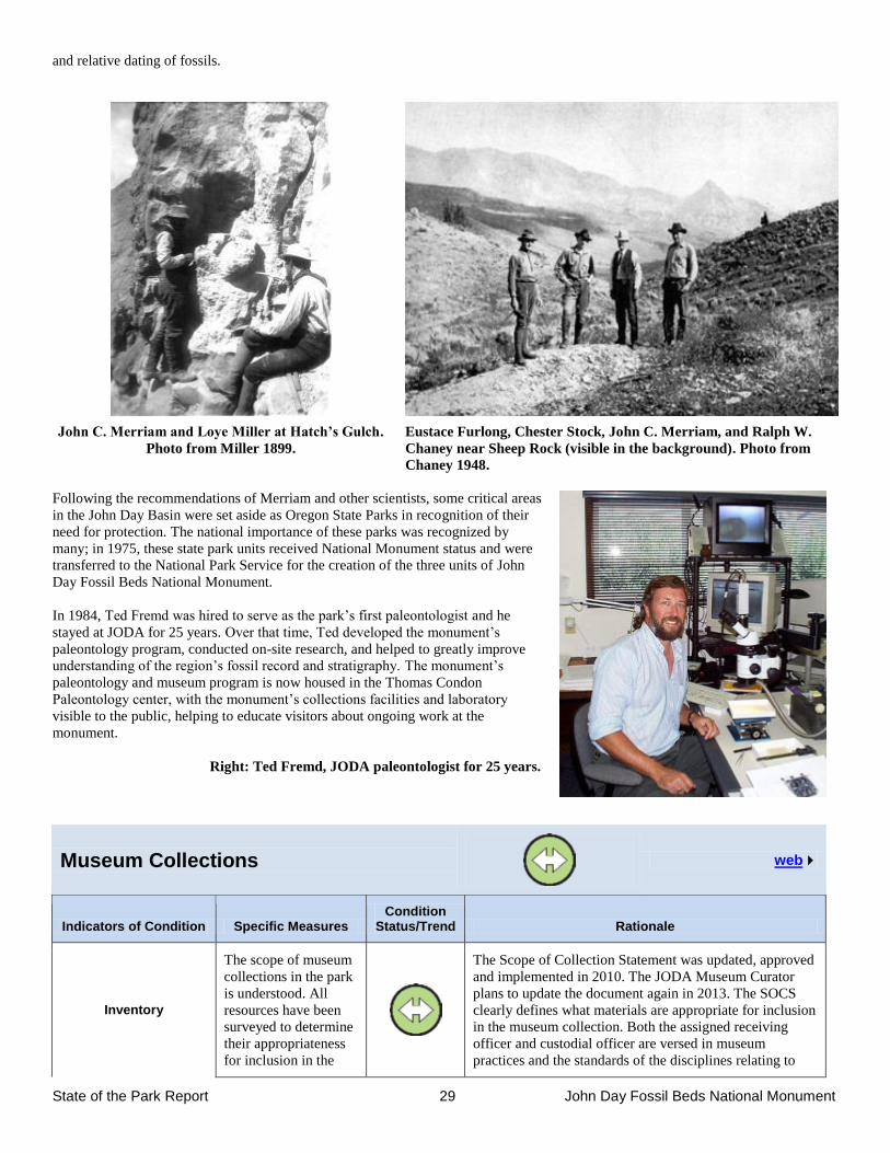
State of the Park Report 29 John Day Fossil Beds National Monument
and relative dating of fossils.
John C. Merriam and Loye Miller at Hatch’s Gulch.
Photo from Miller 1899.
Eustace Furlong, Chester Stock, John C. Merriam, and Ralph W.
Chaney near Sheep Rock (visible in the background). Photo from
Chaney 1948.
Following the recommendations of Merriam and other scientists, some critical areas
in the John Day Basin were set aside as Oregon State Parks in recognition of their
need for protection. The national importance of these parks was recognized by
many; in 1975, these state park units received National Monument status and were
transferred to the National Park Service for the creation of the three units of John
Day Fossil Beds National Monument.
In 1984, Ted Fremd was hired to serve as the park’s first paleontologist and he
stayed at JODA for 25 years. Over that time, Ted developed the monument’s
paleontology program, conducted on-site research, and helped to greatly improve
understanding of the region’s fossil record and stratigraphy. The monument’s
paleontology and museum program is now housed in the Thomas Condon
Paleontology center, with the monument’s collections facilities and laboratory
visible to the public, helping to educate visitors about ongoing work at the
monument.
Right: Ted Fremd, JODA paleontologist for 25 years.
Museum Collections
web
Indicators of Condition Specific Measures Condition
Status/Trend Rationale
Inventory
The scope of museum
collections in the park
is understood. All
resources have been
surveyed to determine
their appropriateness
for inclusion in the
The Scope of Collection Statement was updated, approved
and implemented in 2010. The JODA Museum Curator
plans to update the document again in 2013. The SOCS
clearly defines what materials are appropriate for inclusion
in the museum collection. Both the assigned receiving
officer and custodial officer are versed in museum
practices and the standards of the disciplines relating to
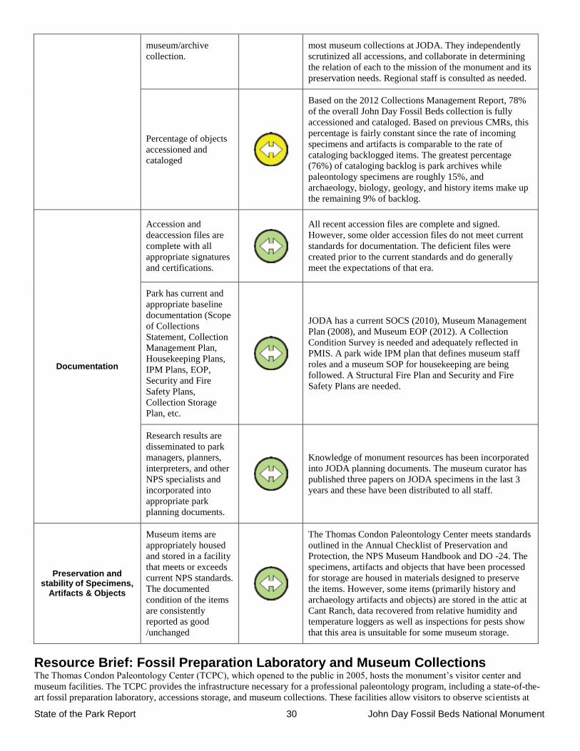
State of the Park Report 30 John Day Fossil Beds National Monument
museum/archive
collection.
most museum collections at JODA. They independently
scrutinized all accessions, and collaborate in determining
the relation of each to the mission of the monument and its
preservation needs. Regional staff is consulted as needed.
Percentage of objects
accessioned and
cataloged
Based on the 2012 Collections Management Report, 78%
of the overall John Day Fossil Beds collection is fully
accessioned and cataloged. Based on previous CMRs, this
percentage is fairly constant since the rate of incoming
specimens and artifacts is comparable to the rate of
cataloging backlogged items. The greatest percentage
(76%) of cataloging backlog is park archives while
paleontology specimens are roughly 15%, and
archaeology, biology, geology, and history items make up
the remaining 9% of backlog.
Documentation
Accession and
deaccession files are
complete with all
appropriate signatures
and certifications.
All recent accession files are complete and signed.
However, some older accession files do not meet current
standards for documentation. The deficient files were
created prior to the current standards and do generally
meet the expectations of that era.
Park has current and
appropriate baseline
documentation (Scope
of Collections
Statement, Collection
Management Plan,
Housekeeping Plans,
IPM Plans, EOP,
Security and Fire
Safety Plans,
Collection Storage
Plan, etc.
JODA has a current SOCS (2010), Museum Management
Plan (2008), and Museum EOP (2012). A Collection
Condition Survey is needed and adequately reflected in
PMIS. A park wide IPM plan that defines museum staff
roles and a museum SOP for housekeeping are being
followed. A Structural Fire Plan and Security and Fire
Safety Plans are needed.
Research results are
disseminated to park
managers, planners,
interpreters, and other
NPS specialists and
incorporated into
appropriate park
planning documents.
Knowledge of monument resources has been incorporated
into JODA planning documents. The museum curator has
published three papers on JODA specimens in the last 3
years and these have been distributed to all staff.
Preservation and stability of Specimens,
Artifacts & Objects
Museum items are
appropriately housed
and stored in a facility
that meets or exceeds
current NPS standards.
The documented
condition of the items
are consistently
reported as good
/unchanged
The Thomas Condon Paleontology Center meets standards
outlined in the Annual Checklist of Preservation and
Protection, the NPS Museum Handbook and DO -24. The
specimens, artifacts and objects that have been processed
for storage are housed in materials designed to preserve
the items. However, some items (primarily history and
archaeology artifacts and objects) are stored in the attic at
Cant Ranch, data recovered from relative humidity and
temperature loggers as well as inspections for pests show
that this area is unsuitable for some museum storage.
Resource Brief: Fossil Preparation Laboratory and Museum Collections The Thomas Condon Paleontology Center (TCPC), which opened to the public in 2005, hosts the monument’s visitor center and
museum facilities. The TCPC provides the infrastructure necessary for a professional paleontology program, including a state-of-the-
art fossil preparation laboratory, accessions storage, and museum collections. These facilities allow visitors to observe scientists at
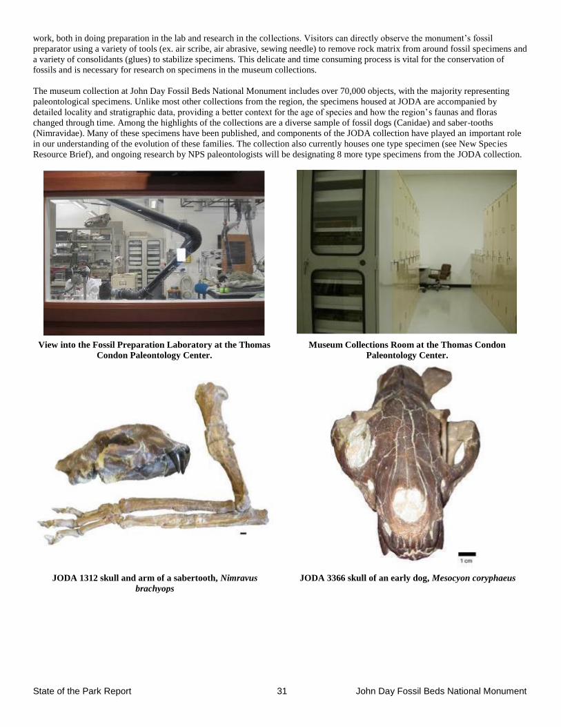
State of the Park Report 31 John Day Fossil Beds National Monument
work, both in doing preparation in the lab and research in the collections. Visitors can directly observe the monument’s fossil
preparator using a variety of tools (ex. air scribe, air abrasive, sewing needle) to remove rock matrix from around fossil specimens and
a variety of consolidants (glues) to stabilize specimens. This delicate and time consuming process is vital for the conservation of
fossils and is necessary for research on specimens in the museum collections.
The museum collection at John Day Fossil Beds National Monument includes over 70,000 objects, with the majority representing
paleontological specimens. Unlike most other collections from the region, the specimens housed at JODA are accompanied by
detailed locality and stratigraphic data, providing a better context for the age of species and how the region’s faunas and floras
changed through time. Among the highlights of the collections are a diverse sample of fossil dogs (Canidae) and saber-tooths
(Nimravidae). Many of these specimens have been published, and components of the JODA collection have played an important role
in our understanding of the evolution of these families. The collection also currently houses one type specimen (see New Species
Resource Brief), and ongoing research by NPS paleontologists will be designating 8 more type specimens from the JODA collection.
View into the Fossil Preparation Laboratory at the Thomas
Condon Paleontology Center.
Museum Collections Room at the Thomas Condon
Paleontology Center.
JODA 1312 skull and arm of a sabertooth, Nimravus
brachyops
JODA 3366 skull of an early dog, Mesocyon coryphaeus
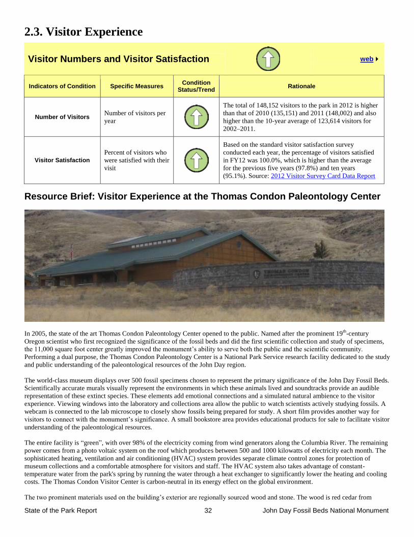
State of the Park Report 32 John Day Fossil Beds National Monument
2.3. Visitor Experience
Visitor Numbers and Visitor Satisfaction
web
Indicators of Condition Specific Measures Condition
Status/Trend Rationale
Number of Visitors
Number of visitors per
year
The total of 148,152 visitors to the park in 2012 is higher
than that of 2010 (135,151) and 2011 (148,002) and also
higher than the 10-year average of 123,614 visitors for
2002–2011.
Visitor Satisfaction
Percent of visitors who
were satisfied with their
visit
Based on the standard visitor satisfaction survey
conducted each year, the percentage of visitors satisfied
in FY12 was 100.0%, which is higher than the average
for the previous five years (97.8%) and ten years
(95.1%). Source: 2012 Visitor Survey Card Data Report
Resource Brief: Visitor Experience at the Thomas Condon Paleontology Center
In 2005, the state of the art Thomas Condon Paleontology Center opened to the public. Named after the prominent 19th
-century
Oregon scientist who first recognized the significance of the fossil beds and did the first scientific collection and study of specimens,
the 11,000 square foot center greatly improved the monument’s ability to serve both the public and the scientific community.
Performing a dual purpose, the Thomas Condon Paleontology Center is a National Park Service research facility dedicated to the study
and public understanding of the paleontological resources of the John Day region.
The world-class museum displays over 500 fossil specimens chosen to represent the primary significance of the John Day Fossil Beds.
Scientifically accurate murals visually represent the environments in which these animals lived and soundtracks provide an audible
representation of these extinct species. These elements add emotional connections and a simulated natural ambience to the visitor
experience. Viewing windows into the laboratory and collections area allow the public to watch scientists actively studying fossils. A
webcam is connected to the lab microscope to closely show fossils being prepared for study. A short film provides another way for
visitors to connect with the monument’s significance. A small bookstore area provides educational products for sale to facilitate visitor
understanding of the paleontological resources.
The entire facility is “green”, with over 98% of the electricity coming from wind generators along the Columbia River. The remaining
power comes from a photo voltaic system on the roof which produces between 500 and 1000 kilowatts of electricity each month. The
sophisticated heating, ventilation and air conditioning (HVAC) system provides separate climate control zones for protection of
museum collections and a comfortable atmosphere for visitors and staff. The HVAC system also takes advantage of constant-
temperature water from the park's spring by running the water through a heat exchanger to significantly lower the heating and cooling
costs. The Thomas Condon Visitor Center is carbon-neutral in its energy effect on the global environment.
The two prominent materials used on the building’s exterior are regionally sourced wood and stone. The wood is red cedar from
State of the Park Report 33 John Day Fossil Beds National Monument
southern Oregon and British Columbia forests milled in Eugene, Oregon. The hand cut, gray lava stone is basalt quarried in Camas,
Washington, within the Columbia River Gorge. The quarry has basalt that is part of the same widespread Columbia Flood Basalts that
can be seen cresting the ridgelines outside the center. These flood basalts cover over 60,000 square miles of Oregon and Washington,
with the oldest layers being approximately 16 million years old.
Interpretive and Education Programs – Talks, Tours, and Special Events
web
Indicators of Condition Specific Measures Condition
Status/Trend Rationale
Education Programs
Number and quality of
programs, and number
of participants
Seven types of resource-based education programs tied to
State K–12 Content Standards offer educators effective
on-site curriculum. An average of 50 programs a year is
presented to an average of 1,259 students. Traveling
education kits are sent out on average 58 times a year
reaching an average of 6,616 students. University classes
visit the TCPC each year for formal tours and field trips.
Ranger Programs
Number and quality of
programs and
attendance
Through FY12, traditional ranger led interpretive
programs increased in number and quality due to
increased seasonal staffing and Interpretive Development
Program training for both permanent and seasonal
employees.
Junior Ranger Programs
Number of programs
and attendance
A new Junior Ranger booklet was designed in 2012 with
activities that encourage visitors to explore all three units
of the monument. In 2011, 262 Junior Ranger badges
were awarded, increasing to 345 in 2012.
Special Events
Variety and longevity
of events, community
involvement
Rangers conduct photo tours into sensitive areas, evening
photography special events, National Fossil Day events,
and they work with Camp Hancock, managed by the
Oregon Museum of Science and Industry. The park
paleontologist presents special talks to university and
other student groups through the year outside the park.
Interpretive Media – Brochures, Exhibits, Signs, and Website
web
Indicators of Condition Specific Measures Condition
Status/Trend Rationale
Wayside Signs Condition and currency
of signs
Due to the dispersed nature of the monument, interpretive
signage is critical to conveying resource messages. A
wayside assessment in 2012 documented 151 signs, most
in deteriorating condition and created prior to NPS
design standards and ADA criteria. The park is planning
content replacement and pursuing funding to address
these needs.
Park Directional Signs (on and off-site)
Usefulness, quantity,
and placement
The park is assessing directional signs in and near the
monument and has initiated collaboration with the
Oregon Department of Transportation to better serve
visitors.
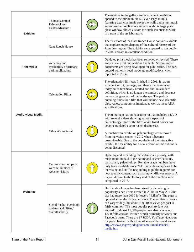
State of the Park Report 34 John Day Fossil Beds National Monument
Exhibits
Thomas Condon
Paleontology
Center/Museum
The exhibits in the gallery are in excellent condition,
opened to the public in 2005. Seven large murals
featuring extinct animals cover the walls and a multitrack
audio program replicates animal sounds. A large plate
glass window allows visitors to watch scientists at work
in a state of the art laboratory.
Cant Ranch House
The first floor of the Cant Ranch House contains exhibits
that explore major chapters of the cultural history of the
John Day region. The exhibits were opened to the public
in 2005 and are in excellent condition.
Print Media
Accuracy and
availability of primary
park publications
Outdated print media has been removed or revised. There
are six new print publications available. Several more
documents are being developed for publication. The park
unigrid will only need moderate modifications when
reprinted in 2014.
Audio-visual Media
Orientation Films
The orientation film was finished in 2001. It has an
excellent script, message, and theme that is relevant
today but is technically limited and shot in standard
definition, which is no longer the standard and does not
convey the grandeur of the landscape. The park is
pursuing funds for a film that will include new scientific
discoveries, computer animation, as well as meet ADA
specifications.
Other AV material
The monument has an education kit that includes a DVD
with several videos showing various aspects of
paleontology. One of the films about fossil horses has
become outdated due to recent discoveries.
A touchscreen exhibit on paleontology was removed
from the visitor center in 2012 when it became
unserviceable. Due to the popularity of the interactive
exhibit, the feasibility for a new version of this exhibit is
being discussed.
Websites
Currency and scope of
website; number of
website visitors
Updating and expanding the website is a priority, with
most attention paid to the nature and science sections,
particularly paleontology. Reliable usage numbers have
only been available since 2011 but web use appears to be
increasing and staff is responding to public requests for
new specific content such as spring wildflower reports. A
major addition to the History and Culture section was
completed in 2013.
Social media: Facebook
updates and "likes,"
overall activity
Our Facebook page has been steadily increasing in
popularity since it was created in 2010. In May 2013 the
site had more than 2000 followers (“Likes”). The page is
updated about 4–5 times per week. The number of views
can vary widely, but about 700–1000 views per post is
fairly common. The most popular post to date was
viewed by almost 11,000 people. We also have about
1,500 followers on Twitter, which primarily retweets our
Facebook posts. There are 17 JODA YouTube videos on
the park channel, with a total of several thousand views.
http://www.nps.gov/joda/photosmultimedia/social-
media.htm
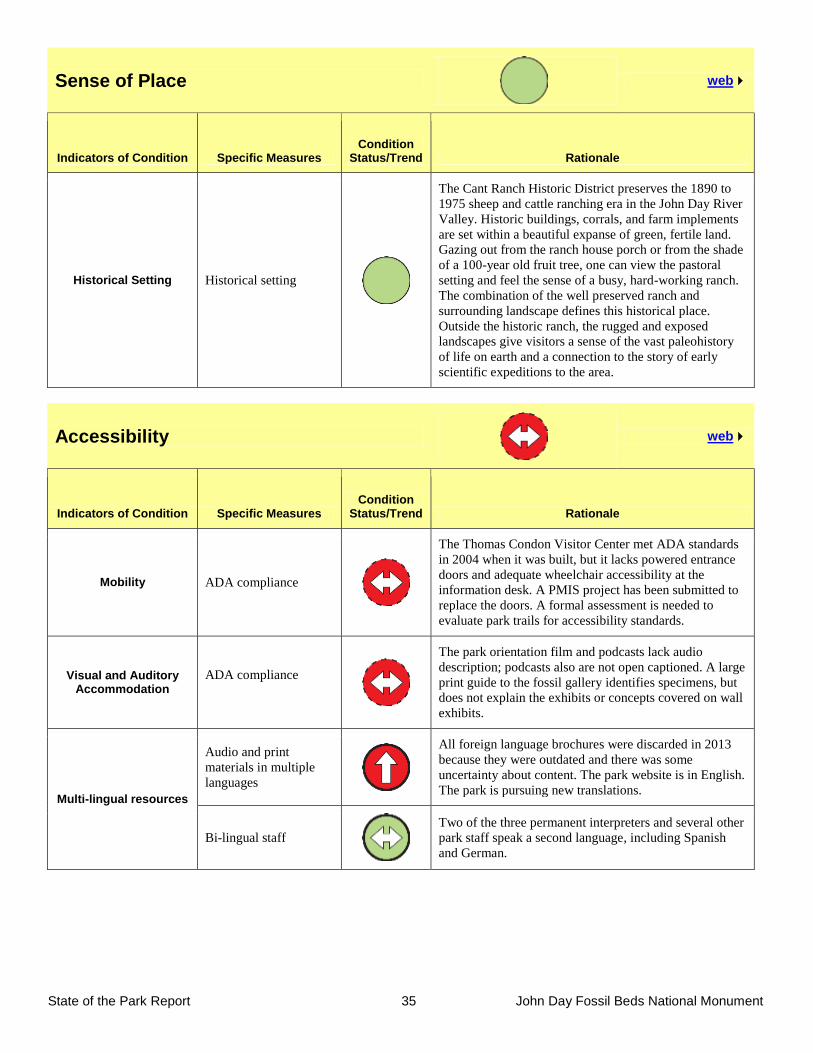
State of the Park Report 35 John Day Fossil Beds National Monument
Sense of Place
web
Indicators of Condition Specific Measures Condition
Status/Trend Rationale
Historical Setting Historical setting
The Cant Ranch Historic District preserves the 1890 to
1975 sheep and cattle ranching era in the John Day River
Valley. Historic buildings, corrals, and farm implements
are set within a beautiful expanse of green, fertile land.
Gazing out from the ranch house porch or from the shade
of a 100-year old fruit tree, one can view the pastoral
setting and feel the sense of a busy, hard-working ranch.
The combination of the well preserved ranch and
surrounding landscape defines this historical place.
Outside the historic ranch, the rugged and exposed
landscapes give visitors a sense of the vast paleohistory
of life on earth and a connection to the story of early
scientific expeditions to the area.
Accessibility
web
Indicators of Condition Specific Measures Condition
Status/Trend Rationale
Mobility ADA compliance
The Thomas Condon Visitor Center met ADA standards
in 2004 when it was built, but it lacks powered entrance
doors and adequate wheelchair accessibility at the
information desk. A PMIS project has been submitted to
replace the doors. A formal assessment is needed to
evaluate park trails for accessibility standards.
Visual and Auditory Accommodation
ADA compliance
The park orientation film and podcasts lack audio
description; podcasts also are not open captioned. A large
print guide to the fossil gallery identifies specimens, but
does not explain the exhibits or concepts covered on wall
exhibits.
Multi-lingual resources
Audio and print
materials in multiple
languages
All foreign language brochures were discarded in 2013
because they were outdated and there was some
uncertainty about content. The park website is in English.
The park is pursuing new translations.
Bi-lingual staff
Two of the three permanent interpreters and several other
park staff speak a second language, including Spanish
and German.
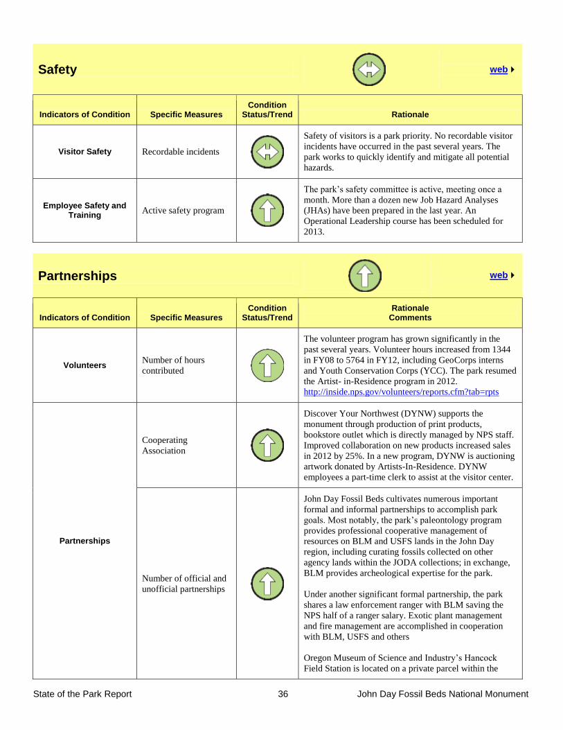
State of the Park Report 36 John Day Fossil Beds National Monument
Safety
web
Indicators of Condition Specific Measures Condition
Status/Trend Rationale
Visitor Safety Recordable incidents
Safety of visitors is a park priority. No recordable visitor
incidents have occurred in the past several years. The
park works to quickly identify and mitigate all potential
hazards.
Employee Safety and Training
Active safety program
The park’s safety committee is active, meeting once a
month. More than a dozen new Job Hazard Analyses
(JHAs) have been prepared in the last year. An
Operational Leadership course has been scheduled for
2013.
Partnerships
web
Indicators of Condition Specific Measures Condition
Status/Trend Rationale
Comments
Volunteers Number of hours
contributed
The volunteer program has grown significantly in the
past several years. Volunteer hours increased from 1344
in FY08 to 5764 in FY12, including GeoCorps interns
and Youth Conservation Corps (YCC). The park resumed
the Artist- in-Residence program in 2012.
http://inside.nps.gov/volunteers/reports.cfm?tab=rpts
Partnerships
Cooperating
Association
Discover Your Northwest (DYNW) supports the
monument through production of print products,
bookstore outlet which is directly managed by NPS staff.
Improved collaboration on new products increased sales
in 2012 by 25%. In a new program, DYNW is auctioning
artwork donated by Artists-In-Residence. DYNW
employees a part-time clerk to assist at the visitor center.
Number of official and
unofficial partnerships
John Day Fossil Beds cultivates numerous important
formal and informal partnerships to accomplish park
goals. Most notably, the park’s paleontology program
provides professional cooperative management of
resources on BLM and USFS lands in the John Day
region, including curating fossils collected on other
agency lands within the JODA collections; in exchange,
BLM provides archeological expertise for the park.
Under another significant formal partnership, the park
shares a law enforcement ranger with BLM saving the
NPS half of a ranger salary. Exotic plant management
and fire management are accomplished in cooperation
with BLM, USFS and others
Oregon Museum of Science and Industry’s Hancock
Field Station is located on a private parcel within the
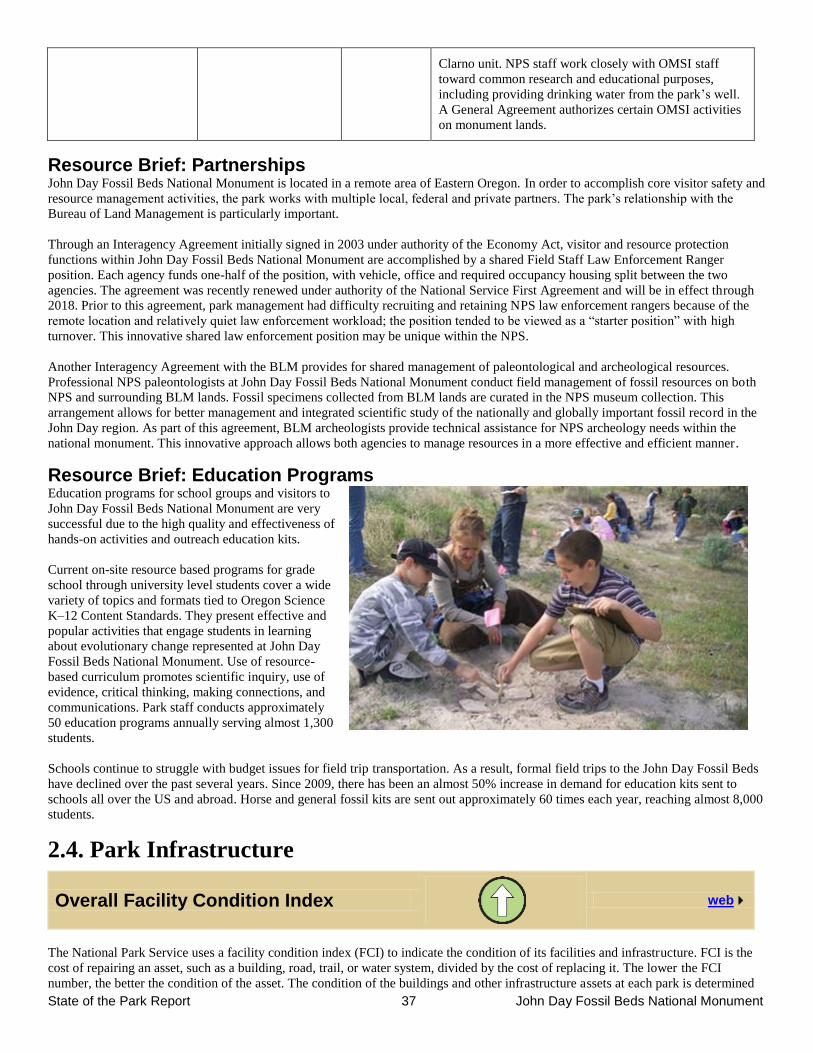
State of the Park Report 37 John Day Fossil Beds National Monument
Clarno unit. NPS staff work closely with OMSI staff
toward common research and educational purposes,
including providing drinking water from the park’s well.
A General Agreement authorizes certain OMSI activities
on monument lands.
Resource Brief: Partnerships John Day Fossil Beds National Monument is located in a remote area of Eastern Oregon. In order to accomplish core visitor safety and
resource management activities, the park works with multiple local, federal and private partners. The park’s relationship with the
Bureau of Land Management is particularly important.
Through an Interagency Agreement initially signed in 2003 under authority of the Economy Act, visitor and resource protection
functions within John Day Fossil Beds National Monument are accomplished by a shared Field Staff Law Enforcement Ranger
position. Each agency funds one-half of the position, with vehicle, office and required occupancy housing split between the two
agencies. The agreement was recently renewed under authority of the National Service First Agreement and will be in effect through
2018. Prior to this agreement, park management had difficulty recruiting and retaining NPS law enforcement rangers because of the
remote location and relatively quiet law enforcement workload; the position tended to be viewed as a “starter position” with high
turnover. This innovative shared law enforcement position may be unique within the NPS.
Another Interagency Agreement with the BLM provides for shared management of paleontological and archeological resources.
Professional NPS paleontologists at John Day Fossil Beds National Monument conduct field management of fossil resources on both
NPS and surrounding BLM lands. Fossil specimens collected from BLM lands are curated in the NPS museum collection. This
arrangement allows for better management and integrated scientific study of the nationally and globally important fossil record in the
John Day region. As part of this agreement, BLM archeologists provide technical assistance for NPS archeology needs within the
national monument. This innovative approach allows both agencies to manage resources in a more effective and efficient manner.
Resource Brief: Education Programs Education programs for school groups and visitors to
John Day Fossil Beds National Monument are very
successful due to the high quality and effectiveness of
hands-on activities and outreach education kits.
Current on-site resource based programs for grade
school through university level students cover a wide
variety of topics and formats tied to Oregon Science
K–12 Content Standards. They present effective and
popular activities that engage students in learning
about evolutionary change represented at John Day
Fossil Beds National Monument. Use of resource-
based curriculum promotes scientific inquiry, use of
evidence, critical thinking, making connections, and
communications. Park staff conducts approximately
50 education programs annually serving almost 1,300
students.
Schools continue to struggle with budget issues for field trip transportation. As a result, formal field trips to the John Day Fossil Beds
have declined over the past several years. Since 2009, there has been an almost 50% increase in demand for education kits sent to
schools all over the US and abroad. Horse and general fossil kits are sent out approximately 60 times each year, reaching almost 8,000
students.
2.4. Park Infrastructure
Overall Facility Condition Index
web
The National Park Service uses a facility condition index (FCI) to indicate the condition of its facilities and infrastructure. FCI is the
cost of repairing an asset, such as a building, road, trail, or water system, divided by the cost of replacing it. The lower the FCI
number, the better the condition of the asset. The condition of the buildings and other infrastructure assets at each park is determined
State of the Park Report 38 John Day Fossil Beds National Monument
by regular facility inspections, or “condition assessments”, including daily informal inspections and formal yearly inspections.
Deficiencies identified from these assessments are documented in the NPS Facility Management Software System and the cost for
each repair determined. Repairs that cannot be completed within the year count against the condition of a structure. The total cost of
these deferred repairs divided by the total cost to replace the structure results in the FCI, with values between 0 and 1 (the lower the
decimal number, the better the condition). The FCI is assigned a condition category of Good, Fair, Poor, or Serious based on industry
and NPS standards. Deferred maintenance projects that require additional funding are identified based on FCI. Planned preventive
maintenance on critical components occurs during the year, using a park’s base budget. For additional information about how park
managers use information about the condition of facilities and infrastructure to make decisions about the efficient use of funding for
maintenance and restoration activities at the park, Click Here.
Asset Category
Number of Assets
2008 / 2012 FCI
2008 / 2012 Condition
Status/Trend Rationale
Buildings 38 / 39 0.010 / 0.006
The park has constructed and/or rehabilitated
many park structures in the past 10 years
including the Thomas Condon Visitor Center
and the Historic Cant Ranch House. The ongoing
facility operations and cyclic maintenance
programs will continue to prolong the overall life
of these buildings. Solar and energy efficient
construction and improvements in Housing Units
as well as in other park buildings assist the park
in reducing their carbon foot print. A
maintenance shop/visitor contact station is
planned for the Clarno Unit.
Trails 16 / 17 0.131 / 0.026
25 miles of developed hiking trails are
maintained at the park. Over the last five years
the park has removed 8 miles of unauthorized
trails that contributed to erosion within the
Clarno Unit. The park is planning to formalize
several more miles of trail within the Clarno
Unit to enhance future visitor hiking
opportunities.
Waste Water Systems 7 / 7 0.274 / 0.000
Waste water systems are annually assessed and
maintained according to a service schedule.
Employees are trained to safely inspect the
systems and provide maintenance as needed.
Water Systems 7 / 7 0.058 / 0.011
The park’s seven water systems are well
operated and maintained. The park has several
trained utility operators who are dedicated to
monitoring and providing safe drinking water to
the public.
Unpaved Roads, and Parking Areas
30 / 31 0.028 / 0.100
Most of the unpaved roads, pullouts, and
overlooks are in good condition and will
continue to be maintained through cyclic
maintenance funding. The Camp Hancock Road
in the Clarno Unit is in poor condition; a funding
request to improve it has been included in the
overall Clarno Unit plans.
Paved Roads, and Parking Areas
12 / 12 0.117 / 0.131
Paved roads are generally in good condition with
the exception of a few parking areas that have
deferred maintenance.
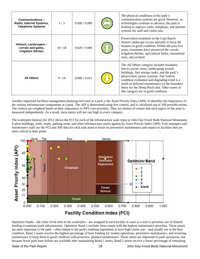
State of the Park Report 39 John Day Fossil Beds National Monument
Communications – Radio, Internet Systems,
Telephone Systems 1 / 3 0.000 / 0.000
The physical conditions of the park’s
communication systems are good. However, as
technologies continue to advance, the park is
looking to improve radio, telephone, and internet
systems for staff and visitor use.
Historic Landscapes – corrals and gates, irrigation ditches
10 / 10 0.029 / 0.000
Preservation treatment on the Cant Ranch
historic landscape occurs annually to keep the
features in good condition. Within the past five
years, treatments have preserved the corrals,
irrigation ditches, agricultural fields, ornamental
trees, and orchard.
All Others 9 / 14 0.006 / 0.011
The All Others category includes boundary
fences, picnic areas, landscaping around
buildings, fuel storage tanks, and the park’s
photovoltaic power systems. The Yellow
condition evaluation and degrading trend is a
result of deferred maintenance on the boundary
fence for the Sheep Rock unit. Other assets in
this category are in good condition.
Another important facilities management planning tool used at a park is the Asset Priority Index (API). It identifies the importance of
the various infrastructure components at a park. The API is determined using five criteria, and is calculated out of 100 possible points.
The criteria are weighted based on their importance to NPS core priorities. They are distinct to ensure that each aspect of the asset is
measured independently. As a result, most assets will not rate high in every category.
The scatterplot (below) for 2012 shows the FCI for each of the infrastructure asset types at John Day Fossil Beds National Monument.
It plots buildings, trails, roads, parking areas, and other infrastructure assets against its Asset Priority Index (API). Park managers and
maintenance staff use the FCI and API data for each park asset to focus on preventive maintenance and repairs to facilities that are
most critical to their parks.
Optimizer bands—the color of the dots in the scatterplot—are assigned to each facility or asset as a tool to prioritize use of limited
funding to maintain park infrastructure. Optimizer Band 1 includes those assets with the highest maintenance priorities. These assets
are most important to the park—often linked to the park's enabling legislation or have high visitor use—and usually are in the best
condition. Band 1 assets receive the highest percentage of base funding for routine operations, preventive maintenance, and recurring
maintenance to keep them in good condition with proactive, planned maintenance. These assets are important to park operations, but
because fewer park base dollars are available after maintaining Band 1 assets, Band 2 assets receive a lesser percentage of remaining
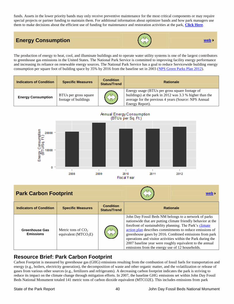
State of the Park Report 40 John Day Fossil Beds National Monument
funds. Assets in the lower priority bands may only receive preventive maintenance for the most critical components or may require
special projects or partner funding to maintain them. For additional information about optimizer bands and how park managers use
them to make decisions about the efficient use of funding for maintenance and restoration activities at the park, Click Here.
Energy Consumption
web
The production of energy to heat, cool, and illuminate buildings and to operate water utility systems is one of the largest contributors
to greenhouse gas emissions in the United States. The National Park Service is committed to improving facility energy performance
and increasing its reliance on renewable energy sources. The National Park Service has a goal to reduce Servicewide building energy
consumption per square foot of building space by 35% by 2016 from the baseline set in 2003 (NPS Green Parks Plan 2012).
Indicators of Condition Specific Measures Condition
Status/Trend Rationale
Energy Consumption BTUs per gross square
footage of buildings
Energy usage (BTUs per gross square footage of
buildings) at the park in 2012 was 3.3 % higher than the
average for the previous 4 years (Source: NPS Annual
Energy Report).
Park Carbon Footprint
web
Indicators of Condition Specific Measures Condition
Status/Trend Rationale
Greenhouse Gas Emissions
Metric tons of CO2
equivalent (MTCO2E)
John Day Fossil Beds NM belongs to a network of parks
nationwide that are putting climate friendly behavior at the
forefront of sustainability planning. The Park’s climate
action plan describes commitments to reduce emissions of
greenhouse gases by 2016. Combined emissions from park
operations and visitor activities within the Park during the
2007 baseline year were roughly equivalent to the annual
emissions from the energy use of 12 households.
Resource Brief: Park Carbon Footprint Carbon Footprint is measured by greenhouse gas (GHG) emissions resulting from the combustion of fossil fuels for transportation and
energy (e.g., boilers, electricity generation), the decomposition of waste and other organic matter, and the volatilization or release of
gases from various other sources (e.g., fertilizers and refrigerants). A decreasing carbon footprint indicates the park is striving to
reduce its impact on the climate change through mitigation efforts. In 2007, the baseline GHG emissions set within John Day Fossil
Beds National Monument totaled 141 metric tons of carbon dioxide equivalent (MTCO2E). This includes emissions from park
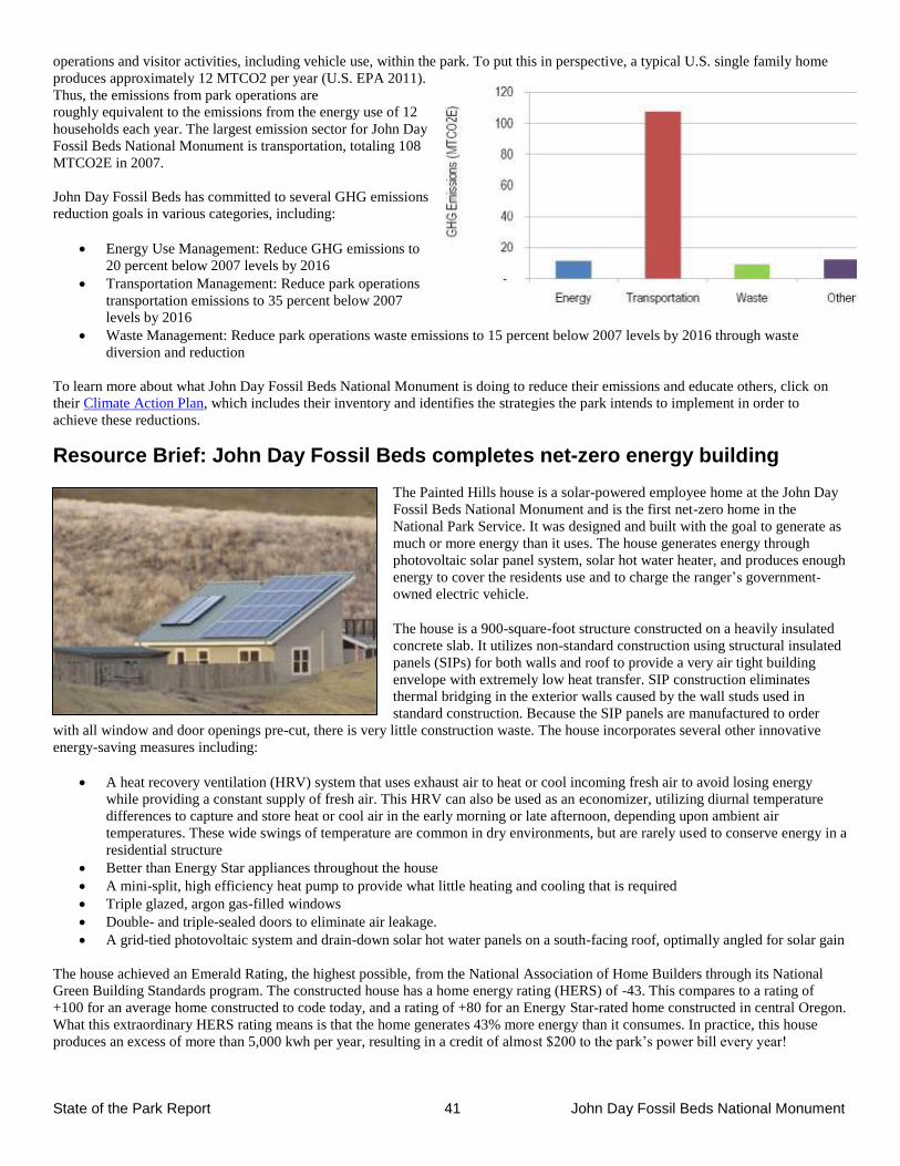
State of the Park Report 41 John Day Fossil Beds National Monument
operations and visitor activities, including vehicle use, within the park. To put this in perspective, a typical U.S. single family home
produces approximately 12 MTCO2 per year (U.S. EPA 2011).
Thus, the emissions from park operations are
roughly equivalent to the emissions from the energy use of 12
households each year. The largest emission sector for John Day
Fossil Beds National Monument is transportation, totaling 108
MTCO2E in 2007.
John Day Fossil Beds has committed to several GHG emissions
reduction goals in various categories, including:
Energy Use Management: Reduce GHG emissions to
20 percent below 2007 levels by 2016
Transportation Management: Reduce park operations
transportation emissions to 35 percent below 2007
levels by 2016
Waste Management: Reduce park operations waste emissions to 15 percent below 2007 levels by 2016 through waste
diversion and reduction
To learn more about what John Day Fossil Beds National Monument is doing to reduce their emissions and educate others, click on
their Climate Action Plan, which includes their inventory and identifies the strategies the park intends to implement in order to
achieve these reductions.
Resource Brief: John Day Fossil Beds completes net-zero energy building
The Painted Hills house is a solar-powered employee home at the John Day
Fossil Beds National Monument and is the first net-zero home in the
National Park Service. It was designed and built with the goal to generate as
much or more energy than it uses. The house generates energy through
photovoltaic solar panel system, solar hot water heater, and produces enough
energy to cover the residents use and to charge the ranger’s government-
owned electric vehicle.
The house is a 900-square-foot structure constructed on a heavily insulated
concrete slab. It utilizes non-standard construction using structural insulated
panels (SIPs) for both walls and roof to provide a very air tight building
envelope with extremely low heat transfer. SIP construction eliminates
thermal bridging in the exterior walls caused by the wall studs used in
standard construction. Because the SIP panels are manufactured to order
with all window and door openings pre-cut, there is very little construction waste. The house incorporates several other innovative
energy-saving measures including:
A heat recovery ventilation (HRV) system that uses exhaust air to heat or cool incoming fresh air to avoid losing energy
while providing a constant supply of fresh air. This HRV can also be used as an economizer, utilizing diurnal temperature
differences to capture and store heat or cool air in the early morning or late afternoon, depending upon ambient air
temperatures. These wide swings of temperature are common in dry environments, but are rarely used to conserve energy in a
residential structure
Better than Energy Star appliances throughout the house
A mini-split, high efficiency heat pump to provide what little heating and cooling that is required
Triple glazed, argon gas-filled windows
Double- and triple-sealed doors to eliminate air leakage.
A grid-tied photovoltaic system and drain-down solar hot water panels on a south-facing roof, optimally angled for solar gain
The house achieved an Emerald Rating, the highest possible, from the National Association of Home Builders through its National
Green Building Standards program. The constructed house has a home energy rating (HERS) of -43. This compares to a rating of
+100 for an average home constructed to code today, and a rating of +80 for an Energy Star-rated home constructed in central Oregon.
What this extraordinary HERS rating means is that the home generates 43% more energy than it consumes. In practice, this house
produces an excess of more than 5,000 kwh per year, resulting in a credit of almost $200 to the park’s power bill every year!
State of the Park Report 42 John Day Fossil Beds National Monument
Chapter 3. Summary of Key Stewardship Activities
and Accomplishments
The list below provides examples of stewardship activities and accomplishments by park staff and partners to maintain or improve the
condition of priority park resources and values for this and future generations:
Partnerships
Partnerships with other agencies, tribal organizations, and educational institutions are integral to park management goals. Some
examples of successful, ongoing partnerships include:
Cooperative management of paleo resources with Bureau of Land Management and U.S. Forest Service.
Cooperative law enforcement efforts with BLM, Oregon State Police, local sheriff offices.
Invasive plant management and strategic planning through collaboration with North Cascades Exotic Plant Management
Team, Grant County Cooperative Weed Management Area, Deschutes Native Plant Seed Bank, and USDA Agricultural
Research Services (Ecologically-Based Invasive Plant Management planning).
Fire management collaboration with BLM and NPS Fire Effects monitoring program (North Cascades team).
Oregon Museum of Science and Industry – Hancock Field Station—this 10 acre parcel of private land within the Clarno unit
is used for research and educational purposes. A General Agreement authorizes certain OMSI activities on monument lands.
Tribal partnerships, including Pine Creek Conservation Area.
Summer internship and guest scientist programs with Oregon Youth Conservation Corps, Northwest Youth Corps, Youth
Conservation Corps, Student Conservation Association, and GeoCorp program.
Supporting local community development with Oregon Paleo Lands Institute.
Natural Resources
Paleontology: Intensive surveys within the Sheep Rock unit have covered more than 75% of the badlands exposures, and
helped to preserve thousands of fossil specimens. New fossil species are regularly discovered in all three park units, and on
adjacent BLM lands, by park paleontologists.
Two recently published finds includes the earliest modern beaver in North America and the world’s oldest fisher; press
coverage of these finds created wide-spread general interest.
The park hosted two recent field conferences—Society of Vertebrate Paleontology, and Geological Society of America.
Recent geologic research has helped define stratigraphy of rock units in the Park, and combined with new radiometric dates
allows more precise dating of fossils (usually within 1 million years).
Park working with NOAA fisheries to increase threatened steelhead populations by restoring riparian vegetation and
improving fish passage in Bridge Creek at the Painted Hills Unit.
Collaboration with UCBN Inventory and Monitoring program for long-term monitoring and natural resource management.
o Radio telemetry study with bat species to determine location of roosts
o Vertebrate inventories (mammals, birds, reptiles, amphibians)
o Butterfly and moth inventories
o Upland and riparian vegetation monitoring
o Water quality and stream channel monitoring
Vegetation management program: Annually control invasive plant species through herbicide application (with an average of
over 100 acres treated each year), manual pulling, and biological control agents (stem-boring weevil for Dalmatian toadflax).
Restoration of abandoned agricultural fields to native grass communities. Initiated ecologically-based invasive plant
management (EBIPM) in partnership with USDA-ARS to improve weed management effectiveness and sustainability of the
program.
Cultural Resources
Completion of the cultural landscape inventory for the Cant Ranch Historic District.
Updated National Register of Historic Places nomination for the Cant Ranch Historic District.
Preservation of historic fruit tree varieties in the Cant Ranch orchard by grafting scions to period root stock.
Preservation treatment of the Cant Ranch outbuildings and landscape.
Increased knowledge of archeology through archeological surveys and testing projects including the discovery of pit houses
occupied by indigenous tribes.
Visitor Experience
Thomas Condon Paleontology Center is a world class facility for educating the public about the region’s fossil history and
the on-going story of scientific inquiry.
State of the Park Report 43 John Day Fossil Beds National Monument
Social media—Significant updates to the website have substantially improved public access to information about the
monument. The park has established a popular Facebook page, YouTube channel, and Twitter account to increase relevancy
for virtual visitors.
Major revisions to publications are ongoing. Six publications have already been revised and are now available, with many
more on the way.
Created a new Jr. Ranger book in 2012 that focuses on the full range of primary and secondary park resources.
The popular horse kit traveling educational trunks are sent to schools as far away as Guam.
Eight new wayside exhibits were developed and installed at two popular park locations, the Clarno Picnic Area and the Island
in Time trail at Blue Basin.
Rangers completed a monument-wide wayside exhibit inventory and assessment in 2012.
Park Infrastructure
Prep lab and collection facility at Thomas Condon Paleontology Center are state of the art, allowing curation of park
resources at a level unprecedented within the National Park Service.
Energy efficiency: New residences were constructed at Painted Hills and Foree in 2009 and 2010. The Painted Hills house is
a net-zero energy home that actually results in an annual surplus back to the park’s energy bill.
The Red Scar Knoll trail was built at Painted Hills in 2011, providing a spectacular and popular visitor experience.
Chapter 4. Key Issues and Challenges for
Consideration in Management Planning
Strategic Sustainability
The greatest management challenge at John Day Fossil Beds, as at many other parks, is development of a strategic management
paradigm that will be sustainable into the future. We need to become lean and efficient with a focus on the core resources for which
the park was established. This is going to require some very difficult choices between important resources and core resources. This
will likely mean a conscious decision to let some important, but not core, resources and assets deteriorate.
A related significant challenge is maintaining employee skills and workplace satisfaction in the face of declining budgets, FTE
ceilings and the need to do less with less, which is not easy for highly dedicated employees to accept. A significant portion of the
long-term workforce at John Day Fossil Beds will be eligible for retirement within the next several years, so planning for workforce
transition will be important to retain institutional knowledge.
Lands Issues
John Day Fossil Beds National Monument was established in 1975. As described in the park’s Land Protection Plan, nearly one
quarter of the area within the boundary is in non-federal ownership and much of this non-federal land is privately owned. Associated
threats to park resources and visitor experience include trespass cattle, exotic plant control, access to NPS facilities and resources
across inholdings, and encroachment of development on park lands.
Community/Partnerships
In the modern world, no park is an island. To effectively manage park resources and provide a quality experience for park visitors,
John Day Fossil Beds National Monument needs to maintain multiple existing partnerships and seek to develop new partners in
innovative, non-traditional ways.
The park and our visitors contribute positively to local economies; continued economic development in rural communities surrounding
the park is important to provide necessary infrastructure for visitors to stay in the area long enough to experience the park’s resources,
as well as for support of NPS employees and management functions. We are part of the local communities and economies, and
cooperation with local efforts to expand necessary visitor services is appropriate.
Paleontology John Day Fossil Beds National Monument was established because of world-class fossil resources. The park has an active and exciting
paleontology program with new species being described on an almost routine basis. This program is world renowned and very well-
respected. Since scientific integrity of paleontological resources is lost if the specimens erode out of their geologic context, the park
routinely prospects for new fossils becoming exposed through erosion. As a result, the park’s museum collection is literally expanding
every week. At some point, the park’s capacity for curating these specimens will be reached. Pre-planning for this eventuality will be
important for continued protection of these world-class resources.
State of the Park Report 44 John Day Fossil Beds National Monument
The 2009 General Management Plan plans for opening the Hancock Mammal Quarry for research and interpretation. This site is of
great importance to scientists’ knowledge of vertebrate fossils from the early Tertiary Period. Preliminary analysis suggests that this is
the best late Eocene vertebrate site found in the western United States. Much information likely would be gained by reopening the
quarry, and it would add a new facet to the visitor experience. However, significant pre-planning and facility development would be
necessary to insure that this important resource could be adequately protected and interpreted.
Vegetation Management Decisions regarding sustainable management of vegetative communities within John Day Fossil Beds National Monument will be
important in the future, possibly necessitating re-evaluation of desired future conditions and perhaps even applicability of traditional
NPS policy regarding native communities. Invasive plant species are widespread and expanding within all three units, posing a
significant threat to native communities. Even if the entire park budget and all staff were to be dedicated solely to exotic plant
management, invasive plants could not be eradicated. The park is working on an innovative planning process to establish realistic
priorities and goals for treatment of exotic plants; however this will continue to be a huge management challenge for the foreseeable
future.
Although junipers are native to the monument, scientists believe that this species is encroaching on new areas and in densities that
may require some management action (Miller et al. 2005). Prescribed fire has been used over the past few decades to control junipers,
but there is disagreement over the application of burning because of the aggressive establishment of exotic understory species in areas
opened up by fire.
Cultural Resources
The Cant Ranch Historic District is one of the most intact locally significant examples of a historic sheep/cattle ranch in Wheeler and
Grant Counties, Oregon, and is currently managed to maintain the historic features. This includes multiple historic structures including
four agricultural fields actively managed for harvest. Sustainable management of this district into the future may become increasingly
difficult as budgets and staffing declines.
A management plan for the park’s archeological resources, especially pictographs, is a critical need to protect these irreplaceable
resources. In 2013 meetings with each of the traditionally associated American Indian governments, the need for a formal plan to
manage and protect pictographs was raised as the tribes’ highest priority. The park lacks technical expertise to complete this planning
process and will require assistance from Pacific West Region staff to do so. Timely completion of this planning process is important
for resource protection and for maintaining good relations with traditionally associated tribal governments.
Visitor Opportunities and Relevancy
First-time visitors to the park often exclaim in awe that they had no idea there is such a fascinating resource right here in Oregon and
declare that they will be back to visit again now that they know about the amazing paleontology story. This park is quite remote.
Digital infrastructure that has become expected elsewhere is not available here. We do not have cell phone coverage in most of the
park or the surrounding areas. Internet infrastructure capabilities are limited. Even telephones often malfunction. Although the park
has an active following on Facebook and Twitter, as well as two web cameras, finding a way to provide digital experiences that the
modern visitor (both on-site and virtual visitors) expect continues to be challenging.
The Clarno Unit is the least developed of the park’s units. There is an extensive trail system that was informally created over time
rather than planned. The park’s 2009 General Management Plan calls for formalizing these unofficial trails. Careful planning and
development could result in a much expanded visitor experience, including new interpretive opportunities.
References
See the State of the Park Report for the Park website for a more complete list of references to documents and data sets upon which the
assessments in this State of the Park report are based. References for several key documents cited in this report are as follows:
Albright III, L.B., M.O. Woodburne, T.J. Fremd, C.C. Swisher III, B.J. MacFadden, AND G.R. Scott. 2008. Revised
chronostratigraphy and biostratigraphy of the John Day Formation (Turtle Cove and Kimberly Members), Oregon, with
implications for updated calibration of the Arikareean North American Land Mammal Age. The Journal of Geology, 116:
211–237.
Bell, J. and D. Hinson. 2010. Natural Resource Condition Assessment: John Day Fossil Beds National Monument. Natural Resource
Report. NPS/UCBN/NRR-2010/174. National Park Service. Fort Collins, Colorado.
State of the Park Report 45 John Day Fossil Beds National Monument
Bestland, E.A., and G.J.Retallack. 1994. Geology of the Clarno Unit, John Day Fossil Beds National Monument, Oregon, Final report,
National Park Service contract CX–9000–1–10009, p. 1–203.
Bestland, E.A., and G.J. Retallack 1994. Geology and paleoenvironments of the Painted Hills Unit, John Day Fossil Beds National
Monument, Oregon. National Park Service Final report, contract CX–9000–1–10009, p. 1–211.
Bestland, E.A., P.E. Hammond, D.L.S. Blackwell, M.A. Kays, G.J. Retallack, and J. Stimac. 1999. Geologic framework of the Clarno
Unit, John Day Fossil Beds National Monument: Central Oregon. Oregon Geology, 61:3–19.
Bestland, E.A. M.S. Forbes, E.S. Krull, G.J. Retallack, and T.J. Fremd. 2008. Stratigraphy, paleopedology, and geochemistry of the
middle Miocene Mascall Formation (Type area, central Oregon, USA). PaleoBios, 28:41–61.
Beuchling A. 2007. Distribution and status of endemic and non-native plant species at the Painted Hills Unit of the John Day Fossil
Beds National Monument. Oregon State University. Unpublished Report.
Calede, J.M., and S.S.B. Hopkins. 2012. Intraspecific versus interspecific variation in Miocene Great Basin mylagaulids: implications
for systematics and evolutionary history. Zoological Journal of the Linnean Society, 2012, 164, 427–450.
Chaney, R.W. 1924. Quantitative studies of the Bridge Creek Flora: American Journal of Science, Fifth Series. VIII:127–144.
Chaney, R.W. 1925. The Mascall flora; its distribution and climatic relation. Carnegie Institute of Washington Publication, 349:23–48.
Chaney, R.W. 1948. The ancient forests of Oregon. Oregon System of Higher Education, Condon Lectures, Eugene, Oregon, 56 pp.
Chaney, R.W. 1952. Conifer dominants in the middle Tertiary of the John Day Basin, Oregon. The Palaeobotanist, 1:105–115.
Chaney, R.W. 1956. The ancient forests of Oregon. Condon Lectures, Oregon State System of Higher Education, University of
Oregon, Eugene, OR.
Chaney, R.W. 1959. Miocene floras of the Columbia Plateau. Parti I, Composition and interpretation. Carnegie Institution of
Washington Publication, 617: 1–134.
Chaney, R.W., and D.I. Axelrod. 1959. Miocene floras of the Columbia Plateau. Carnegie Institution of Washington Publication,
617:135–237.
Cope, E.D. 1884. The Vertebrata of the Tertiary Formations of the West, Book 1. U.S. Geological Survey of the Territories, Report 3,
p. 1–1009.
Dillhoff, R.M., T.A. Dillhoff, R.E. Dunn, J.A. Myers, and C.A.E. Strömberg. 2009. Cenozoic paleobotany of the John Day Basin,
central Oregon; pp. 135–164 in O’Connor, J.E., R.J. Dorsey, and I.P. Madin, eds., Volcanoes to Vineyards: Geologic Field
Trips through the Dynamic Landscape of the Pacific Northwest. Geological Society of America Field Guide 15.
Esposito, D. M., D. S. Stucki, and T. J. Rodhouse. 2012. Sagebrush steppe vegetation monitoring in the Clarno Unit of John Day
Fossil Beds National Monument: 2012 Annual Report. Natural Resource Data Series NPS/UCBN/NRDS—2012/396.
National Park Service, Fort Collins, CO.
Fisher, R.V. and J.M. Rensberger. 1972. Physical stratigraphy of the John Day Formation, central Oregon. University of California
Publications in Geological Sciences, 101:1–33.
Fisichelli, N. 2013. Climate change trends for planning at John Day Fossil Beds National Monument, Oregon. NPS Climate Change
Response Program, Fort Collins, Colorado.
Fremd, T.J., E.A. Bestland, and G.J. Retallack. 1994. John Day Basin paleontology field trip guide and road log. Society of Vertebrate
Paleontology, 1994 Annual Meeting. Northwest Interpretive Association, Seattle, 80 pp.
Fremd, T.J. 1995. Cyclic prospecting to preserve vertebrate paleontological resources: San Bernardino County Museum Association
Quarterly. 4:19–25.
Fremd, T.J. 2010. Guidebook: SVP Field Symposium 2010. John Day Basin Field Conference. Society of Vertebrate Paleontology,
153 pp.
State of the Park Report 46 John Day Fossil Beds National Monument
Hall, Jason, M. Pollock, and S. Hoh. 2011. Methods for Successful Establishment of Cottonwood and Willow Along an Incised
Stream in Semiarid Eastern Oregon, USA. Ecological Restoration Volume 29, No. 3.
Hunt, R.M. and E. Stepleton. 2004. Geology and paleontology of the upper John Day beds, John Day River Valley, Oregon:
lithostratigraphic and biochronologic revision in the Haystack Valley and Kimberly areas (Kimberly and Mt. Misery
quadrangles). Bulletin of the American Museum of Natural History, 282:1–90.
Kohut R.J. 2004. Ozone risk assessment for Upper Columbia Basin Network. National Park Service. Fort Collins, Colorado.
Kohut, R.J. 2007. Ozone risk assessment for Vital Signs Monitoring Networks, Appalachian National Scenic Trail, and Natchez Trace
National Scenic Trail. NPS/NRPC/ARD/NRTR—2007/001. National Park Service, Fort Collins, Colorado.
Le, Y., M. A. Schuett, S. J. Hollenhorst. 2005. John Day Fossil Beds National Monument Visitor Study, Fall 2004. Visitor Services
Project Report 162. University of Idaho, Park Studies Unit, Moscow, Idaho.
MacFadden, B.J. 1994. Fossil Horses: Systematics, Paleobiology, and Evolution of the Family Equidae. Cambridge University Press,
Cambridge, Massachusetts. 369 pp.
Maher, S. P., A. M. Kramer, J. T. Pulliam, M. A. Zokan, S. E. Bowden, H. D. Barton, K. Magori, and J. M. Drake. 2012. Spread of
white-nose syndrome on a network regulated by geography and climate. Nature Communications 3:1–8.
Manchester, S.R. 1981. Fossil plants of the Eocene Clarno nut beds. Oregon Geology, 43:75–81.
Manchester, S.R. 1990. Eocene to Oligocene floristic changes recorded in the Clarno and John Day Formations, Oregon, U.S.A.; pp.
183–187 in Knobloch, E., and Z. Kvacek, eds., Paleofloristic and paleoclimatic changes in the Cretaceous and Tertiary,
symposium proceedings. Czekoslovakian Geological Survey Press, Prague.
Manchester, S.R. 1994. Fruits and seeds of the middle Eocene Nut Beds flora, Clarno Formation, Oregon. Palaeontographica
Americana, no. 58. 205 pp.
Manchester, S.R. 1995. Yes, we had bananas. Oregon Geology, 57:41–43.
Manchester, S.R. 2000. Late Eocene fossil plants of the John Day Formation, Wheeler County, Oregon. Oregon Geology, 62:51–63.
Martin, J. E., and T. J. Fremd. 2001. Revision of the lithostratigraphy of the Hemphillian Rattlesnake units of central Oregon.
PaleoBios 21:89.
McClaughry, J.D., M.L Ferns, M.J. Streck, K.A. Patridge, and C.L. Gordon. 2009. Paleogene calderas of central and eastern Oregon:
Eruptive sources of widespread tuffs in the John Day and Clarno Formations; pp. 407–434 in O’Connor, J.E., R.J. Dorsey,
and I.P. Madin, eds., Volcanoes to Vineyards: Geologic Field Trips through the Dynamic Landscape of the Pacific
Northwest, Geological Society of America Field Guide 15.
Merriam, J. C. 1901. A contribution to the geology of the John Day Basin. University of California, Publication of Department of
Geological Sciences 2(9):269–314.
Merriam, J. C., C. Stock, and C. L. Moody. 1925. The Pliocene Rattlesnake Formation and fauna of eastern Oregon, with notes on the
geology of the Rattlesnake and Mascall deposits. Carnegie Institution of Washington, Contributions to Palaeontology
347:43–92.
Meyer, H.W., and Manchester, S.R., 1997, The Oligocene Bridge Creek flora of the John Day Formation, Oregon: University of
California Publications in Geological Sciences, v. 141, p. 195, illus.
Miller, R.F., J.D. Bates, T.J. Svejcar, F.B. Pierson, and L.E. Eddleman. 2005. Biology, ecology, and management of western juniper.
Oregon State University Agricultural Experiment Station Technical Bulletin 152.77 p.
National Park Service. 2010. John Day Fossil Beds National Monument Long-Range Interpretive Plan. National Park Service, Harpers
Ferry, West Virginia.
National Park Service, Air Resources Division. 2013. Air quality in national parks: trends (2000–2009) and conditions (2005–2009).
Natural Resource Report NPS/NRSS/ARD/NRR–2013/683. National Park Service, Denver, Colorado.
State of the Park Report 47 John Day Fossil Beds National Monument
Prothero, D.R., and J.M. Rensberger. 1985. Preliminary magnetostratigraphy of the John Day Formation, Oregon, and the north
American Oligocene-Miocene Boundary. Newsletters on Stratigraphy, 15:59–70.
Prothero, D.R., E. Draus, and S.E. Foss. 2006a. Magnetic stratigraphy of the lower portion of the middle Miocene Mascall Formation,
central Oregon. PaleoBios, 26:37–42.
Prothero, D. R., J. M. Hoffman, and S. E. Foss. 2006b. Magnetic stratigraphy of the upper Miocene (Hemphillian) Rattlesnake
Formation, central Oregon. PaleoBios 26: 31–35.
Retallack, G. J. 1999. Paleosols and paleoenvironments of the Rattlesnake Formation (late Miocene) near Dayville, Oregon. Final
report, National Park Service, John Day Fossil Beds national Monument, #1443–PX9325–99–005, 61 pp.
Retallack, G. J. 2004a. Late Oligocene bunch grasslands and early Miocene sod grasslands from central Oregon. Palaeogeography,
Palaeoclimatology, Palaeoecology, 207: 203–237.
Retallack, G. J. 2004b. Late Miocene climate and life on land in Oregon within a context of neogene global change. Palaeogeography,
Palaeoclimatology, Palaeoecology, 214: 97–123.
Retallack, G. J. 2007. Cenozoic paleoclimate on land in North America. The Journal of Geology, 115:271–294.
Retallack, G.J, E.A. Bestland, and T.J. Fremd. 2000. Eocene and Oligocene paleosols of central Oregon, Geological Society of
America Special Paper 344, 196 pp.
Retallack, G. J., S. Tanaka, and T. Tate. 2002. Late Miocene advent of tall grassland paleosols in Oregon. Palaeogeography,
Palaeoclimatology, Palaeoecology 183:329–354.
Rodhouse T. J. 2009. Monitoring sagebrush-steppe vegetation in the Upper Columbia Basin Network: 2008 annual monitoring report
for City of Rocks National Reserve, Hagerman Fossil Beds National Monument, and John Day Fossil Beds National
Monument. Natural Resource Technical Report. NPS/UCBN/NRTR—2009/182. National Park Service Natural Resource
Program Center. Fort Collins.
Rodhouse, T. J., A. St. John, and L. K. Garrett. 2010. Vertebrate inventory of John Day Fossil Beds National Monument 2002–2003:
Upper Columbia Basin Network. Natural Resource Technical Report NPS/UCBN/NRTR—2010/282. National Park Service,
Fort Collins, Colorado.
Samuels, J.X., and J. Cavin. 2013. The earliest known fisher (Mustelidae), a new species from the Rattlesnake Formation of Oregon.
Journal of Vertebrate Paleontology, 33(2):1–7.
Samuels, J.X., and C. Janis. 2010. Impacts of Cenozoic climate and habitat changes on rodent communities. 70th
Annual Meeting of
the Society of Vertebrate Paleontology. Journal of Vertebrate Paleonotlogy, SVP Program and Abstract Book: 156A.
Samuels, J.X., J.A. Meachen, and S.A. Sakai. 2013. Postcranial morphology and the locomotor habits of living and extinct
carnivorans. Journal of Morphology, 274:121–146.
Samuels, J. X. and J. Zancanella. 2011. An early Hemphillian occurrence of Castor (Castoridae) from the Rattlesnake Formation of
Oregon. Journal of Paleontology 85:930–935.
Starkey, E. N. 2011. Upper Columbia Basin Network stream channel characteristics and riparian condition annual report 2010: John
Day Fossil Beds National Monument (JODA). Natural Resource Data Series NPS/UCBN/NRDS—2011/181. National Park
Service, Fort Collins, CO.
Starkey, E. N. 2013. Upper Columbia Basin Network integrated water quality annual report 2010: John Day Fossil Beds National
Monument (JODA). Natural Resource Technical Report NPS/UCBN/NRTR—2013/718. National Park Service, Fort Collins,
CO. https://irma.nps.gov/App/Reference/Profile/2194082 (accessed 3 April 2013).
Sullivan, T. J., G. T. McPherson, T. C. McDonnell, S. D. Mackey, and D. Moore. 2011a. Evaluation of the sensitivity of inventory and
monitoring national parks to acidification effects from atmospheric sulfur and nitrogen deposition: main report. Natural
Resource Report NPS/NRPC/ARD/NRR—2011/349. National Park Service, Denver, Colorado.
State of the Park Report 48 John Day Fossil Beds National Monument
Sullivan, T. J., G. T. McPherson, T. C. McDonnell, S. D. Mackey, and D. Moore. 2011b. Evaluation of the sensitivity of inventory and
monitoring national parks to acidification effects from atmospheric sulfur and nitrogen deposition: Upper Columbia Basin
Network (UCBN). Natural Resource Report NPS/NRPC/ARD/NRR—2011/382. National Park Service, Denver, Colorado.
Sullivan, T. J., T. C. McDonnell, G. T. McPherson, S. D. Mackey, and D. Moore. 2011c. Evaluation of the sensitivity of inventory and
monitoring national parks to nutrient enrichment effects from atmospheric nitrogen deposition: main report. Natural Resource
Report NPS/NRPC/ARD/NRR—2011/313. National Park Service, Denver, Colorado.
Sullivan, T. J., T. C. McDonnell, G. T. McPherson, S. D. Mackey, and D. Moore. 2011d. Evaluation of the sensitivity of inventory and
monitoring national parks to nutrient enrichment effects from atmospheric nitrogen deposition: Upper Columbia Basin
Network (UCBN). Natural Resource Report NPS/NRPC/ARD/NRR—2011/334. National Park Service, Denver, Colorado.
Swisher, C.C. III. 1992. 40
Ar/39
Ar dating and its application to the calibration of the North American Land Mammal ages. Ph.D.
dissertation, University of California, Berkeley.
USGS National Water Information System. 2010. http://waterdata.usgs.gov/nwis/uv?14046778,
http://waterdata.usgs.gov/or/nwis/uv/?site_no=14038530&PARAmeter_cd=00065,00060(accessed 22 March 2013).
Wang, X. 1994. Phylogenetic systematics of the Hesperocyoninae (Carnivora: Canidae). Bulletin of the American Museum of Natural
History, 221:1–207.
Wang, X, R.H. Tedford, and B.E. Taylor. 1999. Phylogenetic systematics of the Borophaginae (Carnivora: Canidae). Bulletin of the
American Museum of Natural History, 243:1–391.
Wang, X. and R.H. Tedford. 2008. Dogs: Their Fossil Relatives & Evolutionary History. Columbia University Press, New York. 219
pp.
Wheeler, E.A., and S.R. Manchester. 2002. Woods of the Eocene Nut Beds flora, Clarno Formation, Oregon, USA. International
Association of Wood Anatomists Journal Supplement 3.
Yeo, J. J., and T. J. Rodhouse. 2012. Sagebrush steppe vegetation monitoring in John Day Fossil Beds National Monument: 2011
annual report. Natural Resource Data Series NPS/UCBN/NRDS—2012/226. National Park Service, Fort Collins, CO.
See Also:
Collection of Natural Resource-Related References
Collection of Cultural Resource-Related References
Collection of Visitor Experience-Related References
Glossary
See the State of the Parks home page for a link to a complete glossary of terms used in State of the Park reports. Definitions of key
terms used in this report are as follows:
Americans with Disabilities Act
(ADA)
Law enacted by the federal government that includes provisions to remove barriers that limit a
disabled person's ability to engage in normal daily activity in the physical, public environment.
State of the Park Report 49 John Day Fossil Beds National Monument
Archeological Sites Management
Information System (ASMIS)
The National Park Service's standardized database for the basic registration and management
of park prehistoric and historical archeological resources. ASMIS site records contain data on
condition, threats and disturbances, site location, date of site discovery and documentation,
description, proposed treatments, and management actions for known park archeological sites.
It serves as a tool to support improved archeological resources preservation, protection,
planning, and decision-making by parks, centers, regional offices, and the national program
offices.
Baseline Documentation Baseline documentation records the physical condition of a structure, object, or landscape at a
specific point in time. A baseline provides a starting point against which future changes can be
measured.
Carbon Footprint Carbon footprint is generally defined as the total set of greenhouse gas emissions caused by an
organization, event, product or person.
Climate Friendly Park The NPS Climate Friendly Park designation requires meeting three milestones: completing an
application; completing a comprehensive greenhouse gas (GHG) inventory; and completing a
Climate Action Plan, which is the actions, policies, programs, and measures a park will put
into place to reduce its GHG emissions.
Cultural Landscape Inventory (CLI) A Cultural Landscapes Inventory describes historically significant landscapes within a park.
The inventory identifies and documents each landscape’s location, size, physical development,
condition, characteristics, and features, as well as other information useful to park
management.
Curation National parks are the stewards of numerous types of objects, field notes, publications, maps,
artifacts, photographs, and more. The assemblage of these materials comprises a museum
collection. Curation is the process of managing, preserving, and safeguarding a collection
according to professional museum and archival practices.
Exotic Plant Management Team
(EPMT)
One of the ways the NPS is combating invasive plants is through the Exotic Plant Management
Program. The program supports 16 Exotic Plant Management Teams working in over 225 park
units. EPMTs are led by individuals with specialized knowledge and experience in invasive
plant management and control. Each field-based team operates over a wide geographic area
and serves multiple parks.
Facility Condition Index (FCI) FCI is the cost of repairing an asset (e.g., a building, road, bridge, or trail) divided by the cost
of replacing it. The lower the FCI number, the better the condition of the resource.
Foundation Document A park Foundation Document summarizes a park’s purpose, significance, resources and
values, primary interpretive themes, and special mandates. The document identifies a park’s
unique characteristics and what is most important about a park. The Foundation Document is
fundamental to guiding park management and is an important component of a park’s General
Management Plan.
Fundamental and Other Important
Resources and Values
Fundamental resources and values are the particular systems, processes, experiences, scenery,
sounds, and other features that are key to achieving the park’s purposes and maintaining its
significance. Other important resources and values are those attributes that are determined to
be particularly important to park management and planning, although they are not central to
the park’s purpose and significance. These priority resources are identified in the Park
Foundation Document and/or General Management Plan. The short-cut name that will be used
for this will be Priority Resources.
Historic Integrity Historic Integrity is the assemblage of physical values of a site, building, structure or object
and is a key element in assessing historical value and significance. The assessment of integrity
is required to determine the eligibility of a property for listing in the National Register.
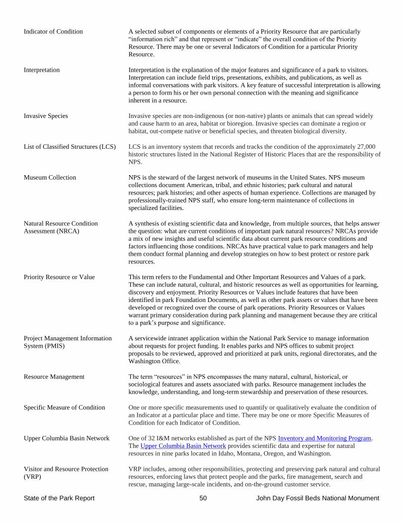
State of the Park Report 50 John Day Fossil Beds National Monument
Indicator of Condition
A selected subset of components or elements of a Priority Resource that are particularly
“information rich” and that represent or “indicate” the overall condition of the Priority
Resource. There may be one or several Indicators of Condition for a particular Priority
Resource.
Interpretation Interpretation is the explanation of the major features and significance of a park to visitors.
Interpretation can include field trips, presentations, exhibits, and publications, as well as
informal conversations with park visitors. A key feature of successful interpretation is allowing
a person to form his or her own personal connection with the meaning and significance
inherent in a resource.
Invasive Species Invasive species are non-indigenous (or non-native) plants or animals that can spread widely
and cause harm to an area, habitat or bioregion. Invasive species can dominate a region or
habitat, out-compete native or beneficial species, and threaten biological diversity.
List of Classified Structures (LCS) LCS is an inventory system that records and tracks the condition of the approximately 27,000
historic structures listed in the National Register of Historic Places that are the responsibility of
NPS.
Museum Collection NPS is the steward of the largest network of museums in the United States. NPS museum
collections document American, tribal, and ethnic histories; park cultural and natural
resources; park histories; and other aspects of human experience. Collections are managed by
professionally-trained NPS staff, who ensure long-term maintenance of collections in
specialized facilities.
Natural Resource Condition
Assessment (NRCA)
A synthesis of existing scientific data and knowledge, from multiple sources, that helps answer
the question: what are current conditions of important park natural resources? NRCAs provide
a mix of new insights and useful scientific data about current park resource conditions and
factors influencing those conditions. NRCAs have practical value to park managers and help
them conduct formal planning and develop strategies on how to best protect or restore park
resources.
Priority Resource or Value
This term refers to the Fundamental and Other Important Resources and Values of a park.
These can include natural, cultural, and historic resources as well as opportunities for learning,
discovery and enjoyment. Priority Resources or Values include features that have been
identified in park Foundation Documents, as well as other park assets or values that have been
developed or recognized over the course of park operations. Priority Resources or Values
warrant primary consideration during park planning and management because they are critical
to a park’s purpose and significance.
Project Management Information
System (PMIS)
A servicewide intranet application within the National Park Service to manage information
about requests for project funding. It enables parks and NPS offices to submit project
proposals to be reviewed, approved and prioritized at park units, regional directorates, and the
Washington Office.
Resource Management The term “resources” in NPS encompasses the many natural, cultural, historical, or
sociological features and assets associated with parks. Resource management includes the
knowledge, understanding, and long-term stewardship and preservation of these resources.
Specific Measure of Condition
One or more specific measurements used to quantify or qualitatively evaluate the condition of
an Indicator at a particular place and time. There may be one or more Specific Measures of
Condition for each Indicator of Condition.
Upper Columbia Basin Network One of 32 I&M networks established as part of the NPS Inventory and Monitoring Program.
The Upper Columbia Basin Network provides scientific data and expertise for natural
resources in nine parks located in Idaho, Montana, Oregon, and Washington.
Visitor and Resource Protection
(VRP)
VRP includes, among other responsibilities, protecting and preserving park natural and cultural
resources, enforcing laws that protect people and the parks, fire management, search and
rescue, managing large-scale incidents, and on-the-ground customer service.