Squassux Landing Cultural Landscape Report
24
Squassux Landing Cultural Landscape Report Written by Jayme Breschard Cornell University December 15, 2004
-
Upload
khangminh22 -
Category
Documents
-
view
0 -
download
0
Transcript of Squassux Landing Cultural Landscape Report

Squassux Landing Cultural Landscape Report
Written by Jayme Breschard Cornell University December 15, 2004

1
TABLE OF CONTENTS FIGURES ………………………………………………………………………………... 3 ACKNOWLEDGMENTS …………………………………………………………………... 4 INTRODUCTION …………………………………………………………………………. 5 PART ONE: SITE HISTORY, EXISTING CONDITIONS, ANALYSIS & EVALUATION ………… SITE HISTORY …………………………………………………………………………… 6
• PERIODS OF SIGNIFICANCE ……………………………………………………… 9
o EARLY INDUSTRIES………………………………………………………. 9 o RECREATION …………………………………………………………….. 9
o SIGNIFICANT LOCAL PERSONS: LANDSCAPE PAINTERS
WALTER CLARK (1848 – 1917) ……………………………………….... 10
FREDERICK W. KOST (1861 – 1923) ...…………………….…………… 11
o DESIGN INTENT: DREDGING …………………………………………… 11 EXISTING CONDITIONS …………………………………………………………………. 12
• LAND USE ……………………………………………………………………… 12 • VEGETATION …………………………………………………………………… 14
• CIRCULATION ……………………………………………………...................... 15 • STRUCTURES …………………………………………………………………… 16
ANALYSIS & EVALUATION …………………………………………………………....... 17

2
PART TWO: TREATMENT ………………………………
• HISTORIC PRESERVATION ………………………………………………………. 19
o Spatial Organization and Vegetation ………………………………….. 19
o Circulation …………………………………………………………….. 20
o Water Features ………………………………………………………… 20
o Structures, Furnishings, and Objects ………………………………….. 20
• CONSERVATION ………………………………………………………………… 20
o Vegetation ………………………………………………………….. 20
PART THREE: RECORD OF TREATMENT ………………..
• RECOMMENDATIONS ……………………………………………………………. 21
BIBLIOGRAPHY ………………………………………………………………………….. 22

3
FIGURES
1. BROOKHAVEN HAMLET ……………………………………………………….... 6 2. CARMANS RIVER ……………………………………………………………….. 6 3. CARMAN R. LUSH'S SALT HAY MEADOW ………………………………………. 9 4. SMITH POINT FERRY DOCK ……………………………………………………. 10 5. BROOKHAVEN, LONG ISLAND …………………………………………………. 10
6. GATHERING SALT HAY …………………………………………………………11
7. DREDGING PLAT FOR SQUASSUX LANDING, CIRCA 1964 ……………………… 13
8. COMMON REEDS (PHAGMITES AUSTRALIS)…………………………………….. 14
9. PERMEABLE ROAD BED ………………………………………………………... 16
10. GAZEBO, CIRCA 1923 ………………………………………………………….. 16
11. GAZEBO, SUMMER 2004 ……………………………………………………….. 16

4
ACKNOWLEDGMENTS Several persons were instrumental in the conception and preparation of this report and deserve special thanks. I owe a substantial debt of gratitude to Thomas Williams and his wife, Ellen, for welcoming me to Brookhaven Hamlet and allowing me access to the wonderful archives at the Post-Morrow Foundation, Inc. I am likewise especially grateful to Martin Van Lith for his countless hours of private research, scanning images, providing oral history contacts, and email correspondence. In addition, I wish to acknowledge independent historian John Dietz. His willingness to lead me to references regarding the area’s development was greatly appreciated. I further wish to recognize Bill Starke and Bruce Tooker for taking the time to speak to me about their life experiences in Brookhaven Hamlet.

5
INTRODUCTION Squassux Landing is a historic vernacular landscape located in Brookhaven Hamlet on the south shore of Long Island; in the Town of Brookhaven, Suffolk County, New York. It has served the community as a salt hay meadow, a boat landing for clammers and fisherman, and as a shelter for pleasure boats. Squassux Landing covers about fourteen-acres. It is bordered on the east by the Wertheim National Wildlife Refuge1 and the Carmans River and on the west by the Newey-Tooker-Starke Boatyard.2 It is owned and maintained by the locale civic group, the Brookhaven Village Association, Inc. (BVA).
1 The refuge was acquired by the U.S. Fish and Wildlife Service in 1947 as a donation from Cecile and Maurice Wertheim, who maintained the area as a private reserve for waterfowl hunting. An additional donated parcel was added in 1974. The most recent acquisition was the Southaven Properties, which added another 127-acres in 1998. Internet; available at http://www.friendsofwertheim.org/aboutref.html; accessed 15 December 2004. 2 Part of the boat yard is operated by John Taylor as “S.N. 1 at the Tooker's Boatyard.” The other half operates as the Carmans River Maritime Center. The Carmans River Maritime Center is an educational facility, operated by the Post-Morrow Foundation, Inc., for the building, restoration, and repair of wooden boats and to sustain maritime skills and traditions particularly associated with Brookhaven Hamlet and Great South Bay. This small shipyard has served as a wooden boat building center for over a century. Internet; available at http://prometheusli.com/hamlet/history/HistoricSitesImages.asp?InventoryCode=Br16.1.0-S; accessed 15 December 2004.
Each year, the BVA has about $80,000 in its coiffeurs for the maintenance and repair of Squassux Landing. This capital is derived from the charges imposed by the BVA for boat slip rental and security charges at Squassux Landing. Taxes are paid upon the land. There is no other source of income to run the marina. The BVA keeps separate accounts; income derived from membership dues and occasional donations to scholarship and environmental funds. Money is spent on contractors for cutting the grass and two seasonal full-time employees (dockmasters), repair of the roads and docks, and electricity. Historically, boat slips were available to non-residents (living outside of Brookhaven Hamlet). There is now a waiting list, with slim chances that a non-resident can berth, due to the marina’s affordable docking fees; the average slip costs about $200 to $300 a year.3 High-voltage lighting from a nearby golf course and the installation of a pump-out station for recreational boats threaten this small marina’s cultural interpretation. While there are no rules and regulations mandating pump-out stations in the Town of Brookhaven’s Code, its Division of Environmental Protection requires that a marina with gasoline service must provide pump-out service. This policy is mandated only when an individual or group applies for a wetlands permit to maintain or improve the marina.4
3 Martin Van Lith, interview by author,
22 November 2004, Brookhaven Hamlet, New York, oral interview.
4 Tom Carrano, interview by author, 6 December 2004, Ithaca, New York, email correspondence.

6
Figure 1: Brookhaven Hamlet Squassux Landing’s historic spatial organization and land patterns are afforded some protection, however, with its inclusion in the Fire Place Historic District; one of thirteen historic districts within the Town of Brookhaven. PART ONE: SITE HISTORY, EXISTING CONDITIONS, ANALYSIS & EVALUATION SITE HISTORY Brookhaven Hamlet was purchased from one of Long Island’s thirteen native bands, the Unkechaugs, on June 10, 1664 by a group of early English settlers. Unkechaug was the geographically descriptive name for the family group, not the tribal name, since the Unkechaugs formed the Long Island Confederacy of the Delaware Indians.
Figure 2: Carmans River Referred to as “Old Purchase at South,” the land included the western part of South Haven and all of the land in the villages of Fire Place and Bellport. In exchange for the land, the white settlers paid Tobaccus, the Unkechaug sachem, with four coats and the sum of six pounds, ten shillings. The portion of the Old Purchase that is known today as Brookhaven Hamlet was then called “Fire Place.” Fires were built along the mainland to help guide whaling boats at night through the Old Inlet, an outlet in the barrier island just south of Long Island that led from the Atlantic Ocean into the Great South Bay. The banks of the Carmans River were a natural landing for whaling boats to clean and trim the oil, blubber, and bone. The Unkechaugs, however, retained fishing and hunting rights after the sale of Old Purchase. Legend has it that “Squassacks Landing” was named for the Unkechaug potter, Wessquassucks, who kept his pottery kiln in the area.5
5 Pamela Borg and Elizabeth Shreeve, The Carmans River Story (New York: Pamela Borg and Elizabeth Shreeve, 1974), 11 – 12.

7
Almost immediately, the land along the Great South Bay in the Old Purchase at South was divided into 49 “meadow lots.” The meadow lots were approximately equal in size, some extending further back from the Great South Bay than others, and were numbered from east to west. None of the meadow lots included any upland at first. Lots 1 through 32 comprised what is today Brookhaven Hamlet (lots 6 through 10 possibly being Squassux Landing). In 1676, fifteen-acre upland shares were granted to each of the owners of the meadow lots – adjoining each man’s meadow share as was feasible. These upland shares became known as Long Lots and Cross Lots. The Long Lots extended from the meadow lots along the Great South Bay to what is now Beaver Dam Road and the Cross Lots extended west from the meadow lots along the Carmans River and Yaphank Creek (north of Beaver Dam Road). Additional land transactions between these land owners and others transpired soon after, as the relatively small shares were consolidated into larger lots and farms. By the mid-eighteenth century, most of the land was no longer owned by the original shareholders or even by their family descendents. By the early eighteenth century, a mill had been established at South Haven, most likely by Samuel Terrell. John Havens was in possession of this land 1745, which later passed to the Homan Family by the time of the Revolutionary War. Catherine Homan became the wife to Samuel Carman, Jr. – and thus the prosperous South Haven mills entered the Carman Family. It appears that the
land owned by the Carman’s eventually (if not initially) included not only the mill, but much of Yaphank Neck and the borders of the Carmans River north to Yaphank and south to Squassux Landing. These acquisitions were not direct, as a major section of Yaphank Neck appears to have passed to Nathaniel Brewster prior to 1716. Samuel Carman, Jr. operated much of this land for hunting and fishing, with particular interest set on the water supply for his mills.6 In May of 1867, Joseph Carman was conveyed three parcels of land by his parents, Samuel Carman, Jr. and “Caty” Homan Carmen. One parcel is described as “all premises made and executed by Zephaniah Conklin and Desire, his wife, to Joseph Homan on March 10, 1802;” the second as “all the premises made and executed by Robert Hawkins, Jr. to said Joseph Homan dated March 24, 1807;” and the third parcel as “all the premises made and executed by Samuel A. Hawkins and Eliza his wife to Samuel Carman dated April 22, 1836.”7 Catherine Homan Carman died, however, in 1861 and Samuel Carman, Jr. died two years after conveying this land to Joseph in 1869. Joseph Carman owned a home at the foot of Beaver Dam Road. Much of the land west of Yaphank Creek appears to have been acquired by the Hawkins family in the eighteenth century; the land south of South Country Road to Beaver Dam Road between Old Stump Road and Yaphank Creek. This land likely consists of Cross Lots and may have
6 John Dietz, interview by author, 29 November 2004, Ithaca, NY, email correspondence. 7 Liber 144, Pages 384 – 385.

8
included what was to become the Joseph Carman property.8 Somehow, Edward Carman became a partner to Joseph Carman in the stewardship of the land. He and his wife, Isabella, and Joseph Carman and his wife, Eliza, sold the property to Carman R. Lush on November 16, 1906 for $5,000 (recorded in the Suffolk County Clerk’s Office on February 9, 1907). The premises commenced, “on the North side of the public highway leading to Carmans River and adjoining the property now or formerly of Frank Smith and running thence North 8° 35’ East 5/3 feet; thence North 16° 15’ West 494 Feet; thence North 20° 35’ West 81 Feet; thence North 71° West 529 and 33/1000 Feet with and adjoining the property now or formerly of Frank Smith, Nelson (?), Wallace Swezey, John Robinson, E. Albin, W. Swezey, and E. Cessman; thence North by and with the same property to Little Neck Creek; thence following Little Neck Creek by and adjoining the property of Augustus Shaw to Carmans River; thence southerly by and with Carmans River to the North side of the said road; thence westerly by and with the said road to the point or place of beginning. Also that second piece of property bounded and described as follows: Commencing on the River Street Road to Arthur’s Creek and the said property of the said Egbert Swezey to the property of Charles Newey Estate; thence North 3° 20’ East 400 Feet; thence North 6° 30’ West 500 Feet by and with the said Charles Newey Estate;
8 John Dietz, interview by author, 29 November 2004, Ithaca, New York, email correspondence.
thence East by and with River Street to the point or place of beginning.” 9 Carman Lush was a prosperous businessman from the Village of Hempstead where many Carmans appear to have settled. Samuel Carman, Sr. (Samuel Jr.’s father) was probably born in Hempstead; definitely married there. Carman R. Lush’s grandmother may have been Mary Carman.10 On September 7, 1907, Lush conveyed the building rights at the end of Beaver Dam Road to the Town of Brookhaven for the construction of a public dock.11 James H. Post, a local benefactor, acquired Squassux Landing on January 29, 1917 from Carman R. Lush (recorded in the Suffolk County Clerk’s Office on March 7, 1917). It was at this time that James H. Post unofficially opened Squassux Landing for public use.12 In 1945, James H. Post’s daughters, Jessie Wells Post, Helen Post Hubert, and Elisabeth Post Morrow, sold the property to the Brookhaven Village Association, Inc. for the sum of one dollar and “in furtherance of our desires to promote civic and community purposes of the Brookhaven Village Association.”13 Elisabeth Post Morrow and her husband, Thomas Morrow, established the Post-
9 Liber 609, Pages 370 – 372. 10 The record is vague – census records do not fully agree with various compilations. John Dietz, interview by author, 29 November 2004, Ithaca, New York, email correspondence. 11 Liber 948, Page 193. 12 Martin Van Lith, interview by author, 14 November 2004, Ithaca, New York, email correspondence. 13 Liber 2451, Pages 563 – 564.

9
Morrow Foundation, Inc. in 1969 for the preservation of the rural countryside and character of Brookhaven Hamlet and its surrounding environs.14 PERIODS OF SIGNIFICANCE EARLY INDUSTRIES The inherent value of the Carmans River is seen through the centuries by its many businesses and activities. Salt hay (Spartina patens) was harvested from the estuarine marshes of the Carmans River by the early European settlers for their cattle. Some of the salt hay was used to camouflage hunting blinds for duck shooting in the winter. Ice harvested along the river replaced salting, spicing, pickling, smoking, and drying as a preservative for food. Grain mills, as well as fulling15 and saw mills, utilized the river’s waterpower. The fishing economy was also important to people of the Carmans River area with local baymen profiting in oystering, scalloping, crabbing, eeling, and clamming.16 Fishermen, sailors, and haulers have used Squassux Landing since the early eighteenth-century. Around the 1770s, the Old Inlet in the barrier island at the south end of Carmans River was opened. Thus, with a direct opening to the Atlantic Ocean, Carmans River became a much deeper channel. Old Inlet, then known as Smith’s Inlet, was open to the Atlantic Ocean until 14 Internet; available at http://postmorrow.org/; accessed 15 December 2004.
15 A moistening, heating, and pressing process through which woolen cloth was cleansed and thickened.
16 Borg and Shreeve, 19 – 26.
1837 when a ship with a cargo of mill wheels and grindstones sank during a winter storm. It caused the inlet to silt over, resulting in the maritime industries of the east end of the Great South Bay to change forever.17
Figure 3: Carman R. Lush's Salt Hay Meadow Squassux Landing was used as a salt hay meadow and cow pasture in the early twentieth century when Carman R. Lush owned it. This hay was shipped to markets such as the Bushwick Hay Market in Brooklyn and sold as packing material, fodder and bedding for cattle, and mulch for crops.18 RECREATION Before the construction of the public dock at the eastern end of Beaver Dam Road in 1907, two passenger ferries moored at the site. The first, called the Fanny Fern, was run by Blyth Gerard. The other was called the Woodmere. Both went to Smith’s Point, a barrier beach located across the Great South
17 Internet; available at http://www.geocities.com/dodiknapp/Squassux.html; accessed 15 December 2004.
18 Borg and Shreeve, 22.

10
Bay on Fire Island. The Fanny Fern and the Woodmere were commonly called “ferries,” although they were technically sailboats. The Fanny Fern, however, had a “kicker,” which was a small one-cylinder engine.
Figure 4: Smith Point Ferry Dock The Fanny Fern and the Woodmere brought passengers to the Smith’s Point House and, after it was destroyed by the Hurricane of 1938, to Paradise Beach. The Smith’s Point House was run by the Nesbitt Family and had bathhouses, a dock, and served “surf-shore” dinners usually on Sundays. It was located close by to the Coast Guard station and just west of where the Smith’s Point Bridge now stands. This automobile bridge was first opened in 1959. Earlier wooden bridges only lasted a few years each due to winter storms and ice; 1916, 1921, and the last in 1927.19 SIGNIFICANT LOCAL PERSONS: LANDSCAPE PAINTERS WALTER CLARK (1848 – 1917) Walter Clark received formal training from the National Academy of Design in
19 Bob Starke, History of Old Inlet, 23 January 2003, interview and transcription by Martin Van Lith.
New York shortly after his return from Europe and Asia sometime after 1869. Under the influence of George Inness, the landscape painter, Clark adopted a tonalist manner. Scenes from East Hampton were among Water Clark’s earliest paintings, where he spent summers beginning in 1881. About 1891 he began summering further west in Brookhaven Hamlet. By this time, Clark – like many other American plein-air pointers – was responding to the influences of impressionism. Clark’s close friend and colleague, John H Twachtman, may have acquainted him with this practice in modern art. In fact, in its serene simplicity and pale unmixed colors, Clark’s painting Brookhaven, Long Island closely resembles similar scenes that Twachtman was painting along the shores of Connecticut at this time. The warm strokes of reflected
Figure 5: Brookhaven, Long Island light, however, are more reminiscent of Inness’s early influence on Clark’s work. It may have been Clark’s paintings of Brookhaven Hamlet, exhibited in New York City, which attracted the artist Frederick Kost to the area.20
20 Ronald G. Pisano, Long Island Landscape Painting: 1820 – 1920 (Boston: Little, Brown and Company, 1985), 132.

11
FREDERICK W. KOST (1861 – 1923) After some instruction in New York from George Inness, Frederick W. Kost traveled abroad to complete his training in Munich and Paris. In 1906, he purchased a summer home in Brookhaven Hamlet and began painting local scenes. The olive-green meadows of salt marsh that bounded the shores of the Great South Bay especially attracted Kost. Gathering Salt Hay depicts the technique of harvesting salt hay from sailing vessels on the Carmans River. Like many other artists who were attracted to Long Island, Kost chose to focus on serene atmosphere and nostalgic traditions. In 1920 he retired to his Brookhaven home and remained there until his death three years later.21
Figure 6: Gathering Salt Hay DESIGN INTENT: DREDGING Between 1917 and approximately 1965, boats were only moored along the west bank of the Carmans River at Squassux Landing. After 1965, more dock space
21 Ibid.
was created. Through a series of events, design intent was (unintentionally) imposed upon the landscape The Old Inlet Club and the Fire Island Beach Club were private beach clubs located on the barrier beach on Fire Island in the early twentieth century. The Old Inlet Club had a regular membership committee, wherein membership was gained through nomination by at least one member. It was open to Brookhaven Hamlet residents, but consisted mostly of residents from the Village of Bellport. The Fire Place Beach Club was different from the Old Inlet Club in that its members were restricted to a geographic area – Brookhaven Hamlet. To be a member of the Fire Place Beach Club, one had to reside within the bounds of the Hamlet: Carmans River on the east; Montauk Highway to the north; Arthur Avenue and Bellhaven Road on the west; and the Great South Bay to the south. The Old Inlet Club had family houses, women’s and men’s courts (which were just lockers), freshwater showers, and bathhouses that could be rented for the season. The Hurricane of 1938, however, destroyed most of the buildings and structures. Nevertheless, the Old Inlet Club members decided to rebuild and those who contributed were noted in the record as equity members.22 The Fire Place Beach Club was created in the mid-1950s in response to the threat of Robert Moses’ plan to build a highway down the middle of Fire Island as well as the Federal Government’s interest in establishing a National
22 Later, when the property was sold to the National Seashore, those members who rebuilt the Club received extra compensation.

12
Seashore along the barrier island. In following the Old Inlet Club’s business example23, the Fire Place Beach Cub established a company called the Mattabank Corporation (an Indian name for the barrier beach). The residents of Brookhaven Hamlet were offered one share of stock for $25 and one bond for $100. The bond paid six percent interest. Enough stocks and bonds were sold so that a five-acre parcel could be purchased at $3,000 an acre. With a 200-foot wide swathe, the property stretched from the Great South Bay to the Atlantic Ocean. The property was leased to the BVA, who in turn named it the Fire Place Beach Club. In 1964, the Federal Government sought to acquire the barrier beaches “for the purpose of conserving and preserving for the use of future generations certain relatively unspoiled and undeveloped beaches, dunes, and other natural features ... which possess high values to the Nation as examples of unspoiled areas of great natural beauty in close proximity to large concentrations of urban population.”24 The Mattabank Corporation was offered $32,000 for the land – nearly twice what was paid a decade earlier – plus a few thousand for the boardwalk and clubhouse. The Fire Place Beach Club negotiated an agreement where the land would be leased back over a five-year period. The Federal Government agreed, and so the Fire Place Beach Club sold the property but continued to run the beach as before. The Mattabank stockholders received 23 The Old Inlet Club established the Hospital Point Company. Through this company, property was purchased and leased to the Old Inlet Club using stocks and bonds. 24 Internet; available at http://www.nps.gov/fiis/; accessed 15 December 2004..
about $500 for their original $125 investment. When the five-year lease agreement expired, however, it was not renewed and the Fire Place Beach Club’s dock, boardwalk, and clubhouse were destroyed. The BVA, which held a number of the Mattabank Corporation’s stocks and bonds, received several thousand dollars. The money was used to construct two canals at Squassux Landing. The South Shore Motor Transportation Co. Inc. of 100 West Avenue in Patchogue dredged the canals north of Arthur’s Creek.25 The South Shore Motor Transportation Co. Inc., a trucking company, was located in Manhattan at 41 Vestry around 1933-34.26 They later consolidated and relocated to Patchogue, East Moriches, and Riverhead.27 The canals were redredged about fifteen years later by the Costanza Dredging Company of Center Moriches.28
25 Bill Starke, interview by author, 22
November 2004, Shirley, New York, oral interview.
26 New York City (Boroughs of Manhattan and Bronx) Directory (New York: R.L. Polk & Co., 1933 – 1934).
27 Eastern Suffolk County, Long Island, New York Telephone Company, Volumes 1936 – 1937 and 1938 – 1939. 28 Bill Starke, interview by author, 22 November 2004, Shirley, New York, oral interview.

13
Figure 7: Dredging Plat for Squassux Landing, Circa 1964 EXISTING CONDITIONS LAND USE The Carmans River is one of thirty-five freshwater tributaries that flow into the Great South Bay. The Carmans River is the longest (11 miles) and has a maximum elevation of +18m with a drainage basin of seventy-one square miles.29 It is further defined as a semi-rural stream/river corridor with extensive tidal wetlands and New York State Department of State designated significant fish and wildlife habitats. Carmans River is also a New York State
29 J.R. Schubel, T.M. Bell, and H.H.
Carter, eds., The Great South Bay (New York: State University of New York Press, 1991), 1.
Wild, Scenic and Recreational River.30 The State’s Wild, Scenic and Recreational Rivers Act protects those State rivers that possess outstanding scenic, ecological, recreational, historic, and scientific values by requiring a review of the impacts of any change to the land in areas within a ½-mile of the designated water body or river. This Act is administered by NYSDEC and the Adirondack Park Agency (applies only to designated water bodies or rivers in Adirondack Park). Carmans River begins as a freshwater stream in Yaphank and runs south through Upper and Lower Lakes, South Haven Pond, and into the Great South
30 Long Island Regional Planning Board, Evaluation of Land Use Impacts on Environmental Quality in Urban and Semi-rural Stream Tributary to Great South Bay, Long Island, New York (Hauppauge, New York: Long Island Regional Planning Board, 1990), 4.

14
Figure 8: Common Reeds (Phagmites australis) Bay. Federal and Suffolk County parkland, commercial recreation, former duck farms31 and vacant land, as well as few residential and agricultural areas, border the Carmans River. Squassux Landing is situated between Little Neck Run and Arthur’s Creek on the west bank of the Carmans River. It is an intertidal wetland situated at the eastern end of Beaver Dam Road.32
31 Samuel Carman, Jr., for whom the
river is named, expanded his homestead to include a post office, store, and tavern for duck and deer hunters sometime in the early nineteenth century. The Carman’s mill was in existence before 1745 (the mill was torn down in 1958 to make way for Sunrise Highway (NY 27). In 1936, part of Carman’s homestead was demolished by Charles E. Robinson for use as the Carmans River Duck Farm. The industry prospered greatly during the meat shortage of World War II, but with governmental restrictions concerning pollution, the farm closed and the land has since been owned in part by Suffolk County and the Wertheim National Wildlife Refuge. Borg and Shreeve, 17 – 18.
32 Beaver Dam Road is a narrow, country road (sans sidewalks and streetlights) that has served since 1737 as a working thoroughfare. Arthur Danto, Brookhaven Hamlet as Historical District (Publisher and date unknown), 2.
VEGETATION Once the Carmans River passes South Haven Pond, it widens and the great variety of freshwater vegetation gives way to a fewer number of species typical of the salt marsh. Common reeds (Phagmites australis) and salt hay (Spartina patens) now border the river’s edge as swamp maples (Acer rubrum) and pepperidge trees (Nyssa sylvatica) recede into higher ground to escape the saltier water.33 Squassux Landing is representative of an estuarine system. This wetland system consists of deepwater tidal habitats and adjacent tidal wetlands that are usually semienclosed but have open, partly obstructed, or sporadic access to open ocean or tidal fresh waters, and in which ocean water is at least occasionally diluted by freshwater runoff. The limits extend from the upstream limit of tidal influence seaward to an imaginary line closing the mouth of a river or bay. Salinity is usually less than 30.0 parts per thousand (ppt) ocean derived salts. More specifically, Squassux Landing is defined as a high salt marsh within the estuarine intertidal subsystem. High salt marsh is one zone within a coastal salt marsh ecosystem; it occurs in a complex mosaic with several other communities. Other communities in a salt marsh ecosystem include salt shrub and brackish meadow at the upland border of the high marsh; sea level fen in rare cases associated with freshwater seepage at the landward edge; low salt marsh at the seaward border of the high marsh and along the edges of tidal creeks that drain the high marsh; and salt pannes in shallow depressions within the marsh.
33 Borg and Shreeve, 28.

15
High salt marshes can be further classified by landform type: mainland fringe-marshes, mid-lagoon marshes, and backbarrier fringe-marshes. A high salt march occurs in sheltered areas of the seacoast, in a zone extending from mean high tide up to the limit of spring tides. It is periodically flooded by spring tides and flood tides. High salt marsh typically consists of a mosaic of patches that are mostly dominated by a single graminoid species. The dominant species in many large areas are either salt-meadow grass (Spartina patens) or a dwarf form (15 to 30 cm tall) of cordgrass (Spartina alterniflora). Spikegrass (Distichlis spicata), blackgrass (Juncus gerardii), and glassworts (Salicornia herbacea), or a mixture of salt-meadow grass and cordgrass also dominate large areas. Characteristic species of the upper slope of the high marsh (the area that grades into salt shrub) are blackgrass, switchgrass (Panicum virgatum), sea lavender (Limonium carolinianum), seaside gerardia (Agalinus maritima), and slender saltmarsh aster (Aster tenuifolius). Characteristic animals include salt marsh mosquitoes (Aedes sollicitans), greenhead flies (Tabanidae), coffeebean snail (Melampus bidentatus), sharp-tailed sparrow (Ammodramus caudacutus), marsh wren (Cistothorus palustris), eastern meadowlark (Sturnella magna), clapper rail (Rallus longirostris), and American black duck (Anas rubripes).34
34 New York State Department of
Environmental Conservation, New York Natural Heritage Program, Internet; available at http://www.dec.state.ny.us/website/dfwmr/heritage/; accessed 15 December 2004.
However, Squassux Landing is not a pristine high salt marsh. The imprint of dredging has resulted with an estuarine dredge spoil shore. Dredging along the west bank of the Carmans River and the two canals has created a substrate composed of dredge spoils. Thriving in habitats disturbed by human activities, Phragmites australis overruns native plants and replaces them with dense, monospecific stands unusable as nesting and feeding sites for many bird species. Although Squassux Landing is surrounded by a significant wetland habitat, there is currently minimal vegetative cover and relatively low species diversity compared to its earlier history. A bulkhead at the end of Beaver Dam Road provides access to public fishing and crabbing. This small outlet is most likely an estuarine riprap/artificial shore. The substrate is composed of broken rocks, wooden bulkheads, or concrete placed so as to reduce erosion. Vegetative cover and species diversity are low compared to natural estuarine shores.35 CIRCULATION Squassux Landing is accessed by a gravel drive to the south of the bulkhead on Beaver Dam Road. The site is set apart from Beaver Dam Road by a chain link fence. The roads within the marina are covered with permeable materials, such as crushed shell, small pebbles, and sand – save for a poured concrete boat ramp.
35 Ibid., 15.

16
Figure 9: Permeable Road Bed About forty narrow docks, marked by locust and oak posts, sit along the Carmans River’s embankment at Squassux Landing. Two narrow canals to the west of the river are also used for dockage. The boat ramp is located at the foot of the easterly canal. STRUCTURES To the west of the vehicle/pedestrian entrance at Squassux Landing is a rustic wooden sign with “Squassux Landing” written across a life preserver. Other posted signs denote a five mile an hour wake and erosion monitoring. A gazebo, approximately 12-feet long by 8-feet wide, sits to the east of the entrance. The structure has a hipped roof, covered with asphalt shingles, and has exposed roof rafters, squared post supports, and an open rail. It overlooks the Carmans River. The original gazebo was built circa 1923. The current structure is either the renovated original or a reconstruction built in 1942.36 36 Minutes from a June 26, 1942 BVA meeting cites, “Motion also made that the new President appoint a committee for the policing and taking care of this property, and also to get an estimate for repairing the summer house.” Martin Van Lith, interview by author, 7
Figure 10: Gazebo, circa 1923
Figure 11: Gazebo, Summer 2004 There is a small side-gabled structure to the west of the entrance called the “guard house.” It has a poured concrete foundation, a six-paneled door, three one-over-one double-hung sash windows, and is covered with plain, wood shingles. The roof is covered with asphalt shingles. The guard house was built circa 2000 by the current Squassux chair, Steve Marshall, who is a carpenter.37 A large stone with a commemorative plaque (dedicated to the Post-Morrow
December 2004, Ithaca, New York, email correspondence. 37 Martin Van Lith, interview by author, 7 December 2004, Ithaca, New York, email correspondence.

17
Family) sits to the north of a poured concrete boat ramp and is accompanied by a wooden bench. Scattered throughout the site are 30-foot high (estimated) electric poles. ANALYSIS & EVALUATION The visual context of Squassux Landing is highly illustrative of the early industries of the Carmans River. Development along the lower portion of the Carmans River has been inhibited with the establishment of the Wertheim National Wildlife Refuge.38 The landscape’s association to significant trends in late-nineteenth and early-twentieth century recreation is visible in the topography’s lack of bulkheading. For the past one hundred years, small pleasure boats have docked along the west bank of the Carmans River, utilizing only locust posts. Essentially, the west bank of the Carmans River has not been manipulated.39 Although the two canals destroyed the integrity of Squassux Landing as a salt hay meadow, none of the shorelines have been hardened by
38 Phragmites, also known as the
common reed, has infested and degraded more than half of the refuge’s valuable marshes.
39 There is some evidence that dredging occurred in the Carmans River pre-World War II. As seen in a Post-Morrow Family moving picture, archived at the Post-Morrow Foundation, Inc., bucket dredges removed materials by biting or digging into the river’s bottom. The loads were raised clear of the water and dumped upon spoil banks. “South Shore Motor Transportation Company” is inscribed on a few of the cranes, or land-based platform dredges. The gambrel roofline of 7 Newey Lane is visible in the backdrop (west); placing the cranes in the Carmans River. F. Lester Simon, Dredging Engineering (New York: McGraw-Hill Book Company, Inc., 1920), 1 – 3.
bulkheading (in contrast to the public dock at the end of Beaver Dam Road). Design intent associated with the two manmade canals at Squassux Landing exhibits the period when the dredging permit system was first implemented.40 The Rivers and Harbors Act of 1899 is the principal act governing the dredging and deposition of bottom sediments in the shore zones. This Act directs the U.S. Army Corps of Engineers (COE) to implement a permit system for dredging, filling, building piers, and other activities in navigable waters. During the period between 1961 and 1971, most individual or governments wishing to dredge and/or fill areas in, or adjacent to, navigable waters sent the COE descriptions of their proposed actions.41 The scope of work for the circa 1965 dredging at Squassux Landing may be available at the New York District Office of the U.S. Army Corp of Engineers. The Board of Directors of the BVA, during the period of 1990 to 1998, was very much involved in environmental protection. Effective long-term
40 An agreement was drawn-up between
James H. Post and Sam Newey concerning the maintenance of Arthur’s Creek. Sam Newey operated a two-acre boatyard just west of Squassux Landing. Post permitted Newey to dredge and maintain Arthur’s Creek in order to accommodate vessels that carried oil barrels. Newey also built boats of all description including sloops, yachts, yawls, boats for ferrymen, commercial draggers equipped with heavy booms and hoisting gear, and sailboats for children. Bill Starke, interview by author, 22 November 2004, Shirley, New York, oral interview.
41 J.S. O’Connor, Dredging and Spoiling on Long Island: Technical Report Series #19 (SUNY: Marine Sciences Research Center, November 1973), 10 – 11.

18
management of the area’s stream corridors, wetlands, and scenic resources became a top priority. Thus, the BVA made recommendations in 1992 to the Town of Brookhaven’s Master Plan and received rural and conservation land classifications for more than 550-acres in the community. Included were 2,600 acres of the Wertheim National Wildlife Refuge and the change of zone for business (J2) in stream corridors to residential (A1-A5). If ever the BVA were to lose charge of Squassux Landing, zoning would only allow for low-density residential (1 du/per 10 acres). Although there are quite a few sailboats on the Carmans River, most of the boats at Squassux Landing are motor-driven. On the majority, there has been no damage to the banks of the Carmans River since the arrival of motor boats over seventy-five years ago. New York State Department of Environmental Conservation (NYSDEC) has studied the impacts of spent fuel on the Great South Bay, and although there are traces of Methyl Tertiary Butyl Ether (MTBE), there has been no significant amount of petroleum-related substances. Neither the U.S. Fish and Wildlife Service nor the NYSDEC have shown apprehension for the affects of motor boating upon the native wildlife. Low usage of the local environment accounts for this unconcern. A majority of the 200 (more or less) boats are relatively small and are used only part of the year and mostly on weekends. Even during the summer months, on an average weekday, there are only a few dozen that come and go from Squassux Landing.42
42 Martin Van Lith, interview by author,
29 November 2004, Ithaca, New York, email correspondence.
PART TWO: TREATMENT An important factor to consider in creating a management objective for Squassux Landing is that it is a tidal wetland and a permit or work release is required for any regulated activity as per Chapter 81: Wetlands and Waterways of the Brookhaven Town Code. This regulation was adopted by the Town Board on January 19, 1993 and went into effect six days later. It identifies regulated activities as: any form of drainage, dredging, excavation or removal of materials; any direct or indirect form of dumping or filling or depositing of materials; erecting any buildings or structures, constructing roads and bridges, clearing and regrading, placing of bulkheads, retaining walls, pilings, docks, catwalks or other physical improvements; any form of pollution or discharge; any grading activities; construction of any pier or the mooring of a residential houseboat or floating home; any mariculture or aquaculture activity; and any other activity which substantially impairs any of the several functions served by surface waters, lands underwater and/or tidal or freshwater wetlands or the benefits derived therefrom. Permit applications apply to tidal and freshwater wetlands, its surface waters and lands underwater, in addition to areas that extend 150-feet landward of and parallel to the wetland boundary or shoreline of a water body.43 Local natural resource legislation is based on Chapter 43-B of New York State’s Consolidated Laws; the Environmental Conservation Law. The
43 Code of the Town of Brookhaven, Chapter 81: Wetlands and Waterways, § 81-1 through § 81-20, 1993.

19
Environmental Conservation Law was passed by majority vote, three-fifths being present, on May 31, 1972. Tidal wetlands regulation is based on the Tidal Wetlands Act (6NYCRR Part 661). Under the Tidal Wetlands Act, NYSDEC administers a permit program regulating activities in tidal wetlands and their adjacent areas. NYSDEC requires a permit for almost any activity that will alter wetlands or the adjacent areas. The COE also has jurisdiction and a Corps Permit may be required whether or not NYSDEC requires one. The COE regulates waters and wetlands under two laws: the Rivers and Harbors Act of 1899 and the Clean Air Act of 1990. Section 10 of the Rivers and Harbors Act requires a permit from the COE for any project that involves work or structures in, over or under navigable (truly navigable) waters of the United States. Section 404 of the Clean Water Act requires a permit from the COE for the discharges of dredged or fill material into any water of the United States, including wetlands, which are a type of water of the United States. Wetlands are identified in the field using the COE delineation manual.44 HISTORIC PRESERVATION The Secretary of the Interior is responsible for establishing professional standards and providing advice on the preservation of cultural resources listed in or eligible in the National Register of Historic Places. In partial fulfillment of this responsibility, and to ensure that projects receiving federal money or tax benefits were reviewed in a consistent manner nationwide, a set of seven
44 J.S. O’Connor, 10 – 11.
standards were devised in 1976: acquisition, protection, stabilization, preservation, rehabilitation, restoration, and reconstruction. However, these standards applied to historic buildings. In 1992, the Standards were revised so that they could be applied to all historic resources: buildings, structures, sites, objects, districts, and landscapes. The new version addresses four treatments: preservation, rehabilitation, restoration, and reconstruction. Of the four, preservation standards require retention of the greatest amount of historic fabric, including the landscape’s historic form, features, and details as they have evolved over time.45 Spatial Organization and Vegetation
• Maintain topography, vegetation, and structures that define the overall pattern of Squassux Landing by reclaiming open spaces from non-contributing shrubby pines (Pinus).
Circulation
• Replace in-kind circulation features or materials when deteriorated or damaged; repaving the road beds with permeable materials, not asphalt or concrete.
45 Charles A. Birnbaum, ed., The
Secretary of the Interior’s Standards for the Treatment of Historic Properties: With Guidelines for the Treatment of Cultural Landscapes (Washington, D.C.: U.S. Department of the Interior, 1996), 3.

20
Water Features
• Maintain the “soft” edge and shape of the west embankment of the Carmans River at Squassux Landing.
Structures, Furnishings, and Objects
• Replace in-kind features such as dock pilings with locust or new materials that match the old in composition, design, color, and texture.
CONSERVATION Although this treatment is not one of the four treatments recommended for cultural landscapes, it applies to the preservation, protection, and careful management of the environment and the wise use of natural resources. Vegetation
• The spit of land between Carmans River and the easterly canal has the potential to assume a Phragmites management program. The removal of Phragmites is a long and difficult project and uses a combination of herbicide use and prescribed burning. Desirable native plants, such as Spartina patens, should be encouraged in the area following the herbicide/burn management regime.
In April 2003, a study was conducted at the Wertheim National Wildlife Refuge that documented the spatial distribution of Phagmites australis using analyses of aerial photographs from 1974 to 2000. From 1974 to 1989, the area covered by
Phagmites australis increased approximately six-acres per year (2.5 ha/year). This rate increased to 8.2 acres per year (3.4 ha/year) from 1989 to 2000.46
46 Internet; available at http://www.friendsofwertheim.org/PhraghistoryReport.pdf; accessed 15 December 2004.

21
PART THREE: RECORD OF TREATMENT RECOMMENDATIONS
• The scope of work for the circa 1965 dredging at Squassux Landing may be available at the New York District Office of the U.S. Army Corp of Engineers and could illustrate a consciously designed or laid out landscape.
• A history of the Brookhaven
Village Association needs to be researched and documented. As the proprietor of the marina for over fifty years, individual features of the landscape may be attributed to a discrete period of introduction or substantiated to a given date.
• Through social or cultural
attitudes of an individual, a family, or a community, the landscape reflects the physical, biological, and cultural character of everyday lives. Although several oral interviews have been conducted for this report, further investigations may provide more information about how Squassux Landing has evolved through time through use by the people whose activities or occupancy shaped it.
22
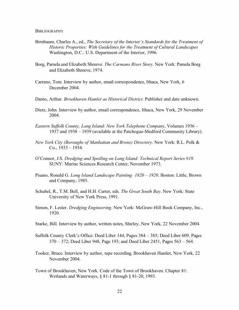
BIBLIOGRAPHY
Birnbaum, Charles A., ed., The Secretary of the Interior’s Standards for the Treatment of Historic Properties: With Guidelines for the Treatment of Cultural Landscapes Washington, D.C.: U.S. Department of the Interior, 1996.
Borg, Pamela and Elizabeth Shreeve. The Carmans River Story. New York: Pamela Borg
and Elizabeth Shreeve, 1974.
Carrano, Tom. Interview by author, email correspondence, Ithaca, New York, 6 December 2004.
Danto, Arthur. Brookhaven Hamlet as Historical District. Publisher and date unknown. Dietz, John. Interview by author, email correspondence, Ithaca, New York, 29 November
2004. Eastern Suffolk County, Long Island: New York Telephone Company, Volumes 1936 –
1937 and 1938 – 1939 (available at the Patchogue-Medford Community Library). New York City (Boroughs of Manhattan and Bronx) Directory. New York: R.L. Polk &
Co., 1933 – 1934. O’Connor, J.S. Dredging and Spoiling on Long Island: Technical Report Series #19.
SUNY: Marine Sciences Research Center, November 1973. Pisano, Ronald G. Long Island Landscape Painting: 1820 – 1920. Boston: Little, Brown
and Company, 1985. Schubel, R., T.M. Bell, and H.H. Carter, eds. The Great South Bay. New York: State
University of New York Press, 1991.
Simon, F. Lester. Dredging Engineering. New York: McGraw-Hill Book Company, Inc., 1920.
Starke, Bill. Interview by author, written notes, Shirley, New York, 22 November 2004. Suffolk County Clerk’s Office: Deed Liber 144, Pages 384 – 385; Deed Liber 609, Pages
370 – 372; Deed Liber 948, Page 193; and Deed Liber 2451, Pages 563 – 564. Tooker, Bruce. Interview by author, tape recording, Brookhaven Hamlet, New York, 22
November 2004. Town of Brookhaven, New York. Code of the Town of Brookhaven. Chapter 81:
Wetlands and Waterways, § 81-1 through § 81-20, 1993.

23
Van Lith, Martin. Interview by author, email correspondence, Brookhaven Hamlet, New
York, multiple dates. WEBSITES Batcher, Michael S. 2003. “Analysis of Historic Aerial Photographs to Assess Changes in
Cover and Distribution of Phragmites australis at Wertheim National Wildlife Refuge, New York.” http://www.friendsofwertheim.org/PhraghistoryReport.pdf (accessed 15 December 2004).
New York State Department of Environmental Conservation. “New York Natural
Heritage Program.” http://www.dec.state.ny.us/website/dfwmr/heritage/ (accessed 15 December 2004).
Post-Morrow Foundation, Inc. “Welcome to the Post-Morrow Foundation.”
http://postmorrow.org/ (accessed 15 December 2004). “Squassux Landing: Carman’s River, Brookhaven, NY.”
http://www.geocities.com/dodiknapp/Squassux.html (accessed 15 December 2004).