Springfield Main Street Safety Project - Oregon.gov
22
SPRINGFIELD MAIN STREET SAFETY PROJECT Potential ORS 366.215 Impact • Presenters: John Bosket | DKS Associates Bill Johnston | ODOT • A facility plan prepared by the City and ODOT to identify safety improvements to a 5-mile urban corridor. The conceptual solutions identified in the plan will be refined later in the design phase. Mobility Advisory Committee Meeting date: November 18, 2021 1 Revised 2021-11-04
-
Upload
khangminh22 -
Category
Documents
-
view
4 -
download
0
Transcript of Springfield Main Street Safety Project - Oregon.gov

SPRINGFIELD MAIN STREET SAFETY PROJECTPotential ORS 366.215 Impact
• Presenters: John Bosket | DKS AssociatesBill Johnston | ODOT
• A facility plan prepared by the City and ODOT to identify safety improvements to a 5-mile urban corridor. The conceptual solutions identified in the plan will be refined later in the design phase.
Mobility Advisory CommitteeMeeting date: November 18, 2021
1Revised 2021-11-04
Presenter
Presentation Notes
No notes required. The slide is self-explanatory.

AGENDA
2
Topics:• Location and project description• Problem and project purpose• Existing conditions and potential changes
• Roundabouts• Pinch point information• Street widths and raised medians
Objective:Seeking Stakeholder Forum input on Facility Plan subject to ORS 366.215.
Presenter
Presentation Notes
The project team is seeking Stakeholder Forum input on this facility plan, as required by ORS 366.215. The MAC will have another opportunity to review this project when it is advanced to the design phase, if and when funding is identified. If necessary, after this initial discussion with the MAC, a follow-up meeting can be scheduled to discuss the facility plan in more detail.
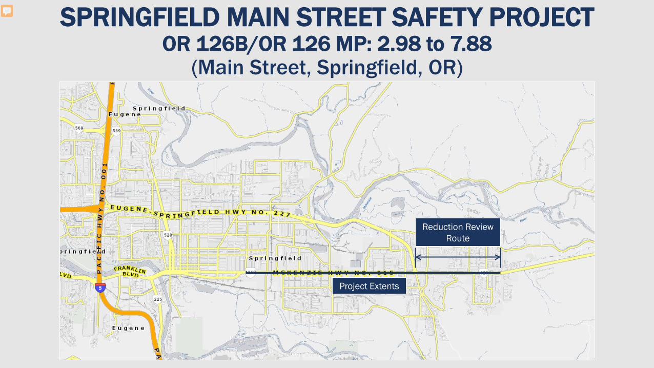
SPRINGFIELD MAIN STREET SAFETY PROJECTOR 126B/OR 126 MP: 2.98 to 7.88
(Main Street, Springfield, OR)
3
Project Extents
Reduction Review Route
Presenter
Presentation Notes
This is a map showing the location of the Main Street corridor. The entire project area is approximately 5 miles long from approximately 20th Street to 72nd Street. The section east of Bob Straub Parkway is designated as an ORS 366.215 Reduction Review Route. Proposed improvements that could potentially reduce the vehicle carrying capacity of the roadway require review by the Mobility Advisory Committee. The section of Main Street west of Bob Straub Parkway also needs to be reviewed by the Mobility Advisory Committee. It’s not a Reduction Review Route but Highway Division Directive DES 02 (2017) applies. This directive applies when roundabouts are proposed on any state highway. The standards are slightly different. ORS 366.215(2) specifies that ODOT “may not permanently reduce the vehicle-carrying capacity of an identified freight route when altering, relocating, changing or realigning a state highway unless safety or access considerations require the reduction.” DES-02 specifies only that roundabouts must accommodate freight movement. Note: Both cases require consultation with the trucking industry. The MAC functions in this capacity. For ORS 366.215 reviews they function as a Stakeholder Forum, with expanded participation. For DES reviews they function in a more limited, less formal role commenting on behalf of the trucking industry. This is sometimes referred to as a freight industry consultation. Regardless of their role, the committee is usually referred to as the MAC. Note: The City of Springfield constructed two roundabouts in 2018 on Franklin Blvd, in the Glenwood area, between the Willamette River and I-5. They are planning to construct three more roundabouts in that area, if and when they obtain funding.

SPRINGFIELD MAIN STREET SAFETY PROJECTCorridor characteristics
Roadway Characteristics
• State highway, 5 lanes
• Freight Reduction Review Route (east of Bob Straub Parkway)
• Flat, straight
Traffic Conditions• ADT: 16,400 – 21,800
• Trucks: 9-10%
4
Presenter
Presentation Notes
No notes required. The slide is self-explanatory.

SPRINGFIELD MAIN STREET SAFETY PROJECTProblem, Solution & Scope
• Springfield’s Main Street is consistently ranked in the top 10% in terms of high crash locations (statewide).
• In 2015 ODOT’s All Roads Transportation Safety (ARTS) program identified several crash hotspots in the corridor and recommended raised medians as a countermeasure.
• The purpose of the Main Street Safety Project is to identify infrastructure improvements that will make Main Street safer for people walking, biking, driving, and taking transit.
• The Facility Plan being developed will be adopted by ODOT and the City. It will inform future design and construction.
5
Presenter
Presentation Notes
The ODOT Transportation Safety Plan establishes as a goal to have no deaths or life-changing injuries on Oregon’s transportation system by 2035. Adoption by ODOT (last bullet) assumes ORS 316.215 requirements are adequately addressed.

6
SPRINGFIELD MAIN STREET SAFETY PROJECTIssues
Systemic Issues SAFETY ACCESS
Presenter
Presentation Notes
Safety 653 crashes (2012-2016) spread nearly evenly over the corridor (4 fatal, 350 injury (20 Inj A, 102, Inj B, 228 Inj C)) 13 unique top 10% SPIS sites between 2014 and 2016 High percentage of rear-end and turning movement crashes (Typical for roadways with high numbers of driveways and intersections) Average access density on Main Street is 75 access points per mile (compared to ODOT standard of 10 per mile for new roadways) Ped/Bike High stress environment for people walking (narrow 6’, curb-tight sidewalk) and biking (narrow 5’ bike lane)

SPRINGFIELD MAIN STREET SAFETY PROJECTChanges being considered
Safety improvements:
7
Roundabouts
Raised medians
Lane reduction
Presenter
Presentation Notes
The project team is considering modifications to the Main Street corridor that could potentially reduce the vehicle-carrying capacity of OR126. These include: Street cross section changes that include raised medians, Roundabouts, and A lane reduction at the east end of the corridor for approximately 3 blocks (1/3 of a mile) At this point in the planning process the project team is still discussing these potential changes with the advisory committees, stakeholders, and City Council. City and community support has not yet been confirmed. Other alternatives are still being considered. The final version of the facility plan may recommend a different alternative.

SPRINGFIELD MAIN STREET SAFETY PROJECTRaised Medians
8
Why raised medians:
• Can significantly reduce crashes
• Create frequent opportunities for enhanced pedestrian crossings
• Would have breaks at strategic locations for left turns and passenger car U-turns
Presenter
Presentation Notes
Adding raised medians can reduce crashes by 35% along the entire corridor (48% when combined with roundabouts). Raised medians also create frequent opportunities along the corridor for enhanced pedestrian crossings, which improve pedestrian safety and access to transit. There would be breaks in the raised medians at strategic locations for left turns and passenger car U-turns. Raised medians would be mountable for emergency vehicles.

SPRINGFIELD MAIN STREET SAFETY PROJECTRoundabouts
9
Why roundabouts:
1. Can improve safety, compared to signals
2. Complements medians by facilitating U-turns
3. Can reduce delay and need for complete stops
4. Can be (and will be) designed to accommodate over-dimension vehicles
Presenter
Presentation Notes
Springfield’s Transportation System Plan policies direct the City to evaluate all control types when considering intersection improvements. Replacing signals with roundabouts are an effective solution at intersections with high crash rates. Roundabouts could reduce crashes by 48% at each location. Roundabouts also complement raised medians. Roundabouts facilitate U-turns, especially for larger vehicles, enabling travelers to return (out of direction) to access businesses where left-turn movements are restricted by the median. Roundabouts reduce delay because they accommodate higher traffic volumes than signalized intersections. They also minimize the need to come to a complete stop, which decreases fuel consumption and wear on the power train and brakes – especially for large vehicles. The following slides describe the over-dimension vehicles that currently use Main Street and that will be accommodated in the future. All of the roundabout design concepts can accommodate large trucks and articulated buses. A standard WB-67 truck can make a U-turn using the inside lane and apron. Roundabouts can also be designed to accommodate over-dimension vehicles. This was a key consideration in the design of the roundabouts the City of Springfield constructed on Franklin Blvd (to the west) in 2018. The MAC previously reviewed and approved the design of those roundabouts. The conceptual roundabouts range in size from about 150 feet to 185 feet in diameter. A larger 220-foot roundabout concept was developed for the intersection at Bob Straub Parkway. The project team determined a separate alternatives analysis will be required at this location to consider a broader range of interchange options. If a grade-separated interchange was constructed at Bob Straub Parkway it would need to be designed to function with adjacent roundabouts at 54th Street and 58th Street.

SPRINGFIELD MAIN STREET SAFETY PROJECTOver-dimension permit history
10
In the past 6 years there have been 1,077 single-trip over-dimension load permits issued for Main Street (both east and west of Bob Straub Parkway.
Presenter
Presentation Notes
In the past 6 years, there have been 1,077 single-trip over-dimension load permits issued for Main Street (both east and west of Bob Straub Parkway). The widest loads were for mobile units that had bases of 14’11” and eaves of 1’4”. The longest load was 185’ (transporting electrical transformers).

SPRINGFIELD MAIN STREET SAFETY PROJECTAnnual permit allowances
11
• 105 feet – long logs / poles / piling permit, without steerable axles
• 95 feet – mobile / modular unit permit
• 105 feet – unladen heavy haul combination permit
• 80 feet – 1/2 wheelbase rear overhang permit for truck tractor and semitrailer combinations
Presenter
Presentation Notes
This table shows indicates the allowable dimensions for various types of annual permits. Additional information about the history of over-dimension permits along this corridor is available upon request.

SPRINGFIELD MAIN STREET SAFETY PROJECTRoundabouts
12
OR 126OR 126B
N
Presenter
Presentation Notes
The City and ODOT are considering roundabouts to replace traffic signals at 7 major intersections along the corridor, 2 of which are on a Reduction Review Route (east of Bob Straub Parkway). It’s possible that only certain intersections will be selected for conversion to roundabouts. The City and ODOT have not yet determined whether any roundabouts will be included in the final plan.

SPRINGFIELD MAIN STREET SAFETY PROJECTExisting Cross Section
13
68 feet curb-to-curb typical
Presenter
Presentation Notes
In addition to roundabouts, raised medians are being considered on Main Street to improve safety. As mentioned previously, Main Street is currently a five-lane roadway with a center turn lane. A number of crashes along the Main Street corridor have involved pedestrians crossing at uncontrolled locations. Raised medians are one of the most effective countermeasures for addressing this problem. This solution was previously identified by the ARTS program. The narrow bike lanes have also been identified as a significant deficiency in the existing design. Providing better separation between people biking and auto traffic (especially buses and trucks) was identified as another important potential improvement for Main Street. To address the safety concerns on Main Street, three potential cross sections with raised medians are being proposed on Main Street, which will be described in more detail later in the presentation. Adding raised medians has the potential to reduce the existing curb-to-curb distance on Main Street (which is typically 68 feet).

SPRINGFIELD MAIN STREET SAFETY PROJECTCross Section Pinch Point Information
Existing Typical Curb-Curb: 68’
14
N
Existing:MP 7.25W = 29 feet
Proposed:MP 6.24 – 6.34W = 26 feet
OR 126
Proposed:MP 6.34 – 7.56W = 33 feet
Existing:MP 8.86+W = 30 feet
Existing:MP 6.31W = 35 feet
Presenter
Presentation Notes
This map shows the existing and proposed horizontal pinch points on the Reduction Review Route segment of OR 126, east of Bob Straub Parkway. (The dark blue boxes show existing conditions.) The map also shows the curb-curb width of the potential cross sections (the teal boxes show the proposed conditions). Existing conditions There is an existing raised median and traffic separator just east of Bob Straub (from MP 6.31 to MP 6.46) where the curb-to-curb width is 35 feet (on either side of the median). An existing pedestrian crossing island at MP 7.25 results in the narrowest clear width of 29 feet within the project limits. Approximately 1 mile east of the project limits the existing cross section transitions from 2 travel lanes with a center turn lane and 5-foot shoulders, to 2 travel lanes with no center turn lane and 3-foot shoulders. This section of the road has a clear width of 30 feet. Proposed conditions The proposed changes would result in a typical clear width of 33 feet, with the exception of the area just east of Bob Straub Parkway where the design transitions from the Active Transportation Enhanced cross section back to the Balanced Width cross section. The cross sections are described in more detail in other slides.

SPRINGFIELD MAIN STREET SAFETY PROJECTPinch Point Information
Existing Typical Curb-Curb: 68’
15
N
Existing: 29 feet
Proposed:MP 6.24 – 6.34W = 26 feet
Proposed:MP 6.34 – 7.56W = 33 feet
OR 126B
MP 3.56 MP 3.93 MP 4.90MP 4.26 MP 4.39 MP 5.39 MP 5.86MP 5.60
Existing: 32 feet
Presenter
Presentation Notes
This map shows the existing and proposed horizontal pinch points on the OR 126B, west of Bob Straub Parkway. (The blue boxes show existing conditions.) There are existing medians and pedestrian crossing islands throughout Main Street west of Bob Straub Parkway where the curb-to-curb width ranges from 29-32 feet (on either side of the median). The proposed changes would result in a typical clear width of 33 feet, with the exception of the area near Bob Straub Parkway, where the design transitions from the Balanced Width cross section to the Active Transportation Enhanced cross section. The cross sections are explained in more detail in the following slides.

SPRINGFIELD MAIN STREET SAFETY PROJECTPotential Roadway Cross Sections
16
Balanced Width – 33’ curb-to-curb
West of Bob Straub Parkway (OR 126B) East of Bob Straub Parkway (OR 126) (Reduction Review Route)
Presenter
Presentation Notes
This cross section would be the most widely applied cross section in the corridor (if this alternative is selected). East of Bob Straub Parkway the median is 1 foot wider (10’ rather than 9’). The raised median would significantly improve pedestrian safety by providing a refuge for those crossing the roadway. It would also improve vehicle safety by reducing turning movements and conflict points. Other safety features include narrow travel lanes (11’ rather than 12’) to encourage slower travel speeds, and a 3’ painted buffer between the outside travel lane and bike lane to provide better separation between bicycle and motor vehicle traffic. The buffer also serves to accommodate wider freight vehicles by providing additional space to overhang. The curb-to-curb width (between the median and the curb) is significantly less than the curb-to-curb width of the existing roadway (without a raised median). However it is still greater than the narrowest of the existing pinch points along the corridor. The raised median would have mountable curbs to accommodate emergency vehicles. Note: Installing vertical delineation (flexible plastic tubes) in the bike buffer would improve safety but reduce the clear horizontal width.

SPRINGFIELD MAIN STREET SAFETY PROJECTPotential Roadway Cross Sections
17
Active Transportation Enhanced – 26’ curb-to-curb
Presenter
Presentation Notes
This cross section is proposed for a segment west of Bob Straub Parkway (and the transition area just east of Bob Straub). This cross section could also be applied elsewhere if redevelopment were to increase setbacks and reduce driveway density. The raised median would significantly improve safety by providing a pedestrian refuge and reducing turning movements. The cross section also separates bicycle riders from the roadway. The curb-to-curb width (between the median and the curb) is significantly less (26 feet) than the curb-to-curb width of the existing roadway (without a raised median). It is also less than the narrowest of the existing pinch points along the corridor However, the roadway would still be wide enough to accommodate over-dimension vehicles. If necessary, the raised median and landscape strip could be constructed with mountable curbs to further accommodate over-dimension vehicles. These and other mitigation measures will be considered in more detail during the design phase of the project. The 5-foot landscape strip (including 6-inch curbs on each side) may not be wide enough to allow for trees as shown in the diagram. The exact types of plantings will be determined during the design phase.

SPRINGFIELD MAIN STREET SAFETY PROJECTPotential Roadway Cross Sections
18
Constrained Width – 30’ curb-to-curb
Presenter
Presentation Notes
This cross section would only be used in very constrained areas where it’s not possible to widen the roadway. It includes a raised median installation but no bike lane improvements. The raised median would significantly improve safety for pedestrians and motor vehicles. It would not significantly improve safety for people biking. It doesn’t provide a buffer between the bike lanes and the travel lanes (same as the existing condition); however the bike lane is one-foot wider (6’ versus 5’). The raised median would have mountable curbs to accommodate emergency vehicles. The curb-to-curb width (between the raised median and the curb) is significantly less (30 feet) than the curb-to-curb width of the existing roadway (without a raised median). However it is not any narrower than the narrowest of the existing pinch points along the corridor Again, this cross section would only be used in constrained areas. The Balanced Width cross section would be the primary design for most of the corridor. The Balanced Width section is 33’ wide and includes a 3’ buffer between the bike lanes and travel lanes.

SPRINGFIELD MAIN STREET SAFETY PROJECTPotential Roadway Cross Sections
19
Presenter
Presentation Notes
This diagram shows where the various cross sections would be implemented. The “Balanced Width” cross section (described previously) is anticipated to be the primary design for most of the corridor. The “Active Transportation Enhanced” cross section would be applied to the segment from Bob Straub Parkway west to 52nd Place (circled in green). This slide also shows where a lane reduction is being considered (circled in yellow at the east end). This is described in the next slide. Note that the “Constrained Width” cross section is not shown on this schematic diagram. The locations where that cross section would apply will be determined later, during the design phase of the project.

SPRINGFIELD MAIN STREET SAFETY PROJECTLane Reduction
20
69th
Stre
et
N
Proposed 3-Lane
Section
Presenter
Presentation Notes
The project team is proposing a lane reduction east of 69th Street for approximately three blocks (1/3 of a mile). This would reduce the number of travel lanes from two in each direction to one in each direction. A raised median may not be needed in this area with a lane reduction. The traffic volumes at this location (ADT = 15,500) support this proposed lane reduction. This modification would effectively extend the existing three-lane section, east of the study area, further to the west (to 69th Street). (There is no named cross-section or diagram for this segment.) A recommended cross section design has not been identified for this segment, but if a raised median is not constructed the total unobstructed width of the roadway could be the same as the existing width (68 feet) if the curb locations are not changed. The potential impact on over-dimension vehicles will be considered as the recommendations for this segment advance but it is unlikely that the unobstructed width would be narrower than existing adjacent pinch points.

NEXT STEPS• Continue refining these planning
concepts.• Determine community support for this
alternatives (or another alternative). • Finalize the facility plan (2022).• The MAC will have another opportunity
to review this project when it is advanced to the design phase.
Presenter
Presentation Notes
As described at the beginning presentation, this is a planning-level project not a design project. These are conceptual solutions (improvements) that are still being refined. The next step for ODOT and City staff is to determine if there is community support for the median and roundabout concepts described in this presentation. In the next several months staff will be meeting with the advisory committees, stakeholders, and City Council. Other alternatives are still being considered. The final version of the facility plan may recommend a different alternative. The plan won’t be completed until early 2022. The MAC will have another opportunity to review this project when it is advanced to the design phase, if and when funding is identified. If necessary, after this initial discussion with the MAC, a follow-up meeting can be scheduled to discuss the facility plan in more detail. Additional notes The MAC is not required to support (or oppose) a planning-level project. The primary purpose of the review is for the project team to obtain input from the trucking industry and others early in the planning process. After the meeting, Mobility Program staff will post the presentation on the Mobility Meeting Records webpage. A Mobility Considerations Checklist is not required for a planning project. A Record of Support is not required for a planning project. ODOT staff will prepare a ROS after the MAC reviews the project during the design phase (if the MAC supports the project).

THANK YOU