
Spatial variability of prodeltaic undulations of the Guadalfeo River prodelta: New clues for their...
25
UNCORRECTED PROOF ORIGINAL RESEARCH PAPER 1 2 Spatial variability of prodeltaic undulations on the Guadalfeo 3 River prodelta: support to the genetic interpretation 4 as hyperpycnal flow deposits 5 F. J. Lobo • J. A. Goff • I. Mendes • 6 P. Ba ´rcenas • L. M. Ferna ´ndez-Salas • 7 W. Martı ´n-Rosales • J. Macı ´as • V. Dı ´az del Rı ´o 8 Received: 22 April 2014 / Accepted: 8 August 2014 9 Ó Springer Science+Business Media Dordrecht 2014 10 Abstract Two fields of prodeltaic undulations located off 11 the Guadalfeo River were studied by integrating surficial 12 (multibeam bathymetry, backscatter, sediment samples) 13 and sub-surface (seismic profiles, sediment cores) data. Our 14 main motivation was to analyze the along- and across-shelf 15 variability of the seafloor undulations, in order to obtain 16 useful insights into genetic mechanisms. A geostatistical 17 analysis was performed, based on the determination of 18 characteristic parameters and derived relationships. The 19 undulations occur over a concave-upward surface which 20 shows a seaward-decreasing slope. Most of the undulations 21 are symmetrical to asymmetrically-oriented toward the 22 coast. Two main fields are correlated with the present and 23 previous river mouths. The western field, associated with 24 the modern river mouth, is highly symmetrical, with the 25 higher undulations in an axial position and diminishing the 26 width/height relationship both laterally and downslope. In 27 contrast, the eastern field, associated with an historic river 28 mouth, shows lower-amplitude undulations, the width/ 29 height changes are less pronounced, and the undulations 30 are more elongated. The two undulation fields exhibit 31 subseafloor reflections that are subparallel to the seafloor, 32 with peaks that migrate upslope upward in the stratigraphic 33 column and which appear to correlate with coarse-grained 34 layers. We support the contention that prodeltaic undula- 35 tions off the Guadalfeo River should be regarded as sedi- 36 ment waves. Assuming a sediment-wave process, a strong 37 normal-to-contour sediment flows with a riverine origin 38 (e.g., hyperpycnal flows) may have been active during 39 undulation generation. Both morphometric parameters of 40 the river basin and estimations of sediment concentration 41 during exceptional flood events are in agreement with an 42 episodic activity of high freshwater discharges. Most of the 43 geomorphic parameters and stratigraphic observations 44 indicate a change of sediment supply conditions related to 45 the change in river mouth position, attributed to a temporal 46 change in the activity of hyperpycnal flows. 47 A1 F. J. Lobo (&) A2 Instituto Andaluz de Ciencias de la Tierra, CSIC-Universidad de A3 Granada, Avenida de las Palmeras no. 4, 18100, Armilla, Spain A4 e-mail: [email protected] A5 J. A. Goff A6 Institute for Geophysics, Jackson School of Geosciences, A7 University of Texas at Austin, Austin, TX 78758, USA A8 I. Mendes A9 CIMA, Universidade do Algarve, Edifı ´cio 7, Campus de A10 Gambelas, 8005-139 Faro, Portugal A11 P. Ba ´rcenas J. Macı ´as A12 Departamento de Ana ´lisis Matema ´tico, Facultad de Ciencias, A13 Universidad de Ma ´laga, Campus de Teatinos s/n, 29080 Ma ´laga, A14 Spain A15 L. M. Ferna ´ndez-Salas A16 Instituto Espan ˜ol de Oceanografı ´a-Centro Oceanogra ´fico de A17 Ca ´diz, Muelle de Levante s/n, Apdo. 2609, 11006 Ca ´diz, Spain A18 W. Martı ´n-Rosales A19 Departamento de Geodina ´mica, Facultad de Ciencias, A20 Universidad de Granada, Avenida de Fuentenueva s/n, A21 18002 Granada, Spain A22 V. Dı ´az del Rı ´o A23 Instituto Espan ˜ol de Oceanografı ´a-Centro Oceanogra ´fico de A24 Ma ´laga, Puerto Pesquero s/n, 29640 Fuengirola, Spain AQ1 123 Journal : Large 11001 Dispatch : 13-8-2014 Pages : 25 Article No. : 9233 h LE h TYPESET MS Code : MARI-D-14-00037 h CP h DISK 4 4 Mar Geophys Res DOI 10.1007/s11001-014-9233-9 Author Proof
-
Upload
concepta-net -
Category
Documents
-
view
1 -
download
0
Transcript of Spatial variability of prodeltaic undulations of the Guadalfeo River prodelta: New clues for their...
UNCORRECTEDPR
OOF
ORIGINAL RESEARCH PAPER1
2 Spatial variability of prodeltaic undulations on the Guadalfeo3 River prodelta: support to the genetic interpretation4 as hyperpycnal flow deposits
5 F. J. Lobo • J. A. Goff • I. Mendes •
6 P. Barcenas • L. M. Fernandez-Salas •
7 W. Martın-Rosales • J. Macıas • V. Dıaz del Rıo
8 Received: 22 April 2014 / Accepted: 8 August 20149 ! Springer Science+Business Media Dordrecht 2014
10 Abstract Two fields of prodeltaic undulations located off
11 the Guadalfeo River were studied by integrating surficial
12 (multibeam bathymetry, backscatter, sediment samples)
13 and sub-surface (seismic profiles, sediment cores) data. Our
14 main motivation was to analyze the along- and across-shelf
15 variability of the seafloor undulations, in order to obtain
16 useful insights into genetic mechanisms. A geostatistical
17 analysis was performed, based on the determination of
18 characteristic parameters and derived relationships. The
19 undulations occur over a concave-upward surface which
20 shows a seaward-decreasing slope. Most of the undulations
21 are symmetrical to asymmetrically-oriented toward the
22 coast. Two main fields are correlated with the present and
23 previous river mouths. The western field, associated with
24 the modern river mouth, is highly symmetrical, with the
25 higher undulations in an axial position and diminishing the
26 width/height relationship both laterally and downslope. In
27 contrast, the eastern field, associated with an historic river
28 mouth, shows lower-amplitude undulations, the width/
29height changes are less pronounced, and the undulations
30are more elongated. The two undulation fields exhibit
31subseafloor reflections that are subparallel to the seafloor,
32with peaks that migrate upslope upward in the stratigraphic
33column and which appear to correlate with coarse-grained
34layers. We support the contention that prodeltaic undula-
35tions off the Guadalfeo River should be regarded as sedi-
36ment waves. Assuming a sediment-wave process, a strong
37normal-to-contour sediment flows with a riverine origin
38(e.g., hyperpycnal flows) may have been active during
39undulation generation. Both morphometric parameters of
40the river basin and estimations of sediment concentration
41during exceptional flood events are in agreement with an
42episodic activity of high freshwater discharges. Most of the
43geomorphic parameters and stratigraphic observations
44indicate a change of sediment supply conditions related to
45the change in river mouth position, attributed to a temporal
46change in the activity of hyperpycnal flows. 47
A1 F. J. Lobo (&)A2 Instituto Andaluz de Ciencias de la Tierra, CSIC-Universidad deA3 Granada, Avenida de las Palmeras no. 4, 18100, Armilla, SpainA4 e-mail: [email protected]
A5 J. A. GoffA6 Institute for Geophysics, Jackson School of Geosciences,A7 University of Texas at Austin, Austin, TX 78758, USA
A8 I. MendesA9 CIMA, Universidade do Algarve, Edifıcio 7, Campus de
A10 Gambelas, 8005-139 Faro, Portugal
A11 P. Barcenas ! J. MacıasA12 Departamento de Analisis Matematico, Facultad de Ciencias,A13 Universidad de Malaga, Campus de Teatinos s/n, 29080 Malaga,A14 Spain
A15 L. M. Fernandez-SalasA16 Instituto Espanol de Oceanografıa-Centro Oceanografico deA17 Cadiz, Muelle de Levante s/n, Apdo. 2609, 11006 Cadiz, Spain
A18 W. Martın-RosalesA19 Departamento de Geodinamica, Facultad de Ciencias,A20 Universidad de Granada, Avenida de Fuentenueva s/n,A21 18002 Granada, Spain
A22 V. Dıaz del RıoA23 Instituto Espanol de Oceanografıa-Centro Oceanografico deA24 Malaga, Puerto Pesquero s/n, 29640 Fuengirola, Spain
AQ1
123Journal : Large 11001 Dispatch : 13-8-2014 Pages : 25
Article No. : 9233h LE h TYPESET
MS Code : MARI-D-14-00037 h CP h DISK4 4
Mar Geophys Res
DOI 10.1007/s11001-014-9233-9
Au
tho
r P
roo
f
UNCORRECTEDPR
OOF
48 Keywords Alboran Sea ! Guadalfeo River prodelta !49 Submarine undulations ! Multibeam bathymetry !50 Geostatistics
51 Introduction
52 Seafloor undulations, or crenulations, are the most signifi-
53 cant morphosedimentary structures built up upon Medi-
54 terranean prodeltaic wedges. These features were initially
55 recognized through the interpretation of high-resolution
56 seismic records and short sediment cores, thus with a
57 limited ability to visualize their spatial extent. The later
58 advancement of multibeam imagery, with complete cov-
59 erage of some shallow-water settings, has revealed that
60 seafloor undulations extend over widespread areas. Such
61 features are conspicuous in many Mediterranean prodeltaic
62 settings (Urgeles et al. 2011), such as: (1) southern
63 (Fernandez-Salas et al. 2007; Barcenas et al. 2009) and
64 north-eastern Iberia (Dıaz and Ercilla 1993; Urgeles et al.
65 2007); (2) the Tyrrhenian Sea (Trincardi and Normark
66 1988; Bellotti et al. 1994; Budillon et al. 2005; Sacchi et al.
67 2005, 2009; Milia et al. 2008); (3) the Adriatic Sea, where
68 they have been extensively reported occurring along mud-
69 dominated coastal wedges, even in areas lacking a direct
70 fluvial source (Correggiari et al. 2001; Cattaneo et al. 2004;
71 Marsset et al. 2004; Berndt et al. 2006; Sultan et al. 2008);
72 and (4) the Hellenic Arc (Lykousis 1991; Hasiotis et al.
73 2006; Lykousis et al. 2009). In addition, equivalent mor-
74 phologies have been reported to occur in deeper water,
75 such as the Gulf of Taranto (Rebesco et al. 2009) and the
76 Caspian Sea (Levchenko and Roslyakov 2010).
77 Undulations imaged in multibeam surveys show dis-
78 tinctive dimensions, with wavelengths up to 300 m, heights
79 up to 5 m and lateral extensions of several kilometers
80 (Cattaneo et al. 2004; Urgeles et al. 2007, 2011). Seismi-
81 cally, they have been depicted as the surficial expression of
82 plane-parallel to discontinuous seismic facies on steep
83 slopes, generally related to basal detachment layers, high
84 and/or rapidly changing accumulation rates, and frequent
85 occurrence of gas within the sediments (Ercilla et al. 1994,
86 1995; Correggiari et al. 2001). Also, they usually show a
87 dominant muddy sediment composition (Trincardi and
88 Normark 1988; Dıaz and Ercilla 1993; Bellotti et al. 1994).
89 Most of the early and some recent interpretations favor a
90 deformational origin, as prodeltaic undulations were
91 regarded as gravity-induced, lowly-displaced instabilities
92 such as syn-sedimentary creep (Dıaz and Ercilla 1993;
93 Bellotti et al. 1994; Correggiari et al. 2001; Budillon et al.
94 2005; Sacchi et al. 2005) or rotated block slumps (Hasiotis
95 et al. 2006; Lykousis et al. 2003, 2009). Other recent
96 interpretations support a composite origin (depositional-
97 deformational), although with a dominant morphogenetic
98role of a sediment wave-forming process (Lee et al. 2002;
99Berndt et al. 2006). For example, undulations in shallow-
100water sectors of the Adriatic Sea are considered to result
101from the growth of sediment waves under the action of
102bottom flows sweeping an irregular sea-floor, due to early
103sediment deformation processes that controlled relief
104growth (Cattaneo et al. 2004; Marsset et al. 2004; Berndt
105et al. 2006; Sultan et al. 2008). In other cases there is no
106strong evidence of the occurrence of gravitational insta-
107bilities or deformation processes, and prodeltaic undula-
108tions are interpreted as the result of: (1) fluvially-derived
109sediment flows (e.g., hyperpycnal flows) normal to bathy-
110metric contours (Lee et al. 2002; Urgeles et al. 2007; Milia
111et al. 2008; Rebesco et al. 2009); or (2) sediment resus-
112pension by internal waves or bottom current activity
113(Trincardi and Normark 1988; Urgeles et al. 2011).
114The collection of extensive multibeam coverage has
115enabled the identification of seafloor undulations on the
116shelves of southern Iberian Peninsula to the east of the
117Strait of Gibraltar similar in dimensions to those reported
118in other Mediterranean settings (Fernandez-Salas et al.
1192007). Initial observations revealed that the most signifi-
120cant undulation field occurs over the Guadalfeo River
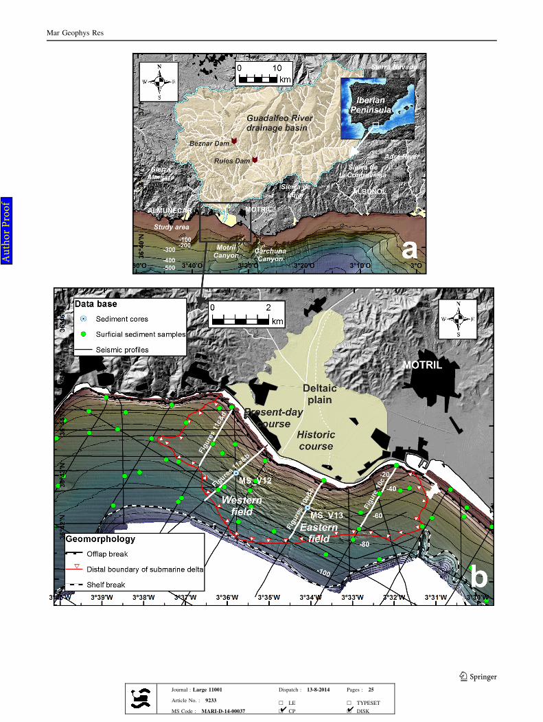
121prodeltaic body, a sediment wedge occupying most of the
122shelf in the northern margin of the Alboran Sea. Fernandez-
123Salas et al. (2007) discovered the existence of two main
124zones of undulations, referred to as eastern and western
125fields, where the undulation are most developed and which
126also appeared to correlate with the main river outlets
127(Fig. 1). Taking into account the morphobathymetric
128measurements and additional seismic evidence, it was
129initially hypothesized that the Guadalfeo prodeltaic undu-
130lations were generated by strong sediment flows emanating
131from the river mouths, either present or ancient (Fernan-
132dez-Salas et al. 2007).
133In this paper we present the results of an analysis of
134seafloor undulations in the prodeltaic area of the Guadalfeo
135River (Fig. 1). Our approach will be more comprehensive
136than previous analysis of prodeltaic undulations, most of
137which utilized only a limited number of bathymetric sec-
138tions, and which did not examine along- and across-slope
139morphological variability. We utilize a geostatistical
140characterization that enables estimation of morphological
141parameters by inversion of second-order statistics (Goff
142and Jordan 1988, 1989a, b). This approach allows us to
143examine in detail the variations of small-scale submarine
144topography associated with the Guadalfeo River undulation
145fields, both along- and across-slope. We combine the
146bathymetric data with available surficial (backscatter,
147sediment samples) and sub-surficial information (seismic
148profiles, sediment cores). Our primary objective is to
149constrain possible genetic interpretations, by establishing
150diagnostic criteria linked either to creeps or to sediment
Mar Geophys Res
123Journal : Large 11001 Dispatch : 13-8-2014 Pages : 25
Article No. : 9233h LE h TYPESET
MS Code : MARI-D-14-00037 h CP h DISK4 4
Au
tho
r P
roo
f
UNCORRECTEDPR
OOF
Mar Geophys Res
123Journal : Large 11001 Dispatch : 13-8-2014 Pages : 25
Article No. : 9233h LE h TYPESET
MS Code : MARI-D-14-00037 h CP h DISK4 4
Au
tho
r P
roo
f
UNCORRECTEDPR
OOF
151 waves, and to ascertain potential submarine geohazards in
152 this area. In particular, we seek to establish the potential
153 role played by hyperpycnal flows in undulation genesis by
154 integrating available information regarding the Guadalfeo
155 River drainage basin.
156 Regional setting
157 Terrestrial setting
158 Climate, hydrology and sediment supply
159 Alternating dry and wet periods have been documented for
160 the last 500 years in the southern Iberian Peninsula
161 (Rodrigo et al. 1999). Drastic climatic conditions increase
162 toward the east, where the catchments show a semi-arid
163 behavior (Liquete et al. 2005). As a consequence, water
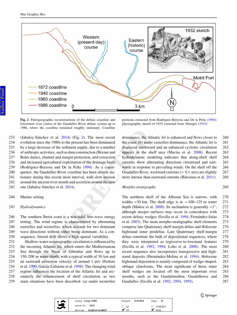
164 discharges are low on an annual basis, but they exhibit a
165 marked seasonal variability and the drainage basins have
166 undergone numerous catastrophic floods in response to
167 torrential rains (Brazdil et al. 1999). Both changing cli-
168 matic conditions and variations in water discharge have
169 been linked to fluctuations of the North Atlantic Oscillation
170 (Rodrigo et al. 2000; Liquete et al. 2005). In addition, the
171 change of land use (trees were replaced by vineyards)
172 during the last centuries favored the reduction of the veg-
173 etation cover and soil erosion (Brazdil et al. 1999).
174 The Guadalfeo River is one of the longest (72.5 km) rivers
175 in the northern Alboran Sea margin, with a 1,312 km2 drain-
176 age basin that extends from altitudes higher than 3,000 m in
177 the nearby Sierra Nevada Mountains. Average river slope is
178 2.21", but slope values decrease from the hinterland to the
179 deltaic plain,where theyare\0.5". The upstreamcourse of the
180 river is controlled by E-W trending mountain ranges such as
181 Sierra Nevada, Sierra de Lujar and Sierra de la Contraviesa
182(Fig. 1a). The emerged deltaic area of the fluvial system
183covers 8.6 km2, with coarse-grained sediments ranging from
184medium sands to boulders generating a 6 km long deltaic
185coastline (Jabaloy-Sanchez et al. 2014) (Fig. 1b).
186Average rainfall is *550 mm/year in the drainage basin,
187although with contrasting patterns in the deltaic plain and the
188highlands (Jimenez-Sanchez et al. 2008). In the coastal
189domain, average rainfall is *400 mm/year and the pluvio-
190metric regime is semi-arid. In the mountains, however, aver-
191age rainfall is[1,000 mm/year, frequently as snow (Jimenez-
192Sanchez et al. 2008). However, very high rainfall values have
193been recorded in the Guadalfeo River drainage basin during
194episodic events. For example, values of 400–600 mm/day
195were recorded during a storm event in 1973 in different
196locations of the basin. Those constitute the most intense pre-
197cipitation events per day recorded in the Iberian Peninsula.
198Water discharge is controlled by snow contribution in
199the upper lands, as well as by strong spatial and temporal
200variability of rainfalls. The average water discharge for the
201period 1942–2000 is 0.6 m3/s. Maximum monthly dis-
202charges ([0.8 m3/s) occur from December to May, and the
203rest of the year the discharge decreases substantially
204(Liquete et al. 2005). Two dams constructed in 1986
205(Beznar) and 2003 (Rules) regulate 85 % of the total run-
206off. At Rules, the estimated average water discharge since
207the opening of the dam in 2007 is 2.86 m3/s, although
208values of an order of magnitude higher (23 m3/s) have been
209measured in response to precipitation events higher than
21060 mm/day. The river has a high capacity of hydraulic
211erosion and sediment transport due to the steep basin
212physiography and low vegetation density. Mean sediment
213load is 2.7 kg/s, and the mean sediment yield is 65.1 t/
214km29 year (Liquete et al. 2005).
215Recent coastline changes
216The river mouth and lowermost course of the Guadalfeo
217River have undergone modifications that have influenced
218coastline evolutionary patterns (Rodrıguez-Berzosa and De
219la Pena 1994) (Fig. 2). Two deltaic distributaries (the pres-
220ent-day river channel and a channel located to the east of the
221present-day position) have been active during historic times.
222A general drawing of the coastal domain around the river
223mouth dated in 1932 places the river mouth in the eastern
224channel (Almagro 1932). A geographic map dated in 1940
225depicts the lowermost river course in its present-day position
226(Fig. 2). Therefore, we infer that the eastern channel became
227inactive during the 1930s. This significant change largely
228modified the coastline evolution, as it promoted a significant
229coastal advance of thewestern part of the deltaic system. The
230coastal segment between the historic course and the Motril
231Port also experienced high progradation rates compared to
232accumulation driven by east–west sediment flux distribution
bFig. 1 Geographical setting of the study area, located in the northernmargin of the Alboran Sea, western Mediterranean Basin. a TheGuadalfeo River drainage basin shows an abrupt, steep morphology,dictated by nearby elevations. Two major dams (Beznar and Rulesdams) have regulated the water and sediment production of thedrainage basin in the recent past. Onland shaded relief generated froma 5 m resolution topographic grid extracted from the ‘‘Base Topog-rafica Nacional’’. Bathymetric image generated from a 50 m resolu-tion grid extracted from multibeam bathymetric data from the‘‘Instituto Espanol de Oceanografıa’’ database. Artificial illuminationis from the northwest. Water depth contours are given in meters.b Location of sediment samples, sediment cores and seismic profiles,superimposed on the multibeam bathymetric data covering the shelfdomain. Onland shaded reliefs generated from a 5 m resolutiontopographic grid extracted from the ‘‘Base Topografica Nacional’’.Bathymetric data derived from the 5 m resolution grid generated frommultibeam bathymetric data collected within the ESPACE project.Artificial illumination is from the northwest. Water depth contours aregiven in meters
AQ2
Mar Geophys Res
123Journal : Large 11001 Dispatch : 13-8-2014 Pages : 25
Article No. : 9233h LE h TYPESET
MS Code : MARI-D-14-00037 h CP h DISK4 4
Au
tho
r P
roo
f
UNCORRECTEDPR
OOF
233 (Jabaloy-Sanchez et al. 2014) (Fig. 2). The most recent
234 evolution since the 1980s to the present has been dominated
235 by a large decrease of the sediment supply, due to a number
236 of anthropic activities, such as dam construction (Beznar and
237 Rules dams), channel and margin protection, arid extraction
238 and increased agricultural exploitation of the drainage basin
239 (Rodrıguez-Berzosa and De la Pena 1994). As a conse-
240 quence, the Guadalfeo River coastline has been almost sta-
241 tionary during this recent most interval, with slow erosion
242 around the ancient river mouth and accretion around the new
243 one (Jabaloy-Sanchez et al. 2014).
244 Marine setting
245 Hydrodynamics
246 The southern Iberia coast is a non-tidal, low-wave energy
247 setting. The wind regime is characterized by alternating
248 easterlies and westerlies, which account for two dominant
249 wave directions without either being dominant. As a con-
250 sequence, littoral drift shows a high spatial variability.
251 Shallow-water oceanographic circulation is influenced by
252 the incoming Atlantic Jet, which enters the Mediterranean
253 Sea through the Strait of Gibraltar and flows up to
254 150–200 m water depth, with a typical width of 30 km and
255 an eastward advection velocity of around 1 m/s (Perkins
256 et al. 1990; Garcıa-Lafuente et al. 1998). The changing wind
257 regime influences the location of the Atlantic Jet and sec-
258 ondarily the enhancement of shelf circulation, as two
259 main situations have been described: (a) under westerlies
260dominance, the Atlantic Jet is enhanced and flows closer to
261the coast; (b) under easterlies dominance, the Atlantic Jet is
262displaced southward and an enhanced cyclonic circulation
263appears in the shelf area (Macıas et al. 2008). Recent
264hydrodynamic modeling indicates that along-shelf shelf
265currents show alternating directions (westward and east-
266ward) in response to prevailing winds. On the shelf off the
267Guadalfeo River, westward currents ([ 0.1 m/s) are slightly
268more intense than eastward currents (Barcenas et al. 2011).
269Morpho-stratigraphy
270The northern shelf of the Alboran Sea is narrow, with
271widths\30 km. The shelf edge is at *100–125 m water
272depth (Munoz et al. 2008). Its inclination is generally\1",
273although steeper surfaces may occur in coincidence with
274recent deltaic wedges (Ercilla et al. 1994; Fernandez-Salas
275et al. 2003). The main morpho-stratigraphic shelf elements
276comprise late Quaternary shelf-margin deltas and Holocene
277highstand inner prodeltas. Late Quaternary shelf-margin
278deltas constitute the bulk of depositional sequences, where
279they were interpreted as regressive-to-lowstand features
280(Ercilla et al. 1992, 1994; Lobo et al. 2008). The most
281recent sequence also incorporates transgressive and high-
282stand deposits (Hernandez-Molina et al. 1994). Holocene
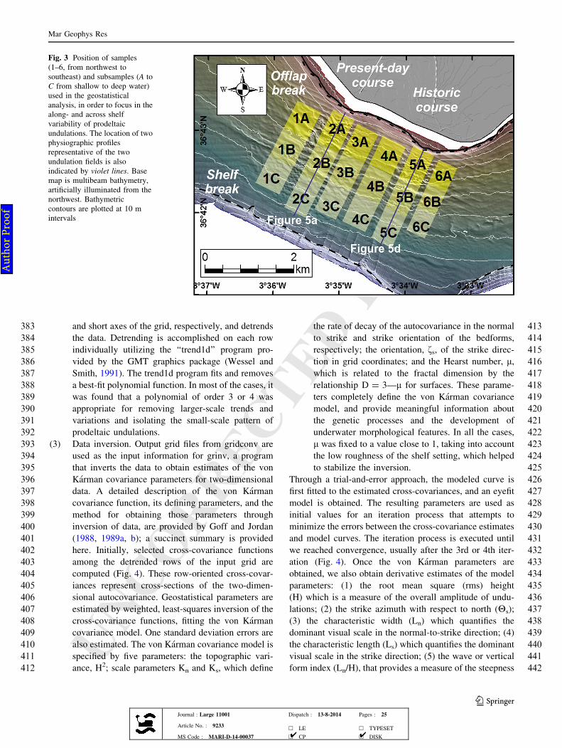
283highstand deposition is mainly composed of wedge-shaped,
284oblique clinoforms. The most significant of those inner
285shelf wedges are located off the most important river
286mouths, such as the Guadalmedina, Guadalhorce and
287Guadalfeo (Ercilla et al. 1992, 1994, 1995).
Fig. 2 Paleogeographic reconstructions of the deltaic coastline andlowermost river course of the Guadalfeo River deltaic system up to1986, where the coastline remained roughly stationary. Coastline
positions extracted from Rodrıguez-Berzosa and De la Pena (1994);physiographic sketch of 1932 extracted from Almagro (1932)
Mar Geophys Res
123Journal : Large 11001 Dispatch : 13-8-2014 Pages : 25
Article No. : 9233h LE h TYPESET
MS Code : MARI-D-14-00037 h CP h DISK4 4
Au
tho
r P
roo
f
UNCORRECTEDPR
OOF
288 Distinctive morphological features of shelf prodeltas
289 include foresets and bottomsets with slopes higher than
290 2.5" and 1", respectively, shallow and close to the coast
291 offlap break, lobate shapes and coarse sediment composi-
292 tion (Lobo et al. 2006). Among other small-scale features,
293 sea-floor undulations occur over several prodeltaic bodies;
294 the undulation field located on top of the Guadalfeo River
295 prodelta is the most extensive one. Average height,
296 wavelength and lateral extension values are 0.85, 80 and
297 210 m, respectively (Fernandez-Salas et al. 2007). They
298 appear as two concentric loci emanating off the present and
299 a previous river mouth location. The working hypothesis
300 considers an origin influenced by strong sediment flows
301 normal to bathymetric contours, possibly coupled with
302 subsequent slow sediment deformation processes.
303 Methodology
304 Several types of data were considered for this study: (1)
305 multibeam bathymetric data, which were used to perform a
306 geostatistical analysis; (2) surficial sediment samples and
307 backscatter data; (3) seismic profiles with different reso-
308 lutions; (4) sediment cores and (5) determination of sedi-
309 ment concentration.
310 Multibeam bathymetry
311 Bathymetric data were collected over the northern Alboran
312 Sea shelf with a 300 kHz Simrad EM3000D multibeam
313 echo-sounder (Fig. 1b). Data were acquired using DGPS
314 navigation referred to the WGS-84 ellipsoid. Accurate
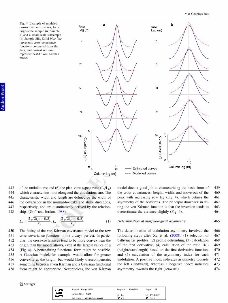
315 navigation and real time pitch, roll and heave corrections
316 were provided by the Seatex Seapath 200. The EM3000D
317 multibeam echo-sounder provides 254 beams (1.5" 9 1.5"
318 beam width, 0.9" beam spacing) of depth information from
319 a swath width up to five times the water depth with a
320 maximum ping rate of 25 Hz. Collected bathymetric data
321 provide complete seafloor coverage from \5 m in the
322 shoreface to more than 170 m in submarine canyon axis.
323 Multibeam data were processed with NeptuneTM software
324 and a 5 9 5 m resolution grid was produced. The grid was
325 integrated in an ArcGISTM project, where derived maps
326 such as hillshade and slope maps were generated.
327 Terminology
328 We use the generic term (i.e., without a genetic connota-
329 tion) ‘‘undulations’’ to refer to the conspicuous seafloor
330 morphologies identified over the prodeltaic foresets, in
331 analogy to other studies of equivalent morphologies around
332 the Mediterranean Sea (e.g., Cattaneo et al. 2004; Berndt
333 et al. 2006; Fernandez-Salas et al. 2007; Urgeles et al.
3342007, 2011; Rebesco et al. 2009). Some authors have used
335the term ‘‘crenulation’’ as equivalent to undulation (Corr-
336eggiari et al. 2001; Budillon et al. 2005). Undulations/
337crenulations could indicate the existence either of sediment
338waves, formed by the action of a current flowing across the
339seabed (Trincardi and Normark 1988; Lee et al. 2002;
340Wynn and Stow 2002; Levchenko and Roslyakov 2010), or
341of creep folds, developed as a consequence of soft sediment
342deformation (Lee and Chough 2001; Wynn and Stow 2002;
343Levchenko and Roslyakov 2010).
344Geostatistical analysis
345Geostatistical analysis of undulations is utilized to estimate
346geomorphic metrics that can be used in spatial analysis.
347Our procedure is comprised of three main steps:
348(1) Sampling of bathymetric data. We initially selected a
349number of rectangular samples (1–6 from northwest
350to southeast) along the Guadalfeo River prodeltaic
351area, in order to cover the lateral variability of the
352seafloor undulation fields (Fig. 3). Later, each initial
353sample was subdivided into three smaller subsam-
354ples (A, B and C from shallow to deep water) in
355order to focus on the across-section undulation
356variability (Fig. 3). The samples and subsamples
357were selected from the original grid by using the
358Extract by Mask tool, from the ArcToolbox Spatial
359Analyst Tool. The resulting files were exported to
360ASCII format by using the Raster to ASCII tool,
361from the ArcToolbox Conversion Tools.
362The initial samples 1–6 were chosen to be approximately
363normal to seafloor undulations, and with similar across-
364shelf extensions as much as possible according to wide-
365spread across-shelf occurrence. The sampling location was
366also dictated by the previous study of Fernandez-Salas
367et al. (2007) which found two main undulation fields
368named as the western and eastern fields. Thus, samples 1–3
369are expected to cover the western field, whereas the eastern
370field should be covered by samples 4–6 (Fig. 3). The
371subsamples were generated with the same across-slope
372length, but in general fall within three well-defined
373bathymetric intervals: 30–50, 50–70 and 70–90 m for A, B
374and C subsamples, respectively (Fig. 3).
375(2) Grid adaptation. The ASCII file exported from
376ArcGIS was used as the input information for a
377new Fortran program we named ‘‘gridconv’’, which
378enables the adaptation of the ArcGIS grid in order to
379input it in the inversion program. Gridconv takes as
380input the initial ArcGIS ASCII file, resamples with
381inverse distance weighting interpolation to reorient
382the rows and columns to be oriented along the long
Mar Geophys Res
123Journal : Large 11001 Dispatch : 13-8-2014 Pages : 25
Article No. : 9233h LE h TYPESET
MS Code : MARI-D-14-00037 h CP h DISK4 4
Au
tho
r P
roo
f
UNCORRECTEDPR
OOF
383 and short axes of the grid, respectively, and detrends
384 the data. Detrending is accomplished on each row
385 individually utilizing the ‘‘trend1d’’ program pro-
386 vided by the GMT graphics package (Wessel and
387 Smith, 1991). The trend1d program fits and removes
388 a best-fit polynomial function. In most of the cases, it
389 was found that a polynomial of order 3 or 4 was
390 appropriate for removing larger-scale trends and
391 variations and isolating the small-scale pattern of
392 prodeltaic undulations.
393 (3) Data inversion. Output grid files from gridconv are
394 used as the input information for grinv, a program
395 that inverts the data to obtain estimates of the von
396 Karman covariance parameters for two-dimensional
397 data. A detailed description of the von Karman
398 covariance function, its defining parameters, and the
399 method for obtaining those parameters through
400 inversion of data, are provided by Goff and Jordan
401 (1988, 1989a, b); a succinct summary is provided
402 here. Initially, selected cross-covariance functions
403 among the detrended rows of the input grid are
404 computed (Fig. 4). These row-oriented cross-covar-
405 iances represent cross-sections of the two-dimen-
406 sional autocovariance. Geostatistical parameters are
407 estimated by weighted, least-squares inversion of the
408 cross-covariance functions, fitting the von Karman
409 covariance model. One standard deviation errors are
410 also estimated. The von Karman covariance model is
411 specified by five parameters: the topographic vari-
412 ance, H2; scale parameters Kn and Ks, which define
413the rate of decay of the autocovariance in the normal
414to strike and strike orientation of the bedforms,
415respectively; the orientation, fs, of the strike direc-
416tion in grid coordinates; and the Hearst number, l,
417which is related to the fractal dimension by the
418relationship D = 3—l for surfaces. These parame-
419ters completely define the von Karman covariance
420model, and provide meaningful information about
421the genetic processes and the development of
422underwater morphological features. In all the cases,
423l was fixed to a value close to 1, taking into account
424the low roughness of the shelf setting, which helped
425to stabilize the inversion.
426Through a trial-and-error approach, the modeled curve is
427first fitted to the estimated cross-covariances, and an eyefit
428model is obtained. The resulting parameters are used as
429initial values for an iteration process that attempts to
430minimize the errors between the cross-covariance estimates
431and model curves. The iteration process is executed until
432we reached convergence, usually after the 3rd or 4th iter-
433ation (Fig. 4). Once the von Karman parameters are
434obtained, we also obtain derivative estimates of the model
435parameters: (1) the root mean square (rms) height
436(H) which is a measure of the overall amplitude of undu-
437lations; (2) the strike azimuth with respect to north (Hs);
438(3) the characteristic width (Ln) which quantifies the
439dominant visual scale in the normal-to-strike direction; (4)
440the characteristic length (Ls) which quantifies the dominant
441visual scale in the strike direction; (5) the wave or vertical
442form index (Ln/H), that provides a measure of the steepness
Fig. 3 Position of samples(1–6, from northwest tosoutheast) and subsamples (A toC from shallow to deep water)used in the geostatisticalanalysis, in order to focus in thealong- and across shelfvariability of prodeltaicundulations. The location of twophysiographic profilesrepresentative of the twoundulation fields is alsoindicated by violet lines. Basemap is multibeam bathymetry,artificially illuminated from thenorthwest. Bathymetriccontours are plotted at 10 mintervals
Mar Geophys Res
123Journal : Large 11001 Dispatch : 13-8-2014 Pages : 25
Article No. : 9233h LE h TYPESET
MS Code : MARI-D-14-00037 h CP h DISK4 4
Au
tho
r P
roo
f
UNCORRECTEDPR
OOF
443 of the undulations; and (6) the plan-view aspect ratio (Ls/Ln)
444 which characterizes how elongated the undulations are. The
445 characteristic width and length are defined by the width of
446 the covariance in the normal-to-strike and strike directions,
447 respectively, and are quantitatively derived by the relation-
448 ships (Goff and Jordan, 1988).
Ln "2
!!!!!!!!!!!!!!!!!!!!!
2#l$ 0:5%p
Kn
; Ls "2
!!!!!!!!!!!!!!!!!!!!!
2#l$ 0:5%p
Ks
#1%
450450 The fitting of the von Karman covariance model to the row
451 cross-covariance functions is not always perfect. In partic-
452 ular, the cross-covariances tend to be more convex near the
453 origin than the model allows, even at the largest values of l
454 (Fig. 4). A better-fitting functional form might be possible.
455 A Gaussian model, for example, would allow for greater
456 convexity at the origin, but would likely overcompensate;
457 something between a von Karman and a Gaussian functional
458 form might be appropriate. Nevertheless, the von Karman
459model does a good job at characterizing the basic form of
460the cross covariances: height, width, and move-out of the
461peak with increasing row lag (Fig. 4), which defines the
462asymmetry of the bedforms. The principal drawback in fit-
463ting the von Karman function is that the inversion tends to
464overestimate the variance slightly (Fig. 4).
465Determination of morphological asymmetry
466The determination of undulation asymmetry involved the
467following steps after Xu et al. (2008): (1) selection of
468bathymetric profiles, (2) profile detrending, (3) calculation
469of the first derivative, (4) calculation of the ratio H/L
470(height/wavelength) based on the first derivative function,
471and (5) calculation of the asymmetry index for each
472undulation. A positive index indicates asymmetry towards
473the left (landward), whereas a negative index indicates
474asymmetry towards the right (seaward).
Fig. 4 Example of modeledcross-covariance curves, for alarge-scale sample (a; Sample2) and a small-scale subsample(b; Sample 3B). Solid blue linerepresents cross-covariancefunctions computed from thedata, and dashed red linesrepresent best-fit von Karmanmodel
Mar Geophys Res
123Journal : Large 11001 Dispatch : 13-8-2014 Pages : 25
Article No. : 9233h LE h TYPESET
MS Code : MARI-D-14-00037 h CP h DISK4 4
Au
tho
r P
roo
f
UNCORRECTEDPR
OOF
475 Surficial sediment samples and backscatter data
476 To complement the bathymetric information, seafloor sur-
477 ficial information off the Guadalfeo River deltaic coastline
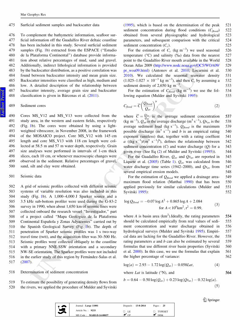
478 has been included in this study. Several surficial sediment
479 samples (Fig. 1b) extracted from the ESPACE (‘‘Estudio
480 de la Plataforma Continental’’) database provide informa-
481 tion about relative percentages of mud, sand and gravel.
482 Additionally, indirect lithological information is provided
483 by the backscatter distribution, as a positive correlation was
484 found between backscatter intensity and mean grain size.
485 Backscatter intensities were classified as high, medium and
486 low. A detailed description of the relationship between
487 backscatter intensity, average grain size and backscatter
488 classification is given in Barcenas et al. (2011).
489 Sediment cores
490 Cores MS_V12 and MS_V13 were collected from the
491 study area, in the western and eastern fields, respectively
492 (Fig. 1b). The cores were obtained by using a light-
493 weighted vibrocorer, in November 2008, in the framework
494 of the MOSAICO project. Core MS_V12 with 145 cm
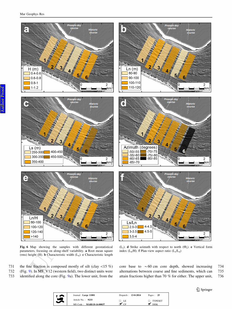
495 length and core MS_V13 with 118 cm length were col-
496 lected at 58.5 m and 57 m water depth, respectively. Grain
497 size analyses were performed in intervals of 1-cm thick
498 slices, each 10 cm, or whenever macroscopic changes were
499 observed in the sediment. Relative percentages of gravel,
500 sand, silt and clay were obtained.
501 Seismic data
502 A grid of seismic profiles collected with different seismic
503 systems of variable resolution was also included in this
504 study (Fig. 1b). A 1,000–4,000 J Sparker source and a
505 3.5 kHz sub-bottom profiler were used during the G-83-2
506 survey in 1990, when about 1,650 km of seismic lines were
507 collected onboard the research vessel ‘‘Investigador,’’ part
508 of a project called ‘‘Mapa Geologico de la Plataforma
509 Continental Espanola y Zonas Adyacentes’’ carried out by
510 the Spanish Geological Survey (Fig. 1b). The depth of
511 penetration of Sparker seismic profiles was 1 s two-way
512 travel time (twtt), and the acquisition filter was 30–500 Hz.
513 Seismic profiles were collected obliquely to the coastline
514 with a primary NNE-SSW orientation and a secondary
515 NW-SE orientation. The Sparker profiles were not included
516 in the earlier study of this region by Fernandez-Salas et al.
517 (2007).
518 Determination of sediment concentration
519 To estimate the possibility of generating density flows from
520 the rivers, we applied the procedure of Mulder and Syvitski
521(1995), which is based on the determination of the peak
522sediment concentration during flood conditions (Cflood)
523obtained from several physiographic and hydrological
524parameters, and subsequent comparison with the critical
525sediment concentration (Cc).
526For the estimation of Cc (kg m-3) we used seasonal
527temperature ("C) and salinity (%) data from the nearest
528point to the Guadalfeo River mouth available in the World
529Ocean Atlas 2009 (http://www.nodc.noaa.gov/OC5/WOA09/
530pr_woa09.html) (Antonov et al. 2010; Locarnini et al.
5312010). We calculated the seasonal seawater density
532(1.025–1.027 9 10-3 kg m-3), and then Cc by assuming a
533sediment density of 2,650 kg m-3.
534For the estimation of Cflood (kg m-3) we use the fol-
535lowing equation (Mulder and Syvitski 1995):
Cflood " CQflood
Qav
" #b
; #2%
537537where C " QsavQav
is the average sediment concentration
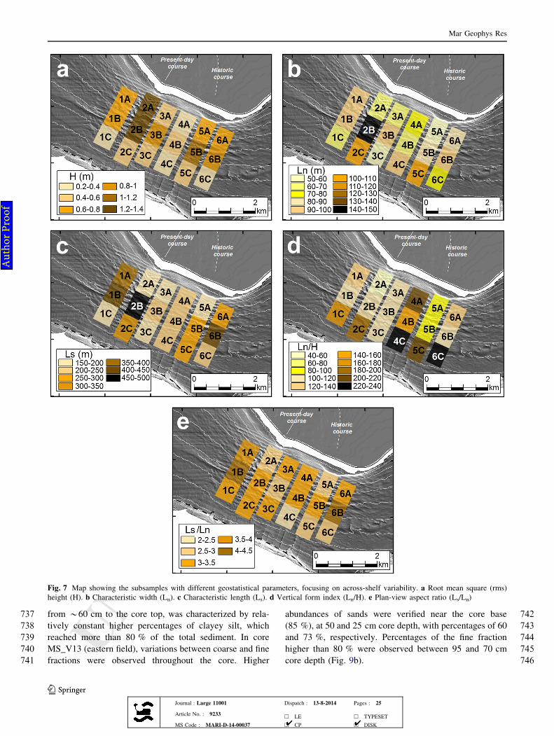
538(kg m-3), Qav is the average discharge (m3 s-1), Qsav is the
539average sediment load (kg s-1), Qflood is the maximum
540possible discharge (m3 s-1) and b is an empirical rating
541exponent (unitless) that, together with a rating coeffient
542a ((kg s-1)/(m3 s-1)b), defines the relationship between
543sediment concentration (C) and water discharge (Q) for a
544given river (See Eq (2) of Mulder and Syvitski (1995)).
545For the Guadalfeo River, Qav and Qsav are reported in
546Liquete et al. (2005) (Table 1). Qav was calculated from
547water discharge time series (1942–2000), and Qsav from
548several empirical erosion models.
549For the estimation of Qflood we applied a drainage area-
550maximum flood relation (Matthai 1990) that has been
551applied previously for similar calculations (Mulder and
552Syvitski 1995):
logQflood " &0:07 logA2 $ 0:865 logA$ 2:084
for A\106km2; r2 " 0:99;
#3%
554554where A is basin area (km2).Ideally, the rating parameters
555should be calculated empirically from real values of sedi-
556ment concentration and water discharge obtained in
557hydrological surveys (Mulder and Syvitski 1995). Empiri-
558cal data are lacking for the Guadalfeo River. However, the
559rating parameters a and b can also be estimated by several
560formulas that use different river basin properties (Syvitski
561et al. 2000). In this case, we use the formulas that explain
562the higher percentage of variance:
log a# % " 2:93& 1:72 log#Qav% & 0:058Lat; #4%
564564where Lat is latitude ("N), and
b " 0:64& 0:50 log Qav# % $ 0:23 log Qsav# % & 0:32 log#a%:
#5%
Mar Geophys Res
123Journal : Large 11001 Dispatch : 13-8-2014 Pages : 25
Article No. : 9233h LE h TYPESET
MS Code : MARI-D-14-00037 h CP h DISK4 4
Au
tho
r P
roo
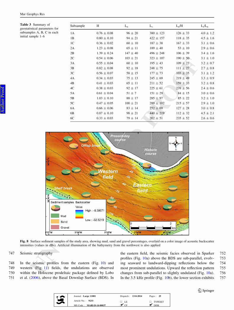
f
UNCORRECTEDPR
OOF
566566 Results
567 Analysis of bathymetric and derived data
568 General physiographic characterization
569 The Guadalfeo River prodelta undulation fields occur off
570 the delta plain, where the coastline is oriented *WNW–
571 ESE. An inflection occurs at the present-day river mouth,
572 where the coastline changes its orientation to*NNW–SSE
573 and a prodeltaic bulge is identified at\20 m water depth.
574 Another inflection changes the coastline to *NE–SW to
575 the east of the historic river mouth; in this zone another
576 prodeltaic bulge is recognized at shallow water, slightly to
577 the west of the coastline inflection and with a well-marked
578 offlap break at about 20 m water depth (Fig. 1b).
579 The shelf is about 4 km wide, with the shelf break
580 approximately coincident with the -110 m isobath. The
581 shelf break is approximately parallel to the main coastline
582 orientation of the deltaic front. The area where the undu-
583 lations are readily identifiable extends*3 km offshore and
584 *5–6 km alongshore (Fig. 1b).
585 The undulations appear to be more developed off the
586 two nearshore prodeltaic bulges, from about 20–90 m
587 water depth; these two areas constitute the western and
588 eastern fields (Fig. 1b). The seaward disappearance of the
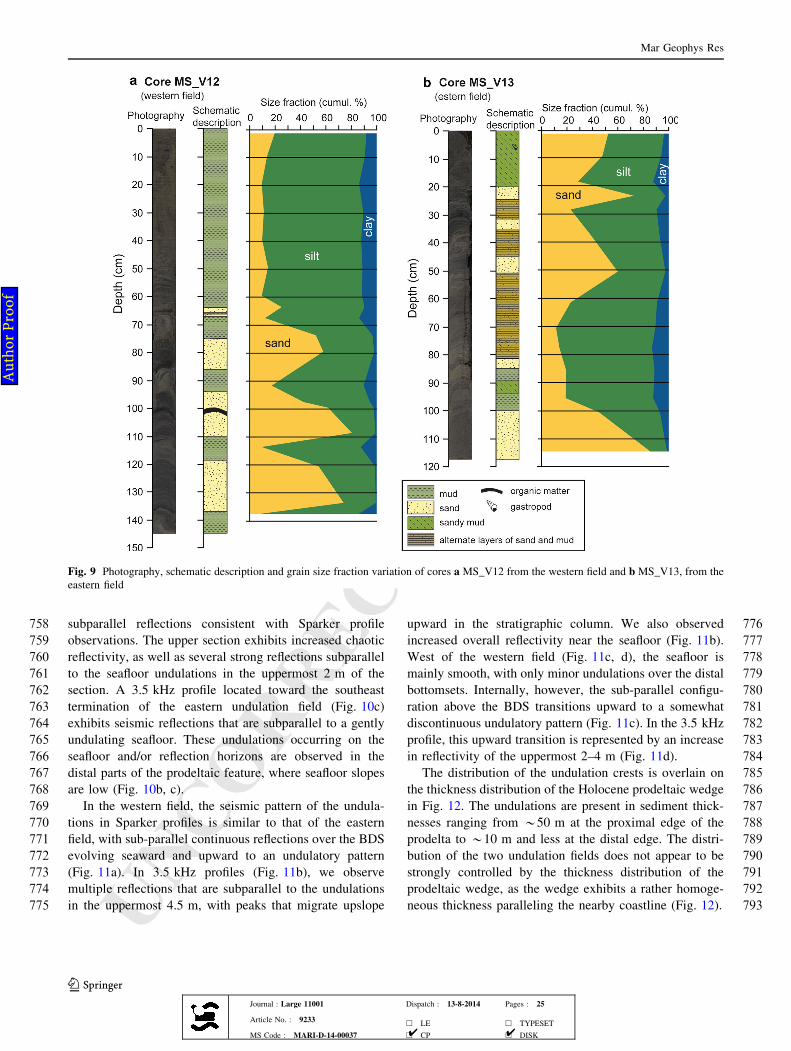
589 undulations is accompanied by the inception of a number
590 of straight channels that dissect the shelf break and con-
591 tinue seaward onto the upper slope (Fig. 1b).
592 The gradients of shelf areas surrounding the prodeltaic
593 undulations are generally[2", but with numerous instances
594 of greater local slopes in the undulation area. In the western
595 and eastern fields, most of the undulations generate local
596 slope values between 4" and 6"; values [6" tend to be
597 restricted to the undulations located in\60 m water depth.
598 In cross-shelf sections, the prodeltaic wedge shows a
599 concave-upward shape which becomes less evident in the
600transitional area between both undulation fields. Average
601slopes show a progressive seaward-declining trend (Fig. 5),
602with average values nearly below 2" in the proximal
603foresets (between 30 and 50 m water depths) to average
604values\1" in the distal bottomsets. The undulations occur
605across the prodeltaic wedge independently of the overall
606seaward slope decline (Fig. 5). The undulations show
607either a slight landward-directed asymmetry or symmetric
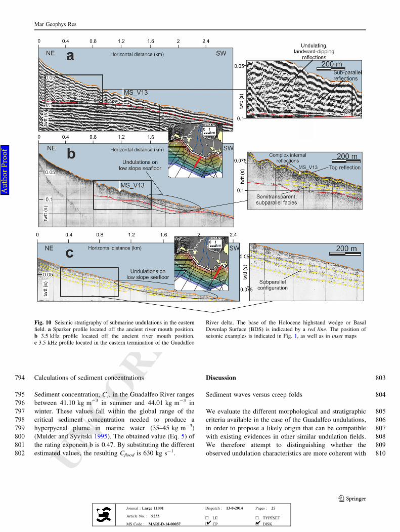
608character. The landward-directed asymmetry is dominant
609in the central part of the western undulation field; in con-
610trast, the undulations in the central part of the eastern
611undulation field are more symmetric (Fig. 5).
612Along-slope variations of geostatistical parameters
613The along-slope variation of geostatistical parameters is
614investigated using 6 NNE-SSW oriented rectangular boxes.
615A summary of the resulting parameters is provided in
616Table 2 and represented in Fig. 6.
617Sample 2, directly offshore of the present-day course of
618the Guadalfeo River, displays the highest RMS height
619(H) value in the study area (1.12 m) (Fig. 6a); adjacent
620samples 1 and 3 both exhibited lower H values of 0.77 m.
621The next-highest H values (0.87 m) were measured at
622Sample 5, directly offshore of the historic course of the
623river. Adjacent values are likewise reduced, although much
624more at Sample 4 (0.54 m) than at Sample 6 (0.85 m).
625The characteristic width (Ln) exhibits contrasting
626behavior between the western and eastern field (Fig. 6b). In
627the western field, wider undulations (101 m) occur in the
628middle Sample 2, and Ln decreases in adjacent Samples 1
629and 3 (both 91 m). However, the difference in character-
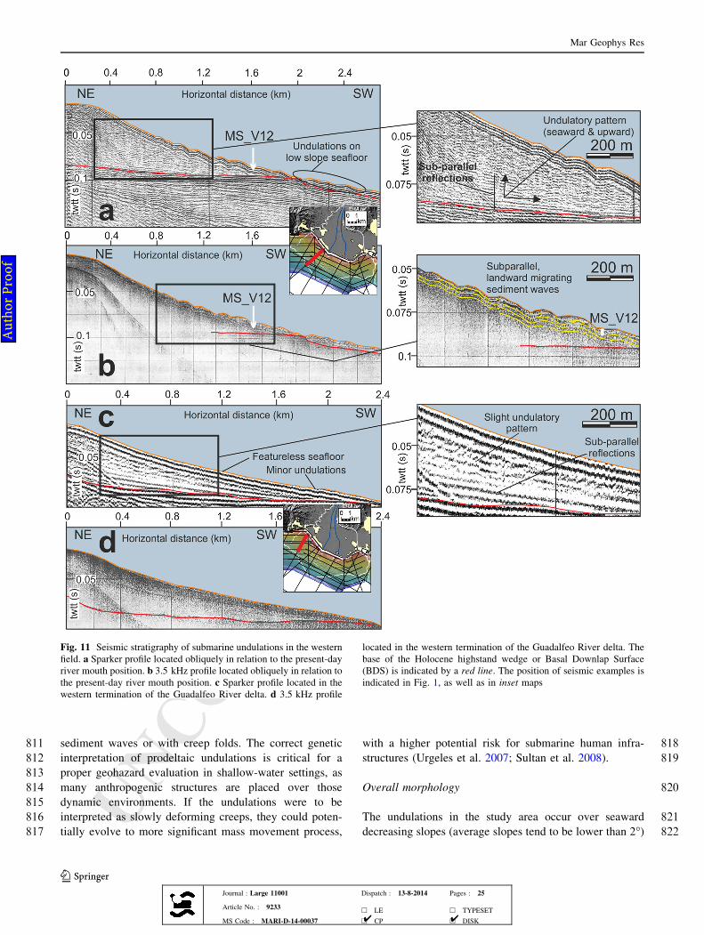
630istic length,*10 m, is smaller than the estimation errors of
631*13–15 m (Table 2). This pattern is inverted in the east-
632ern field, with the middle Sample 5 displaying the lowest
633characteristic lengths (87 m), and adjacent Samples 4 and 6
634displaying the largest values ([ 110 m). These differences
635are better-resolved given the estimation errors of
636*13–19 m.
637The characteristic length distribution (Ls) does not show
638well-defined patterns around the two river outlets (Fig. 6c).
639We only note that the western field shows overall lower Ls
640values than the eastern field, and that the errors are quite
641high for this parameter.
642A clear pattern is recognized in the distribution of strike
643orientation (H), as the undulations are NW–SE oriented in
644sample 1 and become almost E-W oriented in sample 6,
645depicting a radial pattern that is consistent with a lobate
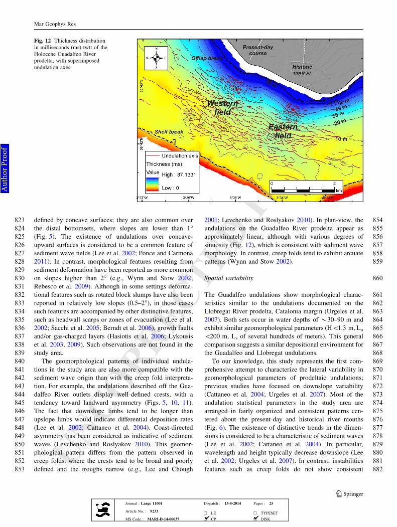
646shape characteristic of prodeltaic settings (Fig. 6d). The
647only exception to this trend is the negligible angle change
648observed between samples 3 and 4.
649The vertical form index (Ln/H) also displays a clear
650pattern with respect to the modern and historic river outlets
Table 1 Morphometric and hydrological parameters of the Guadal-feo River basin
Basin area (km2) 1,312.2
River length (km) 72.5
Basin maximum elevation (m) 3,243
River maximum elevation (m) 2,793
River slope (") 2.21
Delta area (km2) 8.6
Deltaic coastline length (km) 6.0
Mean discharge (m3 s-1) 0.6
Mean sediment load (kg s-1) 2.5
Mean sediment yield (t km2 year-1) 65.1
Extracted from Liquete et al. (2005)
Mar Geophys Res
123Journal : Large 11001 Dispatch : 13-8-2014 Pages : 25
Article No. : 9233h LE h TYPESET
MS Code : MARI-D-14-00037 h CP h DISK4 4
Au
tho
r P
roo
f
UNCORRECTEDPR
OOF
Fig. 5 Representative physiographic profiles of the study area.a Profile located in the middle part of the western undulation field.b Undulation elevation (with removal of the slope) in the westernfield profile. c Estimate of the asymmetry index in the western fieldprofile. d Profile located in the middle part of the eastern undulation
field. e Undulation elevation (with removal of the slope) in the easternfield profile. (f) Estimate of the asymmetry index in the eastern fieldprofile. Profile locations (a and d) are indicated in Fig. 3. A positiveindex indicates asymmetry toward the left (landward)
Mar Geophys Res
123Journal : Large 11001 Dispatch : 13-8-2014 Pages : 25
Article No. : 9233h LE h TYPESET
MS Code : MARI-D-14-00037 h CP h DISK4 4
Au
tho
r P
roo
f
UNCORRECTEDPR
OOF651 (Fig. 6e). Samples 2 and 5, located in the middle parts of
652 the western and eastern undulation fields, show the lowest
653 vertical form indexes, with values\100. Samples adjacent
654 to these exhibit values[100. The pattern is symmetrical in
655 the western field, but asymmetrical in the eastern field, as
656 the vertical form index is considerable higher in sample 4
657 than in sample 6. We also observed that the overall Ln/H
658 values are lower in the western field than in the eastern
659 field.
660 The samples with higher aspect ratios (Ls/Ln) are the
661 outermost 1 and 6, whereas the middle samples 3 and 4
662 show the lowest ratio values (Fig. 6f).
663 Across-slope variations of geostatistical parameters
664 The across-slope variation of geostatistical parameters
665 (Fig. 7, Table 3) was investigated by subdividing the initial
666 sampling rectangles in three subsamples, upper (A), middle
667 (B) and lower (C) (Fig. 3). Strike orientations were com-
668 puted but not presented here, as they do not provide
669 meaningful information.
670 The western field shows a consistent pattern of down-
671 slope variation in RMS height (H): increasing from A to B,
672 and then decreasing from B to C, often by *half (Fig. 7a).
673 The highest values of the study area are found in subs-
674 amples 2A and 2B, directly offshore of the modern river
675 outlet, where H values are 1.23 and 1.39 m, respectively.
676 Subsample 5B, offshore of the historic river outlet, also
677 exhibits H[1 m.
678 Characteristic width (Ln) exhibits more variability in the
679 pattern of across-slope variation than does H (Fig. 7b). In
680 the western field, the highest Ln values are found in middle
681 (B) subsamples, except in sample 1 where subsamples A
682 and B show similar values. In the eastern field there is no
683 consistent pattern, with Ln values decreasing then
684 increasing in Sample 4, increasing monotonically in Sam-
685 ple 5, and increasing then decreasing in Sample 6 (although
686 these changes are not well resolved given the errors).
687 As with H, characteristic length (Ls) values generally
688 show increasing-then-decreasing downslope trends, par-
689 ticularly in the western field offshore of the modern river
690 outlet (Fig. 7c). Samples 4 and 5 in the eastern field are
691 exceptions. In Sample 4, Ls values decrease-then-increase
692from subsamples A to C. In Sample 5, Ls values increase
693monotonically down slope. The higher error estimates for
694Ls (Table 3) render some of these downslope changes in Ls
695values uncertain, however.
696The across-slope variations of the vertical form index
697(Ln/H) do not appear to be consistent, although the highest
698values tend to occur in the most distal subsamples
699(Fig. 7d). Finally, the pattern exhibited by the aspect ratio
700(Ls/Ln) is also scarcely predictable, although the highest
701values tend to occur in the middle subsamples (Fig. 7e).
702Surficial sediments and backscatter distribution
703The available sediment samples (Fig. 8) are more abundant
704in the western field, where sand percentages are higher than
70525 % in almost all the samples, with some higher than
70650 % (Fig. 8). No sediment samples are available in the
707central part of the eastern field, but the samples located in
708the proximal topsets and in the distal bottomsets reveal
709sand percentages even higher than their equivalents in the
710western field. The amount of muds increases laterally from
711the undulation fields. Thus, mud percentages tend to be
712higher than 50 % both to the north-northwest and to the
713south-southeast of the fields (Fig. 8).
714The backscatter data (Fig. 8) exhibit high values over
715the prodeltaic topset ([-20 dB), indicative of high sand
716contents and small amounts of gravels. The eastern field
717shows backscatter intensities ranging from -24 to -26 dB,
718whereas backscatter values in the western field are between
719-27 and -28 dB, suggesting that the eastern field exhibits
720a coarser sediment composition than the western field.
721Seaward, most of the prodeltaic surface is characterized by
722low backscatter intensities (\-24 dB), attributed to fine to
723coarse sands. The rest of the prodeltaic surface, including
724the middle area between both undulation fields, shows
725backscatter intensities lower than -28 dB, correlated in
726many cases with muddy sediments with high amounts of
727sands (Fig. 8).
728Sediment cores
729In both cores, grain size analyses revealed that the coarse
730fraction is composed primarily of sand (gravel\0.2 %) and
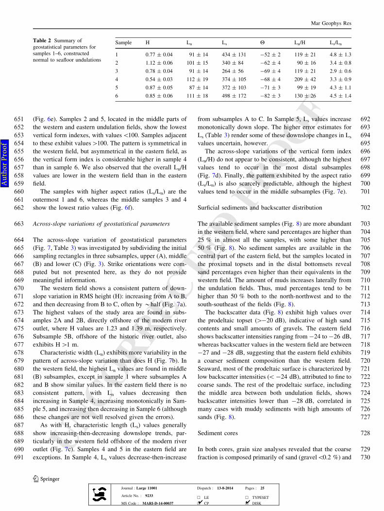
Table 2 Summary ofgeostatistical parameters forsamples 1–6, constructednormal to seafloor undulations
Sample H Ln Ls H Ln/H Ls/Ln
1 0.77 ± 0.04 91 ± 14 434 ± 131 -52 ± 2 119 ± 21 4.8 ± 1.3
2 1.12 ± 0.06 101 ± 15 340 ± 84 -62 ± 4 90 ± 16 3.4 ± 0.8
3 0.78 ± 0.04 91 ± 14 264 ± 56 -69 ± 4 119 ± 21 2.9 ± 0.6
4 0.54 ± 0.03 112 ± 19 374 ± 105 -68 ± 4 209 ± 42 3.3 ± 0.9
5 0.87 ± 0.05 87 ± 14 372 ± 103 -71 ± 3 99 ± 19 4.3 ± 1.1
6 0.85 ± 0.06 111 ± 18 498 ± 172 -82 ± 3 130 ± 26 4.5 ± 1.4
Mar Geophys Res
123Journal : Large 11001 Dispatch : 13-8-2014 Pages : 25
Article No. : 9233h LE h TYPESET
MS Code : MARI-D-14-00037 h CP h DISK4 4
Au
tho
r P
roo
f
UNCORRECTEDPR
OOF
731 the fine fraction is composed mostly of silt (clay\15 %)
732 (Fig. 9). In MS_V12 (western field), two distinct units were
733 identified along the core (Fig. 9a). The lower unit, from the
734core base to *60 cm core depth, showed increasing
735alternations between coarse and fine sediments, which can
736attain fractions higher than 70 % for either. The upper unit,
Fig. 6 Map showing the samples with different geostatisticalparameters, focusing on along-shelf variability. a Root mean square(rms) height (H). b Characteristic width (Ln). c Characteristic length
(Ls). d Strike azimuth with respect to north (Hs). e Vertical formindex (Ln/H). f Plan-view aspect ratio (Ls/Ln)
Mar Geophys Res
123Journal : Large 11001 Dispatch : 13-8-2014 Pages : 25
Article No. : 9233h LE h TYPESET
MS Code : MARI-D-14-00037 h CP h DISK4 4
Au
tho
r P
roo
f
UNCORRECTEDPR
OOF
737 from *60 cm to the core top, was characterized by rela-
738 tively constant higher percentages of clayey silt, which
739 reached more than 80 % of the total sediment. In core
740 MS_V13 (eastern field), variations between coarse and fine
741 fractions were observed throughout the core. Higher
742abundances of sands were verified near the core base
743(85 %), at 50 and 25 cm core depth, with percentages of 60
744and 73 %, respectively. Percentages of the fine fraction
745higher than 80 % were observed between 95 and 70 cm
746core depth (Fig. 9b).
Fig. 7 Map showing the subsamples with different geostatistical parameters, focusing on across-shelf variability. a Root mean square (rms)height (H). b Characteristic width (Ln). c Characteristic length (Ls). d Vertical form index (Ln/H). e Plan-view aspect ratio (Ls/Ln)
Mar Geophys Res
123Journal : Large 11001 Dispatch : 13-8-2014 Pages : 25
Article No. : 9233h LE h TYPESET
MS Code : MARI-D-14-00037 h CP h DISK4 4
Au
tho
r P
roo
f
UNCORRECTEDPR
OOF
747 Seismic stratigraphy
748 In the seismic profiles from the eastern (Fig. 10) and
749 western (Fig. 11) fields, the undulations are observed
750 within the Holocene prodeltaic package defined by Lobo
751 et al. (2006), above the Basal Downlap Surface (BDS). In
752the eastern field, the seismic facies observed in Sparker
753profiles (Fig. 10a) above the BDS are sub-parallel, evolv-
754ing seaward to landward-dipping reflections below the
755most prominent undulations. Upward the reflection pattern
756changes from sub-parallel to slightly undulated (Fig. 10a).
757In the 3.5 kHz profile (Fig. 10b), the lower section exhibits
Table 3 Summary ofgeostatistical parameters forsubsamples A, B, C in eachinitial sample 1–6
Subsample H Ln Ls Ln/H Ls/Ln
1A 0.76 ± 0.08 96 ± 20 380 ± 123 126 ± 33 4.0 ± 1.2
1B 0.80 ± 0.10 94 ± 21 422 ± 157 118 ± 35 4.5 ± 1.6
1C 0.36 ± 0.02 60 ± 10 187 ± 38 167 ± 33 3.1 ± 0.6
2A 1.23 ± 0.08 65 ± 11 189 ± 40 53 ± 10 2.9 ± 0.6
2B 1.39 ± 0.24 147 ± 40 496 ± 248 106 ± 39 3.4 ± 1.6
2C 0.54 ± 0.06 103 ± 21 323 ± 107 190 ± 50 3.1 ± 1.0
3A 0.55 ± 0.04 60 ± 10 195 ± 43 109 ± 23 3.2 ± 0.7
3B 0.82 ± 0.08 92 ± 18 248 ± 75 111 ± 27 2.7 ± 0.8
3C 0.56 ± 0.07 58 ± 15 177 ± 73 103 ± 35 3.1 ± 1.2
4A 0.34 ± 0.03 75 ± 13 245 ± 69 219 ± 49 3.3 ± 0.9
4B 0.41 ± 0.03 65 ± 11 211 ± 52 159 ± 33 3.2 ± 0.8
4C 0.38 ± 0.03 92 ± 17 225 ± 61 239 ± 56 2.4 ± 0.6
5A 0.61 ± 0.04 51 ± 7 151 ± 29 84 ± 15 3.0 ± 0.6
5B 1.03 ± 0.10 88 ± 17 285 ± 97 85 ± 22 3.2 ± 1.0
5C 0.47 ± 0.05 100 ± 21 289 ± 102 215 ± 57 2.9 ± 1.0
6A 0.66 ± 0.06 83 ± 14 252 ± 69 127 ± 28 3.0 ± 0.8
6B 0.87 ± 0.10 98 ± 21 440 ± 219 112 ± 32 4.5 ± 2.1
6C 0.33 ± 0.03 79 ± 14 202 ± 51 235 ± 52 2.6 ± 0.6
Fig. 8 Surface sediment samples of the study area, showing mud, sand and gravel percentages, overlaid on a color image of acoustic backscatterintensities (values in dBs). Artificial illumination of the bathymetry from the northwest is also applied
Mar Geophys Res
123Journal : Large 11001 Dispatch : 13-8-2014 Pages : 25
Article No. : 9233h LE h TYPESET
MS Code : MARI-D-14-00037 h CP h DISK4 4
Au
tho
r P
roo
f
UNCORRECTEDPR
OOF
758 subparallel reflections consistent with Sparker profile
759 observations. The upper section exhibits increased chaotic
760 reflectivity, as well as several strong reflections subparallel
761 to the seafloor undulations in the uppermost 2 m of the
762 section. A 3.5 kHz profile located toward the southeast
763 termination of the eastern undulation field (Fig. 10c)
764 exhibits seismic reflections that are subparallel to a gently
765 undulating seafloor. These undulations occurring on the
766 seafloor and/or reflection horizons are observed in the
767 distal parts of the prodeltaic feature, where seafloor slopes
768 are low (Fig. 10b, c).
769 In the western field, the seismic pattern of the undula-
770 tions in Sparker profiles is similar to that of the eastern
771 field, with sub-parallel continuous reflections over the BDS
772 evolving seaward and upward to an undulatory pattern
773 (Fig. 11a). In 3.5 kHz profiles (Fig. 11b), we observe
774 multiple reflections that are subparallel to the undulations
775 in the uppermost 4.5 m, with peaks that migrate upslope
776upward in the stratigraphic column. We also observed
777increased overall reflectivity near the seafloor (Fig. 11b).
778West of the western field (Fig. 11c, d), the seafloor is
779mainly smooth, with only minor undulations over the distal
780bottomsets. Internally, however, the sub-parallel configu-
781ration above the BDS transitions upward to a somewhat
782discontinuous undulatory pattern (Fig. 11c). In the 3.5 kHz
783profile, this upward transition is represented by an increase
784in reflectivity of the uppermost 2–4 m (Fig. 11d).
785The distribution of the undulation crests is overlain on
786the thickness distribution of the Holocene prodeltaic wedge
787in Fig. 12. The undulations are present in sediment thick-
788nesses ranging from *50 m at the proximal edge of the
789prodelta to *10 m and less at the distal edge. The distri-
790bution of the two undulation fields does not appear to be
791strongly controlled by the thickness distribution of the
792prodeltaic wedge, as the wedge exhibits a rather homoge-
793neous thickness paralleling the nearby coastline (Fig. 12).
Fig. 9 Photography, schematic description and grain size fraction variation of cores a MS_V12 from the western field and b MS_V13, from theeastern field
Mar Geophys Res
123Journal : Large 11001 Dispatch : 13-8-2014 Pages : 25
Article No. : 9233h LE h TYPESET
MS Code : MARI-D-14-00037 h CP h DISK4 4
Au
tho
r P
roo
f
UNCORRECTEDPR
OOF
794 Calculations of sediment concentrations
795 Sediment concentration, Cc, in the Guadalfeo River ranges
796 between 41.10 kg m-3 in summer and 44.01 kg m-3 in
797 winter. These values fall within the global range of the
798 critical sediment concentration needed to produce a
799 hyperpycnal plume in marine water (35–45 kg m-3)
800 (Mulder and Syvitski 1995). The obtained value (Eq. 5) of
801 the rating exponent b is 0.47. By substituting the different
802 estimated values, the resulting Cflood is 630 kg s-1.
803Discussion
804Sediment waves versus creep folds
805We evaluate the different morphological and stratigraphic
806criteria available in the case of the Guadalfeo undulations,
807in order to propose a likely origin that can be compatible
808with existing evidences in other similar undulation fields.
809We therefore attempt to distinguishing whether the
810observed undulation characteristics are more coherent with
Fig. 10 Seismic stratigraphy of submarine undulations in the easternfield. a Sparker profile located off the ancient river mouth position.b 3.5 kHz profile located off the ancient river mouth position.c 3.5 kHz profile located in the eastern termination of the Guadalfeo
River delta. The base of the Holocene highstand wedge or BasalDownlap Surface (BDS) is indicated by a red line. The position ofseismic examples is indicated in Fig. 1, as well as in inset maps
Mar Geophys Res
123Journal : Large 11001 Dispatch : 13-8-2014 Pages : 25
Article No. : 9233h LE h TYPESET
MS Code : MARI-D-14-00037 h CP h DISK4 4
Au
tho
r P
roo
f
UNCORRECTEDPR
OOF
811 sediment waves or with creep folds. The correct genetic
812 interpretation of prodeltaic undulations is critical for a
813 proper geohazard evaluation in shallow-water settings, as
814 many anthropogenic structures are placed over those
815 dynamic environments. If the undulations were to be
816 interpreted as slowly deforming creeps, they could poten-
817 tially evolve to more significant mass movement process,
818with a higher potential risk for submarine human infra-
819structures (Urgeles et al. 2007; Sultan et al. 2008).
820Overall morphology
821The undulations in the study area occur over seaward
822decreasing slopes (average slopes tend to be lower than 2")
Fig. 11 Seismic stratigraphy of submarine undulations in the westernfield. a Sparker profile located obliquely in relation to the present-dayriver mouth position. b 3.5 kHz profile located obliquely in relation tothe present-day river mouth position. c Sparker profile located in thewestern termination of the Guadalfeo River delta. d 3.5 kHz profile
located in the western termination of the Guadalfeo River delta. Thebase of the Holocene highstand wedge or Basal Downlap Surface(BDS) is indicated by a red line. The position of seismic examples isindicated in Fig. 1, as well as in inset maps
Mar Geophys Res
123Journal : Large 11001 Dispatch : 13-8-2014 Pages : 25
Article No. : 9233h LE h TYPESET
MS Code : MARI-D-14-00037 h CP h DISK4 4
Au
tho
r P
roo
f
UNCORRECTEDPR
OOF
823 defined by concave surfaces; they are also common over
824 the distal bottomsets, where slopes are lower than 1"
825 (Fig. 5). The existence of undulations over concave-
826 upward surfaces is considered to be a common feature of
827 sediment wave fields (Lee et al. 2002; Ponce and Carmona
828 2011). In contrast, morphological features resulting from
829 sediment deformation have been reported as more common
830 on slopes higher than 2" (e.g., Wynn and Stow 2002;
831 Rebesco et al. 2009). Although in some settings deforma-
832 tional features such as rotated block slumps have also been
833 reported in relatively low slopes (0.5–2"), in those cases
834 such features are accompanied by other distinctive features,
835 such as headwall scarps or zones of evacuation (Lee et al.
836 2002; Sacchi et al. 2005; Berndt et al. 2006), growth faults
837 and/or gas-charged layers (Hasiotis et al. 2006; Lykousis
838 et al. 2003, 2009). Such observations are not found in the
839 study area.
840 The geomorphological patterns of individual undula-
841 tions in the study area are also more compatible with the
842 sediment wave origin than with the creep fold interpreta-
843 tion. For example, the undulations described off the Gua-
844 dalfeo River outlets display well-defined crests, with a
845 tendency toward landward asymmetry (Figs. 5, 10, 11).
846 The fact that downslope limbs tend to be longer than
847 upslope limbs would indicate differential deposition rates
848 (Lee et al. 2002; Cattaneo et al. 2004). Coast-directed
849 asymmetry has been considered as indicative of sediment
850 waves (Levchenko and Roslyakov 2010). This geomor-
851 phological pattern differs from the pattern observed in
852 creep folds, where the crests tend to be broad and poorly
853 defined and the troughs narrow (e.g., Lee and Chough
8542001; Levchenko and Roslyakov 2010). In plan-view, the
855undulations on the Guadalfeo River prodelta appear as
856approximately linear, although with various degrees of
857sinuosity (Fig. 12), which is consistent with sediment wave
858morphology. In contrast, creep folds tend to exhibit arcuate
859patterns (Wynn and Stow 2002).
860Spatial variability
861The Guadalfeo undulations show morphological charac-
862teristics similar to the undulations documented on the
863Llobregat River prodelta, Catalonia margin (Urgeles et al.
8642007). Both sets occur in water depths of *30–90 m and
865exhibit similar geomorphological parameters (H\1.3 m, Ln
866\200 m, Ls of several hundreds of meters). This general
867comparison suggests a similar depositional environment for
868the Guadalfeo and Llobregat undulations.
869To our knowledge, this study represents the first com-
870prehensive attempt to characterize the lateral variability in
871geomorphological parameters of prodeltaic undulations;
872previous studies have focused on downslope variability
873(Cattaneo et al. 2004; Urgeles et al. 2007). Most of the
874undulation statistical parameters in the study area are
875arranged in fairly organized and consistent patterns cen-
876tered about the present-day and historical river mouths
877(Fig. 6). The existence of distinctive trends in the dimen-
878sions is considered to be a characteristic of sediment waves
879(Lee et al. 2002; Cattaneo et al. 2004). In particular,
880wavelength and height typically decrease downslope (Lee
881et al. 2002; Urgeles et al. 2007). In contrast, instabilities
882features such as creep folds do not show consistent
Fig. 12 Thickness distributionin milliseconds (ms) twtt of theHolocene Guadalfeo Riverprodelta, with superimposedundulation axes
Mar Geophys Res
123Journal : Large 11001 Dispatch : 13-8-2014 Pages : 25
Article No. : 9233h LE h TYPESET
MS Code : MARI-D-14-00037 h CP h DISK4 4
Au
tho
r P
roo
f
UNCORRECTEDPR
OOF
883 distribution patterns and tend to exhibit a more random
884 scatter of dimensions (Lee and Chough 2001; Wynn and
885 Stow 2002). As an example, the most significant instabil-
886 ities in a fan delta of the Gulf of Corinth occur in a lateral
887 flank, unrelated to the river mouth and the distribution of
888 the depositional body (Hasiotis et al. 2006).
889 We found that H and Ln/H ratio provide the most con-
890 sistent geomorphological patterns with respect to the
891 present-day and historic river mouths (Fig. 6a–e). Along-
892 shelf, the largest H values occur offshore the river mouths,
893 decreasing to either side (Fig. 6a), whereas Ln/H ratio is
894 smallest off the river mouths, and increases to either side.
895 Across-shelf, the highest H values tend to occur at mid-
896 depths (*60 m) in both undulation fields (Fig. 7a). The
897 downslope variation of the Ln/H ratio in the central axis of
898 the undulation fields shows a strong increasing downslope
899 trend (Fig. 7e), indicating that the undulations become
900 flatter and smaller in a downslope direction.
901 Both H and Ln/H distribution patterns give further
902 support to the sediment wave interpretation, as similar
903 patterns have been observed in other sediment wave areas.
904 For example, maximum sediment wave dimensions
905 (H) occur at mid depths in a sediment wave field located on
906 the Fraser River Delta; there, it has been proposed that
907 dune dimensions are most likely controlled by the relative
908 rates of bedload versus suspended load transport, and
909 ultimately by current speed (Carle and Hill 2009). In the
910 case of the vertical form index, the downslope increase of
911 the Ln/H ratio has been related in fjord settings to the
912 generation of sediment waves by sediment fluxes (Bøe
913 et al. 2004). Those distribution patterns are clearly different
914 from the distribution of creep fold dimensions reported in
915 one of the most outstanding studies regarding such defor-
916 mation features (Lee and Chough 2001). In fields of sub-
917 marine creep deposits, the highest reliefs of the undulations
918 tend to occur in the most distal low-slope settings.
919 Characteristic widths, Ln, do not show a consistent
920 downslope pattern, as the cross-slope distributions differ in
921 both fields (Fig. 7b). Systematic variation in undulation
922 width with depth was also not observed in prodeltaic set-
923 tings (Cattaneo et al. 2004; Urgeles et al. 2007) or in deep-
924 water undulation fields (Rebesco et al. 2009).
925 Stratigraphic patterns
926 Undulations in the study area show consistent stratigraphic
927 patterns in both fields (eastern and western) as observed in
928 3.5 kHz profiles, such as landward-migrating crests
929 evolving upward in the stratigraphic section, lateral conti-
930 nuity of internal reflectors from one wave to the other,
931 continuity beyond undulation fields into areas of sub-par-
932 allel reflectors without any significant sediment disruption,
933 and regularity of reflector spacing (Figs. 10, 11). Those
934compelling evidences have been ascribed to sediment wave
935fields (Lee et al. 2002; Wynn and Stow 2002; Urgeles et al.
9362007; Milia et al. 2008; Levchenko and Roslyakov 2010),
937as the development of sediment waves occur in response to
938changing environmental conditions (Lee et al. 2002).
939The shallow internal reflectors occurring in the upper-
940most sediment column could be correlated with the coarse-
941grained peaks identified in the sediment cores. Similar
942sandy or coarse-grained layers have been documented in
943other prodeltaic Holocene wedges around the Mediterra-
944nean Sea, where they are usually interpreted as the result of
945flood-derived rapid deposition (e.g., Budillon et al. 2005;
946Hasiotis et al. 2006; Milia et al. 2008). We propose a
947similar interpretation for the study area. Core MS_V13,
948located in an area influenced by the river discharges of the
949historic course, revealed the sedimentary deposition that
950occurred until the 30 s of the 20th century, when the course
951of the river was deviated to its present position. The lower
952part of core MS_V12 reflected the sedimentation occurred
953after the river course deviation, which alternated between
954periods of increase supply of sand material to the shelf,
955linked with periods of increased runoff, and periods of
956lower river discharges, with the deposition of fine material.
957The upper part of this core represents sediments deposited
958after the stabilization of the river course to its present-day
959location, when only fine material is deposited in this area of
960the shelf, until the present.
961In contrast to those evidences, creep folds show dis-
962placement along failure planes (Lykousis 1991; Corregg-
963iari et al. 2001; Hasiotis et al. 2006; Lykousis et al. 2009)
964and do not display lateral migration (Lee and Chough
9652001; Wynn and Stow 2002).
966Undulations observed in the seismic profiles in the study
967area generally increase in dimensions upward in the
968stratigraphic column (Figs. 10, 11). This pattern has been
969observed in diverse marine settings (both shallow- and
970deep-water), where it has been associated to progressive
971development of sediment waves over long time periods
972(Trincardi and Normark 1988; Lee et al. 2002; Bøe et al.
9732004; Urgeles et al. 2007; Levchenko and Roslyakov
9742010).
975Sedimentological patterns
976The two undulation fields display higher backscatter
977intensities than the surrounding prodeltaic surface (Fig. 8),
978indicative of coarser material (predominantly sandy) that
979we infer is sourced from the two river outlets. This pattern
980also supports the hypothesis that the genesis of the undu-
981lations are related to the transport of sand-sized sediments
982beyond the littoral zone during flooding events, as docu-
983mented in other settings (Mulder et al. 2003; Warrick and
984Milliman 2003). The pattern is not consistent with
Mar Geophys Res
123Journal : Large 11001 Dispatch : 13-8-2014 Pages : 25
Article No. : 9233h LE h TYPESET
MS Code : MARI-D-14-00037 h CP h DISK4 4
Au
tho
r P
roo
f
UNCORRECTEDPR
OOF
985 expectations under the creep hypothesis for these features,
986 as this would require finer-grained sediments within the
987 undulation field (Lee and Chough 2001).
988 Possible genetic mechanisms for sediment waves
989 Under the assumption that the undulations off the Gua-
990 dalfeo River are sediment waves, their presence should not
991 be considered an indicator for the occurrence of instability
992 processes, and consequently they likely do not pose sig-
993 nificant hazard for offshore development. In this section we
994 discuss possible triggering processes for those prodeltaic
995 undulations in the study area. Two main possibilities can
996 be envisaged (e.g., Cattaneo et al. 2004; Urgeles et al.
997 2011): (1) influence of oceanographic processes; and (2)
998 river discharges with high sediment concentrations (i.e.,
999 hyperpycnal flows).
1000 Oceanographic processes
1001 Elsewhere around the Mediterranean Sea, the formation of
1002 prodeltaic undulations has been attributed to the sediment
1003 transport induced by oceanographic processes like shelf-
1004 depth currents or internal waves (Trincardi and Normark
1005 1988; Cattaneo et al. 2004; Berndt et al. 2006; Urgeles
1006 et al. 2011).
1007 (a) Bottom currents. Under the influence of bottom
1008 currents, sediment waves usually share several of the
1009 following attributes, such as: (1) significant variation
1010 of deepest occurrence or occurrence in relatively
1011 deep shelf waters; (2) dominance of sub-horizontal
1012 upslope limbs; (3) asymmetrically oriented seaward;
1013 (4) no consistent seaward decrease of wave dimen-
1014 sions; (5) high lateral continuity (up to tens of
1015 kilometers); (6) evidences of erosion at different
1016 water depths (Trincardi and Normark 1988; Cattaneo
1017 et al. 2004; Berndt et al. 2006).
1018 The undulations mapped in the Guadalfeo River study area
1019 do not meet these criteria because: (1) they occur in a well-
1020 defined water depth range (30–90 m); (2) they show a
1021 preferential landward-directed asymmetry, with steep
1022 upslope limbs, and the dimensions show a consistent sea-
1023 ward pattern; (3) they show much lower lateral continuity
1024 that undulations generated by laterally continuous shelf
1025 current flows; and (4) available knowledge about shelf
1026 hydrodynamic conditions indicates the prevalence of
1027 along-shelf flows, subparallel to the main undulation ori-
1028 entation in response to alternating winds (Barcenas et al.
1029 2011). Therefore, we conclude that the undulations are not
1030 related to bottom flows running parallel to bathymetric
1031 contours.
1032(b) Internal waves. Recent publications suggest that, in
1033some cases, internal waves may be responsible for
1034the generation of prodeltaic undulations (Puig et al.
10352007; Urgeles et al. 2011). The occurrence of long,
1036linear crests (i.e., kilometric scale) with elongated
1037undulations parallel to the shoreline is regarded as
1038the main morphological criteria to suggest the
1039leading influence of internal waves (Puig et al.
10402007). In addition, such undulations tend to exhibit a
1041preferential seaward-directed asymmetry, decreasing
1042their dimensions in the onshore direction and with
1043L/H relationships between 190 and 230 (Urgeles
1044et al. 2011).
1045The morphology and distribution of the undulations in the
1046Guadalfeo River prodelta is not consistent with these cri-
1047teria: (1) they exhibit low Ls values (hundreds of meters);
1048(2) they form at relatively short distance from the river
1049mouth; (3) the undulations show a concentric distribution
1050around the river outlets; (4) they have preferential land-
1051ward asymmetry; (5) the highest undulations tend to occur
1052at mid-water depths; and (6) L/H relationships are\100.
1053We therefore also conclude that internal waves are not a
1054viable formative mechanism for the Guadalfeo prodelta
1055undulations.
1056High-sediment-concentration river discharges
1057Hyperpycnal flows are another plausible mechanism for
1058sediment wave generation in prodeltaic slopes. These are a
1059particular kind of turbidity current generated by river dis-
1060charge (Normark and Piper 1991), where a negatively
1061buoyant plume with a density higher than the ambient
1062seawater flows along the basin floor. For hyperpycnal flows
1063to occur, critical sediment concentration (Cc) for plung-
1064ing in the marine environment should be between
106535–45 kg m-3 (Mulder and Syvitski 1995). Those values
1066should be considered as conservative estimates, as Cc
1067values are lowered under specific circumstances, such as
1068the occurrence of convective instability of the flow
1069(Cc = 5 kg m-3) (Parsons et al. 2001) or the existence of
1070easily erodible deposits (Mulder et al. 2003). Rivers able to
1071generate annual hyperpycnal flows are designated as
1072‘‘dirty’’, but most rivers are only able to produce hyper-
1073pycnal flows during extreme events, such as major floods.
1074Most of those rivers are small to medium-size, drain
1075mountainous and steep fluvial basins with easily erodible
1076sediments and have low average annual discharges
1077(\380–460 m3 s-1) (Mulder and Syvitski 1995; Imran and
1078Syvitski 2000).
1079The continental margins in the Mediterranean side of the
1080southern Iberian Peninsula are good candidates for the
1081generation of hyperpycnal flows: mountainous and with
Mar Geophys Res
123Journal : Large 11001 Dispatch : 13-8-2014 Pages : 25
Article No. : 9233h LE h TYPESET
MS Code : MARI-D-14-00037 h CP h DISK4 4
Au
tho
r P
roo
f
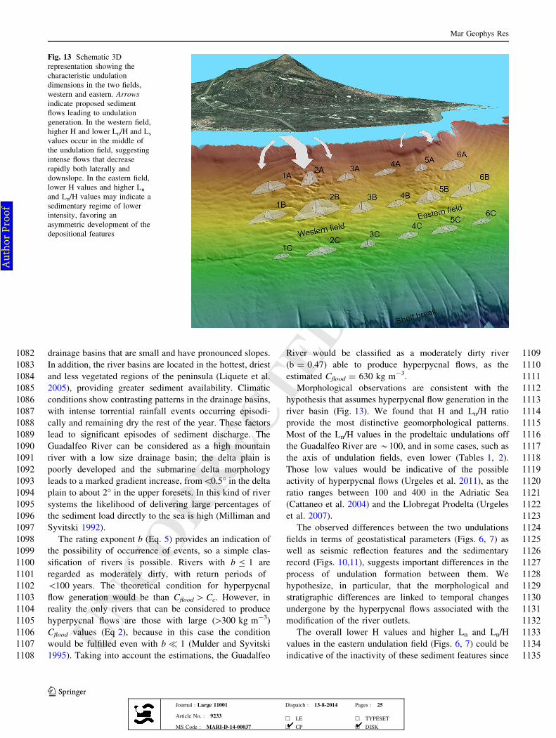
UNCORRECTEDPR
OOF
1082 drainage basins that are small and have pronounced slopes.
1083 In addition, the river basins are located in the hottest, driest
1084 and less vegetated regions of the peninsula (Liquete et al.
1085 2005), providing greater sediment availability. Climatic
1086 conditions show contrasting patterns in the drainage basins,
1087 with intense torrential rainfall events occurring episodi-
1088 cally and remaining dry the rest of the year. These factors
1089 lead to significant episodes of sediment discharge. The
1090 Guadalfeo River can be considered as a high mountain
1091 river with a low size drainage basin; the delta plain is
1092 poorly developed and the submarine delta morphology
1093 leads to a marked gradient increase, from\0.5" in the delta
1094 plain to about 2" in the upper foresets. In this kind of river
1095 systems the likelihood of delivering large percentages of
1096 the sediment load directly to the sea is high (Milliman and
1097 Syvitski 1992).
1098 The rating exponent b (Eq. 5) provides an indication of
1099 the possibility of occurrence of events, so a simple clas-
1100 sification of rivers is possible. Rivers with b B 1 are
1101 regarded as moderately dirty, with return periods of
1102 \100 years. The theoretical condition for hyperpycnal
1103 flow generation would be than Cflood[Cc. However, in
1104 reality the only rivers that can be considered to produce
1105 hyperpycnal flows are those with large ([300 kg m-3)
1106 Cflood values (Eq 2), because in this case the condition
1107 would be fulfilled even with b ' 1 (Mulder and Syvitski
1108 1995). Taking into account the estimations, the Guadalfeo
1109River would be classified as a moderately dirty river
1110(b = 0.47) able to produce hyperpycnal flows, as the
1111estimated Cflood = 630 kg m-3.
1112Morphological observations are consistent with the
1113hypothesis that assumes hyperpycnal flow generation in the
1114river basin (Fig. 13). We found that H and Ln/H ratio
1115provide the most distinctive geomorphological patterns.
1116Most of the Ln/H values in the prodeltaic undulations off
1117the Guadalfeo River are *100, and in some cases, such as
1118the axis of undulation fields, even lower (Tables 1, 2).
1119Those low values would be indicative of the possible
1120activity of hyperpycnal flows (Urgeles et al. 2011), as the
1121ratio ranges between 100 and 400 in the Adriatic Sea
1122(Cattaneo et al. 2004) and the Llobregat Prodelta (Urgeles
1123et al. 2007).
1124The observed differences between the two undulations
1125fields in terms of geostatistical parameters (Figs. 6, 7) as
1126well as seismic reflection features and the sedimentary
1127record (Figs. 10,11), suggests important differences in the
1128process of undulation formation between them. We
1129hypothesize, in particular, that the morphological and
1130stratigraphic differences are linked to temporal changes
1131undergone by the hyperpycnal flows associated with the
1132modification of the river outlets.
1133The overall lower H values and higher Ln and Ln/H
1134values in the eastern undulation field (Figs. 6, 7) could be
1135indicative of the inactivity of these sediment features since
Fig. 13 Schematic 3Drepresentation showing thecharacteristic undulationdimensions in the two fields,western and eastern. Arrowsindicate proposed sedimentflows leading to undulationgeneration. In the western field,higher H and lower Ln/H and Ls
values occur in the middle ofthe undulation field, suggestingintense flows that decreaserapidly both laterally anddownslope. In the eastern field,lower H values and higher Ln
and Ln/H values may indicate asedimentary regime of lowerintensity, favoring anasymmetric development of thedepositional features
Mar Geophys Res
123Journal : Large 11001 Dispatch : 13-8-2014 Pages : 25
Article No. : 9233h LE h TYPESET
MS Code : MARI-D-14-00037 h CP h DISK4 4
Au
tho
r P
roo
f
UNCORRECTEDPR
OOF
1136 the change in river course. The lateral variability patterns
1137 in the geostatistical parameters are also different. The H
1138 values in the eastern field are not as symmetric as for the
1139 western field. From this we infer that the eastern field
1140 sedimentary regime would be of lower energy. In addition,
1141 depositional conditions would have developed an asym-
1142 metrical sediment lobe, as the area with higher undulations
1143 appears to be broader and displaced eastward (Fig. 6). In
1144 addition, seismic data do not show abundant intra-undu-
1145 lation reflections, which would be in agreement with the
1146 field inactivity (Fig. 10b).
1147 Higher H values and lower Ln/H values in the western
1148 undulation field (Fig. 6) could be indicative of the inten-
1149 sification of riverine flows after the river deviation took
1150 place. The shallow subsurface stratigraphy also shows
1151 frequent subparallel reflections that provide evidence of
1152 active shoreward migration (Fig. 11b). The identification
1153 of symmetrical patterns of several parameters (e.g., H, Ln
1154 and Ln/H distributions) around the present river mouth in
1155 the western field may indicate that the undulations in the
1156 western field result from highly focused flows, where
1157 current velocity and capacity for sediment transport
1158 decrease rapidly to either side. Consequently, a temporal
1159 change in the nature of the sediment supply can be inferred,
1160 as the riverine flows became more focused and intense after
1161 the river deviation. The sedimentary texture of the western
1162 undulation field reveals a slightly finer grain size compo-
1163 sition that may indicate that the most recent influence on
1164 sediment supply of dam construction in the drainage basin.
1165 Conclusions
1166 Our analysis provides morphologic and stratigraphic evi-
1167 dence supporting the hypothesis that the prodeltaic undu-
1168 lations can be considered as a type of sediment waves. Key
1169 geostatistical parameters, particularly H and Ln/H, exhibit
1170 fairly consistent distribution patterns, especially in the
1171 along-shelf direction, with respect to historic and present-
1172 day outlets of the Guadalfeo River. This variability can be
1173 used to make predictive assessments in other areas where
1174 the primary wave-forming process is unknown.
1175 Morphometric parameters of the drainage basin and
1176 estimations of sediment concentration during episodic
1177 flood events are compatible with the major influence of
1178 hyperpycnal flows and deposition at short distance from the
1179 coast. The morphological characteristics of the Guadalfeo
1180 River prodelta undulations suggest the imprint of intense
1181 downslope sediment flows emanating from river outlets,
1182 with increased proportions of bedload sediment transport in
1183 relation with other undulation areas. Lateral changes in the
1184 geomorphological variables and in the seismic and sedi-
1185 mentological features are considered to be indicative of the
1186temporal change undergone by hyperpycnal flows associ-
1187ated with the shift in river outlet. Future work in the area
1188should be aimed at validating the estimations of sediment
1189concentration by collecting sediment load data under dif-
1190ferent water discharge conditions.
1191Acknowledgments Multibeam data were collected within the1192framework of the ESPACE (‘‘Estudio Geologico de la Plataforma1193Continental Espanola’’) project, executed by the ‘‘Instituto Espanol de1194Oceanografıa (IEO)’’ and the ‘‘Secretarıa General de Pesca Marıtima1195(SGPM)’’. This work is a contribution to the research projects1196MOSAICO, TESELA, CTM2005-04960/MAR and CGL2011-30302-1197C02-02. This contribution was elaborated during a research stage of1198the first author at the Institute for Geophysics, Jackson School of1199Geosciences, University of Texas at Austin, during May to August12002009. This stage was funded by the ‘‘Jose Castillejo’’ program1201(JC2008-00210), call of the Spanish Ministry for Science and Inno-1202vation to support short stages for young doctors in foreign research1203centers. Isabel Mendes thanks to the Portuguese Foundation for Sci-1204ence and Technology (FCT) for grant SFRH/BPD/72869/2010. Use-1205ful comments and remarks concerning hyperpycnal flow development1206were made by James P.M. Syvitski (University of Colorado at1207Boulder) and Thierry Mulder (Universite de Bordeaux 1). Two1208anonymous reviewers are sincerely thanked because of their con-1209structive suggestions that helped to improve the manuscript. UTIG1210Contribution #2717.
1211References
1212Almagro J (1932) Torrentes y Pantanos en Sierra Nevada. Madrid1213Antonov JI, Seidov D, Boyer TP, Locarnini RA, Mishonov AV,1214Garcia HE, Baranova OK, Zweng MM, Johnson DR (2010)1215World Ocean Atlas 2009, Volume 2: Salinity. In: Levitus S (ed)1216NOAA Atlas NESDIS 69. U.S. Government Printing Office,1217Washington, DC1218Barcenas P, Fernandez-Salas LM, Macıas J, Lobo FJ, Dıaz del Rıo V1219(2009) Estudio morfometrico comparativo entre las ondulaciones1220de los prodeltas de los rıos de Andalucıa Oriental. Rev Soc Geol1221Esp 22(1–2):43–561222Barcenas P, Lobo FJ, Macıas J, Fernandez-Salas LM, Dıaz del Rıo V1223(2011) Spatial variability of surficial sediments on the northern1224shelf of the Alboran Sea: the effects of hydrodynamic forcing1225and supply of sediment by rivers. J Iber Geol 37(2):195–214.1226doi:10.5209/rev_JIGE.2011.v37.n2.81227Bellotti P, Chiocci FL, Milli S, Tortora P, Valeri P (1994) Sequence1228stratigraphy and depositional setting of the Tiber delta: integra-1229tion of high-resolution seismics, well logs and archeological1230data. J Sedim Res 64(3b):416–432. doi:10.1306/D4267FDC-12312B26-11D7-8648000102C1865D1232Berndt C, Cattaneo A, Szuman M, Trincardi F, Masson D (2006)1233Sedimentary structures offshore Ortona, Adriatic Sea: deforma-1234tion or sediment waves? Mar Geol 234(1–4):261–270. doi:10.12351016/j.margeo.2006.09.0161236Bøe R, Bugge T, Rise L, Eidnes G, Eide A, Mauring E (2004)1237Erosional channel incision and the origin of large sediment1238waves in Trondheimsfjorden, central Norway. Geo-Mar Lett123924(4):225–240. doi:10.1007/s00367-004-0180-31240Brazdil R, Glaser R, Pfister C, Dobrovolny P, Antoine J-M,1241Barriendos M, Camuffo D, Deutsch M, Enzi S, Guidoboni E,1242Kotyza O, Rodrigo F (1999) Flood events of selected European1243Rivers in the Sixteenth Century. Clim Chang 43(1):239–285.1244doi:10.1023/A:1005550401857
AQ3
Mar Geophys Res
123Journal : Large 11001 Dispatch : 13-8-2014 Pages : 25
Article No. : 9233h LE h TYPESET
MS Code : MARI-D-14-00037 h CP h DISK4 4
Au
tho
r P
roo
f
UNCORRECTEDPR
OOF
1245 Budillon F, Violante C, Conforti A, Esposito E, Insinga D, Iorio M,1246 Porfido S (2005) Event beds in the recent prodelta stratigraphic1247 record of the small flood-prone Bonea Stream (Amalfi Coast,1248 Southern Italy). Mar Geol 222–223:419–441. doi:10.1016/j.1249 margeo.2005.06.0131250 Carle L, Hill PR (2009) Subaqueous dunes of the upper slope of the1251 fraser river delta (British Columbia, Canada). J Coast Res1252 25(2):448–458. doi:10.2112/06-0796.11253 Cattaneo A, Correggiari A, Marsset T, Thomas Y, Marsset B,1254 Trincardi F (2004) Seafloor undulation pattern on the Adriatic1255 shelf and comparison to deep-water sediment waves. Mar Geol1256 213(1–4):121–148. doi:10.1016/j.margeo.2004.10.0041257 Correggiari A, Trincardi F, Langone L, Roveri M (2001) Styles of1258 failure in late holocene highstand prodelta wedges on the adriatic1259 shelf. J Sedim Res 71(2):218–236. doi:10.1306/0428007102181260 Dıaz JI, Ercilla G (1993) Holocene depositional history of the1261 Fluvia—Muga prodelta, northwestern Mediterranean Sea. Mar1262 Geol 111(1–2):83–92. doi:10.1016/0025-3227(93)90189-31263 Ercilla G, Alonso B, Baraza J (1992) Sedimentary evolution of the1264 northwestern Alboran Sea during the quaternary. Geo-Mar Lett1265 12(2–3):144–149. doi:10.1007/BF020849251266 Ercilla G, Alonso B, Baraza J (1994) Post-calabrian sequence1267 stratigraphy of the northwestern Alboran Sea (southwestern1268 Mediterranean). Mar Geol 120(3–4):249–265. doi:10.1016/1269 0025-3227(94)90061-21270 Ercilla G, Dıaz JI, Alonso B, Farran M (1995) Late pleistocene-1271 holocene sedimentary evolution of the northern Catalonia1272 continental shelf (northwestern Mediterranean Sea). Cont Shelf1273 Res 15(11–12):1435–1451. doi:10.1016/0278-4343(94)00089-61274 Fernandez-Salas LM, Lobo FJ, Hernandez-Molina FJ, Somoza L,1275 Rodero J, Dıaz del Rıo V, Maldonado A (2003) High-resolution1276 architecture of late Holocene highstand prodeltaic deposits from1277 southern Spain: the imprint of high-frequency climatic and relative1278 sea-level changes. Cont Shelf Res 23(11–13):1037–1054. doi:10.1279 1016/S0278-4343(03)00120-11280 Fernandez-Salas LM, Lobo FJ, Sanz JL, Dıaz-del-Rıo V, Garcıa MC,1281 Moreno I (2007) Morphometric analysis and genetic implica-1282 tions of pro-deltaic sea-floor undulations in the northern Alboran1283 Sea margin, western Mediterranean Basin. Mar Geol1284 243(1–4):31–56. doi:10.1016/j.margeo.2007.04.0131285 Garcıa-Lafuente J, Cano N, Vargas M, Rubın JP, Hernandez-Guerra1286 A (1998) Evolution of the Alboran Sea hydrographic structures1287 during July 1993. Deep Sea Res Part I: Oceanograp Res Papers1288 45(1):39–65. doi:10.1016/S0967-0637(97)00216-11289 Goff JA, Jordan TH (1988) Stochastic modeling of seafloor1290 morphology: inversion of sea beam data for second-order1291 statistics. J Geophys Res 93(B11):13589–13608. doi:10.1029/1292 JB093iB11p135891293 Goff JA, Jordan TH (1989a) Stochastic modeling of seafloor1294 morphology: a parameterized Gaussian model. Geophys Res1295 Lett 16(1):45–48. doi:10.1029/GL016i001p000451296 Goff JA, Jordan TH (1989b) Stochastic modeling of seafloor1297 morphology; resolution of topographic parameters by sea beam1298 data. IEEE J Ocean Eng 14(4):326–337. doi:10.1109/48.359831299 Hasiotis T, Charalampakis M, Stefatos A, Papatheodorou G, Feren-1300 tinos G (2006) Fan delta development and processes offshore a1301 seasonal river in a seismically active region. NW Gulf of1302 Corinth. Geo-Mar Lett 26(4):199–211. doi:10.1007/s00367-006-1303 0020-81304 Hernandez-Molina FJ, Somoza L, Rey J, Pomar L (1994) Late1305 pleistocene-holocene sediments on the Spanish continental shelves:1306 model for very high resolution sequence stratigraphy. Mar Geol1307 120(3–4):129–174. doi:10.1016/0025-3227(94)90057-41308 Imran J, Syvitski JPM (2000) Impact of extreme river events on the1309 coastal ocean. Oceanogr 13(3):85–92. doi:10.5670/oceanog.1310 2000.17
1311Jabaloy-Sanchez A, Lobo FJ, Azor A, Martın-Rosales W, Perez-Pena1312JV, Barcenas P, Macıas J, Fernandez-Salas LM, Vazquez-1313Vılchez M (2014) Six thousand years of coastline evolution in1314the Guadalfeo deltaic system (southern Iberian Peninsula).1315Geomorphol 206:374–391. doi:10.1016/j.geomorph.2013.08.0371316Jimenez-Sanchez J, Martın-Rosales W, Fernandez-Chacon F, Rubio-1317Campos JC (2008) Variabilidad temporal de las precipitaciones1318en la Cuenca del rıo Guadalfeo (provincia de Granada). Agua y1319Cultura, Publicaciones del Instituto Geologico y Minero de1320Espana, Madrid, vol 2, pp 159–1681321Lee SH, Chough SK (2001) High-resolution (2–7 kHz) acoustic and1322geometric characters of submarine creep deposits in the South1323Korea Plateau East Sea. Sedimentol 48(3):629–644. doi:10.1046/1324j.1365-3091.2001.00383.x1325Lee HJ, Syvitski JPM, Parker G, Orange D, Locat J, Hutton EWH,1326Imran J (2002) Distinguishing sediment waves from slope failure1327deposits: field examples, including the ‘Humboldt slide’, and1328modelling results. Mar Geol 192(1–3):79–104. doi:10.1016/1329S0025-3227(02)00550-91330Levchenko OV, Roslyakov AG (2010) Cyclic sediment waves on1331western slope of the Caspian Sea as possible indicators of main1332transgressive/regressive events. Quat Int 225(2):210–220.1333doi:10.1016/j.quaint.2009.12.0011334Liquete C, Arnau P, Canals M, Colas S (2005) Mediterranean river1335systems of Andalusia, southern Spain, and associated deltas: a1336source to sink approach. Mar Geol 222–223:471–495. doi:10.13371016/j.margeo.2005.06.0331338Lobo FJ, Fernandez-Salas LM, Moreno I, Sanz JL, Maldonado A1339(2006) The sea-floor morphology of a Mediterranean shelf fed by1340small rivers, northern Alboran Sea margin. Cont Shelf Res134126(20):2607–2628. doi:10.1016/j.csr.2006.08.0061342Lobo FJ, Maldonado A, Hernandez-Molina FJ, Fernandez-Salas LM,1343Ercilla G, Alonso B (2008) Growth patterns of a proximal1344terrigenous margin offshore the Guadalfeo River, northern1345Alboran Sea (SW Mediterranean Sea): glacio-eustatic control1346and disturbing tectonic factors. Mar Geophys Res 29(3):195–216.1347doi:10.1007/s11001-008-9058-51348Locarnini RA, Mishonov AV, Antonov JI, Boyer TP, Garcia HE,1349Baranova OK, Zweng MM, Johnson DR (2010) World Ocean1350Atlas 2009, Volume 1: Temperature. In: Levitus S (ed) NOAA1351Atlas NESDIS 69. U.S. Government Printing Office, Washing-1352ton, DC1353Lykousis V (1991) Submarine slope instabilities in the Hellenic arc1354region, northeastern Mediterranean Sea. Mar Geotechnol135510(1–2):83–96. doi:10.1080/106411991093798841356Lykousis V, Sakellariou D, Roussakis G (2003) Prodelta slope1357stability and associated coastal hazards in tectonically active1358margins: Gulf of Corinth (NE Mediterranean). In: Locat J,1359Mienert J (eds) Submarine mass movements and their conse-1360quences. Kluwer Academic Publishers, pp 433–4401361Lykousis V, Roussakis G, Sakellariou D (2009) Slope failures and1362stability analysis of shallow water prodeltas in the active margins1363of Western Greece, northeastern Mediterranean Sea. Int J Earth1364Sci 98(4):807–822. doi:10.1007/s00531-008-0329-91365Macıas D, Bruno M, Echevarrıa F, Vazquez A, Garcıa CM (2008)1366Meteorologically-induced mesoscale variability of the North-1367western Alboran Sea (southern Spain) and related biological1368patterns. Estuar Coast Shelf Sci 78(2):250–266. doi:10.1016/j.1369ecss.2007.12.0081370Marsset T, Marsset B, Thomas Y, Cattaneo A, Thereau E, Trincardi F,1371Cochonat P (2004) Analysis of Holocene sedimentary features on1372the Adriatic shelf from 3Dvery high resolution seismic data (Triad1373survey). Mar Geol 213(1–4):73–89. doi:10.1016/j.margeo.2004.137410.0021375Martın-Rosales W, Pulido-Bosch A, Gisbert J, Vallejos A (2003)1376Sediment yield estimations and check dams in a semiarid area
Mar Geophys Res
123Journal : Large 11001 Dispatch : 13-8-2014 Pages : 25
Article No. : 9233h LE h TYPESET
MS Code : MARI-D-14-00037 h CP h DISK4 4
Au
tho
r P
roo
f
UNCORRECTEDPR
OOF
1377 (Sierra de Gador, southern Spain). In: de Boer DH, Froehlich W,1378 Mizuyama T, Pietroniro A (eds) erosion prediction in ungauged1379 basins: integrated methods and techniques. Proceeding of1380 symposium HS01 Sapporo, IAHS Publ no. 279, pp 51–581381 Matthai HF (1990) Floods. In: Wolman MG, Rigss HC (eds) The1382 Geology of North America: Vol. O-1, Surface water hydrology.1383 Boulder, Colorado, Geological Society of America, pp 97–1201384 Milia A, Molisso F, Raspini A, Sacchi M, Torrente MM (2008)1385 Syneruptive features and sedimentary processes associated with1386 pyroclastic currents entering the sea: the AD 79 eruption of1387 Vesuvius, Bay of Naples. Italy. J Geol Soc 165(4):839–848.1388 doi:10.1144/0016-76492007-1101389 Milliman JD, Syvitski JPM (1992) Geomorphic/tectonic control of1390 sediment discharge to the ocean: the importance of small1391 mountainous rivers. J Geol 100(5):525–5441392 Mulder T, Syvitski JPM (1995) Turbidity currents generated at river1393 mouths during exceptional discharges to the world oceans.1394 J Geol 103(3):285–2991395 Mulder T, Syvitski JPM, Migeon S, Faugeres J-C, Savoye B (2003)1396 Marine hyperpycnal flows: initiation, behavior and related1397 deposits. A review. Mar Petrol Geol 20(6–8):861–882. doi:10.1398 1016/j.marpetgeo.2003.01.0031399 Munoz A, Ballesteros M, Montoya I, Rivera J, Acosta J, Uchupi E1400 (2008) Alboran basin, southern Spain-Part I: geomorphology.Mar1401 Petrol Geol 25(1):59–73. doi:10.1016/j.marpetgeo.2007.05.0031402 Normark WR, Piper DJW (1991) Initiation processes and flow1403 evolution of turbidity currents: implications for the depositional1404 record. In: Osborne RH (ed) From Shoreline to abyss: contri-1405 butions to marine geology in honor of Francis Parker Shepard.1406 SEPM Special Publication, vol 46. SEPM (Society for Sedi-1407 mentary Geology), pp 207–230. doi: 10.2110/pec.91.09.02071408 Parsons JD, Bush JWM, Syvitski JPM (2001) Hyperpycnal plume1409 formation from riverine outflows with small sediment concen-1410 trations. Sedimentol 48(2):465–478. doi:10.1046/j.1365-3091.1411 2001.00384.x1412 Perkins H, Kinder T, Violette PL (1990) The Atlantic inflow in the1413 Western Alboran Sea. J Phys Ocean 20(2):242–263. doi:10.1414 1175/1520-0485(1990)0201415 Ponce JJ, Carmona N (2011) Coarse-grained sediment waves in1416 hyperpycnal clinoform systems, Miocene of the Austral foreland1417 basin, Argentina. Geology 39(8):763–766. doi:10.1130/g31939.11418 Puig P, Ogston AS, Guillen J, Fain AMV, Palanques A (2007)1419 Sediment transport processes from the topset to the foreset of a1420 crenulated clinoform (Adriatic Sea). Cont Shelf Res1421 27(3–4):452–474. doi:10.1016/j.csr.2006.11.0051422 Rebesco M, Neagu RC, Cuppari A, Muto F, Accettella D, Dominici R,1423 Cova A, Romano C, Caburlotto A (2009) Morphobathymetric1424 analysis and evidence of submarine mass movements in the1425 western Gulf of Taranto (Calabria margin, Ionian Sea). Int J Earth1426 Sci 98(4):791–805. doi:10.1007/s00531-009-0429-11427 Rodrigo FS, Esteban-ParraMJ, Pozo-VazquezD,Castro-DıezY (1999)1428 A 500-year precipitation record in Southern Spain. Int J Climatol1429 19(11):1233–1253. doi:10.1002/(sici)1097-0088(199909)19:11\1430 1233:aid-joc413[3.0.co;2-l
1431Rodrigo FS, Esteban-Parra MJ, Pozo-Vazquez D, Castro-Dıez Y1432(2000) Rainfall variability in southern Spain on decadal to1433centennial time scales. Int J Climatol 20(7):721–732. doi:10.14341002/1097-0088(20000615)20:7\721:aid-joc520[3.0.co;2-q1435Rodrıguez Berzosa P, De la Pena JM (1994) Evolucion del delta del1436rıo Guadalfeo. Ing Civ 94:75–841437Sacchi M, Insinga D, Milia A, Molisso F, Raspini A, Torrente MM,1438Conforti A (2005) Stratigraphic signature of the Vesuvius 79 AD1439event off the Sarno prodelta system, Naples Bay. Mar Geol1440222–223:443–469. doi:10.1016/j.margeo.2005.06.0141441Sacchi M, Molisso F, Violante C, Esposito E, Insinga D, Lubritto C,1442Porfido S, Toth T (2009) Insights into flood-dominated fan-1443deltas: very high-resolution seismic examples off the Amalfi1444cliffed coasts, eastern Tyrrhenian Sea. In: Violante C (ed)1445Geohazard in Rocky Coastal Areas. Geological Society, London,1446Special Publications, vol 322. Geological Society, London,1447pp 33–71. doi: 10.1144/sp322.21448Sultan N, Cattaneo A, Urgeles R, Lee H, Locat J, Trincardi F, Berne S,1449Canals M, Lafuerza S (2008) A geomechanical approach for the1450genesis of sediment undulations on the Adriatic shelf. Geochem1451Geophys Geosyst 9:Q04R03. doi:10.1029/2007GC0018221452Syvitski JP, Morehead MD, Bahr DB, Mulder T (2000) Estimating1453fluvial sediment transport: the rating parameters. Water Resour1454Res 36(9):2747–2760. doi:10.1029/2000wr9001331455Trincardi F, Normark W (1988) Sediment waves on the Tiber prodelta1456slope: interaction of deltaic sedimentation and currents along the1457shelf. Geo-Mar Lett 8(3):149–157. doi:10.1007/bf023260911458Urgeles R, De Mol B, Liquete C, Canals M, De Batist M, Hughes-1459Clarke JE, Amblas D, Arnau PA, Calafat AM, Casamor JL,1460Centella V, De Rycker K, Fabres J, Frigola J, Lafuerza S, Lastras1461G, Sanchez A, Zuniga D, Versteeg W, Willmott V (2007)1462Sediment undulations on the Llobregat prodelta: signs of early1463slope instability or sedimentary bedforms? J Geophys Res: Solid1464Earth 112(B5):B05102. doi:10.1029/2005JB0039291465Urgeles R, Cattaneo A, Puig P, Liquete C, De Mol B, Amblas D,1466Sultan N, Trincardi F (2011) A review of undulated sediment1467features on Mediterranean prodeltas: distinguishing sediment1468transport structures from sediment deformation. Mar Geophys1469Res 32(1):49–69. doi:10.1007/s11001-011-9125-11470Warrick JA, Milliman JD (2003) Hyperpycnal sediment discharge1471from semiarid southern California rivers: implications for coastal1472sediment budgets. Geol 31(9):781–784. doi:10.1130/g19671.11473Wessel P, Smith WHF (1991) Free software helps map and display1474data. EOS Trans 72:4411475Wynn RB, Stow DAV (2002) Classification and characterisation of1476deep-water sediment waves. Mar Geol 192(1–3):7–22. doi:10.14771016/S0025-3227(02)00547-91478Xu JP, Wong FL, Kvitek R, Smith DP, Paull CK (2008) Sandwave1479migration in Monterey submarine canyon Central California.1480Mar Geol 248(3–4):193–212. doi:10.1016/j.margeo.2007.11.005
AQ4
Mar Geophys Res
123Journal : Large 11001 Dispatch : 13-8-2014 Pages : 25
Article No. : 9233h LE h TYPESET
MS Code : MARI-D-14-00037 h CP h DISK4 4
Au
tho
r P
roo
f