Southern Illinois Invasive Species Strike Team
100
S S o o u u t t h h e e r r n n I I l l l l i i n n o o i i s s I I n n v v a a s s i i v v e e S S p p e e c c i i e e s s S S t t r r i i k k e e T T e e a a m m 2 2 0 0 1 1 0 0 A A n n n n u u a a l l R R e e p p o o r r t t
-
Upload
khangminh22 -
Category
Documents
-
view
3 -
download
0
Transcript of Southern Illinois Invasive Species Strike Team

SSoouutthheerrnn IIlllliinnooiiss
IInnvvaassiivvee SSppeecciieess SSttrriikkee TTeeaamm
22001100 AAnnnnuuaall RReeppoorrtt


Southern Illinois Invasive Species Strike Team
2010 Annual Report
Prepared by Bruce Henry and Brooks Davey Invasive Species Strike Team
This program was funded through:
A grant supported by the USDA Forest Service Northeast Area State and Private Forestry,
the Illinois Department of Natural Resources, The Nature Conservancy, and the River to River Cooperative Weed Management Area

Acknowledgements
This program was funded through a grant supported by the USDA Forest Service Northeast Area State and Private Forestry, the Illinois Department of Natural Resources, The Nature Conservancy,
and the River to River Cooperative Weed Management Area
Contributions to this report were provided by: Bruce Henry and Brooks Davey, Invasive Species Strike Team;
Chris Evans, River to River Cooperative Weed Management Area; Jody Shimp, Natural Heritage Division, Illinois Department of Natural Resources;
Karen Tharp, The Nature Conservancy
Equal opportunity to participate in programs of the Illinois Department of Natural Resources (IDNR) and those funded by the U.S.D.A Forest Service and other agencies is available to all individuals regardless of race, sex, national origin, disability, age, religion or other non-merit factors. If you believe you have been discriminated against, contact the funding source‟s civil
rights office and/or the Equal Employment Opportunity Officer, IDNR, One Natural Resources Way, Springfield, IL. 62702-1271; 217/782-2262; TTY 217/782-9175.

- 1 - | P a g e
Executive Summary
The Nature Conservancy, in partnership with the Illinois Department of Natural Resources, and the USDA Forest Service Northeast Area State and Private Forestry Program developed the Southern Illinois Invasive Species Strike Team (ISST) “formally known as the Southern Illinois Exotic Plant Strike Team” to control exotic plants in state parks, state nature preserves and adjacent private lands that serve as pathways onto these properties. This Strike Team is modeled after the very successful National Park Service Exotic Plant Management Team Program, and deploys trained, mobile force of two plant management specialists who assist parks and preserves in controlling invasive, exotic plants. This report covers the results from the second year of the Strike Team program which was initiated in 2008-09. This program focuses on detection and removal of the invasive plant species and populations which pose the greatest threat to the ecological integrity of the natural areas in the southern Illinois region. Once risk has been identified, the Strike Team also serves as a Rapid Response Team. Applying the Early Detection & Rapid Response approach to invasive species management greatly improves the likelihood that invasions will be addressed successfully while populations are still localized and containable. The Southern Illinois Invasive Species Strike Team has primary responsibility for species identification, containment, eradication, and monitoring. The Invasive Species Strike Team served 11 counties (Alexander, Gallatin, Hardin, Jackson, Johnson, Massac, Pope, Pulaski, Saline, Williamson and Union) in southern Illinois. The Strike Team works under the direction of The Nature Conservancy and the Illinois Department of Natural Resources approved management schedules, Integrated Weed Management Plans, and work plans for state parks and preserves. The Nature Conservancy works with Illinois Department of Natural Resources biologists and the River to River Cooperative Weed Management Area Coordinator to determine priorities for the Strike Team for combating exotic plants that reflect the needs and resources of the parks they serve. Priorities are based on the following factors: severity of threat to high-quality natural areas and rare species; extent of targeted infestation; probability of successful control and potential for restoration; opportunities for public involvement; and park commitment to follow-up monitoring and treatment. The Strike Team conducts and evaluates the removal of exotic species, and take appropriate native species restoration efforts. The Invasive Species Strike Team worked year round and treated 2,476 acres of 11 different non-native invasive plant species. Treating exotics was the focal point of the Strike Team comprising 40 percent of their time. Comprehensive time and treatment records were taken by the Strike Team and will be used to refine the teams operations and assess treatment success.
Japanese Stilt Grass (Microstegium vimineum)

- 2 - | P a g e

- 3 - | P a g e
Table of Contents
Introduction ................................................................................................................................... 5
Program Accomplishments ......................................................................................................... 6
Research .......................................................................................................................................... 6
Surveying and Monitoring .......................................................................................................... 6
Treatment and Prevention ........................................................................................................... 7
Cooperation and Collaboration .................................................................................................. 8
Safety ............................................................................................................................................. 10
Early Detection Rapid Response (EDRR) ................................................................................ 10
Invasive Species Strike Team Location Map ........................................................................... 11
Natural Areas
Berryville Shale Glade Nature Preserve ..................................................................... 11
Brown Barrens Nature Preserve .................................................................................. 14
Cache River State Natural Area ................................................................................... 16
Cave in Rock State Park ................................................................................................ 18
Cedar Draper Bluff Land and Water Reserve .................................................................. 20
Chestnut Hills Nature Preserve ........................................................................................... 24
Collier Glade Nature Preserve ............................................................................................. 26
Cretaceous Hills Nature Preserve ....................................................................................... 28
Cypress Pond State Natural Area ........................................................................................ 30
Degognia Canyon Land and Water Reserve .................................................................... 32
Dixon Springs State Park .............................................................................................. 34
Faulkner-Franke Pioneer Railroad Prairie Nature Preserve........................................ 36
Fern Rocks Nature Preserve ......................................................................................... 38
Ferne Clyffe State Park .................................................................................................. 40
Giant City State Park ..................................................................................................... 42
Gibbons Creek Barrens State Natural Area ...................................................................... 44
Grassy Slough Land and Water Reserve ........................................................................... 46
Hayes Creek Canyon Horse Campground ....................................................................... 48
Heron Pond-Little Black Slough Nature Preserve .......................................................... 50
Horsefly Ridge Nature Preserve .......................................................................................... 52
Horseshoe Lake Nature Preserve ........................................................................................ 54

- 4 - | P a g e
Table of Contents (continued)
Natural Areas (continued)
IDNR Region 5 Office .................................................................................................... 56
Lake Murphysboro State Park ...................................................................................... 58
Lusk Creek Canyon Nature Preserve ................................................................................. 60
Lusk Creek Sanctuary .................................................................................................... 62
Mermet Swamp Nature Preserve ........................................................................................ 64
Ozark Hills Nature Preserve ........................................................................................ 66
Pyramid State Park ........................................................................................................ 68
Rauchfuss Hill State Recreation Area................................................................................. 70
Round Bluff Nature Preserve ....................................................................................... 72
Section 8 Wood Nature Preserve ......................................................................................... 74
Trail of Tears State Forest ............................................................................................. 76
Tunnel Hill State Trail ................................................................................................... 78
Union County State Fish and Wildlife Area..................................................................... 82
Appendix
Appendix A: Time Allocation ............................................................................................. 84
Appendix B: New Invasive Species Alert (Japanese Chaff Flower) ......................... 85
Appendix C: Invasive Plant Treatment Calendar ......................................................... 86
Appendix D: Standard Operating Procedures ............................................................... 87

Introduction
“On a global basis… the two greatest threats to biodiversity are habitat destruction and invasion by exotic species” -E.O. Wilson In a 2005 report, the economic costs associated with exotic species in the United States were estimated at over $120 billion/year. (Ecological Economics (52):273-288). In southern Illinois alone, over two dozen species of invasive plants have been marked as priority for removal. Invasive plants change the structure and composition of native ecosystems by contributing to soil erosion, altering the availability of water, changing soil chemistry, and choking out native flora. Because they have no natural enemies, and thus spread rapidly, invasive species diminish biodiversity and pose a threat to rare and unique species while effecting enormous costs on agriculture, forestry, fisheries and other human enterprises.
Chinese Yam infestation (credit: Chris Evans)
With funding from USDA Forest Service, Northeastern Area, State and Private Forestry, Forest Health Protection Program and the Illinois Department of Resources and with cooperation from the River to River CWMA, The Nature Conservancy established a two-person team to work full-time, year-round on monitoring and controlling these invasive plants in southern Illinois.
In the fall of 2008, the Southern Illinois Invasive Species Strike Team (ISST) began work. The strike team helped control invasive species in nature preserves and natural areas in the southernmost 11 counties of Illinois. Using pesticides, mechanical methods and prescribed fire, the ISST was able to suppress well-established infestations as well as prevent future infestations by controlling invasive seedlings and saplings. By responding to early detection events and controlling invasive species in pathways of spread and corridors, the ISST decreased the potential spread of invasive plants onto natural areas.
This report reflects the Invasive Species Strike Team‟s second full year of invasive species treatments. From October 2009 through September 2010, the Strike Team completed treatments at 36 management sites throughout southern Illinois.
The areas surveyed for invasive species as well as the control methods used to treat the exotics in these areas were recorded in detail using The Nature Conservancy's Weed Information Management System (WIMS). This information allows populations of invasive plants to be monitored and compared year to year, and will help determine the best methods of control for exotic plants.
WIMS program on handheld PDA
The goal of the ISST is to reduce the effect of existing infestations, manage new infestations and re-establish native plant communities to restore ecosystem functions.
- 5 - | P a g e

- 6 - | P a g e
Program Accomplishments
The ISST played an important role in many aspects of managing the invasive species of southern Illinois, including research, surveying and monitoring, treatment, and prevention.
From October of 2009 through September of 2010, the ISST surveyed and treated 2476.6 acres of invasive plants, including 11 species in 36 areas.
Research To effectively treat invasives, the ISST worked with DNR heritage biologists and the CWMA to plan treatment methods for each infestation. This information, combined with a detailed description of each site (e.g. GPS coordinates, area sensitivity, landowner information, etc.), was compiled into a work order for each site. The ISST then used these work orders to prioritize and plan treatments. In addition to their normal tasks, the ISST worked with the US Forest Service (USFS), to create test plots to determine the effectiveness of natural herbicides. Non-chemical herbicides have the potential to minimize ecological damage in treatment areas and can be used in areas where pesticide use is discouraged or forbidden (e.g. USFS land or privately owned plots). Applying different concentrations of natural herbicides, and comparing the results to a control plot will determine the lowest effective application concentration. Cost effectiveness will also be determined. The USFS
will also test soil samples to determine any residual effects the natural herbicides may have.
Surveying and Monitoring The ISST surveyed natural areas to find and document new and known infestations. These areas were treated or were scheduled for later treatment when specific control would be most effective based on plant phenology.
To document and monitor the areas surveyed and treated, the ISST employed the Access-based Weed Information Management Systems (WIMS), created by The Nature Conservancy. WIMS allows the user to map points (corresponding to a specific weed infestation) as well as polygons (denoting the spread of each infestation) using ArcGIS.
Mapping Autumn Olive using WIMS
This data was overlaid on aerial or topographic maps to create visual images of the infestations. Such compositions are useful when planning for future treatments, determining changes in size and density of infestations, identifying possible sources of contamination (such as waterways or neighboring lands), and allowed the ISST to monitor their progress over time. Additionally, WIMS was used to record weather conditions, plant phenology and
Chemically Treated: 793.5 acres
Mechanically Treated: 31.1 acres
Treated with Prescribed Fire:
1,652 acres
Total Acres Treated: 2,476.6 acres

- 7 - | P a g e
density, and treatment data such as type and quantity of herbicide used. Such information is essential to determining the best control methods.
Treatment and Prevention Treatment, or control, of invasive plants was the focal point of the ISST. By implementing mechanical and chemical treatment techniques as well as prescribed fire the ISST treated over 2,000 acres from October 2009 through September 2010. Below are tables breaking down treatment activities by species and by method. Our official total acres treated will be represented by the WIMS report separating chemical treatments, mechanical treatment and prescribed fire treatments. No maps for kudzu (except for the infestation at Trail of Tears State Forest) are included in this report due to the fact that all but one infestation treated by the Strike Team occurred on privately owned land. These landowners have management agreements with the Illinois Department of Natural Resources. By treating near and along high-use areas such as campgrounds, trails and roads, the ISST helps to prevent the spread of seed to new areas. Working along stream corridors and drainages helped prevent spread downstream to sensitive areas. In addition to treating invasive species, the ISST developed a system to clean equipment to prevent the spread of invasive species. Boots and clothing were cleaned with an air compressor and brush, while the truck and ATVs were power washed on-site to prevent seeds from being transferred from one site to the next.
Invasive Species Acres Treated
Autumn olive (E. umbellata)
149.4
Bush honeysuckle (L. maackii)
115.2
Chinese yam (D. oppositifolia)
40.2
Garlic mustard (A. petiolata)
162.5
Tree of Heaven (A. altissima)
6.6
Japanese stiltgrass (M. vimineum)
361.9
Cutleaf teasel (D. laciniatus
0.1
Burning bush (E. alatus)
0.2
Oriental bittersweet (C. orbiculatus)
0.2
Japanese chaff flower (A. japonica)
6.8
Kudzu (P. Montana)
~20
Boot cleaning with air compressor

- 8 - | P a g e
Cooperation and Collaboration To increase the effectiveness of the ISST, cooperation and coordination between partnering agencies and private landowners was essential. While the ISST is employed by The Nature Conservancy, funding comes from the Illinois Department of Natural Resources (IDNR) and USDA Forest Service, Northeastern Area, State and Private Forestry, Forest Health Protection Program. Additionally, the River to River Cooperative Weed Management Area (CWMA) provided a wealth of information and an intern to participate in invasive species removal throughout the summer. The local IDNR Heritage Biologists provided three summer interns who participated in invasive treatment, monitoring, and research. Through inter-agency cooperation, the ISST was able to garner all the equipment and knowledge necessary for chemical and prescribed fire treatments, as well as the resources to collect and manage infestation data. Working with private landowners in areas adjoining state-dedicated natural areas, the ISST helped prevent the spread of exotics in ecologically sensitive areas. The following are examples that demonstrate collaborative work that the ISST participated in this past year.
Chinese yam treatment at Lusk Creek Sanctuary - owned by the Audubon Society, this site is surrounded by the Shawnee National Forests‟ Lusk Creek Wilderness. Last years‟ treatment marked the first time the Audubon Society has used herbicides at one of their sites. A follow-up treatment was performed this year.
Acid Seep Spring protection research at Cretaceous Hills Nature Preserve – The ISST assisted IDNR Heritage Biologists and interns with research, and with the help of the interns, chemically treated Japanese stiltgrass at the three state owned seep springs.
Garlic mustard treatment at Hayes Creek Canyon Campground – a privately owned horse campground with access to hundreds of miles of trails through state and federal land. Hayes Creek flows through the property and into the Shawnee National Forest. Reducing the amount of Garlic mustard seed is vital to keeping seeds from flowing into and infesting one of the National Forests‟ high quality natural areas.
Prescribed fire at Degognia Canyon – a privately owned land and water reserve noted for rare sandstone glades and population of state threatened Timber Rattlesnake.
Garlic mustard in the Buck Creek watershed in between Cedar Bluff land and water reserve and Ferne Clyffe State Park- By treating Garlic mustard at both Cedar Bluff and this privately owned property that connects two tracts of state land, we can help prevent the infestation from moving downstream into Ferne Clyffe State Park.
Sierra Club Garlic mustard pull- Sierra Club members assisted the ISST in pulling garlic mustard along a roadside that borders Section 8 Woods Nature Preserve to keep seed from disseminating into the nationally renowned Cache River watershed.
Prescribed fire at Faulkner-Franke Pioneer Railroad Prairie Nature Preserve – a privately owned nature preserve, this prairie is one of only two remaining high quality prairies in the Southern Till Plain Natural Division.

Species Control Work Accomplished in the Project Area by other means than the Strike Team
Site Species Acres Method Labor
Hours Source
Horseshoe Lake Nature Preserve
Garlic mustard 5 Garlon 3A foliar spray Contractor – Forest Improvements, Inc.
Boss Island Autumn Olive, Bush Honeysuckle
120 Glyphosate 5% Foliar & trichlopyri – cut stump
342 Contractor - Rock Road Ecological LLC.
Frankie Faulkner Nature Preserve
Autumn olive, Japanese honeysuckle, and Japanese hops
3 Glyphosate 5% Foliar & trichlopyri – cut stump
Contractor – Forest Improvements, Inc.
Ferne Clyffe State Park
Japanese Stilt Grass 0.5 Poast Plus (2.0 %), foliar spray from ATV power spray unit
1 Summer interns
Fern Rocks Nature Preserve
Japanese Stilt Grass 170 cutting/ weed whipping/ pulling
12.5 vvVolunteervV Giant City Friends Group
Ferne Clyffe, Deer Pond and Cypress Pond
Japanese Stiltgrass, Autumn Olive, Bush honeysuckle, bi-color lespedeza and multi-flora rose
2% glyphosate w/1% Garlon 3A on trail
108 Contractor – Forest Improvements, Inc.
Garlic mustard and Japanese stiltgrass control at Green Earth’s Chatauqua Bottoms- Green Earth, Inc. is a small non-profit NGO that owns and manages small nature preserves in and around Carbondale IL. With the help of about 60 Sixth graders the ISST and the CWMA pulled garlic mustard along a watershed in one of their nature preserves. The event was not only to prevent garlic mustard from taking over the understory of this small but environmentally and socially important ecosystem but to provide education on the value of preserving nature within an urban setting. The ISST assisted the summer interns with their Japanese stiltgrass control research at Chatauqua Bottoms.
Kudzu on private land- The ISST treated kudzu on numerous private properties. These landowners have management agreements with the Illinois Department of
Natural Resources and would not be able to effectively control this species without this assistance.
Chinese yam and Japanese stiltgrass treatments at Gibbons Creek Barrens State Natural Area - The ISST found and treated source populations of these two species on privately owned lands upstream of this high-quality site.
Chinese Yam at Dixon Springs State Park - Through private landowner assistance, the ISST found and treated a possible source population for Dixon Springs State Park‟s Chinese yam infestation.
Chemical treatment efforts at the privately owned Horsefly Ridge Nature Preserve occurred with the permission and guidance of the landowner.
- 9 - | P a g e

- 10 - | P a g e
Safety The ISST often works in demanding and potentially hazardous areas; safety is thus an important component of the ISST‟s work. The ISST often hikes long distances carrying backpack sprayers and navigating uneven and steep terrain. The inherent dangers of prescribed fire and the use of equipment such as herbicides, chainsaws, brushcutters and ATVs can also pose safety hazards. To address safety concerns, the ISST received extensive training in herbicide application, wildland fire, and chainsaw use. The ISST holds appropriate NWGC wildland fire certification, with an emphasis on prescribed fire. At each site, the ISST works as a pair to mitigate any safety issues that may arise. Planning ahead, researching terrain and local weather, as well as using radios, topographic maps and GPS systems in the field, contribute to a safe work environment. As a result, the ISST had a perfect safety record for the year.
Chainsaw training
Early Detection Rapid Response Early Detection Rapid Response (EDRR) events are an important aspect of the ISST‟s work. By detecting new infestations and treating the populations before they spread, valuable time and resources can be saved. As a preventative measure, EDRR is aimed at furthering the success of restoration efforts and maintaining
the pristine quality of existing ecological resources. Through contact with the River to River CWMA, the IDNR, concerned citizens, and the Strike Team, the Early Detection and Rapid Response events are reported and treated. During the year, the ISST completed several Early Detection and Rapid Response events.
Desoto Municipal Park- The Strike Team received a call from the Mayor of the Village of DeSoto, Illinois describing a small population of Kudzu in their city park.
Cedar Bluff Land and Water Reserve- A tip from the River to River CWMA and the IDNR led the Strike Team to a small population of Burning Bush along Buck Creek and a stand of Tree of Heaven atop the bluff.
Round Bluff Nature Preserve- Tree of Heaven was treated after correspondence between the Strike Team and IDNR staff at Ferne Clyffe State Park
Chestnut Hills Nature Preserve- The Strike Team was alerted by a botanist to the presence of a new invader to Illinois, Japanese chaff flower along the banks of the Ohio River.
Trail of Tears State Forest- Oriental bittersweet was detected by the Strike Team, just north of the Union nursery.
Horsefly Ridge Nature Preserve- Tree of Heaven, Burning bush and Autumn olive were detected and treated by the Strike Team while on a Japanese stiltgrass deployment.
Kudzu at the DeSoto Municipal Park

Invasive Species Strike Team Location Map
The Invasive Species Strike Team focused on the 11 southernmost counties in Illinois, working primarily on land managed by the State, as well as several properties owned by The Nature Conservancy and private landowners. Areas by County: Pope
Cretaceous Hills Nature Preserve Hayes Creek Canyon Campground Gibbons Creek Barrens SNA Lusk Creek Nature Preserve Lusk Creek Audubon Sanctuary Rauchfuss Hill State Recreation Area
Johnson Cache River State Natural Area Cedar Draper Bluff LWR Cypress Pond State Natural Area Dixon Springs State Park Ferne Clyffe State Park Heron Pond Nature Preserve Round Bluff Nature Preserve
Jackson
Chatauqua Bottoms Degognia Canyon LWR Faulkner-Franke Pioneer Railroad Prairie NP
Fern Rocks Nature Preserve Giant City State Park Lake Murphysboro State Park
Hardin
Cave in Rock State Park Collier Glade Nature Preserve
Saline
Tunnel Hill Trail Perry
Pyramid State Park Alexander
Horseshoe Lake Nature Preserve Pulaski
Cache River State Natural Area Chestnut Hills Nature Preserve Grassy Slough LWR Section 8 Woods Nature Preserve
Union Berryville Shale Glade Nature Preserve
Brown Barrens Nature Preserve Cedar Draper Bluff LWR Cypress Pond State Natural Area Giant City State Park Ozark Hills Nature Preserve Trail of Tears State Forest Union County Conservation Area
Massac Horsefly Ridge Nature Preserve Mermet Swamp Nature Preserve
- 11 - | P a g e

- 12 - | P a g e
Berryville Shale Glade Nature Preserve
Site Statistics County: Union Size: 40.72 acres Ownership: IDNR Dates of assessment and treatment: June 15, 16, 2010 Man hours: 8.0 Acreage chemically treated: 2.4 Site Description Like Brown Barrens Nature Preserve, and situated just one mile to the south, Berryville Shale Glade Nature Preserve is located on an outcrop of Springville shale in Union County. Barrens are plant communities that contain widely scattered and stunted trees. The trees develop their stunted growth forms because of the thin poor soil which contains little moisture and few nutrients. Common trees present in this barren are blackjack oak, post oak, black oak, hickory and winged elm. The herbaceous flora of the site is naturally stunted due to the moisture and mineral deficiencies of the shale. Herbaceous plants that are present here are little bluestem, butterfly weed, prairie spurge and false boneset. Targeted Invasive Species Chinese yam forms pure stands in upland disturbed habitats and in riparian corridors. The infestations are primarily a threat to the establishment of native trees, shrubs, and herbaceous vegetation. At Berryville Shale Glade Nature Preserve, populations were found in and along the creek bank that runs the western border of the preserve. 2010 was the ISST‟s first response to this infestation, and after searching the extent of the property, we found it at its greatest density at the northwest corner of the preserve. Due to the infestation‟s location in the riparian zone, the most probable source for the infestation is vegetative material likely carried from private property downstream into the preserve. Chemical Treatment Species (Common Name) % Herbicide (Chemical Name) Method Dioscorea oppositifolia (Chinese yam) 2%Element 3a (Triclopyr) Foliar
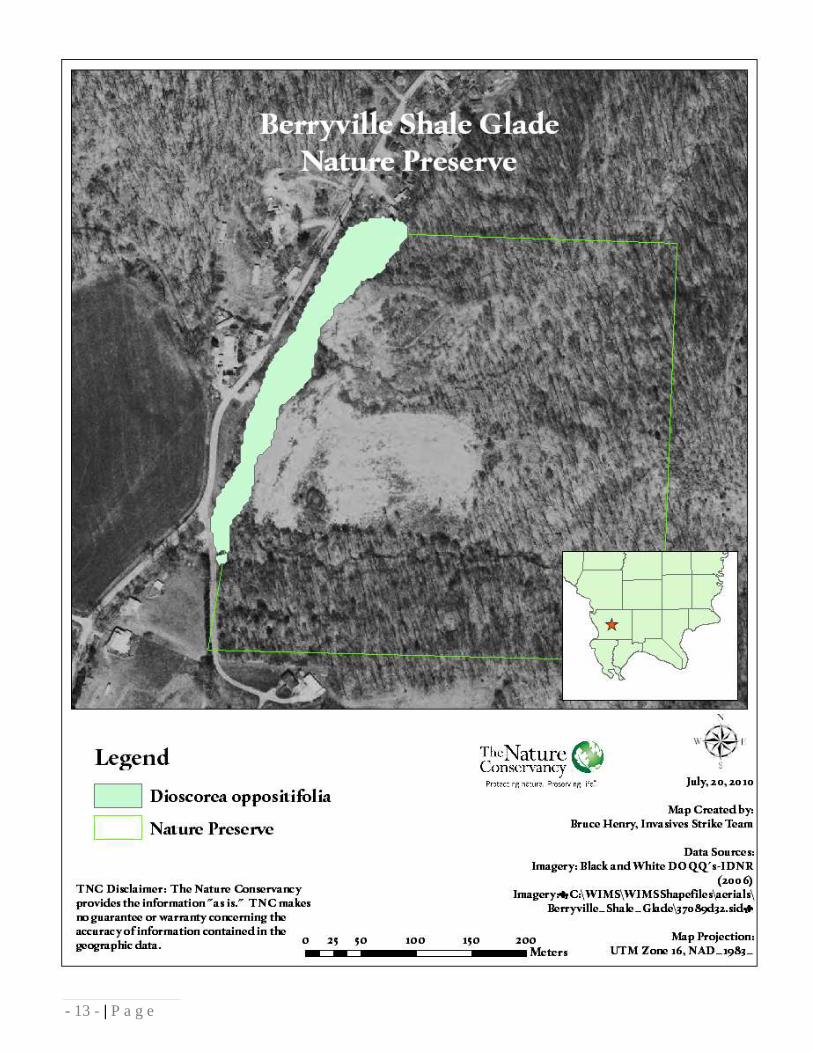
- 13 - | P a g e

- 14 - | P a g e
Brown Barrens Nature Preserve
Site Statistics County: Union Size: 28.8 acres Ownership: IDNR Dates of assessment and treatment: September 9, 24, 2009; August 20, 2010 Man hours: 13.75 Acreage chemically treated: 8.08 Site Description Shale barren communities are very rare in Illinois. Barrens are plant communities containing widely scattered and stunted trees due to thin, poor soil which contains little moisture and few nutrients. This quality barren remnant is located on an outcrop of Springville Shale in Union County. The trees of this site are dwarfed and open grown, particularly post oak. Blackjack oak, white oak, shingle oak, and red oak also occur at this site, along with more mesic species downslope and in the drainage. Little bluestem is the most common grass in the understory which is naturally depauperate due to the dry conditions of the site. Other herbaceous species common in the preserve include curly muhly grass, woodland sunflower and sea oats. Common wildlife seen in the barrens include Pileated woodpeckers, eastern box turtle, and eastern wild turkey. Targeted Invasive Species Japanese stiltgrass is an extremely aggressive annual warm season grass that can easily form pure stands under both full sun and completely shaded conditions. Left unchecked, it will prevent tree regeneration of native species such as oak and hickory as well as displace native herbaceous vegetation. The species‟ main vector of infestation is by water movement and travel on boots, animals, and equipment. At Brown Barrens Nature Preserve, Japanese stiltgrass is found in relative abundance along a drainage that runs the width of the preserve, and creeping up-slope toward the high-quality barrens. Given the extent of the infestation at this site, the management goal for this species at Brown Barrens is total eradication. Chemical Treatment Species (Common Name) % Herbicide (Chemical Name) Method Microstegium vimineum (Japanese stiltgrass) 1.5% Poast Plus (Sethoxydim) Foliar

- 15 - | P a g e

- 16 - | P a g e
Cache River State Natural Area
Site Statistics County: Johnson and Pulaski Size: 14,354 acres Ownership: IDNR Dates of assessment and treatment: August 17, 24, 2010 Man hours: 10 Acreage chemically treated: 24.45 Site Description Cache River State Natural Area is composed of two distinct management units including Little Black Slough and the Lower Cache. Situated in southernmost Illinois, Cache River State Natural Area lies within a floodplain carved long ago by glacial floodwater of the Ohio River. Lower Cache is best known for its remnant examples of high quality wetland natural communities, including bald cypress and tupelo gum swamps with trees more than 1,000 years ago. Native oak and hickory trees grow in the flatwoods and wet forest next to the swamps. Little Black Slough is also known for its swamps, as well as upland woods with small patches of limestone barrens. Wetlands within Cache River State Natural Area are so important to migratory waterfowl and shorebirds that in 1996 the RAMSAR Convention collectively designated them a Wetland of International Importance, only the 19th wetland in the United States to receive the distinction. With its diversity of soils, bedrock and landforms, the Cache River Valley contains four distinct ecological regions. This area contains 39 state-threatened or endangered plant and animal species and eleven state champion trees. Targeted Invasive Species Japanese stiltgrass is an extremely aggressive annual warm season grass that can easily form pure stands under both full sun and completely shaded conditions. Left unchecked, it will prevent tree regeneration of native bottomland hardwood species such as oak and cypress as well as displace native herbaceous vegetation. The species‟ main vector of invasion is by water movement and travel on boots, animals, and equipment. At Cache River State Natural Area, Japanese stiltgrass is found in very high densities on and adjacent to an access trail that follows the Cache River. The current management goal for Japanese stiltgrass in the Cache River State Natural Area is to eliminate the spread of the species by park users by eliminating trail-side populations. Chemical Treatment Species (Common Name) % Herbicide (Chemical Name) Method Microstegium vimineum (Japanese stiltgrass) 1.5% Poast Plus (Sethoxydim) Foliar

- 17 - | P a g e

Cave in Rock State Park
Site Statistics County: Pope Size: 204 acres Ownership: IDNR Dates of assessment and treatment: June 22, 2010 Man hours: 5 Acreage chemically treated: 0.12 Site Description Sitting atop the high bluffs overlooking the scenic Ohio River, the heavily wooded park is named for the 55-foot-wide cave that was carved out of the limestone rock by water thousands of years ago. Trails winding along the riverbank offer views of riverboats, barges and other river scenes. In addition to the natural splendor of the cave itself, the park contains two established hiking trails of moderate difficulty, plus numerous unmarked trails for exploration and appreciation of tranquil forests and inspiring views. Following the Revolutionary War, this immense recess came to serve as the ideal lair for outlaws, bandits and river pirates who preyed on the people traveling along the Ohio River. Natural communities found here are representative of the Lesser Shawnee Hills Section of the Shawnee Hills Division and are made up mainly of upland oak-hickory forest consisting of White Oak, Scarlet Oak, Black Oak, Pignut Hickory and Shagbark Hickory. Targeted Invasive Species Chinese yam forms pure stands in upland disturbed habitats and in riparian corridors. The infestations are primarily a threat to the establishment of native trees, shrubs, and herbaceous vegetation. At Cave in Rock State Park, populations were found along the main road through the park in two patches that have diminished significantly in size and density since ISST treatment in 2009. Due to the infestation‟s proximity to the park road right-of-way, a probable source for the infestation could be vegetative material likely carried on a vehicle or mowing equipment. Chemical Treatment: Species (Common Name) % Herbicide (Chemical Name) Method Dioscorea oppositifolia (Chinese Yam) 2.3% RoundUp Pro (Glyphosate) Foliar
- 18 - | P a g e

- 19 - | P a g e

- 20 - | P a g e
Cedar Draper Bluff Land and
Water Reserve
Site Statistics County: Union and Johnson Size: 741 acres Ownership: IDNR Dates of assessment and treatment: September 29, October 7, November 10, 12, 2009; April 2, 6, 8, 12-15, 19-22, May 3-5, June 1-3, 7, 8, July 7, 28, 29, August 16, 2010 Man hours: 277.5 Acreage chemically treated: 105.62 Acreage treated with prescribed fire: 170 Site Description Cedar Bluff is part of a massive sandstone cliff system that runs across southern Illinois from the Mississippi River to the Ohio River. Cedar Bluff was recognized by the INAI for their sandstone cliffs over 100 feet high, containing exceptional cliff communities and pockets of old growth mesic and dry-mesic forest communities. The area is used for hiking, bird watching, hunting, rock climbing, and general nature study. Targeted Invasive Species Buck Creek is a major distribution corridor for invasive species at Cedar Bluff Land and Water Reserve. Within the Buck Creek floodplain, there are large, extensive populations of Garlic mustard, Chinese yam, Multiflora rose, and Japanese stiltgrass. All herbaceous species were treated separately due to differences in biology and growing seasons, although Multiflora rose was treated simultaneously with Garlic mustard and Chinese yam. Populations of all of these species are very persistent, have developed a large seedbank, and require a very dedicated effort for eradication. Populations of woody invasives are unrelated to a watershed and much more locally distributed. Chemical Treatment Species (Common Name) % Herbicide (Chemical Name) Method Alliaria petiolata (Garlic mustard) 2.5% RoundUp Pro (Glyphosate) Foliar Dioscorea oppositifolia (Chinese yam) 2.5% Element 3a (Triclopyr) Foliar Rosa multiflora (Multiflora rose) 2.5% RoundUp Pro (Glyphosate) Foliar Microstegium vimineum (Japanese stiltgrass) 1.5% Poast Plus (Sethoxydim) Foliar Ailanthus altissima (Tree of Heaven) 20% Element 4 (Triclopyr) Cut Stump Euonymus alatus (Winged burning bush) 20% Element 4 (Triclopyr) Cut Stump Lonicera maackii (Bush honeysuckle) 20% Element 4 (Triclopyr) Cut Stump 2% RoundUp Pro (Glyphosate) Foliar Elaeaganus umbellata (Autumn olive) 20% Element 4 (Triclopyr) Cut Stump 2% RoundUp Pro (Glyphosate) Foliar Prescribed Fire Treatment Purpose: Control Japanese honeysuckle, Garlic mustard rosettes, and seedlings of Autumn olive and Bush honeysuckle. Date of Treatment Acres Treated 4/2/2010 170.1

- 21 - | P a g e

- 22 - | P a g e

- 23 - | P a g e

- 24 - | P a g e
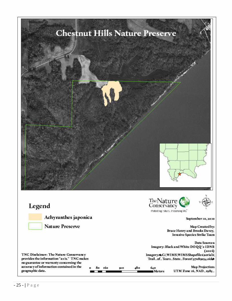
Chestnut Hills Nature Preserve
Site Statistics County: Pulaski Size: 212 acres Ownership: IDNR Dates of assessment and treatment: September 1, 2010 Man hours: 10 Acreage chemically treated: 6.77 Site Description Chestnut Hills Nature Preserve contains 212 acres of forest, stream, ravines, and river bluff communities of the Cretaceous Hills Section of the Coastal Plain Natural Division. Historically, this area supported one of the few native American chestnut stands- thus the name Chestnut Hills. Since that time, the population has been eliminated by the chestnut blight. Significant features of the preserve include outstanding geological exposures of the Owl Creek Formation, Clayton Formation, and the McNairy Formation (a Cretaceous period formation); a rare eroding river bluff community; and several rare plants and animals such as silverbells, dusky salamander and wintering bald eagles. Much of the notable mesic upland forest is located on narrow ridges, steep slopes and ravines. The community is dominated by beech, red oak, white oak, and sugar maple. Targeted Invasive Species Japanese chaff flower is a new invader to Illinois‟ soil. Japanese chaff flower is an invasive perennial forb that reaches its‟ best growth on partly shaded floodplain soils, but has been found growing on a variety of sites all along the Ohio River. This species easily outcompetes and displaces native vegetation, and its seeds are easily transported by man and animals. The ISST was alerted to this species‟ presence at Chestnut Hills Nature Preserve in mid August, and completed its first EDRR treatment of the nature preserve on September 1st. Japanese chaff flower was found to be widespread throughout Chestnut Hills Nature Preserve, in drainages, dry ridgetops, and throughout the Ohio River floodplain. For more information on Achyranthes japonica see the Invasive Species Alert in Appendix B. Chemical Treatment Species (Common Name) % Herbicide (Chemical Name) Method Achyanthes japonica (Japanese chaff flower) 2% AquaNeat (Glyphosate) Foliar
- 25 - | P a g e

- 26 - | P a g e
Collier Glade Nature Preserve
Site Statistics County: Hardin Size: 106 acres Ownership: IDNR/private Dates of assessment and treatment: March 18, 2010 Man hours: 14.0 Acreage treated with prescribed fire: 58.2
Site Description Collier Limestone Glade Natural Area is a high-quality grade A and B limestone community. A unique assemblage of prairie and glade plants occurs in this community type, which is rare. The area is an oak-hickory mosaic containing remnant dry oak woodlands and limestone glades. In southern Illinois, limestone glades are small prairie-like areas which occur on shallow soils over limestone outcrops. This glade occurs in the Lesser Shawnee Hills Section of the Shawnee Hills Natural Division. Collier Limestone Glade is one of the last remnants of what was once the largest continuous glade system that existed in Illinois. Targeted Invasive Species Collier Glade has a few Autumn olive, Bush honeysuckle and sweet clover individuals encroaching into the prairie and glade communities along with some roadside Sericean lespedeza and Japanese stiltgrass.
Prescribed Fire Treatment Purpose: Suppress sweet clover and Japanese honeysuckle, as well as seedlings of Autumn olive and Bush honeysuckle. Date of Treatment Acres Treated 3/18/2010 58.0

- 27 - | P a g e

- 28 - | P a g e
Cretaceous Hills Nature Preserve
Site Statistics County: Pope Size: 237 acres Ownership: IDNR Dates of assessment and treatment: March 20, July 21, 22, 2010 Man hours: 37 Acreage chemically treated: 2.3 Acreage treated by prescribed fire: 50.1
Site Description Cretaceous Hills is characterized by steep to rolling hills of coastal plains gravel. It is representative of the eastern Cretaceous Hills Section of the Coastal Plain Natural Division. Mostly wooded, the preserve supports slope forest, dry ridge forest and ravine forest communities; however, several seep springs also exist creating wet, acidic, “boggy” areas. The upland areas support white oak and hickories, while tulip tree and red oak occur in the ravines. Unusual plants associated with the spring are cinnamon fern, marsh fern, royal fern and sphagnum moss. Cretaceous Hills is also a significant historic site; the presence of several cultures from the Archaic period are evident by an abundance of artifacts. The area is also the site of one of the first white settlements in southeastern Illinois. Management to preserve this unique natural area includes prescribed burning and brush removal. Targeted Invasive Species Japanese stiltgrass populations are very widespread at Cretaceous Hills Nature Preserve. The preserve‟s most unique features are three seep springs that contain many threatened and endangered species, all of which are in jeopardy by the presence of Japanese stiltgrass. Starting in 2010, ISST is extensively managing the infestations within and upstream of the seep springs. Chemical Treatment Species (Common Name) % Herbicide (Chemical Name) Method Microstegium vimineum (Japanese stiltgrass) 1.5% Poast Plus (Sethoxydim) Foliar Prescribed Fire Treatment Purpose: Control seedlings of Japanese Honeysuckle Date of Treatment Acres Treated 3/30/2010 50.1

- 29 - | P a g e

- 30 - | P a g e
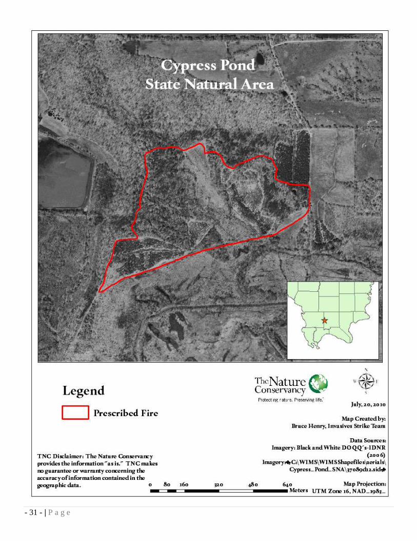
Cypress Pond State Natural Area
Site Statistics County: Johnson/Union Size: 1047 acres Ownership: IDNR Dates of assessment and treatment: April 1, 2010 Man hours: 15 Acreage treated by prescribed fire: 84.3 Site Description In 1988, IDNR acquired a 313 acre parcel from Westvaco Timber Co. This 313 acre area is an INAI site known as Cypress Pond. In September of 2001, IDNR acquired the remaining Westvaco ownership (additional 734 acres). The original 313 acres had limited public access, but the new acquisition allowed the IDNR to develop good public access areas. The new acquisition also offers new management maintenance and resource conservation opportunities. This entire 1,047 is open to hunting, hiking, nature appreciation, research, etc. A trail system should be developed and would be used as firebreaks as a part of the prescribed burning program. Four ponds would be built for erosion control and recreation and as an additional wildlife habitat component in upland areas. The area has many existing wetlands, although previous owners have attempted to drain some of these areas. Wetland restoration work needs to be done to correct these earlier drainage efforts. Plantations of poplar, sweetgum and sycamore need contractual thinning and/or prescribed fire to restore native mast producing hardwoods. For additional habitat diversity, 40 acres of warm season grasses should be established on old fields in the uplands. Targeted Invasive Species Seedlings of Autumn olive and Bush honeysuckle are present in scattered populations among the warm season grass plantings. Japanese honeysuckle was found on the forest floor of the pine plantations in the northeast corner of the prescribed burn unit. Prescribed Fire Treatment Purpose: Control Bush honeysuckle, Autumn olive and Japanese honeysuckle seedlings Date of Treatment Acres Treated 4/1/2010 84.3
- 31 - | P a g e

- 32 - | P a g e
Degognia Canyon Land and Water Reserve
Site Statistics County: Jackson/Randolph Size: 124.1 acres Ownership: private Dates of assessment and treatment: 3/25/2010 Man hours: 14 Acreage treated with prescribed fire: 8.78 Site Description Degognia Canyon Land and Water Reserve contains forest and sandstone glade communities located in the Central Section of the Ozark Natural Division. The Central Section is characterized by sandstone outcrops and an Ozarkian floral element. The area is significant because it is a large block of forest and glade complex. The forest is a mature oak-hickory forest with a 100-foot high sandstone cliff forming an impressive canyon. Tree species found on the sandstone outcrops include Black Oak, Post Oak, Blackjack Oak and Vaccinium. The site contains habitat for a State-threatened reptile and a high quality sandstone glade community. Targeted Invasive Species Seedlings of Autumn Olive and Bush honeysuckle are present in scattered individuals along the road on the reserve‟s northern boundary. Japanese honeysuckle was found on the forest floor in small areas throughout the burn unit. Prescribed Fire Treatment Purpose: To control autumn olive, bush honeysuckle and Japanese honeysuckle seedlings Date of Treatment Acres Treated 3/25/2010 8.78

- 33 - | P a g e

- 34 - | P a g e
Dixon Springs State Park
Site Statistics County: Pope Size: 801 acres Ownership: IDNR Dates of assessment and treatment: June 21, 2010 Man hours: 2.75 Acreage chemically treated: 1.38 Site Description Dixon Springs State Park is one of several state parks in the Illinois Shawnee Hills. The park is on a giant block of rock which was dropped 200 feet along a fault line that extends northwesterly across Pope County. Bold cliffs and crags overhang a babbling brook while large boulders, overgrown with ferns, ivy, lichens, and moss, fringe the hillside. Giant century-old trees interlock above the small creek as cliffs rise on either side and huge boulders are scattered through the valley. Deer, squirrels, rabbits, groundhogs, and foxes scamper around the oak, cypress, gum, pine, sycamore, walnut, persimmon, hickory, birch, and maple trees. Dogwood and catalpa trees blossom profusely in season. In the spring the Jack-in-the-pulpit, violet, lady's slipper, May apple, and sweet William brighten the natural beauty of the park. Targeted Invasive Species Chinese yam forms pure stands in upland disturbed habitats and in riparian corridors. The infestations are primarily a threat to the establishment of native trees, shrubs, and herbaceous vegetation. At Dixon Springs State Park, the ISST found populations along a gravel road right of way, in a riparian area and upstream on private land. 2010 is this population‟s second consecutive year of treatment. Due to the infestation‟s location in the riparian zone, the most probable source for the infestation is vegetative material likely carried from private property downstream into the preserve. Chemical Treatment Species (Common Name) % Herbicide (Chemical Name) Method Dioscorea oppositifolia (Chinese yam) 2% Element 3a (Triclopyr) Foliar

- 35 - | P a g e

- 36 - | P a g e
Faulkner-Franke Pioneer Railroad Prairie Nature Preserve
Site Statistics County: Jackson Size: 4.14 acres Ownership: Private Dates of assessment and treatment: March 12, 2010 Man hours: 4 Acreage treated by prescribed fire: 3.17 Site Description The Faulkner-Franke Pioneer Railroad Prairie Nature Preserve contains 4.14 acres of dry-mesic prairie near DeSoto in Jackson County, Illinois. The preserve is part of the DeSoto Railroad Prairie INAI site, containing dry-mesic, mesic and wet-mesic prairie, which is adjacent to the Illinois Central Railroad and is approximately one mile in length. The land was purchased for preservation purposes by two families, and the dedication is the family's way of passing that legacy on to its future generations. The prairie is one of only two remaining high quality prairies in the Southern Till Plain Natural Division. Targeted Invasive Species Faulkner-Franke Pioneer Railroad Prairie‟s proximity to a railroad and a well-traveled highway expose it to exotic invasion. Seedlings of Bush honeysuckle, Autumn olive and Japanese honeysuckle occur along the preserve‟s western border with the Illinois Central railroad. Prescribed Fire Treatment Purpose: Control Bush honeysuckle, Autumn olive and Japanese honeysuckle seedlings Date of Treatment Acres Treated 3/12/2010 3.17

- 37 - | P a g e

- 38 - | P a g e
Fern Rocks Nature Preserve
Site Statistics County: Jackson Size: 170 acres Ownership: IDNR Dates of assessment and treatment: June 13-15, August 23, 25, 2010 Man Hours: 46.5 Acres chemically treated: 16.12 Site Description Fern Rocks contains high quality dry and mesic upland forest, cliff and bedrock outcrops of the Greater Shawnee Hills Section of the Shawnee Hills Natural Division. The importance of this portion of the Shawnee Hills as a natural science study area was recognized as early as 1870 when Southern Illinois Normal University botanist George Hazen French named the area for its abundance of ferns including Christmas fern, marginal fern, maidenhair, lady fern and several spleenwort ferns. The forested portions of the preserve are dominated by oaks and hickories or by maples. Outstanding sandstone cliffs, bluffs and shelter communities support a large variety of vegetation. Along the north facing slope, shade-loving species are found including mosses and liverworts. Notable crevice-occurring species are Forbes‟ saxifrage, partridge-berry and small alumroot. Fern Rocks is the type locality for two at the plants discovered by French in the late 1800‟s: French‟s shooting star and Forbes‟ saxifrage. It contains one of the most spectacular spring wildflower displays to be seen anywhere in the state. Targeted Invasive Species Both Japanese stiltgrass and Chinese yam can quickly form homogeneous populations along riparian areas and adjacent uplands. At Fern Rocks Nature Preserve, populations of these species were found along the Stonefort Creek floodplain on the northern and eastern boundaries and along Trillium Trail by the northwestern parking lot. The 2009 treatment included additional woody invasive treatments on the southern end of the nature preserve. Chemical Treatments Species (Common Name) % Herbicide (Chemical Name) Method Dioscorea oppositifolia (Chinese yam) 2% Element 3a (Triclopyr) Foliar Microstegium vimineum (Japanese stiltgrass) 1.5% Poast Plus (Sethoxydim) Foliar

- 39 - | P a g e
- 40 - | P a g e
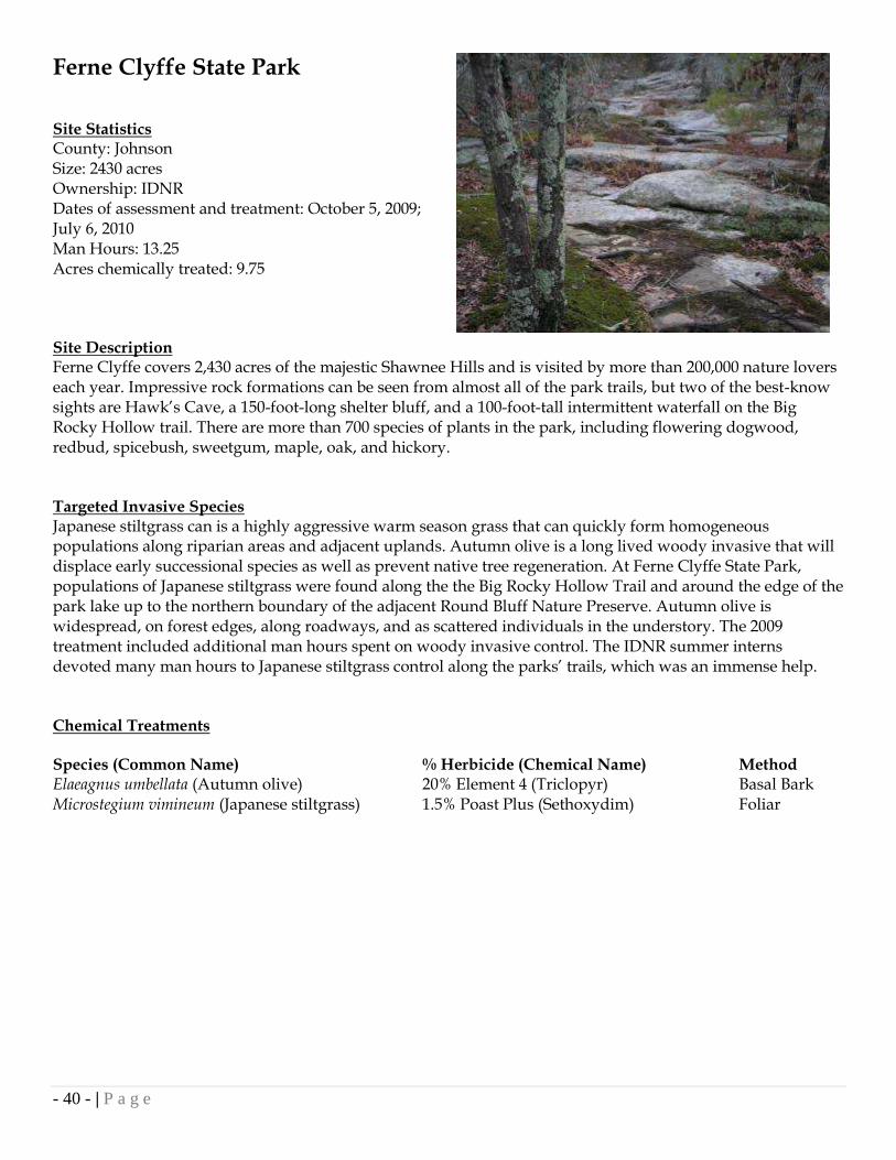
Ferne Clyffe State Park
Site Statistics County: Johnson Size: 2430 acres Ownership: IDNR Dates of assessment and treatment: October 5, 2009; July 6, 2010 Man Hours: 13.25 Acres chemically treated: 9.75 Site Description Ferne Clyffe covers 2,430 acres of the majestic Shawnee Hills and is visited by more than 200,000 nature lovers each year. Impressive rock formations can be seen from almost all of the park trails, but two of the best-know sights are Hawk‟s Cave, a 150-foot-long shelter bluff, and a 100-foot-tall intermittent waterfall on the Big Rocky Hollow trail. There are more than 700 species of plants in the park, including flowering dogwood, redbud, spicebush, sweetgum, maple, oak, and hickory. Targeted Invasive Species Japanese stiltgrass can is a highly aggressive warm season grass that can quickly form homogeneous populations along riparian areas and adjacent uplands. Autumn olive is a long lived woody invasive that will displace early successional species as well as prevent native tree regeneration. At Ferne Clyffe State Park, populations of Japanese stiltgrass were found along the the Big Rocky Hollow Trail and around the edge of the park lake up to the northern boundary of the adjacent Round Bluff Nature Preserve. Autumn olive is widespread, on forest edges, along roadways, and as scattered individuals in the understory. The 2009 treatment included additional man hours spent on woody invasive control. The IDNR summer interns devoted many man hours to Japanese stiltgrass control along the parks‟ trails, which was an immense help. Chemical Treatments Species (Common Name) % Herbicide (Chemical Name) Method Elaeagnus umbellata (Autumn olive) 20% Element 4 (Triclopyr) Basal Bark Microstegium vimineum (Japanese stiltgrass) 1.5% Poast Plus (Sethoxydim) Foliar

- 41 - | P a g e

- 42 - | P a g e
Giant City State Park
Site Statistics County: Jackson/Union Size: 4000 acres Ownership: IDNR Dates of assessment and treatment: March 3, May 4,-6, 10, 11, June 23, August 1, 2010 Man Hours: 65.5 Acres chemically treated: 23.82 Site Description Giant City is home of the “Giant City Streets” formed 12,000 years ago by huge bluffs of sandstone. The massive sandstone structures give the area its name. Eons of geological faulting and folding have molded a landscape like none other, which is now clothed in lush garments of fern, moss, large flowering mints, hundreds of species of wild flowers and 75-plus varieties of towering trees. The natural splendor of Giant City has made it a renowned retreat that attracts more than 1.2 million visitors annually. Targeted Invasive Species Garlic mustard and Chinese yam are herbaceous exotics that quickly form monocultures in the understory. Left untreated, the species will out compete and displace many native species of herbaceous and woody plants. At Giant City State Park, Garlic mustard and Chinese yam were found in abundance along the Indian Creek riparian area and along the Indian Creek Trail. Cutleaf teasel is a highly-invasive biennial forb that is listed as a noxious weed in at least four states nationally. It can be seen invading communities with full sun exposure; at Giant City State Park, Cutleaf teasel is found along a main road to the north and west of the maintenance buildings. This year is the ISST‟s first treatment year for Garlic mustard and teasel at Giant City State Park. Chemical Treatments Species (Common Name) % Herbicide (Chemical Name) Method Alliaria petiolata (Garlic mustard) 2% Glyphos Xtra (Glyphosate) Foliar Dioscorea oppositifolia (Chinese yam) 2% Glyphos Xtra (Glyphosate) Foliar Dipsacus laciniatus (Cutleaf teasel) 20% Element 4 (Triclopyr) Cut Stem

- 43 - | P a g e
- 44 - | P a g e
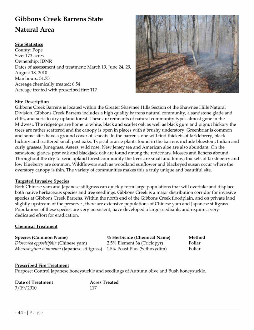
Gibbons Creek Barrens State
Natural Area
Site Statistics County: Pope Size: 173 acres Ownership: IDNR Dates of assessment and treatment: March 19, June 24, 29, August 18, 2010 Man hours: 31.75 Acreage chemically treated: 6.54 Acreage treated with prescribed fire: 117
Site Description Gibbons Creek Barrens is located within the Greater Shawnee Hills Section of the Shawnee Hills Natural Division. Gibbons Creek Barrens includes a high quality barrens natural community, a sandstone glade and cliffs, and xeric to dry upland forest. These are remnants of natural community types almost gone in the Midwest. The ridgetops are home to white, black and scarlet oak as well as black gum and pignut hickory the trees are rather scattered and the canopy is open in places with a brushy understory. Greenbriar is common and some sites have a ground cover of seaoats. In the barrens, one will find thickets of farkleberry, black hickory and scattered small post oaks. Typical prairie plants found in the barrens include bluestem, Indian and curly grasses. Junegrass, Asters, wild rose, New Jersey tea and American aloe are also abundant. On the sandstone glades, post oak and blackjack oak are found among the redcedars. Mosses and lichens abound. Throughout the dry to xeric upland forest community the trees are small and limby; thickets of farkleberry and low blueberry are common. Wildflowers such as woodland sunflower and blackeyed susan occur where the overstory canopy is thin. The variety of communities makes this a truly unique and beautiful site. Targeted Invasive Species Both Chinese yam and Japanese stiltgrass can quickly form large populations that will overtake and displace both native herbaceous species and tree seedlings. Gibbons Creek is a major distribution corridor for invasive species at Gibbons Creek Barrens. Within the north end of the Gibbons Creek floodplain, and on private land slightly upstream of the preserve , there are extensive populations of Chinese yam and Japanese stiltgrass. Populations of these species are very persistent, have developed a large seedbank, and require a very dedicated effort for eradication. Chemical Treatment Species (Common Name) % Herbicide (Chemical Name) Method Dioscorea oppositifolia (Chinese yam) 2.5% Element 3a (Triclopyr) Foliar Microstegium vimineum (Japanese stiltgrass) 1.5% Poast Plus (Sethoxydim) Foliar Prescribed Fire Treatment Purpose: Control Japanese honeysuckle and seedlings of Autumn olive and Bush honeysuckle. Date of Treatment Acres Treated 3/19/2010 117

- 45 - | P a g e

- 46 - | P a g e
Grassy Slough Land and
Water Reserve
Site Statistics County: Johnson Size: 2672.5 acres Ownership: The Nature Conservancy Dates of assessment and treatment: October 26-29, November 2-5, 2009 Man hours: 45.0 Acreage chemically treated: 143.95 Site Description Grassy Slough Land and Water Reserve includes 2,672.5 acres in Johnson County in extreme southern Illinois that is owned by The Nature Conservancy. Once historically dominated by low wet bottomland hardwood forests and swamps, the construction of the Post Creek Cutoff (initiated in 1915) quickly drained much of this vast floodplain. Subsequently, this land was cleared, much of it less than 50 years ago, and converted to cropland and pasture. Prior to acquisition by TNC, Grassy Slough was intensively farmed. The entire site was cropland, planted annually to bell peppers, squash, tomatoes, cucumbers, and cereal grains. In 1997 the landowner enrolled 2,158.3 acres of this farm in the Cache River Special Wetland Reserve Program (WRP). Not long afterward (May 1999), TNC purchased the entire parcel. WRP restoration on site includes 1,362.8 acres that have been reforested, and 564.1 acres that have been restored to wetlands. The WRP is administered by the Natural Resources Conservations Service, with restoration funded by the Illinois Department of Natural Resources through the C2000 Program. Targeted Invasive Species Autumn olive and Bush honeysuckle are extremely invasive woody shrubs that can quickly outcompete and displace native plant communities. A favorite soft mast of many species of birds, these species are readily distributed throughout most terrestrial community types in southern Illinois. At Grassy Slough Land and Water Reserve, these species are wide spread, with relatively low densities but spread over a large area. 2010 is the ISST‟s first treatment at this site. Chemical Treatments Species (Common Name) % Herbicide (Chemical Name) Method Elaeagnus umbellata (Autumn olive) 20% Element 4 (Triclopyr) Cut Stump Lonicera maackii (Bush honeysuckle) 20% Element 4 (Triclopyr) Cut Stump

- 47 - | P a g e

- 48 - | P a g e
Hayes Creek Canyon Horse Campground
Site Statistics County: Pope Size: n/a Ownership: Private Dates of assessment and treatment: March 31, 2010 Man hours: 6.5 Acreage chemically treated: 0.6 Site Description Hayes Creek Canyon Campground is a popular destination for horseback riders, campers, hunters and hikers. Within a 4-mile radius of Hayes Canyon Campground there are 67 miles of designated Forest Service trails; thus, it provides an excellent opportunity for EDRR. The campground is situated around a tributary of Hayes Creek, a high quality sandstone glade and canyon area noted by the Illinois Natural Areas Inventory. The area in and around the campsite are excellent example of dry to xeric upland forest, xeric sandstone glade, and sandstone canyon communities representative of the Shawnee Hills Division. These communities are rare and dominated by black oak, post oak, blackjack oak, and eastern red cedar. Prominent herbaceous glade species present include little bluestem, widow‟s cross, farkleberry, and prickly pear. Targeted Invasive Species Garlic mustard grows in the forest understory in a wide range of light availability and soil moisture conditions. Left untreated, it has the ability to form large, homogeneous populations and displace almost all native vegetation. At Hayes Creek Canyon campground, the Garlic mustard infestations threaten the native xeric forest and sandstone glade vegetation. A population of Garlic mustard was discovered by the campground‟s owners and treated by the ISST is 2009. The 2010 treatment includes a new population detected by the owners over the winter and the retreatment of the area from 2009. Probable source of infestations are equine related activities. If left untreated, this infestation has the potential to disperse throughout the Hayes Creek watershed. Chemical Treatments Species (Common Name) % Herbicide (Chemical Name) Method Alliaria petiolata (Garlic mustard) 2.5% RoundUp Pro (Glyphosate) Foliar

- 49 - | P a g e

- 50 - | P a g e
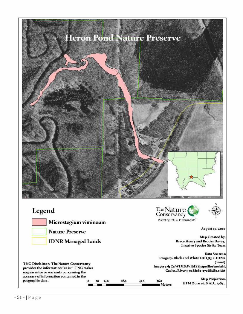
Heron Pond-Little Black Slough Nature Preserve
Site Statistics County: Johnson Size: 1861 acres Ownership: IDNR Dates of assessment and treatment: August 24, 2010 Man hours: 2 Acreage chemically treated: 12.19 Site Description The area has extensive stands of high quality upland forest and limestone glade communities representative of the Lesser Shawnee Hills Section of the Shawnee Hills Natural Division and high quality swamp and floodplain forests typical of the Bottomland Section of the Coastal Plain Natural Division. The 1,861 acres are divided into three units: Heron Pond-Wildcat Bluff, Goose Pond, and Boss Island-Boulder Slope Woods. Special features of the area include a portion of the Cache River floodplain bounded by steep bluffs on the east and west. The swamps are dominated by water tupelo and bald cypress, some of which are among the oldest trees in Illinois. There is critical habitat for Illinois threatened and endangered species and federally endangered species, a heron rookery and the presence of many other plant and animal species limited to the Coastal Plain Division. This preserve is a good place to see black vulture, red-shouldered hawk, barred owl, Acadian flycatcher, parula warbler, yellow-throated warbler, prothonotary warbler, and Kentucky warbler. Bobcat, river otter and swamp rabbit also occur in this preserve. Targeted Invasive Species Japanese stiltgrass is an extremely aggressive annual warm season grass that can easily form pure stands under both full sun and completely shaded conditions. Left unchecked, it will prevent tree regeneration of native bottomland hardwood species such as oak and cypress as well as displace native herbaceous vegetation. The species‟ main vector of invasion is by water movement and travel on boots, animals, and equipment. At Heron Pond-Little Black Slough Nature Preserve, Japanese stiltgrass is found in very high densities on and adjacent to an access trail that follows the Cache River. The current management goal for Japanese stiltgrass in the Heron Pond-Little Black Slough Nature Preserve is to eliminate the spread of the species by park users by eliminating trail-side populations. Chemical Treatment Species (Common Name) % Herbicide (Chemical Name) Method Microstegium vimineum (Japanese stiltgrass) 1.5% Poast Plus (Sethoxydim) Foliar
- 51 - | P a g e

- 52 - | P a g e
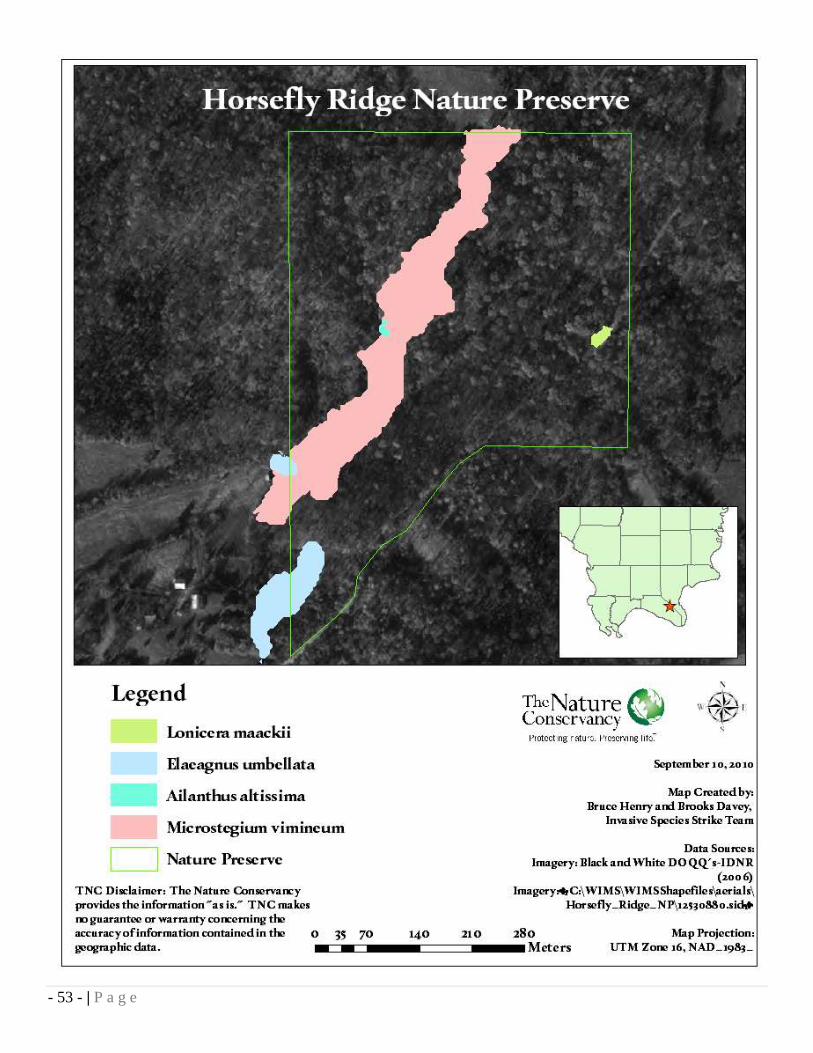
Horsefly Ridge Nature Preserve
Site Statistics County: Massac Size: 49 acres Ownership: private Dates of assessment and treatment: August 19, 26, 2010 Man hours: 13 Acreage chemically treated: 10.57 Site Description The 49 acre Horsefly Ridge Nature Preserve in Massac County protects a high-quality barrens community composed of large-limbed, open-grown oaks mixed with dry open bare areas, and areas containing herbaceous plants including prairie flora. The site looks very much like it did when the original land surveyors visited the area in 1806. This barrens community is very rare. Targeted Invasive Species Japanese stiltgrass is an extremely aggressive annual warm season grass that can easily form pure stands under both full sun and completely shaded conditions. Left unchecked, it will prevent tree regeneration of native tree species such as oak and hickory as well as displace native herbaceous vegetation. The species‟ main vector of invasion is by water movement and travel on boots, animals, and equipment. At Horsefly Ridge Nature Preserve, Japanese stiltgrass is found in very high densities in and along the main drainage that runs southwest through the preserve. This was the ISST‟s first year treating this Japanese stiltgrass infestation. According to the landowner, smaller patches of Japanese stiltgrass observed by the ISST on upland areas were established after the 2008 ice storm. Woody invasives including Bush honeysuckle, Autumn olive, Winged burning-bush(one single stem) and Tree of Heaven were also treated at Horsefly Ridge Nature Preserve. Only several stems of Tree of Heaven were found growing along the drainage. Other woody invasives were treated along the southwestern border of the preserve. Chemical Treatment Species (Common Name) % Herbicide (Chemical Name) Method Microstegium vimineum (Japanese stiltgrass) 1.5% Poast Plus (Sethoxydim) Foliar Lonicera maackii (Bush honeysuckle) 20% Element 3a (Triclopyr) Cut stump Elaeagnus umbellata (Autumn olive) 20% Element 3a (Triclopyr) Cut stump “ “ Basal bark Euonymus alatus (Winged burning-bush) 20% Element 3a (Triclopyr) Cut stump Ailanthus altissima (Tree of Heaven) 20% Element 3a (Triclopyr) Cut stump
- 53 - | P a g e

- 54 - | P a g e
Horseshoe Lake Nature Preserve
Site Statistics County: Alexander Size: 492 acres Ownership: IDNR Dates of assessment and treatment: March 10, April 6, 26, 2010 Man hours: 16.75 Acreage mechanically treated: 3.63 Site Description This preserve is made up of two separate tracts within Horseshoe Lake Conservation Area. One area is west of the campgrounds and the other is located on the southern tip of Horseshoe Lake Island. The area was designated as a National Natural Landmark in 1974. Horseshoe Lake is an ancient oxbow of the Mississippi River and this entire preserve is on the Mississippi floodplain. The woods on Horseshoe Island are near a virgin forest of beech, sugar maple, swamp chestnut oak and American elm growing in loamy soils. Some of these trees reach up to 48” in diameter. A bald cypress and tupelo community can be found in the interior sloughs and bordering Horseshoe Lake. Willow and swamp cottonwood are common associates here, with buttonbush as a typical shrub. The west tract is a forest of pin oak, sweet gum and other oaks growing in wet, heavy soils. Interesting and unusual reptiles and amphibians include green treefrog, mole salamander and cottonmouth. Red-shouldered hawks, prothonotary warbler, fish crow and during the winter, bald eagles may also be seen here. Targeted Invasive Species Garlic mustard is a biennial forb that quickly forms monocultures on the forest floor. Left untreated, the species will out compete and displace many native species of herbaceous and woody plants. At Horseshoe Lake Nature Preserve Garlic mustard was found on Horseshoe Lake Island along the main trail mainly on the eastern side of the preserve. This year is the ISST‟s second treatment year for Garlic mustard at Horseshoe Lake Nature Preserve. The objective of the 2010 treatment was to clean up leftovers of a treatment by a state-contracted herbicide applicator prior to the ISST‟s treatment. Mechanical Treatment Species (Common Name) Method Alliaria petiolata (Garlic mustard) Hand Pull

- 55 - | P a g e

- 56 - | P a g e
IDNR Region 5 Office Site Statistics County: Franklin Size: 34.46 Ownership: IDNR Dates of assessment and treatment: December 16, 2009 Man hours: 14 Area chemically treated: 34 Site Description Acquired in 1938, the Region V headquarters serves as the administration and coordination center for the region. In addition, it also functions as a public service center regarding assistance with items such as registrations, permits, licenses, regulations, site information, public relations, etc. The central office and outbuildings are located on 34.46 acres. Most of the property is grade C dry mesic forest with scattered pine plantings. Targeted Invasive Species At the IDNR Region 5 office, the surrounding woodlands contained seven species of woody invasives. They were scattered among the grade C dry mesic forest and field edges. These species were treated as part of a IDNR region-wide one day collaborative treatment effort at the Benton office with 12 employees. Chemical Treatments Species (Common Name) % Herbicide (Chemical Name) Method Lonicera maackii (Bush honeysuckle) 20% Element 4 (Triclopyr) Cut stump Euonymus fortunei (Wintercreeper) 20% Element 4 (Triclopyr) Cut stump Euonymus alatus (Winged Burning bush) 20% Element 4 (Triclopyr) Cut stump Wisteria floribunda (Japanese wisteria) 20% Element 4 (Triclopyr) Cut stump Ligustrum sinense (Chinese privet) 20% Element 4 (Triclopyr) Cut stump Elaeagnus umbellata (Autumn olive) 20% Element 4 (Triclopyr) Cut stump Albizia julibrissin (Mimosa tree) 20% Element 4 (Triclopyr) Cut stump

- 57 - | P a g e

- 58 - | P a g e
Lake Murphysboro State Park
Site Statistics County: Jackson Size: 1022 acres Ownership: IDNR Dates of assessment and treatment: March 8, May 25-28, 2010 Man hours: 31 Acreage chemically treated: 2.06 Acreage mechanically treated: 10.2 Acreage treated with prescribed fire: 6.05 Site Description Beautiful rolling hills and woods surround star-shaped Lake Murphysboro and provide a wonderful backdrop for boating, fishing, picnicking, camping and hiking. Patches of native wild orchids may be found in the wooded areas of the park. Yellow lady‟s slipper, showy, purple fringeless, twayblade, puttyroot, coralroot and ladies‟ tresses are just some of the varieties to watch for. The variety of orchids makes it possible to find blooming plants throughout the year. The wooded hills include groves of majestic oak and hickory trees, as well as most other types of trees. The 145 acre lake is well stocked with largemouth bass, redear sunfish, bluegill and channel catfish. Targeted Invasive Species Garlic mustard is a biennial forb that quickly forms monocultures on the forest floor. Left untreated, the species will out compete and displace many native species of herbaceous and woody plants. At Lake Murphysboro State Park, populations of Garlic mustard are widespread. This year is the ISST‟s second treatment year for Garlic mustard at Lake Murphysboro. In 2009, the help of many volunteers made for a larger treatment area than in 2010. Chemical Treatment Species (Common Name) % Herbicide (Chemical Name) Method Alliaria petiolata (Garlic mustard) 2% RoundUp Pro (Glyphosate) Foliar Mechanical Treatment Species (Common Name) Method Alliaria petiolata (Garlic mustard) Hand Pull Prescribed Fire Treatment Purpose: To control Garlic mustard rosettes and seedlings of Bush honeysuckle and Autumn olive. Date of Treatment Acres Treated 3/8/2010 6.05

- 59 - | P a g e

- 60 - | P a g e
Lusk Creek Canyon Nature Preserve
Site Statistics County: Pope Size: 125 acres Ownership: IDNR Dates of assessment and treatment: May 17, 2010 Man hours: 6.25 Acreage mechanically treated: 0.19 Site Description This large and very scenic canyon contains a high quality stream which flows by some high sandstone cliffs. Several rare plants such as arching dewberry, superb lily and several fern and clubmoss species grow in this area. Timber rattlesnakes plus several unusual plants inhabit the forests or the sandstone canyons. Sandstone glade and sandstone cliff communities are also present. Invasive Species on Site Garlic mustard forms pure stands in almost any mesic habitat and especially in riparian corridors. The infestations are primarily a threat to the establishment of native trees, shrubs, and herbaceous vegetation. At Lusk Creek Canyon Nature Preserve, the ISST found populations around an equestrian hitching post used for visitors to the nature preserve. Due to the infestation‟s location around the trail and hitching post, the most probable source for the infestation is seeds carried by horse or man. In 2009, the ISST treated Chinese Yam along Lusk Creek. Mechanical Treatment Species (Common Name) Method Alliaria petiolata (Garlic mustard) Hand pull

- 61 - | P a g e

- 62 - | P a g e
Lusk Creek Sanctuary Site Statistics County: Pope Size: 56.8 acres Ownership: Illinois Audubon Society Dates of assessment and treatment: June 19, 2010 Man hours: 7 Acreage chemically treated: 2.16 Site Description The property is near the headwaters of Lusk Creek, and the creek itself runs right through the middle of the property. Lusk Creek is a rocky, spring-fed stream traversing wooded uplands. Springs and caves throughout its course add to the high biological diversity of the system and provide habitats for unique flora and fauna. The stretch of stream that flows through Lusk Creek Sanctuary runs the full range of possiblities--slow broad sections, fast narrow channels, deep pools, and active riffles. The riparian zone ranges from flood plain canebreaks to hardwood forest canopies. At the other end of the spectrum, sandstone glades give way to sandstone bluffs and an amazing array of wildflowers, included the rare French's shooting star Targeted Invasive Species Chinese yam forms pure stands in upland disturbed habitats and in riparian corridors. The infestations are primarily a threat to the establishment of native trees, shrubs, and herbaceous vegetation. At Lusk Creek Sanctuary, the ISST found populations in and along the Lusk Creek floodplain. This is the ISST‟s second consecutive year treating this infestation. The population area is similar, but is smaller in density compared to 2009. Due to the infestation‟s location in the riparian zone, the most probable source for the infestation is vegetative material likely carried downstream into the preserve. Chemical Treatments Species (Common Name) % Herbicide (Chemical Name) Method Dioscorea oppositifolia (Chinese yam) 2% Element 3a (Triclopyr) Foliar

- 63 - | P a g e

- 64 - | P a g e
Mermet Swamp Nature Preserve
Site Statistics County: Massac Size: 43 acres Ownership: IDNR Dates of assessment and treatment: August 31, 2010 Man hours: 9 Acreage chemically treated: 12.6
Site Description Mermet Swamp contains original vegetation once typical of the Bottomland Section and Cretaceous Hill Section of the Coastal Plain Natural Division. The preserve is a level, wooded, bottomland swamp, with a small part of the preserve extending up a steep hillside. The swamp is under water most of the year and is characterized by a thick stand of young cypress trees, most of which are less than fifteen inches in diameter. Buttonbush and Virginia willow are dominant shrubs, while unusual plants include storax, arrow alum and red iris. Many common mammals are found here as well as unusual and rare species including swamp rabbit, golden mouse, and rice rat. The swamp also provides habitat for a wide diversity of birds, amphibians and reptiles. Targeted Invasive Species Japanese stiltgrass is an extremely aggressive annual warm season grass that can easily form pure stands under both full sun and completely shaded conditions. Left unchecked, it will prevent tree regeneration of native species such as oak and hickory as well as displace native herbaceous vegetation. The species‟ main vector of infestation is by water movement and travel on boots, animals, and equipment. At Mermet Swamp Nature Preserve, Japanese stiltgrass is found in relative abundance along the northern border of the preserve, generally above the high water mark. This is the first year the ISST has treated Mermet Swamp Nature Preserve. Chemical Treatments Species (Common Name) % Herbicide (Chemical Name) Method Microstegium vimineum (Japenese stiltgrass) 1.5% Poast Plus (Sethoxydim) Foliar

- 65 - | P a g e

- 66 - | P a g e
Ozark Hills Nature Preserve
Site Statistics County: Union Size: 222 acres Ownership: IDNR Dates of assessment and treatment: January 21, 25, 28, August 14, 2010 Man hours: 27.25 Acreage chemically treated: 42.5
Site Description This preserve is located in the Southern Section of the Ozark Division, that part of Illinois that is geologically similar to the Ozark Region of Missouri. The site is mature second growth forest. It contains several unusual plant species such as red buckeye, azalea and cucumber magnolia. These plants have a very limited distribution in Illinois. The community that these plants occur in is dry-mesic and mesic upland forest. The dry-mesic forest contains white oak, black oak and hickories while American beech, tulip tree sugar maple and sweet gum comprise the mesic upland forest. In the spring the forest floor is blanketed by colorful wildflowers including phlox, Dutchman‟s breeches, spring beauty, bellflower, celandine poppy and squirrel corn. This preserve provides habitat for scarlet tanager, summer tanager, hooded warbler, worm-eating warbler and Kentucky warbler. Targeted Invasive Species Bush honeysuckle and Autumn olive populations were found by the ISST growing together near the creek on the northern boundary of the preserve. Japanese stiltgrass was discovered growing in low densities on and along the south forest road, the southern border of the preserve. This was the ISST‟s first year of treatment at Ozark Hills Nature Preserve. Chemical Treatments Species (Common Name) % Herbicide (Chemical Name) Method Lonicera maackii (Bush honeysuckle) 16% Element 4 (Triclopyr) Cut Stump Elaeagnus umbellata (Autumn olive) 16% Element 4 (Triclopyr) Cut Stump Microstegium vimineum (Japenese stiltgrass) 1.5% Poast Plus (Sethoxydim) Foliar

- 67 - | P a g e

- 68 - | P a g e
Pyramid State Park
Site Statistics County: Perry Size: 19,701 acres Ownership: IDNR Dates of assessment and treatment: March 2, 2010 Man hours: 6 Acreage treated with prescribed fire: 1154 Site Description: Pyramid State Recreation Area consists of heavily forested hills and many lakes and ponds. Pyramid is the largest State Recreation Area in Illinois at 19,701 acres. Pyramid gets its name from a coal mine that once existed here. In 1962, the state's first strip-mine reclamation law became effective. The most common method of reclamation in the 1930's was tree planting, but this was discouraging as the trees brought no quick economic return. A mature hardwood timber consisting of mostly White Oak and Hickory on the West edge of the park is an area about 20 acres which was not strip-mined. Several stands of conifers were planted years ago, and there is a timber cover of cottonwood, box elder and sycamore. Oak and hickory trees are increasing in number. Many species of wildlife may be found in the area, including songbirds, deer, squirrels, beavers, rabbits, turkey, bobcat, raccoons, possums, coyotes, weasel, mink, woodchucks and waterfowl. More than 500 acres of water form lakes varying in size from 0.1 acres to 276 acres. Targeted Invasive Species At Pyramid State Park the ISST found Autumn olive seedlings growing among the warm season grass plantings along with Phragmites on the pond shorelines. While prescribed fire does not control Phragmites, it is an effective intermediate step between herbicide treatments.
Prescribed Fire Treatment Purpose: Control Phragmites and seedlings of Autumn olive. Acres Treated Date of Treatment 1154 3/2/2010

- 69 - | P a g e

- 70 - | P a g e
Rauchfuss Hill State Recreation Area
Site Statistics County: Pope Size: 261 acres Ownership: IDNR Dates of assessment and treatment: June 21, August 18, 2010 Man hours: 4.5 Acreage chemically treated: 7.32 Site Description A large bluff located on the north side of the Golconda marina is named Rauchfuss Hill. The site also has been known as Steamboat Hill, because it offers the best location to watch the steamboats go up and down the Ohio River. The U.S. Forest Service obtained ownership of the bluff and built a camping area overlooking the Ohio River. It is now owned by the Illinois Department of Natural Resources and is designated a State Recreation Area. This area offers a picnic area and a hiking trail up the historic steps on the south bluff which is registered with the National Historical Society. Targeted Invasive Species Chinese yam and Japanese stiltgrass form pure stands in upland disturbed habitats and in riparian corridors. The infestations are primarily a threat to the establishment of native trees, shrubs, and herbaceous vegetation. At Rauchfuss Hill State Recreation Area, As the picture shows above, Japanese stiltgrass populations are very dense, but are confined to the road right of way and the campground area. The ISST found a small population of Chinese yam along the main road right of way. Due to the infestation‟s proximity to the right of way, the most probable source for the infestations are vegetative material and stiltgrass seeds likely carried on vehicles. Chemical Treatment Species (Common Name) % Herbicide (Chemical Name) Method Dioscorea oppositifolia (Chinese yam) 2% Element 3a (Triclopyr) Foliar Microstegium vimineum (Japanese stiltgrass) 1.5% Poast Plus (Sethoxydim) Foliar

- 71 - | P a g e

- 72 - | P a g e
Round Bluff Nature Preserve
Site Statistics County: Johnson Size: 53 acres Ownership: IDNR Dates of assessment and treatment: July 6, July 29, 2010 Man hours: 7.25 Acreage chemically treated: 4.54 Site Description Round Bluff is an isolated outlier of the massive Pennsylvanian sandstones that form the canyons of Ferne Clyffe. It stands like an island, separated from the principal bluffs of the park and contains and outstanding assemblage of plants not found elsewhere in the region. Northeastern relict plants such as bottle gentian, black chokecherry, hay scented fern and bartonia grow on the shaded sandstone outcrops. Sandstone glades along the south side of the bluff support prickly pear cactus, rock pink and blue curls. High quality remnants of the sandstone cliff and sandstone glade natural communities of the Greater Shawnee Hills Section of the Shawnee Hills Natural Division are represented. The forested portions of the preserve support a variety of songbirds. These include the yellow-billed cuckoo, eastern wood pewee and red-headed woodpecker. Black vultures are often sighted overhead. Targeted Invasive Species At Round Bluff Nature Preserve, the ISST treated Tree of Heaven and Japanese stiltgrass. Tree of Heaven was found growing in a large stand on the southeastern corner of the nature preserve. Japanese stiltgrass was treated along the path that surrounds the park lake. Chemical Treatments Species (Common Name) % Herbicide (Chemical Name) Method Ailanthus altissima (Tree of Heaven) 20% Element 3A (Triclopyr) Cut Stump Microstegium vimineum (Japenese stiltgrass) 1.5% Poast Plus (Sethoxydim) Foliar
Tree of Heaven Before After

- 73 - | P a g e

- 74 - | P a g e
Section 8 Woods Nature Preserve
Site Statistics County: Pulaski Size: 326.8 Ownership: IDNR Dates of assessment and treatment: April 30, 2010 Man hours: 8 Acreage mechanically treated: 2.43 Site Description This forest is an important component of the Cache River bottomlands in Pulaski County. The plant communities present here include cypress-tupelo swamp and pond communities representative of the Coastal Plain Division. Some of the best examples of these communities in Illinois are present here. The swamp community consists of bald cypress and tupelo with scattered red maples, buttonbush and Virginia willow which often grows on logs or in areas of shallow water. Some exceptionally large cypress trees are present throughout the area. The site is also a haven for birds, including Acadian flycathers, pileated woodpeckers, prothonatary warblers, Cerulean warblers, tree swallows, herons and black vultures. Targeted Invasive Species Near Section 8 Woods Nature Preserve, the Garlic mustard infestations threaten the native bottomland hardwood forest and swamp vegetation by out competing them for light and other resources. A population of Garlic mustard was discovered east of the preserve along both sides of Urbana Road south of the Cache River and treated by the ISST with help from Sierra Club volunteers. Due to the infestation‟s location on the road right-of-way, probable sources of infestation include mowing or construction equipment or other vehicles. If left untreated, this infestation has the potential to disperse throughout the Cache River watershed. Mechanical Treatments: Species (Common Name) Method Alliaria petiolata (Garlic mustard) Hand pull

- 75 - | P a g e

- 76 - | P a g e
Trail of Tears State Forest
Site Statistics County: Union Size: 5114 acres Ownership: IDNR Dates of assessment and treatment: November 20, 30, December 1, 3, 7, 10, 15, 21, 22, 29-31, 2009; January 4-6, 21, 22, 28, August 14, 23, 31, 2010 Man hours: 181.5 Acreage chemically treated: 186.1 Site Description Trail of Tears State Forest lies within the southern section of the Ozark Hills Natural Division, one of the most rugged landscapes in Illinois. Trail of Tears State Forest is a multiple-use site managed for timber, wildlife, ecosystem preservation, watershed protection and recreation. The variety in plant communities is influenced by the terrain. Dry ridgetops and south-facing slopes have black oaks, white oaks and hickories. Extremely dry sites contain prairie-like openings (barrens and hill prairies) with a mingling of gnarled open-grown trees and shrubs like wild azalea, farkleberry and low-bush blueberry. The shaded north-facing slopes and protected coves support stands of American beech, tuliptree and sugar maple, or red oak, tuliptree and sweetgum. A rich understory of shrubs (including pawpaw, buckeyes, bladdernut and hornbeam), exists in moister sites. In stream valleys, a canopy of American elm, sweetgum, tuliptree, sycamore and sugar maple over a shrub layer of redbud, deciduous holly and spicebush, and thickets of wild cane (bamboo) occur. The wildflower flora of the Forest's lower slopes and valleys is lush and diverse. Targeted Invasive Species At Trail of Tears State Forest, the ISST targeted five species of invasives. Bush honeysuckle and Autumn olive are widespread throughout certain areas of the understory. We treated a prominent population on a north facing slope along State Forest Road. Japanese stiltgrass can be found is most major drainages throughout the park; our treatment of this species was concentrated to the campgrounds and along major trails in order to prevent dissemination by park users. A small population of Kudzu that was thought to be eradicated was discovered by the ISST to be active and was treated during flowering. An early detection, rapid response treatment of a small population of Oriental bittersweet occurred in October of 2009. Chemical Treatments Species (Common Name) % Herbicide (Chemical Name) Method Lonicera maackii (Bush honeysuckle) 16% Element 4 (Triclopyr) Cut Stump Elaeagnus umbellata (Autumn olive) 16% Element 4 (Triclopyr) Cut Stump Celastrus orbiculatus (Oriental bittersweet) 20% Element 4 (Triclopyr) Cut Stump Microstegium vimineum (Japenese stiltgrass) 1.5% Poast Plus (Sethoxydim) Foliar Pueraria montana (Kudzu) 0.5% Transline (Clorpyralid) Foliar

- 77 - | P a g e

- 78 - | P a g e
Tunnel Hill State Trail
Site Statistics Counties: Saline, Williamson, Johnson, Pulaski Size: 45 miles in length Ownership: IDNR Dates of assessment and treatment: May 13, 18, 20, 21, 23, August 10, 17, Man hours: 77.5 Acreage chemically treated: 227.8 Site Description Tunnel Hill Trail, a reclaimed railroad, stretches 45 miles from Harrisburg to Karnak. Beginning in flat farm country, the old railroad bed enters the Shawnee National Forest, continues along among bluffs, and passes through lush wetland to emerge in the Cache River State Natural Area‟s ancient cypress-tupelo swamp. Woodland wildflowers dot the forest floor each spring, while prairie flowers and grasses lend their beauty to the summer landscape. Oak, hickory, tulip poplar, cottonwood and sweet gum trees explode in color during the fall months. Wildlife abounds in this section of the state including bluebirds and songbirds, killdeer, dove, quail, wild turkey, squirrels, white-tailed deer, red foxes and eastern cottontail rabbits. Targeted Invasive Species Due to the length of Tunnel Hill State Trail, it acts as a corridor for the spread of invasive species. Bicyclists, hikers, pets and maintenance equipment move seeds up and down the trail on a daily basis. Large populations of Garlic mustard were found on the northern end of the trail, mostly north of Stonefort. Japanese stiltgrass was found to be widespread but in relatively low densities from Stonefort south to the Cache River. Management goals for this site are to slow the spread of invasives to other recreation sites and natural areas. Chemical Treatments Species (Common Name) % Herbicide (Chemical Name) Method Alliaria petiolata (Garlic mustard) 2.3% Element 3A (Triclopyr) Foliar Microstegium vimineum (Japanese stiltgrass) 1.5% Poast Plus (Sethoxydim) Foliar

79 | P a g e

80 | P a g e

81 | P a g e

82 | P a g e
Union County State Fish and Wildlife Area
Site Statistics County: Union Size: 6202 Ownership: IDNR Dates of assessment and treatment: October 15, 19, 20, 21, 2009 Man hours: 25 Acreage chemically treated: 5.59 Site Description The Union County State Fish & Wildlife Area was acquired by the Illinois Department of Natural Resources in the late 1940s. The area encompasses 6,202 acres in the Lower Mississippi River bottomlands division of Illinois. Numerous shallow sloughs and other water areas totaling approximately 1,100 acres are scattered throughout the area. More prominent water areas include Grassy Lake with 350 acres and Lyerla Lake with 275 acres. Of the 5,350-acre land area, approximately 2,400 acres are cultivated. The remaining acreage is timber, brush or permanent grass cover. By far the most intensive activity on the area is farming. Each year a variety of hard grain and green forage crops are planted and left standing to provide food for wintering geese. More than 2,400 acres of corn, sunflower, wheat, clover and other crops are established for this purpose. Union County State Fish & Wildlife Area is a haven for many diverse forms of wildlife. The most prominent throughout five months of the year is the phenomenal flock of Canada geese and other waterfowl which winter on the area. Controlled harvest through the quota system and continued provision of quality winter sanctuary and food have contributed to a total southern Illinois winter population of nearly 500,000 Canada geese. The Union County segment of this population varies from 50,000 to 100,000 each winter. White-tailed deer, bald and golden eagles, and many other interesting types of wildlife are commonly observed by visitors to the area. Targeted Invasive Species Autumn olive and Bush honeysuckle are woody invasives that can form dense colonies in the forest understory and in full sun. The small seeds are a favorite of many birds and are widely distributed almost anywhere. A dense population of Autumn olive and Bush honeysuckle were treated by the ISST in the northeastern sector of the conservation area near the levee road. Chemical Treatments Species (Common Name) % Herbicide (Chemical Name) Method Elaeagnus umbellata (Autumn olive) 20% Element 4 (Triclopyr) Cut Stump Lonicera maackii (Bush honeysuckle) 20% Element 4 (Triclopyr) Cut Stump

83 | P a g e

84 | P a g e
Appendix A: Time Allocation The Invasive Species Strike Team keeps detailed records of man hours spent on various activities each day. Time is recorded as seven different categories. The breakdown of man hours and percent of total time is as follows:
Category Man Hours Percentage of Total Time
Administrative 561.25 20
Equipment Maintenance 266.5 9
WIMS (Inventory and Mapping) 421.25 15
Training 58 2
Travel 415.5 15
Control (Treatments) 1141.75 39
Total 2864.25 100
Time Allocation (In Man Hours)
561.25
1141.75266.5
421.25
58
415.5Administrative
Control
Equipment Maintenance
WIMS
Training
Travel

85 | P a g e
Appendix B: New Invasive Species Alert
Appendix C:

86 | P a g e

87 | P a g e
Appendix D: Standard Operating Procedures
Standard Operating Procedures for the ISST Duty Station, Trail of Tears State Forest
Office Procedures: ................................................................................................................................... 88
Benefits, Holiday Calendar, Employee E-Binder ........................................................................... 88
Phone and Email ...................................................................................................................................... 88
Weekly Meetings ..................................................................................................................................... 88
Timesheets (Deltek), Reimbursements (Concur), Benefits (Peoplesoft), Diary..................... 88
PDA and Laptop Set-up, Data Transfer and Storage .................................................................... 89
Reference Materials – Pesticides, Work Orders, WIMS, GIS, ArcPad ..................................... 90
Pesticide Storage and Recycling .......................................................................................................... 90
Truck ............................................................................................................................................................ 91
Shop/ Equipment Maintenance .......................................................................................................... 91
Safety/ First Aid ...................................................................................................................................... 92
Standard Operating Procedures for the ISST Field Work
Pesticide Application Preparation ...................................................................................................... 93
On-Site Pesticide Application .............................................................................................................. 93
WIMS and Pesticide Record Keeping ................................................................................................ 93
Truck Usage in the Field ........................................................................................................................ 94
ATV Usage in the Field .......................................................................................................................... 94
Truck/ Boot Cleaning ............................................................................................................................ 94
WIMS Daily Data Backup ..................................................................................................................... 94
Creating Maps in ArcGIS ...................................................................................................................... 95
Job Objectives and Reports ................................................................................................................... 95
Prescribed Burns ...................................................................................................................................... 96
Items to Work on During Inclimate Weather .................................................................................. 96

88 | P a g e
Standard Operating Procedures for the ISST Duty Station, Trail of Tears State Forest
Office Procedures:
Enter/leave the building through the front door or the side door (usually left open by the Union nursery workers). Make sure to lock and close the front door after entering/leaving.
Do not turn on/off any lights other than those in the bathroom or those in the Strike Team office.
To use the phone, dial 9-9-1 to get out of the building (do not hit a line button before dialing; simply pick up the phone). Use LINE 2 to make long distance calls from the office.
The fax and copier can be found in the main office. Instructions for the fax machine can be found on the wall to the left. Be sure to leave everything as you found it.
The break room has refrigerators where you can store your lunch. You are welcome to use the room, but leave everything as you found it. Do not turn on/off the lights.
Benefits, Holiday Calendar, Employee E-Binder
All of this information can be found in the folder C:\Documents and Settings\Admin\Desktop\Documents for Staff\Admin
The E-binder is especially helpful for new employees to help get oriented with the company. Phone and Email
Check phone messages on the desk by the office door. If there are messages for the other staff, either leave them on the answering machine or take a note and leave it next to the answering machine. Return any phone calls as soon as possible.
Check cell phone messages. You may either wait until you get service or call the cell phone from the office landline and hit # when the voicemail begins. Then enter the password: 12535. The charger for the cell phone is in the desk and the car charger is left in the truck.
Turn on computer and laptop. For the TNC laptop, the username and password is posted on the desk, the other laptop, there is no password, just click „enter‟.
Log on to email.tnc.org and check email. If using Chrome, there is a „Email TNC‟ button that will take you to this link. After the page says „done‟ at the bottom, you will need to click the link again to take you to the email login page. The domain/user name for email is the same as the username to log into remote.tnc.org.
A list of emails and phone numbers can be found on the bulletin board. The cell has numbers programmed for Shimp, Lindsay, Ballard, Guetersloh, Tharp, and site offices.
Weekly Meetings
Check in with Bob Lindsay each Monday morning for any specific work orders.
Make weekly conference call with Karen Tharp and Jody Shimp at 8:30 AM every Thursday.
Each Thursday, email updated Strike Team Action Plan to all IDNR, CWMA and TNC contacts. Timesheets (Deltek), Reimbursements (Concur), Benefits (Peoplesoft), Strike Team Diary
From the remote.tnc.org homepage, you can also access Deltek (timesheet), Concur (for reimbursements) and Peoplesoft (to change benefit preferences and direct deposit).
o In Deltek, the login is your staff ID number, and the domain is TNC.ORG Once logged in, click on timesheet to either open a new timesheet or view previous
pay periods. Click on „Cost Center‟ and then click on the binoculars. Click on „Favorites” and then
find the Charge Description „FS/IDNR SIL EXOTI‟. Make sure the „Load‟ box is checked and click „Update‟
Enter your hours and click „Save‟. Exit when done.

89 | P a g e
When you have completed the timesheet for the entire payperiod, click on the „Signature‟ box on the bottom of the page. Enter your password to sign your timesheet. Timesheets are due every other Thursday by the end of the day.
**At the end of the day, be sure to enter your hours into Deltek**
o In Peoplesoft, the user ID is your staff ID number Click on „Self Service‟ and follow the appropriate links for payroll, benefits, etc.
o In Concur, the login is your staff ID number. Click on „Create‟. Enter all of the fields: the report date should be the day of the first
reimbursement item; the business purpose should include a list of all the reimbursement items and the associated dates.
Find the correct expense type by using the links on the right side of the page. Enter all of the information and click „Save‟.
Travel Protocol: You can choose to claim the entire miles driven when you drive somewhere work related when you don't go to the office. If you go to the office during the trip then you subtract your to/from work commute from the total miles driven and claim that amount.
When all of your expenses are accounted for, click on „Print Report.‟ Click the „TNC Fax Receipt Cover Page‟ and „Itemization‟ box. Click on „Print Preview‟ and then print the Fax Cover Page. Follow the instructions on the page.
After a few minutes, click the „Check Receipts‟ link to make sure your receipts have been added. When this is complete, click „Submit‟. After Karen approves the reimbursements you will be sent a check or it will be directly deposited, if applicable.
Diary o At then end of each day, open the Strike Team Diary spreadsheet in the folder
C:\Documents and Settings\Admin\Desktop\Documents for Staff\Forms. Fill out each of the columns according to your activities for the day. Make sure to fill out the info for treatment (Site Diary) and assessments (Dates of Assessment) found under the other tabs of the file. This info will be used to fill out the end of year report, so it‟s important you take the time to fill it out.
PDA and Laptop Set-up, Data Transfer and Storage
PDA and laptop set-up for WIMS
If the PDA and laptop do not come pre-programmed, use the „WIMS Installation Guide‟ and the „WIMS Users Manual‟ in the folder C:\WIMS\Documentation to install WIMS software and load aerial maps.
To add aerial imagery, you may download the appropriate imagery off of the internet, such as the USGS seamless server, or another source. Before the imagery can be used in ArcPad or ArcMap, it must be converted to MrSid format using either ArcCatalog or ArcMap. Instructions are in PDF form located in the folder C:\WIMS\Documentation. To move image files to the PDA, perform a copy and paste using ActiveSync. The imagery is stored on the PDA storage card under the ActiveSync window, Explore\MobileDevice\SDcard\Aerials.
If the WIMS toolbar is not operational after installation and set-up, ensure that the files „ArcPad applet‟ and „Srego‟ are contained within the „WIMS‟ folder on your PDA‟s storage card. If they did not load, copy and paste them from C:\WIMS\ArcPad_WIMS to the device‟s WIMS folder. This may work.
Before using the GPS feature on ArcPad, under GPS preferences in ArcPad, the port must be set to COM4, baud rate= 57600; and for Pharos 565 units, under Start\Settings\System\ExternalGPS, Programs tab, the port must be set to GPD1, and Start\Settings\System\ExternalGPS, Hardware tab, the port must be COM4, baud rate= 57600.

90 | P a g e
After WIMS has been loaded on the laptop, open the program. Click on „Support Tables‟ and fill in the appropriate info for plants, the areas you will be working in and the types of treatments you will be employing. For example, to enter an herbicide, click on the herbicide tab. Click on „New.‟ Enter as much information as you have then click „Save and Close.‟ The next time you sync the PDA with the laptop it will transfer this data to the PDA after performing a GIS export through WIMS. This is helpful for field work, as these Support Tables provide drop down menus in WIMS (on ArcPad) when you are inputting occurrences, treatments and assessment.
Data Entry/ Uploading
At the end of each day, connect the PDA to the Laptop and upload the shapefiles you recorded. Instructions for doing this can be found in the WIMS Users Manual found in C:\WIMS\Documentation (also see section „WIMS Daily Data Backup‟ below)
The WIMS shapefiles as well as the aerial maps are combined into an overall map in ArcGIS. The file, „WIMS shapefile with map‟ is located in C:\WIMS\WIMS Shapefiles. Aerial photos are located in this same folder, under the subfolder „Aerials‟
Storage
The PDA needs to be charged after every use. The charger and accessories are kept in the desk drawer.
The laptop must be shut down and locked every night. Reference Materials – Pesticides, Website, Work Orders, WIMS, GIS, ArcPad
The MSDS folder, pesticide applicator training manuals and invasive species field guides/books can be found in the shelves on the desk, and the tan file cabinet. There is also a copy of the MSDS in the truck.
The TNC Global Invasive Species Team website contains a lot of information on treatment, specifics on chemicals, and related subjects. Refer to the website http://www.invasive.org/gist/handbook.html.
The Green binder marked „Work Orders‟ contains all of the work orders, organized by species. The file „Work Order Spreadsheet‟ in the folder: C:\Documents and Settings\Admin\Desktop\Documents for Staff lists all the species by site. Update this when you receive a new work order. The work orders can also be found on the website (soon to come).
Additional reference can be found in the bookmarks bar of the internet browsers.
WIMS info, troubleshooting and instructions can be found in the PDFs in C:\WIMS\Documentation. Also, the website www.imapinvasives.org contains similar WIMS troubleshooting issues.
There are useful power point presentations on how to use arcpad in the folder C:\WIMS\ArcPad Help Powerpoints. The folder labeled „intro acrgis training‟ has info on ArcMap v9.3.
Pesticide Storage and Recycling
All pesticides must be stored in the center storage room at the southernmost end of the shop. The door needs to be locked when not in use.
When entering the storage room turn on the fan for a few minutes before entering. The lock sticks a bit, so you may have to jiggle the key, turn the key to the left then the right, or push firmly on the bottom left-hand corner of the door (with your foot) to get it open. Prop open door while you are inside.
Turn off the fan and make sure the door is locked when you leave.
Maintain a monthly inventory of pesticides, and give to Bob Lindsay.
All recyclable material is to be appropriately broke down, cleaned (triple rinsed), etc… for placement in the recycling receptacle located down the road at the State Forest shop behind the white barn. All non-recyclable material is to be placed in the dumpster at the north end of the shop.

91 | P a g e
Truck
On daily basis be sure to have: PDAs, camera, gloves, flagging, eye wash, toolboxes, PPE (personal protective equipment), water for drinking and eye wash, water for mixing pesticide, roadside assistant kit, bung wrench, state cell phone and charger, bungees, tarp, instant soap and water, towels, trash bag, tool boxes, inverter, extra gas, brushes and compressor for boot cleaning, a few gallons of water and pressure washer for cleaning truck tires, and MSDS safety sheets.
Record beginning and ending mileage on the Monthly Commuting Summary Form daily. At the end of each month, mail the completed form to Jody in a pre-addressed, pre-paid envelopes found in the mailing system.
Maintenance
Check fluids and tire pressure on a weekly basis. Refer to IDNR for any major repairs.
Filling
Credit card is to be kept in glove compartment; do not leave the pin # with the card. Have card, truck mileage, and pin # ready at pump.
**Not all stations accept the credit card, so be sure to have enough fuel if you are in an unfamiliar area.
Be sure to keep the receipts with the credit card. At the end of each month, report the total cost of the receipts and the ending mileage to Bob or Belinda.
Parking/ Keys
Leave in the shop overnight, locked. Store the keys in the office in the desk drawer.
Leave one spare key hidden on the truck either in a hide a key box or somewhere hidden in the bed. One other spare key is to be placed in a desk in the office.
Winterizing
Before winter season flush entire tank and pump with antifreeze thoroughly to keep from freezing and rupturing pump on sprayer. Drain tank of all water/pesticide, fill with 5 to 10 gallons of antifreeze and run pump and sprayer until all sprayed liquid is bright pink (or color of specific antifreeze).
Use a fuel stabilizer in the pump engines (Seafoam), if they may sit idle during winter. Shop/ Equipment Maintenance
Storage of items: the shop is ours to use as we please, but ask one of the Union nursery staff if you want to move their equipment around.
Burn equipment includes: gas powered blowers, chainsaws, saw kit, drip torches, gasoline/oil mix, drip torch mix, hand tools, radios, PPE (helmet, eye protection, leather boots, leather gloves, nomex pants/shirt).
o Blowers should be tested before each use by starting and running for a few minutes to ensure good condition. If stored for a long period of time either start every other week to let gas run through the motor or treat fuel with fuel stabilizer.
o Chainsaws require close attention before and during any use. Frequently check chain tension on bar, sharpness of chain, gas and bar oil levels before and during use. Periodically check air filter and clean if necessary. If stored for a long period of time treat with a fuel stabilizer and store in a high dry area.
o Saw kit includes extra chains, wedges, small ax, and tools for servicing chainsaw. Pulaskis should be sharpened periodically according to use.
o Ensure that the radios are in the chargers overnight if planning for a burn the next day.

92 | P a g e
Pesticide treatment equipment includes: PPE, gas powered brush cutter, chainsaw, loppers, handsaws, hand and backpack sprayers
o Brush cutters should be tested before each use by starting and running for a few minutes to ensure good condition. If stored for a long period of time either start every other week to let gas run through the motor or treat fuel with fuel stabilizer.
o Sprayers should be emptied if they are not going to be used for a few days. Extra pesticide can be stored in triple-rinsed pesticide containers; just print off a label and affix it to the container. Rinse the sprayer with the tank cleaner; make sure to spray the cleaner through the hose until all pesticide is removed from the hose.
Safety/ First Aid
An eyewash station is located in the Pesticide Storage Room to the west of ours, inside the office in the sorting room next to the breakroom.
A first aid kit can be found in the truck or in the shop.
MSDS safety sheets can be found in the truck or in the ISST office on the desk.
93 | P a g e
Standard Operating Procedures for the ISST Field Work Pesticide Application Preparation
A list of work orders can be found in the green binder in the office. This should include a GPS point for the treatment site as well as a topo map of the area. Contact the area heritage biologist to let them know you will be working in their area. You may need to contact a landowner if the site is on private property; either you or the heritage biologist can do this.
Check weather for the day on the internet. Ensure that the forecast is suitable for ecologically responsible pesticide application. Record temperature, wind speed, and wind direction to be entered into WIMS if a Kestrel is not available.
If you are unsure of which pesticides or treatment methods to use, ask Chris Evans or one of the heritage biologists, or refer to the TNC Global Invasive Species Team Handbook link on Chrome.
All of the equipment can be found in the shop and the pesticides can be found in the locked storage unit at the southernmost end of the shop.
Radios and the PDAs can be found in the office.
You can fill up water at one of the outdoor hydrants. There is a hose in the bed of the truck; you can either fill the white drum, or the fire tank for larger jobs. Make sure to bring a few gallons to clean the truck tires, if necessary (instructions below).
For spills: paper towels and an orange box containing kitty litter, etc. can be found inside the truck. On-Site Pesticide Application
Be sure to reference the work order to see if there are special considerations for the site-this is your responsibility.
Flagging the treatment sites is optional, but is helpful if you are working at one site for several days. Also, the GPS is not too accurate, so if you plan to revisit the same patches the following year, flagging will save you time.
For spills: paper towels and an orange box containing kitty litter, etc. can be found inside the truck.
Lunch is eaten on-site; there is instant soap and water and paper towels in the truck you can use to clean your hands.
WIMS and Pesticide Record Keeping
For each treatment area collect the following data in WIMS: o Occurrence: this refers to a point inside of an infestation (one occurrence per species if there
is more than one invasive present). You must have at least one occurrence per assessment and treatment (limit: 14 occurrences per treatment polygon).
Under the „Basic‟ tab: Weed Name and Location Info. Location Info can be any description, such as Stand 1, Stand 2, etc., but should include the date in dd/mm/yy.
Under the „Areas‟ tab: choose the area you are working in, and select „primary area.‟
Note info in other tabs, if applicable. o Assessment: refers to the perimeter of the infestation.
Under the „location‟ tab: choose the appropriate occurrence.
Under the „size‟ tab: click the Calculate Size from Shape box.
Under the „cover/dens‟ tab:
If treating a quantifiable invasive (e.g. where you can count # of plants or stems), enter the density in the Density section. You do not need to enter anything into the Count dropdown menu.
If treating an invasive that is not quantifiable (e.g. an heavy infestation where there are too many plants to count), choose the percent of the ground that is covered from the Class drop down menu.

94 | P a g e
Under the „time‟ tab: enter the total time and the number of staff if the area takes longer than a few minutes to assess.
o Treatment: Includes the infestation treated, as well as the area you have searched for invasives.
Under the „basic‟ tab: the Treatment Type, Date.
Under the „areas‟ tab: Choose your location and click Calc Acres from Shape.
Under the various „weeds‟ tabs: Select the occurrences you have treated.
Under the „notes‟ tab: enter any relevant information useful later data management.
Under the „phen‟ tab: Select appropriate phonological stage of weed.
Under the „chem‟ tab: Enter the wind data, temp, time and applicator(s).
use the kestrel to gather weather data
Under the „herb‟ tab: fill in the herbicide, adjuvant, tank mix used and % sol.
*If the treatment is a burn, fill out the info under the „burn‟ tab.
At the end of the day, turn off the GPS before you close ArcPad and shut off the PDA. Otherwise, you may have to do a soft restart next time you want to use the GPS
Truck Usage in the Field
Make sure to lock the truck when you are out in the field and remove any items from the bed of the truck that might be stolen.
The pesticide does not need to be kept locked, but it should be labeled and covered with a tarp.
Cover the pump engine and any other equipment (especially any small engines) with the oil tarp if you are out in rainy weather.
The overhead lights on the truck can be used if you are moving in a high traffic area. The controls are on the dashboard to the right of the steering column. The overheads are not easily visible from the rear of the truck, so it is recommended that the hazard lights are used as well.
The winch control cable can be found inside the truck. The „IN‟ button sticks, so you may have to fiddle with it. If the winch is not operational, check the breaker attached to the truck‟s battery and reset.
ATV Usage in the Field
ATVs are located in the shop bay. Trailers are on concrete pad at the Union nursery. o The ball and pin are in the truck. o Make vehicle checks prior to leaving- tire psi, etc. o The keys for the ATVs are already in the machines. o The two Polaris Rangers have safety lights you can use if you will be working on the
roadside or at a burn. Truck/ Boot Cleaning
At the end of each day, hook the inverter to the battery on the truck and attach the air compressor. Use the hose to spray off your boots; there are several brush scrubbers you can use as well. Make sure to wash your boots in the area you were working, before you return to the TOT office.
If the truck has been parked in an area that may have invasive seeds (e.g. not on a road), you will also need to wash the tires. There is a pressure washer that you can attach to the inverter and fill with water. Be sure to wash the tires before leaving the site, not at the TOT office.
WIMS Daily Data Backup
At the end of each day, connect the PDA to the laptop and upload the WIMS data. Make sure ArcPad is not running. Open WIMS on the desktop and click on „GIS import‟ and follow the directions.
If you need further directions, read one of the PDFs in the folder: C:\WIMS\Documentation.
If you need to access the WIMS data, it is saved in the folder: C:\WIMS\ArcPad_WIMS.

95 | P a g e
You can delete an occurrence or assessment directly in the database. To delete an assessment, you need to delete the associated occurrence.
Creating Maps in ArcGIS
In order to use WIMS shapefiles in ArcMap, you will need to perform a GIS Export in WIMS first.
Open a new project.
Click on „Add Theme‟ to add a layer and select the appropriate directory. o The WIMS layers can be found in the folder: C:\WIMS\ArcPad_WIMS.
You only need to add weedassessmentsp.shp, weedoccurences.shp, and weedtreatmentssp.shp. The other WIMS layers will not load.
o The aerial photos are in the folder: C:\WIMS\WIMS Shapefiles\Aerials o The layers for state and federal lands (e.g. Nature Preserves) can be found in the folder:
C:\WIMS\WIMS Shapefiles\State, Federal Land.
Make sure all of the layers are activated – the box on the left hand side of the screen will be checked.
To move a layer up (e.g. on top of another layer), click on the appropriate box on the left hand side of the screen and drag it to the desired level.
Maps (aka „Projects‟) are saved in the folder: C:\WIMS\WIMS Shapefiles. o If the map is projected incorrectly: Rename a copy of one of the prj files written during a GIS
Export (e.g., Weedoccurrences.prj), which can be found in the ArcPad_WIMS folder where your WIMS Access database resides. Give it the same name as the SID file. Copy this .prj file to the WIMS folder on the Pocket PC along with .sid and .sdw files.
If a layer does not show up when loaded, it is probably in the wrong projection. To change the projection, it must be reprojected. See appropriate PDF under C:\WIMS\Documentation.
Job Objectives and Reports
A summary of job objectives can be found in the Job Objective document you create with Karen.
An in-depth explanation of the position can be found in the „Contract‟ document in C:\Documents and Settings\Admin\Desktop\Documents for Staff.
Quarterly reports o Base your report off previous reports such as „Strike Team Progress Report_Jan to March 09‟
found in: C:\Documents and Settings\Admin\Desktop\Documents for Staff\reports\old progress reports
o (if needed) Using the data from the Strike Team Diary, create two pie charts: one for the total number of person hours for the TNC categories and one chart for the total number of person hours based on IDNR categories.
o Use WIMS to calculate the acreage for each quarter. o Use data from the Diary to calculate the time reporting .
End of Year Reports and Layouts o The End of Year Report can be found in C:\Desktop\Documents for Staff\2010 o For each of the sites, you need to generate information about time spent, acreage treated, etc.
Methods are listed below: Dates of assessment and treatment: Use strike team diary; dates are listed under „site
diary‟ and „dates of assessment‟ tabs. Man Hours: Use Strike team diary; add up the man hour columns for the site under
the „site diary‟ and „dates of assessment‟ tabs. Acreage chemically treated: report Treatment Acres/Hours, by Type and select the
specific area. Add your photos from the burn season and chemical treatments.

96 | P a g e
Site descriptions from the previous year can be re-used and there are additional descriptions in : C:\Documents and Settings\Admin\Desktop\Documents for Staff\reports.
o To report year end totals: Acreage surveyed/monitored: use the total area treated chemically and
mechanically (be sure to subtract any area that was treated both chemically and mechanically). Do not include prescribed fire unless you actually surveyed the area prior to burning.
Acreage treated by prescribed fire: use the „treatment acres/hours by type.‟ Acres infested: use the report „weed inventory by area‟ and add up the acreage in the
„gross acres‟ column. Acreage Mechanicaly and Chemically treated: same as infested.
Other reports: o WIMS reports can be generated in Access; look under the „report‟ button on the main screen o General reports (for DNR biologists, etc.) are saved in the folder C:\WIMS\WIMS
Shapefiles\Reports. Prescribed Burns For each individual burn, refer to IDNR staff for instructions on flagging fire line, blowing and cutting line, and ignition, monitoring, and extinguishing fire. Be sure to record the burn site in WIMS (see directions in WIMS and Pesticide Record Keeping section) Items to Work on During Inclimate Weather
Update WIMS Maps
Clean truck/ shop
Data entry
Equipment rehab