South America - Cidade do Salvador
618
-
Upload
khangminh22 -
Category
Documents
-
view
0 -
download
0
Transcript of South America - Cidade do Salvador


*
xfi^ 1 "
'
'
' '* <?^ ^L\* ^/ >s^ <<?-
>*

I

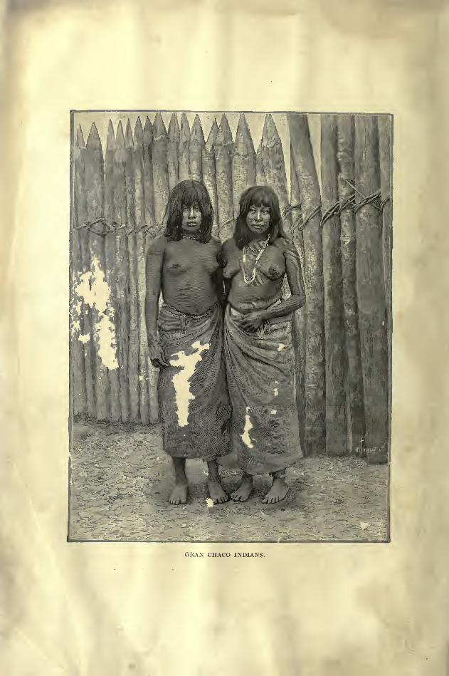
GRAN CHACO INDIANS.
THE
EARTH AND ITS USTHAB ITANT S
SOUTH AMERICABY
ELISEE RECLUS.
EDITED BY
A. H. KEANE, B. A.,
MEMBER OF COUNCIL, ANTHROP. INSTITUTE; COR. MEMB. ITALIAN AND WASHINGTON AN,T tOP. SOC.
AUTHOR OF "ASIA," ETC.
VOL. II.
AMAZONIA AND PLATA.
ILLUSTRATED BY NUMEROUS ENGRAVINGS AND MAPS.
NEW YORK:D. APPLETON AND COMPANY,
1895.

JUN 7 1956
A PARTING WORD.
completing this long work, begun in the days of my youth, I
may congratulate myself on the good fortune by which, in the
course of a life not lacking in stirring incidents, I have been
enabled to fulfil my engagements of regular publication, without
ever once breaking faith with my readers. At the same time I am well aware
that the best intentions and most conscientious labour would have been inade-
quate to such an undertaking, but for the devoted fellow-workers who have
constantly aided me by their researches and advice.
A feeling of gratitude must therefore be uppermost, and my thanks are
accordingly given to all friends who have directly or indirectly helped me by
notes, studies, correspondence, corrections, encouragement, or criticism. But this
acknowledgment can no longer reach all those to whom it is due ! A retrospective
glance shows the path marked at intervals by the memory of comrades in work
garnered by death. Towards them above all my thoughts are turned at the close
of my task. On this last page I record the name of Emile Templier, who sought
me out on the pontoons of Brest with a view to the publication of the long con-
templated Earth and its Inhabitants.
This period of twenty years, long relatively to the life of a man, is as nought
in the history of the Earth; yet how well it has been utilised ! How many
discoveries and explorations have followed one on the other, adding to our previous

iv A PARTING WOKD.
knowledge and requiring us to modify our description of the world ! Although
the mystery of the Poles is still unrevealed, Nansen has at least made his astonish-
ing journey from shore to shore of ice-capped Greenland. In the interior of Asia,
the " Eternal Sanctuary," where dwells the divine Dalai-Lama, has since Hue's
visit been closed to profane Europeans ; nevertheless, every year sees the circle
of itineraries narrowed round about the sacred spot.
In the " Dark Continent," the problems of the Nile, of the Zambesi, Congo,
and Niger have all been solved. Everywhere the network of travels covers the
planet with its ever-contracting meshes. A systematic exploration has even been
begun of the underground world, of the caves and katabothras of Greece, the
subterranean pits and channels of Vaucluse and the Gausses. The chart of the
marine depths, with their temperatures, living organisms, and geological deposits,
is progressing, like that of the continents, towards completion. As knowledge
increases, man, so to say, becomes daily transformed to a new life.
At the same time distant lands are constantly drawn closer together. The
Atlantic, a broad expanse for Norse Vikings and Genoese mariners, has become, in
the language of modern seafarers, a mere " ditch"traversed in a hundred hours.
Every year diminishes the time taken to make the tour of the world, which for
certain "globe-trotters
"has become a caprice of the moment. So bounded are
now the confines of the planet, that it everywhere benefits by the same industrial
appliances ; that, thanks to a continuous network of postal and telegraphic services,
it has been enriched by a nervous system for the interchange of thought ;that it
demands a common meridian and a common hour, while on all sides appear the
inventors of a universal language. Despite the rancours fostered by war, despite
hereditary hatreds, all mankind is becoming one. Whether our origin be one
or manifold, this unity grows apace, daily assumes more of a quickening reality.
In the presence of this world, which is modified from day to day, and whose
changes I can follow only from a distance, I have nevertheless endeavoured clearly
to realise the lands described, as if I had them actually under my very eyes, and
to study their inhabitants as if I had mingled in their society. I have striven to
live my pictures, revealing the characteristic features of each region, portraying
the peculiar genius of each human group. Everywhere, I may say, I have felt at
home, in my native land, amid my brother men. I am not conscious of having
A PAETING WORD. v
been swayed by any sentiment other than one of sympathy and respect for all the
inhabitants of the universal fatherland. On this ball, that spins so swiftly in
space, a grain of sand in infinitude, is it worth while to cherish mutual hatreds ?
But while taking my place at this standpoint of human solidarity, my work
seems still unfinished. Before studying in detail the planetary surface and the
peoples inhabiting it, I had tried in another work, The Earth* to study the life-
history of the globe itself, such as it is presented isolatedly, prepared to receive
the humanity by which the great body is animated. That work was a sort of
introduction to the series of volumes which I now bring to a close. But is not a
conclusion still lacking ?
Man, like the Earth, has his laws.
Seen from above and from afar, the diversity of features intermingled on the
surface of the globe crests and valleys, meandering waters, shore-lines, heights
and depths, superimposed rocks presents an image which, so far from being
chaotic, reveals to him who understands a marvellous picture of harmony and
beauty. The man who searchingly surveys this universe, assists at the vast work
of incessant creation, aiways beginning, never ending, and himself sharing by the
largeness of his grasp in the eternity of things, he may, like Newton, like Darwin,
find the word that sums all up.
And if the earth seems consistent and simple amid the endless complexity of
its forms, shall the indwelling humanity, as is often said, be nought but a blind
chaotic mass, heaving at hazard, aimless, without an attainable ideal, unconscious
of its very destiny ? Migrations in diverse directions, settlements and dispersions,
growth and decline of nations, civilisations and decadence, formation and displace-
ment of vital centres;are all these, as might seem at the first glance, mere facts,
nay, facts unconnected in time, facts whose endless play is uncontrolled by any
rhythmical movement giving them a general tendency, which may be expressed
by a law ? This it is that it concerns us to know. Is the evolution of man in
perfect harmony with the laws of the Earth ? How is he modified under the
thousand influences of the modifying environment ? Are the vibrations
simultaneous, and do they incessantly modulate their tones from age to age ?
* The Earth : A Descriptive History of the Physical Phenomena of the Life of our Globe. ByElisee Eeclus.
vi A PARTING WORD.
Possibly the little already known may enable us to see farther into the darkness
of the future, and to assist at events which are not }et. Possibly we may succeed
in contemplating in thought the spectacle of human history beyond the evil days
of strife and ignorance, and there again behold the picture of grandeur and beauty
already unfolded by the earth.
Here is whtit I would fain study according to the measure of my strength.
From the myriad faqts which I have had to record from chapter to chapter I
would fain extract a general idea, and thus, in a small volume written at leisure,
justify the long series of books now ended without apparent conclusion.
ELISEE RECLUS.

CONTENTS.
A PARTING WORD . . iii
CHAP.
I. THE GUIANAS 1 46
General Survey, p. 1. Natural and Political Divisions, p. 2. Physical Features,
p. 3. Rivers, p. 11. Lakes, p. 22. Climate, p. 25. Flora, p. 26. Fauna, p. 31.
Inhabitants, p. 32.
II. BRITISH GUIANA . 47 55
The North-West District, p. 48. E-sequibo Basin, p. 49. Georgetown, p. 51.
Material Condition, p. 53. Administration, p. 64.
III. DUTCH GUIANA 5661
Nickerie, p. 56. Paramaribo, p. 57. Eastern Settlements, p. 59. Natural Re-
sources, p. 59. Administration, p. 61.
IV. FRENCH GUIANA > . . 62 76
Convict Stations, p. 64. Cayenne, p. 66. Natural Resources, p. 69. Adminis-
tration, p. 70. The Contested Franco- Brazilian Territory, p. 71.
V. BRAZIL: GENERAL SURVEY .'".-. . 7789
Geographical Exploration, p. 77. Settlement, p. 79. Political Relations, p. 81.
Ethnical Elements, p. 85. Phyiical Divisions, p. 86.
VI. STATES OF AMAZONAS AND. PARA 90 124
The Amazons .River, p. 90. Eio Negro, p. 93. The Madeira, p. 96. . TheAmazons Estuary, p. 100. The Climate, p. 103. Flora, p. 103. Fauna, p. 106.
Inhabitants, p. 108. Topography, p. 114. Para, 120.
VII. STATE OF GOYAZ 125132
Tocantins Basin, p. 126. Climate, p. 128. Flora Fauna Inhabitants, p. 129.
Topography, p. 130.
VIII. STATES OF MARANHAO, PIAUHY, CEARA, Rio GBANDE DO NORTE, PAEAHYBA, PER-
NAMBUCO, AND ALAGOAS . 133 151
Geographical Research, p. 133. Physical Features Rw>rs, p. 134. Fernando de
Noronha, p. 136. Climate Flora Fauna, p. 137. Inhabitants, p. 138. Topo-graphy, p. 139. ^
viii CONTENTS.
CHAP. PAOE
IX. STATES OF MINAS GEBAES, .BAHIA, SEEOIPE, AND ESPIEITO SANTO .... 152178
Discovery and Settlement, p. 153. Physical Features, p. 153. River S. Francisco,
p. 155. Coast Streams, p. Io8. Climate Flora. Fauna, p. 162. Inhabitauts,
p. 163. Topography, p. 167.
X. STATE OF Rio DE JANEIRO AND NEUTBAL TEEP.ITOBY 179198
Physical Features, p. 179. Rivers, p. 182. Climate, p. 185. Flora Fauna
Inhabitants, p. 186. Topography, p. 187.
XI. STATES OF S. PAULO, PAEANA, AND SANTA CATHAEINA 199 233
The Disputed Zone, p. 200. Physical Features, p. 202. Rivers, p. 203. Parana
Basin, p. 206. Climate, p. ^10. Flora Fauna, p. 211. Inhabitants, p. 212.
Topography, p. 215.
XII. STATE OF Rio GBANDE DO SUL 234 248
Physical Features, p. 236. Coast Lagoons, p. 236. Rivers, p. 239. Climate,
p. 239. Flora Fauna, p. 240. Topography, p. 242.
XIII. STATE OF MATTO GEOSSO . 249262
Historic Survey, p. 249. Physical Features, p. 251. Rivers, p. 254. Climate,
p. 256. Flora Fauna Inhabitants, p. 257. Topography, p. 260.
XIV. MATEEIAL AND SOCIAL CONDITION OF BRAZIL 263 291
Immigration, p. 266. Agriculture, p. 268. Land Tenure, p. 271. Industries,
p. 273. Communications, p. 278. Education Religion, p. 283. Administration,
p. 285.
XV. PABAGUAY 292328
Historic Retrospect, p 293. Extent Population, p. 295. Discovery, p. 296.
Physical Features, p. 297. Rivers, p. 298. Climate, p. 302. Flora Fauna,
p. 303. Inhabitants, p. 305. The Paraguay Missions, p. 309. Topography,
p. 313. Material and Social Condition, p. 321. Government, p. 327.
XVI. UBUGTTAY*
329343
Physical Features Rivers, p. 330. Climate, p. 332. Flora Fauna Inhabi-
tants, p. 334. Topography, p. 335. Monte Video, p. 336. Social and Material
Condition, p. 339. Government, p. 342.
XVII. ABGENTINA 344476
Progress of Discovery, p 344. Frontier Questions, p. 349. Physical Features,
p. 352. The Patagonian Steppe, p. 365. The Pampas, p. 367. Rivers, p. 370.
The Parana Delta, p. 374. The Plate Estuary, p. 376. Closed Basins, p. 378.
The Rio Negro, p. 382. Patagonian Rivers and Lakes, p. 385. Climate, p. 392.
Flora, p. 396. Fauna, p. 398. Inhabitants, p. 404. Topography, p. 421. Ro-
sario, p. 427. Salta, p. 429. Tucuman, p. 430. Mendoza, p. 437. Cordoba,
p. 442. Buenos Ayres, p. 445. Towns of Patagonia, p. 456. New Wales, p. 458.
Material and Social Condition, p. 461. Stock-breeding, p. 463. Land Tenure,
j>.467. Industries Trade, p. 4(J9. Administration Finance, p. 474.
XVIII. FALKLAND ISLANDS AND SOUTH GEOEGIA 477482
APPENDIX STATISTICAL TABLES ..... 483492

LIST OF ILLUSTRATIONS.
MAPS PRINTED IN COLOURS.
South America (upper part)
South America (lower part)
PAGE
46
124
Rio de Janeiro and Environs .
Buenos Ayres, La Plata and the Estuary
178
344
PLATES.
Gran Chaco Indians.... Frontispiece
Mount Roraiina . . .To face page 8
Galibi Habitation on the Banks of the Maroni 36
Cayenne View taken from Ceperou . . 66
The Maranon at Tabatinga .... 90
Amazonian Scenery Cachoeira, near Manaos . 96
Flooded Banks of the Amazous . . .100Interior of a Ticuna Hut . . . .108Mauaos View taken from the Suburbs . .118Para View taken from the River . . .122Caraya Indians ...... 130
Port of Recife 144
Sugar Haryest . . . . . .148Bahia General View of the Bay . . . 152
Paulo Affonso Falls 156
Entrance to Rio de Janeiro Bay . . . 184
Rio de Janeiro General View take.i from
Cobras Island 190
Immigrant Station, Flores Island, in Rio de
Janeiro Bay 196
Victoria Falls, on the Rio Iguazu . . .210Santos Harbour View taken in 1891 . . 222
Paranagua-Curitiba Railway View taken at
the Morro de Marumby .... 226
Matto Grosso Scenery Banks of the Aqui-dauana .... To face page 250
Lengoas Indians on the March . . . 258
Carnauba Palms 270
Mules transporting Minerals . . . 276
Group of Anga'ite Indians, North Chaco . . 306
Humaita View taken from the Banks of the
Paraguay 320
Convoy of Waggons ..... 324
Monte Video General View taken from the
Cerro .......The Parana View taken at Hernandanas
Convoy of Muleteers at the foot of the Cordil-
lera 356
Las Palmas L'igunes, near the Mouth of the
Pilcomayo ...... 374
Banks of the Rio Neuquen . . . .382Group of Patagonians . . . . .414Group of Gauchos 418
Tucuman . 430
Mendoza 438
Buenos Ayres Congress Buildings . . 448
General Acha Street View . . . .456Corral in the Province of Patagones . . 464
LIST OF ILLUSTRATIONS.
LIST OF ILLUSTRATIONS.
FIG.
1 . Island of the Guianas ....2 . Routes of the Chief Explorers of Guiana .
3. Turauc-Humac Mountains
4. KAIETETTR FALLS ......5. Essequibo and Upper Rio Branco Basins .
6. Sources of the Oyapok . . .
7. Rivers of the Franco -Brazilian Contested
Zone8. Takutu Savannas . . . . .
9. Forests and Savannas of Guiana
10. Indians of the Guianas .
11. GALIBI MAN12. GALIBI WOMAN13. Inhabitants of Guiana .
14. North-Western District, British Guiuna .
15. Georgetown ......16. Paramaribo and Surinam Estuary17. Cultivated Zone, Dutch Guiana
18. Penal Settlements of the Maroni
19. Cayenne Island
20. Cayenne21. Mouth of the Oyapok .
22. Gold Mines of Guiana ....23. Mapa and Carapaporis Bay24. Political Divisions of Guiana
25. Land of Vera Cruz, Section of Brazilian
Coast first Discovered ....26. Old Political Divisions and Frontiers of
Brazil .......27. Brazil and Portugal28. Colonia del Sacramento ....29. Relief of Brazil
30. Solimoes and Japura Confluence
31. Uaupes Confluence and Rio Negro Cata-
racts
32. Lower Course of the Rio Branco
33. Amazonian Depression and Outer Zone of
the Cataracts
34. Amazonian Gulf .....35. Diurnal Temperatures of Para and London
36. Amazonian Selva .....37. CAFUSA HALF-BREED .
38. Indian Populations of Amazonia
39. Teffe and Japura Confluence
40. Madeira Falls and Projected Railway4 1 . Itaoostiara and Madeira Confluence .
42. Obidoa
43. Alemquer Santarem .
44. Para and its Roadstead ....45. Routes of Explorers in the Amazons and
Tocantins B i*ins
46. South Goyaz and Future Federal Territory
of Brazil
PAGE
LIST OF ILLUSTRATIONS. XI
F1O.
96. Coffee Plantations North of S. Paulo
97. Sorocaba and Ipanema Iron Mined .
98. From Curitiba to Paranagua .
99. Pg,raiiagua ......100. S. Francisco Island.....101. Santa Catharina Island .
102. Lagoa dos Patos
103. Lagoa Mirim ......104. German Colonies in South Brazil
105. Porto Alegre and Guahyba Estuary106. Proposed Canal from the Capivary to
Torres and Laguna ....107. Rio GRANDE GENERAL VIEW108. PeJotas
L09. Rio Grande do Sul and its Bar
110. Tapajoz and Paraguay Watershed .
111. Sources of the Alegre and Agua,p>thy112. Matto Grosso and the Upper Guapore113. Cuyaba and the Paraguay114. Density of the Brazilian Population115. Chief Colonies of Immigrants in Brazil .
116. Chief Forest and Agricultural Products
of Brazil ......117. Goldfields of Central Brazil
118. Limit of the Mining Interdict about
Diamantina in the Eighteenth Century119. Chief Mines of Brazil . . . .
120. Railways of Brazil
121. Rio, Minas and S. Paulo Railway Sys-tems .......
122. Navigable Waterways of Brazil
123. Political Divisions of Brazil
124. PALACE ON FISCAL ISLAND CUSTOM
HUUSE, BAY OF Rio ....125. Municipalities of the State of Rio de
Janeiro.......126. Former Limits Claimed and Present
Limits of Paraguay ....127. ThePilcomayo128. VlEW TAKEN ON THE PlLCOMAYO
129. Forest and Campos Regions130. Jesuit Missions .....131. OLD JESUIT CHURCH IT PIEAYU132. Encainacion ......133. Asuncion
134. ASUNCION STREET VIEW135. From Asuncion to Villa Rica .
136. South-West Paraguay .
137. Humaita ......138. Yerba Mate Regions of Paraguay and
Brazil'*.......139. La Plata Estuary140. Montevideo141. A SALADERO AT SALTO .
PA6K
THE EARTH AND ITS INHABITANTS.
AMAZONIA AND LA PLATA.
CHAPTER I.
THE GUIANAS.
GENERAL SURVEY.
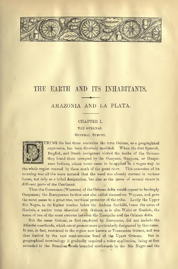
URING the last three centuries the terra Guiana, as a geographical
expression, has been diversely modified. When the first Spanish,
English, and Dutch navigators visited the banks of the Orinoco
they found them occupied by the Guayano, Guayana, or Guaya-naze Indians, whose name came to be applied in a vague way to
the whole region roamed by them south of the great river. This extension of its
meaning was all the more natural that the word was already current in various
forms, not only as a tribal designation, but also as the name of several rivers in
different parts of the Continent.
Thus the Guaraunos (Warauns) of the Orinoco delta would appear to be simply
Guayanos ; the Rucuyennes farther east also called themselves Wayana, and gave
the same name to a great tree, mythical protector of the tribe. Lastly the UpperRio Negro, in its higher reaches below the Andean foothills, 1 ears the name of
Guainia, a native term identical with Guiana, as is also Waini or Guainia, the
name of one of the coast streams between the Essequibo and the Orinoco delta.
But the name Guiana, as first employed by Europeans, did not include the
Atlantic coastlands, which are at present more particularly designated by that name.
It was, in fact, restricted to the region now known as Venezuelan Guiana, and was
thus limited by the vast semi-circular bend of the Upper Orinoco. But in
geographical terminology it gradually acquired a wider application, being at first
extended to the Brazilian 4ands bounded southwards by the Rio Negro and the
2 AMAZONIA AND LA PLATA.
Amazons, and then to the eastern slopes of the mountains, formerly known, in a
general way, as the Serra de Parima, and figuring on the early maps as Caribana,
that is to say," Land of the Caribs."
EXTENT NATURAL DIVISIONS.
Within these wider limits Guiana constitutes a well-defined section of the South
American mainland. It comprises the whole of the oval space, some 800,000 square
miles in extent, which is cut off from the rest of the Continent by the valleys of
the Orinoco, Cassiquiare, Rio Negro, and Lower Amazons. This vast region of South
America has been called an "island," but there is no question here of a real island
completely encircled by a navigable waterway. Although it may probably one dayassume this character, by means of a series of artificial canals, the navigation is at
present interrupted by the famous Aitures and Maipures rapids on the Orinoco, as
well as by others on the Cassiquiare and on the Upper Rio Negro, where boatmen have
to land their goods and surmount the obstructions by portages. Thus, even under
the most favourable conditions of weather, currents, and conveyance, the circum-
navigation of Guiana could not at present be completed under three or four months.
From the geological standpoint also, Guiana constitutes an isolated region
distinct from the rest of the mainland. It consists of a separate mass of granites
and other eruptive rocks, which have been iipheaved since the Triassic epoch.
The whole system, however, presents considerable diversity, and may be decom-
posed into four nearly equal natural divisions by two lines intersecting each other
at right angles. The first is formed by the crests of the mountains which are dis-
posed nearly parallel with the equator, running from the low water-parting near
the Cassiquiare towards the northern headland of the Amazons estuary. The
second is somewhat less distinctly indicated by the transverse depression traversed
in one direction by the Essequibo, in the other by the Rio Branco.
POLITICAL DIVISIONS.
But the rival conquering Powers in the American continent could scarcely be
expected to pay much attention to this natural segmentation of the Guianas, more
especially as the European settlers had easy access only to the coastlands and the
banks of the great rivers. Even within a few miles of the sea the interior of the
country long remained absolutely unknown. Adventurers made their way into
the recesses of the forests and savannas, but they brought back no clear geogra-
phical details, and of the mountainous central regions nothing was known beyond
vague or fabulous reports. As in so many other parts of the southern continent,
rumour spoke here also of the El Dorado, who was supposed to bathe in liquid
gold, and who dwelt in an emerald and ruby palace. Frequent attempts were
made to discover this "man of gold" and plunder his treasures. But no system-
atic exploration was undertaken before the present century.
Thus it happened that the political divisions were made, not along the lines
of natural separation, but, were developed from the seaboard towards the interior.
Spain, whose domain is inherited by the republic of Venezuela, took possession of
POLITICAL DIVISIONS OF GUIANA. 3
the whole of northern and western Guiana, along the crescent described by the
Orinoco. Portugal, now replaced by Brazil, appropriated that section of the
Guianas which lies on the Amazonian slope. Thus for the other European Powers
nothing remained except the maritime region comprised between the Orinoco delta
and the estuary of the Amazons.
Here the English, Dutch, and French secured a footing as conquerors and
colonists. To their settlements on the seaboard they added the " hinterlands"of
all the coast streams traversing their several domains, claiming the whole regionbetween the sea and the unknown watersheds of those rivers. The three colonial
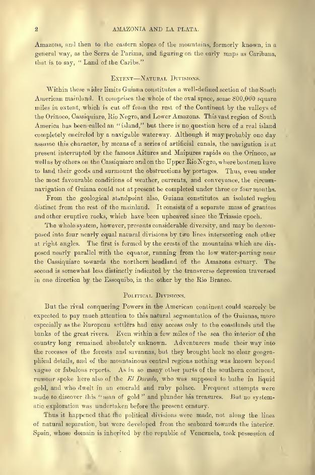
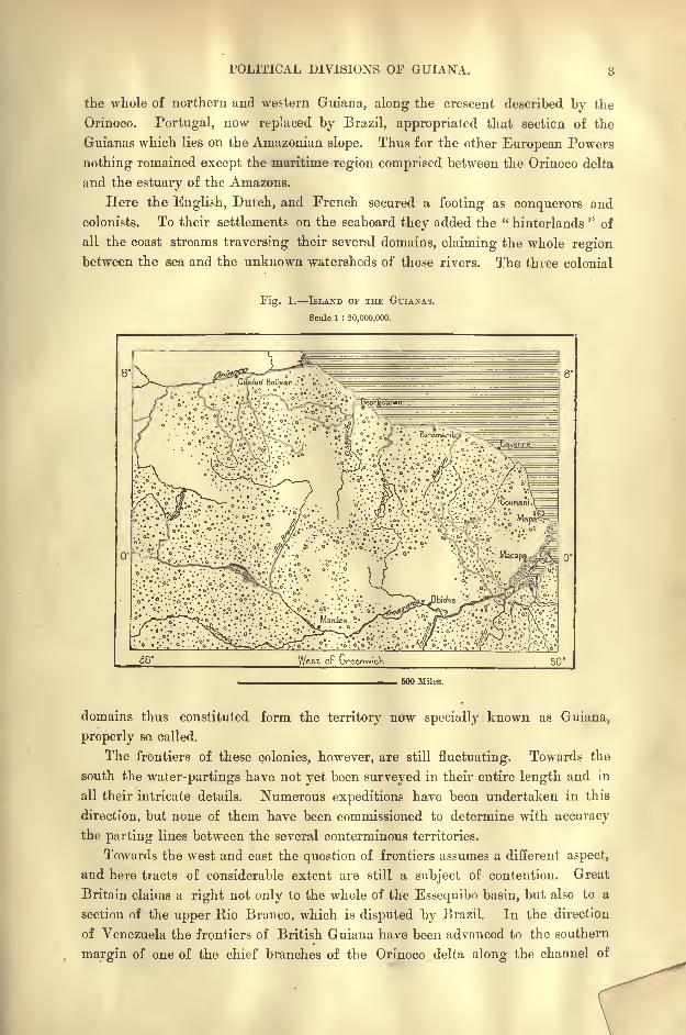
Fig. 1. ISLAND OF THE GUIANAS.
Scale 1 : 20,000,000.
o' .?*"Jr.:oV'*.'f!**"!".*;.'?*-'.*:*.*-V*"
.. ''-'.-.v.-v.-:- ;..;.
500 Miles.
domains thus constituted form the territory ncrw specially known as Guiana,
properly so called.
The frontiers of these colonies, however, are still fluctuating. Towards the
south the water-partings have not yet been surveyed in their entire length and in
all their intricate details. Numerous expeditions have been undertaken in this
direction, but none of them have been commissioned to determine with accuracy
the parting lines between the several conterminous territories.
Towards the west and east the question of frontiers assumes a different aspect,
and here tracts of considerable extent are still a subject of contention. Great
Britain claims a right not only to the whole of the Essequibo basin, but also to a
section of the upper Rio Branco, which is disputed by Brazil. In the direction
of Venezuela the frontiers of British Guiana have been advanced to the southern
margin of one of the chief branches of the Orinoco delta along the channel of

4 AMAZONIA AND LA PLATA.
the Amacuru. The boundary has also been drawn so as to include the rich
auriferous alluvia of the Cuyuni valley, and the wliole of the disputed territory,
which has already led to sanguinary conflicts, comprises a superficial area more
extensive than that of the region recognised as belonging indisputably to Great
Britain.
At the other extremity of the Guianas, France contests with Brazil a large
tract estimated at about half the size of P>ance. The district in dispute forms a
long strip of the Amazons basin, extending along the Atlantic seaboard between
the Araguari and the Rio Branco. All these disputed lands on the south, west,
and east frontiers form so many distinct political domains comprised within the
natural limits of the " island of Guiana." The whole region thus contains five
separate territories, with superficial areas as under :
Bq. miles.
British Guiana, including the district disputpd by Brazil . . 45,700
Guiana contested by Great Britain and Venezuela . . . 50,000Dutch Guiana (undisputed) ........ 45,700French Guiana (undisputed) ........ 31,000Guiana contested by France and Brazil . ..... 100,000
Total according to H. Coudreau . . . 272,400
All these Guianas greatly resemble each other in their general physical
aspects, their geographical constitution, the direction and character of their
running waters and marine currents, the erosions and deposits of their coastlands,
their climatic relations, the distribution of their animal and vegetable species,
the affinities of their indigenous populations. To human agencies are mainly
due the chief contrasts observed in the different colonial territories, which have
been subjected by the respective mother countries to different social and economic
conditions. Numerous travellers, some acting on individual impulse, some
in their official capacity, have carefully studied many of the river valleys, agri-
cultural and mining districts, and their itineraries have been connected with those
of other explorers who have traversed the \\hole region, either from one slope to
the other, or from the banks of the Orinoco to those of the Amazons. Thanks
to these collective surveys, a general picture may now be formed of the physical
and biological features of the Guianas.
PROGRESS OF DISCOVERY AND SETTLEMENT.
Our first knowledge of the seaboard is due to the Spanish navigator, Vicente
Yaiiez Pinzon, who had accompanied Columbus on his voyage of discovery. In
the year 1500 this pioneer, after coasting the shores of Brazil east of the Amazons,
crossed the estuary and skirted the low-lying coasts of Guiana as far as the Orinoco
delta. lie was followed by Diego de Lepe and other mariners, who explored the
same waters;but nearly a century passed before any European settlers ventured
to penetrate into the interior.
A few Spaniards had already landed on the coasts near the Orinoco, when some
Dutchmen attempted in 1581 to establish themselves on the banks of the Demerara
and open trade with the natives. Other pioneers were attracted by the love of
DISCOVEEY AND SETTLEMENT OF GUIANA. 5
adventure and by the hope of discovering the treasures of El Dorado. In 1596
the English explorer, lieymis, following in the footsteps of Sir Walter Raleigh in
the "Empire of Guaya," that is, in Spanish Guiana, went in quest of the fictitious
lake Manoa, which figures on Raleigh's map as a great sheet of water 200 miles
long, with a city at its eastern extremity, reported to be " the largest in the
world." This map, for the first time published in 1892,* shows the course of the
Orinoco and Amazons rivers, and covers the whole continent from their mouths to
the Pacific coast. Writing in 1595 to Lord Charles Howard on " the discovery of
the large, rich, and beautiful empire of Guaya," Sir Walter remarks in reference
to the map :
" How these rivers crosse and encounter, how the country lieth, and
is bordered, the passage of Camenes, and of Berreo, mine own discoverie, and the
way that I entred, with all the rest of the nations, and rivers, your lordship shall
receive in a large chart or map, which I have not yet finished, and which I shall
most humbly pray your lordship to secret, and not to suffer it to pass your own
hands;for by a draught thereof all may be prevented by other nations. For
I know it this very yeere sought by the French, although by the way they now
take I fear it not much."
But instead of taking the route of the. Orinoco, Keymis ascended the river
Oyapok, which traverses the region that has since become French Guiana. In
1688 la Motte Aigron sailed up the same river a distance of "fifty leagues
"from
ihe sea, in the vain hope of reaching the banks of the Amazons, and perhaps even
of discovering the route leading to the famous region of gold and precious
stones.
So late as 1739 the same mirage of a city with houses of rubies and other
gems was still powerful enough to attract Nicolas Hortsmann, who, following
the course of the Essequibo, penetrated far into the interior.
But regular colonisation had its origin not in adventure but in commerce.
Once settled on the Guiana seaboard, the traders of various nationalities began to
struggle for the ascendancy in the conquered lands, and their respective Govern-
ments took part in these rivalries by organising warlike or plundering expeditions.
Thanks to these expeditions a better knowledge was gradually acquired of the
more favoured districts on the seaboard;the geographical f i atures of the coast-
lands, estuaries, and watercourses as far as the first rapids, were more accurately
laid down, and some vague notions of the inland regions were obtained from the
reports of the Indians and of the Bush Negroes.
In 1672 Richter made his famous discovery of the flattening of the globe at
its poles. Two years later the Jesuits, Grillet and Bechamel, were sent to Cayenneto study the physical geography of the country ;
but after penetrating to the
territory of the Nurag and Acoqua Indians, these pioneers succumbed to the hard-
ships of the journey. The scientific exploration of the Guianas was thus delayed
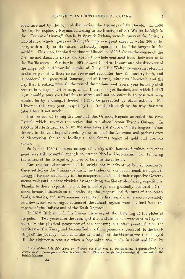
till the eighteenth century, when a beginning was made in 1743 and 1744 by
* Sir Walter Raleigh's Karte ran Guyana urn 1595, von L. Friedrichsen. Separatabdruck aus
Festschrift der Hamburgischen Ameiika- Feier, 1892. This is a fac-simile of the original preserved in the
British Museum.
35
AMAZONIA AND LA PLATA.
Barrere and by La Condamine on his return from his memorable expedition to
the equatorial Andes.
Twenty years later Simon Mentelle arrived at Cayenne, where he sojourned
under conditions of the greatest difficulty for thirty- six years. During this
period he visited, in his capacity as engineer, the whole of the seaboard of French
Gaiana, and had his advice been attended to, many a disastrous expedition would
have been avoided. The same region was traversed in 1762 64 by the botanist,
Fusee Aublet, whose work on the Plants of Guiana is still a standard book of
reference. In 1787 his associate, Patris, ascended the Oyapok and its Camopi
affluent, and Leblond, another naturalist of considerable intelligence and enter-
prise, followed nearly the same route, returning by the river Sinnamari. He spent
Fig. 2. ROUTES OF THE CHIEF EXPLOEEES OF GUIANA.
Scale 1 : 13,000,000.
^''A
711*S** tfP
\ \ M' '*':/v -r
'
'/ C^ / # V% $ \\ -" ' / TVf &. IC^ %, *&- ! "5 ft $1 J;^
60'
, 250 Miles.
several years in exploring a great part of the land, studying its economic plants,
searching especially for the quinquina, which he failed to find, observing the
aborigines, and developing projects for the settlement of the uplands.
Both in French and Dutch Guiana the engineer Guisan constructed numerous
navigable and drainage canals, taking advantage of these works to investigate the
character of the soil, climate, and local products. Stedman, an English officer in
the Dutch service, turned to profitable account a residence of five years (1772-77)
in the interior of the colony of Surinam. He has left us a valuable record of his
travels and observations in this region, as well as an excellent history of the wars
with the Bush Negroes, in which, he was actively engaged.
Later the gangs of convicts transported to French Guiana contributed to a
PEOGEESS OP GEOGEAPHICAL EESEAECH IN GUIANA. 7
wider knowledge of the country ;for which, however, they earned the evil reputa-
tion of a land of pestilence and death. Of all the educated exiles who eventually
returned to the mother country, not one was found capable or willing to prepare a
work of permanent value on the land of his banishment.
After the wars of the Revolution and of the Empire the first voyages of discovery
modelled on the memorable expeditions of Humboldt and Bonpland to the NewWorld were those undertaken by the brothers Schomburgk in the years 1835-39.
After investigating nearly the whole of British Guiana, these distinguished tra-
vellers crossed the mountains and connected their itineraries with those of Humboldt
and other explorers in the Orinoco basin. In French Guiana the divide between
the Oyapok, Yari, and Araguari rivers had already been crossed by Adarn de
Bauve in 1830. Leprieur had traversed the same regions, descending the Yari
for a distance of over fifty leagues, while Gatier surveyed the course of the Mana
to its sources.
During the twenty years from 1849 to 1868, Appun, friend and associate of
the forest Indians, devoted himself to the study more especially of the plants and
animals of exuberant tropical nature in British and Venezuelan Guianas ;the geolo-
gists Brown and Sawkins continued on the mainland as far as the Pacaraiina
mountains the researches they had successfully carried out in the neighbouringisland of Trinidad
; Idenburg occupied himself with the climatology and sanitary
condition of Butch Guiana ;Crevaux in 1876 and Coudreau in 1883 resumed the
work of the Schomburgks at other points nearer to the Amazons, thus connecting
the itineraries of the seaboard with those of the inland Brazilian slopes in the Rio
Branco and Rio Negro basins.
Since the year 1883 Everard im Thurn has been occupied with careful carto-
graphic surveys of the disputed north-western territory claimed by Great Britain
on the Venezuelan frontier. Triangulations are still lacking for accurate maps of
that region, but we already possess all the elements needed to lay down with suffi-
cient precision the course of the ramifying streams and the relief of the mountains,
bringing the details into harmony with the more scientific surveys of the coastlands
and fluvial estuaries.
Of the numerous publications dealing with the geographical literature of the
Guianas, their populations, administration, and economic conditions, some are of
great value to students of anthropology and political economy. Amongst them are
the writings of Kappler and Anthony Trollope, Gifford Palgrave's Dutch Guiana
(1876), and, above all, Everard im Thurn' s classical work on The Indians of Guiana
(1883).
PHYSICAL FEATURES RORAIMA.
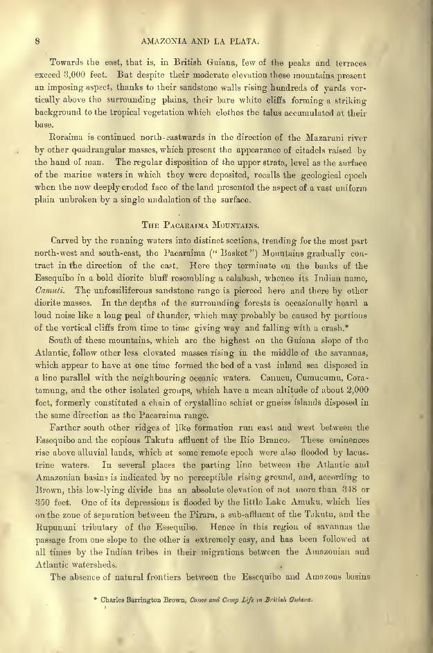
Between Venezuela and British Guiana the chief mountain mass, forming the
natural frontier of both regions, is the superb Roraima, a square block or table of
pink sandstone, which discharges from a height of 7,500 feet several cascades
blown into ribbons of spray by the breeze. The whole system of mountains, col-
lectively known as the Pacaraima range, presents its loftiest crests to the west and
south-west in the Upper Rio Branco basin.
8 AMAZONIA AND LA PLATA.
Towards the east, that is, in British Guiana, few of the peaks and terraces
exceed 3,000 feet. But despite their moderate elevation these mountains present
an imposing aspect, thanks to their sandstone walls rising hundreds of yards ver-
tically above the surrounding plains, their bare white cliffs forming a striking
background to the tropical vegetation which clothes the talus accumulated at their
base.
Roraima is continued north-eastwards in the direction of the Mazaruni river
by other quadrangular masses, which present the appearance of citadels raised bythe hand of man. The regular disposition of the upper strata, level as the surface
of the marine waters in which they were deposited, recalls the geological epochwhen the now deeply eroded face of the land presented the aspect of a vast uniform
plain unbroken by a single undulation of the surface.
THE PACARAIMA MOUNTAINS.
Carved by the running waters into distinct sections, trending for the most part
north-west and south-east, the Pacaraima (" Basket ") Mountains gradually con-
tract in the direction of the east. Here they terminate on the banks of the
Essequibo in a bold diorite bluff resembling a calabash, whence its Indian name,
Camuti. The unfossiliferous sandstone range is pierced here and there by other
diorite masses. In the depths of the surrounding forests is occasionally heard a
loud noise like a long peal of thunder, which may probably be caused by portions
of the vertical cliffs from time to time giving way and falling with a crash.*
South of these mountains, which are the highest on the Guiana slope of the
Atlantic, follow other less elevated masses rising in the middle of the savannas,
which appear to have at one time formed the bed of a vast inland sea disposed in
a line parallel with the neighbouring oceanic waters. Cauucu, Cumucumu, Cora-
tamung, and the other isolated groups, which have a mean altitude of about 2,000
feet, formerly constituted a chain of crystalline schist or gneiss islands disposed in
the same direction as the Pacaraima range.
Farther south other ridges of like formation run east and west between the
Essequibo and the copious Takutu affluent of the Rio Branco. These eminences
rise above alluvial lands, which at some remote epoch were also flooded by lacus-
trine waters. In several places the parting line between the Atlantic and
Amazonian basins is indicated by no perceptible rising ground, and, according to
Brown, this low-lying divide has an absolute elevation of not more than 348 or
350 feet. One of its depressions is flooded by the little Lake Amuku, which lies
on the zone of separation between the Pirara, a sub-affluent of the Tukutu, and the
Rupununi tributary of the Essequibo. Hence in this region of savannas the
passage from one slope to the other is extremely easy, and has been followed at
all times by the Indian tribes in their migrations between the Amazonian and
Atlantic watersheds.
The absence of natural frontiers between the Essequibo and Amazons basins
* Charles Harrington Brown, Canoe and Cump Life in British Guiana.


THE GUIANA UPLANDS. 9
also accounts for the differences that have arisen between the Governments of
Great Britain and Brazil regarding the limits of their respective domains about
the sources of the Essequibo and Rio Branco affluents. The whole of the dividing
zone sometimes takes the name of the River Parira, a word of Macusi origin,
which, according to Schomburgk, indicates the geological constitution of the
land a ferruginous conglomerate. Above the water-parting rises a column of
trap formation, which is regarded as a sacred object by the surrounding Macusi
Indians.
A few other isolated groups follow southwards as far as the neighbourhood
of the sources of the Essequibo, which stand at an altitude of about 820 feet.
Here the heights, glimpses of which are at rare intervals obtained from the river
banks across the dense foliage of the primeval woodlands, do not develop a con-
tinuous amphitheatre of rounded hills, but form a number of distinct ridges
sharply defined by deep transverse gorges. They constitute so many"huge
blocks, some of which have a length of about 90 miles, standing on very low
pedestals of plateau formation."*
According to Coudreau, the loftiest summit in this region is Coirrit, or
Cairrid Dekeuou (Brown's Acara'i), the " Mountain of the Moon," which lies
near the sources of the Takutu, and attains an altitude of about 5,000 feet. It
is the culminating peak of a ridge with a mean elevation of some 3,000 feet,
which sweeps round in a vast bend first to the south and then to the east, as far
as Mount Aourriawa, where rise the headwaters of the Essequibo. Farther on
are developed the Curucuri heights, seen from a distance by Coudreau. Here
the water-parting coincides exactly with the crest of the mountain range. Onone side descend the streams flowing to the Essequibo, on the other those
flowing to the Trombetas affluent of the Amazons.
The sierra falls in the direction of the east, where it forms the natural
boundary between Dutch Guiana and Brazil. According to Brown, the highest
summits rise scarcely 300 feet above the sources of the River Corentyne, which
forms the frontier line between Dutch and British Guiana.
THE TuMUC-HuMAC RANGE.
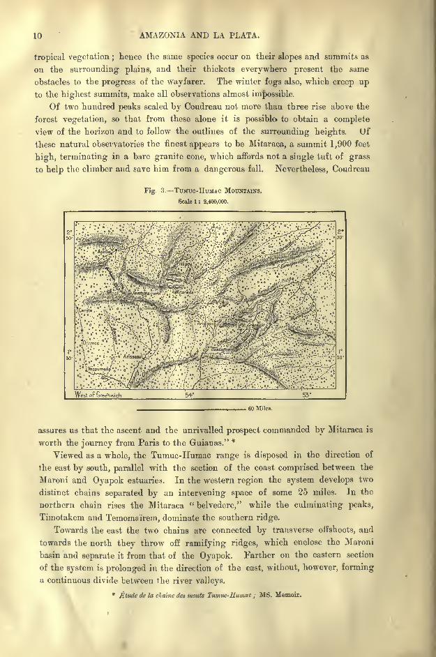
Farther on the system again rises, and here takes the name of the Tumuc-
Humac range, a term of unknown meaning. From its northern slopes descends
the Maroni, the chief watercourse of French Guiana. According to Coudreau,
its highest summit is Mount Timotakem (2,624 feet), which lies in the western
section of the range. Few of the travellers that have visited this mountainous
region have laid down accurate itineraries of their routes, and hitherto (1894)
Coudreau is the only explorer who has mapped the main range with any approachto accuracy. It is all the more difficult to determine its exact form and trend
that all the slopes, as well as the intermediate valleys, are clothed with a con-
tinuous mantle of dense woodlands.
None of the Tumuc-Humac crests are lofty enough to rise above the zone of
* Henri A. Coudreau, la France Equinoxiale.
10 AMAZONIA AND LA PLATA.
tropical vegetation ;hence the same species occur on their slopes and summits as
on the surrounding plains, and their thickets everywhere present the same
obstacles to the progress of the wayfarer. The winter fogs also, which creep upto the highest summits, make all observations almost impossible.
Of two hundred peaks scaled by Coudreau not more than three rise above the
forest vegetation, so that from these alone it is possible to obtain a complete
view of the horizon and to follow the outlines of the surrounding heights. Of
these natural observatories the finest appears to be Mitaraca, a summit 1,900 feet
high, terminating in a bare granite cone, which affords not a single tuft of grass
to help the climber and save him from a dangerous fall. Nevertheless, Coudreau
Fig 3. Tmiuo-HiTMAc MOUNTAINS.
Scale 1 : 2,400,000.
West op Gnee'fwich 53'
, 60 Miles.
assures us that the ascent and the unrivalled prospect commanded by Mitaraca is
worth the journey from Paris to the Guianas." *
Viewed as a whole, the Tumuc-Humac range is disposed in the direction of
the east by south, parallel with the section of the coast comprised between the
Maroni and Oyapok estuaries. In the western region the system develops two
distinct chains separated by an intervening space of some 25 miles. In the
northern chain rises the Mitaraca "belvedere," while the culminating peaks,
Timotakem and Temoma'irem, dominate the southern ridge.
Towards the east the two chains are connected by transverse offshoots, and
towards the north they throw off ramifying ridges, which enclose the Maroni
basin and separate it from that of the Oyapok. Farther on the eastern section
of the system is prolonged in the direction of the east, without, however, forming
u continuous divide between the river valleys.
* Etude de la dialiic des wonts Tumuc-Humac ; MS. Memoir.
THE GUIANA UPLANDS. 11
At their eastern extremity the Tumuc-IIumac mountains ramify like the ribs
of a fan towards the north-east, the east and south-east, but retain the aspect of
distinct ridges only above the low-lying marshy tracts. About the sources of the
Oyapok between these ridges the water-partings are so indistinct that the channels
of the Oyapok, Cachipour, Araguari, and even of the Yari affluent of the Amazons,
are all connected during the rainy season by continuous chains of meres and
lagoons. These shallow expanses, however, are unnavigable and inaccessible even
to the canoes of the surrounding Indian tribes.
In that section of the Guianas which is comprised between the southern
uplands and the seacoast, there nowhere occur any heights forming continuous
chains of mountains or hills. Here all the rising grounds are broken by the
fluvial valleys into separate ridges of short length, such as the so-called
"Montagne Francai&e
"on the right bank of the Maroni
;the Magnetic
Mountain (715 feet) towards the south-east between the Inini and Mana rivers;
and the granitic Mount Leblond (1,335 feet), towards the sources of the Sinnamari.
Near the shore the eminences are for the most part merely isolated masses of
gneiss, schists, or sandstone ranging in height from 300 to 720 feet. Formerlywashed by the marine waves, they are now surrounded by alluvial matter deposited
in the marine waters. One line of beach after another was here laid down,
enclosing the old islands and archipelagoes, which are now to be sought in the
interior of the Continent.
In French Guiana nothing is seen along the seaboard except a few rocky
prominences on the beach or in the vicinity of the coast. North-west of Cayennea few bluffs stand out near Mana, Iracoubo, Sinnamari, and Kourou. South-east
of the capital stretch the hills of Caux, whose French nume, as spelt in the eigh-
teenth century, has been altered to the English form Kuw. This range of coast
hills culminates in Mount Matouri (836 feet), in the " Tour de 1'Ile," south of
Cayenne. Mount Argent, serving as a landmark to mariners at the mouth of the
Oyapok, is a mere hillock scarcely 300 feet high.
The district known as the " island of Cayenne," though separated from the
mainland only by a few marshy channels, is also studded with knolls representing
former islands now connected by sedimentary deposits. Such are Cabassou
dominating the capital, and farther east the Remire "Mountains," which were
formerly called volcanoes. The neighbouring depressions where rise the springs
which supply Cayenne with water were similarly regarded as old " craters."
Along the coast occur a few rocky islets, of which the most important,
thanks to its deep anchorage, is the Salut Archipelago ;farther east are the Enfant
Perdu;the Malingre, Pere, Mere and Mamelles, all disposed in a chain parallel
with the shore; lastly, farther seaward, the two Connetables facing the mouth of
the Approuague, upheaved peaks of a submarine plateau.
RIVERS OF GUIANA THE ESSEQUIBO BASIN.
The Essequibo (Essequebo), largest of all the Guiana rivers, flows entirety in
British territory ;but the Cuyuni, one of its chief affluents, takes its rise beyond

12 AMAZONIA AND LA PLATA.
the Venezuelan frontier. The main stream, like all the other watercourses of
this region, appears to bear a native name, in which the final syllable bo indicates
direction in the Galibi group of languages; hence Essequi-bo would have the
sense of <f
Essequi-wards," in the direction of the Essequi. Nevertheless, Schom-
burgk refers to a legend which attributes the origin of this name to Don
Juan Essequibel or Jaizquibel, one of Diego Columbus's companions.* Formerlythe different, sections of this great watercourse bore different native names. In
the coast region, where it develops a broad estuary, the surrounding populations
called it the Aranauma, while the main branch was designated Chip Wa, that is,
Chip River, by the Wapisianas and the neighbouring tribes. It would appear to
communicate with the upper Trombetas, an Amazonian affluent, through the
Apini, a river which, like the Cassiquiare, is said to have a double incline.
Rising in the Awarrivva mountain, the Essequibo, which has a somewhat
shorter cour-e than that figured on the English maps of Schomburgk and
Brown, flows first north-eastwards through the forest inhabited by a few groups
of the Chirm and Taruma Indians. Farther on it is joined by the Yaore, wjiich
flows in a winding course eastwards through the uninhabited wilderness border-
ing on the savannas. A human figure carved on the face of the rock near a
cascade on the Yaore is said by the Indian boatmen to be a portrait of Schomburgk
sculptured by the explorer himself, whose name has remained famous amongstthe natives
;but the effigy is too rudely drawn to accept; this legend.
Below the Yaore confluence the Essequibo bends gradually round to the
north. Here its bed is still in process of formation;the stream, interrupted by
numerous rocky barriers, descends from reach to reach through a succession of
cataracts. One of these, bearing the loyal but somewhat eccentric name of "King
William the Fourth's Fall," long marked the limit of legitimate trading operations
on the upper course of the Essequibo. None ventured beyond this point except
the kidnappers who went to capture slaves for the planters of the coastlands.
Numerous affluents follow along the left bank of the Essequibo, whose basin
broadens out towards the west and contracts to very narrow limits towards the
east, from which direction it consequently receives only a few slight contributions.
The Cuyuwini, which collects the surface waters of the western savannas, is suc-
ceeded lower down by the Rupunini, which is itself joined on its right bank by the
copious river Rewa some miles above the confluence with the main stream. The
whitish current of this affluent, which mingles with the black water of the Esse-
quibo, offers a navigable route towards the west utilised by the native boatmen to
reach the Amazons basin through Lake Amuku and the Pirara river. The only
interruption to the waterway between the two systems is a single portage, which
is reduced to about half a mile in length during the rainy season.
During this period the flood waters overflow in both directions, on one side to
the Rupunini, on the other to the slope drained by the headstreams of the Rio
Branco. A great part of this district about the divide between the Essequibo and
Amazons basins is occupied by savannas, which would appear to have formerly* Robert A. Schomburgk, Description of British Guiana, Hakluyt calls the river Lessekele.
ELVERS OF GUIANA. 18
been the bed of an extensive lacustrine depression, probably the great inland sea
celebrated in legend as the Lake Pa rima where dwelt the "Man of Gold." A
Fig. 4. KAIETEUE FALLS.
tradition still survives amongst the natives that the bed of the little Lake Amuku,
scarcely more than a flooded mere, is "entirely lined with gold."*
* Gustavo da Suckow, Geographical Journal, March, 1893.

14 AMAZONIA AMD LA PLATA.
THE POTARO AND THE KA1ETEUR FALT.S.
Lower down the Essequibo is joined by the Burroburro and Potaro rivers, both
flowing from the foothills of the Pacaraima uplands, and in their descent tumbling
over numerous cascades and rapids. The Kaieteur Falls, formed by the waters of
Fig. 5. ESSEQTTIBO AND UPPER TtlO BRANCO BASINS.
Scale 1 : 7,000,000.
61*
.
West oF Greenwich
Depth".
Bapids orCataracts.
Oto5FutbomB.
6 to 26Fathoms.
25 Fathomsand upwards.
125 Miles
the Potaro about the middle of its course, are amongst the finest in Guiana and
even in the whole world. Yet their very existence was absolutely unknown to
Europeans till the year 1871, when they were discovered by Mr. C. Barrington
Brown, at that time engaged on a geological survey of the British Colony. Here
BIVERS OF GUIANA. 15
the Potaro is precipitated over an abrupt cliff 741 feet high, and at flood water
the fall is 370 feet wide, decreasing at low water to rather less than half that
width. During the rainy season Mr. iin Thurn compares the spectacle to a
vast curtain of water nearly 400 feet wide rolling over the top of the cliff, and
retaining its full width until it crashes into the boiling water of the pool which
tills the whole space below;but of the pool itself only the outer margin is visible,
the greater part being ceaselessly tossed and hurled up in a great and high mass
of surf, foam, and spray. The floor of the amphitheatre over which the Potaro
tumbles "is occupied by a waste of fallen rocks, made black by constant moisture,
but capped with short, intensely green grass, except round the dark stormy pool,
where the rocks are entirely bare, slippery, and black. Immediately behind the
fall a huge dark cave is visible in the cliff, the upper edge of the cliff serving as
a horizon to the whole scene when viewed from below." *
Lower down the Potaro continues still to descend as from step to step through
a series of romantic cascades. Formerly the great fall, at that time over 1,000
feet high, stood some 15 miles farther down; but by incessantly eating away the
sandstone plateau over which it is hurled down to the plain, it has gradually
retreated while diminishing in height. The cornice of rocks from which the river
is precipitated consists of a hard conglomerate overlying a more friable sandstone.
This sandstone is incessantly eroded by the seething waters of the pool, detaching
huge blocks from time to time, and excavating a dark recess beneath the over-
hanging edge of the plateau. At sunset myriads of swallows, gathering from the
surrounding woodlands, sweep the precipice, dart like a flash into the misty spray,
and then reappear at the mouth of the cave. Such is the rapidity of their flight
that " their wings produce a hissing noise, which is not the least curious pheno-
menon of this wonderful place. After descending straight down they settle for
the night on the face of the cliff, by and behind the fall." t
THE MAZARUNI AND LOWER ESSEQUIBO.
Below the Potaro affluent the Essequibo is almost doubled in volume by the
contributions of the Mazaruni, which is itself joined by the Cuyuni eight miles
above their common mouth on the left bank of the mainstream. Rising on the
highest slopes of the Pacaraima Mountains, where it receives the streams tumbling
from Roraima, the Mazaruni is of all the Guiana rivers the most obstructed by
cataracts. The falls and rapids occur especially in the lower part of its course,
so that, despite its great volume, this river is almost entirely closed to navigation.
At the falls of Chichi, that is, the "Sun," in the Macusi language, the fluvial
bed descends a total height of 890 feet (1,380 to 490) in a space of about eight
miles. The last obstructions occur at the so-called "Monkey Jump," some 15
miles above the point where the Mazaruni is joined by the Cuyuni.
Below the confluence of the Mazaruni, the Essequibo expands into a broad
estuary, which attains a width of no less than 15 miles where it enters the sea.
*Among the Indian* of Guiana, p. 66.
t Ib.
16 AMAZONIA AND LA PLATA.
But this great expanse is broken and divided into three main navigable branches
by a number of islands, whose long axes are disposed in the same direction as the
tidal currents.
The enormous volume of water which is discharged by the Essequibo, and
which makes itself felt at a distance of some twelve miles seawards, is explained
by the great extent of its catchment basin, combined with an abundant rainfall
and the impermeable character of the soil. During the winter season the upper
reaches, dammed up by their rocky barriers, overflow their banks in many places,
thus periodically restoring the chain of lakes which at one time existed in the
fluvial valley.
THE DEMERARA, BERBICE, AND CORENTYNE.
The Deinerara (Demerari), formerly Lemdrare, flows east of and parallel to
the Essequibo with such regularity that it might almost be taken for a lateral
channel, into which were formerly discharged the flood waters of some stream
rivalling the Amazons itself in magnitude. Rising amid the northern spurs of
the dividing range, the Demerara traverses the same geological formations as the
Essequibo, first granite masses, then sandstones with diorites cropping out at
various points, and towards the coast broad alluvial tracts strewn here and there
with sandhills from 50 to 60 feet high. Sluggish channels and backwaters ramify
eastwards, connecting the Demerara with the Mahaica, a river of similar aspect,
but of much smaller volume.
The Berbice and the Corentyne (Corentijn), which follow in the direction of
the east, also flow in parallel courses quite as regular as those of the Essequibo and De-
merara. They develop the same curves and have to surmount the same obstructions
by cascades tumbling over rocky granite, diorite, or sandstone barriers. But they
vary considerably in length, the Berbice rising far in advance of the dividing
range, whereas the Corentyne has its source in the Curucuri mountains away to
the south. The latter is already a copious stream at the point where it pierces the
rocky hills, in which its western neighbour the Berbice takes its rise.
In this district the Corentyne is joined on its left bank by the New River,
through a labyrinth of ramifying branches, and below the confluence the united
waters descend to the plains through a series of superb falls and rapids. To one
of these, Robert Schomburgk gave the name of King Frederick William the
Fourth, as to the corresponding cataract of the Essequibo, which lies under the same
latitude, and which presents the same general aspect amid its rugged granite walls.
The Corentyne develops another grand fall at the crystalline rocks of Wenotobo,
where three or four branches ramifying into several channels are precipitated
from a height of about 100 feet into a lake about a mile wide, from which it
issues. in a single stream about 1,000 feet broad and 80 feet deep. Beyond this
point the Corentyne is entirely free from rapids for the rest of its course of some
170 miles to the sea. But its broad estuary, studded with islands, reefs, and shoals,
is of difficult access, and practically closed to vessels drawing more than 10 feet
of water.
B1VEES OF GUIANA. 17
THE COAST STREAMS OF DUTCH GUIANA.
This estuary also receives the discharge of the Biver Nickerie from the east.
The Mckerie may be taken as a type of the coast streams of Dutch Guiana,
developing an irregular but continuous current, which winds sluggishly from east
to west through the low- lying alluvial plains. Some of the rivers rising farther
inland on the advanced terraces of the dividing range are intercepted on their
course to the Atlantic by these coast streams, whose volume they swell, while
deflecting them to the east or to the west, according to the abundance of their
discharge or the incline of the land. Thus the Upper Nickerie and the Coppe-
name after joining the coast stream continue their seaward course in opposite
directions, while .between the two winds a channel whose current sets alternately
to the right or to the left according to the strength of the river descending from
the interior.
East of the Coppename follow the Coesewijne and ihe Saramacca, which do
not communicate directly with the Coppename or its ramifying creeks, although
they fall into the same estuary. The lower course of the Saramacea, flowing from
east to west, cuts off a strip of coastland, partly bush and partly swamp, which
has been completely isolated in the direction of the east as far as the Surinam
estuary by an old creek canalised in the seventeenth century by the famous
Governor Sommelsdyke, and still known as the Sommelsdyke Canal.
East of the Surinam, whose bar is accessible at ebb tide to vessels drawing 16
feet of water, the bush and marshy coastlands present towards the sea a long low-
lying beach of scarcely perceptible curve, and towards the interior aii intricate
system of tortuous rivers and creeks with alternating currents. Here and there
these watercourses have been transformed to regular navigable canals, largely
utilised by the boats and canoes of planters and natives. Thus follow from west
to east between the Surinam and the Maroni on the French frontier, the Comme-
wijne, Cottica, Coermoeribo (Ccrmontibo), and the Wana or Wane Creek.
The tendency of all the watercourses in this part of Guiana to set in a direc-
tion parallel with the coast, as well as the deposit of rich alluvial matter between
the watercourses themselves and the present shore -line, cannot be explained
merely by the action of the periodical floods. On the contrary, the ocean plays the
chief part in the production of these phenomena. The liquid masses rolled down
by the Amazons and the .Tocuntins do not precipitate all their sediment in the
great" fresh-water
"estuary. Being intercepted by the marine current, the
fluvial waters are deflected along the shores of the Guianas as fur as the Orinoco,
beyond which a portion penetrates through the Serpent's Mouth into the Gulf of
Paria.
Thus the alluviul matter brought down by the great Brazilian rivers is dis-
tributed along the Guiana seaboard, and in this way beach after beach is succes-
sively added to the continental periphery. Most of these new formations become
merged in a continuous low-lying coastland, but their regular successive growth
is still shown by the intermediate creeks disposed parallel with the shore-line.
The fluvial waters of the interior, arrested by the opposing marine current,.

18 AMAZONIA AND LA PLATA.
are ceaselessly deflected westwards, so as to flow parallel with the ocean stream
itself. The alluvial tracts of peninsular formation are thus extended to great
distances between the coast streams and the sea, until some weak point here and
there suddenly yields to the action of some fierce storm or of an exceptionally
high inundation.
In this way has been formed the whole coast system of Dutch Guiana, with
its perfectly distinct double shore-line, that may be traced all the way from the
Corentyne to the Maroni. These tracts of oceanic origin are still more clearly
indicated in that district of British Guiana which lies immediately to the east of
the Orinoco delta, and the possession of which is contested by Venezuela. Here
the Pomerun river, which reaches the sea at Cape Nassau, the Waini (Guainia),
the Barima, and the Amacuru all intersect so many strips of the seaboard that
have been built up by the deposition of sedimentary matter in the shallow waters
beyond the primitive continental contour -line.
Palgrave, a careful observer of the hydrographic system of Dutch Guiana,
describes the rivers of that region as its true highways," traced right and left with
matchless profusion by Nature herself. Broad and deep, tidal too for miles uptheir course, but with scarcely any variation in the fulness of their mighty flow,
summer or winter, rainy season or dry, so constant is the water supply from its
common origin, the equatorial mountain chain. They give easy access to the
innermost recesses of the vast regions beyond, east, west, and south;and where
their tortuous windings and multiplied side canals fail to reach, Batavian industry
and skill have made good the want by canals, straighter in course, and often
hardly inferior in navigable capacity to the mother rivers themselves. On the
skeleton plain, so to speak, of this mighty system, of water communication, the
entire cultivation of the interior has been naturally adjusted ;and the estates of
Surinam are ranged one after another along the margin of rivers and canals, just
as farms might be along highways and byeways in Germany or Hungary. Sub-
servient to the waterways, narrow land-paths follow the river or trench, by which
not every estate alone, but every sub-division of an estate, every acre almost is
defined and bordered, while the smaller dykes and canals are again crossed bywooden bridges, maintained in careful repair ;
but paths and bridges alike are of
a width and solidity adapted to footmen only, or at best to horsemen. The
proper carriage road is the river or canal."'
THE MARONI, AWA, AND OYAPOK.
The Maroni, the Marowijn of the Dutch, takes the foremost position amongstthe secondary watercourses of the Guianas between the Orinoco and the Amazons.
Its ramifying headstreams cover a space of nearly 200 miles, on the northern
slope of the Tumuc-IIumac Mountains, between the Corentyne and Oyapok basins
west and east. At present the larger portion of this drainage area belongs to
Holland, the whole of the tract lying between the two main branches of the Awa
(Lawa) and the Tapanahoni having been attributed to Dutch Guiana by the
Dutch Gttiana, p. 71-2.
RIVERS OF GUIANA. 19
decision of the Tsar, to whom the question in dispute had been referred in
1891.
The Awa or eastern branch, which now serves as the boundary between the
conterminous colonies, is supposed to be the more copious of the two headstreams,
although the Tapanahoiii has the greater winter discharge. Both Crevaux and
Coudreau were able to ascend the Awa in boats for a distance of over 300 miles .
It has still a width of 60 or 70 feet at the farthest puint reached by Coudreau on
the Itani, that is, the branch which serves as the international frontier, and whose
junction with the Marouini farther east forms the Awa. Immediately beyondthis point begin the first rising grounds and steep foothills of the Tumuc-Humac
ran e.
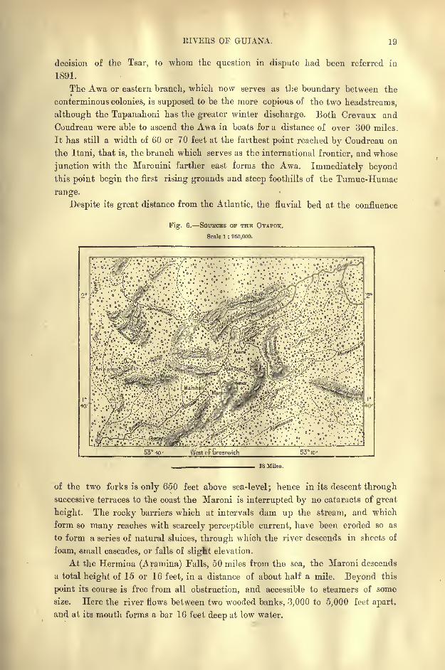
Despite its great distance from the Atlantic, the fluvial bed at the confluence
Fig. 6. SOUBOES OF THE OYAPOK.
Scale 1 : 950,000.
/ Tt r.TiJ&je* . .oTxsR>3i;. :
\$&iji^^53 40 Vilest cf Greenwich; 53 ID-
18 Miles.
of the two forks is only 650 feet above sea-level; hence in its descent through
successive terraces to the coast the Maroni is interrupted by no cataracts of great
height. The rocky barriers which at intervals dam up the stream, and which
form so many reaches with scarcely perceptible current, have been eroded so as
to form a series of natural sluices, through which the river descends in sheets of
foam, -small cascades, or falls of sliglit elevation.
At the Hermina (Aramina) Falls, 50 miles from the sea, the Maroni descends
a total height of 15 or 16 feet, in a distance of about half a mile. Beyond this
point its course is free from all obstruction, and accessible to steamers of some
size. Here the river flows between two wooded banks, 3,000 to 5,000 feet apart,
and at its mouth forms a bar 16 feet deep at low water.
20 AMAZONIA AND LA PLATA.
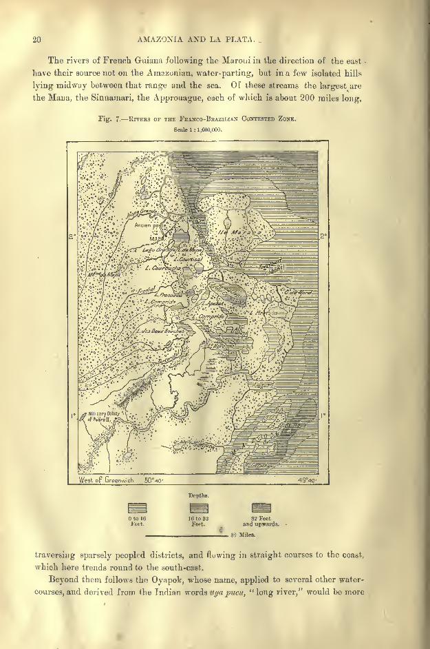
The rivers of French Guiana following the Maroui in the direction of the east
have their source not on the Amazonian* water-parting, but in a few isolated hills
lying midway between that range and the sea. Of these streams the largest are
the Mana, the Sinnamari, the Approuague, each of which is about 200 miles long,
Fig. 7. RIVEES OF THE FRANCO-BRAZILIAN CONTESTED ZONE.
Scale 1 : 1,600,000.
West op Greenwich 50 40' 494C-
Depths.
16 to 32Feet.
32 Feetand upwards.
, 30 Miles.
traversing sparsely peopled districts, and flowing in straight courses to the coast,
which here trends round to the south-east.
Beyond them follows thn Oyapok, whose name, applied to several other water-
courses, and derived from the Indian words uija pucu, "long river," would be more
EIVEES OF GUIANA. 21
appropriate to the Amazons than to any other South American stream. Like the
Maroni, the Oyapok rises under the name of the Souanre in the Tumuc-Humac
Mountains at the Watagnapa Peak, and serves as the eastern frontier of the un-
disputed portion of French Guiana towards Brazil.
The " creeks" * or headwaters of the Oyapok approach those of the Maroni,
and these two rivers closely resemble each other in their general character. The
Oyapok also, which was usually followed by travellers bound for Brazilian Guiana,
descends from reach to reach through a succession of falls and rapids, which, how-
ever, are both more numerous and higher than those of the Maroni. Coudreau
speaks of two which plunge over precipices some 60 or 70 feet high, and the Trots
Sauts (" Three Leaps ") is probably the finest in the whole of French Guiana.
The Robinson Fall, last of the series, lies about 50 miles from the sea.
THE ARAGUARI, CACHIPOUR, AND MAPA GRANDE.
East of the long alluvial promontory of Cape Orange, which is formed by the
deposits of the Oyapok, the whole of the triangular space comprised between this
river and the Araguari belongs to the same zone of drainage. Like the Oyapok, the
Araguari, the Cachipour, the Cunani, the Carsevenne, the Mapa Grande (Amapa of
the Brazilians), the Frechal, and the Tartarugal all rise amid the marshy foothills of
the Tumuc-Humac range, whence they diverge in all directions like the ribs of a fan.
The Araguari estuary marks the extreme limit of the Guiana seaboard, beyondwhich immediately begin the waters and islands of the Amazonian basin.
GENERAL CHARACTER or THE GUIANA RIVERS.
As in Venezuelan and Brazilian Guianas beyond the dividing range, the rivers
of Guiana north of that range differ greatly in the colour of their waters. Some,
those especially of the savannas, are cloudy and whitish, while others flowing from
the woodlands seem black or blackish, although really transparent. In the Esse-
quibo basin the blackish hue of these forest streams is attributed to the roots and
branches of the wallaba tree growing in the water along their banks.
Although most of the Guiana rivers traverse continuous woodlands from the
mountains to the sea, they are far less obstructed by snags than many other
watercourses of the tropical regions. This is due to the great specific gravity of
nearly all the arborescent species growing along the margins of the Guiana rivers.
Instead of floating, the trees falling into the water through erosion or storms sink
to the bottom and rot on the spot.
But on the narrow and shallow upper reaches, the tangle of branches and
lianas is a great impediment to the boatmen, who are often obliged to hew their
way through with the axe or knife. Here the fallen timber accumulates in barrages,
the so-called taknba of the Essequibo Indians, and the barrancas of the Brazilian
refugees in the contested territory. Other obstructions are formed by masses of aquatic
plants, like the sudd of the White Nile, which often present as effectual a barrier
to the canoe-men as the falls and rapids themselves. In most of the watercourses
* In French Guiana the term crique (" creek ") is generally applied to mountain torrents.
36

22 AMAZONIA AND LA PLATA.
the sandstone, granite, or diorite reefs rising to or above the surface are covered,
as with a coating of tar, by a film composed of iron and manganese oxides. As on
the Orinoco, the harder the rock the blacker the film, which in rainy weather emits
noxious odours.
Below the reefs and rapids the broad deep rivers, discoloured and dammed up
by the tidal current, roll down a yellowish water often hidden beneath floating
vegetation. In their lower reaches these streams merge in the riverside morasses,
lakes, or lagoons, which in French Guiana take the name of pripris. In the more
settled and better-cultivated districts of the British and Dutch seaboard the
direction and discharge of the flood waters have been regulated by dykes and
canals. On the plantations sluices are used to arrest the tides, while the percolat-
ing waters are discharged at ebb through the so-called kokers, or ditches. About
the estuaries the fresh water of the Guiana rivers floats on the heavier salt water
for a distance of six or eight miles seawards.
THE GUIANA LAKES.
Thanks to the uniform slope of the land, the old lakes which formerly studded
the surface of Guiana, and whose contours may often still be traced in those of
the savannas, have nearly all been discharged. These ancient lacustrine depres-
sions have been best preserved in the contested Franco-Brazilian territory between
the Mapa Grande and Araguari rivers.
This lake-studded district lies back of the low-lying peninsular headland of
Cape do Norte and the equally low island of Maraca. Within a comparatively
recent epoch the zone of fresh-water lagoons extended much farther north all the
way to the Oyapok river, and at that time all these lakes, creeks, and channels
presented a continuous waterway, over 200 miles between Amazonia and French
Guiana, navigable throughout by boats and barges. According to the officers in
command of the French fort of Mapa, which was maintained during the years
1836 41, craft of forty tons were still able to follow this route about the middle
of the nineteenth century. The Lago Grande, immediately south of the MapaGrande river, is now a mere fragment of the large sheet of water encircling the
island on which stood the French fort abandoned in 1841, and reoccupied by the
Brazilians in 1890.
South and south-east of the peninsular Cape do Norte follow other lakes, one
of which, Lake Jac, near the Carapaporis Strait between the mainland and Maraca
Island, appears to still preserve the form of a spacious bay, but without shelter,
hence exposed to the Atlantic storms, and scarcely any longer navigable by the
native boatmen.
The Lago Novo, near the Araguari river at the southern extremity of the
lacustrine chain, also resembles a marine inlet, and even affords a retreat to
manatees, which here browse on the forests of aquatic plants. But it is also acces-
sible to barges, which find shelter from the Atlantic gales under the lee of the
insular groups which form so many transverse breakwaters. Having a depth of
from 30 to 40 feet, this basin might easily be transformed to a magnificent

LAKES OF GUIANA. 23
harbour of refuge spacious enough for whole fleets, by deepening the channel a
few miles long with which it communicates with the Araguari, and dredging the
estuary which has silted up, presenting in some places depths of little over three
feet.
The subsidence and entire disappearance of the Guiana lakes is a process
which is accomplished very rapidly. The reeds and other plants which wither
in summer are deposited in a bed of floating humus in which various vegetable
species and even shrubs strike root. These verdant carpets are from time to time
rent by the storms and driven to the surrounding margins. Here they are soon
again massed together and thickened. Thus the lake becomes gradually filled in,
or transformed to a floating quagmire, firm on the surface, boggy in the lower
depths. In a short time nothing remains of the lagoon except the navigable
channel, the igarape, or " canoe track." Coudreau even hazards the theory
that the lakes are emptied by a kind of see-saw movement of the banks.*
In several of the lacustrine beds have been found huge trunks, whose origin
it is difficult to explain, except on the supposition that the lakes were at first dry
land, which afterwards subsided through some sudden disturbance of the ground.Another explanation of the phenomenon, however, is suggested by the form and
trend of the seaboard. The alluvial promontories at the Oyapok, Approuague,and Cachipour estuaries are all disposed in the direction of the north, and in
their lower course these rivers also follow the same direction, evidently under
the influence of the marine current, which deposits its sedimentary matter along
the shore. It may therefore be assumed that at contact with this current the
Araguari was also deflected northwards, and that the chain of lakes which have
the same trend are the remains of the old fluvial bed.
The Carapaporis Strait, which flows between Maraca Island and the mainland,
and which is clearly distinguished by its greater depth from all the surrounding
shallow basins, would on this hypothesis be the old mouth of the Araguari,
scarcely modified since the time when the river reached the sea more to the east.
If so much be allowed, there would be nothing surprising in the fact that, like the
Amazons, the copious Araguari should float down large trees and deposit them
along its lower winding course, which afterwards became a system of lagoons con-
nected together by tortuous channels. In the same way the marine current itself
intercepts the snags washed down by the Amazons, depositing them along its
muddy course, where they afterwards become embedded in the alluvial coastlands
of more recent formation. Such ligneous deposits have been found at depths of
78 or 80 feet.
But however this be, great changes have been in progress even during the
contemporaneous period. A mere glance at the map suffices to show that the sea-
board of the contested Franco-Brazilian territory between the Araguari and the
Cachipour presents a striking contrast to the section of the coast running east and
west between Cayenne and the Corentyne estuary. This section develops a
regular convex curve, indicating the incessant deposit of sediment by the marine
* La France Equinoxiale, Voyage a travers Us Guyanes et VAmzzonie.
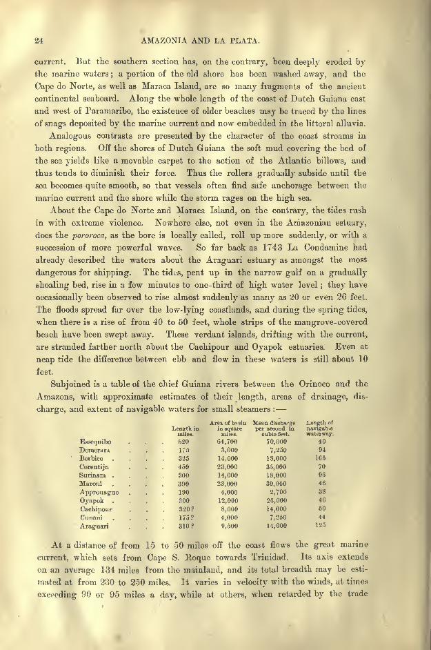
24 AMAZONIA AND LA PLATA.
current. But the southern section has, on the contrary, been deeply eroded bythe marine waters
;a portion of the old shore has been washed away, and the
Cape do Norte, as well as Maraca Island, are so many fragments of the ancient
continental seaboard. Along the whole length of the coast of Dutch Guiana east
and west of Paramaribo, the existence of older beaches may be traced by the lines
of snags deposited by the marine current and now embedded in the littoral alluvia.
Analogous contrasts are presented by the character of the coast streams in
both regions. Off the shores of Dutch Guiana the soft mud covering the bed of
the sea yields like a movable carpet to the action of the Atlantic billows, and
thus tends to diminish their force. Thus the rollers gradually subside until the
sea becomes quite smooth, so that vessels often find safe anchorage between the
marine current and the shore while the storm rages on the high sea.
About the Cape do Norte and Maraca Island, on the contrary, the tides rush
in with extreme violence. Nowhere else, not even in the Amazonian estuary,
does the pororoca, as the bore is locally called, roll up more suddenly, or with a
succession of more powerful waves. So far back as 1743 La Condamine had
already described the waters about the Araguari estuary as amongst the most
dangerous for shipping. The tides, pent up in the narrow gulf on a gradually
shoaling bed, rise in a few minutes to one-third of high water level; they have
occasionally been observed to rise almost suddenly as many as 20 or even 26 feet.
The floods spread far over the low-lying coastlands, and during the spring tides,
when there is a rise of from 40 to 50 feet, whole strips of the mangrove-covered
beach have been swept away. These verdant islands, drifting with the current,
are stranded farther north about the Caehipour and Oyapok estuaries. Even at
neap tide the difference between ebb and flow in these waters is still about 10
feet.
Subjoined is a table of the chief Guiana rivers between the Orinoco and the
Amazons, with approximate estimates of their length, areas of drainage, dis-
charge, and extent of navigable waters for small steamers :
EssequiboDemerarci
Berbice
CorentijnSurinam .
Muroni
ApprouagneOyapok .
CachipourCnnani
Araguari
At a distance of from 15 to 50 miles off the coast flows the great marine
current, which sets from Cape S. Roque towards Trinidad. Its axis extends
on an average 134 miles from the mainland, and its total breadth may be esti-
mated at from 230 to 250 miles. It varies in velocity with the winds, at times
exceeding 90 or 95 miles a day, while at others, when retarded by the trade
enpth inmiles.
CLIMATE OF GUIANA. 25
winds, it moves at scarcely more than a mile an hour, and even develops lateral
counter-currents and whirlpools. At such times it rises in the harbours alongthe seaboard like a fluvial current above the weirs.
CLIMATE OF THE GUIANAS.
The Guianas lie entirely within the zone of the north-east trade winds.
Nevertheless they are sufficiently near the equator to come within the influence
of the prevailing south-easterlies for a part of the year. At Cayenne, which maybe taken as the central point of the Guiana seaboard, the normal wind, setting
usually from the north-east, blows regularly from the beginning of December,
and acquires its greatest force in January and February. At the spring equinoxits fury abates a little, and then follows the period of calms interrupted by
squalls, while in the month of July the general shifting of the atmospheric
currents towards the northern hemisphere is indicated by the steadily increasing
south-easterly breezes. Nevertheless, these south-easterlies, or rather east-south-
easterlies, do not blow continuously ; they prevail usually at night, being replaced
during the day by the land breezes. The Guiana seaboard lies entirely beyond the
sphere of the cyclonic storms.
The period during which the north-easterly trade winds prevail corresponds
to the rainy season, which usually sets in with the normal winds, and lasts till the
period of irregular breezes and of the dry south-easterlies. In March the rainfall
is least abundant, whence the expression," March Summer," which is applied in
French Guiana to this relatively dry month. But in May the moisture-bearing
clouds discharge their contents in cataracts, and these heavy downpours are known
as the Pluies de la Poussiniere," Pleiades Rains." On the Guiana seaboard the
mean rainfall exceeds 100 inches, and in some years the rain-gauges have
registered over 160 inches,* while Mr. im Thurn records a downpour of no less
than 13 inches in twelve hours. f
But the precipitation varies greatly from year to year, rising at Georgetown,for instance, from a little over 60 inches in 1885 to double that quantity in 1890.
During the rainy season the temperature is slightly lower than in summer ;
but it never varies more than a few degrees from the normal for the whole year,
which may be taken at about 80 or 8L Fahr. In the interior, the range between
the extremes is slight, thanks to the uniform relief of the land, which presents
no great elevations except" in the Pacaraima uplands. But the greatest differences
are observed in the distribution of moisture. Thus the rain-bearing clouds
intercepted by the mountains discharge their contents in torrents on the higher
summits, whereas they part with but little of their humidity on the plains, where
they meet with no obstacles.
But even here the atmosphere is nearly always charged with a large quantity
of aqueous vapour. At dusk the fogs spread like a vast shroud over the wood-
lands, where they are often pierced by the large trees, whose crests rise above the
* Rainfall of Cayenne in 1874 : 168 inches (Maurel and Hardy),t Journal of the Colonial Institute, 1892 93.
26 AMAZONIA AND LA PLATA.
dense haze like rocky islets in the midst of the sea. The plains, the headlands,
everything is wrapped in this damp covering, with which are intermingled the
miasmatic exhalations of the soil. On the Tumuc-Humac Mountains, where in
the space of five months Coudreau made over fifteen hundred observations, the
atmosphere is less charged with moisture than on the coastlands. " Here the
fogs are drier, and the night temperature falls to 16 degrees"
(61 Fahr.).*
FLORA OF THE GUIANAS.
To the irregular distribution of the rainfall must be attributed the striking
contrasts presented by the flora of the Guianas. There are two distinct botanical
zones the savannas, or campos, as the Brazilians call them, and the primeval
woodlands. But account must also be taken of various sandy and arid tracts
destitute of all vegetable humus, and of other districts, where, despite the
moisture, arborescent plants are prevented from springing up by the dense forests
of reeds.
The treele-s regions extend for the most part below the hills or mountains,
whose upper flanks are exposed to constant rains. Thus in British Guiana the
upper Takutu basin, sheltered from the moist winds by the eastern offshoots of the
Pacaraima range, lies altogether within the zone of savannas. But certain plains
in close proximity to the Atlantic coast are completely destitute of forest growths,
although in their geographical position and absence of relief they closely resemble
other well-wooded plains. Thus in the contested Franco- Brazilian territory the
savannas, interrupted only by fringes of trees along the river banks, extend
parallel with the Atlantic coast all the way from Cape Orange to the Amazons
estuary, and nearly the whole of the lower Araguari valley forms a vast treeless
campo.
In British and Dutch Guiana, the savannas form a narrow belt of open
ground reaching from the banks of the Demerara to those of the Surinam. The
existence of these treeless tracts between the mangrove-covered littoral and the in-
land forests is due partly to a local disturbance of the moist winds, partly to the
nature of the soil, formerly the bed of a lake.
Like the Venezuelan llanos, the savannas of Guiana present the whole series
of transitions from a wooded to a grassy surface. In some districts the limits of
the different zones are as sharply defined as those of land and sea formed byvertical cliffs. On emerging from the virgin forest with its tangle of lianas and
parasites, the wayfarer suddenly finds himself surrounded by a sea of herbaceous
growths, where the eye sweeps unhindered over a vast horizon limited in the dis-
tance by a sky-line of mountain crests. Elsewhere the woodlands break into an
irregular fringe of glades, distribute their trees more openly, and lower their
height, scattering clusters of wooded islets round about their verge.
*Meteorological conditions of the Guiana seaboard :
Mean Highest Lowest RainyTemperature. Temperature. Temperature. Days. Rainfall.
Georgetown . . 81 F. 90" F. 74 F. 170 119 inches
Paramaribo . . 79 96 70 177 140 ,,
Cayenne ... 80 92' IT 160 130
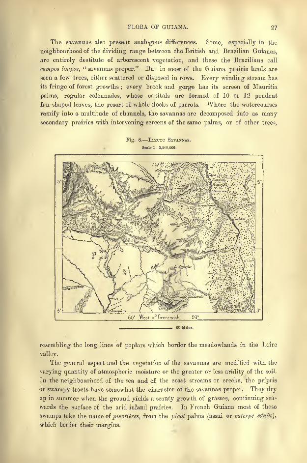
FLORA OF GUIANA. 27
The savannas also present analogous differences. Some, especially in the
neighbourhood of the dividing range between the British and Brazilian Guianas,
are entirely destitute of arborescent vegetation, and these the Brazilians call
campos l/'mpos," savannas proper." But in most of the Guiana prairie lands are
seen a few trees, either scattered or disposed in rows. Every winding stream has
its fringe of forest growths ; every brook and gorge has its screen of Mauritia
palms, regular colonnades, whose capitals are formed of 10 or 12 pendent
fan-shaped leaves, the resort of whole flocks of parrots. Where the watercourses
ramify into a multitude of channels, the savannas are decomposed into as many
secondary prairies with intervening screens of the same palms, or of other trees,
Fig. 8. TAKTJTU SAVANNAS.
Scale 1 : 3,200,000.
60 West oF Greenwich 59
60 Miles.
resembling the long lines of poplars which border the meadowlands in the Loire
valley.
The general aspect and the vegetation of the savannas are modified with the
varying quantity of atmospheric moisture or the greater or less aridity of the soil.
In the neighbourhood of the sea and of the coast streams or creeks, the pripris
or swampy tracts have somewhat the character of the savannas proper. They dry
up in summer when the ground yields a scanty growth of grasses, continuing sea-
wards the surface of the arid inland prairies. In French Guiana most of these
swamps take the name of pinotikres, from the jtrinot palms (assai or euterpe edulis),
which border their margins.
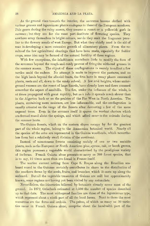
28 AMAZONIA AND LA PLATA.
As the ground rises towards the interior, the savannas become clothed with
various grasses and leguminous plants analogous to those of the European meadows.
Pale green during the rainy season, they assume a russet or a yellowish garb in
summer ; but they are for the most part destitute of flowering species. Theynowhere array themselves in bright colours, nor do they emit the fragrance pecu-
liar to the flowery meads of west Europe. But what they chiefly need is the aid of
man in developing a more extensive growth of alimentary plants. From the re-
sults of the few agricultural clearings that have been made, especially for fodder
crops, some idea may be formed of the natural fertility of these regions.
"With few exceptions, the inhabitants contribute little to modify the flora of
the savannas beyond the rough-and-ready process of firing the withered grasses in
the summer season. The object of these conflagrations is merely to collect a few
turtles amid the embers. No attempt is made to improve the pastures, and on
the high lands beyond the alluvial tracts, the fires have in many places consumed
plants, roots and all, down to the sandy subsoil. A few arid heights, whose under-
ground recesses are the resort of huge lizards, have already here and there assumed
somewhat the aspect of sandhills. The fire, under the influence of the winds, is
at times propagated with great rapidity, but as a rule it spreads much slower than
in the Algerian bush or on the prairies of the Far West in North America. The
plants, containing more moisture, are less inflammable, and the conflagration is
usually arrested on the verge of the forests after devouring a few of the more
exposed trees. Even in the savanna itself it spares the verdant clusters which
are formed round about the springs, and which afford cover to the animals during
the summer heats.
The Guiana forests, which on the eastern slopes occupy by far the greatest
part of the whole region, belong to the Amazonian botanical world. Nearly all
the species of the selva are represented in the Guiana woodlands, which neverthe-
less form but a relatively small division of the continent.
Instead of monotonous forests consisting mainly of one or two sociable
plants, such as the European or North American pine, spruce, oak, or beech groves,
this region possesses a vegetable world characterised by the prodigious variety
of its forms. French Guiana alone presents as many as 260 forest species, that
is to say, 10 times more than are found in France itself.
The marine current setting from Cape S. Roque along the Brazilian sea-
board round to the Guianas certainly contributes its share to the distribution of
the southern forms by the seeds, fruits, and branches which it casts up along the
seaboard. But all the vegetable treasures of Guiana are still but approximately
known, some regions not having yet been visited by any naturalists.
Nevertheless, the itineraries followed by botanists already cover most of the
ground. In 1872, Grisebach estimated at 3,500 the number of species described
up to that date. The most widespread families are those of the leguminous type,
which represent about a ninth part of all the local forms. Next to them the most
numerous are the ferns and orchids. The palms, of which as many as 30 varie-
ties occur in French Guiana alone, comprise about the hundredth part of the
FLORA OF GUIANA. 29
whole flora;but their majestic appearance, making them conspicuous objects
at a distance, gives them a seeming importance far beyond their mere numbers.
The members of the Venezuelan and Colombian zones, which are not found
in Guiana, are mainly the Alpine plants flourishing in the Andes at altitudes
much higher than the summits of the Pacaraima and Cain-it ranges. At least
200 varieties of tree ferns grow on the slopes at heights of over 3,000 feet;in a
few days Richard Schomburgk discovered as many as 93 different members of
this family in the Roraima district, which has been called the "Eldorado of
botanists." Here the slightest difference of relief, aspect, or soil is marked byfresh forms. The be/aria (be/aria), or " rose of the Andes," and a plant allied to
Fig. 9. FORESTS AND SAVANNAS OF GUIANA.
Scale 1 : 13,000,000.
250 Miles.
the cinchona, are also represented on the slopes of Roraima. On the banks of
the Essequibo the Indians make use of arrows obtained from a poisonous bamboo,
which produces the same effect as the curare.*
The superb Victoria regia, discovered in 1837, in the Berbice River, British
Guiana, and afterwards met in many other watercourses in the Amazonian region,
is an example of the marvellous beauty that efflorescence may assume in equato-
rial America. In some places the surface of the lakes almost entirely disappears
under a carpet of enormous leaves and tufts of white petals intermingled with
other flowers, blue, pink, or yellow, and with quaking grasses. Under certain
favourable atmospheric conditions, the flowers of a nymphoeacea abounding in
these fresh-water basins shine with the calm glow of anight light, much less vivid
* C. B. Brown, Canoe and Camp Life in British Guiana.
80 AMAZONIA AND LA PLATA.
than that of tropical fire-flies and of other luminous insects, but brighter than
that emitted by decaying timber.
Amongst alimentary plants are the wild cacao, several varieties of edible
passionworts, wild pine-apples, some sap-yielding palms, the marantaceae from
which arrowroot is extracted, the twelve varieties of manioc, the euphorbiacea
from which cassava, coac, and the so-called paiourai beverage are prepared, the
carambola (arerrhoa c.), the tuka (bertholetia cxcclsa), whose fruit, resembling a
cannon ball, and about the size of a man's head, contains in four cells six or eight
of the excellent Brazil or Para nuts.
The " traveller's tree"
of Madagascar is represented in the Guianas by the
rarcnala guiancnsis, a wild plantain with enormous leaves shooting up from near
the ground to a height of 10 or even 15 feet. "The bases of the leaf-stalks"
sheath the one over the other, and in the pockets formed by each of these sheath-
ing parts much rainwater is retained even through the dry season. Another
noticeable feature in these plants is that the seeds within the tough thin shell
of the fruit are packed in a large quantity of short fibrous substance like clippings
of wool, in the Guiana species of brightest scarlet colour, but in the Madagascar
plant of blue. (Im T/nirn.J
In the coast region are met the oleaginous, medicinal, resinous, and aromatic
species of Amazonia, and room might still be found for all those of equatorial Africa.
The awara (attalea spcciosa), a member of the palm family, yields an oil as valuable
as that of the Guinea oil-palm, which was introduced into Guiana in 18C6. Other
kinds, such as the carapa guyanensis, whose nuts contain as much as 70 per cent,
of their weight in oil, the wax-tree (virola sabifera), and the incorruptible wapa
(tamarindmindica}, also offer industrial resources hitherto scarcely utilised;the
same may be said of the 150 species and upwards of medicinal plants, all contain-
ing valuable properties in their wood, sap, roots, leaves, flowers, or fruits.
Amongst the caoutchoucs and others yielding gums and rubber of the gutta-
percha type, noteworthy is the balata (achras or mimusops balata], the "bullet-
tree"of English writers, whose sap is at once elastic and ductile. Like Arabia,
Guiana has also its incense tree, the hyawa (idea hcptaphylla], which is burnt in
the churches on the coastlands. " Where the hyawa tree grows, the whole air for
some distance round is pleasant and wholesome with the incense-like odour of the
white resin that drops from its stem and falls in masses on the ground ;and a
still more powerfully-scented resin, which coats the trunk of another tree, the
tauranero of the Indians (humirium floribnndnm, Mart.), seems to imitate and sur-
pass the odour of vanilla." (1m Thurn.}
The natives have brought to the notice of the whites numerous dyewoods, such
as the rutfu and the lena (genipa americana], and others abounding in tannin.
With the fibres of hundreds of plants, from the palm to the pine-apple, they
weave a thousand different textile fabrics, which are used for endless purposes.
Altogether this region holds in reserve a prodigious storehouse of raw materials,
all available for the industrial arts.
Guiana also abounds in timber and cubinet woods, which it is to befeand
FAUNA OF GUIANA. 81
may soon attract the attention of those reckless speculators who have already
wasted so many woodlands. The mora excelw, a leguminous tree, which overtops
all other forest growths, shooting up to a height of 120 or 130 feet, exceeds
the oak and even the teak in elasticity and durability ;it is unsurpassed for ship-
building, and in economic value is rivalled only by the green- heart ebony (nec-
tandra Rodicei).
Dozens of forest trees are met which possess more solidity than the oak, but
their specific gravity is for the most part equal to or even greater than that of
water. During the last century some of these heavy woods were used for
making mortars and gun-carriages. The species suitable for cabinet work are
noted for their bright green, yellow, grey, or black tints, their mottled, marble,
or satin-like surface. One species which shows in section a lovely spotted brown
grain has taken the name of "tiger-wood
" from its resemblance to the spotted
skin of the American tiger (jaguar). Another is the letter-wood (brosimum
AubletiiJ, so called from the deep colour of its surface, on which are inscribed black
figures resembling hieroglyphics.
FAUNA OF THE GUIANAS.
In its fauna, no less than in its flora, Guiana forms a land of transition
between the Amazonian zone and those of the Venezuelan seaboard and of the
West Indies. None of its mammals, saurians, or reptiles belong to it exclusively ;
and if some of its birds, insects, or other smaller organisms have not hitherto
been met elsewhere, it may be almost taken for granted that such forms do also
occur in the conterminous regions possessing the same climate, soil, and vegetation.
The species usually spoken of as specially characteristic of the Guianas are
those that naturalists have first observed in this region. Such are the marsh or
mangrove deer (cervus palustris), which frequents the swampy districts;the crab-
eater (cancrophagus major], which preys on crabs and builds its nest in the banks
of the creeks; the grey crane (gi'its ferricora), with the digestion of an ostrich,
and nearly as tall;of aquatic fowl, such as duck, flamingoes, herons, ibis, there is
a great variety, gathering at times in flocks of thousands. The tijrannus sul-
phureus, most common of all birds, whose voice is heard in every tree, has from
its peculiar note received in French Guiana the eccentric name of Qu'cst-ce q*.iil
dit, contracted to Ki&kadi. In the depths of the forest is often heard the metallic
note of the so-called bell-bird (campanero), of which there are two varieties
(chasmarhynchus caruncula tits and C. variegatiu*). But Mr. im Thurn " never
could detect much resemblance in the note of these birds to the sound of a bell.
The cry of the first species is more like the ring produced by two pieces of iron
struck against each other;but the notes of the male and female birds differ con-
siderably. The cry of the second species is like the sound made by the drill in
blasting operations. Then also in the forest is heard an extraordinary deep sound,
like the lowing of an ox, and it is long before the traveller realises the fact that
this is made by the '
quow'
or 'calf-bird
'
(gymnocephalus calvus), a bird no bigger
than a pigeon."
32 AMAZONIA AND LA PLATA.
In British Guiana the great cayman is confined to the upper courses of the
Essequibo and Berbice rivers;nor does it occur anywhere in Dutch or French
Guiana, though it is again met in the Franco-Brazilian contested territory. The
rivers of Dutch and French Guianas are frequented only by two small species of
alligators.
Nearly all the snakes are harmless to man;the small number of venomous
serpents take the collective name of gragcs in Cayenne, where they are often met
in a torpid state. Some of the boas, especially those of aquatic habits, such as
the water camoodi (eunectesmurina), acquire enormous dimensions. According to
Kappler, one killed on the upper Surinam river measured over 43 feet, and Mr.
im Thurn's companion shot one in the Potaro river which "proved to be 20 feet
in length and three feet in girth at the thickest."
The gigantic low-low, a silurian found in the Essequibo, and much appreciated
by the natives, exceeds ten feet in length, and weighs as much as 220 pounds.
The pirai or perai (serasalmo niger), whose bite is justly dreaded by man, swarms
in most of the rivers, and is probably one of the most voracious animals in exis-
tence. They not only snap off the feet of ducks and the tails of iguanas, but will
even attack alligators, who " do not always escape with whole tails. A perai
itself, if wounded by any chance, is at once attacked and devoured by its fellows.
If a monkey or bird, when shot, falls in the water, perai rush together from all
quarters and carry off the prey before the sportsman can reach it;and more than
once, when fishing in clear water, the bait having been taken by some other fish,
I have seen the captive, as it was pulled through the water towards the boat, pursued
and snatched by rushing perai." (Iin Thurn.}
The Guiana Indians are rare experts in domesticating wild animals, such as
the agamis (psophia crepitans), cranes, hoccos (crax alector), parrakeets, dogs,
aras, and even jaguars. The stranger arriving suddenly near a native homestead
is liable to be attacked by these "pets," and unless the owner comes to restore
order, he will have much difficulty in reaching the cabin. Of the two species
of wild dogs in British Guiana, one, the maikang of the natives, commits great
depredations on the plantations. These carnivora prowl about in large packs at
night, penetrating through the enclosures without giving tongue, and playing
havoc with the poultry and other farm -yard animals. The maikang crossed with
the common species produces an excellent breed of hunting dogs, which fetch
large prices in Georgetown.
INHABITANTS OF THE GUIANAS.
All the Guiana Indians are collectively grouped by the English and Dutch
settlers under the respective names of bucks and bocks, terms which, in a sense,
assimilate them to the beasts of the field. During the early colonial times the
Europeans, ignorant of the different languages and usages of these aborigines,
were naturally inclined to regard the various groups as so many distinct " nations."
Thus Barrere in 1743 enumerates over forty of such groups in French Guiana
alone, without attempting to classify them according to their mutual affinities.
INHABITANTS OF GUIANA. 83
But these ethnical affinities were gradually recognised, and the studies of the
missionaries and philologists have now reduced all the indigenous populations of
Guiana to three independent families : Arawak, Carib, and Tupi. Even these
groups, however, present many points of resemblance in their appearance, physiog-
nomy, and customs, while differing greatly in speech.
THE ARAWAKS.
The oldest group, constituting the aboriginal element in the strictest sense,
appears to be that of the Arawaks, a name which has been referred with great
improbability to a Tupi word meaning"porridge-eaters." All the natives alike,
as well as the Creoles, live on a manioc diet, so that the Arawaks Sre not specially
distinguished in this respect. They are met, all bearing the same name, every-
where throughout the British Guiana seaboard, and under different designations
in the inland districts; here they usually call themselves Lokono (Lukkunu),that is,
" Men."
The Wapisianas, Tarumas, Atorais (Atorradi) of the upper Essequibo and of
the Takutu, and the Palicurs of the contested territory, all belong to this primitive
group. At the time of Schomburgk's journey the Amaripa tribe, formerly neigh-
bours of the Wapisianas, were already extinct, or represented only by a single
survivor, a woman sixty years old. The coast Arawaks, living in the midst of the
whites and of other settled populations with a sort of English jargon as their
common medium of intercourse, have all been Anglicised, and are gradually
merging in the somewhat cosmopolitan labouring class employed on the planta-
tions. Under the Dutch rule these Arawaks were exempt from the servitude
"legally
"imposed on all the other Indians.
Those of the Moruka coast stream north-west of the Essequibo estuary are not
full-blood Arawaks. During the Venezuelan War of Independence some Orinoco
Indians belonging to an unknown tribe, but already largely Hispanified in their
usages, took refuge in British Guiana, in order to escape from oppression and
massacre. Here they received a concession of some land in the hilly district about
the sources of the Moruka, where they settled, cultivating the soil, intermarrying
with the Arawaks, and thus reverting to the Indian type. Later some Portu-
guese immigrants mingled with these half-breeds, while the discovery of the
gold mines brought them in contact with the cosmopolitan populations of the
auriferous districts.
Till recently the Arawaks, who have their camping-grounds on the banks of
the Aruka, a western affluent of the Barima, kept completely aloof from the
whites, and of all the natives these alone were unfamiliar with the English
language. As amongst the Caribs of the West Indies, some traces of bilingual
speech have been discovered amongst them, a phenomenon which can only be
explained by the intermingling of two races as the result of conquest.
The Arawaks have preserved many of the old national usages, amongst others
certain tests of endurance, such as the whip-game or dance, in which the dancers,
all being men, "stand in two rows opposite each other. Each man has in his
84 AMAZONIA. AND LA PLATA.
hand a whip with a hard sjtrong lash made of fibre. Every now and then a coupleretire from the line and use their whips. One stands steadily, one leg in front
of the other;the other swings back his whip, and, with all the force he can
command, lashes the calf of the first man's leg. Then in his turn the second manstands still to receive a lash from the other. They lash each other in this wayuntil their calves are striped with weals and blood flows freely. The punishmentis borne and inflicted with perfect good temper, and was probably originally
devised as a test of endurance. Finally the dancers retire and drink together."
(Im Thurn.)
These Arawaks appear to have been by far the most civilised of all the
Guiana peoples^or they possess fictile vases of most varied forms embellished
with ornaments and grotesque human and animal figures in high relief. The
pottery of other Guiana tribes is extremely simple, without any decorative work
beyond a few rude designs executed' in thin lines. To the Arawaks should per-
haps be attributed the stone porringers met in several parts of the Guianas, the
circle of standing stones seen by Barrington Brown in the Pacaraima Mountains,
and resembling that of Stanton Moor, the time/in or inscribed rocks of the Ber-
bice, Corentyne, and Maroni rivers, covered with figures of men and animals,
especially frogs, together with other eccentric forms, some shallow, some deeply
incised.
THE WAPISIAKAS AND ATORAIS.
The Wapisianas and Atorais, who dwell about the region of the water-parting,
being rarely visited by the English travellers, have still preserved their primitive
type. The Atorais would probably be the losers by miscegenation with other
tribes, for their women are distinguished by remarkably perfect figures and
great dignity of expression. The profile of the face differs little from that of
Europeans, and the complexion is almost white. According to Coudrcau, many of
the Atorais are no darker than the Andalusians, the Sicilians, or the peasantry of
South France.
On the other hand, the Wapisianas are of a browner colour, with less regular
features and less graceful carriage. Like the Atorais, they have a hairless face
with only a few short bristles on the upper lip and chin, while the hair of the head
is very abundant. Both sexes pierce the lower lip with at least two pins, and
insert another in the cartilage of the nose, to which they attach a piece of metal.
This, it would seem, is the distinctive mark of the tribe. Formerly the Wapisiana
girls were obliged to have the two upper incisors extracted;but this custom
appears to have fallen into abeyance.
These natives wear nothing but the catembe, the loin-cloth of the negroes ;but
they pay great attention to the head-dress and other personal embellishments,
decking themselves with all the beads, coins, and trinkets they can pick up.
Maize is grown, but only to extract from the grain a kind of beer, called cashiri,
which throws the drinkers into a state of hilarious intoxication. It is during
these orgies that the young men's brides are usually carried off, marriage being
still made amongst the Atorais and Wapisianas by abduction.

INHABITANTS OF GUIANA. 35
Like most other Guiana tribes, the Wapisianas practise the strange custom of
couvade. Throughout the region of the divide between the Takutu and Essequibo
basins, their language has become the chief medium of trade and general inter-
course between the surrounding groups, even those of Carib origin. The Atorais,
or at least the men, have almost completely given up their own in favour of the
soft and sonorous Wapisiana tongue, which, being highly vocalic, is well suited for
oratory.
Amongst the indigenous tribes connected with the Arawaks should perhaps
be included the Warraus (Guaraunos) of British Guiana, who have their camping
grounds in the wooded alluvial tracts of the north-west, and who have partly
adopted Christianity. Scarcely differing from those of the Orinoco* delta, they live
Fig. 10. INDIANS OF THE GTJIANAS.
Scale 1 : 11,000,000.
(A) Arawaks. (C) Caribs. (T) Tupi.
186 Miles.
like them in cabins built and entirely furnished with the wood, leaves, and fibre of
the Mauritia palm, from which plant they also procure their clothing, food, and
drink. The Warraus never perform any ablutions, in this respect differing
altogether from most of the other natives, who take great delight in bathing.
When there are any family disputes to settle, the tribe gathers on some sand-
bank, where the men of all ages range themselves in two opposite rows armed with
shields made of the Mauritia palm. Then all advance, each facing an opponent
and watching his opportunity to spring forward and thrust him back. The shields
now meet and clash, the two antagonists planting one foot firmly on the ground,
and pushing with the knee of the other leg with might and main against his
opponent's shield. Whoever succeeds in forcing the other back from his position
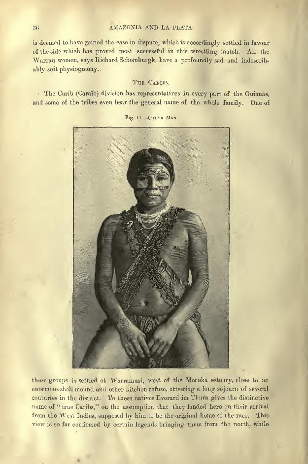
30 AMAZONIA AND LA PLATA.
is deemed to have gained the case in dispute, which is accordingly settled in favour
of the side which has proved most successful in this wrestling match. All the
Warrau women, says Richard Schomburgk, have a profoundly sad and indescrib-
ably soft physiognomy.
THE CARIBS.
The Carib (Cara'ib) division has representatives in every part of the Guianas,
and some of the tribes even bear the general name of the whole family. One of
Fig. 11. GALIBI MAN.
these groups is settled at Warramuri, west of the Moruka estuary, close to an
enormous shell mound and other kitchen refuse, attesting a long sojourn of several
centuries in the district. To these natives Everard im Thurn gives the distinctive
name of " true Caribs," on the assumption that they landed here on their arrival
from the West Indies, supposed by him to be the original home of the race. This
view is so far confirmed by certain legends bringing them from the north, while
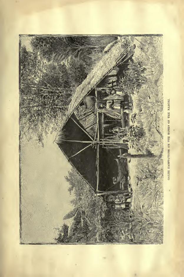

INHABITANTS OF GUIANA. 37
the Caribs themselves claim to have descended from above through a hole in the
sky.
But most American ethnologists look on the central regions of Brazil as the
most probable cradle of the Carib race, in which case the expression" true Caribs
"
would be more applicable to the tribes dwelling in the interior of the Guianas than
to those now settled on the seaboard. The Galibi of French Guiana, who are
also of pure Carib stock, and who even bear this name under a somewhat
more euphonious form, have occupied the coast zone west of Cayenne for at least
Fig. 12. GALIBI WOMAN.
two centuries and a half. Here they had some twenty villages in 1652, and at
present some of their settlements are scattered along the Sinnamari and Iracubo
rivers, and especially along the right bank of the Maroni.
Another Carib people, the Calinas, remnant of a great and powerful nation,
have held their ground in the Surinam valley. To the same stock belong the
famous Roucouyennes of the interior, who are so named by the Creoles from the
37
88 AMAZONIA AND LA PLATA.
roucou (rucu) with which they paint their bodies, but who call themselves Wayana,
perhaps another form of the word Guiana.
The fine Akawoi (Waika or Kapohn) Indians of the mountainous districts of
British Guiana watered by the Mazaruui, the Partamonas of the Potaro river, the
formidable Arecuuas, who dwell in the upland valleys about Roraima, the Waye-wes of the Upper Essequibo, the Tairas of French Guiana, lastly the Macusi about
the headwaters of the Rio Branco, all belong to the widespread Carib family, and
speak closely related dialects of the same stock language. Like the Wapisiana in the
dividing range between the Esscquibo and Rio Branco, the Galibi tongue has
become a sort of lingua franca for all these tribes. Several Carib words, such
as cayman, toucan, and hammock, have found currency in the European languages.
In general, the Caribs of Guiana are inferior in physique to the Aravvaks,
especially if the Atorais be taken as the type of this race. The Galibi have short,
slender figures, while their roun'd, soft, and beardless face gives them a feminine
look. The Macusi, though more hirsute, have heavier frames and more massive
figures.
Like most Indians, the Roucouyennes look taller than they are, which is due
to the length and fulness of the bust contrasting with the slight development of the
extremities. The long bandages in which they wrap themselves in accordance
with their hygienic ideas give them the appearance of great corpulence. Their
figures are very short, while the feet are broad and flat, and the eyelids slightly
oblique, as with the Chinese. They have the habit of plucking out the eyebrows" the better to see," as they say, but more probably as an offering to the sun.*
Some of the Galibi tribes also follow the Wapisiana fashion of piercing the lower
lip with bits of bone or a peg, which they keep constantly moving with the tongue,
and of causing the calves to swell by means of wide garters tightly clasped below
the knee.
THE TUPI AND OTHER ABORIGINES.
The Tupi, who form the third ethnical division of the Guianas, are a branch
of the great Brazilian race represented by hundreds of tribal groups between the
Maroni and Plate rivers. In Guiana territory the two chief Tupi tribes are the
Oyampi of the Tumuc-Humac range about the Upper Oyapok, and the Emerillons,
who dwell farther west between the Approuague and the Maroni affluents. Both
are skilled agriculturists, raising quantities of manioc for the gold hunters, with
whom they are becoming assimilated in speech and costume.
But amongst the tribes of these inland regions several still survive whose lan-
guage is unknown, and whom it is not yet possible to affiliate to any of the sur-
rounding ethnical stocks. Such are the Oyaricoulets, who are reported to occupy
the valley of the Itani, which flows through the Awa to the Maroni. According
to local report for no traveller has yet described them from personal observation
they have a white complexion, with blue eyes and light beard; hence some writers
have felt inclined' to regard them as whites keeping aloof from their European
* Elie Reclufl, MS. Notes.

INHABITANTS OF GUIANA. 89
kindred. Coudreau, however, was assured by the Roucouyennes that these Oyari-
coulets were "like the other Indians."
In British Guiana rumour speaks also of the fabulous Didi, a hairy race, whomall the other natives clread without ever having seen them. But in these regions,
when an Indian is afraid of seeing any formidable being, or even a rock of
fantastic shape, he rubs his eyes with red pepper. Then, seeing nothing, he is
happy in the thought that there is nothing more to be seen.
GENERAL CHARACTERISTICS OF THE GUIANA INDIANS.
But to whatever ethnical divisions the Guiana Indians may belong, they have
all very much the same usages. Were habits and customs to be taken as a
criterion of racial affinity, many peoples of different speech would have to be
classed together. Thus the Galibi, Oyambi, Emerillons, and Wapisianas, all
practising the couvade, would be grouped in the same category. But such
resemblances may be due rather to a common environment and like economic
conditions than to blood relationship.
In none of the tribes has authority been firmly established on the model intro-
duced by the European settlers. Certain persons may bear more or less distinctive
titles;but for all that they are not true " chiefs
"in the common acceptation of
the term. Their personal qualities may ensure them great influence, but they
must not interfere so far as to issue orders. Each member of the tribe enjoys
full personal liberty in all his movements and actions. This freedom extends
even to the children, who are never punished."Dogs alone are beaten," says a
Macusi proverb.
Nevertheless, the ordeals formerly inflicted on the young of both sexes on
reaching the adult period were atrocious. Thus the mother scourged her daughter
while father and brothers slept, and woe to her if her cries roused them from their
slumbers. Amongst the Roucouyennes the initiatory rites consisted in subjecting
both boys and girls to the sting of wasps and bite of ants. The unhappy victims
swooned away in sheer agony without uttering a groan.
To their healing and divining powers the peatmen (piai, puyai, peartzan, or
medicine-men) are indebted for a larger share of moral authority than that of the
so-called chiefs;
but even they would never presume to exercise any direct
control. Perhaps the veneration in which they were formerly held should in
great measure be attributed to the severe trials which they had to undergo before
being considered worthy of admittance into this primitive order of priesthood.
More than one of the candidates succumbed to the prolonged hardships they ha-l
to suffer during the terrible years of novitiate.
But at present the preliminary training has been greatly mitigated and
curtailed. The chief, instrument of the rite is the maraca, a small calabash
about the size of the fist enclosing a few rattling pebbles. This maraca serves
to scare the devil and, if need be, to raise him, especially when a kenaima or
avenger has to be summoned in case of bloodshed. Inspired by the relentless
spirit of the vendetta, the man who undertakes the duty of following and killing
40 AMAZONIA AND LA PLATA.
the wrong-doer, or, failing to find him, any of his kindred, is no longer a respecter
of persons ;for the time being he has neither clan nor family ; he disappears in
the depths of the forest, and does not again show himself in public until he has
throttled, poisoned, or even tortured his victim. But the kenaima plays many
parts, and to his malevolence are usually accredited all diseases;hence to circum-
vent him trees are often cut down and strewn across his presumed track.
In some tribes, and especially amongst the Roucouyennes, the dead are still
occasionally cremated, all their belongings being heaped on the pyre and con-
sumed with the body. All travellers are unanimous in asserting the former
prevalence of anthropophagy. But the chief tribes that were addicted to this
horrible practice, such as the Nouragues of the Approuague valley and the
Acoquas of the Tumuc-Humac mountains, have already disappeared. Amongstthe descendants of these cannibal tribes are mentioned the Tairas and the Oyampi.
So recently as 1830 the Oyampi still sang the burden of the songs celebrating
the old rites :
" In the olden time we were men, we ate our enemies; now like
women, we eat nothing but manioc." The very word Oyampi would appear to
mean "Men-eaters." But it may be confidently stated that since the close of the
eighteenth century cannibalism has completely ceased amongst all the known
tribes. The Caribs burnt the heart of the vanquished foe, and mingled its ashes
with their drink.
The largest share in the steady decrease of the native populations is taken by the
warlike tribes, who have generally best preserved their racial purity. More than
hulf of the groups mentioned by the old writers have already disappeared.
Nevertheless the survivors are still far more numerous than is commonly supposed.
Explorers ascending the rivers often overlook the groups encamped in the recesses
of the forests. The indigenous population of the Guiana seaboard, exclusive of
the Amazonian slopes, would appear to still number about 8,000.
THE BLACKS THE BUSH NEGROES.
Thanks to the slave trade an African population has been introduced into the
Guianas, chiefly by the Antilles route, which, jointly with the half-castes, far
outnumbers the aborigines. Distributed at first in the plantations of the coast-
lands, and afterwards removed by their owners to the towns as domestic servants,
the negroes have everywhere throughout this region supplanted the aborigines,
who have retired before the progress of culture farther and farther into the back-
woods.
A stop was put to the importation of black labour in the Guianas by the
abolition of slavery, first proclaimed in the French territory in 1794, and later
carried, out effectively in British Guiana in 1838, and successively thereafter in
the other colonies. Nevertheless a part of the overflowing black population of
Barbadoes found its way to the Guianas, thus continuing the movement of African
immigration by new elements under new conditions. Thousands of free Kroomen
from Liberia also find employment in the timber-yards and as sailors on board
the coasting vessels. But after procuring by strenuous efforts enough money to
INHABITANTS OF GUIANA. 41
purchase several wives, these natives of Liberia usually return to their native
land.
At present the Guiana negroes form two natural groups the descendants
of the slaves who, after intermingling with the free immigrants, have alwaysremained in contact with the white settlers on the coast, and the independent
blacks, who live in the interior of the country. These descendants of the
Maroons, or runaway slaves, who have now become peaceful citizens, reconciled
with the offspring of their former masters, are universally known as Bush
. Negroes, the Bosch Negers of the Dutch, and the Negres Boch or Negres dcs Bois
of the French.
But, despite their name, these blacks do not roam the woods like wild game,but are, on the contrary, peaceful agriculturists, settled along the banks of the
river, where they occupy permanent villages surrounded by cultivated lands.
Negro republics have been founded in the British, Dutch, and French territories;
but the most numerous groups have established themselves in the Surinam and
Maroni river basins.
The first migrations took place in the year 1663, when the Portuguese Jews
of the Surinam valley sent their slaves to the forests in order to avoid the poll-
tax, hoping they would return as soon as the tax-gatherers' backs were turned.
But the fugitives, having tasted freedom, remained in their camping-grounds.
About fifty years later (1712) some French marauders having invaded the Suri-
nam and Commewijne riverside plantations, the proprietors took refuge in the
capital, leaving their slaves to shift for themselves. The majority joined the
French in plundering the abandoned houses, and on. the return of the owners
took refuge in the neighbouring forests, where they began a protracted war of
pillage and reprisals with the whites.
The number of predatory bands increased from year to year, and suddenly, in
1730, a formidable insurrection broke out in the Upper Surinam basin on the
plantations belonging to the Government itself. The struggle lasted with vary-
ing success for nearly 20 years, when the authorities were fain to recognise the
insurgents as belligerents and freemen. Then followed a treaty of peace, in which
the boundaries of the independent territory were determined.
Other risings took place in 1757, when Arabi, a chief probably of Mahom-
medan origin, defeated the Dutch planters, and in 1761 compelled the Government
to agree to terms of peace in the treaty of Auca, from which the principal black
republic became known as that of the " Aucan (Jocan, Yukan) Negroes." Next
year another group, that of the Maroons of the Saramicca river, also secured its
political independence. Later other communities were established, such as those
of the Poligudus (Poregoedoe) and of the Paramaccas on the Upper Maroni, the
Koflfi, Becoes, Matrocanes, or Musingas.In 1772 Boni, the legendary hero of the Bush Negroes, led his bands nearly
up to the very walls of Paramaribo. Regular war had to be declared against him,
and an army of 1,200 men despatched from Europe, one of the chief officers being
Stedman, well known for his excellent work on Guiana. The war lasted several

42 AMAZONIA AND LA PLATA.
years, during which nearly the whole of the expedition perished, scarcely 20
of the men returning in good health to Europe. At last an alliance with the
Aucans, who had remained loyal to their treaty engagements, enabled the Dutch
to drive Boni back to the foot of the Tumuc-Humac mountains.
As a general rule the negroes of the interior succeeded in asserting their
independence, while the slaves on the coastlands about Paramaribo and the forts
were crushed by the disciplined troops opposed to them. The Maroons of the
West Indies, even those of the large island of Jamaica, were never able to make
head against regular soldiers proceeding systematically to the general occupation
of the islands by erecting forts and opening strategical routes. But the Bush
Negroes of Guiana had space in their favour. They were always free to retire
farther and farther towards the unknown interior, and thus escape the pursuit of
their owners.
Various estimates ranging from about 8,000 to some 20,000 have been made of
these Bush Negroes, who till recently enjoyed absolute independence, but who are
now being brought gradually under the control of the central administrations.
Owing to the interminglrngs brought about by slavery, migrations, and wars, all
memory of the original stock races has perished, and the only known fact, obvious
enough in itself, is the almost pure African descent of the Maroons. Of these, the
finest and most civilised are the Aucans, while the most degraded by isolation and
poverty are those belonging to the Matrocane communities.
But according to Gilford Palgrave, all alike present a perfectly African type." The men are often six feet and more in height, with well-developed limbs and
pleasing open countenance;and the women in every physical respect are, to say
the least, worthy of their males. Ill-modelled trunks and disproportioned limbs
are, in fact, as rare among them as they are common among some lighter-com-
plexioned races. Their colour is, in general, very dark, and gives no token of the
gradual tendency to assume a fairer tint that may be observed among the de-
scendants of negroes residing in more northerly latitudes. Their hair, too, is as
curly as that of any Niam-Niam or Darfooree chief, or native of Senegal. I
have heard it asserted more often than once that, by long domicilement in the
South American continent, the negro type has a tendency to mould itself into one
approaching that of the Indian aboriginal; and something of the kind might be
looked for, if anywhere, among the Bush Negroes of the Surinam interior. But
in the specimens that I saw, and they were many, I could not detect any such
modification." *
Nevertheless, both Paul Levy, who has lived with the negroes of the auriferous
regions, and Carl Appun, who resided many years in British Guiana, affirm that
the tendency is perceptible. The colour of the skin would appear to be less
black, the hair longer and less woolly. But it is not always easy to distinguish
between full-blood and half-caste types, and interminglings have taken place not
only between blacks and Europeans, but also between blacks and Indians. Thus
the Curbougres (Karboegers) of the Coppename river are the issue of negro
* Dutch Guiana, p. 170.
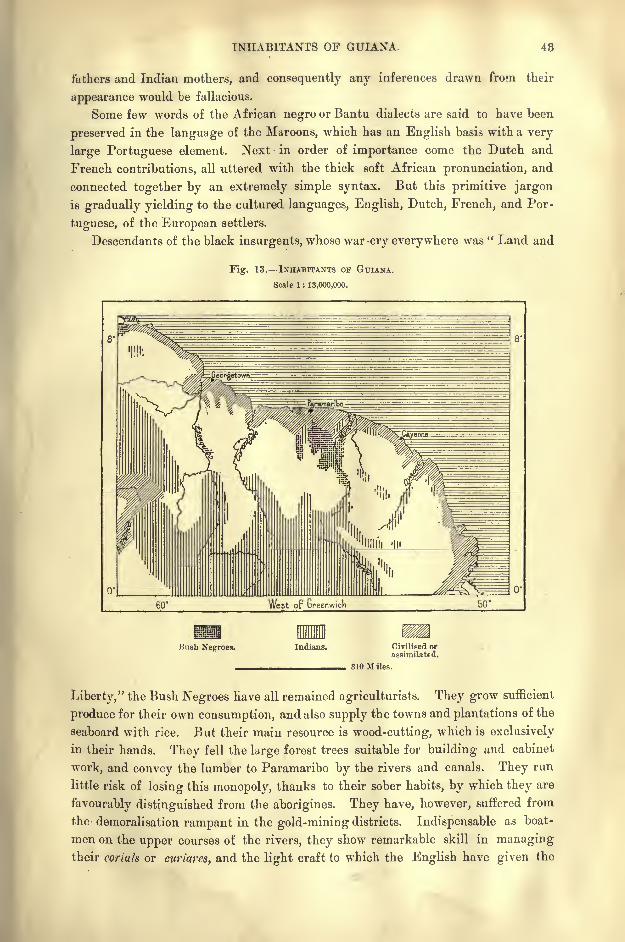
INHABITANTS OF GUIANA. 43
fathers and Indian mothers, and consequently any inferences drawn from their
appearance would be fallacious.
Some few words of the African negro or Bantu dialects are said to have been
preserved in the language of the Maroons, which has an English basis with a very
large Portuguese element. Next in order of importance come the Dutch and
French contributions, all uttered with the thick soft African pronunciation, and
connected together by an extremely simple syntax. But this primitive jargon
is gradually yielding to the cultured languages, English, Dutch, French, and Por-
tuguese, of the European settlers.
Descendants of the black insurgents, whose war-cry everywhere was " Land and
Fig. 13. INHABITANTS OF GUIANA.
Scale 1 : 13,000,000.
cr
Bush Negroes. Indians. Civilised orassimilated.
310 Miles.
Liberty," the Bush Negroes have all remained agriculturists. They grow sufficient
produce for their own consumption, and also supply the towns and plantations of the
seaboard with rice. But their main resource is wood-cutting, which is exclusively
in their hands. They fell the large forest trees suitable for building and cabinet
work, and convey the lumber to Paramaribo by the rivers and canals. They run
little risk of losing this monopoly, thanks to their sober habits, by which they are
favourably distinguished from the aborigines. They have, however, suffered from
the demoralisation rampant in the gold-mining districts. Indispensable as boat-
men on the upper courses of the rivers, they show remarkable skill in managingtheir coriah or curiares, and the light craft to which the English have given the
44 AMAZONIA AND LA PLATA.
name of " wood-skins." These are frail canoes made from the bark of copaifera
publiflora or of hymcenca courbaril, like the birch-bark canoes of the Huron
Indians.
So early as 1739, the Moravian missionaries had already founded stations
amongst the Bush populations, but they have had little success except with the
Moesinga communities. From a vague reminiscence of the teachings received
during the period of slavery on the plantations, the negroes have retained a sort
of belief in a Supreme Being, creator of man, monkeys, and manioc, on the whole
a beneficent deity, whose wife was called Maria, and whose son bore the name of
Jest Kixti. But apart from this shred of Christianity, most of the Bushmen have
preserved their nature worship, and, in fact,"they believe what their mothers
believed." But the fervour even of this primitive cult seems to be on the wane
in most of their villages, and the fetishes and gadtis or effigies of tutelar animals
have generally disappeared from the neighbourhood of the white settlements.
At present the chief object of negro worship is the ceiba or cotton-tree, that
noblest forest growth of the "West Indies, which rises in solitary grandeur in the
vicinity of the settlements, its wide-spreading branches affording shelter to the
community like some beneficent deity. Traces may often be seen of offerings,
such as fowls, yams, libations of drink, scattered round its stem, the object being
to propitiate the spirit dwelling in its branches, who is of a beneficent disposition,
unlike his demon brother of the poison tree Hiari, who also finds some votaries
inspired rather by fear than gratitude.
No idols properly so called are worshipped, but the negroes of the more
inland districts cover themselves with obeeahs or amulets of shells, bones, or
feathers;such charms are even hung round the necks of their dogs to improve
their scent in the chase. A curious trait is the custom of bringing back and
burying with all honours the hair of those who may happen to die at a distance
from their homes.
These communities dwell in peace unruffled by the wranglings of rival chiefs
contending for the supreme power. Enjoying an equal share of comfort, the
Bush Negroes also enjoy absolutely equal rights. Nevertheless every village has
its nominal headman nearly always chosen from the same family, and distinguished
amongst his fellow-citizens, not by any personal authority, but by the privilege
of parading on feast days in a military uniform and flourishing a gold-headed
cane in public.
But the chiefs in a pre-eminent sense, those of the Aucan community, bear the
distinctive title of Gramman, from the English" Grand Man." The Aucan chief
is allowed a respectful precedence by his Saramaccan and Moesinga colleagues,
and is, in fact, recognised as the overlord of all the Surinam Bush Negroes, though
in rank and title rather than in power. His pedigree goes back to the first
Aucan chief, Pamo, but in the female line, the matriarchal traditions having been
preserved from times anterior to the period of slavery. The Gramman is even
recognised by the Dutch Government, which, however, has taken the precaution
to provide him with a European Resident under the title of Posfhomtcr. This
INHABITANTS OF GUIANA. 45
" Postholder" was formerly a simple delegate from the whites, who at last became
the chief magistrate and arbitrator in lawsuits between private persons and in
differences between the various village communities. The Gramman of the Boni
people in French Guiana is no longer much more than a civil functionary receiv-
ing a regular subsidy from the Colonial Government.
Like the aborigines, the negroes, other than the immigrants from Trinidad,
Barbadoes, and Martinique, are decreasing, although the climate of the Guianas
appears to be as favourable to the black race as it is unfavourable to Europeans.
Miscegenation with other races may, to a small extent, explain this decrease; but
even amongst those living apart, as well as amongst those intermingled with the
cosmopolitan populations of the towns and coastlands, the number of deaths
exceeds that of the births everywhere except amongst the Aucanjp. In the last
century it was supposed that the Africans could never multiply in Guiana, because
nearly all the infants died of convulsions during the first nine days after birth.
This excessive mortality is attributed by Palgrave to the ill-regulated affection
of the mothers for their offspring, whom they literally "kill with kindness,"
which takes the form of overfeeding. But this cause being prevalent elsewhere
as well as in Guiana, some other explanation must be sought. It would seem, in
fact, that the blacks have not yet become perfectly acclimatised, as shown by their
feeble resistance to such disorders as leprosy, elephantiasis, small-pox, and manyothers, which commit great havoc amongst them. Those dwelling in the bush
are also exposed to the attacks of the luc'dia hominivora, a horrible insect pest
which deposits its eggs in the ears and nostrils with fatal results.
THE COOLIES EUROPEAN SETTLERS.
After the emancipation most of the freedmen having abandoned the planta-
tions either to seek work in the towns or else to cultivate their own holdings, the
great landowners had to seek elsewhere for labourers. French and Dutch Guianas
were too poor to import many alien hands; but British Guiana, with its wider
extent of cultivable lands, and with the great labour market of British India
thrown open by the Government, has engaged no less than 170,000 Asiatic
coolies since the year 1845. At present this element represents fully one-third of
the whole population of the English colony, the most valued being the so-called
hill- coolies from the uplands south of the great bend of the Ganges. Emigrantoffices have been opened in Calcutta and Madras to meet the demands of the
Demerara planters, who have also engaged a few thousand Chinese coolies.
On the other hand, the Surinam planters have introduced labourers from Java,
while Arabs, Annamites, and Senegal negroes have been attracted to the French
colony. Even white labour has been sought, but only in such markets as
Madeira and the Azores, whose inhabitants are accustomed to a tropical climate.
These immigrants, collectively called "Portuguese," though a very mixed race,
seem destined to become the true ethnical element of the Guianas of the future.
They have already established themselves in several districts beyond the zone of
plantations which it has taken the French, Dutch, and English some two hun-
46 AMAZONIA AND LA PLATA.
dred and fifty years of patient labour to reclaim from the swamps and woodlands.
Even the whites who formerly succeeded best in Dutch Guiana were Jews for the
most part of Portuguese origin. The chief group, a body of Hebrew planters
expelled from Brazil, arrived in 1 663, and to their influence is due the large pro-
portion of Portuguese words that have found their way into the Creole languageof the Bush Negroes.
All the costly attempts to colonise the country with whites drawn from other
lands have ended in disaster. Individuals of strong constitution may no doubt
become acclimatised by carefully observing all the rules of health. But to adapt
whole families and communal groups to an environment so different from that of
Europe is certainly a far more dangerous and difficult experiment than to settle
them in Canada,, or the United States, especially when the emigrants are deprived
of ordinary comforts and even of proper food, as has too often been the case.
Although consumption is almost unknown on the coastlands, the new arrivals are
rapidly decimated by the marsh fevers, which are most dangerous, especially when
the hot sun begins to suck up the deadly exhalations in the swampy districts.
Since the year 1855, yellow fever also has made frequent visits to this sea-
board.
Hence the Europeans, although the political masters of the land and owners of
the plantations, have remained practically aliens in the midst of a motley cosmo-
politan population, in which the half-caste elements are steadily increasing. Except
in some favourable years, the mortality is always higher th-in the birth rate, and
meanwhile the Europeans of pure descent are being outstripped on all sides by the
Portuguese islanders from the north, by the Brazilians, also of Portuguese speech,
from the south, by the Spanish Venezuelans from the west; in a word, by intruders
of Latin speech and culture arriving from every quarter.
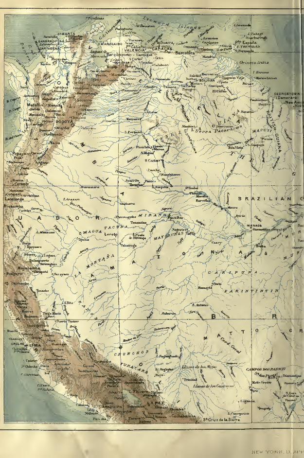
JL;^;
BOGOTA ^^^Kx_v-.r
t>ir*r<iat I'x'.n.-.-m .-
wSfr'-Sw
R_.
"jwr"*"
\R^
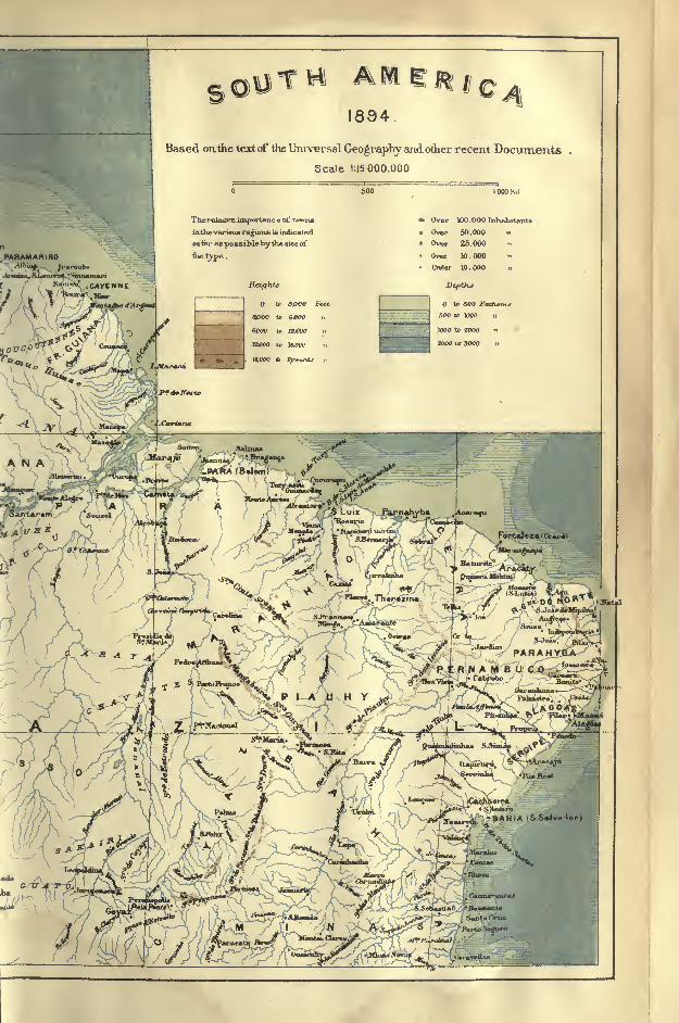
1894.
Based on.ihe text of the Universal Geography axid other recent Documents .
Scale 1:15000.000
THerelaiivBimportance of town*
in1he~vari<nu regions is inihcaied
ait, i as possible by the size of
tlie type .
Over IDO.OOOInVmbitanls
Over 50.000 v
Over 26.000 -.
Owr 10.000 <<
Under 10.000 .,
to SpCO Feet
3000 to 6000
12.000 ,.
12000 to JftOOc-
!....,(,. -
CHAPTER II.
BRITISH GUIANA.
HIS section of the Guianas, with its still undetermined political
frontiers, is by far the most important, both for population and
commercial activity. It is usually taken for granted, without fur-
ther inquiry, that this remarkable superiority of British Guiana as
a field of enterprise is primarily due to the administrative genius
of the English. But if this relative prosperity may at least in part be attributed
to the non-intervention of the home government in local affairs, to the comparatively
limited staff of office-holders, and to the continuity of the policy pursued towards
the colony, it is none the less true that British Guiana also enjoys considerable
natural as well as political advantages.
In the first place, it possesses the largest river basin, while its chief plantations
are more accessible to shipping both from Europe and the West Indies. Hence
these plantations had already been profitably worked by the Dutch long before
the English conquest. The cultivable zone stretches along the coast, with a good
seaward outfall for drainage purposes. Consequently, numerous towns and villages
have been founded and estates laid out in close proximity between the Atlantic
and the stagnant waters of the interior. But in Dutch Guiana and in the greater
part of the French colony the marshy zone lies on the coast, masked only by a
mangrove screen from the ocean.
It was easy to begin agricultural operations on the open coastlands of the
British territory, and, thanks to the proximity of the West Indies, the first planters,
for the most part Scotchmen, were able without difficulty to procure all the labour
they needed. Since 1802, when Great Britain occupied this northern part of
Guiana, which was officially ceded to her in 1814, the rulers of the land have
largely profited by the neighbourhood of the West Indian colonies to favour the
immigration of the negroes of the overpeopled island of Barbadoes, as well as of
the large island of Trinidad. Later, when the emancipation deprived the great
landowners of the slaves who worked their estates, the Indian Government threw
open its coolie market for the benefit of the wealthy sugar-growers of Demerara.
All these circumstances secured for British Guiana a decided advantage over
the conterminous colonies, and as a natural result this very advantage brought
48 AMAZONIA AND LA PLATA.
about a better commercial status, a more rapid development of its industrial
resources, more numerous and more active relations with the outer world. All
actual progress acts as a stimulant of further prosperity. If British Guiana is no
more a colony in the strict sense of the word than are the other two territories
under European rule, it has at least become a sphere of spontaneous colonisation
for settlers from the West Indies and the Azores. In ordinary language, the
English speak of their possessions on the South American mainland as in fact
forming part of the West Indies.
THE NORTH-WEST DISTRICT.
Till recently the zone of large agricultural domains was limited in British
Guiana to that section of the seaboard which is comprised between the Pomerun
and Berbice rivers. The north-western region, the possession of which is con-
tested by Venezuela, remained uninhabited. During the early days of colonisa-
tion a few Dutch settlers had established themselves on the banks of the Pomerun,
the first arrivals dating from the year 1580. But they had never advanced west-
wards in the direction of the Orinoco. Their plantations on the Pomerun itself
were even abandoned one after the other, and about the middle of the nineteenth
century the only inhabitants of this district were some Indians and negro half-
breeds encamped in the forest glades. The latter are descendants of runawayslaves who had taken refuge here in 1738, and whom their owners feared to
pursue ;but the Maroons on their part did not dare to remain in the vicinity of
the whites, and so joined the Indian tribes.
Regular colonisation in this district was first undertaken by some Portuguese
speculators about the year 1 870, and since then agricultural progress has been
continuous and rapid. The chief difficulty was the interruption of the communi-
cations during the dry season. The itabbo or ditch connecting the Moruka and
Waini rivers is completely dry for six months in the year, and even during ihis
period the alluvial lands are not firm enough to afford a footing to wayfarers in
the woodlands between the two basins.
At present the steamers plying between Georgetown and the Orinoco delta
have brought the whole of the " north-western district"
into easy relations with
the rest of the colony. The new domain thus opened up has been occupied at
three different points by traders and others engaged especially in the lumber
business. One, lying nearest to the plantations on the banks of the Pomerun,
stands at the junction of the waters formed by the Baramanni lagoon with the
Waini river;another at the confluence of the Morawhanna, which connects the
Barima with the Waini;the third at the mouth of the Barima in the Orinoco
estuary. The natural and administrative centre of the whole district is the
Jforaic/ianiia station, where the British Government has erected a group of public
buildings, including a courthouse, police barracks, and hospital.
This may be taken as a proof of the determination of the Foreign Office
absolutely to ignore the pretensions of Venezuela to the north-western district,
which has a superficial area of 9,400 square miles. In colonial times the nearest
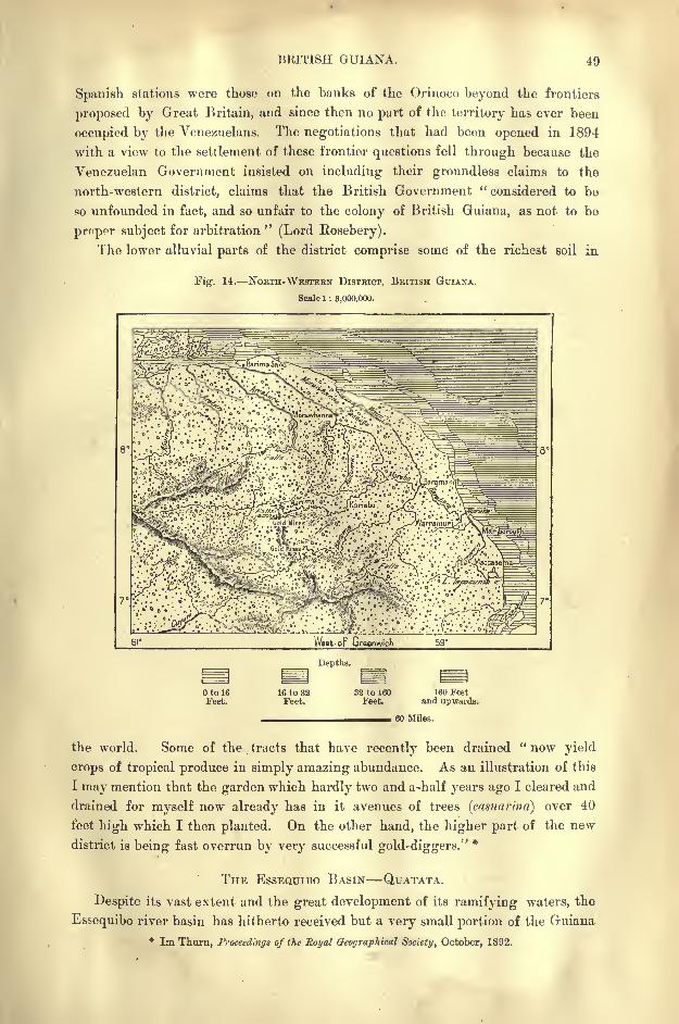
BRITISH GUIANA. 49
Spanish stations wore those on the banks of the Orinoco beyond the frontiers
proposed by Great Britain, and since then no part of the territory has ever been
occupied by the Venezuelans. The negotiations that had been opened in 1894
with a view to the settlement of these frontier questions fell through because the
Venezuelan Government insisted on including their groundless claims to the
north-western district, claims that the British Government "considered to be
so unfounded in fact, and so unfair to the colony of British Guiana, as not to bo
proper subject for arbitration" (Lord Rosebery).
The lower alluvial parts of the district comprise some of the richest soil in
Fig. 14. NoRra-WESTEBN DISTRICT, BRITISH GUIANA.
Scale 1 : 8,000,000.
7
Depths.
otoieFeet.
16 to 32Feet.
32 to 160Feet.
160 Feetand upwards.
60 Miles.
the world. Some of the tracts that have recently been drained "now yield
crops of tropical produce in simply amazing abundance. As an illustration of this
I may mention that the garden which hardly two and a-half years ago I cleared and
drained for myself now already has in it avenues of trees (casiiarind) over 40
feet high which I then planted. On the other hand, the higher part of the new
district is being fast overrun by very successful gold-diggers."*
THE ESSEQUIBO BASIN QUATATA.
Despite its vast extent and the great development of its ramifying waters, the
Essequibo river basin has hitherto received but a very small portion of the Guiana
* Im Thurn, Proceedings of the Royal Geographical Society, October, 1892.
50 AMAZONIA AND LA PLATA.
populations, nor has any centre of European enterprise leen yet established within
its limits. 1 he region about its headwaters is occupied by the Taruma Indians,
who are rarely visited by travellers, and whose relations with the colony are con-
ducted through the agency of a few traders thinly scattered over a wide space.
Groups of hamlets follow at great distances along the course of the rivers
especially about the portages, where the cataracts have to be turned by the boat-
men. The river traffic carried on by their means is almost entirely limited to the
section of the Essequibo below the confluence of the Rupununi, although this
affluent follows the natural route between the Atlantic and the Amazons basin
through the Pirara depression. But everywhere the riverside stations are wide
apart, and till recently they were exclusively inhabited by Indians and half-breeds,
with a few black or Portuguese dealers from the distant coast towns. Neverthe-
less, there can be no doubt that sooner or later the broad highway leading from
the Atlantic to Amazonia will acquire great commercial importance.
Meanwhile, the chief group of huts near the Pirara depression is the obscure
village of Qnatata, trysting-ground of the Wapisiaria, Macusi, and WayeweIndians, who here carry on a barter trade in hammocks, sarbacanes, and other
objects of native industry, taking in exchange the cutlery, beads, dogs, and
manioc rasps supplied by the European dealers. The natives have been visited
both by Protestant missionaries from Demerara and by Catholic Fathers from
Manaos, and near Quatata are seen the remains of the little Fort New Guinea,
erected by the English to uphold the claims of Great Britain to this important
strategical position. The district is yearly visited by half-caste Brazilian immi-
grants engaged in stock-breeding.
BARTICA. ZEELANDIA.
At the confluence of the navigable Mazaruni and Cuyuni affluents above the
estuary stands the little town of Bartica Grove, or simply Bartica, at one time a
flourishing mission station, till lately reduced to a few wooden huts embowered
in the overhanging riverside vegetation, a recently restored church, some small
residences, and a few timber-sheds. The picturesque village, with its avenues of
tall mango-trees and tangle of flowery shrubs overtopped by groups of graceful
palms, was till recently occupied chiefly by the so-called " river-men," idle negroes
and half-breeds, who make a precarious living on the Government timber-grants,
or as boat-hands to help travellers in surmounting the numerous cataracts of the
Essequibo affluents.
Since 1887 the prosperity of Bartica has revived, thanks mainly to the develop-
ment of the gold-mining industry in the western districts. The place is now
rapidly increasing, and tends to become the chief trading centre of the colony.
Chinese and Portuguese traders have already opened numerous stores for the
supply of the mining populations, and the future of Bartica seems to be assured
by its advantageous position at the converging point of a network of navigable
waters leading in one direction up the Essequibo to the Amazons and Brazil, in
another by the Cuyuni towards the Orinoco and Venezuela.
BRITISH GUIANA. 51
A few miles to the west an eminence rising above the left bank of the Maza-
runi-Cuyuni, a short distance above the confluence, is crowned by the extensive
buildings of the penal settlement, established in 1843, and containing about 300
convicts. To prevent the prestige of the ruling race from being lowered, no
English criminals are confined in this establishment, which is surrounded by a
magnificent park, planted with fine trees of rare species. The mansion of the
governor, the houses of the officials and turnkeys are all shaded in an exuberant
vegetation of tropical growth.
The convicts are mostly employed in working the neighbouring quarries, which
supply Georgetown with the granite required for its quays and buildings. Some
of the well-conducted enjoy a moderate share of freedom, being allowed to seek
employment in the district as carpenters, gardeners, or woodmen. A steamer plies
regularly between the settlement and Georgetown, Bartica being the chief station
on the route.
Below the Mazaruni confluence the Essequibo develops its broad estuary, at
first in an open expanse some miles wide, and lower down in numerous channels
winding between an archipelago of islands, nearly all inhabited. One of these,
three miles from the sea, contains the still-imposing ruins of Fort Zeelandia, which
was erected by the Dutch in 1743 as the commercial and administrative centre
of their colony. Each island is rounded off in a superb dome of rich vegetation,
while the view is everywhere bound by a circle of arborescent growths. The
larger members of the archipelago are occupied by plantations surrounded by large
timber, and cultivated grounds stretch along the estuary north-westwards in the
direction of the Pomerun, north-eastwards towards Georgetown, at the mouth of the
Demerara.
GEORGETOWN. NEW AMSTERDAM.
The old Dutch town of Stabrock, which in 1774 supplanted Zeelandia as the
residence of the governor, has acquired considerable importance since it has become
the capital of British Guiana under the name of Georgetown. It is already the
largest centre of population on the stretch of seaboard between the Orinoco
and Amazons estuaries, and here are concentrated twice as many inhabitants as are
found in the whole of French Guiana. Yet, seen from the sea, Georgetown almost
escapes observation, little being visible except a dense mass of leafy vegetation
overtopped by clumps of coeoanut palms and oreodoxas. But a nearer view reveals
the shipping which crowds the broad Demerara estuary, with a background of
elegant white houses skirting the right bank of the river.
Georgetown, which is inhabited in large majority by blacks and people of
colour, extends considerably over a mile along the estuary between Fort William
at the entrance and the group of villas dotted over the plains. Even in the
vicinity of the busiest thoroughfares and of the quays where are stored nearly all
the products of the Guianas, the houses with their verandahs of flowering
creepers are surrounded by shady gardens, and each dwelling has its cistern for
watering the trees and flower-beds.
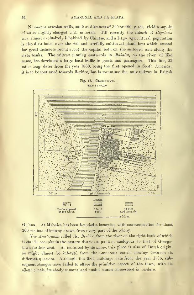
52 AMAZONIA AND LA PLATA.
Numerous artesian wells, sunk at distances of 300 or 400 yards, yield a supply
of water slightly charged with minerals. Till recently the suburb of Hopetoicn
was almost exclusively inhabited by Chinese, and a large agricultural population
is also distributed over the rich and carefully cultivated plantations which extend
for great distances round about the capital, both on the seaboard and along the
river banks. The railway running eastwards to Mahaica, on the river of like
name, has developed a large locj.1 traffic in goods and passengers. This line, 23
miles long, dates from the year 1850, being the first opened in South America;
it is to be continued towards Berbice, but is meantime the only railway in British
Fig. 15. GEOBGETOWN.
Scale 1 : 87,000.
', , o .
imyeldt "-'*'\ '..''
*".'
West or Greenwich
Bnnks exposedat low water.
Depths.
to 16
Feet.
IB Fpetand upwards.
2 Mile?.
Guiana. At Mahaica has been founded a lazaretto, with accommodation for about
200 victims of leprosy drawn from every part of the colony.
New Amsterdam, called also Berbice, from the river on the right bank of which
it stands, occupies in the eastern district a position analogous to that of George-
town farther west. As indicated by its name, this place is also of Dutch origin,
as might almost be inferred from the numerous canals flowing between its
different quarters. Although the first buildings date from the year 1796, sub-
sequent changes have failed to efface the primitive aspect of the town, with its
silent canals, its shady squares, and quaint houses embowered in verdure.
BRITISH GUIANA. 58
MATERIAL CONDITION OF BRITISH GUIANA.
As in otter regions exploited by slave labour, field operations, performed bymen like machines, controlled by overseers armed with the lash or the stick, were
incompatible with the cultivation of any great variety of crops in British Guiana.
Simple processes carried out in a mechanical way were alone possible ;hence the
products of the sugar-cane rum,"foots," molasses besides cotton and coffee,
were the only articles of export during the plantation days. Even still, despite
the abolition of slavery, the crude old agricultural systems linger on, and land
tenure has undergone no change, large domains still everywhere prevailing. Onlythe gangs of black slaves are now replaced by contract labour, though the Hindoo
coolies have to conform to the same old rigid methods of routine work. Asingle estate on the left bank of the Demerara comprises as many as 5,600 acres,
and yields 5,500 tons of sugar, employing altogether 3,730 coolies and freedmen.
The administration, however, has at last discovered that it would be unwise to
dispose of the remaining unallotted lands in great domains. With a view to
attracting settlers, efforts are being made to create a numerous class of small free-
holders by limiting to 50 acres the lots granted to new arrivals.
THE SUGAR INDUSTRY.
As in the slave days, sugar continues to be the staple crop. About half of all
the cultivated land is under cane, and this single item represents on an average
over nine-tenths of all the colonial exports. Thanks to the fertility of the soil,
improved processes of production, and the excellent quality of the sugar, the
Demerara planters have hitherto "been able to hold their- own against the fierce
competition of the European beet-sugar growers. But to maintain their ground
they shrink from no necessary outlay. While utilising the upheaved strip of
coastlands, they have encroached on the sea itself, by the construction of an ex-
ceedingly costly system of dykes, which at the same time serve as roads.
The land has been cut up by a network of canals and trenches, by which the
surface is drained, while facilities are afforded for the transport of the cane. The
soil is renovated by a liberal employment of chemical manures, and the mills have
been provided with the most improved machinery and general plunt for crystal-
lising the sap to the best advantage. The cane, containing on an average 17 per
cent, of sugar, is thus made to yield as much as 16 per cent., whereas by the old
processes of crushing scarcely one-half could be extracted. The best " Deme-
rara" commands on the English markets prices far higher than the product of all
other sugar-canes. It is also exported to Nova Scotia, Newfoundland, and other
British colonies, and, despite the heavy protective tariffs, it competes successfully
with the sugars of Louisiana and of Cuba in the United States markets. The
Demerara rum, which is greatly inferior to that of Jamaica, is exported chiefly to
Great Britain;while the Georgetown molasses are highly appreciated in the French
Antilles.
The Berbice coffee plantations, which formerly yielded a choice variety of the
berry, have now been almost everywhere replaced by cane ;in fact, the shrub is
38
54 AMAZONIA AND LA PLATA.
scarcely anywhere met except in gardens and in the small negro holdings. Next
to sugar the chief product of British Guiana at present is lumber, which is cut bythe Partamona and Calina tribes on the banks of the Essequibo abo\7 e Bartica and
in other fluvial valleys south of the plantations. These Indians are closely related
to the Galibi who dwell on the banks of the Maroni about the Franco-Dutch
frontiers.
In late years the trade in fruits, cocoanuts, and bananas has acquired some
importance, and, despite the distance, might compete with the fruit trade that
has sprung up between Central America and the United States. The Guiana
fruits, especially the bananas, have a delicate flavour fully equal to those of the
West Indies, Costa Rica, and Guatemala.
TRADE ADMINISTRATION.
Altogether British Guiana has a mean annual export trade of about 8,000,000
in sugar and other products of cane, timber, cabinet woods, and fruits, to which
in late years have been added gold dust and small diamonds collected on the banks
of the Barima and Cuyuni rivers and in the alluvia of the coast streams in the
north-western district. "In 1884 the gold exported was only 250 ounces from
the whole colony, and this had increased in steady and natural ratio in 1891 to
101,297 ounces. From the Morawhanna river, from which the first gold 129
ounces was obtained only in November, 1889, 2,836 ounces were obtained in
March, 1892. It should be added that though the metal as yet obtained has been
got by means of such primitive instruments as the battel, the torn, and the sluice
from the alluvial mud, there are already signs that the more serious enterprise of
quartz-crushing will soon be entered on." *
British Guiana imports provisions, machinery of all kinds, textile fabrics, and
other manufactured wares chiefly from England, and to some extent from the
United States. Georgetown is now connected by regular lines of steamers with
Great Britain, the West Indies, and Canada.
Till the year 1831 Demerara and Berbice constituted two distinct colonial
governments, as they had under the Dutch rule. Most of the laws and local
regulations had been maintained, and numerous traces still survive of this system.
The political power is almost exclusively in the hands of the governor as repre-
sentative of the Queen. He is assisted in his administration by a " Court of
Policy"composed of the five chief colonial officers, and of five members chosen by
the Court and the two presented by the notables, who form electoral bodies num-
bering altogether 2,046 in 1893.
To the Governor and Court of Policy are also entrusted the legislative and
executive functions. But in determining the rate of taxes the Governor has to
consult six financial representatives, who form, with the other Government officials,
a " Combined Court." The colony is still administered under the Dutch civil law,
modified by various decrees and ordinances ;but the criminal law has been con-
formed to that of England, though the jury system has not yet been adopted.
* Im Thurn, Proc. R. Geo. Soc., October, 1892.
BRITISH GUIANA. 55
The so-called "Rhenish "scale of weights and measures still prevails on the banks
of the Demerara, although abolished in Holland itself.
The police comprises a few hundred men, while the military garrison num-
bers about 300 soldiers, drawn from the West Indian black regiments. The
Church of England, which is the national church, has a hierarchy of one bishop,
with a number of rectors and curates supported by the British Government,
which also subsidises the Presbyterian and Catholic Churches. In 1891 about
88,000 children, or one-ninth of the whole population, were receiving regular
instruction in the colonial schools. The annual budget usually balances itself,
while the public debt amounted in 1890 to 200,000.
The colony is divided into the four administrative districts or counties of the
North-West, Essequibo, Demerara, and Berbice.
CHAPTER III.
DUTCH GUIANA.
HE Dutch, who were the first settlers in British Guiana, laid the
foundations of the prosperity of that colony to the benefit of their
English rivals. What they have preserved of their old posses-
sions is of far less value than what they have lost. Surinam, as
they call their present colony of Guiana, has scarcely one-sixth of
the population grouped round Deraerara, in the British possessions, while its
trade hardly amounts to one -fifth of the commercial transactions carried on by the
neighbouring colony.
The economic crisis following the abolition of slavery in 1863 involved
numerous plantations in utter ruin, and vast stretches of cultivated land reverted
to the solitude of the savannas and woodlands. The population even decreased
by emigration, and several years of decadence elapsed before the first symptomsof a slow revival became manifest. At present the population is on the increase,
though this is due to the arrival of a few Indian coolies. The planners are
gra'dually resuming possession of the land, but are for the most part devotingtheir attention to economic plants different from those cultivated by their
predecessors.
As in British Guiana, the inhabited and cultivated zone forms but a small
part of the whole territory. It comprises the coastlands between the outer belt of
bush and mangrove swamps and the inland savannas. But even in this
cultivated zone there are numerous gaps occupied by scrubby and marshy tracts.
NICKEUIE GROXINGEN.
Nickcric, the westernmost district, lying east of the Corentyne and its estuary,
is but thinly settled, and the population is still very slight. At the beginning
of the nineteenth century some planters and traders established a colony at the
headland close to the confluence of the Corentyne with the River Nickerie on
the right bank of the estuary. The site seemed favourable, and the settlement
increased rapidly. But in less than two generations the very ground on which the
quays and buildings had been erected was swept away by the Atlantic waves
DUTCH GUIANA. 57
continually encroaching on the land. The inhabitants, disheartened and com-
pelled to retreat constantly towards the interior, at last dispersed, and nothing
remained except a little group of cottages at the entrance of the estuary.
According to Palgrave, the rapid advance of the sea at this point is due to a
subsidence of the land, and not, as the residents supposed, to a change in the
direction of the winds and currents, giving more force to the breakers. This
observer speaks of "a broad, triangular space of shallow water, lashed into seeth-
ing waves by wind and current, where, a few feet under the surface, lies what
was once the busy area of populous streets. Meanwhile the breakers, not content
with the mischief already done, continue ceaselessly tearing away the adjoining
land bit by bit. Right in front a large house, left an empty shell, without doors
or window-frames, by its fugitive inhabitants, is on the point of sinking and
disappearing among the waters that, unopposed, wash to and fro through the
ground floor. Close by the victorious sea has invaded the gardens of the neigh-
bouring dwellings, and will evidently soon take possession of the buildings them-
selves. Farther on a few isolated fragments of what was once a carefully
constructed sea-dam rise like black specks among the yeasty waters, and the
new earth- wall built to protect what yet remains of Nickerie has a desponding,
makeshift look, as if aware that it will not have long to wait for its turn of
demolition."*
Groningen, another colony of which its promoters had great expectations, has
proved even a greater failure than Nickerie. It was founded in 1843 near the
Saramacca estuary, and peopled with Frisians carefully chosen for the purposeof introducing
" white labour"
into these equatorial regions. But the enter-
prise met the fate that invariably overtakes . all such experiments. Of the 384
settlers about one half were dead within six months, and most of the survivors
had to remove to the neighbouring plantations. Several have prospered as artisans
and gardeners in Paramaribo, but Groningen itself has all but disappeared. It
stood about midway between Paramaribo and Batavia, which lies a few miles to
the south-west on the right bank of the Coppename estuary.
Here is a lazaretto, where the patients are maintained by their friends and
families. But the village lies too near the settled districts, and another leper-
house is to be established on the right bank of the Upper Surinam in the unin-
habited district of Grand Chatillon. Nowhere are the ravages of this loath-
some malady more destructive than in Dutch Guiana, especially among the
blacks and people of colour. In 1893 nearly a thousand were said to be tainted.
PARAMARIBO.
Unlike Georgetown and New Amsterdam, Paramaribo, capital of Dutch
Guiana, does not lie on the sea coast. In this region the form and character of
the seaboard has required the towns and settlements of the plantations to be
established in the relatively dry zone, which is traversed by the coast streams
flowing parallel with the strip of swampy mangrove-covered foresnore. Para-
* Dutch Guiana, p. 17.
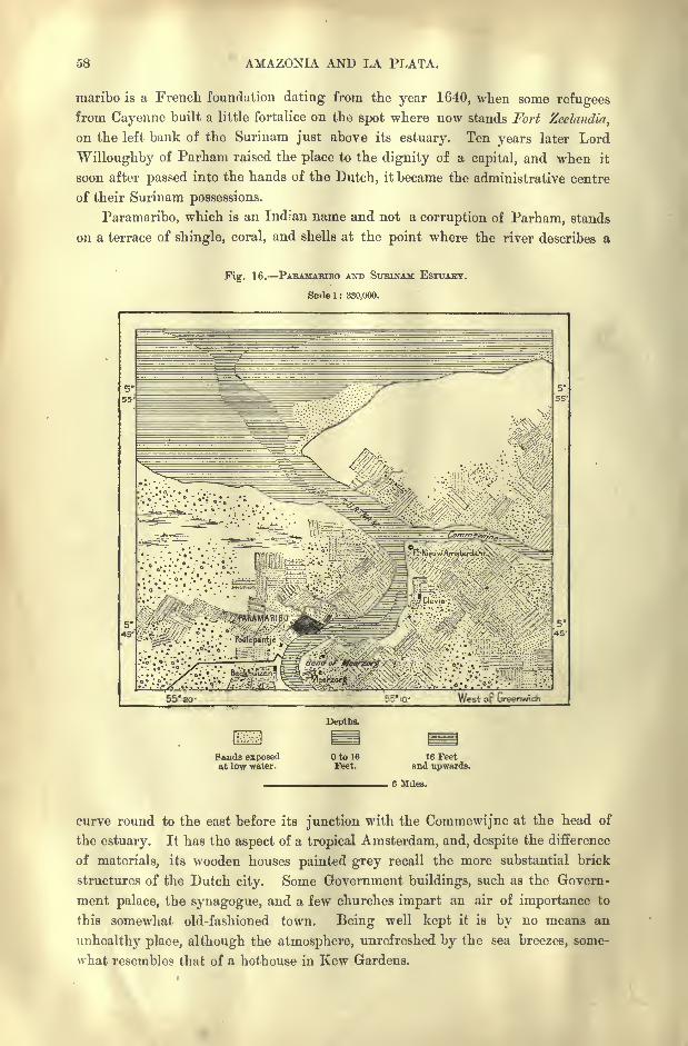
58 AMAZONIA AND LA PLATA.
maribo is a French foundation dating from the year 1640, when some refugeesfrom Cayenne built a little fortalice on the spot where now stands Fort Zeelandia,
on the left bank of the Surinam just above its estuary. Ten years later Lord
Willoughby of Parham raised the place to the dignity of a capital, and when it
soon after passed into the hands of the Dutch, it became the administrative centre
of their Surinam possessions.
Paramaribo, which is an Indian name and not a corruption of Parham, stands
on a terrace of shingle, coral, and shells at the point where the river describes a
Fig. 16. PARAMABIBO AND SlTBINAM ESTUAHT.
Scale 1 : 330,000.
55' 20- 55' 10.- West op Greenwich
Depths.
Sands exposedat low water.
Otol6Feet.
16 Feetand upwards.
curve round to the east before its junction with the Commewijne at the head of
the estuary. It has the aspect of a tropical Amsterdam, and, despite the difference
of materials, its wooden houses painted grey recall the more substantial brick
structures of the Dutch city. Some Government buildings, such as the Govern-
ment palace, the synagogue, and a few churches impart an air of importance to
this somewhat old-fashioned town. Being well kept it is by no means an
unhealthy place, although the atmosphere, unrefreshed by the sea breezes, some-
what resembles that of a hothouse in Kew Gardens.
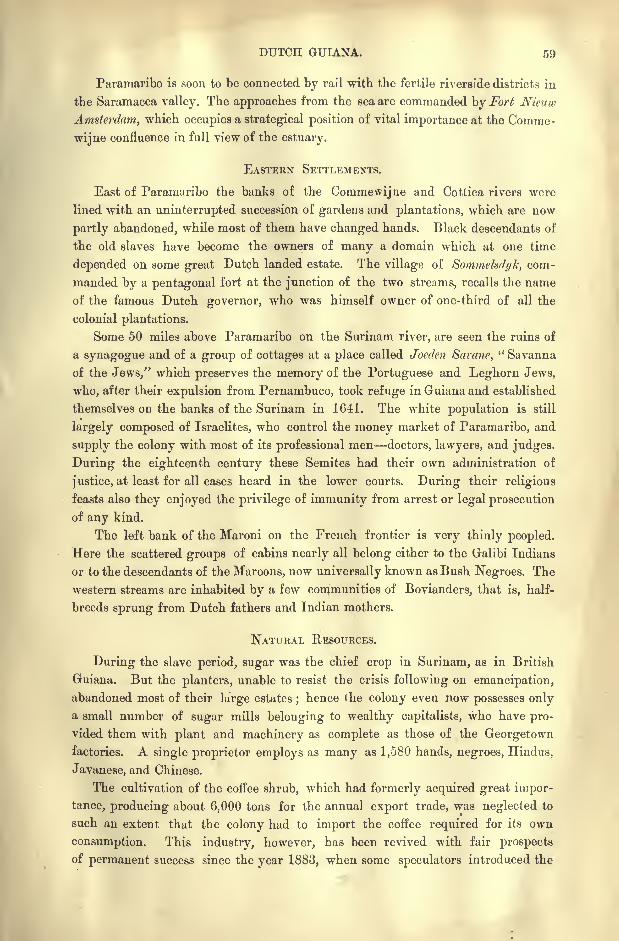
DUTCH GUIANA. 59
Paramaribo is soon to be connected by rail with the fertile riverside districts in
the Saramacca valley. The approaches from the sea are commanded by Fort Nieuw
Amsterdam, which occupies a strategical position of vital importance at the Comme-
wijne confluence in full view of the estuary.
EASTERN SETTLEMENTS.
East of Paramaribo the banks of the Commewijne and Cottica rivers were
lined with an uninterrupted succession of gardens and plantations, which are now
partly abandoned, while most of them have changed hands. Black descendants of
the old slaves have become the owners of many a domain which at one time
depended on some great Dutch landed estate. The village of Sommelsdyk, com-
manded by a pentagonal fort at the junction of the two streams, recalls the name
of the famous Dutch governor, who was himself owner of one-third of all the
colonial plantations.
Some 50 miles above Paramaribo on the Surinam river, are seen the ruins of
a synagogue and of a group of cottages at a place called Joeden Sarane," Savanna
of the Jews," which preserves the memory of the Portuguese and Leghorn Jews,
who, after their expulsion from Pernambuco, took refuge in Guiana and established
themselves on the banks of the Surinam in 1641. The white population is still
largely composed of Israelites, who control the money market of Paramaribo, and
supply the colony with most of its professional men doctors, lawyers, and judges.
During the eighteenth century these Semites had their own administration of
justice, at least for all cases heard in the lower courts. During their religious
feasts also they enjoyed the privilege of immunity from arrest or legal prosecution
of any kind.
The left bank of the Maroni on the French frontier is very thinly peopled.
Here the scattered groups of cabins nearly all belong either to the Galibi Indians
or to the descendants of the Maroons, now universally known as Bush Negroes. The
western streams are inhabited by a few communities of Bovianders, that is, half-
breeds sprung from Dutch fathers and Indian mothers.
NATURAL RESOURCES.
During the slave period, sugar was the chief crop in Surinam, as in British
Guiana. But the planters, unable to resist the crisis following on emancipation,
abandoned most of their large estates;hence the colony even now possesses only
a small number of sugar mills belonging to wealthy capitalists, who have pro-
vided them with plant and machinery as complete as those of the Georgetownfactories. A single proprietor employs as many as 1,580 hands, negroes, Hindus,
Javanese, and Chinese.
The cultivation of the coffee shrub, which had formerly acquired great impor-
tance, producing about 6.000 tons for the annual export trade, was neglected to
such an extent that the colony had to import the coffee required for its own
consumption. This industry, however, has been revived with fair prospects
of permanent success since the year 1883, when some speculators introduced the
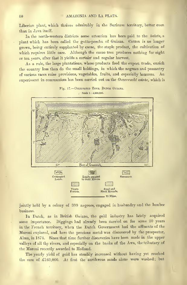
60 AMAZONIA AND LA PLATA.
Liberian plant, which thrives admirably in the Surinam territory, better even
than in Java itself.
In the north-western districts some attention has been paid to the balata, a
plant which has been called the gutta-percha of Guiana. Cotton is no longer
grown, being entirely supplanted by cacao, the staple product, the cultivation of
which requires little care. Although the cacao tree produces nothing for eight
or ten years, after that it yields a certain* and regular harvest.
As a rule, the large plantations, whose products feed the export trade, enrich
the country less than do the small holdings, in which the negroes and peasantry
of various races raise provisions, vegetables, fruits, and especially bananas. An
experiment in communism has been carried out on the Onvertcacht estate, which is
Fig. 17. CULTIVATED ZONE, DUTCH GUIANA.
, Scale 1 : 4,000,000.
CultivatedLands.
Lands srrantedto Gold Miners.
Savannas.
VirginForests.
Sand andShell Mounds.
75 Miles.
jointly held by a colony of 300 negroes, engaged in husbandry and the lumber
business.
In Dutch, as in British Guiana, the gold industry has lately acquired
some importance. Diggings had already been carried on for some 20 years
in the French territory, when the Dutch Government had the affluents of the
Maroni explored, and here the precious metal was discovered by the prospector,
Alma, in 1874. Since that time further discoveries have been made in the upper
valleys of all the rivers, and especially on the banks of the Awa, the tributary of
the Maroni recently awarded to Holland.
The yearly yield of gold bas steadily increased without having yet reached
the sum of 160,000. At first the auriferous sands alone were washed; but
DUTCH GUIANA. 61
recently the miners have ascended the valleys, and have begun to attack the
primitive rocks in which the mineral is embedded. Thus the mining industryhas rapidly become one of the important branches of the colonial industry, which
had hitherto been limited to a small number of products. With a view to the
development of the gold-mines, a road 50 miles long has been opened between the
Surinam and Maroni rivers.
ADMINISTRATION.
Despite certain empty parliamentary forms, the colonial government enjoys
absolute authority. The governor, named by the Crown, is also president of the" House of Assembly," comprising 13 members, of whom he nominates four.
The nine others, elected for six years, owe their nomination to notables enjoying'an income of at least 40 florins.
The governor proposes, and, if he chooses, disposes. Should his advice be
rejected, he puts in writing the reasons of his dissent from the delegates, where-
upon the majority has to consider the matter settled.
Instruction is obligatory for all children between the ages of seven and twelve,
and in 1887 nearly 5,400 pupils were attending the 48 public schools. The
annual budget amounts to about 100,000.
Dutch Guiana is divided for administrative purposes into 16 districts with
variable circumscriptions. But all decentralised or provincial administration
can be no more than nominal in a country whose capital alone contains more
than half of the entire population, excluding the Bush Negroes, who are not com-
prised in the census returns.
The German Government is said to entertain the idea of purchasing Dutch
Guiana with the view of converting it into a penal settlement like that of French
Guiana.
CHAPTER IV.&
FRENCH GUIANA.
I.
FRENCH GUIANA PROPER.
ERE French Guiana increased by the addition of the contested region
extending from its recognised frontiers southwards to the Ara-
guari estuary, it would equal the British territory in superficial
area;but in respect of population, trade, industry, political and
social life, no comparison is possible between the two colonies.
Of all the French possessions beyond the seas not one has prospered less than
Guiana. Its story cannot be told without a feeling of humiliation, and the
example of this territory is usually chosen to show the incapacity of the French as
a colonising people, as if the country had ever been a colony in the strict sense of
the word.-
No really spontaneous stream of immigration has ever been directed from
France to Guiana ever since the sixteenth and seventeenth centuries, when some
French freebooters, roving the seas, established a few ports of refuge or
refitting stations at favourable points along the seaboard. All who, during the
last 250 years, have landed on these shores between the Maroni and Oyapok estu-
aries, have come either as colonial officials and soldiers, or else in gangs of slaves
and hired labourers, or even in convoys of criminals and convicts often of the
worst type.
ESSAYS AT COLONISATION.
The country has never been quickened by the spirit of free colonisation.
The very sites of the settlements were often selected beforehand by administrators
who had never visited the colony. Impracticable decrees issued from Paris were
carried out in a haphazard way ;no preparations were made on the spot for the
reception of the new arrivals, who consequently perished in thousands, camping
without food or shelter on the banks of swampy creeks. Even those who had
been more favoured by fortune, and who had obtained some cover and supplies,
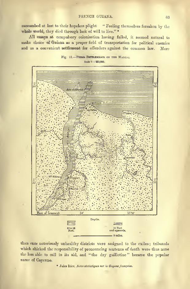
FRENCH GUIANA. 63
succumbed at last to their hopeless plight"Feeling themselves forsaken by the
whole world, they died through lack of will to live." *
All essays at compulsory colonisation having failed, it seemed natural to
make choice of Guiana as a proper field of transportation for political enemies
and as a convenient settlement for offenders against the common law. More
Fig. 18. PENAL SETTLEMENTS ON THE MABONI.
Scale 1 : 45U.OOO.
^Lighthouse
7. LesHattaa^
^S^BS^:-f^S-S?rfei^BPS-:;&vA^-#iS?^: .f
:; ^
-
; ; ./;..-.::
;,.J -\g
West or Greenwich 5350"
Depths.
Otol6Feet.
16 Feetand upwards.
9 miles.
than once notoriously unhealthy districts were assigned to the exiles;
tribunals
which shirked the responsibility of pronouncing sentence of death were thus none
the less able to call in its aid, and " the dry guillotine"
became the popularname of Cayenne.
* Jules Itier, Notes staliatiques sur la Guyane franqaise.
64 AMAZONIA AND LA PLATA,
Such a by-word easily enough explains the repugnance felt by all freemen for
this region, which nevertheless is not cursed with the deadly climate attributed
to French Guiana by the popular fancy since so many wretched victims of sen-
tences of transportation began to be cast upon its shores.
The very failure of the frequent attempts to colonise the country had the
natural consequence of causing much indecision in the plans of the central
government, as well as in the activity of the local administrators. Few officials
enter on their functions in Cayenne without forthwith yearning to return to their
native land. Being merely" birds of passage," they can take but slight interest
in a region which they hope soon to quit. But without attaching themselves to
the land, they may perhaps be tempted to distinguish their administration by some
ambitious scheme at variance with those of their predecessors in office, and calcu-
lated to enhance their reputation in high places.
Thus the affairs of the colony are managed in a shiftless way without a con-
tinuous policy, as needs must be in a territory which has seen thirty-four governors
replace each other since the middle of the century. Hence whatever real pro-
gress is made in French Guiana, either in an increase of population or in the
development of its natural resources, must be attributed, not to the administration,
but to the slow ferment working spontaneously in the mass of the aboriginal
elements increased by a few immigrants from Martinique, some Bush Negroesfrom Surinam, Portuguese and Brazilians from the conterminous regions. But on
the other hand, the introduction of Hindu coolies has been made without system
or humanity. Of 8,372 engaged in the prime of life, 4,522, more than half,
perished within 22 years (1856-78), and of the whole number only 675 were
restored to their native homes.
CONVICT STATIONS MANA.
The basin of the copious River Maroni, which separates French from Dutch
Guiana, is inhabited in its upper and middle course only by a few scattered
groups of Indians, negroes, and gold-hunters. The first white settlements are
seen some 38 miles above the estuary, and even these are nearly all occupied
by convicts. Free colonisation in this district is represented only by a few
plantations which were granted to some Algerian Arabs after their discharge from
detention.
Saint- Jean, which lies farthest up the river, has the advantage of railway com-
munication with the capital of the penal colony ;but the surrounding district is
marshy and unhealthy. Saint-Laurent, a little lower down, also on the right
bank of the Maroni, is better situated, and here reside the directors of the penal
station. The cabins of the Negro, Arab, and Annamite convicts occupy the sunny
glades of a densely-wooded park not far from the cemetery.
Opposite Saint-Laurent stands the village of Albino, the only settlement
founded by the Dutch on the left bank of the Maroni. In Portal Inland, a little
higher up, is situated the most important plantation in French Guiana, occupied
mainly with the production of roucou.
FRENCH GUIANA. 65
The Mana river, which follows the Maroni in the direction of the east, has its
little commune of Mana, named from the river, but the other coast streams, such as
the Organebo, the Iracubo, and the Counamano, traverse almost uninhabited dis-
tricts. Mana recalls some essays at colonisation, which were carried on with
great vigour and perseverance. The enterprise was undertaken by a religious
sister, Madame Javouhey, with a rare display of determination almost indepen-
dently of Government control, although aided by the officials. With the help of
the sisters of the community, of numerous hired labourers, and several hundred
slaves, she founded various establishments, plantations, asylums, schools, a general
hospital, and a lazaretto. The present village of Mana is regarded as one of the
most salubrious in Guiana, and was formerly the " rice granary"
of the whole
colony.
SlNNAMARI KOUROU.
Sinnamari, originally a Dutch settlement, founded near the mouth of the
river of like name, has become famous as a place of banishment. In 1797 and
1798, after the Royalist conspiracy of Fructidor, over five hundred suspected were
transported to this place ;of the 329 landed by the Charente, 171, more than half,
rapidly succumbed to their hardships, despair, and disease. But far more disas-
trous had been the attempt made to colonise the district in 1763, when about
13,000 emigrants from Alsace, Lorraine, and Saintonge were landed on the banks
of the Kourou, some thirty miles east of the Sinnamari.
France had just ceded Canada to England, and Choiseul, who with his cousin,
de Praslin, at that time ruled the Monarchy, decided to replace the lost territory
by calling Guiana "Equatorial France," and despatching thither fleet after fleet
of colonists. Even some players were included for the purpose of amusing the
future " Guianese"in their hours of relaxation. In memory of Canada they were
provided with skates, but the provisions were forgotten, and no arrangements
were made for landing and housing the settlers, while the Chevalier de Turgot,
who had been appointed leader of the expedition, remained in France. Even
during the voyage the unhappy victims were decimated by the plague, and on the
banks of the Kourou famine carried off those spared by typhus. After at least
10,000 had perished miserably, a few hundred survivors at last succeeded in
getting back to Saint-Jean d'Angely, the port from which they had sailed.* Acoffee plantation belonging to the Government marks the spot where most of the
"colonists
" had succumbed to their miseries. A few critical remarks on the
colonising genius of the promoters of this scheme cost Freron six months in the
Bastille.
Farther east the district about the Kourou estuary was also the scene of some
colonising experiments. At present some convicts are engaged on the plantations ;
but the Kourou penitentiary is a mere dependency of the three Salut Islands
belonging to the neighbouring penal establishment. Saint-Joseph and the lie
Royalc form the convict station proper, reserved for dangerous subjects, or for
* J. Mourie, la Guyanefrangaise.
66 AMAZONIA AND LA PLATA.
such as are placed under special control. Vessels of large size find good anchorageunder the shelter of the Salut Islands.
CAYENNE.
Cayenne, which appears to take its name from an old Indian chief, is one of
the earliest settlements in Guiana. The island on which it stands was occupied
Fig. 19. CAYENNE ISLAND.
Scale 1 : 200,000.
. .;;V: :.' . .. .*;..iVest oP Greenwich 52*20' 52*15'
Eepths.
OtolOFeet.
10 Feetand upwards.
3 Miles.
in 1604 by a party of Frenchmen under the leadership of the Norman, La
Ravardiere, who had been commissioned by a trading company of Rouen. The
first immigrants, as well as the Dutch Jews and others who followed them, had
FRENCH GUIANA. 67
settled at the foot of the Remire Hills some distance to the east of the present
town, which was founded at the little fort of Saint-Louis, but did not become the
permanent capital of French Guiana till the year 1877.
Cayenne is comparatively speaking a large place, containing 10,000 inhabi-
tants, or about one -third of the whole population of the colony. It is laid out in
the usual American chessboard fashion, with streets at right angles and shady
squares on a peninsular space at the foot of the verdant "Ceperou eminence at the
north-west extremity of the island.
The administrative and Government buildings, hotels, barracks, and prisons
occupy a large part of the town, which is encircled by parks and magnificent
avenues of palm-trees. Being well exposed to the Seabreeze, Cayenne would
Fig. 20. CAYENNE.
Scale 1 : 30,000.
52*19''
vWest op.ureenwich' 52'I8'
Depths.
to 3Feet.
3 to 6Feet.
6 to 10ieet.
10 Feetand upwards.
1,100 Yards.
naturally enjoy a healthy climate but for the canals in the environs, which often
get choked. A supply of water is brought by conduits from a neighbouring
height fed by the Rorota rivulet. By far the greater part of the population
consists of negroes, chiefly descendants of the freedmen who flocked to the place
after the emancipation of 1848. But all the other races of the colony have their
representatives in Cayenne. Most of the domestic servants are Creoles from
Martinique ;the booths and stores are chiefly in the hands of Chinese hucksters,
while the fish markets are supplied by natives of Annam. The harbour is
accessible to vessels drawing 14 feet, but it is partly exposed, and the shipping
has occasionally been wrecked by high tides occurring in rough weather. Alighthouse has been erected on the Enfant Perdu, a rock at the northern entrance.
Formerly gardens and plantations abounded in the environs of Cayenne,
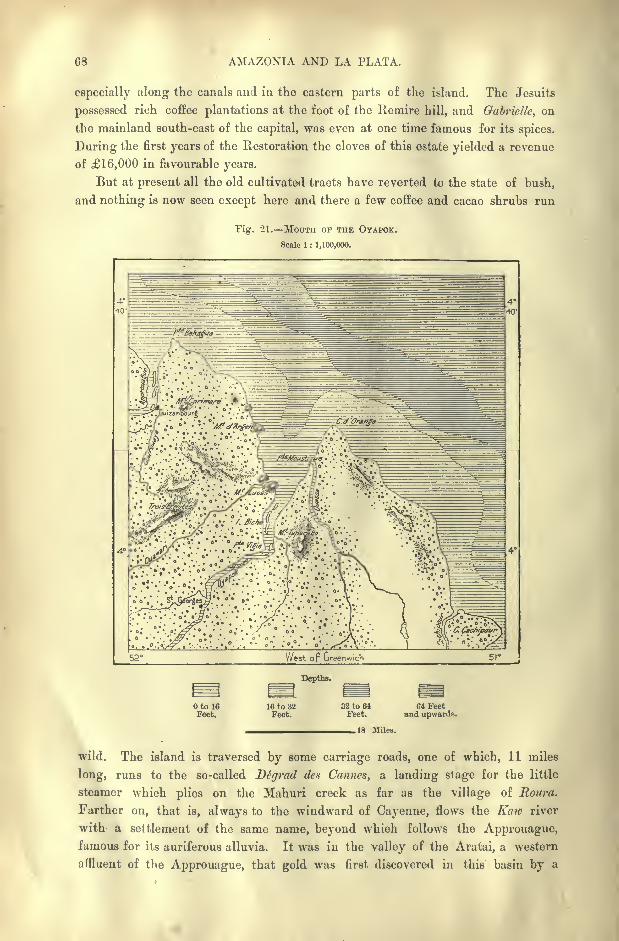
68 AMAZONIA AND LA PLATA.
especially along the canals and in the eastern parts of the island. The Jesuits
possessed rich coffee plantations at the foot of the Remire hill, and Gabrielle, on
the mainland south-east of the capital, was even at one time famous for its spices.
During the first years of the Restoration the cloves of this estate yielded a revenue
of 16,000 in favourable years.
But at present all the old cultivated tracts have reverted to the state of bush,
and nothing is now seen except here and there a few coffee and cacao shrubs run
Fig. 21. MOUTH OF THE OYAPOK.
Scale 1 : 1,100,000.
West op Greenwich
Depths.
otoieFeet.
16 to 32Feet.
32 to 64Feet.
64 Feetand upwards.
.18 Miles.
wild. The island is traversed by some carriage roads, one of which, 11 miles
long, runs to the so-called Dtgrad des Cannes, a landing stage for the little
steamer which plies on the Mahuri creek as far as the village of Roura.
Farther on, that is, always to the windward of Cayenne, flows the Kaw river
with a settlement of the same name, beyond which follows the Approuague,famous for its auriferous alluvia. It was in the valley of the Aratai, a western
affluent of the Approuague, that gold was first discovered in this basin by a
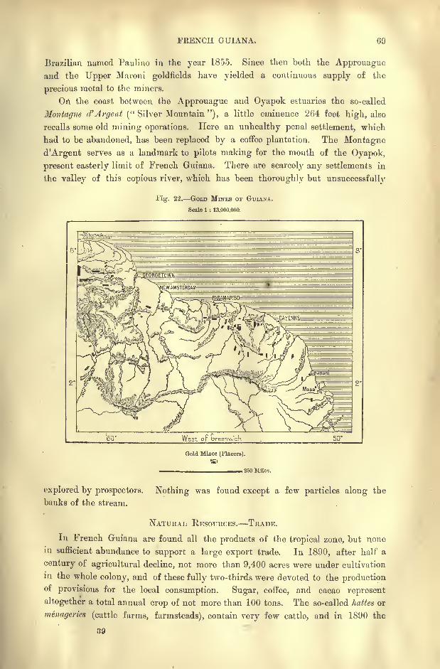
FKENCH GUIANA, 69
Brazilian named Paulino in the year 1855. Since then both the Approuague
and the Upper Maroni goldfields have yielded a continuous supply of the
precious metal to the miners.
On the coast between the Approuague and Oyapok estuaries the so-called
Montague d'Argent (" Silver Mountain "), a little eminence 264 feet high, also
recalls some old mining operations. Here an unhealthy penal settlement, which
had to be abandoned, has been replaced by a coffee plantation. The Montagne
d'Argent serves as a landmark to pilots making for the mouth of the Oyapok,
present easterly limit of French Guiana. There are scarcely any settlements in
the valley of this copious river, which has been thoroughly but unsuccessfully
Fig. 22. GOLD MINES or GUIAXA.
Scale 1 : 13,000,000.
West op Greenwich 50*
Gold Mines (Placers).
. 250 Miles.
explored by prospectors,
banks of the stream.
Nothing was found except a few particles along the
NATURAL RESOURCES. TRADE.
In French Guiana are found all the products of the tropical zone, but none
in sufficient abundance to support a large export trade. In 1890, after half a
century of agricultural decline, not more than 9,400 acres were under cultivation
in the whole colony, and of these fully two-thirds were devoted to the produc^nof provisions for the local consumption. Sugar, coffee, and cacao represent
altogether a total annual crop of not more than 100 tons. The so-called hattes or
menageries (cattle farms, farmsteads), contain very few cattle, and in 1890 the
39

70 AMAZONIA AND LA PLATA.
whole colony possessed only 218 weedy, badly-bred horses. Of horned cattle,
which succeed best, there were over 6,000, and about the same number of pigs,
besides those running wild in the woods. A few hundred sheep, goats, asses, and
mules complete the list of livestock.
The industries, properly so-called, are in a rudimentary state, being limited to a
few tafia (coarse rum) distilleries, some saw-mills, and other small establishments.
The largest industrial operations are those connected with auriferous quartz-
crushing. But the yield of gold has gradually fallen off since 1875. In that
year the registered return rose to about 4,500 pounds, valued at 227,000, to
which, perhaps, half as much more should be added for the pilfering^ at the works
and for the gold smuggled abroad. The iron ores, which abound in some districts,
have never been worked.
Despite certain statements to the contrary, the trade of French Guiana is
certainly greater at present than it was before the Revolution. The yearly
exchanges with the rest of the world average from 520,000 to 720,000. The
imports greatly exceed the exports, most of the merchandise brought into the
colony being destined for the convict stations and the garrisons, which produce
nothing in return. At present the whole of the shipping falls below 100,000
tons, but it is steadily increasing, thanks to the greater facilities of communica-
tion enjoyed by steamers over sailing vessels. Cayenne is connected by a regular
line of steamships with Martinique and France by the Surinam and Demerara
route. Small steamers ply on the coast, and a telegraph line 200 miles long con-
nects Cayenne with the Maroni.
ADMINISTRATION.
Although French Guiana possesses a general council of 16 elected members,
of whom seven for Cayenne, and also nominates a deputy to the French Chambers,
the population is too small and the army of officials too strongly organised for
the absolute power of the governor to be checked by this initial measure of local
representation. Under the direct orders of the governor are the military com-
mander, the heads of the naval forces and of the marine, the director of the
interior, the procurator-general, the head of the penitentiary department. All
these functionaries constitute his privy council, to which, as a matter of form, are
added three of the inhabitants whom he chooses, and whose vote he can always
depend upon.
But even were the whole council in opposition, the governor might still defy
them, and even manipulate the annual budget, not to say expel any refractory
members. Except during the elections, the 3Tonifenr Officiel, issued weekly, is
the only journal in the Colony. In a word, the penitentiary system of adminis-
tration may be said to mould civil society itself.
After the Coup d'Etat of 1851, the transportation system was introduced by
special decree, and is now the sole motive for the maintenance of French rule in
Guiana. The first convoy of condemned criminals arrived at the Salut* Islands
in 1852, and by the year 1867 over 18,000 had been despatched to the various
FRENCH GUIANA. 71
penitentiaries successively chosen in the territory. Being now replaced by NewCaledonia as the chief penal colony, French Guiana receives only a part of the
recidivistes, that is, those Europeans condemned to over eight years' transportation,
and all the Arabs, Annarnites, and negroes.
The four penitentiaries of Cayenne, the Salut Islands, Kourou, and the Maroni
contain on an average from 3,000 to 4,000 inmates, who are for the most part
employed on public works. But besides utilising them in this way, the adminis-
tration of the penal settlements also lend them either gratuitously or for a small
sum to the town of Cayenne, to the governor of the colony, and to private
firms. Although the labour of a convict is rated at about two francs (Is. 8d.)
a day, all accessories included, the charge per head usually vaiies from three to
eight pence. But it may be asked, on the other hand, what is the real value of
forced as compared with free labour ? To judge from the state of the roads on
which the convicts are constantly engaged, it must be concluded that their labour
is almost worthless, at least in Guiana, despite the large number of hands
employed. Thus by excluding free labourers, they retard rather than promote the
material progress of the colony.
French Guiana proper, that is, the settled territory, has been divided into
thirteen communes in the full enjoyment of civil rights, with an organisation
analogous to those of the mother country and of the other colonies. Nevertheless
all municipal privileges were suspended for three years, and only restored in 1892
under the reserved condition of the governor's intervention in the choice of certain
communal functionaries. The only exception has been made in favour of the
capital, which retains its full rights without any reserve.
The thirteen districts, to which must be added that of the penitentiaries on
the banks of the Maroni, comprise scarcely the eighth part of the whole territory,
or about 54,000 acres altogether. The unsettled inland region remains undivided.
II.
THE CONTESTED FRANCO-BRAZILIAN TERRITORY.
'
Officially the territory in dispute between France and Brazil would appear to
comprise a space of at least 100,000 square miles. It forms a long zone stretching
from the Atlantic to the Rio Branco, and limited northwards by the course of the
Oyapok, the Tumuc-Humac Mountains with their western spurs, the course of the
Araguari, and the equator.
The question, however, has no real importance, except so far as regards the
contested coast district between the Oyapok and Araguari rivers. Farther west
the whole valley of the Rio Branco has, beyond all doubt, become Brazilian in
speech, social usages, political and commercial relations. The appropriation of
this section by France would be equivalent to appropriating a slice of Brazil
itself.
As to the intermediate regions, which have been traversed by the explorers
Crevaux, ..Qoudreau, and Barbosa Rodrigues, they are inhabited only by completely
^'r
72 AMAZONIA AND LA PLATA.
independent Indian populations estimated by Coudreau at not more than 12,700
souls altogether.
The district really contested comprises a superficial area approximately estimated
at that of 15 French departments, or, say, about 35,000 square miles. But even
here the civilised inhabitants number no more than some 3,000, or 12 to the
square mile.
DISPUTED FRONTIERS.
So early as the seventeenth century, these regions were already claimed both
by France and Portugal ;but there never could have been any doubt as to the
southern frontier, which was too plainly indicated by the broad stream of the
Amazons. Fort Macapa, on the very bank of the estuary near the equator, had
been erected by the Portuguese in 1688, occupied by the French in 1797, and the
same year recovered by the Portuguese. The Treaty of Utrecht, concluded in
1713, was intended to settle the question once for all, but instead of doing so, it
further complicated matters, by fixing, as limit of the respective domains, a river
which nobody knew anything about, and the very estuary of which had never been
explored by any navigator.
It is still asked, What is this river Yapok or Vincent Pinzon which the Utrecht
diplomatists, ignorant of the relations in America, had in mind when they drew
up their rudimentary map ? On the one hand, the Portuguese identified it, amid
so many Yapoks, or " Great Rivers," on this coast, with that which falls into the
sea between the Montagne d'Argent and Cape Orange. On the other, the French
might assert that the true " Great River," Vincent Pinzon's " fresh-water sea," was
certainly the Amazons itself, and, if not this, then the Araguari, as being the
largest watercourse in the region north of the Amazons.
Whole libraries might be filled with the memoirs and diplomatic documents
that have been published on this unsolvable question. Various commissions have
been engaged interpreting the meaning of the Treaty of Utrecht, or in settling the
problem by a definite decision, but all their suggestions have been rejected, and
Brazil, heir of Portugal, still advances the original claim to the Oyapok as the
common frontier. Nevertheless, she is willing to settle the matter by accepting
the Carsevenne as her northern boundary in this direction.
But history is not formulated, it "makes itself," despite treaties and conven-
tions. In 1836 the French established a station on Lake Mapa, in the heart of the
disputed territory, and four years afterwards the Brazilians founded the military
colony of dom Pedro Scgundo on the left bank of the Araguari. A convention
decided that the rival Powers should evacuate the district in litigation, and France
accordingly abandoned the station of Mapa. But Brazil declined to withdraw
from the occupied territory, and in 1860 even exercised political functions north
of the Araguari as far as the Tartarugal.
The country, till recently a solitude, is being gradually settled;a few villages
have been founded, and the inhabitants, mostly Brazilian deserters and fugitives,
who might well be satisfied with unmolested independence, are now seeking to
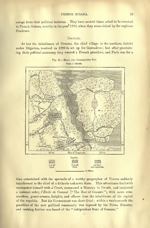
FRENCH GUIANA. 73
escape from their political isolation. They have several times asked to be annexed
to French Guiana, notably in the year 1883, when they were visited by the explorer
Coudreau.
COUNANI.
At last the inhabitants of Counani, the chief village in the northern district
under litigation, resolved in 1886 to set up for themselves; but after proclaim-
ing their political autonomy they wanted a French president, and Paris was for a
Fig. 23. MAPA AND CAKAPAPOKIS BAY.
Scale 1 : 650,000.
5030- West of Greenwich 50 10'
Oto 16Feet.
Depths.
16 to 32Feet.
32 Feetand upwards.
12 Miles.
time entertained with the spectacle of a worthy geographer of Vanves suddenly
transformed to the chief of a hitherto unknown State. This adventurer forthwith
surrounded himself with a Court, summoned a Ministry to his aid, and instituted
a national order, I'Etoile de Counani [" The Star of Counani "), with more com-
manders, grand-crosses, knights, and officers than the inhabitants of the capital
of the republic. But his Government was short-lived;within a twelvemonth the
president of the new political community was deposed by his Prime Minister,
and nothing further was heard of the "independent State of Counani."

74 AMAZONIA AND LA PLATA.
Meanwhile the question at issue is solving itself in a practical way. The
district, till lately a wilderness without appreciable economic value, is already
well known from the explorations of Coudreau, and its natural resources have
awakened the cupidity of its northern and southern neighbours. The population,
estimated at no more than 1,500 at the proclamation of the ephemeral republic, had
increased twofold within the next six years, and the annual trade already amounts
to 60,000.
The coast steamers, calling at all the ports around the South-American sea-
board, have not yet made their appearance at any point between the Oyapok and
Mapa estuaries;but a brisk trade is carried on by the so-called tapouyes, small
craft so named from a local Indian tribe. These vessels, ranging from 5 to 15
tons, are all built by the natives, for in this respect the independent tribes are
more industrious than the inhabitants of French Guiana. The little harbours of
the estuaries, being obstructed by bars, are inaccessible to large vessels, although
nature has here provided the best anchorage on the whole of the seaboard between
the Orinoco and the Amazons. Such is the deep Carapaporis channel, which
flows between Maraca Island and the mainland, and which at some former period
approached nearer than at present to the Araguari estuary. This harbour of
refuge in the midst of the dangerous waters exposed to the bores rushing up the
neighbouring estuaries may yet become one of the most frequented roadsteads on
the Atlantic coast.*
The people of Counani have not yet begun to work the auriferous alluvia of
their river valleys ;but their extensive savannas enable them to raise large herds
of cattle. According to Coudreau, as many as 18,000 oxen find good pasturage
in the district between the Oyapok and the Araguari. Stock-breeding has even
extended beyond the mainland to the hitherto unoccupied Maraca Island.
The fisheiies also are very productive, the lakes teeming with the piracuru,
which is cured for the markets of Cayenne and Para. The fishers also harpoon
the manatees, capture turtles, and extract an excellent fish-glue from the ma-
choiran. Rubber and other valuable gums are collected in the surrounding wood-
lands.
INHABITANTS. RECENT PROGRESS.
About two-;hirds of the inhabitants are of Brazilian origin, and consequently
generally speak Portuguese ; nevertheless, all understand the Creole-French of
Cayenne, which has borrowed several Indian words. The remaining third consists
of Portuguese, Martinique islanders, and French Creoles, besides the Indian half-
breeds, who till recently were the exclusive inhabitants of the district. These
are known by the collective name of Tapuyos, a word which in the Tupi or
"general language
"of Brazil has the meaning of
"stranger," or "
enemy."
It is now commonly applied indifferently to all the sedentary Indians on the
banks of the Amazons, and even to the half-castes of all races, whose mixed
descent is betrayed by the colour of their skin.
Political pressure is felt especially on the Brazilian side, where the military
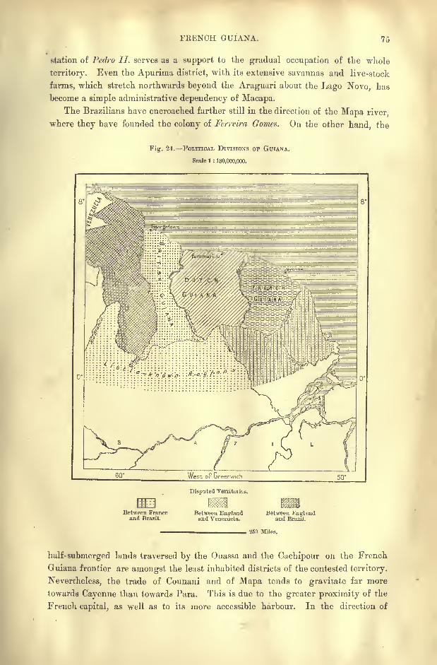
FRENCH GUIANA. 75
station of Pedro II. serves as a support to the gradual occupation of the whole
territory. Even the Apuriraa district, with its extensive savannas and live-stock
farms, which stretch northwards beyond the Araguuri about the Lago Novo, has
become a simple administrative dependency of Macapa.
The Brazilians have encroached farther still in the direction of the Mapa river,
where they have founded the colony of Ferreira Gomes. On the other hand, the
Fig. 24. POLITICAL DIVISIONS OF GUIANA.
Scale 1 : 130,000,000.
Between Franceand Brazil.
Disputed Territories.
Between Englandand Venezuela.
Between Knghndand Brazil.
250 Miles.
half-submerged lands traversed by the Ouassa and the Cuchipour on the French
Guiana frontier are amongst the least inhabited districts of the contested territory.
Nevertheless, the trade of Counani and of Mapa tends to gravitate far more
towards Cayenne than towards Para. This is due to the greater proximity of the
French capital, as well as to its more accessible harbour. In the direction of

7.6 AMAZONIA AND LA PLATA.
Para is developed the dangerous gulf of the " fresh-water sea," with its islands,
currents, high tides, and bores.
In the northern basin of the Ouassa the three villages of Rocaona, Couripi, and
Ouassa are mere groups of buts round which roam the Palicour and Aroua Indians.
Even the ranchos of Cachipour give shelter to scarcely more than a dozen
families. The two already mentioned villages of Counani and Mapi are situated
farther south. Mapa stands near the place where the French had erected their
little fort in 1836, and has the advantage of lying nearest to the Carapaporis road-
stead. Both of these villages contain a few wood and brick houses rising above
the groups of palm -roofed huts. They have also each its school, and the intellec-
tual and moral condition of the inhabitants differs little from that prevalent in the
surrounding European settlements. In 1890 a service of steamers was established
between Para and the mouth of the Mapa river, with an intermediate port of
call at Bailique Island at the entrance of the Amazons estuary.
All these little centres of population have been constituted so many adminis-
trative "captainries," each with its "first captain," "second captain," and
"brigadier," officials who are listened to when they have any personal worth, but
whose orders are unheeded when displeasing to the citizens. In these microscopic
communities unanimity alone may be said to have force of law. The officers
themselves are nominated by acclamation in the public gatherings, and deposed
by the same summary process.
CHAPTER V.
BRAZIL GENERAL SURVEY.
RAZIL unquestionably takes the foremost position in Latin America,
and in extent it ranks as the fifth of the great States of the
world, being exceeded only by the British Empire, Russia, China,
and the United States.* In superficial area it nearly equals all
the Hispano-American republics of South America, and scarcely
yields to them in population.
In its form and general relief Brazil presents a sharp contrast to the Andine
States, which are developed in a vast semicircle round her landward frontiers.
The plateaux and crests of the uplands belong to an orographic system entirely
different from that of the Cordilleras, forming, as it were, a continent within a
continent. Between the two stretch the plains watered by the great rivers
Amazons and Parana, with their multitudinous ramifications.
Being intersected by the equator, Brazil also differs from the conterminous
regions in its higher temperature and more tropical nature. Only at its southern-
most extremity does it penetrate into the temperate zone, which comprises not
more than a thirteenth part of the total area. The mean elevation being much
lower than that of the Andine States, the climate is proportionately warmer, and
all the conditions of its flora, fauna, and inhabitants are correspondingly different.
Another contrast is derived from the relatively greater proximity of Brazil to
the Old "World. The shortest line between Europe and South America lies
between Cape St. Vincent and the Brazilian headland of Cape S. Roque, while
Pernambuco is nearer to Cadiz than is La Guaira or any other Venezuelan sea-
port.
GEOGRAPHICAL EXPLORATION.
The discovery of Brazil has been attributed to a certain Joao Ramalho, who died
at San Paulo in 1580, after a pretended residence of ninety years in the country.
*Comparative extent of the great States of the world in 1893, excluding the Colonial empires,
according to Wagner, Supan, and others :
Russia, less the inland seas 8,000,000 square miles.
China with Mongolia, but exclusive of Tibet and Corea . 3,800,000 ,,
United States with Alaska 3,550,000 ,,
Dominion of Canada with Labrador and the Archipelagoes 3,116,000Brazil . 3,070,000
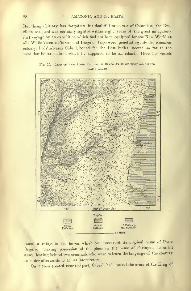
78 AMAZONIA AND LA PLATA.
But though history has forgotten this doubtful precursor of Columbus, the Bra-
zilian seaboard was certainly sighted within eight years of the great navigator's
first voyage by an expedition which had not been equipped for the New World at
all. While Vicente Pinzon and Diego de Lepe were penetrating into the Amazons
estuary, Peclr' Alvarez Cabral, bound for the East Indies, steered so far to the
west that he struck land which he supposed to be an island. Here his vessels
Fig. 25. LAND OF VERA CRUZ, SECTION OF BRAZILIAN COAST FIRST DISCOVERED.
Scale 1 : 500,000.
40 West or breenwich
Depths.
Oto5Fathoms.
5 to 12
Fathoms.12 Fathomsand upwards.
i>8 Miles.
found a refuge in the haven which has preserved its original name of Porto
Seguro. Taking possession of the place in the name of Portugal, he sailed
away, leaving behind two criminals who were to learn the language of the country
in order afterwards to act as interpreters.
On a cross erected near the port, Cabral had caused the arms of the King of
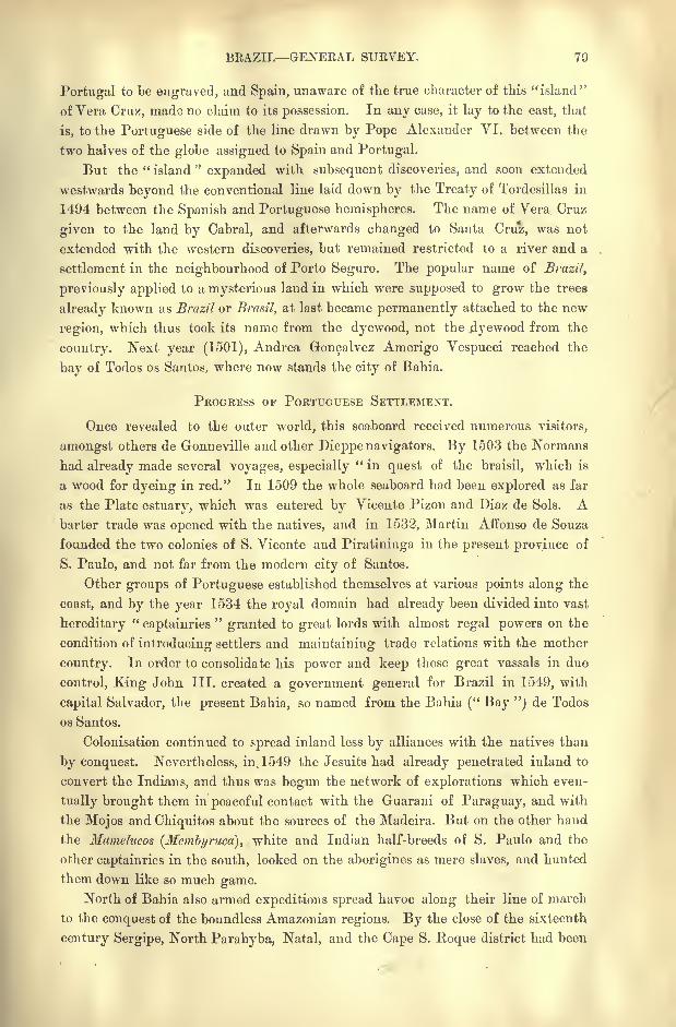
BRAZIL GENERAL SURVEY. 79
Portugal to be engraved, and Spain, unaware of the true character of this "island"
of Vera Cruz, made no claim to its possession. In any case, it lay to the east, that
is, to the Portuguese side of the line drawn by Pope Alexander VI. between the
two halves of the globe assigned to Spain and Portugal.
But the " island"expanded with subsequent discoveries, and soon extended
westwards beyond the conventional line laid down by the Treaty of Tordesillas in
1494 between the Spanish and Portuguese hemispheres. The name of Vera Cruz
given to the land by Cabral, and afterwards changed to Santa Cruz, was not
extended with the western discoveries, but remained restricted to a river and a
settlement in the neighbourhood of Porto Seguro. The popular name of Brazil,
previously applied to a mysterious land in which were supposed to grow the trees
already known as Brazil or Brasil, at last became permanently attached to the new
region, which thus took its name from the dyewood, not the jdyewood from the
country. Next year (1501), Andrea Goncalvez Amerigo Vespucci reached the
bay of Todos os Santos, where now stands the city of Bahia.
PROGRESS or PORTUGUESE SETTLEMENT.
Once revealed to the outer world, this seaboard received numerous visitors,
amongst others de Gonneville and other Dieppe navigators. By 1503 the Normans
had already made several voyages, especially" in quest of the braisil, which is
a wood for dyeing in red." In 1509 the whole seaboard had been explored as far
as the Plate estuary, which was entered by Vicente Pizon and Diaz de Sols. Abarter trade was opened with the natives, and in 1532, Martin Affonso de Souza
founded the two colonies of S. Vicente and Piratininga in the present province of
S. Paulo, and not far from the modern city of Santos.
Other groups of Portuguese established themselves at various points along the
coast, and by the year 1534 the royal domain had already been divided into vast
hereditary"captainries
"granted to great lords with almost regal powers on the
condition of introducing settlers and maintaining trade relations with the mother
country. In order to consolidate his power and keep these great vassals in due
control, King John III. created a government general for Brazil in 1549, with
capital Salvador, the present Bahia, so named from the Bahia (" Bay "j de Todos
os Santos.
Colonisation continued to spread inland less by alliances with the natives than
by conquest. Nevertheless, in. 1549 the Jesuits had already penetrated inland to
convert the Indians, and thus was begun the network of explorations which even-
tually brought them in peaceful contact with the Guarani of Paraguay, and with
the Mojos and Chiquitos about the sources of the Madeira. But on the other hand
the Mamelucos (Hembyruca), white and Indian half-breeds of S. Paulo and the
other captainries in the south, looked on the aborigines as mere slaves, and hunted
them down like so much game.North of Bahia also armed expeditions spread havoc along their line of march
to the conquest of the boundless Amazonian regions. By the close of the sixteenth
century Sergipe, North Parahyba, Natal, and the Cape S. Hoque district had been
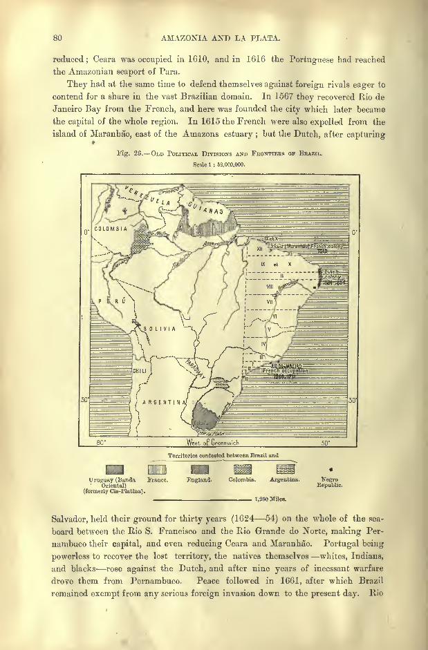
80 AMAZONIA AND LA PLATA.
reduced;Ceara was occupied in 1610, and in 1616 the Portuguese had reached
the Amazonian seaport of Para.
They had at the same time to defend themselves against foreign rivals eager to
contend for a share in the vast Brazilian domain. In 1567 they recovered Rio de
Janeiro Bay from the French, and here was founded the city which later became
the capital of the whole region. In 1615 the French were also expelled from the
island of Maranhao, east of the Amazons estuary ;but the Dutch, after capturing
Fig. 26. OLD POLITICAL DIVISIONS AND FBONTIEBS OF BRAZIL.
Scale 1 : 52,000,000.
Territories contested between Brazil and
Uruguay (Banda France.
Oriental)(formerly Cis-Platina) .
England. Colombia. Argentina.
1,250 Miles.
NegroRepublic.
Salvador, held their ground for thirty years (1624 54) on the whole of the sea-
board between the Rio S. Francisco and the Rio Grande do Norte, making Per-
nambuco their capital, and even reducing Ceara and Maranhao. Portugal being
powerless to recover the lost territory, the natives themselves whites, Indians,
and blacks rose against the Dutch, and after nine years of incessant warfare
drove them from Pernambuco. Peace followed in 1661, after which Brazil
remained exempt from any serious foreign invasion down to the present day. Rio
BRAZIL GENERAL SURVEY. 81
de Janeiro, however, was captured in 1711 by the French filibuster, Duguay-
Trouin, who levied a heavy ransom on the inhabitants.
During the eighteenth century the Paulistas, that is, the people of S. Paulo, most
enterprising of all the Brazilians, continued their excursions towards the Far
West, whence they brought gold, diamonds, and other treasures. Stations were
established at the mountain passes, at the entrance of the valleys, at the conflu-
ences of the rivers, and Goyaz and Matto Grosso were thus gradually annexed to
the colony. The Paulistas even encroached on the Spanish domain, invading the
" Missions"in the Parana and Paraguay basins, and extending their expeditions
beyond the Mamore to Bolivia and the Peruvian foot-hills. Thus was continually
enlarged the domain of Portuguese speech, while the " buffer"zone separating
the Brazilian uplands from the spurs of the Andes was gradually narrowed to the
advantage of the Brazilian serfanejos. These pioneer squatters and backwoodsmen
had explored, if not the whole course, at least the upper reaches and headwaters
of the Amazons affluents, and the whole region began to assume a certain geo-
graphical unity.
POLITICAL RELATIONS.
After the rout of the Dutch, the sturdy Brazilians had many occasions of
resisting the exactions of the Portuguese themselves, who came to be gradu-
ally regarded as fomsteiros (" foreigners,"" aliens "). About the beginning
of the eighteenth century, several risings took place with varying success in the
provinces of S. Paulo, Minas Geraes, and Pernambuco;
but after the North
American revolution, the national movements become more serious, and the year
1789 witnessed the defeat of the first republican conspiracy in Brazil;followed
by the execution of Tiradentes, one of the chief conspirators, in 1792, the date
chosen by the Brazilians as the starting-point of their new national era.
Although the Portuguese rule was maintained some years longer, the prince
regent Dorn Joao, on escaping from Portugal to Brazil, had to make Rio de
Janeiro the capital of the Monarchy. Brazil itself took the title of a kingdom,and distant Portugal began to be regarded as a dependency of its former
colony. In 1817 a republican insurrection broke out in Pernambuco, and in 1821
the Brazilian Cortes (" Chambers ") opposed the departure of Dom Joao VI. for
Portugal. Although the deputies were dispersed at the point of the bayonet,
the regent Dom Pedro had next year to choose between the imperial throne of
an independent Brazil or a return to Portugal. He chose the throne, and
thus was accomplished almost without bloodshed the final severance of Brazil
from the mother country.
Having thus become master of her own destinies, Brazil developed a marked
individuality in strong contrast to that of the Spanish republics. Although
Brazil, like the neighbouring States, contains hundreds of little-known indepen-
dent tribes, her mixed white and Indian populations present more unity, a more
complete fusion of the racial elements, than do the Hispano-American mestizoes.
Most of the aborigines, to whatever stock they may belong, have also been merged
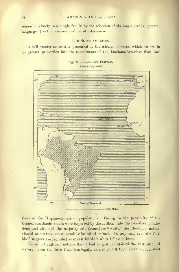
82 AMAZONIA AND LA PLATA.
somewhat closely in a single family by the adoption of the Ungoa geral (" general
language ") as the common medium of intercourse.
THE SLAVE QUESTION.
A still greater contrast is presented by the African element, which enters in
far greater proportion into the constituents of the Lusitano-American than into
Fig. 27. BRAZIL AND POETUOAL.
Scale 1 : 88,000,000.
70' JO'
1,860 Miles.
those of the Hispano-American populations. Owing to the proximity of the
Guinea coastlands, slaves were imported by the million into the Brazilian planta-
tions, and although the majority call themselves "white," the Brazilian nation,
viewed as a whole, must certainly be called mixed. In any case, even the full-
blood negroes are regarded as equals by their white fellow-citizens.
Yet of all cultured nations Brazil had longest maintained the institution of
slavery ; even the slave trade was legally carried on till 1826, and then abolished
BRAZIL GENERAL SURVEY. 83
only under the pressure of the British Government. Nor was the convention
observed, and the traffic continued, despite the English cruisers, and despite the" Aberdeen Act "
of 1845, claiming the right of pursuing and capturing slavers
in the Brazilian harbours. From 50,000 to 80,000 continued to be annually
smuggled in down to the middle of the century, and as many as 1,500,000 are
estimated to have been imported between 1826 and 1851, when the Brazilian
Government was compelled by public opinion to place the slave trade on the same
level as piracy. In 1851 the servile population was estimated at 2,200,000, but
owing to the excessive mortality of the blacks, and the cessation of the import
trade, they had fallen to 1,500,000 in 1871.
Public opinion still continued to demand the abolition of slavery itself. In
1866 the Benedictine monasteries liberated their 1,600 blacks, and the good
example was followed by the hospitals and other institutions. At last in
1871 was passed the law of progressive emancipation, which aimed at the
total extinction of slavery in a single generation. The same law summarilyliberated all the slaves of the State, of the Crown, and of intestate estates,
and this was followed by the final abolition of slavery in 1888, the very year
in which Brazil effected an almost bloodless political revolution, changing the
form of government from an empire to a federal republic. The emancipationaffected 740,000 blacks, so that in twenty years their number had been reduced
by one-half.
But if servitude has disappeared, the system of large landed estates per-
sists. This is at present the chief factor in the social life of Brazil;
it has
given an immense impulse to free immigration and to the importation of hired
labourers.
BRAZIL AND THE UNITED STATES.
In many respects Brazil, the " South American Union," may be compared with
the North American Union. In their geographical aspect both regions present
a curious resemblance, each occupying the central parts of symmetrical continents
watered by river systems of prodigious extent. The relief also is much the same,
somewhat narrow parallel coast ranges on the east side, traversed or flanked on
the west by the great backbone of the New World.
Even their history presents striking analogies, despite the difference of origin,
Latin on one side, Anglo-Saxon on the other, and despite the slighter indus-
trial and intellectual development of Brazil. In both regions the whites "found
themselves originally face to face with the aborigines, who were relentlessly
pressed farther and farther inland. In both slave labour was imported to clear
the ground and work the plantations, and in both has been developed an aristocracy
of planters, whose power rests on the exploitation, almost on the monopoly of a
small number of agricultural products.
The two great Powers of North and South have also had their frontier wars,
the United States with Mexico, Brazil with the southern neighbours, and in 1893
the latter was still wrangling diplomatically over boundary questions.
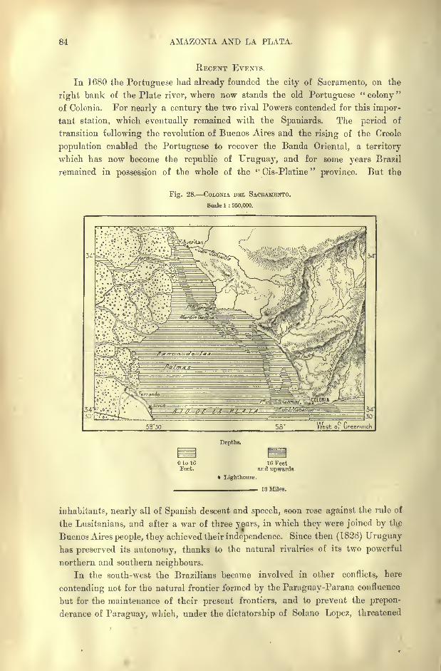
84 AMAZONIA AXD LA PLATA.
RECENT EVENTS.
In 1680 the Portuguese had already founded the city of Sacramento, on the
right bank of the Plate river, where now stands the old Portuguese"colony
"
of Colonia. For nearly a century the two rival Powers contended for this impor-
tant station, which eventually remained with the Spaniards. The period of
transition following the revolution of Buenos Aires and the rising of the Creole
population enabled the Portuguese to recover the Banda Oriental, a territory
which has now become the republic of Uruguay, and for some years Brazil
remained in possession of the whole of the " Cis-Platine"
province. But the
Fig. 28. COLONIA DEL SACRAMETTTO.
Scale 1 : 950,000.
5330 West 01 Greenwich
Depths.
Oto 16Feet.
16 Feetar.d upwards.
Lighthouse.
18 Miles.
inhabitants, nearly all of Spanish descent and speech, soon rose against the rule of
the Lusitanians, and after a war of three years, in which they were joined by the
Buenos Aires people, they achieved their independence. Since then (1828) Uruguayhas preserved its autonomy, thanks to the natural rivalries of its two powerful
northern and southern neighbours.
In the south-west the Brazilians became involved in other conflicts, here
contending not for the natural frontier formed by the Paraguay-Parana confluence
but for the maintenance of their present frontiers, and to prevent the prepon-
derance of Paraguay, which, under the dictatorship of Solano Lopez, threatened
BRAZIL GENERAL SURVEY. 85
to upset the balance of power in the Plate regions. The five years' war
(1865 70), in which Argentina and Uruguay sided with Brazil, was one of the
most sanguinary ever waged. Paraguay was transformed to a citadel surrounded
by a circle of fire and sword, which was gradually narrowed, till the whole nation
had well-nigh perished.
Foreign wars were accompanied or followed by intestine strife, the province
of Rio Grande do Sul often rising in revolt, and even constituting itself an
independent republic which held its ground from 1835 to 1840. Here the
peoples of Spanish descent are more numerous than elsewhere in Brazil, while
their usages and commercial relations attract them to the centres of trade in the
Plate regions.
Still more serious internal convulsions have recently broken out, and a civil
war, which was fortunately brought to a sudden close in the spring of 1894,
seemed for a moment to threaten the very stability of the State, if not the over-
throw of republican institutions and the restoration of the Monarchy. In the
autumn of 1893 the insurgents, having secured the adhesion of the navy, found
themselves strong enough to occupy several strategical points in the Bay of Rio
de Janeiro, and even repeatedly to bombard the capital itself.
ETHNICAL ELEMENTS.
Till recent times Portugal had maintained a certain ascendency in its former
colony, if not by its trade and industries, at all events through the immigrationof the labouring classes. Every year a few thousands in the prime of life came
from the banks of the Douro and Minho, or from Madeira and the Azores, to
strengthen the Lusitanian element in the Brazilian towns and rural districts.
The islanders are generally known by the name of Angicos, from Angra, former
capital of the Azores, and from them are also perhaps named numerous places in
Brazil, such as Angical and Arra'ial dos Angicos. Th|tnks to their common speech
and usages, these Portuguese immigrants readily adapted themselves to the new
environment, and rapidly merged in the surrounding populations.
Next to the Portuguese the Germans were the most numerous settlers, intro-
duced at first as hired labourers, and afterwards as free immigrants. Those
engaged by speculators for the plantations of Amazonia and of the Mucury basin
perished wholesale of famine and hardships of all kinds. But the settlers in the
temperate regions of Santa Catharina and Rio Grande do Sul thrived so well
that their patriotic fellow-countrymen began to believe in the birth of a " New
Germany" between the Uruguay and^ Brazil.
But although many grew wealthy, and for a time almost maintained a State
within a State, their national cohesion has already been broken by the stream of
Italian immigration, which has begun to overflow into every part of Brazil, and
especially into the southern provinces. The influence of other white peoples
French, English, and North Americans is felt not by their numbers, but bytheir enterprising spirit displayed in every branch of trade and industry.
Under the Dutch rule the Jews became powerful in Pernambuco, and although
40
86 AMAZONIA AND LA PLATA.
they were afterwards persecuted by the Inquisition, burnt by the hundred, and
compelled to abjure their national religion, they are now returning in greater
numbers than ever, especially from Germany and Russia. The gypsies, descen-
dants of those transported by Portugal to Brazil about the middle of the eigh-
teenth century, still wander in small groups over the inland plateaux, while the
Chinese have begun to make their appearance in the towns and on the plantations.
In general the Brazilians have not degenerated physically, and on the
plateaux they are distinguished by their tall stature, skill, and energy. Despite
the frequent wars into which they have been dragged, they are not a bellicose
people, but rather of peaceful disposition, patient and long-suffering. Althoughfar from ambitious, they are endowed with considerable intelligence and, like the
Hispano-Americans, are " a nation of orators."
Even in colonial times Brazil had produced numerous writers and independent
thinkers, amongst others Antonio Jose de Silva, burnt by the Inquisition at Lisbon
in 1739. Jose de Lacerda, the first explorer to penetrate far into the interior of
equatorial Africa, was a Brazilian, as was also Gusmao, first of modern physicists
to send up a balloon (1709).
MAIN PHYSICAL DIVISIONS.
Viewed as a whole, Brazil forms a geographical unit characterised by an almost
insular mass of crystalline and archsean mountains disposed in the direction
from north to south, steeply inclined towards the Atlantic Ocean, and developing
broad plateaux between the fluvial slopes. But despite this general simplicity
of structure the country is so vast that within its limits are still comprised several
distinct physical divisions of great extent. Hence nearly all of its most dis-
tinguished explorers have been fain to confine themselves to a single region, or
even to a single section, as, for instance, some particular river basin of that region.
It will accordingly be convenient to spread the detailed description of Brazil over
a number of separate chapters, in which may be summed up the special geo-
graphical and biological features of each physical division.
The natural limits of these physical divisions coincide in no way with those
of the old administrative "provinces," which correspond with the States at present
constituting the federal republic. In fact, these provinces had for the most part
a purely artificial origin. They were carved by royal or ministerial caprice out
of the coast region, and then extended inland in total ignorance of the configura-
tion of the interior. These ancient "captainries," which varied from time to time
in number and extent, have become the political and administrative divisions of
East Brazil, while new provinces were afterwards created from the western terri-
tories, which stretched away to the unknown regions inhabited by independent
wild tribes. Here, also, as on the seaboard, fictitious frontiers were traced on
the map long before any knowledge had been acquired of the natural frontiers.
Amongst the broad physical divisions Amazonia alone comprises about one-
half of the whole republic. It would even be doubled in size were it made to
include all those parts of Venezuela, Colombia, Ecuador, Peru, and Bolivia which
BRAZIL GENERAL SUEVEY. 87
belong to its basin on the inland slopes of the Andes. The great river which
forms the central axis imparts to Amazonia an independent life, a world apart,
with distinct natural features, products, and populations, and with a separate
outlet towards Europe and North America. With the rest of Brazil its relations
are still maintained, not by overland routes, but by this great waterway. All
landward communication except in the south-east is prevented by the boundless
Fig. '29. RELIEF OF BRAZIL.
Scale 1 : 500,000,000.
Heights.
to 650Feet.
650 to 1.650
Feet.1,650 to 3,300
Feet.
Depths.
3,300 to 6,550Feet.
6,550 Feetand upwards.
to 100Fathoms.
100 to 1,000Fathoms.
1,000 Fathomsand upwards.
1,250 Miles.
and tractless woodlands inhabited only by savage tribes. A direct overland
journey from Manaos, capital of Amazonia, to Rio de Janeiro, capital of the
republic, would resolve itself for half the route into a dangerous exploring expe-
dition. A hostile fleet anchoring in the Amazons estuary would suffice to divide
Brazil into two halves as distinct as France and Algeria. Hence it is not sur-
88 AMAZONIA AND LA PLATA.
prising that the civilised populations dwelling on the banks of the great river
have always submitted with reluctance to the Government of Rio de Janeiro.
Apart from Amazonia, the rest of Brazil is divided into natural divisions less
clearly marked, although still offering some striking contrasts. The great oval
space in which are developed the twin rivers Araguaya and Tocantins, and which
about coincides with the State of Goyaz, constitutes one of these geographical
regions skirted eastwards by the main central range, which runs iiorih and south
as far as the chief diverging point of the two fluvial systems.
The projecting seaboard at Pernambuco serves as limit to another region,
which splits the great equatorial current into two streams flowing in inverse direc-
tions, and which separate the S. Francisco basin from the slope draining to the
Amazons Gulf. Here are grouped the States of Maranhao, Piauhy, Ceara, Rio
Grande do Norte, Parahyba, Pernambuco, and Alagoas, which, despite their
proximity to the equator, enjoy a relatively salubrious climate, at least on the
plains exposed to the sea breezes. They everywhere present the aspect of exten-
sive plateaux or sertaos of slight relief, thinly wooded, and inhabited mainly by
stock-breeders, who suffer much from the periodical droughts.
Another natural division, including the two cWtral and flourishing States of
Bahia and Minas Geraes, comprises nearly the whole of the S. Francisco basin
with some of the headwaters of the Parana. This may be regarded as the true
central region of the country, not only in its geographical position, but also as
regards its climate, flora, and inhabitants. The seaboard States following south
from the lower S. Francisco Sergipe, Bahia, Espirito Santo, Rio de Janeiro
constitute the outer slope of the basin traversed by the S. Francisco, and in these
States are situated all the natural approaches, mountain passes, and river gorges
leading from the Atlantic to that inner basin. This coast zone presents a more
rapid seaward incline than that of the northern plateaux. The mountains are
loftier and approach nearer to the sea;the rivers are more copious and swifter ;
the flora richer and more varied, thanks to the regular rains accompanying the
trade winds. But the climate seems less healthy, although here lies the old
capital, Bahia, one of the two largest cities in Brazil.
Rio de Janeiro, the modern capital, occupies a distinct zone sharply limited on
the north by the deep Rio Parahyba valley. In the natural slope of the land
and the direction of its rivers, this part of Brazil is connected with the plateaux of
S. Paulo, although a large portion of its inhabitants has gravited towards the
Upper S. Francisco basin.
West of Minas Geraes and of Goyaz, the State of Matto Grosso, which com-
prises the water-parting between the Amazons and Plate basins, constitutes
another physical zone, where the more open country, scattered clumps of trees,
and wooded river banks contrast with the vast Amazonian forests and grassy
plains of the plateau regions. Here the aborigines still hold their ground against
the European and half-caste settlers.
On the other hand, South Brazil, traversed by the Parana, the Uruguay, and
their affluents, has got rid of nearly all the indigenous tribes, and here Europeans
BRAZIL GENERAL SURVEY. 89
of pure stock are relatively far more numerous than in any other part of the
republic. Here also the State of Rio Grande do Sul, often torn by civil strife,
constitutes a separate geographical area, a peninsular region clearly delimited on
the west and north by the course of the Uruguay. This State forms an inter-
mediate zone between Brazil proper and the Plate River regions, although still
differing greatly from the Argentine pampas in the inequalities of its relief, its
arborescent vegetation, and the usages of its agricultural populations.
GEOGRAPHICAL NOMENCLATURE.
In the geographical nomenclature, names of Indian and especially of Tupi
origin are scarcely less numerous than those introduced by the Portuguese
settlers. Such native names have at least the advantage of generally conveying
a clear meaning ;most of them indicate some local peculiarity : the colour of the
running waters, the height, form, or aspect of the mountains, the character of the
vegetation or its absence. Recently a reaction has set in against the Portuguese
and in favour of the Tupi terminology, and one result of the late political change
was to impart a more Indian appearance to the maps. Such names as Impera-
triz, Principe Imperial, &c., have been replaced by Tupi words whish, if of
less familiar aspect, possess more geographical interest.
The recurrence of favourite names is also extremely frequent, and every State
has its Iguassu, its Parana Minim, its Chapada Grande, its Bom Jardin, and its
Boa Vista. On the east coast there are no less than thirty-nine towns and vil-
lages named from St. John (S. Joao), besides many more in the interior. The
villages usually take the title of povoagao, while aldeia, the word employed in
Portugal, is reserved in Brazil for the native villages. In Minas Geraes a
common term for village is arraial,"camping-ground," due to the former gold-
hunters, who formed temporary encampments in the auriferous districts.
CHAPTER VI.
AMAZONIA : STATES OF AMAZONAS AND PARA.
VEN when restricted to the section of the fluvial basin claimed by
Brazil, the expression Amazonia covers a space about twelve
times the size of the British Isles, but with a population, civilised
and savage, of little over half a million. Politically it comprises
the two States of Amazons and Para, although a portion of the
latter lies beyond Amazonia proper. Even its capital, Belem or Para, is situated
on a lateral channel east of the Amazons basin.
THE AMAZONS RIVER.
This river, most copious in South America and in the whole world, is already
a great continental watercourse at the point where it enters Brazilian territory, at
the foot of the Tabatinga cliffs, Between the Huanuco Andes and this place it
has traversed a distance of 1,500 miles, flowing at first in its upland valley
parallel with the Pacific coast, then through the pongos or gorges by which it
escapes from the Andine regions, and lastly in a winding bed across the Mamas
plains. In this upper section it has been joined by several large affluents, such as
the Chinchipe, the Paute, Morona, Pastaza, Huallaga, and Ucayali, this last
draining the whole of South Peru. It has also received the Napo from Ecuador,
and the Javary, which forms the political frontier between Peru and Brazil.
At the Javary confluence the volume of the Maranon (Upper Amazons) exceeds
that of the largest river in Europe, yet it has still to traverse two-thirds of the
continent at its broadest part, and to receive the contributions of such mightystreams as the Japura, the Purus, the Rio Negro, the Madeira, the Tapajoz, and the
Xingu, beyond which it expands into a prodigious estuary before finally minglingits waters with those of the Atlantic.
During its long course from the Andes to the sea the great artery, which has
everywhere a depth of at least 160 feet, changes its name three times. The
Maranon, as it is called within the Peruvian frontier, becomes the SolimOes, or
Alto Amazonas, in the section between the Tabatinga and the Rio Negro conflu-
ence, beyond which, that is, throughout its lower course, it is specially known as
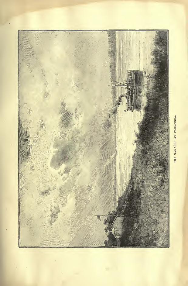
AMAZONIA. 91
the Rio de las Amazonas. For the riverine Indians it was the Parana Tinga," White River," the Parana Guassu,
" Great River," or simply Para," River
"in
a pre-eminent sense, a name now restricted to a lateral channel connected with the
Amazons system. Lastly the Brazilians have conferred on their majestic stream
the title of Rio Mar," Sea River."
Before the days of steam the Amazons was seldom visited, and to the missionary
Fritz (1690) is due the first chart of its course, rectified in 1749 by La Condamine.
Then came in the present century the scientific explorations of Spix and Martius,
of Castelnau, Herndon, Gibbon, Orton, Myers, Spruce, Wallace, Bates, de la Espada,
Agassiz, Hartt, Barbosa Rodrigues, Jose da Costa Azevedo, and Tardy de Mon-
travel.
On the Brazilian frontier, the Amazons flows at a level of not more than 270
feet above the sea;here it is nearly two miles wide and already presents the impos-
ing aspect which it retains for the rest of its seaward journey. Several of the
affluents themselves enter the main stream through mouths of enormous width.
The waters of some are of the same yellowish colour as the Amazons itself, while
others are of divers tints, clear and turbid, white or reddish, or even black, though
limpid, each revealing a page of its geological history in its peculiar shade and
in the sediment it holds in solution.
THE PlJTUMAYO AND JAPUKA.
The northern affluents descend from a zone only half as broad as that traversed
by those from the south;hence their contributions, however copious, are in gene-
ral much smaller than those of the southern streams. Nevertheless one of them,
the lea, that is, the Putumayo of the Colombians, would seem to be relatively
the most voluminous; its headwaters, rising north and south of the equator,
descend from the eastern slopes of the Quito highlands, which are exposed to
heavy rains throughout the year. The Putumayo is one of those rivers which
have most contributed to the erosion of the Andine system, reducing it in Ecuador
to a comparatively narrow ridge between the broader Colombian and Peruvian
masses. The Guames (Guamues), one of its head branches, issues from the Cocha,
or "Lake," as it is called pre-eminently, and below its junction the Putumayosoon becomes accessible to barges drawing six or seven feet. It flows along a
gentle incline unobstructed by reefs or rapids, at a sharp angle with the Amazons,
and in Brazilian territory is known only by its Indian (Omagua) name, lea. It
was first visited by the Jesuit, Juan de Sosa, in 1609, and in recent times has been
surveyed by Rafael Reyes (1874), Simson (1876), and Crevaux (1879). Like
the Napo, the Japura, and other Ecuador tributaries, the lea floats down much
pumice from the slopes of the volcanoes, and this pumice accumulates in masses
along all the chalk cliffs of the Amazons.
The Japura (Hyapura) rises a little north of the Putumayo in the Colombian
Andes, and both streams flow in nearly parallel courses to a point where the
Lower Japura trends directly east, joining the Amazons through a labyrinth of
channels. Its incline is much greater than that of the lea, and after issuing from

AMAZONIA AND LA PLATA.
the Andes it plunges into the profound gorges of a sandstone plateau, where the
current is contracted from a width of about half a mile to some 200 feet. The
Araracoara rapids, followed by a cascade 100 feet high, mark the farthest point
reached by Spix and Martius, and later by Silva Coutinho, and few travellers
have yet succeeded in penetrating higher up.
The Apapuris, which joins the Japura below the rapids, is regarded by the
Brazilians as the political frontier between their Amazonian territory and
Colombia, whereas the Colombians claim as the international boundary the Avati
Parana creek, which branches off from the left bank of the SolimOes, and winds
through a half-submerged district to the right bank of the Japura, Thus, in this
part of its course the Amazons may be said to be a tributary of the Japura, bywhich 125 miles lower down it is joined through numerous channels.
Even beyond the confluence, for a space of at least 40,000 square miles, extend-
Fig. 30 SOLIMOES AND JAPUEA CONFLUENCE.
Scale 1 : 8,500,000.
67' West oF Greenwich 60*
125 Miles.
ing all the way to the Rio Negro, the region comprised between the two con-
verging streams is occupied by an intricate system of lagoons, creeks, and
backwaters, which shift their forms and channels with every inundation under
the alternating pressure of the SolimOes and Japura waters. If the Amazons basin
was at one time an inland sea, as seems probable, its former aspect is best pre-
served in this half-lacustrine, half-emerged inter-fluvial district.
THE JUTAHY, JURUA, AND PURUS.
Between the Tea and the Japura confluences the SolimOes is joined by several
southern tributaries, such as the Jutahy (Hyuta'i) and the Jurua, which in any
other region would be regarded as great rivers. In 1867 Chandless ascended the
Jurua for a distance of 1,125 miles, including all the meanderings of its tortuous
channel, and at the farthest point reached by him the stream was still some 30
AMAZONIA. 98
feet deep and about 400 feet wide. Yet the Jurua ranks only as a third-class
river in Brazil.
A little below its confluence the SolimOes is joined by the Teffe, or "Deep,"
beyond which follow on the same right bank the black Coary and the Purus, the
latter descending from the base of the Peruvian Andes. The Purus, essentially a
river of the plains and entirely fed by rainwater, was ascended by Serafim for
1,300 miles in 1852, by Manoel Urbano in 1860, and in 18645 by Chandless,
whose name has been given to one of its western affluents. The botanist, Wallis,
accompanied the first steamer, which in 1862 reached a point 800 miles above
the confluence.
Like all the other southern affluents of the Amazons, the Purus, which has an
extremely winding course of about 1,850 miles, has a general north-easterly trend,
and brings to the main .stream the contributions of several large tributaries, such as
the Araca, Hyuacu, Aquiry, Pauyarim, Mucuim, and Tapaua. It flows entirely in
the old depression, which occupies the heart of the former Amazonian sea, and
throughout its whole course it is entirely free from rapids or other obstructions;
even islands are rare ; but its numerous meanderings are constantly shifting their
course owing to the erosions of the flood waters, which even a short distance
above the confluence rise to a height of no less than 60 feet. Farther up the
inundations fill its whole valley for a distance of 15 or even 20 miles, and at
this season temporary branches are opened in the direction of the Amazons. But
the channels figured on the old maps as communicating eastwards with the
Madeira do not appear to have any real existence,
THE Rio NEGRO AND ITS AFFLUENTS.
Between the Purus and Madeira confluences the SolimOes becomes the
Amazons by the junction of the Rio Negro ("Black River ") on its left bank.
Of the numerous watercourses bearing this name, none has a better claim to the
epithet, and all travellers who have visited the Parana Pixuua, as the natives call
it, have been struck by the contrast, presented by the Rio Negro, especially at its
confluence with the almost milky Rio Branco ("White River"), descending from
the argillaceous savannas on the British Guiana frontier. The two currents flow
side by side, like two streams in the same bed, and during the November floods,
when the Rio Branco sends down a larger volume than the Rio Negro, it may be
distinctly traced for a distance of some 20 miles below the confluence. It is
noteworthy that mosquitoes do not infest the black rivers, which also abound less
in fish and are often avoided by crocodiles, though these saurians frequent the
Rio Negro. The water is limpid, but unpleasant to the taste, and apparently
even unwholesome, owing to the decomposed vegetable matter with which it is
charged, and to which it owes its dark colour. This colour, however, is percep-
tible only in the deeper parts, the shallow waters being of a light brown and even
yellowish tint.
Of the numerous streams converging to form the Rio Negro the Rio TJaupes
(TJcuyaris) seems to have the best right to be regarded as its true upper course
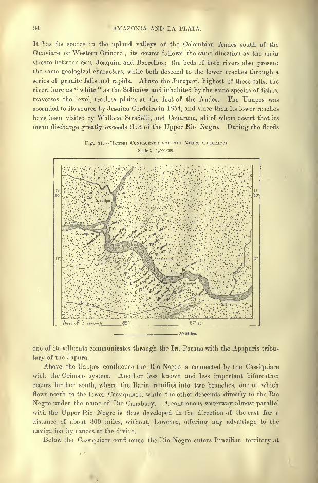
AMAZONIA AND LA PLATA.
It has its source in the upland valleys of the Colombian Andes south of the
Guaviare or Western Orinoco;
its course follows the same direction as the main
stream between San Joaquim and Barcellos;the beds of both rivers also present
the same geological characters, while both descend to the lower reaches through a
series of granite falls and rapids. Above the Jurupari, highest of these falls, the
river, here as " white"
as the Solimoes and inhabited by the same species of fishes,
traverses the level, treeless plains at the foot of the Andes. The Uaupes was
ascended to its source by Jesuino Cordeiro in 1854, and since then its lower reaches
have been visited by Wallace, Stradelli, and Coudreau, all of whom assert that its
mean discharge greatly exceeds that of the Upper Rio Negro. During the floods
Fig. 31. UAUPES CONFLUENCE AND Rio NEOBO CATARACPS
Scale 1 : 1,500,000.
West op Greenwich 68" 67 so-
30 Miles.
one of its affluents communicates through the Ira Parana with the Apapuris tribu-
tary of the Japura.
Above the Uaupes confluence the Rio Negro is connected by the Cassiquiare
with the Orinoco system. Another less known and less important bifurcation
occurs farther south, where the Baria ramifies into two branches, one of which
flows north to the lower Cassiquiare, while the other descends directly to the Rio
Negro under the name of Rio Canabury. A continuous waterway almost parallel
with the Upper Rio Negro is thus developed in the direction of the east for a
distance of about 300 miles, without, however, offering any advantage to the
navigation by canoes at the divide.
Below the Cassiquiare confluence the Rio Negro enters Brazilian territory at
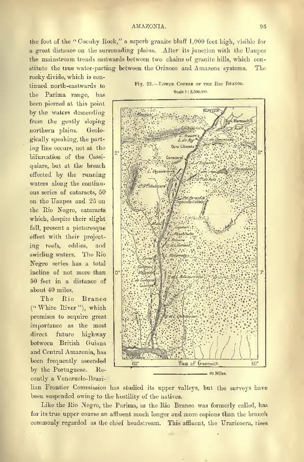
AMAZONIA. 95
the foot of the "Cuouhy Rock," a superb granite bluff 1,000 feet high, visible for
a great distance on the surrounding plains. After its junction with the Uaupesthe mainstream trends eastwards between two chains of granite hills, which con-
stitute the true water-parting between the Orinoco and Amazons systems. The
rocky divide, which is con-
Fiy. 32. LOWER COUESE OF THE Eio BEANCO.
Scale 1 : 3,500,000.
tinned north-eastwards to
the Parima range, has
been pierced at this point
by the waters descending
from the gently sloping
northern plains. Geolo-
gically speaking, the part-
ing line occurs, not at the
bifurcation of the Cassi-
quiare, but at the breach
effected by the running
waters along the continu-
ous series of cataracts, 50
on the Uaupes and 25 on
the Rio Negro, cataracts
which, despite their slight
fall, present a picturesque
effect with their project-
ing reefs, eddies, and
swirling waters. The Rio
Negro series has a total
incline of not more than
50 feet in a distance of
about 40 miles.
The Rio Branco
("White River"), which
promises to acquire great
importance as the most
direct future highwaybetween British Guiana
and Central Amazonia, has
been frequently ascended
by the Portuguese. Re-
cently a Venezuelo-Brazi-
lian Frontier Commission has studied its upper valleys, but the surveys have
been suspended owing to the hostility of the natives.
Like the Rio Negro, the Parima, as the Rio Branco was formerly called, has
for its true upper course an affluent much longer and more copious than the branch,
commonly regarded as the chief headstream. This affluent, the Uraricoera, rises
^. . a ^' /''. **.* "y**" .
*
'.
62 West op Greenwich
60 Miles.
96 AMAZONIA AND LA PLATA.
in an upland granitic valley of the Serra Parima, south of the Machiati peak, and
after an easterly course of 360 miles joins the Takutu, or "Upper Bio Branco,"
which collects the torrents from Roraima and Cai'rrit, as well as the Pirara creek
on the depression giving access to the Essequibo through its Rupunini affluent.
The Mahu (freng), branch of the Takutu, is famous for its falls, one of which, the
Corona, 160 feet high, ranks with Roraima and the Kaieteur Falls as one of the
"three wonders" of British Guiana.
After receiving all these headstreams the Rio Branco trends south-westwards,
and like the Uaupes and Rio Negro descends through a series of rapids which inter-
rupt all navigation between the upper and lower reaches. Below these obstructions
the Rio Branco flows in an almost due southerly course between a double chain of
lagoons and backwa,ters> representing old abandoned beds, down to its confluence
with the Rio Negro. The Jauapiry, which joins the main stream below the Rio
Branco, appears to be a remnant of one of these deserted channels.
In its lower course the Rio Negro forms, like the Canadian rivers, a succession
of lakes rather than a normal watercourse. In some places it expands to a width of
20 to 30 miles, far more than the Amazons itself, but the incline is so gentle that
the current is at times scarcely perceptible, and towards the confluence the Amazons
often sets up the Rio Negro, developing a sort of "bar," from which. Manaos took
its old name of " Barra do Rio Negro." The rise at high water ranges from about
30 to 40 feet, the ordinary depth being 100 or even 160 feet. Nevertheless navi-
gation at low water is impeded by numerous sandbanks, and the small steamers,
drawing no more than four and a half feet, which ascend to Santa Izabel, 450 miles
above the confluence, have sometimes to stop running for one or two months in
the year.
THE MADEIRA.
The Madeira, or " Wood "river, the Cayari (" White Water ") of the natives,
marks with the Rio Negro the great transverse depression of the Amazonian basin.
It has its farthest sources on the Bolivian uplands, and on the nearly level low-
lying plains, which are mostly drained by the Plate river. The Beni (Veni), its
main headstream, which formerly received the overflow of Lake Titicaca, is joined
within the Bolivian frontier by the copious Madre de Dios (Mayu-Tata, Amaru-
Mayo, "Snake River"), and farther on by the Mamore ("Mother of Men"),whose great tributary, the Guapore, flows entirely within Brazilian territory.
The Guapay, or Rio Grande, that is, the upper course of the Mamore, rises in the
Cochabamba Andes at an altitude of over 13,000 feet, and after describing a great
bend round those mountains is swollen by the waters of several rivers from the
low-lying plains between the Bolivian and the "Brazilian highlands. Its passage
from the southern to the northern plains is here closed by a barrier of metamorphic
gneiss rocks, which obstructs the current and develops a long series of falls and
rapids. Formed by the junction of the Beni and Mamore", the Madeira floats
down large quantities of drift wood, whence the name given to it by its first
explorer, Francisco Palheta, in 1723. Since that time it has served as the main
highway between the Amazonian plains and the plateaux of Bolivia, and this
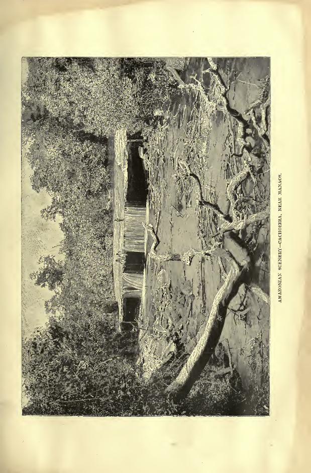
RIVERS OF AMAZONIA. 97
route has been followed by all recent explorers, such as D'Orbigny, Church, and
Keller-Leuzinger. The hydrographic chart prepared in 1878 to a scale of -n^V^iy
is based on the careful surveys of Selfridge.
From the Guajara Guassu Falls on the Mamore to the last cataracts of Santo
Antonio the total incline scarcely exceeds 200 feet in a distance of about 240 miles.
The highest cascade, that of Ribeirao, some 12 miles below the Beni, has a drop
of 40 feet, the 45 others varying from 30 feet to a few inches;but the
whole system presents so many difficulties to the navigation that the native boat-
men take from two to three months to make the ascent from the lower to the
upper reaches.
Below these obstructions the Madeira flows mainly north-east parallel to the
Purus with a uniform, though somewhat rapid current, which is nowhere less than
16 feet deep at low water, and in some places exceeds 500 feet, with a total mean
discharge of no less than 1,400,000 cubic feet per second. It enters the Amazons
through numerous island- studded channels, and throws off one branch, the
Parana Mirim ("Little River") which joins the main stream about 190 miles
lower down, thus enclosing the vast island of Tupinambaramas.
THE TROMBETAS, TAPAJOZ, AND XINGU.
Beyond the Madeira confluence the largest affluent on the north side is the
Trombetas, which collects the surface waters of the savannas, and on its course
to the Amazons develops a ramifying lake due to the alluvial matter deposited
by the mainstream about the confluence. Higher up similar phenomena are
presented by the Urubu, Uatuma, Yamunda (Neamunda or Cumery), all carefully
explored by Barbosa Rodrigues. Farther down the Paru and the Jary, which
descend from the Tumuc-Humac Mountains, have a more regular course, freer
from stagnant waters, but obstructed at intervals by rapids and even by cascades.
Crevaux descended the Jary and the Paru in 1877-79 at the risk of his life.
On the south side the Amazons is joined below the Madeira by the Tapajoz,
so called from the Tapajocos Indians, who have been completely exterminated bythe Portuguese. Its two headstreams, the Arinos and the Juruena, rise in
Matto Grosso, near the sources of the Paraguay, and after their junction the
Tapajoz flows parallel with the Madeira north-eastwards to the scarp of the
plateau. Here it is obstructed by a series of 16 cataracts, beyond which it
forms a broad navigable watercourse, flowing between wooded banks for 300
miles to a point where the navigation is again interrupted by the Salto Augusto,the only cascade which is impassable at all seasons.
For the rest of its course of 220 miles the Tapajoz forms a sluggish stream
nearly as dark as the Rio Negro, which gradually expands into a broad lagoon
with scarcely perceptible current. Like that of the Trombetas, Lake Yillafranca,
as this flooded depression is called, owes its existence to the sedimentary matter
deposited by the Amazons at the confluence. The Tapajoz presents the shortest
natural route between the Amazons and Plate estuaries.
The Xingu, last great affluent of the Amazons proper, rises on the same
98 AMAZONIA AND LA PLATA.
plateau as the Tapajoz, and. like it, is obstructed by a series of reefs and rapids,
inaccessible to boats. Although visited in the eighteenth century by the Jesuit,
Hundertpfund, and again in 1842 by Adalbert of Prussia, so little was known of
the Xingu till quite recently that its southern affluents figured on many maps as
tributaries of the Tapajoz. But the charts prepared from the surveys of Von
den Steinen in 1884 and 1887 may be regarded as fairly accurate.
At its confluence the Xingu, already under the influence of the tides, expandsinto a vast lake like that of the Tapajoz. The strip of land separating it from
the Amazons is divided by creeks into an archipelago of wooded islands, while a
labyrinth of other channels is developed above the confluence along the right
bank of the mainstream.
Throughout its course of about 2,000 miles between Tabatinga and Macapa,the Amazons maintains a somewhat uniform aspect, varying in breadth far less
than the Rio Negro, and nearly everywhere narrow enough for at least a fringe
of verdure to be visible on both banks from midstream. Below the Trombetas
confluence it even contracts, at the Obidos narrows, to 5,000 or 6,000 feet, during
the floods in June, with a mean depth of 250 feet, and a velocity of about 8,000
yards an hour. From these data it may be inferred that at this season the Amazons
discharges at least 3,500,000 cubic feet per second, before receiving the contri-
butions of the Tapajoz, Xingu, and some other affluents. During the great
inundations the overflow south of Obidos runs into the Lago Grande de Villa
Franca, a vast reservoir 34 miles long and from four to 10 miles wide. Manybillions of cubic feet are thus withdrawn from the sea at this point. In the same
place both Spix and Martius and Wallace have estimated the discharge in the
dry season at not more than 530,000 cubic feet per second.
The annual rainfall of the whole basin cannot be calculated at less than 100
inches, which would supply a uniform discharge of at least 18,000,000 cubic feet.
But large quantities are lost by evaporation in the vast reservoirs lining both
banks of all the northern and southern affluents below the rapids.
THE AMAZONIAN MEDITERRANEAN.
Throughout the whole of the Amazonian basin, from the Andean foothills to
the shores of the Atlantic, there everywhere occur tabular or horizontal terraces
of sandstone and argillaceous rocks, ranging from 100 to about 1,000 feet in
height. In the central part of the depression the northern and southern terraces
recede to a distance of some 500 miles from each other ; but at Obidos and Monte
Alegre they approach inuuh nearer to the fluvial banks. Between these two
towns, Santarem on the left side stands at the extremity of a fragment of the
same rocky formation, which extends to the shores and islands of the estuary,
including most of the large island of Marajo and the sea-coast stretching south-
eastwards in the direction of Piauhy and Ceara.
"Whatever be the origin of this vast system of sedimentary strata, whether
it is to be referred with Agassiz to glacial action, or with other geologists more
probably to the paleozoic and especially the carboniferous ages, there can be little
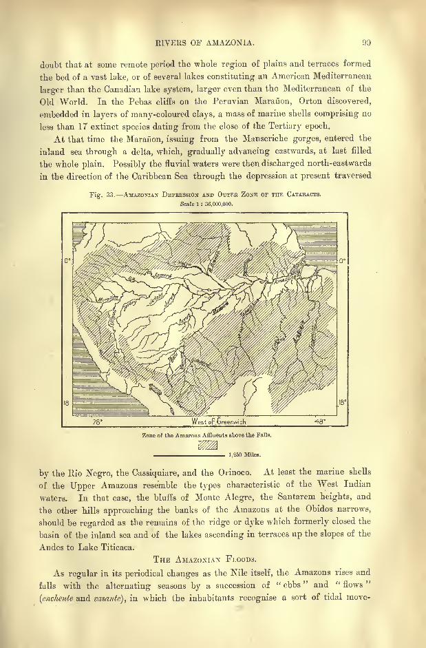
RIVERS OF AMAZONIA.
doubt that at some remote period the whole region of plains and terraces formed
the bed of a vast lake, or of several lakes constituting an American Mediterranean
larger than the Canadian lake system, larger even than the Mediterranean of the
Old World. In the Pebas cliffs on the Peruvian Maranon, Orton discovered,
embedded in layers of many-coloured clays, a mass of marine shells comprising no
less than 17 extinct species dating from the close of the Tertiary epoch.
At that time the Maranon, issuing from the Manseriche gorges, entered the
inland sea through a delta, which, gradually advancing eastwards, at last filled
the whole plain. Possibly the fluvial waters were then discharged north-eastwards
in the direction of the Caribbean Sea through the depression at present traversed
Fig. 33. AMAZONIAN DEPRESSION AND OUTER ZONE OF THE CATARACTS.
Scale 1 : 36,000,000.
West op.Greenwich 48*
Zone of the Amazons Affluents above the Falls.
1,250 Miles.
by the Rio Negro, the Cassiquiare, and the Orinoco. At least the marine shells
of the Upper Amazons resemble the types characteristic of the "West Indian
waters. In that case, the bluffs of Monte Alegre, the Santarem heights, and
the other hills approaching the banks of the Amazons at the Obidos narrows,
should be regarded as the remains of the ridge or dyke which formerly closed the
basin of the inland sea and of the lakes ascending in terraces up the slopes of the
Andes to Lake Titicaca.
THE AMAZONIAN FLOODS.
As regular in its periodical changes as the Nile itself, the Amazons rises and
falls with the alternating seasons by a succession of " ebbs" and " flows
"
(enchente and vasante), in which the inhabitants recognise a sort of tidal move-
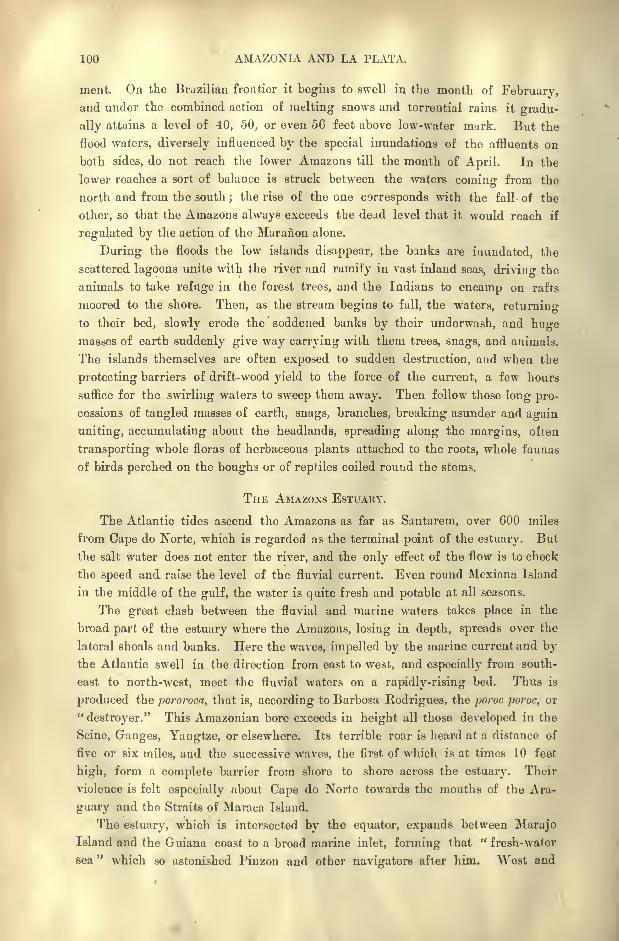
100 AMAZONIA AND LA PLATA.
ment. On the Brazilian frontier it begins to swell in the month of February,and under the combined action of melting snows and torrential rains it gradu-
ally attains a level of 40, 50, or even 56 feet above low-water murk. But the
flood waters, diversely influenced by the special inundations of the affluents on
both sides, do not reach the lower Amazons till the month of April. In the
lower reaches a sort of balance is struck between the waters coining from the
north and from the south ;the rise of the one corresponds with the fall of the
other, so that the Amazons always exceeds the dead level that it would reach if
regulated by the action of the Maranon alone.
During the floods the low islands disappear, the banks are inundated, the
scattered lagoons unite with the river and ramify in vast inland seas, driving the
animals to take refuge in the forest trees, and the Indians to encamp on rafts
moored to the shore. Then, as the stream begins to fall, the waters, returning
to their bed, slowly erode the soddened banks by their underwash, and hugemasses of earth suddenly give way carrying with them trees, snags, and animals.
The islands themselves are often exposed to sudden destruction, and when the
protecting barriers of drift-wood yield to the force of the current, a few hours
suffice for the swirling waters to sweep them away. Then follow those long pro-
cessions of tangled masses of earth, snags, branches, breaking asunder and again
uniting, accumulating about the headlands, spreading along the margins, often
transporting whole floras of herbaceous plants attached to the roots, whole faunas
of birds perched on the boughs or of reptiles coiled round the stems.
THE AMAZONS ESTUAHY.
The Atlantic tides ascend the Amazons as far as Santarem, over 600 miles
from Cape do Norte, which is regarded as the terminal point of the estuary. But
the salt water does not enter the river, and the only effect of the flow is to check
the speed and raise the level of the fluvial current. Even round Mexiana Island
in the middle of the gulf, the water is quite fresh and potable at all seasons.
The great clash between the fluvial and marine waters takes place in the
broad part of the estuary where the Amazons, losing in depth, spreads over the
lateral shoals and banks. Here the waves, impelled by the marine current and bythe Atlantic swell in the direction from east to west, and especially from south-
east to north-west, meet the fluvial waters on a rapidly-rising bed. Thus is
produced the pororoca, that is, according to Barbosa Rodrigues, the poroc poroc, or
"destroyer." This Amazonian bore exceeds in height all those developed in the
Seine, Ganges, Yangtze, or elsewhere. Its terrible roar is heard at a distance of
five or six miles, and the successive waves, the first of which is at times 10 feet
high, form a complete barrier from shore to shore across the estuary. Their
violence is felt especially about Cape do Norte towards the mouths of the Ara-
guary and the Straits of Maraca Island.
The estuary, which is intersected by the equator, expands between MarajoIsland and the Guiana coast to a broad marine inlet, forming that " fresh-water
sea" which so astonished Finzon and other navigators after him. West and
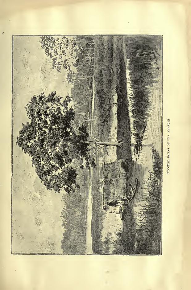
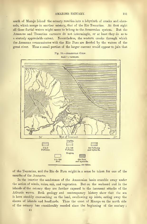
AMAZONS ESTUAEY. 101
south of Marajo Island the estuary ramifies into a labyrinth of creeks and chan-
nels, which merge in another estuary, that of the Rio Tocantins. At first sight
all these fluvial waters might seem to belong to the Amazonian system. But the
Amazons and Tocantins currents do not intermingle, or at least they do so to
a scarcely appreciable extent. Nevertheless, the western creeks through which
the Amazons communicates with the Rio Para are flooded by the waters of the
great river. Thus a small portion of the larger current would appear to join that
Fig. 34. AMAZONIAN GULF.
Scale 1 : 13,000,000.
West oF Greenwich 44
Oto5Fathoms.
dlOto 650Feet.
Depths.
5 to 100Fathoms.
Heights.
100 Fathomsand upwards.
650 Feetand upwards.
310 Miles.
of the Tocantins, and the Rio de Para might in a sense be taken for one of the
mouths of the Amazons.
In the interior the sandstones of the Amazonian basin crumble away under
the action of winds, rains, sun, and vegetation. But on the seaboard and in the
islands of the estuary they are further exposed to the incessant attacks of the
Atlantic waves. Both geology and contemporary history show that the sea
is here steadily encroaching on the land, swallowing up islets, eating away the
shores of islands and headlands. Thus the coast of Macapa on the north side
of the estuary has considerably receded since the beginning of the century ;
41
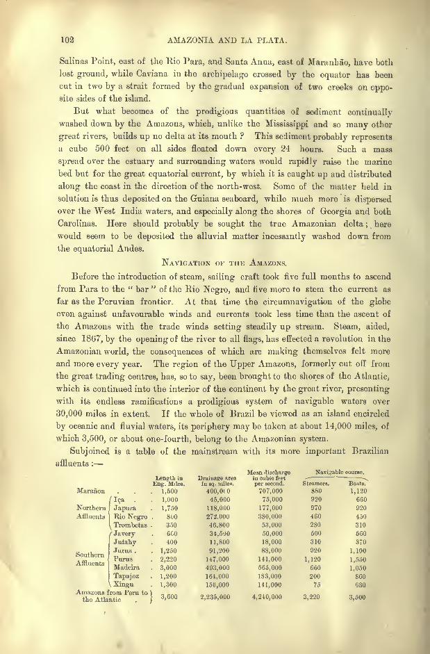
102 AMAZONIA AND LA PLATA.
Salinas Point, east of the Rio Para, and Santa Anna, east of Maranhao, have both
lost ground, while Caviana in the archipelago crossed by the equator has been
cut in two by a strait formed by the gradual expansion of two creeks on oppo-site sides of the island.
But what becomes of the prodigious quantities of sediment continually
washed down by the Amazons, which, unlike the Mississippi and so many other
great rivers, builds up no delta at its mouth ? This sediment probably represents
a cube 500 feet on all sides floated down every 24 hours. Such a mass
spread over the estuary and surrounding waters would rapidly raise the marine
bed but for the great equatorial current, by which it is caught up and distributed
along the coast in the direction of the north-west. Some of the matter held in
solution is thus deposited on the Guiana seaboard, while much more is dispersed
over the West India waters, and especially along the shores of Georgia and both
Carolinas. Here should probably be sought the true Amazonian delta; here
would seem to be deposited the alluvial matter incessantly washed down from
the equatorial Andes.
NAVIGATION OF THE AMAZONS.
Before the introduction of steam, sailing craft took five full months to ascend
from Para to the " bar"
of the Rio Negro, and five more to stem the current as
far as the Peruvian frontier. At that time the circumnavigation of the globe
even against unfavourable winds and currents took less time than the ascent of
the Amazons with the trade winds setting steadily up stream. Steam, aided,
since 1867, by the opening of the river to all flags, has effected a revolution in the
Amazonian world, the consequences of which are making themselves felt more
and more every year. The region of the Upper Amazons, formerly cut off from
the great trading centres, has, so to say, been brought to the shores of the Atlantic,
which is continued into the interior of the continent by the great river, presenting
with its endless ramifications a prodigious system of navigable waters over
30,000 miles in extent. If the whole of Brazil be viewed as an island encircled
by oceanic and fluvial waters, its periphery may be taken at about 14,000 miles, of
which 3,500, or about one-fourth, belong to the Amazonian system.
Subjoined is a table of the mainstream with its more important Brazilian
affluents :
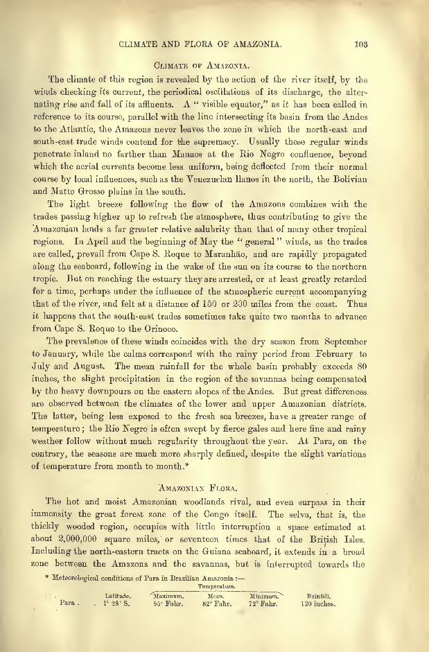
CLIMATE AND FLORA OF AMAZONIA. 103
CLIMATE OF AMAZONIA.
The climate of this region is revealed by the action of the river itself, by the
winds checking its current, the periodical oscillations of its discharge, the alter-
nating rise and fall of its affluents. A " visible equator," as it has been called in
reference to its course, parallel with the line intersecting its basin from the Andes
to the Atlantic, the Amazons never leaves the zone in which the north-east and
south-east trade winds contend for the supremacy. Usually these regular winds
penetrate inland no farther than Manaos at the Rio Negro confluence, beyondwhich the aerial currents become less uniform, being deflected from their normal
course by local influences, such as the Venezuelan llanos in the north, the Bolivian
and Matto Grosso plains in the south.
The light breeze following the flow of the Amazons combines with the
trades passing higher up to refresh the atmosphere, thus contributing to give the
Amazonian lands a far greater relative salubrity than that of many other tropical
regions. In April and the beginning of May the l(
general" winds, as the trades
are called, prevail from Cape S. Roque to Maranhao, and are rapidly propagated
along the seaboard, following in the wake of the sun on its course to the northern
tropic. But on reaching the estuary they are arrested, or at least greatly retarded
for a time, perhaps under the influence of the atmospheric current accompanyingthat of the river, and felt at a distance of 150 or 200 miles from the coast. Thus
it happens that the south-east trades sometimes take quite two months to advance
from Cape S. Roque to the Orinoco.
The prevalence of these winds coincides with the dry season from Septemberto January, while the calms correspond with the rainy period from February to
July and August. The mean rainfall for the whole basin probably exceeds 80
inches, the slight precipitation in the region of the savannas being compensated
by the heavy downpours on the eastern slopes of the Andes. But great differences
are observed between the climates of the lower and upper Amazonian districts.
The latter, being less exposed to the fresh sea breezes, have a greater range of
temperature ;the Rio Negro is often swept by fierce gales and here fine and rainy
weather follow without much regularity throughout the year. At Para, on the
contrary, the seasons are much more sharply defined, despite the slight variations
of temperature from month to month.*
AMAZONIAN FLORA.
The hot and moist Amazonian woodlands rival, and even surpass in their
immensity the great forest zone of the Congo itself. The selva, that is, the
thickly wooded region, occupies with little interruption a space estimated at
about 2,000,000 square miles, or seventeen times that of the British Isles.
Including the north-eastern tracts on the Guiana seaboard, it extends in a broad
zone between the Amazons and the savannas, but is interrupted towards the
*Meteorological conditions of Para in Brazilian Amazonia :
Temperature.
Latitude. Maximum. Mean. Minimum. Rainfall.
Para. . 1C28'S. 95" Fahr. 82 Fahr. 72Fahr. 120 inches.
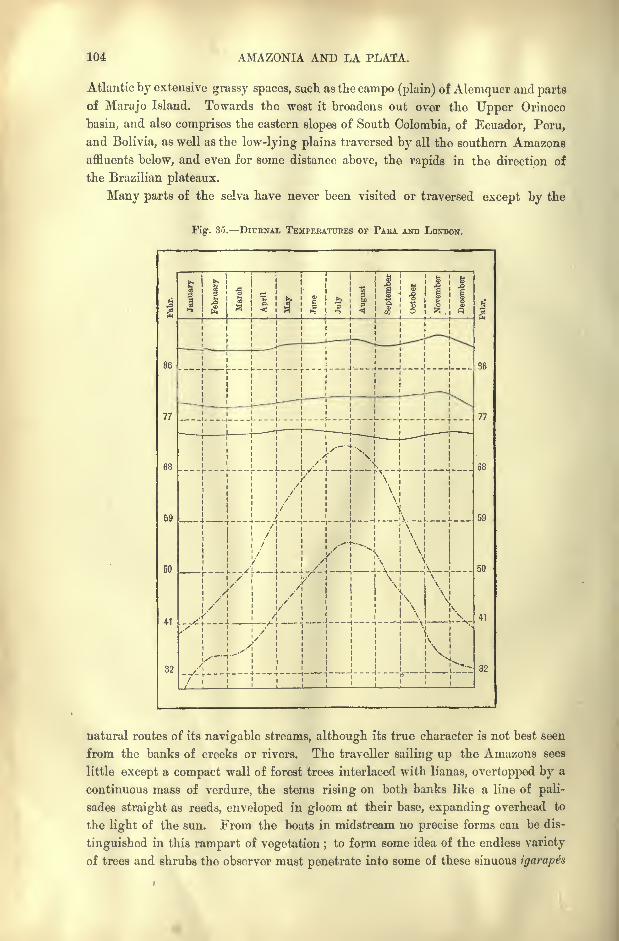
104 AMAZONIA AND LA PLATA.
Atlantic by extensive grassy spaces, such as the campo (plain) of Alemquer and parts
of Marajo Island. Towards the west it broadens out over the Upper Orinoco
basin, and also comprises the eastern slopes of South Colombia, of Ecuador, Peru,
and Bolivia, as well as the low-lying plains traversed by all the southern Amazonsaffluents below, and even for some distance above, the rapids in the direction of
the Brazilian plateaux.
Many parts of the selva have never been visited or traversed except by the
Fig. 35. DIURNAL TEMPEKATUBES OF PARA AND LONDON.
86
77
59
50
41
32
4
-f-
1- T T
-\--_L
T
77
38
59
50
32
natural routes of its navigable streams, although its true character is not best seen
from the banks of creeks or rivers. The traveller sailing up the Amazons sees
little except a compact wall of forest trees interlaced with lianas, overtopped by a
continuous mass of verdure, the stems rising on both banks like a line of pali-
sades straight as reeds, enveloped in gloom at their base, expanding overhead to
the light of the sun. From the boats in midstream no precise forms can be dis-
tinguished in this rampart of vegetation ;to form some idea of the endless variety
of trees and shrubs the observer must penetrate into some of these sinuous igarapes
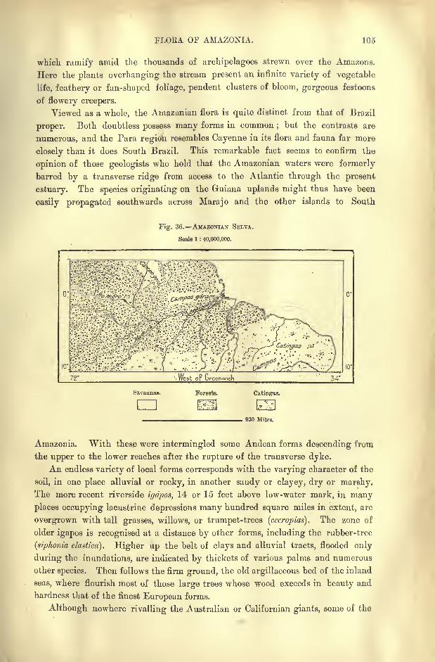
FLORA. OF AMAZONIA. 105
which ramify amid the thousands of archipelagoes strewn over the Amazons.
Here the plants overhanging the stream present an infinite variety of vegetable
life, feathery or fan-shaped foliage, pendent clusters of bloom, gorgeous festoons
of flowery creepers.
Viewed as a whole, the Amazonian flora is quite distinct from that of Brazil
proper. Both doubtless possess many forms in common;but the contrasts are
numerous, and the Para region resembles Cayenne in its flora and fauna far more
closely than it does South Brazil. This remarkable fact seems to confirm the
opinion of those geologists who hold that the Amazonian waters were formerly
barred by a transverse ridge from access to the Atlantic through the present
estuary. The species originating on the Guiana uplands might thus have been
easily propagated southwards across Marajo and the other islands to South
Fig. 36. AMAZONIAN SELTA.
Scale 1 : 40,000,000.
72
Savannas.
cnForests. Catingas.
930 Miles.
Amazonia. "With these were intermingled some Andean forms descending from
the upper to the lower reaches after the rupture of the transverse dyke.
An endless variety of local forms corresponds with the varying character of the
soil, in one place alluvial or rocky, in another saody or clayey, dry or marshy.The more recent riverside iyripos, 14 or 15 feet above low-water mark, in manyplaces occupying lacustrine depressions many hundred square miles in extent, are
overgrown with tall grasses, willows, or trumpet-trees (cccropias). The zone of
older igapos is recognised at a distance by other forms, including the rubber-tree
(siphonia elastica). Higher up the belt of clays and alluvial tracts, flooded only
during the inundations, are indicated by thickets of various palms and numerous
other species. Then follows the firm ground, the old argillaceous bed of the inland
seas, where flourish most of those large trees whose wood exceeds in beauty and
hardness that of the finest European forms.
Although nowhere rivalling the Australian or Californian giants, some of the
106 AMAZONIA AND LA PLATA.
trees attain a height of 180 or even 200 feet. Such are the moiratinga, probably
a variety of the mora excclsa of Guiana;the samauina (eriodendron samauma), and
the massaranduba, or "milk-tree," whose sap is taken with coffee, though large
quantities appear to be dangerous. The widespreading branches of a gigantic
ceaba, discovered by Wallis on the banks of the Rio Branco, covered a space of
about six acres, where 25,000 persons might find standing room. The monguba,another species of bombax or silk-cotton tree, has the peculiarity of shedding all
its leaves before sprouting again.
A strange and striking feature of Amazonian arborescence consists in the great
development of the outer walls sustaining, but detached from, the stem, leaving an
intervening space wide enough to afford refuge to several persons. Another
characteristic of these woodlands are the countless species of parasitic growths,
climbing the trunk to reach the light, or clinging to the branches, from which
hang their long aerial roots; waving in the breeze, or interlacing with the
ascending lianas.
Palms, of which there occur several hundred species, constitute a large propor-
tion of the arborescent forms, even forming whole forests in certain sandy districts
and on the margins of the savannas. In many places a single variety prevails
the graceful assa'i (euterpe oleracea) round about Para;
the paxiuba (iriartea
exhoryza) in parts of the Japura and lea valleys ;the barrigoto (iriartea ventricosa)
on the Upper Amazons;the piassaba in the Rio Negro basin
;the tucum (astro-
caryum vulgare) on the Purus and Jurua.
European travellers are surprised by the lack of bright flowers. Even orchids
are rare, while edible fruits, abounding in some districts, are absent from others.
The sandy river-banks with a sunny aspect yield the caju (anacardium occidentale),
the fruit of which is much prized ;the guajeru (chrysobalanus icaco) of the coast-
lands, the wild pineapple (bromelia abacaxi), the inga lucida, and the various passion-
flowers, all contribute fruits or berries much valued by the natives.
Other products of the selva, cabinet-woods, rubber, various gums, resins, and
camphorated substances, drugs, fibres, and dyewoods, exist in thousands and are
daily being more and more utilised by human industry.
THE AMAZONIAN FAUNA.
The death-like stillness prevailing in many districts might lead the observer to
suppose that animal life was poorly represented in these woodlands. But if
individuals are few, the species present a great diversity. During his eleven years'
exploration in Amazonia, Bates collected as many as 14,712 animal forms, of which
8,000 were completely new to science. Life teems even in apparently deserted
parts of the selva;the gloom beneath the undergrowth may be forsaken, while
the foliage bathed in light is alive with whole populations of insects, birds, and
even mammals.
Most of the quadrupeds have so well adapted themselves to their environment
that they advance easily from tree to tree. The land mammals are both few and
nearly all of small size ; even the tapir, largest of all, is smaller than the original
FAUNA OF AMAZONIA. 107
type. But on the other hand there are 38 members of the monkey family,
all climbers and all with prehensile tails. The cercolcpfes, a species of bear, is also
of exclusively arboreal habits, and of the four kinds of ant-eaters (myrmecophaga)
studied by Bates, three live in the trees, as do also the degenerate descendants of
the colossal megatherium (sloth), besides various squirrels, snakes, and other
reptiles.
Gulls and the frigate-bird ascend the Amazons to the Peruvian plains 2,500
miles from the sea, while the manatee and dolphins frequent all the large affluents
as far as the first rapids. But the various species of cetaceans have acquired
exclusively fluvial forms. The water boa (eunectes murinus), which sometimes
attacks man, acquires enormous proportions in the Napo basin, where Osculati saw
one which appeared to him some 50 or 60 feet long.
The Amazons waters are infested by the formidable jacare uassu, or great
crocodile;but the turtle, which formerly swarrned in the main stream, has been
nearly exterminated or driven up the affluents by the reckless destruction of its
eggs. Both of these animals withdraw to the lakes and tributaries during the
rainy season, returning in the dry period, or else burying themselves in the mud
during the summer months. Saurians and fishes of identical species vary in colour
according to the darker or lighter tints of the fluvial waters frequented by them.
All the running waters teem with fishes, and the 600 or 700 species estimated
by Spix were raised by Agassiz to nearly 2,000 for the Amazons alone, that is,
twice as many as in the Mediterranean, and more than in the whole Atlantic. The
Hyanuary lagoon west of the Rio Negro confluence contains over 200, or more
than all the rivers and lakes of Europe together. Some are extremely ferocious;
the piranhas (tetragonopterus), despite their small size, attack man with great fury,
and often snap off the lips of dogs and horses drinking in the streams infested bythem.
Although poor in some bird forms, notably humming birds, Amazonia abounds
in others, and Wallace alone collected over 500 different kinds. Aquatic beetles
are rare, but on the other hand no less than 700 species of butterflies occur within
a radius of four miles round Para. It was the extreme variety of the lepidoptera
that enabled Bates to prosecute those comparative studies on transformation and
mimicry that supplied so many arguments in support of Darwin's theory on the
Origin of Species. Some of the winged pests, such as the nocturnal mosquito and
the pium or day fly, render- certain riverside districts in the Purus valley quite
uninhabitable;the sauba ant also (cecodoma cephalotes), which lines its underground
galleries with leaves, makes all tillage impossible in many places. Coffee planta-
tions laid out at great cost have been utterly destroyed by its invading hosts. The
galleries, which extend to a distance of 160 and even 200 feet, are the work of a
delving population provided with a frontal eye like the fabulous cyclops or the
modern miners with their Davy lamps. A denizen of these subterranean abodes
is the amphisboena," mother of the saubas," a harmless snake said by the natives
to have two heads. Even more dreaded than the sauba is the formiga do fogo, or
"fire-ant
"(myrmica rubra), which has at times put whole communities to flight.
108 AMAZONIA AND LA PLATA.
INHABITANTS OF AMAZONIA.
Amongst the few traces of the former inhabitants of Amazonia is a necro-
polis discovered near Manaos, evidently of great antiquity, containing hundreds
of large mortuary jars of elegant design, but of unknown origin. To a more
recent period would appear to belong the shell-mounds occurring near Para, in
Marajo Island and in the Santarem district. The numerous fragments of human
industry found in these mounds -seem to have been deposited by the present
riverine populations ;some of the skulls differ in no respect from those of the
Tapuyos. Like those of the Mississippi basin, some of the mounds affect the
form of caymans or other huge animals, probably the otem of the tribe. Certain
jade objects," worth their weight in gold," are supposed by most observers to
have come from the region of the Upper Rio Branco; one, representing a jaguar
devouring a turtle, recalls the style of similar Muysca sculptures. Inscribed
rocks have been discovered in many parts of the Rio Negro, Tapajoz, and Madeira
valleys.
Of the 150 tribes recorded by Orellana on his memorable voyage down the
Amazons all have disappeared, and such has been tbe destruction of human life
that the white man would seem to have visited these regions only to create a
solitude. Very few full-blood Indians now survive on the banks of the Amazons,and those formerly grouped in communities under the Jesuits are now merged in
a homogeneous population speaking the lingoa geral which had been taught them
with the catechism, but which is itself now being gradually replaced by the
Portuguese of tbe Brazilian traders.
THE TAPUYOS, AKAWAKS, AND CARIBS.
These Indians take the general name of Tapuyos, which appears to have
formerly belonged to a Tupinamba tribe that migrated from East Brazil to
Amazonia in the sixteenth century. They probably belong for the most part to
the Tupi family, whose various dialects resembled that which the Jesuits reduced
to written form and made the "general language
"of Brazil. A purer form of
this idiom appears to be the Guarani of Paraguay, where is probably to be sought
the origin of these Amazonian Tupis. Since the publication of the first Tupi
grammar by Anchieta in 1595, this dialect has been sedulously cultivated, and
now possesses quite a literature, in which the Brazilians themselves take a certain
patriotic pride.
It is scarcely any longer possible to recognise the original elements amid the
endless interminglings that have taken place between the red, white, and black
races. The term mameluco, at first restricted to the children of white fathers
and Indian mothers, is now commonly applied to all half-breeds. A very marked
type is that of thecfiftizo, the offspring of a black father and Indian mother,
noted especially for his enormous head of bristly black hair, lank but not woolly.
In general, the mixed Amazonian populations may be said to have gained in
physical beauty and natural grace, as well as in intelligence.
Besides the Tapuyo half-castes, good boatmen, but indolent, and of little use
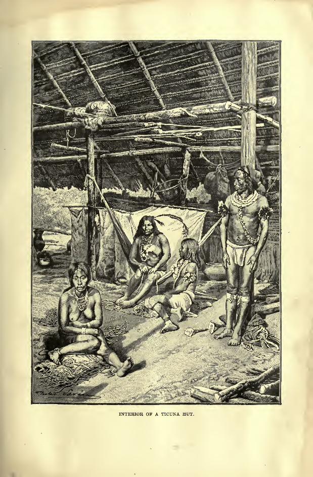
INTERIOR OF A TICUNA HUT.
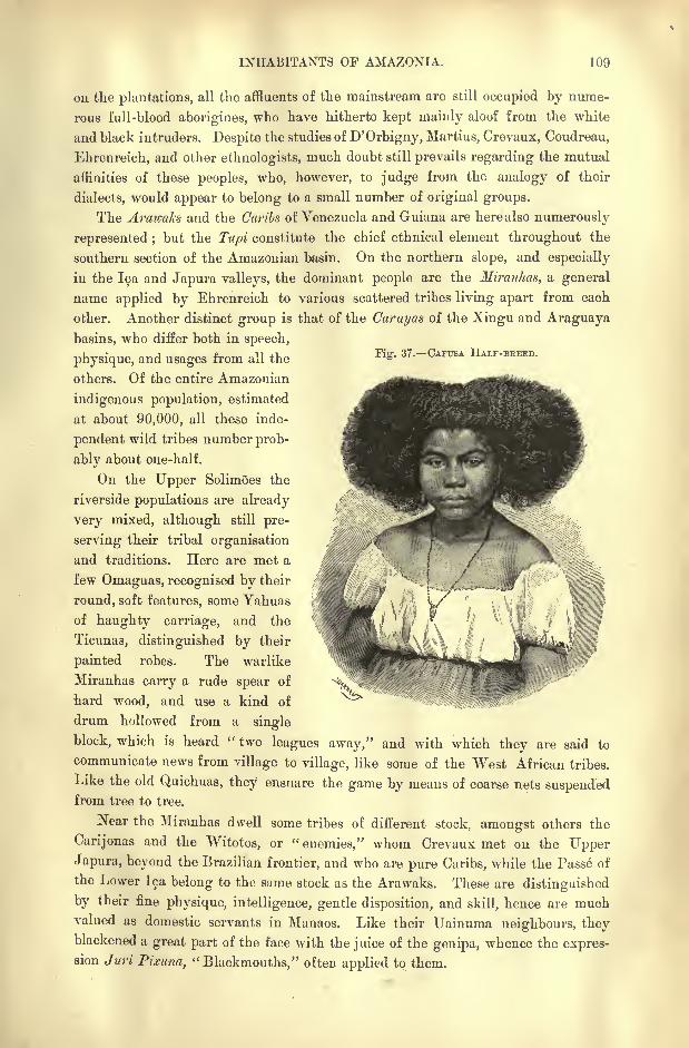
INHABITANTS OF AMAZONIA. 109
Fig. 37. CAFUSA HALF-BKEED.
on the plantations, all the affluents of the mainstream are still occupied by nume-
rous full-blood aborigines, who have hitherto kept mainly aloof from the white
and black intruders. Despite the studies of D'Orbigny, Martius, Crevaux, Coudreau,
Ehrenreich, and other ethnologists, much doubt still prevails regarding the mutual
affinities of these peoples, who, however, to judge from the analogy of their
dialects, would appear to belong to a small number of original groups.
The Arawaks and the Carils of Venezuela and Guiana are here also numerously
represented ;but the Ttipi constitute the chief ethnical element throughout the
southern section of the Amazonian basin. On the northern slope, and especially
in the lea and Japura valleys, the dominant people are the Miranhas, a general
name applied by Ehrenreich to various scattered tribes living apart from each
other. Another distinct group is that of the Carayas of the Xingu and Araguaya
basins, who differ both in speech,
physique, and usages from all the
others. Of the entire Amazonian
indigenous population, estimated
at about 90,000, all these inde-
pendent wild tribes number prob-
ably about one-half.
On the Tipper SolimOes the
riverside populations are already
very mixed, although still pre-
serving their tribal organisation
and traditions. Here are met a
few Omaguas, recognised by their
round, soft features, some Yahuas
of haughty carriage, and the
Ticunas, distinguished by their
painted robes. The warlike
Miranhas carry a rude spear of
hard wood, and use a kind of
drum hollowed from a single
block, which is heard " two leagues away," and with which they are said to
communicate news from village to village, like some of the West African tribes.
Like the old Quichuas, they ensnare the game by means of coarse nets suspendedfrom tree to tree.
Near the Miranhas dwell some tribes of different stock, amongst others the
Carijonas and the Witotos, or "enemies," whom Crevaux met on the Upper
Japura, beyond the Brazilian frontier, and who are pure Caribs, while the Passe of
the Lower lea belong to the same stock as the Arawaks. These are distinguished
by their fine physique, intelligence, gentle disposition, and skill, hence are muchvalued as domestic servants in Manaos. Like their TJainuma neighbours, theyblackened a great part of the face with the juice of the genipa, whence the expres-sion Juri Pixuna,
"Blackmouths," often applied to them.
110 AMAZONIA AND LA PLATA.
Rio NEGRO AND TROMBETAS TRIBES.
On the Uaupes branch of the Rio Negro dwell the Uaupes, a group of 21
tribes speaking 15 different dialects, and according to Coudreau of diverse origin.
Some, such as the dominant Tarianas, are undoubtedly Caribs, while the Macus,
who roam the forests from the Andes to Manaos, would seem to be akin to the
Witotos of the Upper Japura, though these also are stated to be true Caribs.
Most of the Uaupes differ in dress and usages as well as in speech, and their
common religion appears to be the chief bond of union between them. Despitethe zeal of the Catholic missionaries, they still preserve a national cult, in which
are intermingled Pagan and Christian rites, the latter derived from the teachings
of the Jesuits during the eighteenth century. Tupan, a great traveller, and author
of the numerous drawings c irved on the granite rocks about the cataracts, repre-
sents the God of the Christians. Jurupari, the native god, born of Virgin Mary,is an evil genius, who encourages drink, murder, and other vices amongst his
people. In his honour are celebrated great feasts, dances, flagellations, and orgies ;
but he receives a secret worship, from which the women are jealously excluded.
But all the Uaupes are disappearing, and in the Rio Negro basin civilised and
savage together had been reduced to 8,000 in 1884.
On the other hand the Macusi, dominant on the southern slopes of the moun-
tains drained by the Rio Branco, appear to have greatly increased since the
eighteenth century, when they acquired the ascendancy over the Wapisianas.
The Macusi, probably of Tupi stock, form two main groups, one in the east on the
rivers Mahu and Takutu, the other in the west towards the Upper Uraricuera
basin. Formerly much dreaded on account of their poisonous arrows, they have
ceased to prepare the curare poison, and now use firearms. Their savannas being
traversed by the natural highway between the Es^equibo and the Amazons,
they have recently taken to trade, and already begin to speak a little broken
English.
Next to these the most powerful tribe are the Wayewe of the Upper Mapuerro,which flows to the Amazons under the name of Urubu. The Wayewe, that is,
"Whites," are probably pure Caribs, men of splendid physique, noble features,
fair complexion, and very industrious. The kindred Japii are "the finest
Indians" met by Coudreau during his ten years' explorations in Guiana. This
observer was surprised to find light hair and blue eyes amongst the Japii, while
their northern neighbours, the Tucans, were distinguished by prominent cheek-
bones and oblique Mongol eyes.
Except the Macusi, Wayewes, and Piangotos, all the independent tribes of
the Rio Branco, Urubu, Yamunda, and Trombetas rivers appear to be decreasing.
Several have even disappeared altogether, amongst others the Paravilhanas," Bowmen," who were very powerful in the fifteenth century. Of the twenty-
two groups recorded in 1787 only nine survive, and one of these, the Crichanas
of the Rio Jauapery, at constant war with the whites, were threatened with
extinction, when Barbosa Rodrigues succeeded in establishing peace between the
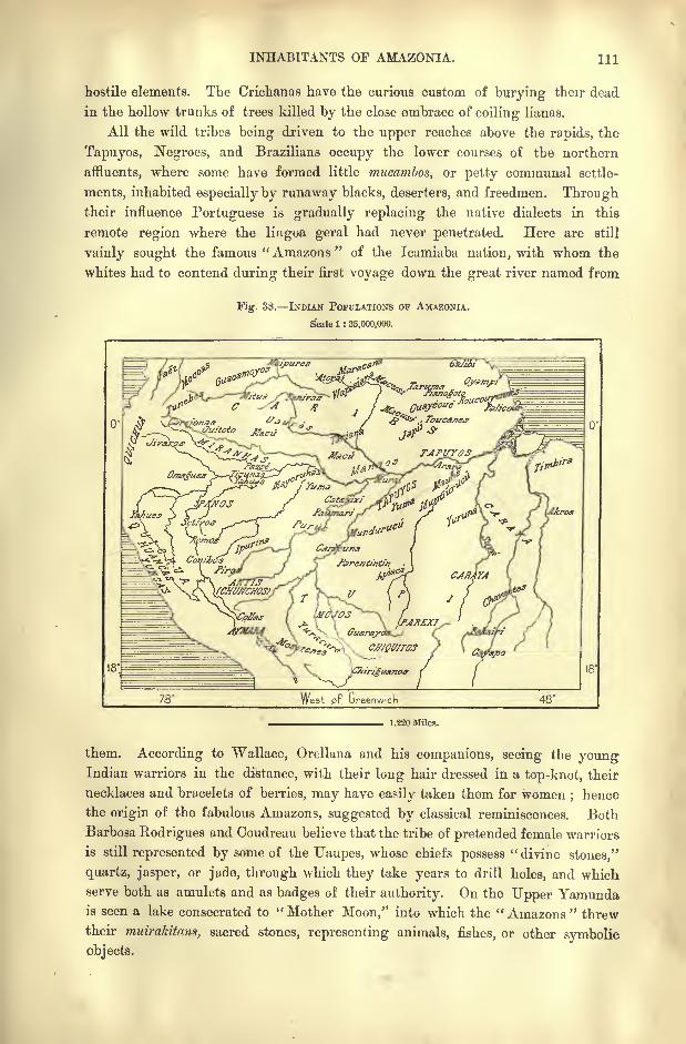
INHABITANTS OF AMAZONIA. Ill
hostile elements. The Crichanas have the curious custom of burying their dead
in the hollow trunks of trees killed by the close embrace of coiling lianas.
All the wild tribes being driven to the upper reaches above the rapids, the
Tapuyos, Negroes, and Brazilians occupy the lower courses of the northern
affluents, where some have formed little mucambos, or petty communal settle-
ments, inhabited especially by runaway blacks, deserters, and freedmen. Throughtheir influence Portuguese is gradually replacing the native dialects in this
remote region where the lingoa geral had never penetrated. Here are still
vainly sought the famous " Amazons "of the Icamiaba nation, with whom the
whites had to contend during their first voyage down the great river named from
Fig. 38. INDIAN POPULATIONS OF AMAZONIA.
Scale 1 : 35,000,000.
1,220 Miles.
them. According to Wallace, Orellana and his companions, seeing the youngIndian warriors in the distance, with their long hair dressed in a top-knot, their
necklaces and bracelets of berries, may have easily taken them for women; hence
the origin of the fabulous Amazons, suggested by classical reminiscences. Both
Barbosa Rodrigues and Coudreau believe that the tribe of pretended female warriors
is still represented by some of the Uaupes, whose chiefs possess" divine stones,'*
quartz, jasper, or jade, through which they take years to drill holes, and whichserve both as amulets and as badges of their authority. On the Upper Yamundais seen a lake consecrated to " Mother Moon," into which the " Amazons " threw
their muirakitans, sacred stones, representing animals, fishes, or other symbolic
objects.
112 AMAZONIA AND LA PLATA.
Rio JAVARY AND PURUS TRIBKS.
Independent wild tribes are far more numerous on the southern slope of the
Amazons valley, where they are reckoned by the hundred, all with their dis-
tinctive characters and special dialects, which, however, may be traced to one
great linguistic family. Those of the Rio Javary, on the Peruvian frontier, are
for the most part akin to the Panos, who appear to have reached a high state of
culture before they were again reduced to barbarism and nearly exterminated bywars and epidemics. The various tribes of the Rio Jurua appear to be of Arawak
stock, as are also the multitudinous little groups of the Purus valley. Amongstthese the Ipurinas are noted for their physical beauty and dignified presence.
They embellish themselves with black paintings on a scarlet ground, and also
engage in fierce combats "for pleasure," so that most of them are covered with
scars, of which they are very proud. A favourite game is to single out some tree
as an enemy, and pierce it with '
arrows, uttering the sharp cry,"I-pu-ri-na,
I-pu-ri-na !
" whence their name. So many of their warriors perish in battle that
the women greatly outnumber the men, and polygamy has become common.
Members of the Arawak family are also the Catauixi and the Pauinari of the
Lower Purue, although the latter bury their dead, like the Quichuas, in large
earthern jars, which are deposited in mortuary cabins. The Paumari, that is,
Pama-uri,"Berry-eaters," seem to be descended from the old Purus nation, who
gave their name to the river. Between the Purus and Madeira confluences the
right bank of the Amazons is roamed by a few survivors of the formerly powerful
Mura nation, who were nearly exterminated by the Mandurucus towards the close
of the eighteenth century. Although speaking a totally different language,
Bates affiliates them to their Mundurucu enemies, who are of Tupi stock. Theyare so indolent that "
lazy as a Mura sleeping on three strings"has become a
proverbial expression, implying that they have not energy enough to net them-
selves proper hammocks.
Rio MADEIRA TRIBES THE MUNDURUCUS.
About the cascades and rapids of the Madeira are encamped the Caripunas,
or "Watermen/' akin to other Caripunas of the Pano family, who occupy the
Ucayali valley. East of them follow the Parentintins, whose territory stretches
along the right bank of the Madeira, and thence through the forest eastwards in
the direction of the Rio Tapajoz. These are full-blood Tupis, who appear to have
migrated from the south, and who are at constant war with their eastern
neighbours, the Mandurucus.
Very different from these warlike tribes are the harmless and indolent Parexi,
Cabixi, Cachitini, and Vaimare, all Arawak peoples inhabiting the campos or
plateaux between the Guapore, Tapajoz, and Paraguay basins. These have come more
in contact with the whites, who have taught them the use of firearms, as well as of
iron implements for cultivating the soil. The}' are expert manufacturers of baskets,
sieves, hammocks, and textiles, with which they procure European wares from the
Brazilian traders. Thus they are becoming rapidly civilised, and many even get
INHABITANTS OF AMAZONIA. 118
baptized, though still preserving some of their old usages and religious practices.
The dead are buried under the hammock of the nearest akin, and provided with
food for the six days' journey which it takes to reach cloudland.
Along the middle course of the Tapajoz dwell several Tupi tribes, such as the
Apiacas (Abiabas, or "Men"), the Mundurucus and the Mauhes. Although
usually of peaceful habits the Apiacas still occasionally indulge in their old cannibal
practices. Those tattooed with three horizontal bars on the cheek are privileged to
eat their prisoners of war, the children captured on their predatory expeditions
being spared till their twelfth year, when they are served up at their sacred feasts.
Rumour speaks of a mysterious people in their district, the Jacareuaras, a race of
albinoes said to travel only at night, hence usually called MorccffOi, or " Bats."
Of all the Brazilian aborigines the most powerful are the Mundurucus, said byBates to number 20,000, and regarded by Couto de Magalhaes as typical children
of nature. Their settlements follow along the banks of the Tapajoz and in the
forest glades, and from them the whole country takes the name of Munducuriana.
Tall, stout, muscular, and of somewhat clear complexion, the various tribes and
classes are distinguished by their respective tattoo marks, which, although falling
into disuse, are still held in great respect. So elaborate were the designs that it
sometimes took ten years to complete the picture.
Loyalty to their pledged word, a proud and noble bearing are characteristics of
the Mundurucue, who are also skilled husbandmen and expert at featherwork and
various other arts. Formerly very warlike, they have developed a thorough
military organisation, preparing in peace for war, so that at the first sound
of the drum all fly to arms and muster in vast barracks, from which the women
are excluded. They always attack at dawn, their manoeuvres being directed bythe varied beat of the drum. In the fight no quarter is given, but after the vic-
tory every care is taken of the women and children, the latter being adopted to
repair the losses sustained in battle.
Rio TAPAJOZ A<SD XINGTJ TRIBES.
The Mauhes of the Lower Tapajoz, who have given their name to an extensive
system of creeks and channels on the south side of the Amazons, appear to belongto the same group as the Mundurucus, although long separated from them, and
speaking a totally different language. East and west of them are the fierce Arara
(Yuma) Caribs, who attack always by night, and who are regarded by the sur-
rounding populations rather as demons than men. Till lately the Mauhes were
the only natives who prepared the guarana, a decoction obtained from the beans
of a species of liana (paullinia sorbiiis], which is used throughout Brazil and even
in Bolivia against dysentery and ague. In local business transactions the paullinia
beans serve as currency.
East of the Tapajoz the Xingu basin appears from Karl von den Steinen's
researches (1884 87), to have been the point of dispersion for the various Carib
tribes, which under so many names have spread in successive waves of migrationnorth-west to the foot of the Andes, northwards to Guiana, Venezuela, and the
114 AMAZONIA AND LA PLATA.
Antilles, and whose origin had hitherto been sought in the "West Indies, or even
in the North American continent. The Bakairi and their northern neighbours,
the Nahuquas, are the purest members of the Carib family, judging at least from
their speech, which has been least modified by foreign elements.* Although sur-
rounded by Tupi and other races, they keep so aloof that till quite recently theystill belonged to the stone age, with no knowledge of the metals, of the dog, of the
banana and many other edible fruits well known to their neighbours. Theysmoke no tobacco and prepare no fermented drinks, while their earthenware is
greatly inferior to that of the kindred Roucouyennes of French Guiana.
From all this Von den Steinen concludes that of all the Caribs, the Bakairi
stand nearest to the primitive stock and to the cradle of the race. The national
legends speak of migratory movements in the direction from south to north, and such
movements have taken place even in the contemporary period. The Araras scattered
along the south side of the Amazons have the same tattoo markings as the Bakairi,
a blue line crossing the cheek from the corner of the mouth to the outer angle of
the eyelid.
Some of these primitive Caribs, converted to Christianity about the year 1820,
have at least adopted a show of culture, and their chief, dressed in an official
costume, has become a Brazilian captain. But there still remain some groups of
independent Bakairi, of peaceful habits, fond of music, and building straw huts
with a narrow entrance, like large bee-hives. Having little knowledge of the
industries, they procure various manufactured objects from their Suya neighbours,
who live farther down on the right bank of the Xingu. These Suyas are dis-
tinguished by their tall stature, physical strength, energy, and skill in making
pottery and wicker ware.
On the Lower Xingu the chief people are the Yurunas of Tupi stock, formerly
cannibals, but now noted for their gentle disposition and hospitality. Nevertheless,
they still avoid contact with the whites, and continue to deck themselves with
glass bead necklaces, girdles, and pendants, and wear the hair plaited in a single
long pigtail. They are unsurpassed in taming animals, and every village is a
menagerie of tapirs, monkeys, agoutis, toucans, parrokeets, and other pets. The
Yurunas would be the happiest of mortals but for the raids of the fierce Carayas,
who infest the right bank of the Xingu, and who are akin to others of the same
name in the Araguay and Tocantins basins.
TOPOGRAPHY OF AMAZONIA.
The impression produced on a traveller steaming up the Amazons is that of a
boundless solitude. Towns properly so called are extremely rare, and manystations whose names are of frequent occurrence in books of travel are mere clusters
of cabins. Such is Tabatinga, the frontier post towards Peru, which consists of
two or three little dwellings and a half-ruined fort on the left bank of the Amazons,
here 1,600 yards wide. A somewhat large place is 8. Paulo de Olirciiya on the
* Karl von den Steinen, Durch central Brtuilien ; Paul Ehrenreich, Petermann's MMeilungen, 1891,
Hef c IV-
TOPOGBAPHY OF AMAZONIA. 115
south side, which stands on a bluff rising 215 feet above low -water level.
Tunantins, on the left bank between the loops of the Iq& and Jutahy affluents,
stands on the site of the old mission of Tunati.
Being easily navigable to the foot of the Andes by craft drawing six or seven
feet, the lea is much visited by rubber and sarsaparilla seekers. Its upper course
is occupied by the Macaguajes, the middle by the Orejones, and the lower by the
Ticunas. The Orejones slit lips, ears, and nostrils for the insertion of ornaments,
wear a willow band as the national costump, still wield the stone axe, and make
some fine pottery.
From Tunantins to the port of Fonte Boa (" Good Well ") follow a series of
islands formerly frequented by millions of turtles, which yielded vast quantities of
oil to the Portuguese traders. But being recklessly hunted down, they have
now forsaken these breeding-grounds.
TEFFE STATIONS ON THE PURUS AND MADEIRA.
Tcffe, formerly Ega, owes its present name to the river on which it stands.
Although containing less than 1,000 inhabitants, it ranks as a great city in the
Solimoes basin. Its foundations were laid in 1668 by the missionary Samuel Fritz
as a station for Indians who have since lost their tribal name and become mergedwith the other half-caste Tapuyo populations. In 1781 the Hispano-Portuguese
Boundary Commission established its headquarters at Ega, and the naturalist
Bates made choice of the same place as the centre of his excursions in UpperAmazonia during the years 1850-59.
TefFe enjoys great natural advantages in its healthy climate, its almost complete
immunity from mosquitoes, its rich soil and vegetation, its excellent commercial
position in the centre of a network of navigable waters, and lastly its spacious
harbour formed by the deep lake fed by the Rio Teffe by a lateral channel on its
right bank. It is also a pleasant place of residence, every house having its orange
and banana grove and its turtle pond.
On the west side of the lake stands the village of Nogueira, famous throughout
Amazonia for its earthenware decorated with geometrical designs. Farther down
follow the settlements of Coary (Avellos) on the right bank, at the mouth of the
Rio Coary, and Codajaz on one of the creeks, through which the Lower Japura
communicates with the Solimoes.
Till recently the great River Purus, longer than the Danube, had not a single
white habitation on its banks. But despite its insalubrity, the crowds of mosquitoes,
and other drawbacks, the extreme richness of its forests in rubber and other
valuable products has somewhat suddenly begun to attract settlers. The first
steamer, which made its appearance in 1862, was followed in 1869 by a flotilla of
15 boats, by which a regular service was established from the Amazons to the
first camping grounds of the seringueiros. These rubber-hunters increased from
2,000 in 1871 to no less than 50,000 in 1890, nearly all nomads, besides the local
tribes.
In 1871 Labre, one of the most active explorers of the Upper Purus basin,
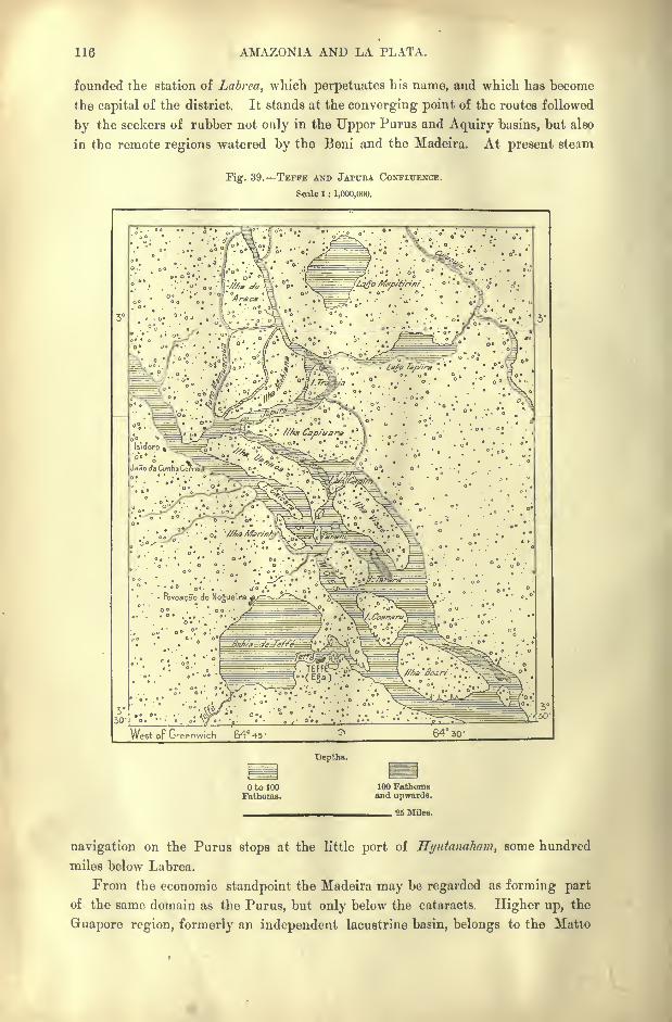
116 AMAZONIA AND LA PLATA.
founded the station of Labrca, which perpetuates his name, and which has become
the capital of the district. It stands at the converging point of the routes followed
by the seekers of rubber not only in the Upper Purus and Aquiry basins, but also
in the remote regions watered by the Beni and the Madeira. At present steam
Tig. 39. TEFFB AND JAPTTRA CONFLUENCE.
Scale 1 : 1,000,000.
Depths.
to 100Fathoms.
100 Fathomsand upwards.
_ 25 Miles.
navigation on the Purus stops at the little port of Hyutanaham, some hundred
miles below Labrea.
From the economic standpoint the Madeira may be regarded as forming part
of the same domain as the Purus, but only below the cataracts. Higher up, the
Guapore region, formerly an independent lacustrine basin, belongs to the Matto
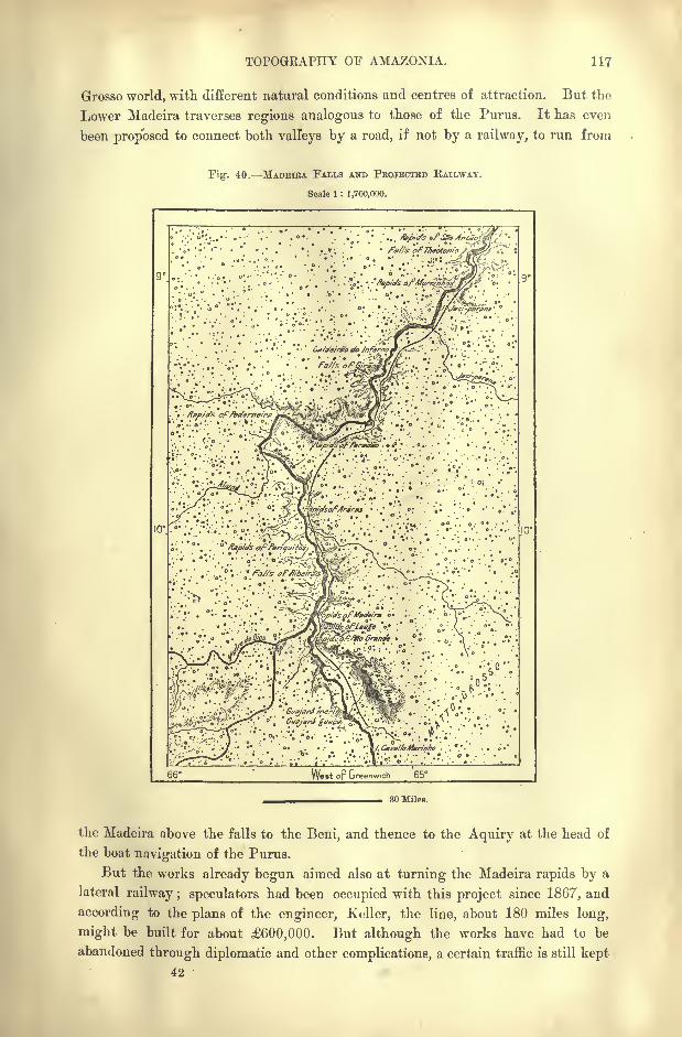
TOPOGEAPHY OF AMAZONIA. 117
Grosso world, with different natural conditions and centres of attraction. But the
Lower Madeira traverses regions analogous to those of the Purus. It has even
been proposed to connect both valleys by a road, if not by a railway, to run from
Fig1
. 40. MADEIRA FALLS AND PROJECTED RAILWAY.
Scale 1 : 1,700,000.
9
. . O
So Grand, . i-., o .'iS ;
'
.V
"Z-^^--^r' ;;. . :. .; v<< Vc^x; &''
:U^-%^ "')'.' -..
:<>"-
c
'' ;<" "';
':
'.l/'^}/i:ol'
:;''.
S^Srr^-' oV-o ';/' ;>>; ''; ^^T^???/ ?-'.
:
.
66 Wet op Greenwrch 65
30 Miles.
the Madeira above the falls to the Beni, and thence to the Aquiry at the head of
the boat navigation of the Purus.
But the works already begun aimed also at turning the Madeira rapids by a
lateral railway ; speculators had been occupied with this project since 1867, and
according to the plans of the engineer, Keller, the line, about 180 miles long,
might be built for about 600,000. But although the works have had to be
abandoned through diplomatic and other complications, a certain traffic is still kept
42
118 AMAZONIA AND LA PLATA.
up between the two navigable sections of the Madeira despite the labour and
expense involved in loading and unloading at the different portages.
Santo Antonio on the right bank guards the lower approaches to the cataracts.
Lower down all the way to the Amazons, a distance of 660 miles, the only settle-
ments are a few little hamlets, such as Crato, Humaita, and Borba. Crato has
succeeded another Crato which served as a place of exile for political offenders
under the Portuguese rule.
STATIONS IN THE Rio NRG no BASIN MANAOS.
The Rio Negro, interrupted, like the Madeira, by rapids, has scarcely more
inhabitants along its lower course above Manaos. Towards the close of the eigh-
teenth century the riverside stations of Thomar, Moreira, Barcellos, and Ayrao had
acquired some importance, thanks to the enforced labour of the natives on the
cotton, rice, indigo, coffee, cacao, and tobacco plantations, and in the cotton spin-
ning and weaving factories. But this industry, which supplied cotton stuffs for
the whole of the Rio Negro basin and even for the province of Para, rested on
the unstable foundation of a system of practical slavery, and was ruined by a
change in the local administration. The Indians took refuge in the forests, and
the settlements were soon reduced to a few groups of wretched hovels.
On the banks of the Uaupes are situated some groups of population, such as
Juaurite, Panore, and Taraqua, which, having about 300 inhabitants each, seem
like veritable cities amid the surrounding wilderness. Of the so-called " towns "
on the Rio Negro below the Uaupes Barcellos is the largest, yet at the time of
Coudreau's visit in 1884 it comprised only 30 houses. But in the last century,
when it was the capital of a "captainry," it had as many as 4,000 inhabitants.
Most of these emigrated in 1809, when Barcellos was replaced by Manaos as the
centre of the administration.
At that time the Rio Branco also contained a few large villages, such as Santa
Maria, Carmo, and Pesqneira Real, the very sites of which can no longer be
identified. They are chiefly replaced by the pleasant little town of Boa Vista on
the left bank below the fort of S. Joaquim.
Manaos, formerly Barm, or Fortalezo da Barm do Rio Negro, takes its present
name from a powerful Tupi tribe, who offered a stout resistance to the Portuguese
invaders. It occupies a considerable space on the left bank of the Amazons above
the level of the highest floods and about 10 miles above the Rio Negro confluence.
Since 1850, when it became the capital of Amazonia, it has gradually attracted to
itself nearly all the trade of the great river and its innumerable affluents. Its
advantageous position at the converging point of the great navigable highways of
the Solimoes, Amazons, Rio Negro, and Madeira makes Manaos the natural
emporium for the produce of half Brazil. Being also accessible to deep-sea vessels,
it has developed a direct foreign trade since 1876;
hence in recent years the
population has greatly increased, especially by immigration from Ceara, and
according to Barbosa Rodrigues, here are already concentrated half the inhabi-
tants of the vast province of Amazonia. Here also reside most of the foreign
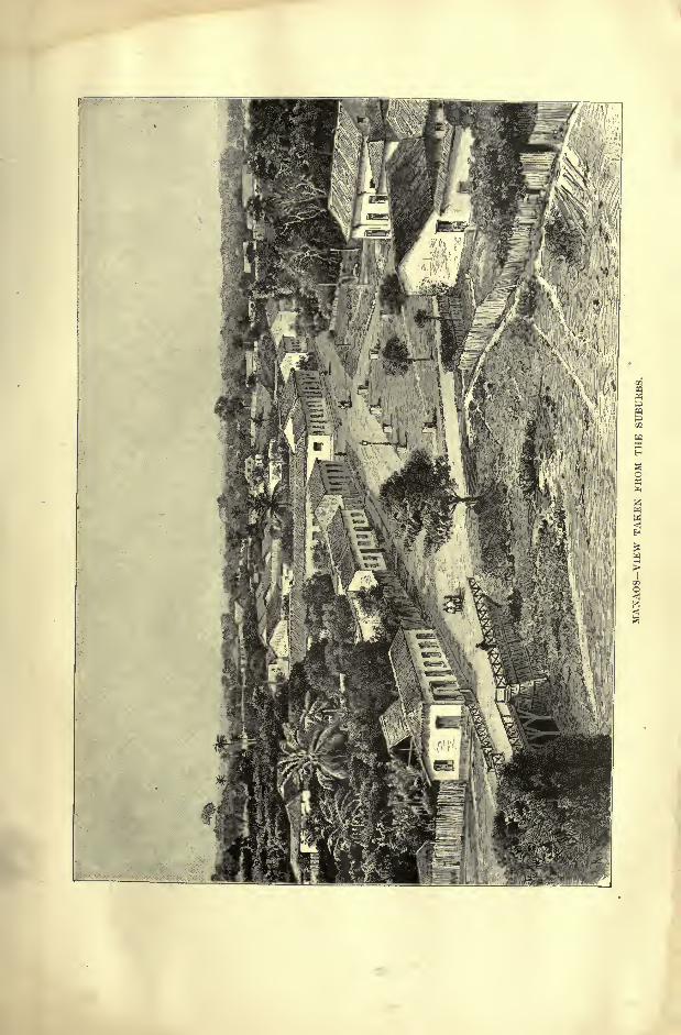
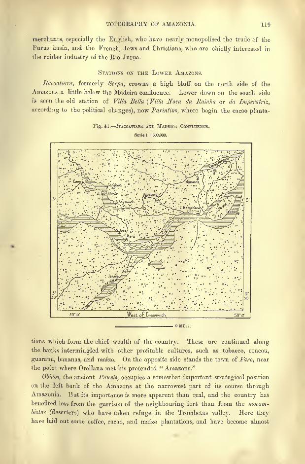
TOPOGRAPHY OF AMAZONIA. 119
merchants, especially the English, who have nearly monopolised the trade of the
Furus basin, and the French, Jews and Christians, who are chiefly interested in
the rubber industry of the Rio Jurua.
STATIONS ON THE LOWER AMAZONS.
Itacoattara, formerly Serpa, crowns a high bluff on the north side of the
Amazons a little below the Madeira confluence. Lower down on the south side
is seen the old station of Villa Bella (Villa Nova da Rainha or da Imperatriz,
according to the political changes), now Parintim, where begin the cacao planta-
Fig. 41. ITACOATIAEA AND MADEIRA CONFLUENCE.
Scale 1 : 500,000.
59'iO' nest or Greenwich 58'iCf
9 Miles.
tions which form, the chief wealth of the country. These are continued alongthe banks intermingled with other profitable cultures, such as tobacco, roucou,
guarana, bananas, and maize. On the opposite side stands the town of Faro, near
the point where Orellana met his pretended" Amazons."
Obidos, the ancient Pauxis, occupies a somewhat important strategical position
on the left bank of the Amazons at the narrowest part of its course throughAmazonia. But its importance is more apparent than real, and the country has
benefited less from the garrison of the neighbouring fort than from the mocam-
bistas (deserters) who have taken refuge in the Trombetas valley. Here theyhave laid out some coffee, cacao, and maize plantations, and have become almost
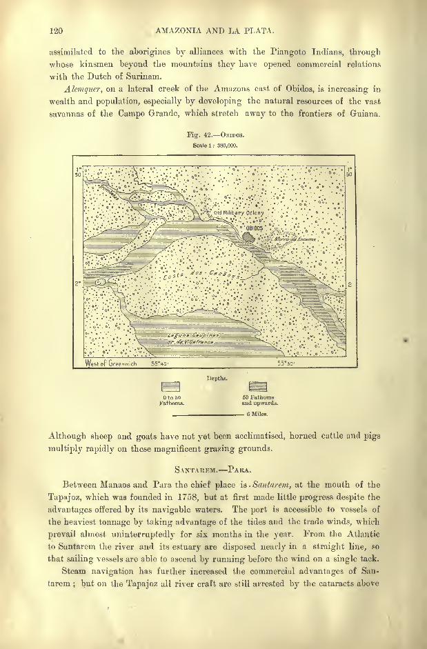
120 AMAZONIA AND LA PLATA.
assimilated to the aborigines by alliances with the Piangoto Indians, through
whose kinsmen beyond the mountains they have opened commercial relations
with the Dutch of Surinam.
Alemquer, on a lateral creek of the Amazons east of Obidos, is increasing in
wealth and population, especially by developing the natural resources of the vast
savannas of the Campo Grande, which stretch away to the frontiers of Guiana.
Fig. 42. OBIDOS.
Scale 1 : 380,000.
*. '.*"* 'v : ia/guna -Caupinas
West oF Greenwich 55Vcr 5530-
Depths.
OtooOl-'athoiiis.
50 Fathomsand upwards.
6 Miles.
Although sheep and goats have not yet been acclimatised, horned cattle and pigs
multiply rapidly on these magnificent grazing grounds.
SANTAREM. PARA.
Between Manaos and Para the chief place is . Santarew, at the mouth of the
Tapajoz, which was founded in 1758, but at first made little progress despite the
advantages offered by its navigable waters. The port is accessible to vessels of
the heaviest tonnage by taking advantage of the tides and the trade winds, which
prevail almost uninterruptedly for six months in the year. From the Atlantic
to Santarem the river and its estuary are disposed nearly in a straight line, so
that sailing vessels are able to ascend by running before the wind on a single tack.
Steam navigation has further increased the commercial advantages of San-
tarem ; but on the Tapajoz all river craft are still arrested by the cataracts above
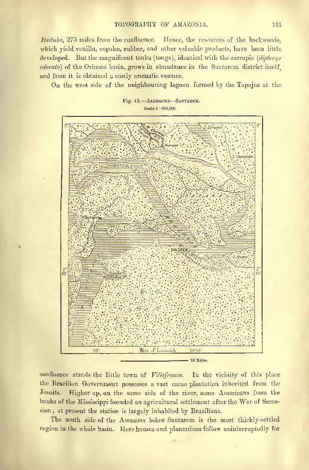
TOPOGRAPHY OF AMAZOXIA. 121
Itaitttba, 275 miles from the confluence. Hence, the resources of the backwoods,
which yield vunilla, copahu, rubber, and other valuable products, have been little
developed. But the magnificent tonka (tonga), identical with the sarrapia (diptcryx
odorata) of the Orinoco basin, grows in abundance in the Santarem districtitself,
and from it is obtained a costly aromatic essence.
On the west side of the neighbouring lagoon formed by the Tapajoz at the
Fig. 43. ALEMQTTEB SANTABEM.
Scale 1 : 800,000.
West oP GreenwicK 54*40'
18 Miles.
confluence stands the little town of Villafranca. In the vicinity of this place
the Brazilian Government possesses a vast cacao plantation inherited from the
Jesuits. Higher up, on the same side of the river, some Americans from the
banks of the Mississippi founded an agricultural settlement after the War of Seces-
sion;at present the station is largely inhabited by Brazilians.
The south side of the Amazons below Santarem is the most thickly-settled
region in the whole basin. Here houses and plantations follow uninterruptedly for
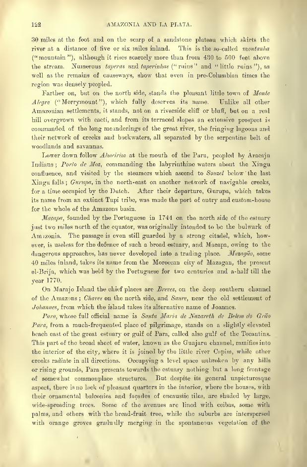
122 AMAZONIA AND LA PLATA.
30 miles at the foot and on the scarp of a sandstone plateau which skirts the
river at a distance of five or six miles inland. This is the so-called montanha
("mountain"), although it rises scarcely more than from 430 to 500 feet above
the stream. Numerous taperas and taperinhas (" ruins" and "little ruins "), as
well as the remains of causeways, show that even in pre-Columbian times the
region was densely peopled.
Farther on, but on the north side, stands the pleasant litrle town of Monte
Alcgre ("Merrymount"), which fully deserves its name. Unlike all other
Amazonian settlements, it stands, not on a riverside cliff or bluff, but on a real
hill overgrown with cacti, and from its terraced slopes an extensive prospect is
commanded of the long meanderings of the great river, the fringing lagoons and
their network of creeks and backwaters, all separated by the serpentine belt of
woodlands and savannas.
Lower down follow Almcirim at the mouth of the Paru, peopled by Aracaju
Indians;Porto de Moz, commanding the labyrinthine waters about the Xingu
confluence, and visited by the steamers which ascend to Souzcl below the last
Xingu falls; Gurupa, in the north-east on another network of navigable creeks,
for a time occupied by the Dutch. After their departure, Gurupa, which takes
its name from an extinct Tupi tribe, was made the port of entry and custom-house
for the whole of the Amazons basin.
Macapa, founded by the Portuguese in 1744 on the north side of the estuary
just two miles north of the equator, was originally intended to be the bulwark of
Amizonia. The passage is even still guarded by a strong citadel, which, how-
ever, is useless for the defence of such a broad estuary, and Macapa, owing to the
dangerous approaches, has never developed into a trading place. Muzngao, some
40 miles inland, takes its name from the Moroccan city of Mazagan, the present
el-Brija, which was held by the Portuguese for two centuries and a-half till the
year 1770.
On Marajo Island the chief places are Brcrcs, on the deep southern channel
of the Amazons ;Chares on the north side, and Saure, near the old settlement of
Jo/tannes, from which the island takes its alternative name of Joannes.
Para, whose full official name is Santa Maria de Nazareth de Be/cm do Grao
Para, from a much-frequented place of pilgrimage, stands on a slightly elevated
beach east of the great estuary or gulf of Para, called also gulf of the Tocantins.
This part of the broad sheet of water, known as the Guajaru channel, ramifies into
the interior of the city, where it is joined by the little river C.ipim, while other
creeks radiate in all directions. Occupying a level space unbroken by any hills
or rising grounds, Para presents towards the estuary nothing but a long frontuge
of somewhat commonplace structures. But despite its general unpicturesque
aspect, there is no lack of pleasant quarters in the interior, where the houses, with
their ornamental balconies and facades of encaustic tiles, are shaded by large,
wide-spreading trees. Some of the avenues are lined with ceibas, some with
palms, and others with the bread-fruit tree, while the suburbs are interspersed
with orange groves graduilly merging in the spontaneous vegetation of the
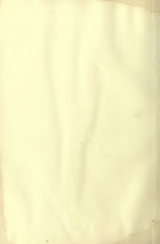
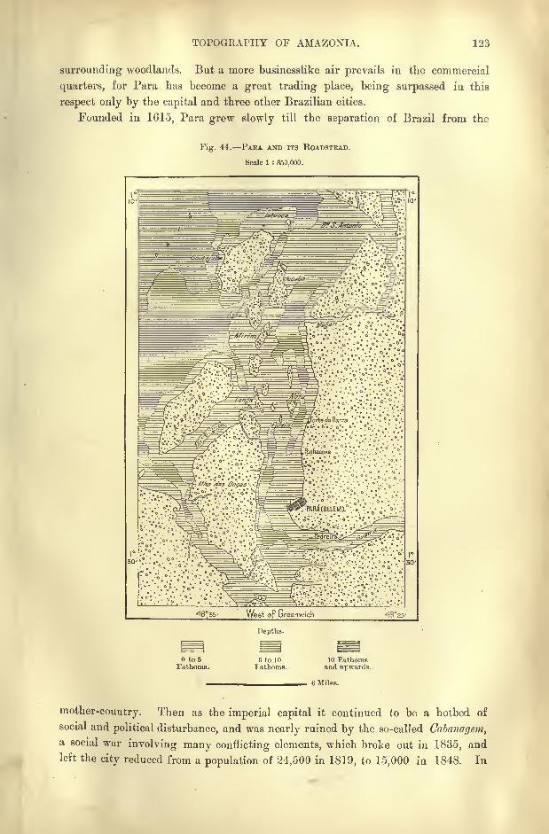
TOPOGRAPHY OF AMAZONIA. 123
surrounding woodlands. But a more businesslike air prevails in the commercial
quarters, for Para has become a great trading place, being surpassed in this
respect only by the capital and three other Brazilian cities.
Founded in 1615, Para grew slowly till the separation of Brazil from the
Fig. 44. PABA AND ITS ROADSTEAD.
Scale 1 : 350,000.
Depths.
to 5Fathoms.
ft to 10
Fathoms.10 Fathomsand upwards.
6 Miles.
mother-country. Then as the imperial capital it continued to be a hotbed of
social and political disturbance, and was nearly ruined by the so-called Cabanagem,a social war involving many conflicting elements, which broke out in 1835, andleft the city reduced from a population of 24,500 in 1819, to 15,000 in 1848. In
124 AMAZONIA AND LA PLATA.
1850 the yellow fever made its first appearance, struck down two-thirds of the
inhabitants, and drove the rest to seek safety in flight.
Since then Para has made astonishing progress, the population increasing more
than sixfold and the exchanges over tenfold in four decades. All the retail busi-
ness and a considerable amount of the foreign trade, as well as several of the
industries, are in the hands of recent Portuguese immigrants, who here display a
great spirit of solidarity.
Although over 60 miles from the sea, the channel at Para is still 23 feet deep,
giving access to large vessels, which here ship rubber (the finest in the world),
cacao, hides, drugs, Peruvian straw hats, and other produce, in exchange for
preserves, breadstuff, and European wares of all sorts. Most of the exchangesare with the United States, England, and France in the order named.
Round about Para are several little trading places, such as Viyia, at the
entrance of the estuary ; Salinas, on the white cliffs facing seawards; Braganqa,
farther east, a watering place now connected by rail with Para; Camcta, on a
high bluff west of the Tocantins, which is here five miles wide.

n ii
^M^&^&s^*-
FJIMtf" ^ MJtVl' :
J
\ ^^jli-f ff|;.";
;;
f p/frft'H >^ 1
.^Hi!"-. liE^ff ''rJ'
H w-' S "*
4Ai-jS r
P^i'l I il i i ! i 111
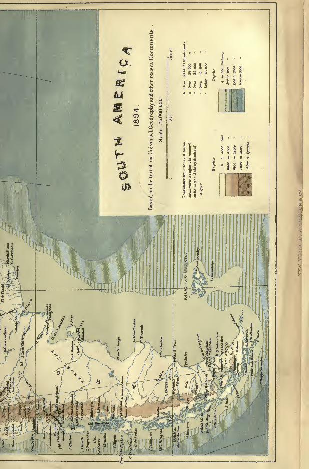
CHAPTER VII.
THE TOCANTINS BASIN-STATE OF GOYAZ.
HE Tocantins hydrographic system is closely connected with that of
the Amazons. If, as seems probable, a continuous subsidence of
the old marine bed has given access to the Atlantic waters,
causing them to flood the lands at present occupied by the
Amazonian gulf, the Tocantins must at one time have communi-
cated directly with the Amazons through a confluence lying to the east of MarajoIsland. It was thus a simple affluent of the great river. In any case it flows
from the same slope as the Xingu, the Tapajoz, and the other southern tributaries
of the main stream, and its course is developed in the same direction.
But the Tocantins, rising in the very heart of the Brazilian orographic system,
is conterminous about the region of its sources with two other large fluvial basins,
those of the S. Francisco and the Parana. Hence it has been proposed to found
a new capital of the federal republic on this dividing line near the diverging
point of three great rivers.
There is no coincidence between the political frontiers of Goyaz and the natural
limits of the Tocantins catchment basin. Goyaz, the superficial area of which maybe approximately estimated at about 300,000 square miles, occupies south of the
P}rreneos divide part of the southern slope draining to the Parana, and towards
the west it comprises no more than one-half of the Araguaya Valley ;the channel
of this river in fact forms its frontier towards Matto Grosso and Amazonia.
The drainage area itself is otherwise very sharply defined. An oval-
shaped cirque is developed round the sources of the two main branches
Tocantins and Araguaya. and this cirque is closed northwards by the rocky
ridges where are formed the last fluvial cataracts. The outer walls of this vast
amphitheatre are formed, if not by distinct mountain ranges, at least by the
escarpments of a plateau. Towards the east especially the edge of the basin
rises in scarps of bold relief, which have even received the name of serras
(" ranges "), from the aspect which they present towards the valley. Such are
the Serra das Mangabeiras, the Serra do Douro, da Tabatinga, and do Paranan.
In reality these heights consist of chapadocs, fragments of a sandstone plateau
at a mean elevation of 1,300 feet, above which rise at intervals cubic masses about
165 feet higher, with a few intervening depressions of corresponding depth-
126 AMAZONIA AND LA PLATA.
The whole region formerly constituted a level plain, whose present inequalities
are due to the erosion of running waters. But for a small part of its lower
course the Tocantins flows through the alluvial plain which forms an eastern pro-
longation of that of the Amazons.
AMAZONS AND TOCANTINS BASINS.
The absolutely unknown regions of this basin still comprise a very large por-
tion of its area. It is generally so inaccessible that explorers, amongst whommust be mentioned Francis de Castelnau, Couto de Magalhaes, Hassler, and Ehren-
reich, have for the most part confined their excursions to the river and its imme-
diate vicinity. Goyaz has also been visited by Pohl and Natterer, and during
the eighteenth century a few voyages of discovery were undertaken, although
such expeditions were forbidden by the Portuguese Government through its dread
of all change. Tavares Lisbao, guilty of having made the descent of the Tocan-
tins as far as Para, was imprisoned with his companions, and had a narrow escape
from capital punishment.
Two rivers of equal length, and differing little in volume, unite to form the
mainstream. These are the Tocantins, properly so called, and the Araguaya,
whose mutual relations may be compared to those of the Loire and Allier in France.
Between the two Brazilian as between the two French watercourses there
stretches a line of heights sufficiently elevated to assume in some places the aspect
of mountains, and collectively forming a distinct geological zone. In Goyaz this
zone consists of metamorphic rocks encircled by sandstones.
The farthest sources of the Tocantins or eastern brunch escape from an upland
valley enclosed by the transverse ridge of the Pyreneos, and are collected in the
placid Lake Formosa. They emerge from this basin in the single channel of
the Maranhao, which flows first north-west, and then trends round at a right angle
to the north-east.
After its junction with a torrent from the Montes Glares, the Maranhao takes
the name of Tocantins, which it preserves for the rest of its course to the sea.
Its volume is doubled by the Parana (Parana-Tinga, or "White Hiver "), which
collects all the streams descending from the western slopes of the Paranan and
Tabatinga Mountains.
Below the Parana confluence the Tocantins would be accessible to large
steamers but for the rocky ledges interrupting its course at several points.
Various other affluents follow, nearly all from the eastern slope, amongst them
the Rio do Somno, descending from a divide 2,140 feet high, whose waters are dis-
charged through the Sapaotothe S. Francisco basin and through the Somninho
to the Tocantins. On Homem de Mello's map of 1885, a lakelet on the crest of
the divide is even figured as discharging, besides these two emissaries, a third
affluent, the Novo, flowing also to the Tocantins.
After its junction with the Manoel Alves Grande the mainstream forces its
way by a succession of abrupt changes through a series of rocky barriers, by the
northernmost of which it is at last deflected westwards to the Araguaya.
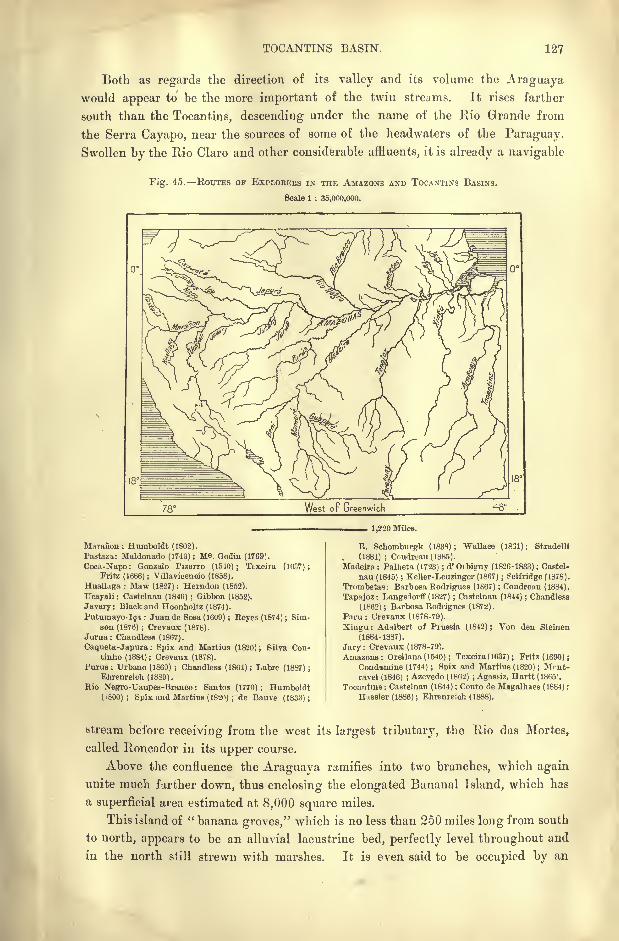
TOCANTINS BASIN. 127
Both as regards the direction of its valley and its volume the Araguayawould appear to be the more important of the twin streams. It rises farther
south than the Tocantins, descending under the name of the Rio Grande from
the Serra Cayapo, near the sources of some of the headwaters of the Paraguay.
Swollen by the Rio Claro and other considerable affluents, it is already a navigable
Fig. 45. ROUTES OF EXPLORERS IN THE AMAZONS AND TOCANTINS BASINS.
Scale 1 : 35,000,000.
F Greenwich 48
1,220 Miles.
Maraiion : Humboldt (1802).
Pastaza: Maldonado (1743) ; M Godin (1769).
Coca-Napo: Gonzalo Pizarro (1540); Texeira (1637);Fritz (1686) ; Villavicencio (1858).
Huallaga : Maw (1827); Herndon (1852).
Ucayali: Castelnau (1846) ;Gibbon (1852).
Javary: Black and Hoonholtz (1874).
Putumayo-191 : Juan de Sosa (1609) ; Keyes(1874); Sim-son (1876) ; Crevaux (1878).
Jurua: Chandless (1867).
Caqueta-Japura : Spix and Martius (1820); Silva Cou-tinho (1884); Crevaux (1878).
Purus : Urbano (1860) ; Chandless (1864) ; Labre (1887) ;
Ehrenreioh (1889).
Kio Negro-TJaupes-Branco : Santos (1770) ; Humboldt(ifeOO); Spix and Murtius ( 1820) ; de Bauve (1833);
E. Scliomburgk (1838) ; Wallace (1831) ; Stradelli
(1881) ; Coudreau(1885).Madeira ; Palheta (1723) ; d'Oibigny (1826-1833); Castel-
nau (1845) ; Keller-Leuzinger (1867) ; Selfridge (1878).
Trombetas: Barbosa Bodrigues (1S67) ; Condreau (1884).
Tapajoz: Langsilorff (1827) ; Castelnau (1844) ; Chandless
(1862) ; Barbosa Bodrigues (1872).
Para : Crevaux (1878-79).
Xingu : Adalbert of Prussia (1842) ; Von den Steinen
(1884-1887).
Jary : Crevaux (1878-79).
Amazons: Orellana (1540) ; Texeira ( 1637 ); Fritz (1690) ;
Condamine (1744) ; Spix and Martius (1820) ; Mf'nt-
ravel (1846) ; Azevedo (1862) ; Agasfiz, Hartt (1865).
Tocantins : Castelnan (1844) ; Conto de Magalhaes (1884) ;
Hassler (1836) ; Ehrenreich (1888).
stream before receiving from the west its largest tributary, the Rio das Mortes,
called Roncador in its upper course.
Above the confluence the Araguaya ramifies into two branches, which again
unite much farther down, thus enclosing the elongated Baiianal Island, which has
a superficial area estimated at 8,000 square miles.
This island of " banana groves," which is no less than 250 miles long from south
to north, appears to be an alluvial lacustrine bed, perfectly level throughout and
in the north still strewn with marshes. It is even said to be occupied by an
128 AMAZONIA AND LA PLATA.
extensive sheet of water which discharges into the eastern or lesser branch of the
Araguaya. Farther north follow two other islands of similar formation skirting
the Serrados Cayapos, which gradually converges on the river, throwing off trans-
verse ridges of gneiss or igneous origin across the stream. Thus are formed the
series of cascades and rapids through which the Araguaya descends from the
plateaux to the Amazonian plains. In a space of about 18 miles it descends a
total incline of 85 feet, and beyond this zone of cataracts the river becomes
entangled in rocky gorges, about 500 feet wide, terminating in the Cachoeira
Grande ("Great Cataract"), where it falls 50 feet in a distance of 12 miles.
Then it pursues a tranquil course to a point where it is abruptly deflected
northwards to its confluence with the Tocantins.*
Below the confluence the united stream, which retains the name of Tocantins,
is still obstructed by numerous rapids, one of which at the Tauiry rocks com-
pletely arrests the navigation except, for boats of light draught at high water in
March and April. Even below the last falls of Itaboca the channel is interrupted
by sunken reefs, so that the regular navigation stops at the ruined fort of
Alcobaca, where at low water the river falls to a depth of about three and a half
feet. Here it is distant 130 miles from the system of navigable creeks through
which it enters the Para estuary. Hence the whole of Goyaz is deprived of all
natural communication with the coast, and its two great watercourses require to
be supplemented by canals, roads, or railways before they can be of much use in
developing the resources of the country.
CLIMATE or GOYAZ.
To Goyaz a great diversity of climate is imparted by the course taken bythe Tocantins from south to north and along a steeply-inclined slope. From the
sources of the Araguaya to the Para estuary the river traverses 17 of southern
latitude, and there is a total descent of about 4,000 feet between the crest of the
divide in the Serra Goyana and the alluvial coastlands. Thus the lower section
of the fluvial basin falls within the Amazonian zone and consequently enjoys a
hot moist climate, with but slight vicissitudes between diurnal and periodical
temperatures, whereas the upland regions naturally present far greater extremes
of heat and cold. Under the influence of the normal south-east trades, or of
the south-western winds, the glass here falls at times several degrees below freez-
ing-point, especially during the month of August, while the summer heats
occasionally exceed 104 Fahr.
A correspondingly high range occurs between day and night when the wind
veers round abruptly from one quarter to the other, and differences of 36 or even
46 have been recorded in less than 24 hours. Summer is ushered in with the
*Hydrographic system of the two rivers :
Draiaoge Discharge in
Length in area in cubic feet
Eng. miles. square miles. per second.
Tocantins . . . l,5oO 190,000 ?
Araguaya . . . 1.250 164,000 ?
United Stream . . 1,740 354,000 350,000?
INHABITANTS OF GOYAZ. 129
rains which begin to fall in September, and which in the upland Tocantins valleys
appear to represent an annual precipitation of nearly 80 inches.
FLORA AND FAUNA.
On the lower Goyaz slopes the selva is developed in a continuous sea of
verdure interrupted only by the watercourses;but on the upland forests it becomes
rarer and more open. Here most of the surface is occupied with terraced campos
(savannas), where arborescent vegetation is represented only by isolated clumps,
or catingas, that is, groves and thickets interrupted by numerous clearings. In
the more fertile regiuns these catingas present the aspect of pleasant parklands,
while elsewhere they have a wretched appearance, compared by the white settlers
to neglected orchards.
The slopes descending from the sparsely-wooded plateaux to the leafy forest
tracts are clothed with a tall herbaceous vegetation. Here certain southern species
already indicate the transition between the Amazons and Plate basins. South of
the chapadoes the plateaux are overgrown with several varieties of the canella
de ema (vettosia maritima], an extremely picturesque plant with terminal clusters
of lovely white flowers protected by pendent fibres like the leaves of weepingwillows.
The waters of the Tocantins are frequented by three species of caymans as well
as by dolphins. Its upper affluents are said to be inhabited by the minhoceo, a
prodigious species of lepidosiren, resembling a huge worm, and big enough to
drag down and drown large animals. The so-called " ostriches"
of Argentina
range as far as South Goyaz.
INHABITANTS.
Although their name is perpetuated in that of the region traversed by the
Tocantins, the Goyaz or Guayaz Indians are extinct as a separate nation, and
their descendants are now merged with tribes of a different origin. At present
the most important indigenous people are the Cayapos, who are met also under
other names in Matto Grosso and S. Paulo. In Goyaz, where they are said
to number about 12,000, they live mostly apart from the settlements in the
western mountains between the Araguaya and the Xingu rivers, and in the north-
east on the borders of the State of Maranhao.
According to their language and usages, the Cayapos must be grouped with
the widespread Ges family, so named by Martius from the final syllable of most
of the tribal denominations. But the shape of the head, which is highly brachy-
cephalic, differs from that of all other members of the Ges connection. They are
also distinguished by an extremely marked Mongoloid type. Like the kindred
Botocudos, the Cayapos wear the botoque or wooden disc in the lower lip. But
they are much more industrious than the Botocudos, and display great skill in the
preparation of arms, instruments, and various other objects.
Other Indians of the same race, known to the Brazilians by the name of
Chavantes, dwell in the Araguaya basin, and especially in the region traversed
130 AMAZONIA AND LA PLATA.
by the Rio das Mortes. They call themselves Akue, and to the same group
belong the Chikriabas of the divide between the Paranatinga and Paranahyba
rivers, the Akroas and Cherentes of the Rio do Somno and of the Tocantins above
the " Two Bars," and the Apinages, naked savages of the hilly district between
the Araguaya and the Tocantins. Couto de Magalhaes asserts that the Chavantes
eat their dead children in order to again assimilate them. At Goyaz, Castelnau
saw a Cherent captive with nearly two hundred scars on his breast indicating the
number of men he had killed and eaten. Those on the right side represented the
"Christians," those on the left the natives.
The Carayas, who also roam the right bank of the Xingu, have their chief
tribes on the western slopes of the Araguaya valley, in Bananal Island, and,
east of the Tocantins, on the borders of the provinces of Para and Maranhuo.
They are regarded as of different stock from the Ges, Tupi, and Carib races, and
their polysyllabic language appears, to be fundamentally distinct from all other
South American tongues. Most of the Carayas have very narrow skulls, upturned
nose, small and slightly oblique eyes, and much less coarse hair than that of most
other natives.
Amongst the numerous Caraya tribes, who muster altogether about 4,000"bows," the Chamboas appear to be the most mixed, owing to numerous alli-
ances with the Cayapos and the frequent adoption of captive children. The
Ccirayas are probably the most :-killed craftsmen of all the Brazilian aborigines ;
they are also expert boatmen, and the tribes formerly known as Canoeiros (" Canoe-
men ") belonged probably to this race. Morally the Carayas are distinguished
by their sober habits, truthfulness, and contempt of stratagem. Their dead are
buried in a vertical position, the head being left above ground, so that they can
still be fed with bananas and other food.
In South Goyaz the Negro element was at one time relatively very numerous.
But most of the slaves perished without leaving any issue;over 100,000 were
said to be employed on the plantations of the eomarca of Goyaz at the beginning
of the nineteenth century, and of these not more than 4,000 were still alive at
the time of the emancipation. Hence there is but a slight strain of black blood
in the half-caste Brazilian populations of Goyaz, who are chiefly descended from
white fathers and Indian mothers. In all the districts where the waters are
charged with magnesium goitre is very prevalent amongst these somewhat
degenerate mestizoes. Owing to the demoralisation attending the working of
gold mines, Francis de Castelnau declares that in his time the country had
reverted to "a complete state of barbarism."
TOPOGRAPHY OF GOYAZ.
According to an article of the new republican constitution, the future federal
capital is to be founded near the sources of the Maranhao, and in 1892 a space
of about 6,000 square miles was here marked out as a federal district, the
common property of the nation. This region appears to enjoy an excellent climate,
and also possesses an abundance of good water, ample for the requirements of the
CAKAYA INDIANS.
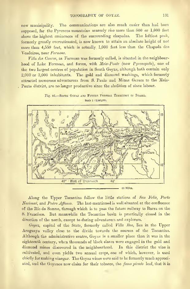
TOPOGKAPHY OF GOYAZ. 131
new municipality. The communications are also much easier than had been
supposed, for the Pyreneos mountains scarcely me more than 800 or 1,000 feet
above the highest eminences of the surrounding chapadas. The loftiest peak,
formerly greatly overestimated, is now known to attain an absolute height of not
more than 4,550 feet, which is actually 1,000 feet less than the Chapada dos
Veadeiros, near Formosa.
Villa dos Couros, as Formosa was formerly called, is situated in the neighbour-
hood of Lake Formosa, and forms, with Meia-Ponte (now Pyrenopotitt), one of
the two largest centres of population in South Goyaz, although both contain only
2,000 or 3,000 inhabitants. The gold and diamond washings, which formerly
attracted numerous adventurers from S. Paulo and Minas Geraes to the Meia-
Ponte district, are no longer productive since the abolition of slave labour.
Yi<r. 46. SOUTH GOYAZ AND FUTURE FEDERAL TERRITORY OF BRAZIL.
Scale 1 : 2.540,000.
16
49" > West of 'Greenwich 48
60 Miles.
Along the Upper Tocantins follow the little stations of San Felix, Porto
National, and Pedro Affonso. The last-mentioned is well situated at the confluence
of the Rio do Somno, through which is to pass the future railway to Barra on the
S. Francisco. But meanwhile the Tocantins basin is practically closed in the
direction of the north, except to daring adventurers and explorers.
Goyaz, capital of the State, formerly called Villa Boa, lies in the Upper
Araguaya valley close to the divide towards the sources of the Tocantins.
Although the administrative centre, Goyaz is a smaller place than it was in the
eighteenth century, when thousands of black slaves were engaged in the gold and
diamond mines discovered in the neighbourhood. In this district the vine is
cultivated, and even yields two annual crops, one of which, however, is used
chiefly for making vinegar. The Goyaz wines were said to be formerly much appreci-
ated, and the Goyanos now claim for their tobacco, the famo picado leaf, that it is
182 AMAZOMA AND LA PLATA.
" the best in the world." At any rate, it commands the highest price on the
Bahia market.
Beyond the important riverine port and military station of Junipensen, 50
miles below Goyaz, follow at long intervals a few other little settlements, such as
Leopoldina, at the confluence of the Vermelho with the Araguay, and S. Joao
das duas Ban-as at the confluence of the Araguay with the Tocantins. But S. Joao
tie Araguaya, as it is also called, never can become an important riverside port,
the navigation being obstructed by numerous falls and rapids, both above and
below this station. Below the last (Itaboca) falls, where the united waters flow
with a tranquil navigable current, the Tocantins ceases to belong to Goyaz.
Here it enters the province of Para; which it traverses for the rest of its course
to the estuary.
CHAPTER VIII.
EQUATORIAL SEABOARD.
STATES OF MARANHAO, PIAUHY, CEARA, Rio GRANDE DO NORTE, PARAHYBA,
PERNAMBUCO, AND ALAGOAS.
ETWEEN the Para estuary and the mouth of the Rio S. Francisco
the seaboard is disposed in the direction from north-west to south-
east and comprises numerous relatively small river basins, all
resembling each other in their general incline, their soil, climate,
and products. The whole region presents a transitional character
between Amazonia and the more thickly-peopled parts of Brazil, and towards
the south it is limited by extensive mountainous solitudes.
Owing largely to the lack of communications all the States of this seaboard
are still in a backward condition, and the population averages scarcely more than
eight or ten to the square mile 4,320,000 in a total area of about 470,000 square
miles. In normal years, when the rainfall is abundant, there is a tendency to
increase;
but in unfavourable seasons the enterprising people of Ceara emigrate
in large numbers to Amazonia, although even this movement has at least the
advantage of promoting more intimate relations with the remote provinces of the
republic.
GEOGRAPHICAL RESEARCH.
Our knowledge of the interior is also rapidly advancing, thanks to the labours of
the engineers and speculators engaged in laying down the traces of future high-
ways or in the quest of mineral treasures. Geographical exploration had already
begun in 1594 by the arrival of Jacques Briffault in the island where now stands
the town of San Luiz do Maranhao. The missionaries, Yves d'Evreux and Claude
d'Abbeville, have left us descriptions of the savages with whom they sojourned in
the early days of the discovery, and during the Dutch occupation of Pernambuco
(1630 1654), other districts were described by Johannes van Laet, Barla3us, and
Nieuhof.
Various expeditions into the sertao for the capture of slaves gradually revealed
the trend of the river valleys and mountain ranges ;but of the Brazilian regions
these have been least visited by naturalists and geographers. In 1809 and the
43
134 AMAZONIA AND LA PLATA.
following years Henry Koster traversed the coastlands between Recife and
Maranhao. In 1875 Wells, starting from Carolina on the Tocantins, crossed the
mountainous zone, and reached Maranhao by the Rio de Grajahu valley. The
coast has also been carefully studied by Vital d'Oliveira and later by Mouchez,
both of whose charts serve as bases for the still -defective maps of the interior.
PHYSICAL FEATURES GEOLOGY.
The coast ranges between the Tocantins and the S. Francisco basins constitute
no continuous chains with regular watersheds; they are evidently the remains of
elevated plains eroded by running waters, although the crests may still enable
geologists to divine the original structure of the ravined plateaux. The loftiest
ridges appear to be the Serra do Piauhy and the Serra dois Irmaos, which
dominate the course of the S. Francisco on the north-west. These crests, running
south-west and north-east, may be regarded as the edge of a plateau, another
edge of which is formed in the south-west by the Serras Mangabeiras and
Gurgueia. Some of the peaks exceed 3,000 feet, although the highest measured
by Wells between the Tocantins and the streams flowing to the Gulf of Maranhao
only attained an elevation of 2,100 feet.
Little is known of the geological structure of these uplands. The escarp-
ments inclined towards the S. Francisco consist of archaean rocks analogous to
those of Canada, and to the same formation belong the heights on the projecting
coastland between Ceara and Alagoas ;but farther west these primitive rocks
underlie calcareous strata of the chalk ages. The whole of the Upper Parnahyba
valley is occupied by these formations, while farther north, parallel with the coast,
follow sandstone terraces like those of Amazonia, doubtless dating from the same
period when arenaceous sediment was deposited on the bed of a vast fresh-water
Mediterranean.
At that time the Amazonian gulf formed dry land, and the same agencies are
still at work eating away the present seaboard. Between the Para and Maranhao
estuaries, a distance of about 300 miles, land and water are continually battling
for a tolerably broad belt of creeks, inlets, islands, reefs, channels, and lagoons,
intermingled in endless confusion and shifting with every tide. Here the bore
rushes in with tremendous fury, at times with a velocity of six miles an hour, a
veritable tidal cataract tearing the beach into shreds and sweeping away all
obstacles. But in this ceaseless struggle the advantage remains with the ocean.
Along the strand beds of marine organisms are found superimposed on shell
mounds of lacustrine origin ;the aquatic mangrove is encroaching on the land
flora, and here and there clumps of palms are seen already invaded by the surging
waters.
RIVERS.
Numerous streams descend from the hills and plateaux of the Atlantic water-
shed; but no river, not even the Parnahyba, rivals the great Amazonian affluents
in the length of its course. The Gurupy, flowing between the States of Para and
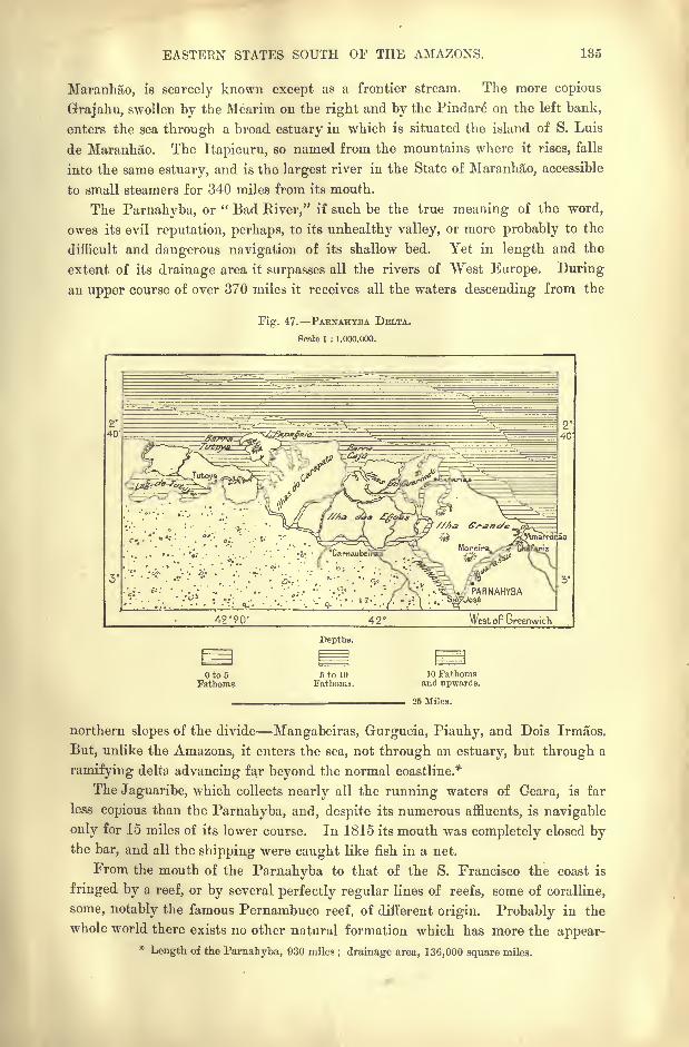
EASTEEN STATES SOUTH OF THE AMAZONS. 135
Maranhao, is scarcely known except as a frontier stream. The more copious
Grajahu, swollen by the Mearim on the right and by the Pindare on the left bank,
enters the sea through a broad estuary in which is situated the island of S. Luis
de Maranhao. The Itapicuru, so named from the mountains where it rises, falls
into the same estuary, and is the largest river in the State of Maranhao, accessible
to small steamers for 340 miles from its mouth.
The Parnahyba, or " Bad River," if such be the true meaning of the word,
owes its evil reputation, perhaps, to its unhealthy valley, or more probably to the
difficult and dangerous navigation of its shallow bed. Yet in length and the
extent of its drainage area it surpasses all the rivers of West Europe. During
an upper course of over 370 miles it receives all the waters descending from the
Fig. 47. PAENAHYBA DELTA.
fioalel : 1,000,000.
~^/i/t?/ew?fw/<;
Tutqya
Ts//,a a&a /o1 ///? Grane/e
Moreir
fi^
'
';'''.'''
''.;.'
''
?<
''
.' XxV.'-^./y PARNAHYBA
;,... '/^ . '.
.VI ,;.. .-..:; \ V-.. V.../.VU ,..-3g&V
West of Greenwich
Depths.
Oto5Fathoms.
6 to 10
Fathoms.10 Fathoms
and upwards.
25 Miles.
northern slopes of the divide Mangabeiras, Gurgueia, Piauhy, and Dois Irmaos.
But, unlike the Amazons, it enters the sea, not through an estuary, but through a
ramifying delta advancing far beyond the normal coastline.*
The Jaguaribe, which collects nearly all the running waters of Geara, is far
less copious than the Parnahyba, and, despite its numerous affluents, is navigable
only for 15 miles of its lower course. In 1815 its mouth was completely closed bythe bar, and all the shipping were caught like fish in a net.
From the mouth of the Parnahyba to that of the S. Francisco the coast is
fringed by a reef, or by several perfectly regular lines of reefs, some of coralline,
some, notably the famous Pernambuco reef, of different origin. Probably in the
whole world there exists no other natural formation which has more the appear-*Length of the Parnabyba, 930 miles ; drainage area, 136,000 square miles.
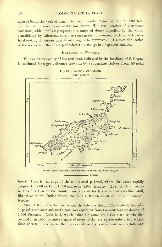
136 AMAZONIA AND LA PLATA.
ance of being the work of man. Its mean breadth ranges from 100 to 200 feet,
and the flat top remains exposed at low water. The rock consists of a compact
sandstone, which probably represents a range of dunes deposited by the water,
consolidated by calcareous substances and gradually covered with an extremely
hard coating of various animal and vegetable organisms. It resists the action
of the waves, and the oldest pilots detect no change in its general outlines.
FERNANDO DE NORONHA.
The eastern extremity of the continent, indicated by the headland of S. Roque,
is continued for a great distance seawards by a submarine plateau about 56 miles
Fig. 48. FEBNANDO DE NOBONHA.
Scale 1 : 100,000.
LesJumeauxQj
Portuguese^ \
TheBrothers
C.flace/fie.
/.aux fregates
32 28' 32 25'
On the Maps the place names differ with the nationality oi the surveyors.
^ ____^_ ____ 2 Miles.
broad. Here is the edge of the continental pedestal, where the water rapidly
deepens from 30 or 40 to 1,500 and even 2,000 fathoms. The first land visible
in this direction is the annular enclosure of las Rocas, a true coralline atoll,
like those of the Indian Ocean, enclosing a lagoon about six miles in circum-
ference.
About 110 miles farther east is seen the volcanic island of Fernando de Noronha
disposed south-west and north-east, and separated from the continent by depths of
1,500 fathoms. This land, which takes its name from the mariner who dis-
covered it in 1503, occupies a space of no more that six square miles;but within
these narrow limits is seen the most varied scenery, creeks, and havens, hills and
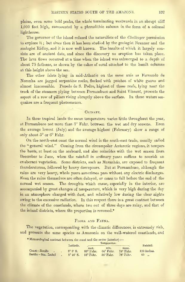
EASTEEN STATES SOUTH OF THE AMAZONS. 187
plains, even some bold peaks, the whole terminating westwards in an abrupt cliff
1,000 feet high, surmounted by a phonolithic column in the form of a colossal
lighthouse.
The governor of the island refused the naturalists of the Challenger permission
to explore it;but since then it has been studied by the geologist Branner and the
zoologist Ridley, and it is now well known. The basalts of which it largely con-
sists are of ancient date, and since the discovery no eruption has taken place.
The lava flows occurred at a time when the island was submerged to a depth of
about 75 fathoms, as shown by the cakes of coral attached to the basalt columns
at this height above the sea.
The other islets lying in mid-Atlantic on the same axis as Fernando de
Noronha are jagged serpentine rocks, flecked with patches of white guano and
almost inaccessible. Penedo de S. Pedro, highest of these reefs, lying near the
track of the steamers plying between Pernambuco and Saint Vincent, presents the
aspect of a row of pillars rising abruptly above the surface. In these waters sea-
quakes are a frequent phenomenon.
CLIMATE.
In these tropical lands the mean temperature varies little throughout the year,
at Pernambuco not more than 3 Fahr. between the wet and dry seasons. Even
the average lowest (July) and the average highest (February) show a range of
only about 5 or 6 Fahr.
On the north-east coast the normal wind is the south-east trade, usually called
the "general wind." Coming from the circumpolar Antarctic regions, it tempers
the heats, at least on the seaboard, and also coincides with the wet season from
December to June, when the rainfall in ordinary years suffices to nourish an
exuberant vegetation. Some districts, such as Maranhao, are exposed to frequent
thunderstorms, followed by heavy downpours. But at Pernambuco, although the
rains are very heavy, whole years sometimes pass without any electric discharges.
Even the rains themselves are often delayed, or cease to fall before the end of the
normal wet season. The droughts which ensue, especially in the interior, are
accompanied by great changes of temperature, which is very high during the dayin an atmosphere charged with dust, and relatively low during the clear nights
owing to the excessive radiation. In this respect there is a great contrast between
the climate of the coastlands, where two out of three days are rainy, and that of
the inland districts, where the proportion is reversed.*
FLORA AND FAUNA.
The vegetation, corresponding with the climatic differences, is extremely rich,
and presents the same species as Amazonia on the well-watered coastlands, and
*Meteorological contrast between the coast and the sertao (interior) :
Temperature.Latitude. / Kainfall.
max. min. mean.Coast Recife . . 8 3' S. 89 Fahr. 64 Fahr. 78 Fahr. 120 inches.
Sertao - Sta. Izabel 8 46' S. 93 Fahr. 66 Fahr. 76 Fahr. 40
138 AMAZONIA AND LA PLATA.
becomes gradually poorer towards the interior. To the matta, or forest /one of
the seaboard, succeeds the catinga, a more open or scrubby district, which merges
higher up in the agreste, where trees and shrubs become rarer, and consist of
species which shed their leaves in summer. Lastly comes the sertao of the arid
uplands, with poor pasturage, where stock-breeding is the only possible industry,
except in the brejos or combes, marshy or fed by springs, forming so many oases in
the wilderness.
In these dry inland regions the prevailing species are the gummiferous or
aromatic plants, whose foliage is deciduous in the summer season. The charac-
teristic palm is the carnauba or wax-tree (copernicia cerifera), one of those useful
plants which supply the natives with all their wants food, drink, light, clothes,
and habitations.
Formerly the fauna of Ceara and neighbouring districts was very rich, and at
the beginning of the seventeenth century the " ostrich"
(rhea) still roamed the
coastlands opposite the island of Maranhao. In the limestone caves of the Mar-
anhao, Piauhy, and Ceara mountains, frequented by myriads of bats and vampires,
the remains have been found of huge extinct mammals, such as the mastodon
and the megatherium. Even Fernando de Noronha had its special fauna, repre-
sented by a large species of rat, birds, lizards, snakes, insects, and shells, showingthat the island had been separated from the mainland since the close of the
Mesozoic epoch.
INHABITANTS.
One of the caves in the valley of the Quixeramobim affluent of the Jaguaribe
contained part of a human skull evidently of great antiquity. But it is uncertain
whether it belonged to an ancestor of any of the dominant races Tupi, Tupi-
namba, Tupinambulx, that is" Brave Men," or Tabajara,
"Village Lords "
with
whom the first French settlers in Maranhao entered into friendly relations duringthe sixteenth century. Nor has any knowledge survived of those Indians whoformed alliances with the French immigrants, all having long been merged in
the general Brazilian population.
Although the Guajajaras of the Pindare valley were exterminated by the gold-
hunters, some of this race are still met at the sources of the Upper Grajahu.
They are a vigorous people of Mongolic type, and the neighbouring ""White
Indians"
are remarkable for their light complexion. Farther east, on the
higher parts of the plateau, there still survive some fragments of distinct tribes,
such as the Akroas and Cayapos between the Tocantins and the Grajahu, in the
Serra da Cinta and the Serra do Negro. These natives, who appear to be of
Ges stock, approach the coastlands in West Maranhao, where they are known as
Timbiras and Gamellas, the latter term having reference to their "lip disk."
On the Piauhy and Pernambuco borderlands still roam a few scattered bands
of the Pimenteiras, whose speech shows traces of Carib affinities or contact. In
the sixteenth century the Caethes of the Pernambuco district had already begunto amalgamate with the Europeans, who were later again crossed with the slaves
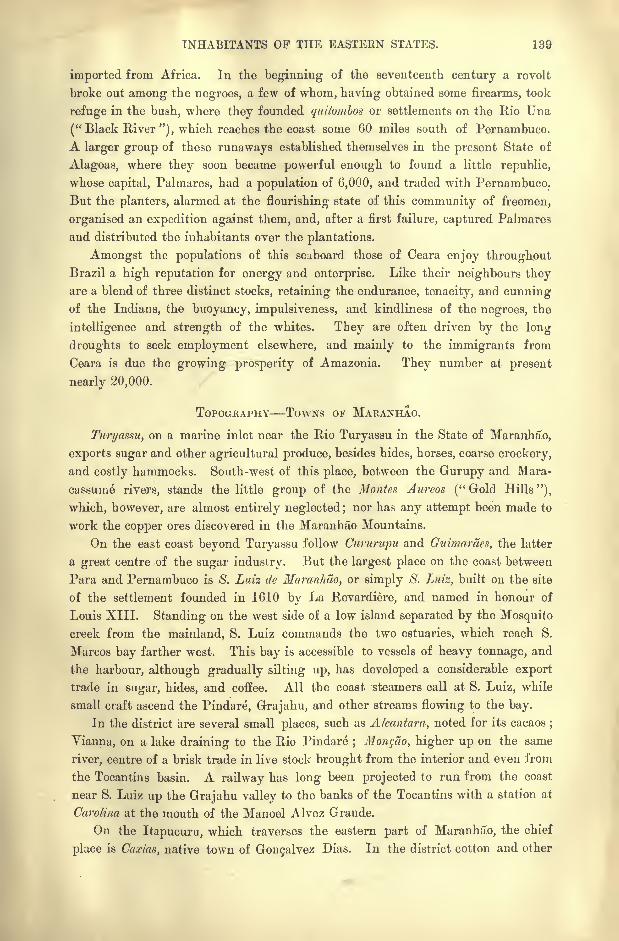
INHABITANTS OP THE EASTERN STATES. 139
imported from Africa. In the beginning of the seventeenth century a revolt
broke out among the negroes, a few of whom, having obtained some firearms, took
refuge in the bush, where they founded quilombos or settlements on the Rio Una
("Black River"), which reaches the coast some 60 miles south of Pernambuco.
A larger group of these runaways established themselves in the present State of
Alagoas, where they soon became powerful enough to found a little republic,
whose capital, Palmares, had a population of 6,000, and traded with Pernambuco.
But the planters, alarmed at the flourishing state of this community of freemen,
organised an expedition against them, and, after a first failure, captured Palmares
and distributed the inhabitants over the plantations.
Amongst the populations of this seaboard those of Ceara enjoy throughoutBrazil a high reputation for energy and enterprise. Like their neighbours they
are a blend of three distinct stocks, retaining the endurance, tenacity, and cunningof the Indians, the buoyancy, impulsiveness, and kindliness of the negroes, the
intelligence and strength of the whites. They are often driven by the long
droughts to seek employment elsewhere, and mainly to the immigrants from
Ceara is due the growing prosperity of Amazonia. They number at present
nearly 20,000.
TOPOGRAPHY TOWNS OF MARANHAO.
Turyassu, on a marine inlet near the Rio Turyassu in the State of Maranhao,
exports sugar and other agricultural produce, besides hides, horses, coarse crockery,
and costly hammocks. South-west of this place, between the Gurupy and Mara-
cassume rivers, stands the little group of the Monies Aureos ("Gold Hills"),
which, however, are almost entirely neglected; nor has any attempt been made to
work the copper ores discovered in the Maranhao Mountains.
On the east coast beyond Turyassu follow Cururupu and Guimaraes, the latter
a great centre of the sugar industry. But the largest place on the coast between
Para and Pernambuco is S. Luiz de Maranhao, or simply S. Luiz, built on the site
of the settlement founded in 1610 by La Revardiere, and named in honour of
Louis XIII. Standing on the west side of a low island separated by the Mosquito
creek from the mainland, S. Luiz commands the two estuaries, which reach S.
Marcos bay farther west. This bay is accessible to vessels of heavy tonnage, and
the harbour, although gradually silting up, has developed a considerable export
trade in sugar, hides, and coffee. All the coast steamers call at S. Luiz, while
small craft ascend the Pindare, Grajahu, and other streams flowing to the bay.
In the district are several small places, such as Alcantara, noted for its cacaos;
Yianna, on a lake draining to the Rio Pindare; Monffto, higher up on the same
river, centre of a brisk trade in live stock brought from the interior and even from
the Tocantins basin. A railway has long been projected to run from the coast
near S. Luiz up the Grajahu valley to the banks of the Tocantins with a station at
Carolina at the mouth of the Manoel Alvez Grande.
On the Itapucuru, which traverses the eastern part of Maranhao, the chief
place is Caxias, native town of Gongalvez Dias. In the district cotton and other
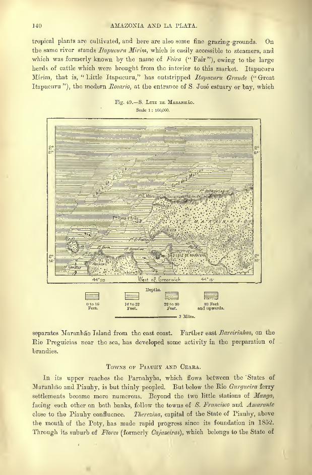
140 AMAZONIA AND LA PLATA.
tropical plants are cultivated, and here are also some fine grazing-grounds. Onthe same river stands Itapucuru Mirim, which is easily accessible to steamers, and
which was formerly known by the name of Feira (" Fair"), owing to the large
herds of cattle which were brought from the interior to this market. Itapucuru
Mirim, that is," Little Itapucuru," has outstripped Itapucuru Grande (" Great
Itapucuru "), the modern Rosario, at the entrance of S. Jose estuary or bay, which
Fig. 49. S. LTJIZ DE MAEANH!O.
Scale 1 : 160,000.
E^^f3fcJ' ^&"<'
* "*'".*" *
"-?^T?^' <. "-'
'*
F^^rT'^'1
*?- /;./ F.-*".M AS'R>>/A'<N>H.'A- ^7/7^
:/%
?_^//a
^^J^rfSss==^ m'.^.~'
^S^;'f^^vp^g^fO LUIZ DE MARANH/a
.. .; .
-g< ;.
; |j,- V-'.;.
West oF. Greenwich 44 15-
Depths.
Oto 16
Feet.16 to 32Feet.
32 to 80Feet.
80 Feetand upwards.
3 Miles.
separates Maranhao Island from the east coast. Farther east Bareirinhas, on the
Rio Preguicias near the sea, has developed some activity in the preparation of
brandies.
TOWNS OF PlAUHY AND CEARA.
In its upper reaches the Parnahyba, which flows between the States of
Maranhao and Piauhy, is but thinly peopled. But below the Rio Qurgueira ferry
settlements become more numerous. Beyond the two little stations of Manga,
facing each other on both banks, follow the towns of 8. Francisco and Amarante
close to the Piauhy confluence. Therezina, capital of the State of Piauhy, above
the mouth of the Poty, has made rapid progress since its foundation in 1852.
Through its suburb of Flores (formerly Cajazeiras), which belongs to the State of
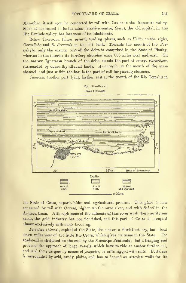
TOPOGEAPHY OF CEAEA. 141
Maranlmo, it will soon be connected by rail with Caxias in the Itapucuru valley.
Since it has ceased to be the administrative centre, Oeiras, the old capital, in the
Rio Caninde valley, has lost most of its inhabitants.
Below Therezina follow several trading places, such as Uniao on the right,
Curralinho and 8. Bernardo on the left bank. Towards the mouth of the Par-
nahyba, only the eastern part of the delta is comprised in the State of Piauhy,
whereas in the interior its territory stretches some 300 miles west and east. On
the narrow Iguarassu branch of the delta stands the port of entry, Parnahyba,
surrounded by unhealthy alluvial lands. Amarra^ao, at the mouth of the same
channel, and just within the bar, is the port of call for passing steamers.
Camocim, another port lying farther east at the mouth of the Rio Coreahu in
Fig. 50. CEAEA.
Scale 1 : 800,000.
38"40' West oi Greenwich
Depths.
Otol6Feet.
16 to 32Feet.
32 Feetand upwards.
18 Miles.
the State of Ceara, exports hides and agricultural produce. This place is now
connected by rail with Granja, higher up the same river, and with Sobral in the
Acaracu basin. Although some of the affluents of this river wash down auriferous
sands, the gold industry has not flourished, and this part of Ceara is occupied
almost exclusively with stock-breeding.
Fortaleza (Ceara), capital of the State, lies not on a fluvial estuary, but about
seven miles west of the little Rio Ceara, which gives its name to the State. The
roadstead is sheltered on the east by the Mucuripe Peninsula;but a fringing reef
prevents the approach of large vessels, which have to ride at anchor farther out,
and land their cargoes by means oijangadas, or rafts rigged with sails. Fortaleza
is surrounded by arid, sandy plains, and has to depend on artesian wells for its
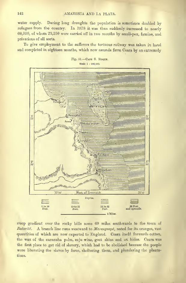
142 AMAZONIA AND LA PLATA.
water supply. During long droughts the population is sometimes doubled by
refugees from the country. In 1878 it was thus suddenly increased to nearly
60,000, of whom 23,250 were carried off in two months by small-pox, famine, and
privations of all sorts.
To give employment to the sufferers the tortuous railway was taken in hand
and completed in eighteen months, which now ascends from Ceara by an extremely
Fig. 51. CAPE S. KOQUE.
Scale 1 : 200,000.
'35-20' West or Greenwich 35-10-
Dep'hs.
to 10Feet.
10 to 16Feet.
16 to 32Feet,
32 Feetand upwards.
5 Miles.
steep gradient over the rocky hills some 60 miles southwards to the town of
EaturiU. A branch line runs westward to Maranguapt, noted for its oranges, vast
quantities of which are now exported to England. Ceara itself forwards cotton,
the wax of the carnauba palm, caju wine, goat skins and ox hides. Ceara was
the first place to get rid of slavery, which had to be abolished because the people
were liberating the slaves by force, sheltering them, and plundering the planta-
tions.
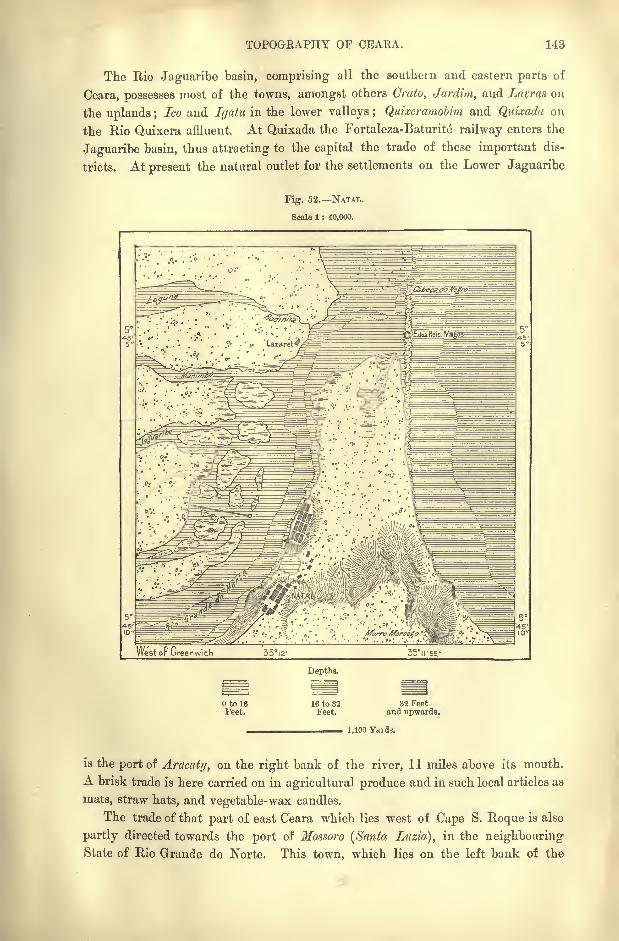
TOPOGEAPHY OF CEARA. 143
The Rio Jaguaribe basin, comprising all the southern and eastern parts of
Ceara, possesses most of the towns, amongst others Crato, Jardim, and Lavras on
the uplands ;Ico and Igatu in the lower valleys ; Quixeramobim and Quizada on
the Rio Quixera affluent. At Quixada the Fortaleza-Baturite railway enters the
Jaguaribe basin, thus attracting to the capital the trade of these important dis-
tricts. At present the natural outlet for the settlements on the Lower Jaguaribe
Fig. 52. NATAL.
Scale 1 : 40,000.
West or Greenwich 35i2' 35ir55."
Depths.
to 16Feet.
16 to 32Feet.
32 Feetand upwards.
1,100 Yards.
is the port of Aracaty, on the right bank of the river, 11 miles above its mouth.
A brisk trade is here carried on in agricultural produce and in such local articles as
mats, straw hats, and vegetable-wax candles.
The trade of that part of east Ceara which lies west of Cape S. Roque is also
partly directed towards the port of Mossoro (Santa Luzia), in the neighbouringState of Rio Grande do Norte. This town, which lies on the left bank of the
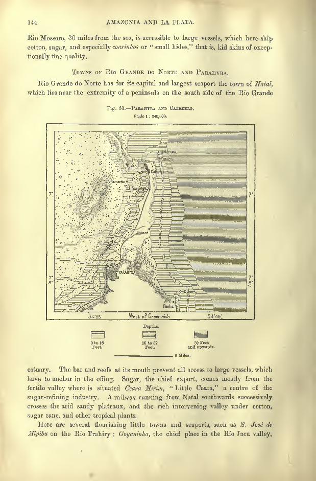
144 AMAZONIA AND LA PLATA.
Rio Mossoro, 30 miles from the sea, is accessible to large vessels, which here ship
cotton, sugar, and especially courinlios or " small hides," that is, kid skins of excep-
tionally fine quality.
TOWNS OF Rio GRANDE DO NORTE AND PARAHYBA.
Rio Grande do Norte has for its capital and largest seaport the town of Natal,
which lies near the extremity of a peninsula on the south side of the Rio Grande
Fig. 53. PABAHYBA AND CABEDELO.
Scale 1 : 840,000.
34'55' West or Greenwich 34-45'
Depths.
to 16i'eet.
16 to 32Feet.
32 Feetand upwards.
6 Miles.
estuary. The bar and reefs at its mouth prevent all access to large vessels, which
have to anchor in the offing. Sugar, the chief export, comes mostly from the
fertile valley where is situated Ceara Mirim," Little Ceara," a centre of the
sugar-refining industry. A railway running from Natal southwards successively
crosses the arid sandy plateaux, and the rich intervening valley under cotton,
sugar cane, and other tropical plants.
Here are several flourishing little towns and seaports, such as 8. Jos6 de
Mipibu on the Rio Trahiry ; Goyaninha, the chief place in the Rio Jacu valley,
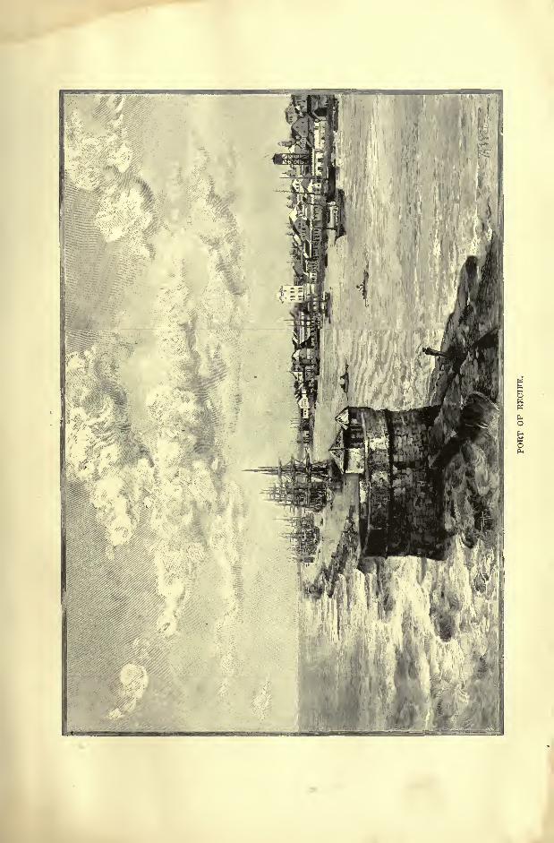


TOPOGEAPHY OF PERNAMBUCO. 145
and farther south Canguaretama, Nova Cruz, and Pcnha in the Kio Curimatahu
valley.
In the State of Parahyba do Norte the port of Mamanguape, on the river of
like name, still does a little coasting trade, although the city of Parahyba has
attracted most of the traffic hy the construction of a railway penetrating to Inde-
pendencia on the Upper Mamanguape, and tapping the neighbouring serra with its
numerous agricultural settlements, such as Bananeiras, Brejo d'Areia, and AlagoaGrande. In the southern part of the State, 8. Joao de Cariry, Campina Grande,
Inga, and Pilar have their natural outlet in the estuary of the Rio Parahyba do
Norte, on the right bank of which stands the city of Parahyba. On the heights
is the Cidade Velha (" Old Town "), founded in 1579, now a group of almost aban-
doned monasteries;lower down is the Varadouro (" Marina "), the business
quarter about 18 miles above the entrance of the estuary, where the shipping is
arrested by the reefs and where the northern extremity of the peninsula is crowned
by the fortress of Cabedelo.
TOWNS OF PERNAMBUCO AND ALAGOAS.
South of Parahyba, the ancient city of Goyana, already a flourishing place in
the time of the Dutch occupation, holds an analogous position on the bend of a
river, which towards its mouth expands into an estuary, but which is also half
closed by a barrier of reefs.
Goyana lies in the State of Pernambuco, that is, Parana-mbuk," Sea River,"
so named in reference to the semi-circular channel which enclosed the island of
Itamaraca. This island is one of the most densely-peopled districts in Brazil,
and produces much sugar, abundance of provisions, and " the best fruits on the sea-
board." So early as 1630, as many as 23 sugar-works had been established
in Itamaraca, whither the Dutch at one time thought of removing the seat of
their Brazilian colony.
Pernambuco, capital of the State, takes its official name of Recife from the
" reefs"
which shelter its harbour like natural breakwaters. It is one of the
historical cities of the New World, and a commercial emporium which seems des-
tined to a great future. Founded in 1503, by Duarte Coelho, it became the seat
of administration under the Dutch at the time when they were masters of north-
east Brazil. A few remains of their establishments are still visible at Recife and
in the island of Antonio Vaz at S. Antonio, formerly Mauricea (Mauritsstad], so
named in honour of Maurice of Nassau.
Under the name of Pernambuco are comprised several distinct urban groups,
such as Olinda, the former capital, on an eminence over four miles from the com-
mercial centre, a group of crumbling palaces and convents north of the roadstead.
On the mainland the country seats, gardens, and farmsteads of Campo Grande con-
nect the old and new quarters, while Recife, properly so called, covers the island
nearest to the outer reefs with its public buildings, depots, and warehouses, and is
itself connected by bridges with the more southerly and larger island of Antonio
Vaz. Other causeways connect this central quarter with that of Boa Vista, which
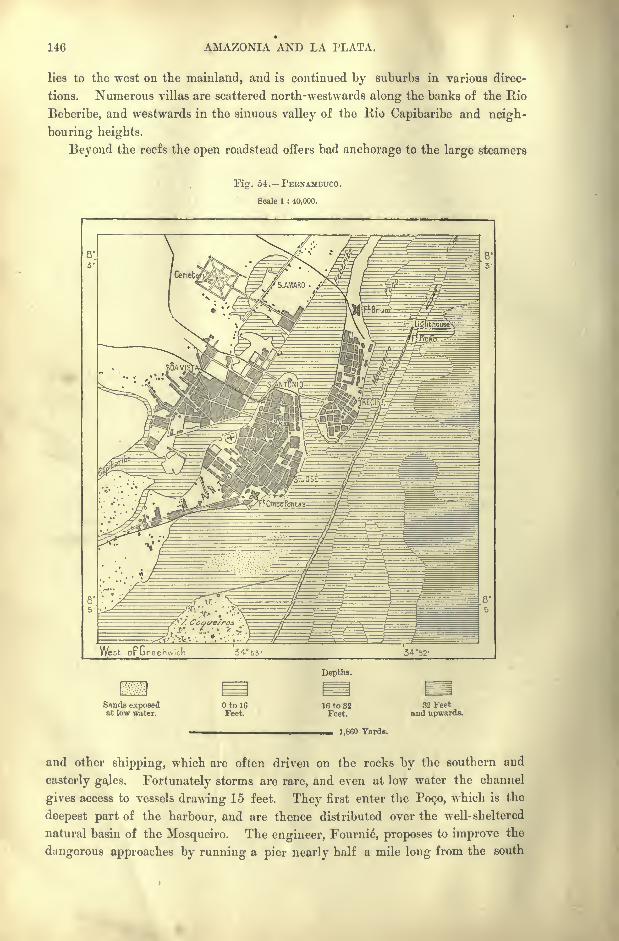
146 AMAZONIA AND LA PLATA.
lies to the west on the mainland, and is continued by suburbs in various direc-
tions. Numerous villas are scattered north-westwards along the banks of the Rio
Beberibe, and westwards in the sinuous valley of the Rio Capibaribe and neigh-
bouring heights.
Beyond the reefs the open roadstead offers bad anchorage to the large steamers
Fig. 54. PEBNAMBUCO.
Scale 1 : 40,000.
West or Greenwich 3455' 34*52'
Depths.
Sands exposedat low water.
to 16Feet.
16 to 32Feet.
1,860 Yards.
32 Feetand upwards.
and other shipping, which are often driven on the rocks by the southern and
easterly gajes. Fortunately storms are rare, and even at low water the channel
gives access to vessels drawing 15 feet. They first enter the POC.O, which is the
deepest part of the harbour, and are thence distributed over the well- sheltered
natural basin of the Mosqueiro. The engineer, Fournie, proposes to improve the
dangerous approaches by running a pier nearly half a mile long from the south

PEENAMBUCO. 147
side of the channel eastwards to deep water, thus enabling large vessels to load
aud unload at all states of the tide and in all weathers. Hawkshaw proposes a
somewhat similar plan, but with longer and more crescent-shaped pier.
Fig. 55. PEUNAMBTTCO STREET VIEW.
Either project would make Pernambuco one of the best harbours in Brazil.
But its admirable position near the north-east angle of the continent has already

148 AMAZONIA AND LA PLATA.
Fig. 56. FRINGING REEFS BETWEEN PAKAHYBA AND THE
MOUTH OF THE S. FEANCISCO.
Scale 1 : 3,500,000.
made Recife the chief point of attraction for vessels coming from North America,
Europe, and Africa. No part of the Brazilian seaboard possesses more strategical
importance. It forms the advanced bulwark of the republic, and in the near
future Pernambuco promises to become the most frequented port in South America,
especially for the pas-
senger traffic between
the Old and NewWorlds.
Three trans-Atlan-
tic cables radiate from
Recife, which is the
port of call for twelve
lines of steamers, while
hundreds of other
vessels here ship cot-
ton, coffee, sugar, to-
bacco, hides, skins, the
dyewoods formerly
known as "pernam-
bucs," natural history
collections, and other
objects. Great Britain
takes the largest share
of this traffic, France,
Germany, and the
United States follow-
ing in the order
named. Pernambuco
is the seat of a geo-
graphical institute and
other learned societies.
Numerous carriage
roads and three rail-
ways radiate to the
surrounding towns
Iguarassu in the
north; Pfio d"Alho in
the north-west at the
bifurcation of the rail-
ways running one towards Nazareth, the other towards Limoeiro, two busy trading
places surrounded by sugar-works. Limoeira is the chief place in the R:o
Capibaribe valley, where are also situated Bom Jardim, Taquaretinga, and Brejo da
Madre de Dem.
The railway running west of Recife towards the Upper Ipojuca valley succes-
F Greenwich
Oto5Fathoms.
5to50Fathoms.
Depths.
50 to 500Fathoms.
500 to 1.000Fathoms.
GO Miles.
1.000 Fathomsand upwards.
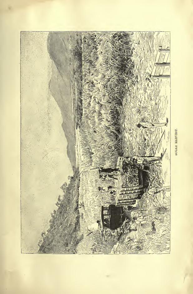
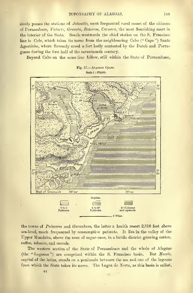
TOPOGBAPHY OF ALAGOAS. 149
sively passes the stations of Jaboatao, most frequented rural resort of the citizens
of Pernambuco, Victori-t, Gravatd, Bezerros, Caniaru, the most flourishing mart in
the interior of the State. South-westwards the chief station on the S. Francisco
line is Cabo, which takes its name from the neighbouring Cabo (" Cape ") Santo
Agostinho, where formerly stood a fort hotly contested by the Dutch and Portu-
guese during the first half of the seventeenth century.
Beyond Cabo on the same line follow, still within the State of Pernambuco,
Fig. 57. ALAGOAS COAST.
Scale 1 : 375,000.
West or Greenwich 35 so'
to 5Fathoms.
Depths.
5 to 10Fathoms.
10 Fn thornsand upwards.
, 6 Miles.
the towns of Palmares and Garanhuns, the latter a health resort 2,810 feet above
sea-level, much frequented by consumptive patients. It lies in the valley of the
Upper Mundahu, above the zone of sugar-cane, in a fertile district growing cotton,
coffee, tobacco, and cereals.
The western section of the State of Pernambuco and the whole of Alagoas
(the"Lagoons ") are comprised within the S. Francisco basin. But Maceio,
capital of the latter, stands on a peninsula between the sea and one of the lagoons
from which the State takes its name. The Lagoa do Norte, as this basin is called,
44

150 AMAZONIA AND LA PLATA.
receives the Rio Mundahu, while the Manguaba lagoon farther south is fed by one
of the numerous streams bearing the general name of Parahyba.
Here the pleasant town of Maceio with its suburb of Juragua is shaded with
groves and avenues in which are intermingled the African date with the Indian
coconut palm. Unfortunately the harbour, though protected from the east and
north winds, is exposed to the southern gales, during the prevalence of which the
shipping has to take refuge farther east in the roadstead of Pajussara under the
shelter of the Ponta Verde and a chain of reefs. Cotton, sugar, and caju wine are
Fig. 58. MACEIO AND ITS ROADSTEAD.
Scale 1 : 60,000.
'... Pujucara ..,
38*5' West oF Gr 38*3'
Depths.
Otol6Feet.
16 to 32Feet.
32 Feetand upwards.
2,200 Yards.
amongst the exports. Maceio receives much of its supplies from the railwaywhich runs north-westwards up the Mundahu valley to Uniao, one of the numerous
places which during the Empire bore the name of Imperairiz in honour of the"Empress
"of Brazil.
The Rio Parahyba valley, which is disposed south-east parallel with that of
the Mundahu and connected with it by a branch line, abounds in sugar planta-
tions in the municipalities of Victoria, Villa Vi$osa (formerly Asscmblea), Atalaia,
Pilar, and Alagoas. The last-mentioned, which was capital of the State till 1839,
stands near the southern extremity of the Manguaba lagoon. It is much less
FEENANDO NORONHA. 151
favourably situated for trade than Maceio, the present capital. Small steamers
ply regularly on the creeks and the neighbouring Lake Manguaba between the
towns of Maceio and Pilar. At the latter place they ship the cotton brought to
the coast from the surrounding plantations.
Fernando Noronha, which belongs administratively to the State of Pernambuco,
is a natural dependency of the north-eastern provinces of Brazil. It has no towns
or any colony of free settlers, being entirely set apart by the federal government as
a convict station. The island is so infested by rats and mice that the convicts,
who are employed at certain times in hunting them down, sometimes kill as manyas 20,000 in a single day. In the year 1893 a project was brought forward to
establish a quarantine and a signal station on the island. The deposits of phos-
phates have not yet been worked, although some guano has been collected on
some of the neighbouring rocks and islets.
CHAPTER IX.
S. FRANCISCO BASIN AND EAST SLOPE OF THE PLATEAUX.
STATES or MINAS GERAES, BAHIA, SERGIPE, AND ESPIRITO SANTO.
BOUT half of this region is comprised within the S. Francisco basin,
a vast depression of oval shape analogous to that of the twin rivers
Araguaya and Tocantins, of nearly the same size. Only the S.
Francisco does not maintain its normal direction from north to
south, but .trends round to the east, falling into the Atlantic at
the point where the coast-line begins to turn south-west below the Pernambuco
promontory. By this change in its course the main artery, rising in the zone of
elevated plateaux, gives a certain unity to both of the natural regions which it
traverses.
Farther south the crests of the divide form a sharp limit between the fluvial
basin and the slopes facing the Atlantic. But viewed as a whole, the coastlands
may be regarded simply as the seaward escarpments of the plateaux watered bythe S. Francisco. But the political frontiers coincide only to a certain extent with
their natural limits. In the south the State of Minas Geraes encroaches con-
siderably on the Parana slope, as well as on the Rio Doce basin towards Espirito
Santo or Rio de Janeiro.
But however limited in extent, the region of the S. Francisco combined with
that of the Atlantic slopes is the most important section of the republic. Minas
Geraes (" General Mines "), one of its four political divisions, is a magnificent
country with natural resources rendering it independent of the whole world.
Although not the largest, it is by far the most populous State in Brazil, and even
from the historic point it may claim the first rank. After enriching Portugal
beyond all the other colonies, it was the first to strike a blow for national inde-
pendence, and such is its commanding position that proposals have several times
been made to break it up into two or more separate States.
Bahia, although of less importance than Minas Geraes, takes the second place
in the republic for population, and its capital is surpassed by Rio de Janeiro alone
in size and commercial activity. Sergipe, despite the small extent of its territory,
takes more than its share in the general trade of the country, and even Espirito

STATES OF THE S. FRANCISCO BASIN. 153
Santo, mainly a forest zone of difficult access, has made rapid progress in recent
years. Collectively the four States comprise a supsrficial area of about 434,000
square miles, with a population (1893) of 5,570,000.
PROGRESS OF DISCOVERY AMD SETTLEMENT.
The vast bay of Todos os Santos, on which now stands the city of Bahia, was
already sighted by Christovao Jaques in 1503, three years after the discovery of
the Brazilian coast. The colony developed rapidly in the second half of the
sixteenth century, after Bahia had been chosen as capital of all the Brazilian
captainries. But the forest-clad seaward slopes long presented an insurmount-
able barrier to the occupation of the interior. Expeditions were, however, under-
taken towards the unknown lands traversed by the Upper S. Francisco, whence
Marcos de Azevedo brought silver and emeralds in 1650. Twenty years later
some daring Paulistas, under Fernando Dias Paes Leme, pushed northwards to the
regions reported to abound in precious stones. They reached the sources of the
Rio- Doce without, however, discovering the treasures for which this district after-
wards became famous.
Other Paulistas were more fortunate, and in 1720 the Portuguese Government,
in order to secure its mineral revenues, constituted the captainry of Minas Geraes
with about the same limits as those of the present State. Each of the new miningcentres became starting-points for fresh explorations, and since the era of scien-
tific research was opened by Humboldt, the whole land has been traversed byVon Eschwege, Auguste de Saint-Hilaire, Spix and Martius, Mawe, Gardener,
Spruce, Burton, Liais, Halfeld, Wells, Manoel de Macedo, and others. In 1815-17
Max von Wied visited and carefully described the Botocudos;Lund devoted
many years to the study of the extinct fauna of the Caves; Gorceix, Hartt, Fer-
rand, Orville, Derby, and many other miners, engineers, and geologists examined
the character of the rocks and their mineral treasures, and a beginning has
been made with a topographic map to the scale \of TO"O"!^O"O", which is to be con-
nected with works of a like nature now progressing in the State of S. Paulo.
PHYSICAL FEATURES.
To the mountainous region where the Rio S. Francisco takes its rise, the term
campos,"plains," or "
fields," is sometimes applied ;but these upland plains pre-
sent no such level spaces as* the Venezuelan llanos. The surface is everywherebroken by hills rising from 300 to 600 feet above the normal height of the vast
plateau. One of the loftiest summits in Minas even takes the name of Itabira do
Campo, in contradistinction to the less elevated Itabira da Serra, or do Matto
Dentro, in the mountainous and wooded eastern regions.
The mean altitude of these uplands, which form the central water-parting
of Brazil, and which slope in all directions, is about 3.000 feet, while the
culminating peaks between Queluz and Barbacena exceed 4,000 feet. From
this central nucleus diverge the various ranges, which rise above the common
pedestal, and which nearly everywhere decrease with it in altitude.

154 AMAZONIA AND LA PLATA.
Towards the west the S. Francisco and Parana basins are separated by such a
range, which farther on merges in a second divide, whence ramify northwards the
Serra da Canastra and numerous other ridges. South-west of the Barbacena knot
a chain with steep outer slopes is developed parallel with the Rio de Janeiro coast.
North-eastwards the Serra da Mantiqueira, as this chain is called, is continued
under various names, everywhere following the trend of the coastline. Lastly, in
the north stretches the main range to which Eschwege has given the name of
Serra do Espinha9o, that is, the " Backbone "of Brazil. Yet the peaks rising
above this range are of moderate elevation, the very highest, the Carac,a Peak in
the north-east, falling, according to Liais, below 6,500 feet. Farther south follow
the Piedade (5,850 feet), and near Ouro Preto, capital of Minas, Mount Itacolumi,
which was long supposed to be the culminating point of Brazil, but to which
Gerber assigns a height of not more than 5,600 feet. In geological terminology,
Itacolumi has given its name to a yellowish sandstone which covers a great
part of Central Brazil, but which, according to Burton, forms at most only a
small part of Itacolumi itself. Like Caruca, this mountain is said to consist
mainly of quartzite.
North of Caraca the Serra do Espinhaco is continued for a distance of about
150 miles, without presenting any very prominent summits. Beyond the Itabira
da Serra follow, in the diamantiferous Serro do Frio, the igneous Itambe (4,315),
and west of the Rio das Velhas, the rugged and twin- crested Itabira do Campo
(5.150 feet). Like the other Itabira, this mountain consists almost exclusively of
a ferruginous ore, the so-called "itabirite," containing 60 per cent, of pure metal.
On various maps of this district there figures a so-called Mount Boas, 7,550 feet
high. But no such name is known in the country, nor do any of the summits
attain such an elevation above the sea.
Beyond the Diamantina ridge is developed the sinuous Itacambira range, which
is continued northwards by the Grao Mogol chain, and farther on by the Serra
das Almas. This section merges in the State of Bahia in vast plateaux, where the
ranges are in reality mere scarps of the tablelands eroded at their base by the
running waters. A more distinct chain is the Serra dos Aimores, which takes its
name from its former aboriginal inhabitants, and which runs parallel with the
coast of Espirito Santo, though pierced by the gorges of numerous rivers flowing
from the eastern slopes of the Espinhaco. In the quartzose gneiss Capazilo mass
near the root of this chain, the botanist Schwacke has recently scaled a hitherto
unknown summit 7,220 feet high.
West of the Rio S. Francisco, a few other ridges, such as the Serra dos DivisOes
between Minas and Goyas, still present a somewhat mountainous aspect. But
farther north all traces of mountains disappear, and here nothing is seen except
desert plateaux, formidable travessias destitute of water and vegetation, and in
many places covered with salt. Lastly in the same Rio S. Francisco valley rise
numerous groups and ridges, some parallel with the fluvial valley, others running
athwart its course and giving rise to cascades and rapids.
Of these groups the most famous is that of Lagoa Santa, well known in the
S. FRANCISCO BASIN. 155
geological and pre-historic records of Brazil. The limestone district is pierced byinnumerable caves, some mere fissures, others vast galleries, huge vaulted chambers,
winding passages, ramifying in an endless maze of underground recesses. The
rocks seem to have been first crushed by tremendous lateral pressure, and then
eroded by running waters. Calcareous concretions hang from the vaults of the
caverns, or rise in pillars from the floor, which is covered with argillaceous layers
of varying thickness containing land and fresh-water shells identical with contem-
porary species. In these layers have also been found enormous quantities of animal
remains which have been studied by Claussen, and later more successfully byLund.
East of the S. Francisco /valley the " Backbone "consists mainly of gneiss,
passing in certain places to granite, syenite, and mica-schist. The crystalline
rocks are of a granulated texture, with large feldspar crystals easily disintegrated
and forming arenaceous and reddish layers disposed in broad slopes at the base of
the hills;in some districts these layers, covered with a vegetable humus, are nearly
1,000 feet thick. Nowhere are seen any sedimentary deposits overlying masses of
gravel produced by the disintegration of mountains, which at one time stood at a
prodigious elevation above sea level." The conclusion is irresistible that ancient
Brazil was one of the greatest mountain regions of the earth, and that its summits
may very probably have exceeded in height any now existing in the world. What
we now behold are the ruins of the ancient mountains, and the singular conical
peaks are, as Liais has explained, the remains of some harder masses of melamor-
phic gneiss, of which the strata were tilted at a high angle."*
The plateaux in which the Parana and its affluents have excavated their upper
valleys are formed to a considerable, but still undetermined, depth of the tritu-
rated fragments of the ancient Brazilian highlands ;such is also the origin of the
plains of Paraguay Gran Chaco, and the Argentine pampas, as well as of the
sandbanks in the Plata estuary. In this chemical laboratory the rocks have
changed their place and form from crystalline mountains they have become
stratified plains.
Here also the ground contains much gold, as well as iron ores, and, in some
districts, diamonds. Those mines more especially are worked which are covered
with canga, a recent conglomerate formed by the detritus of the mountains, and
cemented by ferruginous waters. The gravels under which diamonds are found
are known by the name of cascal/io.
RIVERS THE S. FRANCISCO.
The Rio S. Francisco, explored by Halfeld in 1852-54, and by Liais in 1862,
was known in its higher reaches to the Paulistas before its lower course had been
traced or identified with the estuary discovered and named the S. Francisco in the
year 1501.
After flowing for about half its course from south to north parallel with the
Tocantins, Xingu, and other Amazons affluents, it trends round to the north-east
* John Ball, Notes of a Naturalist m South America, p. 317.
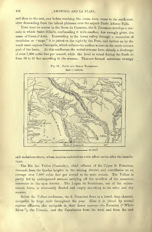
156 AMAZONIA AND LA PLATA.
and then to the east, and before reaching the ocean even turns to the south-east,after descending from the inland plateaux over the superb Paulo Affonso Falls.
Even near its source in the Serra da Canastra, the S. Francisco develops a cas-
cade to which Saint-Hilaire, confounding it with another, has wrongly given the
name of Casca d'Anta. Descending to the lower valley through a succession of
escadinhas or "steps," it is joined on the right by the Para, and farther on by the
much more copious Paraopeba, which collects the surface waters in the south-eastern
part of the basin. At this confluence the united streams have already a dischargeof over 7,000 cubic feet per second, while the level is raised during the floods to
from 26 to 40 feet according to the seasons. Thus are formed numerous swampy
Fig. 59. SAPAO AND SOMNO WATERSHED.
Scale 1 : 5,300,000.
West or Greenwich 44
125 Miles.
and malarious tracts, whose noxious exhalations even affect swine after the inunda-
tions.
The Hio das Yelhas (Guaicuhy), chief affluent of the Upper S. Francisco,
descends from the Queluz heights in the mining district, and contributes on an
average over 7,000 cubic feet per second to the main stream. The Velhas is
partly fed by underground streams carrying off the overflow of the numerous
reservoirs in the cave district. The Lagoa de Sumidouro, one of the subter-
ranean lakes, is alternately flooded and empty according to the rainy and dry
seasons.
Below the Velhas confluence, the S. Francisco flows in a broad, deep channel,
navigable by large craft throughout the year. Here it is joined by several
copious affluents, also navigable in their lower courses the Paracatu (" White
River"), the Urucuia, and the Carinh&nha from the west, and from the east
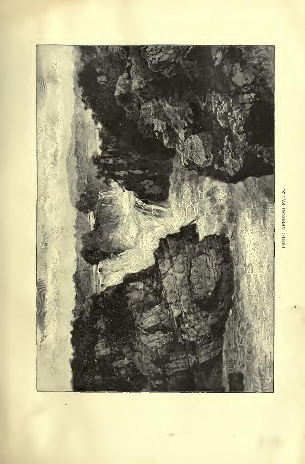
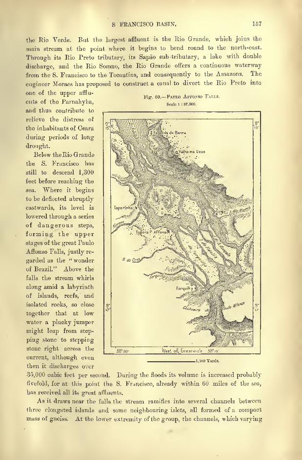
S FRANCISCO BASIN. 157
Fig. 60. PATJLO AFFONSO FALLS.
Scale 1 : 37.000.
the Rio Verde. But the largest affluent is the Rio Grande, which joins the
main stream at the point where it begins to bend round to the north-east.
Through its Rio Preto tributary, its Sapao sub -tributary, a lake with double
discharge, and the Rio Sorano, the Rio Grande offers a continuous waterway
from the S. Francisco to the Tocantins, and consequently to the Amazons. The
engineer Moraes has proposed to construct a canal to divert the Rio Preto into
one of the upper afflu-
ents of the Parnahyba,and thus contribute to
relieve the distress of
the inhabitants of Ceara
during periods of long
drought.
Below the Rio Grande
the S. Francisco has
still to descend 1,300
feet before reaching the
sea. Where it begins
to be deflected abruptly
eastwards, its level is
lowered through a series
of dangerous steps,
forming the upper
stages of the great Paulo
Affonso Falls, justly re-
garded as the " wonder
of Brazil." Above the
falls the stream whirls
along amid a labyrinth
of islands, reefs, and
isolated rocks, so close
together that at low
water a plucky jumper
might leap from step-
ping stone to stepping
stone right across the
current, although even
then it discharges over
35,000 cubic feet per second. During the floods its volume is increased probably
fivefold, for at this point the S. Frjncisco, already within 60 miles of the sea,
has received all its great affluents.
As it draws near the falls the stream ramifies into several channels between
three elongated islands and some neighbouring islets, all formed of a compactmass of gneiss. At the lower extremity of the group, the channels, which varying
58 20
.1,100 Yards.
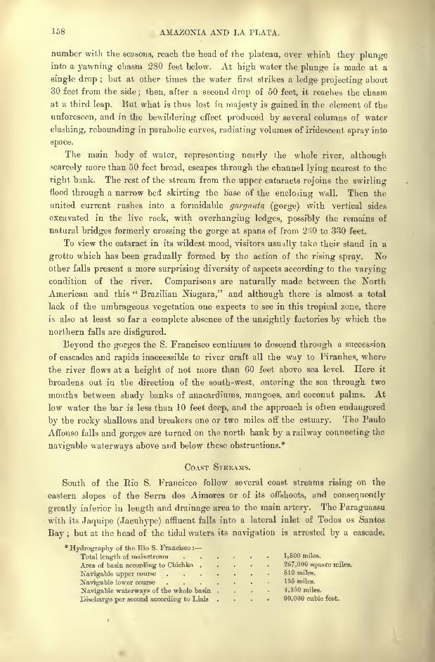
158 AMAZONIA AND LA PLATA.
number with the seasons, reach the head of the plateau, over which they plungeinto a yawning chasm 280 feet below. At high water the plunge is made at a
single drop ;but at other times the water first strikes a ledge projecting about
30 feet from the side; then, after a second drop of 50 feet, it reaches the chasm
at a third leap. But what is thus lost in majesty is gained in the element of the
unforeseen, and in the bewildering effect produced by several columns of water
clashing, rebounding in parabolic curves, radiating volumes of iridescent spray into
space.
The main body of water, representing nearly the whole river, although
scarcely more than 50 feet broad, escapes through the channel lying nearest to the
right bank. The rest of the stream from the upper cataracts rejoins the swirlingflood through a narrow bed skirting the base of the enclosing wall. Then the
united current rushes into a formidable gnrganta (gorge) with vertical sides
excavated in the live rock, with overhanging ledges, possibly the remains of
natural bridges formerly crossing the gorge at spans of from 2HO to 330 feet.
To view the cataract in its wildest mood, visitors usually take their stand in a
grotto which has been gradually formed by the action of the rising spray. Noother falls present a more surprising diversity of aspects according to the varyingcondition of the river. Comparisons are naturally made between the North
American and this " Brazilian Niagara," and although there is almost a total
lack of the umbrageous vegetation one expects to see in this tropical zone, there
is also at least so far a complete absence of the unsightly factories by which the
northern falls are disfigured.
Beyond the gorges the S. Francisco continues to descend through a succession
of cascades and rapids inaccessible to river craft all the way to Piranhes, where
the river flows at a height of not more than 60 feet above sea level. Here it
broadens out in the direction of the south-west, entering the sea through two
mouths between shady banks of anacardiums, mangoes, and coconut palms. At
low water the bar is less than 10 feet deep, and the approach is often endangered
by the rocky shallows and breakers one or two miles off the estuary. The Paulo
Affonso falls and gorges are turned on the north bank by a railway connecting the
navigable waterways above and below these obstructions.*
COAST STREAMS.
South of the Rio S. Francicco follow several coast streams rising on the
eastern slopes of the Serra dos Aimores or of its offshoots, and consequently
greatly inferior in length and drainage area to the main artery. The Paraguassu
with its Jaquipe (Jacuhype) affluent falls into a lateral inlet of Todos os Santos
Bay ;but at the head of the tidal waters its navigation is arrested by a cascade.
*Hydrography of the Rio S. Francisco :
Total length of mainstream 1,800 miles.
Area of basin according to Chichko 267,000 square miles.
Navigable upper course . . . . 810 miles.
Navigable lower course 135 miles.
Navigable waterways of the whole basin .... 4,350 miles.
Discharge per second according to Liais * 99,000 cubic feet.

THE LITTLE S. FEANCISCO. 159
The Piio de Contas is similarly obstructed by numerous falls. Farther south the
Pardo and Poxim have a common delta with the Jequitinhonha, which often takes
Fig. 61. MOUTH OF THE S. FEANCISCO.
Scale 1 : 130,000.
3629' West or Greenwich
Oto2Fathoms.
Depths.
Sandbank.
2 Fathomsand upwards.
3 Miles.
the name of " Little S. Francisco," from its great volume and the grand cataracts
interrupting its lower course. Below the Salto Grande (" Great Falls "), the
Jequitinhonha, which sometimes takes the name of Rio Belmonte from the town
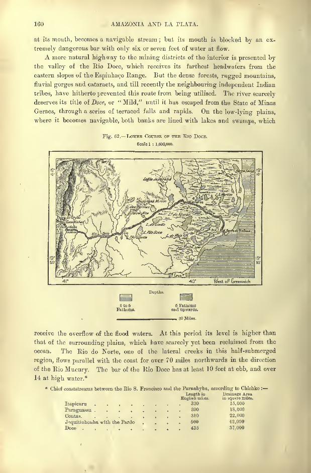
160 AMAZONIA AND LA PLATA.
at its mouth, becomes a navigable stream;but its mouth is blocked by an ex-
tremely dangerous bar with only six or seven feet of water at flow.
A more natural highway to the mining districts of the interior is presented bythe valley of the Rio Doce, which receives its farthest headwaters from the
eastern slopes of the Espmhac,o Range. But the dense forests, rugged mountains,
fluvial gorges and cataracts, and till recently the neighbouring independent Indian
tribes, have hitherto prevented this route from being utilised. The river scarcely
deserves its title of Doce, or "Mild," until it has escaped from the State of Minas
Geraes, through a series of terraced fulls and rapids. On the low-lying plains,
where it becomes navigable, both banks are lined with lakes and swamps, which
Fig. 62. LOWEB COURSE OF THE Rio DOCE.
Scale 1 : 1,600,000.
40 West oF Greenwich
Depths.
Oto6Fathoms.
6 Fathomsaud upwards.
30 Miles.
receive the overflow of the flood waters. At this period its level is higher than
that of the surrounding plains, which have scarcely yet been reclaimed from the
ocean. The Rio do Norte, one of the lateral creeks in this half-submerged
region, flows parallel with the coast for over 70 miles northwards in the direction
of the Rio Mucury. The bar of the Rio Doce has at least 10 feet at ebb, and over
14 at high water.*
* Chief coaststreams between the Rio S. Francisco and the Parnahyba, according to Chichko :
Length in Drainage Area
Itapicuru ....Paraguassu ....Contas. ....Joquitinhonha with the Pardo
Doce
English mi.es.
320
300
310
500
435
in square miles.
15,000
18,000
22,000
42,000
37-000
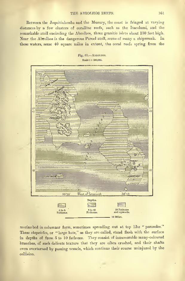
THE ABEOLHOS EEEFS. 161
Between the Jequitinhonha and the Mucury, the coast is fringed at varying
distances by a few clusters of coralline reefs, such as the Itacolumi, and the
remarkable atoll encircling the Abrolhos, three granitic islets about 130 feet high.
Near the Abrolhos is the dangerous Parcel atoll, scene of many a shipwreck. In
these waters, some 40 square miles in extent, the coral reefs spring from the
Fig. 63. ABEOLHOS.
Scale 1 : 500,000.
58*58' West op Greenwich 3845
Oto5Fathoms.
Depths.
5 to 10Fathoms.
10 Fathomsand upwards.
12 Miles.
marine bed in columnar form, sometimes spreading out at top like "parasoles."
These chapeiroes, or "large hats," as they are called, stand flush with the surface
in depths of from 5 to 10 fathoms. They consist of innumerable many-coloured
branches, of such delicate texture that they are often crushed, and their shafts
even overturned by passing vessels, which continue their course uninjured by the
collision.
162 AMAZONIA AND LA PLATA.
Some 600 miles seawards stands the volcanic Trinidade Island, which the
astronomer Halley occupied in 1700, in the name of England. But since the
close of the eighteenth century it has belonged politically to Brazil. About 30
miles farther east are seen the three islets of Martim Vaz, so named from the
Portuguese pilot who discovered them at the beginning of the sixteenth century.
CLIMATE.
On the coastlands the temperature in this tropical part of Brazil never falls
below 68 F., ranging from about 72 in July to 79 or 80 in January. Towards
the interior the heat naturally decreases with the altitude, while the range
between the extremes increases from about 18 on the seaboard to as much as 54
on the plateaux.
Between Recife and Rio de Janeiro, the coast lies entirely within the zone of
the southern trade winds, which set steadily from the south-east during the winter
season from April to September. In summer the north-east trades predominate ;
but irregularities occur in all seasons, and the calms resulting from the collision
between opposing currents are sometimes followed by fierce storms, thoughtrue cyclones are rare.
Although the European settlers speak officially of ""
spring, summer, autumn,
and winter," the only natural division is that of the Guarani natives, who recog-
nise the " season of the sun" and the " season of rain"
alone. On the coast the
rains, which fall chiefly in autumn, are much heavier than on the plateaux, shel-
tered by the mountains from the moist sea breezes. Nevertheless, even in the UpperS. Francisco basin the precipitation is abundant enough to develop boggy tracts
like those of Ireland. Farther north the elevated chapadas of Bahia suffer, on the
contrary, from a deficient rainfall, and here some districts present the aspect of
real deserts.*
FLORA AND FAUNA.
A selva comparable to that of Amazonia occupies all the well-watered coast-
lands and the higher valleys of the ranges exposed to the moist marine
winds. But on the western slopes of the backbone continuous woodlands become
rare. Much of the treeless aspect of the hills is, however, due to the action of
man, especially in the mining districts, where the timber required for the under-
ground galleries has often to be renewed every four years. On the northern
plateaux the forests are reduced to mere catangas, clumps or thickets of shrubs
which shed their leaves during the dry season;here many of the heights, especi-
*Meteorological conditions of the Upper S. Francisco valley and of the towns on the adjacent sea-
board :
Temperature.Latitude. Height. . Rainfall.
max. mean. min.Conconhas de Sahara 19 47' 2,250 feet 90 Fahr. 68 Fahr. 34 Fahr. 66 inches
Buhia . . . 12 58' 215 , 88 Fahr. 79 Fair 70 Fahr. 96
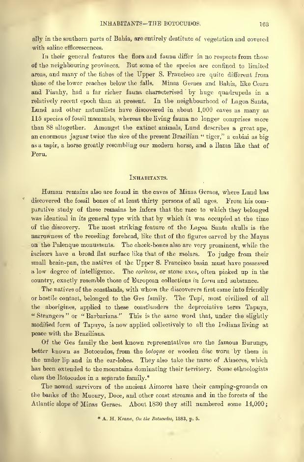
INHABITANTS THE BOTOCUDOS. 163
ally in the southern parts of Bahia, are entirely destitute of vegetation and covered
with saline efflorescences.
In their general features the flora and fauna differ in no respects from those
of the neighbouring provinces. But some of the species are confined to limited
areas, and many of the fbhes of the Upper S. Francisco are quite different from
those of the lower reaches below the falls. Minas Geraes and Bahia, like Ceara
and Piauhy, had a far richer fauna characterised by huge quadrupeds in a
relatively recent epoch than at present. In the neighbourhood of Lagoa Santa,
Lund and other naturalists have discovered in about 1,000 caves as many as
115 species of fossil mammals, whereas the living fauna no longer comprises more
than 88 altogether. Amongst the extinct animals, Lund describes a great ape,
an enormous jaguar twice the size of the present Brazilian "tiger," a cabiai as big
as a tapir, a horse greatly resembling our modern horse, and a llama like that of
Peru.
INHABITANTS.
Human remains also are found in the caves of Minas Geraes, where Lund has
discovered the fossil bones of at least thirty persons of all ages. From his com-
parative study of these remains he infers that the race to which they belongedwas identical in its general type with that by which it was occupied at the time
of the discovery. The most striking feature of the Lagoa Santa skulls is the
narrowness of the receding forehead, like that of the figures carved by the Mayason the Palenque monuments. The cheek-bones also are very prominent, while the
incisors have a broad flat surface like that of the molars. To judge from their
small brain-pan, the natives of the Upper S. Francisco basin must have possessed
a low degree of intelligence. The coriscos, or stone axes, often picked up in the
country, exactly resemble those of European collections in form and substance.
The natives of the coastlands, with whom the discoverers first came into friendly
or hostile contact, belonged to the Ges family. The Tupi, most civilised of all
the aborigines, applied to these coastJanders the depreciative term Tapuya,"Strangers
"or " Barbarians." This is the same word that, under the slightly
modified form of Tapuyo, is now applied collectively to all the Indians living at
peace with the Brazilians.
Of the Ges family the best known representatives are the famous Burungs,better known as Botocudos, from the botoque or wooden disc worn by them in
the under lip and in the ear-lobes. They also take the name of Aimores, which
has been extended to the mountains dominating their territory. Some ethnologists
class the Botocudos in a separate family.*
The nomad survivors of the ancient Aimores have their camping-grounds on
the banks of the Mucury, Doce, and other coast streams and in the forests of the
Atlantic slope of Minas Geraes. About 1830 they still numbered some 14,000 ;
* A. H. Keane, On the Botocudos, 1883, p. 5.
164 AMAZONIA. AND LA PLATA.
but since then most of the tribal groups have disappeared, partly through epi-
demics and general absorption in the surrounding settled populations, but partly
also through wholesale butcheries encouraged by the Brazilian officials. Duringthe early frontier wars, from about 1790 to 1820, every effort was made, not
merely to reduce, but to extirpate them root and branch. Being regarded as irre-
claimable savages, addicted to cannibalism and other pagan practices, and alto-
gether no better than wild beasts, methods of warfare were adopted against them
which are not usually sanctioned by civilised communities. The small-pox virus
was industriously spread amongst them, and poisoned food scattered over the
forests frequented by their hunters. By these and other means the Conde de
Linhares cleared the coast districts about the Rios Doce and Belmonte, and another
Commendador boasted to Professor Hartt that he had either slain with his own
hand, or ordered to be butchered with knife, gun, and poison, many hundreds of
this "vermin."
The charge of cannibalism brought against the Botocudos by early writers,
and still imputed to them by their neighbours, seems to be fully justified byabundant evidence. D'Orbigny states that they wore collars or strings of the
teeth of the persons they had eaten, and the portrait of a woman so ornamented
is figured in Sir W. Ouseley's" Travels." Yon Martius also asserts positively
that all were formerly anthropophagists, devouring not only the enemy slain in
battle, but also members of the Puri, Malali, Coroado, and other kindred tribes.
The heads were not eaten, but stuck as trophies on stakes, and used as butts for
the practice of archery.
All the bravos, that is, the independent wild tribes, are still in the stone age,
or rather, have scarcely yet reached that stage. The highly-finished diorite,
granite, and porphyry implements, found in the surrounding districts, belong to
the Amazonian and other more advanced Brazilian aborigines, and do not appear
to have ever been used by the Botocudos. The objects manufactured by them
are almost exclusively of wood or vegetable fibre. Such are the wooden mortars,
bamboo water vessels, cotton or bark sacks, reed spears, bows and arrows, which
last are their only offensive weapons. The bow is about 6 feet long, and so
strong that none but natives can use it;the arrows also are of great length,
and, being poisoned, the Portuguese soldiers had to be protected against them
by the giboa d'armas, a kind of armour, made of cotton cloth, thickened with
several layers of cotton wadding.An instrument of a more peaceful character is a small bamboo flute, which
is played on through the nose. This strange habit was probably occasioned bythe lip ornament, which prevented the mouth from being conveniently used for
the purpose.
Physically, the Botocudos are of robust frame, with full chest, broad shoulders,
small extremities, somewhat oblique eyes, prominent cheek-bones, very large
mouth and skull like that observed by Lund in the Lagoa Santa skeletons. Their
distinctive ornaments were the enormous discs of light wood by which the lower
lip and ear-lobes were immensely distended. Unable to use the lips in speaking,
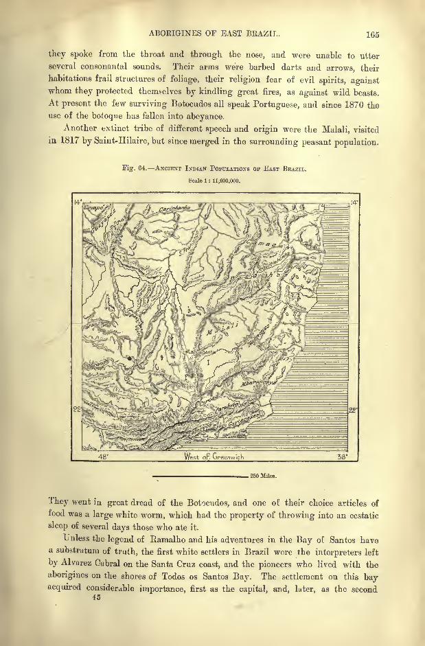
ABORIGINES OF EAST BRAZIL. 165
they spoke from the throat and through the nose, and were unable to utter
several consonantal sounds. Their arms were barbed darts and arrows, their
habitations frail structures of foliage, their religion fear of evil spirits, againstwhom they protected themselves by kindling great fires, as against wild beasts.
At present the few surviving Botocudos all speak Portuguese, and since 1870 the
use of the botoque has fallen into abeyance.
Another extinct tribe of different speech and origin were the Malali, visited
in. 1817 by Saint-Hilaire, but since merged in the surrounding peasant population.
Fig. 64. ANCIENT INDIAN POPULATIONS or EAST BRAZIL.
Scale 1 : 11,000,000.
14-
. 250 Miles.
They went in great dread of the Botocudos, and one of their choice articles of
food was a large white worm, which had the property of throwing into an ecstatic
sleep of several days those who ate it.
Unless the legend of Ramalho and his adventures in the Bay of Santos havea substratum of truth, the first white settlers in Brazil were the interpreters left
by Alvarez Cabral on the Santa Cruz coast, and the pioneers who lived with the
aborigines on the shores of Todos os Santos Bay. The settlement on this bayacquired considerable importance, first as the capital, and, later, as the second
45
1G6 AMAZONIA AND LA PLATA.
city in Brazil. But the spot where Cabral's associates landed is at present one of
the least frequented in the whole country.
The first arrivals from Portugal generally penetrated inland to the plateauxof Minas Geraes and the Upper S. Francisco Valley, attracted, in the first instance,
by the mineral wealth of these regions, and afterwards induced to remain by the
fertility of the land, its excellent climate, and abundant resources. Towards the
second half of the seventeenth century the intrepid Paulistas flocked in thou-
sands to the mining districts in quest of gold and of the precious stones wronglycalled " emeralds." But they were not the only intruders, and the settlers on the
shores of Rio de Janeiro, as well as adventurers from beyond the seas, also claimed
a share in these treasures. Civil war soon broke out between these emboalas,
or "strangers
" from Portugal and the other provinces, and the Paulistas, who
considered themselves the lawful owners of the mineral districts, which they had
wrested from the Cataguar Indians. In 1708 the emboabas were nearly exter-
minated on the banks of the Rio das Mortes;but other bands pressed forward,
and after renewed conflicts both factions had to become reconciled under the
stern repressive measures imposed on all parties by the central government.
Extremely rigorous laws were enacted to regulate the operations in the gold-
fields, and afterwards in the diamantiferous districts discovered in 1728. Nowhere
else was a more draconic administration introduced, and the consequence was
widespread corruption, frauds, thefts, smuggling, and the general demoralisation
which is the usual outcome of legalised terrorism.
Since that epoch the political relations have changed, and the mines, which
had inspired this ferocious legislation, and caused all this moral degradation, are
themselves now to a large extent exhausted. The old mining cities have fallen
into decay ;little remains of formerly flourishing centres of population, except
crumbling ruins overshadowed by sumptuous churches like the vast minsters of
mediaeval Europe. But the impoverishment of certain districts has not prevented
general progress, shown by a tenfold increase in the population since the
mining days.
The blacks introduced as slaves in the mining districts of the plateaux have
left scarcely any descendants, and the few survivors have been absorbed in the half-
caste populations of the interior. But nowhere in Brazil are the Africans better
represented than in the districts of the Lower S. Francisco and in the city of
Bahia. Here was formerly the centre of the slave trade. Besides those intro-
duced from the coast of Angola to work on the plantations and in the mines,
others arrived as freemen in the quality of sailors and supercargoes, and to
these (Krumen and others) was given the general name of Minas, from a tribe on
the Slave Coast south of Dahomey. Even still these form in Bahia a sort of
corporation, whose members are distinguished by their moral qualities and spirit
of solidarity, as well as for their tall stature and physical strength. Their speech
comprises numerous words inherited from the African languages, and hundreds
of Yoruba and Cabinda terms have been adopted in the current dialect of Bahia.
Here the negroes accompany their magic incantations with snatches of songs
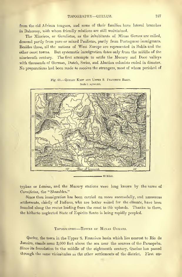
TOPOGRAPHY QUELUZ. 167
from the old African tongues, and some of their families have lateral branches
in Dahomey, with whom friendly relations are still maintained.
The Mineiros, or Geralistas, as the inhabitants of Minas Geraes are called,
descend partly from pure or mixed Paulistas, partly from Portuguese immigrants.
Besides these, all the nations of "West Europe are represented in Bahia and the
other coast towns. But systematic immigration dates only from the middle of the
nineteenth century. The first attempts to settle the Mucury and Doce valleys
with thousands of German, Dutch, Swiss, and Alsatian colonists ended in disaster.
No preparations had been made to receive the strangers, most of whom perished of
Fig. 65. QTJELUZ KNOT AND UPPEE S. FRANCISCO BASIN.
Scale 1 : 4,000.000.
' West or Greenwich
60 Miles.
typhus or famine, and the Mucury stations were long known by the name of
Carnijicina, the " Shambles."
Since then immigration has been carried on more successfully, and numerous
settlements, chiefly of Italians, who are better suited for the climate, have been
founded along the routes leading from the coast to the uplands. Thanks to them,
the hitherto neglected State of Espirito Santo is being rapidly peopled.
TOPOGRAPHY TOWNS OF MINAS GERAES.
Queluz, the town in the Upper S. Francisco basin which lies nearest to Rio de
Janeiro, stands some 3,000 feet above the sea near the sources of the Paraopeba.Since its foundation in the middle of the eighteenth century, Queluz has passed
through the same vicissitudes as the other settlements of the district. First en-
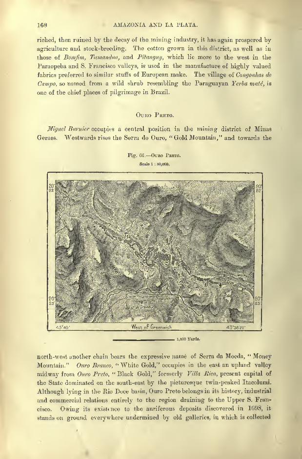
168 AMAZONIA AND LA PLATA.
riched, then ruined by the decay of the mining industry, it has again prospered by
agriculture and stock-breeding. The cotton grown in this district, as well as in
those of Bomjim, Tamandua, and Pitanguy, which lie more to the west in the
Paraopeba and S. Francisco valleys, is used in the manufacture of highly valued
fabrics preferred to similar stuffs of European make. The village of Congonhas de
Campo, so named from a wild shrub resembling the Paraguayan Yerba mate, is
one of the chief places of pilgrimage in Brazil.
OURO PRETO.
Miguel Btirnicr occupies a central position in the mining district of Minas
Geraes. Westwards rises the Serra do Ouro, "Gold Mountain," and towards the
Pig. 66. OURO FBETO.
Scale 1 : 30,000.
i
43*40' West or Greenwich 43'38'gO'
1,100 Yards.
north-west another chain bears the expressive name of Serra da Moeda,"Money
Mountain." Ouro Branco," White Gold," occupies in the east an upland valley
midway from Ouro Preto," Black Gold," formerly Villa Rica, present capital of
the State dominated on the south-east by the picturesque twin-peaked Itacolumi,
Although lying in the Rio Doce basin, Ouro Preto belongs in its history, industrial
and commercial relations entirely to the region draining to the Upper S. Fran-
Owing its existence to the auriferous deposits discovered in 1698, itCISCO.
stands on ground everywhere undermined by old galleries, in which is collected
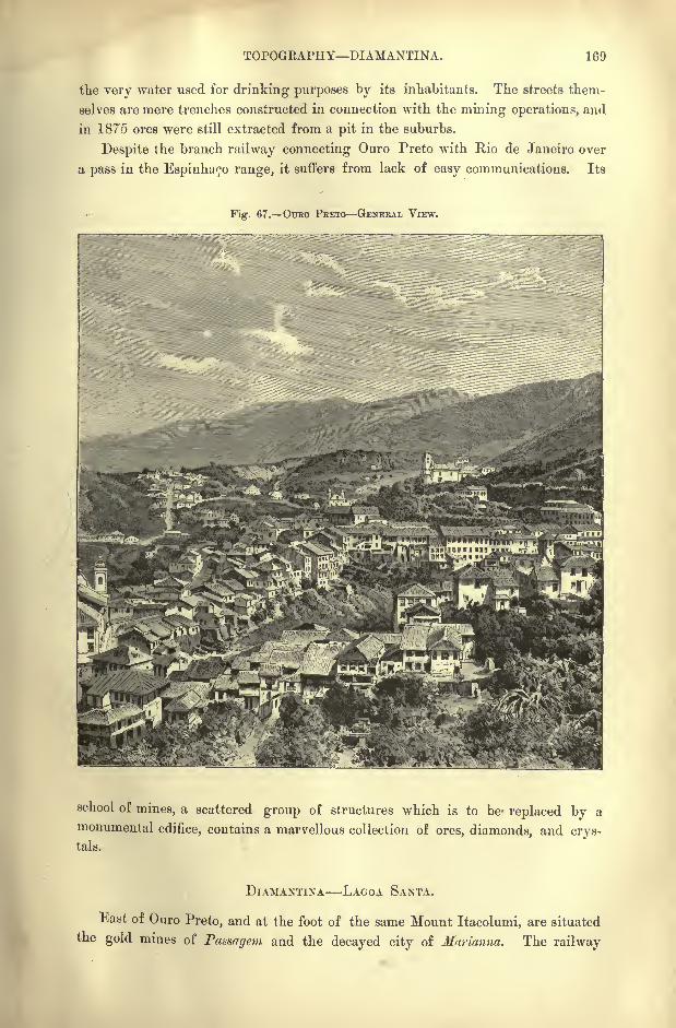
TOPOGEAPHY DIAMANTINA. 169
the very water used for drinking purposes by its inhabitants. The streets them-
selves are mere trenches constructed in connection with the mining operations, and
in 1875 ores were still extracted from a pit in the suburbs.
Despite the branch railway connecting Ouro Preto with Rio de Janeiro over
a pass in the Espinhaco range, it suffers from lack of easy communications. Its
Fig. 67. OURO PRETO GENERAL VIEW.
school of mines, a scattered group of structures which is to be- replaced by a
monumental edifice, contains a marvellous collection of ores, diamonds, and crys-tals.
DIAMANTINA LAGOA SANTA.
East of Ouro Preto, and at the foot of the same Mount Itacolumi, are situated
the gold mines of Passagem and the decayed city of Mnrianna. The railway
170 AMAZONIA AND LA PLATA.
traversing the eastern slope of the Espinha90 range here penetrates to the
northern mining region through Infieionado, Cattas Alias, Santa Barbara, Itabira
do Matto Dentro, Conceigao, and Serro, all of which places occupy upland valleys
watered by the headstreams of the Rio Doce. Serro still possesses some gold and
diamond mines, but it now depends chiefly on its agricultural resources.
Diamantina, formerly Tijuco, lies in the upper Jequitinhonha valley, but its
commercial relations are chiefly with Rio de Janeiro through the S. Francisco
basin. The yield of its diamond mines has fallen from about 150,000 to less
than 40,000 a year. Farther north the formerly flourishing town of Grao Mogolhas been nearly abandoned.
In the Upper Rio das Yelhas valley are several thriving places, such as Sabara
at the head of the navigation, whose highly productive gold mines, especially
Morro Velho, near Villa Nova de Lima, are now worked by some wealthy English
companies. Villa Nova is well known to mineralogists by its old name of Can-
gonhas de Sabara. Morro Velho employs from 1,500 to 2,000 hands, and at pre-
sent has an average annual yield of about 80,000 ;if fully worked the output
might exceed 280,000.
About eight miles from the railway west of Sabara lies the healthy plateau of
Hello Horisonte, one of the sites which have been proposed for the future capital of
Minas Geraes. The pure waters of the district already surveyed would suffice for
the requirements of a city of 450,000 inhabitants. A narrow valley on the oppo-
site side of Sabara is occupied by the mining village of Gaethe, which abounds in
asbestos.
Santa Luzia, below Sabara on the Rio des Velhas, lies near Lagoa Santa, where
Lund passed many years exploring the surrounding caves. The jasper beds
in the neighbourhood supply the material for the statuettes and other objects
executed by the local artists. Farther on, Parauna," Black Water," on the
affluent of like name, has also been mentioned as a favourable site for the
future capital of the State, of which it occupies the geometrical centre.
In the northern section of Minas Geraes the towns of Monies Claros das
Formigas at the head of the Rio Verde, and Paracatu, formerly Piracatu, near the
Goyaz frontier, have become flourishing centres of the cattle trade. Like those of
Lagoa Santa, the Montes Claros cliffs are pierced by numerous caves, in which
have been found the remains of the megalonyx and other extinct animals.
TOWNS OF BAHIA AND SERGIPE.
Below the Velhas confluence, where stands the little-frequented port of Guai-
cuhy, Januaria, or Salgado, is the last place on the S. Francisco within the Minas
Geraes frontier. In the State of Bahia follow Carinhanha ; Bom Jesus de Lapa
with its "miraculous" grotto; Urubu, the "Vulture" town, facing Mount Pernam-
buco; Barra, at the Rio Grande confluence, chief place in the western districts of
Bahia; Pilao Arcado, lower down on the left bank, a great centre of the salt
industry. Here are vast beds of native salt still untouched by the miner.
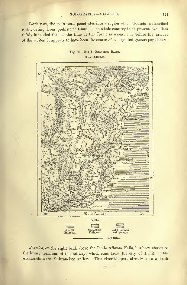
TOPOGEAPHY JOAZEIRO. 171
Farther on, the main route penetrates into a region which abounds in inscribed
rocks, dating from prehistoric times. The whole country is at present even less
thinly inhabited than at the time of the Jesuit missions, and before the arrival
of the whites, it appears to have been the centre of a large indigenous population.
Fig. 68. Eio S. FEANCISCO BASIN.
Scale : 1,400,000.
Depths.
to 600Fathoms.
500 to 2,000Fathoms.
2,000 Fathomsand upwards.
310 AJiles.
Joazeiro, on the right bank above the Paulo Affonso Falls, has been chosen as
the future terminus of the railway, which runs from the city of Bahia north-
westwards to the S. Francisco valley. This riverside port already does a brisk
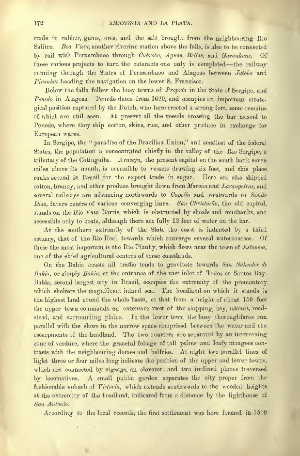
172 AMAZONIA AND LA PLATA.
trade in rubber, gums, ores, and the salt brought from the neighbouring Rio
Salitre. Boa Vista, another riverine station above the falls, is also to be connected
by rail with Pernambuco through Cabrobo, Aguas, Bellas, and Garanhuns. Of
these various projects to turn the cataracts one only is completed the railway
running through the States of Pernambuco and Alagoas between Jatoba and
Piranhas heading the navigation on the lower S. Francisco.
Below the falls follow the busy towns of Propria in the State of Sergipe, and
Penedo in Alagoas. Penedo dates from 1620, and occupies an important strate-
gical position captured by the Dutch, who here erected a strong fort, some remains
of which are still seen. At present all the vessels crossing the bar ascend to
Penedo, where they ship cotton, skins, rice, and other produce in exchange for
European wares.
In Sergipe, the "paradise of the Brazilian Union," and smallest of the federal
States, the population is concentrated chiefly in the valley of the Rio Sergipe, a
tributary of the Cotinguiba. Aracnju, the present capital on the south bank seven
miles above its mouth, is accessible to vessels drawing six feet, and this place
ranks second in Brazil for the export trade in sugar. Here are also shipped
cotton, brandy, and other produce brought down from Maroim and Larangeiras, and
several railways are advancing northwards to Capella and westwards to Sirnao
Diaz, future centre of various converging lines. San Christomo, the old capital,
stands on the Rio Vasa Barris, which is obstructed by shoals and mudbanks, and
accessible only to boats, although there are fully 12 feet of water on the bar.
At the southern extremity of the State the coast is indented by a third
estuary, that of the Rio Real, towards which converge several watercourses. Of
these the most important is the Rio Piauhy, which flows near the town of Estancia,
one of the chief agricultural centres of these coastlands.
On the Bahia coasts all traffic tends to gravitate towards San Salvador de
Bahia, or simply Bahia, at the entrance of the vast inlet of Todos os Santos Bay.
.Bahia, second largest city in Brazil, occupies the extremity of the promontory
which shelters the magnificent inland sea. The headland on which it stands is
the highest land round the whole basin, so that from a height of about 150 feet
the upper town commands an extensile view of the shipping, bay, islands, road-
stead, and surrounding plains. In the lower town the busy thoroughfares run
parallel with the shore in the narrow space comprised between the water and the
escarpments of the headland. The two quarters are separated by an intervening
zone of verdure, where the graceful foliage of tall palms and leafy mangoes con-
trasts with the neighbouring domes and belfries. At night two parallel lines of
light three or four miles long indicate the position of the upper and lower towns,
which are connected by zigzags, an elevator, and two inclined planes traversed
by locomotives. A small public garden separates the city proper from the
fashionable suburb of Victoria, which extends southwards to the wooded heights
at the extremity of the headland, indicated from a distance by the lighthouse of
San Antonio.
According to the local records, the first settlement was here formed in 1510
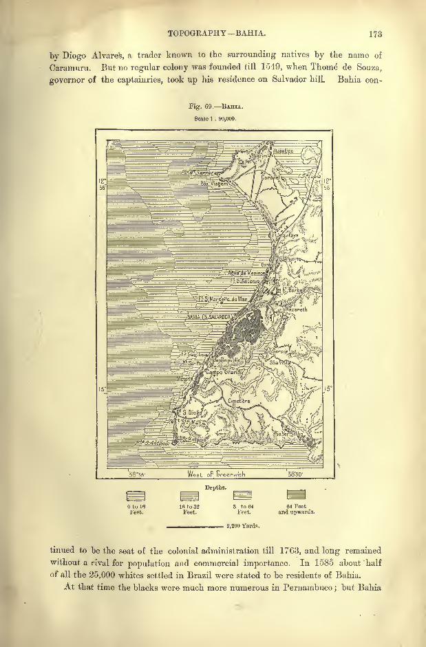
TOPOGRAPHY -BAHIA. 173
by Diogo Alvares, a trader known to the surrounding natives by the name of
Caramuru. But no regular colony was founded till 1549, when Thome de Souza,
governor of the captainries, took up his residence on Salvador hill. Bahia con-
Fig. 69. BAHIA.
Scale 1 : 90,000.
West op Lreenwich 38'50'
Depths.
to 16Feet.
Ifi to 32Feet.
3 to 64Feet.
2,200 Yards.
64 Feetand upwards.
tinued to be the seat of the colonial administration till 1763, and long remained
without a rival for population and commercial importance. In 1585 about half
of all the 25,000 whites settled in Brazil were stated to be residents of Bahia.
At that time the blacks were much more numerous in Pernambuco ;but Bahia
174 AMAZONIA AND LA PLATA.
soon monopolised the slave trade, and despite of later legislation the local traders
continued to be the chief importers of negroes down to the middle of the nineteenth
century, introducing in some years as many as 60,000. Bahia was nearly ruined
by the suppression of the traffic, and with difficulty recovered from the blow by
developing its agricultural resources. The black element is still predominant in
la Velha Mulata, the " Old Mulattress," as the place is popularly called.
At the time of the foundation the Jesuits established themselves in Bahia,
which still retains its rank as the religious metropolis of Brazil. It was also in
the seventeenth century the intellectual centre of Portuguese America;but its
libraries, museums, and learned societies are scarcely worthy of a city with over
200,000 inhabitants. Buhia, however, possesses one of the two schools of medicine
that have been founded in the republic. Its citizens are also distinguished
amongst all Brazilians for their dignified bearing and culture, and they have at
all times taken a considerable share in the government of the country. In one
respect, Bahia is more " Brazilian"
than Rio de Janeiro. It lacks the cosmo-
politan character of the federal capital, and its houses, many of which are faced
with varnished faience ware, are more like those of Lisbon. One of its churches
has been entirely built of dressed stones imported from Portugal.
The harbour, sheltered from the east and south-east winds by the promontory,
is exposed to the Atlantic swell rolling in through the broad entrance to the bay.
Hence large vessels ride at anchor some distance off the quays. No attempt has
yet been made to carry out the project to enclose a space of over 250 acres bymeans of two breakwaters, one over a mile long running from the northern
extremity of Bahia to Fort S. Marcello, the other carried in the direction of the
same fort from the southern quarter, where are situated the arsenal and custom-
house. Sugar, tobacco, coffee, cotton, cattle, and hides are the chief articles of the
export trade, which is valued at nearly 2,000,000 a year. The local markets are
abundantly provided with provisions, and are specially noted both for the great
variety and profusion of tropical fruits, and for the endless diversity of types
white, black, and half-breeds of every shade observed in the picturesque groups
frequenting them.
In the neighbouring waters a few whalers still pursue the cetaceans, which
yield the train-oil used in lighting the city before the introduction of gas, but now
forwarded to Europe. During the prevalence of southern winds the whales fre-
quently penetrate into the bay, and are then pursued by boatmen armed with har-
poons. About fifty are captured every year, and a spermaceti refinery has been
established in the city. Others formerly existed in the neighbouring island of
Itaparica, where at the beginning of the present century most of the whalebone
was prepared, which at that time was used instead of railing for enclosing gardens
and courtyards.
Some deposits of coal have been discovered in Itaparica, a long narrow island,
with a town at its northern extremity. The soil is extremely fertile, and the
island is noted for the excellence of its produce no less than for its genial climate.
It is locally known as the "Europe of the poor," because it is much frequented
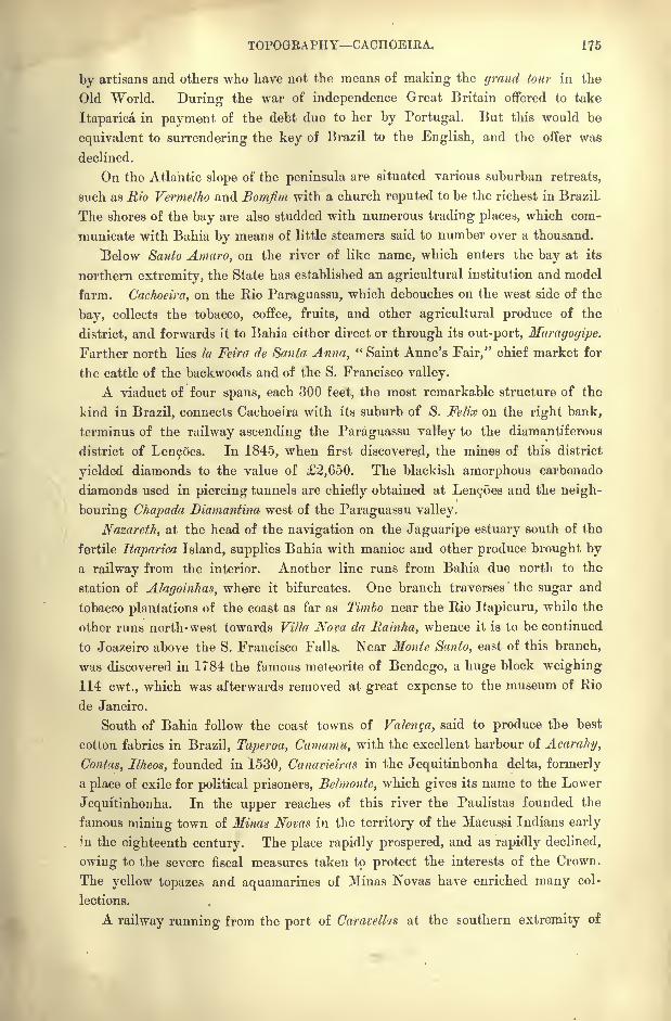
TOPOGRAPHY CACHOEIEA. 175
by artisans and others who have not the means of making the grand tour in the
Old World. During the war of independence Great Britain offered to take
Itaparica in payment of the debt due to her by Portugal. But this would be
equivalent to surrendering the key of Brazil to the English, and the offer was
declined.
On the Atlantic slope of the peninsula are situated various suburban retreats,
such as Rio Vermelho and Bomfim with a church reputed to be the richest in Brazil.
The shores of the bay are also studded with numerous trading places, which com-
municate with Bahia by means of little steamers said to number over a thousand.
Below Santo Amaro, on the river of like name, which enters the bay at its
northern extremity, the State has established an agricultural institution and model
farm. Cachoeira, on the Rio Paraguassu, which debouches on the west side of the
bay, collects the tobacco, coffee, fruits, and other agricultural produce of the
district, and forwards it to Bahia either direct or through its out-port, Maragogipe.
Farther north lies la Feira de Santa Anna," Saint Anne's Fair," chief market for
the cattle of the backwoods and of the S. Francisco valley.
A viaduct of four spans, each 300 feet, the most remarka,ble structure of the
kind in Brazil, connects Cachoeira with its suburb of S. Felix on the right bank,
terminus of the railway ascending the Paraguassu valley to the diamantiferous
district of LencOes. In 1845, when first discovered, the mines of this district
yielded diamonds to the value of 2,650. The blackish amorphous carbonado
diamonds used in piercing tunnels are chiefly obtained at Le^oes and the neigh-
bouring Chapada Diamantina west of the Paraguassu valley.
Nazareth, at the head of the navigation on the Jaguaripe estuary south of the
fertile Itaparica Island, supplies Bahia with manioc and other produce brought bya railway from the interior. Another line runs from Bahia due north to the
station of Alagoinhas, where it bifurcates. One branch traverses the sugar and
tobacco plantations of the coast as far as Timbo near the Rio Itapicuru, while the
other runs north-west towards Villa Nova da Rainha, whence it is to be continued
to Joazeiro above the S. Francisco Falls. Near Monte Santo, east of this branch,
was discovered in 1784 the famous meteorite of Bendego, a huge block weighing
114 cwt., which was afterwards removed at great expense to the museum of Rio
de Janeiro.
South of Bahia follow the coast towns of Valenqa, said to produce the best
cotton fabrics in Brazil, Taperoa, Camamu, with the excellent harbour of Acarahy,
Contas, Ilheos, founded in 1530, Canavieiras in the Jequitinhonha delta, formerly
a place of exile for political prisoners, Belmonte, which gives its name to the Lower
Jequitinhonha. In the upper reaches of this river the Paulistas founded the
famous mining town of Ninas Novas in the territory of the Macussi Indians early
in the eighteenth century. The place rapidly prospered, and as rapidly declined,
owing to the severe fiscal measures taken to protect the interests of the Crown.
The yellow topazes and aquamarines of Minas Novas have enriched many col-
lections.
A railway running from the port of Caravellxs at the southern extremity of
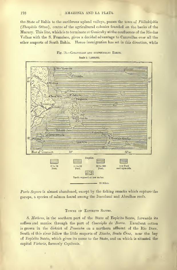
176 AMAZONIA AND LA PLATA.
the State of Bahia to the auriferous upland valleys, passes the town of Philadelphia
(Theophilo Ottoni}, centre of the agricultural colonies founded on the banks of the
Mucury. This line, which is to terminate at Guaicuhy at the confluence of the Rio das
Velhas with the S. Francisco, gives a decided advantage to Caravellas over all the
other seaports of South Bahia. Hence immigration has set in this direction, while
Fig. 70. CABAVELLAS AND SUBBOUNDING REEFS.
Scale 1 : 1,000,000.
West or Greenwich 38*50-
Depths.
Oto 16
Feet.l-to32Feet.
32 to 160Feet.
IfO Feetand upwards.
Reefs exposed at low water.
18 Allies.
Porto Sctjtiro is almost abandoned, except by the fishing smacks which capture the
garupa, a species of salmon found among the Itacolumi and Abrolhos reefs.
TOWNS OF ESPIRITO SANTO.
S. Matheus, in the southern part of the State of Espirito Santo, forwards its
coffees and manioc through the port of Conceigao da Barrn. Excellent cotton
is grown in the district of Pcssanha on a northern affluent of the Rio Doce.
South of this river follow the little seaports of Riacho, Santa Cruz, near the bayof Espirito Santo, which gives its name to the State, and on which is situated the
capital Victoria, formerly Capitania.
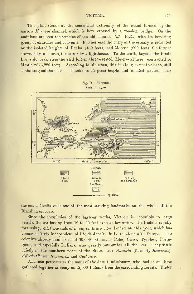
VICTORIA. 177
This place stands at the south-west extremity of the island formed by the
narrow Maruype channel, which is here crossed by a wooden bridge. On the
mainland are seen the remains of the old capital, Villa Velha, with its imposing
group of churches and convents. Farther east the entry of the estuary is indicated
by the isolated heights of Penha (430 feet), and Moreno (690 feet), the former
crowned by a church, the latter by a lighthouse. To the north, beyond the Frade
Leopardo peak rises the still loftier three-crested Mestre-Alvarez, contracted to
Mestialve (3,220 feet). According to Mouchez, this is a long extinct volcano, still
containing sulphur beds. Thanks to its great height and isolated position near
Fig. 71. VICTORIA.
Scale 1 : 140,000.
40 "20' West oF Greenwich 40*14-'
Depths.
to 16Feet.
16 to 32Feet.
Sandbank.
32 Feetand upwards.
Miles.
the coast, Mestialve is one of the most striking landmarks on the whole of the
Brazilian seaboard.
Since the completion of the harbour works, Victoria is accessible to large
vessels, the bar having from 16 to 20 feet even at low water. Its trade is rapidly
increasing, and thousands of immigrants are now landed at this port, which has
become entirely independent of Rio de Janeiro, in its relations with Europe. The
colonists already number about 30,000 Germans, Poles, Swiss, Tyrolese, Portu-
guese, and especially Italians, who greatly outnumber all the rest. They settle
chiefly in the southern parts of the State,"
near Anchieta (formerly Benevente),
Alfredo Chavez, Itapemirim and Cachociro.
Anchieta perpetuates the name of the Jesuit missionary, who had at one time
gathered together as many as 12,000 Indians from the surrounding forests. Under

178 AMAZONIA AND LA PLATA.
the rule of the priests, the " reductions"
(stations) were kept aloof from all con-
tact with the whites, and even after their expulsion from Brazil the Jesuits
stipulated that an " inalienable"space of six square leagues should be left round
the Indian villages. But their backs were scarcely turned when the reservation
was invaded. Some of the recent arrivals, still under government control, receive
a yearly subsidy, besides seed, corn, and cattle. But most of the settlers are
already "emancipated," that is to say, are thrown upon their own resources, culti-
vating small freeholds at their own risk. Coffee, which is the chief crop, yielded
in 1892 about 3,930,000 cwts. But manioc, rice, beans, and other provisions are
also raised for the surrounding markets.


RIO DE JANEIR
W "YORK E>
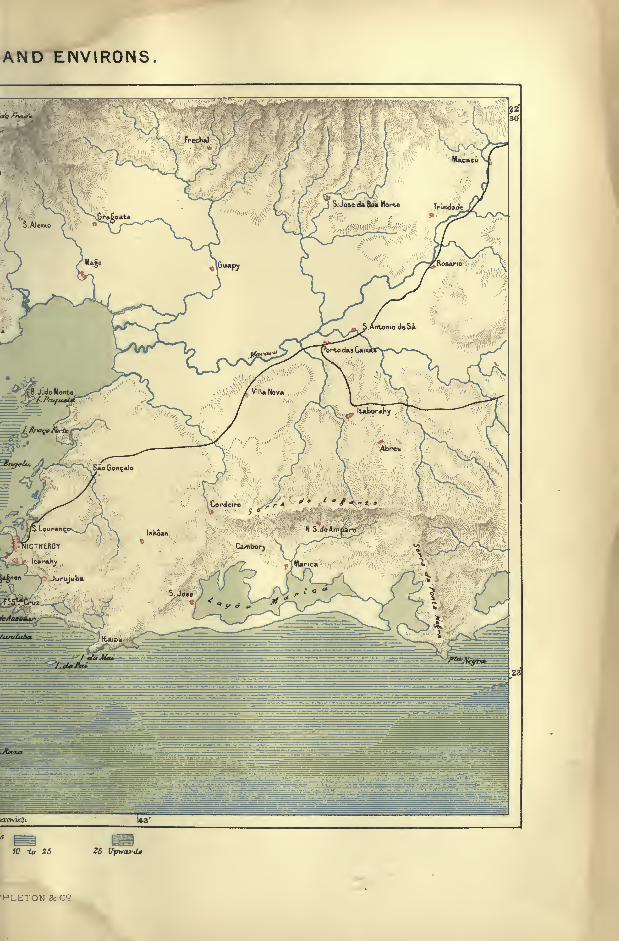
AND ENVIRONS.
j &>' y <K .
to 25 25 Upward*
PLETON 8cC9
CHAPTER X.
PARAHYBA BASIN.
STATE or Rio DE JANEIRO AND NEUTRAL TERRITORY.
HE State in which is situated the capital of Brazil, forms a land of
transition between the tropical and temperate zones. At Cape
Frio, the direction of the coast-line, which had a general southern
trend below Cape S. Roque, changes abruptly to the west, and after
describing a regular curve resumes its normal course from north to
south with some points to the west. The southern tropic passes just south of the
State of Rio de Janeiro, and thus coincides with the trend of the seaboard at this
point.
On the other hand the Rio Parahyba, which rises on the plateaux of S. Paulo,
at the same divide where the upper affluents of the Parana have their source, flows
north-east in a deep trough forming a natural boundary to the triangular space
comprising the State of Rio. On its upper slopes this river valley belongs to the
temperate plateaux, and in its lower course to the tropical zone.
Since the early days of the discovery, the famous bay of Rio de Janeiro has
played a conspicuous part in the history of the New World. After the heroic
ages, when French and Portuguese contended for the possession of Nictheroy, the
surrounding region has been explored in every direction, and hundreds of
observers have contributed to our knowledge of the land in all its aspects. Never-
theless, it still lacks large scale maps possessing even approximate accuracy.
Excellent charts, however, will soon be available at least for the city and the
surrounding neutral municipality, the triangulation of which is now completed.
Rio is the most densely peopled district in Brazil, having a population of nearly
2,000,000 to an area of 27,000 square miles.
PHYSICAL FEATURES.
The mountain barrier enclosing ihe Parahyba valley on the north-west would
form the most natural frontier of the State;but the political parting-line, instead
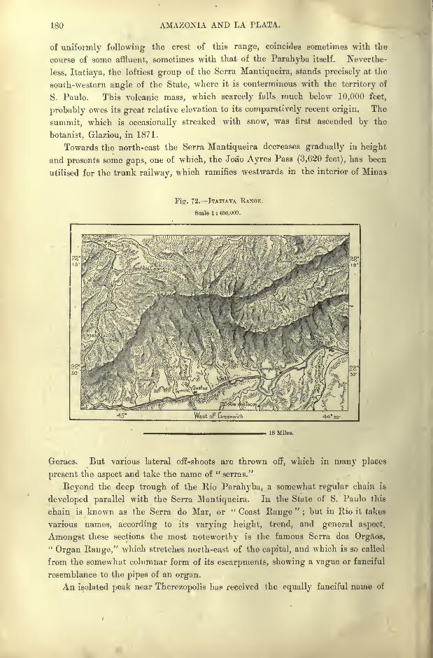
180 AMAZONIA AND LA PLATA.
of uniformly following the crest of this range, coincides sometimes with the
course of some affluent, sometimes with that of the Parahyba itself. Neverthe-
less, Itatiaya, the loftiest group of the Serra Mantiqueira, stands precisely at the
south-western angle of the State, where it is conterminous with the territory of
S. Paulo. This volcanic mass, which scarcely falls much below 10,000 feet,
probably owes its great relative elevation to its comparatively recent origin. The
summit, which is occasionally streaked with snow, was first ascended by the
botanist, Glaziou, in 1871.
Towards the north-east the Serra Mantiqueira decreases gradually in height
and presents some gaps, one of which, the Joao Ayres Pass (3,620 feet), has been
utilised for the trunk railway, which ramifies westwards in the interior of Minas
Fig. 72. ITATIAYA RANGE.
Scale 1 : 650,000.
18 Miles.
Geraes. But various lateral off-shoots are thrown off, which in many places
present the aspect and take the name of " serras."
Beyond the deep trough of the Rio Parahyba, a somewhat regular chain is
developed parallel with the Serra Mantiqueira. In the State of S. Paulo this
chain is known as the Serra do Mar, or " Coast Range"
;but in Rio it takes
various names, according to its varying height, trend, and general aspect.
Amongst these sections the most noteworthy is the famous Serra dos Orgaos,"Organ Range," which stretches north-east of the capital, and which is so called
from the somewhat columnar form of its escarpments, showing a vague or fanciful
resemblance to the pipes of an organ.
An isolated peak near Therezopolis has received the equally fanciful name of
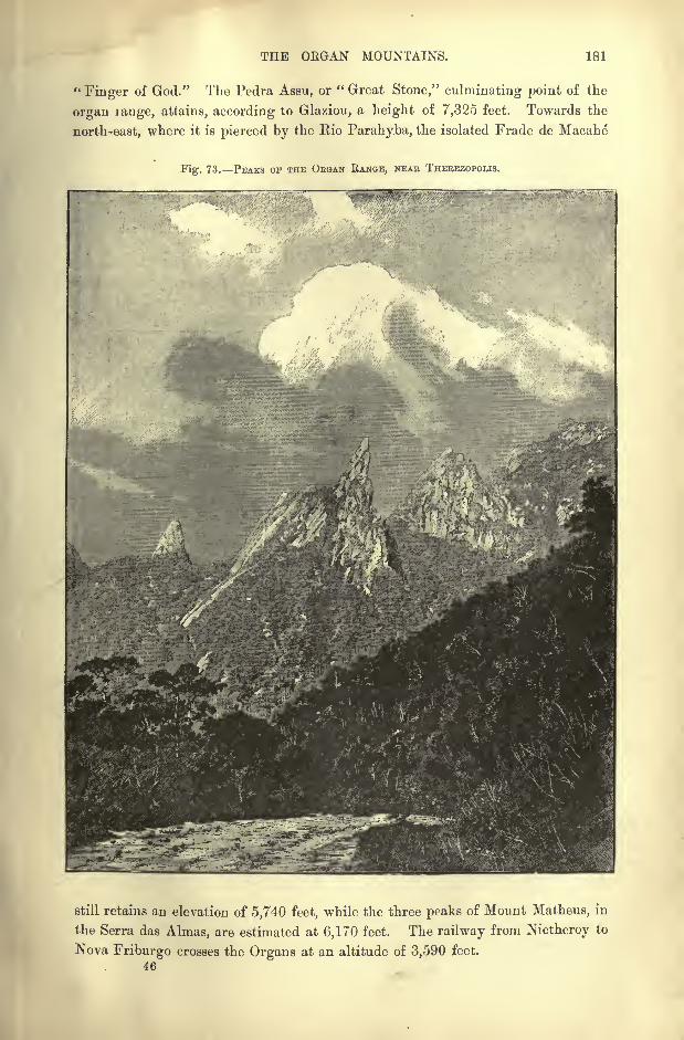
THE ORGAN MOUNTAINS. 181
"Finger of God." The Pedra Assu, or " Great Stone," culminating point of the
organ range, attains, according to Glaziou, a height of 7,325 feet. Towards the
north-east, where it is pierced by the Rio Parahyba, the isolated Frade de Macahe
Fig. 73. PEAKS OF THE OEGAN RANGE, NEAE THEBEZOPOLIS.
still retains an elevation of 5,740 feet, while the three peaks of Mount Matheus, in
the Serra das Almas, are estimated at 6,170 feet. The railway from Nictheroy to
Nova Friburgo crosses the Organs at an altitude of 3,590 feet.
46

182 AMAZONIA AND LA PLATA.
Westwards, the Organ range is continued by the Serra de Tingua, which has
an extreme height of 5,410 feet. This range, being of igneous origin, with
obliterated craters, presents a marked contrast to the neighbouring gneiss and
granite mountains. West of the Serra de Tingua, a railway long regarded as a
marvel of Brazilian enterprise surmounts the Serra do Mar by a series of steep
gradients and eighteen tunnels, the highest point reached being 1,356 feet.
Farther on towards the S. Paulo frontier the nearly isolated Serra Bocaina has
several peaks 5,000 feet high, facing the superb Itatiaya group on the other side
of the upper Parahyba valley. On the seaward side of the Serra do Mar a few
Fig. 74. Rio DE JANEIRO SEABOAED.
Scale 1 : 1,800.000.
Depths.
Oto 10Fathoms.
10 to 25Fathoms
25 to 50Fathoms.
50 Fathomsand upwards.
30 Miles.
narrow heights, rising abruptly above the sea, represent ancient islands now joined
to the mainland. Such are the cones encircling Rio de Janeiro Bay, the entrance
to which is dominated by Mount Tijuca (3,360 feet), where Agassiz thought traces
of former glaciation might be detected.
RIVERS.
The Parahyba do Sul, or simply Parahyba, has its sources close to the sea at
the south-east extremity of S. Paulo. It flows first south-west, in the very oppo-
site direction to the course which it afterwards takes to escape from its rocky
E1VERS OF EIO DE JANEIEO. 183
barriers. After receiving the Rio Preto from Itatiaya and the Parahybuna," Black River," it is joined by the Dous Rios above the S. Fidelia Gorge.
Below this point, where it is only 230 feet above sea level, it becomes a navigable
stream, winding through rich alluvial plains to the zone of its marshy delta.
The sediment washed down by the turbid waters of the Parahyba has formed
extensive sandbanks north of Cape S. Thome, which frequently shift their position
during the floods and storms, and reduce the water at the bar to little over six
Fig. 75. MOUTH OF THE PARAHYBA AND CAPE S. THOME.
Scale 1 : 1,100,000.
West oF breanwich 4I50' 41
Depths.
to 5Fathoms.
5 to 10Fathoms.
10 to 25Fathoms.
25 Fathomsand upwards.
18 Miles.
feet. The Parahyba, a term of doubtful meaning, has a total length of about 600
miles, a drainage area of 26,000 square miles, a navigable course of *60 miles, and
a mean discharge of 53,500 cubic feet per second.
On the narrow seaward slopes of the coast range there is no room for the
development of any large streams. The Macacu, which enters the north-west side
of Rio Bay, although one of the largest, has a course of less than 60 miles. But if
the seaboard lacks copious rivers, it abounds in stagnant lagoons and land-locked
inlets. South of the Lower Parahyba the Lagoa Feia, an old marine gulf now
separated from the sea by a strip of sands, has an average superficial area of 170
square miles, and communicates through shallow creeks with numerous other
lagoons dotted over the low-lying coastlands. Northwards it is connected, during
184 MAZONIA AND LA PLATA.
the floods, with the Parahyba ; eastwards, with the chain of backwaters on both
sides of Cape S. Thome; south-westwards, a channel, or rather, a broad ditch,
traversing several other lagoons, carries to the Macahe the overflow of the LagoaFeia.
West of the Archipelagoes and peninsular headlands terminating at Cape Frio,
several sheets of water follow along the low-lying tract comprised between the sea
and the foot of the Serra do Mar. Araruama, largest of these basins, maintains
constant communication with the ocean through a passage north of Cape Frio
giving free access to the tides. But the other lagoons are closed, and after long
Fig. 76. CAPE FBIO.
Scale 1 : 960.000.
42 v West oF Greenwich
Depths.
OtolO 10 to 25 2ft to 50 50 FathomsFathoms. Fathoms. Fathoms. and upwards.
18 Miles.
periods of rain they have to be opened by cuttings in the intervening sandy
cordons. These lagoons might be easily transformed to productive salines, and
they were often used as such even under the Portuguese rule, although in
order to protect the monopoly of the Setubal salines, the extraction of salt was
forbidden by the royal edicts of 1690 and 1691.
The marvellous bay of Eio de Janeiro," River of January," which has given
its Portuguese name to the Brazilian capital, and which was formerly much more
aptly named Nictheroy, "Hidden Water," by the surrounding Tupi Indians,
belongs in its northern extremity to the type of the coast lagoons.It is, in fact,
CLIMATE OF EIO DE JANEIRO. 185
at once a gulf and a lagoon, while the entrance resembles a strait. Here the
granite rocks approach on both sides so closely that only a passage is left 1,600
yards wide with 15 fathoms on the sill. Inside this passage the east and west
shores are indented with semi-circular inlets, whose intervening headlands are
continued by islands and islets far into the water. Beyond these labyrinthine
groups of rocky and verdant heights, the bay expands into a vast inland sea, with
shelving beach exposed and flooded at each ebb and flow. With its 300 islands
the land-locked basin covers a space of 170 square miles, over a third of which is
deep enough for the largest vessels. The deeply indented shores further present
a succession of ramifying creeks, where the shipping finds an unlimited extent of
perfectly sheltered anchorage. Nevertheless some parts of the bay are slowly
silting up, and some of the old mooring places have had to be abandoned.
Outside the inner coast-line formed by the bay, the regular marine beach is
indicated west of the Bio heights by the so-called restinga of Marambaia, a narrow
strip of sand running nearly in a straight line between a headland and an
adjacent islet. Farther on, the peak of the Ilha Grande, over 1,000 feet high,
follows in the same direction, projecting its spurs towards a still more elevated
peninsular promontory, which shuts off the gulf of Paraty from the ocean. Alono-
the line of all these islands and peninsulas the marine waters preserve their normal
depth, and nowhere show any indication of shoaling.
CLIMATE.
Within a narrow space mountains, valleys, and coastlands offer so many
parallel zones, each with its separate climate. To the contrast of varying tem-
perature is added the play of alternating sea breezes, due to the trend of the two
sections of the coast, one disposed from north to south, the other from east to west.
But everywhere the humidity is relatively very great throughout the year, although
the rainfall is heaviest in summer, when the weather is also most stormy under the
influence of the west and north-west gales. The most prevalent winds, however,
are those of the southern trades, which usually blow from the south-east.
Taken as a whole, the State of Rio de Janeiro is not one of the healthy regions
of Brazil. The numerous marshy tracts on the coast are dangerous afc all seasons,
especially for strangers. Besides the endemic agues, these districts are visited by
epidemics of yellow fever, which are fatal to all white settlers. But the moun-
tain slopes and breezy heights offer health resorts, where the European mayrecover from the debilitating effects of a residence on the lowlands. The climate
of Rio is said to have undergone a change since the destruction of the great
forests. Rains and storms would appear to have become far more irregular than
formerly.*
*Meteorological conditions of Rio :
Temperature. RainyLatitude. Altitude. ^- " -^ iJays. Rainfall.
max. mean. min.Rio . . 2264'S. 220 feet. 102 Fahr. 73 Fahr. 50 Fahr. 127 43 inches.
186 AMAZONIA AND LA PLATA.
FLORA AND FAUNA.
The flora and fauna also, originally analogous to those of the neighbouring
State of Espirito Santo, have already been greatly modified, at least in the district
surrounding the capital. Here the primeval forests have everywhere disappeared
except on the unhealthy parts of the plains, or in the less accessible scarps of the
mountains. Most of the large animals have also vanished. Tapirs are no longer
met anywhere, and jaguars only in the remoter parts of the backwoods. The
former herds of peccaries and other porcos do matto,"forest swine," are reduced to
a few rare bands on the verge of the outlying settlements, and even some of the
bird species have diminished in number. But on the other hand as many as 800
species of butterflies and over 2,000 of insects may still be found in a narrow radius
round about the bay.
INHABITANTS.
Like the animals, the aborigines have all disappeared within the limits of the
State, nor can even the half-caste descendants of the old Tamoyo (Tamoi, Aiam)race be any longer recognised. As friends of the French, these were hostile to
the Pero (Portuguese), who sought allies amongst the Mbarancayas ("Cats") of
Espirito Santo, and by their aid got the better both of the French and of the
Tamoyos. These were mostly exterminated, while the rest escaped, and are now
said to be represented by the Tupinambas, or Tupinambaranas, of the large island
of that name below the Madeira confluence.
The Paulistas, who hunted down the aborigines to supply the mines and
plantations with slaves, also contributed to the destruction of the Tamoyos, who
were of pure Tupi stock and speech. They were also cannibals, at least to the
extent of eating the enemy slain in battle. The early European travellers, such
as Hans Staden, Jean de Le"ry and Magalhanes de Gandavo, all agree in their des-
criptions of the usages of these maritime Tupi tribes, and their statements are in
nearly complete agreement with tho^e of Yves of Evreux and Claude of Abbeville
respecting the Indians of Maranhao, who belong to the same widely diffused
ethnical family. All alike painted their bodies with the red rucu dye, and black
with genapa ; they also disfigured themselves to a far greater extent than did the
Botocudos by the insertion of various objects in the lips, ear lobes and other parts
of the face. They pierced the under lip of the children, gradually enlarging the
aperture until it was wide enough to receive a wooden disk or some stone orna-
ment. They also pierced the cheeks for the insertion of pieces of crystal, and
took pride in covering the face with artificial protuberances, and plastering their
bodies with feathers and thorns. Yet all were robust and healthy, and amongstthem there were scarcely any lame or halt, maimed or distorted.
These Tupi tribes lived in large cabins sometimes 150 or ICO feet long, with
as many fire-places as there were separate family groups. All had their ham-
mocks disposed along the whole length of the common corridors, the vast dor-
INHABITANTS OF EIO DE JANEIRO. 187
initory resembling the lower deck of a galley. They dwelt together in peace ;
the friend of one was the friend of all, and whoever had anything to eat, however
little it might be, shared with all present.
Marriage was strictly endogamous, that is, within the tribe, and the Tamoyos
lawfully married their nieces, daughters of their own brothers or sisters. Ac-
cording to Gandavo, some of the women, scorning the occupations of their sex,
dressed and decorated themselves like the men, carried the bow and arrows and
hunted in their company. Each of these viragoes was attended by another Indian
woman whom she called her helpmeet.
Trials of endurance were held in high honour amongst the Tupinambas. The
chief, entering the cabins, gashed the young men on their legs with a very sharp
fish-bone, to teach them to suffer without complaint, and thus earn the name of
men and warriors. In battle the combatants hurled insults and curses at each
other, shouting from camp to camp :
"May all evils befall you ; to-day I will
make a meal of you !
" And in fact the victor consumed the flesh of the van-
quished. Such was the renown attached to the exploit that henceforth the Indian
warrior took a new name, and also bestowed one on his wife, selecting it from
some fish, fruit or flower.
Isolated amid these Tupi peoples were the Watecas (Goytacazes), "Runners,"
who were akin to the Botocudos, and who occupied the lower districts of the
Parahyba still from them called "Campos dos Guatacazes." These were the
wildest of all the coast Indians;and such was the terror inspired by their name
that, in the popular imagination, they acquired gigantic proportions and super-
human strength.
Near their camping-grounds, amid the lagoons, they heaped up the remains of
their vanquished foes, which formed islands amid the lagoons of their watery
domain. After over a century of fierce resistance to the Portuguese, they were
at last overcome in 1630, when those surviving the battlefield either escaped to
the backwoods on the Minas Geraes frontier, or else were removed to an agricul-
tural reservation. Those of the woodland cut their flowing locks and shaved the
crown of the head, whence the term Coroados (" Crowned ") applied to them bythe Portuguese in common with many other tribes adopting the same style of
headdress.
Nearly all the aborigines having thus disappeared, their place has been taken
by Africans and by immigrants from almost every European land. In no other
part of Brazil are the people of a more cosmopolitan character. Some of the
inland settlers from Germany and Switzerland have even partly preserved the
national type; while the great trade of the capital with Europe and North
America has given it almost a foreign aspect.
TOPOGRAPHY.
In the Parah\ ba valley all the centres of population depend almost for their
very existence on coffee, the staple product of Brazil. Such are Rezende, domi-
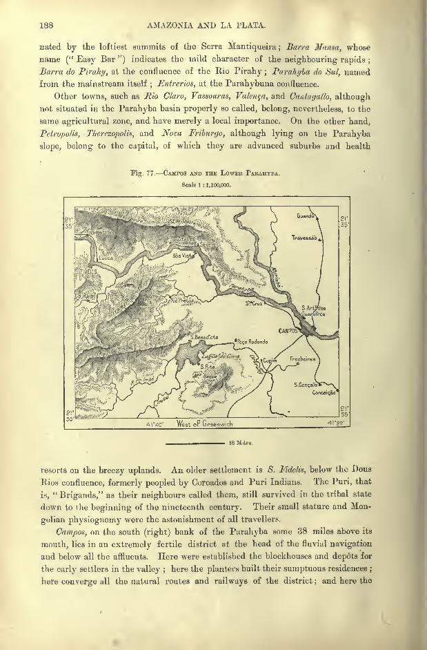
188 AMAZONIA AND LA PLATA.
nated by the loftiest summits of the Serra Mantiqueira; Barra Mansa, whose
name (" Easy Bar ") indicates the mild character of the neighbouring rapids ;
Barm do Pirahy, at the confluence of the Rio Pirahy ; Parahyba do Sul, named
from the mainstream itself; Entrerios, at the Parahybuna confluence.
Other towns, such as Rio Claro, Vassouras, Valeria, and Cantagallo, although
not situated in the Parahyba basin properly so called, belong, nevertheless, to the
same agricultural zone, and have merely a local importance. On the other hand,
Petropolis, Therezopolia, and Nova Friburgo, although lying on the Parahyba
slope, belong to the capital, of which they are advanced suburbs and health
Fig. 77. CAMPOS AND THE LOWER PARAHYBA.
Scale 1 : 1,100,000.
18 Miles.
resorts on the breezy uplands. An older settlement is S. Fidelis, below the Dous
Rios confluence, formerly peopled by Coroados and Puri Indians. The Puri, that
i.s,"Brigands," as their neighbours called them, still survived in the tribal state
down to the beginning of the nineteenth century. Their small stature and Mon-
golian physiognomy were the astonishment of all travellers.
Campos, on the south (right) bank of the Parahyba some 38 miles above its
mouth, lies in an extremely fertile district ut the head of the fluvial navigation
and below all the affluents. Here were established the blockhouses and depots for
the early settlers in the valley ;here the planters built their sumptuous residences ;
here converge all the natural routes and railways of the district;and here the
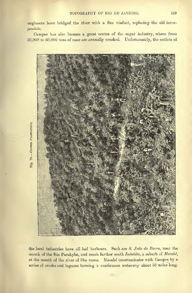
TOPOGRAPHY OF RIO DE JANEIRO. 189
engineers have bridged the river with a fine viaduct, replacing the old barca-
pendula.
Campos has also become a great centre of the sugar industry, where from
50,000 to 60,000 tons of cane are annually crushed. Unfortunately, the outlets of
in
the local industries have all bad harbours. Such are 8. Jodo da Barra, near the
mouth of the Rio Parahyba, and much farther south Imbetiba, a suburb of Hacahe,
at the mouth of the river of like name. Macahe communicates with Campos by a
series of creeks and lagoons forming a continuous waterway about 56 miles long.
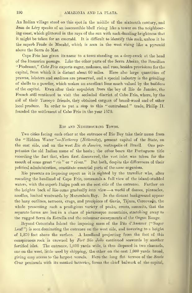
190 AMAZONIA AND LA PLATA.
An Indian village stood on this spot in the middle of the sixteenth century, and
Jean de Lery speaks of an inaccessible bluff rising like a tower on the neighbour-
ing coast, which glittered in the rays of the sun with such dazzling brightness that
it might be taken for an emerald. It is difficult to identify this rock, unless it be
the superb Frade de Macahe, which is seen in the west rising like a pyramidabove the Serra do Mar.
Cape Frio has given its name to a town standing on a deep creek at the head
of the Itamarica passage. Like the other parts of the Serra Abaixo, the Brazilian
'Piedmont," Cabo Frio exports sugar, molasses, and rum, besides provisions for the
capital, from which it is distant about 60 miles. Here also large quantities of
prawns, lobsters and sardines are preserved, and a special industry is the grindingof shells to a powder, which makes an excellent lime much valued by the builders
of the capital. Even after their expulsion from the bay of Rio de Janeiro, the
French still continued to visit the secluded district of Cabo Frio, where, by the
aid of their Tamoyo friends, they obtained cargoes of brazil-wood and of other
local produce. In order to put a stop to this " contraband"
trade, Philip II.
founded the settlement of Cabo Frio in the year 1575.
Rio AND NEIGHBOURING TOWNS.
Two cities facing each other at the entrance of Rio Bay take their name from
the "Hidden Water" Nicthcroy (Nithcrohy], present capital of the State, on
the east side, and on the west Rio de Janeiro, metropolis of Brazil. One per-
petuates the old Indian name of the basin;the other bears the Portuguese title
recording the fact that, when first discovered, the vast inlet was taken for the
mouth of some great"
rio"
or " river." But both, despite the differences of their
political administration, constitute essential parts of the same organism.
Rio presents an imposing aspect as it is sighted by the traveller who, after
rounding the headland of Cape Frio, commands a full view of the island-studded
waters, with the superb Itaipu peak on the east side of the entrance. Farther on
the heights back of Rio come gradually into view a world of domes, pinnacles,
needles, limited westwards by Marambaia Bay. In the distant background appear
the hazy outlines, terraces, crags, and precipices of Gavia, Tijuca, Corcova^o, the
whole presenting such a prodigious variety of peaks, crests, summits, that the
separate forms are lost in a chaos of picturesque mountains, stretching away to
the rugged Serra da Estrella and the columnar escarpments of the Organ Range.
Beyond Cotuntuba Island the imposing mass of the Pao d'Assucar ("Sugar
Loaf ") is seen dominating the entrance on the west side, and towering to a height
of 1,270 feet above the surface. A headland projecting from the foot of this
conspicuous rock is crowned by Fort Sao Joao continued seawards by another
fortified islet. The entrance, 1,(JOO yards wide, is thus disposed in two channels,
one on the west, little used by shipping, the other on the east 1,000 yards broad,
giving easy access to the largest vessels. Here the long flat terrace of the Santa
Cruz peninsula with its masked batteries, forms the chief bulwark of the capital,
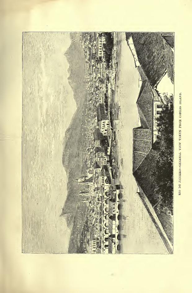

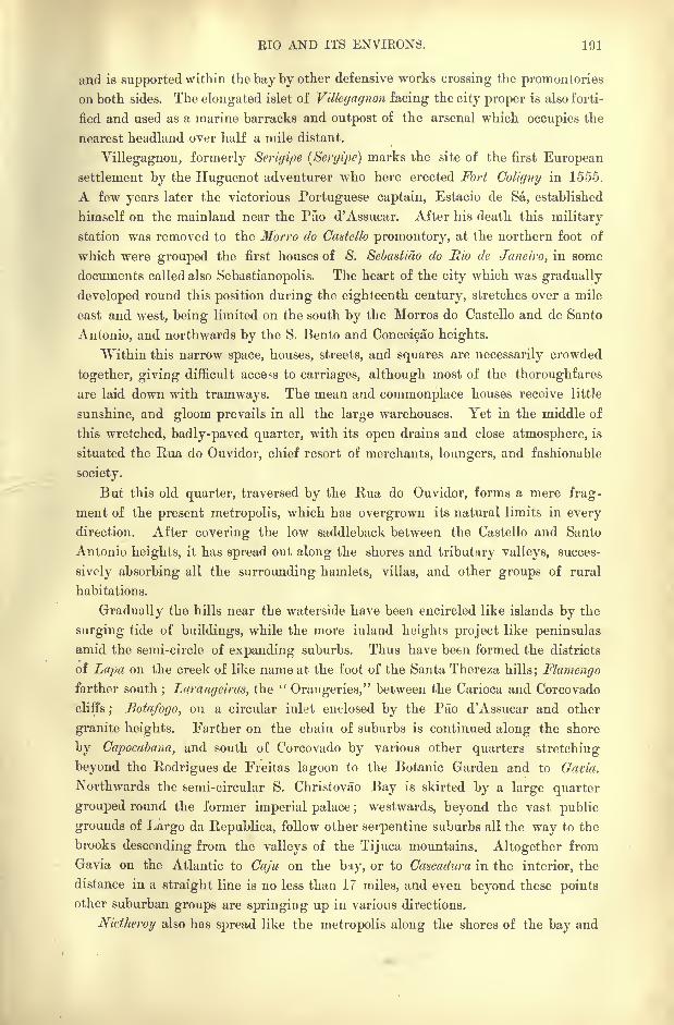
KIO AND ITS ENVIRONS. 191
and is supported within the bay by other defensive works crossing the promontories
on both sides. The elongated islet of Villegagnon facing the city proper is also forti-
fied and used as a marine barracks and outpost of the arsenal which occupies the
nearest headland over half a mile distant.
Villegagnon, formerly Scrigipe (Sergipe) marks the site of the first Europeansettlement by the Huguenot adventurer who here erected Fort Coligny in 1555.
A few years later the victorious Portuguese captain, Estacio de Sa, established
himself on the mainland near the Pao d'Assucar. After his death this military
station was removed to the Morro do Caatello promontory, at the northern foot of
which were grouped the first houses of 8. Sebastiao do Rio de Janeiro, in some
documents called also Sebastianopolis. The heart of the city which was gradually
developed round this position during the eighteenth century, stretches over a mile
east and west, being limited on the south by the Morros do Castello and de Santo
Antonio, and northwards by the S. Bento and Conceicao heights.
"Within this narrow space, houses, streets, and squares are necessarily crowded
together, giving difficult access to carriages, although most of the thoroughfares
are laid down with tramways. The mean and commonplace houses receive little
sunshine, and gloom prevails in all the large warehouses. Yet in the middle of
this wretched, badly-paved quarter, with its open drains and close atmosphere, is
situated the Rua do Ouvidor, chief resort of merchants, loungers, and fashionable
society.
But this old quarter, traversed by the Rua do Ouvidor, forms a mere frag-
ment of the present metropolis, which has overgrown its natural limits in every
direction. After covering the low saddleback between the Castello and Santo
Antonio heights, it has spread out along the shores and tributary valleys, succes-
sively absorbing all the surrounding hamlets, villas, and other groups of rural
habitations.
Gradually the hills near the waterside have been encircled like islands by the
surging tide of buildings, while the more inland heights project like peninsulas
amid the semi-circle of expanding suburbs. Thus have been formed the districts
of Lapa on the creek of like name at the foot of the Santa Thereza hills; Flamengofarther south
; Larangeims, the "Orangeries," between the Carioca and Corcovado
cliffs; Botafogo, on a circular inlet enclosed by the Pao d'Assucar and other
granite heights. Farther on the chain of suburbs is continued along the shore
by Capocabana, and south of Corcovado by various other quarters stretching
beyond the Hodrigues de Freitas lagoon to the Botanic Garden and to Gavia.
Northwards the semi-circular S. Christovao Bay is skirted by a large quarter
grouped round the former imperial palace ; westwards, beyond the vast public
grounds of Largo da Republica, follow other serpentine suburbs all the way to the
brooks descending from the valleys of the Tijuca mountains. Altogether from
Gavia on the Atlantic to Caju on the bay, or to Cascadura in the interior, the
distance in a straight line is no less than 17 miles, and even beyond these points
other suburban groups are springing up in various directions.
Nidheroy also has spread like the metropolis along the shores of the bay and
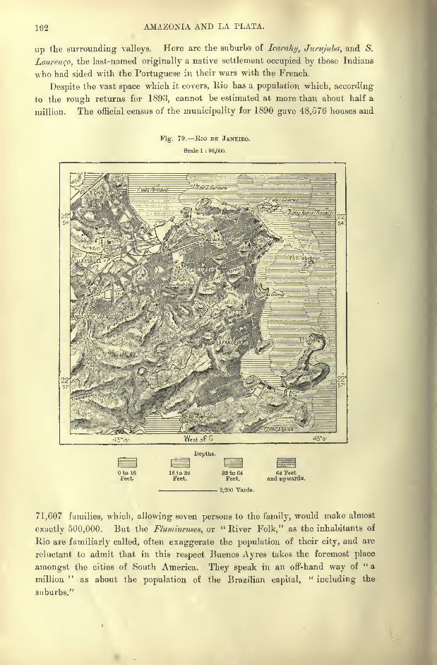
192 AMAZONIA AND LA PLATA.
up the surround iiig valleys. Here are the suburbs of learaky, Juntjuba, and S.
Lourengo, the last-named originally a native settlement occupied by those Indians
who had sided with the Portuguese in their wars with the French.
Despite the vast space which it covers, Rio has a population which, according
to the rough returns for 1893, cannot be estimated at more than about half a
million. The official census of the municipality for 1890 gave 48,576 houses and
Fig. 79. Rio DE JANEIRO.
Scale 1 : 90,000.
West of G 43V
Depths.
Oto 16Feet.
16 to 32Feet.
82 to 64Feet.
. 2,200 Yards.
64 Feetand upwards.
71,607 families, which, allowing seven persons to the family, would make almost
exactly 500,000. But the Fluminenses, or " River Folk," as the inhabitants of
Rio are familiarly called, often exaggerate the population of their city, and are
reluctant to admit that in this respect Buenos Ayres takes the foremost place
amongst the cities of South America. They speak in an off-hand way of " a
million"
as about the population of the Brazilian capital,"including the
suburbs."
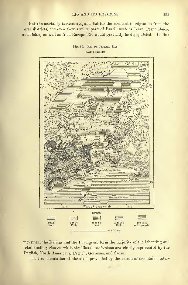
lilO AND ITS ENVIEONS. 193
But the mortality is excessive, and but for the constant immigration from the
rural districts, and even from remote parts of Brazil, such as Ceara, Pernambuco,
and Bahia, as well as from Europe, liio would graduallj' be depopulated. In this
Fig. 80. Rio DE JANEIRO BAY.
8oale 1 : 320,000.
45"i5- West oF Greenwich 43V
Depths.
Oto3Feet.
StoleFeet.
16 to 64Feet.
64 to 160Feet.
6 Miles.
160 Feetand upwards.
movement the Italians and the Portuguese form the majority of the labouring and
retail trading classes, while the liberal professions are chiefly represented by the
English, North Americans, French, Germans, and Swiss.
The free circulation of the air is prevented by the screen of mountains inter-
194 AMAZONIA AND LA PLATA.
vening between the city and the Atlantic. Most of the streets are also badly
paved and worse drained; hence in recent years Rio has suffered much from
epidemics, especially yellow fever, which would appear to have even become
endemic. Water, however, flows abundantly in all quarters, being supplied in the
proportion of about 40 gallons daily per head of the population. Rio no longer
depends as formerly on the Carioca springs alone, which rise in the hills north of
Corcovado, and the water from which is conveyed by conduits and a fine aqueduct
to the central districts. In the surrounding forests, which have become State
property, reservoirs have been constructed at intervals along the course of several
underground channels. Such is that of Pedregulho near S. Christovao, which is
fed by the Rio de Ouro 30 miles to the north, and which has a capacity of about
9,000,000 gallons.
Rio is far from a monumental city. The churches are copies of copies in the
usual Jesuit style, while with few exceptions the recent public buildings resemble
huge barracks. On the other hand few cities are adorned with more beautiful
avenues, such as those of la Tijuca, and the triple avenue of lofty palms (Oreodoxa
oleracea) in the Botanical Gardens. These palms have a perfectly smooth, slender
stem about 80 feet high, terminating in a mass of leaves each averaging 10 or 12
feet in length.
Although there are no special industries, Rio has to some extent become a
manufacturing city, with numerous cotton-spinning and weaving mills, foundries,
furniture, cabinet, and shipbuilding works. Several docks and repairing basins
have been excavated in the live rock of the Saude hills and in Cobras Island near
the marine arsenal. Coffee, the staple of the export trade", was shipped to the
value of 8,000,000 in 1892, the total exports amounting to about 15,000,000,
and the imports to over 16,000,000. In the general movement of the foreign
exchanges Great Britain takes the first place, the United States, France, and
Germany following in the order named. The traffic with the interior is almost
exclusively carried on by means of the two chief lines of railway, one running to
S. Paulo, the other to Minas Geraes. The local circulation is amply provided for
by numerous tramways, worked either by mules or by electricity, while the com-
munications with Nictheroy and the various towns and ports around the bay are
kept up by means of steam ferries. These have preserved their English name of
"ferry," while the omnibuses are still known by the name of "bonds," from the
bonds originall}' issued by the English company which introduced this system of
locomotion.
Rio, which has been capital of Brazil since 1763, is the seat of the chief
museums and learned institutions of the republic. Amongst these is the School
of Medicine, one of the first in the New World, in connection with the vast
Misericordia Hospital. This sumptuous establishment, which accommodates 1,200
patients, and which appears to be admirably conducted, stands on the spot where
Magellan landed in 1520 on his voyage round the globe. Other important estab-
lishments are the Polytechnic School, the Academy of Fine Arts, the Conserva-
toire of Music, the Blind and Deaf and Dumb Asylums, the School of Navigation,
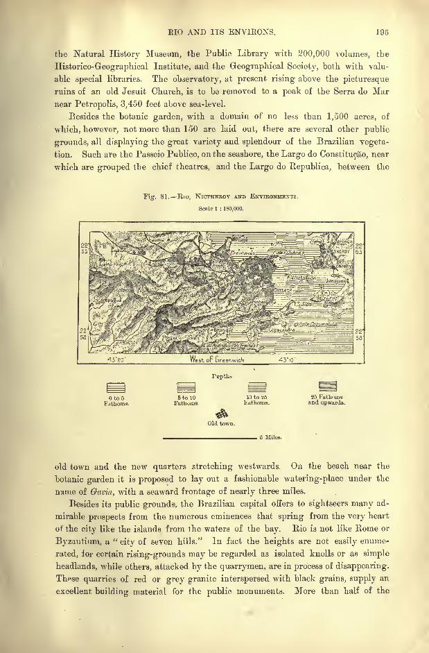
BIO AND ITS ENVIKONS. 195
the Natural History Museum, the Public Library with 200,000 volumes, the
Historico-Geographical Institute, and the Geographical Society, both with valu-
able special libraries. The observatory, at present rising above the picturesque
ruins of an old Jesuit Church, is to be removed to a peak of the Serra do Mar
near Petropolis, 3,450 feet above sea-level.
Besides the botanic garden, with a domain of no less than 1,500 acres, of
which, however, not more than 150 are laid out, there are several other public
grounds, all displaying the great variety and splendour of the Brazilian vegeta-
tion. Such are the Passeio Publico, on the seashore, the Largo do Constitucao, near
which are grouped the chief theatres, and the Largo do Republica, between the
ig. 81. RlO, NlCTHEEOY AND ENVIRONMENTS.
Scale I : 180,000.
West or Greenwich 43iO'
to 5Fathoms.
5 to 10Fathoms.
Tepths
Old town.
10 to 5?5
Fathoms.25 Fathomsand upwards.
6 Miles.
old town and the new quarters stretching westwards. On the beach near the
botanic garden it is proposed to lay out a fashionable watering-place under the
name of Gavia, with a seaward frontage of nearly three miles.
Besides its public grounds, the Brazilian capital offers to sightseers many ad-
mirable prospects from the numerous eminences that spring from the very heart
of the city like the islands from the waters of the bay. Rio is not like Rome or
Byzantium, a "city of seven hills." In fact the heights are not easily enume-
rated, for certain rising-grounds may be regarded as isolated knolls or as simple
headlands, while others, attacked by the quarrymen, are in process of disappearing.
These quarries of red or grey granite interspersed with black grains, supply an
excellent building material for the public monuments. More than half of the
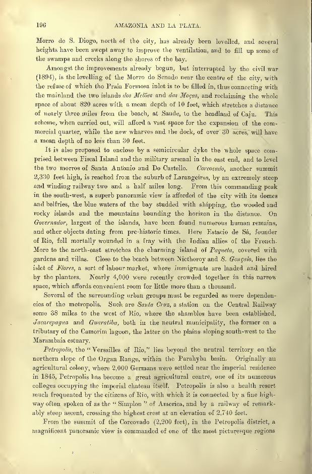
196 AMAZONIA AND LA PLATA.
Morro de S. Diogo, north of the city, has already been levelled, and several
heights have been swept away to improve the ventilation, and to fill up some of
the swamps and creeks along the shores of the bay.
Amongst the improvements already begun, but interrupted by the civil war
(1894), is the levelling of the Morro do Senado near the centre of the city, with
the refuse of which the Praia Formosa inlet is to be filled in, thus connecting with
the mainland the two islands dos Meloes and das Mogas, and reclaiming the whole
space of about 820 acres with a mean depth of 10 feet, which stretches a distance
of nearly three miles from the beach, at Saude, to the headland of Caju. This
scheme, when carried out, will afford a vast space for the expansion of the com-
mercial quarter, while the new wharves and the dock, of over 30 acres, will have
a mean depth of no less than 30 feet.
It is also proposed to enclose by a semicircular dyke the whole space com-
prised between Fiscal Island and the military arsenal in the east end, and to level
the two morros of Santa Antonio and Do Castello. Corcovado, another summit
2,330 feet high, is reached from the suburb of Larangeiras, by an extremely steep
and winding railway two and a half miles long. From this commanding peakin the south-west, a superb panoramic view is afforded of the city with its domes
and belfries, the blue waters of the bay studded with shipping, the wooded and
rocky islands and the mountains bounding the horizon in the distance. On
Groternador, largest of the islands, have been found numerous human remains,
and other objects dating from pre -historic times. Here Estacio de Sa, founder
of Rio, fell mortally wounded in a fray with the Indian allies of the French.
More to the north-east stretches the charming island of Paqueta, covered with
gardens and villas. Close to the beach between Nictheroy and S. Gongalo, lies the
islet of Flores, a sort of labour market, where immigrants are landed and hired
by the planters. Nearly 4,000 were recently crowded together in this narrow
space, which affords convenient room for little more than a thousand.
Several of the surrounding urban groups must be regarded as mere dependen-
cies of the metropolis. Such are Santa Cruz, a station on the Central Railwaysome 38 miles to the west of Rio, where the shambles have been established,
Jacarepagua and Guaratiba, both in the neutral municipality, the former on a
tributary of the Camorim lagoon, the latter on the plains sloping south-west to the
Marambaia estuary.
Petropolis, the " Versailles of Rio," lies beyond the neutral territory on the
northern slope of the Organ Range, within the Parahyba basin. Originally an
agricultural colony, where 2,000 Germans were settled near the imperial residence
in 1845, Petropolis has become a great agricultural centre, one of its numerous
colleges occupying the imperial chateau itself. Petropolis is also a health resort
much frequented by the citizens of Rio, with which it is connected by a fine high-
way often spoken of as the "Simplon
"of America, and by a railway of remark-
ably steep ascent, crossing the highest crest at an elevation of 2,740 feet.
From the summit of the Corcovado (2,200 feet), in the Petropolis district, a
magnificent panoramic view is commanded of one of the most picturesque regions
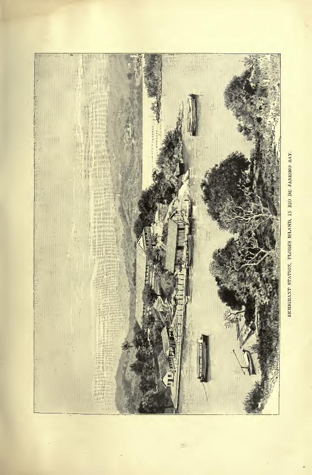

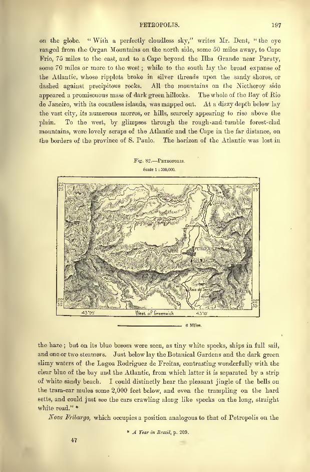
PETBOPOLIS. 197
on the globe." With a perfectly cloudless sky," writes Mr. Dent,
" the eye
ranged from the Organ Mountains on the north side, some 50 miles away, to Cape
Frio, 75 miles to the east, and to a Cape beyond the Ilha Grande near Paraty,
some 70 miles or more to the west;while to the south lay the broad expanse of
the Atlantic, whose ripplets broke in silver threads upon the sandy shores, or
dashed against precipitous rocks. All the mountains on the Nictheroy side
appeared a promiscuous mass of dark green hillocks. The whole of the Bay of Rio
de Janeiro, with its countless islands, was mapped out. At a dizzy depth below lay
the vast city, its numerous morros, or hills, scarcely appearing to rise above the
plain. To the west, by glimpses through the rough-and-tumble forest-clad
mountains, were lovely scraps of the Atlantic and the Cape in the far distance, on
the borders of the province of S. Paulo. The horizon of the Atlantic was lost in
Fig. 82. PETEOPOLIS.
Scale 1 : 300,000.
6 Miles.
the haze;but on its blue bosom were seen, as tiny white specks, ships in full sail,
and one or two steamers. Just below lay the Botanical Gardens and the dark green
slimy waters of the Lagoa Rodriguez de Freitas, contrasting wonderfully with the
clear blue of the bay and the Atlantic, from which latter it is separated by a strip
of white sandy beach. I could distinctly hear the pleasant jingle of the bells on
the tram-car mules some 2,000 feet below, and even the trampling on the hard
setts, and could just see the cars crawling along like specks on the long, straight
white road." *
Nova Friburgo, which occupies a position analogous to that of Petropolis on the
* A Year in Brazil, p. 209.
198 AMAZONIA AND LA PLATA.
northern slope of the serra da Boa Vista, as the coast range is here called, was
also originally an agricultural settlement founded in 1819, by 1,700 peasants
from the Swiss canton of Friburg. But within a single decade more than a third
of these colonists had disappeared, and since the middle of the century this place
has been a thoroughly Brazilian town, containing but few of the first Friburgfamilies. From the district Rio draws vegetables, poultry, and other supplies
forwarded by the railway to Nictheroy. Although now chosen as the seat of the
State legislature, Therezopolis is a less important place than either Petropolis or
Nova Friburgo. It is still (1894) unconnected by rail with the bay.
Beyond the neutral municipality follow several well-sheltered little havens
along the west coast. Such are Mangaratiba, ruined by the abolition of slavery ;
Angra dos Rcis, dating from 1532, now the quarantine station of Rio, and Paraty,
farther west, noted fora rum of prime quality.
CHAPTER XI.
PARANA SLOPE AND ADJACENT COASTLANDS.
STATES OF S. PAULO, PARANA, AND SANTA CATHAEINA.
]HE geographical region draining south-westwards to the Parana
presents a remarkable degree of physical uniformity, although
divided into several political administrations, and although the
zone of the waterparting is unequally distributed between Minas
Geraes, Goyaz, and Matto Grosso. The whole territory is the
fragment of a plateau disposed in a vast curve between the two parallel lines of
the Atlantic coast and the course of the Parana. Northwards it is limited by the
Rio Grande, a main branch of the Upper Parana, and towards the south by the
upper valley of the Rio Uruguay.At the south-west corner, in the narrow tract comprised between the converg-
ing Parana and Uruguay rivers, the boundary towards Argentina has not yet been
determined. But colonisation has scarcely yet been extended to this region, and
even in S. Paulo, by far the most populous of the three States, there still exist
" unknown lands"
of great extent disposed in parallel strips by the Upper Parana
affluents.
From the reports of pioneers and adventurers these lands are known to be to
a large extent fertile. They seem destined some day to be the home of teeming
populations, and their settlement has already been commenced. Every year,
every day almost, sees fresh tracts reclaimed from the wilderness.
THE PAOLISTAS.
Amongst all the populations of Brazil, those of S. Paulo are distinguished bytheir enterprising spirit, so much so that in some respects this region might be
regarded as the true centre of Portuguese America. Soon after the discovery the
daring pioneer, Joao Ramalho, in friendly alliance with the Indians, had estab-
200 AMAZONIA AND LA PLATA.
lished himself on the inland plateaux far from the sea-coast. So early as 1532 a
fortified station was founded at Piratiiiinga (" Dried Fish "), near the spot where
was afterwards built the city of S. Paulo. In 1552 the Jesuits arrived and
took up their residence in the midst of the Indians, laying the foundations of
S. Paulo, which was destined to eclipse the earlier settlement of Santo Andres
de Piratininga.
But the inevitable conflict soon broke out between the civil and ecclesiastical
elements. The free colonists, eager for wealth, had begun to enslave the natives,
employing them either in cultivating the land or in the quest of gold ;but the
priests, while also utilising their labour, strove at least to protect them from
violence and enforced servitude. On the other hand the Jesuits, regardless of
political frontiers, continued to work in unison on both sides of the Hispano-
Portuguese boundary, and advantage was readily taken of this alliance to charge
the missionaries with treason when they tried to prevent or to punish the incur-
sions of the Paulist bandeirantes in the Paraguay and Bolivian missions. Hence
constant struggles, in which the Jesuits were at last worsted, although often up-
held by the central power and always by the authority of the Roman pontiif.
Thus a free hand was given to the Paolistas, who, in their slave-hunting raids,
crossed rivers and mountains, ranging right up to and even beyond the Amazons
to the slopes of the equatorial Andes. Muratori estimates at two millions the
number of Indians captured by these predatory bands in the course of three
hundred years.
This indomitable energy displayed in their kidnapping expeditions they now
apply to more peaceful pursuits, and since the middle of the nineteenth century
they have distinguished themselves in this respect beyond all other natives of
Brazil. To them more especially the country owes its pre-eminence over all rivals
as a coffee-growing land. They also take the foremost position in the industries;
their railway system is the most fully developed, and they have even outstripped
Minas Geraes and Rio de Janeiro in the preparation of the typographical chart to
the scale of ToV,o~7nr. An expedition appointed to explore one of the great
routes destined one day to connect their territory with the Argentine regions,
has even drawn, to the scale of TiF,"!nnF a map of the whole course of the Rios
Itapiringa and Paranapanema.This map is certainly superior to those of the same category published by
Castelnau for the Tapajoz and Araguaya basins, by Halfeld for the Rio S. Fran-
cisco valley, and by Liais for that of the Rio das Velhas. A nd these cartogra-
phic labours themselves are but the outward and tangible proof of the profound
investigations carried on by numerous explorers and students in every branch of
natural history.
THE DISPUTED ZONE.
Despite its excellent soil and climate, and its numerous navigable waters, the
upper Parana basin is the least known region in this section of the republic.
CONTESTED BEAZILO-AEGENTINE FKONTIEBS. 201
Since the middle of the nineteenth century railway engineers and other surveyors
have traversed the country in all directions, but their itineraries, prepared for
special purposes, have contributed little to a general knowledge of the land and of
its vast agricultural resources.
S. Paulo represents nearly one-half of the whole region in extent, and its
population is greatly superior to that of the two other States together.* Santa
Catharina, smallest of the three, threatens to be still further reduced by the loss
Fig. 83. CONTESTED BRAZILO-ARGENTINE TERRITORY.
Scale 1 : 3,000,000.
26
27 27
West or Greenwich 55
Territories claimed by Argentina.
Territory originallyclaimed.
Territory addedto the first claim.
60 Miles.
of the south-western district, which is the territory claimed from Brazil by
Argentina. This debatable land remains unsettled and almost abandoned since
the Spanish-speaking settlers are advancing into the interior by the route of the
lower Parana, and the Portuguese by that of the seaboard.
After the first treaty of 1750, a mixed commission was appointed to fix the
common frontier;but its work was never finished, and in 1777 it was decided
by the treaty of S. Ildefonso that the boundary should follow the waterparting
* Area of S. Paulo : 112,000 square miles;of Parana and Santa Catharina, 113,000 square miles;
respective populations, 1,386,000 and 423,000.
202 AMAZONIA AND LA PLATA.
between the sources of the Pipiry Guazu affluent of the Uruguay on one and side
of the San Antonio affluent of the Iguazu on the other, and should "cover the
settlements and missions of Spain and Portugal." But the commissioners were
unable to identify these rivers, and after eighteen years of futile attempts to come
to an understanding they ceased to act. Since then Paraguay, one of the heirs
of the Spanish claims, has been excluded by force of arms, and the issues have
been narrowed down to the pretentions of Argentina and Brazil. In 1887 the
question was referred to the President of the United States, who, however, has
to decide in favour of one or the other of the litigants absolutely, without the
option of awarding to each a share of the disputed territory, which has a total area
of about 12,000 square miles, with a scattered population (1890) of 2,000 stock-
breeders owning 40,000 head of cattle.
'PHYSICAL FEATURES.
South of Bio de Janeiro the Coast Range ceases to present the aspect of a
mountain chain, at least beyond the Bocaina Mass. After ascending the seaward
slope and the slight prominence forming the scarp of the plateau, the traveller
advancing from Santos finds himself on a rolling plain with no apparent limits
except distant ridges of low elevation. The character of the vegetation also
changes abruptly from the tall and leafy trees of the tropical zone to stunted
growths, in many places recalling the heaths of North Germany, and on the
terraces to groups of fine araucarias growing somewhat wide apart and giving
free play to the sunlight.
Although the border ridges are continued regularly along the sea-coast, the
different sections take various names, generally from the towns or villages at
their foot. Above the port of Ubatuba they are known as the Serra de Ubatuba;
between Santos and S. Paulo as the Serra de Cubatiio, from a hamlet lost in the
marshy bush on a creek enclosing the island of Santos. Seen from the coast the
crests seem to run at a somewhat uniform altitude of about 3,000 feet, and
consist of gneiss and granite pierced by eruptive masses of melaphyre. In the
Serra dos Itatins between Santos and Iguape the range would seem to rise to
4,370 feet; farther on the Serra de Guarahu presents the same elevation, and in
the State of Parana the Serra Graciosa rises, according to D'Orville Derby, to
5,000 feet. The Serra do Mar is crossed by the railway from Santos to S. Paulo
at an altitude of 2,620 feet, while the line between Paranagua and Curitiba pierces
the crest through a tunnel 3,130 feet high.
In the State of Santa Catharina the system is interrupted by the broad valley
of the Rio Itajahy, beyond which it develops the superb terraces known as the
Campos de Boa Vista, and the picturesque granite hills of Tuburao. Here paleo-
zoic limestones and sandstones abut on the crystalline rocks of the Coast Range,
and vast stalactite caves traversed by running waters occur in many places.
But the goldfields, profitably worked during the last century, have been aban-
doned.
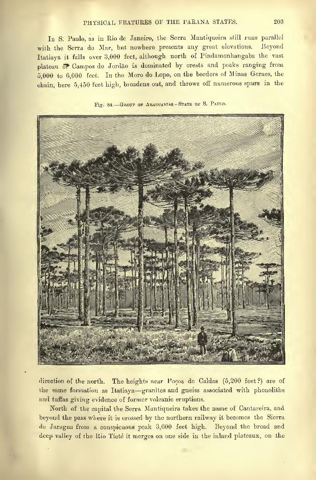
PHYSICAL FEATURES OF THE PARANA STATES. 203
In S: Paulo, as in Rio de Janeiro, the Serra Mantiqueira still runs parallel
with the Serra do Mar, but nowhere presents any great elevations. Beyond
Itatiaya it falls over 3,000 feet, although north of Findamonhangaba the vast
plateau of Campos do Jordao is dominated by crests and peaks ranging from
5,000 to 6,000 feet. In the Moro do Lopo, on the borders of Minas Geraes, the
chain, here 5,450 feet high, broadens out, and throws off numerous spurs in the
i. 84. GHOUP OF ARATTCABIAS STATE OF S. PAULO.
direction of the north. The heights near Pocos de Caldas (5,200 feet ?) are of
the same formation as Itatiaya granites and gneiss associated with phonoliths
and tuffas giving evidence of former volcanic eruptions.
North of the capital the Serra Mantiqueira takes the name of Cantareira, and
beyond the pass where it is crossed by the northern railway it becomes the Sierra
de Jaragua from a conspicuous peak 3,600 feet high. Beyond the broad and
deep valley of the Rio Tiete it merges on one side in the inland plateaux, on tho
204 AMAZONIA AND LA PLATA.
other in the Serra do Mar system. On the outer slopes the erupted rocks have,
for the most part, been transformed to the famous terra rora," red earth," which
yields such magnificent crops to the coffee growers. In some places this formation
has a thickness of 60, 100, and even 220 feet. The colour is of a duller red than
that of the terra vermelha or massape, which occurs in many other parts of Brazil,
and which is derived from the disintegrated granites of those regions. Agricul-
turists thoroughly understand the different shades of colour in all these lands, the
market price of which is, in fact, determined by the particular hue of the soil.
On the Parana slope many of the uplands are sufficiently level to take the
name of campos broad expanses under grasses or low plants contrasting with the
primeval forests and capoeiras or thickets of second growth. Although the
campos have been enlarged by conflagrations, they do not appear, as many assert,
to owe their existence exclusively to the action of fire. These treeless regions
certainly receive a sufficient rainfall to nourish an arborescent vegetation, for the
trees now and then planted by the half-nomad settlers readily take root and
flourish without artificial irrigation.
RIVERS COAST STREAMS.
On the seaboard between the States of Rio de Janeiro and Rio Grande do Sul
the chief watercourse is the Ribeira de Iguape, whose headstreams, rising on the
inland plateaux, pierce the Serra do Mar through deep gorges. In its lower
course the Iguape flows close to the coast, and even throws off a branch three
miles long which joins the Cananea inlet. But the mainstream trends north-
eastwards to the coast at a point where the sea is open and free from reefs. Small
steamers ascend the Lower Iguape and even its two affluents, the Juquia and the
Jacupiranga. In Santa Catharina the chief river is the Itajahy, which traverses
the German settlements, and is thus better known although inferior in size and
volume to the Iguape, whose catchment basin probably exceeds 11,000 square
miles.
The Serra-abaixo,"Piedmont," or narrow strip of coastlands between the Serra
do Mar and the Atlantic, has been entirely formed by marine deposits. In the
sandstones covered with shifting dunes are embedded stems and roots bearing a
great resemblance to the present magnolia trees. These deposits have certainly
been covered by the ocean within a comparatively recent period, and several
successive movements of upheaval and subsidence would appear to have taken
place. The cliffs containing vegetable remains reveal eight or ten distinct strata
of varying thickness, all disposed horizontally. One of these strata, consisting of
a nearly pure limonite iron ore, has been formed in marshy waters. According to
Karl Rath the whole of the South Brazilian coast between Rio de Janeiro and Rio
Grande do Sul is at present rising. The old Indian graves, and the tambaqui or
shell -mounds occurring in large numbers along the beach, all stand at a height
of 40 to 80 or 90 feet above high water, although they must have been originally
deposited at sea-level.

HYDROGRAPHY OF THE PARANA STATES. 205
Along the whole of the southern seaboard beyond Santos frequent modifica-
tions have evidently taken place in the contour line of the coastlands. On the
one hand, the sea has penetrated through creeks and inlets into the mainland;
on the oth^r the mainland has advanced seawards, developing mud banks, sandy
spits, and cordons along the beach. In the north the coast of S. Paulo has been
carved into rocky headlands and islands, plunging their steep escarpments into
deep water, or rising, like the large island of S. Sebastiao, 4,300 feet above the
Fig. 85. CANANEA CHANNEL.
Scale 1 : 700,000.
West oF Greenwich 47'50'
Oto5Fathoma.
Depths.
5 to 10Fathoms.
10 Fathomsand upwards.
12 Miles.
surface;but farther south is seen the opposite phenomenon of sandy formations
fringing the shore. Some rocky islands have thus been joined to the mainland
by recent alluvial deposits filling up the intervening channels. Such are the
Santos and Santo Amaro hills, where the old marine straits are now represented
only by shallow backwaters.
The vast Bay of Paranagua, which greatly resembles that of Rio de Janeiio,
is bordered, like the Santos inlet, by marshy tracts standing little above sea-level.
Farther south the large island of S. Francisco at the Joinville estuary has pre-
served its insular character, being still separated from the mainland by an open
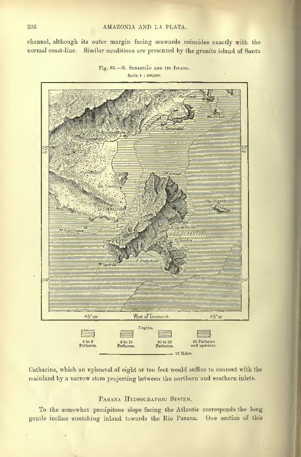
206 AMAZONIA AND LA PLATA.
channel, although its outer margin facing seawards coincides exactly with the
normal coast-line. Similar conditions are presented by the granite island of Santa
Fig. 86. S. SKBASTIAO AND ITS ISLAND.
Scale 1 : 500,000.
Eeptlis.
to 6 6 to 10 10 to 25 25 FathomsFathoms. Fathoms. Fathoms. and upwards
12 Miles.
Catharina, which an upheaval of eight or ten feet would suffice to connect with the
mainland by a narrow stem projecting between the northern and southern inlets.
PARANA HYDROGRAPHIC SYSTEM.
To the somewhat precipitous slope facing the Atlantic corresponds the long
gentle incline stretching inland towards the Rio Parana. One section of this
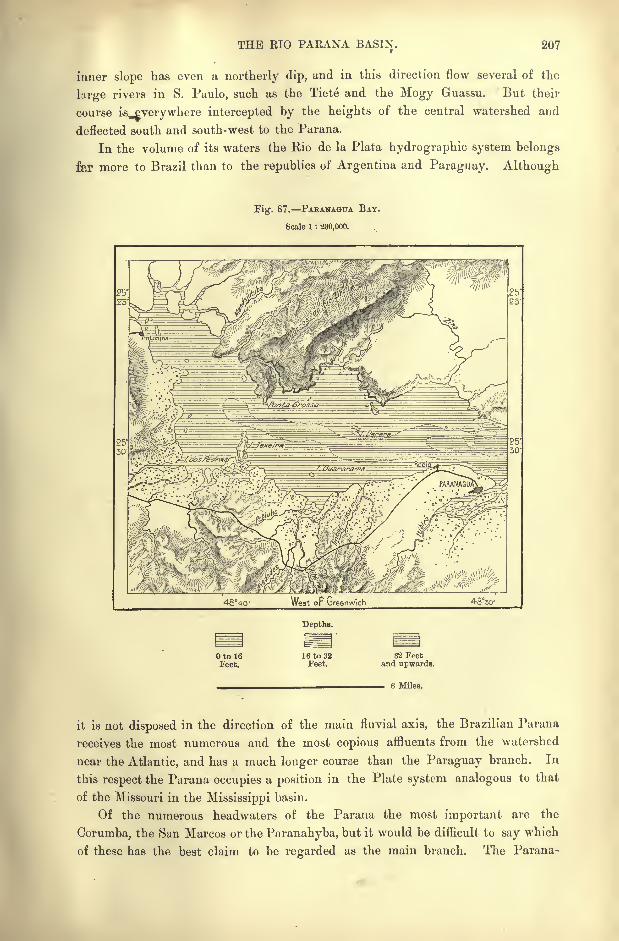
THE BIO PARANA BASIN. 207
inner slope has even a northerly dip, and in this direction flow several of the
large rivers in S. Paulo, such as the Tiete and the Mogy Guassu. But their
course is^verywhere intercepted by the heights of the central watershed and
deflected south and south-west to the Parana.
In the volume of its waters the Rio de la Plata hydrographic system belongs
far more to Brazil than to the republics of Argentina and Paraguay. Although
Fig. 87. PAKANAGUA BAY.
Scale 1 : 230,000.
Depths.
Oto 16feet.
16 to 32Feet.
32 Feetand upwards.
6 Miles.
it is not disposed in the direction of the main fluvial axis, the Brazilian Parana
receives the most numerous and the most copious affluents from the watershed
near the Atlantic, and has a much longer course than the Paraguay branch. In
this respect the Parana occupies a position in the Plate system analogous to that
of the Missouri in the Mississippi basin.
Of the numerous headwaters of the Parana the most important are the
Corumba, the San Marcos or the Paranahyba, but it would be difficult to say which
of these has the best claim to be regarded as the main branch. The Parana-
208 AMAZONIA AND LA PLATA.
hyba rises at the point farthest removed from the fluvial axis, and at first flows
due north in the direction of the S. Francisco. But while still a small stream
it bends round north-west and west to the junction with the San Marcos descend-
ing from the north.
Some 125 miles lower down the mainstream is joined by the copious Corumba,
issuing from the rocky gorges of the Pyrenees Mountains, and farther on by Meia
Ponte and the Rio dos Bois descending from the same watershed. From the
opposite side comes the Rio das Velhas with the contributions of the Canastra and
Matta de Corda uplands. At the confluence of the Rio Grande, which rises on
the Minas Geraes plateaux, the mainstream takes the name of Parana, that is
"River," in a pre-eminent sense, which it retains for the rest of its course to
the Plate estuary.
The Rio Grande is distinguished from all the other branches both by its
greater volume, and by the rugged character of its upper basin. Its chief head-
stream rises in the Itatiaya group over 8,200 feet above sea-level, and although it
is joined by several large streams, such as the Rio das Mortes and the Sapucahyfrom the north, and the Rio Pardo from the S. Paulo uplands, its upper course is
too steep to be navigable except for short stretches. Here it is interrupted byseveral grand waterfalls, such as the Maribondo Cascade below the Pardo confluence
with a drop of about 65 feet. Other cataracts have been gradually obliterated bythe erosion of the reefs which obstructed the current. Thus south of Uberaba all
the schistose masses, by which the river was formerly blocked, have been eaten
away piecemeal. Nothing now remains of these barriers except some fragmentsof solid quartz, which form rocky islets in mid-stream. At one point these
islets have served as the foundations of a bridge, which the engineers have built
across the Rio Grande, and the twenty-five piers of which all stand on these
natural supports.
Both the Pardo and its Mogy Guassu affluent, as well as the Tiete, flowing
more to the south, parallel with the Rio Grande, all present long stretches of
navigable waterways, thanks to their more gentle incline and to the works that
have been carried out to regulate their course. The Mogy Guassu, which winds
through the most flourishing coffee plantations in S. Paulo, has a continuous
navigable channel of 140 miles, scarcely interrupted by a few rapids which have
been improved by lateral weirs.
Of all the Parana affluents the Tiete has its sources nearest to the Atlantic,
some of its headstreams rising within seven or eight miles of the coast, but over
3,000 feet above the sea. Being connected by rail with the port of Santos, its
valley, like that of the Mogy Guassu, give access to the till recently deserted
regions of the Campos of the Parana. Its lower course, however, is obstructed bythe Avanhandava and Itapura falls, respectively 44 and 65 feet high. A few
miles below the Tiete* confluence, the Parana itself develops the great Urubupunga
(" Vulture ") falls.
Below the Tiete* follow other large tributaries, such as the Sucuryu, Rio
Verde, Ivinheima, and Paranapanema, the last-mentioned being nearly as copious
THE PAKANA BASIN. 209
as the Rio Grande. About half of the Paranapanema basin, comprising some
30,000 square miles, still figures on the maps as the Zona desccnhecida, the " Un-
known Zoj^e."
The Paranapanema, or " Useless River," as the word is interpreted by some
etymologists, fully deserves its name, so completely obstructed is its channel by
projecting reefs and rapids. At the present limit of navigation below the Rio
Pardo, occurs the Salt Grande," Great Fall," where a volume of about 1,000
cubic feet per second is precipitated some 30 feet down to a seething .chasm,
Fig. 88. FALLS or THE PARANA.PANEMA ABOVE AND BELOW S. SEBASTIAO.
Scale 1 : 750,000.
49 '34' West or breenwich
2,200 Yards.
whence the boiling waters escape through a narrow cleft in the rocks. Other
cascades follow, preventing all navigation down to the Tilbagy confluence,
whence the channel is free to its junction with the Parana, 850 feet above sea
level.
Parallel with the Paranapanema, flow the Ivahy and Piquiry, joining the
great artery on the plateau above the point where it forces its way through the
Maracaju (Mbaracayu) ridge on the Paraguay frontier down to the plains.
210 AMAZONIA AND LA PLATA.
Above this point the Parana expands to a broad lake with two branches
enclosing a large island, beyond which it tumbles over several falls from 50
to 60 feet high, all differing in the character of their rocks and vegetation, as
well as in the volume of water precipitated. The Sete Qucdas, or "Seven
Falls," as this group is popularly called, must not be taken in the literal sense,
for the stream ramifies in the dry season at times into as many as twenty partial
currents, while during the floods all merge in a single liquid mass. In 1631, when
the Jesuits had to abandon their missions of la Guayra they lost in these waters
over 300 boats, and since then the Sete Quedas have been known by the alterna-
tive name of the Guayra Falls.
Below this point the Parana, after gliding over a few more rapids, gradually
enters on its tranquil course, and is here joined by its last great affluent formerly
called the Rio Grande de Curitiba, now better known by its Guarani name Iguazu
(Y-guassu). Like the parallel rios, Paranapanema and Tiete, the Iguazu is
interrupted by a succession of cascades, terminating at the Victoria Falls with an
extreme drop of 140 feet. At this point the Brazilian Government has estab-
lished its military colony and arsenal, commanding the navigation of the whole
course of the Lower Parana as far as the Argentine waters. The famous Con-
quistador Alvar Nunez had followed this route on his daring journey from Brazil
to Paraguay in 1542.
Beyond the Iguazu confluence, the Parana, henceforth free from cataracts or
dangerous rapids, passes through several narrow gorges, such as that of Itangu-
aymi, where the stream, 4,000 *or 5,000 yards broad in some places, contracts to
scarcely 460 feet. Lower down the river maintains everywhere a great width,
rolling down a vast body of yellowish water studded with low islands and lined
by marshy banks. At the Paraguay confluence its volume is often ten times
greater than that of the rival stream.
CLIMATE.
In a general way the climate of the region resembles that of Minas Geraes,
with the essential difference that, lying partly beyond the tropical zone, it enjoys
a greater diversity of seasons. Here the winters are real winters, characterised bya marked fall of the temperature, by cold polar winds, and at times even by snow.
But the chief contrast is less between north and south than between east and
west, as determined by the varying altitudes. The littoral zone at the foot of
the coast range still belongs partly to the torrid region, and merges southwards
in subtropical lands resembling Italy both in their climate and their verdant
seaward slopes.
Another parallel zone is that of the "Serra," or "Mountain," marked by a
lower temperature, but still under the influence of the moist sea breezes. This is
followed by the inner and much broader zone of the Campos, presenting the
normal conditions of a continental climate with its great range of temperatures, in
some years exceeding 60 or 70 Fahr.
FLORA OF S. PAULO. 211
On the Campos, which are gradually being brought under cultivation, frosts
are much dreaded, especially when cold nights are followed by sultry days, when
the glass rises te^and even above, 86 Fahr. Frosts follow, especially after heavy
rains, when radiation is stimulated by clear, cloudless skies. The rainfall itself
is very unequally distributed, rising in some years from nearly 120 inches at
Santos to over 160 on the crests of the neighbouring mountains, and then falling
to less than 40 at S. Paulo on the landward slope. On the other hand, the
aerial currents general!}' maintain their normal direction throughout the year. Aregular diurnal alteration takes place between the south-east marine, and the
north-west land breezes, the former prevailing during the night and early morning,
the latter in the evening.
Thus S. Paulo, although standing on the inland plateau, enjoys a semi-marine
climate;but a few miles farther on the conditions are entirely changed.* The
line of equal magnetic declination traverses the State of S. Paulo with a gradual
incline towards the west. In 1885 it had reached the seaboard above Iguape a
short distance to the west of Santos.
FLORA AND FAUNA.
During the winter months (June, July and August) the bare trunks of the trees,
the withered herbage and the absence of flowers, impart a dreary aspect to the
landscape. But with the first rains nature is transformed, and, as if by enchant-
ment, the plains are covered with the green sprouts of young plants, and even
with brilliant corollas. According to the seasons different groups of flowers burst
into bloom, blue, yellow or red tints predominating each in its turn.
Loefgren estimates at 2,000 the number of plant forms growing on the Camposof S. Paulo. Here the araucaria paranensis is one of the characteristic forest
trees, abounding especially in the more temperate zone. In general, the tropical
selva is intermingled with the herbaceous vegetation of the Plate region, the
former prevailing especially on the seaboard, and along the valleys of the streams
flowing to the Parana;but here great clearances have already been made by the
planters, the soil of the forest tracts being found the most favourable also for the
coffee shrub.
But in many districts the woodlands have been cleared too rapidly. Much
ground, carelessly prepared for tillage, has had to be abandoned after a preliminary
attempt at cultivation, and new forests, consisting of different species^ take the
place of the primitive selva. Such tracts, locally called Capociras, are less
beautiful, less picturesque than the virgin forest, and at the same time more
difficult to traverse. These thickets, with their tangle of thorny bushes and
*Meteorological conditions in the Parana States :
212 AMAZONIA AND LA PLATA.
other undergrowths, are, in fact, accessible only to the tapir and the hunter
familiar with the practicable tracks.
The herbaceous vegetation of the Campos differs little in its general aspect
from that of the Argentine pampas. Here also the plains are dotted over with
clumps of low trees, which shed their leaves during the dry season. But vast
spaces are entirely treeless, either owing to the periodical conflagrations, or because
arborescent vegetation is prevented from striking root by the dense growth of
herbaceous plants. These plants themselves, however, present a great variety of
forms, resembling in their main features those of the pampas, and even of the
Andean punas.
Similar contrasts are offered by the local fauna. Monkeys, coatis, capyvaras,
sloths, ant-eaters, and tapirs are still met in S. Paulo and Parana;turtles and
crocodiles also frequent the streams;while the flowery plains are enlivened by
gaudy butterflies and humming-birds of resplendent plumage. The nandu, or
plateau ostrich, which has disappeared from North Brazil, is still found in some-
what numerous flocks on the Parana campos. But he cannot hope long to
escape from the pursuit of the sportsman with his deadly rifle and swit't
hound. The American ostrich must soon become a mythical bird like so
many other species that have already disappeared. It will become associated
with the other monstrous forms created by the popular fancy, or exag-
gerated by vague tradition. Thus, according to the unanimous testimony of
the natives, the region of the water-parting between the sources of the Parana
and of the Uruguay, was formerly, and perhaps still is, infested by a " worm" of
huge proportions, strong enough to uproot the trees on the marshy ground. The
legend has reference perhaps to some extinct anaconda of exceptional size, and
may be regarded as a lingering reminiscence of the serpent- worship which lies at
the origin of so many religious systems.
Mr. Wells tells us that certain marshy districts called burityzak are still the
haunts of enormous anacondas, of such a size that he hesitates to give their exact
length for fear of being charged with exaggeration. He adds, however, that they
are "certainly longer than I have ever heard of any species of snake in any part
of the globe." He was assured by the natives that cattle wading into the swampsto drink water are often swallowed by the monsters, all but the head and horns,
and he seems to give some credence to the statement.*
INHABITANTS.
Pre-historic remains abound on the seaboard, where hundreds of shell-mounds
are met, containing, like those of Europe, chipped stones and other objects of
primitive industry. In these tambaqui, vulgarly pronounced sambaqui, have also
been found skeletons belonging to very different types, usually seated and associ-
ated with vases, ornaments, weapons, and utensils, the implements beirig mostly
of basalt, but also of porphyry, quartz, and meteoric iron.
* Three Thousand Miles Through Brazil, vol. II. p. 167.
INHABITANTS OF THE PAEANA EEGIONS. 213
The shell-mounds certainly date from a remote epoch, for several have disap-
peared beneath the detritus washed down by ancient streams, while large trees of
the primeval forest have struck root in others. Some represent a prodigious
amount of laboltr, being over 300 feet wide and 50 feet high. For two or three
hundred years they have furnished the lime-burners with sufficient materials to
supply Rio Santos and many other towns with lime, yet a considerable number
still remain.
On the plateaux are also seen numerous sepulchral mounds, which are known
in the country by the appropriate name of seputturas velhas, "old burial grounds."
It is noteworthy that the earth used in the construction of these barrows is always
different from that of the surrounding soil. Some are built of stones, in which
case the materials have also been brought from a distance, as if some religious
idea were associated with the increased labour thus involved.
From the form of most of the skulls found in the old graves it may be inferred
that the pre-historic aborigines belonged to the same race as the contemporary
Tupi and Guarani peoples. Nevertheless, Loefgren found in a tambaqui six miles
west of S. Vicente a skull analogous to those brought to light by Lund in the
Lagoa Santa caves.
When the first Europeans arrived, the dominant Tamoyos were very powerful,
and took the lead in a general alliance of all the coast tribes against the Portu-
guese. These would, in fact, have probably been exterminated but for the
intervention of the Jesuits, Nobrega and Anchieta, who induced the warlike
Indians to make peace at a critical juncture.
The other natives of the coastlands Goyanazes, Itatins, Piturunas, Guanha-
nari, Carijos have all been merged in the general population, which is now
rapidly mingling with the most diverse elements. The Italians arrive in great
numbers in S. Paulo, and in many rural districts are already in the majority.
With them come other Europeans, besides gypsies, eastern Jews, and Maronites
from Syria. In general, the Paulist type has the reputation of being the finest
in Brazil. According to a local saying, we are asked to admire, in Bahia, the
he's, not the she's ; in Pernambuco, the she's, not the he's ; in S. Paulo, the she's
and the he's.
Being broken into scattered groups, the aborigines of the Parana States no
longer possess any kind of solidarity in their struggles against the whites, and are
thus destroyed in detail. Those grouped round the Jesuit mission of La Guayrawere the first to disappear, whole communities of peaceful neophytes being dis-
persed or led captive during the ten years ending 1638. The Jesuits themselves had
to take flight, and in 1641 Montoya attempted to remove the survivors to the
district at present known as the " Missions" on the banks of the Lower Parana.
But in the exodus more than half of his faithful adherents perished, and after all
the massacres, hardships, and disasters in the river only 12,000 remained of those
onceflourishing congregations.
Of late years a certain counter-movement has set in amongst the indigenous
populations. Being arrested or driven back by the rising flood of Argentine48
214 AMAZONIA AND LA PLATA.
colonisation, some of the Guarani Indians, who had come originally from the
south, have retraced their steps in the direction of the Upper Parana. A few
families, immigrants from Paraguay, now dwell in the western forests of the
State of S. Paulo, and these do good service as boatmen in forwarding merchan-
dise by the water highway. But they nowhere group themselves in villages
under the control of the whites, and they also keep aloof from the surrounding
aborigines.
The aborigines, who continued to lead a savage existence in the forests and on
the campos, collectively called Bugres by the Brazilians, belong to three distinct
families : Chavantes, Cayuas or Cayovas, and Coroados. It is uncertain whether
the Chavantes are of the same stock as those bearing the same name on the banks
of the Araguaya and Tocantins. Their Coroado neighbours call them Cucurton,
that is," Unclothed." They are noted for their repulsive features and nearly
black colour, and lead a wretched existence, without huts or tents, cultivating no
land, and living on roots, fruits, lizards, and rats. During the dry season they
fire the savannas, and kill with branches all the small animals that try to escape
the conflagrations. They pass whole days digging for the honey of a liule
burrowing bee, using for the purpose the scraps of iron they steal from the
settlers.
In S. Paulo and Parana the Paranapanema basin is partly occupied by about
3,000 Cayuas, who are certainly of Tupi origin, their Abanheenga language
differing little from the lingua geral. Several members of the tribe are now asso-
ciated with the whites, and take part in the field operations ;but they have the
reputation of being extremely sensitive, so that the colonists have to be constantly
on their guard to avoid giving them offence.
The Cayuas are expert boatmen and daring swimmers, and display great skill
in shooting the rapids. They weave excellent robes or blankets with nettle fibre,
make good earthenware, and cultivate a variety of maize unknown to the whites.
They reckon by sevens, and still wear the tembeta or cheriinbita, a stick of resin
introduced into the lower lip, and looking like a long thorn. Similar ornaments
of transparent quartz or other hard material are used in various other parts of
Brazil, and the practice was formerly far more general, perhaps universal,
amongst the populations of the whole region between the Amazons and the
Parana. ,
To the third indigenous group of S. Paulo the Brazilians apply the name of
Coroados," Crowned "
; but these Coroados are of different stock from other tribes
similarly designated, such as those who formerly occupied the State of Santa
Catharina, and who have left Tupi names to all the rivers of that region. The
term has reference merely to the common fashion of wearing the hair in form of a
crown round a tonsure on top of the head.
The Paranapanema Coroados are a thick-set, vigorous race, with broid
shoulders, large head, powerful jaws, and small eyes. In fact, they present a
type somewhat analogous to that of the Asiatic Mongols, whereas most of the
Tupis have the eagle-like physiognomy of the North-American Redskins.
TOPOGRAPHY OF MINAS GEBAES. 215
Neither the Cayuas nor the Chavantes understand the language of the Coroados,
who have been credited with a symbolic system of representation, which the
whites are unable to interpret, and which will probably have perished before any
attempt can bebe made to decipher the symbols.
The traveller crossing the woodlands enclosed on all four sides by the rivers
Paranapanema, Parana, Ivahy, and Tibagy, often meets in the vicinity of aban-
doned huts coils of creeping plants suspended across the path intentionally and
decorated with bits of wood, feathers, bones, birds' talons, the jaws of monkeys
or of wild boars, and similar strange objects. From their peculiar arrangement it
seems evident that the whole series forms a sort of historic record, a statement or
message addressed for some purpose to allied or kindred tribes, and intelligible to
them.
Occasionally the Coroados make use of this mysterious method of composition
to threaten the whites. Arms planted in the ground, wings of the aras, like
those with which they feather their arrows, are symbols, the sense of which can
scarcely be misunderstood. They are certainly more significant than the strange
markings which from time to time appear on the mangoes and other trees over
wide tracts in India, and which raise periodical scares amongst the white rulers
of the land.
TOPOGRAPHY Towxs or SOUTH MINAS.
Since the introduction of railways new directions have been given to the
current of migration. Thanks to the facilities afforded by this means of commu-
nication, the populations of the Upper S. Francisco, and of the chief towns, such
as Ouro Preto, Sahara, and Pitanguy, have begun to gravitate in the direction of
Rio de Janeiro, despite the natural slope of the laud, which should constitute
Bahia the centre of attraction. Still more powerfully drawn towards Rio and
S. Paulo are the mineral towns of the south-east in the Parahyba basin, and
those of the south-western districts traversed by the head- waters of the Parana.
Several of these places have already acquired some importance as secondary
centres of trade and industry. In these respects they have even outstripped the
city of Ouro Preto, which still retains the rank of capital, but which is situated in
a narrow valley draining to the Rio Doce, and standing apart from the main high-
ways of communication.
On the Parahyba slope, within the Minas frontier, the chief place is Juiz de-
Fora, which stands about 2,300 feet above the sea on the right bank of the Para-
hybuna affluent. Here is the seat of a flourishing German colony, and since the
opening of the central railway and of the carriage-road to Petropolis, Juiz de
Fora has become an industrial town, and the most active agricultural centre in
Minas Geraes. It now aspires to succeed Ouro Preto as the future capital of the
State.
In the same basin follow other thriving settlements, such as Parahybuna, on
the river of like name, at the foot of the superb Fortaleza bluff; Mar de Hespanha,
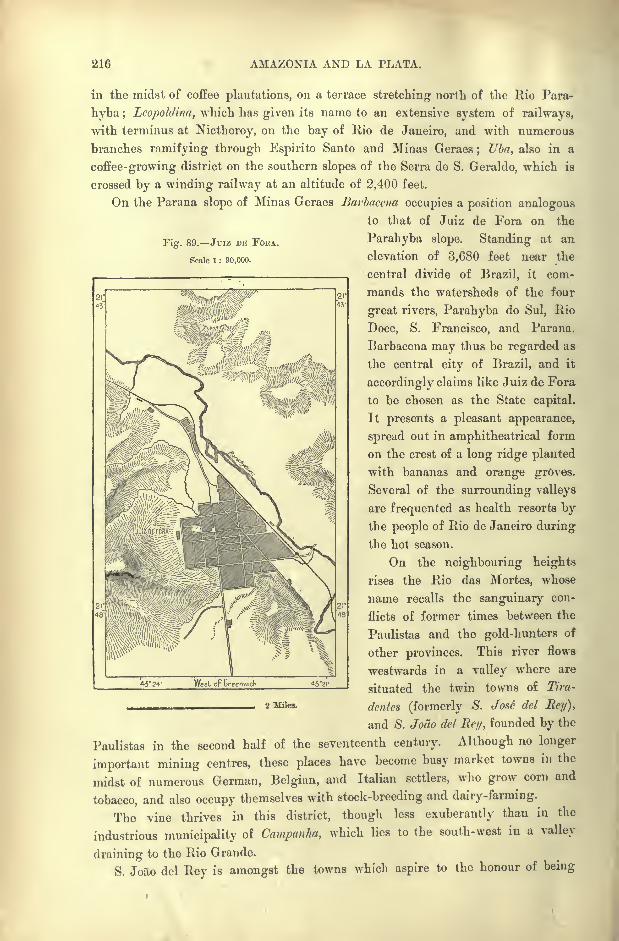
216 AMAZONIA AND LA PLATA.
Fig. 89. Juiz DE FOEA.
Scale 1 : 90,000.
in the midst of coffee plantations, on a terrace stretching north of the Rio Para-
hyba ; Lcopoldina, which has given its name to an extensive system of railways,
with terminus at Nictheroy, on the bay of Rio de Janeiro, and with numerous
branches ramifying through Espirito Santo and Minas Geraes; Uba, also in a
coffee-growing district on the southern slopes of the Serra de S. Geraldo, which is
crossed by a winding railway at an altitude of 2,400 feet.
On the Parana slope of Minas Geraes Barbacena occupies a position analogous
to that of Juiz de Fora on the
Parahyba slope. Standing at an
elevation of 3,680 feet near the
central divide of Brazil, it com-
mands the watersheds of the four
great rivers. Parahyba do Sul, Rio
Doce, S. Francisco, and Parana.
Barbacena may thus be regarded as
the central city of Brazil, and it
accordingly claims like Juiz de Fora
to be chosen as the State capital.
It presents a pleasant appearance,
spread out in amphitheatrical form
on the crest of a long ridge planted
with bananas and orange groves.
Several of the surrounding valleys
are frequented as health resorts bythe people of Rio de Janeiro during
the hot season.
On the neighbouring heights
rises the Rio das Mortes, whose
name recalls the sanguinary con-
flicts of former times between the
Paulistas and the gold-hunters of
other provinces. This river flows
westwards in a valley where are
situated the twin towns of Tira-
dentes (formerly S. Jose del Rey),
and S. Joao del Ret/, founded by the
Paulistas in the second half of the seventeenth century. Although no longer
important mining centres, these places have become busy market towns in the
midst of numerous German, Belgian, and Italian settlers, who grow corn and
tobacco, and also occupy themselves with stock-breeding and dairy-farming.
The vine thrives in this district, though less exuberantly than in the
industrious municipality of Campanha, which lies to the south-west in a valley
draining to the Rio Grande.
S. Joao del Rey is amongst the towns which aspire to the honour of being
43* 24' West op Greenwich *3'2l-
2 Miles.
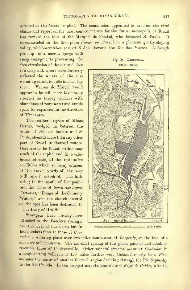
TOPOGRAPHY OF MINAS GERAES. 217
Fig. 90. BAEBACENA.
Scale 1 : 23,000.
selected as the federal capital. The commission appointed to examine the rival
claims and report on the most convenient site for the future metropolis of Brazil
has revived the idea of the Marquis de Pombal, who favoured S. Paulo. It
recommended in the first place Varzea do Marqal, in a pleasant gently sloping
valley, which-*tretches east of S. Jo&o beyond the Rio das Mortes. Although
pent up in a narrow gorge with
steep escarpments preventing the
free circulation of the air, and close
to a deep sink where were formerly
collected the waters of the sur-
rounding mines, S. Joao is a healthy
town. Varzea do Marcal would
appear to be still more favourably
situated on breezy terraces with
abundance of pure water and ample
space for expansion in the direction
of Tiradentes.
The southern region of Minas
Geraes, wedged in between the
States of Rio de Janeiro and S.
Paulo, abounds more than any other
part of Brazil in thermal waters.
Here are to be found, within easy
reach of the capital and in a salu-
brious climate, all the restorative
conditions which so many citizens
of Rio travel yearly all the wayto Europe in search of. The hills
rising to the south of Campanhabear the name of Serra dasAguas
Virtuosos,"Range of the Salutary
Waters," and the church erected
on the spot has been dedicated to
"Our Lady of Health."
Strangers have already. been
attracted to the Lambary springs,
near the river of like name, but in ^ ^ MOO Yards.
less numbers than to those of Cax-
ambu, a watering-place over two miles south-west of Baependy, at the foot of a
dome- shaped mountain. The six chief springs of this place, gaseous and alkaline,
resemble those of Coutrexeville. Other mineral streams occur at Coutendas, in
a neighbouring valley, and 125 miles farther west Caldas, formerly Ouro Fino,
occupies the centre of another thermal region draining through the Rio Sapucahyto the Rio Grande. In this rugged mountainous district Po$os de Caldas, with its
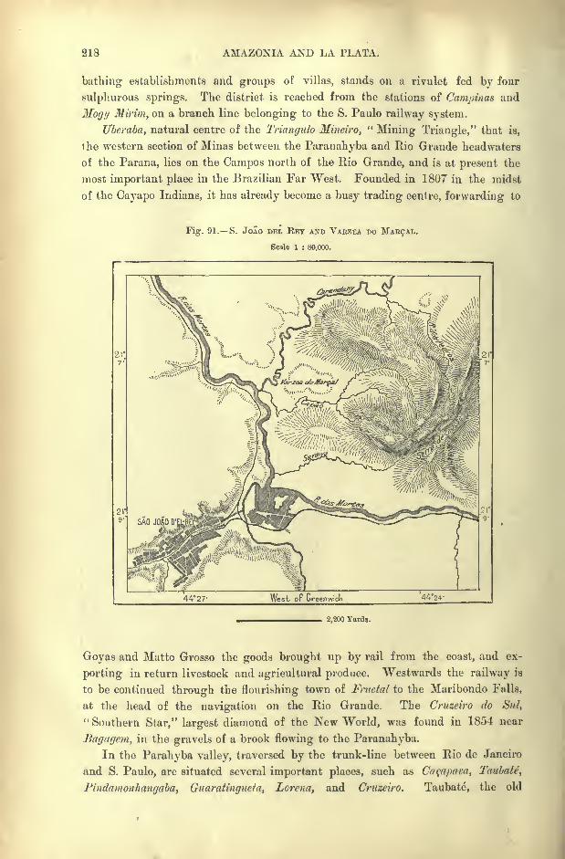
218 AMAZONIA AND LA PLATA.
bathing establishments and groups of villas, stands on a rivulet fed bv four
sulphurous springs. The district is reached from the stations of Campinas and
Mogy Mirim, on a branch line belonging to the S. Paulo railway system.
Uberaba, natural centre of the Triangulo Mineiro,"Mining Triangle," that is,
the western section of Minas between the Paranahyba and Rio Grande headwaters
of the Parana, lies on the Campos north of the Rio Grande, and is at present the
most important place in the Brazilian Far West. Founded in 1807 in the midst
of the Cayapo Indians, it has already become a busy trading centre, forwarding to
Fig. 91. S. Jolo DEL RET AND VAEZEA DO
Scale 1 : 80,000.
4427' West or Greenwich 44*24 '
2,200 Yards.
Goyas and Matto Grosso the goods brought up by rail from the coast, and ex-
porting in return livestock and agricultural produce. Westwards the railway is
to be continued through the flourishing town of Fructal to the Maribondo Falls,
at the head of the navigation on the Rio Grande. The Cruzeiro do Sul,
" Southern Star," largest diamond of the New World, was found in 1854 near
Bagagem, in the gravels of a brook flowing to the Paranahyba.
In the Parahyba valley, traversed by the trunk-line between Rio de Janeiro
and S. Paulo, are situated several important places, such as Caqapara, Taubate,
Pindamonhanyaba, Guaratingucta y Lorcna, and Cruzeiro. Taubate, the old
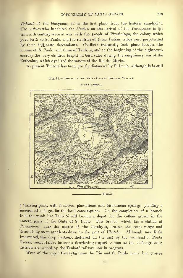
TOPOGRAPHY OF MINAS GERAES. 219
Ituboate of the Guayanas, takes the first place from the historic standpoint.
The natives who inhabited the district on the arrival of the Portuguese in the
sixteenth century were at war with the people of Piratininga, the colony which
gave birth to S. Paulo, and the rivalries of these Indian tribes were perpetuated
by their haj|,-caste descendants. Conflicts frequently took place between the
miners of S. Paulo and those of Taubate, and at the beginning of the eighteenth
century the very children fought on both sides during the sanguinary war of the
Emboabas, which dyed red the waters of the Rio das Mortes.
At present Taubate has been greatly distanced by S. Paulo, although it is still
Fig. 92. REGION OF THE MINAS GEKAES THERMAL WATERS.
Scale 1 : 2,000,000.
'
'
46. West op Greenwich
30 Miles.
a thriving place, with factories, plantations, and bituminous springs, yielding a
mineral oil and gas for the local consumption. On the completion of a branch
from the trunk line Taubate will become a depot for the coffees grown in the
eastern parts of the State of S. Paulo. This branch, which has a station at
Parahybuna, near the source of the Parahyba, crosses the coast range and
descends by steep gradients down to the port of Ubatuba. Although now little
frequented, this deep harbour, sheltered on the east by the headland of Ponta
Grossa, cannot fail to become a flourishing seaport as soon as the coffee-growingdistricts are tapped by the Taubate railway now in progress.
West of the upper Parahyba basin the Rio and S. Paulo trunk line crosses
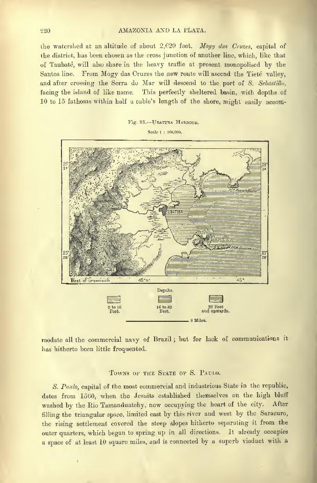
220 AMAZONIA AND LA PLATA.
the watershed at an altitude of about 2,020 feet. Mogy das Cruzes, capital of
the district, has been chosen as the cross junction of another line, which, like that
of Taubate", will also share in the heavy traffic at present monopolised by the
Santos line. From Mogy das Cruzes the new route will ascend the Tiete valley,
and after crossing the Serra do Mar will descend to the port of S. Sebastiao,
facing the island of like name. This perfectly sheltered basin, with depths of
10 to 15 fathoms within half a cable's length of the shore, might easily accom-
Fig. 93. UBATTTBA HARBOUR.
Scale 1 : 160,000.
West op Greenwich 45 5' 45
Depths.
Oto 16Feet.
16 to 32Feet.
32 Feetand upwards.
3 Miles.
modate all the commercial navy of Brazil;but for lack of communications it
has hitherto been little frequented.
TOWNS OF THE STATE OF S. PAULO.
S. Paulo, capital of the most commercial and industrious State in the republic,
dates from 1560, when the Jesuits established themselves on the high bluff
washed by the Rio Tamanduatehy, now occupying the heart of the city. After
filling the triangular space, limited east by this river and west by the Saracuro,
the rising settlement covered the steep slopes hitherto separating it from the
outer quarters, which began to spring up in all directions. It already occupies
a space of at least 10 square miles, and is connected by a superb viaduct with a
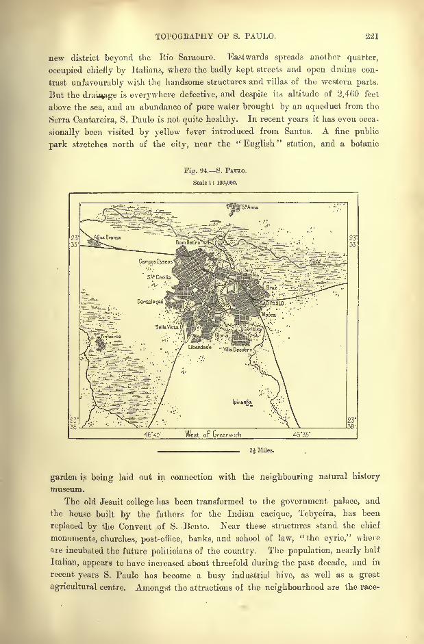
TOPOGRAPHY OF S. PAULO. 221
new district beyond the Rio Saracuro. Eastwards spreads another quarter,
occupied chiefly by Italians, where the badly kept streets and open drains con-
trast unfavourably with the handsome structures and villas of the western parts.
But the drai%tge is everywhere defective, and despite its altitude of 2,460 feet
above the sea, and an abundance of pure water brought by an aqueduct from the
Serra Cantareira, S. Paulo is not quite healthy. In recent years it has even occa-
sionally been visited by yellow fever introduced from Santos. A fine public
park stretches north of the city, near the "English" station, and a botanic
Fig. 94. S. PAULO.
Scale 1 : 130,000,
./ Libcrdade' ..m e"^oro C'\ ..
4640' West oF Greenwich 4635'
2 1 Miles.
garden is being laid out in connection with the neighbouring natural history
museum.
The old Jesuit college has been transformed to the government palace, and
the house built by the fathers for the Indian cacique, Tebycira, has been
replaced by the Convent of S. Bento. Near these structures stand the chief
monuments, churches, post-office, banks, and school of law," the eyrie," where
are incubated the future politicians of the country. The population, nearly half
Italian, appears to have increased about threefold during the past decade, and in
recent years S. Paulo has become a busy industrial hive, as well as a great
agricultural centre. Amongst the attractions of the neighbourhood are the race-
222 AMAZONIA AND LA PLATA.
course, the much-frequented shrine of la Penha, crowning a bluff east of the
city, and the imposing but still unoccupied palace of Ipiranga, the finest architec-
tural building in Brazil, erected by the Italian architect, Bezzi, to commemorate
the establishment of the empire.
Santos, formerly Todos os Santos," All Hallows," is at once the depot and
outlet for the trade of S. Paulo. The first settlement on this coast dates from
1532, when the present watering-place of S. Vicente was founded five or six
miles farther east. Here was produced the first sug^r in Brazil, extracted from
the cane introduced from Madeira, and here the Jesuits established the first
primary school in 1566. This outer port, standing like Santos itself on an island
separated by a narrow strait from the mainland, continued till the year 1709 to
rank as the capital of the section of the Brazilian seaboard stretching for about
600 miles between Macahe and Cananea.
Santos, regularly planned, .but badly kept, extends along the foot of the
steep Monserate eminence, which occupies the centre of the island, and which
is crowned by a church commanding a superb panoramic view. But the site of
the city is hopelessly insalubrious;or at least to make it healthy it would be
necessary to raise the miry soil, sodden with the rain and tidal waters minglingwith the slush of the sewers. Mudbanks are exposed at low water, while the
putrid carcasses of cattle embedded in the sands, are left to the carrion birds,
which do duty as scavengers. Hence no place in the New World has suffered
more from yellow fever in proportion to its population than Santos. At times all
work has been suspended by the death or flight of the employees, and vessels
abandoned by their crews have been seen drifting helplessly in the bay. As the
bad season approaches, nearly the whole population takes refuge in the health
resorts of the surrounding heights, or in Balnearia and other watering-places on
the coast.
Yet, despite these recurrent epidemics, Santos is the centre of a large importand export trade, averaging collectively about 15,000,000 a year. Formerly it
exported the produce of Minas Geraes, and, even of Matto Grosso;but at present
it is the outlet mainly of the State of S. Paulo, whose trade, however, is steadily
increasing. To meet the growing traffic various harbour works have been under-
taken, and the largest vessels will soon be able to load and unload at the
wharves. The English, and next to them the Norwegians, take the largest share
of the general movement of Santos, which is regularly visited by as many as
twenty lines of steamers. A splendid railway, constructed by English engineers,
across the primeval forests of Culutao, and over the coast range, serves to bring
down the coffees of S. Paulo, and to forward to the interior rice from India,
Newfoundland cod, English coal, and all kinds of European manufactured
goods.
But this line is already quite inadequate to meet the demands of the local
trade, and the frequent blocks and delays in forwarding goods, are driving
commerce to seek new and costly routes. Two Paulist companies, one in the
west, the other in the east, have been formed to compete with the English society
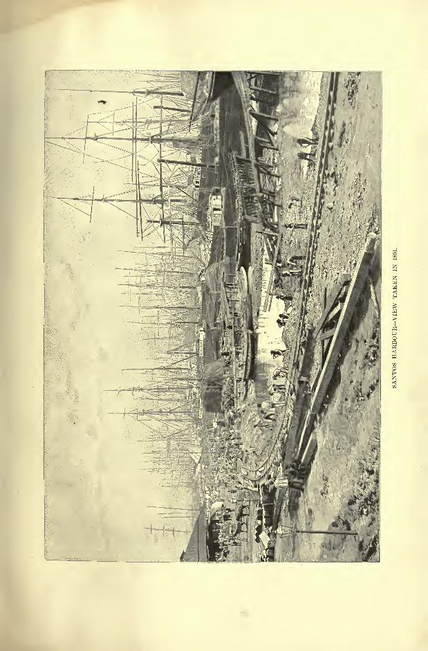
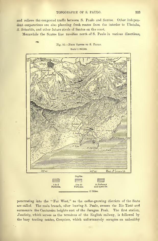
TOPOGRAPHY OF S. PAULO. 223
and relieve the congested traffic between S. Paulo and Santos. Other indepen-
dent corporations are also planning fresh routes from the interior to Ubatuba,
S. Sebastiuo, and other future rivals of Santos on the coast.
Meanwhile the Santos line ramifies north of S. Paulo in various directions,
Fig. 95. FEOM SANTOS TO S. PAULO.
Scale 1 : 650,000.
-462cr West op Greenwich
Depths.
Oto5Fathoms.
5 to 10Fathoms.
10 Fathomsand upwards.
12 Miles.
penetrating into the " Far West," as the coffee-growing districts of the State
are called. The main branch, after leaving S. Paulo, crosses the Bio Tiete and
surmounts the Cantareira heights east of the Jaragua Peak. The first station,
Jundiahy, which serves as the terminus of the English railway, is followed bythe busy trading centre, Campinas, which unfortunately occupies an unhealthy
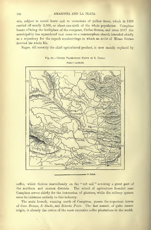
224 AMAZONIA AND LA PLATA.
site, subject to torrid heats and to visitations of yellow fever, which in 1892
carried off nearly 3,000, or about one-sixth of the whole population. Campinasboasts of being the birthplace of the composer, Carlos Gomez, and since 1817 the
municipality has squandered vast sums on a commonplace church intended chiefly
as a repository ior the superb woodcarvings to which an artist of Minas Geraes
devoted his whole life.
Sugar, till recently the chief agricultural product, is now mainly replaced by
Fig. 96. COFFEE PLANTATIONS NORTH OF S. PAULO.
Scale 1 : 3,000,000.
We stoF Greenwich 47'
GO Miles.
coffee, which thrives marvellously on the " red soil"covering a great part of
the northern and eastern districts. The school of agriculture founded near
Campinas serves chiefly for the instruction of planters, while the railway system
owes its existence entirely to this industry.
The main branch, running north of Campinas, passes the important towns
of Casa Branca, S. Simao, and Riberao Prelo. The last named, of quite recent
origin, is already the centre of the most extensive coffee plantations in the world.
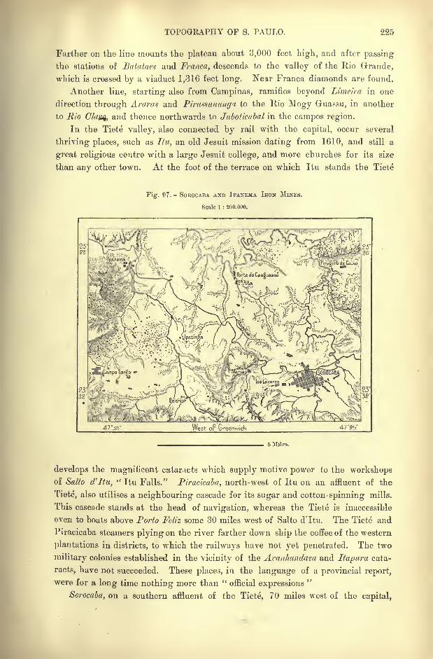
TOPOGRAPHY OF S. PAULO. 225
Farther on the line mounts the plateau about 3,000 feet high, and after passing
the stations of Batataes and Franca, descends to the valley of the Rio Grande,
which is crossed by a viaduct 1,316 feet long. Near Franca diamonds are found.
Another line, starting also from Campinas, ramifies beyond Limeira in one
direction through Araras and Pirasaunungv to the Rio Mogy Guassu, in another
to Rio Clci^ and thence northwards to Jaboticabal in the campos region.
In the Tiete valley, also connected by rail with the capital, occur several
thriving places, such as Itu, an old Jesuit mission dating from 1610, and still a
great religious centre with a large Jesuit college, and more churches for its size
than any other town. At the foot of the terrace on which Itu stands the Tiete
Fig. 97.- SOEOCABA. AND IPANEMA IRON MlNES.
Scale 1 : 200,000.
West oF Greenwich 47 '25'
5 Miles.
develops the magnificent cataracts which supply motive power to the workshopsof Salto d'Itu,
" Itu Falls." Piracicaba, north-west of Itu on an affluent of the
Tiete, also utilises a neighbouring cascade for its sugar and cotton- spinning mills.
This cascade stands at the head of navigation, whereas the Tiete is inaccessible
even to boats above Porto Feliz some 30 miles west of Salto d'ltu. The Tiete and
Piracicaba steamers plying on the river farther down ship the coffee of the western
plantations in districts, to which the railways have not yet penetrated. The two
military colonies established in the vicinity of the Avanhandam and Itapura cata-
racts, have not succeeded. These places, in the language of a provincial report,
were for a long time nothing more than "official expressions."
Sorocaba, on a southern affluent of the Tiete, 70 miles west of the capital,

226 AMAZONIA AND LA PLATA.
presents a solitary spectacle of decadence in the State of S. Paulo. It has been
ruined by the railways which have brought prosperity to so many other places.
Till recently it was the central market for cattle, and especially for mules for-
warded by the Rio Grande do Sul stock-breeders. As many as 200,000 animals
were often seen at its fairs, and the mules of Itio Grande are still distributed over
the States of Santa Catharina and Parana, and even enter that of S. Paulo through
the Faxina route. But on reaching the various stations they are at once for-
warded by rail direct to the plateaux and coastlands, so that the Sorocaba market
receives yearly less and less of this traffic.
The iron industry of Ipanema, in the same district, has also suffered, thoughfrom another cause. This place, which takes its name from an affluent of the Rio
Sorocaba, is famous for its ferruginous ores, yielding from 70 to 80 per cent, of
excellent metal. Nevertheless, the works established on the spot have not suc-
ceeded, despite government support. Everything costs more than it fetches, and
the ferruginous mount Araqoyaba (3,180 feet), commonly called o morro do ferro," Iron Mount," remains little utilised.
At present (1894) Botucatu is the last important place in the cultivated region.
Beyond the surrounding coffee plantations begin the vast unexplored solitudes
comprised between the lower Tiete and the Paranapanerna. Since the seventeenth
century a great shifting of the aboriginal populations has taken place in this
region. Over 100,000 civilised Indians were grouped round the settlements of
S. Ignacio Mayor and other places on the Paranapanema and Parana rivers. But
the land was depopulated by the slave-mongers, and the work of colonisation, and
even to some extent of geographical exploration, has to be begun again. Some
progress, however, has already been made, and in 1890 the annual production of
cattle was estimated at 100,000. A beginning had also been made with sugar,
coffee, cotton and tobacco growing.
The southern part of the State, still unconnected with the capital by carriage
roads or railways, constitutes, with the conterminous districts of Parana, a perfectly
distinct geographical region. It is but thinly settled, and its chief towns are
mere villages, such as Apiahy, now forsaken by the gold-hunters : Xiririca, with
unworked quarries of lovely white marble; Iguape and Cananea, two small
riverside ports, the former near the mouth of the Ribeirao, communicating bya navigable canal with the so-called Mar Pcqueno,
" Little Sea," which
extends for over 60 miles along the banks. Cananea, occupying an island in
this flooded depression, is accessible to large river craft at high water. This
port marks the spot where Christovao Jacques and Amerigo Vespucci landed
in 1503, and from the same place set out the first bandcira of eighty adventurers
in search of gold, not one of whom ever returned.
TOWNS OF THE STATE OF PARANA.
Curitiba, capital of the State of Parana, stands, like S. Paulo, on a plateau
bounded eastwards by the Serra do Mar, and, like it, is connected by rail with an
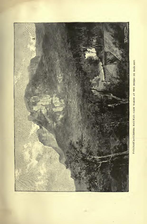
TOPOGRAPHY OF THE STATE OF PARANA. 227
outlet on the Atlantic. Standing at an altitude of 2,920 feet, Curitiba enjoys a
temperate climate, and is surrounded by European settlers who bring to its
market the fruits and vegetables of the Old World. It ranks as a capital only
since the year 1854, when the territory of Parana was detached from S. Paulo
and constituted a separate province.
A carriage road running to the coast by the town of Graciosa was supplemented
in 1885 by the railway, which, after turning the superb Mount Morumby (4,700
feet), descends through a series of cuttings, tunnels, and viaducts to the foot of
the mountains at Marretcs. The highest point reached stands at the entrance of
a tunnel 3,135 feet above the sea, and from the successive terraces and inclined
planes magnificent views are afforded of the surrounding mountains, slopes, and
lowland tracts, stretching away to Paranagua Bay.
At Morretes, formerly a centre of the mate export trade, the railway bifurcates,
Fig. 98. FBOM CUEITIBA TO PAEANAGUA.
Scale 1 : 800,000.
West op Greenwich 484tr
12 Miles.
one branch running north-west to the port of Antonina, which though shallower
than that of Paranagua, is still accessible to vessels drawing 14 or 16 feet. Duringthe floods, which often threaten to inundate the main line between Morretes and
Paranagua, the Autonina branch offers an alternative route for the foreign trade
of Curitiba.
Paranagua standing on the north (left) bank of the Itubere (Itibiri) estuary,
is no longer directly accessible to large vessels, which have to ride at anchor at a
distance of over a mile to the north-west in the deep waters of the bay sheltered
from the east by the hilly Cotinga Island. The town itself is moving in this
direction, and numerous new structures already extend along the new harbour.
Its export trade is mainly restricted to forest produce, such as araucaria wood
and yerba mate, obtained from the ilex corityhensis, a plant allied to that which
228 AMAZONIA AND LA PLATA.
yields the mate1
of Paraguay. Nearly 20,000 tons of this article were exported in
1892, valued at 312,000.
Visitors are still shown the ruins of the old Jesuit College, former headquarters
of the Parana missions. In the surrounding forest clearings are several agricul-
tural settlements, the most important of which is Alexandra, where a group of
Italian colonies cultivates alimentary plants, and have also laid out some sugar and
coffee plantations.
In the interior, west of Curitiba, some flourishing colonies have developed
Fig. 99.
Scale 1 : 100,000.
48 52- West oF Greenwich 48 8-
Depths.
otoieFeet.
16 to 32Feet.
32 Feetand upwards.
. 2 Miles.
into towns such as Campo Largo and Palmeiro, and farther north Ponta Grossa on
the upland plains watered by the Tibagy. Till recently nearly all the German
settlers were attracted to the States of Santa Cutharina and Rio Grande do Sul;
at present the stream of Italian immigration is setting in the direction of S.
Paulo, while Parana is favoured chiefly by the Poles. Yet this movement beganwith the disastrous undertaking of 1878, when 1,366 Slav peasants were intro-
duced without any preparations being made for their reception. Left at Palmeira
TOPOGRAPHY OF THE STATE OF PARANA. 229
to tbefr own resources, many perished, and of the survivors some found their way
back to Europe, while others were removed to the United States.
The handful that remained on the spot became the nucleus of ffesh colonies,
which have gradually reclaimed the wastes on the elevated campos watered
by the Rio Iguazu. Most of these "Russians," as they are generally called,
come from Bussian and Austrian Poland, though in quite recent years they have
been joined by Russian Poles, driven by religious persecutions from the provinces
of Lithuania and the Vistula. For a space of 18 or 20 miles Curitiba is sur-
rounded by these exclusively Polish colonies, which even officially take the name
of " New Poland." Others are settled about Palmeira, and along the right bank
of the Iguazu all the way to.the new station of Porto Unao. Other groups have
established themselves in the southern parts of the State on the Rio Negro and
Rio Vermelho towards the Santa Catherina frontier.
These Polish colonists, among whom not a single Jew is found, are approxi-
mately estimated at 100,000, or about one-third of the whole population of Parana.
The mortality is extremely low, so that the natural increase by the excess of births
over deaths rises to an average of four per cent., a proportion rarely attained in
any country. The Poles of Parana preserve their language and national usages ;
they have their own churches and schools, and even support a newspaper. Being
nearly all peasants, they have monopolised the production of cereals and vegetables,
and have begun to drive back towards S. Paulo the settlers of other nationalities.
One of these groups, however, the Italian communist settlement of La Cecilia,
near Palmeira, has hitherto resisted the Slav invasion.
Although gold occurs at Campo Largo and quicksilver at Palmeira, Parana is
more noted for its natural curiosities than for its mineral resources. Some 20 miles
east of Ponta Grossa, the argillaceous ground is pierced by three astonishing
buracos or pits, one of which is no less than 560 feet deep and 264 feet wide at the
mouth. A sluggish stream flowing at the bottom passes from chasm to chasm
towards a lagoon which drains to the Rio Tibagy. Farther east a crumbling mass
of old red sandstone has received the name of Villa Velha," Old Town," from the
pyramids and other fantastic forms which it has assumed.
In 1894 Curitiba possessed only one railway running through Lapa to the
Santa Catharina frontier. The Rio Iguazu, crossed by this line, becomes navigableat Porto do Amazonas, some 60 miles west of the capital, but 125 miles lower
down the stream is interrupted by numerous rapids. Owing to the general lack
of communications nearly the" whole of the fertile western districts of Parana still
remain a vast wilderness roamed only by a few bands of Coroados. Here the
traveller lights upon the shapeless ruins of former missions, such as Villa Rica in
the Rio Ivahy valley, and at the confluence of the Piquiry with the Parana, the
central station of la Guayra, headquarters of the vast theocratic empire founded bythe Jesuits and ruined by the Paulistas. In this region almost the only recent,
colonial settlement is that of Guarapava, not far from the head of the Rio Ivahy,which here develops a superb cascade 248 feet high.
In 1889 the Brazilian Government selected a site at the confluence of the49
280 AMAZONIA AND LA PLATA.
Iguazu with the Parana, below the great falls, for the military colony of Foz de
Iguazu, which has since become a free settlement with a mixed Brazilian, Para-
guayan, and French population of 700 souls chiefly engaged in collecting mate*
and cultivating cereals. Foz de Iguazu occupies an important strategical position
as a frontier station towards Paraguay and Argentina. Here a beginning has
already been made with a national arsenal and a flotilla, and there can be no doubt
that sooner or later an important centre of population must spring up either at Foz
de Iguazu, or at some other confluence in the neighbourhood. In this district the
valley of the Parana is intersected by the shortest highway running from the Atlantic
seaboard westwards to Matto Grosso, that is, to the geographical centre of the Conti-
nent. The position is somewhat analogous to that of St. Louis on the Mississippi.
TOWNS OF SANTA CATHARINA.
This State, which takes its name from the long island of Santa Catharina, the
Juru Mirim of the Indians, has benefited more than any other region of Brazil bythe movement of immigration controlled by the Government. If a " New Ger-
many"has not been developed in Santa Catharina and the neighbouring Rio
Grande do Sul, at least the German language prevails in many districts, and
thanks to the higher standard of education this State exercises an influence in
public -affairs out of proportion to its slight population.
In 1849 a Hamburg trading association introduced the first German colonists,
who established themselves on the banks of the Rio Cachoeira. The rising station
took the name of Joinville, in honour of the French prince to whom a territory
of about 60,000 square miles had been ceded as the dowry of dona Francisca,
sister of the Emperor of Brazil. The district soon assumed the aspect of a
flourishing German domain, and of the 19,000 present inhabitants of the muni-
cipality over 14,000 claim German or Polish descent. Breweries, distilleries,
and other workshops have sprung up round about Joinville, and hundreds of
waggons are engaged in carting to the port of S. Francisco the mate, tobacco,
maize, tapioca, butter, and other produce raised in the district.
A carriage road crossing the Serra do Mar runs northwards to 8. Bento and
other colonies about the Parana frontier, and at Rio Negro this highway joins the
railroad from Curitiba.
S. Francisco, where is centred all the local traffic, is one of the best harbours
on the coast. The channel separating S. Francisco Island from the mainland has
a depth of 20 feet, and offers excellent anchorage to the shipping, which is here
sheltered from all winds.
Blumenau on the Rio Itajahy, south-west of Joinville, dates from 1852, when it
was founded by the German speculator from whom it takes its name. From the
first it had a hard battle to fight with adverse circumstances, but it has at last
entered on a prosperous career, and numerous roads now radiate in all directions
through a rich district studded with mills, workshops, and farmsteads. Steamers
plying on the Itajahy communicate with the port of Nova Trento, where the
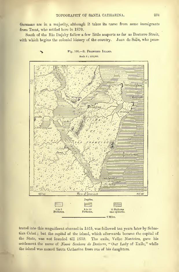
TOPOGRAPHY OF SANTA CATHAEINA. 231
Germans are in a majority, although, it takes its name from some immigrants
from Trent, who settled here in 1870.
South of the Rio Itajahy follow a few little seaports as far as Desterro Strait,
with which begins the colonial history of the country. Juan de Solis, who pene-
Fig. 100. S. FRANCISCO ISLAND.
Scale 1 : 375,000.
4850' West oF Greenwich
Depths.
Oto5Fathoms.
5 to 10Fathoms.
10 Fathomsand upwards.
9 Miles.
trated into this magnificent channel in 1515, was followed ten years later by Sebas-
tian Cabot; but the capital of the island, which afterwards became the capital of
the State, was not founded till 1650. The exile, Yelho Monteiro, gave his
settlement the name of Nossa Senhora do Desterro," Our Lady of Exile," while
the island was named Santa Catharina from one of his daughters.
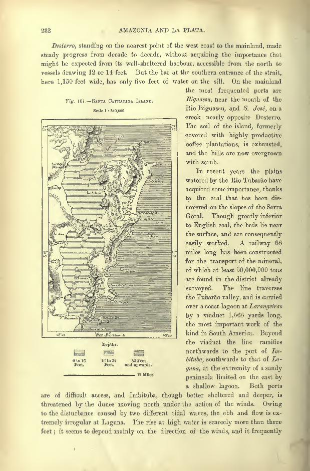
232 AMAZONIA AND LA PLATA.
Fig. 101. SANTA CATHAEINA ISLAND.
Scale 1 : 540,000.
Desterro, standing on the nearest point of the west coast to the mainland, made
steady progress from decade to decade, without acquiring the importance that
might be expected from its well-sheltered harbour, accessible from the north to
vessels drawing 12 or 14 feet. But the bar at the southern entrance of the strait,
here 1,150 feet wide, has only five feet of water on the sill. On the mainland
the most frequented ports are
Biguassu, near the mouth of the
Rio Biguassu, and 8. Jose, on a
creek nearly opposite Desterro.
The soil of the island, formerly
covered with highly productive
coffee plantations, is exhausted,
and the hills are now overgrownwith scrub.
In recent years the plains
watered by the Rio Tubarao have
acquired some importance, thanks
to the coal that has been dis-
covered on the slopes of the Serra
Geral. Though greatly inferior
to English coal, the beds lie near
the surface, and are consequently
easily worked. A railway 66
miles long has been constructed
for the transport of the mineral,
of which at least 50,000,000 tons
are found in the district already
surveyed. The line traverses
the Tubarao valley, and is carried
over a coast lagoon at Larangeiras
by a viaduct 1,565 yards long,
the most important work of the
kind in South America. Beyondthe viaduct the line ramifies
northwards to the port of Im-
bituba, southwards to that of La-
guna, at the extremity of a sandy
peninsula limited on the east bya shallow lagoon. Both ports
are of difficult access, and Imbituba, though better sheltered and deeper, is
threatened by the dunes moving north under the action of the winds. Owingto the disturbance caused by two different tidal waves, the ebb and flow is ex-
tremely irregular at Laguna. The rise at high water is scarcely more than three
feet;
it seems to depend mainly on the direction of the winds, and it frequently
WtoFGreenw,ch
otoieFeet.
Depths.
16 to 32Feet.
32 Feetand upwards.
12 Miles.
TOPOGRAPHY OF SANTA CATHAEINA. 238
happens that the complete tidal movement is spread over a period of twenty-fourhours. The sandy spit west of Laguna is almost entirely covered by an enormous
tambaqui (kitchen midden), containing a vast accumulation of sLells dating back
to prehistoric times.
Lages, the chief place on the inland Campos, is mainly a stockbreeding centre,
and cattle are forwarded from this place, overland, to Sorocaba. The breeders
own about 300,000 oxen on the pastures stretching westwards, in the direction
of the savannas claimed by Argentina.
- CHAPTER XII.
URUGUAY BASIN AND ADJACENT SEABOARD.
STATE or SAN PEDRO OR Rio GRANDE DO SUL.
ESPITE its relatively small extent, this region, named from an inlet
which the first navigators mistook, as they had mistaken the Bayof Rio, for a great river, is one of the best adapted, by its natural
resources, to constitute an independent State. It has often, in
fact, played an independent part, and its position as a border
land towards the Spanish domain gave it too much importance under the
Portuguese rule to be granted as a fief, like so many other provinces of Brazil.
But, although it had consequently always been governed directly by the
crown, its inhabitants were none the less enthusiastic in hailing the proclamation
of independence. Then feeling the yoke of Rio as much as they had before
felt that of Lisbon, they attempted to set up for themselves, and a fierce civil
war was waged for nine years (1835 44) between the farrapos (republicans)
and the caramurus (monarchists). This was the heroic period in the history of
Rio Grande, associated with the name of the great guerilla chief, Garibaldi.
It required all the resources of the vast empire of Brazil to wrest the little
"republic
"of Rio Grande from the band of adventurers led by this famous
captain.
Since then the southern province has had, from its very position, to bear the
brunt of the border warfare carried on at one time against Argentina, at another
against Paraguay. Lastly, since the proclamation of the Brazilian republic,
Rio Grande, true to its traditional hatred of centralisation, has begun a fierce
struggle for its local autonomy. Here was struck the first blow against the
military dictatorship of Rio de Janeiro, and from this region the revolution
gradually spread to a great part of Brazil. Long after the surrender of the rebel
fleet, in the spring of 1894, the revolt was kept alive in Rio Grande.
EIO GEANDE DO SUL. 235
BOUNDARIES EXTENT SETTLEMENT.
Towards Argentina Rio Grande is bounded by the natural frontier of the
Rio Uruguay ; but southwards the vicissitudes of war have caused a purely
conventional frontier to be adopted towards the conterminous republic of Uruguay.The line, which, on the coast, coincides with the little river Chuy, runs inland
across the Lagoa Mirim to the mouth of the Jaguarao, which constitutes the
frontier as far as the Alto da Mina rivulet. Here begins a sinuous line, traced
from hill to hill north-westwards to the divide between the two rivers, Ibicuy
Grande and Tacuarembo, beyond which the boundary is formed by the course of
the Rio Quaraim.
Rio Grande do Sul thus constitutes a somewhat irregular quadrilateral of
about 300 miles on all sides, with a superficial area of over 91,000 square miles,
and a vigorous population (1894) of rather over 1,000,000. The territory has
been traversed by explorers in all directions, except in the northern campos ;but
it still lacks accurate maps, for which the preliminary surveys have not even yet
been undertaken.
The first settlers were natives of the Azores, who were driven from the
Archipelago by famine, and who founded the two cities of Rio Grande and Porto
Alegre in 1737 and 1742. German immigrants began to arrive soon after
the declaration of independence. Some settled in 1824 on a domain near
the spot where now stands S. Leopoldo ;these were followed by military
settlers, and towards the middle of the century the German colonists numbered
over 7,000.
Even the European revolutions exercised a certain influence in the develop-
ment of Rio Grande. Over 1,000 of the so-called Brummcrs, most of whomhad taken part in the German risings of the year 1848, afterwards entered
the Brazilian service, and were engaged in the war against the dictator, Rosas.
Several men of eminence, members of this volunteer force, became leading
citizens of Eio Grande, and to them was due the first educational movement
to which this State is indebted for the prominent position it holds in the
Brazilian union.
Although the early agricultural colonies have lost the organisation imposedon them by the central or provincial government, and although all immigrantsand their descendants have become naturalised Brazilians, the Germanic element
has not yet been entirely assimilated. The national sentiment and cohesion,
fostered by a foreign language, education and usages, is still kept alive in manydistricts. But this " State within the State," constituted by aliens, with different
aspirations from those of the natives, loses ground in proportion to the rapid
increase of other ethnical elements, and especially of such as, through racial and
religious affinities, are more readily absorbed in the dominant Lusitano-Brazilian
nationality.
Numerous Italian, Spanish, and Slav colonists have also arrived, and in 1875 the
Negro element was estimated at over 90,000. Before the final abolition of slavery
AMAZONIA AND LA PLATA.
Rio Grande had liberated more than half, and in 1885 the anniversary of national
independence was celebrated by the emancipation of 10,000.
PHYSICAL FEATURES.
Rio Grande do Sul comprises four natural regions clearly indicated Ly the
general relief of the land. As in the neighbouring States, a " Piedmont"
of
low lying coastlands stretches along the shores of the Atlantic, and these coast-
lands are separated by a mountain range some 3,000 feet high from the inland
plateau sloping gently towards the Uruguay. But the coastland and coast range
are themselves separated by a deep depression in which the Rio Vacacahy, con-
tinued by the Jacuhy, winds to the east, and the Ibicuy Grande, a tributary of
the Uruguay, to the west.
The north-eastern section of the mountains preserves the name of Serra do
Mar, by which they are known as far north as Rio de Janeiro. But south of
the Rio Jacuhy the various sections take other names, such as Serra do Herval
between the Jacuhy and the Camacuam, and Serra dos Tapes thence to the Jaguarao,
while various ridges bear other designations. As in the north, the system con-
sists of crystalline rocks, gneiss, and granites.
In the transverse depression between the sea and the Uruguay is seen the edgeof the northern plateau standing out like the steep banks of a river, and this
scarp, presenting the aspect of a mountain on its outer face, generally takes the
name of Serra. It is decomposed into several groups, which become continuously
less precipitous in the direction of the west. The ridges branching off from the
Serra proper are known, like the southern heights near Uruguay, by the name
of coxilhas,"knives," although the crests, instead of being sharp, are disposed in
long gently inclined slopes.
In many places the primitive granites underlie layers of tertiary sands;but
the relatively recent formations are chiefly represented by erupted traps, which
are easily weathered, taking a brown or yellow crust, and changing to that reddish
clay which covers nearly all the plains. In some of the central regions traps
occupy most of the surface, but they gradually diminish westwards in the direction
of the Uruguay. Geologists generally associate with the presence of erupted
masses the transformation of argillaceous substances to agates, chalcedony, jaspar,
and amethysts, which occur in extraordinary quantities in some of the southern
districts. Besides these valuable stones Rio Grande also contains gold, silver,
copper, tin, lead, iron, kaolin, and coral.
COAST LAGOONS.
The long beach developed in graceful curves along the Atlantic coast is
entirely of marine origin. This cordon of sands has been washed up by the wavesand modified with every tide by fresh deposits and fresh erosions. Various
phenomena point at a general upheaval of the outer beach itself, which now

EIO GRANDE DO SUL COAST LAGOONS. 237
separates from the sea extensive spaces that have been gradually changed to
brackish or even freshwater lagoons. These lagoons, beginning in the State of
Santa Catharina, are developed in a continuous chain, varying in size and form,
Fig. 102. LAGOA DOS PATOS.
Scale 1 : 2,000,000.
32'
52 West oF Greenwich
Depths.
Oto6Feet.
6 to 32Feet.
32 to 160 160 FeetFeet. and upwards.
30 Miles.
some completely closed, others connected by creeks and communicating with the
sea by passages open in the wet, closed in the dry season.
Behind this outer chain another has been formed of still more irregular
outlines, and this system is connected by the Capivary with an inland sea about
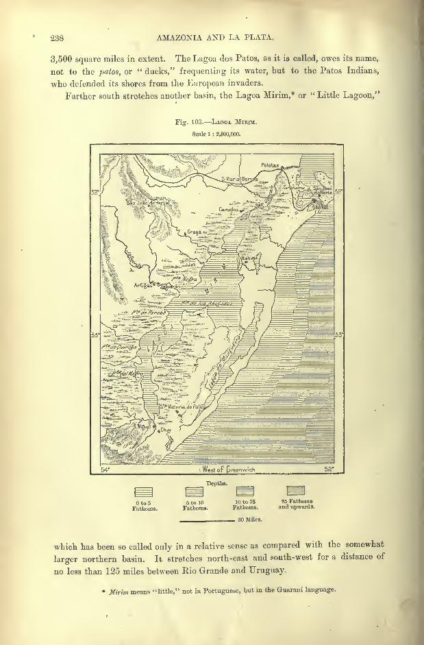
288 AMAZONIA AND LA PLATA.
3,500 square miles in extent. The Lagoa dos Patos, as it is called, owes its name,
not to the patos, or "ducks,'' frequenting its water, but to the Patos Indians,
who defended its shores from the European invaders.
Farther south stretches another basin, the Lagoa Mirim,* or "Little Lagoon,"
Fig. 103. LAGOA MIRIM.
Scale 1 : 2,300,000.
Depths.
to 5Fathoms.
5 to 10
Fathoms.10 to 25
Fathoms.25 Fathomsand upwards.
30 Wiles.
which has been so called only in a relative sense as compared with the somewhat
larger northern basin. It stretches north-east and south-west for a distance of
no less than 125 miles between Rio Grande and Uruguay.
* Mirim means "little," not in Portuguese, but in the Guarani language.
EIO GRANDE DO SUL RIVERS. 239
RIVERS.
Numerous rivers converge in the Lagoa dos Patos, which sends its overflow
through the Rio Grande to the Atlantic. The chief affluent, known by various
names, is formed towards the centre of the State by the junction of the Vacacahyand Jacuhy, the latter being considered the main branch. Below a great cataract
the river becomes navigable, and rapidly increases in volume by the contributions
of the Taquary, Cahy, Rio dos Sinos, and other tributaries, mostly descending
from the northern uplands. Lower down the Jacuhy develops into an estuary,
and under the name of Guahyba, falls through a strait into the Lagoa dos
Patos.
The Lagoa Mirim is fed by the Cebolaty from Uruguay and by the Jaguarao
frontier stream, and discharges its overflow north-eastwards to the Lagoa dos
Patos through the Sangradouro (S. Goncalo) channel. This emissary, which is
joined by the Rio Piratinim, has been deepened and canalised, and is now
utilised by trading steamers between the two lagoons. Unfortunately a dan-
gerous bar, the scene of many shipwrecks, obstructs the navigation of the Rio
Grande do Sul, through which this extensive system of inland waters com-
municates with the Atlantic.
On the north-east and north-west Rio Grande is bounded by the Uruguay,which rises within Brazilian territory, and for the greater part of its course
either flows through or borders Brazilian lands. It has its source in the Serra
do Mar, within thirty miles of the Atlantic, and under various names traverses
the region of the campos. From Rio Grande it receives the Uruguay Mirim," Little Uruguay," and from Santa Catharina numerous affluents, amongst others,
the Chapeco and Pepiry Guassu, which have given rise to so many discussions on
the subject of the Brazilo-Argentine frontiers.
Below the Pepiry Guassu,"Big Straw-Coloured River," the Uruguay forms
the Salto Grande," Great Falls," where it turns abruptly from the west to the
south-west, retaining this direction throughout the whole section of its course
between the conterminous republics. In this region its largest affluent is the
Ibicuy Grande, which is accessible to small craft for some hundred miles. The
mainstream is also navigable, but interrupted at intervals by rapids, so that free
navigation begins far to the south of Brazilian territory below the rapids at Salto,
a town in Uruguay.
CLIMATE.
In Rio Grande, southernmost of the Brazilian States, the seasons are as
distinctly marked as in Europe, and the range of temperature between the hot
summers and cold winters sometimes exceeds 70 Fahr. In January and Februarythe thermometer has recorded 100 and 102 Fahr., while the ground is covered with
snow in July. In the hilly districts the glass falls at times to 17 or 16 Fahr., but
such extremes are rare, and the mean range between the greatest heat and
240 AMAZONIA AND LA PLATA.
greatest cold scarcely exceeds 20 Fahr. The most abrupt changes take place when
the minuano (west or north-west winds) descend from the Andes, or when the
pampciro sweeps up from the Argentine pampas.
The precipitation is very unequally distributed throughout the year. Normallyit falls in winter ; but the summer rains, though of shorter duration, are heavier.
Altogether the annual rainfall is estimated for the whole region at about
40 inches.*
FLORA FAUNA.
As in the neighbouring States as far as S. Paulo, the most marked contrasts
in the vegetation are presented by the woodlands and campos ;but in Rio
Grande the transition is in some places extremely abrupt from the herbaceous to
the forest zone. Elsewhere it is more gradual, and in several districts thickets
of dwarf palms (butia rasteira)
'
&re dotted over the grassy plains. The primeval
forest, continuing the northern selva, occupies the Serra do Mar, and extends
along the scarp of the mountains skirting the north side of the Jacuhy
depression.
In the north and north-west the Uruguay flows through vast wooded tracts,
and here is found the greatest variety of species, as well as the richest soil, so
that the Upper Uruguay valley seems destined to become the most densely
peopled region in the State. South of the Jacuhy the Serras do Herval and
dos Tapes have also their primeval forests, but nearly the whole of the central
and western regions belong to the campos zone. Southwards these almost treeless
expanses assume the character of the Argentine pampas.
In Rio Grande the palm family is reduced to about ten species, including the
Jeriva (cocos corona/a), whose leaves wrapped round maize cobs are preferred by
horses to all other food. The araucaria cones attract flocks of parrakeets, and
also serve to fatten swine. The local flora also includes various bamboos, and the
bromeliacea cravata (caraguata), which resembles the pineapple. Although the
valuable jacaranda is absent, the Rio Grande forests contain over a hundred species
useful for building and cabinet-work.
Rio Grande, like Amazonia, has its apes and vampires, its jaguars and
pumas ("lions"), although these are becoming rare, its iguanas, turtles and alli-
gators. The forests are still frequented by the peccary, cutia and tapir ;but the
viscacha (lagostomus trichodactylns) met on the right or Argentine side of the
Uruguay, is unknown on the left bank. The same river also forms a divide
between other animal species, such as the anteater and coati (nasua socialis), which
occur only on its east side.
* Climatic conditions of Rio Grande do Sul on the coastlands and in the interior :
MeanLatitude. Temperature. Bainfall. Rainy Days.
Santa Cruz . . .29 45' 66 Fahr. ? 107
Pelotas . . . 31 46' 63 Fahr. 42 inches 83
Rio Grande . , 32 7' 65 Fahr. 39 inches 80
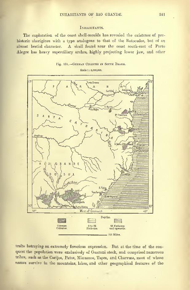
INHABITANTS OF RIO OEANDE. 241
INHABITANTS.
The exploration of the coast shell-moulds has revealed the existence of pre-
historic aborigines with a type analogous to that of the Botocudos, but of an
almost bestial character. A skull found near the coast south-east of Porto
Alegre has heavy superciliary arches, highly projecting lower jaw, and other
Fig. 104. GERMAN COLONIES IN SOUTH BRAZIL.
Scale 1 : 5,000,000.
Depths.
GermanColonies.
Oto25Fathoms.
25 Fathomsand upwards.
125 Miles.
traits betraying an extremely ferocious expression. But at the time of the con-
quest the population were exclusively of Guarani stock, and comprised numerous
tribes, such as the Carijos, Patos, Minuanos, Tapes, and Charruas, most of whose
names survive in the mountains, lakes, and other geographical features of the
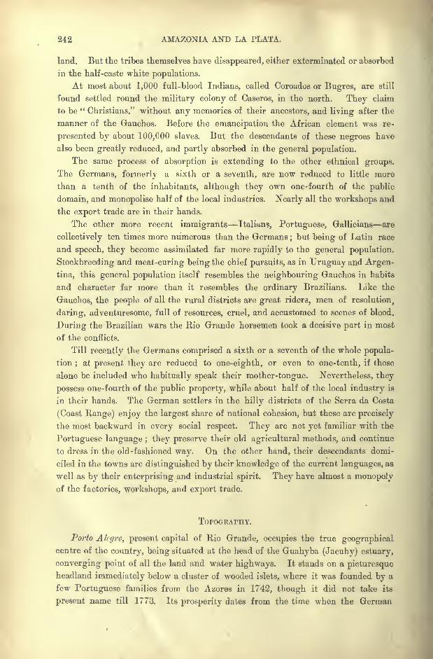
242 AMAZONIA AND LA PLATA,
land. But the tribes themselves have disappeared, either exterminated or absorbed
in the half-caste white populations.
At most about 1,000 full-blood Indians, called Coroados or Bugres, are still
found settled round the military colony of Caseros, in the north. They claim
to be "Christians," without any memories of their ancestors, and living after the
manner of the Gauchos. Before the emancipation the African element was re-
presented by about 100,000 slaves. But the descendants of these negroes have
also been greatly reduced, and partly absorbed in the general population.
The same process of absorption is extending to the other ethnical groups.
The Germans, formerly a sixth or a seventh, are now reduced to little more
than a tenth of the inhabitants, although they own one-fourth of the public
domain, and monopolise half of the local industries. Nearly all the workshops and
the export trade are in their hands.
The other more recent immigrants Italians, Portuguese, Gallicians are
collectively ten times more numerous than the Germans;but being of Latin race
and speech, they become assimilated far more rapidly to the general population.
Stockbreeding and meat-curing being the chief pursuits, as in Uruguay and Argen-
tina, this general population itself resembles the neighbouring Gauchos in habits
and character far more than it resembles the ordinary Brazilians. Like the
Gauchos, the people of all the rural districts are great riders, men of resolution,
daring, adventuresome, full of resources, cruel, and accustomed to scenes of blood.
During the Brazilian wars the Rio Grande horsemen took a decisive part in most
of the conflicts.
Till recently the Germans comprised a sixth or a seventh of the whole popula-
tion; at present they are reduced to one-eighth, or even to one-tenth, if those
alone be included who habitually speak their mother-tongue. Nevertheless, they
possess one-fourth of the public property, while about half of the local industry is
in their hands. The German settlers in the hilly districts of the Serra da Costa
(Coast Range) enjoy the largest share of national cohesion, but these are precisely
the most backward in every social respect. They are not yet familiar with the
Portuguese language ; they preserve their old agricultural methods, and continue
to dress in the old-fashioned way. On the other hand, their descendants domi-
ciled in the towns are distinguished by their knowledge of the current languages, as
well as by their enterprising and industrial spirit. They have almost a monopolyof the factories, workshops, and export trade.
TOPOGRAPHY.
Porto Alcgre, present capital of Rio Grande, occupies the true geographical
centre of the country, being situated at the head of the Guahyba (Jacuhy) estuary,
converging point of all the land and water highways. It stands on a picturesqueheadland immediately below a cluster of wooded islets, where it was founded by a
few Portuguese families from the Azores in 1742, though it did not take its
present name till 1773. Its prosperity dates from the time when the German
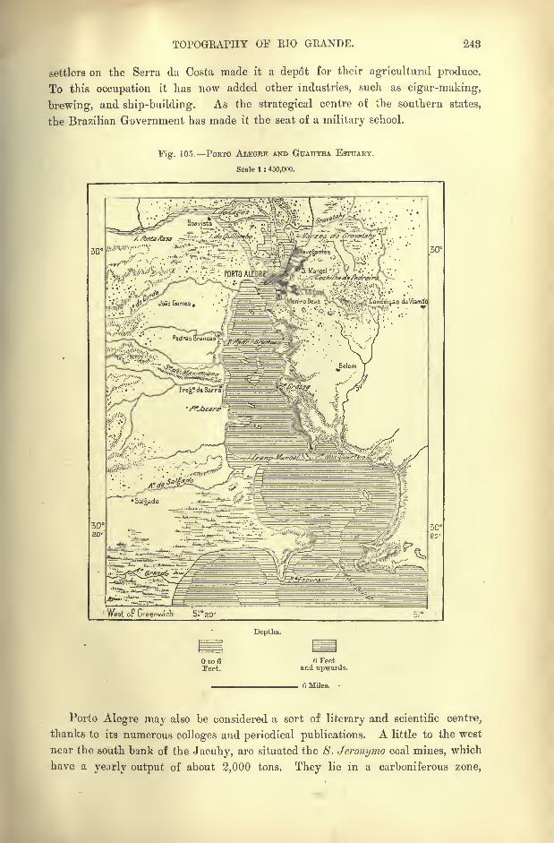
TOPOGRAPHY OF EIO GEANDE. 248
settlers on the Serra da Costa made it a depot for their agricultural produce.
To this occupation it has now added other industries, such as cigar-making,
brewing, and ship-building. As the strategical centre of the southern states,
the Brazilian Government has made it the seat of a military school.
Fig. 105. POETO ALEGBE AND GUAHYBA ESTUARY.
Scale 1 : 450,000.
fV^^'^H-^ '. .^ v--;v PORTO ALE|R
West oF Greenwich 5I20
Depths.
Oto6Teet.
6 Feetand upwards.
. 6 Miles.
Porto Alegre may also be considered a sort of literary and scientific centre,
thanks to its numerous colleges and periodical publications. A little to the west
near the south bank of the Jacuhy, are situated the 8. Jeronymo coal mines, which
have a yearly output of about 2,000 tons. They lie in a carboniferous zone,
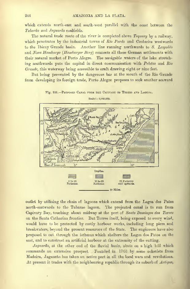
244 AMAZONIA AND LA PLATA.
which extends north-east and south-west parallel with the coast between the
Tubamo and Jaguarao coalfields.
The natural trade route of the river is completed above Taquary by a railway,
which penetrates by the industrial towns of Rio Pardo and Cachoeira westwards
to the Ibicuy Grande basin. Another line running- northwards to S. Leopoldo
and Nova Hamburgo (Hamburger Berg] connects all these German settlements with
their natural market of Porto Alegre. The navigable waters of the lake stretch-
ing southwards puts the capital in direct communication with Pclotas and Rio
Grande, this waterway being accessible to craft drawing eight or nine feet.
But being prevented by the dangerous bar at the mouth of the Rio Grande
from developing its foreign trade, Porto Alegre proposes to seek another seaward
"Fig. 106. PROPOSED CANAL FROM THE CAPIVAEY TO TORRES AND LAOUNA.
Scale 1 : 2,000,000.
West op Greenwich 51
Depths.
OtolOFathoms.
10 to 25Fathoms.
25 Fathomsand upwards.
30 Miles.
outlet by utilising the chain of lagoons which extend from the Lagoa dos Patos
north-eastwards to the Tubarao lagoon. The projected canal is to run from
Capivary Bay, touching about midway at the port of Santo Domingos das Torres
on the Santa Catharina frontier. But Torres itself, being exposed to every wind,
would have to be protected by costly harbour works, including long piers and
breakwaters, beyond the present resources of the State. The engineers have also
proposed to cut through the isthmus which shelters the Lagoa dos Patos on the
east, and to construct an artificial harbour at the extremity of the cutting.
Jaguarao, at the other end of the fluvial basin, abuts on a high hill which
commands an extensive prospect. Founded in 17G3 by some colonists from
Madeira, Jaguarao has taken an active part in all the local wars and revolutions.
At present it trades with the neighbouring republic through its suburb of Art/gas,
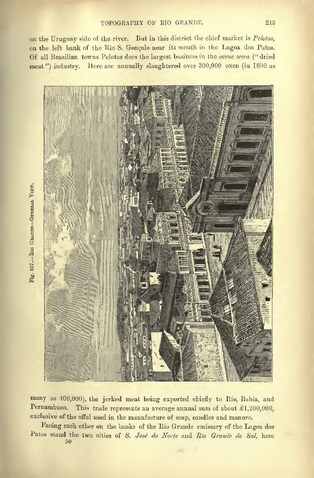
TOPOGRAPHY OF RIO GRANDE. 245
on the Uruguay side of the river. But in this district the chief market is Pelotas,
on the left bank of the Rio S. Gonsalo near its mouth in the Lagoa dos Patos.
Of all Brazilian towns Pelotas does the largest business in the came secca (" dried
meat ") industry. Here are annually slaughtered over 300,000 oxen (in 1890 as
to
many as 400,000), the jerked meat being exported chiefly to Rio, Bahia, and
Pernambuco. This trade represents an average annual sum of about 1,200,000,
exclusive of the offal used in the manufacture of soap, candles and manure.
Facing each other on the banks of the Rio Grande emissary of the Lagoa dos
Patos stand the two cities of S. Jose do Norte and Rio Grande do Sul, here50
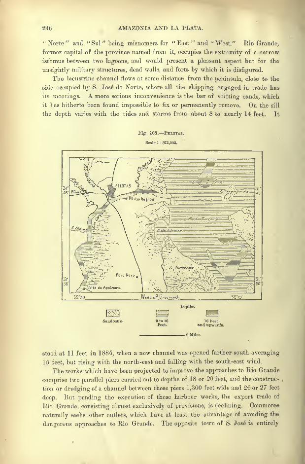
246 AMAZONIA AND LA PLATA.
"Norte" and "Sul" being misnomers for "East" and "West." Rio Grande,
former capital of the province named from it, occupies the extremity of a narrow
isthmus between two lagoons, and would present a pleasant aspect but for the
unsightly military structures, dead walls, and forts by which it is disfigured.
The lacustrine channel flows at some distance from the peninsula, close to the
side occupied by S. Jose do Norte, where all the shipping engaged in trade has
its moorings. A more serious inconvenience is the bar of shifting sands, which
it has hitherto been found impossible to fix or permanently remove. On the sill
the depth varies with the tides and storms from about 8 to nearly 14 feet. It
Fig. 108. PELOTAS.
Scale 1 : 375,000.
52"30 Vlrest oF Greenwich 52IO'
Depths.
Sandbank. Oto 16Feet.
16 Feetand upwards.
6 Miles.
stood at 11 feet in 1885, when a new channel was opened farther south averaging
15 feet, but rising with the north-east and falling with the south-east wind.
The works which have been projected to improve the approaches to Rio Grande
comprise two parallel piers carried out to depths of 18 or 20 feet, and the construc-
tion or dredging of a channel between these piers 1,300 feet wide and 26 or 27 feet
deep. But pending the execution of these harbour works, the export trade of
Rio Grande, consisting almost exclusively of provisions, is declining. Commerce
naturally seeks other outlets, which have at least the advantage of avoiding the
dangerous approaches to Rio Grande. The opposite town of S. Jose is entirely
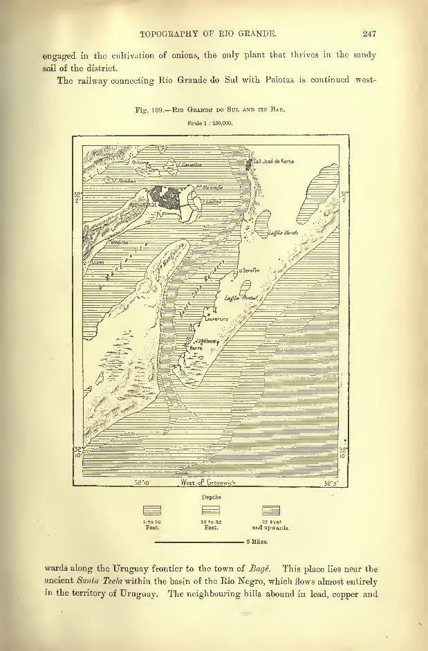
TOPOGEAPHY OF EIO GEANDE. 247
engaged in the cultivation of onions, the only plant that thrives in the sandy
soil of the district.
The railway connecting Rio Grande do Sul with Pelotas is continued west-
Fig. 109. Rio GRANDE DO STTL AND ITS BAR.
Scile 1 : 150,000.
52iO' West oF Greenwich 52 '3'
Depths
to 16
Feet.16 to 32Feet.
32 Feetand upwards.
3 Miles.
wards along the Uruguay frontier to the town of Bage. This place lies near the
ancient Santa Tecla within the basin of the Rio Negro, which flows almost entirelyin the territory of Uruguay. The neighbouring hills abound in lead, copper and
243 AMAZONIA AND LA PLATA.
gold, and at some points the railway between Pelotas and Bage traverses coal
fields of bad quality. The gold mines of Lavras have been worked since 1835.
In the upper Uruguay basin the only places of any note are S. Borj'a, formerly
a famous mission founded by the Jesuits in the midst of the Guarani Indians;
Itaquy, nearly oppo>ite the Aguapey confluence, with a Government arsenal on
the Argentine frontier; Urugiiayana, riverside port of Alcgrete, chief town of the
Ibicuy basin. In the war with Paraguay, Uruguayans was the scene of a
memorable event. It was seized in 1865 by 5,000 Paraguayans, who had to
capitulate after undergoing a formal siege by three of the allied armies com-
manded by the Emperor dom Pedro in person. Almost every town in Brazil has
a street, square, or promenade bearing the name of Uruguayana in memory of
this doughty exploit.
CHAPTER XIII.
MATTO GROSSO.
ITH the exception of a narrow central zone, the vast region of
Matto Grosso, that is, the " Great Forest," nearly five times the
size of the British Isles, is a mere wilderness with undefined
limits, and, if not actually, unknown, at least abandoned to the
aborigines and wild beasts. With the rest of Brazil it is con-
nected only by the tracks of hunters, or the course of the navigable waters rising
within its borders. Its very name has no distinct geographical meaning, for the
expression is applied to many distinct regions, which belong only in small measure
to the Amazonian selva. Most of the territory is in fact comprised in the zone
of uplands which form the waterparting between the great northern and southern
basins, and which are overgrown not with forest trees but with stunted ?crub
and bush.
Another section consists of the partly dried bed of an old inland sea, whose
shores are thinly wooded. The whole of the civilised population is less than that
of a single suburb of Rio de Janeiro, and in an area of some 530,000 square
miles the inhabitants, settled and savage, fall considerably short of 200,000.
Yet no other country exceeds certain parts of the Brazilian wilderness in fertility,
and within its borders there is certainly ample space for a population of at least
100,000,000.
HisToiuc SURVEY.
Except in the extreme south and west, Matto Grosso remained unvisited by
the Spanish conquerors, who, after establishing themselves in Peru and in the
Plate estuary, made no serious attempt to connect these two sections of their
prodigious domain, or at least limited their efforts in this direction to the explora-
tion of the Upper Paraguay and of the Bolivian plateaux.
Hence the Paulist kidnappers were the first whites to penetrate into Matto
250 AMAZONIA AND LA PLATA.
Grosso. Towards the year 1680 a certain Manoel de Campos had already
visited the Bororo Indians on the southern slope of the plateaux, and he was
followed by other traders. The discovery of gold suddenly increased the number
of these pioneers, and every year convoys, sometimes comprising hundreds of
bandeir-antes, set out for this " Promised Land," where, according to report, gold
dust was collected by the bushel. But no proper tracks were laid down, and
the adventurers, exposed to the attacks of the Indians, with no supplies except
the products of the chase and the fisheries, had often to abandon the sick, the
feeble, and the wounded to the wild beasts or to the wilder natives. At times
whole convoys disappeared, not a soul escaping, and no permanent settlements
could be established in these boundless solitudes, where distances were measured,
not by miles or ordinary leagues, but by the legoa grande, averaging from four
to five miles.
To reach the mines of Cuyaba, where is now the capital of the State, the gold
hunters first followed the Rio Tiete and the Parana to the Pardo confluence, then
ascended the Pardo to its Anhambuhy affluent, thus reaching the Serra de Santa
Barbara and the Campos de Vaccaria. Thence their goal was reached by the
Bios Miranda, Paraguay, and Cuyaba, the journey occupying many long
months.
The Mineiros, rivals of the Paulistas, in their turn reached Matto Grosso bythe more direct route across Goyaz and by the valley of the Rio das Mortes.
But the mines, as badly worked as elsewhere in Brazil, gradually ceased to attract
adventurers, and Matto Grosso had almost been again forgotten, when the era
of scientific exploration was ushered in by D'Orbigny, Castelnau, D'Alincourt,
and Leverger. Then, after the Paraguay war, various commissions were succes-
sively appointed to survey this outlying dependency of Brazil.
Up to that time Matto Grosso had remained within the commercial sphere of
the port of Santos in the land of its first discoverers ; but the traffic on this long
and costly route was of trifling value. So difficult were the communications, that
on the declaration of war, it was found impossible for troops to be despatched from
the seaport directly to the aid of the people of Matto Grosso threatened by
Paraguay. The expeditionary force of 3,000 men, which left Rio de Janeiro in
April, 1865, did not reach Uberaba in the Upper Parana basin till the following
July. Thence it set out across the solitudes, losing one-third of its strength before
reaching Miranda, near the Paraguayan frontier, nearly two year's after starting
from Rio. Failing to receive the supplies it had expected at the Rio Apa, the
little band had to fall back in the face of the enemy, and not more than 700
eventually succeeded in reaching a place of safety within the Brazilian lines.
All the rest had perished of fever, cholera, wounds, and hardships of all kinds.
But the ultimate triumph of Brazil over Paraguay opened all the main routes
of access to Matto Grosso, and a regular line of steamers was established to ply
between Rio de Janeiro and Cuyaba, by the La Plata, Paraguay and Cuyabarivers. This route, however, was also too long and too costly for trade purposes,
the best boats taking not less than thirty-one days for the voyage.
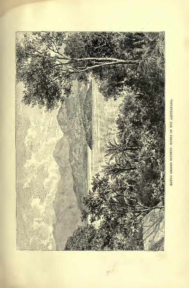
PHYSICAL FEATURES OF MATIO GEOSSO. 251
The alternative fluvial route by the Amazons, Madeira, and Guapore is even
less used than it was in the eighteenth century, after the exploration conducted
in 1742 by Manoel de Lima. The few travellers who venture to descend the
Guapore in boats have to surmount long portages before reaching Santo Antonio
at the head of the steam navigation on the Madeira. On the other hand the
direct route from Para, by the Amazons, the Tapajoz, and the Juruena, is too
tedious and difficult to be utilised by commerce. It is used only for the importa-
tion of the guarana bean (pattllinia sorbills), which is collected by the Mauhe
Indians on the banks of the Amazons, and also imported by the Madeira route.
When ground to a powder, and mixed with water, this bean makes a beverage
preferred by the people of Matto Grosso to all other drinks.
Nevertheless Matto Grosso is being gradually drawn closer to the rest of
Brazil. A telegraph line has already been established between Rio and Cuyaba,while the rjilvvay by S. Paulo has advanced beyond the Rio Grande, thus
covering over a third of the total distance between Cuyaba and the coast.*
Extensions of the existing routes are being planned in all directions, and the
steam traffic of the navigable waterways is being developed, while the rivers
themselves are being connected by lateral highways across the intervening steppes
and forests. Thus the two rivers, Ivahy and Paranapanema, traversing the States
of Parana and S. Paulo, are to be continued beyond Parana by following the course
of the Ivinheiina, and of the Bjilhante as far as the uplands in the neighbourhoodof Miranda, in South Matto Grosso. Such communications, however, are far from
sufficient to meet the requirements of a large stream of immigration, whenever
it sets in the direction of these magnificent regions about the Paraguayan and
Amazonian divides and slopes, regions which have every prospect of becoming a
great centre of population in the near future.
The first movement of colonisation will most probably be made by the southern
route from the direction of Paraguay and Argentina. Of the present scanty
population of Matto Grosso, the great majority is concentrated on the southern
slopes. With the exception of a single town and its environs, the whole of the
territory draining north to the Amazons still remains unoccupied and uninhabited,
except by a few scattered Indian tribes.
PHYSICAL FEATURES.
Matto Grosso is one of the least hilly regions of the continent, and althoughthe natives reckon their " serras
"by the dozen, there are nowhere any heights
constituting real mountain ranges. All the East Brazilian uplands fall gradually
west of South Goyaz, and the space between these highlands and the Andean
foothills was at one time traversed by a marine strait, separating the two great
Alpine regions of East Brazil and the Cordilleras. Fluvial waters now flow in
this marine depression which has been largely filled by their alluvial deposits.
* Distance in a straight line from Rio de Janeiro to Cuyaba, 880 miles; by the Buenos Ayres route,
3,840 miles.
252 AMAZONIA AND LA PLATA.
The divide between the sources of the Guapore and the headwaters of the
Paraguay scarcely exceeds 1,650 feet in altitude, and the Brazilian uplands appear
to be connected with those of the Chiquitos territory only by a very narrow
isthmus of ancient rocks. Here is the true geographical centre of South America.
On the maps a continuous chain of mountains is traced between the Madeira
and Tapajoz basins, then between the Tapajoz and Paraguay, and lastly between
the Tapajoz and the Araguaya. Yet it is certain that this semi-circular ridge
has but a fragmentary existence. The heights dominating the plains of the
upper Paraguay and its affluents are in reality merely the escarpments of a
plateau disposed in horizontal or very slightly inclined strata, and eroded by the
streams now descending towards the Amazons. The rampart itself has a mean
Fig. 110. TAPAJOZ AND PARAGUAY WATERSHED.
Scale 1 : 5.50C.OOO.
West or Greenwich 56*
125 Miles.
elevation of no more than 1,650 feet, and above the edge of the plateau rise a
few isolated crests, attaining here and there a height of some 3,000 feet.
Thus the orographic system of the Matto Grosso watershed, indifferently
called " cordilheira"
or "campos
"dos Parexi, from the local Indian tribe,
presents a mountainous aspect, only as seen from the south. On this steep side
the face of the escarpments is carved into rocky walls, sharp peaks, or needles.
But on the opposite side, facing the Tapajoz and Xingu basins, nothing is seen
except a long gently-inclined slope gradually merging in the Amazonian plains.
The southern parts of the Arara, as the edge of the plateau is generally called,
date probably from paleozoic times, and here are represented carboniferous,
devonian, and silurian formations. Farther north, in the zone of cataracts
traversed by the Madeira, Tapajoz, Xingu, Tocantins, and their affluents, the
rocks exposed by the erosions of these streams are all of crystalline character
granites, gneiss, porphyries, and quartzites.
PHYSICAL FEATURES OF MATTO GROSSO. 258
Farther south, between the sources of the Paraguay and those of the Ara-
guaya, and also between the Paraguay and the Parana, the uplands have been
eroded both on the east and the west, so that in some places the intervening
heights assume the aspect of real mountains, disposed in the direction from north
to south. Such are the Serra de S. Jeronymo, and the Maracaju and Anham-
bahy ranges. Eruptive rocks, locally called basalts, have here cropped out above
the prevailing sandstones, and to their decomposition appears to be due a " red
earth"analogous to that which yields the coffee growers such splendid returns in
S. Paulo.
Within the cirque-like space enclosed by the semi-circular range of heights,
the surface is broken by a number of rocky isolated masses, which are visible from
a great distance, and which are stratified with perfectly regular layers. The heights
themselves affect, for the most part, geometrical forms, as if vast slabs of rock
had scaled off, leaving smooth surfaces like the sloping sides of a finished pyramid.
The summits, as horizontal as if the crests had been cut away by a sharp instru-
ment, correspond to other summits of like formation, so that all evidently at one
time formed part of a continuous terrace.
From the disposition of the lines of disintegration round the flanks of the hills,
a conjecture may be hazarded as to the direction likely to be followed in the
process of destruction still going on. According to de Taunay, who resided
several years in the district, and traversed it in all directions, these sandstone
masses, with their perfectly regular horizontal series of stratification, consist of
lacustrine sedimentary matter sifted and distributed by the great freshwater lake,
which formerly covered the whole region.
The detritus washed down from the surrounding slopes and escarpments has
also had its share in modifying the general aspect of the land. This detritus,
accumulating in the form of talus at the base of the hills, has been caught upand redistributed by the running waters, in some places covering the groundwith fresh matter to a great thickness. Mountain masses formerly connected
with the inland plateaux and ranges, now appear completely isolated, because
their base is concealed by the accumulated debris, so that they rise abruptly-
above the surface without any transitional talus formation. These isolated
masses, which have received the name of itamle, like the great mountain of the
serra d'Espinha90, near Diamantina, shoot up in peaks and domes above the
surrounding woodlands, looking from a distance like colossal structures raised bythe hand of man.
In the eastern districts of South Matto Grosso, the heights belonging to this
geological system, are disposed in ranges or grouped in archipelagoes, standingout above the sea of verdure. In the direction of the west they become con-
tinually less elevated and less numerous, or else appear completely isolated within
the circle of the horizon, though still extending in solitary groups all the way to
the right bank of the Paraguay, and even reappearing on the opposite side. As
already remarked by d'Orbigny, the Chiquito heights belong rather to this
Brazilian system than to that of Bolivia.
254 AMAZONIA AND LA PLATA.
RIVERS: THE PARAGUAY SYSTEM.
The Upper Guapore, the Itenez of the Bolivians, although comprised within
the Amazons basin, as an affluent of the Mamore, belongs specially to Matto Grosso,
for the town of this name has been founded on its banks, and nearly the whole of
the settled population of the State is centred in the depression, the western
section of which is traversed by this river. The Guapore, so named from a longextinct Indian tribe, has its chief source in a corixa or grotto on the edge of the
Araxa escarpment, and flows at first in the direction of the south parallel with the
other streams descending to the Paraguay. But after escaping from the last
hills the ferruginous torrent trends round to the west and north-west, and after
receiving numerous affluents, traverses the plain in which is situated the town of
Matto Grosso, 160 miles from its source. Six miles lower down a bridge spans
the stream, which presents great difficulties to the navigation, being much
obstructed with snags and shifting sandbanks.
The Paraguay, either the " Parrakeet River," or more probably the " River
of the Payaguay Indians," is one of the most remarkable navigable water-
courses in the world. Few streams have a more gentle incline in propor-
tion to the length of their course. Leaving out of consideration the headwaters
which escape through numerous rapids, and even cascades from the hilly districts,
the point where the Paraguay begins to flow in a tranquil stream stands at an
elevation of not more than 660 feet above the sea, from which it is still distant
2,500 miles. Hence the 'mean incline cannot be more than about three or four
inches per mile. Steamers of light draught are thus able to penetrate from the
ocean up the mainstream and its numerous affluents Jauru, Sepotuba, Cuyaba,
S. Lourenco, Taquary far beyond the Argentine and Paraguay republics into the
very heart of Brazil.
Another remarkable phenomenon is the intermingling of its farthest head-
streams with those of the Amazons affluents. The Jauru, former frontier stream
between the Spanish and Portuguese possessions, approaches so near to the
Guapore that it was found easy to connect the two systems by an artificial canal.
The Aguapehy affluent of the Jauru is separated from the Alegre, which joins
the Guapore near Matto Grosso, only by a narrow isthmus of slight elevation,
and not more half a mile wide. In 1772 a canal was cut through the divide,
large enough to admit a six- oared boat, and other attempts to establish a permanent
communication between the two waterways have failed only through the lack of
sufficient traffic to support such works.
Below its headstreams, the Paraguay flows through a marshy district at the
foot of the plateau, where its limpid waters expand into a series of lagoons overgrown
with aquatic plants. Here and there its course is confined between hills, but it
soon enters the vast plain which was formerly a flooded depression, and still
partly retains its lacustrine character. During the floods, when the Paraguayand its tributaries rise 30 or 36 feet, the overflow with its islands and archipela-
goes of floating vegetation, expands to a temporary sea stretching beyond the
RIVERS OF MATTO GB03SO. 255
horizon, and continued on the rising grounds by the so-called banhados, or" drowned lands." Above these rise thickets of tall herbs and shrubs, and in
some places artificial mounds, where the natives formerly took refuge during the
inundations.
Lake Xarayes, as this expanse was called by the first Spanish explorers,
stretches for a length of about 360 miles north and south between the mouths of
the Jauru and the Fecho dos Morros hills, and in some places has a width of 250
or 260 miles. Although it is not permanent, as was formerly supposed, certain
stretches locally called bahias, the "bays
"or inlets of the old inland sea, are
flooded throughout the year. Most of these basins communicate at all seasons
Fig. 111. SOURCES OF THE ALEGEE AND AGTTAPAHY.
Scale 1 : 2,500,000.
60* West Op Greenwich 59
60 Miles.
with the Paraguay, either through lateral creeks or broad passages. Such are
lakes Uberaba, Gaiba, Mandiore, and Caceres, which swarm with " hundreds of
thousands"
of the Jacare crocodile. Some are freshwater basins fed exclusively bythe river
; but others are old depressions formerly filled by the marine waters,
and still preserving saline incrustations which give them a brackish taste.
Towards the centre of the great depression the Paraguay is joined by the
Cuyaba, with its S. Lourenco tributary, called also the Rio dos Porrudos from the
Indians of that name, who protected themselves with a kind of sack from the bite
of the voracious piranha fish. Below the confluence these waters still wanderover the level plains in a labyrinth of creeks, channels, false rivers, and lateral
branches all the way to the junction of the Taquary and Miranda, descending
256 AMAZONIA AND LA PLATA.
from the eastern uplands. In its upper course the Taquary is joined by the
Coxim, described by all travellers as one of the most romantic streams in Brazil.
The Miranda, itself a lovely river, is also joined by a picturesque affluent, the
Aquidauana, or Mondego, which the Paraguayans claimed as the northern limit of
their territory. Descending from the Amambahy heights, it winds in long mean-
derings between wooded banks to its junction with the Miranda at the entrance
to the marshy plains of Lake Xarayes.
From the western or Chiquito side the Paraguay receives only one important
affluent, the Tucabaca or Oliden, which, after its junction with the San Rafael,
develops a chain of lagoons much obstructed by dense masses of drifting vegetation.
The Otuquis, spoken of by D'Orbigny as affording a convenient navigable route
from the Argentine plains to Bolivia, was ascended in 1854 in the Water Witch
by Page a distance of 34 miles, when he had to return, not for lack of depth,
but because he was unable to force a passage through the dense floating vegetation.
In 1886 Fernandez reached a point 25 miles farther, when he also had to return
for the same reason. Were its discharge regulated, and its current kept clear of
aquatic plants, the Otuquis might probably become an outlet for the trade of
Bolivia. South of the Bahia Negra confluence, the section of Gran Chaco included
in the territory of Paraguay begins on the right bank of the river. But on the
left side, the Brazilian frontier is not indicated beyond the confluence of the
river Apa, 155 miles farther south.
CLIMATE.
The inhabited parts of Matto Grosso, lying in the heart of the continent in a
sort of trough between the Andean and Brazilian highlands, present peculiar
climatic conditions, characterised especially by a very high mean annual tempera-
ture, higher even than on the banks of the Amazons under the equator. At the
same time the oscillations of the thermometer are far more abrupt than in other
tropical regions, amounting at times to as many as 28 and even 3-3 Fahr., in the
space of twelve hours. These sudden changes are due to the winds veering round
from north-west to south-east;or in the reverse direction from south-east to
north-west. Thus the moist currents from the Amazonian selva are often suddenly
replaced in winter by cold currents from the Argentine pampas.
On the uplands the glass falls at times to freezing point, and wayfarers have
often perished of cold in crossing the Araxa range. In March, 1822, that is, at
the end of summer, a caravan from Rio de Janeiro lost over twenty negroes in
the Rio Manso valley west of Cuyaba.*The rainfall, regular in summer and frequently accompanied by thunderstorms,
has not yet been accurately gauged, but appears to average at least 120 inches.
*Meteorological conditions of Cuyaba :
Temperature., . Rainfall. Rainy Days.Mean. MHZ. Min.
79 Fahr. IOC1l-'uhr. 45 Fahr. 45 inches 85
INHABITANTS OF MATTO GKOSSO. 257
In general the conditions are highly unfavourable for Europeans, at least, on the
low, marshy plains. The relatively salubrious plateaux are not yet comprised
within the settled districts, so that nearly all strangers have to face the dangers
of great heat and moisture on the low-lying plains. These regions have be^n
visited by frightful epidemics, measles in the last century, and since then other
scourges such as small-pox and yellow fever. Hence, despite a high birth-rate,
the population in some years has diminished in the rural districts. In Matto
Grosso the great epidemics have attacked the animals with as much intensity
as human beings, and have even spread from the cattle and poultry to the deer,
tapirs, and jaguars of the forests and savannas. In 1857 nearly all the horses
and mules perished in the southern districts between Miranda and Cuyaba,
and since then, the horned cattle, estimated at from 600,000 to 1,000,000, have
become half wild through the lack of mounted herdsmen to tend the droves.
FLORA FAUNA.
About the watersheds of the great basins the Amazonian and Argentine vege-
table and animal kingdoms are intermingled. Nevertheless, the tropical flora with
its endless variety of forms predominates in all the wooded regions, that is, mainly
along the river banks. Nowhere else have trailing palms acquired a more
remarkable development. The urubamba (calamus procumbens), a member of
this group, grows to a length of over 650 feet, with a stem scarcely half an inch
thick. The cotton shrub grows wild on the plains, and another useful indigenous
plant is the ipecacuanha, locally called pooya. The American ostrich has pene-
trated from the catnpos and pampas into the Upper Paraguay plains, and the
low marshy grounds have favoured the development of huge land and water
boas.
INHABITANTS.
In Matto Grosso the decrease of the aborigines has been more rapid than the
growth of their white successors. The tribes, which at the arrival of the Europeans
ranged over the whole region, have been greatly reduced, and vast districts maynow be traversed without meeting a single Indian. Although the distinct groups
are still reckoned by the dozen, the collective population does not certainly exceed
25,000.
The Parexi or Parecis, about the headwaters of the Tapajoz, one of the best-
known groups, are affiliated by Ehrenreich to the Arawak family, and by
D'Orbigny to the Pampas Indians, while Martius regards them as a distinct race.
Since the arrival of the miners they have entered into friendly relations with the
settlers of Portuguese speech, and by crossings have become partly assimilated
to the Brazilians. They have even been baptised, and therefore pass as Christians.
After the discovery of the mineral deposits they were employed as garimpciros by
the gold and diamond hunters;but at present they are sent into the forest in
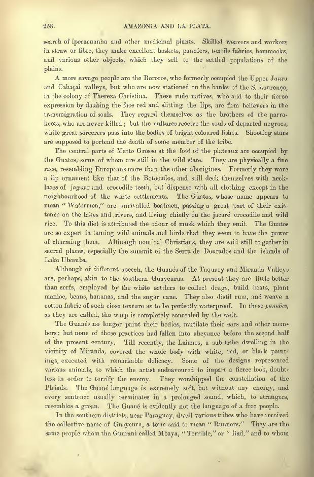
258 AMAZONIA AND LA PLATA.
search of ipecacuanha and other medicinal plants. Skilled weavers and workers
in straw or fibre, they make excellent baskets, panniers, textile fabrics, hammocks,and various other objects, which they sell to the settled populations of the
plains.
A more savage people are the Bororos, who formerly occupied the Upper Jauru
and Cabacal valleys, but who are now stationed on the banks of the S. Louren9o,
in the colony of Thereza Christina. These rude natives, who add to their fierce
expression by daubing the face red and slitting the lips, are firm believers in the
transmigration of souls. They regard themselves as the brothers of the parra-
keets, who are never killed;but the vultures receive the souls of departed negroes,
while great sorcerers pass into the bodies of bright coloured fishes. Shooting stars
are supposed to portend the death of some member of the tribe.
The central parts of Matto Grosso at the foot of the plateaux are occupied bythe Guatos, some of whom are still in the wild state. They are physically a fine
race, resembling Europeans more than the other aborigines. Formerly they wore
a lip ornament like that of the Botocudos, and still deck themselves with neck-
laces of jaguar and crocodile teeth, but dispense with all clothing except in the
neighbourhood of the white settlements. The Guatos, whose name appears to
mean "Watermen," are unrivalled boatmen, passing a great part of their exis-
tence on the lakes and. rivers, and living chiefly on the jacare crocodile and wild
rice. To this diet is attributed the odour of musk which they emit. The Guatos
are so expert in taming wild animals and birds that they seem to have the powerof charming them. Although nominal Christians, they are said still to gather in
sacred places, especially the summit of the Serra de Dourados and the islands of
Lake Uberaba.
Although of different speech, the Guanes of the Taquary and Miranda Valleys
are, perhaps, akin to the southern Guaycurus. At present they are little better
than serfs, employed by the white settlers to collect drugs, build boats, plant
manioc, beans, bananas, and the sugar cane. They also distil rum, and weave a
cotton fabric of such close texture as to be perfectly waterproof. Tn these pannocs,
as they are called, the warp is completely concealed by the weft.
The Guanes no longer paint their bodies, mutilate their ears and other mem*
bers;but none of these practices had fallen into abeyance before the second half
of the present century. Till recently, the Laianos, a sub-tribe dwelling in the
vicinity of Miranda, covered the whole body with white, red, or black paint-
ings, executed with remarkable delicacy. Some of the designs represented
various animals, to which the artist endeavoured to impart a fierce look, doubt-
less in order to terrify the enemy. They worshipped the constellation of the
Pleiads. The Guane language is extremely soft, but without any energy, and
every sentence usually terminates in a prolonged sound, which, to strangers,
resembles a groan. The Guane is evidently not the language of a free people.
In the southern districts, near Paraguay, dwell various tribes who have received
the collective name of Guaycuru, a term said to mean " Runners." They are the
same people whom the Guarani called Mbaya,"Terrible," or " Bad," and to whom
INHABITANTS OF MATTO GKOSSO. 259
the Spaniards gave the name of Lengoas, "Tongues," from the distension of the
lower lip by the insertion of a disk, giving it the appearance of a second tongue.
They constituted one of the largest nations in South America, and even still far'
outnumber all other natives of the Paraguay basin except the Guarani.
Yet according to Severiano da Fonseca, the Cadiueos or Beaqueos, as they are
now commonly called, are already reduced to no more than 1,600, although a few
years after the declaration of independence they could muster as many as 4,000
fighting men. At that time they still tattooed and painted themselves in vivid
colours, and shaved the crown of the head like the Coroados of the eastern pro-
vinces. The women use many words in conversation which do not occur in the
speech of the man. This double language probably originated in the custom of
bride capture.
Another designation of the Guaycurus is that of Caballeros,"Cavaliers," which
is well merited since the introduction of the horse three centuries ago. Theyshow as much skill in the saddle as the Argentine Gauchos themselves, and
during their migrations from one camping-ground to another, the women mount
the pack-horses perched on the loads. The Guaycuru horsemen were long dreaded
for their method of attack, resembling that of the Arab bedouins in its swift
advance and retreat. On the rivers they were also formidable combatants, using
oars tipped with spear-heads, so that the same implement served to pursue the
foe, to strike and retire. Hundreds of Europeans have perished in the wars with
the Guaycurus, whose type has been greatly modified by the large number of
women captured from the white settlers during the last three hundred years. At
present many, especially in the Corumba and Albuquerque districts, live on
friendly terms with the Brazilian population, to which they are being gradually
assimilated.
In a quiet self-satisfied way the Guaycurus regarded themselves as the first
nation in the world. They tolerated no intercourse with strangers, except to
receive their tribute and recognition of inferiority. All the other Indians living in
their territory had been reduced to a state of servitude, and even now the Guanes
bend the neck to a sort of slavery under the whites, for the sole purpose of escapingfrom a harder fate as subjects of their Guaycuru kindred.
But even in the Guaycuru social system itself, everybody is not equal. The
community, constituted by force, is divided into three perfectly distinct classes,
the joagas, or nobles, the plebeians, and the slaves. The daily life of every mem-ber of the tribe has been strictly regulated by this division into three irreducible
castes. Thus the nobles can only marry" ladies of high birth
" who bear the
title of dona, although they are permitted to choose concubines from the lower
castes. The slaves, descendants of captives in war, can never be emancipatedunder any circumstances. Even the very tents, which the Guaycurus carry about
on their wanderings from place to place, are all arranged in accordance with the
laws of precedence. Great homage is paid to a noble at his death;in his grave
are deposited his bow, arrows, lance, and martial adornments, and by his side is
killed his favourite steed.
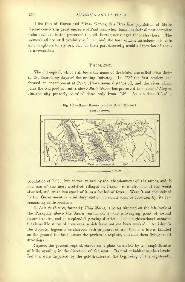
260 AMAZONIA AND LA PLATA.
Like that of Goyaz and Minas Gerues, this Brazilian population of Matto
Grosso consists in great measure of Paulistas, who, thanks to their almost complete
isolation, have better preserved the old Portuguese usages than elsewhere. Thewomenkind are still carefully secluded, and the host seldom introduces his wife
and daughters to visitors, who on their part discreetly avoid all mention of them
in conversation.
TOPOGRAPHY.
The old capital, which still bears the name of the State, was called Villa Bella
in the flourishing days of the mining industry. In 1737 the first settlers had
formed an encampment at Porto Alegre some distance off, and the river which
joins the Guapore" two miles above Matto Grosso has preserved this name of Alegre.
But the city properly so-called dates only from 1752. At one time it had a
Fig. 112. MATTO GROSSO AND THE UPPER GUAPOBE.
Scale 1 : 350,000.
15"
West op Greenwich 59
60 Miles.
population of 7,000, but it was ruined by the abandonment of the mines, and is
now one of the most wretched villages in Brazil ; it is also one of the worst
situated, and travellers speak of it as a hotbed of fever. Were it not maintained
by the Government as a military station, it would soon be forsaken by its few
remaining white residents.
S. Luiz de Caceres, formerly Villa Maria, is better situated on the left bank of
the Paraguay above the Jauru confluence, at the converging point of several
natural routes, and in a splendid grazing district. The neighbourhood contains
inexhaustible stores of iron ores, which have not yet been worked. An islet in
the Uberaba lagoon is so charged with sulphuret of iron that if a fire is kindled
on the ground the heat causes the pyrites to explode, and sets them flying in all
directions.
Cuyaba, the present capital, stands on a plain encircled by an amphitheatre
of hills, opening in the direction of the west. Its first inhabitants, the Cuvalm
Indians, were dispersed by the gold-hunters at the beginning of the eighteenth
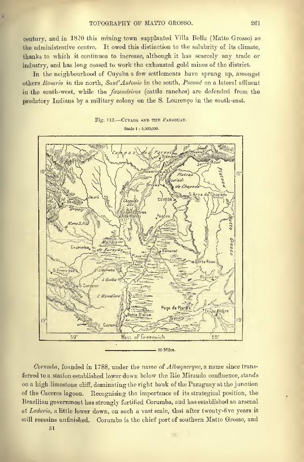
TOPOGRAPHY OF MATTO GROSSO. 261
centurjr, and in 1820 this mining town supplanted Villa Bella (Matto Grosso) as
the administrative centre. It owed this distinction to the salubrity of its climate,
thanks to which it continues to increase, although it has scarcely any trade or
industry, and has long ceased to work the exhausted gold mines of the district.
In the neighbourhood of Cuyaba a few settlements have sprung up, amongst
others Rosario in the north, Sant'Anfonio in the south, Pocont on a lateral affluent
in the south-west, while the fazendeiros (cattle ranches) are defended from the
predatory Indians by a military colony on the S. Lourenco in the south-east.
Fig. 113. CUYABA AND THE PARAGUAY.
Scale 1 : 5,500,000.
59 West oF Greenwich
90 Miles.
Corumba, founded in 1788, under the name of Albuquerque, a name since trans-
ferred to a station established lower down below the Rio Mirando confluence, stands
on a high limestone cliff, dominating the right bank of the Paraguay at the junction
of the Caceres lagoon. Recognising the importance of its strategical position, the
Brazilian government has strongly fortified Corumba, and has established an arsenal
at Ladario, a little lower down, on such a vast scale, that after twenty-five years it
still remains unfinished. Corumba is the chief port of southern Matto Grosso, and
51
262 AMAZONIA AND LA PLATA.
is accessible for half the year to large vessels, which do a brisk trade in cattle,
salt, and lime. In the district are some extremely rich iron ores stored up for
future use.
In 1876, when the Brazilian garrison evacuated the city of Asuncion to fall
back on Corumba, the Paraguayan sutlers and menials migrated with the troops,
and thus suddenly doubled the population of the town. Since then, many young
Paraguayan women have moved in the same direction. They lose no favourable
opportunity of removing to Corumba, where the chances of marriage are much
greater than in Paraguay itself, the female sex being here greatly in excess of the
men. The European immigrants have also begun to find their way to Corumba,
to which place the Bolivians of Santa Cruz de la Sierra forward supplies across
the wilderness.
The Taquary and the Miranda, which join the Paraguay, the former above,
the latter below, the Albuquerque, have some small settlements, destined one dayto become flourishing cent res of population. Herculaneo, capital of the Taquary
district, is better known by the name of Coxim, from the Rio Coxim. On the
Miranda the chief places are Nioac or Levergera and 'Miranda, the latter dating
from the year 1778. Near Coimbra, on the right bank of the Paraguay, below
the Miranda confluence, visitors are shown a group of vast underground chambers,
connected by narrow galleries. Of the Fort Olimpo (Borbon), still figuring on the
maps, nothing remains except a crumbling ruin. All the other military posts
in the same unhealthy district have been abandoned since the war with Paraguay.
Such were the stations established on the Pao de Atsttcar and the Fee/to don
Morros, two little bluffs facing each other east and west on the banks of the river.
The plans prepared by the engineers for the fortifications of these places have, for
the present, been suspended, but Brazil has not withdrawn her claim from Fecho
dos Morros, although, according to the indications of the map, it lies within the
Bolivian frontier. The Brazilian diplomatists being reluctant to leave such an
important strategical post to the conterminous state, argued that those hills on
the left side of the river really belonged to Brazil, because during the periodical
inundations the Paraguay overflowing its banks transforms them to an island,
and thus transfers them to the opposite side,
CHAPTER XIV.
MATERIAL AND SOCIAL CONDITION OF BRAZIL.
LTHOUGII no accurate returns have yet been made, approximate
calculations show that the population of Brazil continues to in-
crease at a rapid rate, having advanced from about 2,000,000 in
1776 to seven, perhaps even eight, times that number in 1894.
Should this rate of increase be maintained, long before the middle
of the twentieth century Brazil will comprise as many inhabitants as France.
No attempt at an official census can be entirely successful in Brazil, owing to
the suspicious dread of all interrogations, and the difficulty of getting the ignorant
natives to sign papers. The printed forms for the census of 1890, which has not
yet been completed in some States, comprise a long list of inquisitorial questions
regarding physical defects, income, and so forth, which even the public function-
aries refuse to fill in. Everywhere the returns are known to be below the
actual figures ;whole parishes have escaped altogether, and even in the State of
Rio de Janeiro one-third of the inhabitants appear to have been overlooked. Twofresh attempts were made to remedy the defect, and even then the final result
(1,050,000) was believed to be at least 350,000 short of the truth. In manyinstances statisticians prefer rough estimates to
"official
"figures, which are
known to be grossly inaccurate.
In many cases the population, in which the European and African elements
greatly outnumber the aborigines, is very unequally distributed over the country.
The immigrants have naturally been mainly concentrated on the seaboard, where
the whites have tended to gravitate towards the more temperate southern
provinces ; while the blacks, introduced originally as slaves, are most numerous in
the tropical northern States. In this movement the boundless regions of Amazonia
and Matto G rosso have hitherto taken scarcely any share. Hence while some
of the more favoured coast districts are relatively thickly peopled, more than half
of the whole territory has less than one person to four or five square miles. In
general, Brazil is still 36 times less peopled than France, and 109 times less than
Belgium.
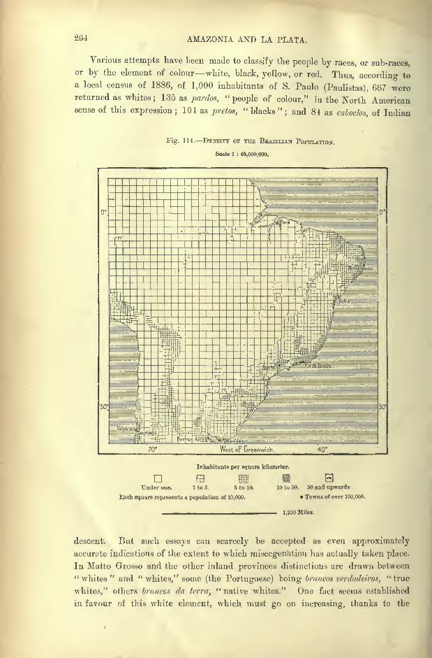
2G4 AMAZONIA AND LA PLATA.
Various attempts have been made to classify the people by races, or sub-races,or by the element of colour white, black, yellow, or red. Thus, according to
a local census of 1886, of 1,000 inhabitants of S. Paulo (Paulistas), 667 werereturned as whites
; 135 as pardos,"people of colour," in the North American
sense of this expression ;104 as pretos,
"blacks"; and 81 as caboclos, of Indian
Fig. 114. DENSITY OF THE BBAZILIAN POPULATION.
Scale 1 : 45,000,000.
Inhabitants per square kilometer.Dm my pa f^Tlrtl(j'jjj I .;;
IIUnder one. 1 to 5. 6 to 10. 10 to 50. 50 and upwards
Each square represents a population of 10,000. Towns of over 100,000.
1,250 Miles.
descent. But such essays can scarcely be accepted as even approximately
accurate indications of the extent to which miscegenation has actually taken place.
In Matto G rosso and the other inland provinces distinctions are drawn between" whites
" and "whites," some (the Portuguese) being brancos vcrdadeiros,
" true
whites," others brancos da terra, "native whites." One fact seems established
in favour of this white element, which must go on increasing, thanks to the
SOCIAL CONDITION OF BRAZIL. 265
steady immigration of Portuguese, Italians, Germans, and other European im-
migrants. It is noteworthy that many, both of the Portuguese and Italians,
marry negresses.
It was long doubted whether Europeans could become acclimatised in Brazil.
But experience has placed the matter beyond doubt, as far as regards the southern
provinces from S. Paulo to Rio Grande do Sul, as well as the uplands of Minas
Geraes. Even North Europeans thrive better in their new homes than in their
native land, as shown by the birth-rate, which exceeds the mortality three, four,
five, or even six times.
Immigration to the tropical regions is, on the other hand, attended by great
risks. Nevertheless, the numbers of full-blood whites who have perpetuated the
race in the Amazonian States, shows that here also they may become acclimatised.
Thus the coastlands from Maranhao to Bahia are inhabited by four millions, of
whom over one million are whites, showing no trace of mixture. These have
come chiefly from the Azores, Galicia, and the banks of the Minho and Douro in
Portugal. Some Basques, Spaniards and Prove^als have also succeeded in
founding families, which have preserved the racial qualities of strength, activity,
and refinement.
The healthiest districts appear to be the Bahia and Minas plateaux, the
Parana campos, and the elevated plains of Rio Grande do Sul. A specially
favoured district is that of Santa Anna de Contendas, on the east side of the Rio
S. Francisco, below the Rio das Velhas confluence. Here families have increased
a hundred-fold since the end of the eighteenth century, and, many patriarchs have
seen gathered round their table hundreds of descendants. In some years the
mortality has fallen to one -twentieth of the births.
With good reason European immigrants dread the yellow fever, which had
ceased to ravage Brazil after the close of the seventeenth, but again made its
appearance towards the middle of the nineteenth century. Since then the coast
towns, especially Rio and Santos, have suffered terribly from its visitations. But
it appears to be confined to the seaboard, and settlers on the plateaux, beyondthe Serra do Mar, 2,800 or 3,000 feet above the sea, are completely exemptfrom its attacks. On the other hand, cholera, fatal especially to the negroes,
knows no limitations of altitude or climate. But its visits are rare, and it
certainly makes less victims than either phthisis or beriberi. In the interior
goitre is prevalent, and on the seaboard elephantiasis and analogous diseases are
far from rare.
Speaking generally, and excluding certain notoriously unhealthy cities
of the seaboard, the whites, whether native born or immigrants from Europe,are less subject to maladies, and have a longer average life than either
the blacks or the Indians. "Wounds and amputations of limbs heal far more
readily under these climates than in the west of Europe. Compared with
those of Paris, the hospitals of Pernambuco, where, however, most of the
patients live almost al fresco, seem to the doctors places of miraculous re-
covery.
AMAZONIA AND LA PLATA.
RECENT IMMIGRATION.
Since the middle of the nineteenth century European immigration has
acquired sufficient development to materially affect the general growth of the
population. In 1*91 the number of arrivals perhaps equalled the natural increase
due to the excess of births over the mortality. Before the proclamation of inde-
pendence, the Portuguese alone had the privilege of settling in that part of the
New World which belonged to their Sovereign, and even for them the permi-sion
was restricted by all manner of official regulations. Strangers actually domiciled
in Brazil depended on chance or on special favour to be allowed to remain in the
country. They were mostly shipwrecked sailors or passengers, prisoners, and
especially mercenary soldiers, whom it would be difficult to restore to their homes,
and who generally received grants of land. Nevertheless, the Government also
directly introduced "Islanders," that is to say, natives of the Azores, when Portu-
guese settlers could not be 'procured to occupy districts possessing a certain stra-
tegic importance.
But systematic colonisation had already begun in 1S20, when KingJoao VI. settled some Catholic Swiss peasants in the Nova Friburgo district.
Four years later was founded the German colony of S. Leopoldo, which is still
the most important centre of foreign colonisation in Brazil. Private enterprise
supplemented the movement controlled by the State, and many large landowners,
anticipating the abolition of slavery, began to substitute free labour for the blacks
employed on their plantations. But too often they merely replaced one kind of
servitude for another, and several of these so-called "free" colonies ended in
disaster. In general the essays at colonisation may be said to have succeeded in
exact proportion to the degree of freedom allowed to the settlers. The colonies
flourished when the strangers became freeholders; they soon died out when these
remained hired labourers or " tenants at will."
The natives of Portugal, who, till about the year 1870, constituted pretty well
two-thirds of all the arrivals, were absolutely free settlers, coming either singly or
in family groups. Having no objection to any kind of work, they sought employ-
ment wherever they could get it without applying to the Government, to the
great financial companies, or to any of the syndicates working the plantations.
Proportionately to their numbers they took a far more active part than any of the
other colonists in the commercial and industrial life of Brazil, as artisans, porters,
overseers of slaves, hucksters, wholesale dealers, and in many other capacities.
After a few years in the country, many amassed sufficient wealth to return to the
Terrinha," Little Land," of their birth, where they built themselves stately man-
sions, often on the very site of the ancestral cabin.
Notwithstanding their defective character, the official returns suffice to show
an extremely rapid increase of immigration, especially since the middle of the
nineteenth century. During the twenty years from 1850 to 187$ the annual
average ranged from 7,000 to 10,000. These figures were doubled in the next
decade, then quintupled, and increased tenfold during the last decade. In 1891
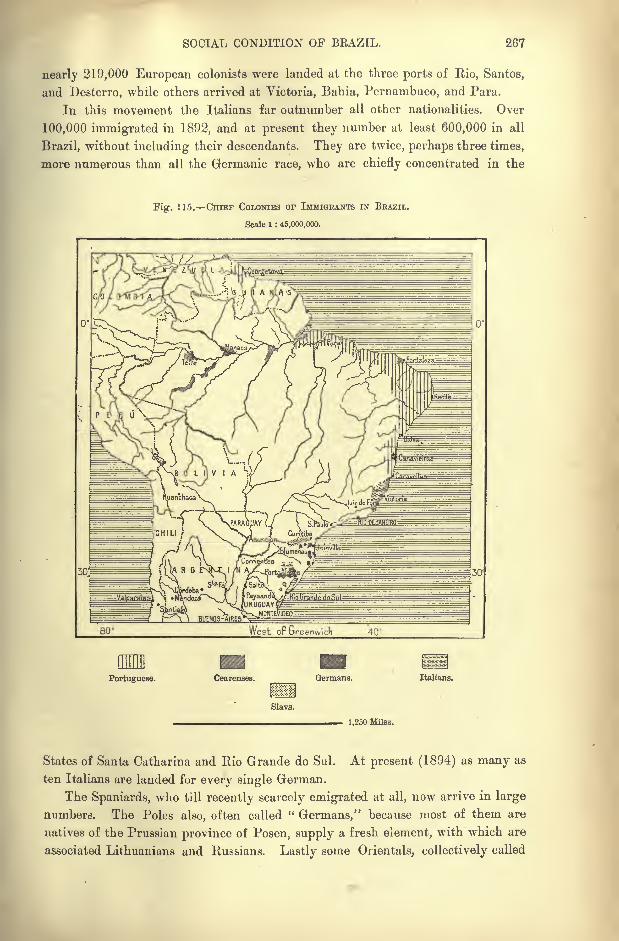
SOCIAL CONDITION OF BEAZIL. 267
nearly 219,000 European colonists were landed at the three ports of Rio, Santos,
and Desterro, while others arrived at Victoria, Bahia, Pernambuco, and Para.
In this movement the Italians far outnumber all other nationalities. Over
100,000 immigrated in 1892, and at present they number at least 600,000 in all
Brazil, without including their descendants. They are twice, perhaps three times,
more numerous than all the Germanic race, who are chiefly concentrated in the
Fig. 115. CHIEF COLONIES OF IMMIGRANTS IN BEAZIL.
Scale 1 : 45,000,000.
so;
Portuguese. Cearenses. Germans. Italians.
Slavs.
1,250 Miles.
States of Santa Catharina and Rio Grande do Sul. At present (1894) as many as
ten Italians are landed for every single German.
The Spaniards, who till recently scarcely emigrated at all, now arrive in large
numbers. The Poles also, often called " Germans," because most of them are
natives of the Prussian province of Posen, supply a fresh element, with which are
associated Lithuanians and Russians. Lastly some Orientals, collectively called
268 AMAZONIA AND LA PLATA.
"Turks," but in reality Christian Maronites of Mount Lebanon and Syria, have
begun to find their way to Rio de Janeiro.
AGRICULTURE.
Despite the recent increase of agricultural settlements, the extent of land
under cultivation is insignificant compared with the superficial area of the
country. In many regions the least clearing attracts attention, so accustomed
is the eye to wander over interminable forests and savannas on both sides of the
track. It would be difficult to obtain accurate statistics on the subject, because
the Brazilian peasant is still half a nomad. There being no lack of land,
whenever the ground seems exhausted he abandons his holding, and makes a
fresh clearance in the woods. The impoverishment of the soil is revealed by the
encroachment of certain plants, such as the samambaia (poiypodium incanuni) in
S. Paulo, and in South Mihas and elsewhere the tristegis glutinom or panicum
melinis, which follows the cultivator in all his wanderings.
Except on the large plantations the method of tillage is of an extremely
primitive character, based on the process followed by the Tupi aborigines. It
must be described rather as a reckless plundering of the soil than an orderly
system of husbandry. Nevertheless, each peasant obtains in abundance all that he
requires for his own consumption manioc, black beans, rice, maize, bananas, yams,and sweet potatoes. The standing dish of all Brazilian tables, thefeijoada, as it is
called, comprises the first three ingredients, to which is usually added the came
sccca (jerked beef), imported from Rio Grande do Sul and the Argentine regions.
Next to provisions the most important product of the soil is coffee, introduced
from Cayenne in 1727. But this plant, first grown at Para, possessed no
economic importance till the declaration of independence. Since then its cultiva-
tion has spread so rapidly that, despite epidemics, financial crises, revolutions,
Brazil has outstripped Java, and all other coffee-growing lands, and at present
supplies more than half of the world's consumption. It thrives almost every-
where, although the great plantations are limited to the regions stretching from
Espirito Santo to the Rio Parana, with Rio de Janeiro as their centre. About
half the exported article is still forwarded through the port of Rio;but the
largest and most productive plantations are now found in the State of S. Paulo,
where the best quality is also grown.
Many of the planters, especially in the States of Rio de Janeiro and Minas
Geraes, mostly absentees wedded to the old ways, were ruined by the emancipa-
tion. But those of S. Paulo had prepared for the crisis by introducing free
hands, and thus weathered the storm successfully. Instead of being impoverished
they became more prosperous than ever. When the slave system was con-
demned, but before its abolition, one of the great planters, the Viscount of Nova
Friburgo, exclaimed lugubriously, addressing his words to Java and the other
foreign coffee-growing lands :
" For you the future ! all hope of preserving our
plantations ends with to-day."
RESOURCES OF BRAZIL AGRICULTURE. 269
The Brazilian plant, which is said to be the richest in Caffeine, scarcely begins
to yield before the fourth year, but gives abundant returns from the sixth to the
sixteenth or twentieth, after which there is a gradual falling off to the thirty -fifth
or fortieth year, when the plantation must be renewed. Usually it needs no
manure beyond its own foliage, and the weeds raked in between the rows. The
intervening ridges may even be planted with maize, sweet potatoes and beans.
But frosts are much dreaded, especially on the low-lying ground, for once nipped
the shrub takes two or three years to recover. It has also its parasitic diseases,
which, however, have hitherto been less destructive than in Java. On all the
large plantations the berry is cleansed, dried, sorted, and sacked for the market
in vast establishments, employing hundreds of families, which usually live in
wretched villages, recalling the worst days of the ancien regime.
Since the abolition of slavery the total yield has greatly increased, but this
increase has been almost exclusively confined to the large estates. In the " red
lands"of S. Paulo some of these estates comprise over 25,000 and even 50,000 acres,
and certain great railway stations owe their existence entirely to the require-
ments of a single plantation. One of the domains belonging to a financial
company with a capital (18^3) of 400,000, employs 4,200 hands, nearly all
Italians, grouped in 26 villages and hamlets;in favourable years this fazenda
may yield as much as 6,000 tons of coffee. The astounding development of this
industry, especially in the State of S. Paulo, where a billion plants are reckoned,
certainly presents a marvellous picture of agricultural progress.
In Brazil, under the almost temperate climate of Rio de Janeiro and of
S. Paulo, the coffee shrub needs no protection from the burning rays of the sun,
as in Venezuela and other tropical lands, where the young plant is sheltered bythe overhanging branches of the cacao, erythrina, and other " foster mothers," as
they are called. Even the wild plant flourishes better beneath the shade of tall
forest trees than in the clearings in Kaffaland and other hot countries, where it
is indigenous.
There was a time when Brazil also took the lead in the production of sugar.
But it has long been outstripped in this respect by the West Indies, and the
district of S. Vicente, where the cane was introduced from Madeira in the first
half of the sixteenth century, now produces next to nothing. At present the
industry is represented chiefly in Pernambuco, Bahia, and neighbouring provinces.
Much of the yield is used in the preparation of cacha^a, a brandy which is found
in every Brazilian house, but which is not much appreciated by strangers.
Cotton is grown chiefly in Ceares and the other northern States. After the
impulse given to it during the war of Secession, the industry languished, but has
since shown symptoms of revival under the almost prohibitory tariff imposed on
foreign cotton goods. The tobacco especially of Bahia and Goyaz is highlyesteemed. Over five-sixths of the leaf is exported chiefly to Germany and
France, whence it returns in the form of cigars and cigarettes. The total annual
yield may be estimated at from 40,000 to 50,000 tons, valued at from 1,000,000
to 1,200,000.
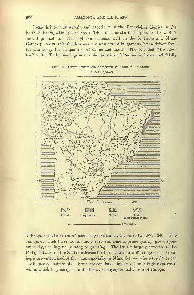
270 AMAZONIA AND LA PLATA.
Cacao thrives in Amazonia, and especially in the Canavieiras district in the
State of Bahia, which yields about 6,000 tons, or the tenth part of the world's
annual production. Although tea succeeds well on the S. Paulo and Minas
Geraes plateaux, this shrub is scarcely seen except in gardens, being driven from
the market by the competition of China and India. The so-called " Brazilian
tea"
is the Yerba mate grown in the province of Parana, and exported chiefly
Fig. 116. CHIEF FOREST AND AGRICULTURAL PRODUCTS OP BRAZIL.
Scale 1 : 45,000.000.
West of Greenwich 40'
Forests. Sugar-cane. Coffee. Matt*
(Ilex Paraguayensi*).
1,250 Miles.
to Belgium to the extent of about 14,000 tons a year, valued at 320,000. The
orange, of which there are numerous varieties, some of prime quality, grows spon-
taneously, needing no pruning or grafting. The fruit is largely exported to La
Plata, and also used in Santa Catharinafor the manufacture of orange wine. Great
hopes are entertained of the vine, especially in Minas Geraes, where the American
stock succeeds admirably. Some growers have already obtained highly esteemed
wines, which they compare to the tokay, champagnes and clarets of Europe.

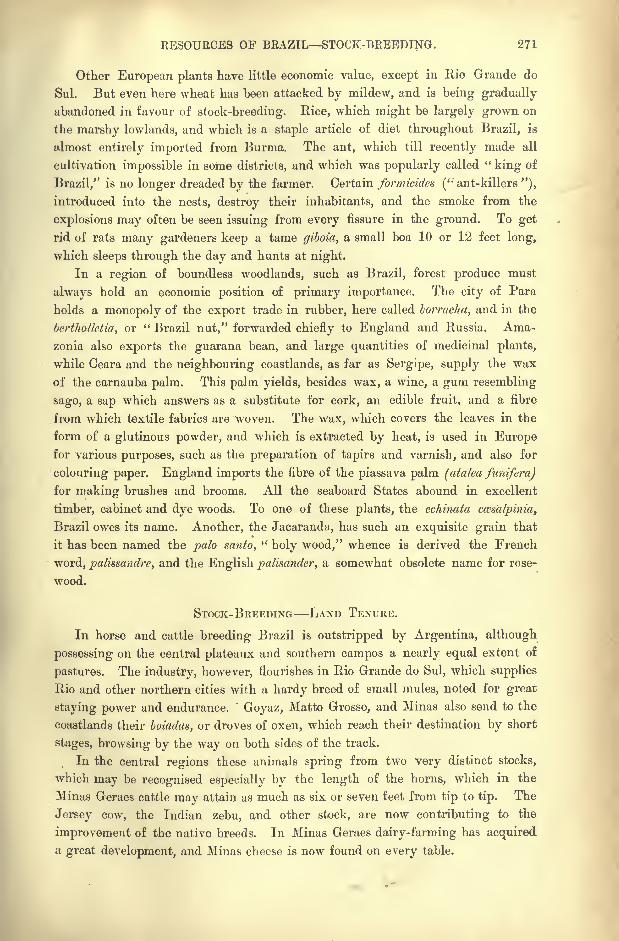
RESOURCES OF BRAZIL STOCK-BREEDING. 271
Other European plants have little economic value, except in Rio Grande do
Sul. But even here wheat has been attacked by mildew, and is being gradually
abandoned in favour of stock-breeding. Rice, which might be largely grown on
the marshy lowlands, and which is a staple article of diet throughout Brazil, is
almost entirely imported from Burma. The ant, which till recently made all
cultivation impossible in some districts, and which was popularly called "king of
Brazil," is no longer dreaded by the farmer. Certain formicides (" ant-killers "),
introduced into the nests, destroy their inhabitants, and the smoke from the
explosions may often be seen issuing from every fissure in the ground. To get
rid of rats many gardeners keep a tame giboia, a small boa 10 or 12 feet long,
which sleeps through the day and hunts at night.
In a region of boundless woodlands, such as Brazil, forest produce must
always hold an economic position of primary importance. The city of Para
holds a monopoly of the export trade in rubber, here called borracha, and in the
berthoUetia, or " Brazil nut," forwarded chiefly to England and Russia. Ama-
zonia also exports the guarana bean, and large quantities of medicinal plants,
while Ceara and the neighbouring coastlands, as far as Sergipe, supply the wax
of the carnauba palm. This palm yields, besides wax, a wine, a gum resembling
sago, a sap which answers as a substitute for cork, an edible fruit, and a fibre
from which textile fabrics are woven. The wax, which covers the leaves in the
form of a glutinous powder, and which is extracted by heat, is used in Europefor various purposes, such as the preparation of tapirs and varnish, and also for
colouring paper. England imports the fibre of the piassava palm (atalea funifera)
for making brushes and brooms. All the seaboard States abound in excellent
timber, cabinet and dye woods. To one of these plants, the echinata ccesalpinia,
Brazil owes its name. Another, the Jacaranda, has such an exquisite grain that
it has been named the palo santo,"holy wood," whence is derived the French
word, palissandre, and the English palisander, a somewhat obsolete name for rose-
wood.
STOCK-BREEDING LAND TENURE.
In horse and cattle breeding Brazil is outstripped by Argentina, although
possessing on the central plateaux and southern campos a nearly equal extent of
pastures. The industry, however, flourishes in Rio Grande do Sul, which supplies
Rio and other northern cities with a hardy breed of small mules, noted for great
staying power and endurance."
Goyaz, Matto Grosso, and Minas also send to the
coastlands their boiadas, or droves of oxen, which reach their destination by short
stages, browsing by the way on both sides of the track.
In the central regions these animals spring from two very distinct stocks,
which may be recognised especially by the length of the horns, which in the
Minas Geraes cattle may attain as much as six or seven feet from tip to tip. The
Jersey cow, the Indian zebu, and other stock, are now contributing to the
improvement of the native breeds. In Minas Geraes dairy-farming has acquired
a great development, and Minas cheese is now found on every table.
272 AMAZONIA AND LA PLATA.
Monarchical traditions have been perpetuated so far as regards the division
of the soil. The great captainries and crown fiefs are still retained under other
names, and the nation possesses very few small freeholds, while vast spaces are
owned by a small number of great lords, to whom the very limits of their
domains are unknown. Some of these domains, even in the more thickly peopled
districts, are measured by the square league, and the owners, unable to find the
hands needed to work such immense territorial estates, still complain of the scarcity
of labour.
Possibly the land would be better tilled were these fertile tracts distributed
amongst numerous small freeholders, instead of being held by a few great land-
lords. After the abolition of slavery, when the planters saw nearly all the blacks
abandoning the workshops and farmsteads, they brought against them the charge
of laziness. But these slaves of yesterday, tired of working for one taskmaster,
had merely withdrawn to the forest clearings, where they have settled with their
families and a few domestic animals, and where they cultivate their little banana,
bean, or manioc fields, without neglecting the flower garden. Nevertheless, a
number of the old slaves have since returned to the plantations to work as free
hands on the spot where they were born.
Whatever be said to the contrary, it is these very blacks, descendants of the
old slaves, that supply the greatest part of the labour in these agricultural dis-
tricts, to which Italian, German, and other peasants have not yet penetrated. The
whites that have no share in the ownership of the soil, the "poor whites
"as they
would be called in some of the Southern States, the "petits blancs" of Louisiana
and the Antilles, preferred to live as agregados, that is, as parasites on the seigno-
rial domain ; some proprietors had hundreds of this class hanging about their
fazendas. Occasionally they might render some little service to their host;
if they
owned a few head of cattle, these were allowed to roam about with their master's
herds, and they freely helped themselves from the well-stocked granaries whenever
they fell short of the necessary supplies. The easy and kindly habits of the
population harmonised very well with this state of things, all the more so that the
agregados, by making the lord of the manor godfather to their children, thus be-
came his co-sponsors, a tie considered as almost sacred.
But the relations between the large proprietors and the lackland classes have
been greatly modified by the political and social changes that have taken place in
recent times. Most of the agregados can now be got rid of by getting them situa-
tions in the thousand bureaucratic offices of the State, the parish, or the munici-
pality. Nevertheless, the land problem remains practically untouched for all the
inhabitants of the rural districts, whether blacks, agregados, or foreign settlers.
Thanks to their frugal habits, the Africans have been able to rest satisfied with
their little patches of land obtained here and there on the borders of the great
domains, or in tracts belonging to the State. But the foreign peasantry are more
exacting, and only a small part of their demands has been met by the lots assigned
to them, either on the national lands or in the distribution of the large private
estates.
RESOURCES OF BRAZIL MINERALS. 278
Even the system of parceria, leaseholds or joint tenure, is looked on
askance by the new generation of settlers from the Old World, who had crossed
the Atlantic in the hops of becoming independent freeholders. This is the
great question for the immediate future of Brazil. The cultivators claim the
land; they even seize it in certain districts, and cultivate it for their own
benefit, while the title-holders seek to dispossess them. .Desirous of continuing
under other forms the old system of bondage, they have induced the legislature
to vote the introduction of coolies on the plantations, under the usual conditions
of contract labour. But the "Celestials" are still slow to arrive; nor has the
Pekin Government shown itself ready to mejt the views of the Brazilian planters.
The few Asiatics hitherto introduced will not suffice to avert the coming storm,
and the struggle between the great landowners and the lackland classes must
grow to a head.
MINING INDUSTRY.
Although agriculture now takes the first, place in economic importance, in the
last century mining operations supplied by far the largest share of the foreign
exports. Compared with Mexico and Peru, lands of silver, Brazil was essentially
the land of gold. In the very first century of the occupation goldfields had
been discovered, especially at Taubate, between Hio and S. Paulo, and the
Paulistas, in their onward movement to the north and west, soon came upon rios de
Ouro, "gold rivers," in almost every part of the vast region comprised between
the Andes and the Bahia coastlands. Most of these deposits are now abandoned,
the mines owned by Portuguese adventurers in Peru being naturally the first to
be closed, owing to the penal measures taken by the Spanish viceroys, jointly
with the inquisition, against these intruders, charged with preparing the conquest
of the land. Many of the Portuguese pioneers are said to have avoided the
dreaded tribunal of the inquisition by flight, after first throwing their treasures
into the lakesand rivers, and then blocking the galleries leading to the under-
ground works. Even the Goyaz mines, which, in the eighteenth century, yielded
larger quantities of the precious metal, are no longer worked, except by a few
searchers, by primitive processes.
Gold also occurs in Parana, Rio Grande do Sul, Santa Catharina, Maranhao
and Piauhy, but is nowhere systematically mined. At present nearly all the
metal exported from Brazil comes from Minas Geraes, the mining State in a pre-
eminent sense. Towards the end of the seventeenth century a beginning was
made with the washing of the sands and gravels (cascalhos) detached from the
auriferous reefs, and almost everywhere covered with a ferruginous conglomerate
(canga). In 1698 the Ouro Preto mountains were attacked, and now the natives
were compelled to work under the lash. Nearly the whole of the ground was
turned over for a distance of 280 miles, and a breadth of 140 miles on both sides
of the main range, and in the valleys draining to the Rio das Velhas. From
the route between Ouro Preto and Sabara is seen an open cutting carried to a
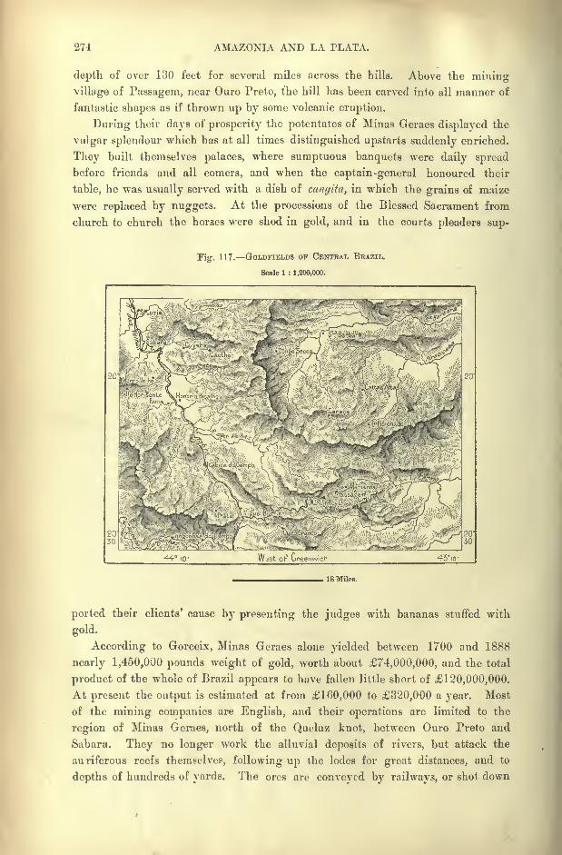
274 AMAZONIA AND LA PLATA.
depth of over 130 feet for several miles across the hills. Above the mining
village of Passagem, near Ouro Preto, the hill has been carved into all manner of
fantastic shapes as if thrown up by some volcanic eruption.
During their days of prosperity the potentates of Minas Geraes displayed the
vulgar splendour which has at all times distinguished upstarts suddenly enriched.
They built themselves palaces, where sumptuous banquets were daily spread
before friends and all comers, and when the captain-general honoured their
table, he was usually served with a dish of canyita, in which the grains of maize
were replaced by nuggets. At the processions of the Blessed Sacrament from
church to church the horses were shod in gold, and in the courts pleaders sup-
Fig. 117. GOLDFIELDS OF CENTBAL BRAZIL.
Scale 1 : 1,200,000.
44 10 43-10-
18 Miles.
ported their clients' cause by presenting the judges with bananas stuffed with
gold.
According to Gorceix, Minas Geraes alone yielded between 1700 and 1888
nearly 1,450,000 pounds weight of gold, worth about 74,000,000, and the total
product of the whole of Brazil appears to have fallen little short of 120,000,000.
At present the output is estimated at from 160,000 to 320,000 a year. Most
of the mining companies are English, and their operations are limited to the
region of Minas Geraes, north of the Queluz knot, between Ouro Preto and
Sahara. They no longer work the alluvial deposits of rivers, but attack the
auriferous reefs themselves, following up the lodes for great distances, and to
depths of hundreds of yards. The ores are conveyed by railways, or shot down
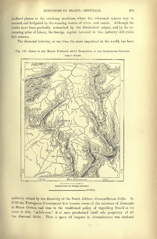
RESOURCES OF BRAZIL MINERALS. 275
inclined planes to the crushing machines, where the triturated masses may be
washed and levigated by the running waters of rivers and canals. Although the
works have been gradually retrenched by the diminished output, and by the in-
creasing price of labour, the foreign capital invested in this industry still yields
fair returns.
The diamond industry, at one time the most important in the world, has been
Fig. 118. LIMIT OF THE MINING INTERDICT ABOUT DIAMANTINA IN THE EIGHTEENTH CENTURY.
Scale 1 : 800,000.
454Q- WestoFGreenw'.cln 43IO-
Limit of the old Mining Interdict.
18 Miles.
suddenly ruined by the discovery of the South African diamantiferous fields. In
1733 the Portuguese Government first became aware of the existence of diamonds
in Minas Geraes, and true to the traditional policy of regarding Brazil as its
caeca de kite, "milch-cow," it at once proclaimed itself sole proprietor of all
the diamond fields. Then a space 42 leagues in circumference was enclosed
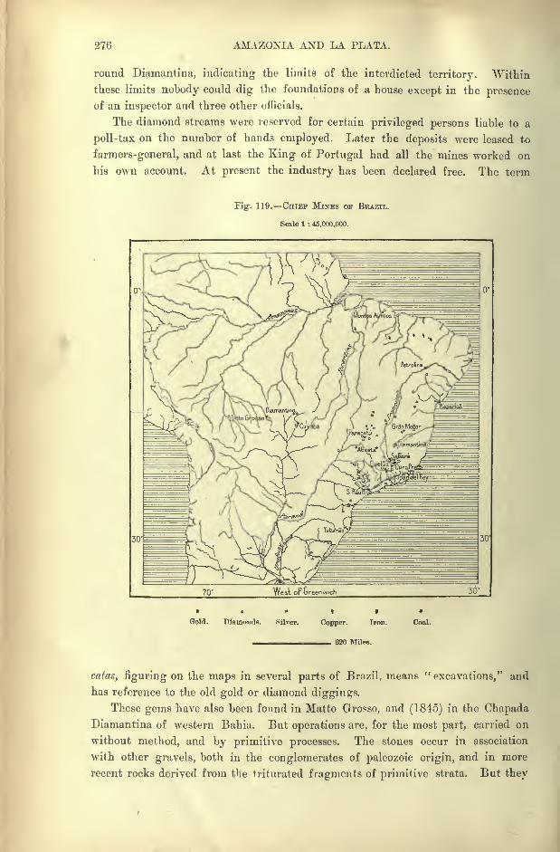
276 AMAZONIA AND LA PLATA.
round Diamantina, indicating the limits of the interdicted territory. "Within
these limits nobody could dig the foundations of a house except in the presenceof an inspector and three other officials.
The diamond streams were reserved for certain privileged persons liable to a
poll-tax on the number of hands employed. Later the deposits were leased to
farmers-general, and at last the King of Portugal had all the mines worked on
his own account. At present the industry has been declared free. The term
Fig. 119. CHIEF MINES OF BRAZIL.
Scale 1 : 45,000.000.
0'.
t
Gold. Diamonds. Silver. Copper. Iron. Coal.
620 Miles.
catas, figuring on the maps in several parts of Brazil, means "excavations," and
has reference to the old gold or diamond diggings.
These gems have also been found in Matto Grosso, and (1845) in the OhapadaDiamantina of western Bahia. But operations are, for the most part, carried on
without method, and by primitive processes. The stones occur in association
with other gravels, both in the conglomerates of paleozoic origin, and in more
recent rocks derived from the triturated fragments of primitive strata. But they
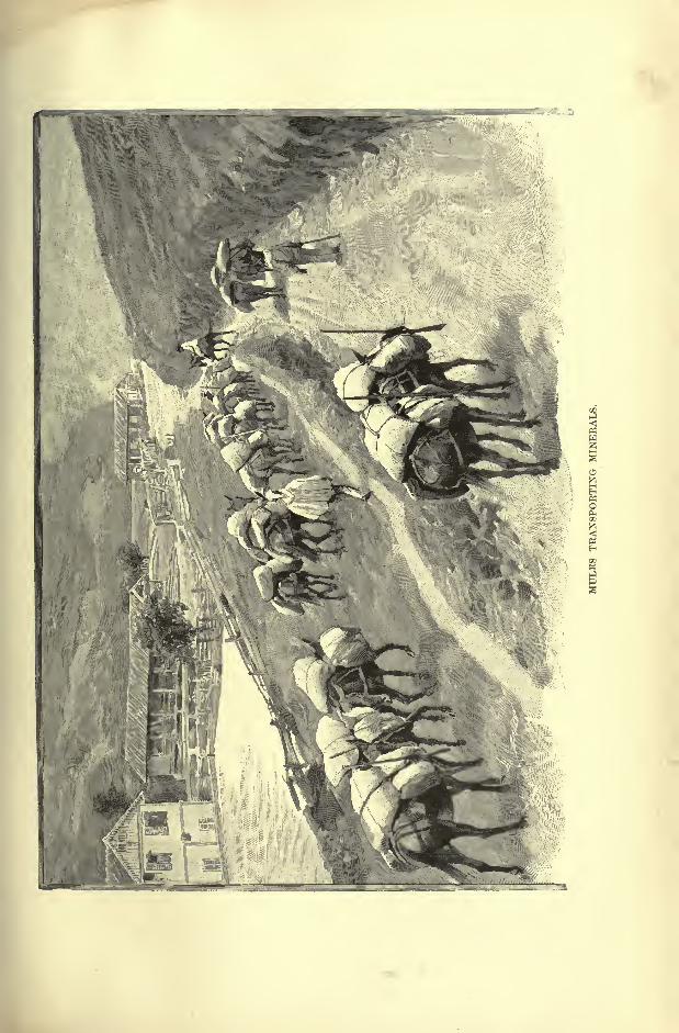
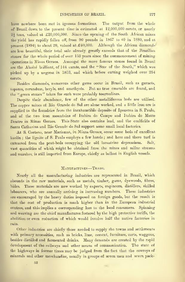
INDUSTRIES OF BRAZIL. 277
have nowhere been met in igneous formations. The output from the whole
of Brazil down to the present time is estimated at 12,000,000 carats, or nearly
2| tons, valued at 20,000,000. Since the opening of the South African mines
the yield has rapidly fallen off, from 90 pounds in 1867 to 40 in 1880, and at
present (1894) to about 20, valued at 40,000. Although the African diamonds
are less beautiful, their total sale already greatly exceeds that of the Brazilian
stones for the whole period of over 150 years since the commencement of mining
operations in Mi nas Geraes. Amongst the more famous stones found in Brazil
are the Abaete brilliant, of 144 carats, and the "Star of the South," which was
picked up by a negress in 1853, and which before cutting weighed over 254
carats.
Besides diamonds, numerous other gems occur in Brazil, such as garnets,
topazes, corundum, beryls, and amethysts. But no true emeralds are found, and
the ".green stones"taken for such were probably tourmalines.
Despite their abundance, few of the other metalliferous beds are utilised.
The copper mines of Rio Grande do Sul are alone worked, and a little iron ore is
supplied to the foundries from the inexhaustible deposits of Ipanema in S. Paulo,
and of the two iron mountains of Itabira do Campo and Itabira do Matto
Dentro in Minas Geraes. This State also contains lead, and the coalfields of
Santa Catharina and Rio Grande do Sul support some small local factories.
At S. Caetano, near Marianna, in Minas Geraes, occur some beds of excellent
kaolin;the lignite of S. Paulo employs a few hands
;and here and there turf is
extracted from the peat-beds occupying the old lacustrine depressions. Salt,
vast quantities of which might be obtained from the mines and saline streams
and marshes, is still imported from Europe, chiefly as ballast in English vessels.
MANUFACTURES TRADE.
Nearly all the manufacturing industries are represented in Brazil, which
abounds in the raw materials, such as metals, timber, gums, dyewoods, fibres,
hides. These materials are now worked by experts, engineers, distillers, skilled
labourers, who are annually arriving in increasing numbers. These industries
are encouraged by the heavy duties imposed on foreign goods, but the result is
that the cost of production is much higher than in the European industrial
centres, and this implies a corresponding loss to the local consumers. Spinning
and weaving are the chief manufactures fostered by the high protective tariffs, the
abolition or even reduction of which would involve half the native factories in
ruin.
Other industries are chiefly those needed to supply the towns and settlements
with primary necessities, such as bricks, lime, cement, furniture, carts, waggons,
besides distilled and fermented drinks. Many demands are created by the rapid
development of the railways and other means of communication. The state of
the highways in former times may be judged from the fact that the convoys of
minerals and other merchandise, usually in groups of seven men and seven pack-
52
278 AMAZONIA AND LA PLATA.
mules, took on an average one month on the road from Ouro Preto to Rio de
Janeiro. An English company having proposed to construct a proper road along
this route, it was objected that good highways would throw open the country to
foreign conquest.
Since the close of the colonial rule trade has certainly increased tenfold.
Foreign goods are no doubt heavily taxed, but at least they are not interdicted
as they were previous to the year 1808. A Portuguese financial association long
enjoyed the monopoly of the trade with Brazil, to protect which it had to equip
a fleet of war-ships. At the beginning of the nineteenth century this monopoly
was said to represent about 6,000,000 a year. But towards 1850 the exchanges
rose to 20,000,000, and in 1880 they had exceeded 40,000,000. Since then they
have continued to increase despite revolutions, civil wars, heavy tariffs, reckless
speculation, gambling, and fraudulent transactions of all kinds. Companies have
been floated with nominal capitals, which within a fortnight have called up shares
to the value of 40,000,000,' or even 80,000,000. In 1891 the various schemes
in operation represented eleven times the whole income of Brazil.
Besides manufactured goods the imports include many articles which mightwell be produced on the spot. Such are bread-stuffs, rice, charqui (jerked beef),
from Uruguay and Argentina, bricks, tiles, flags and the like. English biscuits
and pale ale, and sardines from Nantes may be procured in the humblest village
of the interior. The exports, which on an average exceed the imports, comprise
coffee, representing four-fifths or even more of the total value, rubber, sugar,
cotton, tobacco, cacao, Brazil nuts, mate, gold and diamonds.
Thanks to special tariffs the United States takes the first place in the foreign
trade of Brazil. In 18!>2 it imported over 2,400,000 bags of coffee from Rio,
while the rest of the world received less than 1,000,000 bags from the same
port. On the other hand Santos sends its coffees chiefly to Europe (Bremen,
Havre, Antwerp, Trieste). Great Britain ranks next to the United States in
the movement of exchanges, and takes by far the first place in the carryingtrade. France, Germany and Italy follow in the order named, while the mother
country takes only the fifth place, although the majority of the merchants are
Portuguese. Even in Rio the industrial and trading classes comprise four times more
natives of Portugal than Brazilians. The old colony, however, still continues to
be the best customer of the Lusitanian wine-growers. It is noteworthy that the
rapid development of foreign relations has had the effect' of diminishing the local
coasting trade between the Brazilian seaports. This result is due to the ocean
steam navigation, which, by regularly calling at every important harbour along
the seaboard, has rendered useless the large depots of goods formerly concentrated
in Rio Janeiro and distributed from that point to all the coast towns.
COMMUNICATIONS RAILWAYS.
In Brazil, as in the United States, the necessities of trade have caused the
construction of railways to precede that of carriage-roads almost everywhere. When
COMMUNICATIONS OF BRAZIL. 279
railway enterprise began the only highways opened to wheeled traffic were, in
fact, the fine road from Rio to Petropolis, continued through the Parahyba valley
to Juiz de Fora, and a few others in the neighbourhood of the towns. The so-
called "main highways," connecting Rio with Minas Geraes, Goyaz, and Matto
Grosso, are nothing more than broad tracks, winding up and down hill, scored
with deep ruts in the marshy district, and branching into lateral by-ways at the
steep inclines. Along these dusty, muddy or rocky tracks teams of six, eight, or
ten pairs of oxen slowly drag their lumbering and creaking waggons, while
convoys several hundred yards long are organised for the transport of large quan-
tities of minerals and general merchandise. Large convoys of pack-animals,
chiefly mules, are also employed for the transport of merchandise along the
wretched tracks across the swampy and mountainous districts, which are inacces-
sible to wheeled traffic. These convoys are usually headed by the so-called ma-
drinha, an old horse who carries no load, but wears an arrangement of tinkling
bells, and is also often gaily decked with feathers and strips of coloured cloth.
In 1856 the first railway was opened from Rio to the foot of the coast range
in the direction of Petropolis. Two years later followed the line also from Rio
across the marshy and wooded plains towards the upper Parahyba valley, but
stopping short at Belem at the foot of the Serra do Mar. Eventually the
mountain barrier was overcome by steep gradients and sixteen tunnels, and from
this trunk line between Rio and the Parahyba basin other branches ramified in
various directions.
The Serra do Mar has been surmounted altogether at five different points, of
which three are in the vicinity of the capital. The Serra de Mantiqueira and the
Serra do Espinhaco have also been crossed, and nothing now remains except to
extend the system over the gently-inclined slopes of the inland plateaux. The
highest point reached by the engineers is at a cutting 4,475 feet above sea-level
on the Ouro Preto branch. Although the locomotive has scarcely yet reached the
region of the great rivers, some imposing viaducts have already been constructed,
notably the bridge spanning the Paraguassu between Cachoeira and S. Felix, that
of the Rio Grande on the Uberaba line, and the viaduct over half a mile long in
the Tubarao coal-mining district.
Meanwhile only two systems properly so-called have yet been developed, one
with its seaward terminus at the capital, the other radiating from Santos. These
are, however, themselves connected by a line 370 miles long ascending the Parahyba
valley and descending to S. Paulo. The Rio network penetrates far into Minas
Geraes, and yearly advances one or two stages into the Rio das Velhas valley at
the head of the navigation in the S. Francisco basin.
Still more rapid progress has been made in the State of S. Paulo, where the
lines ramifying through the coffee region have already reached the navigable Rios
Grande, Pardo, Mogy Guassu, Tiete, and Piracicaba. Elsewhere there are only
a few isolated lines, or local systems, such as those of Recife and Bahia Bay.
A great trunk line, such as might give unity to all these isolated sections, is
an undertaking still beyond the resources of Brazilian finance. The lines most
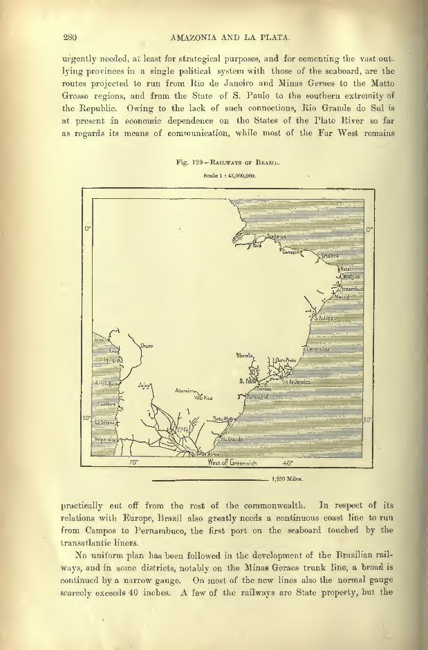
280 AMAZONIA AND LA PLATA.
urgently needed, at least for strategical purposes, and for cementing the vast out-
lying provinces in a single political system with those of the seaboard, are the
routes projected to run from Rio de Janeiro and Minas Geraes to the Matto
Grosso regions, and from the State of S. Paulo to the southern extremity of
the Republic. Owing to the lack of such connections, Rio Grande do Sul is
at present in economic dependence on the States of the Plate River so far
as regards its means of communication, while most of the Far West remains
Fig. 1 20 RAILWAYS OP BRAZIL.
Scale 1 : 45,000,000.
1,250 Miles.
practically cut off from the rest of the commonwealth. In respect of its
relations with Europe, Brazil also greatly needs a continuous coast line to run
from Campos to Pernambuco, the first port on the seaboard touched by the
transatlantic liners.
No uniform plan has been followed in the development of the Brazilian rail-
ways, and in some districts, notably on the Minas Geraes trunk line, a broad is
continued by a narrow gauge. On most of the new lines also the normal gauge
scarcely exceeds 40 inches. A few of the railways are State property, but the
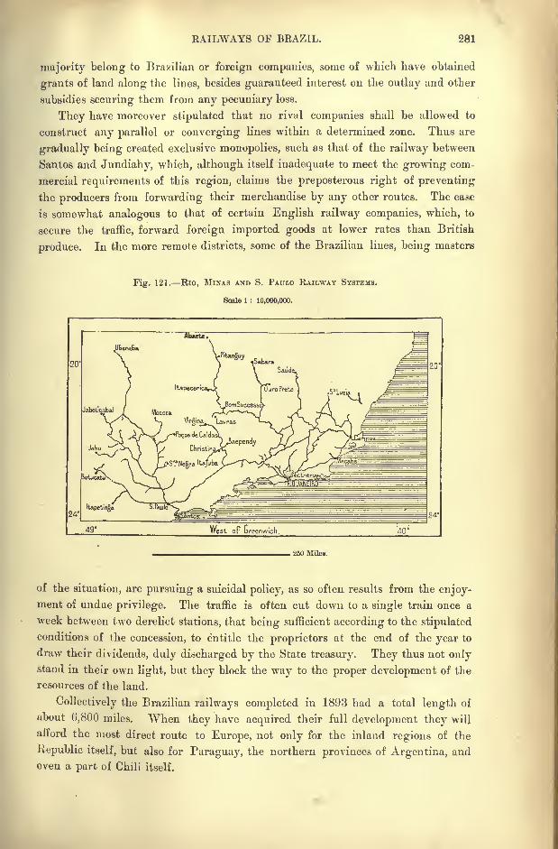
RAILWAYS OF BRAZIL. 281
majority belong to Brazilian or foreign companies, some of which have obtained
grants of land along the lines, besides guaranteed interest on the outlay and other
subsidies securing them from any pecuniary loss.
They have moreover stipulated that no rival companies shall be allowed to
construct any parallel or converging lines within a determined zone. Thus are
gradually being created exclusive monopolies, such as that of the railway between
Santos and Jundiahy, which, although itself inadequate to meet the growing com-
mercial requirements of this region, claims the preposterous right of preventing
the producers from forwarding their merchandise by any other routes. The case
is somewhat analogous to that of certain English railway companies, which, to
secure the traffic, forward foreign imported goods at lower rates than British
produce. In the more remote districts, some of the Brazilian lines, being masters
Fig. 121. Rio, MINAS AND S. PAULO RAILWAY SYSTEMS.
Scale 1 : 10,000,000.
20
250 Miles.
of the situation, are pursuing a suicidal policy, as so often results from the enjoy-ment of undue privilege. The traffic is often cut down to a single train once a
week between two derelict stations, that being sufficient according to the stipulated
conditions of the concession, to entitle the proprietors at the end of the year to
draw their dividends, duly discharged by the State treasury. They thus not onlystand in their own light, but they block the way to the proper development of the
resources of the land.
Collectively the Brazilian railways completed in 1893 had a total length of
about 6,800 miles. "When they have acquired their full development they will
afford the most direct route to Europe, not only for the inland regions of the
Republic itself, but also for Paraguay, the northern provinces of Argentina, and
even a part of Chili itself.
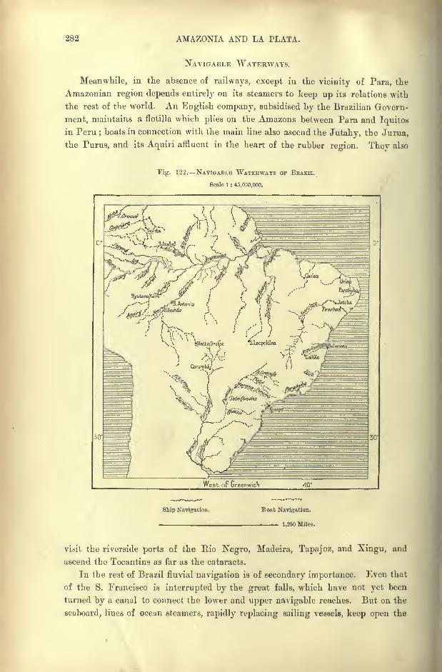
282 AMAZONIA AND LA PLATA.
NAVIGABLE WATERWAYS.
Meanwhile, in the absence of railways, except in the vicinity of Para, the
Amazonian region depends entirely on its steamers to keep up its relations with
the rest of the world. An English company, subsidised by the Brazilian Govern-
ment, maintains a flotilla which plies on the Amazons between Para and Iquitos
in Peru;boats in connection with the main line also ascend the Jutahy, the Jurua,
the Purus, and its Aquiri affluent in the heart of the rubber region. They also
Fig. 122. NAVIGABLE WATERWAYS OF BRAZIL.
Scale 1 : 45.000,000.
Ship Navigation. Boat Navigation.
1,250 Miles.
visit the riverside ports of the Rio Negro, Madeira, Tapajoz, and Xingu, and
ascend the Tocantins as far as the cataracts.
In the rest of Brazil fluvial navigation is of secondary importance. Even that
of the S. Francisco is interrupted by the great falls, which have not yet been
turned by a canal to connect the lower and upper navigable reaches. But on the
seaboard, lines of ocean steamers, rapidly replacing sailing vessels, keep open the
STATE OF EDUCATION, BEAZIL. 283
communications with all the large seaports, such as Para, S. Luiz de Maranhao,
and Fortaleza, Recife (Pernambuco), Maceio, Bahia, Victoria, Rio, Santos, Paranagua,
Desterro, and Rio Grande do Sul. As many as seventeen companies, nearly all
English, are engaged in this service, although in virtue of a recent Act, vessels
flying the national flag are alone authorised to engage in the coast traffic. The
majority of the crews are also required to be of Brazilian nationality, a condition
which could not be complied with but for the facilities afforded to foreign sailors
of becoming naturalised citizens.
In ordinary times about ten Atlantic liners arrive every week in the Brazilian
seaports. The voyage from Lisbon to Pernambuco usually takes eleven days ;
but the Atlantic at its narrowest part, between the African arid South American
continents, could be crossed in two days and a half by a fast sailer, such as those
engaged in the service between Liverpool and Xew York. Direct telegraphic
communication is maintained by submarine cables between Pernambuco, Europe,
and the United States. A line 3,720 miles" long skirts the seaboard from the
Amazons to the Plate estuary.
EDUCATION RELIGION.
Public instruction could scarcely make much progress in a country in which
the great majority of the labourers have, till recently, been slaves. Nevertheless
some schools and colleges had already been founded by the Jesuit missionaries
under the colonial administration, and during the second half of* the eighteenth
century the Marquis de Pombal had caused "royal" educational establishments
to be opened. But the great mass of the people still remained unlettered.
In 1834, seven years after the promulgation of the first law regarding public
instruction, in the whole province of Rio de Janeiro there were only 30 schools,
attended by 1,369 of both sexes. Since then a great improvement has taken
place, although recent statistics show that even in the most advanced provinces
a great part of the young are still receiving no instruction. In 1872 about 23
per cent, of the males and 13 of the females could at least read, while one negroin 1,000 knew the alphabet. Twenty years later it was estimated that over
three-fourths of the whole population of both sexes, whites, blacks, and coloured,
were still ignorant of the rudiments of knowledge. Many of the rising genera-
tion, however, are self-taught. In the central States of Minas Geraes, Goyaz, and
Matto Grosso, most of the curandeiros (" healers," doctors) have qualified them-
selves by the study of medical works without any instruction, and these are
often remarkably successful in the treatment of their patients. The negroes,
who are stated to excel the whites in the musical faculty, have grouped themselves
in musical clubs, numbering many thousands.
The high schools are supported by the State, always excepting various separate
establishments founded by the Jesuits at a distance from the large cities, such as
that of Itu in the State of S. Paulo, and the college of Cara^a in Minas Geraes.
In Rio are centred most of the higher faculties College of Physicians, School
284 AMAZONIA AND LA PLATA.
of Pharmacy, Normal School, College of the Fine Arts, Conservatoire of Music,
Lyceum of the trades and crafts, military and naval schools, without, however,
forming a university body. Pernambuco, Bahia, S. Paulo, and 0uro Preto have
also their medical, law, and mining colleges. In all these institutions French
is, to a large extent, the vehicle of instruction. In the public libraries, also,
the demand for French was, till recently, greater than for Portuguese works.
Printing was introduced in 1744, but the first press lasted only three years,
having been destroyed by order of the central government. Then the country
remained without a printing office till 1808, when the fugitive King of Portugal
introduced another press in order to publish his edicts. Newspapers had a hard
struggle till the period of independence, and the history of their first years is a
dismal record of banishments, imprisonments, and even executions of their
editors. After that the number of periodicals increased steadily from 31 in
1828, to 271 in 1876; during the next decade they had more than doubled.
Formerly the Church was. all-powerful in Brazil, where the Inquisition, intro-
duced in 1702, persecuted heretics with a blind rage. Yet in most cases heresy
consisted, not in the profession of heterodox doctrines, but in the strain of Jewish
blood in the veins of the victims. After the Declaration of Independence the
" Roman Catholic and Apostolic Church "maintained its ascendency, and the
public exercise of all other religions was severely interdicted.
But the revolution which overthrew the empire also separated Church and
State, while continuing their incomes to priests on duty. Nevertheless, there
have been frequent collisions between the two powers, and even in 1892 the legal
suppression of the crucifix in the law courts gave rise to fierce demonstrations
against the "freethinkers."
The vast majority of the population professes the Roman Catholic faith, and
in the returns for Rio de Janeiro in 1892 less than one per cent, declared
themselves of a different or of no religion. But indifference in religious matters
is spreading, and despite the thunders of preachers, freemasonry is acquiring
multitudes of adherents in all the large cities. The clergy finds it difficult to
obtain sufficient recruits from the native white and black populations, and has
to be complemented every year by foreign priests, nearly all Italians.
On the other hand, the Brazilians display great public spirit in the organisi-
tion of their charitable institutions. As in England, their hospitals and asylumsare independent of the State, and supported by voluntary contributions. An
appeal "in the name of all our suffering brethren" never fails to produce
subscriptions sufficient to provide amply for all the hospitals throughout the
Republic.
The outward forms of the irmandades ("brotherhoods") are still religious,
and at the official gatherings the " brethren" wear the monkish habit as of old.
But each association is organised in its own way, and its operations are
curried on altogether independently both of Church and State. In Rio these
benevolent societies administer a collective revenue of several hundred thousand
pounds.
CONSTITUTION OF BRAZIL. 285
GOVERNMENT AND ADMINISTRATION.
In accordance with the stereotyped formulas of modern constitutions,
all Brazilians are recognised as equal before the law. The right of association,
full freedom of speech, and of the press, are also recognised, except in the case
of anonymous publications. Letters passing through the post are inviolable,
and all professions are open to all citizens. The Republic ignores the old
privileges of nobility, suppresses all orders and honours instituted by the
monarchy, and abolishes all aristocratic distinctions. Yet in few countries are
barons, viscounts, and marquises more plentiful, not to speak of councillors and
doctors. The old regime lavished honours on staunch supporters, and, as is said,
still more on reconcilable opponents ; and, since the fall of the empire, both
classes have preserved, if not their allegiance to the exiled princes, at least the
high-sounding titles which they owed to the imperial favour.
Besides all natives, citizenship is extended to all the children of Brazilians,
to the illegitimate children of Brazilian mothers born abroad on taking domicile
in the Republic ; moreover, to foreigners owning land in the country, or marryingBrazilian wives, or having children in Brazil, unless they formally declare
themselves of another nationality.
One of the first acts of the revolution was to extend citizenship to all children
of foreign residents who for the space of six months should omit to claim their
original nationality in distinct, terms. Thus was solved the question affecting
immigrants, which had been for so many years a bone of contention between
political parties. Nothing, in fact, could be more unreasonable and inconsistent
than the treatment of foreign settlers since the middle of the century. They were
urgently invited to come over ; they received a free passage, allotments of land,
at times even advances in money and live-stock; but they were denied citizenship,
and treated almost as outcasts. Before 1863 marriage was interdicted to them,
and in 1881, not one hud yet obtained a seat in the provincial assemblies, not even
in that of Rio Grande do Sul, whose trade and industries they controlled.
The electorate, both for the several States and for the Republic, comprises
all citizens twenty-one years old who are not mendicants, illiterate, or engagedin pursuits incompatible with freedom of opinion. Thus are excluded all
soldiers, except the military students in the higher schools, and all members
of religious communities bound by the vow of obedience. All pleading religious
scruples as a ground of exemption from the discharge of duties imposed by law
on other citizens declare themselves ipso facto barred from civic rights.
Despite the primary importance attached by the constitution to the exercise
of the suffrage, official source of all public authority, the privilege appears to be
little appreciated, and absence from the voting booths is almost universal. Even
in the capital nearly 100,000 electors have been known to abstain from voting.
When the Federal Republic was proclaimed, the nation was not consulted as to
the political groups which should constitute the federation. The names of the
administrative divisions under the empire were merely changed ; and from "pro-
286 AMAZONIA AND LA PLATA.
vinces"
they became "States," although these divisions were singularly defective
in every respect, in no way corresponding to such as would be formed, had the
people themselves been consulted. Apart from Amazonia and Matto Grosso, which
are in reality not States so much as territories awaiting future settlement, the
vast region of Bahia has for neighbours- the two former provinces of Alagoas and
Sergipe, one seven the other eleven times smaller. It may, however, be presumed
Fig. 123. POLITICAL DIVISIONS OF BRAZIL.
Scale 1 : 46.000.000.
ARGENT! N A /RO Grande
Contested Territoiies. Federal Territories
1,250 Miles
that the fluctuating and ill-defined frontiers of so many conterminous States
may still be rectified, in accordance with the physical and social conditions.
Possibly new groups will be constituted, which may have the effect of shifting
the present political equilibrium. But meantime it seems surprising that, in a
nation connected by federal ties, the old royal decrees, rather than the wishes and
interests of the people, are consulted in distributing the inhabitants of the Eepublic
in distinct and autonomous political divisions.
CONSTITUTION OF BEAZIL. 287
Each of the twenty States has its two chambers and its president ;and each
passes special laws subordinate to the general principles of the constitution of the
United States of Brazil. All lands and mines not yet disposed of belong to the
nation, those only excepted which may seem indispensable to the Union for frontier
defence, or for the construction of strategical routes and railways of general
interest. Two conterminous States may conclude special conventions between
themselves, provided they involve no political element. But they cannot declare
war against other States, nor refuse to accept as legal tender the metal or paper
currency recognised by the Union, nor reject any legislative, administrative, or
judiciary measures proclaimed by the Federal Republic. In respect of foreign
matters the twenty States act in concert and have no individual political status.
The Chamber of Deputies, which assembles at Rio de Janeiro, pending the
foundation of a future federal capital on the Goyaz plateaux, consists of popular
representatives, elected in the proportion of at least four members for each State
and for the neutral municipality of the republic ;and in the general proportion of
one to every 70,000 of the inhabitants. As in the United States of North America,
which have served as a model for ihe Brazilian legislators, the Chamber of
Deputies corresponds numerically to the strength of the several States measured bythe test of population, whereas the Senate represents the States as equals by
right, irrespective of the number of their inhabitants. The Senate accordingly
consists of 63 members, that is to say, three for each State and for the neutral
municipality. As in the northern Republic, the members of the Senate retire byrotation. Its legal duration being for nine years, one-third are replaced by new
members after three years, and at the end of the sixth year fresh elections take
place for the second third of the Senators.
Although the president and vice-president were raised to power in virtue of
a military revolution, the constitution provides an elective and popular origin for
the two chiefs of the executive. Both are nominated by direct suffrage, and byan absolute majority of votes
;but failing such a majority, congress decides.
Four years is the period fixed for the exercise of the presidential power, which
cannot be held by the same person twice consecutively. The president appoints
and dismisses the Ministers of State at pleasure ;he commands the land and sea
forces, and appoints the heads of the civil departments dependent on the federation,
the members of the Supreme Court of Justice, the ambassadors and consuls,
declares war and concludes peace. He approves and publishes the laws passed
by congress ;but he possesses the right of veto, sending back questions to be
again discussed by the chambers, and decided not by a bare majority, but by a
substantial majority of two-thirds. The Senate on its part enjoys the almost
delusive privilege of trying the president if impeached by the Chamber of
Deputies. In point of fact the head of the Republic is armed with monarchical
powers far greater than those claimed by the emperor. Thus the Judiciary body,
which by a legal fiction is held to enjoy an influence equal to that of the legis-
lative and executive bodies, is in reality in the hands of the president, who names
all its members.
288 AMAZONIA AND LA PLATA.
It is noteworthy that Auguste Comte's positive school had much to do with
the revolution which overthrew the empire. His teachings had made great
progress, especially in the military institutions, and to the zeal of certain
positivists engaged in the revolutionary movement must be attributed several
decrees issued during the first weeks of the Republic. Such were the separation
of Church and State ;the institution of the national feast of July 14th coinciding
with that of the French Republic ;the adoption of the mottos " Order and
Progress"
for the national flag,"Safety and Fraternity
"in official correspon-
dence.
But political morals are unaffected by such empty formulas. The Brazilian
constitution may model itself almost slavishly on that of the North American
Union;
but it will fail to infuse the Anglo-Saxon spirit into the Brazilian
populations. Each article of its"magna charta" will still be interpreted in
accordance with the habits of thought, the traditions, usages, and passions of the
half-caste Portuguese inhabitants of South America.
Thus it has happened that the royal powers granted to the president of the
United States, and consequently to the head of the Brazilian Republic, have
rapidly led in the latter State to a pure dictatorship. From the very first,
however, the outcome of the revolution was of its essence a military autocracy.
The army had long grumbled at being kept aloof, and when the enfeebled
emperor ceased to take an active part in the administration, the deeply mistrusted
military commanders were studiously removed to great distances, and virtually
banished even to insalubrious regions, such as Upper Amazonia and Matto Grosso.
Nevertheless, the army, elated at its triumphs over Paraguay, had long resented
its subordinate position, and now clamoured for the first place in the manage-ment of affairs. The few men who controlled the republican movement, taking
advantage of this feeling, offered power to the military leaders in exchange for
the name of "Republic," and the revolution, more apparent than real, was effected
without bloodshed as a simple" transformation scene."
Since the end of the empire, Brazil has been ruled by soldiers, and in 1893
more than half of the provincial governors were army men. But the navy, which
had also a share in the glory of the Paraguay War, especially in forcing the pas-
sage of the rivers, now found itself neglected in the distribution of power. To the
consequent rivalry between the military and naval forces, diversely influenced bythe pressure of the civil element, must be attributed the sequence of events which
were brought to. a temporary close by the collapse of the revolt in the spring of
1894.
At the same time the army is not a force constituted by the exercise of any
legitimate national function. Although there exists a law of conscription by lots,
the regiments are recruited by voluntary engagements legally limited to a period
of gix months, during which the men are in the pay of the State. Most of the
rank and file are men of colour, while the officers are mainly whites, or
regarded as such. During the Paraguay War, Brazil had as many as 70,000
soldiers, including the mobilised national guards, the police, and frontier garri-
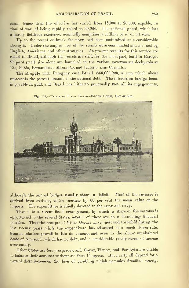
ADMINISTRATION OF BRAZIL. 269
sons. Since then the effective has varied from 15,000 to 20,000, capable, in
time of war, of being rapidly raised to 30,000. The national guard, which has
a purely fictitious existence, nominally comprises a million or so of citizens.
Up to the recent outbreak the navy had been maintained at a considerable
strength. Under the empire most of the vessels were commanded and manned by
English, Americans, and other strangers. At present recruits for this service are
raised in Brazil, although the vessels are still, for the most part, built in Europe.
Ships of small size alone are launched in the various government dockyards at
Rio, Bahia, Pernambuco, Maranhao, and Ladario, near Corumba.
The struggle with Paraguay cost Brazil 60,000,000, a sum which about
represents the present amount of the national debt. The interest on foreign loans
is payable in gold, and Brazil has hitherto punctually met all its engagements,
Fi. 124. PALACE ON FISCAL ISLAND CUSTOM HOUSE, BAY OF Rio.
although the annual budget usually shows a deficit. Most of the revenue is
derived from customs, which increase by 60 per cent, the mean value of the
imports. The expenditure is chiefly devoted to the army and navy.
Thanks to a recent fiscal arrangement, by which a share of the customs is
apportioned to the several States, several of these are in a flourishing financial
position. Thus the receipts of Minas Geraes have increased threefold during the
last twenty years, while the expenditure has advanced at a much slower rate.
Similar relations prevail in Rio de Janeiro, and even in the almost uninhabited
State of Amazonia, which has no debt, and a considerable yearly excess of income
over outlay.
Other States are less prosperous, and Goyaz, Piauhy, and Parahyba are unable
to balance their accounts without aid from Congress. But nearly all depend for a
part of their income on the love of gambling which pervades Brazilian society.
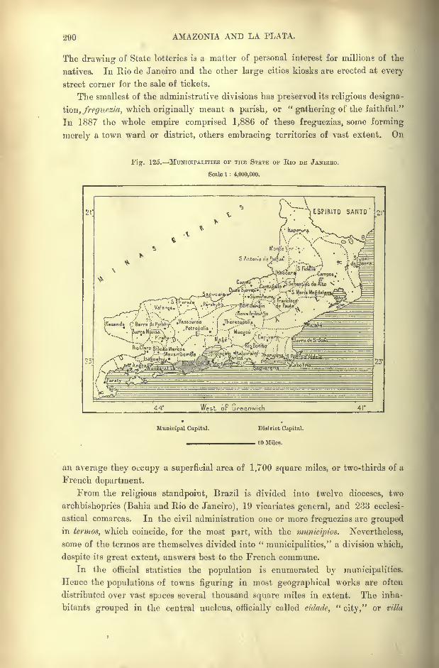
290 AMAZONIA AND LA PLATA.
The drawing of State lotteries is a matter of personal interest for millions of the
natives. In Rio de Janeiro and the other large cities kiosks are erected at every
street corner for the sale of tickets.
The smallest of the administrative divisions has preserved its religious designa-
tion, /m/w^s/a, which originally meant a parish, or "gathering of the faithful."
In 1887 the whole empire comprised 1,886 of these freguezias, some forming
merely a town ward or district, others embracing territories of vast extent. On
Fig. 125. MUNICIPALITIES OF THE STATE OF Rio DE JANEIEO.
Scale 1 : 4,000,000.
fv-i^ L ESPIRITO SANTO
\
\v
^^-JF^1 '
^V-^y \-;-\' >--'' V --^'' ''
'
-.'NovaFribu^o ,,-'. ^^
kzende i'/BarradoP.r^V'"^*"01"-8? '
[ Jhirez^li.s /"""^'
-5^==V
*\R M---'--* .retrofjolis j
,--'" ,"".* /^ =
.
23
44* West oF Greenwich 41'
Municipal Capital. District Capital.
60 Miles.
an average they occupy a superficial area of 1,700 square miles, or two-thirds of a
French department.
From the religious standpoint, Brazil is divided into twelve dioceses, two
archbishoprics (Bahia and Rio de Janeiro), 19 vicariates general, and 233 ecclesi-
astical comarcas. In the civil administration one or more freguezias are groupedin tenttos, which coincide, for the most part, with the ninnicijrios. Nevertheless,
some of the termos are themselves divided into "municipalities," a division which,
despite its great extent, answers best to the French commune.
In the official statistics the population is enumerated by municipalities.
Hence the populations of towns figuring in most geographical works are often
distributed over vast spaces several thousand square miles in extent. The inha-
bitants grouped in the central nucleus, officially called cidade,"city," or villa
ADMINISTRATION OF BKAZIL. 291
"town," are often less than a tenth of the number given for the whole immicipio.
Hence travellers arriving at a "city
" with a reputed population of 10,000 or
20,000 find themselves sometimes landed in a wretched village, where it is not
always easy to procure" accommodation for man and beast."
In 1877 Brazil comprised altogether as many as 910 municipalities, of which
258 were classed as cities and 652 as towns. A group of municipalities consti-
tutes a comarca, which is defined to be an area of territory subject to the juris-
diction of a Juiz de Direito, and which is divided into a number of freguezias.
Hence some of the comarcas, especially in the less thickly peopled regions, cover a
space of thousands of square miles.
Other divisions prevail in the military and naval administrative departments,
while for trade purposes and the collection of customs Brazil is grouped in
five prefectures two fluvial (Amazons and Matto Grosso), and three maritime,
those of the north, centre, and south.
In the appendix is a table of the twenty States, with approximate areas and
populations.
CHAPTER
PARAGUAY.
F the South American States, Bolivia and Paraguay alone have no
seaward outlet through their own territory. But, alike in this,'
these Hispano-American Republics differ greatly in many other
respects. One occupies the summit and steep scarps of a plateau
12,000 or 13,000 feet above the sea; the other, comprised like a
"Mesopotamia
"between two large rivers, is a region of plains and low hills, of
marshes and woodlands.
But the two countries present certain analogies in their historic evolution. In
both regions the nation was developed in seclusion from the outer world, the Boli-
vian on the islands and around the shores of Lake Titicaci, the Paraguayan in
the clearings of the great sub-tropical woodlands. Their growth has been com-
pared to that of the pulp round the hard nucleus of stone fruit. Thus may be
explained the fact that Bolivia lost the strip of territory on the oceanic slope of
the Andes which her neighbours of the Pacific seaboard had at first left in her
possession. This territory did not belong naturally to the State, but was a sort of
dependency assigned to it by a purely conventional arrangement, and of which it
was deprived by a fresh convention when the original conditions were changed.
Paraguay also still remains confined to her forest glades, the population, enjoying
the advantages of a seaward outlet, having naturally gravitated towards other
centres of attraction.
A chief factor in the historic evolution of Paraguay was the ascendancy of the
Jesuits, who, however, were absolute masters only in the southern part of the
country. Their dream of universal empire could never be aught but an Utopia in
the Old "World, where they had to struggle with an innovating spirit, diametri-
cally opposed to their ideal. Yet even here they did not despair of success, and
there were times when, they might seem on the eve of acquiring the control of the
destinies of Europe, and of bending mankind to the yoke which they had framed.
But having failed before the ferment of free thought in Europe, they might

HISTORY OF PARAGUAY. 293
still hope to mould at pleasure the docile savages of South America, and in the
seclusion of that region, far from the jealous gaze of a perverted society, consti-
tute a new world obedient to the disciplinary laws introduced by them. The
scheme embraced the whole continent. Stationed at first in their college of S.
Paulo on the edge of the Brazilian plateau, and constantly recruited by zealous
missionaries drawn from all Christendom, they gradually subdued the vast inland
regions as far as the foot of the Andes and the entrance to the Amazonian
plains.
HISTORIC RETROSPECT.
But the Jesuits had not arrived alone in these new lands, and they soon found
their work hampered by the presence of restless and unsympathetic white neigh-
bours. The Portuguese adventurers, the first to arrive, aspired to other things
besides creating model empires, and thought of little except enriching themselves
by the capture of slaves and the quest of gold. Hence endless conflicts with the"Fathers," who were gradually pressed back to that part of the continent of which
the Paraguayan republic now occupies the centre. Here they at last found the
material suitable for their purpose, meek and pious neophyte*, whose daily existence
might be regulated by the sound of the church bells. The whole nation was
transformed to a devout flock, telling their beads and bending in worship before
the altar.
But the modern spirit continued to dog their steps, and they were fain to
abandon these Paraguay missions, as they had to fly from those of Guayra.Nevertheless their impress was left on the nation whom they had reduced, and
even on the surrounding populations who had not been brought directly under
their sway. By constituting these sequestered communities, cut off from all
intercourse with a profane world, they had roused a feeling of antagonism, which
led to the inevitable conflict. A section of mankind cannot keep aloof from their
kindred, and the wider the gap produced by education and pursuits, the more
unavoidable becomes the clash.
A recent illustration of this truth is supplied by the history of the North
American Mormons, who fell back from wilderness to wilderness before the steadyadvance of the backwood settlers in the Far West. At last they established them-
selves in a basin enclosed by lofty mountains, and defended from invasion bysaline tracts, rugged gorges and waterless ravines. Here the "
Latter-Day Saints"
thought themselves secure, and here, like the Jesuits, they realised that vision of
their dreams, a perfect community modelled on the heavenly Jerusalem. But one
day their implacable enemies, the "Gentiles," burst upon their seclusion, tore their
laws to shreds, and profaned their temples.Even after the expulsion of the Jesuits, the Spanish colony of Paraguay kept
apart from the Buenos Ayres government, of which it was an official dependency.Hence when the Hispano-American provinces separated from the mother-country,the city of Asuncion, which had already revolted in 1811, refused to group itself
with the other Argentine colonies under the hegemony of the former capital.53
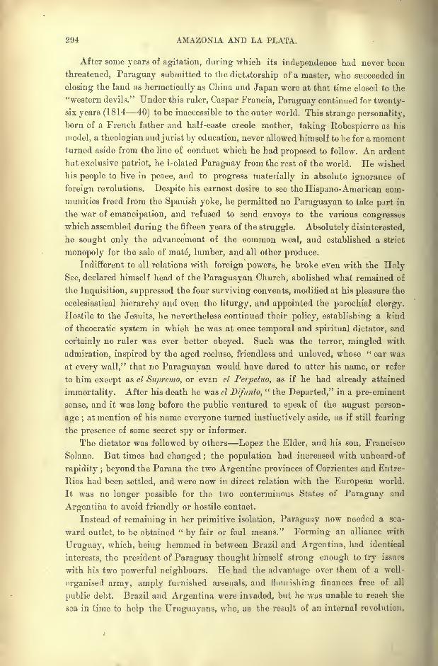
294 AMAZONIA AND LA PLATA.
After some years of agitation, during which its independence had never been
threatened, Paraguay submitted to the dictatorship of a master, who succeeded iii
closing the land as hermetically as China and Japan were at that time closed to the
"western devils." Under this ruler, Caspar Francia, Paraguay continued for twenty-six years (1814 40) to be inaccessible to the outer world. This strange personality,
born of a French father and half-caste Creole mother, taking Robespierre as his
model, a theologian and jurist by education, never allowed himself to be for a momentturned aside from the line of conduct which he had proposed to follow. An ardent
but exclusive patriot, he isolated Paraguay from the rest of the world. He wished
his people to live in peace, and to progress materially in absolute ignorance of
foreign revolutions. Despite his earnest desire to see the Hispano-American com-
munities freed from the Spanish yoke, he permitted no Paraguayan to take part in
the war of emancipation, and refused to send envoys to the various congresses
which assembled during the fifteen years of the struggle. Absolutely disinterested,
he sought only the advancement of the common weal, and established a strict
monopoly for the sale of mate, lumber, and all other produce.
Indifferent to all relations with foreign powers, he broke even with the HolySee, declared himself head of the Paraguayan Church, abolished what remained of
the Inquisition, suppressed the four surviving convents, modified at his pleasure the
ecclesiastical hierarchy and even the liturgy, and appointed the parochial clergy.
Hostile to the Jesuits, he nevertheless continued their policy, establishing a kind
of theocratic system in which he was at once temporal and spiritual dictator, and
certainly no ruler was ever better obeyed. Such was the terror, mingled with
admiration, inspired by the aged recluse, friendless and unloved, whose " ear was
at every wall," that no Paraguayan would have dared to utter his name, or refer
to him except as el Supremo, or even el Perpetuo, as if he had already attained
immortality. After his death he was el Difnnto," the Departed," in a pre-eminent
sense, and it was long before the public ventured to speak of the august person-
age ;at mention of his name everyone turned instinctively aside, as if still fearing
the presence of some secret spy or informer.
The dictator was followed by others Lopez the Elder, and his son, Francisco
Solano. But times had changed ;the population had increased with unheard-of
rapidity ; beyond the Parana the two Argentine provinces of Corrientes and Entre-
Rios had been settled, and were now in direct relation with the European world.
It was no longer possible for the two conterminous States of Paraguay and
Argentina to avoid friendly or hostile contact.
Instead of remaining in her primitive isolation, Paraguay now needed a sea-
ward outlet, to be obtained "by fair or foul means." Forming an alliance with
Uruguay, which, being hemmed in between Braxil and Argentina, had identical
interests, the president of Paraguay thought himself strong enough to try issues
with his two powerful neighbours. He had the advantage over them of a well-
organised army, amply lurnished arsenals, and flourishing finances free of all
public debt. Braxil and Argentina were invaded, but he was unable to reach the
soa in time to help the Uruguayans, who, as the result of an internal revolution,
HISTORY OF PARAGUAY. 295
suddenly changed sides and took part with the Argento-Brazilians in repelling
the Paraguayan invasion. The little Republic, encircled by the two rivers, Parana
and Paraguay, as by a deep moat, held out for over five years against the allies.
During this disastrous war, one of the most terrible on record, Paraguay sacrificed
all her able-bodied men. Retreating inch by inch from one entrenched camp to
another, from Humaita to Aquidaban, the heroic arrny, reduced in numbers, but
animated by a patriotism of which the modern world offers no second example,
still defied the enemy by whom it was vastly outnumbered. On the battle-fields
the allies found little but dead bodies;nor all of these, for many, fighting lassoed
round the waist by cords attached to the saddle-bow, were borne dead or dying
from the field by their mounts. Prisoners tore the bandages from their wounds;
the vanquished preferred death to bondage ;the whole nation wished to perish, as
Numantium had perished.
At last the manhood of the nation had almost entirely disappeared by war,
famine, and cholera. None survived except invalids, the infirm, the women and
children. Entrapped in a mountain gorge, the last heroic band fell with the
dictator.
For many centuries, during which nevertheless so much frightful carnage had
been witnessed, humanity had not suffered from such a terrible struggle, attended
by such atrocious havoc and ruin. The utter destruction of this people, one of the
best and kindliest recorded in history, was primarily due to the enforced isolation
in which the Paraguayan nation had been kept from the very first, and to the
doctrine of collective and absolute submission with which it had been imbued byits spiritual and temporal rulers.
BOUNDARIES EXTENT POPULATION.
The present frontiers of Paraguay have been dictated by the conquerors.
The eastern section, which constitutes Paraguay proper, is strictly limited by
natural boundaries. Here the Rio Apa, constantly claimed before the war by the
Brazilians as their frontier, now separates Paraguay from Matto Grosso. The
great bend of the Parana above the Paraguay confluence encloses the republic on
its east and south sides.
West of the Paraguay the whole of the Gran Chaco solitudes had been
claimed by Argentina, which, having appropriated the territory of the Cis-
Parana missions, now also wished to annex the Cis-Paraguayan section of the
wilderness. But Brazil, whose obvious interest it now is to maintain an indepen-
dent Paraguay as a " buffer State"
against her powerful neighbours, failed to
support the claims of Argentina, and the question, on being referred to the
arbitration of the United States, was decided in favour of Paraguay. The Rio
Pilcomayo thus became the parting line, and all the inter-fluvial territory between
the Paraguay and the Parana was declared Paraguayan domain.
Thanks to this addition Paraguay no longer remains the smallest of the South
American republics. But although larger in extent, she is greatly inferior in
296 AMAZONIA AND LA PLATA.
population to Uruguay, having (1893) not more than 530,000 inhabitants
scattered over an area of nearly 100,000 square miles. Most of this region is, in
fact, an uninhabited wilderness, and the settled part is confined to a narrow
enclave on the river between the desert and the forest. Asuncion, the capital,
is enclosed by a semi-oval tract of cultivated land some 2,000 square miles in
extent, and to this tract the true Paraguay is at present mainly limited. A small
town and a few forest clearings are the only traces of man on the banks of the
Fig. 126. FORMER LIMITS CLAIMED AND PRESENT LIMITS OF PARAGUAY.
Scale 1 : 14,000,000.
28
West op Greenwich 52
Territory formerly claimed. Present Territory.
_ 310 Miles.
Parana. And this narrow domain enjoys little more than a nominal indepen-
dence. In case of rupture with any of her powerful neighbours, Paraguay would
be utterly helpless in the presence of her former conquerors.
PROGRESS OF DISCOVERY.
From the early days of the Spanish occupation Paraguay had attracted
explorers, and the foundation of the city of Asuncion is even anterior to the
definite settlement of Buenos Ayres. The colony of Paraguay had already been
constituted in 1536, under Juan de Ayolas, and nearly the whole space at present
GEOGRAPHICAL RESEARCH, PARAGUAY. 297
occupied by the Argentine Republic, Tucuman, Cordoba, Buenos Ayres, was
governed from Asuncion. The navigable waters were surveyed as far as Matto
Grosso, and the mainstream was brought into connection with the Andean valleys
by routes traced across the plains of Bolivia.
But, beyond the names of the regions traversed, and the most summary
reports on the general relief of the land, Spain communicated nothing to Europeon the subject of her possessions in the centre of the continent. All that was
known came from the Franciscan and Jesuit missionaries, who lived in the midst
of the aborigines. The true character of the country was not revealed till the close
of the eighteenth century, thanks to the explorations of Azara, who spent twenty
years visiting every part of the Plate river and its affluents. Towards 1821
Aime Bonpland, carried off by the soldiers of Francia, was compelled, much
against his will, to continue for nine years his botanical researches, completedsince the war by Balansa. Rengger and Longchamp were also forcibly detained
for several years in Paraguay, which benefited by their studies. Later a few
sailors and diplomatists received permission to ascend and descend the course of
the Paraguay, and the results of their explorations have also been published.
Leverger, a Frenchman who became a naturalised Brazilian under the name
of Baron de Melgago, began his survey of the river in 1846, and prepared charts
of its valley from its sources to the Parana confluence. In 1853 the United
States obtained permission for the Water Witch, under Thomas Page, to ascend
the river and its Bermejo, Pilcomayo, and Otuquis affluents. Six years afterwards
Mouchez also ascended the Paraguay during his great voyage of circumnavigation
round the eastern part of the continent.
But the main problem of a practicable waterway by the Piicornayo between
Paraguay and Bolivia remained unsolved, and even now is but half solved. The
journey is known to be possible, though beset with great difficulties and dangers.
Not one of the numerous expeditions sent to explore the Pilcomayo has been
entirely successful;but they have established the fact that, without extensive
hydraulic works, this river can be of little service in facilitating the communica-
tion between the Plate estuary and the Andes.
Nevertheless intercourse between the surrounding peoples cannot fail,
sooner or later, to be developed and facilitated across these low-lying watery
plains. Progress is already being made from three different directions
from Bolivia by the settlement of the upland valleys ;from Argentina by
the gradual extension of tillage over the plains of Gran Chaco ; lastly from
Paraguay by the ever-advancing camping grounds of the woodman and the
establishment of cattle runs on the open steppe lands. Although published
in fragments and difficult to harmonise, the itineraries of explorers are
nevertheless valuable documents already available for the future map of the
Republic. At present little has appeared except the survey of the main stream
of the Jujuy and of the other rivers explored by Bourgade, together with the
official surveys of the northern frontier. Bourgade's map of Paraguay is certainly
by far the best as well as the largest hitherto published. It is based on his own
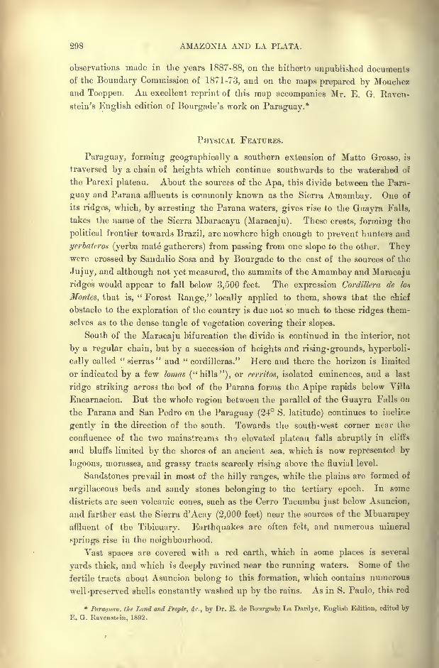
298 AMAZONIA AND LA PLATA.
observations made in the years 1887-88, on the hitherto unpublished documents
of the Boundary Commission of 1871-73, and on the maps prepared by Mouchez
and Toeppen. An excellent reprint of this map accompanies Mr. E. G. Raven-
stein's English edition of Bourgade's work on Paraguay.*
PHYSICAL FEATURES.
Paraguay, forming geographically a southern extension of Matto Grosso, is
traversed by a chain of heights which continue southwards to the watershed of
the Parexi plateau. About the sources of the Apa, this divide between the Para-
guay and Parana affluents is commonly known as the Sierra Amambay. One of
its ridges, which, by arresting the Parana waters, gives rise to the Guayra Falls,
takes the name of the Sierra Mbaracayu (Maracaju). These crests, forming the
political frontier towards Brazil, are nowhere high enough to prevent hunters and
yerbaterott (yerba mate gatherers) from passing from one slope to the other. Theywere crossed by Sandalio Sosa and by Bourgade to the east of the sources of the
Jujuy, and although not yet measured, the summits of the Amambay and Maracaju
ridges would appear to fall below 3,500 feet. The expression Cordillera de Ion
Monies, that is," Forest Range," locally applied to them, shows that the chief
obstacle to the exploration of the country is due not so much to these ridges them-
selves as to the dense tangle of vegetation covering their slopes.
South of the Maracaju bifurcation the divide is continued in the interior, not
by a regular chain, but by a succession of heights and rising-grounds, hyperboli-
cully called " sierras"and " Cordilleras." Here and there the horizon is limited
or indicated by a few lornns ("hills"), or rerritos, isolated eminences, and a last
ridge striking across the bed of the Parana forms the Apipe rapids below Villa
Encarnacion. But the whole region between the parallel of the Guayra Falls on
the Parana and San Pedro on the Paraguay (24 S. latitude) continues to incline
gentty in the direction of the south. Towards the south-west corner near the
confluence of the two mainstreams tho elevated plateau falls abruptly in cliffs
and bluffs limited by the shores of an ancient sea, which is now represented by
lagoons, morasses, and grassy tracts scarcely rising above the fluvial level.
Sandstones prevail in most of the hilly ranges, while the plains are formed of
argillaceous beds and sandy stones belonging to the tertiary epoch. In some
districts are seen volcanic cones, such as the Cerro Tacumbu just below Asuncion,
and farther east the Sierra d'Acay (2,000 feet) near the sources of the Mbuarapeyaffluent of the Tibicuary. Earthquakes are often felt, and numerous mineral
springs rise in the neighbourhood.
Vast spaces are covered with a red earth, which in some places is several
yards thick, and which is deeply ravined near the running waters. Some of the
fertile tracts about Asuncion belong to this formation, which contains numerous
well-preserved shells constantly washed up by the rains. As in S. Paulo, this red
*Paragtmv. the Land and People, 4r., by Dr. E. de Bourgade La Dardye, English Edition, edited by
E. G. Ravenstein, 1892.
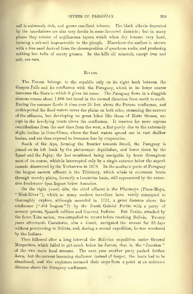
RIVERS OF PARAGUAY. 299
soil is extremely rich, and grows excellent tobacco. The black alluvia deposited
by the inundations are also very fertile in some favoured districts;but in many
places they consist of argillaceous layers, which when dry become very hard,
forming a sub-soil impenetrable to the plough. Elsewhere the surface is strewn
with a fine sand derived from the decomposition of quartzose rocks, and producing
nothing but tufts of scanty grasses. In the hills all minerals, except iron and
salt, are rare.
RIVERS.
The Parana belongs to the republic only on its right bank between the
Guayra Falls and its confluence with the Paraguay, which in its low.er course
traverses the State to which it gives its name. The Paraguay flows in a sluggish
sinuous stream about 1,000 feet broad in the normal direction from north to south.
During the summer floods it rises over 20 feet above the Parana confluence, and
at this period the flood waters cover the plains on both sides, stemming the current
of the affluents, but developing no great lakes like those of Matto Grosso, ex-
cept in the low-lying tracts above the confluence. It receives far more copious
contributions from the east than from the west, a fact partly due to the extremely
slight incline in Gran Chaco, where the flood waters spread out in vast shallow
basins, and are thus exposed to immense loss by evaporation.
South of the Apa, forming the frontier towards Brazil, the Paraguay is
joined on its left bank by the picturesque Aquidaban, and lower down by the
Ipane and the Jujuy, the last mentioned being navigable by boats throughout
most of its course, which is interrupted only by a single cataract below the superb
cascade discovered by the Yerbateros in 18T9. In the southern parts of Paraguaythe largest eastern affluent is the Tibicuary, which winds in enormous bends
through marshy plains, formerly a lacustrine basin, still represented by the exten-
sive freshwater Ipoa lagoon below Asuncion.
On the right (west) side, the chief affluent is the Pilcomayo (Piscu-Mayu,
"Bird-River"), which so many modern travellers have vainly attempted to
thoroughly explore, although ascended in 1721, a great distance above the
confluence ("^64 leagues"?) by the Jesuit Gabriel Patifio with a party of
seventy priests, Spanish soldiers and Guarani Indians. But Patifio, attacked bythe fierce Toba nation, was compelled to return before reaching Bolivia. Twenty
years afterwards Castanares, also a Jesuit, navigated the stream for. 83 dayswithout penetrating to Bolivia, and, during a second expedition, he was murdered
by the Indians.
Then followed after a long interval the Bolivian expedition under General
Margarines, which failed to get much below las Juntas, that is, the "Junction "
of the two main head streams. The next year another party pushed farther
down, but the current becoming shallower instead of deeper, the boats had to be
abandoned, and the explorers retraced their steps from a point at an unknown
distance above the Paraguay confluence.
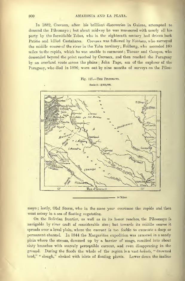
300 AMAZONIA AND LA PLATA.
In 1882, Crevaux, after his brilliant discoveries in Guiana, attempted to
descend the Pilcomayo ;but about midway he was massacred with nearly all his
party by the formidable Tobas, who in the eighteenth century had driven back
Patino and killed Castanares. Crevaux was followed by Fontana, who surveyed
the middle course of the river in the Toba territory; Feilberg, who ascended 160
miles to the rapids, which he was unable to surmount;Thouar and Campos, who
descended beyond the point reached by Crevaux, and then reached the Paraguay
by an overland route across the plains ;John Page, son of the explorer of the
Paraguay, who died in 1890, worn out by nine months of surveys on the Pilco-
Fig. 127. THE PILCOMAYO.
, Scale 1 : 4,000,000.
94 Miles.
mayo ; lastly, Olaf Storm, who in the same year overcame the rapids and then
went astray in a sea of floating vegetation.
On the Bolivian frontier, as well as in its lower reaches, the Pilcomayo is
navigable by river craft of considerable size;but towards its middle course it
spreads over a level plain, where the current is too feeble to excavate a deep or
permanent channel. In 1844 the Margarines expedition was arrested in a sandy
plain where the stream, dammed up by a barrier of snags, ramified into about
sixty branches with scarcely perceptible current, and even disappearing in the
ground. During the floods the whole of the region is a vast banado," drowned
land,""slough," choked with islets of floating plants. Lower down the incline
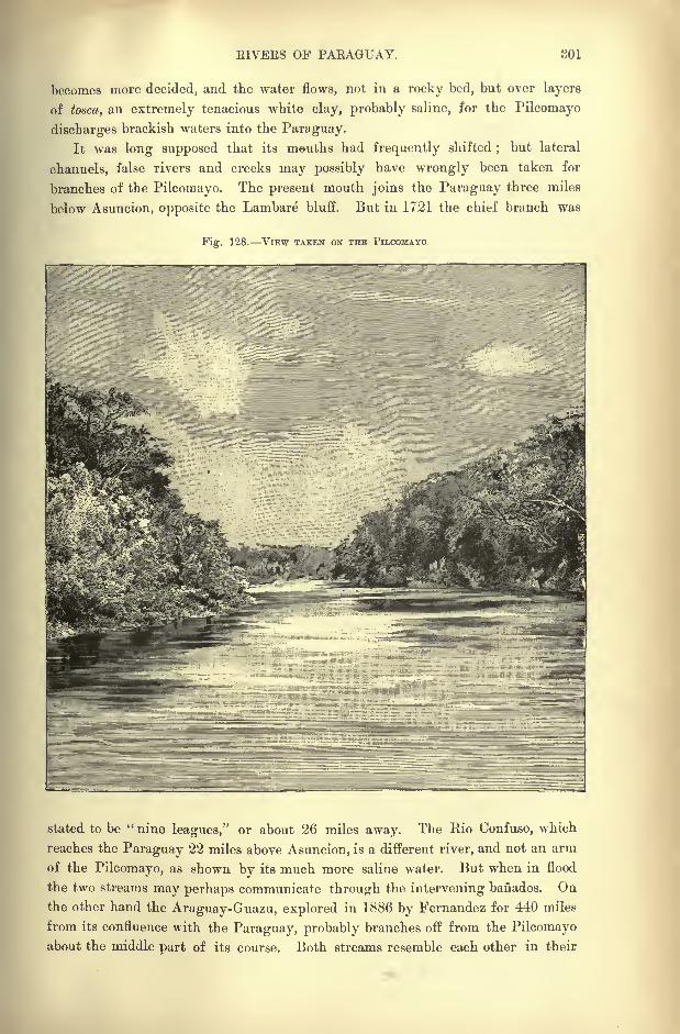
EIVEES OF PARAGUAY. 301
becomes more decided, and the water flows, not in a rocky bed, but over layers
of tosca, an extremely tenacious white clay, probably saline, for the Pilcomayo
discharges brackish waters into the Paraguay.
It was long supposed that its mouths had frequently shifted;
but lateral
channels, false rivers and creeks may possibly have wrongly been taken for
branches of the Pilcomayo. The present mouth joins the Paraguay three miles
below Asuncion, opposite the Lambare bluff. But in 1721 the chief branch was
Fig. 128. VIEW TAKEN ON THE TILCOMAYO.
stated to be "nine leagues," or about 26 miles away. The Eio Oonfuso, which
reaches the Paraguay 22 miles above Asuncion, is a different river, and not an arm
of the Pilcomayo, as shown by its much more saline water. But when in flood
the two streams may perhaps comnmnicate through the intervening banados. Onthe other hand the Araguay-Guazu, explored in 1886 by Fernandez for 440 miles
from its confluence with the Paraguay, probably branches off from the Pilcomayoabout the middle part of its course. Both streams resemble each other in their
302 AMAZONIA AND LA PLATA.
general aspect, temperature and slight degree of salinity, and the term Araguay
(Araaquay) has been applied by the natives to the Pilcomayo properly so called.
It is now generally admitted that thePilcomayo is not in its present condition navi-
gable, and that it is consequently useless as a commercial highway between Bolivia
and Paraguay. But some engineers have suggested that it might be made avail-
able by canalisation. Such an idea is pronounced visionary by Bourgade, who
poinrs out that it would involve an outlay only to be incurred in densely peopled
regions, or on great international highways such as the Suez Canal. The cost
would be enormous, without any prospect of adequate returns on the outlay. The
population is too scanty in both regions to hope for any great development of
traffic;nor are the surrounding districts suitable for settlement, as they consist
for the most part of saline sandy wastes and marshy clays, unfit either for tillage,
stockbreeding, or the permanent residence of the white race.
In its lower course below the Tibicuary, the Paraguay is joined on its right
bank by the Argentine Rio'Bermejo, whose red current flows a long way side byside without mingling with the whitish waters of the main stream. Beyondthe confluence the Paraguay develops two great bends, one of which washes cliffs
20 feet high, where till recently stood the formidable Paraguayan stronghold
of Humaita. A little farther on it joins the Parana through the Tres Bocax,
three shifting channels of unequal volume. The tract, over 125 miles wide,
which stretched along both sides of the Parana about the confluence, and which
is still studded with shallow marsh waters, was certainly at one time the bed of
an inland sea, where the two great rivers converged.
This basin had a double discharge through the Lower Parana and the
Uruguay southwards to the Plate estuary. After the disappearance of the in-
land sea, the rivers long continued to wander over the plains in search of a decided
channel. Even still certain marshy tracts in the -lower part of the Paraguayan
Mesopotamia have the meindering aspect of rivers that have overflowed their
banks.r
CLIMATE.
The almost uninhabited northern part of Paraguay is traversed by the tropic
of Capricorn, so that the more settled southern districts lie entirely in the tem-
perate zone with its alternating seasons, as in West Europe. Nevertheless, the
natives scarcely recognise any contrasts except those of winter and summer. The
transition is sudden, and the spring season is all the less noticed that most of the
trees preserve their foliage throughout the winter. Drought far more than cold
causes them to shed their leaves, and oranges, the characteristic fruit of the Para-
guay gardens, ripen in winter.
The temperature ranges from torrid heats to the freezing point, and the grass
sparkles with hoar frost, especially in the southern savannas exposed to intense
nocturnal radiation. But these frosts do little harm except to the sugar-canes,
whose tissues are disturbed by the sudden thaw at sunrise.

CLIMATE AND FLORA OF PARAGUAY. 808
Like the temperature, the winds, which generally follow the course of the
river either from north to south, or from south to north, are also subject to abrupt
changes, which are much felt, especially by immigrants. The most dominant
wind is a kind of sirocco from Matto Grosso, which in summer makes the atmo-
sphere almost stifling, even at night. On the other hand the southern wind, at
times confounded with the pampero, causes lung complaints, arrests the vege-
tation, and occasionally even destroys the crops. The pleasant easterly breezes,
which temper both the hot and cold weather, are unfortunately of rare occurrence.
The rains, far more copious in the east than on the western plains, full usually
at the equinoxes, and are frequently accompanied by thunderstorms and gales,
called -ventarrones. On the whole the country suffers more from drought than
from excessive moisture.*
Dr. Bourgade, who made a special study of the climatic conditions, considers
Paraguay to be a perfectly salubrious region, and well suited for European settle-
ment. A perpetual spring prevails for nine months in the year, and although the
other three months are undeniably hot, the heat is less scorching than it is in
Matto Grosso, Venezuela, and many other parts of South America. Even in the
hot season scarcely a week passes without heavy rains, which have the effect of
refreshing the atmosphere and lowering the temperature.
Except small-pox, on the decrease since the introduction of vaccination, there
are no epidemics, and very little malaria beyond the thinly peopled eastern dis-
tricts, which are subject to an intermittent fever locally called chucho. Endemics
also are rare, but rheumatic affections, anaemia, and other disorders of the blood, due
to defective sanitary arrangements, are common enough. In a word, this authority
holds that "Paraguay offers a promising field for immigration, the climate being
both temperate and healthy, a combination that is not always found." t
FLORA FAUNA.
Paraguay belongs rather to the Brazilian than to the Argentine botanical
zone, and its rivers are bordered by leafy forests resembling the mattas of Brazil.
The trees, which present a great variety of forms, have for the most part an
extremely close texture;hence they do not naturally float, and to form rafts
they have to be made buoyant by means of reeds and wood with thick sap. Theyare also hard to burn, but yield an excellent charcoal. In an industrial region
they would supply admirable building material, cabinet and dyewoods. The
caraguata, a species of bromeliacea, yields a far finer and stronger thread than
that of hemp. The caranday and other palms intermingle with the araucaria,
*Meteorological conditions of Asuncion :
Temperature.Lat. Altitude. ^ -
-__ Eainy Days. Rainfall.
Min. Mean. Max2-i 16' 330 feet 14 Fahr. 76 101 79 66 inches
T Op. cit., p. 73.
804 AMAZONIA AND LA PLATA.
which in some districts is an exotic introduced by the Jesuits hence its name,
arbof de las Misiones," Mission tree."
To the arborescent flora of spontaneous growth the people are indebted for
the staple of their export trade, yerba mate. Besides the forests, which cover
the greater part of the region east of the Paraguay, stretches of savannas occur
Fig. 129. FOREST AND CAMPOS REGIONS.
Scale 1 : 7,500,000.
27 27'
WesioF G-reenwich 54
186 Miles.
here and there, nearly all occupied by waving seas of the macega grass, which
grows to the height of a, man. The hard stalk and sharp blades of this plant
make travelling extremely difficult, and even dangerous.
Like the flora, the fauna belongs to the Brazilian zone. There are three
species of monkeys, blood-sucking vampires, jaguars, pumas, tapirs, besides
FAUNA OF PAEAGUAY. 805
the capyvara, boa, crocodile, termites, ants, and their enemy, the tumanoir.
The iiandu ostrich frequents the campos, though in far fewer numbers than in
Argentina. For certain species the Paraguay river forms a divide, and the faunas
on either side present a great contrast, especially since the left bank has been
settled by the white colonists, who seldom venture to enter the Chaco region on
the opposite side. According to Garcilaso de la Vega, Chaco means "hunting-
ground," and these plains are still roamed by multitudes of animals pursued bythe wild Indians.
Of the carnivora by far the most formidable is the jaguar, which is said to be
strong enough to carry off an ox or a horse. It avoids the haunts of men, and,
despite the statements of some travellers to the contrary, will scarcely ever attack
human beings."Many a time," writes Bourgade,
" I and my companions met
one in the underwood, and it never failed to give a savage growl and to bound
rapidly away ;and often, as a group of them have collected round my encamp-
ment, I do not think they have ever approached within twenty yards of it in
fact, we became so accustomed to them that, when we were tired, we would let our
fires go out, and ourselves fall off to sleep without the precaution of providing a
sentinel. Ever and again we might be aroused by the cracking noise of a branch
giving way under the weight of the brute, and on looking out we could see its
eyes flashing in the darkness ;but there was no fear of an attack." *
Another less known beast of prey is the aguara-guazu (Canis Azarce), a species
of wild dog sometimes over 30 inches long, with tawny hair and a black stripe
down the back, very long legs, pointed nose, long bushy tail like that of the fox.
It haunts swampy districts and hunts at night, making a peculiar hoarse bark
which can be heard a great distance off. The natives assert that it will not
hesitate to attack the jaguar, often with success.
Game still abounds almost everywhere, and according to Bourgade it would
be scarcely possible to find another region where the sportsman could find more
scope for his pursuits, so great is the variety of large and small animals, such as
tapirs, crocodiles, peccaries, deer, antelopes, and many species of birds. " Could
Europeans only know what is offered them in Paraguay, they would not be longin resorting to it as eagerly as they now make their way to Scotland or the
Caucasus." t
INHABITANTS THE GUARANI.
In Paraguay the great bulk of the aborigines were of Guarani stock, and the
inhabitants of the towns and settled districts are still mainly Guarani half-breeds.
Even before the arrival of the Jesuits their civilisation must have given them a
certain ascendancy, for the Guarani language was sufficiently diffused to be
adopted as the lengua geral, or common speech amongst the heterogeneous popu-
lations between the Oyapok and Paraguay rivers. The "general language" had
*Paraguay, the Land and People, $c., p. 64.
t Ib. p. 68.
306 AMAZONIA AND LA PLATA.
its origin, not in the Jesuit establishment of Porto Seguro, as stated by Martins,
but in the native market-places, whence it spread from tribe to tribe.
In the eastern forests there still survive a few peaceful groups of Coaguas
(Coyagua) and other Indians, who keep uloof, although conscious of their kinship
with the other Guarani, whose religious ceremonies, bequeathed by the Jesuits, they
imitate in a rude way. To the same stock belong the Apitares (" Inland People")
a nation of potters and weavers, who occupy the territory between the sources of
the Jujuy and the Guayra Falls.
The Guarani are amongst those aborigines of America who approach nearest
to the Mongolia type. Nearly all of short stature, averaging about 4 feet 2 or
3 inches, stout and thick set, with broad chest and shoulders, and yellow-brown
complexion, they have a round face with low narrow brow, slightly oblique eyes
and coarse black hair.
On the Paraguay above Asuncion dwelt the Payaguas, a vigorous race of
fishers, taller than the Guarani, with narrower features and more delicate frames.
Most of them perished in the incessant wars with the Spaniards, and the few
survivors were removed to Asuncion, where, before the war, they still numbered
about 500 ;but nearly all fell in the various battles, and in 1878 only 17 remained
of the whole tribe. They were excellent craftsmen and even artists, designing
elegant arabesques and fictile vases, modelling in clay or carving in wood
statuettes with extremely life-like expression. The Payaguay language, which
differed fundamentally from the Guarani, was so difficult to pronounce, that no
Paraguayan could ever learn it. Certain words resembled deep sighs far more
than the sounds of articulate speech.
The Lenguas and the Mbayas, members of the Guaycuru family, have not
entireiv disappeared, a few still surviving in Chaco, opposite Villa Concepcion.
In the same district, but a little farther north, facing the Apa confluence, live
the Angai'tes, who still number about 1,500. They are a remnant of the warlike
tribes, who in the early days of the settlement surrounded and massacred Ayolas's
little armed band.
THE ABIPONS AXD TOBAS.
Few also survive of the famous Abipon nation, who down to the middle of
the eighteenth century still occupied a vast territory in the south of the present
Paraguay and beyond the Parana, as well as in Gran Chaco. Although never very
numerous, at no time mustering 1,000 fighting men, they were much dreaded by
the settlers, especially when they had learnt towards the middle of the seven-
teenth century to train and mount the horses introduced by the Spaniards into
the pampas region. In about fifty years the Abipons with their Mocovi allies
were stated to have captured about 100,000 horses from the whites. " The land
is ours," they said," and all that it produces belongs to us."
These terrible warriors had no chiefs, properly so called;the leader in their
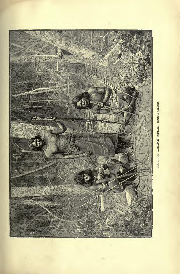
INHABITANTS OF PAEAGUAT. 307
predatory expeditions was an equal, whose strength, skill or energy inspired con-
hdence, but who after the battle enjoyed no further privilege. They hunted the
juguar and eat its flesh in order to assimilate its strength, and for analogous
reasons despised the flesh of peaceful animals. They were firm believers in metem-
psychosis, supposing that cowards and bad people passed into the bodies of
noxious reptiles, while they themselves became the associates of the teal who
hovered in flocks above the lagoons. Towards the middle of the eighteenth
century they became Christians, but since then they have ceased to exist as a
separate nation, being either merged in the surrounding populations, or swept
away by epidemics.
The Tobas, old allies and perhaps kinsmen of the Abipons, not only still
survive but even maintain their independence as a powerful and aggressive
nation. They have often attacked the Paraguayan and Argentine settlements in
Chaco, and the disastrous end of more than one expedition to the Pilcomayo
valley shows how dangerous it is to enter their territory. They roam both sides
of that river far to the north and south, and they have been met in the whole
region from the banks of the Paraguay westwards to the foot of the Andes.
They are a tall race, from 5 feet 6 inches to 6 feet high, with thick skin " like
an ox-hide," so that they can walk even on thorny ground without sandals.
From the marshy nature of the land they have acquired the curious habit of
always, even on dry ground, raising the foot at every step vertically to the
level of the knee. In the central regions they still insert wooden discs in the
ear-lobe, whence the term Oregudos and Orejones, "big-eared," applied to them
as well as to others in Amazonia by the Spaniards. The women tattoo them-
selves with straight and circular lines in blue and red, and apparently also
dye the hair, which passes from the normal black to a chestnut, and even a
yellow shade.
The Tobas cultivate no Lmd, lead the nomad life of hunters and fishers, are
much given to drunken orgies, and from childhood upwards are habituated to
scenes of bloodshed. Through filial pity the children often despatch their sick
parents, and after the battle the warriors bring the mangled remains of the slain
to their women, reserving the head and hair for themselves.
When a woman dies mother and infant are buried together. On reaching
the age of puberty, girls are secluded for a few days, and then entertained with
a great feast, accompanied by much singing, music and dancing. Amongst the
Tobas the marriage rite is extremely simple. The suitor accepted by the young
woman's father goes off to the hunt, kills some large game, and lays it at the
feet of his betrothed, as a proof of his strength, courage, and power to support
a wife and family. Married folks sleep with their feet turned to the east, in
order that the sun mav shine on their soles and teach them to walk in the
right path, for the day-god diffuses all virtue through his rays. The Tobas are
strict monogamists, the women being of an extremely jealous temperament and
admitting no partner in the domestic circle. At the least sign qf rivalry the
matter is settled by a duel, which often ends fatally. Stripped to the waist, the
808 AMAZONIA AND LA PLATA.
loins girdled with a jaguar skin, the two furies arm themselves with a sharp bone
or some other cutting implement, which they seek to plant in the breast or
body of their antagonist, the men assisting with imperturbable gravity at the
deadly combat.
Among these Toba Indians are many Hispano-American refugees, who have
made their escape from Paraguay, Corrientes, and Santiago. But they are not
easily detected, except by the hair on their face." Men who have but a little
white blood in their veins, and only a few points of the European type, become
still less distinguishable in the costume of Adam before the Fall and after years
of an Indian life. A youth, however, who had been stolen when a child, had
retained his natural light-brown hair, and his face left no room for doubt as to
his parentage. Another Christian was a chief. He was a certain Vincenzino,
formerly the manager of an estancia at Santiago, where he was well known.
He was a fine tall man, sunburnt, and with a short grizzled beard. He uttered
very few words, and affected to be unable to express himself in Castilian. This
was an artifice to avoid rousing the suspicion of the Indians, by whom Indianized
Christians are forbidden to speak in an enemy's language that is not understood
by themselves. Such Christians, therefore, remain mute and motionless as
statues.
" Fortune for a long time has favoured the Tobas, who occupy the best lands on
the banks of the Parana and Paraguay, being about sixty leagues, or, if measured
by the windings of the river, a hundred. By secret trading with Corrientes
and the Paraguayan Republic, they have provided themselves with firearms.
Moreover, being farthest from the continually advancing Christian frontier, they
receive a considerable contingent of the convicts, of whom I have already spoken.
In this way the Vilelas and the Chiulipos have become mixed with them, and the
case will be the same with the Mocovitos, who live in the south-west, along the
frontiers of Santa Fe and Santiago, and whose language is not dissimilar, manywords being identical."
But these Gran Chaco Indians are not men of many words, and Mr. Knight
witnessed a scene on the banks of the Paraguay, which was highly characteristic
of their taciturn disposition." We saw four Indians come stealthily down to the
bank, armed with long lances. Then, lying down among the reeds, they gazed
silently into the water till they saw some big fish pass by, when, with wonderful
skill, they speared them one after the other, and threw them on the bank. Next
they lit a fire, roasted the fish they had caught, and devoured them. This done,
they picked up their weapons, and crept back into the woods as noiselessly and
stealthily as they had come. The whole time some three hours that they
were on the river-bank, not one of these men spoke a word ; they gave the
necessary directions to each other by slight inclinations of the head only. As
soon as they had gone, the kites and vultures that had been waiting patiently
around came down and finished the remains of the fish."t
*Pelleschi, Eight Months on the Grjn C/iaco, p. 27.
t Cruise of the Falcon, II., p. 102.
THE PARAGUAY MISSIONS. 809
THE PARAGUAY MISSIONS.
In the reduction of the Paraguay and Chaco Indians the chief instruments
had been the Jesuits, who devoted themselves to this work for two centuries, in
the face of tremendous obstacles, which at last became insurmountable. Of these
difficulties the most formidable were not hunger, thirst, famine, epidemics, or
the savage aborigines, but their own kindred, the white settlers, soldiers, civilians,
rival religious and secular missionaries. They aimed at constituting theocratic
communities amongst the aborigines, who were regarded by the white adventurers
as mere game and legitimate prey, although to be sure, Pope Paul III. had, in
1537, officially declared that the Indians were " real human beings, capable of
understanding the Catholic faith and of receiving the sacraments."
Nevertheless, in most of the churches they were denied the communion on
the ground of inherent stupidity, ignorance and depravity. The kidnappers
organised themselves in bands to capture whole tribes, killing the aged and
infirm, and driving the able-bodied men before them at the point of the lance
like droves of cattle. Hence the Jesuits who grouped the natives in orderly
communities, were regarded as usurpers of the public property, and every effort
was made to deprive them of this human live-stock. They were also detested as
"aliens," a charge to which their very organisation exposed them, for their
country was the Catholic, that is, the " Universal"
church. Whatever their
accidental nationality, whether Spaniards or Portuguese, French or Italians,
Germans or Slavs, they recognised none of the political divisions introduced into
the New World;and to them it mattered little whether their Indian congrega-
tions were regarded as belonging to the " Most Christian King," or to" His
Most Faithful Majesty."
In many local insurrections they had also to suffer from the jealousy of other
religious orders, Dominicans, Franciscans, Mercenaries or " Brothers of Mercy,"and in the towns they were expelled from their churches, while their congrega-
tions were reduced to servitude. Then, after succeeding, in the teeth of these
persecutions, in founding their theocracy, their neophytes were reported to have
brought them great quantities of gold, and a yell of hatred was raised on all
sides against them. But the Jesuits had amassed no gold, and although they
possessed substantial wealth in their plantations and live-stock, it had no value
unless maintained by continuous labour.
After their arrival at Bahia in 1549 their missions were gradually spread
southwards to Porto Seguro, to Piratininga and S. Paulo. But the great field
of their operations lay farther inland, along both banks of the Upper Purana?
about the presumed frontiers of the Spanish and Portuguese domains. In this
secluded region they succeeded in civilising over 100,000 natives; but the kid-
nappers were still on their track, and in the three years, from 1628 to 1631, the
Paulistas, themselves nearly all Indians on the mother's side, were reported to
have captured 60,000 within the territory of the missions. Then the directors
of the Guayra reductions saw that they would have to migrate still to the west, in
54
810 AMAZONIA AND LA PLATA.
order to place more extensive woodlands and more numerous cataracts between
themselves and their relentless persecutors. But in the terrible exodus they lost
more than half of their devoted adherents by epidemics, disasters, and hardships
of all kinds.
Nevertheless, they succeeded in gaining a refuge in the unknown lands on the
banks of the Uruguay, and of the Lower Parana, remote from the Spanish and
Portuguese settlements. Here, and still farther west on the present Bolivian
plains, where dwelt the Mojos and the Chiquitos, the Fathers had at last the joy
Fig. 130. JESUIT MISSIONS.
Scale 1 : 13,000,000.
310 Miles.
of realising on earth that "Kingdom of God amongst Men," for which they had
struggled so hard and endured so much.
The term " reductions"given by them to their Indian stations explains the
object they had in view. They wished to " reduce"the natives, to withdraw them
from the influence of free nature, to regulate their lives by rites and ordinances-
To secure their goodwill they shrank from no expedients, not even from the
allurements of a generous diet. They were wont to say that the preachings of
St. Paul reached the ear of the heathen through the mouth. The natives were
beguiled also by music and the pomp of ceremony. When descending the streams
THE PARAGUAY MISSIONS. 811
in their canoes, or forcing a path through the forest, the Fathers intoned hymns,while the savages emerged from the recesses to listen to their homilies. Duringthe processions the ground was strewn with bright flowers and sweet- smelling
herbs, and birds held by a string fluttered around the triumphal arches. As the
Blessed Sacrament was borne aloft, the natives presented the produce of the chase
and the fruits of their gardens ;musicians accompanied the cortege, and the day
concluded with a display of fireworks.
Such appeals to the untutored savage mind were irresistible, and even the
most refractory were at last drawn within the fold. Between 1610 and 1768
over 700,000 were baptized, and in 1730 the reductions, some 30 in number, had
a collective population of more than 133,000 converts. These statistics were
carefully kept, for the missionaries had to pay the king a dollar a head, receiving
in return a free hand in their government of the congregations.
Once bent to the yoke, the catechumens strictly followed the prescribed rules.
At dawn the children trooped to the church for the exercises of song and prayer,
while the whole community assisted at mass. In the evening the children
returned for instruction in the catechism, after which all took part in prayer, the
day ending with the recitation of the rosary. On Sunday the ceremonies
were redoubled, and those .of the faithful gifted with a good memory were
expected to repeat the sermons by heart. All work was strictly regulated ;
each family received its plot of land, with the necessary allowance of seed-
corn, and oxen to plough the field. But it was at the same time responsible
for the good condition of the animals and of the crops, of which it enjoyed onlythe usufruct.
The part of the territory cultivated in common was the Tiipambac,"Property
of God," the harvest being stored against bad years, and for the support of the
feeble, orphans, and artisans. The excess was transported to Buenos Ayres
by the rivers, and exchanged for sumptuous objects introduced from Europe for
the adornment of the churches. Round the central square were disposed the
workshops of the craftsmen carpenters, masons, locksmiths, weavers, metal-
lurgists, flute and fiddle-makers, sculptors, architects, gilders, carvers, and even
painters who were taught to look on their work as an act of faith, and to make
the embellishment of the churches a labour of love. All shortcomings noticed
by the overseers, reported by the faithful, revealed in the confessional or by
public avowal, involved corporal chastisement. The penitent had to appear in
church before the congregation, and submit to the stripes, while thanking Godand the good fathers for the correction.
In this " model republic," sustained by a hateful system of espionage pervadingall classes, from the highest to the lowest, the rule of the priests was absolute.
Yet they hesitated to place arms in the hands of their subjects, even to defend
the missions. Nevertheless, they were several times driven by urgent necessity
to take action against the Paulistas. Between 1638 and 1661 they gained four
victories over the aggressors ;but after each triumph they disarmed the people
through fear of the influence acquired by the chiefs, whom success had made
312 AMAZONIA AND LA PLATA.
popular. When the order was suppressed, the Jesuits made no resistance, and
their expulsion was unattended by bloodshed.
The reductions possessing no initiative or any vital force, these emasculated
communities melted away as soon as the controlling power was removed. Efforts
were made to keep them together in some places by other missionaries, in others
by the civil authorities;
but all in vain, and in 1801 not more than 14,000
Indians remained in the territories of the missions. Most of the congregations
had dispersed among the surrounding forests, while bands of brigands from
Uruguay invaded the villages, despoiled the churches, and carried off the cattle.
Then white traders and settlers were introduced, and in 1814 about 1,000
strangers from Argentina and Uruguay had merged in a general population with
the 8,000 Indians still remaining in the district. Lastly, in 1848, a presidential
edict declared the surrounding aborigines of the reductions "citizens of the
Republic." At present all traces have disappeared of the organisation established
by the Jesuits, and the still existing stations differ in no respects from the other
Paraguayan villages.
THE PARAGUAYANS.
The inhabitants of the towns have been strongly Hispanified, and can scarcely
be distinguished from other mixed descendants of Spaniards and Guarani natives.
They speak both languages, and some of the periodicals contain articles and poemsin the lengua geral.
From the very first the Basque people seem to have taken a large share
in the colonisation of Paraguay. Irala, who was governor of the country both
before and after the rule of Alvarez Nunez, belonged to the Euskarian nationality.
Palgrave assigns such a large proportion to the Basque element, that he goes so
far as to call the Paraguay people"Vasco-Guarani," instead of "
Hispano-
Guarani." According to this writer the persons with light hair frequently met
in Paraguay are descendants of those light-haired Basques, who are still constantly
met in the Western Pyrenees.*
On the other hand, Martin de Moussy believes that the tall and fair-
complexioned Hispano-G uarani, who conetitute a considerable proportion of the
Paraguayan population, recall the type of the German soldiers who entered the
country with Schmidel at the time of the Conquest. In support of this view it
is stated that the blonde Paraguay women have a Teutonic physiognomy.Their hair is described as really light, like that of the North European women,not of that Spanish flame colour, which approaches a red or ruddy hue, and which
is met in all the other Argentine regions.
But, whatever their origin, the Paraguayans are distinguished above all other
civilised peoples for their extremely docile disposition. Brutal orders issued bybrutal taskmasters are meekly obeyed without a word of protest, and, after sub-
*Ulysses, or Scenes and Studies in Many Lands.
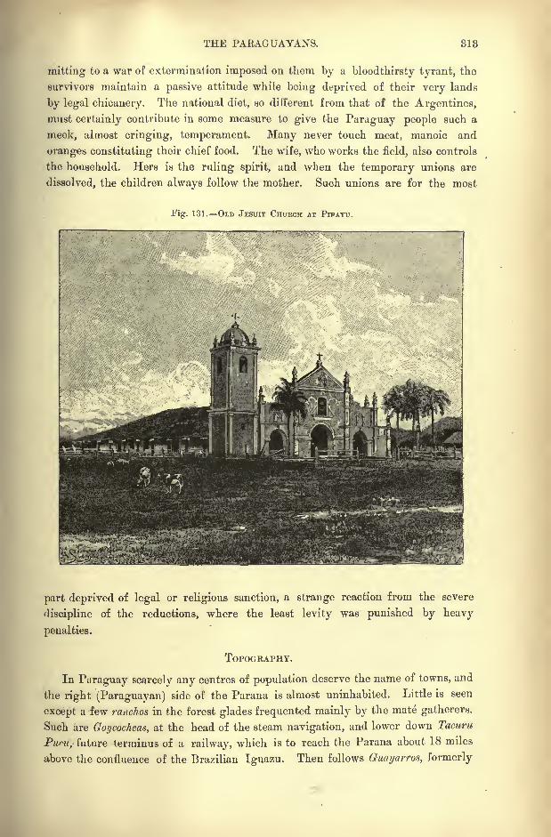
THE PARAGUAYANS. 813
mitting to a war of extermination imposed on them by a bloodthirsty tyrant, the
survivors maintain a passive attitude while being deprived of their very lands
by legal chicanery. The national diet, so different from that of the Argentines,
must certainly contribute in some measure to give the Paraguay people such a
meek, almost cringing, temperament. Many never touch meat, manoic and
oranges constituting their chief food. The wife, who works the field, also controls
the household. Hers is the ruling spirit, and when the temporary unions are
dissolved, the children always follow the mother. Such unions are for the most
Fig. 131. OLD JESUIT CHURCH AT PIWAYU.
part deprived of legal or religious sanction, a strange reaction from the severe
discipline of the reductions, where the least levity was punished by heavy
penalties.
TOPOGRAPHY.
In Paraguay scarcely any centres of population deserve the name of towns, and
the right (Paraguayan) side of the Parana is almost uninhabited. Little is seen
except a few ranches in the forest glades frequented mainly by the mate gatherers.
Such are Goycocheas, at the head of the steam navigation, and lower down Tacuru
Pur.u, future terminus of a railway, which is to reach the Parana about 18 miles
above the confluence of the Brazilian Iguazu. Then follows Guayarros, formerly
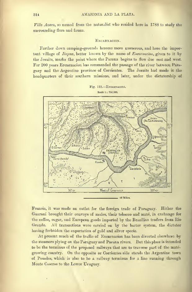
814 AMAZONIA AND LA PLATA.
Villa Azara, so named from the naturalist who resided here in 1788 to study the
surrounding flora and fauna.
ENCARNACION.
Farther down camping-grounds become more numerous, and here the impor-
tant village of Itapua, better known by the name of Encarnacion, given to it bythe Jesuits, marks the point where the Parana begins to flow due east and west.
For 200 years Encarnacion has commanded the passage of the river between Para-
guay and the Argentine province of Corrientes. The Jesuits had made it the
headquarters of their southern missions, and later, under the dictatorship of
Fig. 132. ENCAENACION.
Scale 1 : 700,000.
56,o West or Greenwich
12 Miles.
Francia, it was made an outlet for the foreign trade of Paraguay. Hither the
Guarani brought their convoys of mules, their tobacco and mate, in exchange for
the coffee, sugar, and European goods imported by the Brazilian traders from Rio
Grande. All transactions were carried on by the barter system, the dictator
having forbidden the exportation of gold and silver specie.
At present much of the traffic of Encarnacion has been diverted elsewhere bythe steamers plying on the Paraguay and Parana rivers. But this place is intended
to be the terminus of the proposed railways that are to traverse part of the mate-
growing country. On the opposite or Corrientes side stands the Argentine town
of Posadas, which is also to be a railway terminus for a line running through
Monte Caseros to the Lower Uruguay.
TOPOGRAPHY OF PARAGUAY. 316
Encarnacion lies beyond the zone where mate" flourishes;but the old missions
situated a little farther north in the hilly districts watered by several small
affluents of the Parana, still possess some extensive yerbales,"yerba mate thickets."
The native populations, which formerly constituted the congregations of the mis-
sionaries, have remained in the country, although in greatly reduced numbers.
Here are also the old stations Trinidad, Jesus, Sain Pedro, Santiago, Santa Row,Santa Maria, San If/nacio Guazu consisting of low huts above which rise the
remains of solid structures and heavy churches.
SANTA ROSA CONCEPCION.
Santa Rosa, wealthiest of these missions, consecrated to the patron saint of
the Guarani, was annually visited by thousands of pilgrims, who never approachedher shrine empty-handed. Hence the church, which still exists, was extremelyrich in gold and silver objects ;
it was enclosed by a ditch to defend it from
marauders. Between Santa Maria and Santa Rosa the plantation of Cerrito
recalls the sojourn of Aime Bonpland, who was here interned for nine years bythe dictator, Francia.
Below Encarnacion follow San Juan, another old mission, and the villages of
Carmen and San Cosme just above the Apipe rapids. Beyond this point the navi-
gation is open all the way to the Paraguay confluence above Corrientes.
Conception, below the ruins of San Salvador on the Paraguay, was formerly one
of the great depots of the mate trade. Lower down follows the pleasant little
town of San Pedro, on the Rio Jujuy, a short distance above its junction with the
main stream. Farther south Villa Hayes, so named in honour of the President of
the United States, who in 1879 awarded North Chaco to Paraguay, stands on the
right bank at the confluence of the Rio Confuso.
ASUNCION.
Asuncion, capital of the Republic, is finely situated on a terrace rising some
50 feet above the left bank of the Paraguay a short distance below Villa Hayes.Like nearly all American towns of Spanish origin, it has been laid out on the chess-
board plan, and its dusty streets are continued beyond the houses far into the
country. Although steadily recovering from the effects of the war, the thorough-
fares removed from the centre "are still grass-grown, and the palaces, which were
to make Asuncion the most sumptuous city in South America, were till recently
falling to ruins. Since their restoration they contribute to give the place a stately
aspect, at least by contrast with the towns of Matto Grosso. The arsenal, founded
before the war, contains dockvards where several steamers have been built.
As far as this point the Paraguay is accessible to large vessels from Monte
Video and Buenos Ayres ;but higher up it is navigable only by small craft.
Asuncion, which is traversed by several tramways, is little more than a trading
station, with no local industries beyond a little goldsmiths' work.
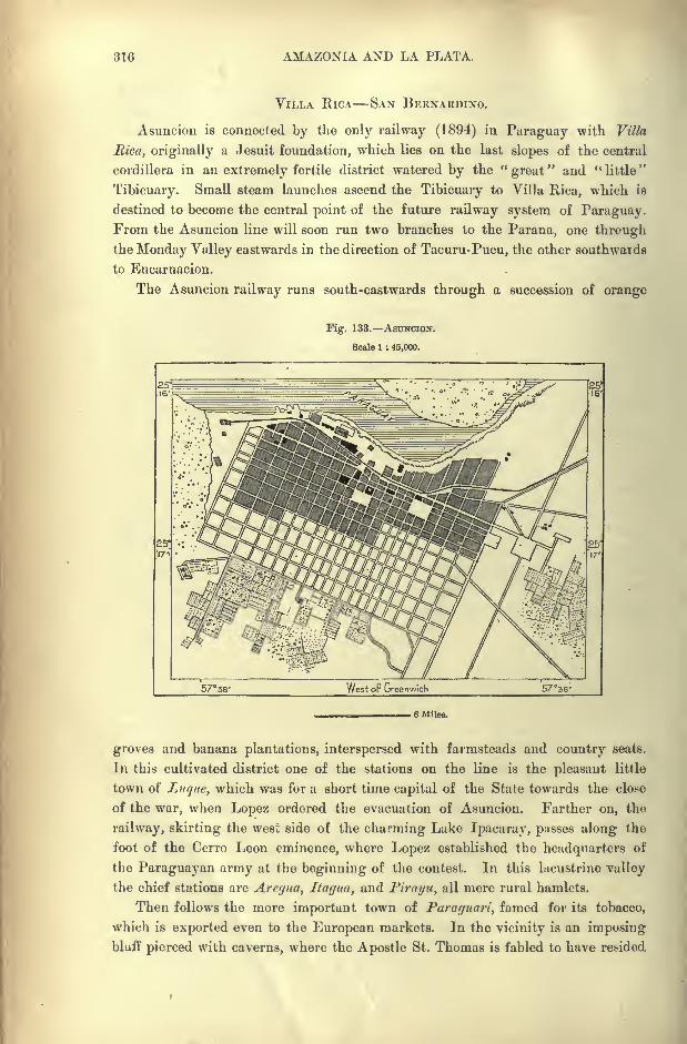
816 AMAZONIA AND LA PLATA.
VILLA RICA SAN BERNARDINO.
Asuncion is connected by the only railway (1894) in Paraguay with Villa
Rica, originally a Jesuit foundation, which lies on the last slopes of the central
cordillera in an extremely fertile district watered by the "great" and "little"
Tibicuary. Small steam launches ascend the Tibicuary to Villa Rica, which is
destined to become the central point of the future railway system of Paraguay.From the Asuncion line will soon run two branches to the Parana, one throughthe Monday Valley eastwards in the direction of Tacuru-Pucu, the other southwards
to Encarnacion.
The Asuncion railway runs south-eastwards through a succession of orange
Fig. 133. ASUNCION.
Scale 1 ; 45,000.
, 6 Miles.
groves and banana plantations, interspersed with farmsteads and country seats.
In this cultivated district one of the stations on the line is the pleasant little
town of Luque, which was for a short time capital of the State towards the close
of the war, when Lopez ordered the evacuation of Asuncion. Farther on, the
railway, skirting the west side of the charming Lake Ipacaray, passes along the
foot of the Cerro Leon eminence, where Lopez established the headquarters of
the Paraguayan army at the beginning of the contest. In this lacustrine valley
the chief stations are Areyua, Itagua, and Pirayu, all mere rural hamlets.
Then follows the more important town of Paruguari, famed for its tobacco,
which is exported even to the European markets. In the vicinity is an imposing
bluff pierced with caverns, where the Apostle St. Thomas is fabled to have resided
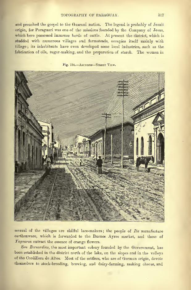
TOPOGRAPHY OF PAEAGUAY. 317
and preached the gospel to the Guarani nation. The legend is probably of Jesuit
origin, for Paraguari was one of the missions founded by the Company of Jesus,
which here possessed immense herds of cattle. At present the district, which is
studded with numerous villages and farmsteads, occupies itself mainly with
tillage ;its inhabitants have even developed some local industries, such as the
fabrication of oils, sugar-making, and the preparation of starch. The women in
Fig. 134. ASUNCION STREET VIEW.
several of the villages are skilful lace-makers; the people of Ita manufacture
earthenware, which is forwarded to the Buenos Ayres market, and those of
Yaguaron extract the essence of orange flowers.
San Bernardino, the most important colony founded by the Government, has
been established in the district north of the lake, on the slopes and in the valleysof the Cordillera de Altos. Most of the settlers, who are of German origin, devote
themselves to stock-breeding, brewing, and dairy-farming, making cheese, and
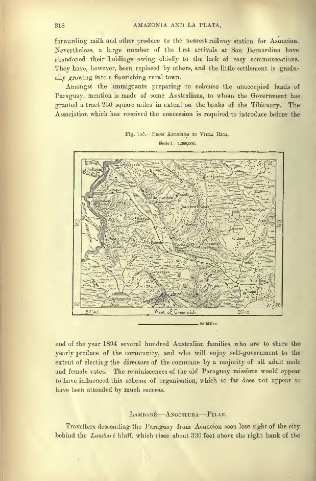
818 AMAZONIA AND LA PLATA.
forwarding milk and other produce to the nearest railway station for Asuncion.
Nevertheless, a large number of the first arrivals at San Bernardino have
abandoned their holdings owing chiefly to the lack of easy communications.
They have, however, been replaced by others, and the little settlement is gradu-
ally growing into a flourishing rural town.
Amongst the immigrants preparing to colonise the unoccupied lands of
Paraguay, mention is made of some Australians, to whom the Government has
granted a tract 230 square miles in extent on the banks of the Tibicuary. The
Association which has received the concession is required to introduce before the
Fig. Ibo. FBOM ASUNCION TO VILLA RICA.
Scale 1 : 1,250,000.
, 25 Miles.
end of the year 1894 several hundred Australian families, who are to share the
yearly produce of the community, and who will enjoy self-government to the
extent of electing the directors of the commune by a majority of all adult male
and female votes. The reminiscences of the old Paraguay missions would appear
to have influenced this scheme of organisation, which so far does not appear to
have been attended by much success.
LAMBA RE ANGOSTURA PILAR.
Travellers descending the Paraguay from Asuncion soon lose sight of the city
behind the Lambare bluff, which rises about 330 feet above the right bank of the

TOPOGRAPHY OF PARAGUAY. 819
river, and which is said to take its name from a native chief, who held out stoutly
against the Spanish invaders in 1528. According to the tradition, Sebastian
Cabot, who was in command, did not venture to advance beyond this point,
although he had repulsed the Indians. A few hills, which, like Lambare, contain
deposits of salt, follow along the left bank, enclosing the pleasant little riverside
port of Villda with its palm arid orange groves.
The heights terminate southwards in a headland, where the stream contracts,
at the famous Angostura"Narrows," to a breadth of not more than. 265 feet.
Fig. 136. SOUTH-WEST PABAGUAY.
Scale 1 : 2,400,000.
27
5840' West or Greenwich 56C40'
160 Miles.
Here also the Indians made a stand against the Spaniards, and three centuries
afterwards the Paraguayans attempted to arrest the advances of the allies by the
formidable lines erected at the same spot by the English engineer Thompson.But the Brazilian army, at the risk of being overtaken and drowned by a sudden
rise of the Paraguay, turned the position by passing westwards through the Chaco
solitudes, and reappearing on the banks of the river above the Narrows.
Below this defile almost the only places of note are the villages of Oliva
and Villa Franca on slight rising grounds above the Tibicuary confluence. Villa
del Pilar, usually called Nembucu, might seem to occupy an excellent position
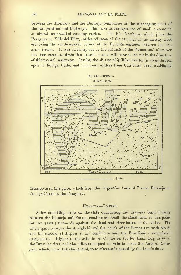
820 AMAZONIA AND LA PLATA.
between the Tibicuary and the Bermejo confluences at the converging point of
the two great natural highways. But such advantages are of small account in
an almost uninhabited swampy region. The Kio Nembucu, which joins the
Paraguay at Villa del Pilar, carries off some of the drainage of the marshy tract
occupying the south-western corner of the Republic enclosed between the two
main streams. It was evidently one of the old beds of the Parana, and whenever
the time comes to drain this district a canal will have to be cut in the direction
of this natural waterway. During the dictatorship Pilar was for a time thrown
open to foreign trade, and numerous settlers from Corrientes have established
Fig. 137. HUMAITA.
Scale 1 : 120,000.
g7<,. ;\^^=gp LjndrA
^
.
*'-
'. .'-
'
; '.._. -.
. ': ;
' '
'. .;
58*34' West oF Greenwich 58'28'
_';, Miles.
themselves in this place, which faces the Argentine town of Puerto Bermejo on
the right bank of the Paraguay.
HUMAITA ITAPIRU.
A few crumbling ruins on the cliffs dominating the Humaita bend midwaybetween the Bermejo and Parana confluences recall the stand made at this point
for two years (1866 68) against the land and river forces of the allies. The
whole space between the stronghold and the mouth of the Parana ran with blood,
and the capture of Itapiru at the confluence cost the Brazilians a sanguinary
engagement. Higher up the batteries of Cnrnzit on the left bank long arrested
the Brazilian fleet, and the allies attempted in vain to storm the forts of Curu-
paiti, which, when half-dismantled, were afterwards passed by the hostile fleet.
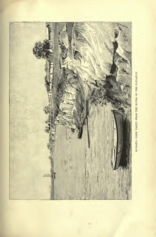
MATERIAL 'CONDITION OF PARAGUAY. 321
In the interior Tuyuti and Tuyitcue, guarding the passes of tne great estcro
Bcllaco morass, were also the scene of fierce combats, and after the struggle, an
invasion of cholera turned the whole region into a vast necropolis.
The fortress of Humaita itself was not actually taken by assault ;but the
summer floods having risen to an unwonted height, the strong iron cable barring
the passage was submerged to a depth of over 16 feet, and four of the seven
Brazilian ironclads took advantage of a foggy starless night to gain the upper
reaches. The defenders of Humaita, taken between two fires, on the one hand bythe warships, on the other by the troops lining a rampart of circumvallation
drawn from Itcipim on the Parana to Ttiyi on the Paraguay, a distance of 24
miles, had to evacuate the stronghold and fall back on other lines of defence
farther north.
A few military posts, erected on piles or on artificial mounds, formerly guarded
the confluence of the Parana and Paraguay ;but no town or village was ever
founded in this miry district. According to Felix de Azara the Paraguay
discharges at low water a volume of not more than 7,000 or 8,000 cubic feet per
second.
MATERIAL AXD SOCIAL CONDITION OF PARAGUAY.
The first census of Paraguay dates from the end of the eighteenth century,
when, according to Azara, the whole population of the province, including the
Indians, numbered 97,480. Between that time and the great war profound peace
prevailed, even during the political changes caused by the movement of indepen-
dence, and if a document issued by the dictator, Soluno Lopez, can be trusted,
the Paraguayans had increased to 1,337,439 in 1867. But the details were never
published, and many doubted the possibility of such an increase in the absence
of any great access of immigrants. Yet with fewer numbers it is difficult to
understand how the nation could have maintained such a stupendous struggle
for five years against her three powerful neighbours. From the first an active
force of 50,000 men was organised, besides a strong reserve and several thousands
engaged in the arsenals constructing floating batteries and steamers, in repair-
ing damages, casting guns, manufacturing small arms, munitions of war, and
uniforms, for Paraguay was completely isolated and could import no supplies
from abroad.
In 1887, eighteen years after the war, a fresh census was taken, showing a
population of onlv 239,774, according to which over a million, or four-fifths of
the whole nation, must have perished in the war. In 1890 the civilised
Paraguayans were estimated at 500,000, and the unreduced Indians of Chaco
between the Pilcomayo and the Paraguay, at 30,000. In recent years immi-
gration has contributed to the re-peopling of the land, and the incompletereturns for 1887 comprised nearly 8,000 strangers. Since then the yearly
arrivals have been ab ;ut a thousand, and in 1890 as many as 2,395, mostly from
Argentina.

822 AMAZONIA AND LA PLATA.
Thanks to the facilities of communication, the Argentine provinces naturally
supply the largest number of immigrants. But some Brazilians have also found
their way into the country, descending from the uplands by the Iguazu Valley.
Amongst the strangers are a few representatives of almost every country in the
New "World and Europe, more especially Italians. It is noteworthy that, accord-
ing to some partial returns, civil registrations, and baptismal entries, more females
are born than males. This phenomenon, which his been also observed in
Japan, is extremely rare in countries where accurate statistics are published.
Nevertheless, the fact had already been noted at the end of the eighteenth century
by Azara, who even determined the proportion of the sexes : fourteen females to
thirteen males. Most other travellers who have visited Paraguay have made
analogous observations, and De Bourgade, amongst others, refers to the baptismal
registers of Asuncion for 1887 as showing that the percentage was 47'6 for boys
and 52 '4 for girls." In the rural districts it appears that the disproportion is
larger, and that the entries for girls are 9-28 per cent above those for boys.
The disproportion is anomalous;
it stands out in contrast with the returns of the
Argentine Republic, which show the birth of more boys than girls."*
MATE CULTURE.
Industries of all kinds, including even agriculture, are still in a rudimentary
state, and at present the most profitable occupation is the collection of forest
products, such as lumber in Chaco, and yerba mate in the eastern wood-
lands. Paraguay is usually supposed to have a monopoly of mate (ilex paraguari-
ensis), although it also thrives in the Southern States of Brazil, where it even sup-
ports a considerable export trade. But that of Matto Grosso passes through
Paraguay, and is sold in the markets as Paraguayan in order to enhance its
value.
It was in the territory of the missions that the Jesuits became acquainted with
the use of this beverage, the taste for which, thanks to their reports, was intro-
duced into the southern part of the Continent. The caa of the Guarani, that is,
the "plant
"in a pre-eminent sense, has been translated by the Spanish yerba,
"herb," though it is not a herb, but a shrub, and even a tree, about the size of
the orange, but on the banks of the Ygatimi, a Parana affluent, growing to a height
of 25 or 26 feet with a girth of about 40 inches. Bonpland speaks of three varieties
in Paraguay, differing little from each other, and resembling the congonhas of the
Brazilian plateaux. Its range comprises the whole space stretching from the
south of Minas Geraes to the frontiers of Rio Grande do Sul, and from the Atlantic
to the Paraguay river. It is also said to have been met beyond Chaco in the
southern parts of Argentina, but the best quality is that of Paraguay, and especi-
ally that collected in the forests of the Rio Maracaju. Under the Jesuits each
mission had its cultivated ycrbal yielding the caa mini, superior in flavour to the
*Paraguay, p. 107.
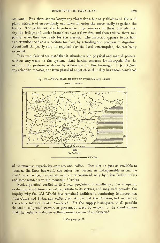
RESOURCES OF PARAGUAY. 323
caa nana. But there are no longer any plantations, but only thickets of the wild
plant, which is often recklessly cut down in order the more easily to gather the
leaves. The yerbatcros, who have to make long journeys to these grounds, first
dry the foliage and tender branchlets over a slow fire, and then reduce them to a
powder when they are ready for the market. The decoction appears to act both
as a stimulant and as a substitute for food, by retarding the progress of digestion.
About half the yearly crop is required for the local consumption, the rest being
exported.
It is even claimed for mate that it stimulates the physical and mental powers,
without any waste to the system. And herein, remarks De Bourgade, lies the
secret of the preference shown by Americans for this beverage. It is not from
any scientific theories, but from practical experience, that they have been convinced
Fig. 138. YEBBA MAT REGIONS OF PAEAGUAY AND BRAZIL.
Scale 1 : 14,000 ooo
28'
Yerba Mat(5.
810 Miles.
of its immense superiority over tea and coffee. Coca also is just as available to
them as the ilex; but while the latter has become as indispensable as manioc
itself, coca has been rejected, and is now consumed only by a few Indian tribes
and some residents in the mountain districts.
Such a practical verdict in its favour proclaims its excellency ;it is a popular,
as distinguished from a scientific, tribute to its virtues, and may well provoke the
inquiry why the Old World has remained indifferent, continuing to import tea
from China and India, and coffee from Arabia and the Colonies, but neglecting
the yerba mate of South America ? Yet the supply is adequate to all possible
demands; subject, however, at present, it must be owned, to the disadvantage
that the yerba is under no well-organised system of cultivation.*
*Paraguay, p. 21.
824 AMAZONIA AND LA PLATA.
THE OKANGE AND OTHER AGRICULTURAL RESOURCES.
Next in importance to mate is the apepu, or native orange, which De Bourgadebelieves to be indigenous, and which is distinguished by a peculiar acid taste. Like
mate it grows wild in the forests, while the different varieties of the European
orange introduced by the settlers also thrive well. Every village, almost every
house, has its orange grove, and during the floods millions of the golden fruit are
sometimes swept down with the stream. The oranges, exported almost exclusively
from the riverside ports of Asuncion and Villeta, represent but a fraction of
the annual yield, most of which polishes through lack of communications to
develop the industry.
Nevertheless the official returns show that over 50 million oranges annually
pass through the chief ports of Paraguay, and this would be nearly doubled if
those were included which are disposed of from the small villages and estancias,
where no control is exercised by the custom house officers. To reckon up the
number of oranges that are consumed in the country, so as to include those that
rot on the trees or that are devoured by birds, monkeys, and other animals, would
be about as difficult as to count the grains of sand on the sea -shore. Hardly a
Paraguayan could be found who does not consume from 20 to 30 oranges a day,
and yet there is no sign of diminution of the golden crop. What it would be if
cultivated systematically only imagination can conceive. But it is by no means
to the fruit that the produce of the orange must be limited. Every part of the
tree has its special use;the blossom can be distilled, essential oil may be extracted
from the leaf, and the trunk is not to be despised as wood.
The bitter orange, also, is by no means an unprofitable fruit. It is not edible,
but it yields several useful products. Besides the oxalic and citric acids, and
their compounds, which are extracted from its pulp, the peel furnishes several
medicinal syrups, and it is also a main ingredient in Curacao. The peel delivered
at the port of Asuncion fetches twenty-five shillings per 100 Ibs., and a brisk trade
has already been developed. If, instead of sending the bitter orange-peel to distant
markets, it should be desired to utilise it on the spot, there would be required
only a very simple apparatus to produce the compound known to druggists as the
"Essence of Portugal," which uniformly commands a high price. This has not
yet been made anywhere in Paraguay.*
Not more than 165,000 acres, or about the four-hundredth part of the whole
territory, has been brought under cultivation. The women, who do nearly all
the field-work, chiefly occupy themselves with maize, the consumption of manioc
diminishing according as the supply of bread stuffs increases. Wheat and rice are
also grown, but in insufficient quantities for the local demand. Although the vine
is seen trailing round the verandahs, there are no vineyards properly so-called.
Every peasant has his little sugar-cane brake, but utilises it only for the preparation
of a coarse unrefined sugar, or a very impure kind of rum. Both coffee and ground-
*Tarayuay, p. 227.
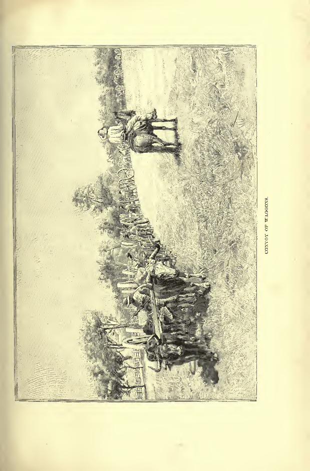
RESOURCES OP PARAGUAY. 325
nuts give good results, but capitalists have hitherto chiefly favoured tobacco,
which is generally regarded of analogous flavour, but superior in quality, to that
of Havana. Perhaps nowhere else are cigars so universally consumed, the pro-
portion being about 24 Ibs. per head of the population, or twelve times more than
in France. Possibly this enormous use of tobacco may partly explain the infinite
patience or apathy of the Guarani under all trials.
A decisive proof of the excellence of the Paraguay leaf is afforded by the
esteem in which it is held by the Argentine people, probably, next to the
Paraguayans themselves, the greatest smokers in the world. But hitherto no
justice has been done to the fine qualities of this tobacco by the growers and
cigar-manufacturers at Asuncion. Everything in the way of preparation, which
ought to be done with the most scrupulous care, such as the gathering and the
drying of the leaves, is got through in the most primitive and careless manner.
Great improvements must be introduced into these processes before there can be
any question of introducing the Paraguay tobacco into the European markets.
De Bourgade states positively that the quality of the natural leaf grown on the
red soil in many districts of Paraguay"equals that of the finest Havana
growths."
Of the live-stock, estimated at 2,000,000 before the war, no more than 15,000
head of cattle survived the universal waste of the land. The loss is now being
made good by importations from Corrientes and Matto Grosso;but the animals
run half-wild, and except in the German colony of San Bernardino, near Asun-
cion, no use is made of the milk, either directly or in the preparation of butter or
cheese. A few horses are also bred, but scarcely any sheep, goats, or pigs. Sheep
farming is said to be impossible owing to the presence of a poisonous plant called
mio-mio, while the mal de cadeira, an infectious disease, rapidly kills off horses,
mules, and asses in the Paraguayan part of Grun Chaco.
LAND TENURE.
Under the Jesuit system the land was held to belong to all, while its products
were partly distributed to the community. Later, the dictators, as representa-
tives of the State, became the true owners of the soil, although each peasant had
his cabin and holding. After the war, nearly the whole territory having been
depopulated, the land again reverted to the State, which put it up to sale at so
much the square league, according to its quality and proximity to the markets.
Argentine, English, and North American speculators immediately rushed in, and
hundreds of thousands of acres were bought up by syndicates to be re- sold at ten
and twenty times their value. One capitalist alone acquired some thousand square
miles, and in these transactions no regard was paid to little holdings that had
been cultivated for generations by Guarani families, which had never needed anytitle deeds to protect their rights. In a few years the vast solitudes were
assigned to absentee proprietors, and henceforth no Paraguayan peasant could hoe
55
326 AMAZONIA AND LA PLATA.
a yard of his native land without paying a rent to New York, London, or
Amsterdam bankers.
INDUSTRIES COMMUNICATIONS.
Although there a e no local industries beyond a few distilleries, brick and
soap works and flour mills, the Guarani are excellent craftsmen, and under the
Jesuits displayed great skill in many trades. The women still weave all kinds of
textiles, amongst others the nandnti,"spiders' webs," of extremely delicate texture.
Before Argentina had begun its railway system, Paraguay already possessed
a line running from Asuncion to Paraguari, since extended to Villa Rica, and the
country was also traversed by roads accessible to wheeled traffic. One of these
roads skirted the left bank of the Paraguay ;another reached the Parana at
Encarnacion, while others radiated from Villa Rica. After the war all these
roads disappeared beneath the swamps and quagmires ;but they have since been
repaired and other tracks have been opened between the Yerbales and the river-
side ports. Small steamers ply on some of the affluents, while large vessels
ascend the Parana from Buenos Ayres to Encarnacion. The traffic is still more
active on the Paraguay, nearly the whole trade of the Republic being centred in
Asuncion.
The telegraphic and postal services have been greatly developed, especially
since Paraguay has joined the Postal Union. The schools have also been re-opened,
and in 1891 nearly 20,000 children were receiving an elementary education. The
country is thus gradually recovering from the drastic " reforms" which closed
the churches, suppressed the marriage rites and legal unions, and swept away all
public institutions. Before the period of independence education was entirely
controlled by the priests, and in those days most of the children, if unable to read,
could at least say their prayers. They also delighted in singing the church
hymns, for the Guarani people have a distinct talent for music. But most of the
ecclesiastics having been deposed or banished by the dictator Francia, the system
of public instruction was greatly modified, and transformed to an almost military
education. In all the villages the children were assembled by the beat of the
drum, and under pain of reprimand or punishment the local magistrate was bound
to see that all the boys followed the prescribed course of instruction. Thus,
before the outbreak of the war, nearly all Paraguayans had learned to read and
write. But it was all done under compulsion, for they took no pleasure, as a rule,
in these accomplishments.
Printing presses were also rare, although some had already been introduced by
the Jesuits. But after their time no printing office was opened till the year 1844.
The head of the Administration issued his orders verbally, well knowing that they
would be implicitly obeyed. Later, when the official journal began to appear,
the representatives of authority assembled the inhabitants of all the villages, and
solemnly read out the decrees of the Government, which were listened to with
religious silence.

ADMIN1STBATION OF PARAGUAY. 827
GOVERNMENT.
The present Constitution, dating from the close of the war, has been modelled
on that of the neighbouring States, and like them, Paraguay possesses the legis-
lative, executive, and judiciary powers. The communal group consists of the
partidos, administrative and judiciary units connected directly with the central
power by elected magistrates. Foreigners have the right to vote at the muni-
cipal elections, and are even themselves eligible. A jefe politico represents the
executive in each commune, to which the Minister of Justice appoints a stipendiary
magistrate.
Two Chambers, directly elected by universal suffrage, discuss all questions
except the Budget, which is reserved absolutely to the lower House. The Presi-
dent, elected like the deputies for four years, controls the executive, and chooses
five ministers responsible to the Chambers. Catholicism remains as formerly the
State religion, but liberty of worship is recognised. The free navigation of the
rivers, one of the main causes of the war, was a necessary result of the triumph of
the allies. Henceforth the Paraguay and the Parana are open to the vessels of
Brazil and the Argentine Republic. Foreigners also are allowed free access to
the State from all points of the frontier, without being furnished with passports, a
necessary condition under the old exclusive system.
The country has not recovered its financial equilibrium upset by the war, and
the annual Budget continues to show a heavy deficit, nearly 105,000 in 1891. In
1892 the external debt, including the consolidated English debt, stood at about
5,000,000, and in that year the Government failed to pay the interest on the
English debt, which amounted to over 830,000. But the financial position is
likely to improve with the development of trade, about five-sixths of the revenue
being derived from the Customs.
It may be mentioned that after the war, when the State was hopelessly
bankrupt, without resources or credit, England was the only country that could
be induced to come to the aid of Paraguay. The London capitalists twice made
advances amounting collectively to a sum of 1,438,500 ;but through one of
those financial mysteries, of which the history of the Hispano-American Republics
offers so many examples, not even a seventh part of the loan, 200,000 at most,
found its way to the State treasury. Negoiiations were opened with a view to
diminish this enormous capital, and the bankers consented to a heavy reduction,
in exchange for a tract of " five hundred square leagues," or about 750,000 acres.
Later the Paraguay Government sold, always to English speculators, the Asuncion-
Villa Rica Railway. By this arrangement, followed by a development of coloni-
sation and a corresponding increase in the value of the soil, it was found possible
to negotiate the sale of vast tracts of arable land, greatly to the benefit of the
public finances.
Commenting on these transactions, De Bourgade remarks that " no Europeanstock-market to the same degree as London has appreciated the vast resources
and future development of the States of America. There may be some initial
328 AMAZONIA AND LA PLATA.
difficulty to overcome, or some crisis to survive ; but England has ever been
regardless of a risk that is temporary, and prepared to await a recompense that
may tarry, but appears to be sure. Almost all the smaller American States are
in hef debt;almost all, at some time or other, have failed to meet their obliga-
tions;but there is not one of them that has not paid large interest to its patient
creditor. No other European market has so accurate an appreciation of the
capabilities of America, and it is this which gives England so powerful a hold
in the New "World, where she disposes of large consignments of her products."*
Paraguay comprises 23 electoral districts, of which three for the capital,
nominating four deputies and three senators;the rural districts elect 32 deputies
and 16 senators, while Chaco forms a special division.
*Paraguay, p. 83.
CHAPTER XVI.
URUGUAY.
RUGUAY, smallest of the South American Republics, often takes
the name of " Banda Oriental," which indicates its former state
of political dependence on Argentina. Of itself the expression has
no meaning except as used by the people of the " Banda Occi-
dentale," that is to say, the inhabitants of Buenos Ayres and the
Argentine"Mesopotamia.
" Under the colonial rule this territory formed part
of the Spanish possessions, and even after the separation it continued to constitute
a province of the Argentine Confederation till the year 1815.
But the Portuguese and their Brazilian heirs also regarded this peninsular
region, bounded by the ocean, the Plate estuary and the Rio Uruguay, as the
natural complement to their vast domain. Hence the post of Colonia, facing
Buenos Ayres, was hotly contested by them at the end of the seventeenth and
during the following century, and it was to outflank the Portuguese that the
Spaniards founded in 1724 tbe town of Monte Video, which has since become the
capital of Uruguay.But in 1821 the Brazilians, taking advantage of the internal dissensions
of the Platean Republic, succeeded in annexing Uruguay, constituting it the
Cisplatine province, and for six years they remained masters of the whole sea-
board between the Amazons and Plate estuaries. Then for another period of
three years Uruguay formed part of the Argentine Confederation, after which
followed the "great war," which lasted sixteen years, from 1836 to 1852, and
which left the country a vast solitude.
During the war with Paraguay the little Republic retained only a nominal
autonomy, for it had to accept the President imposed upon the country by the
Brazilians. Even now its independence is entirely due to the rivalry of its two
powerful neighbours. Yet, despite its unstable political position, it has made
considerable progress since the great war. During the nineteenth century the
population has increased more than tenfold, and trade has even made still more
830 AMAZONIA AND LA PLATA.
rapid progress, for few countries enjoy a more favourable commercial position,
combined with all the advantages of a good climate and fertile soil.
Bounded north by the little Rio Chuy, the Lagoa Mirim and the Rios
Jaguarao and Quaraim, and elsewhere by the Uruguay river, the Plate estuary, and
the Atlantic, Uruguay comprises a total area of over 72,000 square miles, with a
population (1893) of 750,000.
PHYSICAL FEATURES.
The heights traversing Uruguay, which nowhere exceed 2,000 feet, belong to
the same mountainous system as those of Rio Grande do Sul. The ridges take
the same name of cuchillas, or "knives," although presenting no sharp crests,
but only long, gently sloping summits. Most of the surface is broken by these
undulations, which are decomposed into hundreds of distinct masses between the
intervening rivers and rivulets. Campos and irregular plains stretch along the
foot of these hills, which seem high only by contrast, and whose bare upper slopes
rise above the zone of vegetation.
Some of the ridges acquire a great development between the river basins.
Such are the Cuchilla de Haedo, stretching south-westwards in the direction of
Paysandu, and the Cuchilla Grande, which is disposed north and south, gradually
diminishing in height, and projecting a few rocky headlands seawards. Between
Monte Video and Maldonado the last spur takes the name of Sierra de las
Animas.
In the north the prevailing rocks are granites and gneiss, with erupted matter
spread over the other formations. Here occur the auriferous deposits, lead,
copper, agates, and amethysts. All the gravels known as piedra china," China
stone," on the banks of the Uruguay, are organic substances transformed to
silica, often containing drops of water, and sometimes preserving their primitive
colour. Here are also found the so-called cooos de mina, hollow nodules, or clusters,
of crystals, which sometimes explode ;then the natives say that these " mineral
coconuts" have arrived at maturity. The surface of the plains consists of
argillaceous beds, which change to mire in rainy weather, and which abound in
the remains of megatheriums and other extinct animals.
RIVERS.
The Uruguay, which gives its name to the Republic, is already a copious stream
at Salto, where it develops a cascade which arrests the steam navigation except
during heavy floods.
" Of course the aspect of the falls must vary considerably with the volume of
water in this singularly capricious river, but I am inclined to think that the
title of Grand Leap (Salto Grande) given them is a piece of Castilian grandilo-
quence, and that they are never much more than rapids on a very great scale,
though as such none the less obstructive to navigation. A wilderness of shallow,
RIVERS OF URUGUAY. 381
troubled waters was the general impression at once conveyed. The mighty river,
vexed and hindered in its progress by a long succession of step-like reefs, had
spread itself out over an immense area, breaking its way in lines of foam throughthe narrow channels worn by its action, and eddying in the deeper places with a
force that made the water appear to be seething upwards from concealed cauldrons.
The great slabs of dark, slimy rock which remained uncovered in the midst, or
were simply trickled over by the surging flood, literally swarmed with water-
fowl, drawn to the spot by the fish that lay temptingly in view in the shoal water
all round. The entire long-billed tribe cranes, and herons, and storks of every
variety stood there in serried files, watching their chance with a terrible ear-
nestness, undistracted by the myriads of restless gulls which circled above them,
uttering their plaintive, wearisome cry."*
Even lower down the current is obstructed by the so-called Corrahtos,
"little corals," reefs dangerous to large vessels, and during low water there is a
depth of only 10 feet at the Hervidero. Farther south the river preserves the
picturesque aspect of its high banks, its wooded hills, abrupt windings, and
shifting scenery. Below Paysandu, where it is only 700 yards wide, it beginsto assume the aspect of a broad estuary, with low marshy banks on the west
(Argentine) side, terraced cliffs and hills of divers forma on the east side.
It is evident from these contrasts that at some former epoch the Uruguayflowed through the level plain to its junction with the Parana; then at a later
period it gradually shifted its bed in the direction of the east, ceaselessly eating
away the scarps of the cliffs, and distributing the debris along its right bank.
Thus the Uruguay is another illustration of the phenomenon of normal erosion,
which in accordance with the " law of Baer," causes the rivers of the southern
hemisphere to encroach on their left bank, whereas in the northern hemisphere
the tendency is to gain on their right bank.
The basin of the Rio Negro, by far the largest of the Uruguay affluents, com-
prises about half of the territory of the Republic. It takes its name, not from the
colour of its water, but from the sharpness with which its clear, limpid stream
reflects every flitting shadow. After receiving the Tacuarembo and the Yi, the
Rio Negro flows normally north-east and south-west;but before reaching the
main stream it suddenly turns south, thus enclosing with the Uruguay the long
peninsular tract known as the Rin,con de las Gallinas,"Poultry Yard." This
natural enclosure served from the early days of the colonisation as a convenient
place for herding cattle.
Below the Rio Negro confluence the Uruguay expands to the proportions of a
broad lake with scarcely perceptible current, and even at Higueritas, its narrowest
point, maintaining a width of considerably over a mile. Above the island of
Martin Garcia the Parana mingles its waters with those of the Uruguay at the
head of the Rio de la Plata estuary. Sooner or later this estuary must be filled
in by the sediment deposited on its bed by the converging streams, and then the
* Rumbold, The Great Silver River, p. 233.
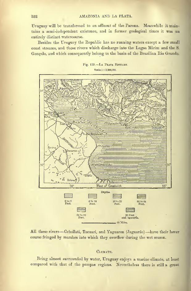
882 AMAZONIA AND LA PLATA.
Uruguay will be transformed to an affluent of the Parana. Meanwhile it main-
tains a semi-independent existence, and in former geological times it was an
entirely distinct watercourse.
Besides the Uruguay the Republic has no running waters except a few small
coast streams, and those rivers which discharge into the Lagoa Mirim and the S.
Gonc,alo, and which consequently belong to the basin of the Brazilian Rio Grande.
Fig. 139. LA PLATA ESTUABY.
Scale 1 : 3,500,000.
58 West or Greenwich
Depths.
Oto r>
Feet.6*0 16Feet.
16 to 32Feet.
32 to 64Feet.
64 t goFeet.
80 Feetand upwards.
GO Miles.
All these rivers Cebollati, Tacuari, and Yaguaron (Jaguarao) have their lower
course fringed by marshes into which they overflow during the wet season.
CLIMATE.
Being almost surrounded by water, Uruguay enjojrs a marine climate, at least
compared with that of the pampas regions. Nevertheless there is still a
CLIMATE OF URUGUAY. 383
range of temperature, which at Monte Video oscillates as much as 72 or 73
Fahr. This city, lying under a latitude corresponding in the southern to that of
Algiers in the northern hemisphere, presents the normal alternation of the four
seasons, although winter is so mild that practically the inhabitants distinguish
only between the warm period, from October to April, and the cool period for the
rest of the year. Owing to exceptional radiation in a clear sky the glass falls
now and then below freezing point ;but as a rule July, the coldest month, corre-
sponds to April in Paris.
In the interior the summer heats seem at times almost unbearable, but this
is due to the conflagrations in the bush country, spreading a mantle of dense
smoke far and wide. The most unpleasant feature of the climate is the great
difference between the cold mornings and the warm mid-day heats, a difference
which usually does not exceed 10 Fahr., but which sometimes rises to 28 and
even 32 in a space of eight hours. Such discrepancies, which are very trying to
strangers, occur especially in spring (September and October), when the biting
winds most prevail.
In the Uruguay valley the atmospheric currents usually set in the direction of
the river, either north and south or south and north. But on the seaboard the
normal south-east trades blow steadily throughout the summer season. They
prevail also in the cool season, but are then frequently interrupted either bynorthern breezes or by the pampero, which comes from the south-west. Althoughthe most dangerous, this pampero is also the great purifier, sweeping all vapours,
fogs, and particles of dust from the atmosphere, drying the saturated ground, and
by the accompanying slight frosts destroying myriads of insects injurious to the
vegetation.
But there is also a wet, or "dirty
"pampero (pampero sucio), which is often
accompanied by tremendous downpours, especially when it blows from the north
in the summer season. " The sheets of water that come down perfectly straight
all through the day and night without a break, are accompanied by equally con-
tinuous thunder and lightning, which seem to work their way right round the
heavens, and to box the entire compass. The thunder is one unceasing muffled
roll, out of which burst sudden fierce claps of deafening violence;the lightning
playing meanwhile almost uninterruptedly at every point of the horizon, and leap-
ing forth now and then into a great scorching flame, which for a moment lights upthe whole world with a lurid blue and yellow. The darkness, too, is very striking,
and almost equals that of a dense London fog ;while the heat seems to increase
rather than to yield to the storm, and one sits as in a prolonged vapour-bath, with
the most trying sense of physical prostration and depression of spirits. These
storms, in fact, do not in the least clear the atmosphere, and relief only comes
when the wind veers round to the south-east, and brings with it a renewed feeling
of vigour and elasticity, as marked as were the languor and dejection before." *
There is no well-marked rainy season, and the precipitation is very unequally
* Sir Horace Rumbold, The Great Silver River, p. 130.
334 AMAZONIA AND LA PLATA.
distributed from year to year. But the yearly average exceeds 40 inches, although
rainy days are far fewer than in West Europe. On the seaboard the rains are
attended by fierce gales and occasionally change to hail.*
FLOKA AND FAUNA.
Uruguay can no longer boast of the rich flora which still survives in South
Brazil, at least as far as the Jacuhy valley. Wild palms, especially the yata'i
(cocos yata'i), may still be seen on the banks and islands of the Uruguay in associa-
tion with the taquara, or Brazilian bamboo, but they no longer range farther
south than the Rincon de las Gallinas. Woodlands have become rare in the
interior;nor do they now present that marvellous variety of forms which is
observed in the Brazilian selects and mattas. Even the araucaria of the Campos has
disappeared, and southwards stretch open, treeless plains, with here and there a
solitary ombu, the characteristic tree of the Platean pampas.
In its fauna also, Uruguay belongs rather to the Argentine than to the Brazi-
lian zone. The howling monkey, still heard in the northern forests, has disap-
peared from the lower reaches of the Uruguay, as the Cayman has from the
estuaries. But the rattle-snake is still met in the rocky glens of Minas and
Maldonado. The ostrich, seldom seen in the wild state, has been domesticated
since 1874, and is now bred in numerous farms. The Platean waters abound in
fish to such an extent that during the nine years' blockade of Monte Video from
1843 to 1851 the inhabitants drew their chief supply of food from this source. In
the Maldonado disti'ict there is a land crab analogous to the Cancer runcola of
Jamaica, which is of burrowing habits;
it digs itself holes in the dry sand far
from the sea-shore and the banks of the lagoons.
INHABITANTS.
At the time of the discovery, Uruguay was roamed by numerous Indian
tribes, whom the Spaniards began forthwith to reduce and enslave. They were
successful with certain groups, probably of Guarani stock, who occupied the left
bank of the Uruguay and its islands. The Yaros, Bobans and Chanas, who sub-
mitted to the invaders, soon disappeared, either by absorption, or in the struggle
with the Charruas, who had maintained their independence.
These were physically a magnificent race, taller than the Europeans, stout,
vigorous and agile, of sober habits, noted for their sharp sense of hearing, always
grave and collected," never complaining even wben being killed." They were
also a valiant people, whom the Spaniards had to conquer inch by inch. At first
they fought with club and arrow, but after the introduction of the horse, they
*Meteorological conditions of Monte Video:
Temperature. RainyLatitude. ^-
-^-^. Days. Riinfall.
Max. Mean. Miu.
34'54'S. 106Fahr. 62 Fahr. 32 Pahr. 36 40 inches.
TOPOGRAPHY OF URUGUAY. 835
learnt the use of spe ir and lasso, like their Pampas neighbours. Towards the
middle of the eighteenth century the Charruas had been driven north of the Rio
Negro, where they were joined by the Minuans from the Parana. "The Char-
ruas," wrote Azara," muster only 400 warriors, but they have cost the Spaniards
more blood than the numerous armies of the Inca and of Montezuma." Theywere finalty reduced in 1831, when some were sold to an itinerant showman, the
last of these dying in a Paris hospital; but there is no doubt a strain of Charrua
blood in the veins of the present mixed Uruguayans, who are physically amongstthe finest of the Hispano-American populations.
TOPOGRAPHY.
The right bank of the Uruguay is thinly peopled above the town of! Salto,
which takes its name from the neighbouring" Fulls." Salto, third city of the
Republic in population, though dating only from the year 1817, is picturesquely
situated on the slopes of several hills at the point where the steam navigation is
arrested, except when the river is in flood. It practically forms a single city
with Concordia on the opposite (Argentine) side. Southwards opens the valley of
the River Dayman, which is named from one of the numerous English proprietors
whose plantations line its banks.
PAYSANDU FRAY BENTOS RIVERA.
Paysandti, founded in 1772 by the "pere" Sandu, occupies a position ana-
logous to that of Salto, on a high cliff at the issue of a river valley nearly
opposite Colon on the Argentine side. It ranks next to Monte Video in population,
and since its destruction by a Brazilian fleet in 1864, has taken a large share in
the preserved meat business, whose chief centre is at Fray Bentos, officially called
Independencia, some distance lower down. In 1863, this place was merely a chapel
surrounded by a few huts, when the district was chosen by a far-seeing speculator
as a suitable site for the establishment of a factory for the preparation of
"Liebig's Extract." The factory, itself a small town, gives employment to about
2,000 hands, and during the busy season, the cattle from the Upper Uruguay, the
Parana, the Gualeguaychu, and the Rio Negro are here " treated"
at the rate of
about 1,000 a day. Thanks to this industry, Fray Bentos has become the third,
and in some years the second port of the Republic." The nature of the opera-
tions carried on here is clearly enough revealed by the whiffs that come borne to
us on the night breeze. Once more, to borrow the vigorous and terrible words
used by Vicuna Mackenna in speaking of it under the rule of Rosas, this country
is literally a huge slaughter-shed, making the air hot and heavy with the smell
of blood, and men callously unconcerned at its sight. A profitable trade and
occupation for a nation doubtless, but one that keeps alive in it those inborn human
instincts of cruelty and savagery, which in our older civilisation have long been
curbed and softened down. One of the ugliest traits of the uneducated native ofO
836 AMAZONIA AND LA PLATA.
these countries is his perfect indifference to the sufferings of the brute creation;
his comparative disregard of human life is, with such a training, not unintelli-
gible."*
Rivera, at the source of the Cunapiru, one of the chief affluents of the Rio
Negro, forms almost a single town with the neighbouring Santa Anna de Livra-
mento on the Brazilian side. For a time Rivera was a great centre of the gold
industry, and considerable quantities appear to have been collected in the
Cunapiru and surrounding valleys. Yet a French company had to cease opera-
tions after losing millions of money in this " Eldorado."
DURAZNO Coi.ONIA SAN JoSE.
Durctzno, on the River Yi, midway between Tacuarcmbo (formerly San Fruc-
tuoso] and Monte Video, has been transformed from a military colony to an agri-
cultural market. Some Indians, expelled by the Brazilian settlers in the territory
of the missions, were settled at Durazno in 1828, but instead of allowing them to
cultivate their land in peace, the authorities enrolled them as soldiers, and all
perished in the civil wars. Soriano, near the head of the Uruguay estuary, dates
from the year 1624, and here is still seen the chapel built by Bernardo de Guzmanfor the Ghana Indians, who had appealed to the Spaniards for protection against
the Charruas. No trace remains of another station which was founded bySebastian Cabot, a few miles farther down, near the present village of San Salvador.
Farther down follow Higucntas (Nueva Palmira) and Carmelo (Las Vacas) at a
point on the estuary where it narrows from six miles to little over one mile, formingan excellent harbour about the Parana confluence. At the extremity of a
headland below the island of Martin Garcia, stands the famous station of Colonia
del Sacramento, opposite Buenos Ayres. Soon after its foundation in 1679, Colonia,
which has the best anchorage in the Plate estuary below Higueritas, was seized
by the Portuguese Manoel Lobo, and by him for a time transformed to a nest of
smugglers. On the banks of the neighbouring little Rio Martin Chico, the illus-
trious navigator Solis was killed by the Charruas.
San Jose, on the river of like name, north-west of Monte Video, was founded at
the end of the eighteenth century by some settlers from the north of Spain.
During the war with Brazil (1825), the Republicans had made it their capital, and
since then it has shared in all the local troubles. Nevertheless, it has steadily
prospered, like the neighbouring Florida on the Arroyo Pintado, which is spanned
by a fine viaduct on the northern railway. The village of Ituzaingo on the Rio
Santa Lucia in the same district, recalls the decisive victory of the Argentinesover the Brazilians in 1827.
MONTE VIDEO.
Monte Video, capital of Uruguay, dates only from the early part of the
eighteenth century, when Zabala, Governor of Buenos Ayres, founded it as a
*Kumbold, p. 153.

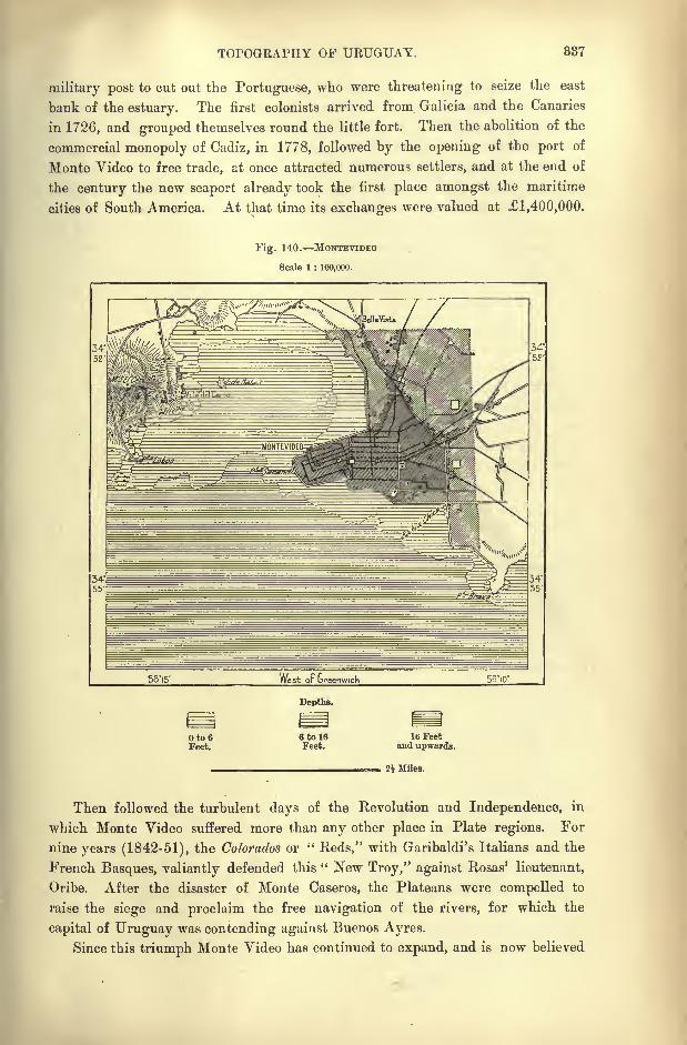
TOPOGRAPHY OF URUGUAY. 837
military post to cut out the Portuguese, who were threatening to seize the east
bank of the estuary. The first colonists arrived from Galicia and the Canaries
in 1726, and grouped themselves round the little fort. Then the abolition of the
commercial monopoly of Cadiz, in 1778, followed by the opening of the port of
Monte Video to free trade, at once attracted numerous settlers, and at the end of
the century the new seaport already took the first place amongst the maritime
cities of South America. At that time its exchanges were valued at 1,400,000.
Fig. 140. MONTEVIDEO
Scale 1 : 100,000.
56*15' West oF Greenwich 56'io'
Depths.
Oto6Feet.
6 to ISFeet.
lb Feetand upwards.
2J Miles.
Then followed the turbulent days of the Revolution and Independence, in
which Monte Video suffered more than any other place in Plate regions. For
nine years (1842-51), the Colorados or "Reds," with Garibaldi's Italians and the
French Basques, valiantly defended this " New Troy," against Rosas' lieutenant,
Oribe. After the disaster of Monte Caseros, the Plateans were compelled to
raise the siege and proclaim the free navigation of the rivers, for which the
capital of Uruguay was contending against Buenos Ayres.
Since this triumph Monte Video has continued to expand, and is now believed
388 AMAZONIA AND LA PLATA.
to rank for population as the fourth city of South America. It is well situated
on an elevated headland which projects westwards, while to the north the shore-
line develops a semi-circular curve round to the Cerro, or "Eminence "in a pre-
eminent sense, which rises 486 feet opposite the capital at the entrance to the
harbour. Rising in amphitheatrical form on the slopes of the peninsula, Monte
Video presents a pleasant seaward aspect, while its terraced houses command a
wide prospect of the harbour, semi-circular bay, and distant roadstead. The lower
parts, till recently encumbered by the remains of the Spanish fortifications, are
now occupied by several fine buildings, such as the exchange, banks, and theatres.
Amongst the learned institutions a foremost place is taken by the University,
which is well attended, especially by students of law, future politicians and legis-
lators of the Republic." A walk through the streets and squares of the capital of Uruguay soon showed
us how very different were these people that we were now among from the
Brazilians ill every respect. No two cities could be less alike than these two
capitals of neighbouring States. Not here the lofty houses of Rio, but clean
streets of one-storied glaring white houses, built in the style of a Pompeian dwell-
ing. A square, flat-roofed building, with an open courtyard or patio, in the
centre, on to which all the rooms open ;a fountain and a flower-garden in the
patio ;towards the street the windows, if any, small and heavily barred with iron
such is the residence of a South American Spaniard, a retiring sort of dwell-
ing, shutting itself jealously from the outer world with a Mussulman-like love of
seclusion. The populace, too, how different from that of a Brazilian city ! no
negroes here, and no ugly-looking Portuguese ;but handsome and dignified
Spaniards, with a good deal of Indian blood in the veins of the lower orders of
them. Cleanest of cities is Monte Video, with straight streets cutting each other
at right angles in the American chess-board fashion." (Rumbold.)
Since the last century the harbour has greatly shoaled, and is now accessible
only to vessels drawing 10 or 12 feet, so that the transatlantic liners have to ride
at anchor in the exposed roadstead. But several improvements have been effected,
including breakwaters, wharves, repairing docks, and the removal of the
quarantine station from Ratas Island in the harbour to Flores Island some 12
miles farther east. But the surf still rolls in from the south, and will continue
to do so till the money can be found to construct another breakwater farther
seawards.
But despite all the difficult and even dangerous approaches, trade still con-
tinues to gravitate towards Monte Video, whose geographical position at the
entrance to the Platean regions presents many advantages. As many as twentylines of steamships touch at this port, where large repairing docks have been
constructed at the foot of the Cerro. It has been proposed to create a great
harbour in deep water by enclosing the Bay of Buceo some six miles east of Monte
Video, although this inlet lies beyond the roadstead. But the plans of the English
engineer have been found too costly to be entertained for the present. The
project is also vehemently opposed by the merchants who are interested in
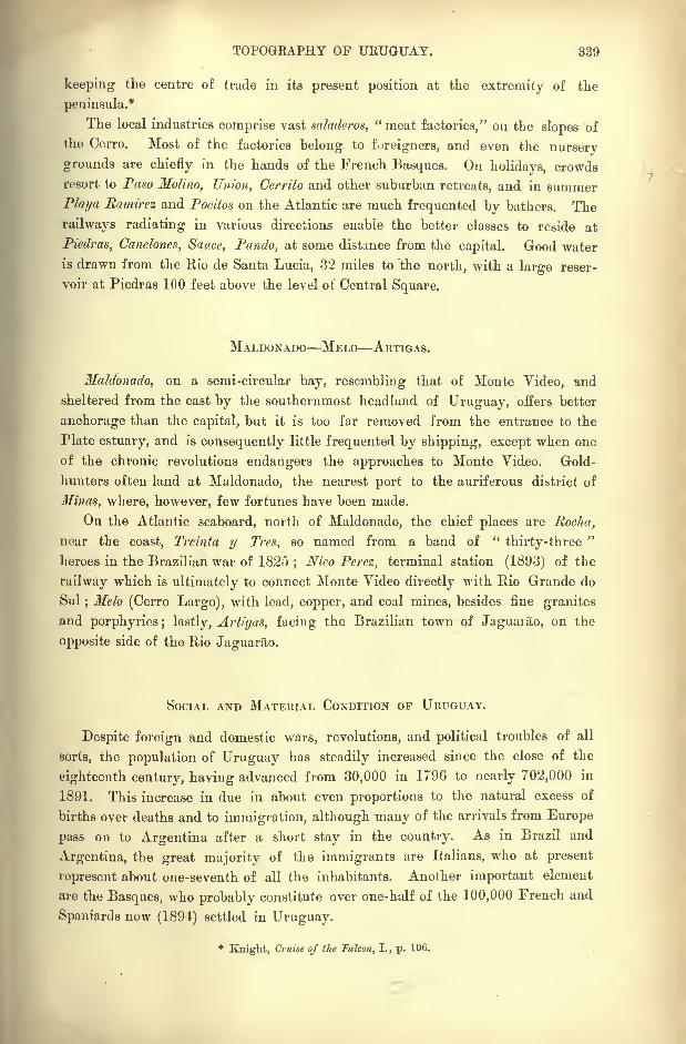
TOPOGRAPHY OF URUGUAY. 839
keeping the centre of trade in its present position at the extremity of the
peninsula.*
The local industries comprise vast saladeros, "meat factories," on the slopes of
the Cerro. Most of the factories belong to foreigners, and even the nursery
grounds are chiefly in the hands of the French Basques. On holidays, crowds
resort to Paso Molino, Union, Cerrito and other suburban retreats, and in summer
Playa Ramirez and Pocitos on the Atlantic are much frequented by bathers. The
railways radiating in various directions enable the better classes to reside at
PiedraSy Canclones, Sauce, Pando, at some distance from the capital. Good water
is drawn from the Rio de Santa Lucia, 32 miles to the north, with a large reser-
voir at Piedras 100 feet above the level of Central Square.
MALDONADO MELO ARTIGAS.
Maldonado, on a semi-circular bay, resembling that of Monte Video, and
sheltered from the east by the southernmost headland of Uruguay, offers better
anchorage than the capital, but it is too far removed from the entrance to the
Plate estuary, and is consequently little frequented by shipping, except when one
of the chronic revolutions endangers the approaches to Monte Video. Gold-
hunters often land at Maldonado, the nearest port to the auriferous district of
Minas, where, however, few fortunes have been made.
On the Atlantic seaboard, north of Maldonado, the chief places are Rocha,
near the coast, Treinta y Tres, so named from a band of "thirty-three
"
heroes in the Brazilian war of 1825;Nico Perez, terminal station (1893) of the
railway which is ultimately to connect Monte Video directly with Rio Grande do
Sul;Melo (Cerro Largo), with lead, copper, and coal mines, besides fine granites
and porphyries; lastly, Artigas, facing the Brazilian town of Jaguarao, on the
opposite side of the Rio Jaguarao.
SOCIAL AND MATERIAL CONDITION OF URUGUAY.
Despite foreign and domestic wars, revolutions, and political troubles of all
sorts, the population of Uruguay has steadily increased since the close of the
eighteenth century, having advanced from 30,000 in 1796 to nearly 702,000 in
1891. This increase in due in about even proportions to the natural excess of
births over deaths and to immigration, although many of the arrivals from Europe
pass on to Argentina after a short stay in the country. As in Brazil and
Argentina, the great majority of the immigrants are Italians, who at present
represent about one-seventh of all the inhabitants. Another important element
are the Basques, who probably constitute over one-half of the 100,000 French and
Spaniards now (1894) settled in Uruguay.
*Knight, Cruise of the Falcon, I., p. 106.
840 AMAZONIA AND LA PLATA.
AGRICULTURE.
Agriculture and pasturage constitute the main sources of wealth, and with the
increase of population cultivated land continues to encroach on the grazing-
grounds. In 1891 about 1,200,000 acres were estimated to be under wheat,
maize, and other crops, the yield of which already exceeds the local demand.
The vine, unfortunately already attacked by phylloxera, flourishes, especially in
the Salto district.
Of the live-stock, sheep alone have increased in recent years ;both horses and
horned cattle, though still relatively very numerous, having greatly fallen off
during the last decade. Mulhall estimates the annual returns from stock-
breeding at about 7,500,000, and from husbandry at 2,500,000, most of this
wealth being owned by strangers. Landed property is burdened with heavy
mortgages, amounting in the aggregate to 4.000,000 in 1893. In the territory
of the Republic are comprised 20,000 urban and 25,000 rural estates exceeding
120 in value, and consequently subject to the impost. It thus appears that
nearly one-half of all the heads of families in the State are freeholders. Accord-
ing to the returns of the national wealth, more than half of the public domain
belongs to foreigners, mostly Basques and Italians;but towards the frontiers of
Rio Grande the richest landowners are Brazilians. In Monte Video itself two-
thirds of the real estate is in the hands of immigrants from Europe.
THE MEAT-PACKING INDUSTRY.
As in Argentina and Rio Grande do Sul, but even to a relatively greater
extent, various preparations of meat form the staple industry. Till recently the
animals ran free on the pastures, and the heaviest work of the estancias was
connected with their capture, branding and sorting for sale, the shambles, or stock.
But these antiquated methods now survive only in the northern provinces. In
the south, where the land has risen greatly in value, the cattle are no longer
allowed to run free, but are confined to enclosures, and more carefully tended.
About a million are slaughtered every year, partly for the local demand, which
may be estimated at about one per head of the population, partly for treatment in
the saladeros.
None of the various attempts to export the meat in a frozen state have proved
quite successful, the process being attended by a loss of flavour. Hence a general
return has been made to the old methods of tinning and jerking, though the
work is carried on with greatly improved appliances, and in a much more
methodic manner. In the large saladeros there is no waste, everything hides,
suet, bones, offal being utilised, and much of the refuse converted into valuable
fertilisers.
TRADE COMMUNICATIONS EDUCATION.
Of the foreign trade, which continues to increase from decade to decade,
about four-fifths consist of the products of the saladeros and of the cattle-farms.
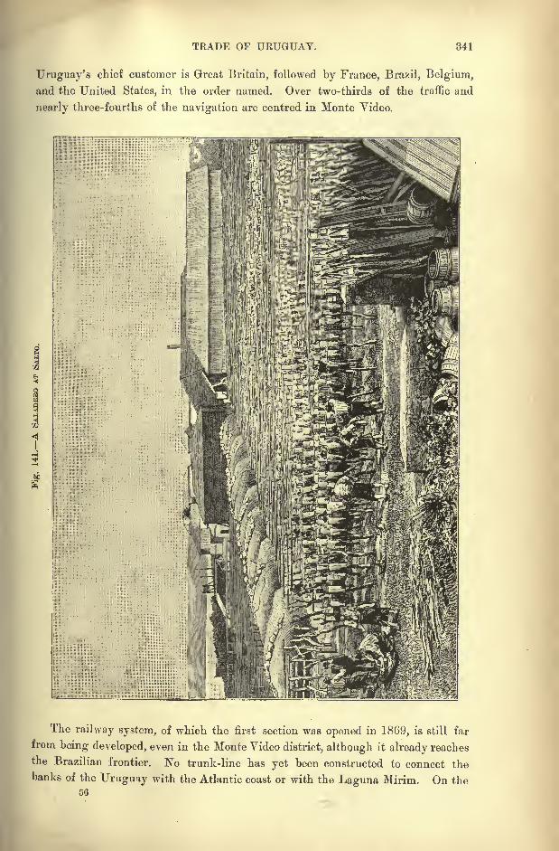
TRADE OF URUGUAY. 341
Uruguay's chief customer is Great Britain, followed by France, Brazil, Belgium,
and the United States, in the order named. Over two-thirds of the traffic and
nearly three-fourths of the navigation are centred in Monte Video.
The railway system, of which the first section was opened in 1869, is still far
from being developed, even in the Monte Video district, although it already reaches
the Brazilian frontier. No trunk-line has yet been constructed to connect the
banks of the Uruguay with the Atlantic coast or with the Laguna Mirim. On the50
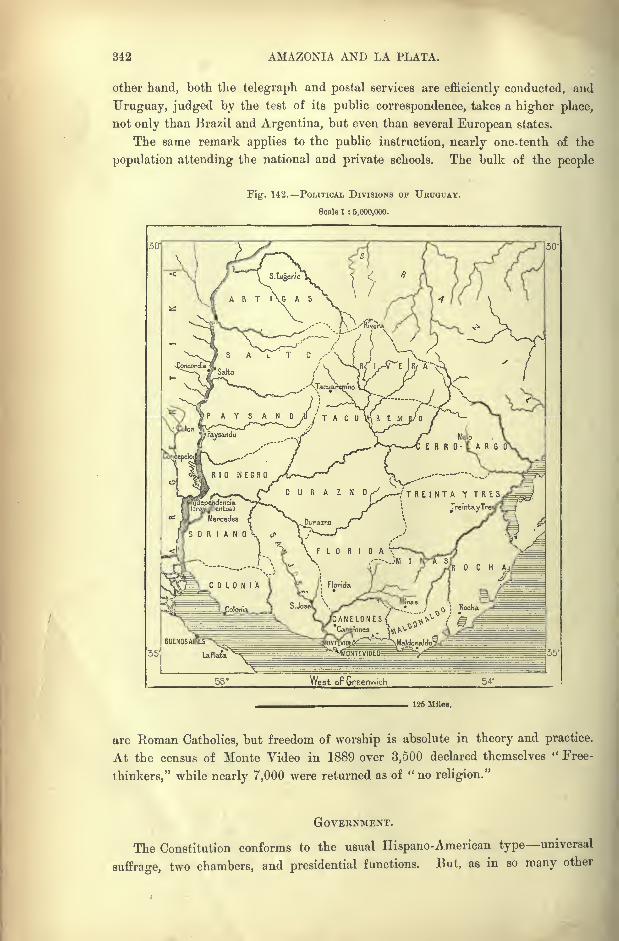
342 AMAZONIA AND LA PLATA.
other hand, both the telegraph and postal services are efficiently conducted, and
Uruguay, judged by the test of its public correspondence, takes a higher place,
not only than Brazil and Argentina, but even than several European states.
The same remark applies to the public instruction, nearly one-tenth of the
population attending the national and private schools. The bulk of the people
Fig. 142. POLITICAL DIVISIONS OF URUGUAY.
Scale 1 : 8,000,000.
>AYSAND,U/TACX -v.
Paysandu
(TREINTA Y TRES
TreintayT
West oF Greenwich 54*
125 Miles.
are Roman Catholics, but freedom of worship is absolute in theory and practice.
At the census of Monte Video in 1889 over 3,500 declared themselves " Free-
thinkers," while nearly 7,000 were returned as of " no religion."
GOVERNMENT.
The Constitution conforms to the usual Hispano-American type universal
suffrage, two chambers, and presidential functions. But, as in so many other
GOVERNMENI OF URUGUAY. 343
Central and South American States, the charter of rights is a document for the
most part pigeon-holed, while the country is torn by rival factions resorting, not
to constitutional methods, but to force, intrigue, bribery, at times even foreign aid,
in support of their claims. Frequently the public revenues have been employedfor party purposes rather than for the public good, while future, receipts have
been discounted by burdensome loans, the interest on which has remained unpaid.
Between 1880 and 1890 the yearly revenue has averaged 2,300,000 and the
expenditure 3,500,000, about half of the former being derived from Customs.
The army, which costs from 600,000 to 800,000, comprises about 4,000 of all
arms.
Uruguay is administratively divided into nineteen departments, which with
their areas and populations are tabulated in the appendix.
CHAPTER XVII.
ARGENTINA.
jOTH in extent and population the Argentine Republic ranks amongstthe foremost states of South America. It is surpassed by Brazil
alone in superficial area, and by Brazil, if not also by Colombia in
the number of its inhabitants. But Colombia must in this respect
soon be distanced, thanks to the stream of immigration settling
towards the Platean regions. In 1893 the population appears to have exceeded
4,000,000 in an area of about 1,125,000 square miles.
In all attempts to forecast the probable destinies of the Argentine region,
the chief geographical factor to be considered is its relative proximity to the
European world. Despite the appearances and despite the evidence afforded bythe maps, the shores of the Plate estuary lie, for all practical purposes, nearer to
Europe than the northern seaboard, which de facto is situated half as near again
to that Continent, for the Plate estuary beyond all doubt exercises a greater
attraction on the European populations, and has consequently hitherto received
the larger share of their trade, capital, and emigrants. In such international
movements mere distance, so largely neutralised by rapid steam navigation, is fur
less important than remoteness from the equator, similar conditions of climate,
vegetation, and social habits, in all which respects the Argentine lands contrast
favourably with Amazonia and most parts of the Brazilian seaboard.
PROGRESS OF DISCOVERY.
This southern section of the Continent remained unvisited by Europeans for
seventeen years after the discovery of the New World by Columbus. In 1509,
Vicente Pinzon and Diaz de Solis entered the Plate estuary, and in 1520, Magel-
lan, accompanied by Pigafetta, historian of the circumnavigation, passed through
the strait between the mainland and Fuegia, which bears his name. The estuary

BUENOS AYRES, LA
O tc 1tS /%/-
NEW
TA AND THE ESTUARY.
16Up-was-d*

EXPLORATION OF ARGENTINA. 345
i
and the strait sufficed to enable cartographers to figure with tolerable accuracy the
true form of the east coast of the Continent. But the bleak shores of Fuegia and
Patagonia were too forbidding to attract explorers to the interior of those regions
at a time when so much remained to be done in more promising lands.
Hence researches were confined to the inlets, sounds, and straits in the hope of
finding some through passage from ocean to ocean. Thus Francisco de Hoces
penetrated in 1527 to the neighbourhood of the " Land's End," but no colony was
founded in these regions, while the Spaniards were endeavouring to secure firm
footing in the land watered by the river which at that time bore the name of Rio
de Solisfrom its discoverer. Diaz de Solis had returned to these waters in 1516,
but only to fall in a fray with the natives on the banks of a coast stream in the
Banda Oriental. In 1538 Sebastian Cabot pushed much farther inland, penetrating
to Paraguay, and erecting a fort at the confluence of the Parana with the Carca-
rana on the spot where now stands the town of Gaboto, so called from the Italian
form of his name.
Cabot was the first to perceive that the estuary of Solis and one of the great
rivers discharging into it might become an excellent highway of access to the
regions of Plata,"Silver," that is to Bolivia and Peru. Hence the curious mis-
nomer of "Argentina
"or " La Plata
"applied to a region not by any means noted
for the importance of its silver mines. The Peruvian and the Bolivian Andes
are the true Argentina.
But the colony founded by Cabot could not be maintained, and a few years
afterwards the Spaniard, Mendoza, settled on the south side of the estuary, on the
spot where now stands Buenos Ayres. Compelled by the Indians to abandon the
settlement, he withdrew with his little party to the fortalice of Carcararia, whence
his lieutenants made numerous excursions in the surrounding districts. Ayolas,
one of these pioneers, founded the station of Asuncion on the left bank of the
Paraguay, which afterwards became the capital of the Republic.
Then he ascended the river as far as Matto Grosso, and advancing boldly into
the savannas of the plains, the yungas of the foothills, and the Andean forests, he
at last reached Peru in 1537. Ayolas was thus the first of all the conquerors to
cross the Continent from sea to sea. He was followed seven years afterwards by
Irala, who performed the same feat, and henceforth Spain held the lines of com-
munication between the eastern and western sections of her vast South American
domain. In 1542, a no less daring expedition was carried out by Alvar Nunez,
who made his way from the coast of Brazil by the rivers and portages directly to
Paraguay.
In 1575, Juan de Garay recovered Buenos Ayres, where he succeeded in
maintaining himself and developing the settlement. The true contour lines of the
Magellanic coasts were determined in 1579 by the pilot Sarmiento, one of the
most remarkable mariners on record, and during the two following centuries the
whole region was explored between the Plate basin and the rampart of the Andes.
But in the extreme north and south the savage aborigines arrested, and frequently
drove back, explorers and settlers. On the one hand the Abipons, Mocovi, and
846 AMAZONIA AND LA PLATA.
Guaycurus of Gran Chaco, on the other the Pampas tribes of Patagonia, valiantly
maintained their independence against the white invaders.
The Jesuit, Falkner, after residing several years amongst the Patagonians at
the foot of the Sierra del Vulcan, first described the interior of the country in the
southern part of the Pampas region. His work, followed in 1772 by the writings
of Cook's companion, Forster, again aroused the attention of the Spanish Govern-
ment, and caused a revival of the explorations which had been suspended for nearly
two centuries.
In 1778, four years after the appearance of Falkner 's work, Juan de la
Piedra visited the stormy gulf of San Matias, called also Bahia sin Fondo," Fathomless Bay," and here discovered the spacious haven of San Jose. Between
1779 and 1784, the brothers Yiedma, followed a few years afterwards by Malaspina,
coasted all the inlets along the southern seaboard;but their reports were consigned
to the royal archives and forgotten. These coast surveys were supplemented byexcursions into the interio'r, and in 1782 Villarino even ascended the course of
the Rio Negro as far as the foot of the Andes. In the same year Antonio de
Viedma discovered the lake which bears his name.
GEOGRAPHICAL RESEARCH.
The scientific study of the Platean regions was ushered in by Felix de Azara,
who had been officially commissioned to determine the Hispano-Portuguese frontiers
on the Uruguay, Parana, and Paraguay rivers;but far from confining himself
to geodetic surveys, Azara also studied the physical features and natural history
of these regions. De Souillac and de la Cruz, other officers in the Spanish
service, crossed the passes of the Cordilleras, and fixed their position.
But the war of independence was now imminent, and henceforth neither the
Spaniards nor their emancipated descendants in the New World continued to take
a serious part in geographical exploration. Thanks, however, to the abolition of the
exclusive Colonial regime, foreigners were now able to co-operate with the natives
in this work. Thus D'Orbigny, after taking up his residence at Carmen de Pata-
gones in 1826, passed into Corrientes to prosecute his researches on the American
aborigines embodied in his classical work, "L'Homme Americain." Then followed
in 1833 the memorable expedition of the Beagle and Adventure, described byDarwin in the "
Voyage of the Beagle," an epoch-making work in the history of
the natural sciences. Dalton Hooker, another English zoologist, who accompanied
the Erebus and Terror expedition, studied the natural history of Fuegia, and
described the "Antarctic Flora."
The geography of Argentina proper is now known in all its main features,
and nothing now remains except to fill in the details. This complementary work
is in daily progress, thanks to the miners exploring the treasures of the moun-
tains, the engineers engaged in laying down railway routes and regulating water-
courses, the land surveyors commissioned to measure and apportion the public
domain.
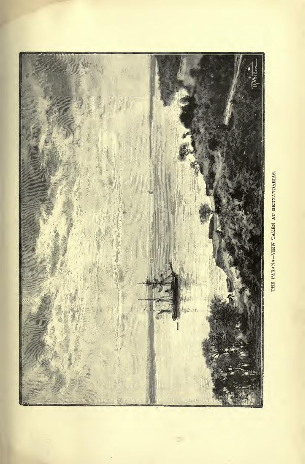

EXPLOEATION OF ARGENTINA. 847
But along the frontiers there still remain almost unknown tracts, either held
by hostile Indians, or too difficult and dangerous to traverse. Thus the Chaco
region, occupied by the fierce Tobas, still contains some spaces, either untraversed
or crossed by itineraries, which have not yet been harmonised at all points. In
the north-western highlands, with their snowy peaks, the network of passes pre-
sents doubts, which have not been solved in the same way by all cartographers.
Lastly, the study of the triangular Patagonian region has cost great labour, while
the section of the Andes separating the Atlantic slope from the western fiords
remains to a great extent still unknown.
Patagonia itself has been visited and explored by numerous travellers, natura-
lists, and geologists, mostly following in the track of the old missionaries, whocrossed from the Chilian heights to the Argentine plains. Punta Arenas, the
Chilian station on Magellan Strait, has also been a starting-point for various
excursions to the interior, while other explorers have penetrated inland from the
various agricultural, pastoral, and military settlements along the eastern seaboard.
Patagonia has thus been completely assimilated to the rest of Argentina by the
labours of Descalzi, Cox, Gardiner, Moreno, Musters, Ramon Lista, Moyano,
Fontana, Rogers, Popper, Yinciguerra, Ameghino, Roncagli, Burmeister, and
many others, as well as by the military expeditions sent against the aborigines.
Paleontologists and geologists also are systematically studying the land in the
interests of the La Plata Museum, and other collections;
stockbreeders are
examining the grassy bottom lands, and prospectors are exploring the mineral
deposits of the country, and thus the era of accurate geographical research has
begun for Patagonia, as well as for the rest of Argentina."
Subjoined is a chronological table of the chief explorations in Patagonia since
the war of independence :
1827. Stokes (Santa Cruz).
1832 et seq. Fitzroy and Darwin (Santa Cruz, Chubut, Rio Negro and Sierra Ventana).1833. Descalzi (Rio Negro).1854 et seq. Jones (Chubut).1856. Fonck, Hess (Nabuel-Huapi) .
1857. Bravard (Sierra Ventana).1862 et seq. Guillermo Cox (Andean Passes).
1867. Gardiner (Santa Cruz, Lake Argentina).1869. Musters (foot of the Andes, Rio Negro).1872. Guerrico (Rio Negro).1874 et seq. Moreno (Rio Negro, Santa Cruz, Chubut, Lake Argentina, etc.).
1876 et seq. Moyano (Rio Chico, Lake Buenos Ayres, Chubut).
1877. Rogers and Ibar (Lake Argentina, Andean Passes). Beerholm (San Julian, Gallegos).
1878 et seq. Ramon Lista.
1879 et seq. Wysoski (Chubut, Rio Negro). Lorentz (Neuquen).1882. Roncagli (Gallegos, Santa Cruz).
1883. Rohde (Nahuel-Huapi, Pass of Bariloche). Zeballos ;Rio Colorado, Rio Negro).1885 et seq. Fontana (Upper Chubut).1 886 et seq. Carlos Burmeister (Chubut, Santa Cruz) . Popper (Fuegia) .
1887. Asahel Bell (Upper Chubut).1891. Siemiradzki (Colorado, Negro, Limay, Nahuel-Huapi). Bodenbender (Neuquen).1S92. Machon and Roth (Andean Valleys, Senguel, Chubut).
The abundant materials already collected on the relief and geology of Argen-
tina, as well as on its natural history and inhabitants, have been embodied in
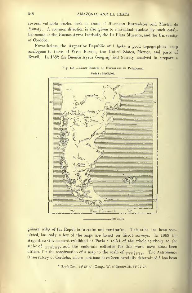
348 AMAZONIA AND LA PLATA.
several valuable works, such as those of Hermann Burmeister and Martin de
Moussy. A common direction is also given to individual studies by such estab-
lishments as the Buenos Ayres Institute, the La Plata Museum, and the Universityof Cordoba.
Nevertheless, the Argentine Republic still lacks a good topographical mapanalogous to those of West Europe, the United States, Mexico, and parts of
Brazil. In 1882 the Buenos Ayres Geographical Society resolved to prepare a
Fig. 143. CHIEF ROUTES OF EXPLOREBS IN PATAGONIA.
Scale 1 : 20,000,000.
75* West oF Greenwich
310 MUeB.
general atlas of the Republic in states and territories. This atlas has been com-
pleted, but only a few of the maps are based on direct surveys. In 1889 the
Argentine Government exhibited at Paris a relief of the whole territory to the
scale of-g-g-jJ-g-.^,
and the materials collected for this work have since been
utilised for the construction of a map to the scale of T7r^ J^TTTT- The Astronomic
Observatory of Cordoba, whose positions have been carefully determined,* has been
* South Lat.. 31 25' 4"; Long., W. of Greenwich, 61 12' 3".
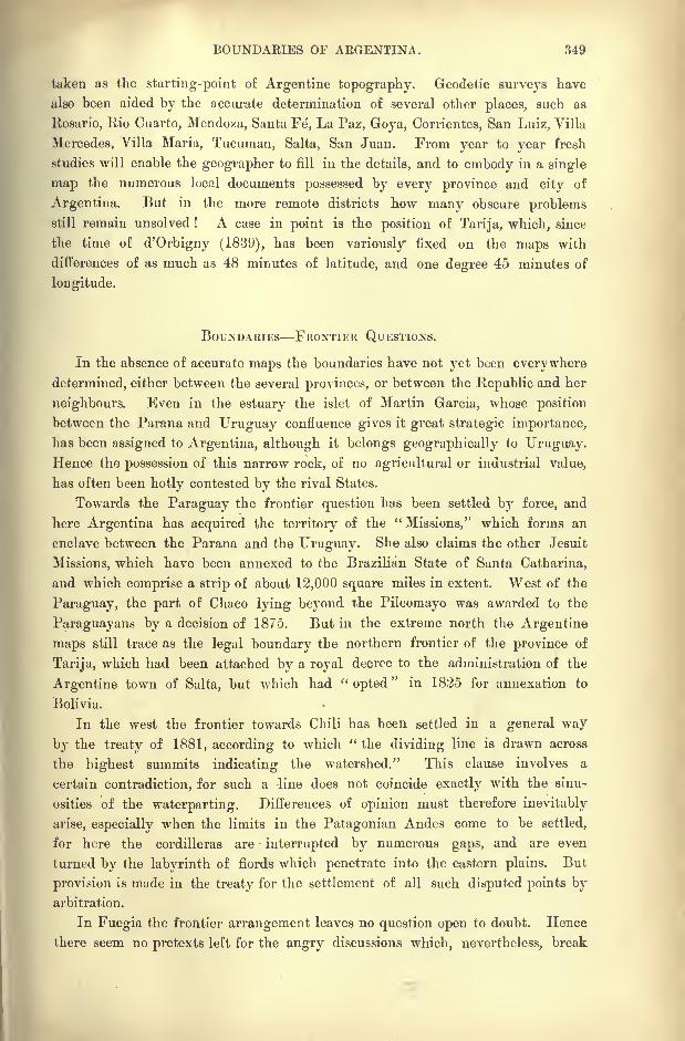
BOUNDAEIES OF ARGENTINA. 349
taken as the starting-point of Argentine topography. Geodetic surveys have
also been aided by the accurate determination of several other places, such as
Rosario, Rio Cuarto, Mendoza, Santa Fd, La Paz, Goya, Corrientes, San Luiz, Villa
Mercedes, Villa Maria, Tucurnan, Salta, San Juan. From year to year fresh
studies will enable the geographer to fill in the details, and to embody in a single
map the numerous local documents possessed by every province and city of
Argentina. But in the more remote districts how many obscure problemsstill remain unsolved ! A case in point is the position of Tarija, which, since
the time of d'Orbigny (1839), has been variously" fixed on the maps with
differences of as much as 48 minutes of latitude, arid one degree 45 minutes of
longitude.
BOUNDARIES FRONTIER QUESTIONS.
In the absence of accurate maps the boundaries have not yet been everywhere
determined, either between the several provinces, or between the Republic and her
neighbours. Even in the estuary the islet of Martin Garcia, whose position
between the Parana and Uruguay confluence gives it great strategic importance,
has been assigned to Argentina, although it belongs geographically to Uruguay.Hence the possession of this narrow rock, of no agricultural or industrial value,
has often been hotly contested by the rival States.
Towards the Paraguay the frontier question has been settled by force, and
here Argentina has acquired the territory of the "Missions," which forms an
enclave between the Parana and the Uruguay. She also claims the other Jesuit
Missions, which have been annexed to the Brazilian State of Santa Catharina,
and which comprise a strip of about 12,000 square miles in extent. West of the
Paraguay, the part of Chaco lying beyond the Pilcomayo was awarded to the
Paraguayans by a decision of 1875. But in the extreme north the Argentine
maps still trace as the legal boundary the northern frontier of the province of
Tarija, which had been attached by a royal decree to the administration of the
Argentine town of Salta, but which had "opted
"in 1825 for annexation to
Bolivia.
In the west the frontier towards Chili has been settled in a general way
by the treaty of 1881, according to which " the dividing line is drawn across
the highest summits indicating the watershed." This clause involves a
certain contradiction, for such a -line does not coincide exactly with the sinu-
osities of the waterparting. Differences of opinion must therefore inevitably
arise, especially when the limits in the Patagonian Andes come to be settled,
for here the Cordilleras are interrupted by numerous gaps, and are even
turned by the labyrinth of fiords which penetrate into the eastern plains. But
provision is made in the treaty for the settlement of all such disputed points byarbitration.
In Fuegia the frontier arrangement leaves no question open to doubt. Hence
there seem no pretexts left for the angry discussions which, nevertheless, break
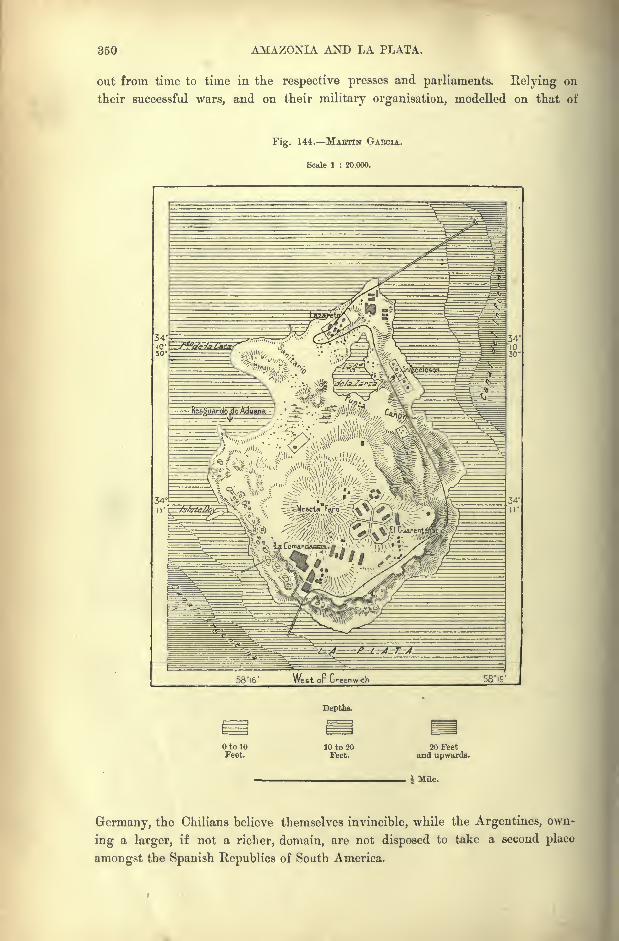
350 AMAZONIA AND LA PLATA.
out from time to time in the respective presses and parliaments. Relying on
their successful wars, and on their military organisation, modelled on that of
Fig. 144. MABTIN GAECIA.
Scale 1 : 20,000.
58"i6' West oF Greenwich 58iS'
Depths.
OtolOFeet.
10 to 20Feet.
20 Feetand upwards.
; Mile.
Germany, the Chilians believe themselves invincible, while the Argentines, own-
ing a larger, if not a richer, domain, are not disposed to take a second place
amongst the Spanish Republics of South America.
THE ARGENTINE PEOPLE. 351
ARGENTINA AND THE ARGENTINES.
But compared with that of Chili, the power of Argentina is greatly impaired
by the lack of political unity. Except in the war caused by Balmaceda's dictator-
ship, Chili, although divided into two hostile classes, has hitherto preserved at
least an outward semblance of domestic harmony. But Argentina has been the
scene of countless local revolutions, and occasionally even of sanguinary wars
embracing the whole of the Republic. Since the close of the colonial rule, the
Argentines have lived in a chronic state of civil strife, relieved only by intervals
of peace or armistices.
This combative spirit and indifference to scenes of bloodshed may perhaps, to
a small extent, be due to heredity, or to the carnivorous habits of the people. But
the chief cause of the lack of political stability must be sought in the persistence
of the struggle between two opposite principles, that of local self-government
and an agressive centralisation inherited from the old monarchical system. Andafter all, it may be asked, is the difference so great between the revolutionary
outbreaks of Argentina and the formidable state of armed peace under which
old Europe threatens to break down ?
An apt illustration of the friction constantly arising between the local and
federal Governments is afforded by the course of recent events in Buenos Ayres,
which had long been the capital both of the province of that name and of the
Argentine Republic." Until 1880 the province of Buenos Ayres dominated the
Argentine Republic. la wealth and population she outweighed the other pro-
vinces, although in area they vastly exceeded hers in size. But with the growthof the provinces the domination of Buenos Ayres was threatened. This was too
much for her pride, and the provincial government, being no longer able to rule,
determined in 1880 to secede from the Confederation. The provincial leaders
were eager enough for independence, but the people were only half-hearted about
it. They were more intent upon their crops, their business, and their profits,
than upon the political status of their province. The result was that, after a
short, hollow struggle, the revolt collapsed, and the provincial government had to
take up a subordinate position." But this was not quite all. The provincial government had hitherto enjoyed
the privilege of raising troops of their own. Had it not been for this, the attempt
to secede could never have been made. The national government now withdrew
from the provincial government this privilege, and the provincial government
were, moreover, given to understand that there was no longer any room for them
in the city of Buenos Ayres. This was the reason of the rise of the new pro-
vincial capital of La Plata. The fiat of the provincial government went forth,
a site was chosen, and, thirty miles from Buenos Ayres, in three years, out of
the bare plain, the new capital of the province arose. Nothing could be more
striking than to see, side by side, the grand new station rearing itself loftily
alongside the little wooden shed which was still doing duty until the new
station should be finished." *
* Dr. E. R. Pearce Edgcumbe, Zephyrus, p. 191.
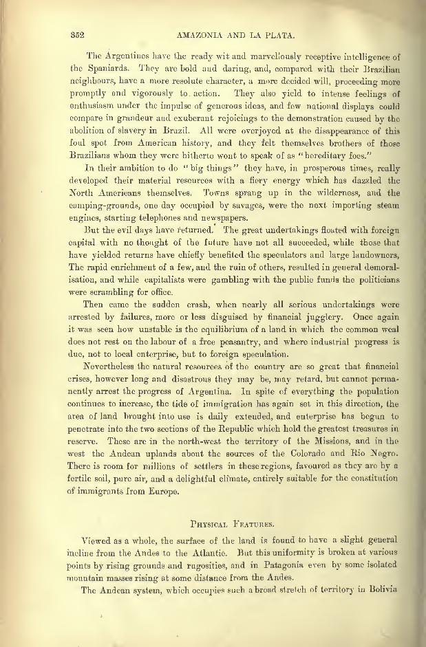
852 AMAZONIA AND LA PLATA.
The Argentines have the ready wit and marvellously receptive intelligence of
the Spaniards. They are bold and daring, and, compared with their Brazilian
neighbours, have a more resolute character, a more decided will, proceeding more
promptly and vigorously to action. They also yield to intense feelings of
enthusiasm under the impulse of generous ideas, and few national displays could
compare in grandeur and exuberant rejoicings to the demonstration caused by the
abolition of slavery in Brazil. All were overjoyed at the disappearance of this
foul spot from American history, and they felt themselves brothers of those
Brazilians whom they were hitherto wont to speak of as "hereditary foes."
In their ambition to do "big things
"they have, in prosperous times, really
developed their material resources with a fiery energy which has dazzled the
North Americans themselves. Towns sprang up in the wilderness, and the
camping-grounds, one day occupied by savages, were the next importing steam
engines, starting telephones and newspapers.
But the evil days have returned. The great undertakings floated with foreign
capital with no thought of the future have not all succeeded, while those that
have yielded returns have chiefly benefited the speculators and large landowners,
The rapid enrichment of a few, and the ruin of others, resulted in general demoral-
isation, and while capitalists were gambling with the public funds the politicians
were scrambling for office.
Then came the sudden crash, when nearly all serious undertakings were
arrested by failures, more or less disguised by financial jugglery. Once again
it was seen how unstable is the equilibrium of a land in which the common weal
does not rest on the labour of a free peasantry, and where industrial progress is
due, not to local enterprise, but to foreign speculation.
Nevertheless the natural resources of the country are so great that financial
crises, however long and disastrous they may be, may retard, but cannot perma-
nently arrest the progress of Argentina. In spite of everything the population
continues to increase, the tide of immigration has again set in this direction, the
area of land brought into use is daily extended, and enterprise has begun to
penetrate into the two sections of the Republic which hold the greatest treasures in
reserve. These are in the north-west the territory of the Missions, and in the
west the Andean uplands about the sources of the Colorado and Rio Negro.
There is room for millions of settlers in these regions, favoured as they are by a
fertile soil, pure air, and a delightful climate, entirely suitable for the constitution
of immigrants from Europe.
PHYSICAL FEATURES.
Viewed as a whole, the surface of the land is found to have a slight general
incline from the Andes to the Atlantic. But this uniformity is broken at various
points by rising grounds and rugosities, and in Patagonia even by some isolated
mountain masses rising at some distance from the Andes.
The Andean system, which occupies such abroad stretch of territory in Bolivia
THE ARGENTINE UPLANDS. 358
and North Chili, extends also into north-west Argentina between the Pilcomayo,
Bermejo, and Juramento slopes. Above the huge pedestal, standing at a mean
altitude of 14,500 feet, rises a regular line of peaks in the direction from north to
Fig. 145. NKVADOS PLATEAU, NORTH-WEST ARGENTINA.
Scale 1 : 3,500,000.
25'
West op Greenwich 65'
EHto 3,300Feet.
Heights.
3,300 to 13,000Feet.
13,000 to 18,000Feet.
18,000 Feetand upwards.
60 Miles.
south exceeding 11,600 feet, and covered with snow throughout the year. The
Cerro de las Granadas, one of these superb peaks, towers above the dreary soli-
tudes of the puna at the north-west corner of the Argentine frontier.
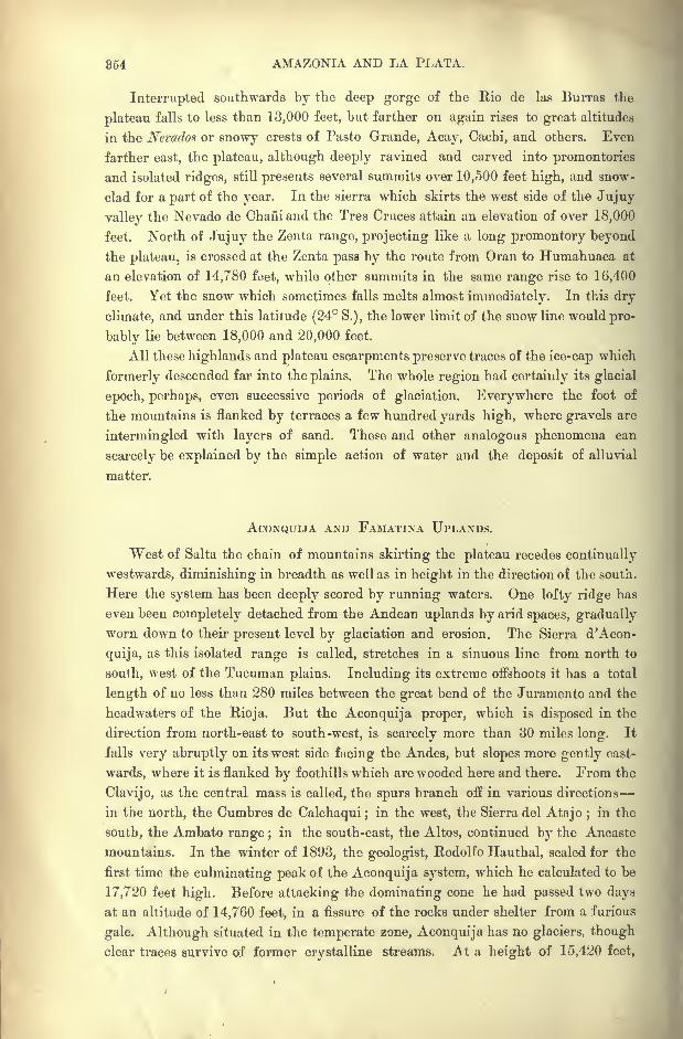
854 AMAZONIA AND LA PLATA.
Interrupted southwards by the deep gorge of the Rio de las Burras the
plateau falls to less than 13,000 feet, but farther on again rises to great altitudes
in the Ncrados or snowy crests of Pasto Grande, Acay, Cachi, and others. Even
farther east, the plateau, although deeply ravined and carved into promontories
and isolated ridges, still presents several summits over 10,500 feet high, and snow-
clad for a part of the year. In the sierra which skirts the west side of the Jujuy
valley the Nevado de Chaiiiand the Tres Cruces attain an elevation of over 18,000
feet. North of Jujuy the Zenta range, projecting like a long promontory beyond
the plateau, is crossed at the Zenta pass by the route from Oran to Humahuaca at
an elevation of 14,780 feet, while other summits in the same range rise to 16,400
feet. Yet the snow which sometimes falls melts almost immediately. In this dry
climate, and under this latitude (24 S.), the lower limit of the snow line would pro-
bably lie between 18,000 and 20,000 feet.
All these highlands and plateau escarpments preserve traces of the ice-cap which
formerly descended far into the plains. The whole region had certainly its glacial
epoch, perhaps, even successive periods of glaciation. Everywhere the foot of
the mountains is flanked by terraces a few hundred yards high, where gravels are
intermingled with layers of sand. These and other analogous phenomena can
scarcely be explained by the simple action of water and the deposit of alluvial
matter.
ACONQUIJA AND FAMATINA UPLANDS.
West of Salta the chain of mountains skirting the plateau recedes continually
westwards, diminishing in breadth as well as in height in the direction of the south.
Here the system has been deeply scored by running waters. One lofty ridge has
even been completely detached from the Andean uplands by arid spaces, gradually
worn down to their present level by glaciation and erosion. The Sierra d'Acon-
quija, as this isolated range is called, stretches in a sinuous line from north to
south, west of the Tucuman plains. Including its extreme offshoots it has a total
length of no less than 280 miles between the great bend of the Juramento and the
headwaters of the Bioja. But the Aconquija proper, which is disposed in the
direction from north-east to south-west, is scarcely more than 30 miles long. It
falls very abruptly on its west side facing the Andes, but slopes more gently east-
wards, where it is flanked by foothills which are wooded here and there. From the
Clavijo, as the central mass is called, the spurs branch off in various directions
in the north, the Cumbres de Calchaqui ;in the west, the Sierra del Atajo ;
in the
south, the Ambato range ;in the south-east, the Altos, continued by the Ancaste
mountains. In the winter of 1893, the geologist, Ptodolfo Hauthal, scaled for the
first time the culminating peak of the Aconquija system, which he calculated to be
17,720 feet high. Before attacking the dominating cone he had passed two days
at an altitude of 14,760 feet, in a fissure of the rocks under shelter from a furious
gale. Although situated in the temperate zone, Aconquija has no glaciers, though
clear traces survive of former crystalline streams. At a height of 15,420 feet,
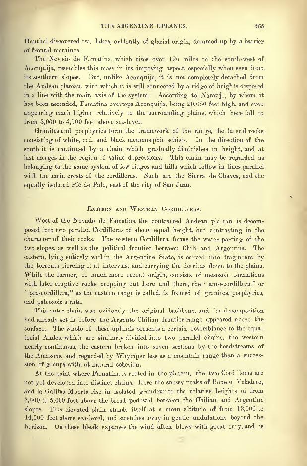
THE ARGENTINE UPLANDS. 855
Hauthal discovered two lakes, evidently of glacial origin, dammed up by a barrier
of frontal moraines.
The Nevado de Famatina, which rises over 125 miles to the south-west of
Aconquija, resembles this mass in its imposing aspect, especially when seen from
its southern slopes. But, unlike Aconquija, it is not completely detached from
the Andean plateau, with which it is still connected by a ridge of heights disposed
in a line with the main axis of the system. According to Naranjo, by whom it
has been ascended, Famatina overtops Aconquija, being 20,680 feet high, and even
appearing much higher relatively to the surrounding plains, which here fall to
from 3,000 to 4,500 feet above sea-level.
Granites and porphyries form the framework of the range, the lateral rocks
consisting of white, red, and black metamorphic schists. In the direction of the
south it is continued by a chain, which gradually diminishes in height, and at
last merges in the region of saline depressions. This chain may be regarded as
belonging to the same system of low ridges and hills which follow in lines parallel
with the main crests of the Cordilleras. Such are the Sierra de Chaves, and the
equally isolated Pie de Palo, east of the city of San Juan.
EASTERN AND WESTERN CORDILLERAS.
West of the Nevado de Famatina the contracted Andean plateau is decom-
posed into two parallel Cordilleras of about equal height, but contrasting in the
character of their rocks. The western Cordillera forms the water-parting of the
two slopes, as well as the political frontier between Chili and Argentina. The
eastern, lying entirely within the Argentine State, is carved into fragments bythe torrents piercing it at intervals, and carrying the detritus down to the plains.
While the former, of much more recent origin, consists of mesozoic formations
with later eruptive rocks cropping out here and there, the uante-cordillera," or
"pre-cordillera," as the eastern range is called, is formed of granites, porphyries,
and paleozoic strata.
This outer chain was evidently the original backbone, and its decomposition
had already set in before the Argento-Chilian frontier-range appeared above the
surface. The whole of these uplands presents a certain resemblance to the equa-
torial Andes, which are similarly divided into two parallel chains, the western
nearly continuous, the eastern broken into seven sections by the headstreams of
the Amazons, and regarded by Whymper less as a mountain range than a succes-
sion of groups without natural cohesion.
At the point where Famatina is rooted in the plateau, the two Cordilleras are
not yet developed into distinct chains. Here the snowy peaks of Bonete, Veladero,
and la Gallina Muerta rise in isolated grandeur to the relative heights of from
3,500 to 5,000 feet above the broad pedestal between the Chilian and Argentine
slopes. This elevated plain stands itself at a mean altitude of from 13,000 to
14,500 feet above sea-level, and stretches away in gentle undulations beyond the
horizon. On these bleak expanses the wind often blows with great fury, and is
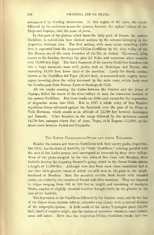
356 AMAZONIA AND LA PLATA.
accompanied by blinding snowstorms. In this region of the puna, the tracks
followed by the muleteers across the plateau, between the upland valleys of the
Eioja and Copiapo, take the name of pircas.
In that part of the plateau which bears the lofty peak of Bonete, the eastern
Cordillera is carved into four distinct sections by the streams belonging to the
Argentine drainage area. The first section, with some crests exceeding 1,600
feet, is separated from the Argento-Chilian Cordillera by the deep valley of the
Rio Blanco, one of the main branches of the Rio de Jachal. The second, lyingnearer to the frontier, develops the pico del Salto, and numerous other summits
over 18,000 feet high. The third fragment of the eastern Cordillera broadens out
into a huge mountain mass with peaks, such as Mainrique and Totora, also
exceeding 18,000 feet, lower limit of the snowline. Lastly the fourth section,
known as the Cordillera del Tigre (16,400 feet), is connected with mighty Acon-
cagua, towering above the valley traversed by the main route, which leads over
the Cumbre pass from Buenos Ayres to Santiago de Chili.
All the tracks crossing the Andes between the Cumbre and the pircas of
Copiapo, follow the course of the river valleys to turn the transverse barriers of
the eastern Cordillera. But these tracks are little used, except for the importation
of Argentine mules into Chili. But in 1817 a whole army of San Martin's
republican forces advanced again &t the Spaniards over the pass of los Patos or
Valle Hermoso, which stands at an altitude of 12,700 feet between Aconcaguaand Ramada. Other breaches in the range followed by the muleteers exceed
14,750 feet, amongst others that of Agua Negra, or la Laguna (15,190), on the
direct route between Jachal and Coquimbo.
THE LITTLE CORDILI,EKA OVERO AND OTHER VOLCANOES.
Besides the eastern and western Cordilleras with their snowy peaks, Argentina,
like Chili, has its chain of foothills, its"little Cordillera," running parallel with
the axis of the Andes proper, and interrupted at intervals by deep river valleys.
West of the plain occupied by the two cities of San Juan and Mendoza, these
foothills develop the imposing Paramillo group, which in the Cerro Pelado attains
a height of 11,280 feet. Although now free from snow, these mountains had at
one time their glaciers, traces of which are still seen on the plain in the neigh-
bourhood of Mendoza. Here the so-called cerrillos, little knolls with rounded
crests, are evidently the remains of frontal and other moraines. They are disposed
in ridges ranging from 150 to 300 feet in height, and consisting of trachytic
blocks, angular or slightly rounded boulders brought down by the glaciers to the
base of the foothills.
The depression in the Cordillera followed by the Cumbre route, and by the line
of the future trans-Andean railway, coincides very closely with a natural division
of the orographic system. A little south of the snowy Tupungato giant (20,286
feet), itself of eruptive origin, rise the craters of numerous volcanoes, some extinct,
some still active. Here also the Argentino-Chilian Cordillera breaks into two
THE ARGENTINE UPLANDS. 857
parallel ranges, the eastern lying entirely within Argentine territory, and on an
average about 5,000 feet lower than the western.
The extinct Overo volcano (15,550 feet), which connects this eastern ridge with
the loftier range, not far from Mount Maipo (17,670), is encircled by one of those
glaciers, which afford the best opportunity for studying the formation of the
HMve penitente, "penitent snow," "so called from the eccentric resemblance to cowled' friars penitent,' affected by the frozen masses under the action of sun and wind.
The crystalline parts, which resist evaporation and the melting process, ramifyin the strangest fashion, in many places leaving the black ground exposed
between the fantastic blocks of ice, which sometimes stand live or six feet high."*
MALAKGUE AND THE SOUTHERN CORDILLERAS.
South of Overo the Argentine chain is interrupted by the valley of the Rio del
Diamante, beyond which rise other crests disposed in lines parallel with the main
range. A breach in which rises the Rio Atuel leads to the Planchon pass
(9,920 feet), one of the most frequented in the Argentine-Chilian Andes.
Farther south the orographic system broadens out. Here the Argentine chain
of the Malargue (Malalhue) volcanoes, which contrasts with the Jurassic forma-
tions of the main range, is developed to the east of the deep longitudinal valley
of the Rio Grande or Upper Colorado.
Some 60 miles farther east, beyond a closed lacustrine basin remnant of a
former inland sea, rises the lofty Nevado de San Rafael (16,190 feet), an almost
isolated fragment of mountain masses which appear to have formerly been far
more extensive than at present. Farther south the Cerro Payen, undoubtedly of
igneous origin, dominates the valley where the Rio Grande and the Rio de las
Barrancas unite to form the Colorado. Near the Buta-co pass, which crosses the
Malargue chain at a height of 4,930 feet, is seen the Cura Cokalio, or " divine
stone" of the Araucanians, a huge sandstone mass, which has fallen across the
track from a neighbouring cliff.
According to Host, the Chos malttl or Bum mahuida, in the eastern pre-
Cordillera, has an altitude of no less than 16,400 feet. It is an extinct volcano
surrounded on all sides by ashes, scoriae, and lava streams. The whole of the
eastern Cordillera in this region is believed to consist of these igneous rocks, which
were ejected at two different epochs, the first represented by black trachytes, the
second by basalts. A sill 7,610 feet high separates the volcano from the western
Cordillera, and forms a divide between the waters flowing in one direction towards
the Colorado, in another to the Rio Negro through its Neuquen affluent. The
Andes have few more romantic sites than this pass in the "Argentine Switzer-
land," which commands a wide prospect of pastures and woodlands, bounded north-
east by the gigantic Cerro Payen, north-west by the Campanario cone, with its
crown of picturesque rocks affecting the form of ruined towers. Southwards the
Vol. XVIII., p. 416.
57
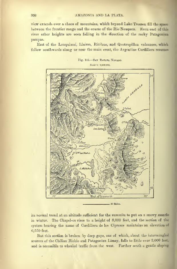
358 AMAZONIA AND LA PLATA.
view extends over a chaos of mountains, which beyond Lake Tromen fill the space
between the frontier range and the course of the Rio Neuquen. Even east of this
river other heights are seen falling in the direction of the rocky Patagonian
pampas.
East of the Lonquimai, Llaima, Eiiiihue, and Quetrupillan volcanoes, which
follow southwards along or near the main crest, the Argentine Cordillera resumes
Fig. 146. SAN RAFAEL NEVADO.
Scale 1 : 2,000,000.
70' West op Greenwich
. 30 Miles.
its normal trend at an altitude sufficient for the summits to put on a snowy mantle
in winter. The Chapel-co rises to a height of 8,000 feet, and the section of the
system bearing the name of Cordillera de los Cipreses maintains an elevation of
6,550 feet.
But this section is broken by deep gaps, one of which, about the intermingled
sources of the Chilian Biobio and Patagonian Limay, falls to little over 3,000 feet,
and is accessible to wheeled traffic from the west. Farther south a gentle sloping

THE ARGENTINE UPLANDS. 359
hill separates an affluent of the Rio Limay from the Chilian lake Picaullu (Lacar,
Lajar), which stands about 2,400 feet above the sea, while the boquete de Perez
Rosalez, a third pass at the western extremity of Lake Nahuel-IIuapi, falls below
2,800 feet.
A second Argentine Cordillera, developed to the east of the first, is less ravined,
but also less elevated, though the peaks in the Sierras de Catalin and de las Angos-
Fig. 147. NAHUEL-HUALPI AND NEIGHBOURING MOUNTAINS.
Scale t : 1,200,000.
Wgst or Greenwich
18 Miles.
turas rise to 5,000 feet. This section of the Argentine orographic system had
also at one time its active volcanoes, like the frontier Cordillera farther west. The
Alumine, Mesa, and Chapel-co heights are all cones of Andesite, while scores of
other peaks flank both sides of the Rio Collon-cura. Their extinct craters are
now clothed with beech and myrtle groves ;but a cone near the sources of the
Biobio has laid all the surrounding districts under ashes. Here the traces of
860 AMAZONIA AND LA PLATA.
former eruptions and of ancient glaciers are found superimposed. Below the
igneous scoriae stretch beds of glacial mud.
South of Tronador, with its"thundering
"avalanches, towering between the
Nahuel-Huapi basin and the Chilian slope, the Cordilleras fall so low that, according
to Rohde, the traveller may pass from the banks of the Rio Limay to the deep
Reloncavi fiord without crossing any range properly so called, but only some low
plateaux intersected by gorges and valleys. At this point, which is perhaps the
old Bariloche route followed by the Jesuit missionaries, the only obstacle to pro-
gress is the exuberant vegetation. The track descends to the Pacific Ocean along
the course of the Rio Puelo, which is flanked on the north by Mount Ballon a
(4,886 feet), on the south by Mount Castillo (4,930 feet).
Farther on, along the deep channels separating the mainland from Cliiloe and
the Magellanic archipelagoes, the frontier range has been scarcely studied except
from a distance. Here rise some extinct and active volcanoes, such as Yate or
Yebcan, Minohin mahuida, Corcovado, and Mellimoya, ranging in height from
5,200 to 7,900 feet. From the few excursions that have been made to the interior,
it may be inferred that the Cordillera is decomposed in distinct masses by the
deep gorges of the rivers rising on the Patagonian plateaux east of the mountains.
The Rio Palena, which flows south of Mount Corcovado, and which, according to
the legend, should give access to the marvellous city of the "Caesars," the South
American Eldorado, winds through one of these gorges, while others are traversed
farther south by the Rios Corcovado, Aysen, and Huemules.
In this region the Andes are, so to say, broken into a land archipelago, ana-
logous to that developed in the neighbouring waters. The Cordillera reappears
across the Taytao peninsula, where rises the superb crest of San Valentino, which
towers to a height of 12,720 feet. Under the same latitude in the lateral Argen-
tine Cordillera, Moyano measured the Zeballos peak (5,500 feet), and determined
the existence of another chain, which towards the source of the Deseado branches
off from the Andes in the direction of the south-east, terminating in the headland
of Cape Blanco south of San Jorge Bay.
The actual height of this transverse range has not yet been ascertained, but
according to native report it is extremely difficult to cross, owing to its rugged
character, rocks, precipices, and general absence of water. Hence, in order to
pass from one point to the other of the seaboard, the Indians pass round to the
west, traversing the more practicable region of grass lands.
THE MAGELLAMC MOUNTAINS.
In the Magellanic region the contracted extremity of the Continent presents
nothing but a narrow strip of plains between the Andes and the Atlantic, from
which are visible the summits rising above the Pacific. But in this terminal
peninsula the parallel zones of mountain ranges are disposed side by side with
surprising regularity. The Cordillera proper, above which rises the superb
tower- shaped Chalten or Fitzroy (6,890 feet), follows almost exactly the direction
THE ARGENTINE UPLAND. 861
of the meridian as far as the break which gives access to the waters of the great
Magellanic fiords.
To this range follows eastwards a pre-Cordillera, to which Moyano has giventhe name of Cordillera de los Baguales (" Wild Horses"), and which stretches
some hundred miles north and south, without greatly deviating from the meri-
dional direction. Mounts Stokes and Payne belong to this system, whose crests
range from 5,000 to 6,500 feet. A third less uniform and less elevated chain
(5,000 feet) falls below the snow line, but exceeds the others in picturesque
scenery, thanks to the fantastic forms of its erupted rocks, towers, obelisks, temples,
and the like. Above this range rise the true Mount Chalten and other active
or extinct volcanoes, and to the same igneous system belongs the Cordillera de
Latorre, with several conspicuous peaks Tres Sabios (" Three Sages "), Philippi,
Gay, Domeyko and with one crater apparently of quite recent origin.
On the surface of the region sloping in the direction of the Atlantic there
stretches a great sheet of scoriae and other erupted matter, which is pierced at
intervals by old volcanic cones, some isolated, some developing continuous chains.
Here the estuary of the Santa Cruz River is indicated from a distance by the
conspicuous landmark of Mount Leon, a limestone crag about 1,000 feet high.This solitary eminence is pierced by caverns, the resort of pumas, while the
condor builds its nest on its rocky ledges.
South of the Andes proper, the coast is indented by a thousand inlets of all
kinds, and here the summits assume an insular aspect, thanks to the surrounding
bays, straits and lakes. Between Skyring "Water and the great bend of Magellan
St.rait, the orographic system is reduced to a single ridge only a few yards high.
But it again rises in the imposing headland of Cape Froward, and, on the other
side of the strait, in the superb Mounts Sarmiento, Darwin, and Fran9ais, with
their girdle of glaciers. Farther on the system develops a vast curve in the
direction from west to east, terminating in Staten Island with summits some
3,000 feet high. This Argentine island forms the terminal rock in the long semi-
circular range of the Andean Mountains, which begin with the island of Trinidad
in the Caribbean Sea.
Staten Island, the Dutch Staatenland, and the Spanish Sierra de los Estados,
faces the south-eastern extremity of Fuegia, from which it is separated by Le
Maire strait, averaging from 15 to 18 miles in width. It extends a distance of
44 miles in the direction from south-west to north-east;but its shores are so
indented with bays and inlets that it is nowhere more than 12 miles wide, the
mean being somewhat less than 5 miles. To the gaze of passing seafarers the
whole land, which has an area of about 200 -square miles, presents nothing but
a chaos of cliffs and sharp peaks clad with a perpetual snowy mantle. It
terminates westwards in Cape Barthelemy and South Cape, whose projecting
headlands enclose Franklin Bay. On the north side are developed the spacious
Flinders Bay, and the two ports Hopner and Parry, which are followed eastwards
by two other deep fiord-like inlets, Port Cook and Havre Saint-Jean, near CapeSt. Jean, the terminal headland towards the east. On the south side are Blossom
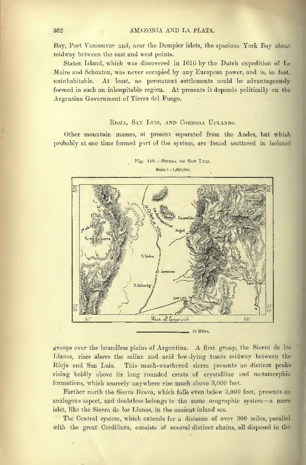
362 AMAZONIA AND LA PLATA.
Bay, Port Vancouver and, near the Dampier islets, the spacious York Bay about
midway between the east and west points.
Staten Island, which was discovered in 1616 by the Dutch expedition of Le
Maire and Schouten, was never occupied by any European power, and is, in fact,
uninhabitable. At least, no permanent settlements could be advantageously
formed in such an inhospitable region. At presents it depends politically on the
Argentine Government of Tierra del Fuego.
RIOJA, SAN Luis, AND CORDOBA UPLANDS.
Other mountain masses, at present separated from the Andes, but which
probably at one time formed part of the system, are found scattered in isolated
Fig. 148. SIEEEA DE SAN LTTIS.
Scale 1 : 1,000,000.
66'
18 Miles.
groups over the boundless plains of Argentina. A first group, the Sierra de los
Llanos, rises above the saline and arid low-lying tracts midway between the
Rioja and San Luis. This much-weathered sierra presents no distinct peaks
rising boldly above its long rounded crests of crystalline and metamorphic
formations, which scarcely anywhere rise much above 3,000 feet.
Farther north the Sierra Brava, which falls even below 3,000 feet, presents an
analogous aspect, and doubtless belongs to the same orographic system a mere
islet, like the Sierra de los Llanos, in the ancient inland sea.
The Central system, which extends for a distance of over 300 miles, parallel
with the great Cordillera, consists of several distinct chains, all disposed in the
THE ARGENTINE UPLAND. 868
same normal direction, and all standing on the same pedestal 1,500 feet above the
plains. In general these crystalline mountains present, like the Andes, their
steep face towards the west, and slope gently eastwards down to the pampas.A first ridge, traversed by the streams descending from the central system,
generally falls below 3,000 feet except at a few rare points, and culminates in
the Cumbre de la Cal (5.150 feet) north-west of Cordoba. But the central chain
attains in the Champaqui peak a height of over 7,550 feet. In the north-west
the system merges in a plateau crossed by a line of volcanoes running east and
west, and terminating abruptly in the trachytic Cerro de Yerba Buena, which
rises 5,400 feet above the western plains. It has no apparent crater, nor has it
emitted lavas or vapours in the memory of man;but slight earthquakes are
occasionally felt in the neighbourhood, and underground rumblings are also said
to be heard at the foot of these mountains.
The Sierra de San Luiz, or de la Puuta, from its south-western spur, may be
regarded as forming part of the Central or Cordoba system, which dies out
northwards in the saline depressions. On their western and northern sides the
San Luis heights present the aspect of bold mountain masses;but these escarp-
ments merely serve to mask a hummocky plateau, which in many places assumes
the character of a simple tableland. Amongst the highest peaks of the escarp-
ments are Monigote (6,430 feet), and the Gigantillo, "Little Giant," which faces
the Gigante,"Giant," of the Andes system on the opposite side of the deep
Canada depression.
The gneiss rocks of this sierra are distinguished from those of the Cordoba
system by their extreme richness in quartz and mica. East of Monigote a short
chain of volcanic heights, disposed transversely to the longitudinal axis, rises in
the Tomolasta to an altitude of 6,850 feet, culminating point of the plateau and
of the whole group. From its auriferous deposits this mountain has received the
name of Cerro de las Minas.
THE TANDIL AND VENTANA HEIGHTS.
Between the Parana and the Uruguay the surface is broken only by slight
rising grounds, or by fluvial cliffs;but in the territory of the Missions, which
stretches eastwards into the Brazilian State of Santa Catharina, the campus
plains are traversed by a ridge with crests of from 1,000 to 1,300 feet.
Distinct chains also rise east of the Patagonian Andes in the province of
Buenos Ayres and in the southern territories. A first line of crests runs north-
west and south-east parallel with the Lower Parana, terminating at the head-
land of Cape Corrientes. In the Sierra de Tandil this system rises to a height
of 1,100 feet, and farther on in the direction of the south-east the Sierra del
Vulcan has an altitude of 930 feet. Like the other heights of the surrounding
region the Sierra del Yulcan consists of granites, gneiss, and archaic rocks. But
there are no recent lavas, as might be supposed from the name of the range. But
this term " Vulcan "is not a Spanish, but a local Indian word, which would
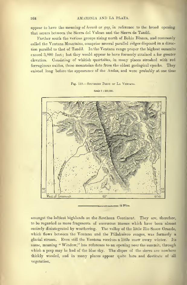
864 AMAZONIA AND LA PLATA.
appear to have the meaning of breach or gap, in reference to the broad opening
that occurs between the Sierra del Vulcan and the Sierra de Tandil.
Farther south the various groups rising north of Bahia Blanca, and commonly
called the Ventana Mountains, comprise several parallel ridges disposed in a direc-
tion parallel to that of Tandil. In the Ventana range proper the highest summits
exceed 3,800 feet;but they would appear to have formerly attained a far greater
elevation. Consisting of whitish quartzites, in many places streaked with red
ferruginous oxides, these mountains date from the oldest geological epochs. Theyexisted long before the appearance of the Andes, and were probably at one time
Fig. 149. SOUTHERN POINT OF LA VKNTANA.
Scale 1 : 550,000.
12 Miles.
amongst the loftiest highlands on the Southern Continent. They are, therefore,
to be regarded as mere fragments of enormous masses which have been almost
entirely disintegrated by weathering. The valley of the little Rio Sauce Grande,
which flows between the Ventana and the Pillahuinco ranges, was formerly a
glacial stream. Even still the Ventana receives a little snow every winter. Its
name, meaning "Window," has reference to an opening near the summit, through
which a peep may be had of the blue sky. The slopes of the sierra are nowhere
thickly wooded, and in many places appear quite bare and destitute of all
vegetation.
THE PATAGONIAN STEPPE. 365
THR PATAGONIAN STEPPE LANDS.
The interior of the Patagonian districts watered by the ftios Colorado and
Negro bristles with rocky crests, pink porphyries, and granites, which look in the
morning sun like lightly- tinted vapours. These various groups, known by the
general name of mahuida, that is," mountains "
in the native language, have un
average height of from 1,300 to 1,650 feet, and are nearly all disposed north-
west and south-east, like the chains of hills between Buenos Ayres and Bahia
Blanca.
Between the ridges the ground is strewn with rolled pebbles, granites, gneiss,
porphyries disposed in horizontal layers alternating with the dunes. These beds
of rolled gravels cover all the tertiary plains which constitute the whole of the
Patagonian plateau east of the Andes, and which contain a superabundance of
fossil remains. This prodigious mass of Patagonian gravels was calculated byDarwin to extend for about 600 miles north and south, with a mean breadth of
200 miles, and a depth of 50 feet. Whole mountain ranges must have been
triturated to yield such gravel beds as these;and to the Patagonian deposits must
be added the detritiis of like nature at present covering the marine bed itself.
Such are the rolled porphyries which the soundings have fished up in the waters
of the Falkland Islands, far from any insular masses containing analogous rocks.
These pebbles are evidently derived from the Andes and the older mountains,
which formerly rose above the central and eastern plains, and of which nothing
now remains except the nuclei. Glacial moraines have undoubtedly supplied the
raw material, which has been distributed by the marine waters in horizontal or
very slightly inclined beds. Then followed the phenomenon of emersion, due
either to an upheaval of the land, or to a subsidence of the sea. Thus the old
shingly beach became the dry gravel pits of Patagonia, in which are found pro-
digious quantities of those gigantic oysters, 15 to '^0 inches round, which are so
widely diffused throughout the soil of Patagonia. Near Possession Bay, at the
Atlantic entrance of Magellan Strait, de Pourtales discovered a lagoon standing
160 feet above sea level, and containing shells absolutely identical with those of
the neighbouring waters.
Hence there can be no reasonable doubt as to the general movement of
upheaval along the Patagonian seaboard. But geologists have not yet determined
its true character, and while some suppose that it took place in a succession of
sudden upward thrusts, corresponding to the several raised terraces, others with
more probability suggest that it was, on the contrary, a slow movement produced
in a series of rhythmical undulations.
During the contemporary period other formations have been superimposed on
the Patngonian gravel beds, and on the argillaceous clays of Central Argentina.
Over vast spaces the ground is now covered with sands, which form dunes
analogous to those developed on many coastlands under the influence of the winds
setting from the high seas. But in the Platean regions these shifting dunes are
not of marine origin ; they are, on the contrary, derived from the region of foot-
366 AMAZONIA AND LA PLATA.
hills, where have been iiccumulated prodigious quantities of debris from the
moraines left by the old glaciers at the entrance of the plains.
The finer particles, raised by the winds in clouds of dust, are wafted to great
distances and strewn over the surface in layers of sand analogous to the "yellow
earth"
of Central China. But the coarser sands form veritable dunes, "land
waves," so to say, heaving and falling under the pressure of the aerial currents.
In the region of the Colorado and Rio Negro especially these formations occupy
vast spaces, stretching nearly across the whole width of the Continent. Actingin the same way as the dunes of oceanic origin, they are arrested under the
influence of the rains, and resume their slow forward movement during the dry
periods. They are often solidified and transformed to hills gradually covered
with a vegetable humus by the binding action of plants with long trailing
rootlets and branches. Certain species of trees with strong roots, such as the
algarrobos, continue to thrive in the midst of the moving sands by which they
have been overtaken.
The eruptive craters of the Andes also contribute to change the aspect of the
Patagonian lands. The whole of the Bios Chubut and Santa Cruz basins have
been covered with ashes of diverse colours, which are deposited in regular layers,
and which are evidently erupted matter ejected by the volcanoes of the Cordilleras,
and wafted to great distances by the western and north-western winds.
In 1886 a great shower of such volcanic dust rained over the whole of the
Santa Cruz valley, on the surrounding heights, and even reached Puuta Arenas.
In some districts travellers found it difficult to breathe, and could scarcely discern
objects ten yards off. Many animals perished for want of water and fodder,
springs and pasturage having disappeared beneath the layer of ashes. For a time
the Santa Cruz itself ceased to flow, and then suddenly rose to a great height,
doubtless having burst the temporary dam formed by the volcanic debris. In
1893 the Chilian volcano, Calbuco, supposed to be extinct, ejected scoriae as far
as the mouth of the Chubut and Nuevo Bay. So rapidly had the clouds of ashes
traversed the vast distance that they fell while still warm, covering the navigation
as if with a mantle of snow.
Despite their generally dreary and monotonous aspect, the Patagonian steppe
lands seem to produce a strange, fascinating impression on all observers. "In
calling up the images of the past," writes Charles Darwin," I find the plains of
Patagonia frequently cross before my eyes ; yet these plains are pronounced by
all to be most wretched and useless. They are characterized only by negative
possessions ;without habitations, without water, without trees, without mountains,
they support only a few dwarf plants. Why then and the case is not peculiar
to myself have these arid wastes taken so firm possession of my mind ? Whyhave not the still more level, the greener, and more fertile pampas, which are
serviceable to mankind, produced an equal impression ?
"I can scarcely analyse these feelings, but it must be partly owing to the free
scope given to the imagination. The plains of Patagonia are boundless, for they
are scarcely practicable, and hence unknown. They bear the stamp of having

THE PATAGONIAN STEPPE. 867
lasted for ages, and there appears no limit to their duration through future time.
If, as the ancients supposed, the flat earth was surrounded by an impassable
breadth of water, or by deserts heated to an intolerable excess, who would not
look at these last boundaries to man's knowledge with deep but ill-defined
sensations ?" *
Since Darwin's time, however," these desolate regions have ceased to be
impracticable, and although still uninhabited and uninhabitable, except to a few
nomads, they are no longer unknown. During the last twenty years the country
has been crossed in various directions, from the Atlantic to the Andes, and from
the Rio Negro to the Straits of Magellan, and has been found all barren. The
mysterious illusive city, peopled by whites, which was long believed to exist in
the unknown interior, in a valley called Trapalanda, is to moderns a myth, a
mirage of the mind, as little to the traveller's imagination as the glittering capital
of Great Manoa, which Alonzo Pizarro and his false friend, Orellana, failed to
discover. The traveller of to-day expects to see nothing more exciting than a
solitary huanaco keeping watch on a hill-top, and a few grey-plumaged rheas
flying from him, and possibly a band of long-haired roving savages, with their
faces painted black and red.
"Yet, in spite of accurate knowledge, the old charm still exists in all its
freshness;and after all the discomforts and sufferings endured in a desert cursed
with eternal barrenness, the returned traveller finds in after years that it still
keeps its hold on him, that it shines brighter in memory and is dearer to him
than any other region he may have visited. In Patagonia the monotony of the
plains, or expanse of low hills, the universal unrelieved greyness of everything,
and the absence of animal forms and objects new to the eye, leave the mind open
and free to receive an impression of visible nature as a whole. One gazes on
the prospect as on the sea, for it stretches away, sea-like, without change, into
infinitude;but without the sparkle of water, the changes of hue which shadows
and sunlight and nearness and distance give, and motions of waves and white
flashes of foam. It has a look of antiquity, of desolation, of eternal peace, of
a desert that has been a desert from of old, and will continue a desert for
ever." f
THE PAMPAS.
Absolutely level plains occur only in Argentina proper north of the Rio
Colorado. These horizontal spaces stand at different heights above the Plate
estuary, and also present other contrasts due to the varying nature of soil and
climate. The northern region, comprised between the foothills and the course of
the Paraguay-Parana, constitutes the so-called Chaco (Gran Chaco), which owes
its peculiar aspect to its vegetation of thorny scrub, palm groves, and open or leafy
woodlands.
Other inland plains, lying farther south on both sides of the Cordoba heights,
*Voyage of the Beagle. t Idle Days in Patagonia.
368 AMAZONIA AND LA PLATA.
are, on the contrary, completely bare, and studded with saline basins glittering
in the solar rays. Lastly, the savannas, which stretch from the Cordoba uplandsto the lower Parana, and from the Plate estuary to the Patagonian foothills, take
the name of pampas, a Quichua word applied on the Peruvian and Bolivian
plateaux to level spaces, terraces, or bottom lands. Farther south, in Patagonia
proper, the grassy pampas gradually merge in a stony steppe covered with
scrub or bush.
Of all the Argentine regions the pampas have been most frequently described,
because they begin on the very outskirts of the large cities Buenos Ayres,
Rosario, Santa Fe and have thus to be traversed to reach the provinces of the
Far "West. They are not uniformly level, as might be supposed, but consist,
in reality, of a gently inclined terrace falling from 3,000 to 600 or 700 feet
between the foot of the Cordoba hills and the Rio Salado of Buenos Ayres, and a
low-lying plain falling from 250 to 120 feet, which develops a semi-circular zone
along the Parana and the Plate estuary, as far as the Atlantic.
The more elevated terrace constitutes the steppe proper, the central pampa,
which always stands above the level of the great inundations, whereas the low-
lying plain was formerly laid under water by the rivers in flood. This region
must be regarded as an alluvial tract deposited by the broad moving sea of the
Parana, and gradually dried by the layers of fine loess analogous to the yellow
earth of China, strewn over the surface by the west winds. No stones are found
intermingled with these upper beds of the pampas. The rocky foundation on
which they rest consists of a very fine-grained sandstone of miocene origin, like
the tertiary beds of Patagonia.
The general aspect of the pampas changes continually, not only with the seasons,
but even with the time of day. Their appearance at sunrise in the summer months is
pictured by Rumbold as indescribably beautiful. " No words can convey an adequate
idea of the beauty and freshness of the prairie at this early hour. The young
sun, but just risen like ourselves, floods the low and perfectly level horizon with a
flush of pink and yellow light. At once you realise the full force of the well-
known hackneyed image which compares the boundless expanse of plain to an
ocean solitude, for the effect is truly that of sunrise out upon the face of the
waste of waters. The fiery disc emerges out of what seems a sea of verdure, all
burned and brown though everything be in reality, and in its slanting rays the
tip of each blade of grass, the giant thistles with their rose-purple crowns, the
graceful floss-like panicles of the pampa grass (paja cortndera], just touched bythe breeze and all glittering with dew, undulate before the eye, like the
successive sparkling lines that mark the lazy roll of the deep in the dawn of a
tropical calm.
" The sky above, of a most lovely pale azure and of wonderful transparency,
has not yet deepened into that almost painful hue of crude cobalt it acquires
in the full blaze of noontide. In the west the vapours of night have not
entirely rolled away, while down in the dips and depressions of the ground
Canada*, as they call them here and over the reed-fenced lagunas, a thin blue mist
THE ARGENTINE PAMPAS. 869
still lingers aud mingles deliciously with tlie various subdued tints of brown and
green around.
" This tender tonality lasts but a very short time, the sun shooting up-
wards with a speed and force that at once completely transforms the picture;
the scorching agencies of light revealing it in its true parched colours and
reducing it to a burning arch above, and a scorching and featureless flat below.
The fresh, rippling ocean turns into a weary wilderness, staring up at a breathless,
pitiless sky."*
Nor are the pampas regions so destitute of animal life and motion as is commonly
supposed. The same observer speaks of the stir of bird and insect life that
accompanies the waking up of the great plain at dawn. " The air is full of
buzzing and chirping and of the flutter of wings. So thickly is the pampa
peopled with birds that it quite produces the effect of an open-air aviary. Brilliant
little creatures with red or yellow breasts, zorzats and cardinals, magpies and
oven-birds dart in and out of the grass and bushes in every direction, while in
the higher regions numerous hawks and kites hover ominously over these tempting
preserves." All the feathered tril:e are singularly fearless and unconcerned at one's
approach, the only exception being the well-known abomination of the sportsman
in the pampa, the spur-winged plover. This insufferable creature, who, as
Darwin somewhere says of him, appears to hate mankind, swarms all over the
prairie, and pursues one with a loud and discordant cry, which is exactly
rendered by his common name of tcru-tero. He is really a very handsome bird,
with glossy black and lavender plumage tipped with green and purple, but, like
much lovelier beings one has occasionally met with, his beauty is quite marred
by his harsh, unmusical voice and forward ways. He is both the spy and the
scold of the pampa. Being too worthless in himself to stand in danger of
being shot, his one idea seems to be to spoil sport. As soon as he gets sight of
you, he sets up his shrill wearying note and follows you pertinaciously about, of
course warning all the game around of your approach." t
A still greater pest is the bicho Colorado, a villainous little bright red insect,
no bigger than a pin's head, whose bite causes an intolerable irritation, which
lasts for days together. But with the exception of these plaguy little creatures
and of the clouds of mosquitoes swarming about all the In goons, the pampas
regions are singularly free from noxious vermin of all kinds. The only really
venomous animals nppear to be the dreaded tarantula and the still more dreaded
vibora do la cruz, a deadly species of viper.
On the other hand, game abounds to an extraordinary extent in some districts
verging on the forest zone. Even in the "campo," as the steppe lands are called
in the province of Buenos Ayres, some good shooting is still afforded by such
aquatic birds as the swan, goose, flamingo, duck, grebe, and water-hen, besides
deer, the Patagonian hare, snipe, and partridge. The partridge is somewhat
* The Great Silver River, p. 273. t The Great Silver River, p. 275.
870 AMAZONIA AND LA PLATA.
larger than its English congener, but not to be compared to it in flavour, the flesh
being white and rather tasteless.
Most of the land about Buenos Ayres consists of an extremely rich alluvium,
where the alfalfa clover and some other herbaceous plants grow with amazing
rapidity. In some districts Dr. Edgcumbe speaks of five crops of clover being
raised in a single year.* Wheat also thrives well, and yields excellent returns.
HYDROGRAPHY OF ARGENTINA.
The La Plata fluvial system, next to that of the Amazons the largest in the
New World, belongs at once to Bolivia, Brazil, Paraguay, Uruguay, and to the
Republic which, from the estuary, takes its names of La Plata and Argentina.
This State comprises about one half of the whole basin, although by far the largest
part of the liquid mass is supplied by the conterminous territories. At the con-
fluence of the two great rivers, Paraguay and Parana, where the united waters
enter a region belonging entirely to Argentina, the discharge is actually greater
than at the head of the estuary. Below the confluence the contributions of the
feeble Argentine affluents are insufficient to make good the loss by evaporation.
THE Rio BERMEJO.
At the Tres Bocas, name of the inland delta formed about the confluence, the
Rio Bermejo (Vermejo," Red "
), largest of the Argentine tributaries, has already
joined the Paraguay branch. This river, which flows parallel to the Pilcomayo
farther north, has its source in the Andes, east of the Jujuy plateau. One of its
main branches, the Bermejo proper, is joined below Oran by the San Francisco,
a stream of equal volume, which collects the surface waters of the province of
Jujuy. Above the confluence Las Juntas, as the Spaniards call it both branches
are alike navigable ;but farther down so many difficulties, and even dangers, are
presented by shoals, quicksands, and armed natives, that no regular service has
yet been established on the lower reaches. The flat-bottomed boats, which carry
on a little trade, take whole months to ascend and descend the Bermejo, and
cannot pretend to compete with the railway, which now penetrates from Buenos
Ayres into the Jujuy district.
In the region of its lower course the incline is so slight that the sluggish
current of the Bermejo ramifies right and left into numerous lateral branches and
shallow basins, where much of the water is lost by evaporation. Nearly all the
old forests have disappeared, killed by the superabundance of flood waters. About
the middle of the nineteenth century the Bermejo shifted its bed some twelve
miles northwards to the parallel Rio Teuco or Teuchtach, and since then the
lateral inundations have diminished on both sides, the stagnant backwaters have
been gradually filled by alluvial matter, and the old bed of the Bermejo is now
*Zephyrus, p. 196.
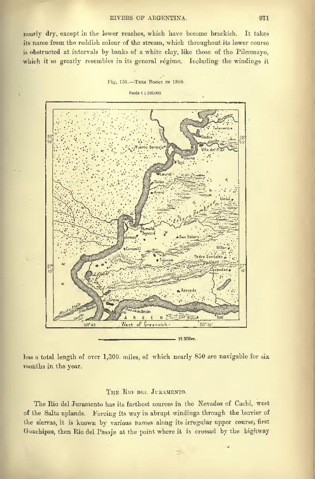
RIVERS OF ARGENTINA. 871
nearly dry, except in the lower reaches, which have become brackish. It takes
its name from the reddish colour of the stream, which throughout its lower course
is obstructed at intervals by banks of a white clay, like those of the Pilcomayo,
which it so greatly resembles in its general regime. Including the windings it
Fig. 150. TEES BOCAS IN 1860.
Scale 1 : 500.1)00
12 Miles.
has a total length of over 1,300- miles, of which nearly 850 are navigable for six
months in the year.
THE RlO DEL JURAMENTO.
The Rio del Juramento has its farthest sources in the Nevados of Cachi, west
of the Salta uplands. Forcing its way in abrupt windings through the barrier of
the sierras, it is known by various names along its irregular upper course, first
Guaehipas, then Rio del Pasaje at the point where it is crossed by the highway
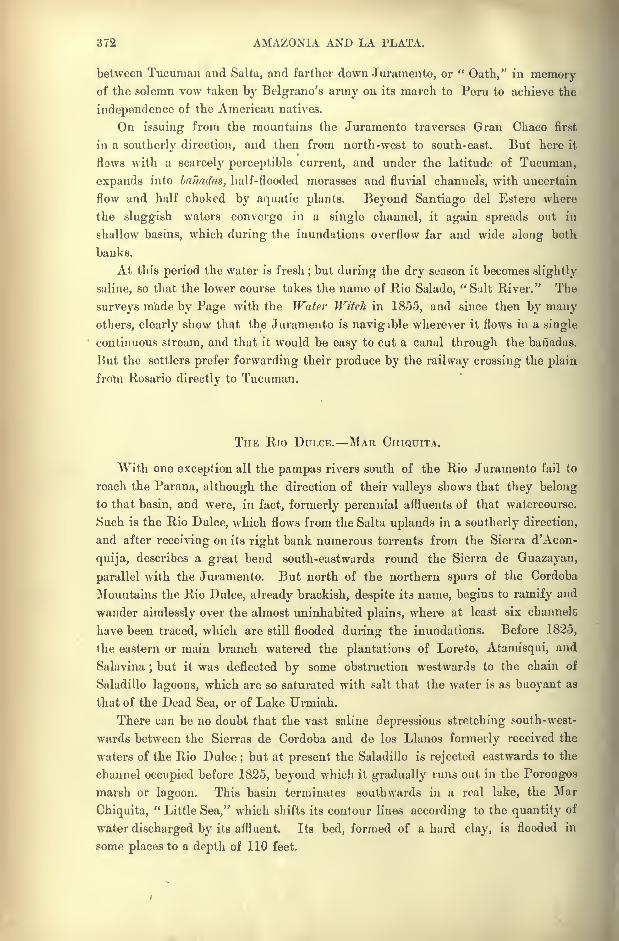
372 AMAZONIA AND LA PLATA.
between Tucuman and Salta, and farther down Juramento, or "Oath," in memory
of the solemn vow taken by Belgrano's army on its march to Peru to achieve the
independence of the American natives.
On issuing from the mountains the Juramento traverses Gran Cbaco first
in a southerty direction, and then from north-west to south-east. But here it
flows with a scarcely perceptible current, and under the latitude of Tucuman,
expands into bafiadas, half-flooded morasses and fluvial channels, with uncertain
flow and half choked by aquatic plants. Beyond Santiago del Estero where
the sluggish waters converge in a single channel, it again spreads out in
shallow basins, which during the inundations overflow far and wide along both
banks.
At this period the water is fresh;but during the dry season it becomes slightly
saline, so that the lower course takes the name of Rio Salado," Salt River." The
surveys made by Page with the Water Witch in 1855, and since then by manyothers, clearly show that the Juramento is navigible wherever it flows in a single
continuous stream, and that it would be easy to cut a canal through the banadas.
Hut the settlers prefer forwarding their produce by the railway crossing the plain
from Rosario directly to Tucuman.
THE Rio DULCE. MAR CHIQUITA.
With one exception all the pampas rivers south of the Rio Juramento fail to
reach the Parana, although the direction of their valleys shows that they belong
to that basin, and were, in fact, formerly perennial affluents of that watercourse.
Such is the Rio Dulce, which flows from the Salta uplands in a southerly direction,
and after receiving on its right bank numerous torrents from the Sierra d'Acon-
quija, describes a great bend south-eastwards round the Sierra de Guazayan,
parallel with the Juramento. But north of the northern spurs of the Cordoba
Mountains the Rio Dulce, already brackish, despite its name, begins to ramify and
wander aimlessly over the almost uninhabited plains, where at least six channels
have been traced, which are still flooded during the inundations. Before 1825,
the eastern or main branch watered the plantations of Loreto, Atamisqui, and
Salavina; but it was deflected by some obstruction westwards to the chain of
Saladillo lagoons, which are so saturated with salt that the water is as buoyant as
that of the Dead Sea, or of Lake Urmiah.
There can be no doubt that the vast saline depressions stretching south-west-
wards between the Sierras de Cordoba and de los Llanos formerly received the
waters of the Rio Dulce;but at present the Saladillo is rejected eastwards to the
channel occupied before 1825, beyond which it gradually runs out in the Porongos
marsh or lagoon. This basin terminates southwards in a real lake, the Mar
Chiquita," Little Sea," which shifts its contour lines according to the quantity of
water discharged by its affluent. Its bed, formed of a hard clay, is flooded in
some places to a depth of 110 feet.
EIVERS OF ARGENTINA. 373
THE Rios PRIMERO, SEGUNDO, TERCERO, CUARTO, AND QUINTO.
The streams descending from the Cordoba heights eastwards to the pampas,have been numbered rather than named in their order from north to south. The
Rio Primero,"First," transformed by a reservoir to a lake above Cordoba, almost
runs dry on entering the pampa, although after heavy rains its yellowish waters
reach the Mar Chiquita. The Rio Segundo,"Second," which follows a parallel
course farther south, also disappears in shallow depressions, which evaporate in the
sun.
But the more copious Rio Tercero,"Third," maintains its current across the
pampa, although gradually changing from a fresh water to a saline stream.
Towards the middle of its course it receives the salt water of the Saladillo, which
appears to be fed by the infiltrations from the irrigation canals derived from the
Rio Cuarto," Fourth." Before reaching the Parana, the Tercero, here called the
Carcarana, or Carcarafial, from an extinct Guarani tribe met by Cabot, is joined
by the Arroyo de las Tortugas," Turtle Creek," which was perhaps at one time
the outlet of the Mar Chiquita. The Carcarana is accessible only to bouts drawingtwo or three feet.
The Rio Quinto,"Fifth," rises not in the Cordoba uplands, but farther west
in the Sierra de San Luis, and the streams descending from the Cordoba slopes
fail to reach its banks. After a south-easterly course of 300 miles it runs out in
the Amarga, or " Bitter"
lagoon, in a region of swamps and quagmires extremely
dangerous to wayfarers. These guadaks, as they are called, long afforded a refuge
to the Ranquele Indians against the white invaders.
EASTERN AFFLUENTS OF THE PARANA. LAKE IBERA.
On its left bank the Parana receives the contributions only of a few small
affluents. In this Argentine"Mesopotamia," the surface is also so level that the
waters expand in swamps and lagoons, such as the Lake Ibera,"Brightwater,"
which, perhaps, indicates the former channel of the Parana, when it flowed parallel
with the Uruguay.In this part of the region comprised between the two main streams the surface
stands almost at a dead level. Hence it was found possible to attempt to partly
drain the Ibera lagoon at two different points. At the head of the basin trenches
were excavated for the purpose of" carrying off the overflow to the upper Parana,
while lower down the rivers Batel and Corrientes were deepened and canalised,
and thus made to receive a portion of the discharge through some sluggish
channels. The Ibera lagoon has a total length of over 24 miles, with flat
uncertain margin on the west side, but sharply limited on the east side by steep
banks and hillocks, which rise to heights of from 30 to 50 feet above the surface
of the lake. The whole basin is disposed in a succession of esteros, most of which
are overgrown with forests of reeds, while others are deep enough to be navigated
by small craft. But few boatmen venture to ply on these waters, which are
58
874 AMAZONIA AND LA PLATA.
infested by prodigious clouds of midges. These lagoons of the Corrientes region
are reported to have encroached, in recent years, on the surrounding lands.
South of the Rio Corrientes, which partly drains Ibera, follow a few other tribu-
taries, which, however, are insufficient to compensate for the loss by evaporation.
The Gualeguay, largest of these tributaries in the province of Entre-Rios, winds
in a sluggish course of about 250 miles parallel with the lower Uruguay. It dis-
charges, not into the Parana direct, but into the Pavon, one of those lateral channels
which are alternately flushed and abandoned by the main stream.
Between the Tres Bocas and Plate deltas, the Parana is increased in width
tenfold by numerous other affluents winding through the vast fluvial depression.
Even those pampa streams, which at present lie quite beyond the labyrinth of
Parana waters, formerly belonged to the system. Such are in the province of
Santa Fe, the Saladillo Dulce and the Saladillo Amargo," Sweet" and "Bitter"
Saladillo, both of which have a course of about 250 miles.
THE PARANA DELTA.
The Parana delta, properly so-called, begins below the Diamante bluff, at the
point where the river trends round to the south-east in the direction of the Plate
estuary. This point marks the former head of the marine gulf at a time when
it penetrated 370 miles into the interior of the Continent. All the upper part of
this vast inlet has been silted up by the alluvial deposits for a distance of 230
miles, and the elongated islands occupying the wide zone of unstable groundbetween the lateral cliffs have all been formed by these siltings.
In this vast deltaic region the main channel of the Parana hugs the right
(pampa) bank nearly to the town of San Pedro, where nearly the whole fluvial
mass is collected in a single channel, which contracts at one point to less than
700 yards, with a depth of about 160 feet. The lateral channels skirting the shores
of Entre-Rios take various names, such as Victoria, Paranacito, Pavon, Ibicuy.
But during great inundations, such as those of 1858 and 1868, all are merged in
a single sheet of water flooding the whole of the ancient marine inlet, and even
submerging the intervening islands. At such time steamers ply between Victoria
and Rosario, right across the temporarily restored estuary, which is here nearly
40 miles wide.
Below San Pedro the Parana Guazu," Great Parana," crosses from the western
to the eastern (Entre-Rios) side, throwing off in the direction of Buenos Ayresthe Baradero, a small branch, which is usually followed by light craft to avoid the
winds and swell of the main channel. Another branch, the Rio de las Palmas
bifurcates from the Parana Guazu, and although less copious, maintains a uniform
width all the way to the estuary, whereas the Guazu ramifies into numerous
lateral creeks, some of which even trend north and north-east to the Uruguay.The chief mouth, about 880 yards wide, opens north of the delta, not in a line
with the axis of the Plate estuary, but more to the north in that part of the
inlet where the Uruguay debouches just below the Higuerites Strait. The front

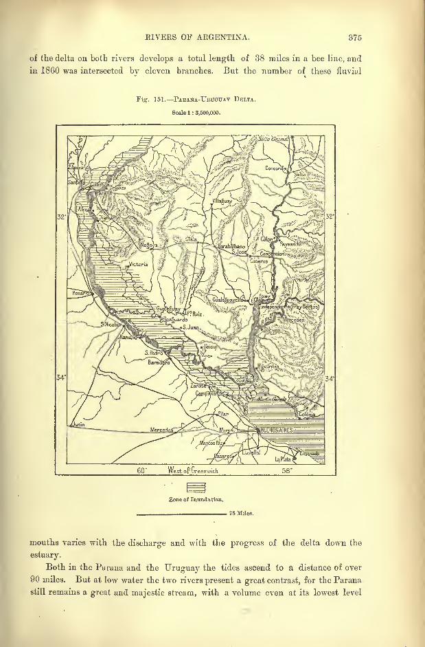
EIVERS OF ARGENTINA. 375
of the delta on both rivers develops a total length of 38 miles in a bee line, and
in 1860 was intersected by eleven branches. But the number of these fluvial
Fig. 151. PABANA-URTTGTJAY DELTA.
Scale 1 : 3,500,000.
34'
60' West op Greenwich
Zone of Inundation.
76 Miles.
mouths varies with the discharge and with the progress of the delta down the
estuary.
Both in the Parana and the Uruguay the tides ascend to a distance of over
90 miles. But at low water the two rivers present a great contrast, for the Parana
still remains a great and majestic stream, with a volume even at its lowest level
876 AMAZOXIA AND LA PLATA.
equal to the average discharge of the Mississippi, and from thirty to forty times
greater than that of the Seine at Rouen. But the Uruguay shows great devia-
tions, being nearly equal to the Parana when in flood, whereas during the dryseason it is reduced to quite a secondary stream with not more than one sixtieth
part of its volume at high water.* Such oscillations in the volume of its waters
are explained by the uniform character of the climate in the region traversed bythe Upper and Middle Uruguay, and by the lack of lateral reservoirs, by which
the discharge might be regulated.
To the volume of water contained in the beds of the Parana and Uruguaymust be added the subterranean channels, which flow with a sluggish current
below the surface, and which are also due to the rains that fall in the fluvial basin.
Below the upper layers there stretches a bed of saturated sands intermingled with
a sheet of fresh water, and containing small fluviatile shells. This underground
basin, which has been discovered by soundings in the sub-soil of Buenos Ayresat a depth of at least 75 or 80 feet, is in direct communication with the section
of the Parana between Rosario and San Pedro. It is replenished not only bydirect contributions from the main stream, but also by continuous undergroundinfiltrations
;hence it may be regarded as practically inexhaustible.t
THE PLATE ESTUARY.
The visible Parana-Uruguay delta is continued by a submarine delta, which
must gradually rise above the surface, if the relative levels of land and sea are
maintained in these waters. Sandbanks separated by deep troughs are advancing
beyond the alluvial islands, and slowly connecting Martin Garcia with the main-
land. The fluvial sediment, which has already absorbed so much of the old marine
inlet, is steadily encroaching on the Plate estuary.
Both the Parana and the Uruguay are ceaselessly washing down alluvial
matter, which is deposited in sandbanks, and which at low water transforms the
whole estuary to a labyrinth of channels, where the shipping has already to thread
its way cautiously. The mean depth of the estuary measured between Monte
Video and Punta de las Piedras, is only 13 or 14 feet, and it must have greatly
diminished even within a comparatively recent geological epoch, for large
whales were formerly stranded above Buenos Ayres, where the water is now too
shallow to give them access. Before the recent dredgings and other harbour
works, all vessels had to ride at anchor far from the shore, passengers and goods
being landed in flat-bottomed barges, and during fine weather in carts drawn
*Comparative table of the Parana and Uruguay, according to Aguirre, Revy, and Bateman :
PARANA. URUGUAY.
Extent of catchment bacin . . 1,150,000 sq. miles 155,000 sq. miles
Extreme length . . . . 2,900 miles 920 miles
Minimum discharge per second . 73,000 cubic feet 19,500 cubic feet
Mean . 393,000 ,, ., 141,000 ,,
Maximum . 1,650,000 ,, 495,000
Proportion of sediment in both rivers : iooofr-
t Einilio G-odoy, Bolctin del Institute Geografico Argentina, Vol. V., 1884.
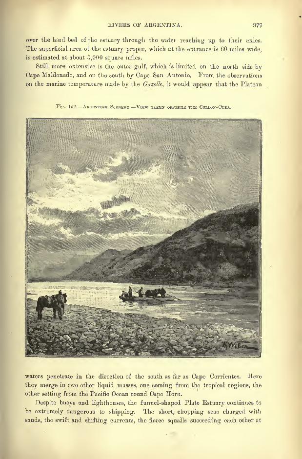
RIVERS OF ARGENTINA. 877
over the hard bed of the estuary through the water reaching up to their axles.
The superficial area of the estuary proper, which at the entrance is 60 miles wide,
is estimated at about 5,000 square miles.
Still more extensive is the outer gulf, which is limited on the north side by
Cape Maldonado, and on the south by Cape San Antonio. From the observations
on the marine temperature made by the Gazelle, it would appear that the Platean
Fig. 152. ABGKNTINK SOENEBY. VIEW TAKEN OPPOSITE THE COLLON-CTTEA.
waters penetrate in the direction of the south as far as Cape Corrientes. Here
they merge in two other liquid masses, one coming from the tropical regions, the
other setting from the Pacific Ocean round Cape Horn.
Despite buoys and lighthouses, the funnel-shaped Plate Estuary continues to
be extremely dangerous to shipping. The short, chopping seas charged with
sands, the swift and shifting currents, the fierce squalls succeeding each other at
878 AMAZONIA AND LA PLATA.
sudden intervals, greatly imperil the navigation ;even large vessels often drag
their anchors, break from their moorings, and run aground on the sandbanks, or
on some of the islands in process of formation.
THE CLOSED BASINS OF ARGENTINA.
Between the Juramento-Salado and the Rio Colorado on the Patagonian
frontier, none of the rivers rising between the eastern slopes of the Andes and
the Sierra de Cordoba reach the Atlantic through the Plate estuary. The closed
basins, which are comprised within this north-western region of Argentina, and
which are nearly all disposed in the direction from north to south parallel with
the Cordillera itself, appear to be of glacial origin. Their beds are strewn with
angular boulders, which have not been transported to any great distances, but
which have been slightly worn by the action of winds and sands.
Within a recent geological period all the running waters descending from
the Andes west and south of Aconquija heights must have reached the Atlantic
through the Colorado, whose basin was formerly far more extensive than at
present. The northernmost streams of this now half-dried basin are all now
reduced to small dimensions. Thus the Chaschuil, with its Fiambala branch and
other affluents, shrinks to half its size in a saline sandy depression of lacustrine
origin, beyond which it penetrates through a defile into the plains of the Rio
Rioja, where its current is completely exhausted. From this point to the junction
with the San Juan the distance in a straight line is about 280 miles from north
to south.
The Rio Vermejo (de la Rioja) and the Jachal, which descend to the west of
the Famatina heights, also receive lateral contributions from the snowy Cordillera,
by which their current is maintained for a greater distance than that of the eastern
rivers. But owing to the irrigation canals derived from both banks they do not
always reach their confluence. Hence their lower course, the Rio Zanjon,
alternately increases and decreases with the seasons, without ever reaching
the marshy basin in which it might effect a junction with the San Juan.
This latter watercourse, with its widely ramifying headwaters, issues as a
foaming torrent from the mountains, but is immediately captured by numerous
irrigation rills winding in all directions over the plains. Nevertheless, sufficient
water remains in the main channel to form a little navigable stream, which is
joined lower down by the drainage of the irrigated lands, and which discharges
into the marshy Huanacache lagoons. The same depression also receives the Rio
de Mendoza descending from the Cumbre and fed by the snows of Aconcagua and
Tupungato.
LAKE BEHEDEKO. Rios SALADO AND ATUEL.
The overflow of these saline lagoons is carried off by the Desaguadero, which
is nearly dry for a part of the year, and which flows south-east, throwing off a
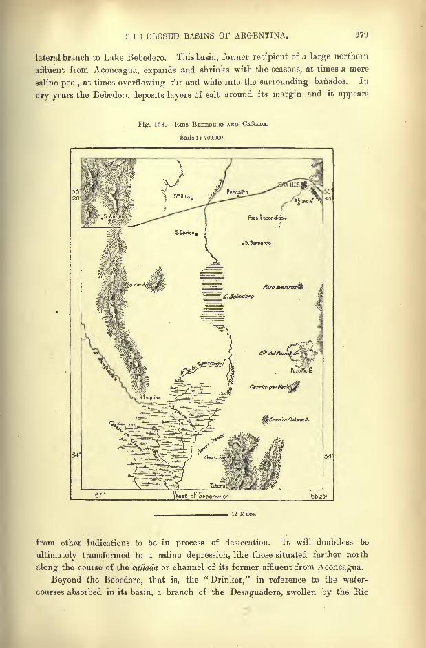
THE CLOSED BASINS OF ARGENTINA. 379
lateral branch to Lake Bebedero. This basin, former recipient of a large northern
affluent from Aconcagua, expands and shrinks with the seasons, at times a mere
saline pool, at times overflowing far and wide into the surrounding banados. In
dry years the Bebedero deposits layers of salt around its margin, and it appears
Fig. 153. Rios BEBEDEBO AND CANADA.
Scale 1 : 700,000.
66'20'
12 Miles.
from other indications to be in process of desiccation. It will doubtless be
ultimately transformed to a saline depression, like those situated farther north
along the course of the Canada or channel of its former affluent from Aconcagua.
Beyond the Bebedero, that is, the "Drinker," in reference to the water-
courses absorbed in its basin, a branch of the Desaguadero,, swollen by the Rio
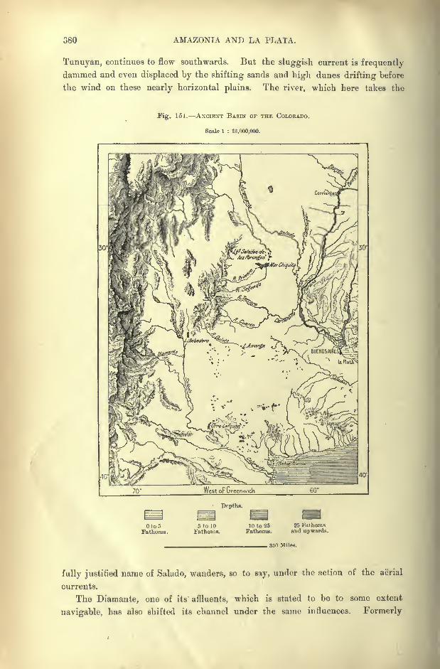
380 AMAZONIA AND LA PLATA.
Tunuyan, continues to flow southwards. But the sluggish current is frequently
dammed and even displaced by the shifting sands and high dunes drifting before
the wind on these nearly horizontal plains. The river, which here takes the
Fig. 151. ANCIENT BASIN OF THE COLORADO.
Scale 1 : 13,000,000.
70' 60*
Depths.
Oto5Fathoms.
5 to 10
Fathoms.10 to 25Fathoms.
25 Fathomsand upwards.
, 310 Miles.
fully justified name of Salado, wanders, so to say, under the action of the aerial
currents.
The Diamante, one of its affluents, which is stated to be to some extent
navigable, has also shifted its channel under the same influences. Formerly
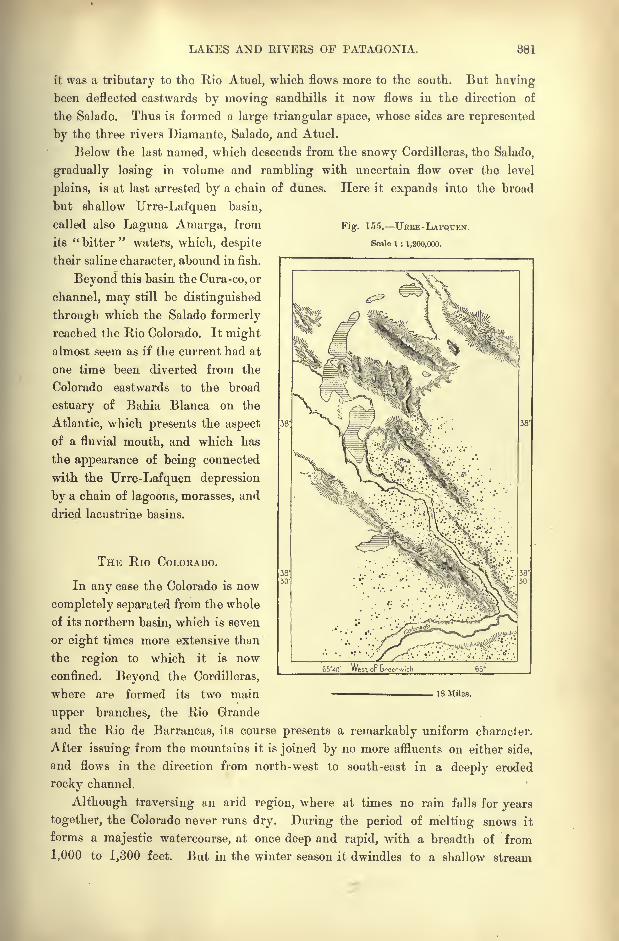
LAKES AND RIVERS OF PATAGONIA. 381
it was a tributary to the Rio Atuel, which flows more to the south. But havingbeen deflected eastwards by moving sandhills it now flows in tLe direction of
the Salado. Thus is formed a large triangular space, whose sides are represented
by the three rivers Diamante, Salado, and Atuel.
Below the last named, which descends from the snowy Cordilleras, the Salado,
gradually losing in volume and rambling with uncertain flow over the level
plains, is at last arrested by a chain of dunes. Here it expands into the broad
but shallow Urre-Lafquen basin,
called also Laguna Amarga, from Fig. 155.
its "bitter" waters, which, despite Scale i : 1,200,000.
their saline character, abound in fish.
Beyond this basin the Cura-co, or
channel, may still be distinguished
through which the Salado formerly
reached the Rio Colorado. It mightalmost seem as if the current had at
one time been diverted from the
Colorado eastwards to the broad
estuary of Bahia Blanca on the
Atlantic, which presents the aspect
of a fluvial mouth, and which has
the appearance of being connected
with the Urre-Lafquen depression
by a chain of lagoons, morasses, and
dried lacustrine basins.
THE Rio COLORADO.
In any case the Colorado is now
completely separated from the whole
of its northern basin, which is seven
or eight times more extensive than
the region to which it is now
confined. Beyond the Cordilleras,
where are formed its two main
upper branches, the Rio Grande
and the Rio de Barrancas, its course presents a remarkably uniform character.
After issuing from the mountains it is joined by no more affluents on either side,
and flows in the direction from north-west to south-east in a deeply eroded
rocky channel.
Although traversing an arid region, where at times no rain falls for years
together, the Colorado never runs dry. During the period of melting snows it
forms a majestic watercourse, at once deep and rapid, with a breadth of from
1,000 to 1,300 feet. But in the winter season it dwindles to a shallow stream
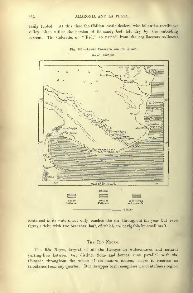
382 AMAZONIA AND LA PLATA.
easily forded. At this time the Chilian cattle-dealers, who follow its rectilinear
valley, often utilise the portion of its sandy bed left dry by the subsiding
current. The Colorado, or "Red," so named from the argillaceous sediment
Fig. 156. LOWER COLORADO AND Rio NEGRO.
Scale 1 : 3,000,000.
Depths.
OtolOFathoms.
10 to 25Fathoms.
25 Fathomsand upwards.
75 Miles.
contained in its waters, not only reaches the sea throughout the year, but even
forms a delta with two branches, both of which are navigable by small craft.
THE Rio NEGUO.
The Rio Negro, largest of all the Patagonian watercourses and natural
parting-line between two distinct floras and faunas, runs parallel with the
Colorado throughout the whole of its eastern section, where it receives no
tributaries from any quarter. But its upper basin comprises a mountainous region
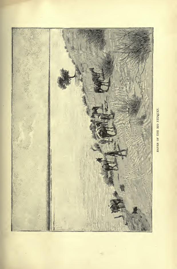
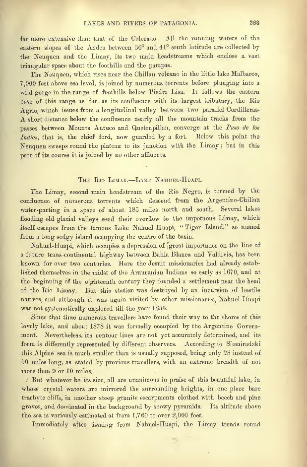
LAKES AND RIVERS OF PATAGONIA. 388
far more extensive than that of the Colorado. All the running waters of the
eastern slopes of the Andes between 36 and 41 south latitude are collected by
the Neuquen and the Limay, its two main headstreams which enclose a vast
triangular space about the foothills and the pampas.
The Neuquen, which rises near the Chilian volcano in the little lake Malbarco,
7,000 feet above sea level, is joined by numerous torrents before plunging into a
wild gorge in the range of foothills below Piedra Lisa. It follows the eastern
base of this range as far as its confluence with its largest tributary, the Rio
Agrio, which issues from a longitudinal valley between two parallel Cordilleras.
A short distance below the confluence nearly all the mountain tracks from the
passes between Mounts Antuco and Quetrupillan, converge at the Paso de los
Indios, that is, the chief ford, now guarded by a fort. Below this point the
Neuquen sweeps round the plateau to its junction with the Limay ; but in this
part of its course it is joined by no other affluents.
THE Rio LIMAY. LAKE NAHUEL-HUAPI.
The Limay, second main headstream of the Rio Negro, is formed by the
confluence of numerous torrents which descend from the Argentine-Chilian
water-parting in a space of about 185 miles north and south. Several lakes
flooding old glacial valleys send their overflow to the impetuous Limay, which
itself escapes from the famous Lake Nahuel-Huapi,"Tiger Island," so named
from a long sedgy island occupying the centre of the basin.
Nahuel-Huapi, which occupies a depression of great importance on the line of
a future trans -continental highway between Bahia Blanca and Valdivia, has been
known for over two centuries. Here the Jesuit missionaries had already estab-
lished themselves in the midst of the Araucanian Indians so early as 1670, and at
the beginning of the eighteenth century they founded a settlement near the head
of the Rio Limay. But this station was destroyed by an incursion of hostile
natives, and although it was again visited by other missionaries, Nahuel-Huapiwas not systematically explored till the year 1855.
Since that time numerous travellers have found their way to the shores of this
lovely lake, and about 1878 it was formally occupied by the Argentine Govern-
ment. Nevertheless, its contour lines are not yet accurately determined, and its
form is differently represented by different observers. According to Siemiradzki
this Alpine sea is much smaller than is usually supposed, being only 28 instead of
50 miles long, as stated by previous travellers, with an extreme breadth of not
more than 9 or 10 miles.' But whatever be its size, all are unanimous in praise of this beautiful lake, in
whose crystal waters are mirrored the surrounding heights, in one place bare
trachyte cliffs, in another steep granite escarpments clothed with beech and pine
groves, and dominated in the background by snowy pyramids. Its altitude above
the sea is variously estimated at from 1,760 to over 2,000 feet.
Immediately after issuing from Nahuel-Huapi, the Limay trends round
384 AMAZONIA AND LA PLATA.
abruptly northwards to a longitudinal valley separating the great Cordillera from
the parallel range known as the Cordillera de los Cipreses. After receiving the
overflow from Lake Treful the Limay pierces this rocky barrier, beyond which it
is joined by the longer and equally copious Collon-Cura rising about 160 miles
farther north. On its winding course southwards the Collon-Cura is joined by
the emissary of the Alumine lagoon, which stands near the divide between the
Biobio and Rio Negro, and possibly sends its overflow to both basins.
Swollen by all the torrents from the Cordilleras, the Limay flows rapidly in a
north-easterly course, flanked here and there by reddish cliffs, and elsewhere
expanding in broad depressions studded with lagoons, the resort of myriads of
water-fowl. The current, although very swift, nowhere develops rapids, so that a
steamer with powerful engines might ascend all the way to Lake Nahuel-Huapi,
and even penetrate into the Collon-Cura affluent.
THE LOWER Rio NEGRO.
At the confluence the Neuquen and the Limay have about the same mean
annual discharge ;but the Neuquen, traversing a more arid region, presents far
greater discrepancies between high and low water. To judge from the disposition
of its valley, the Limay would seem to be the true upper branch of the Cura
Leofu, or Rio Negro, to which the Indians appear to have given this name, not
from the colour of its waters, but from the rapids and other dangerous obstructions
to its navigation. Flowing on a shingly or rocky bed, the stream maintains its
pure sea-green colour throughout the year, except for two or three days after the
floods, when it changes to" a dull red with the red earth that some swollen tribu-
tary hundreds of miles to the west has poured into its current. This change
lusts only a day or two, after which the river runs green and pure again."'
Flowing in its broad, regularly inclined valley at first eastwards, then to the
south-east, the " Black River "receives not a single tributary from the arid Pata-
gonian plains. But although, under this rainless climate, it gradually loses volume
on its seaward course, it still maintains a mean depth of over thirteen feet. About
midway it breaks into two branches which ramify amid groups of shifting islands,
forming the Choele Choel, famed in Patagonian history as the place where the
native warriors crossed to swoop down on the Argentine settlements.
The Choele Choel, some 60 miles long with a mean breadth of 6 or 7 miles,
consists of alluvial soil at a dead level clothed with bush and herbage. Rightand left stretch low-lying plains bounded by the scarps of the plateau (here about
800 feet high), and often submerged by the flood waters of the Neuquen, derived
in summer from the melting snows, in winter from the heavy rains on the
mountain slopes. The Rio Negro glides silently into the sea through a single
channel, without in any way modifying the trend of the shore-line. f
* W. H. Hudson, Idle Days in Patagonia, p. 36.
t Length of the Rio Negro from Lake Nahuel-Huapi to the 8ea . . 575 miles
Area of catchment hasin ....... 50,000 square miles.
Probahle discharge, according to Guerrico . . . 14,000 cubic feet per second.
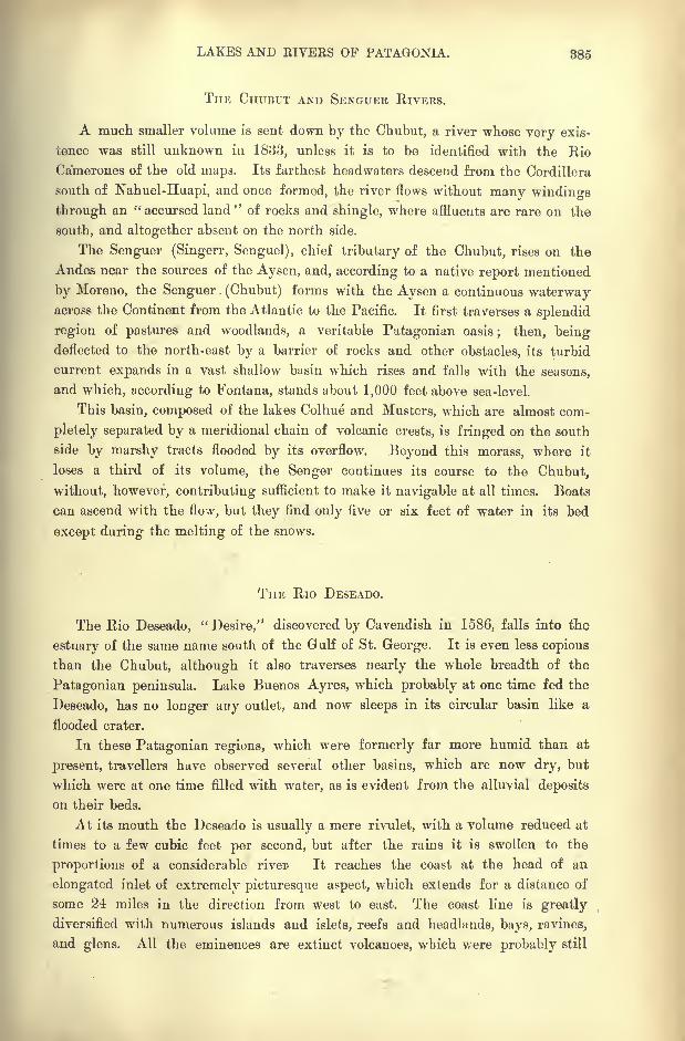
LAKES AND RIVERS OF PATAGONIA. 885
THE CHUBUT AND SENGUKR RIVERS.
A much smaller volume is sent down by the Chubut, a river whose very exis-
tence was still unknown in 1833, unless it is to be identified with the Rio
Camerones of the old maps. Its farthest headwaters descend from the Cordillera
south of Nahuel-Huapi, and once formed, the river flows without many windings
through an "accursed land" of rocks and shingle, where affluents are rare on the
south, and altogether absent on the north side.
The Senguer (Singerr, Senguel), chief tributary of the Chubut, rises on the
Andes near the sources of the Aysen, and, according to a native report mentioned
by Moreno, the Senguer (Chubut) forms with the Aysen a continuous waterwayacross the Continent from the Atlantic to the Pacific. It first traverses a splendid
region of pastures and woodlands, a veritable Patagonian oasis; then, being
deflected to the north-east by a barrier of rocks and other obstacles, its turbid
current expands in a vast shallow basin which rises and falls with the seasons,
and which, according to Fontana, stands about 1,000 feet above sea-level.
This basin, composed of the lakes Colhue and Musters, which are almost com-
pletely separated by a meridional chain of volcanic crests, is fringed on the south
side by marshy tracts flooded by its overflow. Beyond this morass, where it
loses a third of its volume, the vSenger continues its course to the Chubut,
without, however, contributing sufficient to make it navigable at all times. Boats
can ascend with the flow, but they find only five or six feet of water in its bed
except during the melting of the snows.
THE Rio DESEADO.
The Rio Deseado,"Desire," discovered by Cavendish in 1586, falls into the
estuary of the same name south of the Gulf of St. George. It is even less copious
than the Chubut, although it also traverses nearly the whole breadth of the
Patagonian peninsula. Lake Buenos Ayres, which probably at one time fed the
Deseado, has no longer any outlet, and now sleeps in its circular basin like a
flooded crater.
In these Patagonian regions, which were formerly far more humid than at
present, travellers have observed several other basins, which are now dry, but
which were at one time filled with water, as is evident from the alluvial deposits
on their beds.
At its mouth the Deseado is usually a mere rivulet, with a volume reduced at
times to a few cubic feet per second, but after the rains it is swollen to the
proportions of a considerable river It reaches the coast at the head of an
elongated inlet of extremely picturesque aspect, which extends for a distance of
some 24 miles in the direction from west to east. The coast line is greatly
diversified with numerous islands and islets, reefs and headlands, bays, ravines,
and glens. All the eminences are extinct volcanoes, which were probably still
386 AMAZONIA AND LA PLATA.
active during the pliocene epoch, towards the close of the glacial period. Alongthe coast the prevailing formations are trachytes and tuffas. In its eastern section
Port Deseado is accessible to vessels of heavy draught, and at high water 16 to
20 feet ships of average size are able to penetrate to the head of the inlet.
But the navigation is impeded by the strong currents and by the adverse winds,
which prevail especially in the winter months.
Two other small watercourses, which also appear to traverse the Patagonian
plains in parallel valleys, have been differently named by different explorers.
Fig. 157. LAKE AROENTINO ACCOEDINO TO MOBENO.
Scale 1 ; 2,000,000.
50'
West oF Greenwich
oU Miles.
But the term Salado, applied to the southern stream, shows that it is not copious
enough to maintain its current fresh at least, in its lower course.
Farther south follows the Santa Cruz, which is relatively a copious river,
thanks to the wide extent of its upper basin, and to the heavier rainfall in this
contracted part of South Patagonia. About its head affluents four considerable
lakes stretch along the eastern foot of the Andes, a distance of about 120 miles.
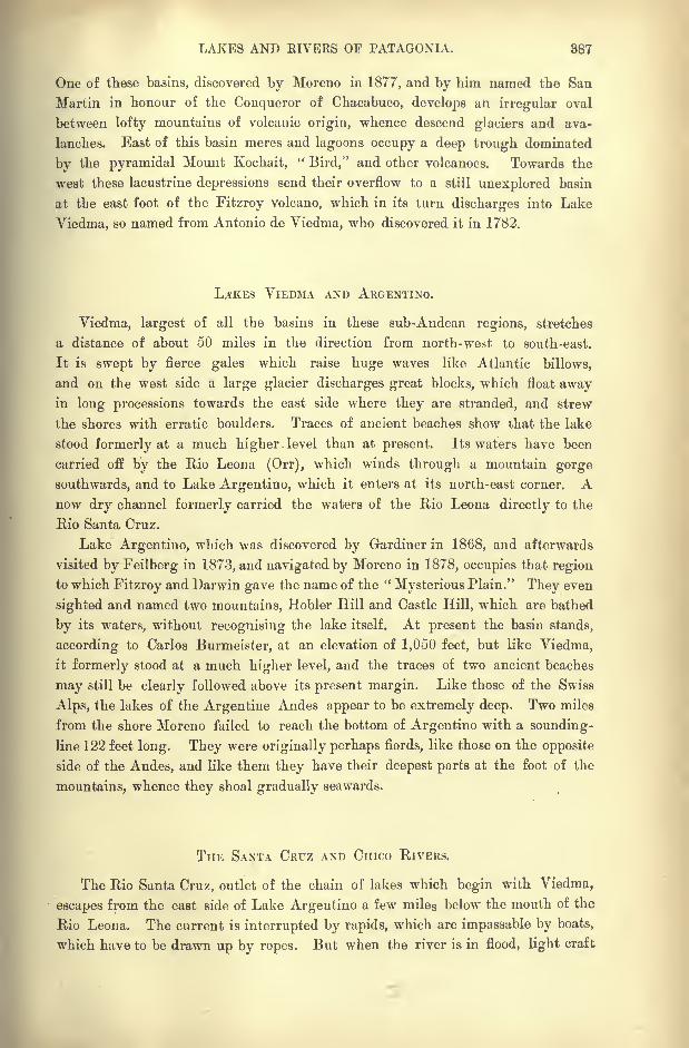
LAKES AND EIVERS OF PATAGONIA. 887
One of these basins, discovered by Moreno in 1877, and by him named the San
Martin in honour of the Conqueror of Chacabuco, develops an irregular oval
between lofty mountains of volcanic origin, whence descend glaciers and ava-
lanches. East of this basin meres and lagoons occupy a deep trough dominated
by the pyramidal Mount Kochait,"Bird," and other volcanoes. Towards the
west these lacustrine depressions send their overflow to a still unexplored basin
at the east foot of the Fitzroy volcano, which in its turn discharges into Lake
Viedma, so named from Antonio de Viedma, who discovered it in 1782.
L/SKES VIEDMA AND ARGENTINO.
Viedma, largest of all the basins in these sub-Andean regions, stretches
a distance of about 50 miles in the direction from north-west to south-east.
It is swept by fierce gales which raise huge waves like Atlantic billows,
and on the west side a large glacier discharges great blocks, which float awayin long processions towards the east side where they are stranded, and strew
the shores with erratic boulders. Traces of ancient beaches show that the lake
stood formerly at a much higher level than at present. Its waters have been
carried off by the Rio Leona (Orr), which winds through a mountain gorge
southwards, and to Lake Argentine, which it enters at its north-east corner. Anow dry channel formerly carried the waters of the Rio Leona directly to the
Rio Santa Cruz.
Lake Argentino, which was discovered by Gardiner in 1868, and afterwards
visited by Feilberg in 1873, and navigated by Moreno in 1878, occupies that region
to which Fitzroy and Darwin gave the name of the "Mysterious Plain." They even
sighted and named two mountains, Hobler Hill and Castle Hill, which are bathed
by its waters, without recognising the lake itself. At present the basin stands,
according to Carlos Burmeister, at an elevation of 1,050 feet, but like Viedma,
it formerly stood at a much higher level, and the traces of two ancient beaches
may still be clearly followed above its present margin. Like those of the Swiss
Alps, the lakes of the Argentine Andes appear to be extremely deep. Two miles
from the shore Moreno failed to reach the bottom of Argentino with a sounding-
line 122 feet long. They were originally perhaps fiords, like those on the opposite
side of the Andes, and like them they have their deepest parts at the foot of the
mountains, whence they shoal gradually seawards.
THE SANTA CRFZ AND Cmco RIVERS.
The Rio Santa Cruz, outlet of the chain of lakes which begin with Viedma,
escapes from the east side of Lake Argentino a few miles below the mouth of the
Rio Leona. The current is interrupted by rapids, which are impassable by boats,
which have to be drawn up by ropes. But when the river is in flood, light craft
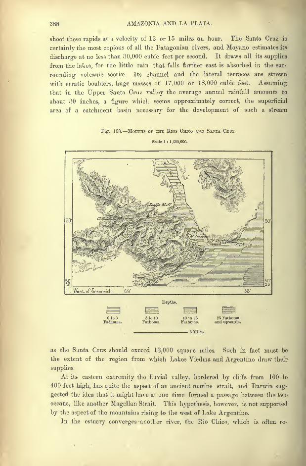
388 AMAZONIA AND LA PLATA.
shoot these rapids at a velocity of 12 or 15 miles an hour. The Santa Cruz is
certainly the most copious of all the Patagonian rivers, and Moyano estimates its
discharge at no less than 30,000 cubic feet per second. It draws all its supplies
from the lakes, for the little rain that falls farther east is absorbed in the sur-
rounding volcanic scorioo. Its channel and the lateral terraces are strewn
with erratic boulders, huge masses of 17,000 or 18,000 cubic feet. Assuming
that in the Upper Santa Cruz valley the average annual rainfall amounts to
about 30 inches, a figure which seems approximately correct, the superficial
area of a catchment basin necessary for the development of such a stream
Fig. 158. MOUTHS OF THE Rios CHICO AND SANTA CEUZ.
Scale 1 : 1,100,000.
West op Greenwich 69
Depths.
tooFathoms.
5 to 10Fathoms.
10 to 'J5 25 FathomsFathoms. and upwards.
6 Miles.
as the Santa Cruz should exceed 13,000 square miles. Such in fact must be
the extent of the region from which Lakes Viedma and Argentine draw their
supplies.
At its eastern extremity the fluvial valley, bordered by cliffs from 100 to
400 feet high, has quite the aspect of an ancient marine strait, and Darwin sug-
gested the idea that it might have at one time formed a passage between the two
oceans, like another Magellan Strait. This hypothesis, however, is not supported
by the aspect of the mountains rising to the west of Lake Argentine.In the estuary converges another river, the Rio Chico, which is often re-

LAKES AND K1VERS OF PATAGONIA. 389
garded as an affluent of the Santa Cruz. The Chico, which was explored in its
lower course by Musters, and in its upper reaches by Moyano, flows, like the
Santa Cruz, in a deep channel excavated in the basaltic plateau. But it is at no
time navigable, and during the dry season it shrinks to a mere rivulet 120 feet
wide, and easily fordable. It adds little to the volume of the Santa Cruz, and
Fig. 159. FEOM LAKE ABQENTINO TO THE SOUTHERN FIORDS.
Scale 1 : 2,500,000.
73" West oF Greenwich
60 Miles.
the average discharge of both in the common estuary is estimated at about 31,000
cubic feet per second. In this estuary, the tides, which are very swift, rise from
about 10 feet on the bar at ebb to 50 or 60 at flow.
Lake Argentine is continued southwards by another basin, which accordingto some authorities stands at the same level of about 300 feet, while according to
others it lies not more than a few feet above the sea. Moyano believes that the
50
390 AMAZONIA AND LA PLATA.
two lakes communicate in some way, either through a channel or a series of
rapids ;but he was unable to verify the fact by actual observation.
Farther south a long stretch of fresh water, half river, half fiord, is developed at
the foot of the mountains, in the direction of the glacial fiords, which form the
ramifying inlets of Skyring Water.
South of the Santa Cruz estuary the coast presents other fiord-like indenta-
tions, half filled with silt, which receive some small streams descending from the
Cordilleras. But all have their sources on the eastern slope of the volcanic range,
and are consequently for the most part dry. Coy Inlet, which Darwin regardedas the remains of a marine strait, like that of Magellan, is joined only by a rivulet
known as the Coyle, a corruption of Coy, the English name of the estuary. It
was dry when visited by Moreno;but farther south the Rio Gallegos, rising in
the fertile Llanuras de Diana," Diana Plains," is a perennial stream, and even
navigable for a few weeks in the year. All the running waters at the extremity
of Patagonia wash down auriferous sands.
THE PATAGOKIAN SEABOARD.
Viewed as a whole, the shores of Patagonia and Tierra del Fuego present no
character of unity in their contour lines. Between Buenos Ayres and Bahia
Blanca the semicircular bend of the seaboard is developed in a rhythmical curve,
in which is revealed the result of slow and continuous geological action. So, also,
at the extremity of the continent a similar movement in the formation of the
coast-line is attested by the cimeter- shaped curved line which is described between
Staten Island and Coy Inlet, and which is interrupted by the two Straits of
Lemaire and Magellan.
But all the intermediate space extending from Bahia Blanca to the Santa
Cruz estuary is indented in an extremely irregular fashion. South of Bahia
Blanca, itself a tunnel-shaped estuary penetrating far into the interior of the
continent, several parallel inlets which follow along the seaboard seem to indicate
the existence of an old delta; only the river, which one might expect to see
discharging into the head of the gulf, has long ceased to exist. By a remarkable
contrast, both the Rio Colorado and the Rio Negro, instead of flowing in valleys
forming a landward continuation of marine gulfs or inlets, follow the line of a
ridge traversing the surrounding plains, and discharge into the Atlantic Ocean at
the extreme convexity of lands projecting seawards.
Immediately south of the Rio Negro the Gulf of San Matias penetrates so far
into the interior of Patagonia that it has received the alternative name of Bahia
Sin Fondo, that is," Endless Bay." On the other hand the Valdes or San Jose*
Peninsula, which encloses this bay on the south side, is connected with the
mainland by a narrow isthmus with a hammer-shaped headland, which bends
round to the right and left (north and south) in such a way as to develop two
lateral inlets.
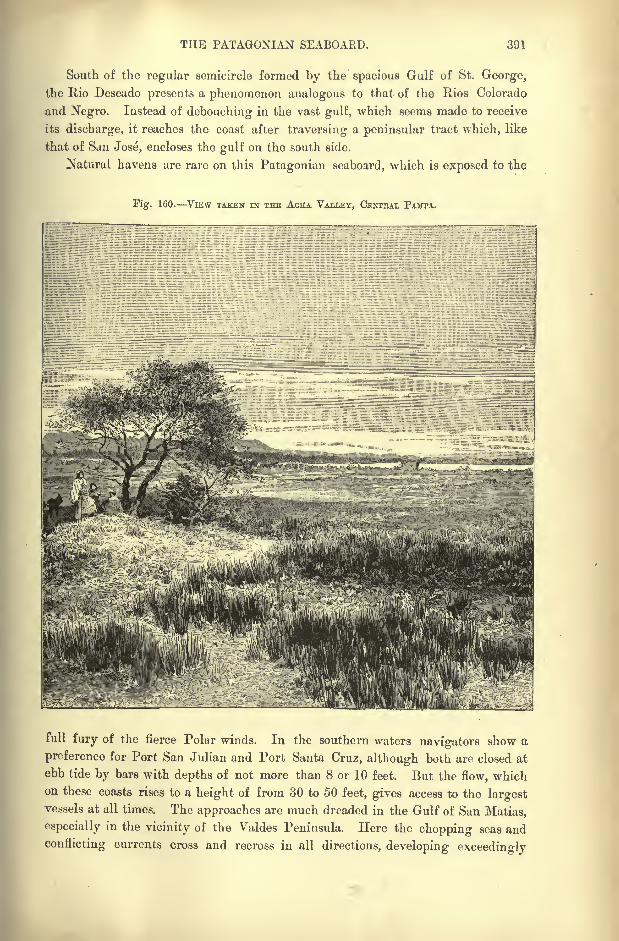
THE PATAGONIAN SEABOARD. 391
South of the regular semicircle formed by the spacious Gulf of St. George,
the Rio Deseado presents a phenomenon analogous to that of the Rios Colorado
and Negro. Instead of debouching in the vast gulf, which seems made to receive
its discharge, it reaches the coast after traversing a peninsular tract which, like
that of San Jose, encloses the gulf on the south side.
Natural havens are rare on this Patagonian seaboard, which is exposed to the
Fig. 160. VlEW TAKEN IN THE ACHA VALLEY, CENTBAL PAMTA.
full fury of the fierce Polar winds. In the southern waters navigators show a
preference for Port San Julian and Port Santa Cruz, although both are closed at
ebb tide by bars with depths of not more than 8 or 10 feet. But the flow, whichon these coasts rises to a height of from 30 to 50 feet, gives access to the largestvessels at all times. The approaches are much dreaded in the Gulf of San Matias,
especially in the vicinity of the Yaldes Peninsula. Here the chopping seas and
conflicting currents cross and recross in all directions, developing exceedingly
892 AMAZONIA AND LA PLATA.
dangerous whirlpools. Such is the force of the currents and eddies that thev
cause the plumb lines to drift, thus preventing accurate soundings from being
taken in these troubled waters.
CLIMATE or ARGENTINA.
With the exception of a small strip of territory in the extreme north, Argen-tina lies entirely within the south temperate zone, with a climate corresponding
in some respects to that of west Europe, between the latitudes of Spain and the
Feroer Islands. But between 22 and 25 south latitude there are naturally
many transitions from north to south, and to these must be added the changes that
take place from east to west between the Atlantic seaboard and the slopes of the
Cordilleras. Hence arises an endless diversity of local climates, all however
characterised both by a considerable range, and by sudden changes, of temperature.
The general relief of the land, from the plains of Chaco to the rugged Fuegian
Archipelago, leaves ample space for the play of the hot equatorial and cold antarctic
winds, which are nowhere intercepted by any mountain barriers.
In the "Mesopotamian
"region, and generally throughout North Argentina,
the normal currents set in the same direction as the mountain ranges and
watercourses, that is, from north to south, or from south to north, parallel with
the Andes and with the Famatina and Aconquija foothills, parallel also with the
Parana and Uruguay valleys. But a certain see-saw movement is observed
between the eastern fluvial and the western highland regions. In the former the
northern, in the latter the southern currents predominate.
Another contrast consists in the deflection of the north wind, which frequently
sweeps from the uplands down to the plains. This is the much-dreaded zonda,
which assumes the character of a gale, especially during the winter months from
July to September. Both the true north wind and the zonda are accompanied by
a considerable rise in the temperature, which has occasionally exceeded 104 Fah.
Then any sudden shifting of the currents may be attended by a fall of 50 or
even 54 Fah. within the twenty-four hours.
In winter, and under the prolonged action of the south wind, which clears the
sky and promotes radiation, the glass may fall below freezing-point, and the Pata-
gonian rivers, as far north as the Chubut, rapidly freeze. Such is the purity of
the atmosphere, that at San Juan, near the foot of the Andes, the stars are said
to be visible by day, even in the vicinity of the sun.
The coastlands about the Plate estuary and along the Atlantic seaboard enjoy
the alternating rirazones, land breezes prevailing during the day followed by sea
breezes at night. This region is also exposed to the south-east trades, not only
in summer, but also during a great part of the winter season. They sometimes
blow with fury, and under the name of su-cstada they churn up the estuary waters
and stem the current of the Parana and Uruguay, causing these rivers to over-
flow their banks. Most of the shipwrecks in the Buenos Ayres roadstead are due
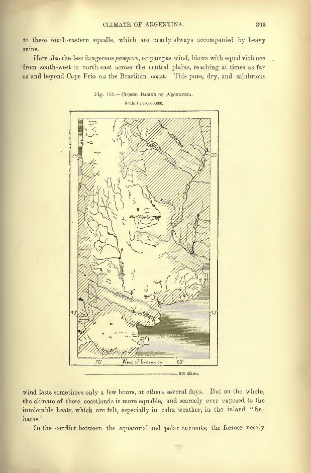
CLIMATE OF ARGENTINA. 893
to these south-eastern squalls, which are nearly always accompanied by heavyrains.
Here also the less dangerous pampero, or pampas wind, blows with equal violence
from south-west to north-east across the central plains, reaching at times as far
as and beyond Cape Frio on the Brazilian coast. This pure, dry, and salubrious
Fig. 161. CLOSED BASINS OF AEGENTINA.
Scale 1 : 20,000,000.
25'
70' West oF Greenwich 60
25
6JO Miles.
wind lasts sometimes only a few hours, at others several days. But on the whole,
the climate of these coastlands is more equable, and scarcely ever exposed to the
intolerable heats, which are felt, especially in calm weather, in the inland " Sa-
haras."
In the conflict between the equatorial and polar currents, the former nearly
894 AMAZONIA AND LA PLATA.
always prevail in Patagonia, where north-west winds set regularly for a part of
the spring and throughout the whole of the summer season. They blow at times
with such fury that riders are unable to keep the saddle, and have to dismount
and seek shelter in some cleft of the rocks. In these canadones an arborescent
vegetation is able to maintain itself; but on the arid storm-swept plains nothingcan thrive except low growths, bush, and herbage. The gales usually rise with
the sun, and continue to increase in violence till the afternoon, when they subside,
a dead calm often prevailing at night.
In the extreme south the aerial currents are far more capricious in the
labyrinth of fiords, inlets, sounds, and narrow channels of Tierra del Fuego than
on the open Patagonian steppe lands. As had already been observed by the
navigator Anson, in the seventeenth century, fine weather never lasts very longin these high southern latitudes. The very clearness of the atmosphere is an
indication to the weather-wise of pending storms.
As a rule, the rainfall decreases gradually in the direction of the south. Onthe Tucuman plains it is heavier than in the Argentine Mesopotamia, more copious
in this region than in Bue.uos Ayres, in Buenos Ayres than in Patagonia. There
is also a falling off in the direction from east to west, aridity increasing with the
distance from the seaboard. Here dews are copious, and fine drizzly rains occur,
like the "Scotch Mists"
of Europe. But farther inland, and notably in the San
Juan district, such phenomena are almost unknown, and are replaced by tre-
mendous downpours, at times accompanied by thunder and hail-storms. Such
heavy showers appear to be an abnormal phenomenon, which is attributed to the
conflict of opposing aerial currents. At Buenos Ayres, and on the surrounding
plains, snow is of extremely rare occurrence. Nevertheless, Hermann Burmeister
was able to record the fall of a few flakes, as an exceptional event, in the year
1871.
Taken as a whole, Argentina, even on' the seaboard, lacks sufficient moisture for
agricultural pursuits. The people of Buenos Ayies have not yet forgotten the
gran seen,"
great, drought," which prevailed from 1827 to 1831, and during which
only a few passing showers fell on the plains. In the interior these droughts
last even longer ;but here the settlers depend not so much on the rainfall as on
the melting snows of the uplands, which feed the irrigation rills, and on the
artesian wells that have been sunk to a depth of 300 feet and upwards in manydistricts.
It would, however, almost seem as if the climate has everywhere become drier,
snow being apparently less abundant than within a recent epoch. To the lack of
moisture, whether under the form of snow or rain, is due the exhaustion of so
many rivers on the northern plains and in Patagonia. In the " accursed lands"
traversed by the Rios Colorado and Negro, mere channels destitute of any affluents,
showers are extremely rare, and at times not a drop falls for years together. The
stations on the railway lines in the solitudes south of Buenos Ayres receive their
water supply regularly with each train. Elsewhere travellers have to put up with
the brackish fluid that oozes in many places from the ground. In these districts
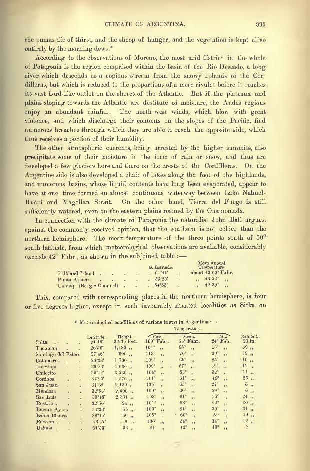
CLIMATE OF ARGENTINA. 895
the pumas die of thirst, and the sheep of hunger, and the vegetation is kept alive
entirely by the morning dews.*
According to the observations of Moreno, the most arid district in tbe whole
of Patagonia is the region comprised within the basin of the Rio Deseado, a long
river which descends as a copious stream from the snowy uplands of the Cor-
dilleras, but which is reduced to the proportions of a mere rivulet before it reaches
its vast fiord- like outlet on the shores of the Atlantic. But if the plateaux and
plains sloping towards the Atlantic are destitute of moisture, the Andes regions
enjoy an abundant rainfall. The north-west winds, which blow with great
violence, and which discharge their contents on the slopes of the Pacific, find
numerous breaches through which they are able to reach the opposite side, which
thus receives a portion of their humidity.
The other atmospheric currents, being arrested by the higher summits, also
precipitate some of their moisture in the form of rain or snow, and thus are
developed a few glaciers here and there on the crests of the Cordilleras. On the
Argentine side is also developed a chain of lakes along the foot of the highlands,
and numerous basins, whose liquid contents have long been evaporated, appear to
have at one time formed an almost continuous waterway between Lake Nahuel-
Huapi and Magellan Strait. On the other hand, Tierra del Fuego is still
sufficiently watered, even on the eastern plains roamed by the Ona nomads.
In connection with the climate of Patagonia the naturalist John Ball argues>
against the commonly received opinion, that the southern is not colder than the
northern hemisphere. The mean temperature of the three points south of 50
south latitude, from which meteorological observations are available, considerably
exceeds 42 Fahr., as shown in the subjoined table :
8. Latitude.
Falkland Wands . . . . . 514l'
Punta Arenas ..... 53D25'
Ushuaja (Beagle Channel) . . . 5453'
Mean AnnualTemperature.
about 43-00" Fd.hr.
43-52
42-39
This, compared with corresponding places in the northern hemisphere, is four
or five degrees higher, except in such favourably situated localities as Sitka, on
*Meteorological conditions of various towns in Argentina :
Temperature.
Latitude. Height -^Alnx. Mean. Mi7> Bainfall.
396 AMAZONIA AND LA PLATA.
the north-west coast of North America. " The general conclusion, which seems
to be fully established, is that the southern hemisphere is not colder than the
northern, and that all arguments based upon an opposite assumption must be set
aside. I think that this belief, as well as many others regarding physical
geography, originated in the fact that physical science, in its mere exact form,
had its birth in Western Europe, a region which, especially as to climate, is
altogether exceptional in its character. The further our knowledge, yet too
limited, has extended in the southern hemisphere, the less ground we find for a
belief in the supposed inferiority of its mean temperature. What we do find, in
exact conformity with obvious physical principles, is that in the hemisphere
where the water surface largely predominates over that of the land, the tempera-
ture is much more uniform than where the land occupies the larger portion of
the surface. In the former the heat of summer is mainly expended in the work
of converting water into vapour, and partially restored in winter in the conversion
of vapour into water or ice.'? *
FLORA OF ARGENTINA.
Tropical woodlands analogous to those of the Brazilian selva and certain parts
of Paraguay occur only in the provinces of Salta, Jujuy, and Tucuman at the foot
of the Platean border ranges, and in Chaco along the banks of the Pilcomayo and
Bermejo. Round its margin this forest region passes by gradual transitions to the
natural parklands, where the woods intermingled with the prairies constitute the
fairest and most fertile districts of Argentina. All the forest species are represented
in these scattered woods and thickets, which occupy considerable tracts in the
northern provinces. But the more valuable timber, cabinet and dyewoods, are
already disappearing in the neighbourhood of the large towns.
From the lack of moisture and vegetable humus, and from the presence of
saline elements in the soil, the vegetation acquires a peculiar character. In such a
climate those trees alone can flourish which bear slender leaves, spikes, or thorns,
diffusing little shade. On the slopes bordering Catamarca and Santiago del Estero
are met the cabif, a species of acacia useful for tanning purposes, and the quebracho
Colorado (loxoptcrygium Lorentzii), also rich in tannin, and owing to its strength
and elasticity much vajued for railway sleepers.
On the dunes, and generally in the sandy districts, the most common tree is the
algarrobo (prvwpis), while regiments of the woody cactus and more ramifying
Barbary fig are characteristic of a \ery dry soil. In Chaco most of the space is
occupied by palm groves composed mainly of the copernicia ccrifera. Farther south
they diminish in extent, breaking into small thickets or clumps chiefly consisting
of the trithinax campestris. The yatai (cocos yatai} occurs more especially in the
provinces of Corrientes and Entre-Rios between the Parana and Uruguay rivers,
which region contains four of the ten or twelve palms peculiar to the Argentine
flora, In some districts thorny trees, such as the gleditschia amorplioides, develop
* Notes of a Naturalist in South America, pp. 2723.
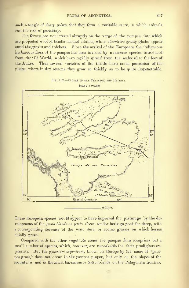
FLOKA OF ARGENTINA. 897
such a tangle of sharp points that they form a veritable snare, in which animals
run the risk of perishing.
The forests are not arrested abruptly on the verge of the pampas, into which
are projected wooded headlands and islands, while elsewhere grassy glades appear
amid the groves and thickets. Since the arrival of the Europeans the indigenous
herbaceous flora of the pampas has been invaded by numerous species introduced
from the Old World, which have rapidly spread from the seaboard to the foot of
the Andes. Thus several varieties of the thistle have taken possession of the
plains, where in dry seasons they grow so thickly as to be quite impenetrable.
Fig. 162. FLOBAS OF THE PLATEATJX AND RAVINES.
Scale 1 : 1,000,000.
18 Miles.
These European species would appear to have improved the pasturage by the de-
velopment of the pasto blando or pasto tierno, tender herbage good for sheep, with
a corresponding decrease of the pasto duro, or coarse grasses on which horses
chiefly graze.
Compared with the other vegetable zones the pampas flora comprises but a
small number of species, which, however, are remarkable for their prodigious ex-
pansion. But the gynerium arffenteum, known in Europe by the name of "pam-
pas grass," does not occur in the pampas proper, but only on the slopes of the
mountains, and in the moist barrancas or bottom-lands on the Pafagonian frontier.

398 AMAZONIA AND LA PLATA.
Not a single indigenous tree is met in the true pampa, and those now growing,even far from human habitations eucalyptus, poplar, peach, and others have
all been introduced by man. Conspicuous amongst them is the ombu (phi/tolacca
orpircunia dioica), with a huge spongy stem, dull bail-shaped foliage, and gnarly
roots trailing over the surface.
Southwards the pampas flora scarcely extends beyond Bahia Blanca; but far-
ther inland it still reaches the Colorado valley, which may be taken as the northern
limit of the scrubby vegetation of Patagonia. In this zone there is a total absence
of pasturage properly so-called, although a few tufts of grass and other herbs growabout the stems of the thorny and gnarly shrubs. In the whole of the vast Pata-
gonian region Lorentz and Niederlein had enumerated not more than 300 distinct
species in 1884. Here the prickly cactus presents in many places an impassable
barrier to men and horses. In the Rio Negro valley the only large tree is a species
of willow (salix humboldtiana), which may, perhaps, be of European origin. But
even this is rapidly disappearing under the axe of the woodman. On the terraces
dominating the river banks the most common "tree," a mere shrub in appearance,
is the chanar (gourlicea decorticans], which in October decks itself with yellow flowers
resembling the broom.
Amongst the few Patagonian plants possessing some economic value are the
" incense"tree (duvaua magellanica), which yields an excellent resin, and the Santa
Cruz "tea" (micromeria Darmnii), a very small plant, with the leaves and large
roots of which is made a highly aromatic infusion tasting like mint. The bcrberis
biuifolia grows in such abundance on certain inland dunes that its bluish colour
is visible miles away, and when the supply of guanaco meat fails, the Indians live
exclusively on the berry of this plant. From a species of juniper they obtain the
so-called maken, a gum which all Patagonians chew, and which acts both as an
excellent dentifrice and as a substitute for tobacco.
About the sources of the Santa Cruz the slopes of the Cordilleras are clothed
with continuous forests of the " antarctic beech," which intertwines its branches
above the gorges, where the wild horse has taken refuge. Farther north the
hillsides are covered with " oaks" and "
cypresses," while the apple, introduced
by the Jesuits, flourishes vigorously in the upland valleys, where the head-
streams of the Rio Negro take their rise.
FAUNA OF ARGENTINA.
During tertiary and even quaternary times, the southern regions of the Con-
tinent had a far richer fauna of large animals than at present. The deposits of
fossil mammals discovered by Darwin near Bahia Blanca were embedded in a layer
of stratified gravels and of reddish mud, such as might at present be formed bythe sea on a shoaling beach. The associated shells belonged in fact to recent or
even contemporary species. Most of the glyptodons or gigantic armadillos broughtto light in the pampean formation just below the vegetable humus are as perfect
as the skeletons of horses or oxen lying on the surface. Hence the conditions of
FAUNA OF ARGENTINA. 899
the animal kingdom were at that time much the same as at present. There were
no huge carnivorous beasts to breuk and scatter the bones, but only, as at present,
vultures and other carrion birds to devour the flesh. According to the Indians
the glyptodon survived till quite recently, and appears to have been certainly con-
temporary with man. Roth found a human skeleton in the hollow ground
excavated beneath the natural roof formed by the huge carapace of one of these
animals.
A striking feature of this Platean and Patagonian tertiary fauna is the astonish-
ing abundance and variety of species concentrated in a narrow space. The Bahia
Blanca beds, little more than about 250 square yards in extent, contained skulls
of the megatherium ;a megalonyx ;
a nearly perfect scelidotherium, a quadruped
of the same family, but showing relations, on the one hand, with the ant-eater,
on the other with the armadillo;three gigantic species belonging to the group of
edentates ;a horse
;a tooth of the macrauchenia, ancestor of the camel and of the
llama; lastly a toxodon, a strange creature approaching the elephant in size, the
rat in its dentition, and the manatee in its aquatic habits, with a general resem-
blance in form to the capivara of the Parana.
On the banks of the Santa Cruz and other South Patagonian rivers explorers
have found numerous remains of hitherto unknown mammals, all of which have
not yet been completely classified. Amongst the most interesting finds in this
region is a gigantic bird larger even than the New Zealand dinornis. Altogether
the extinct Patagonian fauna rivals in number and importance that of the Bad
Lands of the North American Far West.
From the great variety and huge size of these remains it has been inferred
that the terminal peninsula of America is a mere remnant of a vast Continent,
which comprised the islands now scattered over the South Atlantic Ocean. The
amazing accumulation of fossils occurring under the volcanic tuffas support the
hypothesis that at that time the animal kingdom was here represented by myriads
of individuals. At present, were all the animals of the plains involved in some
sudden catastrophe, their skeletons would be found very thinly scattered, except
in the case of gregarious animals herding together.
But however this be, Buffon's remark that the size of the animals corresponds
to some extent to that of the continents inhabited by them, does not appear to be
justified by the character of the old tertiary fauna of Patagonia. However large
this peninsula may have been at that time, it can scarcely have been another
Africa. But in the contemporarv geological epoch most of the genera are repre-
sented by species of larger proportions in the New than in the Old World.
By a remarkable phenomenon of correspondence, the present fauna of the
temperate regions in South America resembles that of the northern continent.
In this respect Argentina and Patagonia correspond to the States bordering on
the great Canadian lakes; if not in their specialised forms, at least in their
genera. In certain districts of both regions all the types might almost be regarded
as identical. But in respect of the invertebrates belonging to the marine fauna,
it has been observed that the corresponding animal forms are met on the shores
400 AMAZONIA AND LA PLATA.
of South America at a far greater distance from the equator than is the case on
the North American seaboard. Thus molluscs of the voluta and oliva types, which
do not occur in the United States beyond the thirteenth degree of latitude, are
seen in abundance as far south as the parallel of Bahia Blanca (39 S. lat.) in
Patagonia. The voluta is common even in Magellan Strait, about 1,000 miles
farther south. A phenomenon of analogous character is presented by the marine
fauna on the southern shores of the African Continent.*
The Rio Negro forms approximately the divide between the Argentine and
Patagonian zoological zones. This line is never crossed by certain species, such
as the nandu ostrich (rhea Americana) and the smaller rhea Darwinii, which keepto their respective northern and southern domains. The Patagonian jaguar also
is of much smaller size than the Chaco species.
Another natural parting-line is formed by the barrier of the Andes, although
these frontiers are surmounted by some animals. The puma (felis concolor] ranges
as far south as the Magellan Strait, and Patagonia is also inhabited by two
kinds of wild cats, dogs, a small armadillo (dasypus minutus), and mice, more
numerous here than in any other part of the world. The Condor, which in
Ecuador descends not even to the level of the Andean foothills, in Patagonia
sweeps down to the shores of the Atlantic. In this terminal region reptiles are
rare, and land and lacustrine molluscs relatively still rarer. Marine life of all
kinds birds, cetaceans, fish, and lower organisms abounds in the Magellanic
archipelagoes, although some species are already threatened with destruction.
The penguins, formerly met in myriads drawn up like soldiers on the overhanging
rocks, have disappeared from several of the insular groups.
In North Argentina three families of monkeys are still represented in the
forest regions of the Missions and Corrientes, and farther west on the slopes of
the Jujuy and Salta mountains towards the Bolivian frontier. Bats are much
rarer than in Brazil, and the phyllostome vampire is no longer seen south of
Tucuman;even here it is much less dangerous than in the tropics. The carnivora
are represented by numerous species, although the felidae, such as the Jaguarand Ocelot, are retreating before the farmers and other settlers. In the Platean
regions the puma never attacks man, and will not even defend itself except bytears from his assaults. This point has been much discussed by naturalists ;
but
the fact has been placed beyond doubt by the researches of Mr. Hudson, who
mentions several authentic cases, and suggests an explanation of the remarkable
phenomenon." All that I had previously heard," he writes,
" had compelled me to
believe that the puma really does possess a unique instinct of friendliness for man,
the origin of which, like that of many other well-known instincts of animals, must
remain a mystery. The fact that the puma never makes an unprovoked attack
on a human being, or eats human flesh, and that it refuses, except in some rare
cases, even to defend itself, does not seem really less wonderful in an animal of its
bold and sanguinary temper, than that it should follow the traveller in the wilder-
*Henry A. Ward, Rivista del Musto de La Plata, Vol. I. 1890-91.
FAUNA OF AEGENTINA 401
ness, or come near him when he lies sleeping or disabled, and even occasionally
defend him from its enemy the jaguar. We know that certain sounds, colours,
or smells, which are not particularly noticed by most animals, produce an extra-
ordinary effect on some species ;and it is possible to believe, I think, that the
human form or countenance, or the odour of the human body, may also have the
effect on the puma of suspending its predatory instincts, and inspiring it with a
gentleness towards man, which we are only accustomed to see in our domestic car-
nivores, or in feral animals towards those of their own species."Wolves, when pressed with hunger, will sometimes devour a fellow-wolf ;
as a rule, however, rapacious animals will starve to death rather than prey on one
of their own kind; nor is it a common thing for them to attack other species
possessing instincts similar to their own. The puma, we have seen, violently attacks
other large carnivores, not to feed on them, but merely to satisfy its ani-
mosity ; and, while respecting man, it is, within the tropics, a great hunter and
eater of monkeys, which of all animals most resemble man. We can only con-
clude with Humboldt that there is something mysterious in the hatreds and affec-
tions of animals." *
Neither the tapir nor the peccary of the hot, moist forest regions ever ranges
farther south than the provinces of Oorrientes and Santiago del Estero. The
sloth also is found no farther south than Chaco, while the ant-eater, very com-
mon in the northern solitudes, is rare in the Argentine provinces.
The tatu (armadillo) family is represented by at least eight species, includingthe gigantic tatu, now rare in the Toba territory north of the Rio Bermejo, the
dwarfish quirqnincho of the province of Mendoza, no bigger than a mole, and the
hairy armadillo (dasypus yilfosm], which has now acquired protective nocturnal
habits. This species is specially remarkable for its versatility and power of
adaptation to changing environments. Its habits are constantly changing to suit
its new conditions of life, so that it remains diurnal in districts where its car-
nivorous enemies are nocturnal, and becomes nocturnal in the presence of its
persecutor, man. In this way the hairy armadillo is able to hold its ground, and
even become more abundant, in regions occupied in increasing numbers by human
settlements.
But the most characteristic animal of the pampas is the viscacha (lagostomns
trichodactylus), which in many respects recalls the prairie dog of North America,
and like it builds itself underground cities in the sandy soil. Here also it is
found in friendly association with the owl and other nocturnal birds, which are
often seen mounting guard at the mouth of the burrows. These burrows are also
frequented by vipers, adders, and poisonous spiders, and travellers crossing
districts occupied by colonies of viscachas never fail to provide themselves with
a clove of garlic, believed by all Argentines to be an infallible protection against
the attacks of all such noxious vermin. Like the bower-bird, the viscacha loves
to decorate the approaches to its dwelling with all kinds of objects, shreds of
* W. H. Hudson, Tlw Naturalist in La Plata, p. 49.
402 AMAZONIA AND LA PLATA.
cloth, bits of leather, old shoes, bleached bones, dry roots und branches, or what-
ever other " inconsidered trifles" it can pick up on the surrounding pampa.
Hence caravans find it convenient to encamp in the vicinity of the riscacheras,
where they have an abundance of fuel ready to hand for cooking purposes. During
the day these viscacheras may be recognised at a distance by the heibige, which
is cropped short at the entrance, but which grows in tall tufts on the surface of
the ground above the burrows. But at night the rider has to guard against the
risk of his mount stumbling and perhaps breaking a leg by falling through the
roof of some underground dwelling. The Indian horse, however, being accustomed
to nocturnal expeditions, keeps his head down, smelling the ground like a hound
on the scent, and his instinct thus enables him generally to avoid the danger.
Between the Colorado and Rio Negro the most common animal is the
marra, or "Patagonian hare
"(dolichotis patagonica) ,
which is met in groups of
twenties on either side of the tracks across the bush. In the cultivated parts of
the pampa game, instead of diminishing, as might have been expected, has greatly
increased, thanks to the cessation of the steppe fires, which formerly destroyed the
young and the lairs.
The guanaco (huanaco), which in Patagon a ranges over the stony wastes as
far as the seaboard, has been exterminated throughout a great part of the
Argentine foothills. It is now rarely met in the Rioja and Catamarca districts;
but in the province of Jujuy both the guanaco and vicuna are respected by the
Quichua natives, and here they may still be seen grazing in flocks of hundreds
by the wayside. In South Patagonia the Tehuel-che natives capture about
300,000 guanacos every year without appreciably reducing their numbers. In
the district between Lake Argentine and the Latorre Cordillera Rogers and Ibar
saw as many as 5,000, and they calculated that there must be about 1,200 000 in
the whole region. The wool is woven into ponchos and blankets;and cloaks,
which command a high price on the Buenos Ayres market, are made of the skins
of young guanacos stitched together with oslrich sinews.
Like the camel, its congener in the Old World, the guanaco is able to pass
days without drink, and when driven to it, can slake its thirst even with brackish
water. The male animal, being of solitary habits and swift in flight, is difficult
to capture ;but the females associating in herds, and possessing less staying power,
fall easier victims to their pursuers. In South Patagonia, the guanaco, wrhen
fatally wounded or in a moribund state, retires to some solitary bush or thicket to
die in peace. The ground in such places is often found strewn with thousands of
skeletons. This strange instinct, first noticed by Darwin and Fitzroy, has since
been fully confirmed by other observers. It is notewonhy that it is only at the
southern extremity of the continent that the guanacos have dying-places ;else-
where they do not appear to have developed the habit, in the explanation of which
the naturalist, Hudson, suggests that the guanaco, in withdrawing from the herd
to drop down and die in the ancient dying- ground, is in reality only seeking
an historically remembered place of refuge, and not of death. He mentions an
analogous impulse in the Argentine riding-horse, which will also come home, or
FAUNA OF ARGENTINA. 403
to the gate of its owner's house, to die, although in the healthy state it avoids its
master as an enemy, and has to be captured with a lasso." In this case also the
explanation would appear to be that the animal remembers how relief is always
sure to come at his master's door, after he has been ridden for twelve or fifteen
hours on the pampas, burdened with the ponderous native saddle, with its huge sur-
cingle of raw hide drawn up so tightly as to hinder free respiration."*
The Argentina avifauna is represented by a great, diversity of forms, from the
huge vulture to the tiny humming-bird. It includes many species of parrokeets,
as well as the Condor, still common in the Sierras de Sans Luis and de Cordoba,
and the nandu ostrich, which is now a familiar sight in many farm-yards. Of
the aquatic birds the largest is the " race-horse duck," better known as the
" steamer duck," from the close resemblance which the action of its wings bears to
the beat of the paddles as it moves with surprising rapidity, half swimming, half
flying, over the surface of the water, and leaving a long streak in its wake. Theylive chiefly on mussels, and some oj: the drakes are nearly four feet long from the
bill to the extremity of the tail.
In the Pampas flamingoes abound. They are considerably smaller than the
African species, but of richer colour. The slender legs, about sixteen inches long,
are of a bright red hue, like that of the tail feathers, while the general plumageis of a delicate rosy tint, contrasting with the black colour of the pen feathers.
These aquatic birds may often be seen wading in the shallow saline lagoons of the
pampas in such numbers as to impart a lovely roseate colour to the scene viewed
from a little distance. The effect is much heightened by the constant flash of
the various tints in the sunlight, as they fltp their wings or take flight when
startled by any sudden noise.
Like the other divisions of the Argentine fauna, the reptile world attests a
general falling off of vital energy south of the torrid zone. The various species
of turtles are smaller than their Brazilian congeners; the jacare alligators,
which swarm in the lagoons and lakes of Corrientes, average scarcely more
than six or seven feet in length, and rarely reach ten. South of Santa Fe they
have disappeared altogether. The boas are not met beyond the region of
Santiago del Estero, and the rattle-snake ranges no farther south than the
Cordoba uplands.
Amongst the blood-sucking insect pests mention is made of the ixodes, a species
of tick of the jigger type, which swarms throughout Argentina, and ranges as
far north as Central America. -
They are a fearful nuisance, and seem to
pervade the very atmosphere. Clustering in myriads about the tips of twigs and
branches, they attach themselves to every passing animal by means of the hooks
with which their feet are armed. Lean and flat when vegetating on the plants,
they swell to the shape and size of a Barcelona nut after feasting on their victims.
" The white globe is leathery, and nothing can injure it;the poor beast cannot
rub, bite, or scratch it off, as it is anchored to his flesh by eight sets of hooks and
a triangle of teeth.
* Hudson, The Naturalist in La Plata, p. 324.
404 AMAZONIA AND LA PLATA.
" The ticks inhabiting regions rich in bird and insect life, but with few
mammals, are in the same condition as mosquitoes, as far as the supply of blood
goes ; and, like the mosquitoes, they are compelled and able to exist without the
nourishment best suited to them. They are nature's miserable castaways, para-
sitical tribes lost in a great dry wilderness where no blood is;and every marsh-
born mosquito, piping of the hunger gnawing its vitals, and every forest tick,
blindly feeling with its grappling-irons for the beast that never brushes by, seems
to tell us of a world peopled with gigantic forms, mammalian and reptilian, which
once afforded abundant pasture to the parasite, and which the parasite perhaps
assisted to overthrow." *
Nearly all the Argentine waters, marine, fluvial, and lacustrine, teem with
fish, one of which, a large trout of excellent flavour, lives both in fresh and salt
water. Cetaceans of all kinds were formerly very numerous everywhere, and
sea-lions and other seals are still pursued in the Patagonian waters. But the
whale is now scarcely met farther north than Fuegia.
INHABITANTS OF ARGENTINA.
It is difficult to unravel the complicated prehistoric relations in Argentina,
owing to the great variety of human types and remains of all kinds brought to
light in recent times. Thus earthenware has been found in the pampas of Buenos
Ayres, which even experts cannot distinguish from vases collected in the Aztec
burial-grounds. In the Rio Dulce valley, near Santiago del Estero, sepulchral
urns have been unearthed containing human remains mingled with shells of the
same species as those now living in the Pacific waters. Certain blocks of stone or
of wood are absolutely identical with those worked by the Maori of New Zealand
and the Melanesians of the New Hebrides. But whether all these resemblances
point at racial affinities, independent parallel developments, migrations, or com-
mercial intercourse, are questions which cannot yet be solved.
Throughout the north-western Argentine uplands from the province of Jujuyto that of Mendoza, numerous ruins, earthworks, towns, and strongholds, are found
on the heights and in the surrounding valleys. Some stand at an elevation of
over 13,000 feet, at times on steep escarpments, and even in the clefts of vertical
walls, like the Arizona and New Mexico cliff dwellings. Most of them had to
be approached by ladders giving access to thick walls or terraces, whence a descent
could be made to the quadrangular courts lined by habitations in the form of
caves.
The industrial arts of these unknown builders were also considerably developed,
as shown by the great highway known as the " Incas' Road," but by Moreno
believed to be anterior to the Inca period. It may still be followed for hundreds
of leagues east of the Andes in a straight line across the plains, with branches
on both sides running to former populous districts, when this region was traversed
Hudson, The Naturalist in La Plata, p. 142.
INHABITANTS OF AEGENT1NA. 405
by great watercourses, and studded with vast lacustrine bisins, which have long
disappeared. The rock inscriptions, which are very numerous along this route,
are different from those of the Peruvian Quichuas, and seem, to belong to another
civilisation. Here, also, are seen the remains of extensive irrigation works, and
here have been found woven fabrics, stone, copper, bronze, and silver objects, all
bearing witness to a tolerably advanced culture, destroyed partly by wars wagedin prehistoric times, and partly also by the general desiccation of the land.
Even as far south as Patagonia the Argentine regions appear to have been
formerly thickly peopled. Scarcely a district, however inhospitable it may now
seem, but has yielded proofs of the migrations or long sojourn of vanished races.
At Ensenada potsherds have been dug up over 200 feet below the surface, and the
varying types of skulls, implements, and rock carvings show that these communi-
ties belonged to several stocks. Argentina is a vast necropolis of extinct popula-
tions, some of. whom may now be represented by degenerate Yahgans, Alakalufs,
and other Fuegians. In the Samborombon bisin, south-east of Buenos Ayres,
Carles discovered near a megatherium a remarkable human skeleton with thirteen
dorsal vertebra?.
In the Rio Negro valley Moreno has examined a large number of paraderos*
as the sites abounding in prehistoric remains are called. They have yielded arrow-
heads both of the paleolithic and neolithic ages, the former usually on the upper
slopes and terraces along the river banks, the latter strewn in great abundance
over the bottom-lands. Near Carmen, Hudson found some of the neolithic types
about half an inch long," most exquisitely finished, with a fine serration, and
without exception, made of some beautiful stone crystal, agate, and green, yellow
and horn-coloured flint. It was impossible to take half-a-dozen of these gems
of colour and workmanship in the hand and not be impressed at once with
the idea that beauty had been as much an aim to the worker as utility." f
In the pampas region farther north archaeologists have discovered human
settlements of a somewhat different type from the ordinary paraderos, and in some
respects resemble kitchen-middens. These certainly indicate the sites of human
encampments long occupied by primitive populations. The total absence of any
traces of disturbance altogether excludes the theory at first put forward that they
may have been the abodes, not of the living, but of the dead. Those found in many
parts of the province of Buenos Ayres have been fully described by Moreno and
Zeballos, while the attention of Ameghino has been more especially directed towards
the paraderos occurring along the banks of the Marco-Diaz, Lujan and other
streams. One of the paraderos in the Marco-Diaz valley covers a superficial area
of no less than 612 feet by 408 feet, and must have been occupied either con-
tinuously or at intervals for countless generations.
* This word, which is of constant occurrence in writings on the early history of man in Argentinaand Patagonia, is derived frum the Spanish pnrar to sojourn. The paraderos are generally supposed to
occupy the sites of ancient habitations or settlements, and this view cprtainly offers the best explanation
of the numerous traces of buint earth strewn about, and apparently caused by the action of fire
kindled for cooking purposes.
t Op. cit., p. 39.
60

406 AMAZONIA AND LA PLATA.
Numerous animal remains, often covering a considerable space, are here and
there found scattered about in the vicinity of these prehistoric settlements. "The
long bones are split, others show grooves and cuts ; nearly all have been subjected
to the action of fire. With these bones have been picked up stone implements,
chiefly arrow-points and fragments of clumsy and badiy-baktd pottery, showing,
however, traces of artificial colouration. Heaps of burnt earth and charcoal cinders
tell clearly of the hearths of men.
"All the bones, whether of mammals or birds, are of species such as the deer
or llama (huanaco) still extant in South America; nowhere are any bones found,
such as those of frequent occurrence in the pampas formation, belonging to extinct
animals. The paraderos must not therefore be confounded with these formations,
and their much more modern character brings them near to that of the ordinary
shell-heaps." Recent discoveries hive lately confirmed this conclusion. Excavations in
a tumulus of elliptical form' (260 by 105 feet and 8 feet high) on the Parana,
near the port of Campana, have brought to light a great many objects which bear
witness to an advanced state of culture. There are weapons and tools of quartz
or of blue granite, often of remarkable workmanship, hand-mills very like those
still in use in the interior of Africa, implements of deer-horn (cervus rufus and
ceretis campestris), whistles of venado-wood, and above all, a considerable number
of fragments of pottery, very superior in execution to any hitherto noticed. Some
of these fragments are coloured red, others are decorated with designs or orna-
mentation. Dr. Zeballos speaks of more than 3,000 potsherds, amongst them
twenty ollas or jars still intact.
"Amongst these pieces of pottery must be mentioned some very close imitations
of animal forms, especially a parrot's head, very true to life. The works of man
lay mixed together in a considerable accumulation of large pieces of charcoal, fish
and mammal bones. It is evident that this mound concealed one or more primi-
tive hearths, and that these hearths, in accordance with a custom common to
many different races, afterwards became burial-places ;the discovery of several
human skeletons leaves no doubt on this point."*
At the arrival of the Europeans early in the sixteenth century, Argentina
from the Bolivian plteaux to the Austral seas was peopled by a multitude of
tribes bearing different names, but belonging in reality to a small number of
distinct ethnical groups. The north-western region belonged to the Calchaquis
of Quichua culture, speech, and perhaps origin. In the Mesopotamia between
the Parana and Uruguay the Guarani were dominant, and branches of this
widely-diffused nation extended beyond the rivers far into the pampas ;south
of Campana, Estanislao Zaballos discovered a vast Guarani barrow containing
twenty-seven skeletons, and the local nomenclature shows that they reached
southwards, even beyond the Plate estuary as far as the Rio Salado and Sambo-
rombon Bay. The Querandi, who inflicted such a disastrous defeat on the
* De Nudaillac, Prehistoru America, p. 54.
INHABITANTS OF ARGENTINA. 407
Spaniards near the present site of Buenos Ayres, may have been a Guarani
people, although Moreno and others regard them as the probable ancestors of
the Puel-che, since driven farther inland.
Between the civilised Calchaquis and the Guarani the plains were occupied bynomad groups, presenting no kind of national cohesion, but resembling each
other in their usages, warlike character, and often also in speech. Many doubtless
belonged to a common stock, which in the absence of any collective name
might be called the Toba race, from the most powerful nation by whom they are
now represented.
Farther south the terminal peninsula of the Continent was occupied by the
Araucanians and Patagonians, who constitute a sub-race very distinct from the
northern Indians. Lastly, the eastern section of Fuegia is still roamed by a
few Onas, who are Patagonian intruders from the mainland.
With the arrival of the Europeans began the massacres and steady exter-
mination of the aborigines under diverse pretexts. Some were distributed in the
so-called encomicndas for their "spiritual welfare," while others were simply
enslaved, or else classed as mitayos, "hirelings." But the result was the same,
and whole groups disappeared in the mines or died out on the plantations.
Those gathered by the Jesuits into their reductions increased in peaceful times
and in healthy years, but only to be eventually swept away by the Mamelucos
and epidemics. Most of the missions have disappeared with all their inhabitants,
either extirpated or assimilated to the surrounding Hi^pano-American mixed
populations.
This process of assimilation has been extended to the north-western Calchaquis,
to the Guarani of Corrientes, to the agricultural Indians of Tucuman, Santiago
del Estero, San Luis, and Cordoba. The Comachigones of the Central province,
the Michilengues of San Luis, the Giyones and Calingastas of Mendoza, havinglost their Indian names and speech, fancy themselves full-blood Spaniards. In
usages, language, and political life they have become gradually assimilated to the
other Argentine populations.
On the other hand, the wild Indians themselves, who have never ceased to
kidnap the women and children of their white neighbours, belong in great
measure, at least in blood, to the race of the conquerors. But the racial struggle
is still carried on, fierce and brutal as ever, between the Argentines and the
warlike Toba tribes of the northern plains. In the south the rapid decrease of
the Pampean aborigines has at last put an end to the border warfare, which had
till recently been waged with relentless cruelty on both sides. Possibly Spanish
influence had rendered these natives more savage than they had been originally.
At least a bad effect could not fail to be produced by the servitude of the
civilised tribes, and by the introduction of the horse and of firearms, which
naturally gave a stimulus to the inborn taste for rapine and plunder.
Little has been heard in Europe of these border troubles;but the horrors
and atrocities that were associated with the sudden raids of the Pampas Indians
almost pass the limits of credibility." It is now but twelve years," writes
408 AMAZONIA AND LA PLATA.
Mr. Knight in 1834," since the Indians made a raid here [Canada de Gomez],
and carried away 10,000 head of cattle and many women, for the aboriginal
has the good taste to prefer the white to the dusky beauties of his own race.
But the camps of the white men have advanced many leagues farther into
the Indian territory since that time, and Canada de Gomez has little to fear
now." A raid of Pampas Indians is no joke. As the peaceful stock-farmer is
scanning his herd some fine morning, he perceives a dust on the horizon, and out
of the dust soon comes on at a tremendous gallop the wild troop of naked menon splendid horses, seeming one with their steeds very centaurs, with long black
hair waving behind their shoulders, and brandishing their long lances, while
they raise their piercing and fearful war-cries. The estancia is pillaged in a
few moments, the wife and daughters of the estanciero carried off, and then,
swooping down on the herds, the savages drive them away to the distant pastures
by fnr rivers that the white man knows not of. When Indians on expeditions
of this nature come across a solitary white man, they kill him if they find arms
upon him. If he be unarmed, they treat him more mercifully. They content
themselves with cutting off the soles of his feet, and let him go."* It may be
remembered that the Persian victims of the Turkoman alamans often met with
similar treatment at the hands of the people of Khiva, before their marauding
expeditions were suppressed by the Russians.
THE CALCHAQUI AND CI-HRIHUANAS.
The descendants of the Quichuas in the province of Jujuy bear the general
name of Coyos, or Coyas. Although all understand Spanish they have preserved
their mother tongue and national usages. Many migrate periodically to the
plains as itinerant pedlars, but, like the Bolivian Collahuayas, nearly always
return to their mountain homes.
In the extensive region between the North Chilian frontier and the Cordoba
uplands, formerly occupied by the Calchaquis, few traces now remain of that
powerful nation except their characteristic black and red pottery of diverse forms
with geometrical designs in straight lines, and on the sepulchral urns symbolic
and animal figures. For over a century these Indians successfully resisted the
Spaniards, and even attempted to restore the Inca dynasty ;but they were finally
overthrown in 1664, when most of the combatants preferred death to bondage.
The Quilme group was removed in 1677 to the suburban quarter of Buenos Ayres,
which still bears their name, and where the last of the race died in 1869. But
the half-caste descendants of the Calchaquis constitute the substratum of the
industrious populations in the provinces of Jujuy, Salta, Catamarca, and La Rioja.
Most of the towns and villages, especially in the upland valleys, perpetuate the
* Cruise of the Fal,on, i., p. 144.
INHABITANTS OF ABGENTINA. 409
names of assimilated Calchaqui tribes, such as the Andalaga, Tolombon, Cafayate,
Fiambala, Tinogasta, arid Famatina. Tucuman is also a modified Calchaqui
name.
All the northern part of the Argentine Mesopotamia is still occupied by
populations of undoubted Guaraui descent, although the tribal names have dis-
Fig. 163. INDIAN POPULATIONS OF NORTH AEGENTINA.
Scale 1 ; 19,000,000.
4C 1
310 Miles.
appeared, and the Spanish language is steadily spreading from all the urban
centres. The Chirihuanas (Chiriguanos), who are nearly pure Guarani from the
Bolivian province of Tarija, occupy parts of Chaco, where they seek employmenton the sugar plantations of the Bermejo and Juramento valleys. Their Guarani
dialect differs little from that of Paraguay ;but at present most of these semi-
independent Chiriguanos speak Spanish.
410 AMAZONIA AND LA PLATA.
THE MATACOS AND ABIPONS.
Associated with them on the sugar plantations are the Matacos, a branch of
the independent Mataguayos, who appear to be of Toba stock. They are smaller,
more thick-set, and stronger, but also less skilful and enterprising than the
Chiriguanos. The uncivilised branch have the curious custom of wearing, sus-
pended from the shoulders, a satchel in which are kept odds and ends of all sorts,
arrowheads, fish scales, hair, feathers, dry leaves, blood-stained rags, which make
up the "history" of the bearer, each object representing some event in his life,
and, therefore, carefully preserved as part of himself till his death. The Matacos,
who are estimated at about 14,000, practise the couvade. They are of shorter
stature than the Tobas, but more robust and strongly built, with thick neck,
well-developed muscles, stout limbs, broad, flat features, and high cheek-bones,
the upper jaw being deeply arched like a horseshoe. " The nose is broad,
straight, not very prominent, and with wide nostrils, but it is not flattened.
Indeed, they are seriously afraid of having flat noses, so much so that they will
not eat mutton, which is supposed by them to cause flatness in that feature. This
is a device of their medicine-men and soothsayers, in order to prevent the
destruction of their few sheep and also the consequent loss of the wool, which they
weave and make use of in many ways." The adults have black or blackish hair
;in the old it is sometimes, but rarely,
white, possibly because very few attain to old age. The children up to ten or
twelve years have reddish hair;a curious fact recalling the theory of De Salles,
according to which primitive man was red-haired. The hair is generally worn
long and unkempt, but during periods of mourning it is cut off for a year. The
skin of all these Indians varies in colour from copper to clay, while occasionally
some are spotted with black." *
Like most of the other uncivilised tribes of Gran Chaco, the Matacos are
unable to count beyond four, and even to accomplish this mental operation they
have recourse to the four fingers of the right hand, the thumb being held in the
left; beyond four everything is ntocq, "many." Thus a noted Mataco chief had
some difficulty to explain to his interviewer, Pelleschi, that in his time he had
slain a large number of hostile Indians. After telling off the first four he got
puzzled, and "sitting down cross-legged on the ground, he began making marks
on the earth with his finger, exclaiming at each one toch, i.e.,'
this,' raising his
head each time as well as his hand, and looking at me, added uuidt toch, meaning' and this one too
'
;and so he went on until he reached about a score, always,
however, turning towards me that I might understand that, besides these, there
were always the four fingers, until at last I was almost tired out with ntocq, ntncy }
'
many, many.'"f
In Argentina the fierce and till recently powerful Abipons are now represented
only by a few half-caste families of Spanish speech in the Santa F district. The
kindred Mocovi, or Mbocovi, alternately their allies and deadly foes, still retain
Pelleschi, p. 33. t Pelleschi, p. 289.
INHABITANTS OF AEGENIINA. 411
their tribal organisation, although greatly reduced in numbers, perhaps more by
small-pox than by war. But they have been recruited by refugees of all racec,
horse -stealers, murderers, brigands, and others obliged to fly from the white
settlements.
These Mocovi, usually called Indios Montaraces," Forest Indians," formerly
committed terrible depredations, destroying villages, wasting the plantations in
Tucuman and the neighbouring provinces, and long preventing the whites from
access to Chaco. Their nasal and guttural language is a dialect of the Abipon,
which, according to Lafone y Quevedo, is "a branch of the great Carib family."
Thus the powerful Carib race, whom the first European navigators found spread
over many of the West Indian islands, but whose original home appears to be
Central Brazil, would seem to have ranged southwards as far as the foot of the
Argentine Cordilleras.*
THE PAMPAS INDIANS.
South of the settled provinces, in which all the indigenous groups have
been obliterated as distinct elements, the southern regions of the pampas,
together with the whole of Patagonia, belonged till recently to the free In-
dians, collectively classed as "Pampeans," Araucanians, and Patagonians. After
the first conflicts with the Spaniards, these aborigines were driven south, and
long remained at peace with the whites. They possessed neither gold nor
silver, nor much agricultural wealth; they were left to their grassy and stony
solitudes.
Meantime the Indians had received, in the horse introduced by the whites, a
valuable ally, useful in battle, in the chase, and even as food, failing the guanaco,
ostrich, armadillo, and other game. They became great riders, and during their
long warlike or migratory expeditions the Ranqueles and Pampeans of the Buenos
Ayres district never quitted the saddle. When worn out by fatigue they stretched
themselves on the animal as on a bed, and slept for hours in this position without
ever losing their balance. Such was the intelligence of the horse that he instinc-
tively adapted all his movements to those of his inert burden. We are even
assured that the Indian could die on his horse. During the frontier wars instances
were recorded of dead warriors being found and removed with difficulty from the
horse that carried him out of the fight, and about whose neck his rigid fingers
were clasped in death.t
Then they learnt to trade in this live-stock with the Chilians over the moun-
tains, receiving in exchange arms and other implements. And if the herds fell
short, they could be renewed by raiding the whites, by taking the animals from
those who had taken their lands. Hence those incursions (malon, maloca) which
the squatters on the frontiers justly dreaded, and which were renewed from year
to vear all along1 the borders between Buenos Ayres and Mendoza. Thus waso /
* Remsta del Museo de La Plata, 18901891.
t The Naturalist in La 2'lata, p. 355.
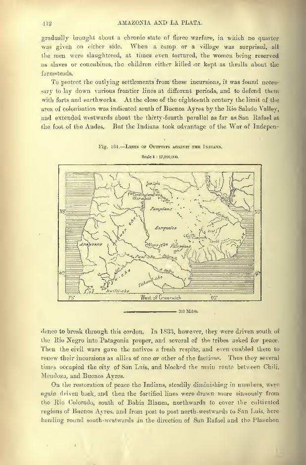
412 AMAZONIA AND LA PLATA.
gradually brought about a chronic state of fierce warfare, in which no quarter
was given on either side. When a camp or a village was surprised, all
the men were slaughtered, at times even tortured, the women being reserved
as slaves or concubines, the children either killed or kept as thralls about the
farmsteads.
To protect the outlying settlements from these incursions, it was found neces-
sary to lay down various frontier lines at different periods, and to defend them
with forts and earthworks. At the close of the eighteenth century the limit of the
area of colonisation was indicated south of Buenos Ayres by the Rio Salado Valley,
and extended westwards about the thirty-fourth parallel as far as San Rafael at
the foot of the Andes. But the Indians took advantage of the War of Indepen-
Fig. 164. LINES OF OUTPOSTS AGAINST THE INDIANS.
Scale 1 : 17,000,000.
West of Greenwich 60"
310 Miles.
rlence to break through this cordon. In 1833, however, they were driven south of
the Rio Negro into Patagonia proper, and several of the tribes asked for peace.
Then the civil wars gave the natives a fresh respite, and even enabled them to
renew their incursions as allies of one or other of the factions. Thus they several
times occupied the city of San Luis, and blockpd the main route between Chili,
Mendoza, and Buenos Ayres.
On the restoration of peace the Indians, steadily diminishing in numbers, were
again driven back, and then the fortified lines were drawn more sinuously from
the Rio Colorado, south of Bahia Blanca, northwards to cover the cultivated
regions of Buenos Ayres, and from post to post north-westwards to San Luis, here
bending round south-westwards in the direction of San Rafael and the Plauchon
INHABITANTS OF ARGENTINA. 413
Pass. This frontier was divided into nine sections, each defended by a fortified
central camp held by a strong garrison. In 1876 a general forward movement
advanced the line in such a way as to effjce all its curves, thus greatly reducingits length, and annexing the native trysting grounds.
This new chain of forts, extended along the eastern slopes of the Andes, madeall further resistance impossible, and nothing remained for the survivors except to
submit. But meantime the Pampeans had disappeared, and even the Pata-
gonians are dying out, having fallen from about 30,000 before the border wars to
no more than 2,000 in 1893. The loss, however, can scarcely be regretted, for
long before their final reduction the Pampas Indians had been transformed to
mere predatory hordes, depending for their very existence on cattle-lifting raids
amongst the white settlers." Even those who, like the more distant Pehuenches,
were of Araucanian origin, had sadly degenerated from the formidable warriors
sung by Ercilla. They had lost all the bolder traditions of savage warfare, and
had sunk to the level of mere marauders, though their inborn ferocity too fre-
quently showed itself in cowardly murders committed on the defenceless. Unfor-
tunately their tofderias, or encampments, served as a refuge to the more lawless
elements among the native Argentines or Gauchos, and they were often led, as
well as instructed in the n>e of firearms, by deserters and criminals flying from
justice."
Still, considering the paucity of their numbers and the poorness of their arma-
ment, it seems almost a national disgrace that they should have been allowed to
hold their own so long, and, indeed, to derive tribute, as they did, from the trea-
suries of civilised communities like Santa Fe or Buenos Ayres. It is the more
surprising because, like their kinsmen in North America, they were an expiring
race, and at the time of their final overthrow had been reduced to a state of semi-
starvation by the iron barrier of the frontier, which put an end to cattle-lifting on
a large scale, and prevented their replenishing the herds of horses which alone
made them formidable.
" The internal dissensions, which so long distracted the Confederation and para-
lysed its energies, must account for the lack of vigour shown towards these
intolerable savages, and the radical manner in which they have now been dealt
with is a happy augury that this country has at last reached the era of stable,
well-ordered government."*
Of the Pamp^ans the Ranqueles (Ranqual-che) were nearest to the Buenos
Ayres colonies, being followed southwards by the Puel-che of the Rio Colorado,
and westwards in the province of Mendoza by the numerous Araucanian tribes,
whose names terminate in the syllable cite, meaning"people." Such were the
Pehuen-che, Iluilli-che, Payu-che, Tami-che, Pilma-che, Teghul-che, following in
their order along the chain of the Andes. The JVIolu-che occupied the central
regions, while the Tehuel-che, that is,"People of the East," roamed the Atlantic
coastlands from Magellan Strait to the Rio Chubut, and ranged into Fuegia under
the name of Onas.
*Ruinbold, op. cit., p. 76.
414 AMAZONIA AND LA PLATA.
THE PATAGOMANS.
The Tehuel-che probably descend from the "Patugonians
" met by Magellan
and described by Pigafetta. They are still the most numerous of these groups,
and they have best preserved their cohesion as a distinct nation. The term
Patagoncs,"Big Feet," is a misnomer, for they have in fact rather small feet
(averaging less than 11 inches) compared to their colossal stature of about 6 feet
4 inches. In very cold weather they often wear over their boots a kind of gaiter
made of gaanaco skin, and this may perhaps have given the feet a dispropor-
tionately large appearance, though Pigafetta's words are :" The guanaeo skin
gives their feet the appearance of bears' claws." As to the giants "ten or twelve
feet high"reported by Byron, Sarmiento and others, they were probably not taller
than the present Patagonians, who, however, are undoubtedly the tallest race in
the world.
At Carmen de Patagones, where the Tehuel-che are already crossed with the
Pampas Indians, and consequently fall below the average stature of the race,
d'Orbigny found that the men had a mean-height of 5 feet 9 or 10 inches. Since
that time nearly all explorers, who have traversed the country or even merely
visited the coast-lands, have also taken regular measurements of the stature of the
aborigines. A comparative table of these measurements shows that the full-blood
natives of the interior are the tallest, averaging about 6 feet 3 or 4 inches in the
Upper Rio Chico Valley. The women also are very tall, and the guanaco skin,
which constitutes their ordinary costume, contributes to give them a still more
majestic appearance.
The Tehuel-che are also noted for their broad shoulders, fine muscular develop-
ment, and stately bearing. The eyes are small, the nose short, the face round,
with a somewhat pleading expression. The Tehuel-che language is very harsh,
guttural, and difficult to express with European letters, as shown by the extra-
ordinary discrepancies in the spelling of words collected by different travellers.
It also changes rapidly owing to the custom of avoiding sounds that might recall
the name of any departed friend, such sounds having to be replaced by fresh
expressions. The three dialects Tehuel-che, Araucanian and Pampean differ
so greatly that the kindred peoples were unable to converse together.
Nevertheless they possess a simple and very complete decimal system of
numeration, which is absolutely identical in all three dialects. This feature mightat first sight seem to connect the Patagonian speech with that of the Peruvian
linguistic family. But it could never establish any fundamental relationship,
and, taken by itself, would point at most to the civilising influence formerly
exercised by the Quichea nation far beyond the actual political frontiers of the
Peruvian empire. The Patagonians themselves have no historic traditions, and
their oral records go no farther back than the period when they came into contact
with the European settlers. They cannot even imagine a time when their
ancestors lived without a knowledge of the horse, an animal which now appears
so necessary to their very existence.
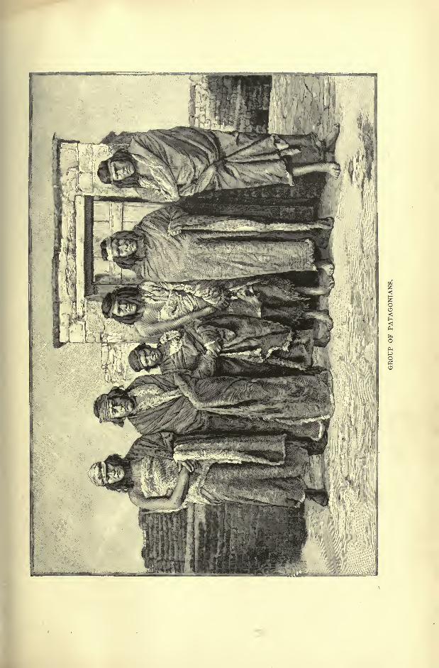
INHABITANTS OF ARGENTINA. 415
165. INDIAN POPULATIONS OF
SOUTH ABOENTINA.
Scale 1 : 16,000,000.
All the Patagouians have for several years lived in complete subjection to the
Argentine authorities. They even cull themselves Christians ;but despite their
apparent physical strength they are often decimated by epidemics. Although
generally sober, they indulge in drunken orgies on all festive occasions, and these
degrading scenes sometimes last for
weeks together. At such times the Fig.
women carefully collect all dan-
gerous implements, knives, clubs,
lassos, and hide them away in some
remote gorge, where they take refuge
with the children till the bout is
over.
For the most part the Tehuel-
che Indians are dying out without
passing through the period of servi-
tude. These aborigines still pre-
serve their haughty spirit, freely
roaming their dreary solitudes from
north to south, from the foot of the
Andes to the shores of the Atlantic.
They wear their flowing locks bound
round the head with a broad band-
age, like that which is used to com-
press the skull to the required shape
in infancy. Like so many oiher
primitive peoples, they carefully
pluck out all hairs from the face,
and till recently employed for this
purpose small silver tweezers iden-
tical with those that have been
found in the old sepulchral mounds
of the Calchaqui Indians in the pro-
vince of Catamarca.* But in their
present impoverished state they
have generally to rest satisfied with
simple knives with which all sprout-
ing hairs are shaved off.
Since their submission to the 310 Miles.
Argentine Government, the Pata-
gonians have been obliged to renounce all warlike expeditions. Consequently they
no longer go about armed with the national spear and cowhide buckler embellished
with metal ornaments. At present their only weapon is the bola perdida, "lost
* Francisco P. Moreno, Viaje a la Patagonia Austral.
416 AMAZONIA AND LA PLATA.
bola,' which they cover with leather and keep attached to the waist. "This
characteristic missile is of two kinds : the simplest, which is chiefly used for
catching ostriches, consists of two round stones, covered with leather and united
by a thin plaited thong about eight feet long. The other kind differs only in
having three balls united by the thongs to a common centre. The Oaucho holds
the smallest of the three in his hand, and whirls the other two round and round
his head ; then, taking aim, sends them like chain-shot revolving through the
air. The balls no sooner strike any object than, winding round it, they cross each
other and become firmly hitched.
" The size and weight of the balls vary according to the purpose for which they
are made. When of stone, although not larger than an apple, they are sent with
such force as sometimes to break the leg even of a horse. I have seen the balls
made of wood, and as large as a turnip, for the sake of catching these animals
without injuring them. The balls are sometimes made of iron, and these can be
hurled to the greatest distance. The main difficulty in using either lazo or bolas
is to ride so well as to be able at full speed, and while suddenly turning about,
to whirl them so steadily round the head as to take aim;on foot any person would
soon learn the art." *
Some of the Patagonians still wear little silver bells suspended from the waist ;
all paint themselves in red, white, and deep blue, both for show and also for the
practical purpose of protecting the exposed parts of the body from the action of
the wind and from mosquitoes. Their only musical instrument is a sort of flute
made of the bone of a huanaco.
Under new forms the old beliefs still persist. Sun and moon retain their
beneficent qualities as good spirits, while noxious influences are diffused by certain
animals such as the lizard, which have to be conjured by the sacrifice of living
beings, especially the horse. Probably through fear of similar baneful results
several of the Tehuel-che tribes will on no account eat fish. The women secrete
little figures, regarded perhaps as amulets or household gods, and the medicine-
men still continue, as in pagan times, to exorcise their patients, to summon or scare
away the demons.
These paye, as the medicine-men are called by a name differing but slightly
from that current in the Amazonian and Guiana regions, have also the right of
interpreting at their pleasure all natural phenomena and incidents of all kinds.
Thus a long-established belief based on such interpretations assigns to the gaitlichus,
or demons, the bodies of old women, as their ordinary dwelling-place. Hence
everyone had a right to kill any aged females crossing his path, and till recently
this right was frequently exercised. In order to escape from such a fate most of
the cronies attempted to render some service to the community in the character of
prophetesses announcing good tidings. But woe to those whose forecastings
turned out unfortunate.
In certain cases custom even required the Tehuel-che to sacrifice some aged
* Charles Darwin, Yoyige Round the World, ch. iii.
INHABITANTS OF ARGENTINA. 417
relative, slave, or mistress. On the death of any young person in the toldo, or
tent, the head of the family had to secretly remove the appointed victim far from
the camp, and despatch her with a knife. This duty was sternly exacted, especi-
ally in the case of mothers-in-law. Hence, in anticipation of such a tragic end,
the parents of the bride were careful to live apart from the son-in-law, never
coming in contact or holding any intercourse with him. A similar custom is
known to prevail amongst the Papuans, the Australians, the Zulu-Kaffirs of South
Africa, and many other primitive peoples. In these communities mother-in-law
and son-in-law take every precaution to avoid each other's sight, and the explana-
tion of the feeling is probably afforded by the Patugonian custom. Orphans, on
the other hand, are well looked after; they are the wards of the whole tribe, and
their property is administered with perfect honesty. Married people without
children often solemnly adopt a little dog, setting apart for his maintenance a
number of horses, as would be done in the case of a son and heir.
Marriages are always freely contracted without the intervention of the parents
on either side. But, like burials, they afford a pretext for sacrifices. On such
occasions several mares are killed, and the blood drunk as it flows from the
wounds. But during the present generation no instances have occurred of human
sacrifices. On the other hand, when a man goes into mourning for the loss of a
wife, he burns all he possesses. The dead are sewn up in a poncho and buried
either in the recesses of a cave or under a heap of stones like the cairns raised
over the graves of the old Gaulish chiefs. They are always deposited in a sitting
posture, like that of the Peruvian mummies, and like the bodies of the pre-historic
inhabitants of Patagonia.
So recently as the year 1860 the Tehuel-che still sewed up the bodies of the
dead in a fresh leather sack. If the sick person happened to be advanced in
years, his friends did not wait for his death, fearing that the rigor mortis mightrender the operation impossible. An old woman, charged with the funeral
arrangements, sat upon the chest of the victim, drew the legs by sheer force up to
the trunk at the risk of breaking them, and then fastened the hands to the
tibias. The pack, well corded, was then exposed to the sun, and when suffi-
ciently dried, stowed away in the sands of the dunes. Such was the force of
habit or tradition, gradually transformed to a pious duty, that, in order to bury
the dead in accordance with the prescribed forms, they were killed by breaking
their bones.* Such a practice forcibly recalls the Procrustean process of legen-
dary Greek history, which may have possibly been a reminiscence of analogous
usages in savage times.
THE GAUCHOS.
Till recently the Argentine of the rural districts, undoubtedly descended on
the mother's side from the aborigines, scarcely differed in his social usages from
* Moreno, op. cit.
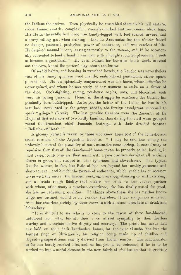
418 AMAZONIA AND LA PLATA.
the Indians themselves. Even physically he resembled them in his tall stature,
robust frame, swarthy complexion, strongly-marked features, coarse black hair.
His life in the saddle hud made him bandy-legged with feet turned inward, and
a heavy rolling gait when walking. Like his Araucanian foe, the Gaucho feared
no danger, possessed prodigious power of endurance, and was careless of life.
He despised manual labour, leaving it mostly to the women, and, if he occasion-
ally consented to lend a hand it was done with a haughty, contemptuous air," such
as becomes a gentleman." He even trained his horse to do his work, to tread
out the corn, knead the potters' clay, churn the butter.
Of sordid habits, and housing in wretched hovels, the Gaucho was nevertheless
vain of bis finery, guanaco wool mantle, embroidered pantaloons, silver spurs,
plumed hat. No less splendidly comparisoned was his horse, whose affection he
never gained, and whom he was ready at any moment to stake on a throw of
the dice. Cock-fighting, racing, pot-house orgies, wars, and bloodshed, such
were his ruling passions. Hence, in the struggle for existence, the Gaucho has
gradually been outstripped. As he got the better of the Indian, he has in his
turn been suppl mted by the gringo, that is, the foreign immigrant supposed to
speak"griego
"(Greek). The last genuine Gauchos were the Llanistas of La
Rioia, at first retainers of two lordly families, then during the civil wars groupedround the truculent chief, Facundo Quiroga, with their dreaded banner :
"Religion or Death !
"
A gloomy picture is drawn by those who knew them best of the domestic and
social relations of the Argentine Gauchos. " It may be said that among the
unlovely homes of the peasantry of most countries none perhaps is more dreary or
repulsive than that of the Gaucho if home it can be properly called, having, in
most cases, for its basis an illicit union with a poor creature devoid of all feminine
charm or grace, and steeped in utter ignorance and slovenliness. The typical
Gaucho woman, in fact, has little of her sex beyond her untidy garments and
sharp tongue ;and but for the powers of endurance, which enable her on occasion
to vie with the men in the hardest work, such as sheep-shearing or cattle -driving,
and a certain rough fidelity that makes her stick to the chance partner
with whom, after many a previous experience, she has finally mated for good,
she has no redeeming qualities. Of things above these she has neither know-
ledge nor instinct, and it is no wonder, therefore, if her companion is driven
from her cheerless society by sheer ennui to seek a solace elsewhere in drink and
debauchery."
It is difficult to say who is to come to the rescue of these hot-blooded,
untutored men, who, for all their vices, attract sympathy by their fearless
bearing and a certain native dignity and courtesy. The priest has never had
any hold on their dark heathenish homes, for the pure Gaucho has but the
faintest tinge of Christianity, his religion being made up of childish and
degrading superstitions, mainly derived from Indian sources. The schoolmaster
so far has hardly reached him, and he has yet to be redeemed if he is to be
worked up into a useful element in the new fabric of civilisation that is growing
INHABITANTS OF ARGENTINA. 419
up around him, The national government have an arduous task before them in
this direction." *
THE SPANIARDS AND OTHER EUROPEAN SETTLERS.
Even during the early migrations the white intruders in the Platean regions
were already a strongly mixed race, and interminglings are still going on to a
greater extent than in any other land. Certain Arab words which have become
obsolete in Spanish reappear in the language of the Argentines. Such are juguel,
a well flush with the surface ; guadnl, a quagmire, and other terms referring for
the most part to life in the wilderness. Some family names, also, such as
Albarrctcin, which have disappeared in Spain, are still met on the Argentine
plains. From these examples it would seem probable that during the first period
of colonisation the converted Christians of Moorish stock, still harassed by the
minions of the Inquisition, emigrated in relatively larger numbers than those of
the old Spanish race.
But however this may be, all non-Spanish elements except the negro slaves were
rigorously excluded from the country before the War of Independence, and it is
only since 1821 that foreign immigration has been encouraged by the Argentine
Government. By a treaty concluded with England in 1825, the country was
formally thrown open to settlers of all nationalities.
The first to avail themselves of the privilege were the Basques, those of the
French Pyrenees as well as those of the Iberian provinces. At Monte Video,
Buenos Ayres, and all the inland towns along the banks of the Uruguay and
Parana rivers, these Basques found employment as stevedores, gardeners, brick-
makers, tanners, overseers on the estancias or at the saladeros; in a word, in all
pursuits demanding skill, strength, and endurance. In many localities they were
grouped in colonies sufficiently populous to preserve the use of their mother
tongue, at least for some time. Although they have now for the most part
adopted the Spanish language, the multitude of Basque names, recurring in every
part of Argentina more frequently than in any of the other Hispano-American
Republics, shows the great importance taken by this ethnical element in the
formation of the Argentine people. Even Indian chiefs bear Basque names, and
tradition still preserves the memory of the exploits performed by the Pampean
captain, Baigorrita.
RECENT IMMIGRANTS.
The material progress made by Argentina may be gauged by the development
of the immigration movement. Not a single European nation but has its repre-
sentatives in this vast Babel of the New World. The French, English, and
Germans have settled especially in the large cities, Tvhere they control the
* Rumbold, op. cit., p. 91.
420 AMAZONIA AUD LA PLATA.
industries, and promote most of the local enterprises. The Italians have
monopolised the fluvial navigation, and are rapidly increasing in numbers,
crowding out all rivals and taking a leading part in all departments of national
activity.
A stream of Irish immigration, now nearly run dry, flowed in some decades
ago, and became associated more intimately than the English with the general
population, especially in field operations and about the docks and shipyards.
The agricultural colonies of Santa Fe were chiefly founded by Swiss, German,and French peasants, while Russians and Russified Germans form the majorityof the rural settlers in Entre-Rios on the banks of the Parana. The Welsh have
formed a separate group in the remote region of the Chubut Valley. Even
Australia has begun to take part in the movt ment, and in 1893 several hundreds
from this region obtained concessions along the banks of the Rio Negro. Since
1891 thousands of Jews, expelled or refugees from Russia, have found an asylumin the Argentine lands, where they have hitherto kept aloof from the other
elements of the population. Thousands of Chilians swarm into the western
provinces, and are rapidly peopling the Cuyo, as the Andean slopes are called.
Bolivians, Paraguayans, and Brazilians also form a considerable section of the
northern and eastern settlements. But types indicating a strain of African blood
are rare, although in 1778 people of colour formed about one-third of the whole
population.
It would appear from a Parliamentary paper issued in 1891 by the British
Foreign Office on Baron Hirsch's recent Jewish Colonisation scheme, that none of
these foreigners succeed better than the Jewish refugees from Russia. At the
end of the year 1893 these already numbered considerably over 6,000, most of
them being drawn from the provinces of Southern Russia. The extent of lands
bought for them is 63 square leagues, of which about one-third is colonized at
an expenditure so far of nearly 440,000. The present condition of the colonies
is described as decidedly prosperous. The area under crops is large, wheat alone
covering over 17,000 acres. Thoroughly practical men have been engaged in
carrying out the scheme, with the result that the settlers have now a good harvest
before them, and are likely to realise good profits. There is a central committee
in St. Petersburg, with branches all over Russia, who select the most deserving
Jews recommended to their notice for emigration.
After a colony has been properly organised, local self-government is intro-
duced. A council with several members is appointed, of which two or three,
according to the size of the settlement, are chosen by election from among the
colonists themselves, and one is the resident controller named by the association.
This council, which meets daily, regulates the distribution of machines, transport,
building, public health, and the difficult question of meat. The duty of the
controller is to look after the property of the association, to distribute the food
subsidies to each family, to act as its legal representative in all dealings with the
local authorities and private persons, and later to collect the debts due by the
colonists to the association.
TOPOGBAPHY OF AEGENTINA. 421
TOPOGRAPHY TOWNS OF THE MISSIONS TERRITORY.
Like the United States and other regions where trade and population are
rapidly increasing, the Argentine Republic is distinguished by a marked prepon-
derance of urban groups, and by a general tendency of the people to gravitate
towards the large towns. Buenos Ayres, capital of the State, contains over one-
eighth of the whole population, while vast inland regions far from the Atlantic
ports remain almost uninhabited.
In the territory of the Argentine" Missions
"the former reductions, or settle-
ments of converted Indians, have been transformed to rural villages with widely
scattered dwellings, while most of the ruined churches have supplied the materials
for modern structures. The Brazilians, who form the majority of the settlers in
this region, have established sugar-works and factories for the preparation of
manioc and mate.
On the right bank of the Uruguay, where till recently the ruins of the Missions
covered a space of nearly 150 acres planted with palm and orange groves, the town
of Conception has become a busy agricultural centre surrounded by a broad belt of
" black"tobacco fields. Farther on the village of Santo Tome, also an old Jesuit
foundation on the same side of the river, exports much rice. San Martin (the
Yapeyu of the Guarani), birthplace of the revolutionary hero bearing this name,
is now a mere hamlet, although for many years the headquarters of the Missions,
the " Rome "of the great theocratic Republic.
Libres Paso de los Libres, formerly Restauracion where the "freemen"
crossed the river to rescue their country from the tyranny of Rosas, stands over
against Uruguayana, on the Uruguay side, with which it practically forms a
single town. A little farther south is the old mission where Aime Boupland
passed the last twenty years of his life, and where he died in 1857.
Lower down Monte Caseros, an important cattle market, faces the Uruguayantown of Santa Rosa. At this point the railway constructed along the left bank
of the Uruguay throws off to the north-west a branch which is soon to be com-
pleted through Mercedes to Corrientes, capital of the province of like name.
CONCORDIA LORETO ITAT I.
Southwards follow the modern settlements of Mocorcta, Libertad, founded by
Tyrolese peasants, Ft deration "and Concordia, the last-mentioned facing the
Uruguayan city of Salto. Although one of the busiest riverside ports of Argen-
tina, it is accessible to large steamers only during the floods. Even Colon, over
60 miles farther south, is approached with difficulty at low water. Colon, which
dates from 1863, faces Paysandu on the Uruguay side, and serves as the outlet
for the agricultural produce of San Jose. This colony, established in 1857 bysome Swiss and Savoy immigrants, has prospered wonderfully, and from this
" mother hive"have issued numerous swarms, which have gradually transformed
the whole face of the land. Wheat, with which a beginning was made, has been
61

422 AMAZONIA AND LA PLATA.
successively replaced by orchards, and by vineyards which yield a coarse wine
infinitely preferable to the horrible concoctions sold in Argentina as " claret."
Poultry farming also succeeds well in the San Jose settlement.
Vessels drawing over 20 feet stop below Colon at the landing-stage of Concep-
tion del Uruguay, former capital of the province, which stands on a lateral creek
communicating by rail with the main stream. Caseros, west of Concepcion, is one
of the most flourishing offshoots of San Jose.
Gualeguaychii, on the right bank of the shallow river of like name, is visited
by numerous vessels of light draught, which here ship cattle, provisions, hides,
and other farm produce. Founded at the close of the eighteenth century, Guale-
guaychu has become the third port of the Republic, and the largest and wealthiest
city in the province of Entre-Rios. It has far outstripped its former rival, Guale-
guay, which lies some 60 miles farther west on the river Gualeguay. This place
is connected by rail with Tala, central station of the province, and with the indus-
trious settlement of Villagudy, where the Belgians are in a majority. A branch
line runs through Nogoya and its cattle farms to the port of Victoria on a lateral
creek of the Parana.
On the Parana the Argentine stations above Corrientes are for the most part
villages founded by the missionaries. Such are Candelaria, at one time residence
of the Jesuit directors, and Posadas, which has displaced Yapeyu as capital of the
present administrative division of the Missions. Posadas, which from 1822 to the
death of Francia was the only free port of entry for the traffic of Paraguay with
Argentina, has continued to flourish despite the loss of its monopoly.
Nearly all the stations which follow as far as the Paraguay confluence recall
some events in the local wars and predatory expeditions. The tranqticra
(" trench ") of San Miguel, and lower down that of Loreto, were dug to protect
the territory of the Jesuits against the incursions of the Corrientinos, and on the
former Francia erected a fort in 1822. Itati, near the Paraguay confluence, dating
from the beginning of the seventeenth century, lies near the defensive works so
stubbornly defended by the Paraguayans against the allies. The inhabitants of
Itati are of nearly pure Guarani stock, although they have become half assimilated
to the Hispano-Americans in speech. They still practise the traditional industries
of weaving and pottery, for which the Guarani people were always famous.
TOWNS OF CoRIUENTES AND CHACO.
Corrientes, capital of the province of like name, and the most important place
between Buenos Ayres and Asuncion, may be regarded geographically as the city
of the fluvial confluence, although founded 15 miles below the delta (Tres Bocas).
It owes its name of Corrientes San Juan de los Siete Corrientes to the swirling
waters or eddies caused on the left bank by rocky ledges projecting into the
stream. Taraguy, its Indian name, is said to mean the " Lizard- ground." It
might also be culled "Orangetown," so embowered is the place in groves of the
golden fruit.
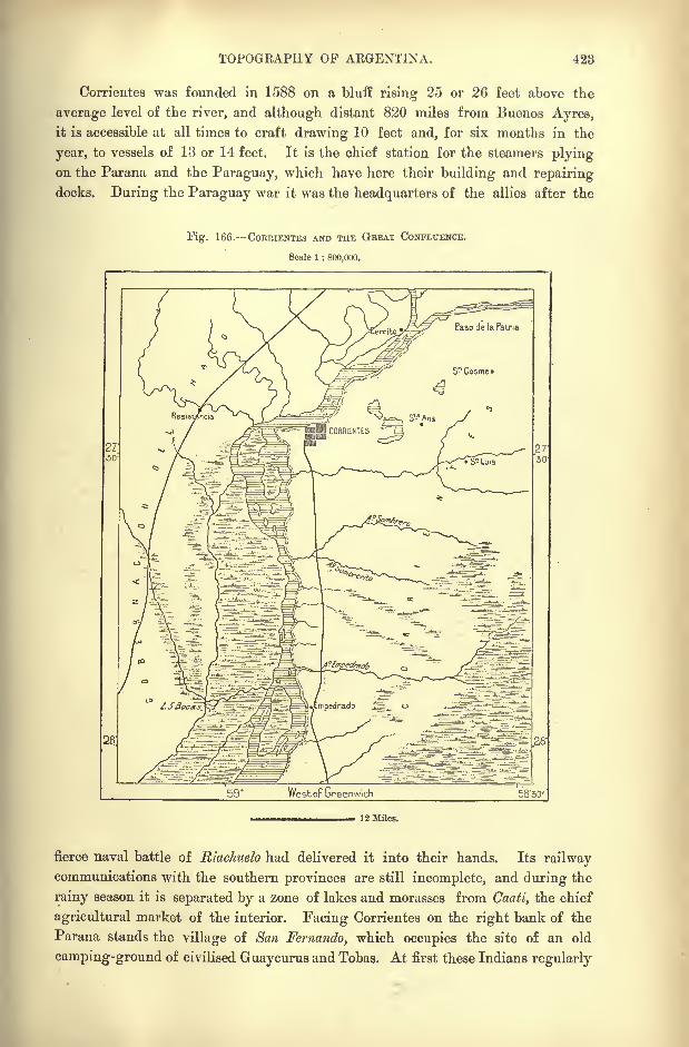
TOPOGRAPHY OP ARGENTINA. 423
Corrientes was founded in 1588 on a bluff rising 25 or 26 feet above the
average level of the river, and although distant 820 miles from Buenos Ayres,it is accessible at all times to craft drawing 10 feet and, for six months in the
year, to vessels of 13 or 14 feet. It is the chief station for the steamers plyingon the Parana and the Paraguay, which have here their building and repairing
docks. During the Paraguay war it was the headquarters of the allies after the
Fig. 166. COERIENTES AND THE GBEAT CONFLUENCE.
Scale 1 : 800,000.
59' WestoF Greenwich
J 2 Miles.
fierce naval battle of Riachuelo had delivered it into their hands. Its railwaycommunications with the southern provinces are still incomplete, and during the
rainy season it is separated by a zone of lakes and morasses from Caati, the chief
agricultural market of the interior. Facing Corrientes on the right bank of the
Parana stands the village of San Fernando, which occupies the site of an old
camping-ground of civilised Guaycurus and Tobas. At first these Indians regularly
424 AMAZONIA AND LA PLATA.
supplied the people of Corrientes with fuel, timber, fodder and other local produce.
But the forests of Gran Chaco have gradually receded before the woodman's axe,
and the natives have receded before the agricultural settlements which now
follow along the river banks.
Formosa, on an isolated bluff opposite the Paraguayan town of Villa Franca,
gives its name to the northernmost of the two divisions of Chaco, an almost
uninhabited territory comprised between the Pilcomayo and the Bermejo. In
1892 it had a European population of not more than 5,000, mostly Italians and
Slavs, and scarcely as many acres under cultivation. Yet the whole district
bordering on Paraguay has already been bought up by sugar-planters, stock-
breeders, and other capitalists. Formosa, the capital, has succeeded to Villa
Occidental, which had to be evacuated by the Argentines when North Chaco was
restored to Paraguay by the decision of the United States. In the hope of makingit a riverside trading-place, Formosa was founded at a spot exactly midway between
Corrientes and Asuncion, 140 miles from both cities. It also occupies a strong
strategical position at a point where the river is rather narrow and very deep.
The passage could easily be commanded by the guns of a fort erected at Formosa.
In the southern division of Argentine Chaco all the riverside lands have
been ceded or sold by the Government, and some well-managed sugar works have
already been established in the district. Timbo or Puerto Bermejo, which
commands the confluence of the Bermejo with the Paraguay, is followed south-
wards by a Swedish settlement on the banks of the Rio de Oro, a small affluent
of the Paraguay, and lower down by Resistencia, capital of South Chaco, at the
mouth of the Rio Negro .
An agricultural colony founded in this district at the expense of the central
administration is conducted by Government officials. But no direct route has yet
been opened across the wilderness between Resistencia and the fertile plains of
Salta.
TOWNS OF ENTRE-RIOS.
Below Resistencia the east bank is occupied at long intervals by a few stations,
such as Bella Vista, founded in 1826 as a penal settlement; Goya ; Esquina, at
the confluence of the Parana and Corrientes; La Paz, formerly Cavallu-CuaUa,
midway between Asuncion and Buenos Ayres, and one of the busiest ports on
the river; Hernandanas, crowning a high wooded bluff
; Parana, formerly Bajada,
the "Landing Stage," the first town founded in Kntre-Rios. This place has
passed through great vicissitudes, having first been capital of the State, and then of
the whole Republic, from 185'2 to 1861. It still does a considerable trade as the
outlet of the neighbouring colonies of Villa Urquiza and Ccrrito. Most of the
settlers in this district are Italians;but every European nationality is represented,
including even some Rumanians accompanied by their buffaloes from the banks
of the Lower Danube.
Here also a Russian mirtwith property held in common, has been founded by
TOPOGRAPHY OF ARGENTINA. 425
some Germans from the banks of the Volga. The woods and pastures remain
undivided, and each family draws lots for its share of the land to be tilled in
common. The first Russo-German colony founded near Diamante, south of
Parana, has sent forth numerous branches numbering altogether about 10,000
settlers along the banks of the river. Excellent growers of wheat and horse-
breeders, these emigrants from the Volga continue to prosper, and every year
purchase new lands for the development of their commercial system, which is
administered by a general assembly of all the heads of families, the womenincluded. The Argentine Government having attempted to introduce the same
organisation as in the other colonies, the sturdy peasants revolted, and since
then they have been left to administer themselves after their own fashion. In
the same region of Entre-Rios some positivists and disciples of Count Tolstoi have
also established themselves in " harmonic societies."
TOWNS OF THE PROVINCE OF SANTA FE ESPERANZA.
In clear weather the towers and domes of Santa Fe may be seen from the
heights of Parana glittering in the setting sun some 12 miles away. This city,
founded by Juan de Garay in 1573, and chosen by the Jesuits as the centre of
the Missions amongst the Mocovi and other Chaco Indians, stands not on the Parana
itself, but on a side branch, the Riacho de Santa Fe or Coronda, which broadens
out into a lagoon, and is here joined by the Rio Salado. The port, approached
through a labyrinth of channels, is accessible to craft drawing 6 or 7 feet;but
most of the traffic is done on a railway 7 miles long, which connects Santa Fe
with the riverside port of Colastine, with a depth of from 24 to 26 feet even at
low water.
A city of churches and convents, a venerable metropolis where Congress met
occasionally to deliberate on the common interests of the Republic, Santa Fe was
long abandoned by commerce, and even declined in population, until its prosperity
was revived by the opening of the railways and the arrival of foreign settlers,
who have brought the surrounding lands under cultivation.
These settlers, who have enriched Santa Fe, are grouped round Esperanza,"Hopetown," founded in 1856 on the plains 18 miles north-west of Santa-Fe.
The "hopes
"of the founders have been realised. The two hundred Swiss fami-
lies who arrived before a single cabin had been erected for their reception, have
been followed by thousands and thousands of other families, French, Germans, but
especially Italians. Towns, villages, steam factories, workshops of all kinds have
sprung up in the pampa, where the railways have ramified in every direction.
The pleasant little town of Esperanza, with its rows of paraisos,' '
paradise trees"
(melia azedarach] lining all the thoroughfares, bears on its town hall the inscrip-
tion in Spanish," Subdivision of Property." To this subdivision of the land into
small and average holdings the district assuredly owes its prosperity, yielding
crops a hundredfold more abundant than those obtained from far more fertile
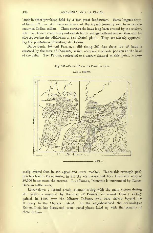
426 AMAZONIA AND LA PLATA.
lands in other provinces held by a few great landowners. Some leagues north
of Santa Fe may still be seen traces of the trench formerly cut to arrest the
mounted Indian raiders. These earthworks have long been crossed by the settlers,
who have transformed every railway station to an agricultural centre, thus step by
step converting the wilderness to a cultivated plain. They are already approach
ing the plantations of Santiago del Estero.
Below Santa EC* and Parana, a cliff rising 260 feet above the left bank is
crowned by the town of Diamante, which occupies a superb position at the head
of the delta. The Parana, contracted to a narrow channel at this point, is more
Fig. 167. SANTA FE AND ITS FIRST COLONIES.
Scale 1 : 1,250,000.
32'
61 West oF Greenwich 6030'
25 Miles.
easily crossed than in the upper and lower reaches. Hence this strategic posi-
tion has been hotly contested in all the civil wars, and here Urquiza's army of
20,000 horse swam the current. Like Parana, Diamante is surrounded by Russo-
German settlements.
Lower down a lateral creek, communicating with the main stream during
the floods, is occupied by the town of Victoria, so named from a victory
gained in 1728 over the Minuan Indians, who were driven beyond the
Uruguay to the Charma district. In the neighbourhood the archaeologist
Ramon Lista has discovered some burial-places filled up with the remains of
these Indians.
TOPOGRAPHY OF ARGENTINA. 427
ROSARIO.
Rosario, the chief place in the province of Santa Fe, and second largest city in
Argentina, owes the foundations of its prosperity to the civil wars. Buenos
Ayres having withdrawn from the rest of the Confederation in 1854, the Govern-
ment installed at Parana ordered the construction of a railway from Rosario to
Cordoba, and at the same time granted a reduction of 18 per cent, on the Customs
in favour of all vessels ascending the Parana without touching at Buenos Ayresor any other port in the Plate estuary. Rosario at once benefited by this decree,
the more so that it is accessible throughout the year to ships drawing 16 feet,
whereas till recently large vessels had to anchor in the offing a great distance
from Buenos Ayres.
Rosario has the further advantage of lying at the bend of the river, where it
begins to trend south-east in a line with the estuary, and it has thus become the
busiest riverside port in the whole basin. The Cordoba railway has also made it
a rival of Buenos Ayres for the direct foreign trade of Argentina. It is now
visited by the steamers of no less than fourteen transatlantic companies, which
here ship wheat for Europe, alalfa or lucerne for Brazil, metals, hides, and other
produce for all parts.
The aspect of the city is essentially commercial, with piers lined by shipping,
quays intersected by rails, warehouses stocked with goods, tramways radiating in
all directions, telegraph and telephone wires crossing and re-crossing at everystreet corner. Rosario is inhabited by a population of even a more cosmopolitan
character than that of its commercial rival, Buenos Ayres. In England its
name is still chiefly associated with colonisation schemes notoriously mismanaged,and ending in disastrous failures.
The railway from Santa Fe to Corduba was constructed by an English com-
pany, which received a concession of all the land for a width of three miles on both
sides of the line on the condition of colonising the country. Hence, since 1870,
Bernstadt, Carcarana, Canada de Gomez, Tortugas, and other stations have become so
many agricultural settlements, peopled, like Esperanza, by Italian, French, Swiss,
and German peasants. The English settlers at Canada de Gomez, although
specially favoured by the Company, never prospered, and have now been replaced
by others from the Continent.
SAN NICOLAS MARTIN GARCIA.
San Nicolas, chief riverine port between Rosario and Buenos Ayres, is also
one of the large cities of the Republic ;it was even, at one time, proposed as the
capital of Argentina. It is followed lower down by other busy ports, such as
Obligado, where the dictator Rosas attempted to defend the course of the Parana
against an Anglo-French squadron in 1845;San Pedro, with a good natural har-
bour of about 300 acres; Baradero, where a prosperous Swiss colony was founded
in 1856; Zarate, centre of the numerous insular colonies clustering about the
428 AMAZONIA AND LA PLATA.
delta; Campana, a busy port on the Parana de las Palmas, with an extensive
frozen-meat factory.
The rocky islet of Martin Garcia, with a lazaretto and quarantine station,
guards the approaches to the delta, beyond which a sinuous channel leads throughthe spacious estuary to the capital of Argentina.
TOWNS OF THE PROVINCES OF JUJUY.
If the Parana is the great fluvial artery connecting Buenos Ayres and the
La Plata estuary with the interior of the continent, the land route in a pre-
eminent sense is the historical highway which, under the Spanish administration,
connected the two seaboards of La Plata and Peru through the northern Argentine
provinces of Jujuy, Salta and Tucuman.
In the province of Jujuy, conterminous with Bolivia, the first place on the
route leading down from the Cortaderas Pass (12,965 feet), is the old Quichua
town of Hnmahuaca, near the source of the San Francisco, over 10,000 feet above
the sea. After the conquests, its inhabitants, who had offered a stout resistance
to the invaders, were removed bodily to La Rioja, and replaced by conquered
Indians from Famatina.
Below Humahuaca the track, which follows the right bank of the river along
the foot of the snowy Chani range, crosses several streams before entering the
broad well-watered plains (4,000 feet), where stands Jujuy, capital of the province.
This place, built by Velasco in 1592, still preserves its aspect of an old Spanish
town, and is surrounded by plantations extending into the lateral valleys watered
by affluents of the Rio Grande, one of the main branches of the Rio Bermejo.
Jujuy, which abounds in agricultural produce of the sub-tropical and temperate
zones, owes its chief importance to its transit trade with Bolivia carried on by
convoys of mules and llamas, and comprising such commodities as maize, fruits,
chicha, and especially salt extracted from the dry bed of Lake Casabinda. Its
fairs are much frequented, and here many Bolivians have settled, thus repairing
the heavy mortality caused by pneumonia, rheumatism, chuchu fevers, and other
maladies due to the cold winter winds, and in summer to the noxious exhalations
from the badly-kept canals. In the neighbourhood are some petroleum wells, and
the thermal saline springs of the quebrada de los Reyes are much frequented byrheumatic patients.
ORAN RIVADAVIA.
Below Jujuy, the San Francisco continues to flow in a steep bed obstructed
by rapids, till it reaches a more level incline beyond its great bend near the
Ledesma sugar plantations. In this part of the basin the chief place is Oran,
standing at a height of 1,000 feet, on a torrent near the point where the San
Francisco unites with the Tarija to form the Benuejo. Oran is surrounded byrich sugar and other plantations, cultivated chiefly by the Mataco and Chiriguano
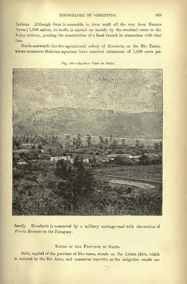
TOPOGRAPHY OF ARGENTINA. 429
Indians. Although Oran is accessible to river craft all the way from Buenos
Ayres (1,850 miles), its traffic is carried on mainly by the overland route to the
Jujuy railway, pending the construction of a local branch in connection with that
line.
South-eastwards lies the agricultural colony of Rivadavia, on the Rio Teuco,
where numerous Bolivian squatters have received allotments of 1,250 acres per
Fis:. 168. GENERAL VIEW OF JUJUY.
family. Rivadavia is connected by a military carriage-road with the station of
Puerto Bermejo on the Paraguay.
TOWNS OF THE PROVINCE OF SALTA.
Satta, capital of the province of like name, stands on the Lerma plain, whichis watered by the Rio Arias, and numerous tagaretes, as the irrigation canals are
480 AMAZONIA AND LA PLATA.
locally called. Lying from 100 to 120 feet lower than Jujuy, but more to the
south, Salta cultivates plants of the temperate zone, so that the district presents a
somewhat European aspect. Like Jujuy, it relies chiefly on its transit trade with
Bolivia arid Chili, and about a tenth of the inhabitants are of Bolivian origin.
In the neighbourhood Belgrano gained a first success over the Spaniards in 1812,
and in honour of this victory the province adopted the black and blue colours now
incorporated in the Argentine flag.
Southwards follow several large agricultural villages, such as Cac/ii, which
gives its name to the neighbouring plateaux and nevados, San Jose, Molinos,
San Carlos, Cafalate, all of which places make excellent wines and raise crops of
the famed Trigo de los Valles,"Valley wheat." The mules and horned cattle
bred by the Christian Calchaquis of the district are highly esteemed throughout
Argentina and Chili.
On the railway between Salta and Tucuman the chief station is Rosario de la
Frontera, on a head stream 'of the Juramento. Here are sugar and tobacco
plantations, and here is made the cheese known in every part of Argentina bythe name of tafi. In summer invalids flock to the neighbouring thermal waters,
which have a temperature of over 167 Fahr., and are said to be very efficacious.
The whole district abounds in sulphurous and other hot springs, which, however,
are little utilised by the natives.
According to Brackebusch the heat of these springs is due, not to the igneous
character of the ground, but to the action of the iron pyrites which are contained
in large quantities in the surrounding schistose limestone mountains, and which
at contact with water liberate a high degree of heat. These formations are also
charged with petroleum, which is distilled in the lower depths, and which may
perhaps explain the local earthquakes and the inflammable gas-jets occasionally
seen above the surface.
TOWNS OF THE PROVINCE OF TUCUMAN.
The province of Tucuman, certainly one of the richest of Argentine, has been
described in somewhat extravagant language by native and even by some Europeanwriters. Sarmiento speaks of it as a tropical land, where nature has displayed its
greatest pomp, the garden of Argentine, the Eden of America, without a rival on
the face of the earth, covered with sugar-cane brakes, orange and myrtle groves,
the resort of gaudy butterflies, brilliant humming-birds, green parrots, blue
magpies, golden toucans, and so forth. But this idyllic picture has its reverse
side, and Tucuman with all its advantages undoubtedly suffers from some serious
drawbacks. The dangerous and wasting chuchu fever is endemic, especially in
the marshy districts infested by mosquitoes, which alone seem capable of resisting
the malarious exhalations which rise from the black mud festering in the hot sun.
Another much-dreaded scourge are the swarms of locusts, which at times
transform entire districts to lifeless solitudes. From the multitudes of these
winged pests the whole landscape at times assumes a russet colour like that of
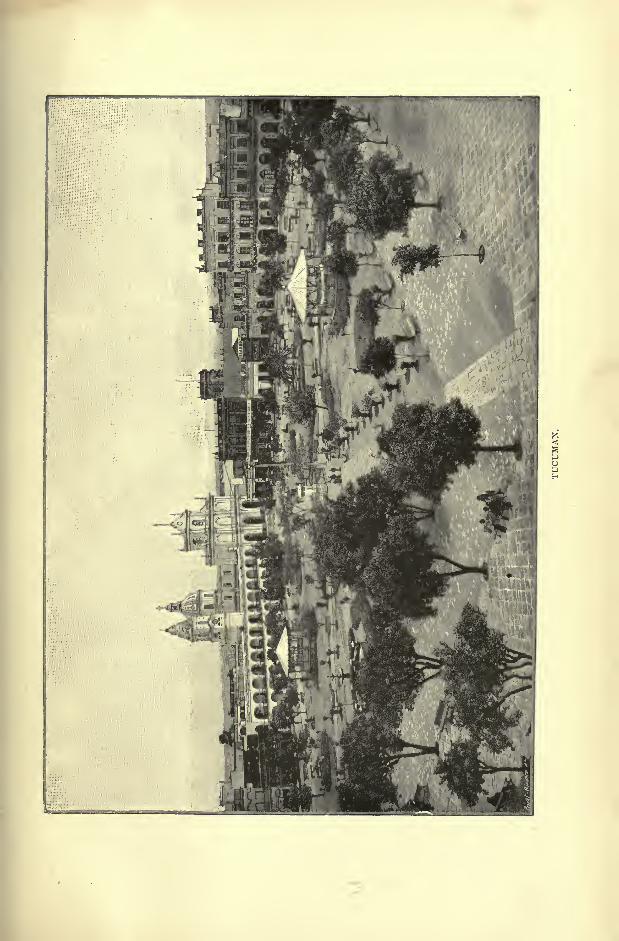
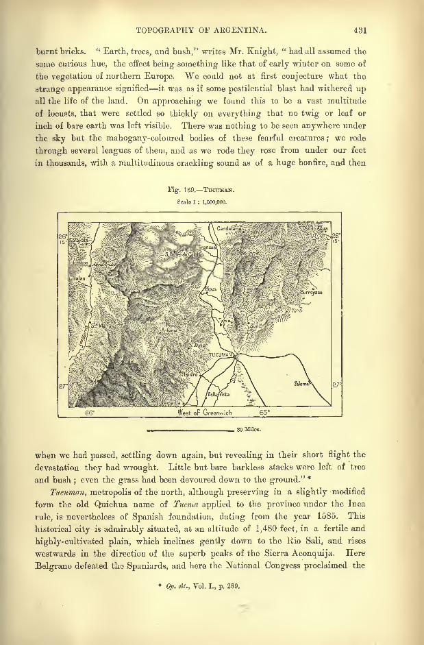
TOPOGRAPHY OF ARGENTINA. 481
burnt bricks. "Earth, trees, and bush," writes Mr. Knight,
" had all assumed the
same curious hue, the effect being something like that of early winter on some of
the vegetation of northern Europe. We could not at first conjecture what the
strange appearance signified it was as if some pestilential blast had withered upall the life of the land. On approaching we found this to be a vast multitude
of locusts, that were settled so thickly on everything that no twig or leaf or
inch of bare earth was left visible. There was nothing to be seen anywhere under
the sky but the mahogany-coloured bodies of these fearful creatures ; we rode
through several leagues of them, and as we rode they rose from under our feet
in thousands, with a multitudinous crackling sound as of a huge bonfire, and then
Fig. 169. TUCTJMAN.
Scale 1 : 1,600,000.
27
West oF Greenwich 65
30 Miles.
when we had passed, settling down again, but revealing in their short flight the
devastation they had wrought. Little but bare barkless stacks were left of tree
and bush;even the grass had been devoured down to the ground."
*
Tucuman, metropolis of the north, although preserving in a slightly modified
form the old Quichua name of Tucma applied to the province under the Inca
rule, is nevertheless of Spanish foundation, dating from the year 1585. This
historical city is admirably situated, at an altitude of 1,480 feet, in a fertile and
highly-cultivated plain, which inclines gently down to the Bio Sali, and rises
westwards in the direction of the superb peaks of the Sierra Aconquija. Here
Belgrano defeated tho Spaniards, and here the National Congress proclaimed the
*Op. tit., Vol. I., p. 289.
432 AMAZONIA AND LA PLATA.
independence of the land in 1816. Since then Tucuraan has also taken a large
share in the civil wars by which the country has been wasted.
Nevertheless, the city has continued to increase, and is now the fourth place
in. Argentina for population. The local industries have also been developed by a
steady stream of immigration, comprising Europeans of all nationalities. As
many as thirty large factories have been established in the outskirts, and sugar
culture, introduced from Peru in 1824, has succeeded so well that in 1890 this
industry employed 7,000 hands, and yielded 20,000 tons of sugar and 1,100,000
gallons of rum from a total area of 20,000 arfres. The district, which is
studded with farmsteads and hamlets, also yields coffee, hemp, wheat, and other
produce.
Tucuman enjoys some reputation as a centre of intellectual life, and one of
its colleges takes a high place amongst the scholastic institutions of the Republic.
Next to the capital the most flourishing agricultural towns are Monteros and
Medinas, both situated on affluents of the Rio Dulce.
TOWNS or THE PROVINCE OF SANTIAGO.
Santiago del Estero,"
St. James of the Morass," was the centre of the ancient
province of Tucma (Tucuman), which was brought under the rule of the Incas
towards the beginning of the fourteenth century. Here the Spanish conquerors
established (1553) the first permanent city in the Argentine possessions, and this
place was even long known by the name of Tucuman, now transferred to the more
flourishing northern city.
Standing on the right bank of the Rio Dulce on a plain about 650 feet above
sea-level, Santiago, as indicated by the epithet"Estero," is surrounded by swamps
and lagoons, former beds of the shifting stream. Half of the houses were swept
away by an inundation, in 1633, wben some of the inhabitants migrated to
Tucuman, others to Cordoba. The deserted city, often exposed to the attacks of
the Indians, remained under the government of the Jesuits, who transformed the
country to another Paraguay, with a similar theocratic administration and similar
social usages. In all respects the populations of both regions resemble each
other; they display the same love of cleanliness, and the same taste for music
and the harp, which has always been the national instrument of the Guarani
people. The ordinary diet, almost exclusively vegetable, is the same, as is also
the universal use of mate as a stimulating beverage.
After the proclamation of Argentine independence, Ibarra, dictator and
absolute master for thirty years, made every effort to maintain the outlying
territories, which lay beyond the sphere of political agitation. But although
reduced to a mere collection of adobe houses, Santiago has recovered a little of its
former activity since the completion of the line connecting it with the Cordoba-
Tucuman railway. It exports lucerne, cheese, and other produce, and also
engages in the sugar industry, although with less success than Tucuman.
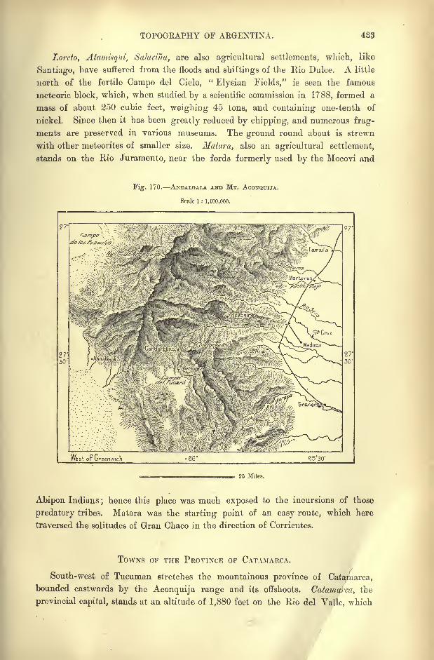
TOPOGEAPHY OF ARGENTINA. 433
Lorcto, Atamisqui, Salai'ina, are also agricultural settlements, which, like
Santiago, have suffered from the floods and shiftings of the Rio Dulce. A little
north of the fertile Campo del Cielo,"Elysian Fields," is seen the famous
meteoric block, which, when studied by a scientific commission in 1788, formed a
mass of about 250 cubic feet, weighing 45 tons, and containing one-tenth of
nickel. Since then it has been greatly reduced by chipping, and numerous frag-
ments are preserved in various museums. The ground round about is strewn
with other meteorites of smaller size. Matara, also an agricultural settlement,
stands on the Rio Juramento, near the fords formerly used by the Mocovi and
Fig. 170. ANDALGALA AND MT. ACONQXTIJA.
Scale 1 : 1,100,000.
West or ureenwich 6530'
25 Miles.
Abipon Indians;hence this place was much exposed to the incursions of those
predatory tribes. Matara was the starting point of an easy route, which here
traversed the solitudes of Gran Chaco in the direction of Corrientes.
TOWNS OF THE PROVINCE OF CATAMARCA.
South-west of Tucuman stretches the mountainous province of Catamarca,
bounded eastwards by the Aconquija range and its offshoots. Catamarca, the
provincial capital, stands at an altitude of 1,880 feet on the Rio del Yalle, which
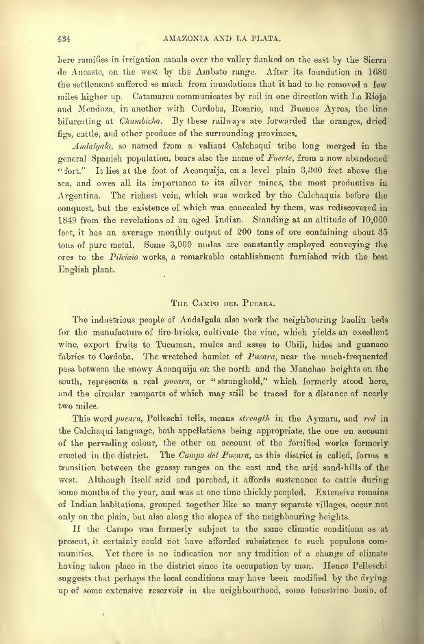
484 AMAZONIA AND LA PLATA.
here ramifies in irrigation canals over the valley flanked on the east by the Sierra
de Ancaste, on the west by the Ambato range. After its foundation in 1680
the settlement suffered so much from inundations that it had to be removed a few
miles higher up. Catamarca communicates by rail in one direction with La Bioja
and Mendoza, in another with Cordoba, Rosario, and Buenos Ayres, the line
bifurcating at Chumbicha. By these railways are forwarded the oranges, dried
figs, cattle, and other produce of the surrounding provinces.
Andalgala, so named from a valiant Calchaqui tribe long merged in the
general Spanish population, bears also the name of Fuerte, from a now abandoned" fort." It lies at the foot of Aconquija, on a level plain 3,300 feet above the
sea, and owes all its importance to its silver mines, the most productive in
Argentina. The richest vein, which was worked by the Calchaquis before the
conquest, but the existence of which was concealed by them, was rediscovered in
1849 from the revelations of an aged Indian. Standing at an altitude of 10,000
feet, it has an average monthly output of 200 tons of ore containing about 35
tons of pure metal. Some 3,000 mules are constantly employed conveying the
ores to the Pilciaio works, a remarkable establishment furnished with the best
English plant.
THE CAMPO DEL PUCARA.
The industrious people of Audalgala also work the neighbouring kaolin beds
for the manufacture of fire-bricks, cultivate the vine, which yields an excellent
wine, export fruits to Tucuman, mules and asses to Chili, hides and guanacofabrics to Cordoba. The wretched hamlet of Pucara, near the much-frequented
pass between the snowy Aconquija on the north and the Manchao heights on the
south, represents a real pucara, or "stronghold," which formerly stood here,
and the circular ramparts of which may still be traced for a distance of nearly
two miles.
This word pucara, Pelleschi tells, means strength in the Aymara, and red in
the Calchaqui language, both appellations being appropriate, the one on account
of the pervading colour, the other on account of the fortified works formerly
erected in the district. The Campo del Pucara, as this district is called, forms a
transition between the grassy ranges on the east and the arid sand-hills of the
west. Although itself arid and parched, it affords sustenance to cattle during
some months of the year, and was at one time thickly peopled. Extensive remains
of Indian habitations, grouped together like so many separate villages, occur not
only on the plain, but also along the slopes of the neighbouring heights.
If the Campo was formerly subject to the same climatic conditions as at
present, it certainly could not have afforded subsistence to such populous com-
munities. Yet there is no indication nor any tradition of a change of climate
having taken place in the district since its occupation by man. Hence Pelleschi
suggests that perhaps the local conditions may have been modified by the drying
up of some extensive reservoir in the neighbourhood, some lacustrine basin, of
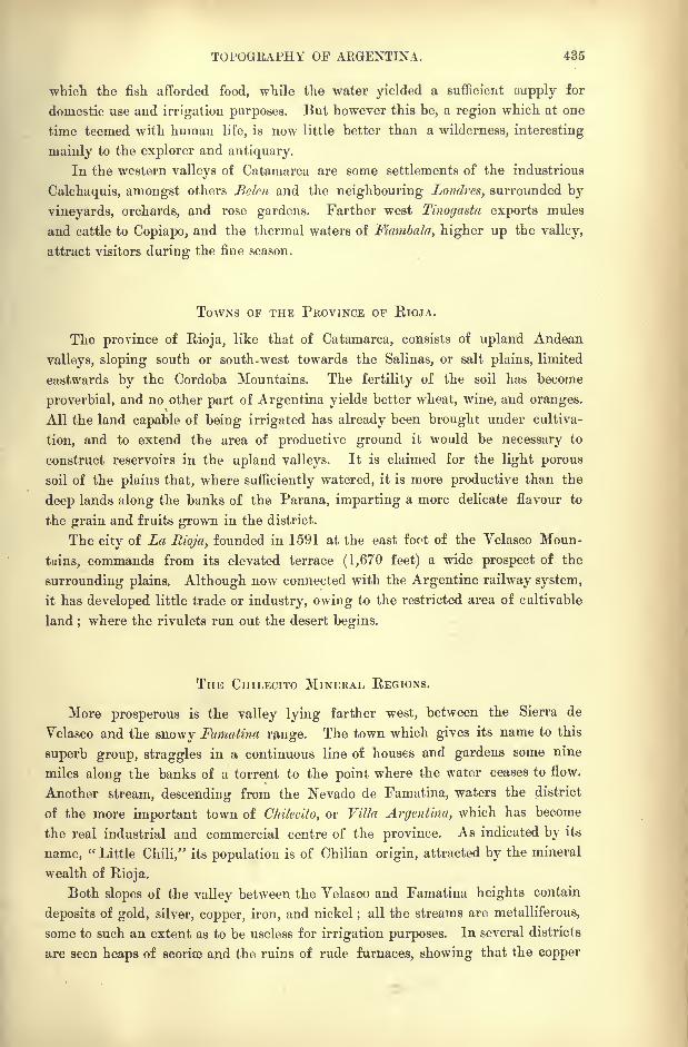
TOPOGRAPHY OF ARGENTINA. 435
which the fish afforded food, while the water yielded a sufficient oupply for
domestic use and irrigation purposes. But however this be, a region which at one
time teemed with human life, is now little better than a wilderness, interesting
mainly to the explorer and antiquary.
In the western valleys of Catamarca are some settlements of the industrious
Calchaquis, amongst others Belcn and the neighbouring Londrcs, surrounded by
vineyards, orchards, and rose gardens. Farther west Tinogasta exports mules
and cattle to Copiapo, and the thermal waters of Fiambala, higher up the valley,
attract visitors during the fine season.
TOWNS OF THE PROVINCE or RIOJA.
The province of Rioja, like that of Catamarca, consists of upland Andean
valleys, sloping south or south-west towards the Salinas, or salt plains, limited
eastwards by the Cordoba Mountains. The fertility of the soil has become
proverbial, and no other part of Argentina yields better wheat, wine, and oranges.
All the land capable of being irrigated has already been brought under cultiva-
tion, and to extend the area of productive ground it would be necessary to
construct reservoirs in the upland valleys. It is claimed for the light porous
soil of the plains that, where sufficiently watered, it is more productive than the
deep lands along the banks of the Parana, imparting a more delicate flavour to
the grain and fruits grown in the district.
The city of La Rioja, founded in 1591 at the east foot of the Yelasco Moun-
tains, commands from its elevated terrace (1,670 feet) a wide prospect of the
surrounding plains. Although now connected with the Argentine railway system,
it has developed little trade or industry, owing to the restricted area of cultivable
land ;where the rivulets run out the desert begins.
THE CniLECTTO MINERAL REGIONS.
More prosperous is the valley lying farther west, between the Sierra de
Velasco and the snowy Famatina range. The town which gives its name to this
superb group, straggles in a continuous line of houses and gardens some nine
miles along the banks of a torrent to the point where the water ceases to flow.
Another stream, descending from the Nevado de Famatina, waters the district
of the more important town of Chilecito, or Villa Argentina, which has become
the real industrial and commercial centre of the province. As indicated by its
name, "Little Chili," its population is of Chilian origin, attracted by the mineral
wealth of Rioja.
Both slopes of the valley between the Velasoo and Famatina heights contain
deposits of gold, silver, copper, iron, and nickel;
all the streams are metalliferous,
some to such an extent as to be useless for irrigation purposes. In several districts
are seen heaps of scoriae and the ruins of rude furnaces, showing that the copper
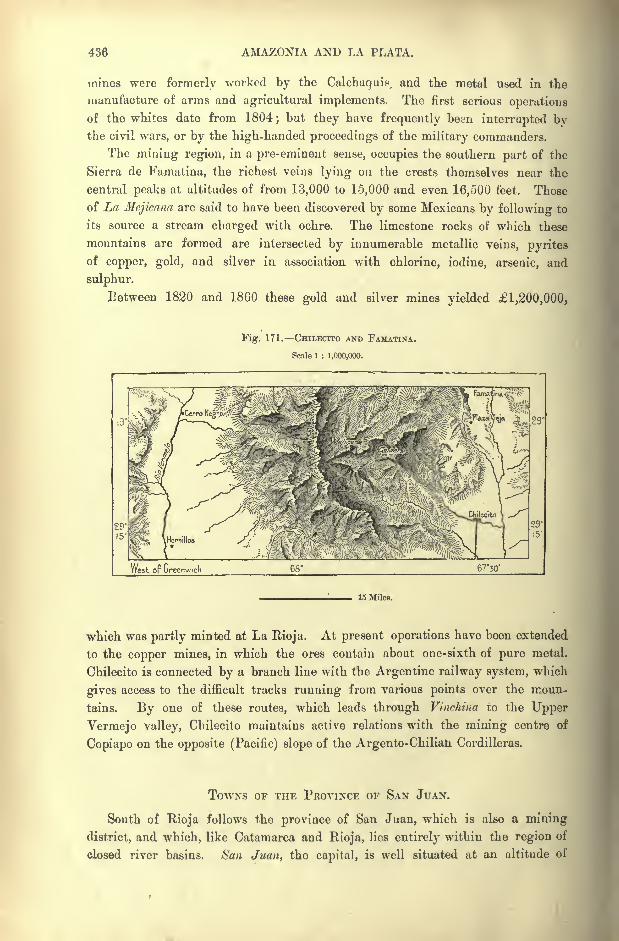
436 AMAZONIA AND LA PLATA.
mines were formerly worked by the Calchaquis^ and the metal used in the
manufacture of arms and agricultural implements. The first serious operations
of the whites date from 1804;but they have frequently been interrupted by
the civil wars, or by the high-handed proceedings of the military commanders.
The mining region, in a pre-eminent sense, occupies the southern part of the
Sierra de Famatina, the richest veins lying on the crests themselves near the
central peaks at altitudes of from 13,000 to 15,000 and even 16,500 feet. Those
of La Hcjicana are said to have been discovered by some Mexicans by following to
its source a stream charged with ochre. The limestone rocks of which these
mountains are formed are intersected by innumerable metallic veins, pyrites
of copper, gold, and silver in association with chlorine, iodine, arsenic, and
sulphur.
Between 1820 and 1860 these gold and silver mines yielded 1,200,000,
Fig. 171. CHILECITO AND FAMATINA.
Scale 1 : 1,000,000.
West oF Greenw.ch
15 Miles.
which was partly minted at La Rioja. At present operations have been extended
to the copper mines, in which the ores contain about one-sixth of pure metal.
Chilecito is connected by a branch line with the Argentine railway system, which
gives access to the difficult tracks running from various points over the moun-
tains. 13y one of these routes, which leads through Vinchina to the Upper
Vermejo valley, Chilecito maintains active relations with the mining centre of
Copiapo on the opposite (Pacific) slope of the Argento-Chilian Cordilleras.
TOWNS OP THE PROVINCE OF SAN JUAN.
South of Rioja follows the province of San Juan, which is also a mining
district, and which, like Catamarca and Rioja, lies entirely within the region of
closed river basins. San Juan, the capital, is well situated at an altitude of

TOPOGRAPHY OF ARGENTINA. 437
2,130 feet on a fertile plain watered by the innumerable ramifying rills of
the Rio San Juan. Founded in 1561 about four miles farther north, and after-
wards removed to its present site, San Juan presents an agreeable aspect with
its belt of cultivated ground and magnificent circular boulevard planted with
poplars. To the west lies the pleasant watering-place of Zonda, and to the
east the town of Cauccte, officially Independencia, in a district reclaimed by
irrigation works from the wilderness. San Juan possesses a botanic garden
and a school of mines in connection with the neighbouring mineral deposits.
Jachel, 124 miles farther north, lies in a district abounding in mines and
thermal waters. Standing on a copious river, which is swollen by torrents from
all the lateral glens, Jachel has become the chief centre of traffic for all the
northern districts of the province. From this point numerous convoys of
mules are directed over the Cordilleras, and across the plateaux to the two
Chilian seaports of Huasco and Coquimbo. But the porterage of goods con-
veyed by these difficult and even dangerous routes is so heavy that the traffic
must entirely cease as soon as the Argentine and Chilian railway systems are
connected by the inter-oceanic trunk-lines now in progress.
TOWNS OF THE PROVINCE OF MENDOZA..
Next to that of Tucuman, the province of Mendoza is the most populous of all
the Andean regions within Argentine territory. It owes its exceptional impor-tance to its position on the main Continental highway between Buenos Ayres and
Valparaiso. The Cumbre Pass, over which will be carried the future trans-
Andean railway, lies between Aconcagua and Tupungato, loftiest peaks of the
Cordilleras. Farther south the range is interrupted by lower passes ;but they are
little frequented, owing to their remoteness from the route connecting the two
vital points of Chili and Argentina.
Like the neighbouring provinces, Mendoza possesses some rich mineral deposits ;
but they have been little worked during the present century, and its chief resources
are its vineyards, cereals, and lucerne meadows watered by the torrents descend-
ing from the Cordilleras. Sericulture, of which great hopes were entertained
when introduced about the year 1850, has since been abandoned. Jointly with
the provinces of San Juan and San Luis, Mendoza belongs to the region known
by the name of Cuyo. Under the Spanish colonial rule this region depended
administratively on the government of Chili.
Mendoza, the capital, and formerly metropolis of the Spanish vice-royalty of
La Plata, was founded in 1560 on a plain traversed by rivulets utilised as irriga-
tion rills. But it does not occupy its original site. The first Mendoza, built with
taller houses and heavier materials, was overthrown in a few minutes by the
fearful earthquake of 1861. The catastrophe occurred on Ash Wednesday evening,when all the inhabitants were assembled in the churches, all of which gave way,
burying beneath their ruins 10,000, or according to some 13,000, in a total popula-62

438 AMAZONIA AND LA PLATA.
tion of less than 15,000. The geologist Bravard, who is traditionally said to have
predicted the shock, was amongst the victims.
As Mendoza is not situated in a volcanic region, and as there are no craters
in the neighbouring Andes, the place can scarcely have been overthrown by an
ordinary igneous disturbance. Brackebusch suggests that it may have been
caused by the combustion of the bituminous beds below the surface, accompanied
by an explosion of gas.
In rebuilding the city, the inhabitants took as central thoroughfare the
Fig. 172. MENDOZA.
Scale 1 : 200,000.
3 Miles.
Alameda, an avenue of poplars and elms, which formed the fashionable resort on
fine summer evenings. The new houses, painted in bright colours and built of
elastic adobe, which vibrates under a concussion, are disposed along the banks of
a canal lined with rows of trees, and ornamented with fountains and waterfalls.
Lying on the main highway between Buenos Ayres and Valparaiso, Mendoza
is the chief station between the two Republics. It is also an agricultural centre of
the first importance, and seat of a great school of agriculture. The surround-
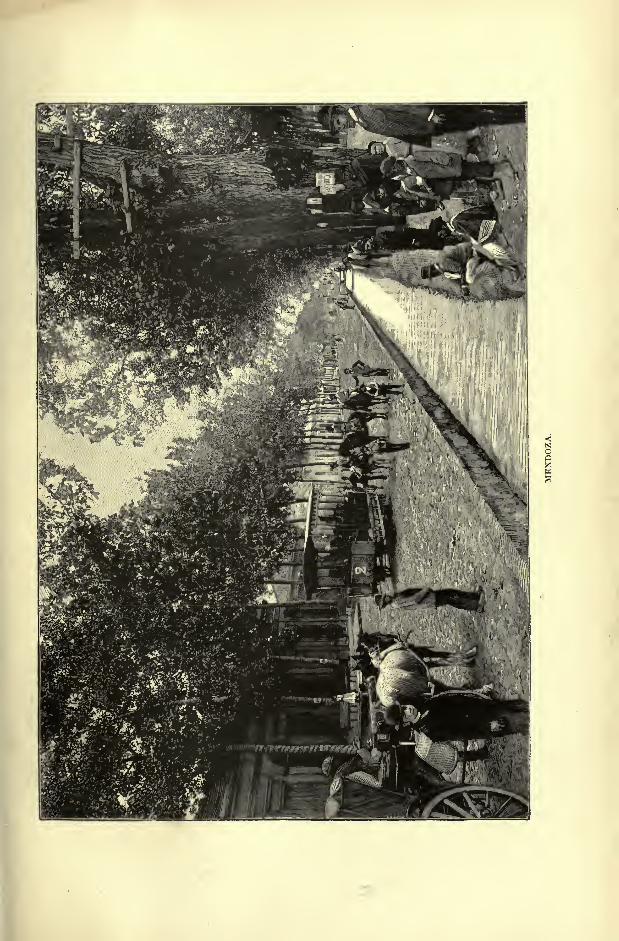
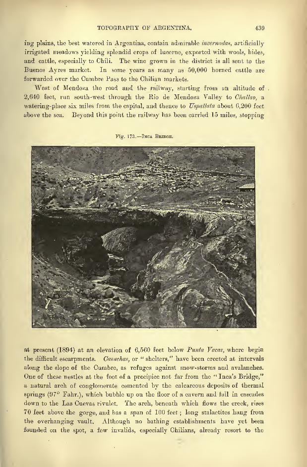
TOPOGRAPHY OF ARGENTINA. 439
ing plains, the best watered in Argentina, contain admirable invcrnadax, artificially
irrigated meadows yielding splendid crops of lucerne, exported with wools, hides,
and cattle, especially to Chili. The wine grown in the district is all sent to the
Buenos Ayres market. In some years as many as 50,000 horned cattle are
forwarded over the Cumbre Pass to the Chilian markets.
West of Mendoza the road and the railway, starting from an altitude of
2,640 feet, run south-west through the llio de Mendoza Valley to Challao, a
watering-place six miles from the capital, and thence to Uspallata about 6,200 feet
above the sea. Beyond this point the railway has been carried 15 miles, stopping
Fig. 173. TNCA BEIDGE.
at present (1894) at an elevation of 6,560 feet below Punta Vacas, where begin
the difficult escarpments. Casuchas, or "shelters," have been erected at intervals
along the slope of the Cumbre, as refuges against snow-storms and avalanches.
One of these nestles at the foot of a precipice not far from the " Inca's Bridge,"
a natural arch of conglomerate cemented by the calcareous deposits of thermal
springs (97 Fahr.), which bubble up on the floor of a cavern and tail in cascades
down to the Las Cuevas rivulet. The arch, beneath which flows the creek, rises
70 feet above the gorge, and has a span of 100 feet; long stalactites hang from
the overhanging vault. Although no bathing establishments have yet been
founded on the spot, a few invalids, especially Chilians, already resort to the
440 AMAZONIA AND LA PLATA.
mineral waters, which have the reputation of being highly efficacious in the case
of rheumatic complaints arid affections of the blood.
But Uspallata itself, although presenting some advantages as an agricultural
centre, has hitherto failed to attract immigrants. It stands at too great an
altitude, about 6,350 feet, and consequently remains without importance, except
as a frontier custom-house. Nor have any great returns been yielded by the
mining operations carried on to utilise the copper and other mineral deposits of
the district. During the last century the Paramillo mines, which stand at various
elevations between 9,000 and 10,600 feet, were actively worked. Enormous
excavations were made by the unfortunate Araucanian captives, who were
employed in the galleries, and perished by thousands. On these uplands the
wind, which takes the name of paiamillero, from the district, blows at times with,
tremendous fury.
SAN CARLOS THE SAN RAFAEL COALFIELDS.
South of Mendoza the route passes San Vicelife, which may be regarded as a
suburb of the capital. Some 60 miles farther south it reaches San Carlos, the
chief station between Mendoza and San Rafael. Sin Carlos has never recovered
the disaster of 1868, when the Indians surprised and massacred its garrison,
plundered the houses, and carried off the women. At present the settlers in the
district, nearly all Chilians, live in isolated houses and farmsteads scattered over
the surrounding plains.
Brighter prospects seem to be in store for San Rafael, which stands near the
banks of the Rio Diamante at the point where it issues from the mountains.
Thanks to the fertility of the soil, its numerous streams, and the relatively easy
passes by which it communicates with Chili, this place promises, in the near
future, to become one of the chief cities of Argentina. Most of its first inhabi-
tants were refugees from other provinces, exiles or criminals, who were known
by the half Indian name of guyquero8tor "ostrich-hunters." They acted as
guides to the military expeditions during the operations carried on in the region
of the Andes.
So recently as 1872 the place was besieged, or at least blockaded, by the
surrounding nomad tribes. None of the garrison dared to venture any distance
from the fort, and the people had to keep their cattle carefully guarded in two
enclosures. At present the artificially watered grassy plains stretch far from the
town, and convoys of mules, laden with fodder for the Chilian markets, are
constantly crossing the Cordilleras by the Planchon and Cruz de Piedra passes.
Near San Rafael the settlers have already introduced the cultivation of the vine,
for which soil and climate seem well suited.
West of San Rafael, which has also suffered from the predatory Indians, the
Argentine foothills contain beds of coal, which certainly belong to the carboni-
ferous formation, and not to the triassic system, like those of the San Juan and
Meudoza districts. The coal burns with a clear flame, and is equal in quality to
TOPOGKAPHY OF AKGENHNA. 441
average English coal. Numerous beds have already been surveyed, and one layer
in the Eloisa mine is no less than 13 feet thick.
All the indications seem to show that this coalfield stretches southwards under
the Jurassic strata as far as the Neuqueri district. The same region contains
petroleum, alabasters, and limestones, valuable as building material. Moreover,
the ashes of the San Rafael coal have a large proportion of vanidium, the salts of
which are the best mordants for aniline dyes. But the best coal pits stand at a
great altitude, from 8,000 to 10,000 feet, and are covered with snow in winter.
Hence it would be difficult to work them with profit before the Rio Diamante is
made navigable, and these elevated regions opened up by the railways now in
course of construction over the Cordilleras.
TOWNS OF THE PROVINCE OF SAN Luis.
The province of San Luis, separated from that of Mendoza by the course of
the Desaguadero and of the Salado, comprises a portion of the central uplands
and stretches far into the southern deserts. It is one of the most thinly peopled
regions of Argentina, although abounding in mineral resources, and very fertile
in all its irrigable districts. It has also the advantage of lying between Cordoba
and Mendoza, and is consequently intersected by the main highway between the
Atlantic and the Pacific.
But of all the Argentine populations those of San Luis have suffered most
from the border warfare. For over 250 years, from the close of the sixteenth
century to the middle of the nineteenth century, the city of San Luis was the
advanced post of the Spaniards and Argentines against the Pampas Indians;and
with such enemies the struggle was incessant. More than once the Indian horse-
men even advanced beyond San Luis, 'extending their incursions into the settled
districts, either as conquerors, or as allies of one or other of the Argentine factions.
Of all the Hispano-American peoples none have taken a more active part in these
fratricidal conflicts, in which the youth of the country have been more than
decimated. Hence, even still the proportion of women is greatly in excess of the
men, despite the stream of immigration, in which the males always outnumber the
females.
CITY OF SAN Luis VILLA MERCEDES.
Built in 1597 by Martin de Loyola, nephew of Ignatius Loyola, founder of
the Jesuit Order, San Luis was long known by the name of Punta de los Venados,
from the bluff on which were erected the first houses;hence the appellation of
Puntanos, given to the inhabitants. The city stands at an altitude of 2,500 feet
on the slopes of the Punta, which commands an extensive prospect of the surround-
ing plains and mountains, limited westwards by the snowy crests dominated by
Tupungato and the Cerro de Plata. A reservoir containing 420 million cubic
442 AMAZONIA AND LA PLATA.
feet feeds the irrigation rills which ramify over the neighbouring vineyards and
orchards. But the gold washings, carried on in the highest gorges of the
mountain near the Tomolasta peak, no longer yield adequate returns.
Villa Mercedes, founded in 1856 under the name of Fuerte Constitutional, has
unexpectedly risen to importance, thanks to its position on a fertile plain watered
by the Rio Quinto on the route of the inter-oceanic railway at the point where
it turns the Sierra de Cordoba on the south. Villa Mercedes thus occupies an
advantageous position as the converging point of the future trunk lines from
Cordoba, Rosario, Buenos Ayres, Bahia Blanca, and Mendoza. Founded in a
district lately wrested from the Pampas Indians, this place continues to thrive
and increase in population at the expense of Achiras and San Jose del Morro,
stations which lie farther north on the old highway to Chili. Villa Mercedes is
surrounded bv rich lucerne meadows.
TOWNS OF THE PROVINCE OF CORDOBA.
Rio Caarto, another busy station of the Argentine railway system, lies, as
indicated by its name, on the " Fourth "of the rivers descending from the
eastern slopes of the Cordoba mountains. It lies within the province of Cordoba,
and, like San Luis, it was long a bulwark against the Pampeans on the extreme
frontier of the settled districts of Argentina. It was often besieged, the women
and children taking refuge in the churches, while the men fought in the streets.
Since the return of peace its agricultural resources have been developed by the
construction of irrigation works, and at present Rio Cuarto is the second city in
the province.
Another outlet for the produce of the district is afforded by the twin towns
of Villa Maria and Villa Nueva, the former on the left, the latter on the right
bank of the Rio Tercero, wrhich is here crossed by a railway bridge.
Frayk Mnerto, the first agricultural colony in this district, was founded by
English settlers in 1868;but it never prospered, and the colonists dispersed.
Since then peasants of other nationalities have arrived in large numbers, and the
country about Bell-villc, as Frayle Muerto is now called, has been brought largely
under cultivation, yielding rich crops of lucerne and wheat.
This place is associated with the fortunes of the ill-fated Henley colony.
Some years ago there arrived from England "a strange crew of young English
gentlemen, with the ostensible object of cattle-farming. If energy and skill in
cana-drinking and horse-racing are the sole requisites for a cattle-farmer, then
none could be better than these. These young men, unsteady, fresh from school
and college and regiment, without practical knowledge of anything, arrived at
Rosario in a batch, and considerably astonished the natives by their manners and
customs. The Heuleyites came down on the land in the fashion of a hostile
army. They had a uniform of which a plumed helmet was not the least con-
spicuous article; each was provided witli a regulation rifle, revolver, and sabre,
besides an arsenal of wonderful weapons he took on his own account in addition.

TOPOGRAPHY OP ARGENTINA. 443
They were encamped for some time in a village of wooden huts, while lands were
being apportioned out to them; and here they soon showed what manner of
colonists they were going to be. Drinking, gambling, and horse-racing was the
order of the day. The capital they had brought with them took unto itself
wings ;for let the gringo (European), however knowing in his own land, skin
his eyes ere he match himself on the turf with the simple gaucho of the pampas.
Fig. 174. CORDOBA.
Scale 1 : 800,000.
31
18 Miles.
" So things went on, and the natives smiled at the ways of the locos Inglcses
('mad Englishmen'), won their money, acquired their mortgaged lands, while
the colonists diminished woefully in number. Many of these gentlemen ultimately
were driven to take any menial work they could get; some died of delirium
tremens, others self-despatched with their own revolvers;the remainder settled
down, after the first wild burst was over, with diminished means to the business
they had come over to undertake. The prosperous little town of Frayle Muerto
444 AMAZONIA AND LA PLATA.
has been built for the most part on the spoils that have been wrung from the
ill-fated Englishmen by publicans and usurers." *
CITY OF CORDOBA.
Cordoba, capital of the province and second largest city of the Republic west of
the Rio Parana, is one of the old settlements in South America, having been
founded by Cabrera in 1573, seven years before Buenos Ayres. Standing on the
right bank of the Rio Primero about 1,300 feet above the sea, it occupies the
deepest part of a valley excavated by the running waters between high lateral
cliffs ;to the west is seen the breach through which the waters escape between
two steep escarpments.
Headquarters- of the Jesuit rule for a period of two centuries, Cordoba till
recently still presented the dull aspect of an ecclesiastical town. But since 1870,
when it was brought into connection with the Argentine railway system, it has
again become a busy centre of trade and industry, as well as the rival of Buenos
Ayres in intellectual progress. The university, which had been established after
the expulsion of the Jesuits in 1767, and which, possessing neither books, instru-
ments, collections, nor professors, had hitherto taught little beyond" Church
Latin " and scholastic philosophy, was re-constituted in 1870 on a liberal basis,
and since then serious studies have been introduced by a staff of learned teachers,
for the most part German naturalists.
An astronomic observatory, founded at the same time, holds an honorable posi-
tion amongst similar institutions, and has already done work of primary impor-
tance by the publication of a chart of the southern heavens. Cordoba also possesses
a meteorological institute, an academy of science, and various other learned institu-
tions. The atlas bearing the name of Scelstrang is in course of preparation at the
geographical bureau.
Formerly Cordoba was greatly exposed to the ravages of torrents overflowing
their banks. A lateral branch of the Rio Primero, issuing from a gorge nearly
always dry, sent down at times sudden avalanches of mud and slush. A munition
or dam constructed in 1671 still holds back the storm waters, and a similar work
on a colossal scale was recently undertaken to embank the Rio Primero. A barrage
erected at the issue from the mountains near San Rogue arrested the flood waters,
and regulated the discharge, both for the supply of the city and for irrigation pur-
poses. Above this dyke, which is no less than 100 feet broad at the base, and
over 16 at the top, and 344 feet long, a navigable lake would have been created
with a depth of over 116 feet, a superficial area of 64 square miles, and a capacity
of over 9,000 million cubic feet. It would, in fact, have been the largest artificial
basin of the kind in the world.
But, as has so often been the case elsewhere, the contractors had tried to effect
savings by the use of an inferior mortar for cementing these cyclopic walls, and
*Knight, op. cit., p. ]67-
TOPOGEAPHY OF ARGENTINA. 445
dangerous fissures made their appearance in the barrier. The level of the lake had
consequently to be limited to 70 feet, which corresponds to a capacity of 2,000
million cubic feet, a quantity still sufficient for the irrigation of at least 100,000acres. In 1890 a single downpour of six hours' duration caused three-fourths of
the contents of the reservoir to escape, bursting a canal, by which the city was
laid under water, and several hundred houses destroyed ; fortunately most of the
inhabitants were able to effect a timely retreat.
In the neighbourhood is the settlement of Pueblito, inhabited by Indian half-
breeds, who since its foundation have always remained under the direct control of
Cordoba. Farther up in the heart of the mountains is the health resort of Cosquin,
frequented during the fine season by consumptive and other patients. A railway,
running from Cordoba by San Roque and Cosquin up to the sources of the Rio
Primero, and descending westwards to the salinas of Rioja, traverses a formerly
productive mineral region, which now yields but little of the precious metal.
Hence the Cordoba mint, which coined the gold from these mountains, has longbeen closed. San Pedro and Dolores, the chief places in the mining district, now
depend on the agricultural resources of the surrounding plains.
TOWNS OF THE PROVINCE OF BUENOS AYRES.
The province of Buenos Ayres, in which is situated the capital of Argentina?
comprises less than a tenth part of the domain of the Republic. But its advan-
tageous position has enabled it to take a much higher rank in respect of wealth
and population. In the fertility of its soil, and even in its climatic conditions it
cannot compare with many other provinces ;but it enjoys the primary advantage
of easy access to foreign trade and immigration.
But not satisfied with its economic preponderance, Buenos Ayres has long
aspired to political supremacy. In shaking off the yoke of Spain, its inhabitants
expected to take the place of the metropolis as the centre of authority, and forth-
with began to issue orders to the other sections of the colonial empire. Such
was the cause of the civil wars between " unionists" and "
federalists," which
have cost torrents of blood, and which for a time even divided Argentina into
two separate States.
CITY OF BUENOS AYRES.
The city to which its founder, Mendoza, gave the name of Puerto Santa Maria
do Buenos Ayres, is not a natural "puerto
"(haven), despite its name and despite
the term Puertenos," Harbour Folk," applied to its inhabitants. On the long,
low-lying strand of the estuary there are no deep inlets of any kind, and the spot
chosen for the settlement offered to the first arrivals nothing but a rocky hard, or
landing-place for the boats of the vessels which had to ride at anchor in the
offing.
446 AMAZONIA AND LA PLATA.
Even at present, despite the artificial port, basins, breakwaters, and other
recently completed harbour works, Buenos Ayres is scarcely distinguished from
the uniform contour line of the horizon; masts, funnels, towers, all appear, seen
from the estuary, as if rising above a floating island. Without hills, or anybroken ground rising more than 60 feet above the surface, Buenos Ayres can
present no imposing or conspicuous object to visitors arriving from any point of
the compass. The streets, laid out in the monotonous chessboard fashion of so
many American cities, stretch away in interminable straight lines, unbroken by
any natural obstacle causing a change of direction. Towards the south alone the
regularity of the geometrical plan is somewhat interrupted by the scarps of a
terrace, which fall abruptly towards the Riachuelo, the "Brook," as the neighbour-
ing rivulet is called. A little variety in the quadrilateral blocks of houses has also
been introduced by the railway lines and stations, and some other structures.
Although its site was one of the first to be chosen for a Spanish settlement,
Buenos Ayres is not the oldest city in the Republic. In 1535, that is, eight years
after the erection of the fortress of Espiritu Santo, near the mouth of the
Carcarana, Diego de Mendoza penetrated into the Riachuelo, and erected a few
huts on the terrace dominating this streamlet. But being unable to maintain
friendly relations with the Querandi Indians, he soon found himself blocked
with his soldiers and settlers in his narrow camping-ground. Assaults and conflicts
followed with varying success; but the little colony failing to shake off the
enemy, Alvar Nunez broke up the settlement in 1542, when the district was
restored to the Indians.
Repulsed in this direction, the Spaniards turned their arms in the direction
of the Parana and Paraguay rivers, where the natives had submitted without
much show of resistance. But the progress of the whites in the interior
rendered all the more indispensable the foundation of a trading place on the
shores of the estuary. It seemed rash to attempt to gain a footing in the vicinity
of the warlike Charruas of the Banda Oriental, hence it was decided to recover
the position abandoned on the Riachuelo. In 1580 Juan de Garay,,at the head of
sixty soldiers and a troop of Indian auxiliaries, resumed possession of the terrace
at Buenos Ayres. The Querandi natives had at the time withdrawn from the
district, and the leaders at once set about distributing the land.
The establishment of a commercial station at the entrance to the vast fluvial
basin of La Plata could not fail to affect the interests of the old trade routes.
The merchants of Cadiz and Seville, who enjoyed a monopoly of the traffic with
the New World by the New Grenada and Peruvian routes, exacted from the
Government the monstrous condition that European goods destined for La Plata
should be forwarded by the way of Peru and the Upper Paraguay.
Nevertheless, Buenos Ayres managed to secure a few concessions, while the
contraband trade was rapidly developed by the establishment of a Portuguese
colony at Sacramento on the opposite side of the estuary. But the place developed
very slowly, and in 1744, over a century and a half after its foundation, the
population still fell short of 20,000. It continued to languish till the year 1776,
TOPOGRAPHY OF AEGENTINA. 447
when the Platean territories were severed from the political and commercial
supremacy of Peru, and constituted a separate viceroyalty in direct dependenceon the home Government. By the close of the eighteenth century Buenos Ayreswas already a large city with 50,000 inhabitants, and as many more in the
surrounding district.
Although wars and civil strife were ushered in with the period of political
independence, Buenos Ayres never ceased to develop, and since European
immigration has assumed the character of an exodus, the capital of La Plata,
till recently inferior to several other places in South America and to the two
chief cities of Australia, now ranks as the largest centre of population in the
whole of the southern hemisphere.* At times local revolutions, epidemics, and
financial crises have occasioned a temporary falling off; but the normal yearlyincrease by the excess of births over the mortality ranges from 10,000 to
14,000, and to this must be added a share of the general immigration, estimated
at about one-fifth of all the passengers landed.
The city, covering a very large area in proportion to its population, extends
for a space of about ten miles along the river, from Belgrano to Barracan, and for
about the same distance from the estuary towards the inland plains. North west-
wards a long suburb stretches away in the direction of the Parana; westwards
several quarters are advancing towards San Jose de Florcs ; in the south con-
tinuous lines of houses reach all the way to La Boca and Barracas on the banks
of the Riachuelo, and the whole municipality comprises a space of about 70
square miles; but the ground actually covered by structures is not more than 18
square miles, or about half the extent of Paris. Since 1870 Buenos Ayres, like
Rio, Monte Video, and all the other large South-American cities, has been amply
supplied with tramways, which do a relatively larger business than those of
European towns. Six local railways also radiate from the quays to several urban
stations.
Before the creation of colossal fortunes by trade and speculation, all the
streets and all the houses were very much alike. As regulated in colonial times
by a formal enactment of the Council of: the Indies, the streets had an averagewidth of 16 vares (45 feet), and formed manzanas, or blocks, 430 feet on all sides,
with footpaths about three or four feet wide along both sides of the road-
way. The normal type of dwelling, modelled on those of Cadiz and Seville,
presents to the street an apartment with two windows, and a railed vestibule
giving a view of the shrubs and flowers of a, patio, or inner court, surrounded bychambers.
Formerly the houses had only one storey, or often merely a ground- floor.
But the increasing value of the land, about the same in the central quarters as
that of European capitals, has induced the ground landlords to build upwards, as
the busy quarters in the east near the harbour, in the north near the Palermo
park and the fashionable Belgrano district are being gradually reconstructed
*Population of Buenos Ayres, July 31, 1893 : 569,122.
448 AMAZONIA AND LA PLATA.
with loftier and more sumptuous houses, no longer modelled on the old Andalusian
type.
But since Buenos Ayres has fallen into the hands of the contractors and
builders, it has begun to assume more and more the composite and commonplace
aspect of most other modern capitals. Except brick and sand, the soil of the
district yields none of the materials employed in the construction and embellish-
ment of its buildings. The banks vie with each other in the display of imported
marbles and metals, and the two English banks are really fine structures, which
would be an ornament to any city. Granite and mica schists come from the
island of Martin Garcia ;the marbles from Italy ;
the flagstones of the side-paths
and courts are brought by English vessels;the lime is prepared on the banks of
Uruguay and Parana rivers; the ordinary timber is felled in Norway and Canada*
while Brazil and Paraguay forward the costly cabinet woods, and France most of
the furniture, bronzes and mirrors.
The chief monuments are concentrated near the shore oil the spot where
Juan de Garay erected his first humble habitations. The Cam Rosada, now the
Government palace, near the custom house, was the old viceregal fort, often
restored and entirely rebuilt towards the close of the sixteenth century. Close
by the Mayo or Victoria Square is lined by the palace of Congress, the Town
Hall, Exchange, Colon Theatre and the Cathedral, with its ambitious peristyle
of Corinthian columns. At this central quarter begins the still unfinished
Boulevard de Mayo, a spacious thoroughfare which is to intersect the Callao
Boulevard in the centre of the city. Near the Mayo Square is also situated the
great terminal station, whence radiate most of the lines of the Argentine railway
system.
All nationalities have their representatives in Buenos Ayres, the great" crucible
"in which the Argentine nation is being ground and amalgamated.
In this Babel of races and languages the natives are not even in a majority, and
in 1892 they constituted no more than a fifth of all the citizens. At that time
the Italians were twice as numerous, and in some quarters little is heard except
the Genoese, Neapolitan, or other Italian dialects.
Buenos Ayres cannot be called a healthy city, and although the birth-rate
exceeds that of some large European capitals, the mortality is also very high, over
24 per thousand in 1891. The new drainage system had not been begun before
the two great epidemics of cholera in 1867 and yellow fever in 1871, the former
of which carried off 15,000, the latter as many as 26,000 victims. The works,
which have already cost 6,000,000, are still far from complete, four-fifths of
the houses not having yet been connected with the main sewer 16 miles long,
which discharges into the estuary near Quihnes, east of the city. The water
supply is obtained about a mile above Belgrano from a part of the estuary which,
though quite fresh, is charged with sediment. The water is conveyed by a tunnel
nearly four miles long to the reservoirs of La Recolcta, just north of the city.
But the daily supply, about 15,000,000 gallons, is inadequate, and in 1893 as
many as 10,000 out of 40,000 houses were still without water from this source.
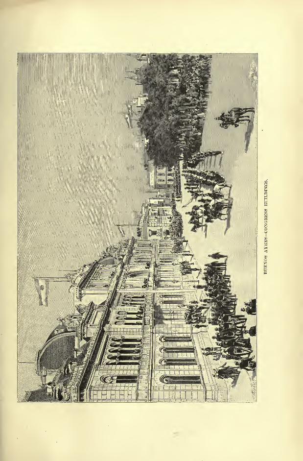
TOPOGRAPHY OF ARGENTINA. 449
There are also numerous artesian wells, some sunk in 18KO to depths of 800 or
900 feet ;but the water is too brackish to be of any use for domestic purposes.
Since then the freshwater has been tapped which communicates with the Rio
Parana at depths of from 84 to 100 feet below the surface. In 1884 as many as
150 of these wells had already been opened, the most copious yielding over
1,400 cubic feet per hour. These underground reservoirs seem to be inex-
haustible.
To meet the increasing demands of the shipping in a seaport concentrating
in itself three-fourths of all the trade of the Republic, more than one attempt has
been made to improve the approaches and create a good artificial harbour. At
first the mouth of the Riachuelo, where Mendoza had moorod his caravals, was
embanked, and the entrance dredged deep enough to admit vessels drawing16 feet
;the dredging is still in progress, and will ultimately attain a depth of
18 or 20 feet.
Another project, on a much larger scale, begun in 1887, consists in construct-
ing along the whole frontage of the city four basins 23 feet deep protected bya granite breakwater, and provided with warehouses, cranes, and railways. When
fully carried out, this scheme, which has already cost nearly 8,000,000, will
give to Buenos Ayres a harbour incomparably superior to that of Monte Video.
Instead of anchoring in the middle of the estuary 16 miles from the city, most
of the large vessels already avail themselves of three of the basins completed in
1893, or of La Boca," the mouth," as the port of Riachuelo is called. In
the last century, the channel not having yet been buoyed, vessels sailed on
the estuary only during the day, preceded by two pilot boats taking the
soundings, quaintly compared by Muratori to hounds on the scent ahead of the
sportsman.
The imports not only comprise manufactured wares and other goods required
for the local demand and for the interior, but also the plant and raw materials
for distilleries, flour mills, foundries, tanneries, and other industries bolstered up
by prohibitive tariffs at the expense of the consumer. In exchange are forwarded
wools, provisions, cheese, maize, and other produce.
Although well supplied with theatres, music halls, and such-like resorts of
pleasure, Buenos Ayres, apart from a few little gardens and some promenades
planted with trees, has only one park, the Palermo, situated on the shore of the
estuary near the fashionable quarters on the road to the suburban districts of
Belgrano, San hidro, San Fernando, and Las Conchas. This magnificent public
garden, traversed by a superb avenue of palms, possesses some fine botanical and
zoological collections.
The University, which occupies the site of the old Jesuit College, contains
the National Library of 60,000 volumes, and the Museum founded in 1823 by
Rtvadavia, and for many years administered by the naturalist, Hermann Bur-
meister. This museum possesses a most valuable paleontological collection, and
amongst other remarkable objects a meteorite which fell in the province of Entre-
Rios in 1880, and which contains carbon substances.
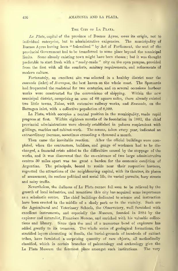
450 AMAZONIA AND LA PLATA.
THE CITY OF LA PLATA.
La Plata, capital of the province of Buenos Ayres, owes its origin, not to
individual enterprise, but to administrative exigencies. The municipality of
Buenos Ayres having been " federalised"by Act of Parliament, the seat of the
provincial Government had to be transferred to some place beyond the municipal
limits. Some already existing town might have been chosen;but it was thought
preferable to start fresh with a "ready-made
"city on the open pampas, provided
from the first with all the comforts, sanitary requirements, and refinements of
modern culture.
Fortunately, an excellent site was selected in a healthy district near the
ensenada (inlet) of Burragan, the best haven on the whole coast. The Spaniards
had frequented the roadstead for two centuries, and on several occasions harbour
works were constructed for the convenience of shipping. Within the new
municipal district, comprising an area of 60 square miles, there already existed
two little towns, Tolosa, with extensive railway works, and Ensenada, on the
Barragan inlet, with a collective population of 8,000.
La Plata, which occupies a central position in the municipality, made rapid
progress at first. Within eighteen months of its foundation in 1882, the chief
provincial administrations were already established in palaces resplendent with
gildings, marbles and cabinet-work. The census, taken every year, indicated an
extraordinary increase, sometimes exceeding a thousand a month.
Then came the inevitable reaction. After the official buildings were com-
pleted, when the contractors, builders, and gangs of workmen had to be dis-
charged, a financial crisis added to the difficulties caused by the stoppage of the
works, and it was discovered that the co-existence of two large administrative
centres 30 miles apart was too great a burden for the economic condition of
Argentina. The principals, bound to reside near their respective bureaus,
regretted the attractions of the neighbouring capital, with its theatres, its places
of amusement, its restless political and social life, its varied pursuits, busy streets
and noisy traffic.
Nevertheless, the dullness of La Plata cannot fail soon to be relieved by the
growth of local industries, and meantime this city has acquired some importanceas a scholastic centre. The chief buildings dedicated to science and instruction
have been erected in the middle of a shady park or in the vicinity. Such are
the Agricultural and Veterinary Schools, the Observatory, well furnished with
excellent instruments, and especially the Museum, founded in 1884 by the
explorer and naturalist, Francisco Moreno, and enriched with his valuable collec-
tions and library. Since then the zeal of a numerous bund of explorers has
added greatly to its treasures. The whole series of geological formations, the
stratified layers abounding in fossils, the burial-grounds of hundreds of extinct
tribes, have furnished a surprising quantity of rare objects, all methodically
classified, which in certain branches of paleontology and archeology give the
La Plata Museum the foremost place amongst such institutions. The very
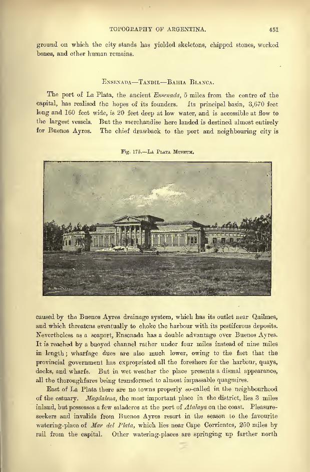
TOPOGRAPHY OP ARGENTINA. 451
ground on which the city stands has yielded skeletons, chipped stones, worked
bones, and other human remains.
ENSENADA TANDIL BAHIA BLANCA.
The port of La Plata, the ancient Emenada, 5 miles from the centre of the
capital, has realised the hopes of its founders. Its principal basin, 3,670 feet
long and 160 feet wide, is 20 feet deep at low water, and is accessible at flow to
the largest vessels. But the merchandise here landed is destined almost entirely
for Buenos Ayres. The chief drawback to the port and neighbouring city is
Fig. 175. LA PLATA MUSEUM.
caused by the Buenos Ayres drainage system, which has its outlet near Quilmes,
and which threatens eventually to choke the harbour with its pestiferous deposits.
Nevertheless as a seaport, Ensenada has a double advantage over Buenos Ayres.
It is reached by a buoyed channel rather under four miles instead of nine miles
in length ; wharfage dues are also much lower, owing to the fact that the
provincial government has expropriated all the foreshore for the harbour, quays,
docks, and wharfs. But in wet weather the place presents a dismal appearance,
all the thoroughfares being transformed to almost impassable quagmires.
East of La Plata there are no towns properly so-called in the neighbourhood
of the estuary. Magdalena, the most important place in the district, lies 3 miles
inland, but possesses a few saladeros at the port of Atalaya on the coast. Pleasure-
seekers and invalids from Buenos Ayres resort in the season to the favourite
watering-place of Mar del Plata, which lies near Cape Corrientes, 250 miles byrail from the capital. Other watering-places are springing up farther north
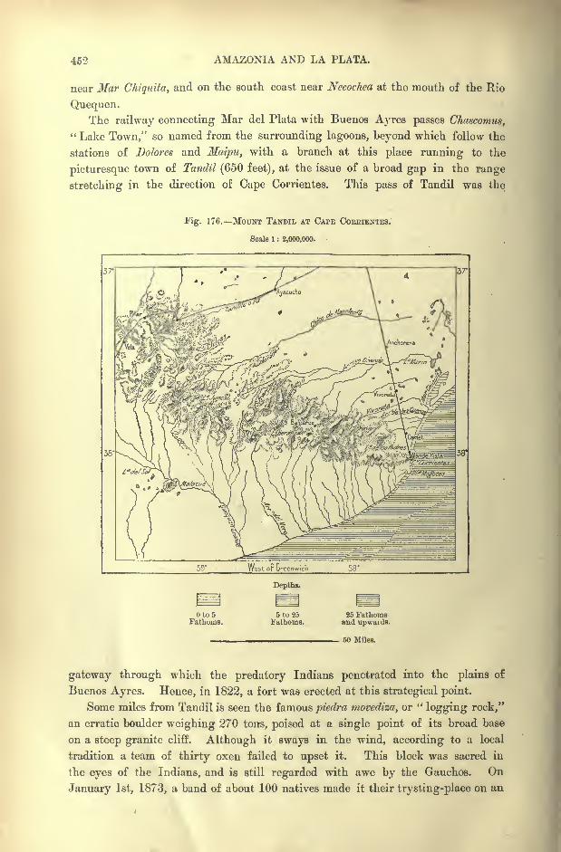
462 AMAZONIA AND LA PLATA.
near Mar Chiquita, and on the south coast near Necochea at the mouth of the Rio
Quequen.The railway connecting Mar del Plata with Buenos Ayres passes Chctscomus,
" Lake Town," so named from the surrounding lagoons, beyond which follow the
stations of Dolores and Maipu, with a branch at this place running to the
picturesque town of Tandil (650 feet), at the issue of a broad gap in the range
stretching in the direction of Cape Corrientes. This pass of Tandil was the
Fig. 176. MOUNT TANDIL AT CAPE COEEIENTES.
Scale 1 : 2,000,000.
Depths.
Oto5Fathoms.
5 to 25Fathoms.
60 Miles.
gateway through which the predatory Indians penetrated into the plains of
Buenos Ayres. Hence, in 1822, a fort was erected at this strategical point.
Some miles from Tandil is seen the famous piedra movediza, or "logging rock,"
an erratic boulder weighing 270 tons, poised at a single point of its broad base
on a steep granite cliff. Although it sways in the wind, according to a local
tradition a team of thirty oxen failed to upset it. This block was sacred in
the eyes of the Indians, and is still regarded with awe by the Gauchos. On
January 1st, 1873, a band of about 100 natives made it their trysting-place on an
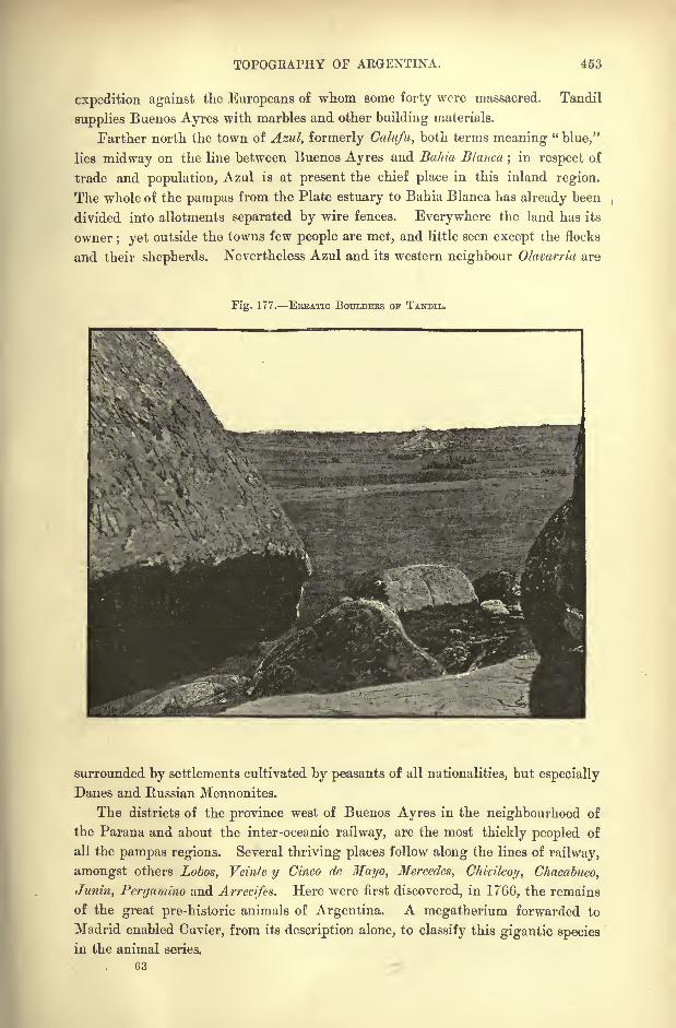
TOPOGEAPHY OF AEGENTINA. 453
expedition against the Europeans of whom some forty were massacred. Tandil
supplies Buenos Ayres with marbles and other building materials.
Farther north the town of Azul, formerly Calufu, both terms meaning"blue,"
lies midway on the line between Buenos Ayres and Bahia Blanco,;in respect of
trade and population, Azul is at present the chief place in this inland region.
The whole of the pampas from the Plate estuary to Bahia Blanca has already been
divided into allotments separated by wire fences. Everywhere the land has its
owner; yet outside the towns few people are met, and little seen except the flocks
and their shepherds. Nevertheless Azul and its western neighbour Olavarria are
Fig. 177. ERRATIC BOULDERS OF TANDIL.
surrounded by settlements cultivated by peasants of all nationalities, but especially
Danes and Russian Mennonites.
The districts of the province west of Buenos Ayres in the neighbourhood of
the Parana and about the inter-oceanic railway, are the most thickly peopled of
all the pampas regions. Several thriving places follow along the lines of railway,
amongst others Lobos, Veinte y Cinco de Mayo, Mercedes, Chicilcoy, Chacabuco,
Junin, Pergamino and Arrecifes. Here were first discovered, in 1766, the remains
of the great pre-historic animals of Argentina. A megatherium forwarded to
Madrid enabled Cuvier, from its description alone, to classify this gigantic species
in the animal series.
G3
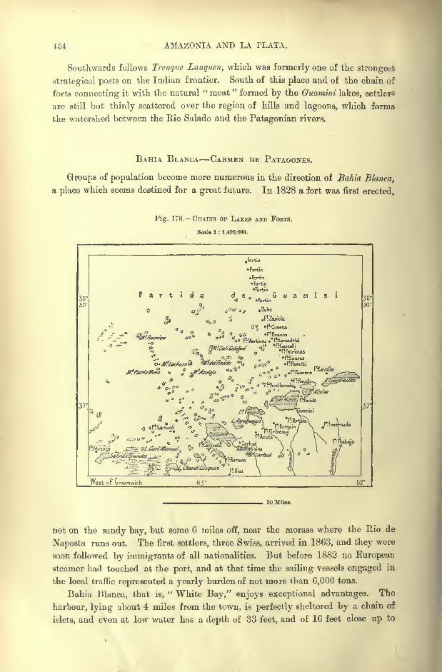
454 AMAZONIA AND LA PLATA.
Southwards follows Trenque Lauquen, which was formerly one of the strongest
strategical posts on the Indian frontier. South of this place and of the chain of
forts connecting it with the natural " moat " formed by the Guamini lakes, settlers
are still but thinly scattered over the region of hills and lagoons, which forms
the watershed between the Rio Salado and the Patagonian rivers.
BAHIA BLANCA CARMEN DE PATAGONES.
Groups of population become more numerous in the direction of Bahia Blanca,
a place which seems destined for a great future. In 1828 a fort was first erected,
Fig. 178. CHAINS OF LAKES AND FOBTS.
Scale 1 : 1,400,000.
West or ureenwich
30 Miles.
not on the sandy bay, but some 6 miles off, near the morass where the Rio de
Naposta runs out. The first settlers, three Swiss, arrived in 1863, and they were
soon followed by immigrants of all nationalities. But before 1882 no European
steamer had touched at the port, and at that time the sailing vessels engaged in
the local traffic represented a yearly burden of not more than 6,000 tons.
Bahia Blanca, that is," White Bay," enjoys exceptional advantages. The
harbour, lying about 4 miles from the town, is perfectly sheltered by a chain of
islets, and even at low water has a depth of 33 feet, and of 16 feet close up to
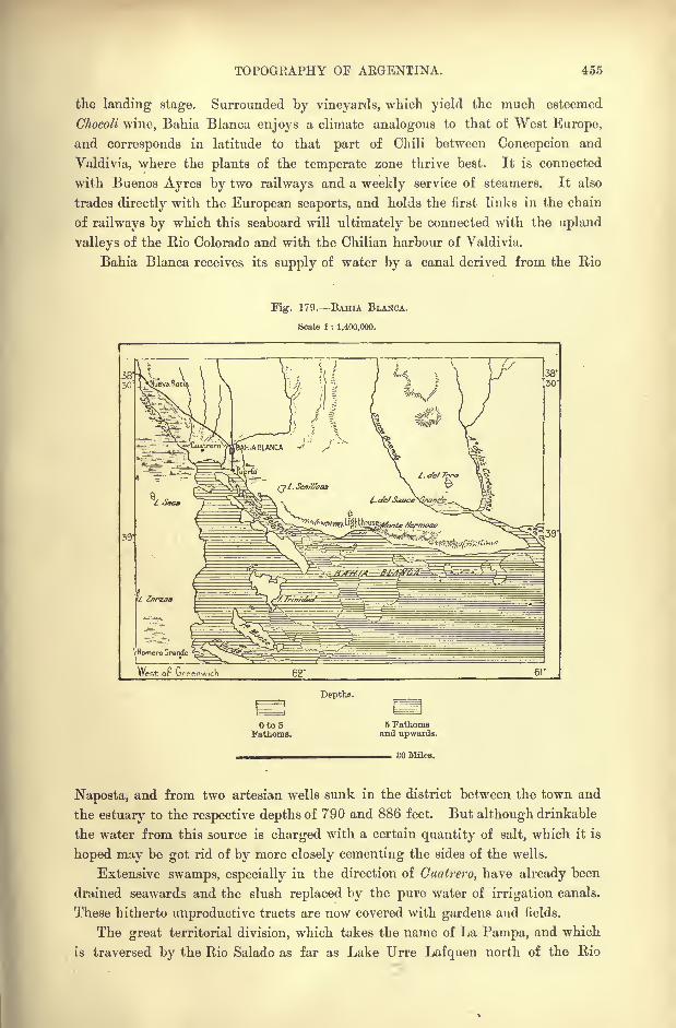
TOPOGRAPHY OF ARGENTINA. 455
the landing stage. Surrounded by vineyards, which yield the much esteemed
Ghocoli wine, Bahia Blanca enjoys a climate analogous to that of West Europe,
and corresponds in latitude to that part of Chili between Concepcion and
Valdivia, where the plants of the temperate zone thrive best. It is connected
with Buenos Ayres by two railways and a weekly service of steamers. It also
trades directly with the European seaports, and holds the first links in the chain
of railways by which this seaboard will ultimately be connected with the upland
valleys of the Rio Colorado and with the Chilian harbour of Yaldivia.
Bahia Blanca receives its supply of water by a canal derived from the Rio
Fig. 179. BAHIA BLANCA.
Scale 1 : 1,400,000.
West of Greenwich
Depths.
Oto5Fathoms.
5 Fathomsand upwards.
SO Miles.
Naposta, and from two artesian wells sunk in the district between the town and
the estuary to the respective depths of 790 and 886 feet. But although drinkable
the water from this source is charged with a certain quantity of salt, which it is
hoped may be got rid of by more closely cementing the sides of the wells.
Extensive swamps, especially in the direction of Cuatrero, have already been
drained seawards and the slush replaced by the pure water of irrigation canals.
These hitherto unproductive tracts are now covered with gardens and fields.
The great territorial division, which takes the name of La Pampa, and which
is traversed by the Rio Salado as far as Lake Urre Lafquen north of the Rio
456 AMAZONIA AND LA PLATA.
Colorado, has Bahia Blanca as its natural outlet aud future metropolis. General
Acha, so-named from one of the military captains of Argentina, is its present
capital. The district is studded with lagoons and laid out in grazing-grounds.
A diligence, which crosses the Rio Colorado at the fort of General Paz,
traverses the desert between Bahia Blanca and Carmen de Patagones, or simply
Patagones, which was founded by Viedma in 1779, and which was long the
advanced outpost of civilisation in the inhospitable solitudes of the south. Pata-
gones stands on the left, bank of the Rio Negro 21 miles above its mouth,
at the foot of the steep plateau escarpments which here present the aspect of
cliffs. A fort erected above the town served till recently as a refuge in case of
alarm for the few squatters who had ventured to establish themselves in- the
territory of the Tehuel-che Indians.
In the early days of independence, during the war between Brazil and Argen-
tina, three vessels manned by imperialists made their appearance at the bar of
the Rio Negro. The men landed to seize the fort, while the vessels attempted
to ascend the stream. But one was stranded on an island at the entrance, another
ran aground half-way up, and when the third came in view of the fort they found
that their 500 comrades had surrendered, overcome by thirst and half dead with
fright at a drove of about a thousand savage horses driven against them by the 70
defenders of Carmen. Thereupon the remaining vessel also struck her colours,
and was immediately broken up by the riverside people.
Since then the inhabitants have brought the surrounding district under culti-
vation, and the surviving Tehuel-che Indians, having nude their submission, have
settled down near Viedma on the opposite side of the river. Steamers from Buenos
Ayres touch regularly at the station of Carmen, despite its dungerous approaches.
Fortunately the much more convenient harbour of San Bias, surveyed by a
hydrographic commission in 1883, lies not far off, about midway between the
Colorado and Negro estuaries. Should the country ever get thickly peopled, San
Bias will become the natural outlet for the produce of both valleys. The buoyedchannel giving access to the port has a depth of 23 feet at ebb, and from 28 to
36 at flow. Viedma, so named in honour of the founder of Carmen, is quite as
large and a pleasanter place of residence than its neighbour. It has been chosen
by the Argentine Government as capital of the Rio Negro territory. Between
the two settlements the rapid and dangerous river has a breadth of about 820
feet.
TOWNS OF PATAGONIA HUCAL JUNIN DE LOS ANDES.
The territory of Neuquen, which is separated from the province of Mendoza
by the Upper Colorado, and in which the Rio Negro receives nearly all its
affluents, can scarcely be settled except from the Chilian side of the Cordilleras.
On the Atlantic slope facing the stony plains the communications must remain
too long and too difficult, at least until good roads or railways are constructed
from the coast to the foot of the Andes.
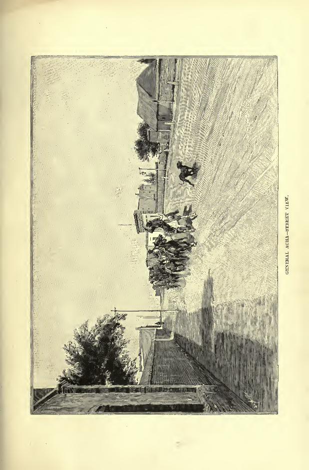

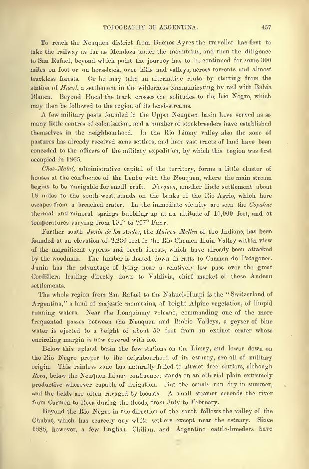
TOPOGRAPHY OF AEGENTINA. 457
To reach the Neuquen district from Buenos Ayres the traveller has first to
take the railway as far as Mendoza under the mountains, and then the diligence
to San Rafael, beyond which point the journey has to be continued for some 300
miles on foot or on horseback, over hills and valleys, across torrents and almost
trackless forests. Or he may take an alternative route by starting from the
station of Hucal, a settlement in the wilderness communicating by rail with Bahia
Blanca. Beyond Hucal the track crosses the solitudes to the Rio Negro, which
may then be followed to the region of its head-streams.
A few military posts founded in the Upper Neuquen basin have served as so
many little centres of colonisation, and a number of stockbreeders have established
themselves in the neighbourhood. In the Rio Limay valley also the zone of
pastures has already received some settlers, and here vast tracts of land have been
conceded to the officers of the military expedition, by which this region was first
occupied in 1865.
Chos-Malaly administrative capital of the territory, forms a little cluster of
houses at the confluence of the Leubu with the Neuquen, where the main stream
begins to be navigable for small craft. Norquen, another lictle settlement about
18 miles to the south-west, stands on the banks of the Rio Agrio, which here
escapes from a breached crater. In the immediate vicinity are seen the Copahue
thermal and mineral springs bubbling up at an altitude of 10,000 feet, and at
temperatures varying from 101 to 207 Fahr.
Farther south Junin de los Andes, the Huinca Melleu of the Indians, has been
founded at an elevation of 2,230 feet in the Rio Chemen Huiu Valley within view
of the magnificent cypress and beech forests, which have already been attacked
by the woodman. The lumber is floated down in rafts to Carmen de Patagones.
Junin has the advantage of lying near a relatively low pass over the great
Cordillera leading directly down to Yaldivia, chief market of these Andean
settlements.
The whole region from San Rafael to the Nahuel-Huapi is the " Switzerland of
Argentina," a land of majestic mountains, of bright Alpine vegetation, of limpid
running waters. Near the Lonquimay volcano, commanding one of the more
frequented passes between the Neuquen and Biobio Valleys, a geyser of blue
water is ejected to a height of about 50 feet from an extinct crater whose
encircling margin is now covered with ice.
Below this upland basin the few stations on the Lirnay, and lower down on
the Rio Negro proper to the neighbourhood of its estuary, are all of military
origin. This rainless zone has naturally failed to attract free settlers, although
Roca, below the Neuquen-Lirnay confluence, stands on an alluvial plain extremely
productive wherever capable of irrigation. But the canals run dry in summer,
and the fields are often ravaged by locusts. A small steamer ascends the river
from Carmen to Roca during the floods, from July to February.
Beyond the Rio Negro in the direction of the south follows the valley of the
Chubut, which has scarcely any white settlers except near the estuary. Since
1888, however, a few English, Chilian, and Argentine cattle-breeders have
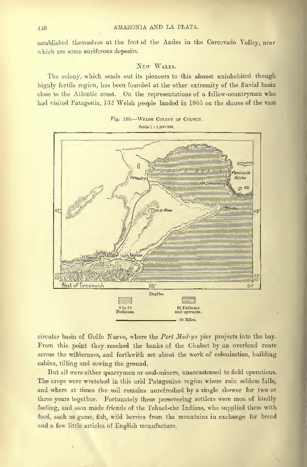
458 AMAZONIA AND LA PLATA.
established themselves at the foot of the Andes in the Corcoyado Valley, near
which are some auriferous deposits.
NEW WALES.
The colony, which sends out its pioneers to this almost uninhabited though
highly fertile region, has been founded at the other extremity of the fluvial basin
close to the Atlantic coast. On the representations of a fellow-countryman who
had visited Patagonia, 132 Welsh people landed in 1865 on the shores of the vast
Fig. 180. WELSH COLONY OF CHUBUT.
Scale 1 : 1 ,500 ooo.
West oF Greenwich 64'
Depths.
Otol2Fathoms
12 Fathomsand upwards.
30 Miles.
circular basin of Grolfo Nuevo, where the Port Hadryn pier projects into the bay.
From this point they reached the banks of the Chubut by an overland route
across the wilderness, and forthwith set about the work of colonisation, building
cabins, tilling and sowing the ground.
But all were either quarrymen or coal-miners, unaccustomed to field operations.
The crops were wretched in this arid Patagonian region where rain seldom falls,
and where at times the soil remains unrefreshed by a single shower for two or
three years together. Fortunately these persevering settlers were men of kindly
feeling, and soon made friends of the Tehuel-che Indians, who supplied them with
food, such as game, fish, wild berries from the mountains in exchange for bread
and a few little articles of English manufacture.
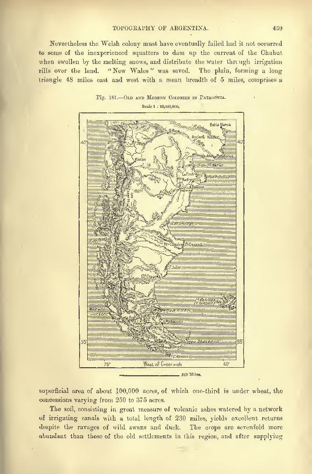
TOPOGRAPHY OF ARGENTINA. 459
Nevertheless the Welsh colony must have eventually failed had it not occurred
to some of the inexperienced squatters to dam up the current of the Chubut
when swollen by the melting snows, and distribute the water thrcugh irrigation
rills over the land. " New Wales " was saved. The plain, forming a long
triangle 48 miles east and west with a mean breadth of 5 miles, comprises a
Tig. 181. OLD AND MODERN COLONIES IN PATAOONIA.
Scale 1 : 16,000,000.
55'
310 Miles.
superficial area of about 100,000 acres, of which one-third is under wheat, the
concessions varying from 250 to 375 acres.
The soil, consisting in great measure of volcanic ashes watered by a network
of irrigating canals with a total length of 230 miles, yields excellent returns
despite the ravages of wild swans and duck. The crops are sevenfold more
abundant than those of the old settlements in this region, and after supplying

460 AMAZONIA AND LA PLATA.
the local demand from l,oOO to 2,000 tons of corn remain for exportation to
Liverpool. The Chubut wheat has the reputation of being the very best in South
America. A railway 46 miles long runs from the banks of the river across the
sandy plateau to Port Madryn. Besides tillage, cattle farming is successfully
carried on, and the colony already owns 30,000 horses, sheep, and cattle.
Consisting originally of a few Welsh starvelings, the colony now comprises
over 3,000 souls, including some more recent English, Italian, and Argentinesettlers. In the community there is neither a single pauper nor a single police-
man, and leisure is already found to cultivate the arts, and to keep alive the study
of the old Welsh language. In the census returns mention is made of pianos,
harps, and violins, as well as of ploughs and harrows. As in the home country,
the colonists have remained faithful to their religious traditions; each sect has
its chapel, and all are zealous observers of the Sabbath.
Raicson, capital of the territory, lies on both banks of the Chubut, which is here
spanned by a wooden bridge. But the position is inconvenient, since all attempts
have been given up to utilise the estuary, and since the colony is connected
by rail with the Golfo Nuevo. Trelcw, 9 or 10 miles higher up, forms a
depot for the produce of Rawson, and here are the headquarters of the co-opera-
tive society which enables the settlers to procure European wares almost at cost
price.
PUERTO DESEALO USHUIA.
Along the coast as far as Magellan Strait follow a few camping grounds, sites
of future towns. Such are San Julian, Santa Cruz, humble capital of the terri-
tory, Gallegos, and Cabo de las Virgenes with its auriferous deposits. Owing to its
rigid climate and thankless soil, the colonists have abandoned Puerto Deseado,
which, nevertheless, enjoyed considerable advantages in its good roadstead and
favourable position under a projecting headland midway between the Chubut
estuary and Magellan Strait. In 1586 Cavendish had settled some English
families at this point, and in 1669 Great Britain sent out fresh colonists, makingthe settlement capital of Patagonia, which had been proclaimed a British possession.
At the close of the eighteenth century, Yiedma erected a fort and hoisted the
Spanish flag at Puerto Deseado, which the Argentine Republic afterwards utilised as
a penal settlement. The outlay for every family till recently maintained on this
bleak and arid coast by the treasury was estimated at no less than 15,000. In
18UO a solitary French family still lingered on the spot.
A group of gold hunters have established themselves in Fuegia on the shores
of San Sebastian Bay. The settlement stands at a point giving access to a region
of pastures, which proves to be considerably more productive than had been com-
monly supposed, and which even affords facilities for tillage, despite the burrow-
ings of the tuco-tuco.
Farther south, on Beagle Channel, is seen the little group of houses at Uzhuia,
another territorial capital which, according to the last census, contained 76 inhabi-
tants, "all officials." This southernmost settlement on the surface of the globe
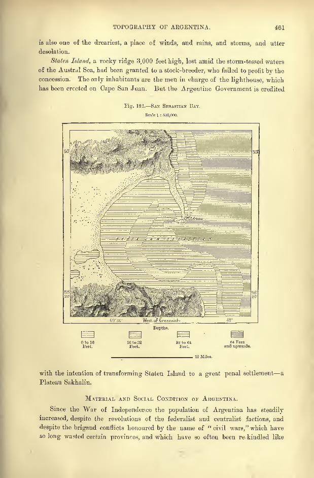
TOPOQKAPHY OF AEGENTINA. 461
is also one of the dreariest, a place of winds, and rains, and storms, and utter
desolation.
Staten Island, a rocky ridge 3,000 feet high, lost amid the storm-tossed waters
of the Austral Sea, had been granted to a stock-breeder, who failed to profit by the
concession. Theooly inhabitants are the men in charge of the lighthouse, which
has been erected on Cape San Juan. But the Argentine Government is credited
Fig. 182. SAN SEBASTIAN BAY.
Scale 1 : 500,000.
Depths.
Otol6Feet.
16 to 32Feet.
3'2 to 64Feet.
64 Feetand upwai ds.
12 Miles.
with the intention of transforming Staten Island to a great penal settlement a
Platean Sakhalin.
MATERIAL AND SOCIAL CONDITION OF ARGENTINA.
Since the War of Independence the population of Argentina has steadily
increased, despite the revolutions of the federalist and centralist factions, and
despite the brigand conflicts honoured by the name of "civil wars," which have
so long wasted certain provinces, and which have so often been re-kindled like
462 AMAZONIA AND LA PLATA.
smouldering embers. At the close of the Spanish rule, the vast region now form-
ing the Argentine Republic had probably not more than 400,000 inhabitants,
whereas the first census taken in 1857 returned as many as 1,837,500, exclusive
of about 100,000 Indians.
Since that time no general census has been taken, but a total of over 4,000,000
may be inferred from a study of the local statistics. But even this is insignificant
compared with the vast extent of the territory. Doubtless only a few scattered
groups of settlers could find support on the elevated Andean plateaux, the
salinas (salt wastes) of the central provinces, or the arid stony steppes of Patagonia.
But the Parana-Uruguay Mesopotamia, the Missions, the north-western plains
and valleys, the Cordoba uplands, the Pampas grazing grounds, lastly, the upper
valleys of all the rivers flowing to the Atlantic, constitute a domain at least
400,000 square miles in extent, where even 100,000,000 human beings would
constitute but a small population, regard being had to the immense resources of
the land. By natural increase such a number could scarcely be attained in a
period of four centuries, at least according to the present rate of growth. As far
as can be judged from the scanty data available, the average mortality would
appear to be about two -thirds of the births, which corresponds to a yearly increase
of not more than 50,000.
IMMIGRATION.
But since the middle of the nineteenth century this increase has been doubled
and in favourable years even tripled by the swelling tide of immigration. In
1889 over 289,000 were landed at Buenos Ayres, and of these as many as 250,000
remained in the country. Larger views are entertained on this subject in Argen-tina than in Brazil, till recently aland of slave labour, and despite local jealousies,
immigration is regarded in the Platean regions as a recruiting ground of future
fellow-citizens. So early as 1811, one year before the abolition of the slave trade
in Buenos Ayres, Bivadavia spoke of attracting foreign settlers," not only to
increase the labour market, but as an element of civilisation."
During the first decade no returns were made of the foreigners who came to
found new homes in the Argentine lands;but since the year 1857 a regular
census is taken of all the immigrants arriving at Buenos Ayres, either directly or
by the route of Monte Video. After deducting the number of emigrants from
the country, and the probable mortality of the unmarried amongst the new arrivals,
during the first years of their residence, statisticians have concluded that the
Republic has been enriched to the extent of about a million permanent settlers in
Argentina.
Moreover, thousands and thousands making their way to the Transatlantic
seaboard by other and more expensive routes, but not classed in the categoryof immigrants, have also established themselves in the La Plata regions. Nor
must those Chilian settlers be overlooked who cross by the passes of the Cordilleras
down to the eastern slopes, and who already constitute the great majority of the
Andean population within the Argentine frontiers.
MATERIAL CONDITION OF ARGENTINA. 463
While increasing the population as a whole, the new arrivals cause an
apparent relative lowering of the birth-rate, owing to the excess of male over
i'emale immigrants. In Buenos Ayres, Santa Fe, and Entre-Rios the disparity
is as much as 20 per cent. But the Italian element, at present by far the largest
in the general movement, is also the most prolific. In the Argentine regions the
birth-rate is stated to rise to 60 per 1,000 in Italian families, compared with 40
per 1,000 in French, and still less in native households. In some years the
mortality would even appear to exceed the births in Argentine families residing
in Buenos Ayres. The native element would thus seem to have already loet some-
what of its vital force, so that the growth of the nation would be arrested were
the race not constantly renewed by a strain of foreign blood. The phenomenon is
somewhat analogous to that which has been observed in New England and the other
parts of the United States that were the first to be colonised. In the Argentine
Republic, as well as in Paraguay, more females than males are said to be born in
the Creole families.
Next to the Italians, who form one-third of the new arrivals, follow the
Spaniards, French, English, Swiss, and Germans (amongst whom many Slavs from
the eastern provinces) in the order named, and since 1891 over 6,000 Jews from
Russia, Austria, and Palestine. Most of the immigrants being of Romance (Neo-
Latin) speech, the adoption of the Spanish language presents no difficulty. It
also appears that over nine-tenths are Catholics by birth, and that about one-third
can neither read nor write.
Naturally the great majority remain at or near the ports of arrival, such as
Buenos Ayres, Rosario, Santa Fe. But throughout nearly the whole of the Republic
Europeans find a suitable climate, and need to avoid 'only the marshy, malarious,
or goitrous districts. Tetanus causes many deaths, and ring-worm is also common,
owing to the habit of eating raw or half-cooked meat. Leprosy carries off a few
victims, and Buenos Ayres has been visited by yellow fever, introduced from
Brazil;but this scourge has not made its appearance in recent years, thanks to
the improved quarantine and sanitary regulations. Small-pox and consumptionalso carry off many victims
; but some of the remote, thinly-settled regions are
remarkably free from maladies of any kind, and there is a local saying, probablynot to be matched in the whole world, that,
" Once in a hundred years a man
dies in Patagonia." It has, however, been suggested that the proverb may owe
its origin to the fact most people in Patagonia meet with some violent end.*
STOCK-BKEEDING.
Agriculture, properly so called, is of recent origin in Argentina. Where
cattle roamed the pampas in thousands and millions, the scanty groups of popula-
tion had little need to dig and delve, the less so that they lived almost exclusively
on a flesh diet. An ox was slaughtered for the sake of the tongue, and no trouble
was taken even to save the hide;the carcass was at most used as fuel in the
* W. H. Hudson, op. eit., p. 126.
464 AMAZONIA AND LA PLATA.
brick-fields. Later, the cattle-owners derived a sufficient revenue from the sale
of the hides, the tasajo or jerked meat, and the animal black obtained from the
combustion of the bones. Nothing could be more primitive than the manage-ment of the Argentine estancias, or cattle-farms. The animals lived throughout
the year under the canopy of heaven, and after being duly branded, were practi-
cally left to themselves. Thus they reverted to a half-wild state, and when
wanted had to be captured, like game, with the lasso. The bola was even occasion-
ally used for the purpose.
After the introduction of the horse by Solis, horned cattle arrived by the
Paraguay route. In 1550 an envoy of Irala, returning from Peru, broughtbuck some sheep and goats, and three years afterwards, the brothers Goes came
into Paraguay from Sao Vicente with a bull and eight cows. From this stock,
originally from the South of Spain, have descended the millions of oxen that now
people the savannas of the Platean Republics. In these regions the Europeanbreed has lost none of its natural qualities, and appears to have undergone
scarcely any change. The new environment suits it as well as the old, and it
retains its characteristics throughout Argentina for a space of over 1,200 miles,
from North Chaco to the plains of Bahia Blanca.
The size, however, is modified by the quality of the pasturage, the animal
being small in the arid Catamarca districts, larger in the rich prairie lands of
Entre-Rios, while the finest breed is that of Miranda from Matto Grosso. Onthe plains all multiply prodigiously, a well-managed herd doubling every three
years. The alzados, that is, the animals which had run wild, increased even at a
still more rapid rate, and these were hunted by the Spaniards of the pampas only
for their hides. The process, which was carried out in a very rude and barbarous
way, has been suppressed since the settlement of the country, and at present
nearly all the herds have again been domesticated.
In the lower Rio Negro valley, the swine have also reverted to the wild state,
without increasing or decreasing in numbers. Hudson relates a pathetic story of
a runaway cow, which became a sort of foster-mother to a drove of wild pigs in
an island of the Rio Negro, where all lived together in a happy family till" the
fame of the cow that had become the leader and queen of the wild island pigs
was spread abroad in the valley." Then somebody took a musket loaded with
ball and shot the queen in the midst of her body-guard.
The baguale*, or wild horses, have become even rarer than the alzados; few
are now met except in South Patagonia, where they are scarcely pursued, except
as game by sportsmen. As mounts they are worthless.
Of Arab stock, crossed by the Andalusian variety, the Argentine horse is as
a rule very docile, hardy, and of great staying power. But till recently little
attention was paid to its points of beauty, and it is still of small size with very
large head. Mules are also bred, especially in the province of Cordoba. Formerlythese animals were exported to Peru to work in the mines
;at present they are
raised chiefly for the Bolivian and Chilian markets.' Throughout the upland
*Op. dt., p. 59.
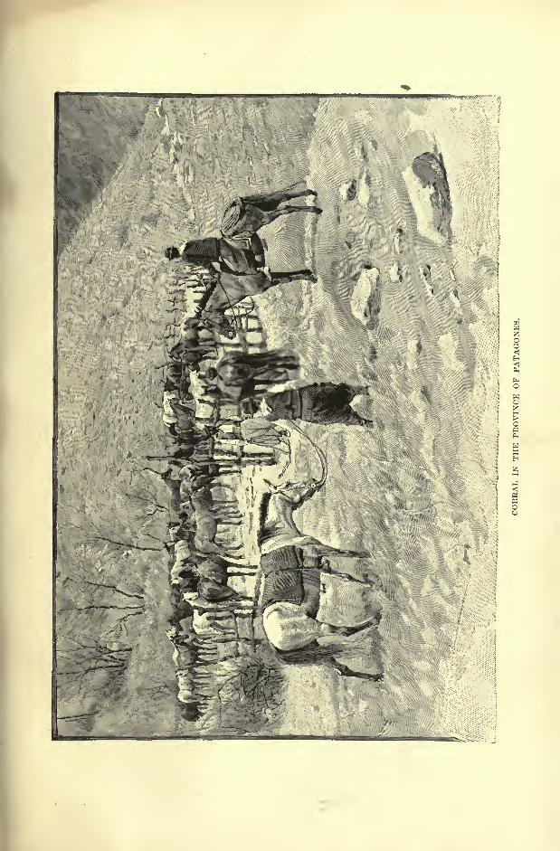
'A W
3 I
MATERIAL CONDITION OF ARGENTINA. 465
regions the mule is almost exclusively employed for all purposes, being more
sure-footed and hardier than the horse. But hitherto little attention has been
paid to the improvement of the breed. The mules which are now exported throughBuenos Ayres to the Mascarenhas, to India, and in the oppobite direction to the
Andean provinces, are all raised on the coust-lands.
Sheep constitute with the horse and ox the chief animal wealth of Argentine,
arid even tend to take the foremost position. Under the colonial administration
they had increased enormously, although at that time possessing but little market
value. In the interior a few Calchuqui women used the wool to weave some
coarse textiles : but the flesh was not even eaten, but left to the dogs and vultures,
while the bones were used for making lime.
Spain had interdicted the importation of the merino breed, which was not
introduced till long after the declaration of independence. But since 18oO a
large number of English and other breeders have improved the native varieties,
and by crossings with various European breeds have obtained new types of sheepas well as of horses and cattle. The best wools are yielded by those that grazeon the short grasses of the north-western provinces, and especially of the puna
region in Jujuy. Here the sheep is associated with the llama, an animal not met
in any other part ot Argentina.
All the other European domestic animals have been introduced, and thrive
well even without any special care. Dogs and cats, which have reverted in
thousands to the wild state; pigs, goats, rabbits, and poultry of all kinds are
met everywhere. Both the South American and the African ostrich have
succeeded in some farms; but the industry has not, acquired the same import-
ance that ostrich farming has in the Cape. Larks and other singing-birds have
been let loose on the pampas, and the European bee thrives in Entre-Rios. But it
may be asked whether it would not be wiser to utilise the native species. Various
honey-yielding insects swarm in Gran Chaco and in the province of Santiago del
Estero, where they still give rise to a considerable industry. The Indian meleros,
or honey gatherers, make long journeys of days, or even weeks together, in quest
of the combs deposited by the bees or other melliferous insects in holes or on the
branches of trees. At times they fell entire woods in the search. Hence it is to
be feared that the valuable honey-makers may disappear altogether before suffi-
cient knowledge has been gained to regulate their work and prepare suitable
hives for their reception. Meantime apiculture, in the strict sense of the word,
has made but little progress. There are a few hives here and there, but in certain
provinces the introduction of the domestic bee appears to have been foi bidden as
injurious to the fruit-trees.
Although in recent years tillage has encroached on pasturage, just as sheep-
farming has been developed at the expense of cattle-breeding, the Argentine
provinces of Entre-Rios and Buenos Ayres, together with the conterminous
Republic of Uruguay, still possess more cattle and horses in proportion to the
population than any other region of the globe. In respect of sheep they rival,
and, in some districts, greatly outstrip Australia itself.
466 AMAZONIA AND LA PLATA.
AGRICULTURE.
Agriculture proper had at first a hard struggle, having to contend especially
with the pastoral habits and traditions of the rural populations. In Entre-Rios the
first land was broken up in obedience to the peremptory orders of the all-powerful
Urquiza. But these orders were of little effect, and the natives took advantage
of the least political disturbances to abandon their fields and orchards and resume
their nomad pastoral life.
Nevertheless, the revolution, which the will of one man had failed to bring
about, was accomplished by the new economic conditions of Europe and the New
World. When animal products began to acquire a market value, even in the
Argentine Mesopotamia, the land itself rose in price ;it was classified according to
the nature of its produce, and agriculture, at first developed in the neighbourhood
of the towns, gradually took possession of the more fertile regions. The arrival
of thousands and tens of thousands of foreign settlers coincided with the economic
transformations of Argentina and gave them a fresh impetus.
In 1891 the extent of land under cultivatign was estimated by Brackebusch
at nearly 12,000 square miles, or rather more than the hundredth part of the
whole territory. Wheat and maize are by far the most important cereals, and
these alone cover over two-thirds of all the tilled land. Next follows alfalfa, or
lucerne, which is grown especially on the artificially irrigated lands of the west,
and which already forms a leading article of exportation.
The other vegetable products are confined to very small areas, mostly in the
province of Buenos Ayres, which supplies the capital with provisions of all kinds.
In fact, one-third of all the land under tillage lies within the limits of this
province. Santa Fe, largely occupied by foreign settlers, follows next in import-
ance, after which comes Cordoba, which, however, grows scarcely anything
except wheat and potatoes. Notwithstanding its admirable position and general
advantages, Entre-Rios takes only the fourth place, while the neighbouring and
equally favoured Corrientes stands nearly at the end of the list, after Mendoza,
San Juan, Tucuman, and San Luis.
Nearly everywhere the farmers have to dread the plague of locusts, which at
times present themselves in serried ranks sixty miles broad. In general the yield
of wheat is far below the average of most other agricultural regions. Even in
Santa Fe, most fertile of the pampas provinces, it scarcely exceeds four or five
bushels per acre, which in France or England would be regarded as little better
than a total failure of the crops. Argentina produces much wheat, not because
of its fertility, but because of its great extent.
Sugar, next in importance to the cereals, is confined exclusively to the sub-
tropical zone, and even here to the bottom lands, forming a narrow belt which
extends from Oran, near the Bolivian frontier, to Tucuman and Santiago del
Estero. Cotton, which yielded good returns, has been nearly abandoned, while
in the same zone the vine is cultivated up to a height of 6,500 feet. The chief
wine-growing districts are in the neighbourhood of San Juan and of Mendoza,
where viticulture has acquired real importance. The total annual yield is
MATERIAL CONDITION OF ARGENTINA. 467
estimated at 13,500,000 gallons, or about as much as the foreign importation, but
not more than one-fifth of all the liquors consumed under the name of " wine."
From the grapes, as well as from sugar-cane, maize, and other produce, spirits of
various kinds are distilled.
Corrientes yields a tobacco resembling the finer Paraguay varieties. The other
more important products of the fields and gardens are olives, bark, potatoes,
European fruits, and vegetables. Some of the fruits thrive well, and the apple
has even run wild, especially about the old Indian Missions in the "Manzanas"
region, on the slopes of the Andes, where the natives extract a chicha, or cider,
from the fruit.
LAND TENURE.
Laud tenure is of various kinds. In some places the old system of great
domains still prevails, while medium or small holdings have been formed in the
eastern provinces under the influence of the foreign settlers. Such holdings
already existed in Tucuman, where, in 1882, the freeholders numbered as manyas 7,150, in a total population of not more than 120,000. In certain remote
districts of Buenos Ayres vast estates belong collectively to the scattered members
of a single family, who enjoy the right of settling and grazing their cattle in any
unoccupied part of the common domain. But this communal system is no proof,
as might at first be supposed, of any hearty union between the different branches
of the family circle. It merely attests the great obstacles which the litigious
spirit of the associates throws in the way of a friendly distribution of the
patrimony.
In the province of Jujuy traces still survive of the old encomiendas, another
name for Indian slavery. A few families of these Coyas serfs have succeeded
after sanguinary revolts in recovering their lands and their freedom;but all are
not yet emancipated, and some of the great landowners may still claim to be
absolute masters of enormous estates comprising whole mountains and valleys
with all their inhabitants. Often the so-called political revolutions of the far
interior are nothing more than conflicts between these great estancieros, who arm
their vassals and retainers against each other. These landless serfs, who have no
hope of ever acquiring an acre of property, live in great misery, overburdened
with debts due to their paramount lords, and leading a dreary existenco to which
the risks of a "civil war" may come as a welcome diversion.
Even in the eastern provinces, notably that of Buenos Ayres, the greater part
of the soil is distributed in vast estates, so large as to be usually measured bythe "square league," that is, about 10 or 11 square miles. A single capitalist
acquired at a stroke a domain of 900,000 acres in the pampas at the upset price
of 440,000.
But such vast estates were far too large to have any well-defined limits. The
flocks ranged to a certain distance from their querencia, that is, the folds where
they were gathered for the night. But the shepherds paid little heed to the
exact boundaries of the conterminous runs, and even of ploughed lands. Thus
4G8 AMAZONIA AND LA PLATA.
Fig. 183. PKODUCTIVE LANDS OF AEGENTINA.
Scale 1 : 32,000,000.
the free range of these animals became the chief obstacle to husbandry in
its initial state. The settlers had constantly to keep guard round about their
enclosures, and often failed to drive off the trespassing herds before all their
crops were hopelessly ruined.-p- ,.Hence constant wi-ano-lings
and heartburnings, which were
at times followed by armed
conflicts between the colonists
and the cattle-owners. The
former have at last gained the
day, and the grazing-groundshave now to be enclosed bywire fences.
RECENT SETTLEMENTS.
The first agricultural settle-
ments, created under great
difficulties, were founded by
speculators, who, in return for
the concessions, undertook to
people their territories within a
given time by the aid of certain
financial or other advantages.
Numerous failures attended
the first efforts, caused by the
inexperience of the squatters,
the hostile attitude of the stock-
breeders, and local rivalries;
but the colonists were encour-
aged by occasional success,
and at present the groups of
thriving agricultural com-
munes are reckoned by ihe
hundred. New settlements
are founded daily, and certain
great landowners are having
their domains surveyed and
partly cut up into allotments,
announced for sale by flaming placards at every railway station and in all the
towns and villages.
The rising settlement receives an attractive name, a general store supplies the
labourers with all their requirements on credit for the first year, the colonists
present themselves and undertake to pay off the charge on their holdings byannual payments spread over four years.
50'
Mountains. Fove-tsand Bush.
Painpa. Desens.
620 Miles.
MATERIAL CONDITION OF ARGENTINA. 469
By the so-called " Colonisation Act "passed in 1876 on the model of the
United States Homestead-Bill, the national domain was divided into squares of 12
miles on all sides, comprising 400 lots of 250 acres each. The first hundred
arrivals received their lots gratis, and the rest was then sold at the rate of two
dollars the hectar(2-^ acres) ;
to prevent the creation of large estates it was
decided that nobody could purchase more than four lots. Colonisation Companieswere to arrange for the introduction of settlers
;but after a few experiments, for
the most part unsuccessful, this system was abandoned.
Since 1887 "agricultural centres
"have been established in the province of
Buenos Ayres round about railway stations distant at least 60 miles from the
capital, and to these estates the law of expropriation is applied in the case of all
absentee owners. In three years over 250 villages have been founded on this
plan, representing altogether about 5,525,000 acres of arable land.
In 1888 the province of Santa Fe, which has received the largest number of
settlers, comprised over 190 colonies with upwards of 6,500,000 acres. In nearly
all these colonies each settler is allowed to acquire as many chacras(lots) as he
has means to purchase, and of these he becomes the absolute owner. Property on
the communal principle of collective ownership exists only amongst the " Russi-
fied"Germans, Mennonites, or others on the east side of the Parana. Here the
Russian mir has been introduced, and is even said to have acquired a more
decidedly communistic character.
MINERALS INDUSTRIES TRADE.
Mineral products constitute but a small portion of the national wealth in the
lund of "Silver." Even in favourable years they scarcely exceed 280,000,
although certain gold, silver, lead, and copper mines are very rich in ores. But
they are all situated in mountainous regions of difficult access, and in the Andean
provinces of the north-west they are often blocked by snow in winter. The coal-
fields of San Rafael and of the foothills appear to constitute the chief mineral
wealth of the Republic; but mining operations have scarcely yet begun in these
rugged districts.
Taken as a whole, the industries are but slightly developed. Till recently they
were confined to the production of articles of primary necessity connected with the
alimentation, housing, and clothing of the people, everything else being imported
from Europe and the United States. The only important industry was directly
associated with stock-breeding the preparation of meat, hides, and the like.
Weaving had even retrograded since the Indian women had ceased to make stout
coarse fabrics from various raw materials.
But the sudden penury caused by the financial crises and bankruptcies has
compelled the Argentines to develop a number of industries, which were not needed
so long as there was plenty of money to buy all they required in Europe. Thus
have recently sprung up breweries, sugar refineries, paper mills, and various other
factories, provided with the best plant and managed by skilled hands.
Being favoured by the facility of transport across the level plains, the trade of
G4
470 AMAZONIA AND LA PLATA.
Argentina has acquired a surprising development during the last decades, thoughnot to the extent represented by misleading official returns. According to Mulhall
the real annual movement of exchanges in recent years, marked by a great com-
mercial crisis, has been about -32,000,000, and in 1889, the most prosperous year,
f38,000,000 ; altogether the collective trade represents a sum of from 8 to 10
per head of the population. In this movement Great Britain takes by far the
largest part, followed (1891) by France, Belgium, Germany, Brazil, and the United
States in the order named. But since 189'2 this order has been disturbed, and at
present Germany ranks before Belgium.
Nearly all the exports are either animal products or agricultural produce, while
the imports include textile fabrics, wines and alimentary substances, machinery,
hardware, coal and petroleum. About two-thirds of the foreign trade are centred
in Buenos Ayres.
Navigation with foreign countries, including the coast and fluvial services with
Uruguay, has increased nearly five-fold during the last decade, and to this must be
added the development of the river navigation in Argentina itself. Steam has
taken by far the largest part of this increase, and Great Britain takes the first place
in the shipping returns, the national flag following next in order of importance.
A single Navigation Company owns no less than 120 steamers plying on the rivers
of the interior. On the great navigable arteries many English and other ship-
owners hoist the Argentine flag to avoid the heavy harbour dues which are levied
on foreign craft. According to a legal fiction of the local administration, the
course of the Uruguay itself is regarded as an "ocean," at least in the section
between Concordia and Salto. Thanks to the railways, however, the right bank
along the Entre-Rios district is being rapidly transformed to a continuous wharf,
busy with sea-borne traffic.
COMMUNICATIONS RAILWAYS EDUCATION.
The era of railway enterprise began in 1857 by the construction of a metro-
politan line running from Buenos Ayres to the south-western suburb of Flores.
But at first progress was slow in the Platean regions, where the easy natural
routes across the level pampas rendered railway communication less urgent than in
other American countries. Before the introduction of wheeled traffic, travellers
for whom time was an object traversed the solitudes with a whole drove of horses
led at a gallop by a mare, whose tinkling bells brought the tropilla to a stand at
every station. When his mount was tired, the rider sprang into a fresh saddle,
and so the pace was kept up from post to post, and distances of 70 or even 90 miles
were covered in a single day. But for merchandise conveyed by pack-mules, or in
lumbering carts, the day's journey rarely exceeded 24 miles, and in disturbed dis-
tricts the convoy had to outspan at night and form lager against a possible
surprise by predatory Indians.
Then followed the coaching days, when diligences and other vehicles with
long teams of horses crossed the plains at full speed, tearing through the tall
grasses and dense patches of thistle, scarcely slacking the pace to descend and
SOCIAL CONDITION OF ARGENTINA. 471
mount the high river banks and cross the streams with the water up to the axles
of their enormous wheels.
But these resources, adequate for a rudimentary traffic, had to give way to
steam when the transport trade began to acquire a serious development. The
growth of railway enterprise thus corresponds to that of material progress in
other directions, and at present the Argentine system rivals that of several
European States; compared with the respective populations it even exceeds them
all, Belgium not excepted. But compared with the extent of the territory the
proportion is less favourable to Argentina, where the population is thinly scattered
over a region of vast extent.
The lines are distributed very unequally over this region. Round the two
Fig. 184. ROUTE OF THE TBANSANDINE RAILWAY.
Scale 1 : 1,800,000.
70' West oF Greenwich
3U Miles.
chief centres, Buenos Ayres and Rosario, they radiate in all directions, and also
afford concurrent routes parallel with the great navigable artery of the Parana.
But the northern provinces are not entirely traversed as far as the Bolivian
frontier, while towards the west the passes over the Andes had not yet been
reached in 1894. Southwards the system extends no farther than Bahia Blanca,
beyond which in the whole of Patagonia there exists only the short line con-
necting the Welsh colony on the Rio Chubut with )ts port on the Golfo Nuevo.
On the whole the traffic on the Argentine railways is considerable, both as
regards passengers and merchandise. But the cost of construction, averaging
about 7,300 per mile, seems very high for a country needing so few cuttings,
levellings, or other expensive works. This outlay, however, which is guaranteed
by the State for one-third of the lines, is explained by reckless speculation, loans

472 AMAZONIA AND LA PLATA.
at heavy interest, the administrative charges for boards of directors over 6,000
miles distant from the field of operations. In the province of Santa Fe, where the
rapid settlement of the country insured immediate returns, the local Government
was able to construct the first lines without spending a single penny. All that was
needed was to issue coupons redeemable by the future profits on the transport trade.
Fig. 185. LINES OF COMMUNICATION.
Scale 1 : 87,000,000.
Weekly Services. Fortnightly Services. Monthly Services.^ 1,240 Miles.
The gauge varies with the different companies, ranging from 5 feet 6 inches
on most lines, to not more than 40 inches on those of Santa Fe. It has been pro-
posed to cut a tunnel under the Uruguay and the Parana, in order to establish
direct railway communication between Buenos Ayres and Monte Video. At
present the most serious engineering work in progress is a viaduct, over 2,200
yards long, crossing the Rio Salado at Molino de Balas.
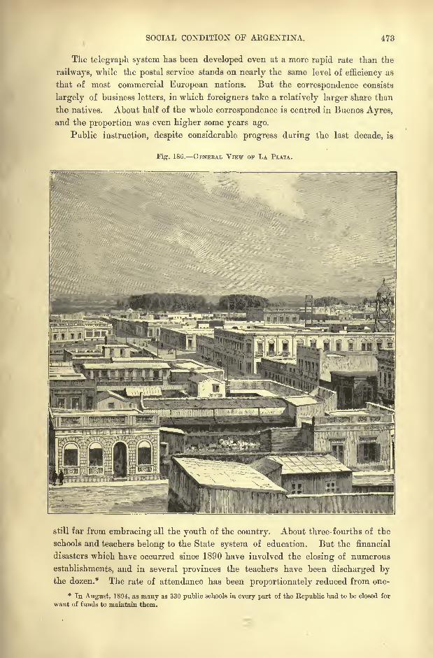
SOCIAL CONDITION OF AKGENTINA. 473
The telegraph system has been developed even at a more rapid rate than the
railways, while the postal service stands on nearly the same level of efficiency as
that of most commercial European nations. But the correspondence consists
largely of business letters, in which foreigners take a relatively larger share than
the natives. About half of the whole correspondence is centred in Buenos Ayres,
and the proportion was even higher some years ago.
Public instruction, despite considerable progress during the last decade, is
Fig-. 186. GENEBAL VIEW OF LA PLATA.
still far from embracing all the youth of the country. About three- fourths of the
schools and teachers belong to the State system of education. But the financial
disasters which have occurred since 1890 have involved the closing of numerous
establishments, and in several provinces the teachers have been discharged bythe dozen.* The rate of attendance has been proportionately reduced from one-
* In August, 1 894, as many as 330 public schools in every part of the Republic had to be closed for
want of funds to maintain them.
474 AMAZONIA AND LA PLATA.
third to one-fourth for the whole country. Each province has its national
college, besides which there are normal schools, two agricultural schools, a school
of mines at San Juan, and two universities Buenos Ayres and Cordoba.
Excluding the ephemeral sheets, which are due to political rivalries and which
disappear after every election, the periodical press comprises (1892) one hundred
and seventy newspapers, of which twenty-four are dailies. Of the latter as manyas fifteen appear in Buenos Ayres in the five more important current languages
Spanish, Italian, French, English, and German.
ADM IN1STRATIOK .
The constitution of the Argentine Republic, as framed by the Santa Fe Con-
vention of 1853, gives the State a federal representative form of government.
Each of the fourteen provinces of the Confederation has its own administration,
represented in six of them by two Chambers, and in the eight others by a single
legislative body. But each province has also its governor or president, elected
for a certain period, and assisted in some instances by a vice-governor. All adult
male citizens enjoy the franchise for the election of the municipal bodies, the
provincial legislatures, and Congress. All titles of nobility and prerogatives of
birth are abolished.
Undoubtedly a chief source of the troubles and difficulties besetting the Central
Government is the political status of the fourteen provinces. Each of these is
practically an independent state, an imperium in imperio, framing its own laws
for internal administration, often with little regard to the general interests.
When the present constitution was adopted there were, no doubt, many reasons
why the several provinces should enjoy the privileges of self-government. The
distances were so great and the routes so difficult, that constant communication
with the Federal Government was impossible, and some of the more remote regions
had, in fact, to be left to themselves. But these difficulties have been removed
by the development of the railway and telegraph systems, and a reform of the
Constitution seems now urgently needed in the direction of greater centralisation.
At present (1894) all the provinces except Entre-Rios are bankrupt, and a favour-
able opportunity is thus presented for the Central Government to take over the
responsibility of the provincial debts in return for the abolition of the provincial
organisation.
Non-naturalised strangers are admissible to the municipal functions, and enjoyall the civil rights of the natives, with freedom to exercise their trades and
professions, to own real property, to navigate the fluvial waters, to practise their
religions, to give evidence, and to marry in conformity with the general laws.
They are not required to take out letters of naturalisation, or to pay enforced
contributions of an exceptional character. Naturalisation, if desired, is obtainable
by a residence of two years, and even sooner in case of eminent services rendered
to the State. On the other hand the children of foreigners are required, at the
age of twenty-one, to choose their nationality, having the option of retaining that
of the fnther or of becoming Argentine citizens.

ADMINISTRATION OF ARGENTINA. 475
The national Congress, seated at Buenos Ayres, official capital of the Con-
federation, comprises two elected bodies. The Chamber of Deputies consists of
representatives directly named by the inhabitants of the provinces and of the
capital, in the proportion of one for every 20,000 or fraction of 20,000 above
10,000 of the population, and elected for four years.
The Senate, modelled on that of the United States, comprises two members for
each province and two for
Buenos Ayres, nominated Fi" IST.-TEBBITOBIAL DIVISIONS OF ABGENTINA.
Scale 1 :31 ,000,000.
for nine years and, like the
deputies, re-eligible. Li
the provinces the senators
are elected by a majority
of the local legislatures ;
in Buenos Ayres by a junta
of electors chosen in the
second degree. The vice-
president of the Confede-
ration is ex-qfficio president
of the Senate. The elec-
tions rarely express the real
will of the people. Usually
the influential classes as-
semble their clients, dis-
tribute the voting tickets,
and lead them in battalions
to the booths.
Both the president and
the vice-president are
chosen by a special body of
electors for a term of six
years. The president, who
possesses the same sove-
reign powers as in the
United States, is assisted
by five ministers for the
interior, foreign affairs,
finance, public worship
and education, war and
navy. The president and the vice-president may both assist at the deliberations
of Congress and take part in the debates, but cannot vote.
The Judiciary power of the Confederation is exercised by a Supreme Court
of Justice, comprising nine judges and two procurators fiscal resident in the
capital. In principle they hold office for life, "except in case of provedunworthiness."
EJE3 /'. SJiian*
' ^ r- &*" *
S-"ff -"'
'
. '".
j] V""k^:j .
'
} 'V*"
."/URUGUAY V
=3 ----...,--.. ". "'iVrvn^sYRrc: .
6-20 Miles.
476 AMAZONIA AND LA PLATA.
RELIGION FINANCE.
Although all cults are free, the Roman Catholic clergy are subsidised, and
the ecclesiastical hierarchy enjoys an official status. It comprises the Archbishop
of Buenos Ay res, who must be a native of Argentina, and four suffragan bishops
Parana, Cordoba, Cuyo, and Salta. The clergy number about 650 priests and
200 monks of various orders employed in educational work. The priests are
eligible to the different political bodies.
The army comprises in time of peace from 8,000 to 10,000 men with 1,700
officers ;but in 1893 a bill was passed raising its strength to 15,600 men. There
is an undue proportion of over-paid officers, while the rank and file fare badly.
The national guard, drawn largely upon during civil strife, comprises over 400,000
men, that is, all able-bodied citizens between the ages of 17 and 45, with a reserve
comprising all between 45 and 60.
The fleet consists of ironclads, gunboats, torpedoes, and transports, with 150
guns, 24,450 tons, and 1,500 sailors.
The finances of the Republic are in a deplorable state, the expenditure regularly
exceeding the income, while the interest on the public debt already exceeds the
annual revenue. The liabilities thus continue to accumulate, and are now exces-
sive compared with the number of inhabitants, despite continual reductions of
interest and pensions, and other retrenchments equivalent to partial acts of
bankruptcy. The administration has at times been reduced to such straits that
it has been unable to pay its gas bills, so that the companies have threatened to
cut off the supply from the public offices.
The provincial finances are in the same plight, and Entre-Rios, which has an
income of only 600,000, has a debt the annual interest of which amounts to
700,000. Collectively the national, provincial, and municipal debts exceed
120,000,000, and to this must be added the foreign charges on various so-called
national undertakings. The railway companies are at present (1894) indebted to
English capitalists to the extent of 50,000,000. As a set-off there are vast
stretches of the public domain still unsold.
Each of the fourteen provinces is divided into departments, which comprise
so many partidos, while the nine territories remain undivided into departments.
The provincial authorities are directly elected by the people, but the President of
the Republic appoints the territorial governors for three years, and these nominate
the district justices of the peace. When a territory has a population of 30,000
it has a right to elect a legislature, and double that number entitles it to enter
the Confederation as an "Argentine province."
In the appendix are tabulated the provinces and territories, with respective
areas and populations.
CHAPTER XVIII.
FALKLAND ISLANDS AND SOUTH GEORGIA.
HIS archipelago, which rises from the Atlantic depths at a distance
of 340 miles to the east of Magellan Strait, bears an English
name, though not that of its English discoverer. The islands
were first sighted by Davis in 1592, and he was followed in 1594
by Hawkins, who passed this way on his plundering expedition
to the coast of Chili, and named the group the "Maiden Islands," in honour of
Queen Elizabeth. Then came the Dutchman, Sebald de Wert, in 1598, who gave
them his own name.
Nearly a century later, that is, in 1689, the navigator Strong dedicated them
in his turn to his friend Falkland, and this name has prevailed, although the
appellation of Malouines, due to a sailor of Saint-Malo, long figured on the
French and Spanish maps. It was even retained by the Argentines, who claimed
the archipelago as part of their domain, and gave it the official name of
Malvinas.
In 1764 Bougainville took the first steps towards a permanent occupation,
by letting loose some cattle in the archipelago ;but he founded no colony
properly so-called. Then the Spanish Government, becoming aware of the pro-
spective value of these oceanic lands, wished to establish a military station on the
islands. But this act of possession having been accompanied by high-handed pro-
ceedings against English subjects, the British Government at once protested, and in
1765 Admiral Byron arriving with a fleet formally reinstated his fellow-country-
men in the name of England, without, however, questioning any higher claims
or pretentions of Spain. But it was undoubtedly a serious step, the more so that
the English station of Egmont was at the same time erected on the bay of like
name. This was obviously a precedent which might afterwards be appealed to
as an act of formal possession.
After the War of Independence, however, the Argentine Republic, heir to the
rights of Spain, took advantage of the fact that the English military post had
meanwhile been abandoned, owing to the heavy cost of maintenance, and in 1828
gave a concession of the Falkland Islands to Louis Vernet, a stockbreeder. This
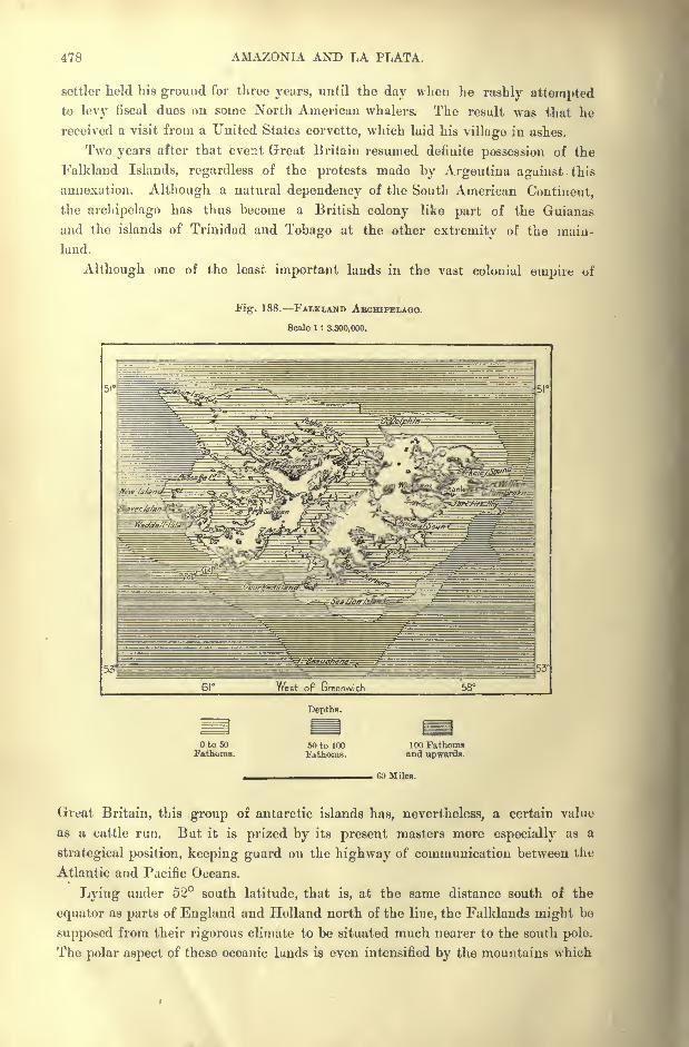
478 AMAZONIA AND LA PLATA.
settler held his ground for three years, until the day when lie rashly attemptedto levy fiscal dues on some North American whalers. The result was that he
received a visit from a United States corvette, which laid his village in ashes.
Two years after that event Great Britain resumed definite possession of the
Falkland Islands, regardless of the protests made by Argentina against this
annexation. Although a natural dependency of the South American Continent,
the archipelago has thus become a British colony like part of the Guianas
and the islands of Trinidad and Tobago at the other extremity of the main-
land.
Although one of the least important lands in the vast colonial empire of
Fig. 188. FALKLAND AECHIPELAQO.
Scale 1 : 3.300,000.
51'
53'
Depths.
Oto 50Fathoms.
50 to 100Fathoms.
100 Fathomsand upwards.
60 Miles.
Great Britain, this group of antarctic islands has, nevertheless, a certain value
as a cattle run. But it is prized by its present masters more especially as a
strategical position, keeping guard on the highway of communication between the
Atlantic and Pacific Oceans.
Lying under 52 south latitude, that is, at the same distance south of the
equator as parts of England and Holland north of the line, the Falklands might be
supposed from their rigorous climate to be situated much nearer to the south pole.
The polar aspect of these oceanic lands is even intensified by the mountains which
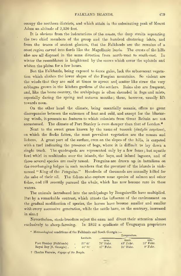
FALKLAND ISLANDS. 479
occupy the northern districts, and which attain in the culminating peak of Mount
Adam an altitude of 2,320 feet.
It is obvious from the indentations of the coasts, the deep straits separating
the two chief members of the group and the hundred clustering islets, and
from the traces of ancient glaciers, that the Falklands are the remains of a
coast region carved into fiords like the Magellanic lands. The crests of the hills
also are all disposed in the same direction from north-west to south-east. In
winter the resemblance is heightened by the snows which cover the uplands and
whiten the plains for a few hours.
But the Falklands, being exposed to fierce gales, lack the arborescent vegeta-
tion which clothes the lower slopes of the Fuegian mountains. So violent are
the winds that they are said at times to uproot and scatter like straw the very
cabbages grown in the kitchen gardens of the settlers. Rains also are frequent,
and, like the home country, the archipelago is often shrouded in fogs and mists,
especially during the spring and autumn months; these, however, usually lift
towards noon.
On the other hand the climate, being essentially oceanic, offers no great
discrepancies between the extremes of heat and cold, and except for the bluster-
ing winds, it presents no features to which colonists from Great Britain are not
accustomed. The climate of Port Stanley is even damper than that of London.*
Next to the sweet grass known by the name of tussock (dactylis ccspitosa],
on which the flocks fatten, the most prevalent vegetation are the mosses and
lichens. A great part of the surface, even on the slopes of the hills, is carpeted
with a turf indicating the presence of bogs, where it is difficult to lay down a
single track. The quadrupeds are represented only by a few foxes;but aquatic
fowl whirl in multitudes over the islands, the bays, and inland lagoons, and of
these several species are easily tamed. Penguins are drawn up in battalions on
the overhanging ledges in such numbers that the governor of the islands is nick-
named "King of the Penguins." Hundreds of thousands are annually killed for
the sake of their oil. The fishers also capture some species of salmon and other
fishes, and till recently pursued the whale, which has now become rare in these
waters.
The animals introduced into the archipelago by Bougainville have multiplied.
But by a remarkable contrast, which attests the influence of the environment on
the gradual modification of species, the horses have become smaller and smaller
with every successive generation, while the cattle have, on the contrary, increased
in size.f
Nevertheless, stock-breeders reject the oxen and direct their attention almost
exclusively to sheep-farming. In 1852 a syndicate of Uruguayan proprietors
*Meteorological conditions of the Falklands and South Georgia :
Temperature.Latitude. -
nwx. mean. nun.
Tort Stanley (Falklands) . 51 41' 76" Fahr. 43 Fahr. 12 Fahr.
Royal Bay (S. Georgia) . . 54 31' 67 Fahr. 34' Fahr. 9 Fahr.
t Charles Darmn, Voyage of the Beagle.
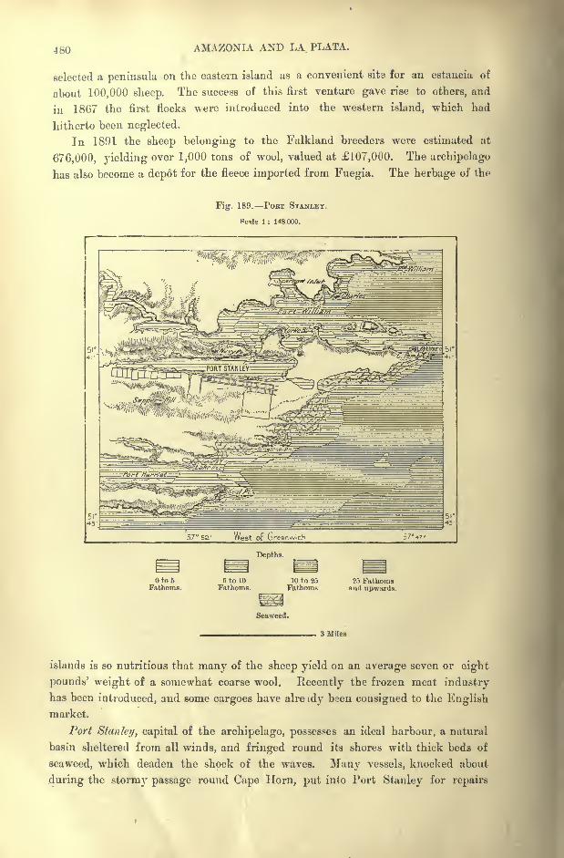
480 AMAZONIA AND LA PLATA.
selected a peninsula on the eastern island as a convenient sits for an estancia of
about 100,000 sheep. The success of this first venture gave rise to others, and
in 18G7 the first flocks were introduced into the western island, which had
hitherto been neglected.
In 1891 the sheep belonging to the Falkland breeders were estimated at
676,000, yielding over 1,000 tons of wool, valued at 107,000. The archipelago
has also become a depot for the fleece imported from Fuegia. The herbage of the
Fig. 189. POST STANLEY.
Pcile 1 : 148.000.
^^E3s*g^^^^^mF^Mi-lifer^T*^ -gg^ fyg^^sfe^
. .,..&#>*&#///-
, :^w '^m^^^t^^J^^sm
57 52' West Op Greenwich 5747'
Depths.
to 5 5 to 10 10 to 25 25 FathomsFathoms. Fathoms. Fathoms and upwards.
Seaweed.
3 Miles.
islands is so nutritious that many of the sheep yield on an average seven or eight
pounds' weight of a somewhat coarse wool. Recently the frozen meat industryhas been introduced, and some cargoes have alre idy been consigned to the Englishmarket.
Port Stan fey, capital of the archipelago, possesses an ideal harbour, a natural
basin sheltered from all winds, and fringed round its shores with thick beds of
seaweed, which deaden the shock of the waves. Many vessels, knocked about
during the stormy passage round Cape Horn, put into Port Stanley for repairs
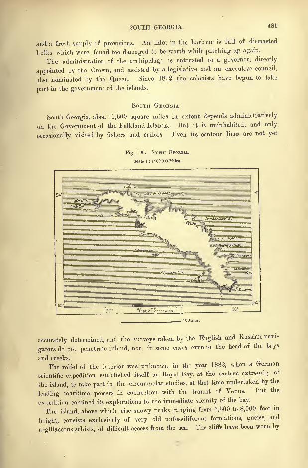
SOUTH GEOKGIA. 481
and a fresh supply of provisions. An inlet in the harbour is full of dismasted
hulks which were found too damaged to be worth while patching up again.
The administration of the archipelago is entrusted to a governor, directly
appointed by the Crown, and assisted by a legislative and an executive council,
also nominated by the Queen. Since 1892 the colonists have begun to take
part in the government of the islands.
SOUTH GEORGIA.
South Georgia, about 1,600 square miles in extent, depends administratively
on the Government of the Falkland Islands. But it is uninhabited, and only
occasionally visited by fishers and sailors. Even its contour lines are not yet
Fig. 190. SOUTH GEORGIA.
Scale 1 : 1,900,000 Miles.
36 Miles.
accurately determined, and the surveys taken by the English and Russian navi-
gators do not penetrate inland, nor, in some cases, even to the head of the bays
and creeks.
The relief of the interior was unknown in the year 1882, when a German
scientific expedition established itself at Royal Bay, at the eastern extremity of
the island, to take part in the circumpolar studies, at that time undertaken by the
leading maritime powers in connection with the transit of Venus. But the
expedition confined its explorations to the immediate vicinity of the bay.
The island, above which rise snowy peaks ranging from 6,500 to 8,000^feet
in
height, consists exclusively of very old unfossiliferous formations, gneiss, and
argillaceous schists, of difficult access from the sea. The cliffs have been worn by
482 AMAZONIA AND LA PLATA.
glaciers, which have scooped out deep troughs in the less compact argillaceous
masses, while leaving intact the peaks and headlands of harder gneiss formation.
Frontal moraines are seen at the issue of the valleys formerly filled with crystal
streams.
The Ross glacier, whose broken fragments float away across Royal Bay, is
developed in a basin at least 50 square miles in extent. The lower limit of
persistent snow descends to about 2,000 feet above sea-level.
The snowy peaks and headlands of South Georgia are constantly shrouded in
fogs, and snow frequently falls even in February, the warmest month in the year.
No tree grows in the island, and the German naturalists were unable to collect
more than thirteen species of flowering plants ; of these all but one are also found
in the neighbouring Falklanrls and in Fuegia. The thirteenth belongs to the
flora of distant New Zealand.
Mosses clothe all the inland plateaux and all the slopes facing the northern
sun, while the rocky escarpments turned towards the south pole are destitute of
vegetation. These mosses of the insular flora, which resemble the arctic forms,
impart to South Georgia a physiognomy quite distinct from that of the other
South American lands.
The fauna of the island comprises, besides various species of penguins, a soli-
tary songster, a member of the lark family.
South Georgia lies under the same latitude as Tierra del Fuego, that is to say,
considerably nearer to the antarctic circle than the Falklands. Its position is
also far more isolated in the midst of the South Atlantic waters, remote from all
the great highways of navigation, some 1,250 miles east of Magellan Strait, and
in the direct track of the antarctic polar current. Hence the mean temperature
is several degrees lower than that of TJshuia on Beagle Channel in Fuegia.
Nevertheless, the moist, stormy climate, being somewhat equable, is believed to
be suitable for sheep farming, like that of the Falklands. The same nourishing
tussock grass also grows up to an altitude of 1,000 feet. But on the other hand
few settlers are likely to be attracted to such a dreary abode, a storm-tossed rocky
prison, lost in the waste of waters on the verge of the habitable globe.
Farther south towards the antarctic pole, the southern seas, with their convoys
of huge icebergs, sweep round the planetary surface, awaiting the future Scoresbys
and Nansens, who are to lift the veil now concealing the mysteries of those
unexplored solitudes.
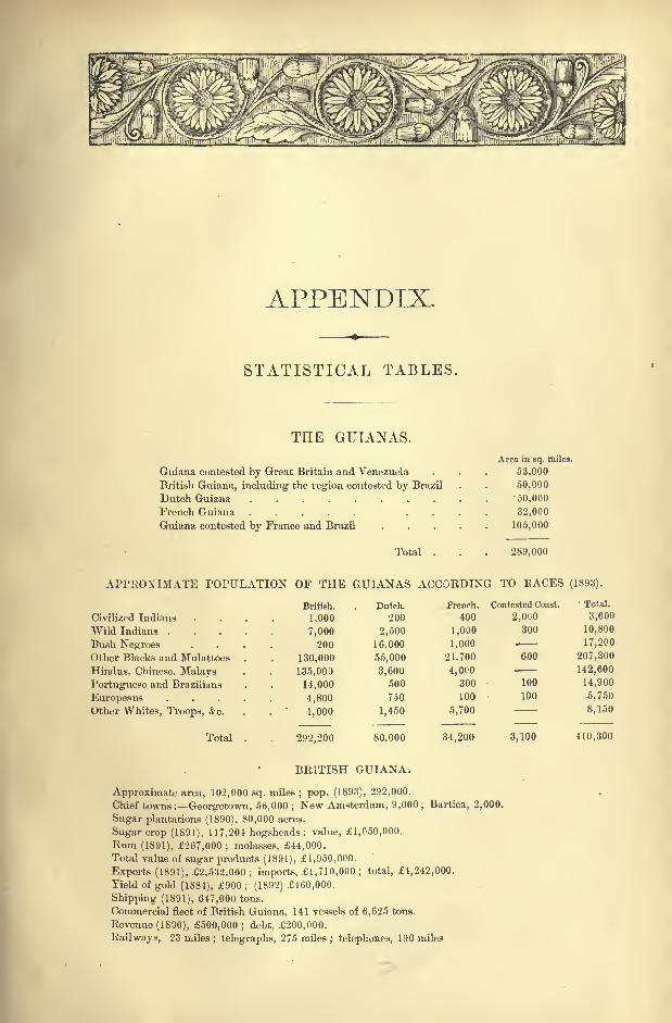
APPENDIX.
STATISTICAL TABLES.
THE GUTANAS.
Guiana contested by Great Britain and Venezuela
British Guiana, including the region contested by Brazil
Dutch Guiana ........French Guiana ..... .
Guiana contested by France and Brazil
Total
Area in sq. miles.
52,000
50,000
50,000
32,000
105,000
289,000
APPROXIMATE POPULATION OF THE GUIANAS ACCORDING TO PACES (1893).
Civilized Indians
Wild Indians .
Bush NegroesOther Blacks and Mulattoes
Hindus, Chinese, MalaysPortuguese and Brazilians
EuropeansOther Whites, Troops, &c.
Total
British.
1,000
7,000
200
130,000
135,000
14,000
4,800
1,000
292,200
Dutch.
200
2,500
16,000
55,000
3,600
500
750
1,450
80,000
French. Contested Coast.
400
1,000
1,000
21.700
4,000300
100
5,700
34,200
2,OUO
300
600
100
100
Total.
3,600
10,800
17,200
207,300
142,600
14,900
5,750
8,150
3,100 410,300
BRITISH GUIANA.
Approximate area, 102,000 sq. miles ; pop. (1893), 292,000.
Chief towns: Georgetown, 56,000 ; New Amsterdam, 9,000 ; Bartica, 2,000.
Sugar plantations (1890), 80,000 acres.
Sugar crop (1891), 117,204 hogsheads; value, 1,650,000.
Rum (1891), 267,000 ; molasses, 44,000.
Total value of sugar products (1891), 1,950,000.
Exports (1891), 2,532.000 ; imports, 1,710,000 ; total, 1,242,000.
Yield of gold (1884), 900; (1892) 460,000.
Shipping (1891), 647,000 tons.
Commercial fleet of British Guiana, 141 vessels of 6,625 tons.
Revenue (1890), 500,000 ; debt, 200,000.
Railways, 23 miles ; telegraphs, 275 miles; telephones, 190 miles
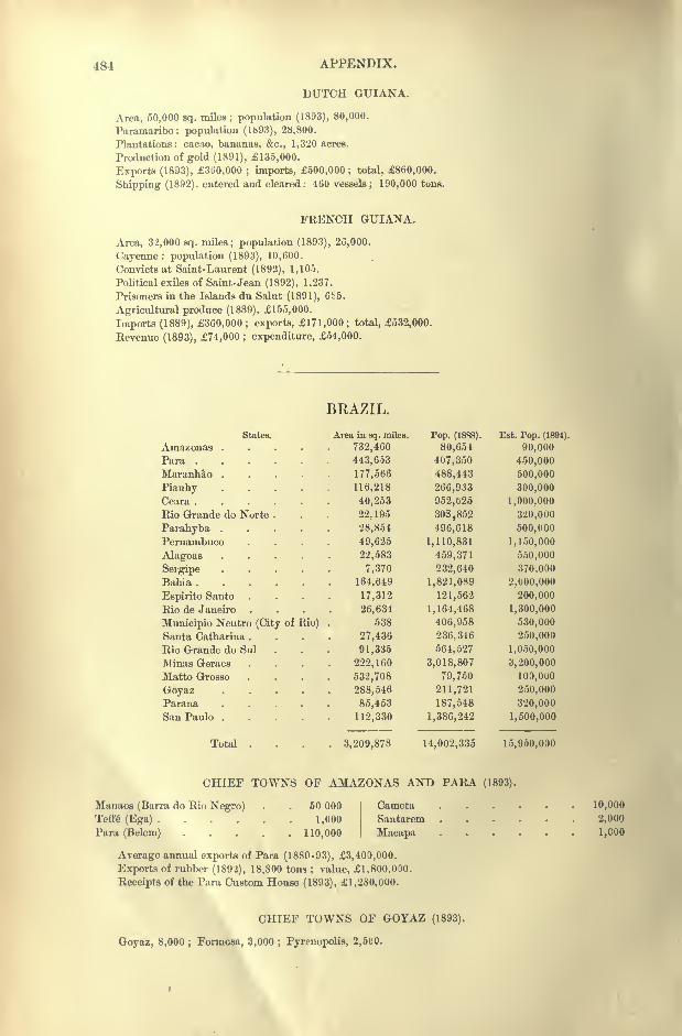
484 APPENDIX.
DUTCH GUIANA.
Area, 50,000 sq. miles ; population (1893), 80,000.
Paramaribo: population (1693), 28,800.
Plantations: cacao, bananas, &c., 1,320 acres.
Production of gold (1891), 135,000.
Exports (18D3), 360,000 ; imports, 500,000; total, 860,000.
Shipping (1892). entered and cleared : 460 vessels ; 190,000 tons.
FRENCH GUIANA.
Area, 32,000 sq. miles; population (1893), 26,000.
Cayenne: population (1893), 10,600.
Convicts at Saint-Laurent (1892), 1,105.
Political exiles of Saint-Jean (1892), 1,237.
Prisoners in the Islands du Salut (1891), 6S5.
Agricultural produce (1889), 155,000.
Imports (1889), 360,000 ; exports, 171,000; total, 532,000.
Revenue (1893), 74,000 ; expenditure, 54,000.
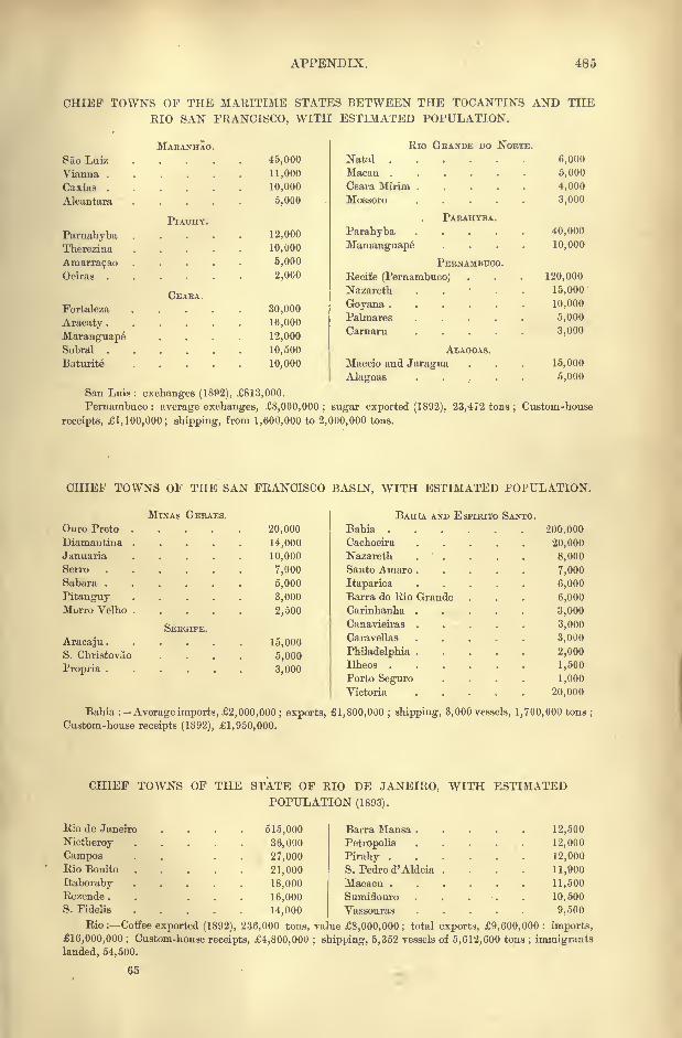
APPENDIX. 485
CHIEF TOWNS OF THE MARITIME STATES BETWEEN THE TOCANTINS AND THERIO SAN FRANCISCO, WITH ESTIMATED POPULATION.
MAEANHAO.
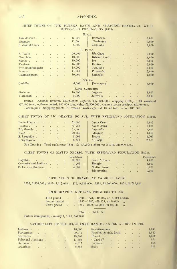
486 APPENDIX.
CHIEF TOWNS OF THE PARANA BASIESTIMATED POl
MnJuiz de Fora 15,000
Uberaba 12,000
S. Joao del Rey .... 8,000
S. PS. Paulo 100,000
Campinas 18.000
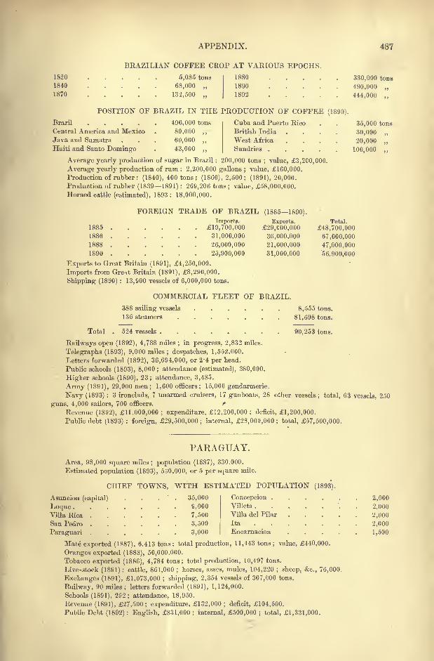
APPENDIX. 487
1820
1840
1870
BRAZILIAN COFFEE CROP AT VARIOUS EPOCHS.
1880 .
1890
5,085 tons
68,000 ,,
132,500 1892
330,000 tons
490,000
444,000 ,
POSITION OF BRAZIL IN THE PRODUCTION OF COFFEE (1890).
Brazil 490,000 tons
Central America and Mexico . 80,000 ,,
Java and Sumatra . . . 60,000 ,,
Haiti and Santo Domingo . 43,000 ,,
Cuba and Puerto Rico
British India
West Africa
Sundries .
35,000 tons
30,000
20,000 ,,
100,000
Average yearly production of sugar in Brazil : 200,000 tons; value, 3,200,000.
Average yearly production of rum : 2,200,000 gallons ; value, 160,000.
Production of rubber : (1840), 400 tons; (1860), 2,500; (1891), 20,000.
Production of rubber (18391891) : 269,206 tons; value, 58,000,000.
Horned cattle (estimated), 1893: 18,000,000.
FOREIGN TRADE OF BRAZIL (18851890).
1885
1886 . . . .
1888
1890
Exports to Great Britain (1891), 4,250,000.
Imports from Gret Britain (1891), 8,290,000.
Shipping (1890) : 13,900 vessels of 6,000,000 tons.
COMMERCIAL FLEET OF BRAZIL.
Imports.
19,700,000
31,000,000
26,000,000
25,900,000
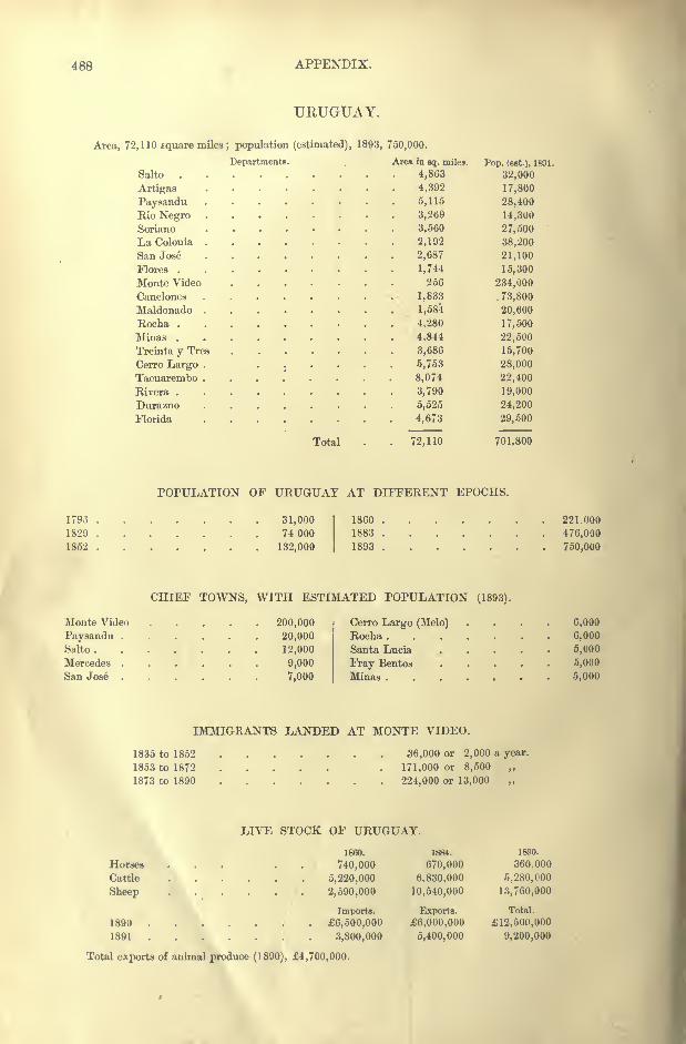
488 APPENDIX.
URUGUAY.
Area, 72,110 square miles; population (estimated),
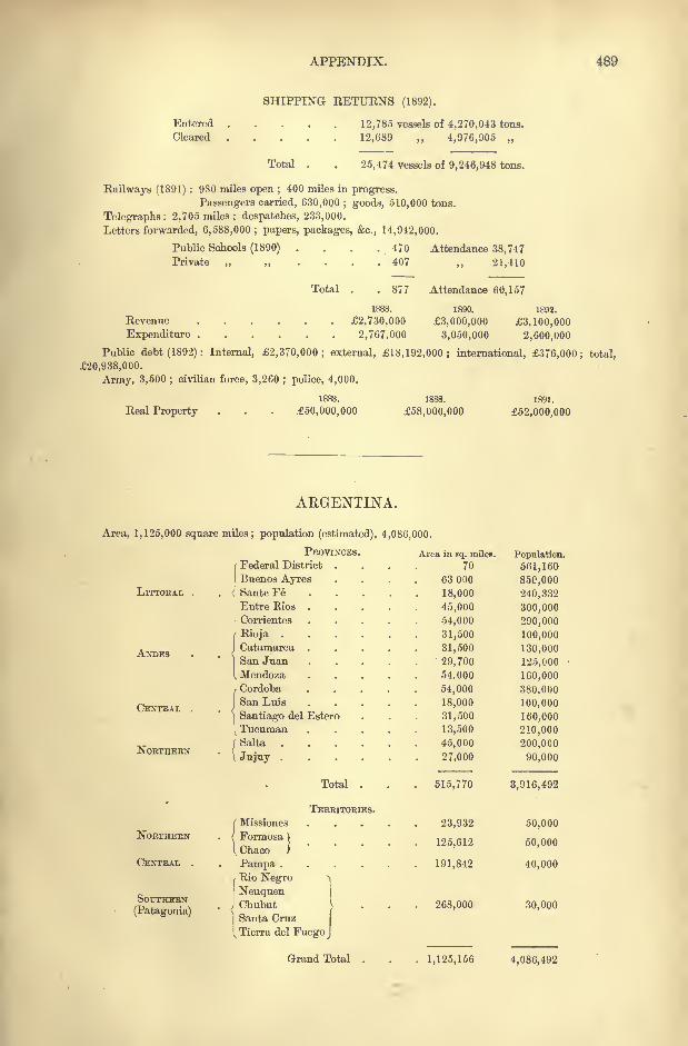
APPENDIX. 489
SHIPPING RETURNS (1892).
Entered
Cleared12,785 vessels of 4,270,043 tons.
12,689 ,, 4,976,905
Total 25,474 vessels of 9,246,948 tons.
Railways (1891) : 980 miles open ;400 miles in progress.
Passengers carried, 630,000 ; goods, 510,000 tons.
Telegraphs: 2,705 miles; despatches, 233,000.
Letters forwarded, 6,588,000 ; papers, packages, &c., 14,942,000.
Public Schools (1890) .
'
. . .470 Attendance 38,747Private 407 ,, 21,410
Total 877 Attendance 60,157
1890.
3,000,000
3,050,000
1892.
3,100,000
2,600,000
Revenue 2,730,000
Expenditure 2,767,000
Public debt (1892): Internal, 2,370,000; external, 18,192,000; international, 376,000; total,
20,938,000.
Army, 3,500 ;civilian force, 3,260 ; police, 4,000.
Real Property
1883.
50,000,000
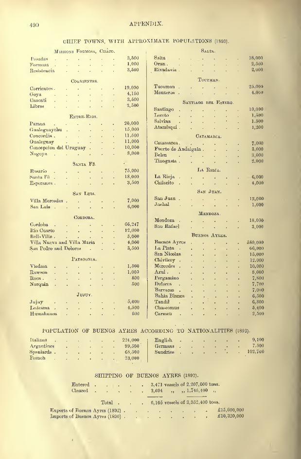
490 APPENDIX.
CHIEF TOWNS, WITH APPROXIMATE POPULATIONS (1893).
MISSIONS FOBMOSA, CHACO. SALTA.
Posadas ......
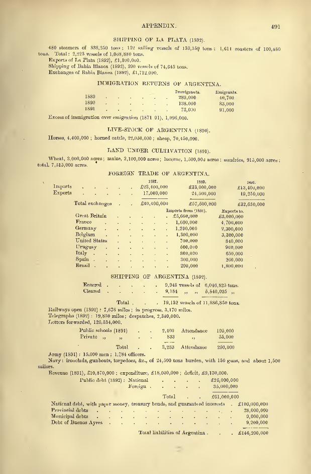
APPENDIX. 491
SHIPPING OF LA PLATA (1892).
480 steamers of 838,250 tons; 132 sailing vessels of 130, 150, tons; 1,611 coasters of 100,480tous. Total : 2,223 vessels of 1,068,880 tons.
Exports of La Plata (1892), l,100,OuO.
Shipping of Bahia Blanca (1892), 390 vessels of 74,645 tons.
Exchanges of Bahia Blanca (1892), 1,712,000.
IMMIGRATION RETURNS OF ARGENTINA.
Immigrants. Emigrants.1889 . . . . . . 289,000 40,7001890 138,000 83,0001891 73.0JO 91,000
Excess of immigration over emigration (1871 91), 1,096,000.
LIVE-STOCK OF ARGENTINA (1890).
Horses, 4,400,000 ;horned cattle, 22,OoO,000; sheep, 70,450,000.
LAND UNDER CULTIVATION (1891).
Wheat, 3,000,000 acres; maize, 2,100,000 acres; lucerne, 1,500,000 acres; sundries, 915,000 acres;total, 7,515,000 acres.
FOREIGN TRADE OF ARGENTINA.1887. 1889. isal.
Imports ...... 23,400,000 33,000,000 13,40U,000
Exports 17,000,000 24,500,000 19,250,000
Total exchanges . . 40,400,000 57,500,000 32,650,000
Imports from (1891). Exports to.
Great Britain 5,660,000 3,000,000France 1,600,000 4,700,000
Germany 1,200,000 2,300,000
Belgium 1,300,000 3,300,000United States 700,000 840,000
Uruguay 500,000 900,000
Italy 800,000 650,000
Spain 300,000 260,000Brazil 290,000 1,800,000
SHIPPING OF ARGENTINA (1892).
Entered 9,948 vessels of 6,046,825 tons.
Cleared . . . . . 9,184 ,, 5,840,025 ,,
Total. . . 19,132 vessels of 11,886,850 tons.
Railways open (1892) : 7,676 miles ;in progress. 3,170 miles.
Telegraphs (1892) : 19,850 miles; despatches, 2,340,000.
Letters forwarded, 126,534,000.
Public schools (1891) . . 2,400 Attendance 195,000Private ,, . 833 ,, 55,000
Total . . 3,233 Attendance 250,000
Army (1891) : 15,600 men ; 1,784 officers.
Navy: ironclads, gunboats, torpedoes, &c., of 24,500 tons burden, with 150 guns, and about 1,500sailors.
Revenue (1891), 10,870,000 ; expenditure, 18,000,000 ; deficit, 9,130,000.
Public debt (1892) : National .... 26,000,000
Foreign 35,000,000
Total . . 61,000,000
National debt, with paper money, treasury bonds, andguarantted interests . 100,000,000Provincial debts 28,000,000
Municipal debts 9,000,000Debt of Buenos Ayres 9,200,000
Total liabilities of Argentina . . . 146,200,000

492 APPENDIX.
FALKLAND ISLANDS AND SOUTH GEORGIA.
Area of East Falkland
,,West Falkland
,, ,, Smaller groups
,, ,, South Georgia
Capital, Port Stanley; population, 694.

INDEX.
Abiaba?, 113
Atiipons, 306, 410Abrolhos Island, 161
Acarahy, 175Acarai Mountain, 9
Acay, 354
Aconcagua, 356
Aconquij* Mountains, 354
Acoqua Indians, 5, 40
Agua Negra Pass, 356
Aguapehy, Rio, 254Ayruas Bellas, 172
Aguas Virtuosas, 217Aimores Mountains, 154
Tribe, 163A'tures Rapids, 2
Akawoys, 38
Akroas, 130
Akue, 130
Alagoa Grande, 145
Alagnas State, 133
Town, 150
Alagoinhas, 175
Alakalufs, 405
Albina, 04
Albuquerque, 259, 261
Alcantara, 139
Aloobaca, 128
Alegrete, 248
Alemquer, 120
Alexandra, 228Alfredo Chavez, 177Almas Mountains, 154
Almeirim, 122Altos Mountains, 317, 354
Alumine Lagoon, 384
Volcano, 359
Amacuru, Rio, 18
Amambdy Mountains, 298
Amapa, Rio. 21
Atnarante, 140
Amargal, 381
Arnarracap, 141
Amazonas Province, 90
Amazonia, 90
Amazons, Rio, 90
Estuary, 100Ambalo Mountains, 354Amuku Lake, 8, 12
Ancaste Mountains, 354
Anchieta, 177AudalcaU Fort, 409
Tribe, 409, 434
Angical, 85
Angicos. 85
Angostura, 319
Angostura Mountains, 359Anra dos Reis, 198
Auh.imbahy Mountains, 253
Rio, 250Animas Mountains, 330
Antonina, 227Antonio Vaz Island, 145Aourriaona Mountain, 9
Apa, R'o, 250, 299
Apanages, 130
Apapuns, Rio, 92
Apia' 'as, 113
Apiahy Mine, 226
Apipe Rapids, 298, 315
Apitares. 306
Approuague, Rio, 11, 20
Aquidaban, Rio, 299
Aquiri, Rio, 93, 117
Araca, Rio, 93
Aracaju Town, 172
Tribe, 122
Aracaty, 143
Aracoyaba, 226
Aiaguay, 302
Araguari, Rio, 11, 21, 23
Araguay, Rio, 4
Araguaya. Rio, 88, 125, 127Aramina Falls, 19
Aranauma, Rio, 11
Araras Town, 225
Tribe, 113Araracoara Rapids, 92
Aratai, Rio, 68
Araucanians, 407
Arawaks, 33, 109Araxa Plateau, 252
Arecunas, 38
Aregua, 316
Argent Mountains, 1 1
Argentina,- 344
Argentines, 351
Argentine Lake, 387
Arinos, Rio, 97
Arrecifes, 453
Arroyo Pintado, 336
Artigas, 339
Asuncion, 315
Atajo Mountains, 354
Atalaia, 150
Atalaya, 451
Atamisqui, 372, 433
Atorais, 33, 34
Atuel, Rio, 357, 381
Auoans, 41
Av*nbadava, 208Avati Parana, 92
Ave'.los, 115
Aysen. Rio, 360
Awa, Rio, 18, 19
Awarriwa Mountain, 12
Ayrao, 118
Azul, 453
Baependy, 217
Ba^agem, 218
Bage, 247
Baguales Mountains, 361Bahia State, 152
Town, 172Bahia Blanca, 381, 454Bahia Negra, 256
Bailique Island, 76
Biijada, 424
Bakairi, 114Ballena Mountain, 360Bananal Island, 127
Bananeiras, 145Banda Oriental, 329
Baradero, Rio, 374
Town, 427Baramanni Lake, 48Barbacena Mountains, 15j
Town, 216
Barcellos, 94, 118
Bareirinhas, 140
Bariloche, 360B irima, Rio, 18
Barra, 170do Pirahy, 188
do Kio I\ ej.ro, 96
Mansa, 188
Marraciip, 447
Barrancas, Rio, 357Bartica Grove, 50
Basques, 419
B^tataes, 225
Batavia, 57
Batel, Rio, 373
Baturite, 142
Bengle Channel, 482
Beaqueos, 259Bebedeio Lake, 378
Beberibe, Rio, 146
Belem, 90
Belen, 435
Belgrauo, 447, 449Bella Vista, 424Bello Horisonte, 170
Belmonte, Eio, 159Belmonte Town, 160, 175
Beudego, 175
Beni, Rio, 96, 97
494 INDEX.
Berbice, Rin, 16
Town, 52
Bermejo, Rio, 370
Ht-rnstadt, 427
Bezerros, 149
Biguassu, Bio, 232
Town, 232
Biobio, Rio, 358
Blanco, Rio, 356
Cape, 3tiO
BlumPimu, '230
Boa Vista Mountains, 118
Town, 172
Boas Alortes Mountain, 118
Boca, La, 449Bocaina Mountains, 202
Bohans, 334
Bois, Rio, 208
B'ttnfim, 168
Bom Jardim, 148
Bonete Mountain, 355
Borba, 118
Borbon, 262
Bororos, 250, 258
Botocudos, 163
Botucatu, 226
Bragan9a, 124
Branco, Rio, 12, 93
Hrava Mountains, 362
Brazil, 77
Brejo da Madrede Deus, 148
Brejo d'Areia, 145
Breves, 122
Brilhante, Rio, 251
Buceo Bay, 338
Buenos Avres Province, 445
City, 445
Bugres, 242
Burras, Rio, 354
Burroburro, Rio, 14
Bush Negroes, 40Buta-co Pass, 357
Caacati, 423
Caba9al, Rio, 25 H
Cabassou Island, 11
Cabixi, 112
Cabo, 149
de las Virgines, 460Cabo Frio, 190
Cabrobo, 172
Ca9apava, 218Caceres Lake, 255Cachl Mountains, 354
Town, 430
Cachiniti, 112
Cachipour, Rio, 11, 21
Cachoeira, Rio. 175
Town, 175, 244
Cachoeiro, 177Caethe Tribe, 138
Village, 170
Cafayates, 409
Cafusos, 108
Cahy, Rio, 237
Cajazeiras, 140
Cal, Cumbre, 3<33
Calbuco Volcano, 366
Calchaquis, 406, 408
Caldas, 217
Calinas, 37
Calingasta*, 407
Camacuam, Kio, 236
Camamu, 175
Camerones, Rio, 384
Caraeta, 124
Camocim, 141
Cainopi, Rio. 6
Citnipana, 428
Campanario Mountain, 357
Campanha. 216
Campina Grande, 145
Campinas, 223
Campo Grnnde, 120, 145
Largo, 228
Campos de Boa Vista, 202de Jardao, 203of Parabyba, 188
Camuti, 8
C,mabury, Rio, 94Canada de Gomez, 363, 427
Cananea, 204, 226Canastra Mountains, 154
Rio, 208
Canavieiras, 175
Candelaria, 422
Canelones, 339
Canguaretama, 145
Cauinde, Rio, 141
Canoeiros, 130
Cantagallo, 188Cantareira Mountains, 203Canucu Mountains, 8
Capazao Mountains, 154
Cape do Norte, 22
Caj>elli, 172
Cipibaribe, Rio, 146
Capitania, 176
Capivary, Rio, 237
Cara9a Peak, 154
Carapaporis Strait, 22
Basin, 23, 74Caravellas Mountains, 175
Carayas, 108, 130
Carbougres, 42
Carcarana, 427, 345
Caribana, 2
Caribs, 2, 33, 36, 109
Carijos, 213, 241
CariJonas, 109
Carinhanha, Rio, 156, 170Carioca Mountain, 191
Spring, 191
Caripunas, 112
Carmelo, 336Carmen (Paraguay). 315
(Patagonia), 405, 454
Carmo, 118
Carolina, 139
Carsevenne, Rio, 21
Caruaru, 149Casa Branca, 224Cnsabinda Lake, 428
Caseros, 422
Cassiquiare, Rio, 2, 94Castello Mountain, 191
Castillo Mountain, 360Castle Hill, 387
Cataeuars, Ifi6
Catalin Mountains, 359Catamarca Province, 433
Town, 433Cattas Altas, 170
Caucete, 437Caux Mountains, 1 1
Caviana Island, 102
Caxambu, 217
Caxias, 139
Cayapos, 129
Mountains, 127
Cayari, Rio, 90
Cayenne, 63, 66
Cayenne Wand, 11
Cavuas, 214Ceara Statn, 133
River, 141
Town, 80, 141
Mirim, 144
Cebolaty, Rio, 237
Ceperou, 67
Ceiillos, 356
(Entre-Rios), 424
(Monte Video), 339
(Paraguay), 315Cerro Largo, 339
Moute Video, 338Chacab co, 453
Chaco, Gran, 424
Challao, 439Chalt^n Mountain, 360
Cuamboas, 130
Champagui Mountain, 363
Chanas, 334Chani Mountain, 354, 428
Chapada, 131
Diaiuautina, 175
Chapeco, Rio, 239
Chapel-co Mountain, 358
Channa, 426
Charruas, 241, 334
Chaschuil, Rio, 378
Chascomus, 452
Chavantes, 129, 214
Cbaves, 122
Mountains, 355
Cherentes, 130Chichi Falls, 15
Chico, Rio, 388
Chikriabas, 130
Chilecito, 435
(Jhinohipe, Rio, 90
ChipWa, Rio, 12( 'hiquita, Mar, 372Chiquitos, 79
Chirihuanos, 408, 409Chiriu, 12
Chivilcoy, 453Choele Choel, 384Chos Malal, 357
Town, 457
Chubut, Rio, 3S5
Colony, 458
ChuHibicba, 434
Chuy, Rio, 235, 330Cinta Mountains, 138
Cipreses Mountains, 358, 384
Claro, Rio, 127
(Jlavijo Mountains, 354
Coary, Rio, 93, 115
Avellos, 115Cocha Lake, 91
Codajaz, 115
Coermoeribo, Rio, 17
C'lesewijne, Rio, 17
Coimbra, 262Coirrit Mountain, 9
Colnstine, 425
Colhue, Lhke, 385
Coligny, 191
Collon-cura, Rio, 359, 384
Colon, 421
Colonia, 329Colon'a del Sacramento, 336
Colorado, Rio, 381
Cornachigones, 407
Commewijne, Rio, 17
Concei9ao, 170, 176
Concepcion (Paraguay), 315
INDEX. 495
Concepcion (Argentina), 421
(Uruguay), 422Concordia (Argentina), 421
(Uruguay) , 421
Confuso, Rio, 301
Congonhas de Campo, 168
Cougonhas de Sahara, 170Connetables Island, 11
Contas, Rio, 159, 175
Contendas, 217
Copiapo, Rio, 356
Coppename, Rio, 17
Coquimbo, 356
Coratamung Mountains, 8
(Jorcovado, Rio, 360
Volcano, 190, 360
Cordoba, City, 444
Mountains, 444
Province, 442
Coreahu, Rio, 141
Corentyne, Rio, 9, 16
Cormoutibo. Rio, 17
Coroados, 164, 187, 214
Coriientes, Cape, 363
Province, 422
Rivtr, 374
Town, 422Cortaderas Pass, 428
Cjrumba, Rio, 207
Albuquerque, 259, 261, 289
Cosquin, 445Cochabamba Mountains, 96
Cotinga Island, 227
Cotinguiba, Rio, 172Cottica, Rio, 17Cotuntuba Island, 190
Counarnano, Rio, 65
Counani District, 73
Village, 76
Couripi, 76
Cuxim, Rio, 258
Town, 262
Coy Inlet, 390
Coyle Estuary, 390
Coyos, 408
Crato, 118, 143
Creoles, 37
Crichanas, 110Cruz de Piedra, 440
Cruzeiro, 218
Cuarto, Rio, 373
Town, 442
Cuatrero, 454Cubatao Mountains, 202
Town, 222Cuch.il) a Grande, 330
Cucuhy Rock, 95
Cumery, Rio, 97Cumbre Pass, 356Cumbres de Calchaqui, 354Cumucuinu Mountains, 8
Cunani, Rio, 21
Cunapiru, Rio, 336
Cura-co, Rio, 381Cura Cokalio, 357
Curimatahu, Rio, 145
Curitiba, 202, 210, 226
Curralinho, 141
Curucuri Mountains, 16
Curupaity, 320
Cururupu, 139
Curuzu, 320
Cuyaba Mines, 250
Town, 260
Tribe, 260
Cuyo Region, 420, 437
Cuyuni, Rio. 4, 15
Cuyuwini, Rio, 12
Darwin Mountain, 361
Dayman, Rio, 335
Demerara, Rio, 16
Desaguadero, Rio, 378Deseado, Rio, 385
Estuary. 385
Port, 460Desterro Town, 23 1
Strait, 231Deux Connetables Island, 357, 380Diamante, 426
Diamantina, 154
(Ticujo), 170
Diana, Llauuras de, 390
Didi, 38
Divisoes Mountains, 154
Doce, Rio, 152, 160Dois Irmaos, Rio, 134
Dolores, 445, 452
Domfyko Mountain, 361Douro Mountains, 125Dous Rios, 183
Dulce, Rio, 372, 432Durazno. 336
Ega, 115
Emerillons, 38
Encarnacion, 314Eufant Perdu Island, 11, 67Ensenada, 451
Eutre-Rios, 188, 424
Esperanza, 425
Espinha9O Mountains, 15-4
Espirito Santo State, 152
Esquina, 424
Essequibo, Rio, 8, 11
Estancia, 172
Estero, 432
Falkland Island*, 477Famatina Mountains, 355
Tribe, 409, 435
Faro, 119
Faxina, 226Fecho dos Morros, 255, 262
Federacion, 421Federal District (Argentina), 445
(Brazil), 190
Feira, 140, 175Fernando de Noronha Islands, 136,
150Ffrreira Gnmes, 75
Fiambala, Rio, 378Town. 435
Fiscal Island, 196
Fitzroy Volcano, 360
Floies, 140
Ilha, 196
Florida, 336Foiite Boa, 115Formosa Lake, 126
Territory, 424
Town, 131, 424
Fortaleza, 141, 215, 230Fort Nieuw Amsterdam, 59
Fort William, 51
Fort Zeelandia, 58Foz de Iguazu, 230Frade de Macahe, 181
Frade Lespardo, 177Franca Town, 225
Fran(;aisMountain, 361
Fray Bentos, 335
Frayle Muerto, 441
Frio, Cape, 184Froward, Cape, 361
Fractal, 218
Fuegia, 407
Fuegians, 405
Gabrielle, 68Gaiba Lake, 255
Galitri, 37
Gallegos, 460Gallina Muerta, 355
Gamellas, 138
Garanhuns, 149, 172
Gauchos, 242,417Gavia Mountain, 190
Gay, Hill, 361General Acha, 456
Paz, 456
Georgetown, 51
Gee, 129, 163
Gigante Mountain, 363
Gigantillo Mountain, 363
Giyones, 407
Goya, 424
Goyana, 145
Goyanazes, 213
Goyaninha, 144
Guyaz State, 125
Indians, 129
Town, 131
Goycocheas, 313
Goytacazazes, )87Graciosa Mountain, 202
Town, 227
Grajahu, Rio, 135Granadas Mountain, 353Grande Falls, 330
Rio, 157
Rio, do Sul, 203
Granja, 141
Grao Mogul Mountain, 154
Gravata, 149
Groniugen, 57
Guachipas, Rio, 371
Guahj ba Estuary, 237
Guaicuhy, 170
Guaiuia, Rio. 1, 18
GuHJajaras, 138
Guajara Guassu, 97
Rio, 374
Gmleguay, 422
Gualeguayehu, 422
Rio, 335
Guame^, Rio, 91
Guaues, 258
Guanhanari, 213
Guapay, Rio, 96
Guapore, Rio, 96, 254
Tribe, 116Guarahu Mountains, 202
Guarani, 108, 214, 305
Guarapuava, 229
Guaratiba, 196
Guaratingueta, 218
Guaraunos, 1, 35
Guatacazes, 187
Guatos, 258
Guaviare, Rio, 94
Guayaiios, 1
Giiayarros, 313
Guaycurus, 258
Gua\ra, 210, 229
Mission, 213Falls. 210, 298
Guiauas, The, 1
496 INDEX.
Guianas Indiana, 32
Guiana, British, 4, 47
French, 4, 62
Dutxsh, 4, 56
Contested, 4, 71
Guimaraes, 139
Gurgueia Mountains, 135
Gurgueira, 140
Gurup*, 1'22
Gurupy, Rio, 134
Haedo, 330
Herculaveo, 262
Hermina Falls, 1 9
Hernandarias, 424
Higueritas, 331, 336
Hobler HiU, 387
Hopetown, 52
Huallaga, Rio, 90
Huanacache, 378
Hucal, 457
Huemules, Rio, 360
Humahuaca, 428
Humaita, 118, 295, 320
Hyuacu, Rio, 93
Hyutanaham, 116
Ibera Lake, 373
Ibicuy, Rio, 235, 239
Icamiabus, 111
Ifa, Rio, 91
Icarahy, 182
Ico, 143
Iga^u, 143
Iguape, Rio, 204
Port, 226
Iguarassu, Rio, 141
Town, 148
Isruazu, Rio, 210Ilha Grande, 185
Ilheos, 175
Imhetiba, 189
Imbituba, 232
Independencia, 145, 335
luficionado, 170
Inga, 145
Inini, Rio, 11
I pane, Rio, 299
Ipanema, Rio, 226
Town, 226
Ipiranga, 222
Ipojnca, Rio, 148
Ipurinas, 112
Iracouba, Rio, 11, 65
Isle Royale, 65
Ita, 317
Ireng, Rio, 96
Itabira, 170Itabira Mountain, 153
do Matto Dentro, 153Itaboca Falls, 132
Ittcambira Mountains, 154
Itacoatiara, 119
Itacolumi Mountain, 154
Reefs, 154
Itagua, 316
Itaipu, 190
Itaiiuba, 121
Itajahy, Rio, 202
Itamaraca, 145
I tarnt>e Peak, 154
Mountain, 154
Itaparica, 175
Itape Mirini, 177
Itapicurn, Rio, 175
Iiapiru, 32U
Itapua, 314
Itapueuru, Rio, 139
Grande, 140
Mirim, 140
Itapura Falls, 208
Itati, 422
Itatiaya Mountains, 203Itatins Mountains, 202
Tribe, 213
Itu, 225
Itubere, Rio, 227
Ituzaingo, 336
Ivahy, Rio, 209
Ivinheima, Rio, 251
Jaboatao, 149
Jabo icabal, 225Jac Lake, 22
Jacar^pagua, 196
Jaoareuaras, 113
Jaohal, Rio, 356
Jacu, Rio, 144
Jacuhy, Rio, 236
Jacupiranga, Rio, 204
Jaguarao, Rio, 235
Mine, 244
Town, 244
Jaguaribe, Rio, 135
Januaiia, 170
Japii, 110
Japura, Rio, 90
Jaquipa, Rio, 158
Jaragua Mountains, 203
Jardim, 143
Jary, Rio, 97
Jatoba, 172
Jauapiry, Rio, 96
Jauru, Rio, 254
Javary, Rio, 90
Jequitinhonna, Rio, 159
Jesus, 315Joao Aires, 180
Joazeiro, 171Joeden Sav, 59
Johannes, 122Joinville Town, 230
Estuary, 205
Juaurite, 118Juiz de Fura, 215
Jujuy, Rio, 299
Mountain, 428
Province, 428
Town, 428
Jundiahy, 223
Junin, 453, 457
Juntas, Las, 299
Juquia, Rio, 204
Juragua, 160
Juramento, Rio, 371
Jurua, Rio, 92, 93
Juruena, Rio, 97
Jurupensen, 132
Jutahy, Rio, 92
Kaieteur Falls, 14
Kaw, Rio, 68Kaw Hills, 11
King William the Fourth Falls,
12, 16
Kochait Volcano, 387Kourou River, 1 1
Town, 65
Kroomen, 40, 166
Labrea, 116
Ladario, 261, 289
Lages, 233
Lago Grande, 22
Novo, 23, 75,
Lagoa Feia, 183dos Patos, 237, 238
Mirim, 238
Santa, 154, 170
Laguna, 232
Mirim, 235
Laianos, 258
Lambare, 217, 318
Promontory, 301
Lapa, 170, 191, 229La Prtz, 424La Plata Town, 450
Estuary, 450
Larangeiras, 172, ?32La Torre Mountains, 361Lavras, 143, '248
Lawa, Rio, 18
Leblond Mountain, 1 1
Ledesma, 428Lemaire Strait, 390
Lengoas, 259
Lenguap, 306Leon Mountain, 361
Leona, Rio, 387
Leopoldina, 132, 216
Lerma, 429
Libertad, 421
Libres, 421
Limay, Rio, 358, 383
Limeira, 225
Limoeiro, 148Llaima Volcano, 358Llanos Mountains, 302
Lobos, 453
Londres, 435
Lonquimai Volcano, 358
Lopo Mountain, 203
Lorena, 218
Loreto, 422, 433
Lujan, Rio, 405
Luque, 316
Maoacu, Rio, 183
Macaguajes, 115
Macahe, Rio, 189
Town, 189
Macapa, 72, 101, 122
Maceio, 149
Macus, 110
Macusi, 38. 110
Madeira, Rio, 96Madre de Dios, Rio, 96
Magdalena, 451
Magellan Strait, 347
Magnetic Mountain, 1 1
Mahaica, Rio, 16
Town, 52
Mahu, Rio, 96, 110
Mahuri, Rio, 68i\l a inrique Mountain, 356
Maipo Mountains, 357
Maipu, 4.V2
Milali, llJo
Malalhue Volcano, 357
Malargue, Volcano, 357M>dbarco Lake, 383Maldonado Cape, 339
Town, 339
Malingre Island, 3, 11
Mamangnape, Rio, 145
Mamelucos. 79, 108
Mamore, Rio, 96Manao Lake, 5
INDEX. 497
Manaos, 87, 96, 118
Mana, Rio, 20
Town, 65
Mandiore Lake, 255
Manga, 140
Mangabeiras, Rio, 125
Mountains, 134
Mangaratiba, 198
Mauoel Alves Grande, Rio, 126
Maiiso, Rio, 256Mansos Llanos, 154
Mantiqueira Mountains, 180
Mapa Lake, 72
Grande, Rio, 21
Mapuerro, Rio, 110
Mar, Serra do, 226, 236de Hespanha, 215del Plata, 451
Pequeno, 226
Maraca Island, 22, 74
Strait, 22, 100
Maracaju Mountains, 209, 253, 298
Maracassume, Rio, 139
Maragogipe, 175
Marajo Island, 100
Maranguape, 142'
Maranhao Island, 80
Rio, 126
State, 133
Maranon, Rio, 90
Mariauna, 169
Maribondo, 208
Maroiin, 172
Maroni, Rio, 17, 18
Maroons, 41
Marouini, Rio, 19
Martini Vaz Islands, 1 62
Martin Chico, Rio, 336Garcia Island, 331, 428
Maruype Channel, 177
Matacos, 410
Mataguayos, 410
Matara, 433Matheus Peaks, 181
Matouri Mountain, 11
Matrocanes, 42Matta de Corda, Rio, 208Matto Grosso State, 249
Town, 260
Mauhes, 113
Mauricea, 145
Mauritsstad, 145
Mayu-Tata, Rio, 96
Mazagao, 122
Mazaruni, Rio, 8, 15
Mbarancayas, 186
Mbayas, 258, 306
Mbuarapey, Rio, 298
Mearim, Rio, 135Meia Ponte, Rio, 131
Town, 131, 208
Mejicana, 436
Mellimoya Volcano, 360
Mclo, 339
Mendoza, Rio, 378
Province, 437
Town, 437
Mercedes, 421, 453Mere Island, 11
Mesa Volcano, 359Mestre Alvarez Mountain, 177Mexiana Island, 100
Michilengues, 407
Miguel Burnier, 168Minas Uruguay, 339
Geraes St^te, 152
Minas Novas, 175Miiiuhin Mahuida Volcano, 360
Minuauos 241, 426
Miranda, Rio, 250 255
Town, 262
Miranlms, 109
Missions, Ter, 349
Paraguay, 309Mitaraoa Mountain, 10
Alocoreta, 421
Mocovi, 306, 410
Moesingas, 44
Mogy das Cruzes, 220
GUNSSU, Rio, 207, 208
Mirim, 218
Mojos, 79
Molinoi, 430
Molu-che, 413
Moncao, 139
Monigote Mountain, 363
Monkey Jump Falls, 15
Montagne d'Argent, 69
Francaise, 11
Monte Alegre, 98, 122
Monte Caseros, 314, 421
Santo, 175Montes Aureos, 1 39
Claros, 126, 170
Montevideo, 336
Worawhanna, Rio, 48
Moreira, 118
Morona, Rio, 90
Morretes, 227
Morro, 191
Velho, 170
Mortes, Rio das, 127, 208
Moruka, Rio, 33
Mossoro, 143
Rio, 144
Mucuim, Rio, 93
Mucuripe, 141
Mucury, Rio, 160
Mundahu, Rio, 149
Munducurus, 112
Muras, 112
Musters Lake, 385
Nahuel-Hualpi Lake, 383
Napo, Rio, 90
Naposta, Rio, 454
Nassau, Cape, 18
Natal, 144
Nazareth, 148, 175
Neamunda, Rio, 97
Negro, Rio (Brazil), 93
(Uruguay), 331
(la Plata), 357
Negro Mountains, 138
Nembuco, Rio, 330
Town, 319
Neuquen, Rio, 357, 383
Territory, 456New Amsterdam, 52New Wales, 458
Nickerie, Rio, 17
Town, 56
Nico Perez, 339
Nictheroy, 190, 191
Nieuw Amsterdam, 57
Nioac, 262
Nogoya, 422
Nogueira, 115
Norquen, 457
Nouragues, 40Nova Cruz, 145
Friburgo, 188, 197
Nova Hamburgo, 244
Trento, 230
Nurag Indians, 5
Obidos, 98, 119
Ohligado, 427
Oeiras, 141
Olavarria, 453
Olimpo Fort, 262
Olinda, 145
Oliva, 319
Omagiia, Rio, 91
Omaguas, 109
Onas, 407
Oran, 428
Orange, Cape, 21
Orejones, 115
Organebo, Rio, 65
Orinoco, Rio, 494
Delta, 3
Organ Mountains, 180
Orr, Rio, 387
Otuquis, Rio, 256
Ouassa, Rio, 75
Village, 76Ouro Mountains, 168
Brancp Mountains, 168Preto Mountains, 168
Town, 168Overo Volcano, 357
Oyampi, 38
Oyapok, Rio, 5, 20
Oyaricoulets, 38
Pacaraima Mountains, 7, 8, 25
Pajussara, 150
Paiicours, 33
Palmares, 139, 149
Pahneira, 228
Pampas, 367
Pampeans, 411
Pando, 339
Panore, 118
Panos, 112Pao d'Alho, 148
d'Assucar, 190, 262
Paqueta Island, 196
Para, Rio, 101, 156
State, 90
City, 122
Paracatu, Rio, 156, 170
Paraguari, 316
Paraguassu, 158
Paraguay, Rio, 97, 254
State, 292
People, 312
Parahyba, Rio, 145, 179, 182
Parahybuna, Rio, 215
Town, 215, 219
Parahyba do Norte State, 133do Norte Town, 145
doSul, 188
Paramaribo, 24, 57Paramillo Mountain, 356
Mines, 440
Parana, Rio, 1'26, 299, 370
Delta, 374
State, 199
Town, 424
Mirim, 97
Paranacito, Rio, 374Parnnas>ua Bay, 227
Port, 202, 227
Paranahyba, Kio, 208Paranan Mountains, 125
198 INDEX.
Paranapanema, Rio, 208Parana- Pixuna, Rio, 93
Paraopeba, Rio, 156
Par..ty, 185, 198
Paruuna, Kio, 170
Town, 170
Paravilnana, 110
Parcel Atoll, 161
Pardo, Rio, 159. 208, 250
Parentintins, 112
Prfrecis, 112
Parexi Tribe, 112, 252, 257
Plateau, 252
Paria Gulf, 17
Parima Lake, 13
Mountains, 2
Rio, 94
Parintins, 119
Parira, Rio, 9
Parnahyba, Rio, 134
Port, 141
Paru, Rio, 97
Piirtiiinonas, 38, 5t
Paso Molino, 339
Pasagem, 169
Pastaza, Rio, 90
Pasto Grande Mountain, 354
Patagones, 456
Patagonians, 407
Patos, 241
Pass, 356
Paulistas, 81, 166, 199
Paulo Affonso Falls, 156, 157
Paumart, 112
P*ute, Ri'>, 90
Pauxis, 119
Pauyarim, Rio, 93
Pavon, ilio, 374
Payaguas, 306
Payen Mountains, 357
Payne Mountains, 361
Paysandu, 335
Pyuchn, 413
Paz, la Paz, 424Pebas Cliffs, 99Pedra Assu, 181
Pedro Affonso, 131
Segundo, 72, 75
Pehuen-che, 413IMado Mountain, 356
Pelotas, 245Peuedo. 172
de S. Pedro, 137
Penlia Mountain, 177
Town, 145
Pepiry G-uassu, 239Pere Inland, 11
Perez Rosalez. 359
Pergamino, 453Peruambuco Slate, 133
City, 81, 145
Pesqueira Heal, 118
Pes>anha, 176
Petropolis, 188, 196
Philadelphia, 176
Philippi Mountain, 361
Pi:ill>ll(0-o<i, 110
Piauhy, Rio, 135
.Mountains, 134
State, 133Picanllu Lake, 359Pie de Palo Mountain, 355Piedade Mountains, 154
Piodraa, 339Pilao An-ado, 170
Pilar, 145, 150
Pilcomayo, Rio, 299Pillahuitico .Mountains, 364
Pimenteiras, 138
Pindamonhangaba, 203, 218
Pmdare, Rio, 135
Pipiry Guuzu, Rio, 202
Piquiry, Ilio, 209
Piracioaba, Rio, 225
Town, 225
Piranhas, 172
Pirara, Rio, 8, 12, 50
Pircas, 356
Pirassununga, 225
Piritiuim, Rio, 239
Piratininga, 79, 219
Pirayu, 316
Pitangay, 108
Piturunas, 213Plinchon Pass, 357Plute Estuary, 376
Pocitos, 339
Pocone, 261
Po(;os de Caldas, 203, 217
Poligudus, 41
Pomerun, Rio, 18
Ponta'Groi-isa, 228
Porrongos, 372Porrudos. 255Port Madryn, 458
Stanley, 480Porial Island, 64Por.o Alegre, 235, 242, 260
de Moz, 122do Amazonas, 229
Frliz, 225
Nacional, 131
Seguro, 78, 176
Posadas, 422
Potaro, Rio, 14
Poty, Rio, 140
Poxim, Rio, 159
Preto, Rio, 157, 183
Primero, Rio, 373
Propria, 172
Pucara, Fort, 434
Pueblito, 445Fuel-one. 407
Puelo, Rio, 360Puerto Bermejo, 320, 424, 429Punta Mountains, 363
de las Pedras, 376Puntas Vacas, 439
Puri, 164
Purus, Rio, 93
Putumayo, Rio, 91
Pyrenees Mountains, 126, 208
Pyrenopolis, 131
Qiiaraim, Rio, 235
Queluz Mountains, 153, 274
Town, 167
Querandi, 406
Quetrupillan Volcano, 358
Quichuas 405
Quilmcs Town, 408, 448
Tribe, 408
Quinto, Rio, 373
Quixada, 143
Quixpraraobim, 138
Rio, 143
Town, 143
Ramada Mountains, 356
Ranqueles, 411
Rawson, 460
Recife, 145
Recoleta, 448Reloncavi, 360Remire Mountains, 11, 68
Resistencia, 424
Restauracion, 421
Rewa, Rio, 12
Riacho, 176, 425
Riachuelo, Rio, 423, 446
(Corrientes), 423Ribeiras Falls, 97Riberao Preto, 224Rincon de las Gallinas, 331Rinihue Volcano, 358Rio Branco, 3, 12, 93
Claro, 188, 225
Cuarto, 373
Doce, 152
de Janeiro State, 1 79
City, 190
Bay, 184Rio Cuarto, 442Rio Grande do Norte State, 133
do Sul, 204
State, 234
Town, 235, 245
River, 239Rio Negro, Uruguay, 331
Argentina, 382
Brazil, 93
Town, 230Rio Pardo, 159, 244
Rioja, Rio, 378
Province, 435
Town, 435
Rivadavia, 428, 429
Rivera, 336Robinson Fall, 21
Roca, 457
Rocas, Las, 136
Rocaoua, 76
Rocha, 339
Ronoador, Rio, 127Roraima Mountain, 7
Koi ota, Rio, 67
Rosario, 140, 427de la Frontera, 430Matto Grosso, 261
Roucouyennes, 1, 37Roura. 68
Rupununi, Rio, 8, 12
Sabara, 170
Sacramento, 446
Saint-Jean, 64
Joseph, 65
Laurent, 64Louis Fort, 6 1
Saladillo Dulce. 374
Amargo, 374
Lagoons, 373Rio, 373
Salado, Rio, Buenos Ayres, 380
Rio, Samboromhon, 405
Rio, San Luis, 372
Salavina, 433
Salinas, 124
Point, 102Salta Mountains, 430
Province, 429
Town, 429Salto Peak. 366
Town. 335
Augusto Rapid, 97
INDEX. 499
Salto Itu Racid, 225Grande Falls, 159, 209, 330
Salvador, 80Walut Islands, 11, 65
Sainborombon, 405San Antonio, 145
Bernardino, 317I las, 456
Cailos-, 430, 440
Sangradouro Canal, 239San Felix, 131, 175
Fernando, 423
Francisco, Rio, 155
Ignacio Guazu, 315
Jsidro, 449
Jorge Bay, 360
Jose, Uruguay, 336
Jose, Argentina, 346, 421de Mores, 447
Juan Province, 436
Bio, 378
Argentina, 436
Julian, 391, 460Luiz Mountains, 363
Province, 441
Town, 139, 441
Martin, 421
Lake, 387
Matias, 346, 390
Miguel, 422
Nicolas, 427
Pedro, Argentina, 427
Jujuy, 298, 315Rafael Mountain, 357
Mines, 440
Town, 440
Roque, Cape, 77
Town, 444Salvador (Paraguay), 315
(Uruguay), 336Sebastian Gulf, 220Valentin Mountain, 360
Vicento, 79, 222Santa Anna Island, 102
Barbara de Campinas, 170Cathnrina State, 199Cruz (Kbprito Santo), 176
Cruz, Rio, 387
Territory, 79Town (Argentina), 460
Fe Province, 425
Town, 425
Lucia, Rio, 143, 336, 339
Luzia, 143, 170
Maria, 118, 315Sant' Antonio, 261
Santarem, 98, 120Santa Rosa (Paraguay), 315
TVcla, 247
Santiago del Estero, 432
Province, 403
Town, 432
(Paraguay), 315Santo Agostinho Cape, 149
Anmro (Bahia), 175Antonio Falls, 97
Town, 118, 172
T.>roe, 421
Santos, 202, 222S. (Sao) Beuto, 191, 230
Bernardo (Parnahyba), 141
Borja, 248Christovao Bay, 172
Town, 172Fidelia Gorge, 183
Town, 188
S. (Sao) Franci-co Island, 205Francisco Port, 230Grfraldo M< mntains, 2 1 6
Gon9alo, 196, 239
Ignacio Mayor, 226
Jeronymo, 243
Joaquim, 1 18
Joao ifa Barra, 189das duas Barras, 132
de Cariry, 145 .
del Rey, 216
Jose de Destero, 232do Mipibu, 144do Norte, 245
Leopoldo, 2*4
Loureiifo, 192, 254
Luiz, Caceres, 260
Maranhao, 135Marcos Bay. 139
Matheus, 176
Paulo, State, 199
^Town, 220
Oliven9a, 114
Roque Cape, 28
Srbastiao Island, 191, 205
Simao, 224Thome Cape, 183,
Sapao Uio, 126
Sapicuhy, Rio, 208
Saiamacca, Rio, 17
Sarmiento Mountain, 361
Sauce, 339
Grande, Rio, 364
Saure, 122
Segundo, Rio, 373
Senguer, Rio, 3N5
Sepotubo, Rio, 254
Sergipe, Rio, 172
Town, 191
State, 152
Serpa, 119
St-rpent's Mouth, 17
Serra Abaixoy204Serro, 170
do Mar, 180
Parima, 96de Frio, 154
Sete Quedas, 210Simao Diaz, 172
Sinuamari, Rio, 6, 20
Village, 65
Skyring Water, 361
Sobral, 141
S )limoes, 7, 90
Sommelsrlyke, 17, 59S >mno, Rio, 126, 157
Somninho, Rio, 126
Souanre, Rio, 21
Soriano, 336
Sorocaba, Rio, 225
Town, 225South Georgia Island, 481
Souzel, 122
Staten Island, 361, 461
Stokes Mountain. 361
Sucuryu, Rio, 208
Sumdouro, 156
Surinam, Rio, 17
Suyas, 114
Tabijaras, 138
Tabatinga Mountains, 90, 125
Town, 114
Rio, 90
Tacuaremlo, Rio, 235, 331
Turuiirembo, Town, 336Tacumbu .Mountains, 298Tacuru Pucu, 313
Tairas, 38Takutu Rio, 8
Takutus, 33
Tala, 422
Tamaudua, 168
Tami-che, 413
Tamoyos, 186, 213Taudil Mountain, 363
Town, 452
Tapanatoni, Rio, 19
Tapajoz, Rio, 97, 252
Tapaua, Rio, 93
Taperoa, 175
Tapes Mountains, 236
Tribe, 241
Tnpuyos, 74, 108, 163
Taquaretinjja, 148
Tnquary, Rio, 254
Taraguy, 422
Taraqua, 118
Tarianas, 110
Tarija, Rio, 349
Town, 349
Tartarugal, Rio, 72
Tarumas, 12, 33
Taubatc, 218
Tayi, 321
Taytao, 360
Teffe, Rio, 93
Town, 115
Teghul-che, 413
Tehuel-che, 413Tt-momairem Mountain, 10
Tercero, Rio. 373Teuco, Rio, 370, 429
Therezina, 140
Therezopolis, 188, 198
Thornar, 118
Tibicuary, Rio, 302
Ticunas, 109, 115
Ticte, Rio, 203, 207, 208
Tigre Mountains, 356
.Tijuca Mountain, 182, 190
Tilbagy, 209
Timbiras, 138
Tiinbo, 175, 424
Itipicuru, 175Timotakem Mountain, 9
Tmgua Mountains, 182
Tinogasta, 409, 435
Tmogostas, 409
Tiradentes, 216
Tobas, 307, 407
Tocantins, Rio, 88, 125Todos os Santos Bay, 79, 158
Tolombons, 409Tomolasta Mountain, 363
Tortuga-, 427Rio, 373
Totora Mountain, 356
Trahiry, Rio, 144
Treful'Lake, 384Treinta y Tres, 339
Trelew, 460
Trenque Lauquen, 454Tres Bocae. 302Tres Cruces Mountain, 435Tres Sabios, 361
Trinid-id, 315Trinidade Island, 162Trois Sauts Falls, 2 1
Ti-ombttas Rio, 12, 97Tromtn Lke ; 358
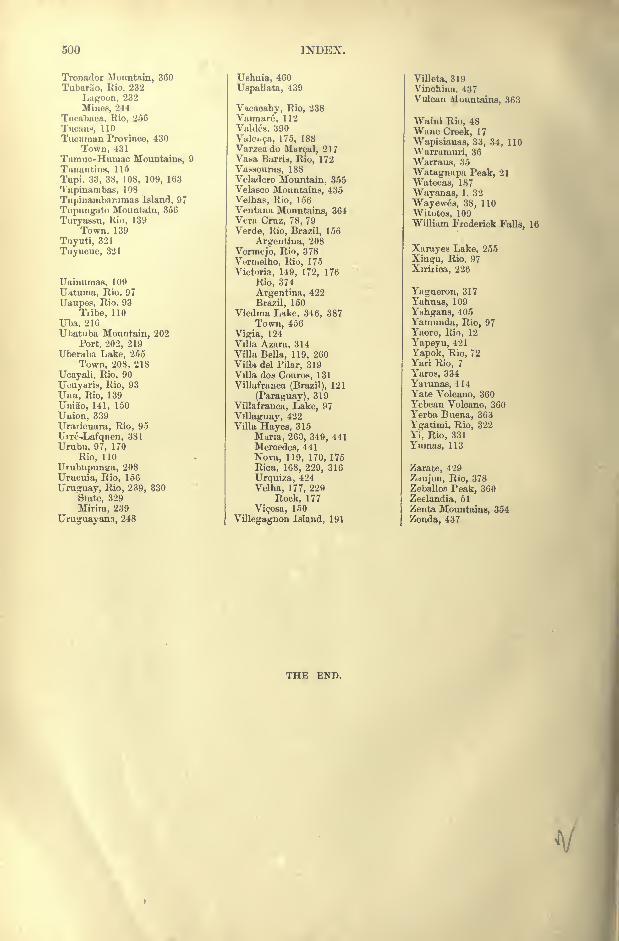
500 INDEX.
Tronndor Mountain, 360
Tubarao, Rio, 232
Lagoon, 232
Mines, 244
Tuoabaca, Rio, 256
TucanM, 110
Tucuman Province, 430
Town, 431Tumuc-Huniac Mountains, 9
'I' iman tins, 115
Tupi. 33, 38, 108, 109, 163
'I'upinainbas, 108
Tupinambaramas Island, 97
Tnpungato Mountain, 356
Turyassu, Rio, 139
Town. 139
Tuyuti, 321
Tuyucue, 321
Uainuraas, 109
Uittuma, Rio, 97
Uaupes, Rio. 93
Tiibe, 110
Uba, 216
Uhatiiba Mountain, 202
Port, 202, 219Uberaba Lake, 255
Town, 208, 218
Ucayali, Rio, 90
Ucuyaris, Rio, 93
Una, Rio, 139
Uniao, 141, 150
Uuion, 339
Uraricuara, Rio, 95
TJiTe-.Lafquen, 381
Urubu, 97, 170
Rio, 110
Urubupunsa, 208
Urucuia, Rio, 156
Uruguay, Rio, 239, 330
Sfate, 329
Mirira, 239
Uruguayans, 248
Ushuia, 460
Uspallata, 439
Vacacahy, Rio, 238
Vaimare, 112
Valdes. 390
Valei^a, 175, 188Varzeado Marcal, 217Va^a Barris, Rio, 172
Vacsouras, 188Veladero Mountain, 355Velasco Mountains, 435
Velhas, Rio, 156Ventana Mountains, 364Vera Cruz, 78, 79
Verde, Rio, Brazil, 156
Argentina, 208
Vermejo, Rio, 378Vermelho, Rio, 175
Victoria, 149, 172, 176
Rio, 374
Argentina, 422
Brazil, 150
Viedma Like, 346, 387
Town, 456
Vigia, 124Villa Azara, 314Villa Bella, 119, 260ViUa del Filar, 319Villa dos Couros, 131
Villafranca (Brazil), 121
(Paraguay), 319
Villafranca, Lake, 97
Villaguay, 422Villa Hayes, 315
Muria, 260, 349, 441
Mercedes, 441
Nova, 119, 170, 175
Rica, 168, 229, 316
Urquiza, 4'24
Velha, 177, 229
Rock, 177
Vicosa, 150
Villegagnon Island, 191
Villeta, 319Vinchina, 437Vulcan Mountains, 363
Waini Rio, 48Wane Creek, 17
Wapisianas, 33, 34, 110
VVarramuri, 36
Warraus, 35
Watagnapa Peak, 21
Watecas, 187
Wayanas, 1, 32
Wayewes, 38, 110
Witotos, 109William Frederick Falls, 16
Xarayes Lake, 255
Xingu, Rio, 97
Xiriiica, 226
Yagneron, 317
Yahuas, 109
Ynhgans, 405
Yamunda, Rio, 97
Yaore, Rio, 12
Yapeyu, 421
Yapok, Rio, 72Yari Rio, 7
Yaros, 334
Yarunas, 114Yate Volcano, 360Yebcan Volcano, 360Yerba Buena, 363
Ygatimi, Rio, 322
Yi, Rio, 331
Yumas, 113
Zarate, 429
Znujon, Rio, 378ZeballoB Peak, 360
Zeelandia, 51
Zenta Mountains, 354
Zonda, 437
THE END.
V
**'STUDENT;; I
'
^SUW
-r,
C t C
r
< <54 < <
< <:. *r c < <
c - c <:
<c c c <<c < < <
c < t<C ( , C <
^ < <
< < .
L ; c <: c-
< < <-
ic < < <. ' <
.
, . <
ft'
< <"
( '- <"-
'
<
^ C
w s s ,'
C << C
^ < < c-. <: <r. <c <<
< < << fd c- c - C C <Tr
_ < . c *__
.
7 / / r *c ,
c~ <rsd r< <r -,
C . f f^ ' < c c c i c
C C<
' <. << <
f<-
< / rf
< (.
_ _ CT..C <:. t.c: CL tv.< :_ <:,<: CL < ei
i _..*:: c:.
.( < <
c
. C
c t
'
:C
^
r-|
-Cr <
c c c< ' C '
t I
' > << <
-. ct
< c , << c > ^f C
;
C C AC<
c c
^ < < <c . , c< i < i
< < .
t <;
< <
< <
-i
<\
-'
>C c
.
.
t
'
< C CC<--<.<. K <
<r< ,- cC< c C
<r
c <-
<' ^ C
<:< cf j'*v -
'
.d<?'<;
"
<r< ci
C C- <r. r<C <Z>- ^c -
c <r c.
<r <r
c_- C <g
c c <
<; c: <
< c< c
<< << *
C!.<<L
C c. < < Cc c < c
'
CT '
c<- . cas*
*'._< ' c
'
< << <:
(' Cc
CC- c c<c c<
. .
<
.
< c
.- c;
ff (f- ,<:<
-. . ,-<-
C< cf<Tf <"
I

> , , ,.
. ,--
. > i^wi