Site planning and guiding principles of hi-tech parks in China: Shenzhen as a case study
23
1 Introduction An important historic event in China’s recent urban planning was the introduction of hi-tech parks (often interchangeable with the term ‘science parks’) in the early 1990s. Hi-tech parks are new urban construction units in China which represent a product of reform and ‘opening up’. The State Council officially approved the establishment of the first twenty-six state-level hi-tech development parks in 1991 (Fang et al, 2002). Another twenty-five hi-tech and new-technologies parks were approved in 1992. At present, there are fifty-three state-level hi-tech parks in China, together with the Yangling New and High Agro Technology Development Park and the Beijing New Technology Experimental Park. The development of hi-tech parks was associated with many important missions in the thoughts of the State Council of China. Eight goals can be identified with these parks (Fang C, 2000; Fang Y, 1996; MacDonald and Deng, 2004): (1) to be pioneers in economic reforms and opening up; (2) to stimulate and accelerate economic growth; (3) to be magnets attracting foreign direct investment and advanced technology; (4) to be key cradles for China’s new hi-tech industries; (5) to be major bases for transforming scientific results and incubating new and hi-tech enterprises; (6) to ‘radiate’ the transformation and upgrading of tradi- tional industries; (7) to be important bases for attracting and fostering talent for the industrialization of China’s new and high technologies; and (8) to advance towards ‘new communities’ of a new era, featuring both material and cultural prosperity. Site planning and guiding principles of hi-tech parks in China: Shenzhen as a case study Chuanglin Fang Institute of Geographic Science and Natural Resource Research, Chinese Academy of Sciences, 11A Datun Road, An-wai, Beijing, 100101 China; e-mail: [email protected] Yichun Xie ô Department of Geography and Geology, Eastern Michigan University, 205 Strong Hall, Ypsilanti, MI 48197, USA; e-mail: [email protected] Received 6 March 2005; in revised form 11 October 2006; published online 27 November 2007 Environment and Planning B: Planning and Design advance online publication Abstract. Recent institutional changes, marketization, and globalization have combined to bring about rapid economic growth in contemporary China. One of the direct outcomes is the rapid expansion of large cities and the recurring birth of new cities from small towns and rural villages. Clustered construction cranes are popular scenes in many Chinese cities. One of the noticeable city landmarks is the specialized economic development district, such as a hi-tech park, industrial park, commerce park, high-standard apartment complex, and designated port district. Along with the development of these new types of urban blocks, the Chinese policies and practices of urban planning and city design have been dramatically reshaped. This paper, on the basis of our participatory observation of the planning process of the Shenzhen Silicon Peak Software Ecological Park, examines site planning and design of hi-tech parks in China. The paper discusses the seven principles guiding the development of hi-tech parks, and the four implementation strategies directing planning and design practices. It also illustrates the adoption of GIS techniques, the new eco-community planning approach, and the classic Chinese cosmology öharmonious wind and water ( feng shui ) öthrough the case study. The paper concludes with discussion of the changes of Chinese values and practices of urban planning in the context of hi-tech parks in the transitional period. DOI:10.1068/b32064 ô Corresponding author.
Transcript of Site planning and guiding principles of hi-tech parks in China: Shenzhen as a case study

1 IntroductionAn important historic event in China's recent urban planning was the introductionof hi-tech parks (often interchangeable with the term `science parks') in the early 1990s.Hi-tech parks are new urban construction units in China which represent a product ofreform and opening up'. The State Council officially approved the establishment of thefirst twenty-six state-level hi-tech development parks in 1991 (Fang et al, 2002).Another twenty-five hi-tech and new-technologies parks were approved in 1992. Atpresent, there are fifty-three state-level hi-tech parks in China, together with theYangling New and High Agro Technology Development Park and the Beijing NewTechnology Experimental Park. The development of hi-tech parks was associatedwith many important missions in the thoughts of the State Council of China. Eightgoals can be identified with these parks (Fang C, 2000; Fang Y, 1996; MacDonaldand Deng, 2004): (1) to be pioneers in economic reforms and opening up; (2) tostimulate and accelerate economic growth; (3) to be magnets attracting foreign directinvestment and advanced technology; (4) to be key cradles for China's new hi-techindustries; (5) to be major bases for transforming scientific results and incubatingnew and hi-tech enterprises; (6) to `radiate' the transformation and upgrading of tradi-tional industries; (7) to be important bases for attracting and fostering talent for theindustrialization of China's new and high technologies; and (8) to advance towards`new communities' of a new era, featuring both material and cultural prosperity.
Site planning and guiding principles of hi-tech parks in China:Shenzhen as a case study
Chuanglin FangInstitute of Geographic Science and Natural Resource Research, Chinese Academy of Sciences,11A Datun Road, An-wai, Beijing, 100101 China; e-mail: [email protected]
Yichun Xie ôDepartment of Geography and Geology, Eastern Michigan University, 205 Strong Hall,Ypsilanti, MI 48197, USA; e-mail: [email protected] 6 March 2005; in revised form 11 October 2006; published online 27 November 2007
Environment and Planning B: Planning and Design advance online publication
Abstract. Recent institutional changes, marketization, and globalization have combined to bring aboutrapid economic growth in contemporary China. One of the direct outcomes is the rapid expansion oflarge cities and the recurring birth of new cities from small towns and rural villages. Clusteredconstruction cranes are popular scenes in many Chinese cities. One of the noticeable city landmarksis the specialized economic development district, such as a hi-tech park, industrial park, commercepark, high-standard apartment complex, and designated port district. Along with the development ofthese new types of urban blocks, the Chinese policies and practices of urban planning and city designhave been dramatically reshaped. This paper, on the basis of our participatory observation of theplanning process of the Shenzhen Silicon Peak Software Ecological Park, examines site planning anddesign of hi-tech parks in China. The paper discusses the seven principles guiding the development ofhi-tech parks, and the four implementation strategies directing planning and design practices. It alsoillustrates the adoption of GIS techniques, the new eco-community planning approach, and the classicChinese cosmologyöharmonious wind and water ( feng shui )öthrough the case study. The paperconcludes with discussion of the changes of Chinese values and practices of urban planning in thecontext of hi-tech parks in the transitional period.
DOI:10.1068/b32064
ôCorresponding author.

The goals of introducing hi-tech parks in China are quite similar to those enactedin Taiwan (Lin, 1997), Japan (Cutler, 1989), the United Kingdom (British Council,2002), the United States (Drescher, 1998), and many other nations (Cabral and Dahab,1998; Moulaert, 2000). The development of hi-tech parks in China is an expectedoutcome of governmental efforts to open up its economy and modernize its technologyand industry under the pressure of increasing economic globalization (Castells andHall, 1994). A growing literature has been reported on the socioeconomic and politicalincentives and outcomes of China's hi-tech park development in recent years (Fang,1996; Fang et al, 2002; Gu and Zhao, 1998; MacDonald and Deng, 2004; Sigurdson,2005a; 2005b; Walcott and Xiao, 2000; Xia, 2001; Zhang et al, 2003).
This paper is based on a real project, the Shenzhen Silicon Peak Software Eco-logical Park site plan (referred to as Shenzhen Software Park in the remainder of thepaper), in which the first author played a significant role in the field survey and siteplanning. The preliminary report of the Shenzhen Software Park planning project wasreviewed and recommended by a panel of eleven expertsöcoming mainly from theHi-tech Department of the National Development and Reform Commission of China,the Chinese Academy of Sciences, and the Chinese Academy of Engineeringöon8 October 2001. The Shenzhen Software Park site plan was accepted as a successfulgrant completion by the Shenzhen Land and Resources Management Bureau on23 January 2002. The final report was published by China Construction Industry Pressin March 2002 (Fang et al, 2002).
This paper reexamines our participatory experiences in planning the ShenzhenSoftware Park. In section 2 we analyze the planning principles and strategies of hi-tech parks, which is a little-exposed research area, from the actual practices andprocedures of planning and designing the Shenzhen Software Park. We also evaluatetraditional Chinese values and their influences on current hi-tech park planningpractices. In section 3 we present the planning and design practices in the ShenzhenSoftware Park site plan project and provide our analysis of how the planning principleswere actually implemented in practice. Moreover, we illustrate the technical methodsthat we used to collect the data, and to design the Shenzhen Software Park. Weconclude in the final section with a discussion of urban planning practices with regardto hi-tech parks during the current transitional period from our own perspectives.We also point out the lessons as well as the challenges for Chinese urban plannersand city architects in planning and designing hi-tech parks.
2 Planning principles of hi-tech parksGrowing economic globalization goes hand in hand with an increased sensitivity toeconomic autonomy, indigenous technical innovation, and national pride (Moulaert,2000). Under the pressures of changing business environments, cities have been moti-vated to advance themselves over rival cities (Hall and Pfeiffer, 2000; Harvey, 1989). Inresponse to the intensifying competition, many city authorities around the world aretaking initiatives of developing large-scale construction projects, such as sport facili-ties, new transport systems, international airports, recreation parks, conference andexhibition centers, etc. Such development strategies are termed by some scholars as anew economic policy or new urban politics (Cox, 1995; Moulaert, 2000). Hi-tech(science) parks, for instance, can be seen as a kind of large-scale urban developmentproject. In China, because of a long-delayed desire for creating economic miracles andcatching up with modern technologies, it is expected that hi-tech parks will producetechnological superiority and economic prosperity. Therefore, developing hi-tech parksin coastal open-door cities and other large cities, supported with special fiscal incentives
2 C Fang, Y Xie

that are aimed to stimulate investments in new technologies, has been a nationalstrategy in China, catching up with the rest of the world (Mao and Fang, 1997).
Regional and city planning has been an important instrument with which to carryout the central government's political and economic goals in China. Understandinghow urban planning has been functional in China will help to explain current practicesof hi-tech park planning and design. A comprehensive review of the theory andpractice of urban planning in socialist China (including the early stage of the economicreforms enacted in 1979 and the period before) can be found in the works by Cao(1985), Kirkby (1985), Koshizawa (1978), Kwok (1981), Ma (1979), Sit (1996), Tang(1994), Xie and Costa (1991; 1993), and Zhou (1986). Urban planning in socialist Chinais well known for the following features: it was an important component of the nation'seconomic development planning; it concurred with the socialist ideology, state control,and economic planning; and it complied with the concepts of rational (goals-oriented)planning, hierarchical urban system, regional coordination, progressive and continuousdevelopment, self-reliance (self-containment) at the subdivision, neighborhood, andworking-unit levels, and diversity (Xie and Costa, 1993).
Urban planning has undergone dramatic changes in the era of economic reform(Chan, 1996; Gaubatz, 1995; Khakee, 1996; Leaf, 1998; Lin, 1995; Ng and Tang, 1999;2004; Nolan, 1995; Szelenyi, 1996; Tang, 2000; Wu, 1997; Yeh and Wu, 1999; Zhang,2002). During the current transitional period from a centralized economy to a socialistmarket economyöwhich began with the economic reforms of 1978öthe dominance ofsocialist ideology, state control, and economic planning on urban planning in Chinahas noticeably diminished (Yeh and Wu, 1999). The practice of urban planning isretreating from the socialist ideology, and is turning to pragmatism and opening upto Western planning ideas and techniques. Urban planning in this period gives increas-ing importance to residence convenience and contentment, environmental amenity andquality, and local growth-oriented planning goals.
A different view of the changes in the transitional period is that state control hasremained strong in many aspects only with increasingly concrete relaxation in limitedareas such as personal freedom and community affairs (Zweig, 1997). In contrast withthe era before the reforms, the central government has employed more indirect thandirect tactics to control the economy and the society (Tang, 2000). In other words, thestate pays more attention to `the whole body' rather than to `the individual organs' ofthe body. Accordingly, governments of cities and towns, which have direct knowledgeof and stake over their own jurisdictions, are given more governance on local mattersin accordance with the general principles that are enforced by the central govern-ment. Accordingly, state control in urban planning and city design is better realizedin alignment with local conditions. Though this gives an impression of decreasingstate control, the fact is that state control is strengthened through its well-layeredpolitical structures. To interpret this in terms of planning practice, a multilayered andcoordinated system of urban planning instruments has been developed (Tang, 2000).
Chinese planning professionals, as aforementioned, are required to identify thesocietal goals of hi-tech development in order to guide their planning and designingpractices. The commonly recognized goal of supporting the development of hi-techparks is their coordinative role in developing a harmonious man ^ land system, whichis a productive and healthy urban system. The purpose of coordinating this dynamicstructure is to realize a sustainable development of the entire city system, in which thehi-tech park is an active block. In the planning of the Shenzhen Software Park werecommended that the coordination of this dynamic system should consist of sevenelements: people (P), resource (R), economy (E1 ), environment (E2 ), ecosystem (E3 ),
Site planning and guiding principles of hi-tech parks in China 3

technology (T ), and society (S). These elements interact, interlink, and intercoordinatewith each other to constitute a PREEETS system.
First, the human factor (people) is the principal agent in optimizing the system andis also the key in coordinating and managing the system. Compared with other citysubdivisions, a hi-tech industrial park is often associated with a high concentration ofknowledge-intensive and advanced-technology-supported industries, and with highlytrained and talented researchers and professionals who invent, manage, and operateadvanced technology to produce products of enormous market value (Yu, 2001).Second, a hi-tech industrial park gathers a tremendous amount of resources: human,financial, scientific, and technological. The hi-tech park is a modern farreaching enter-prise encompassing scientific discoveries, technology innovations, advanced engineeringdesigns, gifted managerial and marketing agencies, and first-class industrial products.Third, a hi-tech park clearly demonstrates the scale of economy. Though it is acompacted district, the hi-tech park boasts strong investment incentives, gathersmassive amounts of investment, and awards great returns. It draws many highlyproductive and profitable enterprises and demonstrates the influence of agglomeratedeconomic powers.
Fourth, the environment amenity is another important aspect of the hi-tech park(Yu and Huang, 2001; Zhang and Shi, 2000). A delightful environment adds an extraincentive to people's desire and inspiration. The attractive living environment of hi-techparks is apparently one important advantage with which to attract more investment,compared with other divisions of the city. The hi-tech park offers a relaxing workingenvironment, which provides a comfortable and high-standard living environment;creates an open atmosphere promoting innovation and adventure and tolerating failurefor talented, well-trained, and highly mobile staff; and ensures that they have favorablebusiness treatments and work efficiently if they follow the rules of the game (Larsenand Rogers, 1988). More importantly, the hi-tech park offers the staff higher qualityservices and more congenial recreational environment than the city. Citizens whohave huge wealth and abundant recreation time can find themselves havens and cozyhomes where there is a tranquil and peaceful environment with undulating hills,meandering rivers and lakes, and flourishing trees and bushes (Lu and Wang,2001). Fifth, the environment consciousness leads to the adoption of an ecologicalapproach in the process of planning, designing, and building hi-tech parks (Marsh,1998). Natural features such as mountains and rivers should be treated as integralcomponents of the entire ecological system. Measures should be taken in the plan-ning and designing stages to adjust to local conditions, imitate nature, protect theecosystem, and beautify the environment (Steiner, 2000). The planners and architectsshould keep the green space as the basic element of the built environment, take fulladvantage of natural endowments or beauties, improve ecological and environmentalquality, and recreate the harmony of man and nature. Sixth, innovative and cutting-edge technologies are the key elements of hi-tech parks, as indicated by the name.It also makes sense to introduce new ideas and advanced techniques in the planningand design of hi-tech parks, in order to demonstrate their hi-tech nature. Geographicinformation systems (GIS), computer-aided drafting packages, digital site-designstudios (software), virtual reality simulations, remote sensed imagery, and collabo-rative decision-support systems are commonly installed and used by the planningagencies and architect institutes in the cities where hi-tech parks are being plannedand constructed.
Seventh, the development of hi-tech parks is a social engineering project. Itcreates a dynamic and complex urban entity renowned for its multilayered networksand its great synergy in pulling together bright and intelligent scientists, innovators,
4 C Fang, Y Xie

investors, businessmen, executives, administrators, managers, engineers, technicians,and adventurers. The cornerstone is the harmonious relationship between man andman, between man and land, within the park, and between the park and the host city.A good plan and design should analyze not only the interactions between the hi-techindustries, the products, the marketing values, the regional and urban economic roles,and the environmental and ecological impacts, but also the interrelations between theknowledge-intensive workersöthe driving forces of the technologyöand other humanresources that accompany and service them. In other words, the planners and archi-tects should analyze the holistic pulling effect of the hi-tech park (or hi-tech industries)in the context of city, regional, national, and international economy. In addition tothe economic values, the design and construction of the hi-tech park should achievecongenial relationships between people of all walks of life, covering people of differ-ent interests, different social status, different professions, different religions, etc,inside the park and within the city (Fang, 2000). To realize the `virtuous circle' andharmonious development we must fully utilize and promote all positive relationswithin the system but avert or avoid all negative relations among these elements.In short, the ultimate goal of the harmonious development is to prioritize a compre-hensive and balanced socioeconomic developmentöprotecting natural resources,ecosystem, and environmentöand to prevent being captured as the `slave' of the natureor the market.
3 The planning practices: the Shenzhen Silicon Peak Software Ecological ParkThe seven principles of developing hi-tech parks have been transformed into fourplanning strategies in designing Shenzhen Software Park: playing a dragon-head rolein the host city's economic development (reflecting P, R, E1), locating at a strategicsite in the host city (P, R, E1 , E2), applying innovative planning techniques (T ), andtaking an ecosystem approach for planning and design (E3 and S ). These strategieswere embedded in the planning practices of Shenzhen Software Park. The data forthe Shenzhen Software Park site plan came primarily from our field surveying. Weused a topographic map at 1:50 000 scale and aerial photos at 1:5000 scale as thebase maps. We inserted around two-hundred control points in the areas showingabrupt landscape changes and gathered the elevation data and the bedrock (or soil)data at these points registered with GPS, and then created a digital elevation model(DEM) in ArcGIS 8.1 (ESRI Inc, Redlands, CA). From the DEM and the ancillarydata (such as soil, vegetation, and hydrology data we collected from the ShenzhenLand and Resources Management Bureau), we derived natural and ecological data-sets, which included physiognomy, geomantic condition, slope gradient, slope aspect,landslide risk, geological stability, and ecological sensitivity. Moreover, the socio-economic data analyzed in this paper were collected from the Shenzhen StatisticalBureau and the Shenzhen Land and Resources Management Bureau in years 2000and 2001, through office visits to these agencies and copied from their internaldatasets. These data have established solid foundations for the planning and designof Shenzhen Software Park.
Shenzhen is situated in the southern coastal area of Guangdong province, 35 kmfrom Hong Kong, and 160 km away from Guangzhou. The Chinese government, underDeng Xiaoping's leadership, established Shenzhen as China's first Special EconomicZone in 1979 to test free-market principles. Shenzhen in 1979 was a fishing town with apopulation of 300 000 and has grown into a metropolitan city of more than sevenmillion over the past twenty-five years. It has also progressed from a primarily agrarianeconomy to being one of China's hi-tech leaders (Ng and Tang, 2004). Thus Shenzhenis an ideal city to showcase the Chinese planning practices of hi-tech parks.
Site planning and guiding principles of hi-tech parks in China 5

3.1 Playing a dragon-head role in the host city's economic developmentUnder the drive of the market economy, the construction of Shenzhen Software Parkwas focused primarily on the realization of great economic benefits. For instance, theplanned area of Shenzhen Software Park is 136.61ha. Though the space is very limited,more than two-hundred software enterprises of various types and sizes are concen-trated there. There are nearly ten-thousand people employed in the research anddevelopment departments. The total sales value has been up to twelve-billion Chinesedollars (yuan). The hi-tech products from the park have an important share in both theinternational and the domestic software market. A great emphasis on export-orientedeconomy is a typical characteristic of the hi-tech park (Fang, 2000).
Moreover, according to the economic benefit analysis, the gross investment by theend of 2008 will reach 5 billion Chinese yuan. By then, Shenzhen Software Park will becompletely built. More than three-hundred enterprises will enter and operate in thePark. Among them, the number of large and middle-size key enterprises will exceedeighty. These enterprises will hire more than 120 000 employees. They will create anannual sale of 25 billion Chinese yuan, an annual industrial growth value of 8 billionChinese yuan, an annual tax revenue of 6 billion Chinese yuan, and an annual exportproduct value of US$ 1.5 billion. The input :output ratio is 1:20:64 on average.Shenzhen Software Park will become a dragon head of the export-oriented softwareenterprises in China's software industry (Fang et al, 2002).
3.2 Locating at a strategic site in the host cityGeography matters and location is important. A hi-tech park, as a special economicdistrict and a show window of an open market economy and economic reform, oftenenjoys a location advantage. Hi-tech parks usually locate at the suburbs of a city andfar apart from traditional (pollution-causing) industrial sites (Gu and Zhao, 1998). Thissuburban location usually has several advantages for attracting hi-tech parks. The landresource is relatively abundant and the land price is relatively low in the suburbs ofa city. The suburbs, geographically adjacent to and as a natural expansion of thecentral city, become a first-choice place for inner-urban hi-tech industries to relocateto and in which professionals seek a better living environment for families (Gong,2001). Often a hi-tech park is adjacent to prestigious universities and research institutes(Drescher, 1998). A hi-tech park has countless ties with its host city. The site selectionof a hi-tech park has to give a full consideration of the city itself. The development andsustainable future of the hi-tech pack are impacted by the comprehensive planning,zoning regulation, industrial and economic structure, road network, traffic condi-tion, utility infrastructure, city design and landscape, entertainment, and educationestablishment of the city.
Many comparative studies have been carried out to borrow experience and to learnlessons from examples in the rest of the world. Three global models have been identi-fied as successful cases of coordinative development between hi-tech parks and hostcities from the perspectives of interdependent and mutually stimulating relationships(Bahraml and Evans, 1995). Tsukuba Science City in Tokyo is recognized as the free-standing development model; Stanford Industrial Park in the USA, Cambridge SciencePark in the UK, and Hsinchu Technological Industrial Park in Taiwan are seen as thecity-peripheral development models; the advanced technology parks of Xi'an andBeijing in China are seen as the inner-city insertion models. Shenzhen SoftwarePark is a peripheral development model.
Shenzhen Software Park is located in Yanziling District in the vicinity of theLonggang large industrial and export processing area. The park forms a `point ^ axis'relationship with the hi-tech industrial zone of Shenzhen. Moreover, from the regional
6 C Fang, Y Xie

economic perspective, it is well placed in the Zhujiang (Pearl) River Delta, enhancingShenzhen's `core ^ hinterland' relationship with the Delta. It takes full locationaladvantage of the City of Shenzhen and occupies an excellent suburban site, whichdisplays an important collaborative relationship between the city and the park, calledthe lips-and-teeth relation by the locals.
The coordinative development between hi-tech park and city is a kind of micro-scopic yardstick for regulating the man ^ land system in an urban district. The maincharacteristics of hi-tech packs include small scope, high harmony, first-class oper-ability, and great efficiency (Xia, 2001). Optimizing the urban man ^ land system of ahi-tech park is an important means for China to implement sustainable-developmentstrategies in cities and specialized districts under the market economy condition. Andthe optimization includes not only the dynamic harmonization between each compo-nent in the hi-tech park and within each component, but also the spatial optimizationof the man ^ land system between the park and the city. Only when the harmony ofindustrial organizations, spatial configurations, and eco-environmental constructionsis realized simultaneously can the unreasonable competition of industries and theconflict of construction spaces be eliminated. Plausible contributions of the hi-techpark to the urban economic, ecological, and social development can be realized.Coordinative development and spatial intergrowth between the hi-tech park and thecity can be achieved. One of the important means to ensure harmony is to adoptscientific method in planning and designing the park.
3.3 Applying innovative planning techniquesMany new planning ideas and techniques, just as the hi-tech park is being introduced,are being rapidly adapted and developed in China. GIS technology is one of the keyplanning toolkits that are widely utilized by Chinese planners to conduct quantitativeand visual analyses. GIS is an integrating technology that can be deployed as acomputing platform to support hierarchical and multicriteria assessment, expertknowledge integration, and a planning decision support system. The introduction ofthese information-technology-based and quantitative methods can supplement qualita-tive analysis to ensure scientific objectivity in the planning and designing process (Maoand Fang, 1997).
GIS has long been seen in Western literature on site selection and urban planningapplications (Klosterman and Xie, 1997). Data layers reflecting policy (such as zoning),transportation (such as accessibility to highway and road networks), current land use,and physical and environmental constraints (such as soils, slope, wetlands, and flood-plains) are common factors that are used to compute a composed score with whichland suitability can be determined and optimal sites chosen (Huxhold et al, 1997;Klosterman and Brail, 2001). However, due to different planning priorities, culturalvalues, and data availability, GIS data focusing on natural disasters, environmentalsensitivity, and traditional Chinese cosmology are often analyzed in China. The GISapplications we adopted in the project of the Shenzhen Software Park site plan arepresented in the following paragraphs as illustrations.
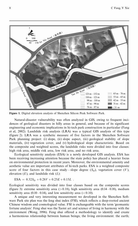
The fundamental GIS application in the Shenzhen Software Park site selection wasthe elevation analysis (figure 1). Elevation is the basic topographic feature that deter-mines the physical characteristics of a siteösuch as its geological foundation andmaterials, its slope, its slope aspect, and its view shade. The elevation ultimatelydetermines the vegetation, ecosystem, and scenery from the perspectives of physicalgeography and landscape. In the application of the GIS technology the elevation wasdivided into ten grades (figure 1). The slope was often derived from the elevation datain GIS.
Site planning and guiding principles of hi-tech parks in China 7
Natural-disaster vulnerability was often analyzed in GIS, owing to frequent inci-dences of geological disasters in hilly areas in general, and because of its significantengineering and economic implications in hi-tech park construction in particular (Fanget al, 2002). Landslide risk analysis (LRA) was a typical GIS analysis of this type(figure 2). LRA was a synthetic measure of five factors in the Shenzhen SoftwarePark planning project: (i) slope, (ii) slope aspect, (iii) geological stability of slopematerials, (iv) vegetation cover, and (v) hydrological slope characteristic. Based onthe composite and weighted scores, the landslide risks were divided into four classes:high risk area, middle risk area, low risk area, and no risk area.
Ecological sensitivity analysis (ESA) is a newly developed GIS analysis. ESA hasbeen receiving increasing attention because the state policy has placed a heavier focuson environmental protection in recent years. Moreover, the environmental amenity andaesthetic value are important attributes of hi-tech parks. ESA is a weighted compositescore of four factors in this case studyöslope degree (SD), vegetation cover (V ),elevation (E ), and landslide risk (L):
ESA � 0:32SD � 0:28V� 0:25E� 0:15L .
Ecological sensitivity was divided into four classes based on the composite scores(figure 3): extreme sensitivity area (>0:18), high sensitivity area (0.14 ^ 0.18), mediumsensitivity area (0.10 ^ 0.14), and low sensitivity area (<0:10).
A unique and very interesting measurement we developed in the Shenzhen Soft-ware Park site plan was the feng shui index (FSI), which reflects a deep-rooted ancientChinese wisdom and cosmological value. FSI is exchangeable with the term `geomanticfortune analysis'. Feng shui was the Taoist art and science of living in harmony with theenvironment (Wong, 1996). Feng shui offered a methodology to identify and createa harmonious relationship between human beings; the living environment: the earth;
65m ^ 76m53m^ 65m42m^ 53m31m^ 42m
<31 m
0 100
50 150
121m ^ 132m110m^ 121m98m ^ 110m87m^ 98m76m^ 87m
Figure 1. Digital elevation analysis of Shenzhen Silicon Peak Software Park.
8 C Fang, Y Xie

Low sensitivity area (<0:10)Medium sensitivity area (0.10 ^ 0.14)High sensitivity area (0.14 ^ 0.18)Extreme sensitivty area (>0:18)
0 100
50 150
Figure 3. Ecological sensitivity analysis (ESA) for Shenzhen Silicon Peak Software Park. For adiscussion of ESA see text.
No risk areaLow risk areaMedium risk areaHigh risk area
0 100
50 150
Figure 2. Landslide risk analysis (LRA) of Shenzhen Silicon Peak Software Park. For a discussionof LRA see text.
Site planning and guiding principles of hi-tech parks in China 9

and the earth's energy: sun, wind, and water (Too, 1996). In popular terms, feng shuiwas derived from ancient Chinese philosophy, which believed that the positioning andphysical characteristics of a home affect the fortunes of the owner. Therefore, the fengshui methodology has been used by the Chinese to design cities, build homes, and burytheir dead for centuries (Wong, 1996).
The ancient feng shui cosmology placed its center on the harmony between the man-made features and their surrounding natural environments, which amazingly coincideswith many core concepts of the modern environmental and ecological preservationists.Thus the FSI is fashionably used in Chinese planning as a measure of a harmoniousman ^ land relationship, though it is arguable how the FSI is exactly computed ormeasured (Fang et al, 2002). In the project of the Shenzhen Software Park site plan,we took six factors into consideration to compute the FSI: elevation (E ), slope degree(SD), slope aspect (SA), wind direction (W ), distance to water body (DW), and distanceto scenery site (DS). Each factor had four ^ six categories. We assigned a weight to eachfactor and rated the various categories for each factor. We calculated the compositescores (FSI) by summing the products of the weights of the six factors with the ratingsof their corresponding categories:
FSI �Xn1i� 1
a1Ei �Xn2i� 1
a2SDi �Xn3i� 1
a3SAi �Xn4i� 1
a4Wi �Xn5i� 1
a5DWi �Xn6i� 1
DSi ,
where a1 is the weight for factor 1 (elevation), n1 is the number of categories for factor 1,and Ei is the rating of a category i for elevation. The other symbols are interpreted in asimilar way. Eventually we created five areas based on the FSI score: best feng shuiarea, very good feng shui area, good feng shui area, medium feng shui area, and poorfeng shui area (figure 4).
Poor feng shui area
Medium feng shui area
Good feng shui area
Very good feng shui area
Best feng shui area
0 100
50 150
Figure 4. Geomantic fortune analysis [feng shui index (FSI)] for Shenzhen Silicon Peak SoftwarePark. For a discussion of FSI see text.
10 C Fang, Y Xie

We used the indices of FSI, ESA, and LRA when designing the park's functionallayout (figures 5 and 6). For instance, the locations of the park gates were chosen to bethe site with high FSI scores, in addition to the considerations of transportation,landscape, and visual effect. Construction was avoided at the locations with low FSIscores and high ESA and LRA scores in order to prevent less harmonious, highlysensitive, and highly risky sites from the perspectives of man ^ land relations, naturaldisasters, and environmental risks, respectively. Moreover, these indices were alsoapplied when we were determining business centers, recreation areas, residential areas,and public facilities. In general, the symbolic constructions, such as the software parkgates and entrances, the administrative center, and the software research and devel-opment centers were located in the best FSI areas; the software training areas andthe recreation areas were located in the very good FSI areas; the exhibition and theresidential centers were mainly located in the good FSI areas; and the softwarehatching areas were concentrated in the medium FSI areas (figures 5 and 6). However,the average FSI areas were located in two peaks areas and were not suitable forconstruction. Moreover, these areas were ranked high in the analyses of ESA andLRA and should be protected.
3.4 Taking an ecosystem approach for planning and designingThe introduction of new ideas and practices is strongly encouraged in the planning anddesign of hi-tech parks. The Western concepts of ecological (sustainable) subdivisionplanning are perceived to fit well the needs of constructing hi-tech parks (Fang, 2000).In order to build a software park into a park-style city, or an ecocity, with harmoniouscoexistence between mankind and nature, the planners should take a visionary view,adopt high standards, promote high efficiency and try to preserve best the originallandscape, culture, and vegetation in the designing and planning process.
Several principles were followed in designing the general layout of the park,including `obtrusion of constructions should be minimized', constructions should beinterlaced, but well ordered', `the synthetic value of economic, ecological, and aestheticperspectives should be emphasized', `grand dimensions, great height, and super luxurybuildings should be avoided', and `overurbanized subdivisions should be avoided'. Forinstance, to protect effectively the upland eco-environment, the construction area ofthe software park was confined to 8:022� 105 m2. Subsequently, the building footagearea was confined to 5:022� 105 m2; the road-construction area was confined to2:139� 105 m2; the total construction area was confined to 5:249� 105 m2; the generalbuilding density was confined to 20%; the plot ratio was confined to 0.73; a greenspace ratio of 67.70% was achieved; the green space area per capita was up to92:49 m2/person; and the total population (at night) was confined to 10 000.
In designing the functional layout, the emphasis on people should be reflected, andresidence convenience and high efficiency should be prioritized (China Urban PlanningAcademy, 2000). As for the spatial layout, the green space was most important and thearchitectures were decorative in the upland, while in the flat ground the architectureswere primary but should be well interspersed and separated with green spaces.Variousfunctional areas of the parkösuch as the R&D (research and development) area,software-hatching area, business exhibition area, management and service area, train-ing facility area, high-standard residential area, and recreation and entertainmentareaöare networked to provide the best articulation, and are spatially positioned inorder best to reflect architecture design and aesthetic appreciation. Each functionalarea is linked with each other area through car driveways and pedestrian paths, andis adjacent to vegetated upland, or close to river (stream) fronts (figures 5 and 6).
Site planning and guiding principles of hi-tech parks in China 11

Software R&D areaSoftware training areaSoftware hatch areaBusiness areaSoftware layout areaPlanning red line
Super residential areaHospitalWaterAdministration areaTour recreation areaGreenbelt
0 100
50 150
Figure 5. Function districts of Shenzhen Silicon Peak Software Park (planned for 2008).
0 100
50 150
Figure 6. Comprehensive planning of Shenzhen Silicon Peak Software Park (planned for 2008).
12 C Fang, Y Xie

This layout has created magnificent picturesque scenery. The structural and technicalindices of the functional areas of Shenzhen Software Park are shown in table 1.
Another important planning practice was to enhance the visual aesthetic valueof the software park by taking ecological landscape planning into consideration. Theprimary objectives were: (i) to preserve, protect, and restore the unique identityand environment of the area, (ii) to provide visual buffering and enhance the sceneryof the area, (iii) to preserve existing trees and vegetation if at all possible, (iv) topreserve the economic base historically attracted to the area, (v) to eliminate existingnonconforming landscaping sites by planting green spaces, and (vi) to promoteenergy conservation through the cooling and wind buffering effects of landscapesand trees.
In the actual implementation we confirmed the ecological landscape planninggoals and proposed `one center, two axes, and two venations' as the guideline forlandscape skeleton (figure 7). `One center' refers to the Panlong Mountain and theFushan Mountain; the `two axes' are Jin Niu Road and Yan He Road; and `twovenations' refers to the mountain venation and the water venation. The skeleton areaswere densely vegetated, forming `the green heart, green axes, and green venations',and constituting the green networks of the ecological landscape. Moreover, thegreen networks were further enhanced through links with many `green bases', whichwere various public green spaces, gardens, and recreational parks that surroundedbuildings and facilities. Many of these green spaces were natural ones, and thelocations of the buildings and constructions were determined with consideration ofthe feng shui assessments (figure 4). Therefore the man-made features took fulladvantage of natural beauty and scenery, and were embedded into the nature.Throughthe construction of the green network, the park became an ecological park thatharmoniously incorporated modern constructions of software industries. Hence, thepark is full of natural vitality and diversity. It takes the hi-tech industry as its economiclocomotive, scientific research and education as its cultural image, and the `greenhills, green trees, green water, and flowered residential areas' as its urban landscapecharacteristics. The park has thus become a symbol of modernization and civilization.It ultimately constitutes a harmonious ecological man ^ land system that featuresnetworked greenbelts, interlinked green spaces, and green-enclosed communities, andis surrounded by scenic mountains and rivers, and flower-decorated residences (Fangand Wang, 2001; Fang et al, 2002; Li, 2001; Liu and Wang, 2000; Wang, 2001) (figure 8).
From the site plan we developed for the Shenzhen Software Park, the construc-tion of the park will add lots of green area to the city, increasing green coverage, andimproving environmental quality and amenity. When the construction finishes, thepark's green area ratio will rise to 66.12% from 62% before the development ofthe park. Some disappeared tree species will be recovered and replanted. A greencorridor 100m wide will be planted along the banks of the Pingshan River (figure 1).Many large patches of grassland, botanic gardens, and parks will be built to fill theseparation spaces between various functional subdivisions of the park (figure 5).Some of these green projects will be constructed as part of the watershed-wideheadwater protection and erosion control projects. The construction of the parkand the green engineering projects will reduce and alleviate natural hazards anddisasters, such as water loss, soil erosion, landslides, and riverbank collapses ofthe Yanziling Hills and the Pingshan River. As a result, the water quality of thePingshan river will reach the third grade standard. These constructions will help torestore the area to a natural environment, improve ecological diversity, and createrecreational value.
Site planning and guiding principles of hi-tech parks in China 13

14C
Fang,Y
Xie
N:/pdf-prep/
Table 1. Structural and technical indices of function subareas of Shenzhen Silicon Peak Software Park.
Function Main Constructive Land-use Construction Constructive Plot Parking Parking Greenbeltsubarea construction land area ratio (%) layers area (m2) ratio space space/ ratio (%)
(m2) ratio (units)
Software number 1 R&D area 18 640 1.36 2 ± 3 18 064 0.96 0.4 43 57.50R&D number 2 R&D area 24 780 1.81 2 ± 3 12 350 0.49 0.5 55 66.00area number 3 R&D area 28 190 2.06 2 ± 3 14 292 0.51 0.4 57 62.00
number 4 R&D area 69 550 5.09 10 ± 20 153 030 2.20 0.4 783 45.50
Software- river front hatch area 38 210 2.80 10 ± 15 31 955 0.83 0.4 128 68.50hatching upland hatch area 31 370 2.30 3 ± 5 20 072 0.64 0.4 69 57.00area postdoctoral 9 560 0.70 3 ± 7 5 818 1.00 0.3 17 68.00
research park
Business technological trade mansion 2 595 0.19 10 ± 15 12 980 5.00 0.5 64 42.50layout area Silicon Peak shopping center 1 500 0.11 8 ± 10 7 520 5.00 0.4 44 40.00
financial center 3 950 0.29 8 ± 10 19 725 4.90 0.5 67 55.50data and communication center 2 595 0.19 8 ± 10 12 980 5.00 0.5 60 42.50software service center 3 350 0.25 10 ± 12 16 760 5.00 0.5 60 40.00Silicon Peak hotel 12 880 0.94 9 25 348 1.96 0.4 101 45.00foreign investor club 2 860 0.21 10 ± 12 14 275 5.00 0.5 72 50.00layout center 8 520 0.62 2 ± 3 3 410 0.40 1.5 58 42.00software exchange center 16 820 1.23 1 2 896 0.20 0.7 20 76.00software exhibition hall 10 960 0.80 3 7 847 0.72 0.7 55 47.00open-air theatre 6 610 0.48 0.00 0.0 35.00other 5 710 0.42 10 ± 12 28 540 5.00 0.2 90 50.00
Management administrant center 4 910 0.36 2 ± 3 3 924 0.80 1.0 40 45.00and service area health care and hospital 8 790 0.64 3 ± 6 3 129 0.36 1.5 47 71.00
Software training software university 23 920 1.75 4 ± 6 30 870 1.29 0.3 93 56.00area Silicon Peak academy of CAS 9 540 0.70 3 ± 5 11 148 1.16 0.4 45 70.00
Residence area residential area 31 770 2.33 10 ± 15 34 386 1.50 0.3 103 50.00villa area 51 370 3.76 2 ± 3 15 688 0.30 0.2 30 72.00

Siteplanning
andguiding
principlesof
hi-techparks
inChina
15Table 1 (continued).
Function Main Constructive Land-use Construction Constructive Plot Parking Parking Greenbeltsubarea construction land area ratio (%) layers area (m2) ratio space space/ ratio (%)
(m2) ratio (units)
Recreation area Silicon Peak green corridor 15 550 1.14 0.00 0.00 95.00Pingshan river blue corridor 21 880 1.60 0.00 0.00Silicon Peak square 28 190 2.06 0.00 0.00 75.00community center 7 600 0.56 2 ± 3 3 835 0.50 0.4 15 55.00
Water 86 100 6.30 0.00 0.00
Road main arterial roads 111 700 8.18 0.00 0.00other through ways 46 800 3.43 0.00 0.00neighborhood roads 55 500 4.06 0.00
Natural green 563 900 41.28 0.00 0.00space
Total 1 366 130 100 524 892 0.73 0.4 2210 67.70

1st-degree scenerysite
2nd-degree scenerysite
3rd-degree scenerysite
4th-degree scenerysite
Visual corridor
Outer visualcorridor
Scenery axis
Figure 7. The design of the ecological landscape of Shenzhen Silicon Peak Software Park(planned for 2008).
Figure 8. Predicted bird's eye view of Shenzhen Silicon Peak Software Park (2008). Available incolor at http://www.envplan.com/misc/b32064/.
16 C Fang, Y Xie

Moreover, the eco-environmental constructions will ultimately contribute to sustainablesocial development. The construction of Shenzhen Software Park is being guided withgreat consciousness of eco-environmental protection and construction, creating a har-mony between the hi-tech park and its host city, and between people and environment.The construction is demonstrating exemplary effects of coordinated developmentbetween people and nature. This man ^ land cooperation places hi-tech enterprises atits foundation, and market and export as its primary goals, combining management,production, marketing, and research together.
4 Discussion and conclusionsThis paper, taking the planning and designing of Shenzhen Software Park as anillustration, analyzes the practices of urban planning and site design for special andlarge urban construction projects during China's current transitional period. It leads toseveral findings, and questions that are worthy of future studies.
The concepts of rational planning and regional coordination are strongly reflectedin the hi-tech park planning process. A hi-tech park is a new urban entity with extremelyhigh economic significance and political visibility. The planning process for hi-techparks must require financial planning, economic development, regional planning,transportation planning, city zoning, architecture design, construction management,environmental planning, etc, at each step (Fang, 1996; Mao and Fang, 1997). Inpractice, a hi-tech industrial park is perceived as an important component of thehost city. It is located at an optimal site that has close ties with the city: physicallythrough transportation links; economically by cooperation with supporting industries,financial institutions, and the regional economy; in terms of research through researchand development, education and training capacity in higher education, and researchinstitutions in the host city; and in terms of marketing by granting locations with thebest natural landscape and scenery. In essence there is a dependent relationshipbetween the park and the host city just like the relationship between teeth and lips.
Moreover, as discussed in section 2, urban planning and city design is an importantinstrument with which to promote sound ideology and to ensure well-balanced societyneeds (or societal benefits). This socialist ideology has not been much weakened withthe introduction of new Western planning thoughts and the renaissance of ancientChinese philosophy. The economic reforms and the open-door policy have broughtrapid economic development. New urban subdivisions, such as hi-tech parks and,subsequently, high-rises, are seen everywhere in big cities, which is a source of pridebut also a challenge to Chinese planners. The economic boom and market forces arechallenging the long-cherished Chinese concepts of equality and efficiency. One of theserious issues is the balance between the increasing power of the newborn elite Chinesebusiness group and the decentralized decision-making power of the state government(Zhang, 2002). Urban planning should be used as an instrument to prevent suchnegative consequences in environment and society derived from the selfish anduncontrolled desires of private and market forces.
From the planning and design practice of the Shenzhen Software Park, we observethat the traditional government-dominated role in planning has been progressivelyretreating. On the other hand, the professional role of urban planners and the idea ofpromoting democratic decision making (such as public participation) has beenbecoming more acceptable. Under the slogan of public engagement, market forcesare increasingly making their way into the site selection and planning process, whichoften compounds the complexity for rational planning. Professional planning is aformalistic process in China (Tang, 2000; Xie and Costa, 1991). It usually involvesa two-tier implementation (Yeh and Wu, 1999). The first step is often a task of
Site planning and guiding principles of hi-tech parks in China 17

comprehensive planningöfor instance, determining the nature of a city and itspredicted population size. Some objective planning standards and guidelines arethen applied in order to figure out the space requirements for the whole urbancommunity as well as for various land uses (see table 1). The second phase focuseson the physical layout design of different types of land uses within a city or district orsubdivision, more aligned with subdivision planning and design. The tasks andcontents involved in this phase constitute the primary responsibilities of Chineseplanners, and thus urban planning in China is classified as a technical profession,rather than as a process suggesting alternative policies and management strategies.
Because of the technical nature of urban planning in China and rapid urbangrowth, we notice that there is a lack of cohesive coordination between comprehensiveplanning and site, and between planning principles and planning implementations. Itis often unrealistic or challenging to achieve the objectives written in the comprehen-sive planning during the project-oriented site planning process. For instance, theprinciples of being people oriented and of man ^ land harmony were strongly pro-moted in the Shenzhen Software Park site plan. These goals might be preserved in thenarrow view of the park itself. However, because the Shenzhen Software Park wasbuilt as a new urban subdivision and located outside existing urban areas, therewas little integration of hi-tech park constructions with surrounding infrastructures,land-use patterns, and residence and shopping service mixtures. The isolation ofhi-tech parks from existing communities creates a dichotomy in Chinese urbanconstruction. On the one hand, the separation of the new constructions from theexisting urban blocks may signify glory and pride in the appearance of new hi-tech parks.On the other hand, this generates inconvenience to the new residents in the parks. Onenatural outcome is to allocate a large proportion of the hi-tech park for residential andshopping service constructions, which will increase the construction cost and the landdemand. Moreover, this approach may still encounter the problem that the newresidents will have difficulties finding good schools for their children's education inthe vicinity. The lack of coordination or isolation of new large-scale urban constructionprojects with their surrounding communities has been a common problem in Chineseurban growth.
Moreover, due to the nature of technical planning, a much higher preference hasbeen given to technology and scientific methods in planning and design. GIS isadopted as a routine planning tool and plays an increasingly important role in urbanplanning and city design (Chen et al, 2004; Yeh, 1999). However, we found, throughour review of the Shenzhen Software Park planning project and our observationsof other hi-tech park site plans, that the applications of modern planning methods ofGIS-based ecological sensitivity analysis and environmental risk analysis were largelyad hoc. In addition to the limitation of available data sources, there existed room forpromoting coherent uses of these new methods. Somehow the fashion of using newplanning techniques was emphasized more than the applicability and the coordinationof these methods. Less attention has been placed on making these methods applicableto specific applications or resolving the inconsistency between these methods. Forexample, the three indicesöLRA, ESA, and FSIöall considered slope and vegetationcover. There existed some overlapping among these indices, which should have beenfurther explored in the project, but was neglected at that time.
Another noticeable trend is that the emphasis on design aesthetics is muchendorsed by the continued economic boom and the consequential pride in overallsuccess and advancement. The aesthetic conception of an ideal urban form with envi-ronmental amenities was represented in the master plan and employed in the designprocess as well. For this reason the principles of ecological diversity and environmental
18 C Fang, Y Xie

protection worked well in the Shenzhen Software Park site plan. Ecological preferenceand landscape optimization were firmly integrated during the entire planning anddesign process. Natural features, such as mountains, rivers, forests, and grasslands,were integrated with man-made green spaces to create an optimal spatial arrangementof landscapeöthat is, a harmonious man ^ land relationship. The successful implemen-tation of the ecological and environmental principles has been largely attributed to thedesire of the governments, the planners, and the developers for creating glorious andgrand new urban constructions to symbolize the economic prosperity and the successof economic reforms. However, the successful implementation of these principles wasachieved at the price of higher construction costs and less-efficient land uses.
Along with the desire for pride, we witnessed the resurgence of traditional Chinesethought in the planning practice. For example, in the Shenzhen Software Park planningproject, the Western concepts of ecological sustainability was thought to concur withthe essences of the ancient Chinese philosophy feng shui, which promotes the harmonybetween human beings, natural forces, and the environment (earth). Therefore, thefocus on ecological diversity and landscape amenity led to a logical marriage of West-ern and Eastern ideas. Chinese planners integrated Western modern planning theorywith the classic Chinese cosmology in planning and design, which became a profes-sional novelty as well as a source of pride for Chinese planners. Harmony betweenman and land became a very popular planning term. Planning was a comprehensiveprocess of guiding coordinative development between a hi-tech park and its host citywith the ultimate goal of seeking a harmonious man ^ land system. The optimizationnot only included dynamic harmonization within each element in the hi-tech park andbetween elements, but also the spatial optimization of the man ^ land system betweenthe park, its surrounding natural environment, and the city. In the interpretation offeng shui, only when each element was reasonably located without obstruction to eachother element, forming a harmonious spatial configuration, would the natural forcescoincide with and complement human wishes, leading to desirable socioeconomicbehaviors and creating a balanced and prosperous society. However, as we pointed outbefore, the planning for the man ^ land harmony was confined within the subdivisionof the Shenzhen Software Park itself.
In summary, urban planning and design in transitional China is influenced by threeforces: the dominant practices of centralized coordination and goal-oriented planning(the socialist), the modern planning theories and practices that originate in West (thereformist), and the resurgent traditional Chinese ideology and value (the traditionalist).Consequently urban planning and design ought to deal with four dialectical relation-ships: between theoretical soundness and practical need, between specialized siteplanning and overall city and regional planning, between socialist principles andtraditional Chinese values and Western ideas, and between scientific and technicalmethods and policy management implications.
Acknowledgements. The authors wish to thank the National Natural Science Foundation of Chinafor supporting this research through a key project grant (foundation item: 40335049), and Mr QiaoBiao at the Institute of Geographic Science and Natural Resource Research for preparing thefigures.
ReferencesBahraml H, Evans S, 1995, ``Flexible re-cycling and high technology entrepreneurship'' California
Management Review 37 62 ^ 88British Council, 2002, ` Science parks, business incubators and clusters'', Briefing Sheet 18,
http://www.britishcouncil.org/science-publications-briefing-sheets.htmCabral R, Dahab S, 1998, ` Science parks in developing countries: the case of BIORIO in Brazil''
International Journal of Technology Management 16 726 ^ 739
Site planning and guiding principles of hi-tech parks in China 19

Cao H, 1985, ` The trend of thought in China's urban planning'' China City Planning Review 1 3 ^ 7Castells M, Hall P, 1994 Technopoles of theWorld:The Making of 21st Century Industrial Complexes
(Routledge, London)Chan K, 1996, ` Post-Mao China: a two-class urban society in the making'' International Journal of
Urban and Regional Research 20 134 ^ 150Chen J, Jiang J,YehA, 2004,` Designing aGIS-based CSCWsystem for development control with an
event-driven approach'' Photogrammetric Engineering and Remote Sensing 70 225 ^ 233China Urban Planning Academy, 2000 Excellent Collection of China'sModernUrbanDesign (China
Architecture and Building Press, Beijing)Cox K, 1995, ` Globalization, competition and the politics of local economic development'' Urban
Studies 32 213 ^ 225Cutler R, 1989, `A survey of high-technology transfer practices in Japan and the United States''
Interfaces 19 67 ^ 77Drescher D, 1998, ` Research parks in the United States: a literature review'',
http://www.planning.unc.edu/courses/261/drescher/litrev.htmFang C, 2000 Regional Development Planning (The Science Press of China, Beijing)Fang C,Wang Y, Mao H, 2002 Design and Study of Shenzhen Silicon Peak Eco-software Park
(China Architecture and Building Press, Beijing)FangY,1996, ` Theory and practice of planning hi-tech industrial parks in China''Research of Urban
Development 6 8 ^ 13Fang Y,Wang Z, 2001, ` Common characteristic of multiple ecology on mountain, city and sea: the
detailed blueprint of the beachfront in Shatoujiao District, Shenzhen and the urban design''Urban Planning 7 71 ^ 75
Gaubatz P,1995,` Urban transformation in post-MaoChina: impacts of the reform onChina's urbanform'', in Urban Spaces in Contemporary China:The Political Economy Potential for AutonomyandCommunity in Post-MaoChinaEdsD SDavis, RKraus, BNaughton, E J Perry (CambridgeUniversity Press, Cambridge) pp 28 ^ 60
Gong H, 2001, `A hierarchical change model of business and professional services in the UnitedStates'' Urban Geography 22 340 ^ 359
Gu C, Zhao L, 1998 China's Hi-tech Industry and Park (Citic, Beijing)Hall P, Pfeiffer U, 2000 Urban Future: A Global Agenda for Twenty-first Century Cities (Spon,
London)Harvey D, 1989 The Condition of Post-modernity (Blackwell, Oxford)Huxhold W, Tierney P S, Turnpaugh D R, Maves B J, Cassidy K T, 1997 GIS County User Guide:
Laboratory Exercises in Urban GIS (Oxford University Press, Oxford)Khakee A, 1996, ` Urban planning in China and Sweden in a comparative perspective'' Progress in
Planning 46 91 ^ 140Kirkby R, 1985 Urbanisation in China:Town and Country in a Developing Economy 1949 ^ 2000 AD
(Croom Helm, London)Klosterman R, Brail R, 2001Planning Support Systems: Integrating Geographic Information Systems,
Models, and Visualization (ESRI Inc, Redlands, CA)Klosterman R, Xie Y, 1997, ` Retail impact analysis with loosely coupled GIS and a spreadsheet''
International Planning Studies 2 175 ^ 192Koshizawa A, 1978, ``China's urban planning: toward development without urbanization'' The
Developing Economies 16 3 ^ 33Kwok R, 1981, ` Trends of urban planning and development in China'', in Urban Development in
Modern China Eds L J C Ma, E W Hanten (Westview Press, Boulder, CO) pp 194 ^ 220Larsen J, Rogers R, 1988, ` Silicon Valley: the rise and falling off of entrepreneurial fever'', in
Creating the Technopolis. Linking Technology Commercialization and Economic DevelopmentEds R Smilor, G Kozmetsky, D Gibson (Ballinger, Cambridge, MA) pp 99 ^ 115
Leaf M, 1998, ` Urban planning and urban reality under Chinese economic reforms'' Journal ofPlanning Education and Research 18 145 ^ 153
Li C, 2001, ` Whole intentöterrain characteristicöeco-environment'' Urban Planning 7 75 ^ 79(in Chinese)
Lin C, 1997, ` Technopolis development: an assessment of the Hsinchu experience'' InternationalPlanning Studies 2 257 ^ 273
Lin N,1995,``Local market socialism: local corporation in action in rural China''Theory and Society24 301 ^ 354
Liu B,Wang M, 2000, ` Recognition of natural landscape factors in landscape planning design''Designer 5 24 ^ 28
20 C Fang, Y Xie

Lu J,Wang H, 2001Mountain Architecture Design (China Architecture and Building Press, Beijing)Ma L, 1979, ` The Chinese approach to city planning: policy, administration, and action''Asian
Survey 19 838 ^ 855MacDonald S, Deng Y, 2004, ` Science parks in China: a cautionary exploration'' International
Journal of Technology Intelligence and Planning 1 1 ^ 14Mao H, Fang C, 1997, ` The basic thought of regional development plan in new period and its
improving way''ACTA Geographica Sinica 52 1 ^ 9MarshW,1998 Landscape Planning: Environmental Applications 3rd edition (JohnWiley, NewYork)Moulaert F, 2000 Globalization and Integrated Area Development in European Cities (Oxford
University Press, Oxford)Ng M, TangW, 1999, ` Urban system planning in China: a case study of the Pearl River Delta''
Urban Geography 20 591 ^ 616Ng M,TangW, 2004, ` Theorising urban planning in a transitional economy: the case of Shenzhen,
People's Republic of China'' Town Planning Review 75 173 ^ 203Nolan P, 1995 China's Rise, Russia's Fall: Politics, Economics, and Planning in the Transition from
Stalinism (Macmillan, London)Sigurdson J, 2005a, ` Shanghai from development to knowledge city'',WP 217, http://ideas.repec.org/
p/hhs/eijswp/0217.htmlSigurdson J, 2005b, ` Ningbo: a regional city leapfrog into hi-tech development'',WP 212,
http://ideas.repec.org/p/hhs/eijswp/0212.htmlSit V, 1996, ``Soviet influence on urban planning in Beijing, 1949 ^ 1991'' Town Planning Review
67 457 ^ 484Steiner F, 2000 The Living Landscape: An Ecological Approach to Landscape Planning
(McGraw-Hill, New York)Szelenyi I, 1996, ` Cities under socialismöand after'', in Cities After Socialism: Urban and Regional
Change and Conflict in Post-socialist Societies Eds GAndrusz, MHarloe, I Szelenyi (Blackwell,Oxford) pp 286 ^ 317
TangW, 1994, ` Urban land development under socialism: China between 1949 and 1977''International Journal of Urban and Regional Research 18 392 ^ 415
TangW, 2000, ` Chinese urban planning at fifty: an assessment of the planning theory literature''Journal of Planning Literature 14 347 ^ 366
Too L, 1996 The Complete Illustrated Guide to Feng Shui (Barnes &Noble, NewYork)Walcott S, XiaoW, 2000, ` High-tech parks and development zones in metropolitan Shanghai:
from the industrial to the information age''Asian Geographer 19 157 ^ 179Wang C, 2001, ` Problems on the planning and management of mountain's landscape showplace''
Designer 6 60 ^ 61Wong E,1996 Feng Shui:The AncientWisdom ofHarmonious Living forModernTimes (Shambhala,
Boston, MA)Wu F, 1997, ` Urban restructuring in China's emerging market economy: towards a framework for
analysis'' International Journal of Urban and Regional Research 21 640 ^ 663Xia H, 2001The Road to Development of China's New and Hi-tech Industrial Park (Citic, Beijing)Xie Y, Costa F, 1991, ` Urban design practice in socialist China'' Third World Planning Review 13
277 ^ 296XieY, Costa F, 1993, ` Theory and practice of urban planning in socialist China''Cities 10 103 ^ 114YehA,1999, ` Urban planning andGIS'', inGeographical Information Systems: Principles,Techniques,
Applications, and Management 2nd edition, Eds PA Longley, M Goodchild, D Maguire,D Rhind (JohnWiley, New York) pp 877 ^ 888
Yeh A,Wu F, 1999, ` The transformation of the urban planning system in China from a centrally-planned to transitional economy'' Progress in Planning 51 167 ^ 252
Yu K, 2001Landscape Design of Hi-tech Industrial Park (China Architecture and Building Press,Beijing)
Yu K, Huang G, 2001, ` Development strategy and ecological planning of hi-tech industrial park''Study of Urban Development 8 58 ^ 64 (in Chinese)
Zhang T, 2002, ` Challenges facing Chinese planners in transitional China'' Journal of PlanningEducation and Research 22 64 ^ 76
ZhangW, Shi J, 2000 Real Records of Park Landscape Design (Jilin Science and Technology Press,Changchun)
Site planning and guiding principles of hi-tech parks in China 21

Zhang Z, Niu Z, Xiong F, 2003, ` Preliminary study of the construction and development ofuniversity research parks during the economy transition period in China'', in Proceedingsof the 15th Annual Conference of the Association for Chinese Economics Studies Australia(ACESA)Melbourne, Australia, 2 ^ 3 October, http://mams.rmit.edu.au/1pn3nryogOtp.pdf
Zhou G, 1986, ` Improve our standard of urban planning and design step-by-step'' City PlanningReview 4 11 ^ 17
Zweig D, 1997 Freeing China's Farmers: Rural Restructuring in the Reform Era (M E Sharpe,Armonk, NY)
ß 2007 a Pion publication printed in Great Britain
22 C Fang, Y Xie

This article is an advance online publication. It will not change in content under normalcircumstances but will be given full volume, issue, and page numbers in the final PDF version,which will be made available shortly before production of the printed version.
Conditions of use. This article may be downloaded from the E&P website for personal researchby members of subscribing organisations. This PDF may not be placed on any website (or otheronline distribution system) without permission of the publisher.