Sikanni Chief River (212-998700)
41
NOVA Gas Transmission Ltd. Supplemental Aquatic Summary Report North Montney Project March 2014/8860/10173 Page 92 Sikanni Chief River originates with the outlet of Sikanni Chief Lake approximately 230 km northeast of Fort St. John, BC within the Muskwa-Kechika Management Area. The Sikanni Chief River flows east then north approximately 400 km, forming the Fort Nelson River after its confluence with the Fontas River approximately 80 km southeast of Fort Nelson, BC. The Fort Nelson River flows generally northeast and drains into the Arctic Ocean via the Mackenzie River. The proposed pipeline route crosses the Sikanni Chief River approximately 120 km downstream from the Sikanni Chief Lake as well as six unnamed tributaries to the Sikanni Chief River. Sikanni Chief River (212-998700) Sikanni Chief River is home to a diverse sportfish community (Table 17, BC MOE 2013b). The Sikanni Chief River offers overwintering habitat for fish that spawn, rear and feed in its tributaries such as the Buckinghorse River (Woods 2001). Slimy sculpin and Arctic grayling have been previously documented within 1 km of the proposed crossing location, and rainbow trout and mountain whitefish have been documented approximately 8 km upstream (BC MOE 2013b). Burbot, flathead chub and lake chub have also been sampled throughout the system (EVS Consultants Ltd. 1980). Historical angling data from 1979 include Arctic grayling up to 48 cm in length though population declines are thought to be the result of subsequent overfishing (Woods 2001). Sikanni Chief Falls, a potential barrier to fish passage (approximately 30 m in height), is located approximately 25 km upstream from the proposed crossing and is within the Sikanni Chief Falls Protected Area (BC MOE 2013b). Mistahae Creek is a fourth order stream that drains primarily south for approximately 18 km into the Sikanni Chief River. The proposed pipeline route crosses an unnamed tributary to Mistahae Creek (no watershed code). The proposed crossing is approximately 13 km upstream from the confluence of the unnamed tributary with Mistahae Creek and approximately 15 km upstream from the Sikanni Chief River. Mistahae Creek (212-998700-60800) Potential barriers to fish passage have been identified on Mistahae Creek; however, both are upstream of the confluence of unnamed tributary with Mistahae Creek (BC MOE 2013a). Additional literature on Mistahae Creek and its tributaries is limited. Caribou Creek is a third order stream that flows north for approximately 14.5 km into the Buckinghorse River. The proposed pipeline route crosses Caribou Creek approximately 10 km upstream from the confluence with the Buckinghorse River. The proposed pipeline route also crosses three unnamed tributaries to Caribou Creek. Arctic grayling have been documented approximately 4 km downstream of the proposed crossing location on Caribou Creek (Table 17, BC MOE 2013b). Additional literature and documentation of Caribou Creek and its tributaries is limited. Caribou Creek (212-998700-48600-46200) The Buckinghorse River headwaters are within the Muskwa-Kechika Management Area approximately 160 km northwest of Fort St. John, BC. The Buckinghorse River flows northeast for approximately 130 km to its confluence with the Sikanni Chief River. The proposed pipeline route crosses the Buckinghorse River approximately 65 km upstream from its confluence with the Sikanni Chief River as well as two unnamed tributaries to the Buckinghorse River. Buckinghorse River (212-998700-48600) Buckinghorse River has moderate gradients and moderate habitat complexity (RRCS 1989). Seasonal flow variability, low water temperatures and turbidity limit fish reproduction and growth (RRCS 1989). Arctic grayling, longnose dace and slimy sculpin have been documented throughout the system (Table 17, RRCS 1989). Arctic grayling rear in the Buckinghorse River, however, likely spawn in low elevation tributaries (RRCS 1989). Overwintering occurs in large mainstem channels or in the Sikanni Chief River (RRCS 1989, Woods 2001). Seasonal migrations are likely limited by abundant beaver impoundments (RRCS 1989). Kahta Creek is a third order stream. Its headwaters originate approximately 1.5 km south of Tescla Creek, east of Highway 97. Kahta Creek flows east for approximately 17 km to its confluence with Middle Fork Kahta Creek (212-998700-48600-38400-2910)
-
Upload
khangminh22 -
Category
Documents
-
view
1 -
download
0
Transcript of Sikanni Chief River (212-998700)

NOVA Gas Transmission Ltd. Supplemental Aquatic Summary Report North Montney Project March 2014/8860/10173
Page 92
Sikanni Chief River originates with the outlet of Sikanni Chief Lake approximately 230 km northeast of Fort St. John, BC within the Muskwa-Kechika Management Area. The Sikanni Chief River flows east then north approximately 400 km, forming the Fort Nelson River after its confluence with the Fontas River approximately 80 km southeast of Fort Nelson, BC. The Fort Nelson River flows generally northeast and drains into the Arctic Ocean via the Mackenzie River. The proposed pipeline route crosses the Sikanni Chief River approximately 120 km downstream from the Sikanni Chief Lake as well as six unnamed tributaries to the Sikanni Chief River.
Sikanni Chief River (212-998700)
Sikanni Chief River is home to a diverse sportfish community (Table 17, BC MOE 2013b). The Sikanni Chief River offers overwintering habitat for fish that spawn, rear and feed in its tributaries such as the Buckinghorse River (Woods 2001). Slimy sculpin and Arctic grayling have been previously documented within 1 km of the proposed crossing location, and rainbow trout and mountain whitefish have been documented approximately 8 km upstream (BC MOE 2013b). Burbot, flathead chub and lake chub have also been sampled throughout the system (EVS Consultants Ltd. 1980). Historical angling data from 1979 include Arctic grayling up to 48 cm in length though population declines are thought to be the result of subsequent overfishing (Woods 2001). Sikanni Chief Falls, a potential barrier to fish passage (approximately 30 m in height), is located approximately 25 km upstream from the proposed crossing and is within the Sikanni Chief Falls Protected Area (BC MOE 2013b).
Mistahae Creek is a fourth order stream that drains primarily south for approximately 18 km into the Sikanni Chief River. The proposed pipeline route crosses an unnamed tributary to Mistahae Creek (no watershed code). The proposed crossing is approximately 13 km upstream from the confluence of the unnamed tributary with Mistahae Creek and approximately 15 km upstream from the Sikanni Chief River.
Mistahae Creek (212-998700-60800)
Potential barriers to fish passage have been identified on Mistahae Creek; however, both are upstream of the confluence of unnamed tributary with Mistahae Creek (BC MOE 2013a). Additional literature on Mistahae Creek and its tributaries is limited.
Caribou Creek is a third order stream that flows north for approximately 14.5 km into the Buckinghorse River. The proposed pipeline route crosses Caribou Creek approximately 10 km upstream from the confluence with the Buckinghorse River. The proposed pipeline route also crosses three unnamed tributaries to Caribou Creek. Arctic grayling have been documented approximately 4 km downstream of the proposed crossing location on Caribou Creek (Table 17, BC MOE 2013b). Additional literature and documentation of Caribou Creek and its tributaries is limited.
Caribou Creek (212-998700-48600-46200)
The Buckinghorse River headwaters are within the Muskwa-Kechika Management Area approximately 160 km northwest of Fort St. John, BC. The Buckinghorse River flows northeast for approximately 130 km to its confluence with the Sikanni Chief River. The proposed pipeline route crosses the Buckinghorse River approximately 65 km upstream from its confluence with the Sikanni Chief River as well as two unnamed tributaries to the Buckinghorse River.
Buckinghorse River (212-998700-48600)
Buckinghorse River has moderate gradients and moderate habitat complexity (RRCS 1989). Seasonal flow variability, low water temperatures and turbidity limit fish reproduction and growth (RRCS 1989). Arctic grayling, longnose dace and slimy sculpin have been documented throughout the system (Table 17, RRCS 1989). Arctic grayling rear in the Buckinghorse River, however, likely spawn in low elevation tributaries (RRCS 1989). Overwintering occurs in large mainstem channels or in the Sikanni Chief River (RRCS 1989, Woods 2001). Seasonal migrations are likely limited by abundant beaver impoundments (RRCS 1989).
Kahta Creek is a third order stream. Its headwaters originate approximately 1.5 km south of Tescla Creek, east of Highway 97. Kahta Creek flows east for approximately 17 km to its confluence with Middle Fork
Kahta Creek (212-998700-48600-38400-2910)

NOVA Gas Transmission Ltd. Supplemental Aquatic Summary Report North Montney Project March 2014/8860/10173
Page 93
Creek. The proposed pipeline route crosses Kahta Creek twice in its headwaters approximately 16 km upstream from the confluence with Middle Fork Creek, as well as two unnamed tributaries to Kahta Creek.
No fish have been previously documented in Kahta Creek; however, Arctic grayling have been documented downstream in Middle Fork Creek (BC MOE 2013b). Additional literature on Kahta Creek and Middle Fork Creek is limited.
Tescla Creek’s headwaters are east of Highway 97 approximately 150 km south of Fort Nelson, BC. Tescla Creek, a third order stream, flows for approximately 10 km east and joins Middle Fork Creek, a tributary to Buckinghorse River. The proposed pipeline route crosses Tescla Creek in its headwaters (K-PWC 115) approximately 7 km upstream from the confluence with Middle Fork Creek.
Tescla Creek (212-998700-48600-38400-4230)
No fish have been previously documented in Tescla Creek; however, Arctic grayling have documented in Middle Fork Creek (BC MOE 2013b). Additional literature on Tescla and Middle Fork creeks is limited.
3.4 Permanent Facilities
No watercourse crossings (i.e., channels with defined bed and bank) were identified at the proposed permanent facility sites along the proposed pipeline route during the 2013 open water fish and fish habitat investigations. As a result, no fish or fish habitat concerns occur at the proposed Aitken, Groundbirch or Saturn Compressor Stations (Appendix F). However, a shrubby swamp was identified at the Saturn Compressor Station (see Wetlands Evaluation [TERA 2014b, Appendix F] for additional information) and a potential NCD was identified in the northeast corner of the proposed Aitken Compressor Station.
The results of the desktop and field verification of the proposed permanent facilities are summarised in Table 18
TABLE 18
PERMANENT FACILITIES ASSOCIATED WITH THE PROJECT
Site Name Legal Location1 Field Data Collection Results Meter Stations
Mackie Creek Sales Meter Station A-I-27/94-B-1 (preliminary location)
Observed and traversed while accessing Mackie Creek (KPA 80.4). No fish or fish habitat concerns.
Altares Receipt Meter Station C-69-H/94-B-8 (preliminary location)
No fish or fish habitat concerns. Located approximately 110 m south of unnamed tributary to
Ground Birch Creek (KPA 104.5). Kobes Receipt Meter Station D-B-15/94-B-16
(preliminary location) Observed and traversed while access drainage
(Townsend Creek watershed) at D-005-B/094-B-16. No fish or fish habitat concerns
Gundy Receipt Meter Station C-98-D/94-A-13 (preliminary location)
Site is located at drainage (Gundy Creek Watershed) at C-098-D/094-A-13, no fish or fish habitat concerns.
Identified as a shrubby swamp, see Wetlands Evaluation (TERA 2014b) for additional information.
Aitken Creek Interconnect Meter Station A44-L/94-A-13 No fish or fish habitat concerns. Aitken Creek East Receipt Meter Station A-44-L/94-A-13
(preliminary location) No fish or fish habitat concerns.
Aitken Creek West Receipt Meter Station D-57-L/94-B-16 (preliminary location)
No fish or fish habitat concerns.
Blair Creek Receipt Meter Station C-90-J/94-B-16 (preliminary location)
No fish or fish habitat concerns.
Halfway River Receipt Meter Station C-53-G/94-G-2 (preliminary location)
No fish or fish habitat concerns.
Lily Receipt Meter Station D-97-G/94-G-2 (preliminary location)
No fish or fish habitat concerns.

NOVA Gas Transmission Ltd. Supplemental Aquatic Summary Report North Montney Project March 2014/8860/10173
Page 94
TABLE 18 Cont'd
Site Name Legal Location1 Field Data Collection Results Beatton River Receipt Meter Station B-29-J/94-G-2
(preliminary location) No fish or fish habitat concerns. Identified as a treed
fen, see Wetlands Evaluation (TERA 2014b) for additional information.
Mason Creek Receipt Meter Station C-95-B/94-G-7 (preliminary location)
No fish or fish habitat concerns.
Buckinghorse River Receipt Meter Station
A-25-F/94-G-7 and D-25-F/94-G-7 (preliminary location)
No fish or fish habitat concerns. Identified as a treed fen, see Wetlands Evaluation (TERA 2014b) for
additional information. Kahta Receipt Meter Station D-C-39/94-G-10
(preliminary location) No fish or fish habitat concerns
Kahta North Meter Station D-C-39/94-G-10 (preliminary location)
No fish or fish habitat concerns
Compressor Stations Groundbirch Compressor Station NE 34-78-16 W6M No fish or fish habitat concerns
Saturn Compressor Station NE 6-81-20 W6M No fish or fish habitat concerns. Identified as a shrubby swamp, see Wetlands Evaluation (TERA
2014b) for additional information. Aitken Creek Compressor Station d-23-B/94-B-16 No fish or fish habitat concerns. Drainage identified in
north-east corner of site.
Note: 1 Legal locations along the most southern portions of the proposed Aitken Section use the Alberta Township System, while the majority of the proposed Aitken Creek Section uses the BC Geographic System. The entire proposed Kahta Section use the BC Geographic System.

NOVA Gas Transmission Ltd. Supplemental Aquatic Summary Report North Montney Project March 2014/8860/10173
Page 95
4.0 REFERENCES 4.1 Personal Communications
TERA wishes to acknowledge those people identified in the Personal Communications for their assistance in supplying information and comments incorporated into this report.
Avis, L. Fisheries Biologist. Northeast Resource Management and Major Projects, BC Ministry of Forests, Lands and Natural Resource Operations. Fort St. John, BC.
4.2 Literature Cited
AMEC Earth & Environmental and LGL Limited. 2008. Peace River Fisheries Investigation – Peace River Tributary Spring Spawning Migration, Tributary Summer Juvenile Rearing and Radio Telemetry Studies - 2006. Prepared for BC Hydro, Vancouver, BC.
AMEC Earth & Environmental and LGL Limited. 2010a. Peace River Fisheries Investigation Peace River and Pine River Radio Telemetry Study 2009.
AMEC Earth & Environmental and LGL Limited. 2010b. Analysis and Assessment of the Ministry of Environments Peace River Bull Trout and Arctic Grayling Telemetry Database 1996 to 1999. Prepared for: BC Hydro, Vancouver, BC. Report No. VE51567.
Applied Aquatic Research Ltd. 1991. Peace River Site C Development – Fisheries Habitat and Tributary Surveys 1990 Studies. Prepared for BC Hydro.
Applied Aquatic Research Ltd. 1999. 1998 Reconnaissance (1:20,000) Fish and Fish Habitat Inventory of Farrell and Lynx Creek Headwaters and Associated Streams in the Dunlevy Landscape Unit. Prepared for Canadian Forest Products, Chetwynd Division. Report No. 304-1.
Applied Aquatic Research Ltd. 2006. Fish Population and Riverine Habitat Inventories at Pine River and Tributaries, British Columbia. Prepared for Suncor Energy Inc, Calgary, AB.
Associated Resource Consultants Ltd. 1977. Summary of fish collecting in British Columbia by W. Mennie.
Axys Environmental Consulting Ltd. 1998. Rice Property Biodiversity Evaluation, Volume II-Fisheries Reconnaissance Inventory, July 18-28, 1997. Prepared for Canadian Forest Products.
Barton, B.A. and B.R. Taylor. 1996. Oxygen requirements of fishes in northern Alberta rivers with a general review of the adverse effects of low dissolved oxygen. Water Quality Research Journal Canada 31(2): 361-409.
British Columbia Conservation Data Centre. 2013. British Columbia Species and Ecosystems Explorer. British Columbia Ministry of Environment. Victoria, BC. Website: http://a100.gov.bc.ca/pub/eswp. Accessed: February 2014..
British Columbia Government. 2010. Environmental Protection and Management Regulation. Victoria, BC. Website: http://www.bclaws.ca/EPLibraries/bclaws_new/document/ID/freeside/200_2010. Includes ammendents up to B.C. Reg. 136/2013, June 3, 2013. Accessed: December 2013.
British Columbia Ministry of Environment. 2001. British Columbia Fisheries Information Services Branch for the Resources Information Standards Committee Reconnaissance (1:20,000) Fish and Fish Habitat Inventory Standards and Procedures. Government of British Columbia.
British Columbia Ministry of Environment. 2010. Terms and Conditions for changes in and about a stream specified by Ministry of Environment Habitat Officers, Peace Sub-Region. Version 1.2. Website: http://www.env.gov.bc.ca/wsd/regions/nor/wateract/terms_conditions_per.pdf. Accessed: December 2013.

NOVA Gas Transmission Ltd. Supplemental Aquatic Summary Report North Montney Project March 2014/8860/10173
Page 96
British Columbia Ministry of Environment. 2013a. Fisheries Inventory Data Queries Tool (FIDQ). Website: http://www.env.gov.bc.ca/fish/fidq/index.html. Accessed: December 2013.
British Columbia Ministry of Environment. 2013b. iMapBC 2.0. Website: http://www.env.gov.bc.ca/habwiz/. Accessed: December 2013.
British Columbia Ministry of Forests, Lands and Natural Resource Operations. 2011. Peace Region Selected Terrestrial and Aquatic Wildlife Least Timing Windows. Website: http://www.env.gov.bc.ca/esd/distdata/Peace_Region_Wildlife_Values/Industrial_Sectors/Best_Management_Practices/April%202011%20Least%20Risk%20Windows.pdf. Accessed: December 2013.
British Columbia Ministry of Forests, Lands and Natural Resource Operations. 2013. 2013-2015 Freshwater Fishing Regulations Synopsis. Website: http://www.env.gov.bc.ca/fw/fish/regulations/docs/1315/fishing_synopsis_2013-15.pdf. Accessed: December 2013.
British Columbia Oil and Gas Commission. 2013. Environmental Protection and Management Guide, Version 1.9. Oil and Gas Commission. Fort St. John, BC.
Burrows J., T. Euchner and N. Baccante. 2001. Bull Trout Movement Patterns: Halfway River and Peace River Progress. Bull Trout II Conference Proceedings. 153-157.
Butcher, G.A., J.R. Ellis and R.B. Davidson.1981. Aspects of the Life History of Arctic Grayling (Thymallus arcticus) in the Liard River Drainage, British Columbia. Aquatic Studies Branch, Assessment and Planning Division, British Columbia Ministry of Environment. Victoria, BC.
Canadian Association of Petroleum Producers, Canadian Energy Pipeline Association and Canadian Gas Association. 2005. Pipeline Associated Watercourse Crossings, Third Edition. Prepared by TERA Environmental Consultants and Salmo Consulting Inc. Calgary AB.
Canadian Council of Ministers of the Environment. 2007. Canadian Water Quality Guidelines for the Protection of Aquatic Life: Summary Table. Updated December, 2007. In: Canadian Environmental Quality Guidelines, 1999, Canadian Council of Ministers of the Environment, Winnipeg, MB.
Committee on the Status of Endangered Wildlife in Canada. 2014a. COSEWIC Species Database. Website: http://www.cosewic.gc.ca/eng/sct1/searchform_e.cfm. Accessed: March 2014.
Committee on the Status of Endangered Wildlife in Canada. 2014b. The COSEWIC Prioritized Candidate List. Website: http://www.cosewic.gc.ca/eng/sct3/index_e.cfm#3. Accessed: March 2014.
Demarchi, D.A., 2011. The British Columbia Ecoregion Classification. Third Edition March 2011, Ecosystem Information Section: Ministry of Environment, Victoria, BC.
Diversified Environmental Services. 1995. Farrell, Mackie and Brenot Creeks Pipeline Maintenance, Fisheries Habitat Assessment July 1995. Prepared for Westcoast Energy Inc. Fort St. John, BC.
Diversified Environmental Services. 1997. Canfor - Fort St. John Reconnaissance Level Stream Inventory 1996 Peace River and Halfway River-East Tributaries. Prepared for Canadian Forest Products Ltd. Fort St. John, BC.
Diversified Environmental Services. 1998. Canfor- Fort St. John Reconnaissance Fish and Fish Habitat Inventory 1997 Beatton River Tributaries. Prepared for Canadian Forest Products Ltd. Fort St. John, BC.
Diversified Environmental Services. 1999. Canfor – Fort St. John Reconnaissance Fish and Fish Habitat Inventory 1998 Beatton River Tributaries. Prepared for Canadian Forest Products Ltd. Fort St. John, BC.

NOVA Gas Transmission Ltd. Supplemental Aquatic Summary Report North Montney Project March 2014/8860/10173
Page 97
Diversified Environmental Services. 2001. Canfor – Fort St. John Reconnaissance Fish and Fish Habitat Inventory 2000 Beatton River Tributaries WSC 233-791200 to 233-826200. Prepared for Canadian Forest Products Ltd. Fort St. John, BC.
Diversified Environmental Services. 2002. Canfor - Reconnaissance Fish And Fish Habitat Inventory 2001 Blueberry River Tributaries WSC 233-261300-67893 to 233-261300-82600. Prepared for Canadian Forest Products Ltd. Fort St. John/Taylor Division.
Down, T. 1995. Peace Fisheries – Field Report: Pine River, from near the headwaters to the MoTH picnic site near Fur Thief Creek. Fort St. John Fisheries, BC Ministry of Environment.
Eisler, G. and Popowich, R. 2013. Crowsnest River mountain whitefish snorkel survey and abundance estimate. Prepared for Alberta Environment and Sustainable Resource Development. Blairmore, AB.
Environment Canada. 2013a. Archived Hydrometric Data: Pine River at East Pine [07FB001]. Website. http://www.wsc.ec.gc.ca/applications/H2O/index-eng.cfm. Accessed: November 2013.
Environment Canada. 2013b. Archived Hydrometric Data: Moberly River near Fort St. John [07FB008]. Website. http://www.wsc.ec.gc.ca/applications/H2O/index-eng.cfm. Accessed: November 2013.
Environment Canada. 2013c. Archived Hydrometric Data: Peace River at Hudsons Hope [07EF001]. Website. http://www.wsc.ec.gc.ca/applications/H2O/index-eng.cfm. Accessed: November 2013.
Environment Canada. 2013d. Archived Hydrometric Data: Peace River near Pine River [07FA004]. Website. http://www.wsc.ec.gc.ca/applications/H2O/index-eng.cfm. Accessed: November 2013.
Environment Canada. 2013e. Archived Hydrometric Data: Halfway River near Farrell Creek [07FA006]. Website. http://www.wsc.ec.gc.ca/applications/H2O/index-eng.cfm. Accessed: November 2013.
Environment Canada. 2013f. Archived Hydrometric Data. Blueberry River below Atick Creek [07FC001]. Website. http://www.wsc.ec.gc.ca/applications/H2O/index-eng.cfm. Accessed: November 2013.
Environment Canada. 2013g. Archived Hydrometric Data. Beatton River River near Fort St. John [07FC001]. Website. http://www.wsc.ec.gc.ca/applications/H2O/index-eng.cfm. Accessed: November 2013.
Environment Canada. 2013h. Archived Hydrometric Data. Sikanni Chief River near Fort Nelson [10CB001]. Website. http://www.wsc.ec.gc.ca/applications/H2O/index-eng.cfm. Accessed: November 2013.
EVS. Consultants Limited. 1980. 1980 Fisheries Monitoring Program, Foothills Pipelines (North B.C.). Prepared for Westcoast Transmission Company Ltd.
Government of Canada. 2012. Species at Risk Public Registry. Website: http://www.sararegistry.gc.ca/species/schedules_e.cfm?id=1. Accessed: January 2014.
Hammond, R. J. 1986. Peace River Summer Creel Census, 1985. Prepared for Ministry of Environment and Parks, Recreational Fisheries Branch. Fort St. John, BC.
Langston, A. R. and R. J. Zemlak. 1998. Williston Reservoir Stocked Kokanee Spawning Assessment,1994. Peace/Williston Fish and Wildlife Compensation Program, Report No. 176. 13pp plus appendices.
LGL Limited. 2001. Overview Assessment of Kobes Creek Watershed for Fish and Riparian Habitat. Prepared for Ministry of Water, Land and Air Protection, Fort St. John, BC.
Mainstream Aquatics Ltd. 2009. Small fish surveys in the Halfway River and Peace River – 2006. Prepared for B.C. Hydro Engineering Services. Report No. 06019F01: 41 p. plus appendices.

NOVA Gas Transmission Ltd. Supplemental Aquatic Summary Report North Montney Project March 2014/8860/10173
Page 98
Mainstream Aquatics Ltd. 2011. Site C Fisheries Studies – 2010 coldwater species fish survey. Prepared for BC Hydro Site C Project, Corporate Affairs. Report No. 10015F: 34 p. plus appendices.
Mainstream Aquatics Ltd. 2012. Site C Clean Energy Project – Fish and fish habitat technical data report. Prepared for B.C. Site C Project ,Corporate Affairs Report No. 12002F: 239 p.
McPhail. J.D. 2007. The freshwater fishes of British Columbia. The University of Alberta Press, Ring House 2. Edmonton, AB.
Meidinger D. and J. Pojar. 1991. Ecosystems of British Columbia. Special Report Series No. 6. Research Branch and Forest Sciences Section of the BC Ministry of Forests. Victoria, BC. Website: http://www.for.gov.bc.ca/hfd/pubs/Docs/Srs/Srs06.pdf.
O’Neal, J.S. 2007. Snorkel Surveys. In Salmonid Field Protocols Handbook, ed. D.H. Johnson, B.M. Shrier, J. O’ Neal, J.A. Knutzen, X. Augerot, T.A. O’ Neil, and T.N. Pearsons, 325-339. Bethesda: American Fisheries Society.
Renewable Resources Consulting Services Ltd. 1979. Peace River Site C Hydro-Electric development fish and aquatic environment final report. Prepared for Thurber Consultants Ltd.
Renewable Resources Consulting Services Ltd. 1989. Fish Surveys of Streams Crossed by Proposed Pipeline of the Sikanni Gas Development Project. Prepared for Total Petroleum Canada LTD, Calgary, AB.
R.L. & L. Environmental Services Ltd. 1994. Northern River Basins Study Project Report No. 32: A General Fish and Riverine Habitat Inventory, Athabasca River April to May 1992. Prepared for Northern River Basins Study, Edmonton, AB.
Stantec Consulting Limited. 2010. Transmission North Expansion – Fort Nelson and Stewart Lake Components – Fish and Aquatic Resources Technical Data Report. Prepared for West Coast Energy Inc, Vancouver, BC.
Stantec Consulting Limited. 2013. North Montney Project Environmental and Socio-Economic Assessement. Prepared for NOVA Gas Transmission Ltd. In association with TERA Environmental Consultants. Calgary, AB.
TERA Environmental Consultants. 2013. Aquatic Summary Report for the Proposed NOVA Gas Transmision Ltd. Groundbirch Mainline (Aitken Creek Section) Project. Prepared for NOVA Gas Transmission Ltd. Calgary, AB.
TERA Environmental Consultants. 2014a. Supplemental Traditional Knowledge Report for the Proposed NGTL North Montney Project for the Communities of: Dene Tha’ First Nation, Metis Nation British Columbia, Horse Lake First Nation, Kelly Lake Cree Nation, Kelly Lake Metis Settlement Society, McLeod Lake Indian Band, Saulteau First Nations, North East Metis Association, West Moberly First Nations, Blueberry River First Nations, Doig River First Nation, Halfway River First Nation and Prophet River First Nation. Prepared for NOVA Gas Transmission Ltd. Calgary, AB.
TERA Environmental Consultants. 2014b. Wetlands Evaluation for the Proposed Nova Gas Transmission Ltd. North Montney Project. Prepared for NOVA Gas Transmission Ltd. Calgary, Alberta.
Thurow, R.F. 1994. Underwater methods for study of salmonids in the Intermountain West. United States Department of Agriculture Forest Service, Ogden, Utah.
Triton Environmental Consultants Ltd. 1994. Habitat Assessment for Westcoast Energy Proposed Fort St. John expansion. Prepared for B.C. Environment Fort St. John, BC.
Woods Environmental Consulting. 2001. Additional historical fisheries information from the Muskwa-Kechika Management Area. Prepared for Fisheries Branch Ministry of Water, Land and Air Protection Fort St. John, BC.

NOVA Gas Transmission Ltd. Supplemental Aquatic Summary Report North Montney Project March 2014/8860/10173
Page 99
4.3 GIS and Mapping References
This subsection includes references cited on the figures accompanying this report.
BC Forests, Lands and Natural Resource Operations. 2008. Tantalis Parks, Ecological Reserves and Protected Areas (digital file). Victoria, BC. Available:https://apps.gov.bc.ca/pub/dwds/home.so. Acquired: August 2013. Last Update Check: August 1, 2013.
BC Forests, Lands and Natural Resource Operations. 2009. Non Legal Planning Features - Current – Polygon (digital file). Victoria, BC. Available: https://apps.gov.bc.ca/pub/geometadata/home.do. Acquired: May 2013. Last Update Check: May 24, 2013.
BC Hydro. 2011. Transmission Circuit (digital file). Available: http://transmission.bchydro.com/transmission_system/maps/. Acquired: September 2011. Last Update Check: May 23, 2013.
Government of Canada. 2013. Aboriginal Lands, Canada (digital file). Edmonton, AB. Available: http://www.geobase.ca. Acquired: December 2013. Last Update Check: December 16, 2013.
IHS Inc. 2004. IHS Hydro Line/Hydro Region Data (digital file). Calgary, AB. Available: http://energy.ihs.com/Solutions/Regions/Canada/. Acquired: June 2011. Last Update Check: October 23, 2013.
IHS Inc. 2013. IHS Road Segments (digital file). Calgary, AB. Available: http://energy.ihs.com/Solutions/Regions/Canada/. Acquired: December 18, 2013. Update Interval: Monthly.
Midwest Surveys Inc. 2013. KPA, KP, Proposed Aitken Section (digital file). Calgary, AB. Aqcuired: July 2013. Last Update Check: July 9, 2013.
Midwest Surveys Inc. 2013. KPK, Proposed Kahta Section (digital file). Calgary, AB. Aqcuired: August 2013. Last Update Check: August 6, 2013.
Midwest Surveys Inc. 2013. Proposed Compressor Station (digital file). Calgary, AB. Aqcuired: September 2013. Last Update Check: September 24, 2013.
Midwest Surveys Inc. 2013. Proposed Meter Station (digital file). Calgary, AB. Aqcuired: November 2013. Last Update Check: November 15, 2013.
Natural Resources Canada. 2003. Canadian Geographical Names (digital file). Ottawa, ON. Available: http://geobase.ca/geobase/en/data/cgn/index.html. Acquired: December 2013. Last Update Check: December 16, 2013.
Natural Resources Canada. 2007-2011. National Hydro Network (digital files). Sherbrooke, QC. Available: http://www.geobase.ca/geobase/en/data/nhn/index.html. Acquired: April 2012. Last Update Check: May 2012.
Natural Resources Canada.2009. Atlas of Canada 1,000,000 National Frameworks Data, Canadian Place Names (digital file). Ottawa, ON. Available: http://geogratis.gc.ca/api/en/nrcan-rncan/ess-sst/85143f8a-3f55-58d1-9e02-9eb29eec1cc8.html. Acquired: October 2009. Last Update Check: June 19, 2013.
Natural Resources Canada. 2012. CanVec -Transportation - 1020009 Railway (digital file). Sherbrooke, QC. Available: http://geogratis.cgdi.gc.ca/geogratis/en/download/topographic.html. Acquired: June 2012. Last Update Check: November 2012.
Natural Resources Canada. 2013. National Road Network - British Columbia (digital file). Sherbrooke, QC. Available: http://www.geobase.ca/geobase/en/data/nrn/index.html. Acquired: September 2013. Last Update Check: December 6, 2013.

NOVA Gas Transmission Ltd. Supplemental Aquatic Summary Report North Montney Project March 2014/8860/10173
Page 100
TERA Environmental Consultants. 2008. Hillshade. Derived from Natural Resources Canada, Earth Sciences Sector, Centre for Topographic Information. 2000-2008. Canadian Digital Elevation Data 250k (digital files). Sherbrooke, QC. Available: http://www.geobase.ca/geobase/en/data/cded/index.html. Acquired: 2008. Last Update Check: December 2010.
TERA Environmental Consultants. 2013. Flow Direction, Large River Habitat Classification (digital file). Calgary, AB. Acquired: August 2013. Last Update Check: August 28, 2013.
TERA Environmental Consultants. 2013. Watercourse Crossings (digital file). Calgary, AB. Acquired: November 2013. Last Update Check: November 28, 2013.
TransCanada. 2013. Imagery 2009-2012 250cm (digital file). Calgary, AB. Acquired: July 2013.

NOVA Gas Transmission Ltd. Supplemental Aquatic Summary Report North Montney Project March 2014/8860/10173
Page A-1
APPENDIX A
LARGE RIVER CLASSIFICATION (Adapted from R.L. & L. 1994)
• Unobstructed Channel (U) - Single main channel, no permanent islands.
Channel Types
• Singular Island (S) - Two channels around a main island.
• Multiple Island (M) - More than two channels and islands.
• Armoured/Stable:
Bank Habitat Types
- A - Armoured and stable banks, dominated by substrates larger than 65mm. Unable to sub-classify.
- A1 - Stable at repose, CB/BL/GR dominant, uniform shoreline, low-moderate velocity, low cover.
- A2 - CB/BL dominant, irregular shoreline, BW habitat, low velocity, moderate cover.
- A3 - See A2 with more BL and BR, irregular shoreline, moderate-high velocity and BW, high cover.
- A4 - Artificial angular riprap, regular shoreline, high velocity, moderate-high cover.
• Canyon:
- C - Canyon. Vertical banks formed by valley walls. Unable to sub-classify.
- C1 - Stable banks formed by valley walls, CB/BL/BR, deep, high velocity and good cover.
- C2 - Steep stable BR banks, regular shoreline, moderate to deep and moderate to high velocity.
- C3 - Moderate eroded banks formed by valley walls, FN/GR/CB, moderate-high velocity, no cover.
• Depositional:
- D - Depositional. Low relief and gently sloping banks prone to sediment deposition. Unable to sub-classify.
- D1 - Low relief, gently sloping bank, fines, shallow/ low velocity, low cover, associated with bars.
- D2 - See D1 but with GR/CB, higher velocities (riffles), associated with bars and shoals.
- D3 - See D2 but with CB/BL (embedded), moderate-high velocity, abundant cover (turbulence).
• Erosional:
- E - Erosional. Unstable banks prone to slope failures. Unable to sub-classify.
- E1 - High, steep eroded unstable banks, fines, moderate-high velocity, and vegetation/depth for cover.
- E2 - See E1 but with no vegetative debris, offshore depth is shallower.
- E3 - High steep eroding banks, GR/CB/Sand deposits, limited cover (turbidity).

NOVA Gas Transmission Ltd. Supplemental Aquatic Summary Report North Montney Project March 2014/8860/10173
Page A-2
- E4 - Steep, slumping/eroding banks, CB/GR/SI, moderate depth, some BW, cover (depth/turbidity).
- E5 - Low steep terraced banks, fines, low velocity, shallow to moderate, limited cover (turbidity).
- E6 - Low slumping/eroding banks, CB/GR/SI, moderate depth, moderate-high velocity, high cover.
• Tributary Confluence:
Special Habitat Features
- TC1 - Intermittent Flow, ephemeral stream.
- TC2 - Permanent watercourse, any width.
• Shoal:
- SH - Shallow (< 1m deep), submerged areas in mid-channel or associated with depositional areas. Unable to sub-classify.
- SHC - Shoal with course substrate (GR/CB/BL).
- SHF - Shoal with fine substrate (SA/SI).
• Backwater (BW) - localized area with reverse flow direction, low velocity.
• Pool (P) - Discrete unit with increased depth and decreased velocity, channel scour.
• Rapid (RA) - Turbulent flow, broken surface (standing waves), high velocity, armoured substrate (BL/BR).
• Run (R) – Moderate to high velocity; surface largely unbroken; usually deeper than riffle; substrate size depended on hydraulics.
• Riffle (RF) - Moderate velocity and turbulence; substrate is large gravel/cobble typically only partially submerged; shallow relative to other channel units (~0.25 m); channel profile straight to convex.
• Snye (SN) - Non-flowing water connected to flowing channel at the downstream end.
• Slough (SL) - Non-flowing waterbody isolated from flowing water except in flood events (oxbows).
• Log Jam (LJ) - Accumulation of woody debris.
• Boulder Garden (BG) - Significant occurrence of large boulders providing significant instream cover.

NOVA Gas Transmission Ltd. Supplemental Aquatic Summary Report North Montney Project March 2014/8860/10173
Page B-1
APPENDIX B
WATERCOURSE SITE RECORDS (AITKEN CREEK SECTION)

NOVA Gas Transmission Ltd. Supplemental Aquatic Summary Report North Montney Project (Aitken Creek Section) March 2014/8860/10173
Page B-2
Watercourse (Site No. ): Unnamed tributary to Stewart Creek (CE WC0) Survey Date: September 26, 2011, August 16, 2013 Legal Location: SW 28-80-20 W6M Fish Stream Classification1: S6 UTM (Zone 10): 620116E, 6202990N Fish and Wildlife Timing Window1: None KPA (as of July 2013): 0.3 Habitat Survey Length: 200 m Field Crew: J. Denroche, E. Fulcher, M. Racicot, E. Schwab, and TEK participants (see Table 3) CHANNEL AND FLOW CONDITIONS (No. of Transects: 5) CHANNEL AND FLOW CONDITIONS CONTINUED Channel Pattern Irregular, wandering Beaver Dams None Confinement Occasionally confined Native Channel Width (m) n/a Bankfull Width (m): Mean, Range 1.0, 0.6-1.5 BANK CONDITIONS LEFT BANK RIGHT BANK Wetted Width (m): Mean, Range 0.6, 0.3-1.0 Bank Shape Vertical Vertical Water Depth (m): Mean, Range 0.09, 0.06-0.11 Bank Texture Fines Fines Ordinary High Watermark (m): Mean, Range 0.2, 0.2-0.3 Bank Height (m): Mean, Range 0.4, 0.4-0.6 0.5, 0.5-0.5 Discharge (m³/s) Negligible Grade of Approach Slopes (%) < 4 < 4 Stream Gradient (%) 0.5 Riparian Area Width (m) 5-10 5-10 Embeddedness n/a Riparian Vegetation Type Shrubs, deciduous
trees Shrubs, deciduous
trees SUBSTRATE % HABITAT No. Length (m) % COVER TYPES AMOUNT Organics 0 Pool 1 (depth > 1.00 m) n/a n/a n/a Stream Shading 71-90% Fines (< 2 mm) 97 Pool 2 (depth 0.50-1.00 m) n/a n/a n/a Boulders Trace Small Gravel (2-20 mm) 3 Pool 3 (depth < 0.50 m) n/a n/a n/a Undercut Banks Trace Large Gravel (21-65 mm) 0 Run 1 (> 1.00 m) n/a n/a n/a Overhanging Vegetation Subdominant Cobble (66-250 mm) 0 Run 2 (0.50-1.00 m) n/a n/a n/a Woody Debris Dominant Boulder (> 250 mm) 0 Run 3 (< 0.50 m) n/a n/a n/a Depth None Flat 1 (> 1.00 m) n/a n/a n/a Instream Vegetation None WATER QUALITY PARAMETERS Flat 2 (0.50-1.00 m) n/a n/a n/a Other None Water Temperature (oC) 12.0 Flat 3 (< 0.50 m) n/a n/a n/a Other None pH 7.5 Riffle n/a n/a n/a Other None Dissolved Oxygen (mg/L) 4.2 Other n/a n/a n/a Other None Conductivity (µS/cm) 514.0 Other n/a n/a n/a Other None Turbidity (visual) Clear Other n/a n/a n/a TOTAL COVER Abundant FISH HABITAT POTENTIAL RATINGS FISH SPECIES PREVIOUSLY DOCUMENTED
Species Spawning Rearing Overwintering Migration No fish have been previously documented in the unnamed tributary to Stewart Creek. Proposed crossing is located approximately 3 km upstream from Stewart Creek. The following fish species have been previously documented in Stewart Creek: burbot; lake chub; brassy minnow; longnose dace; redside shiner; longnose sucker; and sucker species (BC MOE 2013a,b).
bull trout Unsuitable Unsuitable Unsuitable Unsuitable
Arctic grayling Unsuitable Unsuitable Unsuitable Unsuitable
longnose sucker Unsuitable Unsuitable Unsuitable Unsuitable
lake chub Unsuitable Unsuitable Unsuitable Unsuitable FISH SPECIES PRESENT No. Captured No. Observed Fork Length (mm) FISH SAMPLING EFFORT
No sampling – see additional comments
n/a n/a n/a Date Sampled September 26, 2011 August 16, 2013 Sampling Method
No sampling – see additional comments
No sampling – see additional
comments
Distance (m) or No. of Traps
Time (seconds or hours) No. Captured CPUE
ADDITIONAL COMMENTS Small headwater stream lacking channel complexity and pool/riffle/run habitat. Site had some shallow, wetted areas, but lacked flow or connectivity. Channel was dry with pockets of isolated water throughout the reach. The watercourse drains into a low-lying area, approximately 100 m downstream of the proposed right-of-way (Plate 6). The substrate is dominated by fines. Numerous barriers were identified at the site (i.e., woody debris, dry sections of channel and seismic line crossing approximately 60 m upstream of the proposed right-of-way). A tributary confluence is present approximately 30 m upstream of the proposed right-of-way. Fish sampling was not conducted at the time of the 2011 or 2013 assessments since shallow water depth precluded the use of sampling techniques. Winter 2012 habitat investigations were not conducted since conditions were dry in fall 2011. Site was re-aligned approximately 70 m downstream following the 2011 aquatic habitat investigation. Site characteristics were verified during the 2013 aquatic habitat investigation. Notes: 1 As specified in the Oil and Gas Activities Act, EPMR (2010). TBD - to be determined; n/a - not applicable.
Plate 1 Photograph taken at right-of-way looking upstream. Plate 2 Photograph taken at right-of-way looking downstream.
Plate 3 Photograph of right bank taken at right-of-way. Plate 4 Photograph of left bank taken at right-of-way.
Plate 5 Photograph taken 50 m downstream of right-of-way looking upstream.
Plate 6 Photograph taken 100 m downstream of right-of-way looking downstream.
North Montney Project (Aitken Creek Section)
Map illustrating proposed crossing and proposed pipeline route.

NOVA Gas Transmission Ltd. Supplemental Aquatic Summary Report North Montney Project (Aitken Creek Section) March 2014/8860/10173
Page B-3
Watercourse (Site No. ): Unnamed tributary to Stewart Creek (WC01) Survey Date: September 26, 2011, October 11, 2013 Legal Location: NE-29-80-20 W6M Fish Stream Classification1: S6 UTM (Zone 10): 619222E, 6203739N Fish and Wildlife Timing Window1: None KPA (as of July 2013): 1.5 Habitat Survey Length: 200 m Field Crew: J. Denroche, E. Fulcher, B. Edwards, C. Gifford and TEK participants (see Table 3) CHANNEL AND FLOW CONDITIONS (No. of Transects: 7) CHANNEL AND FLOW CONDITIONS CONTINUED Channel Pattern Irregular meandering Beaver Dams None Confinement Unconfined Native Channel Width (m) n/a Bankfull Width (m): Mean, Range 0.4, 0.2-0.6 BANK CONDITIONS LEFT BANK RIGHT BANK Wetted Width (m): Mean, Range 0.4, 0.4-0.6 Bank Shape Vertical Vertical Water Depth (m): Mean, Range 0.09, 0.02-0.16 Bank Texture Fines Fines Ordinary High Watermark (m): Mean, Range 0.1, 0.1-0.1 Bank Height (m): Mean, Range 0.4, 0.4-0.5 0.2, 0.2-0.3 Discharge (m³/s) Negligible Grade of Approach Slopes (%) < 4 < 4 Stream Gradient (%) 3.0 Riparian Area Width (m) 5-10 5-10 Embeddedness n/a Riparian Vegetation Type Grasses, shrubs Grasses, shrubs
SUBSTRATE % HABITAT No. Length (m) % COVER TYPES AMOUNT Organics 0 Pool 1 (depth > 1.00 m) n/a n/a n/a Stream Shading 21-40% Fines (< 2 mm) 100 Pool 2 (depth 0.50-1.00 m) n/a n/a n/a Boulders None Small Gravel (2-20 mm) 0 Pool 3 (depth < 0.50 m) n/a n/a n/a Undercut Banks Trace Large Gravel (21-65 mm) 0 Run 1 (> 1.00 m) n/a n/a n/a Overhanging Vegetation Subdominant Cobble (66-250 mm) 0 Run 2 (0.50-1.00 m) n/a n/a n/a Woody Debris Trace Boulder (> 250 mm) 0 Run 3 (< 0.50 m) n/a n/a n/a Depth None Flat 1 (> 1.00 m) n/a n/a n/a Instream Vegetation None WATER QUALITY PARAMETERS Flat 2 (0.50-1.00 m) n/a n/a n/a Other None Water Temperature (oC) 6.6 Flat 3 (< 0.50 m) n/a n/a n/a Other None pH 6.8 Riffle n/a n/a n/a Other None Dissolved Oxygen (mg/L) 2.6 Other n/a n/a n/a Other None Conductivity (µS/cm) 632.0 Other n/a n/a n/a Other None Turbidity (visual) Clear Other n/a n/a n/a TOTAL COVER Trace FISH HABITAT POTENTIAL RATINGS FISH SPECIES PREVIOUSLY DOCUMENTED
Species Spawning Rearing Overwintering Migration No fish have been previously documented in the unnamed tributary to Stewart Creek. Proposed crossing is located approximately 3.3 km upstream from Stewart Creek. The following fish species have been previously documented in Stewart Creek: burbot; lake chub; brassy minnow; longnose dace; redside shiner; longnose sucker; and sucker species (BC MOE 2013a,b).
bull trout Unsuitable Unsuitable Unsuitable Unsuitable
Arctic grayling Unsuitable Unsuitable Unsuitable Unsuitable
longnose sucker Unsuitable Unsuitable Unsuitable Unsuitable
lake chub Marginal Unsuitable Unsuitable Unsuitable
FISH SPECIES PRESENT No. Captured No. Observed Fork Length (mm) FISH SAMPLING EFFORT
None captured or observed
0 0 n/a Date Sampled September 26, 2011 October 11, 2013 Sampling Method
No sampling-see additional comments
BPEF Distance (m) or
No. of Traps 125 m
Time (seconds or hours) 105 s
No. Captured 0 CPUE 0
ADDITIONAL COMMENTS A small headwater watercourse that is marginally defined upstream of the proposed right-of-way, but becomes more defined downstream. Watercourse was dry at time of assessment with residual pools of water. An existing right-of-way and culvert is present approximately 100 m upstream of proposed right-of-way. Site was dry and lacked continuous, defined bed and bank during the 2011 aquatic habitat investigation. Following an approximately 250 m downstream realignment, the site was classified in 2013 as a watercourse as specified by the Environmental Protection and Management Regulation (BC OGC 2010). Water depths precluded the use of fish sampling techniques other than electrofishing in fall 2013. Winter assessment is not necessary due to dry conditions in fall 2013.
Notes: 1 As specified in the Oil and Gas Activities Act, EPMR (2010). TBD - to be determined; n/a - not applicable; BPEF - backpack electrofishing; CPUE - catch per unit of effort is the number of fish captured per 100 seconds of
electrofishing.
Plate 1 Photograph taken at right-of-way looking upstream. Plate 2 Photograph taken at right-of-way looking downstream.
Plate 3 Photograph taken at right-of-way of right bank. Plate 4 Photograph taken at right-of-way of left bank.
Plate 5 Photograph taken 100 m downstream of right-of-way looking upstream.
Plate 6 Photograph taken 100 m upstream of right-of-way looking upstream at existing culvert.
North Montney Project (Aitken Creek Section)
Map illustrating proposed crossing and proposed pipeline route.

NOVA Gas Transmission Ltd. Supplemental Aquatic Summary Report North Montney Project (Aitken Creek Section) March 2014/8860/10173
Page B-4
Watercourse (Site No. ): Unnamed tributary to the Pine River (WPT 010) Survey Date: September 2, 2011, August 16, 2013 Legal Location: SE-6-81-20 W6M Fish Stream Classification1: S6 UTM (Zone 10): 618108E, 6206283N Fish and Wildlife Timing Window1: None KPA (as of July 2013): 4.8 Habitat Survey Length: 200 m Field Crew: B. Redmond, B. Edwards, M. Racicot, E. Schwab and TEK participants (see Table 3) CHANNEL AND FLOW CONDITIONS (No. of Transects: 5) CHANNEL AND FLOW CONDITIONS CONTINUED Channel Pattern Irregular, wandering Beaver Dams None Confinement Confined Native Channel Width (m) n/a Bankfull Width (m): Mean, Range 1.0, 0.6-1.3 BANK CONDITIONS LEFT BANK RIGHT BANK Wetted Width (m): Mean, Range 0.7, 0.6-1.0 Bank Shape Vertical Vertical Water Depth (m): Mean, Range 0.08, 0.01-0.15 Bank Texture Fines, organics Fines, organics Ordinary High Watermark (m): Mean, Range 0.1, 0.0-0.3 Bank Height (m): Mean, Range 0.5, 0.5-0.6 0.5, 0.5-0.7 Discharge (m³/s) < 0.1 Grade of Approach Slopes (%) < 4 < 4 Stream Gradient (%) 0.5 Riparian Area Width (m) 5-10 5-10 Embeddedness High Riparian Vegetation Type Shrubs, deciduous
trees Shrubs, deciduous
trees SUBSTRATE % HABITAT No. Length (m) % COVER TYPES AMOUNT Organics 27 Pool 1 (depth > 1.00 m) 0 0 0 Stream Shading 71-90% Fines (< 2 mm) 68 Pool 2 (depth 0.50-1.00 m) 0 0 0 Boulders None Small Gravel (2-20 mm) 5 Pool 3 (depth < 0.50 m) n/r 10 5 Undercut Banks Trace Large Gravel (21-65 mm) 0 Run 1 (> 1.00 m) 0 0 0 Overhanging Vegetation Dominant Cobble (66-250 mm) 0 Run 2 (0.50-1.00 m) 0 0 0 Woody Debris Subdominant Boulder (> 250 mm) 0 Run 3 (< 0.50 m) n/r 280 90 Depth None Flat 1 (> 1.00 m) 0 0 0 Instream Vegetation Trace WATER QUALITY PARAMETERS Flat 2 (0.50-1.00 m) 0 0 0 Other None Water Temperature (oC) 12.2 Flat 3 (< 0.50 m) 0 0 0 Other None pH 7.8 Riffle 0 0 0 Other None Dissolved Oxygen (mg/L) 4.5 Drop Structure n/r 10 5 Other None Conductivity (µS/cm) 392.6 Other 0 0 0 Other None Turbidity (visual) Clear Other 0 0 0 TOTAL COVER Abundant FISH HABITAT POTENTIAL RATINGS FISH SPECIES PREVIOUSLY DOCUMENTED
Species Spawning Rearing Overwintering Migration No fish previously documented in unnamed tributary to Pine River. Proposed crossing is located approximately 10 km upstream from the Pine River. The following fish species have been previously documented in the Pine River: Arctic grayling; bull trout; burbot; Dolly Varden; finescale dace; flathead chub; lake chub; lake whitefish; largescale sucker; longnose dace; longnose sucker; mountain whitefish; northern pike; northern pikeminnow; rainbow trout; redside shiner; slimy sculpin; splake (lake trout x brook trout); trout-perch; walleye; and white sucker (BC MOE 2013a,b).
bull trout Unsuitable Unsuitable Unsuitable Unsuitable Arctic grayling Unsuitable Unsuitable Unsuitable Unsuitable
longnose sucker Unsuitable Unsuitable Unsuitable Unsuitable lake chub Unsuitable Unsuitable Unsuitable Unsuitable
FISH SPECIES PRESENT No. Captured No. Observed Fork Length (mm) FISH SAMPLING EFFORT None captured or observed 0 0 n/a Date Sampled September 2, 2011 August 16, 2013
Sampling Method
No sampling - see additional comments
BPEF Distance (m) or
No. of Traps 200 m
Time (seconds or hours) 553 s
No. Captured 0 CPUE 0
ADDITIONAL COMMENTS Seasonal flow and low dissolved oxygen were present at this site. Water depths precluded the use of fish sampling techniques other than electrofishing in summer 2013. Fish presence unlikely due to low dissolved oxygen, low flows and lack of coarse substrates during summer and fall. Fish sampling was not conducted in fall 2011 as the site was dry. Winter 2012 habitat investigations were not conducted since conditions were dry in fall 2011. Site characteristics were verified during the fall 2013 aquatic habitat investigation. Notes: 1 As specified in the Oil and Gas Activities Act, EPMR (2010).
TBD - to be determined; n/r - not recorded; n/a - not applicable; BPEF - backpack electrofishing; CPUE - catch per unit of effort is the number of fish captured per 100 seconds of electrofishing.
Plate 1 Photograph taken at right-of-way looking upstream. Plate 2 Photograph taken at right-of-way looking downstream.
Plate 3 Photograph taken of left bank at right-of-way. Plate 4 Photograph of right bank taken at right-of-way.
Plate 5 Photograph taken 100 m upstream of right-of-way looking downstream.
Plate 6 Photograph taken 100 m downstream of right-of-way looking downstream.
North Montney Project (Aitken Creek Section)
Map illustrating proposed crossing and proposed pipeline route.

NOVA Gas Transmission Ltd. Supplemental Aquatic Summary Report North Montney Project (Aitken Creek Section) March 2014/8860/10173
Page B-5
Watercourse (Site No. ): Unnamed tributary to the Pine River (CEWC3) Survey Date: September 28, 2011, September 11, 2013 Legal Location: SE 23-81-21 W6M Fish Stream Classification1: S32 UTM (Zone 10): 614540E, 6211293N Fish and Wildlife Timing Window1: Working within a critical window is unavoidable2 KPA (as of July 2013): 11.4 Habitat Survey Length: 200 m Field Crew: J. Denroche, E. Fulcher, E. Schneuker, C. Gifford and TEK participants (see Table 3) CHANNEL AND FLOW CONDITIONS (No. of Transects: 7) CHANNEL AND FLOW CONDITIONS CONTINUED Channel Pattern Sinuous Beaver Dams None Confinement Occasionally confined Native Channel Width (m) n/a Bankfull Width (m): Mean, Range 2.3, 1.2-8.0 BANK CONDITIONS LEFT BANK RIGHT BANK Wetted Width (m): Mean, Range 1.6, 0.8-2.2 Bank Shape Vertical Sloping Water Depth (m): Mean, Range 0.10, 0.04-0.18 Bank Texture Fines, gravel Fines, gravel Ordinary High Watermark (m): Mean, Range 0.1, < 0.1-0.2 Bank Height (m): Mean, Range 2.4, 0.5-7.0 0.6, 0.2-1.6 Discharge (m³/s) < 0.1 Grade of Approach Slopes (%) 4-14 < 4 Stream Gradient (%) 5.0 Riparian Area Width (m) 40-50 20-30 Embeddedness Low Riparian Vegetation Type Shrubs Shrubs SUBSTRATE % HABITAT No. Length (m) % COVER TYPES AMOUNT Organics 0 Pool 1 (depth > 1.00 m) 0 0 0 Stream Shading 1-20% Fines (< 2 mm) 38 Pool 2 (depth 0.50-1.00 m) 0 0 0 Boulders Trace Small Gravel (2-20 mm) 12 Pool 3 (depth < 0.50 m) 7 33 17 Undercut Banks None Large Gravel (21-65 mm) 28 Run 1 (> 1.00 m) 0 0 0 Overhanging Vegetation Trace Cobble (66-250 mm) 17 Run 2 (0.50-1.00 m) 0 0 0 Woody Debris Trace Boulder (> 250 mm) 5 Run 3 (< 0.50 m) 0 0 0 Depth None Flat 1 (> 1.00 m) 0 0 0 Instream Vegetation None WATER QUALITY PARAMETERS Flat 2 (0.50-1.00 m) 0 0 0 Other None Water Temperature (oC) 12.9 Flat 3 (< 0.50 m) 0 0 0 Other None pH 8.6 Riffle 12 120 60 Other None Dissolved Oxygen (mg/L) 11.2 Other 2 47 23 Other None Conductivity (µS/cm) 640.9 Other 0 0 0 Other None Turbidity (visual) Moderate Other 0 0 0 TOTAL COVER Trace FISH HABITAT POTENTIAL RATINGS FISH SPECIES PREVIOUSLY DOCUMENTED
Species Spawning Rearing Overwintering Migration No fish previously documented in the unnamed tributary. Proposed crossing is approximately 250 m upstream from the Pine River. The following fish have been previously documented in the Pine River: Arctic grayling; bull trout; burbot; Dolly Varden; finescale dace; flathead chub; lake chub; lake whitefish; largescale sucker; longnose dace; longnose sucker; mountain whitefish; northern pike; northern pikeminnow; rainbow trout; redside shiner; slimy sculpin; splake (lake trout x brook trout); trout-perch; walleye; and white sucker (BC MOE 2013a,b).
bull trout Unsuitable Unsuitable Unsuitable Unsuitable
Arctic grayling Unsuitable Unsuitable Unsuitable Unsuitable
longnose sucker Unsuitable Unsuitable Unsuitable Unsuitable
lake chub Unsuitable Marginal Unsuitable Unsuitable
FISH SPECIES PRESENT No. Captured No. Observed Fork Length (mm) FISH SAMPLING EFFORT
No sampling – see additional comments
n/a n/a n/a Date Sampled September 28, 2011 September 11, 2013 Sampling Method
No sampling – see additional comments
No sampling – see additional comments
Distance (m) or No. of Traps
Time (seconds or hours)
No. Captured CPUE
ADDITIONAL COMMENTS Approximately 50 m downstream of the right-of-way the channel loses definition and becomes characteristic of an alluvial fan. Two drop structures (approximately 2 m high) are present approximately 230 m downstream at the Pine River confluence acting as a potential barrier to fish at the time of assessment (Plates 5 and 6). Relatively low bank heights present at proposed right-of-way, but very high and steep approach slopes due to the Pine River valley. Fish sampling was not conducted at the time of the 2011 assessment since shallow water depth precluded the use of sampling techniques. Fish sampling was not conducted in fall 2013 due to an equipment malfunction, difficult access and shallow water depth preventing deployment of minnow traps. Winter 2012 habitat investigations were not conducted since conditions were dry in fall 2011. Site characteristics were verified during the fall 2013 aquatic habitat investigation. Watercourse is identified as being associated with a shrubby swamp, see Wetlands Evaluation (TERA 2014b) for additional information. Notes: 1 As specified in the Oil and Gas Activities Act, BC OGC (2010) 2 Stream class and Fish and Wildlife Timing Window of Least Risk are assumed to be equivalent to the watercourse’s receiving waterbody (i.e., Pine River) until
verified with second season sampling data. n/a - not applicable; TDB - to be determined.
Plate 1 Photograph taken at right-of-way looking upstream. Plate 2 Photograph taken at right-of-way looking downstream.
Plate 3 Photograph of left bank taken at right-of-way. Plate 4 Photograph of right bank taken at right-of-way.
Plate 5 Photograph taken approximately 250 m downstream of right-of-way looking at drop structure.
Plate 6 Photograph taken approximately 250 m downstream of right-of-way looking at drop structure.
North Montney Project (Aitken Creek Section)
Map illustrating proposed crossing and proposed pipeline route.

NOVA Gas Transmission Ltd. Supplemental Aquatic Summary Report North Montney Project (Aitken Creek Section) March 2014/8860/10173
Page B-6
Watercourse (Site No. ): Pine River (CE-WC05) Survey Date: September 29, 2011, June 25 and September 30, 2013 Legal Location: NE 15-81-21 W6M Fish Stream Classification1: S1A UTM (Zone 10): 612678E, 6210391N Fish and Wildlife Timing Window1: Work within critical window is unavoidable KPA (as of July 2013): 13.5 Habitat Survey Length: 8,950 m Field Crew: G. Todd, E. Schneuker, M. Racicot, E. Schwab, M. Burtnyk, L. Snook, B. Lunn and TEK participants (see Table 3) CHANNEL AND FLOW CONDITIONS (No. of Transects: 1) CHANNEL AND FLOW CONDITIONS CONTINUED Channel Pattern Irregular meandering Beaver Dams None Confinement Frequently confined Native Channel Width (m) n/a Bankfull Width (m): Mean, Range 209.0, n/r BANK CONDITIONS LEFT BANK RIGHT BANK Wetted Width (m): Mean, Range 207.0, n/r Bank Shape Vertical Vertical Water Depth (m): Mean, Range 1.10, 1.00-1.20 Bank Texture Fines, gravel, cobble Fines, gravel, cobble Ordinary High Watermark (m): Mean, Range 1.5, n/r Bank Height (m): Mean, Range 4.7 5.2 Discharge (m³/s) 592 Grade of Approach Slopes (%) < 4 < 4 Stream Gradient (%) n/r Riparian Area Width (m) > 50 > 50 Embeddedness Unembedded Riparian Vegetation Type Mixed wood trees Mixed wood trees SUBSTRATE COMPOSITION % HABITAT No. Length (m) % COVE TYPES AMOUNT Organics 0 Run 4 7925 89 Stream Shading 0%
Fines (< 2 mm) 5 Riffle 7 800 9 Boulders Dominant
Small Gravel (2-20 mm) 0 Rapids 2 225 2 Undercut Banks None Large Gravel (21-65 mm) 5 Other 0 0 0 Overhanging Vegetation None Cobble (66-250 mm) 60 Other 0 0 0 Woody Debris None Boulder (> 250 mm) 30 Other 0 0 0 Depth None Organics 0 Other 0 0 0 Instream Vegetation None
Other 0 0 0 Surface Turbulence None
WATER QUALITY PARAMETERS Other 0 0 0 Other None
Water Temperature (oC) 8.5 Other 0 0 0 Other None
pH 7.5 Other 0 0 0 Other None
Dissolved Oxygen (mg/L) 10.8 Other 0 0 0 Other None
Conductivity (µS/cm) 159.0 Other 0 0 0 Other None
Turbidity (visual) Turbid Other 0 0 0 TOTAL COVER Trace FISH HABITAT POTENTIAL RATINGS FISH SPECIES PREVIOUSLY DOCUMENTED
Species Spawning Rearing Overwintering Migration Proposed crossing is approximately 40 km upstream from the Pine River’s confluence with the Peace River. The following have been previously documented in the Pine River; Arctic grayling; bull trout; burbot; Dolly Varden; finescale dace; flathead chub; lake chub; lake whitefish; largescale sucker; longnose dace; longnose sucker; mountain whitefish; northern pike; northern pikeminnow; rainbow trout; redside shiner; slimy sculpin; splake (lake trout x brook trout); trout-perch; walleye; and white sucker (BC MOE 2013a,b).
bull trout Marginal Marginal Important Important
Arctic grayling Marginal Marginal Important Important
longnose sucker Marginal Important Important Important
lake chub Marginal Marginal Important Important
mountain whitefish Important Important Important Important FISH SPECIES PRESENT No. Captured No. Observed Fork Length (mm) FISH SAMPLING EFFORT
mountain whitefish 0 13 n/r Date Sampled September 30, 2013 bull trout 1 1 500, n/r Sampling Method Snorkel and
redd survey Angling
longnose sucker 0 3 n/r Number of snorkelers/time 2 4.5 hr cyprinid spp. 0 20e n/r Total Distance (m) 5300 5300
No. Captured/Observed 37 1 CPUE 0.03 0.22
ADDITIONAL COMMENTS Habitat data was collected in September 2011 and was verified by an aerial survey in June 2013 (see Figure 3a). The left bank within the proposed right-of-way is steep and shows signs of eroding while the right bank is gently sloping with a gravel/cobble substrate bar. Two islands were noted at approximately 2,000-2,500 m downstream. Snye and backwater sections are present and abundant throughout the reach (Plate 6). A potential tributary or spring confluence was observed at approximately 400 m downstream. Potential mountain whitefish spawning habitat was noted at 200-400 m downstream. Bull trout spawning habitat was present approximately 3000 m downstream of proposed right-of-way and two redds were observed approximately 3400 m downstream of proposed crossing (see Figure 4a). Average velocity at the time of assessment was 1.9 m/s. Notes: 1 As specified in the Oil and Gas Activities Act, EPMR (2010). 2 Environment Canada 2013a. 3 Value is estimated.
TBD - to be determined; n/r - not recorded; n/a - not applicable; CPUE - Catch-per-unit-effort is the number of fish observed per km2 of river or number of fish captured per angler hour.
Plate 1 Aerial photograph taken at right-of-way looking upstream. Plate 2 Aerial photograph taken at right-of-way looking downstream.
Plate 3 Aerial photograph of left bank taken at right-of-way. Plate 4 Aerial photograph of right bank taken at right-of-way.
Plate 5 Photograph of bull trout adult captured by angling approximately 2200 m downstream of right-of-way.
Plate 6 Aerial photograph taken downstream of right-of-way looking at a snye.
North Montney Project
(Kahta Section)
Map illustrating proposed crossing and proposed pipeline route.

NOVA Gas Transmission Ltd. Supplemental Aquatic Summary Report North Montney Project (Aitken Creek Section) March 2014/8860/10173
Page B-7
Watercourse (Site No. ): Moberly River (CF WC 2) Survey Date: October 02, 2011, March 5, 2012, June 25 and September 29, 2013 Legal Location: NW 4-82-22 W6M Fish Stream Classification1: S1B UTM (Zone 10): 600140E, 6216435N Fish and Wildlife Timing Window1: July 16 to August 14 KPA (as of July 2013): 30.7 Habitat Survey Length: 1,370 m Field Crew: B. Redmond, J. Denroche, E. Fulcher, B. Edwards, E. Schneuker, M. Raciot, E. Schwab, M. Burtnyk, L. Snook, B. Lunn and TEK participants (see Table 3) CHANNEL AND FLOW CONDITIONS (No. of Transects: 5) CHANNEL AND FLOW CONDITIONS CONTINUED Channel Pattern Sinuous Beaver Dams None Confinement Frequently confined Native Channel Width (m) n/a Bankfull Width (m): Mean, Range 42.6,36.0–53.0 BANK CONDITIONS LEFT BANK RIGHT BANK Wetted Width (m): Mean, Range 29.2,23.0-40.0 Bank Shape Sloping Sloping Water Depth (m): Mean, Range 0.42,0.10-0.78 Bank Texture Fines, large gravel Fines, large gravel Ordinary High Watermark (m): Mean, Range 1.1, 0.8-1.5 Bank Height (m): Mean, Range 1.7,1.1-2.1 1.6,1.3-1.9 Discharge (m³/s) 3.5 Grade of Approach Slopes (%) 4-14 > 14 Stream Gradient (%) 1-2 Riparian Area Width (m) 40-50 10-20 Embeddedness Low Riparian Vegetation Type Mixed wood trees Mixed wood trees SUBSTRATE COMPOSITION % HABITAT No. Length (m) % COVER TYPES AMOUNT Organics 0 Run 2 666 61 Stream Shading 0% Fines (< 2 mm) 8 Riffle 1 398 32 Boulders Trace Small Gravel (2-20 mm) 7 Rapids 1 306 7 Undercut Banks Subdominant Large Gravel (21-65 mm) 35 Other 0 0 0 Overhanging Vegetation None Cobble (66-250 mm) 48 Other 0 0 0 Woody Debris Dominant Boulder (> 250 mm) 2 Other 0 0 0 Depth None
Organics 0 Other 0 0 0 Instream Vegetation None
Other 0 0 0 Other None
WATER QUALITY PARAMETERS Other 0 0 0 Other None
Water Temperature (oC) 6.7 Other 0 0 0 Other None
pH 6.6 Other 0 0 0 Other None
Dissolved Oxygen (mg/L) 10.3 Other 0 0 0 Other None
Conductivity (µS/cm) 167.0 Other 0 0 0 Other None
Turbidity (visual) Moderate Other 0 0 0 TOTAL COVER Trace FISH HABITAT POTENTIAL RATINGS FISH SPECIES PREVIOUSLY DOCUMENTED
Species Spawning Rearing Overwintering Migration The following fish species have been previously documented in the Moberly River; Arctic grayling; bull trout; burbot; flathead chub; goldeye; lake chub; lake whitefish; largescale sucker; longnose dace; longnose sucker; mountain whitefish; northern pike; northern pikeminnow; peamouth chub; prickly sculpin; redside shiner; slimy sculpin; spoonhead sculpin; spottail shiner; walleye; and white sucker (BC MOE 2013a,b).
bull trout Important Important Important Important
Arctic grayling Marginal Important Important Important
mountain whitefish Important Important Important Important
longnose sucker Marginal Important Important Important
lake chub Marginal Marginal Important Important FISH SPECIES PRESENT No. Captured No. Observed Fork Length (mm) FISH SAMPLING EFFORT
salmonid spp. 0 1 300 2 Date Sampled September 29, 2013 northern pike 0 2 150 2, 300 2 Sampling Method Snorkel and redd survey
bull trout 0 3 150 2, 300 2, 400 2 Number of snorkelers 2 cyprinid spp. 0 100 2 n/r Total Distance (m) 3400 sculpin spp. 0 1 n/r No. Captured/Observed 105 2
CPUE 0.72 ADDITIONAL COMMENTS Habitat data was collected in September 2011 and was verified by an aerial survey in June 2013 (see Figure 3b). Good channel complexities with several elevated side bars were present. Adequate rearing habitat was noted along stream margins and important spawning habitat is located within the downstream reaches. A potential overwintering pool is present approximately 200 m downstream of the proposed right-of-way. Canyon walls composed of fines and gravels are located both upstream and downstream of the proposed right-of-way, mostly along meander bends. Shoals and gravel-bars are present downstream. Partially disconnected side channel due to large, woody debris accumulation (Plate 6). Ice and water were present at the time of the winter 2012 aquatic habitat investigations. The wintering habitat potential rating provided was collected during the winter 2012 aquatic habitat investigations. Sub-adult and adult northern pike and bull trout were observed within the assessed reach during the snorkel and redd survey; no redds were observed within the assessed reach (see Figure 4b). Note: 1 As specified in the Oil and Gas Activities Act, EPMR (2010). 2 Value is estimated.
TBD - to be determined; n/r - not recorded; n/a - not applicable, e - value estimated; CPUE - Catch-per-unit-effort is the number of fish observed per km2 of river.
Plate 1 Aerial photograph taken at right-of-way looking upstream. Plate 2 Aerial photograph taken at right-of-way looking downstream.
Plate 3 Aerial photograph of left bank taken at right-of-way. Plate 4 Aerial photograph of right bank taken at right-of-way.
Plate 5 Aerial photograph taken at downstream of right-of-way looking downstream at unstable banks.
Plate 6 Aerial photograph taken downstream of the right-of-way looking downstream at a side channel obstructed by woody debris.
North Montney Project
(Kahta Section)

NOVA Gas Transmission Ltd. Supplemental Aquatic Summary Report North Montney Project (Aitken Creek Section) March 2014/8860/10173
Page B-8
Watercourse (Site No. ): Moberly River (CF-WC2) Legal Location: NW-4-82-22 W6M Winter Survey Date: March 5, 2012 Habitat Survey Length (No. of transects): 100 m (3) UTM (Zone 10): 600140E, 6216435N Field Crew: J. Denroche, E. Schneuker, S. Thompson and TEK participants (see Table 3) WINTER WATER QUALITY PARAMETERS WINTER CHANNEL AND FLOW CONDITIONS
Water Temperature (oC) 0.0 Wetted/Ice Width (m): Mean, Range 38.0, 32.0-47.0
pH 7.6 Ice Depth (m): Mean, Range 0.45, 0.24-0.58
Dissolved Oxygen (mg/L) 10.8 Water Depth (m): Mean, Range 0.25, 0.01-0.40
Conductivity (µS/cm) 113.4 Dominant/Subdominant Substrate Type Cobble/Gravel
Turbidity (visual) Stained Discharge (m³/s) 0.1
Visible Open Water (yes/no) No WINTER FISH HABITAT POTENTIAL
Springs Present (yes/no) No Habitat potential for overwintering fish Important
FISH SPECIES PRESENT No. Observed Habitat potential for winter spawning species Marginal
n/a n/a Habitat potential for migration Important
Plate 1 Photograph taken at right-of-way looking upstream. Plate 2 Photograph taken at right-of-way looking downstream.
Plate 3 Photograph taken at right-of-way of right bank. Plate 4 Photograph taken at right-of-way of left bank.
Note: n/a – not applicable.
ADDITIONAL HABITAT COMMENTS: Good pool, riffle, run habitat with cobble/gravel substrate. Steep approach banks throughout. Overwintering pool present approximately 200 m downstream of proposed crossing. Open water sampling occurred on October 2, 2011 and September 29, 2013. See open water Site Record for additional channel morphology measurements.
North Montney Mainline (Aitken Creek Section)

NOVA Gas Transmission Ltd. Supplemental Aquatic Summary Report North Montney Project (Aitken Creek Section) March 2014/8860/10173
Page B-9
Watercourse (Site No. ): Unnamed tributary to the Moberly River (CF WC 03A) Survey Date: October 1, 2011, August 17, 2013 Legal Location: SE 7-82-22 W6M Fish Stream Classification1: S6 UTM (Zone 10): 597969E, 6217431N Fish and Wildlife Timing Window1: None KPA (as of July 2013): 33.9 Habitat Survey Length: 200 m Field Crew: J. Denroche, E. Fulcher, M. Racicot, E. Schwab and TEK participants (see Table 3) CHANNEL AND FLOW CONDITIONS (No. of Transects: 5) CHANNEL AND FLOW CONDITIONS CONTINUED Channel Pattern Irregular Beaver Dams None Confinement Unconfined Native Channel Width (m) n/a Bankfull Width (m): Mean, Range 0.8, 0.7-1.1 BANK CONDITIONS LEFT BANK LEFT BANK Wetted Width (m): Mean, Range 0.8, 0.5-0.8 Bank Shape Sloping Sloping Water Depth (m): Mean, Range 0.07, 0.02-0.15 Bank Texture Organics, fines Organics, fines Ordinary High Watermark (m): Mean, Range 0.1, 0.0-0.3 Bank Height (m): Mean, Range 0.2, 0.2-0.3 0.2, 0.2-0.2 Discharge (m³/s) Negligible Grade of Approach Slopes (%) < 4 < 4 Stream Gradient (%) 0.0-0.5 Riparian Area Width (m) 5-10 5-10 Embeddedness n/a Riparian Vegetation Type Deciduous trees Deciduous trees SUBSTRATE % HABITAT No. Length (m) % COVER TYPES AMOUNT Organics 98 Pool 1 (depth > 1.00 m) 0 0 0 Stream Shading 71-90% Fines (< 2 mm) 2 Pool 2 (depth 0.50-1.00 m) 0 0 0 Boulders None Small Gravel (2-20 mm) 0 Pool 3 (depth < 0.50 m) n/r 120 60 Undercut Banks None Large Gravel (21-65 mm) 0 Run 1 (> 1.00 m) 0 0 0 Overhanging Vegetation Dominant Cobble (66-250 mm) 0 Run 2 (0.50-1.00 m) 0 0 0 Woody Debris Subdominant Boulder (> 250 mm) 0 Run 3 (< 0.50 m) 0 0 0 Depth None Flat 1 (> 1.00 m) 0 0 0 Instream Vegetation Dominant WATER QUALITY PARAMETERS Flat 2 (0.50-1.00 m) 0 0 0 Other None Water Temperature (oC) 14.8 Flat 3 (< 0.50 m) n/r 80 40 Other None pH 8.1 Riffle 0 0 0 Other None Dissolved Oxygen (mg/L) 5.5 Other 0 0 0 Other None Conductivity (µS/cm) 144.3 Other 0 0 0 Other None Turbidity (visual) Clear Other 0 0 0 TOTAL COVER Moderate FISH HABITAT POTENTIAL RATINGS FISH SPECIES PREVIOUSLY DOCUMENTED
Species Spawning Rearing Overwintering Migration No fish have been previously documented in the unnamed tributary to the Moberly River. Proposed crossing is approximately 10 km upstream from the Moberly River. The following fish species have been previously documented in the Moberly River: Arctic grayling; bull trout; burbot; flathead chub; goldeye; lake chub; lake whitefish; largescale sucker; longnose dace; longnose sucker; mountain whitefish; northern pike; northern pikeminnow; peamouth chub; prickly sculpin; redside shiner; slimy sculpin; spoonhead sculpin; spottail shiner; walleye; and white sucker (BC MOE 2013a,b).
bull trout Unsuitable Unsuitable Unsuitable Unsuitable
Arctic grayling Unsuitable Unsuitable Unsuitable Unsuitable
longnose sucker Unsuitable Unsuitable Unsuitable Unsuitable
lake chub Unsuitable Unsuitable Unsuitable Unsuitable
FISH SPECIES PRESENT No. Captured No. Observed Fork Length (mm) FISH SAMPLING EFFORT
No sampling – see additional comments
n/a n/a n/a Date Sampled October 1, 2011 August 17, 2013 Sampling Method
No sampling - see additional
comments
BPEF Distance (m) or No. of Traps 170 m Time (seconds or hours) 501 s No. Captured 0 CPUE 0
ADDITIONAL COMMENTS Small, marginally defined headwater watercourse with little channel complexity and substrate consisting primarily of organics. Channel becomes undefined and flows over vegetation approximately 30 m downstream of proposed right-of-way (Plate 5). Approximately 75 m downstream of the proposed right-of-way, the channel becomes loosely defined and fans out (Plate 6). Fish sampling was not conducted in fall 2011 as the site was dry. Winter 2012 habitat investigations were not conducted since conditions were dry in fall 2011. Water depths precluded the use of fish sampling techniques other than electrofishing in fall 2013. Site characteristics were verified during the fall 2013 aquatic habitat investigation. Watercourse is identified as being associated with a shrubby swamp, see Wetlands Evaluation (TERA 2014b) for additional information. Notes: 1 As specified in the Oil and Gas Activities Act, EPMR (2010). n/r - not recorded; n/a - not applicable; BPEF - backpack electrofishing; CPUE - catch per unit of effort is the number of fish captured per 100 seconds of
electrofishing; TBD - to be determined.
Plate 1 Photograph taken at right-of-way looking upstream. Plate 2 Photograph taken at right-of-way looking downstream.
Plate 3 Photograph of left bank taken at right-of-way. Plate 4 Photograph of right bank taken at right-of-way.
Plate 5 Photograph taken approximately 30 m downstream of the right-of-way looking downstream at undefined section of channel that flows over vegetation.
Plate 6 Photograph taken approximately 80 m downstream of the right-of-way looking downstream at undefined section of channel where water flow stops.
North Montney Project (Aitken Creek Section)
Map illustrating proposed crossing and proposed pipeline route.

NOVA Gas Transmission Ltd. Supplemental Aquatic Summary Report North Montney Project (Aitken Creek Section) March 2014/8860/10173
Page B-10
Watercourse (Site No. ): Unnamed tributary to the Peace River (CF WC06) Survey Date: October 8 2011, March 7, 2012, August 17 and October 3, 2013 Legal Location: NE-17-82-23 W6M Fish Stream Classification1: S5 UTM (Zone 10): 589850E, 6219381N Fish and Wildlife Timing Window1: None KPA (as of July 2013): 42.8 Habitat Survey Length: 200 m Field Crew: B. Redmond, B. Edwards, G. Todd, M. Burtnyk, M. Racicot, E. Schwab, M. Henry, L. Snook and TEK participants (see Table 3) CHANNEL AND FLOW CONDITIONS (No. of Transects: 6) CHANNEL AND FLOW CONDITIONS CONTINUED Channel Pattern Irregular Beaver Dams Yes Confinement Unconfined Native Channel Width (m) n/a Bankfull Width (m): Mean, Range 15.0, 1.9-21.0 BANK CONDITIONS LEFT BANK RIGHT BANK Wetted Width (m): Mean, Range 9.5, 1.9-15.0 Bank Shape Sloping Sloping Water Depth (m): Mean, Range 0.34, 0.20-0.50 Bank Texture Organics, fines Organics, fines Ordinary High Watermark (m): Mean, Range 0.1, 0.0-0.1 Bank Height (m): Mean, Range 1.5, 1.2-1.8 1.5, 1.2-1.8 Discharge (m³/s) 0.2 Grade of Approach Slopes (%) < 4 < 4 Stream Gradient (%) 0 Riparian Area Width (m) 5-10 5-10 Embeddedness Moderate Riparian Vegetation Type Shrubs, coniferous
Shrubs, coniferous
SUBSTRATE % HABITAT No. Length (m) % COVER TYPES AMOUNT Organics 50 Pool 1 (depth > 1.00 m) 0 0 0 Stream Shading 1-20% Fines (< 2 mm) 50 Pool 2 (depth 0.50-1.00 m) 0 0 0 Boulders None Small Gravel (2-20 mm) 0 Pool 3 (depth < 0.50 m) 0 0 0 Undercut Banks None Large Gravel (21-65 mm) 0 Run 1 (> 1.00 m) 1 200 100 Overhanging Vegetation Trace Cobble (66-250 mm) 0 Run 2 (0.50-1.00 m) 0 0 0 Woody Debris None Boulder (> 250 mm) 0 Run 3 (< 0.50 m) 0 0 0 Depth None Flat 1 (> 1.00 m) 0 0 0 Instream Vegetation None WATER QUALITY PARAMETERS Flat 2 (0.50-1.00 m) 0 0 0 Other None Water Temperature (oC) 6.3
Flat 3 (< 0.50 m) 0 0 0 Other None pH 5.5 Riffle 0 0 0 Other None Dissolved Oxygen (mg/L) 14.3 Impoundment 0 0 0 Other None Conductivity (µS/cm) 162.2 Other 0 0 0 Other None Turbidity (visual) Clear Other 0 0 0 TOTAL COVER None FISH HABITAT POTENTIAL RATINGS FISH SPECIES PREVIOUSLY DOCUMENTED
Species Spawning Rearing Overwintering Migration No fish previously documented in unnamed tributary to the Peace River. Proposed crossing is approximately 6 km upstream from the Peace River. Previously documented fish species in the Peace River include: Arctic grayling; brook stickleback; brook trout; bull trout; burbot; cutthroat trout; Dolly Varden; finescale dace; flathead chub; goldeye; Kokanee salmon; lake chub; lake trout; lake whitefish; largescale sucker; longnose dace; longnose sucker; molted sculpin; mountain whitefish; northern pearl dace; northern pike; northern pikeminnow; northern redbelly dace; peamouth chub; prickly sculpin; pygmy whitefish; rainbow trout; redside shiner; slimy sculpin; spoonhead sculpin; spottail shiner; trout-perch; walleye; white sucker; and yellow perch (BC MOE 2013a,b).
bull trout Unsuitable Unsuitable Unsuitable Marginal
Arctic grayling Unsuitable Unsuitable Unsuitable Marginal
longnose sucker
Unsuitable Unsuitable Unsuitable Marginal
lake chub Unsuitable Unsuitable Unsuitable Marginal
FISH SPECIES PRESENT No. Captured No. Observed Fork Length (mm) FISH SAMPLING EFFORT
None captured or observed
n/a n/a n/a Date Sampled October 8, 2011 August 17, 2013 October 3, 2013
Sampling Method
No sampling
BPEF MT
Distance (m) or No. of Traps
305 m 6 traps
Time (seconds or hours)
1095 s 128.5 hr
No. Captured 0 0
CPUE 0 0
ADDITIONAL COMMENTS Abundant beaver activity noted throughout reach. The impoundment at the proposed right-of-way had increased in size and depth from 2011 to 2013 (Plates 2 and 6). Large beaver dams present approximately 40 m upstream and 100 m upstream of the proposed right-of-way (Plate 5). Two breached beaver dams are present 68 m and 165 m downstream from the right-of-way. The beaver dam at 68 m downstream was under repair at time of assessment. Ice and water were present at time of the winter 2012 aquatic habitat investigations. The wintering habitat rating was collected during the winter 2012 habitat investigations. Site characteristics were verified during the fall 2013 aquatic habitat investigation. Notes: 1 As specified in the Oil and Gas Activities Act, EPMR (2010). n/a - not applicable; BPEF - backpack electrofishing; MT - minnow trapping; CPUE - catch per unit of effort is the number of fish captured per 100 seconds of
electrofishing or per 1 hour of trapping effort; TBD - to be determined.
Plate 1 Photograph taken at right-of-way looking upstream. Plate 2 Photograph taken at right-of-way looking downstream.
Plate 3 Photograph taken at right-of-way of left bank. Plate 4 Photograph taken at right-of-way of right bank.
Plate 5 Photograph taken approximately 100 m upstream of the right-of-way looking upstream at large beaver dam.
Plate 6 Photograph taken at right-of-way looking downstream in August 2013 at suspected native channel width.
North Montney Project (Aitken Creek Section)
Map illustrating proposed crossing and proposed pipeline route.

NOVA Gas Transmission Ltd. Supplemental Aquatic Summary Report North Montney Project (Aitken Creek Section) March 2014/8860/10173
Page B-11
Watercourse (Site No. ): Unnamed tributary to Peace River (CF WC06) Legal Location: NE-17-82-23 W6M Winter Survey Date: March 7, 2012 Habitat Survey Length (No. of transects): 100 m (3) UTM (Zone 10): 589954E, 6219388N Field Crew: G. Todd, M. Burtnyk and TEK participants (see Table 3) WINTER WATER QUALITY PARAMETERS WINTER CHANNEL AND FLOW CONDITIONS
Water Temperature (oC) 1.0 Wetted/Ice Width (m): Mean, Range 2.0, 1.1-3.2
pH 7.6 Ice Depth (m): Mean, Range 0.28, 0.21-0.35
Dissolved Oxygen (mg/L) 0.6 Water Depth (m): Mean, Range 0.20, 0.12-0.34
Conductivity (µS/cm) 473.0 Dominant/Subdominant Substrate Type Organics/Fines
Turbidity (visual) n/r Discharge (m³/s) Negligible
Visible Open Water (yes/no) No WINTER FISH HABITAT POTENTIAL
Springs Present (yes/no) No Habitat potential for overwintering fish Unsuitable
FISH SPECIES PRESENT No. Observed Habitat potential for winter spawning species Unsuitable
n/a n/a Habitat potential for migration Unsuitable
7
Plate 1 Photograph taken at right-of-way looking upstream. Plate 2 Photograph taken at right-of-way looking downstream.
Plate 3 Photograph taken at right-of-way of right bank. Plate 4 Photograph taken at right-of-way of left bank.
Notes: n/a – not applicable; n/r – not recorded.
ADDITIONAL HABITAT COMMENTS:
Multiple beaver dams located throughout reach (i.e., 85 m upstream, 45 m upstream and 90 m downstream). A 0.05 m void between the ice and water at centerline was observed. Open water sampling occurred on October 8, 2011, August 17 and October 3, 2013. See open water Site Record for additional channel morphology measurements.
North Montney Project (Aitken Creek Section)

NOVA Gas Transmission Ltd. Supplemental Aquatic Summary Report North Montney Project (Aitken Creek Section) March 2014/8860/10173
Page B-12
Watercourse (Site No. ): Unnamed tributary to the Peace River (CF WC07) Survey Date: October 4, 2011, October 4, 2013 Legal Location: NW-18-82-23 W6M Fish Stream Classification1: S6 UTM (Zone 10): 587302E, 6219429N Fish and Wildlife Timing Window1: None KPA (as of July 2013): 45.5 Habitat Survey Length: 300 m Field Crew: B. Redmond, B. Edwards, M. Henry, L. Snook and TEK participants (see Table 3) CHANNEL AND FLOW CONDITIONS (No. of Transects: 6) CHANNEL AND FLOW CONDITIONS CONTINUED Channel Pattern Irregular wandering Beaver Dams None Confinement Frequently confined Native Channel Width (m) n/a Bankfull Width (m): Mean, Range 1.1, 0.8-1.6 BANK CONDITIONS LEFT BANK RIGHT BANK Wetted Width (m): Mean, Range 0.8, 0.2-1.2 Bank Shape Sloping Sloping Water Depth (m): Mean, Range 0.07, 0.01-0.15 Bank Texture Fines Fines Ordinary High Watermark (m): Mean, Range 0.1, 0.0-0.1 Bank Height (m): Mean, Range 0.3, 0.1-0.4 0.5, 0.3-0.9 Discharge (m³/s) Negligible Grade of Approach Slopes (%) 4-14 < 4 Stream Gradient (%) 1.5 Riparian Area Width (m) < 5 < 5 Embeddedness n/a Riparian Vegetation Type Mixedwood trees Mixedwood trees SUBSTRATE % HABITAT No. Length (m) % COVER TYPES AMOUNT Organics 80 Pool 1 (depth > 1.00 m) n/a n/a n/a Stream Shading 21-40% Fines (< 2 mm) 20 Pool 2 (depth 0.50-1.00 m) n/a n/a n/a Boulders None Small Gravel (2-20 mm) 0 Pool 3 (depth < 0.50 m) n/a n/a n/a Undercut Banks None Large Gravel (21-65 mm) 0 Run 1 (> 1.00 m) n/a n/a n/a Overhanging Vegetation Trace Cobble (66-250 mm) 0 Run 2 (0.50-1.00 m) n/a n/a n/a Woody Debris Trace Boulder (> 250 mm) 0 Run 3 (< 0.50 m) n/a n/a n/a Depth None Flat 1 (> 1.00 m) n/a n/a n/a Instream Vegetation Trace WATER QUALITY PARAMETERS Flat 2 (0.50-1.00 m) n/a n/a n/a Other None Water Temperature (oC) 7.2 Flat 3 (< 0.50 m) n/a n/a n/a Other None pH 5.6 Riffle n/a n/a n/a Other None Dissolved Oxygen (mg/L) 1.8 Impoundment n/a n/a n/a Other None Conductivity (µS/cm) 547 Other n/a n/a n/a Other None Turbidity (visual) Turbid Other n/a n/a n/a TOTAL COVER Trace FISH HABITAT POTENTIAL RATINGS FISH SPECIES PREVIOUSLY DOCUMENTED
Species Spawning Rearing Overwintering Migration No fish previously documented in unnamed tributary to the Peace River. Proposed crossing is approximately 4.5 km upstream from the Peace River. Previously documented fish species in the Peace River include: Arctic grayling; brook stickleback; brook trout; bull trout; burbot; cutthroat trout; Dolly Varden; finescale dace; flathead chub; goldeye; Kokanee salmon; lake chub; lake trout; lake whitefish; largescale sucker; longnose dace; longnose sucker; molted sculpin; mountain whitefish; northern pearl dace; northern pike; northern pikeminnow; northern redbelly dace; peamouth chub; prickly sculpin; pygmy whitefish; rainbow trout; redside shiner; slimy sculpin; spoonhead sculpin; spottail shiner; trout-perch; walleye; white sucker; and yellow perch (BC MOE 2013a,b).
bull trout Unsuitable Unsuitable Unsuitable Unsuitable
Arctic grayling Unsuitable Unsuitable Unsuitable Unsuitable
longnose sucker Unsuitable Unsuitable Unsuitable Unsuitable
lake chub Unsuitable Unsuitable Unsuitable Unsuitable
FISH SPECIES PRESENT
No. Captured
No. Observed
Fork Length (mm) FISH SAMPLING EFFORT
None captured or observed
n/a n/a n/a Date Sampled October 4, 2011 October 4, 2013 Sampling Method
No sampling - see additional
comments
BPEF Distance (m) or No. of Traps 150 m Time (seconds or hours) 408 s No. Captured 0 CPUE 0
ADDITIONAL COMMENTS Watercourse lacks habitat complexity and has limited potential to support fish; no fish habitat potential for sport fish. Marginally defined bed and banks in sections throughout the reach. Abundant leaf litter within watercourse and pockets of stagnant water. Suspected dry or frozen to bottom in late fall and winter. Water depths precluded the use of fish sampling techniques other than electrofishing in fall 2013. Winter assessment is not necessary due to dry conditions in fall 2013. Site was dry and lacked continuous, defined bed and bank in 2011. Site was classified in 2013 as a watercourse as specified by the Environmental Protection and Management Regulation (BC OGC 2010) .Spring/summer fish sampling is recommended to confirm seasonal fish use. Notes: 1 As specified in the Oil and Gas Activities Act, EPMR (2010). 2 Stream class and Fish and Wildlife Timing Window of Least Risk are assumed to be equivalent to the watercourse’s receiving waterbody (i.e., Peace River) until
verified with second season sampling data. n/a - not applicable; BPEF - backpack electrofishing; CPUE - catch per unit of effort is the number of fish captured per 100 seconds of electrofishing; TBD - to be
determined.
Plate 1 Photograph taken at right-of-way looking upstream. Plate 2 Photograph taken at right-of-way looking downstream.
Plate 3 Photograph taken of left bank at right-of-way. Plate 4 Photograph of right bank taken at right-of-way.
Plate 5 Photograph taken approximately 100 m downstream of the right-of-way looking upstream.
Plate 6 Photograph taken approximately 100 m upstream of the right-of-way looking downstream.
North Montney Project (Aitken Creek Section)
Map illustrating proposed crossing and proposed pipeline route.

NOVA Gas Transmission Ltd. Supplemental Aquatic Summary Report North Montney Project (Aitken Creek Section) March 2014/8860/10173
Page B-13
Watercourse (Site No. ): Peace River (CF WC09) Survey Date: September 28, 2011, June 25 and September 29, 2013 Legal Location: SE 26-82-24W6M Fish Stream Classification1: S1A UTM (Zone 10): 583756E, 6221326N Fish and Wildlife Timing Window1: Work within critical window is unavoidable KPA (as of July 2013): 49.5 Habitat Survey Length: 10, 150 m Field Crew: G. Todd, E. Schneuker, M. Racicot, E. Schwab, M. Burtnyk, L. Snook, B. Lunn and TEK participants (see Table 3) CHANNEL AND FLOW CONDITIONS (No. of Transects: 4) CHANNEL AND FLOW CONDITIONS CONTINUED Channel Pattern Sinuous Beaver Dams Yes (side channel) Confinement Confined Native Channel Width (m) n/a Bankfull Width (m): Mean, Range 670.0, n/r BANK CONDITIONS LEFT BANK RIGHT BANK Wetted Width (m): Mean, Range 420.0, n/r Bank Shape Sloping Sloping Water Depth (m): Mean, Range 1.40, 0.30-3.00 Bank Texture Fines, large gravel Large gravel, cobble,
boulders Ordinary High Watermark (m): Mean, Range 0 Bank Height (m): Mean, Range 14.5, 4.0-25.0 14.5, 4.0-25.0 Discharge (m³/s) 450.02 Grade of Approach Slopes (%) > 14 4-14 Stream Gradient (%) n/r Riparian Area Width (m) < 5 < 5 Embeddedness Unembedded Riparian Vegetation Type Shrubs, mixed wood
trees Grasses, shrubs, coniferous trees
SUBSTRATE COMPOSITION % HABITAT No. Length (m) % COVER TYPES AMOUNT Organics 12 Pool 1 (depth > 1.00 m) 0 0 0 Stream Shading 0% Fines (< 2 mm) 4 Pool 2 (depth 0.50-1.00 m) 0 0 0 Boulders Subdominant Small Gravel (2-20 mm) 8 Pool 3 (depth < 0.50 m) 0 0 0 Undercut Banks None Large Gravel (21-65 mm) 32 Run 1 (> 1.00 m) 2 9,800 98 Overhanging Vegetation Trace Cobble (66-250 mm) 40 Run 2 (0.50-1.00 m) 0 0 0 Woody Debris None Boulder (> 250 mm) 4 Run 3 (< 0.50 m) 0 0 0 Depth Dominant Organics 12 Flat 1 (> 1.00 m) 0 0 0 Instream Vegetation Trace
Flat 2 (0.50-1.00 m) 0 0 0 Surface Turbulence None
WATER QUALITY PARAMETERS Flat 3 (< 0.50 m) 0 0 0 Other None
Water Temperature (oC) 10.0 Riffle 2 250 2 Other None
pH 7.6 Impoundment 0 0 0 Other None
Dissolved Oxygen (mg/L) 10.9 Other 0 0 0 Other None
Conductivity (µS/cm) 226.0 Other 0 0 0 Other None
Turbidity (visual) Turbid Other 0 0 0 TOTAL COVER Trace
FISH HABITAT POTENTIAL RATINGS FISH SPECIES PREVIOUSLY DOCUMENTED
Species Spawning Rearing Overwintering Migration Previously documented fish species include: Arctic grayling; brook stickleback; brook trout; bull trout; burbot; cutthroat trout; Dolly Varden; finescale dace; flathead chub; goldeye; Kokanee salmon; lake chub; lake trout; lake whitefish; largescale sucker; longnose dace; longnose sucker; molted sculpin; mountain whitefish; northern pearl dace; northern pike; northern pikeminnow; northern redbelly dace; peamouth chub; prickly sculpin; pygmy whitefish; rainbow trout; redside shiner; slimy sculpin; spoonhead sculpin; spottail shiner; trout-perch; walleye; white sucker; and yellow perch (BC MOE 2013a,b).
bull trout Marginal Marginal Important Important
Arctic grayling Marginal Important Important Important
longnose sucker Marginal Important Important Important
lake chub Marginal Marginal Important Important
mountain whitefish Important Important Important Important FISH SPECIES PRESENT No. Captured No. Observed Fork Length (mm) FISH SAMPLING EFFORT
mountain whitefish 0 91 n/r Date Sampled September 29, 2013 bull trout 0 2 n/r Sampling Method Snorkel and redd survey
sucker spp. 0 25 n/r Number of snorkelers 2 longnose sucker 0 3 n/r Total Distance (m) 5300
No. Captured/Observed 121 CPUE 0.03
ADDITIONAL COMMENTS Habitat data was collected in September 2011 and was verified by an aerial survey in June 2013 after realignment approximately 1 km downstream (see Figure 3c). Hawk’s Island, approximately 2.6 km in length, separates the Peace River into two channels upstream of the right-of-way and a mid-river shoal extends downstream of the island into the proposed right-of-way. Approximately 120 m upstream of the proposed right-of-way, a dry tributary channel enters the Peace River; an island located approximately 750 m upstream on the right bank, isolating a small side channel that contains beaver activity (Plate 6). Syne/backwater sections present and abundant both upstream and downstream. Tributaries on the right bank present at approximately 1,300 m and 2,180 m downstream. A historical side channel located approximately 4.1 km downstream on the right bank has main channel connectivity at the upstream end of the side channel (Plate 5). Water quality parameters taken from a previous downstream alignment taken September 26, 2012. Winter habitat assessment was not conducted in 2012 since habitat values and existing information confirm overwintering habitat potential. No redds were observed within the zone of influence (Figure 4c). Numerous adult mountain whitefish, bull trout and suckers were observed within the assessed reach during the snorkel and redd survey (Figure 4c). Note: 1 As specified in the Oil and Gas Activities Act, EPMR (2010).
2 Environment Canada 2013c. n/r - not recorded; n/a - not applicable; TBD - to be determined; CPUE - Catch-per-unit-effort is the number of fish observed per km2 of river.
Plate 1 Aerial photograph taken at right-of-way looking upstream. Plate 2 Aerial photograph taken at right-of-way looking downstream.
Plate 3 Aerial photograph of left bank taken at right-of-way. Plate 4 Aerial photograph of right bank taken at right-of-way, looking upstream.
Plate 5 Aerial photograph taken approximately 4.2 km downstream of right-of-way looking upstream at right bank side channel.
Plate 6 Aerial photograph taken approximately 750 m downstream of the right-of-way looking at a beaver dam on a side channel along the right bank.
North Montney Project (Aitken Section)
Map illustrating proposed crossing and proposed pipeline route. .

NOVA Gas Transmission Ltd. Supplemental Aquatic Summary Report North Montney Project (Aitken Creek Section) March 2014/8860/10173
Page B-14
Watercourse (Site No. ): Farrell Creek (CF WC10) Survey Date: September 30, 2011, March 4, 2012, September 12, 2013 Legal Location: NE-19-82-24 W6M Fish Stream Classification1: S1B UTM (Zone 10): 578748E, 6221229N Fish and Wildlife Timing Window1: August 16 to August 31 KPA (as of July 2013): 55.6 Habitat Survey Length: 214 m Field Crew: K. Dyszy, M. Legge, G. Todd, M. Burtnyk, E. Schneuker, C. Gifford and TEK participants (see Table 3) CHANNEL AND FLOW CONDITIONS (No. of Transects: 5) CHANNEL AND FLOW CONDITIONS CONTINUED Channel Pattern Sinuous Beaver Dams None Confinement Frequently confined Native Channel Width (m) n/a Bankfull Width (m): Mean, Range 26.3, 18.7-29.8 BANK CONDITIONS LEFT BANK LEFT BANK Wetted Width (m): Mean, Range 9.5, 6.1-20.6 Bank Shape Sloping Vertical Water Depth (m): Mean, Range 0.11, 0.01-0.22 Bank Texture Fines, organics Fines, organics Ordinary High Watermark (m): Mean, Range 0.9, 0.5-1.6 Bank Height (m): Mean, Range 16.5, 0.6-60.0 1.7, 0.7-2.8 Discharge (m³/s) 0.1 Grade of Approach Slopes (%) > 14 > 14 Stream Gradient (%) 0.0-1.0 Riparian Area Width (m) 10-20 10-20 Embeddedness Unembedded Riparian Vegetation Type Deciduous trees Deciduous trees SUBSTRATE % HABITAT No. Length (m) % COVER TYPES AMOUNT Organics 0 Pool 1 (depth > 1.00 m) 0 0 0 Stream Shading 21-40% Fines (< 2 mm) 11 Pool 2 (depth 0.50-1.00 m) 0 0 0 Boulders Dominant Small Gravel (2-20 mm) 23 Pool 3 (depth < 0.50 m) 2 9 5 Undercut Banks None Large Gravel (21-65 mm) 40 Run 1 (> 1.00 m) 0 0 0 Overhanging Vegetation None Cobble (66-250 mm) 23 Run 2 (0.50-1.00 m) 0 0 0 Woody Debris Trace Boulder (> 250 mm) 3 Run 3 (< 0.50 m) 3 33 20 Depth Trace Flat 1 (> 1.00 m) 0 0 0 Instream Vegetation Dominant WATER QUALITY PARAMETERS Flat 2 (0.50-1.00 m) 0 0 0 Other None Water Temperature (oC) 12.8 Flat 3 (< 0.50 m) 3 77 47 Other None pH 8.6 Riffle 4 45 27 Other None Dissolved Oxygen (mg/L) 10.7 Other 0 0 0 Other None Conductivity (µS/cm) 559.5 Other 0 0 0 Other None Turbidity (visual) Clear Other 0 0 0 TOTAL COVER Moderate FISH HABITAT POTENTIAL RATINGS FISH SPECIES PREVIOUSLY DOCUMENTED
Species Spawning Rearing Overwintering Migration Previously documented fish in Farrell Creek include: Arctic grayling; Kokanee salmon; rainbow trout; mountain whitefish; burbot; northern pike; walleye; flathead chub; lake chub; longnose dace; northern pikeminnow; peamouth chub; redside shiner; prickly sculpin; slimy sculpin; trout-perch; longnose sucker; largescale sucker; and white sucker (BC MOE 2013a,b).
mountain whitefish
Marginal Marginal Important Important
Arctic grayling Marginal Marginal Important Important
longnose sucker Important Important Important Important
lake chub Important Important Important Important
FISH SPECIES PRESENT No. Captured No. Observed Fork Length (mm) FISH SAMPLING EFFORT
white sucker 2 0 160, 180 Date Sampled September 30, 2011 September 12, 2013 longnose sucker 10 0 77, 37-175 Sampling Method
No sampling- see additional comments
BPEF
spottail shiner 2 0 47, 55 Distance (m) or No. of Traps 400 m
lake chub 4 0 57, 40-90
Time (seconds or hours) 1384 s
No. Captured 18 CPUE 1.3
ADDITIONAL COMMENTS Active springs are present throughout the reach. The left bank is high and vertical throughout the reach and the right bank is high and sloping throughout the reach (Plate 6). The confluence with the Peace River is approximately 1.6 km downstream. Fish sampling was not conducted at the time of the 2011 aquatic assessment due to electrofishing sampling restrictions. Ice and water were present at the time of the winter 2012 aquatic habitat investigations. The wintering habitat rating was collected during the winter 2012 habitat investigations. Site characteristics were verified during the fall 2013 aquatic habitat investigation. Notes: 1 As specified in the Oil and Gas Activities Act, EPMR (2010). n/a - not applicable; BPEF - backpack electrofishing; CPUE - catch per unit of effort is the number of fish captured per 100 seconds of electrofishing; TBD - to be
determined.
Plate 1 Photograph taken at right-of-way looking upstream. Plate 2 Photograph taken at right-of-way looking downstream.
Plate 3 Photograph of left bank taken at right-of-way. Plate 4 Photograph of right bank taken at right-of-way.
Plate 5 Photograph of spottail shiner captured during electrofishing.
Plate 6 Photograph taken approximately 50 m upstream of the right-of-way looking downstream.
North Montney Project (Aitken Creek Section)
Map illustrating proposed crossing and proposed pipeline route.

NOVA Gas Transmission Ltd. Supplemental Aquatic Summary Report North Montney Project (Aitken Creek Section) March 2014/8860/10173
Page B-15
Watercourse (Site No. ): Farrell Creek (CF WC10) Legal Location: NE-19-82-24 W6M Winter Survey Date: March 4, 2012 Habitat Survey Length (No. of transects): 100 m (3) UTM (Zone 10): 578753E, 6221246N Field Crew: G. Todd, M. Burtnyk and TEK participants (see Table 3) WINTER WATER QUALITY PARAMETERS WINTER CHANNEL AND FLOW CONDITIONS
Water Temperature (oC) 0.0 Wetted/Ice Width (m): Mean, Range 26.3, 24.0-28.0
pH 7.6 Ice Depth (m): Mean, Range 0.81, 0.44-1.13
Dissolved Oxygen (mg/L) 12.3 Water Depth (m): Mean, Range 0.20, 0.00-0.20
Conductivity (µS/cm) 1,124.0 Dominant/Subdominant Substrate Type Cobble/Fines
Turbidity (visual) Clear Discharge (m³/s) Negligible
Visible Open Water (yes/no) No WINTER FISH HABITAT POTENTIAL
Springs Present (yes/no) Yes Habitat potential for overwintering fish Important
FISH SPECIES PRESENT No. Observed Habitat potential for winter spawning species Marginal
n/a n/a Habitat potential for migration Marginal
Plate 1 Photograph taken at right-of-way looking upstream. Plate 2 Photograph taken at right-of-way looking downstream.
Plate 3 Photograph taken at right-of-way of right bank. Plate 4 Photograph taken at right-of-way of left bank.
Notes: n/a – not applicable.
ADDITIONAL HABITAT COMMENTS:
Steep banks and approaches throughout reach. Active springs throughout site. Assumed subsurface flow through substrate. Flow was detected about 50 m downstream. Mayflies observed 90 m downstream. Open water sampling occurred on September 30, 2011 and September 12, 2013. See open water Site Record for additional channel morphology measurements.
North Montney Project (Aitken Creek Section)

NOVA Gas Transmission Ltd. Supplemental Aquatic Summary Report North Montney Project (Aitken Creek Section) March 2014/8860/10173
Page B-16
Watercourse (Site No. ): Unnamed tributary to Lynx Creek (PWC08) Survey Date: October 10, 2013 Legal Location: NE-6-83-25 W6M Fish Stream Classification1: S32 UTM (Zone 10): 566319E, 6225468N Fish and Wildlife Timing Window1: August 16 to March 312 KPA (as of July 2013): 70.8 Habitat Survey Length: 200 m Field Crew: B. Edwards, C. Gifford and TEK participants (see Table 3) CHANNEL AND FLOW CONDITIONS (No. of Transects: 7) CHANNEL AND FLOW CONDITIONS CONTINUED Channel Pattern Irregular meandering Beaver Dams Yes Confinement Unconfined Native Channel Width (m) n/a Bankfull Width (m): Mean, Range 1.7, 0.9-2.9 BANK CONDITIONS LEFT BANK RIGHT BANK Wetted Width (m): Mean, Range Dry Bank Shape Vertical Vertical Water Depth (m): Mean, Range Dry Bank Texture Fines Fines Ordinary High Watermark (m): Mean, Range 0.5, 0.4-0.6 Bank Height (m): Mean, Range 1.4, 1.1-1.7 1.5, 1.2-1.7 Discharge (m³/s) n/a Grade of Approach Slopes (%) < 4 < 4 Stream Gradient (%) 1.0 Riparian Area Width (m) < 5 < 5 Embeddedness n/a Riparian Vegetation Type Grasses, deciduous
trees Grasses, deciduous
trees SUBSTRATE % HABITAT No. Length (m) % COVER TYPES AMOUNT Organics 6 Pool 1 (depth > 1.00 m) n/a n/a n/a Stream Shading 1-20 Fines (< 2 mm) 94 Pool 2 (depth 0.50-1.00 m) n/a n/a n/a Boulders None Small Gravel (2-20 mm) 0 Pool 3 (depth < 0.50 m) n/a n/a n/a Undercut Banks Trace Large Gravel (21-65 mm) 0 Run 1 (> 1.00 m) n/a n/a n/a Overhanging Vegetation Subdominant Cobble (66-250 mm) 0 Run 2 (0.50-1.00 m) n/a n/a n/a Woody Debris Dominant Boulder (> 250 mm) 0 Run 3 (< 0.50 m) n/a n/a n/a Depth None Flat 1 (> 1.00 m) n/a n/a n/a Instream Vegetation Trace WATER QUALITY PARAMETERS Flat 2 (0.50-1.00 m) n/a n/a n/a Other None Water Temperature (oC) n/a Flat 3 (< 0.50 m) n/a n/a n/a Other None pH n/a Riffle n/a n/a n/a Other None Dissolved Oxygen (mg/L) n/a Other n/a n/a n/a Other None Conductivity (µS/cm) n/a Other n/a n/a n/a Other None Turbidity (visual) n/a Other n/a n/a n/a TOTAL COVER Moderate FISH HABITAT POTENTIAL RATINGS FISH SPECIES PREVIOUSLY DOCUMENTED
Species Spawning Rearing Overwintering Migration No fish previously documented in unnamed tributary to Lynx Creek. Proposed crossing is approximately 9.8 km upstream from Lynx Creek. Fish species previously documented in Lynx Creek include: Arctic grayling; bull trout; burbot; Kokanee salmon; lake chub; largescale sucker; longnose dace; longnose sucker; mountain whitefish; northern pikeminnow; rainbow trout; redside shiner; slimy sculpin; and white sucker (BC MOE 2013a,b).
bull trout Unsuitable Unsuitable Unsuitable Unsuitable Arctic grayling Unsuitable Unsuitable Unsuitable Unsuitable
longnose sucker Unsuitable Marginal Unsuitable Unsuitable lake chub Marginal Marginal Unsuitable Unsuitable
FISH SPECIES PRESENT No. Captured No. Observed Fork Length (mm) FISH SAMPLING EFFORT No sampling- see additional
comments n/a n/a n/a Date Sampled October 10, 2013
Sampling Method
No sampling - see additional comments
Distance (m) or No. of Traps Time (seconds or hours) No. Captured CPUE
ADDITIONAL COMMENTS Watercourse was dry at time of assessment. A small beaver dam is located approximately 15 m upstream of the proposed right-of-way (Plate 6). Site was not visited in fall 2011 or winter 2012 as the site was not on proposed pipeline route at that time. Confluence of unnamed tributary with Lynx Creek is upstream of barrier falls on Lynx Creek; only documented fish species upstream of the barrier is rainbow trout. Fish sampling was not conducted in fall 2013 as the site was dry. A second season of open water fish sampling is recommended. Winter habitat assessment not necessary due to dry conditions in fall 2013. Notes: 1 As specified in the Oil and Gas Activities Act, EPMR (2010). 2 Stream class and Fish and Wildlife Timing Window of Least Risk are assumed to be equivalent to the watercourse’s receiving waterbody (i.e., Lynx Creek) until verified
with second season sampling data. TBD - to be determined; n/a-not applicable.
Plate 1 Photograph taken at right-of-way looking upstream. Plate 2 Photograph taken at right-of-way looking downstream.
Plate 3 Photograph of left bank taken at right-of-way. Plate 4 Photograph of right bank taken at right-of-way.
Plate 5 Photograph taken approximately 100 m downstream of right-of-way looking upstream.
Plate 6 Photograph taken approximately 15 m upstream of the right-of-way looking upstream at an old beaver dam.
North Montney Project (Aitken Creek Section)
Map illustrating proposed crossing and proposed pipeline route.

NOVA Gas Transmission Ltd. Supplemental Aquatic Summary Report North Montney Project (Aitken Creek Section) March 2014/8860/10173
Page B-17
Watercourse (Site No. ): Unnamed tributary to Wapoose Creek (PWC10) Survey Date: October 10, 2013 Legal Location: A-009-L/094-A-04 Fish Stream Classification1: S42 UTM (Zone 10): 563315E, 6225223N Fish and Wildlife Timing Window1: August 16 to March 312 KPA (as of July 2013): 74.1 Habitat Survey Length: 200 m Field Crew: B. Edwards, C. Gifford and TEK participants (see Table 3) CHANNEL AND FLOW CONDITIONS (No. of Transects: 7) CHANNEL AND FLOW CONDITIONS CONTINUED Channel Pattern Sinuous Beaver Dams None Confinement Occasionally confined Native Channel Width (m) n/a Bankfull Width (m): Mean, Range 1.0, 0.7-1.6 BANK CONDITIONS LEFT BANK RIGHT BANK Wetted Width (m): Mean, Range 0.5, 0.4-0.6 Bank Shape Sloping Sloping Water Depth (m): Mean, Range 0.04, 0.01-0.08 Bank Texture Fines Fines Ordinary High Watermark (m): Mean, Range 0.3, 0.1-0.3 Bank Height (m): Mean, Range 1.9, 1.7-2.3 1.4, 1.0-1.9 Discharge (m³/s) Negligible Grade of Approach Slopes (%) 4-14 4-14 Stream Gradient (%) 3.0 Riparian Area Width (m) < 5 < 5 Embeddedness n/a Riparian Vegetation Type Grasses, mixedwood
trees Grasses, mixedwood
trees SUBSTRATE % HABITAT No. Length (m) % COVER TYPES AMOUNT Organics 8 Pool 1 (depth > 1.00 m) 0 0 0 Stream Shading 1-20 Fines (< 2 mm) 92 Pool 2 (depth 0.50-1.00 m) 0 0 0 Boulders None Small Gravel (2-20 mm) 0 Pool 3 (depth < 0.50 m) 3 5 30 Undercut Banks None Large Gravel (21-65 mm) 0 Run 1 (> 1.00 m) 0 0 0 Overhanging Vegetation Subdominant Cobble (66-250 mm) 0 Run 2 (0.50-1.00 m) 0 0 0 Woody Debris Dominant Boulder (> 250 mm) 0 Run 3 (< 0.50 m) 0 0 0 Depth None Flat 1 (> 1.00 m) 0 0 0 Instream Vegetation Trace WATER QUALITY PARAMETERS Flat 2 (0.50-1.00 m) 0 0 0 Other None Water Temperature (oC) 4.5 Flat 3 (< 0.50 m) 0 0 0 Other None pH 6.7 Riffle 0 0 0 Other None Dissolved Oxygen (mg/L) 1.4 Dry channel 2 6 37 Other None Conductivity (µS/cm) 464.6 Other 0 0 0 Other None Turbidity (visual) Clear Other 0 0 0 TOTAL COVER Moderate FISH HABITAT POTENTIAL RATINGS FISH SPECIES PREVIOUSLY DOCUMENTED
Species Spawning Rearing Overwintering Migration No fish previously documented in tributary. Proposed crossing is located approximately 975 m upstream from the confluence with Wapoose Creek. No fish have been previously documented in Wapoose Creek. Proposed crossing is located approximately 4.2 km upstream from the confluence with Lynx Creek. Fish species previously documented in Lynx Creek include: Arctic grayling; bull trout; burbot; Kokanee salmon; lake chub; largescale sucker; longnose dace; longnose sucker; mountain whitefish; northern pikeminnow; rainbow trout; redside shiner; slimy sculpin; and white sucker (BC MOE 2013a,b).
bull trout Unsuitable Unsuitable Unsuitable Unsuitable Arctic grayling Unsuitable Unsuitable Unsuitable Unsuitable
longnose sucker Unsuitable Unsuitable Unsuitable Unsuitable lake chub Marginal Unsuitable Unsuitable Unsuitable
FISH SPECIES PRESENT No. Captured No. Observed Fork Length (mm) FISH SAMPLING EFFORT
None captured or observed
n/a n/a n/a Date Sampled October 10, 2013 Sampling Method MT No. of Traps 6 traps Time (hours) 108 hr No. Captured 0 CPUE 0
ADDITIONAL COMMENTS Watercourse was dry at time of assessment with anoxic, isolate residual pools (Plates 5 and 6). Water temperature restrictions precluded the use of the electrofishing as a fish sampling method. Habitat types likely flats and shallow pools when wetted and flowing. A historic logfill is present approximately 130 m upstream at a decommissioned logging road/ATV trail. Site was not visited in fall 2011 or winter 2012 as the site was not on the proposed pipeline route at that time. A second season of open water fish sampling is recommended. Winter habitat investigations are not necessary due to dry conditions in fall 2013. Notes: 1 As specified in the Oil and Gas Activities Act, EPMR (2010). 2 Stream class and Fish and Wildlife Timing Window of Least Risk are assumed to be equivalent to the watercourse’s receiving waterbody (i.e., Wapoose and Lynx
creeks) until verified with second season sampling data. TBD - to be determined; n/a - not applicable; MT - minnow trapping; CPUE - catch per unit of effort is the number of fish captured per 1 hour of trapping effort.
Plate 1 Photograph taken at right-of-way looking upstream. Plate 2 Photograph taken at right-of-way looking downstream.
Plate 3 Photograph of left bank taken at right-of-way. Plate 4 Photograph of right bank taken at right-of-way.
Plate 5 Photograph taken approximately 100 m downstream of right-of-way looking upstream at residual pool.
Plate 6 Photograph taken approximately 100 m upstream of right-of-way looking upstream at residual pool.
North Montney Project (Aitken Creek Section)
Map illustrating proposed crossing and proposed pipeline route.
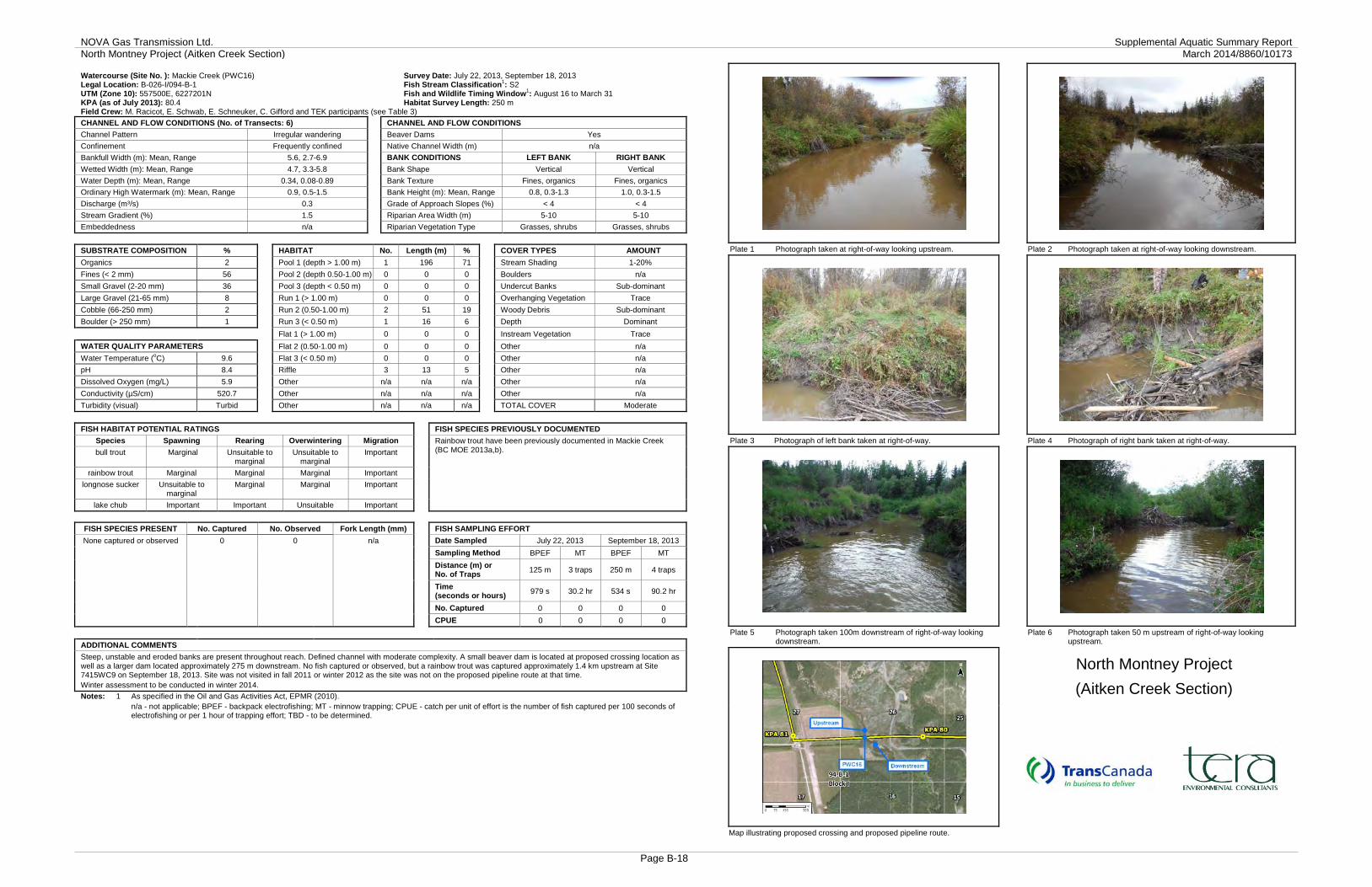
NOVA Gas Transmission Ltd. Supplemental Aquatic Summary Report North Montney Project (Aitken Creek Section) March 2014/8860/10173
Page B-18
Watercourse (Site No. ): Mackie Creek (PWC16) Survey Date: July 22, 2013, September 18, 2013 Legal Location: B-026-I/094-B-1 Fish Stream Classification1: S2 UTM (Zone 10): 557500E, 6227201N Fish and Wildlife Timing Window1: August 16 to March 31 KPA (as of July 2013): 80.4 Habitat Survey Length: 250 m Field Crew: M. Racicot, E. Schwab, E. Schneuker, C. Gifford and TEK participants (see Table 3) CHANNEL AND FLOW CONDITIONS (No. of Transects: 6) CHANNEL AND FLOW CONDITIONS Channel Pattern Irregular wandering Beaver Dams Yes Confinement Frequently confined Native Channel Width (m) n/a Bankfull Width (m): Mean, Range 5.6, 2.7-6.9 BANK CONDITIONS LEFT BANK RIGHT BANK Wetted Width (m): Mean, Range 4.7, 3.3-5.8 Bank Shape Vertical Vertical Water Depth (m): Mean, Range 0.34, 0.08-0.89 Bank Texture Fines, organics Fines, organics Ordinary High Watermark (m): Mean, Range 0.9, 0.5-1.5 Bank Height (m): Mean, Range 0.8, 0.3-1.3 1.0, 0.3-1.5 Discharge (m³/s) 0.3 Grade of Approach Slopes (%) < 4 < 4 Stream Gradient (%) 1.5 Riparian Area Width (m) 5-10 5-10 Embeddedness n/a Riparian Vegetation Type Grasses, shrubs Grasses, shrubs SUBSTRATE COMPOSITION % HABITAT No. Length (m) % COVER TYPES AMOUNT Organics 2 Pool 1 (depth > 1.00 m) 1 196 71 Stream Shading 1-20% Fines (< 2 mm) 56 Pool 2 (depth 0.50-1.00 m) 0 0 0 Boulders n/a Small Gravel (2-20 mm) 36 Pool 3 (depth < 0.50 m) 0 0 0 Undercut Banks Sub-dominant Large Gravel (21-65 mm) 8 Run 1 (> 1.00 m) 0 0 0 Overhanging Vegetation Trace Cobble (66-250 mm) 2 Run 2 (0.50-1.00 m) 2 51 19 Woody Debris Sub-dominant Boulder (> 250 mm) 1 Run 3 (< 0.50 m) 1 16 6 Depth Dominant Flat 1 (> 1.00 m) 0 0 0 Instream Vegetation Trace WATER QUALITY PARAMETERS Flat 2 (0.50-1.00 m) 0 0 0 Other n/a Water Temperature (oC) 9.6 Flat 3 (< 0.50 m) 0 0 0 Other n/a pH 8.4 Riffle 3 13 5 Other n/a Dissolved Oxygen (mg/L) 5.9 Other n/a n/a n/a Other n/a Conductivity (µS/cm) 520.7 Other n/a n/a n/a Other n/a Turbidity (visual) Turbid Other n/a n/a n/a TOTAL COVER Moderate FISH HABITAT POTENTIAL RATINGS FISH SPECIES PREVIOUSLY DOCUMENTED
Species Spawning Rearing Overwintering Migration Rainbow trout have been previously documented in Mackie Creek (BC MOE 2013a,b). bull trout Marginal Unsuitable to
marginal Unsuitable to
marginal Important
rainbow trout Marginal Marginal Marginal Important longnose sucker Unsuitable to
marginal Marginal Marginal Important
lake chub Important Important Unsuitable Important FISH SPECIES PRESENT No. Captured No. Observed Fork Length (mm) FISH SAMPLING EFFORT None captured or observed 0 0 n/a Date Sampled July 22, 2013 September 18, 2013
Sampling Method BPEF MT BPEF MT Distance (m) or
No. of Traps 125 m 3 traps 250 m 4 traps
Time (seconds or hours) 979 s 30.2 hr 534 s 90.2 hr
No. Captured 0 0 0 0 CPUE 0 0 0 0
ADDITIONAL COMMENTS Steep, unstable and eroded banks are present throughout reach. Defined channel with moderate complexity. A small beaver dam is located at proposed crossing location as well as a larger dam located approximately 275 m downstream. No fish captured or observed, but a rainbow trout was captured approximately 1.4 km upstream at Site 7415WC9 on September 18, 2013. Site was not visited in fall 2011 or winter 2012 as the site was not on the proposed pipeline route at that time. Winter assessment to be conducted in winter 2014. Notes: 1 As specified in the Oil and Gas Activities Act, EPMR (2010). n/a - not applicable; BPEF - backpack electrofishing; MT - minnow trapping; CPUE - catch per unit of effort is the number of fish captured per 100 seconds of
electrofishing or per 1 hour of trapping effort; TBD - to be determined.
Plate 1 Photograph taken at right-of-way looking upstream. Plate 2 Photograph taken at right-of-way looking downstream.
Plate 3 Photograph of left bank taken at right-of-way. Plate 4 Photograph of right bank taken at right-of-way.
Plate 5 Photograph taken 100m downstream of right-of-way looking downstream.
Plate 6 Photograph taken 50 m upstream of right-of-way looking upstream.
North Montney Project (Aitken Creek Section)
Map illustrating proposed crossing and proposed pipeline route.

NOVA Gas Transmission Ltd. Supplemental Aquatic Summary Report North Montney Project (Aitken Creek Section) March 2014/8860/10173
Page B-19
Watercourse (Site No. ): Mackie Creek (7415 WC9) Survey Date: July 5, 2011, September 18, 2013 Legal Location: B-037-I/094-B-01 Fish Stream Classification1: S2 UTM (Zone 10): 556789E, 6227951N Fish and Wildlife Timing Window1: August 16 to March 31 KPA (as of July 2013): 81.8 Habitat Survey Length: 419 m Field Crew: J. Denroche, J. MacNeil, E. Schneuker, C. Gifford and TEK participants (see Table 3) CHANNEL AND FLOW CONDITIONS (No. of Transects: 7) CHANNEL AND FLOW CONDITIONS CONTINUED Channel Pattern Irregular Beaver Dams Yes Confinement Frequently confined Native Channel Width (m) n/a Bankfull Width (m): Mean, Range 5.1, 4.1-6.1 BANK CONDITIONS LEFT BANK RIGHT BANK Wetted Width (m): Mean, Range 4.2, 2.4-5.8 Bank Shape Vertical Vertical Water Depth (m): Mean, Range 0.36, 0.25-0.50 Bank Texture Fines, organics Fines, organics Ordinary High Watermark (m): Mean, Range 1.5, 1.1-2.6 Bank Height (m): Mean, Range 2.0, 1.7-2.8 2.1, 1.7-3.0 Discharge (m³/s) < 0.1 Grade of Approach Slopes (%) < 4 < 4 Stream Gradient (%) 1.0-2.0 Riparian Area Width (m) 10-20 5-10 Embeddedness High Riparian Vegetation Type Shrubs, grasses Shrubs, grasses SUBSTRATE % HABITAT No. Length (m) % COVER TYPES AMOUNT Organics 0 Pool 1 (depth > 1.00 m) 5 13 9 Stream Shading 0% Fines (< 2 mm) 76 Pool 2 (depth 0.50-1.00 m) 8 70 17 Boulders Trace Small Gravel (2-20 mm) 0 Pool 3 (depth < 0.50 m) 0 0 0 Undercut Banks None Large Gravel (21-65 mm) 16 Run 1 (> 1.00 m) 3 46 11 Overhanging Vegetation Trace Cobble (66-250 mm) 7 Run 2 (0.50-1.00 m) 10 222 53 Woody Debris Subdominant Boulder (> 250 mm) 1 Run 3 (< 0.50 m) 2 22 2 Depth Dominant Flat 1 (> 1.00 m) 0 0 0 Instream Vegetation None WATER QUALITY PARAMETERS Flat 2 (0.50-1.00 m) 0 0 0 Other None Water Temperature (oC) 9.7 Flat 3 (< 0.50 m) 0 0 0 Other None pH 8.1 Riffle 7 46 11 Other None Dissolved Oxygen (mg/L) 3.4 Other 0 0 0 Other None Conductivity (µS/cm) 593.4 Other 0 0 0 Other None Turbidity (visual) Turbid Other 0 0 0 TOTAL COVER Trace FISH HABITAT POTENTIAL RATINGS FISH SPECIES PREVIOUSLY DOCUMENTED
Species Spawning Rearing Overwintering Migration Rainbow trout have been previously documented in Mackie Creek (BC MOE 2013a,b). rainbow trout Marginal Marginal Unsuitable Marginal
bull trout Unsuitable Unsuitable Unsuitable Marginal
lake chub Unsuitable Marginal Marginal Marginal
longnose sucker Marginal Marginal Unsuitable Marginal
FISH SPECIES PRESENT No. Captured No. Observed Fork Length (mm) FISH SAMPLING EFFORT
rainbow trout 1 0 300 Date Sampled July 5, 2011 September 18, 2013
Sampling Method BPEF MT BPEF
Distance (m) or No. of Traps
100 m 6 traps 200 m
Time (seconds or hours)
277 s 129 hrs 351 s
No. Captured 0 0 1
CPUE 0 0 0.3
ADDITIONAL COMMENTS Unstable and eroded banks are present throughout reach and adjacent existing right-of-ways located at approximately 40 m and 180 m downstream of the proposed right-of-way. Large impoundment and beaver dam located approximately 30 m upstream of the proposed right-of-way (Plate 5). Water is overflowing the dam and bypassing the existing channel flowing through the riparian area. A small erosion channel facilitating run off from the existing right-of-way enters Mackie Creek within the proposed right-of-way on the left bank (approximately 0.3 m in width). Site was realigned approximately 40 m upstream following the 2011 aquatic habitat investigation. Watercourse is identified as being associated with a shrubby swamp, see Wetlands Evaluation (TERA 2014b) for additional information. Winter habitat investigations will be conducted in winter 2014. Notes: 1 As specified in the Oil and Gas Activities Act, EPMR (2010). BPEF - backpack electrofishing; MT - minnow trapping; CPUE - catch per unit of effort is the number of fish captured per 100 seconds of electrofishing or per 1 hour
of trapping effort; TBD - to be determined.
Plate 1 Photograph taken at right-of-way looking upstream. Plate 2 Photograph taken at right-of-way looking downstream.
Plate 3 Photograph of left bank taken at right-of-way. Plate 4 Photograph of right bank taken at right-of-way.
Plate 5 Photograph taken approximately 30 m upstream of right-of-way looking upstream at large beaver dam and impoundment.
Plate 6 Photograph of a rainbow trout caught while electrofishing.
North Montney Project (Aitken Creek Section)
Map illustrating proposed crossing and proposed pipeline route.

NOVA Gas Transmission Ltd. Supplemental Aquatic Summary Report North Montney Project (Aitken Creek Section) March 2014/8860/10173
Page B-20
Watercourse (Site No. ): Unnamed tributary to Mackie Creek (7415 WC33) Survey Date: July 6, 2011, August 18 and September 18, 2013 Legal Location: B-057-I/094-B-01 Fish Stream Classification1: S6 UTM (Zone 10): 556586E, 6230013N Fish and Wildlife Timing Window1: None KPA (as of July 2013): 83.9 Habitat Survey Length: 200 m Field Crew: J. Denroche, J. MacNeil, M. Racicot, E. Schwab, E. Schneuker, C. Gifford TEK participants (see Table 3) CHANNEL AND FLOW CONDITIONS (No. of Transects: 6) CHANNEL AND FLOW CONDITIONS CONTINUED Channel Pattern Sinuous Beaver Dams None Confinement Occasionally confined Native Channel Width (m) n/a Bankfull Width (m): Mean, Range 0.5, 0.3-0.8 BANK CONDITIONS LEFT BANK RIGHT BANK Wetted Width (m): Mean, Range 0.1, dry-0.2 Bank Shape Sloping Sloping Water Depth (m): Mean, Range 0.01, dry-0.02 Bank Texture Fines, organics Fines, organics Ordinary High Watermark (m): Mean, Range 0.2 Bank Height (m): Mean, Range 0.5, 0.2-0.6 0.5, 0.2-0.6 Discharge (m³/s) Negligible Grade of Approach Slopes (%) 4-14 < 4 Stream Gradient (%) 5-10 Riparian Area Width (m) 5-10 5-10 Embeddedness Low Riparian Vegetation Type Mixed wood trees Mixed wood trees SUBSTRATE % HABITAT No. Length (m) % COVER TYPES AMOUNT Organics 0 Pool 1 (depth > 1.00 m) 0 0 0 Stream Shading 71-90% Fines (< 2 mm) 45 Pool 2 (depth 0.50-1.00 m) 0 0 0 Boulders None Small Gravel (2-20 mm) 30 Pool 3 (depth < 0.50 m) 0 0 0 Undercut Banks None Large Gravel (21-65 mm) 25 Run 1 (> 1.00 m) 0 0 0 Overhanging Vegetation Dominant Cobble (66-250 mm) 0 Run 2 (0.50-1.00 m) 0 0 0 Woody Debris Trace Boulder (> 250 mm) 0 Run 3 (< 0.50 m) 3 70 70 Depth None Flat 1 (> 1.00 m) 0 0 0 Instream Vegetation None WATER QUALITY PARAMETERS Flat 2 (0.50-1.00 m) 0 0 0 Other None Water Temperature (oC) 6.1 Flat 3 (< 0.50 m) 0 0 0 Other None pH 8.5 Riffle 0 0 0 Other None Dissolved Oxygen (mg/L) 9.7 Cascade 1 20 20 Other None Conductivity (µS/cm) 529 No Defined Channel 2 10 10 Other None Turbidity (visual) Clear Other 0 0 0 TOTAL COVER Trace FISH HABITAT POTENTIAL RATINGS FISH SPECIES PREVIOUSLY DOCUMENTED
Species Spawning Rearing Overwintering Migration No fish previously documented in the unnamed tributary to Mackie Creek. Proposed crossing is located approximately 1 km upstream from Mackie Creek. Rainbow trout have been previously documented in Mackie Creek (BC MOE 2013a,b).
rainbow trout Unsuitable Marginal Unsuitable Unsuitable to marginal
bull trout Unsuitable Unsuitable Unsuitable Unsuitable to marginal
mountain whitefish
Unsuitable Marginal Unsuitable Unsuitable to marginal
longnose sucker
Unsuitable Marginal Unsuitable Unsuitable to marginal
FISH SPECIES PRESENT No. Captured No. Observed Fork Length (mm) FISH SAMPLING EFFORT
None captured or observed 0 0 n/a Date Sampled July 6, 2011 September 18, 2013
Sampling Method BPEF MT BPEF MT
Distance (m) or No. of Traps
100 m 4 traps 180 m 3 traps
Time (seconds or hours)
512 s 86 hr 167 s 57.8 hr
No. Captured 0 0 0 0
CPUE 0 0 0 0
ADDITIONAL COMMENTS Small watercourse with poor fish habitat and sections of steep gradient (i.e., 5–10%). Channel is marginally defined in sections upstream and downstream of the right-of-way. Confluence with unnamed tributary to Mackie Creek (7415 WC11) is approximately 60 m downstream of right-of-way (Plate 5). Fish sampling data was used from 7415WC11 due to shallow water depths present at 7415WC33 and the close proximity and similar habitat features present in both watercourses. Winter habitat investigations are not necessary due to near dry conditions in fall 2013. Notes: 1 As specified in the Oil and Gas Activities Act, EPMR (2010). n/a - not applicable; BPEF - backpack electrofishing; MT - minnow trapping; CPUE - catch per unit of effort is the number of fish captured per 100 seconds of
electrofishing or per 1 hour of trapping effort; TBD - to be determined.
Plate 1 Photograph taken at right-of-way looking upstream. Plate 2 Photograph taken at right-of-way looking downstream.
Plate 3 Photograph of left bank taken at right-of-way. Plate 4 Photograph of right bank taken at right-of-way.
Plate 5 Photograph taken approximately 60 m downstream at right-of-way looking downstream at confluence with 7415 WC11.
Plate 6 Photograph taken approximately 85 m upstream of right-of-way looking downstream at the creek running through an existing right-of-way.
North Montney Project (Aitken Creek Section)
Map illustrating proposed crossing and proposed pipeline route.

NOVA Gas Transmission Ltd. Supplemental Aquatic Summary Report North Montney Project (Aitken Creek Section) March 2014/8860/10173
Page B-21
Watercourse (Site No. ): Unnamed tributary to Mackie Creek (7415 WC11) Survey Date: July 6, 2011, September 18, 2013 Legal Location: B-057-I/094-B-01 Fish Stream Classification1: S5 UTM (Zone 10): 556583E, 6230067N Fish and Wildlife Timing Window1: None KPA (as of July 2013): 83.9 Habitat Survey Length: 350 m Field Crew: J. Denroche, J. MacNeil, E. Schneuker, C. Gifford and TEK participants (see Table 3) CHANNEL AND FLOW CONDITIONS (No. of Transects: 7) CHANNEL AND FLOW CONDITIONS CONTINUED Channel Pattern Sinuous Beaver Dams None Confinement Occasionally confined Native Channel Width (m) n/a Bankfull Width (m): Mean, Range 3.5, 2.1-4.9 BANK CONDITIONS LEFT BANK RIGHT BANK Wetted Width (m): Mean, Range 1.1, 0.7-1.6 Bank Shape Sloping Vertical Water Depth (m): Mean, Range 0.09, 0.03-0.25 Bank Texture Fines, organics Fines, organics Ordinary High Watermark (m): Mean, Range 0.5, 0.2-1.1 Bank Height (m): Mean, Range 1.0, 0.4-1.9 1.0, 0.5-1.7 Discharge (m³/s) < 0.1 Grade of Approach Slopes (%) 4-14 < 4 Stream Gradient (%) 1.0-2.0 Riparian Area Width (m) 20-30 10-20 Embeddedness Moderate Riparian Vegetation Type Grasses, shrubs Grasses, shrubs SUBSTRATE % HABITAT No. Length (m) % COVER TYPES AMOUNT Organics 23 Pool 1 (depth > 1.00 m) 0 0 0 Stream Shading 41-70% Fines (< 2 mm) 38 Pool 2 (depth 0.5-1.00 m) 0 0 0 Boulders None Small Gravel (2-20 mm) 31 Pool 3 (depth < 0.5 m) 6 14 5 Undercut Banks Dominant Large Gravel (21-65 mm) 8 Run 1 (> 1.00 m) 0 0 0 Overhanging Vegetation Trace Cobble (66-250 mm) 0 Run 2 (0.5-1.00 m) 0 0 0 Woody Debris Subdominant Boulder (> 250 mm) 0 Run 3 (< 0.5 m) 14 187 66 Depth None Flat 1 (> 1.00 m) 0 0 0 Instream Vegetation None WATER QUALITY PARAMETERS Flat 2 (0.5-1.00 m) 0 0 0 Other None Water Temperature (oC) 6.1 Flat 3 (< 0.5 m) 0 0 0 Other None pH 8.6 Riffle 18 82 29 Other None Dissolved Oxygen (mg/L) 8.3 Other 0 0 0 Other None Conductivity (µS/cm) 530.0 Other 0 0 0 Other None Turbidity (visual) Clear Other 0 0 0 TOTAL COVER Moderate FISH HABITAT POTENTIAL RATINGS FISH SPECIES PREVIOUSLY DOCUMENTED
Species Spawning Rearing Overwintering Migration No fish previously documented in the unnamed tributary. Proposed crossing is located approximately 1 km upstream from Mackie Creek. Rainbow trout have been previously documented in Mackie Creek (BC MOE 2013a,b).
rainbow trout Marginal Marginal Unsuitable Marginal
bull trout Unsuitable Unsuitable Unsuitable Marginal
lake chub Marginal Marginal Unsuitable Marginal
longnose sucker Marginal Marginal Unsuitable Marginal
FISH SPECIES PRESENT No. Captured No. Observed Fork Length (mm) FISH SAMPLING EFFORT
none captured or observed 0 0 n/a Date Sampled July 6, 2011 September 18, 2013 Sampling Method BPEF MT BPEF MT
Distance (m) or No. of Traps
100 m 4 traps 180 m 3 traps
Time (seconds or hours)
512 s 86 hr 167 s 57.8 hr
No. Captured 0 0 0 0
CPUE 0 0 0 0
ADDITIONAL COMMENTS Numerous debris piles were observed downstream of the proposed right-of-way. A series of step-pool riffles were located approximately 90 m upstream. The confluence with unnamed tributary to Mackie Creek (Site 7415 WC33) is located approximately 60 m downstream. Site characteristics were verified during the fall 2013 aquatic habitat investigation. Winter habitat investigations will be conducted in winter 2014. Notes: 1 As specified in the Oil and Gas Activities Act, EPMR (2010). n/a - not applicable; BPEF - backpack electrofishing; MT - minnow trapping; CPUE - catch per unit of effort is the number of fish captured per 100 seconds of
electrofishing or per 1 hour of trapping effort; TBD - to be determined.
Plate 1 Photograph taken at right-of-way looking upstream. Plate 2 Photograph taken at right-of-way looking downstream.
Plate 3 Photograph of left bank taken at right-of-way. Plate 4 Photograph of right bank taken at right-of-way.
Plate 5 Photograph taken within reach. Map illustrating proposed crossing and proposed pipeline route.
North Montney Project (Aitken Creek Section)

NOVA Gas Transmission Ltd. Supplemental Aquatic Summary Report North Montney Project (Aitken Creek Section) March 2014/8860/10173
Page B-22
Watercourse (Site No. ): Farrell Creek (C-E WC22) Survey Date: September 27, 2011, March 1, 2012, September 20, 2013 Legal Location: D-017-A/094-B-08 Fish Stream Classification1: S2 UTM (Zone 10): 557096E, 6235869N Fish and Wildlife Timing Window1: August 16 to August 31 KPA (as of July 2013): 89.9 Habitat Survey Length: 200 m Field Crew: E. Koga, L. Murray, J. Denroche, E. Schneuker, S. Thompson, C. Gifford and TEK participants (see Table 3) CHANNEL AND FLOW CONDITIONS (No. of Transects: 7) CHANNEL AND FLOW CONDITIONS CONTINUED Channel Pattern Irregular wandering Beaver Dams None Confinement Occasionally confined Native Channel Width (m) n/a Bankfull Width (m): Mean, Range 19.1, 15.7-24.8 BANK CONDITIONS LEFT BANK RIGHT BANK Wetted Width (m): Mean, Range 7.1, 4.6-19.0 Bank Shape Vertical Sloping Water Depth (m): Mean, Range 0.19, 0.05-0.56 Bank Texture Boulder, cobble Fines, large gravel Ordinary High Watermark (m): Mean, Range 0.5, 0.3-0.7 Bank Height (m): Mean, Range 2.0, 1.1-4.0 1.7, 1.2-2.2 Discharge (m³/s) < 0.1 Grade of Approach Slopes (%) 4-14 < 4 Stream Gradient (%) 1.0-1.5 Riparian Area Width (m) 5-10 20-30 Embeddedness Unembedded Riparian Vegetation Type Grasses, shrubs Shrubs SUBSTRATE % HABITAT No. Length (m) % COVER TYPES AMOUNT Organics 8 Pool 1 (depth > 1.00 m) 0 0 0 Stream Shading 0% Fines (< 2 mm) 11 Pool 2 (depth 0.50-1.00 m) 1 13 7 Boulders Trace Small Gravel (2-20 mm) 31 Pool 3 (depth < 0.50 m) 2 23 12 Undercut Banks Trace Large Gravel (21-65 mm) 38 Run 1 (> 1.00 m) 0 0 0 Overhanging Vegetation Trace Cobble (66-250 mm) 6 Run 2 (0.50-1.00 m) 0 0 0 Woody Debris Trace Boulder (> 250 mm) 6 Run 3 (< 0.50 m) 4 65 33 Depth None Flat 1 (> 1.00 m) 0 0 0 Instream Vegetation None WATER QUALITY PARAMETERS Flat 2 (0.50-1.00 m) 0 0 0 Other None Water Temperature (oC) 9.2 Flat 3 (< 0.50 m) 4 99 50 Other None pH 8.6 Riffle 0 0 0 Other None Dissolved Oxygen (mg/L) 8.5 Other 0 0 0 Other None Conductivity (µS/cm) 337.0 Other 0 0 0 Other None Turbidity (visual) Clear Other 0 0 0 TOTAL COVER Moderate FISH HABITAT POTENTIAL RATINGS FISH SPECIES PREVIOUSLY DOCUMENTED
Species Spawning Rearing Overwintering Migration Fish species previously documented in Farrell Creek include: Arctic grayling; Kokanee salmon; rainbow trout; mountain whitefish; burbot; northern pike; walleye; flathead chub; lake chub; longnose dace; northern pearl dace; northern pikeminnow; peamouth chub; redside shiner; prickly sculpin; slimy sculpin; trout-perch; longnose sucker; largescale sucker; and white sucker (BC MOE 2013a,b).
mountain whitefish
Marginal Marginal Marginal to Important
Important
Arctic grayling Marginal Marginal Marginal to Important
Important
longnose sucker
Important Important Marginal to Important
Important
lake chub Important Important Marginal to Important
Important
FISH SPECIES PRESENT No. Captured No. Observed Fork Length (mm) FISH SAMPLING EFFORT
rainbow trout 7 0 129, 48-220 Date Sampled September 27, 2011 September 20, 2013 trout-perch 6 0 62, 52-83 Sampling Method
No sampling- see additional comments
BPEF redside shiner 34 0 48, 23-97 Distance (m) 220 m
longnose sucker 13 0 71, 41-105 Time (seconds) 837 s slimy sculpin 6 0 62, 44-82 No. Captured 74
lake chub 4 0 67, 39-83 CPUE 8.8
longnose dace 3 0 25, 41, 46 ADDITIONAL COMMENTS Left bank is composed of anthropogenic substrates including cobble and boulder rip-rap. Ford crossing present approximately 90 m downstream of proposed right-of-way. Vertical bedrock cliff present at left bank approximately 80 m upstream of proposed right-of-way (Plate 5). Backwater area adjacent to bedrock cliff on left bank approximately 80 m upstream. Ice and water were present at the time of the winter 2012 aquatic habitat investigations. The wintering habitat potential rating provided was collected during the winter 2012 aquatic habitat investigations. Notes: 1 As specified in the Oil and Gas Activities Act, EPMR (2010). n/a - not applicable; BPEF - backpack electrofishing; CPUE - catch per unit of effort is the number of fish captured per 100 seconds of electrofishing; TBD - to be
determined.
Plate 1 Photograph taken at right-of-way looking upstream. Plate 2 Photograph taken at right-of-way looking downstream.
Plate 3 Photograph of left bank taken at right-of-way. Plate 4 Photograph of right bank taken at right-of-way.
Plate 5 Photograph taken approximately 20 m upstream of right-of-way looking upstream.
Plate 6 Photograph taken approximately 80 m downstream of the right-of-way looking downstream at a ford.
North Montney Project (Aitken Creek Section)
Map illustrating proposed crossing and proposed pipeline route.

NOVA Gas Transmission Ltd. Supplemental Aquatic Summary Report North Montney Project (Aitken Creek Section) March 2014/8860/10173
Page B-23
Watercourse (Site No. ): Farrell Creek (C-E WC22) Legal Location: D-017-A/094-B-08 Winter Survey Date: March 1, 2012 Habitat Survey Length (No. Transects): 115 m (4) UTM (Zone 10): 557102E, 6235862N Field Crew: J. Denroche, E. Schneuker, S. Thompson and TEK participants (see Table 3)
WINTER WATER QUALITY PARAMETERS WINTER CHANNEL AND FLOW CONDITIONS
Water Temperature (oC) 0.0 Wetted/Ice Width (m): Mean, Range 18.0, 11.9-24.0
pH 7.3 Ice Depth (m): Mean, Range 0.51, 0.18-0.95
Dissolved Oxygen (mg/L) 4.8 Water Depth (m): Mean, Range 0.15, 0.02-0.50
Conductivity (µS/cm) 488.0 Discharge (m³/s) <0.1
Turbidity (visual) Stained Visible Open Water (yes/no) No
FISH SPECIES PRESENT No. Observed Springs Present (yes/no) No
n/a n/a WINTER FISH HABITAT POTENTIAL
Habitat potential for overwintering fish Marginal to Important
Habitat potential for winter spawning species Marginal
Plate 1 Photograph taken at right-of-way looking upstream. Plate 2 Photograph taken at right-of-way looking downstream.
Plate 3 Photograph taken at right-of-way of right bank. Plate 4 Photograph taken at right-of-way of left bank.
Notes: n/a – not applicable.
ADDITIONAL HABITAT COMMENTS:
Overwintering pool approximately 80 m upstream. Abundant brown algae surfaced when auguring holes at transects. Good pool/riffle/run habitat throughout. Existing right-of-way is adjacent to proposed right-of-way. Open water sampling occurred on September 27, 2011 and September 20, 2013. See open water Site Record for additional channel morphology measurements.
North Montney Project (Aitken Creek Section)

NOVA Gas Transmission Ltd. Supplemental Aquatic Summary Report North Montney Project (Aitken Creek Section) March 2014/8860/10173
Page B-24
Watercourse (Site No. ): Unnamed tributary to Farrell Creek (C-E WC23) Survey Date: July 11, 2011, October 8, 2013 Legal Location: A-068-A/094-B-08 Fish Stream Classification1: S6 UTM (Zone 10): 556083E, 6240038N Fish and Wildlife Timing Window1: None KPA (as of July 2013): 94.2 Habitat Survey Length: 200 m Field Crew: G. Todd, E. Fulcher, B. Edwards, C. Gifford and TEK participants (see Table 3) CHANNEL AND FLOW CONDITIONS (No. of Transects: 7) CHANNEL AND FLOW CONDITIONS CONTINUED Channel Pattern Meandering Beaver Dams Yes Confinement Unconfined Native Channel Width (m) 0.5 Bankfull Width (m): Mean, Range 1.7, 1.0-2.2 BANK CONDITIONS LEFT BANK RIGHT BANK Wetted Width (m): Mean, Range 4.4, 0.8-12.0 Bank Shape Sloping Sloping Water Depth (m): Mean, Range 0.23, 0.01-0.48 Bank Texture Fines Fines Ordinary High Watermark (m): Mean, Range 0.2, 0.1-0.4 Bank Height (m): Mean, Range 1.6, 1.2-2.0 1.3, 1.0-2.0 Discharge (m³/s) Negligible Grade of Approach Slopes (%) 4-14 4-14 Stream Gradient (%) 1.0 Riparian Area Width (m) 5-10 5-10 Embeddedness n/a Riparian Vegetation Type Shrubs, grasses Shrubs, grasses SUBSTRATE % HABITAT No. Length (m) % COVER TYPES AMOUNT Organics 14 Pool 1 (depth > 1.00 m) 0 0 0 Stream Shading 1-20% Fines (< 2 mm) 82 Pool 2 (depth 0.5-1.00 m) 0 0 0 Boulders None Small Gravel (2-20 mm) 4 Pool 3 (depth < 0.5 m) 1 1 1 Undercut Banks None Large Gravel (21-65 mm) 0 Flat 3 (< 0.5 m) 2 50 43 Overhanging Vegetation Subdominant Cobble (66-250 mm) 0 Riffle 1 10 8 Woody Debris Dominant Boulder (> 250 mm) 0 Impoundment 1 (> 1.00 m) 0 0 0 Depth None
Impoundment 2 (0.5-1.00 m) 1 5 4 Instream Vegetation None WATER QUALITY PARAMETERS Impoundment 3 (< 0.5 m) 1 10 9 Other None Water Temperature (oC) 6.2 Beaver Dam 1 10 8 Other None pH 6.4 No defined channel 1 2 2 Other None Dissolved Oxygen (mg/L) 7.6 Dry channel 2 22 18 Other None Conductivity (µS/cm) 230.4 Existing right-of-way 1 10 8 Other None Turbidity (visual) Turbid Other 0 0 0 TOTAL COVER Moderate FISH HABITAT POTENTIAL RATINGS FISH SPECIES PREVIOUSLY DOCUMENTED
Species Spawning Rearing Overwintering Migration No fish species previously documented in the unnamed tributary. Proposed crossing is approximately 6.5 km upstream from Farrell Creek. Fish species previously documented in Farrell Creek include: Arctic grayling; kokanee salmon; rainbow trout; mountain whitefish; burbot; northern pike; walleye; flathead chub; lake chub; longnose dace; northern pikeminnow; peamouth chub; redside shiner; prickly sculpin; slimy sculpin; trout-perch; longnose sucker; largescale sucker; and white sucker (BC MOE 2013a,b).
mountain whitefish
Unsuitable Unsuitable Unsuitable Unsuitable
Arctic grayling Unsuitable Unsuitable Unsuitable Unsuitable
longnose sucker Unsuitable Marginal Unsuitable Unsuitable
lake chub Unsuitable Marginal Unsuitable Unsuitable
FISH SPECIES PRESENT No. Captured No. Observed Fork Length (mm) FISH SAMPLING EFFORT
None captured or observed
0 0 n/a Date Sampled July 11, 2011 October 8, 2013
Sampling Method BPEF MT BPEF MT
Distance (m) or No. of Traps
100 m 6 traps 100 m 6 traps
Time (seconds or hours)
475 s 123 hr 202 s 101.2 hr
No. Captured 0 0 0 0
CPUE 0 0 0 0
ADDITIONAL COMMENTS Large impoundment located at the proposed right-of-way. Limited connectivity throughout reach, predominantly dry channel with occasional residual pools. Fines are the dominant substrate and woody debris piles are present throughout the reach. Site was realigned approximately 80 m downstream following the 2011 aquatic habitat investigation. Site characteristics were verified during the fall 2013 aquatic habitat investigation. Notes: 1 As specified in the Oil and Gas Activities Act, EPMR (2010). n/a - not applicable; BPEF - backpack electrofishing; MT - minnow trapping; CPUE - catch per unit of effort is the number of fish captured per 100 seconds of
electrofishing or per 1 hour of trapping effort; TBD - to be determined.
Plate 1 Photograph taken at right-of-way looking upstream. Plate 2 Photograph taken at right-of-way looking downstream.
Plate 3 Photograph of left bank taken at right-of-way. Plate 4 Photograph of right bank taken at right-of-way.
Plate 5 Photograph taken approximately 100 m downstream of the right-of-way looking upstream.
Plate 6 Photograph taken approximately 15 m downstream of right-of-way looking downstream at an existing right-of-way.
North Montney Project (Aitken Creek Section)
Map illustrating proposed crossing and proposed pipeline route.

NOVA Gas Transmission Ltd. Supplemental Aquatic Summary Report North Montney Project (Aitken Creek Section) March 2014/8860/10173
Page B-25
Watercourse (Site No. ): Unnamed tributary to Farrell Creek (7415 WC27) Survey Date: July 10, 2011, October 7, 2013 Legal Location: C-078-A/094-B-08 Fish Stream Classification1: S6 UTM (Zone 10): 555927E, 6241389N Fish and Wildlife Timing Window1: None KPA (as of July 2013): 95.6 Habitat Survey Length: 200 m Field Crew: G. Todd, E. Fulcher, M. Henry, L. Snook and TEK participants (see Table 3) CHANNEL AND FLOW CONDITIONS (No. of Transects: 6) CHANNEL AND FLOW CONDITIONS CONTINUED Channel Pattern Sinuous Beaver Dams None Confinement Confined Native Channel Width (m) n/a Bankfull Width (m): Mean, Range 1.5, 0.7-2.6 BANK CONDITIONS LEFT BANK RIGHT BANK Wetted Width (m): Mean, Range 0.9, 0.5-1.6 Bank Shape Vertical Sloping Water Depth (m): Mean, Range 0.08, 0.04-0.12 Bank Texture Fines Fines Ordinary High Watermark (m): Mean, Range 0.1, 0.0-0.1 Bank Height (m): Mean, Range 0.5, 0.3-0.7 0.4, 0.2-0.6 Discharge (m³/s) < 0.1 Grade of Approach Slopes (%) > 14 > 14 Stream Gradient (%) 2.0 Riparian Area Width (m) < 5 5-10 Embeddedness Low Riparian Vegetation Type Mixed wood trees Mixed wood trees SUBSTRATE % HABITAT No. Length (m) % COVER TYPES AMOUNT Organics 0 Pool 1 (depth > 1.00 m) 0 0 0 Stream Shading 71-90% Fines (< 2 mm) 22 Pool 2 (depth 0.50-1.00 m) 0 0 0 Boulders Trace Small Gravel (2-20 mm) 35 Pool 3 (depth < 0.50 m) 11 22 11 Undercut Banks Trace Large Gravel (21-65 mm) 33 Run 1 (> 1.00 m) 0 0 0 Overhanging Vegetation Dominant Cobble (66-250 mm) 7 Run 2 (0.50-1.00 m) 0 0 0 Woody Debris Subdominant Boulder (> 250 mm) 3 Run 3 (< 0.50 m) 7 28 14 Depth None Flat 1 (> 1.00 m) 0 0 0 Instream Vegetation None WATER QUALITY PARAMETERS Flat 2 (0.50-1.00 m) 0 0 0 Stain/Turbulence Trace Water Temperature (oC) 7.2 Flat 3 (< 0.50 m) 1 10 5 Subsurface Trace pH 6.0 Riffle 16 121 62 Other None Dissolved Oxygen (mg/L) 2.3 Subterranean 2 13 7 Other None Conductivity (µS/cm) 160.2 Other 0 0 0 Other None Turbidity (visual) Stained Other 0 0 0 TOTAL COVER Abundant FISH HABITAT POTENTIAL RATINGS FISH SPECIES PREVIOUSLY DOCUMENTED
Species Spawning Rearing Overwintering Migration No fish species previously documented in the unnamed tributary. Proposed crossing is approximately 8.5 km upstream from Farrell Creek. Fish species previously documented in Farrell Creek include: Arctic grayling; Kokanee salmon; rainbow trout; mountain whitefish; burbot; northern pike; walleye; flathead chub; lake chub; longnose dace; northern pikeminnow; peamouth chub; redside shiner; prickly sculpin; slimy sculpin; trout-perch; longnose sucker; largescale sucker; and white sucker (BC MOE 2013a,b).
Arctic grayling Unsuitable Marginal Unsuitable Marginal
longnose sucker Unsuitable Marginal Unsuitable Marginal
lake chub Unsuitable Marginal Unsuitable Marginal
mountain whitefish
Marginal Marginal Unsuitable Marginal
FISH SPECIES PRESENT No. Captured No. Observed Fork Length (mm) FISH SAMPLING EFFORT
None captured or observed
0 0 n/a Date Sampled July 10, 2011 October 7, 2013
Sampling Method BPEF
No sampling – see additional comments
Distance (m) n/r Time (hours) 470 s No. Captured 0 CPUE 0
ADDITIONAL COMMENTS Well defined watercourse with isolated pockets of water throughout reach that lack connectivity. Water depths precluded the use of fish sampling techniques other than electrofishing in 2011. Fish sampling was not conducted at the time of the 2013 assessment since shallow water depth precluded the use of sampling techniques. Winter 2012 habitat investigations were not conducted based on low fish and fish habitat values and poor winter habitat potential. Site was realigned approximately 20 m downstream following the 2011 aquatic habitat investigation. Site characteristics were verified during the fall 2013 aquatic habitat investigation. Notes: 1 As specified in the Oil and Gas Activities Act, EPMR (2010). n/a - not applicable; BPEF - backpack electrofishing; CPUE - catch per unit of effort is the number of fish captured per 100 seconds of electrofishing; TBD - to be determined
Plate 1 Photograph taken at right-of-way looking upstream. Plate 2 Photograph taken at right-of-way looking downstream.
Plate 3 Photograph of left bank taken at right-of-way. Plate 4 Photograph of right bank taken at right-of-way.
Plate 5 Photograph taken approximately 300 m downstream of the right-of-way looking downstream.
Plate 6 Photograph taken approximately 150 m upstream of the right-of-way looking downstream.
North Montney Project (Aitken Creek Section)
Map illustrating proposed crossing and proposed pipeline route.

NOVA Gas Transmission Ltd. Supplemental Aquatic Summary Report North Montney Project (Aitken Creek Section) March 2014/8860/10173
Page B-26
Watercourse (Site No. ): Unnamed tributary to Ground Birch Creek (C-E WC24) Survey Date: July 10, 2011, October 7, 2013 Legal Location: B-098-A/094-B-08 Fish Stream Classification1: S6 UTM (Zone 10): 555905E, 6243009N Fish and Wildlife Timing Window1: None KPA (as of July 2013): 97.1 Habitat Survey Length: 400 m Field Crew: J. Denroche, J. MacNeil, M. Henry, L. Snook and TEK participants (see Table 3) CHANNEL AND FLOW CONDITIONS (No. of Transects: 6) CHANNEL AND FLOW CONDITIONS CONTINUED Channel Pattern Irregular meandering Beaver Dams None Confinement Occasionally confined Native Channel Width (m) n/a Bankfull Width (m): Mean, Range 2.6, 1.6-3.6 BANK CONDITIONS LEFT BANK RIGHT BANK Wetted Width (m): Mean, Range 2.6, 0.6-2.8 Bank Shape Vertical Sloping Water Depth (m): Mean, Range 0.26, 0.07-0.62 Bank Texture Fines Fines Ordinary High Watermark (m): Mean, Range 0.5, 0.3-0.8 Bank Height (m): Mean, Range 0.9, 0.6-1.3 0.8, 0.6-0.9 Discharge (m³/s) < 0.1 Grade of Approach Slopes (%) < 4 < 4 Stream Gradient (%) 2.0 Riparian Area Width (m) 20-30 20-30 Embeddedness High Riparian Vegetation Type Shrubs Shrubs SUBSTRATE % HABITAT No. Length (m) % COVER TYPES AMOUNT Organics 0 Pool 1 (depth > 1.00 m) 0 0 0 Stream Shading 71-90% Fines (< 2 mm) 52 Pool 2 (depth 0.50-1.00 m) 0 0 0 Boulders None Small Gravel (2-20 mm) 43 Pool 3 (depth < 0.50 m) 5 18 4 Undercut Banks Trace Large Gravel (21-65 mm) 5 Run 1 (> 1.00 m) 0 0 0 Overhanging Vegetation Subdominant Cobble (66-250 mm) 0 Run 2 (0.50-1.00 m) 0 0 0 Woody Debris Dominant Boulder (> 250 mm) 0 Run 3 (< 0.50 m) 13 375 87 Depth None Flat 1 (> 1.00 m) 0 0 0 Stain/Turbulence Subdominant WATER QUALITY PARAMETERS Flat 2 (0.50-1.00 m) 0 0 0 Instream Vegetation Subdominant Water Temperature (oC) 7.6 Flat 3 (< 0.50 m) 0 0 0 Surface Turbulence None pH 6.3 Riffle 6 40 9 Other None Dissolved Oxygen (mg/L) 6.4 Other 0 0 0 Other None Conductivity (µS/cm) 161.7 Other 0 0 0 Other None Turbidity (visual) Clear Other 0 0 0 TOTAL COVER Moderate FISH HABITAT POTENTIAL RATINGS FISH SPECIES PREVIOUSLY DOCUMENTED
Species Spawning Rearing Overwintering Migration No fish species previously documented in the unnamed tributary. Proposed crossing is approximately 10 km upstream from Ground Birch Creek. The following fish species have been documented in Ground Birch Creek: Arctic grayling; rainbow trout; bull trout; mountain whitefish; lake chub; redside shiner; longnose dace; northern pikeminnow; prickly sculpin; slimy sculpin; white sucker; longnose sucker; and largescale sucker (BC MOE 2013a,b).
bull trout Marginal Unsuitable to marginal
Unsuitable to marginal
Marginal
Arctic grayling Unsuitable to marginal
Marginal Unsuitable Marginal
longnose sucker Unsuitable to marginal
Marginal Unsuitable to marginal
Marginal
lake chub Marginal Marginal Marginal Marginal
FISH SPECIES PRESENT No. Captured No. Observed Fork Length (mm) FISH SAMPLING EFFORT
None captured or observed
0 0 n/a Date Sampled July 10, 2011 October 7, 2013
Sampling Method BPEF MT BPEF MT Distance (m) or
No. of Traps 130 m 6 traps 200 m 3 traps
Time (seconds or hours)
474 s 148.5 hr 398 s 69 hr
No. Captured 0 0 0 0
CPUE 0 0 0 0
ADDITIONAL COMMENTS Small creek with small gravel and fine substrates. Some pool/run/riffle habitat. Low flow is a seasonal barrier to migration as well as downstream deadfall and woody debris piles. Undercut and failing banks observed through downstream reach. Winter 2012 habitat investigations were not conducted based on shallow water depths, low fish and fish habitat values, and poor winter habitat potential. Site was realigned approximately 70 m upstream following the 2011 aquatic habitat investigation. Site characteristics were verified during the fall 2013 aquatic habitat investigation.
Notes: 1 As specified in the Oil and Gas Activities Act, EPMR (2010). n/a - not applicable; BPEF - backpack electrofishing; MT - minnow trapping; CPUE - catch per unit of effort is the number of fish captured per 100 seconds of
electrofishing or per 1 hour of trapping effort; TBD - to be determined.
Plate 1 Photograph taken at right-of-way looking upstream. Plate 2 Photograph taken at right-of-way looking downstream.
Plate 3 Photograph of left bank taken at right-of-way. Plate 4 Photograph of right bank taken at right-of-way.
Plate 5 Photograph taken approximately 150 m downstream of right-of-way looking downstream.
Plate 6 Photograph taken approximately 150 m downstream of right-of-way looking upstream.
North Montney Project (Aitken Creek Section)
Map illustrating proposed crossing and proposed pipeline route.

NOVA Gas Transmission Ltd. Supplemental Aquatic Summary Report North Montney Project (Aitken Creek Section) March 2014/8860/10173
Page B-27
Watercourse (Site No. ): Unnamed tributary to Ground Birch Creek (C-E WC25) Survey Date: July 11, 2011, Sept 24, 2011, March 9, 2012, July 24, 2013, Sept. 12, 2013 Legal Location: A-028-H/094-B-08 Fish Stream Classification1: S5 UTM (Zone 10): 555929E, 6245527N Fish and Wildlife Timing Window1: None KPA (as of July 2013): 99.8 Habitat Survey Length: 200 m Field Crew: J. Denroche, E. Schneuker, S. Thompson, M. Legge, C. Fazakas, M. Racicot, E. Schwab, E. Schneuker, C. Gifford and TEK participants (see Table 3) CHANNEL AND FLOW CONDITIONS (No. of Transects: 7) CHANNEL AND FLOW CONDITIONS Channel Pattern Irregular meandering Beaver Dams None Confinement Frequently confined Native Channel Width (m) n/a Bankfull Width (m): Mean, Range 3.2, 1.9-8.0 BANK CONDITIONS LEFT BANK RIGHT BANK Wetted Width (m): Mean, Range 2.1, 1.7-2.9 Bank Shape Undercut Undercut Water Depth (m): Mean, Range 0.25, 0.06-0.51 Bank Texture Fines Fines Ordinary High Watermark (m): Mean, Range 0.7, 0.6-1.0 Bank Height (m): Mean, Range 1.2, 1.0-1.6 1.2, 1.1-1.4 Discharge (m³/s) < 0.1 Grade of Approach Slopes (%) 4-14 4-14 Stream Gradient (%) 1.3 Riparian Area Width (m) 5-10 5-10 Embeddedness n/a Riparian Vegetation Type Mixed wood trees Mixed wood trees SUBSTRATE COMPOSITION % HABITAT No. Length (m) % COVER TYPES AMOUNT Organics 0 Pool 1 (depth > 1.00 m) 0 0 0 Stream Shading 21-40% Fines (< 2 mm) 69 Pool 2 (depth 0.50-1.00 m) 12 121 23 Boulders Trace Small Gravel (2-20 mm) 29 Pool 3 (depth < 0.50 m) 6 27 5 Undercut Banks Subdominant Large Gravel (21-65 mm) 5 Run 1 (> 1.00 m) 0 0 0 Overhanging Vegetation Trace Cobble (66-250 mm) 0 Run 2 (0.50-1.00 m) 17 249 48 Woody Debris Dominant Boulder (> 250 mm) 0 Run 3 (< 0.50 m) 8 108 21 Depth None Flat 1 (> 1.00 m) 0 0 0 Stain/Turbulence Subdominant
WATER QUALITY PARAMETERS Flat 2 (0.50-1.00 m) 0 0 0 Instream Vegetation Trace Water Temperature (oC) 12.4 Flat 3 (< 0.50 m) 0 0 0 Other None
pH 8.2 Riffle 2 18 3 Other None
Dissolved Oxygen (mg/L) 7.8 Other 0 0 0 Other None
Conductivity (µS/cm) 96.2 Other 0 0 0 Other None
Turbidity (visual) Lightly Turbid Other 0 0 0 TOTAL COVER Abundant FISH HABITAT POTENTIAL RATINGS FISH SPECIES PREVIOUSLY DOCUMENTED
Species Spawning Rearing Overwintering Migration No fish species previously documented in the unnamed tributary. Proposed crossing is approximately 5 km upstream from Ground Birch Creek. The following fish species have been documented in Ground Birch Creek: Arctic grayling; rainbow trout; bull trout; mountain whitefish; lake chub; redside shiner; longnose dace; northern pikeminnow; prickly sculpin; slimy sculpin; white sucker; longnose sucker; and largescale sucker (BC MOE 2013a,b).
bull trout Unsuitable to Marginal
Unsuitable to Marginal
Unsuitable Unsuitable
Arctic grayling Marginal Unsuitable to Marginal
Unsuitable Unsuitable
longnose sucker Unsuitable to Marginal
Marginal Unsuitable Unsuitable
lake chub Important Marginal Unsuitable Unsuitable FISH SPECIES PRESENT No. Captured No. Observed Fork Length (mm) FISH SAMPLING EFFORT
sculpin spp. 0 1 (dead) n/a Date Sampled July 11, 2011 July 24, 2013
September 24, 2011 and
September 12, 2013 Sampling
Method BPEF MT BPEF
No sampling – see additional comments
Distance (m) or No. of Traps
100 m 4 traps 175 m
Time (seconds or hours)
425 s 92 hr 849 s
No. Captured
0 0 0
CPUE 0 0 0 ADDITIONAL COMMENTS Banks are armoured at existing right-of-way located approximately 20 m upstream of the proposed right-of-way. Seasonal flow barriers are likely a limiting factor to fish presence since the site was dry in fall 2011 and 2013. Small tributary enters on left bank approximately 75 m downstream of the proposed right-of-way (Plate 5). Fish sampling could not be conducted in fall 2013 as the site was dry. A dead sculpin species was observed in September 2013. The wintering habitat rating was collected during the winter 2012 habitat investigations. Site was realigned approximately 30 m upstream following the 2011 aquatic habitat investigation. Site characteristics were verified during the fall 2013 aquatic habitat investigation. Notes: 1 As specified in the Oil and Gas Activities Act, EPMR (2010). n/a - not applicable; BPEF - backpack electrofishing; MT - minnow trapping; CPUE - catch per unit of effort is the number of fish captured per 100 seconds of electrofishing or per 1 hour of trapping.
Effort; TBD - to be determined.
Plate 1 Photograph taken at right-of-way looking upstream. Plate 2 Photograph taken at right-of-way looking downstream.
Plate 3 Photograph taken of left bank at right-of-way. Plate 4 Photograph of right bank taken at right-of-way.
Plate 5 Photograph taken approximately 75 m downstream at tributary entering creek on left bank.
Plate 6 Photograph taken in July 2011 at the right-of-way looking downstream.
North Montney Project (Aitken Creek Section)
Map illustrating proposed crossing and proposed pipeline route.

NOVA Gas Transmission Ltd. Supplemental Aquatic Summary Report North Montney Project (Aitken Creek Section) March 2014/8860/10173
Page B-28
Watercourse (Site No. ): Unnamed tributary to Ground Birch Creek (C-E WC25) Legal Location: A-028-H/094-B-08 Winter Survey Date: March 9, 2012 Habitat Survey Length (No. Transects): 100 m (3) UTM (Zone 10): 555914E, 6245570N Field Crew: J. Denroche, E. Schneuker, S. Thompson and TEK participants (see Table 3)
WINTER WATER QUALITY PARAMETERS WINTER CHANNEL AND FLOW CONDITIONS
Water Temperature (oC) Dry Wetted/Ice Width (m): Mean, Range Dry
pH Dry Ice Depth (m): Mean, Range Dry
Dissolved Oxygen (mg/L) Dry Water Depth (m): Mean, Range Dry
Conductivity (µS/cm) Dry Discharge (m³/s) Negligible
Turbidity (visual) Dry Visible Open Water (yes/no) No
FISH SPECIES PRESENT No. Observed Springs Present (yes/no) No
n/a n/a WINTER FISH HABITAT POTENTIAL
Habitat potential for overwintering fish Unsuitable
Habitat potential for winter spawning species Unsuitable
Plate 1 Photograph taken at right-of-way looking upstream. Plate 2 Photograph taken at right-of-way looking downstream.
Plate 3 Photograph taken at right-of-way of right bank. Plate 4 Photograph taken at right-of-way of left bank.
Notes: n/a – not applicable.
ADDITIONAL HABITAT COMMENTS:
Existing right-of-way has banks restored with rip-rap. Steep banks at existing right-of-way. Moderately steep banks at proposed right-of-way. Open water sampling occurred on July 11 and September 24, 2011, and July 24 and September 12, 2013. See open water Site Record for additional channel morphology measurements.
North Montney Project (Aitken Creek Section)

NOVA Gas Transmission Ltd. Supplemental Aquatic Summary Report North Montney Project (Aitken Creek Section) March 2014/8860/10173
Page B-29
Watercourse (Site No. ): Ground Birch Creek (C-E WC27) Survey Date: Sept. 26, 2011, February 29, 2012, July 25, 2013, Sept. 14, 2013 Legal Location: A-069-H/094-B-08 Fish Stream Classification1: S2 UTM (Zone 10): 555263E, 6249366N Fish and Wildlife Timing Window1: Work within critical window is unavoidable KPA (as of July 2013): 103.7 Habitat Survey Length: 200 m Field Crew: M.Legge, C.Fazakas, G. Todd, M. Burtnyk, M. Racicot, E. Schwab, E. Schneuker, N. Pilgrim and TEK participants (see Table 3) CHANNEL AND FLOW CONDITIONS (No. of Transects: 5) CHANNEL AND FLOW CONDITIONS Channel Pattern Meandering Beaver Dams None Confinement Occasionally confined Native Channel Width (m) n/a Bankfull Width (m): Mean, Range 8.9, 6.9-11.3 BANK CONDITIONS LEFT BANK RIGHT BANK Wetted Width (m): Mean, Range 5.3, 2.9-10.1 Bank Shape Vertical Vertical Water Depth (m): Mean, Range 0.39, 0.06-0.64 Bank Texture Fines Fines Ordinary High Watermark (m): Mean, Range 1.0, 0.6-1.3 Bank Height (m): Mean, Range 2.3, 1.9-3.1 2.4, 1.0-3.4 Discharge (m³/s) < 0.1 Grade of Approach Slopes (%) < 4 < 4 Stream Gradient (%) 0.5-1.0 Riparian Area Width (m) 5-10 5-10 Embeddedness High Riparian Vegetation Type Coniferous trees Coniferous trees SUBSTRATE COMPOSITION % HABITAT No. Length (m) % COVER TYPES AMOUNT Organics 0 Pool 1 (depth > 1.00 m) 1 11 6 Stream Shading 0% Fines (< 2 mm) 67 Pool 2 (depth 0.50-1.00 m) 1 30 17 Boulders None Small Gravel (2-20 mm) 55 Pool 3 (depth < 0.50 m) 1 16 9 Undercut Banks None Large Gravel (21-65 mm) 0 Run 1 (> 1.00 m) 0 0 0 Overhanging Vegetation Trace Cobble (66-250 mm) 1 Run 2 (0.50-1.00 m) 0 0 0 Woody Debris Dominant Boulder (> 250 mm) 1 Run 3 (< 0.50 m) 2 22 12 Depth Trace Flat 1 (> 1.00 m) 0 0 0 Stain/Turbulence None WATER QUALITY PARAMETERS Flat 2 (0.50-1.00 m) 1 20 11 Instream Vegetation Trace Water Temperature (oC) 8.9 Flat 3 (< 0.50 m) 3 78 44 Other None pH 8.3 Riffle 0 0 0 Other None Dissolved Oxygen (mg/L) 9.8 Other 0 0 0 Other None Conductivity (µS/cm) 384.0 Other 0 0 0 Other None Turbidity (visual) Stained Other 0 0 0 TOTAL COVER Abundant FISH HABITAT POTENTIAL RATINGS FISH SPECIES PREVIOUSLY DOCUMENTED
Species Spawning Rearing Overwintering Migration Fish previously documented in Ground Birch Creek include: Arctic grayling; rainbow trout; bull trout; mountain whitefish; lake chub; redside shiner; longnose dace; northern pikeminnow; prickly sculpin; slimy sculpin; white sucker; longnose sucker; and largescale sucker (BC MOE 2013a,b).
bull trout Unsuitable Marginal Important Important
Arctic grayling Unsuitable Marginal Important Important
longnose sucker Marginal Marginal Important Important
lake chub Important Important Important Important
FISH SPECIES PRESENT No. Captured No. Observed Fork Length (mm) FISH SAMPLING EFFORT
longnose sucker 1 0 114 Date Sampled July 25, 2013 September 14, 2013 rainbow trout 2 0 52, 45 Sampling Method BPEF MT BPEF MT redside shiner 6 0 47, 35-84 Distance (m) or
No. of Traps 200 m 3 traps 200 m 4 traps
slimy sculpin 20 0 48, 20-55 Time (seconds or hours) 761 s 57.5 hr 675 s 64.8 hr
lake chub 5 0 51, 31-84 No. Captured 9 39 34 1 CPUE 1.2 0.68 5.0 < 0.1
ADDITIONAL COMMENTS A small tributary enters Ground Birch Creek within the right-of-way on the left bank (see site GB-TRIB, Plate 5) and a second tributary enters approximately 75 m upstream on right bank. Significant debris/dead fall was observed approximately 80 m downstream (Plate 6). Vertical and unstable banks within the study reach and existing right-of-way. Abundant cover for forage fish species, however, it lacks suitable spawning substrate for salmonids. Two large pools are located downstream on meanders within the zone of influence. Ice and water were present at the time of the winter 2012 aquatic habitat investigations. Site was realigned approximately 45 m upstream following the 2011 aquatic habitat investigation. Site characteristics were verified during the fall 2013 aquatic habitat investigation. Notes: 1 As specified in the Oil and Gas Activities Act, EPMR (2010). n/a - not applicable; BPEF - backpack electrofishing; MT - minnow trapping; CPUE - catch per unit of effort is the number of fish captured per 100 seconds of electrofishing or per 1 hour of trapping effort; TBD - to be determined.
Plate 1 Photograph taken at right-of-way looking upstream. Plate 2 Photograph taken at right-of-way looking downstream.
Plate 3 Photograph of left bank taken at right-of-way. Plate 4 Photograph of right bank taken at right-of-way.
Plate 5 Photograph taken at right-of-way looking at tributary entering on the left bank.
Plate 6 Photograph taken approximately 80 m downstream of the right-of-way looking downstream at a large, woody debris pile.
North Montney Project (Aitken Creek Section)
Map illustrating proposed crossing and proposed pipeline route.

NOVA Gas Transmission Ltd. Supplemental Aquatic Summary Report North Montney Project (Aitken Creek Section) March 2014/8860/10173
Page B-30
Watercourse (Site No. ): Ground Birch Creek (C-E WC27) Legal Location: A-069-H/094-B-08 Winter Survey Date: February 29, 2012 Habitat Survey Length (No. Transects): 100 m (3) UTM (Zone 10): 555309E, 6249317N Field Crew: G. Todd, M. Burtnyk and TEK participants (see Table 3) WINTER WATER QUALITY PARAMETERS WINTER CHANNEL AND FLOW CONDITIONS
Water Temperature (oC) 0.1 Wetted/Ice Width (m): Mean, Range 6.3, 6.0-7.0
pH 7.9 Ice Depth (m): Mean, Range 0.45, 0.14-0.87
Dissolved Oxygen (mg/L) 11.4 Water Depth (m): Mean, Range 0.43, 0.19-0.95
Conductivity (µS/cm) 362.6 Discharge (m³/s) Negligible
Turbidity (visual) Clear Visible Open Water (yes/no) No
FISH SPECIES PRESENT No. Observed Springs Present (yes/no) No
n/a n/a WINTER FISH HABITAT POTENTIAL
Habitat potential for overwintering fish Important
Habitat potential for winter spawning species Marginal
Plate 1 Photograph taken at right-of-way looking upstream. Plate 2 Photograph taken at right-of-way looking downstream.
Plate 3 Photograph taken at right-of-way of right bank. Plate 4 Photograph taken at right-of-way of left bank.
Notes: n/a – not applicable.
ADDITIONAL HABITAT COMMENTS:
Flow observed approximately 15 m downstream. Pool habitat is located approximately 60-70 m downstream. Open water sampling occurred on September 26, 2011, July 25 and September 14, 2013. See open water Site Record for additional channel morphology measurements.
North Montney Project (Aitken Creek Section)