Sijilmassa: The Rise and Fall of a Walled Oasis in Medieval Morocco
24
Sijilmassa: The Rise and Fall of a Walled Oasis in Medieval Morocco Dale R. Lightfoot,* and James A. Miller** *Department of Geography, Oklahoma State University **Department of History and Geography, Clemson University ijilmassa, once a great oasis city that or- ganized caravans for gold across the Sa- S hara, lies today in ruins along the Wadi Ziz in the Tafilalt oasis of southeastern Mo- rocco (Figure 1 ). Sijilmassa flourished for nearly 650 years after its establishment in A.D. 757, and housed a population of perhaps 30,000 in the last two hundred years of its existence. Founded by Islamic dissidents-kharijite refu- gees from the religious mainstream who de- bated authority in early Islam and who sought and found spiritual refuge among the Berbers throughout the Maghrib-Sijilmassa quickly emerged as the premier desert entrepitt of North Africa. Not only did the oasis city secure the gold from south of the Sahara, it also con- trolled gold minting, sped the precious trade north and eastward, and was regarded by Arab geographers and historians as the wealthiest of places in the Maghrib. Because Sijilmassa or- ganized the gold trade to Africa, Morocco, and beyond, the city was coveted by centers of power from Spain to Tunis. Prior to abandon- ment in 1393, Sijilmassa constituted a global place in the premodern era. This study of the city's rise and fall is prompted by a multi-disciplinary project to un- earth Sijilmassa. As geographers with the Sijil- massa Project, we have focused on the mor- phology of the ancient city and its organization of space, how the resources of the oasis were harnessed to sustain urban growth, and why the city collapsed. With the expectation of developing a coher- ent picture of Sijilmassa as a place, we found that our approaches and methodologies con- trasted dramatically with those of our col- leagues in history and archaeology. Ultimately, w e realized that conceptions of space, place, and landscape vary sharply among the three disciplines. The first part of this paper offers an overview of these differences and underlines ' ' the strength of the regional concept as a geo- graphic tool. Part two presents key regional information on Sijilmassa; part three discusses our method- ology-a combination of oral tradition, field re- connaissance, remote sensing, historical docu- mentation, and archaeological fieldwork. In part four, we present findings on ancient hy- draulic technologies and the ecology of devel- opment of Sijilmassian resources; we also un- derline the role that political and social relations played in the collapse of Sijilmassa and its nodal function in the geography of the northern Sa- hara. Place in History, Archaeology, and Geography History History seeks facts, seen as the truths of time's details. Having identified temporal se- quences, connections, and motivations, histo- rians then write the narrative of events that happened in a place. These become what the French historian Veyne has called the "plot," the raw frame of history, which captures the play of events (Veyne 1984). For the historian, place serves largely as the stage for the plot. History chronicles how human action moves time forward in place; it does not, at least not directly, address the nature of place itself. Place in history is peripheral to the main event, which is the obverse of place's role in geogra- phy. If the medieval histories of Sijilrnassa pro- vide a fairly clear-cut picture of the run of dy- nastic events, they shed little light on the na- ture of the place itself. It is through this breach that we may infuse geography into history and archaeology. Aw~h o/ the Asocmlron of Amenrai Geographers, 06(1), 199h. pp 78-1 01 01996 by Asmcialion of Amrm an Geographers Published by Bld<kwell Puhlisherr, 238 Main Streel, Cambridge, MA <12142, and 108 Cowley Road, Oxford, OX4 IlF, UK
Transcript of Sijilmassa: The Rise and Fall of a Walled Oasis in Medieval Morocco

Sijilmassa: The Rise and Fall of a Walled Oasis in Medieval Morocco
Dale R. Lightfoot,* and James A. Mil ler**
*Department o f Geography, Oklahoma State University **Department o f History and Geography, Clemson University
ijilmassa, once a great oasis city that or- ganized caravans for gold across the Sa- S hara, lies today in ruins along the Wadi
Z iz in the Tafilalt oasis of southeastern Mo- rocco (Figure 1 ). Sijilmassa flourished for nearly 650 years after its establishment in A.D. 757, and housed a population o f perhaps 30,000 in the last two hundred years o f its existence. Founded b y Islamic dissidents-kharijite refu- gees from the religious mainstream who de- bated authority in early Islam and w h o sought and found spiritual refuge among the Berbers throughout the Maghrib-Sijilmassa quickly emerged as the premier desert entrepitt of North Africa. Not only did the oasis city secure the gold from south of the Sahara, it also con- trolled gold minting, sped the precious trade north and eastward, and was regarded by Arab geographers and historians as the wealthiest of places in the Maghrib. Because Sijilmassa or- ganized the gold trade to Africa, Morocco, and beyond, the city was coveted by centers o f power from Spain to Tunis. Prior to abandon- ment in 1393, Sijilmassa constituted a global place in the premodern era.
This study o f the city's rise and fall is prompted by a multi-disciplinary project to un- earth Sijilmassa. As geographers with the Sijil- massa Project, w e have focused on the mor- phology o f the ancient city and its organization o f space, how the resources o f the oasis were harnessed to sustain urban growth, and why the city collapsed.
With the expectation o f developing a coher- ent picture o f Sijilmassa as a place, w e found that our approaches and methodologies con- trasted dramatically with those o f our col- leagues in history and archaeology. Ultimately, w e realized that conceptions o f space, place, and landscape vary sharply among the three disciplines. The first part o f this paper offers an overview of these differences and underlines
' '
the strength of the regional concept as a geo- graphic tool.
Part two presents key regional information on Sijilmassa; part three discusses our method- ology-a combination o f oral tradition, field re- connaissance, remote sensing, historical docu- mentation, and archaeological fieldwork. In part four, w e present findings on ancient hy- draulic technologies and the ecology o f devel- opment of Sijilmassian resources; w e also un- derline the role that political and social relations played in the collapse o f Sijilmassa and i ts nodal function in the geography o f the northern Sa- hara.
Place in History, Archaeology, and Geography
History
History seeks facts, seen as the truths of time's details. Having identified temporal se- quences, connections, and motivations, histo- rians then write the narrative of events that happened in a place. These become what the French historian Veyne has called the "plot," the raw frame o f history, which captures the play of events (Veyne 1984). For the historian, place serves largely as the stage for the plot. History chronicles how human action moves time forward in place; it does not, at least not directly, address the nature o f place itself. Place in history is peripheral to the main event, which is the obverse o f place's role in geogra- phy. If the medieval histories o f Sijilrnassa pro- vide a fairly clear-cut picture of the run o f dy- nastic events, they shed little light on the na- ture of the place itself. It is through this breach that we may infuse geography into history and archaeology.
A w ~ h o/ the Asocmlron of Amenra i Geographers, 06(1), 199h. pp 78-1 01 01996 by Asmcialion of Amrm a n Geographers Published by Bld<kwell Puhlisherr, 238 Main Streel, Cambridge, M A <12142, and 108 Cowley Road, Oxford, OX4 I lF, UK

Sijilmassa 79
TAFILALT BASIN, SOUTHERN MOROCCO
Figure 1. The Tafilalt Oasis/Basin, southern Morocco. The Sijilmassa ruins lie near the modern town of Rissani. The oasis forms out of the near-convergence of the oueds Rheris and Ziz, the primary channels of the drainage basin outlined here.
Archaeology
As the study of "past cultural behavior within . . . specific historical and ecological frame-
works," archaeology assigns place a central role (Hester 1976:4). Archaeology operates within spatial contexts where human events in the past took place and where sites and land-

80 Lightfoot and Miller
scapes were deposited with the artifacts that are archaeology's raw material. Like history, ar- chaeology seeks temporal connections and sequences from evidence o f earlier human activity.
The archaeologist works with fragmentary records o f place and at map scales that are often large. But because the archaeological rec- o r d is nested within a hierarchy o f place-a niche within a wall framing a dwelling in a neighborhood in a city in a network of trading towns-the analysis usually takes on broader spatial meanings that provide insights into the human condition, the province o f the histo- rian, or the nature of place, the province o f the geographer. And while the objects found and the sites excavated are often o f primary inter- est, archaeological interpretations (like history and geography) aim at larger issues, namely the "explanation of cultural processes b y testing generalizations about how cultures function and evolve" (Watson 1984:viii).
Place in archaeology is the passe structure/, or structure o f past place. Yet place has a broader regionality, and it is that larger vista that w e brought to bear on the archaeology o f the Sijilmassa site, notably by viewing the ruins in the context of local environmental and re- gional features that have served the people o f the Tafilalt oasis over time. As geographers, w e see the ruins, the oasis, and the entire region as a coherent "site."
Geography
Place is concrete in and central to geogra- phy. In the largest sense, geography studies the organization o f space, while human geography studies that portion of space that has been in- scribed by human activity. Although place in geography has the widest possible range o f denominations, region and landscape consti- tute its primary conceptualizations. This three- tiered way o f thinking (space-place-region), so fundamental to geographic analysis, organizes our interpretation of the site, setting, and func- tion of Sijilmassa.
For the geographer, place is both where things occur as well as a point o f departure for understanding why things occur where they do. The choices of scale and form o f place are sufficiently open to respond to the question at hand. Similarly supple are the spatial outlines o f human activity in place-location, dis-
tribution, regionality-which are refashioned through subsequent human action. Geography moreover links human events, objects, and ac- tions in place with the physical environment (Entriken 1991 :I 0). Place is both "real" and an artifact o f human perception: it is "a fact to be explored in the broader frame o f space, but.. . also a reality to be clarified and understood from the perspective of the people w h o have given it meaning" (Tuan 1974:213).
While history, archaeology, and geography all seek to understand what happens in place, the geographic tradition stands alone in seek- ing to understand the coherency o f place. Un- like history or archaeology, geography is not tethered to events, to the past, or to a site; it is free to roam across the boundaries o f time and place, to give coherent meaning to places in the process of becoming, and to explain how they change and why. Accordingly, geog- raphers learn about past places by drawing upon the broadest possible range o f regional observations. At Sijilmassa, our appeal to col- leagues in history and archaeology has literally been to "broaden your sights!"
Sijilmassa: Site and Region
Site
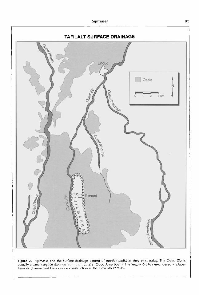
Sijilmassa's ruins, adjacent to the modern town of Rissani, juxtapose a barren landscape with the lushness o f date palms and grain and vegetable fields o f the Tafilalt oasis. The heart of the ancient city occupies a small rise sur- mounting the plain o f the Oued Ziz ("oued" is the usual spelling of the Moroccan Arabic for wadi, or perennial stream). Here, the ruins o f Sijilmassa form a mass of mounds and hollows rising five to ten meters above the Ziz plain. Atop the rise are the remnants o f a mosque built in the 1600s and 1700s. These serve tour- ists as a convenient, if historically misleading, vestige of Sijilmassa. In a broad stretch be- tween this rise and the Ziz, several hundred meters distant, a gently sloping alluvial surface is littered with pottery shards and ruined adobe walls. Material culture remains are here found to depths o f seven meters. In all, Sijilmassa's ruins extend along a sliver measuring eight kilometers in length and one and a half kilo- meters in width along the left (east) bank of the Ziz (Figure 2).
Sijilmassa 81
TAFILALT SURFACE DRAINAGE
Figure 2. Sijilmassa and the surface drainage pattern of oueds (wadis) as they exist today. The Oued Ziz is actually a canal (sepia) diverted from the true Ziz (Oued Amerbouh). The Seguia Ziz has meandered in places from its channelized banks since construction in the eleventh century.

82 Lightfoot and Mil ler
Region
Sijilmassa is located in the Tafilalt basin, a syncline surrounded on east and west by low mountains and filled by alluvial sediments eroded from the Eastern High Atlas Mountains (Margat 1961 :23). Pleistocene and later out- wash material was transported by numerous desert streams, most prominent of which are the oueds Ziz and Rheris. These streams frame the oasis and provide its main water resources (Figures 1 and 2). The Tafilalt oasis occupies the heart of the basin and covers an area o f approximately 15 by 25 kilometers (375 sq km).
The Tafilalt, Morocco’s largest single oasis, is given life b y these streams which converge upon and die in it. The Tafilalt is the farthest point to which water flows seasonally outward from the Atlas. Accounts of medieval travellers and contemporary hydrogeological studies all suggest that the region’s climate and water regimen have not changed appreciably since the time o f Sijilmassa (Hopkins and Levtzion 1981; Margat 1961 ). Surface-water supplies normally increase during the mediterranean- type winter experienced in the mountains, wane in the early summer, and are generally absent until the autumn rains begin. Flooding in this desert setting is periodic, and an abun- dant water table lies only a few meters below the surface. Beyond the Tafilalt stretches the full Sahara, where the interstices of human life are few and far between.
Sijilmassa in Historical Perspective
Sijilmassa is known first and foremost for its historical role in the transSaharan gold trade with ancient Ghana. The essential outline o f this trade was the exchange of copper and brass from North Africa and salt from the Sa- hara itself for gold from regions south o f the Sahara (Bovill 1970). Sijilmassa is noted as early as A.D. 956 as minting all the gold transported northward from the Sudan (a1 Mas’udi, in Hop- kins and Levtzion 1981 :36), and numerous ac- counts over the next four centuries repeatedly identify Sijilmassa as the organizer of the trans- Saharan gold trade and the central pivot for caravan routes linking West Africa north to Fez
and Sebta (Ceuta) and eastward to Tahert (in eastern Algeria) (Figure 3).’ Wi th its immediate hinterland population and market area limited to the Tafilalt oasis and environs, the growth o f Sijilmassa was rooted in, and dependent upon, long-distance trade. In this sense, Sijilmassa was a mirror image of the cities on the other side of the Sahara with which it traded goods and influence (Winters 1981 :345, 347).
Although Sijilmassa may have been founded to capture the African gold trade from estab- lished North African entrepbts, medieval histo-
GOLD TRADE ROUTES
Figure 3. Medieval transSahara gold trade routes and associated sites, circa A.D. 1000-1400. The pri- mary route plied by medieval caravans from the Maghrib connected Fez to Timbuktu via Sijilmassa. Sources: after Martin 1986; McDougall 1990; Winter 1981.

Sijilmassa 83
ries picture the city’s orgins as a spiritual refuge in the desert (Al-Bakri, in Hopkins and Levtz- ion 1981:64-66). It was the second city founded by the forces of Islam in the Maghrib, following Kairouan in Tunisia in A.D. 670. Un- like orthodox Kairouan, however, Sijilmassa was one o f a series of towns established by kharijite exiles from Abbasid Mesopotamia in the mid-700s and sprinkled across North Af- rica. Engaged in a struggle over w h o had the right to become the head of the faith, kharijites literally departed the field o f sectarian battle in 657 and relocated in places where their belief that anyone could become the head of Islam could endure. Kharijism, Islam’s first heresy, has long since died out in the Tafilalt, but survives in the Algerian Sahara.
From establishment o f a kharijite refuge in A.D. 757 until its demise in 1393, Sijilmassa was a stunning success. With the resource base o f the Tafilalt oasis at its command, Sijilmassa ruled the caravan trade of the Sahara and con- nected the Mediterranean and Islamic worlds with West Africa. As an independent city-state, Sijilmassa held a complete monopoly on the West African gold trade-as organizer o f the twice-yearly caravans and the locus o f coinage and transfer point for gold-until the mid- IOOOs, or for somewhat less than half i ts exist- ence (Harris 1895; Bovill 1970). The discrete nature o f the Saharan route, the unidimen- sional quality o f the trade, and the location o f Sijilmassa at a remove from the heart o f M o - rocco and the Maghrib ensured both security and wealth for the oasis city-state.
Given its wealth and strategic significance, Sijilmassa was the first object o f conquest for the Almoravid movement. The Almoravids, bent on conquering the Maghrib and Iberia in the name of a new vision of reformist Islam, swept northward from the Atlantic coast of modern-day Mauritania in the 1050s and ruled over all o f western Islam by the early 11 00s. For the next 300 years, Sijilmassa played a key role as a leading source o f revenue and a flashpoint for political rivalry within three successive M o - roccan empires: the Almoravids (until the 11 ~ O S ) , the Almohads (until the 126Os), and the Marinids (from the 1260s until the fall of the city in 1393). Within these Moroccan imperial systems, Sijilmassa’s power was gradually di- luted as first the Almoravids, and then the AI- mohads and the Marinids, allowed other groups along Morocco’s desert frontiers to
conduct the precious trade (Kenbib 1986- 1987:51, 72, 79). Primary among these were the Saadians o f the Draa Valley, 150 k m west o f the Tafilalt (Figure 3). In addition to the loss of their monopoly on the gold trade, Sijilmas- sians chafed at the demands made on their wealth by the Marinid dynasty then in control of Morocco (Kenbib 1986-1 987:85). Compet- ing Marinid princes had battled for control o f Sijilmassa in 1331 -1 333, 1361 -1 363, and in 1387 (Jacques-Meunie 1982:288-294). In the end, rivalry for power and territory among Ma- rinid factions led to the extinction o f their em- pire, and the Moroccan political landscape de- volved into petty power centers. In the 14OOs, for the first time in over 300 years, no central authority held sway in Morocco. In the Tafilalt, Sijilmassa fell and the oasis became a landscape of adobe villages (qsar; plural, qsour).
Following Sijilmassa’s collapse, the Moroc- can gold trade declined. Iberians sought to control the trade by sea and quickly succeeded in dominating West Africa’s external trade. For the Iberians, sea-going ships and coastal “fac- tories,” not land routes, served as the means of penetration and control of the gold trade. A t the same time, the Portuguese and Spanish repeatedly invaded Morocco in the 1400s and 1500s. With much o f the country held by Christians, Morocco lacked a political focus until the emergence of the Saadians o f the Draa as a powerful new political force in the early 1500s (Kenbib 1986-1 987:83-87). The ”Gold- en Trade of the Moors” did not completely die out, however; the caravan trade and the mint- ing o f African gold and Atlas silver continued in the Tafilalt until the turn o f this century (Har- ris 1895; Bovill 1970).
The economy o f the Tafilalt continued, albeit in different form, after the fall of Sijilmassa. In- deed, the Tafilalt experienced a period of re- newed greatness in the seventeenth century. This reflourescence traces its origins to the 1200s when descendants of the Prophet M o - hammed’s son-in-law, Ali, living in Jubail on the Red Sea coast of Arabia, were invited by Sijil- massians to settle in their city. Carrying with them the holy mantle of the Prophet, the Alaouites (as this family is known) infused a sense of holiness to the Tafilalt (Kenbib 1986- 1987:99).’ By the early 1600s, the Alaouites had refashioned the infrastructure o f the oasis and expanded large-scale irrigation through a net- work o f dams and canals off the Ziz and Rheris

84 Lightfoot and Mil ler
I (Margat 1959:255). In 1631, the inhabitants of the Tafilalt pledged fealty to the Alaouites, who then began a campaign o f territorial conquest designed to safeguard the Tafilalt’s trade routes. Within a generation, the Alaouites were mas- ters of Morocco, and the facts o f their Tafilalt provenance and their uninterrupted rule over Morocco ever since has enshrined Sijilmassa’s place in both memory and history.
The Tafilalt: Economy, Society, and Settlement
Economy
The productive basis of the Tafilalt, as else- where in the oases of the northern Sahara, has been the irrigated cultivation o f the date palm; in the Tafilalt the exceptional quality of dates has been cause for remark since earliest times. AL’Umari (d. 1349) compared them to the fine dates o f Iraq (Hopkins and Levtzion 1981 :274). Here, as elsewhere in the northern Sahara, date palms are grown in a system o f agricultural production little changed since medieval times: grown in irrigated jnan (”gardens”), dates shield crops grown underneath them-fruit trees, barley, henna, vegetables-from the sun. Expansion o f production, however, has been a repeated goal in the Tafilalt. In Sijilmassian times, incremental increases in irrigation from the Ziz and the Rheris permitted more central- ized control o f the resource base through more intensive water management o f the wa- dis. Perhaps shortly after the arrival of the Al- moravids in the eleventh century, the entire course of the Ziz was reconfigured. Later, probably toward the end o f the 1300s or the beginning o f the 1400s, khettara (“chain wells,” known elsewhere as qanats or karez) were added to the technological repertoire. The Alaouites built many dams along the Ziz and Rheris-some twenty in all-but these dams built in the 1600s post-date our subject.
Society
Our primary interest focuses on the spatial organization o f Sijilmassa’s landscape and how and why it changed so profoundly at the end
o f the fourteenth century. A n analysis o f re- gional social organization provides some clues into the social space o f Sijilmassa and the city’s ultimate demise. While all social groups in the region are regarded as Filali (of or from the Tafilalt), these groups can be separated into four basic dichotomies: Muslims and Jews; Ar- abs and Berbers; oasis dwellers and nomads; and, in the oasis, free people and people in bondage (slaves and indentured servants, or haratin). Further divisions of status are defined by holiness, especially sainthood; any one could rise to sainthood in either the world o f Tafilalt Islam or Tafilalt Judaism, within or out- side the oasis (Figure 4).
Africans sold as slaves came along with the gold. In the Tafilalt, slaves were the property o f the zaouias, or religious endowments for Is- lamic saints and their schools. Through the practice of habous, or pious donations, to the zaouias, they became large land- and slave-
SOCIAL SPACE OF THE TAFILALT
Figure 4. Schematic diagram of the social structure of the Tafilalt region. Sources: Fieldwork in the Tafilalt.

Sijilmassa 85
owning institutions. The harafin, a dark- skinned and Arabic-speaking indentured class, are still numerous in many villages and they constitute the backbone o f the oasis labor force. Haratin are chattel in that they are seen as belonging to Arab, Jewish, or Berber families w h o may call upon them to labor at any time. Their status is hereditary. Haratin could own property, however.
Sijilmassa was largely populated by Berber converts to kharijism, but its political and spiri- tual rulers were Arab: the kharijites from Meso- potamia. As in much o f Morocco, the general transition to Arabic accelerated in the 1200s after the arrival o f powerful new Arab groups in the Tafilalt: the Banu Ma’qil nomads and the orthodox Alaouites (both from Arabia) (Dunn 1977:71); and the subsequent arabicizing leadership of the Marinids at the national level.
The Alaouites crown the Tafilalt social pyra- mid. As descendants of the Prophet’s son-in- law, Ali, they are known both as Alaoui, from Ali; and shurfa (“honored”). And as the pro- genitors of Morocco’s longest-lasting dynastic line (which governs the country today through King Hassan I I ) , the Alaouites demonstrate the continuing power o f early Islamic bloodlines. Their endurance also provides substance for the widespread Moroccan perception o f the Tafilalt as an especially holy place. The Alaouite of the Tafilalt are in the same bloodline as the sultan (”king”), many of them serve at court, and they form a large body o f relations to the throne. While normally removed from political power in Morocco, the Filali Alaouite elite traditionally have retained a key role in the political culture of the country since they are consulted over the choice of the new sultan.3
Another group high in the Tafilalt social pyra- mid is Muslim saints (known as wali Allah or solih) and their descendants. Saints may be either Berber or Arabic-speaking and can come from any social group in or outside the oasis (like the Muslims, Moroccan Jews too have their saints). Once acknowledged as saints by the Islamic community, the wali Allah hold special status in religious and community affairs and they are elevated to the rank of sheikh. Their influence may result in the foun- dation o f a zaouia, which further radiates spe- cific theological beliefs. Saints’ descendants may continue to bear the flame of holiness
(baraka), provided they follow in the righteous path of their forebears.
In its essential outlines, the social organiza- tion o f the Tafilalt has remained recognizably similar since the arrival o f the Alaouites in the 1200s, the recrudescence o f sainthood in M o - roccan Islam in that century, and the concomi- tant appearance o f the Arabian bedouins, the Banu Ma’qil (Eickelman 1976). Jews, though numerous throughout Tafilalt’s recorded his- tory, were excluded from political (but not eco- nomic) power in the framework o f the Islamic city. Jews have not been present in the Tafilalt, however, since the 1973 Arab-Israeli War (when they were evacuated to Israel virtually overnight), but they remain strong in local memory and the shrines of Jewish saints attract Jewish pilgrims still. Within the social hierarchy, then, power is weighted toward the Alaouites and the saints. Within Muslim social space, Berbers can become saints, but they cannot become Alaouite. With the arrival of the Alaouites at Sijilmassa, a powerful new social force had clearly emerged.
Settlement
The population o f the Tafilalt today numbers over 80,000 people, or more than twice the estimated population maximum of Sijilma~sa.~ The Tafilalt settlement pattern is one o f villages dispersed throughout the oasis, with the mar- ket town of Rissani (pop. 1982, 7755) provid- ing a clear focus for the entire oasis (Figure 5). Villages, which range in size from 200 to 2,000 people, consist of contiguous dwellings set along narrow alleyways that often conform to a grid pattern within the qsar’s walls. The resi- dential organization o f different social groups varies from village to village. The concentration of Berber villages in the northern and western Tafilalt reflects their recent sedentarization and some consequent enlargement of oasis space. Some villages are socially homogeneous, while others are heterogeneous and spatially segre- gated. Still others are heterogeneous with no detectable residential segregation. Whatever the case, the small size of the typical village (fewer than a thousand inhabitants) means that different social groups live in close proximity to one another.

86 Lightfoot and Miller
CONTEMPORARY SETTLEMENT IN THE TAFILALT OASIS
Figure 5. Contemporary settlement in t h e Tafilalt Oasis. The d o z e n s of villages scattered throughout the oasis h a v e replaced the single central city of medieval Sijilmassa.
Methodology: Collating Multiple Sources of Evidence
T h e joint Moroccan-American Sijilmassa Project has conducted four seasons of field
work-1988, 1992, 1993, and 1994. The ar- chaeological excavations have steadily ad- vanced our understanding of the layout and historical development of t h e site.
As geographers at the archaeological project, we developed our picture of the Sijilmassa

Sijilmassa 87
landscape by drawing upon five sources of data: oral tradition, field reconnaissance, re- mote sensing (air photos and Landsat imagery), historical documentation, and archaeological fieldwork. Understanding contemporary soci- ety in the region also played an important role. These sources were interwoven in two steps: we first produced a conceptual model of Sijil- massa upon which we overlaid evidence from oral tradition; w e then produced a synthetic, second-generation map which collated details from our five sources of evidence and keyed these into a topographic map.
Oral Tradition
Interviews furnished a wealth of information about the site and situation of Sijilmassa. We collected mythic histories of Sijilmassa, com- pared these with findings from archaeological sites and historical texts, and placed the whole in spatial context. In addition, environmental information elicited during interviews-about springs, wells, water tables, canals, dams-re- vealed reference points for the human land- scape of the ancient oasis. The locations o f these environmental features were verified by field reconnaissance and tied to contemporary cultural and physical features.
In total, w e conducted over 100 interviews at 21 villages throughout the Tafilalt during June and July 1992. Our informants revealed an oral tradition on Sijilmassa preoccupied with the end o f the ancient city; moreover, most Arabic speakers in our sample claim descent from the Sijilmassians.
Field Reconnaissance
Walking the Sijilmassa site, combing the riv- erbeds and canals, and navigating the confines of the oasis improved our understanding o f the landscape and the water resources of the Tafilalt and of Sijilmassa as a place. When nar- rators of oral tradition identified architectural or agricultural features associated with Sijilmassa, we tried to f ind them, often accompanied by the people w h o described them. What we learned in one instance began to resonate with what w e learned in another; as our local knowledge became ”denser,” to use Clifford
Geertz’s redolent term, our ability to recon- struct the landscape deepened.
Landscape features identified through oral tradition and recovered through field recon- naissance helped to establish our first model o f the Sijilmassa landscape.
Remote Sensing
Topographic maps covering the northern part of the Tafilalt oasis at 1:50,000 and the entire region at 1:250,000 were used as base maps for plotting locations o f Sijilmassian and contemporary features and ecological data. Aerial-photo reconnaissance and Landsat satel- lite imagery provided an overview o f the ar- chaeological site and oasis environment. Land- sat Thematic Mapper imagery provided re- markable views of surface water channels in relation to settlements as well as o f the distri- bution and quality o f groundwater resources (as inferred from the density o f palm trees). Satellite imagery delineated arable and non-ar- able land in the Tafilalt, facilitated computations of the field area in the oasis, and provided evidence of abandoned fields and earlier levels o f water supplies, water management, and food production.
Aerial-photo analysis also permitted us to confirm the location of features identified in oral and written histories, but which were im- perceptible or obscure at ground level. Fea- tures alleged as Sijilmassian were then mapped. In this way, air-photo analysis guided further archaeological surveys and excavations.
Historical Documentation
The medieval texts, however fragmentary, provide pivotal descriptions o f the place in its time. Medieval Arab authors chronicled the im- portance o f Sijilmassa as an independent city- state and caravan center; its incorporation into the Almoravid empire was documented by Al- Bakri in 1068. Although few medieval chroni- clers actually visited Sijilmassa, it figures large in many historical accounts as the jumping-off point for the gold trade and as a standard point o f reference for the location o f known places in the world.

88 Lightfoot and Miller
Archaeological Fieldwork
The on-going archaeological dig has several objectives: establishing the outlines o f the city, finding its prominent structures, and docu- menting long-distance exchange at Sijilmassa. M u c h o f our evidence comes from ceramics recovered at the site.
The problems o f archaeological excavation at Sijilmassa are daunting. The lower-lying parts o f the site have been repeatedly washed by floodwaters. The lengthy occupation of Sijil- rnassa (757-1393) defines a complex record through many levels o f cultural succession. There was extensive ceremonial rebuilding in the 1600s, and parts o f the site have been used as a dump, a cemetery, and a slaughterhouse in modern times. This said, fourteen soundings at the site in 1992 uncovered several Sijilmas- sian-age structures, notably a residence with three distinct levels dating to the 1000s and a wall and tower-gate complex dating to at least the 1100s. Excavations in 1994 revealed three successively reworked mosque structures (at- tributable to the early, middle, and late Sijil- rnassa eras) in layers beneath the seventeenth- century Alaouite mosque in the central part of the site.
Ceramics offer the most impressive evi- dence for the development of Sijilmassa. Through 1993, some 22,000 ceramic pieces (intact and shards) have been examined and classified into eight groups based on texture, color, size, quantity, and paste. Sijilmassian ce- ramics are interspersed with foreign material which sheds light on the web of trade relations. The 1992 discovery o f a nearly intact plate decorated with Quranic inscriptions proved to have originated in thirteenth-century Qal’at Banu Hammad (eastern Algeria), thus con- firming a trade route identified in documentary sources. Similarly, a cache o f 32 gold coins found in 1992 in Aqaba, Jordan, 29 o f which were minted in Sijilmassa sometime before 101 3, underscores the long-distance reach o f Sijilmassa in the pre-Almoravid period.
The Sijilrnassa Landscape Map
By collating the data from these five sources, w e were able to construct a map o f the ancient city and oasis: a theoretical model, as it were, o f Sijilmassa. The core o f the model is based on the spatial congruence o f the multiple
sources of evidence (Figure 6). The model rep- resents Sijilmassa in its final phases.
This conceptual model of the Sijilmassa land- scape was then fitted to a base map produced from topographic sheets and Landsat imagery. Aerial photographs were scrutinized again with the intent o f recovering Sijilmassian com- ponents; features identified in both the oral tradition and in aerial photos were aligned. Field reconnaissance corroborated inclusion of some elements and the exclusion of others. The final map (Figure 7) represents what w e believe to be the most complete picture yet produced of the medieval Tafilalt, and, most especially, of Sijilmassa in i ts last phases. The remainder of this paper attempts to account for the map’s key features and to clarify their func- tions using oral traditions, field and photo re- connaissance, and medieval texts.
The Sijilmassa landscape
As Portrayed in the Oral Tradition
Oral tradition focuses on four aspects o f the Sijilmassa landscape: 1) setting; 2) walls and gates; 3 ) streets and markets; and 4) water and agriculture.
The Setting. Oral tradition portrays Sijil- massa as long and narrow, running from the modern-day Qsar Mansouria in the north to near Qsar Taboussamt in the south; informants say that the distance amounts to a half-day’s walk long for a man and a full-day’s walk long for a woman to cover the eight kilometers. In width, the city was between one and two kilo- meters (Figures 6 and 7).
Narrators of the oral tradition insist that the Tafilalt contained only the single, large city o f Sijilmassa which was located entirely east o f the Ziz and coincident with the ruins in the landscape today. A single bridge running out o f the central portion o f the city crossed the Ziz and connected it with a market whose name, Ben Akla, lingers in the popular mind.
Figure 6. Conceptual model of the medieval Sijil- rnassa landscape based on oral tradition. The area shown covers most of the Tafilalt Oasis.

Sijilmassa 89
CONCEPTUAL MODEL OF THE SIJILMASSA LANDSCAPE
River Channel
Canal
- Street
1 r Walls / = Dam
0 Post-Sijilmassa qsour (shown for reference)

90 Lightfoot and Mil ler
Development o f the landscape o f individual vil- lages followed the city’s destruction. Some vil- lages claim direct descent from Sijilmassa; these overwhelmingly Alaouite qsour of the central oasis also claim to have been the earli- est villages implanted in the Tafilalt following the abandonment o f Sijilmassa.
Walls and Gates. Informants recount that the city o f Sijilmassa was not walled, but that the surrounding oasis was. Sijilmassa’s fields (guemmoune) were bounded by walls some four meters high, and these delimited the cul- tivated oasis and Sijilmassa from the outside wor ld (Figures 6 and 7). Oral tradition also sug- gests that this enclosure came late in the his- tory o f the city. The common view is that walls around the fields were designed to “keep peo- ple in Sijilmassa” during the rule o f the oppres- sive Sultan el Kahel, or ”Black Sultan.” Inform- ants consistently identify the Black Sultan as the last, and most detested, governor o f Sijilmassa. H e also figures in legends concerning water supplies and the end o f Sijilmassa, to which we will return.
Four gates into the Sijilmassa oasis are indi- cated (Figures 6 and 7). As with gates else- where in Morocco, the names o f Sijilmassa’s gates reflect the direction of trade, the envi- ronment outside, or the direction in which the gate led. Bab Fez (”Gate o f Fez”), located at modern-day Qsar Mansouria, marked the northern end of the city. No other gate pro- vided such direct access to Sijilmassa. Parts o f th is gate are extant today. An eastern gate, Bab Sharq (”East Gate”), was located in the south- east corner of the walled oasis, near Qsar Am- sifi. In the southwest quadrant Bab Sahel, or ”Gate of the Sahel” (referring simply to the plain, sahel in Arabic, south o f the city), was located between Metara and Gaouz villages. In the west, Bab Gharb (“West Gate”) opened to the Oued Rheris and the nearby Ben Akla Mar- ket.
Streets and Markets. Informants provided remarkable detail on a market called “Ben Akla.” They referred to Sijilmassa as a customs point, or diwan, that focused on the Ben Akla market located just west o f the Oued Rheris at the end of the bridge leading out of the ancient city (Figures 6 and 7). Ben Akla, they say, served as the caravan terminus, a market, and a place where taxes were collected. Tribal peo-
ple known as the Ait Kbour are identified as managing the market which was connected to the center o f Sijilmassa by a road lined b y high mud walls.
Water and Agriculture. Informants also had much to say about the supply and manage- ment o f irrigation water in Sijilmassa. The image that emerges is one o f a walled oasis surround- ing a single city, Sijilmassa. Individual villages, or qsour, were absent. Nor was the oasis di- vided into districts and individual fields as it is today; it was, rather, a single agricultural space-a vast farm supporting the city.
Springs are especially important in local ac- counts of Sijilmassa. Oral histories indicate that during Sijilmassian times, a spring on the Ziz known as the “Timedrine” was famous for its abundance and reliability (Figure 1 ). Today, eight springs in the same general area as the Timedrine resupply the Ziz, though informants reckon that they are far less abundant than the ancient Timedrine.
In the lore o f the Timedrine spring, the dev- ilish Black Sultan, the last governor o f Sijil- massa, figures prominently. Bent on controlling Sijilmassa for his own purposes, the Black Sul- tan plugged up the spring. On this informants agree, but his intentions can be read in a vari- ety of ways. Perhaps he sought to control the oasis water supply in order to render Sijilmas- sians evermore dependent upon his authority. In an age of political turmoil, people may have wished to leave the city, and the Black Sultan’s actions may have been an attempt to prevent the population from establishing their o w n vil- lages outside Sijilmassa. By controlling the water supply of the Z i r , he could control the settlement pattern. In so doing, the Black Sul- tan could maintain his authority over a single, centrally controlled city and its walled oasis farmland against the budding desires o f a peo- ple w h o wished to organize themselves differ-
Figure 7. The medieval Sijilmassa landscape show- ing ancient features identified through oral tradition, field reconnaissance, air photography and satellite imagery, historical documentation, and archaeologi- cal fieldwork. These features are collected and su- perimposed on the contemporary Tafilalt landscape.

Sijilmassa 91
MAP OF THE SlJlLMASSA LANDSCAPE
ANCIENT FEATURES CONTEMPORARY FEATURES
0 city - Oasis Outline
a Street / Bridge ,-- ~ Road t Market ,-. Riverchannel
1 r Guernrnoune Walls /Gate 0 Qsar (village)
CanallDarn
Old River Channel - 0 1 2 3km

92 Lightfoot and Mil ler
ently. Perhaps, but these accounts beg many questions: How did the Black Sultan actually plug the Timedrine? Was the political situation s o bad that Sijilmassians wanted to escape their own city? And how and why had the situation deteriorated to this point? Was the Black Sul- tan, who is nowhere recorded in history, real?
Oral tradition also identifies three low dams (seds) and an associated network o f canals (sepias) constructed to divert water from the Ziz during the Sijilmassian era. This irrigation system created the agricultural surface o f the oasis. Informants indicate that the dams were constructed in the following order: 1 ) Rsif, in the northernmost part of the oasis; 2) El Batha, near the southernmost extent of the ancient oasis; and 3) Shamoukh, at the southern margins of the ancient city (Figures 6 and 7). Two major canals are also indicated: Shurfa streamed off the Ziz just north o f the central area o f Sijilmassa by simple sluice gate; Rhorfiya branched off from the Ziz just north o f the oasis and provided water for eastern fields (Figure 7). Smaller canals distributed water from these primary canals and from the oueds Rheris and Ziz.
As Portrayed from Field and Photo Reconnaissance
Some of the features noted in the oral histo- ries are visible on the ground andlor aerial photographs. Oral tradition thus promoted our awareness o f many new features which, when followed up by field and photo reconnais- sance, led to additional discoveries.
The Setting. Field reconnaissance revealed the presence o f canals, houses, and defensive walls and gates here and there across much o f the central Sijilmassa site. Aerial photographs documented that the extensive ruins were pat- terned into alternating blocks of houses and open squares. These ruined walls, most o f which are visible only on the air photos, are easily distinguished from undisturbed soil and surface ruins by their tone, texture, and geo- metric pattern. These suggested an older city below the level of Alaouite ruins. Archaeologi- cal soundings carried out in 1993 and 1994 confirmed the existence of these wall seg- ments and their association wi th the city of Sijilmassa.
Walls and Gates. A long, eroded wall- identified as part o f the ancient oasis wall in oral tradition-is visible along the oasis margin on the east bank of the Oued Rheris at Moulay Abd el Moumen, a ruined qsar in the north- west o f the oasis. Here, two long segments o f the suggested oasis wall run along the east bank o f the Rheris. The wall’s trend conforms to an older channel o f the Rheris, suggesting that it dates from a period when the wadi had a different course. The wall appears to have caved in at two points where cut-bank erosion encroached as the Rheris meandered. Allow- ing for portions obscured b y modern cultiva- tion and erosion, this segment o f the wall ex- tends for almost 3.5 kilometers.
Another long segment of what w e believe to be the encircling wall o f the ancient oasis is visible in air photos. This segment, more than six kilometers long, is especially clear in the less cultivated areas o f what is today mostly open desert around the southeast corner o f the oasis. All of these segments accord with the locations and patterns o f the encircling wall outlined in oral tradition. Moreover, these walls are unrelated to contemporary landscape fea- tures such as fields, canals, roads, and natural drainage patterns. These contrasts suggest that these segments are relics o f an earlier land- scape.
Elsewhere, the encircling oasis wall seems to have been destroyed by erosion and by farm- ers and builders since the fall o f Sijilmassa. In sum, w e believe that enough well-placed an- cient wall segments are present to validate a walled-oasis model. Evidence o f long, straight walls, in stark contrast to the cellular pattern o f today’s fields and walls, underscores the dis- tinctive and collective nature o f landholding and settlement in late Sijilmassa.
O f the gates identified in the oral tradition, the northern gate, Bab Fez, i s a relatively well- preserved Marinid-style structure. Parts o f it have been worked into contemporary Qsar Mansouria and are used as a barn. A freestand- ing and largely intact part o f the gate is the single largest, best-preserved element o f Sijil- massa. The purported location o f the East Gate, near Qsar Amsifi, also reveals remnants o f a gate, though its style, having been strongly modified and incorporated into later struc- tures, is not decipherable.
Streets and Markets. We also documented a wide range of surficial cultural features at the

Sijilmassa 93
site of the legendary Ben Akla Market just west of the Oued Rheris (Figures 6 and 7). Particu- larly prevalent are stone date-pit pounders (used to render date pits into animal feed) and whole and broken grinding stones. These tools are scattered over a radius o f at least a half kilometer outward from what informants say was the center of the site. Sijilmassa-period ce- ramic shards also lie strewn on the ground. Ruins o f mud-brick walls, stone building foun- dations, square pillar foundations suggesting a mosque, and nearby kilns indicating ceramics manufacturing are visible all over the site of the purported market. Nearby, on the east bank, a long, eroded, east-west trending wall near Qsar Ouled Saidane coincides with the wall said to have bordered the principal road run- ning between Sijilmassa and Ben Akla. lnform- ants identify portions o f this wall as Sijilmassian.
Air-photo analysis of the Ben Akla site reveals a faint geometric patterning o f ruined walls over a half-kilometer square area. A nearly straight footpath crosses much of the field area between the Ben Akla market and the center of the Sijilmassa ruin. This footpath is obvious in field reconnaissance of the area. Parallel walls visibly edge much o f this straight road. This constitutes an exceptional pattern in that most contemporary footpaths meander around the patchwork o f cellular field walls; long, straight paths are virtually non-existent. The eastern terminus o f this feature (along the western edge o f the Sijilmassa ruin at the Oued Ziz) matches up precisely with the location of a tower-gate complex unearthed in 1992 by project archaeologists. It is certainly possible that this modern, straight footpath is a descen- dant o f the road described in oral tradition as running between central Sijilmassa and the market at Ben Akla.s
Water and Agriculture. The most important feature o f the ancient Sijilmassa landscape does not enter into the oral tradition: the diversion o f the Oued Ziz into an artificial channel run- ning through the center of the oasis abutting the Sijilmassa site.
The fluvial landscape of today’s Tafilalt con- sists o f three streams f lowing across the basin from north to south. Just north o f the oasis, the Oued Ziz nearly captures the Rheris, but in- stead o f becoming a single stream, they flow independently southward. The Ziz slices through the heart of the Tafilalt oasis and frames the western edge of the Sijilmassa site,
while the Rheris flows southward along the western margins of the Tafilalt (Figure 2). In the northern Tafilalt, near the present-day town of Erfoud, the Oued Amerbouh branches from the Ziz and flows southward along the eastern margins o f the oasis. The Amerbouh and the Ziz then rejoin just south of the Tafilalt where the single stream is again known as the Ziz. Eventually, the Ziz and the Rheris join, forming the Oued Daoura (Figure 1).
Field reconnaissance and air and satellite im- agery reveal that the Ziz channel is unusually straight along most o f its course, which is in sharp contrast to the broad meanders of the Amerbouh and Rheris. In all likelihood, the Ziz is an artificial stream-a great central irrigation canal-within the confines of the oasis6 At the point where the Ziz and Amerbouh diverge, w e found massive stone works, refashioned again and again, leading the Ziz into its artificial channel. The natural channel, known today as Amerbouh, is dry except in periods of flood. W e began to realize that the Ziz had been diverted out o f i ts natural channel at the head of the Tafilalt and redirected through the center o f the oasis, thereby serving the needs o f Sijil- massa.
Two other diversions o f the Ziz have en- dured. These include the canals identified in oral tradition as the seguias Rhorfiya and Shurfa. The Rhorfiya, which leads off the Ziz at the point o f the modern Rhorfiya dam just north of the oasis, follows a southeasterly course and terminates near what was the Bab Sharq o f ancient times (Figures 2 and 7). The Shurfa forms a shorter irrigation channel near the center of the ruins. The Shurfa, always re- ferred to as a oued, waters the fields of Rissani. If there were dams that diverted water to the seguias Rhorfiya and Shurfa (as there are to- day), they are not identified in the oral tradi- tion.
The three dams noted by oral tradition as Sijilmassian (Rsif, El Batha, Shamoukh) are clearly visible in aerial photos and on the ground, though all are breached or silted up. All are old, but precise dating by field recon- naissance or aerial-photo analysis has not been possible. Based on the area irrigated by these dams on the Ziz plus the Rhorfiya and Shurfa canals today, and subtracting the arable land added to the oasis by subsequent Alaouite dams and canals (which created more arable land than is even farmed today), w e estimate that the arable land of Sijilmassa amounted to

94 Lightfoot and Mil ler
r approximately 11 5 square kilometers confined within a roughly rectangular area of 10 k m on one side and 11.5 k m on the other.
As Portrayed in Historical Texts
H o w does the evidence from oral tradition and field and photo reconnaissance compare with historical accounts? Sijilmassa first ap- peared in the historical record within 100 years o f its founding in 757. The city was initially noted as a standard point of reference for wor ld locations (the clima system) in Al-Khu- warizmi’s (d. 846/847) Surat a/-Ard. Sijilmassa appears in thirteen other medieval accounts in a substantive way and is mentioned in many more. Chronologically, these range from Al- Khuwarizmi in the 800s to the Kitab a/-‘/bar o f Ibn Khaldun written in 1374-1378. Leo Afri- canus, writing more than a hundred years after the fall o f Sijilmassa in the early 1500s, provides a coda to the corpus o f medieval Arabic texts.
Nature of the Texts. Problems with the me- dieval texts abound. As far as can be deter- mined, only three chroniclers-lbn Hawqal (Suraf a/-Ard 967), Ibn Battuta (Rihla 1356), and Leo Africanus-actually visited Sijilmassa. Most texts merely repeat earlier information. Al- Bakri’s is the most detailed account (Kitab a/- masalik wa-’/-mamalik 1068); drawing on Ibn Hawqal, he adds much creditable information received from travellers who had been to Sijil- massa. Al-Bakri, however, never left his native Spain. Ibn Hawqal’s and Al-Bakri‘s legacy car- ried forward into later histories and geogra- phies; 300 years later, AL’Umari’s fairly detailed depiction (Masalik a/-absar fi mamalik a/-amsar, 1337/38) repeats Al-Bakri and makes direct ref- erence to Ibn Hawqal (AL’Umari, in Hopkins and Levtzion 1981 :275; Ibn Hawqal 1964).
Such are the written accounts o f the world in the Islamic medieval age. Medieval geogra- phers relied on the best sources available, but they passed on and elaborated upon this infor- mation in a great chain of knowledge that changed very little over time.
Sijilmassa From Rise to Fall. The following narrative o f Sijilmassa emerges from the medie- val texts. Berber tribes in the drylands o f M o - rocco and Algeria were attracted to the egali- tarian Islamic message preached by kharijite
refugees from Mesopotamia in the mid-700s. Sijilmassa was founded by Berbers who had rallied to a charismatic kharijite, one Al-Yasa’. With Arab leaders and Berber converts, Sijil- massa flourished from i ts founding in 757. Two early leaders, Isa (d. 771/2) and Abu al-Qasim (d. 784), created the great and beautiful city based on commercial wealth. The latter begat the first Sijilmassa dynasty, the Midrar, which ruled over two hundred years o f independent growth and prosperity in the oasis. Al-Yasa’ himself ruled between 790-823 and is credited with building much o f Sijilmassa’s urban fabric: city walls, a palace, a great mosque, and public baths. Under the Midrar, Sijilmassa was a place o f religious refuge from other Islamic ideologies and centers of power-at first the Abassids of Baghdad and their outliers in Kairouan in cen- tral Tunisia; by the 9OOs, the Umayyads of Cor- doba and the Fatimids of Tunisia. Al-Bakri’s ac- count (circa 1068) emphasizes the long-term struggle to maintain Sijilmassa’s independence, but he also recounts the collapse of inde- pendence at the hands of the Almoravid movement.
When this Islamic reformist movement swept out o f the western Sahara in 1054, it conquered Sijilmassa before all other places. The Almoravids extinguished kharijism and brought Sijilmassa into the realm of Islamic or- thodoxy. Thereafter, Sijilmassa constituted a province within Morocco’s successive em- pires: the Almoravids from the mid-1000s to the mid-I1 00s; the Almohads in the following 100 years; and the Marinids, who first con- quered the oasis in 1257 and formally annexed Sijilmassa in 1274. The rule under the last o f these was combative and fragile. Rival Marinid governors and princes vied for control over Sijilmassa throughout the 1300s. Fatally en- meshed in the economy and politics o f the hapless Marinid Empire, Sijilmassa finally disap- peared in 1393. Having killed their governor and destroyed their defensive walls, the in- habitants moved into scattered villages throughout the oasis.
In the six and a half centuries o f Sijilmassa’s history, much changed. The geographical structure of the city and the oasis, like its po- litical career, was dynamic, but the medieval histories capture only a portion of these dy- namics. Beyond Al-Bakri’s account, we learn very little from these histories. Al-Bakri’s, how- ever, comes at the midpoint o f the city’s de-

Sijilmassa 95
velopment-at a time when independent city- statehood had ended, when Sijilmassa was be- coming one province within a greater empire. Great changes lay ahead.
The Al-Bakri Landscape, circa 1068 A.D. Al- Bakri describes the city as the creation, in large part, of the Midrar ruler Al-Yasa’ in the early 800s. AI-Bakri observes that AI-Yasa’ built a wall in 814/815 “surrounding the town”; the wall had twelve gates, eight o f which were of iron. Al-Yasa’ also built a royal palace and an ”excel- lent’’ mosque; he evidently failed, however, in improving the city’s baths which are “of poor construction.” “Around the town are numer- ous suburbs wi th lofty mansions and other splendid buildings. There are also many gar- dens” (Al-Bakri, in Hopkins and Levtzion 1981 :64-65; also Taouchikht 1989:106-I 27). “Sijilmassa,” he wrote:
stands on two rivers, whose source, in the place called ljlaf, is fed by many springs. On approaching Sijilmassa this stream divides into two branches, which flow to the east and west of the town. . . . The water in the town is brackish, as it is in all the wells of Sijilmassa. The cultivated land is irrigated with water from the river collected in basins like those used for watering gardens. (Al-Bakri, in Hop- kins and Levtzion 1981:65)
Although Al-Bakri offers a few comments on Sijilmassa’s abundant agriculture, the bulk o f his text deals with the history of the Midrar dy- nasty.
Subsequently, Al-ldrisi (The Book of Roger 1154) portrayed Sijilmassa as a “great and populous city along an abundant stream” (quoted in Taouchikht 1989:108). The anony- mous Kitab a/-lstibsar (ca. 1194) described Sijil- massa as “one of the greatest cities in the Maghrib,” south of which there are ”no inhab- ited places. . . . Between Sijilmassa and Ghana is a desert of two months’ journeying over un- inhabited sands and hills wi th little water.” The Kitab a/-fstibsar also noted that the Jews o f the Tafilalt ”possess vast wealth” (Hopkins and Levtzion 1981 :I 38-140). Ibn Battuta (the Rihla, 1356) chronicles his journey in 1352-1353 from Sijilmassa t o the city of Mali and farther south in the company of Sijilmassa merchants and their caravan trading salt for gold; his ac- count provides many details (and anecdotes) of the trade itself (Ibn Battuta, in Hopkins and Levtzion 1981 :281-304).
The Encircling Oasis Wall. Three accounts shed light o n the oasis landscape and its encir- cling wall. According to Al-Dimashqi (d. 1327), “Sijilmassa is surrounded by walls o f a circum- ference of twelve parasangs” [a Persian land measurement equivalent to 3.88 miles] (AI-Di- mashqi, in Hopkins and Levtzion 1981: 209). Sijilmassa‘s walls were thus on the order of 46 miles (74 kilometers) in circumference. Al- ’Umari (d. 1349) also describes the walls: ”This wall sheltered buildings, gardens, and palms, and was between 70 and 80 kilometers long” (quoted in Taouchikht 1989:53). It is instructive that these rather precise estimates of the wall’s circumference appear late in the historical re- cord and not in earlier accounts. Leo Africanus, visiting the Tafilalt in the early 1500s, also noted that the oasis was ~ a l l e d . ~
Sijilmassa’s End. M u c h like its founding, the city seems to have disappeared in a flash. As late as the 135Os, the city was, in the words o f Ibn Battuta, “one of the finest” that he had visited; he portrayed a city in control of a vig- orous trade in gold across the Sahara (Ibn Bat- tuta, in Hopkins and Levtzion 1981:282). Yet, when Leo Africanus visited the Tafilalt in 151 4- 1515, the city had collapsed; according to Af- ricanus, Sijilmassa’s disintegration occurred in 1393 (Leon L‘Africain [Leo Africanus] 1957:428-430). H e reported that Marinid Mo- rocco in the late 1300s was marked b y political confusion and the fission o f the empire into t w o parts: one part held by the Marinid sultan of Fez, Abu al-Abbas; the other b y Abdul Rahman of Marrakech. Wi th the death of the sultan of Fez w h o had attempted to unite wi th Sijilmassa, Leo Africanus states that the people of Sijilmassa:
killed the governor and demolished the wall of the city’s fortress. This has remained deserted until the present. The people regrouped and built large for- tified houses [qsour] in the fields and districts of the provinces. Some of these [qsourl are free; oth- ers are bound to the Arabs. (Leon L’Africain 1957:425)*
H e further elucidates the reasons for Sijil- massa’s demise:
[Back] when the people were all agreed, they built . . . walls to stop the incursion of Arab horsemen. While the people were united, with a common will, they remained free. But factions arose, and they demolished these walls and each [group] called upon the Arabs to protect them. So it is that these people have become the subjects and al-

96 Lightfoot and Mil ler
most the slaves of the Arabs. (Leon L‘Africain 1957:428)
Consequently, the unified polity of Sijilmassa gave way to the qsar, each o f which i s “gov- erned by a particular lord, who is a party head” and is split by “discord and division.” The peo- ple are “always fighting each other, doing as much harm as they can, which i s to say dam- aging the irrigation canals which come from the river.” They also “cut off palm trees at their trunk and steal from each other, which the Arabs abet.” Jews are numerous, especially in Qsar Taboussamt (in the southern oasis). Most people are poor; but the minting of gold and silver goes on, as does the caravan trade of ”some rich gentlemen” who exchange ”the merchandise of Barbary” for gold and slaves (Leon L‘Africain 1957:428).
The ruins of Sijilmassa were still apparent in the landscape:
the city was built in a plain, on the Ziz, and was encircled by a high wall of which one can still see some parts. . . . Sijilmassa had fine temples and colleges supplied with numerous fountains whose water came from the river. Great wheels took this water from the Ziz and projected it into conduits bringing it into the city. . . . (Leon L‘Africain 1957:430)
A vivid picture emerges of a society sufficiently fractured and divided to have re- sulted in the abandonment o f Sijilmassa and the reorganization o f the landscape into ”about 350 ‘castle-forts’ [qsour], some large, some small, outside o f the villages” (Lkon L‘Africain 1957:428). Sijilmassa lay already buried in time.
Conclusions: The Organization of the Sijilmassa Landscape
Our collation o f related information from di- verse sources-oral tradition, field reconnais- sance, remote sensing, historical docurnenta- tion, and archaeological fieldwork-constitutes the basis for our spatial reconstruction o f the oasis entrep6t. Seven conclusions can be drawn.
1. Sijilmassa occupied a long and narrow space along the Ziz. With the gate at Qsar Man- souria as a reference point for the northern extent o f the city, Sijilmassa’s ruins can be traced almost eight kilometers downstream along the Ziz. Ruins extend laterally from the
Ziz approximately one and a half kilometers on the left (east) bank. The site o f the ancient city is confirmed by archaeological soundings, field reconnaissance, satellite and air-photo im- agery, oral history, and the historical record.
2. An encircling wall framed the oasis. It seems clear that the oasis o f Sijilmassa (the then-arable portion of the Tafilalt) was walled, at least in the city’s last phases (and perhaps earlier). Al-Dimashqi’s, AL’Umari’s, and Leo Af- ricanus’ commentaries on a high wall encircling the oasis are confirmed by fieldwork. The 70- odd k m circumference of the wall reported in these histories is somewhat longer than the circumference o f 43 k m revealed in oral tradi- tion and field and photo reconnaissance. This discrepancy may have to do with translations of linear distances that appear in the medieval texts.
3. The city of Sijilmassa was also walled. In Al-Bakri’s times (eleventh century) the city o f Sijilmassa was walled, and apparently the oasis was not. The presence of a walled city is re- peated over and over again in the medieval manuscripts and it i s confirmed by archae- ological findings: Sijilmassa was walled at least along the Oued Ziz. It may be that oral tradi- tions insisting that the city of Sijilmassa was unwalled are simply wrong; alternatively, w e suspect that the city wall was abandoned at some later date in favor of the larger oasis wall.
4. Sijilmassa’s growth was facilitated by the progressive expansion of the water resources of the Tafilalt. Expansion probably proceeded in three steps. In the first step, Sijilmassa was sup- plied by springs surfacing within the Tafilalt oa- sis itself. In the mid-eleventh century, ljlaf (a place-name that occurs nowhere in the region today) was the source o f Sijilmassa’s water sup- ply. Sijilmassa stood between two streams that stemmed from ljlaf. In the 1950s, the French hydrologist Margat theorized that these t w o streams (mentioned by Al-Bakri) are the pre- sent-day Oued Ziz and the canal (seguia) called ”Oued” Shurfa (Margat 1959:256-257). Margat reasoned that these streams derived from springs located three kilometers north o f Rissani where an outcropping o f conglomerate forms a feature known as the Djebilet (“little mountain”) and where artesian water is plenti- ful. ”It is possible to suggest the existence o f a

Sijilrnassa 97
line o f springs in this sector arising from the water table, feeding a perennial oued as far as Sijilmassa and used in the area surrounding the town for irrigation” (Margat 1959:257). This is also where the Rsif Dam of oral tradition is located. These springs f lowed into the channel w e now know as the Oued Ziz and, farther downstream, the “Oued” Shurfa (Figure 7). This is where, according to Al-Bakri, Sijilmassa “stood” o n t w o ”rivers.” Satellite imagery and test wells have shown that this area contains the most shallow and abundant groundwater in the entire oasis.
Al-Bakri’s commentary provides further clues on the character o f the Oued Ziz in the elev- enth century: “The water in the town is brack- ish as it is in all the wells o f Sijilmassa” (Al-Bakri, quoted in Hopkins and Levtzion 1981:65). Brackish water indicates that the water o f Sijil- massa was not the fresh water that the Ziz provides today; it was rather water from the shallow ljlaf springs. Later diversion o f the Ziz provided greater supplies of better-quality water. Given that Al-Bakri wrote in the 1060s, a decade after the Almoravid conquest o f Sijil- massa, engineering changes in the Ziz must have followed the Almoravid conquest. In Al- Bakri’s day, the waters of the Ziz probably still f lowed naturally along the eastern margins of the oasis in the streambed known today as the Oued Amerbouh. While Al-Bakri did not iden- tify the ”other” river at Sijilmassa, he did iden- tify the historically accurate “Oued” Shurfa. Un- like the other streams o f the oasis (Amerbouh, Rheris), the “Ziz” (Arabic for “fine”) bears an Arabic name. It is reasonable to assume the streambed now called the Ziz was then merely the outflow from a local oasis spring (an out- flow perhaps bearing, originally, a now-lost Ber- ber name, like the ljlaf spring itself) and that Arab engineers reformulated it and named it later.
The second step in hydraulic expansion in- volved a major work o f engineering-the diver- sion of the original Ziz from its natural bed into a channel in the middle o f the Tafilalt oasis. Landsat and air-photo imagery reveals that this channel is actually a series of canalized, post- Pleistocene runoff channels. The building of this great canal connected the waters of the Ziz with those from the ljlaf springs, which evidently were deemed insufficient for Sijil- massa’s water needs in the age of Almoravid empire-building (eleventh and twelfth centu-
I ries).
The third step involved the construction o f the Seguia Rhorfiya. This network o f canals di- verted water from the “new“ Ziz, thereby ex- panding water supplies to the eastern oasis and the size o f the oasis itself.
5. Sijilmassa grew dramatically in size follow- ing the Almoravid conquest (1 054) and retained its enlarged importance through the Almohad pe- riod (1148-1 255). Facilitated by the re-direc- tion o f the Ziz to the center o f the Tafilalt and the city’s doorstep, the oasis population and agricultural output reached new maxima.
6. Sijilmassa collapsed as central authority waned in the Morocco of the Marinids (1 255/1257-1393). The demise of Sijilmassa turns on no single cause. Oral tradition speaks of the malevolence of the ”Black Sultan” as well as an earthquake. Some historical events are clear. Political instability in Morocco prevailed throughout the fourteenth century and well beyond the collapse o f Sijilmassa. The city was beseiged repeatedly in the 1300s by warring Marinids. When the Marinids held Sijilmassa, they exploited it ruthlessly. But a broader per- spective on these events may be warranted.
The gold trade was in transition. Sijilmassa’s role as the sole Maghribi entrep6t and break- of-bulk point in the trans-Saharan trade changed dramatically wi th the emergence of Moroccan empires. Whereas an independent Sijilmassa had alternately subdued and con- quered competitors for the trade across the Sahara, a dependent Sijilmassa was compelled to compete with traders in the Draa Valley, four day‘s journey west of the city.
Sijilmassa’s loss of control over the trans-Sa- haran market also stemmed from changes at the other end of the routes. The locus o f power in West Africa had shifted away from its original, western base in Ghana (1 000s) toward an eastern base along the Niger River at Tim- buktu and Gao in the 11 00s and farther east to the Songhai in the 1300s (Winters 1981:345). Sijilmassa’s merchants may have found it difficult to keep pace with these changes south. Finally, the emergence o f Portuguese ships along the West African coast in the 1300s placed a heavy weight on Saharan traders, trapped as they were by their inland geogra- phy and single form of transportation.
The life of Sijilmassa was not shaped by ex- ternal economic forces alone. O f more imme-

98 Lightfoot and Miller
diate import to Sijilmassa, perhaps, was the presence o f a new threat posed by invaders to their desert habitat. The presence of the Banu Ma’qil nomads in southeastern Morocco al- tered local relations between oasis dwellers and desert nomads. These natives o f the Ara- bian desert, following their expulsion from Egypt b y the Fatimids in the 12OOs, were poorly absorbed into the texture o f Maghribi society, and they wreaked havoc wherever they went. In the Tafilalt, their arrival produced a cascading series o f land shortages and inter- tribal rivalries. The nomadic Berber tribes of southeastern Morocco joined into a great con- federation-the Ait ’Atta-in response. The re- sult was a profound transformation o f the social order. And the presence of the bellicose Banu Maq’il was conjoined with the emergence o f two new powerful groups in the Tafilalt social order: Alaouites and saints.
With the arrival o f the Alaouites in Sijil- massa-also from Arabia, but bearers of the holy flame o f Islam and not ”reckless” pastor- alists like the Banu Ma’qil-Sijilmassa was in- fused with sacred qualities the likes of which few other North African towns could boast. What was happening in local social relations in the first hundred or so years after their arrival in the Tafilalt can only be guessed; the ramifica- tions of the Alaouites coming to Sijilmassa with their o w n effective center o f power are not clear. Reading history backwards, however, it appears that the Alaouites sought to reign over the oasis and to secure wide authority. This is in fact what they had accomplished by the 1600s. From the moment they stepped into the Tafilalt, the Alaouites were powerful people- bearers of the prophet’s bloodline, capable, by their very being, o f exerting authority over other social groups. Sijilmassa got more than it bargained for.
At the same time, as Moroccan society was declining under the Marinids, Moroccan Islam was marked by an outburst o f local religious authority in the form o f saints: individuals and their schools o f ideology expressing a variety o f reactions to the negative forces that had been unleashed on Moroccan society (Eickel- man 1976:19-29). In Sijilmassa, a city once great and independent, but now squeezed by imperial decadence, the presence of the Alaouites constituted a strong impulse for change. They were “automatic“ saints in an age lacking in larger authority. W e would merely
add that as imperial authority vanished from the Moroccan scene, Sijilmassa, too, evapo- rated and was replaced by a landscape of in- dividual villages, each with i ts o w n social order and petty center o f power.
W e conclude from this evidence that the Alaouite and the saintly families o f Sijilmassa sought control. In the tenuously Marinid-con- trolled city, social relationships in the last half o f the 1300s must have been corrosive and debilitating. Nomads warred at the gate; Ma- rinids had lost control over the caravan center. These events conspired to produce a dispersal of urbanity over the landscape o f the Tafilalt; the centrality of land and life was lost.
7. Hydraulic technology was changing as Sijil- massa died. Perhaps the most speculative o f our conclusions o n the demise o f Sijilmassa is the role played by the technology o f the un- derground, horizontal well shaft, or khettara (qanat). It is possible that the adoption o f this new water technology facilitated the disinte- gration o f Sijilmassa as a central place or, at least, made living apart from the city both thinkable and achievable.
Filtration gallery irrigation had diffused from the Near East to the Maghrib as early as the ninth century, and khettara were being built around Marrakech, Morocco by the early twelfth century (Goblot 1979; Joffe 1992). The technology was surely known to Sijilmassian engineers at this time, yet oral tradition and historic texts suggest that khettara were not employed in the oasis until after the death of Sijilmassa, when networks o f dispersed villages with associated khettara emerged in the north- ern and western Tafilalt. Khettara technology conforms well to the layout o f dispersed vil- lages, each with its o w n ruling lineages and mechanisms for organizing labor at a more lo- calized level. Khettara galleries are maintained at a small, localized level, without the extensive cooperation needed to maintain a large canal network. Furthermore, the water from a khet- tara gallery emanates from a single source- from collection in the mother well to discharge at the surface-and is sent directly to fields belonging to the village that maintains the gal- lery. Regional canal networks require a much greater degree of centralized control in order to allocate water to all of the fields and the users that depend on the regional s y ~ t e m . ~
W h y do cities collapse? At this point in our

Sijilmassa 99
understanding o f Sijilmassa, it appears that the mass o f social relations present in the Tafilalt and surrounding region had become so dense that by the end of the 1300s they could no longer be contained within the contours of a single city, particularly one in which control from above had loosened and new social forces from within city and region had been unleashed.
One of the keys to Sijilmassa’s success was that the city exercised control over the Tafilalt- an oasis kingdom whose resources it control- led, managed, and transformed over time. But while Sijilmassa walled its oasis to protect against incursions from without, equally pow- erful forces were at work within. In the end, it may have been Sijilmassa’s nomads and saints, not kings and armies, that caused the city’s collapse. In any event, the cause for collapse will not be found in the archaeological debris or the historical record. Geography, region, and place are more nearly the keys. Despite its wealth and great history, Sijilmassa vanished, replaced by its people wi th a new landscape o f their o w n design for a new age and time.
Acknowledgments
Dr. Lightfoot has been supported in this research by a grant from the National Geographic Society. James Miller has been supported by a grant from the American Institute for Maghribi Studies (AIMS) and by a Fulbright research scholarship for Morocco. Both authors have received logistical and technical support from the joint Moroccan-American Sijilmassa project, headed by Dr. Ronald Messier of Middle Tennessee State University, and from Dr. Lahcen Taouchikht and Mr. Mohammed Choukri of the Cen- tre des Etudes Alaouites, Rissani, Morocco under the general direction of the Moroccan Ministry of Cul- ture and Institute of Archaeology. The authors wish to thank Mr. Addi Ouadderou of Qsar Mezguida for the friendship he extended and the doors he opened.
Notes
1. In all, Sijilmassa figures substantively in fourteen medieval accounts and is mentioned in many more. Chronologically, these range from AI-Khu- warizmi (d. 8461847) to the Kitab a/-’/bar of Ibn Khaldun, written in 1374-1378. The most impor- tant of these is the history written by Al-Bakri, Kitab a/-masalik wa-’/-mamalik (1 068); it provides a rich description nf Sijilmassa’s economy and dy- nastic history. All these accounts have been trans-
lated and compiled in Hopkins and Levtzion, Cor- pus o f Early Arabic Sources for West African His- tory (1 981 ).
2. The Alaouites of Morocco, descendants of Ah, son-in-law of Prophet Mohammed, are to be dis- tinguished from the Alaouites of Syria.
3. This is no longer the case. The Moroccan consti- tution of 1972 specifies that the next king (“sultan” has not been used since 1961) will be the first- born male of the deceased king (law of primogeni- ture).
4. The 1982 census showed a Tafilalt population of 59,670. See Royaume du Maroc 1983. Census re- sults for 1994 were not yet available at the time of this writing; the figure is based on a suspected local RNI of 3 percent per year.
5. On the strength of evidence from our 1992 re- search, the Ben Akla site was revisited in 1994 by Miller and other researchers with the Sijilmassa Project. A systematic collection of surface ceramics revealed a great abundance of Sijilmassian shards and a high incidence of tradewares, perhaps trans- ported by caravans unloading there. On the basis of this evidence, the Moroccan Ministry of Culture has submitted a dossier to protect the area as a national historic site.
6. The diverted Ziz shows some aspects of a natural wadi; over the centuries since the building of this great canal, sections of it have meandered and scoured laterally, but the degree of scouring and meandering is minute compared with the natural channels of the Rheris and Amerbouh. This is not without parallel. For example, the present course of a number of wadis in northwest Jordan is the result of human interference with their natural course-producing very long and narrow interflu- ves-and only through subsequent neglect have these channels re-acquired the properties of a natural wadi (Manners 1969:261).
7. Leo Africanus measured the circumference of the oasis (not the wall) as about 80 miles [I28 kml (Leon I’Africain 1957:429).
8. The “Arabs” referred to are the Banu Maq’il no- mads who eventually controlled large portions of southeastern Morocco.
9. N o mention of khettara is made in the medieval historical accounts of Sijilmassa. It appears that the technology of chain wells first appeared in Mo- rocco during the Almohad period (11 50-1 250), but not until later in the Tafilalt. Khettara in the environs of Marrakech during Almohad times are described by Al-ldrisi in his Description of Africa, or as it is better known, The Book of Roger (11 54) (see Kenbib 1986-1 987:64). Margat (1 961 :204) holds that since the oldest Tafilalt khettara date from the 1500% these village-directed water sources (which the khettara are) could not have been a factor in the demise of Sijilmassa. Also, because of constraints of topography, hydrology, and arable land, khettara cannot be constructed everywhere across the Tafilalt; khettara thus were not available as a solution for the new qsour es- tablished in the central and southern Tafilalt. These lands remained dependent on the canal network constructed earlier in Sijilmassian time. Khettara did offer freedom from central authority for many

100 Lightfoot and Miller
in the Tafilalt; insofar as this technology contrib- uted to Sijilmassa's demise, it was only one of sev- eral causes for the city's abandonment.
I
I
References
Bovill, E. W. 1970. The Golden Trade of the Moors. London: Oxford University Press.
Dunn, R. E. 1977. Resistance in the Desert: Moroc - can Responses to French lmperialism 1881- 7972. Madison: University of Wisconsin Press.
Eickelman, D. F. 1976. Moroccan Islam: Tradition and Society in a Moroccan Pilgrimage Center. Austin: University of Texas Press.
Entrikin, J. N. 1991. The Betweenness o f Placer To- ward a Geography o f Modernity. Baltimore: The Johns Hopkins University Press.
Goblot, H. 1979. Les Qanats: Une Technique d'Ac- quisition de I'fau. Paris: Mouton.
Harris, W. B. 1895. Tafilet. London: W. Blackwood and Sons.
Henige, D. 1982. Oral Historiography. New York: Longman.
Hester, J. J. 1976. htroduct ion to Archaeology. New York: Holt, Rinehart and Winston.
Hopkins, J. F. P., and Levtzion, N., eds. 1981. Cor- pus of Early Arabic Sources for West African His- tory. Cambridge: Cambridge University Press.
Ibn Hawqal (Ibn Hauqal). 1964. Configuration de la Terre (Kitab Surat A/-Ard), trans. J. H. Kramers and G. Wiet. UNESCO Series of Representative Works; Arabic series. Paris: G.-P. Maisonneuve and Larose.
Jacques-Meunie, D. 1982. Le Maroc Saharien des Origines a 7670. Paris: Librairie Klinsieck.
Joffe, G. 1992. Irrigation and Water Supply Systems in North Africa. Moroccan Studies 2:47-55.
Kenbib, M. 1986-1 987. Historie. In La Grande Ency- clopedie du Maroc, vol. 4, ed. M. Sechimi. Ra- bat: GEM.
L'Africain, J.-L. (Leo Africanus). 1957. Description de
I'Afrique, trans. A. Epaulard. Paris: Adrien- Maisonneuve.
Manners, I. R. 1969. The Development of Irrigation Agriculture in the Hashemite Kingdom of Jordan, with Particular Reference to the Jordan Valley. Unpublished Doctoral Dissertation, Oxford Uni- versity.
Margat, J. S. 1959. Note sur la Morphologie du Site de Sigilmassa (Tafilalt). Hesperis 46:254-260.
-. 1961. Memoire Explicatif de la Carte Hydro- geologique au 1/50 000 d e la Plaine du Tafilalt. Notes et Memoire du Service Geologique, No. 150. Rabat: Editions due Service Geologique du Maroc.
Martin, 6. G. 1986. The Spread of Islam. In Africa, 2nd ed., ed. P. M. Martin and P. O'Meara, pp. 87-1 03. Bloomington: Indiana University Press.
McDougall, A. E. 1990. Salts of the Western Sahara: Myths, Mysteries, and Historical Significance. The lnternational journal of African Historical Studies 23:231-257.
Royaume du Maroc. 1983. Ministere du Plan, de la Formation des Cadres et d e la Formation Profes- sionnelle. Rabat: Direction de la Statistique.
Taouchikht, L. 1989. Etude Ethno-Archeologique de la Ceramique du Tafilalet (Sijilmassa): Etat de Question. Unpublished Doctoral Dissertation, University of Provence, Aix-Marseille I, October.
Tuan, Y.-F. 1974. Space and Place: Humanistic Per- spective. Progress in Geography 6:213-252.
Veyne, P. 1984. Writing History: Essay on Epistemol- ogy, trans. M. Moore-Rinvolucri. Middletown, Connecticut: Weslayan University Press.
Watson, P. J., Le Blanc, S. A,, and Redman, C. L. 1984. Archaeological Explanation: The Scientific Me thod in Archaeology. New York: Columbia University Press.
Winters, C. 1981. The Urban Systems of Medieval Mali. journal o f Historical Geography 7:341-355.
Submitted 2/94; Revised 11/94, 3/95; Accepted 5/95.
Lightfoot, Dale R., and Miller, James A. 1996. Sijilmassa: The Rise and Fall of a Walled Oasis in Medieval Morocco. Annals of the Association of American Geographers 86(1):78-101. Abstract.
Sijilmassa (A.D. 757-1393) was the North African head of the gold trade across the Sahara in medieval times. A synthesis of fieldwork undertaken by geographers, historians, and archaeolo- gists suggests the environmental and social structure of the ancient city and its surrounding oasis. Collaboration demonstrates geography's role in solving regional problems originating in history and archaeology. In reconstructing the geography of past place and the demise of place, w e knit together the oasis landscape and environment; local water resources, agricultural produc- tion, and social organization were key to the development of Islamic Sijilmassa. Drawing upon methodologies of oral tradition, field reconnaissance, remote sensing, historical documentation,

Sijilmassa 101
and archaeological fieldwork, medieval Sijilmassa emerges as a Saharan entrepBt founded in Islamic heresy; a landscape developed through diversion of a desert stream; and a city that walled its oasis to protect against bedouin incursions. The process of urban growth and decline were driven by socio-political forces and the allure of new hydraulic technologies; the demise of Sijilrnassa was a result of discordant social forces contending for the region. Sijilmassa remains an icon of sacred space in the landscape of contemporary morocco. Key Words: gold trade, Morocco, Sahara, Sijilmassa, urban development, water resources.
Correspondence: Department of Geography, Oklahoma State University, Stillwater, Oklahoma, 74078 (Lightfoot); Department of History and Geography, Clemson, South Carolina, 29634.