Influence of Airline Cabin Crew Members' Rapport-Building ...

National Park Service U.S. Department of the Interior
Natural Resource Stewardship and Science
Shoreline Erosion and Adaptation Strategies for Peale Island Cabin, Yellowstone National Park Natural Resource Report NPS/NRSS/GRD/NRR—2014/858

ON THIS PAGE The northern spit on Peale Island, where the historic cabin is located, is narrow and eroding. Photograph by: Matt Metz ON THE COVER Peale Island Cabin in Yellowstone National Park is threatened by shoreline erosion. Photograph taken on 23 July 2013. Photograph by: Rebecca Beavers

Shoreline Erosion and Adaptation Strategies for Peale Island Cabin, Yellowstone National Park Natural Resource Report NPS/NRSS/GRD/NRR—2014/858
Rebecca L. Beavers1, Courtney A. Schupp1, Ian A. Slayton2, and Maria Caffrey3
1National Park Service Geologic Resources Division 12795 West Alameda Parkway Lakewood, Colorado 80228 2National Park Service University of Denver Department of Geography and the Environment 2050 E. Iliff Avenue Denver, Colorado 80208 3University of Colorado Department of Geological Sciences, UCB 399 Boulder, CO 80309-0399
October 2014 U.S. Department of the Interior National Park Service Natural Resource Stewardship and Science Fort Collins, Colorado

ii
The National Park Service, Natural Resource Stewardship and Science office in Fort Collins, Colorado, publishes a range of reports that address natural resource topics. These reports are of interest and applicability to a broad audience in the National Park Service and others in natural resource management, including scientists, conservation and environmental constituencies, and the public.
The Natural Resource Report Series is used to disseminate high-priority, current natural resource management information with managerial application. The series targets a general, diverse audience, and may contain NPS policy considerations or address sensitive issues of management applicability.
All manuscripts in the series receive the appropriate level of peer review to ensure that the information is scientifically credible, technically accurate, appropriately written for the intended audience, and designed and published in a professional manner.
This report received formal peer review by subject-matter experts who were not directly involved in the collection, analysis, or reporting of the data, and whose background and expertise put them on par technically and scientifically with the authors of the information.
Views, statements, findings, conclusions, recommendations, and data in this report do not necessarily reflect views and policies of the National Park Service, U.S. Department of the Interior. Mention of trade names or commercial products does not constitute endorsement or recommendation for use by the U.S. Government.
This report is available in digital format from the Natural Resource Publications Management website (http://www.nature.nps.gov/publications/nrpm/). To receive this report in a format optimized for screen readers, please email [email protected].
Please cite this publication as:
Beavers, R. L., C.A. Schupp, I.A. Slayton, and M. Caffrey. 2014. Shoreline erosion and adaptation strategies for Peale Island Cabin, Yellowstone National Park. Natural Resource Report NPS/NRSS/GRD/NRR—2014/858. National Park Service, Fort Collins, Colorado.
NPS 101/126785, October 2014

iii
Contents Page
Figures.................................................................................................................................................... v
Tables ................................................................................................................................................... vii
Executive Summary .............................................................................................................................. ix
Acknowledgments ................................................................................................................................. xi
Introduction ............................................................................................................................................ 1
Yellowstone Lake Setting ............................................................................................................... 1
Peale Island Cabin Setting .............................................................................................................. 7
Shoreline Erosion ........................................................................................................................... 9
Study of Live Tree Cover on Peale Island .................................................................................... 11
Potential Causes of Peale Island Shoreline Erosion ..................................................................... 14
Coastal Adaptation Options for Peale Island ....................................................................................... 15
Monitor, learn, and interpret the change: Continue current management practices ..................... 15
Record, then let go: Deconstruct cabin ......................................................................................... 17
Improve structure resiliency: Elevate cabin ................................................................................. 17
Indirect/offsite action: Nourish shoreline ..................................................................................... 18
Indirect/offsite action: Armor shoreline ....................................................................................... 19
Relocate cabin to Peale Island interior ......................................................................................... 21
Relocate cabin to outer shore of Yellowstone Lake ..................................................................... 22
Replace cabin function and structure ........................................................................................... 22
Tectonic Influences in the Yellowstone Lake Area ............................................................................. 27
Measurements of Uplift and Deformation .................................................................................... 27
Causes of Uplift and Deformation ................................................................................................ 27
Causes of Lake Level Changes ..................................................................................................... 29
Expected Changes and Research Needs ............................................................................................... 31
Future Climate Scenarios ............................................................................................................. 31
Outstanding Data Needs ............................................................................................................... 31
Summary ...................................................................................................................................... 31
Literature Cited .................................................................................................................................... 33
Useful Links ......................................................................................................................................... 37


v
Figures Page
Figure 1. Peale Island is located on the South Arm of Yellowstone Lake in Wyoming ....................... 3
Figure 2. A) Maximum daily outflow of Yellowstone River and maximum daily lake water level elevation for each year 1922-2013 ...................................................................................... 4
Figure 3. A) Annual dates that Yellowstone Lake was frozen over and that ice was melted for each year 1922-2013 ............................................................................................................ 5
Figure 4. Surficial geologic map and bathymetric map draped over a digital elevation model...................................................................................................................................................... 6
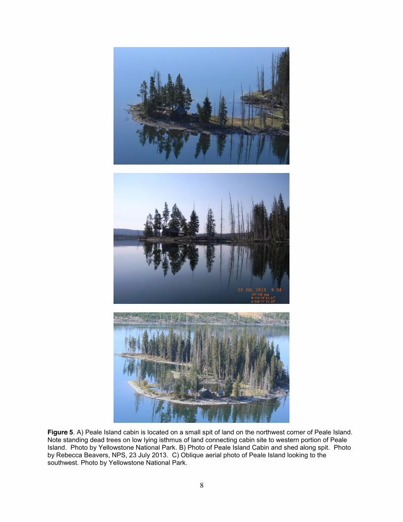
Figure 5. A) Peale Island cabin is located on a small spit of land on the northwest corner of Peale Island ........................................................................................................................................ 8
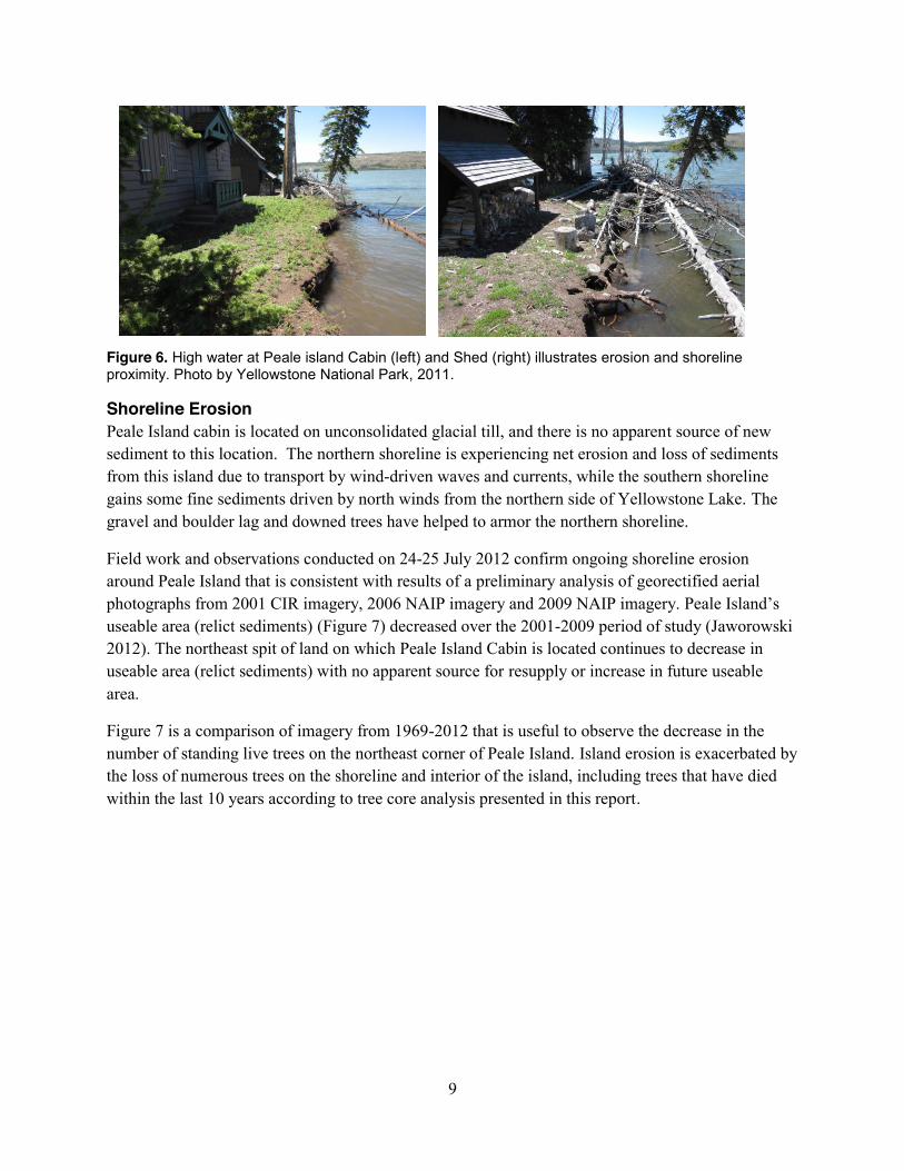
Figure 6. High water at Peale island Cabin (left) and Shed (right) illustrates erosion and shoreline proximity ................................................................................................................................ 9
Figure 7. Comparison of imagery from 1969-2012 showing the decreased number of trees on the northeast corner of Peale Island and ongoing shoreline erosion. ..................................... 10
Figure 8. View of shore from front window of cabin (left) ................................................................ 11
Figure 9. Low lying area of Peale Island where prior boat docks are submerged .............................. 12
Figure 10. Field Crew collecting and logging tree cores. ................................................................... 13
Figure 11. There should be a path to access the shore that is not directly in front of the cabin. .................................................................................................................................................... 16
Figure 12. Fallen trees and cobble and boulder lag provide naturally occurring shoreline protection ............................................................................................................................................. 17
Figure 13. The cabin foundation is approximately 35 cm (14 in) deep .............................................. 18
Figure 14. Any effort to armor the shore on the north side of Peale Island must consider the edge effects that will likely lead to accelerated erosion on the east (top image) and west (bottom image) sides of the spit................................................................................................... 20
Figure 15. Potential log retaining wall and gabion structure proposed by Yellowstone NP staff. ..................................................................................................................................................... 21
Figure 16. The shoreline southwest of Peale Island Cabin is lined with downed trees ...................... 22
Figure 17. Map showing Yellowstone NP, the Yellowstone Caldera, Yellowstone Lake and Yellowstone River, and contours on the historic dome of uplift from 1923-1975 (after Pelton and Smith 1982) ........................................................................................................................ 30


vii
Tables Page
Table 1. Englemann Spruce and Lodgepole Pine tree cores collected on July 23, 2013. ................... 13
Table 2. Summary of shoreline adaptation options for Peale Island Cabin. ....................................... 24


ix
Executive Summary This report examines the geologic setting and natural processes influencing Peale Island and the historic cabin there, part of Yellowstone National Park. A variety of coastal adaptation strategies are described, with potential benefits and impacts on function, duration, wilderness values, and natural and cultural resources.
Yellowstone Lake in Wyoming has only one river outlet: the Yellowstone River on the north side of the lake. The elevation of this outlet and fluctuations in annual runoff control lake levels. The northern portion of the lake is located within the Yellowstone Caldera, which is tectonically active and has continuous but frequently changing uplift and subsidence events that affect both the elevation of the river outlet and the elevation of lake and island shorelines. Waves, wind, ice, and tectonics affect lacustrine processes and associated shoreline change. Over the last four decades, the lake has frozen over later in the year and has thawed earlier.
Peale Island is located in the South Arm of Yellowstone Lake. It is composed of glacial till and has no source of new coarse sediment but does receive a minor supply of erodible fine sediments. The historic Peale Island cabin is located on a narrow spit on the eroding north end of the island. As of 2013, the shoreline had moved closer than 2 m (6 ft) of the cabin porch, and the number of live trees along the shoreline continues to decrease. Several processes may be accelerating shoreline erosion, including a change in sediment transport processes, tectonic uplift, longer ice-free periods, tree death, and changes in wave and wind patterns.
Eight coastal adaptation options for the Peale Island Cabin are presented and described. These include continuing current management practices; elevating the cabin; reducing site erosion through beach nourishment or shoreline armoring; relocating the cabin to the island interior or to the outer shore of the lake; and replacing the cabin function and structure. Cost and relevant policies and legislation (e.g., NEPA and NHPA processes) will also factor into the decision-making process. Many of the adaptation options suggest similar "no-regrets" actions, including monitoring shoreline position and lake water level; documenting the historic resource and cultural landscape; and monitoring the condition of the historic structure. Several datasets would improve estimates of how long each option would protect Peale Island resources: historic wave and wind conditions; detailed erosion rates for the Peale Island shoreline; and tree stand chronology data.
Climate change has the potential to drive several process changes: increased precipitation may raise Yellowstone Lake water levels and increase shoreline submergence; higher summer temperatures may increase evaporation that lower water levels; and warmer temperatures may increase the number of ice-free days on Yellowstone Lake and cause a corresponding increase in exposure of the Peale Island shoreline to wind-driven waves and coastal erosion.


xi
Acknowledgments G. Meyer (Montana State University) suggested multiple hypotheses for increased erosion at Peale Island (personal communication, email to Courtney Schupp, 25 March 2014). M. Caffrey (NPS/University of Colorado Boulder) and C. Jaworowski (Yellowstone NP) provided access to datasets. C. Jaworowski provided the field logistics and coordination with Yellowstone NP Staff for R. Beavers’ July 2013 site visit. M. Curtis, C. Glenn, B. Sefton, R. Beavers, and C. Jaworowski were all active participants in the site visit on July 23, 2014 to Peale Island. M. Caffrey provided the tree corer and protocol for field data collection. J. Kenworthy reviewed and reformatted the report to ensure compatibility with NRR formatting and 508 accessibility compliance requirements.
We greatly appreciate the assistance from all of the current and past staff of Yellowstone National Park, Denver Service Center, Cultural and Natural Resource Directorates, including, but not limited to, C. Jaworowski, H. Heasler, B. Klein, A. Rodman, A.Bruger, A. Boyers, D. Hallac, E. Hale, N. Ward, S. Iobst, D. Wenk, N. Herring, B. Schwartz, T. Roop, C. Curry, S. Olliff, M. Eissenberg, G. Oye, R. Biallas, C. Hoffman, and M. Rockman, who participated in discussions about feasible construction alternatives, historic structures, adaptation of cultural resources to climate change, Yellowstone geology, and wilderness.
Report reviewers included M. Curtis, D. Hallac, H. Heasler, C. Jaworowski, Z. Osman, H. Pranger, A. Rodman, T. Roop, and B. Sefton.


1
Introduction The purpose of this report is to examine the geologic setting of the Peale Island Cabin and to consider potential coastal adaptation strategies for this historic resource and its current function.
Yellowstone Lake Setting Yellowstone Lake in Wyoming (Figure 1) is 32 km (20 mi) long and 22 km (14 mi) wide (NPS 1984). It has an elevation of 2357 m (7733 ft), a surface area of 341 km2 (132 mi2), and 227 km (141 mi) of shoreline. Its deepest point is 131 m (430 ft) deep, located due east of Stevenson Island (Morgan et al. 2003). Over 141 rivers and streams flow into the lake, but the only outlet is at Fishing Bridge, where the Yellowstone River flows north; peak annual streamflow, according to USGS gauge records from 1923 through 2013, has ranged from 51 m3/s (1800 cfs) in 1934 to 282 m3/s (9950 cfs) in 1997 (USGS 2014).
The northern portion of Yellowstone Lake is located within the Yellowstone Caldera. The caldera, which is in the middle of the Yellowstone National Park, is an oval depression 85 km (53 mi) long and 45 km (28 mi) across. This caldera was formed 640,000 years ago during the most recent of Yellowstone’s caldera-forming events. The caldera and surrounding area is in continuous but frequently changing movement; episodes of uplift and subsidence occur at various locations and over different time scales (Brantley et al. 2004).
Relative water levels in Yellowstone Lake, outside of fluctuations related to annual runoff, are controlled by changes in the elevation of the outlet (Hamilton 1987 as cited in Locke and Meyer 1994). Lake levels have lowered by about 27 m (89 ft) during post-glacial time. The outlet has been downcut at a rate of about 2.5 to 3 mm/yr (0.9 to 0.1 in/yr), interrupted by a period of slower incision between about 9,000 to 4,500 years ago (Locke and Meyer 1994).
There is no precise water level gauge on Yellowstone Lake. There is a USGS gauge on Yellowstone River at Fishing Bridge, several hundred meters downstream from the northern shoreline of the lake (USGS 06186500, Yellowstone River at Yellowstone Lk Outlet YNP). Water level is also measured manually at an NPS-maintained station at the Bridge Bay ranger station boat dock (Farnes 2002), on the western shoreline at the northern end of the lake (44°31’59”, 110°25’23”, former USGS gauge number 06186000). Water levels recorded at this location may differ significantly from water levels at the south end of the lake, where Peale Island is located, depending on wind set-up, a process by which which sustained high winds can push water from one area, where water level drops, to another area, where water area is raised. The average maximum water elevation at the Bridge Bay gauge is 1.71 m (5.26 ft) and occurs on an average date of June 26 (Phil Farnes, Snowcap Hydrology) (Figure 2A). Peak daily outflow has an average maximum of 137 m3/s (4896 ft3/s) and occurs on an average date of June 26 (P. Farnes) (Figure 2A). Over the last few decades, maximum water level and outflow at the gauge location have been decreasing (Figure 2B); this may be related to uplift of the northern side of the lake and may not reflect conditions at the southern end of the lake where Peale Island is located.

2
Yellowstone Lake freezes over in the winter with ice thicknesses up to 1 m (3 ft) (http://www.shannontech.com/ParkVision/Yellowstone/Yellowstone9.html). Ice begins to form in October, but December 25 is the average date when the lake is completely frozen over (P. Farnes). The average date for ice-off is May 21, based on records from 1981 through 2010 (P. Farnes). Over the last four decades, the lake has frozen over later in the year and has thawed earlier (Figure 3).
Almost daily, sudden winds can create waves as high as 1.5 m (5 ft). These waves are choppy and very close together (NPS 2014). Active undercutting occurs along much of the shoreline, causing ongoing shoreline erosion (Meyer and Locke 1986). Storm waves have been observed to erode the wave-cut cliff back 1.2 m (4 ft) through compact silt in less than 1 hr (Richmond 1976). Although Richmond (1976) suggests that such catastrophic erosion would be rare, Meyer and Locke (1986) assert that events of this magnitude are probably frequent over tens of years. Ice is another physical force capable of moving unconsolidated sediment along the shores of Peale Island.
Peale Island is composed of glacial till from the melting of the Pinedale Ice Cap about 14,000-16,000 years ago (Figure 4) (Richmond 1974; Licciardi and Pierce 2008). The supply of coarse-grained sediments is limited to the amount of Pinedale till that already exists on Peale Island (Jaworowski 2012). With no apparent source of coarse sediment able to reach Peale Island, the boulders, cobbles, and pebbles in the till are redistributed along the shore, are reworked into active ridges of well-sorted sediments, and comprise the primary sediment that forms the shore in front of Peale Island Cabin.
Around Peale Island, prevailing winds control seasonal distribution of fine sediments that have been eroded from nearby hills and formed deltas in the shallowest portion of the South Arm of Yellowstone Lake (Jaworowski 2012). The physical forces of nearshore waves and currents may winnow the fine sediments from Peale Island. Additional fine sediments from the north side of Yellowstone Lake appear to be driven southward by north winds, to be deposited on the south side of Peale Island (review by D. Hallac, YELL, 8 July 2014). The net effect of no apparent new source of coarse sediments and a potentially minor supply of erodible, fine sediments is a major factor in the erosion along the shores of Peale Island.

3
Figure 1. Peale Island is located on the S
outh Arm of Yellow
stone Lake in Wyom
ing. The eroding shoreline and historic Peale Island cabin are located on the northeast shoreline.

4
Figure 2. A) Maximum daily outflow of Yellowstone River and maximum daily lake water level elevation for each year 1922-2013. All maximums occurred during the months of June or July of each year. B) Over the last few decades, maximum water level and outflow at the gauge location have been decreasing; this may be related to uplift of the northern side of the lake. Lake level data were recorded at Lake Hotel Dock (1921-1939), NPS Dock near Lake Hotel (1940-1966), and Bridge Bay Dock (1967-2013); gauge was replaced in 1988. Data compiled by Phil Farnes, Snowcap Hydrology.

5
Figure 3. A) Annual dates that Yellowstone Lake was frozen over and that ice was melted for each year 1922-2013. Estimates of ice-off dates from 1922-1931 are based on the relationship between observed dates and the day that Lake Yellowstone climatological station snow melted to zero. B) In the last few decades, the lake has frozen later and melted earlier. Observations were recorded from Yellowstone Lake at Bridge Bay. Data compiled by Phil Farnes, Snowcap Hydrology.

6
Figure 4. Surficial geologic map and bathymetric map draped over a digital elevation model. Map shows the South Arm of Yellowstone Lake and Peale Island. Bathymetric contours are 10 feet. Figure from Jaworowski (2012).

7
Peale Island Cabin Setting U.S. Bureau of Fisheries Peale Island Cabin, 48YE943, is located on Peale Island in the South Arm of Yellowstone Lake (Figure 1). The historic cabin (HS-0954) is approximately 0.3 km (0.2 miles) from the south shore of Yellowstone Lake at an elevation of 2360 m (7740 ft). It is located in wilderness and is only accessible by non-motorized watercraft. The cabin is on the north end of the island on a curved spit of land approximately 23 m (75 ft) wide (Figure 5).
Peale Island Cabin has a diverse history from its first use as a fisheries cabin by fish hatchery staff gathering eggs to its current function of hosting VIP visitors and backcountry patrols in the wilderness of Yellowstone National Park. It was built in 1940 with National Industrial Recovery Act funds for repairs and improvements to the Yellowstone fish hatchery facilities that were owned and managed by the Bureau of Fisheries. The cabin is eligible for the National Register because it contributes to the significance of the Lake Fish Hatchery Historic District, which is nationally significant for its significant role in the development of national policies regarding parks & conservation, and for its role as the primary source for wild cutthroat trout eggs for over 50 years (Wyoming SHPO, 20 January 2005).
The cabin is a rectangular, wood frame building measuring 6.6 m by 7.2 m (21.5 ft by 23.5 ft). The cabin rests on a concrete foundation. It has simple, functional characteristics (rough-sawn siding, wood shingle roof, and stone chimney) that were promoted to harmonize with nature near the end of the Rustic Style period. The off-center front door and concrete porch are protected by a gabled roof supported by false purlins and brackets. Proximity to the eroding shore will mean that this front stoop is likely the first area of the structure to be impacted by erosion of the retreating shoreline (Figure 6).
8
Figure 5. A) Peale Island cabin is located on a small spit of land on the northwest corner of Peale Island. Note standing dead trees on low lying isthmus of land connecting cabin site to western portion of Peale Island. Photo by Yellowstone National Park. B) Photo of Peale Island Cabin and shed along spit. Photo by Rebecca Beavers, NPS, 23 July 2013. C) Oblique aerial photo of Peale Island looking to the southwest. Photo by Yellowstone National Park.
9
Figure 6. High water at Peale island Cabin (left) and Shed (right) illustrates erosion and shoreline proximity. Photo by Yellowstone National Park, 2011.
Shoreline Erosion Peale Island cabin is located on unconsolidated glacial till, and there is no apparent source of new sediment to this location. The northern shoreline is experiencing net erosion and loss of sediments from this island due to transport by wind-driven waves and currents, while the southern shoreline gains some fine sediments driven by north winds from the northern side of Yellowstone Lake. The gravel and boulder lag and downed trees have helped to armor the northern shoreline.
Field work and observations conducted on 24-25 July 2012 confirm ongoing shoreline erosion around Peale Island that is consistent with results of a preliminary analysis of georectified aerial photographs from 2001 CIR imagery, 2006 NAIP imagery and 2009 NAIP imagery. Peale Island’s useable area (relict sediments) (Figure 7) decreased over the 2001-2009 period of study (Jaworowski 2012). The northeast spit of land on which Peale Island Cabin is located continues to decrease in useable area (relict sediments) with no apparent source for resupply or increase in future useable area.
Figure 7 is a comparison of imagery from 1969-2012 that is useful to observe the decrease in the number of standing live trees on the northeast corner of Peale Island. Island erosion is exacerbated by the loss of numerous trees on the shoreline and interior of the island, including trees that have died within the last 10 years according to tree core analysis presented in this report.

10
Figure 7. Comparison of imagery from 1969-2012 showing the decreased number of trees on the northeast corner of Peale Island and ongoing shoreline erosion.

11
Shoreline erosion estimates have been made by staff visiting the cabin and recording observations in the cabin’s log book (Figure 8). In 2013, the shoreline was within 1.8 m (6 ft) of the cabin porch, 3.4 m (11.2 ft) from the northeast corner of the cabin foundation, and 3.1 m (10.2 ft) from the northwest corner (review by M. Curtis, YELL, 9 July 2014) (Figure 8).
Figure 8. View of shore from front window of cabin (left). Shoreline is within 1.8 m (6 ft) of the cabin porch in 2013 (right). Photo by Rebecca Beavers, NPS, 23 July 2013.
Study of Live Tree Cover on Peale Island One of the earliest observations of Peale Island change, in the early 1970s, was an increase in dying trees on the island (email from Dr. Bob Smith, Research Professor at University of Utah, to Dr. Cheryl Jaworowski, Yellowstone National Park, 2012). Along the south shore of Yellowstone Lake, trees were dying because their trunks were partly below water and a boat dock had become completely submerged (Figure 9) (Brantley et al. 2004).

12
Figure 9. Low lying area of Peale Island where prior boat docks are submerged. Photo by Rebecca Beavers, NPS, 23 July 2013.
To aid in assessing cause of recent tree deaths, tree cores from Lodgepole Pine and Englemann spruce were collected from Peale Island on July 23, 2013 (Figure 10). Three living samples (“L”) were taken from trees on Peale Island, and three dead snags (“D”) were sampled from trees that appeared to have been killed by the changing shoreline (Table 1). The ground elevation of the trees ranges from 2351 to 2358 m (mean elevation = 2354 m). Dead samples were cross-dated using marker years from 1995-1993 (thick latewood with relatively short growing seasons three years in a row), a 1991-1989 (two tough years with thin rings, followed by a thick ring) and 1967-1968 (thick latewood, only a slightly below average growing season overall). No marker years could be determined prior to 1967 because there were no consistent markers due to the variability in age of the trees leading to growth patterns that overwhelmed the environmental signals.

13
Figure 10. Field Crew collecting and logging tree cores. Note extensive downed trees in interior of Peale Island. Photo by Rebecca Beavers, NPS, 23 July 2013.
Table 1. Englemann Spruce and Lodgepole Pine tree cores collected on July 23, 2013.
Sample Elevation (m)
Establishment Record start
Record end
Observations
L1 2356 Pith was just missed. Establishment date was within a couple years before 1866.
1866 2013
L2 2358 No pith 1929 2013 L3 2355 1924 1924 2013 D1A/D1B 2352 No pith 1953 2008 D2 2351 No pith 1867 2012 D3 2352 No pith 1969 2005 or
2007 Dense outer rings indicate tree stressed before death
The three living trees sampled on Peale Island were established prior to 1929, in 1924, and within a couple years of 1866. The three standing dead trees were established prior to 1969, prior to 1953, and as far back as prior to 1867. The sampled dead trees are found at slightly lower elevations from the living trees and died within recent years including in 2012, 2008, and 2005 or 2007. The dense outer rings in sample D3 indicate that the tree was likely stressed prior to succumbing.
The end dates of the sampled dead trees show that they were not killed during a single high-water year. It is possible that lower elevation trees around the cabin are gradually dying due to progressive encroachment of the shoreline and drowned root systems. All of the sampled dead trees had died within the preceding nine years, which suggests that dead snags do not remain standing in the water for very long. Given that these trees’ deaths are relatively recent, the shoreline may have risen to the

14
dead trees’ respective locations relatively recently. These data should be considered very preliminary.
Potential Causes of Peale Island Shoreline Erosion Several processes may be contributing to erosion along the Peale Island shoreline. Many of these processes are described in more detail in this document.
x Sediment transport to the Peale Island shoreline may have changed (e.g., riverine sediment discharge may have decreased), accelerating the natural ongoing erosion of the island’s shoreline.
x Tectonic uplift occurring north of Peale Island may cause the lake basin to tilt, so that water levels near Peale Island have risen relative to water levels at the north end of the lake.
x The ice-free period on Yellowstone Lake may be lengthening due to warming conditions, thereby exposing the shoreline to wave-induced erosion for longer periods of time each winter.
x The height or period of waves affecting the shoreline may be increasing.
x Tree death may be due to biological factors (e.g. virus, pests, Spruce Budworm) and/or higher groundwater levels; reduced tree cover releases more sediments that were previously bound by root systems.
x Changes in wind speed and direction may have produced increased wave energy or fetch (i.e., stronger and longer duration northerly winds).

15
Coastal Adaptation Options for Peale Island This section describes potential coastal adaptation options (summarized in Table 2) for the protection and use of Peale Island Cabin:
x Monitor, learn, and interpret the change: Continue current management practices x Record, then let go: Deconstruct cabin x Improve structure resiliency: Elevate cabin x Indirect/offsite action: Nourish shoreline x Indirect/offsite action: Armor shoreline x Relocate cabin to Peale Island interior x Relocate cabin to outer shore of Yellowstone Lake x Replace cabin function and structure
Each of these options would affect the duration of the cabin’s functionality differently. The time frame estimates below are based on best available data and professional judgment.
All options are presented in the context of the Preserving Coastal Heritage effort underway within the NPS (2014) and should be evaluated with the “Siting and Design Criteria” (2013) in current use by the NPS. All actions would be subject to compliance with NEPA, NHPA, and other relevant legislation. The provisions of the Wilderness Act in analyses and decision-making concerning cultural resources would also be relevant, because “the laws pertaining to historic preservation also remain applicable within wilderness but must generally be administered to preserve the area’s wilderness character” (see NPS Management Policies § 6.3.8 Cultural Resources).
Monitor, learn, and interpret the change: Continue current management practices Continuing the current management practices assumes that the cabin will be functional for the short-term (1-5 years), during which time it would continue to be available for patrol use. Short-term access would be dependent on the number and extent of high water events. There is no plan for if and when the cabin becomes unusable or inaccessible due to continued shoreline erosion, foundation undermining, or structural deterioration. The cabin would become an eyesore as it deteriorated, impacting the viewshed and creating debris that would impact the lake and would likely require removal.
Simple actions, such as mitigating social trails so that the shore access path is not directly in front of the cabin (Figure 11), could reduce shoreline erosion. Small social trails lead to cuts in the bank and lower routes along the shore that focus wave runup during high water and wave events. Another simple action is to leave downed trees where they fall near the shoreline. Large woody debris stabilizes the shoreline when it is located in an orientation that dissipates wave energy. Downed trees along the Peale Island shoreline should not be removed unless there is a concern on a very high water year that these logs will be dislodged and forced into the cabin, causing destruction of elements of the cabin or adjacent shed. These logs protect areas of the shoreline from erosion by wind driven waves by dissipating incipient wave energy (Figure 12).

16
If this option is selected, the park might want to document the historic resource and interpret the change in place. Future decision-making would benefit from monitoring data on changes in water level, shoreline position, and changing condition of the cultural resources.
The option to allow the loss of this historic resource is consistent with NPS Policy Memo 14-02 “Climate Change and Stewardship of Cultural Resources,” although the memo notes that no guidelines for how to make this decision have been developed. In recognizing loss, this memo states that “Responsible stewardship requires making choices that promote resilience and taking sustainable management actions. Funding temporary repairs for resources that cannot, because of their location or fragility, be saved for the long term, demands careful thought. Managers should consider choices such as documenting some resources and allowing them to fall into ruin rather than rebuilding after major storms. Such decisions for loss cannot be made lightly nor without appropriate consultation and compliance.” There are other historically significant structures in wilderness (e.g., Enchanted Valley Chalet in Olympic National Park, Portsmouth Village in Cape Lookout National Seashore) that NPS has considered allowing to go to failure.
Figure 11. There should be a path to access the shore that is not directly in front of the cabin.

17
Figure 12. Fallen trees and cobble and boulder lag provide naturally occurring shoreline protection. The tree in this image was cut in order to remove it from the cabin porch where it had fallen. Photo by Rebecca Beavers, NPS, 23 July 2013.
Record, then let go: Deconstruct cabin Documenting and then deconstructing the cabin assumes that the cabin will be functional for the short-term (1-5 years), during which time it would continue to be available for patrol use. Short-term access would be dependent on the number and extent of high water events. It does not include any actions to protect or restore the historic structure. Instead, this option would involve fully documenting the structure its associated cultural landscape, and related resources via the Historic American Buildings Survey/ Historic American Engineering Record (HABS/HAER) program. Then, it would follow a timeline to remove hazardous materials and to salvage materials as appropriate. This option removes the vulnerable structure, which would not be available to patrol use or any other purpose following deconstruction. This action would remove some evidence of human impact on this wilderness area, thereby enhancing wilderness character.
Improve structure resiliency: Elevate cabin Elevating the cabin would prolong the cabin’s accessibility and extend its functionality over a medium-term period (10-20 years) by elevating the structure on pilings and creating piers or docks. This would protect both the historic structure and the location in the short term, although it would affect the appearance of the historic site.
Designing the jack up foundation would require further consultation with Denver Service Center. On July 23, 2013 the base of the foundation was exposed by Michael Curtis (YELL) by digging a small hole. The depth of the current foundation is approximately 0.4 m (14”) (Figure 13). While elevating the structure may be feasible, it is very important to consider the limited amount of time that this structure may be viable while the island around the cabin continues to erode and separate from the

18
western portion of Peale Island. As shoreline erosion continued, the piling foundations and cabin access docks would be vulnerable to shoreline erosion and undercutting, and could lead to a situation in which the access to cabin might be threatened before the cabin structure itself. Furthermore, construction could affect shoreline processes; pilings and other structures in the water will affect existing hydrodynamics. This option would increase human impact on a wilderness area, and would require mechanized tools in wilderness for the temporary construction work. This option does not plan for if and when the structure becomes unusable or inaccessible in the long-term. Future decision-making would benefit from monitoring data on changes in water level, shoreline position, and changing condition of the cultural resources.
Figure 13. The cabin foundation is approximately 35 cm (14 in) deep. Photo by Rebecca Beavers, NPS, 23 July 2013.
Indirect/offsite action: Nourish shoreline Nourishing the shoreline would protect access, function, structure, and location of the cabin over the medium-term (10-20 years) by placing sediment along the shoreline, thereby reducing the vulnerability of the cabin to shoreline erosion. This action would temporarily increase the human influence in the wilderness area, because sediment transport and placement of material would likely require mechanized tools. Shoreline change should be monitored to determine the effectiveness of the nourishment and to identify need for renourishment. Future decision-making would benefit from monitoring data on changes in water level, shoreline position, and changing condition of the cultural resources.
NPS Management Policies (2006) specifically allow for intervention such as beach nourishment when manipulation is necessary to “preserve cultural and historic resources as appropriate based on park planning documents; or protect park developments or the safety of people” (see NPS Management Policies § 4.8.1.1; Dallas et al. 2012). This alternative would help supplement one of the diminishing physical resources, unconsolidated sediment, at this location. The island is located on unconsolidated glacial till and there is no apparent source of new sediment to this location. The use

19
of coarse native sediment could be used to augment the native cobbles and boulders that naturally armor the shore in front of Peale Island cabin (Figure 12).
Indirect/offsite action: Armor shoreline Armoring the shoreline would protect the historic structure in the medium-term (10-20 years) and prolong accessibility to the cabin by placing structures along the eroding shoreline. Any structure placed along the shore of Peale Island in front of the cabin will provide some temporary protection from the wind driven waves along the south arm of Yellowstone Lake. However, when wave forces are not dissipated by an unconsolidated shoreline, edge effects and scour may cause erosion of the edges of the land around the cabin to such a large extent that the cabin remains as a small island separated from the main portion of Peale Island (Figure 14). Structures might also fail due to impacts from scour, ice push, and wave overtopping. Additionally, engineering structures would impact natural shoreline processes and would affect the character of the historic site and the viewshed, and their deterioration might leave debris. The sight of these structures would impact wilderness character, and construction would require the use of mechanized tools.
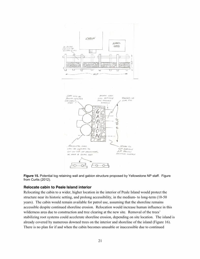
Over the years, attempts have been made to stabilize the shoreline at the Peale island Cabin with rock, log, and cement barricades to prevent further erosion and the loss of the cabin. These barriers have deteriorated over time (Curtis, 2012). An offshore breakwater would diminish incipient wave heights, but would be ineffective at deflecting some of the shoreline impacts driven by ice and short period wind driven waves. Sheetpile or riprap armoring placed in front of the cabin would reduce erosion on the landward side of the engineering structure, but would accelerate erosion in front of and adjacent to the structure. A bank stabilization proposal developed by YELL staff member Michael Curtis (Curtis 2012) proposes building a retaining wall, 30 m (100 ft) long and 1.4 to 2.1 m (4.5 to 7 ft) wide, made of logs and large rocks, and backfilled with native or transported fill (38 m3 [50 yd3] of material), then topped with soil to encourage re-vegetation (Figure 15). This proposed shoreline structure would be placed at the low water line and extend up to the current Peale Island elevation (Figure 1). The shoreline impacts of such a structure, although built from different materials and supporting some aspects of a living shoreline, would be similar to that of riprap armoring.
Future decision-making would benefit from monitoring data on changes in water level, shoreline position, and changing condition of the engineering structures and the cultural resources.

20
Figure 14. Any effort to armor the shore on the north side of Peale Island must consider the edge effects that will likely lead to accelerated erosion on the east (top image) and west (bottom image) sides of the spit. Photo by Rebecca Beavers, NPS, 23 July 2013.
21
Figure 15. Potential log retaining wall and gabion structure proposed by Yellowstone NP staff. Figure from Curtis (2012).
Relocate cabin to Peale Island interior Relocating the cabin to a wider, higher location in the interior of Peale Island would protect the structure near its historic setting, and prolong accessibility, in the medium- to long-term (10-50 years). The cabin would remain available for patrol use, assuming that the shoreline remains accessible despite continued shoreline erosion. Relocation would increase human influence in this wilderness area due to construction and tree clearing at the new site. Removal of the trees’ stabilizing root systems could accelerate shoreline erosion, depending on site location. The island is already covered by numerous downed trees on the interior and shoreline of the island (Figure 16). There is no plan for if and when the cabin becomes unusable or inaccessible due to continued

22
shoreline erosion. Future decision-making would benefit from monitoring data on changes in water level, shoreline position, and changing condition of the cultural resources.
Figure 16. The shoreline southwest of Peale Island Cabin is lined with downed trees. Any effort to relocate the Peale Island cabin to another portion of the island would require removal of additional trees. Photo by Rebecca Beavers, NPS, 23 July 2013.
Relocate cabin to outer shore of Yellowstone Lake Removing the cabin from Peale Island, and relocating it along the outer shore of Yellowstone Lake, would preserve the historic structure and prolong accessibility in the long-term (50 years), provided that the cabin is sited in a low-vulnerability area. This alternative has the highest potential for the longest-term preservation of the structure.
This option would have the greatest effect on the current function of the cabin that provides backcountry lodging for visitor and park staff including a unique Yellowstone Lake experience with many strong staff ties to the current Peale Island setting. The new site could be selected to improve availability by patrol and other staff or visitor use. Construction could impact resources at the new cabin site. Relocation would impact the historic character by removing it from its historic setting, but would also remove a human imprint from a wilderness area.
Future decision-making would benefit from monitoring data on changes in water level and shoreline position relative to the new cabin location.
Replace cabin function and structure A range of options could replace the current cabin structure and its function in supporting patrols and visitors. Depending on the type of structure and location chosen, this option would extend

23
functionality and accessibility in the medium-term (if located on Peale Island) or long-term (if located off Peale Island).
Changing the use (function) and allowing an area to be subject to natural processes (e.g., getting wet and periodically inundated) is a strategy provided by the NPS Cultural Resource directorate as a viable adaptation strategy (NPS 2014 Policy Memo 14-02). The historic structure could be deconstructed or relocated, and the function of this cabin as backcountry lodging could be replaced with an undeveloped campsite at the same location, or a built structure at another location along the outer shoreline of Yellowstone Lake. This option would be combined with other alternatives related to the fate of the Peale Island cabin and shed. Sites along the Peale Island shoreline would continue to be vulnerable to shoreline erosion, inundation, and foundation failure (if any structure is maintained). This option would not fully protect or restore the historic structure in its historic location; changes to the structure will affect the site appearance.
At some point in the future, elements of the cabin would need to be removed to minimize environmental impacts from the degrading structure. Olympic National Park used this option at the Enchanted Valley Chalet, a backcountry cabin that is on the National Register of Historic Places and that was imminently threatened by erosion of the East Fork of the Quinault River (Ollikainen, 2014), with high winter flows shifting the channel by at least 15 feet, undercutting the structure. Park crews removed equipment, supplies and hazardous materials from the chalet, along with windows and window casings to prevent glass from impacting the river downstream, and to preserve historic elements.
Before deconstructing the cabin, the structure, its associated cultural landscape, and related resources should be fully documented. Future decision-making would benefit from monitoring data on changes in water level and shoreline position relative to any new structure and location.

24
Table 2. Summ
ary of shoreline adaptation options for Peale Island Cabin. C
ontinued on subsequent pages.
Adaptation O
ption1
Duration of
Cabin
Function2
Response to
Natural
Coastal
Processes and Effects of C
limate
Change
Staff and Visitor U
se and Experience
Wilderness
Short-term
Access Long-term
Access
Natural
Resource
Managem
ent
Cultural
Resource
Managem
ent
Monitor,
learn, and interpret the C
hange: C
ontinue current m
anagement
practices
Short-term
(1-5 years)
Vulnerable to
shoreline erosion, inundation, and foundation failure
Continued
availability for patrol to use W
ill become an
eyesore as it deteriorates
No change
Dependent on
high water
events M
itigating social trails and leaving dow
ned trees in place m
ay help to slow
shoreline erosion
No planning for
if and when
structure is unusable or inaccessible
Monitor
changes in w
ater level and shoreline position D
eterioration w
ill create debris that w
ill im
pact lake and w
ill require rem
oval
No action to
protect or restore structure M
onitor condition change D
ocument
historic resource and interpret the change in place
Record, then
let go: D
econstruct cabin
Short-term
(1-5 years)
Rem
oves vulnerable structure
No access
after deconstruction
Rem
oves a hum
an influence
No access
after deconstruction
No access
after deconstruction
Identify tim
eline for rem
oving hazardous m
aterials and salvage.
No action to
protect or restore structure D
ocument
historic resource
1 All actions would be subject to com
pliance with N
EP
A, NH
PA, and other relevant legislation.
2 Time fram
es are estimates based on best available data and professional judgm
ent.

25
Table 2 (continued). Summ
ary of shoreline adaptation options for Peale Island C
abin. Continued from
previous page.
Adaptation O
ption1
Duration of
Cabin
Function2
Response to
Natural
Coastal
Processes and Effects of C
limate
Change
Staff and Visitor U
se and Experience
Wilderness
Short-term
Access Long-term
Access
Natural
Resource
Managem
ent
Cultural
Resource
Managem
ent
Improve
structure resiliency: Elevate cabin
Medium
-term
(10-20 years) P
iling foundations and cabin access docks w
ould be vulnerable to shoreline erosion and undercutting
Prolongs
accessibility A
ccess to cabin m
ay be threatened before the cabin structure itself
Increased hum
an influence
Temporarily
inaccessible during transition; prolonged accessibility follow
ing construction
No planning
for if and when
structure is unusable or inaccessible
Construction
may affect
shoreline processes
Structure and
location are protected in the m
edium-
term
Construction
will affect site
appearance. Indirect/offsite action: N
ourish shoreline
Medium
-term
(10-20 years) W
ould reduce vulnerability of cabin to shoreline erosion
Prolongs
accessibility Increased hum
an influence during renourishm
ent events
Prolonged
accessibility P
rolonged accessibility
Monitor
shoreline change to determ
ine need for renourishm
ent
Structure and
location are protected in the m
edium-
term
Indirect/offsite action: Arm
or shoreline
Medium
-term
(10-20 years) W
ould accelerate erosion in front of and adjacent to riprap, and reduce erosion behind it
Prolongs
accessibility Increased hum
an influence
Prolonged
accessibility P
rolonged accessibility
Natural
shoreline processes w
ill be im
pacted D
eteriorating structures m
ay leave debris E
dge effects m
ay accelerate erosion on east and w
est sides of spit
Structure and
location are protected in the m
edium-
term
Construction
will affect site
appearance

26
Table 2 (continued). Summ
ary of shoreline adaptation options for Peale Island C
abin. Continued from
previous page.
Adaptation O
ption1
Duration of
Cabin
Function2
Response to
Natural
Coastal
Processes and Effects of C
limate
Change
Staff and Visitor U
se and Experience
Wilderness
Short-term
Access Long-term
Access
Natural
Resource
Managem
ent
Cultural
Resource
Managem
ent
Relocate
cabin to Peale Island interior
Medium
to long term
(10-50 years)
Vulnerable to
shoreline erosion Tree rem
oval m
ay accelerate shoreline erosion
Continued
availability for patrol to use
Increased hum
an influence
Prolonged
accessibility N
o planning for if and w
hen structure is unusable or inaccessible
Reduced tree
cover A
ccelerated shoreline erosion
Structure is
protected in the m
edium to
long term near
its historic setting
Relocate
cabin to outer shore of Yellow
stone Lake
Long-term (50
years) C
abin could be sited in low
-vulnerability area
Improve
availability for use by patrol and other staff Im
pacts historic character
Rem
oves a hum
an influence
Temporarily
inaccessible during transition; prolonged accessibility follow
ing construction
Maintains
long-term
access
Monitor
shoreline change and w
ater level relative to new
location C
onstruction m
ay impact
resources at relocation site
Preserves
historic structure and protects against w
ave erosion and ice during spring thaw
R
emoves
cabin from
historic context R
eplace cabin function and structure
Long-term (50
years) if off-island M
edium-term
(10-20 years) if on-island
Vulnerable to
shoreline erosion, inundation, and foundation failure
Use and
function may
change
No change
Use and
function may
change
Maintains
long-term
access U
se and function m
ay change
Monitor
shoreline change and w
ater level relative to new
structure
Structure m
ay not be fully protected or restored C
hanges to structure w
ill affect site appearance D
ocument
historic structure

27
Tectonic Influences in the Yellowstone Lake Area The geologically young Yellowstone caldera, which underlies much of Yellowstone Lake, exhibits a complex process of ground deformation that is not well understood. In the northern Yellowstone Lake area, net relative uplift of at least 10 m has occurred during the last 2500 years, most likely due to magmatic activity in the caldera (Meyer and Locke 1986, Dzurisin et al. 2012). In recent decades, the caldera has continued to show many signs of unrest, with rapid variations of uplift to subsidence over decadal periods (Puskas et al. 2007). Visual observations between the 1950s and 1970s noted that the shoreline along the southern arm of Yellowstone Lake had subsided, and continuous GPS measurements indicate renewed caldera subsidence beginning in 2010 (Dzurisin et al. 2012).
Measurements of Uplift and Deformation A resurvey of benchmarks and level lines established along the road system of Yellowstone showed doming within Yellowstone Caldera (Figure 17) between 1923 and 1985. The maximum uplift (0.95 m) over the 62 year period was centered near Le Hardys Rapids, just north of Yellowstone Lake and a few miles downstream from the lake’s outlet (Pierce et al. 2007). This uplift raised the north end of Yellowstone Lake much more than the south end (Brantley et al. 2004). Uplift was lower in other parts of the lake, and decreased towards the caldera rim, where little change was evident (Locke and Meyer 1994). Uplift unexpectedly ceased in 1985 when a large earthquake swarm began near the northwest rim of the caldera (Dzurisin et al. 2012), and between 1987 and 1995, the caldera floor subsided 11.2 cm (4.4 in) +/- 2.4 cm (0.9 in) near the Sour Creek Dome (Puskas et al. 2007).
Radar-interferometry studies indicate that patterns have changed over recent years. The area of greatest subsidence migrated from the northeast to the southwest part of the caldera from 1992 to 1995 (Dzurisin et al. 2012). Subsequently, the area of greatest uplift migrated similarly, with renewed inflation of the Sour Creek resurgent dome area from 1995 to 1996 and migration of inflation to the Mallard Lake dome area, just west of Yellowstone Lake, from 1996 to 1997 (Wicks et al. 1998 as cited in Pierce et al. 2007). During that 1995-1998 period, the northeast part of the caldera experienced an uplift of 2.4 cm (0.9 in) +/- 0.3 cm (0.1 in). Subsequently, while the north rim had an uplift of up to 8 cm (3 in) between 1995 and 2000 (Dzurisin et al. 2012), the entire caldera floor subsided 2.7 cm (1 in) +/- 1.8 cm (0.7 in) from 2000 to 2003 (Puskas et al. 2007). Beginning in 2004 and continuing into mid-2006, the northeast Yellowstone caldera began to rise at rapid rates of up to 7 cm/yr (2.7 in/yr), while the north rim area subsided at a slower rate (Dzurisin et al. 2012). In contrast, the continuous GPS station at the Promontory, which is about 10 km (6 mi) from Peale Island, indicates that no significant (> 5 mm [0.2 in]) uplift nor subsidence occurred between 2007-2009 (Dzurisin et al. 2012; Hank Heasler, YELL, personal communication, 13 May 2014). Following an earthquake swarm in early 2010 near the northwest caldera rim, continuous GPS stations recorded the onset of caldera subsidence (Dzurisin et al. 2012).
Causes of Uplift and Deformation There appear to be three distinct sources of deformation (the Mallard Lake dome, the Sour Creek dome, and the north rim), each of which may interact with the other two sources; source depths are 5-15 km (3 to 9 mi) deep (Dzurisin et al. 2012).

28
Locke and Meyer (1994) describe several major caldera-wide processes and cite previous research that might explain all or part of the observed deformation history.
1) Glacioisotacy. The Yellowstone ice cap was up to 1 km (0.6 mi) thick at its maximum ~20,000 years ago; deglaciation was rapid beginning about 15,000 years ago (Richmond 1976, 1986; Pierce 1979). Glacioisostatic depression and postglacial rebound are very likely given the large (100 km [62 mi]) diameter of the ice cap and the underlying hot and weak crust. Immediately following deglaciation, the caldera interior subsided rapidly, likely due to depressurization and rapid loss of hydrothermal fluids due to removal of the glacial ice load. Subsequently, the caldera margin experienced slow, continuous subsidence. Since deglaciation, the lake basin has subsided a net 3 m (9.8 ft) within the caldera compared to outside of the caldera. Within the caldera interior, late Holocene uplift is in contrast to the subsidence trend (Meyer and Locke 1986).
2) Extensional tectonic deformation. Extension along the regional N-S trend has been an important source of net vertical surface deformation both within and outside of the caldera.
3) Regional tectonic deformation. Uplift may be caused by compression of deformable material at depth (Meertens and Levine 1985) or rebound following earthquakes in 1959 and 1975 (Reilinger 1986). Warping and subsidence of hanging-walls may be associated with postglacial surface offsets along faults with a N-S strike (Otis et al. 1977; Locke et al. 1992); overall subsidence and crustal thinning may be caused by extension of the hot, weak intracaldera area (Dzurisin et al. 1990).
4) Ascent of magma. Pelton and Smith (1982) concluded that the most probable explanation for the historic (1923-1975) uplift is due to magma ascending into the upper crust beneath the caldera, based on geophysical evidence suggesting magma or partially molten material at a shallow depth. However, Locke and Meyer (1994) believe that vertical migration of magma occurs over longer time periods than the postglacial uplift considered here.
5) Storage and loss of evolved magmatic fluids. Local subsidence can be caused by draining of a near-surface magma chamber or lateral transfer of magma, and widespread subsidence can occur due to volume loss (minimum 9 km3) through cooling and crystallization over the last 11,500 years (Dzurisin et al. 1990). This process is probably not a major factor on the short timescale considered (e.g., the post-1984 subsidence).
6) Hydrothermal processes. The speed and magnitude by which the surface changed from uplifting to subsiding (from 25 mm/yr [1 in/yr] to -35 mm/yr [-1.4 in/yr] in less than two years) suggest movement of a low-viscosity fluid. Uplift would occur when evolved magmatic fluids are trapped beneath an impermeable cap created by the hydrothermal system. Fluid loss and subsidence may then occur when the confining pressure is exceeded and fluid either vents to the surface or moves into void space beneath the surface (Dzurisin et al. 1990; Fournier 1989), or when an earthquake swarm ruptures a seal in the deep hydrothermal system beneath the northeast part of the caldera and allows magmatic fluid to escape (Dzurisin et al. 2012). This process should be considered as a possible contributor to deformation, but an increased flux of fluids in the surface waters had not yet been observed as of 1994. Deformation along the north rim may occur when magma or magmatic fluid escapes the caldera system at a three-way structural intersection of (1) the northern caldera

29
boundary, (2) an active seismic belt to the north-northwest that is associated with the Hebgen Lake fault zone, and (3) the Norris–Mammoth corridor, a zone of faults, volcanic vents, and thermal activity that strikes north from the north rim of the caldera near Norris Geyser Basin to Mammoth Hot Springs near the northern boundary of YELL; increased fluid flux would cause subsidence, and decreased fluid flux would cause uplift (Dzurisin et al. 2012).
Causes of Lake Level Changes According to Morgan and others (2003), the primary cause of lake level changes over the last 9,500 years is the episodic uplift and subsidence (inflation and deflation) of the central part of the Yellowstone Caldera. There has been episodic uplift and subsidence of the caldera interior of 5-20 m (16-66 ft) over approximately 1000 years (Locke and Meyer 1994). Vertical movement of the lake outlet directly controls lake level. Doming along the caldera axis reduces the gradient of the Yellowstone River from Le Hardys Rapids to the Yellowstone Lake outlet, causing an increase in lake level (Pierce et al. 2007). Meyer and Locke (1986) calculated that the lake outlet is being uplifted relative to the lake basin, resulting in rise of relative water level over the entire lake basin, as indicated by lake gauge data and the drowning of shoreline vegetation. Sonar data suggest that outlet uplift has overwhelmed outlet erosion in the past and has caused submergence of shorelines (Meyer and Locke 1986).

30
Figure 17. Map showing Yellowstone NP, the Yellowstone Caldera, Yellowstone Lake and Yellowstone River, and contours on the historic dome of uplift from 1923-1975 (after Pelton and Smith 1982). Upstream from Le Hardys Rapids (LHR), uplift raises the level of the Yellowstone River and Yellowstone Lake, thereby tying the level of Yellowstone Lake to uplift and subsidence at LHR. Figure from Pierce et al. (2007) using uplift contours from Pelton and Smith (1982).

31
Expected Changes and Research Needs Future Climate Scenarios Ongoing and projected climate change will affect lake and shoreline dynamics at Yellowstone Lake. Mean annual temperature could increase 4.4 ± 1.2º C [7.9 ± 2.2º F] by 2100 (Gonzalez 2012). Warmer temperatures may increase the number of ice-free days and cause a corresponding increase in exposure of the Peale Island shoreline to wind-driven waves. Additionally, most of the Global Climate Models project an average 5 ± 8% increase in precipitation for Yellowstone National Park (Gonzalez 2012). The effect of this increase in precipitation on Yellowstone Lake levels is unknown, will depend on the timing of precipitation, and may raise water levels and increase shoreline submergence. It is also possible, though, that higher summer temperatures will increase evaporation rates, which will lower overall lake levels.
Outstanding Data Needs There are several specific datasets that could help in evaluating the causes of Peale Island shoreline erosion and any changing trends. Datasets should extend back before 1970 to capture any changes leading up to the accelerated erosion and tree death noted in the early 1970s.
x Historic wave conditions. This would help to evaluate whether wave impact on the Peale Island shoreline has increased.
x Historic wind data. Identifying changes in average wind speed and direction may clarify the case for increased wave impacts on the shoreline.
x Peale Island Erosion Rates. A detailed topographic survey (via theodolite and LiDAR) and shoreline change rates from historic photography for Peale Island will enable park managers to better define the timeline before the useable area of the island at the Peale Island cabin affects the function and integrity of the Peale Island Cabin
x Tree core analysis. Results from tree core samples collected in 2012 may indicate why trees were stressed prior to succumbing; higher water levels would stress trees by submerging roots and trunks and by increasing groundwater salinity.
x Tree stand chronology. Further work has been proposed to map and date dead and living trees on the island (M. Caffrey, NPS, personal communication, 22 May 2014). The construction of a tree stand chronology for both the dead and living trees could be used to calculate the rate of the shoreline change over time. Information about the rate of change would be instrumental in determining the potential causes of the shoreline erosion.
Summary Ongoing shoreline erosion, tectonic processes, and climate change forecasts create a tenuous setting for the historic Peale Island Cabin. A variety of adaptation options may be considered in order to protect the historic structure and natural resources, to maintain or improve wilderness character, and to maintain the cabin’s function as backcountry lodging. Each option described has a unique set of implications for the duration of cabin function, and the potential impacts on staff and visitor use, wilderness, and natural and cultural resources. Additional data analysis would improve estimates of

32
how long each option would protect Peale Island resources. Cost and relevant policies and legislation (e.g., NEPA and NHPA processes) will also factor into the decision-making process.
There are several ‘no-regrets’ actions common to many of the coastal adaptation options described. These are actions that will benefit the park in a variety of scenarios, under various rates of resource condition changes, to inform decision-making and to assess success of management actions. No-regrets actions include monitoring shoreline position and lake water level; documenting the historic resource and cultural landscape; and monitoring the condition of the historic structure.

33
Literature Cited Brantley, S.R., J.B. Lowenstern, R.L. Christiansen, R. B. Smith, H. Heasler, G. Waite, and C. Wicks.
2004. Tracking Changes in Yellowstone's Restless Volcanic System. USFS Fact Sheet 100-03. Available at http://pubs.usgs.gov/fs/fs100-03/ (accessed 25 March 2014).
Cannon, K. P., K. L. Pierce, and G. M. Crowthers. 1995. Caldera unrest, lake levels, and archeology: The view from Yellowstone Lake. Park Science 15(3):28–31.
Curtis, M. 2012. Peale Island Bank Stabilization Project Proposal. National Park Service Internal Document.
Dallas, K. L., J. Eshleman, and R. Beavers. 2012. National Park Service Beach Nourishment Guidance. Natural Resource Technical Report NPS/NRSS/GRD/NRTR—2012/581. National Park Service, Fort Collins, Colorado.
Dvorak, J.J., and G. Mastrolorenzo. 1991. The mechanisms of recent crustal movements in Campi Flegrei caldera, southern Italy. Geological Society of America Special Paper 263, 47 p.
Dzurisin, D. and Yamashita, K.M. 1987. Vertical surface displacements at Yellowstone caldera, Wyoming, 1976-1986. Journal of Geophysical Research 92: 13753-13766.
Dzurisin, D., J.C. Savage, and R.O. Fournier. 1990. Recent crustal subsidence at Yellowstone caldera, Wyoming. Bulletin of Volcanology 52: 247-270.
Dzurisin, D., Wicks, C., W., and Poland, M.P. 2012. History of Surface Displacements at the Yellowstone Caldera, Wyoming, from Leveling Surveys and In SAR Observations, 1923-2008. U.S. Geological Survey Professional Paper 1788, 68 p. Available at http://pubs.usgs.gov/pp/1788/pp1788_text.pdf (accessed 5 September 2014).
Farnes, P. E. 2002. Natural variability in annual maximum water level and outflow of Yellowstone Lake. Pages 69-74 in Yellowstone Lake: Hotbed of chaos or reservoir of resilience? R. J. Anderson and D. Harmon, editors. Proceedings of the 6th Biennial Scientific Conference on the Greater Yellowstone Ecosystem. Yellowstone Center for Resources and The George Wright Society, Yellowstone National Park, Wyoming, USA. Available at http://www.georgewright.org/01yp_farnes.pdf (accessed 25 March 2014).
Fournier, R.O. 1989. Geochemistry and dynamics of the Yellowstone National Park hydrothermal system. Annual Review of Earth and Planetary Science 17: 13-53.
Gonzalez, P. 2012. Climate Change and Ecological Impacts at Yellowstone National Park, USA. National Park Service Report. National Park Service Climate Change Response Program, Washington, DC. Available at http://www.patrickgonzalez.net/images/Gonzalez_climate_change_Yellowstone_NP.pdf (accessed 23 May 2014).

34
Hamilton, W.L. 1984. Applying lake level gaging records to the investigation of uplift within the Yellowstone caldera, Yellowstone National Park. Abstract. EOS (AGU Transactions) 65: 192-193.
Hamilton, W.L. 1987. Water level records used to evaluate deformation within the Yellowstone caldera, Yellowstone National Park. Journal of Volcanology and Geothermal Research 31: 205-215.
Jaworowski, C. 2012. Erosion of Peale Island: A Geologic Trip Report 24-25 July 2012. Yellowstone Center for Resources, Yellowstone National Park.
Licciardi, J. M., and K.L. Pierce. 2008. Cosmogenic exposure-age chronologies of Pinedale and Bull Lake glaciations in greater Yellowstone and the Teton Range, USA. Quaternary Science Reviews 27: 814-831.
Locke, W.W., G.A. Meyer, and J.C. Pings. 1992. Morphology of a postglacial fault scarp across the Yellowstone (Wyoming) caldera margin and its implications. Bulletin of the Seismology Society of America 82: 511-516.
Locke, W.W., and G.A. Meyer. 1994. A 12,000-year record of vertical deformation across the Yellowstone caldera margin: The shorelines of Yellowstone Lake. Journal of Geophysical Research 99( B10): 20,079-20,094. Available at http://onlinelibrary.wiley.com/doi/10.1029/94JB00243/abstract (accessed 25 March 2014).
Meertens, C.M. and J. Levine. 1985. Compressive tectonic strain as a possible mechanism for longterm vertical deformation of the Yellowstone caldera. Eos, Transactions of the American Geophysical Union 66: 853.
Meertens, C.M., R.B. Smith, and C.M. Puskas. 2000. Crustal deformation of the Yellowstone caldera from campaign and continuous GPS surveys, 1987–2000. Eos, Transactions of the American Geophysical Union 78(46): V22F-19.
Meyer, G.A. and Locke, W.W. 1986. Origin and deformation of Holocene shoreline terraces, Yellowstone Lake, Wyoming. Geology 14(8): 699-702. http://geology.gsapubs.org/content/14/8/699.short (accessed 25 March 2014).
Morgan, L.A., P. Shanks, D. Lovalvo, K. Pierce, G. Lee, M. Webring, W. Stephenson, S. Johnson, C. Finn, B. Schulze, and S. Harlan. 2003. The Floor of Yellowstone Lake is Anything but Quiet! New Discoveries in Lake Mapping. Yellowstone Science 11(2): 14-30. Available at http://www.nps.gov/yell/planyourvisit/upload/YS11(2)partI.pdf (accessed 23 May 2014).
Newhall, C.G., and D. Dzurisin. 1988. Historic unrest at large calderas of the world: U.S. Geological Survey Bulletin 1855, 1,108 p., 2 vols.

35
NPS. 1984. Historic Resources of Yellowstone National Park (Partial Inventory: Lake District- Excluding Fish Hatchery). National Register of Historic Places Inventory Nomination Form. National Park Service Rocky Mountain Regional Office, Denver, Colorado, USA.
NPS, 2006. Management Policies 2006. National Park Service, U.S. Department of the Interior, Washington DC. Available at http://www.nps.gov/policy/mp2006.pdf (accessed 23 May 2014).
NPS, 2013. Siting and Design Criteria. Denver Service Center.
NPS, 2014. Policy Memo 14-02. Climate Change and Stewardship of Cultural Resources.
NPS, 2014. Preserving Coastal Heritage. Summary Report. April 3-4, 2014. Federal Hall, New York City. Available at https://sites.google.com/site/democlimcult/
NPS. 2014. Yellowstone Lake Map. Available at http://home.nps.gov/yell/planyourvisit/upload/3maps.pdf (accessed 30 March 2014).
Ollikainen, R., 2014. “Brink of Disaster: Nature clawing away at historical Olympic National Park Chalet.” Peninsula Daily News. Available at http://www.peninsuladailynews.com/article/20140324/NEWS/303249989/brink-of-disaster-nature-clawing-away-at-historical-olympic-national (accessed 23 March 2014).
Otis, R.M., R.B. Smith, and R.J. Wold. 1977. Geophysical surveys of Yellowstone Lake, Wyoming. Journal of Geophysical Research 82: 3705-3717.
Pelton, J.R., and R.B. Smith, R.B. 1979. Recent crustal uplift in Yellowstone National Park: Science 206: 1179–1182.
Pelton, J.R. and R.B. Smith. 1982. Contemporary vertical surface displacements in Yellowstone National Park. Journal of Geophysical Research 87: 2745-2761. Available at http://onlinelibrary.wiley.com/doi/10.1029/JB087iB04p02745/pdf (accessed 2 May 2014).
Pierce, K.L. 1979. History and dynamics of glaciation in the northern Yellowstone National Park area. USGS Professional Paper 729-F, 90 pp.
Pierce, K.L., K.P. Cannon, G.A. Meyer, M.J. Trebesch, and R.D. Watts. 2007. Postglacial Inflation-Deflation Cycles, Tilting, and Faulting in the Yellowstone Caldera Based on Yellowstone Lake Shorelines. U.S. Geological Survey Paper 78. Available at http://digitalcommons.unl.edu/usgspubs/78 (accessed 25 March 2014).
Puskas, C. M., R.B. Smith, C.M. Meertens, and W.L. Chang. 2007. Crustal deformation of the Yellowstone–Snake River Plain volcano‐tectonic system: Campaign and continuous GPS observations, 1987–2004." Journal of Geophysical Research 112(B3). Available at http://volcanoes.usgs.gov/yvo/publications/2007/PuskasJGR.pdf (accessed 2 May 2014).
Puskas, C. M. and R.B. Smith. 2009. Intraplate deformation and microplate tectonics of the Yellowstone hot spot and surrounding western US interior. Journal of Geophysical Research

36
114(B4). Available at http://onlinelibrary.wiley.com/doi/10.1029/2008JB005940/pdf (accessed 2 May 2014).
Reilinger, R.E. 1986. Evidence for postseismic viscoelastic relaxation following the 1959 M=7.5 Hebgen Lake, Montana, earthquake. Journal of Geophysical Research 91: 9488-9494.
Richmond, G.M. 1976. Surficial geologic history of the Canyon Village quadrangle, Yellowstone National Park, Wyoming, for use with Map I-652. U.S. Geological Survey Bulletin 1427, 35 p. Available at https://play.google.com/store/books/details/Gerald_Martin_Richmond_Surficial_geologic_history_?id=DYU_AAAAIAAJ (accessed 20 May 2014).
Richmond, G.M. 1986. Stratigraphy and correlation of glaciations in Yellowstone National Park. Quaternary Science Review 5: 83-98.
Rockman, M. 2014. Draft Cultural Resource Adaptation Guidance. Documents were provided for review at Cultural Heritage Meeting, New York City, April 2014.
Smith, R.B., C.M.Meertens, A.R. Lowry, R. Palmer, and N.M. Ribe. 1997. Evolution and active processes of the Yellowstone hotspot: Eos, Transactions of the American Geophysical Union 78(46): F801.
USGS. 2014. USGS water level gauge 06186500 (Yellowstone River at Yellowstone Lake Outlet YNP). Available at http://waterdata.usgs.gov/usa/nwis/uv?site_no=06186500 (accessed 25 March 2014).
Whipple, J.J. 2001. Yellowstone sand verbena—A Yellowstone Lake endemic. In: R. J. Anderson and D. Harmon, editors. Proceedings of the 6th Biennial Scientific Conference on the Greater Yellowstone Ecosystem. Yellowstone Center for Resources and The George Wright Society, Yellowstone National Park, Wyoming, USA, p. 17.
Wicks, C. Jr., W. Thatcher, and D. Dzurisin. 1998. Migration of fluids beneath Yellowstone caldera inferred from satellite radar interferometry. Science 282: 458–462.
Wyoming State Historic Preservation Office (WYSHPO). 2005. Correspondence with Yellowstone National Park.

37
Useful Links Yellowstone Research Library. WYLDCAT Wyoming Libraries Database. Wyoming State
Libraries. http://wyld.state.wy.us/yrl/ (accessed 30 March 2014).
UNAVCO. Plate Boundary Observatory. http://pbo.unavco.org/ (accessed 29 August 2014).
USGS Volcano Hazards Program. Yellowstone Volcano Observatory. http://volcanoes.usgs.gov/observatories/yvo/ (accessed 29 August 2014)


The Department of the Interior protects and manages the nation’s natural resources and cultural heritage; provides scientific and other information about those resources; and honors its special responsibilities to American Indians, Alaska Natives, and affiliated Island Communities. NPS 101/126785, October 2014

National Park Service U.S. Department of the Interior
Natural Resource Stewardship and Science 1201 Oakridge Drive, Suite 150 Fort Collins, CO 80525 www.nature.nps.gov
EXPERIENCE YOUR AMERICA TM
Copyright © 2022 FDOKUMEN