Shifting the Focus in Mobile Maps
11
Shifting the Focus in Mobile Maps Stephan Winter Department of Geomatics, The University of Melbourne Victoria 3010, Australia [email protected] Martin Tomko Cooperative Research Centre for Spatial Information Department of Geomatics, The University of Melbourne Victoria 3010, Australia [email protected] Abstract. Mobile maps show the current position of a map reader in their center. We will question this convention, which is in our opinion a relict from paper maps. We observe that, in contrast to paper maps, mobile maps have a narrower purpose and mobile devices have a different affordance and handling. This observation encourages thinking of a map design that allows an embodied experience of map reading. The latter is realized here by a shift of the current position of the map reader to the bottom of a mobile map. We expect that a map design closer to the bodily experience of a map reader reduces the cognitive workload of reading. In this paper we investigate the new design paradigm and its consequences. Furthermore, we present experiments of reaction times of map readers, to find evidence for the validity of our hypothesis. Keywords: mobile maps, affordance, body experience. 1. Introduction Location-based services use different means to communicate spatial information to their (human) clients, among them are maps on mobile handheld devices, or short, mobile maps. With this definition, we exclude here larger kinds of devices, like electronic paper, and also other kinds of spatial communication, like augmented reality. Mobile maps differ in several ways from paper maps: • Clients of location-based services read the mobile maps seeking support for spatial decisions, and typically such information is instantly put into action, i.e., relates to the immediate environment. This categorization is reflected in the fact that mobile maps are produced on demand for one-time use, based on the current position of the client. We argue that this is one essential difference to the use of paper maps, which serve a much broader range of uses. They provide the same local information, but the ‘bigger picture’ as well. Hence they are used additionally, for instance, for planning or analysis purposes. They are in use over many years and are not made on demand for a specific one-time use. • Another essential difference concerns the carrier: a handheld device offers different affordance to the client, and hence is handled different to a large and probably folded sheet of paper. For instance, people do not turn their handheld device, since they hold and operate it with one hand. It is also is relatively expensive). Hence, a reader of a mobile map will not turn the device to align the map with the environment, a behavior frequently observed with readers of paper maps (Figure 1, left) – and it is well- known that map alignment improves wayfinding success. Other evidence for this observation can be found by observing the typical body posture of a map reader. A mobile map reader looks down on her device in front of her (Figure 1, right). That means the device is always (roughly) co-aligned with her egocentric reference frame: the bottom of the screen is close to the body, and the top of the screen is heading in the direction of the client’s current body orientation (ahead). In contrast, the orientation of paper maps is flexible, they might be hold aligned to the environment, aligned to a route, or even studied collaboratively, in which case every map reader has to mentally rotate the map image to her reference frame. • Furthermore, body posture during reading a mobile device is according to the bird’s eye view of maps. If the device would show another view, for instance a perspective three-dimensional view from the current position, this view would not be aligned with the posture and requires an additional mental rotation.
Transcript of Shifting the Focus in Mobile Maps

Shifting the Focus in Mobile Maps Stephan Winter Department of Geomatics, The University of Melbourne Victoria 3010, Australia [email protected] Martin Tomko Cooperative Research Centre for Spatial Information Department of Geomatics, The University of Melbourne Victoria 3010, Australia [email protected]
Abstract. Mobile maps show the current position of a map reader in their center. We will question this convention, which is in our opinion a relict from paper maps. We observe that, in contrast to paper maps, mobile maps have a narrower purpose and mobile devices have a different affordance and handling. This observation encourages thinking of a map design that allows an embodied experience of map reading. The latter is realized here by a shift of the current position of the map reader to the bottom of a mobile map. We expect that a map design closer to the bodily experience of a map reader reduces the cognitive workload of reading. In this paper we investigate the new design paradigm and its consequences. Furthermore, we present experiments of reaction times of map readers, to find evidence for the validity of our hypothesis.
Keywords: mobile maps, affordance, body experience.
1. Introduction
Location-based services use different means to communicate spatial information to their (human) clients, among them are maps on mobile handheld devices, or short, mobile maps. With this definition, we exclude here larger kinds of devices, like electronic paper, and also other kinds of spatial communication, like augmented reality. Mobile maps differ in several ways from paper maps:
• Clients of location-based services read the mobile maps seeking support for spatial decisions, and typically such information is instantly put into action, i.e., relates to the immediate environment. This categorization is reflected in the fact that mobile maps are produced on demand for one-time use, based on the current position of the client. We argue that this is one essential difference to the use of paper maps, which serve a much broader range of uses. They provide the same local information, but the ‘bigger picture’ as well. Hence they are used additionally, for instance, for planning or analysis purposes. They are in use over many years and are not made on demand for a specific one-time use.
• Another essential difference concerns the carrier: a handheld device offers different affordance to the client, and hence is handled different to a large and probably folded sheet of paper. For instance, people do not turn their handheld device, since they hold and operate it with one hand. It is also is relatively expensive). Hence, a reader of a mobile map will not turn the device to align the map with the environment, a behavior frequently observed with readers of paper maps (Figure 1, left) – and it is well-known that map alignment improves wayfinding success. Other evidence for this observation can be found by observing the typical body posture of a map reader. A mobile map reader looks down on her device in front of her (Figure 1, right). That means the device is always (roughly) co-aligned with her egocentric reference frame: the bottom of the screen is close to the body, and the top of the screen is heading in the direction of the client’s current body orientation (ahead). In contrast, the orientation of paper maps is flexible, they might be hold aligned to the environment, aligned to a route, or even studied collaboratively, in which case every map reader has to mentally rotate the map image to her reference frame.
• Furthermore, body posture during reading a mobile device is according to the bird’s eye view of maps. If the device would show another view, for instance a perspective three-dimensional view from the current position, this view would not be aligned with the posture and requires an additional mental rotation.

Figure 1: Paper maps can be folded, rotated and aligned, and studied collaboratively. Mobile maps are shown by devices which are held in one hand – they are not rotated and not studied collaboratively.
• A third essential difference is in the level of map-reading expertise the map producers can presume. Paper maps follow conventions that are assumed to be the accepted procedures of communication. Mobile map users are not necessarily experienced map readers, but nevertheless expect to grasp the communicated information instantaneously. The reading process has to presume a minimal set of accepted procedures, and exploiting body experience – which is shared by all mobile map readers – seems to be a natural choice towards this goal.
In summary, readers of mobile maps perceive their communication medium different to paper maps, use it for a narrow set of purposes, and are willing to give only a low level of attention to it. Hence it is an interesting question whether concurrent location-based services, producing mobile maps still based on the conventions of paper mapping, are the best we can get. Much research is spent on creating better communicating mobile maps (for overviews, see Cartwright et al. 1999; Kraak and Brown 2001), for example through personalized or context-dependent services. This paper is one contribution in that direction.
Our original approach is based on the bodily awareness (Lakoff 1987; Lakoff and Johnson 1999) of a user of a mobile device, supported by the affordance the device offers to the subject (Gibson 1979). We will specifically challenge the convention of drawing a mobile map in a way so that the current position of the map reader is in the center of the map. Considering the affordance of a mobile device and the relation of the human body to the device, we argue that it is more intuitive for a map reader to find her actual position at the bottom of the map. The reader looking down at the device in her hand perceives the bottom line of the map as the closest part to the body, and the top line is heading off. The top line points towards features in the vista space ahead of the reader, and, as the horizon of the map, matches cognitively with the horizon of the vista space.
This hypothesis has a number of consequences. If the current position is at the bottom of the map, the top of the map has to show what is ahead of the map reader. Hence, the map has to be aligned with the environment. If that is guaranteed, the mobile map is at the same time aligned with the egocentric reference frame of the map reader (‘left’-‘right’-‘ahead’), because of the specific handling of mobile devices, as discussed above. Furthermore, to complete the body experience the content of this mobile map shall be limited to the visible features on the horizon, which determines the scale and the level of detail. According to narrative theory (Bal 1997), we can call the function deciding the way in which space and spatial features are depicted a focalizing agent. Our goal is to specify an agent that produces mobile maps in the described way.
By shifting the focus in mobile maps from the center to the bottom we hypothesize that the maps will be more easily understood by people who are untrained in map reading. This expectation should reflect in faster response times to spatial orientation tasks, and a higher success rate in these tasks. Thus, we will look for evidence for the hypothesis by tests of reaction times on appropriately focalized maps. These maps contradict conventional map design, and hence, experienced map users will have to re-train before they might find the new procedures more intuitively.
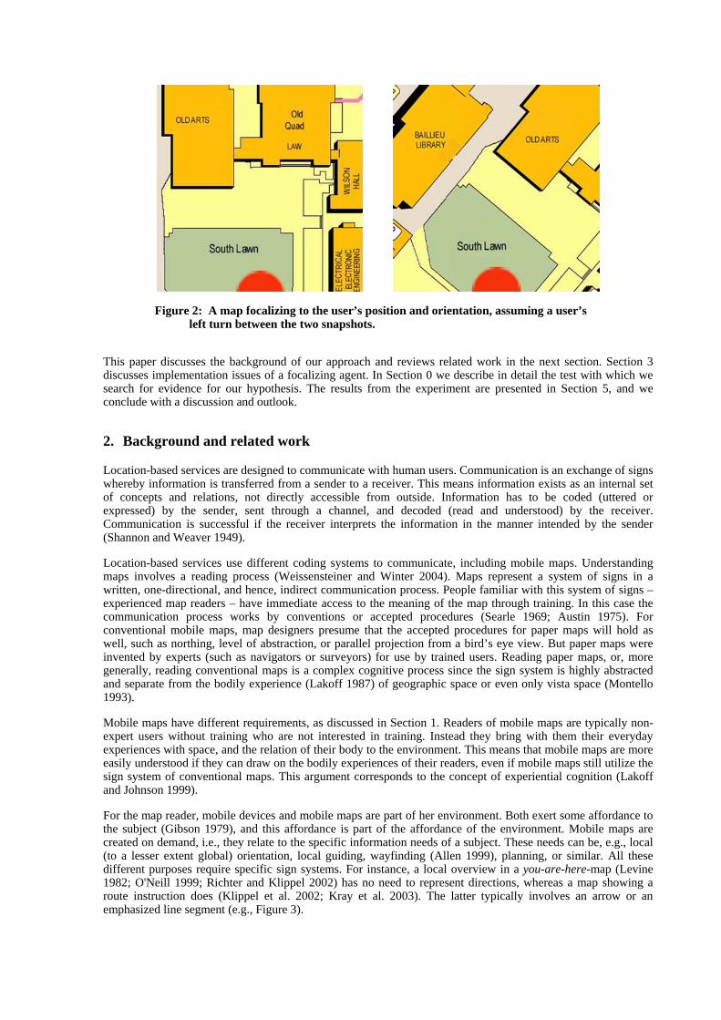
Figure 2: A map focalizing to the user’s position and orientation, assuming a user’s left turn between the two snapshots.
This paper discusses the background of our approach and reviews related work in the next section. Section 3 discusses implementation issues of a focalizing agent. In Section 0 we describe in detail the test with which we search for evidence for our hypothesis. The results from the experiment are presented in Section 5, and we conclude with a discussion and outlook.
2. Background and related work
Location-based services are designed to communicate with human users. Communication is an exchange of signs whereby information is transferred from a sender to a receiver. This means information exists as an internal set of concepts and relations, not directly accessible from outside. Information has to be coded (uttered or expressed) by the sender, sent through a channel, and decoded (read and understood) by the receiver. Communication is successful if the receiver interprets the information in the manner intended by the sender (Shannon and Weaver 1949).
Location-based services use different coding systems to communicate, including mobile maps. Understanding maps involves a reading process (Weissensteiner and Winter 2004). Maps represent a system of signs in a written, one-directional, and hence, indirect communication process. People familiar with this system of signs – experienced map readers – have immediate access to the meaning of the map through training. In this case the communication process works by conventions or accepted procedures (Searle 1969; Austin 1975). For conventional mobile maps, map designers presume that the accepted procedures for paper maps will hold as well, such as northing, level of abstraction, or parallel projection from a bird’s eye view. But paper maps were invented by experts (such as navigators or surveyors) for use by trained users. Reading paper maps, or, more generally, reading conventional maps is a complex cognitive process since the sign system is highly abstracted and separate from the bodily experience (Lakoff 1987) of geographic space or even only vista space (Montello 1993).
Mobile maps have different requirements, as discussed in Section 1. Readers of mobile maps are typically non-expert users without training who are not interested in training. Instead they bring with them their everyday experiences with space, and the relation of their body to the environment. This means that mobile maps are more easily understood if they can draw on the bodily experiences of their readers, even if mobile maps still utilize the sign system of conventional maps. This argument corresponds to the concept of experiential cognition (Lakoff and Johnson 1999).
For the map reader, mobile devices and mobile maps are part of her environment. Both exert some affordance to the subject (Gibson 1979), and this affordance is part of the affordance of the environment. Mobile maps are created on demand, i.e., they relate to the specific information needs of a subject. These needs can be, e.g., local (to a lesser extent global) orientation, local guiding, wayfinding (Allen 1999), planning, or similar. All these different purposes require specific sign systems. For instance, a local overview in a you-are-here-map (Levine 1982; O'Neill 1999; Richter and Klippel 2002) has no need to represent directions, whereas a map showing a route instruction does (Klippel et al. 2002; Kray et al. 2003). The latter typically involves an arrow or an emphasized line segment (e.g., Figure 3).

Figure 3: Route instruction with the user’s current position in the center, and the map oriented north-up (MapQuest and Navteq 2004.). This snapshot is from a webservice as it would appear on a web-enabled handheld device.
Conventionally, any of the above mentioned mobile maps shows the reader’s current position in its center (e.g., Figure 3, Figure 3), and they have constant orientation. It is well-known that people prefer to align a (paper) map with their environment (Figure 4), and that this alignment improves their wayfinding success. Both was shown for example by Warren and Scott (1993). Alignment should be provided automatically without having to rotate the mobile device. Rotating the mobile device seems to have only a low affordance for people.
Figure 4: Paper map aligned to a bus line in Melbourne (which is in west-east direction).
2.1 You-are-here-maps
There are basically two purposes for you-are-here-maps: global or local orientation. For global orientation a map reader seeks to get an idea of her current position in relation to a larger environment. This information need requires a level of detail that is typically not provided by mobile maps, but by maps put up on signs at fix positions in the environment. Alignment you-are-here-maps is a known issue for cognitive accessibility (Richter and Klippel 2002), but the reader’s position is typically somewhere in the map area (not necessarily in the center).
For local orientation a map reader seeks to get an idea of what is in the immediate neighborhood. This is an issue for mobile maps, since the amount of information is low, the immediate neighborhood is perceivable, and relations between map content and environment can directly be drawn. However, the conventional mobile map, centered position and north-up, requires the reader (a) to find and identify the marker you-are-here-sign, (b) to match the map image with features in the environment for identifying the rotation angle between egocentric
reference frame and the reference frame of the map (north), and (c) to mentally rotate the map. If our focalizing agent could produce a map for local orientation, map and subject would be co-aligned and no mental rotation would be required, and the you-are-here-sign is where the bodily experience of the subject expects it to be. Furthermore, any specific interest in a feature in the neighborhood will let the subject turn to it; at the same time the mobile device turns to it, making the feature of interest appear at the top of the map. This effect is similar to pointing (Egenhofer and Kuhn 1998; Egenhofer 2003), and hence should be highly automated by body experience.
2.2 Local guides
Purposes and means for local guiding are manifold and difficult to categorize in our context. The find-next-services relate to you-are-here-maps, but refer to an environment that is, in terms of extension, somewhere between their global or local extent. On the other hand, when a find-next-service comes up with a specific recommendation a wayfinding map is more appropriate (see below). A tourist guide could communicate by wayfinding maps (see below), by means of virtual reality (Yang et al. 1999; Schilling and Zipf 2003) or augmented reality (Wagner and Schmalstieg 2003; Reitmayr and Schmalstieg 2004), or by explaining route landmarks. The latter would be an extension of the local you-are-here-map, and could benefit from our focalizing agent.
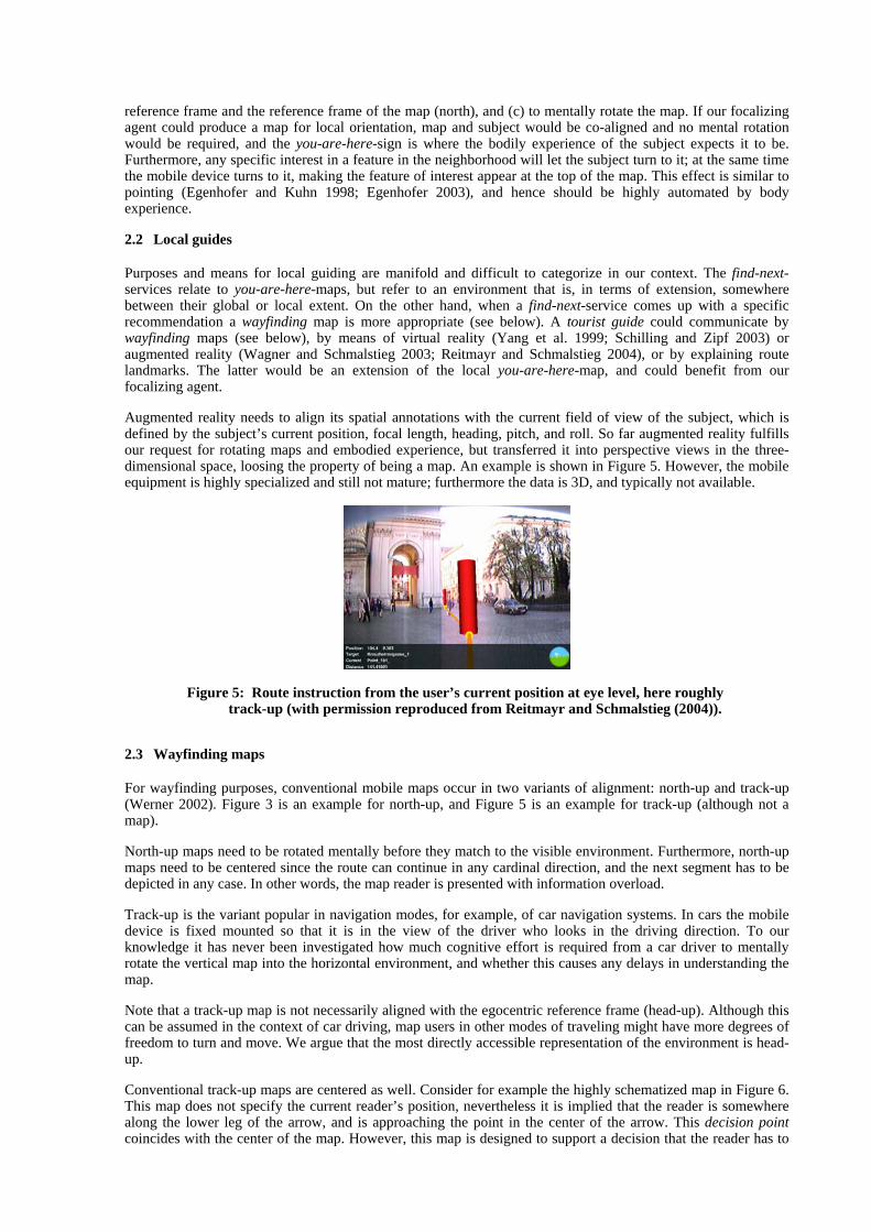
Augmented reality needs to align its spatial annotations with the current field of view of the subject, which is defined by the subject’s current position, focal length, heading, pitch, and roll. So far augmented reality fulfills our request for rotating maps and embodied experience, but transferred it into perspective views in the three-dimensional space, loosing the property of being a map. An example is shown in Figure 5. However, the mobile equipment is highly specialized and still not mature; furthermore the data is 3D, and typically not available.
Figure 5: Route instruction from the user’s current position at eye level, here roughly track-up (with permission reproduced from Reitmayr and Schmalstieg (2004)).
2.3 Wayfinding maps
For wayfinding purposes, conventional mobile maps occur in two variants of alignment: north-up and track-up (Werner 2002). Figure 3 is an example for north-up, and Figure 5 is an example for track-up (although not a map).
North-up maps need to be rotated mentally before they match to the visible environment. Furthermore, north-up maps need to be centered since the route can continue in any cardinal direction, and the next segment has to be depicted in any case. In other words, the map reader is presented with information overload.
Track-up is the variant popular in navigation modes, for example, of car navigation systems. In cars the mobile device is fixed mounted so that it is in the view of the driver who looks in the driving direction. To our knowledge it has never been investigated how much cognitive effort is required from a car driver to mentally rotate the vertical map into the horizontal environment, and whether this causes any delays in understanding the map.
Note that a track-up map is not necessarily aligned with the egocentric reference frame (head-up). Although this can be assumed in the context of car driving, map users in other modes of traveling might have more degrees of freedom to turn and move. We argue that the most directly accessible representation of the environment is head-up.
Conventional track-up maps are centered as well. Consider for example the highly schematized map in Figure 6. This map does not specify the current reader’s position, nevertheless it is implied that the reader is somewhere along the lower leg of the arrow, and is approaching the point in the center of the arrow. This decision point coincides with the center of the map. However, this map is designed to support a decision that the reader has to
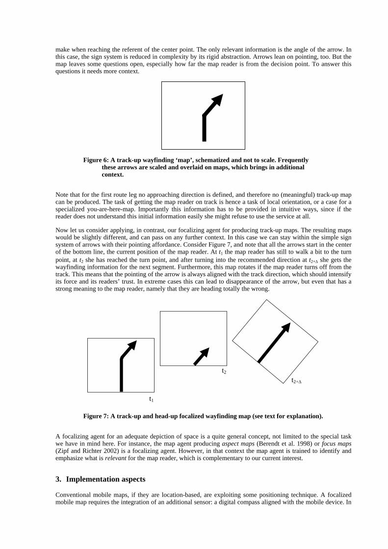
make when reaching the referent of the center point. The only relevant information is the angle of the arrow. In this case, the sign system is reduced in complexity by its rigid abstraction. Arrows lean on pointing, too. But the map leaves some questions open, especially how far the map reader is from the decision point. To answer this questions it needs more context.
Figure 6: A track-up wayfinding ‘map’, schematized and not to scale. Frequently these arrows are scaled and overlaid on maps, which brings in additional context.
Note that for the first route leg no approaching direction is defined, and therefore no (meaningful) track-up map can be produced. The task of getting the map reader on track is hence a task of local orientation, or a case for a specialized you-are-here-map. Importantly this information has to be provided in intuitive ways, since if the reader does not understand this initial information easily she might refuse to use the service at all.
Now let us consider applying, in contrast, our focalizing agent for producing track-up maps. The resulting maps would be slightly different, and can pass on any further context. In this case we can stay within the simple sign system of arrows with their pointing affordance. Consider Figure 7, and note that all the arrows start in the center of the bottom line, the current position of the map reader. At t1 the map reader has still to walk a bit to the turn point, at t2 she has reached the turn point, and after turning into the recommended direction at t2+∆ she gets the wayfinding information for the next segment. Furthermore, this map rotates if the map reader turns off from the track. This means that the pointing of the arrow is always aligned with the track direction, which should intensify its force and its readers’ trust. In extreme cases this can lead to disappearance of the arrow, but even that has a strong meaning to the map reader, namely that they are heading totally the wrong.
t1
t2 t2+∆
Figure 7: A track-up and head-up focalized wayfinding map (see text for explanation).
A focalizing agent for an adequate depiction of space is a quite general concept, not limited to the special task we have in mind here. For instance, the map agent producing aspect maps (Berendt et al. 1998) or focus maps (Zipf and Richter 2002) is a focalizing agent. However, in that context the map agent is trained to identify and emphasize what is relevant for the map reader, which is complementary to our current interest.
3. Implementation aspects
Conventional mobile maps, if they are location-based, are exploiting some positioning technique. A focalized mobile map requires the integration of an additional sensor: a digital compass aligned with the mobile device. In

client-server architectures of mobile focalizing services it further needs some considerations of efficient workload management and challenges.
A digital compass attached and aligned with a mobile device measures the heading of the device. Having position and heading of the handheld device, a service can provide a map which appears to be constantly aligned with the environment, whatever the heading of the map reader and the heading of the mobile device is. To guarantee alignment, the image rendered on the display has to be rotated by the negative value of the heading measured by the compass.
The region presented on the map needs to provide enough information about the surrounding space, and at the same time limit the region displayed to the minimum possible, due to limitations of current mobile devices displays. Thus, the scale will be modified according to the navigator’s environment, considering its elements relevant to the navigation task.
In general, two approaches to the design of the system are possible:
• A client-server based architecture, exploiting any ubiquitous wireless communication network, for instance GPRS or UMTS.
• A client-based architecture, deploying a local spatial database on the handheld device.
A client-based architecture is a straight-forward local application. Its disadvantage is the need of a mobile spatial database: memory of handheld devices is scarce, and local databases require maintenance or run out-of-date. The latter is a critical argument in real-time applications. Only client-server architectures can provide actual information in real time. Therefore we investigate the details of this approach in more detail. In this case, client and server have to communicate wirelessly. Typically, the workflow of a system will consist of the following steps:
1. At the client side, reading and parsing sensor inputs.
2. Building and submitting a query string for the server application.
3. At the server side, retrieving (and rendering) the corresponding image.
4. Sending the reply back to the client (and rendering if this is not done by the server application already), and presenting the result on the display.
In regards to step 1, current mobile devices are not easily connectable to a larger number of sensors and I/O devices. For an online application, three concurrent interfaces need to be implemented: compass, GPS, and a network connection. The input from the former two is typically in the form of ASCII formatted NMEA 0183 sentences (NMEA 2001), with a unique string at the beginning of each of the sentence, identifying the sensor. In our implementation we use either the strings $GPRMC or $GPGGA, providing minimum navigation instruction from the GPS (latitude, longitude, time), and $HCHDM (magnetic heading, measured clockwise from north in decimal degrees) string output of the digital compass (KVH Industries 1998).
Regarding step 2, current internet browser technologies do not provide direct port-reading capabilities due to security reasons. Therefore, it is not possible to implement such a system in a pure thin-client architecture, and a light-weight application needs to be built to support I/O communication and mimic the rendering capabilities of the browser.
Regarding steps 3 and 4, several architectures are possible with respect to the rotation of the map. On the server side, an application deploying a map server has to be built (OGC 2002). The server application needs to be able to handle a GetMap request with parameters input in WGS84 (the GPS reference system – assuming that the positioning technique of choice is GPS), i.e., to reproject the GPS parameters to the coordinate system of the data source of the map server. The rotation of the map can be handled by the map server or the client software. Because of continuous updates of the map image with every move or turn of the user, preferably the client software takes over the map generation allowing a better balance of workload between client and server.
With this strategy, the requests to the server can be limited to cases where the user moves out of a specified area. However, this approach requires that the server sends larger maps (or map data), enabling to shift the focus to the bottom of the image and still providing enough information in the direction of the user is heading in. This larger image is virtually clipped, masked on the device, in order to perfectly fill the display area of the GUI. According to the OGC WMS specification (OGC 2002), the output image size defined by the HEIGHT and WIDTH parameters is a compulsory part of a webmap server query. Assume that our application produces square output sizes of side length a. Then the area to be requested by a server can be estimated to HEIGHT=WIDTH= 8a ,
enabling the client software to shift the focus and to rotate the output image according to any heading of the device. Additional buffers can be included to incorporate a moving user anticipating her speed and direction.
Another challenge of rotating maps is text placement. Text labels of point and area features have to appear aligned to the image axes, which means that with continuous alignment their placement has to be revised if overlaps occur. Linear elements are typically labeled aligned with the feature, and hence are less critical, switching their orientation only twice over the full circle. Some web services started recently to orient aligned labels of linear features; try http://www.us.map24.com/. However, in a dynamic service this would increase computation requirements extremely, and seems to us not necessarily raising the readability of the map.
On the center of the bottom a convenient symbol can indicate the current position of the user. However, since that focus point does not change for any focalized map it is possible to integrate this mark directly in the user interface, for instance on the border of the masking area. Additionally, one can easily extend the user interface and bodily experience by adding an arrow to the image giving the general heading of the track continuation. The specific user interface design is however beyond the topic of this paper.
For the purpose of the experiments for this paper, an implementation using sets of pre-generated raster files on specified locations can be used. These raster files are text-free. A local application reads the digital compass, and produces focalized output. A simple user interface allows to switch between locations, and to record the times a specific map is shown.
4. Experiment
Experiments can collect evidence of whether a rotating map with current position on the bottom is more successful than conventional mobile maps, which are static in their heading and show the current position in the center of the image. With the known evidence that aligned maps are more successful (Warren and Scott 1993), the rotation aspect of the present proposal is already supported. For that reason the experiments can concentrate on the shift of focus to the bottom of the map, according to our hypothesis.
Experiments test reaction times of participants in spatial decision situations, where mobile maps are presented to support the decision. These tests do not only depend on the maps, but also on the type of decision to be made. We have selected a simple selection task, and leave other tasks for future work. Furthermore, they have to be designed such that only the factor in question – here: understanding the map – influences the observation. That is not given in the current context: the participants vary in their experience with maps, in their spatial abilities, and in their experience with mobile devices. Hence, we test each participant at several locations, between which the parameters of the tests will systematically vary. We will not compare the results between participants, but use the average values at the selected locations.
4.1 Participants
Participants in the experiment will be students from other faculties, with the expectation to find among them a larger number of inexperienced map readers. All participants are paid. No personal data is collected during the experiment. Participants are familiar with the test environment (the campus), but that does not affect the results since the selection task is randomized, and it is not related to wayfinding, which would be distorted by route or survey knowledge (Siegel and White 1975).
4.2 Design
In this experiment we concentrate on orientation by you-are-here-maps. The task for the participant is to identify a feature in the environment that is labeled on the mobile map. We observe the time the participant requires studying the map for solving this task.
Each participant is tested at several locations (lane intersections on campus). The participant is brought to each location, and posed in a pre-defined orientation. Target features are selected such that they appear in different angles at the different locations. On each map, all features are labeled by a randomized name (e.g., a capital character, or a color dot), to keep features anonymous, and to force the participants to use the map for their task even if they have prior knowledge of the environment. Participants are asked to identify the feature with a specific label in their environment.

4.3 Material
For the tests, maps are produced with randomized labels for each feature. These maps are presented on mobile handheld devices, in a sequence with instructions (see below). A supervisor accompanies the participant, and guides from location to location.
For one test group (group 1), the maps are produced by our focalizing agent. These maps rotate when the participant turns, and show the current position on the bottom of the map. For a second group (group 2), the maps rotate, but show the current position in the center. For a third group (group 3), the maps do not rotate; they are oriented north-up, and they show the current position in the center.
4.4 Procedure
The participant is equipped with a mobile device, and instructed in its usage. The supervisor guides the participant to a test location. Then the mobile device controls the sequence of instructions and actions (Figure 8):
• After arrival at a location, the participant reads an instruction. The instruction is deliberately kept simple and easy to memorize. It tells the participant which feature on the map she has to identify in her environment.
• Then, when the participant confirms that she has read and understood the instruction – i.e., when she presses the map-button – a map appears showing the environment, with labeled features. The map is of an appropriate level of detail and uniform scale, but it does not show any more text.
• The participant orients herself in her environment with the help of the map, and makes a decision about the feature to identify. As soon as this decision is made the participant is instructed to press the ready-button, which lets the map disappear, and to point the supervisor to the feature. The device registers the time between pressing a map-button and a ready-button, i.e., the time interval the map was visible, or studied.
• The supervisor observes the actions of the participant taken, especially whether the choice of a feature is correct, and guides to the next location.
Choose lane A
to continue.
[map]
Choose lane B
to continue.
[map]
[ready]
Figure 8: A sequence of the user interface screens during the experiment. We observe the time a participant studies the map to make a decision.
After finishing the experiment, the participants have the opportunity to give additional individual feedback about their feelings during the travel, and about specific difficulties experienced.
5. Results from the experiment
At the time of writing the paper, the experiment is not finished. The results from the experiment will be reported at the workshop.
Each participant produces a record of time intervals representing the times she studied a map at selected locations to become oriented. The fact that each participant produces several observations allows us to check the consistency of the individual behavior, and to identify outliers in each record.
Having a larger number of participants, the individual records can be compared or averaged. The spatial abilities of the individual participants will vary, and hence, a larger variance is to be expected. It is also possible to calculate averages for the single locations, which allows comparison of the complexity of the tasks at the individual locations. However, our main interest is the comparison of the three groups. The hypothesis is validated only if the average study time of group 1 is statistically significant shorter than the averages of the two other groups.
6. Conclusion
Motivated by the observation of different usages of paper maps and mobile maps, we have proposed a shift in focus in the design of mobile maps. We argue that the bodily experience of the map reader and the affordance of the device and the map appearance should drive the map design. We present principles of correspondingly focalized you-are-here-maps and wayfinding maps. Our expectation is that, at least for untrained map readers, these maps are cognitively more easily accessible than conventional mobile maps. We propose experiments studying the reaction times of participants on spatial orientation tasks to test this hypothesis. The results from the experiments are still due.
It is beyond of the scope of this paper to deal with the interface design of focalizing location-based services. The interface design concerns the graphic appearance of the proposed maps, navigation, selection, and an appropriate scale and level of detail. The interface design is correlated with the proposed shift of focus, which means that design can be tested in similar experiments for its cognitive accessibility. For this reason we kept the design of the mobile maps in our experiments the same for the different groups. – We can, for instance, extend the argument of body experience to the reader’s visual perception, and develop presentation forms that include the horizon (Kulik and Egenhofer 2003).
Additionally, the new paradigm for a focalizing map agent has to be carefully developed and tested for other categories of mobile maps as well, since the experiment is task dependent. It is also interesting to study whether the shifted focus has effects on route learning, memory, or the construction of a mental map (Tolman 1948).
Acknowledgements
Alexander Klippel gave valuable comments to a draft of this paper. We acknowledge support by an ECR Grant of The University of Melbourne, and partial support by the Cooperative Research Center for Spatial Information through project 3.3.
References
Allen, G.L., 1999: Spatial Abilities, Cognitive Maps, and Wayfinding. In: Golledge, R.G. (Ed.), Wayfinding Behavior, Johns Hopkins University Press, Baltimore, pp. 46-80.
Austin, J.L., 1975: How to Do Things with Words. Clarendon Press, Oxford. Bal, M., 1997: Narratology: Introduction to the Theory of Narrative. University of Toronto Press, Toronto. Berendt, B.; Barkowsky, T.; Freksa, C.; Kelter, S., 1998: Spatial Representation with Aspect Maps. In: Freksa,
C.; Habel, C.; Wender, K.F. (Eds.), Spatial Cognition. Lecture Notes in Artificial Intelligence, 1404. Springer, Berlin, pp. 313-336.
Cartwright, W.; Peterson, M.P.; Gartner, G. (Eds.), 1999: Multimedia Cartography. Springer, New York, 343 pp. Egenhofer, M., 2003: A Family of Smart Maps. In: Timpf, S. (Ed.), Euresco Conference on Geographical
Domain and Geographical Information Systems. ESF, Bad Herrenalb, Germany. Egenhofer, M.; Kuhn, W., 1998: Beyond Desktop GIS. Proceedings of GISPlanet '98, Lisbon,
www.spatial.maine.edu/~max/BeyondDesktopGIS.pdf. Last accessed 29.7.2004. Gibson, J.J., 1979: The Ecological Approach to Visual Perception. Houghton Mifflin Company, Boston.

Klippel, A.; Tappe, H.; Habel, C., 2002: Pictorial representations of routes: Chunking route segments during comprehension. In: Freksa, C. et al. (Eds.), Spatial Cognition III, Springer, Berlin.
Kraak, M.-J.; Brown, A. (Eds.), 2001: Web Cartography. Taylor & Francis, London, 213 pp. Kray, C.; Laakso, K.; Elting, C.; Coors, V., 2003: Presenting Route Instructions on Mobile Devices, Proceedings
of the 8th International Conference on Intelligent User Interfaces. ACM Press, Miami, FL, pp. 117-124. Kulik, L.; Egenhofer, M., 2003: Linearized Terrain: Languages for Silhouette Representation. In: Kuhn, W.;
Worboys, M.F.; Timpf, S. (Eds.), Spatial Information Theory. Lecture Notes in Computer Science, 2825. Springer, Berlin, pp. 128-145.
KVH Industries, I., 1998: C100 Compass Engine Technical ManualKVH Part No. 54-0044 Revision G2, KVH Industries, Inc.
Lakoff, G., 1987: Women, Fire, and Dangerous Things - What Categories Reveal about the Mind. The University of Chicago Press, Chicago, 614 pp.
Lakoff, G.; Johnson, M., 1999: Philosophy in the Flesh: The Embodied Mind and its Challenge to Western Thought. Basic Books, New York.
Levine, M., 1982: You-Are-Here Maps: Psychological Considerations. Environment and Behaviour, 14: 221-237.
Montello, D.R., 1993: Scale and Multiple Psychologies of Space. In: Frank, A.U.; Campari, I. (Eds.), Spatial Information Theory. Lecture Notes in Computer Science, 716. Springer, Berlin, pp. 312-321.
NMEA, 2001: The NMEA 0183 Protocol, http://nmeatool.nmea2000.de/download/0183.pdf. Last accessed 23.7.2004.
OGC, 2002: Web Map Service Implementation Specification. OpenGIS Implementation Specification OGC 01-068r3, Open GIS Consortium Inc.
O'Neill, M.J., 1999: Theory and research in design of 'you-are-here' maps. In: Zwaga, J.G.; Boersma, T.; Hoonhout, H.C.M. (Eds.), Visual information for everyday use - design and research perspectives, Taylor & Francis, London, pp. 225-238.
Reitmayr, G.; Schmalstieg, D., 2004: Collaborative Augmented Reality for Outdoor Navigation and Information Browsing. In: Gartner, G. (Ed.), Symposium Location Based Services and TeleCartography 2004, Vienna, Austria, pp. 31-41.
Richter, K.-F.; Klippel, A., 2002: You-Are-Here Maps: Wayfinding Support as Location Based Service, GI-Tage. Institute for Geoinformatics, Munster, Germany.
Schilling, A.; Zipf, A., 2003: Generation of VRML City Models for Focus Based Tour Animations, 8th International Symposium on Web 3D Technology, Saint Malo, France.
Searle, J.R., 1969: Speech Acts. Cambridge University Press, Cambridge. Shannon, C.E.; Weaver, W., 1949: The Mathematical Theory of Communication. The University of Illinois
Press, Urbana, Illinois. Siegel, A.W.; White, S.H., 1975: The Development of Spatial Representations of Large-Scale Environments. In:
Reese, H.W. (Ed.), Advances in Child Development and Behavior, 10. Academic Press, New York, pp. 9-55.
Tolman, E.C., 1948: Cognitive Maps in Rats and Men. Psychological Review, 55 (4): 189-208. Wagner, D.; Schmalstieg, D., 2003: First Steps Towards Handheld Augmented Reality. In: Narayanaswami, C.;
Feiner, S.; Mizell, D. (Eds.), Proceedings of the 7th International Conference on Wearable Computers, White Plains, NY.
Warren, D.H.; Scott, T.E., 1993: Map alignment in traveling multisegment routes. Environment and Behavior, 25 (5): 643-666.
Weissensteiner, E.; Winter, S., 2004: Landmarks in the Communication of Route Instructions. In: Egenhofer, M.; Freksa, C.; Miller, H.J. (Eds.), GIScience. Lecture Notes in Computer Science, Springer, Berlin, pp. in print.
Werner, S., 2002: Cognitive Reference Systems and their Role in Designing Spatial Information Displays. Kuenstliche Intelligenz (4): 10-13.
Yang, J.; Yang, W.; Denecke, M.; Waibel, A., 1999: Smart Sight: A Tourist Assistant System, The Third International Symposium on Wearable Computers (ISWC'99).
Zipf, A.; Richter, K.-F., 2002: Using Focus Maps to Ease Map Reading. Künstliche Intelligenz (4): 35-37.