Shaping informality. The role of street-based strategies in revitalizing informal and low-income...
17
Shaping informality. The role of street-based strategies in revitalizing informal and low-income areas. Oscar Carracedo García-Villalba National University of Singapore, Singapore. Email: [email protected] Urbanization is a transformative process and as a consequence of cities growth and development, informal settlements and low-income areas arise. This urbanization outcome is mainly taking place in the developing world, where the informal city is a growing phenomenon and is becoming the norm. Recent approaches to the regeneration of informal settlements are evolving into strategies characterized by improving their existing conditions, minimizing relocations of their inhabitants. This on-site approach, together with street-based upgrading, constitutes an effective eviction alternative that facilitates regeneration. This paper argues that street-based upgrading plays an essential role in the regeneration process of low-income and informal areas, since it preserves the social organization network of communities, secures land tenure rights and promotes productivity and economic activity. Keywords: Urban regeneration, Informal settlements, Street-based upgrading, On-site upgrading, Urban design, Placemaking, Informal settlements in inner cities are a growing phenomenon in the developing world. According to the estimates of the United Nations, the 32 per cent of the world’s population, nearly one billion people, now live in informal conditions, and with no action the number will reach 50 per cent by 2030 (UN-Habitat, 2003). Particularly in low-income areas and in informal settlements, the overcrowding and high density, together with the small size of housing units and the lack of public spaces, increases the peoples stress and tension. If public space is absent, inadequate or privatized, the city becomes segregated and ghettified (Project for Public Spaces, 2012). For these reasons, the street, the public space of the informal areas, becomes of great importance for people's quality of life. They provide identity and liveable places for the community, offer the opportunity for social, cultural and economic interaction in the daily life of people, and play a fundamental role in the urban structure and the civic pattern of cities. The provision and investment in streets and public spaces has to be seen as an essential resilient strategy for the urban regeneration of low-income and informal areas. If neighbors have a positive image of the public spaces they use daily, a sense of pride would arise, which is crucial for the community development (Fiori & Brandao, 2007).
Transcript of Shaping informality. The role of street-based strategies in revitalizing informal and low-income...
Shaping informality. The role of street-based strategies in revitalizing
informal and low-income areas.
Oscar Carracedo García-Villalba
National University of Singapore, Singapore.
Email: [email protected]
Urbanization is a transformative process and as a consequence of cities growth and development, informal settlements and low-income areas arise. This urbanization outcome is mainly taking place in the developing world, where the informal city is a growing phenomenon and is becoming the norm. Recent approaches to the regeneration of informal settlements are evolving into strategies characterized by improving their existing conditions, minimizing relocations of their inhabitants. This on-site approach, together with street-based upgrading, constitutes an effective eviction alternative that facilitates regeneration. This paper argues that street-based upgrading plays an essential role in the regeneration process of low-income and informal areas, since it preserves the social organization network of communities, secures land tenure rights and promotes productivity and economic activity. Keywords: Urban regeneration, Informal settlements, Street-based upgrading, On-site upgrading, Urban design, Placemaking,
Informal settlements in inner cities are a growing phenomenon in the developing world.
According to the estimates of the United Nations, the 32 per cent of the world’s
population, nearly one billion people, now live in informal conditions, and with no action
the number will reach 50 per cent by 2030 (UN-Habitat, 2003).
Particularly in low-income areas and in informal settlements, the overcrowding and high
density, together with the small size of housing units and the lack of public spaces,
increases the peoples stress and tension. If public space is absent, inadequate or
privatized, the city becomes segregated and ghettified (Project for Public Spaces,
2012). For these reasons, the street, the public space of the informal areas, becomes
of great importance for people's quality of life. They provide identity and liveable places
for the community, offer the opportunity for social, cultural and economic interaction in
the daily life of people, and play a fundamental role in the urban structure and the civic
pattern of cities.
The provision and investment in streets and public spaces has to be seen as an
essential resilient strategy for the urban regeneration of low-income and informal areas.
If neighbors have a positive image of the public spaces they use daily, a sense of pride
would arise, which is crucial for the community development (Fiori & Brandao, 2007).
Connecting the divided city. Street-based urbanism in Medellín.
One of the most important actions to regenerate and to improve the quality of life of
low-income and informal neighborhoods is to connect them to the rest of the city by
using the streets. With the creation of continuities, sequences and linkages between
spaces, it is possible to promote social inclusion, forge identity and reduce the gap
between the formal and the informal city. Thus, enhancing urban connectivity implies
the continuity of the urban structure, discouraging the perpetuation of the fragmentation
of the city and the characteristic lack of urbanity of informal areas.
This is one of the strategies used in Medellin to improve the informal conditions of
several of its neighborhoods. In 1993, a new approach for improving informal areas
started in response to the failure of policies to eradicate urban informality as the only
possible alternative. With the objectives of integrating informal settlements in the
"formal" urban fabric, relocate houses, regularize and legalize land tenureship, and for
setting up mechanisms for planning, management and participation, the government
and local agencies implemented a series of plans and programs1.
In 2004, the Urban Development Enterprise (EDU), a public agency created in 1993,
began a series of strategic urban projects identified in the Development Plan to
improve the neighborhoods with higher rates of poverty and informality and less sense
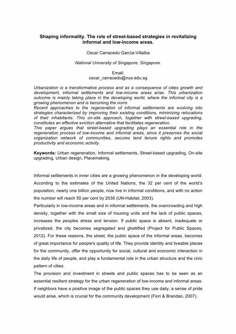
of belonging. The Comprehensive Urban Projects (PUI) (fig 1) or the Library Parks
Strategic Project, were created to perform several urban and social inclusion actions,
based on a model of urban growth committed to the improvement, consolidation,
regeneration, regularization, relocation and upgrading of informal settlements.
Two of the major urban strategies on which is supported the urban regeneration
process of Medellín, are mobility and public space.
The first urban strategy seeks to facilitate connectivity. The purpose is to connect and
integrate the traditionally marginalized areas, located on the city's steep hillsides,
through alternative transport systems linked to the Metro, the main form of public
transport in the city. In this case, the proposal of a cable car system, the Metrocable
(fig 2), provides to the settlements a fast connection with the rest of the city.
The second urban strategy is committed to the priority of the street and public space,
as well as to its generation, consolidation, improvement and social appropriation. In
addition, this strategy articulates public spaces with facilities, heritage and mobility
systems, where pedestrians and public transport have right of way2. This strategy,
1 Comprehensive Plan for the Improvement of Informal Neighborhoods (PRIMED), Territorial Urban Plan (POT), Development Plans. 2 Alcaldía de Medellín. Acuerdo 46 de 2006. Plan de Ordenamiento Territorial (POT) Artículo 2. Lineamiento 3.

implemented mainly through the PUI, considers the public space as the essence of the
city, and as the main cohesive and regenerator element of the neighborhoods.
Figure 1. Comprehensive Urban Projects (PUI) 2004-2011 and Northwest PUI. (EDU - urbam EAFIT and Author)

Figure 2. Metrocable and centrality of La Candelaria. (EDU - urbam EAFIT) In this sense, when constructing the Metrocable, the city not only invested in the
improvement of the accessibility and mobility, but also took advantage of the
construction of the stations and the piles to support the cable car to provide the hillside
neighborhoods with new public spaces and centralities at their bases as lively and
vibrant neighborhood places. The connection between these centralities and the rest of
the neighborhood through linear parks, squares, promenades, streets, or pedestrian
skywalks (fig 3), created a complex structural network and a civic pattern for the
neighbors.
In addition to this street-based network, the Library Parks Strategic Project (fig 4)
located five iconic buildings in five strategic positions inside the disadvantaged
neighborhoods. Placed together with quality public spaces and with other cultural,
recreational and educational buildings, these architectonic devices achieved to trigger
processes of transformation and regeneration of the neighborhoods from the inside.
Under this conception of street-based urbanism and architecture as catalysts of
physical and social transformations, a total of 4 PUI have been developed since 2004,
with an impact on 98 districts and on 40% of the population of Medellín. Taking the pilot
project of Juan Bobo in the Northeast PUI as an indicator for the socioeconomic
evaluation of the programs and projects, we note that, after its implementation, public
space has increased by 1200% per person, and the building footprint has decreased by
15%, being reduced to a total of 55% of the whole area. This increase in public space,
carried out residential improvements such as the decrease of the housing density, the
relocation of dwellings located in risk areas, the increase by 31% of the average
housing living area, or the improvement and legalization of 100% of households. In
addition, the implementation of the Metrocable helped to improve the socioeconomic
status of the neighborhood residents, integrating them to other districts, and reducing
travel time and costs. As a result of reduced spending on travel, families have had an
average saving of 4% on the average income, which has represented an improvement

for almost 95% of the users in the neighborhood (EDU, 2013). Referring to the entire
area of the Northeast PUI, a total of 18 parks, 2.8 Km of pedestrian promenades and 4
pedestrian bridges were created, which means more than 125,000 sqm of public
space. As a consequence of these improvements on the public space, trade increased
by 300%, and 10 corporate events were made, which generated sales of US$ 80,000.
Furthermore, it should be noted that, for the execution of these projects, 92% of the
hired workforce were neighbors, which stimulated the local economy and reduced
unemployment.
Figure 3. Civic pattern of linear parks, squares, promenades, streets and pedestrian skywalks. Before and after. (EDU -
urbam EAFIT)
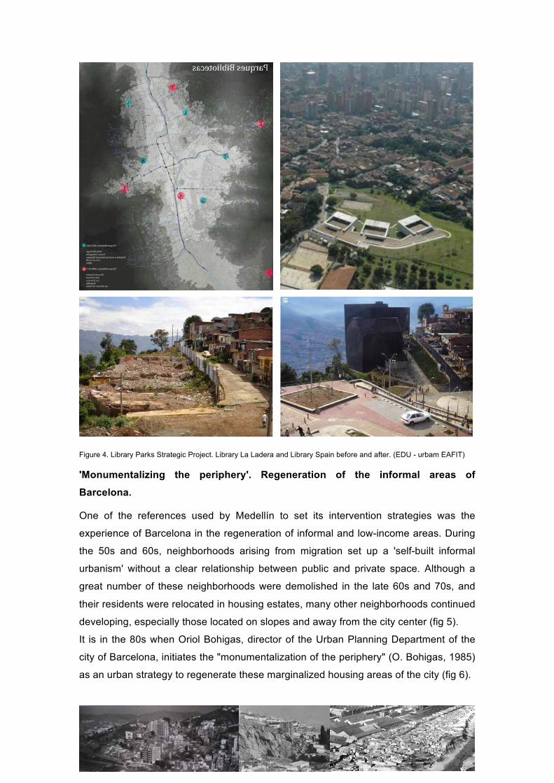
Figure 4. Library Parks Strategic Project. Library La Ladera and Library Spain before and after. (EDU - urbam EAFIT)
'Monumentalizing the periphery'. Regeneration of the informal areas of
Barcelona.
One of the references used by Medellín to set its intervention strategies was the
experience of Barcelona in the regeneration of informal and low-income areas. During
the 50s and 60s, neighborhoods arising from migration set up a 'self-built informal
urbanism' without a clear relationship between public and private space. Although a
great number of these neighborhoods were demolished in the late 60s and 70s, and
their residents were relocated in housing estates, many other neighborhoods continued
developing, especially those located on slopes and away from the city center (fig 5).
It is in the 80s when Oriol Bohigas, director of the Urban Planning Department of the
city of Barcelona, initiates the "monumentalization of the periphery" (O. Bohigas, 1985)
as an urban strategy to regenerate these marginalized housing areas of the city (fig 6).

Figure 5. Informal areas and precarious infrastructure in the sloppy informal settlements. El Carmel and Somorrostro,
today Barcelona's Olympic Village (Ajuntament de Barcelona).
Housing estates relocation sites. La Guineuta and Montbau. (Ajuntament de Barcelona / Manuel Guàrdia)
Figure 6. 'Monumentalizing the periphery'. The paradigmatic case of Via Julia. (Bernardo de Sola)
This policy, which extends during the 90s, over the pre and post-Olympic periods, is
based on a deep analysis and assessment of the characteristics of urban informal
settlements. The challenges of this strategic commitment lies in the effort to keep the
existing housing as far as possible, and in connecting the marginal sectors with the rest

of the city. But, above all, the main challenge lies in the use of streets and public
spaces as essential elements of the vitality of the informal city that, together with the
provision of facilities, must be the catalyst to regenerate the neighborhoods.
However, the most innovative aspect is the introduction of art works (fig 7) as a a new
concept for the urban regeneration of neighborhoods, linking them to public spaces as
a strategy to strengthen the sense of identity and belonging to the place. Although in
most of the cases the art sculptures were not created for the specific context in which
they were located, they constituted a formal element in the transformation of public
space itself, and acted as a reference point for the regeneration of the neighborhood.
In conclusion, a successfully tested strategy and methodology, that has been also
applied in Medellín (Echeverri & Orsini, 2010) looking for a similar urban effect, but in
this case using the iconic role of architecture.
Figure 7. Art as an urban regeneration strategy. (Raymond Elstad, Naggy Judit, Enric Vision)
A change of scale and complexity. The Asian experience.
Based on prior knowledge of these experiences, the projects for the neighborhoods of
Karet Tengsin in Jakarta, and Baseco in Manila, also rely on street-based strategies for
their future regeneration incorporating, however, some innovative aspects.
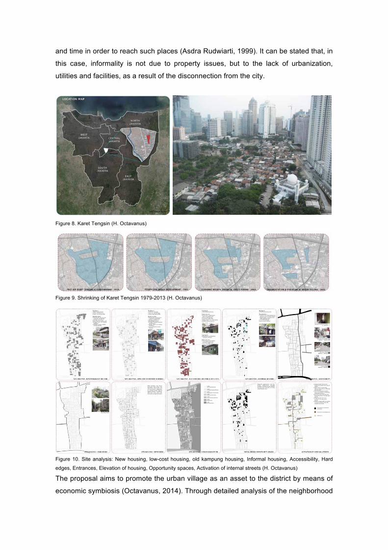
Karet Tengsin is a high-dense mid-city kampung located in the 'Golden Triangle' of the
CBD of Jakarta (fig 8). This strategic position together with the pressure of commercial
developments around it has caused the shrinkage of the village to its current size,
isolating it from the rest of the district (fig 9). However, despite this enormous pressure,
and due to the high land value, the area has not been completely gentrified, and is still
largely occupied by low-income households with different cultures, ethnic origins and
social strata, with a high attachment to the place.
One significant factor is that most of the land in Karet Tengsin is owned by the people
living there, which hold different types of tenure. Most of the people are unwilling to
move out arguing that the existing site location is very strategic, accessible and close
to the places they usually frequent to go to (work place, children school, relative’s
house, daily needs...), so that they do not need to spend more on transportation cost
and time in order to reach such places (Asdra Rudwiarti, 1999). It can be stated that, in
this case, informality is not due to property issues, but to the lack of urbanization,
utilities and facilities, as a result of the disconnection from the city.
Figure 8. Karet Tengsin (H. Octavanus)
Figure 9. Shrinking of Karet Tengsin 1979-2013 (H. Octavanus)
Figure 10. Site analysis: New housing, low-cost housing, old kampung housing, Informal housing, Accessibility, Hard
edges, Entrances, Elevation of housing, Opportunity spaces, Activation of internal streets (H. Octavanus)
The proposal aims to promote the urban village as an asset to the district by means of
economic symbiosis (Octavanus, 2014). Through detailed analysis of the neighborhood
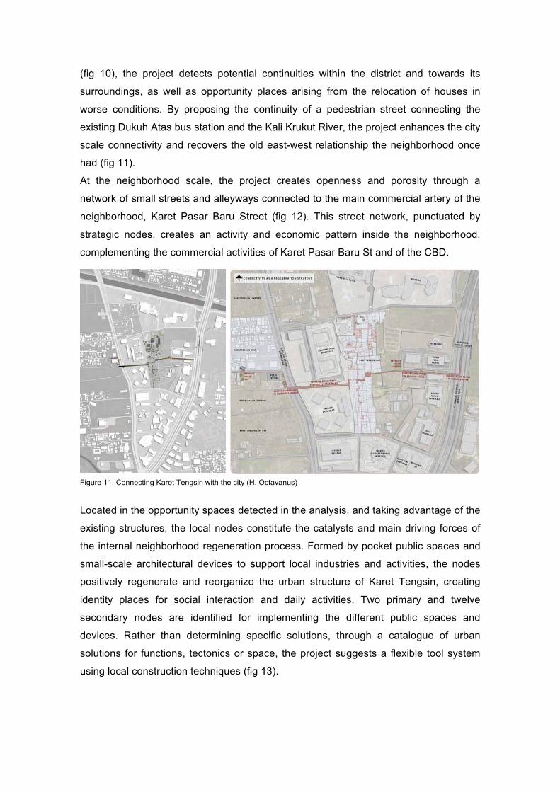
(fig 10), the project detects potential continuities within the district and towards its
surroundings, as well as opportunity places arising from the relocation of houses in
worse conditions. By proposing the continuity of a pedestrian street connecting the
existing Dukuh Atas bus station and the Kali Krukut River, the project enhances the city
scale connectivity and recovers the old east-west relationship the neighborhood once
had (fig 11).
At the neighborhood scale, the project creates openness and porosity through a
network of small streets and alleyways connected to the main commercial artery of the
neighborhood, Karet Pasar Baru Street (fig 12). This street network, punctuated by
strategic nodes, creates an activity and economic pattern inside the neighborhood,
complementing the commercial activities of Karet Pasar Baru St and of the CBD.
Figure 11. Connecting Karet Tengsin with the city (H. Octavanus)
Located in the opportunity spaces detected in the analysis, and taking advantage of the
existing structures, the local nodes constitute the catalysts and main driving forces of
the internal neighborhood regeneration process. Formed by pocket public spaces and
small-scale architectural devices to support local industries and activities, the nodes
positively regenerate and reorganize the urban structure of Karet Tengsin, creating
identity places for social interaction and daily activities. Two primary and twelve
secondary nodes are identified for implementing the different public spaces and
devices. Rather than determining specific solutions, through a catalogue of urban
solutions for functions, tectonics or space, the project suggests a flexible tool system
using local construction techniques (fig 13).

Figure 12. Openness and porosity. A network of small streets and alleyways connecting nodes, public spaces and
productive devices. (H. Octavanus)
Figure 13. Street-based catalogue of solutions (H. Octavanus)

In the case of Baseco in Manila (fig 14), the strategy consists in transforming the
streets into arteries of the community's social interaction and daily activities, as well as
into an infrastructural strategy for water (Ee Xinmei, 2014).
Barangay 649, Baseco3, is the formal name of the district located at the mouth of the
Pasig River. In 1990 Baseco became the government’s official relocation site for
evicted slum-dwellers from different parts of the city, leading to an accelerated growth
of the area. The space between the two breakwaters was reclaimed with land filling
materials and garbage to create enough room to house all the families, becoming the
largest informal community in Manila with more that 6.000 families, 70.000 inhabitants
and 13.000 housing units stacked in 52-hectares (fig 15). In 2002, the area was
proclaimed as a socialized housing site by the President, and the land was awarded to
its inhabitants. However, today, none of its inhabitants has received any property title.
Other than some public structures provided by the government, the Baseco compound
has been left relatively forgotten and cut off from the city of Manila.
Figure 14. Baseco site (MLA-NUS, Google maps)
Figure 15. Land reclamation with filling materials and garbage (MLA-NUS)
3 The area is named after the owner, the company Batann Shipping and Engineering Company (BASECO). Before its abandonment it was used as a ship loading and unloading site.

In contrast to the current role of the streets in Baseco as simply the remnant empty
space for people and vehicles (fig 16), the proposal understands the potential of streets
to become spaces for social interaction and daily activities, as well as community-
managed infrastructures that can help to relieve the pressures of flooding.
Figure 16. Existing street pattern and infrastructural spines (A. Ee Xinmei)
Due to the high density at which the settlement is currently built-up to, and with the aim
of minimizing the relocation of families, the proposal utilizes the existing streets as the
available space for a series of infrastructural spines that will create room for the excess
water during rainstorms (fig 16). Through this street-based approach, the proposal
identifies five streets that will act as flood channels to drain the rainwater off into the
sea. At the same time, these streets will be a sequence of interconnected public
spaces and activity nodes along them to positively transform and improve the quality of
the neighborhood. By selecting one of the five proposed flood channels as a
representative site, the project further explores the potential of implanting a catalogue
of solutions for the street cross-section depending on the urban context, suggesting
different possibilities for gathering, productive, environmental and water spaces (fig
17).
By extending the existing streets, the proposal offers the potential to connect and
extend the infrastructure, the public spaces, and the economic activities towards the
coastline.
With these street-based interventions, it is expected that the five streets will have an
impact in the urban regeneration of the neighborhood, as they will constitute urban
structure elements and connection for the neighborhood and the city; they will generate
productive spaces for the local economy; they will be enhanced as a collective spaces
for social gathering and to strengthen the sense of community and security among
neighbors; and lastly, they will play the role of green-infrastructure for the
environmental improvement of the neighborhood.

Figure 17. Public space and Green-infrastructure. Productive nodes and street-based catalog solutions along a spine
(A. Ee Xinmei)
From plan, to projects. Large urban projects and small-scale tactical urbanism.
Even though all the cases explained show how the street-based upgrading strategy
work as a catalyst for the revitalization and transformation of low-income and informal
areas, generating productive spaces for economy and creating sense of community,
we can observe a slight change in the trend of the projects.
Thus, while in the first two cases we observe that from comprehensive policies,
programs and plans, derive large urban interventions of infrastructure, facilities and
public space, in Manila and Jakarta is noticeable a change of scale. These two
proposals focus more on the scale of the neighborhood, exploring potential
methodologies and innovative strategies for regenerating these informal areas through
small-scale interventions, and taking advantage of the existing reality and detecting
latent opportunities in the neighborhood. This change of scale, closer to tactical
urbanism projects with specific actions and small projects, shows a transition from the
plan to the project, allowing for a more bottom-up approach and not depending so
much on the development of projects coming from bigger plans.
However, this approach has the risk of resulting in a host of small actions disconnected
from each other without a global overview. It should be added that most of these small
interventions also depend on political decisions and, without a regulatory framework or
a powerful neighborhood initiative, can become very difficult to implement.
Finally, it is important to note how the proposals for Manila and Jakarta incorporate
contemporary concerns regarding environmental aspects. In these cases, the reflection
on the street as a public space as well as a green-infrastructure, provides an added
value to the street-based strategies, transforming the streets into public spaces and
infrastructural devices capable to solve environmental issues while public life and
productivity are also enhanced.

References
Alcaldía de Medellín (2004): "Plan de Desarrollo Municipal 2004 -2007". Medellín, Compromiso de Toda la Ciudadanía. Medellín. Alcaldía de Medellín, 2004.
Alcaldía de Medellín (2006): "Plan de Ordenamiento Territorial". Medellín. Alcaldía de Medellín, 2006.
Asdra Rudwiarti, L. (1999): "Jakarta core area development. Case study of Karet Tengsin area". Max Lock Centre. University of Westminster. London
Balbo, M.; Jordán, R.; Simoni, D. (2003): “La Ciudad Inclusiva” (The inclusive city). United Nations, Santiago de Chile.
Bohigas, O. (1986): "Los barrios viejos y la periferia" in "Reconstrucción de Barcelona". Mopu, Madrid 1986. p.25-54.
Bohigas, O. (1985): "Reconstrucción de Barcelona". Madrid: Ministerio de Obras Públicas y Urbanismo. Secretaría General Técnica. Servicio de Publicaciones. 1986
Busquests i Grau, J. (1999): "La urbanización marginal" España: Ediciones UPC, 1999.
Carracedo, O. (2013): "Regenerating neighborhoods through identity and community places Planning and developing strategies for resilient informal settlements". Conference Proceddings. 7th Conference of the International Forum on Urbanism (IFoU). Tainan. Taiwan, October 2013.
Carracedo, O.; Noguer, N. (2013): “Upgrading suburbs in the Latin American context. A managment and transformation review of the slums”, Conference Proceddings. 25th Conference of the European Network of Housing Research, Tarragona, June 2013.
Carracedo, O.; Noguer, N. (2013): “Retrofitting suburbia and informal slums in the Latin American context. Recovering neighborhoods in extreme poverty conditions with tactical urbanism and new urbanism principles”, 21st Conference of New Urbanism, Salt Lake City, May 2013.
Carracedo, O.; Sotoca, A. (2013): “From Master Plan to punctual interventions”, 21st Conference of New Urbanism, Salt Lake City, May 2013.
Carracedo, O.; Sotoca, A. (2011): “Housing in the former periphery of Barcelona: Towards the finding of criteria for urban renewal”, 23rd Conference of the European Network of Housing Research, Tolousse, July 2011.
De Lecea, I. (2004): "Arte público, ciudad y memoria" in "on the W@terfront". Universitat de Barcelona. Polis Research Centre. Public Art Observatory Project.
Ee Xinmei, A. (2014): "Space for the water & the community. Transforming streets in Baseco to alleviate flooding and provide infrastructure for the community" MArch Thesis. National University of Singapore (NUS). Department of Architecture. Tutor: O. Carracedo
Echeverri Restrepo, A.; Orsini, F.M. (2010): "Informalidad y urbanismo social en Medellín" in "Medellín Medio Ambiente Urbanismo Sociedad". Ed. M. Hermelin, A. Alejandro Echeverri Restrepo, J. Giraldo Ramírez. Universidad EAFIT (Medellín, Colombia) Centro de Estudios Urbanos y Ambientales - urbam
Echeverri Restrepo, A.: "Políticas y proyectos estratégicos urbanos para Medellín". EDU Medellín. Alcaldía de Medellín.
Empresa de Desarrollo Urbano EDU (2013): "Medellín. Modelo de transformación urbana. Proyecto Urbano Integral-PUI en la zona nororiental". EAFIT, AFC, EDU, Alcaldía de Medellín.Empresa de Desarrollo Urbano EDU: "Los proyectos urbanos integrales". EDU Medellín. Alcaldía de Medellín.
Empresa de Desarrollo Urbano EDU: "Los proyectos urbanos integrales". EDU Medellín. Alcaldía de Medellín.
Empresa de Desarrollo Urbano EDU, Santana Vélez, O.: "Ambientes Urbanos Marginales. Proyectos Urbanos Integrales-PUI. Medellín". EDU Medellín. Alcaldía de Medellín.

Empresa de Desarrollo Urbano EDU, Uribe Tirado, C.I.: "El mejoramiento integral de barrios como transformador de territorios" EDU Medellín. Gerencia Auxiliar de Vivienda y Hábitat. Alcaldía de Medellín.
Fernandes, E. (2011): "Regularization of informal settlements in Latin America". Policy Focus Report. Lincoln Institute of Land Policy.
Fernádez Castro J.: “Anteproyecto Urbano Barrio 31 Carlos Mugica”. IEHu | FADU | UBA Institud of the human especiality, Architecture and urban design faculty, Buenos Aires University.
Fernádez Castro J. and others. (2010): “Barrio 31 Carlos Mugica. Posibilidades y límites del proyecto urbano en contextos de pobreza”. Institud of the human especiality, Buenos Aires.
Fiori, J.; Brandao, Z. (2007): "Spatial Strategies and Urban Social Policy: Urbanism and Poverty Reduction in the Favelas of Rio de Janeiro". Unpublished paper.
Graduate Program Update. "Habitat and urban poverty in Latin America". School of Architecture and Urban Design, National University of Buenos Aires.
Hernández Correa, C. A. (2006): “Proyecto urbano integral en la zona nororiental de Medellín. un modelo de transformación de ciudad” (Integral Urban Project in northeastern Medellín. A model of city transformation). International conference on human development, Madrid.
Janches, F. (2011): "Significance of Public Space in the Fragmented City. Designing Strategies for Urban Opportunities in Informal Settlements of Buenos Aires City". United Nations University. UNU-Wider. World Institute for Development Economics Research. Working Paper No 2011/13. March
Karlsson, M. (2012): "Informal Settlements. The World’s Invisible Communities" SLU, Sveriges lantbruksuniversitet, Fakulteten för naturresurser och lantbruksvetenskap
Lindsay Tyrrell, M. (2008): "Urban design for capacity development in informal settlements. Case Study: Diepsloot, Johannesburg, South Africa. Public space and environmental infrastructure". Unpublished paper.
Magalhaes, F.; Di Villarosa, F. (2012): “Urbanización de favelas. Lecciones aprendidas en Brasil”(Slum upgrading. Lessons learned from Brazil) Fernanda Magalhães · Francesco di Villarosa, Editores.
Mario Rodríguez, C.: “La transformación de Medellín, una acción social” (Medellin’s transformation, a social accion). Document of the Medellin City Council
McCarthy, P.: "The case of Jakarta, Indonesia". World Bank (Jakarta Office)
Octavanus, H. (2014): "Lines & Nodes. Street-led urban village regeneration in Central Jakarta". MArch Thesis. Tutor: O. Carracedo. MArch Thesis. National University of Singapore (NUS). Department of Architecture. Tutor: O. Carracedo
Project for Public Spaces, Inc. PPS. (2012): “Placemaking and the Future of Cities”, UN-HABITAT Sustainable Urban Development Network (SUD-Net)
Rodríguez Herrera, C. (2012): “Análisis de los procesos de inclusión social a partir de los programas de mejoramiento urbanístico. Political Science and Government Faculty, University College Nuestra Señora del Rosario, Bogotà.
Theis, M. et al. (2000): "Guide to good practice in core area development. DFID Research Project. Jakarta. Field Studies and Workshop". Max Lock Centre,University of Westminster. Centre for Urban and Regional Planning Studies, Institute of Technology Bandung, Indonesia
UN-Habitat (2003): "The Challenge of Slums. Global report on human settlements" Earthscan Publications Ltd London and Sterling, VA
Unit settlements and housing development planning administrative department. (2007): “Programa de mejoramiento integral de barrios” (Program Upgrading Informal Settlements). Document of the Medellin City Council.