ShakeMap for the MN 5.4, 6 March 2005 Riviere-du-Loup, Quebec Earthquake
9
IO/,-~,"/Im~|/~ll S E C T I 0 N] SEISMOLOGICAL ShakeMap for the MN 5.4, 6 March 2005 Rivi re-du-Loup, Qu6becEarthquake SanLinn I. Kaka and Gail M. Atkinson Carleton University ABSTRACT Since the beginning of June 2004, near-real-time ShakeMaps have been produced in Ontario for earthquakes of M > 2.8 and are posted at http://www.shakemap.cartet0n.ca/within minutes of occurrence. ShakeMaps, originally conceived by Wald et al. (1999), provide rapid online assessment of locations, shaking intensities, and expected levels of damage to specific areas, q-he Nuttli magnitude (MN) 5.4 earthquake which occurred 17 km southwest of Rivi~re-du-Loup, Qudbec on 6 March 2005 was the first moderate, well recorded event since the implemen- tation of the Ontario ShakeMap project. It provided a good opportunity to evaluate the performance of ShakeMap in east- ern Canada. q-he ShakeMap location and moment magnitude, based on the ground-motion centroid, are very close to traditional esti- mates of these parameters. ShakeMap intensities agree with the preliminary observed intensity results collected based on felt reports submitted online. Recorded ground-motion param- eters from this earthquake agree very well with the predictions of empirical ground-motion relations developed for ShakeMap applications by Kaka and Atkinson (2005a), as well as with rela- tions developed by Atkinson and Boore (1995). INTRODUCTION A moderate earthquake ofM N 5.4 occurred in the Charlevoix seismic zone on 6 March 2005 (01:17:49 EST) at 47.75~ 69.73~ (see earthquake location determinec bythe Geological Survey of Canada at http://www.seismo.nrcan.gc.ca/nedb/ eq_db_e.php), q-he earthquake was felt strongly in Rivi~re-du- Loup, Saint-Pascal, and La Malbaie and Saint-Pacome regions. It was also felt widely throughout Quebec, eastern Ontario, and the border regions of the northeastern United States. No sig- nificant structural damage has been reported. q-he Rivi~re-du-Loup event was the first moderate well recorded event in eastern Canada since the implementation of the Ontario ShakeMap project. ShakeMaps, originally con- ceived by Wald et al. (1999), provide rapid online assessment of the locations, shaking intensities, and expected levels of damage to specific areas, q-he Rivi~re-du-Loup event provided a good test of the performance of ShakeMap and an opportunity to examine the validity of different relations that are implemented in the Ontario ShakeMap program. ShakeMap sent e-mail notifications within 3 minutes of the event, and maps were automatically produced and posted within 7 minutes. Initial maps were not accurate because real- time ShakeMaps are currently based only on POLARIS sta- tions (within Ontario, far from the earthquake). The event was postprocessed to include all of the available CNSN (Canadian National Seismograph Network) stations, to give an indica- tion of the performance of the system that can be obtained if all eastern Canadian stations were used. As of the end of 2005, all CNSN stations will be available in real-time for ShakeMap applications, in addition to the POLARIS stations. Thus the use of all stations is indicative of the ShakeMap performance that can be readily obtained with the current eastern Canadian station distribution. PERFORMANCE OF SHAKEMAP Location and Magnitude Ontario ShakeMap uses the ground-motion centroid concept, originally developed by Kanamori (1993), to estimate the earth- quake magnitude and location (see Kaka and Atldnson, 2005b). In Figure 1, the ShakeMap location is compared to that of the epicentral location determined by the Geological Survey of SeismologicalResearch Letters Volume 76, Number 6 November/December 2005 743
Transcript of ShakeMap for the MN 5.4, 6 March 2005 Riviere-du-Loup, Quebec Earthquake

I O / , - ~ , " / I m ~ | / ~ l l S E C T I 0 N]
SEISMOLOGICAL
ShakeMap for the MN 5.4, 6 March 2005 Rivi re-du-Loup, Qu6bec Earthquake
SanLinn I. Kaka and Gail M. Atkinson Carleton University
ABSTRACT
Since the beginning of June 2004, near-real-time ShakeMaps have been produced in Ontario for earthquakes of M > 2.8 and are posted at http://www.shakemap.cartet0n.ca/within minutes of occurrence. ShakeMaps, originally conceived by Wald et al. (1999), provide rapid online assessment of locations, shaking intensities, and expected levels of damage to specific areas, q-he Nuttli magnitude (MN) 5.4 earthquake which occurred 17 km southwest of Rivi~re-du-Loup, Qudbec on 6 March 2005 was the first moderate, well recorded event since the implemen- tation of the Ontario ShakeMap project. It provided a good opportunity to evaluate the performance of ShakeMap in east- ern Canada.
q-he ShakeMap location and moment magnitude, based on the ground-motion centroid, are very close to traditional esti- mates of these parameters. ShakeMap intensities agree with the preliminary observed intensity results collected based on felt reports submitted online. Recorded ground-motion param- eters from this earthquake agree very well with the predictions of empirical ground-motion relations developed for ShakeMap applications by Kaka and Atkinson (2005a), as well as with rela- tions developed by Atkinson and Boore (1995).
INTRODUCTION
A moderate earthquake ofM N 5.4 occurred in the Charlevoix seismic zone on 6 March 2005 (01:17:49 EST) at 47.75~ 69.73~ (see earthquake location determinec bythe Geological Survey of Canada at http://www.seismo.nrcan.gc.ca/nedb/ eq_db_e.php), q-he earthquake was felt strongly in Rivi~re-du- Loup, Saint-Pascal, and La Malbaie and Saint-Pacome regions. It was also felt widely throughout Quebec, eastern Ontario, and
the border regions of the northeastern United States. No sig- nificant structural damage has been reported.
q-he Rivi~re-du-Loup event was the first moderate well recorded event in eastern Canada since the implementation of the Ontario ShakeMap project. ShakeMaps, originally con- ceived by Wald et al. (1999), provide rapid online assessment of the locations, shaking intensities, and expected levels of damage to specific areas, q-he Rivi~re-du-Loup event provided a good test of the performance of ShakeMap and an opportunity to examine the validity of different relations that are implemented in the Ontario ShakeMap program.
ShakeMap sent e-mail notifications within 3 minutes of the event, and maps were automatically produced and posted within 7 minutes. Initial maps were not accurate because real- time ShakeMaps are currently based only on POLARIS sta- tions (within Ontario, far from the earthquake). The event was postprocessed to include all of the available CNSN (Canadian National Seismograph Network) stations, to give an indica- tion of the performance of the system that can be obtained if all eastern Canadian stations were used. As of the end of 2005, all CNSN stations will be available in real-time for ShakeMap applications, in addition to the POLARIS stations. Thus the use of all stations is indicative of the ShakeMap performance that can be readily obtained with the current eastern Canadian station distribution.
PERFORMANCE OF SHAKEMAP
Location and Magnitude Ontario ShakeMap uses the ground-motion centroid concept, originally developed by Kanamori (1993), to estimate the earth- quake magnitude and location (see Kaka and Atldnson, 2005b). In Figure 1, the ShakeMap location is compared to that of the epicentral location determined by the Geological Survey of
Seismological Research Letters Volume 76, Number 6 November/December 2005 743

A Figure 1. Location of Rivi~re-du-Loup epicenter (gray square) and ShakeMap centroid (filled square). Triangles show station locations. Inset is Charlevoix region.
Canada; the centroid is located approximately 17 km from the epicenter. ~he ShakeMap estimate of moment magnitude (M) is 5.0, whereas the GSC value ofM N 5.4 provides an estimated value of M 4.9, using empirical relations (Atkinson, 1993a) to c o n v e r t M N t o M. Preliminary moment-tensor evaluations of the event provide a value of M 4.7 to 4.8 (D. Boore, personal com- munication, 2005, based on estimates made by W. Y. Kim and R. Herrmann, respectively). Thus the magnitude determined by the ground-motion centroid approach appears to be accurate, while there is an offset in the location of the centroid from the epicen- ter, attributable to the effects of ground-motion amplitude vari- ability on the centroid for sparse station distribution.
Ground Motions Recorded ground motions include broadband three-com- ponent and short-period data from the Canadian National Seismographic Network (CNSN) and Portable Observatories for Lithospheric Analysis and Research Investigating Seismicity (POLARIS) network (see Figure 1). Instrument response is removed as described by Atkinson (2004). Ground-motion parameters, listed in Table 1, include peak ground velocity
(PGV), peak ground acceleration (PGA), and 5% damped pseudo-acceleration (PSA) at various frequencies.
An important element of ShakeMap is the combination of recorded ground motions with predicted values based on location and magnitude. The use of the predicted values is par- ticularly important in eastern Canada to "fill out" the ground- motion pattern, due to the sparse distribution of seismograph stations. In Ontario ShakeMap, ground-motion values between stations are predicted using the empirical ground-motion equa- tions given by Kaka and Atkinson (2005a), using the magnitude and location of the centroid. Figure 2 shows that the ground- motion amplitudes predicted by the Kaka and Atkinson rela- tions agree well with the recorded amplitudes; the predictions of Atkinson and Boore (1995) are also in close agreement with observations. Onlyvertical-component data are shown on Figure 2, as the Kaka and Atkinson relations are specified for vertical- component amplitudes. 1-he Atkinson and Boore (1995) hori- zontal-component predictions were converted to the equivalent vertical component using a relation for hard-rock sites given by Atkinson (1993b). The vertical-component amplitude is chosen because the site amplification of the vertical component is rela-
744 Seismological Research Letters Volume 76, Number 6 November/December 2005

TABLE 1 Observed Ground-motion Amplitudes
PGV PGA PSA (cgs) PSA (cgs) PSA (cgs) Station Component (mm/s) (cgs) 0.5 Hz 1 Hz 2 Hz
PSA (cgs) 5 Hz
PSA (cgs) 10 Hz
Hypocentral Distance (km)
A21 HHE 7.81 68.4 1.19 4.44 14.1
HHN 8.15 73.2 2.24 4.8 17.1
HHZ 7.89 75.3 1.13 3.51 19.3
A64 HHE 3.86 22.9 0.331 2.22 4.44 HHN 2.91 32.2 0.278 1.8 2.78 HHZ 2.89 13 0.493 2.61 4.4
A61 HHE 7.68 56.3 0.426 2.14 9.86 HHN 9.06 69.9 1.65 4.26 11.5
HHZ 8.16 31.6 0.871 3.54 18.7
A16 HHE 3.36 20.8 0.329 0.909 4.49
HHN 6.06 32.9 0.176 0.948 5.28
HHZ 2.8 13.4 0.165 1.08 3.42
LMQ BHE 3.11 17.7 0.127 0.747 3.89 BHN 3.81 27.5 0.236 1 3.09 BHZ 2.39 11.9 0.193 1.12 4.93
A54 HHE 2.44 10.8 0.113 0.594 2.7 HHN 3.52 16 0.266 0.985 5.25 HHZ 5.26 19.7 0.203 1.16 7.22
All HHE 1.67 8.65 0.0848 0.496 1.56
HHN 1.65 8.39 0.0888 0.367 2.98
HHZ 1.46 6.15 0.117 0.507 3.03
DAQ EHZ 0.427 2.08 0.0873 0.453 0.997
CNQ EHZ 0.155 0.664 0.0286 0.111 0.245
GSQ EHZ 0.222 0.549 0.0587 0.11 0.321 DPQ EHZ 0.314 0.876 0.0613 0.23 1.06 ICQ BHE 0.129 0.696 0.023 0.0645 0.258
BHN 0.155 0.355 0.0272 0.0751 0.201
BHZ 0.134 0.518 0.0191 0.0845 0.315 MNQ EHZ 0.0477 0.209 0 .00914 0.0406 0.123 MOQ EHZ 0.202 0.702 0.0427 0.128 0.464 SMQ EHZ 0.0663 0.269 0.0102 0.0558 0.114 MNT BHE 0.149 0.37 0.0218 0.106 0.28 MNT BHN 0.153 0.63 0.0203 0.0834 0.435
BHZ 0.147 0.396 0.0233 0.0992 0.474 TRQ EHZ 0.211 0.41 0.0204 0.0837 0.646 LMN BHE 0.0707 0.214 0.032 0.0979 0.198
BHN 0.104 0.212 0.0273 0.138 0.324
BHZ 0.0664 0.146 0.0293 0.0988 0.146 ALFO HHE 0.118 0.298 0.0299 0.0879 0.411
HHN 0.158 0.286 0.04 0.158 0.471
HHZ 0.143 0.184 0.0348 0.111 0.37
75.5
35.1
73.1
11.4
10.6 7.69
41.2
53.3 36.2 24.9
33.1
29.2
18.7 26.2 26.5 19
37.8 17.4
10.5
11.2
8.64
2.74
1.22
1.29
2.65 1.01
0.638 0.882
0.518 1.62 0.454 1.4 1.45 1.12 1.16 0.314
0.276 0.214 1.11
0.899
0.512
107
131
72.5
31.3
28.5 22
112
79
46.8
33.9
82
35.5
23.4
37.3 22.9
33.9 22.8 49.4
28.3
20.8
17.9
4.08
1.97 1.37
2.44 1.67 1.06
1.53 0.49 1.42 0.812 0.88 1.36 1.05 0.722 0.748
0.57
0.292
0.523
0.608
0.452
18.9
18.9
18.9
23.3 23.3 23.3
33
33 33 41.4
41.4
41.4
53.2 53.2 53.2 63.2
63.2 63.2
68.8
68.8
68.8 116.7
211.9
233.4
259.5 267.7 267.7
267.7
317.5 333.1 352.8 388.5 388.5 388.5 403.6 430.1 430.1
430.1 458.2
458.2
458.2
Stations are listed in order of increasing distance from the earthquake. *Site located on soil; all others on hard rock.
Seismological Research Letters Volume76, Number6 November/December2005 745

TABLE 1 (Continued) Observed Ground-motion Amplitudes
PGV PGA PSA (cgs) PSA (cgs) PSA (cgs) Station Component (mm/s) (cgs) 0.5 Hz 1 Hz 2 Hz
PSA (cgs) 5 Hz
PSA (cgs) 10 Hz
Hypocentral Distance (km)
GRQ EHZ 0.164 0.335 0.0309 0.152 0.397 GAC BHE 0.829 1.41 0.0648 0.243 1.9
BHN 0.498 0.825 0.0465 0.186 1.09 BHZ 0.556 0.795 0.0478 0.202 0.76
GAC EHZ 0.17 0.362 0.0335 0.107 0.437 WBO EHZ 0.0681 0.159 0.0224 0.0796 0.201 OTT EHZ O. 102 0.206 0.0158 0.0736 0.554 VLDQ BHE 0.0416 0.0651 0 .0149 0.0685 0.185
BHN 0.134 0.137 0.0354 0.176 0.491 BHZ 0.067 0.0889 0.0288 0.105 0.175
CRLO EHZ 0.0988 0.143 0.0176 0.0911 0.29 MPPO HHE 0.0581 O. 111 0.0186 0.0494 0.217
HHN 0.0794 0.147 0.0164 0.0829 0.203 HHZ 0.0605 0.123 0.0163 0.0555 0.172
PLVO HHE 0.062 0.134 0.0246 0.0539 0.223 HHN 0.0745 0.124 0.023 0.137 0.239 HHZ 0.0841 0.137 0.0388 0.0706 0.276
KGNO BHE 0.0421 0 .0882 0 .0264 0.0537 0.154 BHN 0.0502 0.131 0.0308 0.0439 0.164 BHZ 0.0425 0 .0809 0.00654 0.0265 0.114
ALGO* HHE 0.46 1.01 0.0369 0.185 1.02 HHN 0.495 1.07 0.0548 0.184 1.14 HHZ O. 119 0.354 0.0168 0.0735 0.321
BANO* HHE 0.0637 0.126 0.0184 0.0418 0.179 HHN 0.0814 0.187 0.0334 0.069 0.331 HHZ 0.0468 0.0903 0.00915 0.0535 0.144
PECO HHE 0.0489 0.0835 0 .0163 0.0556 0.136 HHN 0.0621 0.114 0.0192 0.0734 0.143 HHZ 0.0447 0.0864 0.0146 0.0411 0.193
DELO HHE 0.0495 0.0863 0 .0135 0.0413 0.212 HHN 0.0715 0.109 0.0223 0.0737 0.208 HHZ 0.0579 0.0891 0 .0108 0.0616 O. 14
EEO EHZ 0.0765 0.109 0.0322 0.14 0.268 KILO HHE 0.0772 0 .0854 0.0307 0.154 0.276
HHN 0.215 0.169 0.0919 0.27 0.534 HHZ 0.0877 0.132 0.0367 0.133 0.252
MALO HHE 0.0564 0.0593 0.0275 0.095 0.182
HHN 0.193 0.148 0.109 0.302 0.382 HHZ 0.0723 0 .0729 0 .0453 0.0879 0.215
BUKO HHE 0.0514 0 .0679 0 .0172 0.0629 0.138 HHN 0.0881 0.13 0.033 0.149 0.282
0.744 3.61 1.55 1.7 0.931 0.528 0.812 0.135 O.253 0.141 0.535 0.331 0.468 0.358 0.318 0.436
0.333 0.298 0.371 0.181 2.77 3.14 0.708 0.34 0.346 0.269 0.333 0.38 0.283 0.256 0.28 0.221 0.311 0.22 0.403 0.208 0.0961 0.172 0.12 0.158 0.231
0.507 1.73 1.85 1.12 0.591 0.364 O.346 0.0891 0.164 0.0973 0.247 0.222 0.304 0.299 0.237 0.218 0.208 0.18 0.198 0.114 1.77 1.45 0.717 0.325 0.276 0.155 0.165 0.219 0.138 0.13 0.154 0.143 0.148 0.144 0.199 0.182 0.12 0.159 0.108 0.12 0.175
480.3 493.6 493.6 493.6 493.6 523.7 527.1 576.5 576.5 576.5 611.3 601.3 601.3 601.3 638.6 638.6
638.6 652.5 652.5 652.5 663 663 663 698 698 698 703.8 703.8 703.8 705.5 705.5 705.5 715.9 745.4 745.4 745.4 774.7 774.7 774.7 781.2 781.2
Stations are listed in *Site located on soil;
order of increasing distance from the earthquake. all others on hard rock.
746 Seismological Research Letters Volume 76, Number 6 November/December 2005
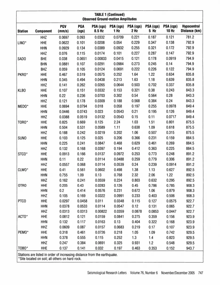
TABLE 1 (Continued) Observed Ground-motion Amplitudes
PGV PGA Station Component (mm/s) (cgs)
PSA (cgs) PSA (cgs) PSA (cgs) PSA (cgs) PSA (cgs) Hypocentral 0.5 Hz 1 Hz 2 Hz 5 Hz 10 Hz Distance (km)
HHZ 0.0697 0.093 0.0332 0.0709 0.221 0.187 0.121 781.2 LINO* HHE 0.0622 0.101 0.0208 0.054 0.229 0.347 0.138 792.9
HHN 0.0929 0.134 0.0389 0.0932 0.255 0.321 0.172 792.9 HHZ 0.076 0.115 0.0174 0.101 0.227 0.287 0.147 792.9
SADO BHE 0.038 0.0651 0.00833 0.0415 0.121 0.178 0.0919 794.9 BHN 0.0881 0.107 0.0291 0.0984 0.273 0.245 0.14 794.9 BHZ 0.059 0.105 0.0124 0.0691 0.222 0.226 0.122 794.9
PKRO* HHE 0.467 0.519 0.0575 0.252 1.64 1.22 0.634 835.8 HHN 0.345 0.494 0.0438 0.213 1.63 1.18 0.639 835.8 HHZ 0.141 0.262 0.0265 0.0644 0.503 0.702 0.337 835.8
KLBO HHE 0.107 0.151 0.0332 0.153 0.321 0.38 0.243 843.3 HHN 0.22 0.236 0.0703 0.302 0.54 0.564 0.28 843.3 HHZ 0.121 0.178 0.0309 0.188 0.568 0.384 0.24 843.3
MEDO* HHE 0.0694 0.0794 0.018 0.058 0.197 0.255 0.0978 849.4 HHN 0.0446 0.0743 0.023 0.0543 0.21 0.195 0.126 849.4 HHZ 0.0388 0 .0519 0 .0132 0.0543 0.15 0.11 0.0717 849.4
TORO* HHE 0.825 0.669 0.125 2.24 1.03 1.51 0.801 875.5 HHN 0.504 0.531 0.0589 1.11 0.638 1.09 0.618 875.5 HHZ 0.188 0.242 0.0219 0.202 1.06 0.507 0.315 875.5
SUNO HHE 0.103 0.125 0.025 0.206 0.366 0.231 0.159 884.5 HHN 0.225 0.241 0.0847 0.468 0.629 0.461 0.269 884.5 HHZ 0.132 0.168 0.0397 0.194 0.412 0.363 0.225 884.5
STCO* HHE 0.0913 O. 166 0.0137 0.0972 0.253 0.773 0.248 891.2 HHN 0.11 0.22 0.0114 0.0488 0.259 0.779 0.306 891.2 HHZ 0.0557 0.068 0.0114 0.0539 0.24 0.239 0.0914 891.2
CLWO* HHE 0.41 0.561 0.0602 0.498 1.38 1.13 0.627 892.5 HHN 0.755 1.09 0.13 0.768 2.32 2.06 1.22 892.5 HHZ 0.162 0.241 0.0559 0.224 0.803 0.632 0.295 892.5
OTRO HHE 0.205 0.43 0.0283 0.126 0.45 0.786 0.785 908.3 HHN 0.2 0.414 0.0576 0.231 0.672 1.06 0.879 908.3 HHZ 0.105 0.169 0.0322 0.0991 0.233 0.403 0.506 908.3
PTCO HHE 0.0297 0.0458 0.011 0.0348 0.115 0.127 0.0575 922.7 HHN 0.0378 0 .0533 0 .0114 0.0547 0.12 0.131 0.065 922.7 HHZ 0.0313 0 .0313 0.00822 0.0359 0.0878 0.0853 0.0447 922.7
ACTO* HHE 0.0812 0.121 0.0159 0.0841 0.275 0.359 0.156 923.9 HHN O. 132 O. 117 0.0163 O. 13 0.404 0.322 O. 168 923.9 HHZ 0.0609 0.087 0.0157 0.0683 0.219 0.17 0.107 923.9
PEMO* HHE 0.318 0.461 0.0726 0.218 1.05 1.09 0.742 929.5 HHN 0.378 0.555 0.115 0.252 1.3 1.4 0.823 929.5 HHZ 0.247 0.384 0.0691 0.325 0.931 1.2 0.548 929.5
TOBO* HHE 0.137 0.141 0.032 0.197 0.463 0.353 0.152 943.7
Stations are listed in order of increasing distance from *Site located on soil; all others on hard rock.
the earthquake.
Seismological Research Letters Volume76, Number6 November/December2005 747

TABLE 1 (Continued) Observed Ground-motion Amplitudes
PGV PGA Station Component (mm/s) (cgs)
PSA (cgs) PSA (cgs) PSA (cgs) PSA (cgs) PSA (cgs) 0.5 Hz 1 Hz 2 Hz 5 Hz 10 Hz
Hypocentral Distance (km)
HHN 0.139 0.18 HHZ 0.108 0.13
TYNO* HHE 0.102 0.197 HHN 0.161 0.325 HHZ 0.0382 0.0641
ELGO HHE 0.0563 0.0726 HHN 0.0634 0.0913 HHZ 0.0549 0.0492
KAPO BHE 0.0273 0.0269 BHN 0.0627 0.0637 BHZ 0.0313 0.0259
HGVO HHE 0.0421 0.0537 HHN 0.0367 0.0531 HHZ 0.0379 0.0408
BRCO* HHE 0.281 0.339 HHN 0.223 0.307 HHZ 0.0535 0.111
PLIO* HHE 0.0229 0.0324 HHN 0.0262 0.0259 HHZ 0.0206 0.0195
SILO HHE 0.0126 0.00722 HHN 0.0361 0.0217 HHZ 0.0226 0.0124
TBO EHZ 0.00618 0.0169 MUMO HHE 0.00854 0.00676
HHN 0.0232 0.0155 HHZ 0.0111 0.00903
SOLO EHZ 0.00568 0.00718
0.035 0.328 0.598 0.328 0.17 0.0345 0.188 0.481 0.185 0.15 0.0156 0.0739 0.283 0.797 0.294 0.021 0.0779 0.332 0.945 0.353 0.00893 0.0661 0.108 0.157 0.114 0.0124 0.0819 0.254 0.123 0.0854 0.0185 0.0885 0.206 0.176 0.101 O. 0111 O. 12 O. 15 O. 106 O. 0668
0.016 0.0637 0.0906 0.0567 0.0355 0.0335 0.121 0.193 0.0963 0.065 0.0195 0 .0507 0.0864 0.0577 0.0317 0.0164 0.0611 0.14 0.121 0.0595 0.0118 0.0519 0.153 0.106 0.0658 0.0108 0.0663 0.098 0 .0896 0.0638 0.0298 0.137 1.63 0.8 0.402 0.0409 0.175 1.14 0.755 0.364 0.0149 0.0777 0.327 0.372 O. 152 0.0102 0 .0304 0.0913 0.047 0.0365 0.00939 0.036 0.0655 0.0572 0.0303 0.00965 0.0484 0.0473 0.046 0.0244 0.00667 0.0177 0.023 0.0138 0.01 0.0297 0 .0656 0.0636 0.0254 0.0233 0.0146 0.033 0.0291 0.0187 0.0143 0.00658 0.0196 0.0223 0.0115 0.00901 0.00322 0.012 0.0135 0.00612 0.0104 0.0103 0.0337 0.031 0 .0162 0.0164 0.00713 0.013 0.0162 0.00601 0.0145 0.0054 0.0178 0.026 0.00931 0.00722
943.7 943.7 944.1 944.1 944.1 945.2 945.2 945.2
956.8 956.8 956.8 969.6 969.6 969.6 983.4 983.4 983.4
1,214.6 1,214.6 1,214.6 1,236.4 1,236.4 1,236.4 1,457 1,559.7 1,559.7 1,559.7 1,646.4
Stations are listed in order of increasing distance from the earthquake. *Site located on soil; all others on hard rock.
tively small, making it a more useful basis for the estimation of location and magnitude. The fact that the vertical-component soil amplitudes agree relatively well with the rock amplitudes, as seen in Figure 2, supports this approach. Note that when predicting intensities from the ground motions, the vertical- component amplitudes are converted to equivalent horizontal values based on H / V ratios that depend on site soil conditions, using site-specific H/Vratios for the recording stations.
Felt-intensity ShakeMap ShakeMap was designed as a rapid-response tool to portray the extent and variation of ground shaking and expected damage throughout an affected region immediately following a signifi- cant earthquake (Wald et al. 1999). The felt-intensity level is
more useful to those who are not familiar with ground-motion parameters such as PGV, PGA and PSA (f). A key element of ShakeMap is the requirement for a relationship to relate ground-motion amplitude to felt intensity that is applicable to eastern North American earthquakes. In our ShakeMap imple- mentation, felt intensity is derived from an empirical relation between PGV and Modified Mercalli intensity (MMI) as given by Kaka and Atkinson (2004):
MMI = 4.08 + 1.79 log PGV - 0.28 log R, (1)
where PGV is the horizontal component PGV in mm/s and R__ is hypocentral distance in km. It is assumed when predicting intensity that all sites with unknown soil condition are NEHRP C (firm ground) and are accordingly assigned H / V - 2 . 3 8
748 Seismological Research Letters Volume 76, Number6 November/December2005

0.5
0 E v N -r" �9 -- -0.5
<( 00 13_ 03 - 1 O
. .J
-1.5
E o 0 N -1- M3
< -1 or) 13_
0 3 O
_ J
-2
-3
10
10
I ' ' ' ~ ' ' ' 1
i Predicted by KA05 [] Rock �9 Soil
- - Predicted by AB95
[] []
[]
[]
D/ []
[]
&
[ ] I , , , J ,~ , l I , j . . . . . I I
20 100 200 1000 2000
Hypocentral Distance (km)
-1 [ ]
I ' ' ' ' ' " 1
[ ]
i Predicted by KA05 [] Rock �9 Soil
Predicted by AB95
20 100 200
[]
_i
[] I
[]
D D
[]
, , . . . . ,I I 1000 2000
Hypocentral Distance (km)
E v N -1- Od
< (/) 8_
O ._J
(/)
c/)
E 1 c.) v N -1- o 0
< or) n -1
O ._l
-2
-3
10
I I I , I I I I ' ' ' ' ' " 1
n P red ic ted by KA05
[ ] Rock
�9 So i l
P red ic ted by AB95
DD D
D
�9 �9
20 100 200
[ ]
1000 2000
Hypocentral Distance (km)
I . . . . . . . I I . . . . . . . I
10
Predicted by KA05 ]u~. .~ [] Rock [ �9 Soil
Predicted by AB95
I , , ~ , , , , I I , , j . . . . I I
20 100 200 1000 2000
Hypocentral Distance (km)
%" 1
E o
< 0 (5 13.. O'} O
"J -1
-2
I . . . . . . . t I . . . . . . . I
~ " Predicted by AK05 [] Rock �9 Soil
Predicted by AB95
Ebl []
Do
E E v > (.9 13_
O3 O
._!
I . . . . . . . I I . . . . . . . I
[ ]
\
-3 I , ~ ~ , , ~ I I . . . . . . . I I -2 I ~ . . . . . . I I
10 20 100 200 1000 2000 10 20 100 200
Predicted by KA05 [] Rock �9 Soil
Predicted by AB95
~176 DaD
, , , , , , , I 13~ ,1
1000 2000
Hypocentral Distance (km) Hypocentral Distance (km)
A Figure 2. Ground-motion amplitudes for the M 5.0 Rivi~re-du-Loup earthquake compared to the predictions (for rock) of Kaka and Atkinson (2005, thick line) and Atkinson and Boore (1995, thin line).
Seismological Research Letters Volume76, Number6 November/December2005 749

A Figure 3. Mean MMI and standard deviation for observations grouped in distance bins 0.1 log units in width (open squares), based on the mean MMI for each ZIP code or city location (gray dots), weighted by the number of observations for that location. Filled symbols show MMI predicted from horizontal-component PGV values based on the relation of Kaka and Atkinson (2004).
(Adams and Halchuk, 2003). An exception is made for the POLARIS stations, which are classified by their site-specific H/V ratios (Kaka and Atkinson, 2005b). The CNSN stations are hard-rock sites and are thus assigned H/V= 1.21 (Atkinson, 1993b); this ratio is also assumed for in rock POLARIS sta- tions sited with unknown H/V.
Comparing observed and predicted intensities is difficult for this event because a Canadian internet intensity reporting system is not yet in place comparable to the U.S. Geological Survey "Did You Feel It?" (DYFI) Web site. Canadians can
report their experiences in descriptive format at the GSC Web site (http://www.seismo.nrcan.gc.ca/), but these responses need to be processed manually to provide a reliable intensity. This processing is in progress but will take time, as there were about 3,000 responses (mostly in French). Americans in the north- east who felt the earthquake reported their observations on the USGS DYFI site (http://pasadena.wr.usgs.gov/shake/), while some Canadians reported to the USGS international DYFI site (also available at http://pasadena.wr.usgs.gov/shake/). Overall the reported intensities of IV to VI near the epicenter, with
750 Seismological Research Letters Volume 76, Number 6 November/December 2005
intensities of II to IV in northern Maine, New Hampshire, and Vermont, agree well with ShakeMap intensities, which can be viewed at http://www.shakemap.carieton.ca/. In Figure 3, the predicted ShakeMap intensities are compared to MMI based on felt reports submitted online to the automated USGS sites. It is concluded that the agreement between observed and predicted intensity appears to be satisfactory. It is noted that observed MMI data are preliminary in nature; efforts are underway to evaluate intensity in more detail. An interesting observation is that there may be a bias in the Internet intensities to high values at large distances, due to the greater tendency of those who felt the event to report their observations online, as compared to those who did not feel the event.
Given the vast area covered and the relatively small num- ber of seismographic recording stations, ShakeMap offers a reasonable picture of ground shaking across the region. The performance of ShakeMap for this event is very encouraging and can be viewed as a significant step forward in the develop- ment of reliable near-real-time seismic information relevant to postearthquake rapid warning systems in eastern Canada. Improvements are needed to reflect specific local variation in ground shaking due to soil conditions. El
ACKNOWLEDGMENTS
Ontario ShakeMap development is supported by Ontario Power Generation and the Ontario Research and Development Challenge Fund. The assistance of the Geological Survey of Canada and the U.S. Geological Survey in ShakeMap develop- ment work is gratefully acknowledged.
REFERENCES
Adams, J. and S. Halchuk (2003). Fourth Generation Seismic Hazard Maps of Canada: Values for Over 650 Canadian Localities Intended
for the 2005 National Building Code of Canada, Geological Survey of Canada Open File Report 4459, 150 pp.
Atkinson, G. (1993a). Source spectra for earthquakes in eastern North America, Bulletin of the Seismological Society of America 83, 1,778- 1,798.
Atkinson, G. (1993b). Notes on ground motion parameters for eastern North America: Duration and H/V ratio, Bulletin ofthe Seismological Society of America 83, 587-596.
Atkinson, G. M. (2004). Empirical attenuation of ground motion spec- tral amplitudes in southeastern Canada and the northeastern United States, Bulletin of the Seismological Society of America 94, 1,079- 1,095.
Atkinson, G. M. and D. M. Boore (1995). Ground-motion relations for eastern North America, Bulletin of the Seismological Society of America 85, 17-30.
Kaka, SanLinn I. and G. M. Atkinson (2004). Relationships between instrumental ground Motion p and Modified Mercalli Intensity in eastern North America, Bulletin of the Seismological Society of America 94, 1,728-1,736.
Kaka, SanLinn I. and G. M. Atkinson (2005a). Empirical ground-motion relations for ShakeMap applications in southeastern Canada and the northeastern United States, Seismological Research Letters 76, 274-282.
Kaka, SanLinn. I. and G. M. Atkinson (2005b). Implementation of ShakeMaps in Ontario: Challenges of detection and location in a sparse network, Seismological Research Letters (in preparation).
Kanamori, H. (1993). Locating earthquakes with amplitude: Application to real-time seismology, Bulletin of the Seismological Society of America 83, 264-268.
Wald, D. J., V. Quitoriano, T. H. Heaton, H. Kanamori, C. W. Scrivner, and C. B. Worden (1999). "TriNet ShakeMaps": Rapid generation of instrumental ground motion and intensity maps for earthquakes in Southern California, Earthquake Spectra 15, 537-556.
Carleton University Earth Sciences Dept, Herzberg Lab
1125 Colonel By Drive Ottawa, ONK1S 5B6
CANADA skaka @ ccs. carleton, ca gmatldnson @ aol. corn
Seismological Research Letters Volume76, Number6 November/December2005 751