Fire frequency for the transitional mixedwood forest of Timiskaming, Quebec, Canada
11
Fire frequency for the transitional mixedwood forest of Timiskaming, Quebec, Canada Daniel J. Grenier, Yves Bergeron, Daniel Kneeshaw, and Sylvie Gauthier Abstract: Fire history was reconstructed for a 2500-km 2 area at the interface between the boreal coniferous and north- ern hardwood forests of southwestern Quebec. The fire cycle, the time required for an area equal to the study site to burn once over, was described using a random sampling strategy that included dendrochronological techniques in con- junction with provincial and national government archival data. Physiographic elements were not found to spatially in- fluence fire frequency; however, human land-use patterns were observed to significantly affect the fire frequency. A temporal shift in fire frequency was also detected, which coincided with the period of Euro-Canadian colonization and known extreme dry years for the study site. Additionally, a fire-free period was identified in the most recent times that could be associated with fire suppression and climate change. The estimated cycles (approx. 188–314 years) for the southeastern section of the study area were thought to better represent the natural cycles for this transition zone as a result of less anthropogenic influence. The importance of gap-type dynamics becomes evident with the increased pres- ence of old-growth forest, given the derived fire cycle estimations for the region. Even-aged management with short ro- tations, consequently, is questioned because fire cycle estimations suggest more complex harvest systems using an ecosystem management approach. Résumé : L’historique des feux a été reconstruit pour une superficie de 2500 km 2 à l’interface entre la forêt boréale et la forêt feuillue septentrionale du sud-ouest du Québec. Le cycle de feu (nombre d’années requises pour que soit brûlée une superficie équivalente au territoire à l’étude) a été décrit avec un dispositif d’échantillonnage aléatoire utili- zant la dendrochronologie conjointement avec les archives des gouvernements provincial et fédéral. Les éléments phy- siographiques n’ont pas eu d’influence spatiale sur la fréquence des feux. Cependant, les patrons d’utilization des terres associés à la colonization ont significativement affecté la fréquence des feux. Un changement temporel dans la fré- quence des feux a été aussi détecté. Il est synchrone avec la période de colonization euro-canadienne, ainsi qu’avec des années de sécheresse extrême pour le site d’étude. De plus, l’absence de feu notée depuis 1950 pourrait être expliquée par l’effet cumulé de la suppression du feu et des changements climatiques. Les cycles estimés (approx. 188 à 314 ans) pour la section sud-est du site d’étude ayant subi une moins grande influence anthropique représenteraient mieux les cycles naturels du territoire étudié. Avec la présence d’une proportion plus élevée de forêt ancienne, les perturbations secondaires par trouées deviennent sont importantes étant donné les estimations du cycle de feu dans la région. Par conséquent, les régimes d’aménagement équienne à rotation courte sont à remettre en question pour ce secteur. Comme le suggère les estimations du cycle de feu, des pratiques sylvicoles plus diversifiées et l’utilization d’une approche de gestion écosystémique seraient plus appropriées. Grenier et al. 666 Introduction Fire history and behavior in boreal forests have received much attention in the past two decades, which has culmi- nated in forest management inspired by natural disturbance dynamics (MacDonald 1995; Lieffers et al. 1996; Bergeron and Harvey 1997; Angelstam 1998). This approach is thought to aid in the maintenance of biodiversity and vital ecological processes, as it allows for the maintenance of stand compo- sition, structure, and functions similar to those occurring natu- rally and to which endemic species have adapted through time (Franklin 1993; Hunter 1999; Bergeron et al. 2002). Many factors are recognized to play important roles in controlling fire regimes. Studies have shown regional-scale climate patterns synchronizing fire occurrence across large areas (Swetnam and Betancourt 1990; Johnson and Wowchuck 1993; Swetnam and Baisan 1996; Kitzberger et al. 1997; Flannigan et al. 2000). Climate will thus contribute in defin- Can. J. For. Res. 35: 656–666 (2005) doi: 10.1139/X05-005 © 2005 NRC Canada 656 Received 17 May 2004. Accepted 15 December 2004. Published on the NRC Research Press Web site at http://cjfr.nrc.ca on 29 March 2005. D.J. Grenier 1 and Y. Bergeron. Groupe de Recherche en écologie forestière interuniversitaire and Chaire industrielle en aménagement forestier durable, Université du Québec en Abitibi - Témiscamingue, 445 boulevard de l’Université, Rouyn-Noranda, QC J9X 5E4, Canada. D. Kneeshaw and S. Gauthier. 2 Groupe de Recherche en écologie forestière interuniversitaire and Chaire industrielle en aménagement forestier durable, Université du Québec à Montréal, C.P. 8888 succursale Centre-ville, Montréal, QC H3C 3P8, Canada. 1 Corresponding author (e-mail: [email protected]). 2 Present address: Natural Resources Canada, Canadian Forest Service, Laurentian Forestry Centre, 1055 rue du PEPS, P.O. Box 3800, Ste-Foy, QC G1V 4C7, Canada.
Transcript of Fire frequency for the transitional mixedwood forest of Timiskaming, Quebec, Canada
Fire frequency for the transitional mixedwoodforest of Timiskaming, Quebec, Canada
Daniel J. Grenier, Yves Bergeron, Daniel Kneeshaw, and Sylvie Gauthier
Abstract: Fire history was reconstructed for a 2500-km2 area at the interface between the boreal coniferous and north-ern hardwood forests of southwestern Quebec. The fire cycle, the time required for an area equal to the study site toburn once over, was described using a random sampling strategy that included dendrochronological techniques in con-junction with provincial and national government archival data. Physiographic elements were not found to spatially in-fluence fire frequency; however, human land-use patterns were observed to significantly affect the fire frequency. Atemporal shift in fire frequency was also detected, which coincided with the period of Euro-Canadian colonization andknown extreme dry years for the study site. Additionally, a fire-free period was identified in the most recent times thatcould be associated with fire suppression and climate change. The estimated cycles (approx. 188–314 years) for thesoutheastern section of the study area were thought to better represent the natural cycles for this transition zone as aresult of less anthropogenic influence. The importance of gap-type dynamics becomes evident with the increased pres-ence of old-growth forest, given the derived fire cycle estimations for the region. Even-aged management with short ro-tations, consequently, is questioned because fire cycle estimations suggest more complex harvest systems using anecosystem management approach.
Résumé : L’historique des feux a été reconstruit pour une superficie de 2500 km2 à l’interface entre la forêt boréale etla forêt feuillue septentrionale du sud-ouest du Québec. Le cycle de feu (nombre d’années requises pour que soitbrûlée une superficie équivalente au territoire à l’étude) a été décrit avec un dispositif d’échantillonnage aléatoire utili-zant la dendrochronologie conjointement avec les archives des gouvernements provincial et fédéral. Les éléments phy-siographiques n’ont pas eu d’influence spatiale sur la fréquence des feux. Cependant, les patrons d’utilization des terresassociés à la colonization ont significativement affecté la fréquence des feux. Un changement temporel dans la fré-quence des feux a été aussi détecté. Il est synchrone avec la période de colonization euro-canadienne, ainsi qu’avec desannées de sécheresse extrême pour le site d’étude. De plus, l’absence de feu notée depuis 1950 pourrait être expliquéepar l’effet cumulé de la suppression du feu et des changements climatiques. Les cycles estimés (approx. 188 à 314 ans)pour la section sud-est du site d’étude ayant subi une moins grande influence anthropique représenteraient mieux lescycles naturels du territoire étudié. Avec la présence d’une proportion plus élevée de forêt ancienne, les perturbationssecondaires par trouées deviennent sont importantes étant donné les estimations du cycle de feu dans la région. Parconséquent, les régimes d’aménagement équienne à rotation courte sont à remettre en question pour ce secteur. Commele suggère les estimations du cycle de feu, des pratiques sylvicoles plus diversifiées et l’utilization d’une approche degestion écosystémique seraient plus appropriées.
Grenier et al. 666
Introduction
Fire history and behavior in boreal forests have receivedmuch attention in the past two decades, which has culmi-nated in forest management inspired by natural disturbancedynamics (MacDonald 1995; Lieffers et al. 1996; Bergeronand Harvey 1997; Angelstam 1998). This approach is thoughtto aid in the maintenance of biodiversity and vital ecologicalprocesses, as it allows for the maintenance of stand compo-
sition, structure, and functions similar to those occurring natu-rally and to which endemic species have adapted throughtime (Franklin 1993; Hunter 1999; Bergeron et al. 2002).
Many factors are recognized to play important roles incontrolling fire regimes. Studies have shown regional-scaleclimate patterns synchronizing fire occurrence across largeareas (Swetnam and Betancourt 1990; Johnson and Wowchuck1993; Swetnam and Baisan 1996; Kitzberger et al. 1997;Flannigan et al. 2000). Climate will thus contribute in defin-
Can. J. For. Res. 35: 656–666 (2005) doi: 10.1139/X05-005 © 2005 NRC Canada
656
Received 17 May 2004. Accepted 15 December 2004. Published on the NRC Research Press Web site at http://cjfr.nrc.ca on29 March 2005.
D.J. Grenier1 and Y. Bergeron. Groupe de Recherche en écologie forestière interuniversitaire and Chaire industrielle enaménagement forestier durable, Université du Québec en Abitibi - Témiscamingue, 445 boulevard de l’Université, Rouyn-Noranda,QC J9X 5E4, Canada.D. Kneeshaw and S. Gauthier.2 Groupe de Recherche en écologie forestière interuniversitaire and Chaire industrielle en aménagementforestier durable, Université du Québec à Montréal, C.P. 8888 succursale Centre-ville, Montréal, QC H3C 3P8, Canada.
1Corresponding author (e-mail: [email protected]).2Present address: Natural Resources Canada, Canadian Forest Service, Laurentian Forestry Centre, 1055 rue du PEPS, P.O.Box 3800, Ste-Foy, QC G1V 4C7, Canada.
ing spatially explicit fire regimes over large areas (Payette etal. 1989). Temporal changes in global climate also controlfire regimes. For example, in the eastern (Bergeron et al.2001) and western (Larsen 1996; Weir et al. 2000) borealforests of North America, a reduction in fire frequency hasbeen identified and attributed to large-scale climate changefollowing the end of the Little Ice Age (approx. AD 1850).
Factors other than climate are also believed to be impor-tant in controlling fire regimes. Deviations from regional fireregimes have been attributed to variations in microclimateand fuel load controlled by local site factors (Barton et al.2001; Brown et al. 2001; Heyerdahl et al. 2001; Turner andRomme 1994). Steep gradients in elevation, changes in as-pect, and other physiographic features have been shown todrive spatial variation in fire regimes by influencing fuelmoisture, humidity, and interaction with the wind, therebyaffecting the probability of fire (Whelan 1995; Rowe andScotter 1973). Waterbodies have also been found to functionas natural firebreaks affecting fire spread (Larsen 1997; Bergeron1991; Romme and Knight 1981; Heinselman 1973).
Humans also strongly influence fire regimes. Colonizationleads to improved access to once-remote areas, providing anincreased potential for fire ignitions (Weber and Stocks 1998).In fact, national statistics show that human-induced firesmake up the majority of the ignition sources in Canada(Anonymous 2002). Studies have also shown that activitiesassociated with the colonization process (i.e., using fire toclear forested land for agriculture and other human use) sig-nificantly increase the annual area burned (Lefort et al. 2003;Niklasson and Granström 2000). However, other studies havefound human impacts to lead to a decrease in area burned asa result of fire suppression (Brown et al. 2001; Everett et al.2000; Barrett et al. 1991; Tande 1979). It seems no consen-sus has been reached as to the overall effect humans haveplayed on the fire regime.
In comparison with the northern boreal forest, the temperateforest is characterized by a low fire frequency. Fire-historystudies in the temperate forests of North America have docu-mented fire cycles >1100 years (Zhang et al. 1999; Lorimer1977; Wein and Moore 1979; Wein and Moore 1977; Whitney1986), while in contrast the closed-crown boreal forests aredescribed by a much shorter natural mean fire cycle <150 years(Payette 1992). Comparisons of fire studies in the temperatezone have also shown fire cycles in forests dominated by de-ciduous species (Whitney 1986; Frelich and Lorimer 1991) tobe much longer than those in pine-dominated stands (Heinselman1973; Whitney 1987; Cwynar 1976). A greater mixed or de-ciduous composition in temperate forests is thus thought toplay a role in the lower fire frequency in this biome. Histori-cal documentation additionally shows human influence andmajor alterations of temperate forests since European coloni-zation in North America (Whitney 1994; Cronon 1983), whilethese effects are relatively recent in boreal forests.
The Timiskaming region of southwestern Quebec is lo-cated at the transition between the temperate and borealbiomes. The forest is mixed in vegetation composition, withboth boreal and temperate elements. The first harvesting ef-forts in this region began as early as 1800, though exploitationon a regular basis did not begin until the 1860s (Vincent1995). Settlement began in the 1870s, with most major mu-nicipalities being established after 1890 (Vincent 1995).
However, little information is known regarding the role offire for this transitional region between a boreal forest sys-tem controlled by many fires and a temperate forest systemaffected by comparatively few fires. The relative importanceof natural fires in shaping natural forest mosaics for this re-gion could therefore have important implications on deci-sions forest managers make about silvicultural systems (evenage vs. uneven age) that should be implemented (Bergeronet al. 1999). There is also speculation as to the naturalnessof the 20th-century fire regime, given possible human influ-ence; consequently, to improve our knowledge and compre-hension of the function fire has in this relatively unstudiedarea, we worked in the transition between these biomes. Ourobjectives were to (1) document fire frequency in the con-text of stand-replacing events in this temperate–boreal tran-sitional area and (2) identify spatial or temporal influencesthat may have caused variation in the fire cycle. The latter isdefined as the time required for an area equal in size to thestudy area to burn over once (Johnson and Gutsell 1994).
Materials and methods
Study areaThe study site is located within the Timiskaming region of
southwestern Quebec, Canada, bordering eastern Ontario alongthe Ottawa River (approx. 47°30′N, 79°00′W; Fig. 1). Theregion is found within the Northern Temperate Zone, locatedjust below and adjacent to the boreal forests of southwesternQuebec (Saucier et al. 1998). The surface area of the studyarea measures approximately 2500 km2. Average altitude isabout 350 m, with moderate relief composed of hills and de-pressions with intermediate slopes throughout and rock es-carpments in the western portion of the region. Surface depositsare composed mainly of glacial till and lacustrine deposits;20% of the surface area is made up of water bodies (Robitailleand Saucier 1998). Average annual temperature is 2.5–5.0 °C,and average precipitation measures 800–900 mm/year, with25% falling as snow.
The study area lies within the fir – yellow birch bioclimaticdomain for western Quebec (Saucier et al. 1998), which is ofa mixed-forest type dominated by balsam fir (Abies balsamea(L.) Mill.) and yellow birch (Betula alleghaniensis Britt.) ac-companied by white spruce (Picea glauca (Moench) Voss),sugar maple (Acer saccharum Marsh.), red maple (Acerrubrum L.), and white birch (Betula papyrifera Marsh.). Fire-associated species such as red pine (Pinus resinosa Ait.),white pine (Pinus strobus L.), and jack pine (Pinus banksianaLamb.) are represented on xeric sites (Grondin 1996).
Human influence on the landscape through widespreadforestry activities and extensive agricultural land use is doc-umented for the northern and western portions of the studyarea since the late 1800s (Vincent 1995). The towns of Béarn,Ville Marie, Belleterre, Angiliers, Laverlochère, and Latulipeare found along the western edges of the territory. Road net-works are laid out primarily along the northern and westernmargins.
Fire-history reconstruction and mappingWe reconstructed the fire history of the study area using
both archival and field-collected data to produce a stand-initiation map (Johnson and Gutsell 1994). Georeferenced
© 2005 NRC Canada
Grenier et al. 657
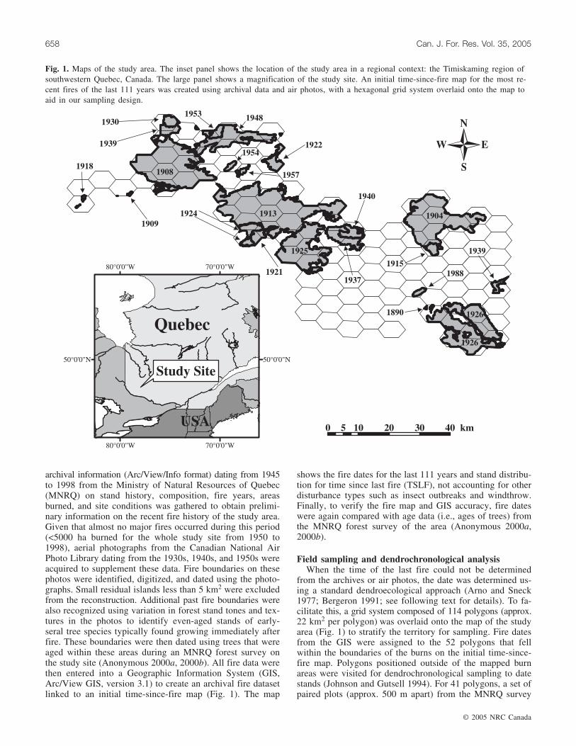
archival information (Arc/View/Info format) dating from 1945to 1998 from the Ministry of Natural Resources of Quebec(MNRQ) on stand history, composition, fire years, areasburned, and site conditions was gathered to obtain prelimi-nary information on the recent fire history of the study area.Given that almost no major fires occurred during this period(<5000 ha burned for the whole study site from 1950 to1998), aerial photographs from the Canadian National AirPhoto Library dating from the 1930s, 1940s, and 1950s wereacquired to supplement these data. Fire boundaries on thesephotos were identified, digitized, and dated using the photo-graphs. Small residual islands less than 5 km2 were excludedfrom the reconstruction. Additional past fire boundaries werealso recognized using variation in forest stand tones and tex-tures in the photos to identify even-aged stands of early-seral tree species typically found growing immediately afterfire. These boundaries were then dated using trees that wereaged within these areas during an MNRQ forest survey onthe study site (Anonymous 2000a, 2000b). All fire data werethen entered into a Geographic Information System (GIS,Arc/View GIS, version 3.1) to create an archival fire datasetlinked to an initial time-since-fire map (Fig. 1). The map
shows the fire dates for the last 111 years and stand distribu-tion for time since last fire (TSLF), not accounting for otherdisturbance types such as insect outbreaks and windthrow.Finally, to verify the fire map and GIS accuracy, fire dateswere again compared with age data (i.e., ages of trees) fromthe MNRQ forest survey of the area (Anonymous 2000a,2000b).
Field sampling and dendrochronological analysisWhen the time of the last fire could not be determined
from the archives or air photos, the date was determined us-ing a standard dendroecological approach (Arno and Sneck1977; Bergeron 1991; see following text for details). To fa-cilitate this, a grid system composed of 114 polygons (approx.22 km2 per polygon) was overlaid onto the map of the studyarea (Fig. 1) to stratify the territory for sampling. Fire datesfrom the GIS were assigned to the 52 polygons that fellwithin the boundaries of the burns on the initial time-since-fire map. Polygons positioned outside of the mapped burnareas were visited for dendrochronological sampling to datestands (Johnson and Gutsell 1994). For 41 polygons, a set ofpaired plots (approx. 500 m apart) from the MNRQ survey
© 2005 NRC Canada
658 Can. J. For. Res. Vol. 35, 2005
1926
1926
1939
1988
1913
1908
1948
1924
9391
19301953
1954
1957
1922
1940
1918
0 10 20 30 405 km
80°0'0"W
80°0'0"W
70°0'0"W
70°0'0"W
50°0'0"N 50°0'0"N
Quebec
USA
Study Site
1909
1925
19211937
1915
1890
1904
Fig. 1. Maps of the study area. The inset panel shows the location of the study area in a regional context: the Timiskaming region ofsouthwestern Quebec, Canada. The large panel shows a magnification of the study site. An initial time-since-fire map for the most re-cent fires of the last 111 years was created using archival data and air photos, with a hexagonal grid system overlaid onto the map toaid in our sampling design.

assessment of the study area was randomly selected for on-site visiting. For the 21 polygons without archival data or airphoto fire dates and not containing MNRQ survey plots, alocation among areas deemed accessible was randomly se-lected. Paired plots 500 m apart were then established atthese locations for sampling.
At each visited polygon, efforts were made to identify evi-dence of past fire by searching for fire-scarred trees and byexamining the mineral soil for bits of charcoal. While fire-scarred trees were observed at only one site, the nearly uni-versal occurrence of charcoal observed at the base of the hu-mus layer at sampling sites confirmed the widespread extentof past fires in these areas. TSLF for visited polygons wasestimated by using a cohort of trees, taking the age of theoldest tree when at least three of the sampled individuals hadan establishment date within a range of 10 years for jackpine and 20 years for all other species (Lesieur et al. 2002).When samples did not allow for determination of the TSLFevent by cohort, the polygon was characterized by the age ofthe oldest individual sampled (Bergeron and Dubuc 1989;Johnson and Gutsell 1994; Lesieur et al. 2002). Data of thissort were considered a minimum estimate of TSLF, with thedate regarded as censored in further statistical analyses (seefollowing text for details). Censorship is a statistical methodof handling data when the exact survival time of an individ-ual is unknown as a result of loss of an individual during thestudy period or from the study period ending before all indi-viduals fail (i.e., the study period is too brief for all individ-uals to experience the event; Allison 1995). Data are alsopresented in 10-year age-classes to reduce bias due to thelack of precision in the estimation of the real fire date.
At each visited polygon, increment cores or cross-sectionswere collected from 5 to 10 trees having the largest diameter,preferably from pioneer species (n = 443 cores, n = 120 cross-sections, average of 9.23 samples per polygon; Kipfumuellerand Baker 1998). Selection priority (from first choice tolast) was Pinus banksiana (jack pine), B. papyrifera (whitebirch) – B. alleghaniensis (yellow birch), Populus tremuloides(trembling aspen), Picea mariana (black spruce), and Piceaglauca (white spruce). Increment core samples were extractedfrom the base of the trunk as low as possible (i.e., highenough to allow the increment borer to turn), with attemptsmade to core through the pith so as to minimize aging prob-lems (Phipps 1986).
Sampled cores were mounted, sanded, and aged by the di-rect counting of the annual rings on the cores using a dis-secting microscope (Phipps 1986). For cores that missed thepith, pith locators were used to estimate the number of miss-ing years from ring curvature and growth rate (average of6.1 rings to pith when missed; Applequist 1958). Cross-sections were prepared similarly, with rings counted on twoaxes (Arno and Sneck 1977). To confirm ages, cross-datingwas visually performed using identified diagnostic rings (i.e.,narrow, light, and frost rings; Yamaguchi 1991). We thenmeasured annual ring widths using a Velmex measuring sys-tem to the nearest 0.01 mm and validated our cross-datingwith COFECHA, a computer program that constructs a longhomogeneous tree ring-width master series to which individ-ual tree ring-width series can be compared (Holmes 1999).
Yellow birch was the exception to the aforementioned ag-ing procedure. Because heart rot was prevalent in yellow
birch trees, accurately aging individuals through annual ringswas often impossible; consequently, diameter at breast height(DBH = 1.4 m) for individuals encountered was recorded forage estimation attempts for those individuals with rot. A di-ameter–age regression curve was created using data gatheredfor yellow birch within the study area from the MNRQ for-est survey (y = 0.2733x + 9.265, R2 = 0.671, n = 409;Fig. 2). The derived diameter–age relationship was then usedto estimate the ages of the field-measured yellow birch indi-viduals (Lorimer 1980).
Fire frequency estimationThe proportion of area burned for each decade, derived
from the time-since-fire map, provided us with a time-since-fire distribution. The time-since-fire distribution can be de-scribed using the Weibull model (Johnson and Gusell 1994):
A(t) = exp[–(t/b)c]
where A(t) is the cumulative proportion of the landscape thatsurvived to time t, b is the scale parameter, and c is theshape parameter. The negative exponential distribution is aspecial case of the Weibull where c = 1, indicating that thehazard of burning remains constant in time (Johnson andGutsell 1994). Under a negative exponential distribution thecycle is equal to b, the mean of the distribution (Johnson andGutsell 1994). When a cumulative time-since-fire distribu-tion fits a negative exponential, it will appear as a straightline on a semilog scale. When the parameter c ≠ 1, it impliesthat the risk of burning changes with time. When c ≠ 1, thefire cycle is equal to bΓ(1/c + 1).
Fire cycles were assessed using survival analysis, a statis-tical method for studying the occurrence and timing of events(Johnson and Gutsell 1994; Allison 1995). This method hasbeen long used in other fields but has only recently been appliedto vegetation ecology (Pyke and Thompson 1986; Muenchow1986; Johnson and Gutsell 1994; He and Alfaro 2000). It iswell suited for time-series data and allows for the use of datathat contain censored information. The 114 TSLF observa-tions were fit using the exponential model in the PROCLIFEREG procedure of SAS (SAS Institute Inc. 1990). Thislog-likelihood-based survival analysis also made it possible
© 2005 NRC Canada
Grenier et al. 659
Fig. 2. Diameter–age relationship (y = 0.2733x + 9.265, R2 =0.671, n = 409) for yellow birch (Betula alleghaniensis) used inage estimation of field-measured individuals.
to compare cumulative TSLF distributions and assess whetherthe fire cycle was constant as a function of spatial and tem-poral influences. A χ2 test evaluated whether the survivalestimates of different covariates or classes of a covariatewere significantly different. In addition, survival models us-ing the temporal and spatial covariates individually found tostatistically have an influence on fire frequency were ex-plored in conjunction to identify their relative importance.For each survival model, a Lagrange multiplier χ2 test wasperformed to see whether each hazard function was constantover time. This is a one degree of freedom test for the nullhypothesis that the scale term in the negative exponentialmodel equals one. Additionally, we used the partial informa-tion provided from stands where we had only a minimum es-timate of time since fire (i.e., the data were censored, meaningthat we know the stand had survived for at least a certaintime.) in this process. Thirty-seven percent of the data werecategorized as censored in this study.
Because we had reason to suspect temporal changes in thefire cycle related to human influence, we evaluated fire cy-cles before versus after 1890, the date corresponding to thestart of colonization of the settlements adjacent to the north-western part of the study area. The fire cycle was also com-pared before and after 1850; the end of the period known asthe Little Ice Age. Research in boreal forests has shownvariation in fire frequency before versus after this time pointrelated to a sharp transition in climate (Bergeron andArchambault 1993; Larsen 1997; Hofgaard et al. 1999; Weiret al. 2000; Bergeron et al. 2001; Girardin 2004).
We also thought it probable that human land use and in-fluence could have caused spatial variation in the fire cycledue to human concentration in the north and west of thestudy site. Consequently, we equally divided the territory inhalf (north vs. south, and then west vs. east) and comparedtime-since-fire distributions and fire cycles to determine whetherdistributions and cycles for areas closest to settlements weredifferent from areas further away. The influence of relief onthe fire cycle was tested, given that this factor is also thoughtto have an important spatial effect on fire regimes (Hemstromand Franklin 1982; Turner and Romme 1994; Heyerdahl et al.2001). Given the topography of the Timiskaming region, thestudy site was divided into one of two relief classes (plain orhill). Fire cycles and time-since-fire distributions were thenestimated and compared for the relief classes. Firebreaks mayalso affect fire spread (Larsen 1997). Accordingly, we testedtheir potential impact on the cycle by comparing distributionsand cycles by coarse classes for the study site by identifyingfor each plot the mean distance to firebreaks (lake, river,stream, and bog) measured along each of the eight cardinaldirections on topographics maps with a scale of 1 : 50 000.In addition, we tested whether the fire cycle remained spa-tially constant as a function of superficial deposit. The studyarea was divided into one of two coarse soil classes (glacialand fluvioglacial), and time-since-fire distributions and fire cy-cles for each class were identified and compared.
Finally, post hoc likelihood-ratio tests were performed toevaluate survival model goodness of fit. Results showed thatthe Weibull model did not provide a better fit than that ob-tained with the negative exponential model in all cases ex-cept when analyzing the aforementioned temporal influencesand temporal and spatial influences in combination. It is
possible that the natural fire regime was altered on the studysite to the point that the negative exponential model may notprovide the best fit for the data. However, considering thecoarse-scale resolution obtained with our sampling strategy,the testing of more complex nonlinear models may not bejustified. Consequently, we felt that the negative exponentialmodel provided adequate fire cycle estimations.
Results
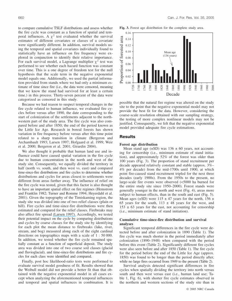
Forest age distributionMean stand age (±SD) was 136 ± 60 years, not account-
ing for censorship (i.e., minimum estimate of stand initia-tion), and approximately 52% of the forest was older than100 years (Fig. 3). The proportion of stand recruitment perdecade appeared relatively constant and stable (approx. 3%–4% per decade) from the mid-1700s until 1900, at whichpoint fire-caused stand recruitment tripled for the next threedecades (early 1900s). From the 1950s to the present, nolarge-scale fire events were observed (<5000 ha burned forthe entire study site since 1950–2000). Forest stands weregenerally younger in the north and west (Fig. 4), areas moresubject to human effects, than in the south and east (Fig. 5).Mean ages (±SD) were 115 ± 47 years for the north, 156 ±65 years for the south, 113 ± 48 years for the west, and153 ± 63 years for the east, not accounting for censorship(i.e., minimum estimate of stand initiation).
Cumulative time-since-fire distribution and survivalanalyses
Significant temporal differences in the fire cycle were de-tected before and after colonization in 1890 (Table 1). Thefire cycle was much shorter in the period immediately aftercolonization (1890–1948) when compared with the periodbefore this event (Table 2). Significantly different fire cycleswere also seen before and after 1850 (Table 1). The fire cyclefor the period before the end of the Little Ice Age (approx.1850) was found to be longer than the period directly after,while no large fires occurred from 1949 to the present (Table 2).
Survival analysis detected significant differences in firecycles when spatially dividing the territory into north versussouth and then west versus east (i.e., human land use; Ta-ble 1, Fig. 6), with shorter fire cycle estimates observed inthe northern and western sections of the study site than in
© 2005 NRC Canada
660 Can. J. For. Res. Vol. 35, 2005
Fig. 3. Forest age distribution for the complete study area.

the southern and eastern portions (Table 2). However, nostatistical spatial relationships between the fire cycle and relief,soil deposits, or distance to fire breaks were found throughsurvival analysis (Table 1, Fig. 6).
When including both time period and the spatial land-usevariables (dividing the territory into halves) in the survival
analysis model, both factors proved to be statistically signifi-cant, although p values suggested that time period mighthave greater importance (Table 1). The estimated cycles whenincluding both spatial land-use variables and time period inthe model did not vary largely from those observed whiletesting each factor individually (Table 2).
© 2005 NRC Canada
Grenier et al. 661
Fig. 4. Forest age distribution for the northern and southernhalves of the study site (study area divided into north vs. south).
Fig. 5. Forest age distribution for the western and eastern halvesof the study site (study area divided into west vs. east).
Factors tested for differences in cumulativetime-since-fire distribution
Survival analysis(p >χ2)
Lagrange coefficient(p >χ2)
Time periodColonization (1890–1948, before 1890) 0.0003 <0.0001Little Ice Age (1850–1948, before 1850) 0.0188 0.0102
Human land useNorth vs. south 0.0019 0.4772West vs. east 0.0008 0.4746
Relief (plain, hill) 0.4917 0.9397Mean distance to firebreak (near, medium, far) 0.3002 0.8739Soil deposits (glacial, fluvioglacial) 0.4599 0.9506Land use and time period
North vs. south 0.0188 <0.0001Time period (1890 break) 0.0020 <0.0001
Land use and time periodWest vs. east 0.0081 <0.0001Time period (1890 break) 0.0018 <0.0001
Table 1. Survival analyses and Lagrange probability results validating spatial and temporalinfluences on fire frequency while testing whether the hazard of burning was constant with time.

Discussion
Factors controlling fire frequency
PhysiographyTopographically complex landscapes, fire breaks (such as
lakes), and other site-specific environments have been identi-fied as hindering fire spread and promoting local-level devi-ations from regional fire patterns (Bergeron 1991; Brownand Sieg 1996; Larsen 1997; Barton et al. 2001; Brown et al.2001; Heyerdahl et al. 2001). However, no differences in firecycles owing to relief, distance to water bodies, and surfacedeposits were detected in the area studied. Although topo-graphic elements in Timiskaming are generally considered tobe variable and irregular when compared with the more ho-mogeneous landscape found in the adjoining boreal zone(Saucier et al. 1998; Robitaille and Saucier 1998), these fea-tures do not appear to have functioned as obstacles to firespread as reported for other studies. Though no studies havesought direct verification, it is generally assumed that certainsurficial soil deposits, such as fluvioglacial types, may alsocreate changes in fire frequency. It seems that changes insoil types across the study area were also not sufficiently di-verse to create significant spatial differences in fire frequency.This lack of a clear relationship between surficial depositsand fire frequency is also reported for the adjacent borealforest (Bergeron et al. 2004). However, the lack of relation-ship may stem from the large grid size that we used (approx.22 km2 per hexagon) to ensure that we primarily sampledlarge stand-replacing events (i.e., those that control fire fre-quency), while excluding small and (or) less lethal fires thatmay be more connected to abiotic factors.
ClimateNumerous studies have shown regional climatic signals
synchronizing fire timing across large areas (Swetnam andBetancourt 1990; Johnson and Wowchuck 1993; Wotton and
Flannigan 1993; Swetnam and Betancourt 1998; Flanniganet al. 2000). Throughout the boreal forest, researchers haveindependently shown a decrease in fire frequency associatedwith warming and increased precipitation since the end ofthe Little Ice Age (Bergeron 1991; Engelmark et al. 1994;Larsen 1997; Weir et al. 1999; Bergeron et al. 2001; Lesieuret al. 2002). However, shorter fire cycles were identified inTimiskaming after 1850. This climatic signal may have beenmasked by increased fire activity associated with the coloni-zation process and an extreme dry period throughout Quebecin the early 1900s (Lesieur 2000; Lefort et al. 2003). Thefire-free period identified from 1950 to 2000 could partiallybe attributed to the warming trend and reduction in droughtsobserved after the Little Ice Age, though more efficient firesuppression measures since the 1970s may also have playeda role (Bergeron 1991; Lefort et al. 2003).
Nonetheless, the period after the Little Ice Age mighthave produced an increase rather than a decrease in fire fre-quency in this mixed transitional forest. Fire frequency inthe temperate forests of the Great Lakes region apparentlyincreased at least 25% in the 20th century as a result ofwarm, dry conditions and the absence of fire suppression(Clark 1988). This is, however, in contrast with fire weathermodeling results from Flannigan et al. (2001) using high-resolution daily weather data under a 2× CO2 scenario. Theirresults suggest a decrease in severe fire weather for much ofeastern Canada for this period related to increases in precipi-tation and humidity offsetting the warmer temperatures. Tocomplicate matters, for this model, the Timiskaming regionstraddles two areas, one with no changes and another with aslight increase in severe fire weather. Therefore, there is un-certainty about the effects of global climate change on firefrequency and vegetation patterns at this temperate–borealtransitional area; in the absence of large changes in fire pat-terns, the most likely scenario is an increase in species thatcurrently inhabit temperate forests and a decrease in speciesthat currently inhabit boreal forests.
© 2005 NRC Canada
662 Can. J. For. Res. Vol. 35, 2005
Spatial and (or) temporal influenceTime periodinvestigated
Estimated fire cyclelengtha (years)
Time periodColonization 1890–1948 96 (73–126)Precolonization Before 1890 262 (163–422)Post Little Ice Age 1850–1948 117 (91–150)Little Ice Age Before 1850 270 (141–519)
Northern part of study area — 91 (66–124)Southern part of study area — 191 (135–270)Western part of study area — 85 (61–118)Eastern part of study area — 188(135–262)Temporal and spatial effects of colonization
Land use (N vs. S) and time (1890) N, 1890–1948 73 (53–102)N, before 1890 176 (101–309)S, 1890–1948 130 (88–193)S, before 1890 313 (189–521)
Land use (W vs. E) and time (1890) W, 1890–1948 68 (48–96)W, before 1890 165 (94–291)E, 1890–1948 130 (89–189)E, before 1890 314 (190–519)
aAverage length of fire cycle, with 95% confidence interval in parentheses.
Table 2. Fire cycle estimates for spatial classes and temporal periods.

ColonizationHumans have exerted profound effects on fire regimes,
and our results suggest that the Temiskaming region of Quebecis not an exception. Colonization and its associated loggingand agricultural activities in conjunction with an extreme dryperiod in the early 1900s in Quebec (see Lesieur 2000; andalso Lefort et al. 2003) appear to have contributed to spa-tially mixed fire frequencies, with shorter fire cycles in areasadjacent to the developed sections of the north and west.Moreover, the observed temporal shift in fire frequency to ashorter cycle immediately after 1890 provides further sup-port for the importance of human impact through settlement
on the fire regime. Webber and Stocks (1998) suggest thatan increase in fire ignitions may be due to greater access tothe landscape through the settlement process, while otherstudies have identified an increase in the area burned duringthe postsettlement period due to the many fires ignited by hu-man activities (Cwynar 1977; Hemstrom and Franklin 1982;Niklasson and Granström 2000; Lefort et al. 2003).
Natural fire cycle for the Timiskaming regionGiven the aforementioned spatial and temporal influences,
an accurate natural fire cycle is difficult to estimate. How-ever, the notably longer fire cycles detected in the south and
© 2005 NRC Canada
Grenier et al. 663
Fig. 6. Cumulative time-since-fire distributions using logarithmic scale comparing (A) global distribution, (B) relief, (C) surficial de-posits, (D) mean distance to firebreak, (E) land-use patterns (north vs. south), and (F) land-use patterns (west vs. east). Statisticallysignificant differences in distributions are denoted by asterisks.
east in the earliest time period may be a result of feweranthropogenic influences on the landscape, and thus theymost likely better represent the natural cycles. The complexnature of this transitional area sometimes affected by fireand sometimes by other disturbance types consequently be-comes apparent given fire cycle estimates ranging between188 and 314 years. Long fire cycles have important conse-quences on stand composition, structure, and ultimately theforest mosaic (Bergeron and Dubuc 1989; Bergeron et al.2001; Lesieur et al. 2002). Because of the presence of largetracts of old-growth forest with less frequent fires, patch(i.e., insect perturbation and windthrow) and gap (i.e., small-scale single-tree and small-group mortality) dynamics arealso significant. The presence of multiple disturbance typesdue to the long fire cycle in this transition zone may in partexplain the particularly high diversity of tree species ob-served at different scales in the landscape (Frelich and Reich1995), especially when compared with the lower diversitylevels observed in the boreal zone.
Implications for sustainable forest managementIt is apparent from our results that when establishing for-
est management plans based on historical disturbance pat-terns it is necessary to conduct individual baseline studiesto understand the natural processes unique to a managementarea. Yet on a larger scale, our findings and others show thathumans (Hemstrom and Franklin 1982; Niklasson andGranström 2000; Lefort et al. 2003) and climate (Bergeron1991; Engelmark et al. 1994; Larsen 1997; Weir et al. 1999;Bergeron et al. 2001; Lesieur et al. 2002) have interacted toaffect the fire regime, which is something that researchersand forest managers should consider regionally and acrossCanada. When time intervals between fires lengthen and ex-ceed the mean tree longevity for the postfire cohort, mecha-nisms of succession become important (Frelich and Reich1995; Lesieur et al. 2002). Without fires, forest structure andcomposition become closely related to secondary disturbancesuch as spruce budworm (Choristoneura fumiferana Clem.)outbreaks and windthrow, which are common in eastern Ca-nadian forests (Bergeron et al. 2001). New studies identify-ing species-replacement mechanisms in the presence andabsence of fire and fine-scale disturbances then become nec-essary, functioning as a key component in guiding forestmanagement practices inspired by natural ecosystem dynam-ics.
Fire affects the pattern and structure of forests even in thistransition zone between northern hardwood forests andboreal coniferous forests. However, if management objec-tives are to be based on natural disturbance patterns in thisarea, our results call into question the use of large-scaleeven-aged management systems with short rotations andsuggest more diversified silvicultural practices. With longerfire cycles, alternatives to clearcuts are required. By the su-perimposition of the effects of secondar disturbance (i.e., ef-fects of insect outbreaks and other gap-type dynamics)through partial cutting onto the mosaic created by largefires, simulated through even-aged techniques, natural standdynamics may be emulated to a greater extent, thus advanc-ing the goal of maintaining biodversity and natural ecologi-cal processes.
Acknowledgements
We greatly appreciate the funding for this project pro-vided by the TEMBEC Corporation as well as the NaturalSciences and Engineering Research Council of Canada(NSERC) – Canadian Forest Service (CFS) Partnership grantawarded to Dan Kneeshaw and Yves Bergeron. Scholarshipendowment was graciously provided by the Université duQuébec en Abitibi Témiscamingue and the Chaire industrielleen aménagement forestier durable, UQAT-UQAM. Additionally,we are thankful for the competent field assistance of JudyDoré, Jamie Owens, Mark Purdon, and Fateh Sadhi. Wethank Hervé Bescond, Martin Simard, Annie Belleau, DanielLesieur, and Dominic Cyr for their invaluable technical supportthroughout this work and Dr. Ellen McDonald, Dr. DougMaynard, and anonymous reviewers for constructive com-ments and help on our manuscript.
References
Allison, P.D. 1995. Survival analysis using the SAS system: a prac-tical guide [computer manual]. SAS Institute Inc., Cary, N.C.
Angelstam, P.K. 1998. Maintaining and restoring biodiversity inEuropean boreal forests by developing natural disturbance re-gimes. J. Veg. Sci. 9: 593–602.
Anonymous. 2000a. Normes d’inventaire forestier: les placettes-échantillons permanents. Ministère des Ressources naturelles duQuébec, Direction des inventaires forestiers, Forêt Québec, QuébecCity.
Anonymous. 2000b. Normes d’inventaire forestier: les placettes-échantillons temporaires – peuplements de 7 m et plus de hau-teur. Ministère des Ressources naturelles du Québec, Directiondes inventaires forestiers, Forêt Québec, Québec City.
Anonymous. 2002. Compendium of Canadian forestry statistics.Section 3: forest fires. Canadian Council of Forest Ministers.Available from http://nfdp.ccfm.org/compendium/index_e.php[updated 19 June 2002; cited 20 September 2002].
Applequist, M.B. 1958. A simple pith locator for use with off-center increment cores. J. For. 56: 141.
Arno, S.F., and Sneck, K.M. 1977. A method for determining firehistory in coniferous forest of the mountain west. USDA For.Serv. Gen. Tech. Rep. INT-42.
Barrett, S.W., Arno, S.F., and Key, C.H. 1991. Fire regimes ofwestern larch – lodgepole pine forest in Glacier National Park,Montana. Can. J. For. Res. 21: 1711–1720.
Barton, A.M., Swetnam, T.W., and Baisan, C.H. 2001. Fire and Ar-izona pine dynamics: local and regional factors in a fire-pronemadrean gallery forest. Landsc. Ecol. 16: 351–369.
Bergeron, Y. 1991. The influence of island and mainland lakeshorelandscape on boreal forest fire regimes. Ecology, 72: 198–1992.
Bergeron, Y., and Archambault, S. 1993. Decreasing frequency offorest fires in the southern boreal zone of Québec and its rela-tion to global warming since the end of the “Little Ice Age”.Holocene, 3: 255–259.
Bergeron, Y., and Dubuc, M. 1989. Succession in the southern partof the Canadian boreal forest. Vegetatio, 79: 51–63.
Bergeron, Y., and Harvey, B. 1997. Basing silviculture on naturalecosystem dynamics: an approach applied to the southern borealmixedwood forest of Quebec. For. Ecol. Manage. 92: 235–242.
Bergeron, Y., Richard, P.J.H., Carcailler, C., Gauthier, S.,Flannigan, M., and Prairie, Y. 1999. Variability in fire frequencyand forest composition in Canada’s Southeastern boreal forest: achallenge for sustainable forest management. Conserv. Ecol. [se-
© 2005 NRC Canada
664 Can. J. For. Res. Vol. 35, 2005

rial online], 12: article 6. Available from http://www.consecol.org/vol2/iss2/art6.
Bergeron, Y., Gauthier, S., Kafka, V., Lefort, P., and Lesieur, D.2001. Natural fire frequency for the eastern Canadian boreal for-est: consequences for sustainable forestry. Can. J. For. Res. 31:1–8.
Bergeron, Y., Leduc, A., Harvey, B., and Gauthier, S. 2002. Natu-ral fire regime: a guide for sustainable management of the bo-real forest. Silva Fenn. 36: 81–95.
Bergeron, Y., Gauthier, S., Flannigan, M., and Kafka, V. 2004. Fireregimes at the transition between mixedwood and coniferous bo-real forest in northwestern Quebec. Ecology, 72: 1880–1992.
Brown, P.M., Kaye, M.W., Huckaby, L.S., and Baisan, C.H. 2001.Fire history along environmental gradients in the SacramentoMountains, New Mexico: influences of local patterns and re-gional processes. Ecoscience, 8: 115–126.
Brown, P.M., and Seig, C.H. 1996. Fire history in interior ponder-osa pine forests of the Black Hills, South Dakota, U.S.A. Int. J.Wildland Fire, 6: 97–105.
Clark, J. 1988. Effect of climate change on fire regimes in north-western Minnesota. Nature (Lond.), 334: 233–235.
Cronon, W. 1983. Changes in the land: Indians, colonists, and theecology of New England. Hill and Wang, New York.
Cwynar, L.C. 1976. Recent fire history of fire and vegetation fromlaminated sediment of Greenleaf Lake, Algonquin Park, On-tario. Can. J. Bot. 56: 10–21.
Cwynar, L.C. 1977. The recent fire history of Barron Township,Algonquin Park. Can. J. Bot. 55: 1524–1538.
Engelmark, O., Kullman, L., and Bergeron, Y. 1994. Fire and agestructure of Scots pine and Norway spruce in northern Swedenduring the past 700 years. New Phytol. 126: 163–168.
Everett, R.L., Schellhaas, R., Keenum, D., Spurbeck, D., andOhlson, P. 2000. Fire history in the ponderosa pine/Douglas-firforests on the east slopes of the Washington Cascades. For. Ecol.Manage. 129: 207–225.
Flannigan, M., Campbell, I., Wotton, M., Carcaillet, C., Richand,P., and Bergeron, Y. 2001. Future fire in Canada’s boreal forest:paleoecology results and general circulation model – regionalclimate model simulations. Can. J. For. Res. 31: 854–864.
Flannigan, M.D., Stocks, B.J., and Wotton, B.M. 2000. Climatechange and forest fires. Sci. Total Environ. 262: 221–229.
Frelich, L.E., and Reich, P.B. 1995. Spatial patterns and successionin a Minnesota southern-boreal forest. Ecol. Monogr. 65: 325–346.
Frelich, L.E., and Lorimer, C.G. 1991. Natural disturbance regimesin hemlock-hardwood forests of the upper great lakes region.Ecol. Monogr. 61: 145–164.
Girardin, M.-P., Tardif, J., and Flannigan, M.D. 2004. Multicenturyreconstruction of the Canadian Drought Code from eastern Can-ada and its relationship with paleoclimatic indicies of atmo-spheric circulation. Clim. Dynamics, 23: 99–115.
Grondin, P. 1996. Ecologie forestiere. In Maunel de Foresterie. LesPresses de l’Université Laval, Québec City. pp. 135–285.
He, F., and Alfaro, R.E. 2000. White pine weevil attack on whitespruce: a survival time analysis. Ecol. Appl. 10: 225–232.
Heinselman, M.L. 1973. Fire in the virgin forest of the BoundaryWaters Canoe Area, Minnesota. Quat. Res. 3: 329–382.
Hemstrom, M.A., and Franklin, J.F. 1982. Fire and other distur-bances of the forests in Mount Rainier National Park. Quat. Res.18: 32–51.
Heyerdahl, E.K., Brubaker, L.B., and Agee J.K. 2001. Spatial con-trols of historical fire regimes: a multiscale example from the in-terior west, USA. Ecology, 82: 660–678.
Hofgaard, A., Tardif, J., and Bergeron, Y. 1999. Dendroclimatic re-sponse of Picea mariana and Pinus banksiana along a latitudi-nal gradient in the eastern Canadian boreal forest. Can. J. For.Res. 29: 1333–1346.
Holmes, R.L. 1999. Dendrochronology program library and thedendroecology program library. Laboratory of Tree-Ring Re-search, University of Arizona, Tucson, Az.
Hunter, M.L., Jr. (Editor). 1999. Maintaining biodiversity in forestecosystems. Cambridge University Press, Cambridge, UK.
Johnson, E.A., and Gutsell, S.L. 1994. Fire frequency, models,methods and interpretation. Adv. Ecol. Res. 25: 239–287.
Johnson, E.A., and Wowchuck, D.R. 1993. Wildfire in the southernCanadian Rocky Mountains and their relationship to mid-tropospheric anomalies. Can. J. For. Res. 23: 1213–1222.
Kipfmueller, K.F., and Baker, W.L. 1998. A comparison of threetechniques to date stand-replacing fires in lodgepole pine for-ests. For. Ecol. Manage. 104: 171–177.
Kitzberger, T., Veblen, T.T., and Villalba, R. 1997. Climate influ-ences on fire regime along a rain forest-to-xeric woodland gradi-ent in northern Patagonia, Argentina. J. Biogeogr. 24: 34–47.
Larsen, C.P.S. 1997. Spatial and temporal variations in boreal for-est fire frequency in northern Alberta. J. Biogeogr. 24: 663–673.
Lefort, P., Gauthier, S., and Bergeron, Y. 2003. The influence offire weather and land use on the fire activity of the Lake Abitibiarea, eastern Canada. For. Sci. 49: 509–521.
Lesieur, D. 2000. Reconstruction historique des feux et de la dyna-mique forestiPre dans le secteur du Réservoir Gouin, Québec.Mémoire de Maîtrise, Département de Biologie, Université duQuébec à Montréal, Montréal.
Lesieur, D., Gauthier, S., and Bergeron, Y. 2002. Fire frequencyand vegetation dynamics for the south-central boreal forest ofQuebec, Canada. Can. J. For. Res. 32: 1996–2009.
Lieffers, V.J., Macmillan, R.B., MacPherson, D., Branter, K., andStewart, J.D. 1996. Semi-natural and intensive silvicultural sys-tems for the boreal mixedwood forest. For. Chron. 72: 286–292.
Lorimer, C.G. 1977. The presettlement forest and natural distur-bance cycle of northeastern Maine. Ecology, 58: 139–148.
Lorimer, C.G. 1980. Age structure and disturbance history of asouthern Appalachian virgin forest. Ecology, 61: 1169–1184.
MacDonald, G.B. 1995. The case for boreal mixedwood manage-ment: an Ontario perspective. For. Chron. 71: 725–734.
Muenchow, G. 1986. Ecological use of failure time analysis. Ecol-ogy, 67: 246–250.
Niklasson, M., and Granström, A. 2000. Numbers and sizes offires: long-term spatially explicit fire history in a Swedish boreallandscape. Ecology, 81: 1484–1499.
Payette, S. 1992. Fire as a controlling process in the North Ameri-can boreal forest. In A systems analysis of the global boreal for-est. Edited by H.H. Shugart, R. Leemans, and G.B. Bonan.Cambridge University Press, New York. pp. 145–169.
Payette, S., Morneau, C., Sirois, L., and Desponts, M. 1989. Re-cent fire history of the northern Québec biomes. Ecology, 70:656–673.
Phipps, R.L. 1986. Collecting, preparing, crossdating and measur-ing tree increment cores. USGS Water Resources InvestigationsReport 85-4148. Lakewood, Colo. pp. 5–35.
Pyke, D.A., and Thompson, J.N. 1986. Statistical analysis of sur-vival and removal rate experiments. Ecology, 67: 240–245.
Robitaille, A., and Saucier, J.P. 1998. Paysages régionaux du Québecméridional. Les Publications du Québec, Ste-Foy, Que. pp. 213.
Romme, W.H., and Knight, D.H. 1981. Fire frequency and subal-pine forest succession along a topographic gradient in Wyo-ming. Ecology, 62: 319–326.
© 2005 NRC Canada
Grenier et al. 665
Rowe, J.S., and Scotter, G.W. 1973. Fire in the boreal forest. Quat.Res. 3: 444–464.
SAS Institute Inc. 1990. SAS/STAT user’s guide, version 6 [com-puter manual]. SAS Institute Inc., Cary, N.C.
Saucier, J.P., Bergeron, J.F., Grondin, P., and Robitaille, A. 1998.Les régions écologiques du Québec méridional (3e version): undes éléments du système hiérarchique de classification écolo-gique du territoire mis au point par le ministère des Ressourcesnaturelle du Québec. Supplément de l’Aubelle. pp. 12.
Swetnam, T.W., and Baisan, C.H. 1996. Historical fire regime pat-terns in the southwestern United States since AD 1700. In Pro-ceedings of the Second La Mesa Fire Symposium, Los Alamos,New Mexico, 29–31 March 1994. Edited by C.D. Allen. USDAFor. Serv. Gen. Tech. Rep. RM-GTR-286. pp. 11–32.
Swetnam, T.W., and Betancourt, J.L. 1990. Fire – southern oscilla-tion relations in the southwestern United States. Science (Wash-ington, D.C.), 249: 1017–1020.
Swetnam, T.W., and Betancourt, J.L. 1998. Mesoscale disturbanceand ecological response to decadal climatic variability in theAmerican Southwest. J. Clim. 11: 3128–3147.
Tande, G.F. 1979. Fire history and vegetation pattern of coniferousforests in Jasper National Park, Alberta. Can. J. Bot. 57: 1912–1931.
Turner, M.G., and Romme, W.H. 1994. Landscape dynamics incrown fire ecosystems. Landsc. Ecol. 9: 59–77.
Vincent, O. 1995. Histoire de l’Abitibi-Témiscamingue. InstitutQuébécois de recherche sur la culture, Québec City.
Weber, M.G., and Stocks, B.J. 1998. Forest fires and sustainabilityin the boreal forest of Canada. Ambio, 27: 545–550.
Wein, R.W., and Moore, J.M. 1977. Fire history and rotations inthe New Brunswick Acadian forest. Can. J. For. Res. 7: 285–294.
Wein, R.W., and Moore, J.M. 1979. Fire history and recent fire ro-tation periods in the Nova Scotia Acadian forest. Can. J. For.Res. 9: 166178.
Weir, J.M.H., Johnson, E.A., and Myanishi, K. 1999. Fire fre-quency and spatial age mosaic of the mixedwood boreal forestof Saskatchewan. In Proceedings of the Sustainable ManagementNetwork Conference. Science and Practice: Sustaining the BorealForest, Edmonton, Alberta, 14–17 February 1999. Edited by T.S.Veeman, D.W. Smith, B.G. Purdy, F.J. Salkie, and G.A. Larkin.Sustainable Forest Management Network, Edmonton, Alta. pp. 81–86.
Weir, J.M.H., Johnson, E.A., and Myanishi, K. 2000. Fire fre-quency and spatial age mosaic of the mixed-wood boreal forestin western Canada. Ecol. Appl. 10: 1162–1177.
Whelan, R.J. 1995. The ecology of fire. Cambridge UniversityPress, Cambridge, UK.
Whitney, G.G. 1986. Relation of Michigan’s presettlement pine for-ests to substrate and disturbance history. Ecology, 67: 1548–1559.
Whitney, G.G. 1987. An ecological history of the Great Lakes for-est of Michigan. J. Ecol. 75: 667–684.
Whitney, G.G. 1994. From coastal wilderness to fruited plain: ahistory of environmental change in temperate North America from1500 to the present. Cambridge University Press, Cambridge, UK.
Wotton, B.M., and Flannigan, M.D. 1993. Length of fire season inchanging climate. For. Chron. 69: 187–192.
Yamaguchi, D.K. 1991. A simple method for cross-dating incre-ment cores from living trees. Can. J. For. Res. 21: 414–416.
Zhang, Q., Pregitzer, K.S., and Reed, D.D. 1999. Catastrophic dis-turbance in the presettlement forests of the Upper Peninsula ofMichigan. Can. J. For. Res. 29: 106–114.
© 2005 NRC Canada
666 Can. J. For. Res. Vol. 35, 2005