GEOLOGY OF THE SURPRISE LAKE AREA, QUEBEC
151
TH 0878 GEOLOGY OF THE SURPRISE LAKE AREA, QUEBEC
-
Upload
khangminh22 -
Category
Documents
-
view
1 -
download
0
Transcript of GEOLOGY OF THE SURPRISE LAKE AREA, QUEBEC

TH 0878GEOLOGY OF THE SURPRISE LAKE AREA, QUEBEC
BIBLIOTHÈ
Plc ~
~ I
II flllllill, '1 ~ . Iili llll 385 1
) 11111111
IIII1III II4,,,. .,,I 1IIIIIIII MIN ST RE DES RICHESSES NATURELLES
DU QUEBEC
UE
`~`✓T l_ ~l
/5-3- Tff 0~~~
=LOGY
of tho
=nine 7f d i74 1h , ~-~ ...~ , is•.I
by
A. N. Dolma
~ Aicaortation P roacntod to tho Faculty of tho Craduato School of Yalo
Univo ra ity in S cru3iâr cy for tho Docroo of Doctor of Philosophy
1955

MPS AND ILLU;;TI:ATIC1.3 ;
Coolot is nap of the Surprise Lake Aran, Quebec (in pocket)
Figures
Figure 1.- Location of aroa
Figure 2.- Location of area in relation to hoight-of-land and for: or lake £3a:riow-Cjibway
Figuro 3.- fegiona.l structura, Surprise lake and adjacent areas
Plates (et the end of roport)
Plato IA.- Glacial groove, southeast shore of W.rdy lako
113.- Glacial groove and striae, uouthoast shore of Windy lake
Plats IIA.- Pillowed lava with top of flow indicated by point of geologic harmer, northeast akora of Windy lake
III.- Pillowod lava structura accentuated by differential smothering, oast shore of ':ind! lake
Plato IIIA.-I?rng folding in highly schictoco lava, east shore of Alidy
MD.-Bands of talc along nose of drag folds in schistoca lava, wont choro of Windy l ko
Plata IVC .- Pino-grainod ne inontary rocks, south share of Caopatina lake
ÏVI3.- Faulting &nd ehcaring in conglonerato, island south of Caopatinaa lake. loto quartz veinlot parallel to fracture
Plato VA,- Vertical jointe in basaltic lava, island near western shore of Dada lake
Pebble-like plagioclase porpvyroblauts in fine-grained hornblende schist, western tip of long ialand of :urpriso lake
Plate VIA.- Piotito porphyroblast perpendicular to structure of bi.otito ,paragneisas. Section is frvn exposure one mile southeast of lako dII.u. Natural light,x28
VII3.- ISArnbland© porphyrob2aata in hornblende-c:zlcarito schist. Section is from exposure north of Surprise lake. Natural x28
p. 2
P. 92
p. 117
VD
TABLE C? t; rtItTN T 8
INTr QLaUC i I0N Location and sccesc Previous work and history of development ?resent work A c:-r:o:al o dr;nent s
ra2=.T.l'TIO.I OF 'TEA Topography Lakes .rind rivers Glacial topographic i`oaturea Inhabitants, climate sand reecourcoa
=LOGY' Table of formations
it=ÿATzll (2) Andeaitos and buaaits
Occurrence Petrography Mineral assemblage and r~etamorphic facies
;".fltagabbro and raatadiorito Occurrence Petrography Vin.ssrssl assemblage and x:ataxzorp?Lia facies
Phyolit€es and trza.chytots Occurrence Petrography t-:inorszl tssasaablagce and :-aetamerphic facies
ï'yro cl ass ti c rs Distribution and occurrence i'cstrogra,phy
;odimentsary rocks Occurrence Petrography Mineral t sa W s;: b l ig o and rot amt r-phi c facies DepositionDepositionof the todir zer.ts;
.7.0= 0P a ,AN.,I` IG2i Amphibo li t o and rTtp%ibo li tas schist
Occurrence Petrography 2;inersal assemblage and metamorphic .facies Origin
Fornblonde ssChists Distribution Petrography
iiornblende-chlorite a cr: i Occurrence Petrography Mineral assemblage
Nice schiste Occurrence Petrography L:iniersal €a.; rssmblago and metamorphic facies
psis
1
7 9 9 10 12 12 14 16
1
~
24
20 29 31 32 32
:31i. 34 35 37
0 41 41 41
45 45 45 47 47 40 149 50 50 50 51
a tts
und metamorphic tamarphio facie:a
ji♦MM GRADE i'::.:ai AâEt✓.1 L d1J.0 1n o ln J Hornblende gr.oissas and ar:phibolitou
C7c curronc Q Pci trearraphy Inix`•eraal assemblage and metamorphic facies Origin of the hornblende snQiarsoa and cr:xphibo l i te
Diotitc paragnois3a Occurrence Petrography 1"â.neral assemblage und metamorphic facio€e Origin
53 st 5 5a 5a
G~ ~5 66
GRAU/T2 Occurrence Varieties
Quartz diorite-granodiorito ^yenite ;,ode granite Pegmatite and aphte Emplacement of granite ?9
nI s~L.~ 5~ DIKES 3 Occurrence 33
~t y~y Petrography SidL û i0~OI3 Distribution and occurrence •0€3 Glacial material 09 Forms of glacial deposits 09 Direction of ice movement 91
i1 ~ ~ !: M v ~ f',1 R1 ~ 9~ l~i~.ë.:~J r~~ i.~;~~:::.~i.~~~~1~s~w 3 tory and nomenclature 9 s Keewatin 95 Tirai sS: ma3.nL,- 96 Grenville 96 Kewooncwan 97
Geologic periods used in the table of formations 93 Dolir-aitation of Keewatin-type and Grenville-type rocks 102
STRUCTURAL GLOLOGY 104 Folding in the Keewatin-type rocks 104
Structural features 104 Interpretation 108
Structure of the nran7ille-typa rocks 110 Relationship between folding of the Keewatin-typo rocks and the structure of the Grenville-type meioses 113 The Grenville Front 115
L": nNOI?O G: OLO.GY 119 Xirerali, ation in the Keewatin-type rocks 119
Occurrence and distribution of mineral i za d zones 119 Gold-sulphide mineralization 1~
. Iron bearing sedimentary rocks 122
70 70 70 71
76 77
t.inorslizs,tian in the pneiusev 124 Description of properties 126
Adnor Nines Limited 126 Wright-Fisrgreavos Ninas Limited '127 Fenton Lake Nines Limited 123 Plor.iic rhiboug=su Minus Limited 123 Riverside Chibot~;s..::,au Minas Limited 123 Lake ;âl:.rpris® Nines Limited 129
~ ♦ ~,rn}~ /~ t r*~t ~. _. 'rr't -;2~ T ~+ f~ ; s ~~-s ~ .. p r ~•..4 ütduSl+.lA OP i~â~.~ i.Y~3:'.à i, ad~...a +..ta.~~:.i E':~~+uli,
Abstract
The croc lies in Abitibi-East county, Quebec, about 35 Ailes south ?eat of the villeFe of Ciiibougar.au and 20 riloa northwest of Quebec city. It comprises thrice fifteen minute sheets (rbout 600 squt ro miles) mapped in the sty:ers of 1952, 1953 and 1954.
All the conccolidated rocks of the crea are of Frocvrabria,n are. They belong; to tvo different c eoleric ,and geographic diviaiQns of the Canadian shield, the iirsicakr.tsing and the rrenvili.s Qubprovincos. Except for ncattarod outc:ro2s, thotra Prdcarzhric.n rocks are covered ty Pleictoccino drift.
The rocks in the north-northWout half of the area are i:aowatin-typo rocks Fnd belong to the T:xfickacl.in^ r:uLprovinco. They co:soi c t mainly of clteres:Y lavno ranging from btzcaltc to ri;;c►litoe, with r=od.i-;cntr,r; rocks, pyroclncticw end intermedi-ate to basic intrua:.vos3 making up the reminder. These rocks, frar the most part belong to the graon : chist ncte_orri.i.c facies.
The south-couthacst half of the tires in underlain by hornblande and biotito gneiss: e:s which aro Gronvillo»typo. These gnoicsoe belong to the amphibolite r:otrz:o:►phi.c .fccioc, and in places, they are coarse-grained and rich in garnet.
The Keovatin-type sedimentary und volcenic rocks grade eQatward through c :one of trr.nsition into the C?rcnvfllo-t~,po biotite and hornblende moisten and amphibolites. Tho ono of tranuition, vhich separctec the Keewatin- and the Grenville-type rocks, is 2 to 3 miles wide and crosses: the area dir.gon- as1ly from the northeast corner to the south central pert. Thus, the Grenville-type gncriwcas ere the r1ora highly metamor-phosed equivalents of the K®ovatin«ty: o laves and sedimentary roekre.
Tho Keewatin- and the Grenville-typo rocks are intruded by granite and granite rrs;ei; s manses of different vcrioticct. Late Precambrian diabasu dikes intrude the gr..z.ite, and are the rrcu..~~~re:st consolidated rocks in the area.. Troy mry be of ?:cwo encwts.n are.
Tho vaut-trending:o©watin-t,; pry rocks are not truncated by the ctructuro of the Grunvillo-t po gnoiesoc. Post of the Grenville-type *noissoe continuo the tout-west trend of the Keawntin-types rocks, but in plecec nwing to the northeast, the change in striko Loing; gradual. A fault and diabase dikee, trending northon rt, are superimposed on the gone rrl ©net-went trend. Here, the so-called Grenville front in a zone in which rocks of on© time-etrntigrcphic eeriea pass fry a lower to a higher grade of notr:riorphi sm.
Th serous shear zones in the Keewatin-type rocks are minor-alized with sulphides and gold, and may become producers of gold and copper. 'Cranium occurs in sono pognstites cscociatod with the rrrnite.
1
Ii7; ~ ODM yION
The Surprise Lake res idn was studied celolot;icclly to
examine and to map the relationship betwcan the i:oQt:atin
typo rocItm found in the narthvost prrt of the area and the
Grenville-typo rocks found in the : cut::o4 at pc rt. The role-
ticanhip hotw:eort the Tiniciraning and tho Gronvil.e province;
of the Canadian Shield ia still on of tko most pu :zlire prob.
lens of i'rocrmbri au geology, and it was hoped that further
work along the botvndory of these two provinces night ~.i:od
Morde li^ht on the relstiva aF ea of the different ruck types.
Part of the writer's work also consisted of inve3sti.ga-. ting and studying the occurrences of nincrslid:ed zones in t~.':o
Keswntin-type rocks, end of determining' if the nx.nor~,.lizativn
extended into the region of the gnciasaea•
Tho work usa c'orao in the ers of 1952, 1953, cnd
under the direction of the ► usboc i'epax'tmor,t of }linos.
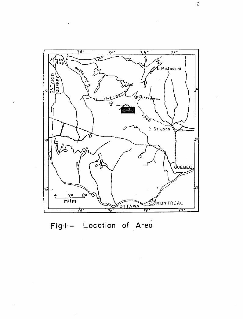
d',oc~tion nnd :~c;ce sr~ ~. _._.. Tho Surprise take area lies in a.bitib.i-L:cset county,
ruabesx (Fig. I. p. w). Tha center or the area is located about 24Q riilea northwest of Quobeo city ter:rà. some 45 riles
southwest of the village of Ghibatramau. :.'h© rDap-sroe in.
cludes the townships of DruSllettes and Tisseur, largo parts
of Orals, üansche, Lanrloiaerie end 2esr:brun, and cmnllar
parts of CrisQiy and Yechnult townships. It is bounded by
8 North and by longitudes 740 3°1latitud4a ~9° 15t and 49° 3Q end 75° 15r Vest, and comprise?, about 575 square miles.
The adjoining area to the cost Wmn nso:pCtc1 by Gilbert (1 E52)
2.9 54"
i
Fig•I-- Location of Area
3
in the summer of 1951, end part of the area to the north was
mapped in 1952 (Lyall, 1953) . The northern boundary of the
F3uteux Area, napped by 3.C. Freeman (19 3), is approximately
seven miles south of the map-area.
The Brea is easily accessible. The St. rFolicien-Chiboug-
Tau all-weather highway passes only 12 miles from the north-
east corner of the map-area. A side road, which loaves the
highway at mile post 121 ( i.e. 121 miles from St. Folicion)
enters the northeast corner of the area ono mile to the north
of Heston lake. This side road, approximately 15 miles long,
extends only one mile west of lieston lake, and the only prac-
tical way of reaching the other parts of the area is by sea-
plane.
Lakes that afford good landing places are numerous and
well located to provide access to all parts of the area. From
Windy, Caopatina, Surprise and Dada lakes, the greater part of
the area is accessible by canoe. There are three short port-
ages along the part of the Opawica river that links Caopatina
and Windy lakes. A single longer portage of 6500 feet offers
a second more direct, although more laborious, passage between
these two lakes. There is but one short portage between
Caopatina and Surprise lakes. Caopatina and Windy lakes are
also separated by one short portage. Travelling between lake
Surprise and lake Dada is most easily done by sea-plane as the
canoe route involves six portages, one of which is nore than
a mile long and over swampy ground. The long bays of Surprise
~~.
lake wore very helpful in covering the south central part or
the srofl. thx-xorou8 other =taller lakes can also La used for
plane 1€sndinca.
The two nain navigable rivers, the Op cuf,cs und de 10
rivera, perm3t easy accods of the ccuthcarstern und soutkxyos;turn
parts of the E:Yoa respectively. Theca rivorsa have narzy rapids
and fallu but ca.;ncra porta,gos by-pass the hazardous plseoo.
These porta:goo, as well ans these linking tho cmsaller. lahe:3 and
rivers are in good condition. Tho smaller ltobort and Loy rivers
permit easy access to the western and south centrul parts of
the area respectively.
Previous York end History of Devalqnmorit
The history of the development of the ChivUugcraµu district
started in 1903 when discoveries cf copper and asbestos were
trddo of the shores of lake ::,hibougamcu. ::usasequwxzt finc:izg, of
gold and iron led nor() prospectors into the district. Dy 1909,
people interested in the dr•vcalopr~~ant of this region asked the
Quebec government for conatructiQn of a railroad to the
;~~zibotgczytau area. As a response to thin request, the :;ucbotx
government formed the rhibvug::=rgcu sining Conn3ssioriw This ccm-
mission had to judgo the value of the discoveries already made
and estimate if future nining possibilities warranted the con-
struction of the rs`il+ciod. Tho report or the Mning ~c~r~~iast~l.Qnx
(Fa.r.ibault, Ouillim and Barlow, 1911) did not favor the immed-
iate construction of the railroad. The proszpoc::oru, however~
kept going into the ores, and other finds were madc.
Zn 1927, 1930 and 1935„ The Geological Srvoy of Canada
sent g©olo, ista into the district to do more mapping. Goo..
logical Survey of Canada memoir 105 on the Chibougi.nru Lake
fsp•Aroa, (Mrawde1ey and Norman, 1935) and a proliainary report
on the €pawioa-Chibouwanau Vap-fia (Norman, 1936) were pub-.
liehed by the Canadian Survey. In 193B, two goologic maps on
the Chibougam u Scoot were iaauod by the Canadian Dopartmont
of Vineu and Reaouraea (Mawdaloy and Norman, 19301 Rotty and
T orrma n, 1936) . Those two rape published on a socle of four
tailor to the inch, are accompanied by marginal notosa but no
final report has yet boon iscuod. Diaaovoriec of =salvo .cul.
philo z inorali: a.tion with gold valuoe in the area iriodlatoly
south of lare Ioda, led to the geologic zapping of the Dutoux
area by the quobso Department of minas (Freeman, 1913). Fur-
ther davelopracnt of the region was greatly handiccppad by
transportation difficulties.
In 1919, the Quebec Departnont of Vines cozlotod the
all-.roathor St. Folicien-Chibougamau highway. With easier ao-
cors to the area, exploration, prospecting and geologic gipping
was carried out at a much accelerated pace. This renewal and
intenaific ation of activity ronulted in the discovoriea of
many inportant praapocta, asamo of ubich were made in the area
ccavoroa by this report. Prior to and during the w^ttcris in.
vostigo.tiotx, prospecting was carried out ospocially in the
north and northeast parte of the area. G©ophy$xac.l aurveya
were also rsadm near laka de nu and flour I".ostcan lakv.
A program of geologic mapping was started by the quob4c
Department or Mines after completion of the highway.

6
Present work
Fie2.d, work wso corried out in the yammer r:ranth; of if;=52.
1t53, and 195h. DurizzM each fiQi.c: season, e fifteen ni.nute
sheet 1rtnf3 covered. :'reli.^*ir.cr~t reports (Croniur, 1'7;53; Do-
land, 1953) ccavorz^z two of th:;ee three Lreso have been pub-
lished by the Quebec nopgrtme'i1t of I°inos. w:,u third re report
covcrir.^ tho w:oterr;most fifteen nix.ruto Shoot will bo avail-
able in ray 1955.
A total of al.i£ixtl.y r.,zora thsrx 300 deys woro s:pes3t in the
field. 1-hrnover weather conditions wore favorable, two and
occasios.rally three parties were used for the mapping. The
area was covered by pace and compass trcvcrwc+c and shoreline
work. Tho traverses wore cpacod ovary 2000 root to 2500
feet a;avrt, and whenezvor pvswibla were run in a north-south
direction across the trcndc of the f.7rmpti.ous. ihi3 was
found more prot#.toblo than trying to well: the contacts be-
cause the latter ere transitional e;ic3 cro covered with gla-
cial drift in meet places. Mich info:t tion wno c'.arivod fzti>ra
work alcjnt; the Choroli.nas where bedrock wrw bettor exposed
than in tlie cross botuo:n the lakes.
The trav:az't:ea c:a%1 aoral.inv coolragy wore plotted on an
eocsurato .helt' a mile to the inch beet) map. The base rep was
compiled in the offices or the ~iuebee Dia,.,ortmnt of :linos
tram rroli*,insry surveyed maps and aaot of vortical aortal
p2xQtogrephya taken by the royal .:;, nadiaxa Air Force. The po3i.
tians of mile posts along the survcav'ed lines and of bench
mark stationaa on the shorelines provide good control in
7
plotting the outcrops on the base maps. The aerial photo-
grspha were carried in the field c .nd proved very useful in
loccting positions while rapping. Aneroid barometers wore
used to determine the elevations of same of th© highest hills.
Laboratory work included a petrographic study of about
300 thin sections. Heavy liquids and rzgnetic separators wore
used in studying the minerals. The universal suage and oil
immersion methods were also used to determine the compositions
of some of the minerals. 'The mineral constituents of 18 rock
specimens were deter: fined by 'x..ray methods in the labcra.tories
of the Quebec Department of }lines. The geology was plotted on
a half e mile to the inch base map, and the map was then vent
to the '`uebec office for reduction of scale. The final map is
on a scale of one mile to the inch.
An attempt was made to use the rock color chart distrib-
uted by the Uationsl Research Council. The color chart proved
helpful in determining the colore of the less metamorphosed
sediments and of come lava flows. The chart could not be used
in describing the higher grade metamorphic rocks.
Fourteen simples from mineralized zones were also analysed
in the laboratories of the Quebec Department of .lines to de-
termine the presence and mounts of gold, silver, copper, nickel,
lead, zinc, or iron.
Acknowledp:ement s
The dissertation was written under the direction of
Professors Alan N.3atoman and ratt S.Walton. Deep appreciation
is expressed for their valuable guidance and constructive cric.
icism.
Tho writer is grateful te Professor Jahn !ledgers who
rood and edited the section of this report de lingwith
structural geology.
The writer wichos to express his: irdobtedne ;x to the
at3-ff of the Curvoy e a branch of the Quebec Department of
?titles rand especially to Dr. I.t . Jonas, chief of the branch.
During the su .car of 1952 Dr. v.a,. Grenier, now with the
I fines branch of the Quebec Department of â"inca cpont about
two ronthe with the writs: pointing out the mein geologic
problem of the area. 1 te guidance in the field rie well as
his mapping; and his collaboration are deeply acknowledged
here. Grenier (1953) wrote the preliminary report on the
Ganache area.
Duch of the infor ..ctian used ta the present work wi.s
colloctod by 'Torero n. 1"or•.ictr- III of the University of
Mo;zic,en.. 1%g lick acted as senior assistant during the 1953
and 1954 field seasons, and hie valuable help is gladly ack—
nowledged.
Additional help tram field asar.istentfa and from follow
graduate students is oleo acknowledged.
9
D~:Cs,zP:aO:r 0? 4.71::A
i ,,nn ÿrR ni:y
The lies irs.cdintely acct of the rseight-of-land
s3akaar tho I:u4toti ~ny and the :.`t. I.-+w: ence I•.ivar bcsincs.
south of Deux Iles lake, near the baur.dxry of the mm?- aroe,
the hairht-of-land is only four milcsa to the ad`£t. Tho urea
slopes very Fontly to the northwest towards fluc?son 2av. The
area has orQncrgl elevation of 1300 foot above sea level
near this eastern boundary, and of slightly over 1100 foot
wear the western boundary. The elovgttons or the nain lakes,
listcA. frcex oast--aout.hocs; t to northwest, are: :eux Iles -
1200; :ûrprf ae - 122.3: Caopatina - 1193: ,Andy - 1172; Dods, -
1109.(1/
(1) :.:lovatiUns of lakes are riven or. ChiLouea¢s£u-:?c;ver - val t;iieat, National ;wocrerhio :;crias - 32:;L:,
The difference in elevation between tY:® easternmost lake
and the westernmost ono is 171 foot, and tho dtstmcQ between
these two lskss is over 35 riles. Tho Cpswic:s river which
connects all those lu;re4 thus has acan.ra.l rr sdiUnt of loss
than 5 feet per mile, reflecting the flatness of the area.
Tho tonw*rc ay of the rap—area is typical of this pert
of thc, Cam dian shield. The local relief .is not marlood, and
the land nur.fcc©, in ranoral, is ranarkably flat. Closer
eomniss.sat:iox2, either in the field or from serial photos, shows
that 4.n =oat places this flet surface is sl;cht?y i.rroŸ ulc.r
with vany low hills. i.zere era pieces whero tracts of land
6 or :lore r::S.l.on long can be fo lowed withc:ut ra chcnGo of 50
10
feet in sslovRtion, !lost hills helm .r.cntle slopes, and few
rise more than 100 foot above the gerac:ral level of the lakes*
A lsrra portion of the raa p-crou not covered by bodies of ws:-
ter consists of swamps and rlus;koF; or low around, iRaur+a aria,
howevor, a for hills that conatituto exceptions to this low
gcr.tlo tos og rs=R,hy. Tho hit~-host hill in the arec iv sbout one
mile west of the south west bcy of Zurpriso lake. This hill,
on which the Casaba© D pc.rttrant of Linde ranci Forocts hess eroc-
ted en observation tower, rises 550 foiat above the level of
lake (.urprise within a distance of a mild. Anoth r ridço be-
tween ft&nick and No pock lake risoa about 300 feet abovo tho
laved of the sea . lak_oe. en Toi or peninsula of Dods lcko a hill
risse 400 foot abovo the level of the lake and l s th© site of
another observation toior. A third tower, erected in the
aurner of 1951, ' is located on a low hill near the south east
shore of Ieko :soaatln©.
In general, the local relief boars little or no relation
to the underlying bedrock* Thus hills synd low c wr:py grounds
are o Nerved over tho granitic) cross, as well as over the
1Zoowntin-typo rocks or their slotamerphescd oquivelenta. Uow-
ever, thon doalin7 with individual rock exposures, some rocks
are more resistant than others and nay account for some of
the smaller topographic features.
Likes end rivers
A striking focture of the area Is the profusion of lekoc.
More than 31 percent of the rap-aroa Is covered by bodies of
li
water. The major jor la;kcc listod on page 9 are all connected by
the Opswica river, witch drains much of the eastern part of
the area. The w stern part is drainod by do l' iglo river, a
tributary of tho Opawica. From Dada lake, the Cptwica river
continues westward and then nor whw c rd into James may through
Waawanipi rnd Nattaw ay rivers.
The lakes and rivers con: titute a complex ciratna ;o cystom
that cannot be placed into awn of the standard drainso pat-
trnc. :'.uric of the larger lakes, like Windy and Caopatina are,
characterized by very intri.aato thorolinoa. There is apparent.
ly no structural nor litholo;ic control over t e al ea and
shapes of thoac lakes. 1+indy lake occupioc a deprcasicn in
bedrock, and its choros are characterised by nearly continuous
exposures. Lake Cnopatine, an tho other hand, occupies a bas-
in filled by glacial material, and outcrops are very rare on
its cborelino. Both t2 o o 1ckos are shallow, and tho outcrops
of Windy as well as tho boulders or •µcoy atina make travollinc
by canoe rather hn:ardouo. Other lakoa, such as Dods and
urpriso, have boon only pprt1.y filled by drift and their shoroa
pro partly rocky and pertly made of glacial material. Then°
two lakes are deep and con .tituto excellant canoe routos.
During the uplift that followod doclaciotion, the, Opawica
and da 1tt i rle rivers ixavo deepened their channels across un-
consolidatod glacial materiail. They chcnnolc are twenty to thir-
ty foot deep in most places, but sure the rivers cut through
coarser glacial material, these chcnnolu aro not so deep, and
rapids and waterfall° are numerous. iocrly all the rapids on
the Opawicn end do l' iglus rivers are on coarse boulders.
12
rancial Tolci!rrPc~hâG Features ,
Looking at aatmii. scale nop or Abitibi-1:ast -snd I:oborval
counties, ono is struck by the very pronounced lineation of
topographie teaturcaa. There is a narked nr,rtr4.c^at trend of
most of the large lakes. This trend is not indicated by tr,o
large lakes in the rza.p..eraa, clth.purh the non-rocky shores or
those isdoa do show this pronounced lineation. Vest or the
medium and =slier size xskza show this northeast trend.
most striking glcc3.ai, topographic features of the-area e~.~ o the
long northeast trending pointa on the north chore or lake
Caopatina;.
Aside f:*m giving this' pronounced lineation, the glaciers
also contributed to flattening asu.r1'aeu tLtit was already flat
before rltzcitrtion. rent of the glacial features .yf the area
are depositional features and they will be discussed in the
section on Cenozoic.
Inhabitants. Climate and f'.©sc9urços
The area is uninhabited cave for one indian family living
.on the east shore of roda lake at the mouth of the do l'Aigle
river. During the summer months, the Quebec rep€rrtmexat of
Lands and Forests operates three observation towers. Two non
are stationed at the towers of Csopatina and "ur; riao lakes.
Tho nain camp of this department in the region io located at
the mouth or the de l'Aigle river on the oust shore or lake
Doda. ircim five to ten man inhabit thin base camp during the
summer months.
Tae climate Is rigorous and the summers aro short. The
,~ ~
broa up" of the ico occurs in ray rind the "froo o up in
ovu bor, and tho boat season to do field work is from the
first drys of Juno to taw first days of Octvbor. Ni ht frusta
a.ro co on in Jw20 and Zptenbar.
fcacausa of tho rigorous clir~ato, and tho lack of good soil
or clays, there are practically no agricultural possibilities.
The Cuobeo DopertInent of Lrinda and rorosto has developed a gar.
don on a candy area, end has had acme succors in crowing pota-
toes and other vogatabloa. Wild bluoborrios and raopborrios
sro abundant in aono parts of tho ,urea.
Tho area is thickly covori d by various characteristic trues.
Black p?ruao is tho reset abundant treo and c=v boautifUl stands
conatituto large r©scrvos fora pulp industry. Other vertu.
tioa of conifers inoludo the jackpin©, tamarack, i tiito cedar
end ba.lca.i fir. White birch and poplar aro the only deciduous
troop but they are much loss common then the conifors.
Falla on the de l' 1 ;lo and Opewica rivers constitute
potential courco of electrical energy.
Fiab are abundant in all the lakes; pike and picr.orol aro
the rout coiron varieties. Sturgoon and grey trout have boon
caught occasionally. Crook trout have boon caught in Noma of
the mall crooks, but thoy aro rare.
Among the liar ;or gams animals, nose are corn on, and black
boar rrxra. Deaver tnd muskrat arc the nest coon mull fur.
bearing animals.

GENERAL GEOLOGY
:+I1 the consolidated rocks of the map-area tira of ere
cc.~ :brion ace. The north and northwestern parts cro under-
lain lily an aasonblage of typical Keewatin-type rocks. Those
consist mainly of altered levee ranging tram bac:clts to r::y,»
elites with sedimentary racks, pgroc3asti cs and in.torsloaiato
to taste Szatrtx ives making up the remainder. Thi sa ccra.plez
assemblage has been intensely folded and defamed so that
now the strata are either steeply inclined or in r► vertical position and generally etrika easterly. ûhos~r :.ones also
strike easterly and are common in this northern half of the
area and many of them are mineralized.
The couth tnd southeastern parts of the eroa aro under-
lain by ,gneissic grtnite, bSotito and hornblende pwraz:noics9s,,
hornblende gneiss and amphibolite. Zone of these r.°aets.norphic
rocks are rich in garnet „ are highly cr,ystAllln.e, and res-
emble Grenville-typo rocks. The p aragneiztse; and hornblende
gneiss also generally strike east; r.owover, r.fl~ r the aouth-
east corner of the map-area the formations and the uc.his-
tosity tend to assume a north-northeast trend. Tiia change
in the direction of the structure is rather gradual. In the
gneissic granite, the gniaanssity is much less regular, al-
though the easterly trend still seems to be the rule.
A few dikes of diubasn, probably of lute 'Precambrian age,
cut the gneiaeic granite and the ::©aWatin-typo rocks.
Very little prospecting was done in the part underlain
by gnoiosog prior to the summer of 1954 s31on uranium uaa
~J
discovered in pogmatites associated with the gneissic granite.
The :oewatin-typo rocks in the northern port of the area
are located at the southeastern border of the Tiniakcirr;
cubprovinco of the Canadian : hiold, and thym crystalline eis-
sea and granite of the area are at the northwestern boundary
of the Grenville cubprovinco. Thus, a segment of the postu-
lated boundary between the two subprovincos crosses the area
diagonally frocs the northeastern to tho south centrai part.
Lith©logic and structural evidence indicate ► that the r ota-x orphic hornblende cad biotitc gnoinues are the riotar orphosed
equivalents of the Xeowotin lavas and sedimentary rocks into
which they pass gradationally. Faulting fora only a minor
part of the structural features.
Except for scattered outcrops, all the Prect brion rocks
are covered by unconsolidated glacial arterial of Pleistocene
o.ga.
Tho major types of rocks tre represented in the table
of formations (Table 1, p. 16).

16
Tabla I
Table of Formations
c'onoûr,ic 1 Pleistocene ] clay, sand and gr ivol, till
Groat unconfctrmity
, Lato I'raor,nbrirnrt Kewoonawan (? ) disbnsa dikas
Intrussivo contact
::s~,Mly or ~ Lato Grenville (4 ) j gneissic granite, agc~r~.i.ti.o, Precambrian I diorite, pegmatite, aplito
Intrusive contact
r
(3rQnvilla-ty,ao rocks
hornblende rno i a s arphibalite biotito a.ndf©r hornblende paragnoi seos (mng bo partly from source other thsa Keewatin-typo rocks)
rio â.r~€~w ._ ati.n-ty;~o rocka
nice schist hornblende mcList h.orrYbi©n:rie-chlorite schist amphibolite
I~~,~©ws,tin-tyna rocks
sedimentary rocks gabbro-diorite siZla basalt, andocite, rhyolita end some pyroclastic rocks
Pro ø tb ri an
Keewatin(?)
17
1. JTIN (4 )
Keowctin.-typc rocks underlie a bolt that trends east-
west scress the northern half of the map-area. This belt is
about three and a half :Niles wide at ase esstern boundary and
it attains a width of eight miles at the western boundary of
the area. f easurod from the western end of lake Surprise
northward, the belt has a maximum width of about ter, miles.
The belt occupies more than ono third of the map-area or about
225 square miles. It is the extension to the south and to
the west of the bolts described by Holmes (1952), Lyall (1953)
and Gilbert (1952) .
The Keewatin-type rocks consist essentially of basic to
acidic flows, =all amounts of pyroclastic rocks, sedimentary
rocks, and intrusive sills of r otagabbro and motaadiorite.
These rock units are not interbedded at random but tend to be
grouped in several characteristic associations. Thus, the
intornodisto and basic lava flows are always intir..ately asso-
ciated with sills of notsgabbro and netadiorite. These sills,
on the other hand, were never observed in contact with the
more acidic flows. Ehyolitee and trachytes form units that
can easily be separated from the andesitos and basalte. Pyro-
elastics such as volcanic brace's and agglomerate are associ-
ated with the rhyolites and trachytes. The sedimentary rocks
seem to have a more complex distribution. They occur in - thick
units such as the bolt south of lake Cc=opaatina and the one
north of lake Surprise, and they also occur in thinner units
intimately associated with the endczites and basalts or with
14
acidic flows. odiriantary rocks were never obsorvod in con-
tact with the rietagabbro and metecîiorito.
All the ioevatin•typo rocks hive under; ono regional
natsror->hiurt rind in more deformed zonate of the bolt same hay*
been cffoctod by hydrotho; al alteration. As expocted, tho
acidic flows and tho qus:rtzo-feldspathic sediments hcvo under--
rono logo char o than the rocks of interoadiato to basis cam-
^ccitton. noccuso of this :ctanorphism„ tho and©mites and
bas:lta cannot bo cepart:tod on the prosont cealo of nap ing,
cnd thoy hcvo been grouped together on the roologie map. The
intrusive sills of cabbro-diorite hcvo Moon diffcrcutiatod
from the laves on the basis of texture alone, but the sepa-
ration is difficult in places, as a schiatoca gabbro-diorito
may look very much like a achistoso cndoaito or basalt.
i;ndesitert r}n:d Desalts
Occurrence
Flows of endeaitas and basalta are widely distributed in
the belt of }.euwatin-type rocks. The boot oxposurus arc an
the : hores of Windy lake and also on the hill oast of No Rock
lake. It is difficult to rossuro the thicknesses of individ-
ual flows boost= re ional nstz:morphisn has oblitorc.ted many
of the contact features that night have boon helpful in
separating ono flow from another. A continuous ox?osuro along
the oast point of Windy lake gives some clues as to the nature
of these flows. The sequence here from north to south, or
Prom top to bottom, is es follows:
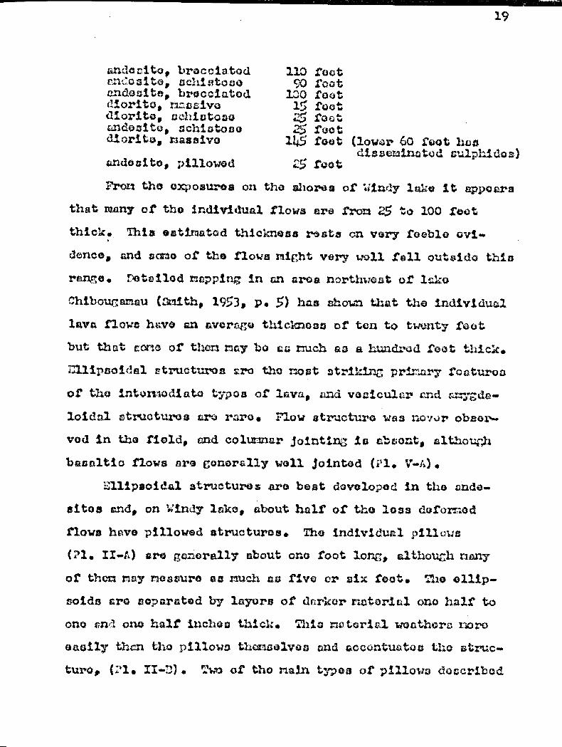
19
rndacito, broccia.tad s~~:'asito, sehistoa3o EindE3F3itE3, brocCii3tod diorito, rzwosivo diorite, achisatas4 aadatsite, schiato€aar diÛritro, naasaivo
z►ndoaito, pillowod
110 foot 90 foot 130 fo o t 15 foot
foot 25 foot
145 foot (low ,r 60 Soot has diszeninatod culphidoa)
25 foot
From the exposures on the shores or Windy lake it appears that many of the individual flows are fry 25 to 100 foot
thick. This ostinatod thickness rasta en very Loebla
demos and same of the flows might very well fall outsido this rie. Detailed napping in an area northwest of lake
Chibouwa ncu (Smith, 1953, P. 5) has shoe that the individual lava flows have an average thickness of tan to twenty foot
but that cama of thora ray bo en touch as a hundred foot thick.
Ellipsoidal r tructures are the nest strikes prirnry foaturoa
of the intomodiato typos of lava, and vocicul4 r and c:mygda-
laidal ctruoturos are rare. Flow structura was nover ()boom.
vod in the field, and columnar jointina is absont, elthouhh
baaaltio flows are generally well jointed (Pl. V-uh).
Ellipsoidal structures are beat dovolopod in the .andn-
aitos and, on Windy lake, about half of the loss doforr..od flows hev© pillowed structures. The individual pillows
(?1. II-A.) are generally about one foot long* although nany
or them nay measure eunuch as five or six toot. Tari ollip-
soids arc) coparctod by lcyors of darker notarial ono half to
one and ono halt iuchoc thick. Thic notorial woothers haro
easily than the pillows thomselvos and accentuatoa tho struc-
tural ('1. 11-n). Two of the nain typos of pillows doceribod
20
by :hrock (1940, p.3E4) are core only observed: the balloon
typo, which is the nowt co non, and the loaf-shaped pillows.
Those two types, however, are not always easily separated
and they grado into each other. I alny pillows have boon
deformed and stretched during the periods of deforn tian but
somme of the lests deformed balloon-type are useful in deter-
mining the tops of the flows. A fcaa of the pillows are char-
acterized by vesicular structures near their r rginss and some
of the vesicles have been filled with calcite.
Putronrophv
The andesites and basalte are fine-grained, greenish
gray (5117(4/l )1 to dark gray (N3) , said ore generally grouped
I. Symbols are those of the Frock Color Chart distributed by tho 1 stion l fosenrch Council.
under the general field torn of "roerictoneTM, Tho rock is
slightly schlstose in cone places and highly schistose in
others.
'. icroscopic examination of tho Ices schistose cndesit©
and basalt show thk,.t the rock has a homogeneous texture con-
sisting of a mass of secondary riinernls. Most of these min-
erals are fibrous end hove random fabric orientation so as
to give the sections a characteristic interwoven texture.
In ran* of the sections, the original ophitia or cub-ophitic
texture con still be observed. The grain size is 0.01 nm and
the individual grains, whether they are anhodral or fibrous,
lock sharp boundaries and seem to gr de into each other.
Under crossed nicoia, the sections ore gray to very dark gray,
as nearly all the minerals have low birefringence. Voinlots
21
of quartz, calcite, opidoto cad a few sulphides attest to the
anount of introducod material. l any of the veinlots are
microscopic in cire and cannot be cot n in the hand specimens. ©cixmens.
Tri essential : tineral constituents of thoco laves are color»
less amphiboles, plagioclase, epidoto, chlorite and minor
quartz, tznd the accessories include biotito, magnetite, pyrite
and aphone.
Colorless amphiboles, mostly of the actinolito variety,
occur as fibrous or tedthorn grains that have a characteristic
wavy extinction. The mineral has grown in a porphyroblcsâtic
foie but there is no relict primary mineral to show whether
the aotino:ito is secondary after a pyroxona, an amphibole,
or some other Mineral or mineral aggregate. Lctinolito tends
to form grains that are slightly larger than the other miner-
als. The long noedlo-like grains give an extinction angle
ZAc of 10 degrees in sone sections but as much as 17 degrees
in others. Tho fibrous mineral is length-slow, and has rathor
weak birefringence ranging up to about 0.01. In some coctiansa,
the amphibole is slightly ploochraic, from light green to
nearly colorless and is believed to be tremolito.
Some ouhedral laths that may be as much as 0.5 rait long
are completely sauasuritized plagioclase and the composition
of the original plagioclase cannot be determined. Other
smaller grains of feldspar ara clear and enhecral end have a
nocative relief against Canada balsa n. This clear plagioclase
is twinned in a few soctions and has a composition of Anlo.
It is believed to be cecondarq albite resulting from the

alteration of a noro calcic plagloclaso.
The two variotiou of opidoto, nanoly pistacito (iron
epidata) and clinozoisito (iron-free opidoto) co stituto the
next mat canyA3n ninerala and, in pone ouations, nay account
for thirty porcont of the rock. The racroscopia oxamination
of tho andeaitos and bazalta affords a. very good illustration
of the groat oaso with which opidoto mvus or reacts to not:i-
vory:hie conditiena. In sono of tha cootie:1s, clinosolaito ia
found surrounded by agcregaten of saussurito grains. The
clinoaolsite Grains aro'colorleco, biaxial pocitivo, and have
a 2V of about BO degree°. Upidoto grows in a porT,h7T.oblaatic
mannor at the expense of cloudy graina of sausauritite and
cioar clinozolaito. Tho iron concentrates ta the centers of
those porphyroblauta Slid gives the grains e sit ht yellowish
pleochroisn and fir t order yollow to rod interference colora,
whereas the borders give anonalous grayish blue intorforenco
colors typical of clinozoialto. Tho borders of tho porphy-
roblasta still Chow aggregate struetwo but the centers do
not. Tho iron opieoto is biaxial negative, has a 2V of about
CO degrocs and has negative olongation. loat of thu opidoto
S. s dofinitoly s000ndory and probably forted noro or losa
diroctly from the oltaration of plagioclase; however, sono
grains aro associated with quartz, calcite and culphidea in
veinlota and may have boon introduced.
C;hlorito occurs as snail flekos that cru slightly pleo-
chroic from colorless to very light groan, and haw) very weak
birefringence and characteriatic wavy extinction. Greenish
23
brown and purplidh gray aro tho most co :. on interference col-
ora but anomalous berlin blue is occacionally observed. lost
of the chlorite appears to be of the clinochloro variety
although penninite and prochlorite may also be present. Moat
chlorite is secondary after hornblende.
Quartz is rare in the meta-.undocitea and nota-basalts,
and was observed in only one of the sections, although it
may be common in the aphanitio groundmacs. Tho grains are
clear and anhodral and are very likely secondary.
Anhedral aphone, suh©dral pyrite and some secondary iron
oxide, probably limonite, are the accoeaories.
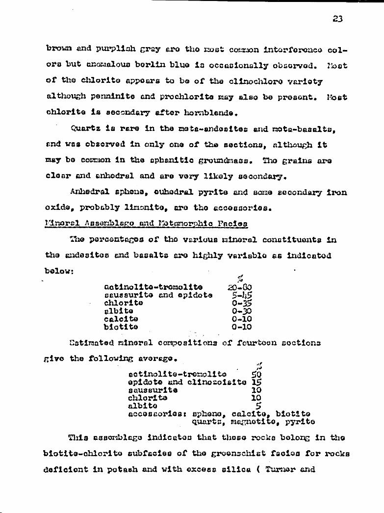
TïrLorcl Aasorbls o and Y tcnorphto Pncien
The percentages of the various mineral constituants in
the andositos and basalts ara highly variable as indicated
below: • fif aotinolito-tmolite X-00 aaussurite and epidote 5_45 chlorite 0.35 albite 0.30 calcite 0-10 biotito 0-10
Z.stimated mineral compositions of fourteen sections
... >>
actinolite•-tromolita 50 epidote and clinozcrisity 15 ssaussurite 10 chlorite 10 albite 5 accessories: dphonct, calcite, biotito
quarts, magnetite, pyrite
This cascrzbl€gn indicates that these rocks belong in the
biotito-chlorite cubtcciea of the grvonschiat facia© for rocks
deficient in potash and with excess silica I Turner and
give the following average.

yarivogen, 1951, p. 466»469) .
Vatzirczb`uro and fi►otadi rite
pccurronco
': idr~lg disitributod throughout the intermediate and basin
lavas and intimately associated with than are sills and lense-
like bodies of altered gabbro and diorite that, wherever ob-
served, are conformable with the flows. There r©cke wore no.
Where seen in contact with the sediments or the rhyolitet.
The largest single unit is about 1500 feet wide and more than
two ailes long and is exposed along the central part of kindy
lake. Yost of the intrusive sills, however, are of much small-
or size end their width generally varies from 10 to 100 toot.
They are thus too €hall to be indicated on the accompanying
map. Dy ur3ing different a -sszbola, an attempt was made to sep-
arate the intrusive sills from the flows, a1t ou4 h, tats rzon-
tioned previously, a achiatoao gabbro-diorite rock cannot in
score places be differentiated from a schistose andesite.
?otro; raohY
The gabbro-diorite rock is more commonly mealy() than
sc}iintoee, and has a greenish gray to dark gray color, which
is very similar to that of the intermediate and basic lavas.
Thoy are altered to a lamely aocondary minerai assemblage
and tiny be grouped with the andosaites, and basalte under the
term "greenstone". The naaeive rock has a distinct Granular
texture and is fine- to medium-grained.. In mat of the soc-
tions examined, ro nth of diabaaic or utbediabesic texture
are preserved. Although this texture can still be recognixed,
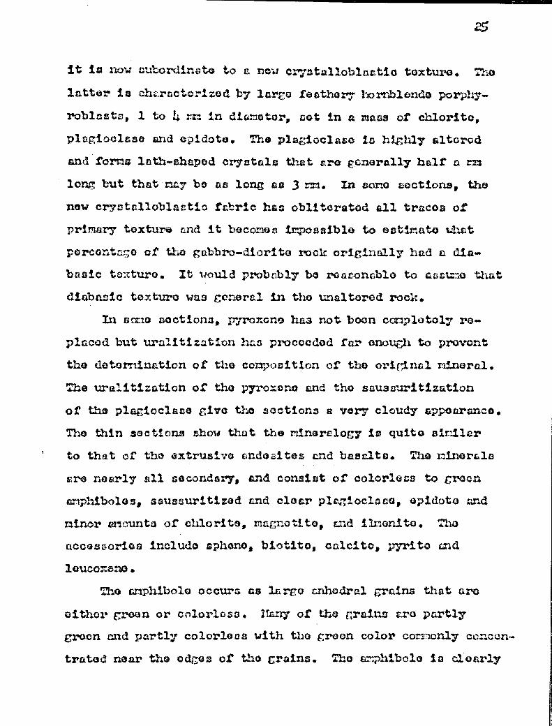
it is now subordinate to a new c atallablastia texture. Tho
latter is chw.ractcrizod by largo feathery hornblende porp:y-
roblcsts, 1 to 4 ma in dia motor, sot in a rsacs of chlorite,
plagioclase and epidoto. The plagioclaao is highly altorod
and forme lath-shaped crystals that tro generally half a me
long but that•riay bo as long as 3 rm. In soro aactians, the
new cry,atalloblactio fabric has obliterated all traces of
primary texture and it becomes impossible to estimate t hat
percont o of tho gabbro-diorite rock originally had a dia-
basic to:tture. It would probably be roasonablo to aast.M-o that
diabasic texture was general in tho unaltered rock.
In same soctions, pyroxene has not boon completely ra.
placed but uralitization has proceeded far enough to prevent
the detormivation of the composition of the original mineral.
The uralitization of the pyroxeno and the saussuritization
of the plagioclace give the sections a very cloudy appoaranca.
The thin sections show that the mineralogy is quit° similar
to that of the extrusive ande itcz and basalte. Tho minerals
Ere nearly all secondary, and consist of colorless to groan
amphiboles, saussuritiz3d and clear plagioclase, apidot© und
minor aaamounta of chlorite, magnetite, and limonite. The
accoesorica include aphone, biotite, calcite, pyrite and
lc►ucoxene .
Tho amphibole occurs as largo arûaadrel grains that arc
eithor groan or colorless. May of the çraainss are partly
croon and partly colorleas with tho groan color corelonly ce ncon-
trated near the edges of the grains. The a*phibolo la clearly
secG:.dcry after j}jro::f:ZiG„ but it is difficult to dotorm:.nFi
what va ,iot.iGs or srap.bibola and of pliroF.x;ne tzx'o pr,;cent.
The o;rtiow::, properties of the Fr cxa rrv hii:ols crains aso as
i`o:.lowa :
zAo : 20 c?s3crcqS (-) 217=C4 degrees absorption sr > x
+lZose properties r.xrd the =Iron occ;urroncm of colArloae
arhSbo1© indicate that the nost ocervn r,.r)bibolo is in the
trsmolito-a3otir.olittt rar.gc. Howgvor, , er,= saoctions contain
much darker c,phibol$ identified as hcax•riblQ:zdo. Tho fact
that green c:nd grese~xish miphibal+os are prflaont in the intru-
sive sills r:lci marl', absent in the laves auc^;vmta that the
gabbro-c:iarita bay(' boon mro iron-rich than thoir oxtru.•
vivo equivalents or that they havo boon differently Altorod.
:33© first hypvtliosis is r:oro probe:iilo.
The plagiocleso groins a..~a found es auh®dral lath-shaped
crystals that arc hichly ao.useuritized. The composition of
the plagioclase is that of an albito or sod,ic olignoloao
(Ann to As'ii5) which is secondary after a more coicic placio-
close. Tho alteration hen not destroyed the oricinal shape
of the crystr1s, and in =any crslnsa concontrstion of opiciotQ
hrs been such as to accentuate the zoned structure.
risteoito, clino:a:iait€a and seussuritQ hava the sane
occurrences ns those observed in the lavas, and cornon3y
form(' zoned porrhyrQblamts.
Chlori.to occura na coiorloso to creonisia flekcta or
pieo{chroic femuls : zs cr ocn y.groen x=vcxy 3.ik,,iat: croon
27
shrdds that have a Characteristic wavy extinction. The pro-
portion of chlorite given below is lowor than that given for
t~.~cr lasvaa simply because only the massive vuriet; of ;cbbru
wns used for thin section studies. Tho slxisto .e g;~bbro-
diori Go rock la rich in chlor1. te .
The a:;cpsco:y sp:.xeno is fatznd oith.vr ru well crystallized
dia.-or.û-a-sa; ed crystals or nu a.:ulodral grdins fo~-.,in~„~, at tho
er.pa.iva of
s~i+,rolg
F:cnl.ya e;~~y~::; 3.üc
~
l
+
:~.Iy
t'@n
+
c~.rcling it completely.
a:~Iâo;'â»~. 1ta~if:E~:p2;al'c~,^'E3 5~.~~~~ ♦ke V~~. t.✓r=}jw ..LtiA nacies
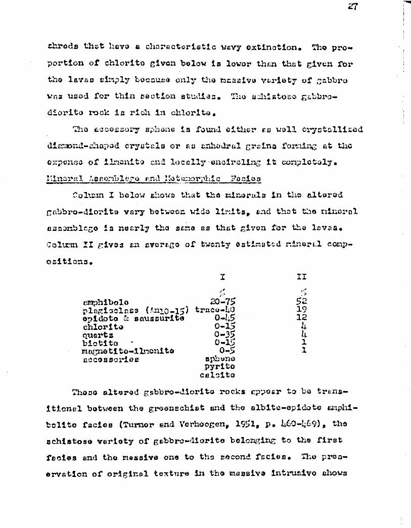
Co1,; wn Z below Shows that the minerals in the altered
gabbro-dioritp vary betwccn with limits, and that the mineral
auc:mblago in nearly the sane as that given for the lavuss.
Coltnzi iT ~-ives an average of twenty ssti.=:ut::d mineral comp..
ositicns.
Y II
amphibole plagioclase (r.n10-1;) opidota ~z soussurite chlorite quartz biotita - magnetite-limonite accessories
,~ry/~y),,..
^i ~ t I trace-LO
0-t;5 Q•15 0-35 C3-lâ 0-5
sph ene pyrite calcite
,,,_ose altered gabbro-diorite rocks cppobr to be trans-
itional between the greonscbiet and the albite-opidoto amphi-
bolite facies (Turner end Verhoogen, 1951• p. 460-469), the
schistose variety of gabbro-diorit© belonging to the first
facies end the massive one to the second rectos. Tho prop
orvetlon of original texture in the massive intrusive ahhows
that the rocks have not p«ct3sisC7, through €z higher crado of meta-
than the clbito-opi.doto amphibolite facies.
:31; cing the massive gcbbrca-c3iorito rock in the albita-
opidoto amphibolite facies and the surrounding schistose ando-
sites and bssalts in the crecnscr.ict facio8 seems to bQ con.
trrdictory. rouover, Cho contradiction is not a vory serious
ono when one considers that the two rectos aro transitional
and cannot always be easily aeparntad. It is thvraforo very
likely thtet the intimately associated sills and flows were
regionally metamorphosed under the same pressure and temper-
ature conditions. :ho most likely explanation that can bas
advanced to an.swar tho pz-oblan seems to be thst:, during resCiOn—
al metamorphism, the sills acted as resistant buttresses, and
the intrusive rocks rani, inod massive, whereas the flows gave
way x2oro easily and the iocka bac mo schiotoco. Under the
sale conditions of temperature and pr► ssuroo, the lcvaa be-
cam altered to chlorite schist and the intrusivo sills chanced
into cm, .tbolitea, thus giving rise respectively to tho groan-
schist and tho amphibalite facies.
It is also a well known fact that rocks of a certain
netamorphic facies have not necessarily passed through all tho
lower fades of metamorphism, and it seams that the sills of
pat,bro-diorite hero constitute an example of "his phenomenon.
Rhyoliteo and ^rachytos
Occurrence
nIyolitoa and trachyLos underlie about ton square miles
in the vicinity of iietaic3: lake. Zero, the rocks aro
concentrated in an oval-shaped muss that is in contact with
sedimentary rocks on the eastern side and bordered by an,,10-
Often on all other aides. Acidicflc or. uzla ;Iota!, the
wostern shore of Windy lske, closs to tho northorn boundary
of tho rwp-ares where they forn a bolt throo vlios lei .nd
leas
then ono tallo wide. Thu exposures of windy lake aro on
the extension or a northosat tre-adIng belt xsulppoil by Lyon,
(1953, p. 4-5). Other or isolated exposures aro found about
three miles northeast of Dods lake and about hair a lullo east
of lake Bernard. All these exposures aro concentratod in the
northern part of the belt underlain by Keewatiu-typo rocks.
Another outcrop of acidic lave is found in the southern part
of the Keevalltin bolt where it is intinotoly uzaocia ud 'with
chlorite and hornblando schists. This outcrop is locsted
about two rilea wont of the southern un‘2 of Djr. Claude lako.
Potrop:rsphy
In contrast with the griduitAile uad LLt alto, the rhyolitos
and trachTtes Gro 114;U-colored; saw specIrlens ore eithor
gray (la) or gli3o1-41.L11 gray (5=41) to lit, EreoniSh
gray (ora/1), whereas others are lir;ht bluiSh cray (537/1).
The rock commonly weathers a characteristic very lit;ht gray
(N8), and the weathered surface i. hel All in diatir,u1shing
the acidic laves trer the andositos and basalts. 1:16:hly
sheared rhyolite is voll exposed et tho falls on the Opouies
river about smile east of Doda lake. Bore, the rock is pink-
ish gray (57110/1) and very schistoso with much crenulation
and devoloptiont• of talc. :;ubon6ular grains of quartz con
still bo obc:orvod. In zy.ost pl.occaa howcsvcax*, tho rock is nos-
live, hard to brook under tho hormo r and is rQ; ic t4xat to
weatherir,g. The expoauroa rorthoc: t of Wind lra;co show rkuch
brocciation,.. and it is poco ib1.o thot, during tho p Qrie:da of
def=ormxstiLrx, r:uch of tho broccicti«n formed in tho acidic
lavas whereas schiatosity developed in tho intornodia; e and
basic lavas, Part of the brocciatioss nay alass ho tho moult
of tho cooling hist:o., of the flow, but it la not pacoi.Ulo
to octinuto how nuch of tho brccci.r.tio:x in the rhydol.itos is
primary and how zrs.:ch ise duo to tzyubwoltacr7t deform4aticn. The
clope asaoci.ation of the rhyoli.tos rind tr•achyt.os with agglan-
orate and volcanic brace/Ex my bo En indication of the Qx,Jlo-
azive nature of thoairs acidic lava flows.
Under the rricroccopQ, most BcotLor.o uhow a ca,ta.clustic
texture and a alight schi ato co structure that in r.o t.ca en in
the hand Spodinens. rany sections show porF7:,yritic texture.
Tho phenocryote are anhedrs.l grrs:ino of quartz or :ubLodral
graina of $y1aagi4claalQ that r.oy ho os nuCh as 7 nn long but
aro resn€aral3.y 1 or 2:m. Those p3a ;ioola: a and ruc:rtz phor:o-
cryata nay account for 62 nuch oz 70 porcont of the rock.
The groundmas« cor;z; sta of very anal.l (0.02 to Q.C}â nn) anho-
dral. and aquigrazrul.rar grains of quartz and feldspar. In non-
porphyritio varieties of acidic flows, there c{ocMa to bo two
profo„red grain oleos, O.05 rim and 0.5 to I xm. NO 1it:ho-
physso wore aeon, but in one o.: the thin sections, flow
structure woe observed. Primary quartz and plagiocleso
grains are nearly all olongatod parollol to tho structure,

ulaeroas tho coconr3 Iry novdlas of s4ricit© havu a random
oriontrytion.
Aside from quartz and plariot;lsiao, tdhiUi are th4 Twin
rock forming =inar^la, rair.nr cfloL:.xitt3 of coricito, opiwto and
c.h:.orite sr* o'acox^.od. Tho rlryfllitas do not contain potash
taldcpar and aro coda r3a.rnli tas.
The p1arioclaco psionocr^,rsts a.^c3 either cloar or vary
ali4Lt1y altar ©d, und have a moderato z:araativo relief against
Canada balsam. May Shaw albite twir.ninc and hava tlae oar,-
positic,.n, of finite or ©lirvciaso (MI5 to l.n12) •
Quartz is found as cloar arrhodra1 graina that crû cpr.-
rronly svgcn--likrr in fo:mn. Thin form is l.roliaveci to represent
Corner quart M fragments or phonocrysts that uor o czuc.hed dur-
ing the periods of dofoxrs€ation. In ono of the sections, quartz
constitutes only fivo porocnt of t:ho minerals and the rock
might then be clasaif'fQd as a treachyta. The p lcgiacicco of
that coction accounts for covonty percent of the rock, mad
Ss a aodic olicoclsao (Anil).
:'ho eccoscory minerals found in th o rh;,ro3i, toc a.nct tra-
chytmrt inûltsdo r.ornblando, biatito, slac..ntito, il.w.en:to,
pl-ritc+, limonite, srhQao,, schor lita, calcite and apaatito.
lsinernl Aepemblal o and T:etaForphi.o FAci.ea
The mineral composition of throe re,recontstive sec-•
linens of acidic lava are given below. Column I roprflaonts a
lava of trachytic composition, and columns II and III give
the mineral contents of rhyolitos.
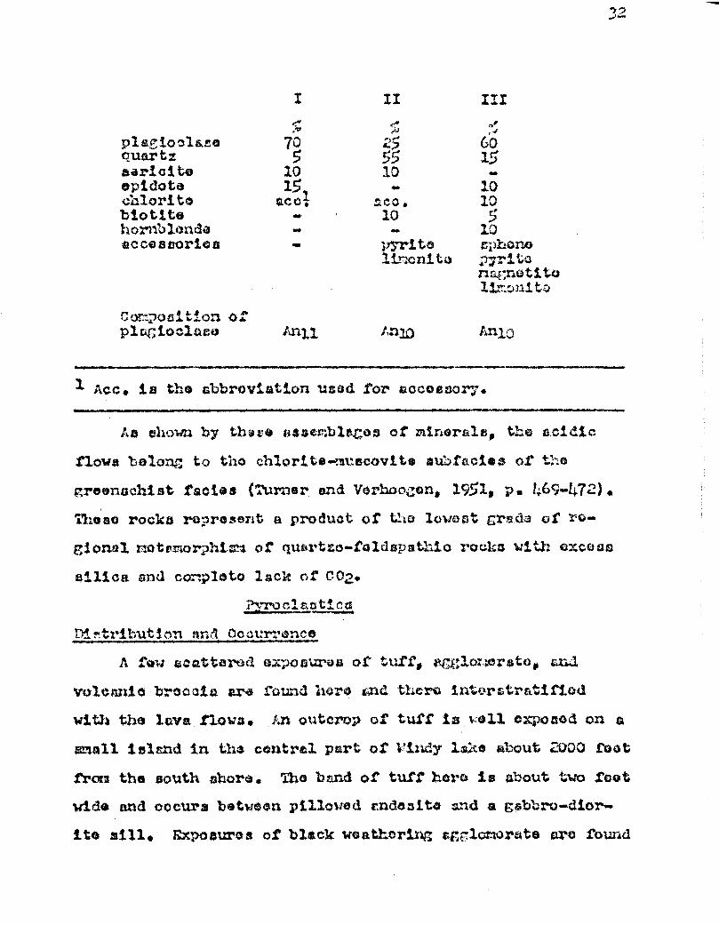
I
?5
10 15, ace:
pla7ioela Res quartz sar3.cite opidote chlorite biotite hornblende accessories
II (•,
III ,•
25 60 55 15 10
10 10 5
10 sphono
mgnot1.Y.4 13.."::Jn3 Go
Ctxwttsi :;ioi3 0f plagioclase Anil An1,0
1 Acc. is th® abbreviation used for accessory.
As shown by thas;e s;ssemblagus ©f minerals, the acidic.
flows belong; to tho chlorite-muscovite eubfacieo of the
_sr;reensseftist rectos (:urger and 'Jerhnozors, 1951, P. 469-472).
11Leso rocks represent a product of the lowest grade of ro-
clonal nfltambrp:si-sm of quartses-t'eldapathic rocks with excess
silica and cox.ploto lack of CO2.
;tyrua:.aatica.
Di n tribut 3.cn ar,A Occurrence
A tow scattered eÂposszras or tuff; e1'gwot:vcir$tc. and
volcanic br©ccia ara Sound hero old there 3,xitors:r€itii'iad
with the lava flows. ..n outcrop of tuff is yell exposed on ss,
snail island in the central part of k"iidy lake about 2000 foot
from the south shore. The band of tuft hero is about two toot
wide and oocura between pillowed cndcssite and a gabbro-dior-
ite sill. Rspoesuraa of black weathering cFr 1omurste arc found

33
close to Whore the Druillottes-Slacour towchip line roots the
northern boundary of the map-urea. Agglomerate alto crops
out at the tip of the long point extending trou the east
shore of windy lake. Nora, a band of about 100 foot wide is
bounded on the north by schistose basalt zend on the south by
pillowcd andosite. A third exposure of agglomerate is found
near mile post VIII a mil© and e halt northwest of Remick
lake. Volcanic breccia is expoced about a mile and a half
west of Temick lake.
Petro!ranhY
The tuffs are fine-grained rocks, schistoco, and they
break into slabs parallel to the bedding. They aro =odium
light gray (116) to dark gray (13) with a tow yellowish gray
beds MO/i). The tuffs are finely latzinatod indicating that
they ware weterleid. A thin section from the Windy lake expo-
sure thaws that the grain size varias from 0.05 to 0.2 nrz,
and that the rain rock-forming minerals are coricite (51X;),
plagioclase (30), quartz (20 5) and accessory pyrite and
epheno .
The section shows a characteristic layered structure
with lapera made of coarser-grained anhodrasl plagioclase (41.12 )
and s little caricite alternating with layers consisting of
very small coricite flakes and minor small quartz grains.
Epigenetic cubes of pyrite have grow across the schietoaity.
The agglomerate exposed ut the northern boundary of the
map-area consists of feldspathic fragmenta Prou ono fourth
of an inch to four inches in length that have been stretched
~
peralwul to the occt-we;.t istoci t, . Tho : ~g:c•T3tQ c.ro sot
in a dc.r:, gray groundmacs that in probûbly the equivalent of
a basic tuff. No bedding was noon in these rocne:. ::ocr
ï:Qa3ick lake, tho frza,.~aentg aru cmb+add4d in a light grcaen,ich
gray matrix and ma.ke up 50 . orcont of tho rock.
The matrix of tho volcanic broccio oxp ouod nor Renick
lake looks very much liko a rhyolite and contains anaall angr•
ular grains of qu rtz and toldapar. Tho frso:-.cnts which make
up 65 porcent of the rock pro a:ithor Whiter than the natrix
or dark gray to black. Tho Wi:ito fru.Fnonts taro uubcr~,?ulaz•s
the block ones nza~-;ular with dharp outlines. One of tho black
irag-=ontc i3 obsidicn. Tho ojoctod blocks average throe
indhu s in diameter with cosa° up to aix in.cho a, and they chou
no dofinito orientation. The dark fr: gmonts wcaahthur s:oz°
easily than tho matrix, loavintâ sor;;o doprassionc on tho our-
taco of the rock, vharame the. whito onoat arc raoro rosais;tcnt
and fern =moll raised arc3FJ8.
Sedimentary rocks
Occurrence
Two separate bolts in the control parts of tho area are
underlain by sodinent€ary rock°. Toth of thusto bolts trend
slightly south of oast and alternate with the banda of tiol-
csnics already doscribod. Tho northern sono is about cloven
mtloa long, lcxna than a rtilo wido at its woetorn boundary
nases the eastern sore of fonick lnko, and broadens ooutward
to a width et Hiroo and u half milo e at C aopatina lake. The
southern bond is nord conatr nt in brordth boing about two and

a half nilos wide over it covon nil() length. A..le band
Stretches from the nortIlet4t,t ahre of Surprise 14;ke westwzrd
to a point sbout two niles northenet of lace, Jay. Doth of
these belts pPes transitionally eastward Into biotite pars-
gneiss. Other small exposures of sedimentary rocks are found
nscocicted with the laves, particularly on the tIlores of the
central part of IY-ida lake and about two rile oust or Lo Rock
lake. These exposures cannot be eAAAa sepLrately on the
accorpanying nap. The bast outcrops of cedirentary rocks can
be observed on the south shore of Caopatina lake and near the
survey lino two miles zouthwest of Windy lake.
The radinants on tha north thore or Curpriso have
undorgono greater mtumorphicn thin tho,oe of Caopatina lake.
Only the higher grade not=orphotad equivalents or this
croup are found east of lake Caepatins.
Petrorraohv
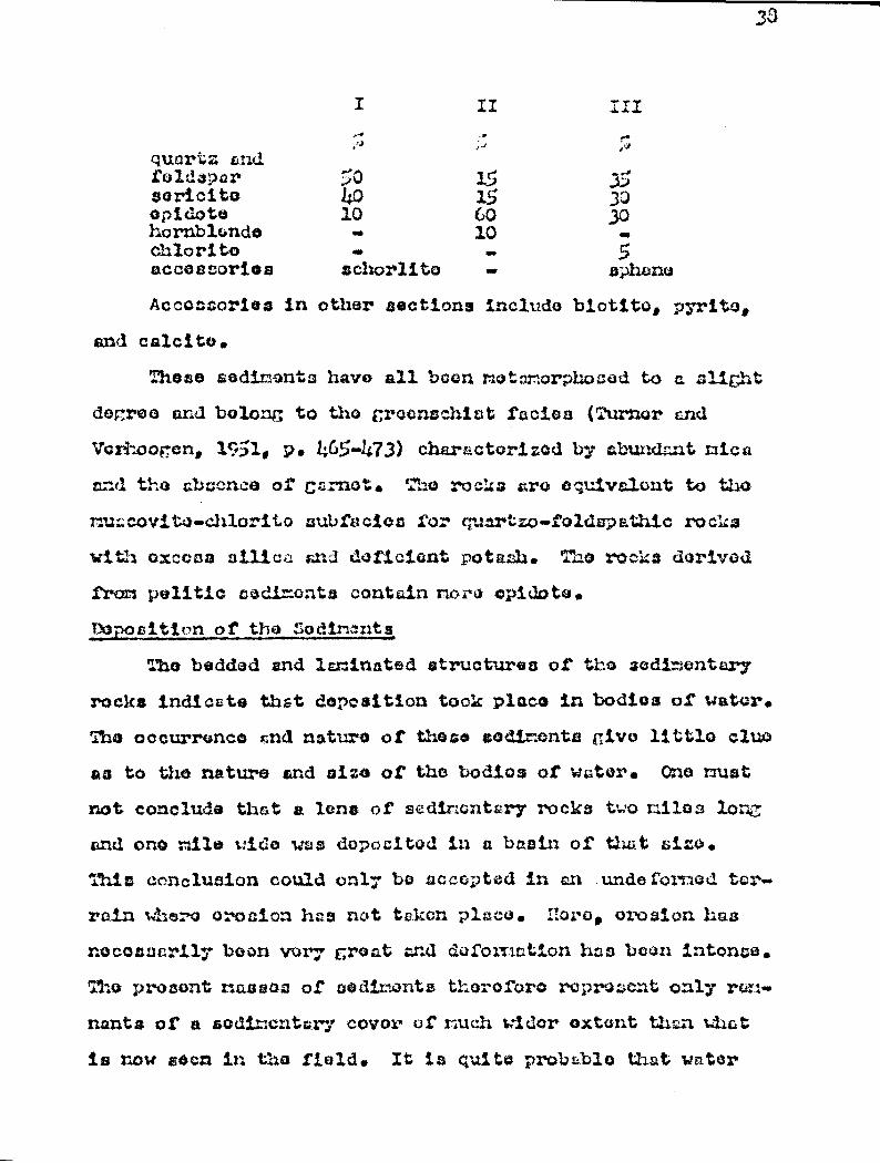
Tho sediments consist largely of a well bedded assem-
blage of regularly alternatirs7 light colored feldspathic
rocks end dark elates (ii. IV.A). The individual lcyers are
from one to seven inchaf;thic1. Differential weathering has
accentuated the bedding even ore, with resistant quart:40-
feldepathic layers se much ac five inches higher then the
adjacent softer vistas.
The rock or the quartzo-foldcputhic beds io generally
rumAve, very fino-grained, end rinilar in hand specireu to
the acidic lavas. The slaty layers are well luninsted and
fissile, and the rock is fine-grsined. The color varlet) fron
medium light gray (i:G) in the quurtao-fvâ.c:epat`rsic layers to
gr.yï:h black (rt) in the slaty layers. I:ont spoMimens ar4
radium gray (IIj) but soma havc, n brownish prFsy color (.5Y45/i) .
The scxdinent€zr►y rocks lack tho groon'.h color sa Characteristic
of tho altered and3aitos end bt*ssl ts.
:ross-bociciix:p: is noticeably absent and g gr: datAt>n
could bo used in only t•...o plaÿos to -c.ottïrn3,xiet the tops o1'
bode. Locally .di: so=inrted pyrite nay be c:btundont and, by,
altering to lino:3it`.o, it given a pitted ueat,tücrtxc; :;ux`.fts;.o.
South of l~rr'~7 C:
~
w
++
C7
~?~~
~+
,
V~~.#►~1,"~, fL lob!}t
nr
{
â~:
{
.'i'tl'~'
+
b
yF.i1~Î.,^a
t
of +`~i~.sE".titc+i'.~.:.~:
Qatyiââ~~bita iro:" i'3 1CÂi..l1t„i li~tSda~. ~ltr F.it.~f~.~°d 1,ri,t.i;, tZ:C! quart s.o"'fo:.iÎ: -
P s th i cmc3. sl a t;t both.
Conglomerate is well oxposod on some of t:;o isla:;r10 in
tho southern parts of Caoastirsn lake. The grrsvmti7s•a it fino.
mgainod sn:l vnri®n fron Qlight gray fâlds;a Lt:ic rock to a
darks!, horn'olanda-rich rock. Tho pebbles I;oncra31y raZ:o up
about on© quarter or the rock but in one exposure they s ccotsYt
for aaixtv percent. Pest of thc.ÿ ere f rcm ono to two i:.cha s
long but soma aoo az :T:cll as six inehou long and throo in:i;.oe
uido. :,amo of tho pebbles aro old: : thic, otlic:rc cr Q rich
in €mpl.iùo].os. This conx.Ior.1or:to occurs alolv a:.oxze of
choarixxC (ri. IV .i3), cnd nany of i ts c:.:aructez.•istics
haw) boon obliterated. Thu pobbkest bore boon stretched and
aro now e1oz2gtaci peralo: to the ;ac..iatQaity. In places,
the boundaries botwocn the frscments r.nc: tho grauncl~:lass ore
not Chs.rp. Vo ¢viclnce of L-odd*n,j ut,s soon in any of tho
ex, oauroa. T`roxz the number of outcrops Qbaervar3, it appears

that conglomerate and other coarse greined rocks form only
mnnll percentrge of the sedimentary assamblco.
Vest zections exanined under tho microscope allow comp.
otitional layering and the beds wry from 0.1 rzi upwardo.
Tho texture is slightly echistose, wad the schietoaity„ ul
thotth generally parallel to the bedding, my form angles up
to 25 denrees with the buda. Individual grains aro anhedral,
equigranular, lose thLn 0.05 nn in diameter, tit cogrL,gato to
form bandn of different composition. Thus, come bunda are
compeeed entirely of sericite (50 quartz (40:), and some
epidote (101, others oenaist of quartz (75) Grid sericite (25
".). In darker layers, the opidote (pistacite and clinozoisite)
increases to 30 percent. Aside tram the essential minerals
quartz, feldspar, sericite, epidote End chlorite, the rock
also conteins biotite, hornblende, nacnotito, pyrite, calcite,
cphona and schorlite ea accessories.
The plerioclaue occurs as =mall clear anhedrel crains
usually untwinned, aad has indices of refraction close to
those or quartz and it is difficult to estimate the relative
content of tho two minerals&
VIneral Assamblage and retnnorphic Moles
The mineral contenta of throe typical sections cr.o given
below and they indicate that each mineral varies between wide
limits.
I f_
II ..
~SI
quartz and feldspar 50 I5 8oricito opic:otea hornblende chlorite
40 10
15 60 10
~'~. 30
5 accessories schorlito raphanca
Accessories in other sections include biotito, pyrite,
and calcite.
Those sediments have all been r..etamorphosed to e s?icht
degree and belong to the greencschizit rectos (Turner cxnd
Vcrhoogen, 191, p. .G5..I,73) characterized by abundant mica
and the abs::nce of carnet. The rocks are equivalent lent to the
muscovite-chler ito 3ubfacioa for c;uartzo.feldapathic racks
with excess silica and deficient potash. The rocks derived
from politic sediments contain noro cpidote.
L4apocition of the Sodincnta
The bedded and laminated structures of the sedimentary
rocks indicate that deposition took places in bodies of water.
The occurrence and nature of these sediments give little clue
as to the nature and Size of the bodies of water. Ono must
not conclude that a lens of sedimentary rocks trio piles lone;
c+nd ono mile wide was deposited in u bsein of that sizeb.
This conclusion could only be accepted in an Aandefermed ter.,
rain Where erosion h s not taken plc©. nor•o, erosion Las
necessarily boon very Erect gad deformation has been intense.
The present reassess of sediments therefore represent only rem-•
nantu of a sedimentary covor of such wider extent ta.nn What
is now seen in the field. It is quite probible that water
33
39
cav red the area, completely or nearly ccxmpletoly' at one or
more pc:-ioda in Precambrian time.
Tho complaition of the sediments is quite similar to
that of the volcanics from which they were probably dorivad.
I:vvn after to racrysta11i,zatgon ir.c t:kon place, a12 Graine
of tho thin :;actions axc.:d.r.od vary fro= radium silt to fir:o
silt to crains of clay size. Although coarbor r-vdi.r,;.czrt3 of
sand and pc:blu sizo are a erif t:câ ar: mch loss rtbtndit
t1;1 tho finer prAtiwkVi. Tho seditiV3ts' MhereiJi°i represent
for the most part, very fir:o products of wca.ti:crir;e. Tho
gmin aizei the vary rcrular bedding and the lack of crs's3-
boddixg indicate that accumulation took place under r_t.iQt-
water conditions and in thallcart basins. A specimen of b3r.c:r
plate collected on tho shorott of Windy lcko prob;b1 has a
hirh carbon contant. Tho srocimon Includes =any =.:;..l.l dis-
seminated nodules of pyrite about ono oi;-hth of an inch across,.
Tho xodo of occurrence of thts iron uulphi.do cu: zo: t3 a prin-
ax-y origin, deposition under foul totton conditions, and the
possibility of tho existatrco of vmaric lifo in early Pre.
+cambrim time.
7.4 02 nkv- Ar«A I ✓N
Tho Nauwati.n-typo sodS:.outery rocks pass grasiatiexnal2y
eastward into bioti.te hornblunc:Q paras=r,oiacecf end tho
and+asiwes and batal tra grade eastward into hornblende gnats « aa.
A zona transition, within which ;.his gradational Change
takes placet is Shown on tha accampanylrg map. la a
mare accurate representation or the gaolasy than nn ettampt
to fix an arbitrary line of division be twoorn the ?Craowati.n-
type and the Granville-type rocks. The transition sane accu.
pics un oaat-wost trending bolt that extends from the oaatarn
boundary of tho area ono milo south of I1oston la,ca to tho
southern shore of C aopa tina lake. South ©t th ± a 1ra.Icot the
bolt assumos a southwest-rorth4a.at trend, and roaches tho
northern boundary of the granitic stock or -aurpri.ao lake.
::ockFY characteristic of this group alto appoar south or Des
c l audco s lake whor© hornblende schist, hornblende gneiss and
amphibolite are intimatol.y associated. Although tho Pleisto-
cene cover prevents the nrecisa delimitation of-the : on° of
transition, it a©cas to change in a ropulaxr wuy Cram about one
rile wide at the eastern boundary of the nap-area to two niloa
wide south of Caopatina lake. - Although rocks belonging to
this group are ï`ound east cod southeast or ~u`ur;;3rxao 1ake,E it
is vary difficult to delimit the ,ono in this area, m,inly
bocauso of the largo intrusion of granitic rcacka. Other ox-
poeurQa Qf schist's are found outa3.do the limits of the ;ono,
but they-ara riinc3r cod cannot be' Showo on tho accompanying
nap. The rocks of the zone of transition show the ar.duont of
47-
a more advanced grade of rsetarorpaism of the lavas and sod-.
imentcry rocha, and since no aiw.rp boundr:rioo axiztt botwüan
the various facioa,, the g7-adati4nal contacta indicated on tho
map aro arbitrary and rathor subjective.
The rocks belonging to this croup are 2:i.gh14 diversified;
they include gLzpl.ilo2itas and sz:411bolito sschïata, hornblende
a.^.hl.atc, l:orn'alortc:o..chlorite achista and mica schi.ato. Tho
amphibolites .and umph.ibolitza ec.lztata appear to bo derived fri=
a coarse grained intrusive rock whose original characteristics
and composition are extremely problematical. The hornblende
s^hista are derived from intermediate to baste lavas, the
h.ornbland4—chlorite rsch3.rsts are the z-mat.rmrpï,rocod equivalents
of both the lava noun and the sedimentary rocks, and the
mica cchiata aro metamorphosed sedimentary rucke.
t.rnhi5olita and Amhit+olito âciYist
bû curxoszco
All the roe:ku described under this heading are fsytald in
the zone of transition southol,at of lake wcUpatins. They fors~
a rexct,yxttTular rsagss measuring about five nilos3 3.Qn,, a~nd ono and
a half miles wide. Tho te s: t expo suros can be ob aal.vc d half a
mile north of lake on both Shores of the Opa*Mr3.csr river,
and an the south shore of the eastern part of Caopatina lake.
i'ts tropri3.nhy
The amphibolita is a dark gray to black, heavy, and
medium— to coarse—grained rock. It is either massive or
slightly schistose and lacks banded structure. Some zones or
shearing are found in the rock; they aro generally narrow,
varying from six inchos to four foot in wIdth snd they all
strike in an east-west diroction, thus paralleling tho shear
zones observod in the Keewatin-type rocks. The surfaco of
the rock is rourh with hornblende crystals one half to three
qusrters of an inch In diameter standing out in strong relief
on the woathorod surface. The rock is very hr d and breaks
in sharp +edged irregular blocks.
Under the microacopo„ the u_nphibolito iv seen to consist
of secondary amphibole (60-a4), minor quartz (10), opidote
()„ Chlorite (51), and accessory plat:1001am), calcite, bio-
tit°, mametito and sohone. The vmphibole occurs sa anhcdral
grains 2 to 6 nm in diameter end they either form a noseic
with e granular texture typical of deep-coated intruvives or
they form porphyroblasts set in a v-;.4.7 fine-crained grano-
blastio groundmass. In the schistose variety or cnOlibolite,
the amphibole porhyroblests are elongated subparallel to the
structuro,and all the minerals of the rroundmacis except
quartz, are elonrted in the direction of the structure.
In many sections, the amphibolo Is hornblende, which
occuro as large feathory or fibrous porphyroblasts that lack.
any sharp boundaries. It has the following propertioa:
Pleoehroic formula: Z=green Yambluish green X*701lowish green
Z A eva MAltiMUM of 27 degrees (-) 2Vu CO decrees Absorption: Z> Y > X.
Some of the hornblende grains arc very dark. green, and
where small opaque inclusions are concentrated, the dark
color has been bleached. In other sections, the amphibole
43
is tro:2olitc-actinolito. Tho forci of the grain is the ano
but tao color is tiuch paler, oven colorless, and t o o: tinc-
tion anglo is p alloy. Kath variutios of anphihola are partly
altorod to chlorite.
cuartz and plagioclase are both in the form of mall
clear €rhedra.l graina. The plagioclase te untwinned r ~3
unzonod, has indices of refraction vory close to those of
quartz and it is difficult to ostinato the relative abundances
of each of thaso two n.inoralsa. Ac far as cari be aacartainod,
it appears that quartz is nord abundant than pla iocla e in
the ratio of about five to ono.
Chlorito is rais) to absent in the massive variety of
pripT.lbolite. Vivaria observed, it is aoconc;rry after the c a ~hi--
bole and also after plagioclase,
:mall grains of zircon wore observed in rizny sections.
They are generally dark gray, cloudy and ares notsict. They
are optically isotropie and are surrounded by ploochroic
haloos if farad in colored minerais such cs hornblende and
biotito. Some grains are clear. Theao aro short and tabular,
and have a golden yellow color. Thon smaller grains are
colorloca and have very high relief.
Yinarol anonblr..go and ? otnrorphic Fecsios
The outirsatod ninoral compositions of five representative
cse:tions are given below.
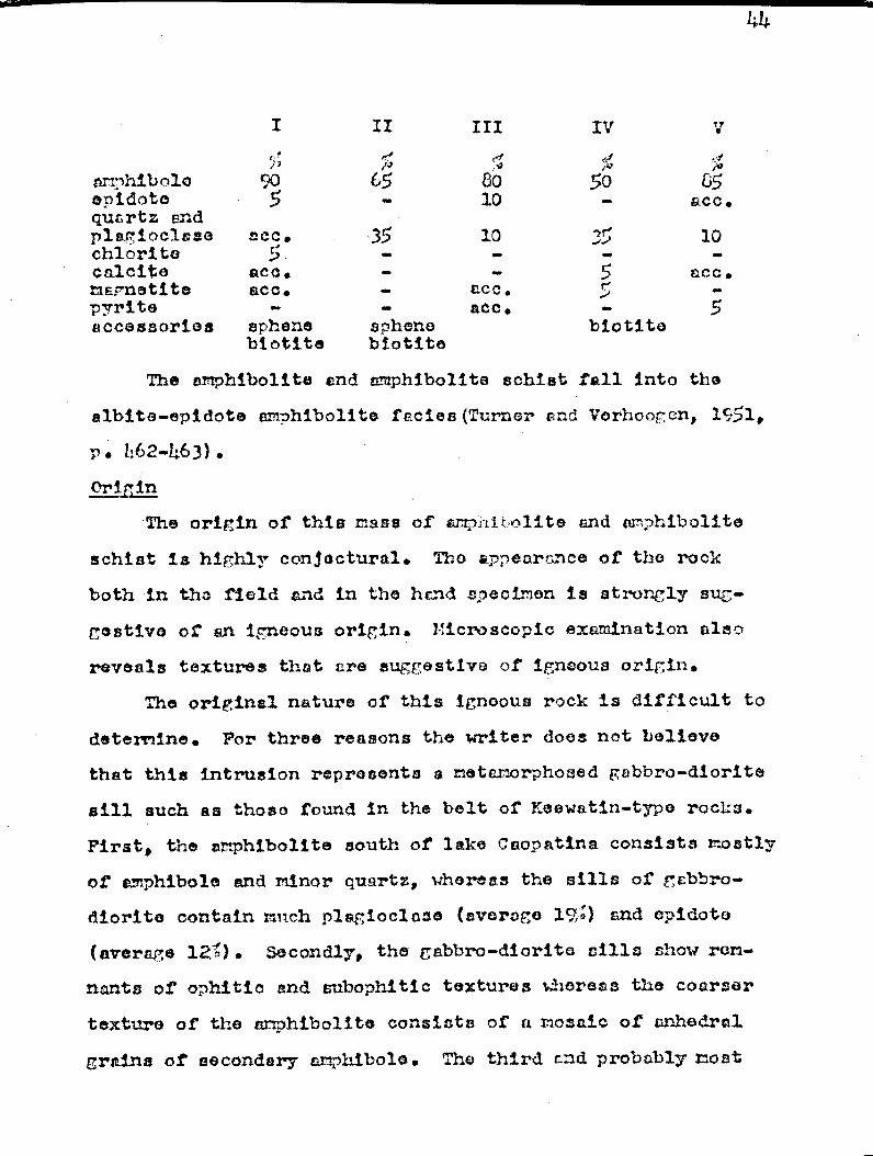
amphibolo opidoto quartz and plagioclase chlorite calcite magnetite pyrite accessories
II III
,-• ei
65 80
- 10
scc. '35 10 •
ace. ace.
sphene biotite
90 5
— —
- M
,. ace. - ace.
sphenQ biotite
zv
50 —
V -> !d
CS
a.cc.
10
ECG.
5
The amphibolite end amphibolite schist fall into the
albite-epidote amphibolite facies (Turner and Vorhooh en, 1Ç51,
p. /162-463). .
Origin
The origin of this mass of •azrrp iir alite and amphibolite
schist is highly conjectural. The appearance of the rock
both in the field and in the hand specimen is strongly sug-
gestive of en igneous origin. Microscopic exprntnation also
reveals textures thst are suggestive of igneous origin.
The original nature of this igneous rock is difficult to
determine. For three reasons the writer does not believe
that this intrusion represents a metamorphosed gabbro-diorite
sill such as those found in the belt of Keewatin-type rocks.
First, the amphibolite south of lake C aop atina consists mostly
of amphibole and minor quartz, whereas the sills of gabbro-
diorite contain =eh plagioclase (everego 19;) and epidoto
(average 125). Secondly, the gabbro-diorite sills show rem-
nants of ophitie and cubophitic textures whereas the coarser
texture of the amphibolite consists of a nosa.ic of anhedral
grains of secondary anphibolo. The third and probably =oat
irrz rtant ronsrn is that of the occurrence. The Gabbrc
diorite rock found in the belt of neewctin_type ' rocks forms
£riz 11 bodies rarely morn than a few scores of Soot wide,
Whereas trie amphibolite is a mass five nllne longand r;oro
thsn a mile wide.
The rock may represent the altoro'd equivalent of ,- J: ox-
enito or x;eridotite as has been observed in the :aowc.ti,n-typo
rodes of the Chibot az au region (rarlow, Guiilir, and Fcribs,ult,
1911, p. 167.174).
l ornblende Cchists
'ji stribut ion
Fine-grained hornblende schiste are found at the outlet
of Surprise lake whore they form a narrow east-tract trending
bolt about two riles long and half a mile wide. The belt is
bounded on the south r..otaevdina.Zts. Other exposures or
hornblende achiats are found r.esr the granit* atock un ti.©
two largest islands of nurprise lake. t_.notrigr croup of horn-
blende schiata are exposed etat of Surprise lake and couth of
Des Claudes lake.
Petrorrrr-ehy
The ::.`.al,n do schiata are si= ilar in many roe ; eats to
low grade ratcando3i.t33 and notubasalts. They ara fine-
grained rocks, dark grë:y to greenish black, and have apro-
touncod achisto: ity. The greenish color is noticeable but to
a much lessor extent as darker colora are boconing predom-
inant. The dark gray color is due to the abundance of small
needle-like crystals of hornblende Which, ir, same specimen::,
46
nay account for as much an 90 percent of the rock. Aside
from the abundance of small dark needles of hornblende, the
hornblende echists are connvnly characterised by tho presence
of stringers of plegioclsre feldspar and also of small len-
ticular or rounded pori,:tyroblusts of the same feldspar
(r1. Cutcropt of hornblende schits with feldspar
stringers are well exposed at the outlet of 5urprive lake.
Ebro, the stringers are cenerally irr4ular and discontinuous,
and are cll aligned parallel to the achistosit,. They are
narrow end rarely attain more thtn one quarter of an Inch in
width. Those stringers Vivo the exposures the appesrence of
bedded structure but the conplete lack of beddinn and lamina-
tion plus the irregularity of the stringers rule out the pos-
sibility that the rocks may be of sedimontary origin. Horn-
blende schists with feldspar stringers are also found nosr
the rranite contact on the two larreat islands of alrpriso
lake. Other exposures ut this locality are chsrroterizod by
tho abundance of lentioulnr crcany foldepsr porphyrob12sts
01. 7-13). About 100 feet from the rani to contact, a band
10 foot 'Ado contains about 50 percent of theses fcldspar
lenses. This band is bounded to the north by a coerce-
grained hornblende-rich rock td to the south by fInv-grained
hornblende schist devoid of creamy feldspar stringers and
lenses. This arrangement is bolielrod to represent a lcva
flow ten feet thick bounded by a thin intrusive hot on the
north and by another flow on the south. The feldelmr lenses
trio whit* to cream colored, one to throe inches long and one
to t1,4o inches wide. The lenticular concentrations of feld-
spar are yore connonly ealorkgatod ï,arall®2 to the orhictcrei.ty
tsinin otherwise.
Practically all the primary struotu.res and textures of
the laves have been obliterated at this tags of mtc.:.orphis:.m.
Vesicular and s.mrfgda7,Qida1 structures ore noticoE,bly absent
and pillowed stz^.»cture9 were observed in only two localities,
one on the south shore of Des ^3sudca lake and the otY,er on
the teat shore of asmeli Ia.lrc half a rile south of Dao
CZauden The neta~orphi~.~ of those laves mist have
taken plea°, in the absence of strong penetrative. defamation
in order to pre ; erve the original ellipsoidal structures.
t thin section of harztblern:cs schist aicwu that it con-
sists essentially of hornblende (64-3t3fj) and of altered pla-
gioclase -* gioclrca~ (~~r' -3~~,) and accessory quartz, chlorite, spheric,
aPir:oto, garnet, pyrite and limonite. The structure 3.0
schistose and the hornblende needles are arrf~~xeed parallel
to the structure.
Tho r.tinerAl assemblage, 'which ia very similar to that
of the coarse-grained c:mrliiibolite doncribed above, and tho
appearance o1' garnet as en accessory mineral indicate that
the hornblende schist:: belong in the albite-apidota amphib-
alito rectos (Turner and Voncoogen, 1951. F • 462-F63).
P.orn3lanrllo-Chlorite Sch4sts
Occurrence
The hornblende-chlorite sc.hiata are found in the zone
of transition ac: creia,tczd with fine-grained hornblende schist's
but they aro lows crx:z~.r;i3 then the latter. Laccu-o of rare
occurrences, the exposures of Yaernulaza.c?o-cl:alorito s:cl:sista
could not b4 rmwar3 together and form a sopsr-ataa map',pablo
unit. Representative snvcirlcns were collected around It:Lo
dtZu and north of the northern h:ore of Wrl.ariwe lake.
PcjtrrTraenhv
In the Z4owctin-type rocks, many of the . chistaa;4 laves
aro very rich in chlorite and in the transition zone, rocks
similar to chlorite scizi cts in many ror;7ects arc found, Tho
rocka care rroer.ich gray (SrF76,fl) to greenish b1acl. (57x4/1),
âtiphly agchiatractz and have apr~asaouxnccad sheen on flat : urfac:eata.
The rock in very fine-grained and broaIcct in thin slabs When
struck by th* hammer. E. featurü that difi'arc:ntieto4 the
hornblende-chlorite vchl::ta from the chlorite sacixi..ato in the
bolt to tho north is that the t:orn`:Ionwo-chlorite schiats
are ch~-rrcctcsriced by long thin black noodles of 2ornblend.a
that stand out conspicuously on tho weathered azurfrco. I:oat
of the needles vrrry between one quarter to one half inch in
length and they are everywhere randomly oriented.
U7ider the microscope, the crains in the ratrix aro very
small (less than 0.05 nn) except for a few por;?hyrtablflctc of
biatite and a=u{ vn-Yiker atructuroa of craanula.r quartz. Largo
anhaclra2 t_r.,rains of hornblende as mob us 5 sin long hsvo grown
in a porph,*roblaptic manner (F1. VI-13) . J'acaida fror:t their
2arr7.Q viz*, the hornblende crains are characterized by their
oloar boundaries end the connon poiZ_ilitic ineluWior3.a of
quartz. The 1".ornbleznd© ira very likely rich in a?t,ninurz. and
Iran as it is quite dark colored aid strongly plcaochrraic.
49
Chlorite occurs us very small (0451t1) individual flakes
or as lama a r`roCaton of flat ort. It han e1icht pleothroia-A
from light green to colorless, and dark brown interference
colors. The rcCenc ci s of the hornblende pora1iyroblaste and
of the chlorite is rather complex. Vest specimens and thin
sections chow clearly that the hornblende porphyroblaats
developed later than the chlorite but one of the sections from
north of Surprise lake shows some hornblende cut by later
chlorite. Thus, the chlorite crystals formed both before and
after the development of the hornblende porphyroblasts. :'hf a
suggests a local retrograde effect.
Ç:uartz and plagioclase both occur as clear anhed.Nal
grains and, because of their small size and the lacs of twin.
nine; in the plagioclase, the relative abundance cf thoce t; o
minerals is difficult to estimate. However,, as in the fine.
grained hornblende schiste, the quartz pp earn rira thundcnt
than the plagioclase in a ratio of about four or five to one.
Calcite is vary coron and is present in nearly all the sac.•
tiens examined. Garnet was observed in one section.
Mineral Assemblrge and Metamorphic Vocies
The dark color of the hornblende, the appearance of gar-
net and the presence of epidoto and chlorite indicate that the
hornblendo-chlorite echists belong in the albite-.opidote fah»
ibolito facion and are of the same saetsinorphio grade as the
hornblende achicta with which they are associated.
nice ::chiata
Occurrence e
Elea schiata occur inr odiatoly went of the river .flow--
mg betwoon $ur2riso and Caopatina lakoa. Eorv, tho rocks
form an ill-dofinod northoactorly tronding bolt about ono to
two and a half riles wide and four miles lor:j . The bolt coy..
ore approxirl3toly five square ratios and expoauroa along this
bolt arc not coon. Othor outcrops aro observed northeast
of lake d' .`u whore they are associated with hornblende chiat;a
and have boon grouped with than. The bout expoeuros are found
on tho south ahora of Caopatina lake.
Tho vice schiata grade oactw rd into biotite pare roisaos
and wuatward into low grcdo matcsedi..entu. Tha series of
oxrosuros along the south shore of Caopatina lako showa this
transition very well. The sedimentary asnsnblaca along the
southwestern part of the lake displays no bands that are rich
in biotito, salthoug.h scattered flakes of thin mineral have
developod in those rocks. Bore too, gneissic atru :turd is
lacking. Farther ()outward, along the contrcl pert of the lake,
biotito boconas concentrated within cortain banda. Mî11 far-
t or eastward, banda rich in biotito are just as abunth nt as
the quirts rich layers. south and couthoost of lcka asdu, the
sodinontary rocks have boco o cotlatoly* chsannod over to bio-
tito pare neiss. This rock is doacribod soparatoly in a cub-
sequent section on higher grade nata :orphic rocks.
Potrorrnphy
The mica achista are light gray, fine-grained, thinly
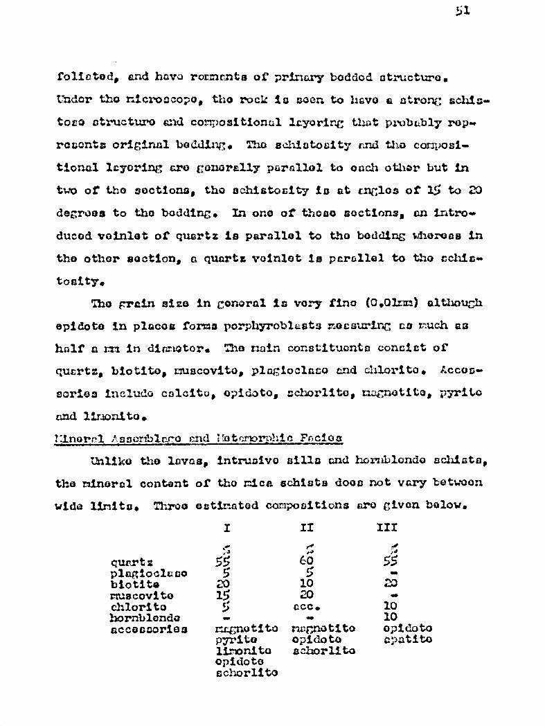
51
foliated, and have rornenta or primary boddod ctructuro.
L iller tho ricroccopo, the rock le Ewen to Bave a utron ; schie.•
toss) structure and compositional layorir,C that probably rep..
rcxonts original beading. Tho schiatocity rand tho composi-
tional lcyoring ar© conorslly parallo1 to ouch other but in
two of t.h© soctiona, tho schistocity is at unglos of 15 to 20
degroos to tho budding. In ono of those soctions, an intro..
ducod voinlet of quartz is parallel to the bedding Whereas in
the other Boction, a quartz voinlot la parallel to the cchis-
toaity.
The Frain size in gonoral is very lino (0.020 althouûh
opidoto in places forma po:phyroblasts measuring co such as
half a mm in dia.Miotor. The main constituents consist of
quartz, blotito, nuacovito, plagiocicco and chlorite. A.caaa-
cortoc incluc'o calcite, opidoto, echorlito, Ll2Cnotito, pyrito
and lirionito.
tanorrl :sseriblr:.ro mind I'otrnorphic F~-acloa
Unlike the laving, intrusive faille and hornblende schiats,
the mineral content of the mica schist$ does not vary botwoon
wide Unite. Throe estimated compositions cr© given below.
I II
qur.rt x plagiocitzco biotite rfuscovi to chlorite hornblende accessories
55 5 20 15 5
r c.Fnotito pyrite li.monito opidoto eckiorlito
~ Ct? 5 10 20 ccc.
rtaf;natito opidoto a: horlito
III
55 20
10 10 opidoto cpatito
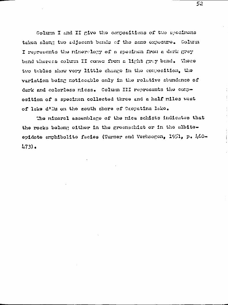
52
Colu=n I and II rive the can2osition3 of two L;loclmana
takoa alon:; two adjacent banda of the same exposure. Colt=
I re-prevents the ninorvlom, of a apecinca frow a dcri: era.;
band uherce colunn II cones fron ci light cm.y band. Thor.°
two t6blo ahour very little ohal4N in the comosition, th.o
variation boinc noticeable, only in t:,© rolLitivo abundance of
dark and colorless micas. Colt= III represents the coNp.
osition of a specimen collected three cnd a half riles viest
of lake (11 u on the south ehore of Ccopatina lake.
The mineral asaGmblaco of the nick Gehl:As indicates that
the rocks belong either in the croonschist or in the albite.
opidoto amphibolite facies (Turner and Verhoor,an, 1951, p. h60.
473).
Y1.Lw~ta.. i l T; .ti s. x~ T:07Z?!rIC ! OCKS r. .~ r ' ,urr:
The rocks described in this section include biotito
perapnoiaso3, hornblende E;noiscos and r,hibolitoa but not
the gneissic granite which will be discussed separately.
Iacposures of biotito and 3:orrblcnda gnoisses and az phib-
olitoa form two east-west trending belts in the central part
of the area, and east of Vorchorosa lake, those two bolts
memo torothcr and continuo to the eastern boundary of the
map-area near Oux. hoc lake. The eastern extension of the
belt of higher grade rotarzorphia rocka was naaped by Gilbert
(1952).
Gnoiscoa and ar htbolitos are also found as inclusions
in the grsnitio rocks, and these occurrences have been shown
on the accompanying zap. Weat of Surprise lake between Des
Claude/3 snd Eve lakes, hornblende gnvis: os and amphibolites
are intimately associated with hornblende and hor nile:r:c:e-
chlorite schiats. A transition from hornblende sdiis:t to
hornblende gnoi3a to amphibolite can be observed north of
Ova lake. Amphibolite is found close to the granite contacts.
hornblende 5.~noiae farther away, and hornblende schist still
r2oro distant from tiro cra.nito. This change takes place in a
width of about one and a half to two riles. It was found
impossible to separate the hornblende schist from the horn-
blonde gneiss und z::mph.itelite ut this locality, and the var-
ious rock types have all been napped together.
There is no sharp delimitation between the meanings of
the terms hornblende gneiss and amphibolite either on the

54
basis of toxturo land structure or composition (:?oimas, 1920,
p. 1103; Adcns. and Barlow, 1910, p. 163; Williams, Turner and
Oilbart, 1954, p. 240-243). It appears, hoaiesvor, that tho
term hornblonda gnaiss; piaco; .:oro emphasis on tho rock ts:t:ruc-
turo whoorolac amphibolite rofeays mostly to tau) ccmposri.f:ion or
the rock, but both the 'ctructuro and tho composition of tLosa
tuo rocks are highly v:~.•ric.blo. Bocsruso of thoir intimate
saw sro w isa tion in the field and their vlarisbi.c petrographic
prczx er t1Qc, the hornblcr.d.ss gnaiss and the amphibolite are
not mapped cepcars:atcsly.
The hornblende cnoiss and cmphibolito land tho bio ti te
paragnoics grQ bolievod to represent a roro advanced stare
in the rncttamrphism of the Keewatin-typo volccnics„ intrusive
and sedimentary rocks.
The higher grade metamorphic rocks are divided into tut)
groups: The hornbiende gnoins and c:r:phibolita croup and tho
biotite,sr par>•rcn.oiesal croup.
1 The torn psarsôrneivsr is used hero to rotor to those rn.eisscss dorivod fram sodi.mentersy rocks. Gnss;itasaosx derived from lava flows c:xo not car.sidortrd ps.arcgneieraas.
ilornblendo Gnoissas end A hibolites
Occurrence
Approximately 50 square miles of the map-area are under-
lain by hornblende pnoisse s and eraphibolitoa. Thoso rocks
crop out in a more or loss regular east-went- trending belt
that is divided into taie segz Qnts botueen 1 O081nb and
Surprise lakes. Thu northern Belmont extends from the north
ond of 2:ocaitno lake to tho northeast csnd of : urprico lake.
It is about tan silica long, and one to one cad a Lail' =ilea
wide, Thu southern segnent axtonc:W from south of Grir•.aldi
lake to the southwest shore of surprise ?aka. I71.1.0 ,laso
Grimaldi to Pierre lake, the belt is about oight :Alas 3tinc
and two miles wide, and from Pierre lake to the southwest end
of Surprise lake, it la eleven miles long end half a aile
wide. Those two sngmonta are separated by the i:oasin4 lak.a
belt of biotite par: pnraias near their eastern purt, gad by a
throo-mile-widcs stock of granite near . their western part.
North of lakes Grimaldi, the two segments join and continue to
the eastern boundary of the map-urea oast of Dieu= Iles 1rJ;o.
In addition to this r.utin bolt, inclusions or remnants of horn-
bIenuo-rich rocks aro found in tho granitic rocks.
;'e tmr=t.y The rocks included in this group are highly. diversified.
They Show a wide range of compositions und agree.t variety of
textures. They may consist almost entirely of avvhitxol4, or
of amphibole and plagioolaso or of amphibolo, plagioclase and
quart-. They mug be fine- nedium- or coarcfl-grainQd, nasaivo,
schistose or gnois:aic, sqtiigrcnulcr cr porphyritic. They nay
chow indications of primary atratiform tstruûtttros although,
in roat caaom, the origin of the rock cannot be a,scorta.inod.
I3oct spaciziansa show a well developed gneissic and schis-
tose catructuro. tenace and v4inlata or quartz paralleling the
structure are co:7=n. Light celorud plagioclase foldzapar is
commonly segregated in parallel str ir;ers =ad lonaoc very
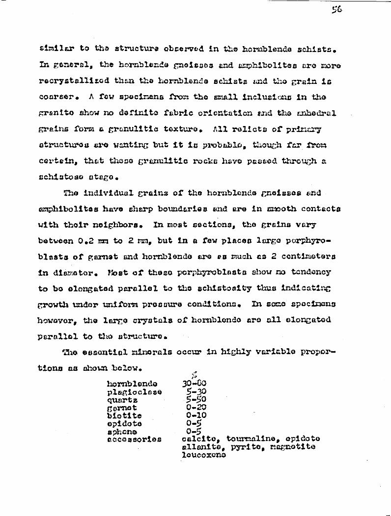
aholal below.
hornblende plagioclase quartz g srn® t biotitcr opidota rspi:cna accessories
,.,
30-00 5..30 5-50 0..20 0-10 o_5 ©_5 calcite, tourmaline, epidato a.ilsanite, pyrite, magnetite loueoxcno
similar to the structure observed in the hornblende schists.
In general, the hornblende gneicses end amphibolites aro more
recrystallized than the hornblende echists rid the grain is
coarser. A few spocirlenss fram the mnall inclusions in the
granit© sho•.r no definite fabric orientation and the vnIledral
grains form a granulitic texture. All relicts aP pri=ry
structures are wanting but it is probable, t :oou h far tram
certain, that those granulitic rocks have paasod through a
schistose stag°.
The individual grains of the hornblende meioses and
amphibolitoa have sharp boundaries and are in cnooth contacts
with their neighbors. In most sections, the grains vary
between 0.2 mm to 2 mm„ but in a few places largo porphyro-
blasts of garnet and hornblende are ea much as 2 centimeters
in diameter. Most of thora pvrphyroblaats Chow no tendency
to be elongated parallel to the ochiatoaity thus indicating
growth under uniform pressure conditions. In some specimens
however,
parallel
The
tion$ an
the largo crystals of hornblende a.r€r nl.l alarga.tod
to the structure.
essential minerals occur in highly variable Fropar--

57
The hornblende found in the northern partc of *(1, min
bolt occurs ca an;:cdral ta ouhoc3..~a2 grains that are clightly
lti; er than the other a nor a.ls. The, horn1;ltar:de is normally
green. strongly pl.a:crGhroic but my bo colorless in places
and peppered with many isinute gLacuetito dots. Zn a:ot4 places,
it is slightly chl.oritizod. The grains of herablan r:e . found
in the southern part of the belt occur as largo por; hy-toblasate
full of small poikilitic inclusions of quartz. They are
Characterized by a darker color and do mot have the colorless
spots of the hornblende found in the ryorth.c it parts of the
bolt. The optical properties of this hornblende are;
• pleoch.roic formulas z=dcrk green y-bluiah green x=1..i.tht yQ llowi ch croon
z c =5-.34 decrees (-) 2V.75-30 degrees absorption: z7 y 7 X.
The hornblondo of the inclusions occurs as anhocral
rounded grains that have ahtrp and anooth bauudarica. The
grains also have poikilitic inclusions of quartz but they
have a darker color than the hornblende grains found in the
main belt. Except for the pleochxroio formula, the optical
properties of this hornblende are the name as that found in the stein bolt of hornblende-rich rock.
The plagioclase of all the hornblondo noiscee wad amphi.
bolttos in found as anhedral clear grains that have positivo
relief against Canada balsam. Twinning, though better dovol-
oped in the more thoroughly recrystallized rock of the inclu-
sions, is rare. A. faint waxing structure is occasionally
observed. Thora is no variation in the composition of the
plagioclase to parallel taie apparent variation in the compos—
ition of the hornblende. The composition of the plagioclase
varies unsystomatieally between that of a calcic oligocicco
(Ans) to that of a codio cndoaino (4n35).
idoto occurs mostly in the northern parts of the con.
tral bolt, is rarely obaorved in the southern pasts,, and is
wonting in the hornblende gneiss found as Inclusions in the
grrni ta. In the northern part of the bolt, the two varieties
of opidoto, pictacito and clinozoisite, have grows in a porphy..
roblastic manner.
Cuarta is found as clear aarhedraal graina and is more
abundant in the hornblende gneiss of apparent sedimentary
origin whereas plagioclase prodo ilnatss in rocks which have no
relict of sedimentary structures.
agnat is found as large enhodral porphyrob7aate that my
measure as Much as 6 ria in diameter. It is characterized by
the lare number of poikilitic inaluaiona of quartz, plaEgie--
clase, hornblende end magnetite. In ove sections, 50 percent
of the por phyroblaata consist of these inclusions. The garnet
is a rod variety and it has a slight pin',1cb tinge under the
rtoroocopo. The index of refraction (1.7136) and the color
indicate that the garnet is slaandito.
Mineral Assembler() and Metamorphic .Facies
Ono roprasontative sample of hornblende gneiss taken from
an inclusion in the granite two riles northeast or lake Vona=
was selected for a 11osiwul analysis. The section is
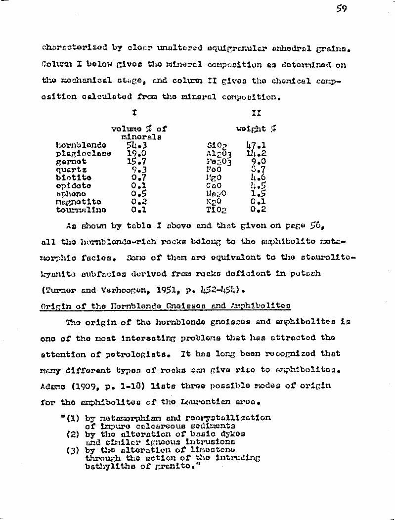
59
chara cterfzod by clanr unnit4rod oquigrs.nula,r anhQdral Grains.
Columl I below gives the mineral composition co c:otarninod on
the mochanical ot‘,co, and colmm II gives the chemical comp.
osaiticn caleulatod from tho minerai composition.
hornblende plagioclase garnet
I
volume % of minerals 54.3 19.0 15.7
.1i 02 Al2ü3 F0203
II
weight
47.1 14.2 9.0
quartz 9.3 FOG 3.7 biotita 0.7 Ito 11.6 opidotsr 0.1 C at43 4.5 aphone 0.5 N é120 1.5 tim,n;notitca 0.2 K2C 0.1 tourmaline 0.1 TiO2 0.2
Ag shown by table I above and thct given on pace 5 s
all tho hornblando-rich rocks bolong to the r,mxhibol:.to xiota-
morphi4 rectos. Oamo of thertt are oqu:ivalont to the ata.urolita-
kycnit© aubfac.ias dvrivod from rocks dafi.ciont in potash
(Turner and Yarhraof;en, 1951, p. 452-454), origin of the ilarnblondo Cnaisg©rr and 1`r•.prïboli.toe
The origin of th© hornblende gnsissoe and a:nhibolitea la
one of the most interesting' problems that hes attracted the
attention of petrologists. It has long been rvcocnizod that
many dSffarent typos of rocks can give rise to anrhiboli.tos.
Ad=^o (1909, p. 1-10) lists three possible modes of origin
for the amphibolites of tho Lcaurontian aroo.
"(1) by xotamarphium and rooryntallizntion of irxpuro calcareous sadimQn.to
(2) by the alteration of bcsio dykes and similar ig:ooua intrusions
(3) by the alteration of limestone through the action of the intruding bathylitha of granitQ."
60
Adana and Barlow (1913, p. 121-160) in their memoir on
tho Hcliburton-Bancroft areas, mentioned that the hornblende.
rich, inclurions found in the gray meioses may represent
basic differentiat©m of a granitic ma< a. Osborne (1936,
p. 202) believes that that amphibolites of the Zhawinigan .Palls
district are the rattriorphosod equivalents of Keewatin lava
flows, basic tuft`: and graywecko as well as basic dykes and
impure calcareous sediments. The evidences for the origin of
the amphibolites in tho :h winigan Falla district, however,
seems to be loss reliable than these round in the Laliburton-
Bancroft area. Further south in the Adirondack region,
tuddin ton and : oderholm (1939, P. 12-13) believe that the
amphibolites are derived from tuffs and lava flows. Thus,
hornblende gneisves and aphibolitoa r y bo derived from tit
least five different kinds of rocks. Those are s
(1)calcareous se dirbonts (2) basic dikes (3) volcanic rocks ( • grayWUCke (5) basic differentiate of a granitic rzcgria.
in the present map-area, the amphibolites and hornblende
gnoisses aro believed to be derived from the rota different
typos of rocks listed below:
(1) and©sito and basalt flows
(2) gabbro-diorite sills
(3)tho uitrabasic intrusive south of Geopatina lake
(Z.) tuffs and sedimentary rocks
(1) The andeaites and basalts are the most common Keewatin.
typo rocks, and they probably account for the greater part
of the amphibolites of the area. In the proceeding pages,, it
krrs pointed out that the laves give rise to chlorite schist,
hornblende schist and finally to hornblende ,gneiss and arrhS-
Mita. The transition from
be seen tore easily where it
tunc© ouch as half a mile or
the granite on the shores of
of the lavas into hornblende
followed wi thou t difficulty.
one end member to the other can
takes place within u Short dis-
so. Thus, near the contacts of
Doda lake, the progressive change
gneiss and amphibolite can be
The same gradation between c.hlor-
ito s^:h ct„ hornblende-chlorite £chiot and hornblende gnoisa
can also be obcervod between Dec Claudna and a lakes., with
the higher grade metamorphic rocha being found closer to the
granita contacts.
(2) Nearly all the intrusive sills of gabbro-diorite asso-
ciated with the volcanica have been r etas orphoaod to c. phi--
bolites. The field occurrence and the preservation of the
original ophitia texture leave little doubt as to the origin
of these amphibolitos.
(3) As mentioned in the description of tho rocks of the -tran-
sition zone. the coarse grained arPhibolite south of Caora ûins
lake is believed to be an ultrabasio intrusive.' The abun-
dance of amphiboles, together er with the very low content of
►l wioclnso and + uurta two vert suggestive of an original
ultrabasic intrusive. The abc, .sir.,nee of light-colored magma-
i -riche onphibalos is aloe indicative of a derivation fro
ultrebcsic rocks. Williams, Turner and Gilbert, 1954. p 243).
(2) There are also evidences that some of the hornblende
gnat sacs and amphibolites of the area are derived from
62
eodincntary rocks though this origin cenrwt be traced 03
easily en the igneous ririgin of the amphibolites. The ced-
insntary origin of sore of the amp2tiboll.ta:a lo uncertain for
two reasons. r irot, ir~::pure calcareous sediments, vhich in
many places have given rise to hornblende gneiss and anAlï-
bolite, Oro cbaatit in the belt of Keewatin-type rocks.
oiid1 , cost sedimental of the area have been r:otenorphoeed to
biotito pervuoisa, and.only rarer* to quartz-rich hornblende
paragnelsa. The qus rtz-riot hornblende paregneiss contains
as much as 50 percent quartz, end it iv difficult to see how
the psr ,gneics could become freed of so much quartz and be
changed to a =hibolite. - Thu slaty layera. that are interbedded
with the quartz-rich beds may have given rise to quartz-poor
hornblende pernçnoisa and t:n hibolite.
Tuffs of the same general conoeition as the intermed-
iate end basic 1avas could also easily be transformed to celphi-
bolites, foj:oror, because of the paucity and gall sire of
the tuff exposures, the derivation of at, phibolites from tuff
cannot be netra to d. .
Thu problen of determining the origin of tho uT ' hibolitev
tecc-zos incrossin ly difficult as the credo of netamorphian
increesss end 2e the original features of the rooks arc oblit-
erated. As noted by Adams and Barlow (1910, p. 164):
"When the origin of a body of s. tphibolite is not discoverable from its field relation n, it is impossible to determine whether it Is an altered igneous or a body of altered sedirient% -
Thus in the granitic cress, the original nature of the horn-
blonde gneiacos and amphibolites found as inclusions cannot
63
be osaaily ascertained. Thera are, however, sono criteria,
although not very dopenth ble, t i t o n be uaed to determine if
the ahibolito is derived from sedimentary rocks, volcanic
rocks, or basic iwntrusives. A high percentage of quartz for
instance may be suggeativ©, although not a proof, of a sed-
imentary origin. The presence of aphone and opidoto nay sug-
gest a medium. or high-grade metamorphism of basic_ or r:agnosisn
rocks, as these minerals are common in the metamorphosed basic
igneous rocks of the amphibolite Sanies (Turner and Vorhoogen,
1951, p. 446-460).
Carnet in relatively low-grade hornblende ;neisa©3 and
amphibolites nay suggest that the rocks have boon derived
from aluainous sediments probably near the compooition of
shale. The occurrence of garnet in an amphibolite, however,
is not in itself criterion of sedimentary origin. As nun-
tinnod previously, the altered lavas of the transition zone
contain some small garnet grains in places. âtawevor, where
the garnet is concentrated in regular bands and where the
parnetiferous hornblende metes is intorbanded with biotito
paragnoiss, it suggests sedimentary origin. Because of its
mineralogy and its field occurrence, the rock whose n osiwal
analysis is given on page 59 le believed to b© of sedimentary
origin.
In the amphibolites found as inclusions in the granita,
the evidence of bedding has boon obliterated. Thuro is,
as already noted, none banding and compositional layering
that nay suggest sedimentary origin. It rust be pointed out,
64
however, that the banding and coz;positi.onal, layering eabsorvod
in th© cr:phibolitos and hornblende gneisaes is not a reliable
criterion of acsdir7cntcry origin. It ic obvious that a schist-
ose lava can give by metamorphism and r:8ta^cmatis.:.1 banding
similar to that found in praragnolsseia. The now notorial that
is being added to the lavas, t;hothor it is silica., pota s.h,
sodra, lino or other complexas, forms compounds that would
tond to follow tho planas: of svl".istoaity and give rise to
banding and co.:<sporaiticsn.sal layering. 'Similarly, racatamorphic
oor._,ro;;:.tione of minerals will form parallel to the utructure
whore pressure is least. Those injections and s€+greigs:tions
can give rise to compositional layering that m®y under r•.3ga-
scopia and microscopic oxa;rainationa be wrongly interpreted
as evidoncos of former sedimentary structures.
i3iotita ë'srcc-noiaa©sa
Occurrence
Biotito pare_rfmisses, underlie about 20 ecuîro miles of
the nap-area, and most outcrops occur along three east-rout
trending bolts. The northornmost ono adjoins tho sout'horn
boundary of the bolt of chlorite, hornblende and mica schists,
and oxtonda a a:itw and from the river flowing between C aopa tine
and Surprise loos. This bolt has not been oxtondod to the
eastern boundary of the rap-area as glacial material covers
the bedrock complatoly, but its extension in warranted by
the prosence of biotite psragnolss oast of the boundary
(Gilbert, 1952) . The central and southern bolts encircle
the granitic stock betwaon Vorchoras lako and the western
65
shore of Curpriso lako. The central bolt is about twelve
riles long, less than half a pila tide and la covered by gla-
ciol debris in its centrai.. part. The routhorn belt iu thir-u
teen ailes long end one half mile wido and trends east-west
very rerulcrly. Zast of Vorchoros lake, the two bol ta join
and form a U-shaped band, ore-rile-wide, that onde north of
i ocsino lake. Othor oxpeauros of biotito parrgnois eaa form-
ing lonticular r;osoea in hornblende ;neiasos and ochiets,
are found east of Doux nos lake, east of lako Pierre, end
south of Noel lake. Inclusions of blotite peregnelasoa are
oleo observed in the granite crass oast and went of lake
Panaco end on the south shore of ` v u lake. Outcrops of bio-
tito perernoisses are found in the two belts of hornblende
gnoisses especially where hornblende pert ,neica predominates
as on the youth :hero of âurprise lake. The dcrarc ation
between the biotito wind the hornblende per -noirssos is gra-
dational in riexty places.
Pott or rsmhv
The biotito paragneisa is a light to dark gray, fine-
to r:odiu i-grained rock consisting esaenttcliy of biotito,
crsay plagioclase feldspar and quartz. folict bedding is
indicated by the regular alternation of bands rich in biotito
and others rich in lighter colored minerals. In a few places,
the rock contains red to reddish garnet (as much as 20 por-
cent) and the garnet grains are concentrated along certain
layera, further accentuating the already pronounced banding.
The exposures veat or Vercheros lake and cround Messina lake
are chnraoteriaod by a greater abundance of garnet. The
66
arrangement of garnet—rich bands alternating with garnet-poor
bands is quite similar to the alternating bode of shale tnd
quartzo-feldspathic sediments seen on the south coo of
Icopstina lake. The biotite pnregneiss is a rather friable
rock that w©athora quite readily, but the more resistant gar-
net grains stand out prominently on the weathered surface.
The rock has a characteristic rusty-weathering surface typical
of nany biottte-boering schiste end En©issoa. Greenish vein-
lets of opidote, either parallel or at various angles to the
structura, are con non in the paragnoiss gear the granite con-
tact. In places, strongly elongated gated lenses of darkor• gnmoisses
rich in hornblende are embedded within the biotite-rich rock.
.mon under the microscope, the rock shows a schistose
struature and granoblastic texture. In =any soctiona the
granoblastic texture is more strongly developed than the
schistosity.
Quarts and plagioclase occur as anhedral oquigrcnular
grains that have diameters from 0.1 to 0.5 mn, and the bio-
tito flakes, which are meetly 0.5mm long, are aligned parallel
to the structure. These three aimerais rra generally segre-
gated into biotito-rich bands and bends rich in feldspar and
quartz. E 3tdoto, garnet and tourmaline Which are minor Tsin--
orals also have tendencies); to be aegrogatod in layeras. Acces-
sories include muscovite, calcite, magnetite, limonite, chier-
ite, aphone, sericito, zircon, sauseurito and pyrite.
In the granular as well as in the schistose rocks, garnet
has formed porphyroblasts that vtay be as largo as 3 r t in
67
diameter. T.xono ,poxpîryrQb3cat. , a1 thouf;h highly trro gulc.r,
tond to be ro•.,nu?od, and ares characteristically full of
ilitic inclusions of quartz and fold:p,Gr. In placac, 'musco-
vite and biotito form r orphyrablastu that are perpendicular
to the gnsaigaoaity (.'1. VI-A).
The plagioclase of the biotito parcgn©isn of tho nor`'~-
ern belt is clear, untwinnod, and has ixldicoc of refraction
close to that of bs+lcr:. It cannot be readily cii.fforcntistod
from quartz grains with which it in cloao3.y associated in tho
fina-grained ground~:aas3. The plagioclase found in the biotito
pr,ragnaisa of :'eszainfl and Vorchorass lake c in more easily
dotorminod. The graina are twinned here and there, and have
indicoa: of refraction higher than balsam.. Tho ccsmpflaitic.n
varies between that of calcic oligaclaao (Ln25) to that of
sodic andeaine (~`Ln33), and is th.oroSoro nearly the came as
that of the plagioclase obaorved in the hornblende gneir'ssoa.
Tourmaline, sWug7oativo of s~etasaomatisn and contact rota-
rorphia phenomena, is observed in about a third of the sec-
tions examined. In two aocttons, it accounts for r per cent of the rock and forms grains that aro as r.ach as half ta mn
in diameter. Tho tourmaline is tho iron-rich variety achorl-
ito, and it occurs an r.nhodral grains, rectangular crystals
or spherical triangles. It has a marked ploochroian from
gray to light gray with rectangular grains showing greater
absorption uhen elongated perpendicular to the vibration
direction of the polarizer.
Pizarro" Assnrablajro and. Ycata:.aorphio racism
Column I below gives an average estimatod composition

Ga
of 13 sections from the northern belt and column IZ, un over-
arm of 14 aoction.a of biotito paremlei.cs of the : outl.:crn
bolt. The main difforarcos between theL o two columns coo=
to be the rrontor mount of chlorite in the northern band and
the hit~har proportion caf okaid.oto in the southern band.
z zz quartz and ô e~ pla,r~ioQlss° 53-60 60-70 biotito 15-25 5-I5 r1urlC:ivito 10-15 (r~-.1C~ chlorite 5-~,sy~r / Y+~~,r:~ op1iG.oto 0Y-5 0-l0 garnet DOC. 0-5 bornble;ndo ccc . 0-5 calcite 0-5 ace. s:.horlita DOC. c.cra.
Sono of the garnetitcrous biotito pareÿcnoiwscns i;eIong,
to the amphibolite rotemor;ahic facies equivalent to tho
stsurzalitv-kyanito subfaoïos derived from fold:pethic tuna-
stone deficient in potash (Turner and Vor~-~.ongon, 1r51, p. 452-
'454). Others bo1on,,~; to the eibito-epi,doto cmph#.boIito ,fc.cÿras
equivalent to the chlorittatd-sz1nandino subfa.cieo c'.t.:rivocl from
politic rocks high in A1203 snd low in K20 (Turner and
Vorboogon, 1951, p. 461-463) .
The northern :und control bolts of bi.otite prar°roiQiscos
form oastward extensions of the two belts of sodin€ents:-ry
rocks previously d4scribtnd. t. ocart.p14te3 gradation from trliglztl,
metamorphosed seadimontary rocks through fine-grained sc2niûts
to ,gernotiforous paragnoiepsess exists cud csn be clearly ob-
eervmd on the south shore of Caopatinn ieak:cr.!} The biotito
;E~ pnrsnvisa thusreproseents tho raot~~.TM.or,~ ilo~év'1 oc°iuivai.e3nt of

sedirrcntery rocks found within tho bolt of Koowntin-typo
rocks.
69
70
G;iAN2=1
1. Unless specified, the terms granite and granitic are taken in their broader sense and include massive and gneissic soda granite, ryanito, i>ra iocliQritct end quartz c3icrito.
Occurrence
Approximately 200 square miles (one third) of the yap.•
ares are underlain by granite. The granitic rocks are found
in the southern pertes of the area where they fora an oast-
west trending belt that is 2 to 4 ailes wide throughout no st
of tt:a length but attains widths of 9 and 3 miles respectively
at the eastern and western boundaries of the ncp-area. in
the center of the map-area, the nain belt of granite is bor-
dered to the north by a belt of hornblende gnoisaoa, immedi-
ately north of which another bolt of granite reappears and
forms an east-west clt n ctod stock about 20 ales lore; and
It to 3 miles wide. Other smeller granitic bodies tara also
found in the Keewatin-typa rocks and in their metamorphosed
equivalents. Near the wcztorn boundary of the area, the
Tower peninsula is underlain by granite, and other masses of
granite crop out southeast of Noel lake, near lake d'Eu, and
on a rrisll island in the northern part of Caopatina lake. A
geophysical survey made around Easton lake suggests the pr s..
once of granite underneath the lake and immediately east of
it. Ono outcrop of granite was submerged when the level of
the lake. was raised to allow landing of hydroplanes.
Varieties
The rocks described in this section include the
71
vsr ieatiic+:a: quartz diorite, rrc.î3vdioï'ito, ::yur.ite,
socïa granite, pegmatite and aa lite. These rocl;s, except for
the pegmatite and zzplitg and nost of the coda granite are
either nassiva or have a well developed gneissic structure.
They can be divided into two groups: an inter.,.©c:is.ta group
inc3.Ldizr quartz diorite, eyenitc: snd f#ranodieritc, and an
acidic group raprnaented by sods granite, pegmatite and r{plite .
The relationship between t?:aaac two groups is not a ui.riple one.
In places, the soda granite, pegmatite and s4zlitc eut into
the rocks of the more basic group, and in others they grade
into then. The r.or© acidic veric tiec of granite, however,
appear to be a later facies of the intermediate granitic
rocks. Tho various facies will be discussed wept.y-•nûeaîy under
the I;. following headings:
Intermediate group l.-quartz dioritc-•granodicarito 2-sycni ta
Acidic group 3-soda-granite 4-pegmatite and aplita
Ptnartz Diorite-Ciranodiori te
fibre than 5Q percent of the gneissic granitic rocks con-
sist of quartz diorite und grsnodiorito. In the field, these
rocks were referred to as gray granite gneiss because of their
characteristic gray color and generally well developed gneissic
structure.
Tho Fraiodiorit® and quartz diorite are cor?osod essen-
tially of feldsparf quartz, biotito and hornblende with
accessory epidoto and chlorite. In taoct of the rock, biotite
is the dominant mafia mineral, although in places, biotito
72
and hornblende aro equally abundant acne locally the latter
is more plentiful. Diasaminatod sulphides are procent in
places, especially near the bordera of the intrusive masses.
The rock is gcnorally medium-grained, thouith thou so,;e facies are
coarser. Gneissic structura is generally loll developed. In
places, it in oxtranaly complex and contorted with well deve-
loped ptygnatic folding. Rarely is the rock rnasaivo, though,
in the finer-grained apooivone, the gnoieaic structure is not
everywhere obvious.
The exposed surfaces of the fine-grained rock are loth
and even, but the coarcor grained rock hma a rough Und irrog..
ulaar surface. Defoliation is not coron but in occasionally
observed in the more gneissic rock.
Th drkr tho ticraccope, the rock is aven to consist of
athod.ral graina of quartz and plagioclase) foldL par armed
in a =polo pattern, and of bictite flakes, hornblende and
epidoto crystals that are Commonly elongated parallel or nub—
parallel to the gnoiacoid structure. Quartz grains, which
in general are smaller than the feldspar grains, may dhow
elongation parallel to the structure. Accessory rinortls ara
apatite, allanito and aphone.
Plagioclaso renies Tron Anx te to r, and is found as
anhadral grains that are co.only twinned and more or lops
altered to Barletta and opidoto.
t pidote fors idioblastic grains, is biaxial negative
and is the iron rich variety piatcoita. Allcnito grains are
light to dark broiza and are cbaractorixod by high relief and
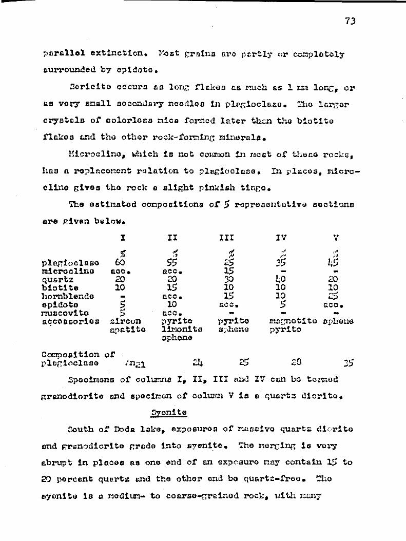
II
4 55 acc. 20 15
saca .
C~Q . pyrite limonite aphone
III
25 15 3D 10 15 ace.
pyrite ss;ik:c:no
Iv T!~
35 tv9
10 10
5 magnetite pyrite
73
parallel extinction. Yost grains are partly or completely
surrounded by epidote.
Saricite occura as long flakes as much as 1 =a lar.c, or us very small secondary noodles in plagioclase. Tho larger
crystals of colorless mica formed later than the biotite
flakes and the other rock-forming minerals.
nicroclina, which is not coon in meat of theca rocks,
has a replacement relation to plagioclas3o. In #laces, micro-
cline gives the rock e slight pinkish tinge.
The estimated cpnpoaitiana of 5 representative suctions
are given below.
I
plagioclase 60 aaicroclinsx sec. quartz 20 biotite 10 hornblende - epidoto 5 muscovite 5 accossori+as zircon
a,natitsa
Composition or plagioclase ;z21 :5 23
Spocimona of columns I, II, III and IV can be termed
graxxod.iorito and specimen ©f column V is sa quartz diorite.
Sydnite
South of Dodss lake, exposures of matâaivo quartz di.,rito
and granodiorita grade into ssvenito. The merging is very
abrupt in places as one end of an exposure nay contain 15 to
20 percent quartz and the other and be quartz-tree.
asyenito is a medium- to coarse-grained rock, kith r r ay
)
.Tho
7~
crystals as much as 5 or oven 3 ram in diameter. Pink feld-
spar and hornblende aro the only essential constituents and
quartz And opidoto are the accessories. The rock varies in
composition from 35 percent hornblende and 60 percent fold-
spar to 35 percent feldspar and 60 percent hornblende. ,It
occurs either sa large masses in the quartz diorite and grano-
diorite or as dikes cutting across the hornblende gnelsuoa.
The hornblende syenito is well exposed one mile east of
the southern end of Duda lake end about 6 miles south of the
boundary of the nap-aroa on Lia l'Aigle river. Ilea the river,
the rock is nnseive with a mottled gray and pink color. Sore
pink feldspar cry stole, as much an 2 or 3 cm in diameter give
the rock a porphyritie texture. Locally, the feldaper phono-
cryats constitute 30 percent of the rock. Lpidote is cor on
and occurs dither as disseminated grains or as veinleta cut-
tintg the syenito porphyry.
A section frci the exposures southeast of Doda lake shows
that the rock consists of plagioclase (401), r'.icrocline (35%),
hornblende (20 1) and rlinor quartz, ephene and epidoto. The
average grain cross-section is about 2 mn and the rock has a
typical interlocking hypidianorphio granitic fabric. The
plagioclase is strongly sericiti ed albite (An5) . The grains
have a rbadarete negative relief Against Canada balsam and
they have been partly replaced by rsicroclino.
The racroclino, believed to be secondary after plagio-
clase, is very clear, has' indices of refraction lower than
balsam, and shows the characteristic twinning.
75
The hornblende fores subhodrai to cuhedral grains that
ere pleochroic Pram green to light groan, and have numerous
poikilitic inclussions of feldspar.
Sphena is the most common accessory, and is 4 cnorclly
round cs well-formed dirriond.shaped crystals that have strong
relief and very high birefringence.
Three noro exposures of ayosnito are found near tho out.
lot of f;ur,ris e lake, at the contact of the biotite paragneiss
with the granite. The rock, however, is quito different froc
the hornblende syerite just described. It is a medium-grained
gray rook that has a well developed gneisscio structuro. some
of the light gray constituents have a slight pinkish tinge.
Under the microscope, the rock is seen to oonai:«t essen-
tially of raicrocline (40",t),. hornblende (301), plagioclase (10;x),
garnet (WI) and biotite (Ex). The accessories are quartz,
saphono, calcite, apatite and pyroxene. The rock may be termed
a garnotiforous hornblende-pyroxene syenite.
The plagioclase is pressent as ouhedral to anhadral unal-
tarod grains of ccmposition ..n27, and nicrocline fores an rie-.
dral clear grains that have the characteristic t i nin. .
The pyroxene is diopsaida. It is ploochroio from light
green to colorless, length-slow, biaxial positive and has a
2V of 66 degrees end an extinction angle ZAC of 3 degrees.
The garnet is seen under the binocular microscope to be
a brownish variety with an indu; of refrraction of 1.813. It
is believed to be intermediate in composition between elman-
dite and sspossartito.
76
Sods Orsni te
Most of the gr nits found in the bolt of ;oowatin-type
rocks belongs to this group. Tho beat exposures of cods
granite sro found on Towor peninsula; of Dodo lshe. Eons, the
rock Is massive, nodium-î rai. ed, pink to rod on tho froth
aurfnco and light pink to tray on the i o ..thorod surface.
The content of dark minerals is lower than th,t in the quart
diorite Henri granodiorite. Light green epidote accounts for
about half of the non-fuisio rinerels and its content in-
creases near the granite contacts. The rock is well jointed
end corm of the joints have boon fillod with quartz.
The granite of the mall islrtnd in the northern part of
:3aopatira lake la nad© up of albite (40 ;7;), n..icrocline (15),
quartz (3a:,1), ruscavite (5 ) , chlorite (54) and epidoto
The structure is gneissic with bands of qutrtz axlternetths
with feldspar-rich bicalua Mpidoto also forma layers parallel
to the structure. The grain sise is about 1 ru; but cone
grains may be cis much as 3 ri in ditmeter.
The pink granite facies la also well exposed on the
southwestern tip of the large island in ûurprise lcko, and
on the adjacent island to the west. The rock here is fine-
to coarse-grained and lacks my pronounced gneissic or
schistose structure.
A thin section of the fine-grained variety shows that
the rock has a well developed grsxnitoid texture. The graine
are 0.5 to 1 mn in diameter and all hove sharp boundaries.
A Rosiwal analysis of the section gives the following mineral
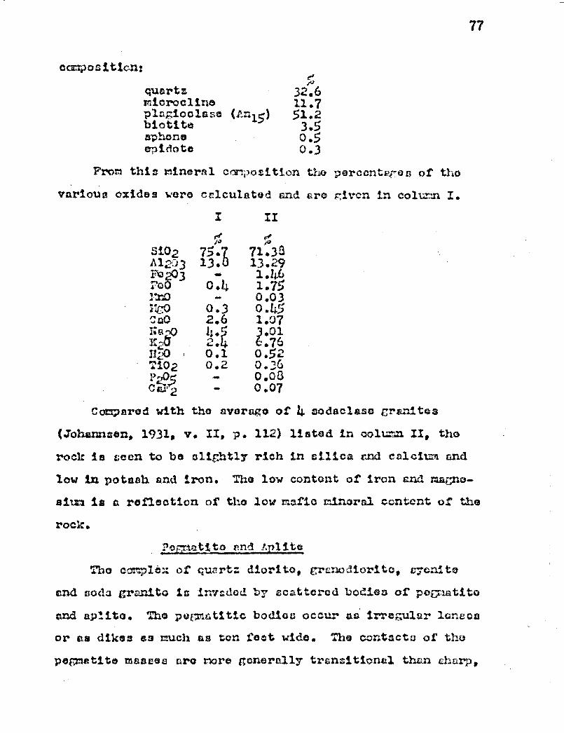
77
composition: ,~
quartr 32.6 microclins 11.7 plagioclase (Anz5) 51.2 biotite 3.5 sphone 0.5 e.pidote3 0.3
From this mineral cflmpositi+an the perccnta-es of tho
various oxides were calculated tant? aro Oxon in column I.
I
ge
II
Si02 75.7 71.33 ~.12v3 13. 13.29 Fia 203 - 1.46 i o0 0.4 1.75 r110 0.03 i":t0 0.3 0.45 0a0 2.6 1.07 i~a-t1 1~.r
~.7~ .01
n:„0 , 0.1 0.52 TiO2 0.2 0.36 P-,C33 - 0.03 c - 0.07
Compared with the avorago of 4 sodaclssc granites
(Johannsom, 1931, v. II, p. 112) listed in coYt..-~~n II, tho
rack is seen to be slightly rich in silica and calcium and
low in potaah and iron. Tha low content of iron and magne-
sium la a reflection of the low =sac m3.noral content, of the
rock.
PeRnatito end fplite
The c 1tn: of quart; diorito, grcnodioritc, cycnito
and sods granite is inrsdod by scattered bodies of pegmatito
and aptito. The pegmatittc bodice occur as irregular lonscu
or as dikes ea much as ton fact wide. The contacts of the
pegmatite masses ore more generally transitional than sharp,
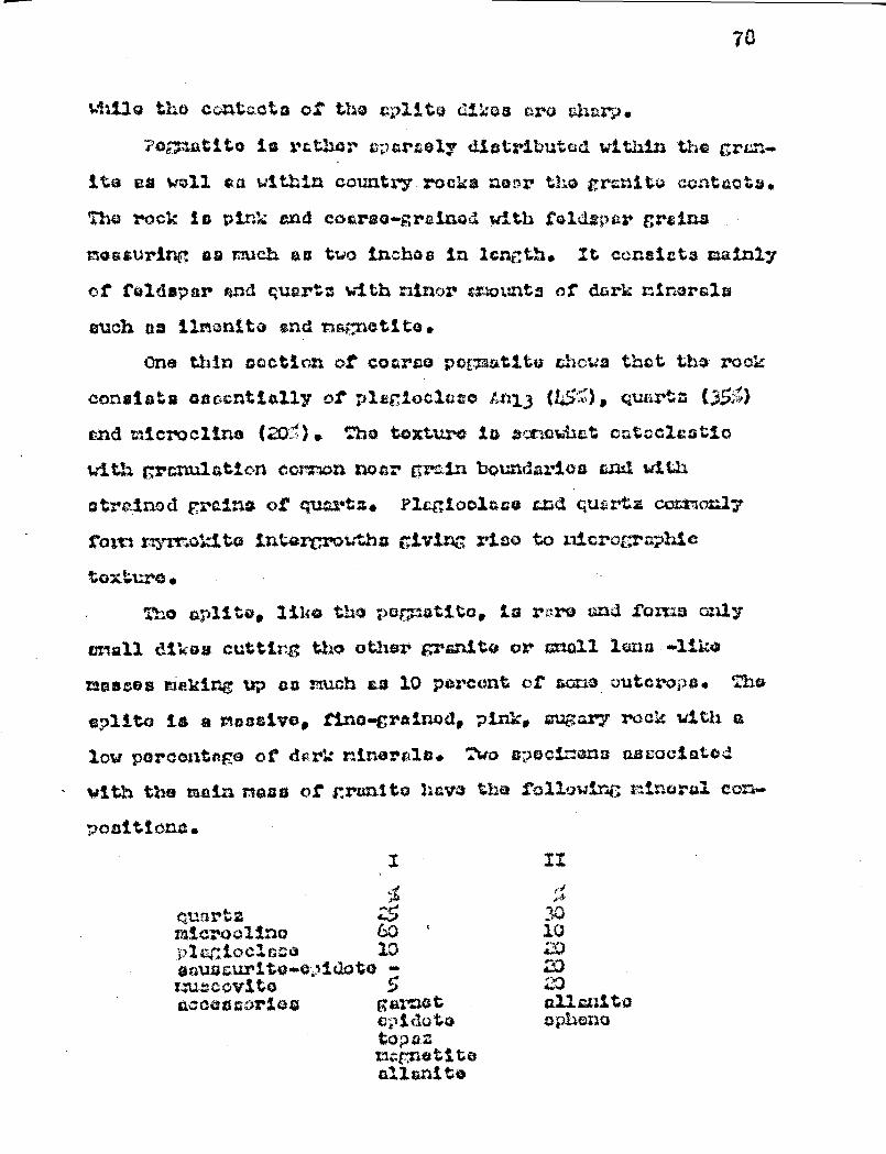
70
Whil.o tho contcota of tho splite dikes cres char2.
?cmati.ta is rr.t;acr svcrselg distributed within tara cren»
ite cum well au within country rocka nanr tho granite contacts.
Tho rack is pin/0; and coarse-grained with feldspar grains
m©aaurinc as much as two inches in length. It consists mainly
of feldspar and, quarts with ninor mounts of dsrk ninorala
such n9 limonite and na47natita.
One thin section of coarse pormutitü Chows that tho rook
consists Qac.cntiall$ o2' plugiocicso Lrsi3 (145,1 1, quartz (.3â ~)
and micro4ltne (201. :he texture la a;xowisat catscic.a MiQ
with rranulation +cannuyn near crain boundaries and with
strained grains of quartz. Plagioclase and çutrtg coomon17
t'om-l~rr.o:...Stcs inte .~row~`~a ci.ving riso to zsi.crocraphi,c
tC3y.tura •
The aplite, 1314rs t.'.za po ;~etito, is nzro and forms only
smsxll dikos cutting the other granite or anal lano ~liha
raas~es siukirsg up as mush as 10 percent of same outcrops.. The
splito is a rsasivo, tirs©-crain.vd, pink, sugary roc:: with a
low porcasitope of rlcrk minerals. Two apcsciMMna ascoc;i.atod
with the min r9ass of grrxlito haw the following mineral can.•
positions.
çuar~~ m.icrooli.av ,f..'lar;:iocla; o aaua /~} s
i~~3tio-e,~ic
IwubcV F itW accessories
I
GO 10
to - J
g artla t cptdoto topaz Tucn@tite all, ani ty
79
acvrposition of .plc ioclaee 1-n10 Ani3
The presence of topaz in the specimen of column I is
indicative of the action of minoralizers. The garnet is pin<:
to red, has an index refraction of 1.511 and is believed to
be intorraedi ate in composition between alriandite and apes-
sartite.
Err:lineament of Orcnite
The pink granite of the Tower peninsula Sa a massive
rock. fore, the oast-crest trendingKeewatin-type make have
boon truncated near their contacts with the intrusive. The
attitude of the strate, 'th© schistosity and the shear zones
around the granite conform to the co,rtacts with the intrusive.
Apophyses of granite and perpatite and veinlete of quartz and
epidote projecting into the country rocks ara very coon in-
deed. The country rock.- near the granite has undergone con-
tact metamorphism, and the chlorite schiste have been changed
to hornblende gneissos and amphibolites. All those features
suggest that the lava flows and the aedimcntarr rocks around
the Tower peninsula hava been displaced but not replace ,
and that the granite is of ratio origin.
The granite stock extending from Vorcherca lake to the
eastern chore of wool lake is massive in its western half
and g eissaio in its pastern half. In the eastern half, the
gneissic structure parallels the contacts of the intrusive
and is better developed near the margins than near the center
of the stock. The granite is in sharp contact with the coun-
try rocks and, like the granite of the Tower peninsula, it
has projecting apophyses that cut the structure of the coun-
try rocks. This granitic stock has been ez placod Tartly in
low grade metamorphic rocks of the greonschist facies and
p6rtly in higher g;rGdca netvmorphic rocks of the ciiphibolito
facies. in tho western part, whore the çr .nits is 'dich r-
roni oud' (Walton, 1955, p. 11) , the # reen tcne near the con..
teat has been changed to amphibolite. Tourmaline is a coon
mineral in the country rocks near the granite which indicates
that 'it WS3 introduced by magmatic gases. All these features
sut-est that the country rocks hava been displaced but not
roolaced rnd indicate that the granitic stock between
Vcrcheros and Noel lakes is of magmatic rather t:ht,ta of meta-
morphic origin.
South of Doda lake, the main body of granite ras Charac-
teristics similar to those of the granites mesa between
Torcherez and Toel, lakes. Near the south chore of Dods lake,
the laws have been chan,t;od to hornblende gneicsos and a^tphib-.
optos end the sedimentary rock now contain czrrnc t and tour -
rIaline. It rust be pointed out, however, that the contact
retnnorphic effects on the groenschists and on the aediraen-
tary rocko are neither widespread nor of toe much intensity.
Tho pegmatite and aplite associated with t e granitic
rocks are massive and cut across the cchisterity and gneiss-
oeity of the granite. Tho cplite dikes have sharp boundaries,
and the pe,g + atitej nasses generally have gmatiticnal contacts
in the grmito but sharp contacts and crocs-cutting relations
whore found in the country rocks. Topaz formed by the action

E31
of rsinoralizerc, and is indicative of pnau'ntolytic action
during the later staves or after the crystcllization of a
magma. necruso of their occurrence tnd composition, the pug-
=Alto and eplito of the area are believed to be of nripatic
derivation.
In the tir in grs:ni to mars, many outcrops are remnants of
the volcanic and sodincntcry rocks found north and east of
tho grcnito , contaot. In sono outcrops, howTM var, country
rocks and nagrtatic material are intimately cscociet©d, and
the nature of those composite gnoisses is not easily deci-
phered. Tho mineralogy and chemical compositions of curtain
of these rocks rnr y suggest either a magmatic or a riotanorp;sic
origin. Thus, the mineral composition of the garnetifcrous
hornblende-pyroxone cyenite given on page 6 is more indica-
tive of a composite gneiss than a rock of purely magmatic
derivation. The high percentnro of nefic ninoraia, espe-
cially hornblende, the abs+enco of quartz, the high content
of potash f©Idsper and of garnet cru features that, whore
found together, are suggestive of rocks of conposito origin.
The gnoiscic utructure in Bono parts of the ricin granite
Hass is vary irregular and highly contorted. This ccnplox
gnoissoeity was probably caused not durian ms ,s atic crystall-
ization, but by aubcoqusnt deformation. There is also micro-
scopic evidence that indicates that the granite has been pro-
duced during metamorphism with the introduction of potassium
and the chrrgc of plagioclase to tzicroolino. Many of the
thin sections give evidence of a foldspethization process in

82
the form of plar:ioclase crains only partly riterod to nIcro-
cline,
03
' Di.AlJAvv D.L aéd+✓
Occurrence
Nearly all the dicbase dikes of the nap-area are found
in the granite or in 'the higher grade metamorphic rooks.
However, two exposures of diabaae were observed in the
Keewatin-type rocks. Ono of that* is a dike 60 feet wide that
occurs in pillowod lavas on the northeast chore of the east
point of Windy lake. The other exposure of diabaoc in con-
tact with the Keewatin-typo rocks is found north of Masten
lake, where it occurs as a 200-foot-wide dike cutting lava
flows and tuff beds. The dike north of ihaton lake strikes
northeasterly, tut the attitude of the dike on the shore of
Windy lake is not known.
Llight other diebasn dikes were observed in the gneissic
rocks. Nearly all of them strike in a general N 30°11 direc-
tion and the dip, as far as can be ascertained, is stoop or
vortical. One of the nain dikes vest of lake Grimaldi
strikes slightly west of north. Only short a egrionta of the
dikes hove boon shown on the nap, and these segments very
likely extend much farther than actually shown. The most
extensively exposed dike is near Qriol lake. It has a .-now
length of more than ton miles and is exposed intermittently
from one mile north of Oriol lake to the southern bounc ary
of the stop-area east of Roy river. This mein d.i©base dike
and that of r'.oston lake nay very well be the continuation of
the Dauvorciero dike (Imbault, 1951, P. 9) . If so, the dike
would be more than 25 exiles long and strike N 400=: wherever
exposed. The dike does not forma perfectly ectly c right line
but bends north of Oriol lake. The dike ip more than 500
feet wide on the east shore of Oriol lake but its width gon..
orally varies between ISO and 300 feet. The other dikes are
ncrrowor, and the one cast of Grimaldi lake for instance is
only about 25 feet wide. The diabase dikes tond to form
resistant ridgeD but these rarely rise more than cO foot
above the surrounding country. No dikes wore observed test
of Curprise lake.
Petra rt.phy
The dicbaso in. s black rock, massive, heavy, and has a
characteristic ophitto texture. The grain gradation from
coarse-grained (5 nui) in the center of the dike to fine-
grained (1 rte) near the margint is clearly shown along the
couthsrn Shore of Oriol lcko particularly near the western
contact of the dike. The essential mineral constituents are
plagioclase and pyroxone with accessory quarts, biotite, nag.
netite-i].ri$nito and epidote.
In thin sections, the plagioclase Is rire abundant than
the pyroxene. The diabetic texture with lath-shtpod crystals
of plagioclase and interstitial pyroxene is characteristic of
all sections examined. The play ioolaso grains erre clear and
the pyroxeno graina mny be cle r or altered. 'kwa stages of
alteration of the pyroxene were noticed in the sections of
the more altered die~baso. In the first suage, the centers
of the pyroxene grains are altered to tra olite, light. colorod
hornblende, biotite and quartz. }bat of these secondary

3,5
products rarn noadlcs-l.ii:o grains or f2ai,cssz that radiate from
tho centers of the grains. Tho first str.ga of al.terctien nay
alco result in the fcsrr:::h#:ion of rims of dark green horr.blcnr.+.o
cad biotite. 3.0 tho cocond e tcg® of t;lte's`ntin, the horn-
blende is altorod to chlorite. Chlorite sr&s observed us
a secondary r-tincsral formed directly fron pyx-rl.rtie nra.
The pyroxone of the diabeso is a-r'ito, with a 2V ranging
f'ron 4.0a to 43°; 1.691; and birofrirgenco, 0.023. In
ono section, the determination of 2V on pro .~;rassâ.voly altered
grains rave the following valucset 40, 41, 62, and 62 de-
s^;roae. The grain with a 2V of 62 degrees is corplataly al-
tered ta hornblondo and traces of the oririnal pyz•o.xona cre
wanting.
The plc iaclase rrair.a chara.ctoriaticc.lZy rennit1 t:.:a1-
to;csd. Thoir composition varies fr.= d.i,I:e to diko bQtweozx a
calcics cza.doaine (:.n40) to a cociio byi.ownito (i1162) . The
crains ore nostly twinned. lidc from the accascorios3 al-
ready rontianod, the altered diabase contains muscovite,
chlorite, 2oucoxerze and ssphono.
Tabulation of mineral percantcgQs of 11 cootir:ns show a
strikingly uniform composition. rods.1 analyses of three rap-
resesntativo spocimens are given below. Colmn I and II are
razalysca of specimens from tho main dibo, sand column III of a
specimen fran the narrow dike su>Jt wont of lakes Grimaldi.
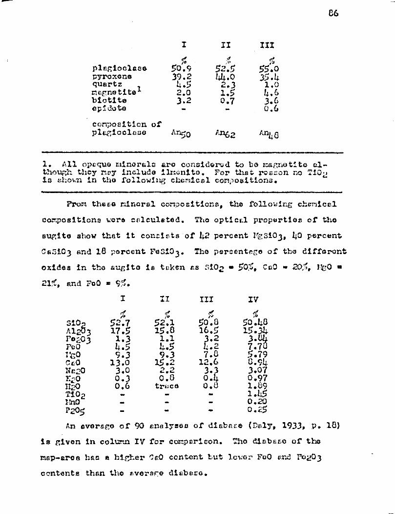
% ;~ ;r plagioclase 50.9 52.5 55.0 pyroxar.e 39.2 44.0 35.4 quartz, 4.5 2.3 1.0 mcrnotita 2.0 1.5 4.6 biotite 3.2 0.7 3.6 e3p-dote - - 0.6
composition of plagioclase An50 /31E2 d:n40
1. All opaque minerals arQ co nsidorod to be rAgretito a1- thottth they my include ilrsonito. For that r»ason no Ti02 is shown in tho following chemical con,.3ositions.
From these n.i.noral comasitiona, the following chemical
compositions wore calculated. The optical propertios of the
sugitb show that it conEints. of 1:2 percent I siO3, 40 percent
Ca 3iO3 and 18 percent Fa:iO3. Tho percentage of the differont
oxides in the auEita is taken ts :402 .. 5©;~r Cp0 • 20:1. r60 x,
214!, and FeO .. . 5,.
I II III Iv ee e ,~ 1
Si0 52.7 52.~ ~~.£ IO 48 ~;1 ~3 17.5 15. ..~ 15.34 F€~~,--ü3 1.3 1.1 .2 3.
~ ~0 4.5 i~•.5 ~.2 7.7 ito 9.3 9.3 7.3 5.79 ûo 13.0 15.2 1.2.6 G.94 Ur; 0 3.0 2.2 3.3 3.07 %.20 0.3 4.8 0.4 0.97 H20 0.6 trace 0.3 1. L9 Ti.0 rf .- » « 1.1;5 2 :r~A ` - - - 0.20 P205 - . - 0.25
Ars average of 90 analyses of dia ;e (Da1y, 1933, P. 18)
is given in column IV for campari.c.on. Tho di.abasa of the
map-ares hart a higher CO content but louer Fea0 cr.d ro203
contents than the avo: af:e diabe.ra.
86
3?
Tho diaba,e is the youngest consolidated rock of tho
zacp—m!rea, and tLe have c?iccordgr.t ra:z tioxi:..:4ipsa with
the moicric ctr u; turc of the g;rur.:.te tcctin: t uh1ch they
hove bo:X,:crs. Tho d.ar,bace d.i;:ec have tuic:cr4;onv vczy
little cieioraatiozx and :rl:c^~tiorl; after their 4npjaccz-:cnt.

38
CENOZOIC
Distribution and Occurrence
The greater part of the map-area is mantled with glacial
till end fluvio-glacial deposits of varying thic roes. The
dense cover of troo4c and undergrowth together with the lack
of roads ma o a study of the glacial fe aturua r ether difficult.
Once recognized in the field, however, men; of the lacic1
featuree are bast studied with tho aid of aerial photocraphe.
In general, the mantle in rather thin no .â the hill tops
where outcrops ore nuriorous. In the low c roa ., like around
Jay, fo Rock and Eva lakes, the mantle, if not thicker, in
at least a lot more continuous, and the bedrock in not exposed
at thoeo localities. A 45 dogr.o di€sand drill hole, one rile
west of !*estan lake, .gent through VO feet of gle+clvl till
before reaching thf bedrock, indicating, that the nentic is
over 60 feet thick at that locality. It is alto reported by
Riverside Chiboufgansu lungs Limited that the overburden is
100 feet thick on the south side of the Opawica river, just
east of Windy lake. It in probcb1a that this is near the
maximum thick oss of the 'loistoccno, but there is no evi-
dence to prove that it cannot be ouch thicker iocnlly.
The distribution of the older rocks has no control over
the thickness of the Pleistocene cover. The la.rCer boulders
do not show evidence of long transport and they can be used
to a limited extent in raping the underlying beerock. Thus,
southeast of Dods lake, and west of Eva lake, large granitic
boulders ore common south of the granito contact but thoy
are rare north of that S =0 contact.
Cpl +r11nl 1 ntcri©l
The glacial. materiel consists z octly of till ranging
from boulder to fino silt in also. In places, sorted material
such as boulders, gravel, send and clay nay fora acctmzlations
but those are rare and of small extent in comparison with the
unsorted drift.
Porno of Glacial Deposits
The unsorted drift occurs for the nowt part as ground
voroine forming a gently umdulating topography of very low
relief. 2mall hills or doprossiona dhow no particular form
and pattern.
The till in plums fora low drzilin-liko rid goo. Good
examples of those topographic forms are the long points ex-
tending couthwostwsrds from the northeast ahem of Ceopatina
lakk©. Nany einilur forms are distributed throughout the area
but they are not as easily recogni ed, goat of thoso drumlin.
like accumulations are loss than one mile long but so n° nay
be as much ua threw miles in lon th. Their width varies be-
twoon 0O and 3000 foot and their b ittxt raroly exceeds 50
feet even in the largest ones.
Accumulations of boulders wore occasionally observed in
the granitic areas. The boulders are subsngular end average
about two feet in diameter. :he boulder accu`:Yulationa do not
Porn elongated narrow tracts but are mere or loss oval-shaped
or rounded sasses. No glacial striae wore observed on these
boulders.
A Pest sand plains occur within the nap-ar©a. The

90
dopos3ita ar© roncrkably flat end gunorally cover loco than
two square nilos. One such dopocit in found at t:3© north.
%roat corner of the n=p-aroa :.nnediatoly narthwast of Dodo,
lake.
Uhatratifiod clays are caattorod throu bout the area but
they too aro rrAro. Zane gray clay was obaer ed loon than six
miles southwest of the height-of-land. Clays aro also pres-
ent at the following; localities: south of 'noel lake, on tho
west ehoro of lake Proust and along the small stream flow.
ing free Vo rock and Jay lakes into 1)o It t iglo river. Thais()
clay deposit© are not covered by younger drift.
Eakore wore noted especially in tho vnutorn parts of tho
nap-tea but none were rocognisod wont of 3urpriso lake. Tho
°alter s are corn ocod of aitt, rand and grs vel, and do not cow
very fine sorting. The sinuous rid cos trond couthurards to
coutf stwz:rds. Zomo of the oaken: are 3 feet high and 30
feet wide at the bas©, others arcs ra high as 60 foot and as
midi as 100 foot wide at the bane. The slopes of those
ridges are fairly stoop, being around 40 to 45 dograeo. The
eskors like neat other glacial features are beat studied rram
aerial photographs. The longest eukor occurs northoaut of
lake Voncco, and it measures over two miles in length. Other
eskers aro shorter.
Small rounded hills and depressions are co, .on in the
southeast corner of the nap-area whore they form k = and
kettle topography. Thoso kenos and 1:ottlas and the ()shorn
are ico-contact features, and wore probably furred by u
91
eta nant mass of ice (Flint, 1949, P. 151).
Near the northwest corner of the map-area on one of the
sand plains, are three ridcoa that trend i t 0°i . These ridges
were .studied from aerial photos only. They are about 2000
foot apart, 200 feet wide and appear to be low. Although
they trend in a direction that par llolo the elongation or the drumlins they are not believed to have been produced dir--
eetly by rloving glaciers. These ridges are thought to repro-
cent transitional dunes. They , aro located between 5 to 10
miles routhaâat of the eastern shore of former lake 33rlow-
O jibway (fig. 2, p. 92) , and the sand plain on Which these
ridges formed may very well represent a former Loath along
the shores of the lake. Westerly winds blowing from the
lake may have formed those ridgos.
Directi n of Ice r evo^:ent
The direction of movement of the last ice Sheet is in..
dicated by the trend of the drumlins, by glacial striae and
glacial grooves. The long points of Oaopatina lake trond
25°W,, and other less reliable determinations on the rest of
the dre lin-1ilo ridges Chew elongation. varying between 530°W
and : 4° i. The glacial striae and glacial grooves (Pl. I A
and 11) nearly all, strike 335°14. ;teas and lee topography
shoe that the last movement of the ice sheet was southwest- •
wards.
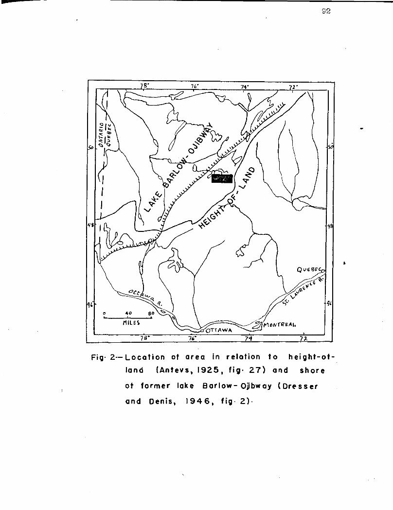
92
Fig• 2•— Location of area in relation to height-ot-
land (Antevs, 1925, fig• 27) and shore
of former lake Barlow- Opbway (Dresser
and Denis, 1946, fig• 2)•
93
ATi I ii T 3 A. 1i oiw :.vm1 T.1„ osi
The word correlation as usod in this report has no tii o
implication but neroly reprosonts the equivalence of rock
units on the basis of litholoL*y. The distinction between
the terms Koawatin and 1 eowctin-type and between the terns
Grenville and Oronvillo-type should be pointed out bore.
The words Koewstin and Grenville imply a specific geologic
ago when applied to rock formations khoross the torn
Keewatin-typo and Cronville-typo do not nococ: aril~ indicate
ore equivalence but rather litholoç;ie si ilaritiaa. The
torn Koowatin-typo Jo applied to those rocks of the Surprise
lake area that are similar to the dominantly volcanic rocks
found :n the throe western cubprovincoz of the Ct. Lailrcnco
province of the Canadian shiold. The tom Gronvillo-typo is
applied to those ,s-noicses typical of the Grenville nubprovinco.
The correlation critoria are lithologic similarities,
degree of metamorphism, and physical continuity. Those cri-
teria are not hold in vary high esteem by strutigrapheru but
they are novertholeaa the only tools ut the disposition of
the reologists working in un.fosciliforous and metamorphosed
terrains of the i roca br3.€n. For those roasona, the corrole-
tions are purely tantetiva.
In the Curprise lake urea, two nain difficulties hinder
attempts et correlation. The first ono is the paucity of
outcrops. In rotc.^iorphosed terrain, ono of the be:.t ways of
moping difforont formations is to walk the contacts. In the
area studied, however, this method of nappina is not only
impracticable but almost impossible bocause of the lack of
of the different formation within tho rea
of the different formations of the urea with
aroebs and their assignment to the appropriate
94
exposures. The second difficulty consists in tho conploxity
of the structure and tho lack of marker units. Not only have
all the rocks been completely dofor.^od but notamorphisza has
oblitaratod most of the stratigraphie and structural criteria.
In the bolt of Koowatin-type rocks, for instance, the volcan-
ic, ccdirunt iry, pyroclastio and intrusivo rocks ero all
intermixed, nearly all notrriorphosed to the wino dogrel), and
the normal sequence of deposition cannot be worked out accu-
rately.
The problem of correlation in tho Surprise lake area has
three different espeata:
1) corrolstion
2) correlation
those of othor
:su'bprovinca
3) correlation of teas different formations of two geograph-
ically and geologically aopar :to divisions of the Canadian
Yracabrian shield, nez oly the Tiriis:urning and the Grenville
subprovincea (ilson, 1939, p. 239)
The problem of correlation boconea increasingly diffi-
cult as larger and larger areas are considered and as the
relation or stratigraphie position of the Keewatin-typo and
Grenville-type rooks are examinod.
Tiistory end r;ononclnture
The original meaning and aubsequant expansion of each
term that may be appliod to the rocks of the map-area are
reviewed briefly hero.

95
Keewatin
The word Keewatin was first used by A C. Lawson in
1635. Workinc in the lake of the Woods region of entario,
Lawson recognized n thick series of cicaely folded lava
flows and sedimentary rocks that ha named Keewatin. le
writes:: (Lawson, 1685, p. 14.15):
"The most appropriate name for the series that suzgests itself to me is 'Keewatin', the indien name for the Northwest, or the North-West wind which has bocn applied to the district within Which the rocks occur."
According to Gunning. and Ambrose (1939, p. 41), W.H.
Parka in 19041 was apparently the first geologist to use the
term to describe some similar racks in western Quebec. The
term was Fain used by .troop in 1907 and by `wilson in 1910
and kept being used macre and more frequently. In 1931,
( ooko, Jumps and 2"awdsley, 1931, p. 25-53) the lava flora
and sedimentary rocks of the I ougn-F:arricanaw region, Quebec
were correlated with those found by Lawson. Four years
later (flwdsley and Norman, 1953) the terne Keewatin (?) was
tentatively applied to the greenston©s of the Chibouganau
lake area, Quebec. Nawdsley and Nor.^an write (1935, p. 11) :
"The oldest rocks, the volcanic flows end minor inter-bedded pyroclastica End zedinents form an altered assemblage that is similar to that termed Keewatin greenstones in other parts of Quebec and Ontario".
Iiswdsley and hornnn than refer to the Geoxoc ical survey of
Canada 2' .oir 166 by Cooke, James and Nawdalcy end write:
"A rather full discussion of rocks of this Character is givon in the report on the fouyrn-lirrricanaw region and the description presented there depict very well the main features of the old volcanic eecerbl r.pe in the Chibougumau District".
96
Tho Chibougamau sheet, %rout and °ant halvo€i (I=cwdsloy
end 'Norman, 1933 and Potty and Varna, 1933) also refer to
these lava/a as Keewatin.
TL is timing
W.G. faller (1911, p. 640), 'working nor lrt:o Tiriiakaming,
applied the term Tiniskaming to a serina of /rchezn sediments
associated with but apparently younger than the Keewatin lava
flows. The term Tiaiskaraing never gained the widespread
usage that Keewatin did and its stratigraphie position in re-
lation to the Keewatin is not perfectly known. By definition,
the Tiniakaning cediaentaay series in quite different litho-
logically from the asuo iblcg© of the Keewatin volcanic series,
and reste unconfornably upon the Keewatin lava flows. in
places however, the Tiniskiing-typa nodir ontary rocky are
found intimately associated cud aocnir ly in conformable con-
tact with a Keewatin-typo volcanic writs so that in sono
places, the relationship between the metaa©diriontu and the
volcanica is uncertain. In those plates, the use of the team
Tiiii©kaming is not warranted.
t r+nville
The term Grenville was first used by W.E. Locan (1363, p. 43 and 036-839) to describe a thick sorbet; of motta-iorphosed
sedimentary rocks that h© found in the Grenville township of
southern Quebec. In 1910, Adsnna and Barlow (1910, p. 36)
gave the distribution and aerial extent of the Grenville se»
ries but the wootern limit of the sariee could riot be located
very accurately. Geologic napping along that weatorn boundary
97
hos boon orrctio, and infroçuent. In 1939, data, though
still very incomplete, plete, worn sufficient to allow V. 14 Wilson
(1939, p. 239) to locate the western boundary of the Gron-
ville subprovinco noro accurately. /. ong the rocks typical
of the Grenville curios aro coaraoly cryete/lino limestone,
quartzite, and garnotiferous and aillinanito parazneiawos,
hornblende gneisaos, End aszphibcli tes. fnorthocito and Emir.
sic Granite form conspicuous masses within the Grenvillo
rocks. The Grenville aubprovince has been divided into four
different rogiona (Dresser and Dons, 19146, p. 197), ono of
which la a border tone in the Grcnvillo subprovinco boi.dod
on tho northwest by the TL isskc i.ng subprovinco. The south-
eastern pert of the Curpriuo lako ores is within this border
zone.
Feweenr:wrn
The tore I:owoonaw n was first used by Brooks (1376, p.
210) in his description of the copper bearinc aeries of laves
and conglomerate of .:ewoanau peninsula, richiçcn. The torn
vats later applied to rocks on the north shore of laze I:uron
and in the Sudbury district (Cooke, 191i7, P. 30) . The
Koweonswan period occupies the upper part of tho i'rotero4oio
ara and is characterized by groat ignoous activity that gave
rice to bssa2tic lavas, and hydabyssel and deep-coated basic
intrueivec. The term K©wocnawan hue boon appliod hero and
there to diabase dikes that are in the upper -?rocc:.:bricn part
of the ,roologia colti. In host of the geologic' reports cov-
ori=gin arras in northern Quebec and Ontario, most late

94
Procambrien dicbaeo dike" cro toz':cc Keeweorauan without any
direct evidence for tho correlation other than their iliabcaio
character and tho fact thf t they are later then the other
PrecaMbrien recuits.
Ceoloric P. riodc tined in the Trble of P '- ticnc
In the table of forma tionn, the tern Kbewatin (?) is
used to refer to the tightly folded eodi:acr t , ec well as the
levant end the terri Tinickaning has boon omitted. eo ie of
the hirher r►rede gnoisses hew, boon referred to oc Grenville-.
typo. The granite has been claeeifiod es Grenville (?).
?:euconewan (?) is nrpliod to th© late Procrs:trinn diabase
dikes.
There rro two nain roe ec::s why the terra Keewatin (?) is
tpplied to the aseemblF.ee of 'twos end sediments. In the
first place, :iavdeloy and Norman (1930) and Patty and Norman
(1930) who r gipped these rocir have elroody referred to the
es Keewatin. Secondly, the roci:s of the nup-aron cor roseond
very closely to the descriptions of typical ass::mb1_i roe such
as the one given by Cooke, Je our and Xaudsloy (1931).
The term Tiniekcrsing is not applied to the sedimentary
rocks of ,3u pried and Ccopatine Iakce. Previous rapping of
there sediments (Meledsley end Normen, 1930) indicntos that
these rocks eras
"in part probcbly ;-ovneer thin Keewatin but in part possibly Keewatin." "Tho aodimentary rocks are possibly equivalents of the Timisktr3:hg eedimento in the Rouyn—roll river region of western (\xebec. They appear to lie in synclinal structure:, nand to be younger then the mater pert of tel© Keewatin laves".
Ito unconforiabl© rel tionship wne not©d between the

99
aodizrontary rocks and the adjacent volcanics, and it rooms
probable but for from certain that the two typos of rocks
are interctratified and of the nano COnorai co. Locauao of
the olocv and intinate association of the sodir,Ycsntary rocks
and the lava flays, th© writer prefers to place the two typos
of rocha uudor the tcrn Y.00vatin. Tao rocks of the transi-
tion zone hava also boon grouped with the k oowatin (7) in the
table of formations as they arc tho saura rocks but hsvo boon
metamorphosed.
The higher grade metamorphic rocks found east of .rprioo
lake were rofr rrad to by Eawdsloy and Z;ox' a in (1933) ras
?Archoan and/or Proterozoic." It has boon Shawn in a provi-
ous section of this report that the hornblende gnoisa a and
amphibolites represent, at least in part, the not mz'phoaed
equivalents of t e lavas and related intrusive rocks and that
the biotito par anaisaus izro ants vrphosod k cowaatin-typo sed-
iments. oloicher or not all of those higher grade notanorphic
rocks ara actually matarwrplosed Eeowatin.-4y- o rocks cannot
be ascertained, and boaauao of this uncortainty, t ho; o Cron-
ville-typo rocks have boon labelled Keewatin(?) .
A major problem arose in constructing the geologic) col-
umn and in trying to apply tours denoting Ace to the various
rock unite. An Archean-type rock may bacono by notsx- rphiam
in Proterowia timo a Proterozoic-typo rock but if Archoan
rocks are metamorphosed in Proterozoic tir.e they remain
Archoan in rage. Thus, the Koowctin (?) rocks of the area do
not became Granville (?) rocks but the i :vci tin-typo rocks
100
st i become Grz'nvillo-type rocks. fn trchorn rock can give
risen to a Proterozoic rock only by erosion and rodoposition
in ?rotoro oio time. There are, however, sono rocle that nay
consist primarily of trchean material 'Allah has boon modified
and to which materials have boon added bp later metamorphic
and mmgmatie procoasos. Those rocks ara co:: poaito und cannot
be easily placod in the geologic column.
In the Curpri ao lake area, the higher grad© na tt or hi c
rocks do not include the throo most characteristic typos of
rocks found in the typo locality of the Gronvillo my tho
crystalline limostozzo, the quartzite and the sillixrn.ito
gnoieu. ik,ircvor, the garnotiforous hornblende gueissos und
biotite paragnoisses and the cmphibolites east of Zurpr iso
lake are coron in the Grenville oubprovinco and they are
considered Gronville-type rocks. Other workers who regard
similar rocks of the surrounding areas as Gronvillo-type are
Gilbert (1952, p. 2), Imbault (1951, p. 7), and tealo (1954,
p. 5) . In this report, the term Grenville is not applied to
these Gronvillo-typa gnoiasos mainly because of tho strong
evidences that these noissoa ropz'azant at least in part
iiota ,rphosod xeewatin (?) rocks.
Although evidences are not too reliable, it seams roa-
sonablo to assume that the granitic rocks of the area are of
ores age, though the intrusions nay span a considerable in..
terval of tire. The granite is dofinitoly ynungor than the
Keewatin (?) rocks and, as shown by the Tower peninsula in-.
trusion, it is also younger than the period of deformation

101
that rosultod in tight folding of the lavas and nodi;iorts.
Tiso granito hap tntruuivo rolatiora to the hornbluncio and bics..
tito gnoiusus, and Is therefore your or guar tho period of
notenor phis. that gave rico to tho gnoissas. It ia, howovor,
very difficult to place the time of intrusion in the geologic
column. . fadioactivo dating is probably the only morns ut our
disposition to date t oso intrusive rocks. 2iawdsloy - rind i ortrÿn
(1933) hove placed the granitic rocks of the rasp-€grog as
Archean and "possibly not all of one ego". There la a atrong
possibility that theao grcnitie rocks arc younger than Archoen
and should probably be placed. in the Proterozoic. - Tho reason
for this is that the largo main bolt of granito has caueod
notsraorphic offocts in its wostcx'n pert but not in the oaotorn
part. The castorn port of the granite) thoroforo was intrudod
in hornblona o gnoiooe and amphibolitosa and if t 000 rocks
were net rphosed in tho rotoroaoto tine (Oronvi.11o V!)
time) , and they probably wore, then, the granito also wauld
be Proterozoic in age. The granite is clasoifiod with the
Grenvillo (t) .
The diaabaae dikes are definitely the yotulgeot cousait-
dated rocks of the nap-area as they out the gnoiaaic structure
of the granito. Their constznt composition indicates that
they are co-tactic and probably of the saro ace. r wdsloy
mad roman (1939) bave found that thoao *dikes are latazr than
the Chibouganau aorion (equivalent to the Cobalt tories,
Ionian (?) ) , though in part they nay be pro hibou ;eau.
bault (1951), Gilbert (1952) and Lynll (1953) Who havo
102
mapped adjacent areas, tentatively correlated the diabrauo
dikes with the Yo ire onrauan (t) , Although there is no ovi donco
to show that these dikes were actually intruded in Neweenswaa
tiro, the co on practice of assigning these into Procanbrian
rocks to that period is adopted.
Dolinitation of Keewatin-type and Grenville--type Rocks
It is very difficult to place the boundary between the
I.eowatin-typo and Gr avilie-type rocks of the Cur prise lake
area on the basis of lithology alone. The granita gnoisaa
that spans the southern part of the area shows no noticeable
change in lithology from the eastern to the wostovn bound-
aries of the nap-area. and therefore it ccnnot be used in
separating the two types of rocks. Aa pointed out in the
description of the various rock types, there in a gradation
between the Keewatin-typo rocks and the Granville-type rocks,
and the only realistic war to delimit the two types of rocks
is to establish the transition zone shown on the accompanying
nap. This ono, iii ch ru a zuro a froc two to three riles in
width trends easterly between the eastarn boundary of the rtap-
aarea and the south shore of lake Caopatina. Ikmath of this
lake, the belt sssu ,ea a southeasterly trend as far as Llva
and Dos Ciaudos lakes, and it abuts sue atmat a gr nite intru-► lion south of there lakes.
A gradation between rocks of the Tirstiskaarinf subprovinco
and those of the Oronvill© subprovinco has been noted by =any
geologists. Quirks and Collins (1930) in their fcraous ncrx it
on the disappearance of the Buronicn were amongst the first

103
to contilud© that tho rocks of the Granville subprovinco rep.
rosent ziQtamorphocod and granitizod sedimentary rocks of
MUronitn aze. A number or çuoboa Department of Minos reporte
show that in various places, o gradation exist° between rocks
of the Tirtiskaiin , subprovince and . tho o of the Grenville
aubprovince. P:.iong thorn the follow•in," can be mentioned:
1) Lowther, 1935, Villobon-Demis rap-R.rea
2) ?regxrw.n, 1943, 3uteux Area
3) kill and Osborn, 19!0, Cawatose Lap-Area
4) Gillian, 1952, Canimiti tree.
5) Neale, 1954, , Zollior.Charron :.ree.
I-noro recently V. G. Johnston (1954, p. 1072) his shown
that east of lako yams L, Ontario:
„some of the Gnoissos in the Grenville subprovinco pro-bably resulted from the i otamorphism of granite of the sena age Pa the granite in the TiraiskFrzt nç subprovinco".
Geologists, working near urpri4o lake from the Grenville-
type rocks towards the Keewatin-type rocks would tend to in-
clude the zone of trynaition with the Grenville»typo racist,
and geologists working in the opposite direction would tend
to place the zone of transition within the bolt of i aowatin.
typa rock°.
The Surprise Lake area lies within two major structural
divisions of the Canadian shield, the Zorior und t e Gren-
ville provinces. These varies were proposed by 0111 (1949,
p. 6144) , end the boundary between his Superior and Granville
provinces coincides with the bot>ndtry between Wilson's Time
is:ccming and Grenville oubprovinces of the St. Lawrence prov-
ince (Wilson, 1939, p. 237-239). Wilson's subdivisions are
goolooicelly und geographically different regions whereas
Gill's provinces are based mostly on the doe insnt structural
trends. As indicated by Gill (1949, p. 65), the generalized
dminrnt trend of the ;,upsrior province is east-west Whereas
that of the Grenville province la northeast. It is also
generally believed that the tectonic disturbances that took
place in the Granville province are younger than those of the
Superior province.
,pocaus' the area belongs to two structurally different
provinces,, the structural featurou are trusted separately in
two set arato sections under the hoc.dinç e "Folding of the
Zeowatin-type Rocks" ccnd "Structure of the Gronvillo-type
Rocks". The relationship between the structures of the two
provinces is briefly discussed in a third section.
Foldirsc of the Keewatin-type flocks
Structural F'etttures
As shown on the regional structure asap (Fig. 3, P. 117)
the 1Zeewati.n (?) lava flows und sodir-xantary rocks have an
east-west trend, with strikes rcx Bing between 11.7000. end
105
$.7000,. The Chief. exceptions to this: easterly trend cre
found nacr the northern pert of ^)oda lake and south and west
of Noel larco where the attitude of tho flows t nd eedir untury
rocks conforms cloaoly to tho contacta of the no«r'oy younger
granite ras-ea.
Tho dips of the flows =4 beds ore either vertical or
steeply inclined. Ripa generally arec between 70 and 90
derreos althouth sorte dips north of the cast end of Caoputina
lake ray be us low sa 25 degrees; such low Mips era very raro
indeed. he lava flows along the northern boundary of the
rasp-area from !eaten lake to the westarn shore of Dods lako
consistently dip to the north. South of this north dipping
bard, the sedimentary rocks end achiats extending from the
western shore of Caopetina lake eastward generally dira steeply
to the south: west of the lake, however, the stoop dips are
to the north.
The Keewatin-typo rocks of the area are generally :schis-
tose, and nerrly everywhere the schistos3.ty conforms to the
attitude of the flows and sedir.sentr ry beads:. Around the gratin-
ito of the tower peninsula, where the strata parallel tho
contact of the intrusion, the schictosity also conforms to
the trend of the flows. Because of titis parallelism, fisc at-
titude of the flows, especially where the contacts of indiv-
idual flows ware not recognized, have been inferred frori the
attitude of the schistosity. In a few places, howovor, as on
the southern shore of Caopatina lake, the schiatocity divergea
as z uch as fifteen degrees from the attitude of the oodinonta.
106
'i1 O flows and sediments, in nanny places, have been very
intensely deformed and dreg folds and crenuletions have formed
(P1. III A and I3) . The plunges of the ares of the drag folds
range between h0 and 80 degrees to the northeast, end the
axial planes generally strike east and•ar© vertical. In acme
plecee, however, the axial planes of the' dreg; folds strike
northeasterly.
Zones of sheering ere corton in the belt of volcanic and
sedimentary rocks, end any of then ere located at the contacts
of the lava flows and the sills of r etegabbra motadicrito..
:'oct of the shear zones trend easterly paralleling the atti-
tude of the strata and of the schistosity. Czia shear zone on
th© eastern shore of Dada lake strikes north but it also par-
allele the trends of the lava flows and sch.istoaity that wrap
around * the intrusive of the Tower peninsula. The shear zones
aro from 2 to 100 feet wide, end commonly show relatively
Sharp contacts with the adjacent rocks. Though present
throughout the belt of ;eewatin-type rocks, shear zones are
concentrated in two main localities. One is in the central
part of Windy lake where a more or less continuous zona of
sheering extends eastward from: the western shore of the lake
for a distance of about six miles. ~. e other zone of shear
ins, traced only through widely a tattered outcrops, extends
from the eastern Shore of Roda lake throe h the falls on
De l' is lo river to north of lake Jay. This zone is also
about six miles long..
Jointing is not pronounced in the Keewatin-typo rocks.

107
Basaltic flows are jointed in places (P1. V-4), and soma sod-
irtonts may have a feint joint set perpendicular to the lods.
All joints ara steeply inclined to vortical.
No ovidanco of major faulting vise observed in the
I:oowatin-typo rocks. Finer .: faults are undoubtedly quite cam.
non, but liko the choar zones, thoy probably generally strike
parallel to the flows and sedimentary beds.
The boat top determinations on lava flows wore obtained
from pillowod and©sites expoeod on the islands and shores of
Windy lake. All top •dotox inationa here (about 25) show that
the flows face south, and as the flows strike N.75°114 and dip
70 to 00 degrees north, they are overturTnod. Those top dot-
ex thations are spread over a width of about 0,000 feet meas-
ured at right angle to the strike of the flows. Another top
dotormination on andosite about two niles east of No Rock
laie w3aora the flow here strikes S.700Z., and dips 00 degrees
north, shows that the flow faces south and is also overturned.
On the eastern shore of Dodo lcko about one aile south of the
mouth of the Opawica river, the flow strikes 1 .10°:;., dips Co
dagroov west and also faces west.
Only throe top determinations have boon obtain©d from
sedimentary rocks showing graded bedding. The codirantary
rocks on the oouthoaetarn shore of Caopatina iake strike
5.00°S., dip 00 degrees south, face north, and are thus over-
turned. one mile southwest of Windy lake, noar the survey
lin©, oasterly striking sediments are also overturned as they
dip to the north and face south.

103
Intorprota:tion
Thoao top dotorminaations on ands: itos and aodimentcry
rocks, and tho other structura foaturee ropro cnt a rather
small amount of data from Which to work out an intorp rota-
tion of the major structure. The lack of marker beds or of
rn easily distinguishable rock unit also necks the structure.
These factors together with the paucity of outcrops and the
present scale of upping hinder the interpretation of the
structure, and make it quite speculative.
The general ocst-west trend of the lccwaatin-typo rocks
suggests that the casœ blage of lava flous and sediments was
folded in ras$ o nse to north-south stress os. The steepness of
the ripe indicates that the strata hava boon tightly folded.
If wo accept the hypothesis that the drag folds represent on
a small scale the structure of the major folds, the latter
should be plunging h0 to CO degrees to the northeast likes the
drag folds. The drag folds also suggest that the major folds
are upright. If northeasterly plunging major folds are up-
right they should give rise to northoaastcrly trending struc-
tures; they could give rise to ©saatoriy trending .structure
only. if the axial planes dipped to the north. A few north-
dipping axial pianos were recorded, but they : re r r o com-
pared with the vertical ones. There is thus a n apprsont con-
trodiation in the structure as indicated by the drag folds
and that indicated by the trend of the formations. I possible
solution to this contradiction nay be that the northeasterly
plunging drag folds sud the major folds were formod at
109
different periods of dolor stion and by otrassos acting in
different dirooticas.
The structural features of the lava flows of Cindy lake
show that the, atrota strike easterly, dip oteeply to tho
north, and tact, south. The top dotorninations are sproaad
over a width of 0,000 foot across the strike of the strata,
and no north facing flow have been observed. Theso struc-
tural foaturos indicate that the individual lava flows may
form a continuous soquonco that is exposed ovor e,000 foot.
Other doterminations on the attitude of those l ocwotin-t- po
volcrnics north of the northern boundary of the area (Lyall,,
1953), suggoet that at least 3,000 feet roro Should be added
to the tarp part of the Windy lake sequence. If this thickness
of 11,000 foot of volcanics is in sequence without any ropoti-
tion, it would then be located on cn inverted northern limb
of a syncline whose axial plane would be south of the lake.
Tho strike of the axial plane of this syncline could ba ton-
tativoly placed along the east-west survey line about ono r:ila
south of ilindy lake. The writer thinks it more likely, how-
ever, that the exposures of Windy lake do not all belong to
ono li sb of a najor fold but rather form parts of many call
isoclinal folds, but boceuso of the lack of information a
firm conclusion cannot bu reached on thia point.
Although sequences of sedimentary rooks and lava flows
bave been known to reach as nuch as 30,000 feet in thickness
(Park, 19146, p. 307), it is doubtful that the tàindy laake so-
quenco is actually 11,000 foot thick, especially if we
110
consider the wide distribution of the T,00watin-typo volcrn-
Ics. It is more likely that repetition both by boddir ; faults
and icoclinol folding has taken place here. The evidence
supporting the hypothesis of repetition is that south of the
s ssumod axial planet the sedimentary rocky dip steeply either
to the north or to the south, and face either north or south.
This arrangement suggests rather strongly that the ? aawatin
type rocks are isoclinally folded. It is quite probable that
more detailed mapping will reveal the presence of north
facing flows in the Windy lake sequence.
3truoturo of the Grenville-type nooks
The main structural feature of the higher grade meta-
morphic rocks is the attitude of the gneissic structure that
may represent primary sedimentary and igneous structures in
some places, and cocondary metamorphic features in otters.
Throughout nest of the southeast part of the rip-area,
the hornblende and biotito cnciaaaaas strike east-wort vary
regularly. The dips are to the north and generally aro very
stoop, varying from 45 to 90 degrees. South of ereheron
lake, the dips are either vertical or to the south. The
hornblende and biotite pledgees are believed to form a series
of oast-west trending isoclinal folds quite als ilar to thon©
postulated in the belt of Zoowatin-typa rooka.
Structured transverse to the easterly trend occur between
VGrcheres and ,wain* lakes and more probably have boon (soused
by the intrusion of granite. The transverse structuras con- •
fora to the contacts of the granite. :aot and aoutrxaaatst of
111
Varchcres lake, cud south of 1Ioz sing lake, t o easterl • trend
of the hornblende and biotito gneissea changes to nort2 east-.
uouthvost and oven to north-south,, and the dips ara to the
goat. One aile southeast of Verchoros lakes the change in
trend is rather abrupt thoreas south of ressino lake it is
more gradual. This change in the trend of the gnoiases could
be explained by . a fault. No evidences of faulting were ob-
served, however, and the structure is more likely to be that
of a fold. Thus, the biotito parc noiases near the southeast
end of Verchores lake form an open anticline plunging south-
east. The dips of the biotito parce n©iasee increase progros»
aively from Îj5 degrees near the granite contact to 00 degrees
farther eastward.
In the granita, the attitude of the gneissic structura
in much less recular although general trends can still be
recognized. Thus between the southwest bay of Zur riao late
and lake 3Soncco, the gneissic etructuro of the grtnito strikes
east-west. North and east of lake ienâco, it ao ups a north-
northeast trend that parallels the contact of the hornblende
gneieses. The dips of the north-northeasterly striking gran«
ite gneiss are steep to the southeast.
Lineation in the high©r grade metamorphic rocks was
measured on elongated hornblende crystals and on plunges of
drag folds. The number of a:eaaurouonts ie =mall but all the
recordings made show plunges parallel to the northeast plunges
observed in the Keem tin-typo rocks. Plunges as low as 15
degrees, however, were recorded in the gneiesos, whereas those

in the Fo©watin-typo rocks are nuch steeper.
Shearing, Which is so co :ton in the lava flows to the
north, is rarely observed in the higher grade metamorphic
rocks and in the granite. Only two :hear sonos were observed:
one along Foy river in the narrow band of hornblende and bio-
tite molasses, and the other in the granite west of the long
island in Surprise lake. Both theso shear zones strike north-
easterly and appear to be rinor.
In only two places could evidence of transverse faulting
be found. The first locality is along lake Pierre whore
there is cumulative evidence of a N.20`'2. striking fault.
The fault extends from the north and of lake Pierre to about
ono idle north of the southern boundary of the nap-area.
Pirat, . a band of hornblende gneiss is abruptly truncated at
this lake; oast, it 1a about three miles wide but to the west,
it is only three quiartors of a tala wide. Second, a sudd©n
charte in strike is concentrated in the vicinity of leko
Pierre. The change in strike is not merely along the contact
©f the granite and the hornblende gneisses but a1*o within
the granite and the hornblende gneisses themselves. Third
and quite cignifioant, nylonite crops out along the Shore of
the lake especially near the south end. The rock is very
hard and brittle, and has banded structure c a recto riatic of
many nylonitoa. A thin section of this rock stews strong
catselsetto structure. The shape of lake Pierre which is
over three r ilea long and about one quarter of a silo wide,
and transacts the east-west structure can be considered indi-
rect evidence of fe=ulting,.
13.3
Tho othor place whore ovidonco of faulting has. baon
found i2 along the soutla*ea s t bay of Surprise ss lako, but ov;i-
dance here iza not as good as that. of lake 3°iürr rs. Tha.: €a is
no noticeable chaxsgo in the trend of the structure hero, and
no abrupt termination or truncation or formations. i Jlonito,
however, ia nrxro corrion than st lake Pierre, and is well e„-
posed near the southwnatarn part of the narrows loading into
the aaouthtaoast bay of Ourprieg lake. Tho outcrops of r.:yiQnit3
form resistant scarps. The gorge at the entrance of the buy
may be cunsidored indirect evidence of faulting parallel to
the bay. The eastern aide of the gorge consists of bedrock
tdh.orens outcrops ere wanting on the sarastorn side.
T?olntionshi.n thott,rc+era Folding _of the F:e3i•3ta4 tin-t3pe
nooks nnd the gtrto ture of the GrQnvi 110-typo _t'noi, asa sa
fia shown on the proceeding pages, nearly all the horn.
blonde. and biotito gnoiaasas atrika oaaat-k.bst, t3.© only notice-
ablrs oxcaa^tivn being the area between V,archQrüa and residue
lakes. I3oro, tho cYaxco in trend ia abrupt near the granita
contact but gradual away from it, and was probably caused by
the granite intrusion. Worth of Vercharcas and t:esa:r.e lakes,
the belts of hornblende and biotito gnaissou strike easterly
rind parallel the bolt of 7eQwatin-tyre rocks. There is thus
no sharp and continuous break in the trend of the formations
as one goes from the Yctowmtt.n-tgpaa rocks into the Gronville-
typa rocks. .na7at of the. rap-area Oilbort, 1952), the atruc-
tureal trend be certa s more complex, but in many places the cort-
oral strike•ie eastward.

114
The chenge from the easterly trend of the Koo.wtin-typo
rocks to the northeasterly trend of t the Gronvillo-typa gnoie-
see has been interpreted co a zuperposition of northeasterly
nountsin structures on the already east-west trendinG folds
of the Superior province. Bell (1932, p. 70-73) and : ox n
(1940, p. 522) have found this relation between the two per-
iods of folding in various croc- ~ of the province of Quebec.
Gill Who supports this hypothesis writes (l%%s3, p. 29) :
"This (northeasterly) trend cute directly across the oast-west trend of the Keewatin cnd Tialiskar in ,-typo rocks along a lino extending from the north chore of lake Huron to lake Nistassini. Those relations strongly supgest that the Grenville subprovince narks
Late Precambrian r.ountaain built belt with a trend later followed farther to the aouthcsst by the Paleozoic rountain aiyston."
In the nap-area, th© Grenville-type rocks trend easterly more
than northeasterly. Where they trend northeasterly, they do
not cut the cast-west trend of the Keewatin-type rooks; in-
stead the chur go in trend in gradational over a width of
about two riles or nacre, und no c ;o relation between the
easterly and northeasterly structures can be established.
If the granite reopen: Able for the transverso structures
oast of Varc3:oxes lake is r ela tod to the Grenville :rountcin
building; period, then the northeasterly trend could be inter..
proted oc superimposed un the easterly trend. Another evi-
dence thnt ne theast structures have been superimposed on the
oaaat-west structure le that the youn,gest consolidated rocks
of the nap-arec, the diabaso dikes, trend northeasterly and
cut the scet-•-vont trend. The fault along lake ?Jerre ie also
n superposition of northea.storly structure on en oast-west

13$
striking formation. The Grenville structural province would
thus appear to be tectonica11y younger than the foldir.g of
the Keewatin-type rocks.
The Orenville Prout
In many ny places along the boundary separating the Gran-
ville and the Superior provinces, najor faults have been coc-
ogntzed. Such faults have boon poatulatod in the Chibougcnau
region not far to the northeast, but in the vicinity of
rpriaa lao the rolationa do not indicate faulting. Norman
(193(,, p. 123) writes that, near Surpriso lake,
"Tho 'contact, between pro-:turonicn rock and the (;nots-cea is a transition :ore rathor than a linear feature, thought in cortparison to the extant of the pro-I:urontcn rocks woatward and the gneiscos eastward from it, tho transition zone with its maximum width of two to three niles, is remarkably narrow.
South of Opawica river, particularly near Surprieo lake, pro-furonian lavas and sediments apparently grade eastward into garnotiforous amisses and schiste. Fur-ther study may thaw that the gradation is interrupted particularly as the apparent continuity aeons to be broken by faulting near a ammil body of intensely crush-ed granite •t the southwest corner of Surprise lake. A few hundred feet west of the crunhod granite dense massive greenetone and coarse grdned r etagabbro occur, whereas east of the granite hornblende ac hints extend eastward in a narrow bolt along the math aide of Surprise lake and paps without interuption into garnet-iforous amphibolitea."
Zvidence of faulting han boon noted along the southwest bay
of Surprise late, but thora is no za.s jor trac: verso fault.
Ilornblonde gnoiscos and amphibolites are found on both aider
of the bay; east of the bay hornblendo gnoiaaoc inaroaso in
metamorphic grade to garnotiforoun amphibolites, whereas wont
of the bay lower grade metamorphic rocks, such as hornblende
schiste are found, but the change is gradational. The sari

116
rolationship botwcan thosso rocks can be obnorvod to the north-
©mot at the outlet of Surpriao lake, and them again grada-
tional contacts instoc d of faulta sop; rtto the rock types.
Zn the uur:wi se In ce area, tho Grenville front la a son°
of tr .nui avion 2 to 3 nilos wide that aoparatou rocka of the
Gronviilo.typo fraya thoao of th© oowatin-typo. Aloe; the
southorn boundary and the contrai part of the rasp-aroa, in-
trusions of granite foilowod the rotsrphicn and the torn-.
ation of the transition :one. A northeast tr nding fault
along lake riorre, and a north©aat striking diabasa dike were
thon cuperirzposod on the granitic intrusivos. From the north-
onstorn end of surprico lsico eastwards, howvvor, the r tamor--
phlcn and the transition zone wore not obliterated by intru.
lions of granita, and there are no suporinpoaod nort.osat
structura haro. The northeast trondinr fault and the diabazo
diko along Piorra And Griol iakoa do not coincide 4th the
sons of tranaition (Pig. 3, p. 117) . Thus, the so.-called
Gronvillo front is a metamorphic front in thin area. It is
not the boundary between torrains of different tin..o-.strati..
graphic, rock units, nor is it a zone of strong dislocation.
Haro, tho Granville front in a sono in which rocks of one
tirio-strati _graphic serios pana from a lower to a higher grade
of metamorphism.
Elsewhere along tho Grenville front there is i videnco
for strong faulting or other forms of dislocation (Norman,
1940, p. 522), but the relationships in the S rpriso Lake
area would uu,,go c t that those are secondary tectonic fo aturo s
Microfilm
PAGE DE DIMENSION HORS STANDARD
MICROFILMÉE SUR 35 MM ET
POSITIONNÉE À LA SUITE DES
PRÉSENTES PAGES STANDARDS
Numérique
PAGE DE DIMENSION HORS STANDARD
NUMÉRISÉE ET POSITIONNÉE À LA
SUITE DES PRÉSENTES PAGES STANDARDS
110
suporix posed on, or perhaps correlative with, what is cue :can-»
tially a m.otcmorphtc facies change. ;;trop, corroborative
evidence for this nay be drawn Stun.: the fact thtat all along
the Grenville front the co-celled Grenville-typo rocka do not
conparo closely in lithologie variety or eequonco with the
assoriblara of rocks identified wi'eh the Grenville series in
central Ontario rind southern '.uobo' . Along the (r envillo
front the rather striking crystalline li.^:ostono , qucrtzitee,
and sillirwnito-boc.ring almainous achiate era absent or vary
subordinate. Amphibolite, hornblende schist and feldspathic
biotite gneiases ras: e up tho baulk of the Grenville-typo rocks
at the Grenville front. This would cu1,,r,oet that the Grenville
serins as a time-atraticraphis entity has eanowhat nacre
restricted distribution than tno Grenville oubpr=ovince as a
tectonic unit. Thus, the term Grenville sub; ravince defines
the areal extent of a rot orphie and dynamic episode that
affected rocks of the Granville aeries cp;a but also affected
other older rocks beyond the present limits of t e Grenville
serins proper. Tho tern Grenville series consequently iden-
tifies an assemblage e of rocks that fare e time-stratigraphie
unit which is different from other tiara-stretiCraphic units
also found in the Grenville subprovinco.
119
=ONO= GalLOGY
Vinoralization in the I;3owatin-typa Pocks
Occurrences end Distribution of tttnoralizod Zones
During the peat savoral years, coza:idorabl© prospocting
has boon carried out in the Lurprii o lake and nearby map-
areas. In the aux©r of 1951, with the discovery of mineral
showings in tho Brogn.i art-Los cur© area to the north (Lyall,
1953), activity in the Lurprize lake region increased, and
host of the northern pert of the map-area tree Windy 1c o
eastward has boon staked. The development work carried out
so far has consisted of trenching, blasting, geophysical sur-
veys and diamond drilling. Some encouraging gold values have
boon found tad conditions appear favour blo for tho finding
or dopoaits of interest.
Sulphide mineralization is particularly wideaproad
throughout the) laves and to a lesser extent in the sedimentary
rocks. Disseminated sulphidec, mainly pyrite, are cico very
common in the gabbro-diorite intrusive sills. Vogt of the
observed &hear zones ahoy at least some sign of mineralization.
In marry placoe, hydrothermal action has strongly cnrbonitizod
and silicifiod the country rock. Many of the most favourable
sheer zones occur at the contacts between gabbro-diorite
bodies and tho lava flours;. Ten assays taken from difforont
shwa- zoros rcvoalod the prononce of gold in only on° place,
a little silver and traces of copper, nickel and zino in the
others. Loma of the stronger ahoara and mineralized azpoeuros
are indicated on the accompanying nap.
120
On tho south chores of C aopatina lake, a few narrow bodes
of magnetito-rich rock occur in the sodimentary sorioa. A
Arab sample of this matoriol esscyod 39.30 porcent iron. The
paucity of exposures in this part of the arcs is a hindranco
to prospocting but it is of interest to not(' that difficulty
vas oncountcred in running travorso linos, duo to the strong
magnetic attraction on the naodlo.
Bands of tale, up to two inchea wido (Pl. III-B), wore
round in ono expo aura on the wont shore of Windy leko. They
occupy tho noon of smell dra* folds in schistose cndoaita.
As the talc and natito ocaurroncos are apparently ~►11
and rare, they are precontly of no cor zorcial value.
cold-Culphido Pinoralizntion
The gold-sulphido mineralization in the L'urpriao lako
region presents many of the characteristic features corr on
in moat cold producing districts of the Canadian shield.
Six of these features aro pivon below.
(a) The mining proportion described in cubaoquont papos are
all located within the bolt of :ocwotin-typo rocks. The
country rocks consist of altered volcanic flows and sills of
Gabbro-d.iorito, and minor sodizontary rocks. Alteration of
thoco rocks cavo rise to chlorite and hornblende schiste.
(b) Tho zones of minoralization in th© Surprise Li/aka area
correspond with easterly striking uhocr zones. The zones do
not appour to bo major structural brous, but they navorthe-
less represent channeiwayn for the rigrntin , mineralizing
solutions.
121
(c) Tho country rocks hava been silicified and carbonatizod.
(d) All the dopoaits of the' Surprise Lake area aro located
near the contacts of grcnito intrusions. At raton loko,
showin s (1), (2), (3), and (4)1 urn within 6,000 foot of
1. Numbers in percnthesoa correspond to nttibors on mop.
the granito obsorvod around the lako. The Showing of I oaton
Lake Bines Limited (6) is within tho granito itoolf. Simi-
larly the ehouings of Iiazour Chibouganau Hinos Linitod (53,
Plants Chibouga.*ncu Linos Linitod (7), rand Nivoroido
Thibougun u lama Limited (3) ore within three and a half
ailes of exposures of granita. The granit© contacts nay very
well be much closor to these prospecte thon indicated on the
map as glacial material is thick over nest of they ninorolizad
localities. Tho gold voluoa found at Des Cloudou lake (9)
are located within 2,500 foot noasur©d horizontally fran the
granite contact.
(o) The gold occurs with quarts, calcite, pyrite, chalcopy-
rite and other minor sulphidotr. The quartz and calcito may
form voinlota that follow the zones of fracturas or 'irregular
blobs. Sn general, the boot vuluca pro found in the a rollor
voinlota .thor000 the larger naoauB of quartz and calcite are
not nineralizod. One largo vein of Quartz end calcite on
ono of the control i Islands of Windy lake occurs in achictoso
netagabbro-n©tadiarite. The vein is 5 foot vide und over
103 foot long, and contains no sulphides. The lurger blobs
of quartz on the property formerly held by the ;urpriso toko
Hines Limited (9) aro barren, iïioroas gold is found in the
silicified country rock.
(f) Tho distribution of the Fold vcluos is erratic with very
rich zones found in rocks devoid of gold.
Tho ;old-sulphide occurrences can be classified as lad©
fisssuro hydrothermal replacement (Bateman, 1951, P. 363-364) .
The proxillity of the mirarallzod zones to the intrusive rocks,
the lack: of cruettfic ation and c r v ity fillings indicate that
the material was deposited in deep-seated veins. I vidouco:,
of replacement such as doubly t©rriinsted crystals, and tabular
crystals intersecting the structure of the country rock are
co :: an.
The concentration of mineralized Zones in the Keewatin-
typo laves and s chists inatoad of in the hiçher grade rata-
i orphio gnoisaos affords a good example of the influenza of
the country rock on deposition of minerals Pram mineralizing
solutions. The chlorite achista arc) much more suacoptiblo
to roplacenont thç.n the gneiszos and smphibolitee. The small-
er number of cheer zones in the gnelases and nphibolitea
may account to a united extent for the lack of mineraliza-
tion in these higher grade metamorphic rocks.
The proximity of the mineralized :hear zones to the
granite may suggest, although not provo, that the vein mater-
ial waa introduced from an outside source and probably from
the granita.
Iron-hoRrins Sedimentary rocks
Tho two iron minerals obaorvod in the sedimentary rocks
123
are pyrite and nn -netito. The sodinontary occurroncoa of
both pyrite and mag otite ara mall and raro.
ryritic black slat© was fourni in only ono locality on
the north bound: z ry of the map-area, 1,200 foot wo; t of mile
post VII west of %.inch Iuke. hors, the, slate is intorboddod
with quartso-foldspat is bode, and intimately ascociatod
with the lava flows, and intrusivo tills of not igcbbro--nota-
diorite. The pyrite occurs as nodule und makes up 15 to 20
percent of the rock. The nodules Era rounded or slightly
olongntod parallel to the bedding, arc oven1T distributed
and avarago one quarter of an inch in dir..notor.
The aedimontary rocks containing nagnot+to aro found on
the Mouth shore of Ceopatina lako, and ara intorboddod with
black nlntcs and quartzo-foldepathia layers. They aro, how-
evor, loss intinatoly ussociatod with the lavua than do py-
ritic slate. The body rich in rm nutit© ara tain ( 1 of an
inch or loss), and in sharp contacts with the adjscont beds.
They are noro of the "even-bedded" typo than the "wavy-beddod"
type (Jsxsos, 1954, p. 265 and 209). The magnetite-rich, beds
consist of magnotito (60,14, calcite (2511), und silicates
(151). The magnetite grains are oquidinensional (0.5 =m),
have irregular and jagged outlines. The adjacent beds aro
finer-grained (0.1 ), and contain only about 25 percent
riacnetita and accessory calcite. The finer grains of rno-
tit© have the same form se those in the coarcor-grained
nagnotito-rich bods.
The pyritio slate und the manotitu-rich bode belong
12îi.
rospoctivoly to th© sulphide and or ado z odirontarx facios of
iron formation (Jaws, 1954) . Tho pyritic slato has very
likoly forrod under strongly roc:ucir ; and acid conditions
with low pH and tz. (Krumbein and Garrola, 1952, p. 9-13
and I?ubo r and Carrels 1953) .
The original nature of the iron mineral in tho magnetite-
rich bode is less °asily ascertained. The magnetite nay be
primary. Although oxperiments (Huber and Garrole, 1953)
show that magnetite dons not procipitcto diroctly from solu-
tions, James (1954, p. 257) lista a 7m-her or iron forma-
tions wham nagn©tito is considered to be a primary ninaral,
but otroscoa that tho supporting ovidancou aro not 83 abun-
dant as for primary hematite. Boccuso of the coarser and
laggod nature of tho nagnotito and the occurrence in ali fitly
rzatrrphosod rocks, it c4WMU noro likely that the present
magnetite may ropresont the m.atanorphic product or somo
former iron mineral. This mineral l rt y have boon L na tito,
as hc.ustite easily reduces to marnotita oither by diar enoais
or by metamorphism.
Because of the close association of the iron-bearing
sedimentary rocks, especially the pyritic slato with lava
flaws, it is roasor_abls to boliovo that volcanic played a
major role in the formation of the iron-b©arirk; sodinerita.
);inoralizntion in the Gnoisnos
Hornblende gnoicaos, biotito paragneisses as well as
one of the loss acidic granite facies cire also ntzioralizod
with sulphidos although loos commonly than the lavas. T e

tulphido ninoralization in thu gncaissoa and r ranitio rocks
consiat8 mostly of dissaminsatod p,;rito and minor chalcopyrite.
Carbonization and silicification of thcr gnuissvs3 is vory rare.
The Btilphideaa are more concentrated near tho sout!,.Aastorn
and southu©starn shores of I•oasino lad©, and about 1,500 foot
south of Verc2:are3 lnko. :,nAlysoa, of erplo® fron those
'coalition show this prosaencc of ailvor, copper and zinc but
all in very mall as:,auntu. Tnroo other occur=•oncos of sul-
phides in the eneittsas arc indicata►d on the accempan,inv, nap.
:hase are located on the south ::horo of Eva lake, one nila
cant of laka :it)rrCA and about four nilo'a ::orthwoat of thea
north end of the sraz^,o 'aka. Trsacazo of ;A2vaâ=, copper, nickel
and zinc nro prosont on Clio south sloro of 1:va lako,
In thsrr loto ;stnnor of 1954, radioactive a::inurals were
discovered by private interests in the vicinity of Yvorno
lake about six miles south of ava lake. Considore'blta ate.
king followed, and by October several hundred claims had
baa€an.. rngisaterrad. Tho original d1. coovary is in the Butoux
aroa, mapped by Frooa:aan (1943, p. 9) vho dascribcd the
country rock: as "rod pernatitic granitn". The Uzrr.,sât Minos
Limited reports (unpublisshed information) that the poemcatito
contains r;ngnetito-il..~onito intQrgrowtho with which vory
fine uraninito crystals ore a5socisitod. Two oa-aploa noaacurod
by radiomotric toots c2owoel a U303 content of 0.61; percent
and 0.33 percent rospoctivoly. Allsnit© crystals up to half
an inch in length ha.vo also bean identified.

12â
Doscription of Proportion
Adnor Minos Limited (1) , (2) ,_ (,)1
1. Phribors in parentheaag indicate s.houinga and/Or drill holos, and correspond to thosQ on the accompanying map.
This company holds a group of 21 clans in the northeast
corner of tho rap-area. Duo to tho paucity of the oxposuroa,
the contacts have boon poetul tod /*van a xicr,,notonotor survoy.
Tho aurvoy rovoalu the prononce of basic, intaruodiato and
acidic lava flows striking ocat- ;est across tho property and
dipping stocply to the north. Banda of tuff are corraonly
interbcz:ded with tho lavas. Those: east striking rocks hcvo
boon cut by a northeast strikin*, di cbcso diko which Shows
very little evidence of shocring. Zhearing zones in the
flows, however, rire intense eap©cially in the Central part
of the property. Three gold-bocrinç zones numbored (1), (2)
and (3) and located on the ecconp an,;ing rap have received
more ettontion. :hoar zone (1) vrrios in width from 6 to 10
foot, and contains numerous voinlo is of quartz, which raroly
exceed G inches in width. The country rock bee boon carbona-
tizod and ailicifiod. A gold-bearing zone (2) is ez;?osed
along a trench 230 foot long that trends north-south. The
rucks are altered volcanica consisting of carbonated and
silicifiod hornblende and chlorite schints cut by four shear
zones whose widths vary from 2 to 10 feet. The shear zones
generally strike last-west. A grab sample taken from the
second northorniost of theta shears on anclysia revealed
0.813 ounces of gold per ton. Diamond drill holes (3) wore
127
bored to dote.;sine tho poaziblo ortonsion of tho cold-bourrin ;
zone of Chibougansu Minos Limited, whose holdings' lia to the
oast or the nap-ara,. Gno of the holes cut a aoction ono
foot long that assayed 67 ounces or gold at a depth of 2,100
foot. All the other holes failed to encounter any gold-bear-
ing zone. In the aprinq of 1953, 4.5 holes totalling 20,326
foot were bored. Except for the one foot section clreedy
monticned, no values of note wore found.
Irrirht-fiarrronves ;!ires United (Is)
Immodiatoly west of the Adnor :'incs Liriitod, six claies
bolong to the W ri *,ht-!arrgre avo a Nines Linitod. A aho ar . zone
(4) occurs in lavas a.asociatod with sills of gabbro-diorite
that strikes I 70°'i and dips 80°Id. The country rock near
th© shear zone has boon silicified ana carbondtod. warzplos
taken from that none assayed 0.4 ounces of cold to tho ton
over a 3 foot width.
Raseur Chibourinrzau !lines Limited (5)
Of the 24 claims hold by this company a ore located in
the map-ores, the others lie irmodictely north or the map-
ores. The company's main showing (5) lies on the northern
boundary of the area about 2,000 foot oast of rile post VIII
north of Cnopsâti.na lake. Here, the lavas have boon altered
to carbonnto chlorite schiste whose cchistosity strikes
3I W and N 75°W, and dips botwecn 45° and 65° to the north.
Quart;, veins carrying galena end pyrite parallel the schist-
osity, but dip only :0° to the north. This achiotoso zona
is cut by a north-south left bald fault and by a quartz vain
123
that strikes If 10°W. A quartz s&rtpla trori the northern end
or tho main shear sono has assay-ad ono ounce of gold to the
ton. Gold was also reported about 200 f oet southwost of the
southern edge of the rain showing.
Veston Lske Minos L1.rtii to d (t )
The rain ahowinr of this cor^pany (G) is locatod on the
northeast shore of ? oeton lako. A gold-b©r,:rirg quartz vain
was discovered in a granitic rock. Diamond drillint during
the uintor of 1952 did not givo oncouraring results.
?Ionic 'hibou eneu !linos Limited (7)
Tho proportl of ?1oiio Chiboularau Minos Limitod consistai
of a group of 20 clair situated we; t of tho Ilbston LLke !linos
property. Seventeen diamond drill hobos totalling 5,429
fout wore bored in te, wintor of 1952. Basic volcanisa and
gabbro .wore eneountored in the cores but th©y are reported
to be more passive than thon© found eastwards on the prop-
erty of tho Veston Lake Itinoc Lirit©d.
Rivoraido rhibouErpmsu Mines Limited (8)
The property's holdings consist of a group of 10 claims
located in the extreme northern part of Urazciur township on
the south side of the Opawica river just oast of Windy ?aka.
An electric rosistivity survey kas made during June 1954.
The survey indicatod tho presence of a :possible shear sono
trending I' 55°'w and =assuring 200 feet in width and about
1,300 foot long. The conductivity ose of sufficient strength
to indicate the presence of sulphide mineralisation. Tho
zone of conductivity coincides with e zone of carbonate

129
schiste. The first hole (a) has penetrated only 3Z.8 feet in
bedrock and has yielded two core lengths of 8 inches and 2
feet respectively that assayed over 130.00 in gold. The two-
foot long core also contained 1.5 ounces of silver, 1 percent
lead, and some zinc.
Lake surprise nines Limited (9)
At Dos Claudes lake, e group of 25 clairs was formerly
hold by the Lake Eurpriao Nines Limited. The coripany's rain
showing was on the largo point on the south shore of the lake.
Stripping, trenching and blasting were done, end in 1950, ten
diamond drill holes totalling more than 3,000 foot were bored.
The main showing consists of a band of diorite 7 feet wide
within a black hornblende schist. Both rocks are schistose
and silicified. The diorite has sharp contacts parallel to
the schistosity, end includes sore lenticular masses of horn-blende schiet. Very fine-grained disseminated pyrite, chai-
©opyrito, and other sulphides occur in both the diorite and
the enclosing rock. The diorite shows dusty weathering and
some copper colors concentrated in a zone about three feet
wide. Ono Crab sample taken by the writer assayed 0.270
ounces of gold per ton, 0.24 percent copper, and 0.2, percent
zinc for a combined gross value of 0.4.70 per ton1. Similar
1. The following values were used in the calculations; gold-$35.00 per ounce copper-30 cents per pound zinc-12 cents per pound
values wore encountered in t. of the 10 drill holes, and in
each of them, the maximum thickness of mineralization cut by
130
the drill wos four feet. The truc thickness of tho mineral-
ized sonos moy be less t rin four foot as the hol©s probebly
intersected it et obliqua angles. Of e total of 3,039 foot
drilled, only 31 foot of minoml i orb rock worms oncountorod.
The cvorE;rio gold content of theso 31 foot is 0.155 ounce
of gold per ton.
BIBLIOGRAPHY
Admis, F.D., 1909, On the origin of the anlphibolitoa of the .Laurentian area of Canada: Jour. Goology, v. 17, p. 1-18.
, and Barlow, A.E., 1910, Geology of the )(aliburton and Bancroft areas, tit.: Geol. Survey Canada Ion. 6.
Antovc, Ernst, 1925, Retreat of the last ice-sheet in eastern Canada: Geol. Survey Canada Mon. 146.
Barlow, A.E., Guillii , J.C., and Faribault, E.R., 1911, Geology and mineral resources of the Chibougar:au region, Quebec: Quebec Dept. of Colonization Elms and Fisheries, Quebec Mines Branch.
Bateman, A.I ., 1951, 2conomic mineral deposits, 2d ed.: New York, John Wiley and Sons, Inc..
Bell, A J ., 1932, Assup River ares, Quebec: Dur. Mines Ann. Rept 1932 pt B, p. 61-92.
Brooks, T.B., 1876, en the youngest Huronien rocks youth of lake Superior and the age of the copper-bearing series:
Jour. Science, 3rd sur., v. 11, art. XXVIII, p. 206-211.
Duddington, A.F., 1939, Adirondack igneous rocks and their t otanorphicm: Geol. Soc. America I em. 7.
Cooke, II.C., 1947, The Canadian shield, in Geology and eco-nomic minerals of Canada, 3rd ed., p. 11-97: Gaol. Survey Canada, Leo. Geol. Sore I.
'Tames, W.F., and Hawdsloy, J.B., 1931, Geology and ore deposits of Rouyn-Iiarricanaw region, Quebec: Geol. Survey Canada 1'em. 166.
Daly, R.A., 1933, Igneous rocks and the depths of the earth: New York, McGraw-Rill Book Corpany, Inc..
Deland, A.N., 1953, Preliminary report on Surprise lake area, Quebec: Quebec Dept. Mines Proliri. Rept. 292.
1955, Preliminary report on Gr adis-raehny.t area, Quebec: Quebec Dept. Nines Prelim. Ropt. ` n press).
Deri , D.F1., et al., 1950, Tectonic nap of Canada: Proc. Gaol. Assoc, Canada.
Dresser, J.A., and Donia, T.C., 1946, La goo2cagie de Quebec, v. 2: :<;~oboc Dept. lrinna Gool, . 12ept. 20.
Flint, R.F., 1949, Glacial geology and tho Ploistacan.e epoch: Now York, John Wiley and Sono, Inc..
Freeman, D.C., 1943, Dutou..~ area, Quebec: Quebec Dept. Vines Geol. Rcspt, 15.
Gilbert, J.2., 1952, Prelir~,tnary report on Rohault area, Quebec: Quebec Dept. rims Prelim. Rept 267.
Gill, J.E., 1948, The Canadian Precambrian shield, in Structural Geol. of Canadian Ore Deposits, p. 2O-)4 6: T-tontre al, P`arcury Press.
, 1949, Natural divisions of tho Canadian shield: Trans. Royal Soc. Canada, star. IV, v. 43, P. 61-69.
Cilliea, N.B., 1952, Canimiti River area, Quebec: Quebec I)ept. 33nea Geol. Rept 52.
Grenior, _.P.R., 1t53, Preliminary report on Ganache area, Quebec: Quebec Dept. Nines Prelim. Rept. 284.
Cunning, fi.C., and Ambrose, J.Sr., 1939, The Timiskmmir~- Keewatin problem in the Rouyn-Marric: na.1r region, Quebec: Trans. Royal :.,oc. Canada, s®r. IV, v. 33.
Holmes, Arthur, 1920, The nomenclature of petrolcrys London, Mamas 2;urby and Co..
Holmes, Stanley, 1952, Preliminary report on Fancar.~:p-3.:c.i1y area, Quebec: Quebec Dept. Vinas Prelim. Rapt. 271.
Huber, N.K., and Garrels, R.N., 1953, Relation of pH and oxidation potential to sedimentary iron mineral formation: 2oon. Geol., v. 48, P. 337-357.
IMbault, ?.E., 1951, Preliminary report on Quoylus area, Quebec: Quebec Dept. Ninas Prelim. Rept. 250.
James, I?.L., 1954, Sedimentary facies of iron-formation: Econ. Geol., v. 49, p. 235-293.
Johannsen, Albert, 1931, A descriptive petrography of the igneous rocks, 4 v.: ^hicaEo, Univ. Chicago Press.
3ohnston, W.G., 1954, Geology-contact southeast of 1 Soc. America Bull., v.
of the Timiskamin;-Granville ake Tomagami, Ontario: Geol. 65, p. 10479.073.
arum oin, W.C. and Carrels, P.«., 1952, Crictn and claaaifi-cation of chemical codir onts in toms of pH and ozi-dation-roduction potontiais: Jour. Gaol., v. 60, p. 1-33.
Lawson, A.G., 1635, Report on tho goolory of the Lake of the ifoods rogion with spacial rofcrenco to the Keewatin {Tluronion ?) bolt of Archoen rocks: Geol. Zurvoy Canada Arm. Ropt., v. 1, pt. cc, p. 1-155.
Logan, W. E., 1863, Geology of Canada: Montreal, Dawson Brothers.
Lawtror, G.X., 1936, Villebon-Denain uap-area, Ci oboc: Ç.taboc Bear. Mines Inn. Ropt. for 1935, pt. c, p. 39-52.
tya1l, 11.13., 1953, Preliminary report on Brogniart-Loscuro aroa, Queboc t Cueboe ï pt. Minors Prolin. flapt 205.
Mawaslay, J.B., and liormn, G.%s.H., 1935, ChibouCo.-°mou Lako nap-area, Quoboc: Cool. Survey Canada Mari. 105.
, and , 1933, ChibouGHsu shoot, last Tialfs Gool. âurvoy Canada t âp 397 A.
;:illor, W.O.„ 1911, Notco on the Cobalt areas 1:0g. and Min. Jour., v. 9u, P. 645-649.
, and Knight, d.':., 1914, The 'rocambr irn Goology ooutheaotorn Ontario with an apporaCix on the corre-
lation of the froc cnbricn rocks of Ontario, wo star n Quebec and southeastern Manitoba: Ont. bur. Linea 1ept 22, pt. 2.
Norman, O.I.U., 1936, Prolirtinary report on the Opa ca-Chibou Cou snap-area, northern Quebec: Cool. survey Canada Paper 36-6.
, 1936a, northoaet trend of late Frocrnbrien tectonic foatures in the Cribourg: ri u district: Trans. Royal Soc. Canada, our. IV, v. 30, p. 119-123.
, 1930, The loot Ploiotocone ice-front in Chibougmnsu district, Quebec: Trans. Loyal Soc. Canada, cor. IV, v. 32, p. 69-36. , 1940, Thrust faulting of Grenvillo Bnoissaus
nor nwostward against the ::iotcscsini aeries' of :'.i atco sins laio, Quebec: Jour. Cool., V. 13, P. 512-5x.,5- .
1946 Major faults, Abitibi region, Quebec: c;anr rn Institute Mn. netaliurg' Trans., V. 49, P. 129-2144.
Neale, I .fl . W ., 1954, Preliminary inary report on Dollior-Charron area, uobec: c, oboc Dept. Einoa Prolir:. rapt 299.
Osborne, F.1'., 1934, Le1;rnoncietion trap-croc, Quebec: Queboc Zur. 2 i1.no a . Ann. Rep t . .
, 1936, Potrology of tho Shawinigan Falls dis-trict: Geol. Soc. America Bull., v. 47, No. 1, p. 197-227.
Park, C.F., 1946, The spilito and manganese problem of the Olympic peninsula, Washington: Am. Jour. aci., v. 244. p. 305-324.
Quirke, T.T., and Collings, `.H., 1930, The disappearance of the Huronien: Geol. Survey Canada non. 160.
Petty, J.A., and Norman, 0.W.f., 1933, Chibouga au shoot, west half: Geol. Survoy Canada Map 398A.
Smith, J.R., 1953, Preliminary report on southwest quarter of l'CKonzie township, Chibougcnau region, fuoboc: Quebec Dept. Ninas Frolic:. Rcpt. 233.
Shrock, r.R., 1943, 3oquonco in layered rocks: Now York, g".cGraw-Hill rook Company Inc . .
Turner, F.S., and Vorhoogon, Joan, 1951, Igneous and notc^ r-phic petrology: Now York, :'c)raw-Kill Book Company Inc..
Wahl, ±I.G., and Osborn©, Far., 1950, Cawatoca trap-aroa, t ebec: Quebec Dept. Vin©; Cool. Ropt. 14.
Walton, Matt, 1955, The orplaconont of granite: An. Jour. Set., v. 253, P. 1-13.
W'illioiaa, Vowel, Turner, F.J., and Gilbert, CJ., 1954, Petrography: San Francisco, w.f. rreer.an and Company.
Wilson, f.I;., 1939, The Canadian chield, in Geologic der Erde, Geology of north America I, p. 232-311: Berlin, 0obrUder Borntraeger.
Winchell, A.N., 1951, Elements of optical mineralogy, pt. II: New York, John Wiley and Sons, Inc..
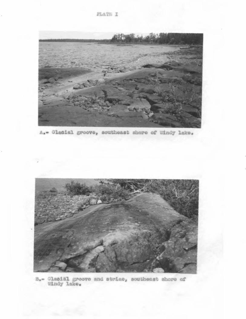
zroovs, southeast lore of .Atr lako*
nsoldi groove and strIse, soutbeastshw.,v of Andy lako#
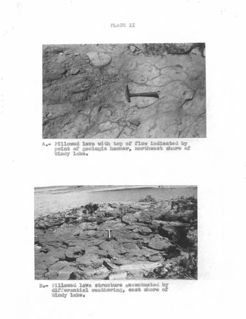
;Jillowed laws with of flew irtwy01 point of geologic: hammer, northwest sh o~
windy lake*
*«► ,,~~~ ##~.1~#,~c10'srau 3,(~~~rl~y~~a~~l
~~at~{r. i,i : tU~.yO differential wv°iLher i oas
Andy lefts*
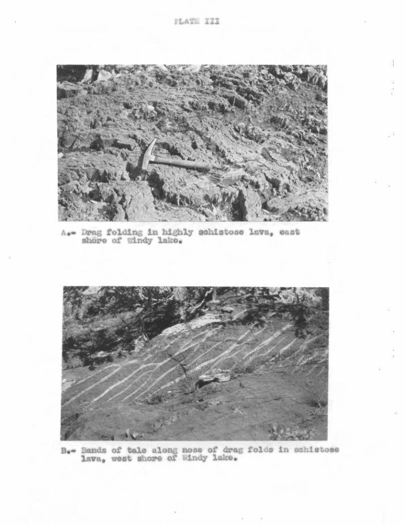
FLATL III
Jrai; folding Lu 1118hly sabligtoao lava, e shore of Andy lao.
3ands or tale a1on6 mse of drag toiz InOCh laVap kleSt sore of Andy lake,*

agmzlamearate, 1'nand „ Note quarts veiac t
'.neweraired .:l,ï.van'4-;.ry
ta; alzorw Caopa Una lake~
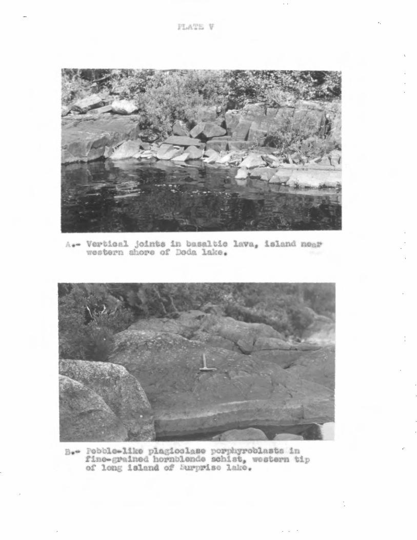
,c
f*,7 4, I
Vertaoal /oints In basaltic lava, island no western Shore of Doda lake.
.# plazioclase porphyroblasts in finomWelned hornblende schist western tip Of long Island of :urpriso lake.
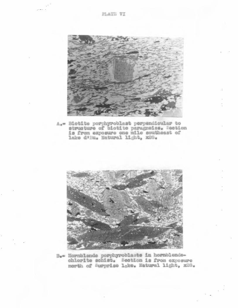
iLA;, VI
A,- Biotite perrStyrobl_st perpendicular to struoture of bletito paragnsiss. .eotion ls tram exposure ono rile southeast or lake do_u• Natural lijAsi '42U.
a Hornblende parOhyroblaate In hornblende. chlorite schiet• beetion is tram exposure
of borprise 1ko. atural light, x284