Sequence stratigraphic analysis of Cenomanian greenhouse palaeosols: A case study from southern...
17
This article appeared in a journal published by Elsevier. The attached copy is furnished to the author for internal non-commercial research and education use, including for instruction at the authors institution and sharing with colleagues. Other uses, including reproduction and distribution, or selling or licensing copies, or posting to personal, institutional or third party websites are prohibited. In most cases authors are permitted to post their version of the article (e.g. in Word or Tex form) to their personal website or institutional repository. Authors requiring further information regarding Elsevier’s archiving and manuscript policies are encouraged to visit: http://www.elsevier.com/copyright
Transcript of Sequence stratigraphic analysis of Cenomanian greenhouse palaeosols: A case study from southern...
This article appeared in a journal published by Elsevier. The attachedcopy is furnished to the author for internal non-commercial researchand education use, including for instruction at the authors institution
and sharing with colleagues.
Other uses, including reproduction and distribution, or selling orlicensing copies, or posting to personal, institutional or third party
websites are prohibited.
In most cases authors are permitted to post their version of thearticle (e.g. in Word or Tex form) to their personal website orinstitutional repository. Authors requiring further information
regarding Elsevier’s archiving and manuscript policies areencouraged to visit:
http://www.elsevier.com/copyright
Author's personal copy
Sequence stratigraphic analysis of Cenomanian greenhouse palaeosols: A case studyfrom southern Patagonia, Argentina
Augusto N. Varela ⁎, Gonzalo D. Veiga, Daniel G. PoiréCentro de Investigaciones Geológicas, Universidad Nacional de La Plata - CONICET, Calle 1 N° 644 (B1900FWA) La Plata, Argentina
a b s t r a c ta r t i c l e i n f o
Article history:Received 14 November 2011Received in revised form 24 May 2012Accepted 13 June 2012Available online 23 June 2012
Editor: J. Knight
Keywords:Cenomanian greenhousePalaeosolsSequence stratigraphic modelAllocyclic and autocyclic controlsAustral Basin
The aim of this contribution is to analyse extrinsic (i.e., tectonics, climate and eustasy) and intrinsic (i.e., pal-aeotopography, palaeodrainage and relative sedimentation rates) factors that controlled palaeosol developmentin the Cenomanian Mata Amarilla Formation (Austral foreland basin, southwestern Patagonia, Argentina). De-tailed sedimentological logs, facies analysis, pedofeatures and palaeosol horizon identification led to the defini-tion of six pedotypes, which represent Histosols, acid sulphate Histosols, Vertisols, hydromorphic Vertisols,Inceptisols and vertic Alfisols.Small- and large-scale changes in palaeosol development were recognised throughout the units. Small-scale orhigh-frequency variations, identified within the middle section are represented by the lateral and vertical su-perimposition of Inceptisols, Vertisols and hydromorphic Vertisols. Lateral changes are interpreted as the resultof intrinsic factors to the depositional systems, such as the relative position within the floodplain and the dis-tance from the main channels, that condition the nature of parent material, the sedimentation rate and eventu-ally the palaeotopographic position. Vertical stacking of different soil types is linked to avulsion processes andthe relatively abrupt change in the distance to main channels as the system aggraded.The large-scale or low-frequency vertical variations in palaeosol type occurring in the Mata Amarilla Formationare related to long-term changes in depositional environments. The lower and upper sections of the studied logsare characterised by Histosols and acid sulphate Histosols, and few hydromorphic Vertisols associated with low-gradient coastal environments (i.e., lagoons, estuaries and distal fluvial systems). At the lower boundary of themiddle section, a thick palaeosol succession composed of vertic Alfisols occurs. The rest of the middle section ischaracterised by Vertisols, hydromorphic Vertisols and Inceptisols occurring on distal and proximal fluvialfloodplains, respectively.The palaeosol succession for the Mata Amarilla Formation can be analysed within a sequence stratigraphicscheme considering changes in depositional environments in relation to accommodation/supply conditions.The results contrast with classical models, mainly in that the palaeosols of the Mata Amarilla Formation are rel-atively well-developed throughout thewhole sequence, including transgressive periods of relatively high aggra-dation rate. Also, even when during regressive episodes, when a thick palaeosol succession that marks thesequence boundary is developed in the classical models, the lack of incised valleys in this succession led tothe preservation of thick palaeosol successions during lowstand conditions. The vertical and lateral palaeosoldistribution identified in the Mata Amarilla Formation could be eventually extrapolated to other sequences de-posited during climate optimums.
© 2012 Elsevier B.V. All rights reserved.
1. Introduction
Palaeosols or fossil soils are the remains of ancient soils that mayhave been buried by subsequent deposits, or exposed over long time in-tervals without any pedogenic activity (Retallack, 2001). These soils aregenerally not in equilibrium with the present soil-forming factors, thatis, they are soils which developed under conditions which differ fromthe ones now prevailing. Soil formation always depends on five‘soil-forming factors’, namely, (1) parent material, (2) climate, (3)
topographic relief, (4) organisms and (5) time (Jenny, 1941; Leckieet al., 1989; Retallack, 2001) and therefore the precise definition ofpalaeosol features may provide important information on the condi-tions prevailing during the accumulation of ancient sequences. Itshould be noted that soil-forming factors do not act separately but si-multaneously. Thus, none of the factors is individually responsiblefor the characteristics of the soil, as it is the combined influence ofall of them that determines the formation of a certain soil type.
TheMata Amarilla Formation is one of themost representative unitsof the early Upper Cretaceous of the Austral Basin, southwest Patagonia,Argentina. In this unit, successions of up to nearly 300 m of stackedpalaeosols have been recorded (Varela, 2011). The excellent quality of
Sedimentary Geology 271-272 (2012) 67–82
⁎ Corresponding author.E-mail address: [email protected] (A.N. Varela).
0037-0738/$ – see front matter © 2012 Elsevier B.V. All rights reserved.doi:10.1016/j.sedgeo.2012.06.006
Contents lists available at SciVerse ScienceDirect
Sedimentary Geology
j ourna l homepage: www.e lsev ie r .com/ locate /sedgeo
Author's personal copy
the outcrops and the absence of an important degree of diagenesis madeit possible to study both lateral and vertical palaeosol variations, as wellas their palaeoenvironmental correlation and relationshipswithin the se-quence stratigraphic framework. Various authors have highlighted theimportance of palaeosols in the definition of sequence stratigraphic ex-amples, both theoretically (Wright and Marriott, 1993) and in the rockrecord (Aitken and Flint, 1996; McCarthy and Plint, 1998; McCarthy etal., 1999, among other authors). More recently the contributions onpalaeosols have focused mainly on descriptive and genetic studies(Wright et al., 2000; Kraus and Hasiotis, 2006; Kraus and Riggins, 2007;Krause et al., 2010) or on the application of classical sequence stratigraph-ic models (Mack et al., 2010).
In general terms, the palaeosols of the Mata Amarilla Formation dis-play characteristics of hydromorphic soils and they can be classified asGleysols or gley soils according to the classification by Mack et al.(1993). This name refers to their typical grey, greenish-grey to olivegreen colouration, caused by the reduced state of the iron oxides. De-spite the fact that the outcrops of the Mata Amarilla Formation are lo-cated at 50° S latitude, these palaeosols display characteristics whichare compatible with warm temperate climates. This is consistent withthe beginning of the Cenomanian greenhouse period, which lastedthroughout the Upper Cretaceous and most of the Palaeogene (Royer,2010). The Cenomanian is an important period in the evolution of veg-etation in South America, as a floral change from mesophytic groups tofloras dominated by angiosperms occurred at this time (Iglesias et al.,2007, 2009).
The aim of this contribution is to study the relative influence ofextrinsic (i.e., tectonics, climate and eustasy) and intrinsic (i.e., pal-aeotopography, palaeodrainage and relative sedimentation rate)factors in the development of the early Upper Cretaceous palaeosolsin southern Patagonia on the basis of the description and interpreta-tion of macroscopic and microscopic pedogenic features. Thus, thespatial distribution of palaeosols, both lateral and vertical, is inter-preted in terms of the predominance of autocyclic and allocyclic fac-tors that controlled the sedimentation and pedogenesis. Moreover,the implications of the results obtained in the study of the MataAmarilla Formation are discussed, especially those concerning the
development of a model of palaeosol evolution within a sequencestratigraphic context during climate optimum conditions.
2. Geological setting
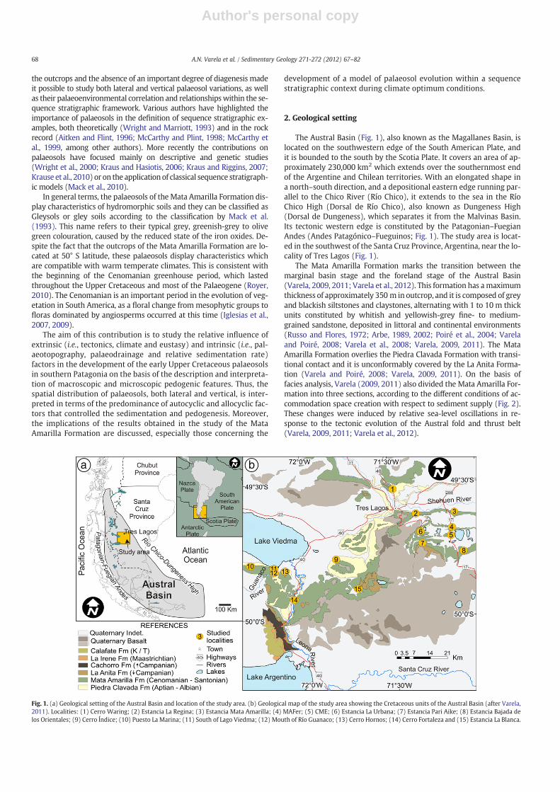
The Austral Basin (Fig. 1), also known as the Magallanes Basin, islocated on the southwestern edge of the South American Plate, andit is bounded to the south by the Scotia Plate. It covers an area of ap-proximately 230,000 km2 which extends over the southernmost endof the Argentine and Chilean territories. With an elongated shape ina north–south direction, and a depositional eastern edge running par-allel to the Chico River (Río Chico), it extends to the sea in the RíoChico High (Dorsal de Río Chico), also known as Dungeness High(Dorsal de Dungeness), which separates it from the Malvinas Basin.Its tectonic western edge is constituted by the Patagonian–FuegianAndes (Andes Patagónico–Fueguinos; Fig. 1). The study area is locat-ed in the southwest of the Santa Cruz Province, Argentina, near the lo-cality of Tres Lagos (Fig. 1).
The Mata Amarilla Formation marks the transition between themarginal basin stage and the foreland stage of the Austral Basin(Varela, 2009, 2011; Varela et al., 2012). This formation has amaximumthickness of approximately 350 m in outcrop, and it is composed of greyand blackish siltstones and claystones, alternating with 1 to 10 m thickunits constituted by whitish and yellowish-grey fine- to medium-grained sandstone, deposited in littoral and continental environments(Russo and Flores, 1972; Arbe, 1989, 2002; Poiré et al., 2004; Varelaand Poiré, 2008; Varela et al., 2008; Varela, 2009, 2011). The MataAmarilla Formation overlies the Piedra Clavada Formation with transi-tional contact and it is unconformably covered by the La Anita Forma-tion (Varela and Poiré, 2008; Varela, 2009, 2011). On the basis offacies analysis, Varela (2009, 2011) also divided the Mata Amarilla For-mation into three sections, according to the different conditions of ac-commodation space creation with respect to sediment supply (Fig. 2).These changes were induced by relative sea-level oscillations in re-sponse to the tectonic evolution of the Austral fold and thrust belt(Varela, 2009, 2011; Varela et al., 2012).
Fig. 1. (a) Geological setting of the Austral Basin and location of the study area. (b) Geological map of the study area showing the Cretaceous units of the Austral Basin (after Varela,2011). Localities: (1) Cerro Waring; (2) Estancia La Regina; (3) Estancia Mata Amarilla; (4) MAFer; (5) CME; (6) Estancia La Urbana; (7) Estancia Pari Aike; (8) Estancia Bajada delos Orientales; (9) Cerro Índice; (10) Puesto La Marina; (11) South of Lago Viedma; (12) Mouth of Río Guanaco; (13) Cerro Hornos; (14) Cerro Fortaleza and (15) Estancia La Blanca.
68 A.N. Varela et al. / Sedimentary Geology 271-272 (2012) 67–82

Author's personal copy
A sedimentological log of the Cerro Waring locality (Fig. 2) showsthat the lower section of the Mata Amarilla Formation consists of fine-grained intervals with palaeosol development interbedded with lam-inated shale and coquinas, corresponding to coastal plain and lagoonpalaeoenvironments (Varela et al., 2011). The middle section of theMata Amarilla Formation is characterised by sandstones and silt-stones, which represent low-sinuosity meandering fluvial channelsand crevasse splay deposits (Varela, 2011), intercalated with fine-grained floodplains, mostly subaerial with palaeosol developmentand subordinate lacustrine deposits (Varela, 2011). The upper sec-tion of the Mata Amarilla Formation is also dominated by fine-grained deposits, which are related to distal fluvial channels. Thepalaeoenvironments correspond, as they do in the lower section,to coastal plain and lagoon settings with high organic matter pres-ervation and palaeosol development (Varela, 2011).
3. Methodology
The Mata Amarilla Formation palaeosols were studied in 15 local-ities (Fig. 1), where the detailed description of pedogenic features andsoil horizons was used to interpret palaeosol development processes(following the criteria described by Retallack, 1988, 1994). Colour ofthe palaeosol matrix, as well as for other features as mottles, nodulesconcretions and cutans was determined using the Munsell colourchart (Munsell® Soil Color Chart, 2000). Field analysis was combinedwith the description of 26 thin sections in which micromorphologi-cal features were identified adopting the terminology suggested byBullock et al. (1985) and Stoops (2001).
The mineralogy of mudstones, mottles, concretions, nodules andrhizoliths was obtained by X-ray diffraction (XRD) analysis. Clay min-eralogy was determined from diffraction patterns obtained usingsamples that were air-dried, ethylene glycol-solvated and heated to550 °C (Brown and Brindley, 1980). The mineralogy of sandstoneswas determined in thin-sections, following Gazzi–Dickinson's meth-od (Ingersoll et al., 1984), in which 400 points were assessed usinga point counter (Varela, 2011).
Pedogenic feature identification (both at meso and microscale),together with the definition of soil horizons, allowed the identifica-tion of pedotypes that were interpreted and classified following themost widely used system in pedology (Soil Taxonomy: Soil SurveyStaff, 1998). Palaeosol analysis of the Mata Amarilla Formation wasalso combined with palaeoenvironmental studies available for thesesections obtained through detailed facies and architectural elementanalysis (Varela, 2011).
The excellent 3D exposures of the Mata Amarilla Formation in thestudy area allowed a detailed analysis of the lateral and vertical rela-tionships of the identified pedotypes. Photomosaics of selected out-crops were obtained in order to map the lateral changes betweenpedotypes. Vertical changes between different types of palaeosolswere also recorded at two different scales, through sedimentarylogs of the whole unit and detailed vertical logs of selected intervalsin order to capture high-frequency vertical changes in differentpedotypes.
4. The Mata Amarilla Formation pedotypes
The description of themacro- andmicromorphological pedofeatures,together with the differentiation of soil horizons served as the basis forthe identification of six different pedotypes for theMata Amarilla Forma-tion in the study area (Pedotypes 1 to 6; Fig. 3). These pedotypes wereclassified according to present-day soil classifications (Soil Taxonomy:Soil Survey Staff, 1975, 1998) as suggested by Retallack (1993, 2001)in order to stimulate the comparison between present-day soils andpalaeosol studies.
Fig. 2. Sedimentological section of theMata Amarilla Formation at CerroWaring, showingvertical distribution of sedimentary facies.
69A.N. Varela et al. / Sedimentary Geology 271-272 (2012) 67–82

Author's personal copy
4.1. Pedotype 1
Pedotype 1 is found in the lower and upper sections of the MataAmarilla Formation. This type of palaeosols is characterised by abun-dant pedogenic features such as mottles, slickensides and rhizoliths.There are two types of mottles in Pedotype 1: purplish-blue mottles(10B 3–2.5/1 and 5PB 3–2.5/1), which indicate iron oxides in a ferrousstate and abundant organic matter; and dark grey to black mottles(N 2.5/0), corresponding to minute carbonaceous remains dissemi-nated throughout the palaeosol matrix. Slickensides are generallyabundant and they are covered by cutans composed of organic mat-ter, manganese oxides (mangans) and clays (argillans). Rhizoliths in
Pedotype1 include greenish-grey rhizoliths and fossil roots preserved ascarbonaceous material. Greenish-grey rhizoliths are 10 to 60 cm inlength, and generally have amain axis with radiating lateral or adventi-tious rhizoliths (taproots). Fossil roots preserved as carbonaceousmate-rial perfectly preserve all the characteristics of the root, even theoriginal plant tissue (Fig. 4c). Disseminated organic remains are com-mon in these pedotypes; they have equidimensional to elongate shapesand are dark to black in colour. Less frequently, verywell-preserved car-bonised tissue fragments (~1.5 mm in length) are present, in whicheven the original cell walls can be distinguished (Fig. 4d).
Pedotype 1 shows the palaeosol profiles with O–A–Bg succes-sions (Fig. 3), and occurs in isolation (simple Pedotype 1) or stacked
Fig.3. Different pedotypes identified in the Mata Amarilla Formation. For location see Fig. 1.
70 A.N. Varela et al. / Sedimentary Geology 271-272 (2012) 67–82

Author's personal copy
Pedotype 1 (Fig. 3). They are characterised by an O histic epipedon(N 3/0; N 3/0 and10G 2.5/1) composed of abundant carbonisedplant fragments. The thickness of O horizons ranges between 5 and20 cm and they are transitional to an A horizon (10Y 3/1–2.5/1)with relatively less organic matter content and variable thickness(Fig. 4a). Gley-coloured subhorizons (Bg) are generally present,with low chromas (10GY 5/1 to N 5/0) and thicknesses rangingfrom 80 to 160 cm. This Bg horizon is usually characterised by thepresence of mottles (both types identified), cutans and slickensides.Fossil roots are restricted to A horizon, whereas greenish-greyrhizoliths appear in both A and Bg horizons.
4.1.1. ClassificationThe presence of the histic epipedons, abundant well-preserved car-
bonised plant fragments, and fossil roots preserved as carbonaceousmaterial, as well as purplish-blue and dark grey to black mottles allowsclassifying the Pedotype 1 soil as a Histosols (Soil Survey Staff, 1975,1998; Retallack, 1993, 2001). Histosols usually occur in topographicallylow areas, with very poor drainage conditions. The high degree of pres-ervation of organic matter in this pedotype could indicate rapid burialor anoxic conditions (McCabe and Parrish, 1992). Accordingly, the pres-ence of carbonaceous fossil roots is generally associated with hydro-morphic palaeosols (McSweeney and Fastovsky, 1987; McCarthy et al.,1998).
4.2. Pedotype 2
Pedotype 2 is found only in the lower and upper sections of theMata Amarilla Formation and shows similar pedogenic features asPedotype1 such as abundant well-preserved carbonised plant frag-ments, fossil roots preserved as carbonaceous material, as well aspurplish-blue and dark grey to black mottles. However, this pedotypeis characterised by a profusion of mottles and rhizocretions preserved
in jarosite, which are characteristically orange in colour (10YR 8/6and 7/6), similar to the ones described by Kraus (1998). Most jarositerhizoliths are taproots with variable shapes and sizes, both long thinroots and short thick ones (Fig. 4b). Horizons with abundant mottlesand rhizocretions preserved in jarosite were referred to as Gr hori-zons by Kraus (1998; Fig. 3), although sometimes the differentiationfrom O horizons is very difficult because both have abundant car-bonised fragments and dark colour (N 3/0; N 3/0 and10G 2.5/1).In terms of horizon development this pedotype is characterised byO–Gr–Bg or Gr–Bg profiles.
4.2.1. ClassificationThe profusion of pedogenic features preserved in jarosite in
Pedotype 2 palaesols indicates characteristics of acid soils and they arecalled ‘potential acid sulphate soils’, following the criteria of Brinkmanand Pons (1973) and Kraus (1998). Jarosite [KFe3(OH)6(SO4)2] is usual-ly formed frompyritewhen the soil drainage conditionsmakeoxidationpossible, which leads to an increase in soil acidity (Miedemaet al., 1974;Van Breeman, 1982; Kraus, 1998). The presence of jarosite confirmsthat the palaeosols have been flooded or waterlogged almost thewhole year, causing permanent reducing conditions with organic mat-ter preservation, iron reduction and pyrite precipitation. Yet, a high con-centration of sulphates is necessary for pyrite precipitation to occur,which is why this type of poorly drained soils is typical of coastalareas and estuaries (Miedema et al., 1974; Van Breeman, 1975). Inshort, Pedotype 2 palaeosols are classified as Histosols with potentialacid sulphate properties. Histosols with potential acid sulphate proper-ties are usually related to very low-gradient, topographically low areaswith very poor drainage conditions and they appear in the MataAmarilla Formation in successions associatedwith distal fluvial systemsor the upper reaches of lagoon and estuarine environments (Varela,2011).
Fig. 4. Macroscopic and microscopic features of Pedotypes 1 and 2. (a) Simple Pedotype 1 at Cerro Fortaleza. Person is 1.80 m tall. (b) Jarosite rhizoliths from a Gr horizon ofPedotype 2. Coin is 2.4 cm in diameter. (c) Root traces preserved as carbonaceous material, produced by the anoxic environment resulting from a high water table. Pen is14.5 cm long. (d) Microscopic view of vegetable remains in A horizon, even plant cells (white arrow) can be distinguished.
71A.N. Varela et al. / Sedimentary Geology 271-272 (2012) 67–82

Author's personal copy
4.3. Pedotype 3
This pedotype is one of themost abundant palaeosol types in theMataAmarilla Formation and it is widely represented throughout the wholeunit. It is characterised by a homogenisation of the soil profile due to pe-dogenesis and the most typical morphological features are slickensides(Fig. 5b) and microslickensides (Fig. 5c). The horizons with a profusionof friction structures (e.g., Ass and Bss) are characterised by the develop-ment of angular peds (Fig. 5b). Rhizoliths associated with this pedotypeare of two types: yellowish rhizoliths (7.5YR–10YR), composed of goe-thite and in a smaller proportion hematite; and greenish-grey rhizoliths(5GY; 10GY; 5G at value of 4–5/1), in which the iron oxides are in a fer-rous state (Fe2+; Fig. 5d). Both rhizolith types can be observed as rootcasts (i.e., sediment-and/or cement-filled root moulds), rhizotubules,rhizocretions and/or rhizohaloes. Some horizons show mottles whichare yellowish to brownish (7.5YR–10YR) and bluish grey in colour (10B
4–6/1 and 5PB 4–6/1), disseminated in a greenish grey matrix with lowchromas (5GY, 10GY, 5G and 10G), together with some iron and manga-nese concretions and nodules. The nodules are yellowish to dark brown(7.5YR 6/6 up to 7.5YR 5/8), between 0.5 and 20 mm in diameter, andcomposed of smectite, quartz and iron oxides, as well as small quantitiesof calcite and siderite (Fig. 5e).
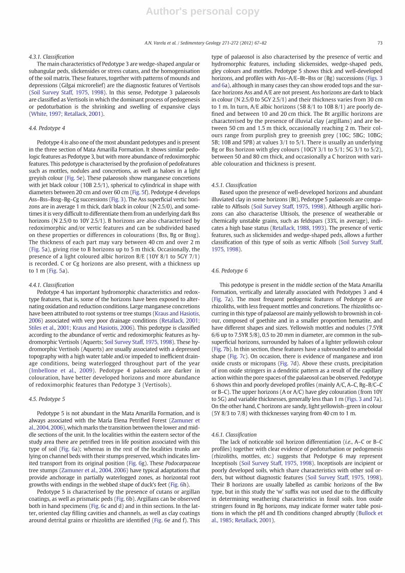
Pedotype 3 most commonly shows an Ass–Bssg–Bssg–Cg profile(Fig. 3). The Ass superficial vertic horizons are in average 1 m thick,dark in colour (10Y 2.5/1; 5GY 2.5/1), and occasionally –when thepalaeosol tops are eroded– they may be absent. B horizons (10GY6/1 to 5G 5/1) can be subdivided in up to six parts with different col-ours or properties (Bss, Bg or Bssg). The thickness of each part mayvary between 40 cm and over 1.5 m (Fig. 5a). C or Cg horizons areusually present, with a thickness between 60 cm and over 1 m, ex-cept in the case of cumulate soils in which these C horizons are ab-sent (Fig. 5a).
Fig. 5. Macroscopic andmicroscopic features of Pedotypes 3 and 4. (a) Stacked Pedotypes 3 and 4 at CerroWaring.White arrows show the top of each palaeosol profile. Person is 1.75 mtall. (b) Slickensides and angular peds, produced by the shrinking and swelling of smectites during alternating episodes of soil wetting and drying. Hammer is 33 cm long. (c) Photomi-crograph ofmicro-slickensideswith polarised light. The A-axis of the clasts is oriented in two directions forming an angle of ~45°. (d) Gley root trace in a Bssg horizon. Coin is 2.4 cm longin diameter. (e) Iron nodules surrounded by grey haloes (i.e., iron depletion zones) (white arrows). Coin is 2.4 cm long in diameter. (f) Manganese–iron concretion from Bssg horizon ofPedotype 4 at Estancia Mata Amarilla. Hammer is 50 cm long.
72 A.N. Varela et al. / Sedimentary Geology 271-272 (2012) 67–82
Author's personal copy
4.3.1. ClassificationThemain characteristics of Pedotype 3 arewedge-shaped angular or
subangular peds, slickensides or stress cutans, and the homogenisationof the soil matrix. These features, together with patterns of mounds anddepressions (Gilgai microrelief) are the diagnostic features of Vertisols(Soil Survey Staff, 1975, 1998). In this sense, Pedotype 3 palaeosolsare classified as Vertisols in which the dominant process of pedogenesisor pedoturbation is the shrinking and swelling of expansive clays(White, 1997; Retallack, 2001).
4.4. Pedotype 4
Pedotype 4 is also one of themost abundant pedotypes and is presentin the three section of Mata Amarilla Formation. It shows similar pedo-logic features as Pedotype 3, butwithmore abundance of redoximorphicfeatures. This pedotype is characterised by the profusion of pedofeaturessuch as mottles, nodules and concretions, as well as haloes in a lightgreyish colour (Fig. 5e). These palaeosols show manganese concretionswith jet black colour (10B 2.5/1), spherical to cylindrical in shape withdiameters between 20 cm and over 60 cm (Fig. 5f). Pedotype 4 developsAss–Bss–Bssg–Bg–Cg successions (Fig. 3). The Ass superficial vertic hori-zons are in average 1 m thick, dark black in colour (N 2.5/0), and some-times it is very difficult to differentiate them fromanunderlying dark Bsshorizons (N 2.5/0 to 10Y 2.5/1). B horizons are also characterised byredoximorphic and/or vertic features and can be subdivided basedon these properties or differences in colourations (Bss, Bg or Bssg).The thickness of each part may vary between 40 cm and over 2 m(Fig. 5a), giving rise to B horizons up to 5 m thick. Occasionally, thepresence of a light coloured albic horizon B/E (10Y 8/1 to 5GY 7/1)is recorded. C or Cg horizons are also present, with a thickness upto 1 m (Fig. 5a).
4.4.1. ClassificationPedotype 4 has important hydromorphic characteristics and redox-
type features, that is, some of the horizons have been exposed to alter-nating oxidation and reduction conditions. Largemanganese concretionshave been attributed to root systems or tree stumps (Kraus and Hasiotis,2006) associated with very poor drainage conditions (Retallack, 2001;Stiles et al., 2001; Kraus and Hasiotis, 2006). This pedotype is classifiedaccording to the abundance of vertic and redoximorphic features as hy-dromorphic Vertisols (Aquerts; Soil Survey Staff, 1975, 1998). These hy-dromorphic Vertisols (Aquerts) are usually associated with a depressedtopography with a high water table and/or impeded to inefficient drain-age conditions, being waterlogged throughout part of the year(Imbellone et al., 2009). Pedotype 4 palaeosols are darker incolouration, have better developed horizons and more abundanceof redoximorphic features than Pedotype 3 (Vertisols).
4.5. Pedotype 5
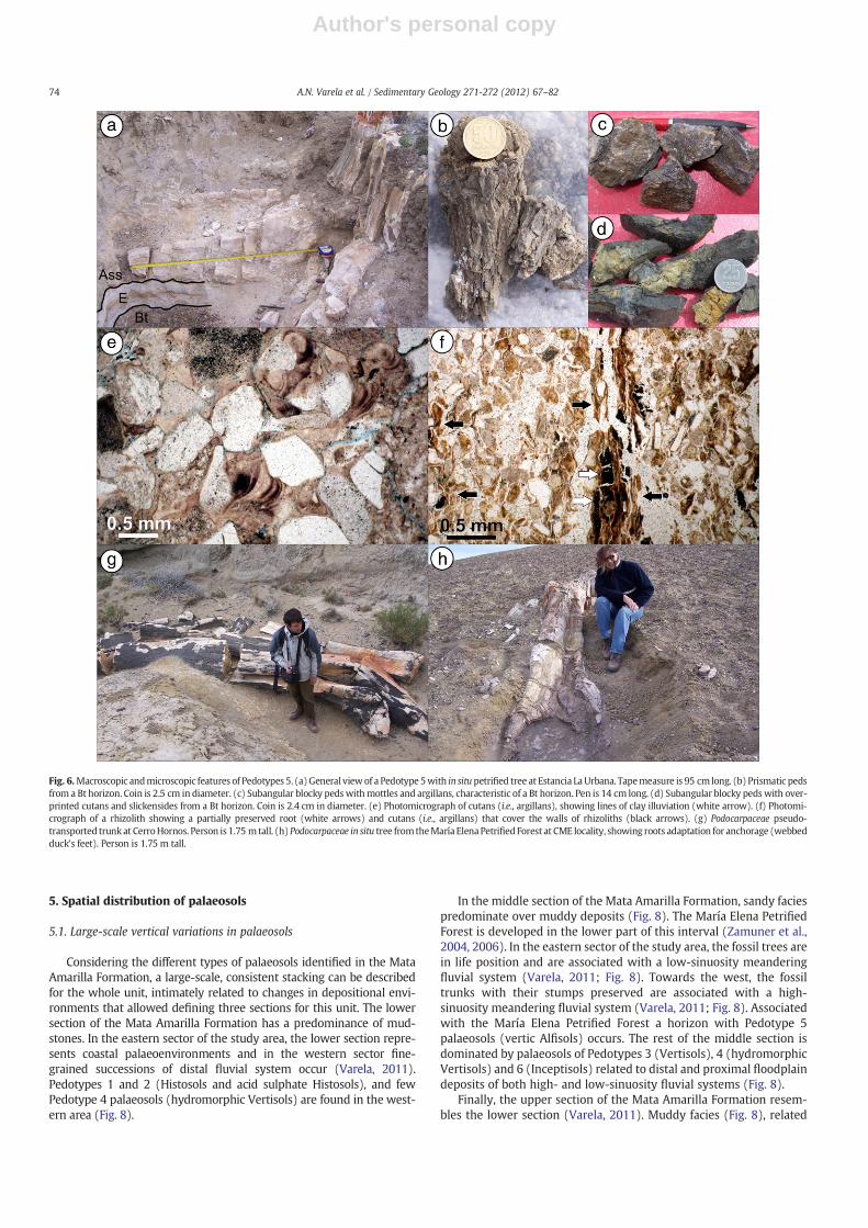
Pedotype 5 is not abundant in the Mata Amarilla Formation, and isalways associated with the María Elena Petrified Forest (Zamuner etal., 2004, 2006),whichmarks the transition between the lower andmid-dle sections of the unit. In the localities within the eastern sector of thestudy area there are petrified trees in life position associated with thistype of soil (Fig. 6a); whereas in the rest of the localities trunks arelying on channel bedswith their stumps preserved,which indicates lim-ited transport from its original position (Fig. 6g). These Podocarpaceaetree stumps (Zamuner et al., 2004, 2006) have typical adaptations thatprovide anchorage in partially waterlogged zones, as horizontal rootgrowths with endings in the webbed shape of duck's feet (Fig. 6h).
Pedotype 5 is characterised by the presence of cutans or argillancoatings, as well as prismatic peds (Fig. 6b). Argillans can be observedboth in hand specimens (Fig. 6c and d) and in thin sections. In the lat-ter, oriented clay filling cavities and channels, as well as clay coatingsaround detrital grains or rhizoliths are identified (Fig. 6e and f). This
type of palaeosol is also characterised by the presence of vertic andhydromorphic features, including slickensides, wedge-shaped peds,gley colours and mottles. Pedotype 5 shows thick and well-developedhorizons, and profiles with Ass–A/E–Bt–Bss or (Bg) successions (Figs. 3and 6a), although inmany cases they can show eroded tops and the sur-face horizons Ass and A/E are not present. Ass horizons are dark to blackin colour (N 2.5/0 to 5GY 2.5/1) and their thickness varies from 30 cmto 1 m. In turn, A/E albic horizons (5B 8/1 to 10B 8/1) are poorly de-fined and between 10 and 20 cm thick. The Bt argillic horizons arecharacterised by the presence of illuvial clay (argillans) and are be-tween 50 cm and 1.5 m thick, occasionally reaching 2 m. Their col-ours range from purplish grey to greenish grey (10G; 5BG; 10BG;5B; 10B and 5PB) at values 3/1 to 5/1. There is usually an underlyingBg or Bss horizon with gley colours (10GY 3/1 to 5/1; 5G 3/1 to 5/2),between 50 and 80 cm thick, and occasionally a C horizon with vari-able colouration and thickness is present.
4.5.1. ClassificationBased upon the presence of well-developed horizons and abundant
illuviated clay in some horizons (Bt), Pedotype 5 palaeosols are compa-rable to Alfisols (Soil Survey Staff, 1975, 1998). Although argillic hori-zons can also characterise Ultisols, the presence of weatherable orchemically unstable grains, such as feldspars (33%, in average), indi-cates a high base status (Retallack, 1988, 1993). The presence of verticfeatures, such as slickensides and wedge-shaped peds, allows a furtherclassification of this type of soils as vertic Alfisols (Soil Survey Staff,1975, 1998).
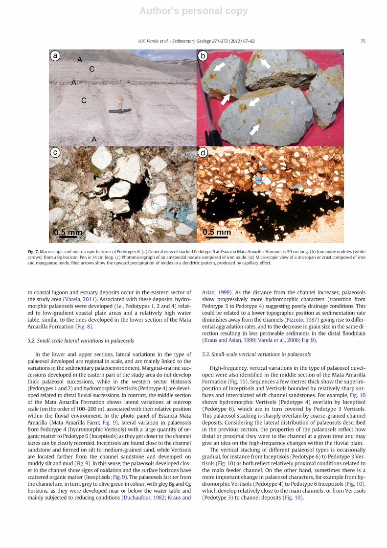
4.6. Pedotype 6
This pedotype is present in the middle section of the Mata AmarillaFormation, vertically and laterally associated with Pedotypes 3 and 4(Fig. 7a). The most frequent pedogenic features of Pedotype 6 arerhizoliths, with less frequentmottles and concretions. The rhizoliths oc-curring in this type of palaeosol aremainly yellowish to brownish in col-our, composed of goethite and in a smaller proportion hematite, andhave different shapes and sizes. Yellowish mottles and nodules (7.5YR6/6 up to 7.5YR 5/8), 0.5 to 20 mm in diameter, are common in the sub-superficial horizons, surrounded by haloes of a lighter yellowish colour(Fig. 7b). In thin section, these features have a subrounded to ameboidalshape (Fig. 7c). On occasion, there is evidence of manganese and ironoxide crusts or micropans (Fig. 7d). Above these crusts, precipitationof iron oxide stringers in a dendritic pattern as a result of the capillaryactionwithin thepore spaces of the palaeosol canbe observed. Pedotype6 shows thin and poorly developed profiles (mainly A/C, A–C, Bg–B/C–Cor B–C). The upper horizons (A or A/C) have gley colouration (from 10Yto 5G) and variable thicknesses, generally less than 1 m (Figs. 3 and 7a).On the other hand, C horizons are sandy, light yellowish–green in colour(5Y 8/3 to 7/8) with thicknesses varying from 40 cm to 1 m.
4.6.1. ClassificationThe lack of noticeable soil horizon differentiation (i.e., A–C or B–C
profiles) together with clear evidence of pedoturbation or pedogenesis(rhizoliths, mottles, etc.) suggests that Pedotype 6 may representInceptisols (Soil Survey Staff, 1975, 1998). Inceptisols are incipient orpoorly developed soils, which share characteristics with other soil or-ders, but without diagnostic features (Soil Survey Staff, 1975, 1998).Their B horizons are usually labelled as cambic horizons of the Bwtype, but in this study the ‘w’ suffix was not used due to the difficultyin determining weathering characteristics in fossil soils. Iron oxidestringers found in Bg horizons, may indicate former water table posi-tions in which the pH and Eh conditions changed abruptly (Bullock etal., 1985; Retallack, 2001).
73A.N. Varela et al. / Sedimentary Geology 271-272 (2012) 67–82
Author's personal copy
5. Spatial distribution of palaeosols
5.1. Large-scale vertical variations in palaeosols
Considering the different types of palaeosols identified in the MataAmarilla Formation, a large-scale, consistent stacking can be describedfor the whole unit, intimately related to changes in depositional envi-ronments that allowed defining three sections for this unit. The lowersection of the Mata Amarilla Formation has a predominance of mud-stones. In the eastern sector of the study area, the lower section repre-sents coastal palaeoenvironments and in the western sector fine-grained successions of distal fluvial system occur (Varela, 2011).Pedotypes 1 and 2 (Histosols and acid sulphate Histosols), and fewPedotype 4 palaeosols (hydromorphic Vertisols) are found in the west-ern area (Fig. 8).
In the middle section of the Mata Amarilla Formation, sandy faciespredominate over muddy deposits (Fig. 8). The María Elena PetrifiedForest is developed in the lower part of this interval (Zamuner et al.,2004, 2006). In the eastern sector of the study area, the fossil trees arein life position and are associated with a low-sinuosity meanderingfluvial system (Varela, 2011; Fig. 8). Towards the west, the fossiltrunks with their stumps preserved are associated with a high-sinuosity meandering fluvial system (Varela, 2011; Fig. 8). Associatedwith the María Elena Petrified Forest a horizon with Pedotype 5palaeosols (vertic Alfisols) occurs. The rest of the middle section isdominated by palaeosols of Pedotypes 3 (Vertisols), 4 (hydromorphicVertisols) and 6 (Inceptisols) related to distal and proximal floodplaindeposits of both high- and low-sinuosity fluvial systems (Fig. 8).
Finally, the upper section of the Mata Amarilla Formation resem-bles the lower section (Varela, 2011). Muddy facies (Fig. 8), related
Fig. 6.Macroscopic andmicroscopic features of Pedotypes 5. (a)General viewof a Pedotype 5with in situpetrified tree at Estancia LaUrbana. Tapemeasure is 95 cm long. (b) Prismatic pedsfrom a Bt horizon. Coin is 2.5 cm in diameter. (c) Subangular blocky pedswithmottles and argillans, characteristic of a Bt horizon. Pen is 14 cm long. (d) Subangular blocky pedswith over-printed cutans and slickensides from a Bt horizon. Coin is 2.4 cm in diameter. (e) Photomicrograph of cutans (i.e., argillans), showing lines of clay illuviation (white arrow). (f) Photomi-crograph of a rhizolith showing a partially preserved root (white arrows) and cutans (i.e., argillans) that cover the walls of rhizoliths (black arrows). (g) Podocarpaceae pseudo-transported trunk at CerroHornos. Person is 1.75 m tall. (h)Podocarpaceae in situ tree fromtheMaría ElenaPetrified Forest at CME locality, showing roots adaptation for anchorage (webbedduck's feet). Person is 1.75 m tall.
74 A.N. Varela et al. / Sedimentary Geology 271-272 (2012) 67–82
Author's personal copy
to coastal lagoon and estuary deposits occur in the eastern sector ofthe study area (Varela, 2011). Associated with these deposits, hydro-morphic palaeosols were developed (i.e., Pedotypes 1, 2 and 4) relat-ed to low-gradient coastal plain areas and a relatively high watertable, similar to the ones developed in the lower section of the MataAmarilla Formation (Fig. 8).
5.2. Small-scale lateral variations in palaeosols
In the lower and upper sections, lateral variations in the type ofpalaeosol developed are regional in scale, and are mainly linked to thevariations in the sedimentary palaeoenvironment. Marginal-marine suc-cessions developed in the eastern part of the study area do not developthick palaeosol successions, while in the western sector Histosols(Pedotypes 1 and 2) andhydromorphic Vertisols (Pedotype 4) are devel-oped related to distal fluvial successions. In contrast, the middle sectionof the Mata Amarilla Formation shows lateral variations at outcropscale (on the order of 100–200 m), associatedwith their relative positionwithin the fluvial environment. In the photo panel of Estancia MataAmarilla (Mata Amarilla Farm; Fig. 9), lateral variation in palaeosolsfrom Pedotype 4 (hydromorphic Vertisols) with a large quantity of or-ganicmatter to Pedotype 6 (Inceptisols) as they get closer to the channelfacies can be clearly recorded. Inceptisols are found close to the channelsandstone and formed on silt to medium-grained sand, while Vertisolsare located farther from the channel sandstone and developed onmuddy silt andmud (Fig. 9). In this sense, the palaeosols developed clos-er to the channel show signs of oxidation and the surface horizons havescattered organicmatter (Inceptisols; Fig. 9). The palaeosols farther fromthe channel are, in turn, grey to olive green in colour, with gley Bg and Cghorizons, as they were developed near or below the water table andmainly subjected to reducing conditions (Duchaufour, 1982; Kraus and
Aslan, 1999). As the distance from the channel increases, palaeosolsshow progressively more hydromorphic characters (transition fromPedotype 3 to Pedotype 4) suggesting poorly drainage conditions. Thiscould be related to a lower topographic position as sedimentation ratediminishes away from the channels (Pizzuto, 1987) giving rise to differ-ential aggradation rates, and to the decrease in grain size in the same di-rection resulting in less permeable sediments in the distal floodplain(Kraus and Aslan, 1999; Varela et al., 2006; Fig. 9).
5.3. Small-scale vertical variations in palaeosols
High-frequency, vertical variations in the type of palaeosol devel-oped were also identified in the middle section of the Mata AmarillaFormation (Fig. 10). Sequences a few metres thick show the superim-position of Inceptisols and Vertisols bounded by relatively sharp sur-faces and intercalated with channel sandstones. For example, Fig. 10shows hydromorphic Vertisols (Pedotype 4) overlain by Inceptisol(Pedotype 6), which are in turn covered by Pedotype 3 Vertisols.This palaeosol stacking is sharply overlain by coarse-grained channeldeposits. Considering the lateral distribution of palaeosols describedin the previous section, the properties of the palaeosols reflect howdistal or proximal they were to the channel at a given time and maygive an idea on the high-frequency changes within the fluvial plain.
The vertical stacking of different palaeosol types is occasionallygradual, for instance from Inceptisols (Pedotype 6) to Pedotype 3 Ver-tisols (Fig. 10) as both reflect relatively proximal conditions related tothe main feeder channel. On the other hand, sometimes there is amore important change in palaeosol characters, for example from hy-dromorphic Vertisols (Pedotype 4) to Pedotype 6 Inceptisols (Fig. 10),which develop relatively close to the main channels; or from Vertisols(Pedotype 3) to channel deposits (Fig. 10).
Fig. 7.Macroscopic and microscopic features of Pedotypes 6. (a) General view of stacked Pedotype 6 at Estancia Mata Amarilla. Hammer is 50 cm long. (b) Iron oxide nodules (whitearrows) from a Bg horizon. Pen is 14 cm long. (c) Photomicrograph of an ameboidal nodule composed of iron oxide. (d) Microscopic view of a micropan or crust composed of ironand manganese oxide. Blue arrows show the upward precipitation of oxides in a dendritic pattern, produced by capillary effect.
75A.N. Varela et al. / Sedimentary Geology 271-272 (2012) 67–82
Author's personal copy
6. Discussion
Alluvial successions with stacked palaeosols commonly show sedi-mentary cycles that form in response to the combination of autocyclicand allocyclic processes (e.g., Bridge, 1984, 2003; Wright and Marriott,1993; Kraus, 1999, 2002; Kraus andAslan, 1999). Cycles of alluvial aggra-dation ranging from tens to hundreds ofmetres thick are typically attrib-uted to allocyclic factors, such as tectonics, eustatic changes, or climatechanges (e.g. Wright and Marriott, 1993; Marriott, 1999; Kraus, 2002;
Blum and Aslan, 2006; Cleveland et al., 2007). On the other hand,small-scale or high-frequency cycles are generally considered a re-sponse to autocyclic processes, such as avulsion or lateral migrationof fluvial channels (Bridge, 1984, 2003; Kraus and Aslan, 1993, 1999;Cleveland et al., 2007). Accordingly, two scales of palaeosol varia-tions were detected in the Mata Amarilla Formation, a small-scaleor high-frequency variation and a large-scale or low-frequency vari-ation, which are discussed below on the basis of the allocyclic and/orautocyclic factors controlling their development.
Fig. 8. (a) Large-scale vertical distribution of pedotypes identified in the Mata Amarilla Formation. The location of channel and splay deposits is also shown. In grey, areas related tomarginal-marine accumulation with no palaeosol development. (b) Panoramic photograph of the Mata Amarilla Formation at Estancia La Blanca showing the large-scale distribu-tion of palaeosols, identified by the different colouration. The lower and upper sections (dark-coloured) are predominantly fine-grained and correspond to coastal environmentsand distal fluvial settings with palaeosol development (mainly Pedotypes 1 and 2). The middle section of the Mata Amarilla Formation (light-coloured) has a higher proportionof sandstone deposits, and is characterised by high- and low-sinuosity meandering fluvial systems, in which Pedotypes 3, 4 and 6 are developed.
76 A.N. Varela et al. / Sedimentary Geology 271-272 (2012) 67–82

Author's personal copy
Fig. 9. Photomosaic of the middle section of the Mata Amarilla Formation at Estancia Mata Amarilla. Top panel (a) (without interpretation) and bottom panel (b) (interpreted) showlateral variations in the development of palaeosols and their relative position to channel deposits. Person for scale surrounded by red circle is 1.80 m tall. (c) Detailed vertical pro-files of identified palaeosols (letters a to e show log position in panels). References as in Fig. 3.
Fig. 10. Vertical, high-frequency changes in the development of palaeosols in the middle section of the Mata Amarilla Formation at Estancia Mata Amarilla. Note the sharp contactbetween palaeosol profiles, interpreted as the result of channel avulsions. The contact between Inceptisols and overlying Vertisols could be related either to an avulsion or to theabandonment of crevasse splay/avulsion deposits. References as in Fig. 3.
77A.N. Varela et al. / Sedimentary Geology 271-272 (2012) 67–82
Author's personal copy
6.1. Small-scale, high-frequency changes in palaeosol development
Soil series or catenas are frequent associations between palaeosolsand the palaeolandscape in which they are developed, for instance inthe case of palaeosols developed near channels and those in more dis-tal floodplains (Kraus, 1987, 1997; Kraus and Aslan, 1999). In thistype of catena the best drained soils are developed near the channelmargins (i.e., levees and crevasse splays), which are associated to ahigher position with respect to the neighbouring floodplains due toa higher aggradation rate related to flood affecting closer positionsmore frequently than in distal areas (Bridge and Leeder, 1979;Kraus and Aslan, 1999; Törnqvist and Bridge, 2002). Their closer posi-tion to the main channel also implies that they are usually developedon coarser sediments (i.e., silts and fine sands), which are more per-meable than the muddier deposits of the distal floodplains. In this re-spect, the palaeosols of the middle section of the Mata AmarillaFormation show systematic, small-scale lateral variations changesthat can be directly related to their position relative to the main pal-aeochannels within the fluvial plain (Fig. 9). Proximal palaeosolsshow a low degree of development and are dominated by stackedInceptisols. These soils were developed on relatively coarse material(fine sandstones) that might have favoured good drainage conditions.Therefore, hydromorphic features are absent in these palaeosols andhorizon development is usually poor. As the distance from the channelincreases, soils show better development with the presence of slicken-sides, wedge-shaped peds, and well developed horizons (Vertisols).Palaeosols located in the distal floodplain have even more mature fea-tures (e.g. darker colours, higher organic matter content, better devel-oped soil horizons, typical of Pedotype 4 hydromorphic Vertisols).This could be the result of the decrease in the sedimentation rate ac-companied by decrease in grain size and in drainage conditions as thedistance from the channel increases. Different aggradation rates be-tween proximal and distal parts of the floodplain (Bridge and Leeder,1979; Mackey and Bridge, 1995; Törnqvist and Bridge, 2002) mighthave also resulted in changes in topographic position and therefore af-fecting local drainage and favouring temporal waterlogging in the distalfloodplains.
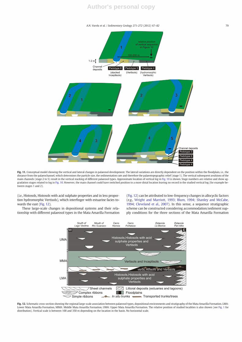
Thus, the lateral palaeosol sequence, from the distal plain to thepalaeochannel shows the transition from hydromorphic Vertisols,to typical Vertisols and eventually to stacked Inceptisols next tochannel deposits (stage 1, Fig. 11). This change can be seen over dis-tances between 100 and 200 m and is consistent with models re-cording the spatial variability within a palaeocatena (Kraus andAslan, 1999).
Additionally, small-scale variations in palaeosol types are also ob-served in a vertical succession within the middle section of the MataAmarilla Formation (Fig. 10). These changes can be quite evident, likethe superimposition of stacked Inceptisols, developed relatively prox-imal to the main channel, sharply on top of distal, hydromorphic Ver-tisols (Fig. 10). If palaeosol type is strongly linked to the relativeposition within the floodplain relative to channels, these verticalchanges may represent the result of an avulsion event (i.e. the abruptchanges in the position of the channels within the fluvial plain, stage3, Fig. 11). The passages from Vertisols to channel deposit (Fig. 10) orthe rapid abandonment of a channel also constitute the record ofavulsion processes (stage 5, Fig. 11).
Although channels can change their position within the fluvialplain more gradually due to lateral migration (especially in high-sinuosity systems), this migration can be a relatively uniform process,gradually changing conditions of a certain location from distal toproximal, or vice versa. That would probably result in the gradualtransformation of soil profiles and not necessarily in the vertical stac-king of different soil types as observed in the studied section. For thisto occur, a pause in soil formation and the reestablishment of flood-plain aggradation is needed in order to develop a sharp boundary be-tween soil types as seen in the Mata Amarilla Formation.
Still, some of these small-scale vertical changes can be more subtleand reflect the vertical superimposition of different soil types that aredeveloped adjacent to each other within the floodplain or even thestacking of different soil profiles of the same type. For example, thelower portion of the section shown in Fig. 10 displays the verticalstacking of two hydromorphic Vertisol profiles. The presence of asharp boundary between these two palaeosol profiles and the preser-vation of a superficial horizon (Ass) in the lower one indicates a rela-tive break in sedimentation and pedogenesis and the subsequentdevelopment of a new soil profile, in this case as distal as the previousone (stage 2, Fig. 11). This subtle change in the rate of sedimentationand pedogenesis can also be related to changes in the position of mainfeeder channels and therefore regarded as a ‘cryptic’ avulsion withinthe fluvial system (Figs. 10 and 11). In this sense, ‘cryptic’ avulsionsare avulsions which remain hidden within the traditional facies anal-yses and can only be revealed by means of detailed palaeosol analysis.Cryptic avulsions can also be interpreted in the case that Inceptisolsare vertically replaced by typical Vertisols (Fig. 10). This change canalso result from the avulsion of the main channel belt (stage 4,Fig. 11), although a similar vertical succession could be observed inthe case of abandoned crevasse splay deposits or developed on topof avulsion deposits (Smith et al., 1989; Kraus and Aslan, 1993),away from the new channel position.
To summarise, small-scale lateral changes identified in the middleMata Amarilla Formation are related to lateral changes within thefloodplain and can represent mesoscale systems or palaeocatenas(sensu Kraus and Aslan, 1999). The systematic change in channel po-sition within the alluvial plain due to avulsion process also resulted inthe development of small-scale vertical sequences –a few metresthick– of different soil types and channel deposits. Both lateral andvertical changes can be associated to autocyclic processes, specificallyto channel avulsion (Fig. 11).
6.2. Large-scale, low-frequency changes in palaeosol development
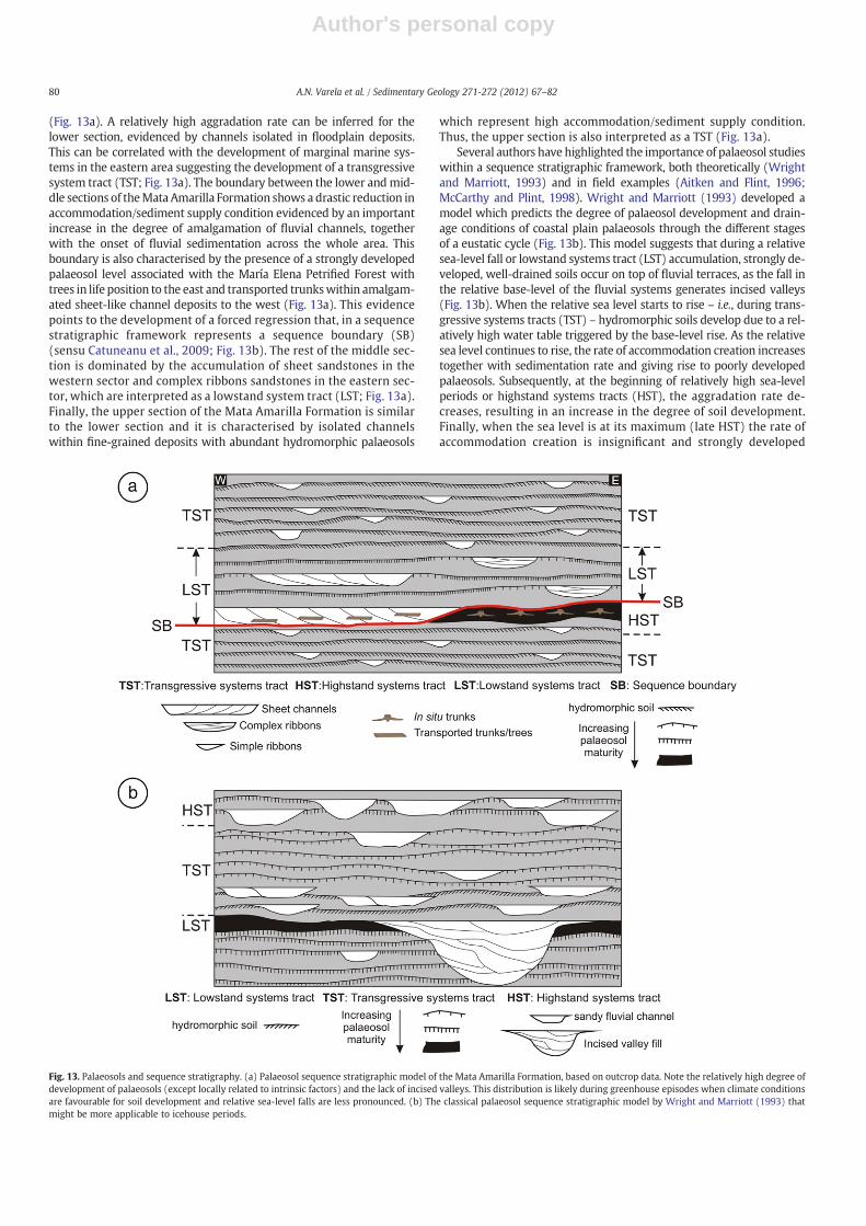
Thedescribed large-scale distributionof theMataAmarilla palaeosols(Fig. 8) is intimately related to regional and temporal changes in the sed-imentary environments (Fig. 12). The lower section of theMata AmarillaFormation in thewestern sector is dominated by fluvial channels encap-sulated in floodplain mudstones on which hydromorphic palaeosols de-veloped (i.e., Histosols, Histosols with acid sulphate properties and, inless proportion, hydromorphic Vertisols; Fig. 12). Towards the easternsector, this lower section is characterised by estuarine facieswith the de-velopment of Histosols andHistosolswith acid sulphate properties in theupper estuary facies. These deposits are replaced, towards the easternlimit of the study area by outer estuary and marine deposits with nopalaeosol development (Figs. 8 and 12). The onset of the middle sectionof the Mata Amarilla Formation is marked both by a change in deposi-tional systems and also in the type of palaeosols developed. This bound-ary is characterised by a relatively sharp surface in the eastern area,where a thick succession of vertic Alfisols is developed associated tothe in situ María Elena Petrified Forest (Fig. 12). The presence of treetrunks with little or no transport within amalgamated sheet-like chan-nels in the western sector shows that the forest horizon – and thereforethe vertic Alfisol level inwhich it was developed –was originally distrib-uted across the whole study area, only that in the western sector it wasnot preserved due to fluvial erosion (Fig. 12). The middle section ofMata Amarilla Formation is characterised by fluvial deposits in thewhole study area, although while in the western sector fluvial channelsshow sheet geometry, in the eastern sector complex sandy ribbonsoccur associated with muddy floodplains. Vertisols, hydromorphic Ver-tisols and Inceptisols developed in these floodplains, and as discussed inthe previous section, the lateral distribution of these types of palaeosolsis directly related to autocyclic processes (Fig. 12). Finally, the upper sec-tion of theMataAmarilla Formation is characterised by channels encapsu-lated in fine-grained deposits with abundant hydromorphic palaeosols
78 A.N. Varela et al. / Sedimentary Geology 271-272 (2012) 67–82
Author's personal copy
(i.e., Histosols, Histosols with acid sulphate properties and in less propor-tion hydromorphic Vertisols), which interfinger with estuarine facies to-wards the east (Fig. 12).
These large-scale changes in depositional systems and their rela-tionship with different palaeosol types in the Mata Amarilla Formation
(Fig. 12) can be attributed to low-frequency changes in allocyclic factors(e.g., Wright and Marriott, 1993; Blum, 1994; Shanley and McCabe,1994; Cleveland et al., 2007). In this sense, a sequence stratigraphicscheme can be constructed considering accommodation/sediment sup-ply conditions for the three sections of the Mata Amarilla Formation
Fig. 11. Conceptual model showing the vertical and lateral changes in palaeosol development. The lateral variations are directly dependent on the position within the floodplain, i.e., thedistance from the palaeochannel, which determines the particle size, the sedimentation rate and therefore the palaeotopographic relief (stage 1). The vertical subsequent avulsions of themain channels (stage 2 to 5) result in the vertical stacking of different palaeosol types. Approximate location of vertical log in Fig. 10 is shown. Stage numbers are relative and show ag-gradation stages related to log in Fig. 10. However, the main channel could have switched position to a more distal location leaving no record in the studied vertical log (for example be-tween stages 1 and 2).
Fig. 12. Schematic cross-section showing the regional large-scale association between palaeosol types, depositional environments and stratigraphy of theMata Amarilla Formation. LMA:Lower Mata Amarilla Formation, MMA: Middle Mata Amarilla Formation, UMA: Upper Mata Amarilla Formation. The relative position of studied localities is also shown (see Fig. 1 fordistribution). Vertical scale is between 100 and 350 m depending on the location in the basin. No horizontal scale.
79A.N. Varela et al. / Sedimentary Geology 271-272 (2012) 67–82
Author's personal copy
(Fig. 13a). A relatively high aggradation rate can be inferred for thelower section, evidenced by channels isolated in floodplain deposits.This can be correlated with the development of marginal marine sys-tems in the eastern area suggesting the development of a transgressivesystem tract (TST; Fig. 13a). The boundary between the lower andmid-dle sections of theMata Amarilla Formation shows a drastic reduction inaccommodation/sediment supply condition evidenced by an importantincrease in the degree of amalgamation of fluvial channels, togetherwith the onset of fluvial sedimentation across the whole area. Thisboundary is also characterised by the presence of a strongly developedpalaeosol level associated with the María Elena Petrified Forest withtrees in life position to the east and transported trunkswithin amalgam-ated sheet-like channel deposits to the west (Fig. 13a). This evidencepoints to the development of a forced regression that, in a sequencestratigraphic framework represents a sequence boundary (SB)(sensu Catuneanu et al., 2009; Fig. 13b). The rest of the middle sec-tion is dominated by the accumulation of sheet sandstones in thewestern sector and complex ribbons sandstones in the eastern sec-tor, which are interpreted as a lowstand system tract (LST; Fig. 13a).Finally, the upper section of the Mata Amarilla Formation is similarto the lower section and it is characterised by isolated channelswithin fine-grained deposits with abundant hydromorphic palaeosols
which represent high accommodation/sediment supply condition.Thus, the upper section is also interpreted as a TST (Fig. 13a).
Several authors have highlighted the importance of palaeosol studieswithin a sequence stratigraphic framework, both theoretically (Wrightand Marriott, 1993) and in field examples (Aitken and Flint, 1996;McCarthy and Plint, 1998). Wright and Marriott (1993) developed amodel which predicts the degree of palaeosol development and drain-age conditions of coastal plain palaeosols through the different stagesof a eustatic cycle (Fig. 13b). This model suggests that during a relativesea-level fall or lowstand systems tract (LST) accumulation, strongly de-veloped, well-drained soils occur on top of fluvial terraces, as the fall inthe relative base-level of the fluvial systems generates incised valleys(Fig. 13b). When the relative sea level starts to rise – i.e., during trans-gressive systems tracts (TST) – hydromorphic soils develop due to a rel-atively high water table triggered by the base-level rise. As the relativesea level continues to rise, the rate of accommodation creation increasestogether with sedimentation rate and giving rise to poorly developedpalaeosols. Subsequently, at the beginning of relatively high sea-levelperiods or highstand systems tracts (HST), the aggradation rate de-creases, resulting in an increase in the degree of soil development.Finally, when the sea level is at its maximum (late HST) the rate ofaccommodation creation is insignificant and strongly developed
Fig. 13. Palaeosols and sequence stratigraphy. (a) Palaeosol sequence stratigraphic model of the Mata Amarilla Formation, based on outcrop data. Note the relatively high degree ofdevelopment of palaeosols (except locally related to intrinsic factors) and the lack of incised valleys. This distribution is likely during greenhouse episodes when climate conditionsare favourable for soil development and relative sea-level falls are less pronounced. (b) The classical palaeosol sequence stratigraphic model by Wright and Marriott (1993) thatmight be more applicable to icehouse periods.
80 A.N. Varela et al. / Sedimentary Geology 271-272 (2012) 67–82

Author's personal copy
palaeosol occurs. In spite of this, the preservation potential of thesoils developed during this stage is limited, because the aggradationrate is too low and the fluvial systems would rework the floodplains.A characteristic of the model developed by Wright and Marriott(1993) is that, unlike other sequence stratigraphic models devel-oped for marine environments (e.g., Posamentier and Vail, 1998), itpredicts high aggradation rates during transgressive periods, andlow aggradation rates during the development of the HST. Conse-quently, the TST will show abundance of overbank deposits withpoorly developed palaeosols, and in the HST the proportion of over-bank deposits will decrease and the palaeosols will show a strongerdegree of developed.
The sequence stratigraphic approach for the palaeosols of theMata Amarilla Formation (Fig. 13b) contrasts with the classical theo-retical model by Wright and Marriott (1993) in that there are no in-cised valleys, and the presence of lowstand wedges is the distinctivefeature associated with the forced regressions. This is a character ofsequence boundaries developed during greenhouse periods and hasimportant implications in the elaboration of a predictive model forpalaeosol development during these climate optimums. Even whenduring the forced regression, a thick strongly developed palaeosollevel occurs in the Mata Amarilla Formation (vertic Alfisols), as itdoes in the theoretical model by Wright and Marriott (1993), the ob-servations in the Mata Amarilla differ considerably from the classicalmodels in which incised valleys and interfluve terraces are the mainfeatures that condition the physiography of the lowstand periods. Inthe studied unit palaeosols that range from weakly to strongly-developed are found in the upper part of the LST. As seen before,this difference is linked to the palaeotopographic location withinthe fluvial system and the relationship with channel deposits, butnot to extrinsic factors. Also, in the theoretical model by Wright andMarriott (1993), palaeosols developed in the highstand deposits arestrongly developed, while palaeosols of the Mata Amarilla Formationhighstand are not preserved due to the nature of the lowstand wedge.Finally, during TSTs, the theoretical model predicts the developmentof hydromorphic, poorly developed soils. However, the Mata AmarillaFormation hydromorphic soils developed during the transgressive in-tervals could be assigned to well-developed palaeosols given theabundance of pedogenic features. Nevertheless, such a degree ofpalaeosol development is relative, because during climate optimumsmore favourable climatic conditions could significantly acceleratesoil development processes resulting in an overall higher degree ofpalaeosol development throughout the whole sequence.
In summary, and although there is a strong link between the type ofpalaeosol developed and the large-scale sequence stratigraphic changesin the Mata Amarilla Formation, big differences can be observed fromthe classical theoretical models. This could be related to climatic condi-tions reigning during the Cenomanian, which may have favoured thedevelopment of well-developed palaeosols throughout the whole unit,and resulting in an increase in the relative importance of local soil for-ming factors such as parent material (in the case of levee-relatedpalaeosols) or palaeotopography (in distal floodplain settings) ratherthan time. Also the classical models, in which palaeosol developmentduring lowstands is related to the development of incised valleys,more likely during icehouse periods, may not be applicable in theMata Amarilla Formation, as a relative important preservation of flood-plain deposits is registered during the LSTwith the development ofwelldeveloped, hydromorphic palaeosols. In this sense, the Mata AmarillaFormation example could be applied to other sequences occurring inmiddle latitudes during climate optimums in terms of predicting long-term palaeosol variability.
7. Conclusion
(1) In theMataAmarilla Formation there is an extensive developmentof stacked palaeosols. Macroscopic and microscopic analyses led
to the identification of six pedotypes that are grouped in fourpalaeosol orders: Histosols, Vertisols, Alfisols and Inceptisols.
(2) The palaeosols of the Mata Amarilla Formation display charac-teristics of hydromorphic soils and they could be groupedwithin the Gleysol order or gley soils, which are compatiblewith warm temperate climates. This is consistent with the be-ginning of the climate optimum or greenhouse period of theCenomanian.
(3) The lower and upper sections of the Mata Amarilla Formationare characterised by the presence of Histosols, Histosols withacid sulphate properties and hydromorphic Vertisols associat-ed with low-gradient coastal environments.
(4) The onset of the middle section of the Mata Amarilla Forma-tion, which is of a fluvial nature, is marked by the occurrenceof a thick, highly developed palaeosol level (i.e., vertic Alfisolsand Vertisols), associated with the María Elena Petrified Forest,which marks the sequence boundary. The rest of the middlesection is composed of Vertisols and Inceptisols.
(5) The large-scale or low-frequency vertical variations in the type ofpalaeosol and the drainage conditions occurring in the three sec-tions of the formation are related to extrinsic factors, whereasthe lateral and vertical, small-scale or high-frequency variationswithin themiddle section were the result of the influence of fac-torswhich are intrinsic to the depositional systems— such as theposition within the floodplain and the distance from the mainchannels.
(6) Finally, a sequence stratigraphic model was developed for thepalaeosol succession of the Mata Amarilla Formation, whichcould be applied to other sequences that deposited during cli-mate optimums.
Acknowledgements
This researchwas funded by the Consejo Nacional de InvestigacionesCientíficas y Técnicas (PIP 1016/10 awarded to D.G. Poiré). We wouldlike to thank S. Richiano, J. Cuitiño, A. Iglesias, A. Zamuner, G. Pedersen,A. Barrueco, and P. García for their assistance in the field; and to M.Ponce for the translation of thefirst manuscript. Constructive commentsby the editor J. Knight and two anonymous reviewers greatly improvedthe final version of the manuscript.
References
Aitken, J.F., Flint, S.S., 1996. Variable expressions of interfluvial sequence boundaries in theBrathitt Group (Pennsylvanian), eastern Kentucky, USA. In: Howell, J.A., Aitken, J.F.(Eds.), High Resolution Sequence Stratigraphy: Innovations and Applications GeologicalSociety of London. Special Publication 104, 193–206.
Arbe, H.A., 1989. Estratigrafía, discontinuidades y evolución sedimentaria del Cretácicoen la Cuenca Austral, Prov. de Santa Cruz. In: Chebli, G., Spalletti, L.A. (Eds.),Cuencas Sedimentarias Argentinas: Instituto Superior de Correlación Geológica,Universidad Nacional de Tucumán, Serie de Correlación Geológica, 6, pp. 419–442.
Arbe, H.A., 2002. Análisis estratigráfico del Cretácico de la Cuenca Austral. In: Haller,M.J. (Ed.), Geología y Recursos Naturales de Santa Cruz. XV Congreso GeológicoArgentino, pp. 103–128.
Blum, M.D., 1994. Genesis and architecture of incised valley fill sequences: a Late Quater-nary example from the Colorado River, Gulf Coastal Plain of Texas. In: Weimer, P.,Posamentier, H. (Eds.), Siliciclastic Sequence Stratigraphy: Recent Developmentsand Applications American Association of Petroleum Geologists Memoir 58, 259–283.
Blum, M.D., Aslan, A., 2006. Signature of climate vs. sea-level change within incisedvalley-fill successions: Quaternary examples from the Texas Gulf Coast. Sedimen-tary Geology 190, 177–211.
Bridge, J.S., 1984. Large-scale facies sequences in alluvial overbank environments. Journalof Sedimentary Petrology 54, 583–588.
Bridge, J.S., 2003. Rivers and Floodplains: Forms, Processes, and Sedimentary Record.Blackwell Publishing, Oxford. 491 pp.
Bridge, J.S., Leeder, M.R., 1979. A simulationmodel of alluvial stratigraphy. Sedimentology26, 599–623.
Brinkman, R., Pons, L.J., 1973. Recognition and prediction of acid sulfate soil conditions.In: Dost, H. (Ed.), Acid sulfate soils: International Institute for Land Reclamationand Improvements Publication, 18, pp. 169–203.
Brown, G., Brindley, G.W., 1980. X-ray diffraction procedures for clay mineral identifi-cation. In: Brindley, G.W., Brown, G. (Eds.), Crystal Structures of Clay Minerals andTheir X-ray Identification. Mineralogical Society, London, pp. 305–359.
81A.N. Varela et al. / Sedimentary Geology 271-272 (2012) 67–82

Author's personal copy
Bullock, P., Federoff, N., Jongerius, A., Stoops, G., Tursina, T., 1985. Handbook for SoilThin Section Description. Waine Research Publications, Albrighton. 152 pp.
Catuneanu, O., Abreu, V., Bhattacharya, J.P., Blum, M.D., Dalrymple, R.W., Eriksson, P.G.,Fielding, C.R., Fisher, W.L., Galloway, W.E., Gibling, M.R., Giles, K.A., Holbrook, J.M.,Jordan, R., Kendall, C.G., St, C., Macurda, B., Martinsen, O.J., Miall, A.D., Neal, J.E.,Numedal, D., Pomar, L., Posamentier, H.W., Pratt, B.R., Sarg, J.F., Shanley, K.W.,Steel, R.J., Strasser, A., Tucker, M.E., Winker, C., 2009. Towards the standardizationof sequence stratigraphy. Earth-Science Reviews 92, 1–33.
Cleveland, D.M., Atchley, S.C., Nordt, L., 2007. Continental sequence stratigraphy of theUpper Triassic (Norian–Rhaetian) Chinle strata, Northern New Mexico, USA:allocyclic and autocyclic origins of paleosol-bearing alluvial successions. Journalof Sedimentary Research 77, 909–924.
Duchaufour, P., 1982. Pedology. George Allen & Unwin Ltd., London. 448 pp.Iglesias, A., Zamuner, A.B., Poiré, D.G., Larriestra, F., 2007. Diversity, taphonomy and pa-
laeoecology of an angiosperms flora from Cretaceous (Cenomanian–Coniacian) inSouthern Patagonia, Argentina. Palaeontology 50, 445–466.
Iglesias, A., Zamuner, A.B., Poiré, D.G., Varela, A.N., Richiano, S., Koefoed, C., 2009.Albian–Campanian continuous record of compression floras in Tres Lagos, AustralBasin, Patagonia, Argentina. Abstract, Reunión Anual de Comunicaciones de laAsociación Paleontológica Argentina, pp. 51–52.
Imbellone, P.A., Guichon, B.A., Giménez, J.E., 2009. Hydromorphic soils of the Río de laPlata coastal plain, Argentina. Latin American Journal of Sedimentology and BasinAnalysis 16 (1), 3–18.
Ingersoll, R.V., Bullard, T.F., Ford, R.L., Grimm, J.P., Pickle, J.D., Sares, S., 1984. The effectof grain size on detrital modes: a test of the Gazzi–Dickinson point-counting meth-od. Journal of Sedimentary Petrology 54, 103–116.
Jenny, H., 1941. Factors of Soil Formation. McGraw-Hill, New York. 281 pp.Kraus, M.J., 1987. Integration of channel and floodplain suites: II. lateral relations of al-
luvial paleosols. Journal of Sedimentary Petrology 57, 602–612.Kraus, M.J., 1997. Lower Eocene alluvial paleosols; pedogenic development, strati-
graphic relationships, and paleosol/landscape associations. Palaeogeography, Pal-aeoclimatology, Palaeoecology 129, 387–406.
Kraus, M.J., 1998. Development of potential acid sulfate paleosols in Paleocene flood-plains, Bighorn Basin, Wyoming, USA. Palaeogeography, Palaeoclimatology, Pa-laeoecology 144, 203–224.
Kraus, M.J., 1999. Paleosols in clastic sedimentary rocks: their geologic applications.Earth-Science Reviews 47, 41–70.
Kraus, M.J., 2002. Basin-scale changes in floodplain paleosols: implications for inter-preting alluvial architecture. Journal of Sedimentary Research 72, 500–509.
Kraus, M.J., Aslan, A., 1993. Eocene hydromorphic paleosols: significance for interpretingancient foodplain processes. Journal of Sedimentary Petrology 63, 434–463.
Kraus, M.J., Aslan, A., 1999. Paleosol sequences in floodplain environments: a hierarchicalapproach. In: Thiry, M. (Ed.), Palaeoweathering, palaeosurfaces and related continentaldepositsInternational Association of Sedimentologists. Special Publication 27, 303–321.
Kraus, M.J., Hasiotis, S.T., 2006. Significance of different modes of rhizolith preservationto interpreting paleoenvironmental and paleohydrologic settings: examples fromPaleogene paleosols, Bighorn basin, Wyoming, USA. Journal of Sedimentary Re-search 76, 633–646.
Kraus, M.J., Riggins, S., 2007. Transient drying during the Paleocene–Eocene ThermalMaximum (PETM): analysis of paleosols in the Bighorn basin, Wyoming. Pal-aeogeography, Palaeoclimatology, Palaeoecology 245, 444–461.
Krause, J.M., Bellosi, E.S., Raigemborn, M.S., 2010. Laterized tephric palaeosols fromCentral Patagonia, Argentina: a southern high-latitude archive of Palaeogene glob-al greenhouse conditions. Sedimentology 57, 1721–1749.
Leckie, D., Fox, C., Tarnocai, C., 1989. Multiple paleosols of the late Albian Boulder CreekFormation, British Columbia, Canada. Sedimentology 36, 307–323.
Mack, G.H., James, W.C., Monger, H.C., 1993. Classification of paleosols. Geological Soci-ety of America Bulletin 105, 129–136.
Mack, G.H., Tabor, N.J., Zollinger, H.J., 2010. Palaeosols and sequence stratigraphy of theLower Permian Abo Member, south-central New Mexico, USA. Sedimentology 57,1566–1583.
Mackey, S.D., Bridge, J.S., 1995. Three-dimensional model of alluvial stratigraphy: theoryand application. Journal of Sedimentary Research 65, 7–31.Marriott, S.B., 1999. Theuse of models in the interpretation of the effects of base-level change on alluvial ar-chitecture. In: Smith, N.D., Rogers, J. (Eds.), Fluvial sedimentology VI International As-sociation of Sedimentologists. Special Publication 28, 271–281.
Marriott, S.B., 1999. The use of models in the interpretation of the effects of base-levelchange on alluvial architecture. In: Smith, N.D., Rogers, J. (Eds.), Fluvial sedimentolo-gy VI International Association of Sedimentologists. Special Publication 28, 271–281.
McCabe, P.J., Parrish, J.T., 1992. Tectonic and climatic controls on Cretaceous coals. In:McCabe, P.J., Parrish, J.T. (Eds.), Controls on the distribution and quality of Creta-ceous coalsGeological Society of America Special Paper 267, 1–15.
McCarthy, P.J., Plint, A.G., 1998. Recognition of interfluve sequence boundaries: inte-grating paleopedology and sequence stratigraphy. Geology 26, 387–390.
McCarthy, P., Martini, I., Leckie, D., 1998. Use of micromorphology for palaeoenvironmentalinterpretation of complex alluvial palaeosols: an example from the Mill Creek Forma-tion (Albian), southwestern Alberta, Canada. Palaeogeography, Palaeoclimatology, Pa-laeoecology 143, 87–110.
McCarthy, P.J., Faccini, U.F., Plint, A.G., 1999. Evolution of an ancient coastal plain: palaeosols,intefluves and alluvial architecture in a sequence stratigraphic framework, CenomanianDunvegan Formation, NE British Columbia, Canada. Sedimentology 46, 87–91.
McSweeney, K., Fastovsky, D.E., 1987. Micromorphological and SEM analysis of Cretaceous–Paleogene Petrosols from eastern Montana and western North Dakota. Geoderma 40,49–63.
Miedema, R., Jongmans, A.G., Slager, S., 1974. Micromorphological observations on py-rite and its oxidation products in four Holocene alluvial soils in the Netherlands. In:
Rutherford, G.K. (Ed.), Soil Microscopy. The Limestone Press, United Kingdom,pp. 772–794.
Munsell® Soil Color Charts, 2000. Revised Washable Edition. X-rite 4300 44th StreetS.E., Grand Rapids, MI 49512, USA.
Pizzuto, J.E., 1987. Sediment diffusion during overbank flows. Sedimentology 34, 301–317.Poiré, D.G., Zamuner, A.B., Goin, F., Iglesias, A., Canessa, N., Larriestra, C.N., Varela, A.N., Calvo
Marcillese, L., Larriestra, F., 2004. Ambientes sedimentarios relacionados a las tafoflorasde las formaciones Piedra Clavada yMata Amarilla (Cretácico), Tres Lagos, Cuenca Aus-tral, Argentina. X Reunión Argentina de Sedimentología, San Luis, Actas, pp. 140–141.
Posamentier, H.W., Vail, P.R., 1998. Eustatic controls on clastic deposition II — se-quences and systems tracts models. In: Wilgus, C.K., Hastings, B.S., Kendall, C.G.StC., Posamentier, H.W., Ross, C.A., Van Wagoner, J.C. (Eds.), Sea level changes, an in-tegrated approach SEPM. Special Publication 42, 125–154.
Retallack, G.J., 1988. Field recognition of paleosols. In: Reinhardt, J., Sigleo, W.R. (Eds.),Paleosols and weathering through geologic time: techniques and applications Geologi-cal Society of America Special Paper 216, 1–20.
Retallack, G.J., 1993. Classification of paleosols: discussion and reply. Discussion. Geo-logical Society of America Bulletin 105, 1635–1636.
Retallack, G.J., 1994. The environmental factor approach to the interpretation ofpaleosols. Soil Science Society of America. Special Publication 33, 31–64.
Retallack, G.J., 2001. Soils of the Past: An Introduction to Paleopedology, Second Edi-tion. Blackwell Science, Oxford. 404 pp.
Royer, D.L., 2010. Fossil soils constrain ancient climate sensitivity. Proceedings of theNational Academy of Sciences of the United States of America 107 (2), 517–518.
Russo, A., Flores, M.A., 1972. Patagonia Austral Extraandina. In: Leanza, A.F. (Ed.), Geo-logía Regional Argentina. Academia Nacional de Ciencias de Córdoba, pp. 707–725.
Shanley, K.W., McCabe, P.J., 1994. Perspectives on the sequence stratigraphy of conti-nental strata. American Association of Petroleum Geologists Bulletin 78, 544–568.
Smith, N.D., Cross, T.A., Dufficy, J.P., Clough, S.R., 1989. Anatomy of an avulsion. Sedi-mentology 36, 1–23.
Soil Survey Staff, 1975. Soil taxonomy. United States Department of Agriculture, Hand-book, 436. 754 pp.
Soil Survey Staff, 1998. Key to Soil Taxonomy, Eighth Edition. United States Departmentof Agriculture, Natural Resources Conservation Service, Washington, DC. 328 pp.
Stiles, C.A., Mora, C.I., Driese, S.G., 2001. Pedogenic iron–manganese nodules in Vertisols:a new proxy for paleoprecipitation? Geology 29, 943–946.
Stoops, G.J., 2001. Micropedology, Methods and Applications. International TrainingCentre for Post-Graduate Soil Scientists, Universiteit Gent. 77 pp.
Törnqvist, T.E., Bridge, J.S., 2002. Spatial variation of overbank aggradation rate and itsinfluence on avulsion frequency. Sedimentology 49, 891–905.
Van Breeman, N., 1975. Acidification and deacidification of coastal plain soils as a resultof periodic flooding. Proceedings. Soil Science Society of America 39, 1153–1157.
Van Breeman, N., 1982. Genesis, morphology, and classification of acid sulfate soils incoastal plains. In: Kittrick, J.A., Fanning, D.S., Hossner, L.R. (Eds.), Acid sulfateweathering: Madison, Wisconsin Soil Science Society of America Journal 95–108.
Varela, A.N., 2009. Accommodation/sediment supply fluvial deposition controlled bybase level changes and relative sea level fluctuations in the Mata Amarilla Forma-tion (Early Upper Cretaceous), Southern Patagonia, Argentina. 9th InternationalConference on Fluvial Sedimentology: Acta Geológica Lilloana, 21, p. 66.
Varela, A.N., 2011. Sedimentología y Modelos Deposicionales de la Formación MataAmarilla, Cretácico de la Cuenca Austral, Argentina. Ph.D. Thesis (Unpublished),Universidad Nacional de La Plata, Facultad de Ciencias Naturales y Museo.
Varela, A.N., Poiré, D.G., 2008. Paleogeografía de la Formación Mata Amarilla, CuencaAustral, Patagonia, Argentina. Proceedings of the XII Reunión Argentina deSedimentología, Buenos Aires, p. 183.
Varela, A.N., Poiré, D.G., Richiano, S., Zamuner, A., 2006. Los paleosuelos asociados albosque petrificado María Elena, Formación Mata Amarilla, Cuenca Austral, Patago-nia, Argentina. IV Congreso Latinoamericano de Sedimentología and XI ReuniónArgentina de Sedimentología, Bariloche, Actas, p. 235.
Varela, A.N., Richiano, S., Poiré, D.G., 2008. Análisis paleoambiental de la FormaciónMata Amarilla a partir de su malacofauna, Cuenca Austral, Patagonia, Argentina.In: Schiuma, M. (Ed.), Trabajos Técnicos, VII Congreso de Exploración y Desarrollode Hidrocarburos, pp. 601–605.
Varela, A.N., Richiano, S., Poiré, D.G., 2011. Tsunami vs storm origin for shell bed deposits in alagoon environment: an example from (lower Upper Cretaceous) southern Patagonia,Argentina. Latin American Journal of Sedimentology and Basin Analysis 18 (1), 63–85.
Varela, A.N., Poiré, D.G., Martin, T., Gerdes, A., Goin, F.J., Gelfo, J.N., Hoffmann, S., 2012.U–Pb zircon constraints on the age of the Cretaceous Mata Amarilla Formation,Southern Patagonia, Argentina: its relationship with the evolution of the AustralBasin. Andean Geology 39 (3), XX-XX.
White, R.E., 1997. Principles and Practice of Soil Science: The Soil as a Natural Resource.Third Edition, Blackwell Science Ltd. 348 pp.
Wright, V.P., Marriott, S.B., 1993. The sequence stratigraphy of fluvial depositionalsystems: the role of floodplain storage. Sedimentary Geology 86, 203–210.
Wright, V.P., Taylor, K.G., Beck, V.H., 2000. The paleohydrology of Lower Cretaceousseasonal wetlands, Isle of Wight, southern England. Journal of Sedimentary Re-search 70, 619–632.
Zamuner, A.B., Poiré, D.G., Iglesias, A., Larriestra, F., Varela, A.N., 2004. Upper Cretaceousin situ Petrified Forest in Mata Amarilla Formation, Tres Lagos, Southern Patagonia,Argentina. Proceedings of the 7th International Organization of Paleobotany Con-ference, Bariloche, p. 150.
Zamuner, A., Falaschi, P., Bamford, M., Iglesias, A., Poiré, D.G., Varela, A.N., Larriestra, F.,2006. Anatomía y Paleoecología de dos Bosques In Situ de la Zona de Tres Lagos,Formación Mata Amarilla, Cretácico superior, Patagonia, Argentina. Proceedingsof the XIII Simposio Argentino de Paleobotánica y Palinología, Bahía Blanca, p. 55.
82 A.N. Varela et al. / Sedimentary Geology 271-272 (2012) 67–82