Sensor-Mission Assignment: A Scenario-Driven Walkthrough
7
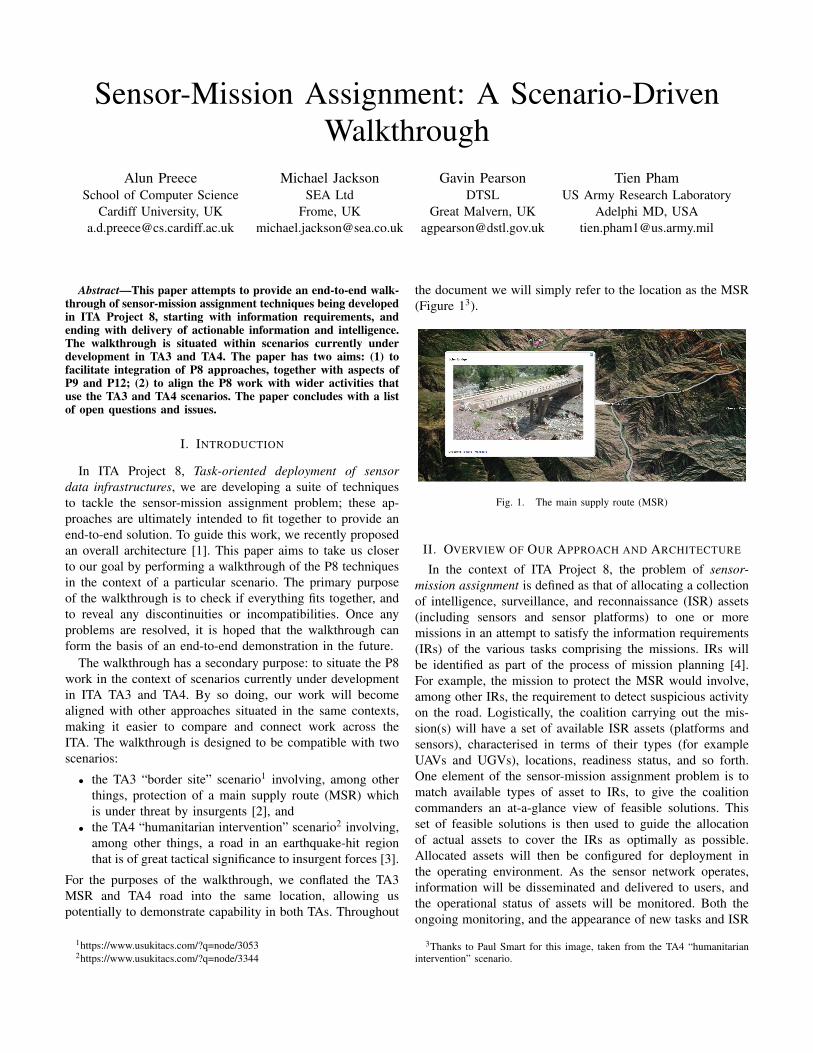
Sensor-Mission Assignment: A Scenario-Driven Walkthrough Alun Preece School of Computer Science Cardiff University, UK [email protected] Michael Jackson SEA Ltd Frome, UK [email protected] Gavin Pearson DTSL Great Malvern, UK [email protected] Tien Pham US Army Research Laboratory Adelphi MD, USA [email protected] Abstract—This paper attempts to provide an end-to-end walk- through of sensor-mission assignment techniques being developed in ITA Project 8, starting with information requirements, and ending with delivery of actionable information and intelligence. The walkthrough is situated within scenarios currently under development in TA3 and TA4. The paper has two aims: (1) to facilitate integration of P8 approaches, together with aspects of P9 and P12; (2) to align the P8 work with wider activities that use the TA3 and TA4 scenarios. The paper concludes with a list of open questions and issues. I. I NTRODUCTION In ITA Project 8, Task-oriented deployment of sensor data infrastructures, we are developing a suite of techniques to tackle the sensor-mission assignment problem; these ap- proaches are ultimately intended to fit together to provide an end-to-end solution. To guide this work, we recently proposed an overall architecture [1]. This paper aims to take us closer to our goal by performing a walkthrough of the P8 techniques in the context of a particular scenario. The primary purpose of the walkthrough is to check if everything fits together, and to reveal any discontinuities or incompatibilities. Once any problems are resolved, it is hoped that the walkthrough can form the basis of an end-to-end demonstration in the future. The walkthrough has a secondary purpose: to situate the P8 work in the context of scenarios currently under development in ITA TA3 and TA4. By so doing, our work will become aligned with other approaches situated in the same contexts, making it easier to compare and connect work across the ITA. The walkthrough is designed to be compatible with two scenarios: • the TA3 “border site” scenario 1 involving, among other things, protection of a main supply route (MSR) which is under threat by insurgents [2], and • the TA4 “humanitarian intervention” scenario 2 involving, among other things, a road in an earthquake-hit region that is of great tactical significance to insurgent forces [3]. For the purposes of the walkthrough, we conflated the TA3 MSR and TA4 road into the same location, allowing us potentially to demonstrate capability in both TAs. Throughout 1 https://www.usukitacs.com/?q=node/3053 2 https://www.usukitacs.com/?q=node/3344 the document we will simply refer to the location as the MSR (Figure 1 3 ). Fig. 1. The main supply route (MSR) II. OVERVIEW OF OUR APPROACH AND ARCHITECTURE In the context of ITA Project 8, the problem of sensor- mission assignment is defined as that of allocating a collection of intelligence, surveillance, and reconnaissance (ISR) assets (including sensors and sensor platforms) to one or more missions in an attempt to satisfy the information requirements (IRs) of the various tasks comprising the missions. IRs will be identified as part of the process of mission planning [4]. For example, the mission to protect the MSR would involve, among other IRs, the requirement to detect suspicious activity on the road. Logistically, the coalition carrying out the mis- sion(s) will have a set of available ISR assets (platforms and sensors), characterised in terms of their types (for example UAVs and UGVs), locations, readiness status, and so forth. One element of the sensor-mission assignment problem is to match available types of asset to IRs, to give the coalition commanders an at-a-glance view of feasible solutions. This set of feasible solutions is then used to guide the allocation of actual assets to cover the IRs as optimally as possible. Allocated assets will then be configured for deployment in the operating environment. As the sensor network operates, information will be disseminated and delivered to users, and the operational status of assets will be monitored. Both the ongoing monitoring, and the appearance of new tasks and ISR 3 Thanks to Paul Smart for this image, taken from the TA4 “humanitarian intervention” scenario.
-
Upload
independent -
Category
Documents
-
view
2 -
download
0
Transcript of Sensor-Mission Assignment: A Scenario-Driven Walkthrough
Sensor-Mission Assignment: A Scenario-DrivenWalkthrough
Alun PreeceSchool of Computer Science
Cardiff University, [email protected]
Michael JacksonSEA Ltd
Frome, [email protected]
Gavin PearsonDTSL
Great Malvern, [email protected]
Tien PhamUS Army Research Laboratory
Adelphi MD, [email protected]
Abstract—This paper attempts to provide an end-to-end walk-through of sensor-mission assignment techniques being developedin ITA Project 8, starting with information requirements, andending with delivery of actionable information and intelligence.The walkthrough is situated within scenarios currently underdevelopment in TA3 and TA4. The paper has two aims: (1) tofacilitate integration of P8 approaches, together with aspects ofP9 and P12; (2) to align the P8 work with wider activities thatuse the TA3 and TA4 scenarios. The paper concludes with a listof open questions and issues.
I. INTRODUCTION
In ITA Project 8, Task-oriented deployment of sensordata infrastructures, we are developing a suite of techniquesto tackle the sensor-mission assignment problem; these ap-proaches are ultimately intended to fit together to provide anend-to-end solution. To guide this work, we recently proposedan overall architecture [1]. This paper aims to take us closerto our goal by performing a walkthrough of the P8 techniquesin the context of a particular scenario. The primary purposeof the walkthrough is to check if everything fits together, andto reveal any discontinuities or incompatibilities. Once anyproblems are resolved, it is hoped that the walkthrough canform the basis of an end-to-end demonstration in the future.
The walkthrough has a secondary purpose: to situate the P8work in the context of scenarios currently under developmentin ITA TA3 and TA4. By so doing, our work will becomealigned with other approaches situated in the same contexts,making it easier to compare and connect work across theITA. The walkthrough is designed to be compatible with twoscenarios:
• the TA3 “border site” scenario1 involving, among otherthings, protection of a main supply route (MSR) whichis under threat by insurgents [2], and
• the TA4 “humanitarian intervention” scenario2 involving,among other things, a road in an earthquake-hit regionthat is of great tactical significance to insurgent forces [3].
For the purposes of the walkthrough, we conflated the TA3MSR and TA4 road into the same location, allowing uspotentially to demonstrate capability in both TAs. Throughout
1https://www.usukitacs.com/?q=node/30532https://www.usukitacs.com/?q=node/3344
the document we will simply refer to the location as the MSR(Figure 13).
Fig. 1. The main supply route (MSR)
II. OVERVIEW OF OUR APPROACH AND ARCHITECTURE
In the context of ITA Project 8, the problem of sensor-mission assignment is defined as that of allocating a collectionof intelligence, surveillance, and reconnaissance (ISR) assets(including sensors and sensor platforms) to one or moremissions in an attempt to satisfy the information requirements(IRs) of the various tasks comprising the missions. IRs willbe identified as part of the process of mission planning [4].For example, the mission to protect the MSR would involve,among other IRs, the requirement to detect suspicious activityon the road. Logistically, the coalition carrying out the mis-sion(s) will have a set of available ISR assets (platforms andsensors), characterised in terms of their types (for exampleUAVs and UGVs), locations, readiness status, and so forth.One element of the sensor-mission assignment problem is tomatch available types of asset to IRs, to give the coalitioncommanders an at-a-glance view of feasible solutions. Thisset of feasible solutions is then used to guide the allocationof actual assets to cover the IRs as optimally as possible.Allocated assets will then be configured for deployment inthe operating environment. As the sensor network operates,information will be disseminated and delivered to users, andthe operational status of assets will be monitored. Both theongoing monitoring, and the appearance of new tasks and ISR
3Thanks to Paul Smart for this image, taken from the TA4 “humanitarianintervention” scenario.
Requirements• Define IRs & SSIRs
• Derive interpretation tasksSensor-task
matching
Logistical information• sensor/platform type
• location
• readiness
Recommendation of
feasible solutions
Emergence
of new tasksStatus
updating
Mission planning
Is there suspicious
activity on the MSR?Are there suspicious
vehicles, etc,
on the MSR?
ISR assets available in theatre
Information
dissemination
& delivery
S1
S2
S3
DB
C
E
A
S4
Sensor FabricMonitoring
Sensor-task
allocation
Deployment
configuration
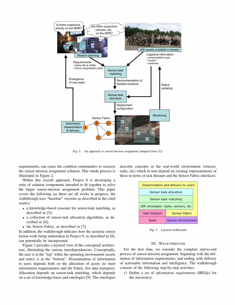
Fig. 2. An approach to sensor-mission assignment (adapted from [1])
requirements, can cause the coalition commanders to reassessthe sensor-mission assignment solution. This whole process isillustrated in Figure 2.
Within this overall approach, Project 8 is developing asuite of solution components intended to fit together to solvethe larger sensor-mission assignment problem. This papercovers the following (as these are all works in progress, thewalkthrough uses “baseline” versions as described in the citedworks):
• a knowledge-based reasoner for sensor-task matching, asdescribed in [5];
• a collection of sensor-task allocation algorithms, as de-scribed in [6];
• the Sensor Fabric, as described in [7].In addition, the walkthrough indicates how the acoustic sensorfusion work being undertaken in Project 9, as described in [8],can potentially be incorporated.
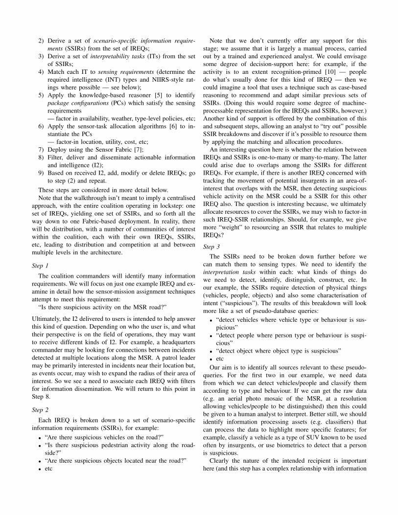
Figure 3 provides a layered view of the conceptual architec-ture, illustrating the various interdependencies. Conceptually,the user is at the “top” while the operating environment (assetsand tasks) is at the “bottom”. Dissemination of informationto users depends both on the allocation of assets (to meetinformation requirements) and the Fabric (for data transport).Allocation depends on sensor-task matching, which dependson a set of knowledge bases and ontologies [9]. The ontologies
describe concepts in the real-world environment (sensors,tasks, etc) which in turn depend on existing representations ofthese in terms of task thesauri and the Sensor Fabric interfaces.
Task thesauri
Tasks Sensor environment
Sensor Fabric
ISR ontologies: tasks, sensors, etc
Sensor-task allocation
Sensor-task matching
Dissemination and delivery to users
Fig. 3. Layered architecture
III. WALKTHROUGH
For the first time, we consider the complete end-to-endprocess of sensor-mission assignment, beginning with the def-inition of information requirements, and ending with deliveryof actionable information and intelligence. The walkthroughconsists of the following step-by-step activities:
1) Define a set of information requirements (IREQs) forthe mission(s);
2) Derive a set of scenario-specific information require-ments (SSIRs) from the set of IREQs;
3) Derive a set of interpretability tasks (ITs) from the setof SSIRs;
4) Match each IT to sensing requirements (determine therequired intelligence (INT) types and NIIRS-style rat-ings where possible — see below);
5) Apply the knowledge-based reasoner [5] to identifypackage configurations (PCs) which satisfy the sensingrequirements— factor in availability, weather, type-level policies, etc;
6) Apply the sensor-task allocation algorithms [6] to in-stantiate the PCs— factor-in location, utility, cost, etc;
7) Deploy using the Sensor Fabric [7];8) Filter, deliver and disseminate actionable information
and intelligence (I2);9) Based on received I2, add, modify or delete IREQs; go
to step (2) and repeat.These steps are considered in more detail below.Note that the walkthrough isn’t meant to imply a centralised
approach, with the entire coalition operating in lockstep: oneset of IREQs, yielding one set of SSIRs, and so forth all theway down to one Fabric-based deployment. In reality, therewill be distribution, with a number of communities of interestwithin the coalition, each with their own IREQs, SSIRs,etc, leading to distribution and competition at and betweenmultiple levels in the architecture.
Step 1
The coalition commanders will identify many informationrequirements. We will focus on just one example IREQ and ex-amine in detail how the sensor-mission assignment techniquesattempt to meet this requirement:
“Is there suspicious activity on the MSR road?”
Ultimately, the I2 delivered to users is intended to help answerthis kind of question. Depending on who the user is, and whattheir perspective is on the field of operations, they may wantto receive different kinds of I2. For example, a headquarterscommander may be looking for connections between incidentsdetected at multiple locations along the MSR. A patrol leadermay be primarily interested in incidents near their location but,as events occur, may wish to expand the radius of their area ofinterest. So we see a need to associate each IREQ with filtersfor information dissemination. We will return to this point inStep 8.
Step 2
Each IREQ is broken down to a set of scenario-specificinformation requirements (SSIRs), for example:
• “Are there suspicious vehicles on the road?”• “Is there suspicious pedestrian activity along the road-
side?”• “Are there suspicious objects located near the road?”• etc
Note that we don’t currently offer any support for thisstage; we assume that it is largely a manual process, carriedout by a trained and experienced analyst. We could envisagesome degree of decision-support here: for example, if theactivity is to an extent recognition-primed [10] — peopledo what’s usually done for this kind of IREQ — then wecould imagine a tool that uses a technique such as case-basedreasoning to recommend and adapt similar previous sets ofSSIRs. (Doing this would require some degree of machine-processable representation for the IREQs and SSIRs, however.)Another kind of support is offered by the combination of thisand subsequent steps, allowing an analyst to “try out” possibleSSIR breakdowns and discover if it’s possible to resource themby applying the matching and allocation procedures.
An interesting question here is whether the relation betweenIREQs and SSIRs is one-to-many or many-to-many. The lattercould arise due to overlaps among the SSIRs for differentIREQs. For example, if there is another IREQ concerned withtracking the movement of potential insurgents in an area-of-interest that overlaps with the MSR, then detecting suspiciousvehicle activity on the MSR could be a SSIR for this otherIREQ also. The question is interesting because, we ultimatelyallocate resources to cover the SSIRs, we may wish to factor-insuch IREQ-SSIR relationships. Should, for example, we givemore “weight” to resourcing an SSIR that relates to multipleIREQs?
Step 3
The SSIRs need to be broken down further before wecan match them to sensing types. We need to identify theinterpretation tasks within each: what kinds of things dowe need to detect, identify, distinguish, construct, etc. Inour example, the SSIRs require detection of physical things(vehicles, people, objects) and also some characterisation ofintent (“suspicious”). The results of this breakdown will lookmore like a set of pseudo-database queries:
• “detect vehicles where vehicle type or behaviour is sus-picious”
• “detect people where person type or behaviour is suspi-cious”
• “detect object where object type is suspicious”• etcOur aim is to identify all sources relevant to these pseudo-
queries. For the first two in our example, we need datafrom which we can detect vehicles/people and classify themaccording to type and behaviour. If we can get the raw data(e.g. an aerial photo mosaic of the MSR, at a resolutionallowing vehicles/people to be distinguished) then this couldbe given to a human analyst to interpret. Better still, we shouldidentify information processing assets (e.g. classifiers) thatcan process the data to highlight more specific features; forexample, classify a vehicle as a type of SUV known to be usedoften by insurgents, or use biometrics to detect that a personis suspicious.
Clearly the nature of the intended recipient is importanthere (and this step has a complex relationship with information
dissemination). Taking our example of the HQ commander andthe patrol leader, the former may want interpretability at thelevel of a complex biometric analysis, face-recognition, etc,while the latter may be satisfied simply with the detection ofmovement, because the patrol can then investigate and judgeif the activity is suspicious (and generate HUMINT).
Step 4
Once we’ve identified the interpretation tasks within eachSSIR, we need to know the kinds of data that are interpretableto answer these: for example, visible imaging, radar, acoustic,etc. An established way way to do this in Intelligence Re-quirements Management (IRM) is to use the National ImageryInterpretability Rating Scale (NIIRS) for various kinds ofimagery intelligence4. NIIRS covers Visible, Radar, IR, andMultispectral imaging and, for each, “provides a means todirectly relate the quality of an image to the interpretationtasks for which it may be used”. For example, identificationof vehicles by type is achievable by Visible NIIRS 4 and RadarNIIRS 6.
We have recently built a proof-of-concept knowledge base(KB) for part of NIIRS, allowing a user to select interpretationtasks in terms of three operations (detect, identify, distinguish)and a range of “detectables” (ground, air and maritime vehi-cles, buildings, etc). The KB infers which imagery types andNIIRS rating levels are appropriate for each interpretation task.For example:
• Identify(Vehicles) → { Visible-4, Radar-6 }Note that in steps 3-4 we are moving from a set of
“soft” (human-interpretable) information requirements to aset of “hard” (machine-processable) requirements, to enableuse of the subsequent reasoning, allocation, and deploymentprocesses.
Further discussion of the relationship between NIIRS andour Project 8 techniques appears in [11].
Step 5
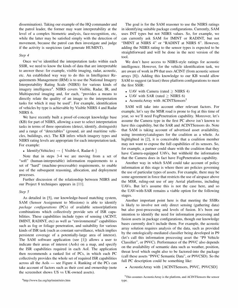
As detailed in [5], our knowledge-based matching system,SAM (Sensor Assignment to Missions) is able to identifypackage configurations (PCs) of available sensor/platformcombinations which collectively provide sets of ISR capa-bilities. These capabilities include types of sensing (ACINT,IMINT, RADINT, etc) as well as “environmental” capabilitiessuch as fog or foliage penetration, and suitability for variouskinds of ISR task (such as constant surveillance, which impliespersistent coverage of a potentially-large area of interest).The SAM software application (see [1]) allows a user toindicate their areas of interest (AoIs) on a map, and specifythe ISR capabilities required in each AoI. The applicationthen recommends a ranked list of PCs, in which each PCcollectively provides the whole set of required ISR capabilitiesacross all the AoIs — see Figure 4. Ranking of the PCs cantake account of factors such as their cost and ownership (notethe screenshot shows US vs UK-owned assets).
4http://www.fas.org/irp/imint/niirs.htm
The goal is for the SAM reasoner to use the NIIRS ratingsin identifying suitable package configurations. Currently, SAMuses INT types but not NIIRS values. So, for example, wecan currently ask SAM for IMINT or RADINT, but not“IMINT at NIIRS 4” or “RADINT at NIIRS 6”. However,adding the NIIRS rating to the sensor types is expected to bestraightforward and will be done in the next version of thetool.
We don’t have access to NIIRS-style ratings for acousticintelligence. However, for the vehicle identification task, weare aware of work in P9 that uses ACINT (from acoustic sensorarrays [8]). Adding this knowledge to our KB would allowSAM to suggest (at least) three platform configurations to meetthe first SSIR:
• UAV with Camera (rated ≥ NIIRS 4)• UAV with SAR (rated ≥ NIIRS 6)• AcousticArray with ACINTSensors5
SAM will take into account other relevant factors. Forexample, let’s say the MSR road is prone to fog at this time ofyear, so we’ll need FogPenetration capability. Moreover, let’sassume the Camera type in the first PC above isn’t known tohave this capability, but the SAR and ACINTSensors do. Notethat SAM is taking account of advertised asset availability,using inventory/catalogues for the coalition as a whole. Ashighlighted in [2], it is conceivable that a coalition membermay not want to expose the full capabilities of its sensors. So,for example, a partner could share with the coalition that theyhave Camera-equipped UAVs, but withhold the informationthat the Camera does in fact have FogPenetration capability.
Another way in which SAM could take account of policyinformation at this stage is where there are policies governingthe use of particular types of assets. For example, there may besome agreement in force that restricts the use of airspace abovethe MSR, ruling-out use of any Aerial platforms, includingUAVs. But let’s assume this is not the case here, and sothe UAV-with-SAR remains a viable option for the followingstages.
Another important point here is that meeting the SSIRsis likely to involve not only direct sensing (gathering data)but also post-processing and levels of fusion. It’s been ourintention to identify the need for information processing andfusion assets in package configurations, though our knowledgebases currently don’t include them. For example, the acousticarray solution requires analysis of the data, such as providedby the ontologically-mediated classifier being developed in P9(let’s call this information processing asset the “P9 VehicleClassifier”, or P9VC). Performance of the P9VC also dependson the availability of semantic data such as weather, position,threat level which ought also to be factored-into the package(call these assets “P9VC Semantic Data”, or P9VCSD). So thefull PC description could be something like:
• AcousticArray with {ACINTSensors, P9VC, P9VCSD}
5This assumes AcousticArray is the platform, and ACINTSensors the sensortype.
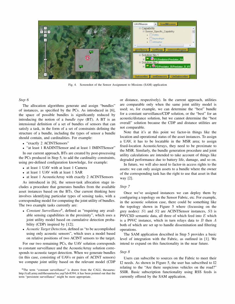
Fig. 4. Screenshot of the Sensor Assignment to Missions (SAM) application
Step 6
The allocation algorithms generate and assign “bundles”of instances, as specified by the PCs. As introduced in [6],the space of possible bundles is significantly reduced byintroducing the notion of a bundle type (BT). A BT is anintensional definition of a set of bundles of sensors that cansatisfy a task, in the form of a set of constraints defining thestructure of a bundle, including the types of sensor a bundleshould contain, and cardinalities. For example:
• “exactly 2 ACINTSensors”• “at least 1 RADINTSensor and at least 1 IMINTSensor”In our current approach, BTs are created by post-processing
the PCs produced in Step 5, to add the cardinality constraints,using pre-defined configuration knowledge, for example:
• at least 1 UAV with at least 1 Camera• at least 1 UAV with at least 1 SAR• at least 1 AcousticArray with exactly 2 ACINTSensorsAs introduced in [6], the sensor-task allocation stage in-
cludes a procedure that generates bundles from the availableasset instances based on the BTs. Our current thinking hereinvolves identifying particular types of sensing tasks, with acorresponding model for computing the joint utility of bundles.The two example tasks currently are:
• Constant Surveillance6, defined as “requiring any avail-able sensing capabilities in the proximity”, which uses ajoint utility model based on cumulative detection proba-bility (CDP) inspired by [12];
• Acoustic Target Detection, defined as “to be accomplishedusing only acoustic sensors”, which uses a model basedon relative positions of two ACINT sensors to the target.
For our two remaining PCs, the UAV solution correspondsto constant surveillance and the AcousticArray solution corre-sponds to acoustic target detection. When we generate bundles(in this case, consisting of UAVs or pairs of ACINT sensors)we compute joint utility based on the relevant model (CDP
6The term “constant surveillance” is drawn from the CALL thesaurus:http://call.army.mil/thesaurus/toc.asp?id=8394; it has been pointed out that theterm “persistent surveillance” might be more appropriate.
or distance, respectively). In the current approach, utilitiesare comparable only when the same joint utility model isused; so, for example, we can determine the “best” bundlefor a constant surveillance/CDP solution, or the “best” for anacoustic/distance solution, but we cannot determine the “bestoverall” solution because the CDP and distance utilities arenot comparable.
Note that it’s at this point we factor-in things like thelocation and operational status of the asset instances. To assigna UAV, it has to be locatable in the MSR area; to assignfixed-location AcousticArrays, they need to be proximate tothe MSR. Similarly, the bundle generation procedure and jointutility calculations are intended to take account of things likedegraded performance due to battery life, damage, and so on.
In future, we will also need to factor-in access rights to theassets: we can only assign assets to a bundle where the ownerof the corresponding task has the right to use that asset in thatway [2].
Step 7
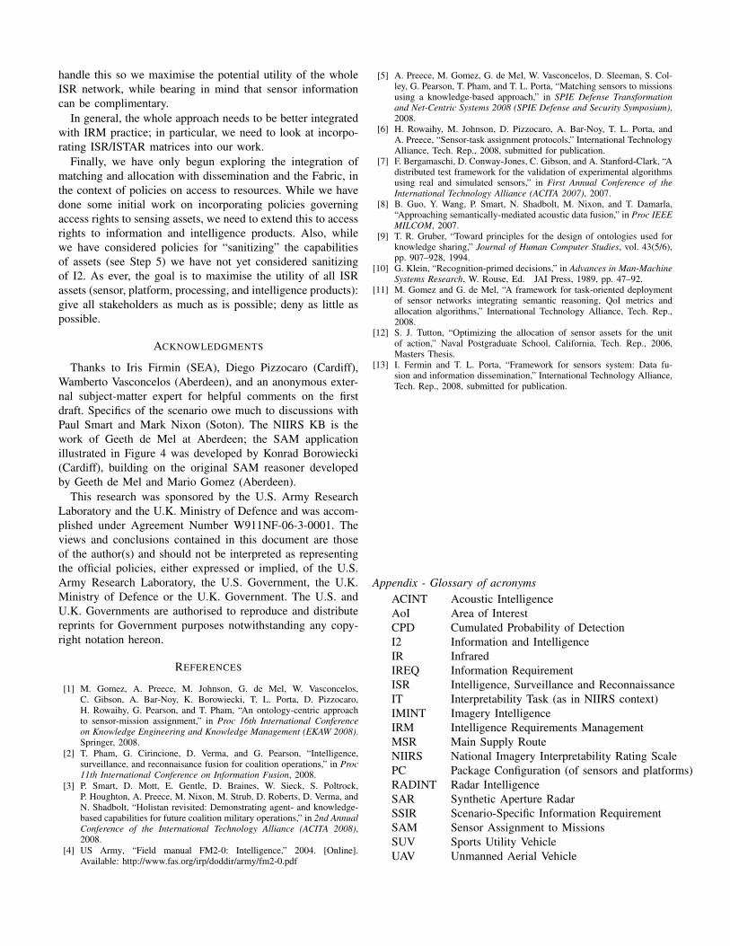
Once we’ve assigned instances we can deploy them byconfiguring a topology on the Sensor Fabric, etc. For example,in the acoustic solution case, there could be something likethe topology shown in Figure 5 where (focussing on thegrey nodes): S1 and S2 are ACINTSensor instances, S3 isP9VCSD semantic data, all three of which feed into E whichis a P9VC instance, which in turn relays data to B then Aboth of which are set up to handle dissemination and filteringoperations.
The SAM application described in Step 5 provides a basiclevel of integration with the Fabric, as outlined in [1]. Weintend to expand on this functionality in the near future.
Step 8
Users can subscribe to sources on the Fabric to meet theirI2 needs. As shown in Figure 5, the user has subscribed to I2relating to the “Are there suspicious vehicles on the road?”SSIR. Basic subscription functionality using RSS feeds iscurrently offered by the SAM application.
A
B E
FC
SC TM
FM FM
FM
FM
D
FM
S1
S2
S3
S4
S5
S6
Fig. 5. An example Sensor Fabric configuration, taken from [1]
Depending on who this user is, the data may be delivered,filtered, and/or presented differently. For example, a basecommander will probably want an overview of all activityalong the MSR, rendered on their laptop screen at HQ, whilea patrol leader operating near the middle of the MSR maywant only to know of suspicious vehicle detections neartheir position, delivered as short text messages to their PDA.Initially, Project 8 plans to use rule-based filtering according totask and command level; going further, learning-based filteringusing historical data will be investigated [13]. As noted in Step7, filtering can be accommodated by appropriate configurationof the Fabric.
Step 9
As the situation evolves, new IREQs appear. For example,imagine a patrol leader reports a large herd of migratingwildebeest crossing the MSR road and, as these are a protectedspecies, it becomes necessary establish the extent and cause ofthe migration, and maybe look for an alternative MSR. Backto step 1!
IV. DISCUSSION AND CONCLUSION
Even though this walkthrough focussed on a single infor-mation requirement in a simplified context, it has still revealeda number of gaps where our current suite of techniques do notquite fit together into the overall approach shown in Figure 2.
A. Supporting Articulation of Requirements
Currently we offer no support for articulating, analysing,and breaking down IREQs to SSIRs to ITs in Steps 1–3.Should we be aiming to provide any assistance at this stage,or seeking to integrate with other US/UK work in this space?The link from IREQs to SSIRS to ITs is important becauseultimately it is the set of IREQs that our whole approach istrying to serve. If the tasks become formalised and machine-processable only at the IT level, then we may miss someopportunities to make maximum use of the available assetsin a flexible, dynamic, and agile way — which after all is themain goal of Project 8.
At the asset allocation level, the issue is to maximiseutility to the interpretation tasks: that is, give the maximum
interpretable data to the SSIRs. We want to be able to sharedata among SSIRs wherever possible. So, for example, if two(or more) SSIRs need detection of vehicles in the same are ofinterest, implying Visible NIIRS 4 or Radar NIIRS 6 data, thenwe can share assets between them (e.g. taking into accountsharing policy, command and control, etc).
However, there are many subtleties in going from SSIRs tointerpretation tasks. The difference between “detect vehicles”and “detect suspicious vehicles” raises a lot of issues. It’sunlikely we’ll be able to define a software procedure thatcan directly answer such an SSIR; instead, we’ll be lookingfor sources of data that, together with post-processing andclassification, can give an analyst as much evidence as possibleto make a judgement. QoI/VoI will surely be a key issue here,as will the role of HUMINT (which we’ve been neglectingfor now). The key to success would seem to be to create ahuman-machine cooperative process that helps in separatingwheat from chaff, and allows analysts to make the best ofwhatever information they can get.
Another gap in our current approach is the retrieval andreuse of previously-collected information (“collect once, useoften”). We won’t always need to generate new data to addressa SSIR. There will be “known knowns” — existing pertinentsources we can retrieve. How do we describe, index and accessthese? We want to avoid “unknown knowns” — things wedon’t know we already know.
B. Intelligence Requirements Management
More work is needed to incorporate information processingand fusion components into the overall approach. The sugges-tion above of adding items like P9VC and P9VCSD to PCsis a naı̈ve one and needs further development. In our recentwork on bundle types (Step 6) we acknowledged the needfor additional configuration constraints, such as cardinality(e.g 2 AcousticArrays with ACINTSensors, 1 P9VC, etc) andlocation (e.g. 1 UAV covering the northern MSR, 1 UAVcovering southern). More kinds of constraints are surely goingto be needed here.
There is also the open question of resource scheduling,which we’ve been neglecting thus far. For example, we mayideally need a collection of sensing types to provide a completeset of interpretable data for some SSIR, but they may not allbe needed at the same time. For example, it may be enoughto gather the ACINT data (needing the AcousticArray assets)now, and do the classification (needing P9VC and P9VCSDassets) later. This is related to the important issue of sensorcueing, where one sensor may produce data that cues the useof another sensor to gather further data. In our motivatingexample, the ACINT/UAV options are not necessarily aneither/or choice — in reality, the acoustic array may cue aUAV to check out a suspicious SUV.
If we accept that SSIRs are the essential “tasks” for whichwe need to collect data, then we want to be sure our alloca-tion/bundle algorithms fit these in the best way. Note the caseabove where an SSIR can be addressed with more than oneapproach, leading to a choice of joint utility model. How to we
handle this so we maximise the potential utility of the wholeISR network, while bearing in mind that sensor informationcan be complimentary.
In general, the whole approach needs to be better integratedwith IRM practice; in particular, we need to look at incorpo-rating ISR/ISTAR matrices into our work.
Finally, we have only begun exploring the integration ofmatching and allocation with dissemination and the Fabric, inthe context of policies on access to resources. While we havedone some initial work on incorporating policies governingaccess rights to sensing assets, we need to extend this to accessrights to information and intelligence products. Also, whilewe have considered policies for “sanitizing” the capabilitiesof assets (see Step 5) we have not yet considered sanitizingof I2. As ever, the goal is to maximise the utility of all ISRassets (sensor, platform, processing, and intelligence products):give all stakeholders as much as is possible; deny as little aspossible.
ACKNOWLEDGMENTS
Thanks to Iris Firmin (SEA), Diego Pizzocaro (Cardiff),Wamberto Vasconcelos (Aberdeen), and an anonymous exter-nal subject-matter expert for helpful comments on the firstdraft. Specifics of the scenario owe much to discussions withPaul Smart and Mark Nixon (Soton). The NIIRS KB is thework of Geeth de Mel at Aberdeen; the SAM applicationillustrated in Figure 4 was developed by Konrad Borowiecki(Cardiff), building on the original SAM reasoner developedby Geeth de Mel and Mario Gomez (Aberdeen).
This research was sponsored by the U.S. Army ResearchLaboratory and the U.K. Ministry of Defence and was accom-plished under Agreement Number W911NF-06-3-0001. Theviews and conclusions contained in this document are thoseof the author(s) and should not be interpreted as representingthe official policies, either expressed or implied, of the U.S.Army Research Laboratory, the U.S. Government, the U.K.Ministry of Defence or the U.K. Government. The U.S. andU.K. Governments are authorised to reproduce and distributereprints for Government purposes notwithstanding any copy-right notation hereon.
REFERENCES
[1] M. Gomez, A. Preece, M. Johnson, G. de Mel, W. Vasconcelos,C. Gibson, A. Bar-Noy, K. Borowiecki, T. L. Porta, D. Pizzocaro,H. Rowaihy, G. Pearson, and T. Pham, “An ontology-centric approachto sensor-mission assignment,” in Proc 16th International Conferenceon Knowledge Engineering and Knowledge Management (EKAW 2008).Springer, 2008.
[2] T. Pham, G. Cirincione, D. Verma, and G. Pearson, “Intelligence,surveillance, and reconnaisance fusion for coalition operations,” in Proc11th International Conference on Information Fusion, 2008.
[3] P. Smart, D. Mott, E. Gentle, D. Braines, W. Sieck, S. Poltrock,P. Houghton, A. Preece, M. Nixon, M. Strub, D. Roberts, D. Verma, andN. Shadbolt, “Holistan revisited: Demonstrating agent- and knowledge-based capabilities for future coalition military operations,” in 2nd AnnualConference of the International Technology Alliance (ACITA 2008),2008.
[4] US Army, “Field manual FM2-0: Intelligence,” 2004. [Online].Available: http://www.fas.org/irp/doddir/army/fm2-0.pdf
[5] A. Preece, M. Gomez, G. de Mel, W. Vasconcelos, D. Sleeman, S. Col-ley, G. Pearson, T. Pham, and T. L. Porta, “Matching sensors to missionsusing a knowledge-based approach,” in SPIE Defense Transformationand Net-Centric Systems 2008 (SPIE Defense and Security Symposium),2008.
[6] H. Rowaihy, M. Johnson, D. Pizzocaro, A. Bar-Noy, T. L. Porta, andA. Preece, “Sensor-task assignment protocols,” International TechnologyAlliance, Tech. Rep., 2008, submitted for publication.
[7] F. Bergamaschi, D. Conway-Jones, C. Gibson, and A. Stanford-Clark, “Adistributed test framework for the validation of experimental algorithmsusing real and simulated sensors,” in First Annual Conference of theInternational Technology Alliance (ACITA 2007), 2007.
[8] B. Guo, Y. Wang, P. Smart, N. Shadbolt, M. Nixon, and T. Damarla,“Approaching semantically-mediated acoustic data fusion,” in Proc IEEEMILCOM, 2007.
[9] T. R. Gruber, “Toward principles for the design of ontologies used forknowledge sharing,” Journal of Human Computer Studies, vol. 43(5/6),pp. 907–928, 1994.
[10] G. Klein, “Recognition-primed decisions,” in Advances in Man-MachineSystems Research, W. Rouse, Ed. JAI Press, 1989, pp. 47–92.
[11] M. Gomez and G. de Mel, “A framework for task-oriented deploymentof sensor networks integrating semantic reasoning, QoI metrics andallocation algorithms,” International Technology Alliance, Tech. Rep.,2008.
[12] S. J. Tutton, “Optimizing the allocation of sensor assets for the unitof action,” Naval Postgraduate School, California, Tech. Rep., 2006,Masters Thesis.
[13] I. Fermin and T. L. Porta, “Framework for sensors system: Data fu-sion and information dissemination,” International Technology Alliance,Tech. Rep., 2008, submitted for publication.
Appendix - Glossary of acronymsACINT Acoustic IntelligenceAoI Area of InterestCPD Cumulated Probability of DetectionI2 Information and IntelligenceIR InfraredIREQ Information RequirementISR Intelligence, Surveillance and ReconnaissanceIT Interpretability Task (as in NIIRS context)IMINT Imagery IntelligenceIRM Intelligence Requirements ManagementMSR Main Supply RouteNIIRS National Imagery Interpretability Rating ScalePC Package Configuration (of sensors and platforms)RADINT Radar IntelligenceSAR Synthetic Aperture RadarSSIR Scenario-Specific Information RequirementSAM Sensor Assignment to MissionsSUV Sports Utility VehicleUAV Unmanned Aerial Vehicle