
Semantic web approach for dealing with administrative boundary revisions: A case study of Dhaka City
108
Shiuli Pervin Semantic web approach for dealing with administrative boundary revisions: A case study of Dhaka City Master thesis submitted in partial fulfillment of the requirements for the Degree of Master of Science in Geospatial Technologies
-
Upload
independent -
Category
Documents
-
view
0 -
download
0
Transcript of Semantic web approach for dealing with administrative boundary revisions: A case study of Dhaka City
Shiuli Pervin
Semantic web approach for dealing with administrative boundary revisions: A case study of Dhaka City
Master thesis submitted in partial fulfillment of the requirements for the Degree of Master of Science in Geospatial Technologies
Semantic web approach for dealing with administrative boundary revisions: A case study of Dhaka City i
Semantic web approach for dealing with administrative boundary
revisions: A case study of Dhaka City
Author´s Declaration
I hereby, certify that this Master thesis product is my independent work and with no other
tools than the specified. All external sources are evidently acknowledged in the thesis.
……………………………….
Signature
Münster, March 2013
Semantic web approach for dealing with administrative boundary revisions: A case study of Dhaka City ii
SEMANTIC WEB APPROACH FOR DEALING WITH
ADMINISTRATIVE BOUNDARY REVISIONS:
A CASE STUDY OF DHAKA CITY
Master Thesis
Supervised by
Prof. Dr. Werner Kuhn
Institute for Geoinformatics (IFGI)
Westfälische Wilhelms-Universität
Münster – Germany
Co-supervised by
Prof. Dr. Rayes Grangel Seguer
Contracted Research Group IRIS,
Institute of New Imaging Technologies (INIT),
Universitat Jaume I (UJI),
Castellón, Spain.
Prof. Dr. Ana Cristina Marinho da Costa
Instituto Superior de Estatística e Gestão de Informação
Universidade Nova de Lisboa
Lisbon – Portugal
Semantic web approach for dealing with administrative boundary revisions: A case study of Dhaka City iii
ACKNOWLEDGEMENTS
My gratitude to the supervisor, Prof. Dr. Werner Kuhn along with my co-supervisor Rayes Grangel
Seguer and Ana Cristina Marinho da Costa for their special support, feedback and continuous
guidance throughout my thesis.
I want to pass my special thanks to Dr. Tomi Kauppinen for helping me understand SAPO and
appreciating me to apply change vocabulary for creating databases for Dhaka City.
Special thanks to my friend and husband Mohammad Ruhul Amin for his moral support. I am also
thankful to Dr. Christoph, Brox, Martina Hoffer, Johannes Trame, Jim Jones, Alber Sánchez,
Mohammed Imaduddin Humayun, and Carlos Andres Osorio Murillo and Mohammad Anisur Rahman
for their great help in constructing my thesis ideas and implementing my data model.
I am thankful to all my friends who always encourage me to do my thesis work in due course and
helped me in collecting data from Bangladesh.
Finally my devoted thanks and love goes to my little princess, my daughter, Ridhwaana Al Mahjabeen
who always encouraged me to work hard and study, never let me fall down, has lots of contribution in
my life.
Semantic web approach for dealing with administrative boundary revisions: A case study of Dhaka City iv
ABSTRACT
Dhaka City is the capital of Bangladesh and boundary revisions of Dhaka city refers to the changes of
Dhaka city administrative boundary or jurisdiction over time. Dhaka is growing very fast in terms of
population and area. So, government is redefining city boundaries and also making big units into
several parts for better city management. Now, the challenge is to deal with these changes of
administrative regions that seem to be helpful to match with census record that comes out every ten to
fifteen years. Dhaka city boundary revisions dataset contains data about the name of the administrative
unit, type of administrative unit, year of establishment, year of data record, geometry of administrative
unit defining the jurisdiction, type of revisions occurred in the administrative units, time of revisions
and the number of subdivisions inside an administrative unit. This thesis aims to integrate Dhaka city
boundary revision dataset using semantic web technology that preserves information about changes
occurred in the Dhaka city boundary over time.
KEYWORDS
Linked Open Data, Semantic Web, Administrative Boundary, Administrative Divisions, Geographical
Information Systems, Spatio-Temporal Changes, SAPO
Semantic web approach for dealing with administrative boundary revisions: A case study of Dhaka City v
ACRONYMS
CSV – Comma Separated Values
DCC – Dhaka City Corporation
DMDP – Dhaka Metropolitan Development Plan
DNCC – Dhaka North City Corporation
DSCC – Dhaka South City Corporation
FOAF – Friend of a friend
GI- Geographic Information
GIS – Geographic Information Systems
GIScience – Geographic Information Science
HTTP – Hypertext Transfer Protocol
LOD – Linked Open Data
OWL – Ontology Web Language
RAJUK - Rajdhani Unnayan Katripakha
RDB – Relational Database
RDBMS – Relational Database Management System
RDF – Resource Description Framework
SAPO - Suomen Ajallinen Paikka Ontologia (Finnish Spatio-Temporal Ontology)
SIOC – Semantically interlinked online communities
SONADUS - Spatiotemporal Ontology for the Administrative Units of Switzerland
SPARQL – SPARQL Protocol and RDF Query Language
SQL - Structured Query Language
URI – Unified Resource Identifier
URL – Unified Resource Locator
W3C – World Wide Web Consortium
WWW – World Wide Web
XML – Extensible Markup Language
Semantic web approach for dealing with administrative boundary revisions: A case study of Dhaka City vi
CONTENTS
ACKNOWLEDGEMENTS ................................................................................................................. iii
ABSTRACT .......................................................................................................................................... iv
KEYWORDS ........................................................................................................................................ iv
ACRONYMS ......................................................................................................................................... v
CONTENTS .......................................................................................................................................... vi
TABLE OF FIGURES ....................................................................................................................... viii
LIST OF TABLES ................................................................................................................................. x
1 Chapter One: Introduction ............................................................................................................ 1
1.1 Introduction ................................................................................................................................... 1
1.2 Rationale of the study .................................................................................................................... 1
1.3 Problem Background ..................................................................................................................... 2
1.4 Problem Statement ........................................................................................................................ 7
1.5 Research questions ........................................................................................................................ 9
1.6 Approach ....................................................................................................................................... 9
1.7 Conclusion .................................................................................................................................... 9
2 Chapter Two: Literature review ................................................................................................. 10
2.1 Administrative Boundary ............................................................................................................ 10
2.2 GIS approaches to incorporate time into the database ................................................................. 11
2.3 Related Work .............................................................................................................................. 12
2.4 Semantic Web ............................................................................................................................. 14
2.5 Choosing and using existing vocabulary ..................................................................................... 17
2.6 Conclusion .................................................................................................................................. 19
3 Chapter Three: Methodology ...................................................................................................... 20
3.1 Data Preparation .......................................................................................................................... 20
3.2 Query Design .............................................................................................................................. 24
3.2.1 Attribute query ......................................................................................................................... 25
3.2.2 Spatial query ............................................................................................................................. 25
3.2.3 Temporal Query ....................................................................................................................... 25
3.2.4 Spatiotemporal query of geographic feature boundary changes................................................ 26
3.3 Data Modeling for Dhaka City Boundary Revisions ................................................................... 26
3.3.1 Data model for the evolution of administrative boundary for semantic web............................. 28
3.3.2 Boundary revisions ................................................................................................................... 29
3.3.3 Vocabularies used for data integration ..................................................................................... 31
3.3.4 RDF format view of data model ............................................................................................... 34
Semantic web approach for dealing with administrative boundary revisions: A case study of Dhaka City vii
3.4 Answer to the query .................................................................................................................... 36
3.5 Conclusion .................................................................................................................................. 36
4 Chapter Four: Vocabulary Implementation and Testing for Dhaka City ............................... 37
4.1 Spatio-temporal query for evolution of Dhaka City..................................................................... 37
4.1.1 Temporal or attribute query ...................................................................................................... 37
4.1.2 Spatial range query ................................................................................................................... 38
4.1.3 Spatial relationship query ......................................................................................................... 39
4.1.4 Spatio-temporal query .............................................................................................................. 39
4.2 Conceptual data model implementation for Dhaka City .............................................................. 40
4.2.1 Implementation of triple model for Dhaka city as object .......................................................... 41
4.2.2 Triple model of Place for semantic web as an event ................................................................. 43
4.2.3 Conceptual background of changes of geographic regions ....................................................... 44
5 Chapter Five: Evaluation and Visualization Issues ................................................................... 51
5.1 Evaluation ................................................................................................................................... 51
5.1.1 Tools for integrating dataset ..................................................................................................... 51
5.2 Implementation of queries ........................................................................................................... 51
5.3 Visualization of Result ................................................................................................................ 60
6 Chapter Six: Discussion ............................................................................................................... 63
6.1 New vocabularies introduced to serve semantic data integration................................................. 63
6.2 Identified changes ....................................................................................................................... 64
6.3 Insights from evaluation .............................................................................................................. 64
6.4 Limitations .................................................................................................................................. 65
7 Chapter Seven: Conclusion ......................................................................................................... 66
7.1 Summary ..................................................................................................................................... 66
7.2 Contribution ................................................................................................................................ 67
7.3 Findings ....................................................................................................................................... 67
Reference ............................................................................................................................................. 68
Appendix A: Triple Data of Dhaka City Split ...................................................................................... 71
Appendix B: Maps ............................................................................................................................... 72
Appendix C: RDF data ......................................................................................................................... 76
Semantic web approach for dealing with administrative boundary revisions: A case study of Dhaka City viii
TABLE OF FIGURES
Figure 1: Revision of Subdistrict boundaries of Dhaka city metropolitan area from 1995 to
2010. ...................................................................................................................................................... 2
Figure 2: Location of Dhaka City (Study Area) ............................................................................... 3
Figure 3: Evolution of Dhaka City between British periods to Bangladesh ................................. 4
Figure 4: Growth of Dhaka City (not in scale) ................................................................................. 4
Figure 5: Dhaka city in different historic period to present ............................................................ 6
Figure 6: Population census data integrated with Dhaka Metropolitan Thana boundary ............ 8
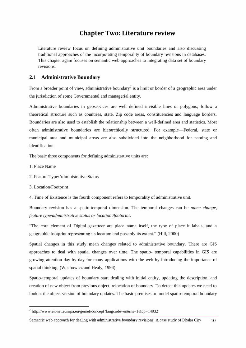
Figure 7: Boundary update procedure for different versions (modified) (Wachowicz and
Healy, 1994) ....................................................................................................................................... 11
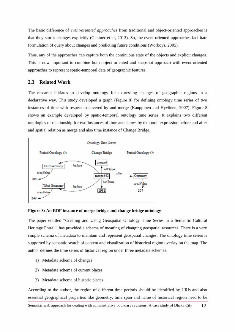
Figure 8: An RDF instance of merge bridge and change bridge ontology .................................. 12
Figure 9: RDF graph with related information about Dhaka City ............................................... 16
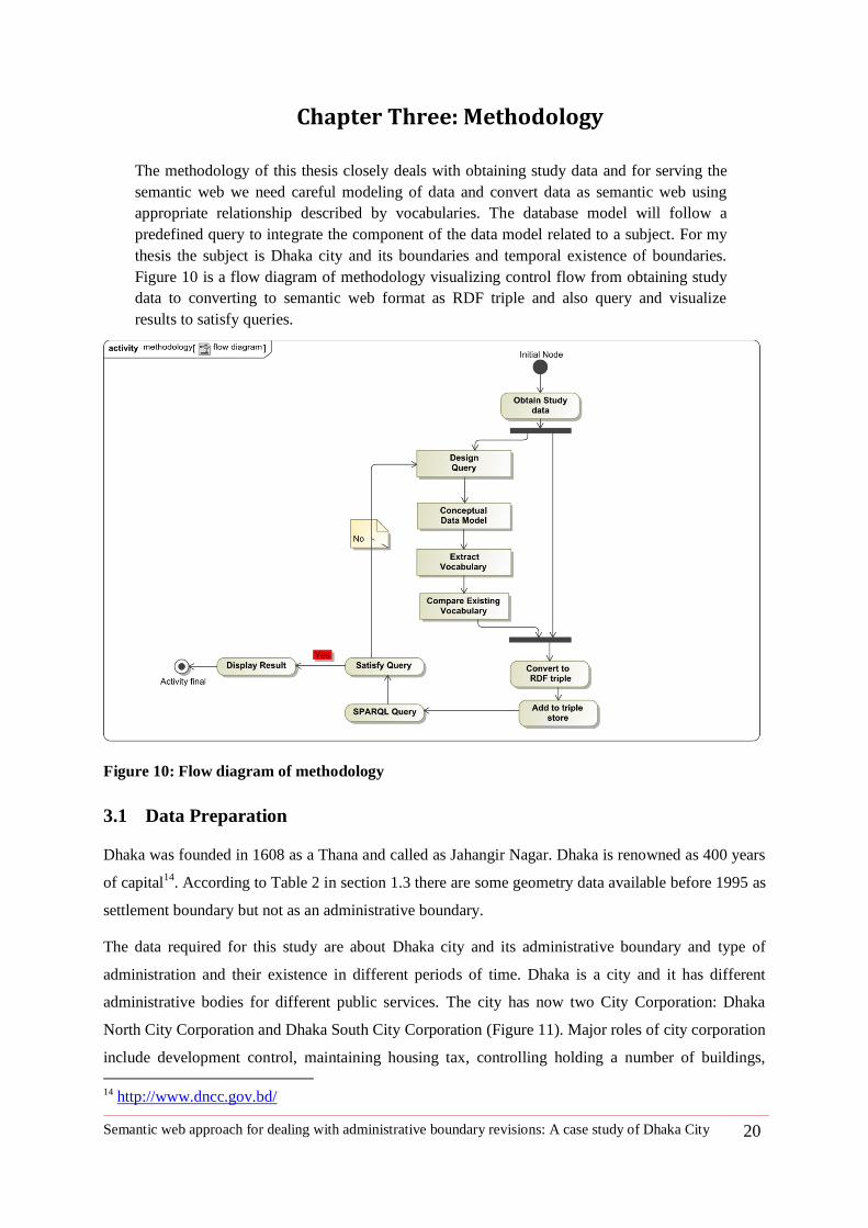
Figure 10: Flow diagram of methodology ...................................................................................... 20
Figure 11: Dhaka North and South City Corporation .................................................................... 21
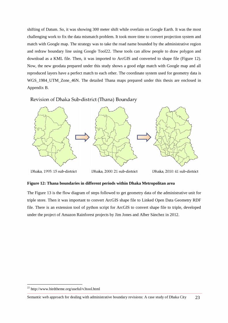
Figure 12: Thana boundaries in different periods within Dhaka Metropolitan area .................. 23
Figure 13: Graphical architecture of geodata prepration for the semantic web .......................... 24
Figure 14: Administrative subdivision of Dhaka city ................................................................... 28
Figure 15: Dhaka city boundary revision process model .............................................................. 29
Figure 16: Administrative boundary entity relationship diagram ................................................ 30
Figure 17: RDF schema of describing a city and its administration and subdivision hierarchies
............................................................................................................................................................. 35
Figure 18: Place as event or historic place ..................................................................................... 35
Figure 19: Use of change vocabulary to integrate boundary revisions dataset ........................... 36
Figure 20: Vocabularies that are used to integrate semantic meaning......................................... 41
Figure 21: RDF graph of Dhaka City triple model for a specific time instance ......................... 42
Figure 22: RDF graph of Dhaka as an Event or historic place ..................................................... 44
Figure 23: Changes of number of subdivisions of administrative units and shape of areas. .... 44
Figure 24: Change of Dhaka City Corporation to Dhaka South and Dhaka North City
Corporation......................................................................................................................................... 45
Figure 25: RDF graph of change type split..................................................................................... 45
Figure 26 : Full Graph to show the Dhaka City administrative boundary revision ................... 46
Figure 27: Evolution of sub-district of Dhaka from 1995 to 2010............................................... 48
Semantic web approach for dealing with administrative boundary revisions: A case study of Dhaka City ix
Figure 28: Example of Thana boundary changes in terms of the split , merge and name
Change ................................................................................................................................................ 49
Figure 29: SPARQL query Q-1 ....................................................................................................... 52
Figure 30: SPARQL query result Q-1 ............................................................................................. 52
Figure 31: SPARQL query Q-2 ....................................................................................................... 53
Figure 32: SPARQL query result Q-2 ............................................................................................. 53
Figure 33: SPARQL query Q-3) ...................................................................................................... 54
Figure 34: SPARQL query result Q-3) ........................................................................................... 54
Figure 35: SPARQL query Q-4) ...................................................................................................... 55
Figure 36: SPARQL query result Q-4) ........................................................................................... 55
Figure 37: SPARQL query Q-5) ...................................................................................................... 56
Figure 38: SPARQL query results Q-5) .......................................................................................... 56
Figure 39: SPARQL query Q-6) ...................................................................................................... 57
Figure 40: SPARQLL query result Q-6) ......................................................................................... 57
Figure 41: SPARQL query Q-7) ...................................................................................................... 58
Figure 42: SPARQL query Q-8) ...................................................................................................... 59
Figure 43: SPARQL query result Q-8) ........................................................................................... 59
Figure 44: Billionaires and compare their wealth .......................................................................... 61
Figure 45: The hardware system ESRI is used for implementation of RDF data visualization61
Figure 46: CultureSampo visualization of historical regions ....................................................... 62
Figure 47: Thana Boundaries of Dhaka Metropolitan Area, 1995 ............................................... 73
Figure 48: Thana Boundaries of Dhaka Metropolitan Area, 2000 ............................................... 74
Figure 49: Thana Boundaries of Dhaka Metropolitan Area, 2010 ............................................... 75
Semantic web approach for dealing with administrative boundary revisions: A case study of Dhaka City x
LIST OF TABLES
Table 1: Area, Population and administrative identity of Dhaka City from 1947 to 2011.......... 5
Table 2: Life of Dhaka city and Availability of Geometric Data ................................................... 5
Table 3: Example of basic data about a city ................................................................................... 15
Table 4: Concepts to define an administrative unit and vocabulary in use ................................. 18
Table 5: Comparism between popular data models and semantic web ...................................... 27
Table 6: Changes of Dhaka city as an administrative region........................................................ 33
Table 7: Name and administrative status of Dhaka City in different period of time ................. 37
Table 8: Snap of Thanas of Dhaka metropolitan area in 1995 ..................................................... 38
Table 9: Administrations that are part of Dhaka City.................................................................... 39
Table 10: Place name and administrative status in period of life Dhaka City ............................ 40
Table 11: Dhaka City in semantic web triple model ..................................................................... 42
Table 12: Adding external resources on the subject ...................................................................... 43
Table 13: Triple model representation of Dacca municipality as Event ..................................... 43
Table 14: Temporal overlap of sub district of Dhaka Metropolitan Area ................................... 47
Table 15: SPARQL query result Q-7) ............................................................................................. 58
Semantic web approach for dealing with administrative boundary revisions: A case study of Dhaka City 1
1 Chapter One: Introduction
This thesis is about administrative boundary revisions of Dhaka city and related problems
and possible solution to manage boundary revision database. Thus, it can offer better
management, data finding and sharing for administrative and research purposes. This
chapter focuses on the study problems in detail, research questions to be solved, and
approach to answer.
1.1 Introduction
Dhaka city, the capital of Bangladesh, has a dynamic history of name changes and boundary revisions
over the last 150 years of its municipal life. Now, the difficulty is to find an appropriate reference data
set of the geographic extent of city and sub regions and match with census information. Administrative
regions refer to the areal extent of the regions. The region might change with the next census period
and accordingly census and other statistics related to the region might also change So , it is difficult to
compare the area and the census information related to a geographic region of previous sessions
(Worboys 1994). The administrative boundary revisions include redefining the city boundary, name
change of administrative units, change of the administrative status, and redistribution of geographic
extent. This thesis aims to integrate administrative boundary revision data in semantic web for Dhaka
city. The outcome of the thesis will help us to compare the area with the aggregate statistics linked
with it, e.g., total population, male female ratio, population density, birth rate, education rate, etc. The
study will extend the scope of linking other information to the existing developed data set and help to
find new facts by relating other discipline (e.g., water supply, taxation, business, crime, crops
production, disease rate, education etc.) of data to regional dataset.
1.2 Rationale of the study
City is an administrative unit refers to as a region of governance. But historic administrative regions
such as countries, municipalities and cities undergo changes over time in terms of name, being merged
with other regions, or one region being divided into two and getting two different identities. City as an
aerial extent has census and other statistical data linked to it. If name and geographic extent change
over time, it is difficult to compare the properties of two different time periods without a proper
system addressing and linking spatial data with appropriate temporal reference.
Development organization such as the World Bank and researchers who are involved in gathering
huge records of data referring to geographic regions or places in the world. To plan our planet, locate
our project and business, we need to compare data trend such as population growth, education status,
crops production and economic progress, settlement growth for future planning and finding new
potentialities and drawbacks. For example-to find a suitable location of Diarrhea Hospital in Dhaka, it
is important to find where the cholera venerable areas are and what the trend of affecting population
Semantic web approach for dealing with administrative boundary revisions: A case study of Dhaka City 2
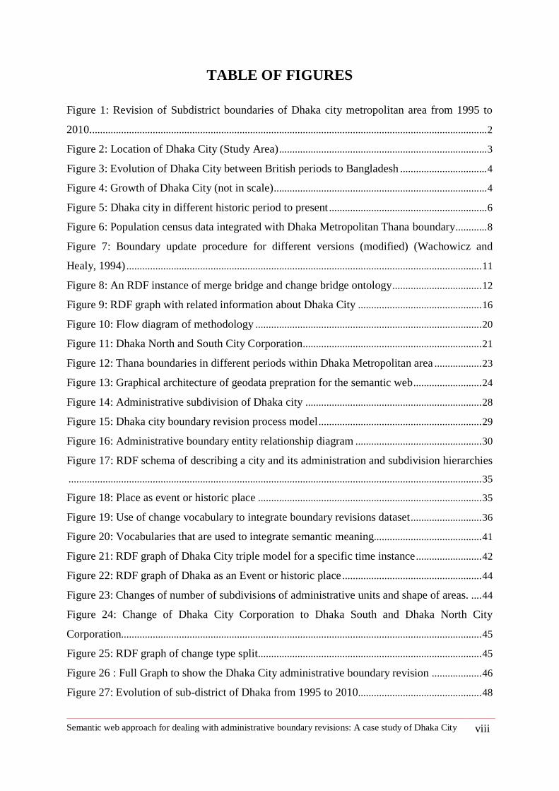
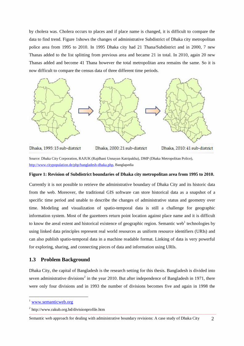
by cholera was. Cholera occurs to places and if place name is changed, it is difficult to compare the
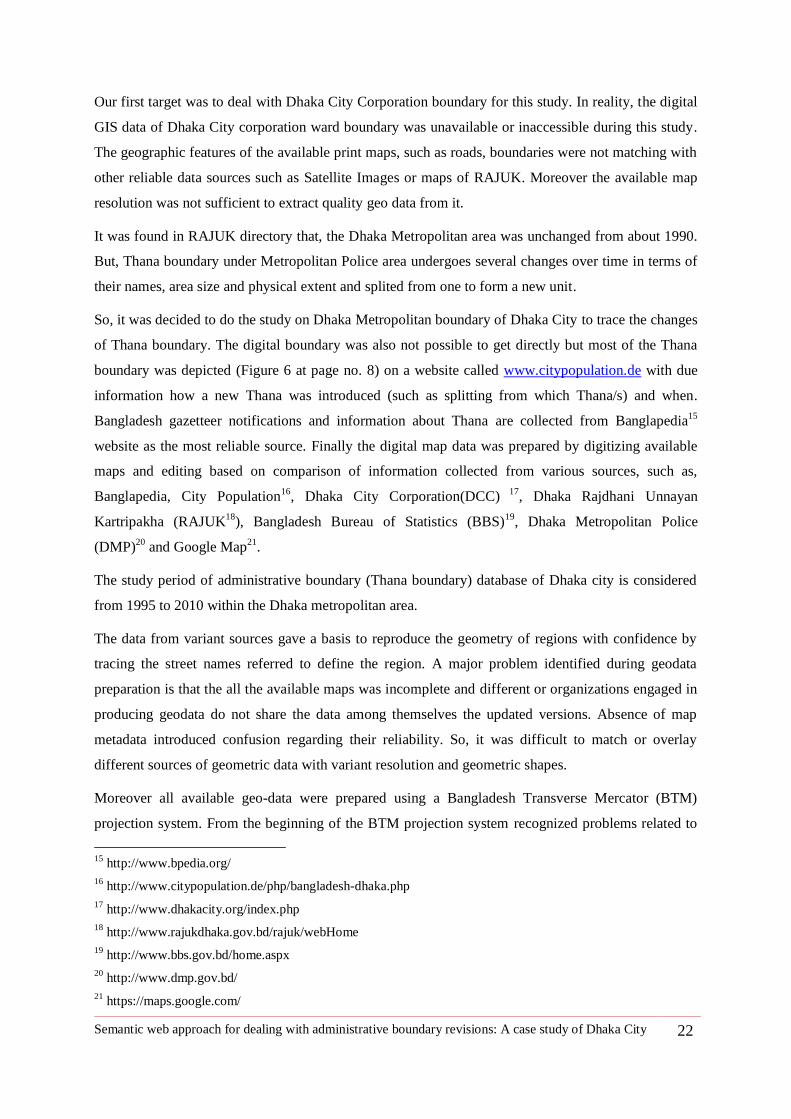
data to find trend. Figure 1shows the changes of administrative Subdistrict of Dhaka city metropolitan
police area from 1995 to 2010. In 1995 Dhaka city had 21 Thana/Subdistrict and in 2000, 7 new
Thanas added to the list splitting from previous area and became 21 in total. In 2010, again 20 new
Thanas added and become 41 Thana however the total metropolitan area remains the same. So it is
now difficult to compare the census data of three different time periods.
Source: Dhaka City Corporation, RAJUK (Rajdhani Unnayan Katripakha), DMP (Dhaka Metropolitan Police),
http://www.citypopulation.de/php/bangladesh-dhaka.php, Banglapedia
Figure 1: Revision of Subdistrict boundaries of Dhaka city metropolitan area from 1995 to 2010.
Currently it is not possible to retrieve the administrative boundary of Dhaka City and its historic data
from the web. Moreover, the traditional GIS software can store historical data as a snapshot of a
specific time period and unable to describe the changes of administrative status and geometry over
time. Modeling and visualization of spatio-temporal data is still a challenge for geographic
information system. Most of the gazetteers return point location against place name and it is difficult
to know the areal extent and historical existence of geographic region. Semantic web1 technologies by
using linked data principles represent real world resources as uniform resource identifiers (URIs) and
can also publish spatio-temporal data in a machine readable format. Linking of data is very powerful
for exploring, sharing, and connecting pieces of data and information using URIs.
1.3 Problem Background
Dhaka City, the capital of Bangladesh is the research setting for this thesis. Bangladesh is divided into
seven administrative divisions2 in the year 2010. But after independence of Bangladesh in 1971, there
were only four divisions and in 1993 the number of divisions becomes five and again in 1998 the
1 www.semanticweb.org
2 http://www.rakub.org.bd/divisionprofile.htm
Semantic web approach for dealing with administrative boundary revisions: A case study of Dhaka City 3
county divided into six divisions. Accordingly, different administrative entities such as city planning
authority redefine their services boundary regularly to include new areas as a process of formalizing
urban growth in the master plan.
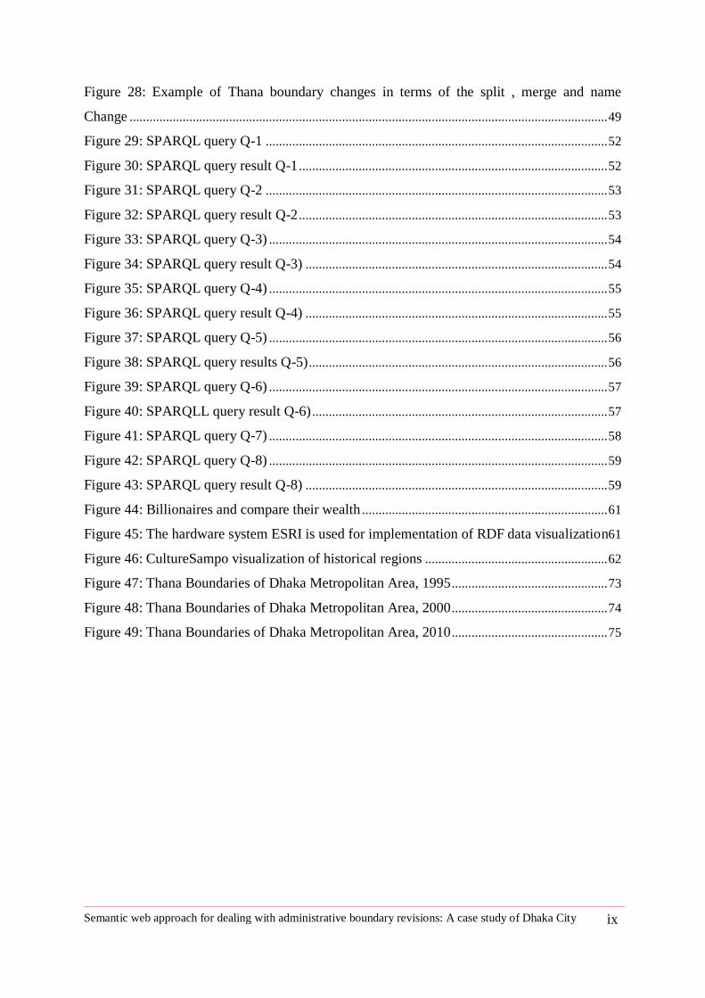
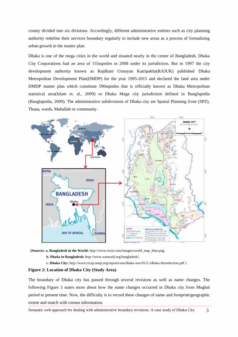
Dhaka is one of the mega cities in the world and situated nearly in the center of Bangladesh. Dhaka
City Corporations had an area of 155sqmiles in 2008 under its jurisdiction. But in 1997 the city
development authority known as Rajdhani Unnayan Katripakha(RAJUK) published Dhaka
Metropolitan Development Plan(DMDP) for the year 1995-2015 and declared the land area under
DMDP master plan which constitute 590sqmiles that is officially known as Dhaka Metropolitan
statistical area(Islam et. al., 2009) or Dhaka Mega city jurisdiction defined in Banglapedia
(Banglapedia, 2009). The administrative subdivisions of Dhaka city are Spatial Planning Zone (SPZ),
Thana, wards, Mahallah or community.
(Sources: a. Bangladesh in the World: http://www.twizi.com/images/world_map_blue.png,
b. Dhaka in Bangladesh: http://www.wateraid.org/bangladesh/,
c. Dhaka City: http://www.rrcap.unep.org/reports/soe/dhaka-soe-05/2-1dhaka-Introduction.pdf )
Figure 2: Location of Dhaka City (Study Area)
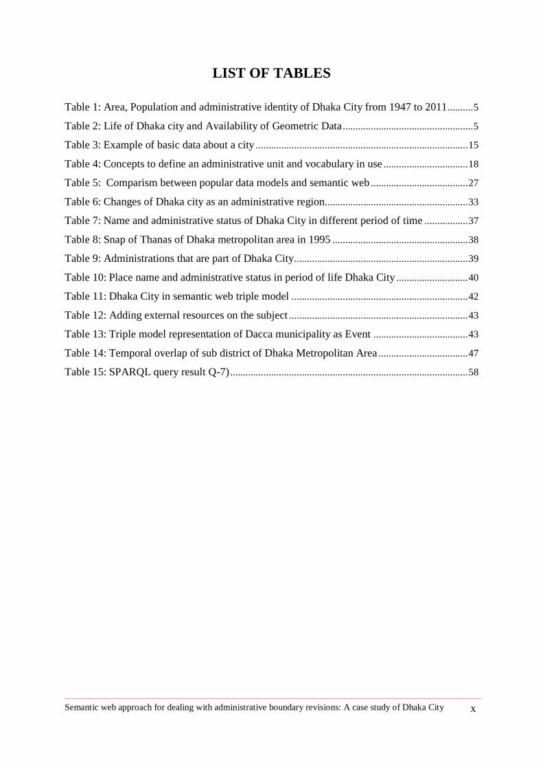
The boundary of Dhaka city has passed through several revisions as well as name changes. The
following Figure 3 states more about how the name changes occurred in Dhaka city from Mughal
period to present time. Now, the difficulty is to record these changes of name and footprint/geographic
extent and match with census information.
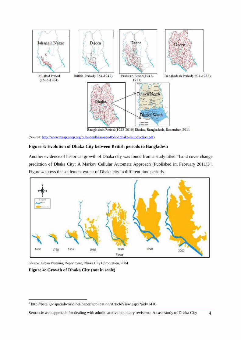
Semantic web approach for dealing with administrative boundary revisions: A case study of Dhaka City 4
(Source: http://www.rrcap.unep.org/pub/soe/dhaka-soe-05/2-1dhaka-Introduction.pdf)
Figure 3: Evolution of Dhaka City between British periods to Bangladesh
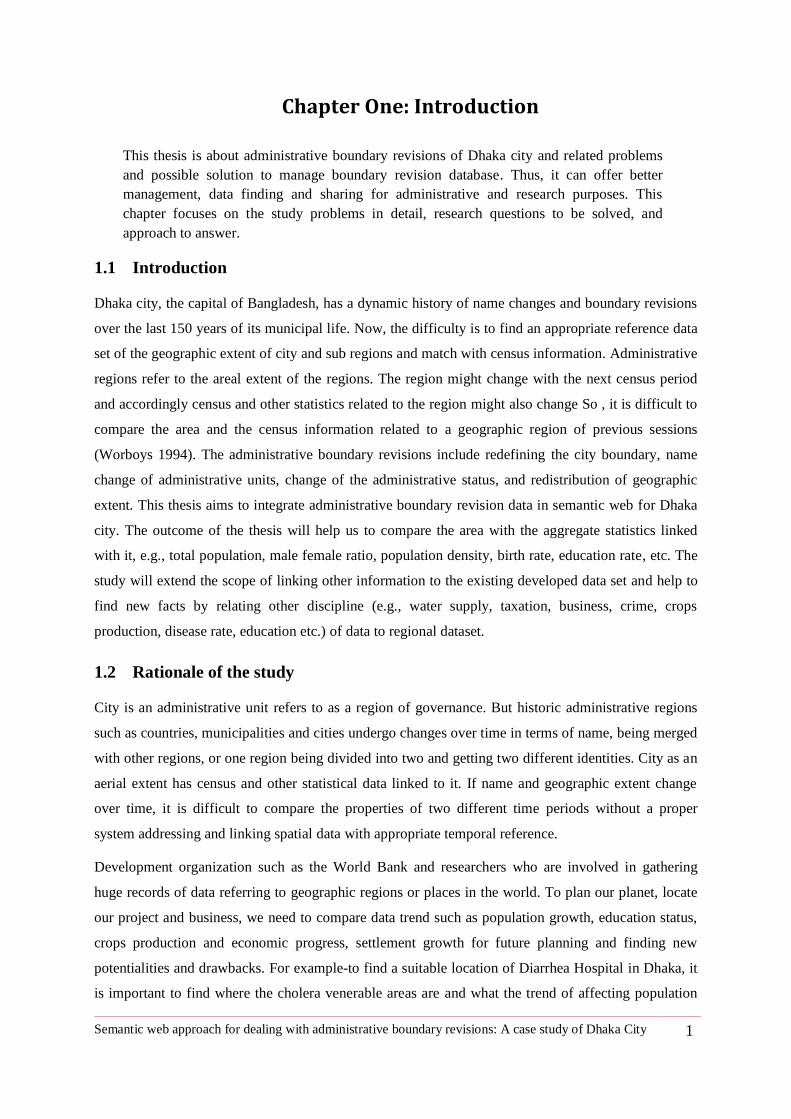
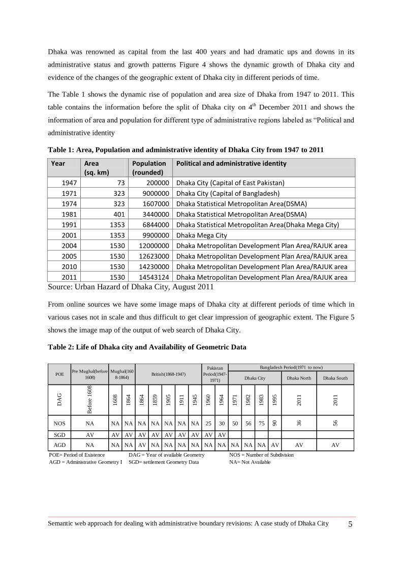
Another evidence of historical growth of Dhaka city was found from a study titled ―Land cover change
prediction of Dhaka City: A Markov Cellular Automata Approach (Published in: February 2011)3‖.
Figure 4 shows the settlement extent of Dhaka city in different time periods.
Source: Urban Planning Department, Dhaka City Corporation, 2004
Figure 4: Growth of Dhaka City (not in scale)
3 http://beta.geospatialworld.net/paper/application/ArticleView.aspx?aid=1416
Semantic web approach for dealing with administrative boundary revisions: A case study of Dhaka City 5
Dhaka was renowned as capital from the last 400 years and had dramatic ups and downs in its
administrative status and growth patterns Figure 4 shows the dynamic growth of Dhaka city and
evidence of the changes of the geographic extent of Dhaka city in different periods of time.
The Table 1 shows the dynamic rise of population and area size of Dhaka from 1947 to 2011. This
table contains the information before the split of Dhaka city on 4th
December 2011 and shows the
information of area and population for different type of administrative regions labeled as ―Political and
administrative identity
Table 1: Area, Population and administrative identity of Dhaka City from 1947 to 2011
Year Area (sq. km)
Population (rounded)
Political and administrative identity
1947 73 200000 Dhaka City (Capital of East Pakistan)
1971 323 9000000 Dhaka City (Capital of Bangladesh)
1974 323 1607000 Dhaka Statistical Metropolitan Area(DSMA)
1981 401 3440000 Dhaka Statistical Metropolitan Area(DSMA)
1991 1353 6844000 Dhaka Statistical Metropolitan Area(Dhaka Mega City)
2001 1353 9900000 Dhaka Mega City
2004 1530 12000000 Dhaka Metropolitan Development Plan Area/RAJUK area
2005 1530 12623000 Dhaka Metropolitan Development Plan Area/RAJUK area
2010 1530 14230000 Dhaka Metropolitan Development Plan Area/RAJUK area
2011 1530 14543124 Dhaka Metropolitan Development Plan Area/RAJUK area
Source: Urban Hazard of Dhaka City, August 2011
From online sources we have some image maps of Dhaka city at different periods of time which in
various cases not in scale and thus difficult to get clear impression of geographic extent. The Figure 5
shows the image map of the output of web search of Dhaka City.
Table 2: Life of Dhaka city and Availability of Geometric Data
Dhaka North Dhaka South
DA
G
Bef
ore
16
08
1608
1864
1864
1859
1905
1911
1945
1960
1964
1971
1982
1983
1995
2011
2011
NOS NA NA NA NA NA NA NA NA 25 30 50 56 75 90
36
56
SGD AV AV AV AV AV AV AV AV AV AV
AGD NA NA NA AV NA NA NA NA NA NA NA NA NA AV AV AV
POE= Period of Existence DAG = Year of available Geometry NOS = Number of Subdivision
AGD = Administrative Geometry Data SGD= settlement Geometry Data NA= Not Available
Bangladesh Period(1971 to now)
Dhaka CityPOE
Pre Mughal(before
1608)
Mughal(160
8-1864)British(1868-1947)
Pakistan
Period(1947-
1971)
Semantic web approach for dealing with administrative boundary revisions: A case study of Dhaka City 6
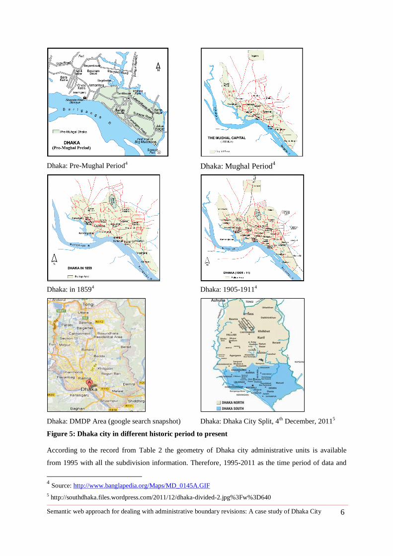
Figure 5: Dhaka city in different historic period to present
According to the record from Table 2 the geometry of Dhaka city administrative units is available
from 1995 with all the subdivision information. Therefore, 1995-2011 as the time period of data and
4 Source: http://www.banglapedia.org/Maps/MD_0145A.GIF
5 http://southdhaka.files.wordpress.com/2011/12/dhaka-divided-2.jpg%3Fw%3D640
Dhaka: Pre-Mughal Period4 Dhaka: Mughal Period
4
Dhaka: in 18594 Dhaka: 1905-1911
4
Dhaka: DMDP Area (google search snapshot) Dhaka: Dhaka City Split, 4th
December, 20115
Semantic web approach for dealing with administrative boundary revisions: A case study of Dhaka City 7
Dhaka metropolitan area and its subdivisions as an administrative boundary were considered for
implementing my thesis.
Dhaka, the capital of Bangladesh has two city corporations now: Dhaka North City Corporation and
Dhaka South City Corporation as of 4th
December 2011 according to Local Government (City
Corporation) Amendment Act (2011). Dhaka was founded in 1608 as the capital of the province
during the Mughal period and it was renamed as Jahangir Nagar. In 1864 Dhaka was declared as
Municipality (Pourashava). In 1905, Dhaka was the capital of a new province comprising East Bengal
and Assam. The city became the provincial capital of East Pakistan after Pakistan emerged as an
independent country in 1947. Dhaka became the capital of Bangladesh in 1971 just after
independence. 1n 1978 administrative status of Dhaka uplifted from Pourashava to Municipal
Corporation and the head of the administrative body was called Major. Again, in 1990, the Dhaka
Municipal Corporation was renamed as Dhaka City Corporation. Now, Dhaka South City Corporation
is considered as the Original Dhaka City and Capital. All the information stated in this paragraph is
taken from Dhaka South City Corporation web site. The interesting part is all data are in text format
and there is no information about the geographic extent of the city or even there is no city map
available online. We can only get an image of Dhaka city split with two different colors. This makes it
difficult for a researcher to find the survey data and use it for intended study area.
1.4 Problem Statement
System of data sharing is not a flexible task. Furthermore, different organizations produce geodata
separately in the same area and lack the enthusiasm to share data among themselves. Therefore,
researchers always face the problem of choosing the most appropriate data set. For this thesis, most of
the data came from paper maps produced by Dhaka City Corporation from which I got only the area
name and sometimes subdivision names. Getting supporting of official information was primarily very
hard. This made me go through all prominent publications about the Dhaka city that discuss about the
city extensively in different periods of time. The experience gained is that all data available either text
format or as books or in maps of the city authority as a cartographic paper map. Every time a
researcher wants to work in Dhaka city, s/he needs to take great hardship to find the geodata in digital
format and also match the data with census information. The difficulties of gathering information
usually compel the researcher to limit study scope. This was all true for my study of collecting map
and data of administrative boundary revisions. I had to spend a lot of time to access the data and also
reproducing the data from paper maps collected from Dhaka City Corporation (DCC), Rajdhani
Unnayan Katripakha (RAJUK), available books and publication.
A current search of Dhaka city spatial information can only show the current information as a JPEG
image or text format and the information is also not in an appropriate data sharing format.
www.citypopulation.de has developed a nice interface to display metropolitan sub districts of Dhaka
Semantic web approach for dealing with administrative boundary revisions: A case study of Dhaka City 8
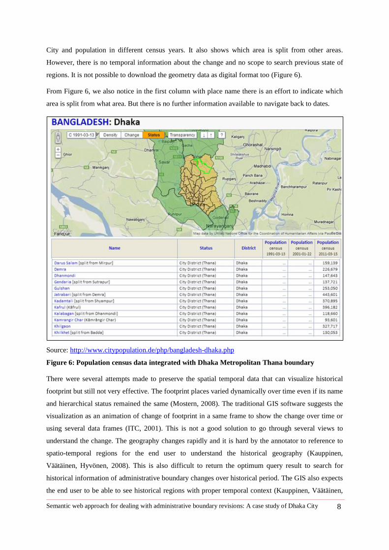
City and population in different census years. It also shows which area is split from other areas.
However, there is no temporal information about the change and no scope to search previous state of
regions. It is not possible to download the geometry data as digital format too (Figure 6).
From Figure 6, we also notice in the first column with place name there is an effort to indicate which
area is split from what area. But there is no further information available to navigate back to dates.
Source: http://www.citypopulation.de/php/bangladesh-dhaka.php
Figure 6: Population census data integrated with Dhaka Metropolitan Thana boundary
There were several attempts made to preserve the spatial temporal data that can visualize historical
footprint but still not very effective. The footprint places varied dynamically over time even if its name
and hierarchical status remained the same (Mostern, 2008). The traditional GIS software suggests the
visualization as an animation of change of footprint in a same frame to show the change over time or
using several data frames (ITC, 2001). This is not a good solution to go through several views to
understand the change. The geography changes rapidly and it is hard by the annotator to reference to
spatio-temporal regions for the end user to understand the historical geography (Kauppinen,
Väätäinen, Hyvönen, 2008). This is also difficult to return the optimum query result to search for
historical information of administrative boundary changes over historical period. The GIS also expects
the end user to be able to see historical regions with proper temporal context (Kauppinen, Väätäinen,
Semantic web approach for dealing with administrative boundary revisions: A case study of Dhaka City 9
and Hyvönen 2008). The census information comes up after every 10 years and within this time the
administrative subdivision may change. This obviously can cause the problem of adjusting non spatial
information linked with it (Michael, 1994).
1.5 Research questions
Based on the problem of poor management system of Dhaka city boundary revisions data, the thesis
intends to answer the following research question:
1. What is the semantic web solution for keeping track of administrative boundary revisions?
1.6 Approach
The existing web search can give information about Dhaka city and its current state as textual format.
But it is very difficult finding out its spatio-temporal state or changes of the city from its origin. This
thesis considers a city as place and location of places. The location provides an essential link between
various disparate forms of information and also distinct process from all other disciplines of
information (Goodchild et al, 2010). So, spatial thinking is very important for researchers from all
disciplines to relate their information and finding with a location or a place to explore and identify new
knowledge and social problems.
Semantic web allows us to integrate the spatio-temporal data inside of a schema. According to the
W3C6, "The Semantic Web provides a common framework that allows data to be shared and reused
across application, enterprise, and community boundaries." This thesis produced a database for
administrative boundaries of Dhaka city and its temporal existence using semantic web technologies in
order to answer the research question. This thesis introduced conceptual data model to define the data
related to the administrative boundaries of Dhaka city and the data set is evaluated by querying
information from the data set.
1.7 Conclusion
This chapter addressed the research problem and introduced a research question and a brief of
approaches. The next chapter two is about literature review. Chapter two consists of definition of
administrative boundary, GIS approaches to deal with spatio-temporal data, related work, an
introduction of semantic web and also focus on available vocabulary suitable for defining
administrative boundaries and its temporality.
6 http://www.w3.org/standards/semanticweb/
Semantic web approach for dealing with administrative boundary revisions: A case study of Dhaka City 10
2 Chapter Two: Literature review
Literature review focus on defining administrative unit boundaries and also discussing
traditional approaches of the incorporating temporality of boundary revisions in databases.
This chapter again focuses on semantic web approaches to integrating data set of boundary
revisions.
2.1 Administrative Boundary
From a broader point of view, administrative boundary7 is a limit or border of a geographic area under
the jurisdiction of some Governmental and managerial entity.
Administrative boundaries in geoservices are well defined invisible lines or polygons; follow a
theoretical structure such as countries, state, Zip code areas, constituencies and language borders.
Boundaries are also used to establish the relationship between a well-defined area and statistics. Most
often administrative boundaries are hierarchically structured. For example—Federal, state or
municipal area and municipal areas are also subdivided into the neighborhood for naming and
identification.
The basic three components for defining administrative units are:
1. Place Name
2. Feature Type/Administrative Status
3. Location/Footprint
4. Time of Existence is the fourth component refers to temporality of administrative unit.
Boundary revision has a spatio-temporal dimension. The temporal changes can be name change,
feature type/administrative status or location /footprint.
―The core element of Digital gazetteer are place name itself, the type of place it labels, and a
geographic footprint representing its location and possibly its extent.‖ (Hill, 2000)
Spatial changes in this study mean changes related to administrative boundary. There are GIS
approaches to deal with spatial changes over time. The spatio- temporal capabilities in GIS are
growing attention day by day for many applications with the web by introducing the importance of
spatial thinking. (Wachowicz and Healy, 1994)
Spatio-temporal updates of boundary start dealing with initial entity, updating the description, and
creation of new object from previous object, relocation of boundary. To detect this updates we need to
look at the object version of boundary updates. The basic premises to model spatio-temporal boundary
7 http://www.eionet.europa.eu/gemet/concept?langcode=en&ns=1&cp=14932
Semantic web approach for dealing with administrative boundary revisions: A case study of Dhaka City 11
updates are: Every object must have an initial version, a hierarchical structure is imposed on the
version of an object, different versions of an object denote different object instances and among all
versions, a current version is always distinguishable (
Figure 7).
Figure 7: Boundary update procedure for different versions (modified) (Wachowicz and Healy,
1994)
2.2 GIS approaches to incorporate time into the database
GIS database management has examined three ways of incorporating time into information system: the
traditional (snapshot), the object-oriented and the event oriented (Gantner et al, 2012). Traditional
approach of dealing with spatio-temporal changes includes the relational database by maintaining an
updated version of current state or taking a snapshot of the same object in different periods of time
(Abraham and Roddick, 1999). Object-oriented approaches are distinct objects characterized by
thematic, topological and geometric properties (Worboys, 2001). Object changes over time and as
soon as an object has changed, it generates a new object with a unique identifier (Lohfink et al, 2007).
According to a formal description by Hornsby and Egenhofer (2000),
“The identity determines the existence and nonexistence of an object and can undergo
a set of possible changes.”
A B C
T1
Update of Boundary: Initial Entity
A B C
T2
Update of Boundary: New Boundary from Existing One;
Relocation of Boundary
Time
Version Set of Boundary
A B C
Current Versions
D
Time
Version Set of Boundary
A B C
A B C D
Historic Version
Current Version
Semantic web approach for dealing with administrative boundary revisions: A case study of Dhaka City 12
The basic difference of event-oriented approaches from traditional and object-oriented approaches is
that they stores changes explicitly (Gantner et al, 2012). So, the event oriented approaches facilitate
formulation of query about changes and predicting future conditions (Worboys, 2005).
Thus, any of the approaches can capture both the continuous state of the objects and explicit changes.
This is now important to combine both object oriented and snapshot approach with event-oriented
approaches to represent spatio-temporal data of geographic features.
2.3 Related Work
The research initiates to develop ontology for expressing changes of geographic regions in a
declarative way. This study developed a graph (Figure 8) for defining ontology time series of two
instances of time with respect to covered by and merge (Kauppinen and Hyvönen, 2007). Figure 8
shows an example developed by spatio-temporal ontology time series. It explains two different
ontologies of relationship for two instances of time and shows by temporal expression before and after
and spatial relation as merge and also time instance of Change Bridge.
Figure 8: An RDF instance of merge bridge and change bridge ontology
The paper entitled ―Creating and Using Geospatial Ontology Time Series in a Semantic Cultural
Heritage Portal‖, has provided a schema of meaning of changing geospatial resources. There is a very
simple schema of metadata to maintain and represent geospatial changes. The ontology time series is
supported by semantic search of content and visualization of historical region overlay on the map. The
author defines the time series of historical region under three metadata schemas:
1) Metadata schema of changes
2) Metadata schema of current places
3) Metadata schema of historic places
According to the author, the region of different time periods should be identified by URIs and also
essential geographical properties like geometry, time span and name of historical region need to be
Semantic web approach for dealing with administrative boundary revisions: A case study of Dhaka City 13
assigned to the URIs of the region. (Kauppinen, Väätäinen, and Hyvönen, 2008). This study
introduces Change vocabulary8 to describe spatio-temporal changes in semantic web.
Change Vocabulary is a lightweight spatio-temporal vocabulary that aims provide spatial and
temporal terms, e.g. merge, split to enable practitioners to describe changes. The change vocabulary is
the outcome of research about modeling changes administrative regions. This vocabulary can describe
the data about administrative boundary change information with temporal dimension.
Ontology time series, Finish Spatio-Temporal Ontology (SAPO) can automatically generate 142
different parts-of hierarchies of the administrative units of Finland between 1865 and 2007 (Gantner et
al. 2012). But, there was no information about sources of information and measure required to
integrate the data (Gantner et al, 2012). I used data model to integrate administrative revision data in
the semantic web of data using existing vocabularies from already available spatial and temporal
domain.
There are much work on ontology and modeling already done to describe historical data. The
International Committee for Documentation of the International Council of Museum (CIDOC)
Conceptual Reference Model (CRM) is one of the earlier to take an ontological approach to semantic
interoperability of metadata. It focuses on context free interpretation and considers historical event
having time span, actor, conceptual objects, location or places as a Qualitative Meta schema of
CIDOC CRM. It only deals with an artifact stored in a museum but not the history of places and how
it changes. It shows a good conceptualization of how we can use the before and after term to link two
different events and their temporal relationship.
Basic Formal Ontology is upper most ontology that combines two ontologies SNAP and SPAN.
According to SPAN the world is composed of four-dimensional entities as something occurred in
space and time. Therefore, SPAN records the events and processes that occur in a certain period of
time. The snap is the snap short or version of object records the state of the world in a specific time
period. BFO combines both SNAP and SPAN that at a time can say the state of the world in certain
period and also the change explicitly to better explain the historical changes of spatial region.
SAPO is an application ontology that contributes the change vocabulary to define the changes of
geometry Finish administrative units as merge, split, and overlap. This is a very good example of
querying knowledge base of efficiently for part of hierarchies and changes.
Geographical Linked Data: The Administrative Geography of Great Britain on the Semantic Web, the
national mapping agency of Great Britain had an attempt to produce the example data set for the
administrative geography of Great Britain. The article tried to encode the topological relations
between geographic entities over traditional spatial queries. The outline of approach follows the
8 http://linkedearth.org/change/ns/
Semantic web approach for dealing with administrative boundary revisions: A case study of Dhaka City 14
systematic approach of creating an ontology and RDF dataset, creating triples for linking data and
querying RDF data via SPRQL query. But, this study did not try to integrate temporality of the dataset.
The issues faced by the project are the semantics and identity, modularization, provenance and
authorization of data publication(Gantner et al, 2012).
Geographic information needs to include semantic specifications in order to achieve semantic
interoperability (Kuhn, 2005). There is also need to specify the local semantics of terminology used
for a place name that was differently called in different time periods and also need ontological
structure to define the database schema. Defining GI Science concepts and Geographic data with
semantics has potentiality to the development of linked dataset and semantic sources of GIS (Gür,
2012). The definition can be reusable as linked data vocabulary as a schema to add linked geodata
resources. Geography is a sector that links data from almost all topical domains and we can say
everything happening in the world is somewhere in the world. Then to answer the question of what,
when and where, spatio- temporal semantic is very important to address the changes. There is always
involved high cost of collecting and managing geographic data that lead to more demand on data
sharing. Data should be collected and maintained once but should be used by many (Goodchild et al,
1998, Guarino and Welty, 2000). The real world is always changing and tracing manages spatio-
temporal data is very important to preserve as reusable format (Frank, 2003).The changing nature of
geospatial data needs proper ontological open commitments (Frank, 2003).
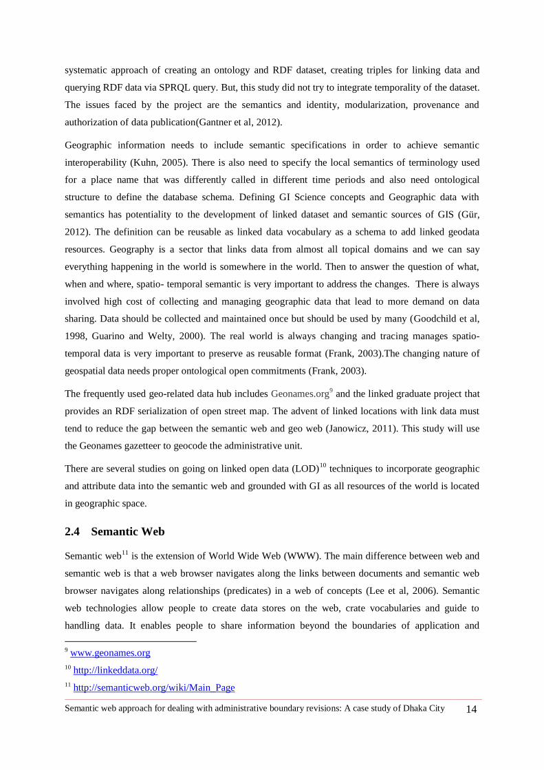
The frequently used geo-related data hub includes Geonames.org9 and the linked graduate project that
provides an RDF serialization of open street map. The advent of linked locations with link data must
tend to reduce the gap between the semantic web and geo web (Janowicz, 2011). This study will use
the Geonames gazetteer to geocode the administrative unit.
There are several studies on going on linked open data (LOD)10
techniques to incorporate geographic
and attribute data into the semantic web and grounded with GI as all resources of the world is located
in geographic space.
2.4 Semantic Web
Semantic web11
is the extension of World Wide Web (WWW). The main difference between web and
semantic web is that a web browser navigates along the links between documents and semantic web
browser navigates along relationships (predicates) in a web of concepts (Lee et al, 2006). Semantic
web technologies allow people to create data stores on the web, crate vocabularies and guide to
handling data. It enables people to share information beyond the boundaries of application and
9 www.geonames.org
10 http://linkeddata.org/
11 http://semanticweb.org/wiki/Main_Page
Semantic web approach for dealing with administrative boundary revisions: A case study of Dhaka City 15
websites. Ontology is considered to be the pillar of semantic web. A semantic web12
vocabulary can be
considered as special form of ontology or sometimes a collection of URIs with described meaning.
Ontology is a formal specification of a shared conceptualization (Gruber, 1993). Ontology defines the
logical relationship of a real world entity of how things are related to each other. Ontology is the
abstraction of the real world and the entities of constituent is defined in a particular ontology language
e.g. Web Ontology Language (OWL); (Antonious and van Harmelen, 2009). The most important
contributions of GIScience are to enhance interoperability and integrate different databases (Agarwal,
2005). An ontology can provide the standardized structure and definition of common entities or
general categories and relationships of a certain domain (Gantner et al, 2012). So, the semantic
interoperability can be increased by reusing the vocabularies for similar other cases.
According to Wikipedia, linked open data is a term used to ―describe a recommended best practice of
exploring, sharing and connecting pieces of data, information and knowledge on the semantic web
using RDF (Resource Description Framework).‖ RDF is a standardized format for publishing data on
the web to keep web interoperable. RDF uses URI‘s for naming of things that means the subject of
data and model data as triple structure: Subject, Predicate (predicate is the vocabulary used to
integrate data set), Object.
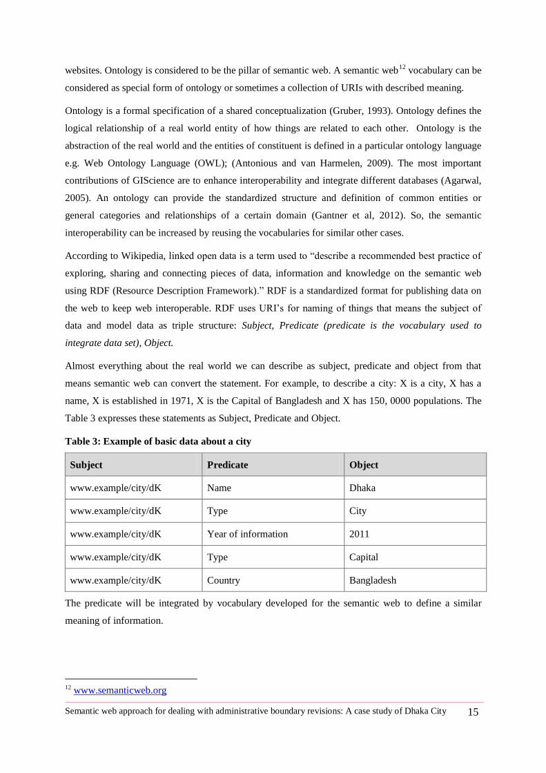
Almost everything about the real world we can describe as subject, predicate and object from that
means semantic web can convert the statement. For example, to describe a city: X is a city, X has a
name, X is established in 1971, X is the Capital of Bangladesh and X has 150, 0000 populations. The
Table 3 expresses these statements as Subject, Predicate and Object.
Table 3: Example of basic data about a city
Subject Predicate Object
www.example/city/dK Name Dhaka
www.example/city/dK Type City
www.example/city/dK Year of information 2011
www.example/city/dK Type Capital
www.example/city/dK Country Bangladesh
The predicate will be integrated by vocabulary developed for the semantic web to define a similar
meaning of information.
12
www.semanticweb.org
Semantic web approach for dealing with administrative boundary revisions: A case study of Dhaka City 16
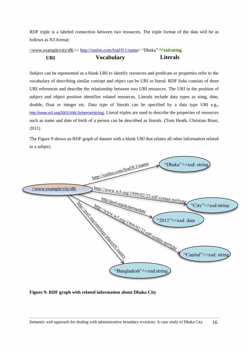
RDF triple is a labeled connection between two resources. The triple format of the data will be as
follows as N3 format:
<www.example/city/dK>< http://xmlns.com/foaf/0.1/name> ―Dhaka‖ ^^xsd:string.
Subject can be represented as a blank URI to identify resources and predicate or properties refer to the
vocabulary of describing similar concept and object can be URI or literal. RDF links consists of three
URI references and describe the relationship between two URI resources. The URI in the position of
subject and object position identifies related resources. Literals include data types as sting, date,
double, float or integer etc. Data type of literals can be specified by a data type URI e.g.,
http://www.w3.org/2001/XMLSchema#string. Literal triples are used to describe the properties of resources
such as name and date of birth of a person can be described as literals. (Tom Heath, Christian Bizer,
2011)
The Figure 9 shows an RDF graph of dataset with a blank URI that relates all other information related
to a subject.
Figure 9: RDF graph with related information about Dhaka City
URI Vocabulary Literals
―2011‖˄˄xsd: date
<www.example/city/dK
―Dhaka‖˄˄xsd: string
―City‖˄˄xsd:string
―Capital‖˄˄xsd: string
―Bangladesh‖˄˄xsd:string
Semantic web approach for dealing with administrative boundary revisions: A case study of Dhaka City 17
This thesis uses semantic web triple model to describe the dataset about administrative boundary and
its temporality. Finish Spatio Temporal Ontology time series and a spatio- temporal ontology for
administrative units of Switzerland attracts my attention to use the triple model to integrate
administrative boundary dataset and revisions scenarios.
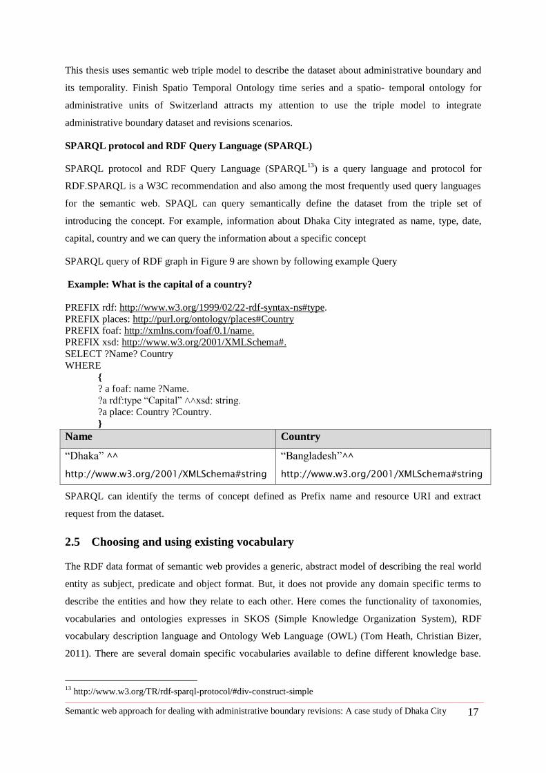
SPARQL protocol and RDF Query Language (SPARQL)
SPARQL protocol and RDF Query Language (SPARQL13
) is a query language and protocol for
RDF.SPARQL is a W3C recommendation and also among the most frequently used query languages
for the semantic web. SPAQL can query semantically define the dataset from the triple set of
introducing the concept. For example, information about Dhaka City integrated as name, type, date,
capital, country and we can query the information about a specific concept
SPARQL query of RDF graph in Figure 9 are shown by following example Query
Example: What is the capital of a country?
PREFIX rdf: http://www.w3.org/1999/02/22-rdf-syntax-ns#type.
PREFIX places: http://purl.org/ontology/places#Country
PREFIX foaf: http://xmlns.com/foaf/0.1/name.
PREFIX xsd: http://www.w3.org/2001/XMLSchema#.
SELECT ?Name? Country
WHERE
{
? a foaf: name ?Name.
?a rdf:type ―Capital‖ ˄˄xsd: string.
?a place: Country ?Country.
}
Name Country
―Dhaka‖ ^^
http://www.w3.org/2001/XMLSchema#string
―Bangladesh‖^^
http://www.w3.org/2001/XMLSchema#string
SPARQL can identify the terms of concept defined as Prefix name and resource URI and extract
request from the dataset.
2.5 Choosing and using existing vocabulary
The RDF data format of semantic web provides a generic, abstract model of describing the real world
entity as subject, predicate and object format. But, it does not provide any domain specific terms to
describe the entities and how they relate to each other. Here comes the functionality of taxonomies,
vocabularies and ontologies expresses in SKOS (Simple Knowledge Organization System), RDF
vocabulary description language and Ontology Web Language (OWL) (Tom Heath, Christian Bizer,
2011). There are several domain specific vocabularies available to define different knowledge base.
13
http://www.w3.org/TR/rdf-sparql-protocol/#div-construct-simple
Semantic web approach for dealing with administrative boundary revisions: A case study of Dhaka City 18
The challenge is to find appropriate vocabularies to define the data model to be populated. So, I need
the vocabulary for defining geographic regions, geographic names, time and changes of geographic
region. For integrating the administrative data into RDF triples, the existing vocabularies and
ontologies are listed in Table 4.
Table 4: Concepts to define an administrative unit and vocabulary in use
Concepts Vocabularies and name space
Administrative unit
City name FOAF: http://xmlns.com/foaf/0.1/
Type RDF: http://www.w3.org/1999/02/22-rdf-syntax-ns#
subClassOf RDFs: http://www.w3.org/1999/02/22-rdf-syntax-ns#
Spatial
Footprint/geometry/coordinate
A set of coordinates
TISC: http://observedchange.com/tisc/ns/#
City point as latitude, longitude GEO: http://www.w3.org/2003/01/geo/wgs84_pos#
GeonamesId
An identifier of place used in
Geonames Gazetteer
Geonames: http://www.geonames.org/ontology#
Time
Date Dublin Core: http://purl.org/dc/terms/
Temporality
existenceBeginsAt TISC: http://observedchange.com/tisc/ns/#
existenceEndsAt TISC: http://observedchange.com/tisc/ns/#
Spatial Changes
merge, nameChange, changePartOf Change: http://linkedearth.org/change/ns#
Region before change Change: http://linkedearth.org/change/ns#before
Region after Change Change: http://linkedearth.org/change/ns#after
Ontologies and vocabularies of Table 4 will be reused to populate the data model for this thesis. All
introduced ontologies require case testing for the usability of common cases and in the same field of
different case studies. The administrative units are considered here is the city and it has attribute
Semantic web approach for dealing with administrative boundary revisions: A case study of Dhaka City 19
properties, spatial properties, temporal properties and also changing behavior's properties to describe
the city units. Table 4 has listed the properties specifically for each domain and also indicates the
corresponding vocabularies in use.
We discuss about the related work done so far about administrative boundary change, dealing with
spatiotemporal data in semantic web, the available ontology and vocabularies, the traditional way of
handling change of geographic region .This chapter also points out the methods background of data
structure as triple and available vocabularies to deal with spatio- temporal and geographic region data
in semantic web. The next chapter will focus on the data structure and source and management for the
triple model solution.
2.6 Conclusion
Literature review focuses on defining the concept of the administrative unit and its component, GIS
approaches to deal with spatio-temporal geographic data, related work that tried to define
administrative units and changes in semantic and ontological approaches, semantic web contribution to
describe data as triple model and also existing vocabularies to match with concept to focus. The
review benefits us to get a deep insight of effort to handle spatio-temporal GI data and suitability of
the semantic web triple model to handle spatial-temporal administrative boundary data.
Semantic web approach for dealing with administrative boundary revisions: A case study of Dhaka City 20
3 Chapter Three: Methodology
The methodology of this thesis closely deals with obtaining study data and for serving the
semantic web we need careful modeling of data and convert data as semantic web using
appropriate relationship described by vocabularies. The database model will follow a
predefined query to integrate the component of the data model related to a subject. For my
thesis the subject is Dhaka city and its boundaries and temporal existence of boundaries.
Figure 10 is a flow diagram of methodology visualizing control flow from obtaining study
data to converting to semantic web format as RDF triple and also query and visualize
results to satisfy queries.
Figure 10: Flow diagram of methodology
3.1 Data Preparation
Dhaka was founded in 1608 as a Thana and called as Jahangir Nagar. Dhaka is renowned as 400 years
of capital14
. According to Table 2 in section 1.3 there are some geometry data available before 1995 as
settlement boundary but not as an administrative boundary.
The data required for this study are about Dhaka city and its administrative boundary and type of
administration and their existence in different periods of time. Dhaka is a city and it has different
administrative bodies for different public services. The city has now two City Corporation: Dhaka
North City Corporation and Dhaka South City Corporation (Figure 11). Major roles of city corporation
include development control, maintaining housing tax, controlling holding a number of buildings,
14
http://www.dncc.gov.bd/
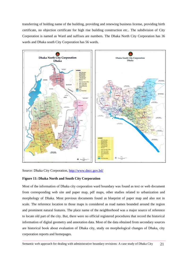
Semantic web approach for dealing with administrative boundary revisions: A case study of Dhaka City 21
transferring of holding name of the building, providing and renewing business license, providing birth
certificate, no objection certificate for high rise building construction etc.. The subdivision of City
Corporation is named as Ward and suffixes are numbers. The Dhaka North City Corporation has 36
wards and Dhaka south City Corporation has 56 wards.
Source: Dhaka City Corporation, http://www.dncc.gov.bd/
Figure 11: Dhaka North and South City Corporation
Most of the information of Dhaka city corporation ward boundary was found as text or web document
from corresponding web site and paper map, pdf maps, other studies related to urbanization and
morphology of Dhaka. Most previous documents found as blueprint of paper map and also not in
scale. The reference location to those maps is considered as road names bounded around the region
and prominent natural features. The place name of the neighborhood was a major source of reference
to locate old part of the city. But, there were no official registered procedures that record the historical
information of digital geometry and annotation data. Most of the data obtained from secondary sources
are historical book about evaluation of Dhaka city, study on morphological changes of Dhaka, city
corporation reports and homepages.
Semantic web approach for dealing with administrative boundary revisions: A case study of Dhaka City 22
Our first target was to deal with Dhaka City Corporation boundary for this study. In reality, the digital
GIS data of Dhaka City corporation ward boundary was unavailable or inaccessible during this study.
The geographic features of the available print maps, such as roads, boundaries were not matching with
other reliable data sources such as Satellite Images or maps of RAJUK. Moreover the available map
resolution was not sufficient to extract quality geo data from it.
It was found in RAJUK directory that, the Dhaka Metropolitan area was unchanged from about 1990.
But, Thana boundary under Metropolitan Police area undergoes several changes over time in terms of
their names, area size and physical extent and splited from one to form a new unit.
So, it was decided to do the study on Dhaka Metropolitan boundary of Dhaka City to trace the changes
of Thana boundary. The digital boundary was also not possible to get directly but most of the Thana
boundary was depicted (Figure 6 at page no. 8) on a website called www.citypopulation.de with due
information how a new Thana was introduced (such as splitting from which Thana/s) and when.
Bangladesh gazetteer notifications and information about Thana are collected from Banglapedia15
website as the most reliable source. Finally the digital map data was prepared by digitizing available
maps and editing based on comparison of information collected from various sources, such as,
Banglapedia, City Population16
, Dhaka City Corporation(DCC) 17
, Dhaka Rajdhani Unnayan
Kartripakha (RAJUK18
), Bangladesh Bureau of Statistics (BBS)19
, Dhaka Metropolitan Police
(DMP)20
and Google Map21
.
The study period of administrative boundary (Thana boundary) database of Dhaka city is considered
from 1995 to 2010 within the Dhaka metropolitan area.
The data from variant sources gave a basis to reproduce the geometry of regions with confidence by
tracing the street names referred to define the region. A major problem identified during geodata
preparation is that the all the available maps was incomplete and different or organizations engaged in
producing geodata do not share the data among themselves the updated versions. Absence of map
metadata introduced confusion regarding their reliability. So, it was difficult to match or overlay
different sources of geometric data with variant resolution and geometric shapes.
Moreover all available geo-data were prepared using a Bangladesh Transverse Mercator (BTM)
projection system. From the beginning of the BTM projection system recognized problems related to
15
http://www.bpedia.org/
16 http://www.citypopulation.de/php/bangladesh-dhaka.php
17 http://www.dhakacity.org/index.php
18 http://www.rajukdhaka.gov.bd/rajuk/webHome
19 http://www.bbs.gov.bd/home.aspx
20 http://www.dmp.gov.bd/
21 https://maps.google.com/
Semantic web approach for dealing with administrative boundary revisions: A case study of Dhaka City 23
shifting of Datum. So, it was showing 300 meter shift while overlain on Google Earth. It was the most
challenging work to fix the data mismatch problem. It took more time to convert projection system and
match with Google map. The strategy was to take the road name bounded by the administrative region
and redraw boundary line using Google Tool22. These tools can allow people to draw polygon and
download as a KML file. Then, it was imported to ArcGIS and converted to shape file (Figure 12).
Now, the new geodata prepared under this study shows a good edge match with Google map and all
reproduced layers have a perfect match to each other. The coordinate system used for geometry data is
WGS_1984_UTM_Zone_46N. The detailed Thana maps prepared under this thesis are enclosed in
Appendix B.
Figure 12: Thana boundaries in different periods within Dhaka Metropolitan area
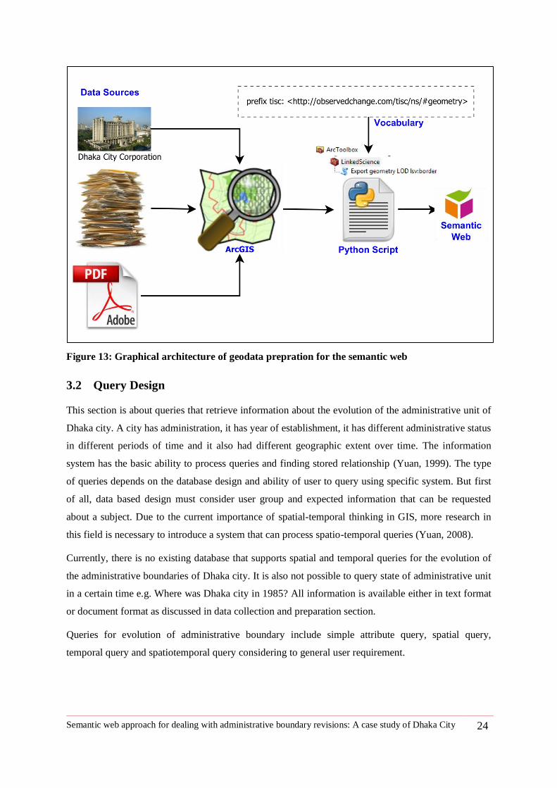
The Figure 13 is the flow diagram of steps followed to get geometry data of the administrative unit for
triple store. Then it was important to convert ArcGIS shape file to Linked Open Data Geometry RDF
file. There is an extension tool of python script for ArcGIS to convert shape file to triple, developed
under the project of Amazon Rainforest projects by Jim Jones and Alber Sánchez in 2012.
22
http://www.birdtheme.org/useful/v3tool.html
Semantic web approach for dealing with administrative boundary revisions: A case study of Dhaka City 24
Figure 13: Graphical architecture of geodata prepration for the semantic web
3.2 Query Design
This section is about queries that retrieve information about the evolution of the administrative unit of
Dhaka city. A city has administration, it has year of establishment, it has different administrative status
in different periods of time and it also had different geographic extent over time. The information
system has the basic ability to process queries and finding stored relationship (Yuan, 1999). The type
of queries depends on the database design and ability of user to query using specific system. But first
of all, data based design must consider user group and expected information that can be requested
about a subject. Due to the current importance of spatial-temporal thinking in GIS, more research in
this field is necessary to introduce a system that can process spatio-temporal queries (Yuan, 2008).
Currently, there is no existing database that supports spatial and temporal queries for the evolution of
the administrative boundaries of Dhaka city. It is also not possible to query state of administrative unit
in a certain time e.g. Where was Dhaka city in 1985? All information is available either in text format
or document format as discussed in data collection and preparation section.
Queries for evolution of administrative boundary include simple attribute query, spatial query,
temporal query and spatiotemporal query considering to general user requirement.
Semantic web approach for dealing with administrative boundary revisions: A case study of Dhaka City 25
3.2.1 Attribute query
Attribute or thematic queries are the simplest type of query is used to retrieve explicitly stored
information. For example- we can find or select part of a map based on some attribute variable such as
name, population, area, etc. This attribute query does not require computation.
Example:
Attribute query: Find all Subdistrict (Thana) with a population density greater than 600/km2?
3.2.2 Spatial query
Spatial query selects geographic feature based on location or spatial relationship23
. Spatial Query can
be simple spatial query, spatial range or spatial relationship queries(Gantner 2011). Simple spatial
query search for a location based on user defined criteria and does not require any computation. The
spatial range query retrieves information about spatial feature within a spatial entity or user defined
criteria. At last, spatial relationship query finds features that have a relationship with another feature.
Examples:
Simple spatial query: Find all Subdistricts in Dhaka city with less than km2?
Spatial range query: How many Subdistricts are inside of Dhaka city?
Spatial relationship query: Find all 3 storied buildings in a specific subdistrict?
3.2.3 Temporal Query
In temporal data time can be represented as discrete time or continuous time. Discrete time is an
essential requirement for describing data pointing to the date of collection. On the other hand,
continuous time is also important for modeling physical changes and global changes. The coexistence
of both is very important to describe the real world as current entity and event.
Time constant can be represented as absolute time (e.g., 5th
March 2013) or a relative time (e.g.
Yesterday). Time can also be interpreted as a time period of something occurred denote as start time
point and end time point. In temporal GIS, it is essential to incorporate geographical time zone to
relate the events that happen in different places.
Temporal queries are categorized as simple temporal query, temporal range and temporal relationship
query. The simple temporal query is used to find the snapshot or time slice of certain time. Temporal
range queries search a feature that undergoes changes in a certain period of time (Gantner 2011).
Temporal relationship queries retrieve information related to changes in feature relationship with the
changes of time that means changes of topological relationship and nearby feature with time.
23
http://en.mimi.hu/gis/spatial_query.html
Semantic web approach for dealing with administrative boundary revisions: A case study of Dhaka City 26
Example:
Simple temporal query: How many people lived in Lalbagh Thana during 1995?
Temporal range query: How many people died in Lalbagh Thana during 1970 to 1972?
Temporal relationship query: How many times Lalbagh Thana splits with the increase of population?
3.2.4 Spatiotemporal query of geographic feature boundary changes
Supporting the spatiotemporal query is the key theme of temporal GIS and requires modeling to
retrieve spatiotemporal information. According to (Langrans, 1992), spatiotemporal queries are
characterized as simple spatiotemporal query and spatiotemporal range query. Simple spatiotemporal
query seeks information about a region at a given time and answer represents a snapshot of the area.
Whereas, the spatiotemporal range query asks question about the history of a region over time that
answers the life of the snapshot table with changes in a specific period of time.
Example:
Simple spatiotemporal query: What are the Thanas in Dhaka City during 1995?
Spatiotemporal range query: How did the subdivision changes in Dhaka Metropolitan area 1995 to
2000?
Langrans approach mostly deal with static spatiotemporal data of histories at the location. In addition
to Langrans, Yuan added spatiotemporal behavior queries to stress the need of dynamic information
describing behavior. This type of query supports tracing evaluation of a given entity to follow an entity
in space and time (Yuan 2002).
Example:
Spatiotemporal behavior query: What changes occur in Lalbagh Thana During 1995 to 2010?
3.3 Data Modeling for Dhaka City Boundary Revisions
Data model refers to the way of representing data along the logical operations. Data model consists of
connecting all the related information that needs to define an entity. The most common data models
are spreadsheet and relational data model. The new approach introduced for the semantic web is the
RDF that combines best of both24
.
In spreadsheet data model, a single spreadsheet is broken down into rows and columns. The column
heading always tells what kind of data it contains. The spreadsheet is very flexible but very difficult to
manage for a fairly big dataset and also the document format of data is not self-explanatory.
24
http://www.cambridgesemantics.com/de/blog/-/blogs/it-all-starts-with-the-data-model
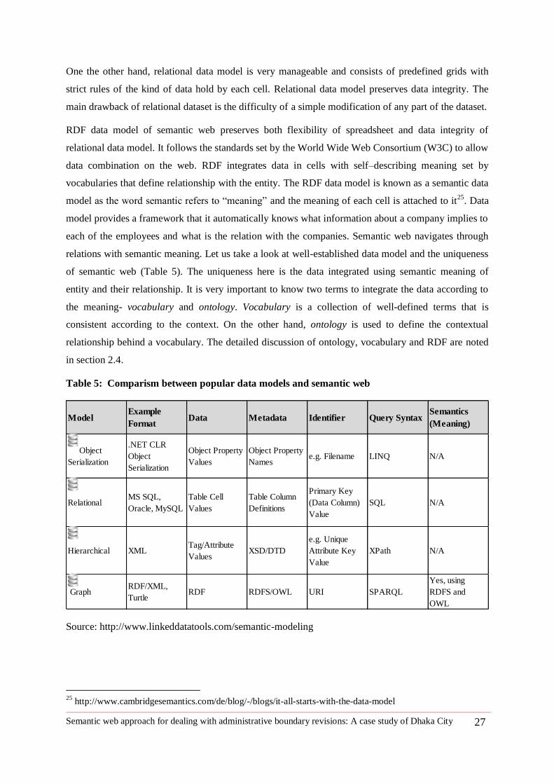
Semantic web approach for dealing with administrative boundary revisions: A case study of Dhaka City 27
One the other hand, relational data model is very manageable and consists of predefined grids with
strict rules of the kind of data hold by each cell. Relational data model preserves data integrity. The
main drawback of relational dataset is the difficulty of a simple modification of any part of the dataset.
RDF data model of semantic web preserves both flexibility of spreadsheet and data integrity of
relational data model. It follows the standards set by the World Wide Web Consortium (W3C) to allow
data combination on the web. RDF integrates data in cells with self–describing meaning set by
vocabularies that define relationship with the entity. The RDF data model is known as a semantic data
model as the word semantic refers to ―meaning‖ and the meaning of each cell is attached to it25
. Data
model provides a framework that it automatically knows what information about a company implies to
each of the employees and what is the relation with the companies. Semantic web navigates through
relations with semantic meaning. Let us take a look at well-established data model and the uniqueness
of semantic web (Table 5). The uniqueness here is the data integrated using semantic meaning of
entity and their relationship. It is very important to know two terms to integrate the data according to
the meaning- vocabulary and ontology. Vocabulary is a collection of well-defined terms that is
consistent according to the context. On the other hand, ontology is used to define the contextual
relationship behind a vocabulary. The detailed discussion of ontology, vocabulary and RDF are noted
in section 2.4.
Table 5: Comparism between popular data models and semantic web
Source: http://www.linkeddatatools.com/semantic-modeling
25
http://www.cambridgesemantics.com/de/blog/-/blogs/it-all-starts-with-the-data-model
ModelExample
FormatData Metadata Identifier Query Syntax
Semantics
(Meaning)
Object
Serialization
.NET CLR
Object
Serialization
Object Property
Values
Object Property
Namese.g. Filename LINQ N/A
RelationalMS SQL,
Oracle, MySQL
Table Cell
Values
Table Column
Definitions
Primary Key
(Data Column)
Value
SQL N/A
Hierarchical XMLTag/Attribute
ValuesXSD/DTD
e.g. Unique
Attribute Key
Value
XPath N/A
GraphRDF/XML,
TurtleRDF RDFS/OWL URI SPARQL
Yes, using
RDFS and
OWL
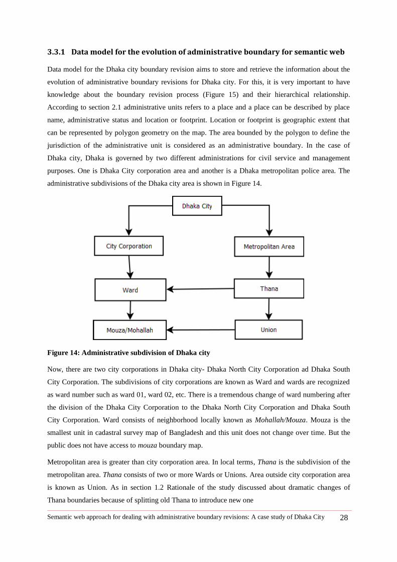
Semantic web approach for dealing with administrative boundary revisions: A case study of Dhaka City 28
3.3.1 Data model for the evolution of administrative boundary for semantic web
Data model for the Dhaka city boundary revision aims to store and retrieve the information about the
evolution of administrative boundary revisions for Dhaka city. For this, it is very important to have
knowledge about the boundary revision process (Figure 15) and their hierarchical relationship.
According to section 2.1 administrative units refers to a place and a place can be described by place
name, administrative status and location or footprint. Location or footprint is geographic extent that
can be represented by polygon geometry on the map. The area bounded by the polygon to define the
jurisdiction of the administrative unit is considered as an administrative boundary. In the case of
Dhaka city, Dhaka is governed by two different administrations for civil service and management
purposes. One is Dhaka City corporation area and another is a Dhaka metropolitan police area. The
administrative subdivisions of the Dhaka city area is shown in Figure 14.
Figure 14: Administrative subdivision of Dhaka city
Now, there are two city corporations in Dhaka city- Dhaka North City Corporation ad Dhaka South
City Corporation. The subdivisions of city corporations are known as Ward and wards are recognized
as ward number such as ward 01, ward 02, etc. There is a tremendous change of ward numbering after
the division of the Dhaka City Corporation to the Dhaka North City Corporation and Dhaka South
City Corporation. Ward consists of neighborhood locally known as Mohallah/Mouza. Mouza is the
smallest unit in cadastral survey map of Bangladesh and this unit does not change over time. But the
public does not have access to mouza boundary map.
Metropolitan area is greater than city corporation area. In local terms, Thana is the subdivision of the
metropolitan area. Thana consists of two or more Wards or Unions. Area outside city corporation area
is known as Union. As in section 1.2 Rationale of the study discussed about dramatic changes of
Thana boundaries because of splitting old Thana to introduce new one
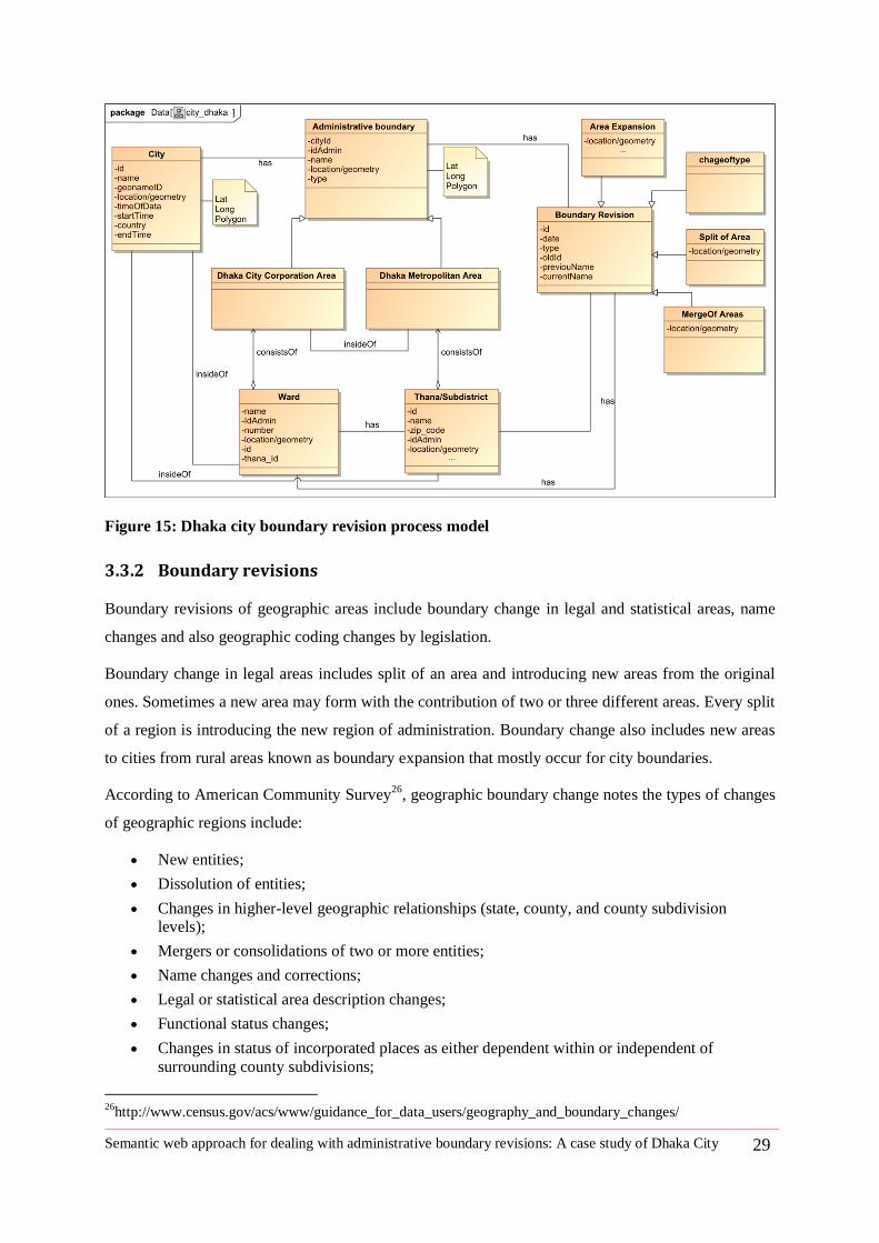
Semantic web approach for dealing with administrative boundary revisions: A case study of Dhaka City 29
Figure 15: Dhaka city boundary revision process model
3.3.2 Boundary revisions
Boundary revisions of geographic areas include boundary change in legal and statistical areas, name
changes and also geographic coding changes by legislation.
Boundary change in legal areas includes split of an area and introducing new areas from the original
ones. Sometimes a new area may form with the contribution of two or three different areas. Every split
of a region is introducing the new region of administration. Boundary change also includes new areas
to cities from rural areas known as boundary expansion that mostly occur for city boundaries.
According to American Community Survey26
, geographic boundary change notes the types of changes
of geographic regions include:
New entities;
Dissolution of entities;
Changes in higher-level geographic relationships (state, county, and county subdivision levels);
Mergers or consolidations of two or more entities;
Name changes and corrections;
Legal or statistical area description changes;
Functional status changes;
Changes in status of incorporated places as either dependent within or independent of
surrounding county subdivisions;
26
http://www.census.gov/acs/www/guidance_for_data_users/geography_and_boundary_changes/
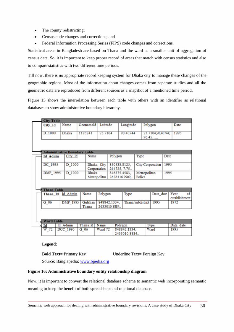
Semantic web approach for dealing with administrative boundary revisions: A case study of Dhaka City 30
The county redistricting;
Census code changes and corrections; and
Federal Information Processing Series (FIPS) code changes and corrections.
Statistical areas in Bangladesh are based on Thana and the ward as a smaller unit of aggregation of
census data. So, it is important to keep proper record of areas that match with census statistics and also
to compare statistics with two different time periods.
Till now, there is no appropriate record keeping system for Dhaka city to manage these changes of the
geographic regions. Most of the information about changes comes from separate studies and all the
geometric data are reproduced from different sources as a snapshot of a mentioned time period.
Figure 15 shows the interrelation between each table with others with an identifier as relational
databases to show administrative boundary hierarchy.
Legend:
Bold Text= Primary Key Underline Text= Foreign Key
Source: Banglapedia: www.bpedia.org
Figure 16: Administrative boundary entity relationship diagram
Now, it is important to convert the relational database schema to semantic web incorporating semantic
meaning to keep the benefit of both spreadsheet and relational database.
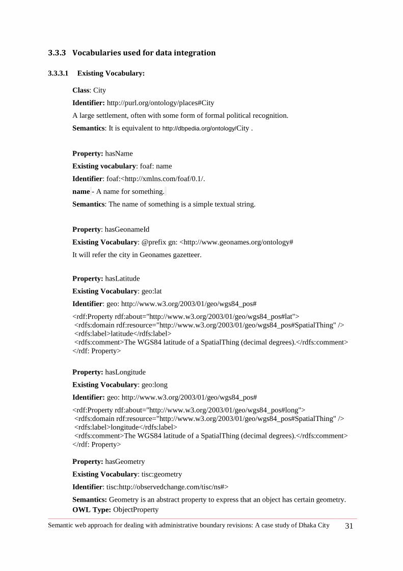
Semantic web approach for dealing with administrative boundary revisions: A case study of Dhaka City 31
3.3.3 Vocabularies used for data integration
3.3.3.1 Existing Vocabulary:
Class: City
Identifier: http://purl.org/ontology/places#City
A large settlement, often with some form of formal political recognition.
Semantics: It is equivalent to http://dbpedia.org/ontology/City .
Property: hasName
Existing vocabulary: foaf: name
Identifier: foaf:<http://xmlns.com/foaf/0.1/.
name - A name for something.
Semantics: The name of something is a simple textual string.
Property: hasGeonameId
Existing Vocabulary: @prefix gn: <http://www.geonames.org/ontology#
It will refer the city in Geonames gazetteer.
Property: hasLatitude
Existing Vocabulary: geo:lat
Identifier: geo: http://www.w3.org/2003/01/geo/wgs84_pos#
<rdf:Property rdf:about="http://www.w3.org/2003/01/geo/wgs84_pos#lat">
<rdfs:domain rdf:resource="http://www.w3.org/2003/01/geo/wgs84_pos#SpatialThing" />
<rdfs:label>latitude</rdfs:label>
<rdfs:comment>The WGS84 latitude of a SpatialThing (decimal degrees).</rdfs:comment>
</rdf: Property>
Property: hasLongitude
Existing Vocabulary: geo:long
Identifier: geo: http://www.w3.org/2003/01/geo/wgs84_pos#
<rdf:Property rdf:about="http://www.w3.org/2003/01/geo/wgs84_pos#long">
<rdfs:domain rdf:resource="http://www.w3.org/2003/01/geo/wgs84_pos#SpatialThing" />
<rdfs:label>longitude</rdfs:label>
<rdfs:comment>The WGS84 latitude of a SpatialThing (decimal degrees).</rdfs:comment>
</rdf: Property>
Property: hasGeometry
Existing Vocabulary: tisc:geometry
Identifier: tisc:http://observedchange.com/tisc/ns#>
Semantics: Geometry is an abstract property to express that an object has certain geometry.
OWL Type: ObjectProperty
Semantic web approach for dealing with administrative boundary revisions: A case study of Dhaka City 32
Property: hasStartTime
Existing Vocabulary: tisc:extistenceBeginsAt
Identifier: tisc:http://observedchange.com/tisc/ns#>
Property: existenceBeginsAt
ExistenceBeginsAt is an abstract property to express that the existence of an object begins at a
given time instant.
Property: hasEndTime
Existing Vocabulary: tisc:extistenceEndsAt
Identifier: tisc: http://observedchange.com/tisc/ns#
Property: existenceEndsAt
ExistenceBeginsAt is an abstract property to express that the existence of an object begins at a
given time instant.
Property: hasSubdivision
Identifier: http://dbpedia.org/property/subdivision
Existing vocabulary: sudivision
dbpprop:subdivision rdf:type rdf:property.
dbpprop:subdivision rdfs:label "subdivision".
Existing Vocabulary for changes of geographic region
Class: Change
Change is a superclass of all different kinds of changes.
Identifier: http://linkedearth.org/change/ns#Change
Class: Merge
Merge is used to denote when some different things (e.g. Two or more administration regions)
have been merged together.
Identifier: http://linkedearth.org/change/ns#Merge
SubclassOf: change:Change
Class: Split
Merge is used to denote when something has been split to two or more different things (e.g. to
two or more administrational regions).
Identifier: http://linkedearth.org/change/ns#Split
SubclassOf: change:Change
Class: Namechange
Namechange is used to denote when something (e.g. administrational region) has been
renamed.
Identifier: http://linkedearth.org/change/ns#Namechange
SubclassOf: change:Change
Class: Changepartof
Changepartof is used to denote when two things (e.g. two administrational region) change
some parts, i.e. one part of a region A is moved to region B.
Identifier: http://linkedearth.org/change/ns#Changepartof
SubclassOf: change:Change
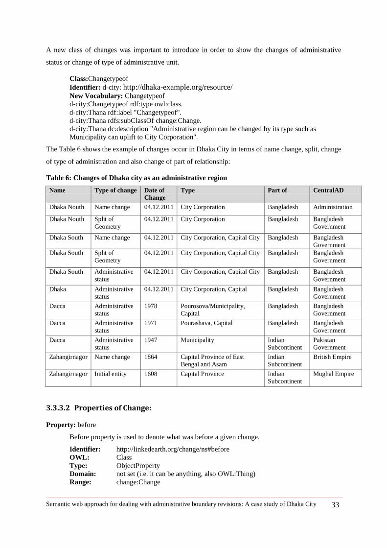
Semantic web approach for dealing with administrative boundary revisions: A case study of Dhaka City 33
A new class of changes was important to introduce in order to show the changes of administrative
status or change of type of administrative unit.
Class:Changetypeof
Identifier: d-city: http://dhaka-example.org/resource/ New Vocabulary: Changetypeof
d-city:Changetypeof rdf:type owl:class.
d-city:Thana rdf:label "Changetypeof".
d-city:Thana rdfs:subClassOf change:Change.
d-city:Thana dc:description "Administrative region can be changed by its type such as
Municipality can uplift to City Corporation".
The Table 6 shows the example of changes occur in Dhaka City in terms of name change, split, change
of type of administration and also change of part of relationship:
Table 6: Changes of Dhaka city as an administrative region
Name Type of change Date of
Change
Type Part of CentralAD
Dhaka Nouth Name change 04.12.2011 City Corporation Bangladesh Administration
Dhaka Nouth Split of
Geometry
04.12.2011 City Corporation Bangladesh Bangladesh
Government
Dhaka South Name change 04.12.2011 City Corporation, Capital City Bangladesh Bangladesh
Government
Dhaka South Split of
Geometry
04.12.2011 City Corporation, Capital City Bangladesh Bangladesh
Government
Dhaka South Administrative
status
04.12.2011 City Corporation, Capital City Bangladesh Bangladesh
Government
Dhaka Administrative
status
04.12.2011 City Corporation, Capital Bangladesh Bangladesh
Government
Dacca Administrative
status
1978 Pourosova/Municipality,
Capital
Bangladesh Bangladesh
Government
Dacca Administrative
status
1971 Pourashava, Capital Bangladesh Bangladesh
Government
Dacca Administrative
status
1947 Municipality Indian
Subcontinent
Pakistan
Government
Zahangirnagor Name change 1864 Capital Province of East
Bengal and Asam
Indian
Subcontinent
British Empire
Zahangirnagor Initial entity 1608 Capital Province Indian
Subcontinent
Mughal Empire
3.3.3.2 Properties of Change:
Property: before
Before property is used to denote what was before a given change.
Identifier: http://linkedearth.org/change/ns#before
OWL: Class
Type: ObjectProperty
Domain: not set (i.e. it can be anything, also OWL:Thing)
Range: change:Change
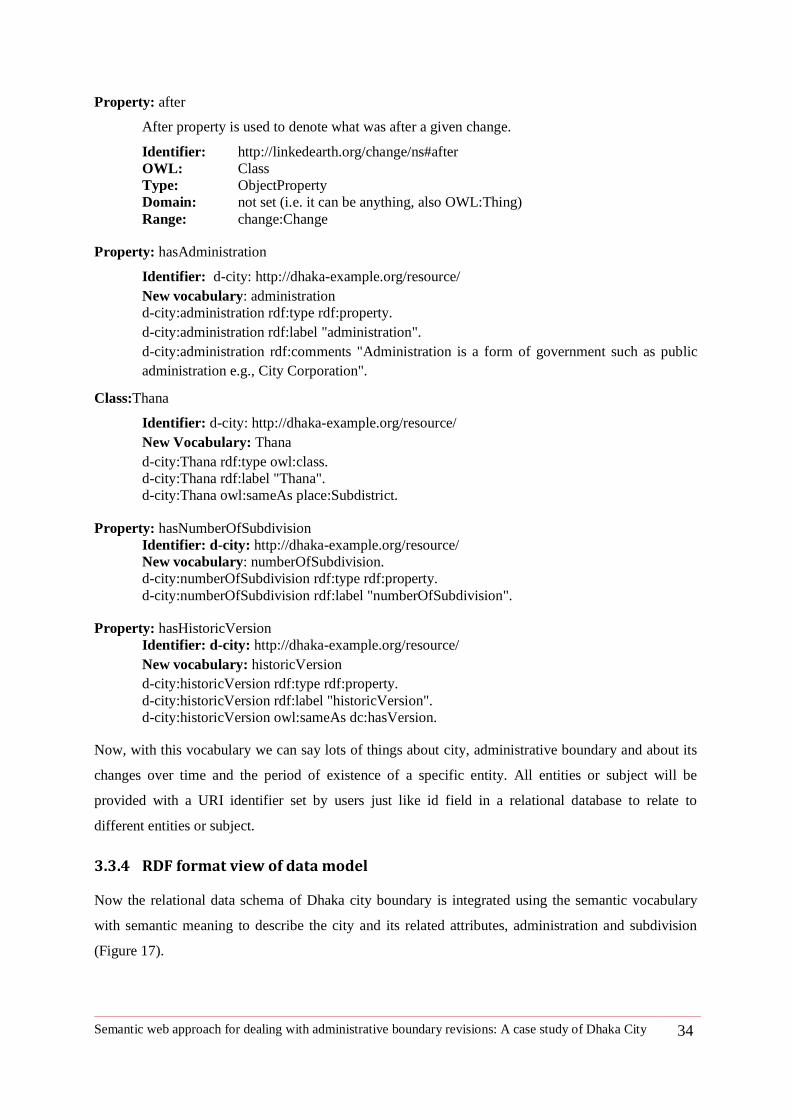
Semantic web approach for dealing with administrative boundary revisions: A case study of Dhaka City 34
Property: after
After property is used to denote what was after a given change.
Identifier: http://linkedearth.org/change/ns#after
OWL: Class
Type: ObjectProperty
Domain: not set (i.e. it can be anything, also OWL:Thing)
Range: change:Change
Property: hasAdministration
Identifier: d-city: http://dhaka-example.org/resource/
New vocabulary: administration
d-city:administration rdf:type rdf:property.
d-city:administration rdf:label "administration".
d-city:administration rdf:comments "Administration is a form of government such as public
administration e.g., City Corporation".
Class:Thana
Identifier: d-city: http://dhaka-example.org/resource/
New Vocabulary: Thana
d-city:Thana rdf:type owl:class.
d-city:Thana rdf:label "Thana".
d-city:Thana owl:sameAs place:Subdistrict.
Property: hasNumberOfSubdivision
Identifier: d-city: http://dhaka-example.org/resource/
New vocabulary: numberOfSubdivision.
d-city:numberOfSubdivision rdf:type rdf:property.
d-city:numberOfSubdivision rdf:label "numberOfSubdivision".
Property: hasHistoricVersion
Identifier: d-city: http://dhaka-example.org/resource/
New vocabulary: historicVersion
d-city:historicVersion rdf:type rdf:property.
d-city:historicVersion rdf:label "historicVersion".
d-city:historicVersion owl:sameAs dc:hasVersion.
Now, with this vocabulary we can say lots of things about city, administrative boundary and about its
changes over time and the period of existence of a specific entity. All entities or subject will be
provided with a URI identifier set by users just like id field in a relational database to relate to
different entities or subject.
3.3.4 RDF format view of data model
Now the relational data schema of Dhaka city boundary is integrated using the semantic vocabulary
with semantic meaning to describe the city and its related attributes, administration and subdivision
(Figure 17).
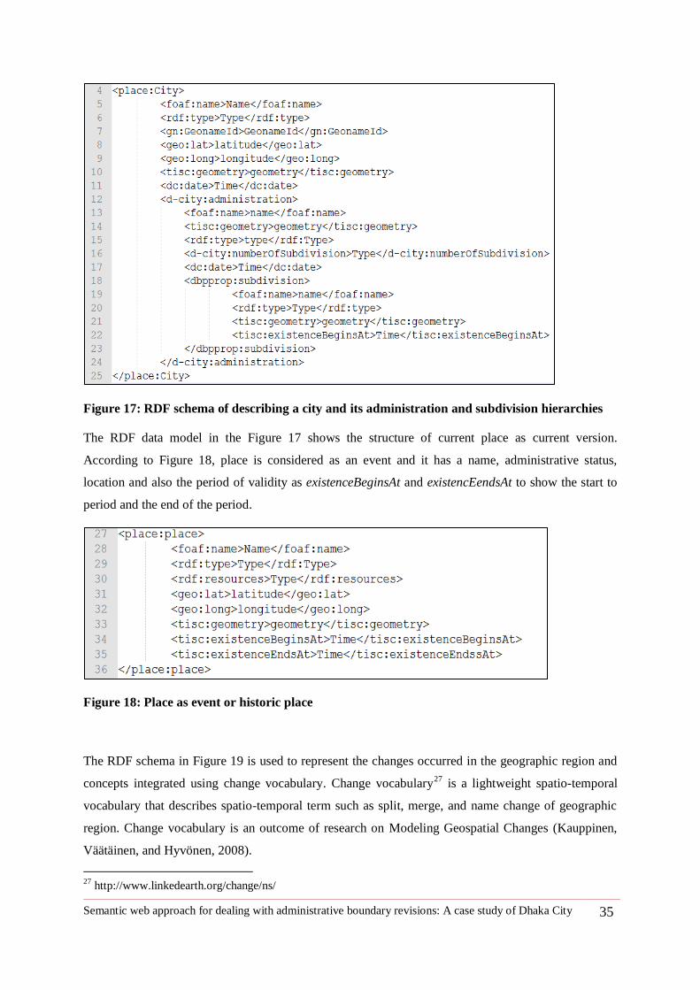
Semantic web approach for dealing with administrative boundary revisions: A case study of Dhaka City 35
Figure 17: RDF schema of describing a city and its administration and subdivision hierarchies
The RDF data model in the Figure 17 shows the structure of current place as current version.
According to Figure 18, place is considered as an event and it has a name, administrative status,
location and also the period of validity as existenceBeginsAt and existencEendsAt to show the start to
period and the end of the period.
Figure 18: Place as event or historic place
The RDF schema in Figure 19 is used to represent the changes occurred in the geographic region and
concepts integrated using change vocabulary. Change vocabulary27
is a lightweight spatio-temporal
vocabulary that describes spatio-temporal term such as split, merge, and name change of geographic
region. Change vocabulary is an outcome of research on Modeling Geospatial Changes (Kauppinen,
Väätäinen, and Hyvönen, 2008).
27
http://www.linkedearth.org/change/ns/
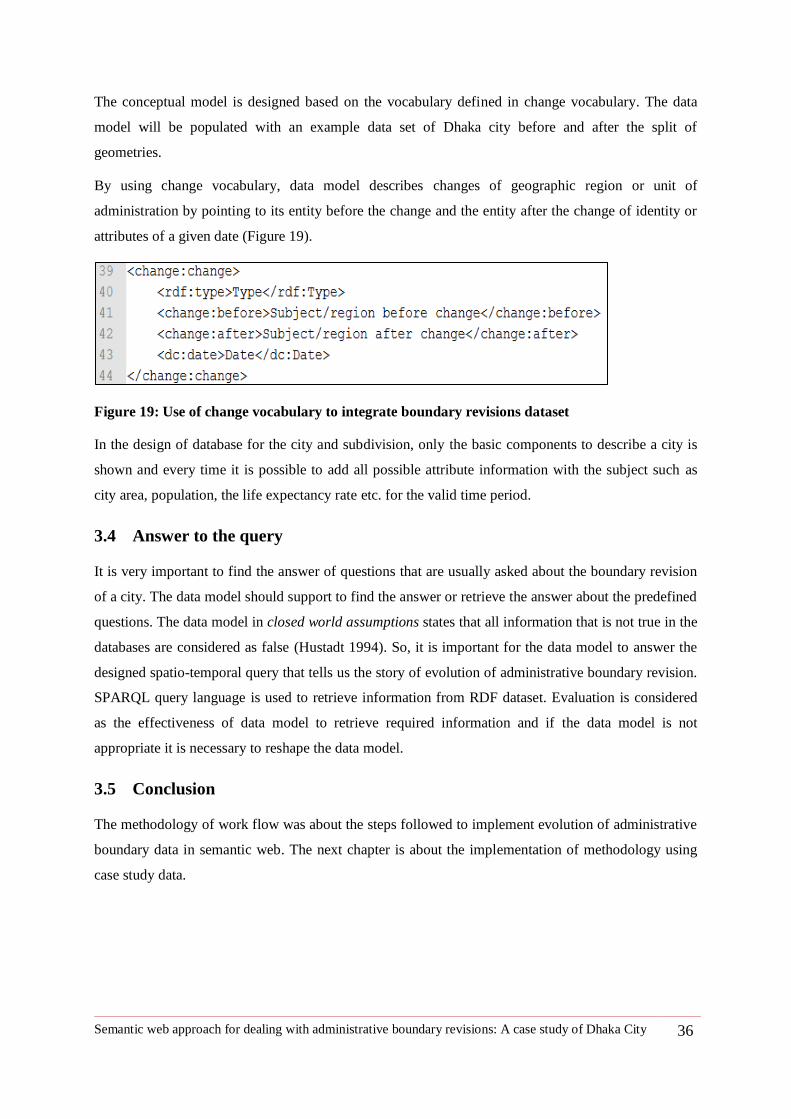
Semantic web approach for dealing with administrative boundary revisions: A case study of Dhaka City 36
The conceptual model is designed based on the vocabulary defined in change vocabulary. The data
model will be populated with an example data set of Dhaka city before and after the split of
geometries.
By using change vocabulary, data model describes changes of geographic region or unit of
administration by pointing to its entity before the change and the entity after the change of identity or
attributes of a given date (Figure 19).
Figure 19: Use of change vocabulary to integrate boundary revisions dataset
In the design of database for the city and subdivision, only the basic components to describe a city is
shown and every time it is possible to add all possible attribute information with the subject such as
city area, population, the life expectancy rate etc. for the valid time period.
3.4 Answer to the query
It is very important to find the answer of questions that are usually asked about the boundary revision
of a city. The data model should support to find the answer or retrieve the answer about the predefined
questions. The data model in closed world assumptions states that all information that is not true in the
databases are considered as false (Hustadt 1994). So, it is important for the data model to answer the
designed spatio-temporal query that tells us the story of evolution of administrative boundary revision.
SPARQL query language is used to retrieve information from RDF dataset. Evaluation is considered
as the effectiveness of data model to retrieve required information and if the data model is not
appropriate it is necessary to reshape the data model.
3.5 Conclusion
The methodology of work flow was about the steps followed to implement evolution of administrative
boundary data in semantic web. The next chapter is about the implementation of methodology using
case study data.
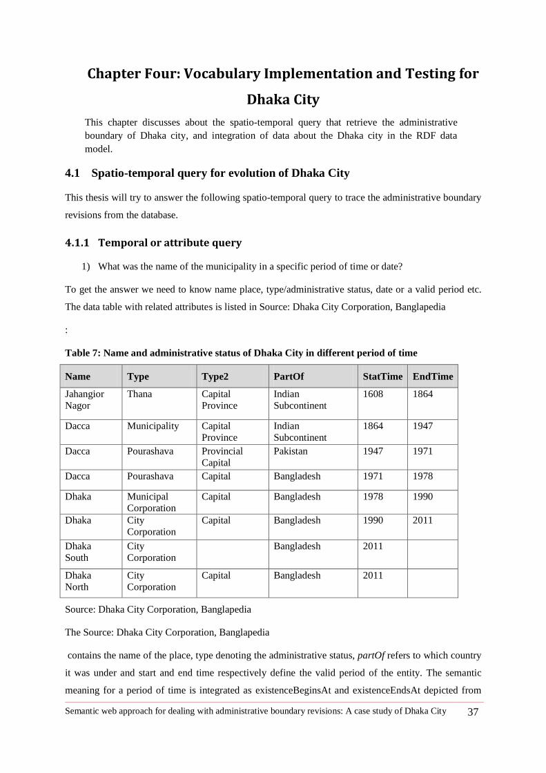
Semantic web approach for dealing with administrative boundary revisions: A case study of Dhaka City 37
4 Chapter Four: Vocabulary Implementation and Testing for
Dhaka City
This chapter discusses about the spatio-temporal query that retrieve the administrative
boundary of Dhaka city, and integration of data about the Dhaka city in the RDF data
model.
4.1 Spatio-temporal query for evolution of Dhaka City
This thesis will try to answer the following spatio-temporal query to trace the administrative boundary
revisions from the database.
4.1.1 Temporal or attribute query
1) What was the name of the municipality in a specific period of time or date?
To get the answer we need to know name place, type/administrative status, date or a valid period etc.
The data table with related attributes is listed in Source: Dhaka City Corporation, Banglapedia
:
Table 7: Name and administrative status of Dhaka City in different period of time
Name Type Type2 PartOf StatTime EndTime
Jahangior
Nagor
Thana Capital
Province
Indian
Subcontinent
1608 1864
Dacca Municipality Capital
Province
Indian
Subcontinent
1864 1947
Dacca Pourashava Provincial
Capital
Pakistan 1947 1971
Dacca Pourashava Capital Bangladesh 1971 1978
Dhaka Municipal
Corporation
Capital Bangladesh 1978 1990
Dhaka City
Corporation
Capital Bangladesh 1990 2011
Dhaka
South
City
Corporation
Bangladesh 2011
Dhaka
North
City
Corporation
Capital Bangladesh 2011
Source: Dhaka City Corporation, Banglapedia
The Source: Dhaka City Corporation, Banglapedia
contains the name of the place, type denoting the administrative status, partOf refers to which country
it was under and start and end time respectively define the valid period of the entity. The semantic
meaning for a period of time is integrated as existenceBeginsAt and existenceEndsAt depicted from
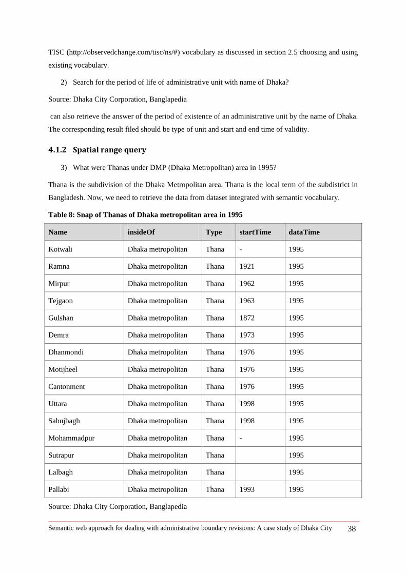
Semantic web approach for dealing with administrative boundary revisions: A case study of Dhaka City 38
TISC (http://observedchange.com/tisc/ns/#) vocabulary as discussed in section 2.5 choosing and using
existing vocabulary.
2) Search for the period of life of administrative unit with name of Dhaka?
Source: Dhaka City Corporation, Banglapedia
can also retrieve the answer of the period of existence of an administrative unit by the name of Dhaka.
The corresponding result filed should be type of unit and start and end time of validity.
4.1.2 Spatial range query
3) What were Thanas under DMP (Dhaka Metropolitan) area in 1995?
Thana is the subdivision of the Dhaka Metropolitan area. Thana is the local term of the subdistrict in
Bangladesh. Now, we need to retrieve the data from dataset integrated with semantic vocabulary.
Table 8: Snap of Thanas of Dhaka metropolitan area in 1995
Name insideOf Type startTime dataTime
Kotwali Dhaka metropolitan Thana - 1995
Ramna Dhaka metropolitan Thana 1921 1995
Mirpur Dhaka metropolitan Thana 1962 1995
Tejgaon Dhaka metropolitan Thana 1963 1995
Gulshan Dhaka metropolitan Thana 1872 1995
Demra Dhaka metropolitan Thana 1973 1995
Dhanmondi Dhaka metropolitan Thana 1976 1995
Motijheel Dhaka metropolitan Thana 1976 1995
Cantonment Dhaka metropolitan Thana 1976 1995
Uttara Dhaka metropolitan Thana 1998 1995
Sabujbagh Dhaka metropolitan Thana 1998 1995
Mohammadpur Dhaka metropolitan Thana - 1995
Sutrapur Dhaka metropolitan Thana 1995
Lalbagh Dhaka metropolitan Thana 1995
Pallabi Dhaka metropolitan Thana 1993 1995
Source: Dhaka City Corporation, Banglapedia
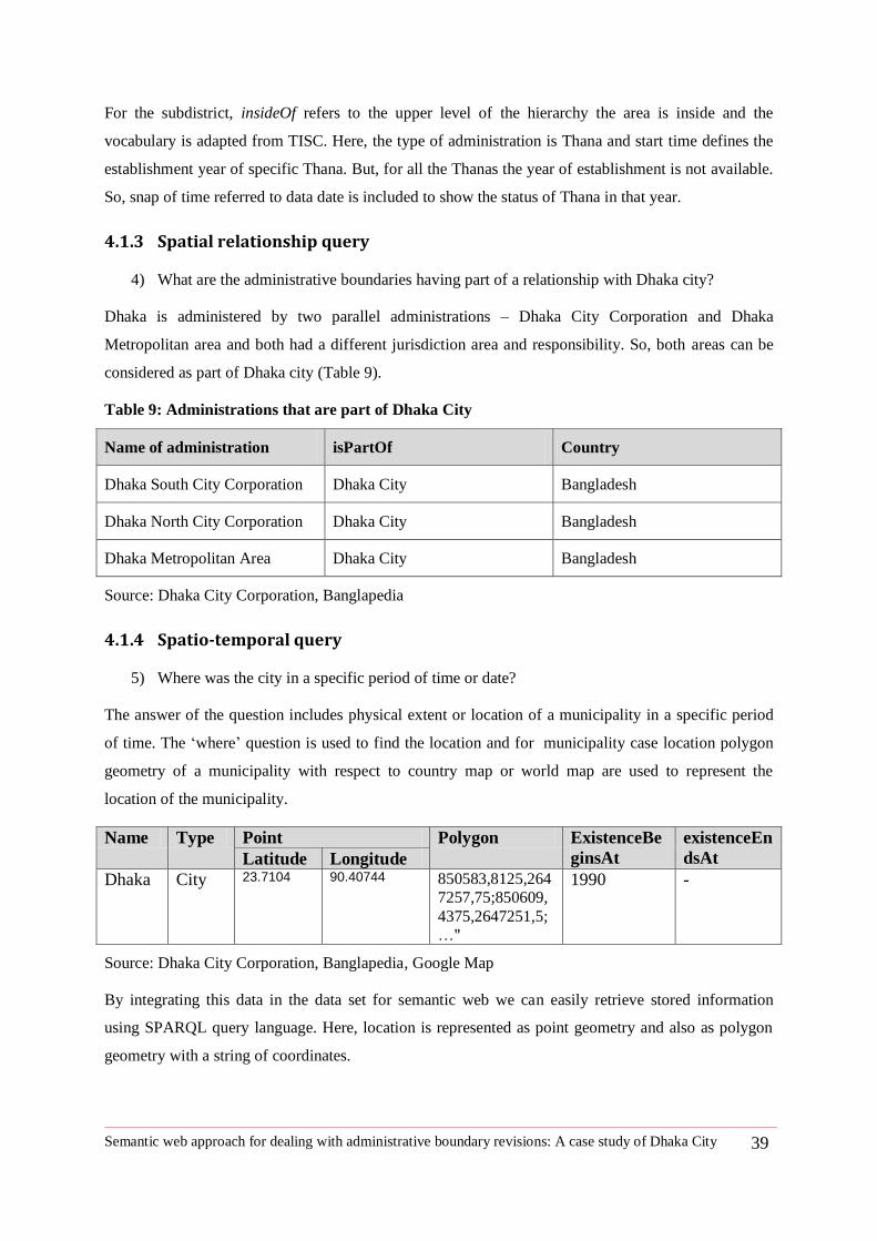
Semantic web approach for dealing with administrative boundary revisions: A case study of Dhaka City 39
For the subdistrict, insideOf refers to the upper level of the hierarchy the area is inside and the
vocabulary is adapted from TISC. Here, the type of administration is Thana and start time defines the
establishment year of specific Thana. But, for all the Thanas the year of establishment is not available.
So, snap of time referred to data date is included to show the status of Thana in that year.
4.1.3 Spatial relationship query
4) What are the administrative boundaries having part of a relationship with Dhaka city?
Dhaka is administered by two parallel administrations – Dhaka City Corporation and Dhaka
Metropolitan area and both had a different jurisdiction area and responsibility. So, both areas can be
considered as part of Dhaka city (Table 9).
Table 9: Administrations that are part of Dhaka City
Name of administration isPartOf Country
Dhaka South City Corporation Dhaka City Bangladesh
Dhaka North City Corporation Dhaka City Bangladesh
Dhaka Metropolitan Area Dhaka City Bangladesh
Source: Dhaka City Corporation, Banglapedia
4.1.4 Spatio-temporal query
5) Where was the city in a specific period of time or date?
The answer of the question includes physical extent or location of a municipality in a specific period
of time. The ‗where‘ question is used to find the location and for municipality case location polygon
geometry of a municipality with respect to country map or world map are used to represent the
location of the municipality.
Name Type Point Polygon ExistenceBe
ginsAt
existenceEn
dsAt Latitude Longitude
Dhaka City 23.7104 90.40744 850583,8125,264
7257,75;850609,
4375,2647251,5;
…"
1990 -
Source: Dhaka City Corporation, Banglapedia, Google Map
By integrating this data in the data set for semantic web we can easily retrieve stored information
using SPARQL query language. Here, location is represented as point geometry and also as polygon
geometry with a string of coordinates.
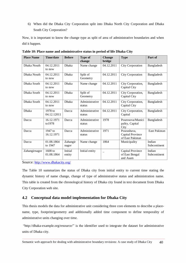
Semantic web approach for dealing with administrative boundary revisions: A case study of Dhaka City 40
6) When did the Dhaka City Corporation split into Dhaka North City Corporation and Dhaka
South City Corporation?
Now, it is important to know the change type as split of area of administrative boundaries and when
did it happen.
Table 10: Place name and administrative status in period of life Dhaka City
Place Name Time/date Before Type of
change
Change
bridge
Type Part of
Dhaka Nouth 04.12.2011
to now
Dhaka Name change 04.12.2011 City Corporation Bangladesh
Dhaka Nouth 04.12.2011
to now
Dhaka Split of
Geometry
04.12.2011 City Corporation Bangladesh
Dhaka South 04.12.2011
to now
Dhaka Name change 04.12.2011 City Corporation,
Capital City
Bangladesh
Dhaka South 04.12.2011
to now
Dhaka Split of
Geometry
04.12.2011 City Corporation,
Capital City
Bangladesh
Dhaka South 04.12.2011
to now
Dhaka Administrative
status
04.12.2011 City Corporation,
Capital City
Bangladesh
Dhaka 1978 to
04.12.12011
Dacca Administrative
status
04.12.2011 City Corporation,
Capital
Bangladesh
Dacca 16.12.1971
to1978
Dacca Administrative
status
1978 Pourosova/Munici
pality, Capital
City
Bangladesh
Dacca 1947 to
16.12.1971
Dacca Administrative
status
1971 Pourashava,
Capital Province
of East Pakistan
East Pakistan
Dacca 01.08.1864
to 1947
Zahangir
nagor
Name change 1864 Municipality Indian
Subcontinent
Zahangirnagor 1608 to
01.08.1864
Initial
entity
Initial entity _ Capital Province
of East Bengal
and Asam
Indian
Subcontinent
Source: http://www.dhakacity.org/
The Table 10 summarizes the status of Dhaka city from initial entity to current time stating the
dynamic history of name change, change of type of administrative status and administration name.
This table is created from the chronological history of Dhaka city found in text document from Dhaka
City Corporation web site.
4.2 Conceptual data model implementation for Dhaka City
This thesis models the data for administrative unit considering three core elements to describe a place-
name, type, footprint/geometry and additionally added time component to define temporality of
administrative units changing over time.
―http://dhaka-example.org/resource/‖ is the identifier used to integrate the dataset for administrative
units of Dhaka city.
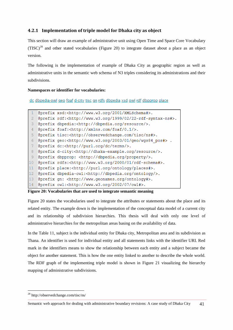
Semantic web approach for dealing with administrative boundary revisions: A case study of Dhaka City 41
4.2.1 Implementation of triple model for Dhaka city as object
This section will draw an example of administrative unit using Open Time and Space Core Vocabulary
(TISC)28
and other stated vocabularies (Figure 20) to integrate dataset about a place as an object
version.
The following is the implementation of example of Dhaka City as geographic region as well as
administrative units in the semantic web schema of N3 triples considering its administrations and their
subdivisions.
Namespaces or identifier for vocabularies:
Figure 20: Vocabularies that are used to integrate semantic meaning
Figure 20 states the vocabularies used to integrate the attributes or statements about the place and its
related entity. The example down is the implementation of the conceptual data model of a current city
and its relationship of subdivision hierarchies. This thesis will deal with only one level of
administrative hierarchies for the metropolitan areas basing on the availability of data.
In the Table 11, subject is the individual entity for Dhaka city, Metropolitan area and its subdivision as
Thana. An identifier is used for individual entity and all statements links with the identifier URI. Red
mark in the identifiers means to show the relationship between each entity and a subject became the
object for another statement. This is how the one entity linked to another to describe the whole world.
The RDF graph of the implementing triple model is shown in Figure 21 visualizing the hierarchy
mapping of administrative subdivisions.
28
http://observedchange.com/tisc/ns/
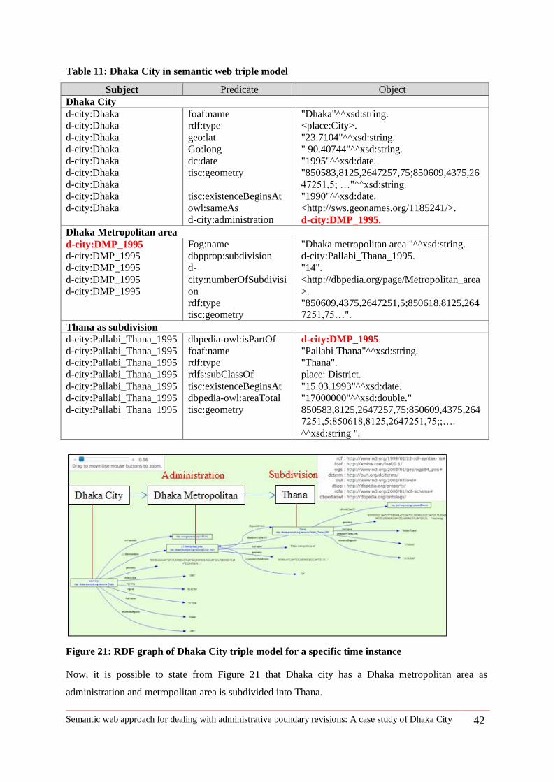
Semantic web approach for dealing with administrative boundary revisions: A case study of Dhaka City 42
Table 11: Dhaka City in semantic web triple model
Subject Predicate Object
Dhaka City
d-city:Dhaka
d-city:Dhaka
d-city:Dhaka
d-city:Dhaka
d-city:Dhaka
d-city:Dhaka
d-city:Dhaka
d-city:Dhaka
d-city:Dhaka
foaf:name
rdf:type
geo:lat
Go:long
dc:date
tisc:geometry
tisc:existenceBeginsAt
owl:sameAs
d-city:administration
"Dhaka"^^xsd:string.
<place:City>.
"23.7104"^^xsd:string.
" 90.40744"^^xsd:string.
"1995"^^xsd:date.
"850583,8125,2647257,75;850609,4375,26
47251,5; …"^^xsd:string.
"1990"^^xsd:date.
<http://sws.geonames.org/1185241/>.
d-city:DMP_1995.
Dhaka Metropolitan area
d-city:DMP_1995
d-city:DMP_1995
d-city:DMP_1995
d-city:DMP_1995
d-city:DMP_1995
Fog:name
dbpprop:subdivision
d-
city:numberOfSubdivisi
on
rdf:type
tisc:geometry
"Dhaka metropolitan area "^^xsd:string.
d-city:Pallabi_Thana_1995.
"14".
<http://dbpedia.org/page/Metropolitan_area
>.
"850609,4375,2647251,5;850618,8125,264
7251,75…".
Thana as subdivision
d-city:Pallabi_Thana_1995
d-city:Pallabi_Thana_1995
d-city:Pallabi_Thana_1995
d-city:Pallabi_Thana_1995
d-city:Pallabi_Thana_1995
d-city:Pallabi_Thana_1995
d-city:Pallabi_Thana_1995
dbpedia-owl:isPartOf
foaf:name
rdf:type
rdfs:subClassOf
tisc:existenceBeginsAt
dbpedia-owl:areaTotal
tisc:geometry
d-city:DMP_1995.
"Pallabi Thana"^^xsd:string.
"Thana".
place: District.
"15.03.1993"^^xsd:date.
"17000000"^^xsd:double."
850583,8125,2647257,75;850609,4375,264
7251,5;850618,8125,2647251,75;;….
^^xsd:string ".
Figure 21: RDF graph of Dhaka City triple model for a specific time instance
Now, it is possible to state from Figure 21 that Dhaka city has a Dhaka metropolitan area as
administration and metropolitan area is subdivided into Thana.
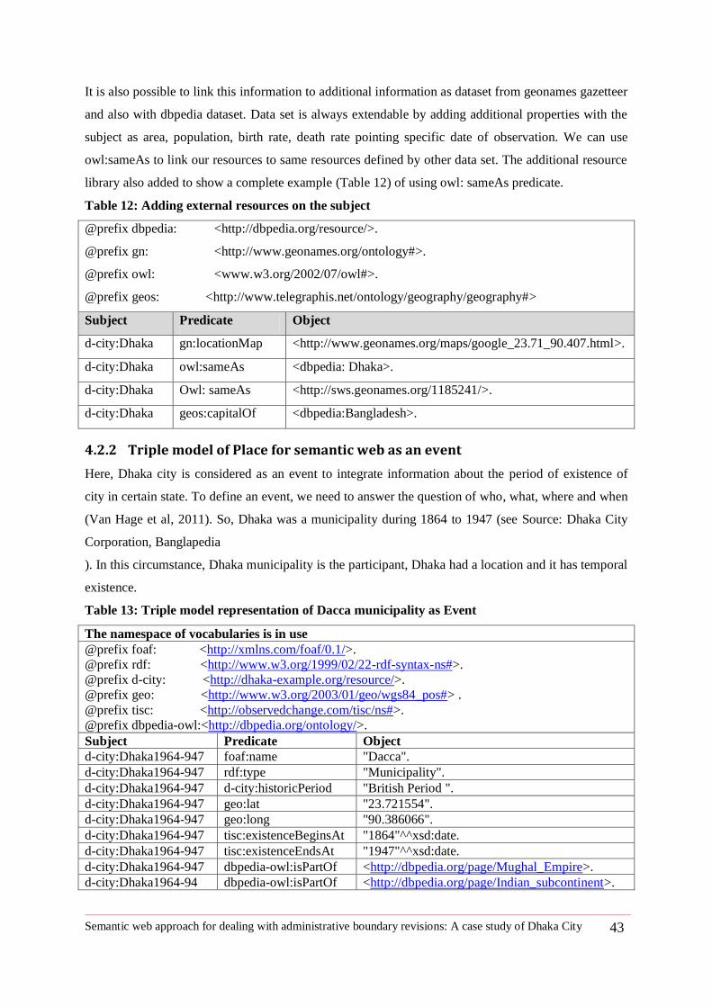
Semantic web approach for dealing with administrative boundary revisions: A case study of Dhaka City 43
It is also possible to link this information to additional information as dataset from geonames gazetteer
and also with dbpedia dataset. Data set is always extendable by adding additional properties with the
subject as area, population, birth rate, death rate pointing specific date of observation. We can use
owl:sameAs to link our resources to same resources defined by other data set. The additional resource
library also added to show a complete example (Table 12) of using owl: sameAs predicate.
Table 12: Adding external resources on the subject
@prefix dbpedia: <http://dbpedia.org/resource/>.
@prefix gn: <http://www.geonames.org/ontology#>.
@prefix owl: <www.w3.org/2002/07/owl#>.
@prefix geos: <http://www.telegraphis.net/ontology/geography/geography#>
Subject Predicate Object
d-city:Dhaka gn:locationMap <http://www.geonames.org/maps/google_23.71_90.407.html>.
d-city:Dhaka owl:sameAs <dbpedia: Dhaka>.
d-city:Dhaka Owl: sameAs <http://sws.geonames.org/1185241/>.
d-city:Dhaka geos:capitalOf <dbpedia:Bangladesh>.
4.2.2 Triple model of Place for semantic web as an event
Here, Dhaka city is considered as an event to integrate information about the period of existence of
city in certain state. To define an event, we need to answer the question of who, what, where and when
(Van Hage et al, 2011). So, Dhaka was a municipality during 1864 to 1947 (see Source: Dhaka City
Corporation, Banglapedia
). In this circumstance, Dhaka municipality is the participant, Dhaka had a location and it has temporal
existence.
Table 13: Triple model representation of Dacca municipality as Event
The namespace of vocabularies is in use
@prefix foaf: <http://xmlns.com/foaf/0.1/>.
@prefix rdf: <http://www.w3.org/1999/02/22-rdf-syntax-ns#>.
@prefix d-city: <http://dhaka-example.org/resource/>.
@prefix geo: <http://www.w3.org/2003/01/geo/wgs84_pos#> .
@prefix tisc: <http://observedchange.com/tisc/ns#>.
@prefix dbpedia-owl:<http://dbpedia.org/ontology/>.
Subject Predicate Object
d-city:Dhaka1964-947 foaf:name "Dacca".
d-city:Dhaka1964-947 rdf:type "Municipality".
d-city:Dhaka1964-947 d-city:historicPeriod "British Period ".
d-city:Dhaka1964-947 geo:lat "23.721554".
d-city:Dhaka1964-947 geo:long "90.386066".
d-city:Dhaka1964-947 tisc:existenceBeginsAt "1864"^^xsd:date.
d-city:Dhaka1964-947 tisc:existenceEndsAt "1947"^^xsd:date.
d-city:Dhaka1964-947 dbpedia-owl:isPartOf <http://dbpedia.org/page/Mughal_Empire>.
d-city:Dhaka1964-94 dbpedia-owl:isPartOf <http://dbpedia.org/page/Indian_subcontinent>.
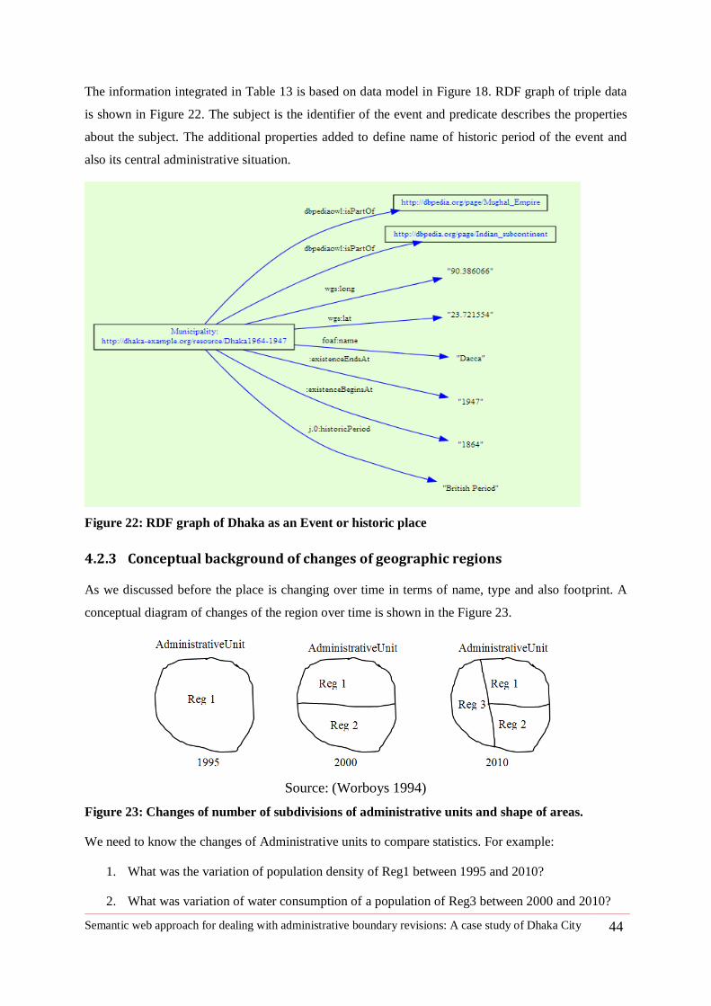
Semantic web approach for dealing with administrative boundary revisions: A case study of Dhaka City 44
The information integrated in Table 13 is based on data model in Figure 18. RDF graph of triple data
is shown in Figure 22. The subject is the identifier of the event and predicate describes the properties
about the subject. The additional properties added to define name of historic period of the event and
also its central administrative situation.
Figure 22: RDF graph of Dhaka as an Event or historic place
4.2.3 Conceptual background of changes of geographic regions
As we discussed before the place is changing over time in terms of name, type and also footprint. A
conceptual diagram of changes of the region over time is shown in the Figure 23.
Source: (Worboys 1994)
Figure 23: Changes of number of subdivisions of administrative units and shape of areas.
We need to know the changes of Administrative units to compare statistics. For example:
1. What was the variation of population density of Reg1 between 1995 and 2010?
2. What was variation of water consumption of a population of Reg3 between 2000 and 2010?
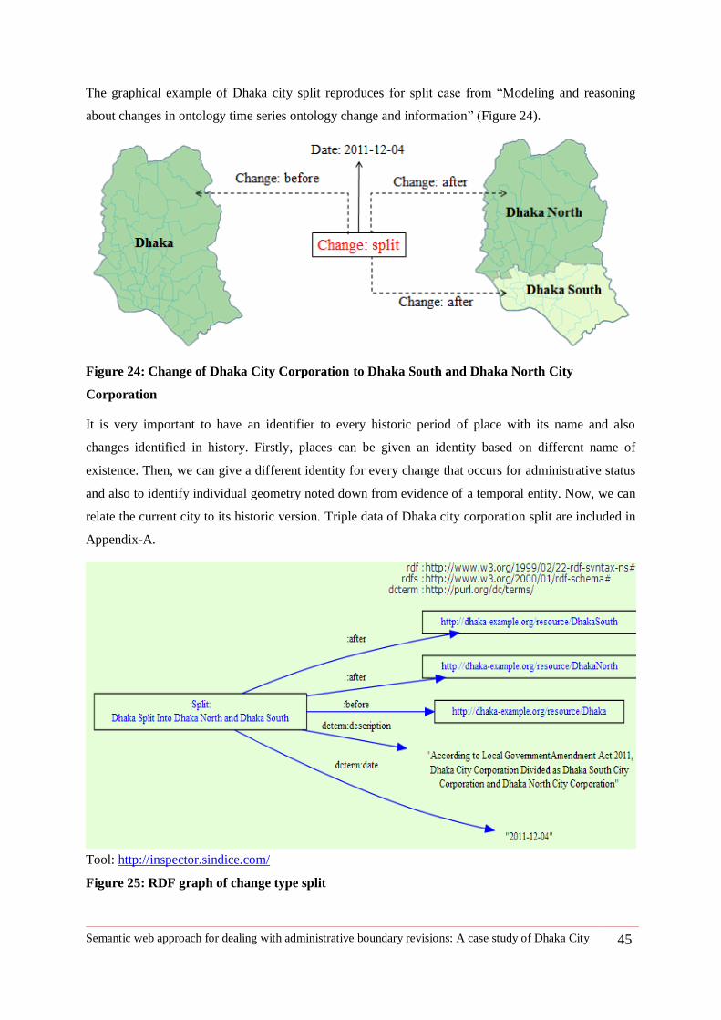
Semantic web approach for dealing with administrative boundary revisions: A case study of Dhaka City 45
The graphical example of Dhaka city split reproduces for split case from ―Modeling and reasoning
about changes in ontology time series ontology change and information‖ (Figure 24).
Figure 24: Change of Dhaka City Corporation to Dhaka South and Dhaka North City
Corporation
It is very important to have an identifier to every historic period of place with its name and also
changes identified in history. Firstly, places can be given an identity based on different name of
existence. Then, we can give a different identity for every change that occurs for administrative status
and also to identify individual geometry noted down from evidence of a temporal entity. Now, we can
relate the current city to its historic version. Triple data of Dhaka city corporation split are included in
Appendix-A.
Tool: http://inspector.sindice.com/
Figure 25: RDF graph of change type split
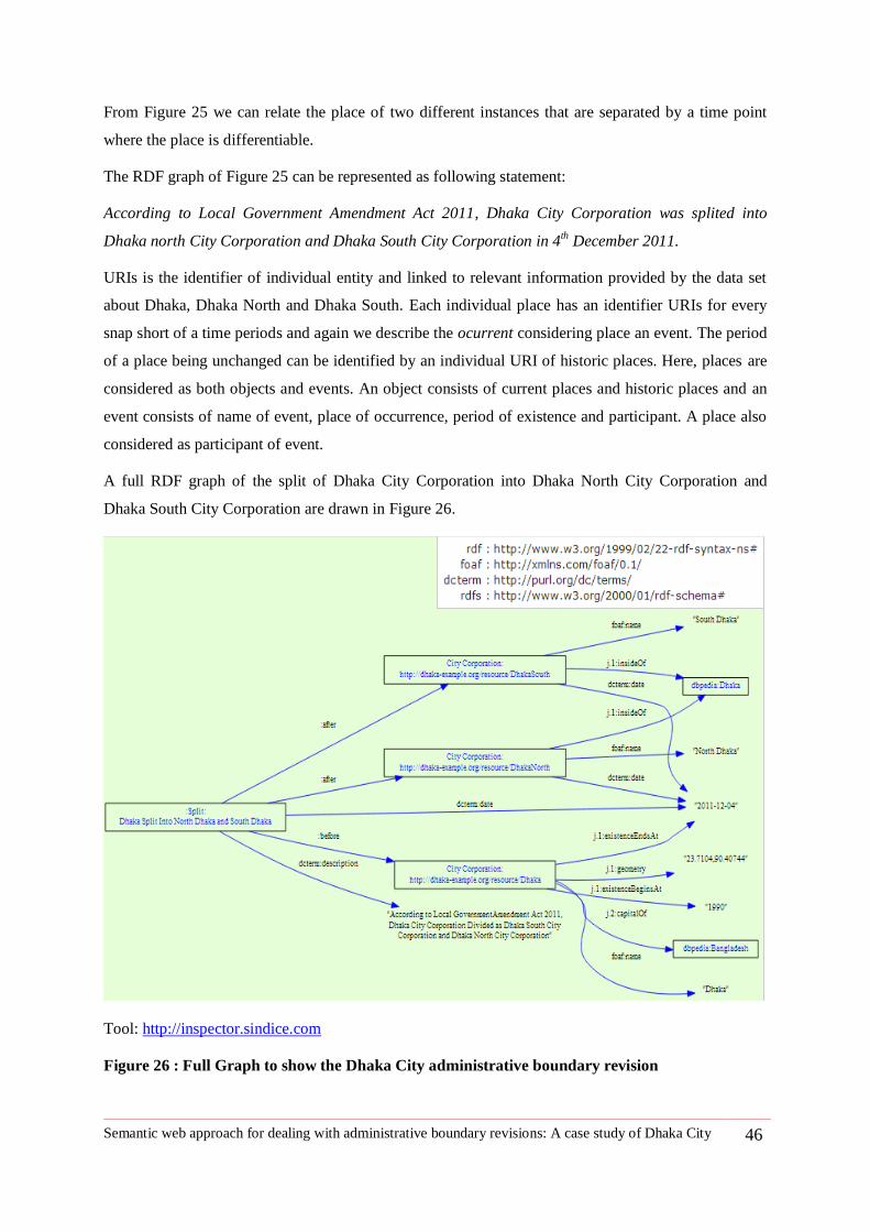
Semantic web approach for dealing with administrative boundary revisions: A case study of Dhaka City 46
From Figure 25 we can relate the place of two different instances that are separated by a time point
where the place is differentiable.
The RDF graph of Figure 25 can be represented as following statement:
According to Local Government Amendment Act 2011, Dhaka City Corporation was splited into
Dhaka north City Corporation and Dhaka South City Corporation in 4th December 2011.
URIs is the identifier of individual entity and linked to relevant information provided by the data set
about Dhaka, Dhaka North and Dhaka South. Each individual place has an identifier URIs for every
snap short of a time periods and again we describe the ocurrent considering place an event. The period
of a place being unchanged can be identified by an individual URI of historic places. Here, places are
considered as both objects and events. An object consists of current places and historic places and an
event consists of name of event, place of occurrence, period of existence and participant. A place also
considered as participant of event.
A full RDF graph of the split of Dhaka City Corporation into Dhaka North City Corporation and
Dhaka South City Corporation are drawn in Figure 26.
Tool: http://inspector.sindice.com
Figure 26 : Full Graph to show the Dhaka City administrative boundary revision
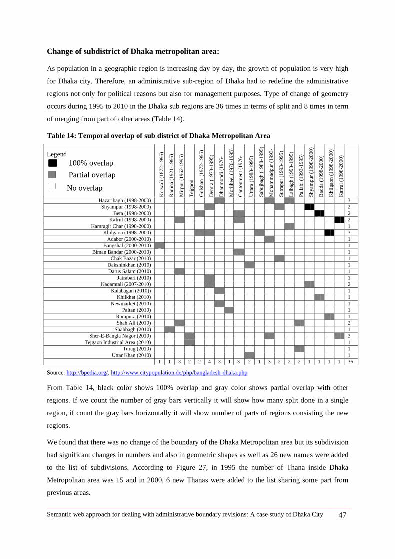
Semantic web approach for dealing with administrative boundary revisions: A case study of Dhaka City 47
Change of subdistrict of Dhaka metropolitan area:
As population in a geographic region is increasing day by day, the growth of population is very high
for Dhaka city. Therefore, an administrative sub-region of Dhaka had to redefine the administrative
regions not only for political reasons but also for management purposes. Type of change of geometry
occurs during 1995 to 2010 in the Dhaka sub regions are 36 times in terms of split and 8 times in term
of merging from part of other areas (Table 14).
Table 14: Temporal overlap of sub district of Dhaka Metropolitan Area
Legend
Kotw
ali
(1872-1
995)
Ram
na
(1921-1
995)
Mir
pur
(1962
-1995)
Tej
gao
n
Guls
han
(1
972-1
995)
Dem
ra (
1973-1
995)
Dhan
mondi
(1976-
1995)
Moti
jhee
l (1
976-1
995)
Can
tonm
ent
(1976-
1995)
Utt
ara (
1988-1
995)
Sab
ujb
agh
(1988
-1995)
Moham
mad
pur
(1993-
1995)
Sutr
apur
(1993-1
995
)
Lal
bag
h (
1993-1
995)
Pal
labi
(1993-1
995)
Shyam
pur
(1998
-2000)
Bad
da (
1998
-2000)
Khil
gao
n (
1998
-2000)
Kaf
rul
(1998
-2000)
Hazaribagh (1998-2000) 3
Shyampur (1998-2000) 2
Beta (1998-2000) 2
Kafrul (1998-2000) 2
Kamragir Char (1998-2000) 1
Khilgaon (1998-2000) 3
Adabor (2000-2010) 1
Bangshal (2000-2010) 1
Biman Bandar (2000-2010) 1
Chak Bazar (2010) 1
Dakshinkhan (2010) 1
Darus Salam (2010) 1
Jatrabari (2010) 1
Kadamtali (2007-2010) 2
Kalabagan (2010)) 1
Khilkhet (2010) 1
Newmarket (2010) 1
Paltan (2010) 1
Rampura (2010) 1
Shah Ali (2010) 2
Shahbagh (2010) 1
Sher-E-Bangla Nagor (2010) 3
Tejgaon Industrial Area (2010) 1
Turag (2010) 1
Uttar Khan (2010) 1
1 1 3 2 2 4 3 1 3 2 1 3 2 2 2 1 1 1 1 36
Source: http://bpedia.org/, http://www.citypopulation.de/php/bangladesh-dhaka.php
From Table 14, black color shows 100% overlap and gray color shows partial overlap with other
regions. If we count the number of gray bars vertically it will show how many split done in a single
region, if count the gray bars horizontally it will show number of parts of regions consisting the new
regions.
We found that there was no change of the boundary of the Dhaka Metropolitan area but its subdivision
had significant changes in numbers and also in geometric shapes as well as 26 new names were added
to the list of subdivisions. According to Figure 27, in 1995 the number of Thana inside Dhaka
Metropolitan area was 15 and in 2000, 6 new Thanas were added to the list sharing some part from
previous areas.
100% overlap
Partial overlap
No overlap
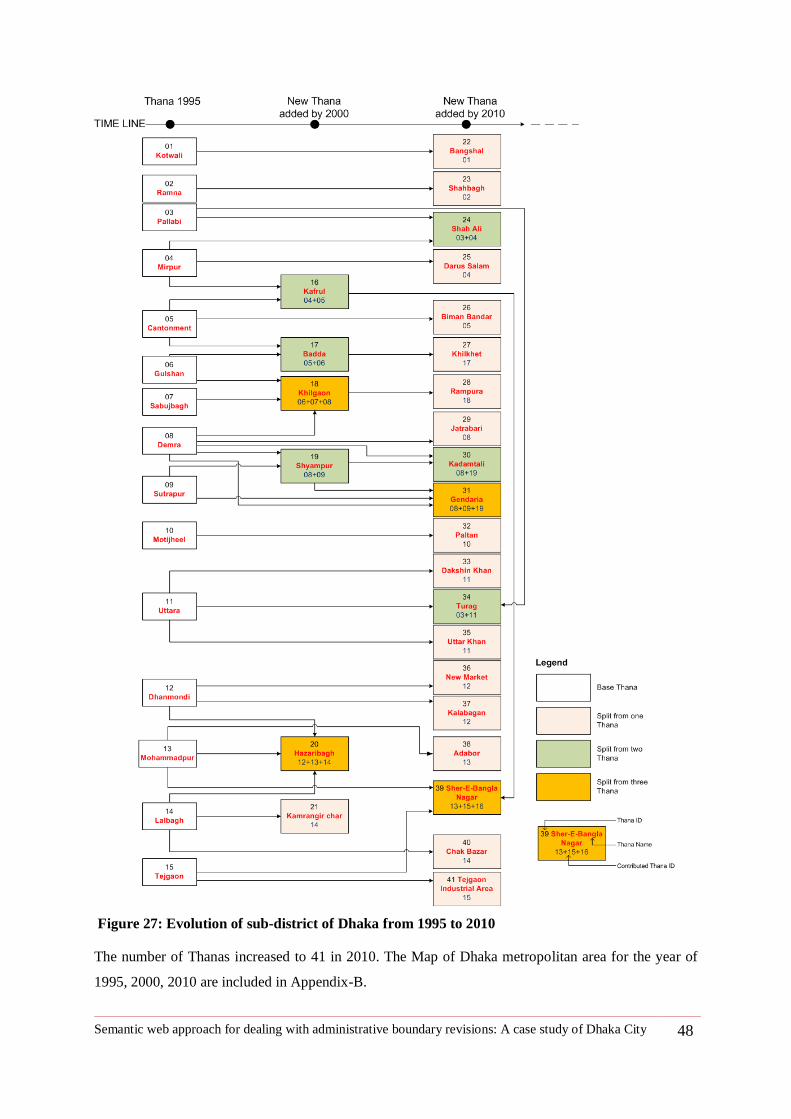
Semantic web approach for dealing with administrative boundary revisions: A case study of Dhaka City 48
Figure 27: Evolution of sub-district of Dhaka from 1995 to 2010
The number of Thanas increased to 41 in 2010. The Map of Dhaka metropolitan area for the year of
1995, 2000, 2010 are included in Appendix-B.
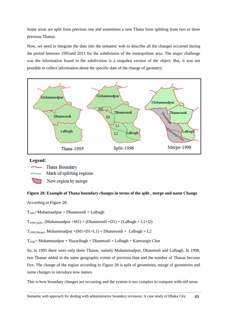
Semantic web approach for dealing with administrative boundary revisions: A case study of Dhaka City 49
Some areas are split from previous one and sometimes a new Thana form splitting from two or three
previous Thanas.
Now, we need to integrate the data into the semantic web to describe all the changes occurred during
the period between 1995and 2011 for the subdivision of the metropolitan area. The major challenge
was the information found in the subdivision is a snapshot version of the object. But, it was not
possible to collect information about the specific date of the change of geometry.
Figure 28: Example of Thana boundary changes in terms of the split , merge and name Change
According to Figure 28:
T1995=Muhamaadpur + Dhanmondi + Lalbagh
T1998 (Split)= (Muhamaadpur +M1) + (Dhanmondi +D1) + (Lalbagh + L1+l2)
T1998 (Merge)= Muhammadpur +(M1+D1+L1) + Dhanmondi + Lalbagh + L2
T1998= Muhammadpur + Hazaribagh + Dhanmodi + Lalbagh + Kamrangir Char
So, in 1995 there were only three Thanas, namely Muhammadpur, Dhanmodi and Lalbagh. In 1998,
two Thanas added in the same geographic extent of previous than and the number of Thanas become
five. The change of the region according to Figure 28 is split of geometries, merge of geometries and
name changes to introduce new names.
This is how boundary changes are occurring and the system is too complex to compare with old areas.
Semantic web approach for dealing with administrative boundary revisions: A case study of Dhaka City 50
The modeling of these changes was done using change vocabulary29
developed by Tomi
Kauppinen (Institute for Geoinformatics, University of Muenster, Germany) based on a research by
modeling changes30
.
29
http://linkedearth.org/change/ns/#
30 http://linkedearth.org/change/ns/#
Semantic web approach for dealing with administrative boundary revisions: A case study of Dhaka City 51
5 Chapter Five: Evaluation and Visualization Issues
This chapter discusses about the tools to integrate dataset as RDF and query capabilities of
data model to retrieve relevant information and visualization issues for semantic web
dataset for end users.
5.1 Evaluation
Evaluation includes uploading the data set in a triple store and generating the RDF graph and
capabilities to query from the data set.
5.1.1 Tools for integrating dataset
I have created all annotation data using http://epad.ifgi.de , a very useful online text editor tool. It was
very comfortable in using it as I could instantly check the syntax error while preparing data set. I have
used RDFpad (epad.ifgi.de) to check the syntax error and view the dataset and this site has also a
SPARQL endpoint to query the data set. For geometry dataset, I used ArcGIS10.0 by the python
script to directly convert the geometry as triple using predefined namespace id for the region. But, I
could not use epad .de online for processing geometry triple set. Geometry has huge coordinate point
and show syntax error while copying and pasting from .ttl file and it was very time consuming to fix
the problem.
Parliament triple store
ParliamentTM
is a high performance triple store designed for semantic web31
. The semantic web data
store is called triple store, graph storage or knowledge base. Unlike relational database table format
data, triple store can store RDF data as a list of triple form (subject, predicate, object) (Parliament
online,12). Parliament triple store is used to store the triple data set created for this thesis and data set
become ready for the query using the SPARQL endpoint supported by the Parliament triple store. It is
possible to visualize the whole graph of data. But Parliament cannot visualize geometry directly. It can
only show the results as a string of coordinate as inserted into the dataset.
5.2 Implementation of queries
This section of the thesis faces the challenge to answer to predefined queries. Implementation shows
the effectiveness of data set to retrieve the information about the revisions of the boundaries of the
administrative unit of Dhaka city. The full RDF data of administrative boundary revision of Dhaka
city is enclosed Appendix-C. The section listed all predefined queries and implementing the queries
using SPARQL and showing corresponding results.
31
http://parliament.semwebcentral.org/
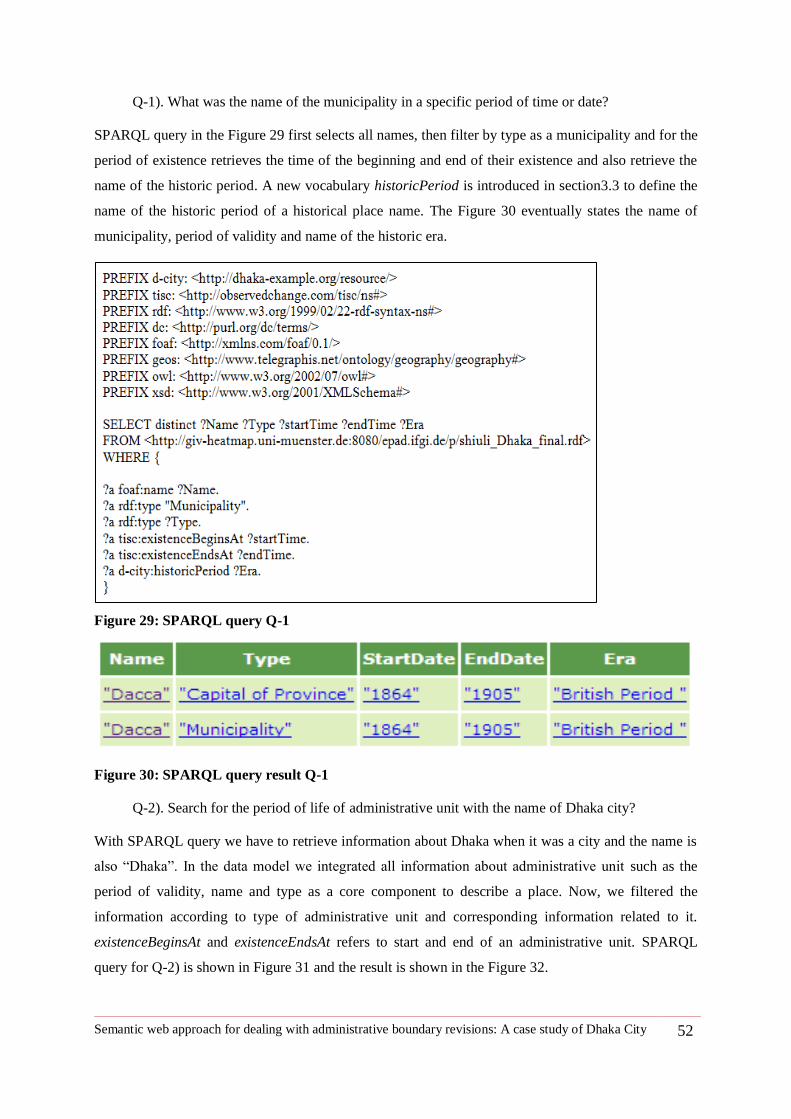
Semantic web approach for dealing with administrative boundary revisions: A case study of Dhaka City 52
Q-1). What was the name of the municipality in a specific period of time or date?
SPARQL query in the Figure 29 first selects all names, then filter by type as a municipality and for the
period of existence retrieves the time of the beginning and end of their existence and also retrieve the
name of the historic period. A new vocabulary historicPeriod is introduced in section3.3 to define the
name of the historic period of a historical place name. The Figure 30 eventually states the name of
municipality, period of validity and name of the historic era.
Figure 29: SPARQL query Q-1
Figure 30: SPARQL query result Q-1
Q-2). Search for the period of life of administrative unit with the name of Dhaka city?
With SPARQL query we have to retrieve information about Dhaka when it was a city and the name is
also ―Dhaka‖. In the data model we integrated all information about administrative unit such as the
period of validity, name and type as a core component to describe a place. Now, we filtered the
information according to type of administrative unit and corresponding information related to it.
existenceBeginsAt and existenceEndsAt refers to start and end of an administrative unit. SPARQL
query for Q-2) is shown in Figure 31 and the result is shown in the Figure 32.
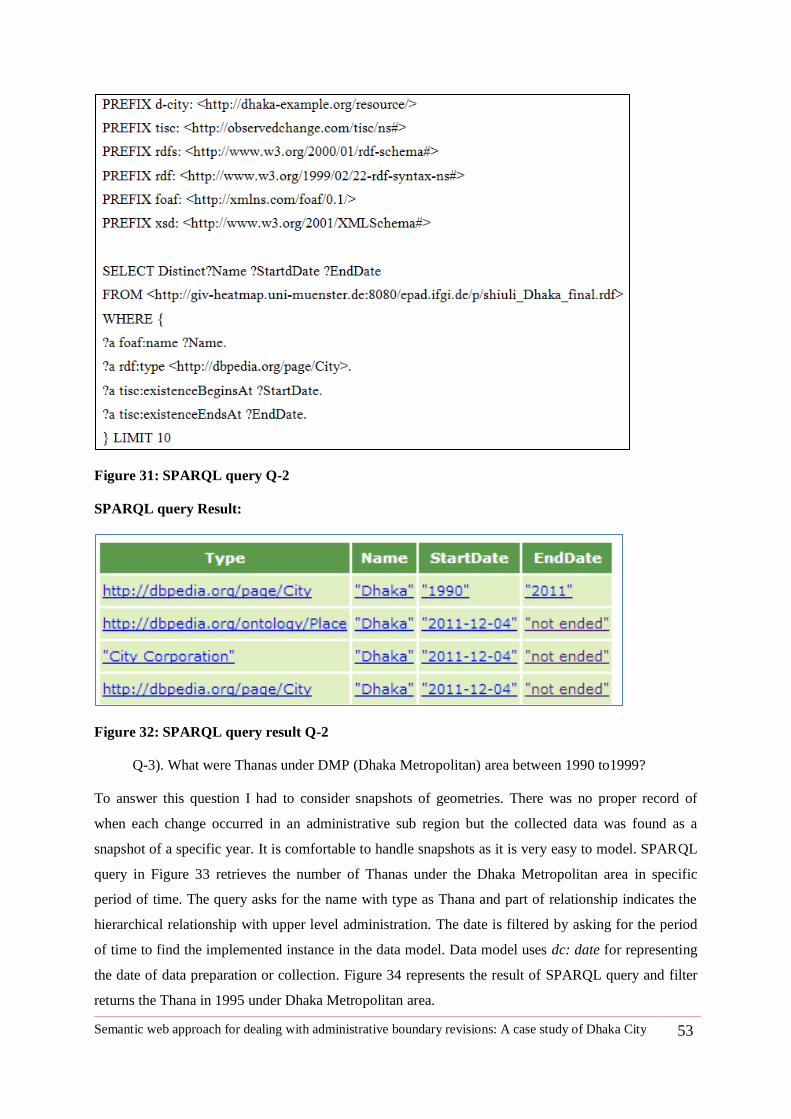
Semantic web approach for dealing with administrative boundary revisions: A case study of Dhaka City 53
Figure 31: SPARQL query Q-2
SPARQL query Result:
Figure 32: SPARQL query result Q-2
Q-3). What were Thanas under DMP (Dhaka Metropolitan) area between 1990 to1999?
To answer this question I had to consider snapshots of geometries. There was no proper record of
when each change occurred in an administrative sub region but the collected data was found as a
snapshot of a specific year. It is comfortable to handle snapshots as it is very easy to model. SPARQL
query in Figure 33 retrieves the number of Thanas under the Dhaka Metropolitan area in specific
period of time. The query asks for the name with type as Thana and part of relationship indicates the
hierarchical relationship with upper level administration. The date is filtered by asking for the period
of time to find the implemented instance in the data model. Data model uses dc: date for representing
the date of data preparation or collection. Figure 34 represents the result of SPARQL query and filter
returns the Thana in 1995 under Dhaka Metropolitan area.
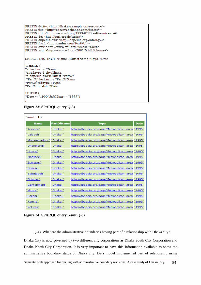
Semantic web approach for dealing with administrative boundary revisions: A case study of Dhaka City 54
Figure 33: SPARQL query Q-3)
Figure 34: SPARQL query result Q-3)
Q-4). What are the administrative boundaries having part of a relationship with Dhaka city?
Dhaka City is now governed by two different city corporations as Dhaka South City Corporation and
Dhaka North City Corporation. It is very important to have this information available to show the
administrative boundary status of Dhaka city. Data model implemented part of relationship using
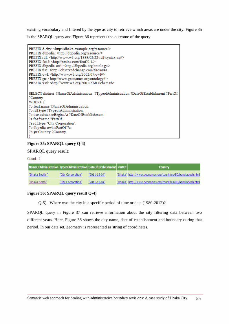
Semantic web approach for dealing with administrative boundary revisions: A case study of Dhaka City 55
existing vocabulary and filtered by the type as city to retrieve which areas are under the city. Figure 35
is the SPARQL query and Figure 36 represents the outcome of the query.
Figure 35: SPARQL query Q-4)
SPARQL query result:
Figure 36: SPARQL query result Q-4)
Q-5). Where was the city in a specific period of time or date (1980-2012)?
SPARQL query in Figure 37 can retrieve information about the city filtering data between two
different years. Here, Figure 38 shows the city name, date of establishment and boundary during that
period. In our data set, geometry is represented as string of coordinates.
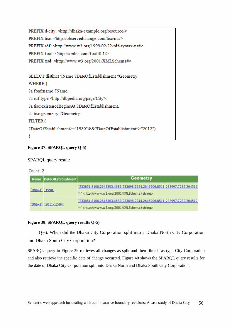
Semantic web approach for dealing with administrative boundary revisions: A case study of Dhaka City 56
Figure 37: SPARQL query Q-5)
SPARQL query result:
Figure 38: SPARQL query results Q-5)
Q-6). When did the Dhaka City Corporation split into a Dhaka North City Corporation
and Dhaka South City Corporation?
SPARQL query in Figure 39 retrieves all changes as split and then filter it as type City Corporation
and also retrieve the specific date of change occurred. Figure 40 shows the SPARQL query results for
the date of Dhaka City Corporation split into Dhaka North and Dhaka South City Corporation.
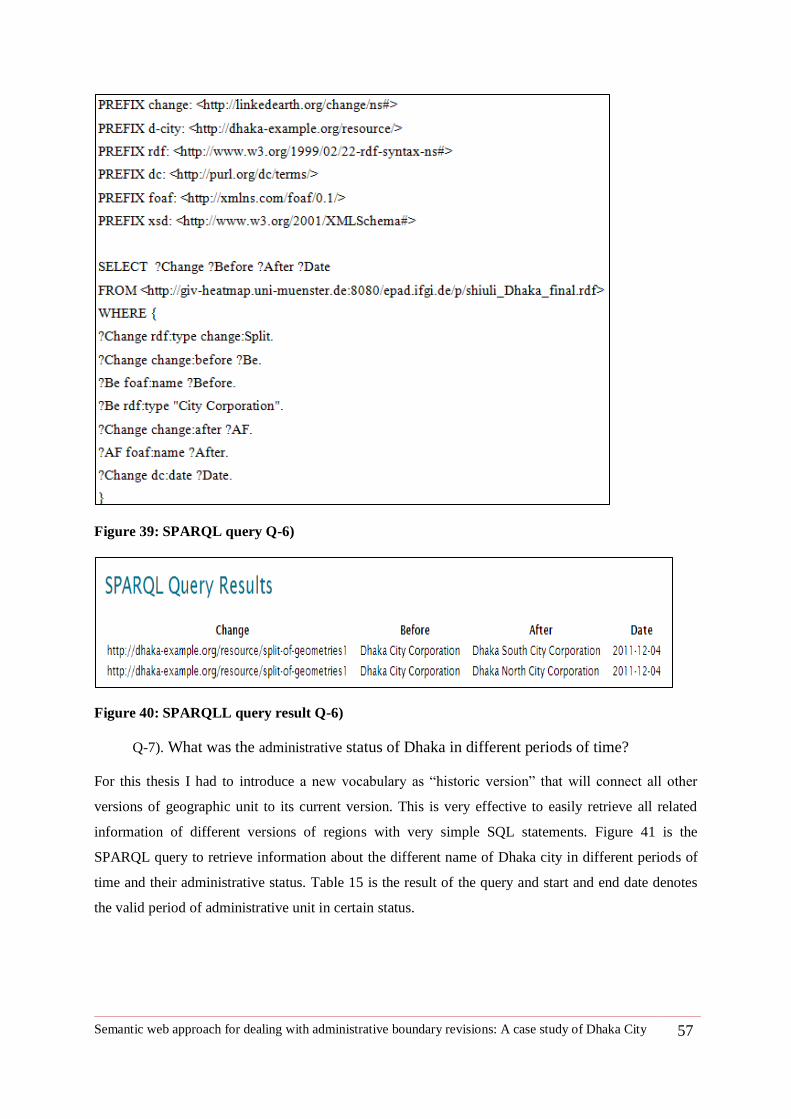
Semantic web approach for dealing with administrative boundary revisions: A case study of Dhaka City 57
Figure 39: SPARQL query Q-6)
Figure 40: SPARQLL query result Q-6)
Q-7). What was the administrative status of Dhaka in different periods of time?
For this thesis I had to introduce a new vocabulary as ―historic version‖ that will connect all other
versions of geographic unit to its current version. This is very effective to easily retrieve all related
information of different versions of regions with very simple SQL statements. Figure 41 is the
SPARQL query to retrieve information about the different name of Dhaka city in different periods of
time and their administrative status. Table 15 is the result of the query and start and end date denotes
the valid period of administrative unit in certain status.
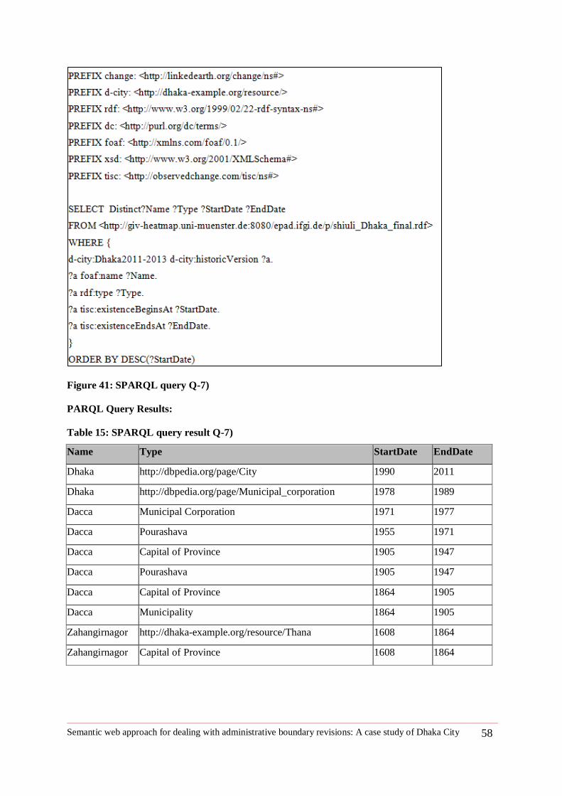
Semantic web approach for dealing with administrative boundary revisions: A case study of Dhaka City 58
Figure 41: SPARQL query Q-7)
PARQL Query Results:
Table 15: SPARQL query result Q-7)
Name Type StartDate EndDate
Dhaka http://dbpedia.org/page/City 1990 2011
Dhaka http://dbpedia.org/page/Municipal_corporation 1978 1989
Dacca Municipal Corporation 1971 1977
Dacca Pourashava 1955 1971
Dacca Capital of Province 1905 1947
Dacca Pourashava 1905 1947
Dacca Capital of Province 1864 1905
Dacca Municipality 1864 1905
Zahangirnagor http://dhaka-example.org/resource/Thana 1608 1864
Zahangirnagor Capital of Province 1608 1864
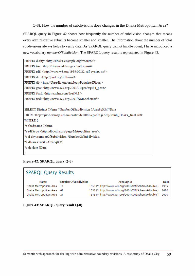
Semantic web approach for dealing with administrative boundary revisions: A case study of Dhaka City 59
Q-8). How the number of subdivisions does changes in the Dhaka Metropolitan Area?
SPARQL query in Figure 42 shows how frequently the number of subdivision changes that means
every administrative subunits become smaller and smaller. The information about the number of total
subdivisions always helps to verify data. As SPARQL query cannot handle count, I have introduced a
new vocabulary numberOfSubdivision. The SPARQL query result is represented in Figure 43.
Figure 42: SPARQL query Q-8)
Figure 43: SPARQL query result Q-8)
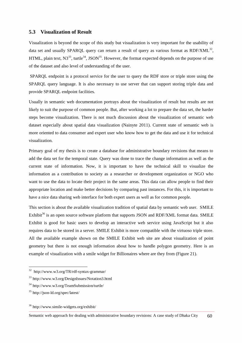
Semantic web approach for dealing with administrative boundary revisions: A case study of Dhaka City 60
5.3 Visualization of Result
Visualization is beyond the scope of this study but visualization is very important for the usability of
data set and usually SPARQL query can return a result of query as various format as RDF/XML32
,
HTML, plain text, N333
, turtle34
, JSON35
. However, the format expected depends on the purpose of use
of the dataset and also level of understanding of the user.
SPARQL endpoint is a protocol service for the user to query the RDF store or triple store using the
SPARQL query language. It is also necessary to use server that can support storing triple data and
provide SPARQL endpoint facilities.
Usually in semantic web documentation portrays about the visualization of result but results are not
likely to suit the purpose of common people. But, after working a lot to prepare the data set, the harder
steps become visualization. There is not much discussion about the visualization of semantic web
dataset especially about spatial data visualization (Nainyte 2011). Current state of semantic web is
more oriented to data consumer and expert user who know how to get the data and use it for technical
visualization.
Primary goal of my thesis is to create a database for administrative boundary revisions that means to
add the data set for the temporal state. Query was done to trace the change information as well as the
current state of information. Now, it is important to have the technical skill to visualize the
information as a contribution to society as a researcher or development organization or NGO who
want to use the data to locate their project in the same areas. This data can allow people to find their
appropriate location and make better decisions by comparing past instances. For this, it is important to
have a nice data sharing web interface for both expert users as well as for common people.
This section is about the available visualization tradition of spatial data by semantic web user. SMILE
Exhibit36
is an open source software platform that supports JSON and RDF/XML format data. SMILE
Exhibit is good for basic users to develop an interactive web service using JavaScript but it also
requires data to be stored in a server. SMILE Exhibit is more compatible with the virtuoso triple store.
All the available example shown on the SMILE Exhibit web site are about visualization of point
geometry but there is not enough information about how to handle polygon geometry. Here is an
example of visualization with a smile widget for Billionaires where are they from (Figure 21).
32
http://www.w3.org/TR/rdf-syntax-grammar/
33 http://www.w3.org/DesignIssues/Notation3.html
34 http://www.w3.org/TeamSubmission/turtle/
35 http://json-ld.org/spec/latest/
36 http://www.simile-widgets.org/exhibit/
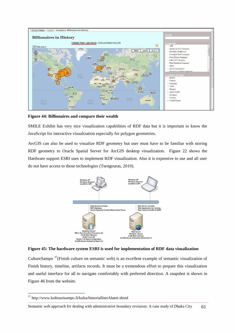
Semantic web approach for dealing with administrative boundary revisions: A case study of Dhaka City 61
Figure 44: Billionaires and compare their wealth
SMILE Exhibit has very nice visualization capabilities of RDF data but it is important to know the
JavaScript for interactive visualization especially for polygon geometries.
ArcGIS can also be used to visualize RDF geometry but user must have to be familiar with storing
RDF geometry to Oracle Spatial Server for ArcGIS desktop visualization. Figure 22 shows the
Hardware support ESRI uses to implement RDF visualization. Also it is expensive to use and all user
do not have access to those technologies (Tsengouras, 2010).
Figure 45: The hardware system ESRI is used for implementation of RDF data visualization
CultureSampo 37
(Finish culture on semantic web) is an excellent example of semantic visualization of
Finish history, timeline, artifacts records. It must be a tremendous effort to prepare this visualization
and useful interface for all to navigate comfortably with preferred direction. A snapshot is shown in
Figure 46 from the website.
37
http://www.kulttuurisampo.fi/kulsa/historiallisetAlueet.shtml
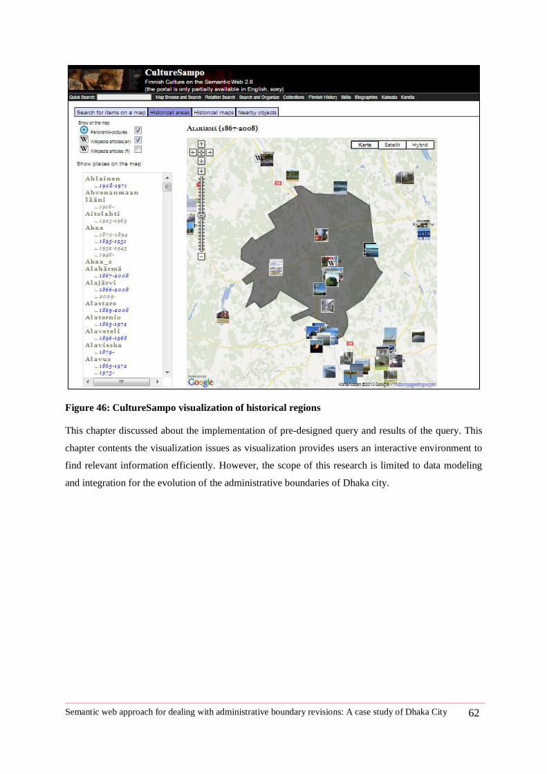
Semantic web approach for dealing with administrative boundary revisions: A case study of Dhaka City 62
Figure 46: CultureSampo visualization of historical regions
This chapter discussed about the implementation of pre-designed query and results of the query. This
chapter contents the visualization issues as visualization provides users an interactive environment to
find relevant information efficiently. However, the scope of this research is limited to data modeling
and integration for the evolution of the administrative boundaries of Dhaka city.
Semantic web approach for dealing with administrative boundary revisions: A case study of Dhaka City 63
6 Chapter Six: Discussion
This thesis developed a conceptual data model based on predefined queries that reflect the
evolution of Dhaka city Boundary changes over time. Then, data is integrated using
semantic vocabulary for the semantic web. There are several expert works already done to
develop ontology of Administrative regions and their temporality. Besides all other
traditional approaches, SONADUS (Gantner et al. 2012) ontology and SAPO(Kauppinen,
Väätäinen, and Hyvönen, 2008) was the most helpful literature to support my study. But, in
both cases they have a very good dataset from the authority and had the access to the proper
record keeping system. SONADUS uses very rich dataset from the historical register and
also geometric dataset produced by the authority. But for my study it was really hard to
follow any of them totally in terms of adopting the properties like finding the life of
geometry or time of annexations. SAPO also had data available to produce nice resource
data. I did not use SONADUS ontology because it does not match with my available data
set but it contributes to improving my data model considering both snapshot of the
geometry of a specific time period and also representing the changes as occurrence or
event. I explicitly use Change38
vocabulary introduced by SAPO ontology and also use
tisc39
vocabulary that describes observed changes. This study has used ―tisc‖ vocabulary to
define geometry and also to describe the fact of ―existenceBeginsAt‖ for establishment date
of administrative regions and ―existenceEndsAt‖ for the abolition date of identity of a
region.
6.1 New vocabularies introduced to serve semantic data integration
This study also introduces some essential vocabulary that was important to describe the data. The new
introduced vocabularies are listed below:
1. Predicate-numberOfSubdivision: The number of subdivisions refers to how many sub regions
under an administrative region such as city.
2. Predicate-Administration: Administration is a form of government such as public
administration e.g., City Corporation
3. Predicate-historicVersion: The previous existence of regions in terms of name, area and
population.
4. Class-Thana: Subdistrict is Thana according to local term in Bangladesh.
5. Predicate-historicPeriod: historicPeriod is a notation of period of historic region such as
British Period, Mughal Period, etc.
6. Class- Changetypeof: Administrative region can be changed by its type such as Municipality
can be uplifted to City Corporation.
38
http://linkedearth.org/change/ns#
39 http://observedchange.com/tisc/ns#
Semantic web approach for dealing with administrative boundary revisions: A case study of Dhaka City 64
Mostly, this study reuses the existing vocabulary but for the simplicity of data model and easy retrieval
of information the new vocabularies are introduced.
From Chapter Five: Evaluation and Visualization Issues , it is found that data set works well with
making queries and retrieving results. The data model can retrieve current information about the city
such as name, type, administrative statutes and also geometry or boundaries as well as changes
occurred with the city e.g., split of Dhaka City Corporation and the date of the split. After and before
terms relate the previous and current state of administrative region. The newly introduced term
―Historic version can relate the current city to all its historical existence status of a region in different
time periods‖.
6.2 Identified changes
There was very frequent boundary revisions occurred for the subdivision of metropolitan areas. All the
changes identified in Dhaka city as a whole were annotation data and very few evidence was found to
retrieve to the administrative boundaries of historic Dhaka. The kind of changes identified of Dhaka
city boundary revisions are listed below:
Boundary revisions type Number of times Unit of changes
Namechange 3 City
NameChange 38 Subdivisions/Thana
Changepartof 3 City
Changetypeof 3 City
Split 1 City
Split 36 Subdivisions/Thana
Merge 11 Subdivisions/Thana
Except change type of administration, all other changes suitable with existing change vocabulary for
changes in geographic regions.
6.3 Insights from evaluation
Evaluation was the effort to answer queries that was designed to record the changes that occur in
Dhaka city boundary. SPAQL query with Parliament Triple store is used to query dataset from triple
store. Now, it is possible to find answer to the queries but the queries are explicitly for implemented
data set. Implemented dataset was based on secondary sources such as publications, home page of
Dhaka City Corporation and documentation collected from Dhaka City Corporation. The study period
Semantic web approach for dealing with administrative boundary revisions: A case study of Dhaka City 65
is limited to 1995 to 2010 for the administrative unit of Dhaka Metropolitan area and subdivision
known as Thana. This study also implemented annotation data about Dhaka from 1608 to 2011 with
all the changes occurred in Dhaka in terms of name, type of administration, colonization to
independence stage of changes and query support to find all historic stages of Dhaka.
6.4 Limitations
Data accuracy:
o Edge mismatch: Data found from secondary sources are in different resolution at
different period and it was difficult to match one layer with another.
o Non compatible data: Same data produced in different organizations are different in
shape and, size without explanation.
Data availability problem:
o Record missing: Absence of proper record keeping by the authority
o Unavailability of digital data: Unavailability of digital data is a big problem and
reproducing digital data was time consuming.
Time shortage:
o Time Limit: Time was short to capture all the real data from the field in digital
format as well as to collect information in detail and verify them.
Semantic web approach for dealing with administrative boundary revisions: A case study of Dhaka City 66
7 Chapter Seven: Conclusion
7.1 Summary
Dhaka is a Mega City of about 103, 56,500 populations according to GeoNames geographical
database. In 16th
century during the regime of Mughal Emperor, it was a Thana or military outpost of
having 2 km2 and only 3000 populations lived there. Dhaka undergoes several changes to its life time
such as it possessed different names in different time and was ruled by different Empire and liberated
in 16th
December 1971. All information about Dhaka city is found currently in internet is document
format and also information is interpreted differently in different studies. So, it is difficult for the
researchers as well as for the development organizations to find appropriate reference extent of area
and compare statistics of two different time periods. Especially, census record is always based on
region name that is under jurisdiction of administrative regions. City Corporation of Dhaka has also
poor data management system to record the changes occurred in Dhaka city. Of course, they have text
documents and old maps of different resolution prepared in different time. Dhaka has currently two
different types of administrative regions-city corporation and metropolitan area. City corporation has a
total area of about 360 km2 consisting of 90 wards and Dhaka metropolitan area has 41 wards with an
area of about 1553 km2 (http://www.dncc.gov.bd/dncc-setup/chronological-development-of-
dncc.html).
The effort is made to find a solution to track of the changes occurred in Dhaka city over time and to
store all information with appropriate temporal reference. Semantic web technology is a likely choice
to implement the spatio-temporal database of city boundary changes. Semantic web allows describing
thing as a statement of subject, predicate and objecting and data representation format is known as
RDF. So, with semantic web technology triple format statement, it is possible to state everything about
Dhaka city. Semantic web provides data set with semantic meaning that allows retrieving information
by using SPARQL query language. The RDF data model of semantic web is developed to describe
current city and its subdivisions, the period of existence of an administrative unit in a certain status
considering city as event and also relating each event by describing changes with type of changes
occurs and after-before relationship and also by describing the date of each changes. Due to the
availability of information about administrative unit status in different time and changes over the
region, it is possible to compare census information of two different periods of time.
This thesis shows the implementation of change vocabulary40
for the changes of administrative
regions. New vocabulary introduced by this study can also integrate number of subdivisions under an
administrative unit in certain period of time and also retrieve information about previous status of
administrative unit by introducing historic version.
40
http://linkedearth.org/change/ns#

Semantic web approach for dealing with administrative boundary revisions: A case study of Dhaka City 67
7.2 Contribution
This thesis makes following contribution:
A brief literature review that discusses about different approaches of handling spatiotemporal
data in GIS and worked done using semantic web.
A discussion about importance of geodata management for changes of boundaries for Dhaka
city
A documentation of changes of Thana boundaries under Dhaka metropolitan area from 1995
to 2010.
A RDF data model that contains revision history of Dhaka city and its subdivision as
administrative unit.
A data base with semantic web that can retrieve wide range of query about administrative
boundary and its historical changes by using SPARQL protocol.
A baseline data set that geometrically overlaps each other and match with Google maps.
7.3 Findings
The implementation of administrative dataset is mostly done using existing vocabularies.
Implementation of change vocabulary was shown for Dhaka City and its subdistrict boundary changes.
Change vocabulary did not introduce change of type of administrative unit. This study introduces
Changetypeof vocabulary that can describe the type change of administrative unit in different periods.
It is always possible to extend the dataset with additional resources. Interactive visualization is a part
of the future work. Change vocabulary is very useful to describe and manage the changes of
administrative regions. This thesis produces a base line study addressing the changes of administrative
unit in Dhaka city. This study is most valuable for Dhaka city since so far there is no study that sheds
light on importance of managing change of administrative boundaries for Dhaka City.
Semantic web approach for dealing with administrative boundary revisions: A case study of Dhaka City 68
Reference
Frank, AU. 2003. 9–77 Ontology for spatio-temporal databases.
http://link.springer.com/chapter/10.1007/978-3-540-45081-8_2 (March 27, 2013).
Gantner, Felix. 2011. ―A Spatiotemporal Ontology for the Administrative Units of Switzerland.‖
geo.uzh.ch.
http://www.geo.uzh.ch/fileadmin/files/content/abteilungen/gis/research/msc_thesis/msc_felix_ga
ntner_2011.pdf (January 23, 2013).
Gantner, Felix, Bettina Waldvogel, Rolf Meile, and Patrick Laube. 2012. ―The Basic Formal Ontology
as a Reference Framework for Modeling the Evolution of Administrative Units.‖ Transactions in
GIS: n/a–n/a. http://doi.wiley.com/10.1111/j.1467-9671.2012.01356.x (January 21, 2013).
Van Hage, Willem Robert, Véronique Malaisé, Roxane Segers, Laura Hollink, and Guus Schreiber.
2011. ―Design and use of the Simple Event Model (SEM).‖ Web Semantics: Science, Services
and Agents on the World Wide Web 9(2): 128–136.
http://linkinghub.elsevier.com/retrieve/pii/S1570826811000199.
Hustadt, U. 1994. ―Do we need the closed-world assumption in knowledge representation.‖ Working
Notes of the KI. http://ceur-ws.org/Vol-1/hustadt-long.pdf (March 11, 2013).
Kauppinen, Tomi, and Eero Hyvönen. 2007. ―MODELING AND REASONING ABOUT CHANGES
IN ONTOLOGY TIME SERIES ONTOLOGY CHANGE AND INFORMATION.‖ In , p. 1–21.
Kauppinen, Tomi, Jari Väätäinen, and Eero Hyvönen. 2008. ―Creating and using geospatial ontology
time series in a semantic cultural heritage portal.‖ … Semantic Web: Research and …: 1–15.
http://www.springerlink.com/index/228L3K2764406561.pdf (January 16, 2013).
Nainyte, Justina. 2011. ―CULTURE BOUNDARIES Master Thesis : CULTURE BOUNDARIES.‖
Tsengouras, Michael D. 2010. ―RDF Databases Made ArcGIS Friendly.‖
http://proceedings.esri.com/library/userconf/proc10/uc/papers/pap_1163b.pdf.
Worboys, MF. 1994. ―A unified model for spatial and temporal information.‖ The Computer Journal.
http://comjnl.oxfordjournals.org/content/37/1/26.short (January 21, 2013).
Yuan, May. 2002. ―Use of a Three •Domain Repesentation to Enhance GIS Support for Complex
Spatiotemporal Queries.‖ Transactions in GIS 3(2).
http://onlinelibrary.wiley.com/doi/10.1111/1467-9671.00012/abstract (March 6, 2013).
Mostern, R.,2008. Historical Gazetteers: An Experiential Perspective, with Examples from Chinese
History, Historical Methods, 41(1), 39-46 (2008).
ITC. 2001. Principles of Geographic Information systems. Rolf A. de by (Ed). (ITC Educational
Textbook Series; 1), Second Edition, 2001.
Transactions in GIS, 2008. Geographical Linked Data: The Administrative Geography of Great Britain
on the Semantic Web. 12(Suppl. 1): 19–30
Heath, T., & Bizer, C. (2011). Linked Data: Evolving Web into a Global Data Space (1st Edition Ed.).
(J. Hendler, & F. Harmelen, Eds.) Morgan & Clayppol Publishers.
Semantic web approach for dealing with administrative boundary revisions: A case study of Dhaka City 69
Tim Berners-Lee. Linked Data - Design Issues, 2006. From
<http://www.w3.org/DesignIssues/LinkedData.html> accessed on 10th
January 2013.
Gür N., (2012).GI Systems for Public Health with Ontology Based Approach. Master Thesis for
Geospatial Technologies. Master in Geospatial Technology, International Erasmus Mundus.
M.F. Goodchild, M. Egenhofer, R. Fegeas, and C. Kottmann, editors. Interoperating Geographic
Information Systems (Proceedings of Interoperating GIS‘97, Santa Barbara, CA). Kluwer,
Norwell, MA, 1998.
N. Guarino and C. Welty. A formal ontology of properties. In R. Dieng and O. Corby, editors,
Proceedings of EKW-2000, 12th Int. Conference on Knowledge Engineering and Knowledge
Management (2-6 October, 2000), Lecture Notes in Artificial Intelligence). Springer-Verlag,
Berlin Heidelberg, 2000.
Special Issue on Linked Spatiotemporal Data and Geo-Ontologies. Submitted by Krzysztof Janowicz
on 01/24/2011 - 16:05. From <http://www.semantic-web-journal.net/blog/special-issue-linked-
spatiotemporal-data-and-geo-ontologies>
Tabulator: Exploring and Analyzing linked data on the Semantic Web, Tim Berners-Lee et. al, SWUI
'06. From <http://dig.csail.mit.edu/2006/Papers/SWUI06/tab> accessed on 13th October, 2012
T. R. Gruber. 2012 A translation approach to portable ontologies. Knowledge Acquisition, 5(2):199-
220, 1993. From <http://tomgruber.org/writing/ontolingua-kaj-1993.htm> accessed on 13th
October, 2012.
Ganter F, Waldvogel B, Laube P 2012 The Basic Formal ontology as a Reference Framework for
Modeling the Evolution of Administrative unit. Transition GIS, 2012.
Abraham T and Roddick J F 1999 Survey of spatio-temporal databases. GeoInformatica 3:61-99.
Worboys M F 2001 Modeling changes and events in dynamic spatial systems with reference to socio-
economic units.
Lohfink A, Carnduff T, Thomas N, and Ware M 2007. An object oriented approach to the
representation of spatio temporal geographic features. In proceedings of the Fifteenth
International Symposium on Advance in Geographic Information System (ACM GIS 2007),
Seattle, Washington.
Hafiz R, 2011. Urban Hazard in Dhaka. 400 Years Capital Dhaka and Beyond: Vol III-Urbanization
and Urban Development. Asiatic Society of Bangladesh
Yuan, M., J. McIntosh 2002. A Typology of Spatiotemporal Information Queries [Journal] ./ McIntosh
// Mining Spatiotemporal Information Systems. - [s.l.] : Kuwer Academic Publishers, 2002. - pp.
63-82.
Yuan M, 2008.Adding Time into Geographic Information System Databases [Book Section] / Yuan
M. // The Handbook of Geographic Information Science / ed. Fotheringham J.P. Wilson and
A.S.. - [s.l.] : Malden, MA: Blackwell Publishing, 2008.
http://www.semantic-web-journal.net/blog/special-issue-linked-spatiotemporal-data-and-geo-ontologies
Semantic web approach for dealing with administrative boundary revisions: A case study of Dhaka City 70
M.F. Goodchild, 1998.Interoperating Geographic Information System [Conference] / M.Egenhofer,
R.Fegeas, C.Kottmann. - 1998.
Morgan & Claypool, 2011.Linked Data: Evolving the Web into a Global Data Space [Book] / auth.
Tom Heath, Christian Bizer. - [s.l.] :.
Parliament™ [Online] // http://parliament.semwebcentral.org/. - 03 20, 2012.
Langrans G, 1992. Time in Geographic Information Systems [Book] / - London : Taylor & Francies,
1992.
Wachowicz. M, Healy, 1994. Towards Temporality in GIS [Book Section] /Wachowicz. M, Healy. R
// Innovations in GIS / ed. F.Worboys Michael. - London : Tailor & Francies, 1994. - Vol. 1.
Yuan M, 1999. Use of a Three-Domain Representation to Enhance GIS Support for Complex
Spatiotemporal Queries. [Journal] / // Transactions in GIS 3(2). - 1999. - pp. 137-159.
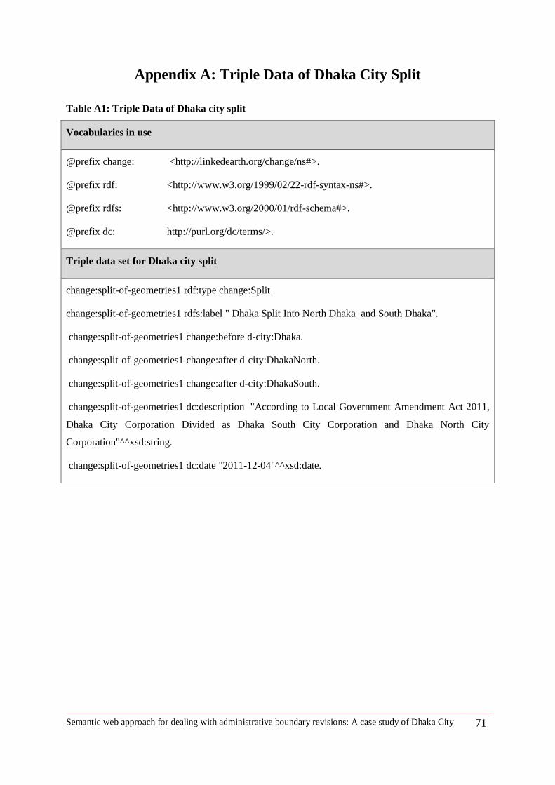
Semantic web approach for dealing with administrative boundary revisions: A case study of Dhaka City 71
Appendix A: Triple Data of Dhaka City Split
Table A1: Triple Data of Dhaka city split
Vocabularies in use
@prefix change: <http://linkedearth.org/change/ns#>.
@prefix rdf: <http://www.w3.org/1999/02/22-rdf-syntax-ns#>.
@prefix rdfs: <http://www.w3.org/2000/01/rdf-schema#>.
@prefix dc: http://purl.org/dc/terms/>.
Triple data set for Dhaka city split
change:split-of-geometries1 rdf:type change:Split .
change:split-of-geometries1 rdfs:label " Dhaka Split Into North Dhaka and South Dhaka".
change:split-of-geometries1 change:before d-city:Dhaka.
change:split-of-geometries1 change:after d-city:DhakaNorth.
change:split-of-geometries1 change:after d-city:DhakaSouth.
change:split-of-geometries1 dc:description "According to Local Government Amendment Act 2011,
Dhaka City Corporation Divided as Dhaka South City Corporation and Dhaka North City
Corporation"^^xsd:string.
change:split-of-geometries1 dc:date "2011-12-04"^^xsd:date.
Semantic web approach for dealing with administrative boundary revisions: A case study of Dhaka City 72
Appendix B: Maps
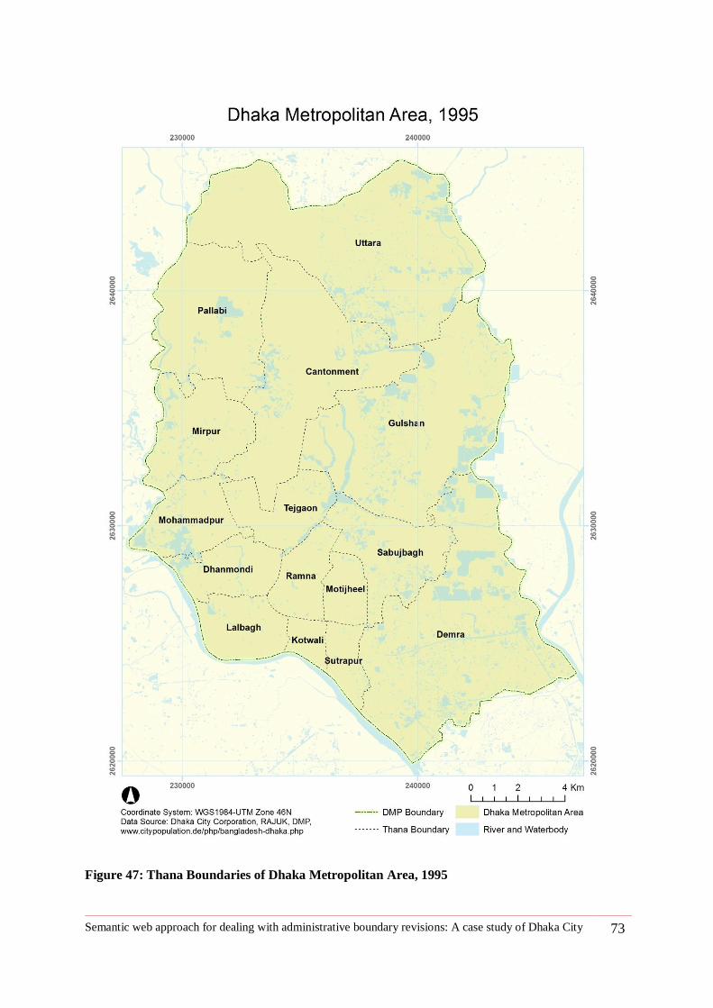
Semantic web approach for dealing with administrative boundary revisions: A case study of Dhaka City 73
Figure 47: Thana Boundaries of Dhaka Metropolitan Area, 1995
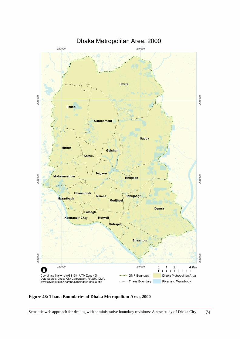
Semantic web approach for dealing with administrative boundary revisions: A case study of Dhaka City 74
Figure 48: Thana Boundaries of Dhaka Metropolitan Area, 2000
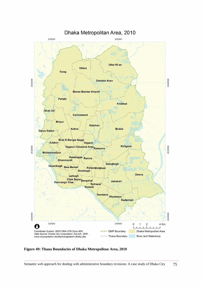
Semantic web approach for dealing with administrative boundary revisions: A case study of Dhaka City 75
Figure 49: Thana Boundaries of Dhaka Metropolitan Area, 2010
Semantic web approach for dealing with administrative boundary revisions: A case study of Dhaka City 76
Appendix C: RDF data
http://giv-heatmap.uni-muenster.de:8080/epad.ifgi.de/p/shiuli_Dhaka_final.html
3/27/13 RDFpad
giv-heatmap.uni-muenster.de:8080/epad.ifgi.de/p/shiuli_Dhaka_final.html 77
RDFpadbased on http://epad.ifgi.de/p/shiuli_Dhaka_final
Namespaces
dc geof db dbpedia-owl geo foaf oeg madsrdf change d-city tisc gn geos rdfs owl dbpedia xsd rdf dbpprop place skos
Triples
d-city:Khilgaon_Thana_2000 db:areaTotal 16.63^^http://www.w3.org/2001/XMLSchema#double
tisc:existenceBeginsAt 1998
dbpedia-owl:isPartOf d-city:DMP_2000
dbpedia-owl:thumbnail http://bpedia.org/maps/MK_0239.GIF
dc:descriptionAdministration Khilgaon thana was established in 1998 consisting of parts of gulshan and demrathanas. The Thana consists of three wards, 13 mouzas and 9villages.Source:http://bpedia.org/K_0239.php
rdf:label Khilgaon, Dhaka
rdf:type d-city:Thana
foaf:name Khilgaon
d-city:Pallabi-I foaf:name Pallabi
d-city:Khilkhet_Thana_2010 rdf:resources http://www.citypopulation.de/php/bangladesh-dhaka.php?cid=2637
db:areaTotal 21.49^^http://www.w3.org/2001/XMLSchema#double
dc:date 2010^^http://www.w3.org/2001/XMLSchema#date
dbpedia-owl:isPartOf d-city:DMP_2010
dc:description Khilkhet splited from Dhanmondi Thana
rdf:label Khilkhet, Dhaka
rdf:type d-city:Thana
foaf:name Khilkhet ^^http://www.w3.org/2001/XMLSchema#string
d-city:Sabujbagh-I foaf:name Sabujbagh
d-city:Shyampur_Thana_2010 db:areaTotal 5.04^^http://www.w3.org/2001/XMLSchema#double
tisc:existenceBeginsAt 1998
dbpedia-owl:isPartOf d-city:DMP_2010
dbpedia-owl:thumbnail http://bpedia.org/maps/MS_0368.GIF
dc:descriptionAdministration Shyampur thana was established in 1998 consisting of parts of Sutrapur and Demrathanas. It consists of one wards, 7 mouzas and 3 villages. Source:http://bpedia.org/S_0368.php
rdf:label Shyampur, Dhaka
rdf:type d-city:Thana
foaf:name Shyampur
d-city:merge-of-geometries1 dc:date 1998
dc:descriptionIn 1998 Kafrul Thana is formed from part of Mirpur Thana and KafrulThana^^http://www.w3.org/2001/XMLSchema#string
change:after d-city:Kafrul_Thana_2000
change:before d-city:cantonment-I
change:before d-city:Mirpur-I
rdfs:label Kafrul Thana splitted from Mirpur Thana and Cantoment Thana
rdf:type change:Merge
d-city:Pallabi_Thana_2000 db:areaTotal 25.44^^http://www.w3.org/2001/XMLSchema#double
tisc:existenceBeginsAt 15.03.1993
dbpedia-owl:isPartOf d-city:DMP_2000
dbpedia-owl:thumbnail http://bpedia.org/maps/MP_0047.GIF
dc:descriptionAdministration Pallabi thana was established on 15 March 1993 under the Dhaka City Corporation. Itconsists of 1 union parishads, 16 mouzas, 27 mahallas.Source:http://bpedia.org/P_0047.php
rdf:label Pallabi, Dhaka
rdf:type d-city:Thana
foaf:name Pallabi
d-city:Demra_Thana_1995 db:areaTotal 54.48^^http://www.w3.org/2001/XMLSchema#double
dbpedia-owl:isPartOf d-city:DMP_1995
tisc:existenceBeginsAt 1973
dbpedia-owl:thumbnail http://bpedia.org/maps/MD_0109.GIF
dc:descriptionAdministration Demra thana was established in 1973. It consists of three wards, three unionparishads, 36 mouzas and 53 villages.source:http://bpedia.org/D_0109.php
rdf:label Demra, Dhaka
rdf:type d-city:Thana
foaf:name Demra
d-city:Motijheel_Thana_1995 db:areaTotal 5.06^^http://www.w3.org/2001/XMLSchema#double
3/27/13 RDFpad
giv-heatmap.uni-muenster.de:8080/epad.ifgi.de/p/shiuli_Dhaka_final.html 78
dbpedia-owl:isPartOf d-city:DMP_1995
tisc:existenceBeginsAt 1976
dbpedia-owl:thumbnail http://bpedia.org/maps/MM_0334.GIF
dc:description
Motijheel thana area Motijheel thana is considered as the commercial area of Dhaka city. The headoffices of many financial institutions including bangladesh bank, sonali bank, pubali bank, agrani bank,janata bank, rupali bank, islami bank, eastern bank, basic bank, jiban bima corporation, sadharanbima corporation, american life insurance Co., dhaka stock exchange, etc are locatedin Motijheel area.Besides, Power and W ater Development Board, rajukand many government and private offices arelocated here.source:http://bpedia.org/M_0334.php
rdf:label Motijheel, Dhaka
rdf:type d-city:Thana
foaf:name Motijheel
d-city:numberOfSubdivision rdf:label numberOfSubdivision
rdf:type rdf:property
d-city:Change-part-of2 dc:date 1847
change:after d-city:Dhaka1955-1971
change:after d-city:Dhaka1947-1954
change:before d-city:Dhaka1905-1947
rdfs:label After British Period, Dhaka become under control of Pakistan
rdf:type change:Changepartof
d-city:Thana dc:description Administrative region can be changed by its type such as Municipality can uplift to City Corporation
rdfs:subClassOf change:Change
rdf:label Changetypeof
owl:sameAs place:Subdistrict
rdf:label Thana
rdf:type owl:class
d-city:nameChange33 dc:date 2007
change:after d-city:Turag_Thana_2010
change:before d-city:Uttara-I
rdf:type change:Namechange
d-city:Mirpur-I foaf:name Mirpur
d-city:nameChange12 dc:date 1998
change:after d-city:Shyampur_Thana_2000
change:before d-city:Demra-II
rdf:type change:Namechange
d-city:Dhaka1947-1954 geos:capitalOf http://dbpedia.org/page/East_Bengal
dbpedia-owl:isPartOf http://dbpedia.org/page/East_Bengal
dbpedia-owl:isPartOf http://dbpedia.org/page/Pakistan
tisc:existenceEndsAt 1954
tisc:existenceBeginsAt 1947
d-city:historicPeriod Pakistan Period
foaf:name Dacca
d-city:Changetypeof2 dc:date 1971
change:before d-city:Dhaka1978-1989
change:before d-city:Dhaka1947-1954
change:before d-city:Dhaka1905-1947
change:before d-city:Dhaka1864-1905
change:after d-city:Dhaka1955-1971
change:after d-city:Dhaka1978-1989
rdfs:label Dhaka pourashava become Dhaka Municipal Corporation in 1971
rdf:type d-city:Changetypeof
d-city:merge-of-geometries9 dc:date 2007
dc:description Gendaria Thana is formed from part of Demra Thana, Sutrapur Thana and Shyampur Thana
change:after d-city:Gendaria_Thana_2010
change:before d-city:Sutrapur-II
change:before d-city:Demra-IV
change:before d-city:Shyampur-II
rdfs:label Genderia Thana splited from Demra, Sutrapur and Shyampur Thana
rdf:type change:Merge
d-city:split-of-geometries17 dc:date 2007
dc:description Badda Thana splited into two parts^^http://www.w3.org/2001/XMLSchema#string
change:after d-city:Khilkhet_Thana_2010
change:after d-city:Badda_Thana_2010
change:before d-city:Badda_Thana_2000
rdfs:label Badda Thana contributes to form Khilkhet Thana
rdf:type change:Split
d-city:Dhaka1978-1989 geos:capitalOf http://dbpedia.org/page/Bangladesh
dbpedia-owl:isPartOf http://dbpedia.org/page/Bangladesh
tisc:existenceEndsAt 1989
tisc:existenceBeginsAt 1978
d-city:historicPeriod Bangladesh Period
rdf:type http://dbpedia.org/page/Municipal_corporation
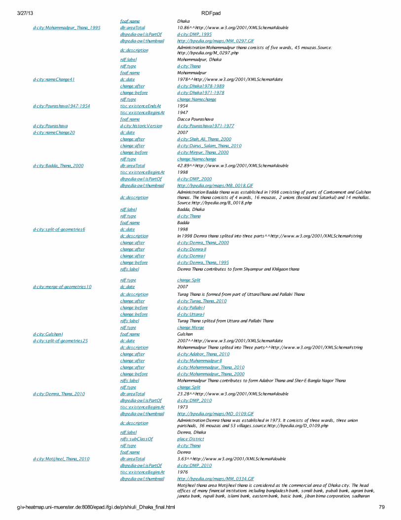
3/27/13 RDFpad
giv-heatmap.uni-muenster.de:8080/epad.ifgi.de/p/shiuli_Dhaka_final.html 79
foaf:name Dhaka
d-city:Mohammadpur_Thana_1995 db:areaTotal 10.86^^http://www.w3.org/2001/XMLSchema#double
dbpedia-owl:isPartOf d-city:DMP_1995
dbpedia-owl:thumbnail http://bpedia.org/maps/MM_0297.GIF
dc:descriptionAdministration Mohammadpur thana consists of five wards, 45 mouzas.Source:http://bpedia.org/M_0297.php
rdf:label Mohammadpur, Dhaka
rdf:type d-city:Thana
foaf:name Mohammadpur
d-city:nameChange41 dc:date 1978^^http://www.w3.org/2001/XMLSchema#date
change:after d-city:Dhaka1978-1989
change:before d-city:Dhaka1971-1978
rdf:type change:Namechange
d-city:Pourashava1947-1954 tisc:existenceEndsAt 1954
tisc:existenceBeginsAt 1947
foaf:name Dacca Pourashava
d-city:Pourashava d-city:historicVersion d-city:Pourashava1971-1977
d-city:nameChange20 dc:date 2007
change:after d-city:Shah_Ali_Thana_2000
change:after d-city:Darus_Salam_Thana_2010
change:before d-city:Mirpur_Thana_2000
rdf:type change:Namechange
d-city:Badda_Thana_2000 db:areaTotal 42.89^^http://www.w3.org/2001/XMLSchema#double
tisc:existenceBeginsAt 1998
dbpedia-owl:isPartOf d-city:DMP_2000
dbpedia-owl:thumbnail http://bpedia.org/maps/MB_0018.GIF
dc:descriptionAdministration Badda thana was established in 1998 consisting of parts of Cantonment and Gulshanthanas. The thana consists of 4 wards, 16 mouzas, 2 unions (Beraid and Satarkul) and 14 mohallas.Source:http://bpedia.org/B_0018.php
rdf:label Badda, Dhaka
rdf:type d-city:Thana
foaf:name Badda
d-city:split-of-geometries6 dc:date 1998
dc:description In 1998 Demra thana splited into three parts^^http://www.w3.org/2001/XMLSchema#string
change:after d-city:Demra_Thana_2000
change:after d-city:Demra-II
change:after d-city:Demra-I
change:before d-city:Demra_Thana_1995
rdfs:label Demra Thana contributes to form Shyampur and Khilgaon thana
rdf:type change:Split
d-city:merge-of-geometries10 dc:date 2007
dc:description Turag Thana is formed from part of UttaraThana and Pallabi Thana
change:after d-city:Turag_Thana_2010
change:before d-city:Pallabi-I
change:before d-city:Uttara-I
rdfs:label Turag Thana splited from Uttara and Pallabi Thana
rdf:type change:Merge
d-city:Gulshan-I foaf:name Gulshan
d-city:split-of-geometries25 dc:date 2007^^http://www.w3.org/2001/XMLSchema#date
dc:description Mohammadpur Thana splited into Three parts^^http://www.w3.org/2001/XMLSchema#string
change:after d-city:Adabor_Thana_2010
change:after d-city:Muhammadpur-II
change:after d-city:Mohammadpur_Thana_2010
change:before d-city:Mohammadpur_Thana_2000
rdfs:label Mohammadpur Thana contributes to form Adabor Thana and Sher-E-Bangla Nagor Thana
rdf:type change:Split
d-city:Demra_Thana_2010 db:areaTotal 23.28^^http://www.w3.org/2001/XMLSchema#double
dbpedia-owl:isPartOf d-city:DMP_2010
tisc:existenceBeginsAt 1973
dbpedia-owl:thumbnail http://bpedia.org/maps/MD_0109.GIF
dc:descriptionAdministration Demra thana was established in 1973. It consists of three wards, three unionparishads, 36 mouzas and 53 villages.source:http://bpedia.org/D_0109.php
rdf:label Demra, Dhaka
rdfs:subClassOf place:District
rdf:type d-city:Thana
foaf:name Demra
d-city:Motijheel_Thana_2010 db:areaTotal 3.63^^http://www.w3.org/2001/XMLSchema#double
dbpedia-owl:isPartOf d-city:DMP_2010
tisc:existenceBeginsAt 1976
dbpedia-owl:thumbnail http://bpedia.org/maps/MM_0334.GIF
Motijheel thana area Motijheel thana is considered as the commercial area of Dhaka city. The headoffices of many financial institutions including bangladesh bank, sonali bank, pubali bank, agrani bank,janata bank, rupali bank, islami bank, eastern bank, basic bank, jiban bima corporation, sadharan
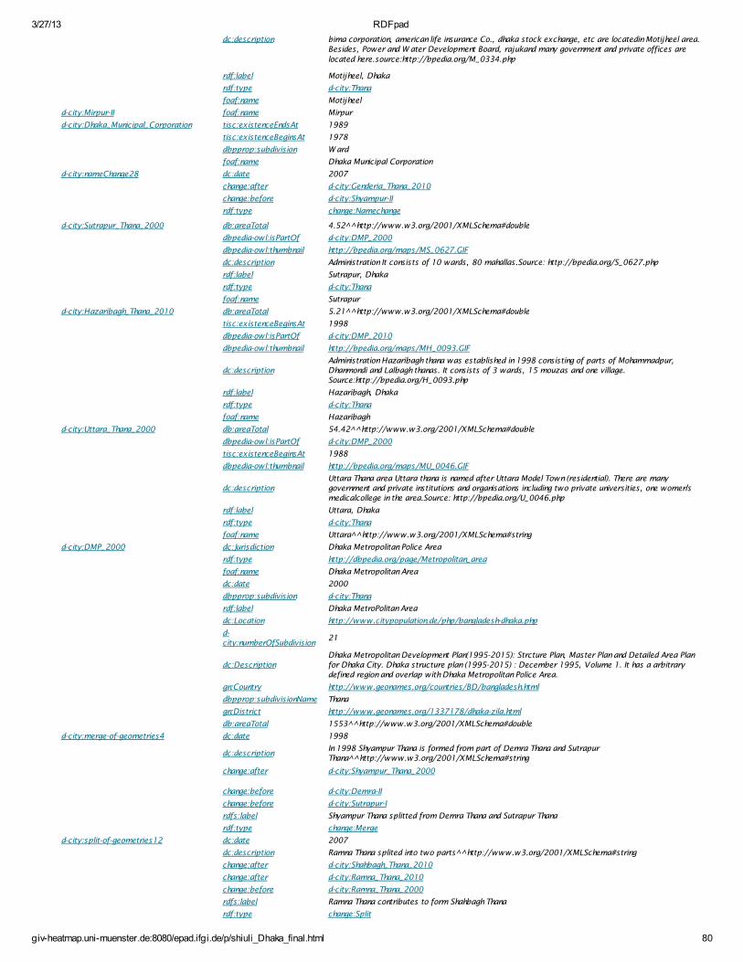
3/27/13 RDFpad
giv-heatmap.uni-muenster.de:8080/epad.ifgi.de/p/shiuli_Dhaka_final.html 80
dc:description bima corporation, american life insurance Co., dhaka stock exchange, etc are locatedin Motijheel area.Besides, Power and W ater Development Board, rajukand many government and private offices are
located here.source:http://bpedia.org/M_0334.php
rdf:label Motijheel, Dhaka
rdf:type d-city:Thana
foaf:name Motijheel
d-city:Mirpur-II foaf:name Mirpur
d-city:Dhaka_Municipal_Corporation tisc:existenceEndsAt 1989
tisc:existenceBeginsAt 1978
dbpprop:subdivision W ard
foaf:name Dhaka Municipal Corporation
d-city:nameChange28 dc:date 2007
change:after d-city:Genderia_Thana_2010
change:before d-city:Shyampur-II
rdf:type change:Namechange
d-city:Sutrapur_Thana_2000 db:areaTotal 4.52^^http://www.w3.org/2001/XMLSchema#double
dbpedia-owl:isPartOf d-city:DMP_2000
dbpedia-owl:thumbnail http://bpedia.org/maps/MS_0627.GIF
dc:description Administration It consists of 10 wards, 80 mahallas.Source: http://bpedia.org/S_0627.php
rdf:label Sutrapur, Dhaka
rdf:type d-city:Thana
foaf:name Sutrapur
d-city:Hazaribagh_Thana_2010 db:areaTotal 5.21^^http://www.w3.org/2001/XMLSchema#double
tisc:existenceBeginsAt 1998
dbpedia-owl:isPartOf d-city:DMP_2010
dbpedia-owl:thumbnail http://bpedia.org/maps/MH_0093.GIF
dc:descriptionAdministration Hazaribagh thana was established in 1998 consisting of parts of Mohammadpur,Dhanmondi and Lalbagh thanas. It consists of 3 wards, 15 mouzas and one village.Source:http://bpedia.org/H_0093.php
rdf:label Hazaribagh, Dhaka
rdf:type d-city:Thana
foaf:name Hazaribagh
d-city:Uttara_Thana_2000 db:areaTotal 54.42^^http://www.w3.org/2001/XMLSchema#double
dbpedia-owl:isPartOf d-city:DMP_2000
tisc:existenceBeginsAt 1988
dbpedia-owl:thumbnail http://bpedia.org/maps/MU_0046.GIF
dc:descriptionUttara Thana area Uttara thana is named after Uttara Model Town (residential). There are manygovernment and private institutions and organisations including two private universities, one women'smedicalcollege in the area.Source: http://bpedia.org/U_0046.php
rdf:label Uttara, Dhaka
rdf:type d-city:Thana
foaf:name Uttara^^http://www.w3.org/2001/XMLSchema#string
d-city:DMP_2000 dc:Jurisdiction Dhaka Metropolitan Police Area
rdf:type http://dbpedia.org/page/Metropolitan_area
foaf:name Dhaka Metropolitan Area
dc:date 2000
dbpprop:subdivision d-city:Thana
rdf:label Dhaka MetroPolitan Area
dc:Location http://www.citypopulation.de/php/bangladesh-dhaka.php
d-city:numberOfSubdivision
21
dc:DescriptionDhaka Metropolitan Development Plan(1995-2015): Strcture Plan, Master Plan and Detailed Area Planfor Dhaka City. Dhaka structure plan (1995-2015) : December 1995, Volume 1. It has a arbitrarydefined region and overlap with Dhaka Metropolitan Police Area.
gn:Country http://www.geonames.org/countries/BD/bangladesh.html
dbpprop:subdivisionName Thana
gn:District http://www.geonames.org/1337178/dhaka-zila.html
db:areaTotal 1553^^http://www.w3.org/2001/XMLSchema#double
d-city:merge-of-geometries4 dc:date 1998
dc:descriptionIn 1998 Shyampur Thana is formed from part of Demra Thana and SutrapurThana^^http://www.w3.org/2001/XMLSchema#string
change:after d-city:Shyampur_Thana_2000
change:before d-city:Demra-II
change:before d-city:Sutrapur-I
rdfs:label Shyampur Thana splitted from Demra Thana and Sutrapur Thana
rdf:type change:Merge
d-city:split-of-geometries12 dc:date 2007
dc:description Ramna Thana splited into two parts^^http://www.w3.org/2001/XMLSchema#string
change:after d-city:Shahbagh_Thana_2010
change:after d-city:Ramna_Thana_2010
change:before d-city:Ramna_Thana_2000
rdfs:label Ramna Thana contributes to form Shahbagh Thana
rdf:type change:Split
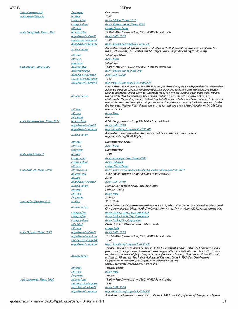
3/27/13 RDFpad
giv-heatmap.uni-muenster.de:8080/epad.ifgi.de/p/shiuli_Dhaka_final.html 81
d-city:Cantonment-II foaf:name Cantonment
d-city:nameChange36 dc:date 2007
change:after d-city:Adabor_Thana_2010
change:before d-city:Mohammadpur_Thana_2000
rdf:type change:Namechange
d-city:Sabujbagh_Thana_1995 db:areaTotal 14.84^^http://www.w3.org/2001/XMLSchema#double
dbpedia-owl:isPartOf d-city:DMP_1995
tisc:existenceBeginsAt 1988
dbpedia-owl:thumbnail http://bpedia.org/maps/MS_0004.GIF
dc:descriptionAdministration Sabujbagh thana was established in 1988. It consists of two union parishads, fivewards, 28 mouzas, 30 mahallas and 12 villages.Source: http://bpedia.org/S_0004.php
rdf:label Sabujbagh, Dhaka
rdf:type d-city:Thana
foaf:name Sabujbagh
d-city:Mirpur_Thana_2000 db:areaTotal 14.08^^http://www.w3.org/2001/XMLSchema#double
madsrdf:Source http://bpedia.org/M_0260.php
dbpedia-owl:isPartOf d-city:DMP_2000
tisc:existenceBeginsAt 1962
dbpedia-owl:thumbnail http://bpedia.org/maps/MM_0260.GIF
dc:description
Mirpur Thana (Town) area was included in keraniganj thana during the British period and in tejgaon thanaduring the Pakistan period. Many administrative and cultural establishments including National Zoo,National Botanical Garden, National Vagabond Shelter Centre are located in this thana area. NationalMartyr Intellectual Memorial has been established at the premises of the graves of martyrintellectuals. The tomb of Hazrat Shah Ali Bagdadi (R), a sacred place and historical relic, is located atMirpur. Besides, the head offices of grameen bank,bangladesh institute of bank management, DhakaEye Hospital, National Heart Foundation, etc are located here.source:http://bpedia.org/M_0260.php
rdf:label Mirpur, Dhaka
rdf:type d-city:Thana
foaf:name Mirpur
d-city:Mohammadpur_Thana_2010 db:areaTotal 6.54^^http://www.w3.org/2001/XMLSchema#double
dbpedia-owl:isPartOf d-city:DMP_2010
dbpedia-owl:thumbnail http://bpedia.org/maps/MM_0297.GIF
dc:descriptionAdministration Mohammadpur thana consists of five wards, 45 mouzas.Source:http://bpedia.org/M_0297.php
rdf:label Mohammadpur, Dhaka
rdf:type d-city:Thana
foaf:name Mohammadpur
d-city:nameChange15 dc:date 1998
change:after d-city:Kamrangir_Char_Thana_2000
change:before d-city:Lalbagh-I
rdf:type change:Namechange
d-city:Shah_Ali_Thana_2010 rdf:resources http://www.citypopulation.de/php/bangladesh-dhaka.php?cid=2674
db:areaTotal 4.96^^http://www.w3.org/2001/XMLSchema#double
dc:date 2010
dbpedia-owl:isPartOf d-city:DMP_2010
dc:description Shah ALi splited from Pallabi and Mirpur Thana
rdf:label Shah ALi, Dhaka
rdf:type d-city:Thana
foaf:name Shah ALi
d-city:split-of-geometries1 dc:date 2011-12-04
dc:descriptionAccording to Local GovernmentAmendment Act 2011, Dhaka City Corporation Divided as Dhaka SouthCity Corporation and Dhaka North City Corporation ^http://www.w3.org/2001/XMLSchema#string
change:after d-city:Dhaka_South_City_Corporation
change:after d-city:Dhaka_North_City_Corporation
change:before d-city:Dhaka_City_Corporation
rdfs:label Dhaka Split Into Dhaka North and Dhaka South
rdf:type change:Split
d-city:Tejgaon_Thana_1995 dbpedia-owl:isPartOf d-city:DMP_1995
dbpedia-owl:areaTotal 10.18^^http://www.w3.org/2001/XMLSchema#double
tisc:existenceBeginsAt 1962
dbpedia-owl:thumbnail http://bpedia.org/maps/MT_0105.GIF
dc:description
Tejgaon Thana area Tejgaon is considered to be the industrial area of Dhaka City Corporation. Manygovernment, semi government and autonomous organisations and institutions are located in the area.Mention may be made of Jatiya Sangsad Bhaban (Parliament Building), Ganabhaban (Prime Minister'sresidence), MP Hostel, Bangladesh Agricultural Research Council, FDC (Film DevelopmentCorporation),International Jute Organisation and Prime Minister'sOffice.source:http://bpedia.org/T_0105.php
rdf:label Tejgaon, Dhaka
rdf:type d-city:Thana
foaf:name Tejgaon
d-city:Shyampur_Thana_2000 db:areaTotal 11.91^^http://www.w3.org/2001/XMLSchema#double
tisc:existenceBeginsAt 1998
dbpedia-owl:isPartOf d-city:DMP_2000
dbpedia-owl:thumbnail http://bpedia.org/maps/MS_0368.GIF
Administration Shyampur thana was established in 1998 consisting of parts of Sutrapur and Demra
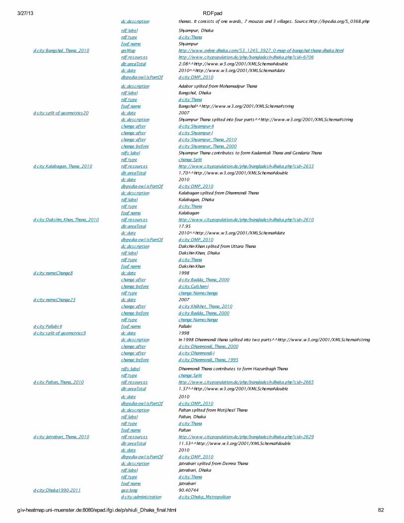
3/27/13 RDFpad
giv-heatmap.uni-muenster.de:8080/epad.ifgi.de/p/shiuli_Dhaka_final.html 82
dc:description thanas. It consists of one wards, 7 mouzas and 3 villages. Source:http://bpedia.org/S_0368.php
rdf:label Shyampur, Dhaka
rdf:type d-city:Thana
foaf:name Shyampur
d-city:Bangshal_Thana_2010 gn:Map http://www.online-dhaka.com/53_1245_3927_0-map-of-bangshal-thana-dhaka.html
rdf:resources http://www.citypopulation.de/php/bangladesh-dhaka.php?cid=6706
db:areaTotal 2.08^^http://www.w3.org/2001/XMLSchema#double
dc:date 2010^^http://www.w3.org/2001/XMLSchema#date
dbpedia-owl:isPartOf d-city:DMP_2010
dc:description Adabor splited from Mohamadpur Thana
rdf:label Bangshal, Dhaka
rdf:type d-city:Thana
foaf:name Bangshal ^http://www.w3.org/2001/XMLSchema#string
d-city:split-of-geometries20 dc:date 2007
dc:description Shyampur Thana splited into four parts^^http://www.w3.org/2001/XMLSchema#string
change:after d-city:Shyampur-II
change:after d-city:Shyampur-I
change:after d-city:Shyampur_Thana_2010
change:before d-city:Shyampur_Thana_2000
rdfs:label Shyampur Thana contributes to form Kadamtali Thana and Gendaria Thana
rdf:type change:Split
d-city:Kalabagan_Thana_2010 rdf:resources http://www.citypopulation.de/php/bangladesh-dhaka.php?cid=2633
db:areaTotal 1.70^^http://www.w3.org/2001/XMLSchema#double
dc:date 2010
dbpedia-owl:isPartOf d-city:DMP_2010
dc:description Kalabagan splited from Dhanmondi Thana
rdf:label Kalabagan, Dhaka
rdf:type d-city:Thana
foaf:name Kalabagan
d-city:Dakshin_Khan_Thana_2010 rdf:resources http://www.citypopulation.de/php/bangladesh-dhaka.php?cid=2610
db:areaTotal 17.95
dc:date 2010^^http://www.w3.org/2001/XMLSchema#date
dbpedia-owl:isPartOf d-city:DMP_2010
dc:description Dakshin Khan splited from Uttara Thana
rdf:label Dakshin Khan, Dhaka
rdf:type d-city:Thana
foaf:name Dakshin Khan
d-city:nameChange8 dc:date 1998
change:after d-city:Badda_Thana_2000
change:before d-city:Gulshan-I
rdf:type change:Namechange
d-city:nameChange23 dc:date 2007
change:after d-city:Khilkhet_Thana_2010
change:before d-city:Badda_Thana_2000
rdf:type change:Namechange
d-city:Pallabi-II foaf:name Pallabi
d-city:split-of-geometries9 dc:date 1998
dc:description In 1998 Dhanmondi thana splited into two parts^^http://www.w3.org/2001/XMLSchema#string
change:after d-city:Dhanmondi_Thana_2000
change:after d-city:Dhanmondi-I
change:before d-city:Dhanmondi_Thana_1995
rdfs:label Dhanmondi Thana contributes to form Hazaribagh Thana
rdf:type change:Split
d-city:Paltan_Thana_2010 rdf:resources http://www.citypopulation.de/php/bangladesh-dhaka.php?cid=2665
db:areaTotal 1.37^^http://www.w3.org/2001/XMLSchema#double
dc:date 2010
dbpedia-owl:isPartOf d-city:DMP_2010
dc:description Paltan splited from Motijheel Thana
rdf:label Paltan, Dhaka
rdf:type d-city:Thana
foaf:name Paltan
d-city:Jatrabari_Thana_2010 rdf:resources http://www.citypopulation.de/php/bangladesh-dhaka.php?cid=2629
db:areaTotal 11.53^^http://www.w3.org/2001/XMLSchema#double
dc:date 2010
dbpedia-owl:isPartOf d-city:DMP_2010
dc:description Jatrabari splited from Demra Thana
rdf:label Jatrabari, Dhaka
rdf:type d-city:Thana
foaf:name Jatrabari
d-city:Dhaka1990-2011 geo:long 90.40744
d-city:administration d-city:Dhaka_Metropolitan
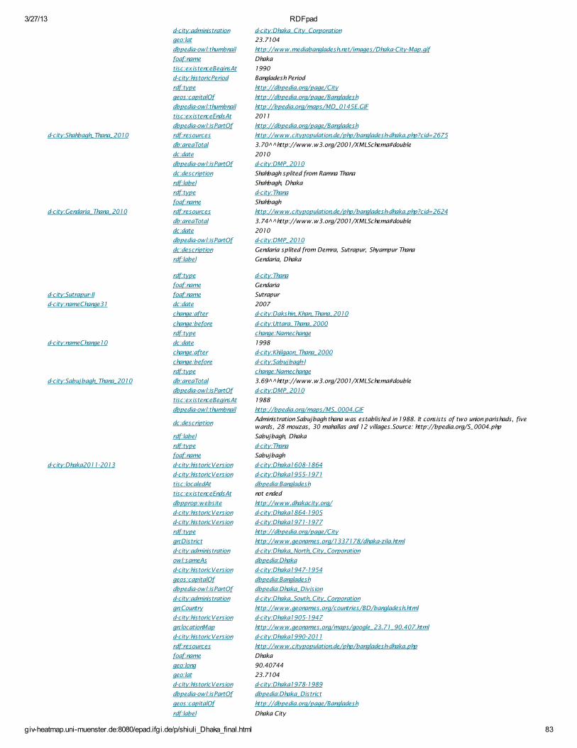
3/27/13 RDFpad
giv-heatmap.uni-muenster.de:8080/epad.ifgi.de/p/shiuli_Dhaka_final.html 83
d-city:administration d-city:Dhaka_City_Corporation
geo:lat 23.7104
dbpedia-owl:thumbnail http://www.mediabangladesh.net/images/Dhaka-City-Map.gif
foaf:name Dhaka
tisc:existenceBeginsAt 1990
d-city:historicPeriod Bangladesh Period
rdf:type http://dbpedia.org/page/City
geos:capitalOf http://dbpedia.org/page/Bangladesh
dbpedia-owl:thumbnail http://bpedia.org/maps/MD_0145E.GIF
tisc:existenceEndsAt 2011
dbpedia-owl:isPartOf http://dbpedia.org/page/Bangladesh
d-city:Shahbagh_Thana_2010 rdf:resources http://www.citypopulation.de/php/bangladesh-dhaka.php?cid=2675
db:areaTotal 3.70^^http://www.w3.org/2001/XMLSchema#double
dc:date 2010
dbpedia-owl:isPartOf d-city:DMP_2010
dc:description Shahbagh splited from Ramna Thana
rdf:label Shahbagh, Dhaka
rdf:type d-city:Thana
foaf:name Shahbagh
d-city:Gendaria_Thana_2010 rdf:resources http://www.citypopulation.de/php/bangladesh-dhaka.php?cid=2624
db:areaTotal 3.74^^http://www.w3.org/2001/XMLSchema#double
dc:date 2010
dbpedia-owl:isPartOf d-city:DMP_2010
dc:description Gendaria splited from Demra, Sutrapur, Shyampur Thana
rdf:label Gendaria, Dhaka
rdf:type d-city:Thana
foaf:name Gendaria
d-city:Sutrapur-II foaf:name Sutrapur
d-city:nameChange31 dc:date 2007
change:after d-city:Dakshin_Khan_Thana_2010
change:before d-city:Uttara_Thana_2000
rdf:type change:Namechange
d-city:nameChange10 dc:date 1998
change:after d-city:Khilgaon_Thana_2000
change:before d-city:Sabujbagh-I
rdf:type change:Namechange
d-city:Sabujbagh_Thana_2010 db:areaTotal 3.69^^http://www.w3.org/2001/XMLSchema#double
dbpedia-owl:isPartOf d-city:DMP_2010
tisc:existenceBeginsAt 1988
dbpedia-owl:thumbnail http://bpedia.org/maps/MS_0004.GIF
dc:descriptionAdministration Sabujbagh thana was established in 1988. It consists of two union parishads, fivewards, 28 mouzas, 30 mahallas and 12 villages.Source: http://bpedia.org/S_0004.php
rdf:label Sabujbagh, Dhaka
rdf:type d-city:Thana
foaf:name Sabujbagh
d-city:Dhaka2011-2013 d-city:historicVersion d-city:Dhaka1608-1864
d-city:historicVersion d-city:Dhaka1955-1971
tisc:localedAt dbpedia:Bangladesh
tisc:existenceEndsAt not ended
dbpprop:website http://www.dhakacity.org/
d-city:historicVersion d-city:Dhaka1864-1905
d-city:historicVersion d-city:Dhaka1971-1977
rdf:type http://dbpedia.org/page/City
gn:District http://www.geonames.org/1337178/dhaka-zila.html
d-city:administration d-city:Dhaka_North_City_Corporation
owl:sameAs dbpedia:Dhaka
d-city:historicVersion d-city:Dhaka1947-1954
geos:capitalOf dbpedia:Bangladesh
dbpedia-owl:isPartOf dbpedia:Dhaka_Division
d-city:administration d-city:Dhaka_South_City_Corporation
gn:Country http://www.geonames.org/countries/BD/bangladesh.html
d-city:historicVersion d-city:Dhaka1905-1947
gn:locationMap http://www.geonames.org/maps/google_23.71_90.407.html
d-city:historicVersion d-city:Dhaka1990-2011
rdf:resources http://www.citypopulation.de/php/bangladesh-dhaka.php
foaf:name Dhaka
geo:long 90.40744
geo:lat 23.7104
d-city:historicVersion d-city:Dhaka1978-1989
dbpedia-owl:isPartOf dbpedia:Dhaka_District
geos:capitalOf http://dbpedia.org/page/Bangladesh
rdf:label Dhaka City
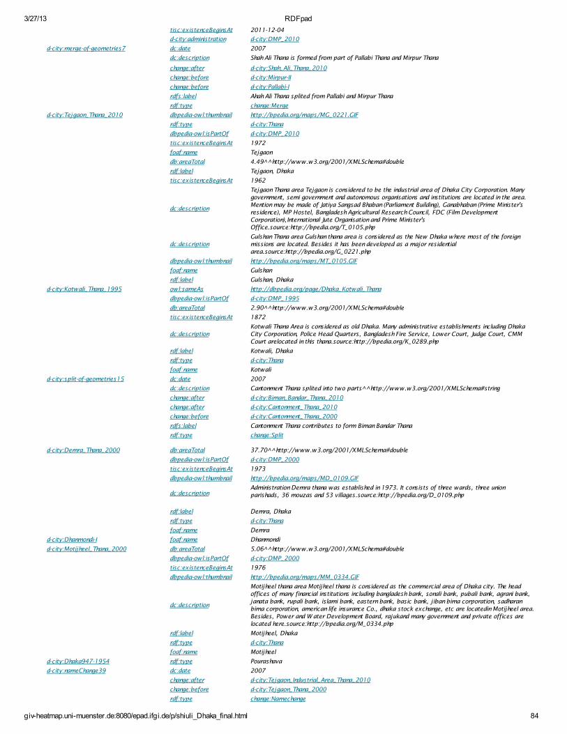
3/27/13 RDFpad
giv-heatmap.uni-muenster.de:8080/epad.ifgi.de/p/shiuli_Dhaka_final.html 84
tisc:existenceBeginsAt 2011-12-04
d-city:administration d-city:DMP_2010
d-city:merge-of-geometries7 dc:date 2007
dc:description Shah Ali Thana is formed from part of Pallabi Thana and Mirpur Thana
change:after d-city:Shah_Ali_Thana_2010
change:before d-city:Mirpur-II
change:before d-city:Pallabi-I
rdfs:label Ahah Ali Thana splited from Pallabi and Mirpur Thana
rdf:type change:Merge
d-city:Tejgaon_Thana_2010 dbpedia-owl:thumbnail http://bpedia.org/maps/MG_0221.GIF
rdf:type d-city:Thana
dbpedia-owl:isPartOf d-city:DMP_2010
tisc:existenceBeginsAt 1972
foaf:name Tejgaon
db:areaTotal 4.49^^http://www.w3.org/2001/XMLSchema#double
rdf:label Tejgaon, Dhaka
tisc:existenceBeginsAt 1962
dc:description
Tejgaon Thana area Tejgaon is considered to be the industrial area of Dhaka City Corporation. Manygovernment, semi government and autonomous organisations and institutions are located in the area.Mention may be made of Jatiya Sangsad Bhaban (Parliament Building), Ganabhaban (Prime Minister'sresidence), MP Hostel, Bangladesh Agricultural Research Council, FDC (Film DevelopmentCorporation),International Jute Organisation and Prime Minister'sOffice.source:http://bpedia.org/T_0105.php
dc:descriptionGulshan Thana area Gulshan thana area is considered as the New Dhaka where most of the foreignmissions are located. Besides it has been developed as a major residentialarea.source:http://bpedia.org/G_0221.php
dbpedia-owl:thumbnail http://bpedia.org/maps/MT_0105.GIF
foaf:name Gulshan
rdf:label Gulshan, Dhaka
d-city:Kotwali_Thana_1995 owl:sameAs http://dbpedia.org/page/Dhaka_Kotwali_Thana
dbpedia-owl:isPartOf d-city:DMP_1995
db:areaTotal 2.90^^http://www.w3.org/2001/XMLSchema#double
tisc:existenceBeginsAt 1872
dc:descriptionKotwali Thana Area is considered as old Dhaka. Many administrative establishments including DhakaCity Corporation, Police Head Quarters, Bangladesh Fire Service, Lower Court, Judge Court, CMMCourt arelocated in this thana.source:http://bpedia.org/K_0289.php
rdf:label Kotwali, Dhaka
rdf:type d-city:Thana
foaf:name Kotwali
d-city:split-of-geometries15 dc:date 2007
dc:description Cantonment Thana splited into two parts^^http://www.w3.org/2001/XMLSchema#string
change:after d-city:Biman_Bandar_Thana_2010
change:after d-city:Cantonment_Thana_2010
change:before d-city:Cantonment_Thana_2000
rdfs:label Cantonment Thana contributes to form Biman Bandar Thana
rdf:type change:Split
d-city:Demra_Thana_2000 db:areaTotal 37.70^^http://www.w3.org/2001/XMLSchema#double
dbpedia-owl:isPartOf d-city:DMP_2000
tisc:existenceBeginsAt 1973
dbpedia-owl:thumbnail http://bpedia.org/maps/MD_0109.GIF
dc:descriptionAdministration Demra thana was established in 1973. It consists of three wards, three unionparishads, 36 mouzas and 53 villages.source:http://bpedia.org/D_0109.php
rdf:label Demra, Dhaka
rdf:type d-city:Thana
foaf:name Demra
d-city:Dhanmondi-I foaf:name Dhanmondi
d-city:Motijheel_Thana_2000 db:areaTotal 5.06^^http://www.w3.org/2001/XMLSchema#double
dbpedia-owl:isPartOf d-city:DMP_2000
tisc:existenceBeginsAt 1976
dbpedia-owl:thumbnail http://bpedia.org/maps/MM_0334.GIF
dc:description
Motijheel thana area Motijheel thana is considered as the commercial area of Dhaka city. The headoffices of many financial institutions including bangladesh bank, sonali bank, pubali bank, agrani bank,janata bank, rupali bank, islami bank, eastern bank, basic bank, jiban bima corporation, sadharanbima corporation, american life insurance Co., dhaka stock exchange, etc are locatedin Motijheel area.Besides, Power and W ater Development Board, rajukand many government and private offices arelocated here.source:http://bpedia.org/M_0334.php
rdf:label Motijheel, Dhaka
rdf:type d-city:Thana
foaf:name Motijheel
d-city:Dhaka947-1954 rdf:type Pourashava
d-city:nameChange39 dc:date 2007
change:after d-city:Tejgaon_Industrial_Area_Thana_2010
change:before d-city:Tejgaon_Thana_2000
rdf:type change:Namechange
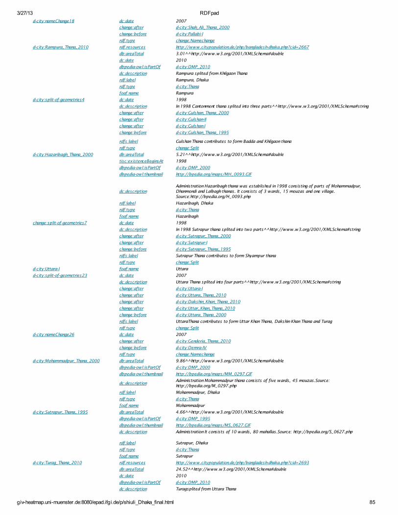
3/27/13 RDFpad
giv-heatmap.uni-muenster.de:8080/epad.ifgi.de/p/shiuli_Dhaka_final.html 85
d-city:nameChange18 dc:date 2007
change:after d-city:Shah_Ali_Thana_2000
change:before d-city:Pallabi-I
rdf:type change:Namechange
d-city:Rampura_Thana_2010 rdf:resources http://www.citypopulation.de/php/bangladesh-dhaka.php?cid=2667
db:areaTotal 3.01^^http://www.w3.org/2001/XMLSchema#double
dc:date 2010
dbpedia-owl:isPartOf d-city:DMP_2010
dc:description Rampura splited from Khilgaon Thana
rdf:label Rampura, Dhaka
rdf:type d-city:Thana
foaf:name Rampura
d-city:split-of-geometries4 dc:date 1998
dc:description In 1998 Cantonment thana splited into three parts^^http://www.w3.org/2001/XMLSchema#string
change:after d-city:Gulshan_Thana_2000
change:after d-city:Gulshan-II
change:after d-city:Gulshan-I
change:before d-city:Gulshan_Thana_1995
rdfs:label Gulshan Thana contributes to form Badda and Khilgaon thana
rdf:type change:Split
d-city:Hazaribagh_Thana_2000 db:areaTotal 5.21^^http://www.w3.org/2001/XMLSchema#double
tisc:existenceBeginsAt 1998
dbpedia-owl:isPartOf d-city:DMP_2000
dbpedia-owl:thumbnail http://bpedia.org/maps/MH_0093.GIF
dc:descriptionAdministration Hazaribagh thana was established in 1998 consisting of parts of Mohammadpur,Dhanmondi and Lalbagh thanas. It consists of 3 wards, 15 mouzas and one village.Source:http://bpedia.org/H_0093.php
rdf:label Hazaribagh, Dhaka
rdf:type d-city:Thana
foaf:name Hazaribagh
change:split-of-geometries7 dc:date 1998
dc:description In 1998 Sutrapur thana splited into two parts^^http://www.w3.org/2001/XMLSchema#string
change:after d-city:Sutrapur_Thana_2000
change:after d-city:Sutrapur-I
change:before d-city:Sutrapur_Thana_1995
rdfs:label Sutrapur Thana contributes to form Shyampur thana
rdf:type change:Split
d-city:Uttara-I foaf:name Uttara
d-city:split-of-geometries23 dc:date 2007
dc:description Uttara Thana splited into four parts^^http://www.w3.org/2001/XMLSchema#string
change:after d-city:Uttara-I
change:after d-city:Uttara_Thana_2010
change:after d-city:Dakshin_Khan_Thana_2010
change:after d-city:Uttar_Khan_Thana_2010
change:before d-city:Uttara_Thana_2000
rdfs:label UttaraThana contributes to form Uttar Khan Thana, Dakshin Khan Thana and Turag
rdf:type change:Split
d-city:nameChange26 dc:date 2007
change:after d-city:Genderia_Thana_2010
change:before d-city:Demra-IV
rdf:type change:Namechange
d-city:Mohammadpur_Thana_2000 db:areaTotal 9.86^^http://www.w3.org/2001/XMLSchema#double
dbpedia-owl:isPartOf d-city:DMP_2000
dbpedia-owl:thumbnail http://bpedia.org/maps/MM_0297.GIF
dc:descriptionAdministration Mohammadpur thana consists of five wards, 45 mouzas.Source:http://bpedia.org/M_0297.php
rdf:label Mohammadpur, Dhaka
rdf:type d-city:Thana
foaf:name Mohammadpur
d-city:Sutrapur_Thana_1995 db:areaTotal 4.66^^http://www.w3.org/2001/XMLSchema#double
dbpedia-owl:isPartOf d-city:DMP_1995
dbpedia-owl:thumbnail http://bpedia.org/maps/MS_0627.GIF
dc:description Administration It consists of 10 wards, 80 mahallas.Source: http://bpedia.org/S_0627.php
rdf:label Sutrapur, Dhaka
rdf:type d-city:Thana
foaf:name Sutrapur
d-city:Turag_Thana_2010 rdf:resources http://www.citypopulation.de/php/bangladesh-dhaka.php?cid=2693
db:areaTotal 24.52^^http://www.w3.org/2001/XMLSchema#double
dc:date 2010
dbpedia-owl:isPartOf d-city:DMP_2010
dc:description Turagsplited from Uttara Thana
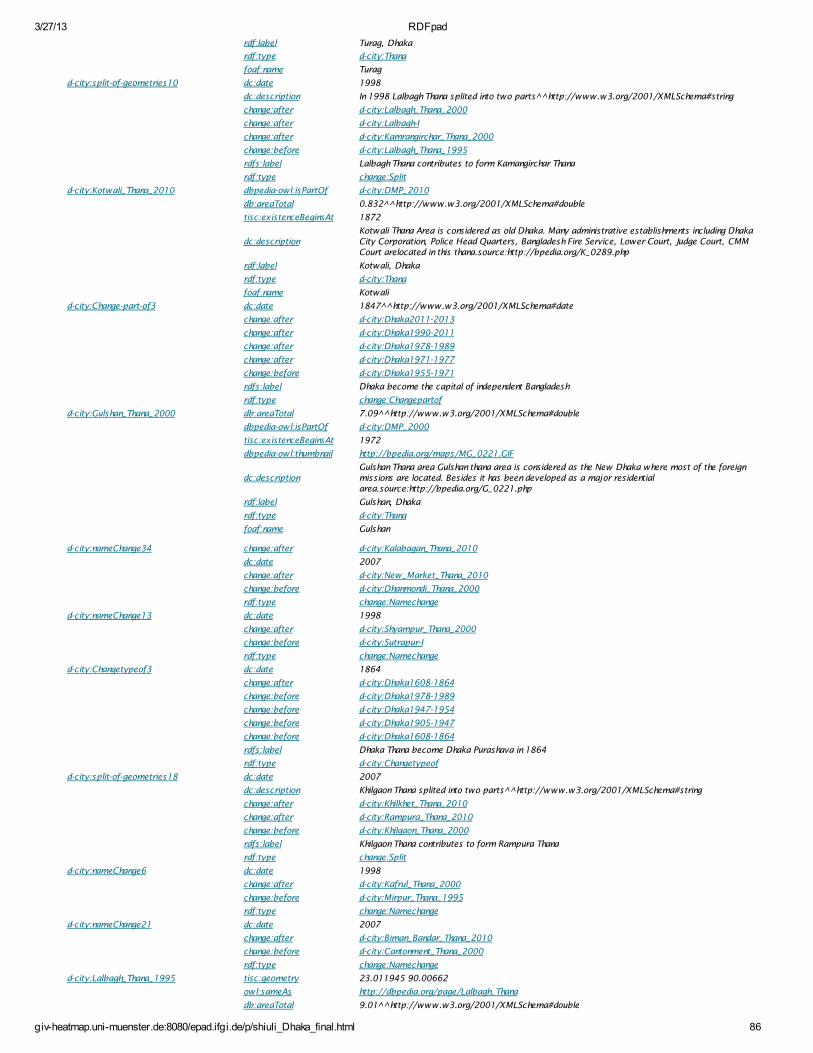
3/27/13 RDFpad
giv-heatmap.uni-muenster.de:8080/epad.ifgi.de/p/shiuli_Dhaka_final.html 86
rdf:label Turag, Dhaka
rdf:type d-city:Thana
foaf:name Turag
d-city:split-of-geometries10 dc:date 1998
dc:description In 1998 Lalbagh Thana splited into two parts^^http://www.w3.org/2001/XMLSchema#string
change:after d-city:Lalbagh_Thana_2000
change:after d-city:Lalbagh-I
change:after d-city:Kamrangirchar_Thana_2000
change:before d-city:Lalbagh_Thana_1995
rdfs:label Lalbagh Thana contributes to form Kamangirchar Thana
rdf:type change:Split
d-city:Kotwali_Thana_2010 dbpedia-owl:isPartOf d-city:DMP_2010
db:areaTotal 0.832^^http://www.w3.org/2001/XMLSchema#double
tisc:existenceBeginsAt 1872
dc:descriptionKotwali Thana Area is considered as old Dhaka. Many administrative establishments including DhakaCity Corporation, Police Head Quarters, Bangladesh Fire Service, Lower Court, Judge Court, CMMCourt arelocated in this thana.source:http://bpedia.org/K_0289.php
rdf:label Kotwali, Dhaka
rdf:type d-city:Thana
foaf:name Kotwali
d-city:Change-part-of3 dc:date 1847^^http://www.w3.org/2001/XMLSchema#date
change:after d-city:Dhaka2011-2013
change:after d-city:Dhaka1990-2011
change:after d-city:Dhaka1978-1989
change:after d-city:Dhaka1971-1977
change:before d-city:Dhaka1955-1971
rdfs:label Dhaka become the capital of independent Bangladesh
rdf:type change:Changepartof
d-city:Gulshan_Thana_2000 db:areaTotal 7.09^^http://www.w3.org/2001/XMLSchema#double
dbpedia-owl:isPartOf d-city:DMP_2000
tisc:existenceBeginsAt 1972
dbpedia-owl:thumbnail http://bpedia.org/maps/MG_0221.GIF
dc:descriptionGulshan Thana area Gulshan thana area is considered as the New Dhaka where most of the foreignmissions are located. Besides it has been developed as a major residentialarea.source:http://bpedia.org/G_0221.php
rdf:label Gulshan, Dhaka
rdf:type d-city:Thana
foaf:name Gulshan
d-city:nameChange34 change:after d-city:Kalabagan_Thana_2010
dc:date 2007
change:after d-city:New_Market_Thana_2010
change:before d-city:Dhanmondi_Thana_2000
rdf:type change:Namechange
d-city:nameChange13 dc:date 1998
change:after d-city:Shyampur_Thana_2000
change:before d-city:Sutrapur-I
rdf:type change:Namechange
d-city:Changetypeof3 dc:date 1864
change:after d-city:Dhaka1608-1864
change:before d-city:Dhaka1978-1989
change:before d-city:Dhaka1947-1954
change:before d-city:Dhaka1905-1947
change:before d-city:Dhaka1608-1864
rdfs:label Dhaka Thana become Dhaka Purashava in 1864
rdf:type d-city:Changetypeof
d-city:split-of-geometries18 dc:date 2007
dc:description Khilgaon Thana splited into two parts^^http://www.w3.org/2001/XMLSchema#string
change:after d-city:Khilkhet_Thana_2010
change:after d-city:Rampura_Thana_2010
change:before d-city:Khilgaon_Thana_2000
rdfs:label Khilgaon Thana contributes to form Rampura Thana
rdf:type change:Split
d-city:nameChange6 dc:date 1998
change:after d-city:Kafrul_Thana_2000
change:before d-city:Mirpur_Thana_1995
rdf:type change:Namechange
d-city:nameChange21 dc:date 2007
change:after d-city:Biman_Bandar_Thana_2010
change:before d-city:Cantonment_Thana_2000
rdf:type change:Namechange
d-city:Lalbagh_Thana_1995 tisc:geometry 23.011945 90.00662
owl:sameAs http://dbpedia.org/page/Lalbagh_Thana
db:areaTotal 9.01^^http://www.w3.org/2001/XMLSchema#double
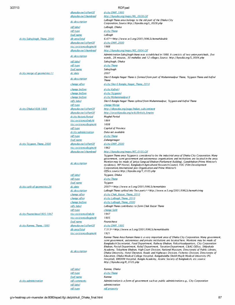
3/27/13 RDFpad
giv-heatmap.uni-muenster.de:8080/epad.ifgi.de/p/shiuli_Dhaka_final.html 87
dbpedia-owl:isPartOf d-city:DMP_1995
dbpedia-owl:thumbnail http://bpedia.org/maps/ML_0028.GIF
dc:descriptionLalbagh Thana area belongs to the old part of the Dhaka CityCorporation..Source:http://bpedia.org/L_0028.php
rdf:label Lalbagh, Dhaka
rdf:type d-city:Thana
foaf:name Lalbagh
d-city:Sabujbagh_Thana_2000 db:areaTotal 6.47^^http://www.w3.org/2001/XMLSchema#double
dbpedia-owl:isPartOf d-city:DMP_2000
tisc:existenceBeginsAt 1988
dbpedia-owl:thumbnail http://bpedia.org/maps/MS_0004.GIF
dc:descriptionAdministration Sabujbagh thana was established in 1988. It consists of two union parishads, fivewards, 28 mouzas, 30 mahallas and 12 villages.Source: http://bpedia.org/S_0004.php
rdf:label Sabujbagh, Dhaka
rdf:type d-city:Thana
foaf:name Sabujbagh
d-city:merge-of-geometries11 dc:date 2007
dc:descriptionSher-E-Bangla Nagar Thana is formed from part of Muhammadpur Thana, Tejgaon Thana and KafrulThana
change:after d-city:Sher-E-Bangla_Nagar_Thana_2010
change:before d-city:Kafrul-I
change:before d-city:Tejgaon-I
change:before d-city:Mohammadpur-II
rdfs:label Sher-E-Bangla Nagar Thana splited from Muhammadpur, Tejgaon and Kafrul Thana
rdf:type change:Merge
d-city:Dhaka1608-1864 dbpedia-owl:isPartOf http://dbpedia.org/page/Indian_subcontinent
dbpedia-owl:isPartOf http://en.wikipedia.org/wiki/British_Empire
d-city:historicPeriod Mughal Period
tisc:existenceEndsAt 1864
tisc:existenceBeginsAt 1608
rdf:type Capital of Province
d-city:administration Data not available
rdf:type d-city:Thana
foaf:name Zahangirnagor
d-city:Tejgaon_Thana_2000 dbpedia-owl:isPartOf d-city:DMP_2000
tisc:existenceBeginsAt 1962
dbpedia-owl:thumbnail http://bpedia.org/maps/MT_0105.GIF
dc:description
Tejgaon Thana area Tejgaon is considered to be the industrial area of Dhaka City Corporation. Manygovernment, semi government and autonomous organisations and institutions are located in the area.Mention may be made of Jatiya Sangsad Bhaban (Parliament Building), Ganabhaban (Prime Minister'sresidence), MP Hostel, Bangladesh Agricultural Research Council, FDC (Film DevelopmentCorporation),International Jute Organisation and Prime Minister'sOffice.source:http://bpedia.org/T_0105.php
rdf:label Tejgaon, Dhaka
rdf:type d-city:Thana
foaf:name Tejgaon
d-city:split-of-geometries26 dc:date 2007^^http://www.w3.org/2001/XMLSchema#date
dc:description Lalbagh Thana splited into Two parts^^http://www.w3.org/2001/XMLSchema#string
change:after d-city:Chak_Bazar_Thana_2010
change:after d-city:Lalbagh_Thana_2010
change:before d-city:Lalbagh_Thana_2000
rdfs:label Lalbagh Thana contributes to form Chak Bazar Thana
rdf:type change:Split
d-city:Pourashava1905-1947 tisc:existenceEndsAt 1947
tisc:existenceBeginsAt 1905
foaf:name Pourashava
d-city:Ramna_Thana_1995 dbpedia-owl:isPartOf d-city:DMP_1995
db:areaTotal 7.513^^http://www.w3.org/2001/XMLSchema#double
tisc:existenceBeginsAt 1921
dc:description
Ramna Thana Area Raman thana is a very important area of Dhaka City Corporation. Many government,semi government, autonomous and private institutions are located here. Mentions may be made ofBangladesh Secretariat, Food Department, Railway Bhaban, PoliceHeadquarters, City CorporationBhaban, Postal Department, Relief Department, Taxation Department, C&AG Office, ShilpakalaAcademy, Telephone Bhaban, High Court Division, National Museum, Directorate of Public Library,Dhaka University, Hotel Sheraton, Roads and Highways Division, Fisheries Division, Directorate ofEducation, Dhaka Medical College Hospital, Bangabandhu Sheikh Mujib Medical University (PGHospital), BIRDEM Hospital, Bangla Academy, Asiatic Society of Bangladesh, etc.source:http://bpedia.org/R_0105.php
rdf:label Ramna, Dhaka
rdf:type d-city:Thana
foaf:name Ramna
d-city:administration rdf:comments Administration is a form of government such as public administration e.g., City Corporation
rdf:label administration
rdf:type rdf:property
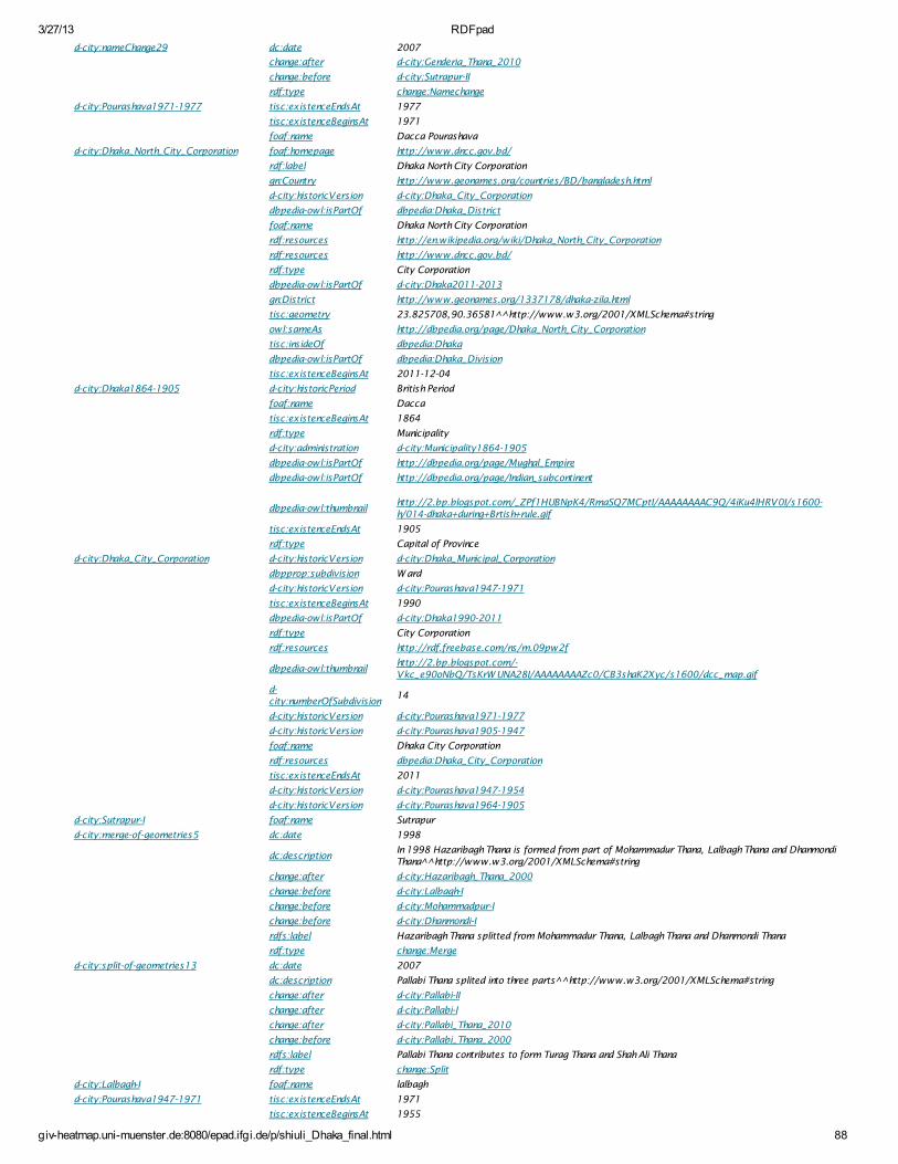
3/27/13 RDFpad
giv-heatmap.uni-muenster.de:8080/epad.ifgi.de/p/shiuli_Dhaka_final.html 88
d-city:nameChange29 dc:date 2007
change:after d-city:Genderia_Thana_2010
change:before d-city:Sutrapur-II
rdf:type change:Namechange
d-city:Pourashava1971-1977 tisc:existenceEndsAt 1977
tisc:existenceBeginsAt 1971
foaf:name Dacca Pourashava
d-city:Dhaka_North_City_Corporation foaf:homepage http://www.dncc.gov.bd/
rdf:label Dhaka North City Corporation
gn:Country http://www.geonames.org/countries/BD/bangladesh.html
d-city:historicVersion d-city:Dhaka_City_Corporation
dbpedia-owl:isPartOf dbpedia:Dhaka_District
foaf:name Dhaka North City Corporation
rdf:resources http://en.wikipedia.org/wiki/Dhaka_North_City_Corporation
rdf:resources http://www.dncc.gov.bd/
rdf:type City Corporation
dbpedia-owl:isPartOf d-city:Dhaka2011-2013
gn:District http://www.geonames.org/1337178/dhaka-zila.html
tisc:geometry 23.825708,90.36581^^http://www.w3.org/2001/XMLSchema#string
owl:sameAs http://dbpedia.org/page/Dhaka_North_City_Corporation
tisc:insideOf dbpedia:Dhaka
dbpedia-owl:isPartOf dbpedia:Dhaka_Division
tisc:existenceBeginsAt 2011-12-04
d-city:Dhaka1864-1905 d-city:historicPeriod British Period
foaf:name Dacca
tisc:existenceBeginsAt 1864
rdf:type Municipality
d-city:administration d-city:Municipality1864-1905
dbpedia-owl:isPartOf http://dbpedia.org/page/Mughal_Empire
dbpedia-owl:isPartOf http://dbpedia.org/page/Indian_subcontinent
dbpedia-owl:thumbnailhttp://2.bp.blogspot.com/_ZPf1HUBNpK4/RmaSQ7MCptI/AAAAAAAAC9Q/4iKu4lHRV0I/s1600-h/014-dhaka+during+Brtish+rule.gif
tisc:existenceEndsAt 1905
rdf:type Capital of Province
d-city:Dhaka_City_Corporation d-city:historicVersion d-city:Dhaka_Municipal_Corporation
dbpprop:subdivision W ard
d-city:historicVersion d-city:Pourashava1947-1971
tisc:existenceBeginsAt 1990
dbpedia-owl:isPartOf d-city:Dhaka1990-2011
rdf:type City Corporation
rdf:resources http://rdf.freebase.com/ns/m.09pw2f
dbpedia-owl:thumbnailhttp://2.bp.blogspot.com/-Vkc_e90oNbQ/TsKrW UNA28I/AAAAAAAAZc0/CB3shaK2Xyc/s1600/dcc_map.gif
d-city:numberOfSubdivision
14
d-city:historicVersion d-city:Pourashava1971-1977
d-city:historicVersion d-city:Pourashava1905-1947
foaf:name Dhaka City Corporation
rdf:resources dbpedia:Dhaka_City_Corporation
tisc:existenceEndsAt 2011
d-city:historicVersion d-city:Pourashava1947-1954
d-city:historicVersion d-city:Pourashava1964-1905
d-city:Sutrapur-I foaf:name Sutrapur
d-city:merge-of-geometries5 dc:date 1998
dc:descriptionIn 1998 Hazaribagh Thana is formed from part of Mohammadur Thana, Lalbagh Thana and DhanmondiThana^^http://www.w3.org/2001/XMLSchema#string
change:after d-city:Hazaribagh_Thana_2000
change:before d-city:Lalbagh-I
change:before d-city:Mohammadpur-I
change:before d-city:Dhanmondi-I
rdfs:label Hazaribagh Thana splitted from Mohammadur Thana, Lalbagh Thana and Dhanmondi Thana
rdf:type change:Merge
d-city:split-of-geometries13 dc:date 2007
dc:description Pallabi Thana splited into three parts^^http://www.w3.org/2001/XMLSchema#string
change:after d-city:Pallabi-II
change:after d-city:Pallabi-I
change:after d-city:Pallabi_Thana_2010
change:before d-city:Pallabi_Thana_2000
rdfs:label Pallabi Thana contributes to form Turag Thana and Shah Ali Thana
rdf:type change:Split
d-city:Lalbagh-I foaf:name lalbagh
d-city:Pourashava1947-1971 tisc:existenceEndsAt 1971
tisc:existenceBeginsAt 1955
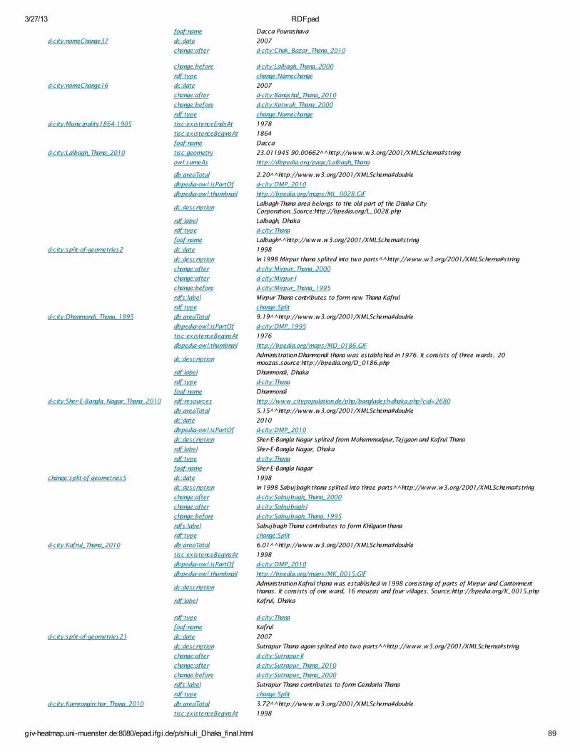
3/27/13 RDFpad
giv-heatmap.uni-muenster.de:8080/epad.ifgi.de/p/shiuli_Dhaka_final.html 89
foaf:name Dacca Pourashava
d-city:nameChange37 dc:date 2007
change:after d-city:Chak_Bazar_Thana_2010
change:before d-city:Lalbagh_Thana_2000
rdf:type change:Namechange
d-city:nameChange16 dc:date 2007
change:after d-city:Bangshal_Thana_2010
change:before d-city:Kotwali_Thana_2000
rdf:type change:Namechange
d-city:Municipality1864-1905 tisc:existenceEndsAt 1978
tisc:existenceBeginsAt 1864
foaf:name Dacca
d-city:Lalbagh_Thana_2010 tisc:geometry 23.011945 90.00662^^http://www.w3.org/2001/XMLSchema#string
owl:sameAs http://dbpedia.org/page/Lalbagh_Thana
db:areaTotal 2.20^^http://www.w3.org/2001/XMLSchema#double
dbpedia-owl:isPartOf d-city:DMP_2010
dbpedia-owl:thumbnail http://bpedia.org/maps/ML_0028.GIF
dc:descriptionLalbagh Thana area belongs to the old part of the Dhaka CityCorporation..Source:http://bpedia.org/L_0028.php
rdf:label Lalbagh, Dhaka
rdf:type d-city:Thana
foaf:name Lalbagh ^http://www.w3.org/2001/XMLSchema#string
d-city:split-of-geometries2 dc:date 1998
dc:description In 1998 Mirpur thana splited into two parts^^http://www.w3.org/2001/XMLSchema#string
change:after d-city:Mirpur_Thana_2000
change:after d-city:Mirpur-I
change:before d-city:Mirpur_Thana_1995
rdfs:label Mirpur Thana contributes to form new Thana Kafrul
rdf:type change:Split
d-city:Dhanmondi_Thana_1995 db:areaTotal 9.19^^http://www.w3.org/2001/XMLSchema#double
dbpedia-owl:isPartOf d-city:DMP_1995
tisc:existenceBeginsAt 1976
dbpedia-owl:thumbnail http://bpedia.org/maps/MD_0186.GIF
dc:descriptionAdministration Dhanmondi thana was established in 1976. It consists of three wards, 20mouzas.source:http://bpedia.org/D_0186.php
rdf:label Dhanmondi, Dhaka
rdf:type d-city:Thana
foaf:name Dhanmondi
d-city:Sher-E-Bangla_Nagar_Thana_2010 rdf:resources http://www.citypopulation.de/php/bangladesh-dhaka.php?cid=2680
db:areaTotal 5.15^^http://www.w3.org/2001/XMLSchema#double
dc:date 2010
dbpedia-owl:isPartOf d-city:DMP_2010
dc:description Sher-E-Bangla Nagar splited from Mohammadpur,Tejgaon and Kafrul Thana
rdf:label Sher-E-Bangla Nagar, Dhaka
rdf:type d-city:Thana
foaf:name Sher-E-Bangla Nagar
change:split-of-geometries5 dc:date 1998
dc:description In 1998 Sabujbagh thana splited into three parts^^http://www.w3.org/2001/XMLSchema#string
change:after d-city:Sabujbagh_Thana_2000
change:after d-city:Sabujbagh-I
change:before d-city:Sabujbagh_Thana_1995
rdfs:label Sabujbagh Thana contributes to form Khilgaon thana
rdf:type change:Split
d-city:Kafrul_Thana_2010 db:areaTotal 6.01^^http://www.w3.org/2001/XMLSchema#double
tisc:existenceBeginsAt 1998
dbpedia-owl:isPartOf d-city:DMP_2010
dbpedia-owl:thumbnail http://bpedia.org/maps/MK_0015.GIF
dc:descriptionAdministration Kafrul thana was established in 1998 consisting of parts of Mirpur and Cantonmentthanas. It consists of one ward, 16 mouzas and four villages. Source:http://bpedia.org/K_0015.php
rdf:label Kafrul, Dhaka
rdf:type d-city:Thana
foaf:name Kafrul
d-city:split-of-geometries21 dc:date 2007
dc:description Sutrapur Thana again splited into two parts^^http://www.w3.org/2001/XMLSchema#string
change:after d-city:Sutrapur-II
change:after d-city:Sutrapur_Thana_2010
change:before d-city:Sutrapur_Thana_2000
rdfs:label Sutrapur Thana contributes to form Gendaria Thana
rdf:type change:Split
d-city:Kamrangirchar_Thana_2010 db:areaTotal 3.72^^http://www.w3.org/2001/XMLSchema#double
tisc:existenceBeginsAt 1998
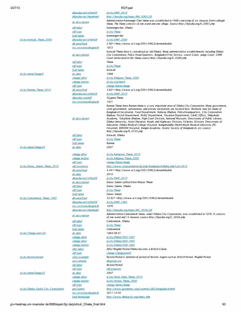
3/27/13 RDFpad
giv-heatmap.uni-muenster.de:8080/epad.ifgi.de/p/shiuli_Dhaka_final.html 90
dbpedia-owl:isPartOf d-city:DMP_2010
dbpedia-owl:thumbnail http://bpedia.org/maps/MK_0065.GIF
dc:descriptionAdministration Kamrangir Char thana was established in 1998 consisting of six mouzas from Lalbaghthana. The thana consists of one ward and one village. Source:http://bpedia.org/K_0065.php
rdf:label Kamrangirchar, Dhaka
rdf:type d-city:Thana
foaf:name Kamrangirchar
d-city:Kotwali_Thana_2000 dbpedia-owl:isPartOf d-city:DMP_2000
db:areaTotal 2.90^^http://www.w3.org/2001/XMLSchema#double
tisc:existenceBeginsAt 1872
dc:descriptionKotwali Thana Area is considered as old Dhaka. Many administrative establishments including DhakaCity Corporation, Police Head Quarters, Bangladesh Fire Service, Lower Court, Judge Court, CMMCourt arelocated in this thana.source:http://bpedia.org/K_0289.php
rdf:label Thana
rdf:type d-city:Thana
foaf:name Kotwali
d-city:nameChange9 dc:date 1998
change:after d-city:Khilgaon_Thana_2000
change:before d-city:Gulshan-II
rdf:type change:Namechange
d-city:Ramna_Thana_2010 db:areaTotal 3.82^^http://www.w3.org/2001/XMLSchema#double
dbpedia-owl:isPartOf d-city:DMP_2010
dbpedia:southOf Tejgaon Thana
tisc:existenceBeginsAt 1921
dc:description
Ramna Thana Area Raman thana is a very important area of Dhaka City Corporation. Many government,semi government, autonomous and private institutions are located here. Mentions may be made ofBangladesh Secretariat, Food Department, Railway Bhaban, PoliceHeadquarters, City CorporationBhaban, Postal Department, Relief Department, Taxation Department, C&AG Office, ShilpakalaAcademy, Telephone Bhaban, High Court Division, National Museum, Directorate of Public Library,Dhaka University, Hotel Sheraton, Roads and Highways Division, Fisheries Division, Directorate ofEducation, Dhaka Medical College Hospital, Bangabandhu Sheikh Mujib Medical University (PGHospital), BIRDEM Hospital, Bangla Academy, Asiatic Society of Bangladesh, etc.source:http://bpedia.org/R_0105.php
rdf:label Kotwali, Dhaka
rdf:type d-city:Thana
foaf:name Ramna
d-city:nameChange24 dc:date 2007
change:after d-city:Rampura_Thana_2010
change:before d-city:Khilgaon_Thana_2000
rdf:type change:Namechange
d-city:Darus_Salam_Thana_2010 rdf:resources http://www.citypopulation.de/php/bangladesh-dhaka.php?cid=2610
db:areaTotal 4.44^^http://www.w3.org/2001/XMLSchema#double
dc:date 2010
dbpedia-owl:isPartOf d-city:DMP_2010
dc:description Darus Salam splited from Mirpur Thana
rdf:label Darus Salam, Dhaka
rdf:type d-city:Thana
foaf:name Darus Salam
d-city:Cantonment_Thana_1995 db:areaTotal 35.92^^http://www.w3.org/2001/XMLSchema#double
dbpedia-owl:isPartOf d-city:DMP_1995
tisc:existenceBeginsAt 1976
dbpedia-owl:thumbnail http://bpedia.org/maps/MC_0036.GIF
dc:descriptionAdministration Cantonment thana, under Dhaka City Corporation, was established in 1976. It consistsof one ward and 13 mouzas.source:http://bpedia.org/C_0036.php
rdf:label Cantonment, Dhaka
rdf:type d-city:Thana
foaf:name Cantonment
d-city:Change-part-of1 dc:date 1864-08-01
change:after d-city:Dhaka1905-1947
change:after d-city:Dhaka1864-1905
change:before d-city:Dhaka1608-1864
rdfs:label After Mughal Period Dhaka becoms a British Colony
rdf:type change:Changepartof
d-city:historicPeriod skos:example historicPeriod is notation of period of historic region such as British Period, Mughal Period
owl:sameAs dbpprop:era
rdf:label historicPeriod
rdf:type rdf:property
d-city:nameChange32 dc:date 2007
change:after d-city:Uttar_Khan_Thana_2010
change:before d-city:Uttara_Thana_2000
rdf:type change:Namechange
d-city:Dhaka_South_City_Corporation gn:Country http://www.geonames.org/countries/BD/bangladesh.html
tisc:existenceBeginsAt 2011-12-04
foaf:homepage http://www.dhakacity.org/index.php
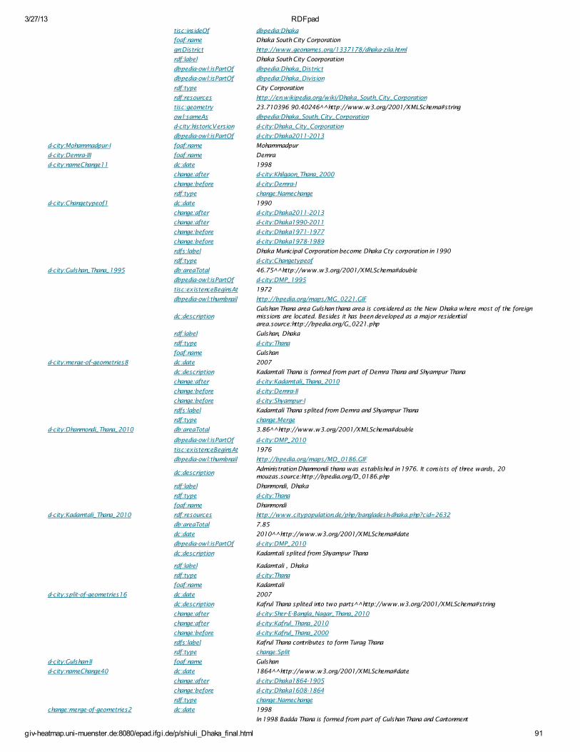
3/27/13 RDFpad
giv-heatmap.uni-muenster.de:8080/epad.ifgi.de/p/shiuli_Dhaka_final.html 91
tisc:insideOf dbpedia:Dhaka
foaf:name Dhaka South City Corporation
gn:District http://www.geonames.org/1337178/dhaka-zila.html
rdf:label Dhaka South City Coorporation
dbpedia-owl:isPartOf dbpedia:Dhaka_District
dbpedia-owl:isPartOf dbpedia:Dhaka_Division
rdf:type City Corporation
rdf:resources http://en.wikipedia.org/wiki/Dhaka_South_City_Corporation
tisc:geometry 23.710396 90.40246^^http://www.w3.org/2001/XMLSchema#string
owl:sameAs dbpedia:Dhaka_South_City_Corporation
d-city:historicVersion d-city:Dhaka_City_Corporation
dbpedia-owl:isPartOf d-city:Dhaka2011-2013
d-city:Mohammadpur-I foaf:name Mohammadpur
d-city:Demra-III foaf:name Demra
d-city:nameChange11 dc:date 1998
change:after d-city:Khilgaon_Thana_2000
change:before d-city:Demra-I
rdf:type change:Namechange
d-city:Changetypeof1 dc:date 1990
change:after d-city:Dhaka2011-2013
change:after d-city:Dhaka1990-2011
change:before d-city:Dhaka1971-1977
change:before d-city:Dhaka1978-1989
rdfs:label Dhaka Municipal Corporation become Dhaka Cty corporation in 1990
rdf:type d-city:Changetypeof
d-city:Gulshan_Thana_1995 db:areaTotal 46.75^^http://www.w3.org/2001/XMLSchema#double
dbpedia-owl:isPartOf d-city:DMP_1995
tisc:existenceBeginsAt 1972
dbpedia-owl:thumbnail http://bpedia.org/maps/MG_0221.GIF
dc:descriptionGulshan Thana area Gulshan thana area is considered as the New Dhaka where most of the foreignmissions are located. Besides it has been developed as a major residentialarea.source:http://bpedia.org/G_0221.php
rdf:label Gulshan, Dhaka
rdf:type d-city:Thana
foaf:name Gulshan
d-city:merge-of-geometries8 dc:date 2007
dc:description Kadamtali Thana is formed from part of Demra Thana and Shyampur Thana
change:after d-city:Kadamtali_Thana_2010
change:before d-city:Demra-II
change:before d-city:Shyampur-I
rdfs:label Kadamtali Thana splited from Demra and Shyampur Thana
rdf:type change:Merge
d-city:Dhanmondi_Thana_2010 db:areaTotal 3.86^^http://www.w3.org/2001/XMLSchema#double
dbpedia-owl:isPartOf d-city:DMP_2010
tisc:existenceBeginsAt 1976
dbpedia-owl:thumbnail http://bpedia.org/maps/MD_0186.GIF
dc:descriptionAdministration Dhanmondi thana was established in 1976. It consists of three wards, 20mouzas.source:http://bpedia.org/D_0186.php
rdf:label Dhanmondi, Dhaka
rdf:type d-city:Thana
foaf:name Dhanmondi
d-city:Kadamtali_Thana_2010 rdf:resources http://www.citypopulation.de/php/bangladesh-dhaka.php?cid=2632
db:areaTotal 7.85
dc:date 2010^^http://www.w3.org/2001/XMLSchema#date
dbpedia-owl:isPartOf d-city:DMP_2010
dc:description Kadamtali splited from Shyampur Thana
rdf:label Kadamtali , Dhaka
rdf:type d-city:Thana
foaf:name Kadamtali
d-city:split-of-geometries16 dc:date 2007
dc:description Kafrul Thana splited into two parts^^http://www.w3.org/2001/XMLSchema#string
change:after d-city:Sher-E-Bangla_Nagar_Thana_2010
change:after d-city:Kafrul_Thana_2010
change:before d-city:Kafrul_Thana_2000
rdfs:label Kafrul Thana contributes to form Turag Thana
rdf:type change:Split
d-city:Gulshan-II foaf:name Gulshan
d-city:nameChange40 dc:date 1864^^http://www.w3.org/2001/XMLSchema#date
change:after d-city:Dhaka1864-1905
change:before d-city:Dhaka1608-1864
rdf:type change:Namechange
change:merge-of-geometries2 dc:date 1998
In 1998 Badda Thana is formed from part of Gulshan Thana and Cantonment
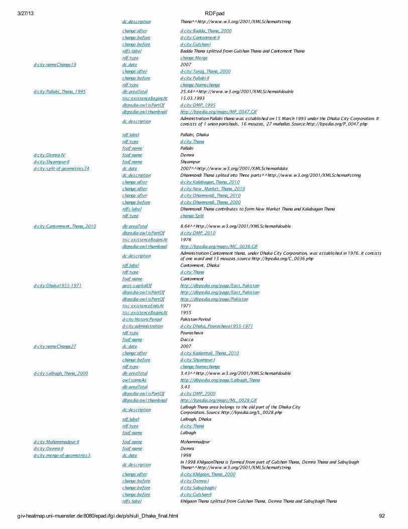
3/27/13 RDFpad
giv-heatmap.uni-muenster.de:8080/epad.ifgi.de/p/shiuli_Dhaka_final.html 92
dc:description Thana^^http://www.w3.org/2001/XMLSchema#string
change:after d-city:Badda_Thana_2000
change:before d-city:Cantonment-II
change:before d-city:Gulshan-I
rdfs:label Badda Thana splitted from Gulshan Thana and Cantoment Thana
rdf:type change:Merge
d-city:nameChange19 dc:date 2007
change:after d-city:Turag_Thana_2000
change:before d-city:Pallabi-II
rdf:type change:Namechange
d-city:Pallabi_Thana_1995 db:areaTotal 25.44^^http://www.w3.org/2001/XMLSchema#double
tisc:existenceBeginsAt 15.03.1993
dbpedia-owl:isPartOf d-city:DMP_1995
dbpedia-owl:thumbnail http://bpedia.org/maps/MP_0047.GIF
dc:descriptionAdministration Pallabi thana was established on 15 March 1993 under the Dhaka City Corporation. Itconsists of 1 union parishads, 16 mouzas, 27 mahallas.Source:http://bpedia.org/P_0047.php
rdf:label Pallabi, Dhaka
rdf:type d-city:Thana
foaf:name Pallabi
d-city:Demra-IV foaf:name Demra
d-city:Shyampur-II foaf:name Shyampur
d-city:split-of-geometries24 dc:date 2007^^http://www.w3.org/2001/XMLSchema#date
dc:description Dhanmondi Thana splited into Three parts^^http://www.w3.org/2001/XMLSchema#string
change:after d-city:Kalabagan_Thana_2010
change:after d-city:New_Market_Thana_2010
change:after d-city:Dhanmondi_Thana_2010
change:before d-city:Dhanmondi_Thana_2000
rdfs:label Dhanmondi Thana contributes to form New Market Thana and Kalabagan Thana
rdf:type change:Split
d-city:Cantonment_Thana_2010 db:areaTotal 8.64^^http://www.w3.org/2001/XMLSchema#double
dbpedia-owl:isPartOf d-city:DMP_2010
tisc:existenceBeginsAt 1976
dbpedia-owl:thumbnail http://bpedia.org/maps/MC_0036.GIF
dc:descriptionAdministration Cantonment thana, under Dhaka City Corporation, was established in 1976. It consistsof one ward and 13 mouzas.source:http://bpedia.org/C_0036.php
rdf:label Cantonment, Dhaka
rdf:type d-city:Thana
foaf:name Cantonment
d-city:Dhaka1955-1971 geos:capitalOf http://dbpedia.org/page/East_Pakistan
dbpedia-owl:isPartOf http://dbpedia.org/page/East_Pakistan
dbpedia-owl:isPartOf http://dbpedia.org/page/Pakistan
tisc:existenceEndsAt 1971
tisc:existenceBeginsAt 1955
d-city:historicPeriod Pakistan Period
d-city:administration d-city:Dhaka_Pourashava1955-1971
rdf:type Pourashava
foaf:name Dacca
d-city:nameChange27 dc:date 2007
change:after d-city:Kadamtali_Thana_2010
change:before d-city:Shyampur-I
rdf:type change:Namechange
d-city:Lalbagh_Thana_2000 db:areaTotal 3.43^^http://www.w3.org/2001/XMLSchema#double
owl:sameAs http://dbpedia.org/page/Lalbagh_Thana
db:areaTotal 3.43
dbpedia-owl:isPartOf d-city:DMP_2000
dbpedia-owl:thumbnail http://bpedia.org/maps/ML_0028.GIF
dc:descriptionLalbagh Thana area belongs to the old part of the Dhaka CityCorporation..Source:http://bpedia.org/L_0028.php
rdf:label Lalbagh, Dhaka
rdf:type d-city:Thana
foaf:name Lalbagh
d-city:Muhammadpur-II foaf:name Mohammadpur
d-city:Demra-II foaf:name Demra
d-city:merge-of-geometries3 dc:date 1998
dc:descriptionIn 1998 KhilgaonThana is formed from part of Gulshan Thana, Demra Thana and SabujbaghThana^^http://www.w3.org/2001/XMLSchema#string
change:after d-city:Khilgaon_Thana_2000
change:before d-city:Demra-I
change:before d-city:Sabujbagh-I
change:before d-city:Gulshan-II
rdfs:label Khilgaon Thana splitted from Gulshan Thana, Demra Thana and Sabujbagh Thana
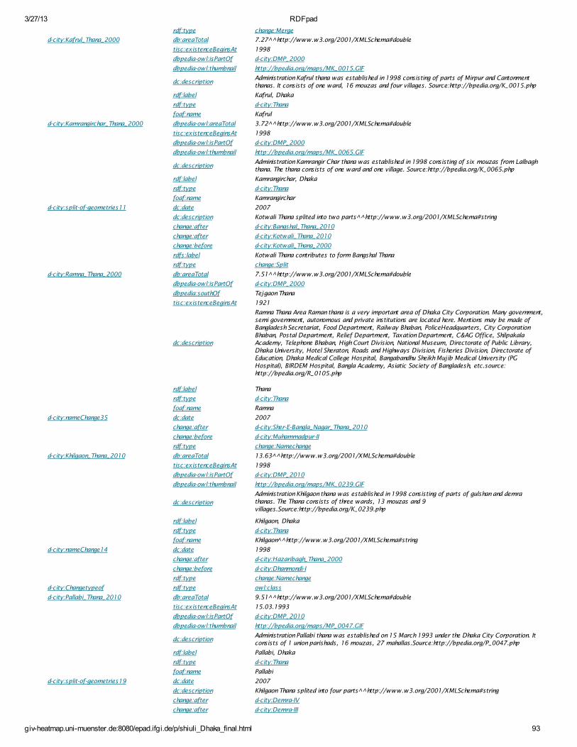
3/27/13 RDFpad
giv-heatmap.uni-muenster.de:8080/epad.ifgi.de/p/shiuli_Dhaka_final.html 93
rdf:type change:Merge
d-city:Kafrul_Thana_2000 db:areaTotal 7.27^^http://www.w3.org/2001/XMLSchema#double
tisc:existenceBeginsAt 1998
dbpedia-owl:isPartOf d-city:DMP_2000
dbpedia-owl:thumbnail http://bpedia.org/maps/MK_0015.GIF
dc:descriptionAdministration Kafrul thana was established in 1998 consisting of parts of Mirpur and Cantonmentthanas. It consists of one ward, 16 mouzas and four villages. Source:http://bpedia.org/K_0015.php
rdf:label Kafrul, Dhaka
rdf:type d-city:Thana
foaf:name Kafrul
d-city:Kamrangirchar_Thana_2000 dbpedia-owl:areaTotal 3.72^^http://www.w3.org/2001/XMLSchema#double
tisc:existenceBeginsAt 1998
dbpedia-owl:isPartOf d-city:DMP_2000
dbpedia-owl:thumbnail http://bpedia.org/maps/MK_0065.GIF
dc:descriptionAdministration Kamrangir Char thana was established in 1998 consisting of six mouzas from Lalbaghthana. The thana consists of one ward and one village. Source:http://bpedia.org/K_0065.php
rdf:label Kamrangirchar, Dhaka
rdf:type d-city:Thana
foaf:name Kamrangirchar
d-city:split-of-geometries11 dc:date 2007
dc:description Kotwali Thana splited into two parts^^http://www.w3.org/2001/XMLSchema#string
change:after d-city:Bangshal_Thana_2010
change:after d-city:Kotwali_Thana_2010
change:before d-city:Kotwali_Thana_2000
rdfs:label Kotwali Thana contributes to form Bangshal Thana
rdf:type change:Split
d-city:Ramna_Thana_2000 db:areaTotal 7.51^^http://www.w3.org/2001/XMLSchema#double
dbpedia-owl:isPartOf d-city:DMP_2000
dbpedia:southOf Tejgaon Thana
tisc:existenceBeginsAt 1921
dc:description
Ramna Thana Area Raman thana is a very important area of Dhaka City Corporation. Many government,semi government, autonomous and private institutions are located here. Mentions may be made ofBangladesh Secretariat, Food Department, Railway Bhaban, PoliceHeadquarters, City CorporationBhaban, Postal Department, Relief Department, Taxation Department, C&AG Office, ShilpakalaAcademy, Telephone Bhaban, High Court Division, National Museum, Directorate of Public Library,Dhaka University, Hotel Sheraton, Roads and Highways Division, Fisheries Division, Directorate ofEducation, Dhaka Medical College Hospital, Bangabandhu Sheikh Mujib Medical University (PGHospital), BIRDEM Hospital, Bangla Academy, Asiatic Society of Bangladesh, etc.source:http://bpedia.org/R_0105.php
rdf:label Thana
rdf:type d-city:Thana
foaf:name Ramna
d-city:nameChange35 dc:date 2007
change:after d-city:Sher-E-Bangla_Nagar_Thana_2010
change:before d-city:Muhammadpur-II
rdf:type change:Namechange
d-city:Khilgaon_Thana_2010 db:areaTotal 13.63^^http://www.w3.org/2001/XMLSchema#double
tisc:existenceBeginsAt 1998
dbpedia-owl:isPartOf d-city:DMP_2010
dbpedia-owl:thumbnail http://bpedia.org/maps/MK_0239.GIF
dc:description
Administration Khilgaon thana was established in 1998 consisting of parts of gulshan and demrathanas. The Thana consists of three wards, 13 mouzas and 9villages.Source:http://bpedia.org/K_0239.php
rdf:label Khilgaon, Dhaka
rdf:type d-city:Thana
foaf:name Khilgaon ^http://www.w3.org/2001/XMLSchema#string
d-city:nameChange14 dc:date 1998
change:after d-city:Hazaribagh_Thana_2000
change:before d-city:Dhanmondi-I
rdf:type change:Namechange
d-city:Changetypeof rdf:type owl:class
d-city:Pallabi_Thana_2010 db:areaTotal 9.51^^http://www.w3.org/2001/XMLSchema#double
tisc:existenceBeginsAt 15.03.1993
dbpedia-owl:isPartOf d-city:DMP_2010
dbpedia-owl:thumbnail http://bpedia.org/maps/MP_0047.GIF
dc:descriptionAdministration Pallabi thana was established on 15 March 1993 under the Dhaka City Corporation. Itconsists of 1 union parishads, 16 mouzas, 27 mahallas.Source:http://bpedia.org/P_0047.php
rdf:label Pallabi, Dhaka
rdf:type d-city:Thana
foaf:name Pallabi
d-city:split-of-geometries19 dc:date 2007
dc:description Khilgaon Thana splited into four parts^^http://www.w3.org/2001/XMLSchema#string
change:after d-city:Demra-IV
change:after d-city:Demra-III
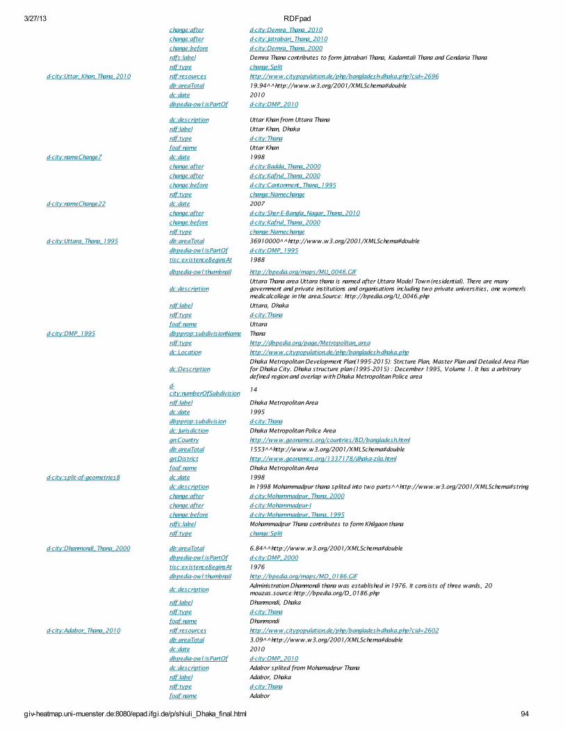
3/27/13 RDFpad
giv-heatmap.uni-muenster.de:8080/epad.ifgi.de/p/shiuli_Dhaka_final.html 94
change:after d-city:Demra_Thana_2010
change:after d-city:Jatrabari_Thana_2010
change:before d-city:Demra_Thana_2000
rdfs:label Demra Thana contributes to form Jatrabari Thana, Kadamtali Thana and Gendaria Thana
rdf:type change:Split
d-city:Uttar_Khan_Thana_2010 rdf:resources http://www.citypopulation.de/php/bangladesh-dhaka.php?cid=2696
db:areaTotal 19.94^^http://www.w3.org/2001/XMLSchema#double
dc:date 2010
dbpedia-owl:isPartOf d-city:DMP_2010
dc:description Uttar Khan from Uttara Thana
rdf:label Uttar Khan, Dhaka
rdf:type d-city:Thana
foaf:name Uttar Khan
d-city:nameChange7 dc:date 1998
change:after d-city:Badda_Thana_2000
change:after d-city:Kafrul_Thana_2000
change:before d-city:Cantonment_Thana_1995
rdf:type change:Namechange
d-city:nameChange22 dc:date 2007
change:after d-city:Sher-E-Bangla_Nagar_Thana_2010
change:before d-city:Kafrul_Thana_2000
rdf:type change:Namechange
d-city:Uttara_Thana_1995 db:areaTotal 36910000^^http://www.w3.org/2001/XMLSchema#double
dbpedia-owl:isPartOf d-city:DMP_1995
tisc:existenceBeginsAt 1988
dbpedia-owl:thumbnail http://bpedia.org/maps/MU_0046.GIF
dc:descriptionUttara Thana area Uttara thana is named after Uttara Model Town (residential). There are manygovernment and private institutions and organisations including two private universities, one women'smedicalcollege in the area.Source: http://bpedia.org/U_0046.php
rdf:label Uttara, Dhaka
rdf:type d-city:Thana
foaf:name Uttara
d-city:DMP_1995 dbpprop:subdivisionName Thana
rdf:type http://dbpedia.org/page/Metropolitan_area
dc:Location http://www.citypopulation.de/php/bangladesh-dhaka.php
dc:DescriptionDhaka Metropolitan Development Plan(1995-2015): Strcture Plan, Master Plan and Detailed Area Planfor Dhaka City. Dhaka structure plan (1995-2015) : December 1995, Volume 1. It has a arbitrarydefined region and overlap with Dhaka Metropolitan Police area
d-city:numberOfSubdivision
14
rdf:label Dhaka Metropolitan Area
dc:date 1995
dbpprop:subdivision d-city:Thana
dc:Jurisdiction Dhaka Metropolitan Police Area
gn:Country http://www.geonames.org/countries/BD/bangladesh.html
db:areaTotal 1553^^http://www.w3.org/2001/XMLSchema#double
gn:District http://www.geonames.org/1337178/dhaka-zila.html
foaf:name Dhaka Metropolitan Area
d-city:split-of-geometries8 dc:date 1998
dc:description In 1998 Mohammadpur thana splited into two parts^^http://www.w3.org/2001/XMLSchema#string
change:after d-city:Mohammadpur_Thana_2000
change:after d-city:Mohammadpur-I
change:before d-city:Mohammadpur_Thana_1995
rdfs:label Mohammadpur Thana contributes to form Khilgaon thana
rdf:type change:Split
d-city:Dhanmondi_Thana_2000 db:areaTotal 6.84^^http://www.w3.org/2001/XMLSchema#double
dbpedia-owl:isPartOf d-city:DMP_2000
tisc:existenceBeginsAt 1976
dbpedia-owl:thumbnail http://bpedia.org/maps/MD_0186.GIF
dc:descriptionAdministration Dhanmondi thana was established in 1976. It consists of three wards, 20mouzas.source:http://bpedia.org/D_0186.php
rdf:label Dhanmondi, Dhaka
rdf:type d-city:Thana
foaf:name Dhanmondi
d-city:Adabor_Thana_2010 rdf:resources http://www.citypopulation.de/php/bangladesh-dhaka.php?cid=2602
db:areaTotal 3.09^^http://www.w3.org/2001/XMLSchema#double
dc:date 2010
dbpedia-owl:isPartOf d-city:DMP_2010
dc:description Adabor splited from Mohamadpur Thana
rdf:label Adabor, Dhaka
rdf:type d-city:Thana
foaf:name Adabor
3/27/13 RDFpad
giv-heatmap.uni-muenster.de:8080/epad.ifgi.de/p/shiuli_Dhaka_final.html 95
d-city:split-of-geometries27 dc:date 2007^^http://www.w3.org/2001/XMLSchema#date
dc:description Lalbagh Thana splited into Two parts^^http://www.w3.org/2001/XMLSchema#string
change:after d-city:Sher-E-Bangla_Nagor_Thana_2010
change:after d-city:Tejgaon_Industrial_Area_Thana_2010
change:after d-city:Tejgaon_Thana_2010
change:before d-city:Tejgaon_Thana_2000
rdfs:label Tejgaon Thana contributes to form Sher-E-Bangla Nagar Thana and Tejgaon Industrial Area Thana
rdf:type change:Split
http://epad.ifgi.de/p/student-106 foaf:topic_interest dbpedia:Dhaka
foaf:topic_interest dbpedia:Semantic_W eb
foaf:topic_interestSemantic web approach for dealing with administrative boundary revisions: A case study of DhakaCity
teach:studyProgram http://ifgi.uni-muenster.de/
foaf:lastName Pervin
foaf:firstName Shiuli
rdf:label Shiuli Thesis
rdf:type http://en.wikipedia.org/wiki/Student
d-city:historicVersion owl:sameAs dc:hasVersion
rdf:label historicVersion
rdf:type rdf:property
d-city:Mirpur_Thana_1995 dbpedia-owl:isPartOf d-city:DMP_1995
db:areaTotal 15.44^^http://www.w3.org/2001/XMLSchema#double
tisc:existenceBeginsAt 1962
dbpedia-owl:thumbnail http://bpedia.org/maps/MM_0260.GIF
dc:description
Mirpur Thana (Town) area was included in keraniganj thana during the British period and in tejgaon thanaduring the Pakistan period. Many administrative and cultural establishments including National Zoo,National Botanical Garden, National Vagabond Shelter Centre are located in this thana area. NationalMartyr Intellectual Memorial has been established at the premises of the graves of martyrintellectuals. The tomb of Hazrat Shah Ali Bagdadi (R), a sacred place and historical relic, is located atMirpur. Besides, the head offices of grameen bank,bangladesh institute of bank management, DhakaEye Hospital, National Heart Foundation, etc are located here.source:http://bpedia.org/M_0260.php
rdf:label Mirpur, Dhaka
rdf:type d-city:Thana
foaf:name Mirpur
d-city:nameChange30 dc:date 2007
change:after d-city:Paltan_Thana_2010
change:before d-city:Motijheel_Thana_2000
rdf:type change:Namechange
d-city:Chak_Bazar_Thana_2010 rdf:resources http://www.citypopulation.de/php/bangladesh-dhaka.php?cid=2609
db:areaTotal 1.22^^http://www.w3.org/2001/XMLSchema#double
dc:date 2010
dbpedia-owl:isPartOf d-city:DMP_2010
dc:description Ckak Bazar splited from Lalbagh Thana
rdf:label Ckak Bazar, Dhaka
rdf:type d-city:Thana
foaf:name Ckak Bazar
d-city:Badda_Thana_2010 db:areaTotal 21.39^^http://www.w3.org/2001/XMLSchema#double
tisc:existenceBeginsAt 1998^^http://www.w3.org/2001/XMLSchema#date
dbpedia-owl:isPartOf d-city:DMP_2010
dbpedia-owl:thumbnail http://bpedia.org/maps/MB_0018.GIF
dc:descriptionAdministration Badda thana was established in 1998 consisting of parts of Cantonment and Gulshanthanas. The thana consists of 4 wards, 16 mouzas, 2 unions (Beraid and Satarkul) and 14 mohallas.Source:http://bpedia.org/B_0018.php
rdf:label Badda, Dhaka
rdf:type d-city:Thana
foaf:name Badda^^http://www.w3.org/2001/XMLSchema#string
d-city:Pourashava1964-1905 tisc:existenceEndsAt 1905
tisc:existenceBeginsAt 1864
foaf:name Dacca Pourashava
d-city:merge-of-geometries6 dc:date 2007
dc:description Shah Ali thana is formed from part of Pallabi Thana and Mirpur Thana
change:after d-city:Shah_Ali_Thana_2010
change:before d-city:Mirpur-II
change:before d-city:Pallabi-I
rdfs:label Ahah Ali Thana splited from Pallabi and Mirpur Thana
rdf:type change:Merge
d-city:Dhaka1905-1947 geos:capitalOf East Bengal and Assam
dbpedia-owl:isPartOf http://dbpedia.org/page/Indian_subcontinent
d-city:administration d-city:Pourashava1905-1947
tisc:existenceEndsAt 1947
tisc:existenceBeginsAt 1905
dbpedia-owl:thumbnailhttp://2.bp.blogspot.com/_ZPf1HUBNpK4/RmRwFVq22_I/AAAAAAAAC7o/5KS7h3Z9YSQ/s320/007-Dhaka+during+British+rule+1924+Mughal+period.jpg
3/27/13 RDFpad
giv-heatmap.uni-muenster.de:8080/epad.ifgi.de/p/shiuli_Dhaka_final.html 96
dbpedia-owl:thumbnail http://2.bp.blogspot.com/_ZPf1HUBNpK4/RmaSG7MCpsI/AAAAAAAAC9I/5G1I_GQZ88E/s320/015-
+Dhaka+city+capital+of+E+bengal+assam+1905-11.gif
rdf:type Capital of Province
rdf:type Pourashava
d-city:historicPeriod British Period
dbpedia-owl:isPartOf http://dbpedia.org/page/Mughal_Empire
foaf:name Dacca
d-city:Biman_Bandar_Thana_2010 rdf:resources http://www.citypopulation.de/php/bangladesh-dhaka.php?cid=2606
db:areaTotal 14.84^^http://www.w3.org/2001/XMLSchema#double
dc:date 2010
dbpedia-owl:isPartOf d-city:DMP_2010
dc:description Biman bandar splited from Cantonment
rdf:label Biman Bandar, Dhaka
rdf:type d-city:Thana
foaf:name Biman Bandar
d-city:split-of-geometries14 dc:date 2007
dc:description Mirpur Thana splited into three parts^^http://www.w3.org/2001/XMLSchema#string
change:after d-city:Mirpur-II
change:after d-city:Darus_Salam_Thana_2010
change:after d-city:Mirpur_Thana_2010
change:before d-city:Mirpur_Thana_2000
rdfs:label Mirpur Thana contributes to form Shah Ali Thana and Darus Salam Thana
rdf:type change:Split
d-city:Dhaka1971-1977 geos:capitalOf http://dbpedia.org/page/Bangladesh
dbpedia-owl:isPartOf http://dbpedia.org/page/Bangladesh
tisc:existenceEndsAt 1977
tisc:existenceBeginsAt 1971
d-city:historicPeriod Bangladesh Period
d-city:administration d-city:Dhaka_Municipal_Corporation
rdf:type Municipal Corporation
foaf:name Dacca
d-city:nameChange38 dc:date 2007
change:after d-city:Sher-E-Bangla_Nagar_Thana_2010
change:before d-city:Tejgaon_Thana_2000
rdf:type change:Namechange
d-city:New_Market_Thana_2010 rdf:resources http://www.citypopulation.de/php/bangladesh-dhaka.php?cid=2663
db:areaTotal 1.28^^http://www.w3.org/2001/XMLSchema#double
dc:date 2010^^http://www.w3.org/2001/XMLSchema#date
dbpedia-owl:isPartOf d-city:DMP_2010
dc:description New Market splited from Dhanmondi Thana
rdf:label New Market, Dhaka
rdf:type d-city:Thana
foaf:name New Market ^^http://www.w3.org/2001/XMLSchema#string
d-city:Cantonment_Thana_2000 db:areaTotal 23.53^^http://www.w3.org/2001/XMLSchema#double
dbpedia-owl:isPartOf d-city:DMP_2000
tisc:existenceBeginsAt 1976
dbpedia-owl:thumbnail http://bpedia.org/maps/MC_0036.GIF
dc:descriptionAdministration Cantonment thana, under Dhaka City Corporation, was established in 1976. It consistsof one ward and 13 mouzas.source:http://bpedia.org/C_0036.php
rdf:label Cantonment, Dhaka
rdf:type d-city:Thana
foaf:name Cantonment
d-city:nameChange17 dc:date 2007
change:after d-city:Shahbagh_Thana_2010
change:before d-city:Ramna_Thana_2000
rdf:type change:Namechange
d-city:Sutrapur_Thana_2010 db:areaTotal 2.68^^http://www.w3.org/2001/XMLSchema#double
dbpedia-owl:isPartOf d-city:DMP_2010
dbpedia-owl:thumbnail http://bpedia.org/maps/MS_0627.GIF
dc:description Administration It consists of 10 wards, 80 mahallas.Source: http://bpedia.org/S_0627.php
rdf:label Sutrapur, Dhaka
rdf:type d-city:Thana
foaf:name Sutrapur
d-city:Uttara_Thana_2010 db:areaTotal 5.25^^http://www.w3.org/2001/XMLSchema#double
dbpedia-owl:isPartOf d-city:DMP_2010
tisc:existenceBeginsAt 1988
dbpedia-owl:thumbnail http://bpedia.org/maps/MU_0046.GIF
dc:descriptionUttara Thana area Uttara thana is named after Uttara Model Town (residential). There are manygovernment and private institutions and organisations including two private universities, one women'smedicalcollege in the area.Source: http://bpedia.org/U_0046.php
rdf:label Uttara, Dhaka
rdf:type d-city:Thana
3/27/13 RDFpad
giv-heatmap.uni-muenster.de:8080/epad.ifgi.de/p/shiuli_Dhaka_final.html 97
foaf:name Uttara
d-city:split-of-geometries3 dc:date 1998
dc:description In 1998 Cantonment thana splited into three parts^^http://www.w3.org/2001/XMLSchema#string
change:after d-city:Cantonment_Thana_2000
change:after d-city:Cantonment-II
change:after d-city:Cantonment-I
change:before d-city:Cantonment_Thana_1995
rdfs:label Mirpur Thana contributes to form Badda and Kafrul thana
rdf:type change:Split
d-city:Demra-I foaf:name Demra
d-city:DMP_2010 dc:DescriptionDhaka Metropolitan Development Plan(1995-2015): Strcture Plan, Master Plan and Detailed Area Planfor Dhaka City. Dhaka structure plan (1995-2015) : December 1995, Volume 1. It has a arbitrarydefined region and overlap with Dhaka Metropolitan Police Area.
dbpedia-owl:isPartOf d-city:Dhaka
gn:Country http://www.geonames.org/countries/BD/bangladesh.html
dc:Jurisdiction Dhaka Metropolitan Police Area
db:areaTotal 1553^^http://www.w3.org/2001/XMLSchema#double
d-city:numberOfSubdivision
41
dbpprop:subdivisionName Thana
dbpprop:subdivision d-city:Thana
foaf:name Dhaka Metropolitan Area
gn:District http://www.geonames.org/1337178/dhaka-zila.html
rdf:type http://dbpedia.org/page/Metropolitan_area
dc:Location http://www.citypopulation.de/php/bangladesh-dhaka.php
dc:date 2010
rdf:label Dhaka MetroPolitan Area
d-city:Cantonment-I foaf:name Cantonment
d-city:Shyampur-I foaf:name Shyampur
d-city:split-of-geometries22 dc:date 2007
dc:description Motijheel Thana splited into two parts^^http://www.w3.org/2001/XMLSchema#string
change:after d-city:Paltan_Thana_2010
change:after d-city:Motijheel_Thana_2010
change:before d-city:Motijheel_Thana_2000
rdfs:label Motijheel Thana contributes to form Paltan Thana
rdf:type change:Split
d-city:Tejgaon_Industrial_Area_Thana_2010
rdf:resources http://www.citypopulation.de/php/bangladesh-dhaka.php?cid=2692
db:areaTotal 2.03^^http://www.w3.org/2001/XMLSchema#double
dc:date 2010
dbpedia-owl:isPartOf d-city:DMP_2010
dc:description Tejgaon Industrial Area splited from Tejgaon Thana
rdf:label Tejgaon Industrial Area, Dhaka
rdf:type d-city:Thana
foaf:name Tejgaon Industrial Area
d-city:nameChange25 dc:date 2007
change:after d-city:Kadamtali_Thana_2010
change:before d-city:Demra-III
d-city:Mirpur_Thana_2010 db:areaTotal 7.37^^http://www.w3.org/2001/XMLSchema#double
dbpedia-owl:isPartOf d-city:DMP_2010
tisc:existenceBeginsAt 1962
dbpedia-owl:thumbnail http://bpedia.org/maps/MM_0260.GIF
dc:description
Mirpur Thana (Town) area was included in keraniganj thana during the British period and in tejgaon thanaduring the Pakistan period. Many administrative and cultural establishments including National Zoo,National Botanical Garden, National Vagabond Shelter Centre are located in this thana area. NationalMartyr Intellectual Memorial has been established at the premises of the graves of martyrintellectuals. The tomb of Hazrat Shah Ali Bagdadi (R), a sacred place and historical relic, is located atMirpur. Besides, the head offices of grameen bank,bangladesh institute of bank management, DhakaEye Hospital, National Heart Foundation, etc are located here.source:http://bpedia.org/M_0260.php
rdf:label Mirpur, Dhaka
rdf:type d-city:Thana
foaf:name Mirpur
View as RDF/XML | N-Triples | Turtle | N3 – View in Sindice Inspector– Query with SPARQLfly
RDFpad is free and open source software. Contact: Carsten Keßler