
Sedimentological characteristics of continental sabkha, south Western Desert, Egypt

lable at ScienceDirect
Quaternary International 266 (2012) 62e73
Contents lists avai
Quaternary International
journal homepage: www.elsevier .com/locate/quaint
Sedimentological response to Holocene climate events in the Istron area, Gulf ofMirabello, NE Crete
Katerina Theodorakopoulou a,*, Kosmas Pavlopoulos a, Constantin Athanassas b, Nikos Zacharias c,Yannis Bassiakos b
aDepartment of Geography, Harokopio University, 70 El. Venizelou Str, 176 71 Kallithea, Athens, Greeceb Laboratory of Archaeometry, N.C.S.R ‘Demokritos’, 153 10 Ag. Paraskevi, Athens, GreececDepartment of History, Archaeology and Cultural Resources Management, University of Peloponnese, 241 00 Kalamata, Greece
a r t i c l e i n f o
Article history:Available online 13 June 2011
* Corresponding author.E-mail address: [email protected] (K. Theodorakopo
1040-6182/$ e see front matter � 2011 Elsevier Ltd adoi:10.1016/j.quaint.2011.05.032
a b s t r a c t
This paper aims to reveal the depositional environment of Istron and its sedimentological response toHolocene climatic events. The results of a multi-disciplinary geoarchaeological research undertaken inthe coastal area of Istron, northeastern Crete, provided information on the depositional environment andthe palaeoenvironmental evolution of the area during the Holocene. Detailed fieldwork and sampling bydrilling cores in the coastal area provided samples for further analytical studies. The identification of thestratigraphy and the distinction of sedimentological units provided evidence for landscape evolution ofthe coastal area. Changes of sedimentation rates determined by optical dating and sedimentologicalanalysis were also correlated with Holocene climatic phases.
� 2011 Elsevier Ltd and INQUA. All rights reserved.
1. Introduction
The Istron area is located in northeast Crete, Gulf of Mirabello,on an alluvial fan of Holocene age (Fig. 1). Its crucial position, at thecenter of the coast of the Mirabello Gulf, controlled the develop-ment of the prehistoric commercial routes of the Aegean (Sampson,2006) and favoured human installations since the Neolithic period(Hayden, 2004). There is archaeological evidence in the area fromLate Neolithic to the Byzantine period. The first excavations wereconducted by archaeologists from the University of PennsylvaniaMuseum in 1912 (Hall, 1914). On a limestone promontory known asPriniatikos Pyrgos in the centre of a broad embayment, a fewancient architectural remains, accompanied by high-quality potteryof Early to Late Minoan date, were exposed and observed at thattime. Historical occupation was represented by abundant Romanpottery (Hayden, 2004).
A 30-year fieldwork campaign, named ‘The Vrokastro RegionalSurvey Project’ (initiated in 1986) in the region, recently concludedthat the site of Priniatikos Pyrgos was the regional template for thecultural development of west-central Mirabello in both prehistoricand historical epochs. Well-preserved architectural remains andpottery dating from early 3rd millennium BC to the Byzantine andVenetian (10the17th centuries AD) periods were discovered.
ulou).
nd INQUA. All rights reserved.
Prehistoric (Minoan) ceramic kilns and later cobble-built circularstructures that might be smelting furnaces for iron productionwerealso recovered, increasing the likelihood that the site was a centerof craft specialization for both ceramic and, later, iron production(Hayden et al., 2006).
In 2002, a newmulti-disciplinary geoarchaeological project wasstarted, coordinated by the Institute of Mediterranean Studies(F.O.R.T.H./Crete) and the Laboratory of Archaeometry, N.C.S.R.“Demokritos”/Athens, in collaboration with the Department ofGeography, Harokopio University/Athens. Among the main targetsof this project was to investigate the nature of the depositionalenvironment, the impacts of climatic changes on the landscape, anysubsurface architectural/cultural remains, landscape evolution andthe seaeland interaction during the last 10,000 years. Detailedgeophysical prospection, geological studies, systematic coring,backhoe trenching and absolute dating have been conducted(Hayden et al., 2006; Kalpaxis et al., 2006; Pavlopoulos et al., 2007;Theodorakopoulou et al., 2009; Zacharias et al., 2009). This paperaims to reconstruct the Holocene landscape evolution of the Istronarea, highlighting links between climatic oscillations, depositionalenvironment and the record of human occupation in this area.
2. Regional setting e Geology
Crete is considered a tectonically active area. Sea level hasfluctuated, although trends to stabilization have been observed

Fig. 1. Location map of the study area.
K. Theodorakopoulou et al. / Quaternary International 266 (2012) 62e73 63
since the earliest phases of human settlement (Pirazzoli et al., 1996;Pirazzoli, 2005).
During the Pleistocene, the main topography was formed,although some deposition and erosion occurred during the longcultural history of the region. The Istron River valley, flood plain andother areas have also been subjected to floods, and some degree ofcoastal subsidence has occurred. Nevertheless, the present physicallandscape would still be recognizable to an inhabitant of an earlierepoch.
According to the geomorphological investigations and theexisting geological mapping of the area (IGME Ag. Nikolaos sheet,1981) the valley consists of the following geological formations:a) upper Cretaceous limestones, b) Cretaceous marbles, c) Mioceneconglomerates, d) Quaternary deposits (talus cones), and e) alluvialdeposits. The long axis of the Istron Valley is SWeNE, generallyparallel to the main local tectonic lines (Hayden et al., 2006).
The Istron River flows in a similar direction and discharges tothe north, ca. 200 m east of Priniatikos Pyrgos promontory, feedingthe near-shore area with sediments originating from the geologicalformations. The sediments deposited in the coastal zone are notonly of fluvial but also of littoral origin, the latter resulting from theHolocene eustatic sea-level rise.
There are six broad geomorphic units and two main drainagesystems in the survey area. The geomorphic units comprise: a) theriverine system of Istron river, b) river valley with its flooding plain,c) terraces along river axis, d) deltaic alluvial fan, e) small limestonepromontory of Priniatikos Pyrgos, and f) limestone cliffs that towerabove the valleys and coast (Theodorakopoulou et al., 2009).
3. Methods
Five drillings were performed at selected sites along the coast,and six backhoe trenches (4e5 m deep) were excavated, near thedrillings (Fig. 2). The drillings were completed by using indepen-dently rotating triple ball bearings, in order to obtain undisturbed,uncompressed cores retaining most of their natural moisturecontent. Most of the cores were placed in 11 cm wide PVC-tubesand thus sealed in “dark conditions”, necessary for OSL (OpticalStimulated Luminescence) dating. Trenches were opened 3.50 mbelow mean sea level, whereas the deepest borehole reachedw13 m in depth. The sedimentary formations of three drillings,namely C2, C3 and C4, were considered appropriate for dating andfurther palaeoenvironmental studies.
In-situ monitoring of the radiation field was performed witha calibrated portable NaI Tl-doped scintillometer (SCINTREX, modelSPP-2), in order to calculate the external dose-rate, a parameterrequired for the assessment of the OSL ages. The chemical profile of
the cores and the evaluation of potassium concentration (necessaryfor dose-rate estimation) were mainly obtained by XRF analysis,performed on a portion of the same sediment samples that wereused for luminescence measurements and was practiced witha bench top XRF spectrometer.
Additionally, neutron activation analysis along with thick sourcea-counting spectroscopy provided the U and Th concentrations ofthe sediment samples. Neutron activation analysis was performedat the University of Missouri, USA.
Luminescence measurements were made on a Risø TL/OSLreader model TLDA-15, with blue LEDs, emitting at 470 � 30 nm(delivering w30 mW cm�2) as stimulation source with the appli-cation of single aliquot regenerative dose (SAR) protocols (Murrayand Wintle, 2000). A series of experiments were carried out aim-ing at assessing the SAR validity (Zacharias et al., 2009), and testsindicated that SAR fulfilled the requirements set by Murray andWintle (2000) with an accuracy over 90%, thus putting confi-dence in the estimated OSL ages.
The study of dated sedimentological profiles of boreholes resul-ted in the calculation of sedimentation rate fluctuations. Correlationto the palaeoenvironmental data coming from pollen and micro-paleontological analysis, along with grain size analysis on selectedsamples, led to the assessment of the depositional environment.
For the characterization of the sedimentary regime and thedetermination of the associated clastic formations origin (aeolian,fluvial, marine), grain size analyses were performed on selectedsamples of core C3. A range of grain size data analysis methods,such as bivariate scatter plots and discrimination functions, wereemployed for the interpretation of the environments and mecha-nisms of sediment deposition.
In the laboratory, selected samples were washed, dried andsieved for grain size analysis. The graphical computational methodof Folk (1966) and Friedman (1961) was used to calculate grain sizestatistical parameters, such as mean, skewness, kurtosis, and sort-ing. Additionally, for the discrimination of the mechanisms andenvironments of deposition, the functions proposed by Sahu (1964)and Alsharhan and El-Sammak (2004) were applied. For discrimi-nation between aeolian processes and littoral (intertidal zone)environments, the following equation was used:
Y1 ¼ �3:5688Mzþ 3:7016sI2 � 2:0766SK1þ 3:1135KG
Mz ¼ Mean, sI ¼ sorting, SK ¼ Skewness, KG ¼ Kurtosis.When Y1<�2.7411 aeolian deposition is indicated; when
Y1>�2.7411 a beach environment is suggested.For discrimination between beach (back-shore) and shallow
agitated marine environments (subtidal), the following equationwas applied:
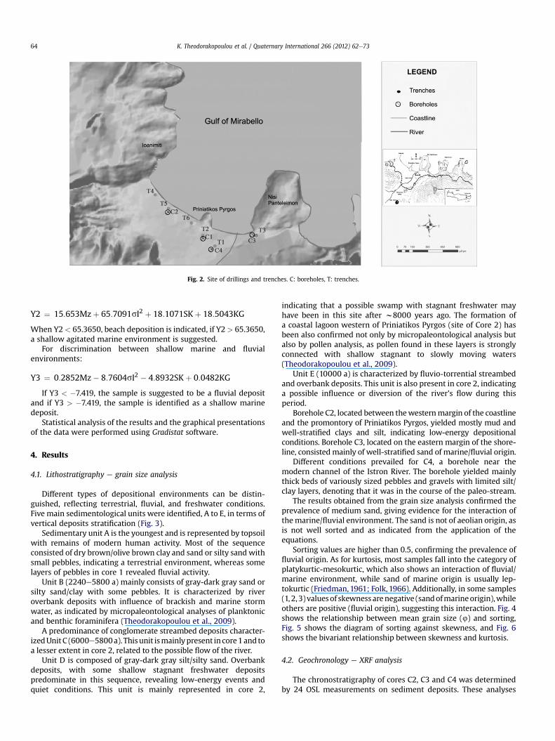
Fig. 2. Site of drillings and trenches. C: boreholes, T: trenches.
K. Theodorakopoulou et al. / Quaternary International 266 (2012) 62e7364
Y2 ¼ 15:653Mzþ 65:7091sI2 þ 18:1071SKþ 18:5043KG
When Y2< 65.3650, beach deposition is indicated, if Y2 > 65.3650,a shallow agitated marine environment is suggested.
For discrimination between shallow marine and fluvialenvironments:
Y3 ¼ 0:2852Mz� 8:7604sI2 � 4:8932SKþ 0:0482KG
If Y3 < �7.419, the sample is suggested to be a fluvial depositand if Y3 > �7.419, the sample is identified as a shallow marinedeposit.
Statistical analysis of the results and the graphical presentationsof the data were performed using Gradistat software.
4. Results
4.1. Lithostratigraphy e grain size analysis
Different types of depositional environments can be distin-guished, reflecting terrestrial, fluvial, and freshwater conditions.Five main sedimentological units were identified, A to E, in terms ofvertical deposits stratification (Fig. 3).
Sedimentary unit A is the youngest and is represented by topsoilwith remains of modern human activity. Most of the sequenceconsisted of dry brown/olive brown clay and sand or silty sand withsmall pebbles, indicating a terrestrial environment, whereas somelayers of pebbles in core 1 revealed fluvial activity.
Unit B (2240e5800 a) mainly consists of gray-dark gray sand orsilty sand/clay with some pebbles. It is characterized by riveroverbank deposits with influence of brackish and marine stormwater, as indicated by micropaleontological analyses of planktonicand benthic foraminifera (Theodorakopoulou et al., 2009).
A predominance of conglomerate streambed deposits character-izedUnitC (6000e5800a). Thisunit ismainlypresent in core1andtoa lesser extent in core 2, related to the possible flow of the river.
Unit D is composed of gray-dark gray silt/silty sand. Overbankdeposits, with some shallow stagnant freshwater depositspredominate in this sequence, revealing low-energy events andquiet conditions. This unit is mainly represented in core 2,
indicating that a possible swamp with stagnant freshwater mayhave been in this site after w8000 years ago. The formation ofa coastal lagoon western of Priniatikos Pyrgos (site of Core 2) hasbeen also confirmed not only by micropaleontological analysis butalso by pollen analysis, as pollen found in these layers is stronglyconnected with shallow stagnant to slowly moving waters(Theodorakopoulou et al., 2009).
Unit E (10000 a) is characterized by fluvio-torrential streambedand overbank deposits. This unit is also present in core 2, indicatinga possible influence or diversion of the river’s flow during thisperiod.
Borehole C2, located between thewesternmargin of the coastlineand the promontory of Priniatikos Pyrgos, yielded mostly mud andwell-stratified clays and silt, indicating low-energy depositionalconditions. Borehole C3, located on the eastern margin of the shore-line, consistedmainly of well-stratified sand of marine/fluvial origin.
Different conditions prevailed for C4, a borehole near themodern channel of the Istron River. The borehole yielded mainlythick beds of variously sized pebbles and gravels with limited silt/clay layers, denoting that it was in the course of the paleo-stream.
The results obtained from the grain size analysis confirmed theprevalence of medium sand, giving evidence for the interaction ofthemarine/fluvial environment. The sand is not of aeolian origin, asis not well sorted and as indicated from the application of theequations.
Sorting values are higher than 0.5, confirming the prevalence offluvial origin. As for kurtosis, most samples fall into the category ofplatykurtic-mesokurtic, which also shows an interaction of fluvial/marine environment, while sand of marine origin is usually lep-tokurtic (Friedman,1961; Folk, 1966). Additionally, in some samples(1, 2, 3) valuesof skewnessarenegative (sandofmarineorigin),whileothers are positive (fluvial origin), suggesting this interaction. Fig. 4shows the relationship between mean grain size (4) and sorting,Fig. 5 shows the diagram of sorting against skewness, and Fig. 6shows the bivariant relationship between skewness and kurtosis.
4.2. Geochronology e XRF analysis
The chronostratigraphy of cores C2, C3 and C4 was determinedby 24 OSL measurements on sediment deposits. These analyses

Fig. 3. Sedimentological units.
0
0.2
0.4
0.6
0.8
1
1.2
1.4
1.6
1.8
0 0.5 1 1.5 2 2.5
SO
RT
IN
G Φ
MEAN Φ
Coarse sand
dnaseniFdnasmuideM
Poor
ly s
orte
dM
od.
sorte
dW
ell s
orte
d
Fig. 4. Bivariant relationship between the mean size and sorting.
K. Theodorakopoulou et al. / Quaternary International 266 (2012) 62e73 65

-0.6
-0.5
-0.4
-0.3
-0.2
-0.1
0
0.1
0.2
0 0.2 0.4 0.6 0.8 1 1.2 1.4 1.6 1.8
SK
EW
NE
SS
SORTING
Well sorted Moderately sorte Poorly sorted
Ne
ga
tiv
ely
s
ke
we
dSym
metrical
positively skew
ed
Fig. 5. Bivariant relationship between sorting and skewness.
K. Theodorakopoulou et al. / Quaternary International 266 (2012) 62e7366
were performed at the Laboratory of Archaeometry N.C.S.R‘Demokritos’ in Athens, respectively (Table 1). The SAR protocol(Murray andWintle, 2000) was applied to provide the accumulateddoses. The estimation of equivalent doses (De) was obtained byemploying a pre-heat of 260 �C for 10 s and a cut heat of 160 �C foraliquots from all samples. The 260 �C pre-heat condition resultedfrom a test applied on selected samples. For most of the C2 and C3samples, the De distribution appears as a similar form havinga broader part at higher doses, while a larger De variation is presentfor most of the C4 samples (Zacharias et al., 2009).
For the evaluation of K concentrations, XRF analysis was appliedon samples from C2 and C4. The results of XRF analysis are shown inTable 2. Besides the potassium concentration which contributes tothe dose-rate estimation, the percentage values of the othermeasured metalloid and transition metals may provide useful hints
-0,6 -0,5 -0,4 -0,3 -0,2
Skewness
Negatively skewed
Fig. 6. Bivariant relationship betw
for the origin and the nature of the material. The samples from C2(considered brackish) show less sulphur than the samples from C4(considered terrestrial). This could be attributed to the low-energydepositional conditions favoring predominance of an oxidizingregime in the supposed small swamp.
In an attempt to search for trends within the chemical data, thebivariate plots of Fig. 7 were drawn. Core 2 (diamonds) and Core 3(triangles) values point to highly calcareous samples, while in core4 (rectangles) calcium concentrations shows less variation. For allcores, an increase in the ratios with depth is noted. Although for C3and C4 samples a moderate Al-variation is observed, the meanCa/Al ratio varies by more than 60%, while for C2 samples the rangeof the Ca/Al ratio is within 35%, although with strong Al variations.The latter should be attributed to dilution effects, probably due toCa. Finally, the higher silicate values for C2, C3 reflect an increased
0
0,2
0,4
0,6
0,8
1
1,2
-0,1 0 0,1 0,2
Ku
rto
sis
Positively
skewedSymmetrical
Pla
tty
ku
rtic
Mesokurtic
Le
pto
ku
rtic
een skewness and kurtosis.

Table 1Summary of dosimetry and luminescence dating results.
Sample K (wt %) U (mg g�1) Th (mg g�1) Equilibriumstate
Sample depth (m) W Cosmic doserate (Gy/ka)
Dose rate(Gy/ka)
Equivalentdose De (Gy)
Age (ka)
C2-1 1.65 � 0.06 2.06 � 0.54 10.32 � 2.02 eq. 0.90 � 0.05 11 � 2 0.19 � 0.01 2.75 � 0.11 2.15 � 0.17 0.78 � 0.07C2-2 1.40 � 0.05 2.16 � 0.67 6.92 � 2.61 eq. 0.30 � 0.10 14 � 2 0.17 � 0.02 2.23 � 0.11 6.80 � 1.07 3.05 � 0.51C2-3 1.41 � 0.04 1.96 � 0.38 11.24 � 1.44 eq. �0.30 � 0.05 10 � 2 0.16 � 0.02 2.32 � 0.08 8.63 � 1.05 3.72 � 0.47C2-4 3.15 � 0.10 3.43 � 0.36 6.03 � 1.26 eq. �1.50 � 0.05 15 � 2 0.14 � 0.01 3.74 � 0.11 16.38 � 2.46 4.38 � 0.67C2-5 3.10 � 0.09 4.13 � 0.39 6.08 � 0.89 60%
escape 226Ra�3.40 � 0.10 15 � 2 0.11 � 0.01 3.63 � 0.12 21.98 � 2.40 6.05 � 0.68
C2-6 0.94 � 0.03 1.16 � 0.14 5.45 � 0.52 eq. �5.10 � 0.05 16 � 2 0.09 � 0.01 1.42 � 0.06 9.40 � 1.25 6.62 � 0.93C2-7 2.11 � 0.05 2.88 � 0.37 9.66 � 1.38 eq. �7.20 � 0.05 11 � 2 0.08 � 0.02 2.81 � 0.12 23.83 � 1.90 8.48 � 0.77C2-8 2.99 � 0.08 1.79 � 0.39 11.24 � 1.46 eq. �8.80 � 0.05 13 � 1 0.07 � 0.01 3.67 � 0.12 35.60 � 2.85 9.70 � 0.84C4-1 1.49 � 0.04 1.69 � 0.44 11.28 � 1.70 eq. 2.35 � 0.05 14 � 1 0.20 � 0.01 2.45 � 0.10 2.28 � 0.16 0.93 � 0.15C4-2 2.03 � 0.07 1.44 � 0.37 10.70 � 1.42 eq. 0.90 � 0.05 16 � 2 0.16 � 0.02 2.82 � 0.10 9.84 � 1.58 3.49 � 0.58C4-3 1.83 � 0.05 1.83 � 0.33 16.81 � 1.28 eq. �0.05 � 0.05 15 � 2 0.14 � 0.02 3.02 � 0.01 13.89 � 1.55 4.60 � 0.50C4-4 1.94 � 0.05 2.28 � 0.51 16.71 � 1.93 eq. �1.60 � 0.05 15 � 2 0.12 � 0.01 3.17 � 0.12 22.73 � 3.86 7.17 � 1.25C4-5 2.05 � 0.05 3.07 � 0.54 15.84 � 1.31 60%
escape 226Ra�2.6 � 0.05 15 � 2 0.11 � 0.01 3.35 � 0.12 26.72 � 4.60 7.98 � 1.40
C4-6 2.42 � 0.06 1.620 � 0.27 12.01 � 1.37 50%excess 226Ra
�3.40 � 0.05 11 � 1 0.10 � 0.01 3.26 � 0.11 28.55 � 5.45 8.76 � 1.72
C4-7 1.83 � 0.05 2.52 � 0.52 10.35 � 1.96 eq. �5.00 � 0.05 14 � 2 0.09 � 0.01 2.68 � 0.12(2.95 � 0.12)
27.80 � 2.90(39.20 � 2.40)
9.59 � 1.09(13.29 � 1.89)
C4-8 1.35 � 0.05 1.99 � 0.58 13.37 � 1.43 60%escape 226Ra
�6.00 � 0.10 13 � 2 0.08 � 0.01 2.40 � 0.12 30.70 � 3.30 12.79 � 1.52
C4-9 1.50 � 0.06 1.39 � 0.27 11.32 � 1.07 50%escape 226Ra
�7.80 � 0.05 11 � 2 0.06 � 0.01 2.34 � 0.10 35.00 � 6.00 14.95 � 2.64
C4-10 2.48 � 0.06 1.87 � 0.29 9.44 � 1.09 eq. �8.90 � 0.05 14 � 2 0.06 � 0.01 2.99 � 0.11 45.90 � 8.26 15.35 � 2.80C3-1 1.48 � 0.06 1.0.87 � 0.09 9.44 � 0.47 eq. 0.0.50 � 0.10 12 � 2 0.16 � 0.02 2.12 � 0.16 0.44 � 0.14 0.21 � 0.06C3-2 2.4 � 0.0.07 2.04 � 0.10 5.28 � 0.26 eq. 1.15 � 0.10 12 � 2 0.12 � 0.01 1.44 � 0.11 1.52 � 0.74 1.06 � 0.05C3-3 0.79 � 0.02 1.48 � 0.074 4.29 � 0.21 eq 1.95 � 0.10 16 � 2 0.09 � 0.01 2.39 � 0.19 3.83 � 0.65 1.6 � 0.02C3-4 2.09 � 0.06 0.75 � 0.03 4.80 � 0.24 eq. 2.90 � 0.10 14 � 2 0.06 � 0.01 2.44 � 0.19 4.53 � 1.48 1.86 � 0.07C3-5 0.78 � 0.02 1.29 � 0.06 3.65 � 0.18 eq. 4.75 � 0.10 16 � 2 0.06 � 0.01 2.41 � 0.17 5.18 � 1.03 2.15 � 0.25
K. Theodorakopoulou et al. / Quaternary International 266 (2012) 62e73 67
mineralogical maturity, i.e. a higher quartz content and a smallerproportion of detrital grains, which is not the case for C4 samples(Rollinson, 1993).
The ages indicate a Holocene landscape evolution for core C2.The greater ages for the lower C4 samples and their greater error isstrongly connected with the depositional environment (slopedeposits), while the deepest point (�6 m) of core C3 was dated tothe Roman period, which is associated with the topography of thearea. Fig. 8 presents the chronostratigraphy of cores.
Table 2XRF analysis results given as wt.% and the respective standard deviations.
M% Al Si S K Ca
C2-1 7.70 � 0.94 24.90 � 0.72 0.07 � 0.02 1.65 � 0.06 11C2-2 5.80 � 0.74 23.02 � 0.62 0.10 � 0.02 1.40 � 0.05 13C2-3 8.79 � 0.70 24.96 � 0.51 0.18 � 0.02 1.41 � 0.04 11C2-4 11.96 � 1.24 40.98 � 1.05 0.82 � 0.07 3.15 � 0.10 25C2-5 11.40 � 1.19 39.98 � 1.01 0.78 � 0.07 3.10 � 0.09 24C2-6 5.63 � 0.66 20.32 � 0.52 0.72 � 0.04 0.94 � 0.03 16C2-7 10.86 � 0.94 28.96 � 0.68 0.55 � 0.04 2.11 � 0.05 9C2-8 12.24 � 1.07 32.49 � 0.79 0.65 � 0.05 2.99 � 0.08 11C4-1 8.59 � 0.76 28.00 � 0.60 0.17 � 0.02 1.49 � 0.04 5C4-2 8.78 � 0.80 31.65 � 0.67 0.08 � 0.02 2.03 � 0.07 10C4-3 10.08 � 0.94 25.53 � 0.66 0.03 � 0.01 1.83 � 0.05 2C4-4 9.15 � 0.84 29.94 � 0.67 0.03 � 0.01 1.94 � 0.05 2C4-5 10.93 � 1.03 29.38 � 0.75 0.07 � 0.02 2.05 � 0.05 1C4-6 12.52 � 1.04 27.74 � 0.70 0.07 � 0.02 2.42 � 0.06 5C4-7 9.45 � 0.92 22.80 � 0.62 0.01 � 0.01 1.83 � 0.05 5C4-8 9.66 � 0.99 20.86 � 0.63 0.05 � 0.01 1.35 � 0.05 5C4-9 9.05 � 1.07 19.80 � 0.68 0.09 � 0.02 1.50 � 0.06 13C4-10 11.49 � 0.93 33.66 � 0.72 0.19 � 0.03 2.47 � 0.06 9C3-1 15.48 � 2.22 45.36 � 3.98 0.03 � 0.01 1.48 � 0.06 21C3-2 15.05 � 0.63 51.48 � 1.38 0.15 � 0.03 2.4 � 0.0.07 12C3-3 14.49 � 0.44 48.29 � 2.25 0.06 � 0.04 0.79 � 0.02 16C3-4 14.55 � 0.77 47.94 � 1.44 0.49 � 0.07 2.09 � 0.06 16C3-5 16.41 � 0.18 53.98 � 0.50 0.17 � 0.02 0.78 � 0.02 15
4.3. Sedimentation rate
The analysis of the cores from the coastal area of Istron gaveevidence for sediment accumulation and associated palae-oenvironmnetal changes (Figs. 9 and 10). Sedimentation rate fluc-tuations were estimated according to the chronostratigraphy ofstudied boreholes for the last 14,000 years. Results are plotted in 3diagrams, one for each borehole, and used to construct one curvebased on data from the three boreholes (Fig. 11).
Ti Cr Mn Fe
.68 � 0.12 0.48 � 0.02 0.08 � 0.01 0.08 � 0.01 3.84 � 0.04
.37 � 0.12 0.38 � 0.02 0.07 � 0.1 0.09 � 0.01 3.06 � 0.03
.21 � 0.08 0.33 � 0.01 0.04 � 0.01 0.04 � 0.01 3.08 � 0.03
.52 � 0.24 1.19 � 0.05 0.13 � 0.01 0.15 � 0.01 7.85 � 0.08
.19 � 0.22 1.09 � 0.04 0.12 � 0.01 0.13 � 0.01 7.30 � 0.08
.28 � 0.11 0.32 � 0.02 0.04 � 0.01 0.08 � 0.01 1.64 � 0.02
.08 � 0.1 0.77 � 0.02 0.08 � 0.01 0.07 � 0.01 5.87 � 0.04
.29 � 0.12 0.97 � 0.03 0.09 � 0.01 0.10 � 0.01 7.22 � 0.06
.98 � 0.07 0.33 � 0.01 0.05 � 0.01 0.07 � 0.01 1.97 � 0.02
.91 � 0.10 0.27 � 0.01 0.042 � 0.004 0.06 � 0.01 1.58 � 0.02
.40 � 0.05 0.55 � 0.02 0.03 � 0.01 0.07 � 0.01 3.04 � 0.03
.80 � 0.05 0.47 � 0.02 0.04 � 0.01 0.07 � 0.01 2.97 � 0.03
.69 � 0.04 0.72 � 0.02 0.06 � 0.01 0.12 � 0.01 5.70 � 0.04
.43 � 0.08 0.60 � 0.02 0.05 � 0.01 0.11 � 0.01 4.06 � 0.03
.67 � 0.07 0.44 � 0.02 0.03 � 0.01 0.07 � 0.01 3.58 � 0.03
.97 � 0.08 0.50 � 0.02 0.04 � 0.004 0.05 � 0.01 3.26 � 0.03
.88 � 0.14 0.53 � 0.02 0.03 � 0.01 0.07 � 0.01 3.79 � 0.01
.92 � 0.10 0.40 � 0.02 0.05 � 0.01 0.08 � 0.01 2.19 � 0.03
.46 � 4.62 1.07 � 0.53 0.04 � 0.03 0.11 � 0.01 4.54 � 1.35
.09 � 1.13 1.17 � 0.09 0.09 � 0.02 0.12 � 0.01 7.31 � 1.34
.07 � 1.67 1.03 � 0.11 0.08 � 0.01 0.06 � 0.01 5.67 � 1.71
.03 � 1.29 1.11 � 0.05 0.11 � 0.04 0.15 � 0.02 6.22 � 0.92
.83 � 0.35 1.33 � 0.07 0.12 � 0.01 0.13 � 0.01 7.79 � 0.68

Fig. 7. Concentration ratios Ca/Al vs. depth of the measured samples, based on the XRFresults.
K. Theodorakopoulou et al. / Quaternary International 266 (2012) 62e7368
The observed sedimentation rate was greater in borehole C2than in C4, which is strongly connected with the difference of thedepositional environment. Particularly, in borehole C2 a deltaicenvironment prevailed, while in borehole 4 slope deposits and
Fig. 8. Chronostratigraphy of bor
terrestrial processes dominated. Borehole C3 covers the last 2200years.
For borehole C2, between 9650 and 4690 years ago, coastalsedimentationprevailed, as shownby sedimentological analysis andconfirmed by micropaleontological and pollen analysis. During thistime, a coastal lagoon had been probably formed in the area, west ofPrinatikosPyrgos (C2drilling site). The sedimentation rate is intense,between 19 and 15 cm/century. After 4500 years ago, where fluvio-terrestrial deposits prevailed and the area of coastal lagoonhadbeenconstrained, the sedimentation rate declined to about 3 cm/century,and increased after 1000 years ago (10 cm/century) (Fig. 12).
Borehole C3 covers the last 2000 years. This period is missingfrom the record of the other boreholes. The results from grain sizeanalysis indicated a mixed type of sedimentation, hence theinteraction of coastal/fluvial sediments. An intense sedimentationrate is observed at about 2000 years ago (63 cm/century), andfalling of the rate is observed between 1500e1000 a (8 cm/century). The augmented rates of sedimentation from this boreholeprobably pertain to the position of the borehole next to the modernriver (Fig. 13).
Borehole C4 covers the last 14,000 years. The sedimentologicalanalysis indicated the predominance of fluvio-terrestrial deposits.Augmented rates are observed between 14000e13000 a (9 cm/
eholes based on OSL dating.

Coring C2, OSL dating and relevant data gained: preliminary evaluation
Absolute
altitude(m)
Coring
depths(m)
-1.0
-2.0
-3.0
-4.0
-5.0
-6.0
-7.0
-8.0
-9.0
-10.0
+1.7
+1.0
0.0
-1.0
-2.0
-3.0
-4.0
-5.0
-6.0
-7.0
-8.0
Modern sea-level
ca. 35m
2950 a 11.9%
3,880 a 14.9%
6,620 a 9.8%
8,450 a 8.9%
10. 4 cm/century
6.7 cm/century
0.0
(Climatic optimum, ca.3.000-4.000 BC,included)
Symbols explanation: : Modern sea-level, :"Dark" coring, : proportion of sedimentation rate in cm/century, : Samples of soil OSL-dated, : Slightly sloping ground surface, ca. 5%. Note: The percentages given with the absolute ages, are the total errors.
Pinus, Olea, Juniperus, Ericace-ae, Heliantheum, Sinapis, Tubu-liflorae, Liguliflorae, Sordaria
Almost barren, few Pinus
Pinus, Ericaceae, Juniperus, Querqus, Pocaceae, Sinapis, Teucrium, Convovulus.
_
_
Barren
_
Barren
_
_
Pinus,Poaceae, Cerealia type,
BarrenLiguliflorae
_Barren
•deltaic environmentand near-shore shoal, temporarily wallow •fine sediments (clays,sands, mud) occupying•sedimentation rate va-ried over the last 6-7 millennia
•mostly xerophytic ve-getation in the widerarea
•mixing of brackish and fresh waters environ-ments, according to ainitiative check formicrofossils
•eustatic transgression
770 a 15.6%
4690 a 11.9%
5800 a 13.4%
9,650 a 11.9%
2.9 cm/century
15.0 cm/century
16.1 cm/century
19.9 cm/century
11.7 cm/century
12.9 cm/century
Age
Fig. 9. Schematic diagram of the depositional environment and palaeoenvironmental conditions in Istron, based on analyses from borehole 2.
K. Theodorakopoulou et al. / Quaternary International 266 (2012) 62e73 69
century), a fall is noted around 12000 a (6 cm/century), whileincreased rates are perceived around 7000 a (18 cm/century).Diminished rates are also observed around 4000e3500 a (5 cm/century) and increased around 900 years ago (7.5 cm/century)(Fig. 12).
5. Discussion
The soils buried in the floodplains and low terraces provideindications on the stabilization phases by considering the pedo-genetic development of the soils (Bull, 1990; Ferring, 1992; Aslanand Autin, 1998; Daniels, 2003), while the sedimentological faciesand the use of dating methods provide criteria on the depositionmode, sedimentation rate, age, and development of the floodplains(Benedetti et al., 2007). A change in climate represents the onlyprocess that is globally synchronous and can potentially account forthe widespread increase in erosion and sedimentation. Climateaffects erosion mainly by the transition from a period of climatestability, in which landscapes had attained equilibrium configura-tions, to a time of frequent and abrupt changes in temperature,precipitation and vegetation, which prevented fluvial and glacialsystems from establishing equilibrium states (Peizhen et al., 2001).
Climatic factors play a key role in determining the mechanismsof sediment transfer, the timing of depositional phases, and themorphological development of fans (Pope and Millington, 2000;Pope et al., 2003; Pope and Wilkinson, 2006; Kotthoff et al.,2008; Ghilardi et al., 2012). Nemec and Postma (1993, 1995)
argued that extremely low rates of sedimentation are indicativeof arid to semi-arid conditions, while increased sedimentation ratesare strongly connected with wet climatic periods.
The observed fluctuations of sedimentation ratewere correlatedwith Holocene climatic phases of variability. Deep sea sedimentstudies in Aegean Sea (Rohling and Thunell, 1999; Geraga et al.,2005, 2010; Triantaphyllou et al., 2009) can offer available proxydata for the identification of climatic fluctuations during theHolocene. Analyses of coccolithophores, planktonic foraminifers,dinoflagellate cysts and pollen assemblages carried out on shallowand deeper sediment cores from the southeastern Aegean Sea haveled to an expanded palaeoecological reconstruction of the LateGlacialeHolocene archive, defining twowarm and humid phases at9.3e8.6 and 7.6e6.4 cal ka BP, associated with the deposition of theearly Holocene sapropel S1, and a third between 5.2 and 4.2 cal kaBP (Climatic Optimum). Additionally, cold and dry periods havebeen recognized, such as 12800e11500 cal. BP (associated with theYounger Dryas event), 11500e9300 cal. BP, and 4200e2500 cal. BP(Triantaphyllou et al., 2009). Deep-sea sediment studies (Rohlingand Thunell, 1999; Geraga et al., 2005) and speleothem studies(Bar-Matthews et al., 1999; Psomiadis et al., 2009) have also indi-cated that the deposition of the sapropel S1 in the Aegean sea washalted during a short period of cooling between 8500 and 7500 cal.BP. This period corresponds well to the most widespread Holocenecold event of Europe, known as the Misox Oscillation, whichoccurred around 8.2 cal ka BP (Alley, 1997). The 8.2 ka event is alsoevident in the pollen record from Tenaghi-Philippon, North Greece

Coring C4, OSL dating and relevant data gained: preliminary evaluationAbsolute
altitude(m)
Coring
depths(m)
-1.0
-2.0
-3.0
-4.0
-5.0
-6.0
-7.0
-8.0
-9.0
-10.0
+2.0
+1.0
0.0
-1.0
-2.0
-3.0
-4.0
-5.0
-6.0
-7.0
Modern sea level
ca. 75m
930 a 16.1%
14,770 a 14.6%
0.0
(Climatic optimum, ca. 3.000-4.000 BC, included)
Symbols explanation: : Modern sea-level, :"Dark" coring, : proportion of sedimentation rate in cm/century, : Samples of soil OSL-dated, : Slightly sloping ground surface, ca. 5%. Note: The percentages given with the absolute ages, are the total errors.
Pinus, Olea, Juniperus, Ericace-ae, Heliantheum, Sinapis, Tubu-liflorae, Liguliflorae, Sordaria
Almost barren, few Pinus
Pinus, Ericaceae, Juniperus, Querqus, Pocaceae, Sinapis, Teucrium, Convovulus.
_
_
Barren
_
Barren
_
_
Pinus,Poaceae, Cerealia type,
BarrenLiguliflorae
_Barren
•deltaic environmentand near-shore shoal, temporarily wallow
•coarse sediments (pebbles and gravel) occupying
•sedimentation rate intensive in the beginning of Holocene (16cm/century)
•mostly xerophytic ve-getation in the widerarea
•Coring at the river-bed, thus fluvial sediments prevailing
•eustatic transgression
+2.99
3,570 a 12.3%
4,750 a 13.7%
7,150 a 18.9%
7,770 a 14.3%
8,900 a 16.0%
11,200 a 17.4%
12,800 a 19.9%
-8.0 -11.0
5.5 cm/century
7.6 cm/century
6.6 cm/century
6.2 cm/century
7.1 cm/century
4.9 cm/century
16 cm/century
9.4 cm/century
7.5cm/centAge
Fig. 10. Schematic diagram of the depositional environment and palaeoenvironmental conditions in Istron, based on analyses from borehole 4.
K. Theodorakopoulou et al. / Quaternary International 266 (2012) 62e7370
(Pross et al., 2009) and from Delphinos in western Crete (Bottemaand Sarpaki, 2003), representing a decline in winter temperaturesof more than 4� C. This event seems to have led to the abandonmentof Neolithic sites in the eastern Mediterranean (Weninger et al.,2006) and simultaneous development of settlements in Greece.The pronounced cold and dry period of 4200e2500 cal. BP, coin-ciding with low water levels in African lakes and speleothem
Fig. 11. Diagram of the sedimentation rate fluctu
records (Drysdale et al., 2006), played a significant role to thecollapse of Old Word civilizations in the Mediterranean region,including the fall of the Ancient Kingdom in Egypt (Weiss, 1997),while the intense drought is suggested as a key factor for thedecline of Mycenaean civilization in Greece (Carpenter, 1966).Between 1550 and 1100 cal. BP, another cold and arid period,known as ‘Dark Ages Cold Event’ or ‘Bond I’, has been recorded and
ations in Istron during the last 14,000 years.

Fig. 12. Sedimentation rate of boreholes 2, 4 and correlation with climatic events.
K. Theodorakopoulou et al. / Quaternary International 266 (2012) 62e73 71
coincides well with the fall of the Roman Empire (Bond et al., 1997;Lamb, 1997). The next cold and arid event which afflicted humansocieties in Europe, is the ‘Little Ice Age’ event from 450 to 150 cal.BP (Lamb, 1997). The most common warm and wet periods of thehistoric era are the ‘Roman Optimum’ between 2200 and 1550 cal.BP (Lamb, 1997) and the ‘Medieval Warm Period’, between 1100and 700 cal. BP (Lamb, 1997).
The above mentioned climatic phases of the Late Glacial-Holocene period were interrelated with the configured fluctua-tions of the sedimentation rate, based on the chronostratigraphy ofboreholes in the study area. The peaks of sedimentation rate
Fig. 13. Sedimentation rate of borehole 3
observed in borehole 2 could be chronologically correlatedwith thewarm and wet periods of 7600e6400 cal. BP, 5200e4200 cal. BP(Climatic Optimum) and 1100e700 cal. BP (Medieval Warm Period)respectively. The greatest values are observed between 7600 and6400 cal. BP and not during the climatic optimum; this can beexplained by the influence of local flooding events. In contrast, thelowest values of sedimentation rate are also correlatedwith periodsof cold and arid climate, such as the cold and dry events of11500e9300 cal. BP and 4200e2500 cal. BP (Fig. 12).
In borehole 3, the influence of the warm and wet period of2200e1550 cal. BP (Roman Optimum) is strongly reflected in the
and correlation with climatic events.

K. Theodorakopoulou et al. / Quaternary International 266 (2012) 62e7372
sedimentation rate of this time spam, giving considerably highvalues (63 cm/century) which are probably connected with intenseflooding events during this warm and wet period. Following theRoman Optimum, a decline in the sedimentation rate is observed,coinciding with the cold and dry period of 1550e1100 cal. BP (DarkAges Cold Event) (Fig. 13).
In borehole 4, several fluctuations to the sedimentation ratecould be connected with the succession of climatic phases (Fig. 8).High rates of sedimentation are observed between 14000e13000 a,7600e6400 a and 1100e700 a, periods of warm and wet climate,whereas low values are observed during 12800e11500 a, whichcoincides well with the cold and dry climatic phase of the YoungerDryas. The sedimentation rate calculated for the time periodbetween 1100 and 700 years ago (Medieval Warm Period) is similar(w7 cm/century) to the sedimentation rate calculated for the sameperiod in Agios Nikolaos town, 12 km NW of the study area(Theodorakopoulou, 2009).
The results from the sedimentological, pollen and micropale-ontological analyses along with the chronostratigraphy giveevidence for the landscape evolution of the area the last 10,000years. A detailed reconstruction of the palaeogeographic evolutionof the area has already been published by Theodorakopoulou et al.(2009).
6. Conclusions
The deltaic formations within the Istron Valley were found tohave evolved primarily during the Holocene, where human occu-pation, according to the archaeological research, was verified inlayers that belong to the second and third millennia B.C. Data fromchronostratigraphy along with sedimentological analysis, provedessential for the calculation of the sedimentation rate while itscorrelation with several Holocene climatic phases contributed tounravelling palaeoenvironmental issues. The fluctuations of theobserved sedimentation rates were found to correspond well toclimatic variations. Among the different approaches currentlypracticed for better understanding of the palaeoenvironment, theOSL dating technique seems to be of paramount helpfulness,providing ages estimations on geomorphological formations, oftennon-datable by any other technique. The combination of dataassisted in reconstruction of the landscape by analyzing sedimen-tological processes, climatic parameter changes, Late Glacial-Holocene sea-level rise, and other pertinent parameters.
This geoarchaeological research is progressing toward a docu-mented understanding of a coastal archaeological site in north-eastern Crete, with diachronic cultural significance from theNeolithic period onwards. The correlation of results from similargeoarchaeological projects in Crete will be very fruitful for thebetter understanding of the palaeoenvironmnetal issues that pre-vailed in Crete during the Holocene.
References
Alley, R., 1997. Holocene climatic instability; a prominent, widespread event 8200yr ago. Geology 25 (6), 483e486.
Alsharhan, A.S., El-Sammak, A., 2004. Grain-size analysis and characterization ofsedimentary environments of the United Arab Emirates coastal area. Journal ofCoastal Research 20 (2), 464e477.
Aslan, A., Autin, W.J., 1998. Holocene flood-plain soil formation in the southernLower Mississippi Valley: implications for interpreting alluvial paleosols.Geological Society of America Bulletin 110, 433e449.
Bar-Matthews, M., Ayalon, A., Kaufman, A., Wasserbourg, G.J., 1999. The easternMediterranean palaeoclimate as a reflection of regional events: Soreq Cave,Israel. Earth and Planetary Science Letters 166, 85e95.
Benedetti, M.M., Daniels, J.M., Ritchie, J.C., 2007. Predicting vertical accretion ratesat an archaeological site on the Mississippi River floodplain: Effigy MoundsNational Monument, Iowa. Catena 69, 134e149.
Bond, G., Showers, W., Cheseby, M., Lotti, R., Almasi, P., deMenocal, P., Priore, P.,Cullen, H., Hajdas, I., Bonani, G., 1997. A pervasive millennial-scale cycle in NorthAtlantic Holocene and glacial climates. Science 278, 1257e1266.
Bottema, S., Sarpaki, A., 2003. Environmental change in Crete: a 9000-year vege-tation history and the effect of the Santorini eruption. The Holocene 13,733e749.
Bull, W.B., 1990. Stream-terrace genesis: implications for soil development.Geomorphology 3, 351e367.
Carpenter, R., 1966. Discontinuity in Greek civilization Cambridge.Daniels, J.M., 2003. Floodplain aggradation and pedogenesis in a semiarid envi-
ronment. Geomorphology 56, 225e242.Drysdale, R., Zanchetta, G., Hellstrom, J., Maas, R., Fallick, A., Pickett, M.,
Cartwright, I., Piccini, L., 2006. Late Holocene drought responsible for thecollapse of Old World civilizations is recorded in an Italian cave flowstone.Geology 34, 101e104.
Ferring, C.R., 1992. Alluvial soils and geoarchaeological research. In: Holliday, V.T.(Ed.), Soils in Archaeology: Landscape Evolution and Human Occupation.Smithsonian Institution Press, Washington, D.C., pp. 1e39.
Folk, R.L., 1966. A review of grain size parameters. Sedimentology 26, 73e93.Friedman, G., 1961. Distinction between dune, beach and river sands from their
textural characteristics. Journal of Sedimentary Petrology 31, 514e529.Geraga, M., Tsaila-Monopolis, S., Ioakim, C., Papatheodorou, G., Ferentinos, G., 2005.
Short-term climate changes in the southern Aegean Sea over the last 48,000years. Palaeogeography, Palaeoclimatology, Palaeoecology 220, 311e332.
Geraga, M., Ioakim, C., Lykousis, V., Tsaila-Monopolis, S., Mylona, G., 2010. The high-resolution palaeoclimatic and palaeoceanographic history of the last 24,000years in the central Aegean sea, Greece. Palaeogeography, Palaeoclimatology,Palaeoecology 287, 101e115.
Ghilardi, M., Psomiadis, D., Cordier, S., Sabatier, D., Demory, F., Hamidi, F.,Paraschou, T., Dotsika, E., Fouache, E., 2012. The impact of early- to Mid-holocene palaeoenvironmental changes on Neolithic settlement at Nea Niko-mideia, Thessaloniki plain, Greece. Quaternary International 266, 47e61.
Hall, E., 1914. Excavations in eastern Crete, Vrokastro. Anthropological Publications3, 79e185.
Hayden, B., 2004. Reports on the Vrokastro Area, Eastern Crete. The SettlementHistory of the Vrokastro Area and Related Studies. University of Pennsylvania,Museum of Archaeology and Anthropology, Philadelphia.
Hayden, B., Bassiakos, Y., Kalpaxis, T., Sarris, A., Tsipopoulou, M., 2006. PriniatikosPyrgos: a primary harbour settlement and emporium in eastern Crete. Expe-dition 48 (3), 33e39.
IGME, 1981. Geological map of Greece. Agios Nikolaos sheet, Scale 1:50,000, Athens.Kalpaxis, T., Athannasas, K., Bassiakos, Y., Breenan, T., Hayden, B., Nodarou, E.,
Pavlopoulos, K., Sarris, A., 2006. Preliminary results of the Istron, Mirabello,geophysical and geoarchaeological project, 2002e2004. Annals of the BritishSchool at Athens 101, 135e181.
Kotthoff, U., Müller, U.C., Pross, J., Schmiedl, G., Lawson, I.T., Van DeSchootbrugge, B., Schulz, H., 2008. Lateglacial and holocene vegetationdynamics in the aegean region: an integrated view based on pollen data frommarine and terrestrial archives. Holocene 18 (7), 1019e1032.
Lamb, H., 1997. Climate History and the Modern World. Routledge, London.Murray, A.S., Wintle, A.G., 2000. Luminescence dating of quartz using an
improved single-aliquot regenerative-dose protocol. Radiation Measurements32, 57e73.
Nemec, W., Postma, G., 1993. Quaternary alluvial fans in southwestern Crete:sedimentation processes and geomorphic evolution. In: Marzo, M.,Puigdefábregas, C. (Eds.), Alluvial Sedimentation. Special Publication of theInternational Association of Sedimentologists, vol. 17, pp. 235e276.
Nemec, W., Postma, G., 1995. Quaternary alluvial fans in southwestern Crete:sedimentation processes and geomorphic evolution: a reply. Sedimentology 42,535e549.
Pavlopoulos, K., Theodorakopoulou, K., Bassiakos, Y., Hayden, B., Tsourou, T.,Triantaphyllou, M., Kouli, K., Vandarakis, D., 2007. Paleoenvironmental evolu-tion of Istron (N.E. Crete), during the last 6000 years: depositional environment,climate and sea level changes. Geodinamica Acta 20, 219e229.
Peizhen, Z., Molnar, P., Downs, W.R., 2001. Increased sedimentation rates and grainsizes 2e4 Myr ago due to the influence of climate change on erosion rates.Nature 410, 891e897.
Pirazzoli, P.A., Laborel, J., Stiros, S.C., 1996. Coastal indicators of rapid uplift andsubsidence: examples from Crete and other eastern Mediterranean sites.Zeitschrift für Geomorphologie 102, 21e35. Supplementband.
Pirazzoli, P.A., 2005. A review of possible eustatic, isostatic and tectonic contribu-tions in eight late-Holocene relative sea-level histories from the Mediterraneanarea. Quaternary Science Reviews 24, 1989e2001.
Pope, R.J.J., Millington, A.C., 2000. Unravelling the patterns of alluvial fandevelopment using mineral magnetic analysis: examples from the SpartaBasin, Lakonia, southern Greece. Earth Surface Processes and Landforms 25,601e615.
Pope, R.J.J., Wilkinson, K.N., Millington, A.C., 2003. Human and climatic impact onLate Quaternary deposition in the Sparta Basin piedmont: evidence from allu-vial fan systems. Geoarchaeology 18 (7), 685e724.
Pope, R.J.J., Wilkinson, K.N., 2006. Reconciling the roles of climate and tectonicsin Late Quaternary fan development on the Spartan piedmont, Greece. In:Harvey, A.M., Mather, A.E., Stokes, M. (Eds.), Alluvial Fans: Geomorphology,Sedimentology, Dynamics. Geological Society Special Publication, vol. 251,pp. 133e152.

K. Theodorakopoulou et al. / Quaternary International 266 (2012) 62e73 73
Pross, J., Kotthoff, U., Müller, U.C., Peyron, O., Dormoy, I., Schmiedl, G., Kalaitzidis, S.,Smith, A.M., 2009. Massive perturbation in terrestrial ecosystems of the EasternMediterranean region associated with the 8.2 ka climatic event. Geology 37,887e890.
Psomiadis, D., Dotsika, E., Zisi, N., Pennos, C., Pechlivanidou, S., Albanakis, K., Syros, A.,Vaxevanopoulos, M., 2009. Geoarchaeological study of Katarraktes cave system(Macedonia, Greece): isotopic evidence for environmental alterations. In:Ghilardi, M. (Ed.), Special Issue on Geoarchaeology: Human-environment Connec-tivity. Geomorphologie: Relief, Processus, Environnement, vol. 4, pp. 229e240.
Rohling, E., Thunell, R., 1999. Five decades of Mediterranean palaeoclimate andsapropel studies. Marine Geology 153, 7e10.
Rollinson, H.R., 1993. Using Geochemical Data: Evaluation, Presentation, Interpre-tation. In: Longman Geochemistry Series London,66e71.
Sahu, B.K., 1964. Depositional mechanisms from the size analysis of clastic sedi-ments. Journal of Sedimentary Petrology 34 (1), 73e83.
Sampson, A., 2006. The Prehistory of Aegean, Paleolithic, Mesolithic, Neolithic (inGreek with summaries in English) Atrapos, Athens.
Theodorakopoulou, K., Pavlopoulos, K., Triantafyllou, M., Kouli, K., Tsourou, M.,Bassiakos, Y., Zacharias, N., Hayden, B., 2009. Geoarchaeological studies in thecoastal area of Istron-Kalo Chorio (Gulf of Mirabello-eastern Crete): landscape
evolution and paleoenvironmental reconstruction. Zeitschrift für Geo-morphologie 53 (Suppl. 1), 55e70.
Theodorakopoulou, K., 2009. The Influence of Environmental Conditions to thePalaeogeographic Evolution of Archaeological Sites and to the Preservation ofTheir Remains. Unpublished Ph.D Thesis, in Greek with English Summary,Harokopio University of Athens, Greece.
Triantaphyllou, M., Antonarakou, A., Kouli, K., Dimiza, M., Kontakiotis, G.,Papanikolaou, M., Ziveri, P., Mortyn, P., Lianou, V., Lykousis, V., Dermitzakis, M.,2009. Late Glacial-Holocene ecostratigraphy of the south-eastern Aegean Sea,based on plankton and pollen assemblages. Geo-Marine Letters, 1e19.
Weiss, N., 1997. Late Third Millennium Abrupt Climate Change and Social Collapsein West Asia and Egypt Third Millennium BC Climate Change and Old WorldCollapse, London.
Weninger, B., Bauer, E., Clare, L., Danzeglocke, U., Jöris, O., Kubatzk, C., Rollefson, G.,Todorova, H., van Andel, T., 2006. Climate forcing due to the 8200 cal yr BPevent observed at Early Neolithic sites in the eastern Mediterranean. Quater-nary Research 66 (3), 401e420.
Zacharias, N., Bassiakos, Y., Hayden, B., Theodorakopoulou, K., Michael, C., 2009.Luminescence dating of nearshore deltaic deposits from Eastern Crete, Greece.Geomorphology 109, 46e53.
Copyright © 2022 FDOKUMEN